Downton Parish Neighbourhood Plan 2016 2026 - Wiltshire ...
37
Downton Parish Neighbourhood Plan 2016 2026 From 2016 to 2026, Made January 2017 submitted by the qualifying body Downton Parish Council Looking to a sustainable future
-
Upload
khangminh22 -
Category
Documents
-
view
6 -
download
0
Transcript of Downton Parish Neighbourhood Plan 2016 2026 - Wiltshire ...

Downton Parish Neighbourhood Plan
20162026
From 2016 to 2026, Made January 2017submitted by the qualifying body Downton Parish Council
Looking to a sustainable future

Contents
1.0 Why Downton Parish Needs a Neighbourhood Plan
2.0 Background
3.0 How The Neighbourhood Plan Was Prepared
4.0 The Neighbourhood Plan Strategy - What Sustainable
Development Means for the Parish
5.0 The Downton Parish Neighbourhood Plan 2015 - 2026
6.0 Developing Policies
7.0 Facilitating and Funding of Policies
8.0 Location and History
9.0 Themes For Land Use9.1 Landscape and Character
9.2 Housing Development and Homes For Local People
9.3 Transport and Infrastructure
9.3.1 Transport
9.3.2 Drainage, Sewerage System, Groundwater
and Surface Water Drainage
9.4 The Local Economy
9.4.1 The Village Economy
9.4.2 The Rural Economy
9.5 Community Facilities and Services
9.5.1 Community Facilities and Services
9.5.2 Leisure Facilities
10.0 Conclusion
5
7
8
9
11
13
14
16
19
27
37
43
47
53
59
67
71
Foreward by John Glen MP
Too often in the past planning has been an endless system of discontent, objections, and appeals. We are determined to give local people more say in planning – setting their own framework within which prospective developers must work.
When we created neighbourhood planning, it was with the aspiration that communities like Downton would want to come together and take charge of their area’s future. Planning is about ensuring we can protect the areas that we value. Downton is a beautiful part of Wiltshire, and nobody wants to see poor planning or inappropriate development undermine its unique character.
But equally, we want it to remain somewhere that our children and grandchildren can afford to live, work, raise a family or start a business and that means looking to the future positively and planning for it.
I am delighted that this optimistic vision for the future of Downton has been completed, and I look forward to seeing it realised in years to come.
A glossary of terms and list of appendices can be found at Appendices 14 and 15.

1.0 Why Downton Parish Needs a Neighbourhood Plan
The Localism Act was introduced in November 2011 with the aim of devolving more decision making powers from central government back to communities. Neighbourhood Plans allow communities, such as Downton, to become involved in planning for their areas, specifically around creating plans and policies to guide new development and in some cases granting planning permission for certain types of development1.
In the autumn of 2013 Downton Parish Council announced its intention to embark upon a Neighbourhood Plan; and a public meeting in November 2013 confirmed community support. In early 2014 the neighbourhood area (of Downton Parish) was designated by the Parish Council and reasons were given to Wiltshire Council for embarking upon the Plan. The objectives of the Plan and its geographic area were approved in August 2014 by Wiltshire Council. Meanwhile, from April 2014 there had been wide, inclusive, and ongoing consultation throughout the plan area, and this continued until September 2015. The Downton Neighbourhood Plan therefore reflects the views and thoughts
of the local community, not just residents but also local businesses and other stakeholders.
Its particular concern is the requirement in the Wiltshire Core Strategy for the development of 190 new homes in Downton by 2026 and any subsequent changes to that allocation. At the moment the Parish Council and local residents can only react to submitted planning applications. The Neighbourhood Plan, once agreed, will be a legal document that sits alongside the Core Strategy; and while it cannot seek to reduce the number of homes to be built or change plans approved prior to its ratification, its statutory status will give the Plan far more weight than many other local planning documents (such as parish plans or village design statements).
The overriding objective of the plan is to ensure that inevitable changes do not detract from the many benefits of the village identified by local people and where possible seek to have these benefits enhanced.
This draft Plan has been produced by a Neighbourhood Planning Steering Group comprising local volunteers and, following ratification by the Parish Council was formally submitted to Wiltshire Council in early December 2015. After a further period of consultation and independent examination, the final plan will be put to a local referendum. A favourable result will mean that the Downton Neighbourhood Plan will form part of the Local Development Plan and become, with the Wiltshire Core Strategy, a start-ing point for deciding development priorities in our area, an influence on what, when and the ap-pearance of development and, with appropriate evidence, the necessary infrastructure required.
5 The Borough White Horse and Co-op
1 The Localism Act 2012www.downtonfuture.org
Downton
CharltonAll Saints Standlynch
Figure 1: The Parish of Downton - Neighbourhood Plan Area Contains Ordnance Survey data © Crown copyright and database right 2015
4

The Neighbourhood Plan aims to ensure that Downton retains and enhances its existing character now and for future generations. At the time of writing it is consistent with the Wiltshire Core Strategy (2012-2026). Reviews can be expected every 5 years or when circumstances or government policies change.
The Neighbourhood Planning process, by raising awareness, enables communities to better shape their place, inform where development takes place and help to influence the type, quality and location of that development, ensuring that the many benefits of the Parish of Downton, as identified by the local community, are retained and enhanced for future generations.
The village of Downton is identified in the Core strategy as a Local Service Centre (LSC). There are four in the South Wiltshire area (Mere, Tisbury, Wilton and Downton)and they are defined as: “smaller towns and larger villages which serve a surrounding rural hinterland and possess a level of facilities and services that, together with improved local employment, provide the best opportunities outside the Market Towns for greater self-containment’’.
It is stated that Local Service Centres will “provide for modest levels of development in order to safeguard their role and to deliver affordable housing” with “the level of development being closely linked to their current and future role of providing for a significant rural hinterland”.
This means that Downton is likely to come under increased development pressure which will have adverse effects on issues identified for sustainable development. The purpose of this plan, therefore, is to ensure that development is guided by local preferences rather than just market forces; and that it is coordinated and supported by infrastructure improvements for the long term benefit of the community.
The production of this plan has coincided with planning applications for residential development. An application for 99 homes has been approved prior to the formal ratification of this Plan and the status of any other applications at the time of the publication of the plan will determine whether or not it has any influence over the proposed development. However, it is emphasised that the policies and proposals contained in this plan are, throughout, consistent with the Wiltshire Core Strategy and are in response to the views of the local community in respect of any proposed development and not any particular current or future applications.
The Neighbourhood Plan has been strongly influenced by active engagement with the local community, not just residents but also other stakeholders including local businesses, community and other groups. More information is contained in the accompanying Consultation Statement.
2.0 Background
7 The Borough
Opposite: Downton Historic Vernacular

The Downton Neighbourhood Plan has been prepared by residents and members of Downton Parish Council working as part of a Neighbourhood Planning Steering Group. The process has involved a number of key steps.
• Designation and Raising AwarenessIncluding: establishing a steering group, defining the neighbourhood area, engaging the community, developing objectives, vision and project plan.
• Consultation and Evidence Gathering Including: carrying out research, community consultation and surveys, identifying priorities and drafting the initial plan.
• Plan Creation, further consultation and delivery
Including: developing policies and proposals and refining the draft plan on the basis of community consultation; further community engagement and consultation with stakeholders.
• Draft Plan, Submission and Examination Including: ratification of the Plan by the Parish Council, and submission to Wiltshire Council after which there will be a statutory 6 week publicity period and independent examination.
• Final step - a local referendumOnce the Neighbourhood Plan is endorsed by the community, it will become part of the Local Development Plan for the area and have statutory status.
Throughout the process the team has made use of the structured approach provided by a project plan which is attached at Appendix 1.
Structure of the Plan
The Plan has been structured around the meaning of Sustainable Development for the whole community. On the basis of consultation it has formulated :
A Vision and objectives identifying the things which are important for Downton.
An analysis of site preferences based on sustainable criteria to guide development.
Policies which provide a local policy framework in line with the Core Strategy for managing new development so that it contributes to the overall vision, aims and strategy.
Proposals which suggest ways in which some of the policies can be implemented.
“Sustainable development is development that meets the needs of the present, without compromising the ability of future generations to meet their own needs2.”
A Sustainability Scoping Report has been produced against which the Plan’s policies and procedures are referenced (Appendix 2 and 3).
As can be seen in the Consultation Statement, although some residents may wish to maintain the status quo, most of the community is willing to accept and embrace growth in accordance with the requirement of the Core Strategy in order to improve and provide for future generations. There are four aspects to this:
• Economic - helping to build a strong, responsive and competitive local economy.
• Social - supporting strong, vibrant and healthy communities and providing decent affordable homes.
• Environmental - contributing to protection and enhancement of our natural, built and historic environment whilst ensuring that the essential infrastructure is in place to support our communities.
• Educational - supporting the next generation in maximizing their potential and contribution to the local and wider community.
To achieve these the community recognizes that it has to engage in the planning process, not just in a reactive way - to planning applications as and when they are submitted - but working together with landowners, developers and prospective developers to take a holistic view of the impact of growth and the future of the parish.
Pre-submission consultation has created the opportunity to take into account the views of all stakeholders, including service providers, businesses, landowners and developers as well as residents and those working in the community.
This collaborative approach has been adopted in the formulation of this Plan will be the basis on which the Parish Council hopes to continue engagement with the statutory planning process to guide future development.
4.0 The Neighbourhood Plan Strategy - What Sustainable Development Means for the Parish 3.0 How The Neighbourhood Plan Was Prepared
8 Neighbourhood Forum start up meeting Informing the residents about the Neighbourhood Plan
2 Our Common Future. United Nations World Commission on Environment and Development.
Special Area of Conservation
Site of Special Scientific Interest
Schedule of Monuments
Registered Parks and Gardens
Public Rights of Way
Legend
SHLAA site eidentified in Core Strategy
Area of Outstanding Natural Beauty
Ancient Woodland
Development Restraint Area
Conservation Area
Housing Restraint Area
Housing Policy Boundary
Area of Special Archaelogical Significance
Area of High Ecological Value
Important Open Space
Proposed Employment Site
Proposed Housing Site
Proposed Recreation Site
Recreational Open Space
Special Landscape Area
Water Source Catchment Area
Area of Outstanding Natural BuildingSpecial Area of Conservation
Site of Special Scientific Interest
Schedule of Monuments
Registered Parks and Gardens
Public Rights of Way
Legend
SHLAA site eidentified in Core Strategy
Area of Outstanding Natural Beauty
Ancient Woodland
Development Restraint Area
Conservation Area
Housing Restraint Area
Housing Policy Boundary
Area of Special Archaelogical Significance
Area of High Ecological Value
Important Open Space
Proposed Employment Site
Proposed Housing Site
Proposed Recreation Site
Recreational Open Space
Special Landscape Area
Water Source Catchment Area
Site of Special Scientific Interest
Special Area of Conservation
Site of Special Scientific Interest
Schedule of Monuments
Registered Parks and Gardens
Public Rights of Way
Legend
SHLAA site eidentified in Core Strategy
Area of Outstanding Natural Beauty
Ancient Woodland
Development Restraint Area
Conservation Area
Housing Restraint Area
Housing Policy Boundary
Area of Special Archaelogical Significance
Area of High Ecological Value
Important Open Space
Proposed Employment Site
Proposed Housing Site
Proposed Recreation Site
Recreational Open Space
Special Landscape Area
Water Source Catchment Area
Special Landscape Area
Special Area of Conservation
Site of Special Scientific Interest
Schedule of Monuments
Registered Parks and Gardens
Public Rights of Way
Legend
SHLAA site eidentified in Core Strategy
Area of Outstanding Natural Beauty
Ancient Woodland
Development Restraint Area
Conservation Area
Housing Restraint Area
Housing Policy Boundary
Area of Special Archaelogical Significance
Area of High Ecological Value
Important Open Space
Proposed Employment Site
Proposed Housing Site
Proposed Recreation Site
Recreational Open Space
Special Landscape Area
Water Source Catchment Area
Important Open Space
Special Area of Conservation
Site of Special Scientific Interest
Schedule of Monuments
Registered Parks and Gardens
Public Rights of Way
Legend
SHLAA site eidentified in Core Strategy
Area of Outstanding Natural Beauty
Ancient Woodland
Development Restraint Area
Conservation Area
Housing Restraint Area
Housing Policy Boundary
Area of Special Archaelogical Significance
Area of High Ecological Value
Important Open Space
Proposed Employment Site
Proposed Housing Site
Proposed Recreation Site
Recreational Open Space
Special Landscape Area
Water Source Catchment Area
Conservation Area
Special Area of Conservation
Site of Special Scientific Interest
Schedule of Monuments
Registered Parks and Gardens
Public Rights of Way
Legend
SHLAA site eidentified in Core Strategy
Area of Outstanding Natural Beauty
Ancient Woodland
Development Restraint Area
Conservation Area
Housing Restraint Area
Housing Policy Boundary
Area of Special Archaelogical Significance
Area of High Ecological Value
Important Open Space
Proposed Employment Site
Proposed Housing Site
Proposed Recreation Site
Recreational Open Space
Special Landscape Area
Water Source Catchment Area
Development Restraint Area
Special Area of Conservation
Site of Special Scientific Interest
Schedule of Monuments
Registered Parks and Gardens
Public Rights of Way
Legend
SHLAA site eidentified in Core Strategy
Area of Outstanding Natural Beauty
Ancient Woodland
Development Restraint Area
Conservation Area
Housing Restraint Area
Housing Policy Boundary
Area of Special Archaelogical Significance
Area of High Ecological Value
Important Open Space
Proposed Employment Site
Proposed Housing Site
Proposed Recreation Site
Recreational Open Space
Special Landscape Area
Water Source Catchment Area
Housing Policy Boundary
Figure 2: Key
Figure 2: The Parish and its qualities Contains Ordnance Survey data © Crown copyright and database right 2015
New Forest Park Boundary
Special Area of Conservation
Site of Special Scientific Interest
Schedule of Monuments
Registered Parks and Gardens
Public Rights of Way
Legend
SHLAA site eidentified in Core Strategy
Area of Outstanding Natural Beauty
Ancient Woodland
Development Restraint Area
Conservation Area
Housing Restraint Area
Housing Policy Boundary
Area of Special Archaelogical Significance
Area of High Ecological Value
Important Open Space
Proposed Employment Site
Proposed Housing Site
Proposed Recreation Site
Recreational Open Space
Special Landscape Area
Water Source Catchment Area
9

The Vision
A Vision for Downton
We want the Parish to evolve and thrive as a vibrant and attractive area and for all the communities of the parish to retain their unique and distinctive characters. We aim to meet the diverse and growing needs of existing and future residents and to provide a high quality infrastructure and environment in which to live and work.
We will do this by:
• Encouraging a thriving and prosperous community that delivers a high
quality of life.
• Supporting measured, proportionate and timely development to meet
local and core strategy requirements.
• Promoting a distinctive and flourishing local economy.
• Endorsing policies that have a positive effect on the environment,
including those that remove or minimise flood risk and reduce our
carbon footprint.
• Retaining the essentially rural identity of the community against
uncontrolled growth.
• Protecting the special historical, built and natural environment in
which we live.
• Involving local people in an ongoing basis in the process of
plan-making, monitoring and delivery of development.
Our objectives are:
• To deliver a housing growth strategy tailored to the needs and context
of the Neighbourhood Plan.
• To encourage sustainable, small scale developments over large scale
mass housing.
• To improve and sustain high quality local facilities for existing and new
residents.
• To strengthen and support local economic activity.
• To seek ongoing improvements to transport, walking, cycling,
drainage and digital connectivity.
• To prioritise local distinctiveness in every aspect of change and
growth.
• To maintain historical sites and traditional built environment.
• To protect green spaces.
5.0 The Downton Parish Neighbourhood Plan 2015 - 2026
11

The Policies set out in this plan have been created in order to manage the future development of Downton and achieve the vision, objectives and strategy of the Neighbourhood Plan. Applicants and decision making bodies must accept the policies as a whole when judging if a proposal would be acceptable.
To reflect the results of the consultation events undertaken during the Plan’s preparation and as evidence of local issues and characteristics the policies are separated into 6 sections :
• Funding and Facilitating the Policies
• Landscape and Local Character
• Housing Development and Homes for Local People
• Local Economy (local businesses and the rural economies sections)
• Local Facilities (community and leisure sections)
• Transport and Infrastructure
6.0 Developing Policies
13
All policies have been framed in the context of the National Planning Policy Framework, and the Wiltshire Core Strategy which was adopted in January 2015. Key to this analysis has been the Sustainability Scoping Document which has informed every aspect of the Plan and has been a major influence on the policy development.
The Neighbourhood Plan is essentially a land-use document. Nevertheless in engaging with the local community a range of issues were identified which fall outside the planning system. Rather than ignore these they are included alongside the Policies as proposals which would benefit the community. The Parish Council has expressed their intention to engage and support these wherefeasible and where resources allow.
Opposite: Downton High Street
12

Community Infrastructure Levy
The Community Infrastructure Levy (CIL) is a charge made on developments exceeding 100 square metres and all housing other than afforda-ble housing. The majority of the levy will go to the charging authority, Wiltshire County Council, to be spent on infrastructure projects as defined by the legislation. Essential priorities identified by the County in the Core Strategy3 include the extension of Downton Primary School to provide additional places. There is also a “place shaping” priority for improvements to library book stock and facilities.
Parish Councils are entitled to 15% of this levy (subject to a cap of £100 per existing council tax dwelling) as the result of development which takes place in their area. If a Neighbourhood Plan is adopted then a payment of 25% (with no cap) is made for the benefit of the local community. This portion of the levy can be spent on more diverse elements than the rest of the levy, provided that it meets the requirement to‘support the development of the area’.
It is expected that public authorities in an area will work together to agree priorities for such spending in an area. Where a Neighbourhood Plan has been made, it should be used to identify these priorities. Section 106
Developers will still be required to undertake works, or provide monies in which to enable the statutory bodies to undertake works, where improvements to infrastructure are required as a direct and reasonable consequence of the works. It is the responsibility of the County Council, in consultation with the Parish Council, to negotiate with prospective developers.
7.0 Facilitating and Funding of Policies
14
The ‘Community Right to Bid’
(also known as Assets of Community Value scheme)
The purpose of Community Right to Bid legislation is to give communities a right to identify a property/asset that is believed to be of value to their social interests or social wellbeing and gives them a fair chance to make a bid to buy the property/asset in the open market if the property/asset owner decides to sell.
A building or other land is an asset of community value if its main use has recently been, or is presently, used to further the social wellbeing or social interests of the local community and could do so in the future.
Once a nomination has been received, Wiltshire Council has 8 weeks in which to consider it and reach a decision on whether or not it is valid and a listing should be made. The Council will tell the owners and occupiers of the property when they receive a nomination.
Asset owners and those nominating assets can follow an appeals process if they are unhappy with a decision made by the Council. There is a compensation scheme for private property owners.
3 Wiltshire Council (2013) Infrastructure Delivery Plan 2 Appendix 1: Southern Wilshire Community Area
FF: Funding and Facilitating the Policies:
FF 1 - Subject to other policies in the neighbourhood plan development proposals will be supported which deliver appropriate community contributions to mitigate their impacts on the local environment and to provide proportionate and necessary improvements for the benefit of local residents.
FFP: Funding and Facilitating the Proposal:
FFP 1 - To take advantage of the Community Right to Bid legislation and to protect the assets of the village to meet some of the aspirations of the Neighbourhood Plan, the Parish Council to set up a group to consider the value of registering some or all of the assets listed in Appendix 4 within six months of the making of the Plan.
What happens when the listed asset comes up for sale?
If the asset has been accepted as listed, then Wiltshire Council will write to the community group who listed the asset to inform them that it is coming up for sale. Relevant community interest groups then have 6 weeks in which to express an interest in buying the asset. If no expressions of interest are received, the asset owner can go ahead with selling it. If an expression of interest is received, the owner must wait until 6 months has elapsed (from the moment s/he gave notice that s/he intended to sell) before selling the asset. During this time, the community group should prepare and submit its bid for the asset.
A list of suggested assets, displayed at a community event in August 2014 in order to raise awareness and invite further comments, is at Appendix 4.
Picture of community asset
Potential asset example - Brian Whitehead Sports Centre
15

The Downton Neighbourhood Plan area encompasses the whole of the civic parish of Downton which is in the SE corner of Wiltshire. The northern end of the parish lies about two miles south of Salisbury; the southern end two miles from the New Forest National Park. The parish is predominantly rural with the built environment concentrated in three places. In the north, is the village of Charlton All Saints, (lying on the western side of the river) and to the east, the hamlet of Standlynch. The main village of Downton is located some 7 miles south of Salisbury, at the Southern end of the plan area, close to the Hampshire border.
People have lived in the plan area for over 7,000 years. Clearbury Ring is an Iron age Hill Fort and evidence of Iron Age, Roman and Saxon settlements has been found in Downton village. Downton is a large ancient Wiltshire village and its location, straddling the river Avon, has defined its history and development - from crossing point and important market town in Anglo-Saxon times, through a more industrial phase with water powering various processes such as tanning and milling, to its present role as local service centre for a largely rural hinterland. A newly researched book “Downton: the town that became a village” is a helpful historical reference 4.
Evidence of past activities can be seen in the lay-out and design of the village : earthworks of a Norman motte and bailey castle lie within 18th Century Moot landscaped gardens overlooking the river, burgage plots define the layout of gardens in the Borough, and old buildings include mills associated with leat and water carriers. In the twentieth century the village was still known for cloth and lace making, tanning and light engineering (including converting Mini cars). Today the village has a population of approximately 3,000 and continues to thrive with its own schools, shops, leisure centre, pubs and businesses. The industrial centre on its northern edge serves local and national companies.
The village is also known for its fishing, award winning local brewery and annual Cuckoo Fair which attracts around 20,000 visitors to over 250 craft and other stalls, plus a parade, maypole, music, dance and various entertainments. For walkers and cyclists Downton is a gateway for exploring the River Avon and the New Forest.
Accessibility
Downton has a good road connection, along the A338, to Salisbury in the north and toBournemouth in the south and onwards to Southampton, (via the M27). This is regarded, in the Wiltshire Core Strategy, as the primary lorry route though the area. Through-traffic can cross the Avon at Downton, using the B3080 to the New Forest and A36 but narrow bridges and pinch points between the Borough and High Street are a constraint. The nearest train station is Salisbury. There are no national cycle network routes in the Plan area, but the Avon Valley path runs through Charlton all Saints and Downton.
European protected sites As well as being designated as SSSI’s, the River Avon and most of the New Forest are protected by European legislation. The River Avon is a Special Area of Conservation (SAC) for its plant and fish communities as well as a tiny snail, Desmoulin’s whorl snail. The New Forest is protected under two European designations; as a SAC for its woodland, marsh and heath habitats and as a Special Protec-tion Area (SPA) for several species of birds including the ground nesting species woodlark, nightjar and Dartford warbler which are particularly sensitive to recreational pressure. While these European des-ignations enrich Downton as a place to live they also confer statutory obligations to ensure devel-opment does not impact on the special features. Development which has the potential to affect the river or the New Forest will be duly assessed by the appropriate authorising authorities and where necessary mitigation measures or changes to the development proposals may be required.
8.0 Location and History
16 Opposite: Church of St Laurence in Downton
4 The Town that Became a Village (Spire Books, 2015) by Elizabeth Hutchinson

9.0 Themes For Land Use
9.1 Landscape and Character
19
Justification and Evidence
The River Avon, runs north/south through the Neighbourhood Plan area, and defines much of the landscape – creating a wide flat valley, with river terraces on gently rising ground above the floodplain. The area is also characterised by chalk downlands which rise from the valley, eastwards to Barford and Witherington Downs and westwards to New Court and Clearbury Ring. The downland in the western part of the parish forms part of the Cranborne Chase area of outstanding natural beauty (AONB).
There are a number of small woodlands and copses within the Plan area, although the landscape is mostly dominated by fields and hedgerows. The woodlands are privately owned but some are crossed by public footpaths, notably at Trafalgar Park and to Clearbury Ring Fort and the associated Open Access downland. Cheyney’s Wood is isolated together with Privett Farm in the Northeastern corner of the area and is a scheduled Ancient Woodland and Special Area of Conservation. Rights of Way only exist on its boundaries.
Apart from the villages of Charlton All Saints in the north and Downton in the south, the parish is typically rural and agriculture dominates the landscape area. There are scattered buildings within the rural area including farms, a cluster of re-developed buildings forming the hamlet of Standlynch, the historic Trafalgar park and local rural businesses (detailed in the section on rural economy), but these enterprises tend to be self-contained, and have had minimal effect on the visual aspects of the landscape. There are, inevitably, some negative impacts (for instance, large trucks accessing narrow country and village roads ) so, whilst there is strong support in the community for policies designed to support economic well-being, including in the agricultural sector, this is countered by an equally strong desire to protect the rural environment. Over 87% expressed the view that “distinctive views” and “the balance and character of the parish” should not be adversely affected by new development.
Figure 3 - Downton Parish ANOB and Sites of Special Scientific Interest Contains Ordnance Survey data © Crown copyright and database right 2015
Special Area of Conservation
Site of Special Scientific Interest
Schedule of Monuments
Registered Parks and Gardens
Public Rights of Way
Legend
SHLAA site eidentified in Core Strategy
Area of Outstanding Natural Beauty
Ancient Woodland
Development Restraint Area
Conservation Area
Housing Restraint Area
Housing Policy Boundary
Area of Special Archaelogical Significance
Area of High Ecological Value
Important Open Space
Proposed Employment Site
Proposed Housing Site
Proposed Recreation Site
Recreational Open Space
Special Landscape Area
Water Source Catchment Area
Figure 3: Key
Area of Outstanding Natural Beauty
Site of Special Scientific Interest Opposite: Downton Parish Landscape
18

The Village of Downton
Downton itself is located on the valley floor, and has developed, unusually, on both sides of the river (other villages further down the Avon valley having developed predominantly on one side). Its location, as a river crossing point, helped to define its history, though the river with its floodplain and tributaries at this point, also creates certain constraints to growth. Nevertheless, Downton has been earmarked for development under the Wiltshire Core Strategy, and the southern part of the neighbourhood plan area is therefore likely to bear the greatest impact in terms of landscape and character.
Visual aspects round Downton can be viewed in two ways – looking towards the village from surrounding viewpoints or looking outwards from the village at the surrounding landscape.
20 21
Outside looking in
Because Downton is low-lying, views of the village from the A338 approach roads are restricted. The Industrial Park dominates the approach from Salisbury and Trafalgar School dominates the approach from Fordingbridge. Views of Downton when approaching from the East along the B3080 are restricted by the high banks either side of lode Hill.
However, the built environment of the Parish is visible from many points in the surrounding landscape, some of which has protected status, e.g. Cranborne Chase Wiltshire Area of Outstanding Natural Beauty. The best views of Downton are from Barford Lane and Wick Lane, where they climb up the valley sides, and from the numerous footpaths and bridleways that provide access to the landscape. This includes the long-distance Avon Valley Path that crosses the water meadows from the North and climbs up the Eastern side of the valley above Moot Lane to the South. It is from these view points that Downton can be seen to be a distinct village within the rural landscape, with St Lawrence’s church being prominent. Also prominent are the large roofs on the Downton Leisure Centre, Downton Industrial Estate and Trafalgar School, which detract from the view of the village.
The sides of the Avon Valley are subtly folded, which is not obvious from maps and is best appreciated from Parish footpaths. These folds can hide or reveal views of the landscape so the village of Downton only becomes visible within 1km on the approach along Barford Lane, although the telephone mast at the top of Lode Hill is clearly visible.
Inside looking out
The surrounding landscape is noticeably visible from within Downton. Because the village is narrow where it crosses the floodplain there are several views up and down the tree-fringed river and its water meadows. There are also views from the wide Borough of the downs on both sides above the village and there are views from either side of the village of the opposite valley sides leading up to the surrounding Downs. There are important views of the village, its roof-scapes and the mature treed landscape, from the scheduled monument of the Moot.
Figure 4 – Downton from Wick Lane
Figure 5 – Downton from Barford Lane
Figure 6 – Downton from the Avon Valley Path Figure 7 – Looking West along the Borough

Downton Conservation Area
The central, older, part of Downton was designated as a Conservation Area in May 1973 and the boundary of the area was last reviewed in Dec 2008. The Conservation Area Appraisal and Management Plan (CAAMP), attached at Appendix 5a, is an important guide that confirms the then Salisbury District Council’s and the Parish Council’s intention to safeguard the area’s special qualities, and takes the view that it is “the accumulation of an area’s positive architectural or historic attributes, rather than the quality of its individual buildings, which makes it worthy of conservation status.” It goes on to state that the attributes might include the landscape setting of the area, the grouping of traditional buildings and the resultant sense of spaces and sense of enclosure, the scale design and type of materials,… historic boundaries, public realm, landmarks views and vistas, and the present and former pattern of activities and land use.”
The CAAMP forms part of the evidence base for the emerging Local Development Plan and its findings, conclusions and design considerations are reinforced by the views contained in this Neighbourhood Plan. The Conservation Area Ap-praisal and Management Plan has been adopted by Wiltshire Council.
The Downton Conservation area contains over 85 listed buildings, including the Grade 1 Listed St. Laurence Church, Moot House and Manor House as well as The Moot which is a scheduled monument. It is also an area of some archaeological significance, not only with the Moot but also because of early Neolithic finds (now in Salisbury Museum) and remains of a Roman Villa, including a fine mosaic (also in Salisbury Museum). English Heritage funded an extensive survey by Wiltshire Council in 2004, which concluded that the core of the settlement of Downton should be considered important archaeologically. It was considered quite possible that further evidence of past human activity remains to be found. Areas of archaeological potential are delineated in Appendix 1 of the attached CAAMP at Appendix 5a.
The key characteristics of the Downton Conservation area are defined as:
• Distinctive settlement layout and the contrast between the village core and The Borough.
• Survival of the important former industrial core (now redeveloped as housing) to the village, centred on the river.
• The setting of the valley floor comprising flood plain and former water meadow systems.
• Distant glimpses of buildings in a mature tree covered landscape.
• The importance of roofscapes in local views, particularly from the Moot.
• Continuous building lines providing good enclosure, defining roads and spaces
complimented by the use of brick and flint boundary walls.
• Valuable survival of a significant number of thatched buildings, individually and in
groups.
• The use of high quality eighteenth century brickwork, often to re-front earlier timber framed buildings.
• Deep narrow plots often backing onto open countryside.
The settlement pattern and plan, particularly that of the Borough, has seen limited change since inception and its survival should be regarded as highly significant in any proposals for development. Unfortunately the form, layout and density of housing development during the latter part of the twentieth century was at odds with the core of the village, but this is not seen as any justification for compounding the errors of the past, and it is widely agreed that new developments should be designed to enhance the approaches to this important conservation area.
Figure 8 - Downton Parish Conservation Area Contains Ordnance Survey data © Crown copyright and database right 2015
Special Area of Conservation
Site of Special Scientific Interest
Schedule of Monuments
Registered Parks and Gardens
Public Rights of Way
Legend
SHLAA site eidentified in Core Strategy
Area of Outstanding Natural Beauty
Ancient Woodland
Development Restraint Area
Conservation Area
Housing Restraint Area
Housing Policy Boundary
Area of Special Archaelogical Significance
Area of High Ecological Value
Important Open Space
Proposed Employment Site
Proposed Housing Site
Proposed Recreation Site
Recreational Open Space
Special Landscape Area
Water Source Catchment Area
Conservation Area
Figure 8: Key
2322

LCP: Landscape and Character Proposals:
LCP 1 - Opportunities to maximise the activities of the Downton Green Group, in conjunction with the Salisbury Transition group, to encourage recycling, re-use and repair of household goods will be supported.
Justification and Evidence
The following supports these policies:
• The Parish of Downton and the landscape in which it sits has a character developed over many centuries of human activity.
• The Parish contains a significant green infrastructure of open spaces.
• The Parish has over 85 listed buildings and is also an area of some archaeological
significance.
Consultations with the local community showed strong support for policies which supported development on the basis that:
88% strongly agreed that new development must not dominate in scale, block distinctive views or significantly change the balance and character of the Parish.
82% strongly agreed that all new buildings should adopt an approach to design and use of materials which is compatible with the local environment as laid out in the Village Design Statement.
85% strongly agreed that development must not harm or adversely impact on protected habitat areas or designated Sites of Special Scientific Interest such as the River Avon.
92% strongly agreed that green public spaces and water meadows throughout the parish, including the Borough Greens, Memorial Gardens, Millennium Green, Moot recreation area and the Moot, must always be protected from development and adverse impacts.
The village outside the Conservation Area
As a consequence of its location each side of the river, the village has tended to grow on both sides along the roads that have followed the river terraces: the A338 to the west and Moot Lane to the east. Consequently, the village has not crept up the sides of the Avon Valley and is separated by several fields from the nearby villages above on the ridge to the east of Morgans Vale, Redlynch and Woodfalls. The former railway line has tended to act as a natural eastern boundary to the village with trees that have grown along its course; and Barford Lane has retained its semi-rural character p ro v i d i n g a n att ra c t i ve gate way to t h e conservation area. At the other end of the village, Wick Lane climbs up the side of the valley to the west but the road stops short of Botleys Farm and only continues as a bridleway. This probably inhibited the strip development that has arisen along other lanes in the region.
The village contains a significant green infrastructure of open spaces both within and outside the Conservation area. Details of these are included in the Landscape Notes in Appendix 5b.
Development, such as the industrial units at the northern entrance to the village, has impacted negatively on views and traffic but consultations with the local community showed that there is still support for sustainable development policies – but only on the basis that:
• Development does not dominate in scale, block distinctive views or significantly change the balance and character of the Parish.
• All new buildings should adopt an approach to design and use of materials which is
compatible with the local environment as laid out in the Village (at Appendix 6a).
LC: Landscape and Character Policies:
The countryside of the parish
The Memorial Hall - within Conservation Area The White Horse Pub - within Conservation Area
LC 1 - Development within the Plan area will be expected to respect designated heritage assets, respect local building styles and traditions in accordance with policy (LC2) and safeguard the character of the local environment in general, and the Cranbourne Chase Area of Outstanding Natural Beauty and the River Avon SAC in particular.
LC 2 - New development proposals within the Downton Conservation area (as shown on Figure 8) will be required to preserve or enhance its character or appearance. New development proposals will also be expected to conform to the principles included both in the Downton Village Design Statement and in the Downton Conservation Area Appraisal and Management Plan.
LC 3 - All new development and any alterations to existing buildings must achieve the highest possible level of energy efficiency and sustainability, taking account of the visual impact and its position in the landscape.
LC 4 - Development which adversely affects European protected sites or impacts on County Wildlife Sites or other features protected through Wiltshire Council’s Core Policy 50 Biodiversity and Geodiversity will not be supported.
LC 5 - Housing development on the Parish’s public Green Infrastructure will not be supported. This includes: The Millennium Green, Moot Lane Playing Fields, The Downton Moot, The Borough Greens and the Memorial Gardens.
LC 6 - The scale and mass of new development will be expected to be informed by, and to be sensitive to the local topography and landscape character of the Plan area. New development will be expected to reflect the character and appearance of the rural landscape. Proposals that fail to do so will be resisted.
2524

9.2 Housing Development and Homes For Local People
Justification and Evidence
The 2011 Census shows that there were 1346 households and 3,073 residents in the Plan area, a growth of 22% from the 2528 residents recorded ten years earlier in the 2001 census. (Houses built, or sold in 2011 include 50 on the Redrow Development off Wick Lane so not all residents of that year will be in the 2011 Census). Of the households recorded, the majority are in the village of Downton whilst the remainderare spread around the parish including the smaller settlements of Charlton All Saints and Standlynch. There is also a Gypsy and Traveller site at Lode Hill.
The growth since 2001 will have been partly due to the Church Leat and Tannery developments on the brown field site at the Tannery, which provided approximately 50 dwellings in total. This, and growth prior to the 2011 Census at Green Acres, Green Lane and Hamilton Park have taken place at a relatively steady rate with developments of between twenty and fifty dwellings.
As a designated Local Service Centre, the Core Strategy5 expects Downton to provide a level of new development that safeguards its role as a service centre for the rural hinterland. Core Policy 24 sets the level of housing growth at 190 new homes during the plan period 2006 - 2026. This would be a 14% increase in households over the 20 year period. To date 69 new homes have been completed or are in construction. Further planning applications are in process or are in the pipeline. Just prior to the formal submission of Downton’s Neighbourhood Plan a planning application for 99 homes to the West of Salisbury Road was approved so creating almost 90% of the total allocation for housing growth. The number of houses already being proposed by developers, if approved, would exceed the number allocated under the Core Strategy.
It is clear from the Report on the Examination into the Wiltshire Core Strategy6 both from the evidence submitted by Wiltshire Council and the Inspector’s conclusions, that the County as a whole will need to find further housing numbers for the later stages of the plan period and thereafter. This means that the Council, and/or local communities through the Neighbourhood Planning process, will be expected to review the potential for housing growth. It is for this reason that this Neighbourhood Plan includes site analyses and a statement of preferences so that if, in the future, beyond the plan period and once the immediate requirements of the plan period have been met, more housing is allocated or events demonstrate the need for change, then the Parish would have a preference for specific sites. This would be subject to review of relevant sections of the NP and only after further consultation. On the other hand, it is important to point out that the Inspector also concluded that there is currently a 6 year supply of housing land and that, “the measured delivery of necessary housing over the plan period does not necessitate undue ‘front loading’ in the early years of the plan7.”
27
5 Wiltshire County Core Strategy 2006 - 2026 6 Report on the Examination into the Wiltshire Core Strategy 7 Report on the Examination into the Wiltshire Core Strategy paragraph 81
Opposite: Local vernacular of the parish

Wiltshire Council will be formally consulting on a Housing Site Allocation Development Plan Document (DPD) towards the end of 2015 and will be producing a new Strategic Housing Market Assessment by early 2016. To properly consider the need for and implications of new development beyond the existing allocation will require detailed work by Wiltshire Council, e.g. on design and layout, traffic implications, impact on local school numbers and capacity, the wider landscape, etc. The DPD will include those areas not covered by Neighbourhood Plans and will allocate new sites for housing amending, where necessary, existing settlement boundaries. It is important to note that they are not currently proposing to look for additional sites in areas where suitable housing is already proposed to be delivered by a Neighbourhood Plan. Wiltshire Council has already identified sites which they consider to be deliverable for development purposes but their refined options are also subject to review.
There is a risk that new housing in the Downton Parish Neighbourhood Plan Area would lead to impacts on the New Forest Special Protection Area as a result of increased recreational distur-bance on ground nesting birds. Wiltshire Council is committed to preparing a New Forest Mitiga-tion Strategy to deliver measures to offset the im-pacts. However, until the strategy is complete, the Neighbourhood Plan notes developers must com-ply with CP 50 of the Core Strategy by providing bespoke measures to demonstrate their propos-als would have no adverse effect on the SPA.
The capacity of Downton to accept new housing development is currently constrained by the Reg-ulations that protect the River Avon SAC. Sewage discharges from the sewage works into the river are contributing to elevated phosphates which are causing the river to fail its conservation tar-gets. Until a mechanism is agreed between Wilt-shire Council, Natural England and the Environ-ment Agency to bring down phosphate levels, the maximum number of houses that can be permit-ted post 2006 is 190 i.e. the number allocated in the Core Strategy. Development in excess of this cannot be lawfully permitted unless a bespoke method for offsetting increased phosphate can be agreed between the developer and Wiltshire Council or the Council judges the effects of devel-opment to be insignificant.
Housing Need
Whilst the Neighbourhood Plan has to be consistent with National Policy, the Core Strategy and other Wiltshire Council policy initiatives, it also has to be supported by the local community. A series of consultations undertaken by the Parish Council and the steering group between October 2013 and December 20148 consistently indicates concerns as to the scale of growth, the amount of new development in any one location, the integration of new development into the existing built environment and with the local landscape and the impact on wildlife sites and woodland. In broad terms, the local community accepts the development of 190 new homes in the plan period and prefers development on brown field sites, in clusters of 15 units with larger developments of 50 or more homes built in phases. Since the public consultations, there has been a change in housing regulations such that developments of 10 houses or less are not required to have any affordable housing. As public consultation has also placed a high level of importance on having affordable housing and discussions with developers has indicated that they would not build clusters of 15 homes, preferring instead to build just 10 expensive homes and no affordable housing, the Neighbourhood Plan Steering Group has adjusted the residents’ preference to ‘clusters of between 15 and 25’.
The Parish has a range of Housing Needs, which are demonstrated in the Housing Needs Survey of January 2014 (Appendix 7) which must bereflected in the provision of new homes. The majority of households are single family homes: however, the 2011 Census showed 28% of households were single person and 16% were single person aged 65 and over. This indicates that there may well be under occupation of potential family homes. Thus new housing development needs not only to consider the needs of families but also that of the aging population and the range of easily accessible services that will be required.
28
8 Consultation Results Neighbourhood Planning web site.
29
Local vernacular of the parish
Affordability is an important issue with evidence that the entry level purchase price for rural areas in Wiltshire are higher than the averages for the South West of England9.
The Core Strategy (Policy 43) sets an affordable homes provision of 30% for development of 10 homes or more. However, this Core Strategy does not seek to go beyond this and seek to determine rental levels or seek the provision of homes for those with a local connection. The Housing Policies in this Plan seek to address the issue of local needs as they are of concern to the local community. As an example 68% strongly agreed that new housing should provide opportunities for young and single people to live in the Parish by including a good proportion of one or two bedroom homes.
The Parish has a public permanent Gypsy and Traveller site at Lode Hill. This currently has provision for 12 pitches. The site is currently undergoing a complete refurbishment with an expected completion date of June/July 2016. A Gypsy and Traveller Assessment has been published and in broad terms this identifies the need for additional pitches and suggests (following consultation) that these should be provided on smaller private sites rather than larger private or public sites. This assessment will form a part of the Gypsy and Traveller Development Plan Document, due to be consulted on in 2016. The Neighbourhood Plan recognises it should accommodate the needs of the Gypsy and Traveller Community, but further details will not be known before publication of the DPD.
9 Wiltshire Housing Market Assessment

30 31
Figure 9 - Downton Parish Contains Ordnance Survey data © Crown copyright and database right 2015
Special Area of Conservation
Site of Special Scientific Interest
Schedule of Monuments
Registered Parks and Gardens
Public Rights of Way
Legend
SHLAA site eidentified in Core Strategy
Area of Outstanding Natural Beauty
Ancient Woodland
Development Restraint Area
Conservation Area
Housing Restraint Area
Housing Policy Boundary
Area of Special Archaelogical Significance
Area of High Ecological Value
Important Open Space
Proposed Employment Site
Proposed Housing Site
Proposed Recreation Site
Recreational Open Space
Special Landscape Area
Water Source Catchment Area
Special Landscape Area
Development Restraint Area
Scheduled Monuments
Conservation Area
Site of Special Scientific Interest
Area of Outstanding Natural Beauty
Special Area of Conservation
Site of Special Scientific Interest
Schedule of Monuments
Registered Parks and Gardens
Public Rights of Way
Legend
SHLAA site eidentified in Core Strategy
Area of Outstanding Natural Beauty
Ancient Woodland
Development Restraint Area
Conservation Area
Housing Restraint Area
Housing Policy Boundary
Area of Special Archaelogical Significance
Area of High Ecological Value
Important Open Space
Proposed Employment Site
Proposed Housing Site
Proposed Recreation Site
Recreational Open Space
Special Landscape Area
Water Source Catchment Area
Figure 9: Key
Opposite: New developments in Downton
Site preferences for future housing development
Parish residents strongly expressed the view that they do not, at this stage, want any more housing than the 190 homes allocated to this Plan area. Several homes have already been built and others have the benefit of planning permission. At the time of formal submission, only 16 homes remain to be approved to fulfil the 190 allocation. It is important to note that, although the exer-cise to establish these preferences was carried out with careful consideration of criteria and independent analysis, it does not necessar-ily give any endorsement or preference to specific design details that may be included in any subsequent planning application. However, it is expected that Wiltshire Council’s review of potential housing sites (DPD) will be informed by the Plan’s stated preferences and criteria and that the Plan will be considered as part of the required public consultation. In essence, al-though the site preference exercise sought to be independent of current planning applications, any planning application greater than 16 homes would be outside of the Plan policies.

The site preferences have taken account of a range of locational, environmental and traffic con-siderations. For consistency of approach with the emerging Wiltshire Housing Site Allocations De-velopment Plan Document SHLAA sites S108, S82 (both north and south) and S1044 have been dis-counted. In addition, site S200A is also discounted as planning permission has been granted for its development for housing purposes. The following table sets out the outcome of this analysis.
At the time of the submission of the Plan the com-munity has a high degree of reassurance that the residual strategic housing development in the adopted Core Strategy will be achieved either through existing commitments or by way of the development of the type of sites included within Policy (LH1) of this Plan. Nevertheless, Policy(LH2) of the Plan sets out the basis on which additional land may be required for residential development within the Plan period if the existing permissions and commitments are unlikely to deliver the num-ber of dwellings expected. The policy indicates that development will be granted planning per-mission in the order identified in table 1.
The policy also identifies that planning permission for these sites will not necessarily be automatic. The Plan needs to be read as a whole in conjunc-tion with the wider development plan. On this basis there will be a variety of environmental and traffic generation issues to be addressed by each and every planning application. This may result in the order of any additional residential devel-opment being different from that set out in table (insert number). In this eventuality those planning applications will be considered on their merits taking into account the range of environmental considerations in the Plan area and the housing supply position at that time.
could be fair to sites where there are no planning applications currently in place, only criteria that could be applied to the site itself (and not to the design included in specific planning applications) were included. Some issues were considered to be more important than others, so a weighting was also applied, based on residents’ views of level of importance. Both the criteria and the weighting were agreed by the Steering Group andthe Parish Council. A scoring exercise, based on fact not opinion, was undertaken by a small group who were independent of those who developed the criteria. The criteria and weightings used are at Appendix 9 with a table of how these criteria relate to the Plan policies and proposals at Appendix 10.
33
Site S2008 S200b S3442 S195 S3386 S3026
Score 20 11 21.5 21 11 32
Environmental considerations
Finally there are important environmental considerations that have been taken into account throughout this analysis. The Downton Area map in the Core Strategy shows 10 different policies which could affect development within the Parish. At least 7 of these restrict or restrain future expansion of the village and have informed out site selection criteria:
• The River Avon which the village straddles is aSpecial Area of Conservation and this mayconstrain development that could cause direct or indirect impacts. Likewise, new developmentwhich could lead to recreational pressure on theNew Forest Special Protection Area will need tooffer appropriate mitigation.
• The Conservation Area extends around theBorough to the West of the Avon and theHigh Street to the east and has its ownpolicies affecting development;
• Downton Moot Garden and the adjoiningplaying field are listed under the Schedule ofMonuments;
• The Mineral Safeguarding Area to the west ofthe A338 is a Planning consideration.
• The area surrounding Downton is designatedas a Special Landscape Area with particularPlanning considerations.
These are pre-exisiting planning considerations and are therefore not repeated as part of the Policies of this Plan.
Table 1: The table on its own only provides a context to the following analysis which has grouped sites into three bands.
32
To establish the Downton community’s site preferences, the Neighbourhood Plan team identified a set of criteria against which to measure potential development sites. For parity, all sites in the Parish submitted as part of the Strategic Housing Land Availability Assessment (SHLAA), undertaken by Wiltshire Council some years ago, were subject to analysis. Where possible the owners or developers have taken part in discussions to provide facts about the sites but these have also been verified by independent scorers. In the case of a large site to the East of the Parish the SHLAA site identified as S82 has been divided into three sites to recognise the different land owners and the fact that public roads pass through the site. The SHLAA sites are shown at Appendix 8 and figure 10.
The criteria were developed from suggestions provided by Wiltshire Council with additions from the Neighbourhood Plan Steering Group and took into account issues considered to be important by residents (as demonstrated in local questionnaires and surveys) and were heavily influenced by environmental considerations and issues of sustainability. So that the analysis
Figure 10 - Downton Parish SHLAA sites Contains Ordnance Survey data © Crown copyright and database right 2015
S200b
S200a
S195
S3386
S3026
S108
S82north
S82south
S1044
S3442S2008
SHLAA site
Special Area of Conservation
Site of Special Scientific Interest
Schedule of Monuments
Registered Parks and Gardens
Public Rights of Way
Legend
SHLAA site eidentified in Core Strategy
Area of Outstanding Natural Beauty
Ancient Woodland
Development Restraint Area
Conservation Area
Housing Restraint Area
Housing Policy Boundary
Area of Special Archaelogical Significance
Area of High Ecological Value
Important Open Space
Proposed Employment Site
Proposed Housing Site
Proposed Recreation Site
Recreational Open Space
Special Landscape Area
Water Source Catchment Area
Figure 10: Key
Justification and Evidence
The following plans, documents and strategies support these policies:
• National Planning Policy Framework
• Wiltshire Core Strategy
• Wiltshire Strategic Housing MarketAssessment
• Housing Needs Survey
• Wiltshire SHLAA
• Downton Village Design Statement
• Downton Neighbourhood Plan SustainabilityAssessment Scoping Report
Results of Consultations with Local Residents showed that:
75% strongly agreed that housing development up to 2026 should not exceed the 190 homes allocated for Downton by Wiltshire Council.
69% strongly agreed that new, or additional, housing, wherever located in the parish should be developed in small clusters rather than large scale developments.
70% strongly agreed that there should be phased construction for larger scale developments.
68% strongly agreed that new housing should provide opportunities for young and single people to live in the parish by including a good proportion of one or two bedroom homes.
75% strongly agreed that, in general, development on brownfield sites is preferred to building on open countryside.
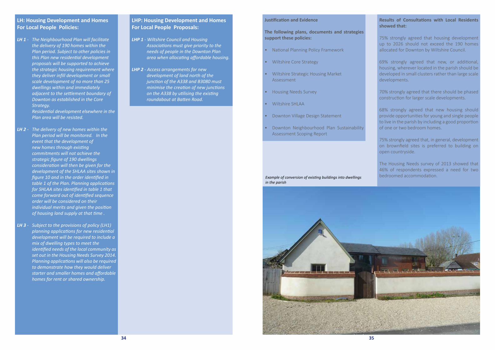
The Housing Needs survey of 2013 showed that 46% of respondents expressed a need for two bedroomed accommodation. Example of conversion of existing buildings into dwellings
in the parish
35
LH: Housing Development and Homes For Local People Policies:
LH 1 - The Neighbourhood Plan will facilitate the delivery of 190 homes within the Plan period. Subject to other policies in this Plan new residential development proposals will be supported to achieve the strategic housing requirement where they deliver infill development or small scale development of no more than 25 dwellings within and immediately adjacent to the settlement boundary of Downton as established in the Core Strategy. Residential development elsewhere in the Plan area will be resisted.
LH 2 - The delivery of new homes within the Plan period will be monitored. In the event that the development of new homes through existing commitments will not achieve the strategic figure of 190 dwellings consideration will then be given for the development of the SHLAA sites shown in figure 10 and in the order identified in table 1 of the Plan. Planning applications for SHLAA sites identified in table 1 that come forward out of identified sequence order will be considered on their individual merits and given the position of housing land supply at that time .
LH 3 - Subject to the provisions of policy (LH1) planning applications for new residential development will be required to include a mix of dwelling types to meet the identified needs of the local community as set out in the Housing Needs Survey 2014. Planning applications will also be required to demonstrate how they would deliver starter and smaller homes and affordable homes for rent or shared ownership.
LHP: Housing Development and Homes For Local People Proposals:
LHP 1 - Wiltshire Council and Housing Associations must give priority to the needs of people in the Downton Plan area when allocating affordable housing.
LHP 2 - Access arrangements for new development of land north of the junction of the A338 and B3080 must minimise the creation of new junctions on the A338 by utilising the existing roundabout at Batten Road.
34

9.3 Transport and Infrastructure
9.3.1 TransportJustification and Evidence
Road network from the local service centre of Downton
The parish of Downton is roughly bisected by the River Avon. It is well connected to the road network by the A338 which runs north-south on the western side of the river. At Downton village there are traffic lights at the junction with B3080, which runs west-east through the centre of the village, crossing the three branches of the Avon. Two minor roads run through the eastern part of the village. Barford Lane to the north connects with the A36 at the Salisbury end of the Alderbury by-pass, and Moot Lane connects with the Hampshire village of Wood Green and the river crossing to Breamore on the A338. The B3080 continues east to the Wiltshire Parish of Redlynch, then across the New Forest joining the B3078 Fordingbridge to Cadnam road. There are few minor roads across the Area of Outstanding Natural Beauty.
Major road connections
The A338 to the south connects with the A31 at Ringwood (which leads to the M27 to Southampton) and to the north with the Salisbury ring road and thence to Swindon and the M4. It is therefore a busy road. It has a high number of road casualties10, is prone to flooding in the winter and there is peak-time congestion at the traffic lights11 at Downton. The A338 is a HGV and bus route and provides access to Salisbury District Hospital in Odstock and to Bournemouth. The A36 is a major trunk road that runs northwest across Wiltshire. The Wiltshire Core Strategy indicates that a key concern for development in the Southern Wiltshire Community Area are likely negative impacts on the A36 and locally as a result of development pressures on the A36 should be considered.
Traffic Issues
The Wiltshire Third Local Transport Plan (LTP3) 2011-2026 forecasts a rise in car usage of between 17- 28% by 2026 with car ownership also continuing to increase, particularly for those living in rural areas where alternative modes of transport are limited or are being reduced. This is supported by figures which show that Southern Wiltshire has one of the highest levels of car ownership in the county.
In and around Downton village, there is a high density of local traffic especially when commuter and school run congestion occurs. At peak times, along the A338, traffic can stretch back to the junction with Charlton all Saints, and residents in Standlynch have complained to Wiltshire Council about the dangerous speed of vehicles using Barford lane as a “rat run” to the A36. For Downton, in particular, minor roads connecting to nearby trunk roads are increasingly being used by commuters as well as by commercial traffic. Significant concern about congestion and parking issues has been reported in village surveys, especially as the volume of traffic will nevitably increase as a result of new housing developments.
The Downton Village Design Statement also confirms that traffic on the A338 affects western aspects of the village, and that the centre of Downton is impacted by through traffic connecting the B3080 to the New Forest and routes to the south. Mitigation for this adverse effect has included road narrowing, traffic priority measures and the introduction of a HGV weight limit, but problems have been exacerbated by increasing car usage and flouting of the lorry ban, as well as a reduction in bus routes and frequency. There are also key safety and access issues to consider for pedestrians and cyclists particularly along busy routes such as Barford Lane, Lode Hill and South Lane and in the High Street where there is congestion caused by parking on pavements.
37
10 Crashmap.co.uk 11 Evidenced by Traffic Study for Charles Church Development
Heavy traffic on the A338 - to update
36

39
Cycle and pedestrian routes
Although pedestrian and cycle links exist, there are no National Cycle Network routes through the Downton Neighbourhood Plan area, and although there is a cycle path alongside the A338 to the north, it does not extend to Salisbury and cyclists find it unsatisfactory.
Downton Parish Council has a Rights of Way Working Group that is currently investigating improved footpaths and cycle routes within the Downton Neighbourhood Plan area. Sustrans recently reported on a study into potential cycling routes from Salisbury to the New Forest12 that mostly routed through Downton and south along Moot Lane, but this involves negotiating three pinch points at which traffic, including HGV’s, converge. The route to the New Forest is along Lode Hill which has no pavement and is particularly hazardous for cyclists and pedestrians.
12Salisbury to the New Forest, Study into potential cycling routes and signing, Sustrans, Aug 2014
Figure 11 - Downton Parish Public Rights of Way Contains Ordnance Survey data © Crown copyright and database right 2015
Public Rights of Way
Special Area of Conservation
Site of Special Scientific Interest
Schedule of Monuments
Registered Parks and Gardens
Public Rights of Way
Legend
SHLAA site eidentified in Core Strategy
Area of Outstanding Natural Beauty
Ancient Woodland
Development Restraint Area
Conservation Area
Housing Restraint Area
Housing Policy Boundary
Area of Special Archaelogical Significance
Area of High Ecological Value
Important Open Space
Proposed Employment Site
Proposed Housing Site
Proposed Recreation Site
Recreational Open Space
Special Landscape Area
Water Source Catchment Area
Figure 11: KeyParking problems in the High Street - to update
Commercial traffic
In 2007, and HGV weight limit of 7.5 tons was imposed on an area of the north New Forest bounded by the B3078/B3079 and the B3078 running through Downton village. This limitallows for local deliveries, but because the road across the New Forest to junction 1 at Cadnam provides access to Winchester, Southampton and onwards to Portsmouth, the weight limit ban is not strictly observed by other transport suppliers. Over the last two years residents have noticed a marked increase in heavy lorry movements especially in the early hours. A survey by the Downton Society in October 2014 confirmed that there were a significant number of vehicles flouting the HGV ban and that most of these were using the B3078 to access the Downton Business Park on the A338 (instead of taking the alternative route from the M27 to the A338 at Ringwood). Attempts have been made to tackle the issue by talking to transport companies, and suggesting better enforcement and improved s ignage but, to date, joint discussions with the police, Wiltshire and Hampshire councils, the NFPA and Highways England (formerly the Highways Agency) have not yet resulted in the implementation of necessary mitigation measures.
Parking issues
In the main, residents in Downton use on- street parking and this has particular difficulties along the narrow thoroughfare between the eastern end of the Borough along the High Street and up Lode Hill where, in places cars park partly on the pavements to reduce the restriction to the carriageway. There is very limited allocated parking for St Laurence’s church and only three spaces outside High street shops which, at times, adds to the parking problems in this locality.
Temporary parking also restricts the movement of traffic along the Borough during school drop off and pick-up times, and outside the doctor’s surgery in Moot Lane.
Village surveys reveal a desire for improved parking facilities, particularly in the Borough. Parking currently provided by the Co-operative store and White Horse Inn is unlikely to meet the parking needs of the increased number of customers expected from new developments on the edge of the village. Throughout the engagement activities carried out in the development of this Plan, this issue has been of primary concern to residents and any solutions to improve parking should be a priority for the use of developers’ contributions.
38Parking problems in the BoroughTraffic on the A338 through the village - to update

TP5 - The Parish Council to work with local buscompanies and Wiltshire Council to lobby for an increase in availability ofpublic transport.
TP6 - Proposals which support a sustainable transport strategy for rural areas including Wiltshire Council’s objectives to reduce impacts on the built and natural environment (SO3), encourage the efficient movement of freight (SO10)and improve safety for all road users (SO8) will be supported.
TP7 - Practical solutions to parking constraints in the High Street and Lode Hill will be supported in liaison with the Highways
Department.
TP8 - Work to improve footpaths and cycle routes through Downton and its Neighbourhood Plan area will be supported by cooperation with Wiltshire Council, the New Forest National Park Authority, Sustrans and landowners.
TP9 - There should be effective road signage in all necessary locations to alert traffic to the limitations on commercial traffic in Downton village.
Justification and Evidence
The following support these policies:
• The western aspects of Downton Village areadversely affected by the traffic on the A338,along with the effects of through-trafficconnecting to the B3080 to the New Forest.Wiltshire Core Strategy Traffic modellingidentifies that ‘Rush hour traffic in Salisbury isforecast to riseby 33%.
• The B3080 has a weight limit to inhibitHGV traffic but the weight limit is notstrictly observed.
• Car usage in the Wiltshire area is forecastto rise over the next 10 years.
• Residents use on street parking and thishas particular difficulties for pedestriansas well as vehicles as two lanes arereduced to one at the eastern end of theBorough, along the High Street and upLode Hill.
• There are no National Cycle Networkroutes through the DowntonNeighbourhood Plan area.
• Salisbury train station is 7.3 miles awayand there is no direct bus route from thePlan area.
Results of Consultations with Local Residents showed that:
94% strongly agreed that developers must assess traffic impact on the wider community e.g. congestion and parking, and help mitigate the impact.
90% strongly agreed that new development must always include safe access for vehicles and pedestrians and should not adversely affect the free movement of traffic in the vicinity.
61% strongly agreed that additional public parking and improved delivery arrangements must be provided to support retail units in the Borough and High Street.
41
Bus routes
Downton is currently served by Wilts and Dorset X3 bus that operates between Salisbury and Bournemouth along the A338 and by the Salisbury Reds 44 service that runs through the village along the B3080 to Redlynch but not beyond across the New Forest. The X3 is a regular service that runs into the evening but the 44 is a limited service so it can be necessary for residents to walk from the eastern top end of Downton to the A338 to catch the X3, which can take 30 minutes. There are also school buses and Comtrans (community transport) which provides a door to door, pre-bookable, minibus service for shoppers who are elderly or have mobility needs. National Express coach services operate through Salisbury and Ringwood. There is no direct bus route to Southampton.
Nearby train stations
The closest train station is Salisbury Railway Station, approximately 7.3 miles from Downton on the northern side of Salisbury but parking is limited and the Downton buses do not go direct to the station. Southampton Parkway Station off Junction 5 on the M27 is 14 miles away but straightforward to reach by car with a newmulti-storey car park and a faster service to London Waterloo than from Salisbury.
The Transport policies and proposals of the Plan reflect the intention to focus on more sustainable approaches to the use of transport in the Parish and surrounding area. By highlighting increased availability of public transport, cycle paths and safer pedestrian areas the policies are intended to engage actions which protect the natural environment.
T: Transport Policies:
T1 - Development proposals will be required to demonstrate that they can be incorporated in a satisfactory way into the capacity of the local highway net work. Planning applications will be expected to identify and assess theimpact of the proposed development on pedestrians, cyclists, road safety and the free and safe flow of traffic in the plan area. Where appropriate measures should be included in proposals to miti gate the impacts arising from the development proposed.
T2 - Insofar as planning permission is required proposals to improve pedestrian, cycle and vehicular access to the Downton Primary School and to Trafalgar Secondary School will be supported.
TP: Transport Proposals:
TP1 - The Parish Council to reinforce the needfor solutions to the congestion and thefree flow of traffic using the A338 andthe B3080 by working with WiltshireHighways Authority and carrying out periodic reviews.
TP2 - Downton Parish Council to support localpeople to establish a new footbridgeacross the River Avon together with associated cycle paths, including liaison with landowners and developers.
TP3 - Proposals to improve parking facilitiesin the Borough area including the area atthe Co-operative store and the White Horse Inn to be actively investigated by the Parish Council.
TP4 - The Downton Society and the ParishCouncil will continue to work with the Wiltshire and Hampshire Councils, the New Forest National Park Authority, Highways England and the Police to discuss issues, proposals and monitoring of the area wide weight limit in general, and on the B3078 through Downton in particular.
40

9.3 Transport and Infrastructure
9.3.2 Drainage, Sewerage System, Groundwater and Surface Water drainageJustification and Evidence
There are significant impacts to the community from high levels of groundwater on a regular basis. In extreme cases, these can lead to property flooding but during a wet winter there are regular overflows from the sewers and surface water drainage system in many locations onto roads and pavements as a result of groundwater infiltration. (There have been 3 significantly raised groundwater levels in the last ten years (winter 2007, 2013 and 2014)
Overflows have lead to large numbers of properties, including the Trafalgar School, being unable to use toilets, washing machines, baths etc with temporary toilets being erected outside resulting in public health and stress related issues. To alleviate some of the problems, Wessex Water have installed temporary pumps during periods of high groundwater to pump directly from the sewers to the River Avon as an emergency measure. The River Avon is a SSSI and SAC with strict controls on unregulated discharges. Long term, other solutions will have to be pursued to minimise further contributions to the problem through development. The Infiltration Reduction Plan is a response to unusual seasonal changes but if this is used on a regular or frequent basis then an alternative solution such as reed beds would need to be considered.
A detailed report on Drainage, Sewerage System and Surface Water Drainage (including graphs from Environment agency groundwater borehole records) is attached at Appendix 11.
43
TD: Drainage, Sewerage System, Groundwater an Surface Water Drainage Policies:
TD1 - All applications for development (other than for minor extensions and changes of use of existing buildings) will be required to take account of the groundwater levels and surface water flows in the Plan area. Where appropriate flood risk assessments will be required to be submitted with planning applications.
Planning applications that demonstrably add to existing foul and surface water conditions within the plan area or which do not provide acceptable mitigation will be resisted.
TDP: Drainage, Sewerage System, Groundwater an Surface Water Drainage Proposals:
TDP1 - In assessing applications for housing development and providing comments to Wiltshire Council the Parish Council will expect to see detailed proposals indicating that all drainage systems associated with the said development need to be sealed to prevent groundwater ingress, particularly at connections from premises to sewer systems and need to have assurances that testing and certification will be in place to ensure efficacy when connected.
TDP2 - Wiltshire Council to complete and implement a ground water management strategy for Downton.
TDP3 - Wessex Water to complete and implement an Infiltration Reduction Plan.
Opposite: River Avon through the water meadows
42

Floods in the water meadows
Justification and Evidence
The following support these policies:
There are significant impacts to the community from high levels of groundwater on a regular basis. In extreme cases, these can lead to property flooding and there are regular overflows from the sewers and surface water drainage system in many locations onto roads and pavements as a result of groundwater infiltration.Results of Consultations with Local Residents showed that:
92% of residents strongly agreed that any new development must have a solution to negative impacts on existing foul and surface water systems before planning permission is granted.
86% of residents strongly agreed that flood defences should continue to be strengthened in vulnerable areas.
44
Floods in the water meadows
45

9.4 The Local Economy
9.4.1 The Village EconomyJustification and Evidence
The Parish has a diverse local economy in Downton village. In the past employment was mainly connected with agriculture, the Tannery, a bacon factory, corn and paper mills and small cottage industries such as lace making and basket weaving. Manufacturing has been sustained through the development of the business park, though the majority of residents commute for work to Salisbury, Southampton, Bournemouth and areas beyond.
There are over 1,000 jobs in the Parish. Approximately 21% of people employed in Parish based companies working either full or part time, live within the Parish in contrast to 79% of people employed (over 800 people) working outside the Parish, reflecting links with larger employment centres, putting pressure on local roads to and from the Parish.
Downton Business Park
The principal employment area in the Parish today is at the business park located off the A338 Salisbury Road. The area has been gradually developing since the 1950s and includesmanufacturing, warehousing and distribution companies as well as service industries. The designs of the different units reflect the changes in construction methods over the years.867 people are employed in 31 businesses located within Downton Business Park but only a very small percentage of people employed here (some 16%) are residents of the Parish. The three largest employers on the business park have 420 employees with only 26% from the Parish. The ‘Help for Heroes’ charity is the largest with 150 employees but with less than 4% of their workforce from the Parish.
47
Opposite: The Co-op and the Borough Cafe Downton Business Park

Units at Downton Business Park
Early research in 2014 took the form of a questionnaire to 57 organisations/companies based in the Neghbourhood Plan area. (Appendix 12) Although this included the Downton Business Park, it also included small businesses and retailers in the area. The questionnaire asked basic information regarding number of employees and their locality. The remainde of the questionnaire was around 3 simple open-ended questions. Many of the comments were closely aligned with those of the residents, backing up many common themes.
Consultation with these local businesses revealed the following:
• 55% said they would like to expand their business within the next five years though 20% of these were concerned that planning permission or lack of space or the right type of space would prevent them from doing so.
• 42% respondents said they would like to see improvement in local amenities (schools, shops, etc.)
• 19% wanted traffic problems within the village improved.
• 15% of respondents said they would like to see improved parking facilities within the
village both around the shops near the Library in the High Street and Co-op in the
Borough plus within the trading estate itself.
Public consultation undertaken by the Steering Group in October 2014 demonstrated there was concern about the general traffic congestion in the village and it was felt to be impacted by heavy lorries travelling through the centre of the village. There is evidence from observation and from the police that some lorries ignoring the HGV lorry ban have been directly connected to the business park, and any future growth of the business park will need to comply with the traffic policy within the Neighbourhood plan. The nature of most of the businesses in the Business Park suggests that the majority of employees are relatively low paid or low skilled. 168 residents are employed in service based companies such as retail / distribution.
Wick Lane
There are nine businesses in Wick Lane employing 35 people. The number of residents employed is slightly higher but still only 32%. These are referred to in the section on the rural economy. The Leisure Centre was included in this survey and they believe that financial constraints are preventing it from developing further. Please refer to the section on Leisure and Facilities.
Village Centre
Within the village there are 17 businesses, 15 of which are retail businesses or pubs and cafes. Of the three areas, this is the sector with the highest proportion of local employees at 51%.
With increasing mobility the viability of many services has declined significantly over the past fifty years. Many local residents increasingly use the larger retail outlets located in nearby cities or shop on line. Over the last few decades the Parish has lost traditional industry such as the Tannery and the bacon factory.
In Downton high street there is a pharmacy, which provides a service for collection and delivery of prescriptions, a kitchen and bathroom design shop, a pub and a fish and chip shop. However, in the last 18 months, a newsagent/ sweetshop has closed, a pub and a post office has been lost with the premises changed to residential use. Public consultation identified a strong feeling that the shops within the High Street (at the east end of the village) needed re-generation, but in recent weeks the third attempt to revive a grocery store has also failed.
48 Shops on the Borough
49

• Traffic and travel - Although four of the 20 companies run shifts, most of the employee traffic using the Business Park do so between 8 and 9 am and between 5 and 5.30 pm with only two companies encouraging car sharing. With parking on the site generally seen as adequate there is little to discourage employees from using their cars. The impact of the Business Park on traffic flow is clear. The Neighbourhood Plan policies and proposals are designed to have an effect on the availability of public transport and reduce car usage but it is not likely that additional housing in the area will significantly reduce the current traffic impact of the Business Park.
• Housing Growth - 55% of businesses saw housing growth as positive, stating that they saw this as an opportunity to gain more business (from increased demand) and in some cases employees although it is questionable as to whether the match of employment opportunities and likely residents from increased housing will enable this to be a reality as shown above. It was felt staff may want to locate to Downton but affordable housing would be required and this is not seen as currently available.
The community survey strongly showed that 82% of respondents would like to encourage a thriving economy by supporting business and commercial expansion in the Parish, including maximizing the use of the current Downton business park. In particular, there was active support for businesses that offer apprenticeships and employment to local people with 90% of respondents favouring this. It is clear that the policies and proposals of this Plan will require action to have any impact on those businesses surveyed above.
As education providers and key stakeholders, schools have been consulted separately and views are expressed in the Community Facilities section.
Employment within the home
The 2011 census showed that 5.2% of residents aged 16 to 74 used their home as their main employment location. There has been a recent upgrade to broadband service to most of the Parish which will help encourage more home based work activity in the future. However, fibre optic upgrade has not reached all homes yet, especially on the periphery of the Neighbourhood Plan Area. The reception of mobile phone signals also remains inconsistent. Greater use of technological and communication advances that aid employment development will be supported as these can improve efficiency and product iv i ty, ra ise va lue added, and are consistent with the South East’s Regional Economic Strategy priority for rural areas to exploit the potential of the knowledge economy. Businesses that use such technology tend to have less environmental impacts and can also support home working to provide more employment opportunities. (Source: New Forest Core Strategy and Development Management Policies DPD 8.9 page 50).
There are several Bed and Breakfast or self-catering holiday facilities within the Parish. However, with its proximity to the New Forest and South Coast, the Parish seems to be under-represented in the tourism industry. Response to the community survey gave support of 77% to exploit our proximity to the New Forest by supporting applications to offer tourism or leisure facilities, including in rural areas.
51
Parking and traffic congestion along with lack of cycle paths and narrow footpaths were seen to exacerbate the decline of retail units and be a risk to the survival of other businesses in the East of the village. Speculation is that these businesses have been suffered from a lack of nearby parking. Nevertheless, 72% of respondents supported the development or expansion of these retail units and 83% of survey respondents wanted the Post office in the High Street to re-open. The main housing development areas are anticipated to be at the western end of the village so unlikely to help with the re-generation of the High Street.
In the Borough in the centre of the village there is a hairdresser, a pub, a medium size Coop, an optician, small bakery/ tea room, a gift shop, an “Aladdin’s cave second hand shop, and a butcher. The branch of a local bank closed three years ago, to the dismay of many residents, but was replaced by a café which is thriving.
At Downton Cross on the main A338 there is a motor cycle shop, a post office, a hairdresser and a barber all of which suffer from lack of parking, a petrol station on the west side of the A338 sells basic foodstuffs but are looking to expand their grocery outlet.
The early research referred to above was supplemented with a local in depth survey of 20 major businesses in the Downton Business park, including 195 employee responses was completed in 2015 (Appendix 13). This highlights some interesting information that supports the policies and proposals in the Housing and Transport sections as well as evidencing the policies and proposals of this section. Important amongst these findings are the following points:
• Recruitment – Recruitment methods are mixed with the most common being word of mouth (70%) and agency (50%). Although 55% of employers surveyed say they would try to recruit locally this is not borne out by the evidence with only 5% using a village publication and 30% using the Downton Business Park job board. The main resistance to local recruitment is the requirement for specialist skills. These points highlight the limited employment options for local people and it is clear that the relevance of the businesses based in Downton to the local skills and match of potential employees is low. Downton Business Park is considered to improve the sustainability of the village by providing local employment but this is not found to be the case.
• Apprentices - There are just six apprentices (under 1% of total employees on the park) captured from these 20 companies with 5 out of the 20 businesses (25%) having them. Only three people have been taken on from the local parish. Although some companies would like closer links to the school it is recognised that the skills and potential apprentices are not always seen as appropriate to their business needs.
• Premises - 75% of businesses based in the Business Park own the premises in which the business operates. Although just over half of the companies said they would like to expand only 15% of these said that they required more space to do this indicating that the Business Park is not generally seen as requiring expansion. Three quarters of the businesses intend to stay in their current location and the position and communication links were considered positively.
50
Downton Pharmacy in the High Street

9.4 The Local Economy
9.4.2 The Rural EconomyBackground
While it is not always easy to delineate exactly where the built up areas of Downton Parish end (Downton and Charlton- All- Saints villages) and the more rural parts of the Parish begin, it is clear that a significant part of the Neighbourhood Plan Area is rural.
These lands are concentrated in two main areas that are separated by the river Avon and its alluvial margins that were once farmed as water meadows. To the north-east of Downton there are the Barford, Standlynch and Witherington Downs, and to the west of Downton, where the Parish extends significantly onto Wick and New Court Downs and above Charlton- All- Saints towards Clearbury Ring. Much of the land is owned by the Longford Estates who have extensive farming activities in the parish and who also lease land to tenant farmers. Other significant farm lands, under different ownership, are to the southeast that bordering the village and extending into neighbouring parishes.
The land area of this rural part of the Parish comprises alluvial river-bed deposits and chalk uplands which are almost exclusively classified as Level 3 agricultural land and mostly level 3a. The uplands support good crop levels of wheat, barley and oilseed rape and provide grazing for grass-fed beef.Agriculture predominates with limited flocks of sheep that are kept for breeding and lamb production, beef cattle, Aberdeen-Angus bull breeding and arable crops. Interspersed with this agricultural activity are some residential houses (singles and in small groups) and a number of successful non-agricultural businesses. The main residential settlements are on, or feeding from, Barford Lane, and especially at Standlynch.
On the top of Standlynch Down there is also a large cellular transmitter and a major water reservoir that supplies Fordingbridge, Downton, Wellow and Rockborne.
The rural area provides direct employment for about 250 people (but few live locally, and most are agency workers). A number of those in living in residential properties also work from home.
Local Opinion
The questionnaire completed by local residents in 2014 clearly indicated that they would like the essentially rural nature of the community to be retained and uncontrolled growth to be restrained. Questions that concerned the rural environment achieved some of the highest ratings. The above clearly indicate an expressed desire that the rural areas that surround Downton and Charlton All Saints should be reserved and protected from development that would significantly change their character.
Cows grazing in the field - to update
53
Justification and Evidence
The following support these policies:
• The Parish has a diverse local economy.
• The principal employment area in the Parish today is the business park located off the A338 Salisbury Road. However, only 11% of the employees are local people.
• Within the village there are 17 businesses, 15 of which are retail businesses or pubs and cafes. This is the sector with the highest
proportion, at 51%, of local employees.
• The number of local retail outlets and facilities has reduced over the past few years.
• Approximately 21% of people employed in Parish based companies, live within the
Parish.
Results of Consultations with Local Residentsshowed that:
77% want to exploit our proximity to the New For-est by supporting applications to offer tourism or leisure facilities, including in rural areas.
82% would like to encourage a thriving economy by supporting business and commercial expan-sion in the Parish.
75% supported the expansion of the Business Park. As the initial business survey indicated, many of the businesses in the Parish are keen to expand.
72% supported the development of new retail units in Downton.
LE - Local Economy Policies:
LE 1 - Insofar as planning permission is required proposals for new commercial units and for the refurbishment of existing units on the Downton Business Park will be supported provided that they are in scale and in character with the immediate locality and would have no unacceptable impacts on the free and safe flow of traffic on the highway network in general and on the A338 in particular.
LE2 - Planning applications for the development of new or extended retail facilities to serve local needs within the Plan area will be supported where they have no unacceptable negative impacts on the residential amenity of the locality concerned or the safe and free flow of traffic on the highway network.
LE 3 - Planning applications that propose the development of new tourism and leisure facilities of a scale appropriate within the Plan area will be supported where they have no unacceptable negative impacts on the residential amenity of the locality concerned or the safe and free flow of traffic on the highway network.
LEP - Local Economy Proposals:
LEP 1 - Optimal use of the existing Business Park to maximise employment will be encourage.
LEP 2 - Communication between businesses and the Parish by means of a regular meeting which facilitates research on constraints on development constraints, reviews demand, hosts links with local schools, encourages employment for local people and apprenticeships and supports job advertisements, to be enabled by the Parish Council within 1 year of the date of the Neighbourhood Plan.
52

The fish farm operates in a highly competitive and low profit margin marketplace. Profitability of the agricultural activities is very dependent on subsidies from the Common Agricultural Policy where significant reductions in assistance are planned during the next few years. As a result the estate will inevitably be looking to develop land in the coming years.
The Earl of Radnor does not intend to permit the installation of wind turbines, solar panels or radio masts on his land which he believes should be largely devoted to agriculture.
Apart from the development of small parcels of land, the estate policy is mostly directed towards maintaining what currently exists and retaining the agricultural dominance. As such it is very much in tune with the views expressed by residents in the questionnaire.
The Longford Estate landholding in the Parish is so significant that there would seem to beconsiderable advantage in the continuing the ongoing informal liason between Parish Council, with the Estate Manager to discuss operations within the Parish and any plans the estate may have to change matters.
Tenant & Other Farmers
As with the Longford Estate’s Home Farm, the economic viability of the tenant and privately owned farm businesses also depends to a significant extent on the level of support they receive from the EU and DEFRA. There have been no major changes of ownership or tenancy in recent years, though there has been a tendency towards diversification. Barford Farm has recently started hosting wedding parties and Witherington Farm has long operated extensive fishing activities.
The main constraints suffered by the farms on the east of the river centre around the road, which in places, is narrower than modern agricultural vehicles and so requires the vehicles to degrade and damage the road margins. In addition, the weight restrictions in Downton cause delivery vehicles to take significant diversions via Salisbury and the A36 or across the New Forest. The same applies to the farming activities off Wick Lane. While not preventing operations both these problems provide a continuing irritation.
Other business activities
The rural area also hosts a number of significant businesses undertaking diverse activities including cabinet manufacture, fishing lake provision, wedding venues, egg and sports energy bar production and millinery.
Clearly the rural environment is no barrier to successful business operation, and in some instances will be a real advantage (eg wedding venues). Many of these units produce products that are of national importance. However, they all suffer from the same general problems that have been outlined above, and seem to lack any structured contact with the Parish Council. This problem could be addressed if the Parish Council formed or sponsored a Rural Business Forum which met regularly and discussed those problems that were hindering business development within the parish.
55 Lanes network in the parish
Future Aims
In order to give expression to these local wishes the overall aims of policies contained in this section of the Downton Neighbourhood Plan are designed to preserve the diverse mix of agricultural and non-agricultural small business activity, in order to sustain the landscape and ensure the economic and social wellbeing of those who live in the more rural parts of the parish. Such development as does take place in these areas should integrate within the existing environment, be limited in scale and impact, and further enhance the overall economic and social wellbeing of the population. It is therefore anticipated that there will not be any significant development within these rural areas as the Core Strategy seeks to focus new development on the Downton Business Park and along the margins of the A338.
Common Issues
There are two common difficulties that affect most of the more rural parts of the parish.
1. Broadband – The vast majority of the Parish is serviced by Downton exchange (01725). The exception is the northern part of the parish on the eastern side of the river, where
telecommunications are provided by the Alderbury exchange (01722 71xxxx).
Although much of the area covered by the Downton exchange offers a good broad band service, some of the coverage is poor and that part of the parish serviced from
Alderbury has much slower broadband speeds and is subject to break-downs in service - these parts of the parish are at the limits of the coverage any exchange can offer and the supply is by overhead copper cable and so subject to low speeds and weather damage. Some businesses suffer more than others and have had protracted discussions with BT but to date without success.
2. Roads – the two more rural parts of the Parish are served by minor roads. Communication to the east of the river is via Barford Lane which becomes Witherington Road, while Wick Lane serves the land on the
western side of the parish. Both roads are limited in width and subject to lower levels of maintenance than would apply on the A338. The movement of large agricultural vehicles and delivery lorries is restricted and can be problematical. Barford Lane also acts as a “cut-through” for commuters and is subject to increased levels of traffic at certain times of the day. Wick Lane narrows significantly just past the sports centre, and this can cause problems for delivery drivers. The road salt bin which was located at the top of the lane has been removed and so access in snow conditions is very difficult.
Major landowner
The Longford Estate is by far the major landowner in the Parish. Their three estates (Longford, Trafalgar and West Park) amount to about 16,000 acres and the larger part of the Longford and Trafalgar estates are located in the Downton Parish (in excess of 10,000 acres). Apart from the built-up areas in Downton and Charlton- All-Saints villages and some land immediately adjacent thereto, the majority of the rural parts of the parish is part of the Longford and Trafalgar Estates, exceptions being the land farmed by Witherington Farm to the north, the land farmed by Newmans to the southeast and some limited parcels of land on the south of the parish. Most of the estate land on the east of the river is farmed by tenants, as is some land on the southern extremities of the estate holding on the west side of the river. Most of the land on the west of the Avon and A338 is farmed as Home Farm (4,700 acres). The estate also own and operate the fish farm off Barford Lane. Home Farm, the estate and the fish farm collectively directly employ about 100 people, many of whom are agency staff living outside the area.
The estate’s agricultural activity in the parish centres around arable farming and Aberdeen Angus beef production. They have dairy and pig activities outside the parish plus extensive areas of cultivated woodland (2,200 acres).
54

RE - Rural Economy Policies:
RE 1 - Planning applications that preserve the rural nature of the Neighbourhood Plan area while also ensuring the continued economic well-being of the agricultural and non-agricultural business planning applications will be supported.
RE - Rural Economy Proposals:
REP 1 - The Parish Council to work with statutory bodies and others as appropriate to help achieve the needs of the rural community and a viable rural economy without compromising the special qualities of the area.
REP 2 - Residents and the Parish Council to continue to lobby for the provision of superfast broadband throughout the rural parts of the parish within the next three years.
REP 3 - The Parish Council to continue to work with the appropriate authorities to highl ight the maintenance requirements of the rural roads throughout the life of the Neighbourhood Plan.
56
Justification and Evidence
The following support these policies:
• A significant majority of the Neighbourhood Plan area is rural.
• The rural area provides employment for about 250 people (although not all are local residents).
• Parts of the Neighbourhood Plan area are at the limits of the coverage of the
communications network and an increasing number of people now work from home.
• The rural parts of the Parish are covered by minor roads which are subject to lower levels of maintenance than A classified roads.
Results of Consultations with Local Residents showed that:
Just over 70% of respondents strongly agree that ‘Future expansion of local industry should be on the Downton Business Centre rather than rural areas of the Parish’.
88% strongly agree with the statement that ‘New development must not dominate in scale, block distinctive views or significantly change the balance and character of the Parish’.
85% strongly agree with the statement ‘Development must not harm or adversely impact on protected habitat areas or designated Sites of Special Scientific Interest such as the River Avon’.
84% strongly agree with the statement ‘Wildlife sites and woodland must be protected and, where necessary, restored and managed’.
Opposite: Cows grazing in the field

Justification and Evidence
In this section the facilities that will be considered are the community buildings and services, medical and dental services and the Parish Schools.
As a designated “service centre” Downton’s community facilities are expected to service a rural hinterland and will need to be considered in the context of the wider area.
Buildings and services
There are over 30 clubs and societies in the plan area. These are an integral part of the community cohesion of Downton and the surrounding areas. Many of these rely on having access to buildings that are suitable for meetings. In addition there are groups, such as Downton painting and book groups, which meet by private arrangement.
St Laurence church is regularly used as a venue for concerts, musical gatherings and seasonal festivals. The Baptist church can be used for meetings and hired for use as a day centre and classes. The Roman Catholic Church and the Methodist Church are used predominately for services.
Downton memorial hall is run by a private trust. The original part of the hall was the British Boys’ School, which closed in 1896 when the new Board school opened in Gravel Close. It be-came a parish hall and was extended after both world wars. It now has a good stage, changing rooms, a kitchen and lavatories, and is used for all kinds of meetings and events including the weekly W.I. market. The building is tired and needs improvements to facilities. These are under consideration by the Parish Council but funding is mainly dependent on developer contribution.
Wiltshire Council operates the Downton Library, which was built in its current position after the tannery was closed in 1968 and rebuilt into residential housing. The library is able to open six days a week with the support of local volunteers. It is well used on a daily basis and there is provision for young readers in a dedicated children’s section and a summer reading challenge. There is also a community reading group started in 2013. Wiltshire Council has a priority for improvements to library book stocks and facilities. The library is well able to accommodate a significant increase in users. Four parking spaces at the Tannery flats are reserved for library users, though they are often used by non library users as convenient parking for the shops at the top end of Downton. Library users then find they are unable to park in the designated spaces.
9.5 Community Facilities and Services
9.5.1 Community Facilities and Services
Opposite: Downton Primary School
Downton Baptist Church
5958

Primary School Provision
Downton Church of England Primary School, a long established co- educational Church of England school in the Diocese of Salisbury, provides education for children between the ages of four and eleven. Currently two thirds of the children at the school come from the villages of Downton, Standlynch, and Charlton-all-Saints.
At present the total number of children on roll is 208 and the children are taught in single year groups from Reception through to Year 6. The 2013 Ofsted result was “Outstanding”.
There are 190 houses identified in the Wiltshire Core Strategy to be built in the Downton community area, around 70% of which have yet to be constructed. The housing identified in the Core Strategy for Downton, is expected to generate increased pupil numbers and will create a shortfall of primary places in the next few years. The precise shortfall will depend on mix of dwelling sizes, social housing and windfall sites actually built but an expansion of the primary school will be required to meet this demand.
There is a recently approved planning application for a two storey classroom extension, an extension to the main hall and change of use to part of the Memorial Hall Gardens to include a new play-ground. This will take the school from a 1.0FE to 1.5FE (forms of entry). Funding will come from contributions from new housing development and the objective is to provide capacity for all children in Downton parish who wish to attend the primary school. Discussions between the Parish Council, the developer and the Education Authority are being held to achieve mutually acceptable outcomes, including on the design of the new building which stands within the conservation area. The school has an admissions policy which is
61
currently being revised. There are currently approximately one third of children attending who are not residents of the parish. There is strong feeling expressed in the survey that all children in the Downton area should be able to attend their local school and the purpose of leasing public land to the school is to enable this, so the admissions policy, needs to ensure that there are places available to all children in the Downton Civil parish. The Planning consent which has been granted for the two storey classroom extension at Downton CE VA Primary School will provide 60 additional places and after this time the site will be at capacity and will not be able to be expanded further.
It is noted that the planning proposals increase car parking facilities by only one space. Although it is expected that the school car park will be opened to people attending out of school hours events at the Memorial Hall, parents and carers dropping and collecting children off have to park at the Coop and behind the White Horse as well as on the road-side which increases congestion and restricts already limited parking for local residents.
Secondary School Provision
The Trafalgar School at Downton is a 11-16 mixed Foundation school with an intake from primary schools in both Wiltshire and Hampshire. The current number on roll is 544 and the school could increase this to 750 and is well within the BB98 education framework Its most recent Ofsted inspection was graded ‘good’ in all areas, with outstanding features. There are 115 students joining Year 7 in 2015, of which 11 come from a cohort of 25 from Downton Primary School.
The school has no Sixth Form provision. Young people born on or after 1 September 1997, must stay in some form of education or training up until their 18th birthday. In 2014 110 students left the school in Year 11: 98 to surrounding Sixth Form Colleges, nine to take up apprenticeships and three to Sparsholt College. School facilities: In 2012 a new sports Hall was built as Trafalgar was the only secondary school in the county without one. There was a decision taken not to compete with the Leisure centre so the school facilities are not open to the public apart from specific arrangements.
Downton Primary School
60
Educational provision
Pre school
Giant Steps Day Nursery provides for 0-3 and 3-5 year old children. This is a private business though takes a number of designated “vulnerable families’ with funding from the local authority. They report a waiting list until September 2016 and would like to expand; but their current premises at Trafalgar School would be unable to accommodate further expansion due to current land ownership. They have the capital to move if a suitable site became available. They are flexible as to where this could be within the plan area.
Clearbury Children’s Centre, a Sure Start Children’s centre, is run by the charity Spurgeons on behalf of the County Council. It shares the same building as Giant Steps, and serves as the hub for a wide geographical area being easily accessible to families in this rural area. They aim to support and encourage local families with children under five by providing information, advice and services including help with returning to work, finding childcare, family support, family health, and much more. There is a varied selection of play sessions and events each week which allow parents and carers to socialize whilst their children explore and develop through play. The centre and its resources, including play room and sensory room is used by a wide variety of local parents.
Downton Community Pre-School welcomes children from age two to school age. The Pre-School is a non-profit making charity run by a parent management committee and aims to be responsive to the needs of the local community. It is currently situated in the Band Hall, Gravel Close which is a central location near the Primary School, but has significant disadvantages for the preschool. All equipment has to be put away at the end of each day; there is no dedicated office space and no grass area on site. There is currently no parking or drop off points outside the preschool and no pavement for safe walking on Gravel close. The hall is owned by the band and is rented for a number of activities. If there is developer funding available for a new the Memorial Hall extension to benefit the community need for more meeting rooms, the preschool would relocate from the band hall to the rear of the Memorial hall. It is advantageous to have the preschool sited next to the primary school as some facilities can be shared and parents can drop off children at the same time reducing car use. It is inevitable, though, that additional school places will increase the traffic flow but also has the potential to increase employment.The school employs five staff all of whom live in the Neighbourhood Plan area.
In addition to the schools there is a number of groups for children during the week:
• Major minors – a pre-school music group at the Memorial Hall.
• Panda club play group and Little Club at the Baptist church.
Giant Steps Day Nursery
Downton Community Pre-school
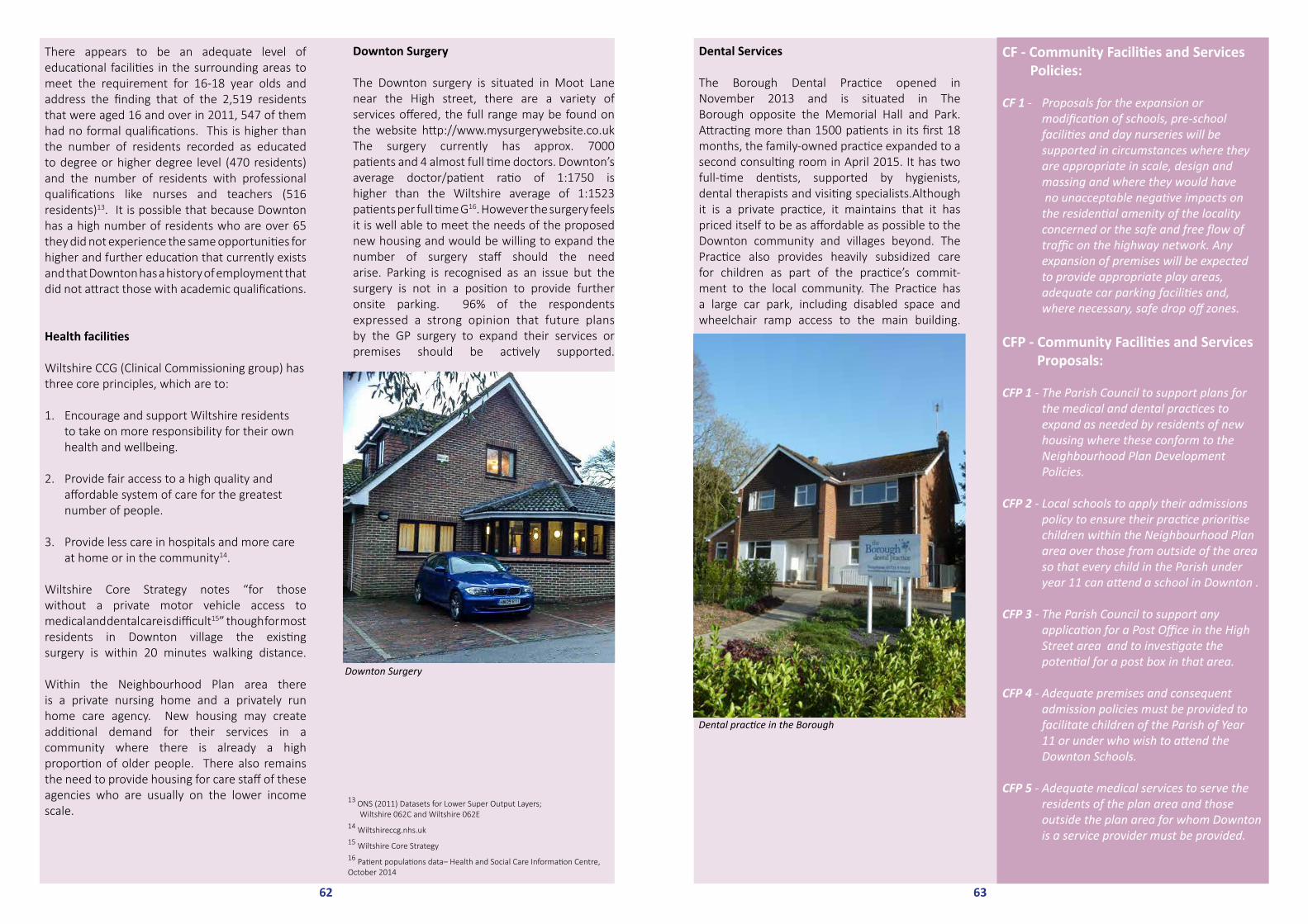
63
Dental Services
The Borough Dental Practice opened in November 2013 and is situated in The Borough opposite the Memorial Hall and Park. Attracting more than 1500 patients in its first 18 months, the family-owned practice expanded to a second consulting room in April 2015. It has two full-time dentists, supported by hygienists, dental therapists and visiting specialists.Although it is a private practice, it maintains that it has priced itself to be as affordable as possible to the Downton community and villages beyond. The Practice also provides heavily subsidized care for children as part of the practice’s commit-ment to the local community. The Practice has a large car park, including disabled space and wheelchair ramp access to the main building.
Dental practice in the Borough
CF - Community Facilities and Services Policies:
CF 1 - Proposals for the expansion or modification of schools, pre-school facilities and day nurseries will be supported in circumstances where they are appropriate in scale, design and massing and where they would have no unacceptable negative impacts on the residential amenity of the locality concerned or the safe and free flow of traffic on the highway network. Any expansion of premises will be expected to provide appropriate play areas, adequate car parking facilities and, where necessary, safe drop off zones.
CFP - Community Facilities and Services Proposals:
CFP 1 - The Parish Council to support plans for the medical and dental practices to expand as needed by residents of new housing where these conform to the Neighbourhood Plan Development Policies. CFP 2 - Local schools to apply their admissions policy to ensure their practice prioritise children within the Neighbourhood Plan area over those from outside of the area so that every child in the Parish under year 11 can attend a school in Downton .
CFP 3 - The Parish Council to support any application for a Post Office in the High Street area and to investigate the potential for a post box in that area.
CFP 4 - Adequate premises and consequent admission policies must be provided to facilitate children of the Parish of Year 11 or under who wish to attend the Downton Schools.
CFP 5 - Adequate medical services to serve the residents of the plan area and those outside the plan area for whom Downton is a service provider must be provided.
62
There appears to be an adequate level of educational facilities in the surrounding areas to meet the requirement for 16-18 year olds and address the finding that of the 2,519 residents that were aged 16 and over in 2011, 547 of them had no formal qualifications. This is higher than the number of residents recorded as educated to degree or higher degree level (470 residents) and the number of residents with professional qualifications like nurses and teachers (516 residents)13. It is possible that because Downton has a high number of residents who are over 65 they did not experience the same opportunities for higher and further education that currently exists and that Downton has a history of employment that did not attract those with academic qualifications.
Health facilities
Wiltshire CCG (Clinical Commissioning group) has three core principles, which are to:
1. Encourage and support Wiltshire residents to take on more responsibility for their own health and wellbeing.
2. Provide fair access to a high quality and affordable system of care for the greatest number of people.
3. Provide less care in hospitals and more care at home or in the community14.
Wiltshire Core Strategy notes “for those without a private motor vehicle access to medical and dental care is difficult15” though for most residents in Downton village the existing surgery is within 20 minutes walking distance.
Within the Neighbourhood Plan area there is a private nursing home and a privately run home care agency. New housing may create additional demand for their services in a community where there is already a high proportion of older people. There also remains the need to provide housing for care staff of these agencies who are usually on the lower income scale.
Downton Surgery
The Downton surgery is situated in Moot Lane near the High street, there are a variety of services offered, the full range may be found on the website http://www.mysurgerywebsite.co.ukThe surgery currently has approx. 7000 patients and 4 almost full time doctors. Downton’s average doctor/patient ratio of 1:1750 is higher than the Wiltshire average of 1:1523 patients per full time G16. However the surgery feels it is well able to meet the needs of the proposed new housing and would be willing to expand the number of surgery staff should the need arise. Parking is recognised as an issue but the surgery is not in a position to provide further onsite parking. 96% of the respondents expressed a strong opinion that future plans by the GP surgery to expand their services or premises should be actively supported.
13 ONS (2011) Datasets for Lower Super Output Layers; Wiltshire 062C and Wiltshire 062E 14 Wiltshireccg.nhs.uk15 Wiltshire Core Strategy16 Patient populations data– Health and Social Care Information Centre, October 2014
Downton Surgery

Justification and Evidence
The following support these policies:
• As a designated ‘service centre’ Downton’s community facilities and services will need to be considered in the context of the wider area.
• With increasing mobility the viability of many
rural services has declined significantly over the past fifty years.
• The surgery feels it is well able to meet the needs of the proposed new houses and would be willing to expand the number of
surgery staff should the need arise.
• Most of the children at the primary school come from the villages of Downton,
Standlynch, and Charlton-all-Saints but a significant proportion come from outside of
the Parish.
• There are difficulties for the current pre-school site - all equipment has to be put
away at the end of each day; there is no dedicated office space and no grass area on
site. There is currently no parking or drop off points outside the preschool.
• The primary school is planning expansion to meet the level anticipated from the Wiltshire core strategy.
• The library is well able to accommodate a significant increase in users.
Results of Consultations with Local Residents showed that:
73% strongly agreed that Primary School capacity must be increased to cater for all children of the parish who wish to attend the school.
96% of the respondents expressed a strong opinion that future plans by the GP surgery to expand their services or premises should be actively supported.
63% strongly agreed with the proposal that the Post office in the high street should be reopened.
69% strongly agreed that Community buildings such as the library and memorial hall should be supported and improved to meet the needs of a growing community.
52% strongly agreed that Pre-school provision in the village should be expanded to meet the needs arising from any increase in development.
Opposite: Downton Memorial Hall
64

9.5 Community Facilities and Services
9.5.2 Leisure FacilitiesJustification and Evidence
The Parish has significant areas of open space all of which have some limitations on their use defined, for example, by covenants in the title deeds. The Memorial gardens were gifted to the parish and opened in 1921 to be a public garden and play area for children. It is well used particularly by children but also for village celebrations e.g. the Queens golden jubilee. The Parish Council also owns, the Moot Lane recreation area, part of the former railway line to the north of The Sidings and the land off Wick Lane on which stands the Leisure Centre, Tennis Courts, Bowling Green, Football Pitch and Sports and Social Club. The Leisure Centre is owned by the Brian Whitehead Sports Centre Association and operated by Beacon Leisure Management and partially supported by Wiltshire County Council funding. The Leisure Centre is subject to a clause which identifies that, should the Centre close, the Longford Estate will have the first refusal to buy back the land on which it stands at a rate that only reflects agricultural use. The Parish Council has responsibility to return the Centre to its previous state should it not remain viable and be returned to the Longford Estate in the way described above. The Leisure Centre roof is almost entirely covered with solar panels for the production of electricity which is subject to a shared income agreement. The land opposite to the Leisure Centre, on the other side of Wick Lane, which is used for allotments is owned by the Longford Estate, leased to the Parish Council and operated by an association. The allotments currently have a waiting list of new applicants. There are also some allotments on land to the rear of the Catholic Church in Barford Lane.
The Leisure Centre
The Local Government Act 1988 (Competition in Sports and Leisure Activities) placed an obligation on Local Authorities to make the provision of such activities subject to competition (tender) and the application of efficiency measures. Currently Wiltshire County Council is continuing to part fund the Leisure Centre but has the option of applying such efficiency measures to the Downton Leisure Centre and there is the potential to place a responsibility on the Centre to find some or potentially all the £50,000 granted by Wiltshire County Council in efficiency savings. This would put the viability of the Centre under considerable threat. The Leisure Centre currently has 250 mem-bers but this is not representative of the total use as there are a number of ‘pay and play’ sessions and many of the 71 junior members are recorded separately as part of the Tennis Club. During the year 2014 1638 older people attended the ‘Fifty plus’ sessions; 572 young people attended the ‘teen zone’ sessions and 468 visits were as a result of GP referrals. With an average monthly footfall of 2,480 people, the Leisure Centre is clearly important to local residents and is visited by people who come some distance such as from Bournemouth. The Centre offers Fitness classes, a variety of team sports, tennis courts, gym facilities and is negotiating a contract with a local Ofsted registered provider to provide classes and leisure activities for children.
The management team at the Centre believes that the potential to increase membership is limited by the fairly rural location but are clear that there is the capacity to welcome more people and maximise availability to the whole community. This belief is possibly untested and support to improve the membership and footfall could be considered through the proposed business liaison meetings.Data from the National Health and Nutrition
67 Opposite: Downton Memorial Gardens Play Area
66

Plans to progress an extension of the Memorial Hall, to include an area for the preschool and meeting rooms for services or local groups to use have been initiated as mentioned above but will depend on sufficient funding being available and planning permission being granted. A key source of such funding is potentially the community infrastructure levy (CIL) provided as a result of local housing development but the pos-sibility of ‘Campus funding’ is also explored20. The Trafalgar School is considering a Multi Use Games Area (MUGA) on its grounds but are awaiting the outcome of community facility discussions elsewhere in the village.
An opportunity for premises sharing is po-tentially available by sharing educational premises and facilities with members of the community. This has the potential for increasing inter-generational interaction which can be ‘an effective way to address a number of issues -many of them key government priorities – related to building active communities’21. Consultation on the emerging Neighbourhood Plan identified just over two fifths of the population agreed with an approach to engage with local schools to encourage sharing of their facilities with the community. However, discussion with Trafalgar School has identified that it is not their policy to encourage open-ing their sports facilities to the public as this would reduce the viability of the Leisure Centre’s provision. In addition it was mooted that the cost of heating outside of school hours would make the opening of facilities for meetings and other use of the school’s buildings potentially prohibitively expensive. However, there is a general willingness to consider applications for use of the facilities for large scale events on their merits.
Although groups and social clubs are often associated with buildings based facilities, the Parish has two publically accessible recreation grounds, one being held in trust with specific conditions but the other being a large open area in Moot Lane which is used by local people as an outdoor walking area and by young people for rollerblading and, in the past, by a football club although currently there is difficulty obtaininginterest in supporting a football team on this land. There is also a further football ground, bowling area and tennis courts available at the Western end of the village adjacent to the Leisure Centre. However, the Moot Lane ground is poorly provided with facilities. The Parish Council has responsibility for the upkeep of the wooden changing rooms built on the recreation ground but additional construction or further provision on the site is limited by the application of the terms of the covenant that was originally applied and this would need to be addressed. Consultation on the emerging Neighbourhood Plan identified just over a quarter of residents agreed with an approach to improve facilities in the Moot Lane recreation area.
69
20 Minutes of South Wilts Area Board July 201521 Centre for Intergenerational Practice: Beth Johnson Foundation, 2001 South Wilts Archery Club using Trafalgar School Grounds
Wooden changing rooms at the Moot Lane football ground
Examination Survey, 2009–201017 shows that nationally there are high levels of obesity with more than one in 20 adults considered to have extreme obesity and about one-third of children and adolescents ages 6 to 19 considered to be overweight or obese.
These statistics do not necessarily represent the conditions for the population of the Parish which does currently have the opportunity to counter the national trend because of the existence of the Leisure Centre and other facilities. The United Nations Convention on the Rights of the Child18
identifies the ‘right of the child to rest, leisure, play, recreational activities, cultural life and the arts’. Although much of this right is satisfied during schooling and educational activities, additional opportunities provided by the Leisure Centre demonstrated through the use of the holiday activities provided there. For health and community cohesion benefits the Parish has strong reasons to support the retention and improvement of the Leisure Centre.
Consultation on the emerging Neighbourhood Plan identified a third of the population agreed with an approach of identifying a suitable area of open space to reintroduce a village cricket ground and a quarter agreed with an approach to create a village trim trail to encourage healthy living in a safe environment.
Other community facilities
Downton has a relatively high proportion of its population being over 60 (40%). It is well known that ‘Social isolation and loneliness impact upon individuals’ quality of life and wellbeing, adversely affecting health and increasing their use of health and social care services’19 and that this is particularly the case in older people and people with mental health issues. During an engagement activity with Downton Good Companions – a group of older people regularly meeting for social stimulation and discussion – it was clear that the members strongly valued the opportunity that the group gave. There is, however, no obvious provision specifically for those with mental ill health. The Parish is well provided with groups and social clubs or activities, having at least 32 such listed in its local magazine as well as scouts and guides.
Consultation on the emerging Neighbourhood Plan identified just under a third of the population agreed with the need to improve the quality and availability of premises in the community for societies, meetings and activities.
68
Downton Leisure Centre on Wick Lane
17 Weight control Information Network 18 The United Nations Convention on the Rights of the Child, dated 17th April 2013.19 Preventing loneliness and social isolation, Social Care Institute for Excellence, October 2014
Downton allotments off Wick Lane

The plan reflects the situation at the time of completion, though we have tried to ‘future proof’ it as far as possible. It is essentially a document to influence planners and outline some of the wishes and aspirations of the local community. Over time, perceptions and priorities may change, but the local environment, housing, transport, infrastruture, community facilities and services and the local economy, will remain essential issues. It is these issues to which we have applied policies and proposals.
A Neighbourhood Plan can be reviewed at any time. Our Plan may need review if there is a major change to Wiltshire’s core strategy or a change, for instance, to national policy on rural development and/or housing. However, the current Plan, and the research that has been done to support it, will remain a foundation to inform future considerations – some of which may need a more radical and far-reaching response to the long term future of the village of Downton and its surrounding hamlets and rural environment.
A glossary of terms and acronyms used in this Plan can be found at Appendix 14.
71
10.0 Conclusion
The Downton Neighbourhood Plan is the result of comprehensive consultation with residents and stakeholders. During its preparation, ideas have evolved and original concepts have been refined in response to discussion generated by increased awareness of the issues. This final document, to be submitted to Wiltshire Council in September 2015, is supported and endorsed by Downton Parish Council.
We are fortunate to be part of a vibrant community. Whilst many of the residents of the parish have lived in the same area for many years, it is clear that they by no means hold the same views. No plan can include all the differing opinions expressed, but we are confident that this one does reflect the majority view on a range of important issues. Wide engagement has demonstrated that people are innovative and are not resistant to change as long as it is sustainable, benefits the community and does not destroy its essential character and sense of place.
The Downton Neighbourhood Plan has taken two years to complete. During this time many people have freely offered their time and skills. Members of the Steering Group have been involved, amongst other things, in Vision, Research and Engagement task groups, creating surveys and running consultation events, liaising with stakeholders and wiltshire council, project planning, maintaining records, writing proof reading and formatting the Plan. The website was maintained by Phill Webs.
Neighbourhood Plan Steering GroupJane Brentor, Christopher Bird, Susan Barnhurst Davies, Ian Campbell, Ian Draper, John Elliott, Peter Favier, Alan Foster, Richard Ford, Adam Hayward, Rob Hewlett, Graham Humphries, Sally Lacey, Dave Mace, Hilary Mace, Lucy Norman, Mike Norman, Margaret Tribe, Helen Willcox, Simon Walker-Bircham, Nikki Wilson (chair)
The Parish Council have been supportive throughout the process.
LF - Leisure Facilities Policies:
LF 1 - Proposals that would result in the creation of new leisure facilities and/or the redesign or extension of existing leisure facilities will be supported provided that they comply with other policies in the neighbourhood plan and the wider development plan.
LFP- Leisure Facilities Proposals
LFP1 - The Parish council to look favourably on proposals that encourage outdoor activities.
LFP2 - The Parish Council to seek to improve the quality and availability of premises in the community for societies, meetings and activities by actions, including engagement with local schools to share facilities, and improving facilities in the Moot Lane recreational area within the restrictions of any covenant on the land ownership during the lifetime of the Neighbourhood Plan.
LFP3 - The Parish Council to pursue the improvement of the Memorial Hall as an integrated solution to the provision of better facilities for the Community.
Justification and Evidence
The following support these policies:
• With an average monthly footfall of 2,480 people, the Leisure Centre is clearly
important to local residents.
• The management team at the Leisure Centre are clear that there is the capacity to
welcome more people and maximise availability to the whole community.
• Downton has a relatively high proportion of its population being over 60 (40%). It is well known that ‘Social isolation and loneliness impact upon individuals’ quality of life and wellbeing, adversely affecting health and increasing their use of health and social care services’ and that this is particularly the case in older people.
• The Moot Lane ground is poorly provided with facilities.
Results of Consultations with Local Residents showed that:
50% strongly agreed that there should be a lobby for public funding and provide support for retention and improvement of the leisure centre.
33% strongly agreed with an approach of identifying a suitable area of open space to reintroduce a village cricket ground.
24% strongly agreed with an approach to create a village trim trail to encourage healthy living in a safe environment.
31% strongly agreed with the need to improve the quality and availability of premises in the community for societies, meetings and activities.
44% strongly agreed with an approach to engage with local schools to encourage sharing of their facilities with the community.
27% strongly agreed with an approach to improve facilities in the Moot Lane recreation area.It is recognised that the demand in this Leisure Facilities area is lower than for other sections.
70

www.downtonfuture.org