Mishra S, Deo SG, Abbas R, Naik S, Shete G, Agrawal N, and Rajaguru SN. 2009. Excavations at the...
17
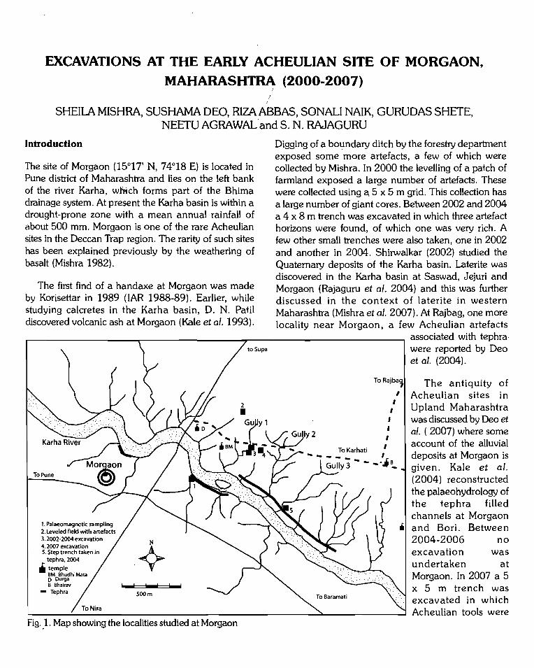
EXCAVATIONS AT THE EARLY ACHEULIAN SITE OF MORGAON, MAHARASHTRA (2000-2007) SHEILA MISHRA, SUSHAMA DEO, RIZA ABBAS, SONALI NAIK, GURUDAS SHETE, NEETU AGRAWAL' and S. N. RAJAGURU Introduction The site of Morgaon (1' N, 74°19 E) is located in Pune district of Maharashtra and lies on the left bank of the river Karha, which forms part of the Bhima drainage system. At present the Karha basin is within a drought-prone zone with a mean annual rainfall of about 500 mm. Morgaon is one of the rare Acheulian sites in the Deccan Trap region. The rarity of such sites has been explained previously by the weathering of basalt (Mishra 1982). The first find of a handaxe at Morgaon was made by Korisettar in 1989 (IAR 1988-89). Earlier, while studying calcretes in the Karha basin, D. N. Patil discovered volcanic ash at Morgaon (Kale et al. 1993). ToPune 4. 2007 excavation 5. Step trench taken in tephra, 2004 .iii temple BM Bhudhi Mata 0 Durga B Bhairav - Tephra lwwol lo;;;;;o! lo;;;;;o! 500m Fig. _1. Map showing the localities studied at Morgaon to Supa Digging of a boundary ditch by the forestry department exposed some more artefacts, a few of which were collected by Mishra. In 2000 the levelling of a patch of farmland exposed a large number of artefacts. These were collected using a. 5 x 5 m grid. This collection has a large number of giant cores. Between 2002 and 2004 a 4 x 8 m trench was excavated in which three artefact horizons were found, of which one was very rich. A few other small trenches were also taken, one in 2002 and another in 2004. Shirwalkar (2002) studied the Quaternary deposits of the Karha basin. Laterite was discovered in the Karha basin at Saswad, Jejuri and Morgaon (Rajaguru et al. 2004) and this was further discussed in the context of laterite in western Maharashtra (Mishra et a/. 2007). At Rajbag, one more locality near Morgaon, a few Acheulian artefacts To I I I I To Karhati 1 ------ I Gully 3 -- associated with tephra were reported by Deo I et a/. (2004). The antiquity of Acheulian sites in Upland Maharashtra was discussed by Deo et a/. ( 2007) where some account of the alluvial deposits at Morgaon is given. Kale et a/. (2004) reconstructed the palaeohydrology of the tephra filled channels at Morgaon Iii and Bori. Between 2004-2006 no excavation was undertaken at Morgaon. In 2007 a 5 x 5 m trench was excavated in which Acheulian tbols were
-
Upload
deccancollegepune -
Category
Documents
-
view
1 -
download
0
Transcript of Mishra S, Deo SG, Abbas R, Naik S, Shete G, Agrawal N, and Rajaguru SN. 2009. Excavations at the...
EXCAVATIONS AT THE EARLY ACHEULIAN SITE OF MORGAON,
MAHARASHTRA (2000-2007)
SHEILA MISHRA, SUSHAMA DEO, RIZA ABBAS, SONALI NAIK, GURUDAS SHETE, NEETU AGRAWAL' and S. N. RAJAGURU
Introduction
The site of Morgaon (1' N, 74°19 E) is located in Pune district of Maharashtra and lies on the left bank of the river Karha, which forms part of the Bhima drainage system. At present the Karha basin is within a drought-prone zone with a mean annual rainfall of about 500 mm. Morgaon is one of the rare Acheulian sites in the Deccan Trap region. The rarity of such sites has been explained previously by the weathering of basalt (Mishra 1982).
The first find of a handaxe at Morgaon was made by Korisettar in 1989 (IAR 1988-89). Earlier, while studying calcretes in the Karha basin, D. N. Patil discovered volcanic ash at Morgaon (Kale et al. 1993).
ToPune
4. 2007 excavation 5. Step trench taken in
tephra, 2004
.iii temple BM Bhudhi Mata 0 Durga B Bhairav
- Tephra lwwol lo;;;;;o! lo;;;;;o!
500m
Fig. _1. Map showing the localities studied at Morgaon
to Supa
Digging of a boundary ditch by the forestry department exposed some more artefacts, a few of which were collected by Mishra. In 2000 the levelling of a patch of farmland exposed a large number of artefacts. These were collected using a. 5 x 5 m grid. This collection has a large number of giant cores. Between 2002 and 2004 a 4 x 8 m trench was excavated in which three artefact horizons were found, of which one was very rich. A few other small trenches were also taken, one in 2002 and another in 2004. Shirwalkar (2002) studied the Quaternary deposits of the Karha basin. Laterite was discovered in the Karha basin at Saswad, Jejuri and Morgaon (Rajaguru et al. 2004) and this was further discussed in the context of laterite in western Maharashtra (Mishra et a/. 2007). At Rajbag, one more locality near Morgaon, a few Acheulian artefacts
To Rajba~
I I
I
I
To Karhati 1
------ I Gully 3 -- --Ji~
associated with tephra were reported by Deo
I et a/. (2004).
The antiquity of Acheulian sites in Upland Maharashtra was discussed by Deo et a/. ( 2007) where some account of the alluvial deposits at Morgaon is given. Kale et a/. (2004) reconstructed the palaeohydrology of the tephra filled channels at Morgaon
Iii and Bori. Between 2004-2006 no excavation was undertaken at Morgaon. In 2007 a 5 x 5 m trench was excavated in which Acheulian tbols were
WIN7
Typewritten Text
WIN7
Typewritten Text
WIN7
Typewritten Text
18 17 N, 74 19 E
WIN7
Typewritten Text
WIN7
Typewritten Text
WIN7
Typewritten Text
122
~ ~
D
cobbly pebbly gravel with laterite, abraded acheu I ian artefacts
Rubble
Compact pinkish silt
~ h ~ Tep ra
[J Black fissured clay
~ Sandy pebbly gravel l.±12J with acheuhar~
artefacts
~ Late Pl~istocene gravels ~ w1th m1crohths,OES
and shells
~ ~:~~·,.1 Ho locene silt
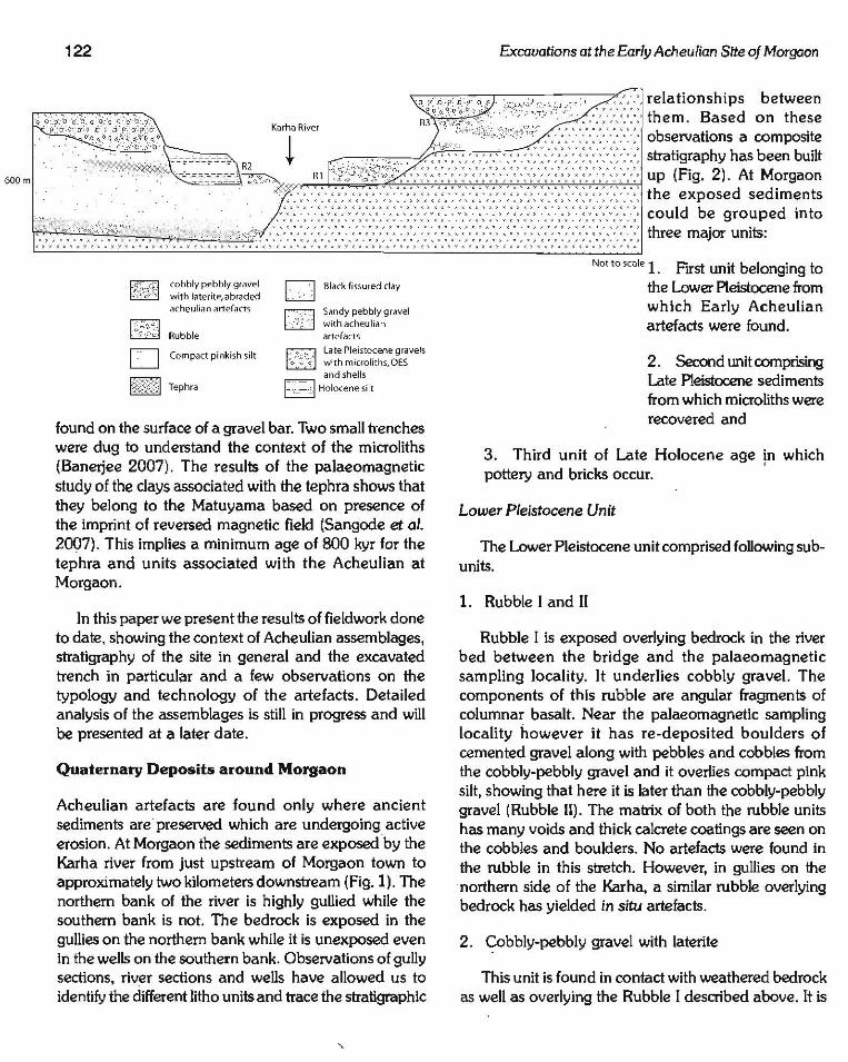
found on the surface of a gravel bar. Two small trenches were dug to understand the context of the microliths (Banerjee 2007). The results of the palaeomagnetic study of the clays associated with the tephra shows that they belong to the Matuyama based on presence of the imprint of reversed magnetic field (Sangode et al. 2007). This implies a minimum age of 800 kyr for the tephra and units associated with the Acheulian at Morgaon.
In this paper we present the results of fieldwork done to date, showing the context of Acheulian assemblages, stratigraphy of the site in general and the excavated trench in particular and a few observations on the typology and technology of the artefacts. Detailed analysis of the assemblages is still in progress and will be presented at a later date.
Quaternary Deposits around Morgaon
Acheulian artefacts are found only where ancient sediments are· preserved which are undergoing active erosion. At Morgaon the sediments are exposed by the Karha river from just upstream of Morgaon town to approximately two kilometers downstream (Fig.l). The northern bank of the river is highly gullied while the southern bank is not. The bedrock is exposed in the gullies on the northern bank while it is unexposed even in the wells on the southern bank. Observations of gully sections, riv~r sections and wells have allowed us to identify the different litho units and trace the stratigraphic
Excavations at the Early Acheulian Site of Morgaon
Nor to scale 1. First unit belonging to the Lower Pleistocene from which Early Acheulian artefacts were found.
2. Second unit comprising Late Pleistocene sediments from which microliths were recovered and
3. Third unit of Late Holocene age ln which pottery and bricks occur.
Lower Pleistocene Unit
The Lower Pleistocene unit comprised following sub-units.
1. Rubble I and II
Rubble I is exposed overlying bedrock in the river bed between the bridge and the palaeomagnetic sampling locality. It underlies cobbly gravel. The components of this rubble are angular fragments of columnar basalt. Near the palaeomagnetic sampling locality however it has re-deposited boulders of cemented gravel along with pebbles and cobbles from the cobbly-pebbly gravel and it overlies compact pink silt, showing that here it is later than the cobbly-pebbly gravel (Rubble II). The matrix of both the rubble units has many voids and thick calcrete coatings are seen on the cobbles and boulders. No artefacts were found in the rubble in this stretch. However, in gullies on the northern side of the Karha, a similar rubble overlying bedrock has yielded in situ artefacts.
2 . Cobbly-pebbly gravel with laterite
This unit is found in contact with weathered bedrock as well as overlying the Rubble I described above. It is
Sheila Mishra et a/.
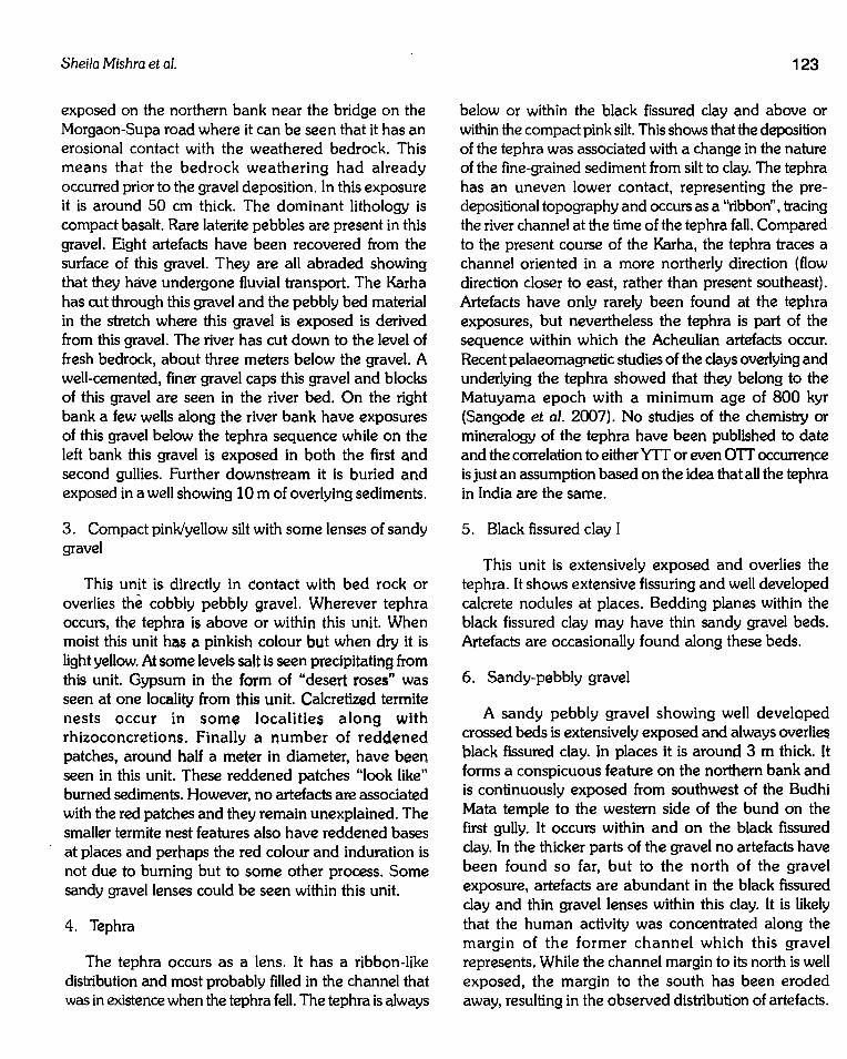
exposed on the northern bank near the bridge on the Morgaon-Supa road where it can be seen that it has an erosional contact with the weathered bedrock. This means that the bedrock weathering had already occurred prior to the gravel deposition. In this exposure it is around 50 em thick. The dominant lithology is compact basalt. Rare laterite pebbles are present in this gravel. Eight artefacts have been recovered from the surface of this gravel. They are all abraded showing that they have undergone fluvial transport. The Karha has rut through this gravel and the pebbly bed material in the stretch where this gravel is exposed is derived from this gravel. The river has cut down to the level of fresh bedrock, about three meters below the gravel. A well-cemented, finer gravel caps this gravel and blocks of this gravel are seen in the river bed. On the right bank a few wells along the river bank have exposures of this gravel below the tephra sequence while on the left bank this gravel is exposed in both the first and second gullies. Further downstream it is buried and exposed in a well showing 10m of overlying sediments.
3. Compact pink/yellow silt with some lenses of sandy gravel
This unit is directly In contact with bed rock or overlies the cobbly pebbly gravel. Wherever tephra occurs, the tephra is above or within this unit. When moist this unit has a pinkish colour but when dry It is light yellow. At some levels salt is seen precipitating from this unit. Gypsum in the form of "desert roses" was seen at one locality from this unit. Calcretized termite nests occur in some localities along with rhizoconcretions. Finally a number of reddened patches, around half a meter in diameter, have been seen in this unit. These reddened patches "look like" burned sediments. However, no artefacts are associated with the red patches and they remain unexplained. The smaller termite nest features also have reddened bases at places and perhaps the red colour and induration is not due to burning but to some other process. Some sandy gravel lenses could be seen within this unit.
4. Tephra
The tephra occurs as a lens. It has a ribbon-like distribution and most probably filled in the channel that was in existence when the tephra fell. The tephra is always
123
below or within the black fissured clay and above or within the compact pink silt. This shows that the deposition of the tephra was associated with a change in the nature of the fine-grained sediment from silt to clay. The tephra has an uneven lower contact, representing the pre-depositional topography and occurs as a "ribbon", tracing the river channel at the time of the tephra fall. Compared to the present course of the Karha, the tephra traces a channel oriented in a more northerly direction (flow direction closer to east, rather than present southeast). Artefacts have only rarely been found at the tephra exposures, but nevertheless the tephra is part of the sequence within which the Acheulian artefacts occur. Recent palaeomagnetic studies of the clays overlying and underlying the tephra showed that they belong to the Matuyama epoch with a minimum age of 800 kyr (Sangode et al. 2007). No studies of the chemistry or mineralogy of the tephra have been published to date and the correlation to either YIT or even OTT occurrence is just an assumption based on the idea that all the tephra in India are the same.
5. Black fissured clay I
This unit Is extensively exposed and overlies the tephra. It shows extensive fissuring and well developed calcrete nodules at places. Bedding planes within the black fissured clay may have thin sandy gravel beds. Artefacts are occasionally found along these beds.
6. Sandy-pebbly gravel
A sandy pebbly gravel showing well developed crossed beds is extensively exposed and always overlies black fissured clay. In places it is around 3 m thick. It forms a conspicuous feature on the northern bank and is continuously exposed from southwest of the Budhi Mata temple to the western side of the bund on the first gully. It occurs within and on the black fissured clay. In the thicker parts of the gravel no artefacts have been found so far, but to the north of the gravel exposure, artefacts are abundant in the black fissured clay and thin gravel lenses within this clay. It is likely that the human activity was concentrated along the margin of the former channel which this gravel represents. While the channel margin to its north is well exposed, the margin to the south has been eroded away, resulting in the observed distribution of artefacts.

124
7. Rubble III
In the section exposed downstream of the bridge, a rubble horizon rich in Acheulian artefacts separates the sediments with Acheulian artefacts from those with microliths. This horizon can be seen to be different from the lower one which occurs in the same section. At the palaeomagnetic sampling locality, rubble is found on the pink silt as well as on bedrock, showing that there also the rubble occurs in two horizons.
Late Pleistocene Unit
1. Sandy-pebbly gravel, with abraded bivalves and microliths
A sandy-pebbly gravel with abraded bivalves and microliths and occasional animal fossils is found. The gravel has a large number of calcrete nodules as pebbles. It forms a distinct linear channel on the northern bank of the river. It is well exposed in the digging near the Budhi Mata temple, where it is seen in direct contact with the Lower Pleistocene units as well as bedrock. Bivalves from an exposure of this gravel on the right (southern) bank were dated to 26 kyr. Calcrete clasts form the predominant lithology of this gravel.
2. Muddy calcrete gravel with ostrich eggshell
This gravel is extensively exposed and also forms a distinct channel on the northern bank. It is extremely rich in ostrich eggshell pieces, but poor in artefacts. The main component of the gravel is calcrete nodules. It overlies the Acheulian tool bearing gravel in the 2007 trench. It was dated to 22 kyr. from samples collected from the right (southern) bank.
3. Black fissured clay II
Black fissured clay is found overlying the calcrete gravP.l with ostrich eggshells in the 2007 trench. This clay is difficult to distinguish from the Acheulian black fissured clay on field characters. Similar looking black fissured clays occur both below Acheulian artefacts in 2002 trench and above microliths in the 2007 trench.
4. Yellow silt
Excavations at the Early Acheulian Site of Morgaon
On the southern bank of the river a calcareous yellow silt is extensively exposed. This is associated with the Upper Palaeolithic units.
Holocene Units
1. Brown silt
A fill of brown silt is found at some spots along the river and it replaces the Pleistocene sediments between the temple and the bridge and forms a low inset terrace. The gullies along the northern bank which expose the Pleistocene sediments have some remnants of this Holocene fill. It appears that in some places the Lower Pleistocene units were exposed, then covered with a thin veneer of Holocene sediments, which are now again stripped off.
2. Unpatinated sandy pebbly gravel
At some places recent erosion of this Hojocene fill has deposited fresh, unpatinated gravels directly over the Lower Pleistocene sediments.
In the Quaternary sequence at Morgaon, occurrence of tephra and laterite is of great significance. Tephra has been found at a large number of localities in Peninsular India (Acharya and Basu 1993). Westgate et al. (1998) and Shane et al. (1995) insist that all the occurrences of tephra in India belong to the Youngest Toba tephra (YIT), which erupted around 75 kyr This tephra is widely dispersed in the ocean sediments and has been identified both from the Bay of Bengal and the Arabian Sea (Ninkovich 1979, Buhring and Sarnthein 2000, Chesner et al. 1991, Patlan 2002, Patlan et al. 2001, Rose and Chesner 1990, Song et al. 2000, Von Rad et al. 2002). There is no doubt, therefore, that there was a YIT air fall tephra all over India, but its occurrence today depends on the survival of sediments from that time. A core from the deep sea drilling project site, ODP 758, has recorded the presence of 4 tephra units from the Toba volcano (Dehn et al. 1991). Besides the YIT, there is Middle Toba Tephra (MTT), dating to around 500 kyr, the Oldest Toba Tephra (OTT), which occurs just below the Brunches Matuyama boundary and the Harangol dactite tuff (HDT) which dates to 1. 2 myr. In western India the tephra sites of Morgaon and Bori have Early Acheulian

Sheila Mishra eta/.
artefacts above the tephra layer. Therefore, we have never accepted the correlation of these tephra occurrences to the YTI. K-Ar (Horn et a/. 1993) and Ar-Ar dating of the Bori tephra (Mishra et a/. 1995) and palaeomagnetic dating of Bori and Morgaon tephra (Sangode et a/. 2007) also support an older date for the tephra. Recent report that tephra in Andhra Pradesh dated by luminesence methods to 76 kyr is associated with blade technology also supports an older age for tephra underlying more primitive stone tool technology (Petraglia et a/. 2007).
Laterite was first noticed in a cobbly bouldery gravel exposed along the Saswad Narayanpur road, around 2 km south of Saswad in the Karha valley. This gravel subsequently also yielded 4 fresh cleavers similar to those found at Morgaon. A second gravel was exposed near Jejuri, during excavations for a new Maharashtra State Electricity Board power station. The Jejuri
10 15 10
4 5 3 3
H3 G3 F3 E3
5 3 H4 G4 F4 E4
Sm
282 artefacts
125
exposure is similar in sedimentology to the Saswad exposure but yielded only one cobble-sized laterite clast and no artefacts were found. After these discoveries laterite was noticed occurring in pebble sized clasts in the cobbly pebbly gravel which forms the oldest unit at Morgaon (Rajaguru et a/. 2004). The occurrence of laterite in these gravels is surprising as no laterite exposure occurs anywhere in the Karha basin today. This means that during the time when these gravels were deposited laterite exposures still existed which have now been completely eroded. This indicates that significant landscape changes have occurred since the deposition of the lateritic gravel at Morgaon.
Artefact Occurrence and Collection
Artefacts have been recovered both from excavation and as surface finds. We tried to avoid unsystematic
8 7
co 80 AO
0 1
Cl 81 A1
8 4 3
(2 82 A2
9 7 3 2
03 C3 83 A3
8 5 2
(4 84 A4
Fig. 3. Distribution of artefacts collected from the surface in 2000

126
Scm
Fig. 4. Large cutting tools from 2000 surface collection : a, weathered cleaver; b, small cleaver; c, large Kombewa flake
surface collection and have made gridded collections from two localities.
Assemblage found in 2000
In 1999 a farmer levelled his field. After leveling, weathered basalt bedrock (murrum) was exposed in the field. No sediments survived when we visited the site. Large flakes and cores were found strewn in the
Excavations at the Early Acheulian Site of Morgaon
field. In 2000 we made a 5 m grid in the field and collected the artefacts from this grid. The frequency of artefacts in different grids can be seen in Fig. 3, which shows a distinct clustering of the artefacts. From. the field margins some artefacts had been moved by the farmer. This indicates that they were originally clustered in this area, which must have been slightly buried. Faint traces of calcareous pink silt were observed where the artefacts were clustered. A total of 282 artefacts were collected from this field of which 63 were cores, 198 flakes and 11 tools (Fig. 4). Basalt weathers in a distinctive way. Compact basalt has hexagonal joints, formed by shrinkage at time of Java cooling. Weathering proceeds faster along these joints, isolating relatively unweathered basalt away from joints. When exposed at the surface the weathered basalt is eroded leaving spherical "corestones" on the bedrock surface. These "corestones" were used for making the Acheulian tools at this locality. The cores show deeper patina on the cortex (unflaked surface) compared to the patina on the flaked surface showing that the original material selected for making tools consisted of weathered corestones from the regolith. The size of the corestones used varies from 5 to 50 em in dimension. After removing a small part of cortex to form a platform, the spherical corestones were broken into two parts, producing a giant flake. Kombewa flakes were removed from this giant flake surface. This simple reduction strategy produces elegant hand sized flakes with a maximum circumference of sharp cutting edge. Further reduction is seen in which pure Kombewa flakes are no longer produced, but an intention to produce large flakes with sharp edges formed by intersection of dorsal and ventral flakes scars continues. In the collection from this location there are only a few regular cleavers. There are many flakes having a few secondary flakes removed from them. In most cases these flakes appear to have been used as tools as they all have suitable sharp cutting edges formed by the intersection of dorsal and ventral flake scars and are "hand sized". Bifacial shaping and extensive secondary retouch is virtually absent in this collection. Small cores and flakes are also very rare with only a single small core collected from an ungridded part of the site. These unique features of this assemblage Jed us to continue work at the site and it was decided that an excavation of some part of the site was required.
Sheila Mishra eta/.
Earlier, Mishra ( 1982) had tried to understand the reason for the relatively smaller number of Lower Palaeolithic artefacts from areas of basalt bedrock and concluded that this was due to geological factors and not the absence of people. She suggested that artefacts survived only in a buried context. In the case of the artefacts collected from the levelled field in 2000, they do appear to have got exposed during leveling in the previous years. Since 2000 considerable destruction of remaining artefacts can be observed, so that the inference that they got preserved by burial seems reasonable. However, the distance from the field with the artefacts to the present exposures of sediments is about 200 m with a difference of 5-7 m in elevation. Lower fields have recently been filled with clay brought from the sediments trapped behind the K-T weir built upstream of the bridge on the Karha river. In the recent past the tools appear to have been "buried" in m urrum rather than in sediments. However most probably ~ much thicker covering layer of sediments would have originally been present. The present sediments are, therefore, only a small remnants of the original sediments deposited.
Excavations in 2002-2004 and Surface Collection
Bedrock is continuously exposed in the area from the locality of the 2000 collection to the Karhati road. It is only after Budhi Mata temple that a sedimentary cover is seen to the south of the road. The "first" gully that
Trench 1 MRG 2002
0 2
Black fissured clay
2
Fig. 5 Section of Trench 1 MRG 2002
127
reaches the road is seen after the Budhi Mata temple. On the left (eastern) side of this gully a large number of artefacts ·could be seen. A left hand branch of the main gully cuts through this artefact-rich area.
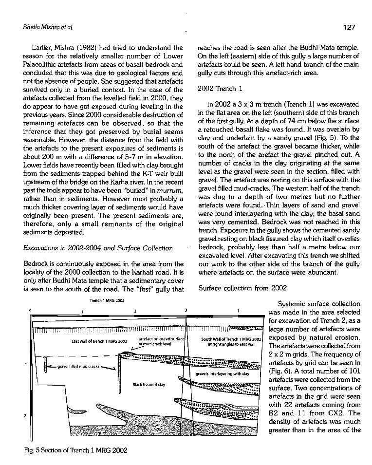
2002 Trench 1
In 2002 a 3 x 3m trench (Trench 1) was excavated in the flat area on the left (southern) side of this branch of the first gully. At a depth of 74 em below the surface a retouched basalt flake was found. It was overlain by clay and underlain by a sandy gravel (Fig. 5). To the south of the artefact the gravel became thicker, while to the north of the arefact the gravel pinched out. A number of cracks in the clay originating at the same level as the gravel were seen in the section, filled with gravel. The artefact was resting on this surface with the gravel filled mud-cracks. The western half of the trench was dug to a depth of two metres but no further artefacts were found. Thin layers of sand and gravel were found interlayering with the clay; the basal sand was very cemented. Bedrock was not reached in this trench. Exposure in the gully shows the cemented sandy gravel resting on black fissured clay which itself overlies bedrock, probably less than half a metre below our excavated level. After excavating this trench we shifted our work to the other side of the branch of the gully where artefacts on the surface were abundant.
Surface collection from 2002
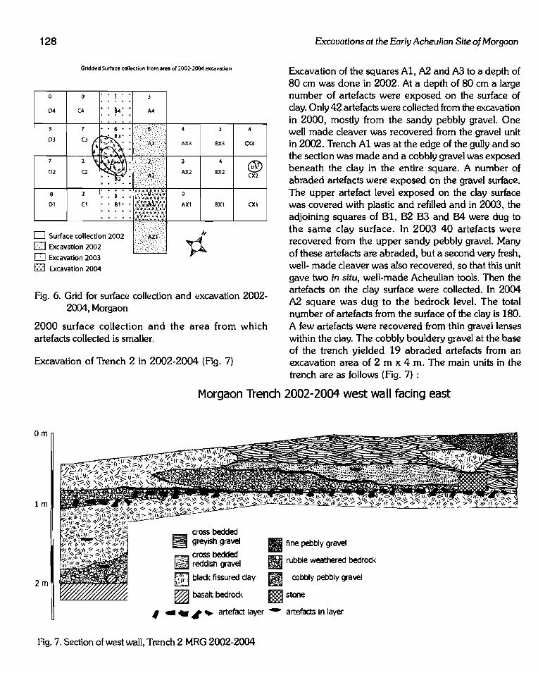
Systemic surface collection was made in the area selected for excavation of Trench 2, as a large number of artefacts were exposed by natural erosion. The artefacts were collected from 2 x 2 m grids. The frequency of artefacts by grid can be seen in (Fig. 6). A total number of 101 artefacts were collected from the surface. Two concentrations of artefacts in the grid were seen with 22 artefacts coming from 82 and 11 from CX2. The density of artefacts was much greater than in the area of the
128
Gridded Surface collection from area of 2002-2004 excavation
0
04
03
7
02
8
01
0
(4
•• 1 ••
•• ~4 •• •••• +
§l ~~;~~~~:;" 2002 U:.*!' ~ D Excavation 2003
m Excavation 2004
BX3
4
BX2
BXl
4
CX3
@ CX2
CXl
Fig. 6. Grid for surface collection and excavation 2002-2004, Morgaon
2000 surface collection and the area from which artefacts collected is smaller.
Excavation of Trench 2 in 2002-2004 {Fig. 7)
Excavations at the Early Acheulian Site of Morgaon
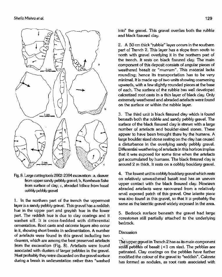
Excavation of the squares A1, A2 and A3 to a depth of 80 em was done in 2002. At a depth of 80 em a large number of artefacts were exposed on the surface of clay. Only 42 artefacts were collected from the excavation in 2000, mostly from the sandy pebbly gravel. One well made cleaver was recovered from the gravel unit in 2002. Trench A1 was at the edge of the gully and so the section was made and a cobbly gravel was exposed beneath the clay in the entire square. A number of abraded artefacts were exposed on the gravel surface. The upper artefact level exposed on the clay surface was covered with plastic and refilled and in 2003, the adjoining squares of 81, 82 B3 and B4 were dug to the same clay surface. In 2003 40 artefacts were recovered from the upper sandy pebbly gravel. Many of these artefacts are abraded, but a second very fresh, well- made cleaver was also recovered, so that this unit gave two in situ, well-made Acheulian tools. Then the artefacts on the clay surface were collected. In 2004 A2 square was dug to the bedrock level. The total number of artefacts from the surface of the clay is 180. A few artefacts were recovered from thin gravel lenses within the clay. The cobbly bouldery gravel at the base of the trench yielded 19 abraded artefacts from an excavation area of 2 m x 4 m. The main units in the trench are as follows {Fig. 7) :
Morgaon Trench 2002-2004 west wall facing east
om
lm
2m
cross bedded ~ greyish gravel
~ cross bedded ~ reddish gravel
ni-J black fissured day
~ basalt bedrock
Ill fine pebbly gravel
rBJ rubble weathered bedrock
i¥J cobbly pebbly gravel
mstone
1 • - 1 ~ artefact layer - artefacts in layer
Fig. 7. Section of west wall, Trench 2 MRG 2002-2004
Sheila Mishra et a/. 129
intd' the gravel. This gravel overlies both the rubble and black fissured clay.
2. A 50 em thick "rubble" layer occurs in the southern part of Trench 2. This layer has a slope from south to north with gravel overlying it in the northern part of the trench. It rests on black fissured clay. The ·main
a component of this deposit consists of angular pieces of weathered basalt or "murrum". This material lacks rounding; hence its transportation has to be very minimal. It is made up of two units showing coarsening
Fig. 8. Large cutting tools 2002-2004 excavation : a, cleaver from upper sandy pebbly gravel; b, Kombewa flake from surface of clay; c, abraded biface from basal cobbly pebbly gravel
1. In the northern part of the trench the uppermost layer is a sandy pebbly gravel. This gravel has a reddish hue in the upper part and greyish hue in the lower part. The reddish hue is due to clay coatings and it washes off. It is cross-bedded with differential cementation. Root casts and calcrete layers also occur in it, showing short breaks in sedimentation. A number of artefacts were found in this gravel including two cleavers, which are among the best preserved artefacts from the excavation (Fig. 8). Artefacts were found associated with clusters of larger pebbles in the gravel. Most probably they were discarded on the gravel surface during a break in sedimentation rather than "washed
upwards, with a few slightly rounded pieces at the base of each. The surface of the rubble has well developed calcretized root casts in a thin layer of black clay. Only extremely weathered and abraded artefacts were found on the surface or within the rubble layer.
3. The third unit is black fissured clay which is found beneath both the rubble and sandy pebbly gravel. The surface of the black fissured clay is strewn with a large number of artefacts and boulder-sized stones. These appear to have been brought there by the humans. A large boulder sized stone resting on the clay has caused a disturbance in the overlying sandy pebbly gravel. Differential weathering of artefacts in this horizon implies that it was exposed for some time when the artefacts got accumulated by humans. The black fissured clay is around 2 m thick. It rests on a cobbly bouldery gravel.
4. The lowest unit is cobbly bouldery gravel which rests on relatively unweathered basalt and has an uneven upper contact with the black fissured clay. Nineteen abraded artefacts were recovered from ·a relatively small exposed patch of this gravel. One laterite piece was also found in this gravel, so that it is probably the same as the lateritic gravel widely exposed in the area.
5. Bedrock surface beneath the gravel had large corestones still partially attached to the underlying bedrock.
Discussion ..
The.:upper gt;fivel in Trench 2 has as its main component sti1~li'.p~bBtJ5 of basalt { < 1 em size). The pebbles are patinated. Clay coatings on the pebbles have further modified the colour of the gravel to "reddish". Calcrete has formed as nodules, as root casts associated with

130
thin clay horizons and along bedding planes. The gravel shows sets of crossbeds. Artefacts from this gravel include very weathered and abraded pieces along with a few artefacts, mostly well finished cleavers, which show no abrasion. We interpret this to mean that these artefacts were actually discarded in the gravel by humans, during periods of a break in sedimentation. The gravel represents a small stream, possibly the ancient Karha, or a small tributary of the Karha. The trench is on the southern periphery of the gravel, which thickens towards the north and continues up to the road after which bedrock is exposed. Many finished artefacts were seen eroding from the surface of this gravel.
The layer of murrum which the gravel abuts is a highly unusual deposit. It has a very small extent and is associated with the area where artefacts occur in abundance. In 2002 we excavated in arbitrary levels and considered the hypothesis that the murrum was carried to its location by humans. Therefore, in 2003 we exposed the surface of the murrum and dug it out separately. A thin black clay layer with rhizoconcretions was found on the murrum surface. It actually lacks any artefacts except a few very abraded ones. In the section there are two murrum layers distinguished by grading and rounding with slightly smaller and rounded pieces at the base of each sequence, supporting a non-anthropogenic origin for the murrum rubble. The association with the artefacts is by preserving the underlying clay strewn surface by burial. Although we ruled out a human agency in the deposition of the murrum, it is still an anomaly as far as geological deposits go. We consider that it is a filling of a small first order stream, involving transport of short distance and short duration. The deposition might have been triggered by some environmental catastrophe. It is tempting to suggest that this could have been the tephra fall. In fact the adjoining main gully does expose the pink silt overlain by black clay units. Where the tephra occurs, it is at the transition from pink silt to black fissured clay, but no tephra layer is seen in this locality.
The artefact horizon consists of a large number of flakes, cores and nodules scattered on the clay surface. These artefacts have definitely been brought to the site by people as they could not have been transported either with the clay or the overlying murrum. In that sense it is in "primary" context. However, the artefacts
Excavations at the Early Acheulian Site of Morgaon
all show different degrees of weathering. They are not abraded. They all have a double patina with the cortex areas having a deeper patina than the flaked surfaces, showing the use of weathered nodules for manufacturing the tools. The large size of the cores indicates that they were available very close to the site. Small flakes are rare and we could not refit any material. Thus the artefacts occur where they were discarded by people but probably accumulated over a significant time period-between the deposition of the clay and sealing with the murrum. It is difficult to estimate the duration of this time period, but judging from the condition of the artefacts, it was long enough for weathering to affect the assemblage but not long enough to destroy the artefacts.
The density of artefacts is fairly high-180 artefacts from this layer which was excavated over 8 x 4 m (32 m2) area. This means about six artefacts were found per square meter. Since the artefacts are quite large, this results in an almost continuous carpet of artefacts.
The clay below the artefact layer was only excavated in two squares, one in 2003 and another in 2004. This clay shows the same character as that described for Trench 1, with which it is continuous, only separated by the erosion of a gully between them. It is definitely a fluvial deposit as small gravel lenses interlayer with it. Artefacts in smal.l numbers are found on the clay surfaces separated by the gravels. Gravel-filled cracks attest to the seasonal and arid climate of the time.
The gravel exposed below the clay is very different in sedimentary characters from the upper gravel. Its main components are well rounded pebbles, cobbles and even occasional boulders. It has a sandy matrix. One laterite pebble was found in the excavation. The artefacts are part of the gravel and show abrasion as well as weathering. It is well cemented. The upper surface of the gravel is uneven and the thickness of only 20-50 em seems low for such a coarse gravel. Therefore, there is probably an erosional contact between the basal gravel and the overlying day. There could be a significant time gap between the two although the artefacts in both belong to the same Large Flake Acheulian tradition. The main reason to consider that there could be a significant time gap is the big difference in the nature of the fluvial systems, implied

Sheila Mishra eta/.
by the differences in sedimentology. On the other hand, it 'ls possible that the difference is between lower and higher order streams of the same drainage system.
The bedrock beneath the gravel preserved a corestone on the basalt bedrock. Similar corestone5 beneath black fissured clay were observed in bund digging in the adjacent gully. The bedrock exposed now does not have such corestones. They occur only under. the Acheulian sediments. However, during the Acheulian time such an exposed surface must have been very near to the trench so that the corestones were brought onto the clay surface for manufacturing tools. The artefact strewn surface was then covered by a layer of unabraded murrum pieces by gully/slope processes. Today no bedrock adjacent to the trench is higher than the trench and the thickness of the mu"um layer beneath the cobbly gravel is also not very great, pointing to further differences in the local landscape between the Acheulian time and the present. The weathering of the basaltic bedrock is a relict process and occurred prior to the deposition of the earliest unit exposed at Morgaon today. as can be inferred from the erosional contact between the weathered basalt layer and the cobbly gravel. Erosional processes since the Acheulian have stripped off much of the weathered regolithlc mantle; the sediments generated in Acheulian times are rich in the re-deposited Tertiary weathering products compared to later sediments which are composed of re-worked Quaternary alluvium.
In 2004 a small step trench was taken in the tephra exposed further downstream to understand its characters. In this locality the tephra is overlain by black fissured clay which in tum is overlain by a well-cemented sandy-pebbly gravel about 1 m thick. At the junction of the tephra and the clay a layer rich in rounded coarse sand-sized calcrete particles is found. Underlying the tephra is a yellowish/pinkish silt which continues below 1 m depth. The trench was not continued further and bedrock is not exposed in the adjacent gully. The basal
· 5 em tephra is grayish-white in colour and loose. It grades to a yellowish-brown silt which is mixed with . tephra particles and is affected by the process of groundwater and pedogenic calcification. The latter aspect is indicated by calcic-rhizoconcretions along with thin bands (-:'2 mm) of pure calcite. Along with rhizoliths, a rare example of pseudo-flowery calcite
131
concretions is also observed in the upper part of the ash beds. Total thickness of the ash bearing silt is 30-35 em. This ash unit rests on dark brown silty-day with well developed vertic features. The clay unit was traced to a depth of 1 m. The tephra at Morgaon is pure only in the basal part and has been affected by pedogenesis and reworking in the upper part. The tephra bearing silt-clay unit appears to have been deposited in near channel overbank flood plain environment, characterized by seasonal flooding and cumulic calcic pedogenesis.
Ex:cavation In 2007
In 2007 a 5 x 5 m trench was taken on the divide between gullies 1 and 2 (Fig. 1). We selected this area as we thought there would be less erosion on the divide. Surrounding gullies had exposed artefacts so that we were hopeful of getting an in situ artefact horizon.
In the upper part of the trench we exposed a black fissured clay (Fig. 9). This clay was thicker in the western part of the trench where it overlay a muddy calcrete clast gravel. This gravel pinched out in Ple middle of the trench and is not seen in the western section. It was about 2-3 m wide and crossed the trench in a NW to SE direction. Sixteen abraded microliths, two basalt flakes and 62 ostrich eggshell fragments were found in this gravel. Most of the ostrich eggshell pieces were abraded. No mollusks were found in this graveL Below the gravel with ostrich eggshells and above the artefact level are a number of reddish sandy gravels. These gravels occur as small lenses within a clay. Almost no
. artefacts were found in this gravel and no shells of any type occurred either. The reddish colou~ is due to clay cOating of the gravel and patina on the basalt. These. features are typical of gravels with Acheulian artefacts. However, these gravel lenses are within the same clay unit which encloses the gravel with ostrich eggshells. One artefact from this gravel was convincing as a microlithic blade. Therefore, we have interpreted this gravel as being deposited in the Late Pleistocene, but from the re-working of the underlying Acheulian gravels: The. Acheulian artefact horizon is very distinctive. It is a cobbly pebbly coarse layer forming a lag on top of a sandy pebbly gravel. This gravel is exposed at 84-90 em below datum (which was the SW corner. of the trench) in the eastern part of the trench
132
Om
lm
2m
3m
m Muddy calcrete gravel W OES & microliths
pr~~~~ Reddish pebbly gravel
~ Black fissured clay
~ Sandy pebbly gravel ~ Acheulian artefacts
~~ Sandy gravel
~ Weathered basalt bedrock
• Artefact
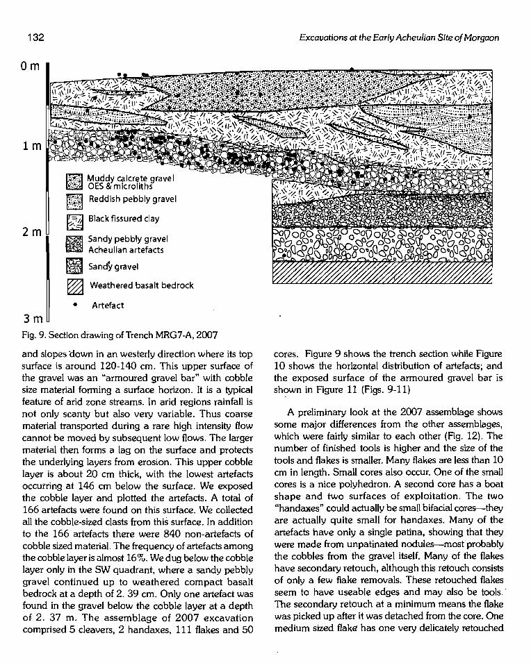
Fig. 9. Section drawing of Trench MRG7-A, 2007
and slopes down in an westerly direction where its top surface is around 120-140 em. This upper surface of the gravel was an "armoured gravel bar" with cobble size material forming a surface horizon. It is a typical feature of arid zone streams. In arid regions rainfall is not only scanty but also very variable. Thus coarse material transported during a rare high intensity flow cannot be moved by subsequent low flows. The larger material then forms a lag on the surface and protects the underlying layers from erosion. This upper cobble layer is about 20 em thick, with the lowest artefacts occurring at 146 em below the surface. We exposed the cobble layer and plotted the artefacts. A total of 166 artefacts were found on this surface. We collected all the cobble-sized clasts from this surface. In addition to the 166 artefacts there were 840 non-artefacts of cobble sized material. The frequency of artefacts among the cobble layer is almost 16%. We dug below the cobble layer only in the SW quadrant, where a sandy pebbly gravel continued up to weathered compact basalt bedrock at a depth of 2. 39 em. Only one artefact was found in the gravel below the cobble layer at a depth of 2. 37 m. The assemblage of 2007 excavation comprised 5 cleavers, 2 handaxes, 111 flakes and 50
Excavations at the Early Acheulian Site of Morgaon
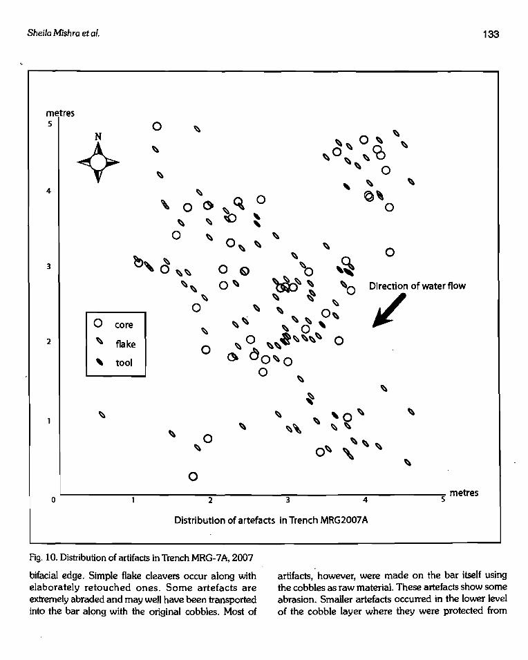
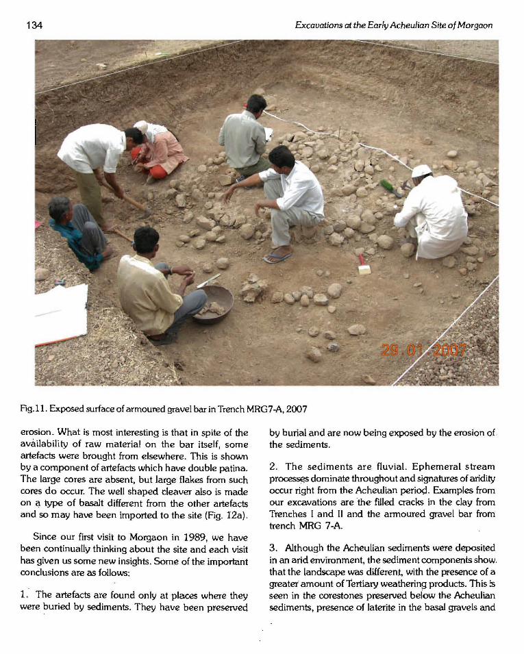
cores. Figure 9 shows the trench section while Figure 10 shows the horizontal distribution of artefacts; and the exposed surface of the armoured gravel bar is sh?wn in Figure 11 (Figs. 9-11)
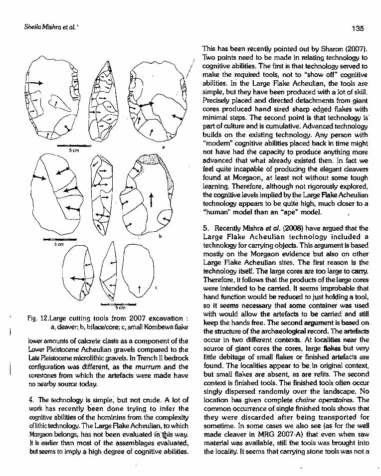
A preliminary look at the 2007 assemblage shows some major differences from the other assemblages, which were fairly similar to each other (Rg. 12). The number of finished tools is higher and the size of the tools and flakes is smaller. Many flakes are less than 10 em in length. Small cores also occur. One of the small cores is a nice polyhedron. A second core has a boat shape and two surfaces of exploitation. The two "handaxes" could actually be small bifacial cores-they are actually quite small for handaxes. Many of the artefacts have only a single patina, showing that they were made from unpatinated nodules-mostprobably the cobbles from the gravel itself. Many of the flakes have secondary retouch, although this retouch consists of only a few flake removals. These retouched flakes seem to have useable edges and may also be tools.· The secondary retouch at a minimum means the flake was picked up after it was detached from the core. One medium sized flake has one very delicately retouched
Sheila Mishra et al.
metres 5 0
N
~ ~
~
4
' 3 ~,d
0 core
2 ~ flake
' tool
~
0 () ~ ~
0 ~
~~
~~ ~
0
~
0
0 ~
0
~Q 0 <) ' ' 0~
~ ~
0 ~
'~ 0 ~ ~ 0~ ~~~ ~0
~ ~ ~ ~ 0 ~
~ ~ ~ ~ ~ ~ 0'
0 ·~~~~ 0 ~ ~~
"' do~o
Direction of water flow
)/
0 ~
0 '-------------.,..2--------.3,.......------4-----~5 metres
Distribution of artefacts in Trench MRG2007 A
133
Fig. 10. Distribution of artifacts in Trench MRG-7 A, 2007
bifacial edge. Simple flake cleavers occur along with elaborately retouched ones. Some artefacts are extremely abraded and may well have been transported into the bar along with the original cobbles. Most of
artifacts, however, were made on the bar itself using the cobbles as raw material. These artefacts show some abrasion. Smaller artefacts occurred in the lower level of the cobble layer where they were protected from
134 Excauations at the Early Acheulian Site of Morgaon
Fig.ll. Exposed surface of armoured gravel bar in Trench MRG7-A, 2007
erosion_ What is most interesting is that in spite of the availability of raw material on the bar itself, some artefacts were brought from elsewhere. This is shown by a component of artefacts which have double patina. The large cores are absent, but large flakes from such cores do occur. The well shaped deaver also is made on a type of basalt different from the other artefacts and so may have been imported to the site (Fig. 12a).
Since our first visit to Morgaon in 1989, we have been continually thinking about the site and each visit has given us some new insights. Some of the important conclusions are as follows:
1. The artefacts are found only at places where they were buried by sediments. They have been preserved
by burial and are now being exposed by the erosion oL the sedlments.
2. The sediments are fluvial. Ephemeral stream pr~ dominate throughout and signatures of aridity occur right from the Acheulian period. Examples from our excavations are ·the mted cracks in the clay from Trenches I and II and the armoured gravel bar frotn trench MRG 7 -A.
3. Although the AcheuUan sediments were deposited in an arid environment, the sediment components show. that the landscape was different, with the presence of a greater· amount of Tertiary weathering products. This :S seen in the corestones preserved below the Acheulian sediments, presence of laterite in the basal gravels and
Sheila Mishra et al. '
a
c
Fig. 12.Large cutting tools from 2007 excavation : a, cleaver; b, biface/core; c, small Kombewa flake
lower amounts of calcrete clasts as a component of the Lower Pleistocene Acheulian gravels compared to the Late Pleistocene microlithic gravels. In Trench ll bedrock. configuration was different, as the murrum and the corestones from which the artefacts were made have no nearby source today.
4. The technology is simple; but not crude. A lot of work has recently been done trying to infer the cognitive abilities of the hominins from the complexity of lithic technology. The Large Aake Acheulian, to which Morgaon belongs, has not been evaluated ilithis way.
~
lt is earlier than most of the assemblages evaluated, but seems to imply a high degree of cognitive abilities.
/
135
This has been recently pointed out by Sharon (2007). Two points need to be made in relating technology to cognitive abilities. The first js that technology served to make the required tools, not to "show off" cognitive abilities. Iri the Large Aake Acheulian, the tools are simple, but they have been produced with a lot of skill. Precisely placed and directed detachments from giant cores produced hand sized sharp edged flakes with minimal steps. The second point is that technology is· part of culture and is cumulative: Advanced technology builds on the existing technology. Any person with "modem" cognitive abilities placed back in time might not have had the capacity to produce anything rnore advanced that what already e~isted then. In fact. we feel quite incapable of producing the elegant cleavers found at Morgaon, at least not without some tough learning. Therefore, although not rigorously explored, the cognitive levels implied by the Large Aake Acheulian technology appears to be quite high, much closer to a "human" model than an ''ape" model.
5. Recently Mishra et al. (2008) have argued that the Large Flake Acheulian technology included a technology for carrying oJ:>jects. This argument is based mostly on the Morgaon evidence but also on other Large Aake Acheulian sites. The first reason is the technology itself. The large cores are too large to carry. Therefore, it follows that the products of the large cores were intended to be carried. It seems improbable that hand function would be reduced to just holding a tool, so it seems necessary that some container was used, with would allow the artefacts to be carried and still keep the hands free. The second argument is based on· the structure of the archaeological record. The artefacts occur in two different contexts. At localities near the source of giant cores the cores, large flakes but very little debitage of small flakes or finished artefacts are found. The localities appear to be_ in original context, but small flakes are absent, as are refits. The second context is finished tools. The finished tools often occur singly dispersed randomly over the landscape. No location has given complete chaine operatoires. The common occurrence of single finished tools shows that they were discarded after being transported for sometime. In some cases we also see (as for the well made cleaver in MRG 2007 -A) that ev.en when raw material was available, still the tools was brought into the locality. It seems that carrying stone tools was not a
136
problem for the Large Flake Acheulian people. They always had finished artefacts with them and discard occurred when the tool utility was over and did not depend on the availability of raw material.
Acknowledgments
We gratefully acknowledge the cooperation and support extended by the Archaeological Survey of India. Excavations were funded by Departmental Grants given to Sheila Mishra and Sushama Deo along with matching
Excavations at the Early Acheulian Site of Morgaon
grants from ASI. We are grateful to Prof. K. Paddayya, Director and other authorities of Deccan College for logistic support at various stages of our research. We thank Drs. Savita Ghate, Arati Deshpande-Mukherjee, ShahidaAnsari and P. P. Joglekar for their help during the excavation. Ashok Khaire and family have made Morgaon a second home for us and Bapu Khaire and other workers are thanked for their expert excavation skills.
References
Acharya, S. K. and P. K. Basu. 1993. Toba Ash on the Indian Subcontinent and its Implications for Correlation of Late Pleistocene Alluvium. Quaternary Research 40:10-19.
Banerjee, R. 2007. Microllthic Industries from Morgaon. Unpublished M. A. Dissertation. Deccan College, Pune.
Buhring, C. and M. Sarnthein. 2000. Toba Ash Layers in the South China Sea: Evidence of Contrasting Wind Directions during Eruption ca. 74 ka. Geology 28:275-278.
Chesner, C. A. W. I. Rose, A. Deino and R. E. Drake. 1991. Eruptive History of the Earth's Largest Quaternary Caldera (Toba, Indonesia) Clarified. Geology 19:200-203.
Dehn, J., J. W. Farrell and H. U. Schmincke 1991. Neogene Tephrochronology from the Site 758 of the Northern Ninety East Ridge: Indonesian Arc Volcanism of the Past 5 rna. Proceedings of the ODP 121:273-295.
Deo, Sushama, Savita Ghate, S. N. Rajaguru, N. R. Karmalkar and M. Kale. 2004. Discovery of an Acheulian Site in Association with Tephra at Rajbag, Taluka Supa, District Pune, Maharashtra. Man and Environment 29:108.
Deo, Sushama, Sheila Mishra, S. N. Rajaguru and Savita Ghate. 2007. Antiquity of Acheulian Culture in Upland Maharashtra: A Geoarchaeological
Approach. ln Human Origin, Genome and People of India: Genome, Palaeontological and Archaeological Evidence, A. R. Sankhayn and V. R. Rao (Eds. ), pp. 292-308. Kolkata: Anthropological Survey of India and Allied Publishers Pvt. Umited.
Horn, P., D. Muller-Sohnius, D. Storzek and L. Zoller. 1993. K-Ar-, rJSSion-Track- and Thermoluminescence Ages of Quaternary Volcanic Tuffs and Their bearing on Acheulian Artifacts from Bori, Kukdi Valley, Pune District, India. Zeitschrift der Deutschen Geologischen Gesellschaft: 326-329.
Indian Archaeology: A Review 1989: 64. New Delhi: Archaeological Survey of India.
Kale, V. S., D. N. Patil, N.J. Powar and S. N. Rajaguru. 1993. Discovery of a Volcanic Ash Bed in the Alluvial Sediments at Morgaon, Maharashtra. Man and Environment 18: 141-143.
Kale, V. S., V. U: Joshi and P. S. Hire. 2004. Palaeohydrological Reconstruction based on Analysis of a Palaeochannel and Toba Ash associated alluvial Sediments in the Deccan Trap Region, India. Journal of the Geological Society of India 64:481-501.
Mishra, S. 1982. On the Effects of Basalt Weathering on the Distribution of Lower Palaeolithic Sites in the Deccan. Bulletin of the Deccan College Postgraduate and Research Institute 41:107-115.
Mishra, S., S. Deo and S. N. Rajaguru. 2007. Some Observations on Laterites Developed on Deccan Trap: Implications for Post-Deccan Trap
Sheila Mish ra eta/.
Denudational History. Journal of the Geological Society of India 70:521-525.
Mishra, S., S. G. Deo and R. Abbas. 2008. Behavioral Implications of Early Acheulian Technology: An Indian Perspective. Abstract submitted for Paleoanthropology Society Meeting 2008, Vancouver, Canada.
Mishra, S., T. R. Venkatesan, S. N. Rajaguru and B. L K. Somayajulu. 1995. Earliest Acheulian Industry from Peninsular India. Current Anthropology 36:847-851.
Ninkovich, D. 1979. Distribution, Age and Chemical Composition of Tephra Layers in deep-sea Sediments off Western Indonesia. Journal of Volcanology and Geothermal Research 5:67-86.
Patlan, J. N. 2002. Volcanic Ash and its Enigma: A Case Study from the Central Indian Ocean Basin. Journal of the Geological Society of India 60.
Patlan, J. N., P. W. Shane, G. Pearce, V. K. Banakar and G. Parthiban. 2001. An Occurrence of- 74 ka YoungestToba Tephra from the Western Continental Margin of India. Current Science 80:1322-1326.
Petraglia, M., R. Korisettar, N. L Boivin, C. Clarkson, P. Ditchfield, S. Jones, J. Koshy, M. M. Lahr, C. Oppenheimer, D. Pyle, R. Roberts, J. -L. Schwenninger, L Arnold and K. White. 2007. Middle Paleolithic Assemblages from the Indian Subcontinent Before and After the Toba Super-Eruption. Science 317:114-116.
Rajaguru, S. N., S. Deo, S. Mishra, S. Ghate, S. Naik and P. Shirvalkar. 2004. Geoarchaeological Significance of the Detrital Laterite Discovery in the Karha Basin, Pune District, Maharashtra. Man and Environment 29:1-6.
Rose, W. I. and C. A. Chesner. 1990 World-wide Dispersal of Ash and Gases from Earth's Largest
137
known Eruption: Toba, Sumatra, 75 ka. Global and Planetary Change 3:269-275.
Sangode, S. J., S. Mishra, S. Naik and S. Deo. 2007. Magnetostratigraphy of the Quaternary Sediments Associated with some Toba Tephra and Acheulian Artefact bearing Localities in the Western and Central India. Gondwana Magazine, Special Volume 10:111-121.
Shane, P. W., J. Westgate, M. A J. Williams and R. Korisettar. 1995. New Geochemical Evidence for the YTf in India. Quaternary Research 44:200-204.
Sharon G. 2007. Acheulian Large Flake Industries: Technology, Chronology and Significance. BAR International Series
Shirwalkar, P. 2002. Geomorphological Background to Prehistoric Sites in the Karha Basin, District Pune, Maharashtra. Unpublished M. A Dissertation, Deccan College, Pune.
Song, S. R., C. H. Chen, M. Y. Lee, T. F. Yang, Y.lizuka and K. -Y. Wei. 2000. Newly discovered Eastern Dispersal of the youngest Toba Tuff. Marine Geology 167:303-312.
Von Rad, U., K. -P. Burgathi, M. Pervaz and H. Schulz. 2002. Discovery of the Toba Ash (c. 70 ka) in a
• high-resolution Core recovering millennia! monsoonal Variability off Pakistan. Geological Society, London, Special Publications 195:445-461.
Westgate, J., P. W. Shane, N.J., G. Pearce and W. T. Perkins. 1998. All Toba Tephra Occurrences across Peninsular India Belong to the 75,000 yr B. P. Eruption. Quaternary Research 50:107-112.