Kar-1996 - SAND DUNES IN THE THAR DESERT AS KEY TO SAND CONTROL MEASURES-Ind J Geom
30
INDIAN JOURNAL OF GEOMORPHOLOGY Volume 1 Number 2 Guly-December)1996 pp. 177-206 MORPHOLOGY AND EVOLUTION OF SAND DUNES IN THE THAR DESERT AS KEY TO SAND CONTROL MEASURES Amal Kar CentralArid Zone ResearchInstitute Jodhpur Abstract Sand control measures in any dune-covered area in the Thar desert are heavily dependent on the concept of vegetative propagation on the dunes. Mechanical and chemical control methods are not popular. The activities are often directed towards planting of trees and shrubs on the reactivated slopes of the high dunes, especially the downwind end of the dunes. While these practices have shown some results, it is more appropriate if the sites and the types of control are decided on the basis of a knowledge on the dune types, their morphology and history of development, their mobility, the air and sand flow patterns over and around them, the expected changes upon any interference to the sand body, as well as the environmental set up of the dunes, including vegetation status, land use practices, etc. A great variety of dunes exist in the Thar desert, which can be broadly grouped under the "old" and the "new" dunes. The new dunes, especially the barchans and the barchanoids, are most mobile and can at best be tackled by mechanical means. The old dunes are naturally stabilized to a great extent, but have been reactivated in recent times due to popula::on pressure. Most stabilized aid dunes have been compartmentalised into private land holdings, and are put to dry farming practices. Restoration of natural vegetation on them is the best solution, but difficult to apply, unless such restoration adds to the economy of the land holders. Over-emphasis on tree and tall shrub plantation may not provide the best solutions, as the movement of saltating parJiiclesmay not be checked unless the basal plant cover is restored. The article discusses various aspects of dune morphology and dune dynamics and ther. makes a Illnited attempt to evaluate the sand control measures in the fight of those considerations. INTRODUCTION Aeolian sand bodies in the desert often pose threat to human activities and man-made structures, burying settlements and canal networks, disrupting communication lines and affecting agricultural and other activities. Attempts are, therefore, made all over the world to control the
-
Upload
independent -
Category
Documents
-
view
1 -
download
0
Transcript of Kar-1996 - SAND DUNES IN THE THAR DESERT AS KEY TO SAND CONTROL MEASURES-Ind J Geom

INDIAN JOURNAL OF GEOMORPHOLOGYVolume 1 Number 2 Guly-December)1996 pp. 177-206
MORPHOLOGY AND EVOLUTION OFSAND DUNES IN THE THAR DESERT AS
KEY TO SAND CONTROL MEASURES
Amal KarCentralArid Zone ResearchInstitute
Jodhpur
Abstract
Sand control measures in any dune-covered area in the Thar desert areheavily dependent on the concept of vegetative propagation on the dunes.Mechanical and chemical control methods are not popular. The activities areoften directed towards planting of trees and shrubs on the reactivated slopesof the high dunes, especially the downwind end of the dunes. While thesepractices have shown some results, it is more appropriate if the sites and thetypes of control are decided on the basis of a knowledge on the dune types,their morphology and history of development, their mobility, the air and sandflow patterns over and around them, the expected changes upon anyinterference to the sand body, as well as the environmental set up of thedunes, including vegetation status, land use practices, etc. A great variety ofdunes exist in the Thar desert, which can be broadly grouped under the "old"and the "new" dunes. The new dunes, especially the barchans and thebarchanoids, are most mobile and can at best be tackled by mechanical means.The old dunes are naturally stabilized to a great extent, but have beenreactivated in recent times due to popula::on pressure. Most stabilized aiddunes have been compartmentalised into private land holdings, and are putto dry farming practices. Restoration of natural vegetation on them is the bestsolution, but difficult to apply, unless such restoration adds to the economyof the land holders. Over-emphasis on tree and tall shrub plantation may notprovide the best solutions, as the movement of saltating parJiiclesmay not bechecked unless the basal plant cover is restored. The article discusses variousaspects of dune morphology and dune dynamics and ther. makes a Illnitedattempt to evaluate the sand control measures in the fight of thoseconsiderations.
INTRODUCTION
Aeolian sand bodies in the desert often pose threat to human activitiesand man-made structures, burying settlements and canal networks,disrupting communication lines and affecting agricultural and otheractivities. Attempts are, therefore, made all over the world to control the
178 AMAL KAR
menace of moving sand fhroqgh ,numerous mechanical and biologicalmeans, including plantation of suita'ble species. Since many of themenacing sand bodies are in the formdf sand dunes, the view of a sanddune conjures up in the mind of a ,common man an awa-inspiring visionof invading sand masses. Not all the dunes are, however, so menacing,unless their ecology is severely disturbed Many dunes are muchstabilised and have a significantly low rate of movement, while some areso stable that these are caned the fossil dunes. There ,are, however, somedunes which have a higher rate of movement and pose the maximumthreat to human activities. Therefore, for proper sand :control measuresan understanding of the different sand dune types, their morphologicalset up and their genesis are a pre-requisite. This paper discusses thedifferent dune types in the Thar desert, their possible genesis and theirrelevance to sand control measures.
SAND MOVING WIND AND SAND PARTICLES
An understanding of the desert dune system requires some basicknowledge of the sand moving and the dune-forming winds, as well asof the sand particles prone to such movement. These are treated brieflyand in turn.
Sand 'Moving Wind
Sar.d-Moving and dune forming winds are those which have sufficientvelocity to move sand and create the dunes. Bagnold (1941) calculatedthe average impact threshold velocity of wind for dune sand as 16 Ianh-1 at 1 m height (or 4 m sec-l at 1 em height). The rate of sandmovement varies approximately as the cube of the drag velocity. Thus,the sand transportation capacity per hour increases sharply as the windvelocity changes from slight to moderate or strong category. Forexample, the transportation by a 50 km h-1 wind for one hour isequivalent to that by a wind of 30 km h-1 for 14.3 hours and by a windof 20 km h-1for 611 hours (Mabbutt, 1977). Since the sand moving windsdo not necessarily blow from all the compass directions, but from oneor two specific directions and in some months of the year only, it ispossible to narrow down the problems of sand movement to a fewmonths and to find out the potential sand drift and the drift directionsfrom wind records.
In the Thar desert the aeolian activity is usually restricted to the periodof strong summer south-west monsoon wind. Sand and dust raisingwinds start blowing from March onw:uds when the surface issufficiently dry after the previous year's monsoon rainfall Guly -
MORPHOLOGY AND EVOLUTION:... 179
September)~-The mean maximum wind speed is reached at all themeteorological stations during June. May and July are also very windy.Since this is also the period when much of the ground flora is dry, theconditions are appropriate for aeolian activities. The wind dissipateswith the arrival of monsoon rains and sand blowing activity ceases. Thenorth-eastern wind of winter months is weak and is a poor agent forsuch activity.
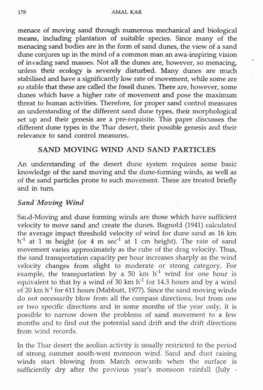
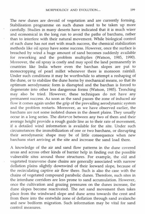
The spatial pattern of present day aeolian activity is reflected in thewind erosion index map that Was constructed (Kar, 1993)with the helpof modified Chepil formula (Yaalon and Ganor, 1966) :
100 y3C'=
2.9 (PE)2
where C' is climatic wind erosion index,
V is mean wind speed at 10 m height,
PE is the Thornthwaite's measure of precipitation effectiveness, and 2.9is the annual average climatic index at Garden City, Kansas; values atother stations are expressed as a percentage of this Figure.
A new scale of severity of wind erosion index was prepared toaccommodate the observed patterns of sand mobility in the region. Thevalues were classified into six groups, ranging from very low toextremely high (Table 1; Figure 1; Kar, 1993).
Grain Size
The size and character of the particles are also important. The particlesclassified as sand range in size from 0.06 to 2.00 mm in diameter (4.0 to- 1.0 phi). Particles of smaller size are referred to as dust and have aplaty structure with increased inter-particle cohesion. The sand particlesare granular and cohesionless. Particles susceptible to movement bywind (or aeolian transportation) are the sand and the silt sized particles.With changing grain size and changing wind velocity the movement
-: takes place as surface creep, saltation and suspension. Saltation accountsfor about !J5percent of the bulk sand transport, consisting mostly of 0.15to 0.25 mm size particles, and the suspension involves particles ofsmaller than 0.15 mm size. Much of the high level suspended load,moving out of the desert and settling along the desert margin andbeyond as dust fall, is composed of particles smaller than 0.06 mm size.
180 AMAL KAR
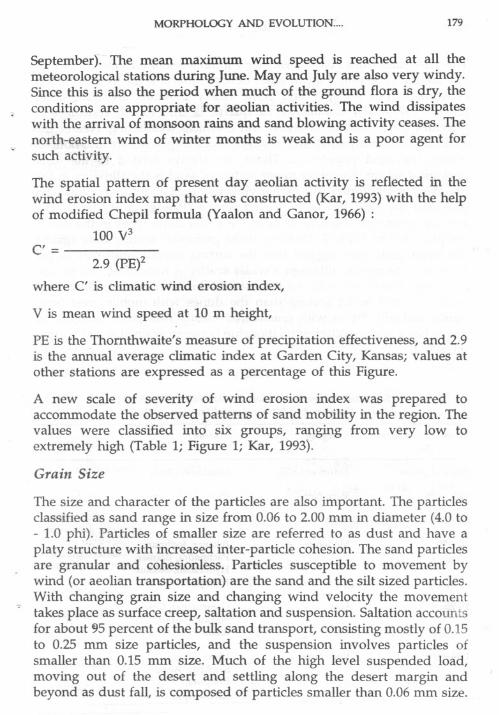
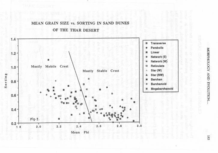
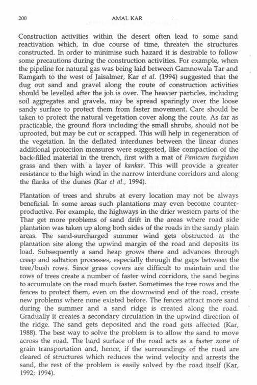
The Thar sand dunes have mean sand grain sizes of 0.15 mm (2.74 phi)to 0.20 mm (2.30 phi). Like in other deserts, quartz is the most commonconstituent, but feldspar and some heavy minerals are also found(Singh, 1977). The dominance of quartz is due to the resistance itprovides to mechanical abrasion and chemical weathering. Nearer therock outcrops many small and unaltered rock fragments are also noticedwithin the sand population. These are always related to the localgeological set up. The other major source of sand is the alluvium in thepre-existing landforms. The earlier view that the Great Rann of Kachchhprovided the sand has been proved wrong (Pandey et al., 1964). Theaverage grain size characteristics of the major dune types in the desertare provided in Table 2. Plotting of the grain size sorting data againstthe mean grain size suggest that the sorting usually improves as thegrain size decreases, although a wider scatter is noticed at 2.20 to 2.50phi range. The dunes with stable crest (old dunes) have generally a finergrain size and better sorting than the dunes with mobile crest (newdunes and old dunes with reactivated crest). This latter category ofdunes has a wider scatter of relationship between grain size and sorting(Figure 2).
Table 1
Suggested Categories of Wind Erosion Index (March-July)For The Thar And Meteorological Stations in Them
Station
Jaisalmer, Chhor
Phalodi
Bikaner, Jodhpur,Pachpadra, Barmer,Hyderabad, SukkurKhanpur
15-29 Low Ganganagar, Chum,Nagaur, Jaipur,Badin
1-14 Very Lqw Hisar, Sikar,Sambhar, AjmerErinpura,Bahawalpur
Wind erosion index Category(%)
480 and above Extremely high
120 -479 Very high
60 - 119 High
30 - 59 Moderate
MORPHOLOGY AND EVOLUTION.... 181
Table 2
Average Grain Size Characteristics ofThe Crestal Sand of Thar Sand Dunes
Type Zone Mean Median Sorting Skewness Kurtosis
(phi) (phi)
PARABOUC South 2.82 2.78 0.360 +0.218 1.449
West 2.62 2.65 0.436 -0.128 1.381
Central 2.63 2.67 0.388 -0.270 1.573
East 2.60 2.64 0.333 -0.170 0.908
LONGITUDINAL Westernmost 2.85 2.82 0.493 +0.130 1.983
West 2.57 2.62 0.486 -0.094 1.312
East 2.68 2.72 0.314 -0.212 1.185
TRANSVERSE West 2.57 2.62 0.388 -0.146 1.004
East 2.70 2.71 0.302 -0.133 0.180
STAR SouthWest 2.33 2.57 0.811 -0.543 1.472
NorthWest 2.85 2.87 0.372 -0.085 1.327
NETWORK
i) Compound hooked West 2.54 2.57 0.402 -0.138 1.062
East 2.88 2.88 0.264 +0.140 1.529
ii) Parabolicform with networks 2.70 2.74 0.349 -0.182 1.086
iii)Longitudinalwith transversals 2.56 2.60 0.602 -0.321 1.890
iv) Fish scali! 2.37 2.40 0.443 -0.121 1.740
BARCHAN 2.30 2.27 0.582 -0.231 0.993
BARCHANOID 2.25 2.31 0.524 -0.194 1.006
MEGABARCHANOID 2.35 2.42 0.548 -0.231 1.069
OBSTACLE 2.79 2.80 0.382 +0.242 1.535

THAR DESERTWIND EROSION INDEX
a
10 Km/hI
LEGEND
0 WIND EROSION INDEX(%> UAVERAGE ANNUAL RAINFALL(mm) I-IRESULTANT WIND (JUNE)
....00N
..,..to.e~.'"
t..~.
~Ii~'"..~~..~~!l
~l""
S
t480 Extremely high
120 Very high
High60
30Moderote
Low15
Very low
Flg.1
0.4
0.21 8
MEAN GRAIN SIZE vs. SORTING IN SAND DUNES
OF THE THAR DESERT
Mostly Mobile Crest
.
Fig.2.
+~
Mostly Stable Crest
.+
.... ....+ + lIIe IIIGL. +.111.
"-a..+ . a fila~
..
2.0 2.2 2.4
Mean Phi
..III
~... ~
. A'EI A. '.011\.. ..1I\j...8~i,,~:~ .'. O.EI
2.6 2.8
III.
a Transverse. Parabolic'" Linear. N.twork(E)III N.twork (W)'
c Reticulate
"'. Star (W)
A Star (NW). Barchan+ Barchanold
III Megabarchal)old
~~§
§-<
~
8
§
F
3.0
....00c"J
1.4
1.2
1.0
01)c- 0.8'...e(IJ
0.6

184 AMAL KAR
aASSIFICATIONOF SAND DUNES
The origin and development of sand dune is related to the tendency ofthe saltating and creeping sand particles to accumulate in somepreferred areas like an obstruction, a topographic nitch, or a sandcovered surface with some vegetation. The sand-free hard surfaces likethe rocky tracts usually do not favour large-scale dune formation, butact as ,a surface of f~ster grain transportation. There are also the controlsof time, as fluctuating climate determined the phases of dune formation.
Sand Dune Systems
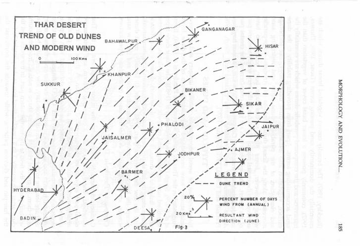
Pandey et ,al. (1964) classified the dunes of the Thar'desert in Rajasthanon the basis of their age and stability. They recognized two 'systems' ofdunes: the dunes of 'old system' and the dunes of 'new system' (seealso Singh, 1982; Singh and Shankarnarayan, 1986). The new dunes arefOrming today and consist of crescentic dunes, sand streaks and sandyhummocks. Most of the 6ld dunes were last formed during 15 ka to 18ka BP, when the dessert extended beyond the Aravalli hill ranges in theeast (Goudie et ilL, 1973; Ghose et al., 1977; Wasson et al., 1983, Singhviand Kar, 1992). This major dry phase was followed by a major wetphase from 10 ka to 3.8 ka BP when the dunes attained a greaterstability. The current dry phase started around 3.8 ka BP, but it is lessextensive than the earlier one. Dissected obstacle dunes, whalebacks andsome network dunes along the desert's wetter eastern margin andbeyond mark its former extent. The trend of the 'old' dunes, both withinand outside the present desert boundary, correlate well with the present
-regional trend of the south-west wind (Figure 3). The average height ofth~ -9.unes varies from 20 to 40 m, while most of the 'new' dunes are
2 to 8 mlu~ is not unusual, however, to find old dunes of 50-60 mheight and new Ciw:tes of 40 m height.
The above classification is ~irhple and has great relevance in sandcontrol measures, involving the s ~..i dunes. This is especially because
it differentiates the dunes which essenti "-. ,.~ management fromthe dunes which need to be controlled. ~
~- ~-Stability of Old Dunes
The greater stability of old dunes is attested by the calcified nodules androot casts of plants within them. These dunes also support copiousvegetation under natural conditions, with a basal cover of 4 to 8 percentor more. Such a cover can reduce sand transport on the dunes by 30 to50 percent of that on bare sand, assuming a wind speed of 36 kmh-1
, I
T.HAR DESERT /""""""""""' ~". ~NGANAGAR
TREND OF OLD DUNES ~~ 7""'./BAHAWALPUR,..'" ~ ". ""AND MODERN WIND ~... ...""""/'" /' ~ HISAR..-'" / /'" """" / - ./
/ ~ ---0 IOOKml
j:' /' ~ --. /' / /" /' - - - ---..> /' /" - .....-
1"{j='i<HANPUR// /" // ./ - - -r / / ./"./'" .SUKKUR "..., / / ././ --- --./.
~,.~/ I BIKANER -- I
.,,"'~Jr""/ 'I I / / /' / / 1 . / - 'I.~IK-:-/.! I I ./ ~. I
V I" // / ./ ./ ;/
/"""""'~; , / / ~ . / / )1/ ,PHALODI /' ~ ;;;: "" //~A~'PURf I I II / JAISALMER ~ /' ././' /'
\ I I I / / ~ ~ - /~'~"~. I c'" I / :/ /
/ Z. / --/. AJMER
. \ \. "'. I / '/ / ~ODHPUR /
;t Oo,' \( I / / ~ / / /' ~/ ,,// --7"":'/ // /" / BARMER / /' ",/ LEG END
... I./" .',/ /! / ./ A / /_-- DUNE TREND.h
'. ./
~ ./'" /
HYDERABA J /" // ."./ //
I ).
~ /'" ./' / /' 2°
Jr-PERCENT NUMBER OF DAYS
V ./' / WINO FROM (ANNUAL),..., / -- ./' ./"'
21 .h
, ~ / """" 1 20 Km," . ~ RESULTANT WIND
BADI~f-- /./'" /" /,1 DIRECTION(JUNE)""" \/""""" // D ESA.: FIN
~
~0
8-<
~
a
~
,.;.8j
186 AMAL KAR
(Buckley, 1987). The broadly convex vegetated linear dunes, which areessentially the dominantly sand passing forms (Tsoar, 1989; Thomas,1992), commonly possess a lesser basal cover of vegetation than the "transverse and the compound parabolic dunes which are essentially thesand accumulating forms. Apart from providing stability to the dunesurface, vegetation also influences dune morphology, like anchorageand elongation of the parabolic dune arms and restricting sandimovement along the linear dune crests to the strongest ridge-parallelwinds. However, fewer plant species have been noticed to havesurvived in the crestal part of the dunes in the very windy western partof the desert. The species which are good colonizers of the crestal partinclude Leptadeniapyrotechnica, Calligonum polygonoides,Panicum turgidum,Acacia jacquemontii and Crotalaria burhia (Saxena and Singh, 1976;Prakash and Gupta, 1976; Saxena, 1977).
TYPES OF SAND DUNES
Interpretation of aerial' photographs, satellite imagery and extensive'field studies haMe necessitated' a reclassification of the dune forms
suggested in the Thar by' earlier workers like Pandey et al. (1964),Breedet al. (1979)~.Singh (t982:);and Wasson et al. (1983). The major dune typesidentified now are: compound parabolic dunes, linear dunes, transversedunes, linked star dunes" a variety of network dunes, major obstacle'dunes. along the hill slopes, barchans, barchanoids and megabarchanoids,and the low sand streaks (Kar, 1993; Figure 4). Usually, most dunesexcept the barchans, barchanoids, megabarchanoids and the low sandstreaks, are the old dunes. A brief discussion on the dune types follows.
,
Compound Parabolic Dunes
Compound parabolic dunes form the major component of the Thardunefield. The dunes look like a coalescing U form, and their curvednosal part appears in the downwind direction. A three to four tier ~
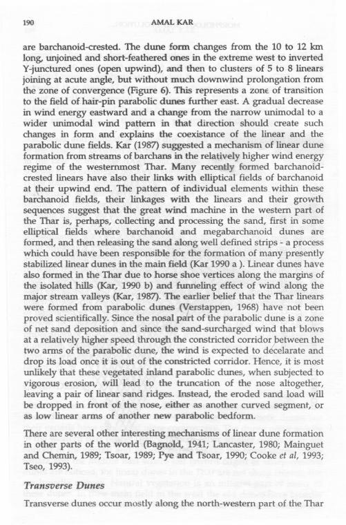
arrangement of dunes is noticed in almost every cluster of parabolicdunes. Although the high dunes are mostly stabilized with copious -vegetation, abundant root casts and CaCO3 fingers within them,increased human and livestock pressures on them are reactivating manyand are leading to the formation of secondary, low crescentic bedformsatop them. A gradual change in dune shape is noticed from the south-western part of the field to the north-eastern part. In the south-west thedune arms are usually 3 to 4 kIDs long and join at sharp angles to formthe hair-pin and chevron patterns, while towards the north-east thearms become shorter and the sharp junction at the nose become 'more

'1
FIGURE'
~
~
~
~
8
§
F
....00'I
LEGEND'DOMINIINTLY OLD DUNES
LINEAR DUNES
bI TRANSVERSE DUNES
PARABOLIC DUNES
STAR DUNES
IS NETWORK:I.INEARDUNESWITHTRANSVERSAI.S
NETWORK I TRANSITIONALPARABOLIC DUNES
m NETWORK:SINUOUSDUNES
IIMAJOROBSTACI.E DUNES
NEW DUNES
SA RCHANS & SARCHANOIDS"""Co
II MEGABARCHANOIDS
m SAND STREAKSAND ZIBARS
188 AMAL KAR
curved. The arm length is gradually reduced to about 500 m.Topographic variations across a parabolic dune near Jodhpur weremapped using a sophisticated Global Positioning System (GPS), whichrevealed that about 37 per cent of the dune volUme is contained in itsupper middle and crestal parts (Kar et al., 1995). This and other newinformation generated through computer simulation of the GPS data has
. many implications for the growth pattern of the dune (Figure 5).
Anchorage and elongation of the dune arms by vegetation and deflationof the plains in between are thought to have formed them, as is noticedin the case of the coastal parabolic dunes. The coalescing of forms hasso long been explained by either joining of the individuals by transverseridge formation (Singh, 1982), or through movement and overriding ofindividuals at different rates and times (Wasson et al., 1983). Recentstudies in the interdune plains where new bedforms are currentlyforming suggest, on the other hand, that sand accumulation downwindof a parabolic chain can occur as isolated depositional lobes whichsubsequently tend to align themselves in the form of two near parallelsand streaks. A major zone of accumulation occurs further downwind,astride the path of the wind. It captures more sand through deflation inbetween the pair of streaks and also through the supply from the dunechain upwind. Gradually the nosal part of the dune is formed here. Thesand streaks do also grow simultaneously and form the dune arms. Inother words, the parabolic bedform can develop here without the needof migration of sets of dunes and in a manner quite different from thegrowth sequence of the coastal parabolic dunes (Kar, 1993). Anotherimplication of the finding is that the interdune plains in the parabolicdunefield, when subjected to sand drift, may witness within a few years'time, new parabolic bedforms, even though these could be of lowerheight.
Linear Dunes
Linear dunes are aligned in the direction of dominant sand transport.These dunes are less numerous in the Thar than the parabolic dunes, buttheir genesis have generated more controversy. The dunes occur mostlyin the western part of the Thar, although other smaller occurrences arenoticed in the central and eastern parts. Unlike the linear dunes in theSahara and the Middle East where sief (sword edged or sharp crested)dunes are noticed, the linear dunes in the Thar are not sharp crested, butare broadly convex. Natural vegetation is an integral part of many ofthese dUnes. In their main field in the west the old dunes have broadlyconvex crests, but the recently forming ones and the reactivated linears

wz::)0u:J0m~ ==<C wa.. t-O I- ~Z a::: en<c w C)..J U) :zZ W Z- 0 0Z a::: E<C <C enu. J: 00 I- ~Z W <0 J: !XIi= I- 9:) ~ C)::) ~:?: enen ;:)
a:::wI-::)a..:e,0u
MORPHOLOGY AND EVOLUTION.... 189
%.
\,
lb.
\
%. <2-
e$~
\to19u..
W B6 ~~
190 AMAL KAR
are barchanoid-crested. The dune form changes from the 10 to 12 kmlong, unjoined and short-feathered ones in the extreme west to invertedY-junctured ones (open upwind), and then to clusters of 5 to 8 linearsjoining at acute angle, but without much downwind prolongation fromthe zone of convergence (Figure 6). This represents a zone. of transitionto the field of hair-pin parabolic dunes further east. A gradual decreasein wind energy eastward and a change from the narrow unimodal to awider unimodal wind pattern in that direction should create suchchanges in form and' explains the coexistance of the linear and theparabolic dune fields. Kar (1987) suggested a mechanism of linear duneformation from streams of barchans in the relatively higher wind energyregime of the westernmost Thar. Many recently formed barchanoid-crested linears have also their links with elliptical fields of barchanoidat \heir upwind end. The pattern of individual elements within thesebarchanoid fields, their linkages with the linears and their growthsequences suggest that the great wind machine in the western part ofthe Thar is, perhaps, collecting and processing the sand, first in someelliptical fields where barchanoid and megabarchanoid dunes areformed, and then releasing the sand along well defined strips - a processwhich could have been responsible for the formation of many presentlystabilized linear dunes in the main field (Kar 1990 a ). Linear dunes havealso formed in the Thar due to horse shoe vertices along the margins ofthe isolated hills (Kar, 1990 b) and funneling effect of wind along themajor stream valleys (Kar, 1987). The earlier belief that the Thar linears
were formed from parabolic dunes (V.;erstappen, 1968) have not beenproved scientifically. Since the nosal pa'rt of the parabolic dune is a zoneof net sand deposition and since the sand-surcharged wind that blowsat a relatively higher speed through the constricted corridor J:>etweenthetwo arms of the parabolic dune, the wind is expected to de'celarate anddrop its load once it is out of the constricted corridor. Hence, it is mostunlikely that these vegetated inland parabolic dunes, when subjected tovigorous erosion, will lead to the truncation of the nose altogether,leaving a pair of linear sand ridges. L1lStead, the eroded sand load willbe dropped in front of the nose, either as another curved segment, oras low linear arms of another new parabolic bedform.
There are several other interesting mechanisms of linear dune formationin other parts of the world (Bagnold, 1941; Lancaster, 1980; Mainguetand Chemin, 1989; Tsoar, 1989; Pye and Tsoar, 1990; Cooke et aI, 1993;Tseo, 1993).
Transverse Dunes
Transverse dunes occur mostly along the north-western part of the Thar

MORPHOLQGY AND EVOLUTION.." 191
WEST
Eastward change in the shape of sand dunes from longitudinal tohairpin parabolic in south Jaisalmer
(0) b) 0Nowotolo
Ie)
: ..i.:..r)!!f f.
f!f..f/1:~:
1 ~
' E:::<:;::: N "'2'
tf; ;i: 2~ ~6.::"::: '5'1 .,'11;: i:: : '1
( dl
,"
Ij/f:
Iff:/
I -Chh.~o.or
SCALE
0123436
. I K'~OM~T R'Es' I
EAST

192 AMAL KAR
and also in the east-central part. Unlike the linear dunes, which arealigned in the direction of the sand-moving south-west wind, thetransverse dunes are oriented across the path of the sand-moving wind.The crest line is everywhere characterized by broad crescent. While the20 to 40 m high old dunes have copious vegetation and subparallellinear ridges along their windward slopes, the new ones of lower heightdo not possess such linear ribs.
Star Dunes
Star dunes are not numerous in the Thar. There are only two majorfields of linked star dunes. These are located in the Mohangarh area (tothe north-east of Jaisalmer)~ downwind of a major rocky hamada, andalong the north-western fringe of the desert, especially in Ganganagar-Suratgarh tract. The dunes mostly have a subdued appearance andoccur in chains. Pefl.ksof 10 to 25 m height are noticed along the centralribs where arms from two or more directions join. Variable low energywind in the wake of a topographic barrier (Mohangarh) and at theconvergence of southwesterly and northwesterly wind currents could bethe possible reasons for their peculiar development. Studies elsewherein the world confirm that the strength, direction and duration ofseasonal primary winds and the secondary airflow over it play crucialroles in the development of star dunes (Nielson and Kocurek, 1987).
Network Dunes
Network dunes of different kinds have been recognized in the Thar.These appear espechilly along the margins of the large fields of majordune types and in the transitional zones between them. The mostdominant among these are the compound parabolic dunes withtransverse forms at right and the large parabolic forms with networkpatterns within. Both the patterns are noticed in the north-eastern partof the Thar and are the transitional forms of the compound parabolicdunes. Their average height varies from 8 to 15 m. A less energetic windregime, a greater directional variability of the wind and an increasedvegetation cover might have contributed to their formation. Networkdunes of another kind, where short linear dunes join at a transverseridge, occur to the west of Ghotaru in Jaisalmer district (Kar, 1994).There are other minor types of network dunes also (Kar, 1993).
Barchans and Barchanoids
Barchans and barchanoids occur mostly to the west of the 120 contourof the wind erosion index. This runs approximately along the 200 mm

MORPHOLOGY AND EVOLUTION.... 193
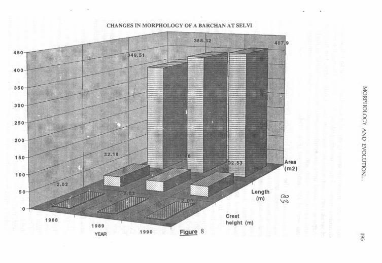
isohyet in the southern part of the desert, but in the northern part it doesnot follow that isohyet because of a lower wind regime. The dunes areideally formed along the margin of the rocky desert of Jaisalmer-Pokaranwhere the 2 to 3 m high dunes move at an average speed of 27 to 32m per annum. Monitoring of a -2 m high dune near Pokaran indicatedan average movement of 31.7 m per year, although there weresignificant year to year variation depending upon the raWall of theprevious year and wind speed during the year in reference (Figure 7).The dune area increased gradually during the recorded period, but thecrest height did not (Figure 8). It was also found that the crestexperienced a higher wind speed during the summer due to streamlineeffect, and also a higher sand accretion rate than at other locations onthe dune (Ramakrishna et al., 1994). The barchans are the fastest movingdunes in the desert. For example, Embabi (1982) recorded an annualmovement rate of 20 to 100 m in the Kharga oasis area of the EgyptianSahara (Western Desert). In the Thar an annual rate of 35 to 40 m wasnoted for the 2-4 m high barchans around Sam and Ramgarh (marginof the extremely high wind erosion index zone). Majority of thebarchans in this latter zone are, however, 4 to 8 m high and move at aslower speed.
The barchan has a crescentic form, with two horns protrudingdownwind, while a slip face at -330 marks the limit of the main dunebody. The necessary aeolian regime for the formation of a barchan is adominant unidirectional wind. The dune originates first as a small ovalshaped sand mound with a convex profile. Gradually a small concaveslip face develops on the leeward face of the mound. From this stageonward the dune grows faster, the slip face gains height as more sandis captured by the dune, the arms on both sides of the slip face lengthenand the dune starts migrating at a faster pace. Initially the crestline andthe brinkline of the barchan are almost at the same place, but as thebarchan captures more sand from upwind direction, more crowding ofrelatively coarser particles takes place at the crestal region. This perhapsleads to a slow creep and a relatively shorter grain jump at the crest.Moreover, Ithe gradual protrusion of the sand body into the boundarylayer provides more resistance to the sand flow. Consequently, thecrestline to brinkline distance increases, the latter marking the upperlimit of the slip face. One of the characteristic features of the Tharbarchans is that the brink of the dune is located in most cases downwindof the crest.
Field observations in parts of the rocky desert of Jaisalmer indicated anapparently chaotic arrangement of the barchans when these are at their

ANNUAL WEATHER AND MOVEMENT OF A BARCHAN AT SEL VI....
~
180
160
Rainfall(mm)
Days withwind speed 0
>15 kmph
)-.~r-'~::0
YEAR 1990
CHANGES IN MORPHOLOGY OF A BARCHAN AT SEL VI
250
5~§~-<
~0m8t""c::...,
~
450
400
350
300
Length(m)
Go\N
1989
YEAR
Crestheight (m)
1990 FiQure 8 ....\001
196 AMAL KAR
source area, but while moving out of it the dunes tend to follow somedefinite routes and in an orderly fashion (Kar, 1994). During the periodof weak north-east wind the barchans take a fulji shape, but the idealshape is regained once the south-westerly wind re-establishes itself. Asimilar situation exists for the barchanoids also, which are numerous tothe west of 150 mm isohyet (Kar, 1994).
Barchanoids, or the coalesced barchans, form under many situations. Inthe low wind erosion index zones the dunes form in the interdune
plains, mainly due to high human-induced reactivation of the old dunesand the sandy plains. Between the 120 and 240 COntours of the index,however, there are more chances of such formation due to a drierenvironment and easy availability of the movable material. In both thecases the 1 to 2 m high barchClnoids form and coalesce due to theretardation effect of relatively dense ground flora ttnder a lower windregime. In contrast, the dunes along the margin of the rocky tract ofSam-Ramgarh and further west are 8 to 20 m high and have threedistinguishable zones: (1) a high arcuate segment at the upwind end,with the characteristic features of a barchan; (2) a field of lowbarchanoid strips downwind of the arcu~t€ segment; and (3) a fewchains of &mallbarchans at the distal end of the dune (Kar, 1990 a). Thearcuate segment traps sand from the upwind direction and has manysmall annual shrubs and grasses along its windward slope. Notableamong these are Panicum turgidum, Crotalaria burhia, Haloxylonsalicornicum, Tephro purpuria and Lasiurus sindicus. These species providesome stability to the arcuate segment and help it to capture more sand.Downwind, a series of 2 to 10 m high barchanoid chains fill up the spacebetween the two ends of the arc. Unlike the high arcuate segment, thelow barchanoids are almost devoid of vegetation. The horns of thebarchan are missing in the high barchanoids. Instead, a pair of barchanstrips, .1ccurring a few tens of metres inside both the ends of the mainedifice, form a linear pattemacross the dominantly transverse bedform,and feed the linear dunes further downstream (Kar, 1990 a).
Alegabarc.hanoid Dunes
The compound megabarchanoids occur in the relatively inaccessiblewesternmost part of the Thar where the average annual rainfall is lessthan 100 mm and the wind erosion index is more than 480. A numberof closely spaced elliptical fields of these dunes could be noticed amidstfield~ of vegetated linear dunes. The axis of the dunes correspond wellwith that of the linears. The height varies from 20 to 40 ffi. Each chainwithin a field is a complex of several crescent shaped giant dunes, with

MORPHOLOGY AND EVOLUTION.... 197
atleast three tiers of nested barchans along their windward slope (Kar,1990 a). The occurrence of linear dune remnants from within themegabarchanoid fields suggest that the megabarchanoids not onlysustain themselves through supplies from the upwind sources, but theyalso engulf new areas of the old linears. Although not as fast moving asthe low barchans, the barchanoids and the megabarchanoids are alsovery mobile and dangerous to human activities.
Most of the high barchanoids and megabarchanoids are easily discerniblefrom the high to medium resolution satellite images like the Landsat TMand IRS Liss II, even without digital processing. Problems are encounteredin the areas with low tonal contrast (Al-Hinai, 1989). If proper groundcontrol points (GCP's) are established for these dunes and theirsurroundings, then the nature of shifting of the dunes can be recordedwith greater accuracy.
Other Dunes
Other dunes in the Thar'include the dissected obstacle sand dunes alongthe hill slopes and low sand streaks in the sandy plains, especially alongthe fence lines of agricultural fields and around the small bushes (shrub,coppice dunes). The shrub coppice dunes (or the nebkhas) are amongthe most dominant non-crescentic recent aeolian bedfonns in the desert.Bushes of Capparisdeciduaand Ziziphus nummularia provide the bestenvironments for their growth and dune-plant symbiotir. relationship.Calligonum polygonoides, Leptadenia Pyrotechnica, Haloxylon salicornicum,Lasiurus sindicus grass clumps, Acacia jacquemontii and degraded bushesof Prosopiscinerariaare also found to encourage the formation of thisdune in different environments. In many cases the height to length ratioof these dunes reaches a value of 1:8 to 1:10 during the strong sandshifting summer months. During the period of weak NE wind thenebkhas become blunt and their length shorten.
Formation of low linear and transverse sand streaks is common in theareas of intensive cultivation in the deep sandy terrain, especially to theeast of the 250 mm isohyet. The sand streaks usually form along theperipheries of agricultural fields when the farmers fence their fields toavoid sandy soil being blown out during the sandstorms (Aandhi). Thefences, however, become the loci of sand accumulation. Although muchof the deposition takes place along the direction of wind, the fencesastride the wind also capture sand, so that a chess board pattern ofaccumulation is noticed. It is however, significant to note that theorientation of many sand streaks replicate that of the d~minant old
198 AMAL KAR
dunes in the locality, which suggests that the pattern of recent sanddeposition in the sandy plains is governed by the pattern of lee wavesbehind the high old dunes and/or the secular pattern of wind in theregion concerned. Under such circumstances the farmers use theseslowly growing sand bodies as field boundaries.
RELEVANCE IN SAND FIXATION STUDIES
Not all the sand dunes are mobile and, hence, not all the different typesof dunes require the same kind of stabilization treatment. Some of thedunes may even turn more ci.angerous if their regular pattern ofmovement is interfered with. It is clear from the study above that wehave to recognise the basic differences between the old and the newdunes. The old dunes in the Thar have attained natural stability withinthe last 15-18 ka or so, but are now under different phases ofdegradation. The loose crests and flanks of many of these dunes createan illusion of alarming dune movement. Monitoring of one such dunein the field yielded an average rate of 0.5 m only (Ramakrishna et al.,1990). Monitoring of some old and reactivated parabolic dunes in the240-480 contour belt of wind erosion index through remote sensingindicated that the rate of advancement varied roughly between 9 and 50m, in case of some hair pin parabolics, especially due to excessivehuman use system and drought, while many others had insignificantrates of movement (Kar, 1993; 1994). Of late, increasing use of the tractorfor ploughing across the slopes of the dunes and in the interdunecorridors have loosened sand to a greater depth and have reduced thebasal plant cover on the dunes to well below the 4-8 per cent that isrequired for reducing sand movement under moderate wind velocity.Consequently, more land is now being threatened by reactivation of olddunes.
The rates of movement decrease sharply in the eastern part, especiallybecause of higher moisture status in the soil and a lower wind regime.There is, however, remote sensing evidence of very high reactivation insome areas (e.g. Nagaur-Churu tract) due to more pressure of tractorploughing and cultivation. Many reactivated old dunes in the east havethe stable surface at a depth of 1 to 3 m below the loose sandy apron.Such dunes could be provided their earlier stable and vegetated statusthrough better management practices everywhere in the desert.Venkateswarlu (1993) and Harsh et al. (1995) provided short overviewson the current knowledge on vegetative methods of sand dune fixationin the Thar desert.
MORPHOLOGY AND EVOLUTION.... 199
The new dunes are devoid of vegetation and are currently forming.Stabilisation programme on such dunes need to be taken up morecarefully. Studies in many deserts have indicated that it is much wiserand economical in the long run to avoid the paths of barchans, ratherthan to interfere with their natural movement. While biological controlof such dune has not met with much success, the chemical stabilisationmethods like oil spray have some success. However, once the surface isbreached by wind a huge amount of sand becomes suddenly availablefor reworking and the problem multiplies (Watson, 1985, 1990).Moreover, the oil spray is costly and may spoil the land permanently incountries like India where even the barchan slopes are put tomonocropping of pearl millet whenever there is monsoon rainfall.Under such. conditions it may be worthwhile to attempt a reshaping ofthe dune, or to stabilise the dune horns by mechanical means, so that itsoptimum aerodynamic form is disrupted and the barchan is forced todegenerate into other less dangerous forms (Watson, 1985). Trenchingmay also be tried. However, these techniques do not have anypermanent success. As soon as the sand passes the zone of induced airflow it comes again under the grip of the prevailing aerodynamic systemand the problem restarts. Moreover, as we have observed earlier, thebarchans are not some isolated dunes in the desert plains. They usuallyoccur in a long series. The dista'1ce between any two of them and theiraverage height provide a rough guide line as to their rate of movement,if a detailed wind information is available for the site. Under suchcircumstances the immobilization of one or two barchans, or disruptingtheir aerodynamic shape may be of little consequence when newbarchans start arriving at the site and increase the sand load there.
A knowledge of the air and sand flow patterns in the dune coveredareas and across other kinds of barrier help in finding out the possiblevulnerable sites around those structures. For example, the old andvegetated transverse dune chains are generally associated with narrowdeflation plains slightly downwind of their leeward slope, because ofthe recirculating captive air flow there. Such is also the case with thechains of vegetated compound parabolic dunes. Therefore, such sites inthe interdune corridors are less prone to sand accumulation. However,once the cultivation and grazing pressures on the dunes increase, tlledune slopes become reactivated. The net sand movement then takesplace from the windward slope and dune arms towards the crest andfrom there into the erstwhile zone of deflation through sand avalancheand new bedform migration. Such information may be vital for sandcontrol measures.
200 AMAL KAR
Construction activities within the desert often lead to some sandreactivation which, in due course of time, threatel\ the structuresconstructed. In order to minimise such hazard it is desirable to followsome precautions during the construction activities. For example, whenthe pipeline for natural gas was being laid between Gamnowala Tar andRamgarh to the west of }aisalmer, Kar et al. (1994) suggested that thedug out sand and gravel along the ro\lte of construction activitiesshould be levelled after the job is over. The heavier particles, includingsoil aggregates and gravels, may be spread sparingly over the loosesandy surface to protect them from faster movement. Care should betaken to protect the natural vegetation cover along the route. As far aspracticable, the ground flora including the small shrubs, should not beuprooted, but may be cut or scrapped. This will help in regeneration ofthe vegetation. In the deflated interdunes between the linear dunesadditional protection measures were suggested, like compaction of theback-filled material in the trench, first with a mat of Panicumturgidumgrass and then with a layer of kankar. This will provide a greaterresistance to the high wind in the narrow interdune corridors and alongthe flanks of the dunes (Kar et al., 1994).
Plantation of trees and shrubs at every location may not be alwaysbeneficial. In some areas such plantations may even become counter-productive. For example, the highways in the drier western parts of theThar get more problems of sand drift in the areas where road sideplantation was taken up along both sides of the roads in the sandy plainareas. The sand-surcharged summer wind gets obstructed at theplantation site along the upwind margin of the road and deposits itsload. Subsequently a sand heap grows there and advances throughcreep and saltation processes, especially through the gaps between thetree/bush rows. Since grass covers are difficult to maintain and therows of trees.create a number of faster wind corridors, the sand beginsto accumulate on the road much faster. Sometimes the tree rows and thefences to protect them, even on the downwind end of the road, createnew problems.where none existed before. The fences attract more sandduring the summer and a sand ridge is created along the road.Gradually it creates a secondary circulation in the upwind direction ofthe ridge. The sand gets deposited and the road gets affected (Kar,1988).The best way to solve the problem is to allow the sand to moveacross the road. The hard surface of the road acts as a faster zone ofgrain transportation and, hence, if the surroundings of the road arecleared of structures which reduces the wind velocity and arrests thesand, the rest of the problem is easily solved by the road itself (Kar,1992;1994). .

MORPHOLOGY AND EVOLUTION.... 201
A number of reactivated hair pin parabolic dunes in the zone with 120to 240 contour of wind erosion index are now being planted with treesand shrubs, especially Acacia tortilis and Prosopis juliflora, at the nosalpart of the dunes. Only this smaIl part is within the jurisdiction of theGovernment Forest Department. The rest of the area of any such dunebelongs to the farmers nearby, who prar:tice dry farming, often usingtractors instead of country plough along the dune slopes, and opengrazing during rest of the year. The shrubs on the dunes also providefuelwood to the villagers. Faced with such a scenario, the departmentis perhaps, justified to develop the 'forest' in the land within its ownjurisdiction and show some 'results'. However, the relative paucity of aground flora in the area of development and the non-availability of thelong upwind parts of the dunes for revegetation programme go severelyagainst the concept of controlling sand movement from the dunes. Withincreasing pressures on the soil and vegetation resources of the dunes,each summer the sand continues to move at an accelerated pace fromthe dune slopes. It is quite logical for this sand to accrete over to thenosal part of the dunes and then to move along narrow, artificiallycreated corridors of faster wind flow through the belts of planted trees,and then to avalanche downslope, thus helping the dune to prograde.There are many instances of such creeping dunes inspite of a plantationprogramme in the Thob-Shergarh-UjIan-Phalsund area. Since plantationof trees and tall shrubs on the dunes has been taken up on a large scale,it is also worthwhile to find out the optimum plant density on a givendune type under a given climatic situation. Although it is known thatthe dune sand has a better moisture holding capacity, it is yet to becalculated how many trees and shrubs a dune can hold on a sustainablebasis.
Presently there is hardly any good and totally acceptable solution to theproblem. To the land holder the dune is the plank of his economic wellbeing. With time it is becoming increasingly difficult for him to keep theland fallow, even for a year. Therefore, he is willing to regularlycultivate the land and gamble with nature for growing crops and at thesame time accept some degradation and consequent dune movement,rather than to leave the land for fencing and for less lucrative proposalslike growing of grasses and horticultural crops, including beT. Thesuggestion that the upper slopes and other vulnerable parts of the dunesshould be left out of the cultivator's plough, is difficult to put topractice. There is no such law. It is also utopian to suggest to thedevelopment agencies the formulation of 'appropriate stabilizationprogrammes' in the so-called 'source areas'. Most of the development
202 AMAL KAR
agencies of the Government and especially the agencies whoseinfrastructures are affected (e.g. the railways and the road maintenancedepartments), have very less land at their disposal and much lessresources and expertise to provide a long term solution to the menaceof sand deposition. What is needed, therefore, is a set of cheap andacceptable solutions for both the private land holders and thedevelopment agencies. Given the complexities of situation in whichsand movement takes place in the dunefields the solutions will be morelocation-specific.
CONCLUSION
It is reasonable to conclude from our study that a proper understandingof the geomorphic properties of the sandy landforms, especially thesand dunes, as well as the process-form interactions in the sandy terrain,are vital to any programme of sand control The dunefields provide anatural laboratory of the possible interactions between parameters ofsand movement and, hence, a closer study of the changes occurring inthese areas can provide enough clues to the possible reactions to theinduced conditions, as well as to the types of control measures requir~d.
Acknowledgements
The author is grateful to Dr.H.P. Singh, Director, and Dr.S. Singh, Head,Division of Resource Survey and Monitoring, CAZRI, for providing facilitiesand for encouragement. .
REFERENCES
Al-Hinai, KG. (1989). Evaluation of remote sensmg data for sandstudies in Saudi Arabia. In, Proceedings,Workshopon DesertStudies inthe Kingdomof Saudi Arabia: Scopesand Concerns.Centre for DesertStudies, King Saud University, Riyadh, pp. 67-90.
Bagnold, RA. (1941). The Physics of Blown Sand and Desert Dunes.Methuen, London, 265 p.
Breed, c.S., Fryberger, S.c., Andrews, S., McCauley, c., Lennert, F.,Gebel, D. and Horstman, K (1979). Regional studies of sand seas~ing Landsat (ERTS)imagery. USGS ProfessionalPaper 1052 : 305-397.
Buckley, R (1987). The effect of sparse vegetation on the transport ofdune sand by wind. Nature, 325 (6103) : 426-428.

MORPHOLOGY AND EVOLUTION.... 203
Cooke, RD., Warren, A and Goudie, A (1993). Desert Geomorphology.UCL Press, London, 526p.
Embabi, N.S. (1982). Barchans of the Kharga depression. In, EI-Baz, F.and Maxwell, T.A. (eds.), Desert Landforms of Southwest Egypt: ABasis for Comparison with Mars. CR-3611; National Aeronautic andSpace Administration, Washington, pp. 141-155.
Ghose, B., Singh, S. and Kar, A (1977).Desertification around the Thar- a geomorphological interpretation. Annals of Arid Zone, 16 : 290-301.
Goudie, A, Allchin, B. and Hegde, KT.M. (1973). The former extensionsof the Great Indian Sand desert. GeographicalJournal, 139 : 243-257.
Harsh, LN., Tewari, J.e. and Kumar, S. (1995). Sand dune fixation andafforestation in arid regions. In, Sen, AK and Kar, A (eds.), LandDegradationand Desertificationin Asia and thePacificRegion.ScientlficPublishers, Jodhpur, pp. 171-178.
Kar, A (1987).Origin and transformation of longitudinal sand dunes inthe Indian desert. Zeitschrift fur Geomorphologie, 31: 311-337..
Kar, A (1988).Evaluationof present-daygeomorphicprocessesin theIndian desert for assessingland degradation and natural hazards.In, Singh, S. and Tiwari, Re. (eds.), Geomorphology and Environment.Allahabad Geographical Society, Allahabad, pp. 643-654.
Kar, A (1990). (a) Megabarchanoids of the Thar - their environment,morphology and relationship with longitudinal dunes. GeographicalJournal,156 : 51-61.
Kar, A (1990). (b) A stream trap hypothesis for the evolution of somesaline lakes in the Indiandesert. Zeitschriftfur Geomorphologie,34 :37-47.
Kar, A (1992).Aeolian geomorphology for avoiding sand drift on thehighways of the Thar desert in Rajasthan. Abstracts,FourthConferenceof IndianInstituteof Geomorphologists,NE Hill University,Shillong,pp. 8-10.
Kar, A (1993). Aeolian processes and bedforms in the Thar desert.Journalof Arid Environments,25 : 83-96.
Kar, A (1994). Sand dunes and their mobility in Jaisalmer district. In,
204 AMAL KAR
Dikshit, KR, Kale; V.S. and Kaul, M.N. (eds.), India: GeomorphologicalDiversity. Rawat Publishers, Jaipur, pp. 395-418.
Kar, A, Singh, N. and Kumar, S. 1994. Wind Erosion Control Measures forGas Pipeline between Gamnowala Tar and Ramgarh (Jaisalmer District).A report for the Gas Authority of India, New Dellii. CAZRI,Jodhpur, 20 p (mimeo.).
Kar, A, Tsunekawa, A and Miyazaki, T. 1995. Potentiality of GlobalPositioning System in sand dune measurement: A case study fromthe Thar desert. Abstracts, International Conferenceon QuaternaryDesertsand ClimaticChange,Al Ain, UAE, p. 53.
Lancaster, N. 1980. The formation of sief dunes from barchans-supporting evidence for Bagnold's model from the Namib desert.Zeitschriftfur Geomorphologie,24: 160-167.
Mabbutt, J.A 1977. Desert Landforms. Australian University Press,Canberra,34Op.
Mainguet, M. and Chemin, M. 1989. The concept of a sandy aeoliansediment budget applied to the sand deposits of the Sahara andSahel taken as a unit in the analysis of the surface shape types of theGrand Ergs Oriental and Occidental. Utilization and Development ofNatural Resources in Arid and Semi-arid Lands (Selected papers of theISEUNRAA, Urumqi). Science Press, Beijing, pp. 106-121.
NielSon, J. and Kocurek, G. 1987. Surface processes, deposits anddevelopment of star dunes: Dumont dune field, California.Geological Society of America Bulletin, 99 : 177-186.
Pandey, S., Singh, S. and Ghose, B. 1964. Orientation, distribution andorigill of sand dunes in the central Luni basin. Proceedings,Symposium on Problems of Indian Arid Zone. CAZRI, Jodhpur,pp. 84-91.
Prakash, I. and Gupta, RK. 1976. An ecological exploration of anextremely arid tract of Rajasthan. IndianJournalof Ecology,3 : 11-21.
Pye, K and Tsoar, H. 1990. Aeolian Sand and Sand Dune. Unwin andHyman, London, 396p.
Ramakrishna, Y.S.,Rao, AS., Singh, RS., Kar, A and Singh, S. 1990.Moisture, thermal and wind measurements over two selected stable
MORPHOLOGY AND EVOLUTION.... 205
and unstable sand dunes in the Indian desert. Journal of AridEnvironments,19 : 25-38.
Ramakrishna, Y.S., Kar, A, Rao, AS. and Singh, RS. 1994. Micro-climate and mobility of a barchan dune in the Thar desert. Annalsof Arid Zone, 33 : 203-214.
Saxena, S.K 1977.Vegetation and its succession in the Indian desert. In,Jaiswal, P.L. (ed.), Desertificationand Its Control. Indian Council ofAgricultural Research, New Delhi; pp. 176-192.
Saxena, S.K and Singh, S. 1976.Some observations on the sand dunesand vegetation of Bikaner district in western Rajasthan. Annals ofArid Zone, 15 : 313-322.
Singh, S. (ed.) 1977. GeomorphologicalInvestigationsof RaJasthanDesert.CAZRI Monograph no. 7, CAZRI, Jodhpur, 45p.
Singh, S. 1982.Types and formation of sand dunes in Rajasthan desert.In, Sharma, HS. (ed.), Perspectivesin Geomorphology.Concept, NewDelhi, pp. 165-183.
Singh, S. and Shankarnarayan, KA 1986. Dynamics, morphology andmanagement of sand dunes in the Great Indian Desert. CurrentPracticesin GeotechnicalEngineering3 : 23-47.
Singhvi, AK and Kar, A (eds.) 1992. Thar Desert in Rajasthan.Geological Society of India, Bangalore, 191p.
Thomas, D.S.G. 1992.Desert dune activity: concepts and significance.journal of Arid Environments,22 : 31-38.
Tsoe, G. 1993. Two types of longitudinal dune fields and possiblemechanisms for their development. Earth Surfa':£ ProcessesandLandforms,18 : 627-643.
Tsoar, H. 1989.Linear dunes - forms and formation. Progressin PhysicalGeography,13 : 507-528.
Venkateswarlu, J. 1993. Problems and prospects in desertificationcontro) : role of Central Arid Zone Research Institute. In, Sen, AKand K"i: A. (eds.), Desertification and Its Control in the Thar, Saharaand SaheLRegions. Scientific Publishers, Jodhpur, pp. 249-267.
Verstappen, HTh. 1968. On the origins of longitudinal (seif) dunes.Zeitschrift fur Geomorphologie,12 : 200-220.
206 AMAL KAR
Wasson, RJ., Rajaguru, S.N., Misra, V.N., Aggarwal, D.P., Dhir, RP.,Singhvi, AK and Rao, KK 1983. Geomorphology, late Quaternarystratigraphy and palaeoclimatology of the Thar dunefield. Zeitschrijtfur Geomorphologie,Suppl. 45 : 117-151.
Watson, A 1985. The control of wind blown sand and moving dunes:a review of the methods of sand control in deserts, with observationsfrom Saudi Arabic:. QuarterlyJournalof EngineeringGeology,London,18 : 237-252.
Watson, A 1990. The control of blowing sand and mobile desert dunes.In, Goudie, AS. (ed.), Techniques for Desert Reclamation. John Wiley, .
London, pp. 35-85.
Yallon, D.H. and Ganor, E. 1966. The climatic factor of wind erodibilityand dust blowing in Israel. IsraelJournalof Earth Science,15 : 27-32.