Micro-climatic changes in Thar Desert: Development and Challenges
24
“Micro-climatic changes in Thar Desert: Development……”; Research paper by Dr. Vinod K. Bhardwaj & Dr. Madhukar Gupta Page 1 of 24 Submitted to Ninth Himalayan Policy Research international conference in Madison, Wisconsin, USA, On October 16, 2014 Micro-climatic changes in Thar Desert: Dr. Vinod K. Bhardwaj & Dr. Madhukar Gupta (IAS) Lecturer (Associate Professor ) BBD Govt. Post Graduate College Chimanpura (Shahpura), Jaipur (Rajasthan) Divisional Commissioner Jaipur Government of Rajasthan Jaipur (Rajasthan)- 302 001, INDIA [email protected] [email protected] Background: Deserts, irrespective their location and nature -cold and warm, are known for scarcity of water and rare vegetation. However, warm / tropical deserts also own their specific characteristics such as long prevailing summers with scorching weather under the influence of local winds system, dust storms, scattered xerophytes, rare human settlements etc. Besides, deserts are now under area of interest for research activities, either due to their climatic change point of view or because of the natural wealth, stored underneath. More than 15 million Sq. Km. lands in the world are under deserts. The Thar Desert, which ranks seventh in size, is a peculiar one in the world as it is densely populous desert as well as rich in mineral wealth. It is known for sand storms and Loo (the hot dry winds). The origin of the desert is not confirmed yet however through some sources it is expected to be about 4000 years old. Presence of Marine Fossils, underneath the sandy cover, indicate the retreat of sea i.e. evidence of climatic change. The desert is expended over 4, 46,000 Sq. Km. both in India and Pakistan. Out of this area, about 2, 08,111 Sq. Km. lies in India. Almost 61 % of this Indian Desert lies in Rajasthan alone and covers about its 3/5 th. The rest part of it lies in and the rest in Gujarat, Haryana and Punjab states 1 . Rivers Sutlej & Yamuna were also possibly part & partial of flow in the desert, which due to tectonic forces turned out; and the average slope of the desert is towards the Indus Plain i.e. towards south west. There are a large number of Palaeo-channels existing in the desert. It is also indicated by some studies that the Palaeo-channels of the extinct river Sarasvati
Transcript of Micro-climatic changes in Thar Desert: Development and Challenges
“Micro-climatic changes in Thar Desert: Development……”; Research paper by Dr. Vinod K. Bhardwaj & Dr. Madhukar Gupta Page 1 of 24 Submitted to Ninth Himalayan Policy Research international conference in Madison, Wisconsin, USA, On October 16, 2014
Micro-climatic changes in Thar Desert:
Dr. Vinod K. Bhardwaj & Dr. Madhukar Gupta (IAS)
Lecturer (Associate Professor )
BBD Govt. Post Graduate College
Chimanpura (Shahpura), Jaipur (Rajasthan)
Divisional Commissioner Jaipur
Government of Rajasthan
Jaipur (Rajasthan)- 302 001, INDIA
[email protected] [email protected]
Background:
Deserts, irrespective their location and nature -cold and warm, are known for
scarcity of water and rare vegetation. However, warm / tropical deserts also own their
specific characteristics such as long prevailing summers with scorching weather
under the influence of local winds system, dust storms, scattered xerophytes, rare
human settlements etc. Besides, deserts are now under area of interest for research
activities, either due to their climatic change point of view or because of the natural
wealth, stored underneath.
More than 15 million Sq. Km. lands in the world are under deserts. The Thar
Desert, which ranks seventh in size, is a peculiar one in the world as it is densely
populous desert as well as rich in mineral wealth. It is known for sand storms and Loo
(the hot dry winds). The origin of the desert is not confirmed yet however through
some sources it is expected to be about 4000 years old. Presence of Marine Fossils,
underneath the sandy cover, indicate the retreat of sea i.e. evidence of climatic
change. The desert is expended over 4, 46,000 Sq. Km. both in India and Pakistan.
Out of this area, about 2, 08,111 Sq. Km. lies in India. Almost 61 % of this Indian
Desert lies in Rajasthan alone and covers about its 3/5 th. The rest part of it lies in
and the rest in Gujarat, Haryana and Punjab states1. Rivers Sutlej & Yamuna were
also possibly part & partial of flow in the desert, which due to tectonic forces turned
out; and the average slope of the desert is towards the Indus Plain i.e. towards south
west. There are a large number of Palaeo-channels existing in the desert. It is also
indicated by some studies that the Palaeo-channels of the extinct river Sarasvati
“Micro-climatic changes in Thar Desert: Development……”; Research paper by Dr. Vinod K. Bhardwaj & Dr. Madhukar Gupta Page 2 of 24 Submitted to Ninth Himalayan Policy Research international conference in Madison, Wisconsin, USA, On October 16, 2014
concedes with the channels of the river Ghaggar, which terminates in this desert. The
height of sand dunes decreases northward i.e. from 152 m in the south to 16 m in the
north, above ground. The soils in the desert are Sandy to Sandy-loam in texture. The
area is known for the depositions of bentonite of tertiary period and hard gypsum pan
of quaternary period beneath the soil cover. Hard pan of gypsum, calcium carbonate
& clay is evidenced by geologists under the Sandy layer.
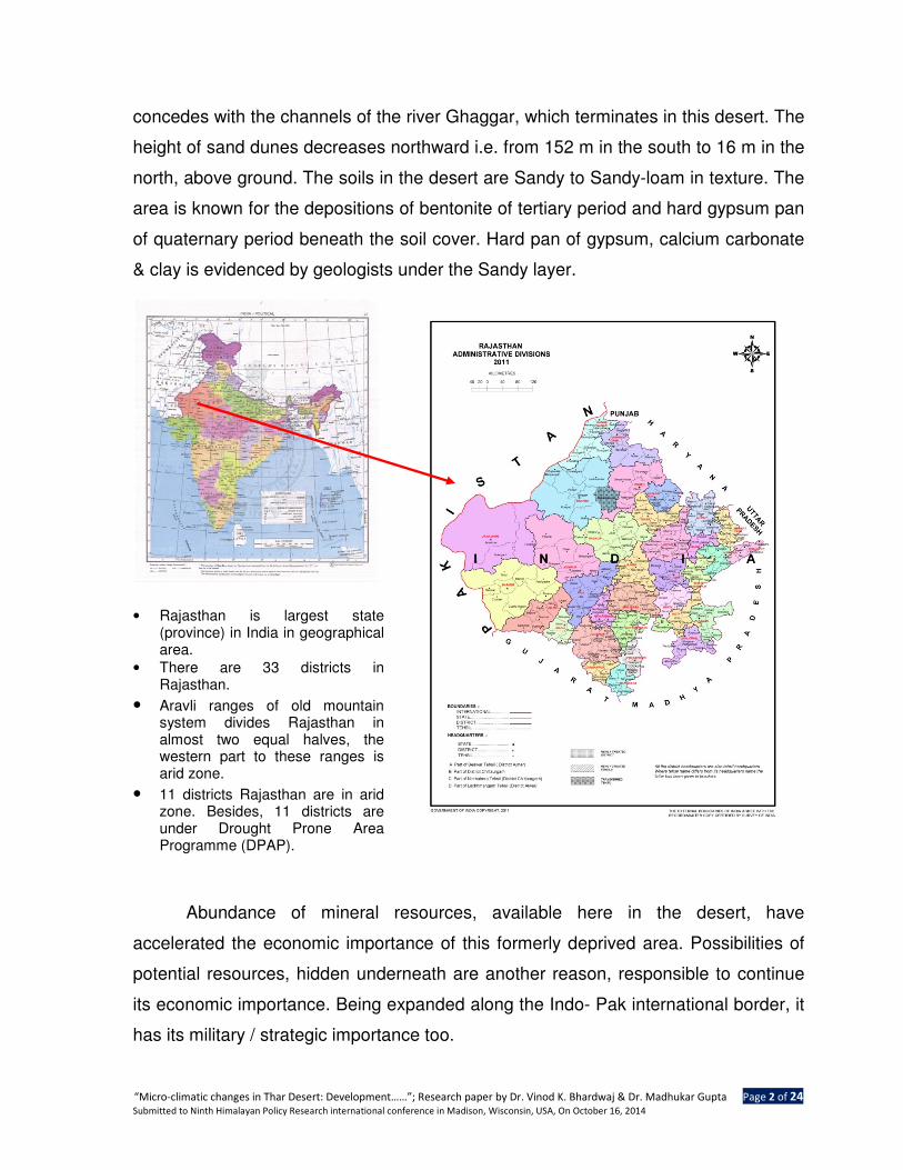
• Rajasthan is largest state (province) in India in geographical area.
• There are 33 districts in Rajasthan.
• Aravli ranges of old mountain system divides Rajasthan in almost two equal halves, the western part to these ranges is arid zone.
• 11 districts Rajasthan are in arid zone. Besides, 11 districts are under Drought Prone Area Programme (DPAP).
Abundance of mineral resources, available here in the desert, have
accelerated the economic importance of this formerly deprived area. Possibilities of
potential resources, hidden underneath are another reason, responsible to continue
its economic importance. Being expanded along the Indo- Pak international border, it
has its military / strategic importance too.
“Micro-climatic changes in Thar Desert: Development……”; Research paper by Dr. Vinod K. Bhardwaj & Dr. Madhukar Gupta Page 3 of 24 Submitted to Ninth Himalayan Policy Research international conference in Madison, Wisconsin, USA, On October 16, 2014
This Desert in Rajasthan was earlier known for sand storms, Loo (hot dry
winds), scarcity of water, numerous sand dunes, sparsely distributed population, low
economic development, hardness of living and repeated occurrence of drought and
famine; but now it is undergoing both natural and cultural changes as precipitation is
on rising side since last two decades along with increase in land available for agro
practices. Contrarily, barren land and typical xerophytes are shrinking. This desert
experienced a severe flood in year 2006 which has left its imprints in the area in form
of rise in underground water table and expansion of green natural vegetation, even
that of perennial nature. Besides, the addition of Indira Gandhi Canal (IGNP) and a lift
canal from the river Narmada have further facilitated the area in terms of availability
of water for irrigation, drinking and for underground recharge. Despite sand storms
and the Loo, increase in agricultural activities and livestock wealth is remarkably
recorded.
Origin of problem:
On reviewing available literature, individual observations and analyzing the
natural changes, being observed in the area, following points arise –
1. Observation : Earlier there were frequent sand storms in Rajasthan, till its
eastern part and even its beyond. But for last many years they
disappeared or are very rare.
Issue : What changes the area undergoing ?
2. Observation : Earlier there was intense scarcity of water in the arid districts,
especially in Barmer & Jaisalmer. Now the areas are getting
better water supply for drinking, having sources in nearby
localities.
Issue : Is this an impact of the canal? If, so, then how Barmer was
having ample water where no canal was available prior to
2008.
3. Observation : Earlier emigration of cattle at a large scale, for a period of
more than 4 months, was a recurring phenomenon which now
appears to be very rare and limited, whereas the number of
“Micro-climatic changes in Thar Desert: Development……”; Research paper by Dr. Vinod K. Bhardwaj & Dr. Madhukar Gupta Page 4 of 24 Submitted to Ninth Himalayan Policy Research international conference in Madison, Wisconsin, USA, On October 16, 2014
cattle is on increase successively.
Issue : What has happened there that the practice is getting
decelerated ?
4. Observation : Earlier sand dunes were on shifting at large scale, whereas
this phenomenon is now confined to very limited parts in the
desert. Most of the dunes have settled / stabled now, along
with perennial trees and bushes there on.
Issue : Is there any change in the magnitude of vegetative cover and
moisture content in soils ?
5. Observation : The area frequently witnessed drought and famines earlier
which now occurs at along gap, especially during the shortage
of rainfall throughout the western region.
Issue : Why decline in the recurrence of droughts and famines now ?
6. Observation : It is observed that there is successive increase in rainfall in
this arid region whereas decreasing precipitation in the
eastern region in the state.
Issue : Whether there is any impact of this growing precipitation in
this desert ?
Study area and methodology adopted:
The study is based on two desert districts – Jaisalmer and Barmer and where
unprecedented flood was reported in the year of 2006. These two districts are biggest
in size in the state and rank first and second successively in size, covering 66, 788
sq. km. geographical area (Jaisalmer – 38, 401 sq. km. and Barmer 28, 387 sq.
km.)2. The districts have registered highest decadal growth in population in the last
two decades (1991-2001 and 2001-11). During the earlier decade (1991-01)
Jaisalmer ranked first (47.5 %) followed by Barmer (36.9 %) at the second place3;
whereas the ranks reverted during the recent decade (2001-11) as Barmer at the first
place with 32.55 percent followed by Jaisalmer at the second place with 32.22
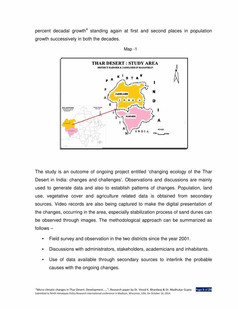
“Micro-climatic changes in Thar Desert: Development……”; Research paper by Dr. Vinod K. Bhardwaj & Dr. Madhukar Gupta Page 5 of 24 Submitted to Ninth Himalayan Policy Research international conference in Madison, Wisconsin, USA, On October 16, 2014
percent decadal growth4 standing again at first and second places in population
growth successively in both the decades.
Map -1
The study is an outcome of ongoing project entitled ‘changing ecology of the Thar
Desert in India: changes and challenges’. Observations and discussions are mainly
used to generate data and also to establish patterns of changes. Population, land
use, vegetative cover and agriculture related data is obtained from secondary
sources. Video records are also being captured to make the digital presentation of
the changes, occurring in the area, especially stabilization process of sand dunes can
be observed through images. The methodological approach can be summarized as
follows –
• Field survey and observation in the two districts since the year 2001.
• Discussions with administrators, stakeholders, academicians and inhabitants.
• Use of data available through secondary sources to interlink the probable
causes with the ongoing changes.
“Micro-climatic changes in Thar Desert: Development……”; Research paper by Dr. Vinod K. Bhardwaj & Dr. Madhukar Gupta Page 6 of 24 Submitted to Ninth Himalayan Policy Research international conference in Madison, Wisconsin, USA, On October 16, 2014
• Analysis of secondary data related with rainfall, land use, temperature etc.
• More emphasis is on field observations and their interpretations.
Changing Micro-climate: Some reflections in the desert region
Despite worldwide worries about global warming, there are there are enough
evidences of micro-climatic changes taking place in this desert, and they are
favourable to human beings. Contrarily to the rising earth’s temperature, the area is
undergoing such changes which lead to mild-ness in its climate. Some of the
changes are as follows –
1. Changing rainfall pattern
2. Natural vegetation: Growth, adaptation and succession
3. Land use : Changing pattern and agro practices
4. Population growth
Rainfall in the desert: Historical account
The desert has experienced high magnitude of rainfall even before the
monsoon of the year 2006 but there was no casualty at all. In fact it is non-periodic
but repeatedly recurring phenomena. As per discussions with people here in the area
(Malwa and Kawas) there was a heavy rainfall in 1990 (even more than 2006) and
also in 1994, but being sparsely inhabited, no such damage took place. About 75
years ago, there was a very heavy rain in this area, but no loss was recorded as the
area was highly sparsely populated and deprived of wealth- prosperity. As per an
expert in meteorology high rainfall is recurring at different intervals here in the desert.
“While it is true, that in the last 60 years five instances of heavy rainfall on a
single day that exceeded the current deluge has been recorded. On September
1, 1968, 30.2cm rainfall was recorded almost double the 16cm rainfall which
wreaked havoc in Barmer on August 22 this year” 5. There are records of flood in
Jodhpur (an adjacent district of Barmer) in the year 1979 and 1981. As per analyses
by meteorological experts of the Indian Institute of Tropical Meteorology- Pune the
flood in Rajasthan is expected every third or fourth year6.
“Micro-climatic changes in Thar Desert: Development……”; Research paper by Dr. Vinod K. Bhardwaj & Dr. Madhukar Gupta Page 7 of 24 Submitted to Ninth Himalayan Policy Research international conference in Madison, Wisconsin, USA, On October 16, 2014
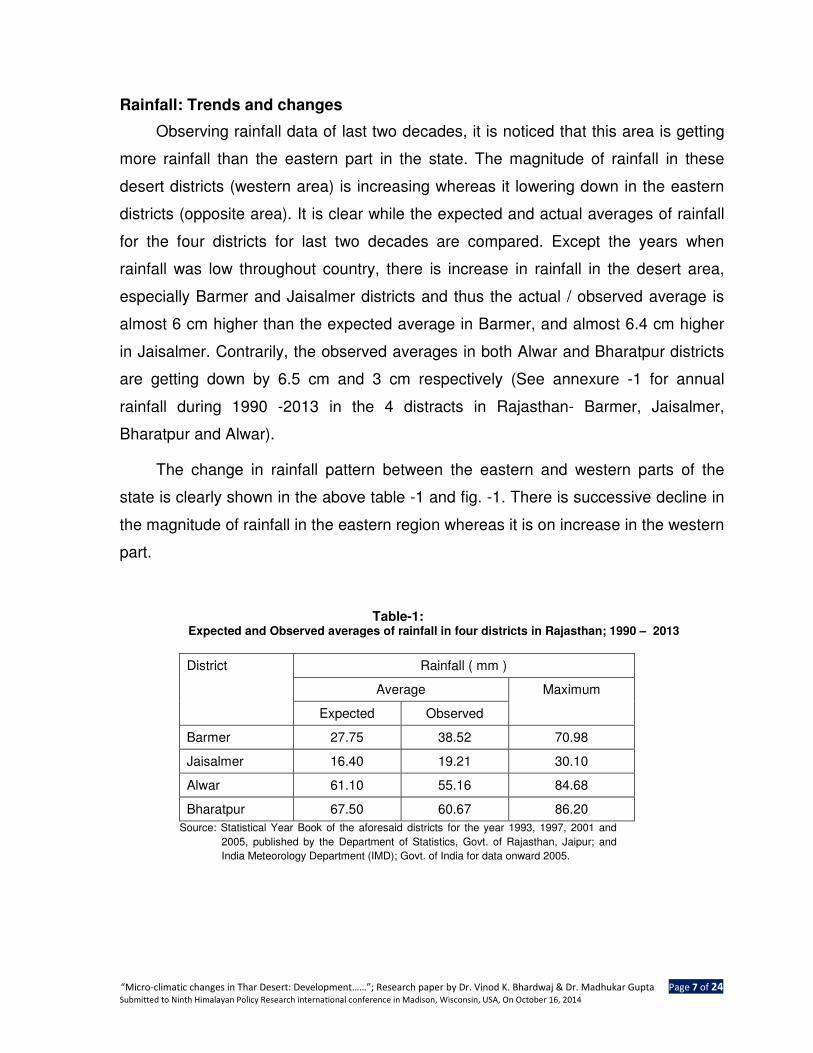
Rainfall: Trends and changes
Observing rainfall data of last two decades, it is noticed that this area is getting
more rainfall than the eastern part in the state. The magnitude of rainfall in these
desert districts (western area) is increasing whereas it lowering down in the eastern
districts (opposite area). It is clear while the expected and actual averages of rainfall
for the four districts for last two decades are compared. Except the years when
rainfall was low throughout country, there is increase in rainfall in the desert area,
especially Barmer and Jaisalmer districts and thus the actual / observed average is
almost 6 cm higher than the expected average in Barmer, and almost 6.4 cm higher
in Jaisalmer. Contrarily, the observed averages in both Alwar and Bharatpur districts
are getting down by 6.5 cm and 3 cm respectively (See annexure -1 for annual
rainfall during 1990 -2013 in the 4 distracts in Rajasthan- Barmer, Jaisalmer,
Bharatpur and Alwar).
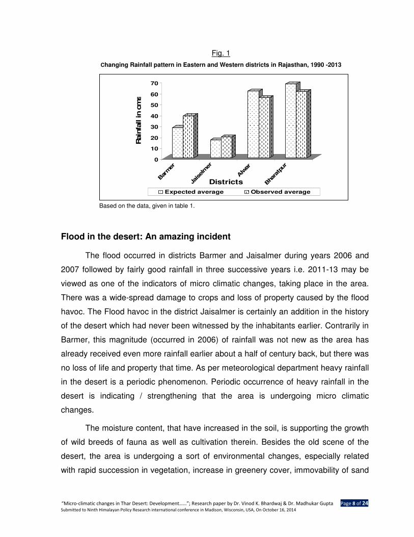
The change in rainfall pattern between the eastern and western parts of the
state is clearly shown in the above table -1 and fig. -1. There is successive decline in
the magnitude of rainfall in the eastern region whereas it is on increase in the western
part.
Table-1: Expected and Observed averages of rainfall in four districts in Rajasthan; 1990 – 2013
District Rainfall ( mm )
Average Maximum
Expected Observed
Barmer 27.75 38.52 70.98
Jaisalmer 16.40 19.21 30.10
Alwar 61.10 55.16 84.68
Bharatpur 67.50 60.67 86.20
Source: Statistical Year Book of the aforesaid districts for the year 1993, 1997, 2001 and
2005, published by the Department of Statistics, Govt. of Rajasthan, Jaipur; and
India Meteorology Department (IMD); Govt. of India for data onward 2005.
“Micro-climatic changes in Thar Desert: Development……”; Research paper by Dr. Vinod K. Bhardwaj & Dr. Madhukar Gupta Page 8 of 24 Submitted to Ninth Himalayan Policy Research international conference in Madison, Wisconsin, USA, On October 16, 2014
Fig. 1
Changing Rainfall pattern in Eastern and Western districts in Rajasthan, 1990 -2013
Based on the data, given in table 1.
Flood in the desert: An amazing incident
The flood occurred in districts Barmer and Jaisalmer during years 2006 and
2007 followed by fairly good rainfall in three successive years i.e. 2011-13 may be
viewed as one of the indicators of micro climatic changes, taking place in the area.
There was a wide-spread damage to crops and loss of property caused by the flood
havoc. The Flood havoc in the district Jaisalmer is certainly an addition in the history
of the desert which had never been witnessed by the inhabitants earlier. Contrarily in
Barmer, this magnitude (occurred in 2006) of rainfall was not new as the area has
already received even more rainfall earlier about a half of century back, but there was
no loss of life and property that time. As per meteorological department heavy rainfall
in the desert is a periodic phenomenon. Periodic occurrence of heavy rainfall in the
desert is indicating / strengthening that the area is undergoing micro climatic
changes.
The moisture content, that have increased in the soil, is supporting the growth
of wild breeds of fauna as well as cultivation therein. Besides the old scene of the
desert, the area is undergoing a sort of environmental changes, especially related
with rapid succession in vegetation, increase in greenery cover, immovability of sand
0
10
20
30
40
50
60
70
Rain
fall in c
ms
Bar
mer
Jaiselm
er
Alw
ar
Bha
ratp
ur
Districts
Expected average Observed average
“Micro-climatic changes in Thar Desert: Development……”; Research paper by Dr. Vinod K. Bhardwaj & Dr. Madhukar Gupta Page 9 of 24 Submitted to Ninth Himalayan Policy Research international conference in Madison, Wisconsin, USA, On October 16, 2014
dunes, increasing magnitude of rainfall etc. No such studies have been made to
estimate / understand the nature of environmental changes and accord the efforts for
their management so far. Besides, there are challenges to establish settlements in
order to save lives during dust storms as well as heavy rainfall like 2006, if occurs.
The overall changes / scenes are so complicated that they need intense studies to
understand and evolve remedies.
Due to growing facilities for agriculture two crops – Rabi and Kharif are being
grown in the area, with special focus on Rabi in which mainly mustard, cumin and
Ishavgol (a medicinal crop) are grown over large area. Being suitable for production
of aforesaid cash crops the area is ably attracting people from within the state and it’s
outside, resulting into registering highest population growth in two districts of this
desert – Jaisalmer and Barmer during last two decades. This increasing population
and growing agro practices are the proof that the area is undergoing such positive
changes which are favorable to human beings and also indicating the reducing
hardness in arid conditions.
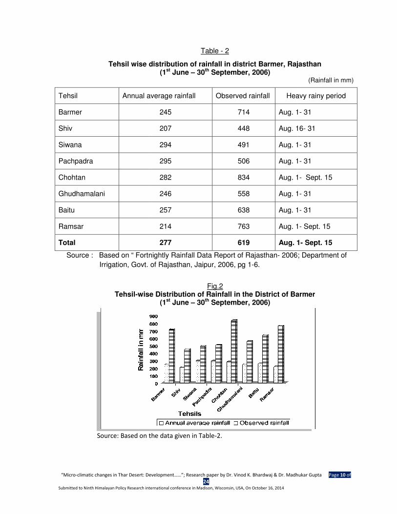
Rainfall normally occurs during monsoon and mostly in the month of July. On an
average, the number of rainy days, reported for the area, is 22. Seasonal and spatial
variations in rainfall and number of rainy days are observed from year to year. This
year (2006) the number rainy days remained normal but the intense rainfall occurred
within 2-3 days, which lead the flood in the area. Few of the towns and villages were
entrapped into the flood in a short period and wreak the havoc. Tehsil (taluka) - wise
rainfall during June- September 2006 is shown in tables 2 & fig.2.
In 2006, occurrence of maximum rain remained confined to the period of two
months - July and August, whereas the intensity remained optimum in a week period
i.e. August 19 - 25, this was recorded as 46.3cm.7 and caused sudden deluge.
District Barmer was more severely affected by the flood and caused heavy damage
to life and property in this district. All the tehsils of the district Barmer got flooded but
the flood caused damage was optimum in the tehsils Ghudamalani, Baitu and Shiv.
Tehsil-wise rainfall distribution is given in the tables 2.
“Micro-climatic changes in Thar Desert: Development
Submitted to Ninth Himalayan Policy Research in
Tehsil wise distribution of rainfall in district Barmer, Rajasthan
Source : Based on “ Fortnightly Rainfall Data Report of Rajasthan
Irrigation, Govt. of Rajasthan, Jaipur, 2006, pg 1
Tehsil-wise Distribution of Rainfall in the District of
Source: Based on the data given in Table
Tehsil Annual average rainfall
Barmer
Shiv
Siwana
Pachpadra
Chohtan
Ghudhamalani
Baitu
Ramsar
Total
Development……”; Research paper by Dr. Vinod K. Bhardwaj & Dr. Madhukar Gupta
24 nternational conference in Madison, Wisconsin, USA, On October 16, 2014
Table - 2
wise distribution of rainfall in district Barmer, Rajasthan(1st June – 30th September, 2006)
Source : Based on “ Fortnightly Rainfall Data Report of Rajasthan- 2006; Department of
Irrigation, Govt. of Rajasthan, Jaipur, 2006, pg 1-6.
Fig.2
wise Distribution of Rainfall in the District of Barmer(1st June – 30th September, 2006)
Source: Based on the data given in Table-2.
Annual average rainfall Observed rainfall Heavy rainy period
245 714 Aug. 1
207 448 Aug. 16
294 491 Aug. 1
295 506 Aug. 1
282 834 Aug. 1
246 558 Aug. 1
257 638 Aug. 1
214 763 Aug. 1
277 619 Aug. 1
adhukar Gupta Page 10 of
wise distribution of rainfall in district Barmer, Rajasthan
(Rainfall in mm)
2006; Department of
Barmer
Heavy rainy period
Aug. 1- 31
Aug. 16- 31
Aug. 1- 31
Aug. 1- 31
Aug. 1- Sept. 15
Aug. 1- 31
Aug. 1- 31
Aug. 1- Sept. 15
Aug. 1- Sept. 15
“Micro-climatic changes in Thar Desert: Development……”; Research paper by Dr. Vinod K. Bhardwaj & Dr. Madhukar Gupta Page 11 of
24 Submitted to Ninth Himalayan Policy Research international conference in Madison, Wisconsin, USA, On October 16, 2014
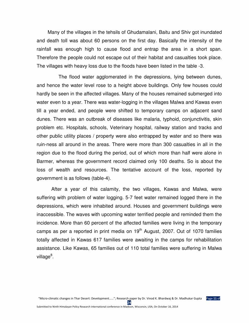
Many of the villages in the tehsils of Ghudamalani, Baitu and Shiv got inundated
and death toll was about 60 persons on the first day. Basically the intensity of the
rainfall was enough high to cause flood and entrap the area in a short span.
Therefore the people could not escape out of their habitat and casualties took place.
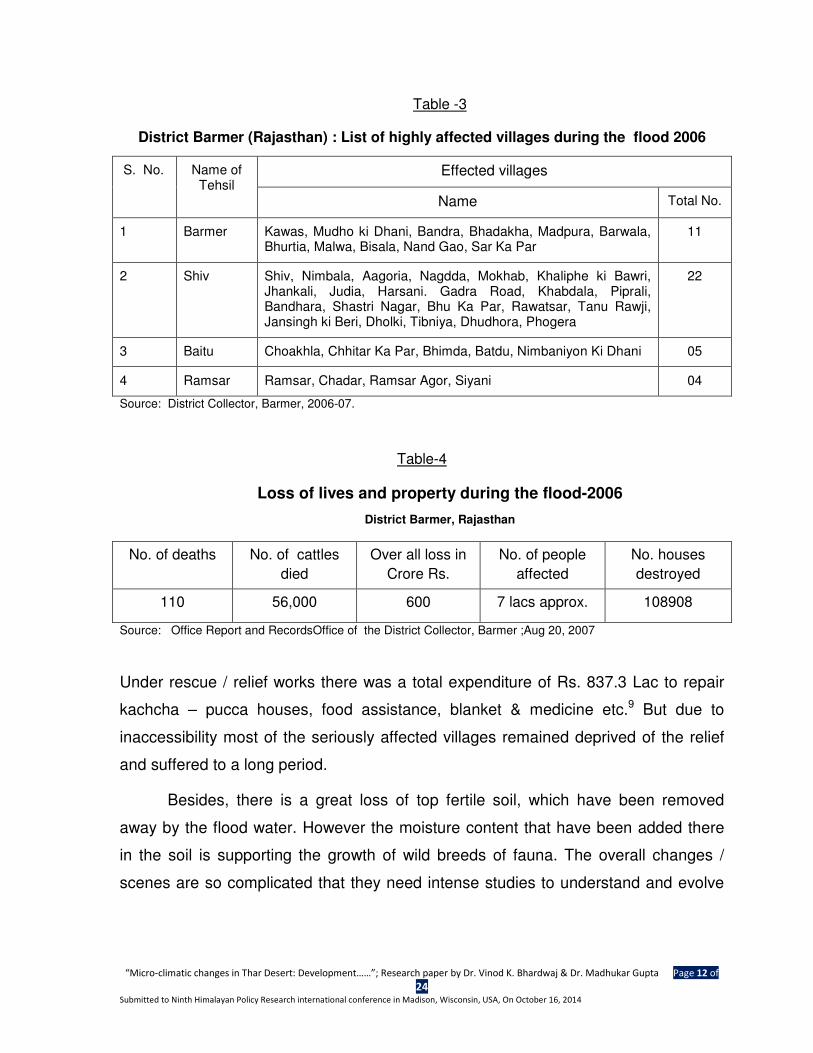
The villages with heavy loss due to the floods have been listed in the table -3.
The flood water agglomerated in the depressions, lying between dunes,
and hence the water level rose to a height above buildings. Only few houses could
hardly be seen in the affected villages. Many of the houses remained submerged into
water even to a year. There was water-logging in the villages Malwa and Kawas even
till a year ended, and people were shifted to temporary camps on adjacent sand
dunes. There was an outbreak of diseases like malaria, typhoid, conjunctivitis, skin
problem etc. Hospitals, schools, Veterinary hospital, railway station and tracks and
other public utility places / property were also entrapped by water and so there was
ruin-ness all around in the areas. There were more than 300 casualties in all in the
region due to the flood during the period, out of which more than half were alone in
Barmer, whereas the government record claimed only 100 deaths. So is about the
loss of wealth and resources. The tentative account of the loss, reported by
government is as follows (table-4).
After a year of this calamity, the two villages, Kawas and Malwa, were
suffering with problem of water logging. 5-7 feet water remained logged there in the
depressions, which were inhabited around. Houses and government buildings were
inaccessible. The waves with upcoming water terrified people and reminded them the
incidence. More than 60 percent of the affected families were living in the temporary
camps as per a reported in print media on 19th August, 2007. Out of 1070 families
totally affected in Kawas 617 families were awaiting in the camps for rehabilitation
assistance. Like Kawas, 65 families out of 110 total families were suffering in Malwa
village8.
“Micro-climatic changes in Thar Desert: Development……”; Research paper by Dr. Vinod K. Bhardwaj & Dr. Madhukar Gupta Page 12 of
24 Submitted to Ninth Himalayan Policy Research international conference in Madison, Wisconsin, USA, On October 16, 2014
Table -3
District Barmer (Rajasthan) : List of highly affected villages during the flood 2006
S. No. Name of Tehsil
Effected villages
Name Total No.
1 Barmer Kawas, Mudho ki Dhani, Bandra, Bhadakha, Madpura, Barwala, Bhurtia, Malwa, Bisala, Nand Gao, Sar Ka Par
11
2 Shiv Shiv, Nimbala, Aagoria, Nagdda, Mokhab, Khaliphe ki Bawri, Jhankali, Judia, Harsani. Gadra Road, Khabdala, Piprali, Bandhara, Shastri Nagar, Bhu Ka Par, Rawatsar, Tanu Rawji, Jansingh ki Beri, Dholki, Tibniya, Dhudhora, Phogera
22
3 Baitu Choakhla, Chhitar Ka Par, Bhimda, Batdu, Nimbaniyon Ki Dhani 05
4 Ramsar Ramsar, Chadar, Ramsar Agor, Siyani 04
Source: District Collector, Barmer, 2006-07.
Table-4
Loss of lives and property during the flood-2006
District Barmer, Rajasthan
No. of deaths No. of cattles
died
Over all loss in
Crore Rs.
No. of people
affected
No. houses
destroyed
110 56,000 600 7 lacs approx. 108908
Source: Office Report and RecordsOffice of the District Collector, Barmer ;Aug 20, 2007
Under rescue / relief works there was a total expenditure of Rs. 837.3 Lac to repair
kachcha – pucca houses, food assistance, blanket & medicine etc.9 But due to
inaccessibility most of the seriously affected villages remained deprived of the relief
and suffered to a long period.
Besides, there is a great loss of top fertile soil, which have been removed
away by the flood water. However the moisture content that have been added there
in the soil is supporting the growth of wild breeds of fauna. The overall changes /
scenes are so complicated that they need intense studies to understand and evolve
“Micro-climatic changes in Thar Desert: Development……”; Research paper by Dr. Vinod K. Bhardwaj & Dr. Madhukar Gupta Page 13 of
24 Submitted to Ninth Himalayan Policy Research international conference in Madison, Wisconsin, USA, On October 16, 2014
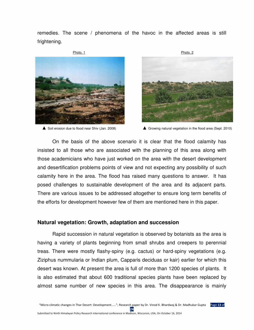
remedies. The scene / phenomena of the havoc in the affected areas is still
frightening.
Photo. 1 Photo. 2
▲ Soil erosion due to flood near Shiv (Jan. 2008) ▲ Growing natural vegetation in the flood area (Sept. 2010)
On the basis of the above scenario it is clear that the flood calamity has
insisted to all those who are associated with the planning of this area along with
those academicians who have just worked on the area with the desert development
and desertification problems points of view and not expecting any possibility of such
calamity here in the area. The flood has raised many questions to answer. It has
posed challenges to sustainable development of the area and its adjacent parts.
There are various issues to be addressed altogether to ensure long term benefits of
the efforts for development however few of them are mentioned here in this paper.
Natural vegetation: Growth, adaptation and succession
Rapid succession in natural vegetation is observed by botanists as the area is
having a variety of plants beginning from small shrubs and creepers to perennial
treas. There were mostly flashy-spiny (e.g. cactus) or hard-spiny vegetations (e.g.
Ziziphus nummularia or Indian plum, Capparis deciduas or kair) earlier for which this
desert was known. At present the area is full of more than 1200 species of plants. It
is also estimated that about 600 traditional species plants have been replaced by
almost same number of new species in this area. The disappearance is mainly
“Micro-climatic changes in Thar Desert: Development……”; Research paper by Dr. Vinod K. Bhardwaj & Dr. Madhukar Gupta Page 14 of
24 Submitted to Ninth Himalayan Policy Research international conference in Madison, Wisconsin, USA, On October 16, 2014
credited to the changing habitat, especially due to increasing soil moisture which is
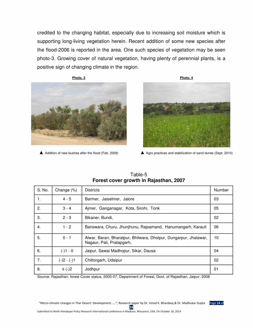
supporting long-living vegetation herein. Recent addition of some new species after
the flood-2006 is reported in the area. One such species of vegetation may be seen
photo-3. Growing cover of natural vegetation, having plenty of perennial plants, is a
positive sign of changing climate in the region.
Photo. 3 Photo. 4
▲ Addition of new bushes after the flood (Feb. 2009) ▲ Agro practices and stabilization of sand dunes (Sept. 2010)
Table-5 Forest cover growth in Rajasthan, 2007
S. No. Change (%) Districts Number
1. 4 - 5 Barmer, Jaiselmer, Jalore 03
2. 3 - 4 Ajmer, Ganganagar, Kota, Sirohi, Tonk 05
3. 2 - 3 Bikaner, Bundi, 02
4. 1 - 2 Banswara, Churu, Jhunjhunu, Rajsamand, Hanumangarh, Karauli 06
5. 0 - 1 Alwar, Baran, Bharatpur, Bhilwara, Dholpur, Dungarpur, Jhalawar, Nagaur, Pali, Pratapgarh,
10
6. (-)1 - 0 Jaipur, Sawai Madhopur, Sikar, Dausa 04
7. (-)2 - (-)1 Chittorgarh, Udaipur 02
8. ≤ (-)2 Jodhpur 01
Source: Rajasthan: forest Cover status, 2005-07; Department of Forest, Govt. of Rajasthan, Jaipur; 2008
“Micro-climatic changes in Thar Desert: Development……”; Research paper by Dr. Vinod K. Bhardwaj & Dr. Madhukar Gupta Page 15 of
24 Submitted to Ninth Himalayan Policy Research international conference in Madison, Wisconsin, USA, On October 16, 2014
Besides, the growing cover of natural vegetation along the windward slopes of
dunes is helping the area to get away from depletion of top soil erosion and settling
down the soil to stabilize the dunes. One sides of a dune covered with natural
vegetation may be seen in Photo-4. The natural vegetation here in this region is
supposed to be in fifth phase of succession where ample number of perennial trees
like – banyan, Ficus religiosa (peepal), Azadirachta indica (neem) and jojoba (a
foreign breed of spiny bushes- videshi babool) etc.
Besides growing vegetative cover in the canal area, Natural vegetation is also
increasing in other areas which are out of the catchments of the canal. Looking upon
the increase in forest cover statistics in Rajasthan it is on record that these two
districts have registered highest growth in forest area in the state (see table-5). there
is a highest growth of 4-5 percent in the state and these two districts have achieved
it, which indicates the turning of climate towards mildness in this region. An attempt to
analyze co-relationship between precipitation and humidity in atmosphere in the
regions on the basis of the data, related to these two variables during 1990 and 2001,
has been made (using concurrent deviation method) and it is observed that there is
positive association between mildness in climate and that in increasing precipitation.
In district Barmer it is observed as + 0.816 and that in case of Jaisalmer as + 0.745;
the related statistics of Barmer and Jaisalmer are shown in annexure -2.
Land use: Changing pattern and agro practices
Changing land use pattern is also an important indicator to show the changing
environmental scenario in the region, especially the growing proportion under agro
land and that in irrigated area are positive change, which are more due to availability
of water for this activity. It is amazing that in Kawas and Malwa areas and in their
adjoining localities ground water is available at a depth of 20-30 feet which is helpful
in cultivation of vegetables and other daily sue products. These areas have emerged
as local supplier of vegetable to nearby urban areas in Barmer. Cultivation of cash
“Micro-climatic changes in Thar Desert: Development……”; Research paper by Dr. Vinod K. Bhardwaj & Dr. Madhukar Gupta Page 16 of
24 Submitted to Ninth Himalayan Policy Research international conference in Madison, Wisconsin, USA, On October 16, 2014
crops like mustard, cumin and ishavgol (a medicinal plant) is being commonly
practiced in both Jaisalmer and Barmer.
Table- 6
Land use pattern in Desert Districts in Rajasthan: Barmer & Jaisalmer
(Land in %)
Year Major Land use (%)
Forest Barren Agriculture Pastures
Total Irrigated
District : Jaisalmer
1990 0.43 75.91 6.27 0.45 2.79
2011 11..1177 6655..2299 1166..1111 1133..9966 22..7711
Change % 172.1 ↑ - 14.0 ↓ 156.94 ↑ 3002.2 ↑ - 2.9 ↓
District : Barmer
1990 0.85 9.28 53.21 1.41 7.38
2011 11..1144 77..8844 6600..0099 99..1199 77..2200
Change % 34.12 ↑ - 15.5 ↓ 12.93 ↑ 551.78 ↑ - 2.44 ↓
Note: Land use is based upon the area reported.
Population growth
Population is also an important measure to indicate climate change. Usually
emigration from an area indicates adversities whereas immigration is credited to
favourable changes in the area, including environmental conditions. Looking upon the
population growth in these two districts, it was first time in 2001 when Jaisalmer stood
at first rank (out of 33 districts) in population growth in the state followed by Barmer.
In the recent decade (2001-11) only the order is reverted whereas these two districts
are again at the top of population growth; ranking Barmer at first and Jaisalmer at
second places. This population growth is more due to immigration of people from
other parts in the state as well as from adjoining states like Punjab and Haryana. The
population growth in these two districts between 1971 and 2011 has been given in
table- 7. The records indicate that both districts have fairly high population growth in
“Micro-climatic changes in Thar Desert: Development……”; Research paper by Dr. Vinod K. Bhardwaj & Dr. Madhukar Gupta Page 17 of
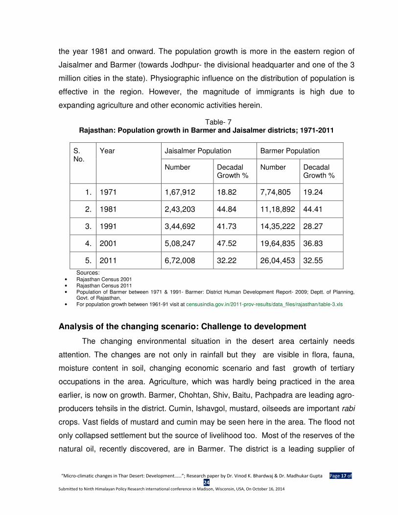
24 Submitted to Ninth Himalayan Policy Research international conference in Madison, Wisconsin, USA, On October 16, 2014
the year 1981 and onward. The population growth is more in the eastern region of
Jaisalmer and Barmer (towards Jodhpur- the divisional headquarter and one of the 3
million cities in the state). Physiographic influence on the distribution of population is
effective in the region. However, the magnitude of immigrants is high due to
expanding agriculture and other economic activities herein.
Table- 7 Rajasthan: Population growth in Barmer and Jaisalmer districts; 1971-2011
S. No.
Year Jaisalmer Population Barmer Population
Number Decadal Growth %
Number Decadal Growth %
1. 1971 1,67,912 18.82 7,74,805 19.24
2. 1981 2,43,203 44.84 11,18,892 44.41
3. 1991 3,44,692 41.73 14,35,222 28.27
4. 2001 5,08,247 47.52 19,64,835 36.83
5. 2011 6,72,008 32.22 26,04,453 32.55
Sources: • Rajasthan Census 2001
• Rajasthan Census 2011
• Population of Barmer between 1971 & 1991- Barmer: District Human Development Report- 2009; Deptt. of Planning, Govt. of Rajasthan,
• For population growth between 1961-91 visit at censusindia.gov.in/2011-prov-results/data_files/rajasthan/table-3.xls
Analysis of the changing scenario: Challenge to development
The changing environmental situation in the desert area certainly needs
attention. The changes are not only in rainfall but they are visible in flora, fauna,
moisture content in soil, changing economic scenario and fast growth of tertiary
occupations in the area. Agriculture, which was hardly being practiced in the area
earlier, is now on growth. Barmer, Chohtan, Shiv, Baitu, Pachpadra are leading agro-
producers tehsils in the district. Cumin, Ishavgol, mustard, oilseeds are important rabi
crops. Vast fields of mustard and cumin may be seen here in the area. The flood not
only collapsed settlement but the source of livelihood too. Most of the reserves of the
natural oil, recently discovered, are in Barmer. The district is a leading supplier of
“Micro-climatic changes in Thar Desert: Development……”; Research paper by Dr. Vinod K. Bhardwaj & Dr. Madhukar Gupta Page 18 of
24 Submitted to Ninth Himalayan Policy Research international conference in Madison, Wisconsin, USA, On October 16, 2014
masonry stone, a building material known as Barmer stone. It is an emerging centre
in trade of typical Rajasthani bed-sheets, being manufactured at Chohtan, leather &
wooden goods, dry vegetables and special type of turban. All these economic
activities are the effort of the people themselves with a little support of the
government.
The flood calamity has raised many challenges, to be taken into care and to
review our developmental approach. Few such challenges are being narrated here.
1. There is only one point approach for the development of the area i.e. arid zone
development approach; and therefore the efforts and budgetary allocations are
being made accordingly. Few such efforts are – annual budget for water supply
through tankers and railways, fodder management, plantation, compensation to
farmers etc. but there is no effort to store rain water for drinking and irrigation
purpose in order to short out these problems.
Challenges
• To locate the original / ancient drainage system and find out its viability in
present context.
• To locate such depressions where rainwater may easily agglomerate,
naturally.
• Construct check ponds along / around the big depressions and connect them
in order to develop a local inland water circulation so that runoff of the water
may be minimized along with optimum use of the rain water.
• Prepare plan for water harvesting for these areas and optimize the use of rain
water, whenever does it rain, for various purposes.
• Provision of annual budget for maintenance for the water reservoirs.
2. Agriculture is on progress here in the district. Efforts for its development are
merely able to contribute in its development. ICAER, Agricultural Uni. Bikaner and
State Agricultural Department are engaged to monitor this sector. However the
“Micro-climatic changes in Thar Desert: Development……”; Research paper by Dr. Vinod K. Bhardwaj & Dr. Madhukar Gupta Page 19 of
24 Submitted to Ninth Himalayan Policy Research international conference in Madison, Wisconsin, USA, On October 16, 2014
way and process of its monitoring is uneconomic and ineffective. More
concentration is on misuse of subsidies and other grants rather effective
utilization. This fraud mentality is not in favour the sustainable development of the
area. It is one of the causes of large scale immigration in the area.
Challenges
• To draft a separate policy for the agricultural sector of the desert area and to
ensure its honest implementation.
• Proper enumeration of the original cultivators of the area so that misuse of the
funds may be prohibited as well as relief during any calamity condition may
be assured to the needy people.
• To optimize the agro-productivity of the area without distributing cash as
subsidies.
• To select suitable crops and their productivity.
3. The flood calamity of 2006 has questioned the settlement pattern of the area.
There is no such policy that may direct settlement growth and locations, except
Zero Line zone along the international border. Therefore unplanned expansion
and location of the settlements was also a reason for the huge damage.
Challenges
• To draft a settlement policy for the area. It’s a great challenge. The locations
of the settlements must be appropriate according to both dust storms and
heavy rainfall situations. It is also must from national security point of view.
• To ensure infrastructural facilities in the areas in order to comfort their living.
• Keep eye watch on immigrants from development and security points of view.
Conclusion
Now it is the time to learn from the incidence and to reframe planning approach
and also the efforts on priority basis. When it is being planned to extend the Indira
“Micro-climatic changes in Thar Desert: Development……”; Research paper by Dr. Vinod K. Bhardwaj & Dr. Madhukar Gupta Page 20 of
24 Submitted to Ninth Himalayan Policy Research international conference in Madison, Wisconsin, USA, On October 16, 2014
Gandhi Canal to the Thar Desert’s districts then it is equally essential to construct
outlets so that under any emergency circumstance outflow of excess water may be
assured. There are evidences of the existence of some ancient channels along with
some extinct rivers like the Leek and the Sheepasaria, linking the area with the
seasonal river Luni. There is need to study the terrain and topography of the area in
order to develop the drainage system and for rehabilitation.
Some of the changes, taking place in the area, especially regarding increasing
moisture content in the soil, growing foreign breeds of natural vegetation which are
adversely affecting the growth of originally inhabited breeds, growing vegetation
cover along with rapid succession, anatomical adaptations in plants etc. are
indicating that there is need to review the developmental efforts and planning
approach along with re-enlisting priorities on real basis, rather than political. Despite
all these indicators the spatial planning is still desert oriented. Lot of funds, flourishing
every year under Desert Development Programme, are consumed without
considering the geographical changes, taking place in the area. Casual meetings to
frame / review development plans for the desert can’t be appropriate efforts unless
the occurring changes and challenges are taken into care and utilization funds /
grants are judiciously consumed. Following are some suggestions in this regard-
1. There is need to begin with a new draft of planning, deciding priorities and
limitations. For this purpose it is again necessary to involve local people,
not necessary politicians only, in order to strengthen the output of plans.
2. Spatial studies are to be promoted through state, national and
international funding agencies, highlighting the issues, capabilities and
challenges.
3. Drainage development should be on priority in order to properly channel
the forthcoming canal water as well as to minimize ruin-ness due to heavy
rain.
4. Though its contradictory to suggest establishment of new settlement on
the top of sand dunes as heavy rain as still occasional but dust storms are
“Micro-climatic changes in Thar Desert: Development……”; Research paper by Dr. Vinod K. Bhardwaj & Dr. Madhukar Gupta Page 21 of
24 Submitted to Ninth Himalayan Policy Research international conference in Madison, Wisconsin, USA, On October 16, 2014
very often in the area, which hit more on the top than the depressions.
However new safe areas for settlement should be searched in order to
balance in the two adverse situations.
5. Involvement of local expert, academicians and scholars is to be
appreciated so that the work in their respective fields may be helpful to
strengthen local planning.
6. There must be planned and limited intervention in the ecosystem in the
area, especially in the field of forestry.
7. The planners are advised to study the adverse consequences of the IGNP
at Suratgarh, Badopal and Hanumangarh (all in Hanumangarh district),
and Lunkaransar (Bikaner district), where the fertile soil has turned into
barren just because of the presence of excess water in the desert
ecosystem. There is gypsum stone layer in Barmer and Jaisalmer distrcits,
underlying the soil cover, which does not allow water to percolate. Hence
water logging and salts deposition in bulk have spoiled the fertile land. The
desert already owns extreme conditions in terms of productivity, which
may be aggravated more through the introduction of canals in the area. So
technical planning and careful identification of the locations / path for the
construction of canal(s) is essential. There was an incidence in Jaisalmer,
where on Nov. 24, 2006 the embankment of the IGNP canal got damaged
due to overflow of water and there was flood situation in the nearby areas.
It may get repeated in lack of planning and maintenance.
8. Regular monitoring of the development plans is must.
9. Short term planning with long term goals may strengthen the development
of the area.
There is need to review the developmental strategy to strengthen the
productivity as well as to optimize the use of ongoing natural and cultural changes
here in the area.
“Micro-climatic changes in Thar Desert: Development……”; Research paper by Dr. Vinod K. Bhardwaj & Dr. Madhukar Gupta Page 22 of
24 Submitted to Ninth Himalayan Policy Research international conference in Madison, Wisconsin, USA, On October 16, 2014
References
1. http://en.wikipedia.org/wiki/NASA
2. Rajasthan Population Census data 2011, available at -
http://www.census2011.co.in/census/state/rajasthan.html
3. Basic Statics: Rajasthan-208; Directorate of Economics & Statistics, Rajasthan, Jaipur; pg. 33.
4. Census of India 2011, Provisional Population Totals –Rajasthan, Data on rural & urban areas,
Figures at a glance, Rajasthan; Census Operations Rajasthan; pg. 4.
5. Tehalka: A daily News on i-net; New Delhi, Sept. 16, 2006.
6. Ibid, (Nityanand Singh of the Indian Institute of Tropical Meteorology- Pune)
7. Average Tehsil wise Rainfall of Barmer District, 2006. Department of Irrigation, Government of
Rajasthan, Jaipur, 2007.
8. Dainik Bhaskar : A daily news paper; Jaipur – Aug. 20, 2007; Pg.1.
9. Barmer: Flood Relief Up-date - (As on 21.09.06): Government of Rajasthan, Jaipur; A
Published Report; Pg. 1.
“Micro-climatic changes in Thar Desert: Development……”; Research paper by Dr. Vinod K. Bhardwaj & Dr. Madhukar Gupta Page 23 of
24 Submitted to Ninth Himalayan Policy Research international conference in Madison, Wisconsin, USA, On October 16, 2014
Annexure - 1
CHANGING MAGNITUDE OF RAINFALL IN RAJASTHAN (1990-2013)
(Rainfall in cms.)
Region
Thar Desert Eastern Rajasthan
Jaisalmer Barmer Bharatpur Alwar
Year
1990 16.71 70.98 62.55 45.25
1991 8.20 12.97 62.55 42.91
1992 23.13 41.20 57.7 42.91
1993 23.13 32.40 61.6 42.91
1994 28.40 48.0 49.2 63.43
1995 25.25 29.80 82.4 52.0
1996 26.48 25.90 86.2 68.03
1997 22.39 36.20 57.28 77.43
1998 30.10 36.40 60.68 74.27
1999 27.25 22.58 62.30 52.49
2000 18.53 28.40 38.60 47.30
2001 23.62 32.08 59.62 56.74
2002 4.40 8.75 39.46 23.70
2003 21.78 47.83 75.19 84.68
2004 7.84 18.15 50.57 42.86
2005 13.95 18.57 69.81 68.56
2006 32.54 69.74 36.51 44.8
2007 25.67 24.38 42.23 55.72
2008 24.72 28.02 78.44 88.09
2009 9.28 18.14 55.55 49.53
2010 37.84 50.71 75.1 82.05
2011 30.93 45.23 74.15 63.63
2012 22.46 22.3 72.47 59.87
2013 23.77 40.54 55.07 66.3
Expected Avg. (cms) 16.40 27.75 67.5 61.10
Actual average
1990-13 (cms) 22.02 33.72 61.05 58.14
Sources:
� For Rainfall during 1990 -2008 : District Statistical outline and Rajasthan at a Glance in different years;
Directorate of Economics and Statistics, Rajasthan, Jaipur.
� For Rainfall during 2009-13, Hydromet Div., Indian Hydrological Deptt., GoI at
http://www.imd.gov.in/section/hydro/distrainfall/rajasthan.html
“Micro-climatic changes in Thar Desert: Development……”; Research paper by Dr. Vinod K. Bhardwaj & Dr. Madhukar Gupta Page 24 of
24 Submitted to Ninth Himalayan Policy Research international conference in Madison, Wisconsin, USA, On October 16, 2014
Annexure-2
Co-relationship between Rainfall and Relative Humidity in the Thar Desert (1990-2001)
(Correlation is computed by using Concurrent Deviation method)
Year Jaisalmer Barmer
Rainfall (cm.) Humidity (%) Rainfall (cm.) Humidity (%)
1990 16.71 49.0 70.98 57.4
1991 8.20 48.0 12.97 50.0
1992 23.13 51.0 41.21 53.08
1993 23.13 48.0 32.40 45.0
1994 28.40 52.0 48.0 59.5
1995 25.25 36.32 29.80 61.80
1996 26.48 42.0 25.90 54.0
1997 22.39 47.0 36.20 53.0
1998 30.10 48.0 36.40 55.3
1999 27.25 49.0 22.58 44.0
2000 18.53 48.0 28.40 45.0
2001 23.62 47.0 32.08 45.0
2002 4.40 45 8.75 43.2*
2003 21.78 49 47.83 52.0*
2004 7.84 47 18.15 47.5*
2005 13.95 48 18.57 48.0*
2006 32.54 50 69.74 59.0*
2007 25.67 48 24.38 46.0*
2008 24.72 47 28.02 49.0*
n = 18 C=14 n = 18 C=15
rc= +0.745
High degree of correlation
rc= +0.816
High degree of correlation
* Statistics are estimated through indirect sources.