DESERT ENVIRONMENT AND AGRICULTURE IN THE ...
231
DESERT ENVIRONMENT AND AGRICULTURE IN THE CENTRAL NEGEV AND KADESH-BARNEA DURING HISTORICAL TIMES
-
Upload
khangminh22 -
Category
Documents
-
view
3 -
download
0
Transcript of DESERT ENVIRONMENT AND AGRICULTURE IN THE ...

DESERT ENVIRONMENT AND AGRICULTURE
IN THE CENTRAL NEGEV AND KADESH-BARNEA
DURING HISTORICAL TIMES

PROMOTOREN: dr. ir. L. J. Pons
hoogleraar in de regionale bodemkunde
dr. A.M. van der Woude
hoogleraar in de agrarische geschiedenis

Hendrik J. Bruins
DESERT ENVIRONMENT AND AGRICULTURE
IN THE CENTRAL NEGEV AND KADESH-BARNEA
DURING HISTORICAL TIMES
Proefschrift
ter verkrijging van de graad van
doctor in de landbouwwetenschappen,
op gezag van de rector magnificus,
dr. C.C. Oosterlee
in het openbaar te verdedigen
op vrijdag 23 mei 1986
des namiddags te vier uur in de aula
van de Landbouwhogeschool te Wageningen.
1986 I -mm- MIDBAR Foundation / Nijkerk, The Netherlands
\ i • . °\

Copyright (c) 1986 by Hendrik J. Bruins
All rights reserved. No part of this publication may be reproduced, stored in a retrieval system, or transmitted in any form or by any means,
electronic, mechanical, photocopying, recording, or otherwise, without the prior written permission from the Midbar Foundation.
ISBN 90-71666-01-8
CIP-GEGEVENS KONINKLIJKE BIBLIOTHEEK, DEN HAAG
Bruins, Hendrik J.
Desert environment and agriculture in the central Negev and Kadesh-Barnea during historical times / Hendrik J. Bruins. - Nijkerk : Midbar Foundation. - Fig., foto's, tab. Proefschrift Wageningen. - Met lit. opg. - Met samenvatting in het Nederlands. ISBN 90-71666-01-8 SISO 635 UDC 63(252)(091)(043.3) Trefw.: landbouw ; Negev ; geschiedenis / landbouw ; Kadesh-Barnea ; geschiedenis.
Copies of this dissertation may be obtained from either
MIDBAR FOUNDATION or H.J. Bruins P.O. Box 78 Jacob Blaustein Institute for Desert Research 3860 AB Nijkerk Ben-Gurion University of the Negev The Netherlands Sede Boqer Campus, 84990
Israel
Price: DF1 39.95 (Dutch guilders); DF1 4.95 - postage and packing.
Payment either on the bank account of the Midbar Foundation: 37.78.34.009 - Rabobank, P.O. Box 44, 3860 AA Nijkerk, The Netherlands; or enclose remittance with order; postal orders and cheques should be made payable to the MIDBAR FOUNDATION.
Cover: The valley oasis of Ein el Qudeirat (Kadesh-Barnea) in the northeastern Sinai desert; note the northern wall on Gebel el Qudeirat and the central Negev mountains at the horizon.
BIBLIOTHEEK DER
iiSDBOtJWHOGESCHOO* VAGENINGEN

AiA/0£?QI , ,0\> J
S T E L L I N G E N 1 •' t • ~ K
i-i-U;i.o J-S ttOGESCHOOl WAGENINSEN
1. About one third of the world's terrestrial surface is occupied by dry lands, usually divided into hyper-arid, arid and semi-arid zones. Runoff farming is the only form of agriculture based upon local rainfall which is possible in the arid zone senso stricto, besides extensive livestock rearing.
2. Runoff farming or rainwater-harvesting agriculture is farming in dry regions by means of runoff rainwater from whatever type of catchment or ephemeral stream. H.J. Bruins, M. Evenari, U. Nessler (1986) Rainwater-harvesting agriculture for food production in arid zones: the challenge of the African famine. Applied Geography 6:13-32.
3. The following runoff farming systems are distinguished, arranged in order of increasing hydro-geomorphic scale: 1) Micro-catchment system 2) Terraced wadi system 3) Hillside conduit system 4) Liman system 5) Diversion system A thorough understanding of the landscape is required, in terms of geology, geomorphology, soils, climate and hydrology, to evaluate the suitability of an area for runoff farming and to design the proper system in each particular situation, taking socio-economic factors into account. H.J. Bruins, M. Evenari, U. Nessler (1986) Rainwater-harvesting agriculture for food production in arid zones: the challenge of the African famine. Applied Geography 6:13-32.
4. Pastoral nomadism is doomed to stagnation, because increased production in nomadic society as a whole is, to any significant extent, impossible. Khazanov, A.M. (1985:71,76) Nomads and the outside world. Cambridge University Press.
5. Combinations of semi-extensive livestock rearing and runoff farming ought to be considered in the arid zone of developing countries to increase local food production and to enhance system viability.
6. The promotion of agrarian self-sufficiency in developing countries suffering from malnutrition and famine should be the main policy guideline in agricultural development cooperation.
7. Internal food reserves must form an integral part of self-sufficient agricultural systems in arid regions, as a buffer for the inevitable years of drought.

8. Instrumental records of weather observations indicate that from about 1950 extreme variations in climatic patterns began to occur in many parts of the world. Agricultural planners ought to take this into account. Buffer stockpiles of food should be formed in vulnerable agro-climatic regions. Diversification of agro-ecosystems should be stimulated to lessen the impact of climatic shocks, as the one-crop economy was at the root of many of the greatest famines in the past. Partly based on Lamb, H.H. (1982) Climate, history and the modern world. London: Methuen.
9. There appears to be a relationship between the major historic period of sediment accumulation in the Kadesh-Barnea valley, from A.D. 1200-1700, and climatic conditions associated with the so-called Little Ice Age.
10. Experimental archaeology can make an important contribution to the understanding of the past.
11. Geologists and archaeologists should beware of the "reinforcement syndrome" by which new data are forced into an existing stratigraphic framework without evaluating the validity of the framework in the light of the new data. Modified after Watkins, N.D. (1972) Reviews of the development of the geomagnetic polarity time scale and discussion of prospect for its finer definition. Geological Society of America Bulletin 83:551-574.
12. "The steady onward flow of time, which is the essence of the cause-effect relation, is something which we superimpose on to the ascertained laws of nature out of our own experience; whether or not it is inherent in the nature of time, we simply do not know". Jeans, Sir James (1930:32) The Mysterious Universe. New York: Macmillan.
13. To understand a phenomenon we have not only to know what it is, but also how it came into being. Boas, F. (1940:305) Race, Language and Culture. New York: Macmillan.
14. Without the unigue food provisioning of manna, the ancient Israelites would have perished during their sojournment in the hyper-arid to arid Sinai desert, after the Exodus from Egypt.
H.J. Bruins. Desert Environment and Agriculture in the central Negev and Kadesh-Barnea during historical times. Auditorium, Agricultural University of Wageningen; 23 May 1986.

A B S T R A C T
Bruins, H.J. (1986) Desert Environment and Agriculture in the central Negev and Kadesh-Barnea during Historical Times.
Doctoral dissertation, Agricultural University of Wageningen, The Netherlands. XI + 219 p., 27 tables, 29 figures, 48 photos, 228 refs, 2 app. Dutch summary.
Land use based on local rainfall in the arid zone senso stricto is often limited to pastoralism, sometimes combined with very marginal rainfed farming, unsuccessful in most years. A more sophisticated form of rainfed agriculture - runoff farming - has been practised in the central Negev and adjacent northeastern Sinai by a sedentary population in certain historical periods, particularly during Byzantine times from the 5th to 7th century A.D. The environment of the Runoff Farming District in the Negev is described, as well as the mechanics of rainwater-harvesting agriculture or runoff farming. Five systems of runoff farming are distinguished on hydro-geomorphic criteria. Excavations have been carried out in ancient runoff farming wadi terraces at Horvat Haluqim, apparently dating back some three millennia, and in Nahal Mitnan, attributed to the Late Byzantine - Early Arab period. The practising of runoff farming at Horvat Haluqim in antiquity has been substantiated by specific soil development in an ancient wadi-terrace layer, indicative of periodically flooded conditions. Calculations have been made about food production, based upon wheat yields, in relation to estimated population levels in the past. Besides runoff farming, oasis-irrigation agriculture in the region could only be practised at a very few spots. The valley oasis of Kadesh-Barnea or Ein el Qudeirat, situated in northeastern Sinai, is one of the most outstanding places in this respect in the entire Sinai-Negev desert, endowed with a copious spring and cultivable soils. The systems of irrigation agriculture are described, whilst the remnants of ancient aquaducts have been dated by radiocarbon. The valley stratigraphy and soil development have been investigated in detail, in relation to the tell (mainly composed of ancient Israelite fortresses, although the Early Fortress might date back to the Late Bronze age, as suggested by C-14 dates), and in relation to ancient remnants of irrigation agriculture, dated by radiocarbon to the Bronze age and the 7th century A.D. Dramatic cut-and-fill processes have occurred in the Kadesh-Barnea valley during historical times. These remarkable changes have been substantiated, in addition to the stratigraphic evidence, through the detection of specific soil development, particularly the microscopic discovery of authigenic pyrite. A detailed chrono-stratigraphy has been established based upon radiocarbon dates, determined by the Isotope Physics Laboratory of Prof. Mook (University of Groningen). All the radiocarbon dates have been calibrated from conventional C-14 years into historical years. The carrying capacities of the Runoff Farming District and the Kadesh-Barnea - Quseima region have been calculated and the outcomes are compared with former population levels. The relationships between the landscape, climatic and agricultural history are evaluated. A clear time-correlation exists between valley aggradation and a relatively wet climate, as well as between valley incision and a relatively dry climate. There is a bit of irony in the conclusion that runoff farming was not practised by a sedentary population in the central Negev desert in those periods during the last three millennia when the climate was relatively wet. Internal and/or external food reserves must have been an integral part of a sedentary runoff farming society, as a buffer for the inevitable years of drought.
Key words: historic land-use in an arid desert, desert environment, arid zone farming, ancient agriculture, runoff farming, environmental archaeology, paleo-climate/landscape/land-use relationships, soil development, geology.

Aan Willie,
Esther, Naomi, en Irit
"OTD3 lap Tbiob AT : • - -\ IJ- :
To him which led his people through the desert
(Psalm 136:16)
VI

ACKNOWLEDGEMENTS
First I sincerely thank my promotors, professor Dr. L.J. Pons and professor
Dr. A.M. van der Woude, for their interest in the subject, their continuous
support and for many helpful suggestions in the various stages toward the
completion of this research and the writing of the dissertation.
I am indebted to Mr. Rudolph Cohen, District Archaeologist of the Negev of
the Department of Antiquities and Museums, as well as to the Archaeological
Survey of Israel, for the opportunities I received to carry out field-work in
the Negev desert and the area of Kadesh-Barnea. During these periods I got
acquainted with many interesting aspects of ancient man-land relationships in
this arid region. The various discussions with Mr. Rudolph Cohen, as well as
with Mr. Mordechai Haiman, Mr. Yosef Porat, Mr. Dov Nachlieli, and others
contributed to shape my archaeologic-historic perception of the area.
Living and working in the Negev desert at the Jacob Blaustein Institute for
Desert Research (Ben-Gurion University of the Negev) has considerably enriched
my understanding of this unique environment in various aspects. The coopera
tion with professor Dr. Michael Evenari, Mr. David Mazigh and Mr. Arieh Rogel
enabled me to obtain a better comprehension of runoff farming. The investiga
tions with professor Dr. Arieh Issar and Mr. Arnon Karnieli on Pleistocene
landscape-climate relationships in the Sede Zin area provided a useful back
ground in the interpretation of Late Holocene landscape developments at Horvat
Haluqim. I thank many of my dear friends and colleagues of the Institute for
their encouragement and support. The comments by professor Dr. Louis Berkofsky
and professor Dr. Emanuel Marx on certain parts of the text are very much
appreciated.
Without the many radiocarbon dates determined at the Isotope Physics Labo
ratory of professor Dr. W.G. Mook, University of Groningen, the absolute basis
of stratigraphy - time - would have been lacking in the investigation of the
fascinating environmental history of the Kadesh-Barnea valley. The C-14 dates
proved to be very important in the framework of this dissertation. Hence I am
indebted to professor Mook for his willingness to cooperate in this research,
and for his comments on parts of the text.
I thank the following persons connected with The Hebrew University of
Jerusalem: Dr. Paul Goldberg (Institute of Archaeology) for introducing me in
the Kadesh-Barnea area in 1976; Dr. Ran Gerson (Institute of Earth Sciences)
and Dr. Yoram Tsafrir (Institute of Archaeology) for useful discussions in the
VII

beginning stages of this research; Professor Dr. Dan Yaalon (Institute of
Earth Sciences) as my former supervisor and mentor who introduced me into the
desert loess of the Negev and taught me to "read" the landscape in relation to
its environment.
My thanks to Dr. Chaim Benjamini (Ben-Gurion University of the Negev,
Department of Geology and Mineralogy) for his comments on certain geological
parts of the text.
I very much appreciate the support received from the Department of Soil
Science and Geology, Agricultural University of Wageningen, with regard to the
laboratory aspects of this research. The contribution of the following persons
of this Department is acknowledged:
- Ir. R. Miedema and Mr. A.G. Jongmans for their helpful suggestions in the
microscopy study of the thin sections.
- Mr. O.D. Jeronimus for the preparation of the thin sections.
- Mr. L.Th. Begheijn and Mr. F.J. Lettink for the chemical analyses.
- Prof. Dr. S.B. Kroonenberg, Dr. N. van Breemen, and Dr. R. Brinkman for
useful comments.
- Mr. Z. van Druuten for the photographic processing of some colour slides
and microscope pictures.
The comments of Ir. A. Kamphorst on aspects of soil salinity and of Ir.
P.D.J, van der vorm on soil fertility (Agricultural University of Wageningen,
Department of Soils and Fertilizers) are appreciated.
The discussions with Dr. Helen Scoging and Mr. Michael Lee of the London
School of Economics about hydrology and ancient runoff farming have been
useful and stimulating.
I acknowledge the assistance of Mr. B. Goudswaard, Mr. Aharon van Leeven,
Mr. Benny Peleg, Mr. J. Meier, Mr. J. Heijenga, and others, in certain parts
of the fieldwork.
My thanks to the Bialik Foundation in Jerusalem for their permission to use
and re-edit certain parts from chapter 8 of the book (in Hebrew): The Ancient
Agriculture in the Negev Mountains (1967), by Y. Kedar. This material appears
primarily in chapter 2, p. 11-17.
Finally, I am very grateful for the continuous encouragement and support of
my wife Willie and my three daughters, Esther, Naomi and Irit, who all helped
in various ways, relieving me of some family duties, which enabled me to
concentrate fully on the writing of this dissertation.
VIII
C O N T E N T S
Abstract V Acknowledgements V I I
1 INTRODUCTION 1 Food production and droughts 1 Classification of dry lands and land-use 3 The central Negev desert and the valley oasis of Kadesh-Barnea 5
2 ENVIRONMENT OF THE RUNOFF FARMING DISTRICT IN THE NEGEV DESERT 9 General Setting 9 Geography of the runoff farming district 11 Geology and Geomorphology 17 Climate 22 Soils and Vegetation 25
Brown lithosols on hillslopes of hard calcareous rocks 27 Calcareous desert lithosols on hillslopes of soft calcareous rocks 29 Young alluvial soils in the active stream channels 29 Loessial serozems 30 Sandy soils 31
3 RUNOFF FARMING IN THE REGION 33 Introduction 33 Terminology of rainwater-harvesting agriculture or runoff farming 34 History of runoff farming in the Negev 36
Chalcolithic 36 Bronze age 37 Israelite period 37 Late Nabatean-Roman-Byzantine-Early Arab period 37 Bedouin farming 38 Modern Israeli runoff farming 38
Hydrology of runoff farming 38 Runoff farming systems 45
Micro-catchment system 46 Terraced wadi system 47 Hillside conduit system 49 Liman system 50 Diversion system 51
4 PASTORALISM 55 Nomadic pastoralism as a specialized form of a food-producing economy 55 Pastoralism and agriculture 57 The origins of pastoralism 59
5 HORVAT HALUQIM 62 Environment 62
Geomorphology and geology 62 Climate 63 Hydrology 65 Soils and vegetation 65
Archaeology of Horvat Haluqim 67 Water supply in the past 70 Ancient runoff-farming wadi terraces at Horvat Haluqim 71 Stratigraphy and soil development of a runoff-farming wadi terrace 75
The discovery of an ancient terrace layer 75
IX

Laboratory data 79 Soil micromorphology 82 Stratigraphic conclusions 84
6 ESTIMATED WHEAT YIELDS UNDER RUNOFF-FARMING CONDITIONS IN ANTIQUITY, 86 RELATED TO HORVAT HALUQIM
Introduction 86 Wheat yields based on ancient literary sources 87 The quantity of wheat sown in relation to soil and climate 89 Estimated amount of wheat sown in the Negev and corresponding yields 90 Evaluation of ancient wheat yields in the light of modern research 91 Wheat yields from the Avdat experimental runoff farm 92 Estimated wheat yields and population levels at Horvat Haluqim 94
7 NAHAL MITNAN 97 Environment 97 Archaeology 98 Stratigraphy and soil development in Byzantine wadi terraces 99
Stratigraphy 99 Soil development 101
8 KADESH-BARNEA: ENVIRONMENT, HISTORY AND THE TELL 105 Environment 105
Geomorphology and geology 105 Geo-hydrology 108 Agricultural evaluation of the spring water 109 Rainfall 109 Soils and vegetation 110
History and geography 110 Archaeology of the tell 112
Carbon-14 date (GrN-12330) - Latest Bronze to Early Iron Age 112 Early, Middle, and Upper Fortress 116 Persian period 117
Environment and siting of the tell 117
9 KADESH-BARNEA: IRRIGATION AGRICULTURE 121 Systems of irrigation agriculture in the Kadesh-Barnea valley 121
Wild flooding system 123 Border irrigation system 124 Basin irrigation system 125
Archaeologic and historic evidence of irrigation agriculture 125 Bronze age aquaduct: Carbon-14 date (GrN-12327) 125 Iron age 128 Byzantine period 128
Carbon-14 dating of the dam (GrN-12326) 130 Mortar micromorphology and paleo-environment of the dam's aquaduct bottom 132
Authigenic pyrite 132 Carbon-14 dating of an aquaduct beginning in the wadi bed 134 Mortar micromorphology of the 7th century wadi-bed aquaduct 137
Authigenic pyrite 139 Bedouin irrigation farming in the Kadesh-Barnea valley 139
10 KADESH-BARNEA: VALLEY STRATIGRAPHY AND SOIL DEVELOPMENT 144 The valley section near the Late Byzantine - Early Arab dam 144 The channel bluff profile that exhibits two C-14 dated aquaduct remnants (Bronze age and Late Byzantine - Early Arab period) 151

Valley aggradation and its radiocarbon dating near the tell 154 Soil development 161
Micromorphology and paleo-environment of KB-129 162 Authigenic pyrite 162
Micromorphology and paleo-environment of KB-131 165 Authigenic pyrite 165
Micromorphology and paleo-environment of KB-132 166 Granulometry and chemical analysis of the aggradational deposits south of the tell 167 An excavated soil pit west of the tell 170
Stream channel evolution in the Kadesh-Barnea valley during historical times 172
11 WATER, FOOD PRODUCTION AND POPULATION IN THE KADESH-BARNEA AREA 175 Introduction 175 Estimated maximal food producing capacity and related population levels of the Kadesh-Barnea valley in antiquity and today 176 Comparison of estimated food production and related population levels with archaeologic data of Late Byzantine-Early Arab times 180 Remains of runoff farming in the vicinity of Kadesh-Barnea 181
The plateau south of the Kadesh-Barnea valley 181 Gebel el Qudeirat, north of the Kadesh-Barnea valley 182 Gebel el Ein 182 Wadi el Halufi 183 The western part of Givat Barnea 183
The post-Exodus sojournment of the ancient Israelites in the desert 186
12 RELATIONSHIPS BETWEEN THE LANDSCAPE, CLIMATIC, AND AGRICULTURAL HISTORY OF THE REGION 188
Valley changes in relation to climate and agriculture 188 Introduction 188 The climatic relationship 189
Roman fill deposit 189 Incision during the Early Arab period 189 Main fill deposit (Late Crusader-Mamluk-Early Ottoman period) 190 Incision since the Late Ottoman period until today 190
Assessment of possible anthropogenic influences 191 Reflections about the relation between climate and valley history 192 Climatic variations and the viability of runoff farming 194
Paleo-climate in the region during historical times 194 Relations between climate and runoff farming 194 The frequency of drought years 196 Droughts and the viability of runoff farming 198
Food production and population in the Runoff Farming District 200
APPENDICES 1. Archaeological and historical periods in Israel, with
emphasis on the Negev. 203 2. Laboratory methods of sediment and soil analysis 204
REFERENCES 205
SAMENVATTING 215
CURRICULUM VITAE 219
XI

1 Introduction
FOOD PRODUCTION AND DROUGHTS
About one third of the world's terrestrial surface is occupied by
dry lands, situated in nearly 70 countries. People living in dry regions face
special problems to produce enough food in a high-risk environment from an
agricultural point of view. This is exemplified by the conditions of drought
and famine that have struck parts of the African continent during the seven
ties and eighties, causing suffering for many people. There appears to be
growing evidence that weather fluctuations have increased in frequency and
amplitude during the last two decades, resulting in greater instability in
local and world food supplies (Abel et al., 1981; Lamb, 1982).
The study of the impact of climatic variations and change upon landscape
and agriculture in dry regions deserves attention in view of these problems.
It is necessary to include the past in this field of research, apart from
intrinsic archaeological and historical objectives. Those involved in agricul
tural planning and food production need to be aware of the possible frequency
and amplitude of fluctuations in the weather and climate in a certain region.
The experience of the present generation in terms of climatic change and its
effect upon landscape and agriculture only covers a relatively short span of
time. Climatic patterns in the past may well have been more radical and
extreme than those within present human memory, and, by implication, may be so
in the future as well. A reasonable assessment of this amplitude, the frequen
cy of variation, and its likely impact on environment and agriculture can only
be established when the factor time is greatly extended beyond the present to
include the past.
1

Whereas interactions between climate and landscape are to a significant
extent not in the realm of human control and influence, the issue of food
production and food provision is more than just the passive result of physical
environmental factors upon human activity. It is, therefore, important also to
study the question of human adaptation or lack of adaptation to climatic
variations or change. The value of this field of endeavour is of major rele
vance to the problems of modern world planning, as described in an excellent
article by Ingram, Farmer and Wigley (1981): "It is plain that in order to
advance the study of human adaptations to climatic variations to the point
where the findings may be of real use to modern planners, it will be necessary
to try to specify more clearly what degrees and types of climatic stress
impose the greatest problems of successful response, and to seek to identify
more rigorously the key features of more or less adaptive societies".
An interesting investigation in this direction was made by Bowden at al.
(1981) in arid and semi-arid regions. They examined material on agriculture in
the US Great Plains in the period A.D. 1880-1979, on droughts in the Sahel
region of Africa during 1910-1915 and 1968-1974, and on the societies of the
Tigris-Euphrates Valley from 6000 BP to the present. The complementary hypo
theses are discussed that, over time, societies adapt to cope with 'minor'
climatic stresses, but that, thereby, they do little to decrease, and may
actually increase, their vulnerability to 'major' stresses of rare fequency.
Both in the Sahel and the American Great Plains the key factor in reducing
vulnerability appeared to be the integration of each area into a wider econo
mic system. However, Bowden et al. warn that there may prove to be a limit to
the effectiveness of such integrative mechanisms in the future. More climatic
stress in the Sahel, coupled with other factors, could precipitate system
collapse in this region with an already fragile resource base.
Mooley and Pant (1981) collected data on the 32 principal droughts which
affected India during the period 1771 - 1977. These droughts resulted in
famines, causing hardship to a large number of people. Statistic tests showed
the droughts to occur randomly in time, following a Poisson probability model
of occurrence in a 5- or 10-year period. These droughts caused food shortages,
whereby prices of available food rose beyond the purchasing power of the rural
population, pushing the farmer deeper in debt and leading to both exploitation
and riots. The authors advocate the building up of food grain reserves in
rural areas and special funds to afford more protection against drought
events.
The question of human adaptation to climatic variation is a complex one,

whose, systematic study has only just begun. Although it is unealistic to draw
simple parallels with former situations and societies, it is reasonable to
suppose that some useful lessons might be learned from past events. According
ly, politicians and planners have begun to show a lively interest in identify
ing and measuring the effect of climatic fluctuations and changes on past
societies (Ingram et al., 1981).
CLASSIFICATION OF DRY LANDS AND LAND-USE
Dry lands are generally classified into three major groups or zones:
hyper-arid, arid, and semi-arid regions. Although ranked together, the large
differences in environment and land-use between each of these dry zones cannot
be emphasized strongly enough. Unesco (1979) has developed a useful system to
delimitate hyper-arid, arid, and semi-arid regions on the basis of measurable
data expressed as aridity indices. The degree of bioclimatic dryness or aridi
ty depends on the relative amounts of water gained from rainfall and lost by
evaporation and transpiration. Bioclimatic aridity can thus be expressed in
terms of the ratio P/ETP, in which P is the mean value of annual precipitation
and ETP the mean annual evapotranspiration. The marked differences between the
dry zones are shown in Table 1.
This threefold division of the dry lands largely coincides with historic
land-use development in these regions. It should be emphasized that only the
semi-arid zone is suited for normal rainfed agriculture and sedentary live
stock rearing. The hyper-arid zone corresponds to the true or inner desert, a
deserted no-man's land without any agricultural or pastoral land-use, except
in oases or along exotic rivers. The term arid zone needs some clarification
to avoid semantic entanglement, because this term is also used in the litera
ture to denote the three defined dry regions together. In this dissertation
the term is generally used in its narrow, defined sense. The arid zone, senso
stricto, is traditionally a nomad's land, practicable for nomadic livestock
rearing, but too dry for common rainfed farming.
There exists, however, a specialized form of farming based upon the use of
runoff water generated by local rainfall, which is suitable for the arid zone:
rainwater-harvesting agriculture or runoff farming. These synonymous terms are
used interchangeably and defined as farming in dry regions by means of runoff
rainwater from whatever type of catchment or ephemeral stream (Bruins et al.,
1986). Runoff collection may also be used in the semi-arid zone to improve the

TABLE 1. Classification, characteristics and land-use of the dry zones
(largely based upon information from Unesco, 1979)
HYPER-ARID zone: - P/ETP ratio is smaller than 0.03
- annual rainfall is very low
- interannual rainfall variability up to 100 % - very sparse vegetation
- no rainfed agriculture or grazing
ARID zone: - P/ETP ratio ranges from 0.03 - 0.20
- annual rainfall 80 - 150 mm in winter rainfall areas
200 - 350 mm in summer rainfall areas
- interannual rainfall variability 50-100 % - scattered vegetation
- nomadic livestock rearing is possible
- agriculture based upon local rainfall only feasible
through rainwater-harvesting techniques: runoff farming
SEMI-ARID zone: - P/ETP ratio ranges from 0.20 - 0.50
- annual rainfall 200 - 500 mm in winter rainfall areas
300 - 800 mm in summer rainfall areas
- interannual rainfall variability 25-50 % - discontinuous vegetation with pe^rennial grasses
- rainfed agriculture and sedentary livestock rearing are
common
viability of rainfed farming (Huibers, 1985). There is a fundamental diffe
rence, however, between the use of runoff in arid and semi-arid zones. In the
former zone the amount of direct rainfall is not sufficient in most years to
sustain a crop. By collecting and storing the runoff rainwater of a certain
landscape catchment into the soil of a smaller cultivable area, the actual
amount of concentrated water in this latter area (rain + runoff) may be
adequate to practise agriculture. In the semi-arid zone direct rainfall is
sufficient in most years to raise a crop. Runoff generated in the agricultural
fields themselves, not necessarily from adjacent non-arable catchments, may be
stored in shallow ponds as a source of additional irrigation water in times of

moisture stress (Huibers, 1985). Thus the use of runoff in semi-arid zones
increases the viability of rainfed farming. In arid zones runoff water is
absolutely essential to practise agriculture based upon local rainfall, the
amount of runoff conducted unto the agricultural fields being much larger than
the amount of direct rainfall itself.
As local food production within the arid zone ought to increase, especially
in rural or remote areas, rainwater-harvesting agriculture seems to have a
largely untapped potential in this respect (Le Houerou and Lundholm, 1976).
Moreover, there is a limit to the use of extraterritorial river water or good-
quality groundwater in the arid zone for irrigation purposes. Regions irriga
ted with water from exotic rivers like the Nile, Tigris, Euphrates, and Indus
are the exception rather than the rule.
Rainfall is often the only available water source for many arid regions.
However, rainfall amounts and its intra-annual and inter-annual variability
(Berkofsky, 1984) must be studied carefully to assess the suitability of a
certain arid region for rainwater-harvesting agriculture. In areas of similar
mean annual precipitation, regions of greater rainfall variability are less
viable from an agronomic point of view. Suitability of a region for runoff
farming not only depends upon climate, but also very much upon landscape and
soil properties. A sandy or flat landscape is usually a disadvantage in this
respect.
THE CENTRAL NEGEV DESERT AND THE VALLEY OASIS OF KADESH-BARNEA
This dissertation deals with the interactions of climate, landscape
and agriculture, during historical times, in the arid region of the central
Negev hills and the valley oasis of Ein el Qudeirat or Kadesh-Barnea, situated
in an adjacent part of north-eastern Sinai. The ancient meaning in Hebrew of
the word "negev" is dryness, which is very appropriate indeed. The Negev and
Sinai form part of the largest planetary desert belt on earth, extending from
the Atlantic coast of Saharan west Africa unto India. Within the division of
dry zones, as presented in Table 1, the hills of the central Negev and north
eastern Sinai belong to the arid zone senso stricto.
The present mean P/ETP aridity index for this region is about 0.07. This is
quite a low figure, which shows that the central Negev hills are situated at
the dry edge of the arid zone, close to the hyper-arid zone of the inner
desert. One might expect that marginal nomadic livestock rearing would be the

35-
30-
25-
I 40
-35
-30
•25
FIGURE 1. The location of the Negev and Sinai as a land-bridge between Africa
and Asia.
sole type of land-use possible in such a dry region. The fact of the matter
is, that runoff farming based upon local rainfall was carried out here exten
sively in time and space (Kedar, 1967; Evenari et al., 1971, 1982).
Orthodox irrigation agriculture from a permanent water source, on the other
hand, could only be practised at a very few places in this entire region
during former times. The Kadesh-Barnea valley in north-eastern Sinai consti
tutes the main centre in this respect, due to the rare existence of a spring
with copious, good-quality water, and adjacent cultivable land.
In conclusion of this introduction a brief sketch of the following chapters

is hereby presented. The desert environment and geography of the runoff
farming district are described in considerable detail in the second chapter of
this dissertation. The mechanics of runoff farming, its main regional history,
as well as hydrological and geomorphic aspects, are presented in chapter 3,
which includes a description of the different runoff farming systems in rela
tion to landscape properties (Bruins et al., 1986a).
Pastoralism or extensive livestock rearing has, in various forms, often
played an important role in the arid zone. Its different systems have been
discussed in chapter A in a somewhat wider regional and historical perspec
tive, because remains of this type of land-use cannot always be traced in
archaeologic and historic terms with the same kind of detail as sedentary
runoff farming or oasis agriculture.
Ancient man-land relationships concerning runoff farming were studied at
the site of Horvat Haluqim (chapter 5 ) , apparently dating back some three
millennia (Cohen, 1976), and in Nahal Mitnan (chapter 7) of apparent Late
Byzantine origin (Haiman, 1982). The sedimentary and archaeological stratigra
phy of ancient runoff farming wadi terraces were investigated, as well as the
related Late Holocene soil development. The potential food production of
runoff farming in antiquity, calculated on the basis of wheat yields, is
discussed in chapter 6 and related to the site of Horvat Haluqim and its
estimated former population.
A detailed study of the Kadesh-Barnea area in chapters 8-11 revealed quite
astonishing valley changes with unusual soil development during historical
times. Archaeological remains and radiocarbon dates from charcoal provided
valuable stratigraphic time markers. There seems a possibility, as indicated
by some of these carbon-14 dates, that irrigation agriculture with water from
the local spring was already practised in the Kadesh-Barnea valley during the
Middle or Late Bronze age, whilst the Early Fortress might perhaps be older
than hitherto assumed (Cohen, 1980, 1981, 1983). Potential food production
levels in the Kadesh-Barnea valley are calculated and compared with estimated
population levels in antiquity, whereby the post-Exodus sojournment of the
ancient Israelites in the desert is also touched upon.
The relationships between the landscape, climatic and agricultural history
of the central Negev desert and Kadesh-Barnea are discussed in the final chap
ter of this dissertation. The viability of runoff farming in such a dry region
is evaluated. Possible food production levels of the runoff farming district
in antiquity are calculated and compared with estimated former population
numbers.
Nahal = wadi = ephemeral stream
7

FIGURE 2. The Negev and the location of the runoff farming district.

Environment of the runoff farming district in the Negev desert
GENERAL SETTING
Although the Negev constitutes only a tiny part of the huge Saharo-
Arabian desert belt, it can be regarded as one of the most famous deserts in
the world. Its fame is, however not so much based upon unique geographical
attributes, but due to its connection with the Book of books. The first times
the Negev is mentioned in the Scriptures (Genesis 12 and 13, quoted below)
suggest its environmental qualities as a region suited for pastoral livestock
rearing in the Middle Bronze Age (around 1900 B.C.), for Abraham used to stay
in the area with his flocks. However, when a famine struck the land, Abraham
went to Egypt.
It seems likely that the famine was caused by a drought, typical for
marginal dry areas. Egypt often proved to be a regional place of refuge in
such a situation. Its agriculture and livestock production are dependent upon
the Nile water, fed by rains in tropical Africa and, therefore, unaffected by
droughts over the Levant. Another important geographic aspect of the Negev is
its role, together with Sinai, as a natural land-bridge between Africa and
Asia.
"And Abram journeyed, going on still toward the Negev. And there was a
famine in the land; and Abram went down into Egypt to sojourn there; for the
famine was grievous in the land... and he had sheep, and oxen, and he asses,.,
and she asses, and camels" (Genesis 12:9,10,16). "And Abram went up out of
Egypt, he, and his wife, and all that he had, and Lot with him, into the
Negev. And Abram was very rich in cattle..." (Genesis 13:1,2).
The precise limits of the Negev are disputable in geographical terms.

Especially in a southwesterly direction, there is no clear natural boundary
separating the Negev from the Sinai, except perhaps Wadi el Arish and its
tributary Wadi Quraiya. The political boundary between the Negev and Sinai was
drawn in 1906 as the result of an agreement between Britain and Turkey. Thus
the Negev and Sinai were demarcated along a more or less straight line running
from the Mediterranean coast near Rafah unto the Red Sea just south of Elat.
Today this line constitutes the border between Israel and Egypt.
The eastern boundary of the Negev is made up by the Arava rift valley,
running from the southern part of the Dead Sea to the northern tip of the Red
Sea near Elat. The Arava valley separates the Negev from the mountainous
regions of Mcab and Edom, both of which are part today of the Hashemite
Kingdom of Jordan. The border between the latter kingdom and the Negev was
demarcated by the British goverment in 1922, and follows the lowest course
through the Arava rift valley.
The northern boundary of the Negev is not well defined. In the coastal
plain and southern Judean foothills, it is situated in a semi-arid transition
zone of dry farming. Here the boundary coincides more or less with the present
350 mm rainfall isohyet, roughly marking the lower limit of wheat growing
without the need of auxiliary irrigation in most years. In this area the
boundary may be depicted as running from the Mediterranean Sea near Gaza to
Lahav (ancient Ziqlag) at the south-western corner of the Judean Hills (Orni
and Efrat, 1971). While the boundary continues further eastward along the
southern extremity of the Judean anticline, the rainfall isohyets sweep to the
north as the Negev merges with the Judean Desert. The area between Arad and
Sedom at the southern tip of the Dead Sea forms the diffuse boundary between
the two deserts.
The total area of the Negev, within its present political and administra
tive boundaries, encompasses about 12,000 square kilometers. Rainwater-harves
ting agriculture or runoff farming was practised in antiquity by a sedentary
population in the central Negev hills (roughly 3000 years ago and in the
period from about A.D. 100-700) in a region of some 2,000 square kilometers,
of which only 2 % was actually farming land (Kedar, 1967), made suitable for
runoff agriculture in the course of time by man-made engineering works. This
region, henceforth referred to as the runoff farming district, is the prime
geographical object of this dissertation, together with the Kadesh Barnea
oasis in Sinai, just across the border with Egypt. As has already been noted,
there is no clear geographical boundary between the Negev and Sinai. Thus,
Kadesh-Barnea can be regarded as lying in an area which forms the natural
10

extension of the central Negev hills into Egypt. In this perspective, it is no
surprise that the area of ancient runoff farming found in the Negev continues
across the Egyptian border into Sinai. The areal extent and boundaries of the
runoff farming regions in the Sinai have not been established yet.
GEOGRAPHY OF THE RUNOFF FARMING DISTRICT
The principal work to determine the extent and distribution of
ancient runoff farming in the Negev was carried out by Kedar (1967). The
runoff farming district in the central Negev hills encompasses an area of
about 2,000 square kilometers (200,000 hectares or 2,000,000 dunams), which is
nearly 17 % of the entire Negev. The combined total area of all the agricultu
ral fields within the runoff farming district has been some 4004 hectares.
Thus only 2 % of the entire district was made up by cultivable fields. These
ancient fields are situated in the valleys, where the runoff waters tend to
concentrate naturally, after having been generated by a rain storm. Only in
the valleys are the soils deep enough to function as a water storage medium
and buffer for agricultural purposes.
Runoff agriculture requires two principal landscape units: (1) a runoff
producing territory, and (2) a related, lower lying, runoff receiving area,
consisting of cultivable land. The ratio between runoff receiving area and
runoff producing area depends upon the climate, but is also dictated by the
composition of the landscape. The larger the amount of rainfall, the smaller
the required size of the runoff contributing area. The relation between runoff
producing hills and runoff receiving valleys determines the potential area
suited for runoff farming. A good understanding of the landscape is crucial in
the planning of runoff farms. The runoff receiving soils, usually situated in
the valleys, must be suited for this type of agriculture. Sufficient depth and
a good water-holding capacity are important attributes in this respect.
The average ratio in the runoff farming district between runoff receiving
fields and related runoff producing areas is 1:18. The range of variation of
this ratio within the district runs from 1:9 to 1:33 (Kedar, 1967). This is a
nearly four-fold difference, which cannot be explained in terms of climate as
average climatic differences within the district are small. It demonstrates
the effect of local landscape properties upon the ratio. The main varying
factors are natural drainage density, the natural size of the valleys and the
surface quality of the runoff contributing area in terms of runoff production.
11

FIGURE 3. Geography of the runoff farming district
12

The runoff farming district is a hilly region, ranging in altitude from
about 200 meters in its north-western part to 1000 m in the south.
- The NORTHERN boundary of the district runs from wadi Azariq at the
Egyptian border, near the confluence of Nahal Nizzana and Nahal Lavan, in a
north-eastern direction along the first anticlinal range of Har Qeren. The
boundary follows the southern edge of the Halutza sand dunes towards the
remains of Halutza (Elusa, Hallasa), one of six ancient Nabatean-Byzantine
towns in the runoff farming district. The other towns are Nizzana (Nessana,
Auja Hafir), Rehovot (Rehovot Banegev, Ruheiba), Shivta (Sobata, Subeita),
Avdat (Oboda, Abdeh), and Mamshit (Mampsis, Kurnub). The first name for each
site is the one used on modern Israeli maps, whereas alternative spellings or
names used in the literature or on older maps, according to Negev (1982), are
put behind brackets. These towns were abandoned in the wake of the Muslim-Arab
conquest in the 7th century A.D.
From Halutza, the northern district boundary continues eastward, along the
southern edge of another field of sand dunes, to Nahal Sekher (Wadi Mashash).
Here the actual boundary differs somewhat from the one drawn by Kedar (1967),
as remains of runoff farming are also present along the valley of Nahal Sekher
and Nahal Mingar. The area around the modern town of Dimona and the ancient
town of Mamshit constitutes the north-eastern corner of the runoff farming
district.
- The EASTERN district boundary runs from here in a south-western direction
along Nahal Mamshit to the Makhtesh Hagadol, an impressive erosion cirque in
the Hatira anticline. From the north-western cliff of the Makhtesh Hagadol,
the boundary sweeps westward through Sede Boqer, circumventing the large Zin
Valley with its canyons, while moving back eastward to the Avdat area. The
boundary continues southward along the Nahal Aqev cliff to Har* Aqev, subse
quently bending east to the edge of the Zin Valley and again due south along
Har Gerafon towards the grandiose northern cliff of the very large Makhtesh
Ramon erosion cirque. Isolated remains of ancient runoff farming fields are
found on Har Ardon, which forms the northeastern rim of the Makhtesh Ramon.
- The SOUTHERN boundary of the runoff farming district coincides with the
impressive Makhtesh Ramon cliff, which constitutes a veritable environmental
border-line. On Har Ramon, the district reaches with 1025 m its highest alti
tude. From here the boundary moves slightly east around the westernmost exten
sion of the Makhtesh Ramon, before continuing south-westward along the cliff
of Mezoqe Loz to the Egyptian border.
Kedar divided the runoff farming district into 10 zones (Figure 4 ) , and * Har = hill or mountain
13

\(r~>^^ y^^^ i«rV • ! > S S 7 ! ^ - . . c n .' ?): . « f e y * * ^ - - . .-• ' ' •"'••.rr!—-^ .jf \ ~*=sr v r^_^. . : // \ \ _ . .—•"" • 1 •., ^ - - ^
¥ H A L ; U Z A v S \ . . " — r : : < ^ X . \ ;' J '; * \ .
.J/ [ ''' : \ . * \--'""'• ^ " ^ - O x ' X Z M ' A M S H I T -X v ^ ^ o , / " - . . S \ - . R E V 1V 1 M . - - ^ S J J ^ J " \ ' •*> J
j<7 R E H O V O T ^ ^ T ' " " " " " ' - - . . " X " ' " " V " - < ' ' ^ ; ' ' . . - - — ^ \ V 1 ' ) /
Jf s^—/^ :+iS !'•-.- ^ \ ', \''""""l .-V--:.'' *•"'•---. /4?X '•'/ V ^ e = = ^ / ' S ' ^ ^ ^ ' S i ' - N r . , . . > - - • . i V E R O H A M F \ v
^ F | L \ > / V ; A ^ T ^ ^ y \ A S \ H A L I M ^ - ^ / ' " ^ P
V \ \ < X ' . ^ SH..I.V T A \ .:;,' £-'""' '^ks-.JF ^/ \ V ^ ' - T ^ ^ r ^ ^ ^ - ^ O ^ " ' ' """'̂ --'" . . - ' ' •• . \ >"~\.. / ' '•---''• / \ * y t <*7
\ 'V-A ':r'\ M \ ^ .-" 1 (S E DE. \ BOQE R"'""7 3*^" \ **\ •> A r~- '""-- \ \ '' *v-- \ ' * ~'Hs ^^ \ \-i\- \ \ x-.,'*\""\ "'•- \ X>~r\ """•;• \ /' y ~77 r~^ < ^
\ •• ^,''1 \ '"*"' '' ̂ ',* 1 ' \ /^*-fljJ^o^rti','T' \ : \^ \ " - .V?. , ~ ' -0 > '• . - . , •'. V ' v .,— -.A '•JtMjkl ^
\ •• \̂ -.\v-"- -s-i \ ..'->.. ; V J A S ^ t & \ .-'Y? \ \ ; • / 1 N .̂ ••. .•' s^.y^t • M » k * 3 f \ \\>-\,,.- h \\ '• i . f\ ' !UO \ ' \ v * ' \ \ V, \ \ V" jy •••••Y,O - ./If* \ ^ v-. ~-\ V v • s~—^ '• \!M c I t \ • i\',vv r S r ^ C ' ^ O , ^S ± \ A V D A T "vjvJUW
\ / •' i ;.x—\ 2/y \ '•-. / \ /'? •'\ N ^TSfc ..,.^ii,_ ,,\ \ ) \ ">•. V^-v '*••• ) ••* ('""'• \ X""̂ "1' ! _V) \ i i • "; ' \> ' - ' ' - • "7 / ( " " ' :' \ ) ' ' i / -V"--. / '
V^-M\\ o*:A --\ ^~-\-;'- / " \ / •••' \ a . - •-. v - • y >VV; ••:.-'x \ «: i , K _y((W\
^K"i-'K .-A.T£5~v A \ \ \ / ""\ ''• ''' J^^ % J r ^ \ ' i '•' N ' V ' " " ^ N > ^ \ V V V - • " 1^/^ W^\
0 \ : \ / iAi:Ki:vxV-'!% -v:"2p^ itjr %$* V-/Vi^ ;u ,c: 'i>\;* Af<;^ ^ X \ >: I "•• / , / \ : J r
^ > \ i L o z j \ >. c L J/ \Js£ ^7>TTV
"' H O R S H A ' / f j i n * ^ " ^
x ) .'' \ ' JjR -y
I '''/i ^<„-<-'-., \ ij
if-. '^'"jf;
_^ . BOUNDARY RUNOFF FARMING ZONES
-?)l(fnff ESCARPMENT
j£& SAND DUNE AREAS
o ANCIENT SITE
"""* WADI
0 10 20 30
km
FIGURE 4. Zonal division of the runoff farming district (based on Kedar, 1967)
14

determined for each zone a number of relevant data, which are quoted here,
albeit in a somewhat different order than in the original Hebrew version
(Kedar, 1967, chapter 8 ) . The ten zones are arranged from west to east, and
from north to south. The first zone is the Halutza - Rehovot area, situated
in the north-western corner of the runoff farming district. This zone is bound
by sand dunes in the north, west and south, and by Nahal Besor in the east.
The next six zones are lying between the former zone and a line, made up by
the Eocene Avdat Plateau, the Zin Valley and the Makhtesh Hagadol erosion
cirque. These zones are listed in a sequence going from west to east: Nizzana
zone, Ruth zone, Shivta zone, Sede Boqer - Ashalim zone, Yeroham - Revivim
zone, and Mamshit zone. The three remaining southern zones of the district are
likewise listed from west to east: Loz - Horsha zone, La'ana - Yeter zone,
and Avdat zone.
TABLE 2. Zonal division of the runoff farming district (based on Kedar, 1967)
1.
2.
3.
4.
5.
6.
7.
8.
9.
10.
NAME OF ZONE
Haluza-Rehovot
Nizzana
Ruth
Shivta
Sede Boqer-Ashalim
Yeroham-Revivim
Mamshit
Loz-Horsha
La'ana-Yeter
Avdat
TOTAL AREA
(hectares)
15,800
17,000
9,200
18,800
25,500
27,900
6,200
42,300
22,400
12,500
AGRICULT.
FIELDS (ha)
239
1489
237
495
303
227
42
200
95
678
FIELDS
ZONAL
1.5
8.7
2.5
2.7
1.3
0.9
0.7
0.5
0.4
4.5
% OF
AREA
% % % % % % % % % %
FIELDS % OF
ALL FIELDS
6.0
37.2
5.9
12.4
7.6
5.7
1.0
5.0
2.4
16.9
%
% % % %
% % % % %
Kedar (1967) also determined within each zone the areal distribution of the
runoff farming fields in relation to wadis, drainage basins, or other geogra
phic points of reference. These relevant data, first published in Hebrew, are
worthwile to be quoted as well (Table 3 ) , as they give more insight into the
respective importance of certain catchment areas and ephemeral streams in
ancient runoff agriculture.
15

TABLE 3. Areal distribution of runoff farming fields within each zone of the
runoff farming district (after Kedar, 1967).
RUNOFF FARMING DISTRICT ZONE
EPHEMERAL STREAM VALLEY OR OTHER REFERENCE
RUNOFF FARMING FIELDS (hectare)
1. HALUZA - REHOVOT Zone:
2. NIZZANA Zone:
Nahal Besor 101 Nahal Rehovot 128 Internal valleys 10
Nahal Ezuz 455 Nahal Nizzana (within this zone) 1034
3. RUTH Zone: Nahal Ruth and its tributaries Nahal Raviv Nahal Safun and Nahal Perach
124 112
1
4. SHIVTA Zone: Nahal Shezaf and its tributaries 66 Nahal Qarha drainage basin 118 Nahal Zetan drainage basin 51 Nahal Derorim drainage basin 44 Nahal Lavan 126 Southern tributaries Nahal Lavan 155
5. SEDE BOQER ASHALIM Zone: Nahal Haroa Nahal Boqer Nahal Baqara Wadi el-Umzira Wadi um-Terafa Nahal Besor (within this zone)
119 19 52 25
9 78
6. YEROHAM - REVIVIM Zone:
7. MAMSHIT Zone:
Surroundings of Revivim 60 Surroundings of Mashabbe Sade 58 Surroundings of Yeroham 109
North-western part 30 South-eastern part (diversion system) 12
8. L0Z - H0RSHA Zone:
9. LA'ANA - YETER Zone:
Northward drainage area Nahal Nizzana (within this area) 83 Nahal Aqrav, Sirpad, and Ayarim 31 Nahal Horsha 49
Southward and eastward drainage areas 13 Westward drainage area (Nahal Loz) 25
Nahal La'ana (northern part) 45 Nahal La'ana (southern part) 11 Nahal Yeter and its tributaries 40
10. AVDAT Zone: Nahal Zin drainage basin 167 Nahal Avdat drainage basin 449 Nahal Divshon drainage basin 48 Plateau between N.Zin and N.Div/shon 13
16

The amount of runoff farming fields related to the lower part of Nahal
Nizzana (1034 ha) is absolutely outstanding. The second largest areal extent
of ancient agricultural fields is in Nahal Ezuz (455 ha), also in the Nizzana
zone, followed by the drainage basin of Nahal Avdat (449 ha). These latter
figures are well above the average of the remaining catchments and the three
mentioned areas combined represent nearly 50 % of all the ancient agricultural
fields in the runoff farming district.
GEOLOGY AND GE0M0RPH0L0GY
The Negev is located at the edge of the Arabo-Afican craton, whose
Precamurian rocks are only exposed in the south near Elat. During the Cratonic
Stage, lasting for most of the Phanerozoic until the Oligocene, transgressions
issued from the former Tethys Ocean (Mediterranean Area) in the NNW, con
trolled by mild vertical tectonic oscillations. Several sedimentation cycles
produced a typical platform sedimentary cover of mature elastics and carbo
nates that were deposited over flat continents or in shallow epeiric seas
(Garfunkel, 1978).
Rather accentuated earth movements occurred in the Late Triassic and during
the Late Jurassic - Earliest Cretaceous. A new phase of tectonic activity, the
results of which are significant even today for the runoff farming district,
began in the Senonian Period of the Late Cretaceous and continued into the
Tertiary. It produced a series of faults and broad asymmetric folds, all
having a northeast-southwest to east-west alignment. These structures, exten
ding from the Euphrates River in Syria, through northern Jordan, Israel, and
Sinai into Egypt, comprise the Syrian arc of Krenkel (1924). The associated
folded anticlines in the central Negev rise gently on the north-western side
and dip often sharply on the south-eastern side, markedly influencing the
present day geomorphology of the region.
The last major transgression occurred during the Eocene, by which carbo
nates were deposited over large portions of the platform (Benjamini, 1979).
The sea extended probably 1000 km inland from the present coastline, but its
retreat and the onset of terrestrial conditions in the area began in the Late
Eocene, followed by a period of extensive erosion that produced a rather flat
landscape (Garfunkel and Horowitz, 1966). Relics of the middle Tertiary topo
graphy in the Negev are still preserved today (Garfunkel, 1978). Eocene rocks
are predominant in the runoff farming district (Figure 5 ) .
17

The originally continuous Arabo-African craton was rifted apart in the Late
Cenozoic, a process that perhaps began in the Oligocene. These earth movements
produced the present plate boundaries in Israel and nearby countries. The Dead
Sea rift forms part of the boundary of the new Arabian plate (Bentor et al.,
1965; Freund, 1965; Garfunkel, 1978). Strong vertical movements considerably
changed the pre-rifting topography of the region. The land surface surrounding
the Dead Sea became the lowest continental spot on earth, situated about 400
meter below the level of the Mediterranean Sea. A variety of sediments and
evaporites (salts), several kilometers thick, accumulated in the subsiding
rift valleys.
The areas adjacent to the rift valleys were often strongly uplifted and
appear today as veritable mountainous walls. Especially the regions of Moab
and Edom east of the Arava Valley, look impressive when viewed from the
eastern Negev. The Mediterranean coastal plain and offshore region to the west
subsided a few kilometers since the Neogene. The northwestern Negev is, there
fore, rather flat and covered with Quaternary loessial (Yaalon and Dan, 1974;
Bruins, 1976; Bruins and Yaalon, 1979) and sandy deposits.
The boundaries of the runoff farming district clearly relate to the south
west-northeast trending fold belt. The first anticline of Har Qeren, bounding
the coastal plain, marks the northwestern limit of the district. The eastern
and southern district boundary follows the Hatira and Ramon anticlines, and
the intervenient steep margins of the Zin Valley which makes a major westward
dent into the central Negev highlands (Figures 2,3,4,5).
The agricultural fields within the runoff farming district are situated in
valleys of ephemeral streams of first or higher order. Quaternary loessial
deposits have accumulated in these valleys and form an ideal parent material
for cultivable soils well suited for rainwater-harvesting agriculture. The
hills and mountains of the district are largely composed of carbonate rocks
formed under marine conditions during the Upper Cretaceous and Lower Tertiary.
The geological formations making up these hills, whose lithological properties
are important factors in runoff production, can be divided into three main
groups: (1) The Judea Group, (2) the Mount Scopus Group, and (3) the Avdat
Group.
Runoff farming can only be successful if enough runoff water is generated
in a certain catchment area under the prevailing rainfall regime. Geomorpholo-
gy and surface lithology of the catchment are important factors in this res
pect. An outline is, therefore, given about the lithological characteristics
and areal distribution of the three geological groups within the runoff far-
18

ming district.
1) The JUDEA GROUP is characterized by HARD LIMESTONE and DOLOMITE rocks
of Cenomanian and Turonian age (Arkin and Braun, 1965; Bartov and Steinitz,
1974). Its rocks cover approximately 20 % of the runoff farming district and
dominate the anticlinal hills in the northeastern part, bound to the west and
south by Nahal Kevuda, Nahal Zipporim and the Zin Valley. Extensive outcrops
of the Judea Group are found in the Shivta, Sede Boqer-Ashalim, Yeroham-
Revivim, and Mamshit zones on the following anticlinal ranges: Givot Kevuda,
Ketef Shivta, Har Nezer, Har Boqer, Ramat Boqer, Har Haluqim, Har Rahama,
Rekhes Yeroham, Har Shahar, Har Zavoa, and the Hatira anticline with Har
Zayyad (Figures 3,4,5). In the southern part of the district the Judea Group
crops out in the Avdat and Loz - Horsha zones along the entire northern cliff
of the Makhtesh Ramon, as well as further west on Har Ramon, Har Horsha, and
Har Harif. Two small, isolated outcrops are found on Har Sa'ad and Har Nafha
in the Avdat Zone.
2) The MOUNT SCOPUS GROUP usually consists of SOFT CHALK and MARL of
Senonian, Maastrichtian, and Paleocene age (Flexer, 1968; Bartov et al.,
1972). Its rocks cover about 5 % of the runoff farming district and generally
appear on the outskirts of the areas occupied by the Judea Group. .Relatively
extensive outcrops occur in the central part of the district, in the Ruth and
Shivta zones, west of Shivta and Nahal Kevuda, and north of Har Lavan. Another
major area is situated in the northern part of the Yeroham - Revivim zone,
northeast of Mashabbe Sade, in between Nahal Misad and Nahal Sekher (Wadi
Mashash). Smaller outcrops are found in the syncline of Yeroham and Sede
Boqer, as well as north of Sheluhat Kadesh Barnea and Har Hamran in the
Nizzana zone.
3) The AVDAT GROUP is composed of Eocene LIMESTONE and CHALK with variable
amounts of chert (Bentor and Vroman, 1963; Braun, 1967; Benjamini, 1979, 1980;
Benjamini and Zilberman, 1979; Zilberman, 1981). Its rocks cover about 65 % of
the runoff farming district, appearing almost everywhere except in the north
eastern part of the district.
Neogene and Quaternary terrestrial deposits, composed of coarse elastics,
sand and loess, make up the remaining 10-15 % of the district. Neogene depo
sits are found particularly in the Dimona-Yeroham-Sede Boqer syncline. Quater
nary sediments are widespread in the northwestern part of the district and
19

30 =J km
Legend:
^ Z H Z Judea Group (Limestone and dolomite)
1111 I Mount Scopus Group (Chalk and marl)
• •'. Avdat Group (Limestone and chalk)
District boundary
Prominent cliffs
Geolog. boundaries
FIGURE 5. Geology of the runoff farming district
occur also in all the ephemeral stream valleys.
As already mentioned, Kedar (1976) divided the runoff farming district into
10 zones and determined for each zone the total area of ancient agricultural
20

fields (Tables 2, 3; Figure 4 ) . A comparison between the landscape factors and
the percentage of ancient agricultural fields does show a clear relationship
in certain zones, as discussed below. The influence of socio-economic and
political factors, superimposed upon the geo-environmental zonal potential, is
indicated by the density of runoff farms around urban centres. The three zones
with the highest percentages of ancient fields (8.7 %, 4.5 %, and 2.7 %) are
those related to the Nabatean-Byzantine cities of Nizzana, Avdat, and Shivta,
respectively.
However, the distinct influence of geomorphology and lithology upon the
area that could be reclaimed in each zone by runof farming in antiquity seems,
nevertheless, apparent in a number of cases. When the Nizzana zone is compared
with the Halutza - Rehovot zone, it is clear that both zones had urban centres
and large areas of potentially cultivable land with loessial soils. The
Halutza - Rehovot zone, which contained larger towns in antiquity than the
former area, has, nonetheless, only 1.5 % of runoff farming fields, compared
to 8.7 % for the Nizzana zone.
The respective landscape characteristics of the two zones seem to be the
principal causes for this difference. The geomorphic division between runoff
producing hills and runoff receiving cultivable lands, as well as the large
catchment and suitable terrace plains of Nahal Nizzana, are clearly advanta
geous for runoff farming in the Nizzana zone. There is a clear lack of runoff
producing hills and too much flat land in the Halutza - Rehovot zone, as well
as in the Yeroham - Revivim zone, due to the extensive valley plains of Nahal
Besor and Nahal Revivim. Moreover, the widespread occurrence in and around the
latter regions of sand dunes, which absorb all the rainwater without genera
ting any runoff, is an additional lithological disadvantage that also limits
the runoff farming potential.
The other zones are situated in more mountainous and rocky terrain. The
ratio and division between runoff producing hills and runoff receiving valleys
seem to be the main geomorphic factors that determine the potential area
suited for runoff farming. However, the properties of the individual hill-
slopes and valleys, in terms of runoff production and storage, respectively,
are also very important. The local effect of lithology, surface covering, and
slope angle in runoff production was investigated in detail in two different
case studies.
Shanan and his colleagues (Evenari et al., 1971; Shanan, 1975; Shanan and
Schick, 1980) stress the runoff producing qualities of gentle, loess covered
slopes, free of stones, which they investigated in the Eocene Avdat area. Yair
21

(1981, 1983) arrived at quite a different conclusion in his studies of an
instrumented hillslope section on hard (Turonian) limestone rocks of the Judea
Group in the Sede Boqer-Ashalim zone. Yair considers bedrock outcrops and
steep stony slopes as advantageous for the production and transmission of
runoff. Gentle loess covered slopes play a negative role in his opinion. These
seemingly contradictary view-points appear both to be correct within their own
context.
More comparative research is needed to evaluate the ramifications of these
different results in terms of various runoff farming systems (Chapter 3 ) , e.g.
micro-catchments on very gentle sloping loess versus other systems that
receive their runoff water particularly from rocky slopes. The hillslope
runoff model of Yair yet requires, as he acknowledges (Yair, 1983), an appro
priate explanation for the function, in his model, of the already much debated
stone mounds on the hillslopes (Tadmor et al., 1958; Shanan, 1975).
CLIMATE
The Negev is situated in the northern, subtropical part, of the
large planetary desert belt that extends from North Africa to India. Aridity
in the Negev is, therefore, mainly the result of descending dry and stable air
masses of global high-pressure cells, situated beyond the tropical convection
zone. Climatic conditions are typical of a winter rainfall desert. The plane
tary pressure system shifts southward in winter, bringing Israel under the
influence of a westerly circulation system with rain bearing depressions from
the Mediterranean. The Negev is situated on the southern edge of this circula
tion system in winter, as most depressions follow a more northward trajectory
over Cyprus. Mean annual precipitation decreases, as a result, from about 300
mm in the northwestern Negev to some 25 mm in the extreme south near Elat.
Depressions sometimes arrive from the south along a narrow belt over the Red
Sea and cause sudden cloudbursts accompanied by torrential floods in the Negev
and Sinai deserts (Ashbel, 1973).
The average temperature in Januari, the coldest month, is about 12 degrees
Celsius in the north-western Negev and nearly 16 degrees in Elat. The hottest
month is August, having average temperatures of about 27 in the north-west and
33 degrees Celsius in the extreme south. Daily maximum temperatures in summer
are regularly above 40 degrees Celsius in the Arava rift valley (Rosenan,
1970). P/ETP indices range from 0.390 near Gaza in the north-western Negev to
22

600
5 0 0
Haifa
Sede Boqeri;-"'
> \ \
0.009 near Elat in the extreme south. Aridity,
therefore, ranges from semi-arid in the north
west to hyper-arid in the south and east, as
defined by Unesco (1979).
The climate of the runoff farming district
in the central Negev hills is typically arid,
situated between the semi-arid northern Negev
and the hyper-arid regions to the south and
east. The arid region actually protrudes south
ward into the hyper-arid surroundings, due to
the elevation of the central Negev. However,
only the rising northern and western parts of
the central Negev highlands, directed towards
the trajectory of rain bringing depressions in
winter, receive relatively more rain. The
eastern and southern parts of the highlands
receive less rain, as soon as the general topo
graphy begins a downward trend, because of the
rainshadow effect and increasing structural
aridity southward. It is quite striking how the
eastern and southern boundary of the runoff
farming district coincide with topographic
features, which mark a more or less sharp
decline in elevation. This surely is a major
climatic and environmental border.
Average annual rainfall amounts in the
runoff farming district range from about 120 mm in the north to some 75 mm in
the south-east. These data are based on various measurements in the area in
the course of the 20th century, as shown in Table 4. Most of the precipitation
occurs erratically between November and April. Interannual rainfall variabili
ty is high, being on the average above 50 %. The rainfall regime in the central Negev is usually very gentle with low
rainfall intensities (Katznelson, 1959; Shanan et al., 1967). The average
amount of rainy days at Sede Boqer, situated in the central-eastern part of
the runoff farming district, is 26, based upon a 28 year record from 1951/52 -
1979/80. The mean annual rainfall over this period is 93.5 mm. About half of
these rainy days register less than 1 mm per day. More than 10 mm rain/day can
be expected on only three days per year, on the average.
Elat
FIG. 6. Ra in fa l l isohyets
23

TABLE 4. Average annual precipitation in the runoff farming district.
Recording
Period
1943-1963
1934-1962
1970-1984
1942-1948
1901-1930
1960-1976
1951-1980
1960-1984
1958-1978
Location
Revivim
Mashabbe Sade
Wadi Mashash
Mamshit
Nizzana
Shivta
Sede Boqer
Avdat
Mizpe Ramon
Elevation
(m)
290
350
370
450
250
350
470
565
890
Runoff Farming
Zone
Yeroham-Revivim
Yeroham-Revivim
Yeroham-Revivim
Mamshit
Nizzana
Shivta
Sede Boqer-Ashalim
Avdat
Loz-Horsha / Avdat
Mean Annual
Rainfall (mm)
101
103
117
135
86
88
94
87
78
A rainfall of 25 mm/day is expected no more than once every two years and
a rainfall of 50 mm/day is highly improbable (Shanan et al., 1967). An analy
sis of rainfall intensities at Avdat, during the period 1959/60 - 1971/72,
showed that main rain-storms, important for runoff farming, can be divided
into three principal types (Shanan, 1975):
- Type A consists of a principal rainfall lasting for about 6-8 hours,
during which period some 10 mm of rain falls. The maximum intensities will be
relatively low: 6-7 mm/hour for a period of a quarter of an hour, and 3-4
mm/hour for a one hour duration. After two hours the average storm intensity
drops to below 2.5 mm/hour and levels off at about 1.5 mm/hour. This type of
rain-storm occurs virtually every year.
- Type B consists of a principal rainfall lasting for about 6 hours, during
which period some 12 mm falls. Maximum intensities for short durations are 60-
100 % greater than for the former type A. Intensities of 12.4 mm/hour may
occur during a period of a quarter of an hour, and 5.3 mm/hour for a one hour
duration. After 2 hours the average rainfall intensity is 3.2 mm/hour, drop
ping to 2.4 mm/hour only after some 4 hours of rain. The average intensity for
the six hour rain-storm period will be 2 mm/hour. This type of rain-storm can
be expected to occur once every two years.
24

- Type C consists of a single rainfall of extremely high intensity, which
occurred on only one occasion (5-10-1965) in the period from 1959/60 -
1971/72. The entire rain-storm produced 35 mm of rain in six hours. Thus, the
average rainfall intensity was almost 6 mm/hour. Maximum intensities for short
periods: 28 mm/hour for a period of a quarter of an hour or half an hour, 19
mm/hour for a one hour duration, and 13 mm/hour for a 2 hour duration. This
type of rain-storm with a duration of 4 hours seems to have a frequency of
once in five years, and with a duration of 6 hours once in about 20 years
(Shanan, 1975).
Temperatures in the runoff farming district are of course influenced by
altitude. Mean annual temperatures range from about 20 degrees Celsius in the
northwest of the district (200-350 m) to 17.8 C at Mizpeh Ramon (890 m) in the
south. Mean temperatures of the coldest month (January) and hottest month
(August) are about 12 C and 27 C, respectively, in the northwest and about 9 C
and 25 C in the south. Differences between day and night temperatures are
typically large for an arid desert region, being about 14 degrees Celsius on a
yearly average (Rosenan, 1970). Frost may occur in the valleys of the runoff
farming district during 20 to 30 nights in winter, especially in the more
elevated parts of the district (Evenari et al., 1971). During Hamsin'or Sharav
weather conditions in spring and autumn, hot and dry winds from the Arabian
desert may raise the temperature to 40 degrees Celsius or more.
Dew is an important phenomena in the central Negev hills, occurring on
approximately 150-200 nights each year. The average annual surface dewfall at
Avdat is about 33 mm (Evenari et al., 1971). Although the effect of dew on
cultivated crops has not been definitely ascertained, Duvdevani (1953)
concluded from his experiments that it has a growth promoting effect.
SOILS AND VEGETATION
Soils occupy the uppermost part of the earth's crust, being in
direct contact with the atmosphere. Their properties differ from the underly
ing rock material, as a result of interactions between this rock material and
the environment over periods of time. Apart from weathering of the parent
rock, soils in the Negev are usually influenced by the influx of aeolian dust
and salt (Yaalon, 1964; Yaalon and Ganor, 1973). In the case of loess deposits
the exotic dust from the air has become a parent material of its own. Climate,
25

living organisms, and landscape position are major soil forming factors.
In Israel the landscape approach was adopted in the study of soils, empha
sizing the effect of geomorphic position and parent material on soil develop
ment. An impression of the areal coverage of parent materials in the Negev has
been summarized by Yaalon (1981). About 60 to 65 % of the area is composed of
rocky deserts with bare rocks and desert lithosols. Some 15 % are regs of the
sedimentary plains or plateaus covered by desert pavements. Another 5 to 10 %
are loessial plains with soils characterized by secondary carbonate formation
at various depths. Some 10 % are sand fields with mostly shifting sand dunes,
and about A % is taken up by ephemeral stream channels and alluvial fans.
Since the vegetation of a region is also influenced by the environment,
there usually exists a strong relationship between the soils of an area and
its plant geography. Four phytogeographical regions of characteristic floral
composition and obvious environmental significance have been recognized in the
Negev:
1) The MEDITERRANEAN phytogeographical region is limited to the northern
Negev fringe, bounded by the 300 mm rainfall isohyet.
2) The IRANO-TURANIAN region is situated between the 300 and 80 mm iso-
hyets and its floral composition, therefore, dominates the runoff
farming district.
3) The SAHARO-ARABIAN region generally coincides with the hyper-arid zone,
limited to areas receiving less than 80 mm of mean annual rainfall.
4) TROPICAL SUDANIAN flora has infiltrated into the hot Arava rift valley,
bounded by the isotherm of 23 degrees Celsius (Zohary, 1966; Danin,
1983).
Vegetation in the hyper-arid Saharo-Arabian region is restricted to favou
rable habitats like ephemeral stream channels and rock crevices, where the
runoff water concentrates naturally. Both fluvial and wind erosion is severe,
due to the absence of a vegetational cover. The surface deposits are, there
fore, depleted of fine soil material, which is partly redeposited as loess in
the semi-arid desert fringe (Yaalon and Dan, 1974). As weathering is slow in
the very dry climate and erosion severe, soils are not well developed. Desert
Lithosols (Lithic Torriorthents) and Coarse Desert Alluvium (Typic Torriflu-
vents) are characteristic soils of the hyper-arid region. Stable landscape
surfaces like sedimentary terraces and plateaus, covered and protected by
desert pavement (Reg or Hammada), exhibit the best developed authigenic desert
26

soils (Dan et al., 1982), called Reg soils in Israel (Gypsiorthids and Cambor-
thids in the American soil taxonomy system; USDA, 1975).
North of the runoff farming district, in the semi-arid part of the Irano-
Turanian and Mediterranean floral regions, the amount of rainfall is usually
sufficient to enable the formation of a rather continuous vegetational carpet.
Soil erosion is restricted. Aerosolic dust from the Sinai and Sahara deserts
could, therefore, accumulate to form rather thick and continuous loess depo
sits in the north-western Negev (Yaalon and Dan, 1974; Ganor, 1975; Bruins,
1976; Bruins and Yaalon, 1979). Soils are mature with well developed soil
profiles, exhibiting calcic horizons (Light Brown soils; Haploxeralfs, Pale-
xeralfs, and Xerochrepts).
The arid runoff farming district is characterized by a diffuse vegetational
cover, dominated by an Irano-Turanian floral composition. The scattered vege
tation cannot prevent severe erosion. However, in favourable habitats like
valleys, where the runoff concentrates, vegetation is often sufficiently dense
to enable deposition of loessial fines eroded from the hillslopes. Soil deve
lopment is usually slow, but somewhat more marked than in the hyper-arid zone
(Dan, 1981). The eastern and southern boundary of the runoff farming district
is of major environmental significance: This line coincides with the south
eastern boundary of both the soil association of Brown Lithosols - Loessial
Serozems (Figure 7) and the Irano-Turanian floral region.
The soil associations found in the runoff farming district are shown in
Figure 7 and listed in Table 5. An estimation is given in Table 5 of their
respective areal coverage in the district, as deduced from the soil map of
Israel (Dan et al., 1975).
BROWN LITHOSOLS ON HILLSLOPES OF HARD CALCAREOUS ROCKS
Rocky hills and mountains dominate the runoff farming district, constitu
ting about 70 % of the region. Weathering of the hard limestone and dolomite
rocks is very slow, due to the dry climate. The soils on these hard calcareous
hills are, as a result, mainly formed from aeolian loessial dust mixed with
parent rock fragments. These shallow soils, designated as Brown Lithosols
(Lithic Torriorthents), are largely confined to pockets and crevices among the
hillslope bedrock, where they are protected from accelerated erosion.
Most of these soils are saline, but the upper soil layer has a low salt
content due to the leaching effect of the rainfall. Salinity in the subsoil is
less in places where runoff from surrounding bedrock outcrops can accumulate.
The additional moisture from runoff water also enables the development of a
27

BOUNDARY DISTRICT
ESCARPMENT
10 20 30
FIGURE 7 & TABLE 5. Soil associations of the Runoff Farming District
SOIL ASSOCIATION GEOMORPHIC POSITION AREA
1) Brown Lithosols and Loessial
Serozems
2) Loessial Serozems
3) Sandy Regosols and Loessial Serozems
A) Sand Dunes
5) Calcareous Desert Lithosols
6) Reg soils and Coarse Desert Alluvium
Hillslopes and valleys 65 %
Plains, plateaus, valleys 15 %
Nw plains and valleys 10 %
NW plains and valleys 5 %
Hillslopes 3 %
Nahal Nizzana valley 1 %
28

relatively rich vegetation, mainly composed of small desert shrubs (Danin et
al., 1975; Yair and Danin, 1980; Dan, 1981). The Artemisia herba alba -
Reamuria Negevensis plant association covers most of the limestone hillslopes
on the Avdat Plateau.
This association is replaced by the Artemisia herba alba - Gymnocarpos
decander, Artemisia herba alba - Salvia lanigera, and the Artemisia herba alba
- Thymelaea hirsuta plant associations on the (Judea Group) limestone and
dolomite hillslopes of the northern part of the runoff farming district. The
various Artemisia associations are replaced in the drier parts of the district
and on south facing slopes by the Zygophyllum dumosum - Reamuria negevensis
plant association (Danin, 1983).
CALCAREOUS DESERT LITHOSOLS ON HILLSLOPES OF SOFT CALCAREOUS ROCKS
Weathering of soft calcareous rocks in the runoff farming district, like
chalk and marl, is somewhat faster. Soils developed on hills composed of these
parent materials are not only formed from exotic airborne loess. They contain
a proportionally larger share of weathered rock fragments than soils developed
on hard rocks. Soils on chalk and marl, therefore, reflect to a larger extent
the composition of the underlying parent material. These soils are included
among the Calcareous Desert Lithosols (Lithic Torriorthents) and cover certain
parts of the Shivta, Ruth, Nizzana, and La'ana-Yeter zones.
Calcareous Desert Lithosols are more saline than Brown Lithosols on hard
rocks. Outcrops of bedrock are less common and vegetation is scarce (Dan,
1981). Reaumurietum negevensis, Reamurietum hirtellae, and many other plant
associations, often related to certain geological formations, are found on
these soft calcareous rocks (Danin, 1983).
YOUNG ALLUVIAL SOILS IN THE ACTIVE STREAM CHANNELS
The valleys of the runoff farming district are largely covered by loessial
sediments. Coarse gravel deposits are generally confined to the major wadis,
like the broad Nizzana Valley. The younger sediments associated with active
epehemeral stream channels do not show soil profile differentiation. Any
textural variations are essentially due to fluviatile sedimentation. These
young soils are called Alluvial Loess (Typic Xerofluvents) and Coarse Desert
Alluvium (Typic Torrifluvents), both of which are largely non-saline.
Carbonate content in the Alluvial Loess soils varies according to rock charac
teristics in the surrounding area. These soils are highly calcareous in catch
ments dominated by chalk and marl, when their vegetation is often characte-
29

rized by the Atriplex halimus - Achillea fragrantIssima plant association
(Danin, 1983). Carbonate content in Alluvial Loess soils is much lower in
areas of hard limestone and dolomite rocks (Yaalon and Dan, 1974).
PHOTO 1. Spring vegetation in the Western
wadi of Horvat Haluqim, just upstream from
the cistern and terraced fields.
The NON-SALINE ALLUVIAL
LOESS SOILS situated in active
ephemeral stream channels,
represent the BEST WATERED
HABITAT in the runoff farming
district. This habitat benefits
from runoff floods every year.
The vegetation is often a dense
steppe of shrubs, such as
Thymelaea hirsuta and Retama
raetam, plants like Achillea
fragrantissima, and various
annual and perennial grasses,
as well as herbs belonging to
the more humid Mediterranean
floral community. The latter
include Avena sterilis, Oryzop-
sis miliacea, Hordeum sponta-
neum, Lolium rigidum, Cynodon
dactylon, Trigonella arabica,
Medicago spp, and others
(Hillel and Tadmor, 1962;
Danin, 1983).
A most remarkable feature of the runoff farming district is the occurrence
of large Pistacia atlantica trees at higher elevations. The highest density of
trees is found above 700 meter. Altitude is, however, not the most important
factor in the distribution of the atlantic pistachio, as most of these trees
appear in the Loz-Horsha zone in association with large outcrops of smooth
faced limestone, ideal in runoff production (Danin, 1983).
LOESSIAL SEROZEMS
Older Loessial deposits on natural wadi terraces and in synclinal plains
exhibit a distinct profile differentiation. A shallow calcic horizon and
30

saline layers at depth characterize these soils, defined as SEROZEMS. Gypsum
is usually present and some clay illuviation may also occur. Salinity in the
subsoil reaches 2 % of soluble salts or even more. The upper 30 cm are almost
free of salts, marking the average depth of effective rainfall penetration.
There is often a good correlation between salt content of the soils and the
stability and age of the pedomorphic surfaces. This indicates that most of the
salts are airborne, slowly accumulating with time in a dry non-leaching envi
ronment (Dan and Yaalon, 1982). The B horizon of the somewhat less developed
Loessial Serozems is of a cambic nature and has a loamy texture (Camborthids
or Calciorthids). More mature Serozems, usually on the higher terraces, may
display an argillic B horizon of clay loam texture (Haplargids). Petrocalcic
stony Serozems on Neogene or Early Pleistocene geomorphic surfaces exhibit
strongly developed calcic horizons and even calcrete (Dan, 1981).
Serozems are found in all the zones of the runoff farming district, especi
ally in the synclinal plains of the southwest-northeast trending fold belt and
in the valleys of Nahal Nizzana, Nahal Kevuda and Nahal Lavan. They also
occur, however, in Pleistocene aeolian loess on high plateaus in the Avdat and
Loz-Horsha zones of the central Negev mountains. The vegetation on the
Serozems is at lower altitude characterized by scattered low shrubs of Hamma-
detum scopariae and Zygophyllum dumosum, and above 700 meter by Anabasetum
syriacae (Danin, 1983). The present moisture regime is generally poor, as most
loessial plains, plateaus and natural wadi terraces do not receive runoff
water. It seems that most Serozems are paleosols formed in a somewhat wetter
arid to semi-arid climate during the Late Pleistocene (Dan et al., 1973; Issar
and Bruins, 1983).
SANDY SOILS
Sand occurs extensively in the northwestern part of the runoff farming
district. Most of the young aeolian sand dune deposits do not reveal any soil
development (Torripsamments and Quartzipsamments). The beginning of pedogene
sis may be detected in the young sandy Regosols (Typic Xerorthents) developed
on stable sand covers. Some darkening of the upper soil layer has taken place,
as well as incipient lime segregation in the subsoil. The soils underneath the
sand on the foot-slopes of hilly areas mainly originate from chalks and con
glomerates. These Brown Lithosols and Rendzinic Desert Lithosols (Torri-
orthents) are mixed with sand in their upper soil layer. Soils underneath the
sand in the valleys and plains include various Serozems, as well as young
alluvial loess deposits (Dan, 1981).
31

The vegetation of the sandy areas is quite lush, in spite of the dry
climate. This is due to a favourable moisture regime as a result of deep rain
fall penetration into the sand. The dominant plant of the mobile sand dunes,
and sometimes the only species present, is the perennial grass Stipagrostis
scoparia. It grows only in sites that are continuously being covered by new
sand. Vegetation of the stable sand fields consists of a mixed community of
shrubs and grasses, dominated by the Artemisia monosperma - Retama raetam
plant association, accompanied by Thymalea hirsuta, Convolvuletum lanati,
Echiochilon fruticosum, Neurada procumbens, Iris mariae geophytes, and grasses
like Stipagrostis ciliata, Stipagrostis obtusa, Panicum turgidum, Pennisetum
divisum, and Aristida species (Hillel and Tadmor, 1962; Waisel et al., 1978;
Danin, 1983).
In more humid regions of the world sand constitutes the driest of habitats,
due to rapid drainage and failure to retain sufficient moisture and nutrients.
However, the opposite situation generally prevails in arid regions, where
sandy soils offer more favourable moisture conditions for plant growth than do
finer-textured soils. This is because of the sands higher permeability to
rain and, hence, greatly reduced runoff losses. Rainfall is usually so scant
in the desert, that no appreciable percolation takes place beyond the reach of
plant roots. Moreover, since sand retains less moisture per unit of depth than
finer-textured loessial soils, less moisture remains near the soil surface,
where it might be subject to subsequent evaporation (Hillel, 1982, p.103).
Notwithstanding these assets, the virtual absence of runoff in sandy areas
renders them unsuitable for runoff farming. Any form of agriculture, including
rainwater-harvesting agriculture, requires much more water (250-500 mm) than
the average annual precipitation (100 mm) in the area. For the requirements of
runoff farming, therefore, by which relatively large quantities of runoff
water must be stored in the root zone, the disadvantages of sand felt in more
humid regions become apparent. Loessial soils, on the other hand, virtually
omnipresent in the wadis of the runoff farming district, are well suited for
this ingenious and yet ancient form of desert agriculture.
32
3 Runoff farming in the region
INTRODUCTION
The crucial factor in the settlement of an arid desert is the
assured supply of water for man, his animals and crops. Since the Negev is not
endowed with a river that brings in water from more humid regions, local
rainfall and runoff has been the only water source for most of the past. Only
in the 20th century it became possible, after the establishment of 'the State
of Israel, to built a pipeline that carries water from the more humid northern
part of the country to the Negev. The transportation of this water is becoming
increasingly more expensive, whereas the amount that can be allocated to the
Negev is limited. In 1975 about 125 million cubic meters of water was piped
into the Negev for irrigation agriculture, which is 11.5 % of the total amount
of water used for agriculture in Israel (Hillel, 1982).
Springs and wells in shallow groundwater reservoirs, naturally fed by
runoff waters, were the only available, more permanent, water sources in
antiquity. The number of these shallow groundwater sources are few and the
amount of water that can be tapped from these springs and wells is very
scanty. Their water is sometimes slightly brackish and their potential for
irrigation agriculture has always been negligible, except for the site of
Kadesh-Barnea. Deep 'fossil' groundwater is known to exist in the Negev at
several hundreds to more than thousand meter below the surface. Use of this
generally brackish water in antiquity would have been unthinkable, as its
possible utilization is even problematic today.
Since springs and wells in the runoff farming district are few in number,
alternative solutions had to be made in the past to ensure a satisfactory
33

infrastructure of potable water. Hundreds of cisterns were constructed in
antiquity to collect and store some of the runoff rainwaters as essential
drinking water for man and his animals. Open-pit cisterns, known from the
Israelite Period, are usually considered to be older than roofed cisterns
excavated into bedrock. Most cisterns of the latter type were probably con
structed in the Nabatean and Byzantine Periods (Evenari et al., 1971; Hillel,
1982).
Without cisterns the establishment of trade routes, towns and agricultural
settlements would have been impossible in the past. The extensive form of
livestock grazing in this arid region is equally impossible without a regular
occurrence of watering points, which only cisterns could provide for. Runoff
farming and livestock grazing, based upon local rainfall and runoff waters,
have been the dominant types of land-use in the district during historical
times.
TERMINOLOGY OF RAINWATER-HARVESTING AGRICULTURE OR RUNOFF FARMING
Before dwelling upon the essence of runoff farming, it seems impos
sible to bypass semantics, as ideas and logic are conveyed through words. In
view of the variant usage of words in the literature related to the topic
under consideration, as well as the various meanings adhered to these words,
it seems clarifying to state at least the author's position, already published
elsewhere (Bruins et al., 1986a).
The term "water harvesting" seems well established in the literature since
it was probably first used by Geddes (1963), who defined it as "the collection
and storage of any farm waters, either runoff or creek flow, for irrigation
use". Myers (1975) modified this definition to "the practice of collecting
water from an area treated to increase runoff from rainfall and snowmelt" (cf.
Hollick, 19S2).
Whatever definition is preferred, water harvesting clearly has a hydrologi-
cal meaning and cannot be regarded as an agronomic term. Moreover, on the face
of it, water harvesting does not specify what kind of water is harvested, i.e.
rainwater, river-water, groundwater, etc., neither for what purpose it will be
used. Water harvesting is of course a term in its own right, but it cannot be
an alternative for runoff farming, since the latter term is intrinsically
agronomic in character.
"Rainwater harvesting" (Boers and Ben-Asher, 1982) is already more specific
34

as far as the source of the water is concerned. Yet, also this term is purely
hydrological in its wording. "Waterspreading" (Newman, 1963; Cunningham, 1975)
and "waterponding" (Newman, 1966; Cunningham, 1970) are hydrologic terms used
in Australia to describe the control of runoff water from rain-storms.
"Floodwater farming" (Bryan, 1929) is a fundamentally different term, as it
clearly states the purpose for which the floodwater is used: farming. The
question is whether this hydro-agronomic term can be regarded as fully synony
mous with runoff farming. From a geomorphic point of view, floodwater is
derived from a stream channel, either occupied by an ephemeral.stream or by a
perennial river. Examples of floodwater farming from ephemeral streams are the
Ak-Chin (arroyo mouth) fields of the Hopi Indians of Arizona (Hack, 1942) and
the Limans at the wadi Mashash experimental runoff farm in the Negev desert
(Evenari et al., 1982). The early agricultural systems on the floodplain of
the Nile (Butzer, 1976) are a form of floodwater farming related to a peren
nial river.
Although nearly all the water used for agricultural purposes is somehow
derived from rainwater, it seems better to make a distinction between epheme
ral streams and perennial rivers, as far as irrigation farming is concerned.
The relaxation time between actual rainfall and the eventual use of this water
for agriculture is usually short in the case of floodwater farming from ephe
meral streams, but very long for perennial rivers. Since "floodwater farming"
may seem to include both of these quite different situations, the term is not
specific enough to characterize the type of agriculture under discussion.
Moreover, the term excludes rainwater-harvesting agricultural systems that
utilize runoff water collected as overland or sheet-flow, which cannot be
classified as floodwater. Various micro-catchment systems (Evenari et al.,
1971; Shanan and Tadmor, 1976; Boers and Ben-Asher, 1982), therefore, would
not fit the term floodwater farming.
There is, however, a need for a concise unifying term that is general
enough to include all types of agricultural systems based upon rainwater
harvesting methods. In order to harvest rainwater from whatever type of catch
ment, the rain has to flow as RUNOFF over a surface or in a channel before it
can be stored into the soil, a cistern, a pond, a tank, etc. From the storage
medium, the water can then be made available, passively or actively, for
agricultural purposes. Hence the term RUNOFF FARMING or RUNOFF AGRICULTURE
seems precise, short and yet general enough to function as a comprehensive
hydro-agronomic tag to label the agricultural systems under discussion. As
such, the term has been used by Evenari and his collaborators during the last
35

25 years (Evenari et al., 1982).
As already mentioned previously, Huibers (1985) has correctly drawn atten
tion to the fundamental difference in the use of runoff rainwater for farming
in semi-arid or arid regions. In the semi-arid zone direct rainfall is normal
ly sufficient to sustain a crop. Runoff water is here merely collected as a
by-product from the local rainfall, useful to irrigate the crops in times of
moisture stress. However, in the arid zone runoff water is absolutely essen
tial to practise agriculture based upon local rain, since direct rainfall
alone is hardly ever sufficient. Rainfed farming in the semi-arid zone with
additional runoff collection (Huibers, 1985) is, therefore, not reckoned to be
runoff farming as defined below.
The hydrological term runoff is not always properly understood by the
average individual, since runoff is not a common word occurring in everybody's
vocabulary. For that reason RAINWATER-HARVESTING AGRICULTURE may be an alter
native general term instead of runoff agriculture, being less concise but more
descriptive and perhaps easier understood. In this dissertion the terms runoff
farming and rainwater-harvesting agriculture are used interchangeably and
defined as follows: - RAINWATER HARVESTING AGRICULTURE IS FARMING IN ARID
REGIONS BY MEANS OF RUNOFF RAINWATER FROM WHATEVER TYPE OF CATCHMENT OR
EPHEMERAL STREAM - (Bruins et al., 1986a,b).
HISTORY OF RUNOFF FARMING IN THE NEGEV.
CHALCOLITHIC
There are indications that already during the Chalcolithic Age, more
than 5000 years ago, runoff farming was practised along the ephemeral stream
of Nahal (wadi) Beersheva in the Northern Negev (Levy, 1983). There seems as
yet no evidence that check-dams were used at that time. For a successful
functioning of the system, the geomorphic position of the loessial floodplain
during Chalcolithic times must have been only slightly higher than the epheme
ral stream channel, so that seasonal floodwaters could inundate the floodplain
readily and wet the soil to sufficient depth.
The present geomorphic situation is rather different, as the stream channel
of Nahal Beersheva and many other wadis in the area are in a downcyt position,
well below the former floodplain level. Today, this particular type of runoff
farming would not be possible at the same sites due to a change in valley
morphology.
36

BRONZE AGE
The Central Negev Highlands were settled quite extensively during the
Middle Bronze I period (ca. 2200 - 2000 B.C.), and there is circumstantial
evidence that some kind of runoff farming was probably practised in suitable
wadis (Evenari et al., 1958; Cohen and Dever, 1980).
ISRAELITE PERIOD
Archaeological structures and terraced wadis, possibly contemporaneous
with the former, might indicate that rainwater-harvesting agriculture was
practised in the Negev during the Israelite II period or Middle Iron Age
(Aharoni et al., 1960; Cohen, 1976). These runoff farming settlements date, in
the opinion of Aharoni et al (1960) and Cohen (1976, 1980), to the 10th
century B.C., and are presumed to have been established during the reign of
King Solomon. There is, however, a clear lack in chrono-stratigraphic data in
the Negev concerning the end of the Late Bronze Age and the first centuries of
the Iron Age. Remnants of runoff farming sites that belong to the Iron age
have also been found in the Judean desert (Stager, 1976).
LATE NABATEAN-ROMAN-BYZANTINE-EARLY ARAB PERIOD
After a gap of perhaps a millennium, runoff farming in the central Negev
was again practised in the 1st century A.D. by the Nabateans. In the opinion
of Negev (1982a) it was probably with the accession to the throne of Rabel II
in A.D. 70, that the bulk of the Nabatean population abandoned its tents,
exchanging them for excellently-built houses. From the late 80s to the late
90s of the 1st century A.D. the completion of runoff farms was inaugurated in
the region of Avdat (Negev, 1982a).
During the Byzantine period, from the 4th-7th century A.D., rainwater-
harvesting agriculture came to the peak of its development in the Negev desert
(Mayerson, 1955, 1960a; Kedar, 1957, 1967; Evenari et al., 1971; Kloner, 1975;
Negev, 1982b). The unique Nizzana documents from the 6th and 7th centuries
A.D., discovered in 1937 by the Colt expedition in two ancient Byzantine
churches during excavations in Nizzana, mention the growing of wheat, barley,
aracus (a legume), grapes, olives and dates. There is also evidence that figs
and pomegranates were cultivated (Kraemer, 1958; Mayerson, 1960a).
The Muslim-Arab conquest in 636 A.D. brought about large political, econo
mic and religious changes in the region, and inaugurated the beginning of the
end of the runoff farming hey-days in the Negev. The eastern part of the
runoff farming district, where the churches of Avdat were set on fire, may
37

have been abandoned more rapidly than the western area. It seems that runoff
farming continued to function here for some time during the Early Arab period
(Kraemer, 1958; Mayerson, 1960a; Negev, 1981, Hairnan, 1982).
BEDOUIN FARMING
Bedouins, as semi-nomads, have sometimes engaged in runoff farming, or
very marginal farming with direct rainfall only, using the remaining fields of
former periods, which they rarely repair. Yet new terrace walls have also been
built by Bedouin, especially in small wadis (Mayerson, 1960b). As this kind of
farming is carried out by individual families and not planned by a central
authority, it may well have occurred throughout certain historic periods,
about which we can only guess. In this context Mayerson (1960b:33) made an
appropriate remark on runoff farming remains in the Negev in general: "For the
most part we are dealing with humble field remains which have a uniformity and
anonymity resistant to identification".
MODERN ISRAELI RUNOFF FARMING
Shortly before the State of Israel came into being in 19A8, the newly
established kibbutz of Revivim, in the Yeroham - Revivim zone, attempted to
use runoff techniques in agriculture. These efforts in runoff farming were
also taken up by the settlers of kibbutz Mashabbe Sade and kibbutz Sede Boqer
in the early fifties. However, a pipeline with imported water from the north
made pipeline-irrigation possible, which completely changed the course of
agricultural development in these settlements (Hillel, 1982). Since 1958 three
experimental runoff farms, near Shivta, Avdat and wadi Mashash, were esta
blished in the Negev by Evenari, Shanan, and Tadmor (1971, 1982).
HYDROLOGY OF RUNOFF FARMING
The major source of water in the Negev hills is the surface runoff
from winter rains. The gentle nature of the rainfall regime in the area has
already been described. Most rainfalls are in the range of 0-6 mm per day.
Even exceptional rain-storms with more than 20 mm of precipitation are usually
composed of several individual showers, separated by sunny or windy periods
(Yair et al., 1978). Rainfall intensities equal to or greater than 20 mm/hour
have an average cumulative duration of only 15 minutes per year (Kutiel,
1978; Yair, 1983). Wide variations occur also in the areal distribution of
38

rainfall on small watersheds, due to the influence of topographic differrences
(Sharon, 1972). Hillside slopes receive twice the amount of rainfall recorded
on peaks of hills and knolls in the Avdat area. These ridge and valley diffe
rences are probably due to raindrops being blown away from peaks (Shanan,
1975).
As soon as rain starts falling, it will hit both the vegetation of a
certain area as well as the ground. Since vegetation is sparse in the region,
interception storage is small and amounts to no more than 0.2 mm for a 12 mm
rainfall (Evenari et al., 1975). What will happen to the rain that hits the
ground, depends essentially on two factors:
1. The quantity of rain falling with time, i.e. the rainfall rate;
2. The amount of rainwater that can be absorbed by the ground with time,
i.e. the infiltration rate.
The latter factor is obviously dependent upon the nature of the ground, which
may be solid bedrock, bare soil, or a mixture of bedrock outcrops, stones and
soil. The initial infiltration rate of ploughed loess soils in the Avdat area,
consisting of some 25 % fine sand, 55 % silt and 20 % clay, is some 18 mm/
hour. This initial rate decreases fast and sharply to a final constant infil
tration rate of about 2-3 mm/hour (Evenari et al., 1975), because a wet
surface crust is formed. The puddling effect of the raindrops causes the wet
upper loess layer to slake, as very fine particles and swelling clays clog the
surface, thereby greatly reducing infiltration (Hillel, 1959, 1964).
The hillslopes in the Avdat area are covered with a mixture of loess and
stones. These colluvial soils or lithosols have a permanent loessial crust
with an avearge thickness of 4.6 mm on a 1 % slope, 3.8 mm on a 10 % slope,
and 2.6 mm on a 20 % slope. The initial infiltration rate of these hillslope
lithosols is much lower than the 18 mm/hour measured in cultivated loess soils
in the valley. Although of rare occurrence, it is noteworthy that rainfall
with an intensity of more than 15 mm/hour breaks the soil crust, thereby
causing an increase in infiltration (Shanan, 1975). Seasonal temperature also
effects infiltration rates, as higher temperatures in autumn and spring cause
a 1.8 and 1.4 fold increase, respectively.
The threshold amount of rainfall needed to generate slope runoff in arid
regions is rather low. Varying with soil moisture conditions and rain proper
ties, it amounts to 1-2 mm for massive bedrock and 3-5 mm for a stony soil
cover (Yair and Klein, 1973; Shanan, 1975; Yair and Lavee, 1976). In the
latter case, most of this water is used to wet and saturate the loessial crust
and to seal its cracks (Shanan, 1975).
39

Photo 2. Glistening runoff generated on hillslopes in the Avdat area during a
rain-storm, causing stream-flow in Nahal Zin below.
As soon as the rainfall rate is larger than the infiltration rate, the
excess water first accumulates in little depressions, which are due to irregu
larities of the ground surface. This initial loss of runoff water is called
depression storage, and amounts to about 1 mm in the Avdat area (Evenari et
al., 1975). If the rainfall continues at a higher intensity than the infiltra
tion rate, a thin, shining sheet of water is formed on the ground surface
(Photo 2 ) .
This accumulated rainwater will now begin to run off on a sloping surface
with a certain velocity as overland flow. In case of sufficient rainfall
duration and intensity, the overland flow of runoff water will reach the first
natural drainage channels. The velocity of channel flow is larger than of
overland flow, an important difference to keep in mind! If the rainfall conti
nues, the first order wadis are filled with runoff water and a real desert
flood may develop, by which the runoff waters also reach the large wadis
(Photo 2 ) .
In case of intermittant rain showers, water will evaporate from moist soil
40

surfaces. With resumed rainfall the soil surface needs to be saturated again
before runoff will appear. Evaporation is thus a hydrological loss from the
system in runoff production. Measured with a USWB Class A Pan, evaporation on
the Avdat farm-stead hill varied from 2.5 to 3.6 mm/day in the winter season
(Evenari et al., 1971). Evaporation during day time was about 2 to 3 times
higher than at night. As described by Shanan (1975), evaporation from moist to
saturated soils is approximately 0.7 times that of an open water surface in a
USWB Class A Pan. Hence evaporation from a saturated soil surface crust in the
Avdat area in winter is between 1.8 to 2.5 mm/day.
Shanan also studied the hydrological effect of the removal of stone cover
from hillslopes upon runoff production. The ancient farmers in the runoff
farming district used to change the natural stone cover on many hillslopes by
concentrating them into mounds and gravel strips (Evenari et al., 1971, 1982).
Shanan reached the conclusion that the removal of stones from the soil surface
results in the forming of a continuous loessial crust, which is advantageous
for runoff production in the gentle rainfall regime of the Negev.
The rainfall infiltration is initially larger on loess soils with a natural
stone cover, because air is able to escape through vesicular layers beneath
the stones. As the soil surface becomes more and more saturated with rain
water, the air escape routes around the periphery of the stones are sealed.
When this threshold is reached, the overall effect of the stone cover on
rainfall infiltration is reversed. Infiltration on a stone covered slope is
now less" than on a loess slope cleared of stones, because the stones are
impermeable whilst the loess isn't. Since most rains in the Negev are gentle
and of rather short duration, this threshold is usually not attained, however,
according to Shanan.
It has been measured by Shanan that stone clearance brings about an
increase in average annual runoff production of 24 % on 10 % slopes and of
nearly 50 % on steeper 20 % slopes (Shanan et al., 1969; Shanan, 1975). Apart
from decreased infiltration under gentle showers, another positive effect of
stone clearance might be considered. The reduced resistance to runoff overland
flow perhaps leads to an overall increase in its velocity. This might result
in lower transmission losses and higher runoff yields, which could help to
explain the dramatic increase in runoff yield from the steeper 20 % slopes.
Average seasonal runoff yields in the area of the Avdat experimental runoff
farm were investigated by Shanan during the years 1964/65 - 1968/69. Data
from very small plots (natural stone cover), the southern man-made conduit
catchments, and the large natural eastern catchment are presented in Table 6.
41

TABLE 6. Average annual runoff yields in the catchment area of the Avdat experimental runoff farm, during the period 1964-65 to 1968-69 (average annual rainfall during those years: 94.7 mm * ; based on data from Shanan, 1975).
CATCHMENT
80 m 80 m 80 m
1.0 3.1 3.7 4.3 5.4 5.5 7.0
345
SIZE
square square square
ha ha ha ha ha ha ha
ha
CHARACTERISTICS (natural stone cover)
OVERLAND FLOW
1 % Slope 10 % Slope 20 % Slope
OVERLAND AND CONDUIT FLOW
Conduit catchment 5 Conduit catchment 4 Conduit catchment 6 Conduit catchment 7 Conduit catchment 2 Conduit catchment 3 Conduit catchment 1
OVERLAND AND WADI FLOW
Natural Eastern catchment
AVERAGE Per unit of area
(mm
26.3 21.8 11.4
10.6 5.4 5.7 5.8
11.7 4.3 8.1
0.5
)
mm mm mm
mm mm mm mm mm mm mm
mm
RUNOFF Percentage of rainfall
(%)
27.8 23.0 12.0
11.2 5.7 6.0 6.1
12.4 4.5 8.6
0.5
% % %
% % % % % % %
%
YIELD * Absolute
quantity (cubic m)
2.1 m3
1.7 m3
0.9 m3
106.0 m3
167.4 m3
210.9 m3
249.4 m3
631.8 m3
236.5 m3
567.0 m3
1725.0 m3
Small catchments generally yield more runoff per unit of area than large
catchments. The reaction time between the onset of rainfall and the beginning
of runoff production is also shorter in the case of small catchments, as
compared to large ones. The sizable eastern catchment of the Avdat farm (345
ha) will only yield runoff unto the farm after relatively prolonged rainfall,
whereas the smaller conduit catchments (1-7 ha) will already produce some
runoff after more gentle rain. However, when runoff does flow in the wadi of
the eastern catchment, it usually contributes the largest amounts of water
unto the farm in absolute quantities (Photo 3 ) . These variations in reaction
time, frequency of flow, and absolute quantity of runoff produced, must all be
considered in proper runoff farming design and management.
The conduits that divide the southern catchment of the Avdat farm into
smaller sub-catchments (Evenari et al., 1971, 1982) were built by man in
42

!!s -:' ̂ 1
: '•"• ''";, ' i'""'[ iff ,
-« - "^"'^. :,, "̂ •B'fc ̂ W i l ; '
PHOTO 3. Large quantities of runoff water flow through the wadi of the sizable
eastern catchment (3A5 ha) into the Avdat farm.
antiquity (the hillside conduit system, p. A9), presumably for some of the
hydrological reasons stated above and below. The differences in runoff yields
between the seven sub-catchments of the southern drainage basin are not only
determined by individual catchment size, as is clear from Table 6. Variations
in surface cover, vegetation, slope angle, length of overland flow, landscape
irregularities, quality of the conduits, etc. have their respective influence
upon the ultimate runoff yield.
Runoff from catchments is, according to Shanan (1975), adversely affected
by overland flow length. An increase in the length of overland flow from 20 to
100 m causes a 50 % reduction in runoff. Small catchments are likewise more
efficient producers of runoff. Shanan considers initial water losses, i.e.
rainfall required to initiate and transmit runoff, as the most important
reasons for these differences. Initial water losses in the investigated catch
ments amount to 2.5 mm for the small plots of 80 square meters, 5.5 mm for the
southern conduit catchments of 1 to 7 hectare, and 7 to 8 mm for the third
order eastern drainage basin of 3A5 hectare. The initial losses in the latter
43

basin are accounted for by Shanan in the following manner: crust wetting 2.5
mm, overland flow losses 3.0 mm, wadi channel losses 2.5 mm.
These figures from the Avdat area in the Negev are comparable to those
found for parts of North Africa. A minimum rainfall of 5 mm is required to
initiate runoff in the Mzab basin in Algeria, and in Egypt a rainfall of 8 mm
is necessary to cause a flood (Dubief, 1953; qf. Shanan, 1975).
The flow velocity of shallow runoff overland flows is a key to grasp the
significance of the concept of partial area contribution (Yair et al., 1978).
In a rough stony environment like the Negev hills runoff flow velocities are
low, being in the order of 3-6 cm/sec, seldom exceeding 10 cm/sec (Emmett,
1970; Lavee, 1973). As rainfall duration is usually short in the central Negev
hills, surface runoff generated at the upper part of slopes exceeding some 50
m in length probably has little or no chance of reaching the slope base. Only
the lower part of the slopes may contribute runoff to a related wadi channel
during most rainfall events (Yair et al, 1978).
This principle was apparently well understood by the ancient runoff farmers
who designed the conduit system to overcome this particular problem in certain
landscape situations. A large catchment can be divided into several smaller
ones through the building of conduits, thereby shortening the length of over
land flow considerably. Since channel flow in a conduit is much faster than
overland flow, more runoff water can thus be harvested from the hillslopes
unto the arable fields (p. 49, photo 6 ) .
Whereas the runoff farmer aims to minimize infiltration in the runoff
producing-parts of his catchment(s), his strategy changes completely when the
runoff water finally flows into the farm lands proper. Here the precious water
has to be conserved as good as possible.
The fields are therefore terraced, while check-dams retain the harvested
runoff water. Notwithstanding the positive effect of ploughing, infiltration
of the runoff water into the loessial soil is a slow process and usually takes
one to three days. The height of the lowest part of the check-dam above the
ground level, often made up by a spillway, determines the amount of water that
is kept on the field. According to experiments, 1 mm of water suffices to
moisten 8-10 mm of loessial soil to its water-holding capacity. If 300 mm of
water is retained by a check-dam, a loess soil of 2 to 3 meter deep will be
fully moistened. After the water has completely infiltrated into the soil, the
surface crust will dry out in about 24-36 hours. Once the crust is dry, the
soil is rather well sealed to keep the moisture inside for agricultural pur
poses (Evenari et al., 1971).
44

RUNOFF FARMING SYSTEMS
A proper understanding and analysis of the landscape is an essential
prerequisite in the design of runoff farming systems. Apart from the climate,
the landscape must also be suited for rainwater-harvesting agriculture. Man
sometimes needs to reshape or alter the landscape in order to improve the
setting for runoff farming. The following minimal requirements have to be
present in the landscape:
a) Geomorphic surface conditions must be such that runoff is relatively easy
generated by rainfall.
b) Differences in elevation must be present, so that runoff waters can be
concentrated in the lower parts of the landscape.
c) The runoff receiving landscape parts must have sufficiently deep soils, of
suitable texture and structure, to retain and store the received runoff
water for agricultural purposes.
Runoff farming systems were classified by the author (Bruins et al., 1986a)
in relation to specific landscape properties, as each runoff farming system
has to be adapted to a certain geomorphic situation:
1. Micro-catchment system
2. Terraced wadi system
3. Hillside conduit system
4. Liman system
5. Diversion system
The order in which the five systems distinguished here are described is not
arbitrarily chosen. It begins with the system of the smallest geomorphic scale
and continues successively with increasingly larger systems in landscape
settings of greater dimension (Bruins et al., 1986a). From a historic perspec
tive, it should be noted that the micro-catchment system is apparently a new
development in the Negev, having been introduced in the last 25 years of this
century (Shanan et al., 1970; Evenari et al., 1971, 1982). A kind of liman
system already functioned in the area in antiquity, though detailed case
studies are lacking. This latter system is used today in the Negev in particu
lar to establish green areas along the roads, planted with trees that provide
both shade and improve the architecture of the landscape.
45
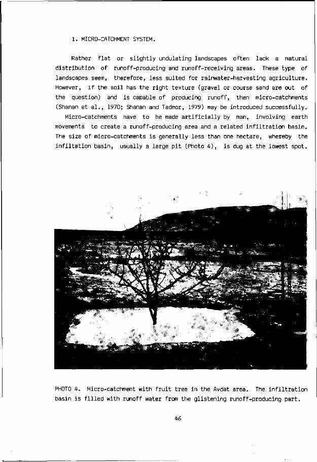
1. MICRO-CATCHMENT SYSTEM.
Rather flat or slightly undulating landscapes often lack a natural
distribution of runoff-producing and runoff-receiving areas. These type of
landscapes seem, therefore, less suited for rainwater-harvesting agriculture.
However, if the soil has the right texture (gravel or course sand are out of
the question) and is capable of producing runoff, then micro-catchments
(Shanan et al., 1970; Shanan and Tadmor, 1979) may be introduced successfully.
Micro-catchments have to be made artificially by man, involving earth
movements to create a runoff-producing area and a related infiltration basin.
The size of micro-catchments is generally less than one hectare, whereby the
infiltation basin, usually a large pit (Photo 4 ) , is dug at the lowest spot.
PHOTO A. Micro-catchment with fruit tree in the Avdat area. The infiltration
basin is filled with runoff water from the glistening runoff-producing part.
46

In a very flat landscape relatively more work is required to make a runoff-
producing and runoff-receiving area, in which trees, pasture or food crops can
be planted. When even slight natural slopes exist, and the surface is capable
of producing runoff, then a runoff-producing area is already present. It is
important to design and built the micro-catchments according to the best fit
with the existing landscape contours.
Crop requirements also influence micro-catchment design. Square, rectangu
lar or circular micro-catchments are generally better suited for trees,
although food crops or pasture plants can also be grown in this way, appearing
as little green islands in the landscape. Longitudinal micro-catchments,
following the contour lines, enable mechanization and are often preferred for
field crops. Various types and shapes of micro-catchments are reported in the
literature, reviewed by Boers and Ben-Asher (1982), who define micro-catch
ments as having a runoff flow trajectory of less than 100 m from runoff
contributing area to the receiving area or infiltration basin.
Of paramount importance is the relationship in size and design between
runoff-producing and runoff-receiving area. Enough runoff water must be gene
rated and stored for proper agricultural production. The above relationship
depends upon climate, geomorphology, soil and type of crop. A noteworthy
advantage of micro-catchment systems is the high specific runoff yield as
compared with larger catchments (Shanan, 1975; Shanan and Tadmor, 1979). A
disadvantage is the low number of crops per unit area and the enhanced oasis
effect as a result.
2. TERRACED WADI SYSTEM.
A terraced wadi system involves the building of a series of low check-
dams across a wadi to retain the runoff waters in the stream channel and
enable the water to be stored in the wadi soil. The check-dams or dikes were
built from local- stones put together without cement in single-line or double-
line walls. Each individual terrace behind a check-dam ought to be levelled to
ensure proper water spreading and storage in the soil. This terracing of the
wadi had the" effect of transforming a certain part of the valley into a
continuous stairway, with stairs perhaps 10-20 meters wide and 20-50 cm high
(Hillel, 1982). Hundreds of terraced wadis can be found in the runoff farming
district. Suitability of a wadi for this system depends mainly upon the follo
wing three factors:
47
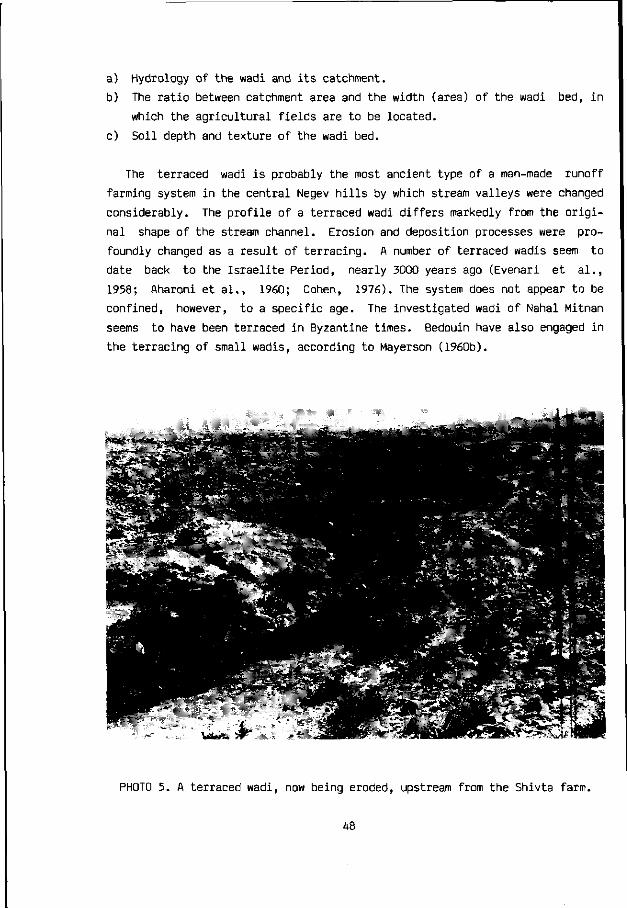
a) Hydrology of the wadi and its catchment.
b) The ratio between catchment area and the width (area) of the wadi bed, in
which the agricultural fields are to be located.
c) Soil depth and texture of the wadi bed.
The terraced wadi is probably the most ancient type of a man-made runoff
farming system in the central Negev hills by which stream valleys were changed
considerably. The profile of a terraced wadi differs markedly from the origi
nal shape of the stream channel. Erosion and deposition processes were pro
foundly changed as a result of terracing. A number of terraced wadis seem to
date back to the Israelite Period, nearly 3000 years ago (Evenari et al.,
1958; Aharoni et al., 1960; Cohen, 1976). The system does not appear to be
confined, however, to a specific age. The investigated wadi of Nahal Mitnan
seems to have been terraced in Byzantine times. Bedouin have also engaged in
the terracing of small wadis, according to Mayerson (1960b).
PHOTO 5. A terraced wadi, now being eroded, upstream from the Shivta farm.
48

Small and medium-sized wadis, situated in rather narrow valleys, are gene
rally most suited for this system of runoff farming. The runoff-producing
hillslopes ought to rise dirctly from the sides of the terraced wadi bed. The
possible presence of colluvium is a clear disadvantage, which may prevent
runoff from reaching the wadi. The terrace dams in the smaller wadis usually
lack a spillway and the floodwaters were allowed to overtop the entire length
of the check-dam. In the somewhat wider wadis, however, a special spillway was
built in the check-dam to prevent erosion. The spillway overflow level from
one wadi terrace to the next may be 15 to 30 cm high, depending upon the
average frequency and magnitude of runoff events as well as upon the crops to
be grown. A spillway level of 25 cm above the field ensures the retention and
storage of about 250 mm of water when runoff has filled the wadi terraces.
3. HILLSIDE CONDUIT SYSTEM.
The hillside conduit system is a useful rainwater-harvesting agricultural
system in geomorphic situations, by which rather wide stream valleys with good
agricultural soils are surrounded by hills having long slopes or colluvium
(Bruins et al., 1986a). This system is found regularly in the central Negev
hills and seems to date back to the Nabatean-Byzantine period.
When the length of runoff overland flow over a slope is long, water is
being lost (Shanan, 1975) or may not even reach the valley fields at all due
to the low velocity of overland flow (Yair et al., 1978). Channel flow, on
the other hand is rather fast and very little water is lost en route. By
building simple ditches as conduits on the hillslopes, the length of overland
flow is considerably shortened. Thus a number of sub-catchments are formed.
The overland flow in each sub-catchment is determined by the spacing of the
conduit channels. The conduits themselves are low walls, simply built from
loose stones and soil, having a slope of no more than 1 %. The conduits also
enable the runoff to bypass possible colluvial deposits, which otherwise might
have absorbed (Yair, 1983) part of the runoff waters.
In a number of geomorphic situations more runoff can be harvested through
the introduction of conduits. The runoff waters drained by the conduits from
the respective sub-catchment (Photo 6) can be directed specifically towards
certain agricultural fields, or into cisterns and other storage reservoirs.
This regulating aspect of conduit channel flow is another advantage of the
system.
49
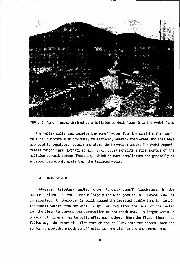
PHOTO 6. Runoff water drained by a hillside conduit flows into the Avdat farm.
The valley soils that receive the runoff water from the conduits for agri
cultural purposes must obviously be terraced, whereby check-dams and spillways
are used to regulate, retain and store the harvested water. The Avdat experi
mental runoff farm (Evenari et al., 1971, 1982) exhibits a nice example of the
hillside conduit system (Photo 6 ) , which is more complicated and generally of
a larger geomorphic scale than the terraced wadis.
4. LIMAN SYSTEM.
Wherever tributary wadis, known to carry runoff floodwaters in due
season, widen or come unto a large plain with good soils, limans may be
constructed. A check-dam is built around the levelled arable land to retain
the runoff waters from the wadi. A spillway regulates the level of the water
in the liman to prevent the destruction of the check-dam. In larger wadis a
series of limans may be built after each other. When the first liman has
filled up, the water will flow through the spillway into the second liman and
so forth, provided enough runoff water is generated in the catchment area.
50

**< 'Si *i»" % - i jm ^
.- tff=! _ .itjgf
PHOTO 7. Limans filled with runoff water at the Wadi Mashash farm.
The term liman is derived from the Greek word "LIMNE" which means lake. A
liman just filled up with runoff water looks like a lake indeed (Photo 7 ) . The
catchment size of a liman is generally larger than in the preceding systems,
though not always. Mini-limans can also be made (Bruins et al., 1986a).
At the Wadi Mashash experimental runoff farm in the Negev, altogether 10
hectares of limans have been established, planted with fruit and fuel trees
(Evenari et al., 1982). Most of the limans function in a successful manner.
Many more limans have been constructed in the Negev by the authorities, gene
rally along the main roads for landscaping purposes.
5. DIVERSION SYSTEM.
In landscape sitiuations where large areas of potential arable land are
found at an elevated position with respect to the stream bed of an adjacent
wadi, it becomes necessary to build more intricate structures in order to
divert the runoff floodwaters onto the fields. For this purpose a dam must be
constructed in the wadi, upstream from the planned fields, at a point where
51

the level of the wadi bed Is at a sufficiently higher elevation than the
fields under consideration. At this point a dam is built to raise the flood-
waters. A low threshold dam may often be sufficient. A diversion channel is
excavated from the dam towards the planned agricultural fields. The gradient
of the diversion channel must obviously be less than the actual wadi and the
adjacent terrace plains. If this precondition is successfully implemented, the
diversion channel will emerge further downstream unto the surface of the
arable lands, which, from hereon, can be irrigated with diverted floodwaters.
Three ancient diversion systems in the runoff farming district, along Nahal
Lavan, Nahal Avdat, and Nahal Mamshit, were studied in detail by Shanan et al.
(1961). The largest and most striking example of a diversion system in the
Negev is that of Nahal Lavan, near the Nabatean-Byzantine town of Shivta. The
terraced agricultural fields comprise here an area of about 200 hectares,
showing massive ancient walls with spillways of 30-60 meter in length.
PHOTO 8. Modern diversion channel, 700 m long, departing from Nahal Avdat onto
a cultivated area of 6 ha, amidst many remains of ancient runoff farming, as
well as modern micro-catchments, belonging to the Avdat runoff farm.
52

PHOTO 9. Runoff water flowing from this diversion channel into the farm lands.
The handling of large flows of diverted water in these diversion systems
required undoubtedly greater skill and sophistication than the operation of
small runoff farms. Maintenance of these systems often became increasingly
difficult due to silting up problems, necessitating the construction of new
diversion structures, beginning higher upstream, to ensure the gravity flow of
diverted floodwaters toward the fields (Shanan et al., 1961; Hillel, 1982).
In the last ten years a diversion system has been set up near the Avdat
experimental farm, constructed by David Mazig (Evenari et al., 1982). An
approximately 50 cm high threshold dam was built at an appropriate place in
Nahal Avdat. From this dam a 700 meter long diversion channel was excavated
into the Late Pleistocene loessial terrace deposits of Nahal Avdat (Photo 8 ) .
Since the diversion channel has a smaller gradient than the wadi and its
adjacent terrace plain, the channel bottom reaches the surface of the culti
vable lands after about 700 m (Photo 9 ) . A loessial serozem soil, exhibiting a
well developed calcic horizon, can be seen in certain parts along the sides of
the diversion channel.
When there is a flood in Wadi Avdat, the threshold dam raises the level of
53

the water, enabling the precious liquid to flow into the diversion channel.
The diverted floodwaters flow through the diversion channel and finally emerge
onto the farm lands of the Late Pleistocene loessial terrace of Wadi Avdat
(Photo 9 ) . In addition, runoff water from a tributary wadi of Nahal Avdat is
also conducted onto the same arable lands. The agricultural fields are sur
rounded by check-dams and interconnected via spillways. An area of 6 hectare
of desert land is cultivated in this manner, planted with pistachio and almond
trees. A desert park has also been laid out for recreational purposes (Evenari
et al., 1982).
Micro-catchments surrounded by low earth bunds were constructed alongside
of the diversion channel, particularly in the terrain that gradually descends
towards the channel. The infiltration basins of the various micro-catchments
appear as little dots on Photo 8. Apart from the agricultural objectives, the
micro-catchments help to check erosion caused by undesired runoff flows from
this sloping land toward the side of the channel. In this manner, different
runoff farming systems are not only adapted to local conditions, as dictated
by the geomorphic make-up of the area, but also may protect each other in
erosion control.
54

4 Pastoralism
NOMADIC PASTORALISM AS A SPECIALIZED FORM
OF A FOOD-PRODUCING ECONOMY
Pastoralism has been an important form of land-use in the arid Negev
during historical times. However, the practising of livestock herding, either
by a nomadic, semi-nomadic or sedentary population, is often hard to grasp in
archaeologic and historic terms. As a food-producing system in the area,
pastoralism cannot be disregarded in the context of this dissertation. Besides
the available data from the Negev, mentioned below, the origins and various
forms of pastoralism in the region at large are treated in a somewhat wider
historic and geographic perspective.
Nomadic and semi-nomadic livestock rearing has been practised widely in the
great arid belt that stretches from the Atlantic coast of the Sahara to the
steppes of Mongolia. In terms of man-land relationships extensive livestock
rearing often developed in marginal environments where food production through
crop cultivation is either impossible or a rather risky undertaking. Hence the
natural vegetation is harvested through the grazing animals and is thus trans
formed into milk, meat and other useful products for man. As such, mobile
extensive pastoralism can be fully regarded as a specialized form of a food-
producing economy (Khazanov, 1985).
There are, however, a large number of possible interrelationships between
livestock rearing and crop cultivation. This ratio of pastoralism and agricul
ture not only depends upon the environment, but also upon various economic,
social and political factors. The influence of these latter aspects is exem
plified by the fact that pastoral nomads may live in areas fit for cultiva-
55

tion, while not engaging significantly in agriculture if at all (Cunnison,
1966; Marx, 1982). "Pure" pastoralists can only develop within a complex
economic system, of which they are an integral part. They produce luxury food
for an urban or well-to-do rural population. This kind of pastoralism is quite
distinct from "subsistence pastoralism", which is usually a combination of
livestock rearing and farming (Marx, 1986, personal communication).
Pastoralists hardly ever subsist directly on their animals, as far as their
diet is concerned. If their food was only composed of eating their livestock
and its products, they would require very large herds indeed (Marx. 1982).
Pastoral specialization has meant more or less economic one-sidedness and no
autarky, as pointed out by Khazanov (1985:3) in an excellent and comprehensive
study about nomads and the outside world. He states that nomads could never
exist on their own without the outside world and its sedentary societies and
different economies. Marx (1982) argues that animals are not merely produced
in a pastoralist society, because they contribute to the diet of their owners,
but rather for sale or for exchange against grain or other goods. Cereals
often constitute the staple food of many pastoralists.
Khazanov (1985:16) defined the most important characteristics of pastoral
nomadism:
1. Pastoralism is the predominant form of economic activity.
2. Its extensive character is connected with the maintenance of herds all year
round on a system of free-range grazing without stables.
3. Periodic mobility in accordance with the demands of a pastoral economy in
specific grazing territories.
U. The participation in pastoral mobility of all or the majority of the
population.
5. The orientation of production towards the requirements of subsistance.
(Khazanov remarks that this fifth characteristic today no longer applies in
many cases, as pastoral nomads have been drawn into the world market
system.)
The most important problem of pastoral nomadism is the balance between
availability of natural resources, number of livestock and population-size
(Barth, 1964; Khazanov, 1985). The thesis is put forward by Barth (1959/60:8)
that: "Unless techniques for the storage of fodder are developed, absolute
population-size is limited by the carrying capacity of the pastures in the
least productive period of the year." (cf. Khazanov 1985:70). Not only the
56

intra-annual shortages of pasture should be taken into account, but also the
Inter-annual frequency of drought years.
Pastoralism In the central Negev without any feed reserves or supplementary
supplies has led to overgrazing, in the absence of a coordinated policy. In
good years the flocks would multiply, and in drought years their numbers would
exceed the dry range's carrying capacity. During a succession of droughts the
Bedouin flocks would be decimated, while their owners would be impoverished
for years. Their plight could be so desperate that the semi-nomads or nomadic
desert dwellers, driven by starvation, would enter more humid sedentary areas
in search for food (Hillel, 1982). An example of such an incident, although
not necessarily related to a drought, is reported by Bailey (1980) to have
occurred during the Ottoman period in 1877: "troops fired upon the bedouins as
they were carrying off crops near Gaza..."
In a larger perspective, that includes Africa, Le Houerou (1985) is pessi
mistic about the present impact of man in pastoral areas. Many factors, such
as overstocking, wood cutting, human and animal population expansion, contri
bute to intensify the pressure on grazed ecosystems. These, in turn, become
less resilient and less able to absorb climatic droughts, which they used to
do under the light exploitation conditions of the past centuries.
Le Houerou (1985), who wrote the article in 1982, remarked that if this
situation persists, one can only predict a gloomy future for pastoralism.
Nomadic pastoralism will either have to disappear quietly or evolve towards
other systems of animal production with increased reliance on supplementary
feedings for longer and longer periods. Khazanov (1985:71,76) is equally
pessimistic: "Pastoral nomadism is doomed to stagnation because its economy is
extensive... Increased production in nomadic society as a whole is, to any
significant extent, impossible".
PASTORALISM AND AGRICULTURE
Pastoral nomadism proper is in its most pure manifestation characte
rized by the total absence of agriculture. Semi-nomadic pastoralism is much
more widespread throughout the world. Its predominant activity is also com
posed of extensive pastoralism and the periodic changing of pastures, but
agriculture is practised as well in a secondary and supplementary capacity.
There are, however, many other forms of pastoralism, which are somehow inte
grated with agricultural practices. Although there seems to be a clear lack of
57

detailed historic and archaeologic information about these relationships in
the Negev in antiquity, some of the systems described by Khazanov (1985:19)
may actually have existed here in the past, used either by the Bedouin (Marx,
1967) or by the sedentary runoff farmers:
1) SEMI-SEDENTARY PASTORALISM differs most fundamentally from semi-nomadic
pastoralism in the sense that agriculture plays the predominant role in the
general economic balance.
2) HERDSMAN HUSBANDRY or DISTANT PASTURE HUSBANDRY describes the situation in
which the majority of the population leads a sedentary life and is occupied
for the most part with agriculture. The livestock or, more often, some of it,
is tended all year round by herdsman especially assigned to this task. They
maintain the herds on pastures, sometimes quite far from the settlements. For
part of the year the animals are usually kept in enclosures, pens and stalls,
which entails the laying-in of fodder.
3) SEDENTARY ANIMAL HUSBANDRY usually supplements agriculture and has diffe
rent variants.
a) HOUSEHOLD-STABLE ANIMAL HUSBANDRY is one of these variants. It is
characterized by the grazing of livestock in pastures adjacent to the settle
ment for part of the year, whereby the animals usually return every day. For
the other part of the year the livestock are kept in stables and enclosures
and fed accordingly.
b) SEDENTARY HOUSEHOLD HUSBANDRY WITH FREE GRAZING is yet another variant
of sedentary animal husbandry. This is genetically one of the most primitive
and ancient forms of pastoralism in which the laying-in of fodder and the
maintenance of livestock in enclosures or stables is generally absent or very
limited (Khazanov, 1985).
The technical problems and organizational requirements of a possible inte
gration between runoff farming and animal husbandry in the central Negev in
antiquity are eloquently described by Hillel (1982:187):
"All the evidence at hand leads to the conclusion that the ancients, espe
cially during the Nabatean-Roman-Byzantine epoch, maintained a diverse agri
cultural economy in the central Negev, with cultivation and grazing carried
out simultaneously. Since roaming livestock could devour and trample crops,
destroy runoff-collecting conduits, accelerate erosion of slopes, and induce
58

silting and pollution of cisterns, undisciplined grazing has always been a
menace to farming. Only an organized and coordinated society could resolve and
integrate such potentially contradictary activities as farming and grazing, as
well as land and water rights, so as to avoid conflict and damage."
No such coordination existed, in the opinion of Hillel (1982), from the
Early Arab period until the establishment of the State of Israel. The tribes
of Bedouin that inhabited the region could not be certain of long-term land
ownership, because of intermittent struggles over territorial rights. Bailey
(1980) collected material about such situations of internal warfare between
the Bedouin tribes during the 19th century, based upon oral traditions of the
Bedouins themselves.
THE ORIGINS OF PASTORALISM
Most authorities agree that pastoral nomadism did not evolve from
hunting and food gathering societies. It rather developed as a specialization
out of sedentary agriculture (Grigg, 1974). Its sources go back to the
Neolithic revolution and the emergence of a food-producing economy, which
basically always consisted of two forms of economic activity: crop cultivation
and animal husbandry. As pointed out by Khazanov (1985), only groups leading a
relatively sedentary way of life with definite surpluses of vegetable food at
their disposal could domesticate animals.
In a study about the emergence of specialized pastoralism in the southern
Levant, Levy (1983) points out that during the Late Neolithic, some 6000-7000
years ago, crop cultivation and livestock grazing in the northern Negev is
clustered around springs, in year-round grazing areas. The maximum grazing
range of sheep away from these springs is about 5-8 km. This might be consi
dered as a form of household animal husbandry with free-range grazing, as
described above.
With population growth and the development of a new agro-technology, the
subsequent Chalcolithic settlements moved further into the more arid inland
valleys, probably using runoff floodwaters for crop cultivation. It would have
been a physiological necessity for village communities in the inland valleys
to move sheep or goat herds to the more humid coastal plain on the arrival of
the dry summer season. The temporary nature of Chalcolithic settlement on the
coastal plain indicates, according to Levy, the primarily pastoral nature of
these camps as part of a newly developed subsistence strategy, in which sheep
59

and goat herds owned by permanent villages were moved north-westward for
grazing during the late summer and early winter months. This development of
sedentary pastoralism during the Chalcolithic (4000-3200 B.C.) marked the
emergence of the traditional system of land-use and herd-management in the
Northern Negev, which matured during the Early Bronze Age (3200-2200 B.C.) and
lasted until the 20th century (Levy, 1983).
This system has the following characteristics:
1. Grazing by mobile herds of small livestock (sheep and goat) combined with
the dry-land cultivation of winter cereals (wheat and barley) whenever and
wherever possible.
2. No significant use of irrigation water, fertilization or supplementary
feeds.
3. The grain and livestock products are primarily used for the subsistance of
the local population, although surpluses are traded or exchanged in favou
rable years (Noy-Meir and Seligman, 1979; cf. Levy, 1983).
The adaptation of a food-producing economy to a specific habitat led,
especially in arid zones (Le Houerou, 1985) to the predominance of pastoralism
over other forms of agriculture. Apart from social and political factors, it
can be said (Khazanov, 1985:69) that pastoral nomadism and semi-nomadic pasto
ralism developed and functioned in the first instance in those regions where
they had economic advantages over all other kinds and forms of economic acti
vity. Khazanov considers that climatic changes played an impor tant role in
the emergence of many types of pastoral nomadism, but economic and cultural
preconditions were also necessary.
The Arabian peninsula was the major centre of nomadization in south-west
Asia and its role was similar to that of the Sahara to the development and
dissemination of African nomadism. Just as in the Sahara, cattle appears in
Arabia in the sixth millennium B.C. and small stock appears in the fourth and
third millennia B.C., when pastoralism becomes the predominant economic acti
vity. Sheep and goat definitively replaced cattle in Central Arabia from the
end of the third millennium B.C. Herdsman husbandry and semi-nomadic pastora
lism existed in the Near East during the third and second millennia B.C., but
in no way was there real nomadism.
The climate of Arabia altered at about the same time as the climate in the
Sahara did (McClure, 1971). It is not known how the desiccation which began
about 2500 B.C. and grosso modo continues until the present (Pearse, 1971;
60

Maley, 1973; Flohn and Nicholson, 1980; Nicholson and Flohn, 1980) affected
the ancient pastoralists of Arabia. Perhaps one consequence of it was the
movement of pastoralists to the borders of agricultural areas (Oates, 1976).
What is clear, however, is that the "bedouinization of Arabia" or the final
stage of the formation of real pastoral nomadism in Arabia was linked to the
beginning of the utilization of the camel as a riding animal (Khazanov, 1985):
"It was only specialized camel-herding, which began in Arabia somewhere in
the middle of the second millennium B.C. and was possibly stimulated by the
desiccation of the peninsula, which led to the dissemination of real pastoral
nomadism in the inner regions of Arabia and Syria. Already in the eleventh
century B.C. the Midianites, Amalekites and "children of the East" stormed
through Jordan into Palestine (Judges 6:1-6), "...for both they and their
camels were without number" (Judges 6:5). According to Dostal (1959:22) their
invasion was linked to the perennial problems faced by nomads: the desire to
extend grazing territory for the increasing numbers in their herds, the need
of agricultural products and of trade with sedentary societies, etc."
(Khazanov, 1985:100).
Le Houerou (1985) wrote an excellent article about the impact of climate on
pastoralism, dealing with specific quantitative aspects of pastoral man-land
relationships. The development of pastoral nomadism in the Near East is
summarized by Khazanov (1985:102) in the following way. Nomadic pastoralism
evolved out of a mixed economy of crop cultivation and animal husbandry,
passing through the stage of extensive herdsman husbandry and/or semi-nomadic
pastoralism. The earliest forms of extensive pastoralism were in the first
instance based upon the herding of small livestock. The camel gradually gained
an important position in the economy as food, as well as for transport and
riding purposes. The immediate transition to pastoral nomadism in its tradi
tional economic forms, at least with regard to species-composition of herds
and methods of their utilization, was probably linked to specific changes or
variations of climate. Finally, nomads were linked right from the beginning
in a complex system of peaceful and hostile relations with sedentary states
(Khazanov 1985:102).
The rather scanty historic information about the interrelationships in the
Negev between nomadic or semi-nomadic Bedouins and the sedentary runoff far
ming population, including travellers, is described by Mayerson (1963, 1964)
for the Byzantine and Early Arab period. Marx (1967, 1977, 1982) and Baily
(1980) have studied contemporary Bedouin life in the Negev and its recent
history.
61

5 Horvat Haluqim
ENVIRONMENT
GEOMORPH0L0GY AND GEOLOGY
The site of Horvat Haluqim exhibits a classic example of an ancient
terraced wadi system (p. 47), constructed for runoff farming purposes well
before the Nabatean period, as indicated by archaeological excavations (Cohen,
1976) and investigations by the author in one of the terraced fields. The
remains of the ancient agricultural village are situated on the southern
slopes of the Haluqim anticlinal range, some 4 km to the north of the canyon
like Zin Valley which constitutes the most dramatic geomorphic feature in the
area. The hills of Har Haluqim, rising to an altitude of 618 m, are part of
the Southwest-Northeast trending fold belts of the northern Central Negev.
Two modern settlements, Kibbutz Sede Boqer and Midreshet Ben-Gurion, are
situated to the south of Horvat Haluqim in the adjacent synclinal plain of
Sede Zin, at an altitude of 470-475 m. Their respective distances to the site
are about 1.5 km and 4.5 km. The road from Sede Boqer to Yeroham forms the de
facto southern border of the site. The synclinal plain of Sede Zin is largely
covered by Late Quaternary loessial deposits (Issar et al., 1984) of the
Netivot Formation (Bruins et al., in preparation).
The site of Horvat Haluqim comprises three small tributary wadis (Photos 1,
10, 12; Fig. 9) of Nahal Haroa, which drain part of a hill composed of Upper
Cretaceous carbonate rocks. The wadis are of the first to second order and
begin at an altitude of about 530-540 m at the upper slopes of a rather flat,
east-west trending hill top axis, which is about 200 m wide. The length of the
wadis from their inception until the road is in the range of 500 to 600 m.
62

. 5 0 0 m
TTJTTT Escarpment
Wadi * Sp r ing
Their average width ranges from
less than 5 m up to 25-30 m. Ini
tially the stream beds are narrow
as the wadis descend from about 540
to 520 m. When the wadi beds widen
and their gradient diminishes,
ancient agricultural terraces ap
pear, usually beginning at an alti
tude of some 515-520 m. Henceforth
the wadis are terraced until the
vicinity of the road, whilst their
beds gradually descend to an alti
tude of about 495 m.
The lithology of the hill
drained by the three wadis is domi
nated by the Nezer Formation of
Late Turonian age, characterized by
well bedded lithographic limestone
and minor chalk layers (Arkin and
Braun, 1965), having a southward
dip of about 6 . The natural join
ting pattern and the individual thickness (about 30 cm) of the hard micritic
limestone layers makes the Nezer Formation suited for local building stones
that are easily quarried and handled (Photo 11), and which were used in the
past. Turonian rocks of the underlying Shivta Formation are exposed along the
lower part of the stream-valley slopes, above the three mentioned wadis. The
Shivta Formation consists of poorly bedded calcarenitic limestone layers.
CLIMATE
The site is situated in close proximity to the nearby meteorological sta
tion of Sede Boqer. Climatic data from the latter station, belonging to the
Israel Meteorological Service, are quoted from Arzi (1981). The average annual
rainfall is 94 mm, measured in the period from 1951/1952 to 1979/1980. Inter-
annual variations fluctuated from a minimum of 30.9 mm to a maximum of 167.3
mm per year. The average number of rainy days amounts to 26 per year; the
range of annual variation lies in between 11 and 36 rainy days. The yearly
temperature average is 18.2 degrees Celsius. Average daily temperatures in the
coldest month (January) range from 3.9 C at night to 15.4 C in the daytime,
FIG. 8. Location of Horvat Haluqim.
63

lAbLL 7. CLIMATIC DATA FROM THE SEDE BOQER METEOROLOGICAL STATION. *
RAINFALL (mm)
RAINY DAYS
TEMPERATURE (°C)
RELATIVE HUMIDITY (58)
EVAPORATION (mm/day)
EVAPORATION (mm/month)
WIND DIRECTION
RAINFALL (mm)
RAINY DAYS
TEMPERATURE (°C)
RELATIVE HUMIDITY (%)
EVAPORATION (mm/day)
EVAPORATION (mm/month)
WIND DIRECTION
OCT
2.6
0.8
20.6
60
6.0
186
N
MAY
0.7
0.4
20.9
43
9.4
291
N
NOV
9.5
2.8
16.0
62
4.0
120
N
JUN
0.2
0.1
24.2
45
11.0
330
NW
DEC
22.4
5.3
11.4
68
2.9
90
NE
JUL
0
0
24.8
53
10.7
332
NW
JAN
23.3
6.5
9.6
70
3.1
96
W
AUG
0
0
25.3
57
10.1
313
NW
FEB
15.7
4.3
11.6
64
3.8
107
W
SEP
0
0
23.6
62
8.3
249
NW
MAR
11.9
3.8
13.6
58
5.1
158
N
APR
7.2
2.0
17.0
53
7.3
219
NW
ANNUAL TOTAL OR AVERAGE
93.5
26
18.2
58
6.8
2491
NW
* Modified from Arzi (1981).
All data are average figures, derived from the Israel Meteorological Service (Climate Department): Rainfall data and the number of rainy days are from a 29 year period (1951/1952 to 1979/1980). Temperature and relative humidity data are from a 10 year period (1952-1956 and 1964-1969). Evaporation data of an open water surface were measured in a Class A Evaporation Pan, up-to-date until 1972/73 (Last, 1978). Wind direction data are from 1974-1975.
and in the hottest month (August) from 17.8 °C at night to 32.8 °C in the day.
Maximum temperatures reach sometimes values' of over 40 °C.
The relative humidity is on the average 58 %, ranging from a monthly low of
43 % in May to a maximum of 70 % in January. Total annual evaporation from an
open water surface amounts to some 2500 mm, measured in a Class A Evaporation
Pan (Last, 1978, qf. Arzi, 1981). The potential annual evapotranspiration is
1917 mm (Arzi, 1981), calculated according to Stanhill (1961). Detailed
monthly climatic data are presented in Table 7, modified from Arzi (1981).
64

HYDROLOGY
The hillslope hydrology of a somewhat similar area as Horvat Haluqim,
situated on the same anticlinal range, has been studied in detail by Yair
(1981) and his collaborators. Their main conclusions from the Sede Boqer
experiment site, some 4 km southwest of Horvat Haluqim, about runoff genera
tion and its flow down the hillslope can be summarized as follows: (1) Bedrock
areas respond more quickly to rainfall than do soil covered areas. (2) An
integrated flow of runoff along the entire slope, that includes a colluvial
part toward the bottom, is quite rare under the present rainfall conditions in
the area (Yair, 1983).
On the hillslopes studied by Yair, three geological formations are succes
sively exposed from top to bottom: the Nezer, Shivta, and Drorim Formations.
Deep colluvial deposits occur at the base of the slopes. Although the two
sites appear in a similar landscape setting, there are some important diffe
rences.
The Drorim Formation, which appears to be less runoff productive than the
other geological formations (Yair, 1981:242), does not crop out at the Horvat
Haluqim site. Colluvial deposits at the base of the slopes are virtually
absent at Horvat Haluqim and thus cannot obstruct runoff flows from reaching
the wadi bed. Moreover, the upper part of the Shivta Formation, which shows
the best runoff production at the Sede Boqer experimental site, is exposed at
an advantageous geomorphic position at Horvat Haluqim: at the lower part of
the hillslopes just above the three wadis. The shape of the hillslopes at
Horvat Haluqim is usually convex, having a maximum gradient of about 20-25
degrees, generally at their lower part toward the wadis. Average slope length
from interfluve to wadi bed is about 100 m on the hilly spurs that seperate
the three wadis from each other.
Considering the outcome of the research conducted by Yair and his col
leagues at the Sede Boqer site, it seems that the three wadis of Horvat
Haluqim are endowed with an advantageous runoff-producing and runoff-
conducting catchment. Although the catchments are relatively small, obvious
for stream channels of the first and second order, their geologic and geomor
phic properties appear well suited for runoff farming.
SOILS AND VEGETATION
This preliminary conclusion seems substantiated by the dense wadi vegeta
tion, which is in sharp contrast to the scattered shrubs on the rather barren
hillslopes (Photo 1, p.30). The sedimentology and soil development of the
65

~..,.:̂ .: .. . ••.:, ~?i%m0^#v*^"M**^"i..
PHOTO 10. View from one of the terraced wadis at Horvat Haluqim, overlooking the synclinal Zin plain towards the elevated Eocene Avdat plateau.
PHOTO. 11. Hard limestone beds of the Nezer Formation, easily quarried.
66

alluvial wadi deposits at Horvat Haluqim were investigated in detail in one of
the man-made terraces. The results are presented in a following sub-chapter.
The soil cover on both the Nezer and Shivta Formations is limited, patchy
and shallow. Bare rock outcrops occur frequently throughout the hilly catch
ment of the three wadis. The shallow lithosols on the hills are dominated by
the Artemisia herba-alba - Gymnocarpos decander and Hammadetum scopariae asso
ciations, the latter being characteristic for the driest habitats with the
worst moisture-retention regimes.
Deeper brown lithosols with significant soil moisture amounts exist in
patchy rock crevices near bare rock outcrops, as a natural mini-variety of the
micro-catchment system in runoff farming. The Varthemia iphionoides - Origanum
dayi association occurs at these most favourable runoff receiving "mini infil
tration basins" on the hillslopes (Yair and Danin, 1980; Danin, 1983:40-41).
The salinity (EC) of lithosol A-horizons at the Sede Boqer site, investi
gated by Arzi (1981), ranges from 0.4-3.9 mS/cm. The salinity usually
increases somewhat in the subsoil, if there is a subsoil at all.
The serozems that developed in the colluvium at the base of the slopes are
much more saline in the deeper subsoil. The electrical conductivity (EC)
reaches here a maximum value of 26 mS/cm (Arzi, 1981). An article about
similar colluvial deposits at the Haluqim anticlinal range, which includes
soil stratigraphic data and their paleoclimatic implications, is currently in
press (Issar et al., 1986).
The Late Quaternary Serozem soils developed in the loessial deposits of the
Sede Zin syncline are also very saline. The A-horizon has an EC of about 1.4
mS/cm, whilst values of 42 mS/cm already occur at a depth of 25 cm. Gypsic
horizons are also found in these soils. Young alluvial loess soils on the Sede
Zin plain have a very low salt content (Dan et al., 1973; Dan, 1981).
ARCHAEOLOGY OF HORVAT HALUQIM
The site extends along the three mentioned tributary wadis of Nahal
Haroa (Figure 9 ) . Archaeological excavations at the site were conducted by
Rudolph Cohen (1976). The remains consist of a small fortress and a settlement
which includes 25 buildings, 4 cisterns and related agricultural terraces.
Apart from two buildings ascribed to the 2nd-3rd centuries A.D. (Roman
period), most of the other remains are attributed by Cohen (1976) to the 10th
century B.C. (Israelite period).
67

FIGURE 9. Plan of the Horvat Haluqim site (modified after Cohen, 1976, 1981),
showing the location of the fortress, the watch-tower, various buildings,
cisterns, and the three wadis with their terraced fields (surveyed by the
author). The geography of the site can be summarized as follows:
ALONG THE EASTERN WADI:
Fortress 23 x 21 m
Building 8 x 8 m
Building 14 x 9 m
Cistern 18 x 8 m
Building 10 x 10 m
40 m N of the road
90 m NE of the fortress
90 m NNE of the fortress
130 m NNE of the fortress
140 m NNW of the fortress
10 m East of the wadi bed
25 m East of the wadi bed
Just East of the wadi bed
10 m East of the wadi bed
45 m West of the wadi bed
68

ALONG THE CENTRAL WADI:
Several buildings 180 m NW of the fortress Just West of the wadi bed
ALONG THE WESTERN WADI:
Cistern 22 x 12 m
Cistern 11 x 11 m
Cistern 14 x 9 m
Building 10 x 8 m
420 m NW of the fortress
440 m NW of the fortress
540 m NW of the fortress
480 m NW of the fortress
65 m East of the wadi bed
25 m East of the wadi bed
Inside the wadi bed
Just West of the wadi bed
Some of the 25 recorded buildings, belonging to the settlement, were exca
vated by Cohen (1976). The fortress has a roughly oval plan (about 21-23 m in
diameter) and includes 7 casemate rooms around a central courtyard (Photo 12).
Only the foundations of the fortress walls of Horvat Haluqim were found to be
preserved, resting on the limestone bedrock of the Nezer Formation. The walls
are built from local, roughly-hewn limestone blocks. The size of the casemate
rooms varies from 1.5-2 m in width to 5.5-8 m in length (Cohen, 1976). The
shape of its ground-plan is similar to the Early Fortress at Kadesh-Barnea and
other fortresses in the region (Cohen, 1980, 1981, 1983).
"'^S-SK iSf's;-' - •"*;? ','
''* IK
;*%;# * * (>Clfe
PHOTO 12. The western casemate room of the fortress at Horvat Haluqim.
69

Cohen (1980:77) admits that "the fundamental problem of the early fortress
network is its date". Radiocarbon dates from the tell at Kadesh-Barnea, partly
published in Chapter 8, seem to suggest that the Early Fortress at the latter
site may have been erected in the Late Bronze or Early Iron age. The apparent
similarity in architectural style and shape of the groundplan between the
Early Fortress at Kadesh-Barnea and the fortress at Horvat Haluqim (Cohen,
1980) raises the question whether the early fortress network might date to the
Late Bronze or Early Iron age. Cohen (1980) mentions the different archaeolo
gical opinions in this matter, by which Rothenberg (1972) seems to favour a
Late Bronze age for the ceramic complexes involved.
Recent advances in the calibration of radiocarbon dates from conventional
C-14 years into historical years (Chapter 8; Pearson, 1986), may lead to a
situation in which the outcome of controversial stratigraphic problems in
archaeology, based on ceramics or architecture, will be resolved by radiocar
bon dating on the basis of chrono-stratigraphy. The dimension of time is
indeed the absolute basis in stratigraphy and the impartial arbitrator in all
aspects of stratigraphic reserach. Only time allows for the juxtaposition of
contemporaneous events in history, archaeology, climate, and landscape.
In the absence of such a detailed chrono-stratigraphy for Horvat Haluqim,
the age of the site will be referred to in accordance with the general opinion
of Cohen (1976), as Iron age, bearing in mind the raised question that some
parts of the site may be older perhaps. Two buildings at the site are actually
younger and belong to the Roman period. The Roman watch-tower, situated 140 m
NNW of the fortress, is the best preserved building at Horvat Haluqim. The
walls .are built of large hewn stones and are 1 m wide.
WATER SUPPLY IN THE PAST
The nearest spring in the vicinity, fed by a natural flow of shallow
groundwater, is the brackish spring of Ein Mor in the Zin Valley, some 7 km
south of Horvat Haluqim. The water of this spring is all right for animals,
but is considered too saline for regular human consumption. The necessary
water supply for the former inhabitants of Horvat Haluqim, therefore, had to
come from runoff rainwater, catched and stored in cisterns.
The four cisterns located in the settlement are built of large rough
stones. All cisterns, except the one located inside the wadi bed of the
western stream valley, are silted up to the brim. Three large piles of silt
70

next to the latter cistern, which still may fill with water in the rainy
winter season, indicate that it was cleared a number of times in the past.
This cistern is oval in shape (9 x 14.5 m ) , with walls 1 m wide and preserved
to a height of A m. Its estimated water-holding capacity amounts to some 300
cubic metres of runoff water (Cohen, 1976).
As the other three cisterns are completely silted up, it is more difficult
to assess their water holding capacity. Their combined volumes are conjectured
to be some 1100 cubic metres. If all the cisterns would have filled up during
the rainy season, approximately 1400 cubic metres of water could have been
stored within the settlement in the past. In a drought year, probably much
less runoff water could be harvested and stored, perhaps less than a third of
the estimated storage capacity, e.g. some 300 cubic metres. How many people
could have lived on such amounts?
Assuming a daily water requirement of 10 liter per capita (Evenari et al.,
1971; Broshi, 1980), which is a rather low quantity, 300 cubic metres of water
might have supported the minimal needs of some 80 people. An amount of 1400
cubic metres, possibly stored in wet years, might have been sufficient for a
population of 380. An assessment of past population levels must be based,
however, apart from other considerations, upon minimal figures in dry years
(Mayerson, 1967; Broshi, 1980), as it was difficult to bring in any signifi
cant quantities of water in antiquity. Moreover, the water needs of possible
flocks and other animals in the village must also be taken into account,
besides evaporation losses that can amount to 2.5 meter/year (Table 7 ) , if the
water surface of the cisterns was fully exposed. It seems, therefore, that the
past population of Horvat Haluqim was probably less than 80 people.
ANCIENT RUNOFF-FARMING WADI TERRACES AT HORVAT HALUQIM
The terraced fields in the wadis are in all likelihood contempora
neous with many of the other structures within the settlement. The siting of a
number of houses at Horvat Haluqim seems to have been chosen to facilitate
easy access to the cultivated fields in the terraced wadis, as already noted
by Cohen (1976). If not for the practising of runoff farming, there appears to
be no logical explanation for the location of these houses in the settlement.
Horvat Haluqim seems to have been a small agricultural village with a defen
sive posture, if the fortress is contemporaneous with the terraced fields.
The number and dimensions of the check-dams and terraced fields in the
71

three wadis were surveyed by the author. Beginning at the head of each stream
valley, the dams and terraced fields in the respective wadis were successively
numbered, while going downstream. It is theoretically possible that a very few
dams are hidden from view, completely buried by alluvial sediments. This would
not affect, however, the determined outcome of both the combined length of the
terraced fields and the calculated cultivable area in each respective wadi:
(1) The EASTERN Wadi exhibits 14 check-dams and terraced fields, having a
total cultivable area of 0.53 hectare. The wadi is terraced over a
length of 250 m.
(2) The CENTRAL Wadi contains 30 check-dams and related terraced fields,
having a total cultivable area of 0.75 hectare. This wadi is terraced
over a length of 454 m.
(3) The WESTERN Wadi exhibits 20 check-dams and related terraced fields,
having a total cultivable area of 0.73 hectare. The wadi is terraced
over a length of 411 m.
This latter figure includes a possible break in terracing over some 60 m
between check-dam 3 and 4. It is not clear whether this stretch of wadi was
never terraced because of an apparently steeper wadi gradient or that erosion
has removed once existing dams and terraces.
The Western Wadi contains a cistern in its stream bed just above the
beginning of the first terraced field. This set-up might have enabled inten
sive vegetable cultivation, even during the summer season, in the first ter
raced fields below the cistern, irrigated by its stored runoff rainwaters. The
very existence of houses, situated just below the first three terraced fields
(Cohen, 1981:60), seems to strengthen this hypothesis of an intensive and
perennial vegetable-herb-fruit garden near home, watered from the cistern in
addition to natural runoff flows.
A very small tributary of the Western Wadi joins the main stream bed some
90 m below the mentioned building remains, in between dam 8 and 9. The fact
that even this little and narrow wadi was terraced, shows the determination of
the ancient village population to cultivate every little plot of soil suited
for runoff farming. The wadi has 6 small check-dams and related terraced
fields with a total cultivatable area of 0.05 hectare (497 square metres).
The little wadi is terraced over a length of 56 m.
The total area of terraced fields in the three wadis amounts to 2.07 ha,
whilst the total catchment area of the three wadis combined is estimated at
72

about 36 ha. The ratio of the runoff receiving area of cultivated fields to
the runoff producing catchment area can, therefore, be put at approximately
1:17 for the Horvat Haluqim site. This local datum is very near the average
figure of 1:18 for the entire Runoff Farming District in the central Negev
desert (Kedar, 1967).
TABLE 8. Number and size of dams and terraced fields in the three wadis * of Horvat Haluqim, descending from the head of the valleys downstream.
TERRACED FIELD and DAM NUMBER
1 2 3 4 5 6 7 8 9
10 11 12 13 14 15 16 17 18 19 20 21 22 23 24 25 26 27 28 29 30
DAM LENGTH = WIDTH (m) OF TERRACED FIELD
wadi WEST
15.5 24.0 18.0 10.0 13.0 14.5 11.0 10.0 28.5 32.5 31.5 29.0 24.0 32.0 25.8 24.3 13.0 9.0 8.0
10.0
wadi CENTRAL
12.5 13.0 15.2 18.0 19.4 13.0 16.0 17.5 15.6 15.7 11.5 13.5 13.5 17.5 20.0 20.0 20.0 19.3 15.9 15.7 15.8 23.0 26.7 26.4 22.5 17.0 13.3 11.2 9.5
10.3
wadi EAST
12.0 14.7 15.7 19.3 18.6 20.0 19.6 20.0 22.0 24.0 24.1 23.5 38.0 25.0
LENGTH (m) OF TERRACED FIELD
(upstream from dam) wadi WEST
30.5 28.4 15.4
(72.0) 12.5 12.6 13.7 12.3 17.4 14,2 14.6 40.0 16.8 20.0 17.5 27.0 17.0 7.2 9.5
12.2
wadi CENTRAL
12.0 16.8 12.0 17.3 31.0 5.6
21.0 16.0 15.6 13.0 21.3 14.5 23.0 18.2 11.2 12.2 10.3 10.1 12.0 18.8 11.7 19.2 17.7 14.8 20.5 13.0 9.8 7.5
13.0 15.2
wadi EAST
12.0 16.8 18.0 38.7 14.4 9.6 9.6
15.7 13.7 14.7 18.3 20.0 22.3 26.0
FIELD AREA (square metre)
wadi WEST
398 560 323 224 143 173 174 129 335 433 467
1210 445 560 505 616 3Y? 79 80
109
wadi CENTRAL
132 214 169 287 579 33
304 268 258 203 289 181 310 282 210 244 206 198 211 297 184 372 439 392 501 256 148 91
134 150
wadi EAST
160 224 274 677 273 185 190 311 288 338 440 476 686 819
The field width of a certain terrace, used to calculate its field area, is based upon the average length of the two dams bounding that terraced field. * Data about the little tributary of the Western Wadi appear in Table 9.
73

TABLE 9. Number and size of dams and terraced fields in the little tributary of the Western Wadi of Horvat Haluqim (measured from the head of the valley downstream).
TERRACED AND DAM
1 2 3 4 5 6
FIELD number
DAM LENGTH = WIDTH (m) OF TERRACED FIELD
6.0 5.5 5.5 8.0
13.0 17.0
LENGTH (m) OF TERRACED FIELD
upstream from dam
6.0 7.5 9.0 7.8
12.2 13.0
FIELD AREA (metre square)*
30 43 49 52
128 195
The field width of a certain terrace, used to calculate the field area of that terrace, is generally based upon the average length of the two dams bounding that terraced field.
The average ratio between the length of a terraced field and its width (=
the length of the dam across the wadi) in the runoff-farming terraced wadi
system at Horvat Haluqim is 0.90. Thus the average length of the terraced
fields is slightly less than the average width of the wadi bed. However, the
individual terrace length/width ratio's at the site vary considerably and
range grosso modo in between 0.5 and 2.0.
For an equal distribution of runoff water within each terraced field, it is
important that the fields are levelled. In a proper design of a terraced wadi
system, the gradient of a wadi, therefore, determines how often and at which
points check-dams are to be constructed across the wadi bed. It is obvious
that the steeper the gradient of the wadi the more check-dams and terraces are
required per unit of wadi-length to enable each terraced field to be levelled,
in analogy to a staircase. Apart from the wadi gradient, the depth of soil
within the wadi bed is a determining factor as well. A relatively shallow soil
will not allow much room for levelling. In the case of two similar wadis,
having an equal gradient but different overall soil depth, more check-dams
might be necessary in the wadi with the shallower soil. It remains to be
investigated how level the ancient terraces actually were.
The three wadis of Horvat Haluqim, including the little tributary of the
Western Wadi, contain a total of some 72 terraced fields. The combined length
of all the measured dams put together amounts to 1234 meter, which is quite a
74

constructional achievement for such a little village in order to wrestle a
living from the desert.
TABLE 10. Data about runoff farming fields at the Horvat Haluqim site. (Terraced wadi system)
a) Number of dams and terraced fields
b) Average length of terraced field
c) Average dam length = field width
d) Ratio b/c = Ratio e/f
e) Total length of terraced wadi fields
f) Total length of dams g) Total area of fields
TRIBUTARY
6
9.3
9.2
1.01
55.5
55.0 497.0
WADI WEST
20
17.5
19.2
0.91
350.8
383.6 728A
WADI CENTRAL
30
15.1
16.6
0.91
454.3
498.5 7542
WADI EAST
14
17.8
21.2
0.84
249.8
296.5 5340
TOTAL OR AVERAGE
72
15.4 (m)
17.1 (m)
0.90
1110.4 (m)
1233.6 (m) 20663 (m2)
STRATIGRAPHY AND SOIL DEVELOPMENT OF A WADI TERRACE AT HORVAT
HALUQIM, CONSTRUCTED AND USED FOR RUNOFF FARMING IN ANTIQUITY
THE DISCOVERY OF AN ANCIENT TERRACE LAYER
In November 1982 an excavation was made by the author into a terrace
of the Eastern Wadi, some 150 m north of the fortress, just upstream from dam
12 near the Roman watchtower (Figure 9, Table 8 ) . The dam has a length of 23.5
m and a width of 1.60 m. It is built across the wadi in a southwest-northeast
direction, its azimuth being 62 degrees. Although the architecture of the dam
was not investigated, its rather complex and somewhat dilapidated appearance
is unlike the precise and neatly layered dams, so often characteristic for the
Nabatean-Roman-Byzantine period. It is possible that the dam was first built
during the Israelite period, in accordance with the age attributed to the site
by Cohen (1976).
New evidence for the pre-Nabatean origin of these agricultural terraces was
found during the present excavations, as described below. Independent carbon-
14 dating may be possible in a later stage. It seems likely that the dam may
75

•*&>* i^>r Tx?--..> '•
PHOTO 13. Excavation into terrace 12 of the Eastern wadi of Horvat Haluqim.
also have been repaired and expanded for runoff farming in later periods, as
indicated by some Roman remains at the site. Thus the dam probably reflects a
composite archaeological and architectural history.
The terrace upstream from the dam is slightly affected by erosion. A very
shallow but discernible erosion channel winds its way through the terrace, and
has made an opening into the somewhat dilapidated terrace dam described above.
The first pit into the terrace was excavated from 0-250 cm upstream from the
dam, just east from the very shallow present stream channel. The location of
this pit proved to be well chosen, as, rather surprisingly, a stone wall was
discovered below the surface at a depth of 50-100 cm.
This wall begins at the contact with the dam, and runs perpendicular from
the dam in an upstream direction in the middle of the terraced wadi bed. The
wall is built of two courses, being only one stone wide and about 50 cm high.
Local natural limestone blocks were used in the construction of this wall,
which might have been part of an ancient spillway, buried by alluvial loessial
sediments after the site was abandoned. The wall has so far been excavated
until A m upstream from the dam. Its upper course consists of 12 stones.
76

PHOTO 14. Exhumed wall and former terrace surface, In the middle of the wadi bed, perhaps dating back to the Israelite period (Iron age).
^ i 4 t ' .Ska- ^^h Ji W l - & » JT._ • - -»!.-*.•
-CD P i t - 2
%; Carbonate nodules
o°o o Gravel
CD Limestone Block
l l l-A
lll-AQ
IV-C
V-C
C3> a C3QCS
o o o
* * *
o o o » • o O
~3 5 °"~
° O ° o
1 <o O o ^ o o o O O Q O Q
50
65
85
100
115 125 130 135 140 150 155 160 165 175 185
225
P i t - 1
FIGURE 10. Excavated and sampled soil pits in the 12th terrace of the Eastern wadi of Horvat Haluqim (related to Photo 14).
77

The average length of the limestone blocks making up the wall is some 33
cm, similar to their width, whilst their thickness (height) is about 25 cm.
Natural blocks of limestone were found on both sides of the wall at about
the same depth, sometimes appearing to form a protective cover for the under
lying loessial sediment, that could otherwise have been affected by erosion
and piping, as a result of runoff flows, by which the dam might have been
undercut. If this interpretation is correct, then these horizontally spread
limestone blocks are likely to have formed part of an ancient spillway system,
together with the two-course high wall. However, since this wall has not yet
been excavated over its entire length, the above conclusion remains tentative.
The alluvial loessial soil shows a somewhat different character from about
50-100 cm, at the same depth as the buried wall. The colour becomes more
greyish, the structure more compact, and a few black and brick-red spots
appear occasionally. A few tiny pieces of bone were also discovered. This is
evidently a layer disturbed by man in the past, a buried surface horizon.
Pottery sherds found in this layer are attributed by Cohen (1983, personal
communication) to the Israelite period. It thus seems clear that, approximate
ly in the middle of the wadi bed, a pre-Nabatean, possibly Iron age soil
surface has been discovered in relation to the two-course high wall and adja
cent rough pavement.
The wall is built on alluvial loessial sediments, of a silt loam texture,
which below a depth of about 100 cm do not appear to have been disturbed by
man. Small mounts of gravel and a few stones occur in the fine-grained allu
vial loessial deposits. At a depth of 140-170 cm a weakly developed calcic
horizon occurs, showing small but distinct orthic carbonate nodules (Wieder,
1977; Wieder and Yaalon, 1974), making up about 1-3 volume per cent of the
soil matrix. Below a depth of 175 cm the amount of gravel increases considera
bly, but at 225 cm depth the bedrock surface has still not been reached.
A second pit was excavated unto a depth of 75 cm, a few meter east of the
former one. The silt loam loessial profile is rather uniform in its appea
rance. Apart from a few small sherds of pottery of doubtful origin, no
archaeological objects of stratigraphic value were found in this pit, although
some natural limestone blocks appeared scattered at about the same depth as
the upper part of the discovered wall in pit-1 (Photo 14). The second pit lies
somewhat closer to the hillside edge of the terrace, and farther away from the
very shallow erosion channel. The surface of the terraced field is slightly
higher near pit-2 than around pit-1, as erosion has apparently removed part of
the surface layer near the latter pit.
78

LABORATORY DATA
Soil samples were collected from both pits. The samples in pit-1 were
taken some 70 cm west of the wall discovered in the subsoil, and 245 cm
upstream from the dam. The samples in pit-2 were taken at a distance of 250 cm
east of the buried wall, and 80 cm upstream from the dam (Fig. 10). The actual
distance between the sampled profiles is 350 cm. The depth of the samples is
stated with respect to the adjacent surface of the terrain next to the two
pits, which appears to be somewhat lower near pit-1.
The content of organic carbon and nitrogen can be rated as very low (Ilaco,
1981) for the entire alluvial soil profile of this ancient runoff-farming
terrace, which is characteristic for arid regions. Despite these deficiencies,
negatively affecting natural soil fertility, the loessial soil is physically
and structurally well suited for runoff-agriculture, having a good water-
holding capacity.
The most striking contrast between the two pits is the large difference in
the respective contents of soluble salts. Pit-1 can be regarded as having an
extremely low salinity content (Ilaco, 1981): its electrical conductivity
ranges from 0.23-0.38 mS/cm. The samples from pit-2, at a distance of only
3.50 m east of the sampled profile of pit-1, exhibit, on the other hand, a
medium to moderately high salinity. The electrical conductivity gradually
increases from 5.95 mS/cm in the upper 10 cm to 9.00 mS/cm at a depth of 70
cm.
The proximity of pit-1 to the present, very shallow, erosion channel
suggests that, (1) either accumulated salts have been leached here by recent
runoff stream flows from the entire profile beyond a depth of 1.85 m, or (2)
no salt accumulation could ever take place on this particular spot since the
end of runoff farming at this terrace. The fact that pit-2, at a sampling
distance of only 3.50 m (!), does contain almost 30 times more salts is quite
extraordinary. The alluvial loessial sediments in pit-2 seem for the most part
to post-date the Iron-Age. Thus the salts must also have accumulated since
that period, after the final termination of runoff farming. The accumulation
of salts in soils may require considerable time (Yaalon, 1964; Dan and Yaalon,
1982), whereas leaching may occur within a few years.
Since the original salt content of the alluvial deposits is unknown, it is
hard to assess how long a period it took for this salinity profile to develop.
The much higher salinity of pit-2, as compared to pit 1, does make it clear,
however, that runoff flows have not been able to flood this part of the
terraced field, which is only slightly higher than the area around pit-1, for
79

a certain period of time until today.
TABLE 11. Granulometry and soil chemistry of alluvial loessial sediments in an ancient runoff-farming terrace of the Eastern wadi at Horvat Haluqim 1) Upper sediments - Pit-2.
HORIZON
A C C II-C II-C II-C II-C
HORIZON
A C C II-C II-C II-C II-C
HORIZON
A C c II-C II-C II-C II-C
DEPTH
(cm)
0-10 10-20 20-30 30-40 40-50 50-62 62-75
DEPTH
(cm)
0-10 10-20 20-30 30-40 40-50 50-62 62-75
DEPTH
(cm)
0-10 10-20 20-30 30-40 40-50 50-62 62-75
CLAY <0.002
mm (%)
17.1 16.4 14.9 20.2 19.3 20.6 26.1
pH
7.4 7.4 7.4 7.5 7.4 7.4 7.3
SOLUBLE
Ca2+
1.7 1.6 1.4 1.5 2.1 2.3 2.5
SILT 0.002-0.063 (%)
55.8 60.7 62.4 58.8 51.7 54.0 50.4
EC(1:1)
(mS/cm)
5.95 7.59 7.70 7.90 7.99 8.70 9.00
SALTS IN
SAND 0.063-2 mm
(.%)
27. 23 22 22 29. 25 23
1:]
>. 2+ .. + Mg Na
<0 <0 <0 <0 0 0 0
.10 52.0
.10 70.0
.10 70.0
.10 70.0
.10 70.0
.15 80.5
.20 87.0
1 0 7 0 0 4 4
SAR
47.9 77.1 83.7 79.5 66.7 72.7 74.9
TEXTURE
SILT LOAM SILT LOAM SILT LOAM SILT LOAM SILT LOAM SILT LOAM SILT LOAM
ORGANIC CARBON (%) c
0.56 0.56 0.52 0.56 0.53 0.57 0.58
GRAVEL >2 mm
(%)
2 5 2 8
12 9 4
NITROGEN
(%) N
0.05 n.d. 0.04 n.d. n.d. n.d. n.d.
SOIL/WATER EXTRACT (
K+
0.8 0.8 0.8 0.8 0.5 0.8 0.8
HC03"
0.9 1.9 0.8 0.9 0.8 0.7 0.6
CI"
53.0 65.0 65.0 58.0 55.0 68.0 75.0
CARBONATES CaCOj
(X)
30.0 26.9 30.6 30.3 29.6 29.1 29.4
TOTAL PHOSPHORUS
(X) P205
0.23 0.24 0.28 0.35 0.34 0.33 0.32
•neq/kg soil)
S042" N03"
0.4 0.4 5.9 0 5.4 0.2 7.5 0
13.5 <0.1 14.0 <0.1 16.0 0
Percentages in weight % of the fine earth <2 mm; the total soil. EC = electrical conductivity, ratio, n.d. = not determined.
only gravel in weight X of SAR = sodium adsorption
Sampling depth in both pits is with reference to the surrounding surface, which seems to be somewhat higher near pit-2. This should be taken into account when both pits are compared stratigraphically: in that case some 15 cm must probably be added to the sample depths of pit-1 (Table 12).
80

TABLE 12. Granulometry and soil chemistry of alluvial loessial sediments in an ancient runoff farming terrace of the Eastern Wadi at Horvat Haluqim 2) Buried Iron-Age soil, overlying Late Quaternary alluvium - Pit-1.
HORIZON
III-A III-A III-A(C) III-A(C) IV-C IV-Cca IV-Cca IV-Cca V-C
HORIZON
III-A III-A III-A(C) III-A(C) IV-C IV-Cca IV-Cca IV-Cca V-C
HORIZON
III-A III-A III-A(C) III-A(C) IV-C IV-Cca IV-Cca IV-Cca V-C
DEPTH
(cm)
50- 65 65- 85 85-100
115-125 130-135 140-150 150-155 160-165 175-185
DEPTH
(cm)
50- 65 65- 85 85-100
115-125 130-135 140-150 150-155 160-165 175-185
DEPTH
(cm)
50- 65 65- 85 85-100
115-125 130-135 140-150 150-155 160-165 175-185
CLAY <0.002
mm (%)
14.7 13.1 14.9 18.0 12.2 17.8 17.9 17.3 20.1
pH
7.8 7.9 7.8 7.8 7.7 7.7 7.7 7.7 7.6
SOLUBLE
Ca2+
0.5 0.5 0.4 0.3 0.3 0.3 0.2 0.1
<0.1
SILT 0.002-0.063 (%)
50.0 58.2 63.6 62.3 61.9 56.6 57.5 67.7 61.1
EC(1:1)
(mS/cm)
0.34 0.23 0.26 0.30 0.25 0.33 0.33 0.37 0.38
5ALTS IN
SAND 0.063-2 mm (%)
35.3 28.7 21.5 19.7 25.9 25.6 24.6 15.1
TEXTURE
SILT LOAM SILT LOAM SILT LOAM SILT LOAM SILT LOAM SILT LOAM SILT LOAM SILT LOAM
GRAVEL >2 mm
(%)
6 7 5 5 6
11 7 6
18.7 SILT LOAM/GRAVEL 17
SAR
3.2 4.5 5.6 8.1 6.3 9.6 8.9
12.8 14.1
ORGANIC CARBON (%) c
0.69 0.74 0.46 0.65 0.35 0.23 0.23 0.42 0.46
NITROGEN
(%) N
0.04 n.d. n.d. n.d. n.d. n.d. n.d. n.d. n.d.
;ARBONATES CaC03
(%)
30.9 33.1 29.4 31.3 30.1 30.4 31.5 29.3 29.6
TOTAL PHOSPHORUS (%) P 2 O 5
0.55 0.52 0.36 0.40 0.13 0.14 0.13 0.15 0.13
1:1 SOIL/WATER EXTRACT (meq/kg soil)
Mg2+ Na+ K+
<0 <0 <0 <0 <0 <0 <0 <0 <0
.10 1
.10 2
.10 2
.10 3
.01 2
.10 3
.10 3
.10 3
.10 3
.8 <0 5 <0.
.8 <0 2 0.
.5 0 7 0.
.2 0
.5 0.
.2 0
1 1 1 2 2 6 4 4 3
HC03
2.1 2.4 2.6 2.9 2.2 3.5 3.3 3.5 3.5
CI"
0.5 0.2 0.2 0.3 0.4 0.5 0.3 0.2 0.2
SO2 N03
0 0 0 0 0 0 0 0 0
.2 <0.1 4 0.2 3 <0.1 4 <0.1
.2 0 2 0
.4 0 3 0
.4 0
Percentages in weight % of the fine earth <2 mm; the total soil. EC = electrical conductivity. ratio, n.d. = not determined.
only gravel in weight % of SAR = sodium adsorption
81
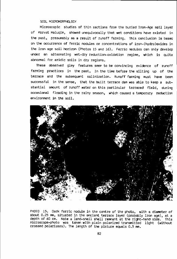
SOIL MICROMORPHOLOGY
Microscopic studies of thin sections from the buried Iron-Age soil layer
of Horvat Haluqim, showed unequivocally that wet conditions have existed in
the past, presumably as a result of runoff farming. This conclusion is based
on the occurrence of ferric nodules or concentrations of iron-(hydro)oxides in
the Iron age soil horizon (Photos 15 and 16). Ferric nodules can only develop
under an alternating wet-dry reduction-oxidation regime, which is quite
abnormal for aridic soils in dry regions.
These observed gley features seem to be convincing evidence of runoff
farming practices in the past, in the time before the silting up of the
terrace and the subsequent salinization. Runoff farming must have been
successful in the sense, that the built terrace dam was able to keep a sub
stantial amount of runoff water on this particular terraced field, during
occasional flooding in the rainy season, which caused a temporary reduction
environment in the soil.
PHOTO 15. Dark ferric nodule in the centre of the photo, with a diameter of about 0.25 mm, situated in the ancient terrace layer (probably Iron age), at a depth of 60 cm. Note a land-snail shell remnant at the right-hand side. This microscope-photo was taken with plain polarized transmitted light (without crossed polarizers). The length of the picture equals 0.5 mm.
82

Iron, which is usually present in the alluvial loessial soils under con
sideration, can become mobile in a wet, reduced environment. Through diffusion
processes the iron may move to certain micro-sinks in the soil, near spots
where voids facilitate the entry of air (oxygen). Here the iron is again
oxidized and immobilized as a result. These diffusional micro-sinks may
develop into concentrations of iron(hydro)oxides or ferric nodules after a
certain period of time.
The formation of ferric nodules may take place within a relatively short
time range in the order of one hundred to a few hundred years, depending upon
various circumstances (Brinkman, 1986, personal communication). For more soil-
chemistry information on this issue, the reader is referred to Brinkman (1979)
and Van Breemen (1986). A more detailed account of the soil micromorpholgy of
this terraced field at Horvat Haluqim will be published elsewhere.
PHOTO 16. Dark ferric nodule in the centre of the photo, with a diameter of
about 0.35 mm, situated in the ancient terrace layer (probably Iron age), at a
depth of 75 cm. This microscope-photo was taken with plain polarized transmit
ted light (without crossed polarizers). The length of the photo equals 0.5 mm.
83

STRATIGRAPHIC CONCLUSIONS
On the basis of the field and laboratory data a fivefold stratigraphic
division is made within the investigated deposits, arranged in a soil-
sedimentary sequence from the terrace surface downward. The stratigraphic
indices are similar to those appearing in the soil horizon designation of
Tables 11 and 12.
I. POST IRON-AGE SEDIMENTATION PHASE-2. The upper 30 cm of alluvial loes-
sial sediment (pit-2) has an average clay content of 16.1 %, whereas the
amount of total phosphorus (0.25 % P205) is lower than in the subsoil. The
phosphorus content, very stable in a calcareous environment, is understood to
reflect the influence of human activity.
II. POST IRON-AGE SEDIMENTATION PHASE-1 (RUNOFF-FARMING PERIOD-2?). The
alluvial loessial deposits at a depth from 30-75 cm (pit-2) contain on the
average more clay (21.6 %) than the overlying layer, whilst the phosphorus
content suddenly rises to about 0.34 X. It seems likely that the lower part of
this layer is transitional to the Iron Age soil, exhibited in pit-1.
III. IRON-AGE LAYER (RUNOFF-FARMING PERIOD-1). The buried Iron-Age horizon
appears in pit-1 at a depth from about 50-100 cm. The lower clay content of
the alluvial loessial sediment may be due to the closer proximity of pit-1 to
the main part of the stream channel. The phosphorus and organic C content
reaches peak values in this horizon of 0.55 % and 0.74 %, respectively.
IV. PRE-TERRACING (PRE-RUNOFF-FARMING) ALLUVIAL LOESSIAL SEDIMENTS. Below
the buried Iron-Age horizon, the phosphorus and organic C contents show a
significant decline to 0.13 % and some 0.30 %, respectively. This clearly
indicates the beginning of an alluvial loessial layer, predating the period of
runoff farming and the influence of man. A weakly developed calcic horizon
(140-175 cm depth) is present in this layer.
V. GRAVELLY ALLUVIAL SEDIMENTS. The amount of gravel increases sharply at a
depth of 175 cm, which marks the upper boundary of coarser alluvial sediments,
mixed with silt loam. At 225 cm depth, bedrock was not yet reached.
A number of significant stratigraphic conclusions can be drawn from this
excavation in the 12th terraced field of the Eastern Wadi of Horvat Haluqim.
84

Since the Iron Age soil surface appears at an average depth of about 70 cm, it
seems beyond any doubt that loessial soil already existed in this wadi, when
the terraced wadi system was first built for runoff farming purposes. More
than 155 cm of soil was already present at this particular spot, when the
ancients decided to terrace the wadi. The upper 100 cm consisted of fine
loessial soil, whilst the gravel content increased below this level. The more
gravelly subsoil, also mixed with silt loam, was still capable of keeping
moisture in its profile. Thus the entire 155+ cm of soil, already present at
the onset of the ancient runoff-farming period, could have stored runoff water
to sustain field crops or trees.
Kedar (1957) expressed the view that one of the main purposes of the
ancients to built the many thousands of dams across the wadis in the Negev was
to enable soil to accumulate, so that agriculture could be practised in a
later stage. Kedar apparently assumed that no soil or not enough soil was
present in many wadis designated for runoff farming by the ancients, when they
first decided to built these dams. This view clearly does not seem to fit the
stratigraphy of the terraced field described above. Enough soil was already
present, when the ancients, presumably the ancient Israelites (Cohen, 1976),
built dams across the little wadi(s) at Horvat Haluqim.
The main and probably sole purpose to terrace the wadis was the retention
of runoff water rather than soil. The fact that more sediment also began to
accumulate as a result of damming, was a secondary factor, not always welcome
perhaps, as it necessitated the building of new layers of stones on top of the
dams in the course of time. On the other hand, the annual addition of some new
sediment with every flood onto the wadi terraces might have contributed to
rejuvenate soil fertility and keep it at a higher natural level than without
this seasonal accumulation of eroded surface material from the slopes of the
surrounding catchment.
85

Estimated wheat yields under runoff-farming conditions in antiquity, related to Horvat Haluqim
INTRODUCTION
How many people might have been fed at Horvat Haluqim in the past
with locally produced food, grown in the three small terraced wadis? It is
impossible to give an accurate answer to that important question without
modern research data from the actual site about yields of food crops in
relation to year-to-year climate, crop rotation systems and manuring
practices.
In modern research about runoff farming in the Negev (Evenari et al., 1971,
1982) the Terraced Wadi System has not been investigated, whilst agricultural
examinations of the Hillside Conduit System (Avdat and Shivta), Diversion
System (Avdat) and Liman System (Wadi Mashash) were largely concentrated on
fruit trees. Some data about wheat yields are available from the Avdat experi
mental runoff farm for the period from 1961/62 to 1966/67. These data, though
quite interesting, are of limited value to assess yields in antiquity, since
chemical fertilizers were used, except for the first year 1961/62.
An initial beginning has been made by the author to investigate the crucial
question of climatic variability in dry regions and self-sufficient food
production based on runoff farming (Bruins et al., 1986b). Future research on
this subject should involve systematic year-to-year food crop production,
evaluated in relation to climate, rainfall and runoff amounts, crop rotation,
cropping patterns, and soil fertility (manuring). Such knowledge is vital to
assess the viability of runoff farming in the Negev as a food-crop producing
system, in past and present. Research on this issue may help to resolve some
86

historic-archaeologic related questions, and will provide know-how on climate-
defensive measures that might be taken with regard to runoff farming in
developing countries.
Despite all the shortcomings in our knowledge today, a rough estimation can
be made about the magnitude of past food production at Horvat Haluqim, as well
as the amount of people that might have subsisted on this local produce.
WHEAT YIELDS BASED ON ANCIENT LITERARY SOURCES
About 73 % of the average food basket today is composed of cereals
(Buringh, 1977). This percentage was probably even higher in the past, when
cereals and legumes (pulses) made up the major part of the diet. Noteworthy is
the remark made by Pliny (Nat. Hist. 18.21.94-95; Loeb ed., vol 5, p.249):
"Nothing is more prolific than wheat - Nature having given it this attribute,
because it used to be her principal means of nourishing man". It thus seems
reasonable to base the following calculations entirely on cereal production
and consumption data.
The unique Nizzana papyri of the 6th and 7th century A.D. are the only
historical documents that provide actual data on ancient yields of food crops
in the Runoff Farming District of the Negev. Document 82 (Mayerson, 1955;
Kraemer, 1958) mentions the yields of wheat, barley, and aracus (a legume)
during a certain year in the 7th century in the Nizzana area. Apart from the
fact that aracus is a legume, its specific typological meaning is unknown
TABLE 13. Yields of wheat, barley and aracus in the Nizzana area, grown in a
certain year during the 7th century A.D. under runoff farming
conditions (after Mayerson, 1955).
PLACE
Ragorios to
Malalkani
Alphag
Alphag
Berain
Berain
Kat
CROP
Wheat
Wheat
Wheat
Barley
Barley
Aracus
Modii SOWN
40
40
180
50
40
30
Modii REAPED
270
288
1225
402
350
97
YIELD
6.8 -fold
7.2 ,,
6.8 ,,
8.0 ,,
8.8 ,,
3.2 ,,
87

(Mayerson, 1955). Yields are usually stated in ancient literary sources as the
volume amount harvested with respect to the volume amount sown. The yields in
the Nizzana papyri are expressed in terms of modii sown and modii reaped
(Table 13). One modius is 8.7 litres (Mayerson, 1955:271).
Today crop yields are generally presented as the weight of the harvested
crop per unit of field area, often in kg or ton per hectare. Whereas a liter
of water is always a kg, a liter of wheat will not always have the same
weight, as this depends on the size of the grains and their specific weight.
Variations in the weight of a liter of wheat are, therefore, likely between
different wheat varieties. A liter of barley or aracus will likewise have
different respective weights. Thus we are faced with a problem to translate
ancient yields, expressed in volumes, accurately into kg, or into kg/ha, for
comparison with present yields.
Mayerson (1955:55) estimates 4 modii to be the approximate equivalent of
one U.S. bushel, which means that in his opinion one modii of wheat is about
6.8 kg. In an article on wheat-farming during Roman times, White (1963)
appears to have used the following equation: 1 modii = 5.88 kg of wheat. This
latter figure is used in the following calculations, to facilitate comparison
with modern yields. Few other literary data exist about yields in antiquity in
the Mediterranean region. Wheat is usually the only crop on which some ancient
information is available (White, 1963; Feliks, 1963; Sperber, 1978).
The question arises how much seed of wheat was sown per unit of area in
antiquity? Information on this matter may enable the translation of ancient
sowing amounts and yields into kg/hectare. In addition it is important to know
what the ancients thought about sowing practices with respect to climatic and
soil conditions. The Nizzana papyri do not contain information on this matter.
White (1963) studied both of these aspects from ancient Roman literary
sources. Despite the fact that the available Roman sources do not touch upon
runoff farming as such, their data are quite instructive and may serve as a
basis to estimate the likely amount of wheat sown under rather dry conditions.
The report by Cicero (In Verr., II, iii, 112) about wheat yields in the
Leontini district of Sicily in the year 70 B.C. is most useful. Cicero does
not only report the ancient wheat yields in that region in the usual volume
tric comparative way, as being 8- to 10-fold the amount sown, but also states
the amount of wheat sown per unit of area.
This important historical text enabled White (1963) to calculate the yield
reported by Cicero as 48 modii per iugerum. This is either an 8-fold or a 10-
fold yield according to whether the seed is sown at the rate of 6 or 5 modii
88

per iugerum. An iugerum is 0.252 hectare (Mayerson, 1955:271). White (1963)
translated this past wheat yield in Sicily of the 1st century B.C. into the
more modern expression of 11.2 quintals per hectare, which is 1120 kg/ha.
Hence one modii of wheat is estimated to be 5.88 kg, whereby one modii per
iugerum equals 23.33 kg/ha. The amount of wheat sown per hectare in Sicily
during the 1st century B.C. seems, therefore, to have ranged in between 112
and 140 kg/ha.
THE QUANTITY OF WHEAT SOWN IN RELATION TO SOIL AND CLIMATE
White (1963) reports the following information from ancient literary
sources about variations of the quantity of seed sown per hectare with respect
to soil and climate conditions in Roman times:
Varro merely recommends the farmer to adapt the quantity of seed sown to
local soil conditions. Columella (De Re Rust., II, IX, 5-6) provides a more
comprehensive account of the matter:
"If the field is moderately stiff (cretosus) or wet (uliginosus) you need
for winter wheat (siligo) or common breadwheat (triticum) rather more than
five modii... But if the ground is dry (siccus) and loose in texture
(resolutus), no matter whether it be rich or lean, only four; for conversely,
lean land requires the same amount of seed; unless it is sown thinly, it
produces a small and empty head. But when it branches out into several stalks
from one seed it makes a heavy stand from a light sowing."
From this passage it is clear, as pointed out by White (1963), that the
dominant consideration in deciding whether to sow thinly or thickly is the
moisture content and texture of the soil. The same distinction is made by
Pliny (Nat. Hist. XVIII, 199):
"In dense, chalky or moist soil sow six modii of winter wheat or common
wheat, but in loose, dry and fertile soil, four: A meagre soil produces a
small and empty ear unless it has the stalks far apart, whereas fields with a
rich soil produce a number of stalks from a single seed and yield a heavy crop
from thinly-sown seed."
It was customary in Greece and Italy to sow either early in autumn (light
89

rains) or immediately before the onset of winter (White, 1963) with its heavy
rains. In early autumn the seed would be sown thinly, whilst just before the
winter it was sown thickly (Theophrastus, Caus. pi., Ill, 25; qf. White,
1963). Columella (De Re Rust., II, IX, 6) points out that the thin early
sowing enables the plant to form stools during the winter and branch out.
Inter-cropping of cereals with olives and vines was extensively practised
in Roman Italy (White, 1963). It is not known whether inter-cropping of this
kind was also carried out in the arid Negev desert under runoff farming
conditions in antiquity. From the Nizzana papyri a threefold land division can
be deduced in the 7th century A.D. (Mayerson, 1955; Kraemer, 1958):
(1) Seedland, mainly used for food crops like wheat and barley.
(2) Vineyard.
(3) Garden or orchard.
This differentiation seems to suggest a division of cropping in the central
Negev desert rather than the example of inter-cultivation in Roman Italy.
ESTIMATED AMOUNT OF WHEAT SOWN IN THE CENTRAL NEGEV DESERT
AND CORRESPONDING YIELDS
Considering the advice of Columella (De Re Rust., II, IX, 5-6) and Pliny
(Nat. Hist. XVIII, 199) to sow 4 modii of wheat, presuambly per iugerum, in
dry soil, it is assumed that a similar amount of 4 modii/iugerum, which is
about 93.3 kg/ha, was sown in antiquity in the dry Negev desert. This is one
modii less than the amount of 5 modii per iugerum, as suggested by Mayerson
(1955). The amount of 93.3 kg seed per hectare fits very well within the range
advised by the agricultural compendium for rural development in the tropics
and subtropics (Ilaco, 1981), put at 70-100 kg/ha for line sowing, and 25 % more where broadcasting is practised, i.e. 88-125 kg/ha.
The number of hectares sown and the wheat yields in kg/ha can thus be
calculated from document 82 of the Nizzana papyri, for a certain year in the
7th century A.D. in the Nizzana area, grown under runoff farming conditions
(Table 14). The average yield amounts to 646 kg/ha, which is considerably less
than the figure of 943 kg/ha calculated by Mayerson (1955). The difference is
caused by his assumption of a sowing rate of 5 modii per iugerum, and one
modii of wheat being equal to 6.8 kg.
90

TABLE 14. Calculated yields of wheat and the amount of hectares sown in three
individual historic cases in the Nizzana area (central Negev) * ,
compared with past yields from selected other regions. #
PLACE TIME Modii Modii HECTARES YIELD SOWN REAPED sown (kg/ha)
Nizzana area 7th cent. A.D. 40 270 2.52 630
Nizzana area 7th cent. A.D. 40 288 2.52 672
Nizzana area 7th cent. A.D. 180 1225 11.34 635
Roman Sicily
Sicily
Italy
Italy
Syria
Tunisia
Israel
70 B.C.
1959
Varro (+ 30 B.C.)
Columella ( + 50 A.D.)
1949-1957
1949-1957
1910-1930
1120
1060
1200
500
700
500
531
* Based on document 82 of the Nizzana papyri (Mayerson, 1955; Kraemer, 1958) # and data from White (1963) and Stanhill (1978). The assumed sowing rate is
4 modii/iugerum (93.3 kg/ha), whereby 1 modii of wheat is assumed to have a weight of 5.88 kg.
EVALUATION OF ANCIENT WHEAT YIELDS IN THE LIGHT OF MODERN RESEARCH
The calculated average wheat yield of 646 kg/hectare from the Nizzana
area is slightly above the outcome of modern field experimentation of wheat
yields in Israel from unfertilized plots, being on the average 580 kg/ha (J.
Ephrat, 1977, personal communication, qf. Stanhill, 1978). This is considered
to be a confirmation of the realistic value of the calculated Nizzana yield.
For it is rather unlikely that any significant fertilization could have been
accomplished in antiquity on the runoff farming fields of the central Negev
desert.
Notwithstanding the unique system of runoff farming, the desert environment
does have a limited carrying capacity with regard to the amount of people and
91

accompanying animals that can be supported per unit of desert area. Moreover,
extensive livestock rearing, common for arid regions, is not quite a system
which allows manure to be concentrated for use on the arable lands for food
crop production. Therefore, apart from what the animals drop during their
allowed grazing of certain stubble fields, no animal manure was probably added
to the fields.
It is clear from the studies by De Wit (1958) and his colleages (Van Keulen
and De Wit, 1975; Van Keulen, 1979, Penning de Vries and Djitaye, 1982;
Penning de Vries, 1983) that lack of fertilization is, apart from water, the
main reason of low yields in arid regions. This is also the conclusion from
Stanhill (1978) in his research about an autarkic agro-ecosystem of a typical
fellah's farm in the Yizreel Valley of Israel, based on data from the first
decades of the 20th century. The average rainfall in the area is at present
about 483 mm per year. Average wheat yields amounted to 531 kg/ha (Table 14,
last figure), whereby wheat was the most important crop in this agro-
ecosystem. Stanhill (1978) concludes "that the main factor limiting wheat
yields on the fellah's farm was the complete absence of fertilization".
WHEAT YIELDS FROM THE AVDAT EXPERIMENTAL RUNOFF FARM
The comparatively few data acquired by Evenari and his colleages on wheat
yields at the Avdat experimental runoff farm are not representative of ancient
runoff farming conditions, since modern fertilizers were used in all cases,
except for the first year. It seems nevertheless worthwile to quote their
interesting results:
1961/1962 SEASON (Rainfall 64.7 mm)
The first flood was on December 6, 1961, and penetrated to a depth of 120
cm, which corresponds to 2000 cubic meter of available moisture per hectare or
200 mm of effective rainfall. This proved to be the only flood of the rainy
season and the wheat developed without any additional water. The wheat varie
ties Ethit and Florence Aurore 8/39 were sown on 17-12-1961 by broadcasting on
a field that had received an amount of 35 cubic meter of manure per hectare.
The plants emerged on 29-12-1961. Full ripening and harvesting of Florence
occurred on 21-4-1962 and 20-5-1962, respectively; and of Ethit on 30-4-1962
and 17-5-1962. The yields of the two varieties were 950 kg/ha and 600 kg/ha,
respectively (Evenari et al., 1963).
92

1962/1963 SEASON (Rainfall 29.5 mm)
The research program for field crops was not carried out because of the
drought conditions. All available water was diverted to the orchard and the
range plants and the plots for the annual field crops were left dry (Evenari
et al., 1964).
1963/1964 SEASON (Rainfall 183.3 mm)
There were three large and prolonged floods in December 1963, on 1-4, 10-11
and 30-31 of that month. During each of these floods the field crop plots were
inundated for 24-48 hours. The plots received 9200 cubic meter of water per
hectare, which is equal to 920 mm of effective rainfall. Moisture filled the
soil several times to a depth of more than 3 meter. Prior to seeding the plots
were prepared with a roto-tiller 5 days after the (second?) flood and ferti
lized with 300 kg/ha ammonium sulfate (21% N) and 800 kg/hectare superphos
phate (15% P205). Two wheat varieties, Florence Aurore 8/39 and Ethit, were
sown on 25-12-1963 in rows 20 cm apart, with a seed rate of 130 kg/ha. Good
but slow emergence started 11 days after sowing; bird damage was severe and
could not be controlled. The dates of full ripening and harvesting of Florence
are 6-4-1964 and 20-5-1964, respectively; and of Ethit 14-4-1964 and 8-5-1964.
The yield of Florence was 1950 kg/ha and of Ethit 1390 kg/ha (Evenari et al.,
1965).
1964-1965 SEASON (Rainfall 144.2 mm)
Since the first flood of the rainy season was late, on 12-1-1965, no wheat
was sown this year. Runoff flows were recorded on 14 days (Evenari et al.,
1968).
1965-1966 SEASON (Rainfall 91.5 mm)
An early flood occurred on 5-10-1965. The field plots for wheat received
prior to sowing 500 kg/ha superphosphate (26% P205 ), 400 kg/ha ammonium
sulphate (21% N), and 40 cubic-metre/ha organic manure. Sowing (150 kg/ha) of
the Florence wheat variety and the Thesera 41 dwarf variety was carried out on
23-10-1965, by which the latter variety received an additional top dressing of
200 kg/ha ammonium sulphate (21% N). Harvesting took place on 7-5-1966, but
the published results are somewhat confusing: p. 27 mentions a yield of the
Florence variety of 4380 kg/ha, whereas table 85 gives a figure of 2670 kg/ha
for Florence and 4380 kg/ha of the Nanasit wheat variety, not mentioned ear
lier. The yield of Thesera 41 is not stated (Evenari et al., 1968)
93

1966-1967 SEASON (Rainfall 80.7 mm)
Seven very small floods occurred and field crops did not develop at all
during this season (Evenari et al., 1968).
ESTIMATED WHEAT YIELDS AND RELATED POPULATION LEVELS AT HORVAT HALUQIM
In the only year that no chemical fertilizers were given to the wheat
sown at the Avdat experimental runoff farm, but "only" 35 cubic-metre/ha of
manure, yields were 600 kg/ha and 950 kg/ha, respectively, for two different
wheat varieties. It is unlikely that such an amount of manure could have been
supplied yearly to the ancient seedlands in the Runoff Farming District of the
Negev in antiquity. During the 6 years from 1961/62 to 1966/67, no wheat was
sown or harvested during 3 years, for lack of runoff water or the first
seasonal flood being too late. The average wheat yield at the Avdat experimen
tal runoff farm during these 6 consecutive years, including the years without
any yield, is 995 kg/ha, obtained with the stated amounts of chemical fertili
zers and manure.
Average runoff water supply to the runoff farming system in the Nizzana
desert area (present annual rainfall about 86 mm) during the 7th century A.D.
might also have been 200-500 mm in the year that the yields were recorded. It
seems unlikely that fertilization was much better in this desert region than
in the semi-arid Yizreel Valley. Hence it seems also unlikely that wheat
yields were much higher than 500 to 600 kg/ha in the Rur ff Farming District
during the 7th century A.D. The average yield of 646 kg/ a, calculated from
the Nizzana papyri on the suppositions described above (Table-14), does not
seem too low an estimate, therefore.
If conditions during the functioning of the runoff farming village at
Horvat Haluqim, roughly 3000 years ago, were more or less similar to the
farming situations decribed above, the 2.07 hectare of terraced fields in the
three wadis may have yielded some 1242 kg of wheat per year, based on an
assumed average yield of 600 kg/ha.
This quantity has to be reduced by the seed stock required for next year
(about 200 kg) and post-harvest losses (Hall, 1970; Van der Lee, 1978) of some
10 % (125 kg), which leaves an estimated 917 kg/year for human consumption.
Broshi (1980) takes the figure of 250 kg grain/person/year as an overall
minimum average required for human subsistance. These aspects of human food
requirements are treated in more detail in chapter 11. Thus only about 4
94

people could have lived on the food production of the three terraced wadis.
Even assuming the possibility of high average yields of 1200 kg/ha, not more
than 8 people could have been nourished by the local produce.
As past population figures at Horvat Haluqim were certainly higher, consi
dering the amount of houses and other buildings (Cohen, 1976), the conclusion
has to be that either much more terraced wadis in the vicinity of the site
were incorporated in the local food economy, or food was regularly supplied
from outside, e.g. from the wetter northern part of the country.
95

1. <% HAR
--« ». HAMRAN
/ < / .
\ \ \ \ \ \ / • \ » w
IV k \ \ \ r K V-
HAR HORSHA
'tf'ft ESCARPMENT
O SPRING
• TELL
A NAHAL MITNAN SITE
0 1 2 3 4 5 1 I I I I I km
FIGURE 11. Area of Kadesh-Barnea and Nahal Mltnan
FIGURE 12. Area
of Nahal Mitnan
in more detail.
sV ;V.
i v «—y*
• ! -<IS.V«H-V . •
\ r\r
4*X&.
^
M .'•J>
•€
' - ^ ^ „ . * 5 f / ' ^ S T * ^ - - 1 ^ - f e 11
• FARMSTEAD
* V U c TERRACED WADI
^ / * 600 m Contour
2 J
km
96
7 Nahal Mitnan
ENVIRONMENT
The terraced wadi of Nahal Mitnan is situated close to the border
with Sinai (Egypt), at a distance of about 37 km south-west of Horvat Haluqim,
as the crow flies. Some 9 km farther to the south-west, already in Sinai, lies
the Valley of Ein el Qudeirat, considered to be the area of Kadesh-Barnea
(Figure 11), extensively dealt with in the next chapter.
Nahal Mitnan is a tribuatary of Nahal Horsha, lying in the Loz-Horsha zone
of the runoff farming district, south of the Nizzana zone (Kedar, 1967). The
wadi flows from south-west to north-east and is about 3.5 km long, over which
length it is joined by its own tributaries of the first to third order (Figure
12). Nahal Mitnan is terraced over most of its length. The terraced parts of
the wadi descend from about 540 m to 475 m, when it joins Nahal Horsha. Its
average gradient is nearly 2 %. Many of its tributaries are also terraced.
Nahal Mitnan drains part of Sheluhat Kadesh-Barnea, a mountainous range
situated to the north-west, which rises to an altitude of 682 m.
This range forms part of a complex folding structure, together with Har
Hamran (704 m) to the east (Figure 3 ) , that seems to be connected with the
east-west trending Saad-Nafha-Hallal fault lineament (Bartov, 1974; Zilberman,
1981). A structural saddle, through which Nahal Mitnan and Nahal Horsha are
able to flow northward, separates Sheluhat Kadesh-Barnea from Har Hamran
(Zilberman, 1981).
The area drained by Nahal Mitnan is largely composed of well-bedded lime
stones, with some silicified horizons, belonging to the Nahal Yeter Formation
of Middle Eocene age (Benjamini, 1979; Zilberman, 1981). The Early Eocene
97

Nizzana Formation is exposed along the entire south-eastern hillslope flank of
Sheluhat Kadesh-Barnea, built of limestones and chalky limestone with some
chalk lenses. The soft marls of the Late Cretaceous to Early Tertiary Taqiye
Formation, cropping out just over the top of this mountainous range
(Zilberman, 1981), are apparently not drained by upper, first order, tributa
ries of Nahal Mitnan, with a few possible exceptions.
The average annual rainfall for the area is estimated at about 75 mm (p.
110). The hillsides are characterized by shallow desert lithosols and bare
rock outcrops, which support a very scattered shrub vegetation dominated by
Zygophyllum dumosum, Reaumuria negevensis, and Artemisia herba-alba (Danin,
1983). Most vegetation is concentrated in the terraced wadis, dominated by the
Thymelaea hirsuta - Achillea fragrantissima association. The alluvial loessial
soils in two adjacent wadi terraces were investigated by the author, the
results of which are presented below.
ARCHAEOLOGY
A farmstead, situated along Nahal Mitnan, at a distance of some 2 km
upstream (south-west) from the confluence with Nahal Horsha, was excavated by
Mordechai Haiman (1982). The farmstead is located on a natural terrace south
of the stream bed of Nahal Mitnan, at an altitude of about 510 m, near the
edge of limestone hills made up by the Eocene Nahal Yeter Formation. As the
farmstead lies somewhat higher than the wadi-bed below, its former inhabitants
could keep an eye on the terraced fields (Photo 17).
The following data from the excavated farmstead, which has a size of 50 x
20 m, are quoted from Haiman (1982): The farm comprises 11 rooms and court
yards. The rooms are square (4 x A m ) , whereas the courtyards are rectangular,
measuring about 7.5 x 5.5 m. The walls, 60 cm wide, were built of two parallel
rows of limestone blocks (30 x 20 cm) with a filling in the intervenient
spaces. Haiman noted the high building quality with carefully laid courses and
precise right angles.
The pottery found at the site, e.g. delicate bowls painted with a net
design, cooking pots, juglets, and an undamaged oil lamp, dates to the 7th and
8th century A.D. An Arabic inscription was found on both sides of a glass
disc. Other finds included fragments of iron and copper tools, mortar pieces,
pounders, grinding stones, and a large number of millstones, which might
suggest that cereal food crops were an important part of local runoff agricul-
98

ture in the terraced wadi systems. It seems that a Byzantine to Early Arab age
can be attributed to the farmstead, as well as to other complexes along the
banks of Nahal Mitnan and its tributaries (Haiman, 1982).
* -*?.
PHOTO 17. Nahal Mitnan with the Byzantine-Early Arab farmstead in the forefront, overlooking the terraced fields toward the hills of Shluhat Kadesh-Barnea. The dam and terraced fields nearest to the farmstead were investigated (pointed out by the arrow).
STRATIGRAPHY AND SOIL DEVELOPMENT IN BYZANTINE
WADI TERRACES OF NAHAL MITNAN
STRATIGRAPHY
The terraced stream bed of Nahal Mitnan is flanked on both sides by
natural wadi terraces, which presumably date back to the Late Pleistocene. The
fine loessial sediments of these natural terraces were deposited when the wadi
bed was situated at a higher level than today. A serozem soil with a well
developed calcic horizon has formed in these natural terrace deposits. The
farmstead is actually located on the upper part of such a Late Pleistocene
terrace near the Eocene hillside edge.
99

*&
b'SPo^Wi M-C V»c5&
• IM-C
IV-C
• 66
• 11 n,E |—| 110
O O O ° ° © °
° o W GRAVEL LAYER
• SAMPLE 50
= L _ 100
==) cm
FIGURE 13. Stratigraphy of a check-dam and two adjacent terraced fields in
the wadi bed of Nahal Mitnan.
Two pits were excavated into the man-made historical terraces within the
wadi bed, on both sides of a check-dam that is located nearest to the farm
stead described above. The dam, built for runoff farming purposes, is in all
likelihood related to the adjacent farmstead and seems, therefore, to date
back to the Byzantine period. Only one small piece of ribbed pottery, appa
rently Byzantine, was found during the excavations inside the two terraces.
The dam is silted up unto its brim with respect to the upper terrace,
whilst it rises some 40 cm above the surface of the lower terrace, downstream
of the dam. As the prime object of the excavation was to study the sedimentary
stratigraphy and soil development of the man-made terraces, the dam was not
excavated from inside and its architecture not thoroughly investigated. It is,
however, quite clear that the building style of this dam is much more precise
and orderly than the dams at the site of Horvat Haluqim, which may date back
to the Iron age or even earlier.
The pit, excavated into the terrace downstream of the dam (Figure 13),
surprisingly revealed a hidden lower part of the dam, buried below alluvial
100
loessial wadi sediments. The dam is thus more complex and wider than initial
ly anticipated, having a width of about 2 meter. This lower part of the dam is
110 cm high, built of 5 courses of limestone blocks, arranged in neat layers
(Figure 13). The base of the lower dam rests on alluvial loessial sediments. A
gravel layer appears some 10 cm below the base of the dam. The pit was not
excavated beyond this gravel layer. The upper part of the alluvial deposits
exposed in this pit, including a thin gravel layer at a depth of 15-25 cm, are
obviously younger than the lower dam itself.
The other pit, excavated into the terrace upstream from the dam (Figure
13), exposed the base of the upper dam at a comparatively shallow depth of
about 40 cm below the present surface of this upper terrace. A thin gravel
layer occurs at a similar depth of 38-43 cm. As the terrace surface upstream
from the dam is about 40 cm higher than the terrace surface downstream from
the dam, it thus seems that these upper gravel layers, found in both pits,
constitute one and the same stratum. The sedimentary stratigraphy and appea
rance of the dam complex suggest that the upper part of the dam was built in a
later stage.
The reason for this addition was apparently the gradual silting up of the
terraced field unto the upper courses of the lower (then only) dam. The upper
gravel layer, indicative of more rapid stream flow in the wadi, was apparently
deposited at the end of this first aggradational period since the wadi was
terraced. In this stage the holding up function of the dams, by which the
runoff floods were arrested and sedimentation induced, had apparently been
overcome. Hardly any runoff flood waters could have been retained on the
field, as the dam was nearly buried below the aggradational deposits. This
necessitated the building of an addition to the dam on top of the alluvial
sediments that had accumulated.
However, the previous process repeated itself (the past is the key to the
future!) as alluvial sedimentation subsequently raised the level of the
terraced field unto the brim of the upper dam. This is the situation at
present. It is noteworthy that more alluvial loessial sediment has accumulated
upstream from the dam on top of the upper gravel layer, than downstream from
the dam (Figure 13).
SOIL DEVELOPMENT
The sediments downstream of the dam are somewhat finer textured than up
stream, presumably because of hydraulic differences in the flow of runoff
water on both sides of the dam. The alluvial soils in the terraced fields of
101

Nahal Mitnan, which accumulated
and developed during and since the
Byzantine period, contain more
clay than the alluvial soils in
the first order wadi of Horvat
Haluqim, apparently terraced du
ring the Israelite period.
TABLE 15. Granulometry and soil chemistry of alluvial loessial sediments in an ancient runoff-farming terrace in the wadi bed of Nahal Mitnan.
1) Terraced field upstream from a check-dam of apparent Byzantine origin.
HORIZON
A C II-C III-C III-C
HORIZON
A C II-C III-C III-C
HORIZON
A C II-C III-C III-C
DEPTH
(cm)
0-15 25-38 38-43 * 47-58 62-70
DEPTH
(cm)
0-15 25-38 38-43 * 47-58 62-70
DEPTH
(cm)
0-15 25-38 38-43 * 47-58 62-70
CLAY <0.00S
mm (X)
21.1 19.5
26.7 27.2
pH
7.4 7.4
7.4 7.4
SOLUBLE
Ca2+
1.0 0.7
1.6 1.6
SILT 0.002-0.063 (%)
56.1 47.8
52.6 51.8
EC(1:1)
(mS/cm)
0.45 0.34
0.46 0.54
SALTS IN
SAND 0. 2
D63-mm
(X)
22 32
20 21
1:
.i 2+ .. +
Mg Na
<0 <0
<0 <0
.10 4
.01 2
.10 5
.10 6
.2
.4
.3
.3
.8
.8
.7
.0
SAR
5.8 3.9
5.9 7.0
TEXTURE
SILT LOAM SILT LOAM GRAVEL SILT LOAM SILTY CLAY
ORGANIC CARBON
(X) c
0.79 0.56
0.46 0.58
GRAVEL >2 mm
(X)
1 0
2 LOAM 1
NITROGEN
(X) N
0.06 n.d.
n.d. n.d.
CARBONATES CaC03
(X)
43.0 45.4
44.9 45.5
TOTAL PHOSPHORUS
(x) P 2 O 5
0.16 0.13
0.15 0.15
L SOIL/WATER EXTRACT (meq/kg soil)
K+
<0.1 <0.1
<0.1 <0.1
HCO3
4.3 2.7
2.4 2.6
CI"
0.4 0.5
3.2 3.2
so2;
0.6 0.6
1.1 1.8
NO3
0 <0.1
0 • 0
Percentages in weight % of the fine earth <2 mm; only gravel in weight % of the total soil. EC = electrical conductivity. SAR = sodium adsorption ratio, n.d. = not determined. * Gravel layer at 38-43 cm depth.
102

TABLE 16. Granulometry and soil chemistry of alluvial loessial sediments in an ancient runoff-farming terrace in the wadi bed of Nahal Mitnan.
2) Terraced field downstream from a check-dam of apparent Byzantine origin.
HORIZON
A II-C III-C III-C III-C III-C IV-C
HORIZON
A II-C III-C III-C III-C III-C IV-C
HORIZON
A II-C III-C III-C III-C III-C IV-C
DEPTH
(cm)
0- 12 15- 25 * 30- 40 57- 66 77- 86 95-105
110-120
DEPTH
(cm)
0- 12 15- 25 * 30- 40 57- 66 77- 86 95-105
110-120
DEPTH
(cm)
0- 12 15- 25 * 30- 40 57- 66 77- 86 95-105
110-120
CLAY <0.002
mm (%)
25.0
25.9 36.1 34.5 28.2 21.8
pH
7.4
7.4 7.4 7.5 7.4 7.4
SOLUBLE
SILT 0.002 0.06] (%)
54.6
55.2 49.6 56.6 47.3 53.7
ECU
SAND TEXTURE GRAVEL - 0.063-( 2 mm
(%)
19
18 14 8
24 24
:1)
(mS/cm)
0.
0. 0. 0. 0. 0.
5ALTS
„ 2+ yl 2+ Ca Mg
2.8 <0
1.1 <0 1.1 <0 2.0 <0 0.8 <0 0.8 <0
.10
.10
.10
.10
.10
.10
70
30 28 63 28 25
IN 1:]
Na+
5.3
2.2 2.2 6.3 2.6 1.8
.6 SILT
>2
LOAM GRAVEL
.9 SILT 3 SILT\
.9 SILTV 6 CLAY 5 SILT-
SAR
4.4
2.9 2.9 6.2 4.1 2.9
LOAM CLAY LOAM
' CLAY LOAM LOAM LOAM/GRAVEL
ORGANIC CARBON (%) C
1.37
0.73 0.72 0.67 0.67 0.72
L SOIL/WATER EXTRACT
K +
0.2
<0.1 <0.1 <0.1 <0.1 <0.1
HC0~ CI"
7.5 0.7
3.3 <0.1 3.0 <0.1 2.7 4.4 2.5 0.3 2.4 0.1
mm
(%
2
0 0 0 4
15
CARBONATES
CaCO-7 (%)
40.9
41.1 44.1 44.2 43.9 46.8
TOTAL PHOSPHORUS
;%) P205
0.18
0.15 0.18 0.18 0.14 0.11
(meq/kg soil)
so2~ N O : 4 3
0
0 0 0 0 0
.7 0
.2 0 2 0
.9 0.3 4 0 3 0
Percentages in weight % of the fine earth <2 mm; only gravel in weight % of the total soil. EC = electrical conductivity. SAR = sodium adsorption ratio. * Gravel layer at 15-25 cm depth.
The soils in Nahal Mitnan are virtually free of soluble salts. The electrical
conductivity ranges in between 0.30 and 0.70 mS/cm. Sodium is the predominant
cation throughout the profiles, whilst hydrogen-carbonate is usually dominant
amongst the anions, often exceeding the amount of chloride, particularly in
103

the top-soil. As HC03 is generally the dominant anion in rainwater (Yaalon,
1963, 1964; Nativ et al., 1983) and runoff floodwaters (Nativ et al., 1983),
there appears to be a causal relationship in this respect.
The terraced wadi soils at Nahal Mitnan are considerably more calcareous,
containing an average amount of 44 % carbonates, than the sampled agricultural
wadi terrace at Horvat Haluqim, which contains 30 % carbonates on the average.
The difference is largely attributed to the different lithology in the respec
tive catchments. Comparatively softer limestone rocks with more intervenient
chalk layers make up the catchment of Nahal Mitnan, whereas harder Turonian
limestone rocks predominate in the catchment area of the Horvat Haluqim wadis.
The terraced wadi soils of Nahal Mitnan have a low organic C and nitrogen
content, typical for arid regions. The amounts concerned are slightly more
advantageous, however, than in the investigated agricultural wadi terrace at
Horvat Haluqim, perhaps related to a comparatively better soil moisture regime
in the more recent past.
The amount of total phosphorus in the studied soils of Horvat Haluqim is,
however, considerably higher than in Nahal Mitnan. Past human activity on the
former terrace appears to have been more pronounced, as indicated by the
reported finds. The phosporus distribution in Nahal Mitnan is nevertheless
internally consistent with the past influence of man, as the content of
horizon-IV, which predates human activity, is even lower than the overlying
layers that developed after the beginning of runoff farming.
The stratigraphic picture of the investigated check-dam and adjacent
terraced fields in the wadi bed of Nahal Mitnan can be summarized as follows,
in accordance with the horizon nomenclature used in the Tables 15 and 16:
I. The present surface layers of the terraced wadi (A and C horizons),
consisting of alluvial sediments that accumulated after the construc
tion of the upper part of the check-dam.
II. The upper gravel layer, which was deposited before the upper part of
the dam was added.
III. Alluvial sediments that accumulated after the terracing of Nahal
Mitnan for runoff farming purposes, i.e. after the building of the
lower part of the check-dam across this stretch of the wadi bed.
IV. Alluvial sediments predating the terracing of the wadi.
104

8 Kadesh-B arnea: environment, history and the tell
ENVIRONMENT
GE0M0RPH0L0GY AND GEOLOGY
The Highlands of the Central Negev continue for some 10-20 km across
the border into Egypt. Further to the west stretches the barren expanse of
Northern and Central Sinai, characterized by wide plains, plateaus, valleys,
individual hills, and isolated mountainous domes. Viewed from Sinai, the
Central Negev highlands, ranging in altitude from about 400 to 1000 meter,
look like an impressive mountainous plateau.
The Kadesh-Barnea area is situated at the western edge of these Highlands,
about 6 to 10 km inside Egypt (Figure 2, 14). The spring of Ein el Qudeirat,
arising in the gorge-like valley of Wadi el Qudeirat, is the most important
feature of the Kadesh-Barnea area in terms of man-land relationships. It is
apparently the richest spring of the entire Sinai and Negev desert region,
producing water of a relatively good quality. The average discharge of the
spring is about 61 cubic meters of water per hour, flowing as a perennial
stream in the channel of Wadi el Qudeirat over a distance of 2 km.
The rather narrow valley plain, in which the wadi has cut a steeply banked
stream channel, ranges in altitude from about 350 m at its mouth, near the
confluence with Wadi Urn Hashim, to about 405 m at the actual site of the
spring's major outlet. The valley is enclosed by a series of spiney ridges and
escarpments that emenate from the highlands. Gebel el Udah (522 m) limits the
area in the southwest, whereas Gebel el Qudeirat (500 m) bounds the Kadesh-
Barnea valley to the north (Figure 14). The width of the valley plain ranges
from about 400 m at its western entrance to some 40 m near the spring.
105

^ Jy ; , _ t
.&>* <"*N
HAR HAMRAN
•; . . . . . „ „ — , U » » \ V % > i '
J\ V--' . X ^ d i \ \ X \ M V?<S> \
V\ \ \ \ tn \_ r \
HAR HORSHA
^H ESCARPMENT
O SPRING
Q TELL
A NAHAL MITNAN SITE
2 km
FIGURE 14. The catchment of Nahal Kadesh-Barnea and the valley oasis of Ein
el Qudelrat, showing the location of the spring and the tell.
Viewed in a somewhat wider geological perspective, Gebel el Qudeirat forms
part of a complex folding structure related to the Saad-Nafha-Hallal fault
lineament. This is the main, east-west trending, linear fault system in the
northern part of the so-called Central Negev and Sinai shear belt, situated in
between the two main faulting zones of the Negev-Sinai region: the Dead Sea
Rift Valley in the east and the Suez Rift in the west (Bartov, 1974;
Zilberman, 1981). The ridge of Gebel el Qudeirat continues eastward as Gebel
el Ein and Sheluhat Kadesh Barnea, which together form the southern flank of a
complex, east-west trending, fold structure that includes Har Hamran farther
to the east. A structural saddle, through which Nahal Horsha and its tributary
106

Nahal Mitnan run northward, separates Har Hamran from Sheluhat Kadesh-Barnea
(Zilberman, 1981). Just north of Gebel el Qudelrat and Gebel el Eln exists a
complex fault system, which is related to the folding structure described
above, forming part of the Saad-Nafha-Hallal lineament (Bartov, 1974).
PHOTO 18. The Kadesh-Barnea valley and the beginning of agricultural cultivation (date-palms) near the broken Jarvis Dam, some A00 m downstream from the spring proper. The mountainous ridge south of the valley is built of Eocene calcareous rocks.
The steep, mountainous ridges north and south of the Kadesh-Barnea valley
are mainly built of hard limestones, as well as chalk, of the Eocene Avdat
Group, overlying the soft marl and chalk of the Mount Scopus Group in the
subsurface. The Lower to Middle Eocene Nahal Yeter Formation (Benjamini, 1979)
forms the upper part of the ridges, overlying the Lower Eocene Nizzana
Formation, which in turn overlies the Paleocene Taqiye Formation.
The Nahal Yeter Formation is composed of well-bedded limestone with some
silicified horizons. Large-scale deformations characterize the top of this
formation, formed by collapsed units of well-bedded limestone layers, 10-20 m
thick. These sedimentary structures may have been caused by Eocene earthquakes
107

(Zilberman, 1981). The Nizzana Formation consists of limestones and chalky
limestone with some chalk lenses. The layers exhibit small to moderate intra-
formational sedimentary disturbances, like small folds, detached layers, sedi
mentary conglomerates and small sedimentary faults. The underlying Taqiye
Formation is mainly composed of marl, cropping out at the lower part of the
northern and western slope of Gebel el Qudeirat, as well as across the
entrance of the Kadesh-Barnea valley near the confluence with Wadi Urn Hashim.
GEO-HYDROLOGY
The main upper aquiclude of the Central Negev Highlands is the Taqiye
Formation, mainly consisting of impervious marl. This formation underlies the
entire Eocene Avdat Plateau from Kadesh-Barnea in the west until the Zin
Valley in the east. Runoff rainwaters that have infiltrated into the under
ground may concentrate as shallow groundwater on top of the Taqiye marls. As a
result of this hydro-geological situation, some springs arise at favourable
locations on the outskirts of the Highlands, near outcrops of the Taqiye
Formation.
The gorge-like valley of Wadi el Qudeirat is incised into the Eocene Avdat
Group and actually cuts into the marls of the Taqiye Formation some 3 km
downstream from the point where the spring of Ein el Qudeirat emerges in the
wadi bed. The relation seems obvious, but the local fold and fault structures
of the Saad-Nafha-Hallal lineament, to which the Kadesh-Barnea area is connec
ted, may also have an important influence on the position of the spring.
The latter view seems concurrent with the existence of the nearby spring of
Quseima, 7 km west-northwest of Ein el Qudeirat, situated on the Saad-Nafha-
Hallal lineament. This spring appears to be almost as copious as Ein el
Qudeirat, having a discharge of about 50-60 cubic meter of water per hour, as
reported by Karschon (1984). The water of the Ein Quseima spring appears to be
of even better quality than the spring of Ein el Qudeirat. Its reported
chloride content of 250-300 mg/liter (7.1 - 8.5 meq/liter) is only half the
quantity occurring in the latter spring.
Data about the water of Ein el Qudeirat are shown in the following table.
The spring is flowing all year round and the differences in discharge between
the various months and years are relatively small, ranging in between 48 and
73 cubic meters of water per hour. The average discharge is about 61 cubic
meter/hour. This suggests a considerable relaxation time between rainfall
events in the catchment area and spring flow, probably caused by the buffering
effect of a sizeable natural storage of shallow groundwater.
108

TABLE 17. Discharge data and chemical analysis of the spring water of Ein el Qudeirat. (based upon data from the Israel Hydrological Service)
SAMPLE DATE
1926 23-08-1951 21-10-1969 19-01-1970 18-05-1970 16-07-1970 21-09-1970 17-02-1971
Ca Mg
89 45 4.44 3.70
DISCHARGE (cubic meter/24 hours)
Na+
330 14.35
1500 1400 1750 1150 1600 1450 1400 1400
K+
4 (mg/liter) 0.10 (meq/liter)
(cubic meter/hour)
HC0~
212 3.47
63 58 73 48 67 60 58 58
CI" SO^"
509 226 14.36 4.71
AGRICULTURAL EVALUATION OF THE SPRING WATER
The chemical composition of the water appeared to be fairly constant
during the years from 1926 to 1971. The chloride content ranged in between
500-580 mg/liter (14.1 - 16.4 meq/1). The amount of dissolved salts is about
1.42 g/1 and the electrical conductivity (EC) of the spring water is estimated
at 2 mS/cm. The sodium adsorption ratio (SAR) is 7.11, showing the sodicity
(alkali) hazard of the water to be low. This is confirmed by the negative
value (-4.67) of the RSC (residual sodium carbonate and bicarbonate), another
criterion to judge the sodium hazard of irrigation water (ILACO, 1981).
For irrigation purposes the water from the spring can be classified as
having a medium-high salinity hazard (Thorne and Peterson, 1964). The water is
suitable to irrigate crops with a moderate to good salt tolerance. Irrigation
is allowed on soils with a moderate to poor permeability. The crusting loam to
silt loam soils in the Kadesh-Barnea valley are, therefore, suited to this
type of irrigation water. Leaching with excess water is required, however, to
prevent a built-up of salts in the root zone.
RAINFALL
The average annual rainfall today in the Kadesh-Barnea area has to be
estimated from data of nearby locations. Mean annual rainfall at Quseima,
situated about 7 km west of Ein el Qudeirat at an altitude of some 300 m, is
109

64 mm (Israel Meteorological Service, 1967). Nizzana receives a mean annual
rainfall of 86 mm and lies 26 km north of Ein el Qudeirat at an altitude of
250 m. The average rainfall in the Kadesh-Barnea area (altitude of the Ein el
Qudeirat valley and of the surrounding ridges and highlands is 350-425 m to
over 500 m, respectively) can therefore be estimated at about 75 mm/year.
SOILS and VEGETATION
In terms of man-land relationships, the Kadesh-Barnea valley is not only
endowed with a copious spring, flowing all year round, but also with culti
vable soils formed in alluvial loessial sediments. These young alluvial soils
show little or no profile differentiation in the field. However, on close
examination, including microscope studies and chemical analysis, remarkable
features of soil development were discovered in the valley soils adjacent to
the steep banks of the narrow wadi channel.
Loessial serozems, usually exhibiting calcic, gypsic and saline horizons,
are found on more elevated Pleistocene terraces in the valley. Calcareous
desert lithosols and Brown lithosols occupy the surrounding hillslopes and
highlands, covered by a desert vegetation dominated by Zygophyllum dumosum,
Artemisia herba-alba, Salsola tetranda, Suaeda vera var. desertis.
The vegetation along the stream channel, fed by the flow of spring-water,
includes Tamarix nilotica, Nitraria retusa, Typha australis and Phragmites
australis (Danin, 1983, personal communication, cf. Goldberg, 1984).
HISTORY AND GEOGRAPHY
Kadesh-Barnea appears to be the principal place where the people of
Israel sojourned in the desert for some 40 years under the leadership of Moses
(Num. 14:33-34), after the Exodus from Egypt and before they entered the
promised land. Most references in the Bible to Kadesh-Barnea are indeed rela
ted to this period within the Late Bronze Age (1550-1200 B.C.), when the
Israelites "abode in Kadesh many days" (Deut. 1:46). However, the site is
already mentioned in the time of Abraham, in the Middle Bronze Age, around
1900 B.C., when Kadesh is equated with En-mishpat, "The Spring of Judgement"
(Gen. 14:7).
The location of Kadesh-Barnea can be inferred from the description of the
southern border of the Land of Israel (Num. 34:1-6; Ezech. 47:19; 48:28) and
of the southern border of the territory allocated to the tribe of Judah (Josh.
110

15:1-4). Numerous scholars of past generations have attempted to identify
biblical Kadesh-Barnea with sites in Sinai, the Negev, or even more distant
places, as summarized by Cohen (1981). A general scholarly consensus emerged
early in the 20th century, relating Kadesh-Barnea to the oasis of Ein el
Qude.i rat.
Woolley and Lawrence (1914-15) regarded the region around Quseima (Fig. 2)
with its springs and arable soil, at the crossroads of two of antiquity's
major desert routes, as the likely area of Kadesh-Barnea from a more broad
perspective. The sheltered valley-oasis of Ein el Qudeirat, in the eastern
part of the Quseima region, is considered by them as the most likely candidate
for Kadesh-Barnea in a more restricted sense, by which they focussed special
attention to the Tell.
The authors made their observations in January and Febuary of 1914. The
following quotations eloquently describe the area and some of the reasons for
relating it to Kadesh-Barnea (Woolley and Lawrence, 1936:88, 87): "These roads
running out to north, south, east, and west... together with its abundance of
water and wide stretch of tolerable soil, distinguish the Kossaima plain from
any other district in the Southern Desert, and may well mark it out as the
headquarters of the Israelites during their forty years of discipline... only
in the Kossaima district are to be found enough water and green stuffs to
maintain so large a tribe for so long, and that therefore the Wilderness of
Zin and Kadesh-Barnea must be the country of Ain el Guderat, Kossaima,
Muweilleh, and Ain Kadeis".
In their description of the springs in the Quseima region, they contrast
the barren and rugged area around Ein Qadeis with the more cultivable Quseima
plain and the oasis of Ein el Qudeirat. The latter site is clearly distin
guished as the most outstanding spot in the entire region (p. 75):
"In place of the solitary Ain Kadeis are Ain Muweilleh, in a soft wady bed;
Ain Kossaima, a plentiful running of water in the sand; and Ain Guderat, a
great spring, not set in a dung-heap like Ain Kadeis, or sand-choked like all
other Negeb springs, but bursting straight from the rock, and running down a
deep green valley of lush grass in swift irrigation channels, or in a long
tree-shaded succession of quiet pools many feet deep. This plain about
Kossaima runs from Muweillah on the west to the foot of the great pass of Ras
Seram on the east. In fortunate years it might be very fruitful; and in the
worst seasons its crops cannot entirely fail, thanks to the irrigated valley
of Ain el Guderat - the only stretch of corn-land under running water which we
saw in all the southern waste."
Ill

ARCHAEOLOGY OF THE TELL
Woolley and Lawrence were the first scholars with solid archaeologi
cal training to study the Tell in the valley of Ein el Qudeirat, situated some
1600 meter downstream from the spring, "commanding the finest water-supply in
all the desert" (p. 84). They described the tell as a little mound rising
above the surrounding corn-fields. After brief excavations, they found the
tell to be made up by the remains of an ancient fortress and contemplated the
possibility that it might have existed already during the time of the Exodus,
and perhaps be linked specifically to Kadesh-Barnea.
The excavations by Dothan in 1956 further clarified the ground plan of the
fortress, dating its construction to the Judean kings of the 8th-7th centuries
B.C. (Dothan, 1965). Thus, the tempting possibility posed by Woolley and
Lawrence (1936:88) "that the fort was already built when Moses came" turned
out to be unreal for this particular stronghold. A reliable stratigraphy was,
however, still lacking for the tell.
Rudolph Cohen conducted thorough excavations at the site during ten seasons
from 1976-1982. These extensive investigations revealed the remains of two
other fortresses. Thus the tell is not made up by just one stronghold of one
period, i.e. the Late Iron age, but by three superimposed fortresses, each one
built over the remains of its predecessor. A concise description of these
fortresses, quoted from Cohen (1981, 1983), follows at page 116. The Early
Fortress and a number of related buildings and silos appear to be the oldest
archaeological structures found at the site, attributed by Cohen to the 10th
century B.C. (Cohen, 1980, 1981, 1983).
CARBON-14 DATE (GrN-12330) - LATEST BRONZE TO EARLY IRON AGE
A charcoal sample was taken by the author in collaboration with Cohen
from one of the lowermost ash layers, some 5 meter below the surface of the
tell-mound. This layer seems stratigraphically connected with the destruction
of the Early Fortress. The sample was investigated at the Isotope Physics
Laboratory of Prof. Mook (University of Groningen) and yielded a date of 2,930
+ 30 BP in conventional Carbon-14 years (GrN-12330). When this date is trans
lated into historical years, calibrated against the high precision curve of
Pearson (1986), for reasons explained in the following section, the resulting
age of the ash layer is surprisingly early: 1255-1055 Cal B.C.
The natural level of carbon-14 in the atmosphere has not been constant with
time, as first reported by De Vries (1958) who made this important observation
112

PHOTO 19. The excavated tell in the valley of Ein el Qudeirat, exhibiting primarily the outline of the Upper Fortress (Late Iron Age). The stream channel carries the water from the spring along the southern part of the tell.
indirectly through C-14 measurements of tree-rings from European and North
American wood. A radiocarbon date, as a consequence, although consistent in
its own timescale, cannot simply be placed into a historical time framework.
First the carbon-14 date, expressed in conventional C-14 years, has to be
translated into astronomical years. The resulting calibrated C-14 date can
then be correlated with historically dated events (Mook, 1983).
In order to make this calibration possible, very detailed and precise C-14
analyses were carried out on wood of known astronomical age, dated by dendro
chronology. Research on oak wood from Ireland has resulted in a high precision
radiocarbon calibration curve, published by Pearson (1986).
A conventional C-14 date is always presented with a range of uncertainty,
called standard deviation (sigma cr). The probability that the actual date is
situated within this time period is 68 %. If the age range is enlarged to
about 3 sigma, the probability becomes virtually 100 %. It should also be
realized that a charcoal sample, in most cases, does not represent a single
113

year, like a tree-ring, but comprises a certain time-width. In an ideal situa
tion, the amount of detail in a calibration curve ought to be adapted to the
time-width of the C-14 sample (Mook, 1983).
when a radiocarbon date is translated from conventional C-14 years into
historical years, not just the median year of the C-14 date, but the entire
sigma related age range of the date has to be plotted against the calibration
curve. Apart from sigma (cr), the standard deviation of the calibration curve,
being 15 years, has to be taken into account as well in order to determine the
correct age range for calibration: (a) Calculate V o - 2 + 152; (b) The resulting
number X is added to the median year of the C-14 date, which gives the upper
time limit of the date's range to be calibrated; (c) X is subtracted from the
median year of the C-14 date, which gives the lower time limit of the C-14
date to be calibrated (Mook, personal communication, 1985).
The age range of the charcoal sample under discussion (GrN-12330; 2930 + 30
BP), to be used in the calibration plotting, is 2965-2895 BP in conventional
C-14 years. This sigma related time range of the date is plotted (Fig. 15)
against the high precision radiocarbon timescale calibration curve of Pearson
(1986). The resulting calibrated date for the black ash layer in historical
years is 1255-1055 Cal B.C.
Q_
m
< UJ >-
i
3100
3000
2965
2930
2895
2800 -
j. \/"\ I | ^ \ I | " I I
I . I
1400 1300 1255 1200
HISTORICAL YEARS B.C.
1100 1055
FIGURE 15. Calibration of the above C-14 date (GrN-12330) into historical
years (apparently related to the time of destruction of the Early Fortress).
114

Taken at face value this surprising outcome might indicate that the Early
Fortress is perhaps older than anticipated. If the ash layer is indeed related
to the time of destruction of the latter stronghold, then the radiocarbon date
of this ash layer suggests this to have occurred during the very end of the
Late Bronze Age or Early Iron Age. The logical implication is, that the time
of construction of the Early Fortress must be even older than the above C-14
date, pointing to the Late Bronze Age, perhaps.
The result of this radiocarbon date and its ramifications, touching upon
the dramatic transition from the Canaanite to the Israelite period in the
Negev and Sinai, as well as the outcome and stratigraphic context of other C-
14 dates from the tell, will be discussed and evaluated in a joint
publication.
The dated ash layer covered a soil profile with the following stratigraphy
and characteristics:
10
20
30
50
oOo " o " ° 0 o o o o o °
o o 00 °0
' O°„0 OB *oo° °o o °
A 0-10 cm Black ash layer.
C 10-20 cm Loessial soil, loamy texture, containing
1-2 % of white nodules.
II-A(C) 20-30 cm Loessial soil, sandy loam texture, con
taining a few small pieces of charcoal.
II-C 30-50+ cm Fine gravel mixed with sandy loam.
The ash layer can be regarded as a disturbed A horizon, overlying a C
horizon that consists of loess with a loamy texture. About 1-2 % of white
nodules, composed of gypsum or secondary carbonates, appear in this C horizon.
These nodules were formed by natural soil forming processes under the influ
ence of rainfall, which caused influx, dissolution, concentration and recrys-
tallization of these chemical compounds in the upper part of the soil.
It is obvious that nodule formation could only take place when the soil was
still situated at the former landscape surface, during the period before
and/or in the time after the formation of the C-14 dated ash layer. With the
building of the Middle Fortress, if not already during the time of the Early
Fortress, the soil became buried below the rainfall penetration depth, which
is about 30 cm for a loamy soil in the average arid climate of the region.
The next II-A(C) soil horizon has a texture of sandy loam. It contains some
small pieces of charcoal, probably older than the dated black ash layer. It is
115
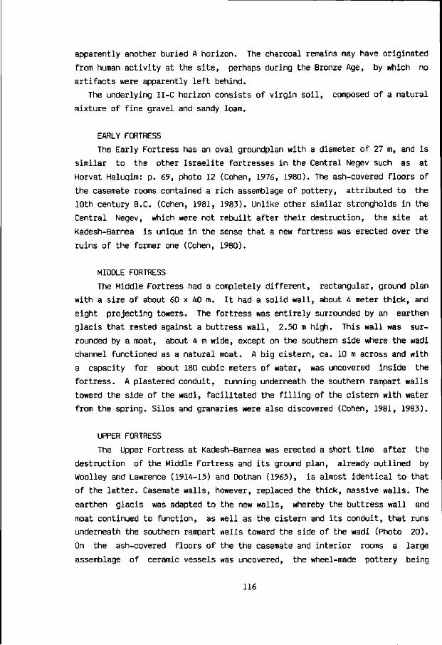
apparently another buried A horizon. The charcoal remains may have originated
from human activity at the site, perhaps during the Bronze Age, by which no
artifacts were apparently left behind.
The underlying II-C horizon consists of virgin soil, composed of a natural
mixture of fine gravel and sandy loam.
EARLY FORTRESS
The Early Fortress has an oval groundplan with a diameter of 27 m, and is
similar to the other Israelite fortresses in the Central Negev such as at
Horvat Haluqim: p. 69, photo 12 (Cohen, 1976, 1980). The ash-covered floors of
the casemate rooms contained a rich assemblage of pottery, attributed to the
10th century B.C. (Cohen, 1981, 1983). Unlike other similar strongholds in the
Central Negev, which were not rebuilt after their destruction, the site at
Kadesh-Barnea is unique in the sense that a new fortress was erected over the
ruins of the former one (Cohen, 1980).
MIDDLE FORTRESS
The Middle Fortress had a completely different, rectangular, ground plan
with a size of about 60 x 40 m. It had a solid wall, about 4 meter thick, and
eight projecting towers. The fortress was entirely surrounded by an earthen
glacis that rested against a buttress wall, 2.50 m high. This wall was sur
rounded by a moat, about 4 m wide, except on the southern side where the wadi
channel functioned as a natural moat. A big cistern, ca. 10 m across and with
a capacity for about 180 cubic meters of water, was uncovered inside the
fortress. A plastered conduit, running underneath the southern rampart walls
toward the side of the wadi, facilitated the filling of the cistern with water
from the spring. Silos and granaries were also discovered (Cohen, 1981, 1983).
UPPER FORTRESS
The Upper Fortress at Kadesh-Barnea was erected a short time after the
destruction of the Middle Fortress and its ground plan, already outlined by
Woolley and Lawrence (1914-15) and Dothan (1965), is almost identical to that
of the latter. Casemate walls, however, replaced the thick, massive walls. The
earthen glacis was adapted to the new walls, whereby the buttress wall and
moat continued to function, as well as the cistern and its conduit, that runs
underneath the southern rampart walls toward the side of the wadi (Photo 20).
On the ash-covered floors of the the casemate and interior rooms a large
assemblage of ceramic vessels was uncovered, the wheel-made pottery being
116

^Cti-V
i PHOTO 20. A plastered conduit, running underneath the southern rampart wall of the Upper (and Middle) Fortress toward the side of the wadi, facilitated the filling of the large cistern inside the latter fortresses.
characteristic for the 7th to 6th century B.C. One jar was still full of burnt
wheat. The third and last fortress at Kadesh-Barnea was probably destroyed by
the Babylonian army of Nebuchadnezzar at about the same time as the First
Temple in Jerusalem - 586 B.C. (Cohen, 1981, 1983).
PERSIAN PERIOD
After the destruction of the Upper Fortress, there was evidently limited
reoccupation on the site during the Persian Period (587-332 B.C.) in the form
of an unwalled settlement (Dothan, 1965; Cohen, 1981, 1983).
ENVIRONMENT AND SITING OF THE TELL
The tell-mound rises some 6 meter above the surrounding valley
plain, which is 164 meter wide at this point. The mountain edge of Gebel el
Qudeirat bounds the valley some 78 m to the north of the tell (Photo 19, 22),
117

measured from the northern wall of the upper and middle fortress. The peren
nial desert stream, fed by the spring, flows along the southern side of the
tell (Photo 19). The mountain edge that bounds the valley in the south (Photo
18, 22) lies about 46 m from the southern wall of the upper and middle for
tress. These fortresses themselves had a width of some 40 m (Cohen, 1983), as
a consequence of which the upper part of the tell is about 40 m wide as well.
The tell is made up by the remnants of the three fortresses that were
successively built on the site. Probably throughout its history the tell
functioned as a sedimention trap for dust, mixed in with the remnants and
debris of successive cycles of building and destruction. Studies about soil
development at the tell in relation to its stratigraphy will be published
elsewhere.
The tell is situated on a slightly elevated hillock, a stony remnant of a
Pleistocene terrace in the middle of the valley of Ein el Qudeirat. This
hillock is primarily composed of coarse gravel and well-rounded boulders up to
40 cm in diameter (Photo 21), being somewhat cemented. These coarse sediments
were deposited during the Late Pleistocene, when the stream bed of the wadi
was situated well above the present level of the valley.
PHOTO 21. Late Pleistocene deposits, consisting of slightly cemented coarse gravel and well-rounded boulders up to 40 cm in diameter, below the base of the southern wall of the Upper Fortress.
118
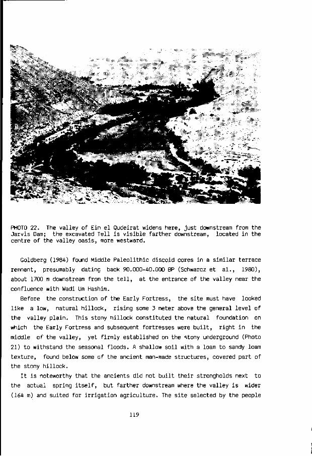
'.fV'»-4>. " «St"
PHOTO 22. The valley of Ein el Qudeirat widens here, just downstream from the Jarvis Dam; the excavated Tell is visible farther downstream, located in the centre of the valley oasis, more westward.
Goldberg (1984) found Middle Paleolithic discoid cores in a similar terrace
remnant, presumably dating back 90.000-40.000 BP (Schwarcz et al., 1980),
about 1700 m downstream from the tell, at the entrance of the valley near the
confluence with Wadi Urn Hashim.
Before the construction of the Early Fortress, the site must have looked
like a low, natural hillock, rising some 3 meter above the general level of
the valley plain. This stony hillock constituted the natural foundation on
which the Early Fortress and subsequent fortresses were built, right in the
middle of the valley, yet firmly established on the stony underground (Photo
21) to withstand the seasonal floods. A shallow soil with a loam to sandy loam
texture, found below some of the ancient man-made structures, covered part of
the stony hillock.
It is noteworthy that the ancients did not built their strongholds next to
the actual spring itself, but farther downstream where the valley is wider
(164 m) and suited for irrigation agriculture. The site selected by the people
119

who built the Early Fortress and subsequent fortresses was apparently the only
elevated stony foundation within the loamy valley plain, situated at a very
strategic position: about half-way between the entrance of the Kadesh-Barnea
valley (which could be kept in view some 1500 m westward) and the actual
location of the spring (some 1600 m eastward). The precious water from the
spring is flowing naturally to the site of the tell all year round, carried by
the narrow stream channel, which is incised below the valley plain and passes
the tell just 10-20 meter south of the main southern fortress wall. A few
hundred meter farther downstream, however, this unique perennial stream in the
desert disappears below the surface of the wadi bed.
The position of the tell thus has the following advantages:
1. It commands the westernmost access to the spring-water.
2. It is situated amidst suitable farming lands in the wider part of the
valley.
3. The elevated stony underground provides a firm foundation against seasonal
runoff floods.
4. It gives a view unto the western entrance of the valley.
*^ A.D. 7th century D a m & Aquaduct © Spring 0 AquaduCtS (1725-1425 Cal BC , 615-665 Cal AD) III J a r v i s Dam — - * W a d i • Te l l * • " • - — - Perenn ia l S t r e a m
0.5 1.5 2 km
^ .Terraced Wad i for runoff farming
FIGURE 16. The valley of Ein el Qudeirat or Kadesh-Barnea
120

9 Kadesh-Barnea: irrigation agriculture
SYSTEMS OF IRRIGATION AGRICULTURE IN THE KADESH-BARNEA VALLEY
The occurrence of a copious spring, whose water is flowing freely
all year round in the middle of the desert, in a valley also endowed with
cultivable soils, may suggest the practise of agriculture to be a natural and
simple matter. In reality the situation is somewhat more complicated, essen
tially due to obstacles of a geomorphic nature. The main problems for farmers
to practise agriculture in the valley of Ein el Qudeirat are essentially
twofold:
1. The water from the spring arises and flows in the stream channel of
Wadi el Qudeirat (Nahal Kadesh-Barnea), situated below the level of
the cultivable valley plain.
2. Although the average annual rainfall in the area is low, being about
75 mm today, powerful runoff floods may occasionally develop in Nahal
Kadesh-Barnea during the rainy season, causing damage or destruction
to irrigation systems and crops.
In order to solve the first problem, the farmers had to bring the water
from the spring unto the level of the cultivable valley plain. The remains of
former and present irrigation systems in the valley show two principal
solutions:
(a) AQUADUCTS THAT BEGIN AT THE NATURAL LEVEL OF THE STREAM BED, either
having their intake of water near the main outlet of the spring or farther
down the wadi bed. This type of aquaduct must initially have a gradient which
is less than the slope of the stream channel and valley plain. As the aquaduct
121

descends less steep than the latter, it will seemingly rise with respect to
the channel bluff and will appear at some point downstream onto the level of
the valley plain as a result. The point of emergence of the aquaduct onto the
valley plain is obviously the highest level where irrigation and agriculture
can take place. From this point the aquaduct may have the same, steeper,
gradient as the valley. A low threshold-dam that raises the water-level
somewhat behind it will considerably facilitate the intake of water into the
aquaduct(s), thus improving this system.
(b) THE BUILDING OF A MAJOR DAM that raises the water level until the
height of the valley plain, as a significant artificial pond will form behind
such an obstruction wall in the stream channel. Aquaducts can thus begin at
the level of the valley plain right from their beginning, which may allow the
valley plain to be irrigated farther upstream, depending of course upon the
location of the dam. This system enables a better control and more efficient
use of the spring-water for agricultural purposes.
It seems obvious that aquaducts which have their beginning in the wadi bed
(type a) are susceptible to destruction by powerfool runoff floods, occasio
nally roaring through the stream channel in the rainy season. Aquaducts
connected with high dams that raise the water until the level of the valley
plain, can be built right from their beginning point of water intake on the
edge of the valley against the mountain side. In these high dam systems the
aquaducts are rather safe, but now the dam itself may be destroyed by runoff
floods, historic examples of which will be discussed in the following
sections.
At present the stream channel only occupies a small part of the Kadesh-
Barnea valley. The channel is about 5 to 15 meter wide. It has steep banks and
its bed is well incised to a depth of 3 to 6 meter below the partly cultivated
valley plain, within historical times the stream channel has experienced
dramatic changes, extensively dealt with in Chapter 10.
Each irrigation system in the Kadesh-Barnea valley necessarily comprises
two different aspects. The first aspect involves the conduction or raising of
water from the spring onto the valley plain, and has already been discussed.
The second aspect involves the equal distribution of irrigation water over the
agricultural fields. Possible distribution systems that were probably used at
various times in the past can be characterized as wild flooding, border, and
basin irrigation (Booher, 1974).
122

PHOTO 23. Unlined irrigation ditch
against the hillside edge, made by
local Bedouin.
These systems may have been
integrated or combined in various
local adaptations.
The main irrigation aquaducts
or ditches were ususually placed
along both high edges of the
valley plain, against the hill
sides. By making outlets at
desired points into these main
aquaducts, the water would flow
onto that part of the valley plain
requiring irrigation. Each part of
the valley plain is sloping down
both laterally towards the stream
channel and longitudinally in a
general downstream direction. The
farmer had several options in
distributing the flow of water as
equally as possible over his
fields. The likely systems used
are outlined below:
WILD FLOODING SYSTEM
This method, described by Booher (1974:108), consists of spilling water
at frequent intervals from a grade ditch constructed along the high edge of a
sloping field. The water is allowed to flow freely down the slope, irrigating
the soils the water moves across. Interceptor ditches are placed at intervals
down the slope to collect the water, which will tend to concentrate in swales,
and to redistribute it more uniformly. This system is used primarily on steep
lands or valley lands with an uneven topography, where uniformity of water
distribution is not a major consideration. The system is also important for
flatter lands having shallow soils, which, for that reason, cannot be
levelled.
Success with this method depends on the skill to release water at the
correct points from the grade ditches, and in adjusting the size of openings
so that the correct amount of water is released to cover the area without
causing soil erosion. A minimum of land grading is required with this method
of irrigation, which is an important advantage where soil depths are shallow
123

and only a limited amount of earth can be moved (Booher, 1974). Shallow soils
covering a stony underground do occur in parts of the Kadesh-Barnea valley.
BORDER IRRIGATION SYSTEM
This method (Booher, 1974:93) requires a series of parallel ridges of
earth or stone, positioned in a lateral direction across the valley plain.
There appear to be ancient remains of stony ridges in the Kadesh-Barnea valley
which might have been used for such an irrigation method. The land in between
these parallel ridges is called a border-strip or gravity-check. The ridges
guide and check a sheet of flowing irrigation water moving down the valley-
slope, the water being released from aquaducts at the edge of the hillside.
The land should have a uniform moderate slope and careful land preparation is
necessary for this method to be efficient.
Where conditions are suitable for border irrigation it is often the most
efficient method for the irrigation of close-growing crops such as cereals,
pasture or other field crops. The system is also used for irrigating orchards
and vineyards (Booher, 1974).
' illiiiie
";':^6^;]^%S#!:S
PHOTO 24. A combination of wild flooding and border irrigation for field crops, next to the date-palms, carried out by local Bedouin in the valley of Ein el Qudeirat, upstream from the tell, south of the stream channel.
124

BASIN IRRIGATION SYSTEM
This method (Booher, 1974) is generally most widely used. There are many
variations in its application, but the principle is simple: dividing the land
into small units so that each has a nearly level surface. Levees (ridges,
bunds or dikes) are constructed around each individual unit or basin, which
are filled with irrigation water to the desired depth.
Basins may vary in size from 1 square metre, used for growing vegetables
and other intensive crops, to several hectares for cereals or other field
crops (Booher, 1974). The size not only depends upon the type of crops but
also upon the geomorphology of the landscape. The latter factor determines the
maximum size of the basin that can be levelled.
Unlined ditches and ridges of earth are usually not preserved. In many
cases these have to be rebuilt every year on account of natural deterioration
or plowing. Morover, the setting up of a new field alignment, because of crop
rotation or a change in ownership, may also alter existing field and
irrigation distribution systems periodically. In archaeologic or historic
reconstructions it is, therefore, often impossible to relate hard remnants,
like stone aquaducts, to soft agricultural field systems. Remains of the
latter are usually not found. In case ridges are preserved, their dating is
generally problematic, hence their correlation with remains of known age.
Evidence from hard but often fragmentary remnants of irrigation farming
that served as the basis for this outline, together with more recent historic
descriptions, is presented in the following section. The position in the
valley of ancient aquaducts and dams was pointed out to the author by Yosef
Porat, who investigated these remains as an archaeologist (Porat, personal
communication, 1981).
ARCHAEOLOGIC AND HISTORIC EVIDENCE OF IRRIGATION AGRICULTURE
IN THE KADESH-BARNEA VALLEY.
BRONZE AGE AQUADUCT: CARBON-14 DATE (GrN-12327)
An aquaduct remnant lined with stones and lime mortar is situated at
an estimated distance of about 400 m downstream from the spring of Ein el
Qudeirat. The aquaduct is buried below the present surface of the valley plain
to a depth ranging from 2.30 m for its upper stones to 3.10 m for its bottom
part (Photos 25, 35). The mortar contains small pieces of charcoal.
125

The radiocarbon content of both the lime mortar and the charcoal were
investigated at the Isotope Physics Laboratory of Prof. Mook (University of
Groningen). The resulting dates in conventional C-14 years (BP), as well as in
calibrated historical years for the charcoal date (Fig. 17), are as follows:
Mortar (GrN-12381) 12.250 ± 230 BP
Charcoal (GrN-12327) 3.270 + 100 BP 1725-1425 Cal B.C.
The discrepancy between the two dates is obviously due to contamination of
the lime mortar with "dead" carbon, probably of Eocene age. The lime mortar
apparently contains both C derived from the atmosphere at the time of the
construction of the aquaduct, and Eocene C from the surrounding rocks. It
seems likely that the ancients produced lime mortar for the aquaduct by the
burning of local Eocene carbonate rocks:
1. CaC03 [carbonate rock] > CaO [quick lime] + C02 H
2. CaO [quick lime] + H20 > Ca(0H)2 [slaked lime]
3. Ca(0H)2 + atmospheric C02 > CaC03 [set lime mortar]
Either incomplete burning of the carbonate rocks or intentional mixing of the
mortar with fine rock fragments resulted in a C content of mixed origin and
age in the mortar. Clear evidence for the presence of "dead" carbon in mortar,
probably of Eocene age, was obtained by microscopic studies of thin sections
from other aquaduct mortar samples in the Kadesh-Barnea valley (p. 138). Hence
the unrealistic C-14 date of 12.250 + 230 BP, which does not reflect the true
age of the aquaduct.
The carbon-14 date of the charcoal (3.270 ± 100 BP; GrN-12327) was calibra
ted against the high precision timescale calibration curve of Pearson et al.
(1985), resulting in a historical date of 1725-1425 Cal B.C. (fig. 17). This
date is admittedly older than expected, which suggests the aquaduct to have
been constructed during the Middle or Late Bronze Age. The laboratory pre-
treatment of charcoal and the physical and chemical aspects of radiocarbon
dating in general are discussed by Mook and Streurman (1983). The stratigraphy
of the valley profile in which the aquaduct remnant appears is presented on
page 151, 152.
If the charcoal date reflects the true age of the aquaduct, it seems likely
that irrigation agriculture was practised in the Kadesh-Barnea valley during
part of the Bronze Age.
126

PHOTO 25. Remnants of a Bronze age aquaduct (1), a Late Byzantine-Early Arab
aquaduct (2), both radiocarbon dated; and of a recent Bedouin pipeline (3).
Q-
3370
3270
3170
^ i 1 1 1 1 — 1 i i
JV / A
; \ / \
;
i i i i i i
I l^ ' *^ \
, , iV • 1725 1600
HISTORICAL YEARS B.C.
1500 1425
FIGURE 17. Calibration of the C-1A date of the (1) aquaduct (3270 + 100 BP;
GrN-12327) into historical years: 1725-1425 Cal B.C.
127

IRON AGE
No structural remains have yet been found of Iron Age irrigation agricul
ture. The plastered conduit, that facilitated the cistern inside the Middle
and Upper Fortress to be filled with spring water, may have been connected
with a so far unknown aquaduct system upstream. The level of the conduit was
about 2 metre above the Iron Age level of the valley plain in the immediate
vicinity of the tell. If there ever was such a connection, then the unknown
aquaduct must have been built on pedestals or an artificial ridge for the last
hundred metre or so upstream from the fortress.
The silos and granaries of the successive fortresses, as well as the jar
full of burnt wheat (Cohen, 1983) are of course no proof of agricultural
practice in the area. These discovered food storage facilities were either
filled with imported grains and/or local agricultural produce.
Circumstancial evidence, however, like the position of the successive
fortresses in the wider part of the cultivable valley and the occurrence of
Israelite runoff farming in the adjacent highlands and various other parts of
the Central Negev (Aharoni et al, 1960; Cohen, 1976), makes it illogical to
assume that no agriculture was practised during the Iron Age in the well-
watered valley of Ein el Qudeirat.
BYZANTINE PERIOD
Woolley and Lawrence, who visited the area in January-February 1914,
described remains of irrigation systems, which in their opinion belong to the
Byzantine period. On both the northern and southern edge of the valley appear
the abandoned ditches of two old irrigation channels against the hillside. The
northern aquaduct is built of masonry and very poor mortar. It is nearly
destroyed and very difficult to trace. Maybe it went to the cultivable valley
of Wadi el Ain, which forms the north-western continuation of Wadi el Qudeirat
in the direction of Quseima, "but more probably it was made only to bring
water to a little Byzantine village whose remains yet exist in a bay of the
northern slope" (Woolley and Lawrence, 1936:78,80), situated about 1 km down
stream from the tell on the lower hillslope of Gebel el Qudeirat. Woolley and
Lawrence estimated the remains at about 15 to 20 small houses.
The aquaduct on the south side "is only a dug ditch, winding along the
contour of the hills, till it comes to an end in a great Byzantine reservoir,
situated in the very mouth of the valley" (Woolley and Lawrence, 1936:78),
near the junction with the valley of Wadi Urn Hashim.
"The reservoir is a great work, four-square, and about twenty yards each
128

way, built in the usual style of the precise Greek masonry, laid in line, and
it still preserves in one corner the opening of the sluice, which let out its
water as required to gardens on the flat land round the elbow of the hills.
The reservoir is, however, now long abandoned, half filled with earth and
stones" (Woolley and Lawrence, 1936:78). More precise measurements of the
reservoir were published by Elgabaly (1954): 20 x 20 x 3.5 m. Thus the maximum
capacity of the reservoir is 1400 cubic meters of water.
It seems likely that the reservoir was used by the ancients to store the
flow of spring water during the night. Irrigating at night is usually not
practical for various reasons (Horst, 1983), e.g. no control of irrigation,
difficult rotation between various fields, farmers are reluctant to work
during the hours of darkness. However, as the spring continues to flow at
night, this water would be lost for agricultural production unless it is
stored and subsequently released for irrigation during the daytime. The
average discharge from the spring at present is 61 cubic meters of water per
hour. In a night of 12 hours, during which no irrigation is practised by the
farmers, 732 cubic meters of water would flow out of the spring. This amount
could easily be stored in the reservoir that has a capacity of up to 1400
cubic meters.
Major Jarvis was the British governor of Sinai during the years 1922-1936.
He first visited the valley of Ein el Qudeirat in 1922, attracted as a
sportsman by the number of desert partridges in the area. His book Desert and
Delta describes his discovery of the reservoir, which he ascribed to the
Romans, being unaware of the 1914-15 publication of Woolley and Lawrence who
considered it of Byzantine age. Since Jarvis (1938:245) considered the
Byzantine period in the southern Levant as "the later Roman period, between
the third and sixth centuries A.D.", there does not seem to be a contradiction
between these opinions.
"One day whilst resting high on the hillside overlooking the valley after a
hard morning's shoot, I noticed a big square mass of old masonry on the
southern slope of the hill that was obviously an old Roman reservoir. It was
filled to the top with silt and the sides had fallen away in places, so that
previously I had imagined it was the ruins of a large building, but from my
position above I now saw it for what it was, a stone water-tank. The question
then arose as to how the Romans managed to fill it as it was nearly fifty feet
[15 m] above the level of the valley. Gradually as my eyes got used to the
uniform greyish-yellow of the limestone rocks I traced the line of the ancient
water-course that had brought water to the reservoir a thousand years ago and,
129

following It up on foot, I came at the head of the valley to the remains of
the dam that had at one time raised the level of the stream." (Jarvis,
1938:244).
These dam remains were pointed
out to the author in 1981 by Porat,
who considered them to be of Byzan
tine age. The dam probably had an
opening in its upper part to allow
the raised water to flow into the
very beginning of the aquaduct that
is situated on top of it. The aqua-
duct continued from the dam along
the southern edge of the valley and
hillside. Once it carried precious
irrigation water to the fields and
probably also to the reservoir,
some 3 km down the valley. It is
rather intriguing, however, that
the position of the dam is upstream
from the spring in the dry part of
the valley. Woolley and Lawrence
(1936:79) did not mention the rem
nants of the dam as such, but also
noticed beyond the spring "a built
aquaduct of stone and lime leading
out of the hill-side and running
across the valley. It probably
points to another, but now forgot
ten, spring which watered these
upper fields."
PHOTO 26. Remains of a dam and connec
ted aquaduct in the valley of Ein el
Qudeirat (upstream from the spring),
dating to the 7th century A.D.
CARBON-14 DATING OF THE DAM (GrN-12326)
The dam and its aquaduct are built of masonry. Pieces of charcoal are
usually present in the lime mortar, enabling carbon-14 dating. The author
collected samples of mortar with charcoal from various parts of the dam on
both sides of the valley to get a sufficient quantity. The charcoal was
extracted from the lime mortar in the Isotope Physics Laboratory of Prof. Mook
(University of Groningen), undergoing the usual pretreatment (Mook and
130

CD
1500
1470
1380
1290
1200
^
.
-
v\ \ -\ k
610
l
• i 68S
l i •
800
1
1 1
900
.
_
.
-
-
-
HISTORICAL YEARS A.D.
FIGURE 18. Calibration of the C-14 date of the dam (1380 + 90 BP; GrN-12326)
into historical years: 610-685 Cal A.D.
Streurman, 1983).
The extracted charcoal was dated as well as a piece of mortar, taken from
underneath the aquaduct surface about 110 cm below the highest part of the
dam. The resulting dates in conventional C-14 years (BP), as well as in
calibrated historical years for the charcoal date (Fig. 18), are as follows:
Mortar (GrN-12379)
Charcoal (GrN-12326)
5.330 + 130 BP
1.380 + 90 BP 610-685 Cal A.D.
The charcoal date seems realistic, giving a Late Byzantine or Early Arab
age to the dam and its aquaduct. The outcome for the mortar, on the other
hand, does not reflect the age of the dam, probably due to, either incomplete
burning by the ancients of local Eocene carbonate rock for the production of
quick lime, or subsequent contamination with "dead" carbon. A microscopic
study of mortar from the dam's aquaduct not only revealed the presence of
"inherited" carbonate rock fragments, but also yielded convincing evidence of
the past flow of water in the aquaduct on top of the dam.
131

MORTAR MICROMORPHOLOGY AND PALEO-ENVIRONMENT OF THE DAM'S AQUADUCT BOTTOM
The mortar sample was taken from the bottom part of the aquaduct, about 1
meter below the highest part of the dam and about 5.30 meter above the lowest
part of the adjacent wadi bed. The mlcromorphological terminology used is
mainly from Brewer (1964), apart from the term calciasepic, introduced by
Mulders (1969).
The mortar is mainly composed of fine plasma, skeleton grains and voids, in
decreasing order of their respective volumes. Voids of various sizes appear in
the mortar matrix. The size of the skeleton grains is usually in the range of
coarse silt (0.04-0.06 mm), as well as very fine sand (0.06-0.1 mm). The
skeleton grains are angular and subrounded in shape, appearing randomly,
sometimes clustered, in the mortar matrix. Quartz grains are most common,
followed by calcite, whilst hornblende, feldspars and other heavy minerals
appear occasionally.
The mortar plasma is primarily composed of a crystic calcic fabric, showing
micrite to sparite calcite crystals. This crystic fabric sometimes occurs in
distinct rounded grains of up to 1 cm in diameter, which may either be rock
relicts or newly formed mortar pieces with a sharp boundary. A small fossil
composed of sparite proved that rock fragments containing "dead" carbon are
present in the mortar. This caused the C-14 date derived from the carbonate
part of the mortar to be unrealistic.
Plasma that consists of a calciasepic fabric, essentially made up by
micrite mixed with fine clay, also occurs. Some parts of the mortar, appearing
as aggregates up to 1 cm in size, are reminiscent of the micromorphology of
loessial soil (Bruins, 1976). Many pieces of charcoal of various sizes appear
randomly in the mortar matrix.
The microscopic discovery of the following micromorphological phenomena in
the mortar unequivocally proved the actual functioning of the dam and its
aquaduct for a considerable time period:
AUTHIGENIC PYRITE
The discovery of a large cluster of pyrite framboids (photos 27, 28) in
the mortar is outstanding evidence of a reduced environment in the past,
caused by a rather continuous flow of water in the aquaduct during the time of
its functioning in antiquity. The microscopic identification as pyrite became
possible through the suggestions of Jongmans and Miedema (1985, personal
communication). The cluster is up to 0.8 mm in diameter and consists of about
a hundred black to reddish brown pyrite framboids, composed of microcrystals.
132

PHOTOS 27. Incident light. PHOTO 28. Plain transmitted light.
Identical microscopic pictures of the pyrite framboid cluster. The width of
the pictures is equal to 0.5 mm. Pyrite is opaque for transmitted light (Photo
28), but shows a typical shining lustre with incident light (Photo 27).
The pyrite is partly weathered to iron-oxide. Each pyrite framboid has a
size of 0.02-0.0A mm. The pyrite cluster can be regarded as a filled crystal
chamber. The pyrite framboids have partly penetrated the surrounding mortar
matrix, showing crystal overgrowth of pyrite over micrite. For more specific
aspects about the micromorphology of pyrite in soils, the reader is referred
to the publications by Pons (1964), Van Dam and Pons (1972), and Miedema et
al., (1974). The soil-chemical aspects of pyrite formation are discussed by
Van Breemen (1972).
Apart from the described cluster, more pyrite framboids occur in the
mortar. Some gypsum crytals, 0.2 mm in length, may have been formed as a
result of partial oxidation of the pyrite into iron-(hydro)oxides. A number of
ferrans and iron-oxide nodules appear in the mortar. A neoferran-ferran with a
size of 0.7 mm is particularly well developed, partly in a vugh against the
133
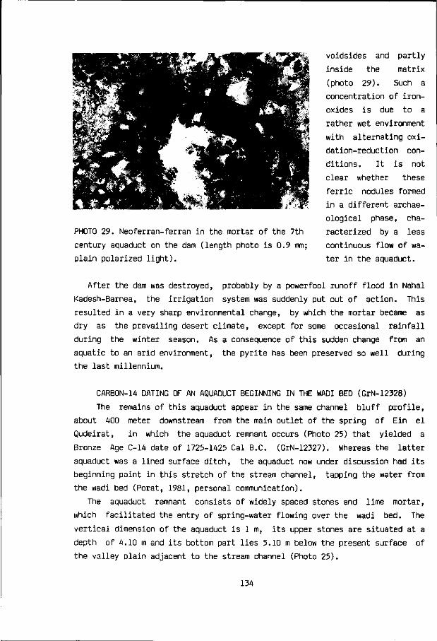
PHOTO 29. Neoferran-ferran in the mortar of the 7th
century aquaduct on the dam (length photo is 0.9 mm;
plain polarized light).
voidsides and partly
inside the matrix
(photo 29). Such a
concentration of iron-
oxides is due to a
rather wet environment
with alternating oxi
dation-reduction con
ditions. It is not
clear whether these
ferric nodules formed
in a different archae
ological phase, cha
racterized by a less
continuous flow of wa
ter in the aquaduct.
After the dam was destroyed, probably by a powerfool runoff flood in Nahal
Kadesh-Barnea, the irrigation system was suddenly put out of action. This
resulted in a very sharp environmental change, by which the mortar became as
dry as the prevailing desert climate, except for some occasional rainfall
during the winter season. As a consequence of this sudden change from an
aquatic to an arid environment, the pyrite has been preserved so well during
the last millennium.
CARB0N-1A DATING OF AN AQUADUCT BEGINNING IN THE WADI BED (GrN-12328)
The remains of this aquaduct appear in the same channel bluff profile,
about A00 meter downstream from the main outlet of the spring of Ein el
Qudeirat, in which the aquaduct remnant occurs (Photo 25) that yielded a
Bronze Age C-1A date of 1725-1A25 Cal B.C. (GrN-12327). Whereas the latter
aquaduct was a lined surface ditch, the aquaduct now under discussion had its
beginning point in this stretch of the stream channel, tapping the water from
the wadi bed (Porat, 1981, personal communication).
The aquaduct remnant consists of widely spaced stones and lime mortar,
which facilitated the entry of spring-water flowing over the wadi bed. The
vertical dimension of the aquaduct is 1 m, its upper stones are situated at a
depth of A.10 m and its bottom part lies 5.10 m below the present surface of
the valley plain adjacent to the stream channel (Photo 25).
13A

The present level of the wadi bed lies at a depth of 5.25 m and today the
water from the spring flows below the aquaduct. The aquaduct mortar contains
small pieces of charcoal. The carbon-14 content of both the lime mortar and
the charcoal were investigated at the Isotope Physics Laboratory of Prof. Mook
(University of Groningen). The resulting dates in conventional C-14 years
(BP), as well as in calibrated historical years for the charcoal date, are as
follows:
Mortar (GrN-12380)
Charcoal (GrN-12328)
14.250 ± 350 BP
1.395 ± 50 BP 615-665 Cal A.D.
The unrealistic outcome of the mortar is certainly due to the presence of
"dead" carbon, for reasons described previously. The charcoal date seems to
represent the age of the aquaduct correctly, which is virtually the same as
the C-14 date for the dam (1380 + 90 BP; 610-685 Cal A.D.; GrN-12326). This
strongly suggests that, either at the end of the Byzantine period or at the
beginning of the Early Arab period, two different systems were constructed
simultaneously to tap the water from the spring for irrigation agriculture
during the 7th century A.D.
CD
I CJ
1500
1445
1395
1345
1300
12001-
I i_J l_l i I I I L i 615 665
HISTORICAL YEARS A.D.
800 900
FIGURE 19. Calibration of the C-14 date of the wadi-bottom aquaduct (1395 + 50
BP; GrN-12328) into historical years: 615-665 Cal A.D.
135

The position of the Late Byzantine - Early Arab wadi-bottom aquaduct below
the Bronze Age dated aquaduct seems an apparent stratigraphic problem. If
these radiocarbon dates are correct, and the labeling of the two respective
samples were not accidentally exchanged, either in the field or in the labora
tory, how is it possible to find a younger aquaduct below an older one? A key
to a possible answer may be the different ways by which the two aquaducts were
constructed in relation to their respective functions. The older Bronze Age
dated aquaduct was built on the former valley surface to conduct the spring-
water from upstream. The beginning of this aquaduct and the manner by which
the spring-water entered this system is unknown.
The Late Byzantine - Early Arab aquaduct was not situated at the former
valley surface during the 7th century A.D., but at the level of the wadi bed
to tap the flow of spring-water. It had to be constructed, therefore, either
by (1) digging a channel from the valley-plain surface down unto a possible
groundwater level adjacent to the natural stream channel, or (2) by carving
out the lowest part of the existing stream channel bank in a slight lateral
excavation at the level of the wadi bed and below the Bronze Age dated aqua
duct (if this aquaduct was already present indeed):
The former possibility (1) seems unlikely for the following reasons: The
stream channel of Wadi el Qudeirat is the natural aquaduct that carries the
water from the spring downstream on its bed. The amount of water seeping, per
unit of time, below the wadi bed in a lateral direction is too little to be
caught in any useful quantity, if at all, by a subsurface seepage collecting
type of aquaduct. As a matter of fact, the author made an excavation near the
tell, 6 m aside from the present stream channel, virtually unto the same level
as the wadi bed with its flow of spring-water, finding the soil to be dry.
Only the direct inflow of water from the wadi bed into the aquaduct can tap
this perennial stream of spring-water effectively for agricultural purposes.
Hence the aquaduct had to be built inside the 7th century stream channel. It
seems, however, unpractical to built such an aquaduct in the middle of the
wadi bed, making it an easy prey for erosion during runoff floods in the rainy
season. The solution of the ancients, as interpreted and envisaged by the
author, might have been as follows: the construction of such an aquaduct
partly inside one of the existing stream channel banks, by carving away only
some sediment at its lowest part at the level of the wadi bed and leaving the
upper part of the bluff intact. A low temporary dam was perhaps built in the
wadi bed, parallel to the aquaduct under construction, to prevent the entry of
water that would have made the work impossible.
136

The loessial material making up the channel bank will not easily collapse
upon the removal of some material from its lowest part. The Bronze Age dated
aquaduct remnant in the upper part of the bluff would, therefore, not necessa
rily have been completely destroyed during the construction of the 7th century
aquaduct. In fact only a small part of the Bronze age dated aquaduct has
actually been preserved (Photo 35), as compared to the large stretch of the
7th century wadi-bed aquaduct still in situ.
The side of the latter aquaduct that faced the flow of water in the wadi
bed was obviously built with openings in between the stones, whilst it had to
be closed on all other sides, also from above, to prevent water losses as well
as the entry of sediment that might block the flow of water inside the aqua
duct. Upon completion of the aquaduct, perhaps carried out in stages, its
closed upper part could be covered again with some of the excavated sediment,
so that the bluff might have been restored as a relatively firm natural wall
with the water tapping aquaduct anchored inside.
Somewhat farther downstream, a low threshold dam might have existed to
raise the water level slightly. This would have facilitated the intake of
water into the aquaduct considerably. From the point where the aquaduct became
situated above the flow of water in the wadi, as it eventually had to descend
with a smaller gradient than the stream channel to emerge onto the valley
plain, its character and make-up necessarily changed from a water-intake
aquaduct to a mere water conducting channel.
MORTAR MICROMORPHOLOGY OF THE 7th CENTURY WADI-BED AQUADUCT
The mortar is mainly composed of fine plasma, skeleton grains and voids,
in decreasing order of their respective volumes. Voids of various sizes and
shapes, like skew planes, vughs and some rare channels, appear in the mortar
matrix. The related distribution of plasma and skeleton grains is porphyroske-
lic. The skeleton grains, angular and subrounded in shape, are mainly of
coarse silt (0.04-0.06 mm) and very fine sand size (0.06-0.1 mm), usually
occuring randomly in the mortar matrix. Quartz grains are most common, fol
lowed by calcite, whilst hornblende, feldspars and other heavy minerals appear
occasionally.
A number of large lime grains, 2-10 mm in diameter and rounded to subroun
ded in shape, appear in the mortar matrix. These grains consist of a rather
uniform crystic calcic or calciasepic fabric, in which virtually no skeleton
grains occur. Because of their rounded shape, it is not entirely clear whether
these grains are inherited rock fragments or newly formed mortar particles.
137

PHOTO 30. A fossil and charcoal in
the mortar (photo width = 0.32 mm)
(plain polarized light)
PHOTO 31. Charcoal in the mortar
(photo width = 2.6 mm)
(plain polarized light)
PHOTO 32. Pyrite framboid (0.04 mm)
inside charcoal (incident light)
The mortar plasma has a predominant
crystic calcic fabric, showing micrite
to sparite calcite crystals. A calcia-
sepic plasmic fabric also occurs. Small
marine fossils, probably of Eocene age,
appear randomly in the mortar (Photo
30). This proves the presence of inhe
rited "dead" carbonate, which caused
the unrealistic C-14 date derived from
the carbonatic part of the mortar.
Many charcoal pieces of various
sizes (0.005 - 8 mm) appear randomly
scattered through the mortar matrix
(Photo 31, 32).
138

AUTHIGENIC PYRITE
The presence of pyrite framboids in the mortar, in relation to voids,
provides unequivocal evidence of a reduction environment in the past, when the
aquaduct was tapping the water flowing over the wadi bed during the Late
Byzantine-Early Arab period. One distinct pyrite framboid, glittering when
observed under the microscope with incident light, has formed inside a void of
a large charcoal fragment (Photo 32).
Concentrations of iron oxides (ferrans and neoferrans) also occur in the
mortar, sometimes as a weathering product of pyrite. This seems to be indica
tive of a period with alternating wet-dry reduction-oxidation circumstances in
the past. Fine gypsum needles appear in association with weathered pyrite as
well.
BEDOUIN IRRIGATION FARMING IN THE KADESH-BARNEA VALLEY
The Late Byzantine to Early Arab dam and aquaduct systems, described in
the preceding sub-chapters, were probably destroyed by powerful runoff floods
in Nahal Kadesh-Barnea during the Early Arab period. There is no evidence
whether these irrigation systems were abandoned before or after their apparent
natural collapse.
Since the Early Arab period, there seems to be no archaeologic or historic
information about irrigation agriculture in the Kadesh-Barnea valley until the
dawn of the 20th century. During their visit in Januari-Februari of 1914,
Woolley and Lawrence made a number of observations about Bedouin irrigation
farming in the valley, which appear scattered through the pages of their book
(Woolley and Lawrence, 1936, p. 75-84).
At that time the Bedouin's system for irrigation agriculture involved a
simple dam across the stream bed, about 800 m downstream from the spring
proper, and some 400 m downstream from the previously described ancient aqua
duct remnants. This dam was probably made of earth and stones. It probably
had to be repaired or rebuilt regularly after the runoff floods in the rainy
season. The dam raised the water level somewhat in the stream channel. Here
the irrigation ditches of the Bedouin Arabs belonging to the Guderat tribe had
their start. These unlined ditches "are only ephemeral, a deeper furrow among
the crops, as such canals must always be, made each spring and destroyed each
winter in the Arab yearly interchange of plough and fallow" (Woolley and
Lawrence, 1936, p. 78).
From this dam the valley was cultivated in a downstream direction until the
139

fields fade out at the valley mouth. The two distinguished British surveyors
made an elucidating description of the hydraulic characteristics of the stream
channel and its functioning during runoff floods in the rainy season, as well
as during Bedouin irrigation practices in their time.
"The water-course ... is a clear channel, cut five to fifteen feet [1.50 -
4.50 m] into the ground, steep banked, and generally from three to ten yards
[2.70 - 9 m] in width. It thus wastes only an inconsiderable part of the
valley space, and its depth gives it content enough to carry off all ordinary
floods without damage to the fields on each side. An occasional great flood
may sweep the whole place, levelling trees and washing out the soil, as
happened two years ago [1911-1912]; but normally the lower reaches of the
torrent-bed are dry except when it is raining, or when the cultivators, having
finished the watering of their land, turn the stream of their little canals
back into the proper bed." (Woolley and Lawrence, 1936, p. 77-78).
The British authors do not mention the growing of fruit trees by the local
Bedouin, but only field crops. This is corroborated by Jarvis who found a
similar situation in 1922, as shown in a picture in his book (Jarvis,
1938:272). The cultivated part of the valley appeared green or yellow with the
crop according to the season. Acacia trees stood at intervals along the edge
of the valley. Woolley and Lawrence described the tell-mound as rising above
the adjacent corn-fields, where barley and/or wheat was probably growing at
the time.
In front of the ruins of the Byzantine village, mentioned earlier, are the
threshing floor and corn pits of the Guderat tribe. The Bedouin moved their
camp to the old village site for a few weeks in each year. Apart from farming,
the British surveyors also noted semi-nomadic livestock rearing as part of the
food producing economy of the Bedouin. They mention the flocks and herds at
Ain el Gudarat, while calling attention to the tribesman as a great maker of
flint tools, used for the animals.
"There is no permanent settlement of Arabs in the valley, through their
fear of the climate. It is believed that anyone who lies there in summer
(whether man or beast) will be attacked by an intermittent fever of peculiar
strength; indeed even the cooked meat of animals which have fed in the valley
is declared dangerous by the local authorities in hygiene. As a matter of
fact, the large deep pools of the upper river must be admirable breeding
places for mosquitoes" (Woolley and Lawrence, 1936, p. 80).
About eight years later, in 1922, Major Jarvis first visited the area as
the British Governor of Sinai, a function in which he continued to serve until
140

1936. "When I first saw the Wadi Gedeirat there were about six acres [2.4 ha]
of cultivated land which the local Arabs irrigated by means of a small mud dam
that they constructed every year after the winter floods" (Jarvis, 1938:243).
This type of dam and its location was probably the same as referred to by
Woolley and Lawrence, described above.
After discovering the remnants of the ancient irrigation systems in the
valley of Ein el Qudeirat, as described on p. 129, it occurred to Jarvis "that
it would be most interesting and fascinating, not to say useful, to recon
struct in some way the old Roman system of irrigation... The need for some
thing of the sort was apparent, for the Arabs of this area depend for their
existence on rain crop barley which is only a definite success once in five
years" (Jarvis, 1938, p. 244-245).
This remark by Jarvis is not entirely correct, as the Bedouins were not
self-sufficient in their crop farming, which constituted only an addition to
their extensive livestock husbandry. The semi-nomadic Bedouin usually trade
their animals for food grains grown by sedentary farmers in the wetter parts
of the region (Marx, 1982). However, the note that rainfed barley farming in
the area during the twenties and thirties was only successful once in 5 years,
is a valuable datum. Jarvis (1938:245) continued his reasoning: "If they were
provided with an irrigation system that would enable them to make certain of
their winter barley, and to grow also a summer crop of maize or millet, it
would constitute a very definite bettering of their lot".
Inspired by the ancient example, Jarvis decided to have a dam constructed
in the stream valley for irrigation farming purposes. Funding of the dam came
from the budget allotted to Sinai for anti-malaria work, as the construction
of a dam would "kill two birds with one stone" (Jarvis, 1938:247): both
advancing irrigation farming and fighting malaria in the area. The dam would
hold the water back of the perennial stream fed by the spring and this would
prevent the formation of isolated pools downstream. "One could easily cope
with the mosquito larvae in the big pond that would form by the introduction
of that jolly little Egyptian fish, the Bolti... immediately after his intro
duction to a stream or pool, he makes himself at home and proceeds to breed to
such an extent that in a few short months the water is a moving mass of small
fry. The fry, which are in a constant state of ravenous hunger, work their way
up into the grassy fringes of the pools and round the stems of the reeds and
rushes, so that it takes a most redoubtable mosquito larva to escape their
attentions" (Jarvis, 1938:247).
The dam was constructed of cut limestone blocks and masonry at the head of
141

the wider part of the valley in 1926. Its position is about 700 m downstream
from the spring, apparently near the place where the Bedouins used to make
their small mud dam. The carbon-14 dated ancient dam and aquaduct remnants are
situated upstream from the Jarvis dam. Haj Ali, the government mason at El
Arish, constructed the dam, whereby he sometimes manufactured home-made lime
on the spot, if there was a lack of cement (Jarvis, 1938:248). This suggests
that the ancients could also have made their lime from local Eocene carbonate
rock.
When the dam was completed, a huge pond, about 90 m long and 27 m wide,
formed behind the dam in a day and a half. The barrier was not absolutely
water-tight, as some one-sixth of the water supply was finding its way through
the coarse gravel beneath the concrete foundations. Haj Ali, therefore, con
structed a much lower second dam, some 45 m downstream from the first. From
this second dam the escaping water was led "into the big channels that ran
from the dam to the reservoirs, so that by this means we harnessed the whole
flow of the stream" (Jarvis, 1938:249).
It appeared that excellent cast-iron pipes, 20 cm in diameter, and with a
combined length of nearly 5 km, had remained in the area since the time of
their use by the Turkish army. By employing these pipes it became not only
possible to run the water from the dam to the reservoir without seepage
losses, but also to carry subsidiary channels across gorges to good land
beyond, while the irrigation system was extended to about 800 m below the
reservoir at the mouth of the valley (Jarvis, 1938:250-251).
"The reservoir was then cleaned of the silt of ages, which filled it to the
brim, and the old Roman plaster lining, which had fallen away in patches, was
stripped off and a layer of twentieth-century concrete substituted. The con
crete was later faced with a lining of cement and 'Pudlo', a patent water
proofing mixture, and the reservoir was ready for the flow from the stream"
(Jarvis, 1938:251). The British governor admitted that he "felt something of a
Philistine" when he lined the age old construction "of vast cut stones with
the prosaic and unpleasant-coloured concrete of to-day, but I consoled myself
with the thought of the acres of dun-coloured deserts that would become green
as the result." It took a day to fill the reservoir of about 20 meter square
and 3.5 m deep, which fits the calculation made on page 127, in relation to
the average discharge of the spring of 61 cubic meter per hour.
Jarvis described all kind of social and human-psychological problems which
had to be overcome, as well as the need for instruction, before the potential
of the irrigation system was tapped by the local Bedouin population. A govern-
142
ment garden was established, both as an object lesson and for experimenting
with various crops and fruit trees. The olive trees made the most prolific
growth, attaining the height of over 3.50 meter in their third year. The vines
were also exceptional in every way, producing a remarkable quantity of grapes
with a very fine flavour. Citrus trees proved less successful. Concerning
vegetables, the growth of asparagus was phenomenal in every respect.
The irrigation scheme in the valley of Ein el Qudeirat was started by
Jarvis in 1926 and it had been in existence for ten years when he left Sinai
in 1936. Some 120 hectare had come into cultivation with thousands of olive
trees in varying stages of growth. "As I expected, there was no real enthou-
siasm for the work until the first Beduin had marketed his crop of olives and
turned the cash proceeds over wonderingly in his palm. Then, when it trans
pired that there was real money to be made over these queer bitter fruits,
every man proceeded to extend his plot, and to level off fresh desert land
until finally one found irrigated orchards a mile away from the dam" (Jarvis,
1938:268). Apart from olives, the bedouins also cultivated vines, winter
grains, and some maize in summer.
Some twenty years later, in the fifties, the system still seemed to
function properly, according to Elgabaly (1954) who noted that the water was
carried in iron pipes and cement canals to irrigate the area below the dam.
During the night water was collected and stored in a reservoir with a capacity
of about 1000 cubic meters. He reported orchards of olives, pomegranates and
figs growing on the water from the spring, and considered the olives as the
most successful trees.
What Jarvis (1938:269) had feared that "the dam may crack with a heavy
flood" happened in 1956, thirty years after its construction. However, the
Egyptians repaired the dam, which, as a result, continued to function until
1969, when another powerfool runoff flood broke the dam again (Fromkin, 1981).
Since that event, the Jarvis dam has not been reconstructed (Photo 33), and
the local Bedouin farmers use the cast-iron pipes to tap the water from the
spring in order to irrigate their orchards and field crops (Photo 24). The
remaining structure of the Jarvis dam functions today as a kind of aquaduct-
bridge for the cast-iron pipes to cross the valley (Photo 33).
In a talk with a local Bedouin in December 1981, I asked whether they
manure their fields. "Only water" was his answer, as he denied any use of
whatever kind of fertilizer. The goats and sheep drop, nevertheless, a certain
amount of manure, as they are allowed to graze on uncultivated plots and
various other fields.
143

10 Kadesh-Barnea: valley stratigraphy and soil development
THE VALLEY SECTION NEAR THE LATE BYZANTINE - EARLY ARAB DAM
Historic reconstruction of landscape and soil development in the
Kadesh-Barnea valley became possible through the presence of archaeological
remains and radiocarbon dating. The valley sections which supplied useful data
are dealt with in order of their respective location in the stream channel,
starting with the C-14 dated Late Byzantine to Early-Arab dam, upstream of the
present position of the spring, and successively continuing down the valley.
Remnants of the dam appear on both sides of the stream channel, as can be
seen on Photo 26. A cross section of the valley (Figure 20) shows the strati-
graphic position of the dam remains in relation to the accumulated sediment
and present level of the stream bed. It is evident from this stratigraphic
relationship that, some time after the destruction of the dam, sediments were
deposited in the valley during a remarkable period of aggradation, followed by
a period of incision that seems to continue even today. This relatively recent
period of downcutting exposed the above sedimentary profile for examination.
Some sediment samples were taken for laboratory analysis from this profile,
which is precisely located in between the two remnants of the 7th century dam
(Photo 26, Figure 20), situated at opposite sides of the valley. In other
words, once the dam in its full length blocked the valley at this spot where
now sediments appear in its place.
Most of the sediments exhibited in the studied profile are rather uniform
in texture, being of a loess-like nature without macro-structural elements,
until a depth of 3.95 m, when a lithological break appears. The baselevel of
the Late Byzantine-Early Arab dam coincides with a depth of about 2.55 m.
144

PHOTO 33. The broken Jarvis Dam as a modern example how the 7th century dam might have looked after its partial collapse and before the unique historic period of wadi aggradation, during which the dam became nearly buried.
f ,r7T^r,i,i,i, 1,1,1,1 i I,;,!
D A M & A Q U A D U C T
205 cm
WADI BED TODAY
FIGURE 20. Cross-section of the stream channel in relation to the remains of
the 7th century dam in the valley of Ein el Qudeirat.
It seems likely that the entire alluvial loessial sequence appearing above the
lithological change at 3.95 m postdates the destruction of the 7th century
dam, deposited during the period of extraordinary aggradation.
This stratigraphic conclusion implies a phase of downcutting and erosion,
following the destruction of the dam but prior to the aggradational period,
which removed some 1.50 m of sediments below the base level of the dam, from a
•145

SURFACE ALLUVIAL DEPOSITS
30 50
140
205 220 240
320
395 420 440 460
- BASE LEVEL DAM
^ m r o ^ f ^
255
PRESENT WADI BED
X Sample Organic layer
' . Distinct gley spots
level of about 2.50 until a depth of 3.95 m.
Many dark organic layers occur in the
sediment profile at intervals of about 10 to
20 cm. Most of these dark layers are faint
and thin, less than 1 cm in thickness. Three
more prominent layers were distinguished at a
depth of 1.40, 2.05 and 3.20 m below the
surface edge of the channel bluff. The dark
layers must have been ancient surface levels
(paleo A-horizons), once covered with vegeta
tion, apparently fed by water from the
spring. These surface horizons were successi
vely formed and subsequently buried during
the gradual process of valley aggradation.
Today vegetation mats cover little surface
areas within the stream channel from the
first emergence of spring water in the wadi
bed.
A few hundred meters down the valley, some
50 m upstream from the main oulet of the
FIGURE 21. Sampled profile in
between the dam remains.
spring proper, Goldberg (1984) was able to
collect enough charcoal for carbon-14 dating
from a pocket or lense at a depth of 3 m
below the valley plain. The charcoal yielded
a date of 665 + 115 BP in conventional C-14 years. Calibrated against
Pearson's curve (Pearson, 1986), this date corresponds to a historical date of
1260-1400 Cal A.D. (Figure 22). The lowermost prominent organic layer in the
alluvial sediments, situated between the 7th century dam remains, occurs at a
similar depth of 3.20 m and is presumed to be of identical age.
At a depth of 3.95 m a lithological change is visible, marked by very clear
orange-brown gley spots, indicative of alternating oxidation-reduction circum
stances in the past, due to aquatic conditions in this part of the stream
channel. Another distinct lithological change occurs at a depth of 4.20 m, the
upper boundary of a more sandy layer, 20 cm thick, that contains many mollusc
shells. At 4.40 m a stony layer appears at the base of the profile, exhibiting
subrounded stones up to 30 cm in diameter. The average size of the stones is
10-20 cm, while the interlocking packing voids are filled with smaller gravel.
The stones are imbricated in a downstream direction.
146

0_ CD
<:
i
780
700
665
600
550
1 v\
i\ 1
i i . !
\ / \ \J \ \
. . "L. 1200 1260
HISTORICAL YEARS A.D.
1400
FIGURE 22. Calibration of the C-14 date of a charcoal sample (665 ± 115 BP;
Goldberg, 1984), collected from a depth of 3 m below the valley
plain, into historical years: 1260-1400 Cal A.D.
The lithological change at 3.95 or 4.20 can be regarded as an erosional
discontinuity, that marks the depth of wadi incision after the destruction of
the dam and prior to the following period of aggradation. The above mentioned
carbon-14 date, being younger than the age of the 7th century dam, fits this
picture very well indeed. It thus seems likely, that by the 13th or 14th
century A.D., the wadi had already deposited its first 75-100 cm of alluvial
sediments: the onset of the unique historic period of wadi aggradation.
Another 3 m of sediment was yet to be deposited in the following centuries.
Two sediment samples were taken in the alluvial loessial deposits at
respective depths of 30-50 cm and 220-240 cm. Another sample was collected
from the more sandy layer at 420-440 cm, which contains mollusc shells. The
laboratory results are displayed in Table 18. The alluvial loessial sediments
are rich in carbonates and appear to be moderately saline throughout the
profile. Sodium and chloride make up the bulk of the salts. The amount of
sulphate is relatively high in the layer near the base of the section, which
also shows a comparative decrease in chloride. The higher nitrate value in the
middle of the profile, may have been derived from some of the dark coloured
organic layers.
147

TABLE 18.
DEPTH
(cm)
30- 50 220-240 420-440
DEPTH
(cm)
30- 50 220-240 420-440
DEPTH
(cm)
30- 50 220-240 420-440
Granulometry and chemical analysis of alluvial sediments in between the remnants of the radiocarbon dated 7th century dam in the valley of Ein el Qudeirat.
CLAY <0.002
mm (»)
15.8 10.4 17.1
PH
7.1 7.2 7.4
SILT 0.002-0.063
(S)
44.7 38.6 19.6
EC(1:1)
(mS/cm)
9.5 9.3 8.8
SOLUBLE SALTS IN
r 2 + Ca
6.1 6.0 1.6
SAND TEXTURE GRAVEL 0.063- >2 mm 2 mm
(K) (S)
39.5 LOAM 0 51.1 LOAM 0 63.4 SANDY LOAM 1
SAR ORGANIC CARBON
(») c
49.0 0.70 49.4 0.27 71.6 0.36
1:1 SOIL/WATER EXTRACT
Mg2+ Na+ K+ HC0~ Cl"
0.2 87 0.2 87
<0.1 65
0 0 1.0 91.0 0 0 0.9 89.5 0 0 0.4 35.0
CARBONATES CaC03
(8)
43.6 44.3 56.5
TOTAL PHOSPHORUS
(55) P205
0.13 0.14 0.09
(meq/kg soil)
SO^" NO3
5.0 0 5.0 1.2
33.0 <0.1
Percentages in weight % of the fine earth <2 mm; only gravel in weight % of the total soil. EC = electrical conductivity. SAR = sodium adsorption ratio.
WATER INLET INTO
AQUADUCT
38 m WADI B E D LEVEL
DAM
TthCENTORV A.D.
VTAVB^D LEVEL
FIRST APPEARANCE OF SPRING WATER TODAY
FIGURE 23. Longitudinal valley section through the 7th century dam, showing
past and present hydro-geomorphic relationships.
148

Figure 23 shows the location of the dam with respect to the present posi
tion of the water level from the spring, as well as the likely situation in
antiquity, when a pond must have accumulated behind the dam, so that the
spring-water could flow into the aquaduct on top of the dam. The height of the
dam was about 4.30 m. From the studied stratigraphic interrelationships the
following conclusions seem warranted about the evolution of this part of the
stream channel in historical times:
1. The level of the wadi bed at the time of the dams's construction (7th
century A.D.) was about 2 meter higher than its lowermost present level.
2. The nearest and highest occurrence of spring-water today appears at a
distance of 38 m downstream from the dam, 3.30 m below the base-level of
the 7th century dam.
3. If the dam was to be reconstructed today, it would serve no other purpose
than the temporary retention of some runoff water during floods in the
rainy season.
4. The apparent function of the dam, in antiquity, was to raise the waters
from the spring to the level of the aquaduct system that began on top of
the dam, for irrigation farming purposes.
5. Hence an important outlet of the spring was in all likelihood situated
upstream from the dam in the 7th century A.D. There is none today.
6. At some time during or after the 7th century A.D. the dam was destroyed by
a powerfool runoff flood in Nahal Kadesh-Barnea, comparable to the des
truction of the Jarvis dam in the 20th century.
7. The destruction of the dam was followed, during a certain period of time,
by a regime of stream channel incision.
8. This period of downcutting was terminated by a remarkable change in the
hydraulic and geomorphic behaviour of Nahal Kadesh-Barnea. Sediments began
to aggradate in this part of the stream channel, as a result of which the
position of the wadi bed became higher and higher. Eventually, the rem
nants of the 7th century dam were almost completely buried by alluvial
loessial sediments.
9. Another environmental change caused the cessation of this quite extraordi
nary period of wadi aggradation. Nahal Kadesh-Barnea began to cut into its
own bed, removing a considerable part of its previous deposits. This
period of incision is still continuing today and has advanced to such a
degree that the present level of the wadi bed is well below the level of
the 7th century A.D.
149

It thus seems that the
position of the spring in the
^ g s | £ * r * y ^ .S^ffiS/';& aK, • -2A^> ̂ . valley of Ein el Qudeirat has
shifted since the 7th century
A.D. Concerning the actual
site of the spring today, one
has to be aware of the two
manners in which the spring-
water emerges in the stream
channel.
The first quiet appearance
of spring-water in the wadi
bed begins 38 m downstream
from the location of the 7th
century dam. This very gentle
emergence and quiet flow of
water in the wadi bed conti
nues for a few hundred meter
further down the stream chan
nel, until the major present
outlet of the spring is
reached (Photo 34).
Here the water rises natu
rally with some force through
a concrete pipe, vertically
placed into the wadi bed.
This "concrete" sight of the
spring is, admittedly, rather
disappointing today, compared
with its appearance in 1914, as described by Woolley and Lawrence (1936:79):
"The spring proper is... where a buttress of limestone runs into the valley...
From the foot of it the water gushes out strongly in three little spouts thick
as a man's arm, from deep, narrow fissures in the rock... Ain el Guderat means
the spring of the earthenware kettles, or small spouted pots. Whether it
refers to the rush of water, in contrast to the slow welling up of Ain Kadeis,
or to actual pottery, we know not".
Since the reference to the limestone buttress is unclear today, one wonders
whether the principal outlet of the spring has actually changed since 1914?
PHOTO 34. (1) Location of the 7th century
dam. (2) The first emergence of spring-
water in the wadi-bed. (3) The main outlet
of the spring at present.
150

THE CHANNEL BLUFF PROFILE THAT EXHIBITS TWO C-14 DATED AQUADUCT
REMNANTS (BRONZE AGE AND LATE BYZANTINE-EARLY ARAB PERIOD)
Two different aquaduct systems appear in the southern bluff of the
stream channel, about 400 meter downstream from the main outlet of the spring.
These remnants were radiocarbon dated by Mook at the University of Groningen
(GrN-12327, GrN-12328), and have already been described (p. 134). The lower
aquaduct near the base of the profile, situated somewhat above the present
level of the wadi bed, formed the beginning of a water transport system in the
7th century A.D. This stretch of aquaduct had the function to tap the spring-
water flowing over the wadi bed.
The remains of the aquaduct are still visible over some tens of meters
(Photo 35). It was built at the edge of the stream-channel bottom existing at
the time and its position indicates that the wadi bed of the 7th century A.D.
was, at this part of the valley, perhaps one meter higher than at present.
This conclusion fits the evidence from the 7th century dam site, some 700 m
upstream, which also indicated a higher level of the wadi bed in those times.
PHOTO 35. A partly collapsed remnant of a Bronze age dated aquaduct (1) above
extensive remains of a 7th century (A.D.) aquaduct (2) near the wadi bed.
151

SURFACE ALLUVIAL DEPOSITS
45 55
160 -180
230
270
350 Y
370 -
410
510 525
AQUADUCT
2 9 0 [1 1725-1425 Cal BC
310
AQUADUCT
615 - 6 6 5 Cal AD
The aquaduct remnant in the middle
part of the profile, of which only a
small part is still preserved (Photo 35),
yielded a surprisingly early carbon-14
date (GrN-12327) of 1725-1425 Cal B.C.
(Late-Middle to Late Bronze Age). It is a
type of aquaduct that probably was situa
ted at the former surface level of the
valley during the time of its functioning
in the past (Porat, 1981, personal commu
nication). The upper 2.30 to 3.00 meter
of sediment above this aquaduct (Photo
35) must, therefore, have been deposited
since the Late Bronze Age during a period
of wadi aggredation.
The alluvial sediments of the entire
profile (5.25 m) are of a loess-like
nature, consisting of silt loam to clay
loam in the lower part of the section.
The deposits have a somewhat finer tex
ture than the loamy sediments near the
7th century dam, some 700 m farther up
stream. Sediment samples were taken at
respective depths of 45-55 cm, 160-180
cm, 270-290 cm (inside the sediment-
filled Bronze Age dated aquaduct), and 350-370 cm (in between the two aquaduct
remains). The laboratory results are presented in Table 19.
The clay content of 7 % inside the Bronze age dated aquaduct is the lowest
value encountered in the investigated valley sediments. The two samples from
the alluvial sediments overlying the Bronze age dated aquaduct remnant, appa
rently deposited during the main period of historic wadi aggradation, have a
somewhat different granulometry than the deeper layers. The layer above the
wadi-bottom aquaduct is likely to have been disturbed by man during the con
struction of the latter aquaduct in the 7th century A.D.
The entire sediment profile is moderately affected by salinity, which has a
tendency to increase slightly in an upward direction. The same trend is also
perceptible in the sediment profile in between the remnants of the 7th century
dam. This kind of distribution of salts through the profile suggests their
PRESENT WATER LEVEL AND WADI BED
X Sample
FIGURE 24. Sedimentary profile
of the channel bluff, in which
the ancient aquaducts appear.
152

TABLE 19. Granulometry and chemical analysis of alluvial sediments in the channel bluff profile that exhibits the C-14 dated aquaduct remnants (* 1725-1425 Cal B.C. and # 615-665 Cal A.D.) @ in the valley of Ein el Qudeirat.
*
#
*
#
*
#
DEPTH
(cm)
45- 55 160-180 270-290 350-370
DEPTH
(cm)
45- 55 160-180 270-290 350-370
DEPTH
(cm)
45- 55 160-180 270-290 350-370
CLAY <0.002
mm (%)
20.2 23.9 7.1
27.3
pH
7.3 7.3 7.3 7.4
SILT 0.002-0.063
(»)
58.9 59.6 67.4 35.2
EC(1:1)
(mS/cm)
10.4 12.8 11.2 9.9
SOLUBLE SALTS IN
r 2 + Ca
3.7 1.7 5.8 4.5
Mg2+ Na
0.35 131 0.30 145 0.35 174 0.25 87
SAND 0.063-2 mm
(»)
21.2 16.5 25.4 37.5
TEXTURE
SILT SILT SILT CLAY
SAR
92 145. 99 56.
6 0 2 5
L:l SOIL/WATER
K+
0 <0.1 0 0 0 0 0 0
LOAM LOAM LOAM LOAM
GRAVEL >2 mm
(S)
0 0 0 2
ORGANIC CARBON
(8)
0. 0. 0. 0.
EXTRACT
HCO3
0.50 0.20 1.15 0.40
C
52 52 54 52
CI"
107.0 133.0 134.0 54.0
CARBONATES CaC03
(«)
41.7 44.9 38.1 46.9
TOTAL PHOSPHORUS (,%) P 2 O 5
0.12 0.14 0.14 0.11
(meq/kg soil)
SO2" NO3
27.0 0.6 11.0 0.3 46.0 0.1 39.5 0.2
Percentages in weight % of the fine earth <2 mm. Only gravel in weight % of the total soil. EC = electrical conductivity. SAR = sodium adsorption ratio. (8 Note peculiar stratigraphy: younger aquaduct below older remnant (p.134).
origin to be related to a capillary rise of spring-water from the wadi bed
(Kamphorst, 1986, personal communication; Kamphorst and Bolt, 1978). However,
the level of the wadi bed, and with it the level of the flow of spring-water,
has experienced dramatic changes since the Byzantine period. The salt distri
bution, therefore, cannot be related to Byzantine or earlier periods. Salts
are easily leached and their present distribution in the sediments adjacent to
the stream channel probably reflects the more recent local environmental
history, i.e. the main period of wadi aggradation and the subsequent period of
downcutting.
153

The amount of dissolved salts in the spring water is about 1.42 g/liter.
Sodium and chloride are the main salt constituents in the spring-water as well
as in the sediment. Both of these components decrease in quantity in the lower
part of the sediment profile, accompanied with an increase in sulphate. A
similar salt distribution occurs in the sediment profile in between the 7th
century dam remnants, some 700 m upstream.
VALLEY AGGRADATION AND ITS RADIOCARBON DATING NEAR THE TELL
Going downstream from the channel bluff site that exhibits the
remains of the two ancient aquaducts, one passes the partly destroyed Jarvis
dam after about 250 m. The tell of the fortresses lies further down the valley
at a distance of some 1200 m from the former aquaduct site.
PHOTO 36. A large stretch of the valley of Ein el Qudeirat, displaying the
location of: (1) the channel bluff site with the ancient aquaducts, (2) the
broken Jarvis Dam, (3) the tell of the fortresses.
154

About 200 m upstream from the tell, a charcoal pocket was found in the
southern channel bluff, approximately 2.50 m below the valley plain and 1.50 m
above the present stream bed with its perennial flow of spring-water. A char
coal sample was taken (GrN-11946) for carbon-14 dating.
Some 60 m southwest of the tell, another charcoal sample (GrN-11947) was
collected from the northern channel bluff, at a level of about 3 m below the
valley plain and 1.30 m above the present stream bed with its gentle flow of
water. Both charcoal samples were investigated at the Isotope Physics Labora
tory of Prof. Mook (University of Groningen). The resulting dates in conven
tional C-14 years and calibrated historical years (Figure 25) are as follows:
GrN-11946
GrN-11947
540 + 45 BP
445 ± 25 BP
1310-1430 Cal A.D.
1440-1460 Cal A.D.
CD
Ld
585
540
495 475
445
415
i \ ~ i |
i l i V
_ . _ . _ . J.. _ . _ . _ . _ i\
i :7\
1200 1300 1400
HISTORICAL YEARS A.D.
1500
FIGURE 25. Calibration of the C-14 dates of two charcoal samples, collected
from different channel bluff sections near the tell, into historical years.
These data give important information about wadi aggradation during the
Mamluk Period, in addition to the detailed picture already obtained from the
7th century dam site, upstream from the spring. However, more information is
yet needed to establish more precisely the duration of the extraordinary
period of aggradation after. Byzantine-Early Arab times. Moreover, is there any
available evidence about stream channel evolution in the valley of Ein el
Qudeirat during earlier historic periods?
155

FIGURE 26. Stratigraphy of valley deposits at the southern edge of the tell.
156

As the wadi flows along the southern edge of the tell, it was assumed by
the author that this part of the valley might contain stratigraphic infor
mation about the position and evolution of the stream channel and its wadi bed
during the Late Bronze, Israelite and subsequent periods. Therefore, a trench
was dug from the base of the southern buttress wall in the direction of the
stream channel in the winter of 1981/1982, during the last seasons of excava
tions by Rudolph Cohen before the Israeli withdrawal from Sinai.
It was discovered that a terraced slope, lined with large stones, descends
from the buttress wall of the Middle and Upper Fortress toward the former
position of the wadi bed during the Iron Age. The obvious purpose of this
terraced slope, covered with stones, was to protect the ancient Israelite
fortresses from being undercut by powerfool runoff floods in the rainy season.
The stratigraphic relationships between the terraced slope, the various
dark ash layers, accumulated debris and sedimentary layers deposited by the
wadi at this part of the tell, are shown in Figure 26.
The base of the buttress wall lies 2 meter higher than the present level of
the stream bed. The distance between the buttress wall and the stream channel
is 12 m, when measured along the trench. The terraced and stone covered slope,
descending from the base of the buttress wall in the direction of the wadi,
marked the landscape surface between the tell and the stream channel during
the Iron Age. A natural gravel deposit, probably of Late Pleistocene age,
underlies the base of the buttress wall and the first part of the terraced
slope.
The position of the stream channel during the Iron Age was similar as
today, but the level of the wadi bed might have been somewhat lower than at
present. Alluvial loessial deposits cover the terraced Iron Age slope and
appear unto a height of about 4 meter above the level of the present wadi bed.
A sloping dark ash layer, about 5 meter in length, descends from the
buttress wall, passes just over the top of the first man-made Iron Age terrace
step, and ends within the alluvial loessial sediment at a height of 1.50 m
above the present stream bed level. This dark ash layer marks the landscape
surface at a time when the wadi aggradation had already begun, since at least
some 1.50 m of sediment was already deposited. Three charcoal samples from
different parts of this ash layer were dated at the Isotope Physics Laboratory
of Prof. Mook (University of Groningen).
The resulting dates in conventional carbon-14 years as well as in histori
cal or dendro years, after calibration with the curve of Pearson et al.
(1985), are as follows (Figure 27):
157

GrN-11949
GrN-12331
GrN-12333
395 ± 45 BP
340 + 40 BP
410 + 35 BP
1450 - 1485 Cal A.D.
1470 - 1530 Cal A.D.
1450 - 1480 Cal A.D.
CD
<
I
450
410 395
340
295
1
"N t (
_ h
*• c
™ ,
1
1. h
.̂— . .
i i;
—i r i 1 T"
«\ ^ IK ./">» •M X I f \ A
1: «:
• i i
A
i \ i, \ ,
1400 1500
HISTORICAL YEARS A.D.
1600 1700
FIGURE 27. Calibration of the above C-14 dates into historical years.
The actual calibration of the three C-14 dates is shown in Figure 27, which
exhibits the particular swings of the high precision curve of Pearson (1986)
in this particular time stretch. The inclusion of the youngest swing of the
graph into the calibration seems unrealistic and has, therefore, been omitted,
as the dates show a distinct tendency to belong to the earlier time section of
the graph. A clear consensus results from the three different charcoal samples
of this dark ash layer. An age of about 1470 Cal A.D. appears to be the
weighed average outcome, dating this ancient surface layer to the latest part
of the Mamluk Period.
Another dark ash lense, only 40 cm long, is situated against the buttress
wall above the former ash layer at a very important stratigraphic position.
The lense lies some 30 cm above the upper part of the former ash layer and
some 30 cm below the highest aggradation level of alluvial loessial sediments.
Charcoal from the lense was investigated by the Isotope Physics Laboratory of
Prof. Mook (University of Groningen). The resulting date in conventional C-14
years and in calibrated historical years, according to the high precision
curve of Pearson (1986), is as follows:
158
GrN-12332 70 + 170 BP 1665 - Recent Cal A.D.
CD
I
240
2 0 0
100
70
r T 13- r — r T 1 1
i \ A • - il/v • 1 1 1 ! L i i i i
1600 1665 1710
HISTORICAL YEARS A.D.
1800 1900
FIGURE 28. Calibration of the above C-14 date into historical years.
This result indicates that the wadi aggradation was probably at its highest
level during the 17th and 18th century, when the wadi bed was about 4 meter
above its present level. As a matter of fact, an abandoned stream channel
exists just west of the tell, exhibiting a paleo-wadi bed at a level of 4.33 m
higher than the adjacent present stream bed. This abandoned stream channel
branches off the present wadi course near the southwestern corner of the tell,
some 5 m south of the southern buttress wall, and bends away from the present
stream channel before rejoining it some 200 m farther to the west (Photo 37
and 38).
The gravel lenses appearing in the upper part of the alluvial sediments in
the studied section (Figure 26), lie at a distance of 4 to 6 meter south of
the buttress wall. These gravel lenses show how the wadi bed moved gradually
closer to the tell during its upward aggradation, as compared to its position
during the Iron Age and today.
When did the period of aggradation come to an end? The former C-14 date
(GrN-12332) indicates this to have occurred after the 17th century. From the
observations of Woolley and Lawrence (1936:77) it is clear that the downward
incision of the wadi and the formation of the present stream bed had already
largely taken place before 1914. It seems, therefore, likely that this remar
kable period of stream channel aggradation came to an end in the 18th century.
159

m
*• ••»" iJ -JL mm. * I •• .
^ i J a s j ! * ^ * *
aw: *4ta *,;?l^sft*is £ 'Mt-'tr-iaBr:
!!**&*
PHOTO 37. The present stream channel (1) and the abandoned paleo-wadi bed (2) downstream from the tell, which functioned during the main aggradational period. The level of the paleo-wadi bed is 4.33 m higher than the present stream bed. Note the ancient man-made wall on Gebel el Qudeirat to the north.
SB ,%^2fe' A \ i.'y™.' '•"' ' .'•/.:,
it ^*m%, Mg-^" f„,r^- ••
PHOTO 38. Close-up of the abandoned paleo-wadi bed (2), which functioned during the main aggradational period; viewed from Gebel el Qudeirat.
160

Very striking is the sudden change in the hydraulic or geomorphic behaviour
of Nahal Kadesh-Barnea from aggradation to incision at the end of this period,
as well as the rapid rate of downcutting that followed this marked environmen
tal change.
SOIL DEVELOPMENT
If aggradation took place in the stream channel during the Mamluk and
Ottoman periods, by which the wadi reached a level of about 4 meter higher
than today, then the flow of spring-water carried by the wadi bed from farther
upstream, must also have streamed up to about 4 meter higher than today. Is
there any evidence of these former wet conditions in the sediment as a result
of post-depositional processes of soil development, proving wet conditions in
the past? The answer is a very definite yes.
Thin sections of three samples from the alluvial loessial sediments, depo
sited during the period of wadi aggradation, were investigated under the
microscope. Sample KB-129 was collected from the uppermost, sandwiched allu
vial loess layer (Figure 26), representing the highest level of aggradation
during the 17th or 18th century. The other two samples are from somewhat
greater depth. The approximate ages of the micromorphology samples, as well as
their precise position with respect to the Iron Age buttress wall and the
present wadi bed, are shown in Table 20.
TABLE 20. Position and approximate age of alluvial loessial sediment samples
in the Kadesh-Barnea valley, south of the tell, investigated
microscopically from thin sections, in order to study their post-
depositional soil development.
Sample Depth
(cm)
KB-129 30- 60
KB-131 120-140
KB-132 190-220
Height above
base-level of
the Iron
buttress
(cm)
140-170
60- 80
10- 0-
Age
wall
-(-)20
Distance
South of
buttress
wall
(cm)
125
350
300
North of
present
wadi-bed
(cm)
1050
825
875
Approximate time
of sedimentation
17-18th century A.D.
16-17th century A.D.
15-16th century A.D.
161

MICROMORPHOLOGY AND PALEO-ENVIRONMENT OF KB-129
The general appearance of the matrix is relatively loose, which is not
surprising for such a young sediment, less than 300 years old, near the valley
surface. Three slaking crusts in the thin section are apparently remnants of
sedimentary layering from the time of deposition, which seems to have been
largely destroyed within a remarkable short period by biological pedotubation.
The soil matrix is composed of fine plasma and skeleton grains in about equal
volume amounts, as well as voids. The related distribution between skeleton
grains and plasma varies, being intertextic, agglomeroplasmic, or porpyhyro-
skelic. The plasma has a calciasepic to very fine crystic calcic fabric.
The skeleton grains, angular and subrounded in shape, are generally of
coarse silt to very fine sand size (0.04-0.1 mm); some sand grains are up to
0.3 mm. The arrangement of the grains is random, sometimes clustered. Their
mineralogy is dominated by quartz, followed by calcite, whilst feldspars,
hornblende, glauconite and other heavy minerals appear occasionally.
Remains of fossils, from silt to sand sizes, are very common. Most of these
small fossils appear to be of marine origin, apparently derived from the
omnipresent calcareous marine rocks in the catchment of Nahal Kadesh-Barnea.
Charcoal remnants, varying from silt size up to 1 mm, occur randomly in the
matrix. A few angular to subrounded limestone fragments, up to 3.2 mm in
diameter, are the largest components inside the sediment sample, together with
a piece of pottery of similar size.
Voids of various sizes and shapes, like channels, compound packing voids,
vughs and some skew planes, appear at random in the matrix. Evidence of
biological activity since the time of sediment deposition, about 250 years
ago, is apparent from the existence of channels, occurring regularly in sizes
of up to 0.2 mm, root remains, and pedotubules (aggrotubules and isotubules)
up to 10 mm in diameter. This already points to wetter soil conditions in the
past, due to the perennial flow of spring-water carried by the wadi bed, when
the stream channel had aggradated to its maximum level, some 4 meter higher
than today, during the Ottoman period.
AUTHIGENIC PYRITE
Conclusive evidence of such a high level of the wadi bed is provided by
the presence of pyrite, which can only form under reduced water-logged condi
tions. A cluster of pyrite framboids (Photo 39), 0.01-0.04 mm in diameter,
obviously formed in situ, is situated in a channel with root remnants. A
weakly developed neoferran (growth of iron-oxides inside the soil matrix)
162

PHOTO 39. Pyrite framboids (0.03 mm)
in the uppermost sedimentary layer
(incident light).
PHOTO 40. Ferric nodule (0.3 mm) in the
uppermost sedimentary layer
(plain polarized light).
adjacent to the pyrite cluster and the channel edge, probably formed as a re
sult of partial oxidation of the pyrite. Other ferric nodules (Photo 40) in
the matrix confirm this picture of wet conditions in the recent past. To the
trained eye, weak gley features are even visible macroscopically in the field.
The observed gley phenomena, neo-ferrans and ferric nodules, are usually
associated with an alternating oxidation-reduction environment. Such condi
tions may have occurred at a certain level X: (a) during aggradation, just
before the stream bed and the water flow arrived at level X, or (b) when the
stream bed and water flow were at some vertical distance above level X, so
that downward seepage of water was not sufficient to fully saturate the soil
and exclude the entry of air (oxygen); (c) during downcutting, as the position
of the stream bed moved slightly below level X.
A full reduction environment with pyrite formation in the Kadesh-Barnea
valley could only occur in those sediments situated at the actual level of
water flow or to some depth below this level, as long as the soil matrix
remained saturated with water, excluding the entry of air.
163

Some secondary crystallization of
calcium carbonate has clearly taken
place in the recently deposited uppe
rmost alluvial loessial sediments.
Apart from a very few incipient car
bonate nodules, some nice calcitans
occur in channels, often related to
roots. Newly formed calcite crystals,
0.002-0.03 mm in size (fine silt),
completely surround a root remnant
having a diameter of 0.3 mm (Photo
41). Even smaller micrite crystals
(0.002-0.01) appear in a cluster, 0.1
mm in diameter, attached to a root.
The occurrence of gypsum is not
very apparent, but very small, newly
formed crystals (0.005-0.02 mm) seem
to make up a cluster with a size of
0.06-0.15 mm.
The degree of soil development in
such a short period of time of about
250 years is certainly remarkable for
a desert region. However, one should
take into account the very large
contrasts in environmental circumstances: First water-logged to wet from the
perennial flow of water in the wadi bed during a certain period after deposi
tion, when aggradation in the stream valley reached its highest level. Later,
probably in the 18th century, the process of downcutting followed the relati
vely long period of aggradation. Suddenly the soil environment became as dry
as the surrounding desert, when the stream channel lowered its bed. Only some
capillary rise of water may have moistened this upper part of the alluvial
loess deposit in the beginning period of progressive downcutting, apart from
the periodic wetting of occasional heavy rainfall that penetrated into the
somewhat deeper part of the soil. No irrigation farming seems to have taken
place at this particular spot in the valley.
Because of this sudden transition from aquatic to arid conditions, the
pyrite has been preserved so well in this soil, as well as in the mortar of
the aquaducts already described previously. In case of prolonged moist oxida-
PHOTO 41. Small pedogenetic calcite crystals around a root remnant in a deposit less than 300 years old (crossed polarizers).
164

tion conditions during the transition from wet to dry, the pyrite should
probably have disappeared already (Van Breemen, 1986, personal communication).
MICROMORPHOLOGY AND PALEO-ENVIRONMENT OF KB-131
The age of this alluvial loessial layer is about 400 years. The soil
matrix is denser than in the uppermost sedimentary layer (KB-129) described
above. The related distribution of plasma and skeleton grains is, accordingly,
mostly porphyroskelic and occasionally agglomeroplasmic. The clay content
appears to be higher and there is, consequently, more plasma than skeleton
grains. The latter particles are similar in composition, size and shape as in
the previous sample. A few pieces of charcoal, up to 2 mm, and fossiliferous
carbonate grains appear randomly in the matrix. The largest solid component is
a subrounded piece of limestone, 2.2 x 4.6 mm in size.
Past biological activity in the
soil must have been intense, as indi
cated by the many channels, root
remnants and pedotubules. The latter
features are caused by small digging
and burrowing creatures that moved
through the soil. The following types
of pedotubules can be distinguished
in the sampled layer: granotubules,
isotubules and aggrotubules, varying
in diameter from 0.7-3.0 mm (Photo
42). Apart from channels, various
other types of voids, like vughs and
skew planes occur at random or clus
tered in the soil matrix.
AUTHIGENIC PYRITE
Conditions of a water-logged
reduction environment in the past is
clearly indicated by the presence of
pyrite framboids, which regularly
occur in the matrix, usually related
to voids. The pyrite crystals are
often weathered. Evidence of wet conditions and alternating oxidation-reduc
tion circumstances is also provided by the occurrence of neo-ferran cutans,
PHOTO 42. Pedotubule 3 mm in
diameter (crossed polarizers).
165

0.02-0.05 mm thick, and small diffuse ferric nodules. Gley features are
somewhat more developed and pyrite appears in a more advanced stage of weathe
ring, as compared to the upper sedimentary aggradational layer.
Some neo-formation of calcite has taken place, usually in the matrix as
very small-scale incipient concentrations, not easily identified as such. One
crystal chamber was observed in a vugh of 0.4 x 0.5 mm, containing fine
micritic and sparitic calcite crystals, 0.005-0.05 mm in size. Considerably
more widespread in this layer is the crystallization of gypsum in voids.
Several channels and vughs are filled up by gypsum crystals, both in needle
and more equilateral shapes. Not all the gypsum is necessarily derived from
pyrite oxidation, as it may also have crystallized above the level of stream
flow from capillary rising water.
MICROMORPHOLOGY AND PALEO-ENVIRONMENT OF KB-132
This layer was approximately deposited in 1500 A.D., just above the first
step of the terraced Iron Age slope, at the same level as the base of the
buttress wall. The micromorphology is in many respects similar to the former
sample from a layer 75 cm higher. Therefore, only the remarkable features or
differences with the former sample will be described.
A very large
striotubule, 2 cm
wide and 11 cm long,
appears in the middle
part of the entire
thin section. Biolo
gical activity and
pedoturbation has
clearly been intense
in the past.
The amount of gypsum
is markedly higher
than in the former
sample. Many channels
and other voids are
completely filled in
with fine gypsum
crystals, 0.005-0.04 mm in size (Photo 43). As some voids within the very
large striotubule, mentioned above, are also filled with gypsum crystals, it
PHOTO 43. Channels filled with fine gypsum crystals
(length photo = 1.5 mm; crossed polarizers).
166

can be concluded that the phase of intense biological activity preceded the
period of gypsum crystallization.
Apart from two large, weathered pyrite framboids, 0.08 mm and 0.12 mm in
diameter, less pyrite seems to occur as compared to the samples above. Since
this layer is closer situated to the present water level, moist oxidation
conditions appear to have persisted for a longer period of time at this level
during the successive phases of aggradation and downcutting. Most of the
pyrite has probably disappeared as a result. The widespread occurrence of
gypsum may underline this viewpoint, although most of the gypsum has probably
been derived from capillary rising water and subsequent crystallization.
From the micromorphology samples so far described, it can be concluded that
the transition from a water-logged reduction environment to the very dry
regional desert environment has been particularly sharp, within a short period
of time, in the aquaduct on top of the 7th century dam, upstream from the
spring, and in the uppermost aggradational sedimentary layer in the profile
south of the tell. Pyrite, formed in the latter aquaduct (Photo 27, 28) during
the time of functioning of the 7th century dam, or formed in the uppermost
aggradational deposits (Photo 39), in the 17th-18th century A.D., has clearly
been best preserved because of this sharp transition.
GRANULOMETRY AND CHEMICAL ANALYSIS OF
THE AGGRADATIONAL DEPOSITS SOUTH OF THE TELL
Eight samples were taken from the alluvial loessial deposits south of the
tell (Figure 26) for granulometric and chemical analysis. Three of these
samples are from the same respective positions as the micromorphology samples
(KB-129, KB-131, KB-132), already described above, and have, therefore, kept
the same respective sample numbers. The following table defines the location
of the various samples with respect to the buttress wall, the present wadi
bed, the vertical grid-system used during the archaeological excavations by
Rudolph Cohen, and the depth below the former valley plain surface at the time
of maximum aggradation.
The former valley plain surface near the stream channel was at a level of
about 19.00 m during the phase of maximum aggradation, expressed within the
vertical grid-system used during the excavations. The upper surface near the
stream channel has been eroded since the onset of the period of downcutting
and incision. Very recently a layer of debris from the excavations was pushed
over the eroded surface by a bulldozer (Figure 26).
The particle size analysis reflects the loessial character of the alluvial
167

TABLE 21. Position and approximate age of samples from the alluvial loessial fill sediments in the Kadesh-Barnea valley, south of the tell, deposited during the period of stream channel aggradation from the 13-18th century A.D.
Sample
KB-129 KB-130 KB-131 KB-132 KB-136 KB-135 KB-134 KB-133 •
#
Depth (cm)
25- 50 60- 95
120-140 190-220 160-180 230-250 280-300 350-370
409
Height within the vertical grid-system of the excavations
(m)
18.75-18.50 18.40-18.05 17.80-17.60 17.10-16.80 17.40-17.20 16.70-16.50 16.20-16.00 15.50-15.30
14.91 16.94
Distance South of buttress wall (cm)
125 225 350 300 600 600 600 600
1175 0
North of present wadi-bed (cm)
1050 950 825 875 575 575 575 575
0 1175
Approximate time of sedimentation
(A.D.)
17-18th century 17-18th century 16-17th century 16-17th century 16-17th century 15-16th century 14-15th century 13-14th century
Present wadi-bed
* Water flow in present 20th century wadi-bed. # Base-level of Iron-Age buttress wall.
fill deposits, in which silt is the dominant component. The lower section of
the fill is somewhat more clayey than its upper part, although a layer of clay
loam (KB-131) exists within the upper section as well.
The total amount of salts in the alluvial fill sediments south of the tell
gradually decreases with depth (Table 22). The salinity of the upper layers
can be rated from moderately high (EC 8.4 mS/cm) to medium (EC 5.8 mS/cm),
further decreasing downward to a low salinity (EC 1.1 mS/cm) in the deeper
layers. Such a characteristic distribution evidently shows the salts to be
derived from capillary rising spring-water flowing over the wadi-bed, as
suggested by Kamphorst (1985, personal communication).
Sodium and chloride are the dominant salts in the fill sediments, followed
by sulphate. This seems to be compatible with the composition of the spring-
water (Table 22), from which most of the salts are thought to be derived.
Samples KB-136 and KB-135 are situated near recent erosional surfaces, now
covered by a layer of bulldozer-pushed debris from the excavations. This
proximity to an erosional stream channel surface might perhaps relate to the
relatively larger contents of bicarbonate anions and sodium-carbonates. The pH
is higher as a result. The microscopically observed presence of gypsum fits
with the measured sulphate content, being highest in sample KB-132 (Photo 43).
168

TABLE 22. Granulometry and chemical analysis of alluvial loessial fill sediments in the Kadesh-Barnea valley, south of the tell, deposited during the aggradational period from the 13-18th century A.D.
SAMPLE DEPTH CLAY SILT SAND <0.002 0.002- 0.063-
mm 0.063 2 mm (cm) (%) (%) (55)
TEXTURE GRAVEL >2 mm
(»)
CARBONATES CaCOj
(«)
KB-129 KB-130 KB-131 KB-132 KB-136 KB-135 KB-134 KB-133
SAMPLE
KB-129 KB-130 KB-131 KB-132 KB-136 KB-135 KB-134 KB-133
SAMPLE
KB-129 KB-130 KB-131 KB-132 KB-136 KB-135 KB-134 KB-133 SPRING-
25- 50 60- 95
125-140 190-220 160-180 230-250 280-300 350-370
DEPTH
(cm)
25- 50 60- 95
125-140 190-220 160-180 230-250 280-300 350-370
DEPTH
(cm)
25- 50 60- 95
125-140 190-220 160-180 230-250 280-300 350-370
WATER 405
14.4 14.7 28.4 15.2 15.9 23.6 25.9 23.4
pH
7.8 7.1 7.4 7.4 7.8 8.1 7.7 7.7
41.4 47.1 48.3 49.1 50.8 40.9 47.3 45.0
EC(1:1)
(mS/cm
8.40 6.58 5.98 5.78 3.62 1.10 1.08 1.85
SOLUBLE SALTS
r 2 + Ca
3.5 3.8 1.6 1.6 1.2 0.3 0.3 0.6 4.4
Mg
<0.10 <0.10 <0.10 <0.10 <0.10 <0.01 <0.01 <0.10
3.7
)
IN
44.3 37.9 23.2 35.8 33.3 35.5 26.8 31.5
SAR
52.9 31.4 48.6 47.9 54.1 30.0 30.3 33.3
LOAM LOAM CLAY LOAM LOAM SILT LOAM LOAM LOAM LOAM
ORGANIC CARBON
(K) C
0.b4 0.27 0.81 0.84 0.27 0.83 0.88 0.43
2 0 0 0 0 0 0 0
TOTAL PHOSPHORUS
(8) P2
0.16 0.14 0.18 0.17 0.15 0.17 0.18 0.15
°5
r
42.8 42.7 45.3 41.9 45.4 46.0 48.1 46.6
NITROGEN
(S) N
0.03 n.d. n.d. n.d. n.d. n.d. n.d. n.d.
1:1 SOIL/WATER EXTRACT (meq/kg soil)
Na+ K+
70 43 43 43 42 10 10 19 14
.0 0
.5 0
.5 0
.5 0
.8 0
.6 0
.7 0
.0 0
.4 0.1
CO3" HCO3
0 3 0 1 0 1 0 0 0.2 2 0.2 3 0 2 0 2 n.d. 3
7 2 5 9 2 6 8 1 5
Cl"
56.0 33.0 34.0 30.5 30.5
5.8 6.7
14.0 14.4
SO4"
12 14 11 17 9 1 1 3 4
0 0 0 5 0 1 8 6 7
NOJ
5.0 0.6 0.6 0.2 1.8 0.4 0.2
<0.1 n.d.
Percentages in weight % of the fine earth <2 mm. the total soil. EC = electrical conductivity, n.d. = not determined.
Only gravel in weight % of SAR = sodium adsorption ratio.
169

AN EXCAVATED SOIL PIT WEST OF THE TELL
The pit was excavated to determine the stratigraphy of the upper sedi
ments at this part of the valley, as well as the particle size distribution
and main soil chemistry. The location of the pit is 38 m west of the tell and
some 60 m north of the stream channel. From an agricultural point of view, the
pit lies next to a field with olive trees (Photo 37), farmed by the Bedouin.
The surface of the pit is situated at a level of 18.29 m, expressed within the
vertical grid-system used during the archaeological excavations.
The sedimentary stratigraphy until the depth of excavation (1.50 m) is
essentially twofold:
1) 0-75 cm Fine loessial deposits with a texture of loam,
containing some scattered stones.
2) 75- 150+ cm Gravel with stones up to 10 cm in size.
Another excavated soil pit, located at a distance of about 10 m east from
the north-eastern corner of the tell, exhibits a similar sedimentary strati
graphy. The boundary between the loessial sediments and the underlying gravel
lies here at a depth of 60 cm. The surface of this pit is situated at a level
of 18.61 m, expressed within the vertical grid-system of the archaeological
excavations.
The resulting stratigraphic picture of this part of the valley, as eluci
dated by the investigated pits and channel sections, clearly shows the blanket
of alluvial loessial sediments to increase in thickness toward the stream
channel, whilst the loam-gravel boundary descends accordingly.
The particle size distribution of the upper two horizons in the soil pit
west of the tell is rather similar to the granulometry of the upper fill
sediments adjacent to the stream channel, south of the tell (Table 22, 23).
This might indicate that some alluvial loessial sediment was also deposited
farther away from the stream channel, during the period of maximal aggradation
in the 17-18th centuries A.D. Sediment laden floods probably covered the
entire Kadesh-Barnea valley when channel aggradation reached its highest
levels in historical times.
Even in the beginning of the 20th century large runoff floods could occa
sionally sweep the whole valley, as reported by Woolley and Lawrence
(1936:77). The marked difference being, that the flood reported by the British
authors caused erosion, whereas the floods during the period of aggradation
had the opposite effect, causing sedimentation!
170

TABLE 23
HORIZON
A C-I C-I C-II
HORIZON
A C-I C-I C-II
HORIZON
A C-I C-I C-II
Granulometry an d chemical analysis of an excavated soil pit in the Kadesh-Barnea valley, next to an irrigated field with olive trees, 38 m
DEPTH
(cm)
0-15 25-35 45-55 70-80
DEPTH
(cm)
0-15 25-35 45-55 70-80
DEPTH
(cm)
0-15 25-35 45-55 70-80
west of the Tell.
CL.AY <0.002
mm (»)
12.5 14.0 19.8 20.0
pH
8.3 8.2 7.9 7.2
SILT 0.002-0.063
(S)
48.1 45.8 31.3 26.1
EC(1:1)
(mS/cm)
0.63 1.22 1.25 7.00
SOLUBLE SALTS IN
Ca 2 + M Q 2 + Ne
0.5 <0. 0.2 <0. 0.2 <0. 5.7 <0.
01 7. 01 10. 01 13. 10 87.
SAND 0.063-2 mm
(«)
39.4 40.2 48.9
TEXTURE
LOAM LOAM LOAM
53.8 SANDY-LOAM/GRAVEL
SAR
15.8 39.1 43.0 51.3
ORGANIC CARBON
(K) C .
0.69 0.69 0.71 0.80
1:1 SOIL/WATER EXTRACT
+ K+
9 <0.10 7 <0.01 6 <0.01 0 <0.10
CO2" HCO" 3 3
0 5.4 0.8 0.1 0 2.5 0 1.0
GRAVEL CARBONATES >2 mm CaC03
{%) ( « )
1 45.0 2 45.5 8 46.4
24 49.4
TOTAL PHOSPHORUS
{%) P2O5
0.11 0.16 0.14 0.14
(meq/kg soil)
CI" SO2" NQ-
3 5 6
49
4 3 0 0.5 <0.1 2 4.6 <0.1 2 5.0 0.1 0 38.5 0
Percentages in weight % of the fine earth <2 mm. Only gravel in weight % of the total soil. EC = electrical conductivity. SAR = sodium adsorption ratio.
The amount of soluble salts in the upper 60 cm of the soil profile can be
rated very low to low, increasing slowly with depth, until the salt content
shows a very sharp increase at the loam-gravel boundary, at a depth of 70 cm.
Such a salt distribution is in marked contrast to that of the fill profile
south of the tell (Table 22), and reflects the influence of leaching, due to
irrigation farming by the Bedouin on the adjacent field.
Sodium is the dominant cation throughout the profile, whereas the amount of
bicarbonate surpasses the chloride anion content in the A horizon. The amount
of sulphate anions in the three subsoil horizons is nearly as large as the
chloride anion content, which is also understood to be a result of leaching
with irrigation water from the spring. The nitrate content is consistently
lower than in the fill profile south of the tell.
171
STREAM CHANNEL EVOLUTION IN THE KADESH-BARNEA VALLEY
DURING HISTORICAL TIMES
In conclusion of the detailed descriptions about the stratigraphy,
radiocarbon dating, mortar micromorphology and soil development of various
investigated sections in the valley of Ein el Qudeirat, the most relevant
stratigraphic information is brought together in Table 24. On the basis of
these data, an attempt is made to reconstruct the evolution of the stream
channel since the Late Bronze Age.
TABLE 24. Geomorphic, archaeoloqic, and C-14 data about stream channel evolution in the Kadesh-Barnea valley during historical times, in chrono-stratigraphic sequence.
Object
Surface aquaduct
Iron Age wadi-bed
Basis dam
Wadi-bed
Charcoal
Charcoal
Charcoal
Charcoal
idem
idem
Charcoal
aquaduct
lense
lense
lense
Below present valley plain
(cm)
230-310
>400
257-400
410-510
300
250
300
250
idem
idem
30
Above present wadi-bed
(cm)
215-295*
<0
73-203*
15-115*
7
150
130
150
idem
idem
375
C-14 charcoal sample
GrN-12327
GrN-12326
GrN-12328
QC-491
GrN-11946
GrN-11947
GrN-12333
GrN-11949
GrN-12331
GrN-12332
Conventional C-14 date
(BP)
3270
1380
1395
665
540
445
410
395
340
70
+
+
+
+
+
+
+
+
+
+
100
90
50
115
45
25
35
45
40
170
Calibrated C-14 date (historic
years)
1725-1425 BC
610- 685 AD
615- 665 AD
1260-1400 AD
1310-1430 AD
1440-1460 AD
1450-1480 AD
1450-1485 AD
1470-1530 AD
1665-1950 AD
# The range in heights expresses the vertical thickness of the aquaduct. * The range in heights expresses maximum and minimum levels of present wadi
bed and valley plain levels.
During the Late Bronze and Iron Age, the surface of the valley plain was
apparently somewhat lower than today, particularly in its narrow part upstream
of the Jarvis dam and in proximity to the stream channel. The level of the
stream bed appears also to have been somewhat lower than at present. This
status quo or dynamic equilibrium in the stream channel of the valley of Ein
172

el Qudeirat may have continued, albeit with presumed small fluctuations, since
the Iron Age probably until Late Hellenistic or Roman times.
During the Late Byzantine period the stream bed level was about one meter
higher than today, taking into consideration the basis-level of the 7th
century (A.D.) dam, as well as the level of the 7th century wadi-bottom
aquaduct that tapped the water flowing over the stream bed.
Since the wadi bed seems to have been below the present level during the
Iron Age, stream channel aggradation is likely to have occurred at some time
before the Late Byzantine Period. A charcoal sample collected by Goldberg
(198A) from a fill deposit 3 km northwest of Quseima, about 9 km northwest of
Ein el Qudeirat, seems to fit this picture. The sample (QC-492) yielded a C-
14 date of 1755 + 105 BP in conventional carbon-14 years. When calibrated
against the high precision calibration curve of Pearson et al. (1985), the
resulting outcome (Figure 29)in historical years is 125-405 Cal A.D.
1860 -
1800 •
1600
125 200 240 300
HISTORICAL YEARS A.D.
405 500
FIGURE 29. Calibration of the above C-14 date (QC-492) into historical years.
The destruction of the 7th century dam coincided perhaps with a period of
stream channel incision during the Early Arab period, by which the stream bed
was lowered with about 1-1.50 m below the Late Byzantine level. This can be
concluded from the sedimentary stratigraphy near the 7th century dam.
173

The most extraordinary period of stream channel aggradation during histori
cal times apparently began in the 13th century A.D., during the latter part of
the Crusader period or very beginning of the Mamluk period, and lasted until
about the 18th century. The stream bed rose with about 4 meter during this
aggradational period!
This remarkable regime of aggradation in Nahal Kadesh-Barnea came to an end
apparently in the 18th century. It was followed by a dramatic change that led
to rapid downcutting and incision during the last few centuries, which lowered
the stream bed with about 4 meter to its present level. This process of
incision and erosion seems to continue even today.
TABLE 25. Summary conclusions of stream channel evolution in the Kadesh-Barnea valley during historical times. *
HISTORIC PERIOD APPROXIMATE TIMING STREAM CHANNEL BEHAVIOUR
Late Bronze Age to Late Hellinistic-Roman times
1500 - 100 B.C. Dynamic equilibrium of the stream channel, with small fluctuations.
Late Hellenistic - Roman Period
Byzantine Period and Early Arab Period
100 B.C. - 400 A.D.
400 - 700 A.D.
Stream channel aggradation and dynamic equilibrium
Dynamic equilibrium
Early Arab Period to Late Crusader Period
Late Crusader Period to Late Ottoman Period
700 -1200 A.D.
1200 -1700 A.D.
Incision and dynamic equilibrium
Major aggradational period
Late Ottoman Period until the present
1700 -1986 A.D. Rapid incision and erosion
* This summary framework is based upon available evidence in the present state of knowledge and understanding. New data may refine or alter this picture.
174

11 Water, food production and population in the Kadesh-Barnea area
INTRODUCTION
There are usually several criteria to assess past population levels
in a certain area. The number of building structures is commonly used in this
respect (Broshi, 1980). However, in cases of tent-dwelling communities, like
the ancient Israelites during their sojournment in the desert after the Exodus
font Egypt, or other nomadic and semi-nomadic inhabitants of arid regions, the
latter criterium is generally of no practical value. The pitching of tents and
their subsequent removal will hardly leave any trace, if at all. In these
circumstances an asessment of the natural food producing capacity of a certain
dry region, in combination with the availability of water, may be the only
helpful criterium as a paleo-population indicator.
With regard to the Kadesh-Barnea valley, it is possible to make an estima
tion of food production levels based upon irrigation agriculture with water
from the spring of Ein el Qudeirat. Such an approach is in a sense hypothetic
and tentative. It seems, nevertheless, very useful to assess the carrying
capacity of the area in terms of food production. The number of people that
can be fed maximally in the Kadesh-Barnea valley, exclusively relying on a
self-sufficient type of subsistence farming, does not necessarily coincide,
however, with actual population numbers in certain historic periods.
The spring was certainly not used to its full potential for food production
in most periods in the past, as this would require full control over the water
flow from the spring, night storage, and two food crops per year, both in the
winter and the summer season. It seems, therefore, likely that population
levels directly supported by food produced with water from the spring were
175

usually below the maximum potential. On the other hand, population numbers
might have been well above the maximum carrying capacity of the valley, as
food could have been supplied through imports or by other means.
The major food crops, both in antiquity and at present, are the cereals.
About 75 % of our food today is derived, one way or the other, from cereals
(Buringh, 1977). Leguminous pulses or beans (Westphal, 1974, 1982) are second
in importance, both for their significant protein content and for their impor
tance in crop rotation to maintain a certain level of soil fertility.
Apart from the two-field system (one year a field is sown, the next year it
is left fallow), used in the Mediterranean area (Slicher van Bath, 1960:68),
the so-called three-field system was also known in the region in antiquity,
especially since its promotion in Roman times. In this system one part of the
land was sown with cereals, a second with legumes and the third was left
fallow. This fallow land was used for pasturage and became thus fertilized in
a natural way by animal manure. The next year this division was rotated, by
which legumes, usually lentils, were sown in the fallow land of the former
year; wheat or barley was sown in the part occupied the year before by
legumes; and the land in which cereals had grown was left fallow. This tradi
tional system of land use and crop rotation persisted in the Southern Levant
for many centuries into modern times (Turkowski, 1969).
Food crops like wheat, barley, lentils and chick peas are known in the
region at large from antiquity (Zohary, 1973; Zohary and Hopf, 1973; Hopf,
1978). Most of these food crops grow in the winter and spring season, and
would require some 300 mm of water, well distributed during their life cycle.
The average annual rainfall at present is about 75 mm , usually concentrated
in the winter months. It seems that summer cereals like sorghum were mainly
introduced in the Southern Levant by the Arabs (Watson, 1983), at some time
after the Muslim-Arab conquest in the 7th century A.D. Summer crops would
require more irrigation water than winter crops, due to the higher tempera
tures in summer and the total lack of rainfall. Some over-irrigation beyond
the actual need of the crop is required, due to the slight salt content in the
spring water of Ein el Qudeirat (1.42 g/1).
ESTIMATED MAXIMAL FOOD PRODUCING CAPACITY AND RELATED POPULATION
LEVELS OF THE KADESH-BARNEA VALLEY IN ANTIQUITY AND TODAY.
The purpose of the following hypothetical calculations is to assess
176
the maximal possible carrying capacity of the area in historical times, rela
ting food production levels to population numbers, based on a rather autarkic
food economy. Rainfall amounts during historical times have naturally varied,
as will be discussed in the last chapter, but it seems unlikely that the
average annual amounts deviated with more than about 50 % from the present
average quantity. The discharge of the spring may, likewise, have varied in
the past, but these variations are probably also within a 50 % range from the
present values. The 20th century precipitation and discharge data served as a
basis for the calculations. Such oversimplifications are inevitable in this
kind of assessments, by which care is taken not to underestimate the carrying
capacity of the area. The outcome of the calculations can, therefore, be
regarded as a likely maximum indeed.
The spring has an average discharge of about 60 cubic meter of water per
hour. This amounts to 525.600 cubic meter of water per year. If a rotational
food crop pattern could be arranged that would allow for an evenly distributed
consumptive water use of the spring water throughout the year (without summer
cereals or summer pulses this is actually a problem), then the 525.600 cubic
meters of annual spring water might be distributed over an area of 131.4
hectare, by which each field would receive 400 mm/year as an average. Full
control of the spring flow and a system of either night irrigation or night
storage is imperative to use the total yearly discharge of the spring for
irrigation agriculture.
The Jarvis irrigation scheme in the area, already described, which concen
trated on cash crops, mainly olives trees, brought some 120 ha into cultiva
tion (Jarvis, 1938:267). This shows that enough potentially arable land exists
in the area in relation to the capacity of the spring. Hence soil is not the
limiting factor in the Kadesh-Barnea valley and the adjacent valleys down
stream.
In antiquity, a yield of 1000 kg/hectare of cereals or pulses was consi
dered to be a good figure, which could only have been obtained through proper
crop rotation and maintenance of soil fertility. The average yields of wheat
and winter legumes amounted to only 530 kg/ha on a rainfed fellah's farm in
the Yizreel Valley (483 mm/year on the average), during the second and third
decades of the 20th century, in a non-optimal autarkic agro-ecosystem
(Stanhiil, 1978). The Nizzana papyri of the 6th and 7th century A.D. mention
the yield of wheat, grown in a runoff farming system in the Nizzana area
during a certain year, to be 6.9 times the amount sown (Kraemer, 1958). In the
chapter on Horvat Haluqim, it was already extensively discussed that average
177

wheat yields under runoff farming conditions in antiquity probably did not
exceed 600 kg/ha.
With proper irrigation farming in the Kadesh-Barnea valley, and a secured
supply of about 400 mm of water per growing season (about half a year), a
yield of 1000 kg/ha of cereals and leguminous pulses might have been possible
in the past. If food crop production and agricultural water use from the
spring of Ein el Qudeirat could have been distributed evenly throughout the
year (winter and summer crop), then about 130,000 kg of cereals and legumes
might have been harvested from some 130 hectares.
This quantity has to be reduced by the seed stock required for next year
(about 13,000 kg) and post-harvest losses (Hall, 1970; Van der Lee, 1978) of
some 10 % (13,000 kg), which leaves an estimated 100,000 kg/year for human
consumption. The rather optimistic yield ratio of 1:10 underlines the purpose
of the calculation to assess the maximum carrying capacity of the area. A
detailed study of historic yield ratios in several European countries was made
by Slicher van Bath (1963a,b). The average nutritional value of cereals and
pulses is about 3000-3500 cal/kg (Westphal, 1974, 1982; Ilaco, 1981). A reaso
nably well-fed human being needs some 2500 cal/day or 912,500 cal/year. If all
his/her energy requirements were to be supplied by the 100,000 kg of cereals
and pulses, 3250 x 100,000 = 325 million food calories would be available per
year. The number of human beings that could live on this amount would be
325,000,000 : 912,500 = 356 people (about 280 kg of cereals and pulses per
person/year).
Assuming a lower consumption of 2000 cal/person/day, which was approxi
mately the average for India in 1958 (Weitz and Rokach, 1968), 445 people
could have lived on this amount (225 kg of cereals and pulses for one person
per year). These figures of 280 and 225 kg/year per capita are comparable with
the figure of 250 kg grain/person/year, taken by Broshi (1980) as an overall
minimum average. However, apart from food calories, also the amount of food
protein has to be taken into consideration, as well as the need for vitamins
and minerals from fruits and vegetables. Van der Woude (1963) studied the
consumption of cereals, meat and butter, in relation to calory requirements,
in Holland at the end of the 18th century.
The average daily protein requirement for a human being is about 80 g/day
or 29.2 kg/year. A rough estimate of the protein content in the mixture of
100,000 kg of cereals and pulses would be about 12 %, which amounts to 12,000
kg protein. This quantity seems sufficient for the yearly requirements of
about 411 people, showing that quantitatively enough protein would be present
178

in the cereals and pulses for about 400 people. However, qualitatively, cer
tain amino acids necessary for the human body are usually lacking in a diet
entirely composed of cereals and pulses. With a limited choice of food crops,
soya bean was not known in the area in antiquity, some 25 % of the daily
protein intake ought, therefore, to be animal protein (Weitz and Rokach,
1968).
Sheep and goats were certainly kept in the area in the past, grazing the
stubble of harvested field crops, fallow land, and the surrounding country
side. Animal manure would have been important to keep soil fertility and
cereals/pulses production on a level of one ton per hectare. The relation
between agriculture and pastoralism during historical times might have varied
in between the semi-nomadic pastoralism of the Bedouin, to forms of herdsman
husbandry and sedentary animal husbandry, as defined by Khazanov (1985). In
order to feed the herds in the difficult months from the second part of the
summer until the early winter, in which there is virtually no natural pasture
(Hillel, 1982:196), some of the irrigation water is likely to have been used
for the growing of forage crops.
A certain amount of vegetables and fruits were probably also grown to
enlarge the dietary composition, thereby satisfying taste and nutritional
requirements. The food basket was perhaps for 75-90 % composed of cereals and
pulses, the remainder made up by animal products, fruits and vegetables. It
is, therefore, unlikely that all the available irrigation water, during cer
tain periods in the past, was entirely used for the growing of cereals and
pulses. The latter production was, therefore, probably somewhat lower than
calculated above. Moreover, a certain percentage of the food grains might
necessarily have been given to the flocks as supplementary feed. It thus seems
likely that with a more varied dietary composition, population levels would
have been somewhat lower, than the number of 400 calculated on the basis of
cereals and pulses alone. However, the grazing of herds outside the valley in
winter and spring might have compensated somewhat for the loss in cereal
production, because part of the naturally produced biomass of an adjacent area
is harvested through the animals.
The maximum possible population level fed by the varied produce of irriga
tion farming in the Kadesh-Barnea valley in antiquity, including the keeping
of some flocks, can thus be estimated at less than 400 people. This calcula
tion is based on the ideal situation of two harvests of food crops per year, a
yield of one ton/hectare and a fully effective use of all the water produced
by the spring, supplying an average amount of 400 mm to each crop.
179

In modern times, assuming free access to the necessary chemical fertilizers
and an ideal fertilizer-water management, yields of 8000 kg/ha may be possible
in the region with the same quantity of about 400 mm of water (De Wit, 1958;
Van Keulen, 1979, 1980). Thus the "absolute" maximum food producing capacity
of the Kadesh-Barnea valley might be sufficient to feed about 3000 people.
Concerning the direct use of water by man, for drinking, washing, and
cooking, the amounts required are relatively low for a population of 400
people. Personal water requirements are estimated at 10 liter per capita per
day as a minimum (Evenari et al., 1971:148-150). For 400 people this amounts
to 1460 cubic m of water/year, which is produced by the spring in 24 hours.
COMPARISON OF ESTIMATED FOOD PRODUCTION AND RELATED POPULATION
LEVELS WITH ARCHAEOLOGIC DATA OF LATE BYZANTINE - EARLY ARAB TIMES
It seems highly unlikely that full control of the spring's annual
discharge for agricultural food production was actually realised in antiquity.
Perhaps a 75 % efficiency might have been attained, which would have reduced
the calculated maximum carrying capacity from about 400 to 300 people. In case
food crops, like cereals and pulses, were only grown in winter, due to the
absence of suitable summer varieties in the region in the past, then the
carrying capacity would have been reduced further from about 300 to perhaps
150 people. The former Byzantine village in the valley of Ein el Qudeirat
apparently consisted of about 20 houses (Woolley and Lawrence, 1936:80). If
each house had 6 inhabitants, the population might have numbered some 120
people, which is not far off the latter estimated figure of 150.
From the remnants of irrigation systems, attributed to the Byzantine
period, Woolley and Lawrence (1936:79,80) concluded that most of the valley of
Ein el Qudeirat and beyond was cultivated in those times. The Early Arab
period ought to be included in this period, as indicated by the carbon-14
dates published in this thesis. The British authors suggested that the local
population was in those times probably more numerous than the Bedouins in
1914, who cultivated only part of the valley. Their statement "One can well
imagine that in years of drought Ain el Guderat fed all the saints of Central
Sinai" might indicate, however, an exaggerated expectation of the food produ
cing potential of the valley and its spring. If the latter estimated figure of
150 is somewhere near the truth, as well as the estimated population for the
local village, only 30 people could have been fed in addition to the villa-
180

gers. Nevertheless, it was certainly the only reliable food producing area in
the region during drought years.
In the early part of the 20th century, night storage was not part of the
irrigation system anymore, and fruit trees and summer vegetables were absent,
apparently because of the malaria hazard, as reported by Woolley and Lawrence
(1914/15) and by Jarvis (1938). In such a situation only a quarter of the
spring's annual discharge could possibly have been used, being 131,400 cubic
meter of water. If 50 % of this water (65,700 cubic meters) was used effec
tively for winter cereals by the local Bedouin, some 16 hectare could have
been cultivated with winter cereals, whereby each plot would receive 400 mm of
irrigation water. Assuming a yield of 700 kg/ha, some 11000 kg of winter
grains might have been produced. When this amount is reduced with 40 % for
next year's seed stock, animal feed and post-harvest losses, approximately
6600 kg would have remained to feed about 33 people, if the grain composed 80
% of their diet.
REMAINS OF RUNOFF FARMING IN THE VICINITY OF KADESH-BARNEA
From the preceding part it is clear that agricultural food produc
tion through irrigation farming with the relatively copious spring of Ein el
Qudeirat was only sufficient to feed a rather limited number of people: from a
few tens to a few hundred people at the most, depending upon the degree of
water control and farming efficiency. It is, therefore, not surprising to find
other agricultural systems based on runoff farming in the immediate vicinity
of the Kadesh-Barnea valley. In certain periods in antiquity, there was appa
rently both an incentive and the capability to develop the two farming systems
side by side in the same region. The present Bedouin population also uses both
systems for farming in this part of the desert, albeit in a low key manner.
THE PLATEAU SOUTH OF THE KADESH-BARNEA VALLEY
A number of terraced wadis appear on the undulating plateau to the south
east of the spring of Ein el Qudeirat. From the remains of an apparent four
room ancient farm house (coordinates 09695-00675) one overlooks a terraced
wadi lying to the south of it. The terraced wadi, a tributary of Wadi Um
Hashim, contains about 20 check-dams spaced at regular intervals across its
stream bed. Only the two lowermost terraced fields have been ploughed by the
Bedouin.
181

GEBEL EL QUDEIRAT, NORTH OF THE KADESH-BARNEA VALLEY
A small but neatly terraced wadi appears on the middle slopes of Gebel el
Qudeirat, above the Jarvis Dam. This runoff farming system consists of 5
check-dams, the latter dam being almost 2 meter high (Photo 44). The check-
dams are orderly built of naturally shaped stones of approximate similar size.
There is no clear evidence as to the age of the system, which, judged from the
amount of silt accumulated behind the terrace dams, must date back to antiqui
ty. The absence of natural vegetation inside the terraces and the appearance
of plough-marks, shows that the system is used for food crops by the local
Bedouin. The position of this runoff farm on the slopes above the valley of
Ein el Qudeirat, so close to the spring and its perennial stream, demonstrates
the determination in certain periods of antiquity to develop and use every
possible part of the desert for agricultural purposes.
PHOTO 44. An ancient runoff farm on Gebel el Qudeirat, above the Jarvis Dam.
GEBEL EL EIN
Continuing from Gebel el Qudeirat to Gebel el Ein, in the direction of
Sheluhat Kadesh-Barnea, a very isolated runoff system appears on the upper
south-facing slopes of this mountainous ridge. The system, composed of only
four check-dams, is situated in a slightly flat and concave part of the
182

hillslope. The runoff farming system is not used at present by the Bedouin.
The following table shows the measures of dams and fields.
TABLE 26. Runoff farming system on Gebel el Ein near Sheluhat Kadesh-Barnea, hauinq a cultiv/able area of only 675 square meter.
DAM 1 DAM 2 DAM 3 DAM 4
LENGTH (m)
30.80 22.00 17.30 16.20
WIDTH (m)
0.60 0.70 0.70 0.90
HEIGHT (m)
0.30 0.50 0.30 0.65
FIELD WIDTH (m)
6 8 7 8. 50
FIELD AREA (m2)
185 210 140 140
WADI EL HALUFI
Quite a large number of runoff farming systems occur between Sheluhat
Kadesh Barnea and Ein el Qudeirat along Wadi el Halufi, a tributary of Nahal
Kadesh-Barnea. These systems are partly eroded, because of incision. The
Bedouin use some of the remaining fields for wheat or barley cultivation. They
generally do not repair the ancient runoff systems, which, as a result receive
only direct rainfall, since runoff water cannot reach these fields any more.
In this way a barley crop may only be a successful in an occasional very wet
year, perhaps once in five years, as noted by Jarvis (1938:245). On the other
hand, there are also examples of Bedouins who have repaired or constructed
runoff catching dams.
THE WESTERN PART OF GIVAT BARNEA
This area, a plateau some 5 km to the east of Kadesh-Barnea, at an
average altitude of about 550 m, is dissected by tributary wadis of Nahal
Kadesh-Barnea, many of which were terraced for runoff farming in antiquity.
The mountainous ridge of Sheluhat Kadesh-Barnea bounds the area to the north.
A very nice terraced wadi, not eroded, is fully used by the local Bedouins,
who have ploughed the fields. The author visited the area on February 21,
1982, when the cereal crop sown was just beginning to emerge from the soil.
This particular wadi was probably terraced in the Byzantine period. From the
remains of a Byzantine farm-house one has a clear view over the terraced
fields (Photo 45). Its dams were built with large stones in distinct rows. The
first dam in focus is 1.80 high and has a width of 2 m. The average size of
its building stones is 40-50 cm, but huge blocks of 1.20 m also occur. This
first dam is partly built upon bedrock.
183

1 *
r-»^S!;%3H?W
PHOTO 45. A tributary wadi of Nahal Kadesh-Barnea, probably terraced in the
Byzantine period, farmed today by local Bedouin for food crops.
A beautiful circular threshing floor (Photo 46) with a diameter of 19.50 m
is situated south of the former wadi on a somewhat higher part of the plateau.
The threshing floor is used by the Bedouin, as indicated by the adjacent heaps
of ensilaged grain stocks, covered with earth and branches (Photo 47). On a
nearby fairly level plateau are the remnants of an ancient fortress, another
circular threshing floor (19.70 m diameter), and ancient circular silo pits
(1.30 m diameter). One of these pits was excavated and appeared to be lined
with stones to a depth of 50 cm below the surface. Large upright standing
stones at the edge of the circular threshing floors, may have served as a kind
of fence in the past.
From the remnants of runoff farming systems, threshing floors and silo pits
in the vicinity of Kadesh-Barnea, it seems clear that cereal food crops were
grown in the area in the past with runoff rainwater, only a few kilometers to
the east of the valley oasis of Ein el Qudeirat with its spring and totally
different system of irrigation farming. Both systems of desert farming are
also used today by the Bedouin.
184

PHOTO 46. Circular threshing floor and ensilaged grain mound at the right-hand
side. The mountainous ridge of Shluhat Kadesh-Barnea rises in the background.
^2 "°.<w5kj^®\
PHOTO 47. Ensilaged cereal stocks, produce of local Bedouin runoff farming.
185

THE POST-EXODUS SOJOURNMENT OF THE ANCIENT ISRAELITES IN THE DESERT
Finally, some remarks about the matter of encampment, water and food
supply of the ancient Israelites after the Exodus and their 40 years in the
desert. The area of Ein el Qudeirat and Ein Quseima is generally accepted as
the most likely region in which Kadesh-Barnea was probably situated.
It seems unlikely, though, that the actual encampment of the Israelites was
in the valley plain of Ein el Qudeirat, because of the danger of flooding in
the rainy season. The whole valley was swept by a flood in 1911/12, as men
tioned by woolley and Lawrence (1936:78). During the recent excavations of the
tell by Rudolph Cohen (1976-1982), runoff water was occasionally flowing
through the tents standing on the valley plain near the tell. The excavated
fortresses (Cohen, 1981, 1983) were not built on the general level of the
valley plain, but on a somewhat elevated natural hillock. The Byzantine
village and the Bedouin encampment are also situated on higher grounds, on the
footslope of Gebel el Qudeirat.
As already estimated, the valley of Ein el Qudeirat might have produced in
antiquity food for about 400 people at the most. If the nearby springs of
Quseima and of Ein Qadeis were also fully used for food production, perhaps
enough food might have been grown for 700 people. If runoff farming was
practised in the surrounding area during the Late Bronze Age, maybe enough
food for about 1000 people and their livestock might have been grown in years
without drought. This number is, however, very remote from the large number of
people mentioned in the Torah (Exodus 12:37; Numbers 11:21).
A food producing economy based on extensive livestock rearing seems out of
the question, as these Israelites were, according to the Sciptures, not dis
persed throughout the Sinai peninsula, but were living together in the desert
in an organized manner. Moreover, the widespread assumption that pastoral
nomads can or could survive in a self-sufficient autarkic way is a myth,
masterly refuted by Khazanov, who states "pastoral specialization has meant
more or less economic one-sidedness and no autarky... nomads could never exist
on their own without the outside world and its non-nomadic societies... the
important phenomenon of nomadism really consists in its indissoluble and
necessary connection with the outside world" (Khazanov, 1985:3).
It seems likewise out of the question that the Israelites, sojourning in
the desert, could depend for their food supply on the non-nomadic outside
world, on Edom, Moab, or on the Canaanite inhabitants of the promised land,
which they intended to conquer. If they had to feed themselves by agricultural
186

and pastoral food production in the region of Quseima and Ein el Qudeirat,
their numbers could not possibly have exceeded a mere 1000 people at the most.
However, the surrounding enemy nations would not have feared such a small
group of people, advancing toward their borders.
Although the high population numbers mentioned in the Bible are often
discounted as mere symbolic or typological expressions (Broshi, 1980), the
context in which these numbers are placed cannot easily be dismissed. The
Biblical narrative does not portray the ancient Israelites, having come out of
Egypt, as a small band of some 1000 Bedouins. The Torah clearly exhibits
another picture: "And Moab was sore afraid of the people, because they were
many...". Balak, the king of Moab went to Balaam, saying: "Behold, there is a
people come out from Egypt: behold, they cover the face of the earth, and they
abide over against me... they are too mighty for me" (Numbers 22:3-6).
Apart from food supply, there is the problem of water. If virtually all the
waters of the springs in the region were fully used for agricultural produc
tion, there would have been no drinking water left for so large a community.
In terms of drinking water the area of Ein el Qudeirat and Ein Quseima might
have sustained a significant population. However, in terms of food supply, by
which it is unlikely that the surrounding enemy nations would have exported
food to the advancing Israelites, there seems indeed no alternative but the
unique food provision described in the Torah: manna.
The practical problem how so large a community could have been sustained
and fed for some 40 years in the desert, or even for one year, cannot be
simply removed by scepticism and scorn for the subject as such. The matter
touches upon the very existentialism of Israel's history. With regard to the
demand for meat alone, the problem is well expressed by Moses himself:
"...thou hast said, 'I will give them meat, that they may eat a whole month!'
Shall flocks and herds be slaughtered for them, to suffice them? Or shall all
the fish of the sea be gathered together for them, to suffice them?" (Numbers
11:21-22).
On the one hand, the region of Kadesh-Barnea and Quseima, possibly the most
favourable agricultural area in the entire Sinai-Negev desert, could not have
fed more than 1000 people at the most. On the other hand, the historical
context clearly requires a large Hebrew population at the dramatic transition
from the Canaanite period to the Israelite period. The food provisioning of so
large a migrating community in the hyper-arid Sinai desert is far beyond the
regional carrying potential. Something" very extraordinary must have occurred
indeed, about which the Scriptures are very definite and clear.
187
12 Relationships between the landscape, climatic, and agricultural history of the region
VALLEY CHANGES IN RELATION TO CLIMATE AND AGRICULTURE
INTRODUCTION
In the sphere of historic landscape studies the assessment of
possible causal relationships between valley history, climate history and
land-use history, should first and foremost be grounded on the absolute basis
of stratigraphy: TIME. Only time is the impartial dimension that allows for a
juxtaposition of various aspects of the history of earth and man.
If there appears to be a connection between climatic history and landscape
history, on the basis of time, it does not necessarily mean that we understand
this relationship in terms of climatic and geomorphic processes. The extrapo
lation of knowledge about present climatic and geomorphic processes may vice
versa lead to a mistaken interpretation of certain landscape properties,
considered to be in equilibrium with the present, but in fact formed in a
different environment of the past, or over a long period of time. The age of
the landscape properties under consideration ought to be determined before
relations are made with present processes. The dimension of time should never
be underestimated and the present does not always hold the proper key to
unravel the past.
The influence of man is beyond doubt with regard to the wadis terraced for
runoff farming purposes, in whatever historical period. It is clear that man
had a decisive influence in this respect on geomorphic wadi processes. By
building thousands of check-dams across hundreds of wadis, man did put the
breaks on the occasional runoff floodwaters that turn a dry river bed into a
188

stream in the desert on some rainy days during the year, usually in the winter
season. Aggradation took place in the terraced wadi courses as a result, as
shown in the examples of Horvat Haluqim and Nahal Mitnan. There is no need
here to invoke climatic causes. Man did the job that caused aggradation,
although (!) in certain historic periods more sediment may have been supplied
from the catchment to the wadis than in other periods, like today.
The possible influence of man is, however, much more difficult to prove, if
at all, when a cut-and-fill stratigraphy is found in a valley that lacks a
staircase of runoff farming terraces in its stream bed. The investigated
Kadesh-Barnea valley is an excellent example in this respect. During the Late
Bronze and Iron Age, as well as during the subsequent Persian and Hellenistic
periods, no discernible evidence was discovered about sweeping changes in the
valley of Kadesh-Barnea and its stream channel. The wadi bed was apparently at
about the same level as today or somewhat lower, in a kind of long-term
dynamic equilibrium, not much fill and not much cut. The possibility is always
there, of course, that significant changes did occur during those periods, but
either left no trace for detection today or were overlooked by the author.
THE CLIMATIC RELATIONSHIP
The studied cut-and-fill history of the Kadesh-Barnea valley is in the
following section first compared with the climatic history, juxtaposed as good
as possible on the basis of time:
ROMAN FILL DEPOSIT. The first detectable aggradational period during the
last three millennia predates the Late Byzantine period. Aggradation may have
taken place in Roman times, as indicated by a C-14 date (Figure 29, Table 25).
The precise beginning of this aggradational phase could not be determined,
however, with regard to regional paleo-climatic data, it is noteworthy that a
dramatic rise in the level of the Dead Sea occurred during the 1st century
B.C., which is understood to reflect an increase in rainfall (Klein, 1982). A
time-relationship between this rainy period and pre-Byzantine aggradation in
the Kadesh-Barnea valley cannot be substantiated, as the dating of the Roman
fill lacks sufficient detail.
INCISION DURING THE EARLY ARAB PERIOD. Downcutting took place after the 7th
century A.D. and prior to the next aggradational period, which apparently
began around 1200 A.D. With regard to climate, Lamb (1977:428) quotes evidence
of widespread drought in the eastern Mediterranean during the 7th and 8th
189

centuries.
MAIN FILL DEPOSIT (LATE CRUSADER - MAMLUK - EARLY OTTOMAN PERIOD). The
most remarkable period of aggradation in the Kadesh-Barnea valley during
historical times occurred from about 1200-1700 A.D., when progressive sedimen
tation caused the level of the wadi bed to rise with some 4 meter.
It is a great advantage that well-dated and detailed proxy-climatic rain
fall data of local origin exist over this period of time. These data have been
derived from variations in the level of the Dead Sea (Klein, 1981) and the
width of tree rings from a Juniperus Phoenica tree (Waisel and Liphschitz,
1968). This tree, dating back from 1115-1968, grew just 40 km west of Kadesh-
Barnea on Gebel Halal, at a similar altitude of about 400 m as the Kadesh-
Barnea valley. The data from the tree rings and Dead Sea level support each
other very well indeed (Klein, 1981). From 1170-1700 the climate was generally
wetter than usual, especially in the periods from 1170-1320, 1360-1430, and
from 1470-1650 (Klein, 1981).
It is noteworthy that many charcoal samples collected for carbon-14 dating,
date back to the intervenient period between 1320-1470, when the climate was
less wet, alternating with drier periods. Perhaps there was a pause in aggra
dation during this stage. The valley surface near the stream channel may have
remained unchanged as a result for some 150 years, enabling relatively more
ash or charcoal to develop upon it.
INCISION SINCE THE LATE OTTOMAN PERIOD UNTIL TODAY. Rapid incision lowered
the wadi bed again with some 4 meter during the last two or three centuries.
From 1700-1880 the climate was very dry, but improved somewhat at the end of
the 19th century and during the first decades of the 20th century. Several
periods of drought have since occurred in the rather dry present century
(Klein, 1961, 1981).
This pattern of aggradation and incision during historical times in the
Kadesh-Barnea valley appears to be more complex, as a detailed case study,
than the results published by Vita-Finzi (1969) about the widespread occur
rence of a historic fill in the Mediterranean valleys in general. The princi
pal difference is that a period of incision during the Early Arab period seems
to separate the historic fill into two parts:
1) A Roman fill of moderate proportions.
2) The main historic fill, deposited from about 1200-1700.
190

The results from the Kadesh-Barnea valley do, nevertheless, corroborate the
basic trend of Vita-Finzi's pioneering research in this field, as far as
historical aggradation is concerned. Although various valleys may have their
own specific pattern of cut-and-fill processes, the widespread occurrence of
stream valley aggradation in the Mediterranean region and the Near East around
the time of the Middle Ages seems to suggest a general climatic cause, also
favoured by Vita-Finzi (1969:115). The influence of man cannot be ruled out
(Davidson et al., 1976; Butzer, 1980; Wagstaff, 1981) and may be the dominant
factor in certain cases, e.g. the terraced wadis in the Negev. Each valley
should be examined within its own sphere and upon its own merits.
Concerning the valley of Ein el Qudeirat, the conclusion seems justified
that the influence of climatic variations appears to be the predominant cause
of the cut-and-fill history of this particular valley. Periods of aggradation
coincide with a climate that is wetter than usual, whereas periods of incision
seem to occur during particularly dry climatic periods. This conclusion veri
fies the working hypothesis adopted by Goldberg (1984), based upon his studies
of the Late Quaternary valley stratigraphy in the Kadesh-Barnea area, in which
he concentrated on the Late Pleistocene.
ASSESSMENT OF POSSIBLE ANTHROPOGENIC INFLUENCES ON
THE CUT-AND-FILL HISTORY OF THE KADESH-BARNEA VALLEY
Changes in land-use did occur in this remote and very thinly populated
desert area, but the juxtaposition of the cut-and-fill evolution of the valley
and the history of runoff farming settlement periods in the Negev (Israelite
period, Late Nabatean-Roman-Byzantine-Early Arab period) does not seem to make
much sense. It seems highly unrealistic to explain the periods of aggradation
and incision in the valley of Ein el Qudeirat as the result of man.
On the first face a tentative coincidence might be contemplated between the
poorly dated Roman fill and the possible onset of runoff farming in the
catchment area of Nahal Kadesh-Barnea in Nabatean-Roman times. However, there
is so far no evidence of settlement in the area during Nabatean-Roman times,
as most historic archaeological remains in the area belong primarily to the
Bronze and Iron age or the Byzantine-Early Arab period (Haiman, 1982, personal
communication), which is substantiated by the outcome of the C-14 data
published in this thesis.
Moreover, historical documents studied by Mayerson (1963) seem to indicate
that there was no runoff farming south-west of Shivta in the late 4th century
A.D. The settled area or oecumene had its boundary in those days near Shivta,
191

whilst the inner desert began south-west of Shivta, according to the narra-
tiones of Nilus the Ascetic. By the Late Byzantine period the limit of the
inhabited part of the central Negev desert had extended itself west and south
for a considerable distance, as indicated by the itinerarium (ca. A.D. 570) of
Antoninus of Placentia and the Nizzana papyri (Mayerson, 1963). The carbon-14
results of the described aquaduct remains in the Kadesh-Barnea valley, dating
to the Bronze age and 7th century A.D., give additional support to the view
that post-Iron age settlement and agricultural land-use of this area south
west of Shivta mainly began in the Late Byzantine period.
Most authorities agree that the sedentary runoff farming civilization in
the central Negev and north-eastern Sinai ceased to exist during the Early
Arab period, when towns and farms were abandoned because of political, econo
mic and religious changes. How should this have led to incision in the valley
of Ein el Qudeirat? A possible deterioration of runoff farming terraces in the
various tributaries of Nahal Kadesh-Barnea upstream from the Valley of Ein el
Qudeirat, might have supplied more sediment, perhaps causing aggradation
downstream rather than incision?
Let us continue, for the sake of argument, to consider possible human
causes for aggradation or incision in later periods as well. What could man
have • done in the catchment of Nahal Kadesh-Barnea during the Late Crusader
period, to cause the onset of the most remarkable period of aggradation in
historical times and to maintain it for many centuries? Was there any dramatic
change in land-use during those days in the above catchment? There is no
indication in that direction. In which way did man behave differently in the
catchment of Nahal Kadesh-Barnea during the later part of the Ottoman
(Turkish) period, that might explain the termination of this extraordinary
aggradational period and the start of rapid incision?
Moreover, it seems worth noting, that the significant changes that followed
the First World War (the British Mandatory period and the establishment of the
State of Israel) did not cause any notable alteration in the current phase of
incision and erosion, notwithstanding the building of the Jarvis dam in the
Kadesh-Barnea valley and its functioning from 1926-1969.
REFLECTIONS ABOUT THE RELATION BETWEEN CLIMATE AND VALLEY HISTORY
How then should a relatively wet climatic period lead to aggradation?
Although the time-stratigraphic relation seems irrefutable, it appears rather
difficult to explain this relation in terms of landscape processes. More
rainfall may lead to a differential increase in vegetation: a slight increase
192

on the hillside catchment and a much more dramatic increase in the stream
channels, due to the different soil depths and moisture storage capabilities
on the hill-slopes and valleys, respectively. Such a development might help to
slow down silt laden runoff streams in the wadis, thereby perhaps inducing
aggradation.
This is, however, but one possible aspect of the complex and intricate
reaction of the landscape to more rainfall. Another important question is to
what extent the rainfall regime varied in wet and dry periods, with regard to
rainfall intensity and duration? A certain amount of rain may come down in
many light showers or in a few heavy downpours, which has a rather different
effect in terms of infiltration, runoff, erosion, and length of stream flow in
the drainage system. Did the aggradational sediments only originate from soil
stripping of the hill-slopes in the catchment, or was there a more intensive
dust input from outside the region as well? During the wet climatic periods of
the Late Pleistocene large amounts of loess were deposited in the Central and
Northern Negev (Yaalon and Dan, 1974; Bruins, 1976; Bruins and Yaalon, 1979,
1980; Issar and Bruins, 1983).
Is there any similarity in climatic and landscape processes between the wet
climatic periods in Historical and Late Pleistocene times? As climatic
processes ought to be studied in a wider geographical context, the possible
relation between Southern Levantine conditions during the last Ice Age in the
Late Pleistocene and during the so-called Little Ice Age in historical times
deserves more attention. There occurred a general turn towards colder climates
in Europe, according to Lamb (1977:449; 1984), from A.D.* 1200-1400 onwards
until the 18-19th century. This was accompanied by shifts of the zones of most
cyclonic activity, as the polar cap and the circumpolar vortex expanded.
It seems clear that during a period of aggradation more sediment is sup
plied to the landscape drainage system than it can handle. The sediment thus
accumulates in the wadis, whereas during a period of incision sediment is
eroded from the stream channels and subsequently removed. The possibility that
incision and erosion in the upper part of the drainage system may cause
contemporaneous aggradation in the lower part of the drainage system, is a
further complicating factor that requires attention, not just in terms of
single events but also in stratigraphic terms over long periods of time. More
research is needed to unravel the intricate processes that cause aggradation
and incision in relation to wet and dry periods, respectively.
193

CLIMATIC VARIATIONS AND THE VIABILITY OF RUNOFF FARMING
PALEO-CLIMATE IN THE REGION DURING HISTORICAL TIMES
Climate expresses the integrated atmospheric state of our planet in
time and space. The study of changes in climate and its possible impact on
human society, by which the relation of climate to food production is probably
most important, is necessarily tied to time and a certain geographic locality.
As instrumental records of climate are limited to the last centuries only,
paleo-climatic data can only be obtained indirectly from proxy-climatic indi
cators, like historical documents, changes in lake levels, and the width of
tree rings dated by dendrochronology.
Information deduced from the Bible about climatic conditions in the Land of
Israel and its surroundings does not suggest sweeping long-term changes since
the time of Abraham until the 1st century A.D. The general fabric of climate
has apparently remained rather similar during this period of time. From the
perception of human experience, however, drastic short-term climatic varia
tions seem to have occurred within Biblical times, like the famine during the
Middle Bronze age in the days of Jacob and Joseph for example. It is a matter
of semantics and time-scale whether to call these climatic events changes,
variations, or fluctuations. The ice ages are also mere fluctuations of the
climate of the earth within geological or astronomical times.
Proxy-climatic data from tree rings prior to 1115 A.D (Waisel and
Liphschitz, 1968) are apparently not available yet. Relatively high levels of
the Dead Sea, implying a wetter than average climate, appear to have occurred
in historical times during part of the Bronze Age, although reliable dating
seems to be a problem (Neev and Emery, 1967; Neev and Hall, 1977). Subsequent
medium to long-term periods with a wetter than average climate in historical
times occurred in the 1st century B.C., as indicated by a sharp rise and
fall of the Dead Sea level (Klein, 1982), and particularly during the rather
unique climatic period from about 1170-1700 A.D. (waisel and Liphschitz, 1968;
Klein, 1981).
RELATIONS BETWEEN CLIMATE AND RUNOFF FARMING
Considering the possible relations between these wetter than average
climatic conditions and the history of runoff farming, there is a bit of irony
in the fact that this unique form of arid zone agriculture was not practised
194

in the Negev by a sedentary population when the climatic environment seemed to
have been most ideal, i.e. during the 1st century B.C. and from A.D. 1200-
1700. In other words, there is no apparent relationship between long-term
climatic trends and runoff farming settlement patterns in the central Negev
desert during the last three millennia.
The viability of runoff farming does not only relate to long-term climatic
trends, but is also very much dependent upon annual rainfall variability and
the frequency of drought years. Runoff farming enables agricultural production
in certain arid regions based upon local rainfall. Yet, runoff farmers have to
cope with drought years, as arid regions are characterized by large yearly
fluctuations in the amount of runoff producing precipitation. How did the
ancient farmers and the sedentary population in the central Negev in general
cope with annual rainfall variations and droughts?
In the present state of knowledge we can only guess about annual data on
rainfall variability and droughts during the two distinct historic phases of
sedentary runoff farming in the central Negev, i.e. the Iron Age and the
composite Late Nabatean-Roman-Byzantine-Late Arab period (Mayerson, 1955;
Evenari et al., 1958; Aharoni et al., 1960; Cohen, 1976; Negev, 1982a, 1982b;
Haiman, 1982).
The data acquired since 1960 at the three experimental runoff farms of
Avdat, Shivta, and Wadi Mashash, established by Evenari, Shanan and Tadmor
(Evenari et al., 1971, 1982) give valuable information about annual rainfall
and runoff variations in present times. On the basis of these available data a
rough estimation was made about the frequency of drought years, in which food
production would probably have been a failure (Table 27, Bruins et al.,
1986a,b). More or less similar frequencies of drought years probably formed a
part of normal climatic patterns in the past during similar dry-to-average
climatic phases, as in the period from 1960-1984.
The pioneering research about runoff farming by Evenari and his colleagues
was not designed to investigate long-term viability with respect to food crops
in a self-sufficient food economy. Their data can, therefore, only serve as a
basis for additional and different investigations, specifically designed to
study the yields of food crops in relation to rainfall, runoff, soil fertility
and various cropping patterns on a continuous long-term basis. Such research
can give more detailed and firm answers about the viability of food production
through runoff farming in a dry arid climate on the border of the hyper-arid
zone.
With regard to the rainfall and runoff data from the farms mentioned above,
195

it is easy to distinguish between a very rainy year and a bad drought year. It
is difficult, however, to draw the dividing line between a moderately good
year, in which agricultural production is perhaps just above the limit of
economic or nutritional survival and a moderately bad year, just below that
red line. Another aspect of viability, that cannot be grasped in terms of
overall annual rainfall and runoff data, is the distribution of the incoming
runoff water over the farm fields. At the Avdat farm, for example, largely
based on the conduit system, a choice can be made out of several options as to
how many fields should receive the incoming runoff water.
In very rainy years all the fields can be saturated with runoff water. But
in moderate to bad years some fields have to be closed off for the incoming
runoff waters to ensure that at least part of the cultivable area is saturated
with moisture, if at all. An even water spreading over all the fields, in such
a situation, could result in a total crop failure. The terraced wadi system,
as found at Horvat Haluqim for example, seems to be less flexible in this
respect. The hydrological and agricultural functioning of this latter system
has not been investigated so far and different catchment properties preclude
simple and possibly misleading comparisons to be made on the sole basis of
runoff water management flexibility.
The timing and frequency of runoff floods during the growing season is
another significant climatic factor of direct importance in viability studies.
The season 1964-65 was a very rainy year at Avdat (144.2 mm). Since the first
flood came late, however, it was decided by Evenari and his colleagues (1968)
not to sow wheat, but other field crops and vegetables, like chick pea,
carrots, asparagus and artichokes. There are no data how the ancient runoff
farmers selected their field crops with regard to the timing of the first
flood. Neither do we have such detailed paleo-climatic data about rainfall and
runoff distribution in the central Negev in antiquity.
THE FREQUENCY OF DROUGHT YEARS
The modern rainfall and runoff data of the three experimental runoff
farms enable an assessment of the frequency of runoff drought years at
present. A runoff drought year usually coincides with a rainfall drought year,
though not necessarily. More runoff is sometimes produced in years with less
rainfall than in wetter years, because of annual differences in rainfall
intensity and duration. Detailed runoff data for the Avdat and Shivta farms
are only available from 1960-61 until 1966-67. Although the runoff data from
the Mashash farm are less precise, as they were measured in a simple way,
196

TABLE 27. Runoff drought years at the Avdat, Shivta, and Wadi Mashash experimental runoff farms, based upon available rainfall and runoff data (after Bruins et al., 1986a,b).
RAINY SEASON
1960-61 1961-62 1962-63 1963-64 1964-65 1965-66 1966-67 1967-68 1968-69 1969-70 1970-71 1971-72 1972-73 1973-74 1974-75 1975-76 1976-77 1977-78 1978-79 1979-80 1980-81 1981-82 1982-83 1983-84
AVDAT hills
Rain (mm)
70.0 64.7 29.5
183.3 144.2 91.5 80.7 86.9 70.3 58.4 82.0
162.6 53.5
132.6 84.9 77.1 64.1 68.0 56.0
100.6 100.8 68.8
124.2 29.3
RUNOFF FARM ide conduit system
Runoff (m3)
1932 4471 792
51875 6115 6905 1827
Drought year
*
*
*
*
*
#
*
SHIUTA RUNOFF FARM hillside conduit
Rain (mm)
102.5 50.6 24.8
145.3 160.8 67.1 94.4 75.4 73.2 43.6
115.2 172.4 41.0
105.8 77.7 62.6
system
Runoff (m3)
594 280 44
6293 9444 1297 2285
Drought year
* •
*
*
*
MASHASH RUNOFF
Rain (mm)
142.0 207.0 55.0
180.5 93.0 79.5
101.0 75.0 90.7
166.0 120.7 75.5
170.0 84.5
liman system
FARM
Runoff Drought (m3/ha)
7000 10000
0 4000 3000
0 2000 1500 5000
16500 10000
0 3500
0
year
»
*
*
*
Average 86.8 10560
Drought year frequency 3.4 (once every ... years)
88.3 2891
3.2
117.2 4464
3.5
their consistent yearly determination is of great value to assess long-term
viability.
Data from the Avdat runoff farm suggest that approximately 7 out of 24
years can be classified as drought years. Thus the average frequency of runoff
droughts at the Avdat farm is once in 3.4 years. The Shivta runoff farm,
another example of a conduit system with possibilities to manipulate the
197

incoming runoff waters, experienced about 5 drought years during 16 years of
measurements, an average drought frequency of once in 3.2 years. At the Wadi
Mashash runoff farm, largely based on the liman system fed by larger catch
ments which show clear zero runoff yields in drought years (Table 27), 4 out
of 14 years were absolute runoff drought years, an average of once in 3.5
years.
As there appears a remarkable similarity between the resulting figures from
the three runoff farms, the preliminary conclusion seems justified that in the
80-120 mm winter rainfall zone of the central Negev, shortage of runoff water
seems a severe limiting factor in agricultural production once every 3 to 4
years in the present rainfall regime. From a farm management point of view, it
is obviously a must to overcome these runoff drought years if runoff farms are
to be viable. The question immediately arises how individual farmers and
society as a whole managed to cope with runoff drought years in antiquity.
DROUGHTS AND THE VIABILITY OF RUNOFF FARMING
It should first of all be realized that, apart from zero yields, it is
difficult to define a drought in absolute terms. A drought in agricultural
production is associated with a certain economic and socio-technical framework
within a certain society. Apart from natural environmental factors, the fabric
of that society and the amount of people that depend upon a certain area of
agricultural land for their provisioning, determines when a drought threshold
is crossed, so that the system can no longer function in the usual way for a
certain time.
When thrown out of equilibrium because of drought, the system tends to draw
on internal reserves of energy, and/or resorts to external energy that
actually forms the reserve of a socio-economic or political framework wider
than the system initially described. The restored balances and their thres
holds of tolerance are not necessarily the same as the initial balances or
thresholds of tolerance (Spitz, 1980).
The forming of internal reserves was probably a significant strategy of the
sedentary population that engaged in runoff farming to overcome drought years
during the Israelite period, as well as during the composite Late Nabatean-
Roman-Byzantine-Early Arab period. Reserves could have been accumulated in
three principal commodoties: water, food, or money (Bruins et al, 1986b). It
seems unlikely that any significant quantities of water might have been stored
in wet years for irrigation in dry years. The capacity of the available
cisterns seems to have been sufficient only for direct water requirements of
198

man and his animals, not for agriculture, with possible exceptions like one of
the cisterns at Horvat Haluqim. Even in the latter case, water was probably
not stored for agricultural use in drought years, but for supplementary irri
gation of a few fields in the same year only. During drought years, all water
reserves were probably necessary to sustain man and his animals.
It remains a matter of uncertainty whether these stockpiles of food or
money could have been acquired through runoff agriculture in the central Negev
desert during the good years as a reserve for the drought years, thereby
maintaining a self-sufficient equilibrium. There are several archaeologic
(Cohen, 1976, 1980) and historic indications (Gihon, 1967) that a central
government outside the Negev, to which the latter region belonged, had an
interest in establishing and maintaining a sedentary population in the central
Negev desert for defensive purposes, both during the Israelite and Roman-
Byzantine period.
In that perspective it seems likely that the central government and its
economic power constituted the principal buffer on which the sedentary popula
tion of the central Negev could rely for its provisioning in times of drought.
The imperial government, of which the central Negev was a part during Roman
and Byzantine times, apparently had a clear interest in the activity of runoff
farming in; the area and probably gave guarantees for food supplies and/or
financial compensation in years of drought when crops failed.
Runoff farming was practised for many centuries during the composite Late
Nabatean-Roman-Byzantine-Early Arab period, and the system obviously func
tioned despite the inevitable occurrence of droughts. The integration of the
region in a larger political and economic order must have been the key to
overcome the drought years. An assured supply of food (and water if necessary)
must have been guaranteed to some extent as an incentive to settle the region.
Such a background does not rule out, however, the development of complex
economic relations within the runoff farming district itself. The basic prin
ciple of economic integration in a larger political setting during Roman-
Byzantine times as the key of viability seems indisputable, because in no way
could the runoff farming district have produced enough food to sustain its
population, as indicated in the following and final part of this dissertation.
However, in transitional periods and other special cases, when the wider
political and economic integration collapsed, individual farmers might have
been able to operate in a self-provisioning way. This important matter of
self-sufficient runoff farming viability in such a dry area as the central
Negev desert requires further investigation.
199

FOOD PRODUCTION AND POPULATION IN THE RUNOFF FARMING DISTRICT
In historical times the Negev was settled by a sedentary population
that engaged in runoff farming during the Israelite period and during the
composite Late Nabatean-Roman-Byzantine-Early Arab period (Mayerson, 1955;
Evenari et al., 1958; Aharoni et al., 1960; Cohen, 1976; Negev, 1982a, 1982b;
Haiman, 1982). The possible existence of runoff farming communities during the
Bronze Age cannot be ruled out, but the picture is far from clear (Cohen and
Dever, 1980). The survey carried out by Kedar (1967) determined the extent of
the runoff farming district in the central Negev (about 2000 square km), as
well as the total area of terraced fields (about 4000 hectare). It is not
known, however, how much wadi land was actually cultivated within each histo
rical period.
There seems to be a general consensus amongst scholars that the sedentary
population of the central Negev, as well as the extent of runoff farming,
reached its peak during the Byzantine period. The population level in this
period was estimated by Avi-Yonah (1964; qf. Broshi, 1980) to have ranged
between 52,000-71,000 people. Broshi (1980) arrived at a more conservative
figure. In his opinion the population of the central Negev did not exceed
30,000 people during Roman-Byzantine times.
The question arises to what degree the sedentary population of the central
Negev desert could have been self-sufficient in terms of food production. In
order to approach this matter in a quantitative manner, it is first necessary
to make a number of suppositions that are not entirely realistic but, never
theless, required as a basis for calculations:
1) All the 4000 ha of terraced wadi fields were used for runoff farming during
Byzantine times.
2) All farming land was used for wheat production.
3) The average yield of wheat amounted to some 600 kg/hectare, as extensively
discussed in chapter 7.
4) The average annual bulk food requirement per capita is equal to about 250
kg of wheat (Broshi, 1980), discussed in chapter 11.
Based on these suppositions, it can be calculated that annual wheat produc
tion in the runoff farming district was probably not higher than about
2,400,000 kg. Such an amount of wheat would have been sufficient to feed some
9600 people. If someone would consider an average annual yield of 600 kg/ha
200

too low, let's be optimistic and base our calculation on a runoff-farming
bumper harvest, for those days, of 1000 kg/ha. The resulting 4,000,000 kg of
wheat could have fed some 16,000 people, which is still only half the conser
vative population estimate made by Broshi (1980). Moreover, this latter wheat-
yield figure seems highly unrealistic as an annual average, because the
drought years must also be taken into account.
Even the lower figure of 2,400,000 kg wheat has to be reduced by the
quantity of seed needed for next year (about 400,000 kg) and some 10 % (Hall,
1970) of post-harvest losses (about 240,000 kg), which leaves some 1,760,000
kg for human consumption. This quantity would be sufficient to feed about 7000
people. The inclusion of the Kadesh-Barnea valley and the runoff-farming areas
in north-eastern Sinai, which belonged to the district in Byzantine times,
might have added food for another 1000 people (Chapter 11). As it is unlikely
that all available farm land could have possibly been devoted to wheat farming
each year, it can safely be assumed that less than 8000 people could have been
fed in the runoff farming district in a self-sufficient food economy.
This means that less than a quarter of the conservative population estimate
of 30,000, made by Broshi (1980), could have been fed by locally produced food
in the runoff farming district. The conclusion seems therefore justified, that
runoff farming during the Byzantine period could not have matched the direct
food requirements of the sedentary population in the central Negev. An assured
food supply to this population from outside the region must have been an
integral part of political and economic realities in Byzantine times. Local
runoff farming seemed to have played a supplementary function in this respect.
However, during changing, transitional phases of sedentary agriculture in
the runoff farming district, e.g. in Early Arab times, it is nevertheless
possible that the remaining farmers, struggling to cope with the new political
and economic situation, were able to subsist on their own produce. Also in
other periods with low population levels, a kind of self-sufficiency might
have been attained. This latter aspect requires further research.
201
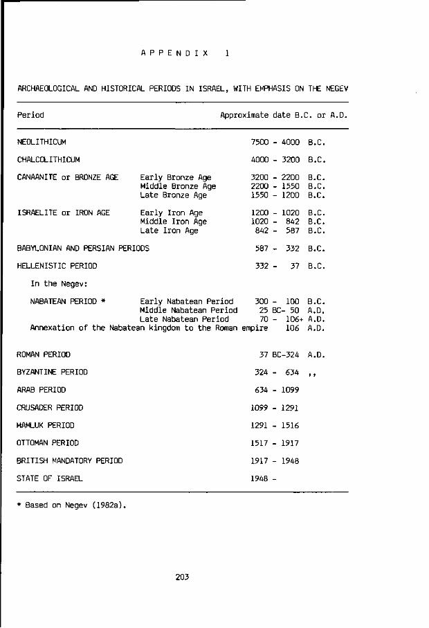
A P P E N D I X
ARCHAEOLOGICAL AND HISTORICAL PERIODS IN ISRAEL, WITH EMPHASIS ON THE NEGEV
Period Approximate date B.C. or A.D.
NEOLITHICUM
CHALCOLITHICUM
CANAANITE or BRONZE AGE
ISRAELITE or IRON AGE
Early Bronze Age Middle Bronze Age Late Bronze Age
Early Iron Age Middle Iron Age Late Iron Age
BABYLONIAN AND PERSIAN PERIODS
HELLENISTIC PERIOD
In the Negev:
NABATEAN PERIOD * Early Nabatean Period Middle Nabatean Period Late Nabatean Period
Annexation of the Nabatean kingdom to the Roman
7500 - A000 B.C.
4000 - 3200 B.C.
3200 - 2200 B.C.
2200 - 1550 B.C. 1550 - 1200 B.C.
1200 - 1020 B.C. 1020 - 842 B.C. 842 - 587 B.C.
587 - 332 B.C.
332 - 37 B.C.
300 - 100 B.C. 25 BC- 50 A.D. 70 - 106+ A.D.
empire 106 A.D.
ROMAN PERIOD
BYZANTINE PERIOD
ARAB PERIOD
CRUSADER PERIOD
MAMLUK PERIOD
OTTOMAN PERIOD
BRITISH MANDATORY PERIOD
STATE OF ISRAEL
37 BC-324 A.D.
324 - 634 ,,
634 - 1099
1099 - 1291
1291 - 1516
1517 - 1917
1917 - 1948
1948 -
* Based on Negev (1982a).
203

A P P E N D I X
LABORATORY METHODS OF SEDIMENT AND SOIL ANALYSIS
Particle size analysis of the sediment and soil samples was carried out at
the Stichting Technisch Centrum voor de Keramische Industrie in Arnhem. The
samples were treated with HC1, so that the carbonate components were removed
prior to the grain size determinations. Some large carbonate grains may not
have been dissolved entirely.
All other chemical analyses were carried out by Mr. F.J. Lettink at the
Chemical Laboratory of the Department of Soil Science and Geology
(Agricultural University of Wageningen), headed by Mr. L. Th. Begheijn. The
methods for the quantitative determination of organic carbon, nitrogen,
carbonate, soluble salts, electrical conductivity and pH are described in
Methods of Chemical Analyses for Soils and Waters (Begheijn, 1980). The method
used to determine the total phosphate content is described by Begheijn and
Schuylenborgh (1971:136).
The pH, soluble salts and electrical conductivity were measured in the
liquid extract of a 1:1 soil/water solution. All analyses were carried out on
the natural soil or sediment fraction < 2 mm. In case gravel (> 2 mm) was
found to be present, the weight percentage of the gravel fraction was deter
mined, which includes the carbonate grains as well.
Large size thin sections for the microscopic investigation of soil, sedi
ment and ancient aquaduct-mortar samples were made at the Micromorphological
Laboratory of the Department of Soil Science and Geology (Agricultural
University of Wageningen), headed by Ir. R. Miedema. The thin sections were
prepared by Mr. O.D. Jeronimus, according to the method described by Jongerius
and Heintzberger (1963).
204

R E F E R E N C E S
ABEL, M.E., SCHNITTKER, J.A. and BROWN, D.C. (1981) Climate-defensive policies to assure food supplies. In: Climate's Impact on Food Supplies (L.E. Slater and S.K. Levin, eds). AAAS Selected Symposium 62, pp. 45-60. Boulder, Colorado: Westview Press.
AHARONI, Y., EVENARI, M., SHANAN, L. and TADMOR, N.H. (1960) The ancient desert agriculture of the Negev. V. An Israelite settlement at Ramat Matred. Israel Exploration Journal 10:23-36, 97-111.
ARKIN, Y. and BRAUN, M. (1965) Type sections of upper Cretaceous formations in the northern Negev (southern Israel). Geological Survey of Israel, Stratigraphic sections, No 2a.
ARZI, A. (1981) Soil-Landscape relationships in the hilly area of Sde Boqer. M.Sc. Thesis, Bar-Ilan University (Israel), Dep. of Geography (in Hebrew).
ASHBEL, D. (1973) Climate. In: Geography, pp. 94-111. Jerusalem: Keter Publishing House.
AVI-YONAH, M. (1964) Essays and Studies. Jerusalem: Newman (in Hebew). BAILEY, C. (1980) The Negev in the nineteenth century: reconstructing history
from Bedouin oral traditions. Haifa: The Institute of Middle Eastern Studies: Asian and African Studies 14:35-80.
BARTH, F. (1959/60) The land use pattern of migratory tribes of South Persia. Norsk Geografisk Tidsskrift 17 (The Bobbs-Merrill Reprint Series in the Social Sciences, A-ll):l-ll.
BARTH, F. (1964) Nomads of South Persia. The Basseri Tribe of the Khamseh Confederacy. Oslo: Universitetsforlaget.
BART0V, Y. (1974) A structural and paleogeographic study of the Central Sinai faults and domes. Ph.D. Thesis, The Hebrew University of Jerusalem, Department of Geology (in Hebrew with English abstract).
BART0V, Y., EYAL, Y., GARFUNKEL, Z. and STEINITZ, G. (1972) Late Cretaceous and Tertiary stratigraphy and paleogeography of southern Israel. Israel Journal of Earth Sciences 21:69-97.
BART0V, Y. and STEINITZ, G. (1974) The Judea and Mount Scopus Groups in the Negev and Sinai with trend surface analysis of the thickness data. Israel Journal of Earth Sciences 26:119-148.
BEGHEIJN, L.Th. (1980) Methods of Chemical Analysis for Soils and Water. Wageningen: Agricultural University, Department of Soil Science and Geology (third edition).
BEGHEIJN, L.Th. and SCHUYLENBORGH, J. VAN (1971) Methods for the Analysis of Soils. Wageningen: Agricultural University, Department of Soil Science and Geology.
BENJAMINI, C. (1979a) Facies relationships of the Avdat Group (Eocene) in the northern Negev. Israel Journal of Earth Sciences 28:47-69.
BENJAMINI, C. (1979b) The Nahal Yeter Formation - a new Eocene formation from the northwestern Negev, Israel. Israel J. of Earth Sciences 28:164-166.
BENJAMINI, C. (1980) Stratigraphy and foraminifera of the Qeziot and Har Aqrav Formations (latest Middle to Late Eocene) of the western Negev, Israel. Israel Journal of Earth Sciences 29:227-244.
BENJAMINI, C. and ZILBERMAN, E. (1979) Late Eocene coral reefs of the western Negev, Israel. Israel Journal of Earth Sciences 28:42-46.
BENT0R, Y.K. and VR0MAN, A. (1963) The geological map of Israel. Ser.A, The Negev. Sheet 17: Nizzana, 1:100,000. Geological Survey of Israel.
BENT0R, Y.K., VR0MAN, A., ZAK, I. (1965) The geological map of Israel, scale 1:250,000, southern sheet.
BERKOFSKY, L. (1984) Rainfall patterns in the desert. World Climate Programme WCP-75. Geneva: World Meteorological Organization.
BOERS, Th.M. and BEN-ASHER, J. (1982) A review of rainwater harvesting. Agricultural Water Management 5:145-158.
205

BOOHER, L.J. (1974) Surface Irrigation. Rome: FAO Agricultural Development Paper No. 95.
BOWDEN, M.J., KATES, R.W., KAY, P.A., RIEBSAME, W.E., WARRICK, R.A., JOHNSON, D.L., GOULD, H.A. and WEINER, D. (1981) The effect of climate fluctuations on human populations: two hypotheses. In: Climate and History (T.M.L. Wigley, H.J. Ingram and G. Farmer, eds), pp. 479-513. Cambridge University Press.
BRAUN, M. (1967) Type sections of Avdat Group, Eocene Formations in the Negev, southern Israel. Geological Survey of Israel, Stratigraphic Sections 4.
BREEMEN, N. VAN (1972) Soil forming processes in acid sulphate soils. In: Acid Sulphate Soils (H. Dost, ed), Vol. 1, pp. 66-131. ILRI Publication No. 18, Wageningen.
BREEMEN, N. VAN (1986) Longterm chemical, mineralogical and morphological effects of Fe-redox processes in periodically flooded soils. In: Iron in Soils and Clay Minerals (J.W. Stucki, B.A. Goodman and U. Schwertmann, eds). Proceedings NATO Advanced Study Institute. Dordrecht: Reidel.
BREEMEN, N. VAN (1986) Personal communication. Agricultural University of Wageningen, Department of Soil Science and Geology.
BREWER, R. (1964) Fabric and mineral analysis of soils. New York: John Wiley. BRINKMAN, R. (1979) Ferrolysis - A soil-forming process in hydromorphic
conditions. Wageningen: Pudoc, Agricultural Research Report 887. BRINKMAN, R. (1986) Personal communication. Agricultural University of
Wageningen, Department of Soil Science and Geology. BROSHI. M. (1980) The population of Western Palestine in the Roman-Byl'natine
period. Bulletin of the American Schools of Oriental Research (BASOR) 236:1-10.
BRUINS, H.J. (1976) The origin, nature and stratigraphy of paleosols in the loessial deposits of the NW-Negev. M.Sc. Thesis, The Hebrew University of Jerusalem (Department of Geology).
BRUINS, H.J. and YAALON, D.H. (1979) Stratigraphy of the Netivot section in the desert loess of the Negev (Israel). Acta Geologica Academiae Scientia-rum Hungaricae 22(1-4): 161-169.
BRUINS, H.J. and YAALON, D.H. (1980) Paleoclimatic significance of clay content and paleosols in the desert loess of the Negev. Bat-Sheva Seminar on Approaches and Methods in Paleoclimatic Research with emphasis on Aridic areas, Jerusalem and Rehovot. Abstracts, pp. 25-26.
BRUINS, H.J., EVENARI, M. and NESSLER, U. (1986a) Rainwater-harvesting agriculture for food production in arid zones: the challenge of the African famine. Applied Geography 6:13-32.
BRUINS, H.J., EVENARI, M. and ROGEL, A. (1986b) Runoff farming management and climate. In: Progress in Desert Research (L. Berkofsky and M.G. Wurtele, eds). Totowa, N.J.: Rowman and Allanheld.
BRUINS, H.J, YAALON, D.H., ISSAR, A. and KARNIELI, A. (1987) The Netivot Formation, (in preparation).
BRYAN, K. (1929) Flood-water farming. Geographical Review 19:444-456. BURINGH, P. (1977) Mondiaal bodemgebruik en voedselproduktie. Bulletin of the
Faculty of Natural Resources, University of Suriname, No.l (Paramaribo). BUTZER, K.W. (1976) Early hydraulic civilization in Egypt: a study in cultural
ecology. Chicago: Chicago University Press. BUTZER, K.W. (1980) Holocene alluvial seguences: problems of dating and
correlation. In: Timescales in Geomorphology (R.A. Cullingford, D.A. Davidson and J. Lewin, eds), pp. 131-142. New York: John Wiley.
CICERO. The Verrine Orations, transl. H.G. Greenwood. Loeb Classical Library. London: William Heineman.
COHEN, R. (1976) Excavations at Horvat Haluqim. Atiqot 11:34-50. COHEN, R. (1980) The Iron Age fortresses in the Central Negev. Bulletin of the
American Schools of Oriental Research (BASOR) 236:61-79.
206

COHEN, R. (1981) Excavations at Kadesh-Barnea 1976-1978. Biblical Archeologist spring-1981:93-107.
COHEN, R. (1981) Archaeological Survey of Israel. Map of Sede Boqer-East (168) 13-03. Jerusalem: The Archaeological Survey of Israel.
COHEN, R. (1982) Personal communication. Department of Antiquities, Israel Museum, Jerusalem.
COHEN, R. (1983) Kadesh-barnea. A Fortress from the Time of the Judaean Kingdom. Jerusalem: The Israel Museum.
COHEN, R. and DEVER, W.G. (1980) Preliminary report of the second season of the "Central Negev Highlands Project". Bulletin of the American Schools of Oriental Research (BASOR) 236:41-60.
COLUMELLA. De Re Rustica, transl. H.B. Ash, E.S. Forster and E. Heftner. Loeb Classical Library. London: William Heineman.
CUNNINGHAM, G.M. (1970) Waterponding on scalds. Journal of the Soil Conservation Service of New South Wales 26:146-168.
CUNNINGHAM, G.M. (1975) Waterspreading - Cobart-Byrock district. Journal of the Soil Conservation of New South Wales 31:82-94.
CUNNISON, I. (1966) Baggara Arabs: Power and the Lineage in a Sudanese Nomad Tribe. Oxford: Clarendon Press.
DAM, D. VAN and PONS, L.J. (1972) Micromorphological observations on pyrite and its pedological reaction poducts. In: Acid Sulphate Soils (H. Dost, ed), ILRI Publication No. 18, Wageningen.
DAN, J. (1981) Soils of the sandy region of the western Negev. In: Aridic Soils of Israel (J. Dan, R. Gerson, H. Koyumdjisky and D.H. Yaalon, eds), pp. 211-222. Bet Dagan: The Volcani Center, Special Publ. No. 190.
DAN, J. (1981) The northwestern part of the Negev hills and mountains. In: Aridic Soils of Israel (J. Dan, R. Gerson, H. Koyumdjisky and D.H. Yaalon, eds), pp. 223-238. Bet Dagan: The Volcani Center, Special Publ. No. 190.
DAN, J., M0SHE, R. and ALPEROVITCH, N. (1973) The soils of Sede Zin. Israel Journal of Earth Sciences 22:211-227.
DAN, J., YAALON, D.H., KOYUMDJISKY, H. and RAZ, Z. (1975) The soil association map of Israel 1:500,000. Bet Dagan: The Volcani Center.
DAN, J. and YAALON, D.H. (1982) Automorphic saline soils in Israel. In: Aridic soils and geomophic processes (D.H. Yaalon, ed), pp. 103-115. Catena Supplement 1. Braunschweig: Catena Verlag.
DAN, J., YAALON, D.H., M0SHE, R. and NISSIM, S. (1982) Evolution of reg soils in southern Israel and Sinai. Geoderma 28:173-202.
DANIN, A. (1983) Desert vegetation of Israel and Sinai. Jerusalem: Cana Publishing House.
DANIN, A., 0RSHAN, G. and Z0HARY, M. (1975) The vegetation of the Northern Negev and the Judean Desert of Israel. Israel Journal of Botany 24:118-172.
DAVIDSON, D.A., RENFREW, C. and TASKER, C. (1976) Erosion and prehistory in Melos: a preliminary note. Journal of Archaeological Science 3:219-227.
D0STAL, W. (1959) The evolution of Bedouin life. In: L'antica beduina (F. Gabrieli, ed), pp. 11-34. Rome.
D0THAN, M. (1965) The fortress at Kadesh-Barnea. Israel Exploration Journal 15:134-151.
DUBIEF, J. (1953) Essai sur l'hydrologie superficielle au Sahara. Alger: Gouvernement Gen.
DUVDEVANI, S. (1953) Dew gradients in relation to climate, soil and topography. Desert Research Proceedings, Research Council of Israel Special Publication No. 2 (Jerusalem).
ELGABALY, M.M. (1954) The soils, water supply, and agriculture in northeastern Sinai. Proceedings of the Symposium on Scientific Problems of Land use in Arid Regions, pp. 125-152. Cairo, Egypt.
EMMETT, W.W. (1970) The hydraulics of overland flow on hillslopes. U.S. Geological Survey, Professional Paper 662-A, U.S.A. Government Printing Office,
207

Washington D.C. EVENARI, M., AHARONI, Y., SHANAN, L. and TADMOR, N.H. (1958) The ancient
desert agriculture of the Negev. III. Early beginnings. Israel Exploration Journal 8:231-268.
EVENARI, M., SHANAN, L. and TADMOR, N.H. (1963) Runoff-farming in the Negev desert of Israel. Progress report on the Avdat and Shivta Farm Projects for the years 1958-1962. The National and University Institute of Agriculture, Rehovot, Israel.
EVENARI, M., SHANAN, L. and TADMOR, N.H. (1964) Runoff-farming in the Negev desert of Israel (II). Progress report on the Avdat and Shivta Farm Projects for 1962/63 season. The National and University Institute of Agriculture, Rehovot, Israel.
EVENARI, M., SHANAN, L. and TADMOR, N.H. (1965) Runoff-farming in the Negev desert of Israel (III). Third Progress report. Avdat and Shivta Farm Projects, 1963/64 season. The National and University Institute of Agriculture, Rehovot, Israel.
EVENARI, M., SHANAN, L. and TADMOR, N.H. (1968) Runoff-farming in the Negev desert of Israel (IV). Fourth Progress report. Avdat and Shivta Farm Projects. 1964/65, 1965/66, 1966/67 seasons. The Hebrew University, Jerusalem, Department of Botany.
EVENARI, M., SHANAN, L. and TADMOR, N.H. (1971, 1982) The Negev - The challenge of a desert. Cambridge, Mass.: Harvard University Press.
EVENARI, M., SHANAN, L. and TADMOR, N.H. (1975) The agricultural potential of loess and loess-like soils in arid and semi-arid zones. Proceedings International Seminar Land Evaluation in Arid and Semi-arid zones of Latin America. IILA, Rome, pp. 489-507.
FELIKS, J. (1963) Agriculture in Palestine in the Period of the Mishna and Talmud. Jerusalem: Magnes Press (in Hebrew).
FLEXER, A. (1968) Stratigraphy and facies development of the Mount Scopus Group (Senonian-Paleocene) in Israel and adjacent countries. Israel Journal of Earth Sciences 17:85-114.
FLOHN, H. and NICHOLSON, S. (1980) Climatic fluctuations in the arid belt of the 'Old World' since the last glacial maximum: possible causes and future implications. In: Sahara and surrounding seas (M. Sarntheim, E. Seibold, P. Rognon, eds), pp. 3-21. Rotterdam: Balkema.
FREUND, R. (1965) A model of the structural development of Israel and adjacent areas since Upper Cretaceous times. Geological Magazine 102:189-205.
FROMKIN, R. (1981) Kadesh-Barnea. In: Kadesh-Barnea and its surroundings, pp..22-27. The Nature Protection Society and The Sede Boqer Field School, Israel (in Hebrew).
GANOR, E. (1975) Atmospheric dust in Israel. Sedimentological and meteorological analyis of dust deposition. Ph.D. Thesis, The Hebrew University of Jerusalem, Department of Geology (in Hebew).
GARFUNKEL, Z. (1978) The Negev - Regional synthesis of sedimentary basins. Tenth International Congress on Sedimentology (IAS), Jerusalem: Sedimento-logy in Israel, Cyprus and Turkey, Guidebook Part I, pp. 35-110
GARFUNKEL, Z. and HOROWITZ, A. (1966) The Upper Tertiary and Quaternary morphology of the Negev. Israel Journal of Earth Sciences 15:]01-117.
GEDDES, H.J. (1963) Water harvesting. Paper presented at the National Symposium on Water Resources, Australian Academy of Sciences, Canberra.
GIH0N, M. (1967) The Negev Frontier. In: Israel and her vicinity in the Roman and Byzantine Periods (M. Gihon and S. Applebaum). The 7th International Congress of Roman Frontier Studies. Tel-Aviv University Printing Press.
GOLDBERG, P. (1984) Late Quaternary history of Qadesh Barnea, Northeastern Sinai. Zeitschift fur Geomorphologie N.F. 28(2):193-217.
GRIGG, D.B. (1974) The agricultural systems of the world - An evolutionary approach. Cambridge: Cambridge University Press.
208

HACK, J.T. (1942) The changing physical environment of the Hopi Indians of Arizona. Harvard University Peabody Museum Papers 35, No. 1.
HAIMAN, M. (1982) Nahal Mitnan. Israel Exploration Journal 32:265-266. HAIMAN, M. (1982) Personal communication. The Archaeological Survey of Israel,
Israel Museum, Jerusalem. HALL, D.W. (1970) Handling and storage of food grains in tropical and
subtropical areas. Rome: FAO Agricultural Development Paper No. 90. HILLEL, D. (1959) Studies of Loessial Crusts. Israel, Rehovot: Agricultural
Research Institute, Bulletin 63. HILLEL, D. (1964) Infiltration and rainfall-runoff as affected by surface
crusts. Bucharest: Transactions 8th International Congress of Soil Science (ISSS) 1:34-39.
HILLEL, D. (1982) Negev - Land, water, and life in a desert environment. New York: Praeger.
HILLEL, D. and TADMOR, N. (1962) Water regime and vegetation in the Negev highlands of Israel. Ecology 43:33-41.
HOLLICK, M. (1982) Water harvesting in arid lands. Scientific Reviews on Arid Zone Research, Volume 1:173-247. Scientific Publ., Jodhpur, India.
HOPE, M. (1978) Plant Remains. In: Early Arad. The Chalcolithic Settlement and Early Bronze City. I. First-Fifth seasons of excavations, 1962-1966 (Amiran, R . ) , Part 3, pp. 64-82. Jerusalem: The Israel Exploration Society.
HORST, L. (1983) Irrigation Systems. Agricultural University of Wageningen, Department of Irrigation and Civil Engineering.
HORST, L. (1983) Irrigation systems - Alternative design concepts. Overseas Development Institute (ODI), Irrigation Management Network Paper 7C.
HUIBERS, F.P. (1985) Rainfed Agriculture in a Semi-arid Tropical Climate: aspects of land- and watermanagement for red soils in India. Dissertation, Agricultural University of Wageningen.
ILACO (1981) Agricultural Compendium for rural Development in the Tropics and Subtropics. Amsterdam: Elsevier.
INGRAM, M.J., FARMER, G. and WIGLEY, T.M.L. (1981) Past climates and their impact on man: a review. In: Climate and History (T.M.L. Wigley, M.J. Ingram and G. Farmer, eds), pp. 3-50. Cambridge University Press.
ISRAEL METEOROLOGICAL SERVICE (1967) Climatological Standard Normals of Rainfall, 1931-1960. Meteorological Notes Ser. A 21, Bet Dagan, Israel.
ISSAR, A.S. and BRUINS, H.J. (1983) Special climatological conditions in the deserts of Sinai and the Negev during the latest Pleistocene. Palaeogeogra-phy, Palaeoclimatology, Palaeoecology 43:63-72.
ISSAR, A., KARNIELI, A., BRUINS, H.J. and GILEAD, I. (1984) The Quaternary geology and hydrology of Sede Zin, Negev, Israel. The Israel Journal of Earth Sciences 33:34-42.
ISSAR, A., KARNIELI, A., BOWMAN, D. and BRUINS, H.J. (1986) Residual colluvio-aeolian aprons in the Negev highlands (Israel) - A paleo-climatic indicator. Accepted for publication in Palaeogeography, Palaeoclimatology, Palaeoecology.
JARVIS, C.S. (1938) Desert and Delta. London: John Murray. JONGERIUS, A. and HEINTZBERGER, G. (1963) The preparation of mammoth-sized
thin sections. Soil Survey Papers, nr. 1, Soil Survey Institute, Wageningen.
JONGMANS, A.G. and MIEDEMA, R. (1985) Personal communication. Agricultural University of Wageningen, Department of Soil Science and Geology.
KAMPHORST, A. (1985) Personal communication. Agricultural University of Wageningen, Department of Soils and Fertilizers.
KAMPHORST, A. and BOLT, G.H. (1978) Saline and sodic soils. In: Soil Chemistry. A. Basic Elements (G.H. Bolt and M.G.M. Bruggenwert, eds), pp. 171-191. Develpments in Soil Science 5A. Amsterdam: Elsevier.
KARSCHON, R. (1984) Quseima: an oasis in the isthmic desert. Agricultural
209

Research Organization, Dept. of Forestry, Leaflet No. 78. Ilanot, Israel. KATZNELSON, Y. (1959) The climate of the Negev. Jerusalem: Meteorological
Service Notes, Series 5(10). KEDAR, Y. (1957) Water and soil from the desert: some ancient agricultural
achievements in the central Negev. The Geographical Journal 123:179-187. KEDAR, Y. (1967) The ancient agriculture in the Negev mountains. Jerusalem:
Bialik Institute (in Hebrew). KEULEN, H. VAN (1979) Nitrogen nutrition, water use and plant production. In:
Soils in Mediterranean Type Climates and their Yield Potential. Proceedings 14th Colloq. International Potash Institute, Bern.
KEULEN, H. VAN (1980) Modelling grain production of wheat under conditions of limiting water supply: a case study. In: Proceedings 3rd International Wheat Conference (Madrid), pp. 414-419. (University of Nebraska-Lincoln, The Agricultural Experiment Station).
KEULEN, H. VAN and DE WIT, C.T. (1975) Actual and potential herbage production in arid regions. An annotated bibliography. Agricultural University of Wageningen, Dept. of Theoretical Production Ecology; and Institute for Biological and Chemical Research on Field Crops and Herbage (IBS).
KHAZANOV, A.M. (1985) Nomads and the outside world. Cambridge: Cambridge University Press.
KLEIN, C. (1961) On the fluctuations of the level of the Dead Sea since the beginning of the 19th century. Hydrological Paper No. 7. Hydrological Service, Ministry of Agriculture, Jerusalem.
KLEIN, C. (1981) The influence of rainfall over the catchment area on the fluctuations of the level of the Dead Sea since the 12th century. Israel Meteorological Research Papers, Vol. 3. Naftali Rosenan Memorial Volume, pp. 29-58. Meteorological Service, Bet-Dagan.
KLEIN, C. (1982) Morphological evidence of lake level changes, western shore of the Dead Sea. Israel Journal of Earth Sciences 31:67-94.
KLONER, A. (1975) Ancient agriculture at Mamshit and the dating of the water-diversion systems in the Negev. Jerusalem: Israel Exploration Society, Eretz-Israel 12:167-170 (in Hebrew, with abstract in English).
KRAEMER, C.J. (1958) Non-literary Papyri. Excavations at Nessana, Volume 3. Colt Archaeological Institute. Princeton N.J.: Princeton University Press.
KRENKEL, E. (1924) Der Syrische Bogen. Centralblat. Mineral. 9:274-281, 10:301-313.
KUTIEL, H. (1978) The Distribution of Rain Intensities in Israel. M.Sc. Thesis, The Hebrew University of Jerusalem.
LAMB, H.H. (1977) Climate - Present, Past and Future. Vol. 2. Climatic history and the future. London: Methuen.
LAMB, H.H. (1982) Climate, History and the Modern World. London: Methuen. LAST, Y. (1978) Class A Evaporation Pan data in Israel. Tahal, Tel-Aviv,
Hydrology Department (in Hebrew). LAVEE, H. (1973) Relationship between the surface properties of the debris
mantle and runoff yield in an extreme arid environment. M.Sc. Thesis, The Hebrew University of Jerusalem, Department of Geography (in Hebrew).
LEE, Ch.A. VAN DER (1978) Grondslagen en aspecten van de bewaring van granen, peulvruchten, wortels en knollen in de tropen. Agricultural University of Wageningen, Department of Tropical Crop Production.
LE H0UER0U, H.N. (1985) The impact of climate on pastoralism. In: Climate Impact Assessment (R.W. Kates, J.H. Ausubel and M. Berberian, eds). Scientific Committee on Problems of the Environment (SCOPE), John Wiley k Sons.
LE H0UER0U, H.N. and LUNDH0LM, B. (1976) Complementary activities for the improvement of the economy and the environment in marginal drylands. In: Can desert encroachment be stopped? A study with emphasis on Africa. Ecological Bulletin 24 (A. Rapp, H.N. Le Houerou and B. Lundholm, eds), pp. 217-229. Stockholm: NFR.
210

LEVY, T.E. (1983) The emergence of specialized pastoralism in the southern Levant. World Archaeology 15:15-36.
MALEY, J. (1973) Mecanisme des changements climatiques aux basses latitudes. Palaeogeography, Palaeoclimatology, Palaeoecology 14:193-227.
MARX, E. (1967) Bedouin of the Negev. Manchester: Manchester University Press. MARX, E. (1977) The tribe as a unit of subsistence: Nomadic pastoralism in the
Middle East. American Anthropologist 79:343-363. MARX, E. (1982) New trends in the study of pastoral nomads. Nomadic peoples
10:65-68. MAYERSON, P. (1955) Arid zone farming in Antiquity: A study of ancient
agricultural and related hydrological practices in Southern Palestine. Ph.D. Thesis, New York University.
MAYERSON, P. (1960a) The ancient agricultural regime of Nessana and the Central Negeb. Colt Archaeological Institute. London: The British School of Archaeology in Jerusalem.
MAYERSON, P. (1960b) The ancient agricultural remains of the central Negeb: Methodology and dating criteria. Bulletin of the American Schools of Oriental Research (BASOR) 160:27-37.
MAYERSON, P. (1963) The desert of southern Palestine according to Byzantine sources. Proceedings of the American Philosophical Society 107(2):160-172.
MAYERSON, P. (1964) The first Muslim attacks on southern Palestine. Transactions and Proceedings of the American Philological Association 95:155-199.
MAYERSON, P. (1967) A note on demography and land use in the ancient Negeb. Bulletin of the American Schools of Oriental Research (BASOR) 185:39-43.
MCCLURE, H.A. (1971) The Arabian Peninsula and Prehistoric Populations. Miami, Florida: Field Research Projects, Coconut Grove.
MIEDEMA, R., J0NGMANS, A.G. and SLAGER, S. (1974) Micromorphological observations on Pyrite and its oxidation products in four Holocene alluvial soils in The Netherlands. In: Soil Microscopy (G.K. Rutherford, ed), pp. 772-794. Ontario: The Limestone Press.
M00K, W.G. (1983) 14C calibration curves depending on sample time-width. In: 14C and Archaeology (W.G. Mook and H.T. Waterbolk, co-eds), PACT 8:517-525.
M00K, W.G. (1985) Personal communication. University of Groningen, Isotope Physics Laboratory.
MOOK, W.G. and STREURMAN, H.J. (1983) Physical and chemical aspects of radiocarbon dating. In: 14C and Archaeology (W.G. Mook and H.T. Waterbolk, coeds), PACT 8:31-55. (Council of Europe, Strasbourg).
M00LEY, D.A. and PANT, G.B. (1981) Droughts in India over the last 200 years, their socio-economic impacts and remedial measures for them. In: Climate and History (T.M.L. Wigley, M.J. Ingram and G. Farmer, eds), pp. 465-478. Cambridge University Press.
MULDERS, M.A. (1969) The arid soils of the Balikh Basin, Syria. Ph.D. Thesis, University of Utrecht.
MYERS, L.E. (1975) Water harvesting 2000 BC to 1974 AD. Proceedings of the Water Harvesting Symposium, Phoenix, Arizona, ARS W-22, USDA, pp. 1-7.
NATIV, R., ISSAR, A. and RUTLEDGE, J. (1983) Chemical composition of rainwater and floodwaters in the Negev desert, Israel. J. of Hydrology 62:201-223.
NEEV, D. and EMERY, K.O (1967) The Dead Sea. Depositional processes and environments of evaporites. Geological Survey of Israel (Jerusalem), Bulletin No. 41.
NEEV/, D. and HALL, J.K. (1977) Climatic fluctuations during the Holocene as reflected by the Dead Sea levels. International Conference on Terminal Lakes, Weber State College, Ogden, Utah.
NEGEV, A. (1981) Les Nabateans au Negev. Le Christianisme au Negev. La vie economique et sociale a l'epoque Byzantine. Le Monde de la Bible 18:4-46.
NEGEV, A. (1982a) Numismatics and Nabataean chronology. Palestine Exploration
211

Quarterly 114:119-128. NEGEV, A. (1982b) Christen und Christentum in der Wuste Negev. Antike Welt
13(2):2-33. NEWMAN, J.C. (1963) Waterspreading on marginal arable areas. Journal of the
Soil Conservation Service of New South Wales 19:49-58. NEWMAN, J.C. (1966) Waterponding for soil conservation in arid areas in New
South Wales. Journal of the Soil Conservation Service of New South Wales 22:2-11
NICHOLSON, S.E. and FLOHN, H. (1980) African environmental and climatic changes and the general atmospheric circulation in Late Pleistocene and Holocene. Climatic Change 2:313-348.
NOY-MEIR, I. and SELIGMAN, N.G. (1979) Management of semi-arid ecosystems in Israel. In: Management of Semi-arid Ecosystems (B.H.Walker, ed), pp. 113-160. Amsterdam: Elsevier.
OATES, J. (1976) Prehistory in Northeastern Arabia. Antiguity 50(197):20-31. ORNI, E. and EFRAT, E. (1971) Geography of Israel. Jerusalem: Israel
Universities Press. PEARSE, C.K. (1971) Grazing in the Middle East: Past, present and future.
Journal of Range Management 24(1):13-16. PEARSON, G.W. et al. (1985) High precision radiocarbon timescale calibration.
12th International Radiocarbon Conference, Trondheim, Norway. PEARSON, G.W. (1986) High precision radiocarbon timescale calibration.
Radiocarbon (in press). PENNING DE VRIES, F.W.T. (1983) The productivity of Sahelian rangelands - a
summary report. Overseas Development Institute (ODI), Agricultural Administration Unit, Pastoral Network Paper 15b.
PENNING DE VRIES, F.W.T. and DJITAYE, M.A., eds (1982) La productivite des Palurages Sahelians. Wageningen: Centre for Agricultural Publishing and Documentation (Pudoc).
PLINY (the Elder). Natural History, transl. H. Rackham, W.H.S. Jones and E.E. Eichholz. Loeb Classical Library. London: William Heineman.
PONS, L.J. (1964) A guantitative microscopical method of pyrite determination in soils. In: Proceedings Micromorphological Symposium, Arnhem, The Netherlands (A. Jongerius, ed), pp. 401-409.
P0RAT, Y. (1981) Personal communication. Department of Antiquities, Rockefeller Museum, Jerusalem.
R0SENAN, N. (1970) Temperature. Atlas of Israel, IV/1. Jerusalem: Survey of Israel, Ministry of Labour; Amsterdam: Elsevier.
ROTHENBERG, B. (1972) Timna. London: Thames and Hudson. SCHWARCZ, H.P., GOLDBERG, P. and BLACKWELL, B. (1980) Uranium series dating of
archaeological sites in Israel. Israel J. of Earth Sciences 29:157-165. SHANAN, L. (1975) Rainfall and runoff relationships in small watersheds in the
Avdat region of the Negev Desert Highlands. Ph.D. Thesis, The Hebrew University of Jerusalem, Department of Geography.
SHANAN, L., EVENARI, M. and TADM0R, N.H. (1967) Rainfall patterns in the Negev desert: Israel Exploration Journal 17(3):163-185.
SHANAN, L., EVENARI, M. and TADM0R, N.H. (1969) Ancient technology and modern science applied to desert agriculture. Endeavour 28(104):68-72.
SHANAN, L. and SCHICK, A.P. (1980) A hydrological model for the Negev Desert highlands: Effects of infiltration, runoff and ancient agriculture. Hydrological Science Bulletin 25(3):269-282.
SHANAN, L., TADM0R, N.H. and EVENARI, M. (1961) The ancient desert agriculture of the Negev, VII. Exploitation of runoff from large watersheds. Israel Journal of Agricultural Research (Ktavim) 11:9-31.
SHANAN, L., TADM0R, N.H. and EVENARI, M. (1970) Runoff farming in the desert, III. Micro-catchments for the improvement of desert range. Agronomy Journal 62:695-699.
212

SHANAN, L. and TADMOR, N.H. (1976, 1979) Micro-catchment systems for arid zone development, A handbook for design and construction. Rehovot, Israel: Ministry of Agriculture, Centre for International Agricultural Cooperation.
SHARON, D. (1972) The spottiness of rainfall in a desert area. Journal of Hydrology 17:161-175.
SLICHER VAN BATH, B.H. (1960) De agrarische geschiedenis van West-Europa (500-1850). Utrecht: Aula.
SLICHER VAN BATH, B.H. (1963a) De oogstopbrengsten van verschillende gewassen, voornamelijk granen, in verhouding tot het zaaizaad, ca. 810-1820. A.A.G. Bijdragen 9:29-125. Wageningen: Agricultural University, Department of Agrarian History.
SLICHER VAN BATH, B.H. (1963b) Yield ratios, 810-1820. A.A.G. Bijdragen 10:1-264. Wageningen: Agricultural University, Department of Agrarian History.
SPERBER, D. (1978) Roman Palestine 200-400 - The Land. Crisis and change in agrarian society as reflected in rabbinic sources. Ramat-Gan: Bar-Ilan University.
SPITZ, P. (1980) Drought and self-provisioning. In: Climatic constraints and human activities (J. Ausubel and A.K. Biswas, eds), pp. 125-147. Oxford: Pergamon Press.
STAGER, L.E. (1976) Farming in the Judean desert during the Iron Age. Bulletin of the American Schools of Oriental Research (BAS0R) 221:145-158.
STANHILL, G. (1961) A comparison of methods of calculating potential evapotranspiration from climatic data. Israel Journal of Agricultural Research 11:159-171.
STANHILL, G. (1978) The Fellah's farm: an autarkic agro-ecosystem. Agro-Ecosystems 4:433-448.
TADMOR, N.H., EVENARI, M., SHANAN, L. and HILLEL, D. (1958) The ancient desert agriculture in the Negev, I. Gravel mounds and strips near Shivta. Agricultural Reserach Station Rehovot, Ktavim Records 8:127-151.
THEOPHRASTUS. Enquiry into Plants, transl. A.F. Hort. Loeb Classical Library. London: William Heineman.
TH0RNE, D.W. and PETERSON, H.B. (1964) Irrigated soils: Their fertility and management. London: The Blackiston Company.
TURKOWSKI, L. (1969) Peasant agriculture in the Judaean hills. Palestine Exploration Quarterly (PEQ) 101:21-33, 101-112.
UNESCO (1979) Map of the world distribution of arid regions. Paris: Unesco, MAB Technical Notes 7.
USDA (1975) Soil Taxonomy. U.S. Department of Agriculture Handbook No. 436. Washington D.C.: U.S. Government Printing Office.
VARR0. De Re Rustica, transl. W.D. Hooper and H.B. Ash. Loeb Classical Library. London: William Heineman.
VITA-FINZI, C. (1969) The Mediterranean Valleys. Geological changes in historical times. Cambridge: Cambridge University Press.
VRIES, H. DE (1958) Variation in concentration of radiocarbon with time and location on earth. Proceedings Koninklijke Nederlandse Academie voor Weten-schappen, Ser. B, 61:94-102.
WAGSTAFF, J.M. (1981) Buried assumptions: some problems in the interpretation of the "Younger Fill" raised by recent data from Greece. Journal of Archaeological Science 8:247-264.
WAISEL, Y., P0LLAK, G. and COHEN, Y. (1978) The ecology of the vegetation in Eretz Israel. Dept. of Botany, Tel-Aviv University.
WAISEL, Y. and LIPHSCHITZ (1968) Dendrochronological studies in Israel. II. Juniperus Phoenica of north and central Sinai. La-Yaaran 1:2-22 (in Hebrew, with English summary, pp. 63-67).
WATSON, A.M. (1983) Agricultural innovation in the early Islamic world. The diffusion of crops and farming techniques, 700-1100. Cambridge: Cambridge University Press.
213
WEITZ, R. and ROKACH, A. (1968) Agricultural Development: Planning and Implementation (Israel case study), Dordrecht: Reidel.
WESTPHAL, E. (1974) Pulses in Ethiopia, their taxonomy and agricultural significance. Wageningen: Pudoc.
WESTPHAL, E. (1982) Tropical pulses. Agricultural University of Wageningen, Department of Tropical Crop Production.
WHITE, K.D. (1963) Wheat-farming in Roman Times. Antiquity 37:207-212. WIT, C.T. DE (1958) Transpiration and Crop Yields. Agricultural Research
Reports 646. Wageningen: Pudoc. WIEDER, M. (1977) Occurrence and Genesis of Carbonate Nodules in Soils. Ph.D.
Thesis. The Hebrew University of Jerusalem, Department of Geology. WIEDER, M. and YAALON, D.H. (1974) Effect of matrix composition on carbonate
nodule crystallization. Geoderma 11:95-121. W00LLEY, C.L. and LAWRENCE, T.E. (1914/15, 1936) The Wilderness of Zin.
London: Palestine Exploration Fund Annual 3 (1914/15). New York: Charles Scribner's Sons (1936).
WOUDE, A.M. VAN DER (1963) De consumptie van graan, vlees en boter in Holland op het einde van de achttiende eeuw. A.A.G. Bijdragen 9:127-153. Wageningen: Agricultural University, Department of Agrarian History.
YAALON, D.H. (1963) On the origin and accumulation of salts in groundwater and in soils of Israel. Bulletin Research Council of Israel 11G:105-131.
YAALON, D.H. (1964) Airborne salts as an active agent in pedogenetic processes. Bucharest: Trans. 8th Int. Congress of Soil Science 5:997-1000.
YAALON, D.H. (1981) Environmental setting. In: Aridic Soils of Israel (J. Dan, R. Gerson, H. Koyumdjisky and D.H. Yaalon, eds), pp. 3-16. Bet Dagan: The Volcani Center, Special Publication No. 190.
YAALON, D.H. and GAN0R, E. (1973) The influence of dust on soils during the Quaternary. Soil Science 116:146-155.
YAALON, D.H. and DAN, J. (1974) Accumulation and distribution of loess-derived deposits in the semi-arid and desert fringe areas of Israel. Zeitschrift f. Geomorphologie N.F. 20:91-105.
YAIR, A. (1981) The Sde Boqer experiment site. In: Aridic Soils of Israel (J. Dan, R. Gerson, H. Koyumdjisky and D.H. Yaalon, eds), pp. 239-254. Bet Dagan: The Volcani Center, Special Publication No. 190.
YAIR, A. (1983) Hillslope hydrology water harvesting and areal distribution of some ancient agricultural systems in the northern Negev desert. Journal of Arid Environments 6:283-301.
YAIR, A. and DANIN, A. (1980) Spatial variations in vegetation as related to the soil moisture regime over an arid limestone hillside, northern Negev, Israel. Oecologia 47(l):83-88.
YAIR, A. and KLEIN, M. (1973) The influence of surface properties on flow and erosion processes on debris-covered slopes in an arid area. Catena 1:1-18.
YAIR, A. and LAVEE, H. (1976) Runoff generative process and runoff yields from arid talus mantled slopes. Earth Surface Processes 1(3):235-247.
YAIR, A., SHARON, D. and LAVEE, H. (1978) An instrumented watershed for the study of partial area contribution of runoff in the arid zone. Zeitschrift fur Geomorphologie N.F. 29:71-82.
ZILBERMAN, E. (1981) The geology of the central Sinai-Negev shear Zone, central Negev. Part A, the Saad-Nafha lineament. Geological Survey of Israel, Report Hydro/1/81.
Z0HARY, D. (1973) The origin of cultivated cereals and pulses in the Near East. In: Chromosomes Today, Vol. 4 (J. Wahrman and K.R. Lewis, eds), pp. 307-320. New York: John Wiley.
Z0HARY, D. and H0PF, M. (1973) Domestication of pulses in the Old World. Science 182:887-894.
Z0HARY, M. (1966) Flora Palaestina, Part I. Jerusalem: The Israel Academy of Sciences and Humanities.
214

S A M E N V A T T I N G
WOESTIJN MILIEU EN LANDBOUW
IN DE CENTRALE NEGEV EN KADESH-BARNEA
GEDURENDE DE HISTORIE
Ongeveer een derde deel van het oppervlak der aarde bestaat uit droge
gebieden, die meestal worden onderverdeeld in hyper-aride, aride en semi-aride
streken. Er bestaat een groot verschil in potentieel land-gebruik tussen deze
drie droge zones, uitgaande van het gebruik van locale regenval. In Israel
ligt de semi-aride zone, waar landbouw m.b.v. directe regenval in de meeste
jaren mogelijk is, net ten noorden van de Negev woestijn. De grens tussen de
semi-aride en aride zone valt hier samen met de 300 mm regenval isohyet. De
noordelijke Negev en het tamelijk hoog gelegen centrale deel van de Negev
liggen grotendeels in de aride zone. De hyper-aride zuidelijke en oostelijke
Negev hebben een gemiddelde jaarlijkse regenval van minder dan 60 mm. Landbouw
en veeteelt gebaseerd op locale regenval is in de hyper-aride zone niet moge
lijk, behalve in oases.
De aride zone is meestal geschikt voor extensieve veehouderij, maar is te
droog voor normale regenafhankelijke landbouw. Runoff landbouw, eveneens geba
seerd op locale regenval, is echter wel mogelijk in de aride zone, indien het
milieu zich hiervoor leent: De geomorfologische, lithologische en bodemkundige
eigenschappen van het landschap, alsmede het regenval regime, moeten zodanig
zijn dat regenwater relatief snel gaat afstromen en vervolgens kan worden
opgeslagen in het bodemprofiel van de lagere delen van het landschap. Een
dergelijk milieu is aanwezig in het "Runoff Landbouw District" van de centrale
Negev, waar zich zeer veel cultuur-technische restanten van runoff landbouw
bevinden, daterend uit het verleden.
Runoff landbouw is hierbij gedefinieerd als landbouw in droge gebieden met
behulp van afstromend regenwater (runoff) in een natuurlijk of geprepareerd
drainage gebied, of vanuit een wadi.
Op hydro-geomorfologische gronden worden vijf vormen van runoff landbouw
onderscheiden:
1) Micro-vanggebied systemen
2) Geterrasseerde wadi systemen
3) Helling-aquaduct systemen
A) Liman systemen
5) Wadi-aftakkingskanaal systemen
215

Het gebruik van runoff landbouw in net aride deel van de Negev woestijn
gaat mogelijk terug naar het Chalcolithicum, zo'n 5500 jaar geleden. In de
Israelitische periode of IJzer tijd (circa 1000 voor Christus) werden een
aantal runoff landbouw nederzettingen gevestigd in de centrale Negev. De
archeologische datering van de vele cultuur-technische overblijfselen van
runoff landbouw die in de Negev worden gevonden is echter een moeilijke en
complexe zaak, waar nog niet zo veel systematisch onderzoek aan is verricht.
Een duidelijke chrono-stratigrafie ontbreekt in de meeste gevallen.
In een wadi-terras te Horvat Haluqim, aangelegd voor runoff landbouw in de
Israelitische periode of nog daarvoor, werd microscopisch de aanwezigheid
vastgesteld van ijzer-oxide concentraties in een ongeveer 3000 jaar oude
bodem-horizont. Dit is een duidelijk bewijs van een periodiek nat en geredu-
ceerd bodem milieu in het verleden. Het practiseren van runoff landbouw in de
oudheid, waarbij het afstromend regenwater in de betreffende wadi werd vastge-
houden door een reeks van lage keer-dammen en aldus in het bodemprofiel werd
opgeslagen, moet hiervoor verantwoordelijk zijn geweest. Dergelijke bodem-
vorming in dit droge aride gebied is normaal niet mogelijk.
Gedurende de historie zijn in het heuvelland van de centrale Negev, in een
gebied van ongeveer 200.000 hectare, zo'n A000 hectare cultiveerbare grond in
de wadis en valleien geschikt gemaakt voor runoff landbouw. Hiertoe werden
duizenden dammen gebouwd in de wadis. Bovendien werden op vele hellingen
eenvoudige doch functionele aquaducten aangelegd om meer afstromend regenwater
te kunnen verzamelen, hetgeen blijk geeft van een zeer goed ontwikkeld geomor-
fologisch-hydrologisch begrip van het landschap in de oudheid. Ook werden
kanalen gegraven die de runoff waterstromen in de wadis ten dele konden
aftakken en geleiden naar cultiveerbare velden.
Tijdens de Byzantijnse periode, van de 5e-7e eeuw na Christus, bereikte de
runoff landbouw in de centrale Negev woestijn zijn hoogtepunt. De gemiddelde
tarwe en gerst oogsten zullen waarschijnlijk niet hoger zijn geweest dan circa
600 kg/hectare. Op grond van schattingen en berekeningen lijkt het erop dat
minder dan een vierde deel der bevolking in de Byzantijnse tijd kon worden
gevoed met locaal verbouwde granen en peulvruchten. Dit bevestigt de indruk
dat het verder in cultuur brengen van de aride centrale Negev (grenzend aan de
hyper-aride zone) d.m.v. runoff landbouw werd gestimuleerd en mogelijk gemaakt
door de Byzantijnse autoriteiten. In dit verband moet worden gedacht aan het
strategische voordeel van een sedentaire bevolking in dit zeer droge gebied
ter verdediging van de zuid-oost grens van het Byzantijnse rijk.
Agrarische zelfvoorziening gebaseerd op runoff landbouw is misschien wel
216

mogelijk geweest met veel lagere bevolkingsaantallen in voorgaande en latere
perioden. Dit aspect vereist echter meer onderzoek. Interne vcedsel reserves
moeten een integraal onderdeel hebben gevormd van runoff landbouw systemen ter
overbrugging van de onvermijdelijke jaren van extreme droogte en misoogsten.
Er lijkt geen relatie te bestaan tussen variaties van het klimaat in het
verleden en de geschiedenis van sedentaire runoff landbouw in de centrale
Negev. In een deel van de eerste eeuw voor Christus en in de periode van circa
1200-1700 A.D. was de gemiddelde regenval relatief hoger in dit gebied, en het
milieu derhalve beter geschikt voor runoff landbouw, dat echter in die eeuwen
niet werd bedreven door een sedentaire bevolking. De mogelijke activiteiten
van semi-nomadische Bedoeinen op het gebied van runoff landbouw is historisch
gezien niet te achterhalen voor de genoemde tijdvakken.
Opmerkelijke geomorfologisch-geologische veranderingen hebben zich in de
laatste twee millennia voorgedaan in de vallei-oase van Kadesh-Barnea, gelegen
in de noord-oostelijke Sinai. Sedimentaire ophoging (aggradatie) in de Kadesh-
Barnea vallei vond plaats in de Romeinse tijd, en vooral in de periode van
1200-1700 A.D. Tijdens de aggradatie in dit laatste tijdvak werd het wadi-bed
met circa A meter opgehoogd. Het permanente beekje in een deel van de wadi,
gevoed door een van de grootste bronnen van de Negev-Sinai woestijn, stroomde
hierdoor ook op een hoger niveau. Deze landschappelijke interpretatie werd
overtuigend gestaafd door de microscopische ontdekking van authigene pyriet in
het bovenste deel van de aggradatie sedimenten. Na 1700 heeft de wadi zich
opnieuw in zijn eigen afzettingen ingesneden en is het niveau van het wadi bed
in korte tijd met zo'n 4 meter verlaagd.
Deze dramatische veranderingen in de vallei van Ein el Qudeirat (Kadesh-
Barnea) vallen chronologisch samen met bepaalde paleo-klimatologische perio
den: (a) sedimentaire ophoging in de vallei vond plaats tijdens een relatief
nat klimaat; (b) insnijding en erosie viel samen met een relatief droog
klimaat. De geomorfologisch-geologische evolutie van de Kadesh-Barnea vallei
in het Laat-Holoceen kan ongeveer als volgt worden samengevat:
1500 - 100 B.C. Dynamisch evenwicht
100 B.C.- 400 A.D. Enige aggradatie en dynamisch evenwicht
400 - 700 A.D. Dynamisch evenwicht
700 -1200 A.D. Insnijding en dynamisch evenwicht
1200 -1700 A.D. Omvangrijke aggradatie
1700 -1986 A.D. Snelle insnijding en erosie
217

Irrigatie landbouw in de vallei-oase van Kadesh-Barnea of Ein el Qudeirat
werd kennelijk reeds bedreven in de Bronstijd omstreeks 1600 voor Christus.
Deze conclusie is gebaseerd op grond van de C-14 datering van een aquaduct
restant. De overblijfselen van een dam met aquaduct aan het begin van de
vallei-oase dateren volgens de C-14 methode uit de 7e eeuw A.D. De aanwezig-
heid van authigene pyriet in de mortel van dit aquaduct, dat zich bovenop de
dam bevindt, is overtuigend bewijs van natte gereduceerde omstandigheden in
het verleden tijdens het functioneren van dit Laat-Byzantijns - Vroeg-Arabisch
irrigatie systeem.
Het maximale aantal mensen dat in vroegere tijden kon worden gevoed in de
vallei-oase van Kadesh-Barnea, d.m.v. irrigatie landbouw met water van de
bron, bedroeg hooguit 300-400 personen. In het hele gebied van Quseima en Ein
el Qudeirat, door velen beschouwd als de meest waarschijnlijke streek van het
Bijbelse Kadesh-Barnea, kunnen in de oudheid niet meer dan zo'n 1000 mensen
geleefd hebben in systemen van agrarische zelfvoorziening.
Aangezien de menigte der Israelieten, onder aanvoering van Mozes, zeer
zeker uit een veel grotere bevolking bestond tijdens het verblijf in de
grotendeels hyper-aride Sinai woestijn, na de Exodus uit Egypte, zou het volk
zonder de unieke voedsel-voorziening van manna zeker zijn omgekomen. Noch
locale landbouwkundige productie, noch extensieve veehouderij, noch voedsel-
importen van de vijandige volken in de omgeving bieden enig wetenschappelijk
alternatief in dit opzicht. Deze kwestie raakt de existentiele kern van de
geschiedenis van het volk Israel in die kritieke periode van haar bestaan.
Nomadisch pastoralisme is een gespecialiseerde vorm van een voedsel produ-
cerende economie, die door z'n eenzijdigheid bijna niet tot autarkie kan
leiden en in sterke mate afhankelijk is van de niet-nomadische sedentaire
buitenwereld. Nomadisch pastoralisme leidt bij een gelijkblijvend territorium
tot stagnatie, omdat een wezenlijke toename van de productie in een puur
nomadische maatschappij vrijwel onmogelijk is. Er zijn archeologische aanwij-
zingen dat runoff landbouw systemen in de aride Negev werden gecombineerd met
veehouderij. Met betrekking tot zelfvoorzienende voedsel productie gebaseerd
op locale regenval in aride streken verdient het aanbeveling de levensvatbaar-
heid te onderzoeken van mogelijke combinaties van veehouderij met de enige
vorm van regenafhankelijke landbouw geschikt voor de aride zone senso stricto:
runoff landbouw. Voedselreserves voor jaren van extreme droogte zijn echter
onmisbaar in dergelijke systemen.
218
CURRICULUM VITAE
The author was born in 1948 in Zeist, The Netherlands. In 1966 he completed
secondary school (HBS-b) at the Openbaar Lyceum "Schoonoord" in Zeist and
began his studies at the Agricultural University of Wageningen. The author
first studied landscape architecture, and later switched to soil science and
geology, in which field he continued at The Hebrew University of Jerusalem. In
1975 he received the Dicker-Shraga Award from the Geological Society of Israel
and the Department of Geology of The Hebrew University for his studies on the
desert loess of the Negev. He graduated cum laude in 1978.
Since 1976 he has been teaching soil science at the Ben-Gurion University
of the Negev, and also worked for brief periods at The Hebrew University of
Jerusalem and at Haifa University. In 1979-1980 he was a research fellow at
the Department of Soil Science and Geology at the Agricultural University of
Wageningen, and investigated the paleomagnetic stratigraphy of the Maas
terraces. From 1981-1984 he worked for the Archaeological Survey of Israel to
study ancient man-land relationships in the Negev desert and at Kadesh-Barnea.
Since 1982 he has been connected with the Jacob Blaustein Institute for Desert
Research of the Ben-Gurion University of the Negev. In 1984 he was co-
organizer of the Third International Course on Runoff Farming in Arid Regions,
held at the Sede Boqer Campus, Israel.
219