MONROE PLANNING COMMISSION
49
MONROE PLANNING COMMISSION SUBJECT: DISCUSSION - Monroe School District Comprehensive Plan Amendment and Rezone DATE: DEPT: CONTACT: PRESENTER: ITEM: 07/08/2019 Community Development Ben Swanson Shana Restall Shana Restall Old Business # 2 Discussion: 04/22/2019, 06/24/2019, and 07/08/2019 Public Hearing: Attachments: 1. Conceptual Site Plan 2. Comprehensive Plan Amendment Application 3. Project Narrative 4. Existing Comprehensive Plan Land Use Designation Map 5. Aerial Photo of the Subject Site 6. Comprehensive Plan Amendment Criteria Reponses 7. Traffic Study 8. Wetland and Stream Determination REQUESTED ACTION: This is informational only. A public hearing on this proposal will take place at a later date. POLICY CONSIDERATIONS As part of the 2018 – 2019 Comprehensive Plan Amendment docket, the City is seeking feedback and direction from the Planning Commission regarding the proposal. DESCRIPTION/BACKGROUND School District # 103 is proposing a citizen-initiated Comprehensive Plan amendment and associated rezone for the 12.4 acre Memorial Stadium and Marshall Field site, which is identified by Snohomish County Assessor’s tax parcel numbers 27060100205100, 27060100100400, 27060100404500. The subject property is situated approximately south of West Maple Street, west of north Kelsey Street, north of West Columbia Street, and east of St. Mary of the Valley Church. The current Comprehensive Plan map designation of the site is Institutional and current zoning district is Institutional. The School District is requesting an amendment to the Comprehensive Plan to modify the site’s Future Land Use Map designation from Institutional to Multifamily. Associated with the proposed Comprehensive Plan amendment, the applicant is also requesting a rezone of the subject property from Institutional to Multifamily Residential - R25. FISCAL IMPACT N/A TIME CONSTRAINTS N/A
-
Upload
khangminh22 -
Category
Documents
-
view
0 -
download
0
Transcript of MONROE PLANNING COMMISSION

MONROE PLANNING COMMISSION
SUBJECT: DISCUSSION - Monroe School District Comprehensive Plan Amendment and Rezone
DATE: DEPT: CONTACT: PRESENTER: ITEM:
07/08/2019 Community Development
Ben Swanson Shana Restall
Shana Restall Old Business # 2
Discussion: 04/22/2019, 06/24/2019, and 07/08/2019 Public Hearing:
Attachments: 1. Conceptual Site Plan
2. Comprehensive Plan Amendment Application 3. Project Narrative 4. Existing Comprehensive Plan Land Use Designation Map 5. Aerial Photo of the Subject Site 6. Comprehensive Plan Amendment Criteria Reponses 7. Traffic Study 8. Wetland and Stream Determination
REQUESTED ACTION: This is informational only. A public hearing on this proposal will take place at a later date.
POLICY CONSIDERATIONS
As part of the 2018 – 2019 Comprehensive Plan Amendment docket, the City is seeking feedback and direction from the Planning Commission regarding the proposal.
DESCRIPTION/BACKGROUND
School District # 103 is proposing a citizen-initiated Comprehensive Plan amendment and associated rezone for the 12.4 acre Memorial Stadium and Marshall Field site, which is identified by Snohomish County Assessor’s tax parcel numbers 27060100205100, 27060100100400, 27060100404500. The subject property is situated approximately south of West Maple Street, west of north Kelsey Street, north of West Columbia Street, and east of St. Mary of the Valley Church. The current Comprehensive Plan map designation of the site is Institutional and current zoning district is Institutional. The School District is requesting an amendment to the Comprehensive Plan to modify the site’s Future Land Use Map designation from Institutional to Multifamily. Associated with the proposed Comprehensive Plan amendment, the applicant is also requesting a rezone of the subject property from Institutional to Multifamily Residential - R25.
FISCAL IMPACT N/A
TIME CONSTRAINTS N/A

PROPOSED 60'RIGHT-OF-WAY
RECREATION /OPEN SPACE
RECREATION /OPEN SPACE
PARKING COUNT 595UNIT COUNT 288 (6-3 STORY BUILDINGS)
Feet
0 100 200
D - 1
RECEIVED 7/31/18

Updated 2018 – Please verify accuracy of this information/form prior to submitting. 1
CITY OF MONROE Community Development Department
806 West Main Street
Monroe, WA 98272 Phone: (360) 794-7400
Fax: (360) 794-4007
Citizen-Initiated Comprehensive Plan Amendment Application and Requirements
REQUIRED MATERIALS FOR A COMPLETE APPLICATION ARE:
1 Original plus 4 copies of the completed application (Pages 1, 2, & 3)
Appendices (See Page 4)
Appendix I – Describe proposal; one (1) original plus 4 copies.
Appendix II – Answer Parts A & B; one (1) original plus 4 copies.
Appendix III – Environmental (SEPA) checklist with supporting reports asrequired, one (1) original plus 4 copies, if applicable.
Appendix IV – Legal description/proof of ownership. Provide a current titlereport; one (1) copy dated within 30 days of application, if applicable.
1 copy of Vicinity and Site Plan Maps (Only required for site specific proposals)
Fees – Refer to the latest fees resolution to determine cost of application.
OFFICE USE ONLY Date Received:________________________ Application Number:
Received By:_________________________ Complete Application Date:
Fee Paid (date/time): Zoning of Site:________________________
Zoning of Adjacent Property: (North) (South)
(East) (West)
Comp Plan Designation:________________ Comp Plan Adjacent Property:(North)
(South) (East) (West)
OFFICE USE ONLY Planning Application Fee: $ Publication Fee: $
Fire Plan Check Fee: $ Mailing Fee: $
SEPA Fee: $ Technology Fee: $
TOTAL FEES: $
7/31/2018 CPA2018-01/RZ2018-01
Kim Shaw 7/31/2018
$2998.75/2:30 POS
Institutional
MR6000
1650.00/275.00 200.00
150.00+$50.00 Signs
550.00 123.75
0
2998.75

5133
SEPA2018-04
RZ2018-01
RECEIVED 7/31/2018

2
City of Monroe
Land Use Permit Application- Page 2
Give a detailed description below of the proposal / work. Provide details specific to
your application e.g., current and proposed lot sizes, number of lots, description of
driveway, description of proposed business including hours of operation, number of employees, existing and
proposed parking spaces.
Forest Tax Reporting Account Number (if harvesting timber call the Department of Revenue at
(800) 548-8829 for tax reporting information or to receive a tax number):
Detailed Description of work:
The proposal is for a combined application for a Comprehensive Plan Amendment and concurrent
Rezone, as detailed within the SEPA Environmental Checklist and submittal packet.

RECEIVED 7/31/2018
Application #5132 / CPA2018-03

Updated 2018 – Please verify accuracy of this information/form prior to submitting. 3
Citizen-Initiated Comprehensive Plan Amendment Application
2. Location of Property (If applicable)
A. Section_________________ Township_________________ Range
3. Legal Description(s) - Property Information (If applicable)
A. Tax Account Number(s):
B. Size of entire site (acres/square feet):
C. Comprehensive Plan Designation:
D. Current Use of Property:
E. Describe physical characteristics:
___________________________________________________________________
___________
___________________________________________________________________
___________
F. Sensitive Areas (wetlands, steep slopes, etc.):
___________________________________________________________________
___________________________________________________________________
__________
___________________________________________________________________
___________
Applications will be accepted Monday through Friday 8:00 am – 12:00 pm & 1:00 pm – 5:00 pm
01 27 N 06 E
27060100100400, 27060100205100, and 27060100404500
Three parcels totalling 12.41+/- acres
The site is designated as "Institutional"
sports fields
The Subject Site is known as Marshall Field and Memorial Stadium. It is developed
with sports fields, associated buildings, bleachers, lights, and a parking lot.
None. A detailed site description is included with the full application submittal.
MONROE SCHOOL DISTRICT NO. 103
COMPREHENSIVE PLAN AMENDMENT/REZONE
CITIZEN INITIATED COMPREHENSIVE PLAN AMENDMENT APPLICATION
& COMBINED PERMIT APPLICATION (LAND USE: REZONE)
JULY 2018
APPENDICES
ATTACHMENT – MSD Comprehensive Plan Amendment/Rezone Page 1 BRENT PLANNING SOLUTIONS, LLC FOR MONROE SCHOOL DISTRICT #103
APPENDIX I
APPENDIX I
Provide a type written description of the proposal including any relevant background material. The proposed amendment application shall consist of at least the following information, and consistent with the Citizen Initiated Comprehensive Plan Amendment Application and Submittal Checklist:
1. A description of the proposal, including any relevant background material;
1.a. If a request to amend the Comprehensive Plan Land Use Map is approved for consideration during the review cycle, staff may require additional information to be submitted including, but not limited to, an environmental review, traffic study, and utilities analysis.
Response: As provided for in Resolution No. 2012/020, the City of Monroe is now accepting
“Citizen-Initiated” requests to amend the City of Monroe 2015-2035 Comprehensive Plan. The
amendments will be considered as part of the City’s 2018-2019 Plan amendment cycle. The
Monroe School District #103 is submitting a Comprehensive Plan Amendment (Docket
Request) and concurrent rezone during this amendment cycle. The Docket Request is a non-
project action proposal for the City of Monroe (City) to amend the Comprehensive Plan with a
change to the Future Land Use Map and a concurrent rezone.
The current Comprehensive Plan map designation of the site is “Institutional” and current
implementing zoning is “Open Space”. The District is requesting an amendment to the
Comprehensive Plan – Future Land Use Map to the “Multifamily” designation (consistent with
the adjacent area), as well as requesting a concurrent rezone to “Multifamily”.
The City is currently in the process of bringing development regulations into compliance with
the land use designation in the adopted 2015-2035 Comprehensive Plan. The District’s
proposed request would allow potential development consistent with the 2015-2035
Comprehensive Plan and land use densities consistent with GMA requirements. The
“Multifamily” zoning designation would provide a range of density between 12 and 25
dwelling units per acre where the infrastructure can support the density. While there is not a
project associated with the Docket Request, the density used for review in the Environmental
Checklist was at the high-end of this range. This was done to determine the full-range of the
necessary infrastructure to serve any future land-use development proposal.
RECEIVED 7/31/2018

ATTACHMENT – MSD Comprehensive Plan Amendment/Rezone Page 2 BRENT PLANNING SOLUTIONS, LLC FOR MONROE SCHOOL DISTRICT #103
Additionally, since the District’s request is to amend the Comprehensive Plan Land Use Map
during the review cycle, City staff requested analysis and submittal of additional information.
This included an environmental review, traffic study, and utilities analysis, which were based
upon a conceptual site layout to provide discussion of potential environmental impacts of any
future subsequent land-use. The following items were prepared and have been submitted as a
part of this application:
Wetland and Stream Determination Report ............................................. Wetland Resources, Inc.
Conceptual Site Layout ....................................................................... Harmsen & Associates, Inc.
Memorandum (Transportation – Rezone Volume Analysis) ....... Gibson Traffic Consultants, Inc.
Results of the analysis of showed compatibility of multifamily on the site. While the study was
of a conceptual site layout, future site-specific development proposals would be subject to a
subsequent analysis (including a full SEPA environmental review) of the proposal, and review
of any proposed measures to reduce or control impacts.
Analysis of the conceptual site layout determined the following:
The on-site soils are conducive to erosion and would require on-site erosion control
measures during any clearing and/or site construction. Any future development would meet
code requirements for grading and erosion control.
Any future development of the site would generate emissions related to construction on the
site, which would be of short duration. Any potential future residential development would
create emissions typical of a residential development.
A minimal amount of oils, grease and other pollutants from paved areas could potentially
enter the ground or downstream surface waters through runoff. As part of any future
development a drainage plan with water quality treatment would be provided for
stormwater collected from pollution-generating surfaces.
No Priority Habitats or Species are known to be on the site or were observed during site
visits. There is a nearby Vaux’s swift communal roost, which is designated a priority
habitat per the Washington Department of Fish and Wildlife (WDFW). However,
development or construction on the subject property would not physically affect the
chimney where the roost is located. Any development on the subject property would not
impact the designated priority habitat area.
Noise levels would vary due to the type and usage of the equipment. Construction noises
are only generated during those times and are usually of short duration for each activity.
Long-term noise sources are those associated with the site use, including building functions,
on-site vehicles and any recreational areas that may be provided.
Development consistent with the proposed designation would be related to residents and
based on units developed per acre. Development at the high-end of the multifamily
designation could yield 288-296 units. Based on 2.97 persons per household, potentially
879 residents could reside on the site.
Any future development of the site would have to go through various permits from the City.
At that time, there would be a review of potential impacts related to traffic drainage and

ATTACHMENT – MSD Comprehensive Plan Amendment/Rezone Page 3 BRENT PLANNING SOLUTIONS, LLC FOR MONROE SCHOOL DISTRICT #103
other site development impacts. The proposal would allow development consistent with the
Comprehensive Plan future land use map and provide a consistent implementing zone.
Future development would potentially change the views on and to the site from field areas
to developed housing.
The conceptual site layout provided approximately 600 onsite parking spaces.
The potential rezone, with a future development, would add vehicle trips to several City
intersections that are projected to operate at level of service E or F in 2035. However, the
City has established a corridor level of service for its concurrency evaluation. Based on the
concurrency corridor analysis contained in the City’s operational level of service appendix
of the City’s Transportation Plan the future 2035 level of service of the corridors are all
expected to operate at acceptable level of service D or better with the highest corridor delay
being on W Main Street East corridor that has a projected delay of 50 second per entering
vehicle. The four intersections that the rezone (future development proposal) adds any
measurable trips to are:
Main Street/Frylands Blvd (Int #9)
Main Street Ramps with SR-522 (Int #10, 11)
Main Street/179th
Street (Int #29)
The proposed rezone would add between 0.4% to 1.55% increase in volume to those
corridor intersections or an average of less than 1% increase to the highest delay
concurrency corridor. The plan shows that W Main Street East corridor has a projected
delay in 2035 of 50 seconds (without the rezone) while 55 seconds appears to be the
threshold for LOS E (i.e., a delay increase capacity of approximately 10% before LOS E is
likely to be reached).
Any future development of the site would be required to provide a traffic study based on the
number of units to be developed. The study would review impacts and potential mitigation
that may be necessary. Frontage and pedestrian walkway improvements would be required.
A specific study on utility capacity was not performed. The following provides details
regarding utilities (sanitary sewer, water, storm water) for the site area.
Sanitary sewer is available along Kelsey Street (10” line) and Columbia Street (8” line).
The depth in Kelsey is approximately nine feet. The length of the site might require
multiple sewer connections or a pump for the future potential projects’ western-most units.
Water is available along Kelsey Street (10” line) and Columbia Street (8” line). The valley
area of the City is generally known to have adequate capacity and pressure for future
potential projects of this nature.
All stormwater would need to be handled on-site through infiltration as there are no local
storm connections that offer capacity for the future subsequent potential project. The soils
in the Monroe valley area are generally very conducive to infiltration and the site is
expected to have no issues controlling stormwater runoff. All projects need to control

ATTACHMENT – MSD Comprehensive Plan Amendment/Rezone Page 4 BRENT PLANNING SOLUTIONS, LLC FOR MONROE SCHOOL DISTRICT #103
construction stormwater and protect it from pollutants and sediment. With the site having
free draining soils, the threat of soil erosion is small. Standard Best Management Practices
(BMPs) would be used during future subsequent potential project construction.
Additional details are provided in the SEPA Environmental Checklist and combined
application packet.
2. Reference to the element(s) of the comprehensive plan that is proposed for amendment;
Response: The District is requesting a Comprehensive Plan amendment to the Future Land
Use Map from “Institutional” to “Multifamily”.
3. Proposed amendment language, when applicable;
Response: Not applicable. The requested amendment is to the Future Land Use Map
designation only.
4. An explanation of why the amendment is being proposed;
Response: The District is requesting the Comprehensive Plan Amendment and concurrent
rezone to allow other options to manage this site resource. While the site is no longer used for
formal education programs, the location doesn’t lend itself for future school facilities. The site
is located in close proximately to other schools that are developed. The site is currently used as
an informal ballfield, which is used by the community. The District does not use it for school
athletic programs or other school program uses. There are other schools in the area that
provide such facilities for school-use. A number of these fields have newer all-weather
surfaces allowing for additional opportunities for community use after school hours.
As the District has reviewed options for site use, the ability to process a Comprehensive Plan
Amendment provides the opportunities for future development options that could provide
additional funding for other needed school projects. While there are currently no plans for the
site, this Docket Request allows the best management of the site resource.
5. A description and/or map of the property affected by the proposal;
Response: The Subject Site includes three tax parcels (#27060100100400, 27060100205100,
and 27060100404500), totaling 12.41± acres in size (see Figure 1 – Vicinity Map and Figure 2
– Parcel Map). Two of the parcels have physical addresses assigned (210 Kelsey Street and
447 W Columbia Street) and one parcel is described as vacant/undeveloped with no physical
address.
Generally, the property is bounded by residential use on the north (including an apartment
complex), church property on the west, residential properties and W. Columbia Street on the
south, and Kelsey Street on the east. The current use is an informal ballfield, which is used by

ATTACHMENT – MSD Comprehensive Plan Amendment/Rezone Page 5 BRENT PLANNING SOLUTIONS, LLC FOR MONROE SCHOOL DISTRICT #103
the community. The site is developed with four sports fields, which includes grass ballfields
and a cinder track, associated buildings, bleachers, lighting and a parking lot. The structures on
site are in poor condition. The vegetation is maintained lawn with a few scattered trees along
the border of the site.
Figure 2 – Site/Parcel Map
6. The appropriate fee, as listed in the Fees Resolution in place at the time of applicationsubmittal
Response: The appropriate fee for the Comprehensive Plan Amendment and concurrent rezone
will be paid as part of the application.

P a r c e l # 2 7 0 6 1 - 0 0 1 - 0 0 4 - 0 0Parcel# 270601-002-051-00
Parcel# 270601-004-045-00
Kirby
Dr
Dickin
son S
t
Gran
tLn
Killarney Cir
W Maple St
W Hill St
NKels
eySt
W Columbia St
I100 0 10050 Feet
Y:\GIS\Departments\Eng\Mark\
Monroe School District - CPA
LegendComprehensivePlanLandUseDesignationsDESC
R8-11R5-7PFS

P a r c e l # 2 7 0 6 1 - 0 0 1 - 0 0 4 - 0 0Parcel# 270601-002-051-00
Parcel# 270601-004-045-00
Kirby
Dr
Dickin
son S
t
Gran
tLn
Killarney Cir
W Maple St
W Hill St
NKels
eySt
W Columbia St
I100 0 10050 Feet
Y:\GIS\Departments\Eng\Mark\
Monroe School District - CPA

ATTACHMENT – MSD Comprehensive Plan Amendment/Rezone Page 6 BRENT PLANNING SOLUTIONS, LLC FOR MONROE SCHOOL DISTRICT #103
APPENDIX II
Part A
The Planning Commission will provide a recommendation to the City Council whether the proposed amendment should be considered for further review based on the following criteria:
1. Consideration of the previous record if the amendment was reviewed and denied during aprevious amendment review cycle;
Response: The Monroe School District has not applied for this amendment previously.
2. The proposed amendment advances goals and policies of the comprehensive plan;
Response: The proposed Comprehensive Plan Amendment advances the goals and policies of
the Comprehensive Plan. The Multifamily designation is consistent with the 2015-2035 City of
Monroe Comprehensive Plan adopted Future Land Use Map. The proposed zoning designation
would provide the consistency with the Comprehensive Plan designation. The density of 12-25
units per acre has been used for review purposes only; however, it is consistent with forecast
conditions as illustrated by the City in their Land Use and Housing Chapters of the
Comprehensive Plan. Recent trends are showing increases in multifamily developments.
Higher density housing development also helps the City achieve goals of the downtown, Main
Street growth and GMA supported infill development.
The District does develop a Capital Facilities Plan (CFP), which outlines the present and future
facilities need for the District. The proposal is consistent with the District’s adopted CFP. The
proposed Docket Request is consistent with the District’s determination that the Subject Site is
no longer an athletic resource for school-use.
The existing infrastructure allows future development on the site with appropriate development
improvements and satisfying the City development standards.
3. The proposed amendment is consistent with the goals and regulations of the GrowthManagement Act;
RCW 36.70A contains many elements that address development in regards to the Growth
Management Act. Of particular consideration are the planning goals contained in RCW
36.70A.020. This amendment request is consistent with those planning goals and are addressed
below in italics. As stated in the RCW, “The following goals are adopted to guide the
development and adoption of comprehensive plans and development regulations of those
counties and cities that are required or choose to plan under RCW 36.70A.040. The following
goals are not listed in order of priority and shall be used exclusively for the purpose of guiding
the development of comprehensive plans and development regulations:”
RECEIVED 7/31/2018
ATTACHMENT – MSD Comprehensive Plan Amendment/Rezone Page 7 BRENT PLANNING SOLUTIONS, LLC FOR MONROE SCHOOL DISTRICT #103
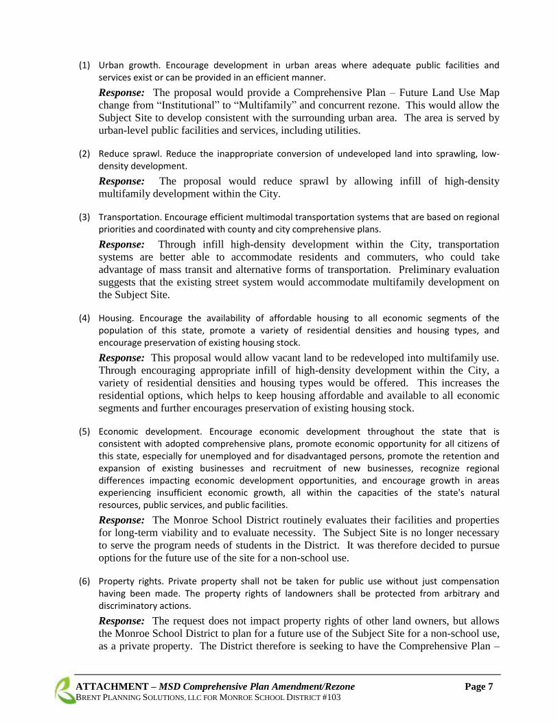
(1) Urban growth. Encourage development in urban areas where adequate public facilities and services exist or can be provided in an efficient manner.
Response: The proposal would provide a Comprehensive Plan – Future Land Use Map
change from “Institutional” to “Multifamily” and concurrent rezone. This would allow the
Subject Site to develop consistent with the surrounding urban area. The area is served by
urban-level public facilities and services, including utilities.
(2) Reduce sprawl. Reduce the inappropriate conversion of undeveloped land into sprawling, low-density development.
Response: The proposal would reduce sprawl by allowing infill of high-density
multifamily development within the City.
(3) Transportation. Encourage efficient multimodal transportation systems that are based on regional priorities and coordinated with county and city comprehensive plans.
Response: Through infill high-density development within the City, transportation
systems are better able to accommodate residents and commuters, who could take
advantage of mass transit and alternative forms of transportation. Preliminary evaluation
suggests that the existing street system would accommodate multifamily development on
the Subject Site.
(4) Housing. Encourage the availability of affordable housing to all economic segments of the population of this state, promote a variety of residential densities and housing types, and encourage preservation of existing housing stock.
Response: This proposal would allow vacant land to be redeveloped into multifamily use.
Through encouraging appropriate infill of high-density development within the City, a
variety of residential densities and housing types would be offered. This increases the
residential options, which helps to keep housing affordable and available to all economic
segments and further encourages preservation of existing housing stock.
(5) Economic development. Encourage economic development throughout the state that is consistent with adopted comprehensive plans, promote economic opportunity for all citizens of this state, especially for unemployed and for disadvantaged persons, promote the retention and expansion of existing businesses and recruitment of new businesses, recognize regional differences impacting economic development opportunities, and encourage growth in areas experiencing insufficient economic growth, all within the capacities of the state's natural resources, public services, and public facilities.
Response: The Monroe School District routinely evaluates their facilities and properties
for long-term viability and to evaluate necessity. The Subject Site is no longer necessary
to serve the program needs of students in the District. It was therefore decided to pursue
options for the future use of the site for a non-school use.
(6) Property rights. Private property shall not be taken for public use without just compensation having been made. The property rights of landowners shall be protected from arbitrary and discriminatory actions.
Response: The request does not impact property rights of other land owners, but allows
the Monroe School District to plan for a future use of the Subject Site for a non-school use,
as a private property. The District therefore is seeking to have the Comprehensive Plan –

ATTACHMENT – MSD Comprehensive Plan Amendment/Rezone Page 8 BRENT PLANNING SOLUTIONS, LLC FOR MONROE SCHOOL DISTRICT #103
Future Land Use Map changed to a designation and zoning consistent with a non-school
site, and compatible with the adjacent multifamily designations.
(7) Permits. Applications for both state and local government permits should be processed in a timely and fair manner to ensure predictability.
Response: This Docket Request will follow the prescribed timing as outlined by the City.
As stated on the City’s website: As provided for in Resolution No. 2012/020, the City of
Monroe is now accepting “Citizen-Initiated” requests to amend the City of Monroe 2015-
2035 Comprehensive Plan. The amendments will be considered as part of the City’s 2018-
2019 Plan amendment cycle.
The existing sport field use was granted through proper governmental approvals more than
20 years ago. Any future land-use application would be required to apply through the City,
and be subject to then current processes and timeframes for approval. The proposed
request would allow potential development consistent with the 2015-2035 Comprehensive
Plan and land use densities consistent with GMA requirements.
(8) Natural resource industries. Maintain and enhance natural resource-based industries, including productive timber, agricultural, and fisheries industries. Encourage the conservation of productive forestlands and productive agricultural lands, and discourage incompatible uses.
Response: Natural resource industries would not be impacted with the approval of this
amendment.
(9) Open space and recreation. Retain open space, enhance recreational opportunities, conserve fish and wildlife habitat, increase access to natural resource lands and water, and develop parks and recreation facilities.
Response: While approval of this amendment does remove a perceived open space with
recreational opportunities for the neighborhood, the Subject Site is not a public park, but
rather a school property. School property must either be serving the District, typically in
meeting programing needs of students, or potentially be surplused in the future.
Multifamily development of the site in the future may be subject to parks mitigation and/or
open space requirements from the City.
(10) Environment. Protect the environment and enhance the state's high quality of life, including air and water quality, and the availability of water.
Response: The Subject Site was reviewed for any wetlands and/or critical areas. There
are none on or adjacent to the property. The area has both public water and sanitary sewer
service provided by the City. Impacts on environmental elements, including air and water
quality, and the availability of water, would be reviewed in conjunction with the review of
environmental impacts of any future subsequent land-use proposal.
(11) Citizen participation and coordination. Encourage the involvement of citizens in the planning process and ensure coordination between communities and jurisdictions to reconcile conflicts.
Response: The Monroe School District has held a community discussion at a school board
meeting to discuss the proposal. There would be additional opportunities for area residents
to provide input during the City’s Docket process, as well as any future District property
evaluation. The proposed request would allow potential development consistent with the

ATTACHMENT – MSD Comprehensive Plan Amendment/Rezone Page 9 BRENT PLANNING SOLUTIONS, LLC FOR MONROE SCHOOL DISTRICT #103
2015-2035 Comprehensive Plan and land use densities consistent with GMA requirements.
The City’s plan updates have a public process with participation of the community.
(12) Public facilities and services. Ensure that those public facilities and services necessary to support development shall be adequate to serve the development at the time the development is available for occupancy and use without decreasing current service levels below locally established minimum standards.
Response: The sports fields no longer serve the programing needs of school students in
the Monroe School District and are not utilized for school-use. Preliminary evaluation
shows adequate levels of service for area utilities, and public facilities and services to serve
the Subject Site with development similar to the surrounding area (multifamily).
Approval of the Docket Request would provide future planning flexibility to the District, a
public service provider, and follows the timing and regulations of the City planning
processes.
(13) Historic preservation. Identify and encourage the preservation of lands, sites, and structures, that have historical or archaeological significance.
Response: The Subject Site is not known to have any structures of historic significance,
nor has it been mapped on the Washington Department of Archaeology and Historic
Preservation’s WISSARD system online. The Monroe School District is unaware of any
archaeological or historical significance regarding the Subject Site.
4. The relationship of the proposed amendment to other City codes and regulations; and
Response: The proposed Comprehensive Plan Amendment is consistent with the City codes
and regulations. The City is currently in the process of bringing development regulations into
compliance with the land use designation in the adopted 2015-2035 Comprehensive Plan. The
proposed request would allow potential development consistent with the 2015-2035
Comprehensive Plan and land use densities consistent with GMA requirements.
The “Multifamily” zoning designation would provide a range of density between 12 and 25
dwelling units per acre where the infrastructure can support the density, and be consistent with
the surrounding developments. The City is currently reviewing zoning designations to be
consistent with the adopted land use map. Analysis of the conceptual site layout included
review of the City’s proposed chapter on Multifamily Zoning Residential Zoning Districts,
which promotes the small town character of Monroe with provision of compatible multifamily
housing stock and encourages Multifamily:
…for land that is located convenient to principal arterials and business and
commercial activity centers where a full range of public facilities and services to
support urban development exists. Multifamily residential zoning districts are
intended for areas of infill housing and housing developments for seniors and other
special housing groups.
Since the Subject Site no longer serves the programming needs of students, the Monroe School
District is requesting a Comprehensive Plan Amendment to the Future Land Use Map

ATTACHMENT – MSD Comprehensive Plan Amendment/Rezone Page 10 BRENT PLANNING SOLUTIONS, LLC FOR MONROE SCHOOL DISTRICT #103
designation from “Institutional” to “Multifamily”, which is an appropriate non-school use
designation that is compatible with the surrounding area. Approval of the Docket Request
would provide future flexibility to the District, a public service provider, and follows the timing
and regulations of the City planning processes.
5. The cumulative effect(s) of the proposed plan amendment(s).
Response: The proposed request would allow potential development consistent with the 2015-
2035 Comprehensive Plan and land use densities consistent with GMA requirements. The
proposed Comprehensive Plan Amendment cumulative effects(s) would allow the Monroe
School District to potentially surplus property no longer needed for school-use, which is
supported by the MSD Capital Facilities Plan (CFP).
If the Comprehensive Plan amendment and rezone are approved, the property would have the
potential to provide increased multifamily housing land within the City of Monroe to better
meet increasing population demands.
Part B
A comprehensive plan amendment may be approved or approved with modifications:
1. Each amendment:
a. Shall not adversely affect public health, safety, or welfare in any significant way;
b. Shall be consistent with the overall goals and intent of the comprehensive plan;
c. Shall be in compliance with the Growth Management Act and other State and Federallaws; and
d. Must be weighed in light of cumulative effects of other amendments being considered.
Response: The proposed Comprehensive Plan Amendment would not adversely affect public
health, safety, or welfare in any significant way. It is consistent with the overall goals and
intent of the Comprehensive Plan. It is in compliance with the Growth Management Act and
other State and Federal laws. When weighed in light of cumulative effects of other
amendments being considered, the proposal continues to provide a benefit to the Monroe
School District and the City of Monroe.
The proposed request would allow potential development consistent with the 2015-2035
Comprehensive Plan and land use densities consistent with GMA requirements.
Impacts on environmental elements, including public health, safety, or welfare, and the
compatibility and consistency with the overall goals and intent of the Comprehensive Plan,
would be reviewed in conjunction with the review of environmental impacts of any future
subsequent land-use proposal.

ATTACHMENT – MSD Comprehensive Plan Amendment/Rezone Page 11 BRENT PLANNING SOLUTIONS, LLC FOR MONROE SCHOOL DISTRICT #103
2. In addition to the above mandatory requirements, any proposed amendment must meet thefollowing criteria unless compelling reasons justify its adoption without meeting them:
a. Addresses needs or changing circumstances of the City as a whole or resolvesinconsistencies between the Monroe Comprehensive Plan and other city plans orordinances.
Response: The City is currently in the process of bringing development regulations into
compliance with the land use designation in the adopted 2015-2035 Comprehensive Plan.
The proposed request would allow potential development consistent with the 2015-2035
Comprehensive Plan and land use densities consistent with GMA requirements.
The “Multifamily” zoning designation would provide a range of density between 12 and 25
dwelling units per acre where the infrastructure can support the density, and be consistent
with the surrounding developments. The Subject Site is in an area of high-density
multifamily development.
The proposed Comprehensive Plan Amendment addresses the needs and changing
circumstances of the City as a whole because the Monroe School District is a public
service provider. The District is the provider of public school education service within the
City and has determined this Docket Request is necessary. The District routinely evaluates
their facilities and properties for long-term viability and to evaluate necessity. The Subject
Site is no longer serving the program needs of students in the District. It was therefore
decided to pursue a plan for the future use of the site for a non-school use.
b. Environmental impacts have been disclosed and/or measures have been included thatreduce possible adverse impacts.
Response: The proposed Comprehensive Plan Amendment is a non-project action. The
Monroe School District prepared a SEPA Environmental Checklist, which discusses the
anticipated potential environmental impacts. Project-level environmental impacts would
be reviewed in conjunction with the review of any future subsequent land-use proposal.
c. Is consistent with the land uses and growth projections that were the basis of thecomprehensive plan and/or subsequent updates to growth allocations.
Response: The proposed Docket Request would be consistent with the land uses and
growth projections that were the basis of the comprehensive plan and/or subsequent
updates to growth allocations. Granting the appropriate non-school designation
(multifamily) adds buildable land for high-density residential infill in the City, which is
consistent with the Housing, Land Use Assumptions, which rely on land use strategies to
accommodate the City’s housing unit needs through 2035. Some objectives include:
Encouraging infill opportunities within existing City limits
Encouraging the provision of diverse housing types in all areas of Monroe

ATTACHMENT – MSD Comprehensive Plan Amendment/Rezone Page 12 BRENT PLANNING SOLUTIONS, LLC FOR MONROE SCHOOL DISTRICT #103
Encouraging housing growth near existing services, including park facilities
The request is necessitated because of changing circumstances as the sport fields are no
longer useful or viable for the Monroe School District. In order to consider a future
surplus of the properties, the Comprehensive Plan designation and zoning for the Subject
Site need to be for non-school use. That action would provide increased residential
(multifamily) infill land within the City, thereby meeting the goals of the Comprehensive
Plan.
The proposed request would allow potential development consistent with the 2015-2035
Comprehensive Plan and land use densities consistent with GMA requirements.
d. Is compatible with neighboring land uses and surrounding neighborhoods, if applicable.
Response: The proposed Docket Request is to provide future consistency with
neighboring land uses and surrounding neighborhoods. The City is currently in the process
of bringing development regulations into compliance with the land use designation in the
adopted 2015-2035 Comprehensive Plan. The “Multifamily” zoning designation would
provide a range of density between 12 and 25 dwelling units per acre where the
infrastructure can support the density, and be consistent with the surrounding
developments.
The sports fields no longer serve the programing needs of school students in the Monroe
School District. Preliminary evaluation shows adequate levels of service for area utilities,
and public facilities and services to serve the Subject Site with development similar to the
surrounding area (multifamily).
Approval of the Docket Request would provide future flexibility to the District, a public
service provider, and follows the timing and regulations of the City planning processes.
e. Is consistent with other plan elements and the overall intent of the comprehensive plan.
Response: The proposed request would allow potential development consistent with the
2015-2035 Comprehensive Plan and land use densities consistent with GMA requirements.
The proposed Docket Request is consistent with the overall intent of the Comprehensive
Plan as demonstrated within the application packet (including attachments and
appendices), the SEPA Environmental Checklist and the Monroe School District’s Capital
Faculties Plan.

2813 Rockefeller Avenue Suite B Everett, WA 98201 Tel: 425-339-8266 Fax: 425-258-2922 E-mail: [email protected]
MEMORANDUM
To: Laura Brent, Brent Planning Solutions From: Matthew Palmer, P.E. Subject: Rezone Analysis for Mid-rise Apartments Date: July 12, 2018 Project: Monroe School District Rezone, GTC #18-166
Gibson Traffic Consultants, Inc. (GTC) has been retained to provide a rezone volume analysis for 296 multi-family units in 3-story buildings located north of Columbia Street between S Kelsey Street and Dickinson Road in the City of Monroe. The purpose of this memorandum is to document the preliminary trip generation and to compare the total entering volume of 19 study intersections to the 2035 volumes identified in the City’s Appendix A: Traffic Operations Level of Service of the Transportation Plan.
ASSUMPTIONS
The existing volumes collected in the Transportation Plan are from 2014; therefore, to grow them to the baseline 2023 volumes a growth factor of 15% was utilized. This was calculated by using 2% growth per year from 2014 to 2020 and then 1% per year from 2020 to 2023. This is consistent with State growth on US-2 in the site vicinity and city forecasting. For the two intersections that were counted by Traffic Data Gathering (TDG) in June 2018 a growth factor of 7% was utilized; 2% growth per year from 2018 to 2020 and then 1% per year from 2020 to 2023.
The year 2023 was utilized as the baseline year as it’s when the apartment buildings could be built and fully occupied. The development would create a connecting roadway that would parallel Columbia Street with access to Kelsey Street approximately 170 feet north of Columbia Street and connecting to Columbia Street opposite Dickinson Road.
TRIP GENERATION
Traffic generation for the development is based on national research data contained in the Institute of Transportation Engineers (ITE) Trip Generation, 10th Edition (2017). ITE Land Use Code 223, mid-rise apartment, is utilized for the proposed use. There will be a total of 296 apartment units under a 3-story scenario. This would generate 1,610 ADT and 130 PM peak-hour trips. The trip generation is summarized on Table 1.
RECEIVED 7/31/18

Monroe School District Rezone Rezone Analysis
Gibson Traffic Consultants, Inc. July 2018 [email protected] 2 GTC #18-166
Trip generation calculations in the attachments also shows the trip generation for a low-rise apartment scenario, but this would have a lower number of units which leads to fewer trips being generated. Therefore, the mid-rise trip generation was utilized as the highest potential use for the volume analysis. No credit/reduction has been taken for existing uses on the site therefore this is a conservatively high analysis of new trip generation.
Table 1: Trip Generation Summary
Monroe School District Rezone PM Peak-Hour Trips
Inbound Outbound Total
Mid-rise Apartments 296 Units
Rate 0.44 per Unit
Splits 61% 39% 100%
Trips 79 51 130
TOTAL 79 51 130
The trips have been distributed through the 19 study intersections per the distribution shown in Figure 1 which is based on other residential distributions in the City of Monroe. Traffic heading to the west of the development using Columbia Street could continue west to 182nd Avenue SE bypassing the intersection of King Street and Blueberry Lane/154th Street SE (Intersection #40); however, as a worst case the westbound traffic was routed onto King Street impacting the study intersection.
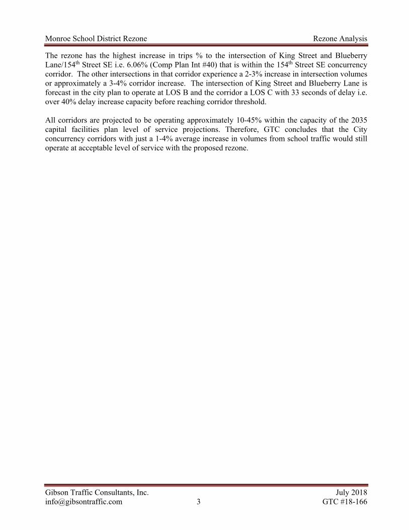
CONCLUSIONS
The potential rezone would add vehicle trips to several City intersections that are projected to operate at level of service E or F in 2035. However, the city has established a corridor level of service for its concurrency evaluation. Based on the concurrency corridor analysis contained in the City’s operational level of service appendix of the City’s Transportation Plan the future 2035 level of service of the corridors are all expected to operate at acceptable level of service D or better with the highest corridor delay being on W Main Street East corridor that has a projected delay of 50 second per entering vehicle. The four intersections that the rezone adds any measurable trips to are:
Main Street/Frylands Blvd (Int #9) Main Street Ramps with SR-522 (Int #10, 11) Main Street/179th Street (Int #29)
Table 2 shows that the proposed rezone would add between 0.4% to 1.55% increase in volume to those corridor intersections or an average of less than 1% increase to the highest delay concurrency corridor. The plan shows that W Main Street East corridor has a projected delay in 2035 of 50 seconds (without school rezone) while 55 seconds appears to be the threshold for LOS E i.e. a delay increase capacity of approximately 10% before LOS E is likely to be reached.
Monroe School District Rezone Rezone Analysis
Gibson Traffic Consultants, Inc. July 2018 [email protected] 3 GTC #18-166
The rezone has the highest increase in trips % to the intersection of King Street and Blueberry Lane/154th Street SE i.e. 6.06% (Comp Plan Int #40) that is within the 154th Street SE concurrency corridor. The other intersections in that corridor experience a 2-3% increase in intersection volumes or approximately a 3-4% corridor increase. The intersection of King Street and Blueberry Lane is forecast in the city plan to operate at LOS B and the corridor a LOS C with 33 seconds of delay i.e. over 40% delay increase capacity before reaching corridor threshold.
All corridors are projected to be operating approximately 10-45% within the capacity of the 2035 capital facilities plan level of service projections. Therefore, GTC concludes that the City concurrency corridors with just a 1-4% average increase in volumes from school traffic would still operate at acceptable level of service with the proposed rezone.

Monroe School District Rezone Rezone Analysis
Gibson Traffic Consultants, Inc. July 2018 [email protected] 4 GTC #18-166
Table 2: Volume Comparison
lntersection
Weekday PM Peak Hour Traffic Operations
Existing Baseline (2023) School
Rezone PM Peak Trips
With School Project (2023)
Preferred Alternative (2035) with
Capital Plan
Preferred Alternative (2035) with
Capital Plan % Increase With School (2035)
Int Letter
Int No. Int Name
Existing TEV
Baseline TEV
With School TEV
Preferred TEV
LOS
o 8 154th St SE & 179th Ave SE 1,184 1362 39 1401 1,614 E 2.36%
n 9 W Main St & Fryelands Blvd 1,150 1323 7 1330 1,736 B 0.40%
l 10 W Main St & East SR 522 RAB
1,322 1520 17 1537 2,157 B 0.78%
m 11 W Main St & West SR 522 RAB
1,743 2004 33 2037 3,048 F 1.07%
i 13 W Main St & Kelsey St 1,562 1796 28 1824 2,405 B 1.15%
j 15 Main St & Lewis St 1,870 2151 9 2160 2,285 F 0.39%
t 16 SR 2 & E Main St 2,587 2975 15 2990 3,981 C 0.38%
r 17 N Lewis St & SR 2 3,602 4142 6 4148 5,355 E 0.11%
u 18 Chain Lake Rd & Tjerne Pl SE 1,127 1296 0 1296 2,798 D 0.00%
g 19 Tjerne Pl SE & N Kelsey St 1,401 1611 13 1624 2,447 B 0.53%
h 20 N Kelsey St & Chain Lake Rd 1,037 1193 0 1193 2,120 C 0.00%
e 24 Blueberry Ln & N Kelsey 1,086 1249 33 1282 1,342 F 2.40%
f 25 SR 2 & Kelsey St 4,178 4805 33 4838 6,274 D 0.52%
q 28 SR 2 & 179th Ave SE 2,615 3007 40 3047 3,671 C 1.08%
k 29 W Main St & 179th Ave SE 1,425 1639 39 1678 2,476 D 1.55%
d 40 King St & 154th St/Blueberry 528 607 39 646 605 B 6.06%
p 41 179th Ave SE & 147th St SE 965 1110 33 1143 1,346 A 2.39%
a Columbia St & Kelsey St 631 675 28 703 --- --- ---
c W Main St & Dickinson Rd 1041 1114 39 1153 --- --- ---

A
Trip Generation

Mon
roe
Sch
ool D
istr
ict R
ezon
eG
TC
#18
-166
Tri
p G
ener
atio
n f
or:
W
eekd
ay(a
.k.a
.):
A
ver
age
Wee
kday
Dai
ly T
rip
s (A
WD
T)
NE
T E
XT
ER
NA
L T
RIP
S B
Y T
YP
E
IN B
OT
H D
IRE
CT
ION
SD
IRE
CT
ION
AL
AS
SIG
NM
EN
TS
Gro
ss T
rip
sIn
tern
alC
ross
ove
rT
OT
AL
PA
SS
-BY
DIV
ER
TE
D
LIN
KN
EW
PA
SS
-BY
DIV
ER
TE
D
LIN
KN
EW
LA
ND
US
ES
VA
RIA
BL
EIT
E
LU
co
de
Tri
pR
ate
% IN%
OU
TIn
+O
ut
(To
tal)
% o
fG
ross
Tri
ps
Tri
ps
In+
Ou
t(T
ota
l)
In+
Ou
t(T
ota
l)
% o
fE
xt.
Tri
ps
In+
Ou
t(T
ota
l)
% o
fE
xt.
Tri
ps
In+
Ou
t(T
ota
l)In
+O
ut
(To
tal)
InO
ut
InO
ut
InO
ut
Mul
ti-F
amily
(M
id-R
ise)
296
units
221
5.44
50%
50%
1610
.00
0%0.
0016
10.0
00%
0.00
0%0.
0016
100.
000.
000.
000.
0080
580
5
Mul
ti-F
amily
(Lo
w-R
ise)
225
units
220
7.32
50%
50%
1647
.00
0%0.
0016
47.0
00%
0.00
0%0.
0016
470.
000.
000.
000.
0082
482
3
A - 1

Mon
roe
Sch
ool D
istr
ict R
ezon
eG
TC
#18
-166
Tri
p G
ener
atio
n f
or:
W
eekd
ay, P
eak
Ho
ur
of
Ad
jace
nt
Str
eet
Tra
ffic
, On
e H
ou
r b
etw
een
4 a
nd
6 P
M(a
.k.a
.):
W
eekd
ay P
M P
eak
Ho
ur
NE
T E
XT
ER
NA
L T
RIP
S B
Y T
YP
E
IN B
OT
H D
IRE
CT
ION
SD
IRE
CT
ION
AL
AS
SIG
NM
EN
TS
Gro
ss T
rip
sIn
tern
alC
ross
ove
rT
OT
AL
PA
SS
-BY
DIV
ER
TE
D
LIN
KN
EW
PA
SS
-BY
DIV
ER
TE
D
LIN
KN
EW
LA
ND
US
ES
VA
RIA
BL
EIT
E
LU
co
de
Tri
pR
ate
% IN%
OU
TIn
+O
ut
(To
tal)
% o
fG
ross
Tri
ps
Tri
ps
In+
Ou
t(T
ota
l)
In+
Ou
t(T
ota
l)
% o
fE
xt.
Tri
ps
In+
Ou
t(T
ota
l)
% o
fE
xt.
Tri
ps
In+
Ou
t(T
ota
l)In
+O
ut
(To
tal)
InO
ut
InO
ut
InO
ut
Mul
ti-F
amily
(M
id-R
ise)
296
units
221
0.44
61%
39%
130.
000%
0.00
130.
000%
0.00
0%0.
0013
00.
000.
000.
000.
0079
51
Mul
ti-F
amily
(Lo
w-R
ise)
225
units
220
0.56
63%
37%
126.
000%
0.00
126.
000%
0.00
0%0.
0012
60.
000.
000.
000.
0079
47
A - 2

Monroe School District RezoneGTC #18-166
Mid-Rise Apartments
PM Peak-Hour
New PM Peak Hour Trips New PM Peak Hour Trips
In Out Total In Out Total
100% 1610 79 51 130.00 100% 1610 79 51 130
1% 16.10 0.79 0.51 1.30 51% 821.10 40.29 26.01 66.30
2% 32.20 1.58 1.02 2.60 52% 837.20 41.08 26.52 67.603% 48.30 2.37 1.53 3.90 53% 853.30 41.87 27.03 68.904% 64.40 3.16 2.04 5.20 54% 869.40 42.66 27.54 70.205% 80.50 3.95 2.55 6.50 55% 885.50 43.45 28.05 71.506% 96.60 4.74 3.06 7.80 56% 901.60 44.24 28.56 72.807% 112.70 5.53 3.57 9.10 57% 917.70 45.03 29.07 74.108% 128.80 6.32 4.08 10.40 58% 933.80 45.82 29.58 75.409% 144.90 7.11 4.59 11.70 59% 949.90 46.61 30.09 76.70
10% 161.00 7.90 5.10 13.00 60% 966.00 47.40 30.60 78.0011% 177.10 8.69 5.61 14.30 61% 982.10 48.19 31.11 79.3012% 193.20 9.48 6.12 15.60 62% 998.20 48.98 31.62 80.6013% 209.30 10.27 6.63 16.90 63% 1014.30 49.77 32.13 81.9014% 225.40 11.06 7.14 18.20 64% 1030.40 50.56 32.64 83.2015% 241.50 11.85 7.65 19.50 65% 1046.50 51.35 33.15 84.5016% 257.60 12.64 8.16 20.80 66% 1062.60 52.14 33.66 85.8017% 273.70 13.43 8.67 22.10 67% 1078.70 52.93 34.17 87.1018% 289.80 14.22 9.18 23.40 68% 1094.80 53.72 34.68 88.4019% 305.90 15.01 9.69 24.70 69% 1110.90 54.51 35.19 89.7020% 322.00 15.80 10.20 26.00 70% 1127.00 55.30 35.70 91.0021% 338.10 16.59 10.71 27.30 71% 1143.10 56.09 36.21 92.3022% 354.20 17.38 11.22 28.60 72% 1159.20 56.88 36.72 93.6023% 370.30 18.17 11.73 29.90 73% 1175.30 57.67 37.23 94.9024% 386.40 18.96 12.24 31.20 74% 1191.40 58.46 37.74 96.2025% 402.50 19.75 12.75 32.50 75% 1207.50 59.25 38.25 97.5026% 418.60 20.54 13.26 33.80 76% 1223.60 60.04 38.76 98.8027% 434.70 21.33 13.77 35.10 77% 1239.70 60.83 39.27 100.1028% 450.80 22.12 14.28 36.40 78% 1255.80 61.62 39.78 101.4029% 466.90 22.91 14.79 37.70 79% 1271.90 62.41 40.29 102.7030% 483.00 23.70 15.30 39.00 80% 1288.00 63.20 40.80 104.0031% 499.10 24.49 15.81 40.30 81% 1304.10 63.99 41.31 105.3032% 515.20 25.28 16.32 41.60 82% 1320.20 64.78 41.82 106.6033% 531.30 26.07 16.83 42.90 83% 1336.30 65.57 42.33 107.9034% 547.40 26.86 17.34 44.20 84% 1352.40 66.36 42.84 109.2035% 563.50 27.65 17.85 45.50 85% 1368.50 67.15 43.35 110.5036% 579.60 28.44 18.36 46.80 86% 1384.60 67.94 43.86 111.8037% 595.70 29.23 18.87 48.10 87% 1400.70 68.73 44.37 113.1038% 611.80 30.02 19.38 49.40 88% 1416.80 69.52 44.88 114.4039% 627.90 30.81 19.89 50.70 89% 1432.90 70.31 45.39 115.7040% 644.00 31.60 20.40 52.00 90% 1449.00 71.10 45.90 117.0041% 660.10 32.39 20.91 53.30 91% 1465.10 71.89 46.41 118.3042% 676.20 33.18 21.42 54.60 92% 1481.20 72.68 46.92 119.6043% 692.30 33.97 21.93 55.90 93% 1497.30 73.47 47.43 120.9044% 708.40 34.76 22.44 57.20 94% 1513.40 74.26 47.94 122.2045% 724.50 35.55 22.95 58.50 95% 1529.50 75.05 48.45 123.5046% 740.60 36.34 23.46 59.80 96% 1545.60 75.84 48.96 124.8047% 756.70 37.13 23.97 61.10 97% 1561.70 76.63 49.47 126.1048% 772.80 37.92 24.48 62.40 98% 1577.80 77.42 49.98 127.4049% 788.90 38.71 24.99 63.70 99% 1593.90 78.21 50.49 128.70
50% 805.00 39.50 25.50 65.00 100% 1610.00 79.00 51.00 130.00
% %NewADT
NewADT
A - 3

B
Figure 1 – PM Trip Distribution

RAFFIC
CITY OF MONROE
MONROE SCHOOL DISTRICTREZONE ANALYSIS
296 MID-RISE APARTMENTS
IBSONG T ONSULTANTSC TRAFFIC IMPACT STUDYGTC #18-166
N
OLD SNOHOMISH
MONROE RD
FRY
ELA
ND
S B
LVD
154TH ST SE
RAINIER VIEWRD SE
CH
AIN
LAK
E R
D
N KELSEY ST
WOODS
RD
RO
OS
EV
ELT R
D
W MAIN ST
S K
ELS
EY
ST
179T
H A
VE
SE
OLD OWEN
CREEK RD
CO
RYUNT C
RE
SCENT
MT
RID
GERD SE
SITE
W MAIN ST
BLUEBERRY LN
W HILL ST
COLUMBIA ST
DIC
KIN
SO
N R
D
177T
H A
VE
SE
147TH ST SE
PEAK
LEGEND
DEVELOPMENTTRIP DISTRIBUTION
PM PEAK-HOUR
FIGURE 1
TRIP DISTRIBUTION %
NEW SITE TRAFFIC(DAILY/PEAK-HOUR)
XX
AWDTPM
13403
20
25
13
403
2520
5 1134
7
LOCAL
5 80
2
4
15483
24
30
580
2 4
581
3 4
4
5813
5813
4
2032210
16
5804
2
5 1618
104
80 52
25 403
20
13 581
3
4
10 161
8
5
15483
24
30
20 322
10
16
348
2 2
22 354
11
17
381
4
5
20
403
2513
12
1939
6
B - 1

C
Counts

HV
NB 4.3%
631 WB #N/A
631 EB 3.4%
INTRS. 3.8%
PHF = Peak Hour Factor
HV = Heavy Vehicle
COUNTED BY: DATE OF COUNT:
REDUCTION DATE: TIME OF COUNT:
3.1%
0
0
0
1
TURNING MOVEMENTS DIAGRAM
W Columbia Street
121
INTERSECTION SB
N K
els
ey S
tre
et
16
80
223
Driveway
Pe
ds =
3
0
0
0
0
N K
els
ey S
tre
et
Woodinville, WA
W Columbia Street @ N Kelsey Street
0.76OUT
0.93Peds = 0
Wed. 6/13/18
TDG
4:00 PM - 6:00 PM
5:45 PM
Wed. 6/13/18
Peds = 0
PHF
0.86
#N/A
0
0
TO
0
0
0
0.93350
312
270
4:00 PM - 6:00 PM PEAK HOUR: 4:45 PM
IN
PEAK HOUR VOLUME
0
198
0
41 182
Pe
ds =
5
58
42
0
Bicycles
Bic
ycle
s
BicyclesU
-Turn
U-Turn
Bicycles
U-T
urn
U-Turn
C - 1

LO
CA
TIO
N:
W C
olu
mb
ia S
treet
@ N
Kels
ey S
treet
DA
TE
OF
CO
UN
T:
CO
UN
TE
D B
Y:
TD
G
Wo
od
invil
le,
WA
TIM
E O
F C
OU
NT
:D
AT
E O
F R
ED
UC
TIO
N:
6/1
3/2
018
TIM
E
INT
ER
VA
LIN
TE
RV
AL
EN
DIN
GT
OT
AL
S
AT
Ped
sB
icycle
HV
U-T
urn
Left
Th
ruR
igh
tP
ed
sB
icycle
HV
U-T
urn
Left
Th
ruR
igh
tP
ed
sB
icycle
HV
U-T
urn
Left
Th
ruR
igh
tP
ed
sB
icycle
HV
U-T
urn
Left
Th
ruR
igh
t
02:1
5 P
M0
00
00
00
00
00
00
00
00
00
00
00
00
00
00
02:3
0 P
M0
00
00
00
00
00
00
00
00
00
00
00
00
00
00
02:4
5 P
M0
00
00
00
00
00
00
00
00
00
00
00
00
00
00
03:0
0 P
M0
00
00
00
00
00
00
00
00
00
00
00
00
00
00
03:1
5 P
M0
00
00
00
00
00
00
00
00
00
00
00
00
00
00
03:3
0 P
M0
00
00
00
00
00
00
00
00
00
00
00
00
00
00
03:4
5 P
M0
00
00
00
00
00
00
00
00
00
00
00
00
00
00
04:0
0 P
M0
00
00
00
00
00
00
00
00
00
00
00
00
00
00
04:1
5 P
M0
01
00
45
60
01
015
48
00
00
00
00
10
00
11
05
130
04:3
0 P
M0
01
00
36
90
00
025
45
01
00
00
00
00
00
80
6129
04:4
5 P
M0
03
00
42
50
03
017
54
00
00
00
00
00
00
15
011
144
05:0
0 P
M0
01
00
37
13
00
20
24
65
02
00
00
00
01
00
10
03
152
05:1
5 P
M0
01
00
39
10
00
20
11
74
01
00
00
00
00
10
10
06
150
05:3
0 P
M0
02
00
49
10
00
70
25
57
00
00
00
00
10
10
14
05
160
05:4
5 P
M0
03
00
57
80
04
020
74
00
00
00
00
40
00
80
2169
06:0
0 P
M0
01
00
33
14
00
10
15
53
01
00
00
00
00
00
50
3123
00
70
0182
41
00
15
080
270
03
00
00
00
51
20
42
016
INT
ER
SE
CT
ION
AL
L M
OV
EM
EN
TS
631
% H
V3.1
%4.3
%#N
/A3.4
%3.8
%
HV
= H
eavy V
eh
icle
PH
F =
Peak H
ou
r F
acto
rT
O
INT
ER
VA
L
TO
TA
LS
TIM
E I
NT
ER
VA
LP
ed
sB
icycle
HV
U-T
urn
Left
Th
ruR
igh
tP
ed
sB
icycle
HV
U-T
urn
Left
Th
ruR
igh
tP
ed
sB
icycle
HV
U-T
urn
Left
Th
ruR
igh
tP
ed
sB
icycle
HV
U-T
urn
Left
Th
ruR
igh
t
2:0
0 P
M -
3:0
0 P
M0
00
00
00
00
00
00
00
00
00
00
00
00
00
00
2:1
5 P
M -
3:1
5 P
M0
00
00
00
00
00
00
00
00
00
00
00
00
00
00
2:3
0 P
M -
3:3
0 P
M0
00
00
00
00
00
00
00
00
00
00
00
00
00
00
2:4
5 P
M -
3:4
5 P
M0
00
00
00
00
00
00
00
00
00
00
00
00
00
00
3:0
0 P
M -
4:0
0 P
M0
00
00
00
00
00
00
00
00
00
00
00
00
00
00
3:1
5 P
M -
4:1
5 P
M0
00
00
00
00
00
00
00
00
00
00
00
00
00
00
3:3
0 P
M -
4:3
0 P
M0
00
00
00
00
00
00
00
00
00
00
00
00
00
00
3:4
5 P
M -
4:4
5 P
M0
00
00
00
00
00
00
00
00
00
00
00
00
00
00
4:0
0 P
M -
5:0
0 P
M0
06
00
160
33
00
60
81
212
03
00
00
00
11
00
44
025
555
4:1
5 P
M -
5:1
5 P
M0
06
00
154
37
00
70
77
238
04
00
00
00
01
10
43
026
575
4:3
0 P
M -
5:3
0 P
M0
07
00
167
38
00
14
077
250
03
00
00
00
11
20
49
025
606
4:4
5 P
M -
5:4
5 P
M0
07
00
182
41
00
15
080
270
03
00
00
00
51
20
42
016
631
5:0
0 P
M -
6:0
0 P
M0
07
00
178
42
00
14
071
258
02
00
00
00
50
20
37
016
602
4:0
0 P
M -
6:0
0 P
M T
ota
l:0
013
00
338
75
00
20
0152
470
05
00
00
00
61
20
81
041
1157
N K
els
ey S
treet
N K
els
ey S
treet
Dri
vew
ay
W C
olu
mb
ia S
treet
RO
LL
ING
HO
UR
CO
UN
T
FR
OM
NO
RT
H O
NF
RO
M S
OU
TH
ON
FR
OM
EA
ST
ON
FR
OM
WE
ST
ON
0.8
60.9
3#N
/A0.7
6
4:0
0 P
M -
6:0
0 P
M P
EA
K H
OU
R:
4:4
5 P
M5:4
5 P
M
PE
AK
HO
UR
FA
CT
OR
PE
AK
HO
UR
TO
TA
LS
N K
els
ey S
treet
N K
els
ey S
treet
0.9
3
223
350
0
INT
ER
SE
CT
ION
TU
RN
ING
MO
VE
ME
NT
S R
ED
UC
TIO
N S
HE
ET
W C
olu
mb
ia S
treet
Dri
vew
ay
FR
OM
NO
RT
H O
NF
RO
M S
OU
TH
ON
FR
OM
EA
ST
ON
FR
OM
WE
ST
ON
Wed
. 6/1
3/1
8
4:0
0 P
M -
6:0
0 P
M
58
C - 2

HV
NB 13.6%
1,041 WB 2.8%
1,041 EB 3.8%
INTRS. 3.6%
PHF = Peak Hour Factor
HV = Heavy Vehicle
COUNTED BY: DATE OF COUNT:
REDUCTION DATE: TIME OF COUNT:
5.3%
0
2
0
0
TURNING MOVEMENTS DIAGRAM
Main Street
493
INTERSECTION SB
Dic
kin
son
Str
eet
5
8
19
Main Street
Pe
ds =
0
5
3
472
0
Dic
kin
son
Str
eet
Woodinville, WA
Main Street @ Dickinson Street
0.92OUT
0.93Peds = 3
Wed. 6/13/18
TDG
4:00 PM - 6:00 PM
5:30 PM
Wed. 6/13/18
Peds = 2
PHF
0.53
0.93
0
0
TO
499
501
26
0.6122
40
1
4:00 PM - 6:00 PM PEAK HOUR: 4:30 PM
IN
PEAK HOUR VOLUME
13
9
0
13 1
Pe
ds =
0
499
13
481
Bicycles
Bic
ycle
s
BicyclesU
-Turn
U-Turn
Bicycles
U-T
urn
U-Turn
C - 3

LO
CA
TIO
N:
Main
Str
eet
@ D
ickin
so
n S
treet
DA
TE
OF
CO
UN
T:
CO
UN
TE
D B
Y:
TD
G
Wo
od
invil
le,
WA
TIM
E O
F C
OU
NT
:D
AT
E O
F R
ED
UC
TIO
N:
6/1
3/2
018
TIM
E
INT
ER
VA
LIN
TE
RV
AL
EN
DIN
GT
OT
AL
S
AT
Ped
sB
icycle
HV
U-T
urn
Left
Th
ruR
igh
tP
ed
sB
icycle
HV
U-T
urn
Left
Th
ruR
igh
tP
ed
sB
icycle
HV
U-T
urn
Left
Th
ruR
igh
tP
ed
sB
icycle
HV
U-T
urn
Left
Th
ruR
igh
t
02:1
5 P
M0
00
00
00
00
00
00
00
00
00
00
00
00
00
00
02:3
0 P
M0
00
00
00
00
00
00
00
00
00
00
00
00
00
00
02:4
5 P
M0
00
00
00
00
00
00
00
00
00
00
00
00
00
00
03:0
0 P
M0
00
00
00
00
00
00
00
00
00
00
00
00
00
00
03:1
5 P
M0
00
00
00
00
00
00
00
00
00
00
00
00
00
00
03:3
0 P
M0
00
00
00
00
00
00
00
00
00
00
00
00
00
00
03:4
5 P
M0
00
00
00
00
00
00
00
00
00
00
00
00
00
00
04:0
0 P
M0
00
00
00
00
00
00
00
00
00
00
00
00
00
00
04:1
5 P
M2
03
00
07
30
20
00
50
05
00
95
10
00
20
6114
0237
04:3
0 P
M0
00
02
03
30
00
00
20
011
01
109
20
04
02
114
0235
04:4
5 P
M1
00
03
06
00
20
30
60
08
02
124
60
08
02
114
1267
05:0
0 P
M0
00
00
01
00
10
20
20
01
01
119
60
03
02
112
3248
05:1
5 P
M1
00
02
02
30
00
31
20
12
00
126
80
04
04
132
0280
05:3
0 P
M0
01
00
14
00
00
00
30
13
00
103
60
04
05
123
1246
05:4
5 P
M0
00
00
03
00
00
00
20
02
01
111
50
02
04
95
0221
06:0
0 P
M0
00
02
05
00
00
30
10
04
00
93
20
02
03
85
2196
20
10
51
13
30
30
81
13
02
14
03
472
26
00
19
013
481
5IN
TE
RS
EC
TIO
N
AL
L M
OV
EM
EN
TS
1041
% H
V5.3
%13.6
%2.8
%3.8
%3.6
%
HV
= H
eavy V
eh
icle
PH
F =
Peak H
ou
r F
acto
rT
O
INT
ER
VA
L
TO
TA
LS
TIM
E I
NT
ER
VA
LP
ed
sB
icycle
HV
U-T
urn
Left
Th
ruR
igh
tP
ed
sB
icycle
HV
U-T
urn
Left
Th
ruR
igh
tP
ed
sB
icycle
HV
U-T
urn
Left
Th
ruR
igh
tP
ed
sB
icycle
HV
U-T
urn
Left
Th
ruR
igh
t
2:0
0 P
M -
3:0
0 P
M0
00
00
00
00
00
00
00
00
00
00
00
00
00
00
2:1
5 P
M -
3:1
5 P
M0
00
00
00
00
00
00
00
00
00
00
00
00
00
00
2:3
0 P
M -
3:3
0 P
M0
00
00
00
00
00
00
00
00
00
00
00
00
00
00
2:4
5 P
M -
3:4
5 P
M0
00
00
00
00
00
00
00
00
00
00
00
00
00
00
3:0
0 P
M -
4:0
0 P
M0
00
00
00
00
00
00
00
00
00
00
00
00
00
00
3:1
5 P
M -
4:1
5 P
M0
00
00
00
00
00
00
00
00
00
00
00
00
00
00
3:3
0 P
M -
4:3
0 P
M0
00
00
00
00
00
00
00
00
00
00
00
00
00
00
3:4
5 P
M -
4:4
5 P
M0
00
00
00
00
00
00
00
00
00
00
00
00
00
00
4:0
0 P
M -
5:0
0 P
M3
03
05
017
60
50
50
15
00
25
04
447
24
00
17
012
454
4987
4:1
5 P
M -
5:1
5 P
M2
00
07
012
60
30
81
12
01
22
04
478
22
00
19
010
472
41030
4:3
0 P
M -
5:3
0 P
M2
01
05
113
30
30
81
13
02
14
03
472
26
00
19
013
481
51041
4:4
5 P
M -
5:4
5 P
M1
01
02
110
30
10
51
90
28
02
459
25
00
13
015
462
4995
5:0
0 P
M -
6:0
0 P
M1
01
04
114
30
00
61
80
211
01
433
21
00
12
016
435
3943
4:0
0 P
M -
6:0
0 P
M T
ota
l:4
04
09
131
90
50
11
123
02
36
05
880
45
00
29
028
889
71930
Dic
kin
so
n S
treet
Dic
kin
so
n S
treet
Main
Str
eet
Main
Str
eet
RO
LL
ING
HO
UR
CO
UN
T
FR
OM
NO
RT
H O
NF
RO
M S
OU
TH
ON
FR
OM
EA
ST
ON
FR
OM
WE
ST
ON
0.5
30.6
10.9
30.9
2
4:0
0 P
M -
6:0
0 P
M P
EA
K H
OU
R:
4:3
0 P
M5:3
0 P
M
PE
AK
HO
UR
FA
CT
OR
PE
AK
HO
UR
TO
TA
LS
Dic
kin
so
n S
treet
Dic
kin
so
n S
treet
0.9
3
19
22
501
INT
ER
SE
CT
ION
TU
RN
ING
MO
VE
ME
NT
S R
ED
UC
TIO
N S
HE
ET
Main
Str
eet
Main
Str
eet
FR
OM
NO
RT
H O
NF
RO
M S
OU
TH
ON
FR
OM
EA
ST
ON
FR
OM
WE
ST
ON
Wed
. 6/1
3/1
8
4:0
0 P
M -
6:0
0 P
M
499
C - 4

C - 5

C - 6

C - 7

Wetland Resources, Inc. Monroe School District – W Columbia Street June 11, 2018 WRI #18175
1
June 11, 2018
Monroe School District #103 Attn: John Mannix 200 East Freemont Street Monroe, WA 98272
RE: Wetland and Stream Determination Report for Tax Parcels 27060100100400, 27060100205100, and 27060100404500
Wetland Resources, Inc. (WRI) performed a site investigation on June 6, 2018 to locate and identify jurisdictional wetlands and streams on and within the vicinity of the subject site located at 449 West Columbia Street in the City of Monroe, Washington. The Public Land Survey System (PLSS) locator for the subject property is Section 01, Township 27N, Range 06E, W.M.
The 12.41-acre subject site is currently developed with four sports fields, associated buildings, bleachers, and a parking lot. Vegetation on the site consists of maintained grasses, with some areas containing creeping buttercup (Ranunculus repens) and white clover (Trifolium repens). Topography of the property is generally flat, with the edges of the football and baseball fields slightly lower than the center of the fields.
METHODOLOGY AND RESULTS Prior to conducting the site reconnaissance, public resource information was reviewed to gather background information on the subject property and the surrounding area in regards to wetlands, streams, and other critical areas. These sources included the USFWS National Wetlands Inventory (NWI), USDA/NRCS Web Soil Survey, Snohomish County PDS Map Portal interactive mapping tool, WDFW Priority Habitat and Species (PHS) Interactive Map, and the Washington Department of Natural Resources (WA DNR) Forest Practices Application Mapping Tool (FPAMT).
• The National Wetlands Inventory does not show any wetlands on or in the immediatevicinity of the subject property. The closest mapped feature is a wetland associated withWoods Creek, about a half mile east of the site.
• USDA/NRCS Web Soil Survey maps the soils underlying the site as Sultan silt loam.
RECEIVED 7/31/18

Wetland Resources, Inc. Monroe School District – W Columbia Street June 11, 2018 WRI #18175 WRI #17054
2
• Snohomish County PDS Map Portal does not show any wetlands on or in the immediatevicinity of the subject property. The closest mapped feature is a wetland over 1,000 feet tothe northeast of the site.
• WDFW PHS Mapper does not show any Priority Habitats or on or immediately adjacentto the subject site. The closest mapped habitat feature is a communal roost of Vaux’sswift approximately 600 feet to the south on the Frank Wager Elementary Schoolcampus.
• WA DNR FPAMT does not show any streams on or in the immediate vicinity of the site.The closest water body displayed is Woods Creek, over a half mile to the east of the site.
The ordinary high water marks (OHWM) of streams and waterbodies, if present, were identified using the methodology described in: Determining the Ordinary High Water Mark for Shoreline Management Act Compliance in Washington State (Anderson et al 2016).
Wetland areas, if present, were determined using the routine determination approach described in the Corps of Engineers Wetlands Delineation Manual (Environmental Laboratory 1987) and the Regional Supplement to the Corps of Engineers Wetland Delineation Manual: Western Mountains, Valleys, and Coast Region (Version 2.0) (U.S. Army Corps of Engineers 2010). Under the routine methodology, the process for making a wetland determination is based on three steps:
1.) Examination of the site for hydrophytic vegetation (species present and percent cover);
2.) Examination of the site for hydric soils;
3.) Determining the presence of wetland hydrology
Dominant vegetation on-site consists of maintained grasses with some creeping buttercup (Ranunculus repens; FAC) and white clover (Trifolium repens; FAC). Large Douglas fir trees (Pseudotsuga menziesii; FACU) are present off-site along the southern boundary of the property. Soils within the football field were generally dark brown (10YR 3/3) sandy loam in the upper 4 inches with a layer of sand below. Soils within the baseball/softball fields were generally dark brown (10YR 3/3) sandy loam or sandy clay loam in the upper layer with a dark yellowish brown (10YR 4/4) sandy loam in the sublayer. Soils were dry at the time of the June 6 site investigation, and no redoximorphic features were observed in the sampled soils. No evidence of previously ponded water, algal mats, scoured soils, or sorted cobble was observed on the property. Based on the results of the site investigation, there no wetlands or streams on the subject site.
Vaux’s Swift The Vaux’s swift communal roost is designated a priority habitat per WDFW. Per the definition of “Fish and Wildlife Conservation Areas” in Monroe Municipal Code 20.05.030, priority habitats designated by WDFW are considered habitats of local importance and therefore are Fish and Wildlife Conservation Areas. The communal roost is approximately 600 feet from the subject site, is within the chimney of an elementary school building, and within a developed residential area. There are currently no trees on the subject property, so any development on the site will not remove any trees or snags that may currently be utilized by the Vaux’s swift. Development

Wetland Resources, Inc. Monroe School District – W Columbia Street June 11, 2018 WRI #18175 WRI #17054
3
or construction on the subject property would not physically affect the chimney where the roost is located. Any development on the subject property would not impact the designated priority habitat area.
USE OF THIS REPORT This Wetland and Stream Determination Report has been prepared for the Monroe School District #103 to assist with identifying on-site and nearby critical areas as required by the City of Monroe. This report is based largely on readily observable conditions and, to a lesser extent, on readily ascertainable conditions. No attempt has been made to determine hidden or concealed conditions.
The laws applicable to critical areas are subject to varying interpretations and may be changed at any time by the courts or legislative bodies. This report is intended to provide information deemed relevant in the applicant's attempt to comply with the laws now in effect.
This report conforms to the standard of care employed by ecologists. No other representation or warranty is made concerning the work or this report and any implied representation or warranty is disclaimed.
Wetland Resources, Inc.
Meryl Kamowski Senior Ecologist
Enclosures: Wetland Determination Data Sheets Determination Map (Sheet 1/1)
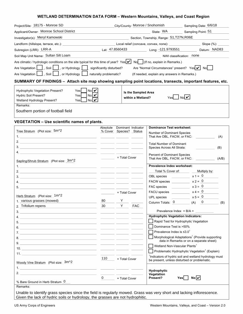
US Army Corps of Engineers Western Mountains, Valleys, and Coast – Version 2.0
WETLAND DETERMINATION DATA FORM – Western Mountains, Valleys, and Coast Region
Project/Site: City/County: Sampling Date:
Applicant/Owner: State: Sampling Point:
Investigator(s): Section, Township, Range:
Landform (hillslope, terrace, etc.): Local relief (concave, convex, none): Slope (%):
Subregion (LRR): Lat: Long: Datum:
Soil Map Unit Name: NWI classification:
Are climatic / hydrologic conditions on the site typical for this time of year? Yes No (If no, explain in Remarks.)
Are Vegetation , Soil , or Hydrology significantly disturbed? Are “Normal Circumstances” present? Yes No
Are Vegetation , Soil , or Hydrology naturally problematic? (If needed, explain any answers in Remarks.)
SUMMARY OF FINDINGS – Attach site map showing sampling point locations, transects, important features, etc.
Hydrophytic Vegetation Present? Yes No Hydric Soil Present? Yes No Wetland Hydrology Present? Yes No
Is the Sampled Area within a Wetland? Yes No
Remarks:
VEGETATION – Use scientific names of plants. Absolute Dominant Indicator
Tree Stratum (Plot size: ) % Cover Species? Status
1.
2.
3.
4.
= Total Cover Sapling/Shrub Stratum (Plot size: )
1.
2.
3.
4.
5.
= Total Cover Herb Stratum (Plot size: )
1.
2.
3.
4.
5.
6.
7.
8.
9.
10.
11.
= Total Cover Woody Vine Stratum (Plot size: )
1.
2.
= Total Cover % Bare Ground in Herb Stratum
Dominance Test worksheet: Number of Dominant Species That Are OBL, FACW, or FAC: (A)
Total Number of Dominant Species Across All Strata: (B)
Percent of Dominant Species That Are OBL, FACW, or FAC: (A/B)
Prevalence Index worksheet: Total % Cover of: Multiply by: OBL species x 1 =
FACW species x 2 =
FAC species x 3 =
FACU species x 4 =
UPL species x 5 =
Column Totals: (A) (B)
Prevalence Index = B/A = Hydrophytic Vegetation Indicators:
Rapid Test for Hydrophytic Vegetation
Dominance Test is >50%
Prevalence Index is ≤3.01
Morphological Adaptations1 (Provide supporting data in Remarks or on a separate sheet)
Wetland Non-Vascular Plants1
Problematic Hydrophytic Vegetation1 (Explain) 1Indicators of hydric soil and wetland hydrology must be present, unless disturbed or problematic.
Hydrophytic Vegetation Present? Yes No
Remarks:
18175 - Monroe SD Monroe / Snohomish 6/6/18
Monroe School District WA S1
Meryl Kamowski S1,T27N,R06E
LRR-A 47.8560433 -121.9793551 NAD83
Sultan Silt Loam none
✔
✔
✔
✔
✔✔
Southern portion of football field
5m^2
3m^2
1m^2
various grasses (mowed) 80 Y
Trifolium repens 30 Y FAC
1103m^2
00
0
0
0
0
0
0 0
✔
Unable to identify grass species since the field is regularly mowed. Grass was very short and lacking inflorescence.Given the lack of hydric soils or hydrology, the grasses are not hydrophitic.

US Army Corps of Engineers Western Mountains, Valleys, and Coast – Version 2.0
SOIL Sampling Point:
Profile Description: (Describe to the depth needed to document the indicator or confirm the absence of indicators.) Depth Matrix Redox Features (inches) Color (moist) % Color (moist) % Type1 Loc2 Texture Remarks
1Type: C=Concentration, D=Depletion, RM=Reduced Matrix, CS=Covered or Coated Sand Grains. 2Location: PL=Pore Lining, M=Matrix. Hydric Soil Indicators: (Applicable to all LRRs, unless otherwise noted.) Indicators for Problematic Hydric Soils3:
Histosol (A1) Sandy Redox (S5) 2 cm Muck (A10) Histic Epipedon (A2) Stripped Matrix (S6) Red Parent Material (TF2) Black Histic (A3) Loamy Mucky Mineral (F1) (except MLRA 1) Very Shallow Dark Surface (TF12) Hydrogen Sulfide (A4) Loamy Gleyed Matrix (F2) Other (Explain in Remarks) Depleted Below Dark Surface (A11) Depleted Matrix (F3) Thick Dark Surface (A12) Redox Dark Surface (F6) 3Indicators of hydrophytic vegetation and Sandy Mucky Mineral (S1) Depleted Dark Surface (F7) wetland hydrology must be present,
Sandy Gleyed Matrix (S4) Redox Depressions (F8) unless disturbed or problematic. Restrictive Layer (if present): Type:________________________________ Depth (inches):________________________ Hydric Soil Present? Yes No Remarks:
HYDROLOGY Wetland Hydrology Indicators: Primary Indicators (minimum of one required; check all that apply) Secondary Indicators (2 or more required)
Surface Water (A1) Water-Stained Leaves (B9) (except MLRA Water-Stained Leaves (B9) (MLRA 1, 2, High Water Table (A2) 1, 2, 4A, and 4B) 4A, and 4B) Saturation (A3) Salt Crust (B11) Drainage Patterns (B10) Water Marks (B1) Aquatic Invertebrates (B13) Dry-Season Water Table (C2) Sediment Deposits (B2) Hydrogen Sulfide Odor (C1) Saturation Visible on Aerial Imagery (C9) Drift Deposits (B3) Oxidized Rhizospheres along Living Roots (C3) Geomorphic Position (D2) Algal Mat or Crust (B4) Presence of Reduced Iron (C4) Shallow Aquitard (D3) Iron Deposits (B5) Recent Iron Reduction in Tilled Soils (C6) FAC-Neutral Test (D5) Surface Soil Cracks (B6) Stunted or Stressed Plants (D1) (LRR A) Raised Ant Mounds (D6) (LRR A) Inundation Visible on Aerial Imagery (B7) Other (Explain in Remarks) Frost-Heave Hummocks (D7) Sparsely Vegetated Concave Surface (B8)
Field Observations: Surface Water Present? Yes No Depth (inches):
Water Table Present? Yes No Depth (inches):
Saturation Present? Yes No Depth (inches): (includes capillary fringe)
Wetland Hydrology Present? Yes No
Describe Recorded Data (stream gauge, monitoring well, aerial photos, previous inspections), if available:
Remarks:
S1
0-3 10YR 3/3 100 Sandy Loam
3-12 10YR 5/3 100 Sand
✔
✔
✔
✔ ✔

US Army Corps of Engineers Western Mountains, Valleys, and Coast – Version 2.0
WETLAND DETERMINATION DATA FORM – Western Mountains, Valleys, and Coast Region
Project/Site: City/County: Sampling Date:
Applicant/Owner: State: Sampling Point:
Investigator(s): Section, Township, Range:
Landform (hillslope, terrace, etc.): Local relief (concave, convex, none): Slope (%):
Subregion (LRR): Lat: Long: Datum:
Soil Map Unit Name: NWI classification:
Are climatic / hydrologic conditions on the site typical for this time of year? Yes No (If no, explain in Remarks.)
Are Vegetation , Soil , or Hydrology significantly disturbed? Are “Normal Circumstances” present? Yes No
Are Vegetation , Soil , or Hydrology naturally problematic? (If needed, explain any answers in Remarks.)
SUMMARY OF FINDINGS – Attach site map showing sampling point locations, transects, important features, etc.
Hydrophytic Vegetation Present? Yes No Hydric Soil Present? Yes No Wetland Hydrology Present? Yes No
Is the Sampled Area within a Wetland? Yes No
Remarks:
VEGETATION – Use scientific names of plants. Absolute Dominant Indicator
Tree Stratum (Plot size: ) % Cover Species? Status
1.
2.
3.
4.
= Total Cover Sapling/Shrub Stratum (Plot size: )
1.
2.
3.
4.
5.
= Total Cover Herb Stratum (Plot size: )
1.
2.
3.
4.
5.
6.
7.
8.
9.
10.
11.
= Total Cover Woody Vine Stratum (Plot size: )
1.
2.
= Total Cover % Bare Ground in Herb Stratum
Dominance Test worksheet: Number of Dominant Species That Are OBL, FACW, or FAC: (A)
Total Number of Dominant Species Across All Strata: (B)
Percent of Dominant Species That Are OBL, FACW, or FAC: (A/B)
Prevalence Index worksheet: Total % Cover of: Multiply by: OBL species x 1 =
FACW species x 2 =
FAC species x 3 =
FACU species x 4 =
UPL species x 5 =
Column Totals: (A) (B)
Prevalence Index = B/A = Hydrophytic Vegetation Indicators:
Rapid Test for Hydrophytic Vegetation
Dominance Test is >50%
Prevalence Index is ≤3.01
Morphological Adaptations1 (Provide supporting data in Remarks or on a separate sheet)
Wetland Non-Vascular Plants1
Problematic Hydrophytic Vegetation1 (Explain) 1Indicators of hydric soil and wetland hydrology must be present, unless disturbed or problematic.
Hydrophytic Vegetation Present? Yes No
Remarks:
18175 - Monroe SD Monroe / Snohomish 6/6/18
Monroe School District WA S2
Meryl Kamowski S1,T27N,R06E
LRR-A 47.8559563 -121.9810241 NAD83
Sultan Silt Loam none
✔
✔
✔
✔
✔✔
Southern portion of baseball field
5m^2
03m^2
01m^2
various grasses (mowed) 90 Y
Ranunculus repens 5 N FAC
Hypochaeris radicata 5 N FACU
1003m^2
00
0
0
0
0
0
0 0
✔
Unable to identify grass species since the field is regularly mowed. Grass was very short and lacking inflorescence.Given the lack of hydric soils and hydrology, the grasses are not hydrophitic.

US Army Corps of Engineers Western Mountains, Valleys, and Coast – Version 2.0
SOIL Sampling Point:
Profile Description: (Describe to the depth needed to document the indicator or confirm the absence of indicators.) Depth Matrix Redox Features (inches) Color (moist) % Color (moist) % Type1 Loc2 Texture Remarks
1Type: C=Concentration, D=Depletion, RM=Reduced Matrix, CS=Covered or Coated Sand Grains. 2Location: PL=Pore Lining, M=Matrix. Hydric Soil Indicators: (Applicable to all LRRs, unless otherwise noted.) Indicators for Problematic Hydric Soils3:
Histosol (A1) Sandy Redox (S5) 2 cm Muck (A10) Histic Epipedon (A2) Stripped Matrix (S6) Red Parent Material (TF2) Black Histic (A3) Loamy Mucky Mineral (F1) (except MLRA 1) Very Shallow Dark Surface (TF12) Hydrogen Sulfide (A4) Loamy Gleyed Matrix (F2) Other (Explain in Remarks) Depleted Below Dark Surface (A11) Depleted Matrix (F3) Thick Dark Surface (A12) Redox Dark Surface (F6) 3Indicators of hydrophytic vegetation and Sandy Mucky Mineral (S1) Depleted Dark Surface (F7) wetland hydrology must be present,
Sandy Gleyed Matrix (S4) Redox Depressions (F8) unless disturbed or problematic. Restrictive Layer (if present): Type:________________________________ Depth (inches):________________________ Hydric Soil Present? Yes No Remarks:
HYDROLOGY Wetland Hydrology Indicators: Primary Indicators (minimum of one required; check all that apply) Secondary Indicators (2 or more required)
Surface Water (A1) Water-Stained Leaves (B9) (except MLRA Water-Stained Leaves (B9) (MLRA 1, 2, High Water Table (A2) 1, 2, 4A, and 4B) 4A, and 4B) Saturation (A3) Salt Crust (B11) Drainage Patterns (B10) Water Marks (B1) Aquatic Invertebrates (B13) Dry-Season Water Table (C2) Sediment Deposits (B2) Hydrogen Sulfide Odor (C1) Saturation Visible on Aerial Imagery (C9) Drift Deposits (B3) Oxidized Rhizospheres along Living Roots (C3) Geomorphic Position (D2) Algal Mat or Crust (B4) Presence of Reduced Iron (C4) Shallow Aquitard (D3) Iron Deposits (B5) Recent Iron Reduction in Tilled Soils (C6) FAC-Neutral Test (D5) Surface Soil Cracks (B6) Stunted or Stressed Plants (D1) (LRR A) Raised Ant Mounds (D6) (LRR A) Inundation Visible on Aerial Imagery (B7) Other (Explain in Remarks) Frost-Heave Hummocks (D7) Sparsely Vegetated Concave Surface (B8)
Field Observations: Surface Water Present? Yes No Depth (inches):
Water Table Present? Yes No Depth (inches):
Saturation Present? Yes No Depth (inches): (includes capillary fringe)
Wetland Hydrology Present? Yes No
Describe Recorded Data (stream gauge, monitoring well, aerial photos, previous inspections), if available:
Remarks:
S2
0-7 10YR 3/3 100 Sandy Clay Loam
7-16 7.5YR 4/4 100 Sandy Loam
✔
✔
✔
✔ ✔

US Army Corps of Engineers Western Mountains, Valleys, and Coast – Version 2.0
WETLAND DETERMINATION DATA FORM – Western Mountains, Valleys, and Coast Region
Project/Site: City/County: Sampling Date:
Applicant/Owner: State: Sampling Point:
Investigator(s): Section, Township, Range:
Landform (hillslope, terrace, etc.): Local relief (concave, convex, none): Slope (%):
Subregion (LRR): Lat: Long: Datum:
Soil Map Unit Name: NWI classification:
Are climatic / hydrologic conditions on the site typical for this time of year? Yes No (If no, explain in Remarks.)
Are Vegetation , Soil , or Hydrology significantly disturbed? Are “Normal Circumstances” present? Yes No
Are Vegetation , Soil , or Hydrology naturally problematic? (If needed, explain any answers in Remarks.)
SUMMARY OF FINDINGS – Attach site map showing sampling point locations, transects, important features, etc.
Hydrophytic Vegetation Present? Yes No Hydric Soil Present? Yes No Wetland Hydrology Present? Yes No
Is the Sampled Area within a Wetland? Yes No
Remarks:
VEGETATION – Use scientific names of plants. Absolute Dominant Indicator
Tree Stratum (Plot size: ) % Cover Species? Status
1.
2.
3.
4.
= Total Cover Sapling/Shrub Stratum (Plot size: )
1.
2.
3.
4.
5.
= Total Cover Herb Stratum (Plot size: )
1.
2.
3.
4.
5.
6.
7.
8.
9.
10.
11.
= Total Cover Woody Vine Stratum (Plot size: )
1.
2.
= Total Cover % Bare Ground in Herb Stratum
Dominance Test worksheet: Number of Dominant Species That Are OBL, FACW, or FAC: (A)
Total Number of Dominant Species Across All Strata: (B)
Percent of Dominant Species That Are OBL, FACW, or FAC: (A/B)
Prevalence Index worksheet: Total % Cover of: Multiply by: OBL species x 1 =
FACW species x 2 =
FAC species x 3 =
FACU species x 4 =
UPL species x 5 =
Column Totals: (A) (B)
Prevalence Index = B/A = Hydrophytic Vegetation Indicators:
Rapid Test for Hydrophytic Vegetation
Dominance Test is >50%
Prevalence Index is ≤3.01
Morphological Adaptations1 (Provide supporting data in Remarks or on a separate sheet)
Wetland Non-Vascular Plants1
Problematic Hydrophytic Vegetation1 (Explain) 1Indicators of hydric soil and wetland hydrology must be present, unless disturbed or problematic.
Hydrophytic Vegetation Present? Yes No
Remarks:
18175 - Monroe SD Monroe / Snohomish 6/6/18
Monroe School District WA S3
Meryl Kamowski S1,T27N,R06E
LRR-A 47.8559563 -121.9810241 NAD83
Sultan Silt Loam none
✔
✔
✔
✔
✔✔
Northern portion of baseball fields
5m^2
03m^2
01m^2
various grasses (mowed) 80 Y
Ranunculus repens 40 Y FAC
1203m^2
00
0
0
0
0
0
0 0
✔
Unable to identify grass species since the field is regularly mowed. Grass was very short and lacking inflorescence.Given the lack of hydric soils and hydrology, the grasses are not hydrophitic.

US Army Corps of Engineers Western Mountains, Valleys, and Coast – Version 2.0
SOIL Sampling Point:
Profile Description: (Describe to the depth needed to document the indicator or confirm the absence of indicators.) Depth Matrix Redox Features (inches) Color (moist) % Color (moist) % Type1 Loc2 Texture Remarks
1Type: C=Concentration, D=Depletion, RM=Reduced Matrix, CS=Covered or Coated Sand Grains. 2Location: PL=Pore Lining, M=Matrix. Hydric Soil Indicators: (Applicable to all LRRs, unless otherwise noted.) Indicators for Problematic Hydric Soils3:
Histosol (A1) Sandy Redox (S5) 2 cm Muck (A10) Histic Epipedon (A2) Stripped Matrix (S6) Red Parent Material (TF2) Black Histic (A3) Loamy Mucky Mineral (F1) (except MLRA 1) Very Shallow Dark Surface (TF12) Hydrogen Sulfide (A4) Loamy Gleyed Matrix (F2) Other (Explain in Remarks) Depleted Below Dark Surface (A11) Depleted Matrix (F3) Thick Dark Surface (A12) Redox Dark Surface (F6) 3Indicators of hydrophytic vegetation and Sandy Mucky Mineral (S1) Depleted Dark Surface (F7) wetland hydrology must be present, Sandy Gleyed Matrix (S4) Redox Depressions (F8) unless disturbed or problematic.
Restrictive Layer (if present): Type:________________________________ Depth (inches):________________________
Hydric Soil Present? Yes No Remarks:
HYDROLOGY Wetland Hydrology Indicators:
Primary Indicators (minimum of one required; check all that apply) Secondary Indicators (2 or more required)
Surface Water (A1) Water-Stained Leaves (B9) (except MLRA Water-Stained Leaves (B9) (MLRA 1, 2, High Water Table (A2) 1, 2, 4A, and 4B) 4A, and 4B) Saturation (A3) Salt Crust (B11) Drainage Patterns (B10) Water Marks (B1) Aquatic Invertebrates (B13) Dry-Season Water Table (C2) Sediment Deposits (B2) Hydrogen Sulfide Odor (C1) Saturation Visible on Aerial Imagery (C9) Drift Deposits (B3) Oxidized Rhizospheres along Living Roots (C3) Geomorphic Position (D2) Algal Mat or Crust (B4) Presence of Reduced Iron (C4) Shallow Aquitard (D3) Iron Deposits (B5) Recent Iron Reduction in Tilled Soils (C6) FAC-Neutral Test (D5) Surface Soil Cracks (B6) Stunted or Stressed Plants (D1) (LRR A) Raised Ant Mounds (D6) (LRR A) Inundation Visible on Aerial Imagery (B7) Other (Explain in Remarks) Frost-Heave Hummocks (D7) Sparsely Vegetated Concave Surface (B8)
Field Observations: Surface Water Present? Yes No Depth (inches):
Water Table Present? Yes No Depth (inches):
Saturation Present? Yes No Depth (inches):
(includes capillary fringe)
Wetland Hydrology Present? Yes No
Describe Recorded Data (stream gauge, monitoring well, aerial photos, previous inspections), if available:
Remarks:
S3
0-7 10YR 3/3 100 Sandy Loam
7-16 10YR 4/4 100 Sandy Loam
✔
✔
✔
✔ ✔

DETERMINATION MAPMONROE SD - W COLUMBIA STREET
PORTION OF SECTION ,, TOWNSHIP 01N, RANGE 4E, W.M.
S,S0
S7
LEGEND
SITE BOUNDARY
S, S7- DATA SITES
Delineation / Mitigation / Restoration / Habitat Creation / Permit Assistance
LMNM ,Lth Avenue S.E. Suite ,N4 Everett,Washington LR0NR Phone: (U0M) 771-7,1UFax: (U0M) 771-7NUM Email: mailbox@wetlandresources .com
N4/,,/0N,R
Monroe SD- W Columbia Street
Monroe School District #,N7Attn: John Mannix0NN East Fremont StMonroe, WA LR010
City Of Monroe
Determination Map
Drawn by: ECProject #: ,R,1M
Sheet ,/,Scale ?" = BCC'
0NN,NN 7NN UNNN