CITY PLANNING COMMISSION - Granicus
56
CITY PLANNING COMMISSION TO: HONORABLE CITY COUNCIL FROM: CITY PLANNING COMMISSION DATE: APRIL 27, 2018 SUBJECT: REPORT AND RECOMMENDATION OF THE CITY PLANNING COMMISSION Ladies and Gentlemen: Attached hereto are: 1) Report and Recommendation of the City Planning Commission from its meeting of Tuesday, April 24, 2018 and 2) Documents filed in relation to the zoning petition. The recommendation of the Commission is described briefly below: Zoning Docket # 050/18 Applicant: City Council Motion No. M-18-72 Request: Request for an amendment to Ordinance No. 26,076 MCS (Zoning Docket 069/14, which permitted under the former Comprehensive Zoning Ordinance a retail development occupying more than 10,000 square feet of floor area) to delete proviso 4(d), for a property in an HMC-2 Historic Marigny/Tremé/Bywater Commercial District. Location: Square 373, Lots A1, 11A, and R, in the Third Municipal District, bounded by Saint Claude Avenue, Elysian Fields Avenue, Marigny Street, and North Rampart Street. The municipal address is 2222 Saint Claude Avenue. (PD 7) CPC Deadline: 06/23/18 CC Deadline: 60 days from receipt Councilmember: Ramsey Recommendation: APPROVAL subject to three (3) waivers and eleven (11) provisos REASONS FOR RECOMMENDATION 1. The applicant was required to install a buffer wall rather than a hedge by the Historic District Landmarks Commission. The applicant acted in good faith and relied on HDLC’s approval when the wall was installed. 2. The current masonry wall acts a stronger buffer between the vehicular use areas and
-
Upload
khangminh22 -
Category
Documents
-
view
0 -
download
0
Transcript of CITY PLANNING COMMISSION - Granicus
CITY PLANNING COMMISSION
TO: HONORABLE CITY COUNCIL
FROM: CITY PLANNING COMMISSION
DATE: APRIL 27, 2018
SUBJECT: REPORT AND RECOMMENDATION OF THE CITY PLANNING
COMMISSION
Ladies and Gentlemen:
Attached hereto are: 1) Report and Recommendation of the City Planning Commission
from its meeting of Tuesday, April 24, 2018 and 2) Documents filed in relation to the
zoning petition. The recommendation of the Commission is described briefly below:
Zoning Docket # 050/18
Applicant: City Council Motion No. M-18-72
Request: Request for an amendment to Ordinance No. 26,076 MCS (Zoning
Docket 069/14, which permitted under the former Comprehensive
Zoning Ordinance a retail development occupying more than
10,000 square feet of floor area) to delete proviso 4(d), for a
property in an HMC-2 Historic Marigny/Tremé/Bywater
Commercial District.
Location: Square 373, Lots A1, 11A, and R, in the Third Municipal District,
bounded by Saint Claude Avenue, Elysian Fields Avenue, Marigny
Street, and North Rampart Street. The municipal address is 2222
Saint Claude Avenue. (PD 7)
CPC Deadline: 06/23/18
CC Deadline: 60 days from receipt
Councilmember: Ramsey
Recommendation: APPROVAL subject to three (3) waivers and eleven (11) provisos
REASONS FOR RECOMMENDATION
1. The applicant was required to install a buffer wall rather than a hedge by the Historic
District Landmarks Commission. The applicant acted in good faith and relied on
HDLC’s approval when the wall was installed.
2. The current masonry wall acts a stronger buffer between the vehicular use areas and

the public rights-of-way than the landscaped hedge as was required in proviso 4(d) of
the original conditional use (ZD069/14)
3. Retaining the buffer wall will not impede the flow of traffic, will not have a negative
effect on adjacent properties, and will not alter the character or integrity of adjacent
developments or the neighborhood.

ZD050/18 1
CITY PLANNING COMMISSION
CITY OF NEW ORLEANS MITCHELL J. LANDRIEU ROBERT D. RIVERS MAYOR EXECUTIVE DIRECTOR LESLIE T. ALLEY DEPUTY DIRECTOR
City Planning Commission Staff Report
Executive Summary Zoning Docket: 050/18
Applicant: City Council Motion No. M-18-72
Request: Request for an amendment to Ordinance No. 26,076 MCS (Zoning Docket 069/14,
which permitted under the former Comprehensive Zoning Ordinance a retail
development occupying more than 10,000 square feet of floor area) to delete proviso
4(d), for a property in an HMC-2 Historic Marigny/Tremé/Bywater Commercial District.
Location: 2222 Saint Claude Avenue.
Summary of Proposal:
Zoning Docket 050/18 is a request for an amendment to Ordinance No. 26,076 MCS
(ZD069/14) to delete proviso 4(d). This is requested in order to relieve the developer of
a requirement to install a landscape hedge to screen vehicular use areas from view from
the adjacent public rights of way. The subject property is the newly opened Robért Fresh
Market grocery store site located near the intersection of Saint Claude and Elysian Fields
Avenues in the Faubourg Marigny.
Although proviso 4(d) specified the installation of a landscape hedge, the Historic
District Landmarks Commission approved plans for a masonry buffer wall that the
developer built and which currently exists. The wall is five feet in height and consists of
a brick base with a picket fence above. The wall is effectively a stronger barrier and
buffer between vehicular use areas and the adjacent public rights of way than a
landscape hedge. Therefore, the staff concludes that the wall be allowed to remain and
recommends the needed changes to proviso 4(d), along with a corresponding waiver of
the zoning regulations that were referenced in proviso 4(d) as originally written.
Master Plan:
The proposal is consistent with the Master Plan.

ZD050/18 2
Recommendation:
The staff recommends approval of Zoning Docket 050/18 subject to three (3) waivers
and eleven (11) provisos.
Reason for Recommendation:
1. The applicant was required to install a buffer wall rather than a hedge by the Historic
District Landmarks Commission. The applicant acted in good faith and relied on
HDLC’s approval when the wall was installed.
2. The current masonry wall acts a stronger buffer between the vehicular use areas and the
public rights-of-way than the landscaped hedge as was required in proviso 4(d) of the
original conditional use ordinance.
3. Retaining the masonry buffer wall will not impede the flow of traffic, will not have a
negative effect on adjacent properties, and will not alter the character or integrity of
adjacent developments or the neighborhood.

ZD050/18 3
City Planning Commission Meeting CPC Deadline: 06/23/2018
Tuesday, April 24, 2018 CC Deadline: 60 days from receipt
Council District: C – Ramsey
STAFF REPORT Zoning Docket: 050/18
To: City Planning Commission
From: Robert Rivers, Executive Director
Stephen Kroll, Planning Administrator
Prepared by: Rachael Berg
Date: April 25, 2018
I. GENERAL INFORMATION
Applicant: City Council Motion No. M-18-72
Request: Request for an amendment to Ordinance No. 26,076 MCS (Zoning Docket 069/14,
which permitted under the former Comprehensive Zoning Ordinance a retail
development occupying more than 10,000 square feet of floor area) to delete proviso
4(d), for a property in an HMC-2 Historic Marigny/Tremé/Bywater Commercial District.
Location: The petitioned property is located on Square 373, Lots A1, 11A, and R, in the Third
Municipal District, bounded by Saint Claude Avenue, Elysian Fields Avenue, Marigny
Street, and North Rampart Street. The municipal address is 2222 Saint Claude Avenue.
(PD 7)
Description: The subject property is the newly opened Robért Fresh Market grocery store site located
near the intersection of Saint Claude and Elysian Fields Avenues in the Faubourg
Marigny. The property includes the entirety of the square bounded by Saint Claude
Avenue, Elysian Fields Avenue, Marigny Street, and North Rampart Street with the
exceptions of the parcels at Saint Claude Avenue’s intersections with Elysian Fields
Avenue and Marigny Street. It has 159 feet, 3 inches of frontage on Saint Claude
Avenue, 229 feet, 10 inches of frontage on Elysian Fields Avenue, 213 feet, 8 inches of
frontage on Marigny Street, and 312 feet, 10 inches of frontage on North Rampart
Street. It has an area of 83,397 square feet (1.92 acres).
To reestablish the site as a grocery store, the applicant applied for and received a

ZD050/18 4
conditional use under the former Comprehensive Zoning Ordinance in 2014.1 The
applicant demolished the buildings to the rear of the main grocery building. The main
building was then renovated and expanded to the side towards Elysian Fields Avenue
and to the rear toward North Rampart Street, as well as upward through the additional of
a partial second floor. Currently, the grocery store has have an indoor floor area of
31,640 square feet, with an additional 1,800 square feet of outdoor seating area. The
building’s exterior was extensively modified, including the addition of new building
elements, canopies, windows, and signage.
The site has two accessory parking lots providing a total of 68 off-street parking spaces.
The first lot, located along and accessible from Elysian Fields Avenue, has 35 spaces.
The second lot, located at the intersection of Marigny and North Rampart Streets and
accessible from both streets, has an additional 33 spaces.
The subject of the request concerns proviso 4(d) of the conditional use ordinance
(Ordinance No. 26,076 MSC) that required the installation of a thirty (30) inch high
continuous landscape hedge to screen vehicular use areas from view from the adjacent
public rights-of-way. The applicant instead installed a five (5) foot tall masonry wall
with a picket fence above. The masonry wall was a requirement from the Architectural
Review Committee (ARC) which was subsequently adopted by the Historic District
Landmarks Commission (HDLC).2 The applicant acted in good faith when the masonry
wall was built. The applicant is requesting the original proviso be deleted to avoid
installing a landscape hedge. The staff recommends the proviso be modified in order to
retain the current masonry wall without the installation of a hedge.
The exact text of the amended proviso recommended by the staff is as follows with the
new wording bolded and underlined:
“The installation of an at least thirty (30) inch high continuous landscape hedge or
masonry wall to screen vehicular use areas from view from the adjacent public rights-
of-way.”
The amendment to the proviso, along with a corresponding waiver of the zoning
regulation that is referenced through proviso 4(d) as originally written, would allow the
existing masonry wall to remain.
Why is City Planning Commission action required?
According to Article 4, Section 4.5.F.3 of the Comprehensive Zoning Ordinance, changes to
an approved conditional use development plan which require the granting of a new variance
(as is the case here) require a new conditional use application and City Council approval. The
1 Ordinance no. 26,076 MSC provided for the establishment of a conditional use to permit a grocery store and other retail
uses occupying more than 10,000 square feet of floor area. 2 Permit #16-26644-RNVS

ZD050/18 5
City Planning Commission is required to make a recommendation on all conditional use
applications prior to City Council action, in accordance with Article 4, Section 4.3.D.3 Action
by the City Planning Commission of the Comprehensive Zoning Ordinance.
II. ANALYSIS
A. What is the zoning of the surrounding areas? What is the existing land use and how are
the surrounding areas used?
Figure 1. Zoning Map
The subject site is within an HMC-2 Historic Marigny/Tremé/Bywater Commercial District
that extends generally along the North Rampart Street/McShane Place/Saint Claude Avenue
corridor. This HMC-2 District begins at the intersection of North Rampart Street and Saint
Philip Street, where it extends along the lake-side of North Rampart Street. At Esplanade
Avenue, the district expands to include properties on both sides of North Rampart Streets. It
continues to include properties on both sides of the street as North Rampart turns into
McShane Place, and then to Saint Claude Avenue. The district extends along both sides of
Saint Claude Avenue until it terminates at Kentucky Street. Developed originally in the 19th
century and experiencing gradual infill development since then, the district features
commercial uses, some of which are historic and some of which are of more recent
construction, as well as residential properties, most of which are historic. For the most part,
ZD 050/18 6
structures stand one- or two-stories in height, are built to or near front and side property lines,
and lack off-street parking. The exceptions to this are those more recent commercial
developments, such as fast food restaurants and automobile-oriented retail uses, which have
substantial setbacks and provide parking on accessory parking lots located within those
setbacks.
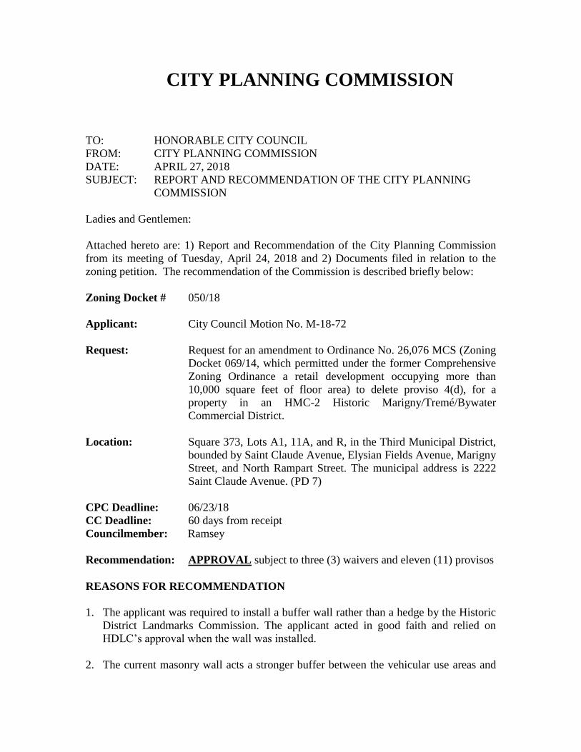
The subject site occupies the entirety of its square, with the exception of the neighboring
parcels at the intersections of Saint Claude Avenue with Elysian Fields Avenue and Marigny
Street. The property at the intersection of Saint Claude and Elysian Fields Avenue is
developed with a single-story structure occupied by an Athlete’s Foot store, as well as its
accessory parking lot. At the intersection of Saint Claude Avenue and Marigny Street is a
historic two-story, corner-store structure occupied by the Allways Lounge and, next to it, a
clothing retailer in a single-story building which immediately abuts the grocery store
structure. Directly across Saint Claude Avenue from the site is a beauty shop, located in a
single-story, late 20th century building at the intersection of Saint Claude Avenue and Elysian
Fields Avenue. Also across Saint Claude Avenue from the site is Siberia, an amusement
place occupying a historic residential building, a reception facility in a metal structure, and a
camelback residential structure. Diagonally across the intersection of Saint Claude and
Elysian Fields Avenues from the site is a Walgreen’s pharmacy, which occupies a relatively
recently-constructed single-story building with a large accessory parking lot.
Across Elysian Fields Avenue from the site is a po-boy shop in the ground floor of a two-
story historic commercial structure, as well as a series of historic structures facing Elysian
Fields Avenue, some of which are used for residential purposes. Across Marigny Street from
the site are a historic single-story commercial structure at the intersection of Saint Claude
Avenue and Marigny Street, a series of single- and two-family residences located mid-block
along Marigny Street, and a hotel occupying a historic two-story commercial structure at the
intersection of Marigny and North Rampart Street.
While the neighboring properties described above are all within the same HMC-2 District as
the site, the site is also neighbored by some properties which are within adjacent zoning
districts. Across North Rampart Street from the site is an HMR-2 Historic
Marigny/Tremé/Bywater Residential District that covers the block of Elysian Fields Avenue
between North Rampart and Burgundy Streets and is developed with historic residential
structures, with the exception of a non-conforming cocktail lounge located at the intersection
of North Rampart Street and Elysian Fields Avenue. The other properties located across
North Rampart Street from the site are single-story, single- and two-family shotgun
residences located within an HMR-3 Historic Marigny/Treme/Bywater Residential District
that covers most of the residential interior of the Faubourg Marigny downriver of Elysian
Fields Avenue.

ZD 050/18 7
B. What is the zoning and land use history of the site?
Zoning History
1929 – ‘J’ Industrial District
1953 – ‘J’ Light Industrial District
1970 – C-1 General Commercial District
Land Use:
1929 – Single-family residential/Two-family residential/Commercial
1949 – Single-family residential/Two-family residential/
Commercial/Light industrial/Vacant
1999 – Commercial3
C. Have there been any recent zoning changes or conditional uses in the immediate area?
If so, do these changes indicate any particular pattern or trend?
In the past five (5) years, there has been one zoning application affecting the subject site:
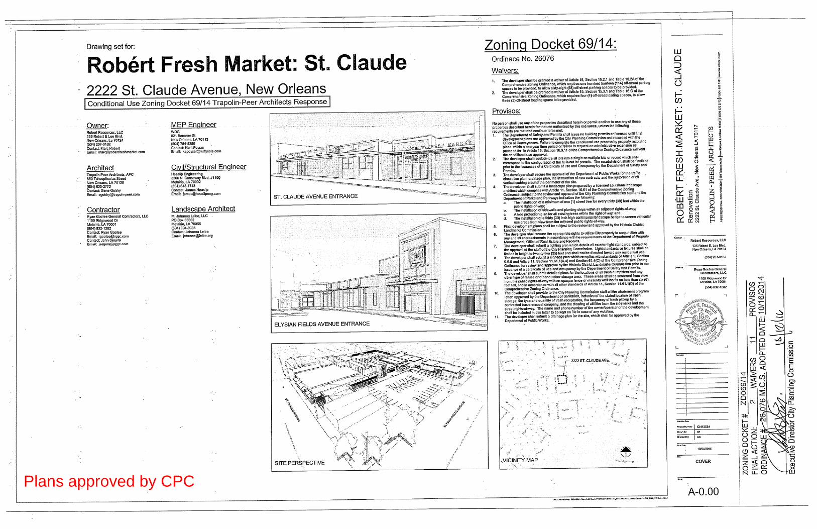
Zoning Docket 069/14 was a request for a conditional use to permit a grocery store and other
retail uses occupying more than 10,000 square feet of floor area in an HMC-2 Historic
Marigny/Tremé Commercial District.4 The municipal address is 2222 Saint Claude Avenue.
The City Planning Commission recommended approval of the request, which was
subsequently approved by the City Council. This is the petitioned site. The applicant
proposes to amend this conditional use to permit a buffer wall rather than a landscape hedge
to separate the vehicular use areas from the public rights of way as stated in proviso 4(d) in
the ordinance 26,076 MCS resulting from this zoning docket.
The request was approved subject to the following waivers and provisos (Ordinance 26,076
MCS):
Waivers
1. The developer shall be granted a waiver of Article 15, Section 15.2.1 and Table
15.A of the Comprehensive Zoning Ordinance, which require one hundred fourteen
(114) off-street parking spaces to be provided, to allow sixty-eight (68) off-street
parking spaces to be provided.
2. The developer shall be granted a waiver of Article 15, Section 15.3.1 and Table
15.G of the Comprehensive Zoning Ordinance, which require four (4) off-street
loading spaces to be provided, to allow three (3) off-street loading spaces to be
provided.
3 These regulations were from the former Comprehensive Zoning Ordinance. 4 This zoning district was from the former Comprehensive Zoning Ordinance.

ZD 050/18 8
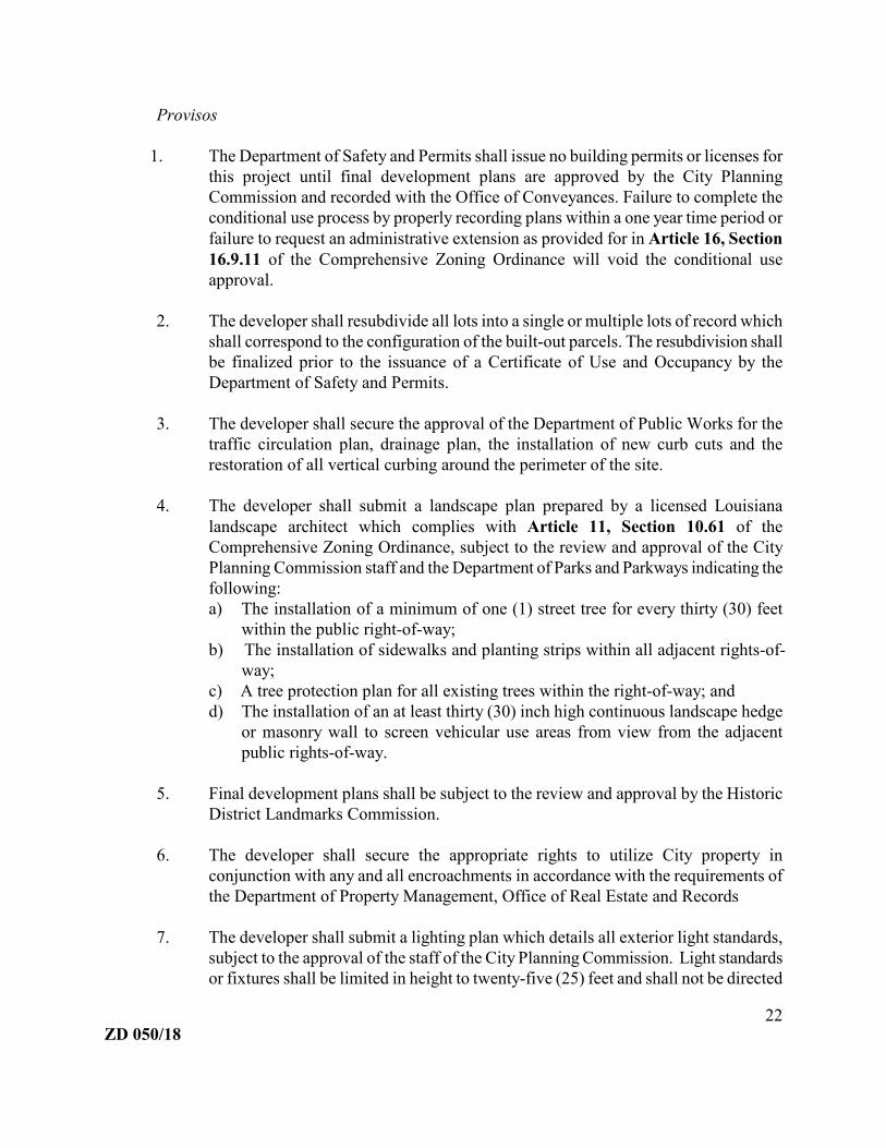
Provisos
1. The Department of Safety and Permits shall issue no building permits or licenses for
this project until final development plans are approved by the City Planning
Commission and recorded with the Office of Conveyances. Failure to complete the
conditional use process by properly recording plans within a one year time period or
failure to request an administrative extension as provided for in Article 16, Section
16.9.11 of the Comprehensive Zoning Ordinance will void the conditional use
approval.
2. The developer shall resubdivide all lots into a single or multiple lots of record which
shall correspond to the configuration of the built-out parcels. The resubdivision shall
be finalized prior to the issuance of a Certificate of Use and Occupancy by the
Department of Safety and Permits.
3. The developer shall secure the approval of the Department of Public Works for the
traffic circulation plan, drainage plan, the installation of new curb cuts and the
restoration of all vertical curbing around the perimeter of the site.
4. The developer shall submit a landscape plan prepared by a licensed Louisiana
landscape architect which complies with Article 11, Section 10.61 of the
Comprehensive Zoning Ordinance, subject to the review and approval of the City
Planning Commission staff and the Department of Parks and Parkways indicating the
following:
a) The installation of a minimum of one (1) street tree for every thirty (30) feet
within the public right-of-way;
b) The installation of sidewalks and planting strips within all adjacent rights-of-
way;
c) A tree protection plan for all existing trees within the right-of-way; and
d) The installation of a thirty (30) inch high continuous landscape hedge to screen
vehicular use areas from view from the adjacent public rights-of-way.
5. Final development plans shall be subject to the review and approval by the Historic
District Landmarks Commission.
6. The developer shall secure the appropriate rights to utilize City property in
conjunction with any and all encroachments in accordance with the requirements of
the Department of Property Management, Office of Real Estate and Records
7. The developer shall submit a lighting plan which details all exterior light standards,
subject to the approval of the staff of the City Planning Commission. Light standards
or fixtures shall be limited in height to twenty-five (25) feet and shall not be directed
toward any residential use.

ZD 050/18 9
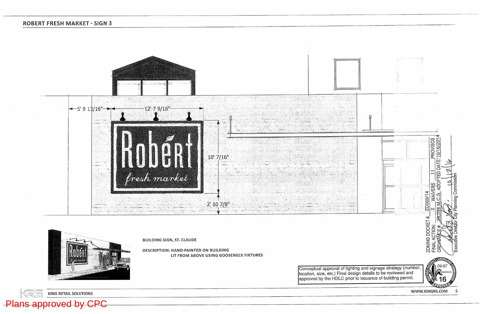
8. The developer shall submit a signage plan which complies with standards of Article
9. Section 9.5.6 and Article 11, Section 11.61.1(A.4) and Section 61.4(C) of the
Comprehensive Zoning Ordinance for review and approval by the Historic District
Landmarks Commission prior to the issuance of a certificate of use and occupancy by
the Department of Safety and Permits.
9. The developer shall submit detailed plans for the locations of all trash dumpsters and
any other type of refuse or other outdoor storage area. These areas shall be screened
from view from the public rights-of-way with an opaque fence or masonry wall that
is no less than six (6) feet tall, and in accordance with all other standards of Article
11, Section 11.61.1(D) of the Comprehensive Zoning Ordinance.
10. The developer shall provide to the City Planning Commission staff a litter abatement
program letter, approved by the Department of Sanitation, inclusive of the stated
location of trash storage, the type and quantity of trash receptacles, the frequency of
trash pickup by a contracted trash removal company, and the clearing of all litter
from the sidewalks and the street rights-of-way. The name and phone number of the
owner/operator of the development shall be included in this letter to be kept on file in
case of any violation.
11. The developer shall submit a drainage plan for the site, which shall be approved by
the Department of Public Works.
This application, Zoning Docket 069/14, is the only relevant zoning action for properties in a
five block radius in the past five years.
D. What are the design review comments?
The applicant does not propose to alter the structures, parking lots or landscaping. The
amendment is simply to alter proviso 4(d) of the conditional use ordinance to delete the
requirement for a landscape hedge along the public right-of-way. Instead of the required
landscape hedge, a 5’ tall masonry/metal wall (which was constructed at the request of the
Historic District Landmarks Commission) would be permitted to be retained.
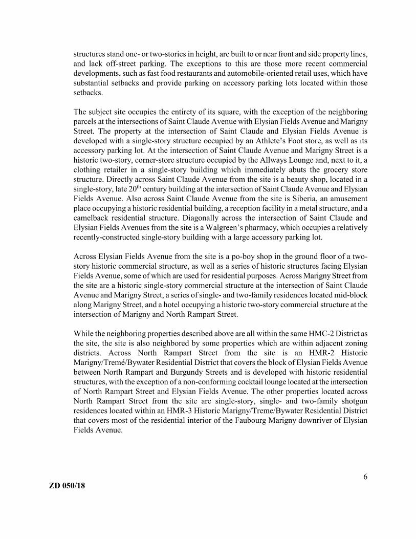
The perimeter buffer wall is in two locations on the site. There is one wall that separates the
vehicular use areas and the public rights of way on the Elysian Fields Avenue side (see
Figures 2 and 3) and another wall that forms an “L” shape that separates the second
vehicular use areas from the public rights of way on the Marigny Street and N. Rampart
Street side. The City Planning Commission approved plans indicate the applicant would
plant a three foot high hedge (see Figure 4). However, a buffer masonry wall with fencing
above was instead built as it had been approved by the Historic District Landmarks
Commission (see Figure 5).
ZD 050/18 10
Figure 2 and 3. Images of the existing wall separating the parking lot from the public rights of way taken
from the Elysian Fields side of the structure.

ZD 050/18 11
Figure 4. Partial image of the CPC approved and recorded plans as part of ZD069/14
Figure 5. Partial image of approved plans by HDLC. Permit #16-26644-RNVS

ZD 050/18 12
E. What impact will the proposed conditional use have on the transportation system, if
any? What are the off-street parking and off-street loading requirements? Can they
be provided on site? If not, is a waiver required?
The proposed amendment to the conditional use ordinance would eliminate the original
requirement for a landscape hedge to separate the grocery store’s vehicular use areas from the
public rights-of-way. The wall that was constructed at the request of the Historic District
Landmarks Commission would be retained. The site would otherwise be unchanged, with no
changes to the number and size of buildings or the number of parking spaces. Therefore,
there will be no change to the level of traffic and demand for parking associated with the
development regardless if the original conditional use ordinance is amended as proposed.
F. What effects or impacts would the proposed conditional use have on adjacent
properties?
The applicant requests the existing masonry wall buffer remain to separate the vehicular use
areas from the public rights of way instead of replacing it with a landscape hedge. The wall is
a more permanent barrier and stronger buffer than a landscape hedge. Additionally, in this
historic location, the wall is more aesthetically appropriate than a hedge, which is why it was
requested by the Historic District Landmarks Commission. Given these various ways in
which the wall is preferable to a hedge, changing the ordinance to allow the wall instead of a
hedge would positively impact the site and its immediate surroundings.
G. Compliance with approval standards
The City Planning Commission recommendation and the City Council decision on
applications for a conditional use shall, on the basis of all information submitted, evaluate
the impact of the conditional use on and the compatibility of the use with surrounding
properties and neighborhoods to ensure the appropriateness of the use at a particular location.
The Commission and Council are required to specifically consider the extent to which the
proposed use meets the approval standards contained in Article 4, Section 4.3.F Approval
Standards of the Comprehensive Zoning Ordinance. In this section, the staff evaluates the
application using those standards.
The proposed use at the specified location is consistent with the policies embodied in
the adopted Master Plan.
The proposed amendment to the conditional use is not addressed by the Plan for the 21st
Century, commonly known as the Master Plan. The Home Rule Charter of the City of New
Orleans requires all land use actions to be consistent with the Master Plan. A land use action
is consistent with the Plan for the 21st Century, commonly known as the Master Plan, if it
furthers, or at least does not interfere with, the goals, policies, and is compatible with the
proposed future uses, densities, and intensities designated in the Land Use Element of the

ZD 050/18 13
Plan. “Chapter 14: Land Use Plan” of the Master Plan designates the future land use of the
petitioned site as Mixed-Use Historic Core. The goal, range of uses and development
character for these designations are copied below:
MIXED-USE HISTORIC CORE
Goal: Increase convenience and walkability for neighborhood residents and visitors
within and along edges of historic core neighborhoods.
Range of Uses: A mixture of residential, neighborhood business, and visitor-oriented
businesses. Uses may be combined horizontally or vertically, and some structures
may require ground floor retail with residences or offices on upper floors. In some
areas where current or former industrial use is verified, existing buildings may be
appropriate for craft and value added industry. Agricultural, stormwater management,
and supporting public recreational and community facilities are allowed. Transit and
transportation facilities are allowed.
Development Character: The density, height, and mass of new development will be
consistent with the character and tout ensemble of the surrounding historic
neighborhood. Appropriate transitions will be provided to surrounding residential
areas. Allow the adaptive reuse of historic non-residential structures with densities
higher than the surrounding neighborhood through the planned development process.
Allow higher residential densities when a project is providing significant public
benefits such as long-term affordable housing. Incorporate risk reduction and
adaptation strategies in the built environment.
The Master Plan does not address buffer walls or hedges between vehicular use areas and
public rights of way. Since the future land use designation does not discuss issues of buffers,
the application is not considered to be inconsistent with the Master Plan.
The proposed use is consistent with the general purpose and intent of the applicable
zoning district regulations.
The subject site lies within a Historic Marigny/Tremé/Bywater Commercial District. This
district is intended to provide for restricted retail stores that will attract both tourists and local
residents. While the use of the subject site is consistent with the intentions of the zoning
district, the subject of this request, a buffer wall, is not addressed in the applicable zoning
district regulations.
The proposed use meets all standards specifically applicable to the use as set forth in
Article 20 and all environmental performance standards of this Section 21.3.
There are no use standards in Article 20 or environmental performance standards in Article
ZD 050/18 14
21, Section 21.3 that specifically apply to buffer walls.
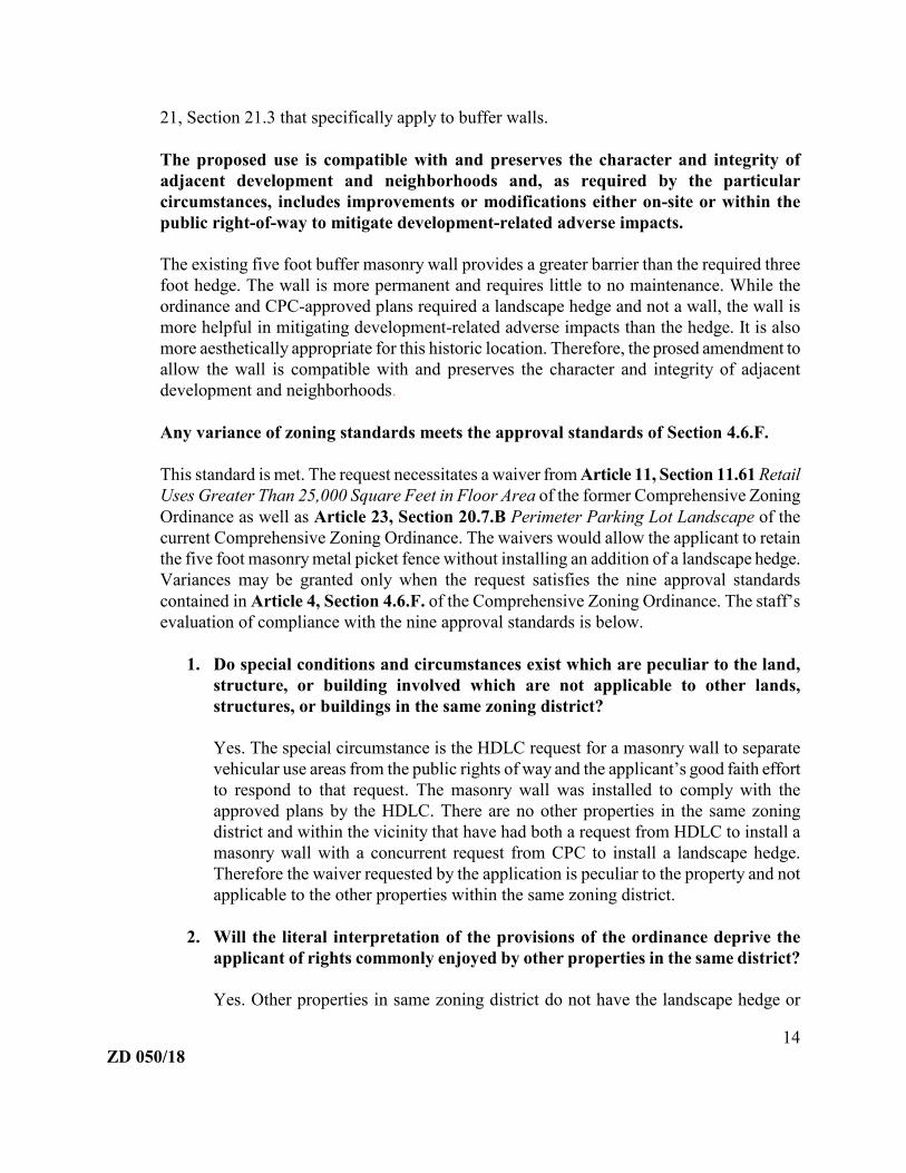
The proposed use is compatible with and preserves the character and integrity of
adjacent development and neighborhoods and, as required by the particular
circumstances, includes improvements or modifications either on-site or within the
public right-of-way to mitigate development-related adverse impacts.
The existing five foot buffer masonry wall provides a greater barrier than the required three
foot hedge. The wall is more permanent and requires little to no maintenance. While the
ordinance and CPC-approved plans required a landscape hedge and not a wall, the wall is
more helpful in mitigating development-related adverse impacts than the hedge. It is also
more aesthetically appropriate for this historic location. Therefore, the prosed amendment to
allow the wall is compatible with and preserves the character and integrity of adjacent
development and neighborhoods.
Any variance of zoning standards meets the approval standards of Section 4.6.F.
This standard is met. The request necessitates a waiver from Article 11, Section 11.61 Retail
Uses Greater Than 25,000 Square Feet in Floor Area of the former Comprehensive Zoning
Ordinance as well as Article 23, Section 20.7.B Perimeter Parking Lot Landscape of the
current Comprehensive Zoning Ordinance. The waivers would allow the applicant to retain
the five foot masonry metal picket fence without installing an addition of a landscape hedge.
Variances may be granted only when the request satisfies the nine approval standards
contained in Article 4, Section 4.6.F. of the Comprehensive Zoning Ordinance. The staff’s
evaluation of compliance with the nine approval standards is below.
1. Do special conditions and circumstances exist which are peculiar to the land,
structure, or building involved which are not applicable to other lands,
structures, or buildings in the same zoning district?
Yes. The special circumstance is the HDLC request for a masonry wall to separate
vehicular use areas from the public rights of way and the applicant’s good faith effort
to respond to that request. The masonry wall was installed to comply with the
approved plans by the HDLC. There are no other properties in the same zoning
district and within the vicinity that have had both a request from HDLC to install a
masonry wall with a concurrent request from CPC to install a landscape hedge.
Therefore the waiver requested by the application is peculiar to the property and not
applicable to the other properties within the same zoning district.
2. Will the literal interpretation of the provisions of the ordinance deprive the
applicant of rights commonly enjoyed by other properties in the same district?
Yes. Other properties in same zoning district do not have the landscape hedge or
ZD 050/18 15
masonry wall buffer between vehicular use areas and the public right of way. Other
properties in the vicinity with a vehicular use area, as noted and show below, do not
have either a hedge or a wall buffer between the public rights of way and the parking
areas. Therefore, literal interpretation of the provisions of the ordinance would
deprive the applicant of rights commonly enjoyed by other properties in the same
district.
3. Do any special conditions and circumstances result from the actions of the
applicant or any other person who may have (or had) an interest in the
property?
No. The special condition was a result of a good faith effort by the applicant to
comply with the regulations set forth by HDLC. HDLC adopted the requirement by
ARC requiring the applicant to install a buffer wall, conflicting with CPC’s
requirement of a landscape hedge. Due to the applicant’s reliance on HDLC’s
requirements and HDLC’s subsequent approval of plans indicating a buffer wall, the
circumstances were a result of a detrimental reliance.
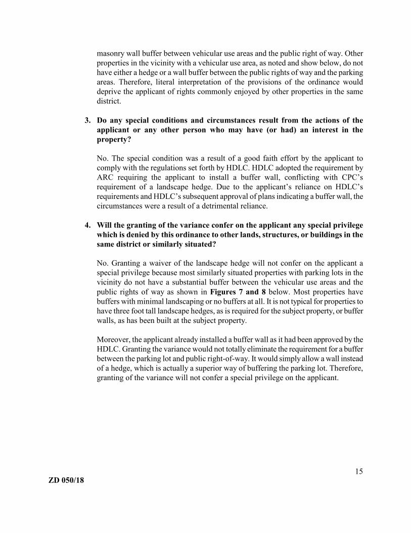
4. Will the granting of the variance confer on the applicant any special privilege
which is denied by this ordinance to other lands, structures, or buildings in the
same district or similarly situated?
No. Granting a waiver of the landscape hedge will not confer on the applicant a
special privilege because most similarly situated properties with parking lots in the
vicinity do not have a substantial buffer between the vehicular use areas and the
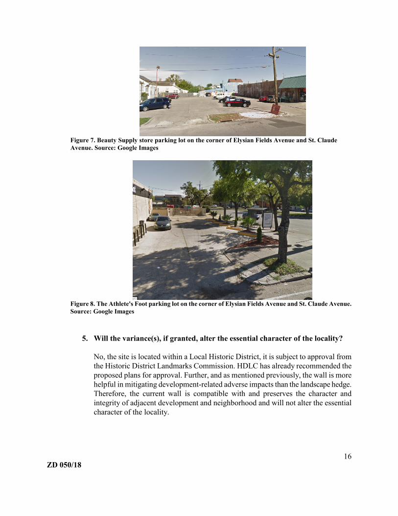
public rights of way as shown in Figures 7 and 8 below. Most properties have
buffers with minimal landscaping or no buffers at all. It is not typical for properties to
have three foot tall landscape hedges, as is required for the subject property, or buffer
walls, as has been built at the subject property.
Moreover, the applicant already installed a buffer wall as it had been approved by the
HDLC. Granting the variance would not totally eliminate the requirement for a buffer
between the parking lot and public right-of-way. It would simply allow a wall instead
of a hedge, which is actually a superior way of buffering the parking lot. Therefore,
granting of the variance will not confer a special privilege on the applicant.
ZD 050/18 16
Figure 7. Beauty Supply store parking lot on the corner of Elysian Fields Avenue and St. Claude
Avenue. Source: Google Images
Figure 8. The Athlete's Foot parking lot on the corner of Elysian Fields Avenue and St. Claude Avenue.
Source: Google Images
5. Will the variance(s), if granted, alter the essential character of the locality?
No, the site is located within a Local Historic District, it is subject to approval from
the Historic District Landmarks Commission. HDLC has already recommended the
proposed plans for approval. Further, and as mentioned previously, the wall is more
helpful in mitigating development-related adverse impacts than the landscape hedge.
Therefore, the current wall is compatible with and preserves the character and
integrity of adjacent development and neighborhood and will not alter the essential
character of the locality.

ZD 050/18 17
6. Will strict adherence to the property regulations result in a demonstrable
hardship upon the owner, as distinguished from mere inconvenience?
Yes. The hardship results from the applicant relying on approved plans from HDLC
requiring a buffer wall between vehicular use areas and the public rights of way. The
applicant moved forward with the construction of an expensive buffer masonry wall
as required by HDLC. Due to the HDLC requirement and the conflicting proviso
requiring a landscape hedge from the original conditional use, the removal and/or
addition of the landscape hedge would be a hardship upon the applicant.
7. Is the purpose of the variance based exclusively upon a desire to serve the
convenience or profit of the property owner, or other interested party(s)?
No. The purpose of the variance is to rectify an inconsistency with the HDLC-
approved plans, and the conditional use ordinance, not to serve the convenience or
profit of the property owner or other interested parties. The applicant built a more
permanent barrier requiring less maintenance under the understanding the masonry
wall had been approved by HDLC. Since the CPC has approved a landscape hedge,
as required in Article 11, section 11.62 of the former CZO, the applicant is seeking a
variance to avoid either removing the installed masonry wall or adding the addition
of a landscape hedge.
8. Will the variance be detrimental to the public welfare, or injurious to other
property or improvements in the neighborhood in which the property is
located?
No. Due to the fact the masonry wall is a stronger and a more permanent buffer
between the vehicular use areas and the public rights of way, the wall helps to
mitigate any negative effects that the parking area might have on the adjacent
properties. Therefore, the variance, if granted, would not be detrimental to the public
welfare, or injurious to other property or improvements in the neighborhood in which
the property is located.
9. Will the variance impair the adequate supply of light and air to adjacent
property, substantially increase traffic congestion in the public street, increase
the danger of fire, or endanger the public safety?
No. The development meets all applicable bulk and yard regulations from the former
CZO and was granted waivers for the loading areas and parking spaces under the
original conditional use. As the applicant has already installed a buffer wall, any
negative impacts from the parking area should be mitigated. The variance would not
impair the supply of light and air to adjacent property nor increase the danger of fire
or endanger the public safety. As stated in the traffic analysis section of this report,

ZD 050/18 18
the staff doesn’t believe that the variance would have any impact on the
transportation system.
Based on the above analysis, the staff concludes that the requested variance of Section 11.61
of the former CZO and Section 23.7.B of the current CZO satisfies the approval standards of
Section 4.6.F. Therefore staff recommends approval of the requested variance of Section
11.61 of the former CZO and Section 23.7.B of the current CZO.
The proposed use is not materially detrimental to the public health, safety, and welfare,
or results in material damage or prejudice to other property in the vicinity.
The applicant’s proposal is not expected to have any of these effects.
III. SUMMARY
Zoning Docket 050/18 is a request for an amendment to Ordinance No. 26,076 MCS
(ZD069/14) to delete proviso 4(d). This is requested in order to relieve the developer of a
requirement to install a landscape hedge to screen vehicular use areas from view from the
adjacent public rights of way. The subject property is the newly opened Robért Fresh Market
grocery store site located near the intersection of Saint Claude and Elysian Fields Avenues in
the Faubourg Marigny.
Although proviso 4(d) specified the installation of a landscape hedge, the Historic District
Landmarks Commission approved plans for a masonry buffer wall that the developer built
and which currently exists. The wall is five feet in height and consists of a brick base with a
picket fence above. The wall is effectively a stronger barrier and buffer between vehicular
use areas and the adjacent public rights of way than a landscape hedge. Therefore, the staff
concludes that the wall be allowed to remain and recommends the needed changes to proviso
4(d).
IV. PRELIMINARY STAFF RECOMMENDATION5
The staff recommends APPROVAL of Zoning Docket 050/18 subject to three (3) waivers
and eleven (11) provisos. The language that the staff recommends be added is bolded and
underlined.
Waivers
1. The developer shall be granted a waiver of Article 15, Section 15.2.1 and Table
15.A of the Comprehensive Zoning Ordinance, which require one hundred fourteen
5 Subject to modification by the City Planning Commission
ZD 050/18 19
(114) off-street parking spaces to be provided, to allow sixty-eight (68) off-street
parking spaces to be provided.
2. The developer shall be granted a waiver of Article 15, Section 15.3.1 and Table
15.G of the Comprehensive Zoning Ordinance, which require four (4) off-street
loading spaces to be provided, to allow three (3) off-street loading spaces to be
provided.
3. The developer shall be granted a waiver of Article 11, Section 11.61 of the
former Comprehensive Zoning Ordinance, and Article 23, Section 23.7.B of the
current Comprehensive Zoning Ordinance to allow a masonry wall without a
landscape hedge to remain as the buffer between the vehicular use areas and the
public rights of way.
Provisos
1. The Department of Safety and Permits shall issue no building permits or licenses for
this project until final development plans are approved by the City Planning
Commission and recorded with the Office of Conveyances. Failure to complete the
conditional use process by properly recording plans within a one year time period or
failure to request an administrative extension as provided for in Article 16, Section
16.9.11 of the Comprehensive Zoning Ordinance will void the conditional use
approval.
2. The developer shall resubdivide all lots into a single or multiple lots of record which
shall correspond to the configuration of the built-out parcels. The resubdivision shall
be finalized prior to the issuance of a Certificate of Use and Occupancy by the
Department of Safety and Permits.
3. The developer shall secure the approval of the Department of Public Works for the
traffic circulation plan, drainage plan, the installation of new curb cuts and the
restoration of all vertical curbing around the perimeter of the site.
4. The developer shall submit a landscape plan prepared by a licensed Louisiana
landscape architect which complies with Article 11, Section 10.61 of the
Comprehensive Zoning Ordinance, subject to the review and approval of the City
Planning Commission staff and the Department of Parks and Parkways indicating the
following:
a) The installation of a minimum of one (1) street tree for every thirty (30) feet
within the public right-of-way;
b) The installation of sidewalks and planting strips within all adjacent rights-of-
way;
c) A tree protection plan for all existing trees within the right-of-way; and

ZD 050/18 20
d) The installation of an at least thirty (30) inch high continuous landscape hedge
or masonry wall to screen vehicular use areas from view from the adjacent
public rights-of-way.
5. Final development plans shall be subject to the review and approval by the Historic
District Landmarks Commission.
6. The developer shall secure the appropriate rights to utilize City property in
conjunction with any and all encroachments in accordance with the requirements of
the Department of Property Management, Office of Real Estate and Records
7. The developer shall submit a lighting plan which details all exterior light standards,
subject to the approval of the staff of the City Planning Commission. Light standards
or fixtures shall be limited in height to twenty-five (25) feet and shall not be directed
toward any residential use.
8. The developer shall submit a signage plan which complies with standards of Article
9. Section 9.5.6 and Article 11, Section 11.61.1(A.4) and Section 61.4(C) of the
Comprehensive Zoning Ordinance for review and approval by the Historic District
Landmarks Commission prior to the issuance of a certificate of use and occupancy by
the Department of Safety and Permits.
9. The developer shall submit detailed plans for the locations of all trash dumpsters and
any other type of refuse or other outdoor storage area. These areas shall be screened
from view from the public rights-of-way with an opaque fence or masonry wall that
is no less than six (6) feet tall, and in accordance with all other standards of Article
11, Section 11.61.1(D) of the Comprehensive Zoning Ordinance.
10. The developer shall provide to the City Planning Commission staff a litter abatement
program letter, approved by the Department of Sanitation, inclusive of the stated
location of trash storage, the type and quantity of trash receptacles, the frequency of
trash pickup by a contracted trash removal company, and the clearing of all litter
from the sidewalks and the street rights-of-way. The name and phone number of the
owner/operator of the development shall be included in this letter to be kept on file in
case of any violation.
11. The developer shall submit a drainage plan for the site, which shall be approved by
the Department of Public Works.
V. REASONS FOR RECOMMENDATION
1. The applicant was required to install a buffer wall rather than a hedge by the Historic
District Landmarks Commission. The applicant acted in good faith and relied on

ZD 050/18 21
HDLC’s approval when the wall was installed.
2. The current masonry wall acts a stronger buffer between the vehicular use areas and
the public rights-of-way than the landscaped hedge as was required in proviso 4(d) of
the original conditional use (ZD069/14)
3. Retaining the buffer wall will not impede the flow of traffic, will not have a negative
effect on adjacent properties, and will not alter the character or integrity of adjacent
developments or the neighborhood.
VI. CITY PLANNING COMMISSION MEETING (APRIL 24, 2018)
The City Planner summarized the request and stated the staff’s recommendation of denial.
No one from the public spoke in support of in opposition of the request. Commissioner
Brown made a motion for approval which was seconded by Commissioner Green and was
unanimously adopted.
MOTION:
BE IT MOVED BY THE CITY PLANNING COMMISSION THAT ZONING DOCKET
050/18 IS HEREBY RECOMMENDED FOR APPROVAL SUBJECT TO THREE (3)
WAIVERS AND ELEVEN (11) PROVISOS. BE IT FURTHER MOVED THAT THE
EXECUTIVE DIRECTOR IS HEREBY AUTHORIZED TO NOTIFY THE CITY
COUNCIL OF SAID ACTION.
Waivers
1. The developer shall be granted a waiver of Article 15, Section 15.2.1 and Table
15.A of the Comprehensive Zoning Ordinance, which require one hundred fourteen
(114) off-street parking spaces to be provided, to allow sixty-eight (68) off-street
parking spaces to be provided.
2. The developer shall be granted a waiver of Article 15, Section 15.3.1 and Table
15.G of the Comprehensive Zoning Ordinance, which require four (4) off-street
loading spaces to be provided, to allow three (3) off-street loading spaces to be
provided.
3. The developer shall be granted a waiver of Article 11, Section 11.61 of the former
Comprehensive Zoning Ordinance, and Article 23, Section 23.7.B of the current
Comprehensive Zoning Ordinance to allow a masonry wall without a landscape
hedge to remain as the buffer between the vehicular use areas and the public rights of
way.
ZD 050/18 22
Provisos
1. The Department of Safety and Permits shall issue no building permits or licenses for
this project until final development plans are approved by the City Planning
Commission and recorded with the Office of Conveyances. Failure to complete the
conditional use process by properly recording plans within a one year time period or
failure to request an administrative extension as provided for in Article 16, Section
16.9.11 of the Comprehensive Zoning Ordinance will void the conditional use
approval.
2. The developer shall resubdivide all lots into a single or multiple lots of record which
shall correspond to the configuration of the built-out parcels. The resubdivision shall
be finalized prior to the issuance of a Certificate of Use and Occupancy by the
Department of Safety and Permits.
3. The developer shall secure the approval of the Department of Public Works for the
traffic circulation plan, drainage plan, the installation of new curb cuts and the
restoration of all vertical curbing around the perimeter of the site.
4. The developer shall submit a landscape plan prepared by a licensed Louisiana
landscape architect which complies with Article 11, Section 10.61 of the
Comprehensive Zoning Ordinance, subject to the review and approval of the City
Planning Commission staff and the Department of Parks and Parkways indicating the
following:
a) The installation of a minimum of one (1) street tree for every thirty (30) feet
within the public right-of-way;
b) The installation of sidewalks and planting strips within all adjacent rights-of-
way;
c) A tree protection plan for all existing trees within the right-of-way; and
d) The installation of an at least thirty (30) inch high continuous landscape hedge
or masonry wall to screen vehicular use areas from view from the adjacent
public rights-of-way.
5. Final development plans shall be subject to the review and approval by the Historic
District Landmarks Commission.
6. The developer shall secure the appropriate rights to utilize City property in
conjunction with any and all encroachments in accordance with the requirements of
the Department of Property Management, Office of Real Estate and Records
7. The developer shall submit a lighting plan which details all exterior light standards,
subject to the approval of the staff of the City Planning Commission. Light standards
or fixtures shall be limited in height to twenty-five (25) feet and shall not be directed

ZD 050/18 23
toward any residential use.
8. The developer shall submit a signage plan which complies with standards of Article
9. Section 9.5.6 and Article 11, Section 11.61.1(A.4) and Section 61.4(C) of the
Comprehensive Zoning Ordinance for review and approval by the Historic District
Landmarks Commission prior to the issuance of a certificate of use and occupancy by
the Department of Safety and Permits.
9. The developer shall submit detailed plans for the locations of all trash dumpsters and
any other type of refuse or other outdoor storage area. These areas shall be screened
from view from the public rights-of-way with an opaque fence or masonry wall that
is no less than six (6) feet tall, and in accordance with all other standards of Article
11, Section 11.61.1(D) of the Comprehensive Zoning Ordinance.
10. The developer shall provide to the City Planning Commission staff a litter abatement
program letter, approved by the Department of Sanitation, inclusive of the stated
location of trash storage, the type and quantity of trash receptacles, the frequency of
trash pickup by a contracted trash removal company, and the clearing of all litter
from the sidewalks and the street rights-of-way. The name and phone number of the
owner/operator of the development shall be included in this letter to be kept on file in
case of any violation.
11. The developer shall submit a drainage plan for the site, which shall be approved by
the Department of Public Works.
YEAS: Brown, Green, Hankins, Hughes, Isaacson, Lunn, Steeg, Stewart
NAYS: None
ABSENT: Wedberg
VII. REASONS FOR RECOMMENDATION
1. The applicant was required to install a buffer wall rather than a hedge by the Historic District
Landmarks Commission. The applicant acted in good faith and relied on HDLC’s approval
when the wall was installed.
2. The current masonry wall acts a stronger buffer between the vehicular use areas and the
public rights-of-way than the landscaped hedge as was required in proviso 4(d) of the
original conditional use (ZD069/14)

ZD 050/18 24
3. Retaining the buffer wall will not impede the flow of traffic, will not have a negative effect
on adjacent properties, and will not alter the character or integrity of adjacent developments
or the neighborhood.

rberg
Image
rberg
Text Box
Zoning Map
rberg
PolyLine
rberg
Arrow
rberg
Text Box
Petitioned Property

rberg
PolyLine
rberg
Text Box
1994 Sanborn Map
Plans approved by CPC

Plans approved by CPC

Plans approved by CPC

Plans approved by CPC

Plans approved by CPC

Plans approved by CPC

Plans approved by CPC

Plans approved by CPC

Plans approved by CPC

Plans approved by CPC

Plans approved by CPC

Plans approved by CPC

skroll
Text Box
Plans approved by CPC

Plans approved by CPC
Plans approved by CPC

Plans approved by CPC

Plans approved by CPC

D co
D co
GV
D co D c
o
GV
Lt. Pole
Lt. Pole
Lt. Pole
Lt. Pole
Dc o
coS
coS
coS
xx
xx
Lt. Pole
coS
Lt. Pole
Power Pole
D.I.
D.I.
CB
SCB MH
PK Nail
Nail
"T"
Cross
Mon.
I.P.
I.R.
MH
LEGEND
Iron RodI.R.
Iron PipeI.P.
FoundFd.
Right of WayRW
Clean Out
Water Meter
Water Valve
Fire Hydrant
Drop Inlet
Catch Basin
Manhole
oc
WM
WV
FH
D.I.
CB
MH
Fire Hydrant
Meter
Meter
Anchor
Valve
co
Handicap
LC Center Line
PL Property Line
Concrete
Building
Arrow
S
W
D
G
T
UG E
CATV
xx
Sewer
Water
Drain
Gas
Telephone
Underground Electric
Cable Television
Overhead Power Line
Fence
OFF-STREET PARKING REGULATIONS: SEE SECTION 15.2.2. TABLE 15.A.
Sign
0.0.4
you
dig.
all
beforene
C
Lt.D c
o
D.I. 23.02' D.I. 22.46'
D. I. 22. 25'
D.I. 21.80'
D.I. 22.20'
D.I. 22.04'
D.I. 22.10'
D.I. 21.91'
D.I. 23.05'
D.I. 22.84'
D.I. 23.24'
D.I. 23.08'
36" Oak
Lt. Pole w/Ped.
SMH 23.20'
co'sS Pay Phones
GM
co
EM (no line)
Inv. 16
.74'
12"
Inv. 19
.50'
D.I. 21.64'
Inv. 19.74'
Inv. 20.21'
8"
8"Inv . 19.90'
Inv . 20.04'
Inv. 20.45'
8"
I nv. 21. 00'
8"
Inv. 21.16'
8"
Inv. 21.52'
8"
Inv. 20.59'
D co's
6" Vert. Pipe
6" Inv. 22.19'
(Inv. N/A)
CBM
Water Pipe
?
Gutter
Gutter
Pipe
D co
Pipe
Pipe
Pipe
23
.19
(Doo
r)
23.63 (Door)
23.51 (Door)
23.54 (Door)
23.53 (Door)
23
.63
(Doo
r)
23
.38
(Doo
r)
23.71 (Door)
22.94 (Door)
22
.84
(Doo
r)
23.13 (Door)
22.3
8
22.8
8
23.1
3
23.0
8
22.9
8
23.1
123
.57
23.2
5
22.9
422
.93
22.9
1
24.1
1
24.0
4
23.3
523
.46
24.0
1
23.9
4
23.8
323
.87
24.0
524
.06
24.0
5
24.3
324.0
124
.26
23.8
423
.53
22.4
7
22.1
2
23.4
3
23.4
9
23.4
6
23.2
123.2
7
23.1
7
23.5
5
23.4
3
23.0
3
21.9
8
22.1
9
22.3
9
21.6
9
22.0
3
22.0
0
22.7
6
22.2
0
22.1
9
21.7
8
22.1
5
21.9
9
22.1
8
21.9
421
.94
22.1
2
22.0
6
22.0
1
22.0
3
21.9
2
22.2
922.0
3
21.8
9
22.2
2
21.7
3
21.8
9
22.1
321
.89
21.9
622.0
7
21.8
2
21.8
0
22.0
8
21.9
5
21.9
4
21.9
5
22.0
4
22.1
0
22.1
8
22.1
6 22.6
1
22.6
622
.58
22.2
9
22.5
4
22.1
922
.52
21.9
3
22.6
6
22.6
122
.68
22.5
2
21.9
5
22.3
3
22.3
5
22.1
322
.14
21.9
4
22.6
0
22.4
4
22.6
1
22.7
1
22.4
6
22.3
6
22.1
5
22.6
0
23.5
2
22.7
5
21.7
622
.26
22.8
1
22.8
0
22.6
3
22.4
7
21.9
7
22.2
0
22.2
9
22.8
1
22.9
822
.66
22.7
4
22.4
9
22.3
422
.67
22.6
9
22.3
1
22.3
5
22.4
8
21.7
2
21.8
8
22.3
722
.32
22.2
5
22.5
122
.27
21.9
1
22.3
8
22.5
022
.17
22.4
0
22.6
3
22.4
022
.73
22.5
3
22.1
7
22.5
2
22.3
8
22.1
9
22.4
4
22.2
3
22.2
1
22.2
1
21.6
3
21.8
8
21.4
9
21.8
5
21.9
5
21.8
8
21.6
1
22.2
422
.21
23.7
4
22.5
7
23.8
723.8
2
23.5
0
23.2
8
23.3
523
.45
23.3
2
23.4
3
23.8
0
23.9
2
23.9
0
23.8
5
23.7
6
22.6
4
22.8
222
.34
22.3
1
22.3
824
.09
22.7
9
22.7
1 23.9
6
24.3
0
24.2
0
24.0
3
24.1
1
24.1
2
24.1
5
24.2
324
.40
24.5
224.6
1
24.2
5
24.0
8
24.2
7
23.8
6
23.7
7
24.2
1 23.9
0
24.0
9
24.3
6
24.3
4
24.5
524
.33
22.5
4
22.6
7
22.5
9
23.1
9
22.5
2
22.4
9
22.6
7
22.7
6
22.7
2
22.7
0
23.1
2
23.2
0
23.4
123
.49
23.7
623
.61
23.2
9
23.3
6
22.8
8
22.7
4
22.8
0
22.5
3
22.7
4
22.7
122
.79
22.5
3
22.5
1
22.6
1
22.6
222
.39 22
.40
22.8
0
22.3
922
.89
22.6
7
22.9
522
.19
22.7
222
.06
22.5
8
22.0
2
21.9
4
22.5
1
23.0
4
22.6
1
22.6
1
22.1
0
22.5
622.5
0
22.1
922
.16
22.4
022.1
122.1
4
22.5
5 22.6
9
22.5
0
22.6
4
22.5
2
22.4
9
22.5
5
22.9
0
22.5
6
22.6
0
22.8
5
22.8
922.6
3
22.7
0
22.5
6
22.6
1
22.7
6
22.8
5
22.6
7
22.6
1
22.7
122
.93
23.1
2
23.6
2
23.1
4
23.0
3
23.2
923
.39
23.3
4
23.1
9
22.9
823
.31
23.1
8
23.3
023
.54
23.5
0
23.4
9
23.4
0
23.0
2
22.7
3
22.3
9
22.4
7
22.4
4
22.3
3
22.2
9
22.3
6
22.4
522
.52
22.5
3
22.5
2
22.5
4
22.4
8
22.5
3
22.4
9
22.4
9
22.5
5
22.7
5
22.9
0
22.6
1
22.6
1
22.5
3
22.6
0
22.5
2
22.7
0
23.6
523.4
7
21.9
322
.12
22.4
722
.7522
.62
22.4
7
21.5
2
22.9
4
23.1
9
23.6
523
.6023
.30
23.0
1
21.7
9
22.3
822
.55
22.6
2
21.9
4
21.6
8
23.3
3
23.6
8
22.7
8
22.0
8
21.9
2
22.9
3
23.0
6
23.6
5
22.6
2
22.4
5
21.9
8
21.7
8
22.9
1
23.1
5
23.1
9
23.6
523.1
522
.92
21.5
4
21.9
2
22.4
1
21.9
3
21.5
8
22.9
4
22.9
6
23.7
0
22.7
422
.52 22
.63
23.2
923
.15
23.6
9
23.1
0
22.8
7
23.4
9
23.4
523
.25
23.1
6
23.0
4
23.2
3
23.1
3
23.6
7
23.2
7
23.0
6
22.8
623
.06
22.5
8
22.6
2
22.8
1
22.9
1 23.3
6
22.8
222
.17
21.9
8
22.1
422
.90
22.1
8
22.0
5
22.8
3
22.7
5
22.5
8
22.8
523
.13
23.3
3
23.5
6
23.8
524
.03
23.3
022
.80
22.4
8
22.4
5
23.0
222
.97
22.0
621
.73
21.4
0
21.7
0
21.9
122
.85
23.0
4
22.6
1
22.4
4
22.8
623
.32
23.5
723
.58
23.3
3
23.2
0
23.1
523
.16
22.6
2
22.7
6
22.9
422
.36
22.0
1
22.2
0
21.9
3
22.8
222
.33
22.8
4
22.7
7
22.4
6
22.4
922
.30
22.5
6
22.0
9
22.1
0
22.2
4
22.7
6
23.2
6
22.5
3
21.5
9
22.5
9
22.2
2
22.9
6
22.6
5
22.3
522
.74
22.4
0
22.5
7
23.1
322
.89
22.8
8
22.3
8
23.1
9
23.2
7
22.7
1
21.9
0
22.7
3
22.1
522
.66
22.7
8
22.5
5
22.6
322
.55
22.8
3
22.9
322
.67
22.6
8
22.4
722
.65
23.0
2
22.9
7
23.0
8
22.6
022
.12
22.7
722
.94
22.6
0
22.2
1
22.9
4
23.3
0
22.7
2
22.7
4
23.3
222
.95
22.7
622.1
0
22.6
6
22.6
0
22.0
7
22.4
2
22.9
1
22.6
8
22.9
5
21.9
8
22.5
4
22.4
5
21.9
0
22.1
723
.27
22.5
5
21.7
522.2
2
22.4
022
.82
21.9
4
21.8
6
22.3
2
22.9
1
23.1
1
23.4
3
23.6
823
.36
23.3
7
23.7
923
.32
23.3
2
23.2
4
23.2
4
23.0
6
23.0
4
22.9
2
22.8
8
21.8
8
22.2
8
21.8
6
22.7
9
22.9
4
23.0
6
23.2
1
23.2
0
23.3
2
23.3
1
22.9
3
23.3
7
23.2
8
23.2
5
23.2
1
23.0
4
22.9
9
21.7
3
22.2
9
22.2
5
21.7
1
22.8
3
23.1
7
23.1
5
23.2
1
23.1
9
23.4
4
23.3
2
23.0
4
23.0
6
23.1
9
23.0
4
23.2
8
23.1
2
22.8
6
23.0
4
23.0
8
23.2
1
23.0
6
23.0
8
22.9
3
22.6
321.8
0
22.1
322
.44
21.9
3
21.9
5
22.4
9
23.1
4
23.1
6
23.2
2
23.0
4
22.9
5
22.9
0
22.7
7
23.1
5
22.2
7
22.7
4
22.5
3
22.7
0
22.6
3
22.8
0
22.6
6
22.2
8
22.3
022
.26
22.2
0
21.9
5
22.0
8
21.9
0
22.7
3
22.3
7
22.4
1
21.9
8
21.8
322
.80
22.8
6
21.8
5
21.8
3
22.5
0
22.6
1
21.8
3
21.8
0
22.7
422
.39
22.4
4
21.8
5
22.2
9
21.8
4
22.3
2
22.2
022
.36
22.6
822
.31
21.7
7
22.3
2
22.4
5
21.8
6
21.7
422
.38
22.3
4
22.4
5
22.4
721
.95
21.7
2
21.9
9
21.8
3
22.0
4
21.4
6
21.4
9
21.8
6
22.6
5
22.7
222
.85
22.9
1
22.9
7
23.0
922
.98
23.0
2
23.2
423
.24
23.1
223
.05
23.1
322
.95
22.8
622
.66
22.7
8
22.7
5
23.0
023
.12
23.2
823
.29
23.2
723
.34
23.3
6
23.3
1
23.2
7
23.2
3
23.1
7
23.1
6
23.1
1
23.0
4
23.1
3
22.8
422.8
522
.59
22.8
7
21.9
0
22.6
5
23.6
323
.37
23.4
0
22.6
323
.15
23.1
1
22.4
6
22.7
6
22.6
5
23.1
2
23.0
122
.44
22.3
7
23.6
3
23.8
2
24.1
3
23.9
1
23.5
3
23.4
5
23.0
6
22.8
6
23.2
1
23.4
5
23.3
5
23.2
3
22.7
7
22.9
1
24.0
9
23.9
524
.07
23.2
8
23.3
2
23.3
3
23.3
1
23.1
823
.30
23.3
3
23.4
4
23.5
5
23.4
823.3
323
.33
23.3
1
23.3
923
.32
23.4
0
23.3
4
23.3
2
23.2
9
23.3
4
23.3
8
22.8
9
21.8
1
Note:The locations of underground and other nonvisible utilities shownhereon have been determined from data and/or extracted fromrecords made available to us by agencies controlling suchrecords. Where found, the surface features of locations areshown.The ACTUAL nonvisible locations may vary from thoseshown hereon. Each agency should be contacted relative to theprecise location of its underground installation prior to anyreliance upon the accuracy of such locations shown hereon,including prior to excavation and digging.
TM
Louisiana
1-800-272-3020
Const. Bench Mark: Nail set in Power Pole (25.50') C.D. (+5.07') NAVDRef. Bench Mark: ALCO (26.23') C.D. (+5.8') NAVD
Area Regulations for the HMC-2 Historic Marigny/Treme' Commercial District.
STANDARDSREQUIREMENTS
(2) The open space requirement may be waived or reduced if the site for a large
Minimum yard requirements none
Maximum Floor Area Ratio 2.2
Minimum Open Space Ratio See Note
Minimum lot area per dwelling unit: See Note
One-family units 1,500 sq. ft.
Two-family units 1,000 sq. ft.
Three-family units 800 sq. ft.
Maximum height from grade 50 ft.
Four-family units 600 sq. ft.
2
2
scale development considers the use of garage roofs pedestrian of landscape
areas, terraces, pools, fountains, open stairways, planting beds, all of which may not
necessarily be at grade level, and which must remain "open to the sky" as part of the
aggregate open space requirement.
WMH 23.77'
WMH 23.53'WMH 22.88'
WMH 22.36'
2-WM's WMH 22.28'
WMH 22.47' WMH 23.39'
WMH 22.40'
WV(?)
FH
FH
W6"
W6"
W12"
W8"
W6"
W6"
W12"
W8"
FHFH
WM
Water Pipe
?
Rollup Door 0.6.0 Gutter
Overhang
Overhang
#2239 N. Rampart St.
(29,816.05 Sq. Ft.)
1 Story Conc. Block
Covered Walk
G6"
G6"
G8"
G8"
G4"
G6"
G6"
49.0.2 Public R/W
159.10.3 Public R/W
127.10.6 Public R/W
49.0.2 Public R/W
89°58'30" 90°03'22"
89°58'30"
89°55'48"
90°03'22"
90°02'20"
269°56'38"
270°01'30"
Crosses Cut
4'
4'
Crosses Cut
4'
4'
Cross Cut
4'
Cross Cut
4'
ATT MH 24.16'
Traffic MH 24.22'
MCI MH 23.99'
Tele. Vault
Bell MH 23.96'ATT MH 23.26'
Traffic MH 24.44'
Support Pole
Lt. Pole w/Ped.
Anchor
Lt. Pole
Const. Bench Mark 25.50' (C.D.)
Made at the request of Robert's Fresh Market.Chapter 25 for a Class "B" survey.
Scale: 1" = 30'
2121 N. Causeway Blvd., Metairie LA 70001 (504) 836-2121Gilbert, Kelly & Couturie', Inc., Surveying & Engineering
for Boundary Surveys as found in Louisiana Administrative Code TITLE 46:LXI,supervision and control and meets the requirements for the Standards of Practice This plat represents an actual ground survey made by me or under my direct
Date: August 5, 2013
DMH 22.70'D.I. 21.44'
DMH 21.77'DMH 22.33'CB 21.86'
SMH (Cover 21.91'
D co
Drain 21.68'
DMH 22.17'DMH 22.23'
DMH 22.06' DMH 22.14'
CB 22.23'
DMH 21.98'
CB 22.17'
CB 22.02'
DMH 22.68'
DMH 22.60'
DMH 22.45'
DMH 22.04'
DMH 22.03'
Drain 22.15'
Inv. (N/A full)
DMH 22.27'
Inv. 14.88'
Inv. 17.58'
Inv. 16.90'
Inv. 15.30'
D12"
12"
D36"
Inv. 15.05'
Inv. 14.94'
8"
Inv. 15.03'
36"
Inv. 14.82'
CB 22.02'
D.I. 21.44'
Inv. 19.44'
12"
36"
D36"
Inv. 16.10'
36"
Inv. 14.20'
36"
12"Inv. 18.94'
Inv. 14.20'
Inv. 18.62'
8"
Inv. 18.21'Inv. 17.73'D
Inv. 20.06'12"
12"
Inv. 16.23'
36"
36"
Inv. 16.19'
36"
36"
Inv. 17.09'
DMH 22.29'
Inv. 19.88'
Inv. 19.08'
6"
12"
Inv. 18.07'D
12"
Inv. 16.37'
Inv. 18.23'
Inv. 16.48'
D36"
D36"
Inv. 16.56'
36"
Inv. 17.96'
12" 12"
Inv. 17.94'
Inv. 16.54'
36"
36"
36"
12" Inv. 19.33'Inv. 18.98'
Inv. 18.18'
12" Inv. 19.37'
Bike Rack
Guard Rail
Rail
Guard Post
Guard Rail
Wood Deck
Covered Area
Guard Rail
30" Oak
18" Sedar Palm
8' Bush
3' Bush
8' Bush 8' Bush
4" Tree
3' Bush
6' Angel Trumpet
4" Tree
9" Tree
9" Tree
24" Tree
Row of Banana Trees
Row of Banana Trees
Grass Area
ORLEANS PARISHNEW ORLEANS, LA
SMH 22.66'Inv. 17.99'
SMH 22.55' SMH 22.62' SMH 23.18'
SMH 22.68'
S12" S
12"
S8"
S12"
S12"
S12"
SMH
S8"
S8"
Inv. 16.48'Inv. 16.32'
Inv. 17.68'
Inv. 17.08'
Inv. 15.36'
12"
SMH 22.09'
8"
Inv. 16.16'
Inv. 15.25'
Inv. 15.75'
12"
Yellow Line
Bike Lane
Vertical Curb No Parking
Handicap Access
Sidewalk
Vertical Curb
Vertical Curb
Vertical Curb
Yellow Line
Vertical Curb
Vertical Curb
Vertical Curb
Vertical Curb
Vertical Curb
Conc. Parking
Conc. Parking
x
SQ. NO. 373THIRD DISTRICT
N. RAMPART ST.
ST. CLAUDE AVE.
ELYSIAN FIELDS AVE.
MARIGNY ST.
US AND THERE IS NO REPRESENTATION THAT ALL APPLICABLE PROPERTY IS LOCATED IN FIA ZONE
SEARCH IN COMPILING THE DATA FOR THIS SURVEY.SURVEYOR HAS MADE NO TITLE SEARCH OR PUBLIC RECORDSERVITUDES AND RESTRICTIONS ARE SHOWN HEREON. THE
ARE LIMITED TO THOSE SET FORTH IN DESCRIPTION FURNISHED BOUNDARY MAP INDICATES THAT THE ABOVE DESCRIBEDTHE SERVITUDES AND RESTRICTIONS SHOWN ON THIS SURVEY THE FEDERAL INSURANCE ADMINISTRATION FLOOD HAZARD
A-1 (+4.5') &
111807
Angles used.
A-1 (+5.0')
(83,396.58 Sq. Ft.)
1.915 Acres
(Concrete)
(Asphalt)
(Asphalt)
(Asphalt)
Not A PartNot A Part
1/2
3/2
01
7 1
:37
:57
PM
C:\Users\thusser\Documents\Robert Fresh Market_Central File_thusser.rvt
02-27
17eavandoren
Plans approved by HDLC

EXISTING BUSSTOP
ST. CLAUDE AVE.
N. RAMPART ST.
EXISTINGPROPERTY LINE
EXISTINGTREES TOREMAIN
MANUALROLLING GATES
NEW CANOPY
EXISTING CANOPYTO BE REPLACEDIN KIND
EXISTING PTD. STEEL TOBE REPLACED IN KIND
A-1.028
18' - 0" EQ 36' - 0" EQ 18' - 0"
18
' - 0
"
6' -
0"
13
14
20
21
19
17
18
16
15 22
23
24
25
26
27
28
6 7 8
29 30 31 32 33 34 35 36 37
40
41
4249
50
51
53
52
55
54
5664
62
63
61
60
59
58
57
65
66
67
68
69
70
EXISTING UTILITY POLEEXISTING UTILITY POLE
EXISTING FIRE HYDRANT
EXISTING CATCH BASIN
EXISTING FIRE HYDRANT
EXISTING UTILITY POLE
EXISTING CATCHBASIN
EXISTINGUTILITY POLE
EXISTING UTILITY POLE
EXISTING PROPERTY LINE
NEW CANOPY
ON
E W
AY
ONE WAY
NEW ADA RAMP.PER DPW STANDARDS
NEW CONCRETESIDEWALK
1-WAY DRIVE AISLE
14' - 7 3/4" 18' - 0" 18' - 0"
EXISTINGBIKE LANE
EXIST. PARALLEL STREETPARKING TO REMAIN
EX
IST
. PA
RA
LL
EL
ST
RE
ET
PA
RK
ING
TO
RE
MA
IN
EX
IST
. DR
IVE
TO
RE
MA
IN
EX
IST
. PA
RA
LL
EL
ST
RE
ET
PA
RK
ING
TO
RE
MA
IN
EX
IST
. PA
RA
LL
EL
ST
RE
ET
PA
RK
ING
TO
RE
MA
IN
EXIST. PARALLEL STREET PARKING
PR
OP
OS
ED
NE
W L
OA
DIN
G Z
ON
E
76
' - 1
"N
EW
CU
RB
CU
T
42
' - 0
"M
AR
IGN
Y S
T. E
LYS
IAN
FIE
LDS
NOT IN SCOPE
CANOPY ABOVE
TRASHCOMPACTOR
EXISTING CORNER STRIPING
MO
N -
SA
T. (
8A
M -
6P
M)
PROPOSED STOP SIGNLOCATION
BIKE RACKS
NEW CANOPY @ 10'-3"ABOVE GRADE
RELOCATED BIKE RACKCOORDINATE WITH DPW
BIKE RACKS
NEW CART CORRAL
NEW CANOPY
EXISTING CATCH BASIN
EXISTING CATCH BASIN
NEW CONCRETEWALK
NEW ADA RAMP
NEW STREET TREESEVERY 30'-0"
EXIST. BUS STOP
NEW TREE WELLS
NEWCONCRETE
PARKING LOT
A-1.015
EXISTING MANHOLE
SLO
PE1/
8" P
ERFO
OT
+ 22.33
+ 22.50
+ 22.50
+ 22.50
+ 22.50D
N
NEW DOWNSPOUTSTO SUBSURFACE
53 41 2
43
44
45
46
47
48
EXISTING BUILDINGGROCERY STORE
NEWCONSTRUCTION
GROCERY STORE
OFF STREET LOADING ZONE 1
71
12' - 0"
35
' - 0
"
OFF STREETLOADING ZONE 2
NEWMASONRY/METALFENCE "A"
2-WAY DRIVE AISLE
25' - 0" 18' - 0"
39
9' - 0"
VAN ACCESSIBLE
5' - 0" 11' - 0"
9
10
11
12
38
VANACCESSIBLE
NEWMASONRY/METALFENCE "A"
3' - 0" 5' - 0" 10' - 0"
ONE WAY
EN
TR
AN
CE
ON
LYE
XIT
ON
LY
3' -
0"
18
' - 0
"
ONE WAY
ON
E W
AY
8' -
6"
ENTRANCE / EXIT
EN
TR
AN
CE
/ E
XIT
1-W
AY
DR
IVE
AIS
LE
24
' - 0
"6
' - 0
"6
5' -
2"
6' -
0" 1
-WA
Y D
RIV
E A
ISLE
18
' - 4
"
EXISTINGPROPERTY LINE
6' -
11
"
103' - 1"
NEW TREE
EXISTING LIVEOAK TREE TOREMAIN
EXISTINGLIVE OAKTREE TOREMAIN
RE
SU
BD
IVID
ED
LO
T 1
1A
20
1' -
4"
NEW PROPERTY LINE
EXISTINGPROPERTY LINE
NEW /RESUBDIVIDEDPROPERTY LINE
EXISTINGPROPERTY LINE
EX
IST
.D
RIV
E T
OR
EM
AIN
FO
R T
RU
CK
TU
RN
ING
RA
DIU
S
45
' - 0
" C
LR
NEW LOADINGZONE SIGN
NEWPARKINGSIGN
NEWPARKINGSIGNS
NEW CURB CUT
24' - 0"
MIN
.4
' - 0
"
9' -
0"
12
' - 0
"35' - 0"
6' -
0"
28
' - 4
"6
7' -
10
"
9' -
4"
9' -
0"
10
9' -
0"
11
' - 0
"5
' - 0
"5
' - 0
"1
0' -
0"
NE
W C
UR
B C
UT
12
' - 0
"
9' - 4"
NEWCONCRETE
PARKING LOT
36
' - 0
"1
2' -
0"
65
' - 2
"1
2' -
0"
30
' - 4
"
NOT IN SCOPE
NEWCONSTRUCTION
GROCERY STORE
NEW CONSTRUCTIONCOVERED OUTDOORLOADING / SERVICE
NEW CONSTRUCTIONCOVERED OUTDOOR
DINING PATIO
EXISTINGMANHOLE
EXISTINGMANHOLE
EXISTINGUTILITY POLE
EXISTINGMANHOLE
EXISTING FIREHYDRANT
EXISTING UTILITYPOLE
5' -
5"S
IDE
WA
LK
12
' - 4
"
NEW LOADINGZONE SIGN
MIN
.3'
- 5 7
/8"
MIN.
4' - 0"
MIN.
4' - 0"
10
8' -
6"
NOT IN SCOPE
NOT IN SCOPE NOT IN SCOPE
NEWMASONRY/METALFENCE "A"
NEW CONCRETE SIDEWALK
NEW CONCRETESIDEWALK
FO
R T
RU
CK
TU
RN
ING
RA
DIU
S
37
' - 5
"
NE
W C
UR
B C
UT
12
' - 0
"
EXISTING CATCHBASIN
NEW ADARAMP
DN
- PROPERTY LINE
- NEW CONSTRUCTION
- EXISTING WALL
SITE PLAN LEGEND
+ 00.00 - NEW FINISHED ELEVATION
- EXISTING BUILDING - GROCERY STORE
- NEW CONSTRUCTION - WHITE BOX
- NEW CONSTRUCTION - GROCERY STORE
- EXISTING TREE TO BE REMOVED
- EXISTING TREE TO REMAIN
- NEW TREE
NOT IN SCOPE
1. Contractor to carry allowance to reset all existing granitecurbs per Department of Public Works standarddetailing. Granite curbs in good shape to remain as isand unused money credited to owner.
2. No striping shall be performed in the public right of way,including driveway arrows and corner striping atintersections.
3. All existing street name tiles shall be saw cut, and re-installed in kind.
4. All existing damaged curbing shall be restored perDepartment of Public Works standard detailing.
5. See landscape drawings for planting scope andlocations. See landscape for final tree well locations andsizes.
GENERAL NOTES - SITE PLAN
BRICKMASONRYCAP
BRICKPILASTER
BRICKMASONRYCAP
ELEVATION
PLAN
1/2"
1" 1'-4" 1"
1/2"
SLOPE CAPTO DRAINWATER
2' -
0"
1' -
8"
2' -
10
"
2 1/2" SQUARE METAL PICKET
5/8" SOLID METAL PICKET @4 1/2" O.C.
2" x 1/2" FLAT BAR
2" x 1/2" FLAT BAR
SOLID BRICK GARDENWALL- GROUTED SOLIDREF: STRUCTURAL
SOLID METAL FENCE
BRICKMASONRYCOPING
BRICK MASONRYCAP
Sheet
A P
RO
FE
SS
ION
AL
CO
RP
OR
AT
ION
850
Tch
oupi
toul
asN
ew O
rlean
s, L
ouis
iana
701
30T
(50
4) 5
23 2
772
F (
504)
523
308
1w
ww
.trap
olin
peer
.com
Project Number
Drawn By
Checked By
Issue Date
Title
Interoffice Data
Revisions
Contractor
Owner
TR
AP
OL
I N P
EE
RA
RC
HIT
EC
T S
1/2
3/2
01
7 1
:38
:27
PM
C:\Users\thusser\Documents\Robert Fresh Market_Central File_thusser.rvt
A-1.00
CN13584
LR
GG
01/20/2017
MarketFare St Claude, LLC
Ryan Gootee GeneralContractors, LLC
RO
BÉ
RT
FR
ES
H M
AR
KE
T: S
T. C
LAU
DE
(504) 832-1282
CONSTRUCTION DOCUMENTS
Ren
ovat
ion
- G
roce
ry S
tore
222
2 S
t. C
laud
e A
ve.,
New
Orle
ans
LA 7
0117
ARCHITECTURAL SITEPLAN
1100 Ridgewood DrMetairie, LA 70001
(504) 207-0162
135 Robert E. Lee Blvd.New Orleans, LA 70124
SCALE: 1/16" = 1'-0"A-1.01 A-1.00
1 Architectural Site Plan
TOTAL GROCERY:23,733 SF
1
1
1
1
1
1
1
SCALE: 3/4" = 1'-0"A-1.00
2 Brick Cap Dtls
SCALE: 1/2" = 1'-0"A-1.00
3 Dtl Section - Fence "A"
1 Revision 1 1/20/2017
02-27
17eavandoren
Plans approved by HDLC

WS-BL-4355
hand sink
ha
nd
sink
ha
nd
sink
handsink
ha
nd
sin
k
ha
nd
sin
k
ha
nd
sink
WS-GFR-6
ha
nd
sink
2-1/2
" DEEP,
SW-FP
-0006, 3
00224
" DEEP,
SW-FP
-0009, 3
0042
2-1/2
" DEEP,
SW-FP
-0011, 3
03224
" DEEP,
SW-FP
-0007, 3
03423
/4" DEE
P, SW-FP-
0126-A, 9
0302
2-1/2
" DEEP,
SW-FP
-0011, 3
03224
" DEEP,
SW-FP
-0007, 3
03423
/4" DEE
P, SW-FP-
0126-A, 9
0302
2-1/2
" DEEP,
SW-FP
-0011, 3
03224
" DEEP,
SW-FP
-0007, 3
03423
/4" DEE
P, SW-FP-
0126-A, 9
0302
2-1/2
" DEEP,
SW-FP
-0011, 3
03224
" DEEP,
SW-FP
-0007, 3
03423
/4" DEE
P, SW-FP-
0126-A, 9
0302
2-1/2
" DEEP,
SW-FP
-0011, 3
03224
" DEEP,
SW-FP
-0007, 3
03423
/4" DEE
P, SW-FP-
0126-A, 9
0302
2-1/2
" DEEP,
SW-FP
-0011, 3
03224
" DEEP,
SW-FP
-0007, 3
03423
/4" DEE
P, SW-FP-
0126-A, 9
0302
2-1/2
" DEEP,
SW-FP
-0011, 3
03224
" DEEP,
SW-FP
-0007, 3
03423
/4" DEE
P, SW-FP-
0126-A, 9
0302
2-1/2
" DEEP,
SW-FP
-0011, 3
03224
" DEEP,
SW-FP
-0007, 3
03423
/4" DEE
P, SW-FP-
0126-A, 9
03022-1/2
" DEEP,
SW-FP
-0011, 3
03224
" DEEP,
SW-FP
-0007, 3
03423
/4" DEE
P, SW-FP-
0126-A, 9
0302
2-1/2
" DEEP,
SW-FP
-0011, 3
03224
" DEEP,
SW-FP
-0007, 3
03423
/4" DEE
P, SW-FP-
0126-A, 9
0302
2-1/2
" DEEP,
SW-FP
-0006, 3
00224
" DEEP,
SW-FP
-0009, 3
0042
2-1/2
" DEEP,
SW-FP
-0011, 3
03224
" DEEP,
SW-FP
-0007, 3
03423
/4" DEE
P, SW-FP-
0126-A, 9
0302
2-1/2
" DEEP,
SW-FP
-0011, 3
03224
" DEEP,
SW-FP
-0007, 3
03423
/4" DEE
P, SW-FP-
0126-A, 9
0302
2-1/2
" DEEP,
SW-FP
-0011, 3
03224
" DEEP,
SW-FP
-0007, 3
03423
/4" DEE
P, SW-FP-
0126-A, 9
0302
2-1/2
" DEEP,
SW-FP
-0011, 3
03224
" DEEP,
SW-FP
-0007, 3
03423
/4" DEE
P, SW-FP-
0126-A, 9
0302
2-1/2
" DEEP,
SW-FP
-0006, 3
00224
" DEEP,
SW-FP
-0009, 3
0042
2-1/2
" DEEP,
SW-FP
-0011, 3
03224
" DEEP,
SW-FP
-0007, 3
03423
/4" DEE
P, SW-FP-
0126-A, 9
0302
2-1/2
" DEEP,
SW-FP
-0011, 3
03224
" DEEP,
SW-FP
-0007, 3
03423
/4" DEE
P, SW-FP-
0126-A, 9
0302
2-1/2
" DEEP,
SW-FP
-0011, 3
03224
" DEEP,
SW-FP
-0007, 3
03423
/4" DEE
P, SW-FP-
0126-A, 9
0302
2-1/2
" DEEP,
SW-FP
-0011, 3
03224
" DEEP,
SW-FP
-0007, 3
03423
/4" DEE
P, SW-FP-
0126-A, 9
0302
EM-SG
-0111-ATACO
METALS
FOR 3/8" G
LASSEM
-SG-0111-A
TACO M
ETALSFO
R 3/8" GLASS
EM -SG -0111-ATACO M ETALSFO R 3/8" G LASS
EM -SG -0111-ATACO M ETALSFO R 3/8" G LASS
EM-SG
-0111-ATACO
METALS
FOR 3/8" G
LASSEM
-SG-0111-A
TACO M
ETALSFO
R 3/8" GLASS
EM -SG -0111-ATACO M ETALSFO R 3/8" G LASS
EM -SG -0111-ATACO M ETALSFO R 3/8" G LASS
4" DE
EP, SW
-FP-000
5, 30642
4" DE
EP, SW
-FP-000
5, 30642
4" DE
EP, SW
-FP-000
5, 30642
4" DE
EP, SW
-FP-000
5, 30642
4" DE
EP, SW
-FP-000
5, 30642
4" DE
EP, SW
-FP-000
5, 30642
4" DE
EP, SW
-FP-000
5, 30642
4" DE
EP, SW
-FP-000
5, 30642
4" DE
EP, SW
-FP-000
5, 30642
4" DE
EP, SW
-FP-000
5, 30642
4" DE
EP, SW
-FP-000
5, 30642
4" DE
EP, SW
-FP-000
5, 30642
EM-SG-0111-ATACO METALS FOR 3/8" GLASS
EM-SG-0111-ATACO METALS FOR 3/8" GLASS
2-1/2" DEEP, SW-FP-0006, 300224" DEEP, SW-FP-0009, 30042
2-1/2" DEEP, SW-FP-0006, 300224" DEEP, SW-FP-0009, 30042
2-1/2" DEEP, SW-FP-0006, 300224" DEEP, SW-FP-0009, 30042
S W -M S-0 100 -A PLA N V IEW
S W -M S-0 100 -A PLA N V IEW
A D -D T- 0 36 6- B P LA N V IE W
SW
-MS-0
100-A
PLAN V
IEW
SW
-MS-0
100-A
PLAN V
IEW
SW
-MS-0
100-A
PLAN V
IEW
SW
-MS-0
100-A
PLAN V
IEW
SW
-MS-0
100-A
PLAN V
IEW
AD-DT-0366-B PLAN VIEW
SW
-MS-0
100-A
PLAN V
IEW
SW
-MS-0
100-A
PLAN V
IEW
SW
-MS-0
100-A
PLAN V
IEW
SW
-MS-0
100-A
PLAN V
IEW
SW
-MS-0
100-A
PLAN V
IEW
SW
-MS-0
100-A
PLAN V
IEW
A D -D T- 0 36 6- B P LA N V IE W
SW
-MS-0
100-A
PLAN V
IEW
B FL-2S W -DP- 0013D ISP ENS E R ITE
BFL-2SW-DP-0013DISPENSE RITE
SW
-MS-0
100-A
PLAN V
IEW
SW
-MS-0
100-A
PLAN V
IEW
SW
-MS-0
100-A
PLAN V
IEW
SW
-MS-0
100-A
PLAN V
IEW
SW
-MS-0
100-A
PLAN V
IEW
SW
-MS-0
100-A
PLAN V
IEW
SW
-MS-0
100-A
PLAN V
IEWS
W-M
S-0100
-A PLA
N VIEW
AD
-DT
-02
96-
A
2 -1/2 " DE EP, SW -FP -000 6, 3 00224 " DE EP, SW -FP -000 9, 3 0042
2 -1/2 " DE EP, SW -FP -000 6, 3 00224 " DE EP, SW -FP -000 9, 3 0042
2 -1/2 " DE EP, SW -FP -000 6, 3 00224 " DE EP, SW -FP -000 9, 3 0042
ST. CLAUDE AVE.
NOT INSCOPE
MERCANTILE, GROUND FLOORAREA: 15,367 SFLOAD FACTOR: 30 SF/P512 PERSONS
BUSINESSAREA: 478 SFLOAD FACTOR: 100 SF/P5 PERSONS
MERCANTILE, STORAGEAREA: 1,631 SFLOAD FACTOR: 300 SF/P5 PERSONS
KITCHENAREA: 599 SFLOAD FACTOR: 100 SF/P6 PERSONS
KITCHENAREA: 2,460 SFLOAD FACTOR: 100 SF/P25 PERSONS
KITCHENAREA: 592 SFLOAD FACTOR: 100 SF/P6 PERSONS
KITCHENAREA: 377 SFLOAD FACTOR: 100 SF/P4 PERSONS
DOOR:OCCUP. LOAD = 271REQ. WIDTH = 271 x 0.2 = 54.2"PROVIDED WIDTH: 92"
DOOR:OCCUP. LOAD = 26REQ. WIDTH = 26 x 0.2 = 5.2"PROVIDED WIDTH: 36"
DOOR:OCCUP. LOAD = 134REQ. WIDTH = 134 x 0.2 = 26.8"PROVIDED WIDTH: 92"
DOOR:OCCUP. LOAD = 132REQ. WIDTH = 132 x 0.2 = 26.4"PROVIDED WIDTH: 40"
ASSEMBLY UNCONCENTRATED
BUSINESS
KITCHEN
MERCANTILE, GRADE FLOOR
MERCANTILE, STORAGE, STOCK, SHIPPING
NON-CONTRIBUTING
CHECKOUT
02
LIQUOR
CASH
OFFICE
COFFEE
SHOP
WIC MEAT
CUSTOMER
RR ADA
UNISEX RR
CORR.
BAKERY
BAKERY
PREP
BACK OF
HOUSE
MAIN
ELECTRICAL
ENT VEST
TOTAL OCCUPANT LOAD 657
WIC
PRODUCE
WIF
ICECREAM
RECEIVING
OFF STAFF RR
DELI PREP
DRY STO.
DISHWASHING
RAW FOOD
PREP
DELI
ADA RR
?
CHECKOUT
01
WIF DAIRYWIF
BAKERYWIC
BAKERY
FLORAL
DISPLAY
BEER
COOLER
OUTDOOR DINING
102
ASSEMBLYAREA: 925 SFLOAD FACTOR: 15 SF/P62 PERSONSDOOR:
OCCUP. LOAD = 31REQ. WIDTH = 31 x 0.2 = 6.2"PROVIDED WIDTH: 36"
CARTS
127
DOOR:OCCUP. LOAD = 31REQ. WIDTH = 31 x 0.2 = 6.2"PROVIDED WIDTH: 48"
76'-11"
20
'-10
"
13
'-0"
56
'-2"
10'-3"
21'-3"
11
'-5
11'-6"30'-1"23'-6"
19'-1
0"22
'-2"
22
'-2"
33
'-6
31'-3"42'-10"
MECH
22
'-0"
7'-2"
16'-10"
28
'-3"
19
'-4"
50
'-10
"
13'-1
0"
12
'-8"
20
'-0"
44'-3" 8'-10"
19
'-0"
7'-9"
10
'-7"
6'-0
"
6'-6
"
42'-6" 20'-7"
7'-1
0"
7'-1
"
8'-0"
C.7 A.3
9
1 HR RATEDWALL ASSEMBLY
EXISTING WALL
NEW CONSTRUCTION
2-HR RATED WALL
1- HR RATED WALL
EGRESS PATH
EXISTING
SECOND
FLOOR
TOTAL OCCUPANT LOAD 8
NOT INSCOPE
ROOF
GENERATOR/RACK
ROOM
ACCESSORY/MECHANICALAREA: 1202 SFLOAD FACTOR: 300 SF/P4 PERSONS
DOOR:OCCUP. LOAD = 4REQ. WIDTH = 4 x 0.2 = .8"PROVIDED WIDTH: 72"
ACCESSORY/MECHANICALAREA: 984 SFLOAD FACTOR: 300 SF/P4 PERSONS
DOOR:OCCUP. LOAD = 4REQ. WIDTH = 4 x 0.2 = .8"PROVIDED WIDTH: 36"
48'-4" 24'-9"
ROOF
ROOF
WALKING PADS
ROOF ACCESS LADDER
12
'-0"
7'-6"
33
'-3"
28'-2"
C.7 A.3
2 HR. RATED FLOOR ASSEMBLYUL DESIGN NO. G 505
2 HR RATED WALL W/ 90 MINUTERATED SELF-CLOSING DOOR. WALLASSEMBLY 4-WYTHE HOLLOW BRICKNOT FILLED PER IBC 721.1(2) 1-1.2
9
Sheet
A P
RO
FE
SS
ION
AL
CO
RP
OR
AT
ION
850
Tch
oupi
toul
asN
ew O
rlean
s, L
ouis
iana
701
30T
(50
4) 5
23 2
772
F (
504)
523
308
1w
ww
.trap
olin
peer
.com
Project Number
Drawn By
Checked By
Issue Date
Title
Interoffice Data
Revisions
Contractor
Owner
TR
AP
OL
I N P
EE
RA
RC
HIT
EC
T S
1/2
3/2
01
7 1
:38
:10
PM
C:\Users\thusser\Documents\Robert Fresh Market_Central File_thusser.rvt
A-0.03
CN13584
LR
GG
01/20/2017
MarketFare St Claude, LLC
Ryan Gootee GeneralContractors, LLC
RO
BÉ
RT
FR
ES
H M
AR
KE
T: S
T. C
LAU
DE
(504) 832-1282
CONSTRUCTION DOCUMENTS
Ren
ovat
ion
- G
roce
ry S
tore
222
2 S
t. C
laud
e A
ve.,
New
Orle
ans
LA 7
0117
LIFE SAFETY -GROCERY
1100 Ridgewood DrMetairie, LA 70001
(504) 207-0162
135 Robert E. Lee Blvd.New Orleans, LA 70124
SCALE: 1/16" = 1'-0"A-1.01 A-0.03
1 GROUND FLOOR PLAN - GROCERY LIFE SAFETY
ZONING ANALYSISPROJECT ADDRESS
2222 ST. CLAUDENEW ORLEANS, LA 70117
ZONING CLASSIFICATION
ZONING DISTRICT: HMC-2
OVERLAY AND INTERIM ZONING DISTRICT : RDO-1/EC
FLOOR AREA RATIO (FAR) CALCULATIONS
Allowable FAR: 2.2 Actual FAR: 0.57
GROUND FLOOR: 25,306 SFSECOND FLOOR: 2,407 SF
TOTAL BUILDING AREA: 27,713 SF
SITE AREA 49,017 SF
FAR = Total sf/Site Area27,713 / 49,017 = 0.565
ARRANGEMENT OF EXITS (SPRINKLERED)
IBC NFPASEPARATION OF EXITS 1/3 OVERALL DIAGONAL DIM. 1/3 OVERALL DIAGONAL DIM.
DEAD-END CORRIDOR 20' MAX (ASSEMBLY OCC.) 20' MAX (ASSEMBLY OCC.)
COMMON PATH OF TRAVEL 75' MAX (ASSEMBLY OCC.) 20' MAX (ASSEMBLY OCC.)
TRAVEL DISTANCE TO EXITS 250' MAX (ASSEMBLY OCC.) 250' MAX (ASSEMBLY OCC.)
CODE ANALYSISApplicable Codes
2012 International Building Code w/ City of New Orleans Amendments2009 International Mechanical Code w/ City of New Orleans Amendments2012 Life Safety Code, NFPA 101NFPA 10 Fire ExtinguishersNFPA 13, 13D, 13R Sprinkler SystemsNFPA 70 National Electrical CodeNFPA 72 Fire Alarm SystemsNFPA 80 Fire Doors and Windows2010 ADA Standards for Accessible DesignLouisiana Energy CodePart XIV, State Sanitary CodeLouisiana State Plumbing Code
Use / Occupancy
Mixed Use-Non Separated UsesPrimary M MercantileSecondary B Business
A-2 Assembly
Fire Resistance Rating Requirements
Construction Type II-BStructural Frame 0 HrBearing Walls - Exterior 0 HrBearing Walls - Interior 0 HrNonbearing Walls - Exterior 0 HrNonbearing Walls - Interior 0 HrFloor Construction 0 HrRoof Construction 0 Hr
Allowable Building Height and Area
MOST RESTRICTIVE OCCUPANCY GROUP: ASSEMBLY A-2
ALLOWABLE HEIGHT BEFORE INCREASES 55'-0" / 2 STORIESALLOWABLE HEIGHT AFTER INCREASES 75'-0" / 3 STORIES
TABULAR AREA (PER FLOOR) 9,500 SF (BEFORE INCREASES)ALLOWABLE AREA INCREASES
OPEN FRONTAGE 3,990 SFSPRINKLER 19,000 SF
ALLOWABLE AREA (PER FLOOR) 32,490 SF (AFTER INCREASES)
SCALE: 1/16" = 1'-0"A-1.01 A-0.03
2 SECOND FLOOR PLAN - GROCERY LIFE SAFETY
02-27
17eavandoren
Plans approved by HDLC
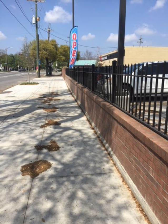

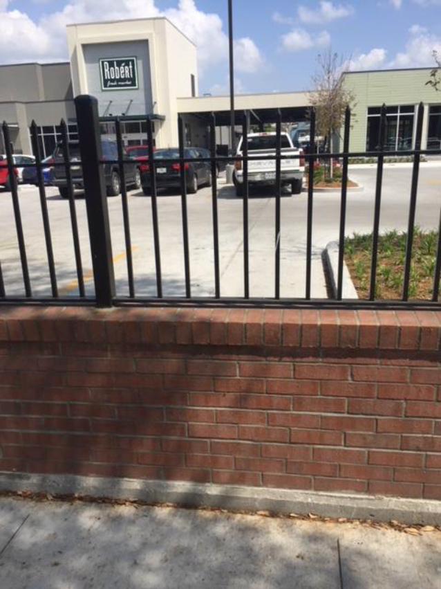


MOTION
NO. M-18-72
CITY HALL: March 8, 2018
BY: COUNCILMEMBER RAMSEY
SECONDED BY:
BE IT MOVED BY THE CITY COUNCIL OF THE CITY OF NEW ORLEANS,
That the City Planning Commission is directed to conduct a public hearing to consider an
amendment to Ordinance No. 26,076 MCS (Zoning Docket 069/14) to delete proviso 4(d), for a
property in an HMC-2 Historic Marigny/Tremé/Bywater Commercial District, on Square 373,
Lots A1, 11A, and R, in the Third Municipal District, bounded by Saint Claude Avenue, Elysian
Fields Avenue, Marigny Street, and North Rampart Street (Municipal Address: 2222 Saint
Claude Avenue); and otherwise to provide with respect thereto.
BE IT FURTHER MOVED BY THE CITY COUNCIL OF THE CITY OF NEW
ORLEANS, That in the process of reviewing the proposed amendment, the City Planning
Commission and staff are directed and granted the flexibility to make any and all legal and
appropriate changes and adjustments deemed necessary in light of public testimony resulting
from this review.
THE FOREGOING MOTION WAS READ IN FULL, THE ROLL WAS CALLED
ON THE ADOPTION OF THEREOF, AND RESULTED AS FOLLOWS:
YEAS:
NAYS:
ABSENT:
AND THE MOTION WAS ADOPTED.