AGENDA MILWAUKIE PLANNING COMMISSION Tuesday ...
259
AGENDA MILWAUKIE PLANNING COMMISSION Tuesday, August 22, 2017, 6:30 PM MILWAUKIE CITY HALL 10722 SE MAIN STREET 1.0 Call to Order - Procedural Matters 2.0 Planning Commission Minutes – Motion Needed 2.1 June 13,2017 3.0 Information Items 4.0 Audience Participation – This is an opportunity for the public to comment on any item not on the agenda 5.0 Public Hearings – Public hearings will follow the procedure listed on reverse 5.1 Summary/File: Tutoring School, CSU-2017-004 Applicant/Owner: Tamara Jata, Blueberry House Tutoring LLC Address: 10670 SE 52 nd Ave Staff: Vera Kolias 5.2 Summary/File(s): Logus Rd Subdivision, S-2016-002/VR-2016-010/PLA-2016-002 Applicant/Owner: Julian Illingworth Address: 4543 SE Logus Rd Staff: Mary Heberling (continued from July 25, 2017) 5.3 Summary/File(s): Kellogg Bridge Replacement, WG-2017-002/NR-2017-002 Applicant/Owner: Rick Buen, City of Milwaukie Address: 11211 SE McLoughlin Blvd Staff: Vera Kolias 5.4 Summary/File(s): Project Galaxy Design Review, DR-2017-001/VR-2017-007 Applicant/Owner: Kurt Schultz, SERA Architects Address: 2036 SE Washington St Staff: Vera Kolias 6.0 Worksession Items 7.0 Planning Department Other Business/Updates 8.0 Planning Commission Committee Updates and Discussion Items – This is an opportunity for comment or discussion for items not on the agenda. 9.0 Forecast for Future Meetings: September 12, 2017 1. Worksession: Comprehensive Plan Advisory Committee Appointment 2. Public Hearing: CU-2017-001 Eton Ln Vacation Rental September 26, 2017 1. TBD
-
Upload
khangminh22 -
Category
Documents
-
view
0 -
download
0
Transcript of AGENDA MILWAUKIE PLANNING COMMISSION Tuesday ...

AGENDA MILWAUKIE PLANNING COMMISSION
Tuesday, August 22, 2017, 6:30 PM
MILWAUKIE CITY HALL 10722 SE MAIN STREET
1.0 Call to Order - Procedural Matters
2.0 Planning Commission Minutes – Motion Needed
2.1 June 13,2017
3.0 Information Items
4.0 Audience Participation – This is an opportunity for the public to comment on any item not on the
agenda
5.0 Public Hearings – Public hearings will follow the procedure listed on reverse
5.1 Summary/File: Tutoring School, CSU-2017-004
Applicant/Owner: Tamara Jata, Blueberry House Tutoring LLC
Address: 10670 SE 52nd Ave
Staff: Vera Kolias
5.2 Summary/File(s): Logus Rd Subdivision, S-2016-002/VR-2016-010/PLA-2016-002
Applicant/Owner: Julian Illingworth
Address: 4543 SE Logus Rd
Staff: Mary Heberling (continued from July 25, 2017)
5.3 Summary/File(s): Kellogg Bridge Replacement, WG-2017-002/NR-2017-002
Applicant/Owner: Rick Buen, City of Milwaukie
Address: 11211 SE McLoughlin Blvd
Staff: Vera Kolias
5.4 Summary/File(s): Project Galaxy Design Review, DR-2017-001/VR-2017-007
Applicant/Owner: Kurt Schultz, SERA Architects
Address: 2036 SE Washington St
Staff: Vera Kolias
6.0 Worksession Items
7.0 Planning Department Other Business/Updates
8.0 Planning Commission Committee Updates and Discussion Items – This is an opportunity
for comment or discussion for items not on the agenda.
9.0
Forecast for Future Meetings:
September 12, 2017 1. Worksession: Comprehensive Plan Advisory Committee Appointment
2. Public Hearing: CU-2017-001 Eton Ln Vacation Rental
September 26, 2017 1. TBD

Milwaukie Planning Commission Statement The Planning Commission serves as an advisory body to, and a resource for, the City Council in land use matters. In this capacity, the mission of the Planning Commission is to articulate the Community’s values and commitment to socially and environmentally responsible uses of its resources as reflected in the Comprehensive Plan
1. PROCEDURAL MATTERS. If you wish to speak at this meeting, please fill out a yellow card and give to planning staff. Please turn
off all personal communication devices during meeting. For background information on agenda items, call the Planning Department at 503-786-7600 or email [email protected]. Thank You.
2. PLANNING COMMISSION MINUTES. Approved PC Minutes can be found on the City website at www.cityofmilwaukie.org 3. CITY COUNCIL MINUTES City Council Minutes can be found on the City website at www.cityofmilwaukie.org 4. FORECAST FOR FUTURE MEETING. These items are tentatively scheduled, but may be rescheduled prior to the meeting date.
Please contact staff with any questions you may have. 5. TIME LIMIT POLICY. The Commission intends to end each meeting by 10:00pm. The Planning Commission will pause discussion of
agenda items at 9:45pm to discuss whether to continue the agenda item to a future date or finish the agenda item. Public Hearing Procedure
Those who wish to testify should come to the front podium, state his or her name and address for the record, and remain at the podium until the Chairperson has asked if there are any questions from the Commissioners. 1. STAFF REPORT. Each hearing starts with a brief review of the staff report by staff. The report lists the criteria for the land use
action being considered, as well as a recommended decision with reasons for that recommendation. 2. CORRESPONDENCE. Staff will report any verbal or written correspondence that has been received since the Commission was
presented with its meeting packet. 3. APPLICANT’S PRESENTATION. 4. PUBLIC TESTIMONY IN SUPPORT. Testimony from those in favor of the application. 5. NEUTRAL PUBLIC TESTIMONY. Comments or questions from interested persons who are neither in favor of nor opposed to the
application. 6. PUBLIC TESTIMONY IN OPPOSITION. Testimony from those in opposition to the application. 7. QUESTIONS FROM COMMISSIONERS. The commission will have the opportunity to ask for clarification from staff, the applicant, or
those who have already testified. 8. REBUTTAL TESTIMONY FROM APPLICANT. After all public testimony, the commission will take rebuttal testimony from the
applicant. 9. CLOSING OF PUBLIC HEARING. The Chairperson will close the public portion of the hearing. The Commission will then enter into
deliberation. From this point in the hearing the Commission will not receive any additional testimony from the audience, but may ask questions of anyone who has testified.
10. COMMISSION DISCUSSION AND ACTION. It is the Commission’s intention to make a decision this evening on each issue on the
agenda. Planning Commission decisions may be appealed to the City Council. If you wish to appeal a decision, please contact the Planning Department for information on the procedures and fees involved.
11. MEETING CONTINUANCE. Prior to the close of the first public hearing, any person may request an opportunity to present additional
information at another time. If there is such a request, the Planning Commission will either continue the public hearing to a date certain, or leave the record open for at least seven days for additional written evidence, argument, or testimony. The Planning Commission may ask the applicant to consider granting an extension of the 120-day time period for making a decision if a delay in making a decision could impact the ability of the City to take final action on the application, including resolution of all local appeals.
The City of Milwaukie will make reasonable accommodation for people with disabilities. Please notify us no less than five (5) business
days prior to the meeting.
Milwaukie Planning Commission:
Greg Hemer, Chair Adam Argo, Vice Chair Shannah Anderson John Henry Burns Sherry Grau Scott Jones Kim Travis
Planning Department Staff:
Denny Egner, Planning Director David Levitan, Senior Planner Brett Kelver, Associate Planner Vera Kolias, Associate Planner Mary Heberling, Assistant Planner Alicia Martin, Administrative Specialist II

CITY OF MILWAUKIE PLANNING COMMISSION
MINUTES Milwaukie City Hall
10722 SE Main Street TUESDAY, June 13, 2017
6:30 PM COMMISSIONERS PRESENT STAFF PRESENT Greg Hemer, Chair David Levitan, Senior Planner Adam Argo, Vice Chair Brett Kelver, Associate Planner John Burns Vera Kolias, Associate Planner Sherry Grau Mary Heberling, Assistant Planner Scott Jones Keith Liden, Temporary Planner Kim Travis Alex Roller, Engineering Technician ll Tim Ramis, City Attorney COMMISSIONERS ABSENT Shannah Anderson 1.0 Call to Order – Procedural Matters* Chair Hemer called the meeting to order at 6:30 pm and read the conduct of meeting format into the record. Note: The information presented constitutes summarized minutes only. The meeting video is available by clicking the Video link at http://www.milwaukieoregon.gov/meetings. 2.0 Planning Commission Minutes 2.1 April 11, 2017 It was moved by Commissioner Burns and seconded by Commissioner Jones to approve April 11, 2017 Planning Commission minutes as presented. The motion passed unanimously. 3.0 Information Items David Levitan, Senior Planner, noted the applicant for PD-2017-001, scheduled for June 27th, requested the hearing be moved to July 25, 2017 at the earliest. 4.0 Audience Participation – This is an opportunity for the public to comment on any item not on the agenda. There was none. 5.0 Public Hearings 5.1 Summary: ADU Variance Applicant: Sarah Roller Address: 11630 SE 27th Ave File: VR-2017-004, ADU-2017-001 Staff: Keith Liden Chair Hemer called the public hearing to order and read the conduct of quasi-judicial hearing formats into the record.
2.1 Page 1

CITY OF MILWAUKIE PLANNING COMMISSION Minutes of June 13, 2017 Page 2
Keith Liden, Temporary Planner, presented the staff report and reviewed key elements of the project, the requested variance, and how the application met the approval criteria with conditions. Chair Hemer called for the applicant's presentation. Sarah Roller, 2679 SE Davies Ct, Milwaukie, stated the front portion of the garage served as office space for her father's business, and the ADU would be an apartment for her mother. The variance was for an additional 80 sq ft which was unavoidable as the footprint of the existing garage was 880 sq ft. The applicant would comply with the requirement to improve the driveway apron and sidewalk although she felt it seemed like a reach for only 80 sq ft. Chair Hemer confirmed there was no public comment and closed the public testimony portion of the hearing. It was moved by Commissioner Burns and seconded by Commissioner Travis to approve land use applications VR-2017-004, ADU-2017-001 for 11630 SE 27th Ave with the recommended findings and conditions as presented. The motion passed unanimously. 5.2 Summary: 29th Ave Triplex Applicant: Casey Colton, Stone Creek Building Address: Tax Lot 11E36BA01101 on 29th Ave File: DEV-2017-006, VR-2017-002 Staff: Mary Heberling Chair Hemer called the public hearing to order and read the conduct of the quasi-judicial hearing format into the record. Mary Heberling, Assistant Planner, presented the staff report, reviewing key elements of the proposal and the requested variance related to the driveway and the two options explored. She addressed clarifying questions regarding the driveway designs, Chair Hemer confirmed there was no presentation from the applicant and no public comment. He closed the public testimony portion of the hearing. The Commission noted the driveway proposal was a creative way to address space issues and the variance was reasonable. It was moved by Commissioner Grau and seconded by Commissioner Travis to approve land use applications DEV-2017-006 and VR-2017-002 for Tax Lot 11E36BA01101 on 29th
Ave with the recommended findings and conditions as presented. The motion passed unanimously. 5.3 Summary: Eagle & 21st Development Applicant: Bradley Smith Address: 2024/2026 SE Eagle St, 11923 SE 21st Ave File: WG-2017-002, VR-2017-005 Staff: Brett Kelver
2.1 Page 2

CITY OF MILWAUKIE PLANNING COMMISSION Minutes of June 13, 2017 Page 3
Chair Hemer called the public hearing to order and read the conduct of the quasi-judicial hearing format into the record. Brett Kelver, Associate Planner, presented the staff report, describing the site’s history and the project and requested variance. He and City Engineering Technician II, Alex Roller, addressed clarifying questions from the Commission with these key responses:
• There was some flexibility to push the road more toward the center of the right-of-way (ROW) to preserve trees in the ROW.
• There was no intention to improve the gravel path on 21st Ave to Bluebird St. Getting a formal agreement with the railroad for major ROW improvements could be difficult.
• Signage indicating a dead-end road could be posted to deter thru-traffic and minimize confusion about traffic circulation in the neighborhood. Installing a barricade would require a turnaround for the fire department.
• The design of the accessway incorporated ADA facilities into the roadway. The neighborhood preferred not to have sidewalks and other pedestrian improvements, which were not warranted due to the low traffic volume. The proposed street design would be approved by the Engineering Director.
• Stormwater would be managed on the north side of the ROW. Chair Hemer called for the applicant's presentation. Brad Smith, 13621 SE Fair Oaks Dr, reviewed the history of the property. The residential units were for him and his wife, who were downsizing, as well as for their daughter and granddaughter. Chair Hemer confirmed there was no public comment and closed the public hearing. Discussion from Commission noted no trees would be lost, the project would not be visible in the Willamette Greenway either from or to the river, and a dead-end sign was adequate to deter traffic. Streets in the Island Station Neighborhood were treated as greenway streets with bicyclists and pedestrians having the right of way, and the NDA had no issues with the proposal. It was moved by Commissioner Travis and seconded by Vice Chair Argo to approve land use applications WG-2017-002, VR-2017-005 for 2024/2026 SE Eagle St, 11923 SE 21st Ave with the recommended findings and conditions as amended. The motion passed unanimously. Chair Hemer called for a brief recess, reconvening the meeting at approximately 7:43 pm. 5.4 Summary: Railroad Ave Subdivision Applicant/Owner: Simon Lofts, Sustainable Infill Development/Francar LLC Address: 4217/4219 SE Railroad Ave File: S-2017-002, VR-2017-001, VR-2017-006, ZA-2017-002, CPA-2017-001 Staff: Vera Kolias Chair Hemer called the public hearing to order and read the conduct of the quasi-judicial and legislative hearing formats into the record. Chair Hemer declared that he served on the Milwaukie Historical Society Board as a volunteer and had testified on behalf of the Historical Society in support of the demolition of the historic
2.1 Page 3

CITY OF MILWAUKIE PLANNING COMMISSION Minutes of June 13, 2017 Page 4
home. He assured his testimony would not be affected in any way. No other conflicts of interest or ex parte contacts were declared. Vera Kolias, Associate Planner, presented the staff report, and reviewed the history of the site and key components of the project. She reviewed three key issues regarding the proposal, and staff’s recommendations regarding alternatives to the requested variances regarding Lot 13, accessways, and new street intersection spacing.
• She corrected a typo and noted the required spacing for the new intersection between 42nd Ave and 43rd Ave was 530 300 ft. The applicant proposal was 126 ft.
• Staff submitted a slightly revised set of conditions that reflected the recommended changes. She highlighted the comments received and noted that Condition 6.E reflected the recommended full 46-ft ROW.
Staff addressed questions from the Commission with these key comments:
• Staff recommended Lot 13 be eliminated because the lot was crammed onto a maximized site plan that created rear lot line issues for Lots 16 and 17, and required another access easement across Lot 14.
• Although rezoning to R-5 would allow for six additional lots on the property, adding lots needed to balance against good design and other Code requirements, including access and lot layout. Eliminating Lot 13 would result in a better design and the development still had more lots than allowed under the current zoning. Staff did not redesign the southern portion, but eliminating Lot 13 would allow Lots 16 and 17 to be squared off.
The applicant agreed with staff’s recommendation to have a shared access between Lots 2 and 3 from the new street with Lot 1 being the only lot to access off 42nd Ave. However, Lot 1 must have a turnaround because backing onto 42nd Ave was prohibited.
• Improvements were required on 42nd Ave regardless of access because a subdivision had a larger proportionality requirement; therefore, all frontages must be improved.
• Staff’s required loop design met other development standards for connectivity and the future development of adjacent parcels, which must be able to access the ROW.
• The current design reflects the City’s requirement that no driveways may access onto Railroad Ave; the new roads were spaced evenly between 42nd Ave and 45th Ave. The 45 ft intersection/driveway spacing requirement applied to the construction of 43rd Ave. Previously, Lots 1 and 2 accessed onto 43rd Ave too close to Railroad Ave. There was space to accommodate shared driveway between Lots 2 and 3, so the proposed plan could meet the requirement.
• The findings and conditions addressed requirements the revised plan needed to meet. With the Commission’s approval of the preliminary plat, the final plat would need to meet the revised standards and include a narrative of how it differed from the original.
• The pedestrian path was a multi-use path, and the extension of the path along north side of Railroad Ave was in the City’s Transportation System Plan (TSP).
• No recent examples existed of the rectangular lot requirement reducing the amount of developable acreage. The Planning Director preferred more regularly shaped lots as required in Title 17 and to not have an access easement across a property. Whether the application met the code’s criteria “to the extent practicable” was a discretionary decision for the Commission. The pros and cons of the layout had to be weighed against the number of lots.
• No turnaround was required on Lot 13 because the requirement was only for driveways onto arterials and collectors, not interior streets.
• The primary issues with Lot 13 were that Lot 13 required an access easement and an additional variance for the 10-ft rear yard setback. The irregularity of Lots 1, 2, 10, and 11
2.1 Page 4

CITY OF MILWAUKIE PLANNING COMMISSION Minutes of June 13, 2017 Page 5
were tied directly to the loop road, but the lots met all of the other development standards and did not require any setback variances.
Chair Hemer called for the applicant's testimony. Mark Dane, Mark Dane Planning, 12725 SW Glen Haven Ave, Portland, OR 97225 explained that removing Lot 13 did not create rectangular lots and would also create double frontage lots, requiring another variance.
• He commended staff for the internal road solution presented. He believed the loop street was key in allowing availability of services.
• He reviewed how the proposal met the criteria for the Comprehensive Plan Map and Text Amendments, as well as the Zoning Map Amendment. .
• The driveway/intersection spacing variance was requested to maximize circulation.
• He reviewed the requested variances with these key comments:
• The variances requested for the access spacing and double frontage on Lots 18 and 19 were a result of the parcel shape.
• The variance requested for Lots 1, 2, 13 was to allow alternate accesses as access on Railroad Ave was prohibited. The rear yard setback variances requested for Lots 13 and 19 would allow for the lots to be more buildable.
• He disagreed with the elimination of Lot 13 and believed staff’s reasoning was against the policies, objectives, and goals of the Comprehensive Plan and zoning.
• The applicant sought approval with the amended conditions as proposed. Mr. Dane addressed clarifying questions from the Commission with these key comments:
• As shown in the new revised plan, the applicant agreed with removing access for Lot 2 to over Lot 3 from 42nd Ave. Changing the home’s orientation and having one access made more sense.
• He deferred to the builder regarding the median sale price of the homes, but noted house prices would change by the time the homes went in. More houses were needed now and they could not be built fast enough.
• Regarding the Hector Campbell NDA requests, the location of the historic house with the family name would be signed, the subdivision’s name reflected the family name, and material from the historic home would be used for signage at the multiuse path.
• The applicant had no objection to using two or three types of deciduous trees, which would be included in the landscaping plan. Materials used for the homes themselves would be left to the builder's discretion.
Mike Harn, Owner, Anlon Construction, 18255 S Charlie Ct, Oregon City, addressed questions from the Commission. The median cost of the homes would be in the low $400,000sEliminating one lot would increase the median cost to around $475,000. There would be a variety of home shapes and sizes as the building envelopes were rather unique. Much depended on the market and the desire for unique homes. Commissioner Burns noted the stormwater assumptions for the predeveloped conditions in the submittal reflected what was on the site today, but the City’s standard was predeveloped or Lewis and Clark conditions.
• Mr. Dane responded the applicant’s team would take another look. Chair Hemer called for public testimony.
2.1 Page 5

CITY OF MILWAUKIE PLANNING COMMISSION Minutes of June 13, 2017 Page 6
In Support David Aschenbrenner, Chair, Hector Campbell NDA, 11505 SE Home Ave, Milwaukie, OR stated the neighborhood supported the project. The applicant had worked with the NDA to resolve issues with the two accesses on 42nd Ave. He was reassured by engineering staff that 42nd Ave would be rebuilt and the intersection improved. The NDA had no issues with Lot 13 and the access through Lot 14 or the double lot frontages. Kay Endo, 4423 SE Railroad Ave, Milwaukie, shared the history of his family and their land, and stated he fully supported the project. In Opposition Beth Lacey Snow, 4404 SE Franklin St, Milwaukie, shared the history of the area and her family home. She opposed the project because she would lose the privacy the field to the southeast provided and the shade the trees provided. If approved, she wanted the mature trees preserved, adding they would also provide shade for the new homes. She was also concerned about erosion behind her house and asked if there was a plan for a retaining wall. Chair Hemer called for comments from staff. Ms. Kolias noted the 20 ft-wide landscape buffer that included the existing trees along the perimeter of the project, so some of the noted trees might fall into that buffer and remain on the property. Mr. Levitan responded staff supported the zoning change and Comprehensive Plan amendment for the additional density, but staff did not believe the proposed site design met the requirements and findings, which would eliminate Lot 13. While that would create a triangle-shaped lot, it would also result in three fewer irregularly-shaped lots.
• The Housing Needs Analysis (HNA) showed a need for 1,150 units over the next 20 years, but also that the City had more than double that capacity to accommodate that growth. The HNA supported the rezoning to allow for anywhere from 14 to 19 units, but he did not believe it supported the need to maximize out to the full 19 units.
Chair Hemer called for applicant's rebuttal. Mr. Dane noted the applicant changed the plan after a concern was raised at the neighborhood meeting about the trees and apologized that was not more clearly shown. He believed he had made a strong argument for keeping Lot 13 and shared his inclination to appeal the decision, if not approved. Ms. Kolias confirmed the findings and conditions of approval. Staff recommended that Lot 2 either be eliminated or get its access with Lot 3 from the proposed 43rd Ave, and that Lot 1 be the only lot accessing 42nd Ave. Chair Hemer closed the public hearing. Planning Commission Deliberation
2.1 Page 6

CITY OF MILWAUKIE PLANNING COMMISSION Minutes of June 13, 2017 Page 7
The Commission agreed the zone change was warranted given that 40% of the City was R-7 zone and only 10% was R-5. The NDA did not have an issue with the zoning change and R-5 zoning met the City’s goals and policies. During deliberations, the Commission discussed and amended the following conditions of approval regarding the requested variances with additional comments as noted:
• Retain Lot 2 and recommend Condition D.2.b to allow access through Lot 3.
• Allow variances to the double frontage lots on Lots 18 and 19.
• Allow the variance to the minimum street spacing requirement between 42nd Ave and 43rd Ave off Railroad Ave.
• Allow variances to the minimum rear yard setbacks for Lots 19 and 13. (Condition 1.B)
• Retain Lot 13 and allow the variance allowing Lot 13 to use the access easement with Lot 14.
• Eliminate Condition 2.
• Add Condition 1.D. to allow a variance to allow alternate access for Lots 2, 13, and 14.
• Eliminate Condition 3.D.1 and Condition 2.A. Tim Ramis, City Attorney, suggested two motions be considered, one for the recommendation for the Comprehensive Plan and Zoning amendments, and the other to address the specific development plan. It was moved by Commissioner Travis and seconded by Vice Chair Argo to recommend approval to City Council of ZA-2017-002 and CPA-2017-001 4217/4219 SE Railroad Ave. The motion passed unanimously. It was moved by Commissioner Grau and seconded by Commissioner Jones to approve land use applications S-2017-002, VR-2017-001, and VR-2017-006, for 4217/4219 SE Railroad Ave with the recommended findings and conditions as amended. The motion passed unanimously. Chair Hemer read the rules of appeal into the record. 6.0 Worksession Items 7.0 Planning Department Other Business/Updates 8.0 Planning Commission Discussion Items Chair Hemer announced that on July 29th, the Milwaukie Pioneer Cemetery would unveil five new headstones purchased by the U.S. Veteran's Administration for previously unmarked graves. More information was also available on the June Veterans Facebook Page. 9.0 Forecast for Future Meetings:
June 27, 2017 1. Public Hearing: PD-2017-001 13333 SE Rusk Rd continued from 5/25/17
2. Worksession: NMIA Framework Plan and Implementation Strategy
July 11, 2017 1. Public Hearing: S-2017-002 4217/4219 SE Railroad Ave continue tentative
2.1 Page 7

CITY OF MILWAUKIE PLANNING COMMISSION Minutes of June 13, 2017 Page 8
2. Worksession: Vision/Comprehensive Plan Update
Chair Hemer asked staff to consider presenting the Vision/Comprehensive Plan Update on June 27th, so the July 11th meeting could be cancelled. Mr. Levitan said if staff was unable to present to the Commission on June 27th, the worksession could be pushed to July 25th. He confirmed the Commission preferred to focus on the Comprehensive Plan portion rather than the Vision Action Plan, but wanted to be updated on the status of the Vision Plan elements. Meeting adjourned at approximately 9:49 pm.
Respectfully submitted,
Alicia Martin, Administrative Specialist II
___________________________ Greg Hemer, Chair
2.1 Page 8

To: Planning Commission
Through: Dennis Egner, Planning Director
From: Stuart Campbell, Intern and Vera Kolias, Associate Planner
Date: August 14, 2017, for August 22, 2017, Public Hearing
Subject: File: CSU-2017-004
Applicant: Tamara Jata, Blueberry House Tutoring LLC
Owner(s): Tamara Jata
Address: 10670 SE 52nd Ave.
Legal Description (Map & Tax Lot): 12E31AB64000
NDA: Linwood
ACTION REQUESTED
Approve application CSU-2017-004 and adopt the recommended Findings and Conditions of Approval found in Attachments 1 and 2. This action would allow for a new Community Service Use (CSU) for a religious based educational tutoring company.
BACKGROUND INFORMATION
The applicant, Tamara Jata, has applied for approval for a Community Service Use (CSU) for a religious based educational tutoring company to share space and operate out of the Living Water Community Fellowship Church. Blueberry House Tutoring LLC (Blueberry House) will provide educational instruction for homeschool students, as well as after school tutoring for students from private and public schools throughout the metro area. 40 students are currently enrolled, and 5 teachers are employed. Blueberry House operates from September through May, and provides classes on Monday through Thursday, from 8:30 a.m. to 5:30 p.m. The Church shares 5 out of its 6 rooms with Blueberry House, and 1 room is reserved exclusively for Blueberry House.
A. Site and Vicinity
The site is located at 10670 SE 52nd Ave. (see Figure 1). It is a permitted church and contains three buildings that are connected by exterior roof overhangs. A 64-space off-street parking lot sits on the east side of the church, with a long driveway access off SE 52nd Ave. The site is flat with areas of grass, trees and shrubs along the north side of the
5.1 Page 1

Planning Commission Staff Report—Tamara Jata, Blueberry House Tutoring LLC Page 2 of 5 Master File #CSU-2017-004—10670 SE 52nd Ave. August 14, 2017
property creating a buffer between the building and the residential use next door, as well as fencing along the sides and rear of the property.
The surrounding area consists of residential uses. The current zone is Low Density Residential R-7. Medium Density Residential R-5 zoning is nearby, to the north and directly west from the site, across SE 52nd Ave. (See Figure 2).
B. Zoning Designation
Residential R-7
C. Comprehensive Plan Designation
Low Density Residential
D. Land Use History
The Clackamas County Assessors data does not provide a date of construction, however Zillow.com provides a construction date of 1962.
R-5
R-7
SE Jackson St
SE Jackson St
SE
52n
d A
ve
S
E 5
2n
d A
ve
Figure 1
Figure 2
5.1 Page 2

Planning Commission Staff Report—Tamara Jata, Blueberry House Tutoring LLC Page 3 of 5 Master File #CSU-2017-004—10670 SE 52nd Ave. August 14, 2017
In 1984, the applicant, Central Church of God, requested the approval of a conditional use (C-1984-002) to expand the church parking lot by paving a strip of property on the south side of the church. The City permitted the parking expansion by requiring that the new parking be parallel to the property line, that the two-lane driveway not be reduced, and that a drywell be installed.
E. Proposal
The applicant is seeking land use approval for a new Community Service Use (CSU) for a religious based educational tutoring company.
The project requires approval of the following applications:
1. Community Service Use (CSU-2017-004)
KEY ISSUES
Summary
Staff has identified the following key issue for the Planning Commission's deliberation. Aspects of the proposal not listed below are addressed in the Findings (see Attachment 1) and generally require less analysis and discretion by the Commission.
Compatibility Blueberry House Tutoring LLC will operate in an existing church, located within the R-7 residential zone. They will be offering religious based educational tutoring instruction for homeschool, private, and public school students. Because Blueberry House is a religious based teaching and tutoring school, it fits the broader use of the Church within the community. Trips generated by the school use are higher than the church use. Preliminary transportation calculations indicate the use would result in 6.0 additional trips during the peak afternoon hour. The Engineering Department determined that the increase is not significant and does not warrant additional traffic impact analysis. Additional trips to the Church for Blueberry House will not increase parking demand in the area. The church has 64 parking spaces available to accommodate such demand. 6 staff and 40 enrolled students use the Church complex during Blueberry House’s hours of operation, but only 6 parking spots are used continuously from 8:30 a.m. until 5:30 p.m. On-site parking is sufficient for the proposed use. Hours of operation will be from 8:30 a.m. until 5:30 p.m., Monday through Thursday, and during the months of September through May. These hours of operation do not conflict with other Church activities. Church services are held Wednesdays at 7 p.m. and Sundays from 10 a.m. through 1 p.m. Activities for Blueberry House are predominately inside the building and have a low impact on the surrounding area during the day. A play area exists on site, and is required per MCC 19.904.7, thus children may play outside for a short duration of time.
5.1 Page 3

Planning Commission Staff Report—Tamara Jata, Blueberry House Tutoring LLC Page 4 of 5 Master File #CSU-2017-004—10670 SE 52nd Ave. August 14, 2017
CONCLUSIONS
A. Staff recommendation to the Planning Commission is as follows:
1. Approve the Community Service Use (CSU) for 10670 SE 52nd Ave. This will result in the applicant receiving a Community Service Use (CSU) designation, permitting the operation of Blueberry House Tutoring LLC within Living Water Community Fellowship Church.
2. Adopt the attached Findings and Conditions of Approval.
B. Staff recommends the following key conditions of approval (see Attachment 2 for the full list of Conditions of Approval):
• Blueberry House Tutoring LLC shall provide the required number of bicycle parking spaces to comply with MMC 19.609.
CODE AUTHORITY AND DECISION-MAKING PROCESS
The proposal is subject to the following provisions of the Milwaukie Municipal Code (MMC).
• MMC Section 19.1006 Type III Review
• MMC Chapter 12.08 Street and Sidewalk Excavations, Construction, and Repair
• MMC Chapter 12.16 Access Management
• MMC Chapter 12.24 Clear Vision at Intersections
• MMC Section 19.904 Community Service Uses
• MMC Chapter 19.600 Off-Street Parking and Loading
• MMC Chapter 19.700 Public Facility Improvements
• MMC Section 19.301 Low Density Residential Zones (incl. R-7)
This application is subject to Type III review, which requires the Planning Commission to consider whether the applicant has demonstrated compliance with the code sections shown above. In Type III reviews, the Commission assesses the application against review criteria and development standards and evaluates testimony and evidence received at the public hearing.
The Commission has 4 decision-making options as follows:
A. Approve the application subject to the recommended Findings and Conditions of Approval.
C. Approve the application with modified Findings and Conditions of Approval. Such modifications need to be read into the record.
D. Deny the application upon finding that it does not meet approval criteria.
E. Continue the hearing.
The final decision on this application, which includes any appeals to the City Council, must be made by November 7, 2017, in accordance with the Oregon Revised Statutes and the Milwaukie Zoning Ordinance. The applicant can waive or extend the time period in which the application must be decided.
COMMENTS
Notice of the proposed changes was given to the following agencies and persons: City of Milwaukie Community Development, Planning Department, Building Division, Engineering
5.1 Page 4
Planning Commission Staff Report—Tamara Jata, Blueberry House Tutoring LLC Page 5 of 5 Master File #CSU-2017-004—10670 SE 52nd Ave. August 14, 2017
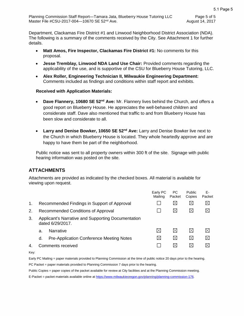
Department, Clackamas Fire District #1 and Linwood Neighborhood District Association (NDA). The following is a summary of the comments received by the City. See Attachment 1 for further details.
• Matt Amos, Fire Inspector, Clackamas Fire District #1: No comments for this proposal.
• Jesse Tremblay, Linwood NDA Land Use Chair: Provided comments regarding the applicability of the use, and is supportive of the CSU for Blueberry House Tutoring, LLC.
• Alex Roller, Engineering Technician II, Milwaukie Engineering Department: Comments included as findings and conditions within staff report and exhibits.
Received with Application Materials:
• Dave Flannery, 10680 SE 52nd Ave: Mr. Flannery lives behind the Church, and offers a
good report on Blueberry House. He appreciates the well-behaved children and
considerate staff. Dave also mentioned that traffic to and from Blueberry House has
been slow and considerate to all.
• Larry and Denise Bowker, 10650 SE 52nd Ave: Larry and Denise Bowker live next to
the Church in which Blueberry House is located. They whole heartedly approve and are
happy to have them be part of the neighborhood.
Public notice was sent to all property owners within 300 ft of the site. Signage with public hearing information was posted on the site.
ATTACHMENTS
Attachments are provided as indicated by the checked boxes. All material is available for viewing upon request.
Early PC Mailing
PC Packet
Public Copies
E- Packet
1. Recommended Findings in Support of Approval
2. Recommended Conditions of Approval
3. Applicant's Narrative and Supporting Documentation dated 6/29/2017.
a. Narrative
d. Pre-Application Conference Meeting Notes
4. Comments received
Key:
Early PC Mailing = paper materials provided to Planning Commission at the time of public notice 20 days prior to the hearing.
PC Packet = paper materials provided to Planning Commission 7 days prior to the hearing.
Public Copies = paper copies of the packet available for review at City facilities and at the Planning Commission meeting.
E-Packet = packet materials available online at https://www.milwaukieoregon.gov/planning/planning-commission-176.
5.1 Page 5

Recommended Findings in Support of Approval File #CSU-2017-004, Tamara Jata, Blueberry House Tutoring LLC
Sections of the Milwaukie Municipal Code not addressed in these findings are found to be inapplicable to the decision on this application.
1. The applicant, Tamara Jata, has applied for approval for a Community Service Use (CSU) at 10670 SE 52nd Ave. This site is in the R-7 Zone. The land use application file number is CSU-2017-004.
2. The applicant is seeking land use approval for a Community Service Use (CSU) for a religious education tutoring company for homeschool students. Blueberry House Tutoring LLC also provides after school tutoring for students throughout the metro area, currently enrolls 40 students, and employs 5 teachers. Blueberry House operates from September through May, and on Mondays through Thursdays, from 8:30 a.m. to 5:30 p.m. There are a total of 5 rooms that are shared between Blueberry House and the Living Water Community Fellowship Church, and 1 is room reserved exclusively for Blueberry House. The intent of the applicant is to permit the operation of Blueberry House Tutoring LLC within the Living Water Community Fellowship’s church building. The proposal is subject to the following provisions of the Milwaukie Municipal Code (MMC):
a. MMC Section 19.1006 Type III Review
b. MMC Chapter 12.08 Street and Sidewalk Excavations, Construction, and Repair
c. MMC Chapter 12.16 Access Management
d. MMC Chapter 12.24 Clear Vision at Intersections
e. MMC Section 19.904 Community Service Uses
f. MMC Chapter 19.600 Off-Street Parking and Loading
g. MMC Chapter 19.700 Public Facility Improvements
h. MMC Section 19.301 Low Density Residential Zones (incl. R-7)
3. The application has been processed and public notice provided in accordance with MMC Section 19.1006 Type III Review. A public hearing was held on August 22, 2017, as required by law.
4. MMC 12.08 – Street & Sidewalk Excavations, Construction, and Repair
MMC Chapter 12.08 applies to all construction that is completed in the right-of-way that is eventually dedicated to the City. The public improvement process will follow MMC 12.08.020.
5. MMC 12.16 – Access Management
MMC 12.16.040 establishes standards for access (driveway) requirements. The Planning Commission finds that the following complies with applicable criteria of MMC Chapter 12.16.
12.16.040E & 12.16.040F: Accessway Design - ADA standards & Width As conditioned, the proposed development will include driveways that conform to MMC 12.16.040.E and MMC 12.16.040. F.
5.1 Page 6ATTACHMENT 1

Planning Commission Findings in Support of Approval Page 2 of 9 Tamara Jata, Blueberry House Tutoring LLC August 14, 2017 Master File #CSU-2017-004—10670 SE 52nd Ave.
6. MMC Chapter 12.24 – Clear Vision at Intersections
12.24.030: clear vision requirements
As conditioned, the proposed development will include driveways and accessways that conform to MMC 12.24.030.
The Planning Commission finds that the proposed development, as conditioned, complies with the applicable criteria in MMC Chapter 12.
7. MMC Section 19.904 Community Service Use
MMC 19.904 provides standards and procedures for review of applications for community service uses. These are uses that are not specifically allowed outright in most zoning districts but that address a public necessity or otherwise provide some public benefit. Community service uses may include schools, government buildings, hospitals, religious institutions, utilities, parks, communication facilities, or private or public recreation facilities.
a. MMC 19.904.2 Applicability – lists the various uses that are allowed through the Community Service Use (CSU) process.
The proposed development is for a religious educational tutoring company, to operate out of the Living Water Community Fellowship Church. Blueberry House Tutoring LLC will provide educational instruction for homeschool students, as well as after school tutoring for students from private and public schools throughout the metro area. 40 students are currently enrolled, and 5 teachers are employed. Blueberry House operates from September through May, and provides classes on Monday through Thursday, from 8:30am to 5:30pm. The Church shares 5 out of its 6 rooms with Blueberry House, and the 6th room is used exclusively by Blueberry House.
MMC 19.904.2.A lists the Community Service Uses that are categorized as Institutions – Public or Private and Other Public Facilities. Examples of uses are schools, governments office buildings, hospitals, cemetery, nursing or convalescent home, religious institutions, community meeting building, temporary or transitional facility, and other similar uses as determined by the Planning Commission. The code explicitly mentions day-care centers, schools, and religious institutions as applicable community service uses.
The Planning Commission finds that the proposed religious educational tutoring company, Blueberry House Tutoring LLC, is a community service use and the standards of MMC 19.904 are applicable to the proposed development.
b. MMC 19.904.3 establishes the review process for CSUs. Except for wireless communication facilities and minor modifications to existing CSUs, applications for CSUs are subject to Type III review (MMC 19.1006).
The proposed development is not a wireless communication facility, nor does it represent a minor modification to the existing CSU.
The Planning Commission finds that the proposed development is subject to the procedures for Type III review outlined in MMC 19.1006.
c. MMC 19.904.4 establishes the following approval criteria for CSUs:
a) The building setback, height limitation, and off-street parking and similar requirements governing the size and location of development in the underlying
5.1 Page 7
Planning Commission Findings in Support of Approval Page 3 of 9 Tamara Jata, Blueberry House Tutoring LLC August 14, 2017 Master File #CSU-2017-004—10670 SE 52nd Ave.
zone are met. Where a specific standard is not proposed in the CSU, the standards of the underlying zone must be met.
The building intended for the CSU is zoned residential R-7. The applicant is applying to permit the operation of their school within the existing building. No additions or expansions are proposed, thus creating no applicable development standards in the base zone.
The use of the building for an educational and after school tutoring program does not trigger any additional off-street parking requirements.
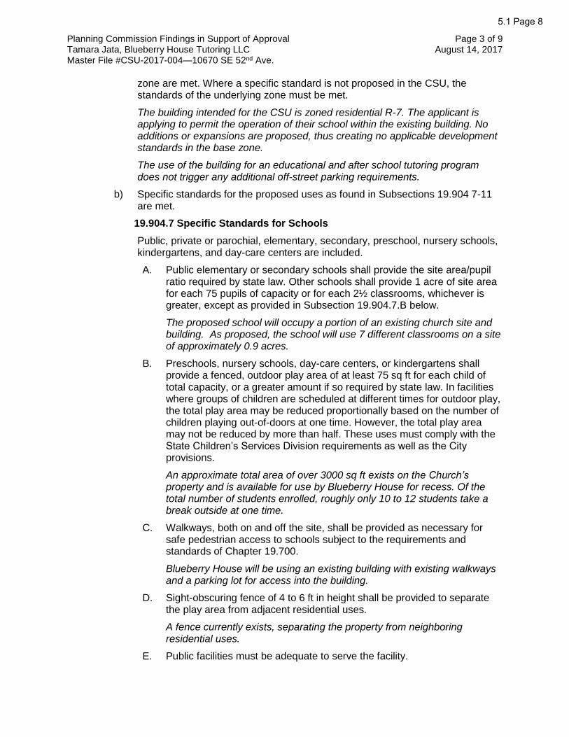
b) Specific standards for the proposed uses as found in Subsections 19.904 7-11 are met.
19.904.7 Specific Standards for Schools
Public, private or parochial, elementary, secondary, preschool, nursery schools, kindergartens, and day-care centers are included.
A. Public elementary or secondary schools shall provide the site area/pupil ratio required by state law. Other schools shall provide 1 acre of site area for each 75 pupils of capacity or for each 2½ classrooms, whichever is greater, except as provided in Subsection 19.904.7.B below.
The proposed school will occupy a portion of an existing church site and building. As proposed, the school will use 7 different classrooms on a site of approximately 0.9 acres.
B. Preschools, nursery schools, day-care centers, or kindergartens shall provide a fenced, outdoor play area of at least 75 sq ft for each child of total capacity, or a greater amount if so required by state law. In facilities where groups of children are scheduled at different times for outdoor play, the total play area may be reduced proportionally based on the number of children playing out-of-doors at one time. However, the total play area may not be reduced by more than half. These uses must comply with the State Children’s Services Division requirements as well as the City provisions.
An approximate total area of over 3000 sq ft exists on the Church’s property and is available for use by Blueberry House for recess. Of the total number of students enrolled, roughly only 10 to 12 students take a break outside at one time.
C. Walkways, both on and off the site, shall be provided as necessary for safe pedestrian access to schools subject to the requirements and standards of Chapter 19.700.
Blueberry House will be using an existing building with existing walkways and a parking lot for access into the building.
D. Sight-obscuring fence of 4 to 6 ft in height shall be provided to separate the play area from adjacent residential uses.
A fence currently exists, separating the property from neighboring residential uses.
E. Public facilities must be adequate to serve the facility.
5.1 Page 8

Planning Commission Findings in Support of Approval Page 4 of 9 Tamara Jata, Blueberry House Tutoring LLC August 14, 2017 Master File #CSU-2017-004—10670 SE 52nd Ave.
Public facilities, as part of the existing church building, are adequate for Blueberry House’s proposed use.
F. Safe loading and ingress and egress will be provided on and to the site.
The existing building in which Blueberry House will operate has existing loading, ingress and egress facilities.
G. Off-street parking (including buses) shall be provided as per Chapter 19.600.
Approximately 64 off-street parking spaces are provided. Blueberry House uses 6 of these. Other spaces are used for student pick-up and drop-off. Roughly 25 cars come and go between 8:30 a.m. and 3:15 p.m., and busses can access the parking lot, as well.
H. Minimum setback requirements:
Front yard: 20 ft
Rear yard: 20 ft
Side yard: 20 ft
Setbacks may be increased depending on the type and size of school in order to ensure adequate buffering between uses and safety for students.
The existing building that Blueberry House will operate out of was built with a 5 ft side yard setback on the north side of the building. It is a pre-existing nonconforming structure.
I. Bicycle facilities are required which adequately serve the facility.
There are currently no bicycle facilities on the site.
i. MMC 19.609 establishes standards for bicycle parking.
The quantity of required bicycle spaces shall be as described in the subsection. In no case, shall less than 2 spaces be provided.
The applicant shall provide 2 bicycle parking spots prior to the issuance of a certificate of occupancy.
As conditioned, the Planning Commission finds the standard is met.
ii. A minimum of 50% of the bicycle spaces shall be covered and/or enclosed (in lockers or a secure room) in any of the following situations:
1. When 10% or more of the vehicle parking is covered.
2. If more than 10 bicycle parking spaces are required.
3. Multifamily residential development with 4 or more units.
The CSU proposal does not have any covered vehicle parking, is not requiring more than 10 bicycle parking spaces, and is not a multifamily development.
This standard is not applicable.
5.1 Page 9

Planning Commission Findings in Support of Approval Page 5 of 9 Tamara Jata, Blueberry House Tutoring LLC August 14, 2017 Master File #CSU-2017-004—10670 SE 52nd Ave.
iii. The dimension of each bicycle parking space shall be a minimum
of 2 x 6 ft. A 5-ft wide access aisle must be provided. If spaces are covered, 7 ft of overhead clearance must be provided. Bicycle racks must be securely anchored and designed to allow the frame and 1 wheel to be locked to a rack using a high security, U-shaped, shackle lock.
The applicant shall adhere to the standards for bicycle parking and racks for the required 2 bicycle parking spaces.
As conditioned, the Planning Commission finds that the standard is met.
iv. Location
1. Bicycle parking facilities shall meet the following requirements:
a. Located within 50 ft of the main building entrance.
b. Closer to the entrance than the nearest non-ADA designated vehicle parking space.
c. Designed to provide direct access to a public right-of-way.
d. Dispersed for multiple entrances.
e. In a location that is visible to building occupants or from the main parking lot.
f. Designed not to impede pedestrians along sidewalks or public rights-of-way.
g. Separated from vehicle parking areas by curbing or other similar physical barriers.
2. The public right-of-way may be utilized for bicycle parking when parking cannot be reasonably accommodated on the site and the location is convenient to the building’s front entrance. The bicycle parking area in the right-of-way must leave a clear, unobstructed width of sidewalk that meets the Engineering Department’s Public Works Standards for sidewalk passage. A right-of-way permit is required.
The applicant shall adhere to the standards for the bicycle parking spaces location for the required 2 bicycle parking spaces.
As conditioned, the Planning Commission finds that the standard is met.
As conditioned, the proposed development meets all applicable standards MMC 19.600 for off-street parking.
J. 15% of the total site is to be landscaped.
The existing property has maintained landscaping on the site.
c) The hours and level of operation of the proposed use are reasonably compatible with surrounding uses.
5.1 Page 10

Planning Commission Findings in Support of Approval Page 6 of 9 Tamara Jata, Blueberry House Tutoring LLC August 14, 2017 Master File #CSU-2017-004—10670 SE 52nd Ave.
Blueberry House Tutoring LLC will use the building between 8:30 a.m. and 5:30 p.m., Monday through Thursday during the months of September through May. This time of day is comparable with other schools in the neighborhood. Blueberry House will use the Church’s existing parking lot during the day, avoiding conflict with evening usage by church attendees. The parking lot will be used for dropping off and picking up students.
The hours and level of operation of the proposed community service use is compatible with nearby schools.
d) The public benefits of the proposed use are greater than the negative impact, if any, on the neighborhood.
The applicant states that Blueberry House will benefit the neighborhood by offering a community service that is needed for children in the area, due to the popularity and necessity of tutoring for those in the North Clackamas/Milwaukie school district.
Trips generated by school use are higher than church use. Preliminary transportation calculations indicate an additional peak hour trip count of 6.0 trips. Additional trips in and out of the parking lot could increase neighborhood car traffic, however it was determined that a traffic impact analysis was not required. These additional trips will increase parking demand, but 64 parking spaces are available for use, which is sufficient for the proposed use.
According to the applicant, Blueberry House’s occupancy of the building, and usage of the parking lot, has cut down on crime in the neighborhood and on the church property. The applicant states that the building has been graffitied, teenagers have been known to destroy property inside the building, mail has been stolen from the mailbox, and the bank has called about forged checks from the address of the church. Vandalism and drug activities were also issues until Blueberry House started occupying the building.
e) The location is appropriate for the type of use proposed.
Blueberry House Tutoring LLC will be in an existing church, located within the R-7 residential zone. They will be offering religious based educational tutoring instruction for homeschool, private, and public school students. There are other community centers and schools within the area, justifying the location. The faith-based teaching of Blueberry House also fits the broader use of the Church within the community.
d. MMC 19.904.5 establishes the procedures for reviewing CSUs.
a) MMC 19.904.5.A requires the Planning Commission to hold a public hearing to consider the establishment of new CSUs or the major modification of existing CSUs. The Commission shall determine whether the proposed use meets the approval criteria of MMC 19.904.4.
The proposed development is to establish a new CSU. The Planning Commission held a public hearing on August 22, 2017, to evaluate the proposed major modification to the CSU in the context of the approval criteria of MMC 19.904.4.
This standard is met.
5.1 Page 11

Planning Commission Findings in Support of Approval Page 7 of 9 Tamara Jata, Blueberry House Tutoring LLC August 14, 2017 Master File #CSU-2017-004—10670 SE 52nd Ave.
b) MMC 19.904.5.B establishes the types of conditions that the Planning
Commission may impose on CSUs to ensure compatibility with other uses in the vicinity. Conditions may involve such aspects as hours or intensities of operation, measures to limit noise or glare, special yard setbacks, design of vehicle access points, and size or location of a building.
The proposed CSU is to establish a religious educational tutoring school within a currently operational church. The use is compatible with the structure and surrounding neighborhood.
The Planning Commission finds that the conditions allowed under MMC 19.904.5.B are not needed for this application.
c) MMC 19.904.5.C authorizes the Planning Director to approve minor modifications to an approved community service use through the Type I review process, subject to compliance with specific criteria.
The proposed development is to establish a new CSU.
The Planning Commission finds that MMC 19.904.5.C does not apply to this application.
The Planning Commission finds that the applicable standards of MMC 19.904.5 are met.
e. MMC 19.904.6 establishes the application requirements for CSUs, including a narrative describing the proposed use, maps showing the vicinity and existing uses, and detailed plans for the project.
The applicant's submittal materials include site plans and a narrative description of the proposed development.
The Planning Commission finds that this standard is met.
The Planning Commission finds that the proposed development meets all applicable standards of MMC 19.904 and is approvable as a new CSU.
8. MMC Chapter 19.700 – Public Facility Improvements
a. MMC Chapter 19.700 applies to partitions, subdivisions, new construction, and
modification or expansion of an existing structure or a change or intensification in use that result in any projected increase in vehicle trips or any increase in gross floor area on the site.
The applicant proposes to change the use of the building, which increases the trip generation of the site. This change in use triggers the requirements of MMC Chapter 19.700.
MMC 19.700 applies to the proposed development.
b. MMC Section 19.703 Approval Criteria
19.703.1 Preapplication Conference
The requirement for a preapplication conference was satisfied on February 23rd 2017.
5.1 Page 12

Planning Commission Findings in Support of Approval Page 8 of 9 Tamara Jata, Blueberry House Tutoring LLC August 14, 2017 Master File #CSU-2017-004—10670 SE 52nd Ave.
c. MMC Section 19.705 requires that transportation impacts of the proposed
development be mitigated.
The proposed development does not trigger mitigation of impacts beyond the required frontage improvements. The impacts are minimal and the surrounding transportation system will continue to operate at the same level of service as existed prior to the proposed development.
The proposed development is consistent with MMC 19.705.
d. MMC Section 19.708.1 requires all development shall comply with access management, clear vision, street design, connectivity, and intersection design and spacing standards.
19.708.1.A – Access Management
As conditioned, the proposed development will comply with access management standards contained in Chapter 12.16.
19.708.1.B – Clear Vision
As conditioned, the proposed development will comply with clear vision requirements contained in Chapter 12.24.
19.708.1.D – Development in Non-Downtown Zones
The existing right-of-way width of 52nd Avenue fronting the proposed development is 60 feet. The Milwaukie Transportation System Plan and Transportation Design Manual classify the fronting portions of SE 52nd Avenue a local street. According to Table 19.708.2 Street Design Standards, the required right-of-way width for a local street is between 20 and 68 feet depending on the required street improvements. The right-of-way needed for the required street improvements is 60 feet. The applicant is not responsible for any right-of-way dedication along SE 52nd Avenue fronting the development property.
The proposed development is consistent with MMC 19.708.1.D.
e. MMC Section 19.708.2 establishes standards for street design and improvement.
The applicant shall construct a frontage improvement on the east side of SE 52nd Avenue along the site’s frontage. The required half street construction are: 6-foot setback sidewalk and thickened curb. Improvements will connect to existing asphalt.
As conditioned, the frontage improvements will conform to 19.708.2.
f. MMC Section 19.708.3 requires sidewalks to be provided on the public street frontage of all development.
The construction of sidewalks along the proposed development property abutting all public rights-of-way is included in the street frontage requirements.
As conditioned, the Planning Commission finds that the proposed development complies with applicable criteria of MMC Chapter 19.700.
5.1 Page 13

Planning Commission Findings in Support of Approval Page 9 of 9 Tamara Jata, Blueberry House Tutoring LLC August 14, 2017 Master File #CSU-2017-004—10670 SE 52nd Ave.
9. As per MMC Subsection 19.1001.7.E.1.a, proposals requiring any kind of development
permit must complete both of the following steps:
a. Obtain and pay for all necessary development permits and start construction within two (2) years of land use approval.
b. Pass final inspection and/or obtain a certificate of occupancy within four (4) years of land use approval.
As per MMC Subsection 19.1001.7.E.2.b, land use approvals shall expire unless both steps noted above have been completed or unless the review authority specifies a different expiration date in the land use decision to accommodate large, complex, or phased development projects.
10. The application was referred to the following departments and agencies on July 12, 2017.:
• Milwaukie Community Development
• Milwaukie Planning Department.
• Milwaukie Building Division
• Milwaukie Engineering Department
• Clackamas County Fire District #1
• Linwood Neighborhood District Association Chairperson and Land Use Committee
The comments received are summarized as follows:
a. Matt Amos, Fire Inspector, Clackamas Fire District #1: No comments for this proposal.
b. Jesse Tremblay, Linwood NDA Land Use Chair: Provided comments regarding the applicability of the use, and is supportive of the CSU for Blueberry House Tutoring, LLC.
c. Alex Roller, Engineering Technician II, Milwaukie Engineering Department: comments have been incorporated into these findings and the conditions of approval.
11. Public Comment
Public notice was sent to all property owners within 300 ft of the site, as well as signage posted at the site.
5.1 Page 14

Recommended Conditions of Approval File # CSU-2017-004
Tamara Jata, Blueberry House Tutoring LLC
1. Prior to the issuance of a certificate of occupancy, the following shall be resolved:
a. Bicycle Parking Facilities Requirements
(1) Prior to the issuance of a certificate of occupancy, the applicant shall provide 2 bicycle parking spaces and racks which adhere to the standards of MMC 19.609.
b. Engineering Requirements
(1) Submit full-engineered plans for construction of all required public improvements, reviewed and approved by the City of Milwaukie Engineering Department.
(2) Obtain a right-of-way permit for construction of all required public improvements listed in these recommended conditions of approval.
(3) Pay an inspection fee equal to 5.5% of the cost of the public improvements.
(4) Provide a payment and performance bond for 100% of the cost of the required public improvements. If work is not completed by the start of school, then the performance bond will have a 1 yr deadline to complete improvements.
(5) Construct a 6 ft curb-tight sidewalk with thickened curb, and tie into existing asphalt on SE 52nd Avenue frontange.
(6) Construct a driveway approach to meet all guidelines of the Americans with Disabilities Act (ADA) to each new lot. The driveway approach aprons shall be between 9 ft and 20 ft in width and at least 7.5 ft from the side property line.
(7) Clear vision areas shall be maintained at all driveways and accessways and on the corners of all property adjacent to an intersection.
(8) Provide a final approved set of Mylar and electronic PDF “As Constructed” drawings to the City of Milwaukie prior to final inspection.
(9) Remove all signs, structures, or vegetation in excess of three feet in height located in “vision clearance areas” at intersections of streets, driveways, and alleys fronting the proposed development.
5.1 Page 15ATTACHMENT 2

PLANNING DEPARTMENT 6101 SE Jolwso11 Creek Blvd MDwaukie OR 97206
PHONE: 503-786-7630 FAX: 503-774-8236 E-MAIL: planning@,milwaukicorego11.gov
RESPONSIBLE PARTIES:
Mailing address:
Phone(s):
APPLICANT'S REPRESENTATIVE (if different than above):
Mailing address: ~ YY\...e_
Phone(s): E-mail:
SITE INFORMATION:
~OJ -11-600 0~5
Application for Land Use Action
Master File #: C S'Vf - [;o I 1- \X>I.{
Review type*: C I LJ II )(Ill LJ IV C V
Zip:
Address:/[) 9 ~ Map & Tax Lot(s): \ 2.f -S \ A~b'-t{).:)O
Comprehensive Plan Designation: Zoning: Size of property:
PROPOSAL (describe briefly):
q
ATTEST: I am the property owner or I am eligible to initiate this application per Milwaukie. Municipal Code (MMC} Subsection 19.1001.6.A. If required, I have att hed written authorization to submit this application. To the best of my knowledge, the info tion provided within t s pplication package is complete and accurate.
Submitted Date:
IMPORTAN INFORMATION ON REVERSE SIDE
ATTACHMENT 3

WHO IS ELIGIBLE TO SUBMIT A LAND USE APPLICATION (excerpted from MMC Subsection 19.1001.6.A):
Type I, II, Ill, and IV applications may be initiated by the property owner or contract purchaser of the subject property, any person authorized in writing to represent the property owner or contract purchaser, and any agency that has statutory rights of eminent domain for projects they have the authority to construct.
Type V applications may be initiated by any individual.
PREAPPLICATION CONFERENCE: A preapplication conference may be required or desirable prior to submitting this application. Please discuss with Planning staff.
REVIEW TYPES: This application will be processed per the assigned review type, as described in the following sections of the Milwaukie Municipal Code: • Type I: Section 19.1004 • Type II: Section 19.1005 • Type Ill: Section 19.1006 • Type IV: Section 19.1007 • Type V: Section 19.1008
THIS SECTION FOR OFFICE USE ONLY:
FILE.NUMBER FEE PERCENT
AMOUN~.. DISCGJJN'.f ~,, ~,,.,,,_,,,"'<\" '
DEPOSIT AMOUNT
$ $
$ $ RECEIVED
$ $ JUN 2 9 2017 $ $
OF MILWAUKIE _.,_.._,.....,...._+-------;.=$===.r----+-----t==$ ==*er1rNN!NG DEPARTMENT
$
TOTAL AM()UNl RECEIVED: · $
Associated application file #s (appeals, modifications, previous approvals, etc.):
Neighborhood District Association{s):
Notes:
*After discount (if any)
7·\Pl,.nninn\Arlminic:tr"ti\/13 - l"::<>n<>r,.l lnfn\Annlir"tinnc:\I 11 Annlir.<1tinn rlnrv-R<>v ?/1?/11'\

www.milwaukieoregon.gov
Transaction Receipt
Record Number: 601-17-000095-PLNG
Receipt Number: 13010
Address: 10670 SE 52ND AVE, MILWAUKIE, OR 97222
Parcel Number: 12E31AB04000
DESC:RlPTION Type III Quasi-Judicial Review
P~YMENTMETHOP. Credit Card Authorization -05003G
Printed: 06/29/2017
PAYER
Fee Items Paid
ACCOUNT E:ODE . 110-000-4480-0000
Payment Summary
COMMEN'.fS TAMARAJATA PAYOR IS APPLICANT
Page 1of1
MILWAUKIE
6101 SE Johnson Creek Blvd Milwaukie,OR 97206
Phone: 503-786-7613
Receipt Date: 6/29/17
AMOUNT PAID $2,000.00
$2,000.00
AMOUNT PAID $2,000.00
$2,000.00

--TUTORING LLC-·
June 28, 2017 RE: Application for School 10670 SE 52nd Ave Milwaukie, OR 97222
RECEIVED
JUN 2 9 2017
C OF MILWAUKIE PLANNING DEPARTMENT
Blueberry House is a tutoring company offering religious education to home school students in the community. We also offer after school tutoring to students from public and private schools. We serve students throughout the metro area. We are requesting a permit to operate out of the Church of God building located at 10670 SE 52nd Ave. Blueberry House Tutoring LLC employs five teachers. We currently have 40 students enrolled. We operate from September- May. Classes are offered Monday through Thursday from 8:30arn- 5:30pm. We are sharing three rooms on the second floor with the church. We have a fourth room on the second floor that is not shared. We are sharing 2 rooms on the first floor with the church.
Sincerely; Tammy Jata Director Blueberry House Tutoring LLC 503-481-4884

)
JUN 2 9 2017
MILWAUKIE PLANNING DEPARTMENT
r

JUN 2 9 2017
C MILWAUKIE PLANNING DEPARTMENT

Living Water Community Fellowship
Date: June 17, 2017
Re: House
Att: To It Concern
is to
as a
Best Regards,
~ Te beck
our
not
to use our
to or
our
us.
RECEIVED
JUN 29
MILWAUKIE PLANNING DEPARTMENT

Blueberry House Tutoring 10670 SE 52nd Ave Milwaukie, OR 97222 June 28, 2017 Prepared by; Tamara Jata/Owner
JUN 2 9
CITY OF M
Community Service Usage - Schools PLANNING DEPARTMENT
19.904.4. Approval Criteria
A. The building setback, height limitation, off street parking and similar requirements governing the size and location in the zone are met.
• The proposed service usage is to for use of an existing building.
B. Specific standards for the proposed uses as found in Subsections 19.904 7-11 are met. (See subsection 7-11)
C. The hours and level of operation of the proposed use are reasonably compatible with surrounding uses.
• The building would be used by Blueberry House Tutoring LLC between the hours of 8:30 am - 5:30 pm. Monday through Thursday during the months of September - May. There are many schools around this neighborhood and these hours are compatible with all schools. Blueberry House would have little impact on the neighborhood due to the daytime use of the building. Most of the neighbors are at work and kids are in school during the majority of this time.
D. The public benefits of the proposed use are greater than the negative impact, if any, on the neighborhood ...
• Blueberry House LLC will benefit the neighborhood by offering a community service that is needed for children in the area. Tutoring is a very popular and much needed resource for parents in the North Clackamas/Milwaukie school district.
• Not only will the tutoring benefit the people of the city, our clients will also bring in revenue for neighboring stores and coffee shops.
• Our occupancy of the building also cuts down on crime in the neighborhood and on the church property. The parking lot has formerly been used as a meeting spot for teenagers to hang out and destroy property and for drug addicts to shoot up in the relative privacy behind the church. The building has been graffitied, and teenagers have been known to run across the roof and enter the building through the courtyard and destroy property inside the building. Over our winter break, the garbage can was set on fire; the fire was so hot it left nothing but the axle melted into the asphalt. Mail is stolen from the mailbox consistently. The bank has called about forged checks from this address. Homeless people have broken windows in the building to sleep inside. Blueberry House LLC has cut the vandalism down by 100% during the hours they are occupying the building. The church people are only in the building a couple of hours a week, thus the open use of the property for the homeless and lawless.
1

Blueberry House Tutoring
10670 SE 52nd Ave Milwaukie, OR 97222
June 28, 2017 Prepared by;
Tamara Jata/Owner
• Blueberry House LLC is not impacting the church due to our use of the building in off hours. Their services are held Wednesday at 7 pm and Sunday from 10am -1 :OOpm. We
are not in the building at that time.
E. The location is appropriate for the type of use proposed.
• Blueberry House Tutoring LLC is a company offering tutoring and religious instruction to all public, private and homeschool students in the SE Portland .area. There are several
schools and community centers within a couple mile radius, making our proposed school a good fit for the neighborhood. Religious instruction within the building is already an approved use of this property and building. We are now requesting permission for a Service Usage permit to offer religious instruction to homeschoolers through classes in
religion and academics that are faith based and aligned with Christian principles,
therefore, the location is very appropriate for what we are proposing.
19.904.7. Specific Standards for Schools
A Schools shall provide the site area/pupil ratio required by state law ....
• We are proposing a school in an existing building. All blueprints, floor plans and capacity for students has already been turned into the city of Miiwaukie.
B. Preschools, nursery schools, daycare centers, or kindergartens shall provide a fenced
outdoor play area of at least 75 sq ft for each child of total capacity or greater if required by law.
• Play area is existing.
C. Walkways both on and off the site shall be provided as necessary ... • We are requesting permission for a school in an existing building, therefore, walkways
and parking lots were already in place for the church.
D. Sight obscuring fence of 4ft to 6ft in height shall be provided to separate the play area from adjacent residential uses.
• The property is currently fenced.
E. Public facilities must be adequate to serve the facility. • Public facilities were part of the initial plan for the building of the church and are
adequate for our proposed use.
F. Safe loading and egress and ingress will be provided on and to the site. • We are requesting permission to use an existing building that already had the egress
and the ingress in place.
2

Blueberry House Tutoring 10670 SE 52nd Ave
Milwaukie, OR 97222
June 28, 2017 Prepared by;
Tamara Jata/Owner
G. Off street parking is provided.
• There are approximately 64 parking spaces on the property. We use six of these spaces for employee cars. The other spaces are used for drop off and pick up at 8:30 am and
again at 3:15pm. We have about 25 cars that come and go during that time frame. There
is a front paved area for busses to pull off of the street.
H. Minimum setback requirements • Moving into an existing building; setback were already in place
I. Bicycle facilities are required.
• There is currently no bicycle facility on site. Blueberry House LLC is aware of the need for this and we are going to meet this requirement to bring the parking up to code.
J. 15% of the total site is to be landscaped
• The existing church property has been landscaped prior to our proposal.
3

CITY OF MILWAUKIE PreAppProjectlD#: 17-004PA
PRE-APPLICATION CONFERENCE REPORT This report is provided as a follow-up to a meeting that was held on 2/23/2017 at
Applicant Name:
Company:
Applicant 'Role':
Address Line 1:
Address Line 2:
City, State Zip:
Project Name:
Description:
ProjectAddress:
Zone:
Occupancy Group:
Construction Type:
Use:
Occupant Load:
AppsPresent:
Staff Attendance:
ADA:
Structural:
Mechanical:
Plumbing:
Plumb Site Utilities:
Electrical:
Notes:
TammyJata
Blueberry House Tutoring LLC
Owner
14135 S Canyon Ridge Circle
Oregon City OR 97045
Homeschool Classes
Homeschool classes in the Church of God buiding
10670 SE 52nd Ave
Residential R-7
Low Density (LD)
Rachelle David, Tamara Jata
Vera Kolias, Samantha Vandagriff, Alex Roller
BUILDING ISSUES
The halls for an E occupancy must be a minimum of 72 inches in width.
Dated Completed: 3/10/2017 City of Milwaukie DRT PA Report
lO:OOam
Page 1 of6

Please note all drawings must be individually rolled. If the drawings are small enough to fold they must be individually folded.
FIRE MARSHAL ISSUES
Fire Sprinklers: The building shall be fully sprinkled throughout.
Fire Alarms: A manual fire alarm system shall be installed.
Fire Hydrants:
Tum Arounds:
Addressing:
Fire Protection:
Fire Access:
Hazardous Mat.:
Fire Marshal Notes: No comments.
Water:
Sewer:
Storm:
Street:
Frontage:
PUBLIC WORKS ISSUES
No water utility work is being proposed.
No wastewater utility work is being proposed.
Submission of a storm water management plan by a qualified professional engineer is required as part of the proposed development. The plan shall confonn to Section 2 - Stormwater Design Standards of the City of Milwaukie Pubic Works Standards. The storm water management plan shall demonstrate that the post-development runoff does not exceed the pre-development, including any existing storm water management facilities serving the development property. Also, the plan shall demonstrate compliance with water quality standards. The City of Milwaukie has adopted the City of Portland 2008 Stormwater Management Manual for design of water quality facilities. All new impervious surfaces, including replacement of impervious surface with new impervious surfaces, are subject to the water quality standards. See City of Milwaukie Public Works Standards for design and construction standards and detailed drawings.
The storm SDC is based on the amount of new impervious surface constructed at the site. One storm SDC unit is the equivalent of 2, 706 square feet of impervious surface. The storm SDC is currently $845 per unit. The storm SDC will be assessed and collected at the time the building permits are issued. Ifno additional impervious area is being created, then no storm SDC's will be required.
The proposed development fronts the south side of SE 52nd A venue, a neighborhood route. The portion of SE 52nd A venue fronting the proposed development has a right-of-way width of 60 feet and a paved width of 26 feet with undeveloped shoulders on both sides.
Chapter 19. 700 of the Milwaukie Municipal Code, hereafter referred to as "Code", applies to partitions, subdivisions, and new construction. No frontage improvements will be required.
Dated Completed: 3/10/2017 City of Milwaukie DRT PA Report Page 2 of6

Right of Way:
Driveways:
Erosion Control:
The existing right-of-way on SE 52nd A venue fronting the proposed development is of adequate width and no right-of-way dedication is required.
Code Section 12.16.040.A states that access to private property shall be permitted with the use of driveway curb cuts and driveways shall meet all applicable guidelines of the Americans with Disabilities Act (ADA). Driveway approach currently conforms to Milwaukie's Public Works Standards.
Per Code Section 16.28.020(C), an erosion control permit is required prior to placement of fill, site clearing, or land disturbances, including but not limited to grubbing, clearing or removal of ground vegetation, grading, excavation, or other activities, any of which results in the disturbance or exposure of soils exceeding five hundred square feet.
Code Section 16.28.020(E) states that an erosion control permit is required prior to issuance of building permits or approval of construction plans. Also, Section 16.28.020(B) states that an erosion control plan that meets the requirements of Section 16.28.030 is required prior to any approval of an erosion control permit.
Traffic Impact Study: Code Section 19.704.l(A) states that the City will determine whether a transportation impact study (TIS) is required. In the event the proposed development will significantly increase the intensity of use, a transportation impact study will be required. The City of Milwaukie Engineering Director has determined that this project will not need a TIS.
PW Notes: TRANSPORTATION SDC
Setbacks:
Landscape:
Parking:
Dated Completed:
The Transportation SDC will be based on the increase in trips generated by the new use per the Trip Generation Handbook from the Institute of Transportation Engineers. The SDC for transportation is $1,921 per trip generated. Credits will be given for any demolished structures, which shall be based upon the existing use of the structures. The trips generated by the school use is higher than the church use. The preliminary calculations indicate an additional trip count of 5.85 trips, which corresponds to a transportation SDC of$1 l,237.
PARKS & RECREATION SDC No additional parks fees are required
PLANNING ISSUES
The proposal is for a school use within an existing building built in 1962. No modifications to the existing structure are proposed. MMC 19.302.4 establishes the setback in the R-7 zone: the front yard setback = 20 feet; side yard setback= 5 feet/IO feet; rear yard setback= 20 feet.
The proposal is for school use within an existing building. No modifications to the existing site are proposed. In the R-7 zone, a minimum of 30% of the site must be landscaped. Vegetated areas can be planted in trees, grass, shrubs, or bark dust for planting beds, with no more than 20% of the landscaped area finished in bark dust (as per MMC Subsection 19.504.7). A maximum of30% of the site may be covered by structures, including decks or patios over 18 inches above grade.
This property has an on-site parking lot. As per the off-street parking standards of MMC Chapter 19.600, religious institutions must provide a minimum of 1 parking space for every 4 seats to a maximum of I space for every 2 seats. A day care center is also located in the building, which is required to provide a minimum of 2 spaces per 1,000 SF of floor area. School uses are required to provide a minimum of 1 space per classroom. Please refer to MMC 19.605. l for specific details.
3/10/1017 City of Milwaukie DRT PA Report Page3of6

Transportation Review: Please see the Public Works notes for more information about the requirements of MMC 19.700.
Application Procedures: Land use applications required: •New Community Service Use (Type III)
The subject property is an approved Community Service Use and it appears that the the building, built in 1962, has been operated as a religious institution since that time. School uses are permitted in the R-7 zone as community service uses. In order to operate a separate school use within the church building, approval for a new community service use is required, which is a Type III land use review process.
MMC 19.904 covers the community service use review process. MMC 19.904.4 establishes the criteria under which the community service use will be reviewed; MMC 19 .904. 7 provides specific standards for schools. All of these criteria and standards must be addressed in the land use application.
MMC 19 .1006 describes the Type III land use review process.
The current application fee for Type III review is $2,000.
For the City's initial review, the applicant should submit 5 complete copies of the application, including all required forms and checklists. A determination of the application's completeness will be issued within 30 days. If deemed incomplete, additional information will be requested. If deemed complete, additional copies of the application may be required for referral to other departments, the Historic Milwaukie Neighborhood District Association (NDA), and other relevant parties and agencies. City staff will inform the applicant of the total number of copies needed.
For Type III review, once the application is deemed complete, a public hearing with the Planning Commission will be scheduled. Staff will determine the earliest available date that allows time for preparation ofa staff report (including a recommendation regarding approval) as well as provision of the required public notice to property owners and residents within 300 ft of the subject property, at least 20 days prior to the public hearing. A sign giving notice of the application must be posted on the subject property at least 14 days prior to the hearing.
Issuance of a decision starts a 15-day appeal period for the applicant and any party who establishes standing. Permits submitted during the appeal period may be reviewed but are not typically approved until the appeal period has ended.
The property is in the Linwood neighborhood and on the border of the Hector Campbell neighborhood. Prior to submitting the application, the applicant is encouraged to present the project at a regular meeting of the Linwood NDA, which occurs at 7 p.m. on the second Thursday of every month at Linwood Elementary School (11909 SE Linwood Ave). Contact information can be found here: http://www.milwaukieoregon.gov/citymanager/linwood-nda .
Natural Resource Review: There are no natural resources on the subject property.
Lot Geography: The subject property is a rectilinear lot fronting on SE 52nd Ave.
Planning Notes: The applicant should review the community service use approval criteria and specific standards for schools to be sure that the proposal adequately addresses each of them.
The application narrative should include a detailed and specific description of the school activities, classroom use, number of students, class size, schedule (including details about the church use), etc. so that staff and the Planning Commission have a clear understanding of the operation and its use of the building.
Dated Completed: 3/10/2017 City of Milwaukie DRT PA Report Page 4 of6

CITY OF MILWAUKIE PreAppProjectlD#: 17-004PA
PRE-APPLICATION CONFERENCE REPORT
This report is provided as a follow-up to a meeting that was held on 2/23/2017 at
Applicant Name:
Company:
Applicant 'Role':
Address Line 1:
Address Line 2:
City, State Zip:
Project Name:
Description:
ProjectAddress:
Zone:
Occupancy Group:
Construction Type:
Use:
Occupant Load:
AppsPresent:
Staff Attendance:
ADA:
Structural:
Mechanical:
Plumbing:
Plumb Site Utilities:
Electrical:
Notes:
TammyJata
Blueberry House Tutoring LLC
Owner
14135 S Canyon Ridge Circle
Oregon City OR 97045
Homeschool Classes
Homeschool classes in the Church of God buiding
10670 SE 52nd Ave
Residential R-7
Low Density (LD)
Rachelle David, Tamara Jata
Vera Kolias, Samantha Vandagriff, Alex Roller
BUILDING ISSUES
The halls for an E occupancy must be a minimum of 72 inches in width.
Dated Completed: 3/10/2017 City of Milwaukie DRT PA Report
lO:OOam
Page 1 of6

Please note all drawings must be individually rolled. H the drawings are small enough to fold they must be individually folded.
FIRE MARSHAL ISSUES
Fire Sprinklers: The building shall be fully sprinkled throughout.
Fire Alarms: A manual fire alarm system shall be installed.
Fire Hydrants:
Turn Arounds:
Addressing:
Fire Protection:
Fire Access:
Hazardous Mat.:
Fire Marshal Notes: No comments.
Water:
Sewer:
Storm:
Street:
Frontage:
PUBLIC WORKS ISSUES
No water utility work is being proposed.
No wastewater utility work is being proposed.
Submission of a storm water management plan by a qualified professional engineer is required as part of the proposed development. The plan shall conform to Section 2 - Stormwater Design Standards of the City of Milwaukie Pubic Works Standards. The storm water management plan shall demonstrate that the post-development runoff does not exceed the pre-development, including any existing storm water management facilities serving the development property. Also, the plan shall demonstrate compliance with water quality standards. The City of Milwaukie has adopted the City of Portland 2008 Stormwater Management Manual for design of water quality facilities. All new impervious surfaces, including replacement of impervious surface with new impervious surfaces, are subject to the water quality standards. See City of Milwaukie Public Works Standards for design and construction standards and detailed drawings.
The storm SDC is based on the amount of new impervious surface constructed at the site. One storm · SDC unit is the equivalent of 2, 706 square feet of impervious surface. The storm SDC is currently $845 per unit. The storm SDC will be assessed and collected at the time the building permits are issued. Ifno additional impervious area is being created, then no storm SDC's will be required.
The proposed development fronts the south side of SE 52nd A venue, a neighborhood route. The portion of SE 52nd A venue fronting the proposed development has a right-of-way width of 60 feet and a paved width of 26 feet with undeveloped shoulders on both sides.
Chapter 19.700 of the Milwaukie Municipal Code, hereafter referred to as "Code", applies to partitions, subdivisions, and new construction. No frontage improvements will be required.
Dated Completed: 3/10/2017 City of Milwaukie DRT PA Report Page 2 of6

Right of Way:
Driveways:
Erosion Control:
The existing right-of-way on SE 52nd A venue fronting the proposed development is of adequate width and no right-of-way dedication is required.
Code Section 12.16.040.A states that access to private property shall be permitted with the use of driveway curb cuts and driveways shall meet all applicable guidelines of the Americans with Disabilities Act (ADA). Driveway approach currently conforms to Milwaukie's Public Works Standards.
Per Code Section 16.28.020(C), an erosion control permit is required prior to placement of fill, site clearing, or land disturbances, including but not limited to grubbing, clearing or removal of ground vegetation, grading, excavation, or other activities, any of which results in the disturbance or exposure of soils exceeding five hundred square feet.
Code Section 16.28.020(E) states that an erosion control permit is required prior to issuance of building permits or approval of construction plans. Also, Section l 6.28.020(B) states that an erosion control plan that meets the requirements of Section 16.28.030 is required prior to any approval of an erosion control permit.
Traffic Impact Study: Code Section 19.704.l(A) states that the City will determine whether a transportation impact study (TIS) is required. In the event the proposed development will significantly increase the intensity of use, a transportation impact study will be required. The City of Milwaukie Engineering Director has determined that this project will not need a TIS.
PW Notes: TRANSPORTATION SDC
Setbacks:
Landscape:
Parking:
Dated Completed:
The Transportation SDC will be based on the increase in trips generated by the new use per the Trip Generation Handbook from the Institute of Transportation Engineers. The SDC for transportation is $1,921 per trip generated. Credits will be given for any demolished structures, which shall be based upon the existing use of the structures. The trips generated by the school use is higher than the church use. The preliminary calculations indicate an additional trip count of 5.85 trips, which corresponds to a transportation SDC of$l 1,237.
PARKS & RECREATION SDC No additional parks fees are required
PLANNING ISSUES
The proposal is for a school use within an existing building built in 1962. No modifications to the existing structure are proposed. MMC 19.302.4 establishes the setback in the R-7 zone: the front yard setback = 20 feet; side yard setback = 5 feet/ l 0 feet; rear yard setback = 20 feet.
The proposal is for school use within an existing building. No modifications to the existing site are proposed. In the R-7 zone, a minimum of 30% of the site must be landscaped. Vegetated areas can be planted in trees, grass, shrubs, or bark dust for planting beds, with no more than 20% of the landscaped area finished in bark dust (as per MMC Subsection 19.504.7). A maximum of30% of the site may be covered by structures, including decks or patios over 18 inches above grade.
This property has an on-site parking lot. As per the off-street parking standards of MMC Chapter 19 .600, religious institutions must provide a minimum of l parking space for every 4 seats to a maximum of l space for every 2 seats. A day care center is also located in the building, which is required to provide a minimum of 2 spaces per l ,000 SF of floor area. School uses are required to provide a minimum of l space per classroom. Please refer to MMC 19.605.1 for specific details.
3/10/2017 City of Milwaukie DRT PA Report Page3 of6

Transportation Review: Please see the Public Works notes for more information about the requirements of MMC 19. 700.
Application Procedures: Land use applications required: •New Community Service Use (Type III)
The subject property is an approved Community Service Use and it appears that the the building, built in 1962, has been operated as a religious institution since that time. School uses are permitted in the R-7 zone as community service uses. In order to operate a separate school use within the church building, approval for a new community service use is required, which is a Type III land use review process.
MMC 19.904 covers the community service use review process. MMC 19.904.4 establishes the criteria under which the community service use will be reviewed; MMC 19 .904. 7 provides specific standards for schools. All of these criteria and standards must be addressed in the land use application.
MMC 19. l 006 describes the Type III land use review process.
The current application fee for Type III review is $2,000.
For the City's initial review, the applicant should submit 5 complete copies of the application, including all required forms and checklists. A determination of the application's completeness will be issued within 30 days. If deemed incomplete, additional information will be requested. If deemed complete, additional copies of the application may be required for referral to other departments, the Historic Milwaukie Neighborhood District Association (NDA), and other relevant parties and agencies. City staff will inform the applicant of the total number of copies needed.
For Type III review, once the application is deemed complete, a public hearing with the Planning Commission will be scheduled. Staff will determine the earliest available date that allows time for preparation of a staff report (including a recommendation regarding approval) as well as provision of the required public notice to property owners and residents within 300 ft of the subject property, at least 20 days prior to the public hearing. A sign giving notice of the application must be posted on the subject property at least 14 days prior to the hearing.
Issuance of a decision starts a 15-day appeal period for the applicant and any party who establishes standing. Permits submitted during the appeal period may be reviewed but are not typically approved until the appeal period has ended.
The property is in the Linwood neighborhood and on the border of the Hector Campbell neighborhood. Prior to submitting the application, the applicant is encouraged to present the project at a regular meeting of the Linwood NDA, which occurs at 7 p.m. on the second Thursday of every month at Linwood Elementary School (I 1909 SE Linwood Ave). Contact information can be found here: http://www.milwaukieoregon.gov/citymanager/linwood-nda.
Natural Resource Review: There are no natural resources on the subject property.
Lot Geography: The subject property is a rectilinear lot fronting on SE 52nd Ave.
Planning Notes: The applicant should review the community service use approval criteria and specific standards for schools to be sure that the proposal adequately addresses each of them.
The application narrative should include a detailed and specific description of the school activities, classroom use, number of students, class size, schedule (including details about the church use), etc. so that staff and the Planning Commission have a clear understanding of the operation and its use of the building.
Dated Completed: 3/10/2017 City of Milwaukie DRT PA Report Page 4 of6

County Health Notes:
Other Notes:
The Milwaukie zoning code can be accessed at: http://www.qcode.us/codes/milwaukie/view .php?topic= l 9&frames=off
ADDmONAL NOTES AND ISSUES
Dated Completed: 3/10/2017 City of Milwaukie DRT PA Report Page5of6

This is only preliminary preapplication conference information based on the applicant's proposal and does not cover all possible development scenarios. Other requirements may be added after an applicant submits land use applications or building permits. City policies and code requirements are subject to change. If you have any questions, please contact the City staff that attended the conference (listed on Page 1). Contact numbers for these staff are City staff listed at the end of the report.
Sincerely,
City of Milwaukie Development Review Team
BUILDING DEPARTMENT
Samantha Vandagriff- Building Official - 503-786-7611
Bonnie Lanz- Permit Specialist- 503-786-7613
ENGINEERING DEPARTMENT
Chuck Eaton - Engineering Director- 503-786-7605
Geoff Nettleton - Civil Engineer- 503-786-760
Rick Buen - Civil Engineer - 503-786-7602 Alex Roller- Engineering Tech II- 503-786-7695 Jennifer Backhaus - Engineering Tech I - 503-786-7608
COMMUNITY DEVELOPMENT DEPARTMENT
Alma Flores- Comm. Dev. Director- 503-786-7652
Alicia Martin -Admin Specialist- 503-786-7600
Avery Pickard -Admin Specialist- 503-786-7600
Joyce Stahly-Admin Specialist - 503-786-7600
PLANNING DEPARTMENT
Dennis Egner - Planning Director - 503-786-7654
David Levitan - Senior Planner - 503-786-7627
Brett Kelver -Associate Planner- 503-786-7657
Vera Kolias -Associate Planner- 503-786-7653 Mary Heberling -Assistant Planner- 503-786-7658
CLACKAMAS FIRE DISTRICT
Mike Boumann - Lieutenant Deputy Fire Marshal- 503-742-2673 Matt Amos - Fire Inspector - 503-7 42-2661
Dated Completed: 3/10/2017 City of Milwaukie DRT PA Report Page6 of6

Clackamas County Fire District #1 Fire Prevention Office
E-mail Memorandum
To: City of Milwaukie Planning Department
From: Matt Amos, Fire Inspector, Clackamas Fire District #1
Date: 3/9/2017
Re: 10670 SE 52°d Ave 17-004PA
This review is based upon the current version of the Oregon Fire Code (OFC), as adopted by the Oregon State Fire Marshal's Office. The scope of review is typically limited to fire apparatus access and water supply, although the applicant must comply with all applicable OFC requirements. When buildings are completely protected with an approved automatic fire sprinkler system, the requirements for fire apparatus access and water supply may be modified as approved by the fire code official. The following items should be addressed by the applicant:
COMMENTS:
1. The Fire District has no comments for this proposal.
Page I of I - 17-004PA 10670 SE 52nd Ave .. doc
2930 S.E. Oak Grove Blvd. • Milwaukie, OR 97267 • 503-742-2660

Blueberry House Tutoring
10670 SE 52nd Ave
Milwaukie, OR 97222
June 28, 2017
Prepared by;
Tamara Jata/Owner
19.904.4. Approval Criteria
Community Service Usage - Schools
A. The building setback, height limitation, off street parking and similar requirements governing
the size and location in the zone are met.
• The proposed service usage is to for use of an existing building.
B. Specific standards for the proposed uses as found in Subsections 19.904 7-11 are met.
(See subsection 7-11)
C. The hours and level of operation of the proposed use are reasonably compatible with
surrounding uses.
• The building would be used by Blueberry House Tutoring LLC between the hours of 8:30
am - 5:30 pm. Monday through Thursday during the months of September - May. There
are many schools around this neighborhood and these hours are compatible with all
schools. Blueberry House would have little impact on the neighborhood due to the
daytime use of the building. Most of the neighbors are at work and kids are in school
during the majority of this time.
D. The public benefits of the proposed use are greater than the negative impact, if any, on the
neighborhood ...
• Blueberry House LLC will benefit the neighborhood by offering a community service that
is needed for children in the area. Tutoring is a very popular and much needed resource
for parents in the North Clackamas/Milwaukie school district.
• Not only will the tutoring benefit the people of the city, our clients will also bring in
revenue for neighboring stores and coffee shops.
• Our occupancy of the building also cuts down on crime in the neighborhood and on the
church property. The parking lot has formerly been used as a meeting spot for teenagers
to hang out and destroy property and for drug addicts to shoot up in the relative privacy
behind the church. The building has been graffitied, and teenagers have been known to
run across the roof and enter the building through the courtyard and destroy property
inside the building. Over our winter break, the garbage can was set on fire; the fire was
so hot it left nothing but the axle melted into the asphalt. Mail is stolen from the mailbox
consistently. The bank has called about forged checks from this address. Homeless
people have broken windows in the building to sleep inside. Blueberry House LLC has
cut the vandalism down by 100% during the hours they are occupying the building. The
church people are only in the building a couple of hours a week, thus the open use of the
property for the homeless and lawless.
1

Blueberry House Tutoring 10670 SE 52nd Ave Milwaukie, OR 97222 June 28, 2017 Prepared by; Tamara Jata/Owner
• Blueberry House LLC is not impacting the church due to our use of the building in off hours. Their services are held Wednesday at 7 pm and Sunday from 10am -1:00pm. We are not in the building at that time.
E. The location is appropriate for the type of use proposed.
• Blueberry House Tutoring LLC is a company offering tutoring and religious instruction to all public, private and homeschool students in the SE Portland area. There are several schools and community centers within a couple mile radius, making our proposed school a good fit for the neighborhood. Religious instruction within the building is already an approved use of this property and building. We are now requesting permission for a Service Usage permit to offer religious instruction to homeschoolers through classes in religion and academics that are faith based and aligned with Christian principles, therefore, the location is very appropriate for what we are proposing.
19.904.7. Specific Standards for Schools
A. Schools shall provide the site area/pupil ratio required by state law .... • We are proposing a school in an existing building. All blueprints, floor plans and
capacity for students has already been turned into the city of Miiwaukie.
B. Preschools, nursery schools, daycare centers, or kindergartens shall provide a fenced outdoor play area of at least 75 sq ft for each child of total capacity or greater if required by law.
• Play area is existing.
C. Walkways both on and off the site shall be provided as necessary ... • We are requesting permission for a school in an existing building, therefore, walkways
and parking lots were already in place for the church.
D. Sight obscuring fence of 4ft to 6ft in height shall be provided to separate the play area from adjacent residential uses.
• The property is currently fenced.
E. Public facilities must be adequate to serve the facility. • Public facilities were part of the initial plan for the building of the church and are
adequate for our proposed use.
F. Safe loading and egress and ingress will be provided on and to the site. • We are requesting permission to use an existing building that already had the egress
and the ingress in place.
2

Blueberry House Tutoring 10670 SE 52nd Ave Milwaukie, OR 97222 June 28, 2017 Prepared by; Tamara Jata/Owner
G. Off street parking is provided. • There are approximately 64 parking spaces on the property. We use six of these spaces
for employee cars. The other spaces are used for drop off and pick up at 8:30 am and again at 3: 15pm. We have about 25 cars that come and go during that time frame. There is a front paved area for busses to pull off of the street.
H. Minimum setback requirements • Moving into an existing building; setback were already in place
I. Bicycle facilities are required. • There is currently no bicycle facility on site. Blueberry House LLC is aware of the need
for this and we are going to meet this requirement to bring the parking up to code.
J. 15% of the total site is to be landscaped • The existing church property has been landscaped prior to our proposal.
3

1
From: Kolias, VeraSent: Friday, July 28, 2017 7:30 AMTo: Campbell, StuartSubject: FW: 10670 SE 52nd Ave Type III Review
Please make note of this in the staff report/findings and put a copy of Jesse’s email into the file (and electronic). Thank you.
VERA KOLIAS, AICP Associate Planner 503.786.7653 City of Milwaukie 6101 SE Johnson Creek Blvd • Milwaukie, OR 97206 From: Jesse Tremblay [mailto:[email protected]] Sent: Thursday, July 27, 2017 4:58 PM To: Kolias, Vera <[email protected]> Subject: 10670 SE 52nd Ave Type III Review
Hi Vera, Regarding the Land Use Application for 10670 SE 52nd Ave: As Linwood NDA Land Use Chair, I approve the conditional use application for the property at 10670 SE 52nd Ave, Milwaukie OR 97222 to be used to house Blueberry House Tutoring LLC, a tutoring company.
5.1 Page 16ATTACHMENT 4

5.1 Page 17

Linwood NDA Land Use Chair Decision for 10670 SE 52nd Ave As I understand it, the property is within an R-7 zone but currently carries an exemption for Community Service Use under: 19.904.2, A. 6. Religious Institutions The proposed use of the property by Blueberry House Tutoring LLC will contribute to and abide by the existing exemption. Religious Institutions engage in educational activities as part of their normal operation, and frequently let space to businesses or organizations with educational activities, as part of their operation. The nature of the entity providing the education is a matter for the property owner, who has the Community Service Use (CSU) exemption from R-7 already. In my opinion, the decision of the property owner to allow Blueberry House Tutoring LLC to run a tutoring business on the property should not be considered a change in Community Service Use from the currently approved use, an exemption from R-7 for Religious Institutions under 19.904.2, A. 6. Religious Institutions. I am supportive of the Community Service Use designation for 19.904.2, A. 1 Schools being applied to properties which currently enjoy a Community Service Use exemption under 19.904.2, A. 6. Religious Institutions. There is a relatively small portion of the overall land in the City which may be reasonably used for 19.904.2, A. 1 CSU, but a high percentage of these will de facto already have a CSU exemption for 19.904.2, A. 6, as both churches and schools require larger buildings and oversized lots compared to traditional R-7 lots. If the property owner requires an additional CSU under 19.904.2, A. 1, Schools, the property owner should then be recognized as the agency requesting the change or additional CSU, as the property owner will benefit from the additional CSU exemption, and be ultimately liable for its requirements. After my land use review, I have concluded that the applicant Blueberry House Tutorng LLC contributes to the original CSU under 19.904.2, A.6, Religious Institutions, and therefore should need no additional CSU to carry on its business activities at 10670 SE 52nd Ave.
5.1 Page 18

My report: I spoke with the applicant Tamara Jata on the phone, reviewed the company website, and read the application in full. I also visited the property and the parking lot is quite large (I estimate 45-55 spots, corroborating the estimate provided) and appears sufficient to handle the number of students Blueberry House Tutoring LLC plans to offer their services to this year, plus the small teaching staff, several of whom were present at the time of my visit. Both of the neighbors whose properties are impacted most by the school's use of the church property to operate Blueberry LLC have written letters approving of the business operating there. Their testimony reveals an important public benefit that the business already has on the existing use of the property. These neighbors would also be the first to complain if the increased load of vehicular traffic were a major detriment. Other close neighbors will be notified by this Review process, and if the prevailing sentiment of neighbors differs from that of the 2 most directly affected, this will be discovered at the August 22 hearing, and should be weighed by the Planning Commission at that time. Blueberry House Tutoring LLC began as a home-based tutoring business. The business’ success brought the need for more space to add students and drove their move to the property at 10670 SE 52nd Ave. This property is a natural next step for such a business. The applicant wants to run the business on the Church property. The business is not purchasing the property, nor proposing construction on it beyond compliance with applicable codes, so that she may operate her business. The business as it runs produces the positive public benefit of providing jobs to teachers and offering tutoring services that may be used by the surrounding community. No indication of a negative impact of the business’ land use has been reported.
5.1 Page 19

Land Use Chair comments: Reasoning: There are many existing churches in Milwaukie, and any precedents where educational organizations have been allowed to use existing church structures or grounds to carry on activities of an educational nature may be used to determine a fair treatment in this case. This decision may affect other similar properties in the Linwood neighborhood. Religious Institutions engage in educational activities as part of their normal operation. Does the addition of Blueberry House Tutoring LLC as a business tenant require a separate Community Service Use for Schools under 19.904.2, A.1 or is the tenancy covered under the existing Community Service Use 19.904.2, A.6. The Land Use test I used, for Religious Institutions allowing the business use of their property Does the combined business use of the property contribute to and abide by the operation of the original CSU under 19.904.2, A.6. Religious Institutions? If No, then: The property owner is subject to Review of their exemption from the underlying residential zone. If yes, then: Does the combined business use of the property exceed occupancy standards for the building under its residential exemption for Religious Institutions? If yes then: The matter should be resolved between the Fire Department, the property owner, and the tenant, in that order. If no, then: Does the combined business use increase human or vehicular traffic to the extent that the original CSU becomes invalid or undesirable in a residential neighborhood? If yes, then: The property owner could then potentially be in violation of the original CSU exemption through the selection of business tenants. If no, then: Does the combined business use contribute to and abide by the operation of the original CSU under 19.904.2, A.6. Religious Institutions? If yes, then: No additional CSU is required for Land Use. If No, then: Does the business create the need for a second CSU? If yes, then: The property owner, as the holder of the current exemption, should be required to apply for the additional CSU, as any new CSU may adversely affect or invalidate the original exempted use, or cause the property owner liability. The property owner may pass liability from required changes to the property due to a second CSU on to business tenants by prior agreement. If No, then: No additional CSU is required for Land Use.
5.1 Page 20

To: Planning Commission
Through: Dennis Egner, Planning Director
From: Mary Heberling, Assistant Planner & Brett Kelver, Associate Planner
Date: August 2, 2017, for August 22, 2017, Public Hearing
Subject: Staff Report
File: S-2016-002
Applicant: Julian Illingworth
Address: 4543 SE Logus Rd
Legal Description (Map & Tax Lot): 12E30CB12000
NDA: Lewelling
ACTION REQUESTED
Reopen the public hearing for land use application master file #S-2016-002 and consider the new information provided regarding the proposed 15-ft right-of-way (ROW) between the extension of Melody Lane and Logus Rd. Choose an option for the 15-ft ROW based on the information provided by the applicant, staff, and community members.
BACKGROUND INFORMATION
The Planning Commission opened the public hearing on the proposed subdivision on July 25th and heard presentations from City staff and the applicant. The hearing was continued to August 22nd to continue the public testimony portion and begin Commission discussion. The Commissioners identified the following item about which they needed more information before deliberating in earnest to arrive at a recommendation:
15-ft ROW – The continuation allows the Planning Commission to discuss further options for creating a possible formal pedestrian access for the 15-ft ROW dedication by the applicant between the extension of Melody Lane and Logus Rd.
Map 1 shows the location of the site and the adjacent property to the east. The 15-ft ROW dedication is on the applicant’s site, but a formal pedestrian path would affect the adjacent lot to the east as well.
5.2 Page 1

Staff Report—Julian Illingworth Subdivision Page 2 of 7 Master File #S-2016-002—4543 SE Logus Rd August 22, 2017
Map 1
Figure 1, left, illustrates the 15-ft ROW dedication on the applicant’s site plan.
The 15-ft ROW dedication is intended to eventually become a street if/when the adjacent property to the east redevelops. At most, it would become a 40-ft-wide ROW, depending on how much dedication is required for the property adjacent to the east.
This north/south connector street from the extension of Melody Lane to Logus Rd is required due to the length of Melody Lane. Once Melody Lane is extended by any amount, it will exceed the length allowed for a dead-end street and a connector street will be needed.
The current proposal has the 15-ft ROW dedicated by the applicant but left unimproved. Once the adjacent property to the east redevelops, an actual street will be built. During the Planning Commission meeting on July 25th, Commissioner Burns inquired about using the 15-ft ROW dedication for pedestrian access while it waits to be
4543 SE Logus Rd
4591 SE Logus Rd
SITE
Figure 1 - Proposed subdivision with 15-ft ROW
5.2 Page 2

Staff Report—Julian Illingworth Subdivision Page 3 of 7 Master File #S-2016-002—4543 SE Logus Rd August 22, 2017
converted into a full street. The Planning Commission then asked staff to provide an analysis and options for the 15-ft ROW.
NEW INFORMATION
On August 1, 2017, staff met with the applicant and the property owners to the east adjacent to the site, to discuss the pedestrian pathway issue. In addition, staff has gathered the following relevant new information the Commission’s consideration:
A. The elementary school for children in this neighborhood is Ardenwald Elementary, located approximately 0.8 miles to the northwest of the site. Neighborhood children would not utilize the pedestrian pathway for school trips to Lewelling Elementary, although it is only approximately 0.4 miles away along Logus Rd to the east of the site.
B. The Engineering Director has confirmed that a gravel path can be American Disabilities Act (ADA) compliant.
C. The site of the subdivision (4543 SE Logus Rd) currently has a 180-ft driveway that accesses a garage to the north. The driveway will be in the 15-ft ROW. Figure 2, below, shows the location of the driveway with respect to the 15-ft ROW. A formal pathway would need to share space with the driveway, which could present some conflicts.
Figure 2 – 15-ft ROW and existing driveway
ANALYSIS
Staff has prepared a set of options for Planning Commission consideration. Advantages and disadvantages of each option are presented below.
Option 1: No Pedestrian Pathway - Restricted Vehicle and Pedestrian Access
This option would restrict any vehicle or pedestrian access through the 15-ft ROW. Barriers would be placed at the end of the extension of Melody Lane to the east and to the south, to discourage pedestrian use of the 15-ft ROW. No access signage would be included.
Advantages:
• Limits any access that may conflict with the existing driveway on the site.
4591 SE Logus Rd
4543 SE Logus Rd
15-ft ROW
5.2 Page 3

Staff Report—Julian Illingworth Subdivision Page 4 of 7 Master File #S-2016-002—4543 SE Logus Rd August 22, 2017
• Limits pedestrian conflicts with vehicles accessing the garage on the site.
• Maintains the balanced proportionality analysis for the development.
Disadvantages:
• Restricts any public pedestrian access in the 15-ft ROW.
Option 2: Informal Pathway and Pedestrian Access
This option would restrict vehicle access, but no formal pedestrian path would be built in the 15-ft ROW. The site would look and function much the same as it does today. There would not be any signs restricting pedestrian access.
Advantages:
• Allows for pedestrian access, probably mostly by neighbors.
• Generally, limits pedestrian conflicts with vehicle use of the existing driveway on the site.
• Limits pedestrian conflicts with vehicles accessing the garage on the site.
• Maintains the balanced proportionality analysis for the development.
Disadvantages:
• Allows but does not encourage or welcome pedestrian access in the 15-ft ROW.
Option 3: Formal Pedestrian Pathway
This option would establish a formal pedestrian pathway within the 15-ft ROW. The east side of the 15-ft ROW could have a barrier, such as a fence or hedge located in the ROW. Any fence or other barrier along the west side of the ROW would be the choice and maintenance responsibility of the owners of the abutting lots. The pathway could be constructed with asphalt or as an ADA-compliant gravel path. Currently, the property has a 180-ft-long partially asphalted driveway (8-10 ft wide) located within the 15-ft ROW that serves a garage and yard area. This 180-ft driveway is nearly 2/3rd the length of the 15-ft ROW connection. The soft trail ADA construction standard will not be sufficient for vehicle traffic. It will be necessary to define a 6-ft portion of the ROW for pedestrian use and define the remaining portion for use by vehicles. Separation and definition may be accomplished through the use of delineators or a similar tool.
Advantages:
• Provide an ADA-compliant, formal pedestrian pathway.
• Provides better pedestrian access to nearby locations for those who live on Melody Lane.
Disadvantages:
• Higher cost to the applicant, which may affect the City’s proportionality analysis for the development.
• Allows conflicts between pedestrians and vehicles using the driveway and pathway.
• Presents confusion about what is public ROW and what is private driveway. From Logus Rd, this will continue to appear as a private driveway.
5.2 Page 4

Staff Report—Julian Illingworth Subdivision Page 5 of 7 Master File #S-2016-002—4543 SE Logus Rd August 22, 2017
• The garage on the site is very close to the western edge of the15-ft ROW. Vehicles may not be able to maneuver in or out of the garage without encroaching into the 6-ft pedestrian path.
• Not effective for Safe Routes to School, since the neighborhood elementary school is Ardenwald, not Lewelling.
• Pedestrian improvements in the 15-ft ROW will be removed once the adjacent property to the east redevelops.
• The applicant, property owners to the east adjacent to the site, and some nearby community members have stated they do not want a formal pedestrian path. Their concerns are about negative impacts to adjacent property owners, in particular pedestrians encroaching on the neighboring properties to the east beyond the pedestrian path. They also express concern about if it makes sense to put in a pedestrian path that will only be demolished once the property to the east redevelops and the 15-ft ROW becomes a street.
Fence/Barrier Options:
At the July 25th meeting, the Commission briefly discussed options for fences, including use of a planted hedge along the eastern property line. Currently, there is a hedge that separates the site from the adjacent property to the east, near Logus Rd. Further to the north, there is a simple 4-ft wire fence along most of the line separating the properties.
Observations:
• Continued use of the existing fencing and hedge is a simple, inexpensive solution. Additional wire fence could be installed by the applicant over the short distance where no fence exists. This fencing would discourage pedestrians from wandering onto the neighboring property to the east. The wire fence is easy to remove when the property to the east redevelops and dedicates additional ROW.
• A hedge barrier on the east of the 15-ft ROW would provide a more aesthetically pleasing separation between the property and a formal pedestrian pathway.
• A hedge would cost substantially more than the wire fence. Maintenance of a hedge in the public ROW would be the responsibility of the adjacent property owner(s) to the east.
• The hedge would need to be removed when the property to the east redevelops and dedicates additional ROW.
• The neighboring property owners to the east have told staff that they do not want a hedge.
CONCLUSIONS
Staff’s recommendation to the Planning Commission is as follows:
The Commission should deliberate as necessary to come to agreement about what action to approve. An appropriate condition of approval will need to be added and a corresponding finding will need to be adopted as part of the final decision. A revised set of conditions of approval are located in Attachment 2 with options provided for the Planning Commission to choose from and/or alter.
5.2 Page 5

Staff Report—Julian Illingworth Subdivision Page 6 of 7 Master File #S-2016-002—4543 SE Logus Rd August 22, 2017
Depending on the option chosen, Finding 19.708.1.E.3 would be revised to include the changes from the Planning Commission’s decision.
CODE AUTHORITY AND DECISION-MAKING PROCESS
The proposal is subject to the following provisions of the Milwaukie Municipal Code (MMC).
• Milwaukie Municipal Code (MMC) Title 17 Land Division
• MMC Title 12 Streets, Sidewalks, and Public Places
• MMC Chapter 19.600 Off-Street Parking and Loading
• MMC Chapter 19.700 Public Facility Improvements
• MMC Section 19.1006 Type III Review
This application is subject to Type III review, which requires the Planning Commission to consider whether the applicant has demonstrated compliance with the code sections shown above. In Type III reviews, the Commission assesses the application against review criteria and development standards and evaluates testimony and evidence received at the public hearing.
The Commission has 3 decision-making options as follows:
A. Choose one of the options for the 15-ft ROW as provided by staff.
B. Choose another option for the 15-ft ROW, reading it into the record.
C. Continue the hearing This option requires that the applicant provide a waiver to the 120-day clock. If the applicant is not willing to provide a waiver to the 120-day clock, the Planning Commission may need to deny the application.
The final decision on these applications, which includes any appeals to the City Council, must be made by September 28, 2017, in accordance with the Oregon Revised Statutes and the Milwaukie Zoning Ordinance. The applicant can waive the time period in which the application must be decided.
COMMENTS
The following is a summary of the comments received by the City since the last public hearing on July 25th. See Attachment 1 for further details.
• Julian Illingworth, Applicant, 4543 SE Logus Rd: Mr. Illingworth wrote in support of the option to restrict both pedestrian and vehicle access in the 15-ft ROW. He felt that all other options would create a dangerous situation for pedestrians. There are also concerns since the existing driveway for the house is 180 ft of the proposed ROW and used actively with the 2-car garage being the further north structure. He believes encouraging pedestrian traffic will create a potentially dangerous interaction of vehicles and pedestrians along the bottom 180 ft. The argument that a pedestrian pathway will be useful for school children is also a problem for the applicant. Lewelling Elementary school is over 2,000 ft away from the site and the neighborhood is in the Ardenwald Elementary school zone. He believes children will not be cutting through to reach Lewelling Elementary.
• Virginia Seitz, Property Owner at 4591 SE Logus Rd: Ms. Seitz is the property owner directly east of the applicant. They do not support a formal pedestrian path running from
5.2 Page 6

Staff Report—Julian Illingworth Subdivision Page 7 of 7 Master File #S-2016-002—4543 SE Logus Rd August 22, 2017
the extension of Melody Lane to Logus Rd. They are concerned about the existing 180 ft driveway on the applicant’s property that would be in the 15 ft ROW. The users of the garage must back out into the driveway and believe this would be very dangerous for anyone using the path. According to Ms. Setiz, there are up to 6 cars that use this driveway now. She also does not feel the that path is necessary for school children since they attend Ardenwald School. They also are opposed to a hedge for any sort of barrier/fencing. They would not be able to maintain it due to their age.
• Leslie Schockner, Property Owner at 4681 SE Logus Rd: Ms. Schockner wrote in opposition to a formal option for pedestrian access in the 15-ft ROW.
• Sam Goska, Property Owner North of the site on SE Howe Lane: Mr. Goska expressed opposition to the idea of a formal pedestrian path.
ATTACHMENTS
Attachments are provided as indicated by the checked boxes. All material is available for viewing upon request.
PC Packet
Public Copies
E- Packet
1. Additional Comments Received
2. Revised Conditions of Approval – Clean Version
3. Revised Conditions of Approval – Strike-Out Version
Key:
Early PC Mailing = paper materials provided to Planning Commission at the time of public notice 20 days prior to the hearing.
PC Packet = paper materials provided to Planning Commission 7 days prior to the hearing.
Public Copies = paper copies of the packet available for review at City facilities and at the Planning Commission meeting.
E-Packet = packet materials available online at https://www.milwaukieoregon.gov/planning/planning-commission-176. .
5.2 Page 7

Regarding the issue of pedestrian access to the N-S ROW connecting melody to Logus. Comments from Julian Illingworth, proposed site applicant. Our belief is that the best solution to this issue is to dedicate a reserve strip across the ROW and restrict both pedestrian and vehicle thoroughfare along the extent of the ROW. We believe vehicle barriers and a sign stating no pedestrian access located at the proposed end of Melody Lane is an appropriate solution. We also believe that with no changes to the south side “driveway” section of the ROW, there would be no increased traffic of people/cars wandering in mistakenly. We agree with commissions comments that “allowing” but not improving the ROW section is not a good solution, even on an interim basis, as it may increase the risk of injury to pedestrians, and create a potential hazard. There is a 10 ft wide and 4 foot high concrete “loading dock” located at the end of the driveway in the middle of the ROW (as denoted on the Existing Conditions map) which would need to be stepped up onto or dismounted from depending on which direction you were travelling if walking on that ROW. We believe that with this existing barrier, signs and road barriers, and some basic shrubs/trees we can reduce the likelihood and ease with which people attempt to cut through (AKA cutting through even though there is a sign saying no pedestrian access). We also believe that improving and encouraging pedestrian traffic through this part of the ROW is not a good solution, and will create a large burden to all neighboring properties. This solution will guarantee the need for barrier fences in the rear of 4591 Logus, as well as on the proposed lots, when otherwise they will not necessarily be needed. Furthermore, the southern 180 ft of that ROW is currently gravelled and used actively as a driveway for the existing house, with the 2 car garage being the furthest north structure. We believe that by encouraging pedestrian traffic it will create a dangerous interaction of vehicles and pedestrians along that bottom 180 ft; 15 ROW is not enough room to have separate walkway and vehicle lane. We would also like to note that the increased expenses associated with any potential improvements along this ROW are likely material to the viability of the project. A fully ADA compliant walkway would run easily into the 10’s of thousands of dollars. We dispute the notion that this is a “direct pathway to an elementary school”, as Seth Lewelling Elementary school is located over 2000 ft away from the site on Logus Rd at its nearest corner, and so the comparison which was made to an existing pedestrian pathway/cut-through leading directly to a park and located less than 200 ft from Ardenwald Elementary school is not applicable in our opinion. We acknowledge the fact that connectivity is a priority point for the City of Milwaukie, and this application as proposed allows for and demands connectivity in the future when this connector is improved to a standard road. We also would like note that sustainability and a duty to the
ATTACHMENT 1 5.2 Page 8

environment are also priorities of the city, and we believe it to be wasteful to lay asphalt, alter terrain, and use resources which are essentially planned to be redundant/destroyed. Without fully improving this road (which is impossible with a mere 15 ft ROW), we believe that all alternative solutions would create a dangerous situation for pedestrians, and so the best option is to restrict both pedestrian and vehicle through access with signs, barriers, and a reserve strip. Potential ideas and questions
1. Make that whole area above the driveway up to melody lane a reserve strip? 2. ADA improvements need stormwater solutions as well? Or is it deemed
semi-impervious? 3. Where on ardenwald for cutthrough - kids not going through to seth lewelling. Go to
ardenwald.
5.2 Page 9

Comments from Julian Illingworth, proposed site applicant.
Regarding the issue of pedestrian access to the N-S ROW connecting melody to Logus.
Our belief is that the best solution to this issue is to restrict both pedestrian and vehicle
thoroughfare along the extent of the ROW. We believe vehicle barriers and a sign stating no
pedestrian access located at the proposed end of Melody Lane is an appropriate solution. We
also believe that with no changes to the south side “driveway” section of the ROW, there would
be no increased traffic of people/cars wandering in mistakenly.
We believe that with the existing rough terrain, signs and road barriers, and some basic
shrubs/trees we can reduce the likelihood and ease with which people attempt to cut through
(AKA cutting through even though there is a sign saying no pedestrian access).
We believe that improving and encouraging pedestrian traffic through this part of the ROW is
not a good solution, and will create an unwanted burden to all neighboring property owners.
This solution will guarantee the need for barrier fences in the rear of 4591 Logus, as well as on
the proposed lots, when otherwise substantial fencing/barriers will not be needed necessarily.
Furthermore, the southern 180 ft of that ROW is currently gravelled and used actively as a
driveway for the existing house, with the 2 car garage being the furthest north structure. We
believe that by encouraging pedestrian traffic it will create a potentially dangerous interaction of
vehicles and pedestrians along that bottom 180 ft.
We would also like to note that the increased expenses associated with any potential
improvements along this ROW are likely material to the viability of the project. A fully ADA
compliant walkway will run easily into the 10’s of thousands of dollars.
We dispute the notion that this is a “direct pathway to an elementary school”, as Seth Lewelling
Elementary school is located over 2000 ft away from the site on Logus Rd at its nearest corner,
and so the comparison which was made to an existing pedestrian pathway/cut-through leading
directly to a park and located less than 200 ft from Ardenwald Elementary school is not
applicable in our opinion. Also, this neighborhood is located in the Ardenwald Elementary
school zone, and so kids will not be cutting through to reach Lewelling in any case.
We acknowledge the fact that connectivity is a priority point for the City of Milwaukie, and this
application as proposed allows for and demands connectivity in the future when this connector
is improved to a standard road. We also would like note that sustainability and a duty to the
environment are also priorities of the city, and we believe it to be wasteful to lay asphalt, alter
terrain, and use resources which are essentially planned to be redundant/destroyed.
While 4543 logus and 4591 Logus are the only properties directly adjacent to the ROW, it is
worth noting that other neighbors have expressed their disapproval of having increased
pedestrian traffic, and there is not a local demand for pedestrian access.
5.2 Page 10

From: Virginia SeitzTo: Heberling, MarySubject: Pedestrian Pathway 4543 SE Logus RoadDate: Monday, August 14, 2017 9:51:01 PM
To The Milwaukie Planning Commission:
My property is at 4591 SE Logus Road and my husband, Don Seitz and I would really like to be able toattend the Planning Commission meeting regarding the Pedestrian Pathway at 4543 SE Logus Road on8-22-17 but we will be in Fossil, OR for the solar eclipse.
We can not support a pedestrian path running from Melody Lane out to Logus Road.
This path is not necessary for connecting children to their local school. The children on Melody Lane willattend Ardenwald School at 8950 SE 36th which is west of Melody Lane. The other primary destination isSafeway and it would be easier to get there by going out Melody Lane to 43rd.
From Logus Road to the end of the garage is a driveway. It is about 180 feet. The users of the garagemust back out into the driveway. They would be backing into the path. It would be impossible to separatethe driveway from the path. This would be very dangerous for anyone using the path. There are up to 6cars that use this driveway now. I am very concerned about this since I have grandchildren that mightwant to play on that path. They are 4 and 6 and a car backing up would not be able to see them.
A hedge was discussed as a border for the path. My husband and I are senior citizens and we struggle tomaintain the two hedges now on our property. A fence would be easier to maintain. There is also aconcrete loading dock in the middle of where the path would go. It is very useful to a lot of the neighborsfor loading lawnmowers, tractors, chippers and other equipment. It would be expensive to remove andsuch a waste.
Thank you for listening to my concerns.
Virginia Seitz
5.2 Page 11

From: Leslie Schockner <[email protected]> Sent: Tuesday, August 1, 2017 7:31:26 AM To: Kelver, Brett; [email protected]; Don Seitz; Virginia Seitz; Sam and Laree; Mona Henry; Ann Wilson; Ellie & Noel Nelson Subject: Comments on proposal to pave ROW on new Logus Rd development
I understand from talking with Virginia Seitz last evening that there is a meeting this morning to discuss a planning commission member's initiative to insist on paving the access road from Logus to Melody. I have a standing commitment on Tuesdays and Thursdays at 9 am and so will be unable to attend. However I do want to chime in. I am completely opposed to this suggestion and hope some other option can be approved. Paving this section at the point it is simply being "banked" for a future road fails, in my opinion, to properly balance the needs of individual homeowners with those of the general public. This development is putting in three new houses, all of which will have access on Melody Lane. The elementary school these kids go to is Ardenwald, which is to the west and therefor kids will walk out Melody to get to school, not out this connector. Likewise the buses for Rowe and the High School are more immediately accessed off Melody than Logus, which is so narrow they don't run the buses down it until they have too - eg, accessing Lewelling School off Stanley, not running them down Logus. People who don't know the neighborhood think they go to Lewelling which is just down Logus almost to Stanley. But they don't so having this improved does not in fact help at all with kids going to school. It is also unsafe for kids because
5.2 Page 12

the driveways for the current houses there are contiguous with the ROW. I don't think making greater public access to the open land we, the neighbors, have in the back is justified in any way. Three of the neighbors are not at this time developing their land, and may never. Putting in this kind of inviting access opens our lands to trespass, not to mention that it interferes with the environmental benefits that accrue to the whole city from having some tracts of land that are not, in fact, being turned into chock-a-block housing. I will also mention that paving over this strip, the donation of which is being made solely dependent on a road which may or may not be built within the next 10 years, takes away open land that mitigates storm water. I think the City should be trying, at this point, to preserve patches of open land in the more built up areas of the city, not trying to pave it all over. The more big hulking houses are getting built, the more large trees are being taken down, the less habitat we have for the wildlife that exists here. And the greater the pressure on Milwaukie to become another Happy Valley with it's miles of standard subdivisions. I already hear recent residents complaining about raccoons and opossums, which have lived in this neighborhood forever, although we are rapidly reducing their ability to do so. We have fewer birds because there are no more weedy lots in back to provide seed and berries for them, fewer butterflies and bees that depend on open spaces where
5.2 Page 13

"weeds" provide them with important sources of flowers for food in the heat of summer. As to the fence I originally requested, I am, if there is to be one, still unalterably opposed to using hedging instead of a fence. We who own the land to the east are getting older and don't have the energy or resources to maintain vegetation. Not to mention, as I did previously, that vegetation is wide and takes up too much space. I suspect that insisting on this kind of developed access might kill of the development due to the excess costs of the project. In conclusion, I realize these comments are a little scattered but I wanted to contribute my thoughts, however hurried, to the planning meeting that is occurring today. I would like to be kept up to date on what occurs and what will be proposed to the Plng. Com. Thanks for including my thoughts in your discussion.
Leslie Schockner Milwaukie, OR 503/659-1371 [email protected]
5.2 Page 14

From: Sam G <[email protected]>
Date: August 1, 2017 at 8:28:27 AM PDT
To: Leslie Schockner <[email protected]>, "Kelver, Brett"
<[email protected]>, "[email protected]"
<[email protected]>, Don Seitz <[email protected]>, "Virginia Seitz"
<[email protected]>, Mona Henry <[email protected]>, "Ann Wilson"
<[email protected]>, Ellie & Noel Nelson <[email protected]>
Subject: Re: Comments on proposal to pave ROW on new Logus Rd development
Thank you Leslie for articulating how many of us (myself included) are feeling regarding this walking path proposal. I was also unaware of the planned meeting, though I did write down my information on the register last Tuesday to receive updates regarding this project. Perhaps this is a closed door meeting?
While I am generally not opposed to the development as originally presented, I am opposed to the idea of a developed walking path, of which I do not see any value (see Leslie's comments regarding the previous 'use' justification) and only detriment to adjacent properties.
Thanks,
Sam Goska
503-786-6842
5.2 Page 15

Strike-Out Version Revised Recommended Conditions of Approval Master File #S-2016-002, Julian Illingworth Subdivision
Conditions
1. At the time of submission of the final plat application, the following shall be resolved:
a. A written narrative describing all changes made to the final plat that are not related to these conditions of approval.
b. A final plat that substantially conforms to the plans received by the Planning Department on May 31, 2017 and approved by this action, except as modified by these conditions of approval.
c. The final plat shall include spaces for signatures by the Milwaukie Planning Director and Milwaukie Engineering Director, and a note indicating that this subdivision is subject to the requirements of City of Milwaukie Land Use Application S-2016-001; VR-2016-007.
2. Prior to approval of the final plat, the following shall be resolved:
a. Establish a deed restriction for Lot 2 to ensure that, within 24 months of final plat approval for this land division, the existing accessory structure on Lot 2 shall be removed unless:
Lot 2 is maintained in mutual ownership with an adjacent lot containing a primary structure and shall remain in mutual ownership with that adjacent lot. If Lot 2 is sold without an adjacent lot, the accessory structure will be dismantled upon sale.
b. Remove the existing electric stove-top from the pool-house studio and treat the space as an accessory use structure, not an accessory dwelling unit.
c. Submit a storm water management plan to the City of Milwaukie Engineering Department for review and approval. The plan shall be prepared in accordance with Section 2 – Stormwater Design Standards of the City of Milwaukie Public Works Standards. Private properties may only connect to public storm system if percolation tests show that infiltration cannot be obtained on site. In the event the storm management system contains underground injection control devices, submit proof of acceptance of the storm system design from the Department of Environmental Quality.
d. Submit full-engineered plans for construction of all required public improvements, reviewed and approved by the City of Milwaukie Engineering Department.
e. Obtain a right-of-way (ROW) permit for construction of all required public improvements listed in these recommended conditions of approval.
f. Pay an inspection fee equal to 5.5% of the cost of the public improvements.
g. Provide a payment and performance bond for 100% percent of the cost of the required public improvements.
h. Provide an erosion control plan and obtain an erosion control permit.
i. Construct 8-in wastewater main to the east end of development property in Melody Lane ROWright-of-way. A new sanitary manhole is required at the end of wastewater main.
5.2 Page 16ATTACHMENT 2

Recommended Conditions of Approval—Illingworth Subdivision Page 2 of 3 Master File #S-2016-003—4543 SE Logus Rd July 25, 2017
j. Extend 6-in water main to east end of development property in Melody Lane ROW. Move existing blowoff to the east end of water main extension.
k. Install all underground utilities, including stubs for utility service prior to surfacing any streets. Relocate or provide a private utility easement for all utilities encroaching onto adjacent properties.
l. Dedicate 7 ft of ROW on the SE Logus Rd frontage of the development property.
m. Dedicate 40 ft of ROWright-of-way on for the extension of SE Melody Ln fronting the proposed development property.
n. Dedicate 15 ft of ROWright-of-way along the east side of the development property from SE Logus Rd to the newly dedicated Melody Ln right-of-way.
(Option 1) Restrict vehicle and pedestrian access for the 15-ft ROW, with signage and barriers placed at the eastern and southern ends of the extension of Melody Lane.
OR
(Option 2) Restrict vehicle access for the 15-ft ROW. Barriers shall be placed at the eastern and southern ends of the extension of Melody Ln and a wire fence shall be installed to fill any existing gaps along the east side of the 15-ft ROW.
OR
(Option 3) Construct a formal pedestrian pathway for the 15-ft ROW. The east side of the 15-ft ROWright-of-way shall have a barrier located in the ROW. Any fence or other barrier along the west side of the ROW would be the choice and maintenance responsibility of the abutting lots to the west. The pathway shall be constructed with asphalt or as an Americans with Disabilities Act (ADA)-compliant gravel path. A 6-ft-wide portion of the existing driveway in the ROW shall be defined for pedestrian use and the remaining portion shall be defined for use by vehicles, using delineators or a similar tool.
n.o. Construct all sidewalks, ramps and driveways on SE Melody Ln.
o.p. Construct a driveway approach to meet all ADA guidelines of the Americans with Disabilities Act (ADA) to each new lot. The driveway approach aprons shall be between 9 ft and 20 ft in width and least 7.5 ft from the side property line. A new dDriveway approach is also required for 4422 SE Melody Ln.
p.q. The subdivision plat shall clearly state that the Dedicate a reserve strip to the City of Milwaukie shall control and manage access at the end of the newly dedicated Melody Ln. The reserve strip will shall be 1- ft wide and willaccess control provision shall run extend from the southeast corner of Lot 4, and will extend to the SE Logus Rd along the right-of-way fronting Taxlot 121004591 SE Logus Rd.
q.r. Clear vision areas shall be maintained at all driveways and accessways and on the corners of all property adjacent to an intersection.
r.s. Provide a final approved set of Mylar and electronic PDF “As Constructed” drawings to the City of Milwaukie prior to final inspection.
s.t. Remove all signs, structures, or vegetation in excess of three 3 feet in height located in “vision clearance areas” at intersections of streets, driveways, and alleys fronting the proposed development.
5.2 Page 17

Recommended Conditions of Approval—Illingworth Subdivision Page 3 of 3 Master File #S-2016-003—4543 SE Logus Rd July 25, 2017
3. Prior to final inspection for any building on the proposed development, the following shall be resolved:
a. Connect all residential roof drains to private drywell or other approved structure.
5.2 Page 18

Clean Version Revised Recommended Conditions of Approval Master File #S-2016-002, Julian Illingworth Subdivision
Conditions
1. At the time of submission of the final plat application, the following shall be resolved:
a. A written narrative describing all changes made to the final plat that are not related to these conditions of approval.
b. A final plat that substantially conforms to the plans received by the Planning Department on May 31, 2017 and approved by this action, except as modified by these conditions of approval.
c. The final plat shall include spaces for signatures by the Milwaukie Planning Director and Milwaukie Engineering Director, and a note indicating that this subdivision is subject to the requirements of City of Milwaukie Land Use Application S-2016-001; VR-2016-007.
2. Prior to approval of the final plat, the following shall be resolved:
a. Establish a deed restriction for Lot 2 to ensure that, within 24 months of final plat approval for this land division, the existing accessory structure on Lot 2 shall be removed unless:
Lot 2 is maintained in mutual ownership with an adjacent lot containing a primary structure and shall remain in mutual ownership with that adjacent lot. If Lot 2 is sold without an adjacent lot, the accessory structure will be dismantled upon sale.
b. Remove the existing electric stove-top from the pool-house studio and treat the space as an accessory use structure, not an accessory dwelling unit.
c. Submit a storm water management plan to the City of Milwaukie Engineering Department for review and approval. The plan shall be prepared in accordance with Section 2 – Stormwater Design Standards of the City of Milwaukie Public Works Standards. Private properties may only connect to public storm system if percolation tests show that infiltration cannot be obtained on site. In the event the storm management system contains underground injection control devices, submit proof of acceptance of the storm system design from the Department of Environmental Quality.
d. Submit full-engineered plans for construction of all required public improvements, reviewed and approved by the City of Milwaukie Engineering Department.
e. Obtain a right-of-way (ROW)permit for construction of all required public improvements listed in these recommended conditions of approval.
f. Pay an inspection fee equal to 5.5% of the cost of the public improvements.
g. Provide a payment and performance bond for 100% of the cost of the required public improvements.
h. Provide an erosion control plan and obtain an erosion control permit.
i. Construct 8-in wastewater main to the east end of development property in Melody Ln ROW. A new sanitary manhole is required at the end of wastewater main.
j. Extend 6-in water main to east end of development property in Melody Lane ROW. Move existing blowoff to the east end of water main extension.
5.2 Page 19ATTACHMENT 3

Recommended Conditions of Approval—Illingworth Subdivision Page 2 of 2 Master File #S-2016-003—4543 SE Logus Rd July 25, 2017
k. Install all underground utilities, including stubs for utility service prior to surfacing any streets. Relocate or provide a private utility easement for all utilities encroaching onto adjacent properties.
l. Dedicate 7 ft of ROW on the Logus Rd frontage of the development property.
m. Dedicate 40 ft of ROW for the extension of Melody Ln fronting the development property.
n. Dedicate 15 ft of ROW along the east side of the development property from Logus Rd to the newly dedicated Melody Ln right-of-way.
(Option 1) Restrict vehicle and pedestrian access for the 15-ft ROW, with signage and barriers placed at the eastern and southern ends of the extension of Melody Ln.
OR
(Option 2) Restrict vehicle access for the 15-ft ROW. Barriers shall be placed at the eastern and southern ends of the extension of Melody Ln and a wire fence shall be installed to fill any existing gaps along the east side of the 15-ft ROW.
OR
(Option 3) Construct a formal pedestrian pathway for the 15-ft ROW. The east side of the 15-ft ROW shall have a barrier located in the ROW. Any fence or other barrier along the west side of the ROW would be the choice and maintenance responsibility of the abutting lots to the west. The pathway shall be constructed with asphalt or as an Americans with Disabilities Act (ADA)-compliant gravel path. A 6-ft-wide portion of the existing driveway in the ROW shall be defined for pedestrian use and the remaining portion shall be defined for use by vehicles, using delineators or a similar tool.
o. Construct all sidewalks, ramps and driveways on Melody Ln.
p. Construct a driveway approach to meet all ADA guidelines to each new lot. The driveway approach aprons shall be between 9 ft and 20 ft in width and least 7.5 ft from the side property line. A new driveway approach is also required for 4422 SE Melody Ln.
q. The subdivision plat shall clearly state that the City of Milwaukie shall control and manage access at the end of the newly dedicated Melody Ln. The access control provision shall extend from the southeast corner of Lot 4 to the Logus Rd along the right-of-way fronting 4591 SE Logus Rd.
r. Clear vision areas shall be maintained at all driveways and accessways and on the corners of all property adjacent to an intersection.
s. Provide a final approved set of Mylar and electronic PDF “As Constructed” drawings to the City of Milwaukie prior to final inspection.
t. Remove all signs, structures, or vegetation in excess of 3 ft in height located in “vision clearance areas” at intersections of streets, driveways, and alleys fronting the proposed development.
3. Prior to final inspection for any building on the proposed development, the following shall be resolved:
a. Connect all residential roof drains to private drywell or other approved structure.
5.2 Page 20

To: Planning Commission
Through: Dennis Egner, Planning Director
From: Vera Kolias, Associate Planner
Date: August 15, 2017, for August 22, 2017 Public Hearing
Subject: Master File: #WG-2017-003; NR-2017-003
Applicant/Owner: City of Milwaukie, Engineering Division
Address: 11211 SE McLoughlin Blvd (Riverfront Park)
Legal Description (Map & Tax lot): 1S1E35AD01000
NDA: Historic Milwaukie; Island Station
ACTION REQUESTED
Approve applications WG-2017-003 and NR-2017-002 and adopt the recommended Findings and Conditions of Approval found in Attachments 1 and 2. This action would allow for the removal and replacement of the Kellogg Creek Bridge with a newly constructed bridge. This project also includes an application (NR-2017-002) seeking approval for slope stabilization and restoration work on the south bank of Kellogg Creek to repair significant damage caused by the 2016 storm and high-water event.
BACKGROUND INFORMATION
The City of Milwaukie has submitted an application for approval to remove the existing Kellogg Creek Bridge in Riverfront Park and replace it with a newly constructed bridge. The Kellogg Creek Bridge connects the main parking lot and boat ramp to the boat trailer parking area. The new bridge will continue to serve that function but will also incorporate a pedestrian crossing as part of the bridge. The project proposes a more efficient and aesthetically appropriate crossing within Riverfront Park.
The bridge replacement project involves the following:
• Construction of protective fencing and installation of required erosion control measures.
• Construction of a new structure with abutments outside of the ordinary high water and scour influence of Kellogg Creek Bridge, including new structure, impact panels, bridge rails, wing walls, etc.
• Reconstruction of approaches to allow easier access for boat trailers onto the new bridge. Approach reconstruction includes reconstruction of the roadway (curbs, asphalt, etc.), drainage, illumination and pedestrian facilities; restoration of traffic signal infrastructure; and restoration and mitigation for disturbance to natural resources and water quality requirements
5.3 Page 1
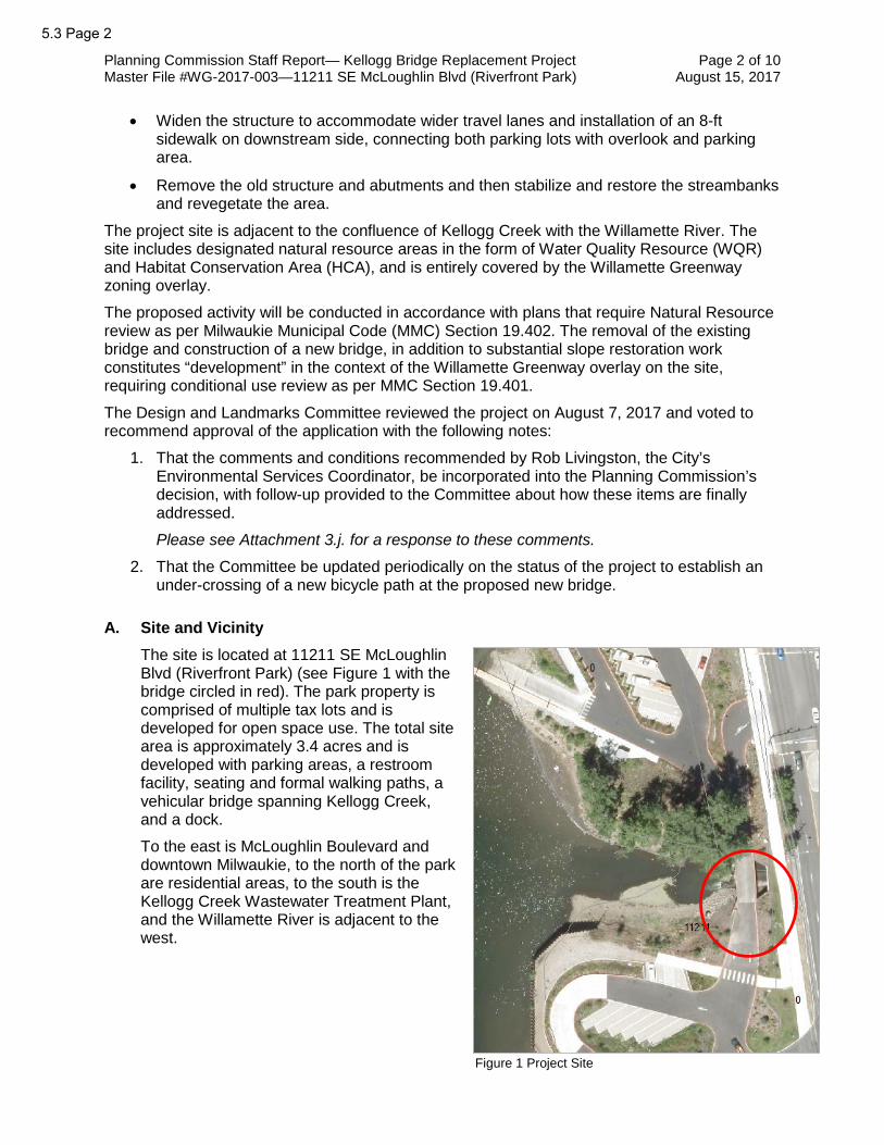
Planning Commission Staff Report— Kellogg Bridge Replacement Project Page 2 of 10 Master File #WG-2017-003—11211 SE McLoughlin Blvd (Riverfront Park) August 15, 2017
• Widen the structure to accommodate wider travel lanes and installation of an 8-ft sidewalk on downstream side, connecting both parking lots with overlook and parking area.
• Remove the old structure and abutments and then stabilize and restore the streambanks and revegetate the area.
The project site is adjacent to the confluence of Kellogg Creek with the Willamette River. The site includes designated natural resource areas in the form of Water Quality Resource (WQR) and Habitat Conservation Area (HCA), and is entirely covered by the Willamette Greenway zoning overlay.
The proposed activity will be conducted in accordance with plans that require Natural Resource review as per Milwaukie Municipal Code (MMC) Section 19.402. The removal of the existing bridge and construction of a new bridge, in addition to substantial slope restoration work constitutes “development” in the context of the Willamette Greenway overlay on the site, requiring conditional use review as per MMC Section 19.401.
The Design and Landmarks Committee reviewed the project on August 7, 2017 and voted to recommend approval of the application with the following notes:
1. That the comments and conditions recommended by Rob Livingston, the City’s Environmental Services Coordinator, be incorporated into the Planning Commission’s decision, with follow-up provided to the Committee about how these items are finally addressed.
Please see Attachment 3.j. for a response to these comments.
2. That the Committee be updated periodically on the status of the project to establish an under-crossing of a new bicycle path at the proposed new bridge.
A. Site and Vicinity
The site is located at 11211 SE McLoughlin Blvd (Riverfront Park) (see Figure 1 with the bridge circled in red). The park property is comprised of multiple tax lots and is developed for open space use. The total site area is approximately 3.4 acres and is developed with parking areas, a restroom facility, seating and formal walking paths, a vehicular bridge spanning Kellogg Creek, and a dock.
To the east is McLoughlin Boulevard and downtown Milwaukie, to the north of the park are residential areas, to the south is the Kellogg Creek Wastewater Treatment Plant, and the Willamette River is adjacent to the west.
Figure 1 Project Site
5.3 Page 2

Planning Commission Staff Report— Kellogg Bridge Replacement Project Page 3 of 10 Master File #WG-2017-003—11211 SE McLoughlin Blvd (Riverfront Park) August 15, 2017
B. Zoning Designations The site is zoned Downtown Open Space (OS) (see Figure 2), with Water Quality Resource (WQR) and Habitat Conservation Area (HCA) designations for natural resources (see Figure 3) and the Willamette Greenway overlay covering the entire site.
C. Comprehensive Plan Designation
Public (P)
D. Land Use History
• 2010: Design Review, Variance, Transportation Plan Review, Willamette Greenway, and Water Quality Resource review for proposed renovation of Riverfront Park (file #s DR-09-01, TPR-09-03, VR-09-03, WQR-09-01 and WG-09-01). The request was approved.
E. Proposal
The applicant is seeking land use approval for temporary and permanent disturbance of designated natural resource areas and conditional use approval related to the Willamette Greenway overlay.
The proposed activity involves removing a vehicular bridge; stabilizing the adjacent steep slopes; replacing the bridge; and planting native species trees, shrubs, and groundcover to restore the project area. The applicant has submitted a Willamette Greenway vegetation buffer plan to address MMC 19.401.8. (see Figure 4).
The project requires approval of the following applications:
1. Willamette Greenway review (file #WG-2017-003)
2. Natural Resource review (file #NR-2017-002)
The Applicant’s Narrative and Supporting Documentation includes more information and detail about the proposed activity (see Attachment 3).
DMU
Figure 2 Zoning Designations
Figure 3 Natural Resource Designations
5.3 Page 3

Planning Commission Staff Report— Kellogg Bridge Replacement Project Page 4 of 10 Master File #WG-2017-003—11211 SE McLoughlin Blvd (Riverfront Park) August 15, 2017
KEY ISSUES
Summary
Staff has identified the following key issue for the Commission’s deliberation. Aspects of the proposal not listed below are addressed in the Findings (see Attachment 1) and generally require less analysis and discretion by the Commission.
A. Is the proposed bridge replacement project, and the bridge design, consistent with the objectives and policies for the Willamette Greenway?
B. Will disturbance to the WQR and HCA be adequately mitigated?
Analysis
A. Is the proposed bridge replacement project, and the bridge design, consistent with the objectives and policies for the Willamette Greenway?
The proposed activity is intended to replace the current bridge with one that is both more efficient and more aesthetically appropriate for Riverfront Park. It includes an 8-ft-wide pedestrian access way, which the current bridge does not. The removal of the old bridge abutments from the edge of the active channel will also improve the function of the creek at this location by widening the streambed.
The project will not create any perceptible change to the historic, economic or recreational character of the river. The scenic and natural character of both the Willamette River and Kellogg Creek will be enhanced by this project. Along with the bank stabilization and restoration activities done on the south bank of Kellogg Creek, the widening of the stream
Figure 4 Proposed Site Plan
5.3 Page 4

Planning Commission Staff Report— Kellogg Bridge Replacement Project Page 5 of 10 Master File #WG-2017-003—11211 SE McLoughlin Blvd (Riverfront Park) August 15, 2017
banks directly underneath the new bridge will result in lower velocities for Kellogg Creek and will make it more conducive for anadromous fish species. The stabilization and restoration of the scoured and eroded portions of stream bank within the project area will enhance views from the Willamette River.
The character and aesthetic value of the views toward and away from the river will not be substantially altered by this project. The existing bridge does not include any decorative elements save for the existing ornamental light fixtures (see Figure 5). Any impact will likely be positive due to the aesthetic design elements incorporated into the bridge, such as a decorative concrete rail and ornamental light stands (see Figure 6). The proposed design is an improvement and will create a sense of permanence as well as serve as a gateway for people using Riverfront Park. Any disturbance of the stream banks directly associated with the bridge replacement will be returned to natural conditions.
The removal of the existing bridge and construction of the new bridge will result in the following:
• Removal of the vertical concrete end abutments from the waterway;
• Widening of the portion of the waterway directly beneath the new bridge; and
• Placement of rock for bank stabilization to address scour issues directly beneath the new bridge.
Figure 5. Existing bridge with slope scour
5.3 Page 5

Planning Commission Staff Report— Kellogg Bridge Replacement Project Page 6 of 10 Master File #WG-2017-003—11211 SE McLoughlin Blvd (Riverfront Park) August 15, 2017
The streambanks directly adjacent to the new bridge will be replanted in accordance with the approved planting plan of the Riverfront Park Plan. The new bridge will incorporate aesthetic elements such as decorative concrete rail and incorporation of the current bridge illumination. The stabilization and restoration of the south bank area will result in a more natural and aesthetically pleasing stream bank environment.
The bridge is necessary to provide public access to the boat ramp and other elements of Riverfront Park. If this project is not under taken, this access is in jeopardy. Construction schedule and planning has been structured to inhibit public access as minimally as possible. The bank stabilization and restoration activities on the south bank should have no impact on public access. The project helps ensure water-oriented and recreational uses remain possible at this location, as required by MMC 19.401.6.
The widening of the waterway beneath the new bridge will reduce the velocity of Kellogg Creek at the point, making the confluence of Kellogg Creek and the Willamette River more conducive to the development of fish habitat. The project will restore areas of the waterway immediately adjacent to the new bridge to a more natural state and will repair the erosion and scour issues occurring in the vicinity. Planting throughout the area will be done in accordance with the approved Riverfront Park Planting Plan (see Attachment 3.g).
B. Will disturbance to the WQR and HCA be adequately mitigated?
The proposed construction of the Kellogg Creek Bridge Emergency Replacement Project will help correct the current scour and erosion issues that have damaged the south bank and the area around the sanitary manhole cover by doing bank stabilization and adding fish habitat structures and vegetation. Included in the project is the reconstructing the currently over-steepened south bank between the existing bridge and the existing soldier pile wall, reestablishing the bank around the sanitary sewer manhole and raising the manhole cover and providing streambank improvements (see Figure 7).
The project will impact some of the previously planted vegetation, which will be dug up if impacted and then replanted after construction is complete. Some low-quality vegetation on the south bank, which is within the vegetation buffer for Kellogg Creek, will be impacted as the over-steepened bank is reconstructed, but the area will be fully replanted as previously
Figure 6. Proposed bridge profile
5.3 Page 6

Planning Commission Staff Report— Kellogg Bridge Replacement Project Page 7 of 10 Master File #WG-2017-003—11211 SE McLoughlin Blvd (Riverfront Park) August 15, 2017
described. The final bank will be a well-vegetated streambank and improved habitat, due to the placement of large woody debris (LWD) in three large structures at the toe of slope on the south bank.
While some minor removal of vegetation will occur during this project, the project will restore vegetation that has been lost due to erosion, scour and past development practices. The planting throughout this area will be done in accordance with the approved Riverfront Park Planting Plan.
Per the Impact Evaluation and Alternatives Analysis (refer to Attachment 3.b), the streambanks downstream of the bridge were analyzed for various stabilization methods. Full rock from toe of slope to top was looked at, but this method would not allow for native vegetation to be reestablished effectively. A fully bio-engineered hillside was assessed, but due to the large volume of water the concern was the likely high failure rate. A compromise was reached that incorporates rock and LWD at the toe of slope, followed by rock that will go partially up the hill but will be buried with soil so vegetation can be established. Biodegradable matting will be placed on top of the soil to keep the soil in place until vegetation is established.
Per the WQR and HCA Mitigation Plan (refer to Attachment 3.c), all temporary or permanent disturbances will be either restored or mitigated (see Figures 8 and 9). The new bridge will place its end abutments outside of ordinary high water (OHW) and will remove fill from the creek banks and bed, thus allowing a more natural creek channel. The removal of the old bridge abutments will reduce the velocity of the creek by widening the channel. This action, combined with the addition of fish habitat structures downstream, more than mitigates for the temporary and permanent impacts to Kellogg Creek. The south bank portion of the project is itself a mitigation project to improve storm scour damage. Plantings within the project will comply with the approved Riverfront Park Planting Plan.
Figure 7 Existing Conditions of the south bank of Kellogg Creek
5.3 Page 7

Planning Commission Staff Report— Kellogg Bridge Replacement Project Page 8 of 10 Master File #WG-2017-003—11211 SE McLoughlin Blvd (Riverfront Park) August 15, 2017
Figure 9 South bank grading and planting plan
Figure 8 Proposed planting (dashed line) and bioswale (cloud) areas
5.3 Page 8
Planning Commission Staff Report— Kellogg Bridge Replacement Project Page 9 of 10 Master File #WG-2017-003—11211 SE McLoughlin Blvd (Riverfront Park) August 15, 2017
CONCLUSIONS
A. Staff recommendation to the Planning Commission is as follows:
1. Approve the Willamette Greenway conditional use application and the Natural Resources application for the proposed bridge replacement and slope stabilization project. This will result in the construction of a new Kellogg Creek Bridge and restoration of damaged bank area, and replacement plantings consistent with the approved Riverfront Park Planting Plan.
2. Adopt the attached Findings and Conditions of Approval.
CODE AUTHORITY AND DECISION-MAKING PROCESS
The proposal is subject to the following provisions of the Milwaukie Municipal Code (MMC).
• MMC 19.304 Downtown Zones
• MMC 19.401 Willamette Greenway
• MMC 19.402 Natural Resources
• MMC 19.905 Conditional Uses
• MMC 19.1006 Type III Review
This application is subject to Type III review, which requires the Planning Commission to consider whether the applicant has demonstrated compliance with the code sections shown above.
The Commission has 4 decision-making options as follows:
A. Approve the application subject to the recommended Findings of Approval.
B. Approve the application with modified Findings of Approval. Such modifications need to be read into the record.
C. Deny the application upon finding that it does not meet approval criteria.
D. Continue the hearing.
The final decision on the application, which includes any appeals to the City Council, must be made by October 20, 2017, in accordance with the Oregon Revised Statutes and the Milwaukie Zoning Ordinance. The applicant can waive the time period in which the application must be decided.
COMMENTS
Notice of the proposed changes was given to the following agencies and persons: City of Milwaukie Community Development, Building, and Engineering Departments; Clackamas Fire District #1; Historic Milwaukie and Island Station Neighborhood District Associations (NDAs); Clackamas County; Metro; Oregon Department of Transportation; Oregon Marine Board; Oregon Department of Fish and Wildlife; Oregon Division of State Lands Wetlands and Waterways; Oregon Parks and Recreation; and North Clackamas Parks and Recreation District.
The comments received are summarized as follows:
1. Alex Roller, Engineering Tech II, Milwaukie Engineering Department: Comments related to the requirement of a stormwater management plan which have been included in the conditions of approval.
5.3 Page 9

Planning Commission Staff Report— Kellogg Bridge Replacement Project Page 10 of 10 Master File #WG-2017-003—11211 SE McLoughlin Blvd (Riverfront Park) August 15, 2017
2. Rob Livingston, Environmental Services Coordinator, Milwaukie Public Works Department: Comments relative to the submitted erosion control plan, which have been provided to the applicant for review and response.
3. Tom Madden, Historic Milwaukie Neighborhood Land Use Committee Chair: The NDA has no objections to the proposed project.
ATTACHMENTS
Attachments are provided as indicated by the checked boxes. All material is available for viewing upon request.
Early PC Mailing
PC Packet
Public Copies
E- Packet
1. Recommended Findings in Support of Approval
2. Recommended Conditions of Approval
3. Applicant's Narrative and Supporting Documentation received July 7, 2017
a. Narrative
b. Impact Evaluation and Alternative Analysis
c. WQR and HCA Mitigation Plan
d. Willamette Greenway Vegetation Buffer Plan
e. Construction Management Plan
f. Erosion Control Plan
g. Plan set
h. Riverfront Park Planting Plan
i. Preapplication Conference Report
j. Response memo to erosion control comments (dated August 11, 2017)
4. Comments Received
Key:
Early PC Mailing = paper materials provided to Planning Commission at the time of public notice 20 days prior to the hearing.
PC Packet = paper materials provided to Planning Commission 7 days prior to the hearing.
Public Copies = paper copies of the packet available for review at City facilities and at the Planning Commission meeting.
E-Packet = packet materials available online at http://www.milwaukieoregon.gov/planning/planning-commission-176.
.
5.3 Page 10

Recommended Findings in Support of Approval File #s WG-2017-003 and NR-2017-002
Kellogg Creek Bridge Replacement
Sections of the Milwaukie Municipal Code not addressed in these findings are found to be inapplicable to the decision on this application.
1. The applicant, the City of Milwaukie Engineering Department, has applied for approval to remove the existing Kellogg Creek Bridge in Riverfront Park and replace it with a newly constructed bridge. The Kellogg Creek Bridge connects the main parking lot and boat ramp to the boat trailer parking area. The new bridge will continue to serve that function but will also incorporate a pedestrian crossing as part of the bridge. The Riverfront Park site consists of multiple tax lots, addressed as 11211 SE McLoughlin Blvd, and is zoned Downtown Open Space OS with Natural Resource and Willamette Greenway overlays. The proposed activity triggers land use review against the applicable standards of the Natural Resource and Willamette Greenway sections of the zoning code. The land use application master file number is WG-2017-003 with associated file number NR-2017-002.
2. The proposed activity involves removing a vehicular bridge; stabilizing the adjacent steep slopes; replacing the bridge; and planting native species trees, shrubs, and groundcover to restore the project area. The applicant has submitted a Willamette Greenway vegetation buffer plan to address MMC 19.401.8.
3. The proposal is subject to the following provisions of the Milwaukie Municipal Code (MMC):
• MMC 19.304 Downtown Zones
• MMC 19.401 Willamette Greenway
• MMC 19.402 Natural Resources
• MMC 19.905 Conditional Uses
• MMC 19.1006 Type III Review
The proposed activity does not result in the expansion of any existing structures. The municipal code relies on an increase in building square footage to calculate vehicle trip generation to and from the site. The Engineering Department has determined that MMC Chapter 19.700 Public Facility Improvements does not apply to this application.
4. The application has been processed and public notice provided in accordance with MMC Section 19.1006 Type III Review. A public hearing was held by the Planning Commission on August 22, 2017, as required by law.
5. MMC Section 19.401 Willamette Greenway Zone
MMC 19.401 establishes standards for the Willamette Greenway overlay designation. The subject property is entirely within the Willamette Greenway zone as shown on the City’s zoning map.
a. MMC Subsection 19.401.5 Procedures
MMC 19.401.5 establishes procedures related to proposed uses and activities in the Willamette Greenway zone. Development in the Willamette Greenway zone requires conditional use review, subject to the standards of MMC Section 19.905 and in accordance with the approval criteria established in MMC Subsection 19.401.6.
5.3 Page 11ATTACHMENT 1
Recommended Findings in Support of Approval—Kellogg Creek Bridge Page 2 of 11 Master File #WG-2017-003—11211 SE McLoughlin Blvd (Riverfront Park) August 15, 2017
The removal of the existing bridge and construction of a new bridge, in addition to substantial stope restoration work constitutes “development” in the context of the Willamette Greenway overlay on the site, requiring conditional use review as per MMC Section 19.401. The proposed activity is subject to the conditional use review standards of MMC 19.905 and the approval criteria of MMC 19.401.6.
b. MMC Subsection 19.401.6 Criteria
MMC 19.401.6 establishes the criteria for approving conditional uses in the Willamette Greenway zone.
(1) Whether the land to be developed has been committed to an urban use, as defined under the State Willamette River Greenway Plan
The State Willamette River Greenway Plan defines “lands committed to urban use” in part as “those lands upon which the economic, developmental and locational factors have, when considered together, made the use of the property for other than urban purposes inappropriate.”
The land on which this project takes place has already been approved for park use. The land is committed to an urban use.
(2) Compatibility with the scenic, natural, historic, economic, and recreational character of the river
The project area is adjacent to and overlooks the confluence of Kellogg Creek with the Willamette River. The project will not create any perceptible change to the historic, economic or recreational character of the river. The scenic and natural character of both the Willamette River and Kellogg Creek will be enhanced by this project. Along with the bank stabilization and restoration activities done on the south bank of Kellogg Creek, the widening of the stream banks directly underneath the new bridge will result in lower velocities for Kellogg Creek and will makes it more conducive for anadromous fish species. The south bank activities will include large woody debris (LWD) and other elements to increase fish habitat. The stabilization and restoration of the scoured and eroded portions of stream bank within the project area will enhance views from the Willamette River.
(3) Protection of views both toward and away from the river
The project area is adjacent to the river and includes steep slopes on the site. The character and aesthetic value of the views toward and away from the river will not be substantially altered by this project. Any impact will likely be positive due to the aesthetic design elements incorporated into the bridge such as a decorative concrete rail and ornamental light stands. The existing bridge does not include any decorative elements save for the existing ornamental light fixtures. The proposed design is an improvement and will create a sense of permanence as well as serve as a gateway for people using Riverfront Park. Any disturbance of the stream banks directly associated with the bridge replacement will be returned to natural conditions.
(4) Landscaping, aesthetic enhancement, open space, and vegetation between the activity and the river, to the maximum extent practicable
The removal of the existing bridge and construction of the new bridge will result in the following: removal of the vertical concrete end-abutments from the waterway, a widening of the portion of the waterway directly beneath the new
5.3 Page 12

Recommended Findings in Support of Approval—Kellogg Creek Bridge Page 3 of 11 Master File #WG-2017-003—11211 SE McLoughlin Blvd (Riverfront Park) August 15, 2017
bridge, and placement of rock for bank stabilization to address scour issues directly beneath the new bridge. The streambanks directly adjacent to the new bridge will be replanted in accordance with the approved planting plan of the Riverfront Park Plan. The new bridge will incorporate aesthetic elements such as stained rock façade, decorate concrete rail and incorporation of the current bridge illumination. The stabilization and restoration of the south bank area will result in a more natural and aesthetically pleasing stream bank environment.
(5) Public access to and along the river, to the greatest possible degree, by appropriate legal means
The Kellogg Creek bridge is necessary to provide public access to the boat ramp and other elements of Riverfront Park. If this project is not under taken, this access is in jeopardy. Construction schedule and planning has been structured to inhibit public access as minimally as possible. The bank stabilization and restoration activities on the south bank should have no impact on public access.
(6) Emphasis on water-oriented and recreational uses
The project helps ensure “water-oriented and recreational uses” remain possible at this location by decreasing the chances of complete stream bank failure.
(7) Maintain or increase views between the Willamette River and downtown
This project will maintain and enhance the current view between the Willamette River and downtown.
(8) Protection of the natural environment according to regulations in Section 19.402
An application for Natural Resources review has been submitted along with the subject application. The intent of the proposed activity is to repair and restore the existing natural area on the site, a significant portion of which includes WQR and HCA natural resource designations. The proposed activity will be reviewed against the standards for natural resource protection as provided in MMC Section 19.402. The project includes mitigation for impacts to the designated natural resource areas on the subject property and will improve the overall ecological health of the natural environment. In-water work will follow Oregon Department of Fish & Wildlife guidelines and will involve isolation and fish removal if necessary. The project area will be re-planted in accordance with the approved Riverfront Park Planting Plan. All disturbed soils will be returned to original or enhanced conditions.
(9) Advice and recommendations of the Design and Landmark Committee, as appropriate
The Design and Landmarks Committee (DLC) reviewed and submitted a recommendation to the Planning Commission on August 7, 2017.
(10) Conformance to applicable Comprehensive Plan policies
The Willamette Greenway Element in the Milwaukie Comprehensive Plan includes policies related to land use, public access and view protection, and maintenance of private property. These policies include the requirement of a conditional use permit for new development and intensification of existing uses, evaluation of development impacts to visual corridors, and limitations on authorizing the unrestricted public use of private land.
5.3 Page 13

Recommended Findings in Support of Approval—Kellogg Creek Bridge Page 4 of 11 Master File #WG-2017-003—11211 SE McLoughlin Blvd (Riverfront Park) August 15, 2017
The Natural Hazards Element includes policies that prohibit development in known areas of natural disasters and hazards without appropriate safeguards. The Open Spaces, Scenic Areas, and Natural Resources Element includes policies to conserve open space and protect and enhance natural and scenic resources.
The proposed activity is being reviewed through the Willamette Greenway conditional use process as provided in MMC Subsection 19.401.5. The project will not significantly or permanently impact visual corridors. The proposed activity maintains and improves public access to the river. The proposed project is also being reviewed through the general discretionary review process for natural resource areas as provided in MMC Section 19.402.
(11) The request is consistent with applicable plans and programs of the Division of State Lands
The proposed activity is not inconsistent with any known plans or programs of the Department of State Lands (DSL). This project does include removal-fill activities within the waters of the state and the appropriate permits from DSL U.S. Army Corps of Engineers will be acquired before any remove-fill activities take place within Kellogg Creek.
(12) A vegetation buffer plan meeting the conditions of Subsections 19.401.8.A through C
The proposed activity involves stabilization of a steep slope on the site, with accompanying plantings to repair and restore riverbank areas damaged by scour following a December 2015 high-water storm event. The applicant’s materials include a mitigation plan that proposes to restore the bank where the existing access road will be removed with native grasses and plant a vegetation buffer area adjacent to the location where the slope will be stabilized. 3 trees have been tagged from removal per the approved Riverfront Park plan. They will be removed as part of this project. No additional trees will be removed from within the Willamette Greenway vegetation buffer and scenic views will not be significantly affected over the long term. The proposed activity will enhance the vegetation buffer area. In addition, while some minor removal of vegetation will occur during this project, the overall goal of the project is to restore vegetation that has been lost due to erosion, scour and past development practices. Planting throughout this area will be done in accordance with the Riverfront Park Planting Plan (See Attachment 3.h).
The Planning Commission finds that the proposed activity meets all relevant approval criteria provided in MMC 19.401.6.
The Planning Commission finds that the proposed activity meets all applicable standards of the Willamette Greenway zone.
6. MMC Section 19.402 Natural Resources
MMC 19.402 establishes regulations for designated natural resource areas. The standards and requirements of MMC 19.402 are an acknowledgment that many of the riparian, wildlife, and wetland resources in the community have been adversely impacted by development over time. The regulations are intended to minimize additional negative impacts and to restore and improve natural resources where possible.
a. MMC Subsection 19.402.3 Applicability
5.3 Page 14

Recommended Findings in Support of Approval—Kellogg Creek Bridge Page 5 of 11 Master File #WG-2017-003—11211 SE McLoughlin Blvd (Riverfront Park) August 15, 2017
MMC 19.402.3 establishes applicability of the Natural Resource (NR) regulations, including all properties containing Water Quality Resources (WQRs) and Habitat Conservation Areas (HCAs) as shown on the City’s Natural Resource (NR) Administrative Map.
The site is adjacent to Kellogg and the Willamette River, both of which are protected water features. As per MMC Table 19.402.15, primary protected water features, along with their associated vegetated corridors, constitute a WQR on the site. The City's NR Administrative Map also shows the HCA designation over a large portion of the site between the existing house and the creek and river below.
As presented in the applicant's submittal materials, the proposed activity will disturb approximately 10,000 sq ft of WQR and/or HCA area. At that scale, the proposed activity is not listed as exempt according to the standards outlined in MMC 19.402.4, even without the needed corrections to the applicant’s calculation of actual WQR and HCA disturbance area.
The Planning Commission finds that the requirements of MMC 19.402 are applicable to the proposed activity.
b. MMC Subsection 19.402.8 Activities Requiring Type III Review
MMC 19.402.8 establishes that certain activities within a designated WQR and/or HCA are subject to Type III review in accordance with MMC 19.1006. As per MMC 19.402.8.A.1, this includes activities allowed in the base zone that are not otherwise exempt or permitted as a Type I or II activity.
The proposed activity is associated with the existing open space use and is allowed outright in the underlying Downtown Open Space OS zone. The level of disturbance proposed within the WQR and HCA areas on the subject property exceeds the levels allowed by Type I and II review, as provided in MMC 19.402.6 and 402.7, respectively. As such, the activity must be reviewed using Type III review and the discretionary process established in MMC 19.402.12.
The Planning Commission finds that the proposed activity shall be processed with Type III review.
c. MMC Subsection 19.402.9 Construction Management Plans
MMC 19.402.9 establishes standards for construction management plans, which are required for projects that disturb more than 150 sq ft of designated natural resource area. Construction management plans must provide information related to site access, staging of materials and equipment, and measures for tree protection and erosion control.
The applicant’s submittal materials include a construction management plan that shows the locations of proposed erosion control measures, access to the work area for machinery and people, and a staging area for equipment and materials. High-visibility fencing and sediment fence will be utilized to protect nearby trees from damage.
The Planning Commission finds that the applicant’s construction management plan is sufficient to satisfy the requirements of MMC 19.402.9.
d. MMC Subsection 19.402.12 General Discretionary Review
MMC 19.402.12 establishes the discretionary review process for activities that substantially disturb designated natural resource areas.
5.3 Page 15

Recommended Findings in Support of Approval—Kellogg Creek Bridge Page 6 of 11 Master File #WG-2017-003—11211 SE McLoughlin Blvd (Riverfront Park) August 15, 2017
(1) Impact Evaluation and Analysis
MMC 19.402.12.A requires an impact evaluation and alternatives analysis in order to determine compliance with the approval criteria for discretionary review and to evaluate alternatives to the proposed development. A technical report prepared by a qualified natural resource professional is required and should include the following components:
• Identification of ecological functions
• Inventory of vegetation
• Assessment of water quality impacts
• Alternatives analysis
• Demonstration that no practicable alternative method or design exists that would have a lesser impact on the resource and that impacts are mitigated to the extent practicable
• Mitigation plan
The applicant’s submittal materials include a technical report prepared by Reeve Sherwood Consulting, LLC, a consulting firm with staff experience and expertise in environmental studies, natural system design, and fisheries biology. The technical report includes an impact evaluation and alternatives analysis consistent with the required components listed above.
In summary, the technical report notes that the proposed construction of the Kellogg Creek Bridge Emergency Replacement Project will help correct the current scour and erosion issues that have damaged the south bank and the area around the sanitary manhole cover by doing bank stabilization and adding fish habitat structures and vegetation. Included in the project is the reconstructing the currently over-steepened south bank between the existing bridge and the existing soldier pile wall, reestablishing the bank around the sanitary sewer manhole and raising the manhole cover and providing streambank improvements.
The project will impact some of the previously planted vegetation which will be dug up if impacted and then replanted after construction is complete. Some low-quality vegetation on the south bank which is within the vegetation buffer for Kellogg Creek will be impacted as the over-steepened bank reconstructed but the area will be fully replanted as previously described. The final bank will be a well-vegetated streambank and improved habitat due to the placement of large woody debris (LWD) in three large structures at the toe of slope on the south bank.
While some minor removal of vegetation will occur during this project, the project will restore vegetation that has been lost due to erosion, scour and past development practices. The planting throughout this area will be done in accordance with the approved Riverfront Park Planting Plan.
The report presents an analysis of alternatives to the proposed activity. The streambanks downstream of the bridge were analyzed for various stabilization methods. Full rock from toe of slope to top was looked at, but this method would not allow for native vegetation to be reestablished effectively. A fully bio-engineered hillside was assessed but due to the large volume of water the
5.3 Page 16

Recommended Findings in Support of Approval—Kellogg Creek Bridge Page 7 of 11 Master File #WG-2017-003—11211 SE McLoughlin Blvd (Riverfront Park) August 15, 2017
concern was the high failure rate would be likely. A compromise was reached that incorporates rock and LWD at the toe of slopes followed by rock that would go partially up the hill but would be buried with soil so vegetation could be established. Biodegradable matting will be placed on top of the soil to keep the soil in place until vegetation is established.
Per the WQR and HCA Mitigation Plan, all temporary or permanent disturbances will be either restored or mitigated. The new bridge will place its end abutments outside of ordinary high water (OHW) and will remove fill from the creek banks and bed, thus allowing a more natural creek channel. The removal of the old bridge abutments will reduce the velocity of the creek by widening the channel. This action combined with the addition of fish habitat structures downstream more than mitigates for the temporary and permanent impacts to Kellogg Creek. The south bank portion of the project is itself a mitigation project to improve storm scour damage. Plantings within the project will comply with the approved Riverfront Park Planting Plan.
The technical report demonstrates that the proposed activity is the least impactful option that also restores and improves the streambank area and reduces the likelihood of further slope erosion.
The technical report includes a mitigation plan that calls for replanting disturbed areas with native species plants, with trees and shrubs planted in the ratios listed in MMC Subsection 19.402.11.D.2.b. The native species of trees, shrubs, and groundcover planted will improve the quality of vegetated cover within the WQR and HCA.
The Planning Commission finds that the applicant’s impact evaluation and alternatives analysis is sufficient for purposes of reviewing the proposed activity against the approval criteria provided in MMC 19.402.12. This standard is met.
(2) Approval Criteria
MMC 19.402.12.B provides the approval criteria for discretionary review as follows:
a) Avoid – The proposed activity avoids the intrusion of development into the WQR and/or HCA to the extent practicable, and has less detrimental impact to the natural resource areas than other practicable alternatives.
b) Minimize – If the applicant demonstrates that there is no practicable alternative to avoid disturbance of the natural resource, then the proposed activity shall minimize detrimental impacts to the extent practicable.
c) Mitigate – If the applicant demonstrates that there is no practicable alternative that will avoid disturbance of the natural resource, then the proposed activity shall mitigate for adverse impacts to the resource area. The applicant shall present a mitigation plan that demonstrates compensation for detrimental impacts to ecological functions, with mitigation occurring on the site of the disturbance to the extent practicable, utilization of native plants, and a maintenance plan to ensure the success of plantings.
The proposed activity would minimize disturbance impacts to the WQR and HCA on the site to the extent practicable while still achieving the goal of stabilizing the slope. The project would affect only those portions of the slope
5.3 Page 17

Recommended Findings in Support of Approval—Kellogg Creek Bridge Page 8 of 11 Master File #WG-2017-003—11211 SE McLoughlin Blvd (Riverfront Park) August 15, 2017
and nearby areas within the WQR and HCA as necessary to stabilize and improve existing conditions. As discussed, while some minor removal of vegetation will occur during this project, the project will restore vegetation that has been lost due to erosion, scour and past development practices. The planting throughout this area will be done in accordance with the approved Riverfront Park Planting Plan. Doing nothing would leave the slope vulnerable to further erosion, increasing the likelihood of additional sediment being deposited in the protected water features below.
To minimize impacts to the WQR and HCA, the applicant’s construction management plan shows the erosion control methods to be employed for this project, including: perimeter controls, wattles, sediment fencing, biodegradable erosion control matting, seeding, and permanent vegetation. Protective fencing will be placed so no work occurs outside of the fencing and will also help in keeping the public from getting into the work areas.
As conditioned, the Planning Commission finds that the proposed activity meets the approval criteria for discretionary review.
e. MMC Subsection 19.402.15 Boundary Verification and Map Administration
MMC 19.402.15 establishes standards for verifying the boundaries of WQRs and HCAs and for administering the City's Natural Resource (NR) Administrative Map.
The locations of WQRs are determined based on the provisions of MMC Table 19.402.15. For streams, the WQR includes the feature itself and a vegetated corridor that extends 50 ft from the ordinary high water mark or 2-year recurrence interval flood elevation. Where the slope exceeds 25% for less than 150 ft, the vegetated corridor is measured with a 50-ft width from the break in the 25% slope. For wetlands, a wetland delineation report prepared by a professional wetland specialist and approved by the Department of State Lands (DSL) is required.
For HCAs, the City’s NR Administrative Map is assumed to be accurate with respect to location unless challenged by the applicant, using the procedures outlined in either MMC Subsection 19.402.15.A.1 or MMC Subsection 19.402.15.A.2.b.
The applicant is not challenging the accuracy of the NR Administrative Map with respect to the HCA location on the site. However, as a result of the disturbance allowed by the approval of the proposed development, the NR Administrative Map shall be adjusted accordingly to remove those HCA locations that will be permanently disturbed by the proposed development.
The Planning Commission finds that the City’s NR Administrative Map shall be adjusted to reflect the information provided by the applicant with respect to the location of the permanent disturbance to the HCA.
As conditioned, the Planning Commission finds that the proposed activity, including disturbance and restoration of a portion of the designated natural resource areas on the subject property, meets all applicable standards of MMC 19.402.
7. MMC Section 19.905 Conditional Uses
MMC 19.905 establishes regulations for conditional uses, including standards for reviewing modifications to existing conditional uses. As noted in Finding 6-a and as provided in MMC Subsection 19.401.5.A, activities within the Willamette Greenway zone that trigger Willamette Greenway review are subject to the provisions of Section 19.905 as conditional uses.
5.3 Page 18

Recommended Findings in Support of Approval—Kellogg Creek Bridge Page 9 of 11 Master File #WG-2017-003—11211 SE McLoughlin Blvd (Riverfront Park) August 15, 2017
a. MMC Subsection 19.905.3 Review Process
MMC 19.905.3 establishes the process by which a new conditional use, or a major or minor modification of an existing conditional use, must be reviewed.
As noted in Finding 6-a, the proposed development is an activity within the Willamette Greenway zone that requires review as a conditional use. The existing use on the subject property is a city park, which is an allowed use in the underlying Downtown Open Space zone OS. The proposed activity involves removing and replacing an existing bridge spanning Kellogg Creek, as well as slope stabilization and plantings, which represents a major modification to the existing use.
MMC 19.905.3.A requires that a major modification of an existing conditional use be evaluated through the Type III review process per MMC Section 19.1006.
b. MMC Subsection 19.905.4 Approval Criteria
MMC 19.905.4.A establishes the approval criteria for a new conditional use or a major modification to an existing conditional use.
(1) The characteristics of the lot are suitable for the proposed use considering size, shape, location, topography, existing improvements, and natural features.
The subject property is a park approximately 3.4 acres in size. The property is developed with parking areas, a restroom facility, seating and formal walking paths, a vehicular bridge spanning Kellogg Creek, and a dock. The site is adjacent to the confluence of Kellogg Creek and the Willamette River and includes WQR and HCA natural resource areas. The proposed activity is intended to provide a more efficient and aesthetically appropriate bridge crossing and repair significant slope damage due to scour and erosion.
The Planning Commission finds that this standard is met.
(2) The operating and physical characteristics of the proposed use will be reasonably compatible with, and have minimal impact on, nearby uses.
The subject property is an active public park that is adjacent to Kellogg Creek and the Willamette River. The project area is located at the confluence of Kellogg Creek and the Willamette River and includes replacement of the existing bridge crossing and streambank slope stabilization, repair and restoration. The bridge and the slopes in question are visible from both the river and from McLoughlin Blvd. The project is intended to improve the existing conditions both in the performance and aesthetics of the bridge, but also in the health and stability of the stream banks. The project’s impacts on nearby uses will be minimal.
The Planning Commission finds that this standard is met.
(3) All identified impacts will be mitigated to the extent practicable.
The primary impact of the proposed activity will be the temporary disturbance of the designated natural resource areas (WQR and HCA) on the site. The project includes planting native species of trees, shrubs, and groundcover to mitigate the disturbance.
The Planning Commission finds that this standard is met.
5.3 Page 19

Recommended Findings in Support of Approval—Kellogg Creek Bridge Page 10 of 11 Master File #WG-2017-003—11211 SE McLoughlin Blvd (Riverfront Park) August 15, 2017
(4) The proposed use will not have unmitigated nuisance impacts, such as from noise, odor, and/or vibrations, greater than usually generated by uses allowed outright at the proposed location.
The proposed activity will not result in any different use of the subject property than currently exists and will not generate any unmitigated nuisance impacts.
The Planning Commission finds that this standard is met.
(5) The proposed use will comply with all applicable development standards and requirements of the base zone, any overlay zones or special areas, and the standards in Section 19.905.
The subject property is in the Downtown Open Space Zone OS. The proposed project is in keeping with existing public park use as well as the approved development plans for Riverfront Park.
As addressed in these Findings, the proposed activity will comply with the relevant standards of the Natural Resource and Willamette Greenway overlay zones, respectively. As addressed elsewhere in Finding 6, the proposed activity is compliant with the other standards of MMC 19.905.
The Planning Commission finds that this standard is met.
(6) The proposed use is consistent with applicable Comprehensive Plan policies related to the proposed use.
As addressed in Finding 5-b-10, the proposed development is consistent with all relevant polices in the Comprehensive Plan.
The Planning Commission finds that this standard is met.
(7) Adequate public transportation facilities and public utilities will be available to serve the proposed use prior to occupancy pursuant to Chapter 19.700.
The Engineering Department has reviewed the proposal and confirmed that existing public transportation facilities and public utilities are adequate to serve the proposed development.
The Planning Commission finds that this standard is met.
The Planning Commission finds that the proposed development meets all of the approval criteria outlined in MMC 19.905.4.A for a major modification to an existing conditional use.
c. MMC Subsection 19.905.5 Conditions of Approval
MMC 19.905.5 establishes the types of conditions that may be imposed on a conditional use to ensure compatibility with nearby uses. Conditions may be related to a number of issues, including access, landscaping, lighting, and preservation of existing trees.
The Planning Commission finds that, as proposed, the new development sufficiently mitigates any negative impacts as proposed and that no additional conditions are necessary to ensure compatibility with nearby uses.
d. MMC Subsection 19.905.6 Conditional Use Permit
MMC 19.905.6 establishes standards for issuance of a conditional use permit, including upon approval of a major modification of an existing conditional use. The
5.3 Page 20

Recommended Findings in Support of Approval—Kellogg Creek Bridge Page 11 of 11 Master File #WG-2017-003—11211 SE McLoughlin Blvd (Riverfront Park) August 15, 2017
provisions include a requirement to record the conditional use permit with the Clackamas County Recorder’s Office and provide a copy to the City prior to commencing operations allowed by the conditional use permit.
An advisory note has been included with the conditions of approval to outline the conditional use permit process.
The Planning Commission finds that the proposed development is consistent with the relevant standards established in MMC 19.905 for conditional uses.
8. As per MMC Subsection 19.1001.7.E.1.a, proposals requiring any kind of development permit must complete both of the following steps:
a. Obtain and pay for all necessary development permits and start construction within two (2) years of land use approval.
b. Pass final inspection and/or obtain a certificate of occupancy within four (4) years of land use approval.
As per MMC Subsection 19.1001.7.E.2.b, land use approvals shall expire unless both steps noted above have been completed or unless the review authority specifies a different expiration date in the land use decision to accommodate large, complex, or phased development projects.
9. The application was referred to the following departments and agencies on July 14, 2017:
• Milwaukie Building Department
• Milwaukie Engineering Department
• Milwaukie Operations Department (Environmental Services Division)
• Clackamas Fire District #1
• Historic Milwaukie and Island Stations Neighborhood District Associations (NDAs) Chairperson and Land Use Committee (LUC)
• Oregon Parks and Recreation Department
• Oregon Department of State Lands (DSL)
• Oregon Department of Fish and Wildlife
• Oregon State Marine Board
• Oregon Department of Transportation (ODOT)
The comments received are summarized as follows:
a. Alex Roller, Engineering Tech II, Milwaukie Engineering Department: comments related to the requirement of a stormwater management plan which have been included in the conditions of approval.
b. Rob Livingston, Environmental Services Coordinator, Milwaukie Public Works Department: comments relative to the submitted erosion control plan, which have been provided to the applicant for review and response.
c. Tom Madden, Historic Milwaukie Neighborhood Land Use Committee Chair: The NDA has no objections to the proposed project.
5.3 Page 21

Recommended Conditions of Approval File #s WG-2017-003; NR-2017-002
Kellogg Creek Bridge Replacement Project
Conditions
1. At the time of submittal of the associated development permit application(s), the following shall be resolved:
a. Final plans submitted for development permit review shall be in substantial conformance with plans approved by this action, which are the plans stamped received by the City on July 7, 2017, except as otherwise modified by these conditions.
b. Provide a narrative describing all actions taken to comply with these conditions of approval.
c. Provide a narrative describing any changes made after the issuance of this land use decision that are not related to these conditions of approval.
Additional Requirements
The following items are not conditions of approval necessary to meet applicable land use review criteria. They relate to other development standards and permitting requirements contained in the Milwaukie Municipal Code and Public Works Standards that are required at various point in the development and permitting process.
1. Conditional Use Permit
As per MMC Subsection 19.905.6, the City will issue a conditional use permit upon approval of an application to allow major modification of an existing conditional use (including Willamette Greenway conditional uses). The applicant must record the conditional use permit with the Clackamas County Recorder’s Office and provide a copy to the City prior to commencing operations allowed by the conditional use permit.
2. Development Standards
Projects affecting designated natural resources are subject to the standards provided in MMC Subsection 19.402.11.A for protection of natural resources during development. In addition, projects requiring mitigation for impacts to natural resource areas are subject to the standards provided in MMC Subsection 19.402.11.B, including survival rates, minimum plant sizes, and others.
3. Erosion Control
Submit an Erosion Control application and plan as required.
4. Limitations on Development Activity
Development activity on the site shall be limited to 7:00 a.m. to 10:00 p.m. Monday through Friday and 8:00 a.m. to 5:00 p.m. Saturday and Sunday, as per MMC 8.08.070(I).
5. Expiration of Approval
As per MMC 19.1001.7.E.1.a, proposals requiring any kind of development permit must complete both of the following steps:
5.3 Page 22ATTACHMENT 2

Recommended Conditions of Approval— Kellogg Creek Bridge Replacement Project Page 2 of 2 Master File #WG-2017-003—11211 SE McLoughlin Blvd. August 15, 2017
a. Obtain and pay for all necessary development permits and start construction within two (2) years of land use approval.
b. Pass final inspection and/or obtain a certificate of occupancy within four (4) years of land use approval.
As per MMC 19.1001.7.E.2.b, land use approvals shall expire unless both steps noted above have been completed or unless the review authority specifies a different expiration date in the land use decision to accommodate large, complex, or phased development projects.
5.3 Page 23

ATTACHMENT 3

WHO IS ELIGIBLE TO SUBMIT A LAND USE APPLICATION (excerpted from MMC Subsection 19.1001.6.A):
Type I, II, Ill, and IV applications may be initiated by the property owner or contract purchaser of the subject property, any person authorized in writing to represent the property owner or contract purchaser, and any agency that has statutory rights of eminent domain for projects they have the authority to construct.
Type V applications may be initiated by any individual.
PREAPPLICATION CONFERENCE: A preapplication conference may be required or desirable prior to submitting this application. Please discuss with Planning staff.
REVIEW TYPES: This application will be processed per the assigned review type, as described in the following sections of the Milwaukie Municipal Code: • Type I: Section 19.1004 • Type II: Section 19.1005 • Type Ill: Section 19.1006 • Type IV: Section 19.1007 • Type V: Section 19.1008
THIS SECTION FOR OFFICE USE ONLY: FILE FEE PERCENT DISCOUNT DEPOSIT TYPE FILE NUMBER AMOUNT* DISCOUNT TYPE AMOUNT DATE STAMP
Master file $ $
Concurrent $ $ - -. application RECEIVED files $ $
$ $ JUL 7 2017 $ $ '"'!TY OF MILWAUKIE
SUBTOTALS $ $ PL A.NNING DEPARTMENT
TOTAL AMOUNT RECEIVED: $ RECEIPT#: RCDBY:
Associated application file #s (appeals, modifications, previous approvals, etc.):
Neighborhood District Association(s}:
Notes:
*After discount (if any)
Z:\Planning\Administrative - General lnfo\Applications\LU Application AF.doc-Rev. 02/13/16

INTRODUCTION This document fulfills the application requirements for a land use application to the City of Milwaukie for the Kellogg Creek Bridge Emergency Replacement Project, located within Riverfront Park. This document supports the concurrent review of this project in regards to the following:
• Willamette Greenway Review (Type III) • Natural Resource Review (Type III)
This document summarizes the work to be done for this project and its compliance with the approval criteria and development standards of the Milwaukie Municipal Code (MCC) Sections 19.401 (Willamette Greenway Zone) and 19.402 (Natural Resources). Compliance with these criteria and standards is outlined both in this document and the following attached appendices:
• Impact Evaluation and Alternatives Analysis (Appendix A) • HCA Mitigation Plan (Appendix B) • Willamette Greenway Vegetation Buffer Plan (Appendix C) • Construction Management Plan (Appendix D) • Erosion Control Plan (Appendix E)
PROJECT NARRATIVE Existing Uses This project will replace an existing bridge within Riverfront Park that connects the main parking lot and boat ramp to the boat trailer parking area. The south bank of Kellogg Creek was damaged during a recent high-water event and the resulting scour and erosion issues are threatening the integrity of the bank itself, a sanitary infrastructure access point and the south end of the existing bridge. Proposed Uses The proposed uses of the project area post-project are essentially unchanged. The new bridge will still serve to connect the two parking lots, but will also incorporate a pedestrian crossing as part of the bridge. The south bank will be stabilized and restored to a more natural condition and will contain elements that will increase fish habitat and usage within the Kellogg Creek-Willamette River confluence. Proposed Construction The proposed construction of the Kellogg Creek Bridge Emergency Replacement Project will help correct the current scour and erosion issues that have damaged the south bank and the area around the sanitary manhole cover by doing bank stabilization and adding fish habitat structures and vegetation. The project will also create a more efficient and aesthetically appropriate crossing within Milwaukie Riverfront Park The project will involve the following:
• Construction of protective fencing and installation of required erosion control measures. • Construction of a new structure with abutments outside of the ordinary high water and scour
influence of Kellogg Creek Bridge including new structure, impact panels, bridge rails, wing walls, etc.
• Reconstruction of approaches to allow easier access for boat trailers onto the new bridge. • Approach reconstruction includes: reconstruction of roadway (curbs, asphalt, etc.), drainage,
illumination and pedestrian facilities as well as restoration of traffic signal infrastructure, restoration and mitigation for disturbance to natural resources and water quality requirements.

• Widen structure to accommodate wider travel lanes and installation of 8’ sidewalk on downstream side connecting both parking lots with overlook and parking area.
• Design and construction of a new 10” waterline within the new structure and abandonment of the existing waterline on the old structure.
• Reconstruction of currently over-steepened south bank between the existing bridge and the existing soldier pile wall, reestablishing the bank around the sanitary sewer manhole and raise the manhole cover and providing streambank improvements.
• Establish vegetation onto streambanks similar to previously approved Riverfront Park planting guidelines. (Plan Sheets 5 and 5A and Riverfront Park Planting Plan sheets).
• Isolation and fish removal for any areas where in-water work will occur. • Placement of three (3) multi-log structures to enhance fish usage in Kellogg Creek (discussed and
approved by ODFW). • Construct temporary sheet pile wall from the Highway 99 bridge over to re-sloped streambank.
(see Plan Sheet 7). This sheet pile wall is to hold back Highway 99 embankment temporarily since we are moving the new bridge downstream slightly, moving the end abutments further away from the creek and fully removing the old bridge. Currently, the Kellogg Creek Bridge abutments are containing the Hwy 99 fill. This sheet pile will be removed when ODPT reconstructs the Hwy 99 Bridge.
• Remove old structure and abutments and then restore streambanks and vegetate the area. • Planting and seeding the areas and then, once established, removing all of the protective fencing
and erosion control measures. This work will be done all below the 100- year flood elevation since the current bridge is below this elevation (~36’ NAVD 88). The project does impact some of the previously planted vegetation which will be dug up if impacted and then replanted after construction is complete. Some low quality vegetation on the south bank which is within the vegetation buffer for Kellogg Creek will be impacted as the over-steepened bank is worked on but the area will be fully replanted as previously described. The end product will be a well-vegetated streambank and improved habitat due to the placement of large woody debris (LWD) in three large structures at the toe of slope on the south bank. The removal of the old bridge abutments from the edge of the active channel will also improve the function of the creek at this location by widening the streambed.
COMPLIANCE WITH APPROVAL CRITERIA AND DEVELOPMENT STANDARDS The property on which this portion of the Kellogg Creek Bridge Emergency Replacement Project will take place is zoned Open Space (OS) and is within the Willamette Greenway and Natural Resources overlays. Therefore, the project work will need to be in compliance with or exempted from the base zone standards given in MMC Section 19.300, the Willamette Greenway standards given in MMC Section 19.401 and the Natural Resources standards in MMC Section 19.402. Compliance with or exemption from the approval criteria and development standards are discussed below. Base Zone Standards (19.300) The project addressed in this application consists of replacement of the current bridge and bank stabilization and restoration activities within an existing park. The Open Space Base Zone standards do not directly address projects of this nature, as this project is not technically a structure and not listed in Table 19.304.2, nor does it fall under prohibited or non-conforming uses.

Willamette Greenway (19.401) The approval criteria given in MCC 19.401.6 are met as follows:
A. Whether the land to be developed has been committed to an urban use, as defined under the State Willamette River Greenway Plan – The land on which this project takes place has already been approved for park use.
B. Compatibility with the scenic, natural, historic, economic, and recreational character of the river – The project will not create any perceptible change to the historic, economic or recreational character of the river. The scenic and natural character of both the Willamette River and Kellogg Creek will be enhanced, however, by this project. Along with the bank stabilization and restoration activities done on the south bank of Kellogg Creek, the widening of the stream banks directly underneath the new bridge will result in lower velocities for Kellogg Creek and makes is much more conducive for fish species use. The south bank activities will include large woody debris (LWD) and other elements to increase fish habitat. The stabilization and restoration of the scoured and eroded portions of stream bank within the project area will enhance views from the Willamette River.
C. Protection of views both toward and away from the river – The character and aesthetic value of the views toward and away from the river will not be substantially altered by this project. Any impact will likely be positive due to the aesthetic design elements incorporated into the bridge (see Plan Sheets 9 and 10) and the restoration of the south bank area. Any disturbance of the stream banks directly associated with the bridge replacement will be returned to natural conditions.
D. Landscaping, aesthetic enhancement, open space and vegetation between the activity and the river, to the maximum extent practicable – The removal of the existing bridge and construction of the new bridge will result in the following: removal of the vertical concrete end-abutments from the waterway, a widening of the portion of the waterway directly beneath the new bridge, and placement of rock for bank stabilization to address scour issues directly beneath the new bridge. The streambanks directly adjacent to the new bridge will be replanted in accordance with the approved planting plan of the Riverfront Park Plan. The new bridge will incorporate aesthetic elements such as stained rock façade, decorate concrete rail and incorporation of the current bridge illumination. The stabilization and restoration of the south bank area will result in a more natural and aesthetically pleasing stream bank environment.
E. Public access to and along the river, to the greatest possible degree, by appropriate legal means – The bridge in question is necessary to provide public access to the boat ramp and other elements of Riverfront Park. If this project is not under taken, this access is in jeopardy. Construction schedule and planning has been structured to inhibit public access as minimally as possible. The bank stabilization and restoration activities on the south bank should have no impact on public access.
F. Emphasis on water-oriented and recreational uses – The project helps ensure “water-oriented and recreational uses” remain possible at this location by decreasing the chances of complete stream bank failure.
G. Maintain or increase views between the Willamette River and downtown – This project will
maintain the current view between the Willamette River and downtown.
H. Protection of the natural environment according to regulations in Section 19.402 – The attached appendices will be followed in order to meet the approval criteria and standards of MCC 19.402. In-water work will follow ODFW guidelines and will involve isolation and fish removal if necessary. Project area will be re-planted in accordance with the Riverfront Park Planting Plan. All disturbed soils will be returned to original or enhanced conditions.
I. Advice and recommendations of the Design and Landmark Committee, as appropriate: No advice or recommendations from the Design and Landmark Committee were received for this specific project.
J. Conformance to applicable Comprehensive Plan policies – This project will conform to the “Open Spaces, Scenic Areas and Natural Resources” element of the Environmental and Natural Resources portion of the Comprehensive Plan. The project will create no new negative impacts to the resources of Kellogg Creek. The rock placed directly beneath the new bridge will protect the stream banks from the erosion and scour that is happening currently. The widening of the waterway beneath the new bridge will reduce the velocity of Kellogg Creek at the point, making the confluence of Kellogg Creek and the Willamette River more conducive to the development of fish habitat. The project will restore areas of the waterway immediately adjacent to the new bridge to a more natural state and will repair the erosion and scour issues occurring in the vicinity. Placement of the LWD in the south bank area will improve fish habitat within Kellogg Creek. In-water work will occur in accordance with Oregon Department of Fish and Wildlife (ODFW) timing requests.
K. The request in consistent with applicable plans and programs of the Division of State Lands – This project does include removal-fill activities within the waters of the state and the appropriate permits from the Oregon Department of State Lands U.S. Army Corps of Engineers will be acquired before any remove-fill activities take place within Kellogg Creek.
L. A vegetation buffer plan meeting the conditions of Subsections 19.401.8A through C. – This project falls within the Riverfront Park Plan and will be subject to the Vegetation Buffer Plan included in that project for this specific area. In addition, while some minor removal of vegetation will occur during this project, the overall gist of the project is to actually restore vegetation that has been lost due to erosion, scour and past development practices. Planting throughout this area will be done in accordance with the Riverfront Park Planting Plan.

Natural Resources (19.402) It has been determined by the City of Milwaukie that, per MCC 19.402.4(A.3.) that the bridge replacement portion of project is exempt from the regular Natural Resources criteria review. This portion of the project has been deemed an emergency action due to the nature of the scour and erosion activity that has taken place within the project area and that is threatening various elements of City of Milwaukie public access and sanitary infrastructure. Any “impacts to the designated natural resource resulting from [this] emergency action” will be repaired in such a way to meet the Willamette Greenway criteria above. However, in order to meet MCC 19.401.6H, both portions of the project will addressed in the Natural Resources plans and analysis. Approval Criteria Compliance with the requirements of MCC 19.402.12 are discussed in the Kellogg Creek Bridge Emergency Replacement in the attached Impact Evaluation and Alternatives Analysis (Appendix A), HCA Mitigation Plan (Appendix B) and Willamette Greenway Vegetation Buffer Plan (Appendix C). It is not possible to avoid some minor initial impact to the natural resources. However, all these impacts will be minimized and mitigated. Due to the nature of the bank stabilization and restoration activities associated with this project, this project will result in a net improvement and restoration of the natural resources within the project area. Development Standards Compliance with the standards of MCC 19.402.11 is outlined in the attached Impact Evaluation and Alternatives Analysis (Appendix A), HCA Mitigation Plan (Appendix B), Willamette Greenway Vegetation Buffer Plan (Appendix C), Construction Management Plan (Appendix D) and Erosion Control Plan (Appendix E).

APPENDIX A: IMPACT EVALUATION AND ALTERNATIVE ANALYSIS
The City of Milwaukee conducted an alternative analysis and concluded that the Kellogg Creek Bridge needed to be replaced (per the Milwaukee Riverfront Park Bridge Report). The city then put this project out to bid as a design-build project. The various teams looked at the proposed project and developed various methods and designs on building this bridge and stabilizing the over-steepened and eroding streambank. The City of Milwaukee picked the HP Civil team as having the best way to address all of the various issues. The team analyzed various bridge designs and concluded that lengthening the bridge and lowering the profile as low as possible was the best alternative. Widening the bridge was also looked at and by doing so it allowed pedestrian better access to the boat parking area. The bridge will be 8 feet wider so as to accommodate a sidewalk outside of the travel lanes.
The impacts of these actions are a bridge foot print that is closer to the Willamette River by approximately 35 feet. The benefit of this design is that the stream will not be restricted as it currently is by the old bridge end abutments that are currently on the edge of the water. The new end abutments will be way outside of the active channel and the stream banks will be sloped back to allow for unrestricted flow. The old bridge structure will be fully removed and, due to the high amount of erosion that is occurring, the banks will have rock placed so as to eliminate bank erosion. The current manhole on the sewer line will be raised and the area around it fortified with rock.
The streambanks downstream on this feature were looked at for various ways of stabilization methods. Full rock from toe of slope to top was looked at, but this method would not allow for native vegetation to be reestablished effectively. A fully bio-engineered hillside was looked at but due to the large volume of water the concern here was the high failure rate would be likely. A compromise was finally agreed to that incorporated rock and large woody debris (LWD) at the toe of slopes followed by rock that would go partially up the hill but would be buried with dirt so vegetation could be established. Biodegradable matting will be placed on top of the dirt to keep the dirt in place until vegetation is established.
Oregon Department of Fish and Wildlife has concluded that LWD placed in groupings would be beneficial in creating fish habitat for the area. They also agreed that planting the streambank would benefit multiple species as well as being aesthetically pleasing for the park users.
Various reports commissioned for the Riverfront Park project were consulted for this project including the Milwaukie Riverfront Park Bridge Report, Geotechnical Engineering Report and Stormwater Report. For propritery reasons, they are not able to attached to this application, but they are available as standalone documents.

APPENDIX B: WQR AND HCA MITIGATION PLAN
Mitigation Requirements
MMC 19.402.11A This project will comply with all standards listed in MMC 19.402.11A.
MMC 19.402.11B All temporary or disturbances permanent disturbances will be either restored or mitigated. The permanent disturbances associated with the bridge replacement portion of the project are technically exempted from the requirements of MMC 19.402 due to its emergency nature (per MMC 19.402(A.3)). The new bridge will place its end abutments outside of OHW and remove fill from the creek banks and bed, thus allowing a more natural creek channel. The removal of the old bridge abutments will reduce the velocity of the creek by widening the channel. This action combined with the addition of fish habitat structures downstream more than mitigates for the temporary and permanent impacts to Kellogg Creek. The south bank portion of the project is self-mitigating. Plantings within the project will comply with the previously approved Riverfront Park Planting Plan.
MMC 19.402.11C Per Table 19.402.11C, the existing conditions of the WQR (Kellogg Creek) within the project area is Class C – “Poor” (see attached photo). The requirements for this classification of existing conditions will be met by compliance with the Riverfront Park Planting Plan.
MMC 19.402.11D Not applicable for this project.
MMC 19.402.11E Not applicable for this project.

Sherwood
Text Box
Looking west towards Willamette River, from existing bridge
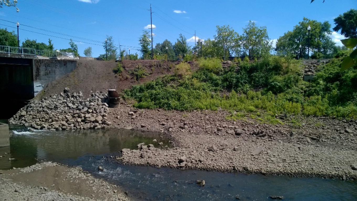
Sherwood
Text Box
Looking south towards south bank of Kellogg Creek, from north bank

APPENDIX C: WILLAMETTE GREENWAY VEGETATION BUFFER PLAN
Requirements The entirety of the bank stabilization and restoration activities associated with the south bank portion of the project area and the areas impacted by the bridge replacement work fall within the “buffer strip of native vegetation” defined by “a location 25 ft. upland from the ordinary high water line (MMC 19.401.8A). Due to scour and erosion issues that have created the need for this project, minimal native vegetation remains within the portions of this buffer that the project will impact. Indeed, the very purpose of the slope stabilization and restoration work on the south bank of Kellogg Creek is to reestablish the vegetation that has previously been eliminated (see attached site photos). This project will address the requirements of MMC 19.401.8B as follows:
1. Riverbank Stabilization – As stated previously, bank stabilization is a central purpose of this project (see “Project Narrative” and Appendix D: Construction Management Plan).
2. Scenic View Protection – This project will enhance and restore the scenic views within the project area by restoring native vegetation to areas where is has been previously eliminated due to scour and erosion. This project will also follow the previously approved Riverfront Park Planting Plan (see attached).
3. Retain Existing Native Vegetation and Large Trees – This specific project will not remove any large trees (though some trees have been identified to be removed in this area in association with other Riverfront Park actions). Some low quality vegetation on the south bank of r Kellogg Creek will be impacted as the over-steepened bank is worked on, but the area will be fully replanted per the Riverfront Park Planting Plan.
4. Restore Native Vegetation – As previously stated, the project area will be replanted in accordance with the Riverfront Park Planting Plan.
5. Enhance Vegetation Buffer Area - As previously stated, the project area will be replanted in accordance with the Riverfront Park Planting Plan.
6. Security that the Plan will be Carried Out – All elements of this plan are included in a contractual agreement with the City of Milwaukie, who will oversee the completion of this project.

Sherwood
Polygon
Sherwood
Polygon
Sherwood
Callout
Plantings in this area will be salvaged and replanted
Sherwood
Callout
This vegetation may end being mostly removed, but this area will be replanted according to the Riverfront Park Planting Plan
Sherwood
Text Box
Looking south towards south bank of Kellogg Creek, from north bank

APPENDIX D: CONSTRUCTION MANAGEMENT PLAN
Introduction This memo addresses the construction management plan requirements of Milwaukie Municipal Code (MMC) Subsection 19.402.D for the bridge replacement and slope stabilization work at the south end of Riverfront Park. The Kellogg Creek Bridge (BR #22142) is located at roughly 11211 SE McLoughlin Blvd. The proposed project will improve access to the Milwaukie Riverfront Park. This plan is required per development standard 10 of MMC 19.402.11.A “Protection of Natural Resources During Site Development.”
Project Description The Kellogg Creek Bridge Emergency Replacement Project is a project that will replace the current parking lot/overlook access bridge (BR #22142) adjacent to the west side of the Hwy 99E Bridge over Kellogg Creek with a single, joint-use structure (vehicles and pedestrian). While creating a more efficient and aesthetically appropriate crossing within Milwaukie Riverfront Park, this project will also help correct current scouring issues that have damaged the south bank and area around the sanitary manhole cover by doing bank stabilization and adding fish habitat structures and vegetation. The project will include the following:
• Construction of protective fencing and installation of required erosion control measures. • Construction of a new structure with abutments outside of the ordinary high water and scour
influence of Kellogg Creek Bridge including new structure, impact panels, bridge rails, wing walls, etc.
• Reconstruction of approaches to allow easier access for boat trailers onto the new bridge. • Approach reconstruction includes: reconstruction of roadway (curbs, asphalt, etc.), drainage,
illumination and pedestrian facilities as well as restoration of traffic signal infrastructure, restoration and mitigation for disturbance to natural resources and water quality requirements.
• Widen structure to accommodate wider travel lanes and installation of 8’ sidewalk on downstream side connecting both parking lots with overlook and parking area.
• Design and construction of a new 10” waterline within the new structure and abandonment of the existing waterline on the old structure.
• Reconstruction of currently over-steepened south bank between the existing bridge and the existing soldier pile wall, reestablishing the bank around the sanitary sewer manhole and raise the manhole cover and providing streambank improvements.
• Establish vegetation onto streambanks similar to previously approved Riverfront Park planting guidelines. (Plan Sheets 5 and 5A and Riverfront Park Planting Plan sheets).
• Isolation and fish removal for any areas where in-water work will occur. • Placement of three (3) multi-log structures to enhance fish usage in Kellogg Creek (discussed and
approved by ODFW). • Remove old structure and abutments and then restore streambanks and vegetate the area. • Construct temporary sheet pile wall from the Highway 99 bridge over to re-sloped streambank.
(see Plan Sheet 7). This sheet pile wall is to hold back Highway 99 embankment temporarily since we are moving the new bridge downstream slightly, moving the end abutments further away from the creek and fully removing the old bridge. Currently, the Kellogg Creek Bridge abutments are containing the Hwy 99 fill. This sheet pile will be removed when ODPT reconstructs the Hwy 99 Bridge.

• Planting and seeding the areas and then, once established, removing all of the protective fencing and erosion control measures.
This work will be done all below the 100- year flood elevation since the current bridge is below this elevation (~36’ NAVD 88). The project does impact some of the previously planted vegetation which will be dug up if impacted and then replanted after construction is complete. Some low quality vegetation on the south bank which is within the vegetation buffer for Kellogg Creek will be impacted as the over-steepened bank is worked on but the area will be fully replanted as previously described. The end product will be a well-vegetated streambank and improved habitat due to the placement of large woody debris (LWD) in three large structures at the toe of slope on the south bank. The removal of the old bridge abutments from the edge of the active channel will also improve the function of the creek at this location by widening the streambed.
Compliance with MMC 19.402.9.B
1. Description of work to be done – see Project Description section of this memo
2. Scaled site plan showing demarcation of WQRs, HCAs, and the location of excavation areas for building foundations, utilities, stormwater facilities, etc. - (see attached Habitat Conservation Areas Map)
3. Location of site access and egress that construction equipment will use - (see attached Proposed Access Points sheet) The site currently has vehicular, pedestrian and equipment access from Highway 99 and from the north end of Riverfront Park. Machinery access down the south bank to place the LWD structures and do the bank stabilization work will be kept to a minimum and all access points will be incorporated into the bank stabilization work and thus fully removed. Removal of the old bridge will be from the ends of the bridge and these areas will be re-sloped with the placement of rock and soil as the machinery pulls out so the creek will have a wider opening then currently available.
4. Equipment and Material staging and stockpile areas - (see Plan Sheet 3)
5. Erosion and sediment control measures - The erosion control methods employed for this project include perimeter controls, wattles, sediment fencing, biodegradable erosion control matting, seeding, and permanent vegetation (see Appendix E: Erosion Control Plan and attached Construction Management Site Plan)
6. Measures to protect trees and other vegetation located within the potentially affected WQR and/or HCA - Protective fencing will be placed so no work occurs outside of the fencing and will also help in keeping the public from getting into the work areas.

Attachments
Construction Management Site Plan Sheets (at end of document)
Habitat Conversation Areas Map
Proposed Access Points Plan Sheet

NOT for Construction Use; For Permitting Illustration ONLYScale: (*) 6/28/2017
Sherwood
Text Box
Kellogg Creek Bridge Emergency Replacement Project
Sherwood
Text Box
Habitat Conservation Areas
Sherwood
Polygon
Sherwood
Callout
Project Area
Sherwood
Text Box
Habitat Conservation Areas
Sherwood
Text Box
*
Sherwood
Polygon
Sherwood
Polygon
Sherwood
Callout
Appoximate Excavation Areas
Sherwood
Line
Sherwood
Text Box
Willamette River
Sherwood
Text Box
Kellogg Creek
Randy
Polygon
Sherwood
Callout
Bioswale

DRAWN:
CHECKED:
DATE:
R
E
V
I S
I O N S
DESCRIPTION
JOB NO.
DATE
NO.
04-13-17
ENGINEER:
18328
10
SHEET NO.
NB
NB
DS
OF
33
= Access Point
Randy
Text Box
Proposed Access Points
Randy
Text Box
Randy
Text Box
Randy
Text Box
Sherwood
Polygonal Line
Sherwood
Line
Sherwood
Line
Sherwood
Line
Sherwood
Line
Sherwood
Line

Randy
Polygonal Line
Randy
Polygonal Line
Randy
Polygonal Line
Randy
Polygonal Line
Randy
Callout
Access to creek from this parking lot through the blackberries to the creek, all trees will be avoided or excavated and then replanted
Randy
Callout
New bridge location
Sherwood
Callout
Approximate LWD placement locations
Sherwood
Line
Sherwood
Line

APPENDIX E: EROSION CONTROL PLAN
Erosion Control
Prior to the initiation of construction work, the work areas will be clearly marked out so that the impacts from construction will be limited to the designated areas shown on the attached Erosion Control Plan sheet. Erosion control measures will consist of silt fence, bio bags, straw waddles and biodegradable matting. Construction of the fish habitat and bank stabilization actions will be completed as much as practicable in the dry during low flow and low tide periods. Any work in the water will only be done after the area has been de-fished and isolated through the use of cofferdams, sandbags, floating silt curtains etc. All fish removal will be done in close association with Oregon Department of Fish and Wildlife and with a fish salvage permit.
Soils placed over any buried rock will have biodegradable matting placed on it and then planted with the appropriate seeds and plants as designated in the Riverfront Park Planting Plan.

DRAWN:
CHECKED:
DATE:
R
E
V
I S
I O N S
DESCRIPTION
JOB NO.
DATE
NO.
04-13-17
ENGINEER:
18328
10
SHEET NO.
NB
NB
DS
OF
33
Randy
Text Box
Erosion control plan
Randy
Text Box
Randy
Text Box
Randy
Polygonal Line
Randy
Polygonal Line
Randy
Polygonal Line
Randy
Callout
Silt fence, waddles, floating silt curtains to be used as necessary to control any potential sediment migration
Randy
Line
Randy
Callout
Silt Fence
Randy
Callout
Silt Fence
Randy
Polygonal Line
Randy
Text Box

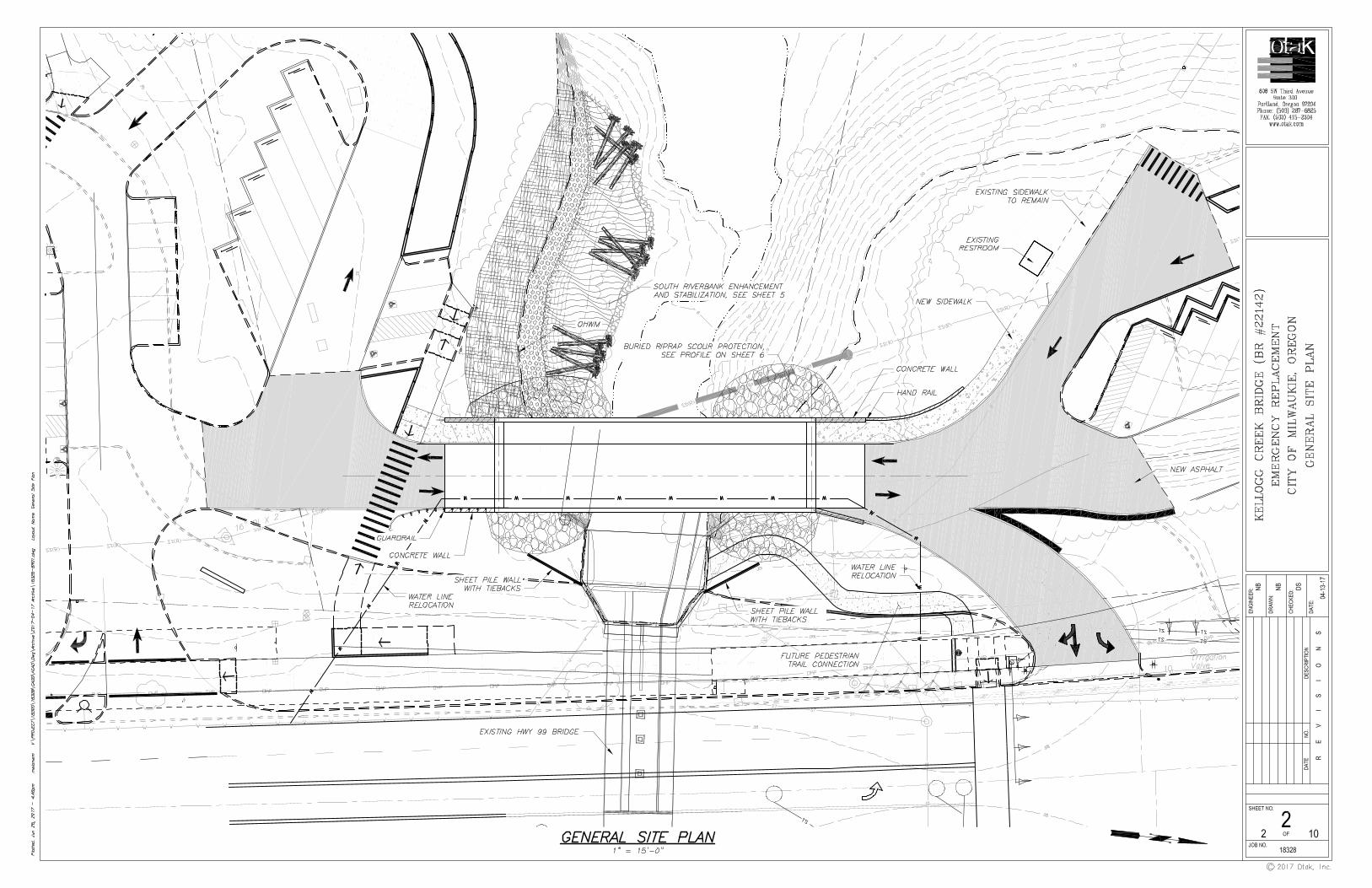

DRAWN:
CHECKED:
DATE:
R E V I S I O N S
DESCRIPTION
JOB NO.
DATE
NO.
04-13-17
ENGINEER:
18328
10
SHEET NO.
NB
NB
DS
OF
33

DRAWN:
CHECKED:
DATE:
R E V I S I O N S
DESCRIPTION
JOB NO.
DATE
NO.
04-13-17
ENGINEER:
18328
10
SHEET NO.
NB
NB
DS
OF
44

Randy
Text Box
Randy
Text Box
Sherwood
Text Box
.9

DRAWN:
CHECKED:
DATE:
R E V I S I O N S
DESCRIPTION
JOB NO.
DATE
NO.
04-13-17
ENGINEER:
18328
10
SHEET NO.
NB
NB
DS
OF
33
Randy
Polygonal Line
Randy
Polygonal Line
Randy
Polygonal Line
Randy
Text Box
Proposed Planting Areas
Randy
Polygonal Line
Randy
Polygonal Line
Randy
Text Box
5-A
Randy
Polygon
Randy
Polygon
Randy
Text Box
ProposedBioswale

DRAWN:
CHECKED:
DATE:
R
E
V
I S
I O N S
DESCRIPTION
JOB NO.
DATE
NO.
04-13-17
ENGINEER:
18328
10
SHEET NO.
NB
NB
DS
OF
66
Sherwood
Text Box
112'
Sherwood
Text Box
.9

DRAWN:
CHECKED:
DATE:
R E V I S I O N S
DESCRIPTION
JOB NO.
DATE
NO.
04-13-17
ENGINEER:
18328
10
SHEET NO.
NB
NB
DS
OF
77
Sherwood
Text Box
112'
Sherwood
Text Box
.9

DRAWN:
CHECKED:
DATE:
R E V I S I O N S
DESCRIPTION
JOB NO.
DATE
NO.
04-13-17
ENGINEER:
18328
10
SHEET NO.
NB
NB
DS
OF
88

DRAWN:
CHECKED:
DATE:
R E V I S I O N S
DESCRIPTION
JOB NO.
DATE
NO.
04-13-17
ENGINEER:
18328
10
SHEET NO.
NB
NB
DS
OF
99

DRAWN:
CHECKED:
DATE:
R E V I S I O N S
DESCRIPTION
JOB NO.
DATE
NO.
04-13-17
ENGINEER:
18328
10
SHEET NO.
NB
NB
DS
OF
1010

• "'5 ,, .. 8
>o
-0
;u
0 -0
0 z 0 ~
0 z (/)
,...._
(/)
;u f
"'1
f"'1
()
,, :
::l
l'T
lo
;u z
ci
-0 "'
:::!
I C
l C
A
;u f
"'1
l'Tl
r r O
> 0
)>
Cl
-......
()
PRO
.JBCT
;o
f"'1
f"'1
:A
' u c
Milw
auki
e R
iver
fro
nt
Par
k
Pro
po
sed
Sit
e P
lan
Cro
ss S
ecti
on
P2
(/)
0 c :I! -0
)>
;u
:;>;; z Cl
)>
;u
f"'1
)> c! ;u
z )>
;u
0 c z 0
ir~§
'·~
i~,.
·-
.. l
0 0
DlfG
. R
BP.
PR
O.JB
CT
SCA
LE
AK
END
KEN
T N
O.
Hr.~
~ C
-1
MA
EX
00
18
1
''=3
0'
0.0
~"'
-t )i
DRAW
N B
Y
DBS
JGN
BY
A
PPR
OV
BD B
Y
DA
TB
78
w~i I
H
BA
R
CR
M
RGW
I E
NC
LO
SU
RE
} 0
5-1
5-0
9
~~
:::.
.:..
..:.
;_;_
_~~~
~-.:
..c.
....
.;..
;.~•
__;._;
._;;;.
._;__~~~~~~N-W_P __
_ 2_0_0_9
=-=1
-9-'-
=-P-a~q~e
14
o
f 4
0
P: \
M\M
AE
X0
00
00
01
8\0
40
0C
AD
\DW
G\S
he
ets
\PE
RM
IT D
RA
WIN
GS
\JP
A
dw
gs\
Pro
p_
Se
ctio
ns_
JPA
.dw
g
May
19,
2
00
9 -
10: 2
1am
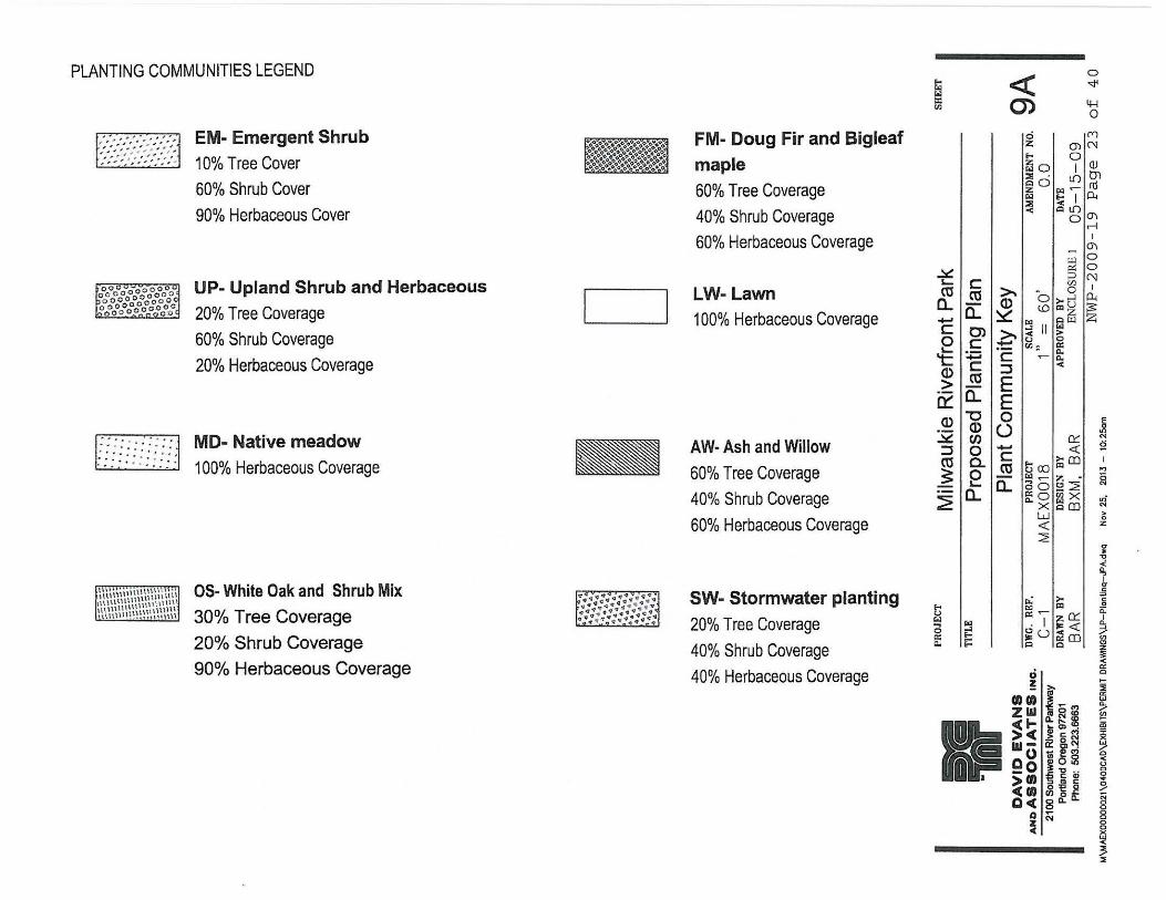
PLANTING COMMUNITIES LEGEND
F:::?:~::~:::}::J
r · · .. -: · · · · 1 ;;;;::: }:·::·:
EM- Emergent Shrub 10% Tree Cover
60% Shrub Cover
90% Herbaceous Cover
UP- Upland Shrub and Herbaceous
20% Tree Coverage
60% Shrub Coverage
20% Herbaceous Coverage
MD- Native meadow
100% Herbaceous Coverage
OS- White Oak and Shrub Mix
30% Tree Coverage
20% Shrub Coverage
90% Herbaceous Coverage
l - I
.. ::~-::;:;-:.,::~ ~::·:::q::: .. ::~ :::.H4:;:.:::.;:
FM- Doug Fir and Bigleaf
maple 60% Tree Coverage
40% Shrub Coverage
60% Herbaceous Coverage
LW-Lawn 100% Herbaceous Coverage
AW· Ash and Willow
60% Tree Coverage
40% Shrub Coverage
60% Herbaceous Coverage
SW- Stormwater planting 20% Tree Coverage
40% Shrub Coverage
40% Herbaceous Coverage
ti r.:i :i:
"' <( (j)
0
""' 4-J 0
g ('() E- O'l ('\J
z 0 ~~ I QJ Cl 0 I.{) tn :z: i::.:i ~ ro ~ ~ I o.. < Cl Li)
oO"I .-1
I O"\
~ Ul 0
L... c: !30 CU"" -- r.nN a.. \U ......... " 0 I
a.. Q) O ;.- ....l 0..
_. ~ C.OC!l ~ :s:: E 0) >. ~ II fa Ul z L...C:_.u ~ 't:: +:i ·- "'" a: c: c: ~ c.. °'cu :J ~ ~a.. ~ Q) "O 0 ·- Q) () ~ Cl) :J 0 _. 0::: cu a. c: <{
~ 0 ~ ~ CXJ i;:jCO
~ 0:: a.. ~ Ci ~ 2" ..:::::;; c..O"' X
X ~llJ w
E-
;;i lr.:i ... _, 0 E-a: -c.. E-
•
<{
2
0 ! >.
auo ~ Ziii if~~ <( ...... I'- '2j
> ,,,, CJ) (D •
" > c (¥)
w- Ci: ~~ oo .,.cs~ _o 1-o .. >O> 'S ~ ~ <cm ~l,52 Qc( 8 Cl.. a..
a .... z N ~
] "' 2 ,., ~
~
i; z
O'
" "'C
< lls ~ g ii: I
Q.
? ~ ~ 25 ..... 5!
~ i'ii
~ / 0 < (.)
~ ~ § 0 0 0 0 x "' < 3 2

j 1 11
11
I I l j
I I I 11
1j l,
i(
I IJ
\ \. __ _
1.,,
,---
··/_
..,
'-\ \
./
I /
MA
TCH
LIN
E;
; l
ill
PRO
JECT
M
ilwau
kie
Riv
erfr
on
t P
ark
.,1
-o"'C
§>
D
gu·~
(tl::Js-
•o-
~Q~
()D
"'
.ll -
~
DWG.
REF
. PR
OJE
CT
TITL
E P
rop
ose
d P
lan
tin
g P
lan
Rea
ch 1
SCAL
E 1"
=
6
0'
(
I ( '·
AM
END
MEN
T N
O.
0.0
~~f ~
,.
C-
1 M
AE
X00
18
e~~-z
-DRA~WN~
B-Y~~~~~-DE-S-IG_N_B_Y~~~~~-
AP~PR_O_VE_D~
BY~~~~~-
D-A-TE~~~-
~l :·
BA
R
BX
M,
BA
R
EN
CL
OS
UR
E I
0
5-1
5-
09
0 .
NW
P-2
00
9-1
9 P
age
24
=>:
\M
\MA
EX
00
00
00
18
\04
00
CA
D\D
WG
\Sh
eet
s\P
ER
MIT
DR
AW
ING
S\J
PA
d
wg
s\L
P-P
lon
tin
g-J
PA
.dw
g M
oy
19,
20
09
SH
EE
T
98
of
40
-10
: 41
om

~ I }I I I Ir
! I ~
t\
'I
J • I I
--:o
r--
--,_
;_ _
_
I
t. '•
I ...
I I /
\·
/ / /'
,,.
~
,,. '
0 15
30
I (
, ..... --
·~
' '
\
''
\ \ .
\ \ \ \
MA
TC
HLI
NE
60~
-.r-
""1!
-.a.111
111
~-PR-o
J-Ec_r~~~
~M~i
l_w_a_
u_k_i_e_R_i_
v_e_rt_r
o~n_t_P_a
_rk~~~~~~
TITL
E P
ropo
sed
Plan
ting
Plan
Rea
ch 2
SHEE
T
DA
VID
EV
AN
S
AN
DA
SS
OC
IAT
ES
INC
.
21
00
So
uth
we
st R
lve
r Pa
rkw
ay
Po
rtla
nd
Ore
go
n 9
7201
P
ho
ne
: 5
03
.22
3.6
66
3
Dlf
G.
RE
F.
C-
1 D
RA
WN
B
Y
BA
R
PR
OJE
CT
MA
EX
00
18
DE
SIG
N
BY
BXM
. B
AR
SCAL
E
, ..
=
60
' A
PP
RO
VE
D
BY
EN
CL
OSU
RE
I
AM
EN
DM
EN
T
NO
. 9C
0
.0
DA
TE
05
-15
-09
NWP
-20
09
-1
9
Pag
e
25
of
40

COMMUNITY DEVELOPMENT BUILDING • ECONOMIC DEVELOPMENT • ENGINEERING • PLANNING
6101 SE Johnson Creek Blvd., Milwaukie, Oregon 97206 P) 503-786-7600 / F) 503-774-8236
www.milwaukieoregon.gov
June 29, 2017
Rick Buen City of Milwaukie
Re: Preapplication Report
Dear Rick:
Enclosed is the Preapplication Report Summary from your meeting with the City on June 15, 2017, concerning your proposal for action on property located at Kellogg Creek Bridge.
A preapplication conference is required prior to submittal of certain types of land use applications in the City of Milwaukie. Where a preapplication conference is required, please be advised of the following:
• Preapplication conferences are valid for a period of 2 years from the date of the conference. If a land use application or development permit has not been submitted within 2 years of the conference date, the Planning Director may require a new preapplication conference.
• If a development proposal is significantly modified after a preapplication conference occurs, the Planning Director may require a new preapplication conference.
If you have any questions concerning the content of this report, please contact the appropriate City staff.
Sincerely, Alicia Martin Administrative Specialist II
Enclosure
cc: Chuck Eaton, Engineering Director Larry Gescher, HP Civil Inc.
Aaron Sherwood, Reeve Sherwood Consulting, LLC Randy Reeve, Reeve Sherwood Consulting, LLC

CITY OF MILWAUKIEPRE-APPLICATION CONFERENCE REPORT
PreApp Project ID #: 17-012PA
Applicant Name: Rick Buen
Company: City of Milwaukie Engineering
Address Line 1: 6101 SE Johnson Creek Blvd
Address Line 2:OR 97206
Applicant 'Role': Owner
ProjectAddress: 11211 SE McLoughlin Blvd
Project Name: Kellogg Creek Bridge Replacement
Zone: Downtown Open Space OS
Occupancy Group:ConstructionType:
Use: Public (P) and Town Center (TC)
Occupant Load:
6/15/2017 10:00am
Staff Attendance: Denny Egner, Vera Kolias, Alex Roller, Richard Nasiombe, Rick Buen
ADA:
Structural:
Mechanical:
Plumbing:
Plumb Site Utilities:
Electrical:
Notes: N/A
This report is provided as a follow-up to a meeting that was held on at
City, State Zip: Milwaukie
BUILDING ISSUES
Description: Replace Kellogg Creek Bridge and additional improvements to the crossing in Riverfront Park
AppsPresent: Larry Gescher, Aaron Sherwood, Randy Reeve
Page 1 of 6City of Milwaukie DRT PA ReportDated Completed: 6/29/2017

Fire Sprinklers:
Fire Alarms:
Fire Hydrants:
Turn Arounds:
Addressing:
Fire Protection:
Fire Access:
Hazardous Mat.:Fire Marshal Notes: See attached.
Water: Water line relocation will be covered under construction plans.
Sewer: Storm manhole raising will be covered under construction plans.
Storm: Submission of a storm water management plan by a qualified professional engineer is required as part of the proposed development. The plan shall conform to Section 2 - Stormwater Design Standards of the City of Milwaukie Pubic Works Standards. The storm water management plan shall demonstrate that the post-development runoff does not exceed the pre-development, including any existing storm water management facilities serving the development property. Also, the plan shall demonstrate compliance with water quality standards. The City of Milwaukie has adopted the City of Portland 2016 Stormwater Management Manual for design of water quality facilities.All new impervious surfaces, including replacement of impervious surface with new impervious surfaces, are subject to the water quality standards. See City of Milwaukie Public Works Standards for design and construction standards and detailed drawings.
Street: Development property fronts McLoughlin Blvd.
Frontage: Chapter 19.700 of the Milwaukie Municipal Code, hereafter referred to as “Code”, applies to partitions, subdivisions, and new construction.
Frontage improvements will not be required, as they have already been completed under previous Capital Improvement Project.
Right of Way: This development does not trigger any dedication requirements.
FIRE MARSHAL ISSUES
PUBLIC WORKS ISSUES
Please note all drawings must be individually rolled. If the drawings are small enough to fold they must be individually folded.
Driveways: n/a
Page 2 of 6City of Milwaukie DRT PA ReportDated Completed: 6/29/2017

PW Notes: none
Setbacks: The setback requirements do not apply to the proposed project in the OS Zone.
Landscape: Based on the proposal, landscaping requirements are related to the MMC 19.402 Natural Resources requirements.
Parking: Minimum parking requirements per MMC 19.600 do not apply to the proposed project.
Transportation Review: Please see the Public Works notes for any information about the requirements of MMC 19.700.
Application Procedures: The proposed work is a revision to an approved plan for Riverfront Park as well as installation of improved slope stabilization infrastructure.
Land use applications required:* Willamette Greenway review (Type III)* Natural Resources (Type III)
Willamette Greenway WG (MMC 19.401): A greenway conditional use is required for all intensification or change of use, or alteration of the vegetation buffer area, or development. Approval shall be granted only if the criteria in Subsection 19.401.6 are met. A new conditional use is subject to Type III review and approval by the Planning Commission under Section 19.1006.
Per 19.401.6, the following shall be taken into account in the consideration of a greenway conditional use:
A.Whether the land to be developed has been committed to an urban use, as defined under the State Willamette River Greenway Plan;
B.Compatibility with the scenic, natural, historic, economic, and recreational character of the river; C.Protection of views both toward and away from the river; D.Landscaping, aesthetic enhancement, open space, and vegetation between the activity and the river,
to the maximum extent practicable; E.Public access to and along the river, to the greatest possible degree, by appropriate legal means; F.Emphasis on water-oriented and recreational uses; G.Maintain or increase views between the Willamette River and downtown;
PLANNING ISSUES
Erosion Control: Per Code Section 16.28.020(C), an erosion control permit is required prior to placement of fill, site clearing, or land disturbances, including but not limited to grubbing, clearing or removal of ground vegetation, grading, excavation, or other activities, any of which results in the disturbance or exposure of soils exceeding five hundred square feet.
Code Section 16.28.020(E) states that an erosion control permit is required prior to issuance of building permits or approval of construction plans. Also, Section 16.28.020(B) states that an erosion control plan that meets the requirements of Section 16.28.030 is required prior to any approval of an erosion control permit.
Traffic Impact Study: Code Section 19.704.1(A) states that the City will determine whether a transportation impact study (TIS) is required. In the event the proposed development will significantly increase the intensity of use; a transportation impact study will be required. The City of Milwaukie Engineering Director will make this determination based on proposed preliminary subdivision design and the number of lots created. No TIS will be required.
Page 3 of 6City of Milwaukie DRT PA ReportDated Completed: 6/29/2017

H.Protection of the natural environment according to regulations in Section 19.402; I.Advice and recommendations of the Design and Landmark Committee, as appropriate; J.Conformance to applicable Comprehensive Plan policies; K.The request is consistent with applicable plans and programs of the Division of State Lands; L.A vegetation buffer plan meeting the conditions of Subsections 19.401.8.A through C.
More information on the requirements for a WG conditional use can be found in MMC 19.401.
Natural Resources (MMC 19.402): The regulations in Section 19.402 apply to all properties that contain, or are within 100 ft of a WQR and/or HCA as shown on the Milwaukie Natural Resource Administrative Map. The area of work contains both WQR and HCA and is entirely within 100 ft of the WQR. The proposed work exceeds 150 sf within the HCA and within 100 ft of a WQR, and therefore is subject to Type III review and approval by the Planning Commission under Section 19.1006.
The application materials should include the following information:
•Information found required in 19.402.9 Construction Management Plans •Demonstrate compliance with 19.402.11 Development Standards •Type III Natural Resource review is subject to 19.402.12 General Discretionary Review. o19.402.12.B identifies the approval criteria for Type III applications. Application materials should
demonstrate how the proposal complies with the listed criteria.
Both applications may be filed together and they will be reviewed concurrently.
For the City's initial review, the applicant should submit 5 complete copies of the application, including all required forms and checklists. A determination of the application's completeness will be issued within 30 days. If deemed incomplete, additional information will be requested. If deemed complete, additional copies of the application may be required for referral to other departments, the Island Station and Historic Milwaukie Neighborhood District Associations (NDAs), and other relevant parties and agencies. City staff will inform the applicant of the total number of copies needed.
For Type III review, once the application is deemed complete, a public hearing with the Planning Commission will be scheduled. Staff will determine the earliest available date that allows time for preparation of a staff report (including a recommendation regarding approval) as well as provision of the required public notice to property owners and residents within 300 ft of the subject property, at least 20 days prior to the public hearing. A sign giving notice of the application must be posted on the subject property at least 14 days prior to the hearing.
Issuance of a decision starts a 15-day appeal period for the applicant and any party who establishes standing. Permits submitted during the appeal period may be reviewed but are not typically approved until the appeal period has ended.
Prior to submitting the application, the applicant is encouraged to present the project at a regular meeting of the Historic Milwaukie and Island Station NDAs.
Natural Resource Review: The project area includes a designated Water Quality Resource (WQR) area and a Habitat Conservation Area (HCA), extending from the river up onto the area of work. The proposed project will disturb both the WQR and HCA and is subject to Type III Natural Resources review.
The subject property is entirely within the Willamette Greenway (MMC 19.401): A greenway conditional use is required for all intensification or change of use, or alteration of the vegetation buffer
Page 4 of 6City of Milwaukie DRT PA ReportDated Completed: 6/29/2017

area, or development. Approval shall be granted only if the criteria in Subsection 19.401.6 are met. A new conditional use is subject to Type III review and approval by the Planning Commission under Section 19.1006.
Please refer to application procedures above.
Lot Geography: The subject property is an irregular shaped lot along the Willamette River with frontage on McLoughlin Blvd.
Planning Notes: The proposal is to replace and relocate the existing bridge with associated slope stabilization in nearby areas of slope failure in Riverfront Park, which has approved plans and a Notice of Decision.
The applicant’s narrative should address the question of whether and/or how much the proposed bridge and slope work will impact views both from the river to the site and toward the river from the street and neighboring properties. Photo simulations or rendered elevations of the proposed bridge would be one effective way to demonstrate the degree of anticipated impact. Neighboring properties within 300 ft of the site will receive notice of the proposed development and may submit comments or testify at the hearing. As noted above, it might be useful to discuss the project with City Council and the Historic Milwaukie and Island Station NDAs to gauge support for the project.
Assuming the Willamette Greenway conditional use request is approved, the City will prepare a conditional use permit that must be recorded with Clackamas County before work commences.
The preapplication conference is valid for purposes of submitting future land use applications as described in MMC 19.1002.4. A preapplication conference is valid for 2 years.
The full zoning code is available online at: http://www.qcode.us/codes/milwaukie/view.php?topic=19&frames=on
County Health Notes:
ADDITIONAL NOTES AND ISSUES
Other Notes:
Page 5 of 6City of Milwaukie DRT PA ReportDated Completed: 6/29/2017

This is only preliminary preapplication conference information based on the applicant's proposal and does not cover all possible development scenarios. Other requirements may be added after an applicant submits land use applications or building permits. City policies and code requirements are subject to change. If you have any questions, please contact the City staff that attended the conference (listed on Page 1). Contact numbers for these staff are City staff listed at the end of the report.
Sincerely,
City of Milwaukie Development Review Team
BUILDING DEPARTMENT
PLANNING DEPARTMENTENGINEERING DEPARTMENT
CLACKAMAS FIRE DISTRICT
Samantha Vandagriff - Building Official - 503-786-7611Bonnie Lanz - Permit Specialist - 503-786-7613
Alma Flores - Comm. Dev. Director - 503-786-7652
Chuck Eaton - Engineering Director - 503-786-7605
Mike Boumann - Lieutenant Deputy Fire Marshal - 503-742-2673Matt Amos - Fire Inspector - 503-742-2661
COMMUNITY DEVELOPMENT DEPARTMENT
David Levitan - Senior Planner - 503-786-7627Alex Roller - Engineering Tech II - 503-786-7695
Alicia Martin - Admin Specialist - 503-786-7600
Richard Nasiombe - Associate Enginer - 503-786-7694
Brett Kelver - Associate Planner - 503-786-7657
Dennis Egner - Planning Director - 503-786-7654
Vera Kolias - Associate Planner - 503-786-7653Mary Heberling - Assistant Planner - 503-786-7658
Page 6 of 6City of Milwaukie DRT PA ReportDated Completed: 6/29/2017

Page 1 of 1 – Kellogg Creek Bridge 17-012PA
2930 S.E. Oak Grove Blvd. • Milwaukie, OR 97267 • 503-742-2660
Clackamas County Fire District #1 Fire Prevention Office
E-mail Memorandum
To: City of Milwaukie Planning Department
From: Matt Amos, Fire Inspector, Clackamas Fire District #1
Date: 6/29/2017
Re: Kellogg Creek Bridge 17-012PA
This review is based upon the current version of the Oregon Fire Code (OFC), as adopted by the Oregon State Fire Marshal’s Office. The scope of review is typically limited to fire apparatus access and water supply, although the applicant must comply with all applicable OFC requirements. When buildings are completely protected with an approved automatic fire sprinkler system, the requirements for fire apparatus access and water supply may be modified as approved by the fire code official. The following items should be addressed by the applicant: The Fire District has no comments for this proposal.

Memorandum
To: Milwaukie Planning Commission From: Rick Buen CC: Vera Kolias Date: August 11, 2017 Re: Kellogg Creek Bridge Replacement This memorandum is in regards to the response to comments as part of the agenda presented to the Design and Landmark Committee on August 7, 2017 meeting. The comments and response are as follows: Comment:
• The erosion control plan relies on basic, simple measures to control erosion next to a waterway- would like to see a more detailed plan. Text box on plan states that “silt fence, waddles (SIC), floating silt curtains to be used as necessary to control any potential sediment mitigation”. Need to see more detail than just “as necessary”.
Response
• On the erosion control issues, we are developing a set of construction plan sheets that show where and how each of the various sediment control methods will be used as per our meeting. Floating silt curtains and fish removal will occur any time work is going to be performed in the water. Any time work is being done below OHW but above the actual water moveable waddles will be placed to intercept any potential sediment from upslope from entering the waterway. Silt curtains and waddles will be used to contain any sediment from staging areas and other work areas. Hope to have the plan sheets completed next week.
Comment:
• The revegetation plan indicates plantings and soil placement below OHW mark with soil placement over rip-rap style boulders and matting over the soil. High river levels from the Willamette and high flows from Kellogg Creek during winter storms in this area will likely scour and erode this placed soil. Would like to see boulders placed over fabric without the addition of soil up to the OHW mark, plantings above the OHW could be done per current plan.
5.3 Page 24ATTACHMENT 3.i. ATTACHMENT 3.j.

Response
• The streambed gravels and dirt that are excavated for the placement of rip rap under the bridge will have matting placed into it and large rocks placed on top of the matting to keep it in place. Once west of the new bridge location matting will not be used to help hold gravels due to the decrease in velocities and the planting of willows into this area. Soils will be placed above OHW in all disturbed areas and planted per the plan. Bark chips will be placed over all disturbed soils above OHW after planting. Revised drawings will show these changes.
Comment:
• The proposed planting area on the south bank of Kellogg Creek calls for following the Riverfront Park planting plan (appendix C). If larger trees could be planted in the south bank that could offer shade to the creek, it would meet some of the City’s measurable goals in the City’s TMDL Implementation Plan for stream temperature reductions and also could create cold-water refugia areas for salmon migrating up the Willamette River as Kellogg Creek is typically colder than the Willamette.
• The Proposed Site Plan Cross Section P2, sheet 7B, indicates trees planted on the south bank but the Riverfront Park Planting Plan detail (sheet 5) calls out small shrubs and groundcover. Would like to see consistency in the planting plans.
Response
• The landscape drawings are being corrected to show where trees will be used and how all vegetation will be properly put into the ground. Large trees will be placed on the top of the banks in the disturbed areas but not on the steep slopes due to the potential of them tipping over and disturbing the slopes once they get large and the wind affects them. Shrubs and low vegetation will be used on the steep slopes to help stabilize them. Willows and red osier dogwoods will be placed below OHW to help establish shrubs and low growing trees to help provide shade for Kellogg Creek. The addition of LWD structures and these plantings will create fish habitat and enhance the stream for fish, wildlife and visual enjoyment.
5.3 Page 25

MEMORANDUM
TO: Community Development Department
THROUGH: Charles Eaton, PE, Engineering Director
FROM: Alex Roller, Engineering Technician II
RE: WG-2017-003, NR-2017-002 Staff Response 11211 SE McLoughlin Blvd
DATE: July 21, 2017
Kellogg Creek Bridge replacement.
No notes
Recommended conditions of approval:
A. Submit a storm water management plan to the City of Milwaukie Engineering Department for review and approval. The plan shall be prepared in accordance with Section 2 – Stormwater Design Standards of the City of Milwaukie Public Works Standards. In the event the storm management system contains underground injection control devices, submit proof of acceptance of the storm system design from the Department of Environmental Quality.
5.3 Page 26ATTACHMENT 4

From: Amos, MattTo: Kolias, VeraSubject: WG-2017-003, NR-2017-002Date: Wednesday, July 19, 2017 1:44:09 PM
Good afternoon Vera, Clackamas Fire has no additional comments for this project. Thank you, Matt AmosFire Inspector | Fire Preventiondirect: 503.742.2661
The information contained in this transmission may contain privileged and confidentialinformation, including patient information protected by federal and state privacy laws. It isintended only for the use of the person(s) named above. If you are not the intended recipient,you are hereby notified that any review, dissemination, distribution, or duplication of thiscommunication is strictly prohibited. If you are not the intended recipient, please contact thesender by reply email and destroy all copies of the original message.
5.3 Page 27

From: Livingston, RobertTo: Kolias, VeraSubject: Kellogg Bridge commentsDate: Wednesday, July 26, 2017 10:41:11 AM
Vera, Thanks for the opportunity to comment on this plan. I have briefly read through the document andhave the following comments:
The erosion control plan relies on basic, simple measures to control erosion next to awaterway- would like to see a more detailed plan. Text box on plan states that “silt fence,waddles (SIC), floating silt curtains to be used as necessary to control any potential sedimentmitigation”. Need to see more detail than just “as necessary”.The revegetation plan indicates plantings and soil placement below OHW mark with soilplacement over rip-rap style boulders and matting over the soil. High river levels from theWillamette and high flows from Kellogg Creek during winter storms in this area will likelyscour and erode this placed soil. Would like to see boulders placed over fabric without theaddition of soil up to the OHW mark, plantings above the OHW could be done per currentplan.The proposed planting area on the south bank of Kellogg Creek calls for following theRiverfront Park planting plan (appendix C). If larger trees could be planted in the south bankthat could offer shade to the creek, it would meet some of the City’s measurable goals in theCity’s TMDL Implementation Plan for stream temperature reductions and also could createcold-water refugia areas for salmon migrating up the Willamette River as Kellogg Creek istypically colder than the Willamette.The Proposed Site Plan Cross Section P2, sheet 7B, indicates trees planted on the south bankbut the Riverfront Park Planting Plan detail (sheet 5) calls out small shrubs and groundcover.Would like to see consistency in the planting plans.
ROB LIVINGSTONEnvironmental Services Coordinatoro: 503.786.7691 c: 503.572.4659City of Milwaukie6101 SE Johnson Creek Blvd • Milwaukie, OR 97206
5.3 Page 28

From: Tom MaddenTo: Kolias, Vera; Ray BryanSubject: Development Plan File#(s): WG-2017-003; NR-2017-002Date: Thursday, July 27, 2017 5:17:38 PM
Dear Ms. Kolias,I'm writing to inform you that the Historic Milwaukie Neighborhood Association'sDevelopment Committee has reviewed the above Application and approves of theDevelopment Plan.Thank you for requesting our input, Tom Madden, Vice President and Committee Chairperson
5.3 Page 29

To: Planning Commission
Through: Dennis Egner, Planning Director
From: Vera Kolias, Associate Planner
Date: August 15, 2017 for August 22, 2017 Public Hearing
Subject: File(s): DR-2017-001; VR-2017-007
Applicant: Kurt Schultz, SERA Architects
Address: 2036 SE Washington St
Legal Description (Map & Taxlot): 11E36BC01600
NDA: Historic Milwaukie
ACTION REQUESTED
Approve applications DR-2017-001 and VR-2017-007, and the recommended Findings and Conditions of Approval found in Attachments 1 and 2. This action would allow the construction of a new 5-story mixed-use building on the property located at 2036 SE Washington St and approve variances to the 6-ft step back requirement and to minimum access spacing standards.
BACKGROUND INFORMATION
A. Site and Vicinity
The project site is located at 2036 SE Washington St and has additional frontages on Main Street and 21st Avenue. The project site is approximately 25,545 sq ft in size and currently contains an auto repair building and an attached retail building. The site is less than 100 ft from the Adams Street Connector and approximately 250 ft from the Orange Line light rail station on 21st Avenue (see Figure 1).
5.4 Page 1

Planning Commission Staff Report—Project Galaxy Page 2 of 17 Master File # DR-2017-001 —2036 SE Washington St August 15, 2017
Figure 1. Site Vicinity
B. Zoning Designation
The site is zoned Downtown Mixed Use (DMU).
C. Comprehensive Plan Designation
Town Center (TC).
D. Proposal
The applicant is seeking Downtown Design Review and Variance approval for construction
of a 5-story mixed-use building. The building will have 7,190 sq ft of retail and commercial
space on the first floor and 110 multifamily dwelling units on the top 4 floors. Interior
mechanical parking for 78 vehicles as well as 94 bicycle parking spaces are proposed. An
outdoor rooftop terrace is proposed on Level 2, which will include stormwater planting
areas. In order to receive a height bonus for the 5th story, the applicant is proposing Green
Globes certification for the building, which acknowledges a certain level or degree of
sustainable components and is an approved green building rating system. Variances are
requested from the 6-ft step back requirement for Levels 4 and 5 and from the minimum
access spacing standards (see Figures 2-5 and Attachment 3).
SITE
5.4 Page 2
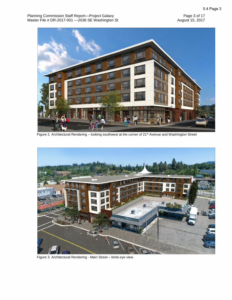
Planning Commission Staff Report—Project Galaxy Page 3 of 17 Master File # DR-2017-001 —2036 SE Washington St August 15, 2017
Figure 2. Architectural Rendering – looking southwest at the corner of 21st Avenue and Washington Street
Figure 3. Architectural Rendering - Main Street – birds-eye view
5.4 Page 3

Planning Commission Staff Report—Project Galaxy Page 4 of 17 Master File # DR-2017-001 —2036 SE Washington St August 15, 2017
Figure 4. Architectural Rendering - Main Street facade
The proposed design meets all the site and building design standards in MMC 19.508 except for the following:
19.508.4.A.2.b(2): In the horizontal building façade, significant breaks shall be created
along building façades at least every 150 linear ft by either setting the façade back at least
20 ft or breaking the building into separate structures. Breaks shall be at least 15 ft wide
and shall be continuous along the full height of the building.
As proposed, the Washington Street façade, which is 205 ft long, does not meet this
standard. As allowed by MMC 19.907.3.C, the proponent has elected Type III Downtown
Design Review rather than meet this standard. As mitigation, the applicant proposes to
use a vertical band of 4 projecting windows and color and material changes to give variety
to the façade and break up the wall. In addition, the proposal includes public art, in the
form of a mural, on the wall area on either side of the parking garage entrance door.
5.4 Page 4

Planning Commission Staff Report—Project Galaxy Page 5 of 17 Master File # DR-2017-001 —2036 SE Washington St August 15, 2017
19.508.4.E.3: For the Washington Street and 21st Avenue block faces, the exterior wall(s)
of the building facing the street/sidewalk must meet the following standard: 40% of the
ground-floor street wall area must consist of openings; i.e., windows or glazed doors.
As proposed, the Washington Street façade does not comply with this standard requiring.
Along Washington Street, 39% of the ground-floor street area consists of openings. The
garage entrance area is not glazed, but the proposed development includes wall murals on
both sides of the parking garage entrance door to mitigate for the missing 1% of opening
area on this wall. The applicant has responded to this standard by addressing the
applicable Downtown Design Guidelines (see Key Issue A and Attachment 3).
19.508.4.E.4.c: For the upper floors, along all block faces, a minimum of 60% of all upper-
floor windows shall be vertically oriented. This standard applies to the upper-level building
façades facing a street or public space.
The proposed development does not comply with the standard requiring a minimum of
60% of all upper-floor windows to be vertically oriented. As proposed, approximately 50%
or less of all upper-floor windows are vertically oriented. As an alternative to strict
compliance, the applicant has proposed oversized windows with an abundance of glass
rather than installing windows with vertical mullions which would potentially block the view.
The applicant has responded to this standard by addressing the applicable Downtown
Design Guidelines (see Key Issue A and Attachment 3).
Figure 5. Architectural Rendering - 21st Avenue façade
5.4 Page 5

Planning Commission Staff Report—Project Galaxy Page 6 of 17 Master File # DR-2017-001 —2036 SE Washington St August 15, 2017
The project requires approval of the following applications:
1. Downtown Design Review (DR-2017-001)
Type III Downtown Design Review for the new development.
2. Variance (VR-2017-007)
Type III Variance application for the following:
• A variance from the 6-ft step back requirement for floors above the base maximum height;
• A variance from minimum driveway spacing standards.
E. Land Use Review Per MMC 19.907.3.B.3, Type III Downtown Design Review applications require review by the Design and Landmarks Committee (DLC). The proposed development was presented to the DLC on August 7, 2017. The DLC voted (3-0) to recommend approval of the Downtown Design Review application with the following recommendations to the Planning Commission:
• Consider an alternative material for the proposed cedar siding (something with a wood look), due to concerns about maintenance issues and durability. A specific concern was noted regarding the bay windows, which are not under cover of the overhang and are significantly exposed on the west (Main Street) elevation.
• South elevation
o Concern was expressed regarding the use of a single material on a large majority of the south elevation. Suggestion to provide a continuation of more permanent and durable siding materials (such as brick) at the base or ground level.
o Recommendation to increase the height and overall area of art to cover a multi-story portion of the south elevation.
• Washington Street elevation
o Provide a continuing rhythm of canopies for greater protection of the pedestrian from the elements.
o Considering that Washington Street is a primary pedestrian route between the riverfront and Downtown, increase the amount of transparency along the ground level to meet the relevant development standard (40%). Consider a transparent garage door, defined art area(s), and other options potentially using transparent or translucent materials (such as back-painted glazing), proportional to the adjacent retail storefronts.
o Investigate options for adding more street trees on the Washington Street frontage.
o Lengthen the required tree-well size to accommodate ground-level plantings.
5.4 Page 6

Planning Commission Staff Report—Project Galaxy Page 7 of 17 Master File # DR-2017-001 —2036 SE Washington St August 15, 2017
• In response to concern about the potential overuse of secondary and tertiary materials, the applicant should provide a list of material calculations showing percentages of primary, secondary, and tertiary materials for each elevation.
Applicant has provided this information. Refer to Attachment 3.e.
• In consideration of the variance request to the 6-ft step back requirement on the 4th and 5th floors, the Planning Commission should review the applicant’s preliminary checklist for Green Globes certification (to be provided), to evaluate the overall sustainability aspects of the proposed development with respect to the bonus height requirement.
Staff has requested that this information be provided prior to the public hearing.
• Show preliminary locations for retail signage as well as for signage for the larger building.
Staff has requested that this information be provided prior to the public hearing.
• Coordinate with the City to investigate a material change for the Furniture Zone, such as concrete pavers, to aid in identifying the pedestrian pathway and visually separate it from the roadway.
Staff has spoken with the Engineering Director about this recommendation. He said that a new public works standard would be required as this would vary from the Public Area Requirements standards already established specifically for Downtown. Also, he stated that he would not approve this new standard on a portion of a frontage. It would need to be constructed on no less than 1 full block face.
The DLC voted (3-0) to recommend approval of the variance application for the 6-ft step back requirement on the 4th and 5th floors with the following notes to the Planning Commission:
• The Planning Commission should review the 5th floor and require a minimum 4-ft step back or consider other alternatives or options to reduce massing, specifically on the Washington Street and 21st Avenue elevations. (Note: The Committee had no issue with the variance request for the 4th floor as a whole, nor with the 5th floor as proposed on the Main Street elevation.)
KEY ISSUES
Summary
Staff has identified the following key issues for the Commission’s deliberation. Aspects of the proposal not listed below are addressed in the Findings (see Attachment 1) and generally require less analysis and discretion by the Commission.
A. Does the proposed design sufficiently address the Downtown Design Guidelines? B. Is the requested variance to the 6-ft step back requirement reasonable?
C. Should the proposed design address the blank wall facing the Adams Street Connector? If so, how?
D. Should the proposed design address the future development of 11138 SE Main St (Bloom Garden Supply)? If so, how?
5.4 Page 7

Planning Commission Staff Report—Project Galaxy Page 8 of 17 Master File # DR-2017-001 —2036 SE Washington St August 15, 2017
Analysis
A. Does the proposed design sufficiently address the Downtown Design Guidelines?
Per MMC 19.907.3.C, an applicant may elect to have a project reviewed through a Type III
discretionary review process. In such cases, the applicant can address downtown design
review requirements through a combination of satisfying certain design standards and, in
instances where they elect not to utilize design standards, satisfying the purpose statement
of the applicable standard or standards and the applicable design guidelines instead. In
such a case, the public hearing and decision will focus on whether or not the project
satisfies the requirements of the applicable design guidelines only and the purpose
statement of the applicable design standard. The proposed design meets all of the design
standards detailed in MMC 19.508 except for 19.508.4.A.2.b(2), 19.508.4.E.3(a), and
19.508.4.E.4(c) as described above. Specifically:
• the proposed design does not include significant breaks in the Washington
Street facade at least every 150 ft;
• the Washington Street ground-floor area is 26.6 sq ft (approximately 1%) short
of meeting the 40% minimum required glazing/opening area;
• approximately 50% of all upper floor windows are vertically oriented, rather
than the minimum 60% required.
The purpose of the Building Façade Details standard is:
• “To provide cohesive and visually interesting buildings, particularly on the ground
floor.”
The proposed development addresses this purpose statement by using a vertical band of
4 projecting windows and color and material changes to give variety to the Washington
Street façade and break up the wall. In addition, the proposal includes public art, in the
form of a mural, on the wall area on either side of the parking garage entrance door. The
retail/commercial ground floor is designed in brick with large roll-up doors for retail uses
and large glass windows and double doors to activate the storefront area.
The purpose of the Windows and Doors standard is:
• “To enhance street safety and provide a comfortable pedestrian environment by
adding interest to exterior façades, allowing for day lighting of interior space, and
creating a visual connection between interior and exterior spaces.”
The proposed development address this purpose statement by designing the
retail/commercial ground floor on the Washington Street façade with large roll-up doors for
retail uses and large glass windows and double doors to activate the storefront area.
Although the garage entrance area is not glazed, the proposed development includes wall
5.4 Page 8

Planning Commission Staff Report—Project Galaxy Page 9 of 17 Master File # DR-2017-001 —2036 SE Washington St August 15, 2017
murals on both sides of the parking garage entrance door to add visual interest and
integrate art into the building’s design.
Although the application would therefore only need to address the applicable guidelines,
the application materials detail how the proposed design responds to each of the
Downtown Design Guidelines and the purpose statement of the applicable design
standards.
The Applicable Downtown Design Guidelines to review in connection with these 3 areas of
non-compliance are:
• Milwaukie Character Guidelines
• Pedestrian Emphasis Guidelines
• Architectural Guidelines
• Lighting Guidelines
1. Milwaukie Character Guidelines
The Milwaukie Character Guidelines are intended to help create a lively street experience
for the downtown. The proposal addresses Milwaukie Character through a mixed-use
design for a building with an active retail storefront on all 3 of its frontages. An active
storefront presence contributes to a lively downtown and the proposal includes double
doors and large roll-up windows for retail spaces to actively connect the building to the
street. The Willamette River plays a large role in downtown’s identity and the building is
designed with views oriented to the river, including a 2nd-floor podium terrace with patio
space to provide an additional visual connection to the river. Views to the river are
emphasized in the design, as well as to the future south downtown plaza and farmers
market.
Another way the proposal connects with pedestrians is through a proposed ground floor
mural on the Washington Street façade, which will also integrate art into the building’s
design. The City encourages murals, particularly in the downtown, with the Milwaukie
High School mural by Chris Haberman being a recent example.
By using natural stained cedar siding as a prominent exterior construction material, the
building’s design relates to both local context with a natural material, but also connects to
Milwaukie’s horticultural history. This material, in addition to the ground floor brick,
provides compatibility with surrounding buildings, including the buildings directly north and
west, which are brick and wood frame buildings. The fiber cement middle is compatible
with surrounding masonry buildings.
The design includes prominent corners, which both create a strong architectural statement
at key street corners and also establish visual landmarks. Although this is a taller and
larger building than surrounding development, the cornice roofline, asymmetrical massing,
5.4 Page 9

Planning Commission Staff Report—Project Galaxy Page 10 of 17 Master File # DR-2017-001 —2036 SE Washington St August 15, 2017
and cantilevered shadowbox effect with the fiber cement panels all help reduce the bulk of
the building. The taller height and larger size are also an advantage, as they establish the
site as a visual gateway into downtown from the south, particularly for light rail transit
riders and those in vehicles arriving in downtown via Washington Street or Lake Road.
The building also addresses a fundamental concept in the Downtown Design Guidelines:
to provide active retail at both ends of Main Street.
In addition, providing quality housing, particularly apartments, in south downtown is a land
use feature of the Downtown and Riverfront Land Use Framework Plan.
2. Pedestrian Emphasis Guidelines
The proposed design addresses pedestrians, and creates a human-scale environment, in a number of ways:
• Includes active retail storefronts are proposed on all 3 frontages with glass overhead doors for shops;
• Significant entrances are proposed at both corners with Washington Street;
• New sidewalks are proposed on Main Street and Washington Street;
• Fixed canopies over all entrances are proposed to protect pedestrians from the elements;
• A ground floor mural is proposed on the Washington Street façade;
• The building is proposed with a zero lot line, establishing a street wall to reflect an urban character.
3. Architecture Guidelines
The Architecture Guidelines are intended to promote quality development while reinforcing
the “individuality and spirit” of Milwaukie. The guidelines promote architectural types
indigenous to Milwaukie and/or the Northwest.
Corner entrances are both a design standard in the code and an element of good urban
form. Street corners are important, as they establish a visual landmark on the street and
also help to create a stopping point. The design includes prominent retail/commercial
entrances at both corners on Washington Street.
Storefronts are proposed to have full glass doors, including double doors with transom
lights and side lights and glass overhead garage doors to retail shops, to connect the
building to the street and pedestrians. Built-in canopies are proposed not only to protect
pedestrians from the elements but also to help create a distinct building base.
The use of 3 distinct building materials establishes a clear base, middle, and top for the
building (tripartite façade division): brick base, fiber-cement-clad middle with cantilevered
shadowbox feature, and natural cedar siding top. Bay windows clad in cedar siding,
5.4 Page 10

Planning Commission Staff Report—Project Galaxy Page 11 of 17 Master File # DR-2017-001 —2036 SE Washington St August 15, 2017
vertical stacking of windows, and balconies create vertical articulation in the façade. The
bay windows also provide variation and relief to the façade.
The proposed design includes a continuous deep cornice overhang at the roof line, which
expresses the top of the building wall. The proposed cornice is of sufficient depth (48 in)
to be proportional to the height of the wall.
A 2nd-floor podium roof with terrace and stormwater plantings is proposed to further define
the L-shaped asymmetrical building, which reduces the bulk of the building and also
provides significant visual interest and outdoor space for residents.
The building is proposed to be constructed to achieve Green Globes certification as
follows: maximize natural light, high performance envelope, recycled and low volatile
organic compound (VOC) materials, stormwater gardens on Level 2, and energy efficient
lighting, heating, ventilation and air conditioning (HVAC), and appliances.
All the proposed parking and loading will be located inside the building so that it is not
visible to the public, further supporting a creative architectural design rather than allotting
exterior space to parking.
4. Lighting Guidelines
The proposed design includes exterior building lighting integral to the façade, particularly
on the ground floor. Landscape lighting is proposed to highlight street trees and the
second-floor podium landscaping.
B. Is the requested variance to the 6-ft step back requirement reasonable?
Per MMC 19.304.5, buildings shall provide a step back of at least 6 ft for any street-facing
portion of the building above the base maximum height (see Figure 6). The intent of this
standard is to promote a compatible building scale. This development standard is also part
of the Building Façade Details design standard in MMC 19.508.4.A. The purpose of this
standard is to provide cohesive and visually interesting building façades in the downtown.
The middle of a building extends from the top of the building base to the ceiling of the
highest building story and is distinguished from the top and base of the building by use of
building elements, such as a 6-ft minimum building step-back on the 3rd floor or higher, for
at least 25% of the length of the building.
5.4 Page 11

Planning Commission Staff Report—Project Galaxy Page 12 of 17 Master File # DR-2017-001 —2036 SE Washington St August 15, 2017
Figure 7. MMC 19.304.5.B.2
Figure 6. Proposed 21st Avenue Elevation
5.4 Page 12

Planning Commission Staff Report—Project Galaxy Page 13 of 17 Master File # DR-2017-001 —2036 SE Washington St August 15, 2017
The building has been designed to “convey a contemporary Northwest style of
architecture,” with a brick base, fiber cement clad middle, and cedar siding at the top and
on the projecting windows. As demonstrated in Figure 7, the proposed change in materials
creates the base, middle, and top vertical façade details as described in MMC 19.508.4.A.
The 5th floor is differentiated to reduce the building’s perceived height to be more
compatible with surrounding development. The overall bulk of the building, and perceived
height, is reduced through a mix of materials as well as deliberate use of fiber cement with
cantilever shadowbox paneling in key sections of the façade, breaking up the overall wall.
Further, the cornice roof overhang and balconies on upper floors create the illusion of a
step back.
The proposal also satisfies the purpose statement of the Building Façade Details design
standard by successfully creating a cohesive and visually interesting façade.
C. Should the proposed design address the blank wall facing Adams Street Connector? If so, how?
The blank south-facing wall that is visible from 21st Avenue and the Adams Street
Connector does not contribute to the pedestrian environment or serve as a positive
gateway to downtown from the light rail station. The applicant has indicated that a mural
would be proposed for the wall to create visual interest on the south-facing façade. A large
mural on the wall would provide visual interest to anyone exiting the light rail station or
traveling along 21st Avenue or the Adams Street Connector. Landscaping is not possible,
as the building is located right next to the property line (see Figures 8-9). A condition of
approval has been recommended to address this, requiring that a mural be installed on the
south-facing wall as well as on the Washington Street façade adjacent to the garage
entrance door. It is recommended that the Applicant consult with ArtMob in developing the
artwork.
5.4 Page 13

Planning Commission Staff Report—Project Galaxy Page 14 of 17 Master File # DR-2017-001 —2036 SE Washington St August 15, 2017
Figure 8. Proposed 21st Ave facade
Figure 9. Proposed southern facade elevation
Blank Wall
Blank Wall
Landscaping, as shown, not feasible.
5.4 Page 14

Planning Commission Staff Report—Project Galaxy Page 15 of 17 Master File # DR-2017-001 —2036 SE Washington St August 15, 2017
D. Should the proposed design address the future development of 11138 SE Main St (Bloom Garden Supply)? If so, how?
The applicant does not control the adjacent property to the southwest, which is currently
developed with a single-story building and surface parking. This raises the question about
the future redevelopment of the property. The design of the proposed building is based on
the current configuration of the adjacent lot, but there is potential that it could redevelop in
the future with a large building not dissimilar to the one proposed. Should that happen, the
2nd-floor podium and terrace area could be enclosed and surrounded by 3 stories of
structure and a very narrow opening to the west and above.
Development on the adjacent property would predominantly affect the terrace area,
particularly as an open space amenity. Given that the applicant does not control the
adjacent property and there is no way of knowing when or if it will redevelop, it is not
reasonable to place conditions on the proposed development to address future
redevelopment next door. However, the Commission could require changes to the
building, such as alternative open space, to account for future redevelopment on the
adjacent parcel. In addition, the applicant may wish to include a notice in the leases to
future occupants that acknowledge potential redevelopment of the adjacent property.
CONCLUSIONS
A. Staff recommendation to the Planning Commission is as follows:
1. Approval of the Downtown Design Review application and the Variance application for the proposed 5-story mixed-use building.
2. Adoption of the attached Findings and Conditions of Approval.
B. Staff recommends the following key conditions of approval (see Attachment 2 for the full list of Conditions of Approval):
• Subject to MMC 20.04, murals are required to be installed on the southern-facing wall as well as the Washington Street façade on either side of the garage entrance door. It is recommended that the Applicant consult with ArtMob in developing the artwork.
Other conditions of approval may be generated by the Planning Commission.
CODE AUTHORITY AND DECISION-MAKING PROCESS
The proposal is subject to the following provisions of the Milwaukie Municipal Code (MMC).
• MMC 19.304 Downtown Zones
• MMC 19.508 Downtown Site and Building Design Standards
• MMC 19.600 Off-Street Parking and Loading
• MMC 19.700 Public Facility Requirements
• MMC 19.907 Downtown Design Review
• MMC 19.911 Variances
5.4 Page 15

Planning Commission Staff Report—Project Galaxy Page 16 of 17 Master File # DR-2017-001 —2036 SE Washington St August 15, 2017
• MMC 19.1006 Type III Review
This application is subject to Type III review, which requires the Planning Commission to consider whether the applicant has demonstrated compliance with the code sections shown above. In Type III reviews, the Commission considers the DLC recommendation, assesses the application against review criteria and development standards, and evaluates testimony and evidence received at the public hearing.
The Commission has 4 decision-making options as follows:
A. Approve the application subject to the recommended Findings and Conditions of Approval.
B. Approve the application with modified Findings and Conditions of Approval. Such modifications need to be read into the record.
C. Deny the application upon finding that it does not meet approval criteria.
D. Continue the hearing.
The final decision on the application, which includes any appeals to the City Council, must be made by October 20, 2017, in accordance with the Oregon Revised Statutes and the Milwaukie Zoning Ordinance. The applicant can waive the time period in which the application must be decided.
COMMENTS
Notice of the proposed changes was given to the following agencies and persons: City of Milwaukie Community Development, Building, and Engineering Departments; Clackamas Fire District #1; Historic Milwaukie Neighborhood District Association (NDA); Clackamas County; Metro; Oregon Department of Transportation; North Clackamas School District; and the Design and Landmarks Committee.
• Ray Bryan, Chair, Historic Milwaukie NDA: The NDA asked about: o the impact of this project on the adjacent property at 11138 SE Main St; o the blank wall on the south-facing façade and if vegetation or design elements
could be added to address it; o any outdoor public amenities and if pedestrian access would be compromised on
the sidewalk; o the potential for improving the signalized intersections in the immediate vicinity; o proposed signage; o the name of the development, and if the existing neon Bernard’s Garage sign will
be incorporated.
Staff response: Staff expressed similar concerns about the potential redevelopment of the 11138 SE Main St property and the blank wall facing the Adams Street Connector. A condition of approval has been included to address the blank wall. The proposal is required to install public area improvements as part of the project. The Washington Street sidewalk will be 12 ft wide; the Main Street sidewalk will be 16 ft wide. The public area requirements include installation of street furniture, such as benches, trash receptacles, and bollards. If a business requests to do so, the City permits outdoor seating subject to specific requirements including the provision of a minimum of 5 ft of clear path for pedestrians. The applicant is not proposing any signage as part of this application.
• Seth Brumley, ODOT Region 1 Planner on behalf of ODOT Rail: Comments included the following:
5.4 Page 16

Planning Commission Staff Report—Project Galaxy Page 17 of 17 Master File # DR-2017-001 —2036 SE Washington St August 15, 2017
o Any proposed vegetation along the 21st Avenue frontage shall provide acceptable sight lines for pedestrian safety.
o Changes to signal timing at 21st Avenue and Washington Street and 21st Avenue and Adams Street will require authorization.
o Changes to roadway or sidewalk widths, crosswalk modifications, or bike lane modifications will require authorization through a Crossing Order.
o Ultimate tenant occupancy and build-out conditions may necessitate additional traffic studies.
o Degradation to the existing traffic control system due to construction shall be immediately remedied per the Crossing Orders for the impacted locations.
Staff response: All comments received were shared with the Applicant.
• Matt Amos, Clackamas Fire District #1: Comments regarding a required access and water supply test to be submitted during the development permit process.
Staff response: All comments received were shared with the Applicant.
• Doug Naef, owner of 2025-2045 SE Washington St: supports approval of the application as submitted.
ATTACHMENTS
Attachments are provided as indicated by the checked boxes. All material is available for viewing upon request.
Early PC Mailing
PC Packet
Public Copies
E- Packet
1. Recommended Findings in Support of Approval
2. Recommended Conditions of Approval
3. Applicant's Narrative and Supporting Documentation received June 2, 2017 and revised July 20, 2017.
a. Narrative
b. Plan Sheets C01 – C18
c. Window area calculations
d. Open space calculations
e. Façade material calculations
4. Comments Received
5. August 4, 2017 memo re: modifications to proposed design
Key: Early PC Mailing = paper materials provided to Planning Commission at the time of public notice 20 days prior to the hearing. PC Packet = paper materials provided to Planning Commission 7 days prior to the hearing. Public Copies = paper copies of the packet available for review at City facilities and at the Planning Commission meeting. E-Packet = packet materials available online at http://www.milwaukieoregon.gov/planning/planning-commission-176
5.4 Page 17

Recommended Findings in Support of Approval File # DR-2017-001
Project Galaxy, 2036 SE Washington St.
Sections of the Milwaukie Municipal Code (MMC) not addressed in these findings are found to be inapplicable to the decision on this application.
1. The applicant, Kurt Schultz, SERA Architects, on behalf of Guardian Development LLC, has applied for approval to construct a 5-story mixed-use building on the property located at 2036 SE Washington St. The site is in the Downtown Mixed Use Zone and the proposal requires Downtown Design Review. The land use application file number is DR-2017-001.
2. The proposal is for a new 5-story mixed-use building located at 2036 SE Washington Street. The building will have 7,190 sq ft of retail and commercial space on the first floor and 110 multifamily dwelling units on the top 4 floors. Access to the proposed parking area will be from Washington Street. Variances are requested from the 6-ft step back requirement and from the minimum access spacing standards. The Applicant has elected to have the project reviewed through the Type III Downtown Design Review process.
3. The proposal is subject to the Milwaukie Downtown Design Guidelines and the following MMC provisions: • MMC 12.16 Access Management • MMC 19.304 Downtown Zones • MMC 19.508 Downtown Site and Building Design Standards • MMC 19.600 Off-Street Parking and Loading • MMC 19.700 Public Facility Requirements • MMC 19.907 Downtown Design Review • MMC 19.911 Variances • MMC 19.1006 Type III Review
4. The application has been processed and public notice provided in accordance with MMC Section 19.1006 Type III Review and MMC Section 19.1011 Design Review Meetings. A public design review meeting was held on August 7, 2017, and a public hearing was held on August 22, 2017, as required by law.
5. MMC 12.16 Access Management
MMC Chapter 12.16.040 establishes standards for access (driveway) requirements
• MMC 12.16.040.C regulates accessway locations. MMC 12.16.040.C.6 regulates the distance of an accessway from an intersection for multifamily development.
Driveway access for development on a collector street (Washington Street) is required to be at least 300 ft from the nearest street intersection. The proposed development includes an accessway that is located midpoint of the proposed building, which is less than 150 ft from the intersections with 21st Avenue and Main Street. A variance application has been submitted to address this standard.
With variance approval, the proposed development is consistent with MMC 12.16.040.C.4.c.
6. MMC 19.304 Downtown Zones
MMC 19.304.2 identifies allowed uses in the Downtown Mixed Use Zone DMU.
Multifamily residential uses and a wide variety of commercial uses are permitted in the DMU Zone.
5.4 Page 18ATTACHMENT 1

Recommended Findings in Support of Approval—Project Galaxy Page 2 of 22 Master File # DR-2017-001—2036 SE Washington St August 15, 2017
The proposed development is a mixed-use building with retail and commercial uses on the ground floor and residential apartment dwelling units on the upper floors.
The proposed development is consistent with MMC 19.304.2.
MMC 19.304.4 and 19.304.5 establish the development standards that are applicable to this site.
Table 1. Compliance with relevant DMU standards
DMU Standards Proposed
FAR 1:1 min/4.5:1 max with bonus for
structured parking 4:1
Building height 35-65 ft max (height bonus available); 6-ft step back on floors above base maximum
57 ft utilizing 2 height bonuses (residential and green building); variance requested to 6-ft step
back standard
Flexible ground-floor space
14-ft ground floor ceiling height; Main Street interior floor area
minimum 20 ft deep 14-ft ceiling height; 35-55 ft
Street setback/build to lines
0 ft 0 ft
Frontage Occupancy 75% (Washington Street); 90%
(Main Street) 100%
Primary entrances If at the corner of Main Street and another street, must be
oriented to Main Street.
Retail/commercial entrance faces Main Street.
Off-street parking
Nonresidential uses are exempt from the off-street parking
requirements.1 space/dwelling unit; reductions per MMC 19.605
apply
With reductions for proximity to transit and additional bicycle parking, per MMC 19.605, 77 spaces required; 78 provided
Subject to the approval of the requested variance, this criterion is met.
7. MMC 19.508 Downtown Site and Building Design Standards
MMC 19.508.4 establishes the building design standards for development in the DMU Zone.
19.508.4.A.2.a Vertical Building Façade
Nonresidential and mixed-use buildings 2 stories and above shall provide a defined base, middle, and top.
The proposed development complies with this standard with a tripartite façade division with a brick base, fiber cement clad middle, and cedar siding at the top.
(1) Base
The base extends from the sidewalk to the bottom of the second story or the belt course/string course that separates the ground floor from the middle of the building. The building base shall be defined by providing all of these elements:
5.4 Page 19

Recommended Findings in Support of Approval—Project Galaxy Page 3 of 22 Master File # DR-2017-001—2036 SE Washington St August 15, 2017
(a) The street-facing ground floor shall be divided into distinct architectural bays that are no more than 30 ft on center.
(b) The building base shall be constructed of brick, stone, or concrete to create a “heavier” visual appearance.
(c) Weather protection that complies with the standards of Subsection 19.508.4.C.
(d) Windows that comply with the standards of Subsection 19.508.4.E.
The proposed development complies with this standard by proposing a brick base with structural canopies. Refer below to compliance with window standards.
(2) Middle
The middle of a building extends from the top of the building base to the ceiling of the highest building story. The middle is distinguished from the top and base of the building by use of building elements. The middle of the building shall be defined by providing all of the following elements:
(a) Windows that comply with the standards of Subsection 19.508.4.E.
(b) One of the following elements:
(i) A change in exterior cladding, and detailing and material color between the ground floor and upper floors. Differences in color must be clearly visible.
(ii) Either street-facing balconies or decks at least 2 ft deep and 4 ft wide, or a 6-ft minimum building step-back on the third floor or higher, for at least 25% of the length of the building.
(c) A change in wall plane of not less than 24 in. deep and 24 in. wide. Breaks may include but are not limited to an offset, recess, window reveal, pilaster, pediment, coursing, column, marquee, or similar architectural feature.
The proposed development complies with this standard by proposing cedar siding combined with fiber cement and cantilevered shadowbox to distinguish the middle. Balconies are also proposed.
(3) Top
The top of the building extends from the ceiling of the uppermost floor to the highest vertical point on the roof of the building, and it is the roof form/element at the uppermost portion of the façade that visually terminates the façade. The top of the building shall provide roofs that comply with the standards of Subsection 19.508.4.F.
The proposed development complies with this standard by proposing a 48” cornice that distinguishes it from the middle of the building and establishes a visual termination of the building.
19.508.4.A.2.b. Horizontal Building Façade
(1) Horizontal datum lines—such as belt lines, cornices, or upper- floor windows—shall line up with adjacent façades if applicable. Complies.
5.4 Page 20

Recommended Findings in Support of Approval—Project Galaxy Page 4 of 22 Master File # DR-2017-001—2036 SE Washington St August 15, 2017
(2) Significant breaks shall be created along building façades at least every 150 linear ft by either setting the façade back at least 20 ft or breaking the building into separate structures. Breaks shall be at least 15 ft wide and shall be continuous along the full height of the building. The area or areas created by this break shall meet the standards of Subsection 19.304.5.H.
This standard is not met on the Washington Street facade. This requirement is mitigated by
the use of multiple bay windows and architectural features to give variety to the north
building facade, as well as public art on the ground floor. The applicant has elected to
have the project reviewed against the Downtown Design Guidelines as detailed in Finding
10.
The proposed development complies with this standard as the Washington Street façade complies with Downtown Design Guidelines (see Finding 10).
19.508.4.B.2 Corners
Nonresidential or mixed-use buildings at the corner of two public streets— or at the corner of a street and a public area, park, or plaza—shall incorporate two of the following features (for the purposes of this standard an alley is not considered a public street):
a. The primary entry to the building located within 5 ft of the corner.
The proposed development complies with this standard. The primary entry to the building is located at the corner of Main Street. and Washington Street.
b. A prominent architectural element, such as increased building height or massing, a cupola, a turret, or a pitched roof at the corner of the building or within 20 ft of the corner of the building.
The proposed development complies with this standard. A cantilevered shadow box element is included in the façade at the corner of Washington Street and Main Street.
c. The corner of the building cut at a 45° angle or a similar dimension “rounded” corner.
d. A combination of special paving materials; street furnishings; and, where appropriate, plantings, in addition to the front door.
19.508.C.2 Weather Protection
All buildings shall provide weather protection for pedestrians as follows:
a. Minimum Weather Protection Coverage
(1) All ground-floor building entries shall be protected from the weather by canopies or recessed behind the front building façade at least 3 ft.
(2) Permanent awnings, canopies, recesses, or similar weather protection shall be provided along at least 50% of the ground-floor elevation(s) of a building where the building abuts a sidewalk, civic space, or pedestrian accessway.
(3) Weather protection used to meet the above standard shall extend at least 4 ft, and no more than 6 ft, over the pedestrian area, and a maximum of 4 ft into the
5.4 Page 21

Recommended Findings in Support of Approval—Project Galaxy Page 5 of 22 Master File # DR-2017-001—2036 SE Washington St August 15, 2017
public right-of-way. Balconies meeting these dimensional requirements can be counted toward this requirement.
(4) In addition, the above standards do not apply where a building has a ground-floor dwelling, as in a mixed-use development or live-work building, and the dwelling entrance has a covered entrance.
b. Weather Protection Design
Weather protection shall comply with applicable building codes and shall be designed to be visually compatible with the architecture of a building. Where applicable, weather protection shall be designed to accommodate pedestrian signage (e.g., blade signs) while maintaining required vertical clearance.
The proposed development complies with this standard. All street frontages have steel canopies meeting these standards.
19.508.D.2 Exterior Building Materials
The following standards are applicable to the street-facing façades of all new buildings. For the purposes of this standard, street-facing façades are those abutting streets, courtyards, and/or public squares in all of the downtown. Table 19.508.4.D specifies the primary, secondary, and prohibited material types referenced in this standard.
a. Buildings shall utilize primary materials for at least 65% of each applicable building façade.
b. Secondary materials are permitted on no greater than 35% of each applicable building façade.
c. Accent materials are permitted on no greater than 10% of each applicable building façade as trims or accents (e.g. flashing, projecting features, ornamentation, etc.).
d. Buildings shall not use prohibited materials on any exterior wall, whether or not it is a street-facing façade.
The proposed development complies with this standard. The project utilizes brick masonry and cedar wood siding as a primary building material and fiber reinforced cement siding as a secondary building material.
19.508.4.E Windows and Doors
19.508.4.E.2 Main Street
For block faces along Main Street, 50% of the ground-floor street wall area must consist of openings; i.e., windows or glazed doors. The ground-floor street wall area is defined as the area up to the finished ceiling height of the space fronting the street or 15 ft above finished grade, whichever is less.
The proposed development complies with this standard. Along Main Street, 71% of the ground-floor street area consists of openings.
19.508.4.E.3 Other Streets
For all other block faces, the exterior wall(s) of the building facing the street/sidewalk must meet the following standards:
5.4 Page 22

Recommended Findings in Support of Approval—Project Galaxy Page 6 of 22 Master File # DR-2017-001—2036 SE Washington St August 15, 2017
a. 40% of the ground-floor street wall area must consist of openings; i.e., windows or glazed doors.
The proposed development does not comply with this standard. Along Washington Street, 39% of the ground-floor street area consists of openings. Along 21st Avenue, 62% of the ground-floor street area consists of openings.
The garage entrance area is not glazed, but the proposed development includes a wall mural on the wall area on both sides of the parking garage entrance door to mitigate for the 1% that is not open or glazed on the wall. The applicant responds to this standard by addressing the applicable Downtown Design Guidelines (see Finding 10)..
19.508.4.E.4 Upper Level
Along all block faces, the following standards are applicable on the upper- level building façades facing a street or public space.
a. Upper building stories shall provide a minimum of 30% glazing. For the purposes of this standard, minimum glazing includes windows and any glazed portions of doors.
The glazing amount for the upper floors are as follows:
Uppers floors West: 35% glazing
Uppers floors East: 32% glazing
Uppers floors North: 38% glazing
b. The required upper-floor window/door percentage does not apply to floors where sloped roofs and dormer windows are used.
c. A minimum of 60% of all upper-floor windows shall be vertically oriented. This vertical orientation applies to grouped window arrays as opposed to individual windows.
Approximately 50% of the upper-floor windows are vertically oriented. The applicant has proposed oversized windows with an abundance of glass rather than installing windows with vertical mullions which would block the view. The applicant responds to this standard by addressing the applicable Downtown Design Guidelines (see Finding 10).
19.508.4.E.5. General Standards
a. Windows shall be designed to provide shadowing. This can be accomplished by recessing windows 4 in into the façade and/or incorporating trim of a contrasting material or color.
b. All buildings with nonresidential ground-floor windows must have a visible transmittance (VT) of 0.6 or higher.
c. Doors and/or primary entrances must be located on the street- facing block faces and must be unlocked when the business located on the premises is open. Doors/entrances to second-floor residential units may be locked.
d. The bottom edge of windows along pedestrian ways shall be constructed no more than 30 in above the abutting walkway surface.
5.4 Page 23

Recommended Findings in Support of Approval—Project Galaxy Page 7 of 22 Master File # DR-2017-001—2036 SE Washington St August 15, 2017
e. Ground-floor windows for nonresidential buildings shall allow views into storefronts, working areas, or lobbies. No more than 50% of the window area may be covered by interior furnishings including, but not limited to, curtains, shades, signs, or shelves.
f. Signs are limited to a maximum coverage of 20% of the required window area.
The proposed development complies with this standard. The applicant acknowledges these standards and will ensure compliance with window glass material and first-floor tenants for signage and window coverings. The bottom edge of windows are designed to be located at sidewalk level.
19.508.6. Prohibited Window Elements
For all building windows facing streets, courtyards, and/or public squares in the downtown, the following window elements are prohibited:
a. Reflective, tinted, or opaque glazing.
b. Simulated divisions (internal or applied synthetic materials).
c. Exposed, unpainted metal frame windows.
The applicant has stated that the proposed development will comply with this standard.
19.508.4.F Roofs and Rooftop Equipment
19.508.4.F.2 Roof Forms
a. The roof form of a building shall follow one (or a combination) of the following forms:
(1) Flat roof with parapet or cornice.
(2) Hip roof.
(3) Gabled roof.
(4) Dormers.
(5) Shed roof.
b. All flat roofs, or those with a pitch of less than 4/12, shall be architecturally treated or articulated with a parapet wall that projects vertically above the roofline at least 12 in and/or a cornice that projects from the building face at least 6 in.
The proposed development has a flat roof and complies with this standard. The cornice projects from the building face approximately 48”.
19.508.4.F.3. Rooftop Equipment and Screening
a. The following rooftop equipment does not require screening:
(1) Solar panels, wind generators, and green roof features.
(2) Equipment under 2 ft high, if set back a minimum of 5 ft from the outer edge of the roof.
b. Elevator mechanical equipment may extend above the height limit a maximum of 16 ft, provided that the mechanical shaft is incorporated into the architecture of the building.
5.4 Page 24

Recommended Findings in Support of Approval—Project Galaxy Page 8 of 22 Master File # DR-2017-001—2036 SE Washington St August 15, 2017
c. Satellite dishes, communications equipment, and all other roof- mounted mechanical equipment shall be limited to 10 ft high, shall be set back a minimum of 10 ft from the roof edge, and shall be screened from public view and from views from adjacent buildings by one of the following methods:
(1) A screen around the equipment that is made of a primary exterior finish material used on other portions of the building, wood fencing, or masonry.
(2) Green roof features or regularly maintained dense evergreen foliage that forms an opaque barrier when planted.
d. Required screening shall not be included in the building’s maximum height calculation.
As proposed the development will meet these standards.
19.508.4.G. Open Space/Plazas
19.508.2 Mixed-Use and Residential Development
The following standards apply to mixed-use buildings with more than 4 residential units and residential-only multifamily developments.
a. Outdoor Space Required
50 sq ft of private or common open space is required for each dwelling unit. The open space may be allocated exclusively for private or common use, or it may be a combination of the two uses.
b. Common Open Space
(1) Common open space may be provided in the form of decks, shared patios, roof gardens, recreation rooms, lobbies, or other gathering spaces created strictly for the tenants and not associated with storage or circulation. Landscape buffer areas may not be used as common open space unless active and passive uses are integrated into the space and its use will not adversely affect abutting properties.
(2) With the exception of roof decks or gardens, outdoor common open space shall be abutted on at least two sides by residential units or by nonresidential uses with windows and entrances fronting on the space.
c. Private Open Space
(1) Private open space may be provided in the form of a porch, deck, balcony, patio, terrace, or other private outdoor area.
(2) The private open space provided shall be contiguous with the unit.
(3) Balconies used for entrances or exits shall not be considered as private open space except where such exits or entrances are for the sole use of the unit.
(4) Balconies may project up to a maximum of 4 ft into the public right-of-way.
d. Credit for Open Space
An open space credit of 50% may be granted when a development is directly adjacent to, or across a public right-of-way from, an improved public park.
The proposed development complies with this standard. With 110 dwelling units, 5,500 sq
ft of open space is required. Common open space is provided in the form of the building
5.4 Page 25

Recommended Findings in Support of Approval—Project Galaxy Page 9 of 22 Master File # DR-2017-001—2036 SE Washington St August 15, 2017
lobby, fitness room, 2nd floor amenity room, and outdoor roof deck. Private open space is
provided on the second-floor private terraces. The proposed development includes 8,571
sq ft of open space.
MMC 19.907 Downtown Design Review – Discretionary Review
Per MMC 19.907.3.C, applicants may elect to have a project reviewed through a Type III
discretionary review. In such cases, applicants can address downtown design review
requirements through a combination of satisfying certain design standards and, in
instances where they elect not to utilize design standards, satisfying the purpose statement
of the applicable standard or standards and the applicable design guidelines instead. In
such a case, the public hearing and decision will focus on whether or not the project
satisfies the requirements of the applicable design guidelines only. Through Type III
review, applicants can address downtown design review requirements through a
combination of satisfying certain design standards and, in instances where they elect not to
utilize design standards, satisfying the purpose statement of the applicable standard or
standards and the applicable design guidelines instead. The application materials indicate
that the proposed design meets the design standards detailed in MMC 19.508, except for
19.508.4.A.2.b(2), 19.508.4.E.3(a), and 19.508.4.E.4(c). Specifically, the proposed design
does not meet the following standards:
• The proposed design does not include significant breaks in facades at least every 150
ft;
• The Washington Street ground-floor area is 26.6 sq ft short of meeting the minimum
required glazing area;
• Approximately 50% of the upper floor windows are vertically oriented, rather than the
minimum 60% as required.
The purpose of the Building Façade Details standard is to provide cohesive and visually
interesting buildings, particularly on the ground floor. The purpose of the Windows and
Doors standards are to enhance street safety and provide a comfortable pedestrian
environment by adding interest to exterior façades, allowing for day lighting of interior
space, and creating a visual connection between interior and exterior spaces.
The Applicable Downtown Design Guidelines to review in connection with these 3 areas of
non-compliance are:
• Milwaukie Character Guidelines
• Pedestrian Emphasis Guidelines
• Architectural Guidelines
• Lighting Guidelines
Finding 10 details consistency with the applicable Downtown Design Guidelines as they relate to the above-mentioned design standards.
8. MMC 19.600 Off-Street Parking and Loading
5.4 Page 26

Recommended Findings in Support of Approval—Project Galaxy Page 10 of 22 Master File # DR-2017-001—2036 SE Washington St August 15, 2017
MMC 19.605.1 Off-Street Parking Requirements
MMC 19.605.1 establishes minimum and maximum off-street parking requirements. The minimum number of off-street parking spaces required for multi-family dwellings in the DMU is 1 space per dwelling unit; the maximum is 2 spaces per dwelling unit.
MMC 19.605.3 Exemptions and By-Right Reductions to Quantity Requirements
MMC 19.605.3.B establishes standards for reductions to minimum parking requirements. The total reduction top required parking allowed in the DMU is 30%. Parking for all uses may be reduced by 25% if the development is within 1,000-ft walking distance of a light rail transit stop. The amount of required parking for all non-single-family residential uses may be reduced by up to 10% for the provision of covered and secured bicycle parking in addition to what is required by Section 19.609.
The proposed development is a mixed-use development with 110 multi-family dwelling units, for a base minimum requirement of 110 parking spaces and 27 bicycle parking spaces (50% of which must be covered or secured). The proposed development is within 1,000 ft of the downtown Orange Line light rail station and includes 94 covered and secured bicycle parking spaces. The proposal is entitled to a 30% reduction in the minimum required parking for a total reduction of 33 spaces. The minimum required number of spaces, with reductions, is 77 spaces. 78 parking spaces in mechanical spaces are provided.
This criterion is met.
9. MMC 19.700 Public Facility Requirements
MMC 19.700 contains regulations for Public Facility Improvements. The proposal complies
with these regulations as described in this finding.
A. MMC Chapter 19.700 applies to partitions, subdivisions, new construction, and
modification or expansion of an existing structure or a change or intensification in use
that result in any projected increase in vehicle trips or any increase in gross floor area
on the site.
The applicant proposes to construct a new 5-story mixed-use building. The proposal
triggers the requirements of MMC Chapter 19.700.
MMC 19.700 applies to the proposed development.
B. MMC 19.703 contains the requirements for the review process for all proposed
developments subject to Chapter 19.700.
(1) MMC 19.703.1 requires a pre-application conference for proposals that require a
land use application. The requirement was satisfied on January 26, 2017.
(2) MMC 19.703.3.B requires that development shall provide transportation
improvements and mitigation at the time of development in rough proportion to
the potential impacts of the development per MMC 19.705. The applicant will
provide transportation improvements and mitigation in rough proportion to the
5.4 Page 27

Recommended Findings in Support of Approval—Project Galaxy Page 11 of 22 Master File # DR-2017-001—2036 SE Washington St August 15, 2017
potential impacts of the development. As conditioned, the proposal is consistent
with MMC 19.703.3
C. MMC 19.704 requires submission of a transportation impact study documenting the
development impacts on the surrounding transportation system.
The applicant submitted a transportation impact study, which was reviewed and
approved by the City and its consulting engineer.
The proposed development is consistent with MMC 19.704.
D. MMC 19.705 requires that transportation impacts of the proposed development be
mitigated in rough proportion of the impacts.
The proposed development does not trigger mitigation of impacts beyond the
required frontage improvements. The impacts are minimal and the surrounding
transportation system will continue to operate at the level of service prior to the
proposed development.
The proposed development, as conditioned, is consistent with MMC 19.705.
E. MMC 19.708.1 requires that all development shall comply with access management,
clear vision, street design, connectivity, and intersection design and spacing
standards.
19.708.1.A – Access Management
Access requirements shall comply with access management standards contained in
Chapter 12.16.
19.708.1.B – Clear Vision
Clear vision requirements shall comply with clear vision requirements contained in
Chapter 12.24.
19.708.1.C – Development in Downtown Zones
Per Public Works standard drawing 718B – Washington Street Cross Section, applicant is responsible for construction of a 12-foot wide sidewalk, curb and gutter, street lighting and half street asphalt reconstruction. Improvements will also include undergrounding of all overhead utilities.
Per Public Works standard drawing 711C – Main Street Cross Section, applicant is responsible for construction of a 16-foot wide sidewalk, curb and gutter, and half
5.4 Page 28

Recommended Findings in Support of Approval—Project Galaxy Page 12 of 22 Master File # DR-2017-001—2036 SE Washington St August 15, 2017
street asphalt reconstruction. Improvements will also include undergrounding of all overhead utilities.
The driveway approach on 21st Avenue shall be removed and replaced with standard curb & gutter and sidewalk.
The existing right-of-way width of Washington Street, 21st Avenue and Main Street fronting the proposed development are adequate width and applicant is not responsible for any right-of-way dedication.
As conditioned, the development shall conform to MMC 19.708.1.C.
F. MMC Section 19.708.2 establishes standards for street design and improvement.
Street design standards have been addressed above under MMC 19.708.1.D.
G. MMC 19.708.3 requires that sidewalks shall be provided on the public street frontage
of all development.
The construction of sidewalks along the proposed development property abutting all
public rights-of-way is included in the street frontage requirements.
The proposed development, as conditioned, will conform to MMC 19.708.3.A.2
through Condition of Approval.
H. MMC 19.708.4 establishes standards for bicycle facilities.
The portion of Washington Street fronting the proposed development is not classified
as a bike route in the Milwaukie Transportation System Plan. Construction of bicycle
facility improvements on the Washington Street frontage are not required for the
proposed development.
The Main Street frontage is identified as a shared bike facility, and construction of a
bike lane will not be required.
The proposed development as proposed is consistent with MMC 19.708.4
I. MMC 19.708.5 establishes standards for pedestrian and bicycle paths.
The proposed development does not present an opportunity to provide a pedestrian
or bicycle path, and is not required to provide them.
MMC 19.708.5 does not apply to the proposed development.
J. MMC Section 19.708.6 establishes standards for transit facilities.
Transit facilities have already been constructed with previous improvements.
Therefore, MMC 19.708.6 does not apply to the proposed development.
10. MMC 19.907 Downtown Design Review
MMC 19.907.7 establishes the approval criteria for design review applications and the process for modifications to the downtown design standards. The approval authority may
5.4 Page 29

Recommended Findings in Support of Approval—Project Galaxy Page 13 of 22 Master File # DR-2017-001—2036 SE Washington St August 15, 2017
approve, approve with conditions, or deny a design review application based on the following criteria:
a. Compliance with Title 19 Zoning Ordinance
As detailed in Findings 3-9, the proposed development complies with Title 19.
As conditioned, and subject to variance approval, this criterion is met.
b. Compliance with applicable design standards in Section 19.508.
As detailed in Finding 7, the proposed development complies with Section 19.508, except for 19.508.4.A.2.b(2), 19.508.4.E.3(a), and 19.508.4.E.4(c) which are reviewed against the applicable Downtown Design Guidelines.
c. Substantial consistency with the purpose statement of the applicable design standard
and the applicable Downtown Design Guideline(s) being utilized in place of the
applicable design standard(s).
Refer to Table 1 below for detailed findings for Downtown Design Guidelines as
related to Building Façade Details specified in 19.508.4.A.2.b(2): horizontal building
façade; 19.508.4.E.3(a) and 19.508.4.E.4(c): windows and doors.
The purpose of the Building Façade Details standard is to provide cohesive and
visually interesting buildings, particularly on the ground floor.
The proposed development addresses this purpose statement by using a vertical
band of 4 projecting windows and color and material changes to give variety to the
façade and break up the wall. In addition, the proposal includes public art, in the form
of a mural, on the wall area on either side of the parking garage entrance door. The
retail/commercial ground floor is designed in brick with large roll-up doors for retail
uses and large glass windows and double doors to activate the storefront area.
The purpose of the Windows and Doors standards are to enhance street safety and
provide a comfortable pedestrian environment by adding interest to exterior façades,
allowing for day lighting of interior space, and creating a visual connection between
interior and exterior spaces.
The proposed development address this purpose statement by designing the
retail/commercial ground floor with large roll-up doors for retail uses and large glass
windows and double doors to activate the storefront area. Although the garage
entrance area is not glazed, the proposed development includes a mural on the wall
5.4 Page 30

Recommended Findings in Support of Approval—Project Galaxy Page 14 of 22 Master File # DR-2017-001—2036 SE Washington St August 15, 2017
area on both sides of the parking garage entrance door to add visual interest and
integrate art into the building’s design.
Applicable Downtown Design Guidelines, of which specific sections are analyzed, are:
• Milwaukie Character Guidelines
• Pedestrian Emphasis Guidelines
• Architectural Guidelines
• Lighting Guidelines
5.4 Page 31
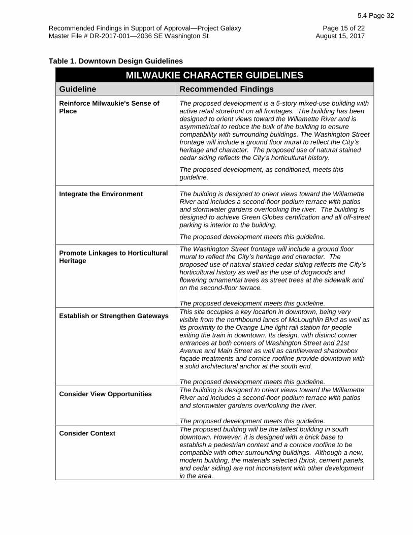
Recommended Findings in Support of Approval—Project Galaxy Page 15 of 22 Master File # DR-2017-001—2036 SE Washington St August 15, 2017
Table 1. Downtown Design Guidelines
MILWAUKIE CHARACTER GUIDELINES
Guideline Recommended Findings
Reinforce Milwaukie's Sense of Place
The proposed development is a 5-story mixed-use building with active retail storefront on all frontages. The building has been designed to orient views toward the Willamette River and is asymmetrical to reduce the bulk of the building to ensure compatibility with surrounding buildings. The Washington Street frontage will include a ground floor mural to reflect the City’s heritage and character. The proposed use of natural stained cedar siding reflects the City’s horticultural history.
The proposed development, as conditioned, meets this guideline.
Integrate the Environment The building is designed to orient views toward the Willamette River and includes a second-floor podium terrace with patios and stormwater gardens overlooking the river. The building is designed to achieve Green Globes certification and all off-street parking is interior to the building.
The proposed development meets this guideline.
Promote Linkages to Horticultural Heritage
The Washington Street frontage will include a ground floor mural to reflect the City’s heritage and character. The proposed use of natural stained cedar siding reflects the City’s horticultural history as well as the use of dogwoods and flowering ornamental trees as street trees at the sidewalk and on the second-floor terrace. The proposed development meets this guideline.
Establish or Strengthen Gateways This site occupies a key location in downtown, being very visible from the northbound lanes of McLoughlin Blvd as well as its proximity to the Orange Line light rail station for people exiting the train in downtown. Its design, with distinct corner entrances at both corners of Washington Street and 21st Avenue and Main Street as well as cantilevered shadowbox façade treatments and cornice roofline provide downtown with a solid architectural anchor at the south end. The proposed development meets this guideline.
Consider View Opportunities The building is designed to orient views toward the Willamette River and includes a second-floor podium terrace with patios and stormwater gardens overlooking the river. The proposed development meets this guideline.
Consider Context The proposed building will be the tallest building in south downtown. However, it is designed with a brick base to establish a pedestrian context and a cornice roofline to be compatible with other surrounding buildings. Although a new, modern building, the materials selected (brick, cement panels, and cedar siding) are not inconsistent with other development in the area.
5.4 Page 32

Recommended Findings in Support of Approval—Project Galaxy Page 16 of 22 Master File # DR-2017-001—2036 SE Washington St August 15, 2017
The proposed development meets this guideline.
Promote Architectural Compatibility
The proposed building design includes natural stained cedar siding which, in addition to the ground floor brick, is compatible with surrounding buildings, including the buildings directly north and west which are brick and wood frame buildings. The fiber cement middle is compatible with surrounding masonry buildings. The proposed development meets this guideline.
Preserve Historic Buildings This guideline does not apply to the proposed development as the site is not identified as an Historic Resource.
Use Architectural Contrast Wisely In addition to the materials selection of brick, fiber cement, and cedar siding, the cantilevered shadowbox effect and bay windows reduce the bulk of the building and provide contrast. The proposed development meets this guideline.
Integrate Art The proposed development includes a ground floor mural on the Washington Street façade and on the south-facing façade visible from Adams Street Connector which will integrate art into the building’s design. The proposed development, as conditioned, meets this guideline.
PEDESTRIAN EMPHASIS GUIDELINES
Guideline Recommended Findings
Reinforce and Enhance the Pedestrian System
Barriers to pedestrian movement and visual and other nuisances should be avoided or eliminated, so that the pedestrian is the priority in all development projects.
The proposed development is proposing new sidewalks that meet the Public Area Requirements on the Main Street and Washington Street frontages. All trash rooms are located inside the building and all utilities will be located inside the building or in sidewalk vaults.
Define the Pedestrian Environment
Provide human scale to the pedestrian environment, with variety and visual richness that enhance the public realm.
The proposed design addresses pedestrians, and creates a human-scale environment, in a number of ways:
• Includes active retail storefronts on all 3 frontages with glass overhead doors for shops
• Significant entrances at both corners with Washington Street
• New sidewalks are proposed on the Main Street and Washington Street frontages
• Fixed canopies over all entrances are proposed to protect pedestrians from the elements
5.4 Page 33

Recommended Findings in Support of Approval—Project Galaxy Page 17 of 22 Master File # DR-2017-001—2036 SE Washington St August 15, 2017
• A ground floor mural is proposed on the Washington Street facade
• The building is proposed with a zero lot line, establishing a street wall to reflect an urban character
The proposed development, as conditioned, meets this guideline.
Protect the Pedestrian from the Elements
Fixed canopies are proposed to protect from elements. The proposed development meets this guideline.
Provide Places for Stopping and Viewing
The proposed development provides places for stopping and view by including the following:
• Active retail storefronts on all 3 frontages with glass overhead doors for shops
• Significant entrances at both corners with Washington Street
• Fixed canopies over all entrances are proposed to protect pedestrians from the elements
• A ground floor mural is proposed on the Washington Street facade
The proposed development, as conditioned, meets this guideline.
Create Successful Outdoor Spaces This guideline does not apply to the Building Façade Details standard.
Integrate Barrier-free Design This guideline does not apply to the Building Façade Details standard.
ARCHITECTURE GUIDELINES
Guideline Recommended Findings
Corner Doors The proposed design includes prominent retail/commercial entrances at both corners on the site with Washington Street. The proposed development, as conditioned, meets this guideline.
Retail and Commercial Doors Storefronts are proposed to have full glass door, including double doors with transom lights and side lights and glass overhead garage doors to retail shops to connect the building to the street and, thereby, to pedestrians. The proposed development meets this guideline.
Residential Doors This guideline does not apply to the proposed development.
Wall Materials The proposed development promotes permanence through a design intended to convey a contemporary northwest style of architecture with a brick base, fiber cement clad middle, and cedar siding at the top and on the bay windows. The proposed development meets this guideline.
Wall Structure The proposed development provides scale defining devices through:
5.4 Page 34

Recommended Findings in Support of Approval—Project Galaxy Page 18 of 22 Master File # DR-2017-001—2036 SE Washington St August 15, 2017
• The facades have a tripartite façade division of base, middle, and top with an overhanging cornice like established neighbors (compatibility)
• Brick base establishes the pedestrian scale like established neighbors
• The 5th floor is differentiated to reduce its overall perceived height to be compatible with the Milwaukie downtown scale
• Vertical stacking of windows, piers, and bay windows The proposed development meets this guideline.
Retail Windows The proposed design creates successful retail windows through:
• Large glass storefront windows at all retail locations
• All doors are double doors
• All doors have transom lights and side lights
• All retail locations have canopies The proposed development meets this guideline.
Residential Bay Windows Residential projecting windows extend from levels 2-5 and occur on every building elevation and all projecting windows are clad in cedar siding. The proposed development meets this guideline.
Silhouette and Roofline Project Galaxy creates interest and detail in Silhouette and Roofline through:
• Residential projecting windows that extend from levels 2-5 occur on every building elevation
• Continuous cornice overhang at the roof line
• The 5th floor is differentiated to reduce its overall perceived height to be compatible with the Milwaukie downtown scale
The proposed development meets this guideline.
Rooftops The proposed design includes a continuous deep cornice overhang at the roof line which expresses the top of the building wall. The proposed cornice is of sufficient depth (48”) to be proportional to the height of the wall. The proposed development meets this guideline.
Green Architecture The building is proposed to be constructed to achieve Green Globes certification as follows: maximize natural light, high performance envelope, recycled and low VOC materials, stormwater gardens on Level 2, and energy efficient lighting, HVAC, and appliances. The proposed development meets this guideline.
Building Security This guideline does not apply to the Building Façade Details standard.
Parking Structures This guideline does not apply to the Building Façade Details standard.
5.4 Page 35

Recommended Findings in Support of Approval—Project Galaxy Page 19 of 22 Master File # DR-2017-001—2036 SE Washington St August 15, 2017
LIGHTING GUIDELINES
Guideline Recommended Findings
Exterior Building Lighting
The proposed design includes exterior building lighting integral to the façade, particularly on the ground floor. The proposed development meets this guideline.
Parking Lot Lighting This guideline does not apply to the Building Façade Details standard.
Landscape Lighting This guideline does not apply to the Building Façade Details standard.
Sign Lighting No signs are proposed as part of this application. This guideline is not applicable to this project.
SIGN GUIDELINES
Guideline Recommended Findings
(7 guidelines related to Signs) No signs are proposed as part of this application. The Sign guidelines are not applicable to this project.
The Planning Commission finds that the proposal, as conditioned, is substantially consistent with the applicable Downtown Design Guidelines and that this approval criterion has been met.
The Planning Commission finds that that with the listed conditions the approval criteria for Downtown Design Review are met.
11. MMC 19.911 Variances
A. MMC 19.911.3 establishes the review process for variance applications.
The applicant has requested the following variances:
• A variance to the requirement in MMC 19.304.5.B.2.d for a 6-foot step back for a
street-facing portion of the building. This type of variance is not specified in the
list of Type II variances.
• A Variance from the access spacing standards in MMC 12.16.040.C.4.c., which
is not specified in the list of Type II variances
The Planning Commission finds that the Variance application for the 2 variances is subject
to Type III Variance review.
B. MMC 19.911.4.B establishes criteria for approving Type III Variance applications.
An application for a Type III Variance shall be approved when all of the criteria in
either 19.911.4.B.1 or 2 have been met. An applicant may choose which set of criteria
5.4 Page 36

Recommended Findings in Support of Approval—Project Galaxy Page 20 of 22 Master File # DR-2017-001—2036 SE Washington St August 15, 2017
to meet based upon the nature of the variance request, the nature of the development
proposal, and the existing site conditions.
The applicant has chosen to address the criteria of 19.911.4.B.1 Discretionary Relief
Criteria.
(1) The applicant’s alternatives analysis provides, at a minimum, an analysis of the
impacts and benefits of the variance proposal as compared to the baseline code
requirements.
The applicant’s narrative addresses this code section as follows:
• Street Spacing: The Washington Street frontage is 210 ft in length. The
development is required to have a single curb cut on Washington Street to
access the parking garage as vehicular access is prohibited on Main Street and
21st Avenue. The curb cut to access the garage is located mid-block to stay as
far away from either corner as possible. Washington Street is a collector road.
The code requires 300-ft spacing for accessways on collector roads and the
spacing proposed is less than 150 ft.
• Step Back: To address the variance to the 6-ft step back requirement, the
applicant states that the building exterior is designed to promote permanence
and quality. The facades have a tripartite façade division of base, middle, and top
with an overhanging cornice. The 5th floor is differentiated to reduce its overall
perceived height to be compatible with the Milwaukie downtown scale. Level 5
has a continuous cornice at the roof line and is materially differentiated from the
body of the building by being clad in cedar siding. A metal trim band also defines
this level at the 5th floor line.
If the 4th and 5th floors were set back 6 ft on 3 sides, the project would lose
approximately 5,000 sq ft of residential leasable area and at least 16 residential units.
There would also be a significant increase in structural and exterior skin costs to set
back the top floor (transfer beams must be added, plumbing runs would not stack in
the units, HVAC ducts would not stack, and the roofs at the setback areas would
require significant waterproofing as part of the wood frame construction).
The loss of the residential leasable area coupled with the cost of construction would
severely impact the feasibility of the project. The proposed design of the building
addresses the purpose of this standard, resulting in a building that has a reduced
perceived bulk, particularly as it is an asymmetrical design and L-shaped.
The Planning Commission finds that this criterion is met.
(2) The proposed variance is determined by the Planning Commission to be both
reasonable and appropriate, and it meets one or more of the following criteria:
(a) The proposed variance avoids or minimizes impacts to surrounding
properties.
5.4 Page 37

Recommended Findings in Support of Approval—Project Galaxy Page 21 of 22 Master File # DR-2017-001—2036 SE Washington St August 15, 2017
No impacts to surrounding properties by either variance have been identified.
The proposed curb cut to the garage has been located at mid-block to stay as far
away from either corner as possible. The applicant submitted a traffic study to the
City of Milwaukie that shows minimal impact to the street system from the parking
garage.
For the step-back requirement, the 5th floor is differentiated to reduce its overall
perceived height to be compatible with the Milwaukie downtown scale, and is treated
similar to the setback architecturally to create the desired architectural scale desired
by the zoning code
As conditioned, the Planning Commission finds that this criterion is met.
(b) The proposed variance has desirable public benefits.
“Public benefits” are typically understood to refer to benefits to be enjoyed by
members of the general public as a result of a particular project, or preservation of
a public resource.
The variances allow for the project to move forward and for more housing units to
be built in the downtown, which addresses a need identified in the Housing Needs
Analysis.
As conditioned, the Planning Commission finds that this criterion is met.
(c) The proposed variance responds to the existing built or natural
environment in a creative and sensitive manner.
This criterion encourages flexibility in site planning and development when the
existing built or natural environment provide challenges to standard development or
site planning.
The Planning Commission finds that this criterion is not applicable.
(3) Impacts from the proposed variance will be mitigated to the extent practicable.
As noted in Finding 11.B (1), the Commission finds there are no negative impacts.
As conditioned, the proposed variances to minimum access spacing and required 6-
ft step back requirement are reasonable and design solutions have been proposed
to provide an alternative to reduce structural bulk.
The Planning Commission finds that this criterion is met.
The Planning Commission finds that the Variance criteria are satisfied.
12. Notice of the proposed changes was given to the following agencies and persons: City of Milwaukie Community Development, Building, and Engineering Departments; Clackamas Fire District #1; Historic Milwaukie Neighborhood District Association (NDA); Clackamas County; Metro; Oregon Department of Transportation; North Clackamas School District; and the Design and Landmarks Committee. The comments received are summarized as follows:
5.4 Page 38

Recommended Findings in Support of Approval—Project Galaxy Page 22 of 22 Master File # DR-2017-001—2036 SE Washington St August 15, 2017
• Ray Bryan, Chair, Historic Milwaukie NDA: The NDA asked about: o the impact of this project on the adjacent property at 11138 SE Main St; o the blank wall on the south-facing façade and if vegetation or design elements
could be added to address it; o any outdoor public amenities and if pedestrian access would be compromised on
the sidewalk; o the potential for improving the signalized intersections in the immediate vicinity; o proposed signage, o the name of the development, and if the existing neon Bernard’s sign will be
incorporated.
• Seth Brumley, ODOT Region 1 Planner on behalf of ODOT Rail: Comments included the following:
o Any proposed vegetation along the 21st Avenue frontage shall provide acceptable sight lines for pedestrian safety
o Changes to signal timing at 21st Avenue and Washington Street and 21st Avenue and Adams Street will require authorization
o Changes to roadway or sidewalk widths, crosswalk modifications, or bike lane modifications will require authorization through a Crossing Order
o Ultimate tenant occupancy and build out conditions may necessitate additional traffic studies
o Degradation to the existing traffic control system due to construction shall be immediately remedied per the Crossing Orders for the impacted locations.
• Matt Amos, Clackamas Fire District #1: comments regarding a required access and water supply test to be submitted during the development permit process.
• Doug Naef, owner of 2025-2045 SE Washington St: supports approval of the application as submitted.
5.4 Page 39

Recommended Conditions of Approval File # DR-2017-001
Project Galaxy, 2036 SE Washington St.
1. The applicant shall submit a Type I Development Review application with final construction plans for construction of the building.
a. Final plans submitted for development permit review shall be in substantial conformance with plans approved by this action, which are the plans stamped received by the City on July 7, 2017 and revised on July 20, 2017, except as otherwise modified by these conditions.
b. Provide a narrative describing all actions taken to comply with these conditions of approval.
c. Provide a narrative describing any changes made after the issuance of this land use decision that are not related to these conditions of approval.
2. Expiration of Approval
As per MMC 19.1001.7.E.1.a, proposals requiring any kind of development permit must complete both of the following steps:
a. Obtain and pay for all necessary development permits and start construction within two (2) years of land use approval.
b. Pass final inspection and/or obtain a certificate of occupancy within four (4) years of land use approval.
As per MMC 19.1001.7.E.2.b, land use approvals shall expire unless both steps noted above have been completed or unless the review authority specifies a different expiration date in the land use decision to accommodate large, complex, or phased development projects.
3. Prior to final inspection, the following shall be resolved:
a. Subject to MMC 20.04, murals are required to be installed on the southern-facing wall as well as the Washington Street façade on either side of the garage entrance door. It is recommended that the Applicant consult with ArtMob in developing the artwork.
b. Submit a storm water management plan to the City of Milwaukie Engineering Department for review and approval. The plan shall be prepared in accordance with Section 2 – Stormwater Design Standards of the City of Milwaukie Public Works Standards. Private properties may only connect to public storm system if percolation tests show that infiltration cannot be obtained on site. In the event the storm management system contains underground injection control devices, submit proof of acceptance of the storm system design from the Department of Environmental Quality.
c. Submit full-engineered plans for construction of all required public improvements, reviewed and approved by the City of Milwaukie Engineering Department.
d. Obtain a right-of-way permit for construction of all required public improvements listed in these recommended conditions of approval.
e. Pay an inspection fee equal to 5.5% of the cost of the public improvements.
5.4 Page 40ATTACHMENT 2

Recommended Conditions of Approval—Project Galaxy Page 2 of 2 Master File # DR-2017-001—2036 SE Washington St August 15, 2017
f. Provide a payment and performance bond for 100 percent of the cost of the required public improvements.
g. Provide an erosion control plan and obtain an erosion control permit.
h. Install all underground utilities, including stubs for utility service prior to surfacing any streets.
i. Construct 12-foot sidewalks, curb and gutter, street lighting and utility undergrounding on Washington Street frontage. Construct 16-foot sidewalks, curb and gutter, street lighting and utility underground on Main Street frontage. Remove driveway approach on 21st Frontage and replace with curb & gutter and sidewalk.
j. Construct a driveway approach to meet all guidelines of the Americans with Disabilities Act (ADA) to each new lot. The driveway approach aprons shall be between 24 feet and 36 feet in width.
k. Clear vision areas shall be maintained at all driveways and accessways and on the corners of all property adjacent to an intersection.
l. Provide a final approved set of Mylar and electronic PDF “As Constructed” drawings to the City of Milwaukie prior to final inspection.
m. Remove all signs, structures, or vegetation in excess of three feet in height located in “vision clearance areas” at intersections of streets, driveways, and alleys fronting the proposed development.
n. Submit an access and water supply test as required by the Clackamas Fire District #1 for full review and approval.
5.4 Page 41

*For multiple applications, this is based on the highest required review type. See MMC Subsection 19.1001.6.B.1.
PLANNING DEPARTMENT 66101 SE Johnson Creek Blvd Milwaukie OR 97206
PHONE: 503-786-7630 FAX: 503-774-8236 E-MAIL: [email protected]
Application forLand Use Action
Master File #: _______________
Review type*: I II III IV V
CHOOSE APPLICATION TYPE(S):
Use separate application forms for:
Annexation and/or Boundary Change
Compensation for Reduction in Property
Value (Measure 37)
Daily Display Sign
Appeal
RESPONSIBLE PARTIES:
APPLICANT (owner or other eligible applicant—see reverse):
Mailing address: Zip:
Phone(s): E-mail:
APPLICANT'S REPRESENTATIVE (if different than above):
Mailing address: Zip:
Phone(s): E-mail:
SITE INFORMATION:
Address: Map & Tax Lot(s):
Comprehensive Plan Designation: Zoning: Size of property:
PROPOSAL (describe briefly):
SIGNATURE:
ATTEST: I am the property owner or I am eligible to initiate this application per Milwaukie Municipal Code (MMC)Subsection 19.1001.6.A. If required, I have attached written authorization to submit this application. To the best of my knowledge, the information provided within this application package is complete and accurate.
Submitted by: Date:
IMPORTANT INFORMATION ON REVERSE SIDE
Downtown Design Review
Variance: Variance
...
...
...
Kurt Schultz- SERA Architects338 NW 5th Avenue Portland OR 97209
503-445-7312 [email protected]
2036 SE Washington Street C224589 ... DMU 25,523.00 Sq Ft
Project Galaxy is a new 5 story mixed-use Transit Oriented Development in downtown Milwaukie. The project is located on the present location of Bernard’s Garage at 2036 SE Washington Street. Land Use reviews requested are a Type III downtown design review plus a Type III variance
June 2, 2017
RESET
ATTACHMENT 3
Z:\Planning\Administrative - General Info\Applications\LU Application AF.doc—Rev. 1
WHO IS ELIGIBLE TO SUBMIT A LAND USE APPLICATION (excerpted from MMC Subsection 19.1001.6.A):
Type I, II, III, and IV applications may be initiated by the property owner or contract purchaser of the subject property, any person authorized in writing to represent the property owner or contract purchaser, and any agency that has statutory rights of eminent domain for projects they have the authority to construct.
Type V applications may be initiated by any individual.
PREAPPLICATION CONFERENCE:
A preapplication conference may be required or desirable prior to submitting this application. Please discuss with Planning staff.
REVIEW TYPES:
This application will be processed per the assigned review type, as described in the following sections of the Milwaukie Municipal Code:
Type I: Section 19.1004
Type II: Section 19.1005
Type III: Section 19.1006
Type IV: Section 19.1007
Type V: Section 19.1008
THIS SECTION FOR OFFICE USE ONLY:
FILETYPE FILE NUMBER
FEE AMOUNT*
PERCENT DISCOUNT
DISCOUNT TYPE
DEPOSIT AMOUNT DATE STAMP
Master file $ $
Concurrent application files
$ $
$ $
$ $
$ $
SUBTOTALS $ $
TOTAL AMOUNT RECEIVED: $ RECEIPT #: RCD BY:
Associated application file #s (appeals, modifications, previous approvals, etc.):
Neighborhood District Association(s):
Notes:
*After discount (if any)


Memorandum
Date 07/20/2017Project Name Project Galaxy Milwaukie
Subject Type III Downtown Design Review Application
LAND USE REVIEWS REQUESTED
Type III downtown design review
Type III varianceo Variance from the MMC 19.304.5.B.2.d requirement for a
6-foot step back for a street-facing portion of thebuilding…
o Variance from the access spacing standards in MMC12.16.040.C.4.c.
PROJECT GALAXY NARRATIVE
Project Galaxy is a new 5 story mixed-use Transit Oriented Development in downtown Milwaukie. The project is located on the present location of Bernard’s Garage at 2036 SE Washington Street. The 25,523 SF “L” shaped lot is bounded by SE Washington Street to the north, SE Main Street to the west, and SE 21st Ave to the east. The Milwaukie/Main Streetorange line Max station is located 1 block to the south near SE 21st Ave and SE Adams Street. Currently Bloom garden supply is located to the south of the property. Project Galaxy will be a highly sustainable projectthat is pursuing a Green Globes certification.
Project Galaxy will provide 110 market rate apartments ranging from studios, 1 bedroom lofts, traditional 1 bedrooms units, and 2 bedroom units on levels 2-5. The ground floor will provide 8,000 sf of retail/commercial space fronting SE 21st Ave and SE Main Street. The residential lobby will face east towards SE 21st Ave to be convenient to the max stop. Parking is accessed midblock on SE Washington Street and 78 mechanical parking spaces will be provided for the building residents. Bike parking will also be located adjacent to the vehicular parking. The ground floor will be built property line tight on all sides to reinforce its urban location.
The residential floors on levels 2-5 will be in an “L” shaped configuration with the wings aligning with SE 21st Ave and SE Washington Street. An occupied rooftop will be provided on level 2 on top of the concrete podium below. A building common room and fitness room will have access out onto the roof terrace. There will also be private residential patios on this podium roof as well as storm-water planters to treat water collected on the roof.
The building exterior will be designed to promote permanence and quality as well as comply with the Milwaukie Downtown Design Guidelines. The facades have a tripartite façade division of base, middle, and top with an
RECEIVED BY THE MILWAUKIE
PLANNING DEPARTMENT ON
JULY 20, 2017.

Memorandum Page 2 of 18
overhanging cornice. The exterior is designed to convey a contemporary northwest style of architecture with a brick base, fiber cement clad body (middle), and cedar siding at the top and on the bay windows. The building is deliberately asymmetrical to convey that this is an inviting residential building meant for modern living in the urban environment. The 5th floor is differentiated to reduce its overall perceived height to be compatible with the Milwaukie downtown scale. Project Galaxy is designed to be a model for sustainable transit oriented mixed use infill projects in downtown Milwaukie.
1. BASE ZONE STANDARDS
19.304 DOWNTOWN ZONES COMPLIANCE
19.304.5A FAR 4:1, bonus for structured parking (.5 SF of additional FAR for every 1 SF of structured parking) Complies. Site area is 25,523 SF. Base FAR allowable is 102,092 SF. We provide 10,000 SF of structured parking for a bonus of 5,000 SF. Total FAR allowable is then 107,692. Actual Project FAR is 103,146 SF, below the maximum allowable.
19.304.5B HEIGHT: 3 stories and 45’ base height (both together, not either-or) Height bonus of 2 stories (5 max) and 24’ (57’ max) if you do achieve a minimum of 2 incentive bonuses listed
a) 25% of gross area in residential
b) Lodging c) Green building certification d) Building height variance
(Type III process) Complies. Height is 57’. 12’ height bonus achieved through bonus a. An additional story is achieved through bonus c. green building (Green Globes certification)
19.304.5B2d Requires a 6’ setback for any street facing portion of the building that is above the base maximum height. The 6’ top floor setback can also be modified through a Type III variance. Per 19.304.8 we are seeking a variance from this standard. See variance application narrative 19.304.5C2b1 14’ minimum clear ceiling at level 1 on Main Street Complies. 19.304.5C2b2 Interior area adjacent to main street 20’ deep minimum Complies.

Memorandum Page 3 of 18
19.304.5D2bStreet setbacks/build to linesComplies.
19.304.5EFrontage occupancyComplies.
19.304.5FPrimary Entrance Standards. If a development is on the corner of Main street and another street, the main entrance shall be oriented towards Main street (or can be 45 degrees at corner). Retail entrances also meet this requirement.Complies.
19.304.5GOff Street ParkingOff street parking required per 19.600. 1 space per dwelling unit (800 sf or less). 1.25 spaces per dwelling unit (over 800 sf)Complies. 8 units over 800 SF=10 stalls required. 101 units less than 800 SF=101 stalls required. (111 total required).
25% reduction for proximity to public transit= 27 stall reduction
10% reduction for additional bicycle parking=11 stall reduction
30% maximum reduction in the downtown mixed use zone =33stall reduction max
111-33=78 stalls required, 78 stalls provided in mechanical parking
2. OVERLAY ZONE STANDARDS
19.508 DOWNTOWN SITE AND BUILDING DESIGN STANDARDS
19.508.1 PurposeThe design standards contained in this section are intended to encourage building design and construction with durable, high-quality materials. The design standards will support the development of a cohesive, attractive, and safe downtown area and encourage private investment. The design standards do not prescribe a particular building or architectural style.
19.508.4 Building Design Standards
All buildings that meet the applicability provisions in Subsection 19.508.2 shall meet the following design standards. An architectural feature may be used to comply with more than one standard.A. Building Façade Details1. PurposeTo provide cohesive and visually interesting building façades in the downtown, particularly along the ground floor.
2. Nonresidential and Mixed-Use BuildingsThe following standards apply only to nonresidential and mixed-use buildings.
REVISED SECTION
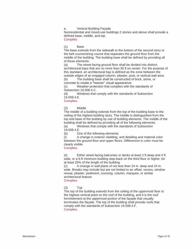
Memorandum Page 4 of 18
a. Vertical Building FaçadeNonresidential and mixed-use buildings 2 stories and above shall provide a defined base, middle, and top.Complies.
(1) BaseThe base extends from the sidewalk to the bottom of the second story or the belt course/string course that separates the ground floor from the middle of the building. The building base shall be defined by providing all of these elements:(a) The street-facing ground floor shall be divided into distinct architectural bays that are no more than 30 ft on center. For the purpose of this standard, an architectural bay is defined as the zone between the outside edges of an engaged column, pilaster, post, or vertical wall area.(b) The building base shall be constructed of brick, stone, or concrete to create a “heavier” visual appearance.(c) Weather protection that complies with the standards of Subsection 19.508.4.C.(d) Windows that comply with the standards of Subsection 19.508.4.E.Complies.
(2) MiddleThe middle of a building extends from the top of the building base to the ceiling of the highest building story. The middle is distinguished from the top and base of the building by use of building elements. The middle of the building shall be defined by providing all of the following elements:(a) Windows that comply with the standards of Subsection 19.508.4.E.(b) One of the following elements:(i) A change in exterior cladding, and detailing and material color between the ground floor and upper floors. Differences in color must be clearly visible.Complies.
(ii) Either street-facing balconies or decks at least 2 ft deep and 4 ft wide, or a 6-ft minimum building step-back on the third floor or higher, for at least 25% of the length of the building.(c) A change in wall plane of not less than 24 in. deep and 24 in. wide. Breaks may include but are not limited to an offset, recess, window reveal, pilaster, pediment, coursing, column, marquee, or similar architectural feature.Complies.
(3) TopThe top of the building extends from the ceiling of the uppermost floor to the highest vertical point on the roof of the building, and it is the roof form/element at the uppermost portion of the façade that visually terminates the façade. The top of the building shall provide roofs that comply with the standards of Subsection 19.508.4.F.Complies.

Memorandum Page 5 of 18
b. Horizontal Building Façade(1) Horizontal datum lines—such as belt lines, cornices, or upper-floor windows—shall line up with adjacent façades if applicable.Complies.
(2) Significant breaks shall be created along building façades at least every 150 linear ft by either setting the façade back at least 20 ft or breaking the building into separate structures. Breaks shall be at least 15 ft wide and shall be continuous along the full height of the building. The area or areas created by this break shall meet the standards of Subsection 19.304.5.H.This standard is not met on SE Washington. This requirement is mitigatedby the use of multiple bay windows and architectural features to give variety to the north building facade, as well as public art on the ground floor.
3. Residential Buildingsa. Stand-alone multifamily residential buildings are subject to the objective standards of Subsection 19.505.3.D.6 Building Façade Design, with the exception of the private and public open space requirements of Subsections 19.505.3.D.1 and 2. The open space requirements of Subsection 19.508.5 apply to stand-alone multifamily residential buildings in downtown.b. Rowhouses are subject to the objective standards of Subsection 19.505.5 Rowhouses, as revised by Subsection 19.304.3.B.c. Live/work units are subject to the objective standards in Subsection 19.505.6 Live/Work Units.
B. Corners1. PurposeTo create a strong architectural statement at street corners and establish visual landmarks and enhance visual variety.2. Nonresidential or Mixed-Use BuildingsNonresidential or mixed-use buildings at the corner of two public streets—or at the corner of a street and a public area, park, or plaza—shallincorporate two of the following features (for the purposes of this standard an alley is not considered a public street):a. The primary entry to the building located within 5 ft of the corner.Complies.
b. A prominent architectural element, such as increased building height or massing, a cupola, a turret, or a pitched roof at the corner of the building or within 20 ft of the corner of the building.Complies.
c. The corner of the building cut at a 45° angle or a similar dimension “rounded” corner.d. A combination of special paving materials; street furnishings; and, where appropriate, plantings, in addition to the front door.
C. Weather Protection1. PurposeCreate an all-season pedestrian environment.2. Weather Protection RequiredAll buildings shall provide weather protection for pedestrians as follows:

Memorandum Page 6 of 18
a. Minimum Weather Protection Coverage(1) All ground-floor building entries shall be protected from the weather by canopies or recessed behind the front building façade at least 3 ft.(2) Permanent awnings, canopies, recesses, or similar weather protection shall be provided along at least 50% of the ground-floorelevation(s) of a building where the building abuts a sidewalk, civic space, or pedestrian accessway.(3) Weather protection used to meet the above standard shall extend at least 4 ft, and no more than 6 ft, over the pedestrian area, and a maximum of 4 ft into the public right-of-way. Balconies meeting these dimensional requirements can be counted toward this requirement.(4) In addition, the above standards do not apply where a building has a ground-floor dwelling, as in a mixed-use development or live-work building, and the dwelling entrance has a covered entrance.b. Weather Protection DesignWeather protection shall comply with applicable building codes and shall be designed to be visually compatible with the architecture of a building. Where applicable, weather protection shall be designed to accommodate pedestrian signage (e.g., blade signs) while maintaining required vertical clearance.Complies.
D. Exterior Building Materials
1. PurposeTo encourage the construction of attractive buildings with materials that evoke a sense of permanence and are compatible with downtown Milwaukie and the surrounding built and natural environment.2. Exterior Wall StandardsThe following standards are applicable to the street-facing façades of all new buildings. For the purposes of this standard, street-facing façades are those abutting streets, courtyards, and/or public squares in all of the downtown. Table 19.508.4.D specifies the primary, secondary, and prohibited material types referenced in this standard.a. Buildings shall utilize primary materials for at least 65% of each applicable building façade.b. Secondary materials are permitted on no greater than 35% of each applicable building façade.c. Accent materials are permitted on no greater than 10% of each applicable building façade as trims or accents (e.g. flashing, projecting features, ornamentation, etc.).d. Buildings shall not use prohibited materials on any exterior wall, whether or not it is a street-facing façade.Complies. The project utilizes brick masonry and cedar wood siding as a primary building material and fiber reinforced cement siding as a secondary building material.
E. Windows and Doors
1. PurposeTo enhance street safety and provide a comfortable pedestrian environment by adding interest to exterior façades, allowing for day lighting of interior space, and creating a visual connection between interior and exterior spaces.

Memorandum Page 7 of 18
2. Main Street For block faces along Main St, 50% of the ground-floor street wall area must consist of openings; i.e., windows or glazed doors. The ground-floor street wall area is defined as the area up to the finished ceiling height ofthe space fronting the street or 15 ft above finished grade, whichever isless.Complies
.3. Other Streets For all other block faces, the exterior wall(s) of the building facing thestreet/sidewalk must meet the following standards: a. 40% of the ground-floor street wall area must consist ofopenings; i.e., windows or glazed doors. b. Along McLoughlin Blvd the required coverage is 30%. Complies
4. Upper LevelAlong all block faces, the following standards are applicable on the upper-level building façades facing a street or public space. a. Upper building stories shall provide a minimum of 30% glazing. For the purposes of this standard, minimum glazing includes windows andany glazed portions of doors. b. The required upper-floor window/door percentage does not apply to floors where sloped roofs and dormer windows are used. c. A minimum of 60% of all upper-floor windows shall be vertically oriented. This vertical orientation applies to grouped window arrays as opposed to individual windows.
.5. General Standardsa. Windows shall be designed to provide shadowing. This can be accomplished by recessing windows 4 in into the façade and/or incorporating trim of a contrasting material or color.b. All buildings with nonresidential ground-floor windows must have a visible transmittance (VT) of 0.6 or higher.c. Doors and/or primary entrances must be located on the street-facing block faces and must be unlocked when the business located on the premises is open. Doors/entrances to second-floor residential units may be locked.d. The bottom edge of windows along pedestrian ways shall be constructed no more than 30 in above the abutting walkway surface.e. Ground-floor windows for nonresidential buildings shall allow views into storefronts, working areas, or lobbies. No more than 50% of the window area may be covered by interior furnishings including, but not limited to, curtains, shades, signs, or shelves.f. Signs are limited to a maximum coverage of 20% of the required window area.Complies.
6. Prohibited Window Elements
For all building windows facing streets, courtyards, and/or public squares in the downtown, the following window elements are prohibited:a. Reflective, tinted, or opaque glazing.b. Simulated divisions (internal or applied synthetic materials).

Memorandum Page 8 of 18
c. Exposed, unpainted metal frame windows.Complies.
F. Roofs and Rooftop Equipment
1. PurposeTo create a visually interesting condition at the top of the building that enhances the quality and character of the building.2. Roof Formsa. The roof form of a building shall follow one (or a combination) of the following forms:(1) Flat roof with parapet or cornice.(2) Hip roof.(3) Gabled roof.(4) Dormers.(5) Shed roof.b. All flat roofs, or those with a pitch of less than 4/12, shall be architecturally treated or articulated with a parapet wall that projects vertically above the roofline at least 12 in and/or a cornice that projects from the building face at least 6 in.c. All hip or gabled roofs exposed to view from adjacent public or private streets and properties shall have a minimum 4/12 pitch.d. Sloped roofs shall have eaves, exclusive of rain gutters, that project from the building wall at least 12 ine. When an addition to an existing structure, or a new structure, is proposed in an existing development, the roof forms for the new structure(s) shall have similar slope and be constructed of the same materials as the existing roofing.3. Rooftop Equipment and Screeninga. The following rooftop equipment does not require screening:(1) Solar panels, wind generators, and green roof features.(2) Equipment under 2 ft high, if set back a minimum of 5 ft from the outer edge of the roof.b. Elevator mechanical equipment may extend above the height limit a maximum of 16 ft, provided that the mechanical shaft is incorporated into the architecture of the building.c. Satellite dishes, communications equipment, and all other roof-mounted mechanical equipment shall be limited to 10 ft high, shall be set back a minimum of 10 ft from the roof edge, and shall be screened from public view and from views from adjacent buildings by one of the following methods:(1) A screen around the equipment that is made of a primary exterior finish material used on other portions of the building, wood fencing, or masonry.(2) Green roof features or regularly maintained dense evergreen foliage that forms an opaque barrier when planted.d. Required screening shall not be included in the building’s maximum height calculation.4. Rooftop StructuresRooftop structures related to shared outdoor space—such as arbors, trellises, or porticos related to roof decks or gardens—shall not be included in the building’s maximum height calculation, as long as they do not exceed 10 ft high.Complies.

Memorandum Page 9 of 18
G. Open Space/Plazas
1. IntentTo assure adequate public and private open space in the downtown.2. Mixed-Use and Residential DevelopmentThe following standards apply to mixed-use buildings with more than 4 residential units and residential-only multifamily developments.a. Outdoor Space Required50 sq ft of private or common open space is required for each dwelling unit. The open space may be allocated exclusively for private or common use, or it may be a combination of the two uses.b. Common Open Space(1) Common open space may be provided in the form of decks, shared patios, roof gardens, recreation rooms, lobbies, or other gathering spaces created strictly for the tenants and not associated with storage or circulation. Landscape buffer areas may not be used as common open space unless active and passive uses are integrated into the space and its use will not adversely affect abutting properties.(2) With the exception of roof decks or gardens, outdoor common open space shall be abutted on at least two sides by residential units or by nonresidential uses with windows and entrances fronting on the space.c. Private Open Space(1) Private open space may be provided in the form of a porch, deck, balcony, patio, terrace, or other private outdoor area.(2) The private open space provided shall be contiguous with the unit.(3) Balconies used for entrances or exits shall not be considered as private open space except where such exits or entrances are for the sole use of the unit.(4) Balconies may project up to a maximum of 4 ft into the public right-of-way.d. Credit for Open SpaceAn open space credit of 50% may be granted when a development is directly adjacent to, or across a public right-of-way from, an improved public park.Complies. Common open space is provided in the form of the building lobby, fitness room, 2nd floor amenity room, and outdoor roof deck. Private open space is provided on the second floor private terraces.

Memorandum Page 10 of 18
MILWAUKIE DOWNTOWN DESIGN GUIDELINES 1. Milwaukie Character Guidelines These guidelines address Milwaukie’s unique “sense of place,” its special quality and personality. People’s image of Milwaukie is that of an All-American riverfront town which is hospitable and family oriented. The guidelines address what gives Milwaukie this feeling, this “character” as a unique collection of spaces and buildings, not simply a group of individual projects that could be anywhere. The Milwaukie Character Guidelines consist of the following sections: • Reinforce Milwaukie’s Sense of Place Project Galaxy reinforces Milwaukie Character through:
Active retail storefront at all street frontages
Use of natural stained cedar siding to reinforce Milwaukie’s rich heritage of tree horticulture
Use of a ground floor mural that reflects Milwaukie heritage and character on SE Washington Street
Views oriented to the riverfront
Small town urban character • Integrate the Environment Project Galaxy integrates the environment through:
Views oriented to the riverfront
Second floor podium roof is an occupied terrace with patios and storm-water gardens overlooking the river
All parking located inside the building
Green building certification
• Promote Linkages to Horticultural Heritage Project Galaxy promotes linkages to Horticultural Heritage through:
Use of natural stained cedar siding to reinforce Milwaukie’s rich heritage of tree horticulture
Use of a ground floor mural that reflects Milwaukie heritage and character on SE Washington Street
Use of dogwoods and flowering ornamental trees at the sidewalk and podium level of the building
• Establish or Strengthen Gateways Project Galaxy strengthens gateways through:
Strong architectural features at both primary building gateways (NE and NW corners) with shadowbox cantilever form with cedar siding infill and staggered windows
Retail/commercial anchors both primary building gateways (NE and NW corners)
• Consider View Opportunities Project Galaxy maximizes view opportunities through:
Building organized to maximize residential units with river views
Second floor podium roof is an occupied terrace with patios and storm-water gardens overlooking the river
• Consider Context Project Galaxy enhances the Milwaukie Context through:

Memorandum Page 11 of 18
The facades have a tripartite façade division of base, middle, and top with an overhanging cornice like established neighbors
Brick base establishes the pedestrian scale like established neighbors
• Promote Compatibility Project Galaxy promotes compatibility through:
The facades have a tripartite façade division of base, middle, and top with an overhanging cornice like established neighbors
Brick base establishes the pedestrian scale like established neighbors
The 5th floor is differentiated to reduce its overall perceived height to be compatible with the Milwaukie downtown scale
• Preserve Historic Buildings Not applicable
• Use Architectural Contrast Wisely Project Galaxy promotes wise contrast through:
The facades have a tripartite façade division of base, middle, and top with an overhanging cornice like established neighbors (compatibility)
Brick base establishes the pedestrian scale like established neighbors (compatibility)
The 5th floor is differentiated to reduce its overall perceived height to be compatible with the Milwaukie downtown scale (compatibility)
The building is clearly the largest building downtown. The building is deliberately asymmetrical to convey that this is an inviting residential building meant for modern living in the urban environment
• Integrate Art Project Galaxy integrates art through:
Use of a ground floor mural that reflects Milwaukie heritage and character on SE Washington Street
2. Pedestrian Emphasis Guidelines In Downtown Milwaukie, the pedestrian is the priority. These guidelines address the ways in which buildings and spaces may be designed to create a convenient, comfortable, human-scaled environment that people will want to be in. The Pedestrian Emphasis Guidelines include the following: • Reinforce and Enhance the Pedestrian System Project Galaxy reinforces the pedestrian system through:
Active retail storefront at all street frontages
New sidewalks all frontages
All parking located inside the building
All trash rooms are inside the building
All utilities are in sidewalk vaults or inside the building
All street frontage have canopies to protect the pedestrian

Memorandum Page 12 of 18
Glass overhead garage doors open up retail shops onto Main Street and the future framers market
• Define the Pedestrian Environment Project Galaxy provides human scale to pedestrian system through:
Active retail storefront at all street frontages with large storefront windows
Walls have brick masonry piers at comfortable bays
All street frontage have canopies to protect the pedestrian
Use of a ground floor art that reflects Milwaukie heritage and character on SE Washington Street
• Protect the Pedestrian from the Elements Project Galaxy protects the pedestrian system through:
All street frontage have fixed canopies to protect the pedestrian
• Provide Places for Stopping and Viewing Project Galaxy provides places to stop and visit in the pedestrian system through:
Active retail storefront at all street frontages with large storefront windows
Setbacks at all building entrances
All street frontage have fixed canopies to protect the pedestrian
Project Galaxy is predominantly property line tight at all frontages to reinforce the urban character of this location
• Create Successful Outdoor Spaces Project Galaxy creates successful outdoor spaces through:
Building organized to maximize residential units with river views and to optimize southern exposure
Second floor podium roof is an occupied terrace with patios and storm-water gardens overlooking the river
• Integrate Barrier-Free Design All building entrances and features are accessible
3. Architecture Guidelines The Architecture Guidelines promote quality development while reinforcing the individuality and spirit of Milwaukie. The guidelines promote architectural types indigenous to Milwaukie and/or the Northwest. Buildings in Milwaukie should seem to be “at home” there, reflecting its character and heritage, suiting its climate, landscape and downtown street grid. Within each downtown planning area, building proposals must consider and respond to selected requirements from the following architectural criteria: • Corner Doors Project Galaxy creates successful entrances through:
Retail/commercial anchors both primary building corners (NE and NW corners) with corner entrances
Doors are of storefront glass

Memorandum Page 13 of 18
• Retail and Commercial Doors Project Galaxy creates successful entrances through:
Large glass storefront doors at all retail entrances
All doors are double doors
All doors have transom lights and side lights
Glass overhead garage doors open up retail shops onto Main Street and the future framers market
• Residential Doors Not applicable
• Wall Materials Project Galaxy promotes permanence through:
The exterior is designed to convey a contemporary northwest style of architecture with a brick base, fiber cement clad middle, and cedar siding at the top and on the bay windows
• Wall Structure Project Galaxy provides scale defining devices through:
The facades have a tripartite façade division of base, middle, and top with an overhanging cornice like established neighbors (compatibility)
Brick base establishes the pedestrian scale like established neighbors
The 5th floor is differentiated to reduce its overall perceived height to be compatible with the Milwaukie downtown scale
Vertical stacking of windows, piers, and bay windows
• Retail Windows Project Galaxy creates successful retail windows through:
Large glass storefront windows at all retail locations
All doors are double doors
All doors have transom lights and side lights
All retail locations have canopies
• Residential Bay Windows Project Galaxy creates incorporates bay windows:
Residential bay windows extending from level 2-5 occur on every building elevation
All bay windows are clad in cedar siding
• Silhouette and Roofline Project Galaxy creates interest and detail in Silhouette and Roofline through:
Residential bay windows extending from level 2-5 occur on every building elevation
Continuous cornice overhang at the roof line
The 5th floor is differentiated to reduce its overall perceived height to be compatible with the Milwaukie downtown scale
• Rooftops Project Galaxy integrates and uses rooftops through:
Second floor podium roof is an occupied terrace with patios and storm-water gardens overlooking the river

Memorandum Page 14 of 18
• Green Architecture Project Galaxy promotes green architecture through:
Green building certification (Green Globes)
Maximizes natural light
High performance envelope
Recycled and low VOC materials
Storm-water gardens on level 2
Energy efficient lighting, appliances, and HVAC systems • Building Security Project Galaxy creates a safe environment through:
Eyes on the street at all street frontages (retail or building lobby)
Parking and loading are inside the buildings
After hours all entrances will have card reader secure entries
No security gates are provided
• Parking Structures Project Galaxy integrates parking through:
All parking is located inside the building in a mechanized parking system and is not visible to the public
4. Lighting Guidelines Lighting should not only provide nighttime security, but also encourage nighttime patronage of businesses and restaurants. Lighting should create an atmosphere of festivity and activity - especially where special elements or places are concerned. Utilitarian application of glaring, offensively colored lights is not appropriate for downtown. Each development proposal must consider and respond to selected requirements from the following lighting criteria:
• Exterior Building Lighting All exterior lighting is integral to the façade composition • Parking Lot Lighting Not applicable. All parking is inside the building
• Landscape Lighting Lighting is used to highlight street trees and second floor podium landscaping • Sign Lighting Not applicable. Signage is not part of this application
5. Sign Guidelines Signs should make it easy to locate and identify businesses as well as providing other information relevant to getting around and doing business in downtown; however, signs should never overwhelm either buildings or landscape. Moreover, signs should provide information in a highly graphic format that is complementary to downtown architecture. Tasteful logos, symbols and graphics are encouraged. A strong pedestrian orientation should be encouraged for all signs. Development proposals must consider and respond to selected requirements from the following sign criteria:

Memorandum Page 15 of 18
Not applicable. Signage is not part of this application • Wall Signs • Hanging or Projecting Signs • Window Signs • Awning Signs • Information and Guide Signs • Kiosks and Monument Signs • Temporary Signs
3. OFF STREET PARKING AND LOADING STANDARDS
Off Street Parking Off street parking required per 19.600. 1 space per dwelling unit (800 sf or less). 1.25 spaces per dwelling unit (over 800 sf) Complies. 8 units over 800 SF=10 stalls required. 101 units less than 800 SF=101 stalls required. (111 total required).
25% reduction for proximity to public transit= 27 stall reduction
10% reduction for additional bicycle parking=11 stall reduction
30% maximum reduction in the downtown mixed use zone =33 stall reduction max
111-33=78 stalls required, 78 stalls provided in mechanical parking
Loading spaces not required in the DMU zone
4. PUBLIC FACILITY STANDARDS 19.702 Applicability 19.702.1 General Chapter 19.700 applies to the following types of development in all zones: A. Partitions. B. Subdivisions. C. Replats that increase the number of lots. D. New construction. Applicable E. Modification or expansion of an existing structure or a change or intensification in use that results in any one of the following. See Subsections 19.702.2-3 for specific applicability provisions for single-family residential development and development in downtown zones. 1. A new dwelling unit. Applicable 2. Any increase in gross floor area. Applicable 3. Any projected increase in vehicle trips, as determined by the Engineering Director. Applicable
19.708.1 General Street Requirements and Standards A. Access Management All development subject to Chapter 19.700 shall comply with access management standards contained in Chapter 12.16. Complies B. Clear Vision All development subject to Chapter 19.700 shall comply with clear vision standards contained in Chapter 12.24. Complies

Memorandum Page 16 of 18
C. Development in Downtown Zones Street design standards and right-of-way dedication for the downtown zones are subject to the requirements of the Milwaukie Public Works Standards, which implement the streetscape design of the Milwaukie Downtown and Riverfront Plan: Public Area Requirements (PAR). Unless specifically stated otherwise, the standards in Section 19.708 do not apply to development located in the downtown zones or on street sections shown in the PAR per Subsection 19.304.6. Complies
TYPE III VARIANCES REQUESTED
Variance from the MMC 19.304.5.B.2.d requirement for a 6-foot step back for a street-facing portion of the building
MMC 19.304.5.B.2.d requires that buildings shall provide a step back of at least 6’ for any street facing portion of the building above the base maximum height (45’). We propose a 5 story building 57’ in height. MMC 19.304.5.B.2.d would require a 6’ setback above 45’ at level 5, the top floor of the project, along SE Main, SE Washington, and SE 21st Ave.
1. Discretionary Relief Criteria a. The applicant’s alternatives analysis provides, at a minimum, an analysis of the impacts and benefits of the variance proposal as compared to the baseline code requirements.
The building exterior is be designed to promote permanence and quality as well as the Milwaukie Downtown Design Guidelines. The facades have a tripartite façade division of base, middle, and top with an overhanging cornice. The 5th floor is differentiated to reduce its overall perceived height to be compatible with the Milwaukie downtown scale. Level 5 has a continuous cornice at the roof line and is materially differentiated from the body of the building by being clad in cedar siding. A metal trim band also defines this level at the 5th floor line. If the 5th floor was set back 6’ on 3 sides, the project would lose 2,500 SF of residential leasable area on level 5 and at least 8 residential units. There would also be a significant increase in structural and exterior skin costs to set back the top floor (transfer beams must be added, plumbing runs would not stack in the units, HVAC ducts would not stack, and the roofs at the setback areas would require significant waterproofing in wood frame construction). b. The proposed variance is determined by the Planning Commission to be both reasonable and appropriate, and it meets one or more of the following criteria:
(1) The proposed variance avoids or minimizes impacts to surrounding properties. The 5th floor is differentiated to reduce its overall perceived height to be compatible with the Milwaukie downtown scale, and is treated similar to the setback architecturally to create the desired architectural scale desired by the zoning code (2) The proposed variance has desirable public benefits.

Memorandum Page 17 of 18
The variance allows more housing units to be built in the downtown zone and mitigates a loss of residential capacity if the variance was not requested
(3) The proposed variance responds to the existing built or natural environment in a creative and sensitive manner. The facades have a tripartite façade division of base, middle, and top with an overhanging cornice. The 5th floor is differentiated to reduce its overall perceived height to be compatible with the Milwaukie downtown scale. Level 5 has a continuous cornice at the roof line and is materially differentiated from the body of the building by being clad in cedar siding. A metal trim band also defines this level at the 5th floor line.
c. Impacts from the proposed variance will be mitigated to the extent practicable.
The 5th floor is differentiated to reduce its overall perceived height to be compatible with the Milwaukie downtown scale, and is treated similar to the setback architecturally to create the desired architectural scale desired by the zoning code
Variance from the access spacing standards in MMC 12.16.040.C.4.c. MMC 12.16.040.C.4.c.requires: Distance from Intersection To protect the safety and capacity of street intersections, the following minimum distance from the nearest intersecting street face of curb to the nearest edge of driveway apron shall be maintained. Where intersecting streets do not have curb, the distance shall be measured from the nearest intersecting street edge of pavement. c. At least three hundred (300) feet for collectors, or beyond the end of queue of traffic during peak hour conditions, whichever is greater.
1. Discretionary Relief Criteria a. The applicant’s alternatives analysis provides, at a minimum, an analysis of the impacts and benefits of the variance proposal as compared to the baseline code requirements.
SE Washington street frontage (total block length) is 210’ long. We are required to have a single curb cut on SE Washington to access our parking garage as vehicular access is prohibited on SE Main and SE 21st Ave. We have located the curb cut mid-block to stay as far away from either corner as possible.
b. The proposed variance is determined by the Planning Commission to be both reasonable and appropriate, and it meets one or more of the following criteria:
(1) The proposed variance avoids or minimizes impacts to surrounding properties. SE Washington street frontage (total block length) is 210’ long. We are required to have a single curb cut on SE Washington to access our parking garage as vehicular access is prohibited on SE Main and SE 21st Ave. We have located the curb cut mid-block to stay as far away

Memorandum Page 18 of 18
from either corner as possible. We have submitted a traffic study to the City of Milwaukie that shows minimal impact to the street system from the parking garage (2) The proposed variance has desirable public benefits. The variance allows the housing project to be built, creating new residential units in the downtown zone
(3) The proposed variance responds to the existing built or natural environment in a creative and sensitive manner. See criteria 1 response
c. Impacts from the proposed variance will be mitigated to the extent practicable.
We have located the curb cut mid-block to stay as far away from either corner as possible. We have submitted a traffic study to the City of Milwaukie that shows minimal impact to the street system from the parking garage
From Kurt Schultz, SERA cc

COMMUNITY DEVELOPMENT BUILDING ECONOMIC DEVELOPMENT ENGINEERING PLANNING
6101 SE Johnson Creek Blvd., Milwaukie, Oregon 97206 P) 503-786-7600 / F) 503-774-8236
www.milwaukieoregon.gov
December 14, 2016
Levi Curran, Mike Andrews, Angela Guo, Briana Murtaugh, Tom Brenneke Guardian Real Estate Services LC 760 SW 9th Ave Portland, OR 97025
Re: Preapplication Report
Dear Levi et al:
Enclosed is the Preapplication Report Summary from your meeting with the City on November 9, 2016, concerning your proposal for action on property located at the Project Galaxy address.
A preapplication conference is required prior to submittal of certain types of land use applications in the City of Milwaukie. Where a preapplication conference is required, please be advised of the following:
Preapplication conferences are valid for a period of 2 years from the date of the conference. If a land use application or development permit has not been submitted within 2 years of the conference date, the Planning Director may require a new preapplication conference.
If a development proposal is significantly modified after a preapplication conference occurs, the Planning Director may require a new preapplication conference.
If you have any questions concerning the content of this report, please contact the appropriate City staff.
Sincerely,
Avery Pickard Administrative Specialist II
Enclosure
cc: Michael Rudis, BC Group Kyle Anderson, GBD Architects

CITY OF MILWAUKIEPRE-APPLICATION CONFERENCE REPORT
PreApp Project ID #: 16-025PA
Applicant Name: LEVI CURRAN
Company: GUARDIAN REAL ESTATE SERVICES LLC
Address Line 1: 760 SW 9TH AVE, STE 2200
Address Line 2:OR 97025
Applicant 'Role': Other
ProjectAddress: PROJECT GALAXY
Project Name: PROJECT GALAXY
Zone: Downtown Mixed Use (DMU)
Occupancy Group: R-2, M, B
ConstructionType:
Use: Proposed mixed-use building and associated parking in a 5-story building: 1 story retail; 4 stories
Occupant Load:
11/17/2016 10:00am
Staff Attendance:
ADA: ADA Parking will need to be provided in the parking garage.
Structural:
Mechanical: The mechanical parking device will be inspected by the Milwaukie Building Department. (Per the State of Oregon Elevator Chief Inspector)
Plumbing: Gray water can only be directed to a public or private sewer system in the plumbing code. To take gray water and use it for irrigation requires a permit from DEQ and has to follow their regulations.
Plumb Site Utilities:
Electrical:
Notes: We do not have any mechinism in place for fee reductions.
This report is provided as a follow-up to a meeting that was held on at
City, State Zip: PORTLAND
BUILDING ISSUES
Description: PROJECT GALAXY
AppsPresent:
Page 1 of 8City of Milwaukie DRT PA ReportDated Completed:

Fire Sprinklers: A fully compliant NFPA 13 system will be required throughout.
Fire Alarms: A manual fire alarm system will be required throughout.
Fire Hydrants:
Turn Arounds:
Addressing:
Fire Protection:
Fire Access:
Hazardous Mat.:Fire Marshal Notes:
Water: Three City of Milwaukie water mains, 10” on SE Washington St, 8” on SE Main St, and 8” on SE 21st
Avenue, will serve the proposed development. The water System Development Charge (SDC) is based on the size of water meters serving the property. The corresponding water SDC will be assessed with installation of a water meter. Water SDC credit will be provided based on the size of any existing water meter serving the property removed from service. The water SDC will be assessed and collected at the time the building permits are issued. Water calculations will be required by the applicant for fire flows.
Sewer: City of Milwaukie 12-inch wastewater mains on SE 21st Avenue and SE Main Street will serve the proposed development. Currently, the wastewater System Development Charge (SDC) is comprised of two components. The first component is the City’s SDC charge of $1075.00 and the second component
is the County’s SDC for treatment of $6,130 that the City collects and forwards to the County. Both
SDC charges are per dwelling unit. Apartments are worth .8 dwelling units for the County SDC. For Milwaukie’s SDC, each 1 bedroom and studio apartment are worth .65 dwelling units, while the 2
bedroom units are worth 1 unit. For commercial uses, the Milwaukie wastewater SDC is assessed using a plumbing fixture count from Table 7-3 of the Uniform Plumbing Code. The wastewater SDC connection units are calculated by dividing the fixture count of new plumbing fixtures by sixteen. The wastewater SDC will be assessed and collected at the time the building permits are issued.
Storm: Submission of a storm water management plan by a qualified professional engineer is required as part of the proposed development. The plan shall conform to Section 2 - Stormwater Design Standards of the City of Milwaukie Pubic Works Standards. A site stormwater management plan shall demonstrate compliance with water quality standards. The City of Milwaukie has adopted the City of Portland Stormwater Management Manual for design of water quality facilities.All new impervious surfaces, including replacement of impervious surface with new impervious surfaces, are subject to the water quality standards. See City of Milwaukie Public Works Standards for
FIRE MARSHAL ISSUES
PUBLIC WORKS ISSUES
Please note all drawings must be individually rolled. If the drawings are small enough to fold they must be individually folded.
Page 2 of 8City of Milwaukie DRT PA ReportDated Completed:

design and construction standards and detailed drawings.
No Storm SDC’s will be required as the site is currently 100% impervious.
Street: The proposed development fronts the south side of SE Washington Avenue, a collector street. The portion of SE Washington Avenue fronting the proposed development has a right-of-way width of 60 feet, a paved width of 30 feet, and curb and sidewalk improvements on the both sides of the street.
The proposed development fronts the west side of SE 21st Avenue, an arterial street. The portion of SE 21st Avenue fronting the proposed development has a right-of-way width of 70 feet, a paved width of 24 feet, and curb and sidewalk improvements on both sides of the street.
The proposed development fronts the east side of SE Main Street, a collector street. The portion of SE Main Street fronting the proposed development has a right-of-way width of 80 feet, paved width of 55 feet, and curb and sidewalk improvements on both sides of the street.
Frontage: Chapter 19.700 of the Milwaukie Municipal Code, hereafter referred to as “Code”, applies to partitions,
subdivisions, and new construction.
Transportation Facility Requirements, Code Section 19.708, states that all rights-of-way, streets, sidewalks, necessary public improvements, and other public transportation facilities located in the public right-of-way and abutting the development site shall be adequate at the time of development or shall be made adequate in a timely manner.
SE Washington AvenueAccording to Public Works Standards; the applicant shall continue the 12-foot sidewalk improvements already completed through the Light Rail improvement project to the west end of the Washington Avenue frontage. These improvements include lighting and tree planting according to PAR requirements.
SE 21st AvenueThe necessary improvements to 21st Avenue were previously constructed with the Light Rail Improvement Project. The applicant is not responsible for any additional improvements, other than removal of unused driveways.
SE Main StreetAccording to Public Works Standards; Main Street requires a 16’ wide sidewalk and parallel parking,
trees and lighting. The applicant will be responsible for constructing these improvements.
Some of these improvements may be eligible for Funds in Lieu of Construction (FILOC). Which will be determined with the application
Right of Way: The existing right-of-way on SE Washington Avenue fronting the proposed development is of adequate width and no right-of-way dedication is required.
The existing right-of-way on SE 21st Avenue fronting the proposed development is of adequate width and no right-of-way dedication is required.
The existing right-of-way on SE Main Street fronting the proposed development is of adequate width and no right-of-way dedication is required
Driveways: Code Section 12.16.040.A states that access to private property shall be permitted with the use of driveway curb cuts and driveways shall meet all applicable guidelines of the Americans with
Page 3 of 8City of Milwaukie DRT PA ReportDated Completed:

PW Notes: TRANSPORTATION SDCThe Transportation SDC will be based on the increase in trips generated by the new use per the Trip Generation Handbook from the Institute of Transportation Engineers. The SDC for transportation is $1,921 per trip generated. Credits will be given for any demolished structures, which shall be based upon the existing use of the structures.
PARKS & RECREATION SDCThe parks & recreation System Development Charge (SDC) is triggered when application for a building permit on a new dwelling is received. Currently, the parks and recreation SDC for each Multi-Family Residence is $3,608.00. Credit is applied to any demolished structures and is based upon the existing use of the structures. Commercial space SDC’s will be charged at 60$ per employee. The parks and
recreation SDC will be assessed and collected at the time the building permits are issued.
REQUIREMENTS AT FINAL PLAT- Engineered plans for public improvements (street, sidewalk, and utility) are to be submitted and approved prior to start of construction. Full-engineered design is required along the frontage of the proposed development.
- The applicant shall pay an inspection fee of 5.5% of the cost of public improvements prior to start of construction.
- The applicant shall provide a payment and performance bond for 100% of the cost of the public improvements prior to the start of construction.
- The applicant shall provide a final approved set of Mylar “As Constructed” drawings to the City of
Milwaukie prior to the final inspection.
Disabilities Act (ADA). Driveway approaches shall be improved to meet the requirements of Milwaukie’s Public Works Standards. Any unused driveway approaches shall be removed at time of
construction.
Erosion Control: Per Code Section 16.28.020(C), an erosion control permit is required prior to placement of fill, site clearing, or land disturbances, including but not limited to grubbing, clearing or removal of ground vegetation, grading, excavation, or other activities, any of which results in the disturbance or exposure of soils exceeding five hundred square feet.
Code Section 16.28.020(E) states that an erosion control permit is required prior to issuance of building permits or approval of construction plans. Also, Section 16.28.020(B) states that an erosion control plan that meets the requirements of Section 16.28.030 is required prior to any approval of an erosion control permit.
Traffic Impact Study: City has determined that with the loading and resident driveway configuration propsed, a TIS will be required.
The transportation impact study triggers a Transportation Facilities Review (TFR) Land Use Application to be filed concurrent with the land use application. Applicant shall pay a deposit of $1000.00 to scope the traffic impact study. The City of Milwaukie will provide a detailed transportation impact study scope for the traffic study. When the traffic impact study is completed in accordance with the TIS scope, the applicant shall submit the completed TIS to the City with a $2500.00 deposit to review the TIS. Lastly, a second pre-application meeting with Milwaukie Engineering Staff will be scheduled along with the payment of $100.00. This meeting is to provide comments on the applicant’s
traffic impact study prior to submission of any land use applications. Upon completion of the second pre-application meeting, the applicant may submit their land use applications
Page 4 of 8City of Milwaukie DRT PA ReportDated Completed:

- The applicant shall provide a maintenance bond for 100% of the cost of the public improvements prior to the final inspection.
Setbacks: In the Downtown Mixed Use (DMU) Zone: Minimum street setback = 0 feet; maximum street setback = 10-20 feet. Please review the following sections in the zoning code for additional information: Figure 19.304-5 First-Floor Build-To Lines; Subsection 19.304.5.D Street Setbacks/Build-To Lines; Subsection 19.304.5.I Transition Measures; Subsection 19.501.2 Yard Exceptions
Landscape: Per MMC 19.508.4.G, mixed-use buildings with more than 4 residential units must provide 50 sq ft of private or common open space for each dwelling unit. Details regarding type of open space and credit for existing open space can be found in MMC 19.508.4.G.
Parking: Off-street parking for residential uses is required at the ratios established in Table 19.605.1. (Multi-family residential = 1 parking space per dwelling unit in the DMU Zone). All other applicable standards of Chapter 19.600 apply. All nonresidential uses are exempt from the off-street parking requirements. By-right reductions and the parking ratio modification process are described in MMC 19.605.2 and MMC 19.605.3.
Transportation Review: The City’s transportation requirements are located in MMC 19.700. Please review the Public Works
section for these requirements.
Application Procedures: Application procedures are described below.
Downtown Design Review:
Downtown design review generally includes review of the proposed structure(s) and site improvements for compliance with applicable design standards. Per MMC 19.906.2.B, Type II development review does not apply to development proposals in the downtown zones as these zones have a separate downtown design review process.
This application would be reviewed through either a Type II or a Type III process, depending upon whether or not the project meets all of the design standards of MMC 19.508 (Downtown Site and Building Design Standards).
Designing this project to the design standards would result in a Type II review process. However, applicants, at their option, may choose to use Type III discretionary review.Through Type III review, applicants can address downtown design review requirements through a combination of satisfying certain design standards and, in instances where they elect not to utilize design standards, satisfying the purpose statement of the applicable standard or standards and the applicable design guidelines instead. In such a case, the public hearing and decision will focus on whether or not the project satisfies the requirements of the applicable design guidelines only.
Per MMC 19.508.5, variances cannot be granted for the design standards of Section 19.508. Projects that cannot meet the design standards in this section must be reviewed through a Type III downtown design review and demonstrate compliance with the Milwaukie Downtown Design Guidelines, pursuant to Section 19.907. A Type III review process would include a review by the Design and Landmark Committee in addition to the Planning Commission.
Applicant is encouraged to carefully review the following zoning code sections applicable to this
PLANNING ISSUES
Page 5 of 8City of Milwaukie DRT PA ReportDated Completed:

project:
1. MMC 19.304 – Downtown zones
2. MMC 19.508 – Downtown site and design standards
3. MMC 19.600 – Off-street parking
4. MMC 19.907 – Downtown design review
Application fees are based on the current fee schedule. Fees are typically updated on July 1st of each year. Current application fees are as follows: Type I = $200; Type II = $1,000; Type III = $2,000. For concurrent applications, a 25% discount is applied (no discount for the most expensive application).
For the City's initial review, the applicant should submit 5 complete copies of the application, including all required forms and checklists. A determination of the application's completeness will be issued within 30 days. If deemed incomplete, additional information will be requested. If deemed complete, additional copies of the application will be required for referral to other departments, the Neighborhood District Association (NDA), and other relevant parties and agencies. City staff will inform the applicant of the total number of copies needed.
Land use application submission materials are listed below for your convenience. Please refer to the handouts distributed at the pre-application conference for more detailed information.
1. All applicable land use applications forms with signatures of property owners.2. All applicable land use application fees.3. Completed and signed “Submittal Requirements”.
4. 5 copies of an existing conditions and a proposed conditions site plan, both to scale.
Once the application is deemed complete, additional copies will be requested for distribution to City departments, applicable governmental agencies, and the neighborhood district association for review.
For Type II review, public notice of the application will be mailed to property owners and residents within 300 ft of the subject property no later than 7 days after the application is deemed complete, with 14 days allowed for comments in response. Within 7 days of being deemed complete, a sign giving notice of the application must also be posted on the subject property, to remain until the decision is issued. A decision by the Planning Director will not be issued before the end of the 14-day comment period.
Type III applications are quasi-judicial in nature and are decided by the Planning Commission at a public hearing. The Planning Commission hears land use applications on the second and fourth Tuesdays of every month, and completed applications need to be submitted to the Planning Department no later than 45 days prior to the target Planning Commission hearing. In general, staff recommends that applications be submitted one to two weeks before the 45-day deadline in order to ensure that there is time to make the applications complete if they are initially deemed incomplete. Once the Planning Commission renders a decision, there is a fifteen calendar-day appeal period. Building permits will be accepted for review only after the appeal period for all land use decisions has expired.
Concurrent applications are reviewed together and follow the review procedure of the highest level of review.
Natural Resource Review: The property does not contain any mapped natural resource areas.
Lot Geography: The site is rectilinear in shape.
Planning Notes: 1. The pre-application conference is valid for purposes of submitting future land use applications as
Page 6 of 8City of Milwaukie DRT PA ReportDated Completed:

described in MMC 19.1002.4. A preapplication conference is valid for 2 years. Construction of new single-family homes on the newly created lots will require another pre-application conference.
2. The site is located in the Historic Milwaukie Neighborhood District Association (NDA) boundary. Staff strongly encourages the applicant to present any proposed Type II or Type III application to the NDA and/or its Land Use Committee, as well as to the immediate property owners. The NDA's webpage is on-line at http://www.milwaukieoregon.gov/citymanager/historic-milwaukie-nda. Their meetings are held at 6:30pm on the second Monday of the month at Libbie’s Restaurant at 11056 SE
Main St. The NDA Chairperson is Ray Bryan (503-794-9354, [email protected] ). Please contact the Chair to coordinate a meeting to discuss the proposal.
3. As discussed in the conference, the applicant is reminded that the City has a program to allow for the Bancroft financing of SDCs in semi-annual payments over a period of 10 years or less. For more information, please contact Amy Koski at 503-786-7624 ([email protected]) or Alma Flores at 503-786-7652 ([email protected]).
4. The applicant submitted several questions for discussion at the conference. Relative to Planning items, the responses are as follows:a. FAR bonus for structured parking includes both above and below grade parking. No other FAR bonus is provided in the code.b. The 6-foot stepback is required for portions of a building above the base maximum height of 3 stories/45 ft.c. Parking reductions and modifications to minimum required are covered in MMC 19.600. Tandem parking stalls are generally not considered 2 parking spaces, but are not covered in the code. Applicant may use tandem spaces as part of an application to request reduction in minimum parking required.d. Goals for SE 21st Ave are to activate the street front similarly to SE Main street.
5. The Vertical Housing Tax Credit was discussed as an incentive and a general timeline of March 2017 was mentioned for expansion of the City’s Vertical Housing Development Zone. Since the conference,
that timeline has been slightly modified with anticipated approval of the proposed expansion by the State in May 2017. For more information, please contact Amy Koski at 503-786-7624 ([email protected]).
6. Information about the Strategic Investment Program (SIP) was shared and one clarification is necessary regarding the conversation at the conference. Specifically, the SIP is only available for projects developed by “traded-sector” businesses defined in Oregon law as “industries in which
member firms sell their goods or services into markets for which national or international competition exists.” For more information, please contact Amy Koski at 503-786-7624
([email protected]) or Alma Flores at 503-786-7652 ([email protected]).
County Health Notes:
ADDITIONAL NOTES AND ISSUES
Other Notes:
Page 7 of 8City of Milwaukie DRT PA ReportDated Completed:

This is only preliminary preapplication conference information based on the applicant's proposal and does not cover all possible development scenarios. Other requirements may be added after an applicant submits land use applications or building permits. City policies and code requirements are subject to change. If you have any questions, please contact the City staff that attended the conference (listed on Page 1). Contact numbers for these staff are City staff listed at the end of the report.
Sincerely,
City of Milwaukie Development Review Team
BUILDING DEPARTMENT
PLANNING DEPARTMENT
ENGINEERING DEPARTMENT
CLACKAMAS FIRE DISTRICT
Sam Vandagriff - Building Official - 503-786-7611Bonnie Lanz - Permit Specialist - 503-786-7613
Chuck Eaton - Engineering Director - 503-786-7605
Dennis Egner - Planning Director - 503-786-7654Stacy Stubblefield - Civil Engineer - 503-786-7602
Mike Boumann - Lieutenant Deputy Fire Marshal - 503-742-2673Matt Amos - Fire Inspector - 503-742-2660
Alma Flores, Comm. Dev. Director - 503-786-7652COMMUNITY DEVELOPMENT DEPARTMENT
Joyce Stahly -Admin Specialist - 503-786-7603
Brett Kelver - Associate Planner - 503-786-7657Chrissy Dawson - Engineering Tech II - 503-786-7610
Marcia Hamley - Admin Specialist - 503-786-7656
Alex Roller - Engineering Tech I - 503-786-7695
Li Alligood - Senior Planner - 503-786-7627
Alicia Martin -Admin Specialist - 503-786-7669
Vacant - Civil Engineer - 503-786-7610
Vera Kolias - Associate Planner - 503-786-7653
Page 8 of 8City of Milwaukie DRT PA ReportDated Completed:

RECEIVED BY THE MILWAUKIE PLANNING
DEPARTMENT ON JULY 20, 2017.


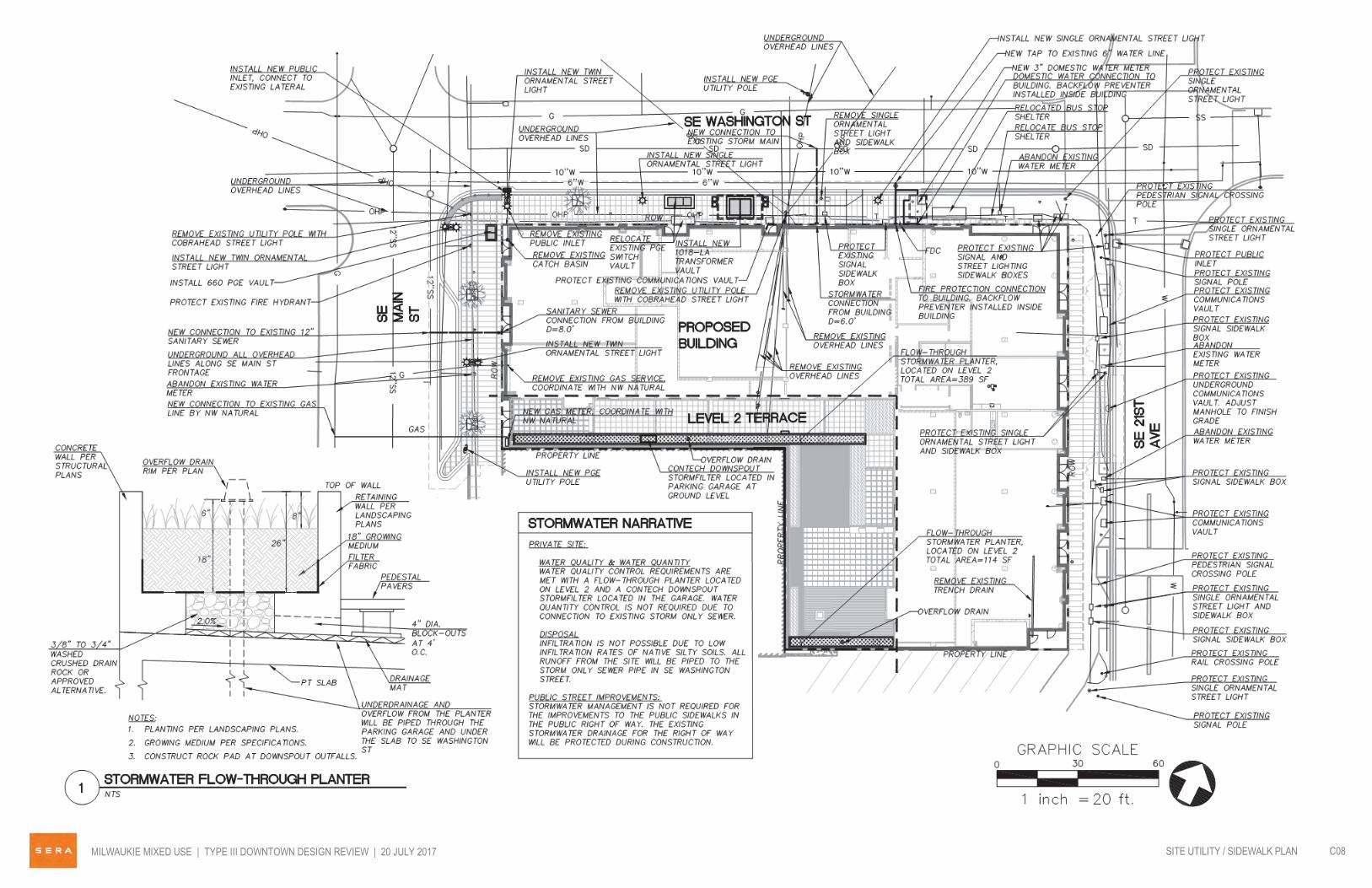


UNIT PATIOS, SEELANDSCAPE
COMMON AREALANDSCAPED TERRACE
BAY WINDOW, TYP.


L1100'-0"
L2115'-6"
L3125'-6"
L4135'-6"
L5145'-6"
ROOF157'-6"
PARKING LEVEL96'-6 1/2"
MEZZANINE106'-10"
NORTH ELEVATION - WINDOW AREA CALCULATIONS:LEVELS 2-5 WALL AREA - 9,439 SF (100%)WINDOW AREA - 3,325 SF (35%)
GROUND FLOOR WALL AREA - 3,064 SF (100%)STOREFRONT AREA - 1,199 SF (39%)
15'-0
"
MILWAUKIE MIXED USE | TYPE III DOWNTOWN DESIGN REVIEW | 20 JULY 2017 C21WINDOW AREA CALCULATIONS
5.4 Page 42ATTACHMENT 3.c.

L1100'-0"
L2115'-6"
L3125'-6"
L4135'-6"
L5145'-6"
ROOF157'-6"
EAST ELEVATION - WINDOW AREA CALCULATIONS:LEVELS 2-5 WALL AREA - 6,612 SF (100%)WINDOW AREA - 2,104 SF (32%)
GROUND FLOOR WALL AREA - 2,209 SF (100%)STOREFRONT AREA - 1,373 SF (62%)
15'-0
"
L1100'-0"
L2115'-6"
L3125'-6"
L4135'-6"
L5145'-6"
ROOF157'-6"
PARKING LEVEL96'-6 1/2"
MEZZANINE106'-10"
WEST ELEVATION - WINDOW AREA CALCULATIONS:LEVELS 2-5 WALL AREA - 3,138 SF (100%)WINDOW AREA - 1,201 SF (38%)
GROUND FLOOR WALL AREA - 1,225 SF (100%)STOREFRONT AREA - 875 SF (71%)
15'-0
"
MILWAUKIE MIXED USE | TYPE III DOWNTOWN DESIGN REVIEW | 20 JULY 2017 C20WINDOW AREA CALCULATIONS
5.4 Page 43

2000x5000
CityLift 2500X5725
2000x5000
CityLift 2500X5725
2000x5000
CityLift 2500X5725
2000x5000
CityLift 2500X5725
2000x5000
CityLift 2500X5725
2000x5000
CityLift 2500X5725
(16 SPACES)
6'-63_4"x16'-47_
8" (Car)
6'-63_4"x16'-47_
8" (Car)
6'-63_4"x16'-47_
8" (Car)
6'-63_4"x16'-47_
8" (Car)
6'-63_4"x16'-47_
8" (Car)
6'-63_4"x16'-47_
8" (Car)
56
57
58
51
51
54
56
57
T
2000x5200
CityLift 2500X5925
2000x5200
CityLift 2500X5925
2000x5200
CityLift 2500X5925
2000x5200
CityLift 2500X5925
2000x5200
CityLift 2500X5925
2000x5200
CityLift 2500X5925
6'-63_4"x17'-03_
4" (Car)
6'-63_4"x17'-03_
4" (Car)
6'-63_4"x17'-03_
4" (Car)
6'-63_4"x17'-03_
4" (Car)
6'-63_4"x17'-03_
4" (Car)
6'-63_4"x17'-03_
4" (Car)
2000x5200
CityLift 2500X5925
2000x5200
CityLift 2500X5925
2000x5200
CityLift 2500X5925
2000x5200
CityLift 2500X5925
6'-63_4"x17'-03_
4" (Car)
6'-63_4"x17'-03_
4" (Car)
6'-63_4"x17'-03_
4" (Car)
6'-63_4"x17'-03_
4" (Car)
2000x5000
CityLift 2500X5725
2000x5000
CityLift 2500X5725
2000x5000
CityLift 2500X5725
2000x5000
CityLift 2500X5725
2000x5000
CityLift 2500X5725
2000x5000
CityLift 2500X5725
(16 SPACES)
6'-63_4"x16'-47_
8" (Car)
6'-63_4"x16'-47_
8" (Car)
6'-63_4"x16'-47_
8" (Car)
6'-63_4"x16'-47_
8" (Car)
6'-63_4"x16'-47_
8" (Car)
6'-63_4"x16'-47_
8" (Car)
2000x5000
CityLift 2500X5725
2000x5000
CityLift 2500X5725
2000x5000
CityLift 2500X5725
2000x5000
CityLift 2500X5725
2000x5000
CityLift 2500X5725
2000x5000
CityLift 2500X5725
(16 SPACES)
6'-63_4"x16'-47_
8" (Car)
6'-63_4"x16'-47_
8" (Car)
6'-63_4"x16'-47_
8" (Car)
6'-63_4"x16'-47_
8" (Car)
6'-63_4"x16'-47_
8" (Car)
6'-63_4"x16'-47_
8" (Car)
RETAIL SHELL
SPACE
RETAIL SHELL
SPACE
BIKE STORAGE/
REPAIR
ELECTRICAL
EXISTING BUILDING
SE WASHINGTON STREET
SE
21S
T S
TR
EE
T
SE
MA
IN
ST
RE
ET
DRIVEWAY ENTRANCE
NORTH STAIR CO
RR
IDO
R
SOUTH STAIR
TRASH
RETAIL SHELL
SPACE
ELEVATORSPARKING GARAGE
WORK ROOM
BLDG.
MAINT.
ELEV. EQUIP.
(90 spaces)
PKG. ROOM
WC
RETAIL SHELL
SPACE
WATER
LEASING OFFICE
FITNESS
MAIL RM
LOBBY
(78 spaces)(10 SPACES)
(16 SPACES)
0' 5' 10' 20' 30'
MILWAUKIE MIXED USE | TYPE III DOWNTOWN DESIGN REVIEW | 20 JULY 2017 C10FLOOR PLAN - LEVEL 1
5.4 Page 44ATTACHMENT 3.d.
johnc
Polygon
johnc
Polygon
johnc
Callout
2,205 SF

5.4 Page 45
haleyw
Line
haleyw
Polygon
haleyw
Text Box
UNIT PATIOS, SEE LANDSCAPE
haleyw
Line
haleyw
Polygon
haleyw
Text Box
COMMON AREA LANDSCAPED TERRACE
haleyw
Text Box
BAY WINDOW, TYP.
haleyw
Line
haleyw
Line
haleyw
Polygon
johnc
Polygon
johnc
Callout
6,366 SF

From: Kurt SchultzTo: Kolias, VeraSubject: FW: Milwaukie - Facade Material %Date: Wednesday, August 09, 2017 4:22:09 PM
Vera, Here are the calculations. The secondary material is never more than 35% of any street facingbuilding facade EAST ELEVATIONAREA – BRICK (primary) 296 3.5%AREA – GLASS (primary) 4,082 47.6%AREA – CEMENT PANEL(secondary) 2,621 30.6%AREA – CEDAR (primary) 1,578 18.4%
TOTAL 8,577
NORTH ELEVATIONAREA – BRICK (primary) 1,555 12.3%AREA – GLASS (primary) 5,015 39.8%AREA - CEMENT PANEL(secondary) 3,647 28.9%AREA – CEDAR (primary) 2,391 19.0%
TOTAL 12,608
WEST ELEVATIONAREA – BRICK (primary) 547 11.8%AREA – GLASS (primary) 2,083 44.8%AREA – CEMENT PANEL(secondary) 890 19.2%AREA – CEDAR (primary) 1,126 24.2%
TOTAL 4,646
Kurt Schultz, AIA, LEED APPrincipal, d: 503.445.7312 m: 503.866.1981o: 503.445.7372
SERAsustainable design for the built environmentseradesign.com
5.4 Page 46ATTACHMENT 3.e.

The Historic Milwaukie Land Use District Review Committee convened on July 2, 2017 and discussed the
Galaxy application.
As representatives of all residents of the NDA, it should be noted that there has long been resistance to
tall buildings in downtown Milwaukie. Those concerns have been voiced at dozens of public meetings,
including the NDA’s June meeting with Guardian Real Estate and SERA Architects. It is our understanding
the height of the building is not up for review and 5 stories are allowed under current zoning.
Our comments and questions:
What impact will this development have on the potential for the Bloom property? If a building allowed
under current code was to be built there, what impacts would that have on the south side of the Galaxy
building especially the outdoor areas?
There is a blank wall with a stairway and apartments behind it that appears to be 4 stories tall on the SE
corner of the Galaxy building. The building is shown to be built out to the property line eliminating the
option of covering with vegetation as shown in the drawings. What design elements or architectural
treatment can be added to make the wall that faces both the Adams St connector and Light Rail Station
more inviting?
We would like more clarification on the outdoor/sidewalk space around the building. Particularly, what
amenities will be available to the public, such as a place to sit? Will there be ample room to pass by if
tables and chairs are located outside the ground floor businesses?
Our meeting was held before the transportation study was made public. As a committee we recognize
the existing conditions on Washington St. often lead to frustration. We discussed the potential of
improving the signals at Washington & Mcloughlin. Reevaluating turning movements and signal time,
perhaps copying was has be done at Harrison and Mcloughlin. We also voiced our support for flashing
lights that are activated when a pedestrian uses the cross walks at Washington and Mcloughlin.
We would like a short discussion on the design approval process apparently there are two routes
available to the applicant. (MMC 19.508 is not applicable)
We noticed that there is not a request for signage. Will the building will have a name and will it be
displayed? Will the current neon sign somehow be incorporated into the façade?
We encourage the planning commission to be very thoughtful in their consideration of the variances
requested by the applicant. Given this is the first major development in the downtown in quite some
time, granting a variance could be interpreted as being easy and open the door to more requests, while
denying the request might be discouraging to other developers.
Thank you for the opportunity to comment,
Ray Bryan
For the Historic Milwaukie Land Use District Review Committee
5.4 Page 47ATTACHMENT 4

From: BRUMLEY Seth ATo: Kolias, VeraSubject: DR-2017-001: Project GalaxyDate: Tuesday, July 11, 2017 3:17:49 PM
Hello Vera,ODOT has no highway concerns regarding the proposed mixed use building. ODOT rail asked that Isubmit the following:
Comments to this MUD are as follows:
· No access is proposed along the SE 21st Street frontage. This is acceptable and preferred.ODOT RPTD would most likely object to any accesses along this frontage due to the
complexity of rail operations along SE 21st Street through town.· With nearly 200 trains operating through the Washington St & Adams St crossings – and a
mixture of freight and LRT – pedestrian (and vehicular/bicycle) safety is paramount. Any
proposed vegetation along the SE 21st Street frontage shall be such to provide acceptablesight lines and conspicuity for traffic control devices. This should be taken into account withany proposed landscape/vegetation plan.
· Changes to traffic signal timing due to any capacity and operational issues for the
intersections of 21st & Washington and/or 21st & Adams will likely require authorizationthrough a crossing Order. (A great deal of time, effort, and resources have gone intoincreasing capacity and safety of these two rail interconnected signalized intersections aspart of the TriMet Orange line extension).
· Changes to roadway widths, sidewalk widths, crosswalk modifications within RPTD’sregulatory jurisdiction, bike lane addition/modifications will likely trigger the need forauthorization through a crossing Order.
· Additional traffic study(ies) may be required by RPTD relative to pedestrian/vehicular/traininteraction based on ultimate tenant occupancy and ultimate build out conditions.
· Degradation to the existing traffic control due to construction – such as Ordered pavementmarkings for the rail crossings – shall be immediately refreshed/maintained to an acceptablecondition per the crossing Orders for the impacted locations.
Thank you for the opportunity to comment.
David R Smith
Please contact me if you have any questions,
Thank you,
Seth BrumleyODOT Region 1 Planner123 NW Flanders St.Portland, OR 97209(503) 731-8234
5.4 Page 48

From: Amos, MattTo: Kolias, VeraSubject: RE: [Spam score:8%] RE: DR-2017-001Date: Friday, July 21, 2017 10:18:59 AM
Vere,
After review, the applicant did not include an access and water supply test as required for full reviewand approval. They will need to include site plan that has the following information:
1) Fire apparatus access including aerial apparatus provisions2) Fire lanes3) Fire Hydrants4) Fire lines5) Available fire flow6) FDC location7) Building square footage8) Building construction type
Thank you,
Matt AmosFire Inspector | Fire Preventiondirect: 503.742.2661
From: Kolias, Vera [mailto:[email protected]] Sent: Thursday, July 20, 2017 7:47 AMTo: Amos, Matt <[email protected]>Cc: Martin, Alicia <[email protected]>Subject: [Spam score:8%] RE: DR-2017-001
Matt,
The referral for 2036 SE Washington went out on June 23rd. You should have received the plan setweeks ago. Here is the application electronically so that you can take a look.
-Vera
VERA KOLIAS, AICPAssociate Planner503.786.7653
5.4 Page 49

City of Milwaukie6101 SE Johnson Creek Blvd • Milwaukie, OR 97206
From: Amos, Matt [mailto:[email protected]] Sent: Thursday, July 20, 2017 7:01 AMTo: Kolias, Vera <[email protected]>Subject: RE: [Spam score:8%] RE: WG-2017-003, NR-2017-002
Good morning,
I may have comments, but those plans have not come across my desk yet.
I have been working with them to ensure they have all our access needs met due to the height of thebuilding. I think the only other part of the project would be water supply.
Matt AmosFire Inspector | Fire Preventiondirect: 503.742.2661
From: Kolias, Vera [mailto:[email protected]] Sent: Wednesday, July 19, 2017 1:53 PMTo: Amos, Matt <[email protected]>Subject: [Spam score:8%] RE: WG-2017-003, NR-2017-002
Thank you!
May I assume you will have comments on DR-2017-001 (the 5-story building at 2036 SE WashingtonSt)?
VERA KOLIAS, AICPAssociate Planner503.786.7653City of Milwaukie6101 SE Johnson Creek Blvd • Milwaukie, OR 97206
From: Amos, Matt [mailto:[email protected]] Sent: Wednesday, July 19, 2017 1:44 PMTo: Kolias, Vera <[email protected]>Subject: WG-2017-003, NR-2017-002
Good afternoon Vera,
Clackamas Fire has no additional comments for this project.
Thank you,
5.4 Page 50

Matt AmosFire Inspector | Fire Preventiondirect: 503.742.2661
The information contained in this transmission may contain privileged and confidentialinformation, including patient information protected by federal and state privacy laws. It isintended only for the use of the person(s) named above. If you are not the intended recipient,you are hereby notified that any review, dissemination, distribution, or duplication of thiscommunication is strictly prohibited. If you are not the intended recipient, please contact thesender by reply email and destroy all copies of the original message.The information contained in this transmission may contain privileged and confidentialinformation, including patient information protected by federal and state privacy laws. It isintended only for the use of the person(s) named above. If you are not the intended recipient,you are hereby notified that any review, dissemination, distribution, or duplication of thiscommunication is strictly prohibited. If you are not the intended recipient, please contact thesender by reply email and destroy all copies of the original message.The information contained in this transmission may contain privileged and confidentialinformation, including patient information protected by federal and state privacy laws. It isintended only for the use of the person(s) named above. If you are not the intended recipient,you are hereby notified that any review, dissemination, distribution, or duplication of thiscommunication is strictly prohibited. If you are not the intended recipient, please contact thesender by reply email and destroy all copies of the original message.
5.4 Page 51

From: [email protected]: Kolias, Vera; [email protected]: File DR--2017-001:VR-2017-007Date: Monday, July 31, 2017 10:07:46 AM
7/31/2017
TO: MILWAUKIE DESIGN AND LANDMARKS COMMITTEE
RE: File DR--2017-001:VR-2017-007
PLEASE ACCEPT THIS AS MY WRITTEN COMMENT REGARDING THE ABOVE DEVELOPMENT:
I AM A PROPERTY OWNER DIRECTLY ACROSS THE STREET FROM THE PROPOSED MIXED USEBUILDING. MY PROPERTY IS LOCATED AT 2025/2035/2045 SE WASHINGTON STREET. I AM INFAVOR OF THIS DEVELOPMENT ALONG WITH REQUESTED VARIANCES.
RESPECTFULLY,
DOUG NAEF
5.4 Page 52

Memorandum
Date August 4, 2017 Project Name 2036 SE Washington Development Project Number DR-2017-001; VR-2017-007 Attention Vera Kolias, Associate Planner
Subject Modifications to Project Design
Remarks Number of Residential Units: 110 (109 originally proposed) Square footage of retail/commercial: 7,190 SF (8,800 SF originally proposed. The amount of retail /commercial reduced in size as the fitness room was moved to the ground floor adjacent to the building lobby) Bicycle parking: Our required bicycle parking count is 114 (1 per unit plus 4 for the retail). We are providing 94 bike spaces in the bicycle room on level 1, 4 exterior short term bike spaces, and the remainder are located in the residential units. We originally proposed 90 bike parking stalls in the bicycle room.
From Kurt Schultz, AIA Principal cc
5.4 Page 53ATTACHMENT 5