Commission Agenda Report - City of Malibu
89
Commission Agenda Report Chair Stack and Members of the Planning Commission Prepared by: Richard Mollica, Senior PlannerJ~’t~’ Reviewed Bonnie Blue, Planning Director ~ Date prepared: July 8,2016 Meeting Date: July 18, 2016 Subject: Coastal Development Permit No. 11-046, Variance No. 16-011, and Site Plan Review Nos. 16-017 and 16-018 - An a~~Iication for the construction of a new two-story single-family residence and associated development Location: 6050 Murphy Way, not located within the appealable coastal zone APN: 4467-004-028 Owner: C.A. Rasmussen Co. LLC RECOMMENDED ACTION: Adopt Planning Commission Resolution No. 16-51 (Attachment 1) determining the project is categorically exempt from the California Environmental Quality Act (CEQA), and approving Coastal Development Permit (CDP) No. 11-046, an application for the construction of a new 10,605 square foot, two-story single-family residence with attached guesthouse and a subterranean garage, for total development square footage for the site is 10,887, alternative onsite wastewater system (AOWTS), new driveway, restoration of unpermitted environmentally sensitive habitat area (ESHA), retaining walls, pool, spa, pool equipment, landscaping, patio with barbeque area, grading, and associated development, including Variance (VAR) No. 16-011 to reduce the required buffer, Site Plan Review (SPR) No. 16-017 for a roof height of 28 feet, and SPR No. 16-018 to allow for remedial grading in the Rural Residential-Ten Acre (RR 10) zoning district located at 6050 Murphy Way (C.A. Rasmussen Co. LLC). DISCUSSION: On June 6, 2016, the Planning Commission opened the public hearing for this item. Due to a lack of quorum, the hearing was not completed, no action was taken, and the item was re-noticed for the July 18, 2016 Regular Planning Commission meeting. Page 1 of 22 To: Planning Commission Meeting 07-18-16 Item 5.A. Agenda Item 5.A.
-
Upload
khangminh22 -
Category
Documents
-
view
3 -
download
0
Transcript of Commission Agenda Report - City of Malibu

Commission Agenda Report
Chair Stack and Members of the Planning Commission
Prepared by: Richard Mollica, Senior PlannerJ~’t~’
Reviewed Bonnie Blue, Planning Director ~
Date prepared: July 8,2016 Meeting Date: July 18, 2016
Subject: Coastal Development Permit No. 11-046, Variance No. 16-011, andSite Plan Review Nos. 16-017 and 16-018 - An a~~Iication for theconstruction of a new two-story single-family residence and associateddevelopment
Location: 6050 Murphy Way, not located within theappealable coastal zone
APN: 4467-004-028Owner: C.A. Rasmussen Co. LLC
RECOMMENDED ACTION: Adopt Planning Commission Resolution No. 16-51(Attachment 1) determining the project is categorically exempt from the CaliforniaEnvironmental Quality Act (CEQA), and approving Coastal Development Permit (CDP)No. 11-046, an application for the construction of a new 10,605 square foot, two-storysingle-family residence with attached guesthouse and a subterranean garage, for totaldevelopment square footage for the site is 10,887, alternative onsite wastewater system(AOWTS), new driveway, restoration of unpermitted environmentally sensitive habitatarea (ESHA), retaining walls, pool, spa, pool equipment, landscaping, patio with barbequearea, grading, and associated development, including Variance (VAR) No. 16-011 toreduce the required buffer, Site Plan Review (SPR) No. 16-017 for a roof height of 28 feet,and SPR No. 16-018 to allow for remedial grading in the Rural Residential-Ten Acre (RR10) zoning district located at 6050 Murphy Way (C.A. Rasmussen Co. LLC).
DISCUSSION: On June 6, 2016, the Planning Commission opened the public hearing forthis item. Due to a lack of quorum, the hearing was not completed, no action was taken,and the item was re-noticed for the July 18, 2016 Regular Planning Commission meeting.
Page 1 of 22
To:
Planning CommissionMeeting07-18-16
Item5.A.
Agenda Item 5.A.

One of the main issues discussed during the June 6th meeting was whether the projectsite is located on a ridgeline. To address this matter, additional information has beenadded to the Surrounding Land Use and Project Setting discussion of this this report. TheESHA resources discussion in that section has also been slightly expanded and findingsrelated to ESHA and scenic resources have been clarified. Other than that information,this agenda report provides the same overview of the project, summary of the surroundingland uses, description of the proposed project and a summary of staff’s analysis of theproject’s consistency with the applicable provisions of the Malibu Local Coastal Program(LCP)and the CEQA that was presented in the June 6,2016 agenda report. The analysisand findings discussed herein demonstrate that the project is consistent with the LCP.
Project Overview
The scope of the proposed project includes the construction of a new single-familyresidence which includes a subterranean garage, attached second residential unit, newAOWTS, retaining walls, pool and spa, hardscaping, including a driveway, andlandscaping. Due to the onsite ESHA, the project was limited to a 10,000 square footdevelopment area. The project also includes a variance to reduce the required ESHAbuffer to allow for the required fuel modification zones. The project also includes two siteplan review requests, one for the construction of a pitched roof that is 28 feet in height anda second to allow for 1,248 cubic yards of remedial grading. Project plans are included asAttachment 2.
Surrounding Land Uses and Project Setting
Figure 1 depicts an aerial view of the subject property and vicinity.
Page 2 of 22
-~.. K\ ~-
—~
.t “~ —~—. ~t
.j.~,. .~%
• N
Figure 1 — Aerial photograph of the subject property
~.‘ .•• ‘N, ~
\\ /~ C
/
~
• • \ \••••.•• .- .\ d
~‘:~h-;, I
Agenda Item 5.A.

The project site is zoned RR-10 and is not located within the Appeal Jurisdiction asdepicted on the Post-LCP Certification Permit and Appeal Jurisdiction Map. The propertyabuts the Debutts Terrace Trail which runs along Murphy Way adjacent to the street right-of-way. The only development that will take place in the street right-of-way is theconstruction of the drive apron which will have no adverse impact on public access.Property data is summarized in Table 1.
~* :Tabae~pro~e~: DàtáLot Depth 735 ft.Lot Width 780 ft.Gross Lot Area 531,183 sq. ft. (12.19 acres)Area of Street Easements 0 sq. ft.Area of 1 to I Slopes 0 sq. ft.Net Lot Area1 531,183 sq. ft. (12.19 acres)
As outlined in Table 2, the surrounding land uses consist of single-family residential homeswithin the RR-10 zoning district and a vacant parcel that is Escondido Canyon Park and iszoned Public Open Space (POS). The residentially developed lots along Murphy Way aredeveloped with two-story homes.
Table 2— Surrounding Land UsesDirection Address! Parcel No. Parcel Size Zoning Land UseNorth 6000 Murphy Way 10.72 acres RR-10 Vacant
Residential6015 Murphy Way 1.53 acres RR-1 0
Residential~ Residential
6035 Murphy Way 3.92 acres RR-l 0Residential
East 4460-002-902 89.73 acres POS ParklandSouth 4467-004-037 11.54 acres RR-1 0 VacantWest 4467-004-036 10.12 acres RR-10 Vacant
ESHA Resources
The subject parcel does contain ESHA based on the LCP ESHA and Marine ResourcesMap. Also, a Biological Assessment for the project site was completed by Nelson andAssociates during November 2014. The Biological Assessment states that there were nospecial-status plant or wildlife species present on the site. During the summer of 2012 aGeotechnical Exploratory Permit was issued for a seismic trench. During the course oftesting, onsite ESHA was removed without the benefit of permit. Through the use of aerialphotographs and the City’s ESHA maps, the City Biologist and planning staff were able to
1 Net Lot Area = Gross Lot Area minus the area of street easements and 1 to 1 slopes.
Page 3 of 22
Agenda Item 5.A.

determine the limits of ESHA and the amount of ESHA disturbed. The attached resolutionincludes conditions of approval requiring remediation of the 71,874 square feet I 1.65acres of ESHA that was disturbed. In addition, the project has been sited and designedin accordance with the LCP’s ESHA requirements.
Ridgeline Analysis
The scenic and visual resource standards of LIP Chapter 6 require measures to minimizevisual impacts of development that will be located on a ridgeline, and states that the hillsidedevelopment standards where the ridgeline measures are found apply to properties witha slope of 20 percent or greater. The subject site and adjacent property to the south andeast, addressed as 6200 Porterdale, are situated on the same topographic ridge-likefeature with slopes descending from Murphy Way, and have been reviewed against theLCP’s criteria for ridgelines in the past by the Planning Commission and found not to beeither a primary or secondary ridgeline.
LIP Section 2.1 provides the following definitions:2
RIDGELINE, PRIMARY - a hill, ridge or promontory which drops on either side of the top of thislandform feature, and includes at least one of the following conditions: 1) forms a distinct part ofthe skyline when viewed from a public street or highway; or, 2) is seen as a distinct and prominentedge against a backdrop of land at least 500 feet behind it when viewed from a public street andcontains an average slope of at least 3:1.
RIDGELINE, SECONDARY - a hill, ridge, or promontory other than a primary ridgeline, but onwhich the elevation drops more than 10 feet in 100 feet horizontally on either side of the top ofthis landform feature.
In its adoption of Initial Study No. 15-001 and Negative Declaration 15-001 (January 19,2016), which was prepared for the lot line adjustment for 6200 Porterdale, it wasdetermined that the ridge feature does not meet the City’s criteria for a primary orsecondary ridgelines, as defined in Local Implementation Plan (LIP) Section 2.1 for thefollowing reasons: 1) the ridge feature does not form a distinct part of the skyline whenviewed from a public street or highway; 2) the ridge feature is not seen as a distinct andprominent edge against a backdrop of land when viewed from a public street; and (3) theridge feature does not drop more than 10 vertical feet in 100 horizontal feet on either sideof the top of the ridge.
The Planning Commission previously evaluated the 6200 Porterdale property forconstruction of a single-family residence sited on this feature in 2008 and concluded that
2 Malibu Municipal Code (MMC) Section 17.40.040(A)(8) provides the same definition.
Page4of22
Agenda Item 5.A.

the building site on this feature did not qualify as a secondary ridgeline and would not havesignificant adverse visual impacts.
For the subject property, when looking from the south towards the north from a publicstreet (or even from Murphy Way), the property is viewed among a back drop of developedproperties at a higher elevation; therefore, the site does not meet the definition of a primaryridgeline. Also, the applicant prepared an analysis which demonstrates that the site doesnot qualify as a secondary ridgeline because the building pad does not have an elevationdrop of more than 10 feet in 100 feet horizontally on either side3 (Attachment 3).
Finally, it should be noted that the proposed building pad on the subject site was part of aprevious CDP approval by the California Coastal Commission (CCC) for the subdivisionof the subject parcel into four lots and 16,439 cubic yards of grading to create buildingpads. The proposed development has been sited in an area previously approved for abuilding pad; and as discussed previously an analysis was completed to demonstrate thatthe site of development is not considered a ridgeline.
Project Description
The proposed project includes the following work:
• Construction of a new 10,665 square foot, two-story, single-family residence6,902 square foot first floor;3,093 square foot second floor;1,565 square foot subterranean garage (283 square feet are consideredTDSF4)Covered decks and entry, 852 square feet (included in TDSF);
• Landscaping;• AOWTS;• ESHA restoration and mitigation;• Driveway and hardscape;• Planters ‘with landscaping;• Swimming pool;• Spa;• Mechanical equipment area;• Outdoor barbeque area; and
~ Because hillside development standards apply to properties with a slope of 20 percent or greater, all recent secondary
ridgeline analyses, including those for CDP Nos. 05-024 and 05-026, have been prepared by drawing a segment along the“spine” of the building pad and extending perpendicular lines 50 feet in both directions from the segment to determine ifthe elevation drops more than 10 feet.
4TDSF = Total Development Square footage.
Page5of22
Agenda Item 5.A.

• Retaining walls up to six feet in height.
The following discretionary requests are included:
1. VAR No. 16-011 to reduce the required scrub ESHA buffer;2. SPR No. 16-017 for construction in excess of 18 feet in height to allow for a pitched
roof that is 28 feet in height; and3. SPR No. 16-018 to allow for 1,248 cubic yards of remedial grading.
LCP Analysis
The LCP consists of the Land Use Plan (LUP) and the LIP. The LUP contains programsand policies to implement the Coastal Act in the City of Malibu. The purpose of the LIP isto carry out the policies of the LUP. The LIP contains specific policies and regulations towhich every project requiring a coastal development permit must adhere.
There are 14 sections within the LIP that potentially require specified findings to be made,depending on the nature and location of the proposed project. Of these 14, five sectionsare for conformance review only and require no findings. These five sections includeZoning, Grading and Archaeological / Cultural Resources, Water Quality, and OnsiteWastewater Treatment System (OWTS) and are discussed under the ConformanceAnalysis section. The nine remaining LIP sections include: 1) Coastal Development Permitfindings; 2) ESHA; 3) Native Tree Protection; 4) Scenic, Visual and Hillside ResourceProtection; 5) Transfer of Development Credits; 6) Hazards; 7) Shoreline and BluffDevelopment; 8) Public Access; and 9) Land Division. These nine sections are discussedunder the LIP Findings section. Of these nine, General Coastal Development Permit(including the variance and site plan review findings), Scenic, Visual and Hillside ResourceProtection, ESHA, and Hazards findings apply to this project.
Based on the project site, the scope of work, and substantial evidence contained withinthe record, the Native Tree Protection, Transfer of Development Credits, Shoreline andBluff Development, Public Access, and Land Division findings are not applicable orrequired for the project for the reasons described herein.
LIP Conformance Analysis
The proposed project has been reviewed by the Planning Department, City Biologist, CityEnvironmental Health Administrator, City geotechnical staff, and the City Public WorksDepartment for conformance with the LCP, as well as the Los Angeles County FireDepartment (LACFD). The department review sheets are attached hereto as Attachment4. The project, as proposed and conditioned, has been determined to be consistent withall applicable LCP codes, standards, goals and policies with the inclusion of the varianceand site plan reviews.
Page 6of22
Agenda Item 5.A.
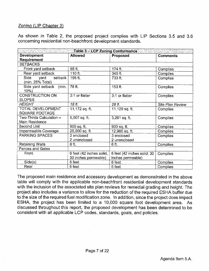
Zoninci (LIP Chapter 3)
As shown in Table 2, the proposed project complies with LIP Sections 3.5 and 3.6concerning residential non-beachfront development standards.
Table 3 — LCP Zoning ConformanceDevelopment Allowed Proposed CommentsRequirementSETBACKS
Front yard setback 65 ft. 174 ft. Corn pliesRear yard setback 110 ft. 340 ft. Corn pliesSide yard setback 195 ft. 733 ft. Complies(mm. 25%_Total)Side yard setback (mi 78ft. 153ff. Complies10%)
CONSTRUCTION ON 3:1 or flatter 3:1 or flatter CompliesSLOPESHEIGHT 18 ft. 28 ft. Site Plan ReviewTOTAL DEVELOPMENT 11,172 sq. ft. 11,129 sq. ft. CompliesSQUARE FOOTAGETwo-Thirds Calculation — 5,007 sq. ft. 3,261 sq. ft. CompliesMain ResidenceSecond Unit 900 sq. ft. 900 sq. ft. CompliesImpermeable Coverage 25,000 sq. ft. 12,960 sq. ft. CompliesPARKING SPACES 2 enclosed 3 enclosed Complies
2 unenclosed 2 unenclosedRetaining Walls 6 ft. 6 ft. CompliesFences and Gates
Front 6 feet (42 inches solid, 6 feet (42 inches solid, 30 Complies30 inches permeable) inches permeable)
Side(s) 6 feet 6 feet CompliesRear 6 feet 6 feet Complies
The proposed main residence and accessory development as demonstrated in the abovetable will comply with the applicable non-beachfront residential development standardswith the inclusion of the associated site plan reviews for remedial grading and height. Theproject also includes a variance to allow for the reduction of the required ESHA buffer dueto the size of the required fuel modification zone. In addition, since the project does impactESHA, the project has been limited to a 10,000 square foot development area. Asdiscussed throughout this report, the proposed development has been determined to beconsistent with all applicable LCP codes, standards, goals, and policies.
Page 7of22
Agenda Item 5.A.

Grading (LIP Chapter 8)
The project proposes a total of 3,427 cubic yards of grading. Of that, 516 cubic yardsmeet the definition of non-exempt grading. The majority of the grading is remedial gradingand safety grading for access to the site. A site plan review has been included as part ofthe project to approve the 1,248 cubic yards of remedial grading that is required forstabilization of the site. The proposed remedial grading has been reviewed andconditionally approved by the City geotechnical staff. Since the project does not proposenon-exempt grading beyond the 1,000 cubic yards permitted, the project conforms to thegrading requirements as set forth under LIP Section 8.3, which ensures that newdevelopment minimizes the visual and resource impacts of grading and landform alterationby restricting the amount of non-exempt grading to a maximum of 1,000 cubic yards forresidential development. Quantities for site preparation are detailed in Table 4.
i aoie 4— u.r ~raaing ~onrormanceExempt** Non
R&R* Understructure Safety*** Exempt Remedial TotalCut 0 685 663 468 1,248 3,064Fill 0 172 143 48 0 363Total 0 857 806 516 1,248 3,427Import 0 0 0 0 0 0Export 0 513 520 420 1,248 2,701
All quantities listed in cubic yards unless otherwise noted*R&R= Removal and Re-compaction**Exempt grading includes all R&R, understructure and safety grading.***Safety grading is the incremental grading required for Fire Department access (such as turnouts, hammerheads, andturnarounds and any other increases in driveway width above 15 feet required by the LACFD).
Archaeological I Cultural Resources (LIP Chapter 11)
LIP Chapter 11 requires certain procedures be followed to determine potential impacts onarchaeological resources. According to the City’s Cultural Resources Map and a siteevaluation completed by PAST, Inc. in November of 2003, the subject site has a lowpotential of containing cultural resources and it is not expected that the subject projectwould impact any archaeological resources.
The resolution contains conditions of approval that require all work to immediately ceaseuntil a qualified archaeologist can provide an evaluation of the nature and significance ofthe resources which are uncovered, and until the Planning Director can review thisinformation.
Water Quality (LIP Chapter 17)
The City Public Works Department has reviewed and approved the project forconformance to LIP Chapter 17 requirements for water quality protection. Standardconditions of approval require that prior to grading permit issuance, final grading and
Page 8 of 22
Agenda Item 5.A.

drainage plans incorporating construction-phase erosion control and storm water pollutionprevention, as well as post-construction storm water management must be approved bythe City Public Works Department. With the implementation of these conditions, theproject conforms to the Water Quality Protection standards of LIP Chapter 17.
Onsite Wastewater Treatment Systems (LIP Chapter 18)
LIP Chapter 18 addresses OWTS. LIP Section 18.7 includes specific siting, design, andperformance requirements. The project includes a new AOWTS, which has beenreviewed by the City Environmental Health Administrator and found to meet the minimumrequirements of the Malibu Plumbing Code, the Malibu Municipal Code (MMC), and theLCP. This system will consist of a MicroSepTec ESI2 EnviroServer treatment tank withan UV disinfection unit. Secondary and tertiary treatment will be required. An operationand maintenance contract and recorded covenant covering such shall be in compliancewith the City Environmental Health requirements. Conditions of approval have beenincluded in Planning Commission Resolution No. 16-51 to require continued operation,maintenance and monitoring of onsite facilities.
LIP Findings
A. General Coastal Development Permit (LIP Chapter 13)
LIP Section 13.9 requires that the following four findings be made for all CDPs.
Finding Al. That the project as described in the application and accompanying materials,as modified by any conditions of approval, conforms with the certified City of Malibu LocalCoastal Program.
The project has been reviewed for conformance with the LCP by Planning Departmentstaff, the City Biologist, City Environmental Health Administrator, City geotechnical staff,the City Public Works Department, and the LACFD. As discussed herein, based onsubmitted reports, project plans, visual analysis and detailed site investigation, theproposed project, as conditioned and with the approval of the variance and the two siteplan reviews, conforms to the LCP in that it meets all applicable residential developmentstandards.
Finding A2. The project is located between the first public road and the sea. The projectconforms to the public access and recreation poilcies of Chapter 3 of the Coastal Act of1976 (commencing with Sections 30200 of the Public Resources Code).
The project is not located between the first public road and the sea; therefore, this findingis not applicable.
Page 9 of 22
Agenda Item 5.A.

Finding A3. The project is the least environmentally damaging alternative.
1. No Project — The no project alternative would avoid any changes to the subjectparcel, leaving it vacant. The project site is designated for single-familydevelopment. In addition, it would not allow for the restoration of the ESHA that wascleared from the site without the benefit of permit as part of the geologic testing forthe subject application. The no project alternative would not accomplish any of theproject objectives.
2. Alternative Desicin — The project objective is for the construction of a single-familyresidence on a lot that is currently vacant. The applicant could have proposed asmaller residence; however, the lot is over 12 acres in size. Despite the size, thelot is constrained and a smaller home would still require a variance to reduce therequired ESHA buffer. Given the topography of the site (steep slopes) and geologicconditions, the location of the building pad is limited. The site plan review forremedial grading would still be required to remediate the areas on the propertyaffected by past landslide activity. Given that the impacts on the site would be thesame as the proposed project and remedial grading would still be required, thealternative design does not offer significant environmental advantages.
3. Projosed Project — The proposed project will allow for the construction of a newsingle-family residence and guest house with associated development that includesa swimming pool, a subterranean garage, hardscaping and landscaping, andremedial grading. The proposed design results in development that is set back fromMurphy Way and is not visible from PCH. Furthermore, the proposed developmentwill not impact views from surrounding trails because of landscaping and existingdevelopment along Murphy Way. The proposed remedial grading will improveonsite stability. The project as conditioned will comply with all applicablerequirements of state and local law. The project will not result in potentiallysignificant impacts on the physical environment.
Finding A4. If the project is located in or adjacent to an environmentally sensitive habitatarea pursuant to Chapter 4 of the Malibu LIP (ESHA Overlay), that the project conformswith the recommendations of the Environmental Review Board, or if it does not conformwith the recommendations, findings explaining why it is not feasible to take therecommended action.
The project site does contain ESHA, and the required fuel modification zones will extendinto the required ESHA Buffer. The proposed project was reviewed by the City Biologistand it was determined that the proposed project is exempt from review by theEnvironmental Review Board (ERB) because pursuant to LIP Section 4.4.4(D), newstructures and landscaping proposed within the permitted graded pad or permitteddevelopment area if there is no graded pad, authorized in a previously approved coastal
Page 10 of 22
Agenda Item 5.A.

development permit do not need to be reviewed by the ERB. Since the building padgrading was approved by the CCC in CDP No. 5-90-1068, the proposed development istaking place in an area previously approved for a building pad.
B. Variance for the reduction in the required Scrub ESHA Buffer (LIP — SectionI 3~26.5)
The applicant is requesting a variance from LIP Section 4.6.1(F) which prohibitsdevelopment within 100 feet of the outermost edge of the ESHA and prohibits fuelmodification within ESHA. While the structure is not located in scrub ESHA, the requiredfuel modification zones will encroach into ESHA located on the subject property. Becauseof this, the project is restricted to a 10,000 square foot development area.
Pursuant to Malibu LIP Section 13.26.5 Variance Findings, the Planning Commission mayapprove and/or modify an application for a variance in whole or in part, with or withoutconditions, provided that it makes all of the following findings of fact. Staff can substantiateand support the proposed variance for the reduction in the required ESHA buffer asfollows.
Finding BI. There are special circumstances or exceptional characteristics applicable tothe subject property, including size, shape, topography, location, or surroundings suchthat strict application of the zoning ordinance deprives such property ofprivileges enjoyedby other property in the vicinity and under the identical zoning classification.
ESHA vegetation is present on the subject parcel. The applicant has researched variousalternatives that would allow development of the subject lot comparable to neighboringproperties. The current design places development within a previously approved andprepared building pad and utilizes an existing access road which will be improved as partof the subject CDP. Due to the topography and geological constraints of the subjectparcel, it is not possible to locate the development’s fuel modification zones in a mannerthat would meet the required scrub ESHA setback. The proposed siting of the proposedresidence creates the least amount of impact to ESHA and the site. If the proposedstructure were to be moved to another location on the project site, additional grading forIandform alteration would be required to create a new building pad and access driveway.Granting of this variance would allow for development similar to development on otherparcels in the area while still minimizing impacts to ESHA.
Finding B2. The granting of such variance will not be detrimental to the public interest,safety, health or welfare, and will not be detrimental or injurious to the property orimprovements in the same vicinity and zone(s) in which the property is located.
The project will meet all applicable building and engineering safety codes and will not bedetrimental to other adjacent properties or improvements. The proposed variance will
Page 11 of 22
Agenda Item 5.A.

allow for the construction of a single-family residence and associated development in anarea that has been determined to be appropriate for such use, and will not be detrimentalto the public’s interest, safety, health or welfare in that all required permits are required tobe secured as a condition of this CDP.
Finding B3. The granting of the variance will not constitute a special privilege to theapplicant or property owner.
Granting of the variance will not constitute a special privilege to the applicant or propertyowner because other properties in the immediate vicinity are developed similarly. Sincethe applicant is proposing to develop a single-family residence consistent with the useallowed by the zoning district, granting the variance does not constitute a special privilegeto the property owner. Neighboring development also abuts the surrounding ESHA andtheir associated fuel modification zones encroach into ESHA.
Finding 84. The granting of such variance will not be contrary to or in conflict with thegeneral purposes and intent of this Chapter, nor to the goals, objectives and policies ofthe LCP.
The granting of the variance is not contrary to or in conflict with the general purposes orintent of the LCP in that granting the variance will allow for construction of a single-familyresidence in the RR-1O zoning district. As stated previously, the proposed project hasbeen reviewed and approved by the LACED, the City Public Works Department, CityEnvironmental Health Administrator, City Biologist, and the City Geologist. The project,as proposed or conditioned, was found to be consistent with applicable City goals andpolicies.
Finding B5. For variances to environmentally sensitive habitat area buffer standards orother environmentally sensitive habitat area protection standards, that there is no otherfeasible alternative for siting the structure and that the development does not exceed thelimits on allowable development area set forth in Section 4.7 of the Malibu LIP.
Development on the subject parcel will result in development that requires the reductionof scrub ESHA buffer setback; however, the development will be located on a previouslyapproved building pad and only the fuel modification zones encroach into ESHA. Thegranting of this variance will allow for the approval of a residence, as well as associatedgrading, landscaping, and an addition to that residence. Additionally, the proposeddevelopment does not exceed the allowable 10,000 square foot development envelope.Given that the project will minimize additional site disturbance, the proposed project willhave the least amount of impacts to the ESHA.
Page 12 of 22
Agenda Item 5.A.

Finding 86. For variances to stringline standards, that the project provides maximumfeasible protection to public access as required by Chapter 2 of the Malibu LIP.
The variance does not pertain to stringlines and this finding is not applicable.
Finding B7. The variance request is consistent with the purpose and intent of the zone(s)in which the site is located. A variance shall not be granted for a use or activity which isnot otherwise expressly authorized by the zone regulation governing the parcel ofproperty.
The proposed project includes a single-family residence, which is an allowed use in theRR-1O zoning district in which the project is located. The proposed variance to allow fora reduction in the required scrub ESHA setback does not authorize a use or activity thatis not expressly authorized by the zoning regulations for the subject property.
Finding 88. The subject site is physically suitable for the proposed variance.
The granting of the variance will allow for the construction of a residence that is compatiblewith the surrounding neighborhood. Furthermore, with the implementation of thegeotechnical standards specified by the applicant’s geotechnical consultant, the proposedresidence can be constructed in a way that will not result in instability of the site. Giventhe topography and shape of the subject parcel, the existing building pad that waspreviously improved provides the best location for development. Therefore, the subjectsite is physically suitable for the proposed variance.
Finding 89. The variance complies with all requirements of state and local law.
The variance complies with all requirements of state and local law. Construction of theproposed improvements will comply with all building code requirements and willincorporate all recommendations from applicable City departments and agencies. Allrequired permits for the proposed development will be secured.
Finding 810. A variance shall not be granted that would allow reduction or elimination ofpublic parking for access to the beach, public trails or parkiands.
The proposed variance does not pertain to public parking and this finding does not apply.
C. Site Plan Review for Construction in Excess of 18 Feet in Height (LIP SectionI 3.27.5)
LIP Section 13.27.5(A) requires that the City makes four findings in the consideration andapproval of a site plan review for construction in excess of 18 feet in height up to a
Page 13 of 22
Agenda Item 5.A.

maximum of 28 feet with a pitched roof. Two additional findings are required pursuant toMMC Section 17.62.050. The applicant has proposed to build a new two-story single-family residence that will be 28 feet above existing grade at its highest point with a pitchedroof. Based on the evidence in the record, the findings of fact for SPR No. 16-017 aremade as follows.
Finding Cl. The project is consistent with policies and provisions of the Malibu LCP.
As discussed herein, the project has been reviewed for and found consistent with allrelevant policies and provisions of the LCP.
Finding C2. The project does not adversely affect neighborhood character.
The project site is located along the southern side of Murphy Way. Story poles wereinstalled in April 2016 to demonstrate that the project is compatible with the rural nature ofthe surrounding development (Site and Story Pole Photos - Attachment 5). Theresidences surrounding the subject parcel are developed as two-story residentialstructures with accessory development. The larger lots share setbacks similar to thoseproposed in the project, while the smaller lots located to the north of the property featuremuch smaller setbacks. In addition, the site’s topography descends from Murphy Way.Similar to the neighboring development, the proposed development will be partiallyshielded from views by the slope located on the subject property that exists between thebuilding pad and Murphy Way. This will allow structures to the north of the subject propertyto look over the proposed development towards the ocean to the south. The projectcomplies with all development standards. Therefore, the project is not anticipated toadversely affect neighborhood character.
Finding C3. The project provides maximum feasible protection to significant public viewsas required by Chapter 6 of the Malibu LIP.
The proposed development is located on a site that descends from Murphy Way and doesnot meet the definition of a primary or secondary ridgeline. The subject property is 12acres in size. Because of the slope on the existing property, proposed landscaping, andthe characteristics of the surrounding neighborhood, bluewater views will be maintainedover the existing development. Furthermore, the site of development has been locateddownslope and approximately 200 feet away from Murphy Way to help preserve bluewaterviews. Due to the location and design of the project and the implementation of standardconditions of approval, the project is expected to have less than significant impacts toscenic vistas and provides the maximum feasible protection to significant public views asrequired by LIP Chapter 6.
Page 14 of 22
Agenda Item 5.A.
Finding C4. The proposed project cornplies with all applicable requirements of state andlocal law.
The proposed project will comply with all applicable requirements of state and local lawand is conditioned to comply with any relevant approvals, permits and licenses from theCity of Malibu and other related agencies, such as the LACFD.
Finding C5. The project is consistent with the City’s general plan and local coastalprogram.
As discussed previously in Finding Al, the proposed project, with the inclusion of the twosite plan reviews and the variance, is consistent with the LCP in that the proposed projectis located in an area that has been identified for residential use. The goals and policies ofthe General Plan are intended to maintain residential character in this area, and the projectis consistent with these goals. The proposed project is consistent with the LCP in that itconforms to the residential land use designation and all applicable developmentstandards. In addition, the project resolution contains materials and lighting conditions towhich the project must comply with.
Finding C6. The portion of the project that is in excess of 18 feet in height does not obstructvisually impressive scenes of the Pacific Ocean, off-shore islands, Santa MonicaMountains, canyons, valleys, or ravines from the main viewing area of any affectedprincipal residence as defined in MMC Section 17.40.040(A)(17).
Based on the visual impact analysis (story pole placement), staff determined that theproposed development will not result in impacts to neighboring residences’ bluewaterviews. No surrounding property owners have contacted staff since the placement of thestory poles or the mailing of the courtesy notice. Based on the visual analysis, as well assite inspections, it is expected that the project will not obstruct visually impressive scenesof the ocean from primary viewing areas of surrounding residences.
D. Site Plan Review for Remedial Grading (LIP Section 13.27)
The LCP requires that the City make findings in the consideration and approval of a SPRfor remedial grading. The project includes SPR No. 16-018 because it proposes remedialgrading to recompact soil that was affected by past landslide activity. Based on theevidence contained within the record, Planning Department staff recommends theapproval of SPR No. 16-018.
Page 15 of 22
Agenda Item 5.A.

Finding Dl. The project is consistent with policies and provisions of the Malibu LCP.
The project has been reviewed for all relevant policies and provisions of the Malibu LCP.Based on submitted reports, visual impact analysis, and detailed site investigations, theproject is consistent with all policies and provisions of the Malibu LCP. Furthermore, thegeotechnical reports that recommend remedial grading were reviewed by the City’sgeotechnical staff and it was determined that the proposed remedial grading was requiredand complied with the City’s geotechnical guidelines.
Finding D2. The project does not adversely affect neighborhood character.
The project is compatible with other development in the adjacent area in that theneighborhood is primarily residentially developed. The proposed remedial grading willstabilize onsite soil conditions as well as add to the stability of surrounding properties. Inaddition, the area of landslide debris will be restored, with no structures being developedin the areas where remedial grading is taking place. It is not expected that the project willadversely affect neighborhood character.
Finding D3. The project provides maximum feasible protection to significant public viewsas required by Chapter 6 of the Malibu LIP.
This project consists of the construction of a new single-family residence and associateddevelopment. As part of the site preparation there is an area on the property that containslandslide debris. The area in which the remedial grading will take place will not be usedfor development but will be restored with groundcover; and therefore, the remedial gradingwill not impact public views.
Finding D4. The proposed project complies with all applicable requirements of state andlocal law.
The proposed project has received LCP conformance review from the City Biologist, Citygeotechnical staff, the City Public Works Department, and the LACED. The project mustalso be approved by the City of Malibu Building Safety Division, prior to issuance of Citybuilding permits. The proposed project complies with all applicable requirements of stateand local law.
E. Environmentally Sensitive Habitat Area Overlay (LIP Chapter 4)
Scrub ESHA exists on the subject property. While the proposed residence and accessorystructures are not located within ESHA, the required fuel modification zones are locatedwithin the required the ESHA buffer and mapped ESHA.
Pagel6of22
Agenda Item 5.A.

A Biological Assessment for the project site was completed by~ Nelson and Associatesduring November 2014. The Biological Assessment states that there were no special-status plant or wildlife species present on the site. In addition, the Biological Assessmentstates that the proposed development will be located on a previously approved buildingpad and area where grading was approved as part of a CCC-issued CDP and only therequired fuel medication zones will intrude into the mapped ESHA areas. Given this, theproposed site of development is the best location to minimize potential impacts to existingESHA to the maximum extent feasible.
Pursuant to LIP Section 4.7.1, the proposed project development envelope is limited to10,000 square feet as the adjacent ESHA cannot be fully avoided. Furthermore, pursuantto LIP Section 4.8.1 the applicant will be required to complete habitat impact mitigationmeasures for areas disturbed by the project’s fuel modification zones. Pursuant to LIPSection 4.7.6(C), the supplemental ESHA findings can be made as follows.
Finding El. Application of the ESHA overlay ordinance would not allow construction of aresidence on an undeveloped parcel.
The property contains scrub ESHA and given the topography and geological of theproperty the site of development is limited and the development restrictions that apply toESHA would not permit the construction of a residence on this parcel. This is because itis not possible to site any structure on the property without having the necessary fuelmodification zones encroach into the onsite ESHA.
Finding E2. The project is consistent with all provisions of the certified LCP with theexception of the ESHA overlay ordinance and it complies with the provisions of Section4.7 of the Malibu LIP.
The proposed single-family residence is consistent with the property’s RR-10 zoningdesignation. In addition, the proposed structure is outside the required 100-foot ESHAbuffer.
Finding E3. The project is consistent with all provisions of the certifled LCP with theexception of the ESHA overlay ordinance and it complies with the provisions of Section4.7 of the Malibu LIP.
As stated in Finding Al, the proposed project is consistent with all provisions of Malibu’scertified LCP, with the exception of the ESHA setbacks. Section 4.7 of the LIP providesfor reasonable, economically viable use of properties that could otherwise not bedeveloped due to ESHA constraints. The proposed new residence is consistent withSections 4.7.1 of the LIP, which limits development area to a 10,000 square footdevelopment envelope. In addition, Condition No. 50 of Resolution No. 16-51 requiresmitigation for the ESHA disturbance from fuel modification.
Page 17 of 22
Agenda Item 5.A.

F. Native Tree Protection (LIP Chapter 5)
No protected native trees exist within the project area. Therefore, the findings in LIPChapter 5 do not apply.
G. Scenic, Visual and Hillside Resource Protection (LIP Chapter 6)
The Scenic, Visual and Hillside Resource Protection Chapter governs those coastaldevelopment permit applications concerning any parcel of land that is located along,within, provides views to or is visible from any scenic area, scenic road or public viewingarea. The project site is in the vicinity of PCH and LUP mapped trails, which are LUPidentified scenic areas. The subject parcel is located adjacent to developed parcels thatshare a similar topography and is not visible from PCH. The site’s topography descendsfrom Murphy Way which contains the Debutts Terrace Trail and a ravine separates thedevelopment from the Escondido Falls Trail to the east. Since the project is locatedadjacent to scenic resources, the findings set forth in LIP Section 6.4 are enumeratedherein.
Finding GI. The project, as proposed, will have no significant adverse scenic or visualimpacts due to project design, location on the site or other reasons.
There is no feasible development site location on the proposed project site wheredevelopment would not have potential to be visible from Debutts Terrace Trail since itlooks down on the site. Because of the topography of the area and building pad’s distancefrom the Escondido Falls Trail (approximately 1,100 feet), the project is not expected tohave significant adverse visual impacts on the trail. Given the surrounding topography,there are no views of the beach; views of the coast and are still maintained over the subjectproperty by the proposed development based on review of the story poles. In addition,the subject property is not visible from PCH because of the topography and surroundingdevelopment in the project area. Therefore, the project as conditioned will not havesignificant adverse scenic or visual impacts due to the project design, location or otherreasons.
Finding G2. The project~, as conditioned, will not have significant adverse scenic or visualimpacts due to required project modifications, landscaping or other conditions.
As discussed in Finding GI, as conditioned, the project will not have significant adversescenic or visual impacts and has been conditioned with lighting limitations as well as colorrestrictions to blend into the surrounding environment.
Page 18of22
Agenda Item 5.A.

Finding G3. The project, as proposed or as conditioned, is the least environmentallydamaging alternative.
The project has been conditioned to include limitations on lighting and colors of thematerials used to prevent any visual impacts to surrounding areas and properties. Asdiscussed in Finding A3 the project is the least environmentally damaging feasiblealternative.
Finding G4. There are no feasible alternatives to development that would avoid orsubstantially lessen any significant adverse impacts on scenic and visual resources.
As discussed in Finding GI, the project, as conditioned, will result in a less than significantimpact on scenic and visual resources.
Finding G5. Development in a specific location on the site may have adverse scenic andvisual impacts but will eliminate, minimize or otheiwise contribute to conformance tosensitive resource protection policies contained in the certified LCP.
As discussed in Finding Gi, as conditioned, development on the site will not havesignificant adverse impacts on scenic and visual resources, and ESHA impacts have beenminimized.
H. Transfer of Development Credit (LIP Chapter 7)
According to LIP Section 7.2, transfer of development credits applies to land divisions andmulti-family development in specified zones. The proposed project does not include aland division or multi-family development. Therefore, the findings in LIP Chapter 7 do notapply.
I. Hazards (LIP Chapter 9)
Pursuant to LIP Section 9.3, written findings of fact, analysis and conclusions addressinggeologic, flood and fire hazards, structural integrity or other potential hazards must beincluded in support of all approvals, denials or conditional approvals of developmentlocated in or near an area subject to these hazards. As stated earlier, the subject projectincludes remedial grading to stabilize landslide debris. However, no development willoccur in the location where the remedial grading will take place. The site of constructionwas chosen because it was located on stable materials suitable for development. Theproject has been analyzed for the hazards listed in LIP Sections 9.2(A)(1-7) by Citygeotechnical staff, City Public Works Department, and has been reviewed and approvedfor conformance with all relevant policies and regulations of the LCP and MMC.
Page 19 of 22
Agenda Item 5.A.

Finding II. The project, as proposed will neither be subject to nor increase instabilityof the site or structural integrity from geologic, flood, or fire hazards due to project design,location on the site or other reasons.
City geotechnical staff determined that the proposed project is not anticipated to result inpotential adverse impacts on site stability or structural integrity and the Public WorksDepartment determined the project is not in a flood hazard area. Based on review of thereports by the following consulting geologists:
• Mountain Geology, Inc. dated June 25, 2015, April 25, 2013, and January 26, 2011and,
• Calwest Geotechnical dated June 6, 2013 and February 7, 2011.
The reports conclude that the proposed development is suitable for the site and, if theirrecommendations are followed, the development will be safe from geologic hazard. Basedon review of the project and associated technical submittals, on September 2, 2015, Citygeotechnical staff approved the project, subject to conditions. All recommendations of theconsulting certified engineering geologist or geotechnical engineer and/or Citygeotechnical staff shall be incorporated into all final design and construction includingfoundations, grading, sewage disposal and drainage. Final plans shall be reviewed andapproved by City geotechnical staff prior to the issuance of a grading permit.
Fire Hazard
The entire city limits of Malibu are located within a high fire hazard area. The City is servedby the LACFD, as well as the California Department of Forestry, if needed. In the eventof major fires, the County has “mutual aid agreements” with cities and counties throughoutthe state so that additional personnel and fire-fighting equipment can augment the LACED.
Nonetheless, a condition of approval has been included in the resolution which requiresthat the property owner indemnify and hold the City harmless from hazards associatedwith wildfire. The project, as conditioned, will incorporate all recommendations of Citygeotechnical staff, City Public Works Department and the LACED.
Finding 12. The project, as conditioned, will not have significant adverse impacts on sitestability or structural integrity from geologic, flood or fire hazards due to required projectmodifications, landscaping or other conditions.
As stated in Finding Ii, the project as designed, conditioned, and approved by Citygeotechnical staff and City Public Works Department, does not have any significantadverse impacts on the site stability or structural integrity from geologic, flood or firehazards due to the project design.
Page 20 of 22
Agenda Item 5.A.

Finding 13. The project, as proposed or as conditioned, is the least environmentallydamaging alternative.
As discussed in Finding A3, the project as designed and conditioned is the leastenvironmentally damaging alternative.
Finding 14. There are no alternatives to development that would avoid or substantiallylessen impacts on site stability or structural integrity.
As stated in Finding Ii, the project as designed, and conditioned, and approved by Citygeotechnical staff and City Public Works Department does not have any significantadverse impacts on the site stability or structural integrity.
Finding 15. Development in a specific location on the site may have adverse impacts butwill eliminate, minimize or otheiwise contribute to conformance to sensitive resourceprotection policies contained in the certified Malibu LCP.
As discussed in Finding II, no adverse impacts to sensitive resources are anticipated.
J. Shoreline and Bluff Development (LIP Chapter 10)
The project site is located on the inland side of Pacific Coast Highway and is not locatedalong the shoreline or on a bluff. Therefore, LIP Chapter 10 is not applicable.
K. Public Access (LIP Chapter 12)
The subject parcel is not located between the first road and the sea as it is located on theinland side of Pacific Coast Highway. The parcel does not contain any mapped trails,however, the Debutts Terrace Trail runs along the right-of-way for Murphy Way adjacentto the subject parcel. The proposed development is set back from the street and only theexisting driveway will be improved which is located in the vicinity of the trail. No physicalbarriers such as fences, walls or gates will be located in the area of the trail; therefore, trailaccess is not blocked. In addition, a mapped trail alignment currently exists to the southof the subject parcel which would connect the Debutts Terrace Trail to the Escondido Fallstrail. Due to the existence of mapped trails surrounding the subject property, access onthe subject property is not required; furthermore, the proposed development is notexpected to affect the surrounding network of trails. Therefore, complies with theprovisions of Chapter 12 and no findings are required.
L. Land Division (LIP Chapter 15)
This project does not include a land division; therefore, the findings in LIP Chapter 15 donot apply.
Page 21 of22
Agenda Item 5.A.

ENVIRONMENTAL REVIEW: Pursuant to the authority and criteria contained in CEQA,the Planning Department has analyzed the proposed project. The Planning Departmentfound that this project is listed among the classes of projects that have been determinednot to have a significant adverse effect on the environment. Therefore, the project iscategorically exempt from the provisions of CEQA pursuant to Sections 15303(a) — NewConstruction and 15303(e) — new construction of accessory structures. The PlanningDepartment has further determined that none of the six exceptions to the use of acategorical exemption apply to this project (CEQA Guidelines Section 15300.2).
CORRESPONDENCE: At the June 6, 2016 meeting correspondence was submitted to theCity regarding the proposed project. Included in that correspondence is clarificationregarding the ridgeline issue, the applicant’s preference not to grant a trail across thesubject property and a request by the homeowners association that the owner be heldaccountable for any construction damage to the private roads which allow for access tothe site. A condition of approval has been added to the resolution addressing thehomeowners association’s request.
PUBLIC NOTICE: Staff published a Notice of Public Hearing in a newspaper of generalcirculation within the City of Malibu on June 23, 2016 and mailed the notice to all propertyowners and occupants within a 1,000-foot radius of the subject property (Attachment 6).
SUMMARY: The required findings can be made that the project complies with the LCP.Further, the Planning Department’s findings of fact are supported by substantial evidencein the record. Based on the analysis contained in this report and the accompanyingresolution, staff recommends approval of this project subject to the conditions of approvalcontained in Section 5 (Conditions of Approval) of Planning Commission Resolution No.16-51. The project has been reviewed and conditionally approved for conformance withthe LCP by Planning Department and appropriate City departments.
ATTACHMENTS:
1. Planning Commission Resolution No. 16-512. Project Plans3. Secondary Ridgeline Analysis4. Department Review Sheets5. Site and Story Pole Photos6. Public Hearing Notice
Page 22 of 22
Agenda Item 5.A.

CITY OF MALIBU PLANNING COMMISSIONRESOLUTION NO.16-51
A RESOLUTION OF THE PLANNING COMMISSION OF THE CITY OF MALIBU,DETERMINING THE PROJECT IS CATEGORICALLY EXEMPT FROM THECALIFORNIA ENVIRONMENTAL QUALITY ACT, AND APPROVING COASTALDEVELOPMENT PERMIT NO. 11-046, AN APPLICATION FOR THECONSTRUCTION OF A NEW 10,605 SQUARE FOOT, TWO-STORY SINGLE-FAMILY RESIDENCE WITH ATTACHED GUESTHOUSE AND A SUBTERRANEANGARAGE, FOR TOTAL DEVELOPMENT SQUARE FOOTAGE FOR THE SITE IS10,887, ALTERNATIVE ONSITE WASTEWATER SYSTEM, NEW DRIVEWAY,RESTORATION OF UNPERMITTED ENVIRONMENTALLY SENSITIVE HABITATAREA, RETAINING WALLS, POOL, SPA, POOL EQUIPMENT, LANDSCAPING,PATIO WITH BARBEQUE AREA, GRADING, AND ASSOCIATED DEVELOPMENT,INCLUDING VARIANCE NO. 16-011 TO REDUCE THE REQUIREDENVIRONMENTALLY SENSITIVE HABITAT AREA BUFFER, SITE PLAN REVIEWNO. 16-017 FOR A ROOF HEIGHT OF 28 FEET, AND SITE PLAN REVIEW NO. 16-018 TO ALLOW FOR REMEDIAL GRADING IN THE RURAL RESIDENTIAL-TENACRE ZONING DISTRICT LOCATED AT 6050 MURPHY WAY (C.A. RASMUSSENCO. LLC)
The Planning Commission of the City OfMalibu does hereby find, order and resolve as follows:
SECTION 1. Recitals.
A. On September 13, 2011, an application for Coastal Development Permit (CDP) No. 11-046, Variance (VAR) No. 16-011, and Site Plan Review (SPR) Nos. 16-017 and 16-018 was submitted tothe Planning Department by applicant, Eric Rasmussen, on behalfofthe property owner C.A. Rasmussen.The application was routed to the City geotechnical staff, City Environmental Health Administrator, CityBiologist, the City Public Works Department, and the Los Angeles County Fire Department (LACFD) forreview.
B. On April 12, 2016, a Notice of Coastal Development Permit Application was posted onthe subject property.
C. On March 22, 2016, story poles were placed onsite to demonstrate the project mass andbulk.
D. On May 3, 2016, a courtesy notice discussing the proposed project was mailed to allproperty owners and occupants within a 500-foot radius of the subject property.
E. On May 11, 2016, a Notice of Planning Commission Public Hearing was published in anewspaper of general circulation within the City of Malibu and was mailed to all property owners andoccupants within a 500-foot radius of the subject property.
F. On June 6, 2016, the Planning Commission continued the item to a date uncertain.
G. On June 20, 2016, a Notice of Planning Commission Public Hearing was published in a
ATTACHMENT 1

Resolution No 16-51Page 2 of2l
newspaper of general circulation within the City of Malibu and was mailed to all property owners andoccupants within a 500-foot radius of the subject property.
H. On July 18, 2016, the Planning Commission held a duly noticed public hearing on the subjectapplication, reviewed and considered the agenda report, reviewed and considered written reports,public testimony, and other information in the record.
SECTION 2. Environmental Review.
Pursuant to the authority and criteria contained in the California Environmental Quality Act (CEQA), thePlanning Commission has analyzed the proposed project. The Planning Commission found that thisproject is listed among the classes ofprojects that have been determined not to have a significant adverseeffect on the environment. Therefore, the project is categorically exempt from the provisions of CEQApursuant to 15303(a) — new construction and 15303(e) — new construction of accessory structures. ThePlanning Commission has further determined that none of the six exceptions to the use of a categoricalexemption apply to this project (CEQA Guidelines Section 15300.2).
SECTION 3. Coastal Development Permit Findings.
Based on substantial evidence contained within the record and pursuant to LIP Sections 13.7(B) and13.9, the Planning Commission adopts the analysis in the agenda report, incorporated herein, the findingsof fact below for CDP No. 11-046 to allow for the construction of a new 10,605 square foot, two-storysingle-family residence with attached guesthouse and a 1,565 square foot subterranean garage, for totaldevelopment square footage for the site of 10,887, environmentally sensitive habitat area (ESHA)restoration, alternative onsite wastewater system, new driveway, retaining walls, pool, spa, poolequipment, landscaping, patio with barbeque area, grading, and associated development, including VARNo. 16-011 to reduce the required ESHA buffer, SPRNo. 16-017 for a roof height of 28 feet, and SPRNo. 16-018 to allow for remedial grading, located in the Rural Residential 10-acre (RR- 10) lot sizeminimum (RR1O) zoning district at 6050 Murphy Way.
The project is consistent with the LCP’s zoning, grading, cultural resources, water quality, and onsitewastewater treatment requirements. With the inclusion of the proposed variance and site plan reviews,the project, as conditioned, has been determined to be consistent with all applicable LCP codes,standards, goals, and policies. The required findings are made herein.
A. General Coastal Development Permit (LIP Chapter 13)
1. The project is for the construction of a new single-family residence and associateddevelopment and has been reviewed for conformance with the LCP by Planning Department staff, theCity Biologist, City Environmental Health Administrator, City geotechnical staff, the City Public WorksDepartment and LACFD. As discussed herein, based on submitted reports, project plans, visual analysisand detailed site investigation, the proposed project, as conditioned and with the approval ofthe varianceand the two site plan reviews, conforms to the LCP in that it meets all applicable residential developmentstandards.
2. Evidence in the record demonstrates that as conditioned, the project will not result inbiological impacts and has been designed to minimize site disturbance. There is no evidence that an

Resolution No 16-51Page 3 of2l
alternative project would substantially lessen any potential significant adverse impacts of thedevelopment on the environment.
3. The project site does contain ESHA, and the required fuel modification zones will extendinto the required ESHA Buffer. The proposed project was reviewed by the City Biologist and it wasdetermined that the proposed project is exempt from review by the Environmental Review Board (ERB)because pursuant to LIP Section 4.4.4(D), new structures and landscaping proposed within the permittedgraded pad or permitted development area if there is no graded pad, authorized in a previously approvedcoastal development permit do not need to be reviewed by the ERB. The California CoastalCommission (CCC) issued CDP No. 5-90-1068 to allow for the subdivision ofthe subject parcel into fourlots and 16,439 cubic yards ofgrading to create building pads. The proposed development is taking placein an area previously approved for a building pad.
B. Variance for the reduction in the required Scrub ESHA Buffer (LIP — Section 13.26.5)
1. ESHA vegetation is present on the subject parcel. The applicant has researched variousalternatives that would allow development of the subject lot comparable to neighboring properties. Thecurrent design places development within a previously approved building pad and utilizes an existingaccess road which will be improved as part of the subject CDP. Building pads were approved as part ofCCC issued CDP No. 5-90-1068. Due to the topography and geological constraints ofthe subject parcel,it is not possible to locate the development and its associated fuel modification zones in a manner thatwould meet the required scrub ESHA setback. The proposed siting of the proposed residence creates theleast amount of impact to ESHA and the site. If the proposed structure were to be moved to anotherlocation on the project site, additional grading for landform alteration would be required to create a newbuilding pad and access driveway. Granting of this variance would allow for development similar todevelopment on other parcels in the area while still minimizing impacts to ESHA.
2. The project will meet all applicable building and engineering safety codes and will not bedetrimental to other adjacent properties or improvements. The proposed variance will allow for theconstruction ofa single-family residence and associated development in an area that has been determinedto be appropriate for such use, and will not be detrimental to the public’s interest, safety, health orwelfare in that all required permits are required to be secured as a condition of this CDP. As statedpreviously, the proposed project has been reviewed and approved by the LACFD, the City Public WorksDepartment, City Environmental Health Administrator, City Biologist, and the City Geologist. Theproject, as proposed or conditioned, was found to be consistent with applicable City goals and policies.
3. Granting ofthe variance will not constitute a special privilege to the applicant or propertyowner because other properties in the immediate vicinity are developed similarly. Since the applicant isproposing to develop a single-family residence consistent with the use allowed by the zoning district,granting the variance does not constitute a special privilege to the property owner. Neighboringdevelopment also abuts the surrounding ESHA and their associated fuel modification zones encroach intoESHA.
4. The granting of the variance is not contrary to or in conflict with the general purposes orintent of the LCP in that granting the variance will allow for construction of a single-family residence inthe RR-10 zoning district.
5. Development on the subject parcel will result in development that requires the reduction

Resolution No 16-51Page 4 of2l
of scrub ESHA buffer setback; however, the development will be located on a previously approvedbuilding pad and only the fuel modification zones encroach into ESHA. The granting of this variancewill allow for the approval of a residence, as well as associated grading, landscaping, and an addition tothat residence. Additionally, the proposed development does not exceed the allowable 10,000 square footdevelopment envelope. Given that the project will minimize additional site disturbance, the proposedproject will have the least amount of impacts to the ESHA.
6. The proposed project includes a single-family residence, which is an allowed use in theRR-10 zoning district in which the project is located. The proposed variance to allow for a reduction inthe required scrub ESHA setback does not authorize a use or activity that is not expressly authorized bythe zoning regulations for the subject property.
7. The granting of the variance will allow for the construction of a residence that iscompatible with the surrounding neighborhood. Furthermore, with the implementation of thegeotechnical standards specified by the applicant’s geotechnical consultant, the proposed residence can beconstructed in a way that will not result in instability of the site. Given the topography and shape of thesubject parcel, the existing building pad that was previously improved provides the best location fordevelopment. Therefore, the subject site is physically suitable for the proposed variance.
8. The variance complies with all requirements of state and local law. Construction of theproposed improvements will comply with all building code requirements and will incorporate allrecommendations from applicable City departments and agencies. All required permits for the proposeddevelopment will be secured.
C. Site Plan Review for Construction in Excess of 18 Feet in Height (LIP Section 13.27.5)
1. The applicant has proposed to build a new two-story single-family residence that will be28 feet above existing grade at its highest point with a pitched roof. As discussed herein, the project hasbeen reviewed for all relevant policies and provisions of the LCP.
2. The project site is located along the southern side of Murphy Way. Story poles wereinstalled in April 2016 to demonstrate that the project is compatible with the rural nature of thesurrounding development. The residences surrounding the subject parcel are developed as two-storyresidential structures with accessory development. The larger lots share setbacks similar to thoseproposed in the project, while the smaller lots located to the north of the property feature much smallersetbacks. In addition, the site’s topography descends from Murphy Way. Similar to the neighboringdevelopment, the proposed development will be shielded from views by the slope located on the subjectproperty that exists between the building pad and Murphy Way. This will allow structures to the north ofthe subject property to look over the proposed development towards the ocean to the south. The projectcomplies with all development standards. Therefore, the project is not anticipated to adversely affectneighborhood character.
3. The proposed development is located on a site that descends from Murphy Way and doesnot meet the definition of a primary or secondary ridgeline. The subject property is 12 acres in size.Because of the slope on the existing property, proposed landscaping, and the characteristics of thesurrounding neighborhood, bluewater views will be maintained over the existing development.Furthermore, the site ofdevelopment has been located downslope and approximately 200 feet away fromMurphy Way to help preserve bluewater views. Due to the location and design of the project and the

Resolution No 16-51Page 5 of2l
implementation of standard conditions of approval, the project is expected to have less than. significantimpacts to scenic vistas and provides the maximum feasible protection to significant public views asrequired by LIP Chapter 6.
4. The proposed project will comply with all applicable requirements of state and local lawand is conditioned to comply with any relevant approvals, permits and licenses from the City ofMalibuand other related agencies, such as the LACFD.
5. As discussed previously, the proposed project, with the inclusion of the two site planreviews and the variance, is consistent with the LCP in that the proposed project is located in an area thathas been identified for residential use. The goals and policies of the General Plan are intended tomaintain residential character in this area, and the project is consistent with these goals. The proposedproject is consistent with the LCP in that it conforms to the residential land use designation and allapplicable development standards. In addition, the project resolution contains materials and lightingconditions to which the project must comply with.
6. Based on the visual impact analysis (story pole placement), staff determined that theproposed development will not result in impacts to neighboring residences’ bluewater views. Nosurrounding property owners have contacted staff since the placement of the story poles or the mailing ofthe courtesy notice. Based on the visual analysis, as well as site inspections, it is expected that the projectwill not obstruct visually impressive scenes of the ocean from primary viewing areas of surroundingresidences.
D. Site Plan Review for Remedial Grading (LIP Section 13.27)
1. The project includes 1,248 cubic yards of remedial grading and has been reviewed for allrelevant policies and provisions of the Malibu LCP. Based on submitted reports, visual impact analysis,and detailed site investigations, the project is consistent with all policies and provisions of the MalibuLCP. Furthermore, the geotechnical reports that recommend remedial grading were reviewed by theCity’s geotechnical staff and it was determined that the proposed remedial grading was required andcomplied with the City’s geotechnical guidelines.
2. The project is compatible with other development in the adjacent area in that theneighborhood is primarily residentially developed. The proposed remedial grading will stabilize onsitesoil conditions as well as add to the stability of surrounding properties. In addition, the area of landslidedebris will be restored, with no structures being developed in the areas where remedial grading is takingplace. It is not expected that the project will adversely affect neighborhood character.
3. This project consists of the construction of a new single-family residence and associateddevelopment. As part of the site preparation there is an area on the property that contains landslide debris.The area in which the remedial grading will take place will not be used for development but will be
restored with groundcover; and therefore, the remedial grading will not impact public views.
4. The proposed project has received LCP conformance review from the City Biologist, Citygeotechnical staff, and the City Public Works Department. The project must also be approved by the Cityof Malibu Building Safety Division, prior to issuance of City building permits. The proposed projectcomplies with all applicable requirements of state and local law.

Resolution No 16-51Page 6 of2l
E. Environmentally Sensitive Habitat Area Overlay (LIP Chapter 4)
1. A Biological Assessment for the project site was completed by Nelson and Associatesduring November 2014. The Biological Assessment states that there were no special-status plant orwildlife species present on the site. In addition, the Biological Assessment states that the proposeddevelopment will be located on a previously approved building pad and area where grading was approvedas part of a CCC issued CDP and only the required fuel medication zones will intrude into the mappedESHA areas. The property contains scrub ESHA and given the topography and geological ofthe propertythe site ofdevelopment is limited and the development restrictions that apply to ESHA would not permitthe construction of a residence on this parcel. This is because it is not possible to site any structure on theproperty without having the necessary fuel modification zones encroach into the onsite ESHA.
2. The proposed single-family residence is consistent with the property’s RR-10 zoningdesignation. In addition, the proposed structure is outside the required 100-foot ESHA buffer.
3. The proposed project is consistent with all provisions ofMalibu’s certified LCP, with theexception of the ESHA setbacks. Section 4.7 ofthe LIP provides for reasonable, economically viable useof properties that could otherwise not be developed due to ESHA constraints. The proposed newresidence is consistent with Sections 4.7.1 of the LIP, which limits development area to a 10,000 squarefoot development envelope. In addition, conditions requiring mitigation for the ESHA disturbance havebeen included in this resolution.
I. Scenic, Visual and Hillside Resource Protection (LIP Chapter 6)iThere is no feasible development site location on the proposed project site where development
1. There is no feasible development site location on the proposed project site wheredevelopment would not have potential to be visible from Debutts Terrace Trail since it looks down onthe site. Because of the topography of the area and building pad’s distance from the Escondido FallsTrail (approximately 1,100 feet), the project is not expected to have significant adverse visual impacts onthe trail. Given the surrounding topography, there are no views of the beach; views of the coast and arestill maintained over the subject property by the proposed development based on review of the storypoles. In addition, the subject property is not visible from PCH because of the topography andsurrounding development in the project area. Therefore, the project as conditioned will not havesignificant adverse scenic or visual impacts due to the project design, location or other reasons.
2. The project will not have significant adverse impacts on scenic or visual impacts.
3. The project, as designed, constructed, and conditioned, is the least environmentallydamaging alternative.
4. The project is not expected to have any significant adverse impacts on scenic and visualresources, and ESHA impacts have been minimized.
J. Hazards (LIP Chapter 9)
1. City geotechnical staff determined that the proposed project is not anticipated to result inpotential adverse impacts on site stability or structural integrity and the Public Works Departmentdetermined the project is not in a flood hazard area. The reports conclude that the proposed developmentis suitable for the site and, if their recommendations are followed, the development will be safe from

Resolution No 16-51Page 7 of2l
geologic hazard. Based on review of the project and associated technical submittals, on September 2,2015, City geotechnical staff approved the project, subject to conditions. All recommendations of theconsulting certified engineering geologist or geotechnical engineer and/or City geotechnical staff shall beincorporated into all final design and construction including foundations, grading, sewage disposal anddrainage. Final plans shall be reviewed and approved by City geotechnical staffprior to the issuance ofagrading permit.
2. The project as designed, conditioned, and approved by City geotechnical staff and CityPublic Works Department, does not have any significant adverse impacts on the site stability or structuralintegrity from geologic, flood or fire hazards due to the project design.
3. The project, as designed, constructed, and conditioned, is the least environmentallydamaging alternative.
4. The project as designed, and conditioned, and approved by City geotechnical staff andCity Public Works Department does not have any significant adverse impacts on the site stability orstructural integrity.
5. The project, as designed, constructed, and conditioned, is not expected to have adverseimpacts to sensitive resources.
SECTION 4. Planning Commission Action.
Based on the foregoing findings and evidence contained within the record, the Planning Commissionhereby approves CDP No. 11-046, VAR No. 16-011 and SPRNos. 16-017 and 16-018, subject to thefollowing conditions.
SECTION 5. Conditions of Approval.
1. The property owners, and their successors in interest, shall indemnify and defend the City ofMalibu and its officers, employees and agents from and against all liability and costs relating tothe City’s actions concerning this project, including (without limitation) any award of litigationexpenses in favor of any person or entity who seeks to challenge the validity of any of the City’sactions or decisions in connection with this project. The City shall have the sole right to chooseits counsel and property owners shall reimburse the City’s expenses incurred in its defense ofanylawsuit challenging the City’s actions concerning this project.
2. Approval of this application is to allow for the following:
a. Construction of a new 10,887 square foot, two-story, single-family residencei. 6,902 square foot first floor;
ii. 3,093 square foot second floor;iii. 1,565 square foot subterranean garage (283 square feet are considered total
development square footage (TDSF))iv. Covered decks and entry, 852 square feet (included in TDSF)
b. AOWTS;c. ESHA mitigation;d. Landscaping;

Resolution No 16-51Page 8 of2l
e. Driveway and hardscape;f. Planters with landscaping;g. Swifliming Pool;h. Spa;i. Mechanical equipment area;j. Outdoor barbeque area;k. Retaining walls up to six feet in height;1. VAR No. 16-0 1 ito reduce the required scrub ESHA buffer;m. SPR No. 16-017 for construction in excess of 18 feet in height to allow for a pitched roof
that is 28 feet in height; andn. SPR No. 16-0 18 to allow for 1,248 cubic yards of remedial grading.
3. Subsequent submittals for this project shall be in substantial compliance with plans on-file withthe Planning Department, date-stamped March 23, 2016. In the event the project plans conflictwith any condition of approval, the condition shall take precedence.
4. Pursuant to LIP Section 13.18.2, this permit and rights conferred in this approval shall not beeffective until the property owner signs and returns the Acceptance of Conditions Affidavitaccepting the conditions set forth herein. The applicant shall file this form with the PlanningDepartment within 10 days of this decision andJor prior to issuance ofany development permits.
5. The applicant shall submit three (3) complete sets of plans to the Planning Department forconsistency review and approval prior to plan check and again prior to the issuance of anybuilding or development permits.
6. This resolution, signed Acceptance of Conditions Affidavit and all Department Review Sheetsattached to the July 18,2016, Planning Commission agenda report for this project shall be copiedin their entirety and placed directly onto a separate plan sheet behind the cover sheet of thedevelopment plans submitted to the City ofMalibu Environmental Sustainability Department forplan check.
7. This CDP shall expire if the project has not commenced within three (3) years after issuance ofthe permit. Extension of the permit may be granted by the approving authority for due cause.Extensions shall be requested in writing by the applicant or authorized agent prior to expiration ofthe three-year period and shall set forth the reasons for the request.
8. Any questions of intent or interpretation of any condition of approval will be resolved by thePlanning Director upon written request of such interpretation.
9. All development shall conform to requirements of the City of Malibu EnvironmentalSustainability Department, City geotechnical staff~, City Biologist, City Public Works Department,LACFD, and City Environmental Health Administrator, as applicable. Notwithstanding thisreview, all required permits shall be secured.
10. Minor changes to the approved plans or the conditions of approval may be approved by thePlanning Director, provided such changes achieve substantially the same results and the project isstill in compliance with the MMC and the LCP. Revised plans reflecting the minor changes andadditional fees shall be required.

Resolution No 16-51Page 9 of2l
11. Pursuant to LIP Section 13.20, development pursuant to an approved CDP shall not commenceuntil the CDP is effective. The CDP is not effective until all appeals, including those to theCalifornia Coastal Commission (CCC), have been exhausted. In the event that the CCC deniesthe permit or issues the permit on appeal, the CDP approved by the City is void.
Cultural Resources
12. In the event that potentially important cultural resources are found in the course of geologictesting or during construction, work shall immediately cease until a qualified archaeologist canprovide an evaluation of the nature and significance of the resources and until the PlanningDirector can review this information. Thereafter, the procedures contained in LIP Chapter 11 andthose in M.M.C. Section 17.54.040(D)(4)(b) shall be followed.
13. If human bone is discovered during geologic testing or during construction, work shallimmediately cease and the procedures described in Section 7050.5 of the California Health andSafety Code shall be followed. Section 7050.5 requires notification ofthe coroner. Ifthe coronerdetermines that the remains are those of a Native American, the applicant shall notify the NativeAmerican Heritage Commission by phone within 24 hours. Following notification ofthe NativeAmerican Heritage Commission, the procedures described in Section 5097.94 and Section5097.98 of the California Public Resources Code shall be followed.
Geology
14. All recommendations of the consulting certified engineering geologist or geotechnical engineerand/or the City geotechnical staff shall be incorporated into all final design and constructionincluding foundations, grading, sewage disposal, and drainage. Final plans shall be reviewed andapproved by the City Geotechnical staff prior to the issuance of a grading permit.
15. Final plans approved by the City geotechnical staff shall be in substantial conformance with theapproved CDP relative to construction, grading, sewage disposal and drainage. Any substantialchanges may require amendment of the CDP or a new CDP.
Grading /Drainage
16. Grading permits shall not be issued between November 1 and March 31 each year pursuant to LIPSection 17.2.1. Clearing and grading during the rainy season (extending from November 1 toMarch 31) shall be prohibited for development that is located within or adjacent to ESHA orincludes grading on slopes greater than 4 to 1. Approved grading for development that is locatedwithin or adjacent to ESHA or on slopes greater than 4 to 1 shall not be undertaken unless there issufficient time to complete grading operations before the rainy season. If grading operations arenot completed before the rainy season begins, grading shall be halted and temporary erosioncontrol measures shall be put into place to minimize erosion until grading resumes after March31, unless the City determines that completion of grading would be more protective ofresources

Resolution No 16-51PagelOof2l
17. Exported soil from a site shall be taken to the Los Angeles County Landfill or to a site with anactive grading permit and the ability to accept the material in compliance with LIP Section 8.3. Anote shall be placed on the plans addressing this condition.
18. A grading and drainage plan shall be approved containing the following information prior to theissuance of grading permits for the project.a. Public Works Department General Notesb. The existing and proposed square footage of impervious coverage on the property shall be
shown on the grading plan (including separate areas for buildings, driveways, walkways,parking, tennis courts and pool decks).
c. The limits of land to be disturbed during project development shall be delineated on thegrading plan and a total area shall be shown on the plan. Areas disturbed by gradingequipment beyond the limits of grading, Areas disturb for the installation of the septicsystem, and areas disturbed for the installation of the detention system shall be includedwithin the area delineated.
d. The grading limits shall include the temporary cuts made for retaining walls, buttresses,and over excavations for fill slopes and shall be shown on the grading plan.
e. If the property contains trees that are to be protected they shall be highlighted on thegrading plan.
f. If the property contains rare and endangered species as identified in the resources studythe grading plan shall contain a prominent note identifying the areas to be protected (to beleft undisturbed). Fencing of these areas shall be delineated on the grading plan ifrequired by the City Biologist.
g. Private storm drain systems shall be shown on the grading plan. Systems with a greaterthan 12-inch diameter shall also have a plan and profile for the system included with thegrading plan.
h. Public storm drain modifications shown on the grading plan shall be approved by thePublic Works Department prior to the issuance of the grading permit.
19. A digital drawing (Aut0CAD) of the project’s private storm drain system, public storm drainsystem within 250 feet of the property limits, and post-construction best management plans(BMPs) shall be submitted to the Public Works Department prior to the issuance of buildingpermits. The digital drawing shall adequately show all storm drain lines, inlets, outlets, post-construction BMPs and other applicable facilities. The digital drawing shall also show the subjectproperty, public or private streets, and any drainage easements.
20. The ocean between Latigo Point and the West City limits has been established by the State WaterResources Control Board as an Area of Special Biological Significance (ASBS) as part of theCalifornia Ocean Plan. This designation allows discharge of storm water only where it isessential for flood control or slope stability, including roof, landscape, road and parking lotdrainage, to prevent soil erosion, only occurs during wet weather, and is composed ofonly stormwater runoff. The applicant shall provide a drainage system that accomplishes the following:
a. Installation ofBMPs that are designed to treat the potential pollutants in the storm waterrunoff so that it does not alter the natural ocean water quality. These pollutants includetrash, oil and grease, metals, bacteria, nutrients, pesticides, herbicides and sediment.
b. Prohibits the discharge of trash.

Resolution No 16-51Page 11 of2l
c. Only discharges from existing storm drain outfalls are allowed. No new outfalls will beallowed. Any proposed or new storm water discharged shall be routed to existing stormdrain outfalls and shall not result in any new contribution of waste to the ASBS (i.e. noadditional pollutant loading).
d. Elimination of non-storm water discharges.
21. A Storm Water Pollution Prevention Plan shall be provided prior to the issuance of theGrading/Building permits for the project. This plan shall include an Erosion and SedimentControl Plan (ESCP) that includes, but not limited to:
Erosion Controls Hydraulic MulchHydroseeding
~ Soil BindersStraw MulchGeotextiles and MatsWood Mulching
Sediment Controls Fiber RollsGravel Bag BermStreet Sweeping and! or VacuumStorm Drain Inlet ProtectionSchedulingCheck Dam
Additional Controls Wind Erosion ControlsStabilized Construction Entrance! ExitStabilized Construction RoadwayEntrance! Exit Tire Wash
Non-Stormwater Vehicle and Equipment WashingManagement
Vehicle and Equipment FuelingVehicle and Equipment Maintenance
Waste Management Material Delivery and StorageSpill Prevention and Control
All BMPs shall be in accordance to the latest version of the California Stormwater QualityAssociation (CASQA) BMP Handbook. Designated areas for the storage of constructionmaterials, solid waste management, and portable toilets must not disrupt drainage patterns orsubject the material to erosion by site runoff.
22. A Water Quality Mitigation Plan (WQMP) is required for this project. The WQMP shall besupported by a hydrology and hydraulic study that identifies all areas contributory to the propertyand an analysis of the predevelopment and post development drainage of the site. The WQMPshall meet all the requirements of the City’s current Municipal Separate Stormwater SewerSystem (MS4) permit. The following elements shall be included within the WQMP:a. Site Design BMPsb. Source Control BMPs

Resolution No 16-51Page 12 of2l
c. Treatment Control BMPs that retains on-site the Stormwater Quality Design Volume(SWQDv). Or where it is technical infeasible to retain on-site, the project must biofiltrate1.5 times the SWQDv that is not retained on-site.
d. Drainage Improvementse. A plan for the maintenance and monitoring of the proposed treatment BMPs for the
expected life of the structure.f. A copy of the WQMP shall be filed against the property to provide constructive notice to
future property owners oftheir obligation to maintain the water quality measures installedduring construction prior to the issuance of grading or building permits.
g. The WQMP shall be submitted to Public Works and the fee applicable at time ofsubmittal for the review of the WQMP shall be paid prior to the start of the technicalreview. The WQMP shall be approved prior to the Public Works Department’s approvalof the grading and drainage plan and or building plans. The Public Works Departmentwill tentatively approve the plan and will keep a copy until the completion of the project.Once the project is completed, the applicant shall verify the installation of the BMP’s,make any revisions to the WQMP, and resubmit to the Public Works Department forapproval. The original singed and notarized document shall be recorded with the CountyRecorder. A certified copy of the WQMP shall be submitted to the Public WorksDepartment prior to the certificate of occupancy.
21. A state construction activity permit is required for this project due to the disturbance ofmore thanone acre of land for development. Provide a copy of the letter from the State Water QualityControl Board containing the WDID number prior to the issuance ofgrading or building permits.
22. Prior to the approval of any permits and prior to the applicant submitting the requiredConstruction General Permit documents to the State Water Quality Control Board, the applicantshall submit to the Public Works Department for review and approval an Erosion and SedimentControl Plan (ESCP). The ESCP shall contain appropriate site-specific construction site BMPsand shall be developed and certified by a Qualified SWPP Developer (QWD). All structuralBMPs must be designed by a licensed California Engineer. The ESCP must address the followingelements:
a. Methods to minimize the footprint of the disturbed area and to prevent soilcompaction outside the disturbed area.
b. Methods used to protect native vegetation and trees.c. Sediment/Erosion Control.d. Controls to prevent tracking on and off the site.e. Non-storm water controls.f. Material management (delivery and storage).g. Spill prevention and control.h. Waste management.i. Identification of site Risk Level as identified per the requirements in Appendix 1
of the Construction General Permit.j. Landowner must sign the following statement on the ESCP:
“I certify that this document and all attachment were prepared under my directionor supervision in accordance with a system designed to ensure that qualifiedpersonnel properly gather and evaluate the information submitted. Based on myinquiry of the person or persons who manage the system or those persons directly

Resolution No 16-51Page 13 of2l
responsible for gathering the information, to the best ofmy knowledge and belief,the information submitted is true, accurate and complete. I am aware thatsubmitting false and/or inaccurate information, failing to update the ESCP toreflect current conditions, or failing to properly and/or adequately implement theESCP may result in revocation of grant and/or other permits or other sanctionsprovided by law.”
25. The developer’s consulting engineer shall sign the final plans prior to the issuance of permits.
Construction/Framing
26. A construction staging plan shall be submitted for review and approval by the PlanningDepartment and Building Safety Division prior to permit issuance.
27. Construction hours shall be limited to Monday through Friday from 7:00 a.m. to 7:00 p.m. andSaturdays from 8:00 a.m. to 5:00 p.m. No construction activities shall be permitted on Sundaysor City-designated holidays.
28. Construction management techniques, including minimizing the amount of equipment usedsimultaneously and increasing the distance between emission sources, shall be employed asfeasible and appropriate. All trucks leaving the construction site shall adhere to the CaliforniaVehicle Code. In addition, construction vehicles shall be covered when necessary; and their tireswill be rinsed off prior to leaving the property.
29. When framing is complete, a site survey shall be prepared by a licensed civil engineer or architectthat states the finished ground level elevation and the highest roofmember elevation. Prior to thecommencement of further construction activities, said document shall be submitted to theassigned Building Inspector and the Planning Department for review and sign off on framing.
30. Construction debris and sediment shall be properly contained and secured on site with BMPs toprevent the unintended transport of sediment and other debris into coastal waters by wind, rain ortracking.
Lighting
31. Exterior lighting shall be minimized, shielded, or concealed and restricted to low intensityfeatures, so that no light source is directly visible from public view. Permitted lighting shallconform to the following standards:
a. Lighting for walkways shall be limited to fixtures that do not exceed two feet in heightand are directed downward, and limited to 850 lumens (equivalent to a 60 wattincandescent bulb);
b. Security lighting controlled by motion detectors may be attached to the residence providedit is directed downward and is limited to 850 lumens;
c. Driveway lighting shall be limited to the minimum lighting necessary for safe vehicularuse. The lighting shall be limited to 850 lumens;
d. Lights at entrances as required by the Building Code shall be permitted provided that suchlighting does not exceed 850 lumens;

Resolution No 16-51Page 14 of2l
e. Site perimeter lighting shall be prohibited; andf. Outdoor decorative lighting for aesthetic purposes is prohibited.
32. Night lighting for sports courts or other private recreational facilities shall be prohibited.
33. No permanently installed lighting shall blink, flash, or be of unusually high intensity orbrightness. Lighting levels on any nearby property from artificial light sources on the subjectproperty shall not produce an illumination level greater than one foot candle.
34. Night lighting from exterior and interior sources shall be minimized. All exterior lighting shall below intensity and shielded directed downward and inward so there is no offsite glare or lighting ofnatural habitat areas.
Colors and Materials
35. The project is visible from scenic roads or public viewing areas, and therefore, shall incorporatecolors and exterior materials that are compatible with the surrounding landscape.
a. Acceptable colors shall be limited to colors compatible with the surrounding environment(earth tones) including shades ofgreen, brown and gray, with no white or light shades andno bright tones. Colors shall be reviewed and approved by the Planning Director andclearly indicated on the building plans.
b. The use ofhighly reflective materials shall be prohibited except for solar energy panels orcells, which shall be placed to minimize significant adverse impacts to public views to themaximum extent feasible.
c. All windows shall be comprised of non-glare glass.
36. All driveways shall be a neutral color that blends with the surrounding landforms and vegetation.Retaining walls shall incorporate veneers, texturing and/or colors that blend with the surroundingearth materials or landscape. The color of driveways and retaining walls shall be reviewed andapproved by the Planning Director and clearly indicated on all grading, improvement and/orbuilding plans.
Onsite Wastewater Treatment System
37. Prior to the issuance ofa building permit the applicant shall demonstrate, to the satisfaction oftheBuilding Official, compliance with the City ofMalibu’s Onsite Wastewater Treatment regulationsincluding provisions of LIP Section 18.9 related to continued operation, maintenance andmonitoring of the AOWTS.
38. Prior to final Environmental Health approval, a final AOWTS plot plan shall be submittedshowing an AOWTS design meeting the minimum requirements of the Malibu Plumbing Code(MPC) and the LCP, including necessary construction details, the proposed drainage plan for thedeveloped property and the proposed landscape plan for the developed property. The AOWTSplot plan shall show essential features of the AOWTS and must fit onto an 11 inch by 17 inchsheet leaving a five inch margin clear to provide space for a City applied legend. If the scale ofthe plans is such that more space is needed to clearly show construction details and/or all

Resolution No 16-51Page 15 of2l
necessary setbacks, larger sheets may also be provided (up to a maximum size of 18 inches by 22inches).
39. A final design and system specifications shall be submitted as to all components (i.e. alarmsystem, pumps, timers, flow equalization devices, backflow devices, etc.) proposed for use in theconstruction of the proposed AOWTS. For all AOWTS, final design drawings and calculationsmust be signed by a
California registered civil engineer, a registered environmental health specialist or a professionalgeologist who is responsible for the design. The final AOWTS design drawings shall besubmitted to the City Environmental Health Administrator with the designer’s wet signature,professional registration number and stamp.
40. Any above-ground equipment associated with the installation of the AOWTS shall be screenedfrom view by a solid wall or fence on all four sides. The fence or walls shall not be higher than42 inches tall.
41. The final design report shall contain the following information (in addition to the items listedabove).a. Required treatment capacity for wastewater treatment and disinfection systems. The
treatment capacity shall be specified in terms of flow rate, gallons per day, and shall besupported by calculations relating the treatment capacity to the number of bedroomequivalents, plumbing fixture equivalents, and/or the subsurface effluent dispersal systemacceptance rate. The fixture unit count must be clearly identified in association with thedesign treatment capacity, even if the design is based on the number of bedrooms.Average and peak rates ofhydraulic loading to the treatment system shall be specified inthe final design;
b. Description of proposed wastewater treatment and/or disinfection system equipment.State the proposed type of treatment system(s) (e.g., aerobic treatment, textile filterultraviolet disinfection, etc.); major components, manufacturers, and model numbers for“package” systems; and conceptual design for custom engineered systems;
c. Specifications, supporting geology information, and percolation test results for thesubsurface effluent dispersal portion of the onsite wastewater disposal system. This mustinclude the proposed type of effluent dispersal system (drainfield, trench, seepage pitsubsurface drip, etc.) as well as the system’s geometric dimensions and basic constructionfeatures. Supporting calculations shall be presented that relate the results of soils analysisor percolation/infiltration tests to the projected subsurface effluent acceptance rate,including any unit conversions or safety factors. Average and peak rates of hydraulicloading to the effluent dispersal system shall be specified in the final design. Theprojected subsurface effluent acceptance rate shall be reported in units oftotal gallons perday and gallons per square foot per day. Specifications for the subsurface effluentdispersal system shall be shown to accommodate the design hydraulic loading rate (i.e.,average and peak AOWTS effluent flow, reported in units of gallons per day). Thesubsurface effluent dispersal system design must take into account the number ofbedrooms, fixture units and building occupancy characteristics; and
d. All final design drawings shall be submitted with the wet signature and typed name oftheAOWTS designer. If the scale of the plan is such that more space is needed to clearlyshow construction details, larger sheets may also be provided (up to a maximum size of

Resolution No 16-51Pagel6of2l
18 inch by 22 inch, for review by the Environmental Health Division). Note: ForAOWTS final designs, full-size plans are required for review by the Building SafetyDivision and/or the Planning Department.
e. H20 Traffic Rated Slab: Submit plans and structural calculations for review and approvalby the Building Safety Division prior to Environmental Health final approval.
42. A covenant running with the land shall be executed by the property owner and recorded with theLos Angeles County Recorder’s Office. Said covenant shall serve as constructive notice to anysuccessors in interest that: 1) the private sewage disposal system serving the development on theproperty does not have a 100 percent expansion effluent dispersal area (i.e., replacement disposalfield(s) or seepage pit(s)), and 2) if the primary effluent dispersal area fails to drain adequately,the City of Malibu may require remedial measures including, but not limited to, limitations onwater use enforced through operating permit and/or repairs, upgrades or modifications to theprivate sewage disposal system. The recorded covenant shall state and acknowledge that futuremaintenance and/or repair of the private sewage disposal system may necessitate interruption inthe use of the private sewage disposal system and, therefore, any building(s) served by the privatesewage disposal system may become non-habitable during any required future maintenance andJorrepair. Said covenant shall be in a form acceptable to the City Attorney and approved by theEnvironmental Sustainability Department.
43. Proof of ownership of subject property shall be submitted to the City Environmental HealthAdministrator.
44. An operations and maintenance manual specified by the AOWTS designer shall be submitted tothe City Environmental Health Administrator. This shall be the same operations and maintenancemanual submitted to the owner and/or operator of the proposed AOWTS following installation.
45. Prior to final Environmental Health approval, a maintenance contract executed between the ownerof the subject property and an entity qualified in the opinion of the City ofMalibu to maintain theproposed AOWTS after construction shall be submitted. Only original wet signature documentsare acceptable and shall be submitted to the City Environmental Health Administrator.
46. Prior to final Environmental Health approval, a covenant which runs with the land shall beexecuted between the City of Malibu and the holder of the fee simple absolute as to subject realproperty and recorded with the Los Angeles County Recorder’s Office. Said covenant shall serveas constructive, notice to any future purchaser for value that the AOWTS serving subject propertyis an alternative method of onsite wastewater disposal pursuant to the City of Malibu PlumbingCode (MPC), Appendix K, Section 10). Said covenant shall be provided by the City of MalibuEnvironmental Health Administrator and shall be submitted to the City ofMalibu with proof ofrecordation by the Los Angeles County Recorder.
47. The City geotechnical staff and Geotechnical Engineer’s final approval shall be submitted to theCity Environmental Health Administrator.
48. In accordance with MMC Chapter 15.14, an application shall be made to the EnvironmentalSustainability Department for an OWTS operating permit.

Resolution No 16-51Page 17of21
Biology/Landscaping
49. The Maximum Applied Water Allowance (MAWA) for this project totals 469,970 gallons peryear. The Estimated Applied Water Use (EAWU) totals 326,540 gpy, thus meeting the LandscapeWater Conservation Ordinance Requirements.
50. Pursuant to LIP Section 4.8.1, all new development shall include mitigation for unavoidableimpacts to ESHA from the removal, conversion, or modification of natural habitat for newdevelopment, including required fuel modification and brush clearance. The proposed project willresult in 24,000 sf (0.55) acres of permanent impacts (Development footprint and/or FuelModification Zones A and/or B) to ESHA and 72,000 sf (1.65 acres) of partial impacts (FuelModification Zone C). One of the following three Habitat Impact Mitigation methods shall berequired: 1) habitat restoration; 2) habitat conservation; or 3) in-lieu fee for habitat conservation.The CDP shall include conditions setting forth the requirements for habitat mitigation. Prior tograding permit issuance the applicant shall provide either a detailed restoration plan, a habitatconservation plan, or evidence of payment of in lieu fees to the Santa Monica MountainsConservancy.
51. Prior to Final Plan Check Approval, please provide landscape water use approval from the LosAngeles County Waterworks District No. 29.
52. Vegetation forming a view impermeable condition (hedge), serving the same function as a fenceor wall, occurring within the side or rear yard setback shall be maintained at or below six (6) feetin height. View impermeable hedges occurring within the front yard setback serving the samefunction as a fence or wall shall be maintained at or below 42 inches in height.
53. Invasive plant species, as determined by the City of Malibu, are prohibited.
54. Vegetation shall be situated on the property so as not to obstruct the primary view from privateproperty at any given time (given consideration of its future growth).
55. No non-native plant species shall be approved greater than 50 feet from the residential structure.
56. The landscape plan shall prohibit the use ofbuilding materials treated with toxic compounds suchas copper arsenate.
57. Grading should be scheduled only during the dry season from April lthrough October 3 1st. If itbecomes necessary to conduct grading activities from November 1 through March 31, acomprehensive erosion control plan shall be submitted for approval prior to issuance ofa gradingpermit and implemented prior to initiation of vegetation removal and/or grading activities.
~8. Grading scheduled between February 1 and September 15 will require nesting bird surveys by aqualified biologist prior to initiation of grading activities. Surveys shall be completed no morethan 5 days from proposed initiation of site preparation activities. Should active nests beidentified, a buffer area no less than 150 feet (300 feet for raptors) shall be fenced off until it isdetermined by a qualified biologist that the nest is no longer active.

Resolution No 16-51Page 18 of2l
59. Night lighting from exterior and interior sources shall be minimized. All exterior lighting shall below intensity and shielded so it is directed downward and inward so that there is no offsite glareor lighting of natural habitat areas.
60. Necessary boundary fencing shall be of an open rail-type design with a wooden rail at the top(instead ofwire), be less than 40 inches high, and have a space greater than 14 inches between theground and the bottom post or wire. A split rail design that blends with the natural environment ispreferred.
61. Prior to issuing a certificate of occupancy, the City Biologist shall inspect the project site anddetermine that all planning conditions to protect natural resources are in compliance with theapproved plans.
Water Quality/ Water Service
62. Prior to the issuance of a building permit, the applicant shall submit an updated Will Serve letterfrom Los Angeles County Waterworks District No. 29 to the Planning Department indicating theability of the property to receive adequate water service.
Swimming Pool / Spa / Water Feature
63. On-site noise, including that which emanates from swimming pool and air conditioningequipment, shall be limited as described in MMC Chapter 8.24 (Noise).
64. Pool and air conditioning equipment that will be installed shall be screened from view by a solidwall or fence on all four sides. The fence or walls shall comply with LIP Section 3.5.3(A).
65. All swimming pools shall contain double walled construction with drains and leak detectionsystems capable of sensing a leak of the inner wall.
66. The discharge of swimming pool, spa and decorative fountain water and filter backwash,including water containing bacteria, detergents, wastes, alagecides or other chemicals isprohibited. Swimming pool, spa, and decorative fountain water may be used as landscapeirrigation only if the following items are met:
a. The discharge water is dechlorinated, debrominated or if the water is disinfected usingozonation;
b. There are sufficient BMPs in place to prevent soil erosion; andc. The discharge does not reach into the MS4 or to the ASBS (including tributaries)
Discharges not meeting the above-mentioned methods must be trucked to a Publicly OwnedWastewater Treatment Works.
67. The applicant shall also provide a construction note on the plans that directs the contractor toinstall a new sign stating “It is illegal to discharge pooi, spa or water feature waters to a street,drainage course or storm drain per MMC 13 .04.060(D)(5).” The new sign shall be posted in thefiltration and/or pumping equipment area for the property. Prior to the issuance of any permits,the applicant shall indicate the method of disinfection and the method of discharging.

Resolution No 16-51Page 19 of2l
68. Pursuant to MMC Section 9.20.040(B), all ponds, decorative fountains shall require a waterrecirculating/recycling system.
Fencing and Walls
69. The applicant shall include an elevation of the proposed electronic driveway gate on thearchitectural plans that are submitted for building plan check. The gate and all fencing along thefront property line shall comply with the regulations set forth in LIP Section 3.5.
70. The height of fences and walls shall comply with LIP Section 3.5.3(A). No retaining wall shallexceed six feet in height or 12 feet in height for a combination of two or more walls.
71. Necessary boundary fencing shall be of an open rail-type design with a wooden rail at the top(instead ofwire), be less than 40-inches high, and have a space greater than 1 4-inches between theground and the bottom post or wire. A split rail design that blends with the natural environmentis preferred.
72. Fencing or walls shall be prohibited within ESHA, except where necessary for public safety orhabitat protection or restoration. Fencing or walls that do not permit the free passage ofwildlifeshall be prohibited in any wildlife corridor.
Deed Restrictions
73. The property owner is required to execute and record a deed restriction which shall indemnify andhold harmless the City, its officers, agents, and employees against any and all claims, demands,damages, costs and expenses of liability arising out of the acquisition, design, construction,operation, maintenance, existence or failure of the permitted project in an area where anextraordinary potential for damage or destruction from wildfire exists as an inherent risk to lifeand property. The property owner shall provide a copy of the recorded document to PlanningDepartment staff prior to final Planning approval.
74. Prior to final planning approval, the applicant shall be required to execute and record a deedrestriction reflecting Lighting conditions. The property owner shall provide a copy ofthe recordeddocument to Planning Department staff prior to final planning approval for issuance of gradingpermits.
Site Specific Conditions
75. Prior to the issuance ofany development permit, the applicant/property owner shall provide a preconstruction assessment of the existing condition ofWinding Way to the subject parcel. A copyof this assessment shall be kept on file with the City. The applicant/property owner shall beresponsible for repairs ofany damage to the road that may result during the construction phase ofthe proposed project. Any obvious damage to the road that becomes apparent during theconstruction phase (including, but not limited to, pot holes, cracks and ripples) shall beimmediately repaired by the applicants/property owner. Prior to a Planning Department finalinspection, the applicant/property owner shall submit a post-construction assessment of the roadto demonstrate compliance with this condition. A photo survey shall be utilized to complete thisassessment.

Resolution No 16-51Page 20 of 21
Prior to Occupancy
76. Prior to Final Building inspection, the applicant shall provide the Environmental SustainabilityDepartment with a Final Waste Reduction and Recycling Summary Report (Summary Report).The Final Summary Report shall designate all material that were land filled or recycled, brokendown by material types. The Environmental Sustainability Department shall approve the finalSummary Report.
77. The applicant shall request a final planning inspection prior to final inspection by the City’sBuilding Safety Division. A Certificate of Occupancy shall not be issued until the PlanningDepartment has determined that the project complies with this coastal development permit. Atemporary Certificate of Occupancy may be granted at the discretion of the Planning Director,provided adequate security has been deposited with the City to ensure compliance should the finalwork not be completed in accordance with this permit.
78. Any construction trailer, storage equipment or similar temporary equipment not permitted as partof the approved scope of work shall be removed prior to final inspection and approval, and ifapplicable, the issuance of the certificate of occupancy.
Fixed Conditions
79. This coastal development permit shall run with the land and bind all future owners of theproperty.
80. Violation of any ofthe conditions ofthis approval may be cause for revocation ofthis permit andtermination of all rights granted there under.
SECTION 6. The Planning Commission shall certify the adoption of this Resolution.
PASSED, APPROVED AND ADOPTED this 18th day of July 2016.
ROOHI STACK, Planning Commission Chair
ATTEST:
KATHLEEN STECKO, Recording Secretary
LOCAL APPEAL - Pursuant to Local Coastal Program Local Implementation Plan (LIP) Section 13.20.1(Local Appeals) a decision made by the Planning Commission maybe appealed to the City Council by anaggrieved person by written statement setting forth the grounds for appeal. An appeal shall be filed withthe City Clerk within 10 days and shall be accompanied by an appeal form and filing fee, as specified bythe City Council. Appeal forms may be found online at www.malibucity.org, in person at City Hall, or bycalling (310) 456-2489, ext. 245.

Resolution No 16-51Page 21 of2l
I CERTIFY THAT THE FOREGOING RESOLUTION NO. 16-51 was passed and adopted by thePlanning Commission of the City ofMalibu at the Regular meeting held on the 1 8th day of July 2016 bythe following vote:
AYES:NOES:ABSTAIN:ABSENT:
KATHLEEN STECKO, Recording Secretary

City of Malibu
—-.4=’.———
~404~
~S1~
——“A.’
— a~..g.,.rw4a.m ~
tfrnAWg)a,41.’.a. $0444
1.1.
~
4. ?W..NbAa,4.,Sa..J.4.44.ErMmm.ar....
•“,4•,•,:•—•.~•.,;———•A~•—•—;.~—*.‘0,,44~40.4A..d.....4fl,k.i4Md.4 fl.s.d.1q’
,~r~••••,—=.~-
4.’.
4$ ‘hd$M*W4.,A,~~d
Li
~ —— -~
~d2~~~~L
•2.’~~
r.—4’ VAft0~”.k.2~y42....4..
__fl____•______ n____2•.
..———4—• $$$4~1
HH
C)
H222~
Item #5D6050 Murphy Way


CIT
YO
FM
AL
IBU
SE
CT
IO2
VS
PR~P
ARED
FOR
~

F]T~Ii H H—
9RTAILTh
•NDS
flm&
Ii. H H
~, ~E_ L
PLAN—
•NDS CONCRETE S WALl? REFuND RETAINING WALLDETAIL 7
‘JOkER
rI~r~I~~:H
~ •NDS I iiNDSrnfRA C?L4AWEL~DET41LJ3 -~ 4-__
IroD DUANE DNA TEL wmt SEE NA ELATE!! EASER’- DJTAIL#
14Y6~4 AWIEL
PER PLAN
SCCTEONARIP RAP DETAIL I
CUT 15974INING WALL NA CELFILL -
• ~
•~5L••~
~NP5
~ :::~~ØAtUtAtNt~
- E~7!!! GNONEOIMCU NA Al
NC 00157
. DRWEWAYDETAIL3RAILING DETAIL 9 FILL RETAINING WALL BACKFILL DR741L5


LOWER ~LOO~ PLAN
“MALIBU CUSTOM RESIDENCE”Malibu, California LGS Architects, Inc. 6/22/14C A RASMUSSEN COMPANY, LLC

UPPa~ FLOO~5 PLAN
“MALIBU CUSTOM RESIDENCE”Malibu, CaliforniaC A RASMUSSEN COMPANY, LLC LGS Architects, Inc. 6/22/14
Ir
h~ r~t
~!JliT~R~ii~Jfl~ ~ç::~
~
J~L ~:
MAIN ~LO~ PLAN ~

—~
“MALIBU CUSTOM RESIDENCE”Malibu, CaIiforn~a IGS Architects Inc. 6/22/14C A RASMUSSEN COMPANY, LLC
-—

~EA~ ELEVATION A
“MALIBU CUSTOM RESIDENCE”Malibu, CaliforniaC. A RASMUSSEN COMPANY, LLC
LGS Architects, Inc.~
6/22/14

“MALIBU CUSTOM RESIDENCE”Malibu, CaliforniaC A RASMUSSEN COMPANY, LLC
~OO~ PLAN
LGS Architecta, Inc.
0.,,
6/22/14

/
7
-
--
—t~-~
——
_E
--
--:
~‘i’/
I
//
/
7-
—
~_~
-~
--
~\
/\II
7
7~
/~
7
•--7
,•
/,
7
/ll~
!1111:~/
IIil!
::~
I

/ / -~- -~ -4 -~ I ~7L~Jj -
~/( \ -
~ / 9 ~ ~, -~.
c ~ / ~ ~ Uc -—~———— —
~ ~ ~~ SI ub in I Cru dC,uor LrI I —
~ ~ - ~ ~\~-~‘ ~: ~ -! ~ ~‘ ~ ~ -
ZONE A — 20 FROM STRUCTURE ‘ •_~_~_~_~ \\.~ / (~) ‘\ ‘~‘~ L H ~
ZONE 13 — 50 FROMSTRUCTURE_ ---... ..-~‘ ~ -~\ ‘.-. ‘—~‘ \ ~ \\ ~ -~-ZONE C - 200 FROM STRUCTURE__._~ ~ /— \ \ .. \\rir
( S ~ \ ~~~l_ ~ I
~ . ..~... S ~ $~ ~ ‘~:~\~ I’
-- \ - I / ~ :~
~ 1 ~4 ‘~ 1l~ ~ ~ )~ I
.5I.~~-WI.II ‘ .~. ~~__iS ~
I \ I/f a ~— ~
rfI — Q~‘,.SS,, I.. ‘5 S ~ 555, ‘5’ ~‘I
~ S “ ,~, ~ S -“1IL~II S ‘. “ I..) IS
5’ —~--.~~. ‘~‘::,~, S.” ‘ ,,cj<
‘ /l L~~J
‘ I N 5’
‘:.zzz:zzzL ~., 5 ~ :1., j .5 LANOSCAPEPLAN./II
~ / ~I (jilS / II
~ I. ‘ 6u ~,,,u,,. I S T.s.lS,/~,sI~sS/ I. I II.....k..,....
-- —-~- ~---~-~- -----~-~-- -~ -~~--~--—__

~[c~j1~ i~)4~iS~if ~-~J
/ S’S~S~
5 ~‘S -~ S
S S -~ S7 /
3~ I S
- ~ £~ 7 S -~SSSS
=~--,
V.fl,fIn..~3%l, ~
200 Wi 3?
I (III?
21223W
IkQW’&,? Iq~h ~-53i—II, ,/‘1i (.2
330,5 3 3~ 34223 ,5i*~k, 09232344 ~1 4frs3N2’”’4’ i3*.3G3
T~3I3?YI*S: 1n,T3i 2~U*34,i2I33h.34VA3VA,30s33-40l34.3I,.,
flOODlIt Cotyg~
ZONE — 20’ FROM STRUCTUR~~
/ZO~fl’I — 50’ FROM STRUCTURE~~E C — 2OO’FROMsTRucTuRE~.SI~,
- :-
~_
S S S
S S~
S - - ~- -~ S
N I ____
~ C0sspn,02s~W 02~I3I~5S53lSIIS~ ~IRRIGATION PLANS34SISS22~S,,d fl0~, 2S14S33430302 3.~3j _ S 551 S S
~SS S ~2#O1Ifl4734
4302 fllSflki2ilSI,~l 2.2342DE,,n25 2/A 121033120.0)4 6200
11155152W’ p~s2p 53555234 is5SId~_ssssS.sIs5,,51509I_4

HH
C
H
Secondary Ridgeline Analysis
\\\~\~ ~,\
‘~ij
=

City ofMalibu23825 Stuart Ranch Rd., Malibu, California CA 90265-4804
(310)456-2489 FAX(310)456-7650
FIRE DEPARTMENT REVIEWREFERRAL SHEET
TO: Los Angeles County Fire Department DATE: 9/1312011FROM: City of Malibu Planning Department
PROJECT NUMBER: CDP 11-046, LDP 11-024JOB ADDRESS: 6050 MURPHY WAY
APPLICANT / CONTACT: Eric RasmussenAPPLICANT ADDRESS: 2320 Shasta way Suite F
Simi Valley, CA 93065APPLICANT PHONE #: (818)518-6932APPLICANT FAX #: _______________________________________PROJECT DESCRIPTION: NSFR
TO: Malibu Planning Department and/or ApplicantFROM: Fire Prevention Engineering Assistant
Compliance with the conditions checked below is required prior to Fire Department approval.
The project DOES require Fire Department Plan Review and Developer Fee payment _____The project DOES NOT require Fire Department Plan Review _____
The required fire flow for this project is / ~V gallons per minute at 20 pounds persquare inch fora 2 hourduration. (Provide flow information from the waterdept)The projectis required to havean intetiorautomaticflre sprinklersystem. _____
Final Fuel Modification Plan Approval is required prior to Fire Department Approval _____
Conditions below marked “not approved” shall be corrected on the site plan and resubmittedfor Fire Department approval.
App’d N/app’dRequired Fire Department vehicular access (including width and grade %)as shown from the public streetto the proposed projectRequired andlor proposed Fire Department VehicularTurnaroundRequired 5 footwide Fire Department Walking Access (including grade %)
•Width of proposed driveway/access roadway gates
*Coufl~, of Los Angeles Fire Department Approval Expires with City Planning permits expiration,revisions to the County of Los Angeles Fire Code or revisions to Fire Department regulations and standards.
~Minor changes maybe approved by Fire Prevention Engineering, provided such changesachieve substantially the same results and the project maintains compliance with the County of LosAn eles Fire Code valid at the time~revised plans are submitted. Applicable review fees shall be required.
SIGNATURE DATE
Additional requirementslcondjticns may be imposed upon review of complete architectural plans.The Fire Prevention Engineerfngniaybe contactedbyphone at (818) 880-0341orat the Fire (Iepariment Counter:
26600 Agoura Road, Suite 110, Calabasas, cA 91302; Hours: Monday —Thursday between 7:00 AM and 11:00AM
ATTACHMENT 4

City of MalibuMEMoRANDuM
To: Planning Department
From: Public Works DepartmentJorge Rubalcava, Assist. Civil Engineer
Date: ApriIl4,2016
Re: Proposed Conditions of Approval for 6050 Murphy Way CDP 11-046 Updated.
The Public Works Department has reviewed the plans submitted for the above referenced project.Based on this review sufficient information has been submitted to confirm that conformance withthe Malibu Local Coastal Plan (LCP) and the Malibu Municipal Code (MMC) can be attained. Priorto the issuance of building and grading permits, the applicant shall comply with the followingconditions.
GRADING AND DRAINAGE
1. Clearing and grading during the rainy season (extending from November 1 to March 31)shall be prohibited for development LIP Section 17.3.1 that:
• Is located within or adjacent to ESHA, or• Includes grading on slopes greater than 4:1• Approved grading for development that is located within or adjacent to ESHA or on
slopes greater than 4:1 shall not be undertaken unless there is sufficient time tocomplete grading operations before the rainy season. If grading operations are notcompleted before the rainy season begins, grading shall be halted and temporaryerosion control measures shall be put into place to minimize erosion until gradingresumes after March 31, unless the City determines that completion of gradingwould be more protective of resources
2. Exported soil from a site shall be taken to the County Landfill or to a site with an activegrading permit and the ability to accept the material in compliance with the City’s LIP Section8.3. A note shall be placed on the project that addresses this condition.
P:\Projects -Ac~ve~Murphy Wa~6O5O Murphy Wa~CDP 1 1-046\6050 Murphy Way COP 11-046 Rev docxRec~ded Papar

3. A grading and drainage plan shall be approved containing the following information prior tothe issuance of grading permits for the project.
• Public Works Department General Notes• The existing and proposed square footage of impervious coverage on the property
shall be shown on the grading plan (including separate areas for buildings, driveways,walkways, parking, tennis courts and pool decks).
• The limits of land to be disturbed during project development shall be delineated onthe grading plan and a total area shall be shown on the plan. Areas disturbed bygrading equipment beyond the limits of grading, Areas disturb for the installation ofthe septic system, and areas disturbed for the installation of the detention systemshall be included within the area delineated.
• The grading limits shall include the temporary cuts made for retaining walls,buttresses, and over excavations for fill slopes and shall be shown on the gradingplan.
• If the property contains trees that are to be protected they shall be highlighted on thegrading plan.
• If the property contains rare and endangered species as identified in the resourcesstudy the grading plan shall contain a prominent note identifying the areas to beprotected (to be left undisturbed). Fencing of these areas shall be delineated on thegrading plan if required by the City Biologist.
• Private storm drain systems shall be shown on the grading plan. Systems greaterthan 12-inch diameter shall also have a plan and profile for the system included withthe grading plan.
• Public storm drain modifications shown on the grading plan shall be approved by thePublic Works Department prior to the issuance of the grading permit.
4. A digital drawing (Aut0CAD) of the project’s private storm drain system, public storm drainsystem within 250 feet of the property limits, and post-construction BMP’s shall be submittedto the Public Works Department prior to the issuance of grading or building permits. Thedigital drawing shall adequately show all storm drain lines, inlets, outlet, post-constructionBMP’s and other applicable facilities. The digital drawing shall also show the subjectproperty, public or private street, and any drainage easements.
STORMWATER
5. The ocean between Latigo Point and the West City limits has been established by the StateWater Resources Control Board as an Area of Special Biological Significance (ASBS) aspart of the California Ocean Plan. This designation allows discharge of storm water onlywhere it is essential for flood control or slope stability, including roof, landscape, road andparking lot drainage, to prevent soil erosion, only occurs during wet weather, and iscomposed of only storm water runoff. The applicant shall provide a drainage system thataccomplishes the following:
• Installation of BMPs that are designed to treat the potential pollutants in the stormwater runoff so that it does not alter the natural ocean water quality. These poi~utants
2P:\Pr~ects - Active\Murphy Way’~6Q5O Murphy Way\CDP 1 1-046\6050 Murphy Way CDP 11-046 Rev .docx
Recyded Paper

include trash, oil and grease, metals, bacteria, nutrients, pesticides, herbicides andsediment.
• Prohibits the discharge of trash.• Only discharges from existing storm drain outfalls are allowed. No new outfalls will
be allowed. Any proposed or new storm water discharged shall be routed to existingstorm drain outfalls and shall not result in any new contribution of waste to the ASBS(i.e. no additional pollutant loading).
• Elimination of non-storm water discharges.
6. A Storm Water Pollution Prevention Plan shall be provided prior to the issuance of theGrading/Building permits for the project. This plan shall include an Erosion and SedimentControl Plan (ESCP) that includes, but not limited to:
Erosion Controls Hydraulic MulchHydroseedingSoil BindersStraw MulchGeotextiles and MatsWood Mulching
Sediment Controls Fiber RollsGravel Bag BermStreet Sweeping and! or VacuumStorm Drain Inlet ProtectionSchedulingCheck Dam
Additional Controls Wind Erosion ControlsStabilized Construction Entrance! ExitStabilized Construction RoadwayEntrance! Exit Tire Wash
Non-Stormwater Vehicle and Equipment WashingManagement
Vehicle and Equipment FuelingVehicle and Equipment Maintenance
Waste Management Material Delivery and StorageSpill Prevention and Control
All Best Management Practices (BMP) shall be in accordance to the latest version of theCalifornia Stormwater Quality Association (CASQA) BMP Handbook. Designated areasfor the storage of constwction materials, solid waste management, and portable toiletsmust not disrupt drainage patterns or subject the material to erosion by site runoff.
7. Prior to the approval of any permits and prior to the applicant submitting the requiredConstruction General Permit documents to the State Water Quality Control Board, theapplicant shall submit to the Public Works Department for review and approval an Erosion
3P:\Projects - Active~Murphy Way\6050 Murphy Wa~4CDP 1 1-046\6050 Murphy Way CDP 11-046 Rev .docx
Recycled Paper

and Sediment Control Plan (ESCP). The ESCP shall contain appropriate site-specificconstruction site BMPs and developed and certified by a Qualified SWPPP Developer(QWD). All structural BMPs must be designed by a licensed California Engineer. The ESCPmust address the following elements:
• Methods to minimize the footprint of the disturbed area and to prevent soil compactionoutside the disturbed area.
• Methods used to protect native vegetation and trees.• Sediment/Erosion Control.• Controls to prevent tracking on and off the site.• Non-storm water controls.• Material management (delivery and storage).• Spill Prevention and Control.• Waste Management• Identification of site Risk Level as identified per the requirements in Appendix 1 of the
Construction General Permit.• Landowner must sign the following statement on the ESCP:
“I certify that this document and all attachments were prepared under my direction orsupervision in accordance with a system designed to ensure that qualified personnelproperly gather and evaluate the information submitted. Based on my inquiry of theperson or persons who manage the system or those persons directly responsible forgathering the information, to the best of my knowledge and belief, the informationsubmitted is true, accurate and complete. I am aware that submitting false and/orinaccurate information, failing to update the ESCP to reflect current conditions, orfailing to properly and/or adequately implement the ESCP may result in revocation ofgrand and/or other permits or other sanctions provided by law.”
8. A State Construction activity permit is required for this project due to the disturbance of morethan one acre of land for development. Provide a copy of the letter from the State WaterQuality Control Board containing the WDID number prior to the issuance of grading orbuilding permits.
9. A Storm Water Management Plan (SWMP) is required for this project. Storm drainageimprovements are required to mitigate increased runoff generated by property development.The applicant shall have the choice of one method specified within the City’s LocalImplementation Plan Section 17.3.2.B.2. The SWMP shall be supported by a hydrologyand hydraulic study that identifies all areas contributory to the property and an analysis ofthe predevelopment and post development drainage of the site. The SWMP shall identifythe Site design and Source control Best Management Practices (BMP’s) that have beenimplemented in the design of the project (See LIP Chapter 17 Appendix A). The SWMPshall be reviewed and approved by the Public Works Department prior to the issuance of thegrading/building permits for this project.
4P:\Projects Active\Murphy Way\6050 Murphy Way\CDP I l-046\6050 Murphy Way COP I 1-046 Rev .docx
Recycled Paper

10. A Water Quality Mitigation Plan (WQMP) is required for this project. The WQMP shall besupported by a hydrology and hydraulic study that identifies all areas contributory to theproperty and an analysis of the predevelopment and post development drainage of the site.The WQMP shall meet all the requirements of the City’s current Municipal SeparateStormwater Sewer System (MS4) permit. The following elements shall be included withinthe WQMP:
• Site Design Best Management Practices (BMP’s)• Source Control BMP’s• Treatment Control BMP’s that retains on-site the Stomiwater Quality Design Volume
(SWQDv). Or where it is technical infeasible to retain on-site, the project mustbiofiltrate 1.5 times the SWQDv that is not retained on-site.
• Drainage Improvements• A plan for the maintenance and monitoring of the proposed treatment BMP’s for the
expected life of the structure.• A copy of the WQMP shall be filed against the property to provide constructive notice
to future property owners of their obligation to maintain the water quality measuresinstalled during construction prior to the issuance of grading or building permits.
• The WQMP shall be submitted to Public Works and the fee applicable at time ofsubmittal for the review of the WQMP shall be paid prior to the start of the technicalreview. The WQMP shall be approved prior to the Public Works Department’sapproval of the grading and drainage plan and or building plans. The Public WorksDepartment will tentatively approve the plan and will keep a copy until the completionof the project. Once the project is completed, the applicant shall verify the installationof the BMP’s, make any revisions to the WQMP, and resubmit to the Public WorksDepartment for approval. The original singed and notarized document shall berecorded with the County Recorder. A certified copy of the WQMP shall be submittedto the Public Works Department prior to the certificate of occupancy.
MISCELLANOUS
11. The developer’s consulting engineer shall sign the final plans prior to the issuance of permits.
12. The discharge of swimming pool, spa and decorative fountain water and filter backwash,including water containing bacteria, detergents, wastes, alagecides or other chemicals isprohibited. Swimming pool, spa, and decorative fountain water may be used as landscapeirrigation only if the following items are met:
• The discharge water is dechlorinated, debrominated or if the water is disinfectedusing ozonation;
• There are sufficient BMPs in place to prevent soil erosion; and• The discharge does not reach into the MS4 or to the ASBS (including tributaries)
Discharges not meeting the above-mentioned methods must be trucked to a Publicly OwnedWastewater Treatment Works.
5P:\Pr~ects - Active\Murphy Way\6050 Murphy Wa~CDP 1 1-046\6050 Murphy Way CDP 11-046 Rev ~dacx
Recyded Paper

The applicant shall also provide a construction note on the plans that directs the contractorto install a new sign stating “It is illegal to discharge pool, spa or water feature watersto a street, drainage course or storm drain per MMC 13.04.060(D)(5).” The new signshall be posted in the filtration and/or pumping equipment area for the property. Prior to theissuance of any permits, the applicant shall indicate the method of disinfection and themethod of discharging.
6P:\Projects - Active\Murpfly WaS46O5O Murphy Wa~4CDP 1 1-046\6050 Murphy Way CDP 11-046 Rev .docx
Recyded Paper

City ofMaithu23825 Stuart Ranch Road e Malibu, California 90265-4861
(3 10) 456-2489 • Fax (3 10) 3 17-1950 • ~vwwrna1ibucity.org
GEOTECHNICAL REVIEW SHEET
Project InformationDate: September 2, 2015 Review Log #: 3305Site Address: 6050 Murphy WayLot/Tract/PM #: n/a Planning #: CDP 11-046Applicant/Contact: Erik Rasmussen, [email protected] BPC/GPC #:Contact Phone #: 818-518-6932 Fax #: Planner: Richard MollicaProject Type: New single-family residential development
Submittal InformationConsultant(s) /ReportDate(s): Mountain Geology, Inc. (Hoit, CEG 1200): 6-25-15, 4-25-13(Current submittal(s,) in Bold) Mountain Geology, Inc. (Holt, CEG 2282; CHG 816): 1-26-11
Caiwest Geotechnical (Liston, RCE 31902): 6-6-13, 2-7-11Barton Slutske (REHS # 3940): 12-26-10Grading plans prepared by Geoworks dated August 25, 2015.Floor plans and elevations, undated.
Previous Reviews: 9-18-13, 8-23-13, 10-4-11, Geotechnical Review Referral Sheet dated 9-15-11
Review Findings
Coastal Development Permit Review
~ The residential development project is APPROVED from a geotechnical perspective.
El The residential development project is NOT APPROVED from a geotechnical perspective. Thelisted ‘Review Comments’ shall be addressed prior to approval.
Building/Grading Plan-Check Review
~ Awaiting Building plan check submittal. Please respond to the listed ‘Building Plan-Check StageReview Comments’ AND review and incorporate the attached ‘Geotechnical Notes for Building PlanCheck’ into the plans.
LI APPROVED from a geotechnical perspective. Please review the attached ‘Geotechnical Notes forBuilding Plan Check’ and incorporate into Building Plan-Check submittals.
El NOT APPROVED from a geotechnical perspective. The listed ‘Building Plan-Check Stage ReviewComments’ shall be addressed prior to Building Plan-Check Stage approval.
Remarks
The referenced revised grading plans and Engineering Geologic Memorandum were reviewed by the City froma geotechnical perspective. The project comprises a new 8,622 square foot two-story single-family residencewith a 2,320 square foot subterranean garage, a swimming pool, tennis court, retaining walls, soldier pile wallsfor stabilization, and an onsite wastewater treatment system (OWTS) consisting of a treatment tank system andseepage pits.
Revised grading consists of 685 yards of cut and 172 yards offill under structure; 663 yards ofcut and 143yards of fill for safety; 468 yards of cut and 48 yards of fill non-exempt; 1,248 yards of cut remedial; and

City of Malibu Geotechnical Review Sheet
2,701 yards of export.
The Project Engineering Geologist recommends removal of a stockpile of uncertified artificial filladjacent to the access driveway and in the motor court area. City geotechnical staff concurs with theConsultant that this grading is remedial-mitigation of an unsuitable geotechnical condition underlyingthe building area.
NOTICE: Applicants shall be required to submit all Geotechnical reports for this project as searchablePDF files on a CD. At the time of Building Plan Check application, the Consultant must providesearchable PDF files on a CD to the Building Department for ALL previously submitted reports thathave been reviewed by City Geotechnical Staff.
Building/Grading Plan-Check Stage Review Comments:
1. The project structural engineer needs to consider the Project Geologist’s conclusions regarding bedrockshattering and incorporate those recommendations into the design of the project, as applicable.
2. If structures are supported on the proposed soldier piles, the Project Geotechnical Consultant needs toprovide estimates of pile deflection at the top of the soldier piles.
3. Please clearly label the landslide and fault Restricted Use Areas established by the Project EngineeringGeologist on the grading and site plans. Indicate the restrictions for development on the plans.
4. Please depict limits and depths of over-excavation and structural fill to be placed on the grading plan, andcross sectional view of the proposed building area. Cut and fill yardages are to be indicated on the coversheet of the plans.
5. Two sets of final grading, retaining wall, swimming pool, soldier pile, tennis court, OWTS, and residenceplans (APPROVED BY BUILDING AND SAFETY) incorporating the Project GeotechnicalConsultant’s recommendations and items in this review sheet must be reviewed and wet stamped andmanually signed by the Project Engineering Geologist and Project Geotechnical Engineer. Citygeotechnical staff will review the plans for conformance with the Project Geotechnical Consultants’recommendations and items in this review sheet over the counter at City HaIl. Appointments for finalreview and approval of the plans may be made by calling or emailing City Geotechnical staff.
Please direct questions regarding this review sheet toCity Geot c nical staff listed below.
Engineering Geo1o~’ Review by: ______________________________ _____________
Christopher Dean, C.E.~. #1751, Exp. 9-30-16 Date / /Engineering Geology Reviewer (310-456-2489, x306)Email: [email protected]
This review sheet was prepared by City Geotechnical Staffcontracted with Fugro as an agent of the City of Malibu.
FUGRO CONSULTANTS, INC.4820 McGrath Street, Suite 100Ventura, California 93003-7778(805) 650-7000 (Ventura office)(310) 456-2489, x306 (City of Malibu)
(330509 — 2 —

Biological review, 2/03/15
City ofMalibu23815 Stuart Ranch Road, Malibu, California 90265
(310) 456-2489 Fax (310) 456-7650
Planning Department
BIOLOGICAL REVIEW
Site Address: 6050 Murphy WayApplicant/Phone: Eric Rasmussen! 818-518-6932Project Type: NSFRProject Number: CDP 11-046Project Planner: Richard Mollica
RESOURCES: Scrub ESHA
REFERENCES: Site plans, partial site survey, landscape plans, Hydrozone map andwater budget calculations, Biological Resource assessment (Nelson 11/14);
DISCUSSION:
1. The Maximum Applied Water Allowance (MAWA) for this project totals 1,027,467 gallonsper year. The Estimated Applied Water Use (EAWU) totals 452,844 gpy, thus meeting theLandscape Water Conservation Ordinance Requirements.
2. This project has numerous restrictions due to ESHA and Geotechnical safety issues.Additionally, a previous CDP was issued on this property for a lot split that also placed thedevelopment area in the same area as proposed with this project, though there is no longer aproposal to split the project. Therefore, due to the restriction of geological hazards, theproposed home location is in the least environmentally damaging area. Further, pursuant toLIP Section 4.4.4.D, the project is not subject to ERB review.
RECOMMENDATIONS:
1. The project is APPROVED with the following conditions:
A. Pursuant to LIP Section 4.7.1 the allowable development area is limited to 10,000 squarefeet as all feasible building areas will result in impacts to Environmentally SensitiveHabitat Area (ESHA).
B. Pursuant to LIP Section 4.8.1, all new development shall include mitigation forunavoidable impacts to ESHA from the removal, conversion, or modification of naturalhabitat for new development, including required fuel modification and brush clearance.The proposed project will result in 24,000 sf (0.55) acres of permanent impacts(Development footprint and/or Fuel Modification Zones A and/or B) to ESHA and
CDP 11-046, Page 1

Biological review, 2/03/15
72,000 sf (1.65 acres) of partial impacts (Fuel Modification Zone C). One of thefollowing three Habitat Impact Mitigation methods shall be required: (1) habitatrestoration; (2) habitat conservation; or (3) in-lieu fee for habitat conservation. The CDPshall include conditions setting forth the requirements for habitat mitigation. Prior toFinal Plan Check the applicant shall provide either a detailed restoration ulan, ahabitat conservation plang or evidence of payment of in lieu fees to the Santa MonicaMountains Conservancy.
C. Prior to Final Plan Check Approval, if your property is serviced by the Los AngelesCounty Waterworks District No. 29, please provide landscape water use approval fromthat department. For approval contact:
Jonathan KingAddress: 23533 Civic Center Way, Malibu, CA 90265Email: JKFNG(~DPW.LACOUNTY.GOV (preferred)Phone: (310) 317-1388
D. Vegetation forming a view impermeable condition (hedge), serving the same function asa fence or wall, occurring within the side or rear yard setback shall be maintained at orbelow six (6) feet in height. View impermeable hedges occurring within the front yardsetback serving the same function as a fence or wall shall be maintained at or below 42inches in height.
E. Invasive plant species, as determined by the City of Malibu, are prohibited.
F. Vegetation shall be situated on the property so as not to obstruct the primary view fromprivate property at any given time (given consideration of its future growth).
G. No non-native plant species shall be approved greater than 50 feet from the residentialstructure.
H. The landscape plan shall prohibit the use of building materials treated with toxiccompounds such as copper arsenate.
I. Grading should be scheduled only during the dry season from April 1-October 31st. If itbecomes necessary to conduct grading activities from November 1 —March 31, acomprehensive erosion control plan shall be submitted for approval prior to issuance of agrading permit and implemented prior to initiation of vegetation removal and/or gradingactivities.
J. Grading scheduled between February 1 and September 15 will require nesting birdsurveys by a qualified biologist prior to initiation of grading activities. Surveys shall becompleted no more than 5 days from proposed initiation of site preparation activities.Should active nests be identified, a buffer area no less than 150 feet (300 feet for raptors)shall be fenced off until it is determined by a qualified biologist that the nest is no longeractive.
CDP 11-046, Page 2

Biological review, 2/03/15
K. Night lighting from exterior and interior sources shall be minimized. All exterior lightingshall be low intensity and shielded so it is directed downward and inward so that there isno offsite glare or lighting of natural habitat areas.
L. Necessary boundary fencing shall be of an open rail-type design with a wooden rail at thetop (instead of wire), be less than 40 inches high, and have a space greater than 14 inchesbetween the ground and the bottom post or wire. A split rail design that blends with thenatural environment is preferred.
2. PRIOR TO ISSUING A CERTIFICATE OF OCCUPANCY, the City Biologist shallinspect the project site and determine that all planning conditions to protect natural resourcesare in compliance with the approved plans.
Reviewed By:______________________________________ Date:Dave Crawford, City Biologist310-456-2489 ext.227 (City of Malibu); e-mail [email protected] at Planning Counter Tuesdays 9:00 a.m. to 11:00 a.m.
CDP 11-046, Page 3

City oflllalibu23825 Stuart Ranch Rd., Malibu, California CA 90265-4861(310) 456-2489 FAX (310) 317-1950 www.rnaIibucity.org
ENVIRONMENTAL HEALTH REVIEWREFERRAL SHEET
I ~ ~ / ~
i~TO: City of Malibu Environmental Health Administrator DATE: o.ti~L_
FROM: City of Malibu Planning Department
PROJECT NUMBER: CDP 11-046, LDP 11-024
JOB ADDRESS: 6050 MURPHY WAY
APPLICANT I CONTACT: Eric Rasmussen
APPLICANT ADDRESS: 2320 Shasta way Suite F
APPLICANT PHONE #: (818)
APPLICANT FAX #:
APPLICANT EMAIL: eras 490@y~po.cornPROJECT DESCRIPTION: NSFR
TO: Malibu Planning Department andlor Applicant
FROM: City of Malibu Environmental Health Reviewer
Conformance Review Complete for project submittals revIewed wfth respect to theCity of Malibu Local Coastal Plan/Local Implementation Plan (LCP/LIP) and MalibuPlumbing Code (MPC). The Conditions of Planning conformance review and plancheck review comments listed on the attached review sheet(s) (or else handwrittenbelow) shall be addressed prior to plan check approval.
Conformance Review Incomplete for the City of Malibu LCP/LIP and MPC. ThePlanning stage review comments listed on the City of Malibu Environmental Healthreview sheet(s) shall be addressed prior to conformance review completion.
OWTS Plot Plan: El NOT REQUIRED
El REQUIRED (attached hereto) El REQUIRED tnot attached)
~ ____
Signature Date
The applicant must submit to the City of Malibu Environmental Health Specialist to determine whether or not anonsite wastewater treatment system (OWTS) Plot Plan approval is required.
Andrew Sheldon, Environmental Health Administrator may be contacted Tuesday and Thursday from 8:00 am to11:00 am, or by calling (310)456-2489, extension 364.
Rev 141008

City of MalibuEnvironmental Health • Environmental Sustainability Department
23825 Stuart Ranch Road Malibu, California 90265-4861Phone (310) 456-2489 Fax (3 10) 317-1950 www.malibucity.org
ENVIRONMENTAL HEALTH REVIEW SHEET
PROJECT INFORMATION
Applicant: Eric Rassmussen(name and email 2320 Shasta Way Suite Faddress) ~mi VateyCA93065
Project Address: 6050 Murphy Way
. . - Malibu, CA 90265~I~t~iz.._:~Pr~jectDescripUo ewonsitewastewatertreatmentsystemDate of Review: December 11 2014 /
~ JQ~ Igo~eContact Information: Phone: (310) 456-2489 ext. 307 1 Email: tcurtis©malibucity.org
SUBMITTAL INFORMATIONArchitectural Plans: Submitted December 5, 2014
. ~~ ~YP P~ 1,~. ~_.__~_
... ~~~ gy~p~p~, ..... yi~qL~:1~L__ . ... ~..
Miscellaneous: N/APrevious Reviews: N/A
REVIEW FINDINGSPlanning Stage: ~ CONFORMANCE REVIEW COMPLETE for the City of Malibu Local Coastal
Program/Local Implementation Plan (LIP) and Malibu Plumbing Code (MPC).The listed conditions of Planning stage conformance review and plan check
.. - ~ P~Q~L~ CONFORMANCE REVIEW INCOMPLETE for the City of Malibu LIP and MPC.
The listed Planning stage review comments shall be addressed prior to—-.----- --.. oew ----.---.---. .
PlanCheckStage: Li ~
~J NOT APPROVED Please respond to the listed plan check review comments and~ ~. condWonsof~annhigconformancerev~w
OWTS Plot Plan: LI NOT REQUIRED. [~J REQUIRED (attached hto EQUIRED (not attached)
Based upon the project description and submittal information noted above, a conformance review wascompleted for a new alternative onsite wastewater treatment system (AOWTS) proposed to serve theonsite wastewater treatment and disposal needs of the subject property. The proposed AOWTS meetsthe minimum requirements of the City of Malibu Plumbing Code, i.e. Title 28 of the Los Angeles CountyCode, incorporating the California Plumbing Code, 2013 Edition with City of Malibu local amendments(Malibu Municipal Code Section 12.12; hereinafter MPC), and the City of Malibu Local CoastalProgram/Local Implementation Plan (LIP). Please distribute this review sheet to all of the projectconsultants and, prior to final approval, provide a coordinated submittal addressing all conditions for finalapproval and plan check items.
Re~yckd [‘~p’~r
Page I of 4lnI~,et \Conlc~~~ O~,~IookZ2JCM,’RMI2~ . CRC . 6050 M~~0!~v~

City of Malibu Environmental Health Review SheetCDP 11-046
6050 Murphy WayDecember11, 2014
The conditional conformance findings hereby transmitted complete the Planning stage EnvironmentalHealth review of the subject development project. In order to obtain Environmental Health final approvalof the project AOVVTS Plot Plan and associated construction drawings (during Building Safety plancheck), all conditions and plan check items listed below must be addressed through submittals to theEnvironmental Health office.
Conditions of Planning Conformance Review
1) Final AOWTS Plot Plan: A final plot plan shall be submitted showing an AOWTS design meetingthe minimum requirements of the MPC, and the LOP/LIP, including necessary construction details,the proposed drainage plan for the developed property, and the proposed landscape plan for thedeveloped property. The AOWTS Plot Plan shall show essential features of the AOWTS, existingimprovements, and proposed/new improvements. The plot must fit on an 11” x 17” sheet leaving a5” left margin clear to provide space for a City-applied legend. If the plan scale is such that morespace is needed to clearly show construction details and/or all necessary setbacks, larger sheetsmay also be provided (up to a maximum size of 18” x 22” for review by Environmental Health).
2) Final AOVVTS Design Report, Plans, and System Specifications: A final AOWTS design reportand construction drawings with system specifications (four sets) shall be submitted to describe theAOWTS design basis and all components proposed for use in the construction of the AOWTS.All plans and reports must be signed by the California-registered Civil Engineer, RegisteredEnvironmental Health Specialist, or Professional Geologist who is respon~ible for the design. Thefinal AOWTS design report and construction drawings shall be submitted with the designer’ssignature, professional registration number, and stamp (if applicable).
The final AOWTS design submittal shall contain the following information (in addition to theitems listed above).
a. Required treatment capacity for wastewater treatment and disinfection systems. Thetreatment capacity shall be specified in terms of flow rate, gallons per day (gpd), and shall besupported by calculations relating the treatment capacity to the number of bedroomequivalents, plumbing fixture schedule, and the subsurface effluent dispersal systemacceptance rate. The drainage fixture unit count must be clearly identified in association withthe design treatment capacity, even if the design is based on the number of bedrooms.Average and peak rates of hydraulic loading to the treatment system shall be specified in thefinal design.
b. Sewage and effluent pump design calculations.
c. Description of proposed wastewater treatment and/or disinfection system equipment. Statethe proposed type of treatment system(s) (e.g., aerobic treatment, textile filter, ultravioletdisinfection, etc.); major components, manufacturers, and model numbers for “package”systems; and the design basis for engineered systems.
d. Specifications, supporting geology information, and percolation test results for thesubsurface effluent dispersal portion of the onsite wastewater disposal system. This mustinclude the proposed type of effluent dispersal system (drainfield, trench, seepage pit,subsurface drip, etc.) as well as the system’s geometric dimensions and basic constructionfeatures. Supporting calculations shall be presented that relate the results of soils analysis orpercolation/infiltration tests to the projected subsurface effluent acceptance rate, including
Page2of4
~~flIcs\Co,,,enLO,,lbok\9Z2JCMAI~I’fl2I . CRC - 6O5OMrI,y’.C1y.d~c’~ Rt’zyckd P~,p~r

City of Maflbu Environmental Health Review SheetCDP 11-046
6050 Murphy WayDecember11, 2014
any unit conversions or safety factors. Average and peak rates of hydraulic loading to theeffluent dispersal system shall be specified in the final design. The projected subsurfaceeffluent acceptance rate shall be reported in units of total gallons per day (gpd) and gallonsper square foot per day (gpsf). Specifications for the subsurface effluent dispersal systemshall be shown to accommodate the design hydraulic loading rate (i.e., average and peakAOWTS effluent flow, reported in units of gpd). The subsurface effluent dispersal systemdesign must take into account the number of bedrooms, fixture units, and buildingoccupancy characteristics.
e. For AOWTS final designs, full-size plans for are also required for review by Building & Safetyand Planning.
3) Building Plans: All project architectural plans and grading/drainage plans shall be submitted forEnvironmental Health review and approval. These plans must be approved by the Building SafetyDivision prior to receiving Environmental Health final approval.
4) Proof of Ownership: Proof of ownership of subject property shall be submitted.
6) Operations & Maintenance Manual: An operations and maintenance manual specified by theAOWTS designer shall be submitted. This shall be the same operations and maintenance manualproposed for later submission to the owner and/or operator of the proposed alternative onsitewastewater disposal system.
6) Maintenance Contract: A maintenance contract executed between the owner of subject propertyand an entity qualified in the opinion of the City of Malibu to maintain the proposed alternative onsitewastewater disposal system after construction shall be submitted. Please note only original “wetsignature” documents are acceptable.
7) AOWTS Covenant: A covenant running with the land shall be executed between the City of Malibuand the holder of the fee simple absolute as to subject real property and recorded with the LosAngeles County Recorder’s Office. Said covenant shall serve as constructive notice to any futurepurchaser for value that the onsite wastewater treatment system serving subject property is analternative method of sewage disposal pursuant to the City of Malibu Uniform Plumbing Code,Appendix H, Section H 1.10. Said covenant shall be provided by the City of Malibu EnvironmentalHealth Administrator. Please submit a certified copy issued by the Los Angeles CountyRecorder.
8) City of Malibu GeologistlGeotechnical Approval: City of Malibu Geologist and GeotechnicalEngineer final approval of the AOWTS plan shall be submitted.
9) City of Malibu Planning Approval: City of Malibu Planning Department final approval of theAOWTS plan shall be obtained.
10) Environmental Health Final Review Fee: A final fee in accordance with the adopted fee scheduleat the time of final approval shall be paid to the City of Malibu for Environmental Health review of theAOWTS design and system specifications.
11) Operating Permit Application and Fee: In accordance with M.M.C. Chapter 15.14, an applicationshall be made to the Environmental Health office for an AOWTS operating permit. An operating
Page 3 of 4~Inte~,ict F \Coenl.Oo~~ook\9Z2JCMAI~i.U2~ -CRC-6O~OM~rphy ~Vaydoc~ I~yc~d I’~p~r

City of Malibu Environmental Health Review SheetCDP11-046
6050 Murphy WayDecember11, 2014
permit fee in accordance with the adopted fee schedule at the time of final approval shall besubmitted with the application.
-oOo
If you have any questions regarding the above requirements, please contact the Environmental Healthoffice at your earliest convenience.
cc: Environmental Health filePlanning Department
Page4of4
~I~ii~e~~ . CRC .6O5OM~phy ‘)~‘wdoc~ R~yc~cd l’~pcr

6050 Murphy Way (CDP 11—046)MALIBU, CA 90265
N. S. P.O. S Z3odnx,m / 100 Piol ,n Usito (N)rOEATNSNI’ rANK. )4i~,ro1o(,T,.’,, 0.1 12 of ((V Oiolnfr,ct,on (N)
ACSIVE, 2 — 5’ a 40’ 02 of 10’ Cop (N) ——
PUTURZ~ 2 — N’ a 40’ (31 of 10’ Cap (N)PERt RAIN, 19,050 ,jpd ) onant projootu, for N’-O and ((‘‘1)
20,325 gpO (rot,,~,, projoofed for N S ,,nd 0-9>DESIONER, S)(,tnko(REHS 3910)
(SEPELSENCE, Slot500)lQ—05-14)
NOSES,
1. ThXn co,,Foru,ano,, rovioo is for a 6 bedroom (100 fixtotounits) now mangle family romidmnoo. TOG new altemnatjvoonsEt,, waoI~owuter troatoont ny,,tnn conforms to theroquiromontn of the City of tLalibu Plumbing Code ((Oft) andthe Local Coastal Plan (teL?)
2. Thit rovoew relator only to the nini000 rogLLtre,,onts ofthe NOt, and tho LC2, and does not include an evaluationof any goulogloal or other potential problems, which mayrequire an altorontivo not)Lod of roviow treatment.
.3. This review in Valid (?nr moo year, or until (Opt, and/orLCP, and/or Adninistratxvn Vol my ohanqow render itnoncomplying.
‘‘“fl”.

Story Pole Photos
A view of the site looking south from Murphy Way
View of the site looking east from Murphy Way
ATTACHMENT 5

Kathleen Stecko
Subject: 6050 Murphy Way Development
V RECEIVEDFrom: Jonathan Kaye [mailto:ionathan~kayo.com} JUN 6 2016Sent: Friday, June 03, 2016 5:56 PM PLANNING DEPTTo: Richard Mollica <[email protected]>Cc: Bonnie Blue <[email protected]>Subject: 6050 Murphy Way Development
Coastal Development Permit No. 11-046Variance No. 16-011Site Plan Review Nos. 16-017 and 16-018
Richard,My name is Jonathan Kaye and I’m the President of the Winding Way — Murphy Way Home and LandownersAssociation. Because Murphy Way is a private street we would like to request th~t the developer for the project takeand submit pictures to the Association before and after construction of the private road leading up to the developmentand make any repairs or fix any damage caused by construction. I know this has been done by the planning departmentfor another development (27318 WINDING WAY, see below) and we would like this provision to be added to any and allfuture construction projects on our private roads.~ These roads include — Winding Way, West Winding Way, MurphyWay, Porterdale Drive and Delaplane Road.Sincerely,Jonathan Kaye
Coastal Development Permit No. 08-046 V
Variance No. 15-044Site Plan Review No. 08-023Minor Modification No. 15-015Section 5. Condition~ of ApprovalSite Specific Conditions14. Prior to the issuance of any development permit, the applicant/property owner shall provide a preconstructionassessment of the existing condition of Winding Way to the subject parcel. A copy of this assessment shall be kept on filewith the City. The applicant/property owner shall be responsible for repairs of any damage to the road that may resultduring the construction phase of the proposed project. Any obvious damage to the road that becomes apparent duringthe construction phase (including, but not limited to, pot holes, cracks and ripples) shall be immediately repaired by theapplicants/property owner. Prior to a Planning Department final inspection, the applicant/property owner shall submit apost-construction assessment of the road to demonstrate compliance with this condition. A photo survey shall beutilized to complete this assessment.
Jonathan Kaye, PresidentWinding Way - Murphy Way Home and Landowners Association V
PD Box 2883Malibu, California 90265Direct [email protected] V Date Received c/42~i~Time 7~
Planning Commission mee~ng of~oI~ AID.Agenda Item No. 5~ -
Total No. of Pages ~CC: Planning Commission, PD, PM, RecordingSecretary, Reference Binder, File
Attachment 6

Kathleen Stecko
Subject: 6050 Murphy- secondary ridgelines and trail request comment lettersAttachments: Response to MRCA trail request.pdf; Ridgeline determination 6050 Murphy Way.pdf
From: Eric Rasmussen {mailto:eric@rasn, ussencollc.com] RECEIVEDSent: Monday, June 06, 2016 9:37 AM JUN — & 2016To: Richard Mollica <RMollica~malibucity.org>Subject: 6050 Murphy- secondary ridgelines and trail request comment letters PLANNING DEPt
Hi Richard,I am sorry that I was unable to get these to you and the Commissioners sooner. Please see attached commentletter discussing the ridgeline question as a complement to the provided exhibit, and our response to the MRCAtrail request letter.
Looking forward to the hearing tonight. Please let me know of any late breaking developments.
Regards,Eric
Eric RasmussenC.A. Rasmussen Co.2320 Shasta Way, Ste. FSimi Valley, CA 93065wk: (805) 581-2275 ext. 21fax: (805) 581-2265cell: (818) 518-6932email: [email protected]
Date Received ~/&/f~p The ~C~P:)Planning Commission meeting of é~/’~ /r(~Agenda Item No. 5DTotal No, of Pages G~
CC: Planning Commission, PD, PM, Recording 1Secretary, Reference Binder, File

C. A. RASMUSSEN COMPANY, LLC2320 Shasta Way, Suite F, Simi Valley, CA 93065 • T (805) 581-2275 • F (805) 581-2265
Richard Mollica, Senior PlannerCity of Malibu Planning Department23825 Stuart Ranch RoadMalibu, CA 90265
June5,2016
Re: Response to letter from Paul Edelman, MRCA
Dear Mr. Mollica,
Thank you for sharing the recent letter provided by Mr. Paul Edelman of theMountains Recreation and Conservation Authority (MRCA), which requests that weconsider granting an easement for a public trail crossing our property located at 6050Murphy Way in Malibu. At this time, we must respectfully decline this request, forreasons of privacy and other concerns raised previously and briefly discussed below. Weremain open to discussion and look forward to clarification of the issues raised.
In general, hiking trails have the potential for being a wonderful community assetand can be difficult to oppose in concept, depending on one’s perspective. While publicaccess routes through private neighborhoods may be desirable in the abstract, they alsodirectly conflict with other important legal and economic values, such as the sanctity ofproperty rights and privacy. Therefore, the relevant question is a determination of whichof many competing and ofien conflicting public policy goals should be prioritized withthe finite funding and resources available. Beyond question, private property rights mustbe preserved, and they are undermined or destroyed at society’s peril. Also beyondquestion is the fact that the amenity of public access to natural areas already exists, andopportunities for the millions of residents of nearby metropolitan Los Angeles area torecreate in the immediate area of the proposed project, and in myriad other locations, areplentiful. We therefore must consider the benefits of a small marginal increase in suchopportunities in relation to an irreversible loss of property rights and the private, quietcharacter of long established residential neighborhoods. Considering the net costs versusbenefits of these competing goals, we conclude that it is better to err on the side ofpreserving privacy and private property rights than to err in the opposite direction.
Mr. Edelman’s letter states that residents have expressed support for adding anew, additional easement through private property in this area, To the immediate east ofour property is the Winding Way East trail and public parking lot, which currentlyfacilitates public access to increasingly large numbers of hikers through the residentialneighborhood to the Escondido Falls parkland. We are not aware of any area resident whocurrently takes the position that an additional public access route would provide anyadditional benefit. Rather, it is our understanding of the prevailing sentiment of residents,

based on oral and written testimony, that a majority are strongly opposed to addingadditional trails. For example, I refer you to the Malibu City Counáil hearing on May 9,2016, at which a large number of Malibu residents expressed vehement opposition to thedepiction of proposed trails over their or their neighbor’s property on the voluntary trailsincentives (“wish list”) map. The City Council was receptive to these concerns.
In conclusion, we cannot in good conscience take an action, however altruistic itmay appear, which would undermine important rights and values or violate the desiresand sentiments of our neighbors as we understand them.
We would like to thank the MRCA and the city planning staff for all of theimportant work that you do and for the opportunity to consider this request.
Very Truly Yours.
Eric RasmussenC.A. Rasmussen Co., LLC

C. A. RASMUSSEN COMPANY, LLC2320 Shasta Way, Suite F, Simi Valley, CA 93065 . T (805) 581-2275 • F (805) 581-2265
Chair Stack and members of the Malibu Planning CommissionCity of Malibu Planning Department23825 Stuart Ranch RoadMalibu, CA 90265
Re: Secondary ridgeline study - 6050 Murphy Way
June 5, 2016
Honorable Commissioners,
In response to questions received on June 1, 2016 about whether the proposed projectsite for 6050 Murphy Way meets the definition of a “secondary ridgeline,” we researchedthe applicable codes. The subject appears to have been governed by overlappingrequirements which were not necessarily clear or consistent. However, the Malibu CityCouncil has taken steps to create a specific and clearly defined procedure to bring theserequirements into consistency and coherence. “LCP Interpretation Number 16”summarizes actions taken by the Council on October 24, 2005. This LCP interpretationappears to have resolved any potential confusion on this issue. However, some confusinglanguage remains, creating ongoing misinterpretation, confusion, and! or inconsistency.To address this, on June 9, 2008, the city council resolved to amend the code forconsistency with the provisions ofLCP Interpretation #16 and further clarified its intentwith “attachment 2,” a diagram.
To summarize the rule, a “secondary ridgeline” would require a variance to build on,and be limited to one story in height, if the elevation were to drop more than 10 feet oneither side within a 100 foot line drawn perpendicular to the ridgeline, the midpoint beingthe highest point along the ridgeline. Another way of stating this is to say that a secondaryridgeline is one which exceeds a 20 percent slope within 50 feet horizontally andperpendicular to the ridgeline. The subject ridge feature does not meet the definition of asecondary ridgeline, as can be seen in the provided “Ridgeline Exhibit” dated June 3,2016.
Both the staff report for this project, dated May 26, 2016, and Initial Study No. 15-001, adopted by the Malibu Planning Commission on January 19, 2016, for a lot lineadjustment with the neighboring parcel, conclude that the Rasmussen project site at 6050Murphy Way does not meet the definition of a primary or secondary ridgeline.
Although the various cOde sections may not share the same language, it is abundantlyevident that the intent of the council is to consider only ridgelines with a 20 percent orgreater slope to be eligible as “secondary ridgelines.” This conclusion is borne out bycommon sense when one considers that a 10 percent slope criteria would be overlyrestrictive by any reasonable standard, but especially in the hilly terrain of this City.

There are several other clear reasons as to why the ridgeline restrictions are notapplicable to this project. The following are some of those reasons.
1. According to LCP Interpretation #16, ridgeline standards only apply if all three ofthe following are true: the ridge is visible from a scenic area, the project is visiblefrom a scenic area, and the project could result in potentially significant adverseimpacts to scenic resources. As reflected in the staff report, the project has beenfound not to have any such potential adverse impacts because it does not obstructocean views and is not visible from PCH. As a result, the ridgeline standards arenot applicable.
2. LUP chapter 6.4 (LUP Land Use Policies) states in part “Scenic Areas do notinclude inland areas that are largely developed or built out such as residentialsubdivisions along the coastal terrace....” The threshold for “largely built out” is65 percent. Within a 1000 foot radius of the proposed project, 70 percent of theparcels are developed with single family homes, exceeding the threshold for“largely built out.” Because all areas from which the project is visible are largelybuilt out, and thereby precluded from being a “scenic area,” the ridgelinestandards do not apply.
3. The 70 percent buildout calculation underestimates the true average of developedparcels in the neighborhood because the parcel itself is so large (over 12 acres)and is contiguous to the north and south with three other extraordinarily largevacant residential parcels, making the neighbors more distant by virtue of themere fact of parcel acreage. It is also contiguous to the east with 89 acres ofparkland which is excluded, but also meets the criteria for being developed. Asstated in LCP Interpretation #16, “In order to be considered developed, the parcelmust accommodate uses normally related to human activities. All parcels withprimary uses are considered developed.” Presumably, the primary use of hiking,etc. meets these criteria.
4. LIP Chapter 6.2 (Applicability- Scenic, Visual, and Hillside Resource ProtectionOrdinance) states, to paraphrase, that it applies to scenic areas with slopes over 20percent. As previously mentioned, the area does not meet the criteria of a scenicarea because it is largely built out, and the ridgeline feature does not exhibit slopesover 20 percent. Ridgeline standards only apply to those portions of the parcel thatmeet the definition of a ridgeline, and not the entire parcel.
5. As related in the staff report for the project, all of the existing homes alongMurphy Way (formerly DeButts Terrace) are two story homes which havesignificantly smaller setbacks than the proposed project and are located on smallerlots. The proposed project is in k~eping with the neighborhood character and infact will have a lesser impact in relation to lot size compared to the other homes inthe neighborhood. LIP section 6.1 “Purpose and Intent” states that “To implementthe certified Land Use Plan (LUP), development standards, permit and applicationrequirements, and other measures are provided to ensure that permitted development

shall be sited and designed to.... be visually compatible with the character ofsurrounding areas.. .“ Therefore, to limit the proposed to one story would be toforce the project to deviate aesthetically from the rest of the neighborhood,contrary to the stated intent of the scenic, visual, and hillside protection ordinancein the LCP.
6. According to the Council Agenda Report for item 3.B.9 dated May 13, 2008,M.M.C. section 17.20.050 (hillside residential development) states that hillsidedevelopment standards only apply to parcels of land on the inland side of PacificCoast Highway with development areas located on slopes steeper than 30 percent,less restrictive than the 20 percent threshold found in the LCP.
As concluded in the staff report prepared on May 26, 2016, the proposed project willnot have negative impacts on scenic resources for the following reasons. Because of thetopography of the area, the distance between the building pad and the Escondido FallsTrail, and vegetation screening, the project will not have visual impacts on the trail.Views of the coastline, beach, or ocean are not obstructed based on review of the storypoles. In addition, the subject parcel is not visible from PCH because of topography andsurrounding developments. As conditioned, the project will utilize lighting limitations aswell as color restrictions to even further reduce impacts on scenic resources.
In the Agenda Report from a City Council meeting on June 9, 2008, Item 3.B.9recommends amendments to the Malibu Municipal Code and Local Coastal Programregarding the definition of secondary ridgelines, as a result of inconsistent and conflictingdefinitions found in the LCP, M.M.C. and the General Plan. At its April 7, 2008 meeting,the City Council directed staff to process an LCPA and a ZTA to revise the language ofthe definition to clarif~’ the intent of the Council that the classification of secondaryridgelines would apply to properties exhibiting a 20 percent slope along the ridgelinefeature. “Attachment 2” to that agenda report is a helpful diagram which clarifies theCouncil’s intent.
In conclusion, the clear standard for a secondary ridgeline is a 20 percent slope within50 feet horizontally of a ridgeline feature. The Council’s intent on this question appears tohave been consistent and has been clarified numerous times over more than a decade.Nonetheless, this is one of several areas in the code which would benefit from additionalclarification. We respectfully suggest that clear, identical language be adopted in eachcode section on this topic to remove any lingering confusion, and we encourage thecommission to do what it can to forward the important goal of clarity in the code.
Very Truly Yours,
Eric RasmussenC.A. Rasmussen Co., LLC

,~— .—
—
V V
- ~- -
- - - ~--- - --- __‘/~~_
‘7 / ,~ ---— — --— -—~ _-
V / / i- •V _--—--‘~ —// .- --.. --
/7 -- .--- ---- --.--— -~/ ~/ / _,/ - -~ ---~-
~/ / //
,,1’,,’
I/
~•
p2
— 44~
3CD
w
CD
0
0~a)
CD
CD
a)
CITY OF MALIBURIDGELINE EXHIBIT
6050 MURPHY WA YSIIEETI OFJ
FREPARRO 3): ?REFAREIJ FOR

RECEIVED
JVN—3 2016Kathleen Stecko PLANNINc flFPT
From: Brad Foib <[email protected]>Sent: Friday, June 03, 2016 3:14 PMTo: Kathleen SteckoCc: Lisa PopeSubject: June 6,2016 Planning Commission Meeting, Item 5D- letter of support 6050 Murphy
Way single family residence
Chair Stack and Members of City of Malibu Planning Commission,
This is a letter of general support for the project in question. I am an abutting neighbor at 6200 Porterdale tothe east and south east of the subject project (6050 Murphy Way). This area of Malibu is largely developed andthe home being proposed is consistent with the character of the neighborhood. As such, I support the project asrecommended by Planning staff in their well written and thorough staff report.
With regard to the MRCA request for a voluntary trail across the northern border of my neighbor’s property, Ido not want to oppose and will not oppose anything my neighbor might voluntarily agree to, but I do believe itwould be a detriment to the safety of hikers and the safety and privacy of residents to our east and west. Thispath does not exist, is not necessary and has strong opposition in the neighborhood. There are existing flat,wide and relatively private trails already in place more than adequately serving the public already extremelyclose by. The proposed path although in a better location than previously proposed, is still highlyinappropriate. Contrary to the communication from the MRCA, there is very strong neighborhood opposition toredundant trails in the area both from Ramirez Canyon residents (Sycamore Park) and East Winding Wayresidents due to legitimate safety and privacy concerns. As proof of this, I would refer you to review the CityCouncil video from May 9, 2016 to get an idea of the strong and heartfelt opposition due to privacy and safetyissues including safety issues for hikers. This is not a NIMBY issue and it is not fair to characterize it assuch. To paraphrase the mayor, the MRCA is not taking care of the more than adequate trails it alreadyhas. There is nothing in the Coastal Act or LCP that requires gathering as many trails as humanly possible orminimize the distance between points on a map. The important issues are hiker safety, homeowner privacy andpublic access. There is already more than adequate access and the paths proposed lessen safety and privacy.
I support the project as recommended in the Planning staff report.
Thank you for all you do.
Brad Foib
Date Received~ Time.2~4~Planning Commission mee~ng~Agenda Item No. 5~ATotal No. of Pages 1
CC: Planning Commission, PD, PM, RecordingSecretary, Reference Binder, File 1

Kathleen Stecko
Subject: Murphy Way 6050, CDP1 1-046 Comments RECEIVED
JUN - 6 2016To Richard Mollica — Case Planner: PLANNING DEPT
Hello Richard — please pass these comments on to the Planning Commissioners
The subject parcel is adjacent to Escondido Canyon Park, owned by the Mountains Recreationand Conservation Authority (MRCA). The subject parcel touches Murphy Way on the westwhich is dedicated public trail. Based on our previous communications with the applicant’srepresentative at the time (Lynn Heacox), it is our understanding that Mr. Rasmussen may beamenable to offering a trail easement along part of the northerly propertyboundary. Residents have expressed a desire to us to keep some kind of local trailconnection from Murphy Way into Escondido Canyon Park. As the primary trail easementrecipient in the area, the MRCA would like to fulfill that local wish to keep the thru trail potentialalive.
This potential trail ,easement would be located the maximum possible distance from theproposed home. Because a trail easement gap would still exist to reach Murphy Way, it wouldbe a considerable amount of time until any trail was constructed or required maintenance.
We would appreciate if you would ask if the owner would be willing to voluntarily accept acondition to record an offer to dedicate (or directly record) a trail easement along part of thenortherly property boundary. The trail easement should be at least 35-feet-wide to allow forthe construction of sustainable switchbacks. The trail easement should hug the northerlyproperty boundary and span from Escondido Canyon Park to approximately 140 feet from thepaved Murphy Way.
If owner is currently amendable to providing such a resource for the local community, MRCAstands ready to help effectuate this benefit.
We thank you, the applicant, and the owner for your consideration.
Paul EdelmanChief of Natural Resources and Planning
310-589-3200 ext. 128
Date Received (o/~/i ~p lime Z’. 0Planning Commission meeUng of ~/ô/noAgenda Item No. S D
CC: Planning Commission, PD, PM, Recordrng Total No. of Pages 1Secretary, Reference Binder, File 1

Notice Continued...
A written staff report will be available at or before the hearingfor the project. All persons wishing to address the Commission regarding this matter will be afforded an opportunity inaccordance with the Commission’s procedures.
Copies of all related documents are available for review atCity Hall during regular business hours. Written commentsmay be presented to the Planning Commission at any timeprior to the beginning of the public hearing.
LOCAL APPEAL - A decision of the Planning Commissionmay be appealed to the City Council by an aggrieved personby written statement setting forth the grounds for appeal. Anappeal shall be filed with the City Clerk within ten days (fifteendays for tentative parcel maps) following the date of action forwhich the appeal is made and shall be accompanied by anappeal form and filing fee, as specified by the City Council.Appeal forms may be found online at www.malibucity.org/planning forms or in person at City Hall, or by calling (310)456-2489, extension 245.
IF YOU CHALLENGE THE CITY’S ACTION IN COURT, YOUMAY BE LIMITED TO RAISING ONLY THOSE ISSUES YOUOR SOMEONE ELSE RAISED AT THE PUBLIC HEARINGDESCRIBED IN THIS NOTICE, OR IN WRITTEN CORRESPONDENCE DELIVERED TO THE CITY, AT OR PRIOR TOTHE PUBLIC HEARING.
If you have questions regarding this notice, please contactRichard Mollica, Senior Planner, at (310) 456-2489, extension 346.
Date: June 23, 2016
By: Bonnie Blue, Planning Director
HH
11
01_Il
010D
0cQ
;:i.BCD
City of Malibu23825 Stuart Ranch Road
Malibu, CA 90265(310) 456-2489 Fax (310) 456-7650
NOTICE OFPUBLIC HEARING
The Malibu Planning Commission will hold a public hearing onMONDAY, July 18, 2016, at 6:30 p.m. in the CouncilChambers, Malibu City HaIl, 23825 Stuart Ranch Road,Malibu, CA, for the project identified below.
COASTAL DEVELOPMENT PERMIT NO. 11-046, VARIANCENO. 16-011, AND SITE PLAN REVIEW NOS. 16-017 AND 16-
— An application for the construction of a new 10,605 squarefoot, two-story single-family residence with attached guesthouseand a 1,565 square foot subterranean garage, for totaldevelopment square footage for the site of 10,887, alternativeonsite wastewater system, new driveway, retaining walls, pool,spa, p001 equipment, landscaping, patio with barbeque area,grading, and associated development, including a variance toreduce the required ESHA buffer, a site plan review for a roofheight of 28 feet, and a site plan review to allow for remedialgrading
6050 Murphy Way, not withinthe appealable coastal zone4467-004-028Rural Residential-Ten Acre(RR-1 0)Eric RasmussenC.A. Rasmussen Co. LLCSeptember 13, 2011Richard MollicaSenior Planner(310) 456-2489, ext. 346rmollica~malibucity.org
Pursuant to the authority and criteria contained in the CaliforniaEnvironmental Quality Act (CEQA), the Planning Director hasanalyzed the proposed project. The Planning Director has foundthat this project is listed among the classes of projects that havebeen determined not to have a significant adverse effect on theenvironment. Therefore, the project is categorically exempt fromthe provisions of CEQA pursuant to CEQA Guidelines Sections15303(a) and (e) — New Construction of a single-familyresidence and Accessory Structures. The Planning Director hasfurther determined that none of the six exceptions to the use of acategorical exemption apply to this project (CEQA GuidelinesSection 15300.2).
_I-
C)CD
-~
-ocz
C)
CDI
LOCATION:
APN:ZONING:
APPLICANT:OWNER:APPLICATION FILED:CASE PLANNER:
I>

O~1~i~ SUE IIORENO PROJECT INFORIIAT)ON6050 MURPHY WAY
MALIBU, CA
OWNERSHIP MAPSCALE 1’ = 200
~=~L1aIF(~TIflT