KUNA PLANNING AND ZONING COMMISSION MEETING ...
128
Kuna City Hall Council Chambers 751 W. 4 th St. Kuna, Idaho Kuna City Codes, Comprehensive Plan, and Maps are available at www.kunacity.id.gov 1. CALL TO ORDER AND ROLL CALL Chairman Lee Young Commissioner John Laraway Vice Chairman Dana Hennis Commissioner Stephen Damron Commissioner Cathy Gealy 2. CONSENT AGENDA: All Listed Consent Agenda Items are Action Items a. Meeting Minutes for October 22, 2019. b. Findings of Fact and Conclusions of Law for 19-07-ZC (Rezone), 19-03-S (Preliminary Plat) & 19-14-DR (Design Review) 3. PUBLIC HEARING: a. 19-06-ZC (Rezone), 19-07-S (Preliminary Plat) & 19-27-DR (Design Review) – Kern River Heights Subdivision; On behalf of Carl Bader (owner), JUB Engineers requests to rezone one parcel consisting of approximately 7.25 acres from an “A” (Agriculture) to “R-6” (Medium Density Residential) zoning district classification and to subdivide the 7.25 acres into 35 total lots (twenty-nine (29) buildable lots, six (6) common lots). The subject site is located at 750 S. Ten Mile Road, Kuna, ID 83634, within Section 26, Township 2 North, Range 1 West; (APN: R5070503500). 4. ADJOURNMENT KUNA PLANNING AND ZONING COMMISSION MEETING AGENDA November 12, 2019
-
Upload
khangminh22 -
Category
Documents
-
view
0 -
download
0
Transcript of KUNA PLANNING AND ZONING COMMISSION MEETING ...

Kuna City Hall Council Chambers 751 W. 4th St. Kuna, Idaho
Kuna City Codes, Comprehensive Plan, and Maps are available at www.kunacity.id.gov
1. CALL TO ORDER AND ROLL CALL Chairman Lee Young Commissioner John Laraway Vice Chairman Dana Hennis Commissioner Stephen Damron Commissioner Cathy Gealy
2. CONSENT AGENDA: All Listed Consent Agenda Items are Action Items
a. Meeting Minutes for October 22, 2019. b. Findings of Fact and Conclusions of Law for 19-07-ZC (Rezone), 19-03-S (Preliminary
Plat) & 19-14-DR (Design Review)
3. PUBLIC HEARING:
a. 19-06-ZC (Rezone), 19-07-S (Preliminary Plat) & 19-27-DR (Design Review) – Kern River Heights Subdivision; On behalf of Carl Bader (owner), JUB Engineers requests to rezone one parcel consisting of approximately 7.25 acres from an “A” (Agriculture) to “R-6” (Medium Density Residential) zoning district classification and to subdivide the 7.25 acres into 35 total lots (twenty-nine (29) buildable lots, six (6) common lots). The subject site is located at 750 S. Ten Mile Road, Kuna, ID 83634, within Section 26, Township 2 North, Range 1 West; (APN: R5070503500).
4. ADJOURNMENT
KUNA PLANNING AND ZONING COMMISSION MEETING AGENDA
November 12, 2019

CITY OF KUNA PLANNING & ZONING COMMISSION
MEETING MINUTES
Tuesday, October 22, 2019
2019 Minutes P&Z Commission Meeting Minutes October 22, 2019 Page 1 of 7
PZ COMMISSION MEMBER PRESENT CITY STAFF PRESENT: PRESENT Chairman Lee Young X Wendy Howell, Planning Director X Commissioner Dana Hennis X Troy Behunin, Senior Planner N/A Commissioner Cathy Gealy X Jace Hellman, Planner II X Commissioner Stephen Damron X Sam Weiger, Planner I N/A Commissioner John Laraway X Doug Hanson, Planner I X
6:00 pm – COMMISSION MEETING Chairman Young called the meeting to order at 6:00 pm. Call to Order and Roll Call
1. CONSENT AGENDA Meeting Minutes for October 8, 2019. Findings of Fact and Conclusions of Law for 19-26-DR (Design Review) & 19-11-SN (Sign)
Commissioner Hennis motions to approve the consent agenda; Commissioner Damron seconds, all aye and motion carried 4-0.
2. PUBLIC HEARING
19-03-AN (Annexation), 19-02-S (Preliminary Plat) & 19-09-DR (Design Review) – Chotika Subdivision; Don Veasey (owner) requests to annex two parcels consisting of approximately 7.67 acres into Kuna City Limits with an R-6 (Medium Density Residential) zone and to subdivide the 7.67 acres into 38 total lots (33 buildable lots, 5 common lots). The subject sites are located at 642 S. Ash St. and S. Ash St., Kuna, ID 83634, within Section 26, Township 2 North, Range 1 West; (APNs: R5070503050 and R5070502835). Commissioner Gealy motions to table Case No. 19-07-ZC (Rezone), 19-03-S (Preliminary Plat) & 19-14-DR (Design Review); Commissioner Hennis seconds, all aye and motion carried 4-0.
19-07-ZC (Rezone), 19-03-S (Preliminary Plat) & 19-14-DR (Design Review) – Robinhood Subdivision; The applicant, JUB Engineers, on behalf of M3 Companies (Owner), requests approval to rezone approx. 25.08 acres and subdivide approx. 37.61 acres into 137 total lots. This site is located near the NEC of Cloverdale and Kuna Roads, Kuna, Idaho, in Section 22, Township 2 North, Range 1 East (APN #’s S1422212410; S1422212000; S1422233700). Troy Behunin: Good evening Commissioners, for the record Troy Behunin, Planner III, Kuna Planning and Zoning Staff, 751 W. 4th St., Kuna ID 83634. The applications before you tonight Case No.19-07-ZC (Rezone), 19-03-S (Preliminary Plat) are presented for your vote to recommend approval, conditional approval or denial to the City Council. Application 19-14-DR (Design Review) is before you tonight for your decision. The project is located near the northeast corner of Cloverdale and Kuna Roads. This project is approximately 37.61 acres in size. The applicant is seeking a rezone for the portion of area that is going to make up the Robin Hood Subdivision approximately 25.08 acres, which is already zoned R-12, high density residential. The applicant seeks to change that from R-12 to R-6, medium density residential for the subdivision. As this is a small portion of the entire Falcon Crest PUD Master Plan Project, it was approved as a mixed-use general designation. Staff reviews the request to be consistent with the

CITY OF KUNA PLANNING & ZONING COMMISSION
MEETING MINUTES
Tuesday, October 22, 2019
2019 Minutes P&Z Commission Meeting Minutes October 22, 2019 Page 2 of 7
Future Land Use Map of the City of Kuna. The preliminary plat also appears to meet all of City of Kuna standards and/or meet the requirements of the Falcon Crest Development Agreement. The applicant is proposing public streets rather than private streets for the project. Staff recommends that the applicant be conditioned to follow all standards approved in the development agreement and/or any items that were discussed and approved through the PUD public hearing process. The landscape plan does appear to meet all of the City of Kuna standards, those listed in the development agreement and PUD approvals. Staff notes that a subdivision monument sign was not a part of the design review application and reminds that applicant all subdivision signs must go through design review as well. The applicant has submitted everything required, and staff finds this application to be complimentary to the Comprehensive Plan Goals, Comprehensive Plan Map and the development agreement that was approved before City Council earlier this year. I will stand for any questions that you may have? C/Gealy: In the staff report there was a statement that there will be 2.76 acres of golf course lots, can you explain for the record what a golf course lot is? Troy Behunin: Lots that will be adjacent to one of the holes for the golf course. The back or side property line will be adjacent to a hole of the golf course. C/Gealy: It is not the actual golf course itself? Troy Behunin: Correct, they will be private lots that abut up against it, or share a property line. C/Laraway: Does the golf course count towards the open space requirement? Troy Behunin: The golf course does count towards open space. There is also a significant amount of open space along the entry road and inside the subdivision itself. There is going to be a significant amount of open space and yes, the golf course will count towards a portion of that. C/Gealy: In the staff report there was mention of a connection through one lot to another for the Fire District and that staff will support a no connection if approved by the Kuna Rural Fire District? Troy Behunin: If you look at the site plan for the subdivision in the packet block 1 lot 48 and near block 7 lot 24 there was a discussion in the pre plat application meeting about a possible need for a connection for the fire department, EMS only. If Kuna Rural Fire District doesn’t see the need for that because the developer meets the street turn around requirements than staff will support the road between those lots being removed. I am not aware of any change of decision by the fire department, however there was a change at the fire chief position. The fire department will have another chance to look at this during the final plat stage of the project. Staff is unaware if the applicant has had any meeting with the fire department in between the time of the pre-application meeting and tonight. The applicant may be able to address the question at the end of their presentation. C/Gealy: In the staff report you suggested including a condition that the roads meet Kuna and ACHD standards, but in the ACHD report there was quite a bit of discussion that some of the roads as presented aren’t meeting standards, will they work with the applicant? Troy Behunin: Well, for example the entry road as it is currently built does not meet anyone’s standards because it is a private drive. However, when it does get converted to a public road then there will be a chance for the applicant to meet the standards from the City and ACHD. C/Gealy: to your knowledge is the applicant willing to do that? Troy Behunin: Yes. C/Hennis: The only thing that seemed like it was a major point of contention was the curbing. Troy Behunin: Yes, that is actually a very unique situation, having a private drive that is being converted to a public road with some curbing that ACHD’s maintenance department and policy does not support. However, at the request of the applicant and in order to preserve the true nature of what makes a planned unit development a unique subdivision, staff did issue a letter of support for keeping the hand cut sand stones for curbing. The maintenance and repair will be the exclusive responsibility of the HOA. C/Gealy: Did ACHD agree to that? Troy Behunin: Reluctantly, they did. There are a few things that an applicant can do to make a subdivision unique and that was one that staff supported. C/Young: In previous meetings there was a lot of concern for water and wells. It is my understanding that the developer is now piping in from Kuna, not sinking new wells? Troy Behunin: That is my understanding. Perhaps the applicant Mark Tate with the M3 Companies can elaborate on that in his presentation tonight. He has been working very closely with the Public Works Department and City Engineer. C/Young: We will now have the applicant come forward, state your name and address for the record. Mark Tate: Good evening, Mark Tate with M3 Companies 1087 E. River St. Boise, ID 83702. There is a PowerPoint presentation forthcoming, but to answer your question about the water that is correct, we are planning a water main extension from Kuna all the way down Kuna Rd to serve the property. That will also include a water reservoir along Kuna Rd. and a booster station to serve the project. That is not to say that someday a well won’t be drilled out in that area, ultimately as things grow around the project there is going to be another domestic well out

CITY OF KUNA PLANNING & ZONING COMMISSION
MEETING MINUTES
Tuesday, October 22, 2019
2019 Minutes P&Z Commission Meeting Minutes October 22, 2019 Page 3 of 7
there, but for the foreseeable future that won’t be necessary. C/Gealy: As I recall there are two wells out there now for the golf course, so those will continue to operate? Mark Tate: Yes, and the staff report did get into this but the pressurized irrigation system will be run off of those existing wells and we have done studies on the existing water quality and water volume monitoring the wells there really hasn’t been draw down that we have been able to see over a long term period, the water quality is exceptional and the volume quality of those wells is on par with a municipal well. Over 2,000 gallons per minute with one well and 1,800 gallons per minute with the other, really big substantial wells. Interestingly it is being farmed as sod right now which uses a tremendous amount of water so as we develop the property there will actually be less water being used because we are taking more sod out of production turning it into roads, houses and that sort of thing. Just as a refresher I think that everybody remembers the property where it is at. There are 36 holes of golf out there complete with driving range, tees, greens and practice greens. The facilities they are basically converted farmhouses out there so we are excited to be able to start upgrading a lot of those facilities along with it. This is the master plan from the development agreement and it is basically a bubble plan showing the different densities. The area that the subdivision is called Golf Village A. Its that tan color that you see there, it was zoned R-12 knowing that it was going to be a higher density type of product, but they weren’t sure exactly at the time what it was going to be. We have chosen to go with a small mod residential around a rebuilt golf course. That line that you see between the green driving range area and the yellow, was an arbitrary line and that is why we are doing a rezone actually, it cuts through a couple of the lots, otherwise we wouldn’t have needed to rezone it we just didn’t want half of a bunch of lots to be R-12 and half to be R-6. We are down zoning the whole thing from R-12 to R-6 because it does meet the R-6 standards so the rezone in front of you right now is actually a decrease in the allowable density. On the trail plan the dotted lines you see are kind of the backbone trail infrastructure along Cloverdale Rd. and through the PUD process we’ve enhanced our requirements for wider pedestrian pathways so we have gone over the minimum standard, so what we expect to do along the entry road is an 8 ft trail along Cloverdale. We did have some discussion with ACHD and there were two points of contention that we were talking about. One being the sandstone, two being the park path on the south side of the road which was an 8 ft trail plus a five-foot sidewalk. We were talking at one point about doing a shared multi-use path, golf and pedestrian. It seemed a little duplicative and confusing to have two parallel paths but that was the non-win with ACHD so we will be building an 8-foot path on the north side, a 5-foot sidewalk on the south side of the entry road and a cart path parallel to the sidewalk. There are some crossings at the entry but it should be a pretty straightforward result. This is an aerial of the area. We are proposing to take the current existing road basically where you see the end of the medians as you come into the project we are going to put a round a bout and the round a bout will have a leg that goes to the south that will be the main entry to the active adult age restricted area portion of the project that’s going to be private streets and gated. On the north side of that round about is going to be the access to the new Robin Hood Subdivision. So you can see the area that we are developing is currently golf course. We are actually planning on building a new 9-hole golf course as part of this. The plan is as you can see the development lots, the golf generally is not part of the plat. The golf lots that were being discussed is right at the entry to the community coming off of that round a bout there are two large lots proposed to have golf holes on them. The rest of the golf lots are actually not part of the plat, the plat has a weird boundary that just includes the allotted areas. This is a kind of conceptual rendering of our club facilities, we are planning a huge number of amenities up there. A bar and grill are going to be built up there as part of our first plan for the area that would have outdoor dining, indoor dining, bar, grille, and sports events which I think is something that the south valley is really missing. It could be very successful for not only golf course use but for the neighborhood and everybody around it. I think we will see a lot of good traffic. There will be a new pro shop eventually, cart storage and a social club is planned which would kind of he pickle ball, tennis, swimming pools and workout facilities. A full on country club type atmosphere for the community. This shows more of the boundaries of the plat. It does include the entry road. Right at the entry there is a lot of beautiful, mature landscaping as you come into the project. From the landscape plan standpoint, we plan to retain the trees and the medians. Even without most of the golf course being as part of the plat we have open space and pocket parks within there so we are not short on open space throughout the project. There was a question about emergency access from the end of the cul-de-sacs. We will

CITY OF KUNA PLANNING & ZONING COMMISSION
MEETING MINUTES
Tuesday, October 22, 2019
2019 Minutes P&Z Commission Meeting Minutes October 22, 2019 Page 4 of 7
work with the fire department if they decide they need to have emergency access between the end of the cul-de-sacs and the eastern cul-de-sac up to the club, we are planning to accommodate that, so we will need to sit down with them to confirm exactly what they want there. It wouldn’t be vehicular the reason for that is it is a golf course and the fewer amount of times you send cars across the golf course the better. This is a photo of the entry and that sandstone curbing. It was a really interesting discussion with ACHD and they very reluctantly accepted the possibility of sandstone, so that is where we are at right now. We want to get their maintenance people on sight to look at the sandstone that has been there for 20 to 30 years and see that the road is not falling apart because of the sandstone. It is in really good shape considering the age of the road. You can see that this is hand cut sandstone quarried from Table Rock. The owner of the golf course the Barbonas family who owns the quarry out there and has for many years. It is kind of a fun historical thing to do but ACHD’s initial reaction was to rip it all out and pour a vertical concrete curb and we asked that they use a little bit of common sense. We are glad to see that there is a glimmer of hope out there, but it is nice because the landscaping is matured, the trees are mature, there’s ponds, nice views and golf right along the corridor. We will basically be rebuilding the road bed itself, adding pedestrian facilities and bringing it up to the ACHD standard up to the round a bout. At the end of the round a bout is when it becomes a private road. As we continue development beyond the round a bout, we will come through with the same process to rebuild the road and bring it up to the public road standards. Another view, this is looking to the southeast that initial lake as you come in there. The entry road, this is not the final version this was the second to final version which showed a shared multi-use pathway, so picture that but with an extra sidewalk. That was really it. I did have one comment on City memorandum from the City Engineer there was a comment in Exhibit B. Section 3 D., that says Robin Hood Subdivision is part of a PUD, streets shall be constructed, owned and maintained by the Falcon Crest Development, it’s successors, heirs and assigns. These streets are proposed to be public so I did just want to clarify that on the record, it was a little bit confusing. From the south side of that entry road is going to be private streets, but this we are proposing to be public. Other than that, we are excited to get moving on this project, as Trot eluded to, we spent a lot of time with Public Works and the City Engineer on the offsite utilities. That is the biggest time commitment, getting all of that squared away, but we are planning on starting utilities this winter to get the project going. It is a big, huge commitment on our part with this amount of infrastructure, that will not only benefit this project but all of Kuna along that corridor, those utilities will benefit a lot of other people. With that I will stand for any questions. C/Young: Are there any questions for the applicant at this time? C/Gealy: I have one question, it is more for clarification to help me understand. Staff in their report asked for a condition that you provide sod wherever turf was indicated and I have to be honest I don’t know the difference between sod and turf and I don’t know what the implications are for a golf course? Mark Tate: I’m not completely sure either. C/Gealy: Somebody must know? That condition was not actually included in the staff report it was suggested. I wanted to find out if you had an opinion. Mark Tate: I didn’t see that, I figured it was a clarification in the staff report wanting to make sure that it was turf grass sod. I did have this argument with somebody on a design review capacity that put artificial turf in the front yard that said your design guidelines let you do turf, and this is turf. We then had to go back and tell them no, we talked about live plants, not Astroturf. C/Gealy: I apologize to staff for not asking while you were up here since it is more of a question for staff. Troy Behunin: Commissioner Gealy, fellow commissioners, again Troy Behunin, Kuna Planning and Zoning Staff. The reason I put that in there is if you remember last year about this time we had another project come through and they labeled an open area as grass, what they wanted to do was put seed in rather than put sod in and it didn’t meet the standards so we just wanted to make sure that we dot that I and cross that T and make sure that areas are either sod or proposing seed. C/Gealy: In this case they are proposing turf. Troy Behunin: Yes, and it sounds like the applicant indeed does mean sod. C/Gealy: Do you see that as a need to add a condition, or do you think this clarification is sufficient? Troy Behunin: I don’t think so at this point. I just wanted to make sure that it came up during this discussion. C/Gealy: Thank you. C/Young: We open up public testimony at 6:34 pm. I don’t see anybody signed in that is listed to testify. I have one person signed in but he’s marked not to. Is there anybody here who has not signed in that would like to testify? Please sign in and after that state your name and address for the record. Richard Leonard: Richard D. Leonard, 10863 S. Cloverdale Rd. I don’t know if this is pertinent to the subdivision or not. I am concerned and thought maybe I could find out how much

CITY OF KUNA PLANNING & ZONING COMMISSION
MEETING MINUTES
Tuesday, October 22, 2019
2019 Minutes P&Z Commission Meeting Minutes October 22, 2019 Page 5 of 7
land I am going to lose across the road, when all of the bare land and all of the profit is being made on the other side? I understand that there is supposed to be 21 feet of our front property taken for the highway. I think it is very unjust and unfair that folks living on the highway, some within short distance of their bedrooms. If this is true, I know that there are already 4 or 5 people that have moved out and people are selling their homes like crazy. Does anybody have any answers on that highway? If this is passed its going to be too late. On the frontage I realize they have 13 steel poles with that new high-rise electricity and it is going to be costly to move them. It is also going to be costly for eminent domain to buy the property on the other side also. I have lived on the other side for 42 years and have been in Kuna for 44. I was a deputy sheriff with the county and am pretty well known in Kuna. I could see this coming, the highway and I just thought that maybe I could find out tonight if anybody had an answer? C/Young: The applicant will address that in just a moment. Any other questions? Richard Leonard: That is all. C/ Young: Seeing nobody else signed up I will have the applicant come back up and see if we can address the question. Mark Tate: That is an absolutely fair question regarding the Cloverdale widening. I believe that the current right of way can accommodate a 5-lane road and that is what the long-term plan for ACHD calls for. That is also what our traffic study has indicated for long term widening. Cloverdale is considered a major arterial for ACHD so the work along that is covered in their long-term transportation plan. ACHD does have a lot of projects slated along Cloverdale Rd. coming in the 5-year work schedule, starting up north and working their way down. ACHD’s process is every 5 years, minimum 5 years but more like 3 years, they go through and reprioritize the projects. If you are seeing more growth in a certain area or higher traffic counts and needs, they are able to reshuffle the order of those projects. I anticipate that Cloverdale Rd. won’t continue to move u the list in priority as growth comes along that corridor. Back to his original question about needing to take that right of way, it would be a very long time if ever that they would need to take right of way along that corridor, given that they already have the right of way as a section line road. Those section line road right of ways go back a very long time to when they mapped the valley and took the right of way along the section line. It certainly can accommodate a 5-lane road, anything beyond that would be discussed in the future. C/Young: With that I will close the public testimony at 6:41 pm which brings up our discussion. C/Hennis: I think the rezone is a good idea because it is dropping the density in half. Ultimately, I like the idea of the single-family development there versus the multi-family that we have seen prior. I like the layout, it’s different, not the standard boxy design. I like the way it runs, the landscaping looks nice they are probably going to do nice work along there. I don’t see any issues from my point of view. I think they have done a nice job and reduced it quite a bit. The points I want to get across if you didn’t get my voice before are: the density reduction is good, the non-linear layout seems nice it is something different than we have been seeing, the landscaping seems far more than what is standard. I like what they have done. C/Laraway: I agree with what you are saying. What I like about the concept is it seems like the R-6 just is wonderful for me, but being that it is the first phase I don’t see the bar being lowered for the other phases down the road. I think the concept will outdo the one previous and that is what I am excited for. I think it is a good idea, I like what they have done and I like the layout, the future for that area. C/Young: As far as the streets are laid out, it is nice to see that they are accommodating topography to a degree. Even as the fairways run through there, the streets are curved so as you look down a street you are not looking from one end to the other. It’s a relief that there isn’t that whole linear path that happens too often. I agree as far as landscape, given the nature of what is existing that the golf course and the landscaping and the design of that is good. It seems like through ACHD recommendations that they will be addressing some of the deceleration lanes and widening issues as well. I don’t have any issues with it as it is laid out currently. C/Damron: My only concern would be as future development comes down with the size of this one, where the neighbors that live across Cloverdale that would lose property due to increased traffic and the increased size of the subdivision. Do we have any indication Troy from ACHD what their 5-year plan on that was? How wide they are going to make it or if they are going to look at expanding on the other side of the road? Troy Behunin: With an expansion that goes beyond 5 lanes is something beyond a 5-year window. That would be more like a 20-year window. Typically, what happens is that any development, whether it is this size or one tenth of this size, ACHD and the City both require that they improve their half plus 12 feet. The developer must focus the improvements on their half of the road. Sometimes you do have a shift in right of way and I think we have all been down roads where they kind of go back and forth and that is a result

CITY OF KUNA PLANNING & ZONING COMMISSION
MEETING MINUTES
Tuesday, October 22, 2019
2019 Minutes P&Z Commission Meeting Minutes October 22, 2019 Page 6 of 7
of that. In the ACHD staff report, on page 2 of their report or 73 of the packet, item number 8 under capital improvement plan or the integrated 5-year work plan, Cloverdale Rd. is listed in the CIP or Capital Improvement Plan to be widened to 3 lanes from Columbia Rd. to Kuna Rd. between 2031 and 2035. The intersection of Cloverdale Rd. and Columbia Rd. is listed in the CIP to be reconstructed as a single lane round a bout, with a westbound right turn pass lane between 2036 and 2030. As Mark Tate indicated ACHD revisits these integrated 5-year work plans and the CIP projects regularly, even yearly. As the need changes and more subdivisions happen at this size or any size, as the impact hits Cloverdale Rd. ACHD will reevaluate that and they will handle it the best that they can. Sometimes they make the developers take care of more than their portion because the impact is so great. C/Damron: That is what I am looking at right now, if we can mitigate that before something happens, because across the street they have the high power lines and it is not only the road that they will encroach you will have to move the power lines back so there is another 30-60 foot easement for the power lines. That was my concern and my question. Troy Behunin: that is something that ACHD would have to work out with the applicant and would have to workout with Idaho Power. Typically, we all know many of the very expensive capital improvement projects happen as a result of a project, not leading up to it. So, there are very few projects that actually get out in front of anticipated traffic because they won’t be able to build it unless they come. C/Damron: Yes, that is what we have been through before and that is what I would like to prevent for those people. Troy Behunin: That is not our call. C/Hennis: Inevitably it is going to be more later than it is sooner, but they won’t be widening that road too much. C/Young: From what I got from Mr. Tate, if they can build a 5-lane road in the existing right of way area, that much like Meridian Rd. C/Damron: It shouldn’t be any larger than that. C/Hennis: We are only talking 3 lanes out to 2031, I don’t think that they are going to be digging too much too soon. C/Damron: I just wanted to make sure that we were in the clear. C/Young: Any other thoughts? C/Gealy: I appreciate reduction in density. I did note that in their letter that they said when they come back and ask for an increase in density in another part of the project at a later date, so we need to bear that in mind. From what I recall from the annexation hearing one of the biggest concerns was water and the impact on people’s wells and it seems like that concern has been addressed. By bringing in a water line, that takes care of all of those concerns until a later date when we can perhaps have ore information about exactly how much water is available and what the impacts might be. I appreciate that solution to the concern as well. It looks like a beautiful property. It looks like every lot has access to open space, it looks like a place where people will want to live.
Commissioner Hennis motions to recommend approval of Case No. 19-07-ZC (Rezone), 19-03-S (Preliminary Plat) & approve 19-14-DR (Design Review); Commissioner Damron seconds, all aye and motion carried 4-0.
3. COMMISSION REPORTS
4. ADJOURNMENT
Commissioner Gealy motions to adjourn; Commissioner Laraway Seconds, all aye and motion carried 4-0.

CITY OF KUNA PLANNING & ZONING COMMISSION
MEETING MINUTES
Tuesday, October 22, 2019
2019 Minutes P&Z Commission Meeting Minutes October 22, 2019 Page 7 of 7
________________________________
Lee Young, Chairman Kuna Planning and Zoning Commission
ATTEST: __________________________________ Wendy I. Howell, Planning and Zoning Director Kuna Planning and Zoning Department

Page 1 of 18 Case No’s 19-07-ZC, 19-03-S (Pre-Plat), 19-14-DR FCO’s 11/07/19 P:\PLANNING AND ZONING\SHARED\CASES\Subdivision\Falcon Crest Robin Hood /PP & ZC
City of Kuna Planning and Zoning Commission
Findings of Fact & Conclusions of Law
To: P & Z Commission Case No’s: 19‐07‐ZC (Rezone) 19‐03‐S (Preliminary Plat) and 19‐14‐DR (Sub Design Review) Location: Southeast Corner of Cloverdale and Deer Flat Roads, Kuna, ID. Planner: Troy Behunin, Planner III Hearing Date: October 22, 2019 Findings Date: November 26, 2019 Owner: M3 Companies ‐ Mark Tate 1087 W. River Street, Ste. 310 Boise, ID 83702 208.939.6263 [email protected] Engineer: JUB Engineers – Wendy Shrief 250 S. Beechwood Ave. S. 201 Boise, ID 83709 208.323.9336 [email protected] Table of Contents:
A. Process and Noticing B. Applicants Request C. Site History D. General Project Facts E. Staff Analysis
F. Applicable Standards G. Comprehensive Plan Analysis H. Kuna City Code Analysis I. Recommendation to City Council.
A. Process and Noticing: 1. Kuna City Code 1‐14‐3 (KCC), Title 1, Chapter 14, Section 3, states that Annexation, Comprehensive Plan
Map Changes, P.U.D.’s, Rezones and Preliminary Plats are designated as public hearings, with the Commission as the recommending body, and City Council as the decision making body, and the Commission as the decision making body for the Design Review. These land use applications were given proper public notice and followed the requirements set forth in Idaho Code, Chapter 65 Local Planning Act. a. Notifications
i. Neighborhood Meeting April 1, 2019 (twenty five (25) persons attended) ii. Agency Comment Request June 18, 2019 iii. 450’ Notice to Property Owners October 11, 2019
iv. Emails sent to Citizens October 11, 2019
P.O. Box 13 Phone: (208) 922-5274
Fax: (208) 922-5989 www.Kunacity.id.gov

Page 2 of 18 Case No’s 19-07-ZC, 19-03-S (Pre-Plat), 19-14-DR FCO’s 11/07/19 P:\PLANNING AND ZONING\SHARED\CASES\Subdivision\Falcon Crest Robin Hood /PP & ZC
v. Kuna, Melba Newspaper July 24, 2019 and October 2, 2019 vi. Site Posted October 5, 2019
B. Applicants Request: 1. Request:
The applicant, JUB Engineers, on behalf of M3 Companies (Owner), requests approval to rezone approx. 25.08 acres and subdivide approx. 37.61 acres into 137 total lots. This site is located near the NEC of Cloverdale and Kuna Roads, Kuna, Idaho, in Section 22, Township 2 North, Range 1 East (APN #’s S1422212410; S1422212000; S1422233700).
C. Site History:
These lands historically have been used for golf course and agricultural purposes for many years. The lands in this application are a smaller part of the Planned Unit Development (PUD) for the Falcon Crest Golf Course and were annexed into Kuna, on February 5, 2019, (Case No. 18‐03‐AN).
D. General Projects Facts: 1. Comprehensive Plan Map: The Comp Plan Map designation for this site is Mixed‐Use, and staff notes as a
reminder, this is only a part of a larger PUD. The Future Land Use Map (Comprehensive Plan Map) is intended to serve as a guide for the decision making body. This map indicates land use designations, it is not actual zoning.
2. Recreation and Pathways Map: The Rec. & Path Master Plan Map indicates a future trail along the north side of the New York Canal, which is off‐site. The PUD approved by Council in early 2019 includes many walking trails throughout the subdivision and this subdivision complies. Staff finds that the applicant has incorporated green/open spaces throughout the project.

Page 3 of 18 Case No’s 19-07-ZC, 19-03-S (Pre-Plat), 19-14-DR FCO’s 11/07/19 P:\PLANNING AND ZONING\SHARED\CASES\Subdivision\Falcon Crest Robin Hood /PP & ZC
3. Surrounding Land Uses: North R‐6, R‐12 Medium & High Density Residential – Golf Course ‐Kuna City
South R‐6 Medium Density Residential – Kuna City
East R‐6 Medium Density Residential – Kuna City
West RR Rural Residential – Ada County
4. Lot Sizes, Current Zoning, Parcel No’s, and L & B No’s:
Lot Size (Approximately)
Current Zone: Parcel Number(s)
20 acres R-6, Med. Density Residential S1422212000
79.03 acres R-6, Med. Density Residential S1422212410
4.80 acres R-6, Med. Density Residential S1422233700
5. Services (at time of development): Sanitary Sewer– City of Kuna Potable Water – City of Kuna Pressurized Irrigation – Developer Built and Owned/Maintained Fire Protection – Kuna Rural Fire District Police Protection – Ada County Sheriff’s office; Kuna Police Sanitation Services – J & M Sanitation
6. Existing Structures, Vegetation and Natural Features: The site has multiple structures that typically are associated with a golf course and maintenance facilities and vegetation that is generally associated with a golf course and other Agricultural uses.
7. Transportation / Connectivity: The site has significant Cloverdale and Kuna Road frontages. The applicant proposes one point of ingress/egress on Cloverdale Road for phase one, approximately 2,000 feet north of Kuna Road to line up with Reining Horse Drive. This subdivision will also connect to proposed stub streets within the Falcon Crest Subdivision approved in February 2019. All points of access must follow City & ACHD standards.
8. Environmental Issues:
Staff is not aware of any environmental issues, health or safety conflicts. Most of the sites’ topography is generally flat with less than 3 percent slope. However, north of this site, there are rolling hills and some grades greater than 3 percent and these are areas within the existing golf course. This site is not within the Nitrate Priority Area (NPA), however, the project will be required to connect to Kuna City sanitary sewer, potable water and provide for a pressure irrigation water system to the project as a whole.
9. Agency Responses:
The following agencies returned comments and are included with this case file: ‐ City Engineer Exhibit B 1 ‐ Ada County Highway District (ACHD) Exhibit B 2 ‐ Boise Project Board of Control Exhibit B 3 ‐ Central District Heath Department Exhibit B 4 ‐ COMPASS Exhibit B 5 ‐ Dept. of Environmental Quality (DEQ) Exhibit B 6 ‐ ID Transportation Dept. (ITD) Exhibit B 7 ‐ Kuna Rural Fire District Exhibit B 8

Page 4 of 18 Case No’s 19-07-ZC, 19-03-S (Pre-Plat), 19-14-DR FCO’s 11/07/19 P:\PLANNING AND ZONING\SHARED\CASES\Subdivision\Falcon Crest Robin Hood /PP & ZC
E. Staff Analysis: The subject site is at the southeast corner (SEC) of Cloverdale and Deer Flat Roads. The site was approved for
residential development in early 2019 as a smaller part of the greater Falcon Crest PUD whole. If approved, this request will integrate single family homes around the Falcon Crest golf course while providing continuity for this multi‐phased project. The Robin Hood Subdivision make’s up approximately 37.61 acres of the approximately 1,028 acres PUD.
The applicant seeks to rezone approximately 25.08 acres of previously zoned R‐12 (High Density Residential) land, TO an R‐6 (Med. Den. Res.) zone. If approved, this down‐zoning will be a reduction for a part of the previously approved R‐12 zoning designation. In concert with the previously approved PUD, the applicant proposes various activities within the project to
include; walking and cart pathways, recreational activities, approximately 4.89 open space and approximately 2.76 acres of golf course lots. Staff finds that the preliminary plat follows current City Code and any previously approved PUD standards which allows the applicant relief from certain development standards to provide a unique development in Kuna. The applicant proposes one shared driveway which staff will support provided the permanent maintenance, care and responsibility of the shared driveways is detailed in the CC&R’s. Staff recommends that the applicant be conditioned to demonstrate shared driveway responsibility as explained. During the pre‐application meeting there was discussion about connecting the cul‐de‐sacs for EMS between lot 48, Block 1 and Lot 24, Block 7, however, staff was unable to find that connection. Staff will support a no connection if it is first approved by the Kuna Rural Fire District (KRFD).
All Robin Hood Sub roads are proposed as public roads. Staff also notes that along arterial roads, KCC calls for
full roadway improvements, including curb/gutter, road widening, and sidewalks at eight feet (either separated or attached). Staff recommends that all Kuna and ACHD standards for roads be conditioned on the applicant. All open spaces will be built and maintained by the Home Owners Association (HOA). Staff notes that the proposed preliminary plat appears to be in substantial compliance with KCC and the approved PUD.
This application includes a request for subdivision landscape design review. Staff finds the proposed
landscaping for common areas appears to be in substantial conformance with KCC Title 5 chapter 17, Kuna’s Landscaping Ordinance (KCC 5‐17). Staff recommends that the applicant be conditioned to provide sod in areas labeled as ‘Turf’. Staff notes if approved, this landscape plan will be considered a binding plan, and shall be followed as presented and not changed or substitutions made without prior approval. Staff also notes the planting details should be changed to reflect KCC; which are requested in the proposed conditions of approval (Condition #12). Staff recommends that the applicant resubmit an 11 X 17” plan bearing these changes. Design Review for a subdivision monument(s) was not applied for, with this project, however, if monument signs are desired, Design Review with the Committee is required.
Staff has determined the rezone, preliminary plat and design review generally complies with the goals and policies for Kuna City, Title 5 and Title 6 of the Kuna City Code; Idaho Statute § 67‐6511; and the Kuna Comprehensive Plan. Staff recommends that if the Planning and Zoning Commission recommends approval of Case No’s 19‐07‐ZC (Rezone) and 19‐03‐S (Preliminary Plat) and approves Case No. 19‐14‐DR (Design Review), the applicant be subject to the conditions of approval listed in section “I” of this report, as well as any additional conditions requested by the Planning and Zoning Commission detailed at the public hearing.
F. Applicable Standards:
1. City of Kuna Zoning Ordinance Title 5,
2. City of Kuna Subdivision Ordinance Title 6,
3. City of Kuna Comprehensive Plan and Map, adopted September 1, 2009,
4. Idaho Code, Title 67, Chapter 65‐ the Local Land Use Planning Act,
5. Planned Unit Development Council approvals, February 5, 2019 (18‐02‐PUD).

Page 5 of 18 Case No’s 19-07-ZC, 19-03-S (Pre-Plat), 19-14-DR FCO’s 11/07/19 P:\PLANNING AND ZONING\SHARED\CASES\Subdivision\Falcon Crest Robin Hood /PP & ZC
G. Comprehensive Plan Analysis: The Kuna Commission accepts the Comprehensive Plan components as described below: The designations of Mixed‐Use shown on the Planning Map (See Map above) for these parcels were approved by Council. This application for an R‐6 (Med. Den. Res.) subdivision is supported by way of the application being a smaller part of a larger whole known as the Falcon Crest PUD (Approved by Council 02.05.19) and staff views this request to be consistent with the following Comprehensive Plan components: Goal Area 3: Kuna’s land uses will support a desirable, distinctive and well‐designed community. Goal 3.D: Encourage development of housing options and strong neighborhoods.
o Objective 3.D.1: Encourage development of housing options for all citizens. Policy 3.D.1.a: Encourage preservation and development of housing that meets demand
for household sizes, lifestyles and settings. Goal 3.G: Respect and protect private property rights.
o Objective 3.G.1: Ensure land use policies, restrictions, and fees do not violate private property rights. Policy 3.G.1.b: Ensure City land use actions, decisions and regulations will not cause an
unconstitutional regulatory taking of private property; and do not effectively eliminate all economic value of the subject property.
Policy 3.G.1.c: Ensure City land use actions, decisions and regulations do not prevent a private property owner from taking advantage of a fundamental property right. Ensure city actions do not impose a substantial and significant limitation on the use of the property.
Goal Area 4: Kuna will be a connected community through strong transportation and infrastructure systems. Goal 4.D: Promote a connected street network that incorporates mid‐mile collectors and crossing for
improved neighborhood connectivity. o Objective 4.D.2: Ensure the continued expansion/development of mid‐mile collector system
throughout the community. Policy 4.D.2.a: Extend and expand mid‐mile roads as growth occurs. Policy 4.D.1.b: Preserve adequate right‐of‐way along all mid‐mile roads or other approved
alternative locations to align roads.
H. Kuna City Code Analysis: 1. This request appears to be consistent and in compliance with all Kuna City Codes (KCC).
Comment: The proposed project meets the land use and area standards in Chapter 3, Title 5 of the Kuna City Code (KCC). Staff also finds that the proposed project meets all applicable requirements of Title 5 and Title 6 of the KCC.
2. The site is physically suitable for the proposed new subdivision and site development.
Comment: The 37.61 acre (approximate) project includes a request for subdividing a portion of the lands into 116 buildable lots and 21 common lots. The site appears to be compatible with the proposal.
3. The applications are not likely to cause substantial environmental damage or avoidable injury to wildlife or their habitat. Comment: The land to be annexed, rezoned and subdivided is not used as wildlife habitat. Future roads, dwelling units and open spaces must be designed and planned for construction according the City and ACHD requirements and best practices and will therefore not cause environmental damage or loss of habitat.

Page 6 of 18 Case No’s 19-07-ZC, 19-03-S (Pre-Plat), 19-14-DR FCO’s 11/07/19 P:\PLANNING AND ZONING\SHARED\CASES\Subdivision\Falcon Crest Robin Hood /PP & ZC
4. The development proposal is not likely to cause adverse public health problems. Comment: The proposed subdivision of the property appears to follows Kuna City Codes. All development requires connection to public sewer and potable water systems, therefore eliminating the occurrence of adverse public health problems. 5. The application appears to avoid detriment to the present and potential surrounding uses; to the health,
safety, and general welfare of the public taking into account the physical features of the site, public facilities and existing adjacent uses. Comment: The Commission did consider the location of the property and adjacent uses. The subject property is in Kuna City and will be required to connect to the Kuna City central sewer and potable water systems, and create their own Pressure Irrigation System. The current adjacent uses are large lots in the County, and agricultural in nature and the site it adjacent to two Principle arterial roads.
6. Based on the evidence contained in Case No’s 19‐07‐ZC, 19‐03‐S, and 19‐14‐DR, adequately complies with Kuna City Code.
7. Based on the evidence contained in Case No’s 19‐07‐ZC, 19‐03‐S, and 19‐14‐DR generally complies with Kuna’s Zoning Code.
I. Recommendation of the Commission: 19‐07‐ZC (Rezone), and 19‐03‐S (Preliminary Plat), Based on the facts outlined in staff’s memo, the Comp Plan, City Code, the record before the Commission, the applicant’s presentation, public testimony and discussion during the public hearing by the Planning and Zoning Commission of Kuna, Idaho, the Commission hereby recommends approval to City Council for Case No’s 19‐07‐ZC and 19‐03‐S, a Rezone and Preliminary Plat request by J‐U‐B Engineers, on behalf of M3 Companies, with the following conditions of approval at time of development in the future:
‐ Applicant shall follow all conditions of approval as outlined in the Staff Report.
19‐14‐DR (Design Review), Based on the facts outlined in staff’s memo, the Comp Plan, City Code, the record before the Commission, the applicant’s presentation, public testimony and discussion during the public hearing by the Planning and Zoning Commission of Kuna, Idaho, the Commission hereby approves Case No. 19‐14‐DR, a Design Review request by J‐U‐B Engineers, on behalf of M3 Companies, with the following conditions of approval at time of development in the future:
‐ Applicant shall follow all conditions of approval as outlined in the Staff Report.
1. The applicant and/or owner shall obtain written approval on letterhead or may be written/stamped on the approved plans of the construction plans from the agencies noted below. All submittals are required to include the lighting, landscaping, drainage, and development plans. All site improvements are prohibited prior to approval of the following agencies:
a. The City Engineer shall approve the sewer hook‐ups. b. The City Engineer shall approve the drainage and grading plans. Central District Health
Department recommends the plan be designed and constructed in conformance with standards contained in, “Catalog for Best Management Practices for Idaho Cities and Counties”. No construction, grading, filling, clearing or excavation of any kind shall be initiated until the applicant has received approval of the drainage plan.
c. The Kuna Fire District shall approve fire flow requirements and/or building plans. Installation of fire protection facilities as required by Kuna Fire District is required.

Page 7 of 18 Case No’s 19-07-ZC, 19-03-S (Pre-Plat), 19-14-DR FCO’s 11/07/19 P:\PLANNING AND ZONING\SHARED\CASES\Subdivision\Falcon Crest Robin Hood /PP & ZC
d. The Boise‐Kuna Irrigation District shall approval any modifications to the existing irrigation system.
e. Approval from Ada County Highway District (ACHD) shall be obtained and Impact Fees must be paid prior to issuance of any building permit(s).
2. All public rights‐of‐way shall be dedicated and constructed to standards of the City, Ada County Highway District and Idaho Transportation Department. No public street construction may commence without the approval and permit from Ada County Highway District and/or Idaho Transportation Department.
2.1– At time of development and as necessary, dedicate right‐of‐way in sufficient amounts to follow City and ACHD standards and widths, except as otherwise approved through the PUD process.
3. Installation of service facilities shall comply with the requirements of the public utility or irrigation district providing the services. All utilities shall be installed underground, see KCC 6‐4‐2‐W.
4. Compliance with Idaho Code, Section §31‐3805 pertaining to irrigation waters is required. Irrigation/drainage waters shall not be impeded by any construction on site. Compliance with the requirements of the Boise Project Board of Control is required.
5. When required, submit a petition to the City (as necessary, confirmed with the City engineer) consenting to the pooling of irrigation surface water rights for delivery purposes and requesting to annex the irrigation surface water rights appurtenant to the property over to the Kuna Municipal Pressure Irrigation system of the City (KMID).
6. All street lighting within and for the site shall be LED lighting and must comply with Kuna City Code, except as otherwise approved through the PUD process.
7. Parking within the site shall comply with Kuna City Code, except as otherwise approved through the PUD process.
8. Fencing within and around the site shall comply with Kuna City Code (Unless specifically approved otherwise and permitted). Perimeter fencing (and permit) is required prior to requesting final plat signatures from Kuna City Clerk and Engineer.
9. All signage within/for the project shall comply with Kuna City Code and go through Design Review for those approvals.
10. All required landscaping shall be permanently maintained in a healthy growing condition. The property owner shall remove and replace unhealthy or dead plant material within 3 days or as the planting season permits as required to meet the standards of these requirements. Maintenance and planting within public rights‐of‐way shall be with approval from the public entities owning the property.
11. The land owner/applicant/developer, and any future assigns having an interest in the subject property, shall fully comply with all conditions of development as approved by the City Council, or seek amending them through public hearing processes.
12. Applicant is conditioned to follow the these planting notes for all trees on site:
12.1 – Landscape contractor shall remove all twine/ropes and burlap from root balls. 12.2 – Landscape contractor shall remove the wire basket from the top 1/2 of the root ball.
13. The applicant’s proposed landscape plan (dated 10.30.2018) shall be considered binding site plans, or as modified and approved through the proper process.
14. The applicant’s proposed preliminary plat (dated 5.18.2018) shall be considered binding site plans, or as modified and approved through the public hearing process
15. Applicant shall follow staff, City engineers and other agency recommended requirements as applicable.
16. Developer/owner/applicant shall comply with all local, state and federal laws.

Page 8 of 18 Case No’s 19-07-ZC, 19-03-S (Pre-Plat), 19-14-DR FCO’s 11/07/19 P:\PLANNING AND ZONING\SHARED\CASES\Subdivision\Falcon Crest Robin Hood /PP & ZC
City of Kuna Planning and Zoning Commission
Findings of Fact and Conclusions of Law
Based upon the record contained in Case No’s 19‐07‐ZC and 19‐03‐S, 19‐14‐DR, including the Comprehensive Plan, Kuna City Code, Staff’s Memorandums, including the exhibits, and the testimony during the public hearing, the Kuna Commission hereby approves Case No. 19‐14‐DR, and recommends approval of the Findings of Fact and Conclusions of Law, and conditions of approval for Case No’s 19‐07‐ZC and 19‐03‐S, a request for a rezone, preliminary plat approval by J‐U‐B Engineers, on behalf of M3 Companies, LLC to rezone approximately 25.08 acres from R‐12 (HDR) to R‐6 (MDR) and to subdivide approximately 37.61 acres into 137 lots (116 buildable lots and 21 common lots).
1. The Kuna Planning and Zoning Commission approves the facts as outlined in the staff report, the public testimony and the supporting evidence list presented. Comment: The Kuna Planning and Zoning Commission held a public hearing on the subject applications on October 22, 2019, to hear from City staff, the applicant and to accept public testimony. The decision by the Commission is based on the application, staff report and public testimony, both oral and written.
2. Based on the evidence contained in Case No’s 19‐07‐ZC, 19‐03‐S, and 19‐14‐DR, this proposal generally complies with the Comprehensive Plan and City Code. Comment: The Comp Plan has listed numerous goals for promoting and supporting a diverse and sustainable economy that will allow more Kuna residents to work in their community and encouraging a balance of land uses to ensure that Kuna remains desirable, stable and a self‐sufficient community.
3. Based on the evidence contained in Case No’s 19‐07‐ZC, 19‐03‐S, and 19‐14‐DR, this proposal generally complies with the City Code. Comment: The applicant has submitted a complete application, and following staff review the application appears to be in general compliance with the design requirements, public improvement requirements, objectives and considerations listed in Kuna City Code Title 5 and Title 6.
4. The Kuna Planning and Zoning Commission has the authority to approve Case No. 19‐14‐DR and to recommend approval to Council for Case No’s 19‐07‐ZC and 19‐03‐S. Comment: On October 22, 2019, the Commission voted to approve Case No. 18‐14‐DR and to recommend approval of Case No’s 19‐07‐ZC and 19‐03‐S.
5. The public notice requirements have been met and the neighborhood meeting was conducted within the guidelines of applicable Idaho Code and City Ordinances. Comment: Neighborhood Notices were mailed out to residents within 450‐FT of the proposed project site on October 11th, 2019 and a legal notice was in the Kuna Melba Newspaper on July 24, and October 2, 2019. Emails to requesting citizens were sent October 11, 2019. The applicant placed a sign on the property on October 5, 2019. DATED this 12th day of November, 2019,
Lee Young, Chairman Kuna Planning and Zoning Commission
ATTEST:
Troy Behunin, Planner III Kuna Planning and Zoning Department
P.O. Box 13 Phone: (208) 922-5274 Fax: (208) 922-5989
www.Kunacity.id.gov

Page 1 of 14 Case Nos.19-06-AN, 19-07-S & 19-27-DR 11/12/2019 P: P&Z\SHARED\CASES\SUBDIVISIONS\Kern River Heights Subdivision
City of Kuna Planning and Zoning Commission
Staff Report
To: Planning and Zoning Commission Case Numbers: 19-06-ZC (Rezone), 19-07-S
(Preliminary Plat) & 19-27-DR (Design Review) Kern River Heights Subdivision
Site Location: 750 S. Ten Mile Rd., Kuna, ID 83634 Planner: Doug Hanson, Planner I Hearing Date: November 12, 2019 Owner: Carl Bader 750 S. Ten Mile Rd. Kuna, ID 83634 Applicant: Ryan Minert 3327 S. Eagle Rd., Ste 110-148 Meridian, ID 83646 208.639.3262 [email protected] Representative: Wendy Shrief, JUB Engineers 250 S. Beechwood Dr., Ste 201 Boise, ID 83709 208.376.7330 [email protected] Table of Contents:
A. Process and Noticing B. Applicants Request C. Site History D. General Project Facts E. Staff Analysis
F. Applicable Standards G. Proposed Comprehensive Plan Analysis H. Proposed Kuna City Code Analysis I. Commission’s Recommendation
A. Process and Noticing:
1. Kuna City Code (KCC), Title 1, Chapter 14, Section 3, states that design reviews are designated as public meetings, with the Planning and Zoning Commission (acting as the Design Review Board) as the decision-making body; and that preliminary plats and annexations are designated as public hearings, with the Planning and Zoning Commission as a recommending body and City Council as the decision-making body. These land use applications were given proper public notice and followed the requirements set forth in Idaho Code, Chapter 65, Local Planning Act.
a. Notifications i. Neighborhood Meeting July 25, 2019 (2 people attended) ii. Agency Comment Request September 5, 2019 iii. 350’ Property Owners Notice October 17, 2019
P.O. Box 13 Phone: (208) 922-5274 Fax: (208) 922-5989 www.Kunacity.id.gov

Page 2 of 14 Case Nos.19-06-AN, 19-07-S & 19-27-DR 11/12/2019 P: P&Z\SHARED\CASES\SUBDIVISIONS\Kern River Heights Subdivision
iv. Kuna Melba Newspaper October 23, 2019 v. Site Posted November 1, 2019
B. Applicant’s Request:
On behalf of Carl Bader (owner), JUB Engineers requests to rezone one parcel consisting of approximately 7.25 acres from an “A” (Agriculture) to “R-6” (Medium Density Residential) zoning district classification and to subdivide the 7.25 acres into 35 total lots (twenty-nine (29) buildable lots, six (6) common lots). The subject site is located at 750 S. Ten Mile Road, Kuna, ID 83634, within Section 26, Township 2 North, Range 1 West; (APN: R5070503500).
C. Site History: The subject parcel is in Kuna City Limits and is currently zoned A (Agriculture). The parcel has historically served as farmland.
D. General Projects Facts: 1. Comprehensive Plan Map: The
Future Land Use Map (FLUM) is intended to serve as a guide for the decision-making body for the City. The FLUM indicates land use designations generally speaking, it is not the actual zone. The Future Land Use Map identifies the 7.25-acre site as Medium Density Residential.
2. Recreation and Pathways Map:
The Recreation and Pathways Master Plan Map does indicate a future pathway/trail through the Ten Mile Corridor near subject site. (See page 13 of the staff report)
3. Surrounding Land Uses: North R-6 Medium Density Residential – Kuna City South RUT Rural Urban Transition – Ada County East R-1 Estate Residential – Ada County
West A
R-4 R-6
Agriculture – Kuna City Medium Density Residential – Kuna City Medium Density Residential – Kuna City
4. Parcel Sizes, Current Zoning, Parcel Number:
Property Owner Parcel Size Current Zone: Parcel Number Carl Bader 7.25 acres A (Agriculture) R5070503500
5. Services:
Sanitary Sewer– City of Kuna Potable Water – City of Kuna Pressurized Irrigation – City of Kuna (KMIS) Fire Protection – City of Kuna (KRFD) Police Protection – Kuna Police (Ada County Sheriff’s office) Sanitation Services – J & M Sanitation
SUBJECT SITE

Page 3 of 14 Case Nos.19-06-AN, 19-07-S & 19-27-DR 11/12/2019 P: P&Z\SHARED\CASES\SUBDIVISIONS\Kern River Heights Subdivision
6. Existing Structures, Vegetation and Natural Features: Currently there are no structures on the parcel, vegetation on-site is consistent with that of crop fields. The sites have an estimated average slope of 12% to 21%. Bedrock depth is estimated to be 10 to 20 inches.
7. Transportation / Connectivity: The applicant proposes connections to an existing public street via S. Rocker Avenue. If the subdivision is approved the projects main ingress/egress will be accessed by an extension of a section of Sunbeam Street (mid-mile collector) that will be located along the southern boundary of the property.
8. Environmental Issues: Staff is not aware of any environmental issues, health or safety conflicts beyond the designation of being in the nitrate priority area. Idaho Department of Environmental Quality (DEQ) has provided recommendations for surface and groundwater protection practices and requirements for development of the site.
9. Agency Responses: The following responding agency comments are included as exhibits with this case file:
• Central District Health Department …..…………………………………………………………………………. Exhibit C-2 • Department of Environmental Quality ….……………………………………………………………………… Exhibit C-3 • Nampa & Meridian Irrigation District …………………………………………………………………………… Exhibit C-4 • Idaho Transportation Department ………………………………………………………………………………. Exhibit C-5 • Ada County Highway District ……………………………………………………………………………………….. Exhibit C-6 • Kuna City Engineer ………………………………………………………………………………………………………. Exhibit C-7
E. Staff Analysis:
On June 26, 2019, Staff held a pre-application meeting with the applicant to discuss the project. The applicant held a neighborhood meeting with residents within 350 ft of the subject site on July 25, 2019. There were two residents who attended the meeting. A recap of the neighborhood meeting was provided as a part of the application (Exhibit A1). The applicant proposes to rezone the approximately 7.25 acres from “A” (Agriculture) to “R-6” (Medium Density Residential. The FLUM and the Comprehensive Plan for Kuna identifies this parcel for medium density residential, which equals six (6) dwelling units per net acre. Staff notes that the applicant proposes 6.26 dwelling units per net acre, exceeding the R-6 net acre density established in Kuna City Code by 0.26 dwelling units per net acre.
The project proposes to take its main access from an extension of Sunbeam Street (mid-mile Collector) along the southern border of the property. The applicant is proposing to construct Sunbeam Street as half of a 36-foot-wide street section, plus an additional 12-feet of pavement to total 30-feet, with vertical curb, gutter, and 7-foot wide attached (or 5-foot wide detached) concrete sidewalk abutting the site within the 50-feet of right-of-way. Additionally, the applicant proposes connection into the existing street, S. Rocker Avenue, which will provide access from the Placerville Subdivision adjacent to the north.
The installation of streetlights is a required public improvement (Kuna City Code 6-4-2). The applicant has not identified streetlight locations on the preliminary plat. Applicant will be required to work with staff in order to comply with Kuna City code and install street lights a maximum spacing of 250 feet along the site’s frontage and on local roads. The locations of street lights will be approved at the time of construction document review. Staff would note that these street lights shall be designed and installed according to “Dark skies” standards and Kuna City Code. A design review application was included with this application for the landscaping for the proposed preliminary plat. The preliminary plat and landscape plan, contain 4.9% useable open space for the 7.25-acre site. Staff finds the proposed landscaping and buffers to be in compliance with Kuna City Code.

Page 4 of 14 Case Nos.19-06-AN, 19-07-S & 19-27-DR 11/12/2019 P: P&Z\SHARED\CASES\SUBDIVISIONS\Kern River Heights Subdivision
Staff has determined the preliminary plat and design review generally complies with the goals and policies for Kuna City, Title 5 and Title 6 of the Kuna City Code; Idaho Statute § 67-6511; and the Kuna Comprehensive Plan. Staff recommends that if the Planning and Zoning Commission recommends approval of case nos. 19-06-ZC (Rezone) and 19-07-S (Preliminary Plat) and approves case no. 19-0-DR (Design Review), the applicant be subject to the conditions of approval listed in section “I” of this report, as well as any additional conditions requested by the Planning and Zoning Commission.
F. Applicable Standards:
1. City of Kuna Zoning Ordinance Title 5. 2. City of Kuna Subdivision Ordinance Title 6. 3. City of Kuna Comprehensive Plan. 4. Idaho Code, Title 67, Chapter 65- the Local Land Use Planning Act.
G. Proposed Comprehensive Plan Analysis:
Kuna Planning and Zoning Commission may (accept or reject) the Comprehensive Plan components, and shall determine if the proposed annexation and preliminary plat requests for the site (are/are not) consistent with the following Comprehensive Plan components as described below: Goal Area 3: Kuna’s land uses will support a desirable, distinctive and well-designed community. Goal 3.D: Encourage development of housing options and strong neighborhoods.
o Objective 3.D.1: Encourage development of housing options for all citizens. Policy 3.D.1.a: Encourage preservation and development of housing that meets demand
for household sizes, lifestyles and settings. Goal 3.G: Respect and protect private property rights.
o Objective 3.G.1: Ensure land use policies, restrictions, and fees do not violate private property rights. Policy 3.G.1.b: Ensure City land use actions, decisions and regulations will not cause an
unconstitutional regulatory taking of private property; and do not effectively eliminate all economic value of the subject property.
Policy 3.G.1.c: Ensure City land use actions, decisions and regulations do not prevent a private property owner from taking advantage of a fundamental property right. Ensure city actions do not impose a substantial and significant limitation on the use of the property.
Goal Area 4: Kuna will be a connected community through strong transportation and infrastructure systems. Goal 4.D: Promote a connected street network that incorporates mid-mile collectors and crossing for
improved neighborhood connectivity. o Objective 4.D.2: Ensure the continued expansion/development of mid-mile collector system
throughout the community. Policy 4.D.2.a: Extend and expand mid-mile roads as growth occurs. Policy 4.D.1.b: Preserve adequate right-of-way along all mid-mile roads or other approved
alternative locations to align roads.
H. Proposed Kuna City Code Analysis: 1. This request appears to be consistent and in compliance with all Kuna City Code (KCC).
Comment: The proposed applications (adhere/do not adhere) to the applicable requirements of Title 5 and Title 6 of KCC.
2. The Planning and Zoning Commission feels the site (is/is not) physically suitable for the proposed development.

Page 5 of 14 Case Nos.19-06-AN, 19-07-S & 19-27-DR 11/12/2019 P: P&Z\SHARED\CASES\SUBDIVISIONS\Kern River Heights Subdivision
Comment: The 7.25-acre (approximate) site (does/does not) appear to be suitable for the proposed development.
3. The preliminary plat request is not likely to cause substantial environmental damage or avoidable injury to wildlife or their habitat.
Comment: The land to be developed is not used as wildlife habitat. Roads, driveways, family units and open spaces are planned for construction according the City and ACHD requirements and best practices and will therefore not cause environmental damage or loss of habitat.
4. These applications (are/are not) likely to cause adverse public health problems.
Comment: The project would connect to public sewer and potable water systems, therefore eliminating the occurrence of adverse public health problems.
5. The application appears to avoid detriment to the present and potential surrounding uses; to the health,
safety, and general welfare of the public taking into account the physical features of the site, public facilities and existing adjacent uses. Comment: The preliminary plat request considers the location of the property and adjacent uses. The adjacent uses are medium density residential (Kuna City), estate residential (Ada County) and rural urban transition (Ada County).
6. The existing and proposed street and utility services in proximity to the site are suitable or adequate for a
commercial development.
Comment: Correspondence from ACHD and Kuna Public Works confirms that the streets and utility services are suitable and adequate for this project, however, per Kuna City Engineer comments (exhibit C8), a commensurate impact of City services will result with this development.
I. Commission’s Recommendation:
Note: These motions are for the approval, conditional approval or denial of the design review application and the recommendation of approval, conditional approval or denial of the annexation and preliminary plat applications to the City Council. However, if the planning and Zoning Commission wishes to approve or deny specific parts of these requests as detailed in the report, those changes must be specified. Based on the facts outlined in staff’s report and public testimony as presented, the Planning and Zoning Commission of Kuna, Idaho, hereby recommends (approval/conditional approval/denial) of Case Nos. 19-06-ZC (Rezone) and 19-07-S (Preliminary Plat), a subdivision request from JUB Engineers to rezone one parcel consisting of approximately 7.25 acres from “A” (Agriculture) to an “R-6” (Medium Density Residential) zoning classification and to subdivide the 7.25 acres into 35 total lots (twenty-nine (33) buildable lots, six (6) common lots); AND (approves/conditionally approves/denies) Case No. 19-27-DR (Design Review), subject to the following conditions of approval:
1. The applicant and/or owner shall obtain written approval on letterhead or may be written/stamped on the approved plans of the construction plans from the agencies noted below. All submittals are required to include the lighting, landscaping, drainage, and development plans. All site improvements are prohibited prior to approval of the following agencies:
a. The City Engineer shall approve the sewer hook-ups. b. The City Engineer shall approve all civil plans. No construction, grading, filling, clearing or
excavation of any kind shall be initiated until the applicant has received approval of the drainage plan.

Page 6 of 14 Case Nos.19-06-AN, 19-07-S & 19-27-DR 11/12/2019 P: P&Z\SHARED\CASES\SUBDIVISIONS\Kern River Heights Subdivision
c. Central District Health Department recommends the plan be designed and constructed in conformance with standards contained in, “Catalog for Best Management Practices for Idaho Cities and Counties”.
d. The Kuna Fire District shall approve fire flow requirements and/or building plans. Installation of fire protection facilities as required by Kuna Fire District are required.
e. The Kuna Municipal Irrigation System and Boise Project Board of Control shall approve any modifications to the existing irrigation system.
f. Approval from Ada County Highway District (ACHD) shall be obtained and Impact Fees must be paid prior to issuance of any building permit(s).
g. All public rights-of-way shall be dedicated and constructed to standards of the City and Ada County Highway District. No public street construction may commence without the approval and permit from Ada County Highway District.
2. Installation of service facilities shall comply with the requirements of the public utility or irrigation district providing the services. All utilities shall be installed underground, see KCC 6-4-2-W.
3. Compliance with Idaho Code, Section §31-3805 pertaining to irrigation waters is required. Irrigation/drainage waters shall not be impeded by any construction on site. Compliance with the requirements of the Boise Project Board of Control is required.
4. When required, submit a petition to the City (as necessary, confirmed with the City engineer) consenting to the pooling of irrigation surface water rights for delivery purposes and request to annex the irrigation surface water rights appurtenant to the property over to the Kuna Municipal Pressure Irrigation system of the City (KMID).
5. Connection to City Services (Sewer, Water, Pressurized Irrigation) is required. The applicant shall conform all corresponding Master Plans.
6. Curb, gutter and sidewalk (attached and detached) shall be installed in accordance with Kuna City Code Title 5 Chapter 17.
7. Applicant shall work with staff in order to provide locations of street lights as required by Kuna City Code. 8. Street lights for the site shall be LED lighting and must comply with Kuna City Code and established Dark
Skies practices. 9. Fencing within and around the site shall comply with Kuna City Code (Unless specifically approved otherwise
and permitted). 10. All required landscaping shall be permanently maintained in a healthy growing condition. The property
owner shall remove and replace unhealthy or dead plant material within 3 days or as the planting season permits as required to meet the standards of these requirements. Maintenance and planting within public rights-of-way shall be with approval from the public entities owning the property.
11. If any revisions are made, the applicant shall provide the Planning and Zoning Staff with a revised copy of the preliminary plat.
12. Any revisions of the plat are subject to administrative determination to rule if the revision is substantial. 13. The land owner/applicant/developer, and any future assigns having an interest in the subject property, shall
fully comply with all conditions of development as approved by the City Council, or seek amending them through public hearing processes.
14. Developer/owner/applicant shall follow staff, City engineers and other agency recommended requirements as applicable.
15. Developer/owner/applicant shall comply with all local, state and federal laws. DATED this 12th day of November, 2019.

Page 7 of 14 Case Nos.19-06-AN, 19-07-S & 19-27-DR 11/12/2019 P: P&Z\SHARED\CASES\SUBDIVISIONS\Kern River Heights Subdivision
City of Kuna Planning and Zoning Commission
Proposed Findings of Fact and Conclusions of Law
Based upon the record contained in Case Nos. 19-06-ZC, 19-07-S and 19-27-DR including the Comprehensive Plan, Kuna City Code, Staff’s Memorandums, including the exhibits, and the testimony during the public hearing, the Kuna Commission hereby (approves/conditionally approves/denies) Case No. 19-27-DR and recommends (approval/denial) of the Findings of Fact and Conclusions of Law, and conditions of approval for Case No’s 19-06-ZC and 19-07-S, a request from JUB Engineers requests to rezone one parcel consisting of approximately 7.25 acres from “A” (Agriculture) to an “R-6” (Medium Density Residential) zoning classification and to subdivide the 7.25 acres into 35 total lots (twenty-nine (33) buildable lots, six (6) common lots). If the planning and Zoning Commission wishes to approve, deny or modify specific parts of the Findings of Facts and Conclusions of Law as detailed below, those changes must be specified.
1. Based on the evidence contained in Case Nos. 19-06-ZC, 19-07-S and 19-27-DR, this proposal does generally
comply with the City Code. Staff Finding: The applicant has submitted a complete application, and following staff review for technical compliance the application appears to be in general compliance with the design requirements, public improvement requirements, objectives and considerations listed in Kuna City Code Title 5 and Title 6.
2. The public notice requirements have been met and the neighborhood meeting was conducted within the
guidelines of applicable Idaho Code and City Ordinances. Staff Finding: Neighborhood Notices were mailed out to residents within 350-FT of the proposed project site on October 17, 2019 and a legal notice was published in the Kuna Melba Newspaper on October 23, 2019. The applicant posted sign on the property on November 1, 2019.
3. Based on the evidence contained in Case Nos. 19-06-ZC, 19-07-S and 19-27-DR, this proposal does generally
comply with the Comprehensive Plan.
Staff Finding: The Comp Plan has listed numerous goals for providing a variety of housing densities and types to accommodate various lifestyles, ages and economic group in Kuna. The proposed zoning designation is R-6 (Medium Density Residential). The Comp Plan Map designates the property as Medium Density.
4. The contents of the proposed preliminary plat application does contain all of the necessary requirements as
listed in Kuna City Code 6-2-3: - Preliminary Plat. Staff Finding: Review by Staff of the proposed preliminary plat confirms all technical requirements listed in KCC 6-2-3 were provided.
5. The availability of existing and proposed public services and streets can accommodate the proposed development. Staff Finding: Correspondence from ACHD and Kuna Public Works confirms that the streets and utility services and suitable and adequate to accommodate the proposed project. It should be noted that installation of this project will place a commensurate impact on City services.
6. The proposed development is continuous with Master Utility Plans (Sewer/Water/Pressurized Irrigation).
P.O. Box 13 Phone: (208) 922-5274 Fax: (208) 922-5989
www.Kunacity.id.gov

Page 8 of 14 Case Nos.19-06-AN, 19-07-S & 19-27-DR 11/12/2019 P: P&Z\SHARED\CASES\SUBDIVISIONS\Kern River Heights Subdivision
Staff Finding: Correspondence from Kuna Public Works recommends the applicant be required to conform to the Master Sewer Plan, Master Water Plan and Master Pressurized Irrigation Plan, therefore satisfying this requirement.
7. The public does have the financial capability to provide supporting services to the proposed development. Staff Finding: Throughout the development of the project and beyond, connection fees, impact fees (Fire, police, Park and Ada County Highway District), and property taxes will be collected, therefore satisfying the financial capability to provide supporting services.
8. The proposed project does consider health and safety of the public and the surrounding area’s environment. Staff Finding: Connection to City services, as well as other public improvements such as streetlights, fire hydrants, sidewalks, bike lanes, etc. are required to be implemented as a part of this project. No major wildlife habitats will be impacted by the proposed development.
9. All private landowners have consented to annexation. Staff Finding: An affidavit of legal interest was signed by Carl Bader allowing JUB Engineers to act on their behalf of this project, therefore consenting to the rezone of the proposed project site.
10. The proposed project lands are contiguous or adjacent to property within Kuna City Limits. Staff Finding: The parcel is contiguous with City limits to the north, west and south.
DATED this 12th day of November, 2019.

Page 9 of 14 Case Nos.19-06-AN, 19-07-S & 19-27-DR 11/12/2019 P: P&Z\SHARED\CASES\SUBDIVISIONS\Kern River Heights Subdivision
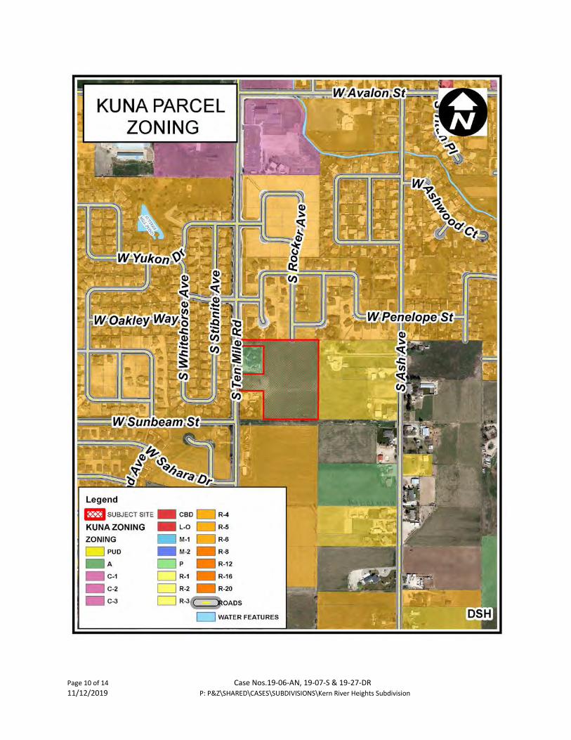
Page 10 of 14 Case Nos.19-06-AN, 19-07-S & 19-27-DR 11/12/2019 P: P&Z\SHARED\CASES\SUBDIVISIONS\Kern River Heights Subdivision

Page 11 of 14 Case Nos.19-06-AN, 19-07-S & 19-27-DR 11/12/2019 P: P&Z\SHARED\CASES\SUBDIVISIONS\Kern River Heights Subdivision

Page 12 of 14 Case Nos.19-06-AN, 19-07-S & 19-27-DR 11/12/2019 P: P&Z\SHARED\CASES\SUBDIVISIONS\Kern River Heights Subdivision

Page 13 of 14 Case Nos.19-06-AN, 19-07-S & 19-27-DR 11/12/2019 P: P&Z\SHARED\CASES\SUBDIVISIONS\Kern River Heights Subdivision

Page 14 of 14 Case Nos.19-06-AN, 19-07-S & 19-27-DR 11/12/2019 P: P&Z\SHARED\CASES\SUBDIVISIONS\Kern River Heights Subdivision


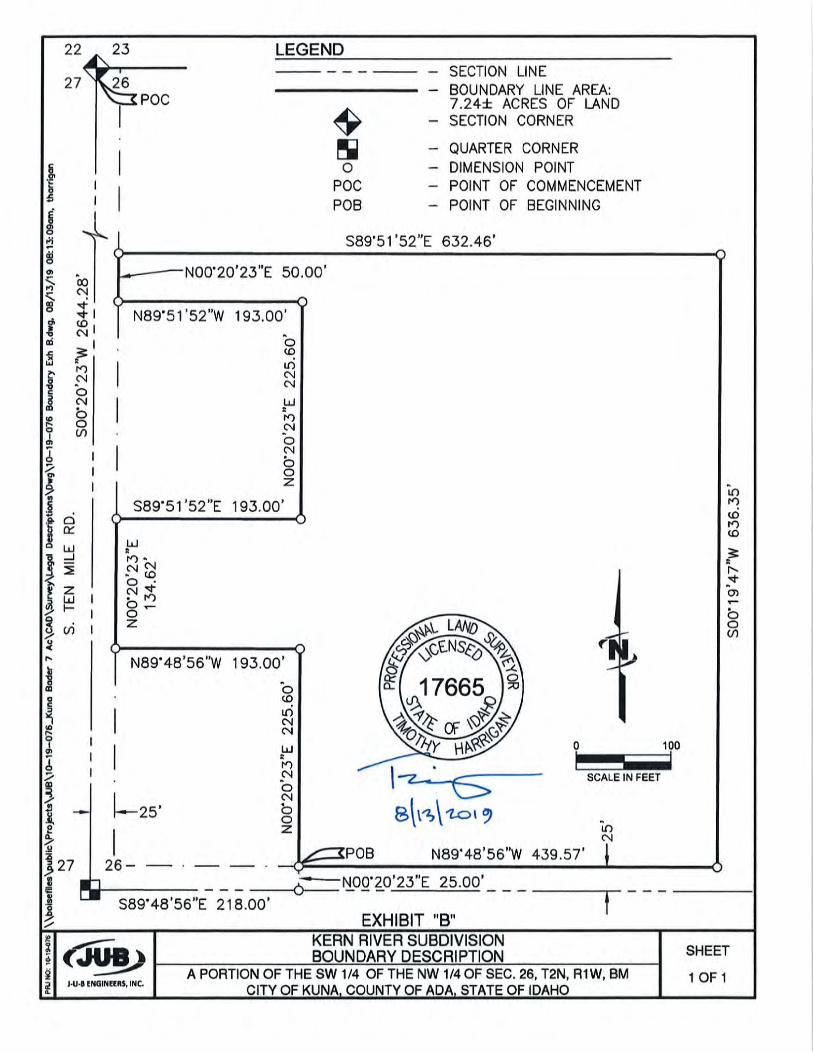


DESIGN BY:
DRAWN BY:
CHECKED BY:
BY
AP
R.
DA
TE
SHEET NUMBER:
DE
SC
RIP
TIO
N
R
EUSE
OF
DR
AW
ING
STH
IS D
OC
UM
EN
T, A
ND
TH
E ID
EA
S A
ND
DE
SIG
NS
INC
OR
PO
RA
TED
HE
RE
IN, A
S A
N IN
STR
UM
EN
T O
F P
RO
FES
SIO
NA
L S
ER
VIC
E, I
S T
HE
PR
OP
ER
TY O
F J-
U-B
EN
GIN
EER
S, In
c.A
ND
IS N
OT
TO B
E U
SE
D, I
NW
HO
LE O
R P
AR
T, F
OR
AN
Y O
THE
R P
RO
JEC
T W
ITH
OU
T TH
E E
XP
RE
SS
WR
ITTE
N A
UTH
OR
IZA
TIO
N O
F J-
U-B
EN
GIN
EER
S, In
c.
NO
.B
Y
RE
VIS
ION
AP
R.
DA
TE
BY
AP
R.
DA
TE
JUB PROJ. # :
LAST UPDATED: 8/13/2019
10-19-076_PRE-PLAT
INCH, SCALE ACCORDINGLYAT FULL SIZE, IF NOT ONE
ONE INCH
FILE :
\\BO
ISE
FIL
ES
\PU
BLI
C\P
RO
JEC
TS
\JU
B\1
0-19
-076
_KU
NA
BA
DE
R 7
AC
\CA
D\S
HE
ET
\10-
19-0
76_P
RE
-PLA
T.D
WG
Plo
t Dat
e:8/
13/2
019
9:55
AM
Plo
tted
By:
Eve
rett
Ear
nest
Dat
e C
reat
ed:8
/13/
2019
J-U-B ENGINEERS, INC.
Boi
se, I
D 8
3709
-094
4S
uite
201
J-U
-B E
NG
INE
ER
S, I
NC
.25
0 S
. Bee
chw
ood
Ave
.
ww
w.ju
b.co
mP
hone
: 208
.376
.733
0
KER
N R
IVER
HEI
GH
TS S
UBD
IVIS
ION
KU
NA
, ID
AH
O
PR
E-P
LAT
10-19-076
----
----
----
PP-01
DEVELOPER
LAND SURVEYORCIVIL ENGINEER
N
0
SCALE IN FEET
50 100
KERN RIVER HEIGHTS SUBDIVISIONSITUATED IN THE SOUTHWEST QUARTER IF THE NORTHWEST QUARTER OF SECTION 26,
TOWNSHIP 2 NORTH, RANGE 1 WEST, BOISE MERIDIAN,KUNA, IDAHO
2019
VICINITY MAP
BOUNDARYCERTIFICATION
BOUNDARY LEGEND
OWNER
LEGEND
LAND USE SUMMARY
SEWER & WATER:
POWER: ROADWAYS
PRESSURE IRRIGATION:
SCHOOL DISTRICT:
FIRE DISTRICT:
IRRIGATION DISTRICT:
SCALE:TYPICAL 50' STREET SECTION
N.T.S.
PRELIMINARY
PRELIMINARY
17665
AutoCAD SHX Text
S. TEN MILE ROAD
AutoCAD SHX Text
W. SUNBEAM STREET
AutoCAD SHX Text
S
AutoCAD SHX Text
S
AutoCAD SHX Text
S
AutoCAD SHX Text
S
AutoCAD SHX Text
S
AutoCAD SHX Text
S
AutoCAD SHX Text
S
AutoCAD SHX Text
S
AutoCAD SHX Text
S
AutoCAD SHX Text
IRR
AutoCAD SHX Text
IRR
AutoCAD SHX Text
IRR
AutoCAD SHX Text
IRR
AutoCAD SHX Text
IRR
AutoCAD SHX Text
IRR
AutoCAD SHX Text
D
AutoCAD SHX Text
D
AutoCAD SHX Text
D
AutoCAD SHX Text
S. FOOTLIGHTS AVENUE
AutoCAD SHX Text
S. ROCKER AVENUE
AutoCAD SHX Text
S. RETORT AVENUE
AutoCAD SHX Text
W. CANUBE STREET
AutoCAD SHX Text
W. CASPIAN STREET
AutoCAD SHX Text
COMMON LOT
AutoCAD SHX Text
COMMON LOT
AutoCAD SHX Text
COMMON LOT
AutoCAD SHX Text
COMMON LOT
AutoCAD SHX Text
COMMON LOT
AutoCAD SHX Text
COMMON LOT
AutoCAD SHX Text
D
AutoCAD SHX Text
D
AutoCAD SHX Text
D
AutoCAD SHX Text
- Section Line
AutoCAD SHX Text
- Center Line
AutoCAD SHX Text
- Subdivision Boundary Line
AutoCAD SHX Text
- Right-of-way Line
AutoCAD SHX Text
- Section Corner
AutoCAD SHX Text
- Quarter-Section Corner
AutoCAD SHX Text
- Existing Parcel Line
AutoCAD SHX Text
- Property Corner
AutoCAD SHX Text
22
AutoCAD SHX Text
23
AutoCAD SHX Text
27
AutoCAD SHX Text
26
AutoCAD SHX Text
ANDREW NEWELL, P.E. J-U-B ENGINEERS 250 S. BEECHWOOD AVE. STE. 201 BOISE, ID 83709 208-376-7330
AutoCAD SHX Text
NOTES: 1. CONTOUR AND SPOT ELEVATION DATA IS REFERENCED TO NAVD '88 DATUM. CONTOUR AND SPOT ELEVATION DATA IS REFERENCED TO NAVD '88 DATUM. 2. THE STREETS WITHIN THIS DEVELOPMENT ARE PUBLIC STREETS. THE PUBLIC STREET SHALL BE CONSTRUCTED IN ACCORDANCE WITH ADA COUNTY THE STREETS WITHIN THIS DEVELOPMENT ARE PUBLIC STREETS. THE PUBLIC STREET SHALL BE CONSTRUCTED IN ACCORDANCE WITH ADA COUNTY HIGHWAY DISTRICT (ACHD) STANDARDS FOR PUBLIC STREETS WITH A MINIMUM GRADIENT OF 0.40%. 3. ALL LOTS ARE RESIDENTIAL BUILDING LOTS EXCEPT LOT 1, BLOCK 1, LOT 1, BLOCK 2, LOT 7, BLOCK 4, LOT 3, BLOCK 5, AND LOTS 1, AND 4, ALL LOTS ARE RESIDENTIAL BUILDING LOTS EXCEPT LOT 1, BLOCK 1, LOT 1, BLOCK 2, LOT 7, BLOCK 4, LOT 3, BLOCK 5, AND LOTS 1, AND 4, BLOCK 6, WHICH ARE COMMON AREA\DRAINAGE STORAGE LOTS. 4. STORMWATER RUN-OFF GENERATED ON THIS SITE SHALL HAVE A QUALITY CONTROL TREATMENT PRIOR TO BEING CONVEYED TO ONSITE STORAGE STORMWATER RUN-OFF GENERATED ON THIS SITE SHALL HAVE A QUALITY CONTROL TREATMENT PRIOR TO BEING CONVEYED TO ONSITE STORAGE ONSITE STORAGE FACILITIES. 5. PUBLIC UTILITIES SHALL INCLUDE WATER, SEWER, ELECTRIC POWER, NATURAL GAS, TELEPHONE, AND CABLE TELEVISION. PUBLIC UTILITIES SHALL INCLUDE WATER, SEWER, ELECTRIC POWER, NATURAL GAS, TELEPHONE, AND CABLE TELEVISION. 6. THIS SUBDIVISION WILL RECEIVE PRESSURIZED IRRIGATION FROM THE CITY PRESSURE IRRIGATION SYSTEM. THE PRESSURE IRRIGATION SYSTEM WILL THIS SUBDIVISION WILL RECEIVE PRESSURIZED IRRIGATION FROM THE CITY PRESSURE IRRIGATION SYSTEM. THE PRESSURE IRRIGATION SYSTEM WILL BE OWNED AND MAINTAINED BY KUNA IRRIGATION. 7 THIS DEVELOPMENT RECOGNIZES SECTION 22-4503 OF IDAHO CODE, RIGHT TO FARM ACT, WHICH STATES, "NO AGRICULTURAL OPERATION, THIS DEVELOPMENT RECOGNIZES SECTION 22-4503 OF IDAHO CODE, RIGHT TO FARM ACT, WHICH STATES, "NO AGRICULTURAL OPERATION, "NO AGRICULTURAL OPERATION, OPERATION, AGRICULTURAL FACILITY OR EXPANSION THEREOF SHALL BE OR BECOME A NUISANCE, PRIVATE OR PUBLIC, BY ANY CHANGED CONDITIONS IN OR ABOUT THE SURROUNDING NONAGRICULTURAL ACTIVITIES AFTER IT HAS BEEN IN OPERATION FOR MORE THAN ONE (1) YEAR, WHEN THE OPERATION, FACILITY OR EXPANSION WAS NOT A NUISANCE AT THE TIME IT BEGAN OR WAS CONSTRUCTED. THE PROVISIONS OF THIS SECTION SHALL NOT APPLY WHEN A NUISANCE RESULTS FROM THE IMPROPER OR NEGLIGENT OPERATION OF AN AGRICULTURAL OPERATION, AGRICULTURAL FACILITY OR EXPANSION THEREOF." 8. DOMESTIC AND FIRE PROTECTION WATER SHALL BE PROVIDED BY THE CITY OF KUNA. DOMESTIC AND FIRE PROTECTION WATER SHALL BE PROVIDED BY THE CITY OF KUNA. 9. SANITARY SEWER COLLECTION SHALL BE PROVIDED BY THE CITY OF KUNA. SANITARY SEWER COLLECTION SHALL BE PROVIDED BY THE CITY OF KUNA. 10. IRRIGATION DITCHES THROUGH THE PROJECT SHALL BE PIPED WHERE THEY CROSS ROADWAYS WITH ALL STRUCTURES LOCATED BEYOND ANY PUBLIC IRRIGATION DITCHES THROUGH THE PROJECT SHALL BE PIPED WHERE THEY CROSS ROADWAYS WITH ALL STRUCTURES LOCATED BEYOND ANY PUBLIC BEYOND ANY PUBLIC RIGHT-OF-WAY. 11. LANDSCAPED COMMON LOTS ARE LOCATED THROUGHOUT THE PROJECT AND ARE IDENTIFIED ON THE PLAN. THESE LOTS SHALL BE OWNED AND LANDSCAPED COMMON LOTS ARE LOCATED THROUGHOUT THE PROJECT AND ARE IDENTIFIED ON THE PLAN. THESE LOTS SHALL BE OWNED AND MAINTAINED BY THE HOMEOWNERS ASSOCIATION. 12. BUILDING SETBACKS AND DIMENSIONAL STANDARDS SHALL BE IN ACCORDANCE WITH THE DEVELOPMENT AGREEMENT WITH THE CITY OF KUNA. BUILDING SETBACKS AND DIMENSIONAL STANDARDS SHALL BE IN ACCORDANCE WITH THE DEVELOPMENT AGREEMENT WITH THE CITY OF KUNA. 13. ANY RE-SUBDIVISION OF THIS PLAT SHALL COMPLY WITH THE APPLICABLE ZONING REGULATIONS IN AFFECT AT THE TIME OF THE RE-SUBDIVISION. ANY RE-SUBDIVISION OF THIS PLAT SHALL COMPLY WITH THE APPLICABLE ZONING REGULATIONS IN AFFECT AT THE TIME OF THE RE-SUBDIVISION. 14. THE OWNER SHALL COMPLY WITH IDAHO CODE, SECTION 31-3805 OR ITS PROVISIONS THAT MAY APPLY TO IRRIGATION RIGHTS. THE OWNER SHALL COMPLY WITH IDAHO CODE, SECTION 31-3805 OR ITS PROVISIONS THAT MAY APPLY TO IRRIGATION RIGHTS. 15. A STORMWATER DRAINAGE EASEMENT SHALL BE RESERVED ON THE DRAINAGE LOTS FOR THE BENEFIT OF ACHD. LANDSCAPING OVER SAID LOTS A STORMWATER DRAINAGE EASEMENT SHALL BE RESERVED ON THE DRAINAGE LOTS FOR THE BENEFIT OF ACHD. LANDSCAPING OVER SAID LOTS SHALL BE MAINTAINED BY THE HOMEOWNERS ASSOCIATION AND ACHD SHALL PROVIDE HEAVY MAINTENANCE OF THE STORM DRAINAGE FACILITIES AS DEFINED IN THE COVENANTS, CONDITIONS AND RESTRICTIONS FOR KERN RIVER HEIGHTS SUBDIVISION. 16. THIS PROPERTY IS IN ZONE X OF THE FLOOD INSURANCE RATE MAP NO. 16001C0400 J, COMMUNITY PANEL NO. 0400, WHICH BEARS AN THIS PROPERTY IS IN ZONE X OF THE FLOOD INSURANCE RATE MAP NO. 16001C0400 J, COMMUNITY PANEL NO. 0400, WHICH BEARS AN 16001C0400 J, COMMUNITY PANEL NO. 0400, WHICH BEARS AN , COMMUNITY PANEL NO. 0400, WHICH BEARS AN 0400, WHICH BEARS AN , WHICH BEARS AN EFFECTIVE DATE OF OCTOBER 2, 2003 AND IS NOT IN A SPECIAL FLOOD HAZARD AREA.
AutoCAD SHX Text
PRELIMINARY PLAT FOR
AutoCAD SHX Text
SCALE: 1"=2000'
AutoCAD SHX Text
S. TEN MILE RD
AutoCAD SHX Text
PLACERVILLE SUBDIVISION
AutoCAD SHX Text
DESERTHAWK SUBDIVISION
AutoCAD SHX Text
DESERT VIEW ESTATES SUBDIVISION
AutoCAD SHX Text
RYAN MINERT 3327 N. EAGLE ROAD SUITE #110-148 MERIDIAN, IDAHO 83646 208-639-3262
AutoCAD SHX Text
CARL BADER 780 S. TEN MILE RD. KUNA, ID 83643
AutoCAD SHX Text
SANITARY SEWER LINE WATER LINE GRAVITY IRRIGATION PIPE PRESSURE IRRIGATION LINE STORM DRAIN LINE CENTERLINE LOT LINE 6" VERTICAL CURB & GUTTER ROLLED CURB & GUTTER 5' SIDEWALK SEWER MANHOLE DITCH FLOW LINE IRRIGATION MANHOLE STREET LIGHT TREE DECIDUOUS TREE CONIFER EDGE OF PAVEMENT GAS LINE FENCE LINE FIRE HYDRANT 5' CONTOUR LINE 1' CONTOUR LINE
AutoCAD SHX Text
EXISTING
AutoCAD SHX Text
PROPOSED
AutoCAD SHX Text
IRR
AutoCAD SHX Text
2650
AutoCAD SHX Text
2651
AutoCAD SHX Text
W. SUNBEAM ST
AutoCAD SHX Text
SUTTER'S MILL SUBDIVISION
AutoCAD SHX Text
TIMOTHY HARRIGAN, P.L.S. J-U-B ENGINEERS 250 S. BEECHWOOD AVE. STE. 201 BOISE, ID 83709 208-376-7330
AutoCAD SHX Text
TOTAL AREA: 7.25 AC. 7.25 AC. TOTAL LOTS: 35 LOTS 35 LOTS RESIDENTIAL LOTS: 29 LOTS 29 LOTS COMMON AREA LOTS: 6 LOTS 6 LOTS RESIDENTIAL DENSITY: 4.00 DU/AC 4.00 DU/AC COMMON AREA: 0.66 AC. (9.1%) 0.66 AC. (9.1%) AVERAGE LOT SIZE: 6,949 S.F. 6,949 S.F. SMALLEST LOT: 5,085 S.F. 5,085 S.F. EXISTING ZONE: A A PROPOSED ZONE: R-6R-6
AutoCAD SHX Text
CITY OF KUNA 6950 S TEN MILE RD MERIDIAN, ID. 83634 PHONE: (208) 287-1729 (SEW) PHONE: (208) 287-1725 (WAT)
AutoCAD SHX Text
IDAHO POWER VIC STEELMAN 1221 W. IDAHO STREET BOISE, ID. 83702 PHONE: (208) 388-2323
AutoCAD SHX Text
ADA COUNTY HIGHWAY DISTRICT 1301 N. ORCHARD ST BOISE, ID. 83706 PHONE: (208) 387-6100
AutoCAD SHX Text
CITY OF KUNA 6950 S TEN MILE RD MERIDIAN, ID. 83634 PHONE: (208) 287-1725
AutoCAD SHX Text
KUNA SCHOOL DISTRICT 711 E. PORTER STREET KUNA, ID 83634 PHONE: (208) 922-1000
AutoCAD SHX Text
KUNA FIRE DISTRICT 150 W. BOISE STREET KUNA, ID 83634 PHONE: (208) 922-1144
AutoCAD SHX Text
BOISE PROJECT BOARD OF CONTROL 2465 OVERLAND ROAD BOISE, ID 83705 PHONE: (208) 344-1141
AutoCAD SHX Text
POINT OF BEGINNING
AutoCAD SHX Text
S
AutoCAD SHX Text
ARDMORE SUBDIVISION
AutoCAD SHX Text
LIBERTY SUBDIVISION
AutoCAD SHX Text
BRANDYWINE SUBDIVISION
AutoCAD SHX Text
COLERIDGE SUBDIVISION
AutoCAD SHX Text
KUNA ORCHARD TRACTS
AutoCAD SHX Text
S. SCHOOL AVE
AutoCAD SHX Text
S. ASH AVENUE
AutoCAD SHX Text
AutoCAD SHX Text
AutoCAD SHX Text
2%
AutoCAD SHX Text
2%
AutoCAD SHX Text
AutoCAD SHX Text
ASPHALT
AutoCAD SHX Text
2%%% MAX.
AutoCAD SHX Text
3" ROLLED CURB AND GUTTER
AutoCAD SHX Text
5.0'
AutoCAD SHX Text
5.0'
AutoCAD SHX Text
2%%% MAX.
AutoCAD SHX Text
5.0'
AutoCAD SHX Text
5.0'
AutoCAD SHX Text
SIDEWALK
AutoCAD SHX Text
KUNA ORCHARD TRACTS
AutoCAD SHX Text
KUNA ORCHARD TRACTS
AutoCAD SHX Text
KUNA ORCHARD TRACTS
AutoCAD SHX Text
DESERTHAWK NO. 4 SUBDIVISION
AutoCAD SHX Text
SUTTER'S MILL SUBDIVISION
AutoCAD SHX Text
COLERIDGE SUBDIVISION
AutoCAD SHX Text
PLACERVILLE SUBDIVISION
AutoCAD SHX Text
S. ROCKER AVENUE
AutoCAD SHX Text
W. SCOOP STREET
AutoCAD SHX Text
17011
AutoCAD SHX Text
R
AutoCAD SHX Text
E
AutoCAD SHX Text
G
AutoCAD SHX Text
I
AutoCAD SHX Text
S
AutoCAD SHX Text
T
AutoCAD SHX Text
E
AutoCAD SHX Text
R
AutoCAD SHX Text
E
AutoCAD SHX Text
D
AutoCAD SHX Text
S
AutoCAD SHX Text
T
AutoCAD SHX Text
A
AutoCAD SHX Text
T
AutoCAD SHX Text
E
AutoCAD SHX Text
O
AutoCAD SHX Text
F
AutoCAD SHX Text
I
AutoCAD SHX Text
D
AutoCAD SHX Text
A
AutoCAD SHX Text
H
AutoCAD SHX Text
O


VICINITY MAP:
L1.00
LANDSCAPENOTES &DETAILS
Th
ese
d
oc
um
en
ts a
re
th
e p
ro
pe
rty o
f S
ta
ck R
oc
k G
ro
up
a
nd
a
re
n
ot to
b
e c
op
ie
d, re
pro
du
ce
d, d
istrib
ute
d, e
ith
er d
ire
ctly o
r in
dire
ctly, u
se
d fo
r a
no
th
er p
ro
je
ct o
r a
ny p
urp
ose
w
ha
tso
eve
r w
ith
ou
t e
xp
re
ss a
nd
w
ritte
n p
erm
issio
n o
f S
ta
ck R
oc
k G
ro
up
.
JOB NO:DATE:DRAWN BY:CHECKED BY:
#
DRAWING TITLE
SHEET NUMBER
JBDW
08.12.201919-1443
D e s c r i p t i o nDATEMRK
REVISIONS
G:\S
ha
re
d d
rive
s\S
ta
ck R
oc
k G
ro
up
\W
ork\2
01
9\0
1-P
ro
je
cts\1
9-1
44
3 K
ern
S
ub
divisio
n\0
3-C
AD
\3
.0
1-C
ity S
ub
mitta
ls\1
9-1
44
3 L
10
0 D
R L
an
dsc
ap
eP
la
n.d
wg
KE
RN
SU
BD
IVIS
ION
KU
NA
, ID
1A
BC
DE
FG
H2 3 4 5 6 7 8 9 10
1 2 3 4 5 6 7 8 9 10
STA
CK
RO
CK
GR
OU
P -
CIT
Y R
EV
IEW
SE
T
WILLET C HOWARD, PLAOFFICE: (208) 345.0500 EMAIL:
THE GRAPHICS AND DESIGNSO N T H I S S H E E T A R EDELIVERABLES THAT REMAINAT ALL TIMES PROPERTY OFSTACK ROCK GROUP, INC.
REPRODUCTION OR REUSE OFTHIS PRODUCT CONTAINEDH E R E I N I S P R O H I B I T E DW I T H O U T T H E W R I T T E NCONSENT OF STACK ROCKG R O U P , I N C .
©2019 STACKROCK GROUP, INC.
LANDSCAPEARCHITECTURE
& MASTER PLANNING
(208) 345-0500404 S 8th St. #154Boise, ID 83702
StackRockGroup.com
PRELIMINARY
NOT FOR CONSTRUCTION
08.12.19LA-16830
RE
TSUBNESSEJ
*OHADIFOETATS
*
LIC
EN
SEDL ANDSCAPE
ARCHI T
EC
T
TOP TWO STRUCTURALROOTS: <3" BELOW TOP OF
ROOTBALL.
LOWEST STRUCTURAL ROOT:<5" BELOW TOP OF ROOT
BALL
612"
NOTES:1. DO NOT DAMAGE OR CUT LEADER2. DO NOT DISTURB ROOT OR DAMAGE ROOT BALL WHEN INSTALLING TREE OR TREE STAKES.3. TREE STAKING SHALL BE AT THE DISCRETION OF CONTRACTOR. HOWEVER ANY TREES DISTURBED
FROM PLUMB DURING THE PLANT WARRANTEE PERIOD WILL BE REPAIRED OR REPLACED ATCONTRACTOR'S EXPENSE.
4. WATER PLANTS THOROUGHLY IMMEDIATELY AFTER INSTILLATION.5. REMOVE ALL BURLAP, TWINE, ROPE, OR MATERIAL FROM THE TOP 13 OF THE ROOTBALL.6. 4' DIAMETER PLANTER BED/MULCH RING AROUND THE TRUNK OF THE TREE. 3" OF MULCH MIN. DO
NOT PLACE MULCH WITHIN 2" OF TRUNK OF TREE.
GRAFT VISIBLE ABOVE SOILLINE
SOIL LINE OF THE TOP OFTHE ROOT BALL AFTER
REMOVING EXCESS SOIL.2-3" OF MULCH
BACKFILL MIX SEENOTES AND
SPECIFICATIONS.
COMPACT SOIL UNDERROOTBALL TO 90% PROCTOR.
BALL AND BURLAP TREE PLANTING3/4" = 1'-0"
212"
SOIL SAUCER >3" HIGH;REMOVE AT COMPLETION OF
PROJECT
CUT AND FOLD WIREBASKET FROM TOP OF
ROOTBALL
FINISHED MATERIALPER PLAN
329343.33-041
MULCH 2" MIN.AWAY FROM TRUNKOF PLANT.
FINISHED MATERIALPER PLAN
BALL AND BURLAP PLANT (IFCONTAINER - GROWN PLANTWITH ROOTS LOOSENED ANDPULLED OUT TO PREVENTPLANT FROM BECOMING ROOTBOUND)
SOIL SURFACEROUGHENED TOBIND WITH NEW SOIL
FOLD BURLAP FROM TOPOF ROOT BALL DOWNINTO GROUND; SET TOPOF BALL FLUSH WITHFINISH GRADE
12" TO 18" FORLARGER SHRUBROOT BALLS,MAKE DEPTH MIN.4" DEEPER THANBALL)
3" DEEP MULCH MIN.
NOTE:REMOVE ALL TAGS, TWINE OROTHER NON BIODEGRADABLEMATERIALS ATTACHED TO PLANT ORROOT MASS.
BACKFILL SHALL BE 100% TOPSOIL.WATER SETTLE ALL PLANTINGS TOENSURE PLANT ROOTBALLMAINTAINS 12" HEIGHT ABOVEEXISTING SOILS WHEN COMPLETE.
SHRUB PLANTING1" = 1'-0" 329333.16-01
2
LANDSCAPE REQUIREMENTS:PER CITY OF KUNA LANDSCAPING REQUIREMENTS CHAPTER 5.
LANDSCAPE AT COMMON LOTS:* MINIMUM (1) DECIDUOUS TREE PER 1,000 SF OF SITE.
COMMON LOT TREES REQUIRED TREES PROVIDED· LOT 1, BLOCK 1 - 2,166 SF 2 2· LOT 1, BLOCK 2 - 2,166 SF 2 2· LOT 7, BLOCK 4 - 1,563 SF 2 2· LOT 1, BLOCK 6 - 1,030 SF 1 1· LOT 4, BLOCK 6 - 15,191 SF 15 17 (13 DECIDUOUS, 4 EVERGREEN)
LANDSCAPE ALONG STREETS:* 1 TREE PER 35 LINEAR FEET.* 5 SHRUBS PER 35 LINEAR FEET.
S. TEN MILE RD. TREES REQUIRED / TREES PROVIDED: SHRUBS REQUIRED / PROVIDED· 134 LF 4/4 20/21W. SUNBEAM ST. TREES REQUIRED / TREES PROVIDED: SHRUBS REQUIRED / PROVIDED· 390 LF 11/11 55/67
BIODIVERSITY REQUIREMENT:*A MINIMUM OF 4 DIFFERENT TREE SPECIES ARE REQUIRED WHEN 31-40 TREES ARE PROPOSED.
· PROPOSED TREES SPECIES REQUIRED: SPECIES PROVIDED:· 39 4 4
PLANT SIZING MINIMUM REQUIREMENTS:
TREE SIZING:SHADE TREES: MIN 2" CAL, B&BORNAMENTAL TREES: MIN 2" CAL, B&BEVERGREEN TREES: MIN 6 FEET IN HEIGHT
1. REGULATIONS & STANDARDS1.1. All contractor work shall be conducted in accordance with
ISPWC (Idaho Standard Public Works Construction), 2019;and Kuna, ID codes, standards and state and localregulations.
2. EXISTING CONDITIONS2.1. All utilities shall be located prior to construction and
protected. Any damage to structures, utilities or concretewill be replaced at contractor's expense.
2.2. The site has many existing improvements such asunderground utilities, curb and gutter, light poles andsidewalks.
2.3. See Engineer's plans for information about existingfeatures; all drainage pipes and locations. Protect andretain drainage at all times.
3. GRADING & SITE PREPARATION3.1. Prepare finish grades for planting by grubbing and
removing weeds. If necessary apply Round-Up (orequivalent herbicide), using a certified applicator. Removerocks and other materials over 2".
3.2. All gravel overprep to be removed and disposed of off site.3.3. Finish grade to be smooth transition to allow for entire site
to be a natural flowing space.3.4. Refer to Engineer's plans for grading information & for all
drainage pipes and locations. Protect and retain drainageat all times.
3.5. No pooling or standing water will be accepted per industrystandards.
4. SOILS4.1. All planter beds to receive a minimum of 18" depth of
screened topsoil. Spread, compact, and fine grade tosmooth and uniform grade 2.5" below adjacent surfaces.
4.2. All lawn areas to receive a minimum of 12" depth ofscreened topsoil. Spread, compact, and fine grade topsoilto a smooth uniform grade 1" below adjacent surfaces.
4.3. Reuse of existing topsoil that has been stockpiled on site ispermitted if:
4.3.1. Topsoil is tested and analyzed to ensure a proper growingmedium. Provide additional amendments asdetermined by soil tests. And
4.3.2. Topsoil is to be loose, friable sandy loam that is clean andfree of toxic materials, noxious weeds, weed seeds,rocks, grass or other foreign materials.
4.3.3. Topsoil should have a pH of 6.5 to 8.4.3.4. If on site topsoil does not meet these minimum standards
contractor is responsible for providing approvedimported topsoil or improving onsite topsoil per theapproval of the project manager.
4.4. If imported topsoil is used it must be from a local sourceand be screened free of any debris or foreign matter.Topsoil must not contain rocks, sticks, lumps, or toxicmatter.
4.5. Smooth, compact, and fine grade topsoil in lawn areas tosmooth and uniform grade .5" below adjacent surfaces.
4.6. Prepare finish grade of topsoil to elevations set byEngineer's plans with positive drainage away fromstructures. Refer to Civil Engineer's plans for gradinginformation.
4.7. Amend all new plantings with 2 parts topsoil and 1 partcompost.
5. PLANTER BED MULCH5.1. All planter beds to receive 3" depth of round river rock
mulch, or approved other. Install over commercial gradeweed barrier fabric per manufacturer recommendations.
6. LAWN AREAS6.1. Sodded, to be tall turf-type fescue or approved equal per
approved by owner.6.2. All lawn areas to have cut edge.
7. PLANTS7.1. All plant material shall be installed per industry standards.7.2. All plant material shall meet or exceed the minimum
federal standards as regulated by ANSI z60.1, AmericanStandard for Nursery Stock. Plants not meeting thesestandards for quality, or plants determined to be unhealthyby Owner's representative, will be rejected.
7.3. All trees and shrubs to be installed per details.7.4. Fertilize all trees and shrubs with 'Agriform' planting tablets
or approved equal. Apply per manufacturersrecommendations.
7.5. All plants shall adhere to plant schedule, species & sizes.Any necessary subsitutions due to availability oralternatives shall be coordinated to the landscape architectvia submittal.
8. IRRIGATION8.1. Irrigation system shall be built to the following
specifications:
8.1.1. Adhere to city codes when connecting to city water.8.1.2. All irrigation material to be new with manufacturers'
warranty fully intact.8.2. All remote control valves (including master control valve)
to have flow control device.8.3. Install indoor rated controller. Coordinate with general
contractor on exact location.8.4. Controller to include On/Off rain switch or other rain shut
off device that does not alter program.8.5. Irrigation system piping to be minimum class 200 PVC or
approved equal, sleeves to be double the size of pipeslocated within, all wires to be contained in separatesleeves 1-1/2" dia min.
8.6. Use common trenching where possible.8.7. All PVC located under hardscapes to be schedule 40 PVC
with same req's as above.8.8. All mainline pipe and wires to be buried a minimum of 18"
and all lateral piping to be buried a minimum of 12" belowgrade.
8.9. All wires to be 14 gauge direct bury wire at a minimum.Size wire for correct voltage loss.
8.10. Supply a minimum of (2) spare wires to furthest valvesfrom controller in all directions.
8.11. Sprinkler heads shall have a matched precipitation withineach control circuit. Velocities shall not exceed 5 feet persecond.
8.12. Contractor is responsible complying with all codes andpaying all permits necessary.
8.13. Sprinkler heads shall have matched precipitation withineach control circuit. Velocities shall not exceed 5 feet persecond.
9. CONTRACTOR RESPONSIBILITIES9.1. Estimated quantities are shown for general reference only.
Contractor shall be responsible for all quantity estimates.9.2. All plant material and workmanship shall be guaranteed for
a period of one year beginning at the date of Acceptanceby Owner. Replace all dead or unhealthy plant materialimmediately with same type and size at no cost to Owner.
9.3. Landscape contractor to turn in as built drawings at theend of project. Substantial completion will not be granteduntil 2 copies @ 1"=10' scale are turned in and approvedby owner's representative.
10. In the event of a discrepancy, notify the General Contractor.
LANDSCAPE NOTES:
NORTH
N.T.S
W. KUNA RD.
PROJECT AREA
W. SUNBEAM ST.
S. T
EN
MIL
E R
D.
S. A
SH
AV
E.
AutoCAD SHX Text
Seals
AutoCAD SHX Text
**
AutoCAD SHX Text
**

S. T
EN
MIL
E R
D.
W. SUNBEAM ST.S
. FO
OTL
IGH
TS A
VE
.
W. CANUBE ST.
S. R
ETO
RT
AV
E.
S. R
OC
KE
R A
VE
.
W. CASPIAN ST.
LANDSCAPE MATERIALS LEGEND:
SOD LAWN, OR APPROVED OTHER
6' CLOSED VISION FENCE
TREES BOTANICAL / COMMON NAME CONT CAL SIZE QTY REMARKS
Acer truncatum `Pacific Sunset` TM / Pacific Sunset Maple B & B 2" 11 30`h x 25`w
Liquidambar styraciflua `Ward` / Cherokee Sweetgum B&B 2" 7 45`h x 30`w
Pinus flexilis `Vanderwolf`s Pyramid` / Vanderwolf`s Pyramid Pine B & B 6`-7` H 4 25` h x 12`w
Tilia americana `Redmond` / Redmond American Linden B & B 2" 17 50`h x 30`w
SHRUBS BOTANICAL / COMMON NAME CONT FIELD2 SIZE QTY REMARKS
Forsythia x intermedia `Kolgold` / Magical Gold Forsythia 5 gal 21 5`h x 4`w
Helictotrichon sempervirens / Blue Oat Grass 2 gal 30 3`h x 3`w,Drought Tolerant
Pennisetum alopecuroides `Red Head` / Red Head Fountain Grass 1 gal 24 3`h x 3`w
Pinus strobus `Blue Shag` / Blue Shag White Pine 5 gal 14 3`h x 4`w
Salvia nemorosa `East Friesland` / East Friesland Perennial Sage 2 gal 4 1.5` H X 2` W Drought Tolerant
PLANT SCHEDULE
X EXISTING FENCE TO REMAIN
L1.01
LANDSCAPEPLAN
Th
ese
d
oc
um
en
ts a
re
th
e p
ro
pe
rty o
f S
ta
ck R
oc
k G
ro
up
a
nd
a
re
n
ot to
b
e c
op
ie
d, re
pro
du
ce
d, d
istrib
ute
d, e
ith
er d
ire
ctly o
r in
dire
ctly, u
se
d fo
r a
no
th
er p
ro
je
ct o
r a
ny p
urp
ose
w
ha
tso
eve
r w
ith
ou
t e
xp
re
ss a
nd
w
ritte
n p
erm
issio
n o
f S
ta
ck R
oc
k G
ro
up
.
JOB NO:DATE:DRAWN BY:CHECKED BY:
#
DRAWING TITLE
SHEET NUMBER
JBDW
08.12.201919-1443
D e s c r i p t i o nDATEMRK
REVISIONS
G:\S
ha
re
d d
rive
s\S
ta
ck R
oc
k G
ro
up
\W
ork\2
01
9\0
1-P
ro
je
cts\1
9-1
44
3 K
ern
S
ub
divisio
n\0
3-C
AD
\3
.0
1-C
ity S
ub
mitta
ls\1
9-1
44
3 L
10
0 D
R L
an
dsc
ap
eP
la
n.d
wg
KE
RN
SU
BD
IVIS
ION
KU
NA
, ID
1A
BC
DE
FG
H2 3 4 5 6 7 8 9 10
1 2 3 4 5 6 7 8 9 10
STA
CK
RO
CK
GR
OU
P -
CIT
Y R
EV
IEW
SE
T
WILLET C HOWARD, PLAOFFICE: (208) 345.0500 EMAIL:
THE GRAPHICS AND DESIGNSO N T H I S S H E E T A R EDELIVERABLES THAT REMAINAT ALL TIMES PROPERTY OFSTACK ROCK GROUP, INC.
REPRODUCTION OR REUSE OFTHIS PRODUCT CONTAINEDH E R E I N I S P R O H I B I T E DW I T H O U T T H E W R I T T E NCONSENT OF STACK ROCKG R O U P , I N C .
©2019 STACKROCK GROUP, INC.
LANDSCAPEARCHITECTURE
& MASTER PLANNING
(208) 345-0500404 S 8th St. #154Boise, ID 83702
StackRockGroup.com
PRELIMINARY
NOT FOR CONSTRUCTION
08.12.19LA-16830
RE
TSUBNESSEJ
*OHADIFOETATS
*
LIC
EN
SEDL ANDSCAPE
ARCHI T
EC
T
NORTH
0
SCALE:
feet30 60 90
1" = 30'
AutoCAD SHX Text
S
AutoCAD SHX Text
S
AutoCAD SHX Text
S
AutoCAD SHX Text
S
AutoCAD SHX Text
S
AutoCAD SHX Text
S
AutoCAD SHX Text
S
AutoCAD SHX Text
S
AutoCAD SHX Text
S
AutoCAD SHX Text
IRR
AutoCAD SHX Text
IRR
AutoCAD SHX Text
IRR
AutoCAD SHX Text
IRR
AutoCAD SHX Text
IRR
AutoCAD SHX Text
IRR
AutoCAD SHX Text
7126±
AutoCAD SHX Text
Lot 13
AutoCAD SHX Text
Block 4
AutoCAD SHX Text
5085±
AutoCAD SHX Text
Lot 12
AutoCAD SHX Text
Block 4
AutoCAD SHX Text
5650±
AutoCAD SHX Text
Lot 11
AutoCAD SHX Text
Block 4
AutoCAD SHX Text
5650±
AutoCAD SHX Text
Lot 10
AutoCAD SHX Text
Block 4
AutoCAD SHX Text
5085±
AutoCAD SHX Text
Lot 9
AutoCAD SHX Text
Block 4
AutoCAD SHX Text
7491±
AutoCAD SHX Text
Lot 8
AutoCAD SHX Text
Block 4
AutoCAD SHX Text
7354±
AutoCAD SHX Text
Lot 6
AutoCAD SHX Text
Block 4
AutoCAD SHX Text
5085±
AutoCAD SHX Text
Lot 5
AutoCAD SHX Text
Block 4
AutoCAD SHX Text
5650±
AutoCAD SHX Text
Lot 4
AutoCAD SHX Text
Block 4
AutoCAD SHX Text
5650±
AutoCAD SHX Text
Lot 3
AutoCAD SHX Text
Block 4
AutoCAD SHX Text
5085±
AutoCAD SHX Text
Lot 2
AutoCAD SHX Text
Block 4
AutoCAD SHX Text
7278±
AutoCAD SHX Text
Lot 1
AutoCAD SHX Text
Block 4
AutoCAD SHX Text
10673±
AutoCAD SHX Text
Lot 8
AutoCAD SHX Text
Block 3
AutoCAD SHX Text
8326±
AutoCAD SHX Text
Lot 7
AutoCAD SHX Text
Block 3
AutoCAD SHX Text
6683±
AutoCAD SHX Text
Lot 6
AutoCAD SHX Text
Block 3
AutoCAD SHX Text
6356±
AutoCAD SHX Text
Lot 5
AutoCAD SHX Text
Block 3
AutoCAD SHX Text
6356±
AutoCAD SHX Text
Lot 4
AutoCAD SHX Text
Block 3
AutoCAD SHX Text
6356±
AutoCAD SHX Text
Lot 3
AutoCAD SHX Text
Block 3
AutoCAD SHX Text
6356±
AutoCAD SHX Text
Lot 2
AutoCAD SHX Text
Block 3
AutoCAD SHX Text
8446±
AutoCAD SHX Text
Lot 1
AutoCAD SHX Text
Block 3
AutoCAD SHX Text
7429±
AutoCAD SHX Text
Lot 4
AutoCAD SHX Text
Block 2
AutoCAD SHX Text
7200±
AutoCAD SHX Text
Lot 3
AutoCAD SHX Text
Block 2
AutoCAD SHX Text
7191±
AutoCAD SHX Text
Lot 2
AutoCAD SHX Text
Block 2
AutoCAD SHX Text
7640±
AutoCAD SHX Text
Lot 3
AutoCAD SHX Text
Block 1
AutoCAD SHX Text
6536±
AutoCAD SHX Text
Lot 2
AutoCAD SHX Text
Block 1
AutoCAD SHX Text
9936±
AutoCAD SHX Text
Lot 2
AutoCAD SHX Text
Block 5
AutoCAD SHX Text
10008±
AutoCAD SHX Text
Lot 1
AutoCAD SHX Text
Block 5
AutoCAD SHX Text
6811±
AutoCAD SHX Text
Lot 2
AutoCAD SHX Text
Block 6
AutoCAD SHX Text
7011±
AutoCAD SHX Text
Lot 3
AutoCAD SHX Text
Block 6
AutoCAD SHX Text
3990±
AutoCAD SHX Text
Lot 1
AutoCAD SHX Text
Block 2
AutoCAD SHX Text
3123±
AutoCAD SHX Text
Lot 1
AutoCAD SHX Text
Block 1
AutoCAD SHX Text
4037±
AutoCAD SHX Text
Lot 3
AutoCAD SHX Text
Block 5
AutoCAD SHX Text
15191±
AutoCAD SHX Text
Lot 4
AutoCAD SHX Text
Block 6
AutoCAD SHX Text
1030±
AutoCAD SHX Text
Lot 1
AutoCAD SHX Text
Block 6
AutoCAD SHX Text
1563±
AutoCAD SHX Text
Lot 7
AutoCAD SHX Text
Block 4
AutoCAD SHX Text
Seals
AutoCAD SHX Text
**
AutoCAD SHX Text
**

S. T
EN
MIL
E R
D.
W. SUNBEAM ST.S
. FO
OTL
IGH
TS A
VE
.
W. CANUBE ST.
S. R
ETO
RT
AV
E.
S. R
OC
KE
R A
VE
.
W. CASPIAN ST.
LANDSCAPE MATERIALS LEGEND:
SOD LAWN, OR APPROVED OTHER
6' CLOSED VISION FENCE
TREES BOTANICAL / COMMON NAME CONT CAL SIZE QTY REMARKS
Acer truncatum `Pacific Sunset` TM / Pacific Sunset Maple B & B 2" 11 30`h x 25`w
Liquidambar styraciflua `Ward` / Cherokee Sweetgum B&B 2" 7 45`h x 30`w
Pinus flexilis `Vanderwolf`s Pyramid` / Vanderwolf`s Pyramid Pine B & B 6`-7` H 4 25` h x 12`w
Tilia americana `Redmond` / Redmond American Linden B & B 2" 17 50`h x 30`w
SHRUBS BOTANICAL / COMMON NAME CONT FIELD2 SIZE QTY REMARKS
Forsythia x intermedia `Kolgold` / Magical Gold Forsythia 5 gal 21 5`h x 4`w
Helictotrichon sempervirens / Blue Oat Grass 2 gal 30 3`h x 3`w,Drought Tolerant
Pennisetum alopecuroides `Red Head` / Red Head Fountain Grass 1 gal 23 3`h x 3`w
Pinus strobus `Blue Shag` / Blue Shag White Pine 5 gal 14 3`h x 4`w
Salvia nemorosa `East Friesland` / East Friesland Perennial Sage 2 gal 4 1.5` H X 2` W Drought Tolerant
PLANT SCHEDULE
LANDSCAPE MULCH
X EXISTING FENCE TO REMAIN
L1.02
LANDSCAPECOLOR PLAN
Th
ese
d
oc
um
en
ts a
re
th
e p
ro
pe
rty o
f S
ta
ck R
oc
k G
ro
up
a
nd
a
re
n
ot to
b
e c
op
ie
d, re
pro
du
ce
d, d
istrib
ute
d, e
ith
er d
ire
ctly o
r in
dire
ctly, u
se
d fo
r a
no
th
er p
ro
je
ct o
r a
ny p
urp
ose
w
ha
tso
eve
r w
ith
ou
t e
xp
re
ss a
nd
w
ritte
n p
erm
issio
n o
f S
ta
ck R
oc
k G
ro
up
.
JOB NO:DATE:DRAWN BY:CHECKED BY:
#
DRAWING TITLE
SHEET NUMBER
JBDW
08.12.201919-1443
D e s c r i p t i o nDATEMRK
REVISIONS
G:\S
ha
re
d d
rive
s\S
ta
ck R
oc
k G
ro
up
\W
ork\2
01
9\0
1-P
ro
je
cts\1
9-1
44
3 K
ern
S
ub
divisio
n\0
3-C
AD
\3
.0
1-C
ity S
ub
mitta
ls\1
9-1
44
3 L
10
0 D
R C
olo
rP
la
n.d
wg
KE
RN
SU
BD
IVIS
ION
KU
NA
, ID
1A
BC
DE
FG
H2 3 4 5 6 7 8 9 10
1 2 3 4 5 6 7 8 9 10
STA
CK
RO
CK
GR
OU
P -
CIT
Y R
EV
IEW
SE
T
WILLET C HOWARD, PLAOFFICE: (208) 345.0500 EMAIL:
THE GRAPHICS AND DESIGNSO N T H I S S H E E T A R EDELIVERABLES THAT REMAINAT ALL TIMES PROPERTY OFSTACK ROCK GROUP, INC.
REPRODUCTION OR REUSE OFTHIS PRODUCT CONTAINEDH E R E I N I S P R O H I B I T E DW I T H O U T T H E W R I T T E NCONSENT OF STACK ROCKG R O U P , I N C .
©2019 STACKROCK GROUP, INC.
LANDSCAPEARCHITECTURE
& MASTER PLANNING
(208) 345-0500404 S 8th St. #154Boise, ID 83702
StackRockGroup.com
PRELIMINARY
NOT FOR CONSTRUCTION
08.12.19LA-16830
RE
TSUBNESSEJ
*OHADIFOETATS
*
LIC
EN
SEDL ANDSCAPE
ARCHI T
EC
T
NORTH
0
SCALE:
feet30 60 90
1" = 30'
AutoCAD SHX Text
S
AutoCAD SHX Text
S
AutoCAD SHX Text
S
AutoCAD SHX Text
S
AutoCAD SHX Text
S
AutoCAD SHX Text
S
AutoCAD SHX Text
S
AutoCAD SHX Text
S
AutoCAD SHX Text
S
AutoCAD SHX Text
IRR
AutoCAD SHX Text
IRR
AutoCAD SHX Text
IRR
AutoCAD SHX Text
IRR
AutoCAD SHX Text
IRR
AutoCAD SHX Text
IRR
AutoCAD SHX Text
7126±
AutoCAD SHX Text
Lot 13
AutoCAD SHX Text
Block 4
AutoCAD SHX Text
5085±
AutoCAD SHX Text
Lot 12
AutoCAD SHX Text
Block 4
AutoCAD SHX Text
5650±
AutoCAD SHX Text
Lot 11
AutoCAD SHX Text
Block 4
AutoCAD SHX Text
5650±
AutoCAD SHX Text
Lot 10
AutoCAD SHX Text
Block 4
AutoCAD SHX Text
5085±
AutoCAD SHX Text
Lot 9
AutoCAD SHX Text
Block 4
AutoCAD SHX Text
7491±
AutoCAD SHX Text
Lot 8
AutoCAD SHX Text
Block 4
AutoCAD SHX Text
7354±
AutoCAD SHX Text
Lot 6
AutoCAD SHX Text
Block 4
AutoCAD SHX Text
5085±
AutoCAD SHX Text
Lot 5
AutoCAD SHX Text
Block 4
AutoCAD SHX Text
5650±
AutoCAD SHX Text
Lot 4
AutoCAD SHX Text
Block 4
AutoCAD SHX Text
5650±
AutoCAD SHX Text
Lot 3
AutoCAD SHX Text
Block 4
AutoCAD SHX Text
5085±
AutoCAD SHX Text
Lot 2
AutoCAD SHX Text
Block 4
AutoCAD SHX Text
7278±
AutoCAD SHX Text
Lot 1
AutoCAD SHX Text
Block 4
AutoCAD SHX Text
10673±
AutoCAD SHX Text
Lot 8
AutoCAD SHX Text
Block 3
AutoCAD SHX Text
8326±
AutoCAD SHX Text
Lot 7
AutoCAD SHX Text
Block 3
AutoCAD SHX Text
6683±
AutoCAD SHX Text
Lot 6
AutoCAD SHX Text
Block 3
AutoCAD SHX Text
6356±
AutoCAD SHX Text
Lot 5
AutoCAD SHX Text
Block 3
AutoCAD SHX Text
6356±
AutoCAD SHX Text
Lot 4
AutoCAD SHX Text
Block 3
AutoCAD SHX Text
6356±
AutoCAD SHX Text
Lot 3
AutoCAD SHX Text
Block 3
AutoCAD SHX Text
6356±
AutoCAD SHX Text
Lot 2
AutoCAD SHX Text
Block 3
AutoCAD SHX Text
8446±
AutoCAD SHX Text
Lot 1
AutoCAD SHX Text
Block 3
AutoCAD SHX Text
7429±
AutoCAD SHX Text
Lot 4
AutoCAD SHX Text
Block 2
AutoCAD SHX Text
7200±
AutoCAD SHX Text
Lot 3
AutoCAD SHX Text
Block 2
AutoCAD SHX Text
7191±
AutoCAD SHX Text
Lot 2
AutoCAD SHX Text
Block 2
AutoCAD SHX Text
7640±
AutoCAD SHX Text
Lot 3
AutoCAD SHX Text
Block 1
AutoCAD SHX Text
6536±
AutoCAD SHX Text
Lot 2
AutoCAD SHX Text
Block 1
AutoCAD SHX Text
9936±
AutoCAD SHX Text
Lot 2
AutoCAD SHX Text
Block 5
AutoCAD SHX Text
10008±
AutoCAD SHX Text
Lot 1
AutoCAD SHX Text
Block 5
AutoCAD SHX Text
6811±
AutoCAD SHX Text
Lot 2
AutoCAD SHX Text
Block 6
AutoCAD SHX Text
7011±
AutoCAD SHX Text
Lot 3
AutoCAD SHX Text
Block 6
AutoCAD SHX Text
3990±
AutoCAD SHX Text
Lot 1
AutoCAD SHX Text
Block 2
AutoCAD SHX Text
3123±
AutoCAD SHX Text
Lot 1
AutoCAD SHX Text
Block 1
AutoCAD SHX Text
4037±
AutoCAD SHX Text
Lot 3
AutoCAD SHX Text
Block 5
AutoCAD SHX Text
15191±
AutoCAD SHX Text
Lot 4
AutoCAD SHX Text
Block 6
AutoCAD SHX Text
1030±
AutoCAD SHX Text
Lot 1
AutoCAD SHX Text
Block 6
AutoCAD SHX Text
1563±
AutoCAD SHX Text
Lot 7
AutoCAD SHX Text
Block 4
AutoCAD SHX Text
Seals
AutoCAD SHX Text
**
AutoCAD SHX Text
**

Agency Transmittal September 5, 2019
Notice is hereby given by the City of Kuna that the following action(s) are under consideration:
File Number & Case Name:
19-06-ZC (Rezone),19-07-S (Preliminary Plat) & 19-27-DR (Design Review) – Kern River Heights Subdivision.
Project Description
On behalf of Carl Bader (owner), JUB Engineers requests to rezone one parcel consisting of approximately 7.24 acres from A (Agriculture) to R-6 (Medium Density Residential) zone and to subdivide the 7.24 acres into 35 total lots (twenty-nine (29) buildable lots, six (6) common lots). The subject site is located at the NEC of S. Ten Mile Rd and W. Sunbeam St, Kuna, ID 83634, within Section 26, Township 2 North, Range 1 West; (APN: R5070503500).
Site Location NEC of S. Ten Mile Rd and W. Sunbeam St, Kuna, ID 83634
Applicant
Ryan Minert 3327 N. Eagle Rd, Ste 110-148 Meridian, ID 83646 208-639-3262 [email protected]
Representative
Wendy Shrief 250 S. Beechwood Dr, Ste 201 Boise, ID 83709 208-376-7330 [email protected]
Public Hearing Date Tuesday, November 12, 2019 6:00 pm Kuna City Hall is located at 751 W. 4th Street, Kuna, ID 83634
Staff Contact
Doug Hanson, Planner I [email protected] Phone: 208.922.5274 Fax: 208.922.5989
City of Kuna Planning & Zoning Department
City of Kuna P.O. Box 13
Kuna, Idaho 83634 Phone: (208) 922-5274
Fax: (208) 922-5989 www.kunacity.id.gov

Page 2
Enclosed is information to assist you with your consideration and response. All comments as to how this action may affect the service(s) your agency provides, is greatly appreciated. Please contact staff with any questions. If your agency needs different or additional information to review and provide comments please notify our office and they will be sent to you. If your agency needs additional time for review, please let our office know as soon as possible. No response within 15 business days will indicate you have no objection or comments for this project.


Kern River Heights Subdivision
19-07-S, 19-06-ZC & Design Review– 19-27-DR
Page 1 of 3
MEMORANDUM
Date: 4 October 2019
From: Paul A. Stevens, P.E.
To: Wendy Howell, Planning and Zoning Director
RE: Kern River Heights Subdivision Preliminary Plat – 19-07-S, 19-06-ZC & Design Review– 19-27-DR
The Kern River Heights Subdivision Preliminary Plat and design review request dated 16 August 2019 has been reviewed.
It is noted that while the application outlines the applicant’s general development intent, specific development plans are
not provided except those implied as allowed or permitted in a “R-6” zone. These comments apply to the preliminary
plat and do not address the landscaping design review request. The landscaping & design review request rests with the
Planning and Zoning Department. Review of civil design drawings is accomplished separately, when received.
These comments may be expanded or refined based on future land-use actions. The following comments apply:
1. General a. Kern River Heights Subdivision requests a rezone from A agricultural to R6 residential, contains 7.24 Acres, 6
common lots, and 29 residential lots. A commensurate impact on the City of Kuna’s water and sewer utilities
will result.
b. Access to Kern River Heights Subdivision is from W. Sunbeam Street and S. Rocker Avenue.
c. A plan approval letter will be required if this project affects any local irrigation districts.
d. Verify that existing and proposed elevations match at property boundaries such that a slope burden is not
imposed on adjacent properties.
e. State the vertical datum used for elevations on all drawings.
f. Provide engineering certification on all final engineering drawings.
2. Inspection Fees a. An inspection fee will be required for City inspection of the construction of any water, sewer and irrigation
facilities associated with this development.
b. The developer shall retain a qualified responsible, Idaho registered professional engineer to provide
sufficient inspection to certify to IDEQ that the project was completed in accordance with approved plans
and specifications and to provide accurate as-built drawings to the City.
c. The developer’s engineer and the City’s inspector are permitted to coordinate inspections.
d. The current inspection fee is $1.00 per lineal foot of sewer, water and pressurized irrigation pipe
CITY OF KUNA
P.O. BOX 13
KUNA, ID 83634
www.kunacity.id.gov
Paul A. Stevens, P.E.
Kuna City Engineer

Kern River Heights Subdivision
19-07-S, 19-06-ZC & Design Review– 19-27-DR
Page 2 of 3
e. Payment is due and payable prior to City’s approval of final construction plans.
3. Right-of-Way
a. Kern River Heights Subdivision accesses from W. Sunbeam Street and S. Rocker Avenue.
a. Sufficient right-of-way on the quarter line and section line for existing and future classified streets shall be
provided pursuant to City & ACHD standards.
b. Approaches onto classified streets must comply with ACHD approach policies.
c. Sidewalk, curb and gutter, street widening and any related storm drainage facilities, shall be provided in
connection with property development. All construction shall comply with city code and policies.
d. All street construction must meet or exceed ACHD and City of Kuna development standards.
e. Developer shall provide sufficient access and maintenance easements to allow city access to and
maintenance of the pressurized irrigation, sewer and water main lines and any associated apparatus.
4. Sanitary Sewer & Potable Water a. The applicant’s property is presently undeveloped, is not connected to City services and would be subject to
connection fees for the ultimate connected sewer load and water demand as provided in the City’s Standard
Tables. City Code (6-4-2) requires connection to the City sewer system for all sanitary sewer needs. City
Code (6-4-2X) requires connection to City water services.
b. City code 5-16-3: B.2 states that applicant shall extend public sewer and water to each parcel when water
and sewer are available within three hundred (300) feet of the parcels.
c. Water and sewer utilities are pending construction. The exact method of supply and conveyance is to be
determined.
d. All sewer and water infrastructure must meet or exceed City of Kuna requirements.
e. Kern River Heights Subdivision is located in the Ten Mile Lift Station Sewer Drainage Basin. Approximately 89
EDU connections may be available in the Ten Mile Lift Station Drainage Basin.
f. Developer participation may be needed to expand the Ten Mile Lift Station.
g. Sewer and Water “Will Serve” commitments shall be based on available water and sewer capacities at the
time of construction drawing approval.
h. Development construction must be in progress and vigorously pursued within one year from the Will Serve
Letter date of issue to avoid automatic termination of the Will Serve Commitments.
5. Pressurized Irrigation a. The applicant’s property is not connected to the City of Kuna pressurized irrigation system. Relying on
drinking water for irrigation purposes is contrary to City Code (6-4-2).
b. Pressurized irrigation will be provided by the City of Kuna.
c. All pressurized irrigation infrastructure shall meet or exceed City of Kuna standards.
d. This application shall be conditioned to conform to the Pressurized Irrigation Master Plan.
6. Grading and Storm Drainage The following provisions apply to Kern River Heights Subdivision:
a. Provide a grading and drainage plan which supports and maintains all upstream drainage rights and all
downstream irrigation delivery rights as they presently exist for this property.
b. Verify that existing and proposed elevations match at property boundaries such that a slope burden is not
imposed on adjacent properties. Slopes shall not be steeper than 3:1 on lots adjacent to a street or common
lot and no steeper than 4:1 for lots with common rear lot lines.

Kern River Heights Subdivision
19-07-S, 19-06-ZC & Design Review– 19-27-DR
Page 3 of 3
c. Runoff from public right-of-way is regulated by ACHD. On site storm water retention shall be reviewed in
conjunction with the Civil Engineering construction improvements review.
d. The City of Kuna relies on the ACHD Stormwater Policy Manual to establish the requirements for design of
any private disposal system.
e. Any increase in quantity or rate of runoff or decrease in quality of runoff (compared to historical conditions)
must be detained, treated and released at rates no greater than historical amounts at a quality consistent
with historical quality.
f. If impervious area is increased, provide a storm water disposal plan for review by the City Engineer which
accounts for the increased storm water drainage. Provide detailed drawings of drainage facilities for review.
7. As-Built Drawings
a. As-built drawings are required at the conclusion of any public facility construction project and are the
responsibility of the developer’s engineer. The city may help track changes but will not be responsible for
the finished product. As-built drawings will be required before occupancy or final plat approval is granted.
8. Property Description a. The applicant provided a preliminary plat and supporting documents as part of the application.

1 Kern River Heights Subdivision/ KPP19-0008/ 19-06-ZC, 19-07-S, 19-27-DR
Development Services Department
Project/File: Kern River Heights Subdivision/ KPP19-0008/ 19-06-ZC, 19-07-S, 19-27-DR
This is a rezone, preliminary plat and design review application to allow for the development of 29 buildable lots and 6 common lots on 7.24 acres.
Lead Agency: City of Kuna
Site address: NEC of Ten Mile Road and Sunbeam Street
Staff Approval: September 25, 2019
Applicant: Ryan Minert 3327 N. Eagle Rd. Ste 110-148 Meridian, ID 83646
Representative: Wendy Shrief JUB 250 S. Beechwood Dr. Ste 201 Boise, ID 83709
Staff Contact: Paige Bankhead Phone: 387-6293 E-mail: [email protected]
A. Findings of Fact 1. Description of Application: The applicant is proposing to rezone two parcels from Agriculture
(A) to Medium Density Residential (R-6), subdivide 7.24 acres into 29 buildable lots for single family dwellings and 6 common lots.
The applicant’s proposal is consistent with the City of Kuna Comprehensive Plan Future Land Use Map for medium density residential uses on this site.
2. Description of Adjacent Surrounding Area: Direction Land Use Zoning North Medium density residential R-6 South Medium density residential R-6 East Residential Single Family (Ada County) R-1 West Medium density residential R-6
3. Site History: ACHD has not previously reviewed this site for a development application.
4. Adjacent Development: The following developments are pending or underway in the vicinity of the site:
• Deserthawk Subdivision No. 4 to the south of site, 34 residential building lots and 7 common lots on 9.4 acres, approved by ACHD in July 2017.

2 Kern River Heights Subdivision/ KPP19-0008/ 19-06-ZC, 19-07-S, 19-27-DR
5. Transit: Transit services are not available to serve this site.
6. New Center Lane Miles: The proposed development includes 0.32 centerline miles of new public road.
7. Impact Fees: There will be an impact fee that is assessed and due prior to issuance of any building permits. The assessed impact fee will be based on the impact fee ordinance that is in effect at that time.
8. Capital Improvements Plan (CIP)/ Integrated Five Year Work Plan (IFYWP): There are no roadways, bridges or intersections in the general vicinity of the project that are in the Integrated Five Year Work Plan (IFYWP) or the District’s Capital Improvement Plan (CIP).
B. Traffic Findings for Consideration 1. Trip Generation: This development is estimated to generate 274 additional vehicle trips per day;
29 additional vehicle trips per hour in the PM peak hour, based on the Institute of Transportation Engineers Trip Generation Manual, 10th edition.
2. Condition of Area Roadways Traffic Count is based on Vehicles per hour (VPH)
* Acceptable level of service for a two-lane minor arterial is “E” (575 VPH).
3. Average Daily Traffic Count (VDT)
Average daily traffic counts are based on ACHD’s most current traffic counts.
• The average daily traffic count for Ten Mile Road north of King Road was 388 on 5/1/13.
C. Findings for Consideration 1. Ten Mile Road
a. Existing Conditions: Ten Mile Road is improved with 2-travel lanes, and no curb, gutter or sidewalk abutting the site. There is 70-feet of right-of-way for Ten Mile Road (30-feet from centerline to the site property line).
b. Policy: Arterial Roadway Policy: District Policy 7205.2.1 states that the developer is responsible for improving all street frontages adjacent to the site regardless of whether or not access is taken to all of the adjacent streets.
Master Street Map and Typology Policy: District Policy 7205.5 states that the design of improvements for arterials shall be in accordance with District standards, including the Master Street Map and Livable Streets Design Guide. The developer or engineer should contact the District before starting any design.
Street Section and Right-of-Way Width Policy: District Policies 7205.2.1 & 7205.5.2 state that the standard 5-lane street section shall be 72-feet (back-of-curb to back-of-curb) within 96-feet of right-of-way. This width typically accommodates two travel lanes in each direction, a continuous center left-turn lane, and bike lanes on a minor arterial and a safety shoulder on a principal arterial.
Roadway Frontage Functional Classification
PM Peak Hour Traffic Count
PM Peak Hour Level of
Service
Ten Mile Road 183-feet Minor Arterial 24 Better than “E”

3 Kern River Heights Subdivision/ KPP19-0008/ 19-06-ZC, 19-07-S, 19-27-DR
Right-of-Way Dedication: District Policy 7205.2 states that The District will provide compensation for additional right-of-way dedicated beyond the existing right-of-way along arterials listed as impact fee eligible in the adopted Capital Improvements Plan using available impact fee revenue in the Impact Fee Service Area.
No compensation will be provided for right-of-way on an arterial that is not listed as impact fee eligible in the Capital Improvements Plan.
The District may acquire additional right-of-way beyond the site-related needs to preserve a corridor for future capacity improvements, as provided in Section 7300.
Sidewalk Policy: District Policy 7205.5.7 requires a concrete sidewalk at least 5-feet wide to be constructed on both sides of all arterial streets. A parkway strip at least 6-feet wide between the back-of-curb and street edge of the sidewalk is required to provide increased safety and protection of pedestrians. Consult the District’s planter width policy if trees are to be placed within the parkway strip. Sidewalks constructed next to the back-of-curb shall be a minimum of 7-feet wide.
Detached sidewalks are encouraged and should be parallel to the adjacent roadway. Meandering sidewalks are discouraged.
A permanent right-of-way easement shall be provided if public sidewalks are placed outside of the dedicated right-of-way. The easement shall encompass the entire area between the right-of-way line and 2-feet behind the back edge of the sidewalk. Sidewalks shall either be located wholly within the public right-of-way or wholly within an easement.
Frontage Improvements Policy: District Policy 7205.2.1 states that the developer shall widen the pavement to a minimum of 17-feet from centerline plus a 3-foot wide gravel shoulder adjacent to the entire site. Curb, gutter and additional pavement widening may be required (See Section 7205.5.5).
ACHD Master Street Map: ACHD Policy Section 3111.1 requires the Master Street Map (MSM) guide the right-of-way acquisition, arterial street requirements, and specific roadway features required through development. This segment of Ten Mile Road is designated in the MSM as a Residential Arterial with 5-lanes and on-street bike lanes, a 72-foot street section within 96-feet of right-of-way.
c. Applicant Proposal: The applicant has proposed to dedicate right-of-way to total 48-feet from centerline of Ten Mile Road and widen Ten Mile Road to a minimum 17-feet from centerline plus a 3-foot wide gravel should adjacent to the entire site. They have also proposed to construct a 5-foot wide detached concrete sidewalk located a minimum of 41-feet from the centerline of Ten Mile Road abutting the site.
Staff Comments/Recommendations: The applicant’s proposal should be approved as proposed. The applicant will not be compensated for the right-of-way dedication as this segment of Ten Mile Road is not listed as impact fee eligible in the Capital Improvements Plan.
If the sidewalk is located outside of the dedicated right-of-way, then a permanent right-of-way easement should be provided.
The City of Kuna has indicated a desire for some arterial roadways to be constructed as complete streets with pavement widening, curb, and gutter to create a finished look for the roadway. If the City of Kuna requires Ten Mile Road to be constructed as a complete street abutting the site, then it should be constructed as half of a 3-lane, 49-foot street section with 24.5-feet of pavement from the centerline of Ten Mile Road, vertical curb, gutter, and a detached concrete sidewalk, a minimum of 5-feet in width, located a minimum of 41-feet from the centerline of Ten Mile Road abutting the site.
2. Sunbeam Street

4 Kern River Heights Subdivision/ KPP19-0008/ 19-06-ZC, 19-07-S, 19-27-DR
a. Existing Conditions: Sunbeam is an unimproved, unopened right-of-way abutting the site. There is 50-feet of right-of-way for Sunbeam Street.
b. Policy: Collector Street Policy: District policy 7206.2.1 states that the developer is responsible for improving all collector frontages adjacent to the site or internal to the development as required below, regardless of whether access is taken to all of the adjacent streets.
Master Street Map and Typologies Policy: District policy 7206.5 states that if the collector street is designated with a typology on the Master Street Map, that typology shall be considered for the required street improvements. If there is no typology listed in the Master Street Map, then standard street sections shall serve as the default.
Street Section and Right-of-Way Policy: District policy 7206.5.2 states that the standard right-of-way width for collector streets shall typically be 50 to 70-feet, depending on the location and width of the sidewalk and the location and use of the roadway. The right-of-way width may be reduced, with District approval, if the sidewalk is located within an easement; in which case the District will require a minimum right-of-way width that extends 2-feet behind the back-of-curb on each side.
The standard street section shall be 46-feet (back-of-curb to back-of-curb). This width typically accommodates a single travel lane in each direction, a continuous center left-turn lane, and bike lanes.
Residential Collector Policy: District policy 7206.5.2 states that the standard street section for a collector in a residential area shall be 36-feet (back-of-curb to back-of-curb). The District will consider a 33-foot or 29-foot street section with written fire department approval and taking into consideration the needs of the adjacent land use, the projected volumes, the need for bicycle lanes, and on-street parking.
Sidewalk Policy: District policy 7206.5.6 requires a concrete sidewalks at least 5-feet wide to be constructed on both sides of all collector streets. A parkway strip at least 6-feet wide between the back-of-curb and street edge of the sidewalk is required to provide increased safety and protection of pedestrians. Consult the District’s planter width policy if trees are to be placed within the parkway strip. Sidewalks constructed next to the back-of-curb shall be a minimum of 7-feet wide.
Detached sidewalks are encouraged and should be parallel to the adjacent roadway. Meandering sidewalks are discouraged.
A permanent right-of-way easement shall be provided if public sidewalks are placed outside of the dedicated right-of-way. The easement shall encompass the entire area between the right-of-way line and 2-feet behind the back edge of the sidewalk. Sidewalks shall either be located wholly within the public right-of-way or wholly within an easement.
Half Street Policy: District Policy 7206.2.2 required improvements shall consist of pavement widening to one-half the required width, including curb, gutter and concrete sidewalk (minimum 5-feet), plus 12-feet of additional pavement widening beyond the centerline established for the street to provide an adequate roadway surface, with the pavement crowned at the ultimate centerline. A 3-foot wide gravel shoulder and a borrow ditch sized to accommodate the roadway storm runoff shall be constructed on the unimproved side.
ACHD Master Street Map: ACHD Policy Section 3111.1 requires the Master Street Map (MSM) guide the right-of-way acquisition, collector street requirements, and specific roadway features required through development. A new collector roadway was identified on the MSM with the street typology of Residential Collector. The new collector roadway should align with Sunbeam Street on the west side of Ten Mile Road and continue through the property stubbing to the east. The Residential Collector typology as depicted in the Livable Street Design Guide

5 Kern River Heights Subdivision/ KPP19-0008/ 19-06-ZC, 19-07-S, 19-27-DR
recommends a 2-lane roadway with bike lanes, a 36-foot street section within 54-feet of right-of-way.
c. Applicant Proposal: The applicant is proposing to construct Sunbeam Street has ½ of a 36-foot residential collector street section, plus an additional 12-feet of pavement to total 30-feet, with vertical curb, gutter, and 7-foot wide attached (or 5-foot wide detached) concrete sidewalk abutting the site within the 50-feet of right-of-way.
d. Staff Comments/Recommendations: The applicant’s proposal should be approved as proposed. If detached sidewalks are constructed and are located outside of the right-of-way, then a permanent right-of-way easement should be provided.
3. Internal Local Streets
a. Existing Conditions: There are no internal local streets within the site. b. Policy:
Local Roadway Policy: District Policy 7207.2.1 states that the developer is responsible for improving all local street frontages adjacent to the site regardless of whether or not access is taken to all of the adjacent streets.
Street Section and Right-of-Way Policy: District Policy 7207.5 states that right-of-way widths for all local streets shall generally not be less than 47-feet wide and that the standard street section shall be 33-feet (back-of-curb to back-of-curb).
Standard Urban Local Street—33-foot Street Section and Right-of-way Policy: District Policy 7207.5.2 states that the standard street section shall be 33-feet (back-of-curb to back-of-curb) for developments with any buildable lot that is less than 1 acre in size. This street section shall include curb, gutter, and minimum 5-foot wide concrete sidewalks on both sides and shall typically be constructed within 47-feet of right-of-way. For the City of Kuna and City of Star: Unless otherwise approved by Kuna or Star, the standard street section shall be 36-feet (back-of-curb to back-of-curb) for developments with any buildable lot that is less than 1 acre in size. This street section shall include curb, gutter, and minimum 5-foot wide concrete sidewalks on both sides and shall typically be constructed within 50-feet of right-of-way. Continuation of Streets Policy: District Policy 7207.2.4 states that an existing street, or a street in an approved preliminary plat, which ends at a boundary of a proposed development shall be extended in that development. The extension shall include provisions for continuation of storm drainage facilities. Benefits of connectivity include but are not limited to the following:
• Reduces vehicle miles traveled. • Increases pedestrian and bicycle connectivity. • Increases access for emergency services. • Reduces need for additional access points to the arterial street system • Promotes the efficient delivery of services including trash, mail and deliveries. • Promotes appropriate intra-neighborhood traffic circulation to schools, parks,
neighborhood commercial centers, transit stops, etc. • Promotes orderly development.
Sidewalk Policy: District Policy 7207.5.7 states that five-foot wide concrete sidewalk is required on both sides of all local street, except those in rural developments with net densities of one dwelling unit per 1.0 acre or less, or in hillside conditions where there is no direct lot frontage, in which case a sidewalk shall be constructed along one side of the street. Some local jurisdictions may require wider sidewalks.

6 Kern River Heights Subdivision/ KPP19-0008/ 19-06-ZC, 19-07-S, 19-27-DR
The sidewalk may be placed next to the back-of-curb. Where feasible, a parkway strip at least 8-feet wide between the back-of-curb and the street edge of the sidewalk is recommended to provide increased safety and protection of pedestrians and to allow for the planting of trees in accordance with the District’s Tree Planting Policy. If no trees are to be planted in the parkway strip, the applicant may submit a request to the District, with justification, to reduce the width of the parkway strip.
Detached sidewalks are encouraged and should be parallel to the adjacent roadway. Meandering sidewalks are discouraged.
A permanent right-of-way easement shall be provided if public sidewalks are placed outside of the dedicated right-of-way. The easement shall encompass the entire area between the right-of-way line and 2-feet behind the back edge of the sidewalk. Sidewalks shall either be located wholly within the public right-of-way or wholly within an easement.
c. Applicant’s Proposal: The applicant has proposed to construct the internal local streets as 36-foot street sections with rolled curb, gutter, and 5-foot wide attached concrete sidewalks within 50-feet of right-of-way.
d. Staff Comments/Recommendations: The applicant’s proposal meets district policy and should be approved, as proposed.
4. Roadway Offsets a. Existing Conditions: There are no roadways within the site.
b. Policy: Local Offset Policy: District policy 7206.4.5, requires local roadways intersecting a collector roadway to align or offset a minimum of 330-feet (measured centerline to centerline).
District policy 7207.4.2, requires local roadways intersecting other local roadways to align or provide a minimum offset of 125-feet from any other street (measured centerline to centerline).
c. Applicant’s Proposal: The applicant is proposing to construct one new local street, Footlights Avenue, to intersect Sunbeam Street which will be located approximately 135 feet west of the proposed new local street from the southern subdivision, Tanami Avenue, and 395 feet east of Ten Mile Road.
The applicant is also proposing to construct internal streets that are aligned or offset at least 125 feet from each other.
d. Staff Comments/Recommendations: The applicant’s proposal to construct Footlights Avenue 135-feet from Tanami Avenue on Sunbeam Street does not meet District policy for roadway offsets for local streets along a collector. Staff recognizes that the offset between Tanami Road and Ten Mile Road (530-feet) limits the ability for the applicant to meet the 330-feet of spacing between Tanami Road and Footlights Avenue. Therefore, Staff recommends adjusting Footlights Avenue to be at least 330-feet from Ten Mile Road, as measured centerline to centerline. Staff does not recommend that the applicant align Footlights Avenue with Tanami Avenue because it would create a linear road to the north that would not be conducive to traffic calming.
5. Stub Streets a. Existing Conditions: There is an existing local stub street that stubs at the northern property
line, Rocker Avenue.
b. Policy: Stub Street Policy: District policy 7207.2.4 (local)states that stub streets will be required to provide circulation or to provide access to adjoining properties. Stub streets will conform with the requirements described in Section 7207.2.5.4 (local), except a temporary cul-de-sac will not

7 Kern River Heights Subdivision/ KPP19-0008/ 19-06-ZC, 19-07-S, 19-27-DR
be required if the stub street has a length less than 150-feet. A sign shall be installed at the terminus of the stub street stating that, "THIS ROAD WILL BE EXTENDED IN THE FUTURE.”
In addition, stub streets must meet the following conditions: • A stub street shall be designed to slope towards the nearest street intersection within the
proposed development and drain surface water towards that intersection; unless an alternative storm drain system is approved by the District.
• The District may require appropriate covenants guaranteeing that the stub street will remain free of obstructions.
c. Applicant Proposal: The applicant is proposing to extend Rocker Avenue into the site, and to construct a new local stub street to the east, Canube Street, located 150-feet north of Sunbeam Street.
d. Staff Comments/Recommendations: The applicant’s proposal meets District policy and should be approved as proposed. A sign shall be installed at the terminus of the Canube Street stub street stating that, "THIS ROAD WILL BE EXTENDED IN THE FUTURE.”
6. Tree Planters Tree Planter Policy: Tree Planter Policy: The District’s Tree Planter Policy prohibits all trees in planters less than 8-feet in width without the installation of root barriers. Class II trees may be allowed in planters with a minimum width of 8-feet, and Class I and Class III trees may be allowed in planters with a minimum width of 10-feet.
7. Landscaping Landscaping Policy: A license agreement is required for all landscaping proposed within ACHD right-of-way or easement areas. Trees shall be located no closer than 10-feet from all public storm drain facilities. Landscaping should be designed to eliminate site obstructions in the vision triangle at intersections. District Policy 5104.3.1 requires a 40-foot vision triangle and a 3-foot height restriction on all landscaping located at an uncontrolled intersection and a 50-foot offset from stop signs. Landscape plans are required with the submittal of civil plans and must meet all District requirements prior to signature of the final plat and/or approval of the civil plans.
8. Other Access Ten Mile Road is classified as a minor arterial roadway; Sunbeam Street is classified as a collector roadway. Other than the access specifically approved with this application, direct lot access is prohibited to these roadways and should be noted on the final plat.
D. Site Specific Conditions of Approval 1. Dedicate additional right-of-way to total 48-feet from the centerline of Ten Mile Road abutting the
site. Compensation will not be provided for this right-of-way dedication.
2. Widen the pavement on Ten Mile Road to a minimum 17-feet from centerline plus a 3-foot wide gravel shoulder adjacent to the entire site.
3. Construct a 5-foot wide detached concrete sidewalk located a minimum of 41-feet from the centerline of Ten Mile Road abutting the site. Provide a permanent right-of-way easement if detached sidewalks are located outside of the dedicated right-of-way.
4. If the City of Kuna requires Ten Mile Road to be constructed as a complete street abutting the site, then construct Ten Mile Road as half of a 3-lane, 49-foot street section with 24.5-feet of pavement from the centerline of Ten Mile Road, vertical curb, gutter, and a detached concrete sidewalk, a minimum of 5-feet in width, located a minimum of 41-feet from the centerline of Ten Mile Road abutting the site.

8 Kern River Heights Subdivision/ KPP19-0008/ 19-06-ZC, 19-07-S, 19-27-DR
5. Construct the internal local streets as 36-foot street sections with rolled curb, gutter, and 5-foot wide attached concrete sidewalks within 50-feet of right-of-way.
6. Construct Footlights Avenue, to intersect Sunbeam Street, 330-feet east of Ten Mile Road as measured from centerline to centerline.
7. Construct one stub street to the east, Canube Avenue, located 150-feet north of Sunbeam Street. Install a sign at the terminus of Sahara Drive, which states that, "THIS ROAD WILL BE EXTENDED IN THE FUTURE.”
8. Internal local streets should align or offset no less than 125-feet, as measured from centerline to centerline.
9. Ten Mile Road is classified as a minor arterial roadway; Sunbeam Street is classified as a collector roadway. Other than the access specifically approved with this application, direct lot access is prohibited to these roadways and should be noted on the final plat.
10. Payment of impact fees is due prior to issuance of a building permit.
11. Comply with all Standard Conditions of Approval.
E. Standard Conditions of Approval 1. All proposed irrigation facilities shall be located outside of the ACHD right-of-way (including all
easements). Any existing irrigation facilities shall be relocated outside of the ACHD right-of-way (including all easements).
2. Private Utilities including sewer or water systems are prohibited from being located within the ACHD right-of-way.
3. In accordance with District policy, 7203.3, the applicant may be required to update any existing non-compliant pedestrian improvements abutting the site to meet current Americans with Disabilities Act (ADA) requirements. The applicant’s engineer should provide documentation of ADA compliance to District Development Review staff for review.
4. Replace any existing damaged curb, gutter and sidewalk and any that may be damaged during the construction of the proposed development. Contact Construction Services at 387-6280 (with file number) for details.
5. A license agreement and compliance with the District’s Tree Planter policy is required for all landscaping proposed within ACHD right-of-way or easement areas.
6. All utility relocation costs associated with improving street frontages abutting the site shall be borne by the developer.
7. It is the responsibility of the applicant to verify all existing utilities within the right-of-way. The applicant at no cost to ACHD shall repair existing utilities damaged by the applicant. The applicant shall be required to call DIGLINE (1-811-342-1585) at least two full business days prior to breaking ground within ACHD right-of-way. The applicant shall contact ACHD Traffic Operations 387-6190 in the event any ACHD conduits (spare or filled) are compromised during any phase of construction.
8. Utility street cuts in pavement less than five years old are not allowed unless approved in writing by the District. Contact the District’s Utility Coordinator at 387-6258 (with file numbers) for details.
9. All design and construction shall be in accordance with the ACHD Policy Manual, ISPWC Standards and approved supplements, Construction Services procedures and all applicable ACHD Standards unless specifically waived herein. An engineer registered in the State of Idaho shall prepare and certify all improvement plans.
10. Construction, use and property development shall be in conformance with all applicable requirements of ACHD prior to District approval for occupancy.

9 Kern River Heights Subdivision/ KPP19-0008/ 19-06-ZC, 19-07-S, 19-27-DR
11. No change in the terms and conditions of this approval shall be valid unless they are in writing and signed by the applicant or the applicant’s authorized representative and an authorized representative of ACHD. The burden shall be upon the applicant to obtain written confirmation of any change from ACHD.
12. If the site plan or use should change in the future, ACHD Planning Review will review the site plan and may require additional improvements to the transportation system at that time. Any change in the planned use of the property which is the subject of this application, shall require the applicant to comply with ACHD Policy and Standard Conditions of Approval in place at that time unless a waiver/variance of the requirements or other legal relief is granted by the ACHD Commission.
F. Conclusions of Law 1. The proposed site plan is approved, if all of the Site Specific and Standard Conditions of Approval
are satisfied.
2. ACHD requirements are intended to assure that the proposed use/development will not place an undue burden on the existing vehicular transportation system within the vicinity impacted by the proposed development.
G. Attachments 1. Vicinity Map 2. Site Plan 3. Utility Coordinating Council 4. Development Process Checklist 5. Request for Reconsideration Guidelines

10 Kern River Heights Subdivision/ KPP19-0008/ 19-06-ZC, 19-07-S, 19-27-DR
VICINITY MAP

11 Kern River Heights Subdivision/ KPP19-0008/ 19-06-ZC, 19-07-S, 19-27-DR
SITE PLAN

12 Kern River Heights Subdivision/ KPP19-0008/ 19-06-ZC, 19-07-S, 19-27-DR
Ada County Utility Coordinating Council
Developer/Local Improvement District Right of Way Improvements Guideline Request
Purpose: To develop the necessary avenue for proper notification to utilities of local highway and road improvements, to help the utilities in budgeting and to clarify the already existing process.
1) Notification: Within five (5) working days upon notification of required right of way improvements by Highway entities, developers shall provide written notification to the affected utility owners and the Ada County Utility Coordinating Council (UCC). Notification shall include but not be limited to, project limits, scope of roadway improvements/project, anticipated construction dates, and any portions critical to the right of way improvements and coordination of utilities.
2) Plan Review: The developer shall provide the highway entities and all utility owners with
preliminary project plans and schedule a plan review conference. Depending on the scale of utility improvements, a plan review conference may not be necessary, as determined by the utility owners. Conference notification shall also be sent to the UCC. During the review meeting the developer shall notify utilities of the status of right of way/easement acquisition necessary for their project. At the plan review conference each company shall have the right to appeal, adjust and/or negotiate with the developer on its own behalf. Each utility shall provide the developer with a letter of review indicating the costs and time required for relocation of its facilities. Said letter of review is to be provided within thirty calendar days after the date of the plan review conference.
3) Revisions: The developer is responsible to provide utilities with any revisions to preliminary
plans. Utilities may request an updated plan review meeting if revisions are made in the preliminary plans which affect the utility relocation requirements. Utilities shall have thirty days after receiving the revisions to review and comment thereon.
4) Final Notification: The developer will provide highway entities, utility owners and the UCC with
final notification of its intent to proceed with right of way improvements and include the anticipated date work will commence. This notification shall indicate that the work to be performed shall be pursuant to final approved plans by the highway entity. The developer shall schedule a preconstruction meeting prior to right of way improvements. Utility relocation activity shall be completed within the times established during the preconstruction meeting, unless otherwise agreed upon.
Notification to the Ada County UCC can be sent to: 50 S. Cole Rd. Boise 83707, or Visit iducc.com for e-mail notification information.

13 Kern River Heights Subdivision/ KPP19-0008/ 19-06-ZC, 19-07-S, 19-27-DR
Development Process Checklist Items Completed to Date:
Submit a development application to a City or to Ada County
The City or the County will transmit the development application to ACHD
The ACHD Planning Review Section will receive the development application to review
The Planning Review Section will do one of the following:
Send a “No Review” letter to the applicant stating that there are no site specific conditions of approval at this time.
Write a Staff Level report analyzing the impacts of the development on the transportation system and
evaluating the proposal for its conformance to District Policy.
Write a Commission Level report analyzing the impacts of the development on the transportation system and evaluating the proposal for its conformance to District Policy.
Items to be completed by Applicant:
For ALL development applications, including those receiving a “No Review” letter: • The applicant should submit one set of engineered plans directly to ACHD for review by the Development
Review Section for plan review and assessment of impact fees. (Note: if there are no site improvements required by ACHD, then architectural plans may be submitted for purposes of impact fee assessment.)
• The applicant is required to get a permit from Construction Services (ACHD) for ANY work in the right-of-way, including, but not limited to, driveway approaches, street improvements and utility cuts.
Pay Impact Fees prior to issuance of building permit. Impact fees cannot be paid prior to plan review approval.
DID YOU REMEMBER: Construction (Non-Subdivisions)
Driveway or Property Approach(s) • Submit a “Driveway Approach Request” form to ACHD Construction (for approval by Development Services & Traffic
Services). There is a one week turnaround for this approval.
Working in the ACHD Right-of-Way • Four business days prior to starting work have a bonded contractor submit a “Temporary Highway Use Permit
Application” to ACHD Construction – Permits along with: a) Traffic Control Plan b) An Erosion & Sediment Control Narrative & Plat, done by a Certified Plan Designer, if trench is >50’ or you
are placing >600 sf of concrete or asphalt. Construction (Subdivisions)
Sediment & Erosion Submittal • At least one week prior to setting up a Pre-Construction Meeting an Erosion & Sediment Control Narrative & Plan, done
by a Certified Plan Designer, must be turned into ACHD Construction to be reviewed and approved by the ACHD Stormwater Section.
Idaho Power Company • Vic Steelman at Idaho Power must have his IPCO approved set of subdivision utility plans prior to Pre-Con being
scheduled.
Final Approval from Development Services is required prior to scheduling a Pre-Con.

14 Kern River Heights Subdivision/ KPP19-0008/ 19-06-ZC, 19-07-S, 19-27-DR
Request for Appeal of Staff Decision 1. Appeal of Staff Decision: The Commission shall hear and decide appeals by an applicant of
the final decision made by the Development Services Manager when it is alleged that the Development Services Manager did not properly apply this section 7101.6, did not consider all of the relevant facts presented, made an error of fact or law, abused discretion or acted arbitrarily and capriciously in the interpretation or enforcement of the ACHD Policy Manual.
a. Filing Fee: The Commission may, from time to time, set reasonable fees to be charged
the applicant for the processing of appeals, to cover administrative costs.
b. Initiation: An appeal is initiated by the filing of a written notice of appeal with the Secretary and Clerk of the District, which must be filed within ten (10) working days from the date of the decision that is the subject of the appeal. The notice of appeal shall refer to the decision being appealed, identify the appellant by name, address and telephone number and state the grounds for the appeal. The grounds shall include a written summary of the provisions of the policy relevant to the appeal and/or the facts and law relied upon and shall include a written argument in support of the appeal. The Commission shall not consider a notice of appeal that does not comply with the provisions of this subsection.
c. Time to Reply: The Development Services Manager shall have ten (10) working days from the date of the filing of the notice of appeal to reply to the notice of the appeal, and may during such time meet with the appellant to discuss the matter, and may also consider and/or modify the decision that is being appealed. A copy of the reply and any modifications to the decision being appealed will be provided to the appellant prior to the Commission hearing on the appeal.
d. Notice of Hearing: Unless otherwise agreed to by the appellant, the hearing of the appeal will be noticed and scheduled on the Commission agenda at a regular meeting to be held within thirty (30) days following the delivery to the appellant of the Development Services Manager’s reply to the notice of appeal. A copy of the decision being appealed, the notice of appeal and the reply shall be delivered to the Commission at least one (1) week prior to the hearing.
e. Action by Commission: Following the hearing, the Commission shall either affirm or reverse, in whole or part, or otherwise modify, amend or supplement the decision being appealed, as such action is adequately supported by the law and evidence presented at the hearing.

15 Kern River Heights Subdivision/ KPP19-0008/ 19-06-ZC, 19-07-S, 19-27-DR
Request for Reconsideration of Commission Action 1. Request for Reconsideration of Commission Action: A Commissioner, a member of ACHD
staff or any other person objecting to any final action taken by the Commission may request reconsideration of that action, provided the request is not for a reconsideration of an action previously requested to be reconsidered, an action whose provisions have been partly and materially carried out, or an action that has created a contractual relationship with third parties.
a. Only a Commission member who voted with the prevailing side can move for
reconsideration, but the motion may be seconded by any Commissioner and is voted on by all Commissioners present.
If a motion to reconsider is made and seconded it is subject to a motion to postpone to a certain time.
b. The request must be in writing and delivered to the Secretary of the Highway District no later than 11:00 a.m. 2 days prior to the Commission’s next scheduled regular meeting following the meeting at which the action to be reconsidered was taken. Upon receipt of the request, the Secretary shall cause the same to be placed on the agenda for that next scheduled regular Commission meeting.
c. The request for reconsideration must be supported by written documentation setting forth
new facts and information not presented at the earlier meeting, or a changed situation that has developed since the taking of the earlier vote, or information establishing an error of fact or law in the earlier action. The request may also be supported by oral testimony at the meeting.
d. If a motion to reconsider passes, the effect is the original matter is in the exact position it
occupied the moment before it was voted on originally. It will normally be returned to ACHD staff for further review. The Commission may set the date of the meeting at which the matter is to be returned. The Commission shall only take action on the original matter at a meeting where the agenda notice so provides.
e. At the meeting where the original matter is again on the agenda for Commission action,
interested persons and ACHD staff may present such written and oral testimony as the President of the Commission determines to be appropriate, and the Commission may take any action the majority of the Commission deems advisable.
f. If a motion to reconsider passes, the applicant may be charged a reasonable fee, to cover
administrative costs, as established by the Commission.


Ann and Kyle Allen 647 S Stibnite Ave
Kuna, ID 83634
Carl Bader 780 S Ten Mile Rd
Kuna, ID 83634
Carl J Bader PO Box 332
Kuna, ID 83634
Roger and Amy Beavers 587 S Rocker Ave
Kuna, ID 83634
Judith and John Beliera 1429 W Penelope St
Kuna, ID 83634
Bendall Family Trust 566 S Retort Pl Kuna, ID 83634
Todd and Deena Brier 524 S Tailings Ave
Kuna, ID 83634
Joshua and Katie Brown 535 S Tailings Ave
Kuna, ID 83634
William and Sheryl Bustamante 1533 W Scoop St Kuna, ID 83634
Mckenzie and Heather Callahan 487 S Rocker Ave
Kuna, ID 83634
Challenger Development Inc 1977 E Overland Rd Meridian, ID 83642
Cindy Clark 834 S Stibnite Pl Kuna, ID 83634
Eric and Katie Clark 722 S Ten Mile Rd
Kuna, ID 83634
Robert and Jessica Clark 741 S Stibnite Ave
Kuna, ID 83634
Cynthia Cothern 1489 W Scoop St Kuna, ID 83634
Clinton Curtis 1511 S Scoop St Kuna, ID 83634
Deserthawk Sub HOA 177 E Overland Rd Meridian, ID 83642
Daniel and Julie Dobransky 1467 W Scoop St Kuna, ID 83634
Michaelyn Drenner 650 S Stibnite Ave
Kuna, ID 83634
Jeanie and Jason Dulin 488 S Rocker Ave
Kuna, ID 83634
Glenn and Barbara Ellis 622 S Whitehorse Ave
Kuna, ID 83634
Brian and Terresa Ellway 742 S Stibnite Ave
Kuna, ID 83634
Thomas and Donna Emidy 497 S Tailings Ave
Kuna, ID 83634
Matthew Engelbart 704 S Whitehorse Ave
Kuna, ID 83634
Scott Frazier 513 S Tailings Ave
Kuna, ID 83634
Juli and Bobby Frontini 521 S Rocker Ave
Kuna, ID 83634
Colleen Gee and Cheryl Potts 683 S Stibnite Ave
Kuna, ID 83634
Bart and Louann George 1407 W Penelope St
Kuna, ID 83634
Melisa George 852 S Stibnite Pl Kuna, ID 83634
Mason Hardin 534 S Rocker Ave
Kuna, ID 83634

Todd and Kristin Hayes 502 S Retort Pl Kuna, ID 83634
Allen and Heather Hillman
634 S Stibnite Ave Kuna, ID 83634
Hip Woo Hong Trading Co LLC
318 W Colchester Dr Eagle, ID
Joel and Melissa Hirtle 535 S Retort Pl Kuna, ID 83634
Jaymie Hoyle and Babette Monroe
524 S Retort Pl Kuna, ID 83634
Misty and Noel Hudon
847 S Ash Ave Kuna, ID 83634
Travis Johnson and Amber Saurey 629 S Stibnite Ave
Kuna, ID 83634
Irina and Ruslan Kondratyuk
502 S Tailings Ave Kuna, ID 83634
Otha and Brenda Lee 722 S Whitehorse Ave
Kuna, ID 83634
Kyle Mallatt 1661 W Afton St Kuna, ID 83634
Nicholas and Stephanie Marsala
1677 W Afton St Kuna, ID 83634
Wanda Martin
1649 W Afton St Kuna, ID 83634
Benjamin and Jennifer Maupin 478 S Retort Ave Kuna, ID 83634
David and Rose McCaslin
553 S Rocker Ave Kuna, ID 83634
Martin and Julie McDannel
682 S Whitehorse Ave Kuna, ID 83634
Tyler and Angie McKay 513 S retort Pl Kuna, ID 83634
Alan Michaelson 655 S Ash Ave Kuna, ID 83634
Gordon and Susan Neuman
553 S Stibnite Ave Kuna, ID 83634
Eric and Jillian Neville 546 S Tailings Ave
Kuna, ID 83634
Douglas and Peggy Newman
29776 Davis Rd Bruneau, ID 83604-5038
Erik and Amy Nielsen 660 W Whitehorse Ave
Kuna, ID 83634
Dillon Onieda 512 S Rocker Ave
Kuna, ID 83634
Kimberly and Lucas Packer
668 S Stibnite Ave Kuna, ID 83634
Clyde and Sara Powell
550 S Stibnite Ave Kuna, ID 83634
David and Shannon Puga 706 S Stibnite Ave
Kuna, Id 83634
David and Danielle Pugmire
709 S Stibnite Ave Kuna, ID 83634
Patricia Rafter
607 S Stibnite Ave Kuna, ID 83634
Brett Reitmeier PO Box 248
Kuna, ID 83634
Kurt Romero
589 S Stibnite Ave Kuna, ID 83634
Derek and Kelsey Sanders
565 S Rocker Ave Kuna, ID 83634

Gregory and Patricia Savage 756 S Stibnite Ave
Kuna, ID 83634
Silver Falls HOA Inc
PO Box 817 Kuna, ID 83634-0817
Floyd and Patricia Smart
577 S Retort Pl Kuna, ID 83634
Kevin and Ann Smith 519 S Whim Ave Kuna, ID 83634
Jonathan and Heidi Sorenson
531 S Whim Ave Kuna, ID 83634
Sutter’s Mill Sub No. 1 HOA
PO Box 87 Kuna, ID 83634
Heather and John Talbot 625 S Ash Ave Kuna, ID 83634
Casey and Kathleen Timmons
723 S Stibnite Ave Kuna, ID 83634
Vladimir and Yelena Tsioma
618 S Stibnite Ave Kuna, ID 83634
Cloyd and Brenda Watson 684 S Stibnite Ave
Kuna, ID 83634
Douglas Wiebusch
685 S Ash Ave Kuna, ID 83634
Stephen and Shelley Wilcox
604 S Whitehorse Ave Kuna, ID 836334
Joshua Wilks 594 S Stibnite Ave
Kuna, ID 83634
Paul Williams
644 S Whitehorse Ave Kuna, ID 83634
Thurlow Young
728 S Stibnite Ave Kuna, ID 83634

PRIMOWNER SECOWNERALLEN DESANIE ANN ALLEN KYLE BBADER CARL BADER CARL J BEAVERS ROGER W BEAVERS AMY EBELIERA JUDITH E BELIERA JOHN LBENDALL FAMILY TRUST 12/11/17 BENDALL RICHARD EVAN TRUSTEEBREIER TODD J BREIER DEENA LBROWN JOSHUA L BROWN KATIE AMANDABUSTAMANTE WILLIAM J BUSTAMANTE SHERYL KCALLAHAN MCKENZIE CALLAHAN HEATHERCHALLENGER DEVELOPMENT INC CLARK CINDY L CLARK ERIC CLARK KATIECLARK ROBERT MATTHEW CLARK JESSICA JEANCOTHERN CYNTHIA CURTIS CLINTON J DESERTHAWK SUB HOA DOBRANSKY DANIEL R DOBRANSKY JULIE MDRENNER MICHAELYN D DULIN JEANNIE C DULIN JASON MELLIS GLENN ALVIN ELLIS BARBARA JEANELLWAY BRIAN ELLWAY TERRESAEMIDY THOMAS EMIDY DONNAENGELBART MATTHEW M FRAZIER SCOTT R FRONTINO JULI LINN FRONTINO BOBBY RAYGEE COLLEEN A POTTS CHERYL DGEORGE BART BOONE GEORGE LOUANNGEORGE MELISA HARDIN MASON D HAYES TODD HAYES KRISTINEHILLMAN ALLEN K HILLMAN HEATHER BHIP WOO HONG TRADING CO LLC HIRTLE JOEL W HIRTLE MELISSA JHOYLE JAYMIE D MONROE BABETTE THUDON MISTY D HUDON NOEL TJOHNSON TRAVIS BRENT SAUREY AMBER RAEKONDRATYUK IRINA KONDRATYUK RUSLANLEE OTHA C LEE BRENDA BMALLATT KYLE MARSALA NICHOLAS J MARSALA STEPHANIE DMARTIN WANDA A MAUPIN BENJAMIN N MAUPIN JENNIFERMCCASLIN DAVID A MCCASLIN ROSE AMCDANNEL MARTIN BRIAN MCDANNEL JULIE MMCKAY TYLER M MCKAY ANGIE T

MICHAELSON ALAN M NEUMAN GORDON JAY NEUMAN SUSAN PNEVILLE ERIC P NEVILLE JILLIAN DNEWMAN DOUGLAS A NEWMAN PEGGY SNIELSEN ERIK C NIELSEN AMY RONIEDA DILLON J PACKER KIMBERLY G PACKER LUCAS WPOWELL CLYDE L JR POWELL SARAPUGA DAVID PUGA SHANNON MARIEPUGMIRE DAVID L PUGMIRE DANIELLE MRAFTER PATRICIA REITMEIER BRETT L ROMERO KURT TOMAS SANDERS DEREK L SANDERS KELSEY NSAVAGE GREGORY L JR SAVAGE PATRICIA ASILVER FALLS HOA INC SMART FLOYD SMART PATRICIASMITH KEVIN CURT SMITH ANN CELESTESORENSON JONATHAN W SORENSON HEIDI LSUTTERS MILL SUB NO 1 HOA INC SUTTER'S MILL SUBDIVISION NO 1 HOMEOWNERS' ASSOCIATION TALBOT HEATHER LEA TALBOT JOHN ATIMMONS CASEY TIMMONS KATHLEENTSIOMA VLADIMIR TSIOMA YELENAWATSON CLOYD WATSON BRENDAWIEBUSCH DOUGLAS WILCOX STEPHEN D WILCOX SHELLEY RWILKS JOSHUA MICHAEL WILLIAMS PAUL L & JANET M REVOCABLE LIVING TRUST WILLIAMS PAUL L TRUSTEEYOUNG THURLOW D REVOCABLE LIVING TRUST YOUNG THURLOW D TRUSTEE

ADDCONCAT STATCONCAT647 S STIBNITE AVE KUNA, ID 83634-0000780 S TEN MILE RD KUNA, ID 83634-0000P O BOX 332 KUNA, ID 83634-0000587 S ROCKER AVE KUNA, ID 83634-00001429 W PENELOPE ST KUNA, ID 83634-0000566 S RETORT PL KUNA, ID 83634-0000524 S TAILINGS AVE KUNA, ID 83634-0000535 S TAILINGS AVE KUNA, ID 83634-00001533 W SCOOP ST KUNA, ID 83634-0000487 S ROCKER AVE KUNA, ID 83634-00001977 E OVERLAND RD MERIDIAN, ID 83642-0000834 S STIBNITE PL KUNA, ID 83634-0000722 S TEN MILE RD KUNA, ID 83634-0000741 S STIBNITE AVE KUNA, ID 83634-00001489 W SCOOP ST KUNA, ID 83634-00001511 W SCOOP ST KUNA, ID 83634-0000177 E OVERLAND RD MERIDIAN, ID 83642-00001467 W SCOOP ST KUNA, ID 83634-0000650 S STIBNITE AVE KUNA, ID 83634-0000488 S ROCKER AVE KUNA, ID 83634-0000622 S WHITEHORSE AVE KUNA, ID 83634-0000742 S STIBNITE AVE KUNA, ID 83634-0000497 S TAILINGS AVE KUNA, ID 83634-0000704 S WHITEHORSE AVE KUNA, ID 83634-0000513 S TAILINGS AVE KUNA, ID 83634-0000521 S ROCKER AVE KUNA, ID 83634-0000683 S STIBNITE AVE KUNA, ID 83634-00001407 W PENELOPE ST KUNA, ID 83634-0000852 S STIBNITE PL KUNA, ID 83634-0000534 S ROCKER AVE KUNA, ID 83634-0000502 S RETORT PL KUNA, ID 83634-0000634 S STIBNITE AVE KUNA, ID 83634-0000318 W COLCHESTER DR EAGLE, ID 83616-0000535 S RETORT PL KUNA, ID 83634-0000524 S RETORT PL KUNA, ID 83634-0000847 S ASH AVE KUNA, ID 83634-0000629 S STIBNITE AVE KUNA, ID 83634-0000502 S TAILINGS AVE KUNA, ID 83634-0000722 S WHITEHORSE AVE KUNA, ID 83634-00001661 W AFTON ST KUNA, ID 83634-00001677 W AFTON ST KUNA, ID 83634-00001649 W AFTON ST KUNA, ID 83634-0000478 S RETORT AVE KUNA, ID 83634-0000553 S ROCKER AVE KUNA, ID 83634-0000682 S WHITEHORSE AVE KUNA, ID 83634-0000513 S RETORT PL KUNA, ID 83634-0000

655 S ASH AVE KUNA, ID 83634-0000553 S STIBNITE AVE KUNA, ID 83634-0000546 S TAILINGS AVE KUNA, ID 83634-000029776 DAVIS RD BRUNEAU, ID 83604-5038660 S WHITEHORSE AVE KUNA, ID 83634-0000512 S ROCKER AVE KUNA, ID 83634-0000668 S STIBNITE AVE KUNA, ID 83634-0000550 S STIBNITE AVE KUNA, ID 83634-0000706 S STIBNITE AVE KUNA, ID 83634-0000709 S STIBNITE AVE KUNA, ID 83634-0000607 S STIBNITE AVE KUNA, ID 83634-0000PO BOX 248 KUNA, ID 83634-0000589 S STIBNITE AVE KUNA, ID 83634-0000565 S ROCKER AVE KUNA, ID 83634-0000756 S STIBNITE AVE KUNA, ID 83634-0000PO BOX 817 KUNA, ID 83634-0817577 S RETORT PL KUNA, ID 83634-0000519 S WHIM AVE KUNA, ID 83634-0000531 S WHIM AVE KUNA, ID 83634-0000PO BOX 87 KUNA, ID 83634-0000PO BOX 87 KUNA, ID 83634-0000625 S ASH AVE KUNA, ID 83634-0000723 S STIBNITE AVE KUNA, ID 83634-0000618 S STIBNITE AVE KUNA, ID 83634-0000684 S STIBNITE AVE KUNA, ID 83634-0000685 S ASH AVE KUNA, ID 83634-0000604 S WHITEHORSE AVE KUNA, ID 83634-0000594 S STIBNITE AVE KUNA, ID 83634-0000644 S WHITEHORSE AVE KUNA, ID 83634-0000728 S STIBNITE AVE KUNA, ID 83634-0000

SUTTERS
MILL POND
Mora Canal
W Stony Desert StS A
sh A
ve
SReto
rtAv
e
W Bayhorse StSR
edSa
ndAv
e
SRoc
kerA
ve
W Sahara Dr
W Caspian St
S Kalahari Ave
SCup
rum
Ave
W Placerville Dr
W Yukon DrSW
hiteh
ors e
Ave
WAshwood Ct
SCas
sand
raAv
e
S Ten
Mile
Rd
W King Rd
SIro
nSpr
ingsA
ve
W Kerf St
W Armand St
W Canube St
W Curtner StS
Titan Pl
W Penelope StSTai l
ings A
v e
W Potosi Way
S StibnitePl
SYa n
keeR
ockA
ve
SSa n
Mat eo
Ave
SHay
ward
Ave
SSt ib
niteA
v e
W Sunbeam St
W Oakley Way
I
DSH
LegendSUBJECT SITE
350 ' Properties
PARCEL LINES
ROADS
WATER FEATURES
350 FT PROPERTIES
MAP


File #’s 19-06-ZC & 19-07-S, Kern River Heights Subdivision NOTICE IS HEREBY GIVEN, that the Kuna Planning and Zoning Commission will hold a
public hearing, Tuesday, November 12, 2019 at 6:00 pm, or as soon as can be heard at Kuna City Hall, 751 W. 4th St, Kuna, ID; in connection with a Rezone (ZC) and Preliminary Plat (S) request for Kern River Heights Subdivision. On behalf of Carl Bader (owner), JUB Engineers requests to rezone one parcel consisting of approximately 7.25 acres from A (Agriculture) to R-6 (Medium Density Residential) zone and to subdivide the 7.25 acres into 35 total lots (twenty-nine (29) buildable lots, six (6) common lots). The subject site is located at 750 S. Ten Mile Rd., Kuna, ID 83634, within Section 26, Township 2 North, Range 1 West; (APN: R5070503500).
The public is invited to present written or oral comments. Written testimony received by
the close of business on November 5, 2019 will be included in the packets distributed to the governing body. Late submissions (must include eight (8) copies) will be presented to the governing body at the time of the hearing. Please mail written comments to PO Box 13, Kuna, ID 83634, or drop them off at City Hall: 751 West 4th Street, Kuna, ID.
Please do not contact anyone who would be involved in this decision making process, which would include the Planning & Zoning Commissioners, City Council Members, or the Mayor; as such private conversations would be considered ex parte (one sided) and could jeopardize the public hearing process.
If you have any questions or require special accommodations, please contact the Kuna Planning & Zoning Department prior to the meeting at (208) 922-5274. Kuna Planning & Zoning Department ____________________________________________________________________________ (No need to print this portion) Please publish one time on October 23, 2019. (Sent 10/17/2019) Kuna P.O. #9192
CITY OF KUNA PO Box 13 - Kuna, ID 83634
Phone: 208.922.5274 - Fax: 208.922.5989