Lateral and Vertical Alteration-Mineralization Zoning in ...
Upload
khangminh22Category
view
0download
0
AGENDA CITY OF GUNNISON
PLANNING & ZONING COMMISSION Rev. 4-3-2018
DATE: WEDNESDAY, APRIL 11, 2018 TIME: 7:00 P.M. PLACE: CITY HALL, COUNCIL CHAMBERS, 201 WEST VIRGINIA AVE.
REGULAR MEETING
I. CALL TO ORDER
II. PLEDGE OF ALLEGIANCE TO THE FLAG
III. UNSCHEDULED CITIZENS
IV. PUBLIC HEARING AND POSSIBLE ACTION – MINOR SUBDIVISION,PRELIMINARY PLAT APPLICATION SB 18-4, SUBMITTED BY BRUCE HOFFMAN,TO SUBDIVIDE ONE PARCEL INTO TWO LOTS (413 WEST NEW YORK AVE)
V. POSSIBLE ACTION – MINOR SUBDIVISION, FINAL PLAT APPLICATION SB 18-2,SUBMITTED BY WEST END GUNNISON DBA PUMPKIN HOUSE RENTALKS, LLC,TO SUBDIVIDE ONE PARCEL INTO TWO LOTS (805 WEST DENVER AVE)
VI. THREE-MILE COUNTY REFERRAL – LAND USE CHANGE REQUEST, MINORIMPACT, SUBMITTED BY CENTENNIAL STORAGE PARTNERS FOR EXPANSIONOF EXISTING COMMERCIAL USE BY ADDITION OF 2 NEW SELF-STORAGEBUILDINGS (1825 STATE HIGHWAY 135)
VII. ANNUAL 3-MILE REVIEW
VIII. CONSIDERATION OF THE MARCH 28, 2018 MEETING MINUTES
IX. COUNCIL/PLANNING STAFF UPDATE
X. COMMISSIONER COMMENTS
XI. ADJOURN TO WORK SESSION
WORK SESSION:RFQ for Comprehensive Plan update DISCUSSION ON THE PROPOSED TEXT AMENDENT TO THE LAND DEVELOPMENT CODE
To comply with ADA regulations, people with special needs are requested to contact the City of Gunnison Community Development Department at 641-8090. This agenda is subject to change, including the addition or deletion of items at any time. Regular Meetings and Special Meetings are recorded and action can be taken. Minutes are on the City website at www.gunnisonco.gov. Work sessions are not recorded and formal action cannot be taken. For further information, contact the Community Development Department at 641-8090.
1

STAFF REPORT Hoffman Minor Subdivision – 413 West New York Avenue
TO: Planning and Zoning Commission FROM: Community Development Staff DATE: April 6, 2018 RE: Minor Subdivision - Preliminary Plat CODE PROVISIONS The City’s Land Development Code (LDC) Section 12.3 defines the types of subdivision within the City. A Minor Subdivision, for which this application is classified, is subject to an expedited two-step review process. The applicable review steps are as follows:
1. Review of the preliminary plat by Planning Commission at a public hearing; 2. Review and recommendation of the final plat by Planning Commission (with no public
hearing); and action on the final plat by City Council (with no public hearing). The public hearing scheduled for April 11, 2018 is for Preliminary Plat. The Planning and Zoning Commission may take action to approve, approve with conditions, remand the application for additional information, or deny the application. Approval of the Preliminary Plat shall not constitute final approval of the subdivision, but rather constitutes authorization only to proceed with an application for Final Plat. APPLICANT REQUEST The applicant, Bruce Hoffman, is requesting a Minor Subdivision to create two lots on a deeded tract of land. The deeded tract is located on West New York Avenue and the legal description of the property is a tract of land 57 feet by 300 feet adjacent to the eastern boundary of Lots 3-12, Block 145, West Gunnison Amended, City and County of Gunnison, Colorado. This land tract is part of the abandoned railroad right-of-way. The subdivision proposal is to create two lots with an east/west common boundary. The proposed north Tract (A) is 8,000 square feet and the south Tract (B) is approximately 9,100 square feet. Both proposed lots have street frontages meeting or exceeding 50 feet, along New York Avenue and Gunnison Avenue, which complies with the LDC standards. SITE ASSESSMENT The property is located in the Commercial zone district with R3 (Multifamily Residential) to the west and R2 (Duplex Residential) to the southeast. The site is bounded on the north by New York Avenue and on the south by Gunnison Avenue with an alley to the east and private property to the west. Improvements on the northern portion of the parcel (proposed Tract A) includes a commercial
2
STAFF REPORT Hoffman Minor Subdivision – 413 West New York Avenue
retail building addressed 423 W. New York Ave. and a small shed on the proposed Tract B. The property includes an unimproved 15-foot wide east/west alley right-of-way and utility easement as well as an east/west 10-foot wide electrical line easement, both of which are located within proposed Tract A. Surrounding uses include Blue Mesa’s lumber yard and the fairgrounds to the east, vacant commercial and residential (mobile homes) to the west, and Commercial service and retail (Colorado Fitness and Blue Mesa Lumber) to the north of the subject property. Directly to the south commercial service uses, primarily auto repair. UTILITIES Utilities are accessible to both proposed Tracts as well as future development to the vacant parcel to the west. Water. Existing water access for proposed Tract A is located off New York Avenue. Water access for improvements on proposed Tract B are available from a one-inch service line within 14th Street that was used historically on the site. Sewer. There is no issue with existing sewer service or future access for proposed Tract B. Existing and future sewer access is from the alley adjacent to the east. Future improvements to the vacant lot to the west has access to sewer through the existing 15-foot-wide utility easement located on Tract A. Electric. The existing structure on Tract A has one overhead electrical line extending from the alley. The plat indicates four power lines (one on Tract A and three on Tract B); however, these overhead lines are not the City’s and are cable and telephone service lines to the mobile homes to the west of the subject site. Underground electric is located in the existing 10-foot wide electric easement that is south of the existing building on proposed Tract A and extends south along the western boundary of the site.
Access. Each lot has adequate frontage to accommodate access to public rights of way. DEPARTMENTAL COMMENTS Public Works Director: Please add “any street to be dedicated or utility to become public proposed by the subdivider shall receive advanced written authorization from the Public Works Director prior to constructing. Prior to city acceptance, the street and utilities location, design and construction shall meet the written approval of the Public Works Director.”
3

STAFF REPORT Hoffman Minor Subdivision – 413 West New York Avenue
Water and Sewer Superintendent: Same as above. Electric Superintendent: Same as above. Project Engineer: Same as above. Police Chief: No issue Parks and Recreation Director: No issue Fire Marshal: No issue Building Official: No issue Finance Director: No issue
STAFF OBSERVATIONS 1. The applicant is requesting a Minor Subdivision to subdivide a deeded parcel (17,100 square
feet) into two lots (8,000 square feet and 9,100 respectively) – the property is within theCommercial zone district.
2. A commercial retail (Mountain Mutts) business is located on the proposed Tract A.3. Existing Water, sewer, and electric services are connected to the existing structure. Sewer
and electric for future development on the proposed Tract B are available from the alleyrights-of-way to the east and water can be accessed from a service line located in 14th Street.
4. The mobile home park to the west of this subdivision site is served by and undergroundelectrical service and sewer service lines extend to Gunnison Avenue and the alley.
5. The requested subdivision does not affect the health, safety and welfare of the community.
REVIEW STANDARDS The LDC Section 12.8 contains eight specific standards that are used by the Planning and Zoning Commission and City Council to consider for all subdivision applications. Based on the LDC Section 6.8, an application that fails to comply with any applicable review standard shall be denied.
A. Master Plan. The proposed subdivision shall carry out the purpose and spirit of the MasterPlan and conform to all of the Plan’s applicable intent statements, specific directions andrecommended actions. It shall be designed to be compatible with surrounding land uses, toprotect neighbors from undesirable noise, glare and shadows and shall not cause adverseeffects on their privacy, solar access and views. The following excerpts from the MasterPlan are applicable to this subdivision.No Conflict.Chapter 5 – Land Use and Growth, Goal: Growth and development will preserve andenhance the quality of life which makes Gunnison unique and attractive. Edges of thecommunity remain clearly defined. Sprawl will be avoided through effective infill andcompact growth.
B. Zone District Standards. The proposed subdivision shall comply with the use anddimensional standards of the underlying zone district and shall provide off-street parking asrequired for the use.No Conflict. The property is located within the Commercial zone district which requires aminimum lot size of 8,000 square feet. Both parcels meet or exceed the minimumrequirement and can accommodate off-street parking standards.
4

STAFF REPORT Hoffman Minor Subdivision – 413 West New York Avenue
C. Improvements. The proposed subdivision shall be provided with improvements which
comply with Section 4 and 5. No Conflict. The request meets the requirements of Section 4 and 5.
1. Streets. Existing and proposed streets shall be suitable and adequate to carry anticipated traffic within and in the vicinity of the proposed subdivision. No Conflict: Public streets and alleys are not proposed within this subdivision.
2. Utilities. Existing and proposed utility services shall be suitable and adequate to
meet the needs of the proposed subdivision. As a condition of obtaining water service, any water rights which run with the property shall be dedicated to the City. No Conflict. Utilities exist to the developed site (Tract A) and sewer and electric are located in the alley rights-of-way for future development on Tract B. A one-inch water service line is located in 14th street for future development on Tract B.
3. Landscaping. Landscaping, buffering and screening as required by Section 4.6 shall be achievable given the underlying lot widths and rights-of-way dimensions. No Conflict: Landscaping and buffering requirements will be required as development occurs on Tract B. The site provides ample space to meet these requirements.
4. Phases. If the subdivision is to be developed in phases, each phase shall contain the required parking spaces, landscape areas, utilities, and streets that are necessary for creating and sustaining a stable environment. Not Applicable.
D. Natural Features. The layout of lots and blocks shall provide desirable settings for
structures by making use of natural contours and maintaining existing views, affording privacy for residents and protecting them from adverse noise and vehicular traffic. The system of roadways and the lot layout shall be designed to take advantage of visual qualities of the areas. Natural features and native vegetation shall be preserved whenever possible. Not Applicable.
E. Floodplains. Tracts of land or portions thereof lying within the one hundred year floodplain
may only be subdivided for open space until the subdivider has shown that compliance with the requirements of the City’s floodplain regulations can be met.
No Conflict. The property is not within a special flood hazard area. F. Future Streets. When a tract is subdivided into lot(s) or parcel(s) which are intended for
future re-subdivision, such lot(s) or parcel(s) shall be so arranged so as to permit the logical location and opening of future streets and appropriate re-subdivision, with provision for adequate utility easements and connectors for such re-subdivision. Not Applicable.
G. Common Recreation Facilities. Where a development is proposed to contain common
recreation facilities, such facilities shall be so located within the development so as to be easily accessible to the residents and to least interfere with neighboring developments.
5

STAFF REPORT Hoffman Minor Subdivision – 413 West New York Avenue
Not Applicable.
H. Lots and Blocks
1. Pattern. The size, shape and orientation of lots shall be appropriate to the design and location of the proposed subdivision and to the type of development contemplated. Where appropriate, lots shall be laid out to respect the existing City pattern. Blocks generally shall not be less than 300’ nor more than 1,200’ in length. No Conflict. The proposed lot sizes, shapes and orientation are appropriate and consistent with the surrounding neighborhood.
2. Frontage. Residential lots should front only on local streets; however, when
necessary, lots designated to face a collector street shall provide adequate means for automobile turnaround within the lot. No Conflict.
3. Right Angles. Side lot lines shall be approximately at right angle or radial to street
lines. No Conflict. Lot lines are appropriately angled.
4. Double Frontage Lots. Double frontage lots are prohibited, except where they are
necessary to provide for the separation of residential development from collector or arterial streets or to overcome specific limitations of the topography or orientation. A planting and screening easement of at least 10” shall be provided along the portion of the lot which abuts such a Collector or Arterial street. There shall be no right of access across a planting and screening easement. The screening easement shall be maintained by the property owner. Not Applicable.
5 T Intersections. The building area of lots shall not face directly into the oncoming
traffic of an intersecting street of a “T” intersection. Not Applicable.
6. Solar Energy. For the purposes of protecting and enhancing the potential for
utilizing solar energy in the proposed subdivision, detached single family lots are encouraged to be laid out in such a manner that the houses will be oriented so that their long axis will run east/west and so that the houses will not block the solar access of adjacent houses. No Conflict.
ACTION During the Planning and Zoning Commission meeting of April 11, 2018, Commissioner ______________ moved, Commissioner _______________ seconded and the Planning and Zoning Commission voted to APPROVE the Minor Subdivision, Preliminary Plat, SB 18-4, Hoffman Minor Subdivision with the following findings of fact and condition:
6

STAFF REPORT Hoffman Minor Subdivision – 413 West New York Avenue
Findings of Fact: 1. The Planning and Zoning Commission finds that the record of this action includes the
application contents on file with the City of Gunnison; all comments entered into thePublic Hearing record; and provisions of the City of Gunnison Land Development Codeand the City of Gunnison Master Plan.
2. The Planning and Zoning Commission finds that this application is for a MinorSubdivision of a deeded parcel (17,100 square feet) into two lots, 8,000 square feet and9,100 square feet respectively.
3. The Planning and Zoning Commission finds that the property is within the Commercialzone district and commercial retail facility is located on the north portion of the propertyTract A.
4. The Planning and Zoning Commission finds that existing water, sewer, and electricservices are provided to the existing structure. Sewer and electric for future developmenton Tract B are available from the alley rights-of-way to the east and water service line islocated in 14th Street.
5. The Planning and Zoning Commission finds that the mobile home park to the west isserved by underground electric and sewer from Gunnison Avenue. Future developmentof the vacant parcel to the north of the mobile home park may access sewer through theutility easement on Tract A.
6. The Planning and Zoning Commission finds that the subdivision of the subject propertyis compatible with the surrounding neighborhood and provides infill of commercialproperty.
7. The Planning and Zoning Commission finds that the subdivision does not affect thehealth, safety and welfare of the community.
8. The Planning and Zoning Commission finds that the eight review standards forsubdivisions have been or will be met based on the following Condition:
Condition: 1. The Final Plat application shall comply with all standards within the City’s Land
Development Code.
7

8
Application Fact Sheet City of Gunnison Land Development Code Minimum Application Contents In accordance with §6.5 C.
!Applicant Name(s):
Cny of Gunnison P.O. Box 239 Gunnison, CO 81230 (970)641-8090
Phone #:?}0-6'tJ-'I ______ E-Mail: Jitgr in / ,
C-~/1....02.vH ld/7~ €2.m.SH, <:JQn-r
State: _Lo _______ Zip: ~ /L?, €:::>
Legal Description
Site Address of Property: 41 .3 ~ N , '-fen.,./'-- Zoning _ C._a_ ~-----Block: Lot(s): _______ Addition: ______ __,5~
Disclosure of Ownership- Please provide one of the following:
D Assessor Parcel Info D Mortgage ~ d D Judgments
OLiens D Contract D Easement Agreement D Other Agreements
Summary of Request:
, D1i/tQ E 11-1-ro
Attachments: OVicinity Map (8.5"X11 ") ODescription of Proposal
Names, Addresses and Map of Adjoining Property Owners (From Assessor's Office)
D Vested Property Rights D Authorization of Agent (Power of Attorney from Owner, if not the applicant)
Site Plan (11 "xl 7") to scale, includes dimensions and location of all structures, parking spaces and access, snow storage, landscaping, live cover, utility lines, road/street names, land uses of adjacent properties, setbacks. Include a table for all dimensional requirements based on §2.6. (See attached sample)
YOU ARE REQUIRED TO SUBMIT FOUR (4) COMPLETE COPIES OF YOUR APPLICATION
Signature(s)
D Conditional Use D Major Subdivision D Mobile Home/RV Park D Consolidated A lication
Date I:-,- 2b ~/& Date - ----
For Office Use Only D Variance
$ Minor Subdivision D PUD
D Zoning Amendment D Subdivision Exemption D Vacation
9
41
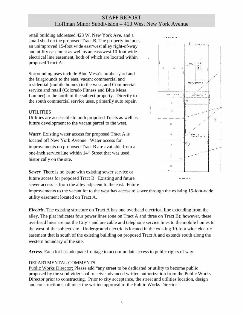
GENERAL WARRANTY DEED
ASHLEY J. BURT hereby se ll s and conveys to BRUCE HOFFMAN and DEBBIE HOFFMAN, as joint tenants, whose address is~ Eve lyn Lane. Gunnison Colorado 81230. the following real property in the County 01· Gu~?- n, Stat_e ~ lorado: ' \s~,, ~,
-·-- -·----A parcel of land 57 feet by 300 feet adjacei1t to Lots 3 to 12. both inclusive, Block 145. Town of WEST GUNNISON. on the east. said parcel or land being more particularly described as follows:
Beginning at Corner No. I, being the northeast corner or Lot 3, Block 145 , according to the official AMENDED Plat of W[ST GUNNISON on file and of record in the office of the County Clerk and Recorder or Gunnison County. Colorado. for a point of beginning; thence east 57 feet to Corner o. 2: thence South 300 feet to Corner No. 3; thence west 57 feet to Corner No. 4 (Corner No. 4 being identical with the southeast corner of Lot 12. said Block 145 , West Gunnison): thence North 300 feet to Corner No. I, the place ol' beginning;
City of Gunnison, County or Gunnison. State of Colorado
with all its appurtenances , and warrants the title to the same free and clear of any liens and encumbrances except:
I. Right of way and easement contained in instrument recorded in Book 377 at page 238;
2. Easement contained in instrument recorded at Book 442 at page I 63;
3. Terms and conditions as contained in Restrictive Covenants Regarding Use of Property recorded December I I. 2000 as Reception No. 507355:
4. Any ri gh ts. interests. or claims. which may exist or arise by reason of the facts shown on Burt Improvement Survey dated .July 26. 20 13. prepared by frederick Adam Ballard; and
5. Real property taxes for 20 15 due and payable in 20 I 6.
Page I of 2

10
\v Signed thi s 4 ·day of September, 20 I 5.
STATE OF COLORADO ) ) ss .
COUNTY OF Gunn ison )
The fo regoi ng instru ment was acknowledged befo re me th is _d_JL{Jay of September, 201 5, by Ashley J. Burt .
Witness my hand and offic ial sea l.
My commission expires:
,...------~---~---~---------, KATHLEEN D. MACALLISTER
NOTARY PUBLIC STATE OF COLORADO
NOTARY ID #19984012231 My Commission Expires May 1, 2018
Page 2 of 2

11
Gunnison Parcels within Range ---._
Print Mailing Labels at 100 Feet
!CountllParcel # IJowner IIAddress
DI--- I GUNNISON ENERGY CORP ATTN: SHELLY PELKEY 11601 FORUM PL STE 1400
013787- 021-55-002 llcoLORADO FITNESS HOLDINGS LLC 111046 PASHUTA DR
013787-021-08-002 IIMORTENSEN JORGE 11216 S 14TH ST LOT 1
0 13787-010-03- I BOARD OF COUNTY COMMISSIONERS OF THE 200 E VIRGINIA AVE STE 001 cou 104 0 13787-012-20-001 11401 W TOMICHI LLC PO BOX 990 ~1~787-021-09- rANSEN GUNNISON LLC
HANSEN WILLIAM R PO BOX 492 015 HANSEN
013787-012-21-004 11401 W TOMICH I LLC PO BOX 990
013787-021- 55-001 llcHANG LIANG CHI 1405 W TOMICHI AVE
013787-021-08-001
IIHOFFMAN DEBBIE HOFFMAN BRUCE II PO BOX 361
_ ____ _) I I lj I
I l[JJ /@ ® IL_ .
llcity IIWESTPALM BEACH
II GUNNISON
IIGUNNISON
II GUNNISON
II GUNNISON
II DELTA
IIGUNNISON
II GUNNISON
IIALMONT
~
~ D ·-- 1 ~ 11 JT ®I L ·-=J1 l - r (5) 1
02 I
l I j
L _ _Jl_J ®
~ .-~ I 1
-~I r I!
I 0 160 320 480 640 ft I
Page 1 of 2
Ustate!~
1EJl33401 I IEJl8123ol
IEJl8123ol
IEJl8123ol IEJl812Jo j
IEJB IEJj8123oj IEJj8123ol
IJco 1181210 I
http://qpub1ic6.qpublic .net/radius.php?parcel=3787-021-08-001 &distance= 1 OO&Sumbit=Re. .. 3/5/2018
12
... w w "' f-V)
:r: f-:i;
' -
NE',/ YORK AVENUE
I
I
I
~ I
® ©
I
I
I ' '
n
El<ISTil1G BIJILDl~Q
N 90'00'00" E 57.00'
<( ci-(/)
1--0 u o ~ o 1-- co
ELECTRICAL LINE EASE~ENT ~ ./
I I
.JI ,/ -,--- V ·1
__ BOOK 377 PAGE 23/~ - •
e-----A-LL_E_Y-(v_o_c_o_t _e_d_i __ ·~~"--.--~-~~~ I ! .. II ~ ~ I
1- N 90-00'00" E 57.00'
_ - v--'~
©
- - - --
--------·-- /,/ I v·--------· / ·1
-- _:::11~ /' ~ •
/' I
/' . - \/ TRACT B I / 9100.05 sq. ft.
0
- -- --
®
- -- --
@
/-·~-·1 [._...----'-------- ·1 A------ -
- -- --
(@)
- -- ·-·
@
- --- --
1.7-6 v
i @
63.00'
N 90'00'00" W 57.00'
GUNNISON AVENUE
NOTES:
1. Property was located by field measurements from city monument ot the intersection of Main Street with Tomichi Avenue. Basis of bearings is NORTH between said monument and a simila r monument at the intersection of Main Street with Denver Avenue.
2. Lot comers were established using information on the Amended Plot of West Gunnison, supplemented by information on City of Gunnison plot prepared by Fisher Engineering (1960).
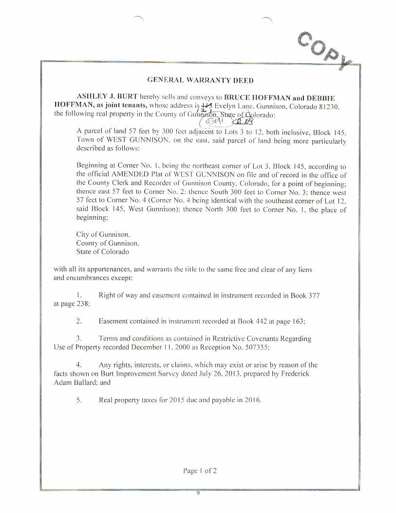
within HOFFMAN
BLOCK 145, CITY
GUNNSION
MINOR SUBDIVISION WEST GUNNISON - AMENDED OF GUNNSION COUNTY, COLORADO
DEDICATION
We, Bruce Hoffmon and Debby Hoffman, being the owners of the land described as follows:
A parcel of land 57 feet by 300 feet adjacent to Lots 3 to 12, both inclusive, Block 145, Town of WEST GUNNISON, rn the east, said parcel of land being more particularly described as follows:
Beginning at Comer No, 1, being the northeast corner of Lot 3, Block 145, according to the official AMENDED Plot ?t WEST GUNNISON on file and of record in the office of
!~:n~:u;~~t c!e;\e:~dt:ei~r~:; ~:.;t;::;e ;:~nt~· 3~~to;;:rt:0~o~n:t~~-~: ~:;~~~in!~st ;:)e:1~:; ~:;~e;e~t~u~~r;:~); ~~~:c~ei~~rti~e~~~alfe:~t~oth;o;:eut~:~1t. ~~:ne;lo~~ ~t 12, beg;nn;ng; I
City of Gunnison,
in Gunnison County, Colorodo, under the name of Hoffomn Subdivision hove laid out, plotted ond/or subdivided the some as shown on this plot and do hereby dedicate to the public at large the streets, alleys, roods and other public areas os shown hereon and hereby dedicate those portions of land labeled os easements for the insto llotion and maintenance of public utilities as shwon hereon.
In witness whereof Bruce Hoffomn ond Debby Hoffman hove subscribed their names this ____ day of - -----------• 2018.
BY--------·-------Bruce Hoffman
BY------------Debby Hoffman
Stote of Colorodo ) )ss.
County of Gunnison )
The foregoing instrument was acknowledged before me this ____ day of-----------· A.O. 2018, by Bruce Hoffman and Debby Hoffman.
My commission expires -----------·
Witness my hand and official seal.
Notary Public
CERTIFICATE OF STREET ANO UTILITY MAINTENANCE Public notice is hereby given that neither the dedicoted roods nor the public utilities shown on this plat will be maintained by the City of Gunnison until and unless the subdivider constructs the streets and roods and utilities in accordance with the subdivision agreement. if any, and the subdivision regulations in effect at the date of the recording of this plat ond approvol of the City hos been issued to that effect. When the City approves o street or utility
SURVEYOR'S CERTIFICATE for mointenonce, the street or utility shall become public in all senses of the word and the subdivider hos no further obligations in regards to that particular street or utility. I, Timothy E. Pearson, o registered lond surveyor in the State of
Cotorodo, certify that this plat and the survey referred to herein
60
i
LEGEND
were mode under my direction and control and that both are true ond correct to the best of my knowledge.
Doted this ___ doy of ------·· 2018.
Timothy E. Pearson Colorado L.S. No. 34979
e Rebar with aluminum cop stomped •LS 37690N
S Rebar with plastic cap stomped NLS 34979"
O UtJJlty pedestal -P-P- Overheod utility lines -*---*-- Fence
0) Lot number inside circle symbol
- - ~ -- --
TOMICHl AVENUE
DD D~ !DD ------- NEW YORK AVENUE
ATTORNEY'S OPINION
I, Rufus 0. Wilderson, on attorney duly licensed to practice In the State of Colorado, hereby certify that 1 have examined title to all lands herein dedicated and subdivided. Such tltle is held in the name of Bruce Hoffman and Debbie Hoffman and is free and clear of all liens, defects, encumbrances, restrictions and reservations except as contained in the following documents:
1. Right of way and eosement contoined in instrument recorded in Book 377 at page 238, 2. Easement contained in instrument recorded ot Book 442 at page 163; 3. Terms ond conditions as contained in Restrictive Covenants Regarding Use of Property
recorded December 11,2000 at Reception No 507355; ond 4. My rights, interests, or claims, which may e><ist or arise by reason of the focts shown on the
Burt Improvement Survey dated July 26,2013, prepared by Frederick Adam Bollard.
This opinion does not oddress mortgages, deeds of trust or similar Instruments wherein the subject property is utilized os security for o promissory note or other written instrument of debt; nor does it address instruments affecting title but not recorded as of the dote of this opinion.
Doted November ___ , 2018
PLANNING COMMISSION APPROVAL
Rufus O. Wilderson, Esq., Reg. No. 14361 Rufus Wilderson, LLC 24441 Highway 149 Powderhom, CO 81243
Th is plot is approved by the City of Gunnison Planning Commission this ___ day of _______ , 2018.
Chairman
CITY COUNCIL APPROVAL This plot is approved for filing and the City hereby accepts the dedication of the streets ond roods shown hereon subject to the provisions in "Street Mointenance" set forth above, and further accepts the dedication of the easements shown hereon.
Signed this __ doy of _____ , 2018.
CITY OF GUNNISON
BY·------------------Mayor
RECORDER'S CERTIFICATE
This plot was filed for record in the office of the County Clerk and Recorder of Gunnison County ot__ __ M on the ___ doy of _______ , 2018, Reception No. _____ .
County Clerk and Recorder
BY·----------------Deputy
~~R~~~ ~~~VEYING I-D_A_TE_:_1_1_/_3_/_17---------1
GUNNISON, CO 81230 LATEST REVISION DATE 3/20/18 970-641-2910
PROJECT# 17-1-20 SHEET 1 OF 1
STAFF REPORT Minor Subdivision – Final Plat
Forsythe Minor Subdivision – 805 W. Denver Ave. TO: Planning and Zoning Commission FROM: Community Development Staff DATE: April 11, 2018 RE: Minor Subdivision - Final Plat CODE PROVISIONS The City’s Land Development Code (LDC) Section 12.3 defines the types of subdivision within the City. A Minor Subdivision, for which this application is classified, is subject to an expedited two-step review process. The applicable review steps are as follows:
1. Review of the preliminary plat by Planning Commission at a public hearing; 2. Review and recommendation of the final plat by Planning Commission (with no public
hearing); and action on the final plat by City Council (with no public hearing). The Planning and Zoning Commission reviewed and approved the Preliminary Plat at the public hearing held on March 7, 2018 with the condition that the Final Plat application shall comply with all standards within the City’s Land Development Code and shall include a 10-foot wide public pedestrian access easement that is dedicated to RE-1J Schools and/or City of Gunnison. The Planning and Zoning Commission reviews the Final Plat application and may recommend to City Council to approve, approve with conditions, remand the application for additional information, or deny the application. APPLICANT REQUEST The applicant, West End Gunnison dba Pumpkin House Rentals, LLC and represented by Erik Forsythe and Shelley Read, is requesting a Minor Subdivision to create two lots on a deeded tract of land. The deeded tract is located on West Denver Avenue. The legal description of the property is Lots 1-6, Block 81, and the east one-half of vacated 10th Street adjoining said lots, West Gunnison addition, City and County of Gunnison, Colorado. The subdivision proposal is to create two lots with a north/south common boundary. The proposed west parcel (A) will be 18,750 square feet and the east parcel (B) will be 7,500 square feet. Both proposed lots will have street frontages meeting or exceeding 50 feet, which complies with the Land Development Code (LDC) standards. The applicant’s narrative states:
“The proposal is to divide the existing property, which measures 150’x175’, into two parcels measuring 50’x150’ and 125’x150’. This complies with all applicable standards and requirements for the construction of a single-family dwelling on the smaller of the two parcels providing 7500 square feet of land for that purpose where a minimum of 6250 is required. Any plans for development of the larger of the two parcels are, at this time, tentative and immaterial to the consideration of this subdivision. Site Development: 50’x150’ parcel:
13

STAFF REPORT Minor Subdivision – Final Plat
Forsythe Minor Subdivision – 805 W. Denver Ave.
The construction of the single-family dwelling of the smaller parcel has already begun and is expected to be completed in the Spring of 2018… …125’x150’ Parcel: As stated above, no concrete development plans exist for the larger of the two parcels. West End Gunnison understands that any future development on that parcel is subject to all applicable standards and requirements, and that proof of compliance with those standards will be required before the issuance of a building permit and before the commencement of any construction on that site.
Schematic Plan: No streets or alleys are being developed as a part of this proposed subdivision. Utilities exist on the City land adjacent to the property, so no out-of-the-ordinary development or schematics are required to ensure connection to utilities for current or future construction…”
SITE ASSESSMENT The property is located in the R-3 district (Multi-Family Residential). Improvements on the land tract include a garage and a single family dwelling (currently under construction) on the east portion of the property and vacant land on the western portion. The RE1J School District (High School) borders the property to the south and multi-family residential is adjacent the property along Denver Avenue. The Community School (1st through 8th) is located a half block to the north. The property contains the “Betty Carr Memorial Walkway” along the western property boundary. The site was purchased with a garage in the northeast corner of the property. The applicant is currently constructing a single family dwelling unit to the south of the garage structure. The configuration of the structures will allow a subdivision of the parcel with a 50-foot street frontage. The remainder of the parcel has not been fully contemplated; however, multi-family dwelling units are a possibility.
14

STAFF REPORT Minor Subdivision – Final Plat
Forsythe Minor Subdivision – 805 W. Denver Ave. UTILITIES The dwelling unit under construction (proposed Parcel B) is served by water, sewer and electricity located within Denver Avenue and future development on the west portion (Parcel A) would be tapped from Denver Avenue as well. Natural gas services extend from the alley, along the eastern boundary of the subject site, to the dwelling unit under construction (Parcel B). Water. There is no issue with existing water service or future access for proposed Parcel A. Existing and future water access is from Denver Avenue. Sewer. There is no issue with existing sewer service or future access for proposed Parcel A. Existing and future sewer access is from Denver Avenue. Electric. Overhead electrical lines are located along the north boundary of the subject site within Denver Avenue.
Natural Gas. A gas meter is located in the alley on the eastern border of proposed Parcel B. An easement to provide natural gas to the western parcel (Parcel A) may be necessary. Access. Each lot has adequate frontage to accommodate access to public rights of way. There are no issues with contemplated site access. Pedestrian Easement. A five-foot pedestrian access easement for the Betty Carr Memorial Walkway, between the property owner and the RE1J school district, is located on the west property boundary line. This pedestrian path is an important route for connectivity between the adjacent residential neighborhoods and the community school and high school campuses. At Preliminary Plat review with the Commission, a condition for a 10-foot-wide pedestrian easement was required. The applicant at that time asked for some flexibility with the snow storage / roof shed into the easement. A plat note was added to the draft Final Plat to allow encroachment of a gable roof up to two feet into the easement; however, after the surveyor placed the 10-foot-wide easement onto the plat, it does not appear that there is room for an encroachment within the easement and the sidewalk. The City of Gunnison Non-Motorized Transportation Plan designates this path as a multi-use trail. The LDC, Section 4.5.C (Pedestrian Linkage Requirements) notes that Land Use Development Applications shall, to the maximum extent feasible, include the design and interconnections with existing sidewalks, access ways and multi-use trail systems. DEPARTMENTAL COMMENTS Public Works Director: No issue. Water and Sewer Superintendent: No issue. Electric Superintendent: No issue. Police Chief: No issue Parks and Recreation Director: No issue
15

STAFF REPORT Minor Subdivision – Final Plat
Forsythe Minor Subdivision – 805 W. Denver Ave. Fire Marshal: No issue Building Official: No issue Finance Director: No issue STAFF OBSERVATIONS 1. The applicant is requesting a Minor Subdivision to subdivide a deeded parcel (26,250 square
feet) into two lots (18,750 square feet and 7,500 respectively) – the property is within the R-3 District.
2. A garage and a single family dwelling unit are located on the east portion of the property; the proposed subdivision would separate these structures into one lot and create a second vacant parcel.
3. Existing Water, sewer, electric and gas services are extended to serve the single family dwelling under construction. Utilities for future development on the proposed Parcel A are available from the Denver Avenue rights-of-way.
4. A five-foot pedestrian access is located along the western boundary of the proposed Parcel A, which is dedicated to the RE1J School District. Several years ago improvements to the path were completed by the City. The five-foot tread width is considered adequate for the use levels, but the easement width is not sufficient to accommodate snow removal and future maintenance needs. At Preliminary Plat a condition was approved for a 10-foot-wide easement.
5. Originally staff stated they would work with the applicant regarding snow shed into the 10-foot-wide sidewalk easement, however on receiving the final plat, it should be noted that due to the width and location of the sidewalk within the 10-foot easement, allowing snow shed into the easement would potentially cause a hazard to pedestrians.
6. Preliminary Plat was approved by the Planning and Zoning Commission on March 7, 2018 with the conditions that the Final Plat application comply with the LDC standards and that the Final Plat include a 10-foot-wide pedestrian easement.
7. The requested subdivision does not affect the health, safety and welfare of the community. REVIEW STANDARDS The LDC Section 12.8 contains eight specific standards that are used by the Planning and Zoning Commission and City Council to consider for all subdivision applications. Based on the LDC Section 6.8, an application that fails to comply with any applicable review standard shall be denied. A. Master Plan. The proposed subdivision shall carry out the purpose and spirit of the Master
Plan and conform to all of the Plan’s applicable intent statements, specific directions and recommended actions. It shall be designed to be compatible with surrounding land uses, to protect neighbors from undesirable noise, glare and shadows and shall not cause adverse effects on their privacy, solar access and views. The following excerpts from the Master Plan are applicable to this subdivision. No Conflict. Chapter Housing, Goal: Gunnison’s housing inventory includes diverse housing types in mixed use areas. New construction will be based on energy efficiency. New homes are compatible with community character with respect to density, design and demographics. A
16

STAFF REPORT Minor Subdivision – Final Plat
Forsythe Minor Subdivision – 805 W. Denver Ave.
wide price range is sufficient to meet the needs of all income levels including a healthy rental market with well-maintained rental units.
B. Zone District Standards. The proposed subdivision shall comply with the use and dimensional standards of the underlying zone district and shall provide off-street parking as required for the use. No Conflict. The property is located within the R-3 zone district which requires a minimum lot size of 6,250 square feet. Both parcels are larger than the minimum requirement and can accommodate off-street parking requirements.
C. Improvements. The proposed subdivision shall be provided with improvements which
comply with Section 4 and 5. Possible Conflict. LDC, Section 4.1.H.5 (Adequate Public Facilities – Pedestrian Circulation), requires that any development or redevelopment within the City shall meet current standards defined in Section 4.5 of the LDC. The existing five-foot easement is too narrow for snow plowing operations and future maintenance needs. LDC, Section 4.5.C sets forth a minimum 15-foot-wide easement for multi-use trails. A 10-foot-wide easement has been placed on the Final Plat along with a plat note that allows encroachment of a gable roof up to two feet into the easement. The placement of the sidewalk within the 10-foot-wide easement does not appear to provide adequate room for a roof encroachment and would cause a potential safety issue for pedestrians on the sidewalk.
1. Streets. Existing and proposed streets shall be suitable and adequate to carry anticipated traffic within and in the vicinity of the proposed subdivision. No Conflict: Public streets and alleys are not proposed within this subdivision.
2. Utilities. Existing and proposed utility services shall be suitable and adequate to
meet the needs of the proposed subdivision. As a condition of obtaining water service, any water rights which run with the property shall be dedicated to the City. No Conflict. Utilities exist to the developed site (Parcel B) and utilities are located in the Denver Avenue rights-of-way for future development on Parcel A.
3. Landscaping. Landscaping, buffering and screening as required by Section 4.6 shall be achievable given the underlying lot widths and rights-of-way dimensions. No Conflict: Landscaping and buffering requirements will be required as development occurs on Parcel A. The site provides ample space to meet these requirements.
4. Phases. If the subdivision is to be developed in phases, each phase shall contain the required parking spaces, landscape areas, utilities, and streets that are necessary for creating and sustaining a stable environment. Not Applicable.
17

STAFF REPORT Minor Subdivision – Final Plat
Forsythe Minor Subdivision – 805 W. Denver Ave. D. Natural Features. The layout of lots and blocks shall provide desirable settings for
structures by making use of natural contours and maintaining existing views, affording privacy for residents and protecting them from adverse noise and vehicular traffic. The system of roadways and the lot layout shall be designed to take advantage of visual qualities of the areas. Natural features and native vegetation shall be preserved whenever possible. Not Applicable.
E. Floodplains. Tracts of land or portions thereof lying within the one hundred year floodplain
may only be subdivided for open space until the subdivider has shown that compliance with the requirements of the City’s floodplain regulations can be met.
No Conflict. The property is not within a special flood hazard area. F. Future Streets. When a tract is subdivided into lot(s) or parcel(s) which are intended for
future re-subdivision, such lot(s) or parcel(s) shall be so arranged so as to permit the logical location and opening of future streets and appropriate re-subdivision, with provision for adequate utility easements and connectors for such re-subdivision. Not Applicable.
G. Common Recreation Facilities. Where a development is proposed to contain common
recreation facilities, such facilities shall be so located within the development so as to be easily accessible to the residents and to least interfere with neighboring developments.
Not Applicable.
H. Lots and Blocks 1. Pattern. The size, shape and orientation of lots shall be appropriate to the design and
location of the proposed subdivision and to the type of development contemplated. Where appropriate, lots shall be laid out to respect the existing City pattern. Blocks generally shall not be less than 300’ nor more than 1,200’ in length. No Conflict. The proposed lot sizes, shapes and orientation are appropriate and consistent with the surrounding neighborhood.
2. Frontage. Residential lots should front only on local streets; however, when
necessary, lots designated to face a collector street shall provide adequate means for automobile turnaround within the lot. No Conflict.
3. Right Angles. Side lot lines shall be approximately at right angle or radial to street
lines. No Conflict. Lot lines are appropriately angled.
4. Double Frontage Lots. Double frontage lots are prohibited, except where they are
necessary to provide for the separation of residential development from collector or arterial streets or to overcome specific limitations of the topography or orientation. A planting and screening easement of at least 10” shall be provided along the portion of the lot which abuts such a Collector or Arterial street. There shall be no right of
18

STAFF REPORT Minor Subdivision – Final Plat
Forsythe Minor Subdivision – 805 W. Denver Ave.
access across a planting and screening easement. The screening easement shall be maintained by the property owner. Not Applicable.
5 T Intersections. The building area of lots shall not face directly into the oncoming
traffic of an intersecting street of a “T” intersection. Not Applicable.
6. Solar Energy. For the purposes of protecting and enhancing the potential for
utilizing solar energy in the proposed subdivision, detached single family lots are encouraged to be laid out in such a manner that the houses will be oriented so that their long axis will run east/west and so that the houses will not block the solar access of adjacent houses. No Conflict.
ACTION During the Planning and Zoning Commission meeting of April 11, 2018, Commissioner _____________ moved, Commissioner _________ seconded and the Planning and Zoning Commission voted to recommend APPROVAL to City Council, the Minor Subdivision Final Plat, SB 18-2, Forsythe Minor Subdivision with the following findings of fact and condition: Findings of Fact:
1. The Planning and Zoning Commission finds that the record of this action includes the application contents on file with the City of Gunnison; all comments entered into the Public Hearing record; and provisions of the City of Gunnison Land Development Code and the City of Gunnison Master Plan.
2. The Planning and Zoning Commission finds that this application is for a Minor Subdivision of a deeded parcel (26,250 square feet) into two lots (18,750 square feet and 7,500 respectively).
3. The Planning and Zoning Commission finds that the property is within the R-3 zone
district and a garage and single family dwelling unit are located on the east portion of the property (Parcel B) with multi-family residential anticipated on the vacant Parcel A.
4. Existing Water, sewer, electric and gas services are extended to serve the existing single family dwelling. The Planning and Zoning Commission finds that utilities for future development on Parcel A are available from the Denver Avenue rights-of-way.
5. An improved five-foot pedestrian path is located along the western boundary of Parcel A,
and is located within a five-foot easement dedicated to the RE1J School District. The Planning and Zoning Commission finds that Section 4.1.H.5 (Adequate Public Facilities – Pedestrian Circulation) requires that any development or redevelopment within the City
19

STAFF REPORT Minor Subdivision – Final Plat
Forsythe Minor Subdivision – 805 W. Denver Ave.
shall meet current standards defined in Section 4.5 of the LDC, and the existing five-foot easement is too narrow for snow plowing operations and future maintenance needs.
6. The Planning and Zoning Commission finds that a 10-foot-wide easement is indicated on the Final Plat as well as a plat note that allows an encroachment of a gable roof up to two feet. The Commission further finds that allowing the encroachment could potentially cause a hazard to pedestrians.
7. The Planning and Zoning Commission finds that the subdivision of the subject property
is compatible with the surrounding neighborhood.
8. The Planning and Zoning Commission finds that the eight review standards for subdivisions have been or will be met based on the following Condition:
Condition:
1. The Final Plat subdivision review is subject to approval by City Council.
20

21
Application Fact Sheet Ci1y,,j'(iwmi.~ort Loml De\·elopmem Cnde Minirntun Application C.omcms In ::iccotd:)nct wilh ~6.5 C. ~2.1..:. O'Jt,.Jfft,£ ue""£'1 ""b
Cily of CunniMJn P.O. Box239 Gunnison, CO 81230 (970'64 1-8090
Applltllnl Nnmc(s): WE-S-r £,-,o GvN~•SON (J.b .... ti' PvA'lli::::.IN H cvS,C eE:VT.ltc,..<j.LtL)
Phonc#; ~t1D s-1i 2 'iS7 F:u #: E-Mail: e.r ·,)<\.,,-5 ;{Th e(o) .;)~,i ,i. CO"'
Mailing Addn:n: P(S 13 0,1( l 2 S" '-I
City: Ct,S>-€t> t>vrri::: State: c.o Zip: ?, 2.2 '-f Lcg:tl Desc.ription
Sile Addrc~~ ofrroperly: YoS' "'. 't> CNVl.lt. Zoning "R.3 l.lloclc l--0r(s): Addit ion:
Disc.l C)Sur-c of Ownc.r:.hip-- Plt1,1sc provide one or lhc following :
D /\.1,:;e:;sor Parcel !Mo D Mongnsc D =d 0Judgmcnts
O Licns D Contracl D Eascmcnc ,\.greemenl )8(' Other A~rmcnts - Co ...... "' ,,. M.{ rv"'<' J l7Li ,
Summary of Rt (lU(:st: S .-~'(I$ ru,J'C... 'Pto'f'f;.lt"T'f ( 1S'01
X ns-') irv 1"c> vt> p,v 1 t><1:. .,....,() r,ua. c. e, .5 M~A.S <JC ttv't... i S"0 1
Y 5'°Q 1 ~N[) 1$"6
1,: 12,.,$
1•
Attachments: l:'.:IVicinity M~.5"X 11 ") 'g)Dcscription of Proposal
"-I Nam~. Addl'C$SCS and fl.:fae o f Adj oining P,rope.rtv Owners (f.rom Assessor's Office)
(3 Veatcd P1opt1 ty l~igm5' S 1) 11thoriz,tiOQ O( A:MPt (Ve-., u uf .\:thll lell!I' fre !Q Owa:u,w: i£n9t the appli;;un.)
''"' e!) 'site Plan ( I r x 11; to !«:3le, includes dimcnsi()l'IS and location of aU structure-~ pa.rking spacc.5 :ind acct:ss, snow stor.tgc, landscaping. live cover. utility lines, rood/strt<t names, land uses o f adjacent propcrtic.!;., setbacks. lndudc a Lable for all dim~nsional req\liremenL,; OOS,00 on §2.6. (Sec :rnached sample)
~<'C,< YOU ARE IU:QUI RF.O TO ~UBMIT .Olln-(-<) COMPLETE COPI ES OF YO UR APPLICATION
Sig.nalu rc(~v /,
~ '·1 ·· '.3l, " Dote z /1t[i8 ' Date o >/1 z, //,E - - . '/ . Por Office. Use Only
0 Conditional Use 0 Variance D Zoning Amendment O Major Subdivisio11 D Minor Subdivision 0 Subdi,..is.ion £.w mplion D Mobile fJomdR v Patk 0 PlJI) CJ Vacution 0 Conso1ida1ed AnMlicat i0t1
112014

22
To Whom It May Concern, 12 February, 2018
Please accept the following information as part of our application for a Minor Subdivision of the property at 805 W. Denver, Gunnison CO 81230
Lots 1 through 6, Block 81, Town of WEST GUNNISON according to t he AMMENDED Plat recorded
September 1, 1881 as Reception No. 17078; TOGETHER WITH the East one-half of vacated 10"' Street contiguous with Lots 1 through 6 in Block 81; City of Gunnison, County of Gunnison, State of Colorado
This property is owned by Pumpkin House Rentals, LLC; d.b.a . West End Gunnison, owned by Erik Forsythe and Shelley Read.
The proposal is to divide the existing property, which measures 1SO'x175', into two parcels measuring SO'xl SO' and 12S'x150'. This complies with a ll applicable standards and requirements for the construction of a single-family dwelling on the sma !Je r of the two parcels providing 7500 square foet of land for that purpose where a minimum of 6250 is required. Any pla ns for development of the larger of the two parcels are, at this time, tentative and immaterial to the consideration of t his subdivision.
Site Oe\lelopment: SO"x150' parcel:
The const ruction of the s ingle-family dwelling of the smalle r parcel has already begun and is expected to be completed in the Spring of 2018. As a building permit has already been issued, complia nce with applicable standards and requirements has already been demonstrated to the City of Gunnison Planning Department .
125'x150' Parcel:
As .stated above, no concrete development plans exist for the larger of the two parcels. West End Gunnison understands that a ny future development on that parcel is subject to all applicable standards and requirements, and that proof of compliance with those standards will be required before the issuance of a building permit and before the commencement of any construction o n that s ite.
Schematic Plan:
No streets or alleys are being developed as a part of this proposed subdivision. Utilities exist on t he City land adjacent to the property, so no o ut-of •the-ordinary devalopment or S<:hematics are required to ensure connection to utilities for current or future construction.
Thank you for considerins t his proposed s ubdivision.
Sincerely,
C;f~ Erik Forsythe West End Gunnision (970)596-2857

23
~J"Ol'l g 201 t . ql'ut>k.M<
1701000001,1
)70USU100) .3701 is-1.N*i Jl0.1.nn 100I
nou,.f.«IO, I-
"' :t I-0 ...
t,.U')l.19001 z no1nu7010 Jl'OllSU '10o2
't?OU)&..-,01
0 @ (3)
W DENVER AVE
@ go f w. ® "0 e N Ve. R..
J70U$42100l J10USt?l!OOl
®
P 3rCt!I f,\;)IC$ no, ,S4uoo>
t::I 2014 • P~ro.l Safe!', c::J 2013 PMcet S~f..,,-
- 1012 P--,m:el St.118'5 i1ZI >011 ra«:,,d S»e$ Q 2 0 10 p .. ,oe1 SOJCS
400 fl 0 200t P31od !fote~ • 100 2"" :,00
' -t·
Parcel: unctcfined Acres. ,, ---,., " ---
• -" -1
" '
0.. primad' 0'2Ql/11 . 1• ~1:W
-

24
PROPERTY OWNERS ADJOINING SOS W DF.NVER, GUNNISON, CO
I. 900 W DENVER AVE, GUNNISON SPEAR RALPH J Ill SHIPP JOE F Sl'!cAR KATHRYN M SHIPP LINDA A • 46 RIO VISTA RO
GUNNISON, CO 81230-4129
2. 804 W DENVER AVE, GUNNISON WATSON RONALOO
2902 TI\AYl.OR 8LVD STE 206 ROCKPORT, n< 78382· 3646
3. 800 W DENVER AVE, GUNNISON WATSON RONALD D 2902 TI\AVLOR 8LVD STE 206 ROCKPORT, n< 78382-3646
4. 62l N. 11TH ST., GUNNISON DENNIS USA R DF.NNIS DAVID W
711 W. SPENCER AVE GUNNISON, CO 81230-2528
s. 800 W OHIO AVE, GUNNISON RC1J SCHOOL DISTRICT 800 N BOULEVARD ST
GUNNISON, CO 81230.2825
6 . 901 W DENVER AVE, GUNNISON
PECA RIC llC C/ 0 MITCH Ell W PECARIC 933 W DENVER AVE GUNNISON, CO 8123()-3325

25
G NNISON COUNTY ABST ACT CO P Y
Est. 1961 504 N. Main Street·Gunnison, CO 81230·Phone: 970. 641. 0710·Fax: 970. 641. 467.S·[email protected]
September 18, 2017
Pumpkin House Rentals LLC, P.O. Box 1254 Crested Butte, Colorado 81224
RE: Commitment No. Gl?-241; File No. 3/3B81/1-6 aol;
Policy No. 7230606-212122616;
Address: TBD W. Denver Avenue, Gunnison, CO 81230;
Legal Description: Lots 1-6, Block 81 and a Tract 50' X 50' of 10th St. adjacent to Lots 1-6 West Gunnison;
Dear Erik and Shelley,
Enclosed is the Title Policy pertaining to the above referenced transaction. Please retain your policy and related documents in a secure place.
Your receipt of this document should complete this transaction. Our team is available if you have any questions or if you need anything further.
We appreciate your business and hope the process has been a proactive and enjoyable experience.
Thank you for using Gunnison County Abstract Company
Sincerely,
Laurie Tull

26
CHICAGO TITLE .• INSURANCE COMPANY
Policy No.: 137087-1-G17-241-2017.7230606-212122616
OWNER'S POLICY OF TITLE INSURANCE
Issued by
CHICAGO TITLE INSURANCE COMPANY Any notice of claim and any other notice or statement in wri!ing required to b~ ~iven the Company under this Policy must be given to the Company at the address shown in Section 18 of the Conditions.
COVERED RISKS
SUBJECT TO THE EXCLUSIONS FROM COVERAGE, THE EXCEPTIONS FROM COVERAGE CONTAINED IN SCHEDULE B, AND THE CONDITIONS, CHICAGO TITLE INSURANCE COMPANY, a Florida corporation, (the "Company") insures as of Date of Policy and, to the extent stated in Covered Risks 9 and 10, after Date of Policy, against loss or damage, not exceeding the Amount of Insurance, sustained or incurred by the Insured by reason of:
1. Title being vested other than as stated in Schedule A.
2. Any defect in or lien or encumbrance on the Title. This Covered Risk includes but is not limited to insurance against loss from (a) A defect in the Title caused by
(i) forgery, fraud, undue influence, duress, incompetency, incapacity, or impersonation;
(ii) failure of any person or Entity to have authorized a transfer or conveyance;
(iii) a document affecting Title not properly created, executed, witnessed, sealed, acknowledged, notarized, or delivered;
(iv) failure to perform those acts necessary to create a document by electronic means authorized by law;
(v) a document executed under a falsified, expired, or otherwise invalid power of attorney;
(vi) a document not properly filed, recorded, or indexed in the Public Records including failure to perform those acts by electronic. means authorized by law; or
(vii)a defective judicial or administrative proceeding.
(b) The lien of real estate taxes or assessments imposed on the Title by a governmental authority due or payable, but unpaid.
(c) Any encroachment, encumbrance, violation, variation, or adverse circumstance affecting the Title that would be disclosed by an accurate and complete land survey of the Land. The term "encroachment" includes encroachments of existing improvements located on the Land onto adjoining land, and encroachments onto the Land of existing improvements located on adjoining land.
3. Unmarketable Title. 4. No right of access to and from the Land.
7230606 ALTA Owners Policy 06/17/06 for C0_306
5. The violation or enforcement of any law, ordinance, permit, or governmental regulation (including those relating to building and zoning) restricting, regulating, prohibiting, or relating to (a) the occupancy, use, or enjoyment of the Land; (b) the character, dimensions, or location of any
improvement erected on the Land; (c) the subdivision of land; or (d) environmental protection if a notice, describing any part of the Land, is recorded in the Public Records setting forth the violation or intention to enforce, but only to the extent of the violation or enforcement referred to in that notice.
6. An enforcement action based on the exercise of a governmental police power not covered by Covered Risk 5 if a notice of the enforcement action, describing any part of the Land, is recorded in the Public Records, but only to the extent of the enforcement referred to in that notice.
7. The exercise of the rights of eminent domain if a notice of the exercise, describing any part of the Land, is recorded in the Public Records.
8. Any taking by a governmental body that has occurred and is binding on the rights of a purchaser for value without Knowledge.
9. Title being vested other than as stated Schedule A or being defective (a) as a result of the avoidance in whole or in part,
or from a court order providing an alternative remedy, of a transfer of all or any part of the title to or any interest in the Land occurring prior to the transaction vesting Title as shown in Schedule A because that prior transfer constituted a fraudulent or preferential transfer under federal bankruptcy, state insolvency, or similar creditors' rights laws; or
(b) because the instrument of transfer vesting Title as shown in Schedule A constitutes a preferential transfer under federal bankruptcy, state insolvency, or similar creditors' rights laws by reason of the failure of its recording in the Public Records (i) to be timely, or (ii) to impart notice of its existence to a
purchaser for value or to a judgment or lien creditor.
10. Any defect in or lien or encumbrance on the Title or other matter included in Covered Risks 1 through 9
-..... ,t,•
Copyright 2006-2016 American Land Title Association. All rights rese~ed. The use ~f this Form (or any derivative thereof) is restricted to ALTA licensees and ALTA members in good standing as of the date of use. All other uses are prohibited. Reprinted under license from the American Land Title Association.
~•Ofll"
Page 1 of 5

27
that has been created or attached or has been filed or recorded in the Public Records subsequent to Date of Policy and prior to the recording of the
deed or other instrument of transfer in the Public Records that vests Title as shown in Schedule A.
The Company will also pay the costs, attorneys' fees, and expenses incurred in defense of any matter insured against by this Policy, but only to the extent provided in the Conditions.
IN WITNESS WHEREOF, CHICAGO TITLE INSURANCE COMPANY has caused this policy to be signed and sealed by its duly authorized officers.
CHICAGO TITLE INSURANCE COMPANY
By: By: Au cer or R. Dillon Waggoner Title-JJl,Jnc DB~"GuiinTson County Abstract Company 504 N Main St Gunnison, CO 81230-2408 Tel: 970-641-0710 Fax: 970-641-4628
President
Attest:
Secretary
EXCLUSIONS FROM COVERAGE
The following matters are expressly excluded from the (b) not Known to the Company, not recorded in the coverage of this policy, and the Company will not pay loss Public Records at Date of Policy, but Known to the or damage, costs, attorneys' fees, or expenses that arise by Insured Claimant and not disclosed in writing to the reason of: Company by the Insured Claimant prior to the date 1. (a) Any law, ordinance, permit, or governmental the Insured Claimant became an Insured under this
regulation (including those relating to building and policy; zoning) restricting, regulating, prohibiting, or (c) resulting in no loss or damage to the Insured relating to Claimant; (i) the occupancy, use, or enjoyment of the Land; (d) attaching or created subsequent to Date of Policy (ii) the character, dimensions or location of any (however, this does not modify or limit the
improvement erected on the Land; coverage provided under Covered Risk 9 and 10); (iii) the subdivision of land; or or (iv) environmental protection; (e) resulting in loss or damage that would not have or the effect of any violation of these laws, been sustained if the Insured Claimant had paid ordinances, or governmental regulations. This value for the Title. Exclusion l(a) does not modify or limit the 4. Any claim, by reason of the operation of federal coverage provided under Covered Risk 5. bankruptcy, state insolvency, or similar creditors' rights
(b) Any governmental police power. This Exclusion l(b) laws, that the transaction vesting the Title as shown in does not modify or limit the coverage provided Schedule A, is under Covered Risk 6. (a) a fraudulent conveyance or fraudulent transfer; or
2. Rights of eminent domain. This Exclusion does not (b) a preferential transfer for any reason not stated in modify or limit the coverage provided under Covered Covered Risk 9 of this policy. Risk 7 or 8. 5. Any lien on the Title for real estate taxes or
3. Defects, liens, encumbrances, adverse claims, or other assessments imposed by governmental authority and matters: created or attaching between Date of Policy and the (a) created, suffered, assumed, or agreed to by the date of recording of the deed or other instrument of
Insured Claimant; transfer in the Public Records that vests Title as shown in Schedule A.
CONDITIONS
1. DEFINITION OF TERMS The following terms when used in this policy mean: (a)"Amount of Insurance": The amount stated in Schedule
A, as may be increased or decreased by endorsement to this
policy, increased by Section 8(b), or decreased by Sections 10 and 11 of these Conditions.
(b)"Date of Policy": The date designated as 'Date of Policy" in Schedule A.
7230606 ALTA Owners Policy 06/17/06 for C0_306 Copyright 2006-2016 American Land Title Association. All rights reserved. The use of this Form (or any derivative thereof) is restricted to ALTA licensees and ALTA members in good standing as of the date of use. All other uses are prohibited. Reprinted under license from the American Land Title Association.
Page 2 of 5

28
(c) "Entity": A corporation, partnership, trust, limited liability company, or other similar legal entity.
(d)"Insured": The Insured named in Schedule A. (i) The term "Insured" also includes
(A) successors to the Title of the Insured by operation of law as distinguished from purchase, including heirs, devisees, survivors, personal representatives, or next of kin;
(B) successors to an Insured by dissolution, merger, consolidation, distribution, or reorganization;
(C) successors to an Insured by its conversion to another kind of Entity;
(D) a grantee of an Insured under a deed delivered without payment of actual valuable consideration conveying the Title
{l)if the stock, shares, memberships, or other equity interests of the grantee are wholly-owned by the named Insured,
(2)if the grantee wholly owns the named Insured, (3) if the grantee is wholly-owned by an affiliated
Entity of the named Insured, provided the affiliated Entity and the named Insured are both wholly-owned by the same person or Entity, or
( 4) if the grantee is a trustee or beneficiary of a trust created by a written instrument established by the Insured named in Schedule A for estate planning purposes.
(ii) With regard to (A), (B), (C), and (D) reserving, however, all rights and defenses as to any successor that the Company would have had against any predecessor Insured.
(e) "Insured Claimant": An Insured claiming loss or damage.
(f) "Knowledge" or "Known": Actual knowledge, not constructive knowledge or notice that may be imputed to an Insured by reason of the Public Records or any other records that impart constructive notice of matters affecting the Title.
(g)"Land": The land described in Schedule A, and affixed improvements that by law constitute real property. The term "Land" does not include any property beyond the lines of the area described in Schedule A, nor any right, title, interest, estate, or easement in abutting streets, roads, avenues, alleys, lanes, ways or waterways, but this does not modify or limit the extent that a right of access to and from the Land is insured by this policy.
(h)"Mortgage": Mortgage, deed of trust, trust deed, or other security instrument, including one evidenced by electronic means authorized by law.
(i) "Public Records": Records established under state statutes at Date of Policy for the purpose of imparting constructive notice of matters relating to real property to purchasers for value and without Knowledge. With respect to Covered Risk S(d), "Public Records" shall also include environmental protection liens filed in the records of the clerk of the United States District Court for the district where the Land is located.
(j) "Title": The estate or interest described in Schedule A. (k) "Unmarketable Title": Title affected by an alleged or
apparent matter that would permit a prospective purchaser or lessee of the Title or lender on the Title to be released from the obligation to purchase, lease, or lend if there is a contractual condition requiring the delivery of marketable title. 2. CONTINUATION OF INSURANCE
The coverage of this policy shall continue in force as of Date of Policy in favor of an Insured, but only so long as the Insured retains an estate or interest in the Land, or holds an obligation secured by a purchase money Mortgage given by a
purchaser from the Insured, or only so long as the Insured shall have liability by reason of warranties in any transfer or conveyance of the Title. This policy shall not continue in force in favor of any purchaser from the Insured of either (i) an estate or interest in the Land, or (ii) an obligation secured by a purchase money Mortgage given to the Insured. 3. NOTICE OF CLAIM TO BE GIVEN BY INSURED CLAIMANT
The Insured shall notify the Company promptly in writing (i) in case of any litigation as set forth in Section S(a) of these Conditions, (ii) in case Knowledge shall come to an Insured hereunder of any claim of title or interest that is adverse to the Title, as insured, and that might cause loss or damage for which the Company may be liable by virtue of this policy, or (iii) if the Title, as insured, is rejected as Unmarketable Title. If the Company is prejudiced by the failure of the Insured Claimant to provide prompt notice, the Company's liability to the Insured Claimant under the policy shall be reduced to the extent of the prejudice. 4. PROOF OF LOSS
In the event the Company is unable to determine the amount of loss or damage, the Company may, at its option, require as a condition of payment that the Insured Claimant furnish a signed proof of loss. The proof of loss must describe the defect, lien, encumbrance, or other matter insured against by this policy that constitutes the basis of loss or damage and shall state, to the extent possible, the basis of calculating the amount of the loss or damage. S. DEFENSE AND PROSECUTION OF ACTIONS
(a)Upon written request by the Insured, and subject to the options contained in Section 7 of these Conditions, the Company, at its own cost and without unreasonable delay, shall provide for the defense of an Insured in litigation in which any third party asserts a claim covered by this policy adverse to the Insured. This obligation is limited to only those stated causes of action alleging matters insured against by this policy. The Company shall have the right to select counsel of its choice (subject to the right of the Insured to object for reasonable cause) to represent the Insured as to those stated causes of action. It shall not be liable for and will not pay the fees of any other counsel. The Company will not pay any fees, costs, or expenses incurred by the Insured in the defense of those causes of action that allege matters not insured against by this policy.
(b)The Company shall have the right, in addition to the options contained in Section 7 of these Conditions, at its own cost, to institute and prosecute any action or proceeding or to do any other act that in its opinion may be necessary or desirable to establish the Title, as insured, or to prevent or reduce loss or damage to the Insured. The Company may take any appropriate action under the terms of this policy, whether or not it shall be liable to the Insured. The exercise of these rights shall not be an admission of liability or waiver of any provision of this policy. If the Company exercises its rights under this subsection, it must do so diligently.
( c) Whenever the Company brings an action or asserts a defense as required or permitted by this policy, the Company may pursue the litigation to a final determination by a court of competent jurisdiction, and it expressly reserves the right, in its sole discretion, to appeal from any adverse judgment or order. 6. DUTY OF INSURED CLAIMANT TO COOPERATE
(a)In all cases where this policy permits or requires the Company to prosecute or provide for the defense of any action or proceeding and any appeals, the Insured shall secure to the
-,,.,tH>" l>~!>lUO
7230606 ALTA Owners Policy 06/17/06 for C0_306 Copyright 2006-2016 American Land Title Association. All rights reserved. The use of this Form (or any derivative thereof) is restricted to ALTA licensees and ALTA members in good standing as of the date of use. All other uses are prohibited. Reprinted under license from the American Land Title Association.
Page 3 of 5
29
Company the right to so prosecute or provide defense in the action or proceeding, including the right to use, at its option, the name of the Insured for this purpose. Whenever requested by the Company, the Insured, at the Company's expense, shall give the Company all reasonable aid (i) in securing evidence, obtaining witnesses, prosecuting or defending the action or proceeding, or effecting settlement, and (ii) in any other lawful act that in the opinion of the Company may be necessary or desirable to establish the Title, or any other matter as insured. If the Company is prejudiced by the failure of the Insured to furnish the required cooperation, the Company's obligations to the Insured under the policy shall terminate, including any liability or obligation to defend, prosecute, or continue any litigation, with regard to the matter or matters requiring such cooperation.
(b)The Company may reasonably require the Insured Claimant to submit to examination under oath by any authorized representative of the Company and to produce for examination, inspection, and copying, at such reasonable times and places as may be designated by the authorized representative of the Company, all records, in whatever medium maintained, including books, ledgers, checks, memoranda, correspondence, reports, e-mails, disks, tapes, and videos whether bearing a date before or after Date of Policy, that reasonably pertain to the loss or damage. Further, if requested by any authorized representative of the Company, the Insured Claimant shall grant its permission, in writing, for any authorized representative of the Company to examine, inspect, and copy all of these records in the custody or control of a third party that reasonably pertain to the loss or damage. All information designated as confidential by the Insured Claimant provided to the Company pursuant to this Section shall not be disclosed to others unless, in the reasonable judgment of the Company, it is necessary in the administration of the claim. Failure of the Insured Claimant to submit for examination under oath, produce any reasonably requested information, or grant permission to secure reasonably necessary information from third parties as required in this subsection, unless prohibited by law or governmental regulation, shall terminate any liability of the Company under this policy as to that claim. 7. OPTIONS TO PAY OR OTHERWISE SETTLE CLAIMS; TERMINATION OF LIABILITY
In case of a claim under this policy, the Company shall have the following additional options:
(a)To Pay or Tender Payment of the Amount of Insurance. To pay or tender payment of the Amount of Insurance
under this policy together with any costs, attorneys' fees, and expenses incurred by the Insured Claimant that were authorized by the Company up to the time of payment or tender of payment and that the Company is obligated to pay.
Upon the exercise by the Company of this option, all liability and obligations of the Company to the Insured under this policy, other than to make the payment required in this subsection, shall terminate, including any liability or obligation to defend, prosecute, or continue any litigation.
(b) To Pay or Otherwise Settle With Parties Other Than the Insured or With the Insured Claimant.
(i) To pay or otherwise settle with other parties for or in the name of an Insured Claimant any claim insured against under this policy. In addition, the Company will pay any costs, attorneys' fees, and expenses incurred by the Insured Claimant that were authorized by the Company up to the time of payment and that the Company is obligated to pay; or
(ii)To pay or otherwise settle with the Insured Claimant the loss or damage provided for under this policy, together with any costs, attorneys' fees, and expenses incurred by the Insured Claimant that were authorized by the Company up to the time of payment and that the Company is obligated to pay.
Upon the exercise by the Company of either of the options provided for in subsections (b)(i) or (ii), the Company's obligations to the Insured under this policy for the claimed loss or damage, other than the payments required to be made, shall terminate, including any liability or obligation to defend, prosecute, or continue any litigation. 8. DETERMINATION AND EXTENT OF LIABILITY
This policy is a contract of indemnity against actual monetary loss or damage sustained or incurred by the Insured Claimant who has suffered loss or damage by reason of matters insured against by this policy.
(a)The extent of liability of the Company for loss or damage under this policy shall not exceed the lesser of
(i) the Amount of Insurance; or (ii) the difference between the value of the Title as
insured and the value of the Title subject to the risk insured against by this policy.
(b)If the Company pursues its rights under Section 5 of these Conditions and is unsuccessful in establishing the Title, as insured,
(i) the Amount of Insurance shall be increased by 10%, and
(ii)the Insured Claimant shall have the right to have the loss or damage determined either as of the date the claim was made by the Insured Claimant or as of the date it is settled and paid.
(c)In addition to the extent of liability under (a) and (b), the Company will also pay those costs, attorneys' fees, and expenses incurred in accordance with Sections 5 and 7 of these Conditions. 9. LIMITATION OF LIABILITY
(a)If the Company establishes the Title, or removes the alleged defect, lien or encumbrance, or cures the lack of a right of access to or from the Land, or cures the claim of Unmarketable Title, all as insured, in a reasonably diligent manner by any method, including litigation and the completion of any appeals, it shall have fully performed its obligations with respect to that matter and shall not be liable for any loss or damage caused to the Insured.
(b)In the event of any litigation, including litigation by the Company or with the Company's consent, the Company shall have no liability for loss or damage until there has been a final determination by a court of competent jurisdiction, and disposition of all appeals, adverse to the Title, as insured.
( c) The Company shall not be liable for loss or damage to the Insured for liability voluntarily assumed by the Insured in settling any claim or suit without the prior written consent of the Company. 10. REDUCTION OF INSURANCE; REDUCTION OR TERMINATION OF LIABILITY
All payments under this policy, except payments made for costs, attorneys' fees, and expenses, shall reduce the Amount of Insurance by the amount of the payment. 11. LIABILITY NONCUMULATIVE
The Amount of Insurance shall be reduced by any amount the Company pays under any policy insuring a Mortgage to which exception is taken in Schedule B or to which the Insured has agreed, assumed, or taken subject, or which is executed by an Insured after Date of Policy and which is a charge or
7230606 ALTA Owners Policy 06/17/06 for C0_306 Copyright 2006-2016 American Land Title Association. All rights reserved. The use of this Form (or any derivative thereof) is restricted to ALTA licensees and ALTA members in good standing as of the date of use. All other uses are prohibited. Reprinted under license from the American Land Title Association.
Page 4 of 5

30
lien on the Title, and the amount so paid shall be deemed a payment to the Insured under this policy. 12. PAYMENT OF LOSS
When liability and the extent of loss or damage have been definitely fixed in accordance with these Conditions, the payment shall be made within 30 days. 13. RIGHTS OF RECOVERY UPON PAYMENT OR SETTLEMENT
(a)Whenever the Company shall have settled and paid a claim under this policy, it shall be subrogated and entitled to the rights of the Insured Claimant in the Title and all other rights and remedies in respect to the claim that the Insured Claimant has against any person or property, to the extent of the amount of any loss, costs, attorneys' fees, and expenses paid by the Company. If requested by the Company, the Insured Claimant shall execute documents to evidence the transfer to the Company of these rights and remedies. The Insured Claimant shall permit the Company to sue, compromise, or settle in the name of the Insured Claimant and to use the name of the Insured Claimant in any transaction or litigation involving these rights and remedies.
If a payment on account of a claim does not fully cover the loss of the Insured Claimant, the Company shall defer the exercise of its right to recover until after the Insured Claimant shall have recovered its loss.
(b)The Company's right of subrogation includes the rights of the Insured to indemnities, guaranties, other policies of insurance, or bonds, notwithstanding any terms or conditions contained in those instruments that address subrogation rights. 14. ARBITRATION
Either the Company or the Insured may demand that the claim or controversy shall be submitted to arbitration pursuant to the Title Insurance Arbitration Rules of the American Land Title Association ( ·Rules"). Except as provided in the Rules, there shall be no joinder or consolidation with claims or controversies of other persons. Arbitrable matters may include, but are not limited to, any controversy or claim between the Company and the Insured arising out of or relating to this policy, any service in connection with its issuance or the breach of a policy provision, or to any other controversy or claim arising out of the transaction giving rise to this policy. All arbitrable matters when the Amount of Insurance is $2,000,000 or less shall be arbitrated at the option of either the Company or the Insured. All arbitrable matters when the Amount of Insurance is in excess of $2,000,000 shall be arbitrated only when agreed to by both the Company and the Insured. Arbitration pursuant to this policy and under the Rules shall be binding upon the parties. Judgment upon the award rendered by the Arbitrator(s) may be entered in any court of competent jurisdiction.
15. LIABILITY LIMITED TO THIS POLICY; POLICY ENTIRE CONTRACT
(a)This policy together with all endorsements, if any, attached to it by the Company is the entire policy and contract between the Insured and the Company. In interpreting any provision of this policy, this policy shall be construed as a whole.
(b)Any claim of loss or damage that arises out of the status of the Title or by any action asserting such claim shall be restricted to this policy.
(c)Any amendment of or endorsement to this policy must be in writing and authenticated by an authorized person, or expressly incorporated by Schedule A of this policy.
(d)Each endorsement to this policy issued at any time is made a part of this policy and is subject to all of its terms and provisions. Except as the endorsement expressly states, it does not (i) modify any of the terms and provisions of the policy, (ii) modify any prior endorsement, (iii) extend the Date of Policy, or (iv) increase the Amount of Insurance. 16. SEVERABILITY
In the event any provision of this policy, in whole or in part, is held invalid or unenforceable under applicable law, the policy shall be deemed not to include that provision or such part held to be invalid, but all other provisions shall remain in full force and effect. 17. CHOICE OF LAW; FORUM
(a)Choice of Law: The Insured acknowledges the Company has underwritten the risks covered by this policy and determined the premium charged therefore in reliance upon the law affecting interests in real property and applicable to the interpretation, rights, remedies, or enforcement of policies of title insurance of the jurisdiction where the Land is located.
Therefore, the court or an arbitrator shall apply the law of the jurisdiction where the Land is located to determine the validity of claims against the Title that are adverse to the Insured and to interpret and enforce the terms of this policy. In neither case shall the court or arbitrator apply its conflicts of law principles to determine the applicable law.
(b)Choice of Forum: Any litigation or other proceeding brought by the Insured against the Company must be filed only in a state or federal court within the United States of America or its territories having appropriate jurisdiction. 18. NOTICES, WHERE SENT
Any notice of claim and any other notice or statement in writing required to be given to the Company under this policy must be given to the Company at CHICAGO TITLE INSURANCE COMPANY, Attn: Claims Department, P.O. Box 45023, Jacksonville, FL 32232-5023.
NOTICE CONCERNING FRAUDULENT INSURANCE ACTS {This Notice is Permanently Affixed Hereto)
It is unlawful to knowingly provide false, incomplete, or misleading facts or information to an insurance company for the purpose of defrauding or attempting to defraud the company. Penalties may include imprisonment, fines, denial of insurance, and civil damages. Any insurance company or agent of an insurance company who knowingly provides false, incomplete, or misleading facts or information to a policyholder or claimant for the purpose of defrauding or attempting to defraud the policyholder or claimant with regard to a settlement or award payable from insurance proceeds shall be reported to the Colorado Division of Insurance within the department of regulatory agencies.
C. R. S. A. § 10-1-128 (6)(a).
7230606 ALTA Owners Policy 06/17/06 for C0_306 Copyright 2006-2016 American Land Title Association. All rights reserved. The use of this Form (or any derivative thereof) is restricted to ALTA licensees and ALTA members in good standing as of the date of use. All other uses are prohibited. Reprinted under license from the American Land Title Association.
Page 5 of 5

31
American Land Title Association AMERICAN -"·--···-"_, __ . .,,,. LAND TITLE ASSOCIATION
Chicago Title Insurance Company Washougal, Washington
SCHEDULE A
OWNER'S POLICY NO.: 7230606-212122616
Address Reference: TBD W. Denver Avenue, Gunnison, CO 81230
Owner's Policy Adopted 6/17/06
AMOUNT OF INSURANCE: $190,000.00 DATE OF POLICY: July 22, 2017 at 8:00am
I. Name of Insured:
Pumpkin House Rentals LLC, a Colorado limited liability company
2. The estate or interest in the land that is insured by this policy is:
Fee Simple
3. Title is vested in:
Pumpkin House Rentals LLC, a Colorado limited liability company
4. The land referred to in this policy is situate in the County of Gunnison, State of Colorado, and is described as follows:
Lots l through 6, Block 81, Town of WEST GUNNISON according to the AMENDED Plat recorded September l, 1881 as Reception No.17078; TOGETHER WITH the East one-half of vacated 10th Street contiguous with Lots l though 6 in Block 81;
City of Gunnison, County of Gunnison, State of Colorado.
Countersigne Gunnison Count~ /stract Company Authorized Offitefor Agent
Member No. 137087.1.72.06
FOR INFORMATION OR SERVICES IN CONNECTION WITH THIS POLICY, CONTACT:
Gunnison County Abstract Company 504 North Main Street, Gunnison, CO 81230 970-641..0710
OWNER'S POLICY NO. 7230606-212122616, SCHEDULE A, G17-241
Copyright 2006·2009 American Land Title Association. AH rights reserved. The use of this Form is restricted to AL TA licensees and ALT A members in good standing as of the date of use. All other uses are prohibited. Reprinted under license from the American Land Title Association.

32
American Land Title Association
Chicago Title Insurance Company Washougal, Washington
OWNER'S POLICY NO. 7230606-212122616 SCHEDULE B: Exceptions from Coverage
Owner's Policy Adopted 6/17/06
This policy does not insure against Joss or damage, and the Company will not pay costs, attorney's fees or expenses that arise by reason of:
1. Rights or claims of parties in possession not shown by the public records.
2. Easements, or claims of easements, not shown by the public records.
3. Discrepancies, conflicts in boundary lines, shortage in area, encroachments, and any facts which a correct survey and inspection of the premises would disclose and which are not shown by the public records.
4. Any lien, or right to a lien, for services, labor, or material heretofore or hereafter furnished, imposed by law and not shown by the public records.
5. Unpatented mining claims; reservations or exceptions in patents or in Acts authorizing the issuance thereof; water rights, claims or title to water.
6. Taxes and assessments for the year 2017 and subsequent years, a lien, but not yet due and payable.
7. Easement and Right of Way for pedestrian access over the West 5 feet of the subject property granted to Gunnison Watershed School District, as more particularly described and set forth in instrument recorded September 29, 2000 as Reception No. 505533; and any and all assignments thereof or interests therein.
8. Any rights, interests, or claims, which may exist or arise by reason of the facts and notes shown on Improvement Survey Plat dated June 5, 2017, prepared by Timothy E. Pearson, Colorado L.S. No. 34979; including:
a)Concrete Sidewalk running across the subject property, as shown, and any easement, right, or interest for the use, maintenance, or repair of said sidewalk.
9. A Deed of Trust from Pumpkin House Rentals LLC, a Colorado limited liability company to the Public Trustee of the County of Gunnison for the benefit of The Gunnison Bank and Trust Company in the principal amount of$78,722.77 recorded on July 21, 2017 at Reception No. 64 7797.
OWNER'S POLICY NO. 7230606-212122616, SCHEDULE B, G17-241

33
ENDORSEMENT ATTACHED TO AND FORMING A PART OF OWNERS POLICY No. 7230606-212122616
ISSUED BY
CHICAGO TITLE INSURANCE COMPANY
Said Policy is hereby amended by deleting printed Exception(s) 1, 2, 3 and 4 of Schedule B.
This endorsement is issued as part of the policy. Except as it expressly states, it does not (i) modify any of the terms and provisions of the policy, (ii) modify any prior endorsements, (iii) extend the Date of Policy, or (iv) increase the Amount of Insurance. To the extent a provision of the policy or a previous endorsement is inconsistent with an express provision of this endorsement, this endorsement controls. Otherwise, this endorsement is subject to all of the tenns and provisions of the policy and of any prior endorsements.
Dated: JULY 22, 2017 at 8:00AM
Member's Name and Address: Gunnison County Abstract Company 504 North Main Street Gunnison CO 81230
FORM 110.1-06
G17-241
Member No. 137087.1.72.06

34
NOTICE CONCERNING FRAUDULENT INSURANCE ACTS (This Notice is Permanently Affixed Hereto)
It is unlawful to knowingly provide false, incomplete, or misleading facts or information to an
insurance company for the purpose of defrauding or attempting to defraud the company. Penalties
may include imprisonment, fines, denial of insurance, and civil damages. Any insurance company or
agent of an insurance company who knowingly provides false, incomplete, or misleading facts or
information to a policyholder or claimant for the purpose of defrauding or attempting to defraud the
policyholder or claimant with regard to a settlement or award payable from insurance proceeds
shall be reported to the Colorado Division of Insurance within the department of regulatory
agencies.
C.R. S. A.§ 10-1-128 (6)(a).

35
l!GENO
• Stt ,.b<lr with pfostlc cop stomped ·LS 3-'979• o utility ~•toJ
-P--P- Ov•rtteod utmty fines
DEt-lVER AVENUE
FORSYTHE MINOR SUBDIVISION within LOTS 1-6, BLOCK 81, WEST GUNNISON AMENDED
TOGETHER WITH THE EAST 50 FEET OF 10TH STREET ADJACENT TO LOTS 1-6, CITY OF GUNNISON
GUNNISON COUNTY, COLORADO
OEDICAllOH
Pumpkin House Rentole. befn9 the owneni of the fond de:,er'lbed
a, follows:
Lola 1 through 6, Block 81, To"'-n or WEST GUNNISON occordin9 to tht 11.UENOEO Plot rocordod Stplembe< 1, 1881 OS ReeepUon No. 17078;
TOCETH£R wrTH the Ecst one-half of vacated 10th Street conti9uout with Lota 1 through 6 m ~k 81;
·----•----•---- •~•----•----•----•----•----•----·-- tn Gunnison County, Colorodo, under the nome or Forsyhte Min()( Subdivision
hovo lold out. paotted ond/or tut>dr'l.dtd the tam. os shown on this plot,
and do hereby cftdlcoto to the public at '°'9• the ttreell, olloyt, roods
1 I
12$.00' 50.00'
LOT 1 ... .... t-U.$
LOT 2
- --------------
I
NOTES:
I I
I
PARCEL .A 18,750 sq. fL
,~oo·
LOT J
LOT 4
LOT 5
LOT 6
H to"OO 00 w I 76.00'
LOT 7
!; ~~~~re:fsw~0~:!ic~ 1:n:.~:::1t~~~.c\r ;,~me~:!n th:oi;t::~::nt
ond o similar monument ot the intersection of Moit1 Street with Denver Avenue.
2. Lol comers ••• ottoblishod uting 1nfom,oUon on the Amended Plot or Wnt Gunnison, supplemented by informotion on City of GuMison plot prepared by Fisher Engineering ( 1950).
3. A goble roof :structure may encrooch Into up to two feet into the 10' pedtstrion ocee:s, easement ond moy thed t no• into the easement. A tokt root ond toffit la not allowed Into the .aument.
20 0 20 40 ••• Sc:a.te1 1 ~ 20'
comnc,.n: or smca AMO unurr WAIN'nWICE Pvtiroe r.iotlc• ts Mr•by ~" 1no1 N'thv tN ded'"<ottd rOOdt nor ,~ oWllc lll.£tiH •"°•" - ltliJ plot ... o. .tl'Ontol,_.,, by N City Of Ow'ln!tt>II !,Ollt): O!'IC! .. ~ .. u 111,t k/Of'rAot, COl'lW\ie:tJ tlM t ttttt.J ol'ld ~ o!ld utlUld tn ~• ..'.tr, Vie , <lt>cf'"11lor, oor,...,.,.t, t! Ofl)', OtTd IM I I.Cl~iOc'I t"9i.llOI*\$ In rtf.ct o1 the G!Ot• ~ U-. ,.conllni, of th&. olot o!ld owo,,ol c( u,, 01y !lot been "''* to \hot , ;r.et. ~.n t~ C.ty QPP,OYH O • ..,..., <,I' vt,1,~ for moln.tiNIOf'lc•. ~ tt,.-4 or \o1llity W'Ct1 becotM lk,llllie 11'1 OIi ,.,. .. , cf tn.t ~ Ol'IO the t111>diY:Ou Ilea no ' Ul'tllff OO,:g,o\iOf",1 ~ rit9Crd1 t.o thot POt1~IOI' t-1'"1. <,I' we..Gt,.
PARCEL B 7500 sq. ft.
,_ __ ..,..__ __ .. a.o
50.00'
SUII\IEYOA'S CERTlflCATE
I, nmothy E. Pearson, a rt11istered kmd 6Urveya< in the State of ~o. c•rtify lhot this plot ond the survey referrtd to her.in were mode under my direction of\d control and thot both ore true ond correct to the best of my knowledge.
Doted thla __ day of ------ 2018.
limothy E. Pearson Colorodo L.S. No. 3•97SI
ond other public areas os st'lown Mr.on ond hereby dedlcote those
portions ot land lobol.ct o• eosements for the instoHotion ond
molnteno.nce of public utilities ot thown hereon.
In wit.nets whereof Erik foraythe, at ------- of Pumpkin House Rentals.
hos aubsclibed hi-t name this ___ day of A.O.
2018.
ey, __________ _ Erik F or,yu,e
Stott of Coklrodo )
)u.
County of Gunnison )
The foregoing in1trum~nt wos oc~lod90d before me this ___ doy
of A.O. 2018, by (l'ik F'Ot't)'tht oe
----------- of Pumpkrn Hoose Reontoi..
My commisaion t)lpires --------
My oddreu is ------------
Witness my Mnd ond ofr1eiol s.eol.
Notary Public
The u-n4orti9n.cl, be.nefido,y under that certain Oee<i of Trwt recorded Juty 2 1, 2017 ot Reeeptlan No. 647797 In tho oftice of the Cleric ond Recorder of Gunnison County, Colorodo, os amend.cf and supplemented from time to lime {the "Oe.ed of Trust/, tor itself ond it.I s.uoceseors ond on'Qns. opp,o,.,es the Plot herein offtcting the Property encumbtttd by lht 08ed of Trust. and ogrees lhol no foreclo-sure or other enforeem.nt of any remedy put1uant to tho Oeod of Trust tholl Impair, lnvolM:!ote, aupersede or othenrite afftct tho coveoonts. concfrUons. restrictions ond eosementt estoblishod by that Plot.
GUNNISON BANK ANO TRUST COMPANY
By: _________ _
No,,,.:
STATE Of' COLORN)() ) ) ...
COUNTY Of GUNNS«lN )
Th• fof090in9 fnsltument wo• oeknowledg~ bef0te mt thl1 __ doy of
2018, by Ot -------of GUNNISON BANK ANO TRUST COMPANY.
WfTNESS '"'I hand ond officlol uoL My commission txpirot:
Notary Public
The uncl•rsigned, on attorney ot low duly licensed to proetk:e In the Stote of Colorado, does hereby certify thol I hove examined the title to I.hi fond described hereof\ Ot
Lots 1 lhl'OU9h 6, Block 8 1, Town of WEST GUNNISON oceordlng to the AMENOEO Plot recorded September 1,1881 os R.ceptlon No. 17078:
TOGETHER WITH the Eott one-hoff of voeated 10th Stffft conli9Vou1 with Lott 1 through 6 in Block 8 1:
City of Gunnl,on. County of GuMison, State of Colorodo.
tho property r9 owned by Pumpkin Koute RentoJa, LLC, o Coklrodo limited liability comp01'y, ond ti free ond cleor or oll Rens, encum.btonc••• rHlriction, ond rtUl'VOtiont, except 01 follows:
1. Unpotented minl.ru1 claims; (b) reaervotions or 1xc;eptiona In potents or in Acts outhori.zJn9 the fssuonc::e thottof; (c) •ater ri9hts, clolms or UU. to .,,.oter, whetho.r or not tt,.e mottera excepted under (o), (b}, or (e) ore shown by tht Public Records;
2. Easement ot'ld Ri9ht of Woy fa< pedestrlon oce:us over the Wost 5 feet of u,e tub;.ct property granted to Cunnison Wotersh~ SchooJ District, os more porticulorf) described ohd ut forth in Instrument reco<ded September 20,2000 os Reception No. ~3: ond ony ond oll o.ulgnmenta thereof or lntersst.s thereln:
3, M-y rightt, interests, or clolms. whk:h moy ox.lat or ol'ite by reoaon of the toet.s and notes shown on lmpro'fOment Survey Plot doted June 5, 2017, prepared by nmothy £. Peorton. Colorado LS. No. 34979: Including: o) Concrete S~ewOlk runnl~ ocrou the subject property, os shown, end ony easement. right, or lnte,ett fOf' th• use, malntenonce, °' repoir of SOtd sidnotk: ond
4. o.od of Trut-t f rom Pumpkin House Rentols LLC, o C,olo,odo limited liability company to the Publk Trv:stoe of tho County of Gunnison for the ben.ent of The Gunnison 8ot1k ond Trust Company in the prl~ipo1 amount of $78,72.2. n recorded on July 21, 2017 ot Ree.ptlon No. 647797.
Thia opin.ort dots not oddreu lnatrume.nta affecting title bt.it nol recorded os of tht dott of this opinion.
Ooted tt,;, __ doy of _ ____ ,2018.
Mlchoel C. Dowson, Atty. R90. No. 27249 O'HAYRE OAWSON, P.C. 120 N. Taylor Str .. t Cunnlaon, Colorado 3 1230 970-641 - 3326 mdowson"9uelow.com
P\ANIIHC ANO ZONING COMMISSION N'PR':NN. Thi9 ptot la approved by tho City of Gunnison Planning ond Zoning Com.m~on thls __ doy of , 20018.
Choirmon
Cl1Y COUNCIL N'PR':NN. This plot It opproYtd for flRng ond the City hereb)' oec::tpts tht dtdlcotion of the streets ond roodl thown hereon 1ubjtct to the prOYls.ofts .n "'Street UoJnteno.nc.e· Ht forth oboYe. ond further occepls the df'd'ICOtion of the eosementa sho .. n ii.r.an.
Sio;nod thit ___ doy of1 ____ _ 20018.
CITY or GUNNISON
ff'(,:_------------"'GYO'
R£C0Al0'S CERTIFICATE This plot wos filed tor record in tM offic. of tho County Clent and Recorder ot CVn.ni:ton County ot___M on the_doy of ____ _ 2018. Rtcieption No. ____ _
PEARSON SURVE't1NG P.O. BOX 652 GUNNISON, CO 81230 970-641-2910 PROJECT # 02-2-11
County Cieri< ond Recorder
IIYc..· ---------------Oepul)I
OATE : 8/6/02
LAT£ST REVISION OATE : 4/3/18
SHEET 1 OF

STAFF REPORT Three-Mile County Referral
Discount Storage
TO: CITY OF GUNNISON PLANNING AND ZONING COMMISSION FROM: Community Development Staff DATE: April 11, 2018
PROCESS: The Three Mile Plan/Urban Growth Boundary Intergovernmental Agreement (IGA) specifies the procedure for the review of projects within the Three Mile Planning Boundary and the Urban Growth Boundary. Procedures for such review are outlined in Section III, B.a. of the IGA. The IGA states “The County Planning Staff shall provide the City Planning Staff with a copy of the complete submittal package at least thirty (30) days prior to the initial action on the application. The City shall provide any comments … at least 5 days prior to the first scheduled hearing…The decision as to whether to review the Proposed Development Application and whether it shall be reviewed by the City Planning Staff, the City Planning Commission, or the City Council, or some or all other groups, shall be at the discretion of the City; provided however that all Major Impact Proposed Development Applications shall be reviewed by the Technical Review Committee.” APPLICANTS: Centennial Storage Partners, LLC – Discount Storage LOCATION: 1825 State Highway 135, County of
Gunnison PROJECT DESCRIPTION: The applicant is requesting a Land Use Change Permit, Minor Impact Review Project. The property is Lot 3, Flying E Ranch Subdivision, 1825 State Highway 135.
The applicant’s narrative states: “Expansion of existing commercial use by addition of 2 new self-storage buildings and modification of parking areas. Construct 2 new storage buildings made of metal on commercial acreage. 1 building 230x30 and 1 building 2240x20. The existing fence at property line is to be removed and the property line to be abandoned. Building ‘F’ is projected to be built in 2018 and building ‘G’ will be built as the market demands with an estimate to begin construction in 2019.”
36

STAFF REPORT Three-Mile County Referral
Discount Storage THREE-MILE PLAN DESIGNATION: The proposed land use change permit is located within the three-mile area and outside the Urban Growth Boundary designated in the Three –Mile Plan (1997). Based on the Three-Mile area, the proposed site is located in the rural residential land use area (1 unit/5-35 or more acres). SURROUNDING USES: Surrounding uses include residential agriculture use to the north and west, and mixed use across the highway to the east and storage to the south. The applicant is proposing expanding their current mixed use of self-storage units and residential to the south of their current location. The applicant recently purchased property to the south of their developed site that was subdivided through a boundary line adjustment process. The purchased property is the location of the proposed addition. UTILITIES: The applicant’s proposal does not include any expansion of utilities. ROADS AND ACCESS: The main access is off of State Highway 135 through an existing driveway. Traffic is estimated to minimally increase with cars, pick-ups and an occasional moving truck. STAFF OBSERVATIONS:
1. Applicant’s proposal mentions abandoning current property line and overall site plan depicts expanding onto Lot 4-C of the Flying E Ranch Subdivision that was recently purchased after a boundary line adjustment of the property to the south.
2. The Three Mile Plan defines the site’s preferred land use as residential with a density of 1 unit/ 5-35 acres.
3. Land use changes along the highway corridor are processed in a vacuum with no coordinated direction or long term thought of consequences. Consequences include haphazard driveway locations affecting traffic safety and function of the highway system, no ability to provide internal street extensions, site developments that are not adequate to provide urban services and land uses that may not be appropriate for the highway corridor or City entrance appeal.
37

STAFF REPORT Three-Mile County Referral
Discount Storage
ACTION REQUESTED OF THE COMMISSION: A motion to forward comments to the Gunnison County Planning Commission is requested. As
an alternative, the Commission may move to forward the application to the City Council for its review.
38

39
Gunmson Co~!!tY
Gunnison County Community and
Economic Development Department Offices of Planning, Building and Environmental Health 221 N. Wisconsin St., Ste. D Gunnison, CO 81230
TO:
FROM:
RE:
DATE:
Phone: (970) 641-0360 Fax: (970)641-8585
Steve Westbay, City of Gunnison CD Director
Neal Starkebau~ssistant Director
Centennial Storage Partners, LLC/Discount Storage Facility Expansion - Referral
March 5, 2018
Please find the attached land use change permit application for Discount Storage. We are referring this application to you for your review and comments and request that comments be received in our office no later than March 23 , 2018.
If you have questions, please contact me at (970)641-0360. Thanks for your time and assistance.
Q ECIE
MAR - 5 2018
City of Gunnison Referral.doc

40
D IRECT (9 7 0) 64 1-3326 EXT. 3 EMAIL: MDI\[email protected]
MICHAEL C. DAWSON
O 'HAYRE DAWSON, P.C . A TTO RNEYS AT LAW
WWW . OUCLAW. C O M
I 20 N . T AYLOR STREET P.O. Box 179
GUNNIS O N . CO 8 I 230 TELEPHONE {9 70) 64 1-3326
19110
January 22, 2018
Cathie Pagano, Director HAND DELIVERED
Gunnison County Community & Economic Development Department 221 North Wisconsin Street Gunnison, Colorado 81230
Re: Minor Impact Review Project LUC Permit Application Centennial Storage Partners, LLC Flying E Ranch Subdivision
Dear Cathie:
I am enclosing the following documents in connection with the proposed sub division adjustment for Martin Klinowski:
1.
2.
3.
4.
5.
6.
Minor Impact Review Project - Land Use Change Permit Application. We have enclosed a fully complete application.
Appl.ication Fee. The Applicants' check number 5521 in the amount of $1,275.00.
Letter of Owners' Consent. We have enclosed a notarized letter from Ken Snyder, Managing Partner of Centennial Storage Partners, LLC, dated January 12, 2018, authorizing O'Hayre Dawson, P.C. to act on all matters pertaining to this Minor Impact Land Use Change.
Statem(!nt of Authoriw. Dated January 12, 2018, giving Ken Snyder authority to act on behalf of Centenial Storage Partners, LLC.
Adiacent Property Owners. Attached is the list of adjacent property owners within 500 feet of the boundaries of the Property.
Warranty Deed. Dated October 06, 2016, conveying the Property in question, 1825 State Highway 135, Gunnison, Colorado 81230 from Advanced Adbag Inc. Profit Sharing Plan to Centennial Storage Partners, LLC.

41
Cathie Pagano, Director January 22, 2018 Page 2
7. Tax Certificate. Attached is the Tax Certificate for the subject Property, dated January 11, 2018. The Tax Certificates show that the taxes for 2017 have not been paid.
8. Oversite Plan/Plat.
9. Landscape Plan and Cost Estimate.
Please contact me if you have any questions or need any further information or documentation.
MCD/aa Enclosures cc. Ken Snyder
Very truly yours,
Michael C. Dawson

42
GUNNISON COUNTY COMMUNITY DEVELOPMENT DEPARTMENT PLANNING OFFICE
221 N. WISCONSIN ST, STE D., GUNNISON, CO 81230 TELEPHONE: 970-641-0360 FAX: 970-641-8585
Website: http://www.gunnisoncounJ;:i.org/planning.html Email: [email protected]
DATE RECEIVED BY COMMUNITY DEVELOPMENT DEPARTMENT.: I I APPLICATION FEE $1,275.00 - SUBMITTED AT TIME OF APPLICATION : --,--,-
Additional fees will be assessed accordin to the Gunnison Count Land Use Chan e Fee Schedule---APPLICANT: Centennial Storage Partners, LLC MAILING ADDRESS:
3440 Admire Road
CITY: Dover PHONE (day): (717) 487-4871 FAX:
STATE: PA
(evening): (717) 487-4871
ZIP: 17315
E-MAIL ADDRESS: [email protected]
PROPERTY OWNER (If other than applicant, a copy of a contract of sale or lease between applicant and owner, or a notarized letter from the property owner consenting to this application, must be submitted.): NAME: C . l S p · ent.enma torage artners
MAILING ADDRESS: 3440 Admire Road CITY: STATE: ZIP: Dover PA 1 7315 PHONE (day): (717) 487-4871 FAX:
(evening): (717) 487-4871 E-MAIL ADDRESS: [email protected]
PRIMARY CONTACT PERSON and AUTHORIZED REPRESENTATIVE (The person the Community Development Department should contact regarding scheduling of meetings and information for this application. A NOTARIZED LETTER from the property owner authorizing the representative must be submitted. )
NAME: Michael C. Dawson MAILI-NG_ A_D_D_R_E_S_S_:-------------------------------1
120 North Taylor Street, P.O. Box 179 CITY: STATE: Gunnison CO PHONE (day): (evening): (970) 641-3326 970 641-3326
ZIP: 81230
FAX: E-MAIL ADDRESS: mdawson , ucla"".:_c_om ______ ~--------------'
01/07/2016 -Page 1-

43
PROPERTY LOCATION and LEGAL DESCRIPTION OF PROPERTY:
1. Legal Description. Cite lot and block or tract numbers, mining claim or homestead references; attach copy of deed and/or metes and bounds description(s).
Lot 3 Flying E Ranch Subdivision
2. Property Address.1825 State Highway 135, Gunnison. Colorado 81230
3. Common Description (include mileage from highway or County road, or other recognized landmarks). Flying E Ranch Subdivision, 18245 0 . State Hwy. 135, Lot 3, 2.9 Acres, Parcel No. 370125006001
AFFECTED LANDOWNERS. List all landowners and land uses that are within 500 feet of the boundaries of the entire parcel on which the land use change is proposed, including all properties separated from the parcel by a road or would be adjacent if the road did not exist. The best-available, most current information of this listing of current owners is in the Gunnison County Assessor's Office:
AFFECTED PARCEL LOCATION RELATIVE TO CURRENT LAND USE ON ADJACENT LANDOWNER'S NAME PROPOSED LAND USE CHANGE PARCEL PARCEL
See Exhibit 'A'
PROJECT DESCRIPTION. Describe in detail what the .applicant wants to do on the parcel, includfng new uses, division of land, adjustment of boundaries, expansion of existing uses, number of units, estimated amount of new traffic, new structures to be constructed, proposed phases and a description of off-site resources and haul routes (including those used by vehicles related to construction) necessary to accomplish the project. If the proposed land use change is a subdivision, identify the use of each lot (single family residence, duplex, commercial, etc.):
Construct 2 new storage buildings made of metal on commercial acreage. 1 building 230x30 and 1 building 240x20. The existing fence at property line is to be removed and the property line to be abandoned.
Building 'F' is projected to be built in 2018 and building 'G' will be built as the market demands with an estimate to begin construction in 2019.
01/07/2016 -Page 2-

44
MINING AND CONSTRUCTION ACTIVITIES. As applicable, information pursuant to the individual sections of Division 9-400: Exploration, Extraction and Processing of Minerals and Construction Materials.
Not Applicable
COMMERCIAL AND INDUSTRIAL USES. As applicable, information pursuant to the individual sections of Division 9-300: Commercial and Industrial Uses.
Expansion of existing commercial use by addition of 2 new self storage buildings and modification of parking areas.
PRESENT LAND USE: identify present land uses and locations and sizes of structures that exist on the property:
2.49 Acres commercial for commercial storage. Currently 5 buildings made of metal for storage purposes . .410 Acres Residential
IDENTIFY PREVIOUSLY-APPROVED USES. List Land Use Change Permits and/or subdivision approval have been previously approved for the property, and the year in which they were approved.
L.U.C. 1989-22 - Approved by BOCC, December 5, 1989; L.U.C. 1990-03 -Approved by BOCC, December 7, 1993; and L.U.C. 1999-45 - Approved by BOCC, 1999.
CHARACTERISTICS and CURRENT CONDITION OF LAND. List physical characteristics and conditions of the land, including streams, irrigation ditches, ponds, soils, roads, vegetation, geologic hazards, any work that has been done to clear the property, etc.)
Property is adjacent to State Highway 135, irrigation ditch borders eastern edge of property.
PROJECT DESIGN. As applicable, all elements of the project design must address and comply with the individual sections of Article 13: Project Design Standards in the Gunnison County Land Use Resolution; the staff will advise the applicant which of these requirements apply to a specific application:
SECTION 13-103: General Site Plan Standards and Lot Measurements. SECTION 13-104: Setbacks from Property Lines and Road Rights-of-Way. SECTION 13-105: Residential Building Sizes and Lot Coverages. SECTION 13-107: Installation of Solid-Fuel-Burning Devices. SECTION 13-108: Open Space and Recreation Areas. SECTION 13-109: Signs. SECTION 13-110: Off-Road Parking and Loading. SECTION 13-111: Landscaping and Buffering. SECTION 13-112: Snow Storage. SECTION 13-113: Fencing. SECTION 13-114: Exterior Lighting. SECTION 13-115: Reclamation and Noxious Weed Control. SECTION 13-116: Grading and Erosion Control. SECTION 13-117: Drainage, Construction and Post-Construction Storm Water Runoff. SECTION 13-118: Water Impoundments. SECTION 13-119: Standards to Ensure Compatible Uses.
01/07/2016 -Page 3-

45
ADDITIONAL SUBMITTAL$ BASED UPON INFORMATION AVAILABLE ON MAPS USED BY THE COUNTY. If a land use change is proposed on a parcel located within any of the following areas additional submittals may be required to be submitted (Section numbers refer to sections in the Gunnison County Land Use Resolution) . The Community Development Department will provide assistance to the applicant to determine the specific information that must be submitted :
1. LOCATION OF SITE WITHIN FLOODPLAIN HAZARD AREA. As applicable, an application proposing a land use change on a parcel located within a floodplain hazard area, pursuant to Section 11-103: Development in Areas Subject to Flood Hazards.
2 . LOCATION OF SITE WITHIN GEOLOGIC HAZARD AREA. As applicable, an application proposing a land use change on a parcel located in a geologic hazard area may be required to submit a geotechnical report that evaluates and predicts the impact of specific geologic conditions on the proposed land use change and measures to mitigate these hazards, pursuant to Section 11-104: Development in Areas Subject to Geologic Hazards.
3. LOCATION OF SITE WITHIN WILDFIRE HAZARD AREA. As applicable, an application proposing a land use change on a parcel located within a wildfire hazard area, pursuant to Section 11-105: Development in Areas Subject to Wildfire Hazards.
4. LOCATION OF SITE WITHIN AREA POTENTIALLY AFFECTED BY WETLANDS AND WETLANDS PERMITTING. As appl icable, an application proposing a land use change on a parcel located in an area in which there are wetlands, pursuant to Section 11-107: Protection of Water Quality.
5. LOCATION OF SITE VISIBLE FROM RIDGELINE VANTAGE. As applicable, an application proposing a land use change that is visible from a ridgeline vantage, pursuant to Section 11-108: Standards for Development on Ridgelines.
6. DEVELOPMENTS IMPACTING AGRICULTURAL LANDS. If a proposed project adjoins agricultural lands, involves land through which irrigation ditches flow, or over which there are general or exclusive easements for stock drives, the application shall address the requirements of Section 11-109: Development That Affects Agricultural Lands, and Section 15-103: Right-to-Ranch Policy which shall identify, in written and/or graphic form, the following:
7. AGRICULTURAL LAND OWNER. The location(s) and name(s) of owner(s) of any agricultural land(s) adjoining or possibly impacted by the proposed land use change. a. AGRICULTURAL DITCHES. The location(s), name(s), name(s) of owner(s), size(s), and decreed
capacity(ies) of any agricultural ditch crossing or adjoining the development property, as available from the Colorado Division of Water Resources, or ditch commissioner's records.
b. EASEMENTS. The location of historical easements used to gain access to headgates, ditches, and fences for maintenance or operations.
c. LIVESTOCK DRIVES AND FENCELINES. Historic or recorded stock drive easements crossing or adjoining the development property, including the location of any existing fences along property lines, and the location of new fences or other obstacles proposed to be built across any such stock drive . .
B. DEVELOPMENT ON LAND BEYOND SNOWPLOWED ACCESS. As applicable, an application that proposes development at a location that currently receives no snowplowing services for access, pursuant to Section 11-110: Development of Land Beyond Snowplowed Access.
9. DEVELOPMENT ON LAND ON AN INHOLDING WITHIN NATIONAL WILDERNESS. As applicable, an application that proposes development on an inholding within a National Wilderness Area, pursuant to Section 11-111 : Development on Inholdings in the National Wilderness.
10. DEVELOPMENT ON PROPERTY ABOVE TIMBERLINE. As applicable, an application that proposes development on a parcel located above timberline, pursuant to Section 11-112: Development on Property Above Timberline.
VICINITY MAP: (Submit 12 copies). The attached sample vicinity map can be used as a guide. Minimum scale of 1"=100' is preferred. Sheet size cannot exceed 34" x 36". The following are required to be included on a vicinity map:
1. PROPERTY LOCATION AND NEARBY PARCEL SIZES AND LAND USES. Location of the property on a United States Geological Survey quadrangle map or on a recorded plat if the proposed development is with in an approved subdivision, with the location highlighted so that it is easy to see, and that clearly shows sizes of parcels and land uses within a half-mile of the proposed project.
2. ROADS. All U.S. and state highways and nearest County or Forest Service, Bureau of Land Management, and/or subdivision/private roads that provide access to the proposed project.
3. EASEMENTS. Easements recorded or historically used that provide access to or across, or other use of, the property.
4. BOUNDARIES OF DISTRICTS, MUNICIPALITIES OR SUBDIVISIONS. Locations of special district boundaries, municipalities or residential subdivisions within a half mile of the property.
5. PROXIMITY OF MINING OR PROCESSING ACTIVITY. Any parcel located within 1,000 feet of the property 01/07/2016 -Page 4-

46
proposed for land use change on which there exists an operation involving mineral exploration or extraction or construction materials processing.
SITE PLAN/LAYOUT. (Submit 12 copies.) This is a drawing; the attached sample site plan can be used as a guide. Minimum scale of 1"=100' is preferred. Sheet size cannot exceed 34" x 36". When multiple sheets are used, provide an index sheet stating the contents of each sheet. All the listed information MUST be shown on the drawing before you can be scheduled to meet with Planning Commission.
1. ALL PROPERTY PROPOSED FOR DEVELOPMENT. Include all land proposed for immediate and anticipated for future development. This can be a simple, hand-drawn layout, but it must be legible, clearly marked, drawn to scale, and signed and dated by the person who drew it.
2. PHASING. Any proposed phases of the development, and their timing. 3. TOTAL ACREAGE OF CONTIGUOUS PROPERTY OWNED BY THE APPLICANT. Total acreage and location
of all contiguous property owned by the applicant. 4. TOTAL ACREAGE IN PROPOSED LAND USE CHANGE PERMIT AREA. Total acreage of the site on which the
applicant wants to obtain approval for the Land Use Change Permit. 5. ADJACENT LOT SIZES. Lot size(s) of properties adjacent to and in the impact area of the site proposed for the
land use change. 6. ADJACENT LAND OWNERS. Names and actual land uses of adjacent landowners (including federal, State of
Colorado and other publicly owned lands), to the site (in addition to the separate narrative listing). This includes properties that may be across a road, stream or river from the applicant's property.
7. UTILITY LOCATIONS IN AREA. Location of all existing utilities on the property (septic tanks, wells, electric, gas, telephone or cable lines) that will seNe the property.
8. TOPOGRAPHIC FEATURES. Streams, lakes, ponds, wetlands, contour lines and elevations, any prominent ridgelines, and any other significant visual resource areas on the property.
9. LIVESTOCK DRIVES AND FENCELINES. Historic or recorded stock drive easements crossing or adjoining the development property, including the location of any existing fences along property lines, and the location of new fences or other obstacles proposed to be built across any such stock drive.
10. IRRIGATION DITCHES. The location(s), and name(s) , of any irrigation ditch crossing or adjoining the development property, as available from the Colorado Division of Water Resources, or ditch commissioner's ~s. _uLJr _ _ here are no irrigation ditches on or adjacent to the subject parcel.
11 . DRAINAGE. Drainage patterns, on and adjacent to the project property. 12. DRIVEWAYS AND PARKING. Driveways/parking areas, both existing and proposed. 13. EXISTING STRUCTURES. Locations and sizes of existing structures. · 14. PROPOSED STRUCTURES. Locations and sizes of proposed structures. 15. BOUNDARIES. Boundaries and related measurements. ·
ACCESS: Indicate the name of the road or highway (name and number) that is the primary access for the proposed land use change. If either a County Access Permit or a Colorado Department of Transportation Highway Access Permit exists for existing access, submit a copy of the pem1it. Submit copies of deeded easements over the area of private or public lands that will provide access to the parcel proposed for land use change.
t 2. 3.
County Access Permit attached: _ n...._ .... · _ ·o Colorado Department of Transportation Highway Access Permit attached; ~=~Easement documents attached: D
TRAFFIC: Estimate traffic to be generated by the proposed project, including whether it will be residential, commercial or industrial, or a mix of all uses, and the estimated numbers of vehicle trips per day.
1. Residential trips (estimate ten trips per day per dwel ling unit) : _5 __ 2. Commercial or industrial uses (describe type and/or weight of vehicles, estimated trips per day and time of day
trips will occur): cars and Pick Up trucks. An occasional moving truck. No documented peak times.
3. Easement documents attached: D
il ROAD SYSTEM. If the development is to include a road or roads, location and design, must be submitted with this application, in compliance with Section-103: Road System and the Gunnison County Specifications for Road and Bridge Construction Standards. Not Applicable
01/07/2016 -Page 5-

47
il TRAILS. If the parcel on which the development is proposed is land over which there is a public trail, the application must comply with Section 12-104: Trails . Applicants also are encouraged to include public trails and other amenities for non-motorized travel in an application to link existing adjacent public trails or trails easements, and should provide information pursuant to that section if they are interested in providing such trails.
WATER SUPPLY. Indicate which of the following will be used to supply water for the proposed use (s):
ilw1LL TIE ONTO AN EXISTING CENTRAL SYSTEM. Indicate the name of the municipality, district or other existing system which will provide the service. Attach a copy of a notarized letter of intent to provide, signed agreement or contract between the applicant and the supplier indicating the amount of water and conditions of tie-on.
Not Applicable
Ilw1LL PROVIDE NEW CENTRAL SYSTEM. Attach copies of approved well permits, court decrees, augmentation plan, or other deeded water rights. Indicate what operational system is proposed, including treatment options and proposed plans for operation and maintenance, and including information about water available for fire suppression.
Not Applicable
IlwlLL HAVE AN INDIVIDUAL WELL OR SPRING SYSTEM. List, and attach copies of approved well permits, court decrees, augmentation plans, or other deeded water rights. If the source of the supply is not located on your property, indicate on the vicinity map where it is located.
Not Applicable
Il WATER AUGMENTATION PLAN. If the Colorado Division of Water Resources requires that a plan of water augmentation be approved for the project, a copy of the application for the augmentation, as submitted to the Division.
Not Applicable
ilsuBDIVISION WATER SUPPLY INFORMATION SUMMARY SHEET. If the application is for a subdivision, complete the attached Colorado Division of Water Resources State Engineer's Office Memorandum and Water Supply Plan Information for subdivisions. The County is required to submit this information to the Division for review.
· FIRE PROTECTION. An applicant for a land use change classified as a Minor Impact project that is located in a specific fire protection district must contact the district before submitting the application, for the purpose of being informed of the District's design and construction standards that will apply to the application. Section 12-107: Fire Protection.
D . Parcel located in Crested Butte Fire Protection District J:Zl Parcel located in Gunnison County Fire Protection District ...D_ Parcel located in Carbondale and Rural Fire Protection District
WASTEWATER TREATMENT: Not Applicable
D_w1LL TIE ONTO AN EXISTING CENTRAL SYSTEM. Indicate which system (municipal, special district, subdivision, as applicable), and attach a copy of a notarized letter of the service provider's intent to provide, or contract between applicant and the provider that the provider has capacity and is willing to provide.
D WILL PROVIDE NEW CENTRAL SYSTEM. Indicate what operational system is proposed, including treatment options and proposed plans for operation and maintenance, as required by the Colorado Department of Public Health and Environment.
I I 1ND1V1DUAL SEWAGE DISPOSAL SYSTEM(S). Contact the Gunnison County Environmental Health Office (641-5105) to determine if your existing system is adequate for the proposed use, and/or requirements for any new system. You will be required to pay the standard site-visit costs that may be necessary for that office to review your proposed site. An individual sewage disposal system permit will be issued only after a land use change permit has been approved, unless the Community Development Department approves the issuance of a system repair permit for an existing system.
01/07/2016 -Page 6-

48
MINERAL RESOURCES: Is this propei~krown to contain, or reasonably believed to contain mineral resources? ...D_Yes _:No · · Has this area been the site of underground or surface mining activity in the past? _DYes JZlNo Has an origi1l')atent been issued to this property under the mining laws of the United States or Colorado? __D_ Yes __ No
On a separate sheet, list the owners or lessees of underlying mineral estates, if applicable.
PROTECTIVE COVENANTS, CONDOMINIUM OR TOWNHOME DECLARATIONS, OR DEED RESTRICTIONS. Any existing, or a draft of proposed, protective covenants, a condominium declaration or deed restrictions that will be imposed on the development.
_D_covenants and/or deed restriction document attached . ..D_Homeowners'/ property owners' association letter attached .£Z1Not applicable.
__ x_COPY OF PROPERTY TAX CERTIFICATE. Copy of certification from the Gunnison County Treasurer's Office indicating that all real property taxes applicable to the subject parcel on which the land use change is proposed have been paid up to the year in which approval is under consideration. Copy of certification from the Gunnison County Treasurer's Office indicating that all real property taxes applicable to the subject parcel on which the land use change is proposed have been paid up to the year in which approval is under consideration.
Modified Landscaping Plan and cost estimate attached
01/07/2016 -Page 7-

49
LOCATION OF SITE WITHIN SPECIAL GEOGRAPHIC AREA OR DISTRICT. As applicable. an application proposing a land use change on a parcel located within a designated Special Area or special district may be required to comply with regulations of that Area or district. The Community Development Department will assist the applicant in determining if the property lies within a district or special geographic area, and if so, what regulations apply.
01/0712016 -Page 8-

50
.., -~ "' --"' <.> ,._ c::i ~
""<:s >::: <:::s
"' ..., w ;:::
..J '"\:l <:: a.. ~
~ , .. : < "' <:: >< ;s:: w a
:z -<:: "' < <.>
..J t::s
a.. ~ c::i
w 'a, .... "' Cl) .;; c::i
:.::-~
01 /07/2016
HOUSE 45'X80'
septic tank & leachfield
Existing Mining Operation (including
gravel pit) , if w/ in 1,000 ft of proposed land use
110'
Proposed Guest House:
45' X 55'
/ 100'
J/
Wetlands
SUBJECT PROPERTY
Boundary of (named) subdivision (if within 1/2
mile of proposed land use)
,. TOT AL DEVELOPMENT AREA N
40ACRES i 1"=
DRAWN BY: DATE:
-Page 9-

51
.. .. ' d_~~~~ r- . -_..,..._,"-' ·-..=-·· . . ' . . -:.-;: · _. - ~ Gunnison t'3:,or1t~_Tr.c:uls ~ptn1r11ss1ot1 . ··""".. ·. _· · -
P.O. Box 1485 Crested Butte, Colorado 81224
Dear Land Use Change Applicant,
The Gunnison County Trails Commission, formed and appointed by the Gunnison County Commissioners in 1995, encourages you to incorporate trails into your planning process. Many trail systems, exist in Gunnison County on public and private land and we are currently developing future trail corridors through a county-wide planning process. We hope you will take trails into consideration early in your planning process.
The Trails Commission believes that a well-planned trail system offers many benefits to people who reside in or visit the county. Alternative forms of transportation such as hiking, biking, horse-back riding, skiing & snowshoeing, not only get you there, they are excellent forms of fitness. In this day and age, exercise is emphasized as an important part of ones health. We believe that an alternative transportation system allow individuals the ability to get from place to place without being dependent on an automobile. In such beautiful surroundings, as we have here, it is an-asset to be outside. A well-planned trail system can be an inviting feature for your clientele and help to increase the value of your project.
Please feel free to contact us regarding your upcoming project as we have many ideas and suggestions. A member of our commission will contact you after you file your application with the Gunnison County Community Development Department or you can give us a call at 970-349-6482.
Thank You for keeping trails in mind as a part of your project.
The Gunn.ison County Trails Commission
NOTICE REGARDING U.S. FISH AND WILDLIFE SERVICE DETERMINATION THAT GUNNISON SAGE-GROUSE IS A
THREATENED SPECIES • The U.S. Fish and Wildlife Service has determined, effective
December 22, 2014, threatened species status under the
Endangered Species Act of 1973, as amended, for the
Gunnison Sage-grouse.
• Gunnison County approval of this County permit is not U.S. Fish and Wildlife Service approval of any
activity described or authorized by this County permit.
01/07/2016
• Gunnison County is not and does not act as your representative with regard to consultation with the U.S. Fish and Wildlife
Service or performance of U.S. Fish and Wildlife Service requirements.
-Page 10-

52
··-- ........ _ .
EXHIBIT 'A' Affected Landowners
Guerrieri Cara G Trust TTEE
· Guerrieri C 64 Lilac Lane
Bluehi ll, ME 04614
Pesnell O A JR
6951 Cottage Hill Road
Mobile, Alabama 36695
Guerrieri Land and Cattle Co, Inc. · P .0. Box 7089
Gunnison, Colorado 81230
'"
Goddard, William R., Jr. P.O. Box 1485
Ardmore, Oklahoma 73402
Pike, Jerry Henry, Frances E.
Pike, Dixie Henry Fredrick W.
1725 State Highway 135 1820 State Highway 135 Gunnison, Colorado 81230 Gunnison, Colorado 81230
-··-··· ·····~· ---····•· ··-- --·-···· ····-·······-··--·*-----< United States of America USDA Johnson, Susan M.
Forest Service Johnson, Roger P. P.O. Box 2000 P.O. Box 152
.. ~-- __ Washington, DC 20013 Gunnison, Colorado 81230 _J Klinowski, Arthur ---- ----S-im- ill.-io_n_,_G_e __ n_e_L_o~u-i-s --- 1
Klinowski, Martin 220 S. Wisconsin Street 211 Pashuta Drive Gunnison,.Colorado 81230
Gunnison, Colorado 81230 -----··----·---------_____________ ......... __________ _
Shahan, Mary Marlene Shahan, Eager E. c/o Marlene
3229 Baltimore Avenue
Pueblo, Colorado 81008 Nienhueser, Vanissa
Nienhueser, Seth
P .0. Box 2959 Watfordcity, ND 58854
Bar Slash Bar Ranch, LLLP c/o Ruth Barret
P.O. Box 356
Morris, Kari A.
1778 County Road 20
Gunnison, Colorado 81230
Guerrieri, Steven R. Guerrieri, Margaret L.
P.O. Box 7089 Gunnison, Colorado 81230
_______ Demin,_Washington 98244 -~----- __ -~--

53
Centennial Storage Partners, LLC 3440 Admire Road
Dover, Pennsylvania 17315
Gunnison County Planning Department 221 N. Wisconsin Gunnison, CO 81230
Re: Authorization Letter Land Use Change Application
Dear Sir or Madam;
This letter will confirm the representation of Centennial Storage Partners, LLC, a Colorado limited liability company, in all matters pertaining to our Lan.d Use Change Application in Gunnison County, State of Colorado, by the law firm of O'HAYRE DAWSON, P .C.
Sincerely,
CENTENNIAL STORAGE PARTNERS, LLC, a Colorado limited liability company.
PENtJ51LVANIA STATE OF ~l~e,~14189 )
)ss. County of ~1oui111M Y(Jil_)(. )
COMMONWEl\l.1 HOF PENNSY VANIA NOTARIALS'E(IL
Katelyn M. Nees, Notary Public DovorTwp., York County
My Commission Expir;;i, Oct. 6, 2021 M -l~l':R, f' N. 8Yt :-.N1A1<S:wi;:1iif1p N OF NOT/\Rll:S
'Ibe foregoing instrument was acknowledged before me this J;i!:. day of January, 2018, by Ken Snyder, Managing Partner of Cente1mial Storage Partners, LLC, a Colorado limited liability company. Witness my hand and official seal. My commission expires: [;(.l . I.P~ J6c> \
?1~yi?_~¥1"~ 1)·,,. ?lt1Jll Notary Public
54
STATEMENT OF AUTHORITY CENTENNIAL STORAGE PARTNERS, LLC
This Statement of Authority relates to an entity named Centennial Storage Partners, LLC, a Colorado limited liability company (the "Company"), and is executed on behalf of the Company pursuant to the provisions of C.R.S. §38-30-172.
2. The Company is a limited liability company organized under the Colorado Limited Liability Company Act, C.R.S. §7-80-101, et seq.
3. The Company Is formed under the laws of the State of Colorado.
4. The malling address for the Company is.3440 Admire Road, Dover, PA 17315.
s. The name, title, and addresses of the persons authoriz:ed to execute instruments conveying, encumbering, or otherwise affecting title to real property on behalf of the Company are:
Ken Snyder, Managing Partner 3440 Admire Road Dover. PA 17315
6. The authority of the foregoing persons to bind the Company is set forth in the operating agreement of the Company, and is not limited.
7. This Statement of Authority amends and supersedes in all respects any prior Statement of Authority execut~d or recorded on behalf of.the Company.
. . f+.. . . Executed this J.ir.:_ day of January, 2018.
fJt; Al tJ st W II tJ I A STATE OF @e!~l, ~ t:51."J )
) ss. County of~· YoR I( )
The foregoing was sworn to and acknowledged before me this /;)f-Vl day of January, 2018, by Ken Snyder, Managing Partner of Centennial Storage Partners, LLC, a Colorado limited liability company.
Witness my hand and official seal.J-v-. . My commission expires: q;i::_ & .. .. ()C1 ~ '--
C<!flionn{ol Sloral)e Partners, U.C Slatemtrt ot Aulhortfy O'Hayre 0.Wft<>rl, P.C.19110 (~) 1/11/16
... ,.. I ' 1].hl f't· ll 1' ! ,t .J , , f I ,~ - ·---- - ~¥·
Notary Public

55
Gunn.-on County, CO 10/11/2016 3:59:26 PM 432
llliUIIIHIIIUlfltlllHIIIIUIIIIIIIIII W&BIMNUr nt~f;n
,.2:590 Page 1 of 4
R 306,00 D 280.(10
THIS DEED. "'1.lldc 11,it ~ day ol OO~f. lO 16. bet-n A<l .. i ft06CI Acllie& Pm1"*'4t, 1Ac. Prol'II 81\A..i.t ..._, Orantot, Mid Cealletullal Storace Pa&rt.,cn, l.LC, it Olton.do l.lmked lilblltt)' COl'llpaflf, whose legal tddrcu k l«O Admire: 11,o,od, Dover. PA 1711.S. Onuuc:c:
WITN£SSE'Tfi, Tha( Grantoc, for and in con,idc<•lion ol t~ win uf Two Million, E.iahl ttlmdred Tbllvr.and thd 110llOOdu. DollllN (52,!!00.000.001, and odler .tood Mtid valunble eooaidcr.otion.1he rcccipi Md sufficiency ol' wtlldl m: ~reby nek...,...·l~gcd. has enntcd, 1>H1ai11"d, sold, and C011veyod, and by~ p~Cllts ~ tnnt, t..rg_a!n. $CII, c0<ivey, tnd conlinn, 111110 Grante~ and (;~nto:·~ rq,1cs<1natill(>i', o..,11et,;, meo11X<11i, hcui;, w.:o~wrt,. arid 11.'-~ftls (tm:Vtr, aJI die rw ltfOfJ<t lY 1og«her with improvt1il<:11Js. if any, ~iruute, lyini:, _,,d beini ln ~ Coua<y nf Ounn,w11, 11nd Sl&CC or C.OICJ01do dei.<:ribcd a. follow,:
5tt £dlliMt A., atf~N{ ~ aad b1c04"f<IU~ licMft bT tbJa NfU'Otltt,
;"uknownby st~ and 11unllle~ ~,: 246Bud:lll)' Or, Cr<!Sll!d Bunt, CO J12'24, 1815 Stai.e ltljil\Wt>)' tl.'i, Cu11nis.oo, CO tl2.30, ttul f!'ll( S 114 St., Ct1111nlsl:'HI, COilti.10:
TOQ€.THElt wid, All alld i.ingubr 1h11 ~i~1t--ul\d .ippui1<:111i!i«1 lh¢t¢tQ bel!Wl.!lio.&, <lif in !1!\)"'!,e 1!lif><:l'!Jit11ll8, Md 1he 1'61'(:ttioo anl1 rcvcrtio1111, n:tnt{l'l<l,cr •mf l'OIWlll\d.ml, '(al\J, i•s™-", .ind rmfiµ dic~t. ud •II tllb cs~ c~ title, illt¢rt:st, dlin•. aM. tkrnfmf whk~vcr of Or•f\fQI', el~ In 1,,w or equity, or. ht, lllld <o Ille abo11e buaaiftCd ~,nik&, wldl I.he hcredit-111 and ~
TO HA VF. ANI> TO HOLO die I.lid~ above bltfaincd •nd cle0ibed, wltti thcuppw~. o.tnto Cuotce:iod Oram.,.,'• n!fm:,ie,,Wivcs, ~.~. ~. nnd o~t,iu (0!'¢¥d'. Aftll C!utotdQC.~ !.l<1~n4nt., gt!U!l, ba,alln.wqn:11wl>lld Wilh~a-&nd 0r.lll(«'ill¢i<:$:, ~. Md i!Qip(Jti~t atlht 1,1~ofltlc-cn=!iacl!lddblivttyofl1~p~111s,~nlill'b.wdl~ottl\a_~4ho""~O/C)'O'd,~ good, 111te. pet(~ .r.1*1uu; t:nd lndctcuibJe c.,u1e « l11b(o'i1.anoe, in hrw, in fee simple, _ond hv good rig.ht, fu/1 power, 1tttd lcwft.il~tMtityto gN11t/bllttAffl, $celt, ,a4 <o(IW..fd!~ -"'!' ltt!ff;ft<ll:<.wl~MI M l(ort:£11/d, a.ml that rhc QIIIC tte r~ 'ftd du, f, om all fonn11t and ochcr ,ranll, bwaain.s. •ides, licid~ we1, -ssmcncs. ~,um1bnt1c", .md l'C$lricriollli of whelevcr kind or iww-c wutroevcr, e~pt: Gll ttietValions ol'ld OlCQe\l(ion~ 11.~ llCt fonh in the Uniwi Stille.~ PMtfltM IUOfl!ed M*)' ll, t<3 1n Boe* <4S • ~ ~2; tt.Cdtviitloa&, ~6\'CftAntl<, eonditlotU, lllld N!:Sllrietlons n~ ~ fOfttl 111 Quit cwm Oeed nlCOtM<f F.tbnnry l8, 19S6111 Boot 2931<! l>*1¢·00..lconon4011nditioru.inChcAf1ett11C111 rt('<1medNovcmbu 19, l931 intlook 2S~ lit f>o.r.,eil:&: f>lill of Flying EQandl Su~lvMon 1'11COfdcd ~ -t9, lW3 llt ~ion No; +1-7702: S011rd ofCouat_y CO(ntnlss!Oflt.~ ~don No. 4l Seim 19119 10¢Qfdtxf ~II« f I, 19&<) kl l!.QOlc .673 ft h~ 184; 011nnkocC011nty Pltooi~COmmi'5loo Cffiii'ia,teo( Mina(!~ Appro,,t{. O:ni~ '°'°' 1S.:t~ 200S ,cc0ldt4 Jilly 21. 2(l()S as Rcoepdo1l No, SSS9't0; rtwvttloni uM ~llOf>li®t"" -fotthfo iM U1>it~ St~~$ l".iem(•}rcciw<led~!Cf\lbcrl9-,l~linBoolt-4S11-rPage!};Cky1.1f011Mbot10ltli~N<1. mSmc,.l9!1l rncordtd fanumy6,, 198:\ in llMI: Slill OJ f'(1£Cl!i8: l't:Rf'\llliont ~nd tX«f)(tMUU¢( fo(jh I& ma f.foltcd _St.It~ P~n1(:.J rtt1Xil4! "4.-y I<, 19JtJ in 8uoit 184 •t 1"11.s,e 164 .md My~. l.919 1~ '.$Q(;lc ('84 11;1: l'•ge H,7; <::O~<:l'l1mi, ~ditiOIIS., k.~ anti t~®lkllia ,,-gtJ. ronJI 111 tht. ncetu•tlon of Prot.eai\« C.0\'CIIU« fl)f Riffl'fflnd hutusttiPI Piat1( tttOtdc~ Sq,tUnbu l<t, (9&2 IR &nk_SM .ii. Page ,<)4 ltl_d the At.locnol<tm lo !he ~claraliM of ~ivc Co¥Ct1ll'lla rc«itda.l_ Occcm!>cr 28, 191\2 in B<>oit._$$8 a(, l'agc SIil, Dcc1ua1ioo of l'TIX«til'c <:o\•ena111s (qr R:i11erforul lndu5(rial Pa<k. Pilillg 2, ~,11<1.lcd Mny 2~, 1996 In Boal<: 7lt3 .. ~c. SM, Ameoll1oct11 10 Occluraooil of l'roteciivc. Cuvc<13111t for flivuiond lndus,,;a1 Pnik, i;n1ng 2, rcccnk<I M~y 20, I 9<111 as ~pi.lilC'l No. 4!32'16. 1nd in Con!ltlll k) Arn<:.ndmcrtt ruo«Scd May lO, I i»s •• R«eptiun No. 411t7<CO; Pila of River4od ... An l11du.«W l>:ut., Fillnr J, m:0<d<i.l S~!IW 14, 19~ ~ R~i<>n Nn. U.§S)4 ttfld tt1e Pllit nfRivet!M•d - "" ll\dd,;ltial P.i&. F'ilitlj? 2. rec6tded May 24, 19% as R~ion No. 4671\il; Qunnisot1 Caun1y Plmning Commissl!lf1 Flndlns of Nu lml"'"'• Ctnl(..:atloo No.,(., Sale:$ 199' re.wrdrd flcbnlnry 12, I !}96 in Book 778 a1 P,w.e 06; Oc\'dcpmentlmprovcmaitA A;rc<;n9Ctlt, w«lf!kd May
56
<=unnl•on Cownty, co 10/11/2016 3:lt:26 PM 432
IIIIIIUllUllllll ltllllliflJIIHIIIII
6'425~ Page 2 of•
R. 306.00 0 280.()()
;u. l ~W. in 01>14. 7~;\ :u. r,,;~e $3) MJ ,«onicd Squmlx:r l..l. ~011 .. , ij.:«rtioo N,1. t.Offll1 (\nduq;< <\f fact<. fo, •r11tu;.11n>t, fo, ..,. 1111<k<!!.<"'-'tid v.·;\ltr nght •M •t•pruvwl o( pltu1 !vt "ut;rnel\lQ!iOfl ['1f ttfvctlaml l~tfti,trhl Wel l r~rnit!c<l Aug1w 't. 2012. . dtcce(itiun N\l llU(i.S/l; dhui1»11inrt urili1ye4~me,u, {1<1rlutll11~ c;iblc TV): iuclu>l()!I of lhc pn:>p01y .. -,11-,,n ori)' tpeci~i ,~ini; dl~cl; 6<1d ckcl'p< c, ~~mcnti. n::wlctlon.~. reM'Natinn.. :.nd fighr~ of Wij)i of""'""'- and W<c~ 011d ~>GsM1tct1tt forl\l l.<i. r ~~h: J;anMIIL)' l . 2017.
On1ntot,J,All lffld will WARP.ANT AND I-IOREVl?:R Df:l'liND !ht 111)1w1:•blll]luincd•pn:.m\,id;(u the quiC\ AIIII pcac .. bk: pou¢¥Sil)(I of Ota nice 1mJ On!t\tcc', l(;Jl!UCntlti"«. owner~. ntcmbct$. hdn, W<:t.e,\llt!, ,
-1 ur<.<igns. ·~oin11 u!l llllai tYtry pcrwn or (let.ON b ullyc:laimlna the whul~ o, •n)' put thUeOf.
IN WITNF.SS Wf!F.RF.OF, Cr&tltM an !Ill! date ,:c1 f(lnh Above .
STA't"P.OF
COUNTY OF ____ _
The foi'¢1:m~a inds:Umcnt "'"" 11<:k'1t<)wlt4tcd bcfon: lllC Um __ clay u1'0anbcr. 201fi, by O.nicl N. Bridg.!!Mn. , ~ Tru~toeot All•lAWl Ad~ l>llcl:~lllf, l11e. Profu Sharlnc PJ, n.
My coou1dsr.lra, uplru: -------
Notal'yMllc

57
Gunnl1cn Countv, co 10/11/2.016 3:59:211 PM 432
l{IIIHIIIHlflllll llUUIIEIIUlll ll~I
ACKNOWLEDGMENT
A notary public or other offi<:ef completing this oenlflcate verifies only the identity of the lodlvidual who signed the document to which this certificate Is atutehad, and not the truthfulness, accuracy, or vafidltv of that document.
State of California ""'- . County of ...> 4-fJ MPTG-t:1 }
6'4lHO Page 3 of 4
R 306.oo o 2eo.oo
On Oroot!n- tA 'b)/6 before me, . Elena C. Herrmann, Notary Public (insert name and tttfe of the officer)
personally appeared QA~,~'- N" · ~12-,DQ..6AAA;tJ who proved to me on the bas.is of satisfactory evidence to be the person(&.) whose nam(t(e) is/are subscribed to the Within instrument and acknowledged to me that helshellhey executed the same In his/her/their authorized oapadty(ies), and that by his/her/their aignatoo!t(s) on the Instrument the peraan{s), or the entity upon behalf of which the person(s) acted, executed the instrument.
I certify under PENAL TY Of PERJURY under the laws of the State of califomia that the foregoing paragraph is true and correct.
WITNESS my hand and official seal.
(Seal)

58
.. 'Y .
Loe 6, lllvtrlud ll\tt<11tr'-l f'llr:t., ~"I No. I, 1<c11rdln1t (.(t tile officld pl~t tbcm,~ ,u,;fd«f S¢ptc1>1htr 14, 198!, ti a-ptli:trt l'lil.~5H (6/kla 24' Q«c.klty firh,t., Cruud il11Ht, CO;•llt.l& Vidh:y !«Or.lifltii
Lat l, Fl,ylna E fbod, Su.bdMd11<1; a«otdli,2111 tl,c plat flied !x«111l>er U, 19-U,lilt R.ctp(kl11 Na. 441102 (llllc/a tm llqihw•y IJj, f',t11ttib611, CO: «1W• Dl1c:oui1l Stontt N.l'tb)i ,._lid
Lots S. 6, •cd 7, flkitk~. City ntG11•111&«m, 11«<1tdl11e to uie <ifr1:d•I A111H<J~ Nat afWt,;1t Guanko-fton fi&c uc1 •t «~or,! .it.l (h< 1>ttk,c<tttlts G.n.«h,,11:1 Ca11~ty Clark.!:( ltt(order {I/M1 HIil Soutll If"' SI.. 0dnnk<lft, CO; ,;wa DtNo1111t Sk111C,<t Seitt!t};
to,4ittf with ttlC lntot'Ctrs, ;ascmtne&, ri&ftt1, bc!lcfrts. lmpro~~nti •nd att.Khtd firn1:u .q)purienant thlwl11, llolld all~ 6" ~lkw ill ~d dNlett ,nd alleys .&j1«11t lhtrd41, except U herein cKcluded.
Gunrdton County, CO 10/ 11/'lClli 2:59:26 PM 4$-2
IHIUIIIUlffllllll!IIIIIIIUIIIIIIIII
64,HO Pllfil '4· flf. <I
8 306,GQ C) 2.80,QO
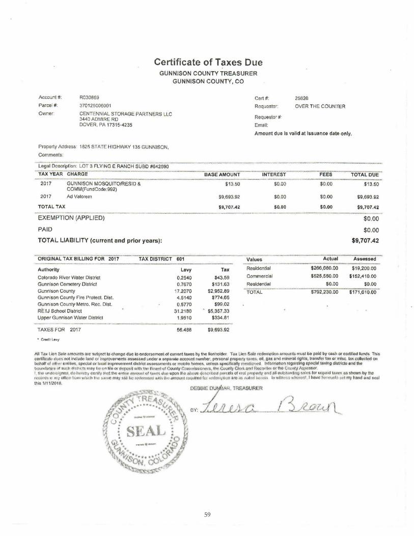
59
Account#:
Paree, # :
Owner:
R030869
3701 25006001
Certificate of Taxes Due GUNNISON COUNTY TREASURER
GUNNISON COUNTY, CO
Cert#:
Requester:
CENTENN IAL STORAGE PARTNERS LLC 3440 ADMIRE RD Requesto, # ·
Ernail: DOVER , PA 17315-4235
25626
OVER TH E COUNTER
Amount due Is valid at Issuance date only.
Property Address 1825 STATE HIGHWAY 135 GUNNISON,
Comments:
Leg·; i ... Dcscrfplio~~LOr 3. FLYING E RANCH sus°D ™ 2590
TAXYEAR CHARGE
2017 GUNNISON MOSQUITO/RESID & COMM(FundCode:992)
2017
TOTAL TAX
Ad Valorem
EXEMPTION (APPLIED)
PAID
TOTAL LIABILITY (current and prior years):
- ORIGINAL TAX BILLING FOR 2017 TAX DISTRICT ________ .. ___ --------- ----Authority
Colorado River Water District
Gunnison Cemetery District
Gunnison County
Gunnison County Fire Protect. Dist.
Gunnison C:::ounty- Metro. Rec. Dist.
RE1J School District
Upper Gunnison Water District
- ------ --- -TAXES FOR 2017
--- ---_ ______ __ .. ___ .. ___ _
601
Levy 0.2540 0.7670
17.2070 4.5140 0.5770
31 .2180 1.9510
56.488
BASE AMOUNT INTEREST
$13.50 $0.00
$9,693.92
$9,707.42
Tax
$43.59 $131 .63
$2 ,952.89 $774.65
$99.02 $5,357 .33
$334.81
$9,693.92
$0.00
$0.00
--- - ·-Values
Restdentlal
Commercial
Residential ____ .,..,.,_.., _____ TOTAL
FEES
$0.00
$0.00
$0.00
Actual
$266,680.00
$525,550.00
$0.00
$792,230.00
TOTAL DUE
$13.50
$9,693.92
$9,707.42
$0.00
$0 .00
$9,707.42
Assessed
$19,200.00
$152,410.00
$0.00
$171,610.00
All Tn~ I.Ion SHlc- on1c,mts ar~ s1.1bJ~c1 to ch,rngll due to em;lorscmcnl. of ·,v,rent !moos by frn: lf<:,rt!1t>l~er T<Jx Lien Stile rcdarnptkm 11mou1>l$ rnus! till 1Wld by ca,11 or· e;;1lilled hmd• This cc11ific11!r Ht~ . not include 111ml 01 irn)l_f()VClMCr\l.S ass<'!&&M lJlldcr a s11Jlll r&te nccoun! n umbot, pcrnonni property !:IX(\S, o il, JlM and 111lnura1 right~. trn·nwf<1t t_nx or rnts.: . ta• r.nUcch\d on bahalf <d olli~, ontith,s, special or local Improvement dit1r1c1 assas.smef\ts or mobllo home$, unle~s s peemcallv 1ur l1lf;)Md 1nromfo!iQf1 rogordtng l!'l)()c!al t~x!tig dl.tricf~,and the QQu11L111tM, ()! suci1 !1•11111.ts mny l,o on lite qr ,1 pot,J wllh 1h« f\nartl·'lf C11u1>ty <:01firni$S•~t1cts. l!1e C~unlv Clark ;ittrt ROtllr<ltH <>f th!> Cu •f!\Y.1\$.~l!ssor. 1 w,1 v•"-"~11,1:tnco, llo hGH: , c-en.iy 1n;,t llrn a.nu, ~omunl 11• 10,e~ .iw 11por1 tho ilh(•Vll <.!<>41:t~i!ld Ol!leeh; of rr ~I pm(lo1tv_ 011 alt outr.V.<1~!111) r;aics lor u111 md ta.1< ·• ns shown by tho h :1:1.1111s.t1 , ni;, 0H1t:v t,v,,• wl1it h 1Ht! ,i,u;~ may ,.1111 !J<i u .. 'Ct<::-r. irt.-;:th•.1d·dhu .umount h.lt.lVifefJ tut 1u~h.1Mp1,v:t are :•, r hM4 Jum:m 111 wJtnt•'fi~ -~,11oreo' I have ht"ttl~M.I~ t.e t 'fUY tiand tll,d soul this II 11/ZO 18.

60
' \
Lli I •
J .
[
'
' !,.ii.
i!i:J;
\ \
< ' ,.,
(fl
I ,
.:,1 ' .. \ ,. • : 1,
)~
. . .
;I 'f t',!Hi :'!1'..~1lt.~. -..ti,'1tf>\'1W l'Mt (?ltJ!,.l 1.,1 f 1 1-; 'iil;~•f.t{A,~ <"!~MWfli,.;'U,:(:~t
i5U:'! O .:il /\ fl :iH\''O J.H tJ)1· 1 lO.Af..kE~ fAt<..( ,Ai. 1.r;~u ~.,,,,w.001 t · tt;)~l ~~.!1H.t .t'h{f 'I. t .~~ • 1:~;:i:• ; J1 t,:1
i -I I:;• ' . .
! .,
J.,-.
,: ~ . t.! .j 1, :~ f
'·'
\
OVERALL SITE PLAN
...,_ .. , 1 : ,: I 1i l .. I ,; I I I ;; l 'l t-::
' I ' ' .

61
W1WAM GOO(>,""
"""""""'"" l'AACCL I .,7010000011, .,,./.4AO!l5
co,r,..reHWY ,,, GUm~ coomv. COIDf.ADO .,, zao
--- ---- --- ----------.r--------------='.!:'.08'~5~':='25;!_'.:.;f 3::5::;2-=25:!..' ----------.....--.-1---i - - -- - - - - - - - -- - - - - - _; OrTCH 4 lfTIUlY~CMfNT
~ ~ V\ -.) ~
-< <l... -t::. "' = .,
-:-' " "' ~ ~ .J
<;., 0
Cl .s
(1:)
::s
~ --=
t
c::,l '-I g i:,
:/.-h() ..:;;-S4
LOT 2
omt" • X~.lf.Vl"'Z 1'1.'(IHGt"NO!~ ,.,.,en., 310,2,ooc;.oo.5
LOTZ.7.2AC~ I 1a, CO 'TAU: HWY 13,
Gcn,,'4eott cov,m,, CO\.OAAOO &1230
_l__ OVERALL SITE W-1""""E~S~C~AL~E~:~1~"=~3~0.~0'~----
S
~ ~ ~
I z
50.3'
101
fl<ISTINGMe'TAL STORA/if llUILOING
--·----·--·------
"' I:! S l!Xl5TING
I? HOUSf
3,.&
DfC~
MMTIH~~,a ri.'l'ING f IWIQt SlmOM!OI l'~l•37012500G002
LOT-4.3.0,Aee, 1n,co,rATl!HWY13,
C.UHN1!50N COUNTY, C01.0MOO t>l 230
LOT 4 -6 I 10 ACRfS
oc1,r1NGMeTAL STORA/if llUILOING
''°·O' e:l<l5TlNGMe'TAL
STORA/if llUILOING
LOT 3 2.~AC~
exi,nNG Me'TAL ,ro,w;e el.lJLOING
5U9Nt t l'.DC.OI. JONN90N rNUAl310 12:soocx>o&
" '°"" I &,.4 CO !5f4f? twr 13, GUHNl50H ecutm', OOLOIVOO t> I Z!O
- -------------------
l"'ltA.NCelt11CNJ:Y~ MCH~TV
r'Ntal.1137012,0C,OOO, 45"""9
l.,20C05TATtl1W"I" 13' GUNt4l!ION COUNTY. COLOIV,DO & I 230
----~UNI: -----~ ----1~TIONMCl1
---------- ~~~ -e-r'- ovtl'J100~U""'1"0ll
_____,... """'"""
/ /
/ /
/
/
/ /
/
n
z <{ ...J a. w 1-[fl
...J
...J ~ Cl:'. w > D
"""""''"' RI.W
t.lOSl'CUltMNfa<,ffl 7/10/17 -... 2007
81
ENGINEER'S STAJ P

62
-CY
i/, I ' I
I
j ~
"' -1 ';y-
\~ ::1::
l
\
l : \
' ' l . ' l i
1
\ 11J \
I".

63
Phone... 970-275,,5448
Fax # 970-349-132B
Ken SY"det Dlsc:01.Kil SeW-Storooe UIMlsol1.Co 81230
1CY Coiolodo ~ 8' CololOdo 5puc:e 2·~/upell tposb Metal edging Mefd~pln:s Soeened topsoil Rood robnc Fabric pin., ~ boo Machine lobor
iillt!~merl~.Ci.',l(J)
nevernimmer!onclscope.com
Estimate
2 500.00 l.000.00 2 400.00 800.00
10 250.00 2.500.00 34 6.00 20'1.00
600 3.00 1.800.00 120 0.75 90.00
2 500.00 1.000.00 1 600.00 60000 1 90.00 90.00
16 90.00 U<I0.00 56 -45.00 2.520.00
Subtotal $12,044.00
Sales T ox (8.5") $000
Total $12,044.00 ,._ ________________ _

April 11, 2018 Gunnison County Planning Commission 200 West Virginia Gunnison, CO 81230 RE: Centennial Storage Partners – Discount Storage Dear Commissioners: Thank you for providing the opportunity to comment on the proposed Land Use Change, Minor Impact for the expansion of two new storage buildings at 1825 State Highway 135. The following comments are based on the submitted application materials and the relation of the proposed project to the Gunnison Three Mile Plan and Urban Growth Boundary, City of Gunnison, Colorado and the City of Gunnison Master Plan. Based on the existing Three-Mile Map, the property is designated as Rural Residential (1 unit per 5-35 or more acres) and is located outside of the Urban Growth Boundary. One of the objectives of the Three-Mile Plan is to encourage infill development within the City limits and to “Limit new commercial and industrial development to lands within or immediately adjacent to existing City commercial and industrial zones.” Land use changes along the highway corridor are processed in a vacuum with no coordinated direction or long term thought of consequences. Consequences include haphazard driveway locations affecting traffic safety and function of the highway system, no ability to provide internal street extensions, site developments that are not adequate to provide urban services and land uses that may not be appropriate for the highway corridor or City entrance appeal. If the proposed request is approved by the County, the possibility of future annexation of the site into the City would be limited, since the City’s code requirements for utilities would not be met. We appreciate the opportunity to review this application. Yours sincerely, Greg Larson, Chairperson City Planning & Zoning Commission
64

STAFF REPORT THREE-MILE PLAN ANNUAL REVIEW
To: Planning and Zoning Commission From: Community Development Staff Date: April 11, 2018 Cc: Gunnison County Planning Commission STATE STATUTE PROVISIONS Pursuant to Title 29, Article 20, Colorado Revised Statutes (CRS), the State gives broad authority to local governments to plan for and regulate the use of land within their respective jurisdictions. Local governments also have the power to regulate the location of activities and developments that may result in significant changes in population density, to provide for phased development of services and facilities, and to regulate the use of land on the basis of impacts. The statute authorizes and encourages local governments to cooperate or contract with other units of government for planning and regulating land. Once a Three Mile Plan has been established, it must be annually reviewed C.R.S. §31.12.105 1EI:
“… Prior to completion of any annexation within the three-mile area, the municipality shall have in place a plan for that area that generally describes the proposed location, character…to be provided by the municipality and the proposed land uses for the area. Such plan shall be updated at least once annually…”
EXISTING THREE-MILE PLAN DOCUMENTS Three Mile Plan: The current Three Mile Plan was last revised in December 1997 and is the guiding document for development within the three-mile planning boundary. The plan discusses existing conditions and future development potential, goals and objectives, preferred land use patterns, as well as implementation actions. Three Mile Plan Intergovernmental Agreement: The Three Mile Plan Intergovernmental Agreement (IGA) was executed on July 3, 2001 between the City of Gunnison and the Gunnison Board of County Commissioners. It provides the policy for intergovernmental coordination, including the joint review process. The IGA also provides for a process to resolve disputes that may arise as a result of changes in circumstances after the execution of the agreement. Wastewater Treatment Facility Agreement: The Wastewater Treatment Facility Agreement was also
65

executed on July 3, 2001 between the City and County and is the sole agreement regarding wastewater collection and treatment between the two entities. The agreement states that there is sufficient capacity to serve the areas contained within the three-mile planning area. The agreement sets forth provisions for capacity charges, facility operations, user fees, discontinuance of service, regulatory jurisdictions, and dispute resolution. One of the main provisions within this agreement relates to the protection of the City’s sales tax, which states that “the City shall not be obligated to accept wastewater for treatment … from any property that is approved by the County for retail or commercial use which generates sales tax revenue…” CITY OF GUNNISON MASTER PLAN Chapter 5 of the City of Gunnison Master Plan (2007) addresses some of the issues and topics regarding future development within the Three Mile area. The plan provides significant revisions to future land uses, redefines the Three-Mile and Urban Growth Boundary, and establishes policy directives. The Master Plan is outdated and two annexations have occurred since the 2007 plan that changes the proposed Three-Mile Boundary and the Urban Growth Boundary.
ANNEXATIONS Gunnison Rising. Gunnison Rising was annexed into the City on January 31, 2010, increasing the city area by 633 acres. The following table indicates specific zoning district designations, assigned residential unit caps (minimum and maximum), the number of recreation vehicle space allocations, and the maximum amount of non-residential floor area for Gunnison Rising.
Excerpt from the City of Gunnison Master Plan (2007): Urban Growth Boundary (UGB) The urban growth boundary (UGB) was last mapped in 1997 with projected land uses identified within that boundary. The UGB and Three-Mile Boundary have been moderately revised for this plan to reflect changing conditions in the area, such as population growth, infrastructure extensions, and transportation needs. However, the Three-Mile Plan will need to be further reviewed by both the City and the County and revised accordingly. Consequences of Existing Land Use Development Patterns Existing land use patterns within the urban growth boundary are problematic in several respects. Most of the residential ranchette properties that have been developed in recent years have a sprawling nature to them, and are contrary to compact land development patterns. Secondly, these properties typically rely on individual septic disposal systems (ISDSs), and not a central sewer system. As a consequence, the City’s water quality and potable water systems could be threatened. Thirdly, traffic patterns are placing increasing pressure on existing roads, particularly on Highway 135 just north of the City limits. (See Chapter 8, Transportation).
66
VanTuyl Ranch. In 2012 the City initiated an Annexation Petition for the VanTuyl Ranch property and the 5.32 acre parcel owned by the Gunnison County Library Board. The City annexed the 389.58 acres on February 12, 2013. The VanTuyl Ranch and Library Site are designated as follows:
THREE-MILE BOUNDARY AND URBAN GROWTH BOUNDARY The attached maps show the existing Three-Mile Boundary (square shape); the existing Urban Growth Boundary; proposed boundary changes; and, sewer service areas within the three-mile area.
Land Use PUD Zoning District
Designation
Acres Residential Unit
Minimum
Residential Unit Cap
Gross Floor Area Non-Residential
Recreational Units
Single-Family Residential R-1 16 1 4 Per Conditional
Use* N/A
Residential R-2 234 235 340 Per Conditional Use* N/A
School District Site R-2 M 10 N/A N/A N/A N/A
Residential Village R-2 M 63 100 270 Per Conditional Use* N/A
Commercial / Mixed Use C M 48 0 120 174,000 N/A
Parks/Open Space O 62
N/A N/A N/A N/A Highway 50 ROW
Dedication N/A 13 N/A N/A N/A N/A
Recreational Resort CRV 64 N/A N/A 10,000 350
Commercial C 5 N/A N/A 20,000 N/A Business &
Research Park I M 37 N/A N/A 250,000 N/A
Western Pavilion C/WP 12 N/A N/A Existing structures to remain
N/A
Government GOV 17 N/A N/A 70,000 N/A
Equestrian Meadows O/E 52 N/A N/A N/A N/A
TOTAL 633 734 484,000 350
*(Note: Non-residential uses which may be allowed through conditional use approval are not reflected in this table.
Land Use PUD Zoning District
Designation
Acres Residential Unit
Minimum
Residential Unit Cap
Gross Floor Area Non-
Residential
Recreational Units
Agriculture and Open Space AG 384.26 1 4 533,602 N/A
Library LIB 5.32 N/A N/A 26,000 N/A
TOTAL 389.58 1 4 546,602 0
67

The Urban Growth Boundary can be defined as an area in which urban growth is encouraged considering two factors: need and location. The Urban Growth Boundary should not be confused with the sewer service areas that extend outside of the Urban Growth Boundary. REVIEW OF PAST THREE-MILE COUNTY REFERRAL APPLICATIONS
App# Name Location Comments Date Reviewed by PZ LUC-16-00042 Tina McGuinness -
McGuinness Subdivision
3.82 acres north of County Road 10 addressed 2375 County Road 10
Three-Mile designation within the Urban Growth Boundary located in the rural residential land use area. Very minor in scope with no significant impact to adjacent existing land uses.
February 6, 2017
LUC-17-00015
AJ Cattles – Gunnison Secure Storage
1012 Highway 135; directly adjacent to the north City of Gunnison boundary.
Three-Mile designation within the Urban Growth Boundary located in the Moderate Density Residential (1 to 6 units per acre) area. No stated concern. Given proximity to the electrical substation and other adjacent uses, this use seems appropriate.
July 20, 2017
LUC-17-00047 William Goddard – Church Lot Subdivision
Church Lot, Riverwalk Estates, Rec. No. 555976, County of Gunnison
Three-Mile designation within the Urban Growth Boundary located in the rural residential (1 unit per 5-35 or more acres) area. No stated concern and is compatible with the neighborhood.
August 9, 2017
STAFF OBSERVATIONS 1. Revision of the Land Development Code was completed and adopted in 2014. Revisions to
the LDC are anticipated While the updated standards do not affect future land uses in the Three-Mile area, the development standards will apply to any areas contemplated for future annexation.
2. An update of the City of Gunnison Master Plan (Comprehensive Plan) will begin in the next
month with a Request for Qualifications from consultant companies. Once a consultant is selected, a Scope of Work will be completed in the fall of 2018. Work on the Comprehensive Plan will begin in January 2019 with an anticipated completion date of January 2020.
3. An update to the Three-Mile Plan will be considered after the completion of the
Comprehensive Plan. 3. Revisions to the Intergovernmental Agreement should be considered when the Three-Mile Plan
is updated. RECOMMENDATIONS 1. Begin exploring sources funding sources for the Three-Mile Plan update. 2. Include the Three-Mile Plan update in the FY2020 budget.
68

3. Review and analyze existing land use patterns within the three-mile planning area and
address future related development potential as part of the Comprehensive Plan update.
69

DRAFT MINUTES – MARCH 28, 2018 7:00 PM CITY OF GUNNISON PLANNING AND ZONING COMMISSION REGULAR MEETING Page 1 of 4
MEMBERS PRESENT ABSENT EXCUSED Greg Larson - Chair X Theresa Hanacek X Bob Beda X Andy Tocke X Erich Ferchau X John Perusek X Erik Iverson X OTHERS PRESENT: Director Steve Westbay, Planner Andie Ruggera, Darin Higgins
I. CALL TO ORDER AT 7:00 PM BY CHAIR GREG LARSON
II. PLEDGE OF ALLEGIANCE TO THE FLAG
III. UNSCHEDULED CITIZENS- None
IV. POSSIBBLE ACTION – MINOR SUBDIVISION, FINAL PLAT APPLICATION SB 17-7, SUBMITTED BY DARIN HIGGINS, TO SUBDIVIDE ONE PARCEL INTO TWO LOTS (321 S. IOWA ST AND 112 E. SAN JUAN AVE Review of Process. The City’s Land Development Code (LDC) Section 12.3 defines the types of subdivision within the City. A Minor Subdivision, for which this application is classified, is subject to an expedited two-step review process. The applicable review steps are as follows:
1. Review of the preliminary plat by Planning Commission at a public hearing; 2. Review and recommendation of the final plat by Planning Commission (with no
public hearing); and action on the final plat by City Council (with no public hearing).
The Planning and Zoning Commission reviewed and approved the Preliminary Plat at a public hearing on February 28, 2018 with the condition that the Final Plat application shall be amended to include the “Original Gunnison Subdivision” in the legal agreement contained in the Certificate of Dedication and Ownership. The Planning and Zoning Commission reviews the Final Plat application and may recommend to City Council to approve, approve with conditions, remand the application for additional information, or deny the application. Mr. Higgins subdivision is a minor subdivision of Lots 13-17, Block 45, Original Gunnison Subdivision. Mr. Higgins was granted a variance for minimum lot size with a Lot A, 6,625 square feet and Lot B, 9,000 square feet. It served by all public utilities currently with no proposed public utility improvements. It is access by existing streets. Appropriate easements have been granted and noted on the plat. No commissioner questions or comments.
70

DRAFT MINUTES – MARCH 28, 2018 7:00 PM CITY OF GUNNISON PLANNING AND ZONING COMMISSION REGULAR MEETING Page 2 of 4
ACTION During the Planning and Zoning Commission meeting of March 28, 2018, Commissioner Ferchau moved, Vice-Chair Tocke seconded and the Planning and Zoning Commission voted to recommend APPROVAL the Minor Subdivision Final Plat, SB 17-7, Higgins Subdivision with the following findings of fact and condition:
Findings of Fact: 1. The Planning and Zoning Commission finds that the record of this action includes
the application contents on file with the City of Gunnison; all comments entered into the Public Hearing record; and provisions of the City of Gunnison Land Development Code and the City of Gunnison Master Plan.
2. The Planning and Zoning Commission finds that this application is for a Minor
Subdivision of a deeded parcel approximately 15,625 square feet into two lots. 3. The Planning and Zoning Commission finds that the subdivision is located in the R-
1 zone district (single family residential) located on Lots 13 -17, Block 45, Gunnison Original Subdivision.
4. The Planning and Zoning Commission finds that in June 2017, Mr. Higgins
submitted an application for a variance from the minimum lot size and the application was approved by the Zoning Board of Adjustments and Appeals.
5. The Planning and Zoning Commission finds that existing utility services and
improved streets are available and serve the two existing single family dwellings. 6. The Planning and Zoning Commission finds that separate utility service extensions
serve the two existing dwelling units and the proposed subdivision plat notes cross easements necessary to ensure future services can be maintained.
7. The Planning and Zoning Commission finds that the subdivision of the subject
property is compatible with the surrounding neighborhood. 8. The Planning and Zoning Commission finds that the eight review standards for
subdivisions have been or will be met based on the following Condition: Condition: 1. The Final subdivision review is subject to approval by the City Council. Roll Call Yes: Perusek, Larson, Beda, Hanacek, Tocke, Ferchau Roll Call No: Roll Call Absent: Iverson Roll Call Abstain: Motion carried
71

DRAFT MINUTES – MARCH 28, 2018 7:00 PM CITY OF GUNNISON PLANNING AND ZONING COMMISSION REGULAR MEETING Page 3 of 4
V. CONSIDERATION OF THE MARCH 7, 2018 MEETING MINUTES
Vice-Chair Tocke moved and Commissioner Hanacek seconded, to approve the February 28, 2018 meeting minutes as presented. Roll Call Yes: Perusek, Ferchau, Larson, Beda, Hanacek, Tocke Roll Call No:
Roll Call Absent: Iverson Roll Call Abstain: Motion carried
VI. MOTION TO EXCUSE COMMISSIONER IVERSON FROM MARCH 28, 2018 MEETING. Commissioner Peruseck moved and Commissioner Beda seconded to excuse Commissioner Iverson from March 28, 2018 Planning and Zoning Commission meeting. Roll Call Yes: Tocke, Ferchau, Larson, Hanacek, Beda, Perusek Roll Call No:
Roll Call Absent: Iverson Roll Call Abstain: Motion carried
VII. COUNCIL UPDATE / PLANNING STAFF UPDATE • Gunnison Arts Center’s “Sunday at Six” multi-day Special Event Permit was approved. • City Council adopted the Gunnison Vibrancy Initiative Final Report with Resolution
No. 2, Series 2018. • Contract between the City and Gunnison Country Chamber of Commerce to support
the operation of the Visitor Center. • Council was given an update on the Ohio Avenue RFP Responses • IGA to delineate responsibilities between the RTA and City of Gunnison for creating
and maintaining bus stops. New bus stops at the Community Center and Virginia and Teller.
• Planning staff is trying to close out the GOCO grant which entails finishing out signing and repair to the deck.
• Cody, the new City engineer, is on board and is very familiar with various types of projects.
• RFP out for the Lazy K Master Plan update. • Cascadia Partners has been contracted for the affordable housing LDC assessment. • No current update from Arby’s but they do have to do a boundary line adjustment. • Gunnison River Riparian Habitat and Restoration project is back to work on the Piloni
ditch. • Gunnison Rising met with City Council regarding needing to develop a Habitat
Conservation Plan for the sage grouse. Also, may be re-thinking the land use on the annexation.
• RFQ- for the Comprehensive Plan update is being worked on.
72

DRAFT MINUTES – MARCH 28, 2018 7:00 PM CITY OF GUNNISON PLANNING AND ZONING COMMISSION REGULAR MEETING Page 4 of 4
VIII. COMMISSIONER COMMENTSCommissioner Ferchau mentioned an article “5 Strategies in Working with Developers,”that was in last month’s Planning magazine. He stated that it was a really good overviewof issues and working with developers.
Discussion about uses in the downtown area.
IX. ADJOURNED TO WORK SESSION AT 7:31 PM BY CHAIR LARSON
____________________________ Attest: Greg Larson, Chair
_______________________ Andie Ruggera, Secretary
73

Comprehensive Plan Update – 2019 Request for Qualifications
Submission Deadline – DATE/TIME Direct all communication to: City of Gunnison Attn: Mr. Steven Westbay, AICP PO Box 239 Gunnison, CO 81230 [email protected] 970-641-8152 Request for Qualifications (RFQ) The City of Gunnison, Colorado seeks a team excited about our community; that is up to the challenge of helping the community establish a blueprint to follow for the upcoming years. Its foundation will be based on vision, stewardship of economic and natural resources, and sustainable directions; and one that possesses outstanding civic engagement talents on all platforms, as well as legal, technical, place-making and market skills, and transportation and urban planning expertise. The consultant should possess the necessary staffing capabilities to provide exceptional services to the City in a major update of the Comprehensive Plan. The Plan will cover the existing City boundaries and also set forth planned future urban service areas. Introduction The Gunnison City Council Strategic Plan (October 10, 2017) tasks city staff to implement the update of the City Comprehensive Plan. Specifically, “by December 31, 2019, the City will have completed a Comprehensive Plan that provides a community vision, and specific implementable strategies so that our community will experience a resilient health economy, affordable housing, improved environmental sustainability, high quality development and public infrastructure which supports our high quality of life.” Community Development is the lead City department for this project. By September 1, 2018, the Department will have led the integrated process of selecting a unified consulting team and prepared a scope of work and budget that will be included in the City’s fiscal year 2019 budget. This RFQ will result in a short-list of consulting teams invited to submit a formal Request for Proposal (RFP). Thereafter, the consulting team and City will proceed through final contractual negotiations and prepare for the process kick-off. Community Background Community Essence. Gunnison, Colorado is a rural community with a rich history influenced by cultural heritage, bountiful natural resources on adjacent federal lands, environment stewardship, and the traditional western value of community and family ties. Gunnison is a family-oriented community that blends a traditional hometown atmosphere with a modern, independent spirit. Gunnison’s authentic downtown, well-established
74

neighborhoods and cooperative governance provides a solid foundation for a living experience that fosters growth and creativity. For visitors, the City provides a sophisticated, yet charming urban atmosphere, featuring independent shops, unique restaurants and a variety of entertainment options. Gunnison’s western heritage is the foundation of a friendly and eclectic community, and modern vitality cultivating a distinct visitor experience. For businesses, Gunnison offers a well-maintained community, supported by consistent resident and visitor traffic. It features government offices balanced by a university and charming downtown business district. This vibrant City has established itself as a place where both traditional and entrepreneurial businesses can flourish. History. Established in 1882, as a railroad hub to access the mineral districts of the Elk and San Juan Mountains, the City has evolved into one of Colorado’s premier West Slope communities, with recreation, ranching, and education being the mainstay economic sectors of the community. In 2016, Outdoor Magazine ranked, Gunnison as the 11th best community in the United States to live and play. Gunnison is the home of Western State Colorado University, which is ranked in the top 100 institutions in the western United States. It has long been a Main Street community, with an ongoing Gunnison Vibrancy Initiative aimed at improving and maintaining the character of the downtown area. The local area has strong tourism, along with varied land use and housing, an industrial business park, regional airport, and hospital. Gunnison is the county seat. Gunnison Today. Gunnison is a full-service municipality, providing a range of municipal services including domestic water (7.2 million gallons a day); a wastewater treatment (4.2 MGD capacity), serving over 8,000 residents; and an electrical service territory encompassing 11.7 square miles, with one of the lowest electrical rates in the nation. It owns and operates twelve parks sites and recreation facilities (11 parks and the community center) as well as provides programming for all ages with a variety of interests. Over 8.5 miles of bikeways provide connectivity to adjacent federal lands; VanTuyl Ranch is an open space managed by an adaptive resource management plan; the Gunnison River State Wildlife Area provides 1.5 mile of public river access; Tomichi Creek State Wildlife Area boarders the eastern city entrance; and a Community Center with 2 indoor pools (warm therapy pool and lap pool), a climbing wall, senior recreation facility and gym. The community has a full service hospital along with assisted living facility, family medicine clinic, home medical services and senior care facility. The incorporated boundary covers approximately 4.1 square miles. Based on the Colorado State Demographer data the current population estimate is 6,276, as of July 2017. This represents a 7.2-percent increase since the 2010 census. The population increased by 867 residents since 2000. It is estimated that Gunnison will have a population of 6,729 by 2025,
75

based on assumptions and data found in the Community Analysis, 2015. http://www.gunnisonco.gov/Planning/Community_Analysis_Final_2_15.pdf The City has 2,445 housing units, and approximately 60% of units are rental. The historic downtown is vibrant and is considered an essential element for economic and community resiliency. Western State Colorado University. In 1911, the Colorado State Normal School opened in Gunnison with 13 students, as a two-year teacher education school. The Normal School was the first college on Colorado’s West Slope. The two-year college became Western State College, a four-year institution in 1923; and in 2012, the college became Western State Colorado University (Western) with world class programs in a variety of academic disciplines, to include several master degree programs. In 2016, the direct impact of Western on the local economy generated $40.75 million. The total direct and indirect impact was $70.52 million, the equivalent of 19 percent of the net earnings by residents of the County. Western creates more than 450 jobs directly and an additional 190 jobs indirectly (Holden Paul, The Role of Western State Colorado University on the Economy of Gunnison County, 2017).
Opportunities & Challenges. During the review of this document, the Planning and Zoning Commission wanted to emphasize that Gunnison is special in a variety of ways, but as with all communities it is not without challenges. The following are general topic headings that reflect the community’s opportunities and challenges. Challenges Urban Growth: where (existing/future service territory), how to grow (sustainable/resilient) Housing Alternative transportation needs Highway corridor bisecting the community (HWY 50 & HWY 135) - Resort influence - jobs, housing, transportation, and cost of living Georgia Avenue – University campus perimeter & Gunnison Rising connectivity Fiscal & Economic Growth – jobs, wages, cost of living and fiscal impacts from urban services (police, fire, utilities, etc.) Opportunities – Recreation Opportunities – Base Camp of the Rockies Western State Colorado University Excellent public school system Friendly and safe community Clean air and water Excellent health care system Low utility rates
76

Abundant water resources Current Master Plan The City’s first Master Plan was adopted in the mid-1980’s and was revised in 1997. The existing City of Gunnison Master Plan (Master Plan) was adopted in 2007. The 2007 Master Plan was largely completed in-house, with assistance from the Colorado Department of Local Affairs. The community came together over a series of traditional public involvement sessions and mapped out its emerging future. The community and administration have been implementing the plan’s defined Goals, Policies and Actions. To date, approximately 85-percent of the implementation actions have been fulfilled. Since 2007, Council has adopted two sub-area plans that are component documents to the 2007 Master Plan. The West Gunnison Neighborhood Plan, adopted in 2008, directs how in-fill development will occur in the western part of the community. The West Gunnison Neighborhood Plan encompasses an area bounded by Highway 50 on the east and south, Tomichi Avenue on the north, and the Gunnison River on the west. The VanTuyl Ranch Management Plan (August 2010) is another sub-area plan that has been adopted by the city. This plan was developed prior to the annexation of the Ranch. The structure of the plan is very diverse but it focuses on future land uses, agriculture management strategies, and natural resource management. In April 2013, the Council also adopted the City of Gunnison Non-Motorized Transportation Plan, which has helped focus efforts to integrate complete street design practices into the community development process. This plan, directs future development of multi-use trails, sidewalks and bike lanes on city streets. Annexations. Since the adoption of the 2007 Master Plan, there have been two major annexations that have occurred. The Gunnison Rising annexation (2010) and VanTuyl Ranch annexation (2012) have extended the city boundary and future service needs to these annexed territories. Annexation of Gunnison Rising has provided the ability to plan and manage future growth of the community. Understanding and directing the future service needs to facilitate this growth is a paramount need to be documented in the upcoming Comprehensive Plan. Municipal service needs will include utility and street extensions as well as services such as fire, police and administrative functions. Gunnison Rising is a master planned PUD, detailing future street layout, land uses and other related functions – Gunnison Valley Properties, owners of the annexation territory, are beginning a process to reassess the 2010 master development plan and PUD documents and the city will be involved in this process. West Gunnison. The 2007 Master Plan recognized that the majority of future infill development will occur in West Gunnison. In 2008, the City developed the West Gunnison Neighborhood Plan which serves as a sub-area plan to the Master Plan. This plan focused on the defining the future physical development of this area of the community. One of the significant outcomes of the West Gunnison Neighborhood Plan was that the City took over the wastewater services
77

previously provided by the West Gunnison Sanitation District. This has helped facilitate additional utility extensions and subdivisions of property in this area. The existing Master Plan does not contemplate the planning details addressed in the West Gunnison Neighborhood Plan, and a revised Master Plan will provide necessary integration or a more clearly defined blueprint for infill development. Transportation. The 2007 Master Plan provides a general summary of transportation functions but the breadth of this topic has changed significantly. For example, street extensions associated with the Gunnison Rising annexation are significant and the updated Master Plan will provide clearer direction regarding transportation elements of the Gunnison Rising annexation. Non-motorized transportation functions have also significantly changed since 2007. The recreation ballot initiative (2007) allocated funds for constructing the ice rink, pool and future trails. The obligation to spend one million dollars for the construction of trails was met in 2014. However, there are additional trail segments identified in the Non-Motorized Transportation Plan (2013) to be completed. While the Master Plan contemplated non-motorized transportation needs it does not have the depth and context of information that is found in the Non-Motorized Transportation Plan. The updated Master Plan can address the scope of information to better direct future trails and sidewalk extensions. General Update Content and Outcomes The City desires to have a successful major update to the current Plan which will serve as a policy basis for the community over a specified planning period. Content elements and outcomes that have been generally considered relevant for the update are summarized below. 1) A Comprehensive Plan which can assist policy makers with a basis leading to managing
community growth and development. 2) Build upon the previous community planning programs, including but not limited to the 2007
Master Plan, adopted sub-area plans, and the Gunnison Vibrancy Initiative, and the Council Strategic Plans and any related amendments.
3) Retest, refine, and expand the vision for the community for both the planning horizon and
long term. 4) Market Studies – housing market, land use capacity and by land use category. 5) Analyze existing conditions and project future conditions. 6) Civic Engagement – Utilize a variety of engagement platforms and techniques including but
not limited to face to face meetings, social media, websites, etc. 7) Elaborate on community vision based on significant citizen and stakeholder input.
78

9) Identify focused, prioritized growth areas for a range of land uses, including vacant ground
development as well as redevelopment opportunities. 10) Strategies that direct the execution and management of plan recommendations. 11) Help build leadership capacity in the community, be diverse and participatory, transparent,
strategic and long term, comprehensive, sustainable, implementable, be the basis of updating regulations, be focused yet visionary, and provide for continual improvement in the community.
12) Include subject areas of at least: land use, future land use, economic development, housing,
neighborhoods, downtown, historic preservation, sustainability/environment, parks & recreation, transportation (roads, transit, pedestrian/bikeway, etc.), airport, growth management, community facilities and services, and community character.
13) Account for the future impacts of emerging technologies in a flexible way that is future
oriented but recognizes the transitional period in the short term – such as autonomous vehicles and drone technology.
14) Determine future trends in commercial development and account for re-development
opportunities. 15) A document that serves as a blueprint to follow in promoting sustainability and focusing on
community resiliency. Request for Qualifications Process Background. The City is soliciting submittals from qualified consultants to assemble a professional team excited about our community; that is up to the challenge of helping the community to establish a community blueprint to follow for the upcoming years. The consultant should possess the necessary staffing capabilities to provide exceptional services to the City in a major update of the Comprehensive Plan. The Plan will cover the existing City boundaries and also set forth planned future urban service areas. RFQ Process. A three-step process will be followed from the initiation of this RFQ to the final selection of the consultant(s). First, is this publication of this RFQ, where professional consulting firms are invited to participate in the review process. Second, based on the RFQ response, a list of qualified consultants will be invited to submit a formal Request for Proposal – selected invitees will demonstrate the technical competency of the team, how the team will produce dynamic and cutting-edge results, and the team’s record of success in producing a great document given the complex social, economic and environmental interplays of the community. Third, a consulting team will be selected and will work with City staff, stakeholders and community leaders on the contract negotiation.
79

While it is anticipated that some work will likely be initiated before the end of the year, the revenues for the lion’s-share of the work will be funded by the City’s fiscal year 2019 budget. RFQ Evaluation The RFQ evaluation and selection criteria for short-listing of the consulting firms invited to submit an RFP are as follows in no particular order: A. A high level of professional competence and proven track record of accomplishment in the
preparation of outstanding Comprehensive Plans.
B. Demonstration of professional, technical, and legal expertise (Colorado focused) and experience of the principal personnel assigned to the project.
D. Experience, knowledge, and expertise with Comprehensive Planning regulations, uses, and laws in the State of Colorado.
E. A diverse team with assorted specialists to help address various disciplines including but not limited to, urban design specialist, transportation engineers, economist and/or economic development specialist, engineering and sustainability professionals.
F. Public facilitation capabilities and experience working with the public, steering committees, and stakeholders in diplomatically crafting standards and/or criteria to be incorporated into the work products as well as outstanding and creative experience in civic engagement through a variety of platforms, outlets, and methods.
F. Demonstrated understanding of the Community and opportunities and challenges affecting local development during the next 10 to 15 years and future.
G. Ability to produce high quality documents and graphics that are user friendly, yet able to be flexibly updated into the future.
H. Ability to make high quality oral and visual presentations.
I. Creative and successful use of technology in a Comprehensive Plan update process as well as civic engagement processes.
J. Ability to listen, be flexible, and follow and/or implement direction and/or ideas and concepts.
K. Ability to adapt throughout the Comprehensive Plan update process for the inevitable changes, ideas, and other items that are raised throughout the process.
80

L. Ability of consultant team to demonstrate initiative, motivation, and knowledge of the City of Gunnison and a desire to produce the highest quality Comprehensive Plan for our community that could additionally compete for national planning awards.
M. Cost of preparation in relationship to the services proposed. The lowest cost will not necessarily be the selected proposal and quality of the proposal is a significant factor within the established City budget parameters.
N. Demonstrated ability of the Consultant to absolutely stay within a negotiated budget amount without cost over runs, change orders, and the like.
O. Project schedule and duration.
P. Review of references, experiences, and work product for similar projects and dynamic cities.
The City administration shall review the RFQ proposals and may decide to interview a selected and limited number of consultants in order to make a final “short-list” determination. The short-listed firms will be invited to submit an RPF with formal scope and costs. Thereafter, a team will be selected. The City intends to enter into a contract for a lump sum, based on a scope of work established jointly by the selected consultant and the City. Funding for the consulting services will be appropriated in the fiscal year 2019 City Budget and contract will be executed contemporaneously with this budget cycle. In the unlikely event, terms of the scope cannot be reached the City reserves the right to cancel the contract and withhold any and all payments. Timelines/Schedule 1) Timeline – 12 months but the time horizon may be extended 2) April 19, 2018 – Publish RFQ, interview potential consultants and select the finalist. 3) May 15, 2018 – RFQ Response Deadline. 4) May 24, 2018 – RFP submitted to short-listed consultants 5) June 22, 2018– RFP Response Deadline 6) July 9th through 13th, 2018 Interview RFP responders 7) July 25, 2018 – Selection of Finalist 8) Fall 2018 – enter into Contract predicated upon the City’s fiscal year 2019 budget adoption. 9) January 2019 – initiate work process. The City anticipates beginning the primary process in
the fall of 2018 with analysis, review, and forecasting and moving into the civic engagement and steering committee process ready to go in January 2019.
RFQ Submittal Content and Format Submittals shall be limited to 25 pages. Three paper copies and one electronic copy (PDF format, on a memory stick or CD – these materials can be emailed if not over 10Mb in file size) shall be
81

submitted by DATE/TIME of the Submission deadline noted herein. All submission materials shall be retained by the City and not returned. At a minimum the RFQ response shall include: 1. Letter of transmittal. 2. Consultant team organizational profile including background and experience of the team and
the primary staff members who are proposed to work directly on the project. Listing of company name of any sub-consultants.
3. Previous project experience and summaries, including reference and contact information for a minimum of four relevant projects of similar scope and scale which demonstrate pertinent experience. An additional listing of pertinent projects may be included. Also include reference contact information for each project.
4. Cost Estimate – The consultant shall provide a generalized (non-binding) cost estimate for completing the entire project including a lump sum dollar figure for all consultant and sub-consultant services, fees, and charges as well as document and graphics preparation, reproduction, and delivery. The budget should include all anticipated costs.
5. Suggested schedule of anticipated tasks and general proposed time line (in weeks and months) with key tasks and target dates.
6. Civic Engagement preliminary plan. The selected consultant will be required to develop a multi-pronged public participation plan that actively engages elected and appointed officials, various stakeholder and advocacy groups, neighborhoods, the general citizenry, and City staff in the pursuit of Plan development.
7. Project management including: a. Project organizational chart for the key staff to be assigned for the team. Clearly identify
who will be the project manager and day to day contact person as well as those who will make significant contributions. Describe each team member’s role and office location.
b. Location of office from which the management of the project will be performed. c. Summary/matrix of key personnel’s shared experience.
8. Response to the contents and outcomes of the plan as noted within this RFQ. 9. Response with ideas to address Opportunities and Challenges as noted within this RFQ. 10. Present ideas that are cutting edge techniques, ideas and trends in comprehensive planning
and urban development that may apply to the Gunnison community. 11. Present ideas and solutions to address the breath of community challenges and when the plan
may be completed in an efficient and cost effective manner. Package Heading and Information. The outside of the submittal package shall include the
following headings and information. 1. RFQ Proposal for City of Gunnison Comprehensive Plan Update 2. Lead Consultant Company Name Special Conditions 1. City is open to suggestions other than those listed in this proposal which consultants believe
would be of value to producing the best Comprehensive Plan Update for the City of Gunnison.
82

2. The City intends to select a consultant and proceed to contracting for an agreed upon lump sum amount.
3. For submittal consideration and service expectations, the project budget shall not exceed $175,000. Please note that the fixed fee will be an established contractual obligation based on the defined scope of work that is worked by the consultant and the City. The City seeks the best response possible that ensure quality outcomes for this important project.
4. The City of Gunnison shall not be liable for any costs incurred for the preparation of this RFQ.
5. The City reserves the right to reject any or all proposals, to waive any non-material irregularities or information in any Proposal, and to accept or reject any item or combination of items. The City further reserves the right to cancel the contract if a final scope of services cannot be acceptably agreed to between the selected consultant and the City.
6. The City reserves the right to inspect the business reputation or other qualifications of any firm, and to reject any proposal, irrespective of quoted prices, if it is determined to be lacking in any of the essential components to assure acceptable standards of performance. The City reserves the right to obtain financial data or other supplemental information concerning the consultant or any sub-consultant.
7. All proposals received shall become the property of the City. All proposals shall become a public record and shall be regarded as public records except for those parts of each proposal which are defined by the proposer as business or trade secrets, provided that such parts are clearly marked as “trade secret”, “confidential”, or “proprietary.”
Service Contract Requirements The selected consultant(s) will be responsible for maintaining the level and type of insurance, employment practices, and other details established by the City of Gunnison Service Contract. A sample City of Gunnison Service Contact may be viewed at the following link. http://www.gunnisonco.gov/docs/Finance/Employee%20Forms/ServicesContract.docx
83

§2.1 ZONE DISTRICTS ESTABLISHED
CITY OF GUNNISON LAND DEVELOPMENT CODE PAGE 2-1
Section 2. Zoning Districts
ZONE DISTRICTS ESTABLISHED
In order to implement the City of Gunnison Master Plan and promote the purposes of this Land Development
Code, the following zone districts are established.
ZONE DISTRICT PURPOSE STATEMENTS
A. Residential Zone District Purposes
1. Single-Family Residential (R-1). This zone district is established to provide for orderly
suburban residential development and redevelopment, and it maintains residential areas at low
densities characterized by detached single-family dwelling units.
2. Single-Family Residential Modified (R-1M). This zone district is established to provide for
residential neighborhoods comprised of detached single-family dwellings on smaller lots than
are permitted in the R-1 zone district, allowing for slightly greater overall densities. Areas
designated Modified Single-Family Residential (R-1M) includes relatively low density
development areas.
3. Duplex Residential (R-2). This zone district is established to provide for moderate density
residential areas comprised of single-family dwellings and duplex dwellings, with no more than
two units permitted in any structure. Two detached single-family dwellings are not allowed on
an individual lot, unless one of the dwelling units is an Accessory Dwelling Unit.
4. Residential Mixed Use (RMU). This zone district is established to provide for relatively high
density single-family, duplex and multi-family residential areas, including primarily triplex,
townhouse, and multi-family dwelling uses.
5. Multi-Family Residential (R-3). This zone district is established to provide for high density
multi-family residential areas and mobile home parks.
TABLE 2-1 BASE ZONE DISTRICTS
SYMBOL ZONE DISTRICT NAME
RESIDENTIAL ZONE DISTRICTS
R-1 Single-Family Residential
R-1M Single-Family Residential Modified
R-2 Duplex Residential
RMU Residential Mixed Use
R-3 Multi-Family Residential
NONRESIDENTIAL ZONE DISTRICTS
B-1 Professional Business
CBD Central Business
C Commercial
I Industrial
SPECIAL PURPOSE AND PLANNED ZONE DISTRICTS
WSCU Western State Colorado University
PUD - O Planned Unit Development - Overlay
PUD - M Planned Unit Development - Mixed Use
84

B. Nonresidential Zone District Purposes
1. Professional Business Zone District (B-1). This zone district is established to provide for a
transitional area between the commercial and residential zone districts, by allowing for
relatively lower intensity commercial uses that are compatible with residential uses and
maintain the architectural and urban design character of the existing residential neighborhood.
Current areas designated Professional Business (B-1) are transitional neighborhoods located
adjacent to the Central Business District (CBD) and Commercial (C) zone district.
2. Central Business Zone District (CBD). This zone district is established to provide for the
business and civic functions that make up the city core. The Central Business District (CBD)
has a strong pedestrian character and provides for concentrated commercial activity, with
buildings covering the entire street frontage. It contains a mix of business, commercial and
residential uses, and serves the needs of the entire community and those of visitors to the
community.
3. Commercial Zone District (C). This zone district is established to provide locations for
offices, service uses, hotel accommodations and businesses retailing durable and convenience
goods. Upper-floor residential dwellings are allowed. The Commercial zone district is located
along the city’s main entrance corridors and, therefore, businesses are accessible-to, and serve,
the entire community. Site design and buffering mitigate traffic and operations impacts upon
adjacent neighborhoods.
4. Industrial Zone District (I). This zone district is established to provide areas for a broad-range
of manufacturing, production, product transport, and other industrial uses. These industries
should be operated in a relatively clean and quiet manner, and should not be obnoxious to
nearby residential or business districts, warehousing and wholesaling activities, and research
facilities.
C. Special Zone District Purposes
Western State Colorado University (WSCU). The Western State Colorado University (WSCU)
zone district contains the geographic extent of the university real property and campus, with
facilities, activity areas, and open space that support related higher education functions. The City
and university work together to ensure that the planning and development of the campus is
compatible with adjacent municipal uses, that utility service needs are adequately addressed, and
that pedestrian and vehicular traffic circulation are designed to efficiently serve the university and
community needs.
D. Planned Unit Development
1. A Planned Unit Development (PUD) is a land area such that varying land uses and innovative
design and layout of the development provide significant benefits to both the developer and the
City over those land use patterns developed and regulated under conventional zoning districts
and development standards. Such benefits include the provision of open space for the benefit
of the residents and other users, the conservation of natural landscape features, provision of
affordable housing, employment opportunities, variety in land use patterns and more efficient
provision of services and utilities.
85

2. In a PUD, the various land use elements are designed so that they interrelate cohesively with
each other; therefore, strict application of standard zone district regulations becomes
unnecessary instead, other specific development and design requirements are included in the
PUD. The boundary between the PUD and adjacent zone districts requires particular attention
to ensure that land use patterns are compatible. To enable a more thorough analysis of a PUD,
more information is required about the proposal than would be required if development were
being pursued within conventional zoning districts.
3. The approval of a PUD constitutes a Zoning Amendment as described in Section 10 of the LDC
and is established by rezoning an area in an existing zone district to a PUD zone or by initial
zoning of newly annexed territory to PUD zoning.
DESIGNATED HOUSING TYPES
A. Definitions. The following housing types are established to provide a common terminology used
in this LDC. All drawings are for illustrative purposes only.
TABLE 2-2 DESIGNATED HOUSING TYPES
Single-Family Detached or Manufactured Home A detached dwelling unit
located on a single lot with
private yards on all four sides.
Zero Lot Line Dwelling A detached dwelling unit
located on a single lot with
private yards on three sides.
The unit has a single side yard
on one side comprising the
equivalent of two side yards of
a single-family detached
house. A zero lot line
development shall be carried
out for an entire block, as a
row of units, or as a cluster in
order to achieve an overall
compatibility of design and so
zero lot line dwellings are not
situated immediately adjacent
to traditionally sited dwellings.
86

Two-family Dwelling
Two attached dwelling units in
a single structure on a single
lot (often called a duplex). The
two units can be located on
separate floors or side-by-side.
Townhouse Two or more attached dwelling
units located on separately
owned lots or on a single lot.
The units are lined up in a row
and share side walls. Dwelling
units cannot be mixed
vertically.
Multi-Family Three or more attached
dwelling units in a single
structure on a single lot. A
multi-family dwelling can vary
in height from two to three
stories. Dwelling units can be
mixed vertically.
Upper-Story Residential A dwelling unit located on a
floor above a nonresidential
use.
Accessory Dwelling Unit A dwelling unit with a floor
area between 300 and 7020
square feet and is located on
the same site as, but have a
separate entrance from, a
single-family dwelling.
B. Manufactured Housing. Manufactured homes are factory-built dwelling units, manufactured or
constructed to comply with the standards of the National Manufactured Housing Construction and
Safety Standards Act of 1974. Manufactured homes shall meet the standards of §3.3 (Residential
Use Standards). Any manufactured home which does not meet any of the standards of §3.3 shall
be considered a mobile home, and shall comply with all standards of this LDC applicable to such
use.
87

C. Mobile Home. “Mobile home” means a dwelling which is eight feet or more in width and 40 feet
or more in body length, is designed to be transported on its own permanent chassis after fabrication,
and which is designed to be used as a dwelling, with or without permanent foundation, when the
required plumbing, heating, and electrical facilities are connected. Mobile homes shall comply with
one of the following circumstances.
1. Comply with HUD Code. New or used mobile homes installed after the effective date of this
LDC shall comply with the standards of the National Manufactured Housing Construction and
Safety Standards Act of 1974 (hereinafter referred to as “the HUD Code”). Such mobile homes
shall have a roof capable of bearing a minimum 40-pound snow load.
2. Pre-date HUD Code. Mobile homes built prior to the HUD Code shall have a roof capable of
bearing a minimum 30-pound snow load.
PRINCIPAL USE TABLE
A. Permitted Uses. A “P” indicates that a use is allowed by right in the respective zoning district and
may be reviewed and approved by the Director. Permitted uses are subject to all other applicable
regulations of this LDC.
B. Conditional Uses. A “C” indicates that a use is allowed only if reviewed and approved as a
Conditional Use, in accordance with the Conditional Use review procedures of Section 7
(Conditional Uses). Conditional Uses are subject to all applicable regulations of this LDC.
C. Uses Not Allowed. A blank cell indicates that a use is not allowed.
D. Specific Use Standards. The final column titled “Use Standards” contains a cross-reference to
related standards established in Specific Use Regulations, of this LDC. Where no cross-reference
is shown, no additional use standard shall apply.
E. Uses Not Listed. The Director shall use the criteria in §3.1 to determine how an unlisted use should
be treated.
88

TABLE 2-3 PRINCIPAL USE TABLE
Use Categories Specific Uses
RESIDENTIAL
ZONING
DISTRICTS
NON-
RESIDENTIAL
ZONING
DISTRICTS
R-1
R-1
M
R-2
RM
U
R-3
B-1
CB
D
C
I
Use
Standards
Residential Use Categories (§3.2)
Household Living
Accessory Dwelling1 P P P P P P P §3.3H
Duplex dwellings P P P CP C §3.3C
Manufactured homes P P P P P P C C §3.3B
Mobile home parks C §3.3I
Multi-family dwellings P P CP C §3.3D
Single-family dwellings P P P P P P C C §3.3 C
Townhouses P P C2 §3.3F
Upper story residential1 P P P P §3.3G
Zero lot line dwellings P P P §3.3E
Congregate Living
Assisted Living homes C3 C3 C3 C3 C3 C3 §3.3J
Nursing home C C C C §3.3J
Rooming and boarding houses,
dormitories, fraternities or sororities C C P §3.3K
Home Occupation and Home
Business
Home Occupation P P P P P P P P §3.3L
Home Business C C C C C P P P §3.3L
Marijuana Personal Use of Marijuana P P P P P P P P P §3.3M
Public, Civic and Institutional Use Categories (§3.4)
Community Service
Detention Center P --
Mausoleum, columbarium C C C C C C C P --
Neighborhood or community centers C C C C C P P --
Public garage or shop P --
Educational Facilities School, public or private C C C C C C C C
§3.4A School, trade or business C C C C C C C C C
Day Care
Daycare Center C C C C2
§3.5A Daycare Home C C P P P P P P C
Daycare School C C C C C C C
Marijuana-Related Business Marijuana Club or Vapor Lounge4 --
Medical Hospitals C P --
Parks and Open Space Parks and recreational facilities P P P P P P P P P --
Religious Institutions Churches or places of worship C C C C C C C P §3.5B
Utilities Major utilities (private only) C C C C C C C C P --
Minor utilities P P P P P P P P P --
Accommodation, Retail, Service - Commercial Use Categories (§3.6)
Entertainment Event, Major Auditoriums C P P --
1
See special allowances in the Use Standards.
2 Ordinance 4, 2014
3 Conditional Use is limited to not more than eight developmentally disabled or eight mentally ill persons pursuant to CRS §31-23-304(4).
4 Ordinance 5, 2015
89
TABLE 2-3 PRINCIPAL USE TABLE
Use Categories Specific Uses
RESIDENTIAL
ZONING
DISTRICTS
NON-
RESIDENTIAL
ZONING
DISTRICTS
R-1
R-1
M
R-2
RM
U
R-3
B-1
CB
D
C
I
Use
Standards
Fairgrounds P --
Office
Banks and financial institutions C P P --
Government offices C P P P P --
Medical clinic or dental office P P P --
Professional offices P P P C --
Radio and television studios P P P --
Parking, Commercial Commercial parking lots and garages C P P --
Retail Sales, Rental and Service, Sales-Oriented
Art Galleries P P P --
Auto sales and rental P P --
Automotive Supplies P P --
Book stores P P P C --
Convenience Stores, without gas
pumps (or small scale grocery store?) P P P P --
Drive-in C C CP C §3.12B
Furniture and Appliance Stores P P P --
Greenhouse or nursery C C P P --
Lumber and building material sales C P --
Outside Sales or Display C P P §3.7 B.3.
Recreational Vehicle Sales P P --
Retail Grocery Store C C P C --
Retail Sales and Service,
Personal Service-Oriented
Athletic or Health Clubs P P P P --
Barber and beauty shops P P P --
Drive-in C C CP C §3.12.B.
Dry cleaning drop-off/pick-up P P P P --
Funeral homes and mortuaries C P P --
Kennels C P --
Laundromats C P P --
Photography studios P P P P --
Veterinary clinic P P --
Marijuana5
Retail Marijuana P C §3.15
Medical Marijuana Centers P C §3.15
Accommodations
Bed and breakfasts C C C C P6 §3.7 A.1.
Hostels C C C C P §3.7 A.2.
Hotels and motels C P §3.7 A.3.
RV Parks C C C §3.7.A.4.
Retail Sales and Service, Eating and Drinking –Oriented
Bars and taverns P P P C --
Coffee shop/bakery CP P P P --
Drive-in C CP C §3.12 B.
Restaurants P P P C --
5
Ordinance 5, 2015
6 Ordinance 3, 2015
90

TABLE 2-3 PRINCIPAL USE TABLE
Use Categories Specific Uses
RESIDENTIAL
ZONING
DISTRICTS
NON-
RESIDENTIAL
ZONING
DISTRICTS
R-1
R-1
M
R-2
RM
U
R-3
B-1
CB
D
C
I
Use
Standards
Retail Sales and Service, Entertainment-Oriented
Private lodges and clubs P P C --
Recreation, indoor P P C --
Theater P P P --
Retail Sales and Service,
Repair-Oriented
Appliance repair C P P --
Bicycle repair/rental
P P P P --
Locksmith C P P P --
Vehicle Services, Limited
Car washes P P --
Convenience stores, with gas pumps C P P §3.7 B.1.
Service stations P P --
Industrial Use Categories (§3.8)
Industrial Sales and Service
Agricultural implement sales/service P P --
Building and heating contractors P P --
Chemicals or explosives manufacture C --
Dry cleaning/dyeing plant C P P --
Feed and grain sales P P --
Manufactured home sales/service C P --
Repair and service of industrial
vehicles C P --
Research laboratories C P --
Salvage or wrecking yards, or
junkyards C --
Sale, rental, leasing of heavy
equipment C P --
Truck Stop C P --
Manufacturing and Production
Catering Services C P P P --
Concrete or redi-mix plant P --
Firewood Production7 C P --
Greenhouse/nursery C P P --
Industrial Hemp Production P --
Manufacture or assembly of
machinery, equipment, instruments C P --
Meat Processing C --
Printing, publishing and lithography C P P P --
Woodworking and cabinet shops C P --
7
Ordinance 4, 2014
91

TABLE 2-3 PRINCIPAL USE TABLE
Use Categories Specific Uses
RESIDENTIAL
ZONING
DISTRICTS
NON-
RESIDENTIAL
ZONING
DISTRICTS
R-1
R-1
M
R-2
RM
U
R-3
B-1
CB
D
C
I
Use
Standards
Marijuana Manufacturing and Production
8
Marijuana manufacturing P §3.15
Medical marijuana-infused products
manufacturing P §3.15
Marijuana cultivation P §3.15
Medical marijuana optional premises
cultivation operation P §3.15
Marijuana testing facility P P §3.15
Self-storage Warehouse Mini-warehouses and mini-storage P --
Vehicle Repair
Auto body shops C P §3.7.B.2
Auto, truck and boat repair C P §3.7.B.2
Quick lube service P P §3.7.B.2
Warehouse and Freight
Movement
Air cargo terminal P --
Outdoor storage, general C P §3.9B.
Post Office P P P --
Recreational vehicle storage C P §3.9B.
Utility service yards or garages C P §3.9B.
Warehouses and truck terminals P §3.9B.
Waste-Related
Transfer stations P --
Recycling centers P --
Wholesale Sales
Mail order houses P P P --
Wholesalers of food, clothing, and
parts C P
--
Other Uses Categories §3.10
Adult entertainment Sexually oriented businesses C §3.10 C.
Alternative Energy Solar Voltaic and Wind Turbines C C C C C C C C C §3.11 D. Aviation and Surface
Transportation Airports and related facilities, public P §3.11 A.
Mining
Processing of aggregate mineral or
other subsurface resources C §3.11 E.
Asphalt Batch Plant C §3.11 E.
Telecommunications Facilities Telecommunications facilities and
towers C C P §3.11 B.
Temporary Commercial Activity General retail sales or other
commercial use operated outside of a
building on a seasonal basis. C C C §3.13
BASE PRINCIPLE USE CATEGORIES
A. Authority. If an application is submitted for a use type not listed the Principal Use Table (§2.4),
8
Ordinance 5, 2015
92

the Director shall be authorized to make a similar use interpretation, based on the following
considerations:
1. the actual or projected characteristics of the activity in relation to the use category cited in the
Principal Use Table (§2.4);
2. the relative amount of site area or floor space and equipment devoted to the activity;
3. relative amounts of transaction volume from each activity;
4. the customer type for each activity;
5. the number of employees in each activity;
6. hours of operation;
7. noise and odor generation;
8. architectural mass and form;
9. site design and arrangement;
10. parking demand;
11. vehicles used with the activity;
12. the relative number of vehicle trips generated by the use;
13. delivery volume;
14. signs;
15. how the use advertises itself;
16. whether the activity is likely to be found independent of the other activities on the site; and
17. effect of the proposed use on uses adjacent to the site.
B. Use Interpretation Standards
1. No use interpretation shall allow a use in a zone district when that use is a Permitted or
Conditional Use in any other zone district.
2. No use interpretation shall permit any use in any zone district unless evidence is presented
demonstrating that it will comply with all applicable requirements and standards of this LDC.
3. No use interpretation shall permit any use in a zone district unless said considerations cited
above demonstrate that the use in question is roughly proportional to Permitted and Conditional
Uses in the underlying zone district.
4. If the proposed use is more similar to a use allowed only as a Conditional Use in the zone
district in which it is proposed to be located, then any similar use interpretation permitting that
use shall require a Conditional Use Permit, as appropriate.
C. Use Interpretation Effect. No similar use interpretation finding a particular use to be permitted or
conditionally permitted in a specific zone district shall authorize the establishment of such use or
the development, construction, reconstruction, alteration, or moving of any building or structure,
but shall merely authorize the preparation, filing, and processing of applications for any permits
93

and approvals that may be required by this LDC and ordinances of the City of Gunnison. Permits
and approvals include, but are not limited to: Conditional Use permits, development permits,
building permits, and building certificates of occupancy.
BASE ZONE DISTRICT DIMENSIONAL STANDARDS
A. Intent. The base zone district dimensional standards establish maximum density and intensity, lot
sizes, height standards, and lot coverage criteria for all development applications. These standards
allow for variety in housing types while maintaining the overall character of neighborhoods and
commercial areas of the city. Separate standards are established to regulate development in each
base zone district. This approach to zone district development standards promotes development
intensities that match existing and proposed infrastructure investments.
B. Dimensional Standards - Residential Zone Districts
1. Development Standards. Development applications shall comply with all applicable
development standards as set forth in this LDC and other applicable laws.
2. Dimensional Standards. Development applications shall comply with the following
dimensional and all other provisions in this LDC and other applicable laws.
TABLE 2-4 RESIDENTIAL DIMENSIONAL STANDARDS
Dimensional Standard R-1 R-1M R-2 RMU R-3
Maximum density (units/acre)1 3.5 6 14 16 30
Minimum Lot Size Single-Family (sq. ft.) 1 8,000 6,250 6,250 6,250 6,250
Lot Size Duplex (per unit) (sq. ft.) 1 3,125 3,125 3,125
Lot Size Townhouse (per unit) (sq. ft.)3 2,250 2,250
Lot Size Multi-Family (per unit) (sq. ft.) 1
Single Story
Two Story
Three Story
3,000 3,000
2,500 2,500
2,000 2,000
Maximum lot coverage structures 40% 40% 40% 45% 45%
Maximum lot coverage parking/access 10% 10% 15% 20% 40%
Minimum lot coverage landscape area 50% 50% 45% 35% 15%
Minimum lot frontage1
Single-Family
Duplex (per unit)
Townhouse (per unit)3
Multi-Family
Zero-Lot Line
50' 50' 50' 50' 50'
50' 50' 50' 50' 50'
25' 25' 25'
20' 20'
100' 100'
50' 50' 50' 50' 50'
Minimum setback front2 15' 15' 15' 15' 15'
Minimum setback side
Provided that one additional foot of setback shall be
required for each two and one-half feet
(a 1:2.5 ratio) of building height over 22.5 feet
10' 5' 5' 5' 5'
Minimum setback rear lot line: principal building
Provided that one additional foot of setback shall be
required for each two and one-half feet
(a 1:2.5 ratio) of building height over 22.5 feet
10' 5' 5' 5' 5'
Minimum setback rear lot line: accessory building 10' 5' 5' 5' 5'
Maximum building height 35' 35' 35' 35' 35'
94

TABLE 2-4 RESIDENTIAL DIMENSIONAL STANDARDS
Dimensional Standard R-1 R-1M R-2 RMU R-3
Maximum building height for detached accessory
structure 30' 30' 30' 30' 30'
Minimum building width 24' 24' 20' 20' 20'
Minimum floor area Principal Dwelling (sq. ft.) 480 480 480 300 efficiency 300 efficiency
480 multi-family 480 multi-family
Floor Area Thresholds Accessory Dwelling (sq.ft.) 720
Minimum storage area (sq.ft.) 32 32 32
Snow storage (% of parking and access coverage) 15% 15% 15% 15% 15% 1 Density calculations for residential development may be subject to Slope Protection Standards (§5.2) and Section 13. 2 Covered porches and the landings and steps of a covered porch may encroach into the front yard pursuant to §1.7.L.3.d 3 Ordinance #3, Series 2016
3. Solar Access Standards. In order to facilitate reasonable solar access for all residential
properties, side and rear setback, and height standards in all residential districts are subject to
certain limitations set forth herein.
Exception. Development which includes 25 percent or more affordable dwelling units as
established in Error! Reference source not found.. Error! Reference source not found..
of this LDC shall be exempt from solar access height limitations.
One- and Two-Story Dwellings. One- and two-story dwellings within any residential
district shall be designed and constructed so as not to cast a shadow greater than a 22.5
foot-tall hypothetical wall located along the side and rear property lines, at noon MST on
December 21st.
FIGURE 1 TWO-STORY HIP ROOF MEETING SOLAR
ACCESS STANDARDS FIGURE 2 TWO-STORY GABLE-END ROOF
MEETING SOLAR ACCESS STANDARDS
95

Three Story Dwellings. Three-
story dwellings in any
residential district shall be
designed and constructed so as
not to cast a shadow greater than
a 22.5 foot-tall hypothetical wall
located along the side and rear
property lines, at noon MST on
December 21st. Furthermore,
any portion of such three story
dwellings shall be setback from
interior (side or rear lot line)
north lot lines an additional 1
foot, beyond the minimum
required, for each 2.5 feet or
fraction thereof of exceeding 22.5
feet in height. For the purpose of
application any side or rear lot
line that has a bearing less than or
equal to 30° from true east or west
shall be considered a north boundary.
Alternative Compliance. Upon request by an applicant, the Community Development
Director may approve an alternative site layout that may be substituted in whole or in part
for a plan meeting the standards of this Section.
i. Procedure. Alternative compliance plans shall be prepared and submitted in
accordance with submittal requirements for plans as set forth in this Section. The plan
shall clearly identify and discuss the modifications and alternatives proposed and the
ways in which the plan will better accomplish the purpose of this Section than a plan
which complies with the standards of this Section.
ii. Review Criteria. In approving an alternative plan, the Community Development
Director shall find that the proposed alternative plan accomplishes the purposes of this
Section equally or better than a plan which complies with the standards of this Section,
or that site conditions including but not limited to lot size, lot configuration,
topography are such that reasonable use of the property is precluded by the application
of these solar access standards.
C. Dimensional Standards - Nonresidential Zone Districts
1. Development Standards. Development applications shall meet all applicable development
standards as set forth in this LDC and all other applicable laws.
2. Nonresidential Dimensional Standards. Permitted nonresidential uses shall meet the
following dimensional standards. Development applications for non-residential uses shall
comply with all other provisions of this LDC and all other applicable laws.
3. Upper-Story Residential Dwellings. Upper-story residential units are permitted on the upper
floors of nonresidential buildings, but shall conform to all lot, yard and bulk requirements of
FIGURE 3 THREE-STORY MEETING SOLAR ACCESS
STANDARDS
96

the principal building.
WESTERN STATE COLORADO UNIVERSITY STANDARDS
A. Applicability. Western State Colorado University (WSCU) zone district standards apply to related
properties identified on the Official Zoning Map.
B. Allowed Uses. Uses allowed in the WSCU zone district are those pertinent to the operations of
Western State Colorado University.
C. Zone District Standards. District standards applicable in the WSCU zone district shall be those
TABLE 2-5 NONRESIDENTIAL ZONE DISTRICT DIMENSIONAL STANDARDS
STANDARD B-1 C CBD I
DENSITY
Max. density (units/acre) 7 14 NA 7
LOT
Minimum lot size (sq. ft.) 6,250 8,000 -- 6,250
Minimum lot frontage (ft.) 50 50 -- 50
Maximum lot coverage: (%)
structures 40 50 100 60
Maximum lot coverage: (%)
Parking Access 15 40 N/A 30
Minimum landscape area (%) 45 10 -- 10
BUILDING
Maximum building height (ft.) 35 35 35 50 35
Minimum building width (ft.) 24 -- -- --
Minimum floor area:
Multi-family (sq. ft.) 480
300 efficiency -- --
480 multi-family
Minimum floor area:
Second story residence (sq. ft.) 300 300 300
300 min
700 max
Minimum storage area (sq. ft.)1 32 32 32 --
BUILDING SETBACKS
Minimum from side lot line (ft.) 5 52 no. req. 51
Minimum from rear lot line (ft.)
principal building 5 52 no req. 52
Minimum from rear lot line (ft.)
accessory building 5 52 N/A N/A
Minimum from front lot line (ft.) 153 152 no req. 02
Other Standards
Snow Storage Area (% of parking
and access coverage) 15 15 N/A 15
1Storage is required for multi-family dwellings) (§3.3D) 2 Uses adjacent to residential zone districts shall comply with Zone District Buffer Standards
(§4.6 F. 3). 3 Parking not allowed within front setback area in B-1 Zone District
97

established and regulated by the State of Colorado.
Section 3. Specific Use Regulations
GENERAL
A. Section Structure. This Section is structured so that specific land use categories are described in
general terms, and these descriptions are followed by specific regulations that apply to these land
use categories.
B. General Land Use Categories. Use Categories shall be defined or otherwise interpreted in
accordance with the following.
1. Basis for Classifications. Land use categories classify activities and uses based on common
functions, product assembly and delivery, and/or physical characteristics. Characteristics
include the type and amount of activity, the type of customers or residents, how goods or
services are sold or delivered and site conditions. Use categories, as established by Table 2-3,
provide a systematic basis for assigning present and future land uses into appropriate zoning
districts.
2. Principal Uses. Principal uses are assigned to the category that most closely describes their
physical nature and function. The “Characteristics” subsection of each use category describes
the common characteristics of each principal use.
3. Developments with Multiple Principal Uses. Principal uses may fall into one use category or
there will be instances when several principal use classifications are considered simultaneously.
When all principal uses of a development fall within one use category, the entire
development is assigned to that use category. A development that contains a department
store, drug store and dry goods store, for example, is classified in the Retail Sales and
Service category, Sales-Oriented because all of the development’s principal uses are in that
category.
When the principal uses of a development fall within different use categories, each
principal use is classified in the applicable category, and each use is subject to all applicable
regulations for that category. A development including department store, drug store and
coffee shop, for example, is classified as the Retail Sales and Service, Sales-oriented;
however the coffee shop is classified as the Retail Sales and Service, Eating and Drinking-
Oriented.
4. Accessory Uses. Accessory uses are allowed by right in conjunction with a principal use unless
otherwise stated in the regulations. In addition, unless otherwise stated, accessory uses are
subject to the same regulations as the principal use. Common accessory uses are listed as
examples in the use category descriptions.
C. Use Regulations. This Section describes a series of regulations that apply directly to designated
land use categories. These land use-specific regulations apply to both permitted and conditional
uses. Additionally, these regulations do not abrogate these land uses from other standards set forth
in this LDC.
98

RESIDENTIAL USE CATEGORIES
A. Household Living Characteristics. Household Living is characterized by the residential
occupancy of a dwelling unit by a single family. Tenancy is to be arranged on a month-to-month
or longer basis. Shorter rental periods are considered to be a form of transient lodging rather than
residential (see the Accommodations categories).
1. Household Living Accessory Uses. Accessory uses commonly associated with Household
Living are recreational activities, hobbies, home occupations, swimming pools, garages,
carports, greenhouses, and storage of household goods and equipment.
B. Congregate Living Characteristics. Congregate Living is characterized by the residential
occupancy of a structure by a group of people who do not comply with the standards for Household
Living. The size of the group may be larger than the average size of a household. Tenancy is
arranged on a monthly or longer basis. Uses where tenancy may be arranged for a shorter period
are considered to be transient lodging. Generally, Congregate Living structures have a common
eating area for residents. The residents may receive care, training, or treatment, and the caregivers
may also reside at the site.
1. Congregate Living Accessory Uses. Accessory uses commonly associated with Congregate
Living are recreational facilities, dining facilities, offices, and maintenance facilities and
parking of vehicles for occupants and staff.
2. Examples. Congregate Living includes boarding houses, dormitories; fraternities and
sororities; homeless shelters; monasteries and convents; nursing and convalescent homes;
homes for more than eight resident clients who are physically disabled, mentally disabled, or
emotionally disturbed; and may include temporary housing for battered women or homeless
families.
3. Exceptions
Lodging where tenancy may be arranged for periods of less than 15 days is classified in
the Accommodations category.
Lodging where the residents comply with the definition of Household and where tenancy
is arranged on a month-to-month basis or for a longer period is classified as Household
Living.
Care-giving facilities where individual units meet the definition of a dwelling unit, and
pursuant to §3.2 are classified as Household Living.
RESIDENTIAL USE STANDARDS
A. Applicability. The standards of this Section shall apply to all permitted, conditional uses, as set
forth in the Principal Use Table found in §2.4 of this LDC. Residential development is also subject
to all applicable General Development Standards (Section 4) and Natural Resource Protection
Standards (Section 5).
99
B. Manufactured Housing. Manufactured housing shall meet the following specific standards.
1. Automatic Fire Sprinkler Systems. Depending on the designated housing type or occupancy,
manufactured housing may be subject to the installation of automatic fire sprinkler systems
pursuant to standards required by adopted fire and building codes.
2. Foundation. Manufactured housing shall be permanently affixed to a foundation in a manner
which complies with the current Building Code. The manufactured structure shall not be
equipped with a permanent hitch, axle or wheels following its installation.
3. Manufactured Home Roof Pitch. The roof pitch of a manufactured home shall have a
minimum pitch of three feet in 12 feet.
4. Overhang. The roof shall have an overhang of not less than one foot, measured from the
vertical wall-plane of the buildings.
5. Climatic and Geographic Design Criteria. Manufactured housing shall be constructed to
meet the climatic and geographic design criteria established in the adopted building codes.
These criteria define values for snow load, wind speed, seismic category and other related
engineering design values.
6. Energy Conservation Standards. Manufactured housing shall be designed and constructed
so as to comply with the minimum insulation standards in the adopted Building Code.
7. Other Standards. Manufactured housing shall comply with additional standards in §3.3.C.
through §3.3.H, along with all other applicable provisions of the LDC.
C. Single-Family Residential and Duplex Features
1. Foundation. All homes at the time of construction shall be permanently affixed to a foundation
in a manner which complies with the current Building Code for residential structures.
2. Dimensions
a. Width. Each home shall comply with the following minimum width requirements on at
least two non-opposing (not parallel) walls.
b. Size. The home shall comply with the minimum floor area standard of the zone district in
which it is located, as specified in §2.6.
3. Multiple Detached Single-Family Units. No more than one single-family dwelling shall be
permitted on any platted lot of record in the R-2 zone district unless one of the dwelling units
is an Accessory Dwelling Unit. No more than one single-family dwelling shall be permitted
on any platted lot of record in the RMU and R-3 zone districts unless the dwelling units are
TABLE 3-1 MINIMUM BUILDING WIDTH
Zone District R-1 R-1M R-2 RMU R-3 B-1
Minimum Building Width 24 ft. 24 ft. 20 ft. 20 ft. 20 ft. 24 ft.
100
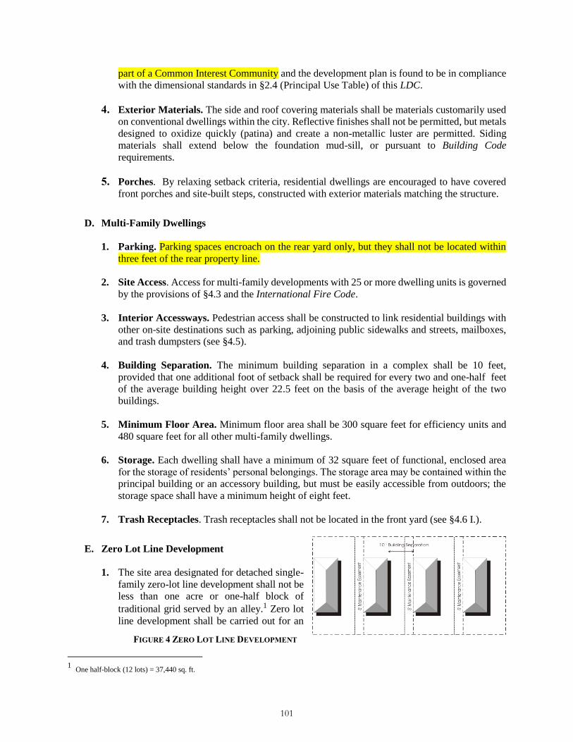
part of a Common Interest Community and the development plan is found to be in compliance
with the dimensional standards in §2.4 (Principal Use Table) of this LDC.
4. Exterior Materials. The side and roof covering materials shall be materials customarily used
on conventional dwellings within the city. Reflective finishes shall not be permitted, but metals
designed to oxidize quickly (patina) and create a non-metallic luster are permitted. Siding
materials shall extend below the foundation mud-sill, or pursuant to Building Code
requirements.
5. Porches. By relaxing setback criteria, residential dwellings are encouraged to have covered
front porches and site-built steps, constructed with exterior materials matching the structure.
D. Multi-Family Dwellings
1. Parking. Parking spaces encroach on the rear yard only, but they shall not be located within
three feet of the rear property line.
2. Site Access. Access for multi-family developments with 25 or more dwelling units is governed
by the provisions of §4.3 and the International Fire Code.
3. Interior Accessways. Pedestrian access shall be constructed to link residential buildings with
other on-site destinations such as parking, adjoining public sidewalks and streets, mailboxes,
and trash dumpsters (see §4.5).
4. Building Separation. The minimum building separation in a complex shall be 10 feet,
provided that one additional foot of setback shall be required for every two and one-half feet
of the average building height over 22.5 feet on the basis of the average height of the two
buildings.
5. Minimum Floor Area. Minimum floor area shall be 300 square feet for efficiency units and
480 square feet for all other multi-family dwellings.
6. Storage. Each dwelling shall have a minimum of 32 square feet of functional, enclosed area
for the storage of residents’ personal belongings. The storage area may be contained within the
principal building or an accessory building, but must be easily accessible from outdoors; the
storage space shall have a minimum height of eight feet.
7. Trash Receptacles. Trash receptacles shall not be located in the front yard (see §4.6 I.).
E. Zero Lot Line Development
1. The site area designated for detached single-
family zero-lot line development shall not be
less than one acre or one-half block of
traditional grid served by an alley.1 Zero lot
line development shall be carried out for an
1
One half-block (12 lots) = 37,440 sq. ft.
FIGURE 4 ZERO LOT LINE DEVELOPMENT
101

entire block, as a row of units or as a cluster in order to achieve an overall compatibility of
design. Zero lot line dwellings shall not be situated immediately adjacent to traditionally sited
dwellings.
2. A single side yard shall be provided comprising the equivalent of two side yards of a
conventional detached house, or 10 feet, whichever is more. This reduction shall not be allowed
on the street yard or to the side yard adjacent to lots that are not part of the zero lot line
development.
3. An easement on the lot adjacent to the zero lot line shall be required to allow for maintenance
or repair, when the roof overhang or side wall of the house are within four feet of the adjacent
property line. The easement on the adjacent property must provide at least six feet of
unobstructed space. The easement shall be recorded on the subdivision plat.
4. The eaves on the side of a house with a reduced setback may project a maximum of 18 inches
over the adjacent property line. In this case, an easement for the eave projection must be
recorded on the deed for the lot where the projection occurs.
5. If the side wall of the house is on the property line, or within three feet of the property line,
windows or other openings that allow for visibility into the side yard of the adjacent lot shall
not be allowed, unless required by the Building Code for emergency egress. Windows that do
not allow visibility into the side yard of the adjacent lot, such as a clerestory window or a
translucent window, shall be allowed.
6. The exterior wall plane of a dwelling unit in a zero-lot line development shall not extend
beyond the property line.
7. Corner lot / unit configurations must have a front and side yard.
F. Townhouses
1. Yards. Side yards are not required for interior townhouses, but street and rear yards shall be
provided to all dwelling units.
2. Building Separation. The minimum building separation shall be 20 feet, provided that one
additional foot of setback shall be required for every two and one half feet of the average
building height over 22.5 feet. The average building height equals the average building height
of the buildings under consideration.
3. Garages and Parking. All townhouse garages and parking areas are encouraged to be located
to the rear of the building or within an interior courtyard area of a complex. Garages located in
the front yard shall be setback a minimum of 22 feet. No more than one exterior parking space
per unit shall be permitted in the street yard.
4. Maximum Number of Units. The maximum number of units allowed in a single building is
eight.
5. Minimum Setback. The minimum 10 foot setback shall be maintained between townhouse
complex and adjacent lots not considered part of the complex, provided that one additional foot
of setback shall be required for every two and one-half feet of building height over 22.5 feet.
102

G. Upper-Story Residential
1. Such uses shall adhere to all dimensional standards of the nonresidential zone district.
2. Minimum floor area shall be 300 square feet.
3. Dwelling units shall be built in a pattern and of materials, complementary to the principal
structure.
4. One off-street parking space shall be provided pursuant to Table 4-7 Off-Street Parking
Requirements, in all zone districts except the CBD and B1.
5. Upper-story residential dwelling units shall not be condominiumized or sold separately and
shall not be rented to guests for periods of less than 30 days.
H. Accessory Dwelling Units. Accessory dwelling units may be allowed in any zone district except
the R-1 and the R-1M zone district. Accessory dwelling units are subject to compliance with the
standards of this section.
1. An accessory dwelling unit may be allowed as an accessory use to an otherwise allowed single-
family dwelling unit that is the principal use on a lot or parcel of at least 6,250 square feet.
2. Accessory dwelling units may be attached-to or detached-from the principal dwelling,
provided:
if attached to the principal dwelling, no new entrance or other exterior modifications shall
be visible from the street to suggest the presence of the accessory dwelling unit.
if detached from the principal dwelling, the accessory dwelling shall be located in the rear
yard and comply with all setback requirements of the principal dwelling unit.
3. Detached accessory dwelling units not located over a garage shall be separated from the
principal dwelling by up to 12 feet.
4. Minimum size shall be 300 square feet and maximum size shall be 720 square feet.
5. Maximum height of detached accessory dwellings shall be 30 feet.
6. Accessory dwellings shall be built in a pattern and of materials complementary to the principal
structure.
7. One oOff-street parking is exempt for an accessory dwelling unit space shall be provided in
addition to other required parking for the primary use is met.
8. Accessory dwelling units shall not be condominiumized or sold separately and shall not be
rented to guests for periods of less than 30 days.
9. Accessory dwelling units will be allowed in the CBD and Commercial zone districts if not on
the street frontage.
10. Must be an accessory use to commercial or industrial uses in the Commercial and Industrial
103

ii. Emergency Vehicle Access. Access easements shall be granted to the City for the
purposes of emergency vehicle access and for the installation, maintenance and repair
of public and private utilities.
iii. Private Maintenance. A private road shall be maintained by the owner(s) of the
development in which the road is located.
h. Speed Limits. All private roads shall be posted with speed limit signs with appropriate
speeds, in compliance with the Manual on Uniform Traffic Control Devices (MUTCD).
B. Retail Sales Establishment. Goods may be produced on a small scale within a retail sales
establishment and be sold in the local area; provided that: a) production shall be limited to no more
than 5080 percent of the area of the retail establishment, and b) production shall not pose any safety
or environmental hazards to the public in the retail production area. (add retail on street frontage
and must be activated towards customers).
1. Convenience Stores
a. If fuel is sold as part of the convenience store operation, the conditions for service stations
related to fuel pump location and bulk fuel storage shall apply.
b. Parking areas for retail sales and fuel service shall be separated from each other, and
circulation within the property to each parking area shall be separate and clearly marked.
2. Vehicle Services and Repair
a. Incidental sale of vehicles will be allowed.
b. A zone district boundary buffer (§4.6.F.3.c.ii.) shall be established along any side of the
property adjacent to a residential use.
c. Service bay doors shall not be oriented toward the road or any residential use, unless such
bays are screened from view from the road and residential uses.
d. All repair or service operations, excluding washing, shall be conducted entirely within a
fully-enclosed building. The term “fully-enclosed building” shall not be construed to limit
open bay doors during hours of operation.
e. Operable vehicles may be parked on-site during business hours. All vehicle parking shall
be accomplished on the site, and in no case shall a parked vehicle encroach into the right-
of-way.
f. The outdoor overnight storage of vehicles may be allowed subject to Commission approval
(§3.9 B.).
g. There shall be no dismantling of vehicles for salvage.
h. The storage of impounded vehicles shall not be permitted.
i. Fuel pump location shall comply with the following requirements:
104

Classification System (NAICS) Subsector 331, Primary Metal Manufacturing, as identified in the
North American Industry Classification System—United States Manual (OMB 1997).
B. Outdoor Storage. Outdoor storage yards shall comply with the requirements of §4.7, Outdoor
Storage and Display.
OTHER USE CATEGORIES
The standards of this Section shall apply to all permitted Conditional Uses, as set forth in the Principal Use
Table (§2.4).
A. Aviation and Surface Transportation Facilities
1. Characteristics. Aviation and Surface Transportation Facilities include facilities for the
landing and takeoff of aircraft, and public transit facilities including loading and unloading
areas. Aviation facilities may be improved or unimproved. Aviation and Surface Transportation
Facilities also include passenger terminals for aircraft and regional bus service.
2. Accessory Uses. Accessory uses include freight handling areas, concessions, offices, parking
and maintenance and fueling facilities.
3. Examples. Examples include airports, bus terminal, and helicopter landing facilities.
4. Exceptions. Bus stops supporting the Gunnison Regional Transportation Authority operations
or City public transit functions which, are classified as Minor Utilities.
B. Telecommunications Facilities
1. Characteristics. Telecommunications Facilities are signal distribution systems used or
operated by a telecommunications carrier under a license from the FCC consisting of a
combination of improvements and equipment including (i) one or more antennas, (ii) a
supporting structure and the hardware by which antennas are attached; (iii) equipment housing;
and (iv) ancillary equipment such as signal transmission cables and miscellaneous hardware.
2. Accessory Uses. Accessory uses may include transmitter facility buildings.
3. Examples. Examples include broadcast towers, telecommunications facilities;
telecommunications support towers and point-to-point microwave towers.
4. Exceptions
a. Amateur radio facilities and antennas that are owned and operated by a federally licensed
amateur radio station operator are considered an accessory use to other permitted uses.
b. Radio and television studios are classified in the Office category.
C. Adult Entertainment
105

The financial guarantee amount shall be equal to 125 percent of the cost of supplying and
installing improvements depicted on the approved Final Plat.
v. Revocation of Conditional Use Permit. The Commission shall have the power after
hearing to revoke the Conditional Use permit for violation of this Section or conditions
imposed by the Commission. Upon at least ten days’ notice to the owner and the operator,
the Commission may hold a hearing to determine the nature and extent of an alleged
violation, and shall have the power, upon a showing of good cause, to revoke the
Conditional Use permit and to require that immediate reclamation measures be
commenced.
NON-RESIDENTIAL ACCESSORY USES AND STRUCTURES
A. General. Principal uses allowed by §2.4 shall be deemed to include accessory uses and structures
that are customarily associated with and appropriate, incidental and subordinate to otherwise
allowed principal uses and structures. Accessory uses and structures shall be subject to the same
regulations as principal use and structures unless otherwise stated.
B. Drive-In Facility. Drive-in facilities may be allowed in the C zone district and by Conditional Use
Permit approved pursuant to the requirements of Section 7 in the CBD and C zone districts as an
accessory use to otherwise allowed uses, and shall comply with the standards of this section.
1. Circulation. Drive-through lanes shall be separated from circulation lanes required to enter or
exit the property. Drive-through lanes shall be marked by striping, pavement markings, or
barriers.
2. Screening. Drive-through lanes shall be screened in accordance with the requirements of §4.6.
C. Outside Sales and Display. Outdoor display of goods and merchandise shall comply with the
standards of §4.7 Outdoor Display and Storage.
D. Manufacturing and Production, Small Scale. Goods may be produced on a small scale within a
retail sales establishment and be sold in the local area, provided that:
1. Area Limited. Production shall be limited to no more than 50 percent of the area of the retail
establishment.
2. Safety and Environmental Hazards Prohibited. Production shall not pose any safety or
environmental hazards to the public in the retail or production area.
E. Satellite and Electronic Reception Devices and Support Structures. Satellite or electronic
reception devices and support structures shall comply with the standards of this Section.
1. Maximum Size. Satellite reception devices shall not exceed a diameter of four feet.
2. Dimensional Standards. The placement of the device shall comply with all dimensional
standards such as height, setback, etc. of the underlying zone district.
TEMPORARY USES
A. Temporary Use Defined. A general retail sales or other commercial use operated outside of a
106

building on a seasonal basis.
B. Use Permit Required. Conditional Use permits are required for all “temporary commercial
activities” excluding farm stands, farmers’ markets, holiday tree sales, rafting and similar
recreational operations, carnival, circus or temporary private events, construction field offices, and
model homes units. (Exclude Food Stands in the C, CBD and B1? Food Stands would follow the criteria
and standards below?)
C. Compliance Criteria and Standards. All temporary uses, except temporary commercial activities
which are established by a Conditional Use Permit, shall function under a Temporary Use Permit
issued by the Community Development Director. All temporary uses shall meet the following
minimum criteria and standards:
1. no lighting or electrical service shall be provided without an electrical permit;
2. temporary use structures shall be subject to the International Building Code and International
Fire Code as deemed applicable by staff;
3. no temporary use structure shall block fire lanes or pedestrian or vehicular access;
4. the site of the temporary use shall be cleared of all debris at the end of the temporary use;
5. all temporary structures shall be cleared from the site within five days after the use is
terminated;
6. written permission of the property owner for the temporary use shall be provided;
7. adequate parking shall be provided for the use, as determined by the Community Development
Director;
8. required parking for other uses shall remain available;
9. adequate traffic control measures shall be provided;
10. adequate provisions for trash disposal and sanitary facilities shall be provided; and
11. when appropriate, adequate provisions for crowd control shall be provided.
D. Additional Conditions. The Community Development Director shall impose such other conditions
as are deemed necessary to accomplish the purposes of this section, this LDC and the City of
Gunnison Master Plan.
E. Revocation of a Temporary Use Permit. A Temporary Use Permit shall be revoked if the Director
finds that the terms of the permit have been violated or that there is a hazard to the public health,
safety and welfare.
F. Carnival, Circus or Temporary Private Events. Temporary carnivals and circuses shall comply
with the standards of this Section.
1. Minimum setback (all sides): 15 feet from all lot lines. The minimum setback shall apply to
107

all equipment, displays, tables and other items associated with the business, from any adjacent
lot with a residential use.
2. Length of Permit. The maximum length of the permit shall be 10 days.
3. Parking. The applicant must provide adequate parking.
4. Security. The applicant must provide for protection, security guards and crowd control.
5. Cleanup. The applicant must guarantee cleanup of the premises.
6. Bond. The applicant may be required to post a bond in a reasonable amount as determined by
the Community Development Director to ensure compliance with the requirements of this
section.
7. Health and Safety Codes. The use must comply with all applicable health and safety codes
and a permit for the use shall be obtained from the Building Official.
8. Location. The use shall be situated such that it does not block any required access or egress
from the site and is not located on any required parking.
G. Construction Field Offices, Temporary. Temporary construction field offices shall comply with
the requirements of this Section.
1. A temporary building for use as a construction field office is permitted on a 12-month basis.
One construction field temporary building shall be allowed for each builder in a subdivision in
which that builder has the authority to construct structures.
2. If the operation of the temporary building used as a construction field office violates any City
ordinances, the certificate of occupancy shall be revoked, unless satisfactory compliance is
achieved.
H. Sales Offices and Model Homes, Temporary. A temporary sales office and model home may be
located within any zoning district provided such use shall comply with the standards of this Section.
1. Temporary residential sales offices and model homes may be located within a residential zone
district as part of an on-going residential development.
2. Any temporary residential sales office or model home shall be removed or converted to a use
permitted within the zone district when Certificates of Occupancy have been issued to 80
percent of the associated residential units or when use as a sales office or model home has
ceased.
3. Model homes for new subdivisions shall only be occupied for residential habitation after all
business activities have ceased and upon sale of the home and shall comply with the applicable
residential parking standards at that time.
MARIJUANA USE CATEGORIES
A. Retail Marijuana and Medical Marijuana Center Standards (retail marijuana
108

D. Minimum Off-Street Parking. The following minimum schedule establishes the minimum
number of off-street parking spaces to be provided for the use categories described in this LDC.
2
Ordinance 3, 2015 2 Ordinance #3, Series 2016
TABLE 4-7 OFF-STREET PARKING REQUIREMENTS
USE CLASSIFICATION SPECIFIC USE MINIMUM NUMBER OF SPACES REQUIRED
Residential Use Categories (§3.2)
Household Living
Single-Family Dwellings, Townhouses,
Two-family Dwellings, Manufactured
Home and Mobile Home
2.0 per dwelling unit
Multi-Family Dwellings2
1st Unit 2.0 per dwelling unit
Each
additional unit
1.75 per dwelling unit
Accessory Dwelling Unit and Upper Floor
Residential2
1.0 per Accessory Dwelling Unit (exempt
in CBD and B1)
Congregate Living
Rooming and boarding houses, dormitories,
fraternities or sororities 1.0 per bed
Nursing Homes 1.0 per employee, plus 1 visitor space per 2
beds
Assisted Living 1.0 per employee, plus 1 visitor space per 4
beds
Accommodations
Hotels and Motels
1.0 per guest room
+1 space per 3 employees and
75% of parking required for other
associated or accessory uses (restaurants,
offices, meeting spaces)
Hostels2 1.0 per 2 beds
Bed and Breakfasts 1.0 space per guest room, plus 2 spaces for
the owner/manager's unit Public, Civic and Institutional Use Categories (§3.4) Community Service
Neighborhood or Community Centers 1.0 per 300 sq. ft. of improved area
Educational Facilities
Elementary and Middle Schools
1.0 per classroom + 1.0 per 300 sq.ft. of
office area + 1.0 per 5 seats in any
auditorium assembly
All Other Schools
6.0 per classroom + 1.0 per 300 sq.ft. of
office area + 1 per 5 seats in any
auditorium or similar facility
Day Care Day Care Homes, Schools and Centers 1.0 per non-resident employee
Medical Hospital 1.0 per 2 beds + 1.0 per employee per day
shift
Parks and Open Space
Cemeteries, Mausoleums To be determined by Director (§4.4D 2.a)
Parks and recreational facilities To be determined by Director (§4.4D 2.a)
Religious Institutions
Churches or Places of Worship 1 space per every 4 seats in the main
sanctuary, plus 1 space for the parish home
Utilities
Major utilities To be determined by Director (§4.4D.2.a)
Minor utilities None
109

TABLE 4-7 (CONTINUED)
USE CLASSIFICATION SPECIFIC USE MINIMUM NUMBER OF SPACES REQUIRED
Accommodation, Retail, Service - Commercial Use Categories (§3.6) Entertainment Event, Major
Auditoriums 1 space per every 4 seats
Fairgrounds To be determined by Director (§4.4 D.2.a)
Office
Banks and Financial Institutions 1.0 per 300 sq. ft. + vehicle stacking see
§4.4 J
Radio and Television Studios 1.0 per 300 sq. ft.
Government Offices 1.0 per 300 sq. ft.
Professional Offices 1.0 per 300 sq. ft.
Medical Clinic or Dental Office 1.0 per 200 sq. ft. Parking, Commercial
Commercial parking lots and garages 1 space per Attendant
Recreation and Entertainment, Outdoor
Golf driving range 1.0 per tee box
Recreational vehicle parks
2 spaces per Site/RV Site (including RV),
plus 1 parking space for each five sites for
guests
Retail Sales and Service, Sales-Oriented
Art Galleries 1.0 per 1000 sq. ft.
Auto sales and rental 1.0 per 300 sq. ft.
Automotive Supplies 1.0 per 250 sq. ft.
Book Stores 1.0 per 250 sq. ft.
Convenience Stores, without gas pumps 1.0 per 200 sq. ft.
Furniture and Appliance Stores 1.0 per 400 sq. ft.
Greenhouse/Nursery, Retail To be determined by Director (§4.4 D.2.a)
Outside Sales or Display 1.0 per 200 sq. ft.
Rental of equipment and supplies 1.0 per 300 sq. ft.
Recreational Vehicle Sales 1.0 per 400 sq. ft.
Lumber and building materials sales To be determined by Director (§4.4 D.2.a)
All other retail 1.0 per 250 sq. ft.
Retail Sales and Service, Personal Service-Oriented
Athletic or Health Clubs, Spas 1.0 per 200 sq. ft.
Barber and Beauty Shops 2.0 per chair
Dry Cleaning Drop-off and Pick-up 1.0 per 300 sq. ft.
Laundromats 1.0 per 2 machines
Funeral homes and Mortuaries 1.0 per 4 seats in assembly area
Kennels 1.0 per 300 sq. ft.
Veterinary clinic 1.0 per 300 sq. ft.
Retail Sales and Service, Eating and Drinking oriented
Restaurants 1.0 per 200 sq. ft.
Eating and drinking with drive-thru 1 per 50 sq. ft. of customer service area +
vehicle stacking spaces as required by §4.4J
Bars and taverns 1.0 per 200 sq. ft.
Coffee shop/bakery 1.0 per 200 sq. ft.
Retail Sales and Service, Entertainment-Oriented
Recreation, indoor 1.0 per 200 sq. ft.
Private lodges and clubs To be determined by Director (§4.4 D.2.a)
Theaters 1.0 per 4 seats
110

TABLE 4-7 (CONTINUED)
USE CLASSIFICATION SPECIFIC USE MINIMUM NUMBER OF SPACES REQUIRED
Industrial Use Categories (§3.8)
Retail Sales and Service, Repair-Oriented
Appliance Repair 1.0 per 400 sq. ft.
Bicycle Repair 1.0 per 400 sq. ft.
Locksmith 1.0 per 400 sq. ft.
Self-storage Warehouse Self-Storage or Mini-Warehouse 1.0 per 10 storage unit
Vehicle Repair
Auto Body Shops 2.0 per service bay + 1.0 per employee
Vehicle Repair 2.0 per service bay + 1.0 per employee
Vehicle Services, Limited
Car Washes None- See §4.4J
Convenience Stores, with Gas Sales 1.0 per 300 sq. ft. + 1 per service bay
or gas pump
Service Stations 2.0 per service bay + 1.0 per employee
Quick Lube Services 1.5 per service bay + 1.0 per employee Industrial Sales and Service
Warehousing and Storage 1.0 per 1000 sq. ft.
Manufacturing and Production
All uses 1.0 per 500 sq. ft.
Wholesale and Freight Movement
Air cargo terminal To be determined by Director (§4.4D2a)
Outdoor storage, general 0.6 per employee
Post Offices 1.0 per 250 sq. ft.
Vehicle Storage Yard 1.0 per employee
Utility Service Yard or Garage 1.0 per employee
All other uses 1.0 per 2,000 sq. ft.
Waste-Related Recycling Facility To be determined by Director (§4.4D2a)
Wholesale Sales
Mail Order 0.6 per employee
Wholesale and Distribution
1.0 per 300 sq. ft. office and administrative
+ 1.0 per 1,000 sq. ft. additional gross floor
area Other Use Categories (§3.10)
Adult Entertainment Adult Entertainment 1.0 per 200 sq. ft.
Agriculture Animals (farm animal) breeding or raising None
Greenhouse/nursery, non-retail 0.6 per employee Alternative Energy Sources
Aviation and Surface Transportation
Airports and related facilities, public Determined by Parking Study
(see §4.4 D.3)
Mining
Telecommunications Facilities
Wireless Communication Occupied
Facilities Only 1.0 per 500 sq. ft.
111

1. Disabled Access Parking
a. Parking spaces for disabled persons shall be provided per the following schedule:
TABLE 4-8 DISABLED ACCESS PARKING
TOTAL PARKING SPACES
IN LOT
MINIMUM ACCESSIBLE
SPACES
MINIMUM VAN-
ACCESSIBLE SPACES
MINIMUM CAR-
ACCESSIBLE SPACES
0 to 25 1 1 0
26 to 50 2 1 1
51 to 75 3 1 2
76 to 100 4 1 3
101 to 150 5 1 4
151 to 200 6 1 5
201 to 300 7 1 6
301 to 400 8 1 7
401 to 500 9 2 7
501 to 1000 2% of Total 1 out of every 8 accessible
spaces
7 out of every 8 accessible
spaces Over 1000 20 plus 1 for each 100 over
1,000
b. Parking spaces for the disabled shall have a minimum stall width of nine feet, unless it is a
required van-accessible space, which shall be a minimum of 11 feet. All spaces designated
as being for the disabled shall have a raised standard identification sign. The identification
sign shall be 12 inches by 18 inches, with a height not to exceed seven feet. The standard
colors of the sign shall be white on blue. (Ordinance 4, 2014)
2. Maximum Requirement and Shared Use Reduction
a. Maximum Parking. No use shall provide more than 110 percent of the required
parking shown in Table 4-7 unless the greater amount is pre-existing from another
use or the threshold is part of a structured public parking program.
b. Phased Development. Where a project is intended to be developed in phases, the
Director may approve development of a parking area intended to serve current and
future development.
3. Parking Studies
a. Parking for Uses Not Listed. In cases where parking demand is not specifically listed in
Table 4-7, the Director may require the submittal of a parking demand study completed by
the applicant according to the directives of §4.4.D.2.a., staff shall apply the off-street
parking and loading standard specified for the listed use that is deemed most similar to the
proposed use or shall establish minimum off-street parking requirements on the basis of a
parking and loading study prepared by the Applicant.
b. Estimates of Parking Demand. The parking and loading study must include estimates of
parking demand based on recommendations of the Institute of Traffic Engineers (ITE), or
other acceptable estimates as approved by staff, and should include other reliable data
collected from uses or combinations of uses that are the same as or comparable with the
proposed use. Comparability will be determined by density, scale, bulk, area, type of
112

FIGURE 10 PARKING STALL DIMENSIONS
activity and location. The study must document the source of data used to develop the
recommendations.
4. Parking Stall and Aisle Dimensions. Standard parking spaces shall conform to the
dimensions shown on Table 4-9 (see Figure 14).
TABLE 4-9 PARKING STALL AND AISLE DIMENSIONS
A B C D E F G
Angle of
Parking Stall Width
Stall
Length Stall Depth
Curb
Length per
Stall
Aisle width
for two-
way traffic
with two-
sided
loading
Aisle width
for one-way
traffic, with
one-sided
or two-
sided
loading
0 degrees 9 23 N/A 23 20 12
30 degrees 9 20 17.4 17 20 15
45 degrees 9 20 20.2 12 20 15
60 degrees 9 19.5 21 10.4 24 20
90 degrees 9 19.5 19.5 9 24 22 1Designed fire lanes and emergency vehicle access mandated by the International Fire Code may
require additional aisle width dimensions.
E. Location
1. Principal Use. Except as otherwise expressly provided in this Section, required off-street
parking stalls and aisles shall be located on the same lot or parcel as the principal use.
2. Setbacks in Non-Residential Zone Districts. In all non-residential zone districts except the
113

Industrial zone district, off-street parking shall not be located within the required yard setback
area. Off-street parking in the CBD shall not be located between the lot line and the building
line parallel to an arterial or collector street (see also §4.3, General Site Access).
3. Setbacks for Multi-Family Development. Off-street parking for multi-family developments
may encroach on the rear yard only, but shall not be within three feet of the rear property line.
4. Setbacks from Rivers, Streams and Wetlands. See §5.4 E.1.b. for required parking area
setbacks from delineated river/stream corridors and wetlands.
5. Parking in Driveways. Parking of single-family and two-family dwellings may be located in
residential driveway areas that meet parking stall dimensions (excluding RVs and boats).
6. Street Buffer. Off-street parking areas shall be separated from the street edge by a street buffer
area (see §4.6 3.4).
F. Off-Street Parking. Off-street parking areas are subject to the following driveway access standards
(Ordinance #3, Series 2016):
1. Dimensions
a. Grade. The maximum grade permitted for any required parking shall not exceed six
percent.
b. Nonconforming Standards. Parking spaces using geometric standards other than those
specified above may be approved if developed and sealed by a licensed engineer registered
by the State of Colorado with expertise in parking facility design, subject to a determination
by the Director, that the proposed facility will satisfy off-street parking aisle width
requirements as adequately as would a facility using those specified above.
2. Surfacing. Where off-street facilities are provided for parking or any other vehicular use area,
they shall be surfaced with asphalt bituminous, concrete or other dustless material (brick
pavers, etc.) approved by the Director and shall be maintained in a smooth, well-graded
condition; gravel or road base surfaces are prohibited. Single-family and duplex units are
exempt from this requirement.
3. Curbs and Wheel Stops
Wheel Stops. All landscaping in, or adjacent to, a vehicular use area shall be protected
from vehicular damage by a raised concrete curb six inches in height or equivalent barrier,
however, the barrier need not be continuous. Curbs and wheel stops shall be placed a
minimum of two feet from any designated landscape area or buffer.
Landscape Height. Landscaped areas adjacent to parking areas shall be landscaped so that
no plant material greater than 12 inches in height will be located within two feet of the curb
or other protective barrier.
4. Separation from Walkways and Streets. In the event any parking area abuts an accessway,
sidewalk, or street, the parking area shall be separated by curbing or other protective device
with a minimum distance of three and one-half feet between the protective device and the edge
114
of the walkway.
5. Landscaping and Buffers. Parking lots are subject to Parking Lot Landscaping Standards
(§4.6 G.).
6. Drainage. See §5.1.
7. Backing Prohibited. All multi-family and nonresidential off-street parking spaces shall be
accessible without backing into or otherwise reentering a public right-of-way, unless it is an
alley right-of-way adjacent to the property. Vehicles exiting from a parking space for a single-
family or duplex dwelling unit may back onto a road designated by the City as a local street.
8. Tandem Parking. Tandem parking (one vehicle parking directly behind another) shall not be
is permitted and shall not may be credited toward meeting any off-street parking requirement
for this Article, except for single-family or duplex residential uses, provided the tandem spaces
are assigned to the same dwelling unit or the unit is under one ownership.
9. Snow Storage. Snow is to be stored on-site according to the following standards:
a. Area. A minimum area of 15 percent of the total required off-street parking or loading
area, inclusive of access drives and aisles, shall be provided as the snow storage area.
b. Storage in Parking Spaces Prohibited. Snow shall not be stored within required parking
spaces, except on an emergency basis, for a period not to exceed 48 hours.
c. Storage in Yards and Open Space Permitted. Snow may be stored in required yards and
open space, including landscaped areas properly designed for snow storage. Stored snow
shall not restrict access and circulation or create a visual obstruction for motorists.
d. Drainage. Adequate drainage shall be provided for the snow storage area to accommodate
snow melt. Snow melt shall not be permitted to drain on to adjacent property.
10. Bicycle Racks. For premises requiring twenty (20) or more vehicular parking spaces, bicycle
racks facilitating locking shall be provided to accommodate one bicycle per twenty parking
spaces or required fraction thereof.
G. Prohibited Uses of Required Spaces
1. Off-street parking spaces shall be available for the parking of operable automobiles of the
residents, customers, and employees of the designated use. Prohibited use of required spaces
shall be as follows:
storage of materials and/or inoperable vehicles;
the parking of delivery vehicles operated by the designated use;
display of vehicles for sale in commercial or industrial parking areas, except for the casual
display of vehicles by owners who are employees or customers using the premises; and,
repair work that renders a vehicle inoperable for periods greater than 24 hours in a parking
115
Copyright © 2022 FDOKUMEN