Draft Revised Zoning Code 06272019 - Crestwood, MO
301
Revised Crestwood Development Code Chapter 26 TABLE OF CONTENTS ARTICLE/SECTION PAGE NUMBER Version Dated – 11/06/2020 i LLC ARTICLE I – GENERAL PROVISIONS ...................................................................................1 SEC. 26-001 Overview ...................................................................................................................1 A. Title ............................................................................................................................................1 B. Authority and Jurisdiction..........................................................................................................1 C. Purposes .....................................................................................................................................1 D. Severability ................................................................................................................................2 SEC. 26-010 Interpretation ...........................................................................................................3 A. Rules of Construction ................................................................................................................3 B. Conflicts .....................................................................................................................................3 C. Measurements ............................................................................................................................3 D. Computations of Time ...............................................................................................................6 E. Interpretation of Zoning Map.....................................................................................................7 F. Non-regulatory Provisions .........................................................................................................7 G. Resources, Guides and Industry Standards ................................................................................7 SEC. 26-020 Administration and Review Bodies ........................................................................8 A. Staff ............................................................................................................................................8 B. Planning, Zoning, and Architectural Review Commission .......................................................8 C. Board of Aldermen. .................................................................................................................10 D. Board of Zoning Adjustment ...................................................................................................10 SEC. 26-030 Enforcement ...........................................................................................................15 A. Violations .................................................................................................................................15 B. Enforcement .............................................................................................................................15 C. Penalties ...................................................................................................................................15 ARTICLE II – DEFINITIONS ...................................................................................................16 SEC. 26-040 Defined Terms ........................................................................................................16 SEC. 26-050 Abbreviations .........................................................................................................33 SEC. 26-060 Description of Uses.................................................................................................34 A. Residential................................................................................................................................34 B. Civic / Institutional ..................................................................................................................35 C. Retail ........................................................................................................................................36 D. Office/Service ..........................................................................................................................39
-
Upload
khangminh22 -
Category
Documents
-
view
1 -
download
0
Transcript of Draft Revised Zoning Code 06272019 - Crestwood, MO

Revised Crestwood Development Code Chapter 26
TABLE OF CONTENTS
ARTICLE/SECTION PAGE NUMBER
Version Dated – 11/06/2020 i LLC
ARTICLE I – GENERAL PROVISIONS ...................................................................................1
SEC. 26-001 Overview ...................................................................................................................1
A. Title ............................................................................................................................................1
B. Authority and Jurisdiction..........................................................................................................1
C. Purposes .....................................................................................................................................1
D. Severability ................................................................................................................................2
SEC. 26-010 Interpretation ...........................................................................................................3
A. Rules of Construction ................................................................................................................3
B. Conflicts .....................................................................................................................................3
C. Measurements ............................................................................................................................3
D. Computations of Time ...............................................................................................................6
E. Interpretation of Zoning Map .....................................................................................................7
F. Non-regulatory Provisions .........................................................................................................7
G. Resources, Guides and Industry Standards ................................................................................7
SEC. 26-020 Administration and Review Bodies ........................................................................8
A. Staff ............................................................................................................................................8
B. Planning, Zoning, and Architectural Review Commission .......................................................8
C. Board of Aldermen. .................................................................................................................10
D. Board of Zoning Adjustment ...................................................................................................10
SEC. 26-030 Enforcement ...........................................................................................................15
A. Violations .................................................................................................................................15
B. Enforcement .............................................................................................................................15
C. Penalties ...................................................................................................................................15
ARTICLE II – DEFINITIONS ...................................................................................................16
SEC. 26-040 Defined Terms ........................................................................................................16
SEC. 26-050 Abbreviations .........................................................................................................33
SEC. 26-060 Description of Uses.................................................................................................34
A. Residential................................................................................................................................34
B. Civic / Institutional ..................................................................................................................35
C. Retail ........................................................................................................................................36
D. Office/Service ..........................................................................................................................39

Revised Crestwood Development Code Chapter 26
TABLE OF CONTENTS
ARTICLE/SECTION PAGE NUMBER
Version Dated – 11/06/2020 ii LLC
ARTICLE II, Section 26-060 (continued)
E. Industrial ..................................................................................................................................42
F. Special Uses .............................................................................................................................43
ARTICLE III – APPLICATIONS AND PROCEDURES .......................................................44
SEC. 26-070 Common Procedures for All Applications...........................................................44
A. Applications and Fees ..............................................................................................................44
B. Application Processing Cycles ................................................................................................44
C. Pre-application Meeting ...........................................................................................................44
D. Staff Review.............................................................................................................................45
E. Notice .......................................................................................................................................45
F. Public Hearings ........................................................................................................................46
G. Action by Review Bodies ........................................................................................................46
H. Appeals ....................................................................................................................................46
I. Technical Studies .....................................................................................................................47
J. Successive Applications...........................................................................................................47
SEC. 26-080 Zoning Map and Text Amendments ....................................................................48
A. Applicability ............................................................................................................................48
B. Application and Submission Requirements .............................................................................48
C. Pre-Application Meeting ..........................................................................................................48
D. Review Process ........................................................................................................................48
E. Review Bodies .........................................................................................................................49
F. Protest Petition .........................................................................................................................50
G. Board of Aldermen Review and Action ...................................................................................50
H. Withdrawal ...............................................................................................................................50
I. Effect of Decision ....................................................................................................................50
SEC. 26-090 Planned Development ............................................................................................51
A. Applicability ............................................................................................................................51
B. A Type of Zoning.....................................................................................................................51
C. Objectives and Standards for Approval ...................................................................................51
D. Types of Planned Development ...............................................................................................52
E. Process .....................................................................................................................................52
F. Permitted Uses .........................................................................................................................58
G. Area Regulations and Performance Standards .........................................................................58
H. Modifications ...........................................................................................................................58
I. Period of Validity .....................................................................................................................59

Revised Crestwood Development Code Chapter 26
TABLE OF CONTENTS
ARTICLE/SECTION PAGE NUMBER
Version Dated – 11/06/2020 iii LLC
ARTICLE III (continued)
SEC. 26-100 Conditional Use Permit .........................................................................................60
A. Applicability ............................................................................................................................60
B. Application and Procedures .....................................................................................................60
C. Pre-Application Meeting ..........................................................................................................61
D. Review Procedures...................................................................................................................61
E. Board of Alderman Public Hearing .........................................................................................62
F. Review Criteria ........................................................................................................................63
G. Aldermanic Decision ...............................................................................................................63
H. Effect of Decision ....................................................................................................................63
SEC. 26-110 Major Site Plan and Design Review .....................................................................65
A. Purpose .....................................................................................................................................65
B. Applicability ............................................................................................................................65
C. Required Data ..........................................................................................................................65
D. Pre-Application Meeting ..........................................................................................................66
E. Review Procedures...................................................................................................................67
F. Review Criteria ........................................................................................................................67
G. Findings and Approval .............................................................................................................67
H. Administrative Adjustments or Revisions ...............................................................................68
I. Effect of Decision ....................................................................................................................68
J. Appeal ......................................................................................................................................68
SEC. 26-120 Minor Site Plan ......................................................................................................69
A. Applicability ............................................................................................................................69
B. Pre-Application Meeting ..........................................................................................................69
C. Review Criteria ........................................................................................................................69
D. Effect of Decision ....................................................................................................................70
E. Appeal ......................................................................................................................................70
ARTICLE IV – ZONING DISTRICTS AND USE STANDARDS .........................................71
SEC. 26-130 Zoning Districts Established .................................................................................71
A. Zoning Districts and Intent Statements ....................................................................................71
SEC. 26-140 Districts and Uses ...................................................................................................74
A. Permitted Uses. ........................................................................................................................74

Revised Crestwood Development Code Chapter 26
TABLE OF CONTENTS
ARTICLE/SECTION PAGE NUMBER
Version Dated – 11/06/2020 iv LLC
SEC. 26-150 Standards Applicable to All Districts ..................................................................78
A. Height Area and Bulk Standards..............................................................................................78
B. Exceptions and Supplemental Standards .................................................................................79
SEC. 26-160 Standards Applicable to Specific Uses and Districts ..........................................83
A. Height Exceptions ....................................................................................................................83
B. Yard and Setback Exceptions in C-1 and M-1 Districts ..........................................................87
C. Area Regulations; Maximum Lot Coverage Calculation.........................................................88
D. Access Regulations ..................................................................................................................88
E. Required Screening for Mechanical Equipment, Trash, and Loading Areas for Non-
Residential Uses .............................................................................................................................88
F. Accessory Buildings and Structures ........................................................................................89
G. Temporary Uses and Structures ...............................................................................................91
H. Land and Buildings ..................................................................................................................92
SEC. 26-170 Watson Road Overlay Area ..................................................................................93
A. Purpose .....................................................................................................................................93
B. Area and Applicability .............................................................................................................93
C. Permitted and Conditional Uses – General ..............................................................................94
D. Use Regulations .......................................................................................................................94
E. Development Requirements .....................................................................................................98
SEC. 26-180 Non-Conforming Situations ................................................................................108
A. Purpose and Intent..................................................................................................................108
B. Scope of Provisions................................................................................................................108
C. Non-conforming Uses of Lots ...............................................................................................108
D. Non-conforming Buildings and Structures ............................................................................108
E. Repairs and Maintenance .......................................................................................................109
F. Change of Tenancy or Ownership .........................................................................................109
G. Completion of Pending Construction and Building Permits..................................................109
H. Conditional Uses ....................................................................................................................110
I. Nonconforming Lots of Record .............................................................................................110
J. Existence of Nonconforming Use ..........................................................................................110
K. Nonconformity as Basis for Variance ....................................................................................110
L. Eventual Removal or Correction of Nonconforming Use .....................................................110

Revised Crestwood Development Code Chapter 26
TABLE OF CONTENTS
ARTICLE/SECTION PAGE NUMBER
Version Dated – 11/06/2020 v LLC
ARTICLE V – SITE AND LANDSCAPE DESIGN STANDARDS
SEC. 26-190 Scope, Purpose, Applicability, and Conflicts ....................................................111
A. Scope ......................................................................................................................................111
B. Purpose ...................................................................................................................................111
C. Applicability ..........................................................................................................................111
D. Conflicts .................................................................................................................................112
E. Definitions..............................................................................................................................112
SEC. 26-200 Landscape Design Standards ..............................................................................116
A. Size Digging...........................................................................................................................116
B. Minimum Tree and Shrub Planting or Preservation Requirements .......................................116
C. Plant Material Installation ......................................................................................................118
D. Additional Requirements in C-1 and M-1 districts ................................................................118
E. Additional Requirements in R-1 through R-5 districts ..........................................................119
F. Maintenance ...........................................................................................................................120
SEC. 26-210 Fencing ..................................................................................................................123
A. Where Erected ........................................................................................................................123
SEC. 26-220 Site Lighting .........................................................................................................127
A. General Standards ..................................................................................................................127
B. Illumination Standards ...........................................................................................................128
SEC. 26-230 Stream Buffer Protection ....................................................................................129
A. Purposes .................................................................................................................................129
B. Applicability ..........................................................................................................................129
C. Definitions..............................................................................................................................131
D. Land Development Requirements ..........................................................................................132
E. Additional Information Requirements for Development on Buffer Zone Properties ............134
F. Responsibility ........................................................................................................................134
G. Inspection ...............................................................................................................................134
H. Violations, Enforcement, and Penalties .................................................................................135
I. Administrative Appeal and Judicial Review..........................................................................136
J. Severability ............................................................................................................................136

Revised Crestwood Development Code Chapter 26
TABLE OF CONTENTS
ARTICLE/SECTION PAGE NUMBER
Version Dated – 11/06/2020 vi LLC
ARTICLE VI – ACCESS AND PARKING.............................................................................137
SEC. 26-240 Intent and Applicability ......................................................................................137
A. Intent ......................................................................................................................................137
B. Applicability ..........................................................................................................................137
SEC. 26-250 Site Plan Required ...............................................................................................138
A. Parking Plan Requirements ....................................................................................................138
SEC. 26-260 Design Requirements ...........................................................................................139
A. Surface Material .....................................................................................................................139
B. Access to Parking Areas ........................................................................................................139
C. Access Near Street Corners ...................................................................................................139
D. Drainage .................................................................................................................................139
E. Lighting ..................................................................................................................................139
F. Setback ...................................................................................................................................139
G. Striping Required ...................................................................................................................139
H. Minimum Off-Street Parking Space Dimensions ..................................................................139
SEC. 26-270 Administrative Provisions and Special Requirements .....................................142
A. Determination of Required Number of Spaces ......................................................................142
B. Parking Exception for Churches ............................................................................................142
C. Parking for Multiple Use Buildings .......................................................................................142
D. Use of Required Parking Spaces ............................................................................................142
E. Parking in Residential Districts .............................................................................................142
F. Accessory Parking Lots .........................................................................................................143
G. Changes in Use ......................................................................................................................143
H. Additions to Structures, Buildings, or Uses ...........................................................................143
I. Existing Parking .....................................................................................................................143
J. Maintenance of Parking Facilities .........................................................................................143
K. Alternative Parking Plans ......................................................................................................143
SEC. 26-280 Schedule of Required Parking and Loading Spaces .........................................144
A. Purpose ...................................................................................................................................144
B. Minimum and maximum parking space requirements...........................................................144
C. Final Determination ...............................................................................................................152
Revised Crestwood Development Code Chapter 26
TABLE OF CONTENTS
ARTICLE/SECTION PAGE NUMBER
Version Dated – 11/06/2020 vii LLC
SEC. 26-290 Alternative Access and Parking Plan .................................................................153
A. Scope ......................................................................................................................................153
B. Applicability ..........................................................................................................................153
C. Contents .................................................................................................................................153
D. Review and Approval ............................................................................................................153
E. Approval Criteria ...................................................................................................................153
F. Shared Parking .......................................................................................................................153
G. Special Facilities for Bicyclists ..............................................................................................154
H. Transit Accessibility ..............................................................................................................154
I. Pervious Parking Surfaces .....................................................................................................154
J. Valet Parking .........................................................................................................................154
K. Landscaping of Recovered Area… ........................................................................................155
L. Transportation Demand Management Activities Program ....................................................155
M. Off-Site Parking .....................................................................................................................155
N. Car-Share Vehicles ................................................................................................................155
ARTICLE VII – SIGN REGULATIONS ................................................................................157
SEC. 26-300 Intent and Applicability ......................................................................................157
A. Intent ......................................................................................................................................157
B. Applicability ..........................................................................................................................157
SEC. 26-310 Definitions .............................................................................................................159
SEC. 26-320 Design and Location Standards ..........................................................................167
A. Computation of Area..............................................................................................................167
B. Computation of Height ..........................................................................................................168
C. Quantity of Signs Per Business ..............................................................................................169
D. Standards and Requirements by Sign Type ...........................................................................169
SEC. 26-330 Permit Requirements and Exceptions ...............................................................183
A. Permit Required .....................................................................................................................183
B. Permit Fees.............................................................................................................................183
C. Permit Fee Exceptions ...........................................................................................................184
SEC. 26-340 Exemptions and Prohibitions ..............................................................................185
A. Exemptions ............................................................................................................................185
B. Signs and Devices Prohibited ................................................................................................185
C. Signs and Devices Requiring Approval of the Planning Commission ..................................187

Revised Crestwood Development Code Chapter 26
TABLE OF CONTENTS
ARTICLE/SECTION PAGE NUMBER
Version Dated – 11/06/2020 viii LLC
ARTICLE VII (continued)
SEC. 26-350 Maintenance and Removal of Signs ...................................................................188
A. Maintenance ...........................................................................................................................188
B. Removal .................................................................................................................................188
SEC. 26-360 Appeals and Variances ........................................................................................190
A. Appeals ..................................................................................................................................190
B. Limitations of Sign Variances ...............................................................................................190
ARTICLE VIII – SUPPLEMENTAL STANDARDS
SEC. 26-370 Environmental Performance Standards ............................................................191
A. Scope of Provisions................................................................................................................191
B. Administration and Enforcement ...........................................................................................191
C. Performance Standards ..........................................................................................................191
D. Future Revisions ....................................................................................................................193
SEC. 26-380 Traffic Impact Studies .........................................................................................194
A. When Required ......................................................................................................................194
B. Study Area .............................................................................................................................194
C. Qualifications .........................................................................................................................195
D. Study Contents .......................................................................................................................195
ARTICLE IX – SUBDIVISIONS AND LAND DEVELOPMENT .......................................197
SEC. 26-390 Generally...............................................................................................................197
A. Intent and Purpose..................................................................................................................197
B. Applicability ..........................................................................................................................197
C. Subdivisions – Major .............................................................................................................198
D. Subdivisions – Minor .............................................................................................................198
E. Compliance with Zoning District Requirements ...................................................................198
SEC. 26-400 Subdivision Review and Approval Process .......................................................199
A. General procedures ................................................................................................................199
B. Pre-application review – Sketch plat review meeting ............................................................199
C. Pre-application review – Contents of sketch plat ..................................................................199
D. Pre-application review – Planning Commission work session ..............................................200

Revised Crestwood Development Code Chapter 26
TABLE OF CONTENTS
ARTICLE/SECTION PAGE NUMBER
Version Dated – 11/06/2020 ix LLC
ARTICLE IX, Section 400 (continued)
E. Preliminary Plat – Submittal requirements ............................................................................200
F. Preliminary Plat – Review procedure ....................................................................................202
G. Preliminary Plat – Effect of approval; period of validity ......................................................203
H. Preliminary Plat – Withdrawal of plat ...................................................................................203
I. Preliminary Plat – Appeal ......................................................................................................204
SEC. 26-410 Improvement Plans ..............................................................................................205
A. Improvement Plans – Submittal requirements .......................................................................205
B. Improvement Plans – Review procedure ...............................................................................206
C. Improvement Plans – Effect of approval; period of validity .................................................207
D. Improvement Plans – As built drawings ................................................................................207
E. Completion of Improvements Guaranteed – Completion deposits ........................................207
F. Completion of Improvements Guaranteed –Deposit agreement ............................................207
G. Completion of Improvements Guaranteed – Release/reduction of completion deposits .......208
H. Completion of Improvements Guaranteed – Failure to complete improvements ..................208
I. Maintenance of common areas and facilities – Trust indentures ...........................................210
J. Maintenance of common areas and facilities – Disclosure of responsibility
for maintenance of streets ......................................................................................................211
SEC. 26-420 Final (Record) Plat ...............................................................................................213
A. Final (Record) Plat — Submittal and information requirements ...........................................213
B. Final (Record) Plat – Review and approval procedure ..........................................................214
C. Recording of Plat ...................................................................................................................215
D. Plat approval not acceptance for maintenance of dedications ...............................................215
SEC. 26-430 Land Development Standards ............................................................................216
A. Purposes and Intent ................................................................................................................216
B. Compliance with Design Standards .......................................................................................216
C. Design Standards – Streets, General ......................................................................................216
D. Design Standards – Streets, Specific .....................................................................................217
E. Design Standards – Sidewalks and Pedestrian ways .............................................................219
F. Design Standards – Lots ........................................................................................................220
G. Design Standards – Easements ..............................................................................................221
H. Design Standards – Utilities...................................................................................................221
I. Design Standards – Lighting ..................................................................................................222
J. Design Standards – Site grading and erosion control ............................................................223
K. Design Standards – Access for common land maintenance ..................................................223
L. Design Standards – Exceptional development constraints and testing ..................................224
M. Design Standards – Permanent markers ................................................................................224

Revised Crestwood Development Code Chapter 26
TABLE OF CONTENTS
ARTICLE/SECTION PAGE NUMBER
Version Dated – 11/06/2020 x LLC
SEC. 26-440 Vacation of Plats ..................................................................................................225
A. Methods..................................................................................................................................225
B. Recording ...............................................................................................................................225
SEC. 26-450 Special Procedures ...............................................................................................226
A. Dwelling unit display procedure – Purpose and intent ..........................................................226
B Dwelling unit display procedure – Limitation on number of display units ...........................226
C. Dwelling unit display procedure – Review and approval procedure .....................................226
D. Dwelling unit display procedure – Other Requirements........................................................226
E. Boundary adjustments — Purpose and intent ........................................................................227
F. Boundary adjustments – Criteria ...........................................................................................227
G. Boundary adjustments – Procedure .......................................................................................227
SEC. 26-460 Administration and Enforcement.......................................................................229
A. Fees, charges, and expenses ...................................................................................................229
B. Permits — Grading (on-site excavation and filling) ..............................................................229
C. Permits— Improvement construction ....................................................................................229
D. Duties of Director of Public Services ....................................................................................229
E. Inspection of land and improvements ....................................................................................230
F. Violations and penalties .........................................................................................................230
G. Waivers ..................................................................................................................................230
H. Amendments ..........................................................................................................................230
ARTICLE X – FLOODWAY/FLOODPLAIN MANAGEMENT
Sec. 26-470 Statutory authorization, findings of fact and purposes ......................................231
A. Findings of fact ......................................................................................................................231
B. Statement of Purpose .............................................................................................................231
Sec. 26-480 General provisions .................................................................................................233
A. Lands to which Article applies ..............................................................................................233
B. Floodplain administrator ........................................................................................................233
C. Compliance ............................................................................................................................233
D. Abrogation and greater restrictions ........................................................................................233
E. Interpretation ..........................................................................................................................233
F. Warning and disclaimer of liability .......................................................................................233
G. Severability ............................................................................................................................232

Revised Crestwood Development Code Chapter 26
TABLE OF CONTENTS
ARTICLE/SECTION PAGE NUMBER
Version Dated – 11/06/2020 xi LLC
Sec. 26-490 Definitions ...............................................................................................................234
Sec. 26-500 Administration .......................................................................................................241
A. Floodplain development permit (required) ............................................................................241
B. Designation of floodplain administrator ................................................................................241
C. Duties and responsibilities of floodplain administrator .........................................................241
D. Application for floodplain development permit ....................................................................241
Sec. 26-510 Provisions for flood hazard reduction .................................................................243
A. General standards ...................................................................................................................243
B. Specific standards ..................................................................................................................244
C. Manufactured homes ..............................................................................................................245
D. Floodway................................................................................................................................245
E. Recreational vehicles .............................................................................................................246
Sec. 26-520 Floodplain management variance procedures ....................................................247
A. Establishment of appeal board ...............................................................................................247
B. Responsibility of appeal board...............................................................................................247
C. Further appeals .......................................................................................................................247
D. Floodplain management variance criteria ..............................................................................247
E. Conditions for approving floodplain management variances ................................................248
F. Conditions for approving variances for accessory structures ................................................248
Sec. 26-530 Penalties for violation ............................................................................................250
Sec. 26-540 Amendments ...........................................................................................................251
Sec. 26-550 Additional standards recommended by FEMA Region VII ..............................252
A. Nonconforming use ................................................................................................................252
B. Critical facilities .....................................................................................................................252
C. Hazardous materials ...............................................................................................................252
D. Freeboard recommendation ...................................................................................................253
Sec. 26-560 Effective ..................................................................................................................254
ARTICLE XI – URBAN REDEVELOPMENT PROCEDURES
SEC. 26-570 Title, Designation and Authority ........................................................................255
SEC. 26-580 Definitions .............................................................................................................256

Revised Crestwood Development Code Chapter 26
TABLE OF CONTENTS
ARTICLE/SECTION PAGE NUMBER
Version Dated – 11/06/2020 xii LLC
SEC. 26-590 Preparation of Blighting Analysis ......................................................................258
SEC. 26-600 Invitation to Submit Proposed Development Plans ..........................................259
A. Published notice .....................................................................................................................259
B. Submitting parties ..................................................................................................................259
SEC. 26-610 Development Plan Contents ................................................................................260
A. Filing fee ................................................................................................................................260
B Development Plan Requirements ...........................................................................................260
SEC. 26-620 Supporting Evidence of Blight ............................................................................263
SEC. 26-630 Public Hearing......................................................................................................264
SEC. 26-640 Preliminary Approval of Development Plan .....................................................265
SEC. 26-650 Final Approval of Development Plan .................................................................266
SEC. 26-660 Tax Abatement .....................................................................................................267
SEC. 26-670 Acceptance by Corporation ................................................................................268
SEC. 26-680 Compliance with other City Ordinances ...........................................................269
SEC. 26-690 Monitoring of Compliance, Time Extensions, and
Certification of Completion ................................................................................................270
A. Building permits.....................................................................................................................270
B. Investigation and reports ........................................................................................................270
C. Time extension .......................................................................................................................270
D. Recommendation of certification ...........................................................................................270
SEC. 26-700 Conveyance of Property ......................................................................................271
SEC. 26-710 Remedies ...............................................................................................................272
SEC. 26-720 Acceptance of Application of State Enabling Act .............................................273
ARTICLE XII- SPECIAL USES
SEC. 26-730 Purpose .................................................................................................................274
Revised Crestwood Development Code Chapter 26
TABLE OF CONTENTS
ARTICLE/SECTION PAGE NUMBER
Version Dated – 11/06/2020 xiii LLC
SEC. 26-740 Sexually Oriented Businesses and Massage Businesses ................................................ 275
A. Sexually Oriented Business ...................................................................................................275
B. Massage Establishment ..........................................................................................................275
C. Where Permitted ....................................................................................................................275
D. Where Not Permitted .............................................................................................................275
SEC. 26-750 Medical Marijuana ..............................................................................................276
A. Definitions..............................................................................................................................276
B. General Requirements ............................................................................................................277
C. District Regulations, Conditional Use Permit Required ........................................................277
D. Signs .......................................................................................................................................279
SEC. 26-760 Telecommunication Towers and Facilities ........................................................280
A. Purposes .................................................................................................................................280
B. Definitions..............................................................................................................................280
C. General Requirements ............................................................................................................282
D. Permitted Use .........................................................................................................................284
E. Administrative Permit Required ............................................................................................284
F. Conditional Use Permit Required ..........................................................................................285
G. Removal of Antenna Support Structure .................................................................................286
H. Filing of Bond or Other Security Prior to Permit Issuance ....................................................286
I. Unlawful Operation of Wireless Facilities or Support Structures .........................................286
SEC. 26-770 Group Homes .......................................................................................................287
A. Definition ...............................................................................................................................287
B. General Requirements ............................................................................................................287
C. District Requirement, Conditional Use Permit Required ......................................................288

Revised Crestwood Development Code ARTICLE I - GENERAL PROVISIONS
Chapter 26 Section 26-001 Overview
Version Dated – 11/4/2020 1 LLC
ARTICLE I – GENERAL PROVISIONS
SEC. 26-001 Overview
A. Title. These regulations shall be referred to as the Crestwood Development Code. References to “this
code,” “the development code,” or “these regulations” shall be considered a reference to the
Crestwood Development Code, and references to “zoning ordinance,” “subdivision regulations,” or
“sign regulations” may be interpreted as references to specific parts of the development code.
B. Authority and Jurisdiction. The Development Code is enacted pursuant to the authority granted in
Chapter 89, RSMo, as amended, as well as other Missouri statutes, and applies to all structures and
land within the incorporated area of the City of Crestwood, as depicted on the official zoning map,
and other maps accompanying the City’s plans and policies. It shall be unlawful to conduct any
development or use of land until any applicable development review and processes have been
followed, all applicable standards have been applied, and all applicable approvals, permits, or other
authorizations have been issued.
C. Purposes. This Development Code is adopted to promote the public safety, health, and general
welfare of residents and visitors to the City of Crestwood. More specifically, the regulations have the
following general purposes intended to:
1. Ensure the orderly development or redevelopment of land;
2. Protect and conserve the value of buildings and other improvements, and minimize any adverse
impact of development on adjoining or other nearby properties;
3. Implement the Comprehensive Plan and other plans and programs authorized under the guidance
of the Comprehensive Plan;
4. Promote the health and general welfare throughout the City;
5. Promote planning and urban design that emphasizes distinct places and unique elements of
community character throughout Crestwood;
6. Provide park, civic, and open spaces that create a desirable and pleasant living and working
environment;
7. Establish standards of design (and reference other sources of design standards and procedures) for
subdivision improvements and improvements within un-subdivided developments based upon
City, State, and Federal requirements to ensure safe and proper construction of new streets,
utilities, drainage facilities, erosion control, and installation of street lighting;
8. Ensure proper legal descriptions and documentation of subdivided land for the protection of both
buyers and sellers of land;
9. Ensure that lot purchasers will receive a buildable, properly oriented lot, provided with adequate
facilities to meet day-to-day needs;
10. Divide the City into zones and districts that promote the goals and objectives of the
Comprehensive Plan;

Revised Crestwood Development Code ARTICLE I - GENERAL PROVISIONS
Chapter 26 Section 26-001 Overview
Version Dated – 11/4/2020 2 LLC
11. Regulate and restrict the development and use of buildings and land within each zoning district to
create a compatible scale and range of building types within districts;
12. Provide for coordinated development of Crestwood consistent with established policies of the
City;
13. Designate and define the powers and duties of the officials administering and enforcing this
Chapter; and
14. Establish penalties for the violation of this Chapter.
D. Severability.
1. If any court of competent and final jurisdiction declares any part of this Development Code to be
invalid, that ruling shall not affect any other provisions of this Development Code not specifically
included in that ruling.
2. If any court of competent and final jurisdiction declares that the application of this Development
Code to a particular property or structure is invalid, that ruling shall not affect the application of
the regulations to any other property or structure, or projects with different circumstances.
3. No provision of this Code shall enable any circumstance which is unlawful under superseding
federal or state law. If any section, subsection, sentence, clause, phrase, or portion of this Code is
now, or in the future, superseded or preempted by state or federal law, or found by a court of
competent jurisdiction to be unauthorized, such provision shall be automatically interpreted and
applied as required by law.
THE REMAINDER OF THIS PAGE INTENTIONALLY LEFT BLANK

Revised Crestwood Development Code ARTICLE I - GENERAL PROVISIONS
Chapter 26 Section 26-010 Interpretation
Version Dated – 11/4/2020 3 LLC
SEC. 26-010 Interpretation
A. Rules of Construction. The following rules shall apply to the application and interpretation of these
regulations, unless the context clearly indicates otherwise:
1. All words shall have the customary dictionary meaning, unless specifically defined in these
regulations.
2. The present tense includes the future tense and the future tense includes the present tense.
3. The singular includes the plural and the plural includes the singular.
4. Lists of examples prefaced by “including the following,” “such as,” or other similar clauses shall
not be construed as exclusive or exhaustive and shall not preclude an interpretation of these lists
including other similar and non-mentioned examples.
5. “Shall” or “must” is mandatory; “should” or “may” is permissive, but recommended as a way to
best meet the standard or achieve the intent of the standard.
6. The words “use” or “occupy” shall include the words “intended,” “designed,” or “arranged” to be
“used” or “occupied.”
7. A reference to an administrative official shall refer to that official, or his or her official designee,
and all references to specific City officials may also include any other designee of the City
Administrator.
8. Any reference to other official local, state, or federal government rules or regulations shall
include the current versions of those regulations, provided they remain binding or are consistent
with the purposes, intent, and objectives included in these regulations.
9. References to a person shall include individuals, partnerships, agencies, corporations, or other
legal entities.
B. Conflicts. In case of a conflict between these regulations and any other adopted regulation of the
City, the more restrictive standard shall apply. In making a determination of which standard is more
restrictive the administrative official may consider which is more specific; which is more consistent
with the Comprehensive Plan; which is more consistent with the purposes, intent, and objectives of
these regulations; and which best promotes public health, safety, and welfare.
C. Measurements. The following rules shall apply to the interpretation of measurements and
dimensional standards:
1. General Calculations. When calculations result in fractions it shall be rounded up to the nearest
whole number if the standard is expressed as a minimum requirement, and rounded down to the
nearest whole number if the standard is expressed as maximum allowance.
2. Buildings. The following shall be used in interpreting dimensional standards for buildings:
a. Building Coverage. The percentage of the total area of the lot covered by buildings or roofed
areas of principal and accessory buildings, measured along the wall at ground level,
excluding the first four feet of any unenclosed roof overhangs. Building coverage may

Revised Crestwood Development Code ARTICLE I - GENERAL PROVISIONS
Chapter 26 Section 26-010 Interpretation
Version Dated – 11/4/2020 4 LLC
control the scale, mass, or orientation of the building more than is established within the
setback lines. It does not include any unroofed projections, surface parking, uncovered patios,
stoops, or plazas.
b. Building Height. Building height, when expressed as a dimension, is measured from the
average grade to highest point of a roof. Average grade is determined by calculating the
average of the highest and lowest elevation of the proposed development or existing
development grade along the perimeter of the building footprint. Where significant
development is proposed in association with a grading plan, post development grades may be
used subject to a grading plan approved with development review. Building heights expressed
in both dimension and stories shall use the additional story limits to impact the scale, form,
and mass of the building within the permitted overall height.
c. Building Setbacks. The minimum required distance between any lot line and the building.
When front building setbacks are expressed as a range (i.e. 10' to 25'), it shall be interpreted
as a “build to” range, within which distance the front building line of the principal structure
shall be established.
d. Story. The part of a building included between the surface of one floor and the surface of the
floor next above, or if there is no floor above, that part of the building which is above the
surface of a floor and the ceiling next above. Story heights shall be:
(1) Eight (8) feet to twelve (12) feet, generally;
(2) The first story for residential buildings should be nine (9) feet to fourteen (14) feet;
(3) The first story in non-residential buildings should be twelve (12) feet to twenty (20) feet;
(4) Any story that has less than four feet of its height exposed above finished grade on the
front elevation, or which has more than fifty (50) percent of its perimeter wall area
Figure 26-010-1 Building Height and Building Stories
Non-residential and residential buildings are depicting the measurement of building height from the
average grade at the front building line to the top of the roof. Story heights are also illustrated
demonstrating the typical story heights of stories depending on their use.

Revised Crestwood Development Code ARTICLE I - GENERAL PROVISIONS
Chapter 26 Section 26-010 Interpretation
Version Dated – 11/4/2020 5 LLC
measured from the finished floor elevation surrounded by finished grade shall not count
as a story for the purpose of measuring building height.
e. Story, Half. The space under a sloping roof that has a line of intersection of the roof and wall
face not more than two (2) feet above the floor level and in which the possible floor area with
head room of five (5) feet or more is greater than forty (40) percent of the total floor area of
the story directly beneath.
3. Lots. The following shall be used in interpreting dimensional standards for lots:
a. Lot Area. The minimum required area of a horizontal plane bounded by the vertical planes
through front, rear, and side lot lines, or when expressed as a range shall be interpreted as a
minimum and a maximum.
b. Lot depth. The horizontal distance between the front and rear lot lines measured at right
angles to the front right-of-way lines. Where the front and rear lines are not approximately
parallel, the lot depth shall be the average when measured from at least three different points
along the front lot line, including the two corners at the front lot line.
c. Lot frontage. The portion of the lot that establishes the relationship between the building,
other site elements, and the public realm or street upon which the lot fronts. When expressed
as a linear dimension: the horizontal distance between side lot lines, measured at the front lot
line. When expressed as a percentage: the maximum percentage of that frontage width
applied to the entire depth of the frontage area. Where the front lot line abuts a curved right-
of-way, the lot frontage requirement may be applied at the front building line for purposes of
regulating the dimensions of lots.
d. Lot width. The horizontal distance between the side lot lines, typically measured at the front
lot line, but for irregular lots may be measured at the front building line.
e. Corner lots. When applying building, lot, and frontage standards to corner lots, lots can be
arranged in one of three patterns based on the context of the block and abutting lots (See
Figure 26-010-2 (Corner Lot Orientation) below):
(1) Standard Corner. The building orients to the front of all other buildings fronting on the
same street, and an expanded street-side setback may apply. Side and rear setbacks apply
to the remaining sides.
(2) Reverse Corner. The building orients to the end-grain of the block, and the front setback
and frontage design applies to that side, and the street-side setback can be the greater of
(a) the stated street-side setback for that building type or (b) ten (10) feet in front of the
forward most point of the front building line of the abutting lot. Side and rear setbacks
apply to the remaining sides.
(3) Corner orientation. The building orients to both streets, with the front setback and
frontage design applying on both street sides. The two remaining sides are treated as side
setbacks and there is no rear setback.

Revised Crestwood Development Code ARTICLE I - GENERAL PROVISIONS
Chapter 26 Section 26-010 Interpretation
Version Dated – 11/4/2020 6 LLC
D. Computations of Time. The following rules apply to any computation of time, unless a specific
section of these regulations indicate otherwise:
1. The day the act commences shall not be counted.
2. The last day of the time period shall be included unless it is a Saturday, Sunday, or legal City
holiday, in which case the next working day shall end the time period.
3. Whenever any time period is expressed for a formal submittal to the City, the time period shall
end at 4:00 P.M. on the last day of that time period.
Figure 26-010-2 Corner Lot Orientation
Corner Lots are unique in that they are able to
front on two different streets or in some cases
both. The figure illustrates the different options
for property owner to face their building and
how this effects the setbacks used.
Street
Street
Street
Street
Front
Fron
t
Fron
t
Fron
t Fro
nt
Fron
t
Fron
t
Fron
t Fro
nt
Fron
t
Front
Fron
t Fro
nt
Fron
t Fro
nt
Side Side
Side
Side
Side
Side
Side
Side
Side Side Side
Side
Side Side Side
Side Side Side
Side Side
Side
Side (Street)
Rear
Rear
Rear
Rear
Rear
Rear
Rear
Rear
Rear
Rear
INTERIOR LOT
FLAG LOT
THROUGH LOT
HAIRPIN LOT
CORNER LOT
REV
ERSE
CO
RN
ER LO
T
INTERIOR LOT
INTERIOR LOT
INTERIOR LOT
INTER
IOR
LOT
INTERIOR LOT
INTERIOR LOT
Side (Street)

Revised Crestwood Development Code ARTICLE I - GENERAL PROVISIONS
Chapter 26 Section 26-010 Interpretation
Version Dated – 11/4/2020 7 LLC
4. Any time period expressed in years shall include a full calendar year from the act that commences
the time period.
5. The time period legally required by law for public notices shall include all calendar days, unless
specified otherwise by law.
6. Unless otherwise specifically provided, whenever a person has the right or is required to do some
act within a prescribed period after the service of a notice or other paper upon him/her and the
notice or paper is served by mail, three days shall be added to the prescribed period.
E. Interpretation of Zoning Map. Where uncertainty exists with respect to any boundary on the zoning
district map, the following rules shall apply:
1. Where boundaries are indicated to approximately follow streets or other rights of way or water
bodies, the centerlines or extension of these centerlines shall be the boundaries. The portion of the
right of way between the centerline and an adjacent parcel shall be considered to be within the
same zone as such adjacent Parcel.
2. Where the district boundaries are indicated as approximately following property lines, the platted
or other official legal line of that property shall be the boundaries.
3. Where the district boundaries split any platted lots, the lot shall be interpreted in the district
designated to the majority of the lot.
4. Where the district boundaries split any un-platted property, any future platting of property may
generally follow the zoning boundary and then each resulting property may assume the zoning
applicable to the majority of the resulting lot, or where any resulting lots have significant
discrepancies with zoning boundaries, rezoning may be required.
F. Non-regulatory Provisions. Intent statements, graphics, and commentary, such as captions to
graphics or notes in tables, are an aid to interpretation of the standards. In the event of any conflict or
ambiguity between the intent statements, graphics, or commentary and a specific standard, the
specific standard shall control.
G. Resources, Guides, and Industry Standards. Resources, guides, and industry standards that are
recognized as reputable authority in the planning, development, and urban design professions may be
used to supplement interpretation of this Code. They shall be subject to the approval of the City
Administrator or his or her designee (designees) responsible for administering this Chapter as defined
in Section 26-020 (Administration and Review Bodies) below and upon a determination that the
content is consistent with the purposes, intent, and design objectives of these regulations and the
policies of the Comprehensive Plan. Any resource, guide, or industry standard approved by the City
Planner shall be listed in Appendix A and at least one copy shall be kept on file with the Public
Works Department. Use of these guides shall only be to the extent that it is consistent with the
purposes, intent, and design objectives expressed in these regulations, and shall not be used to
otherwise modify, contradict, or in any way conflict with any specific standard in these regulations.
THE REMAINDER OF THIS PAGE INTENTIONALLY LEFT BLANK

Revised Crestwood Development Code ARTICLE I - GENERAL PROVISIONS
Chapter 26 Section 26-020 Administration and Review Bodies
Version Dated – 11/4/2020 8 LLC
SEC. 26-020 Administration and Review Bodies
A. Staff. The following City staff positions are responsible for administering specific aspects of this
Code:
1. Director of Public Services. The Director of Public Services shall be responsible for the
administration of this Chapter and may designate certain duties to the City Planner (or other City
staff as he/she may designate). The Director of Public Services shall be responsible for regulating
and reviewing the engineering design, construction, operation, and maintenance of all public
improvements specified under these regulations. The Director of Public Services shall advise the
City Planner on any technical specifications and engineering designs that impact implementation
of the Comprehensive Plan, and may make any final administrative decisions referred to the
Director of Public Services under the procedures and standards of these regulations.
2. City Planner. The City Planner (or his/her designee) is responsible for the principal interpretation
of the zoning and use standards, site and landscape design standards, sign standards, and access
and parking components of these regulations. The City Planner will consult with the Director of
Public Services regarding the engineering design, construction, operation, and maintenance of all
public improvements related to zoning requests and may consult with any other department or
relevant outside agencies in order to coordinate their plans, policies, and programs that relate to
the regulations of this Chapter and that impact on the Comprehensive Plan. The Director of
Public Services shall make all final interpretation decisions and any final administrative decisions
referred to the City Planner under the procedures and standards of these regulations. The City
Planner (or his/her designee) shall also serve as principal liaison to the Planning Zoning and
Architectural Review Commission.
B. Planning, Zoning, and Architectural Review Commission. The Planning, Zoning, and
Architectural Review Commission, hereinafter referred to as the Planning Commission, is the
appointed body of the City responsible for all long-range and comprehensive planning, as well as
review, recommendations, and decisions on implementation of the Comprehensive Plan. In addition
to other general planning authority by statute, local ordinance, or bylaws, the Planning Commission
shall have the specific review responsibilities and final administrative decisions referred to the
Planning Commission under the procedures and standards of these regulations and as specified in this
Section.
1. Composition. The Planning, Zoning, and Architectural Review Commission shall consist of eight
members, seven of whom shall be citizens of Crestwood, plus a non-voting aldermanic
representative. Members are appointed by the Mayor with the approval of a majority of the
authorized membership of the Board of Aldermen. Reasonable efforts shall be made to ensure all
wards are represented, however the qualifications of members shall be the primary guiding
principle in making appointments and no Commission shall be deemed improperly constituted or
unlawful if all wards of the City are not represented thereon. Three of the citizen members shall
be citizens-at-large, and reasonable efforts shall be made for the remaining four citizen members
to include: a reputable architect, a City Planner, a landscape architect or a person knowledgeable
of the construction industry, and a member of the Missouri Bar. All citizen members shall be
appointed to terms of four years in duration, with each term beginning and ending on July 1. The
terms shall be staggered with three groups consisting of two members and one remaining citizen
member. Only one group (or the remaining citizen member) shall be appointed on July 1 of each
year, and another group (or the remaining citizen member) shall be appointed on July 1 of every
following year. All members of the Commission shall serve until his/her successor is appointed
and qualified.
Revised Crestwood Development Code ARTICLE I - GENERAL PROVISIONS
Chapter 26 Section 26-020 Administration and Review Bodies
Version Dated – 11/4/2020 9 LLC
2. Attendance. Citizen members absent without excuse from three consecutive meetings, whether
regular or special, shall be subject to removal under subsection (3) of this Section.
3. Duties and responsibilities. The Commission shall perform the duties required by this Division
and the duties required for a plan commission/zoning commission set forth in Chapter 89, RSMo.
The Commission shall adopt rules in accordance with the provisions of this article. All citizen
members shall be removable for cause by the Board of Aldermen upon written charges and after
public hearing.
4. Chairperson. The Commission shall elect its chairperson and secretary from among the citizen
members. The term of chairperson and secretary shall be for one year with eligibility for
reelection. The chairperson shall be the presiding officer of all meetings of the Commission and
shall have voice and vote the same as all other members. In the absence of the chairperson, the
secretary shall serve as acting chairperson.
5. Aldermanic representatives. The Mayor, with the approval of a majority of the members of the
Board of Aldermen, shall appoint an aldermanic representative from the members of the Board of
Aldermen to act as liaison between the Board of Aldermen and the Commission. Participation in
all discussions is strongly encouraged, but the aldermanic representative shall not have a vote on
the Commission.
6. Ex officio members. The City Planner shall be an ex officio, nonvoting member of the
Commission, acting in an advisory capacity and shall attend all meetings of the Commission. If
the City Planner is unable to attend any such meeting, a representative shall be designated to
attend by the Director of Public Services or the City Administrator.
7. Clerical staff. The Commission shall be provided with a clerical staff person by the City
administration, who is not a voting member of the Commission. It shall be the duty of this staff to
take minutes of the proceedings of the Commission. A set of minutes of the Commission meetings
shall be made public in accordance with applicable state law. Records of the Commission shall be
public records.
8. Vacancies. Vacancies of citizen members of the Commission shall be filled in the same manner as
an original appointment, with the replacement to serve the unexpired term of any member whose
term becomes vacant.
9. Reports. The Planning Commission, by and through the City Planner, shall make monthly reports
to the mayor and Board of Aldermen covering their investigations, hearings, transactions, and
recommendations and such other reports and recommendations relative thereto as it may deem
proper.
10. Functions.
a. Planning: The Planning Commission, may prepare, from time to time, a comprehensive plan
for the City; area or neighborhood plans for land use and development; and/or a zoning
system covering the whole or any part of the City.
b. Zoning: The Planning Commission shall consider all applications for site plan or
development plan review, conditional use permits, signage, and proposals to amend or
change the zoning ordinance, in accordance with the procedures set forth in this Chapter,

Revised Crestwood Development Code ARTICLE I - GENERAL PROVISIONS
Chapter 26 Section 26-020 Administration and Review Bodies
Version Dated – 11/4/2020 10 LLC
and shall report to the board, in writing, its recommendations thereon, stating the reasons
therefore.
C. Board of Aldermen. The Board of Aldermen is the elected body of the City of Crestwood
responsible for all legislative decisions that affect implementation of the Comprehensive Plan. In
addition to other general authority authorized by law, the Board of Aldermen shall have the appeal
authority and final decision authority referred to the Board of Aldermen under the procedures and
standards of these regulations.
D. Board of Adjustment. The Board of Adjustment for the City of Crestwood is hereby established
under the provisions of Chapter 89, RSMo regarding the zoning of cities.
1. Composition. The Board of Adjustment shall consist of five citizens of Crestwood. Members are
appointed by the Mayor with the approval of a majority of the authorized membership of the
Board of Aldermen. Reasonable efforts shall be made to ensure all wards are represented,
however the qualifications of members shall be the primary guiding principle in making
appointments and no board shall be deemed improperly constituted or unlawful if all wards of the
City are not represented thereon. All members shall be appointed to terms of five years in
duration, with each term beginning and ending on July 1. The terms shall be staggered so that one
member’s term expires on July of each year. Three alternate members may be appointed to serve
in the absence or the disqualification of the regular members. All members, including alternate
members, of the Board of Adjustment shall serve until his/her successor is appointed and
qualified.
2. Meeting and Voting. The Board of Adjustment shall adopt rules in accordance with the provisions
of this Section. Meetings of the Board of Adjustment shall be held at the call of the chairman and
at such other times as the Board of Adjustment may determine. Such chairman, or, in his absence,
the vice chairman, may administer oaths and compel the attendance of witnesses. All meetings of
the Board of Adjustment shall be open to the public. A quorum shall consist of four members. All
members and alternates shall be removable for cause by the Mayor and a majority of the
authorized membership of the Board of Aldermen upon written charges and after public hearing..
The Board of Adjustment shall keep minutes of its proceedings, showing the vote of each
member upon each question, or, if absent or failing to vote, indicating such fact, and shall keep
records of its examinations and other official actions, all of which shall be immediately filed in
the office of the Board of Adjustment (being the same as the office of the City Clerk), and shall
be public record. All testimony, objections thereto, and rulings thereon shall be taken down by a
reporter employed by the Board of Adjustment for that purpose.
3. Chairperson. The board shall elect its own chairman who shall serve for one year. The board
shall also elect its own vice-chairman, and may elect a secretary, both of whom shall serve for
one year. The chairman, or in his absence the vice-chairman, may administer oaths and compel
the attendance of witnesses.
4. Clerical staff. The Board of Adjustment shall be provided with a clerical staff person by the City
administration, as needed to maintain the records of the Board. The Board of Adjustment shall
keep minutes of its proceedings, showing the vote of each member upon each question, or, if
absent or failing to vote, indicating such fact, and shall keep records of its examinations and other
official actions, all of which shall be immediately filed in the office of the Board of Adjustment
(being the same as the office of the City Clerk), and shall be a public record. All testimony,
objections thereto, and rulings thereon shall be taken down by a reporter employed by the Board
of Adjustment for that purpose.

Revised Crestwood Development Code ARTICLE I - GENERAL PROVISIONS
Chapter 26 Section 26-020 Administration and Review Bodies
Version Dated – 11/4/2020 11 LLC
5. Vacancies. Vacancies shall be filled in the same manner as an original appointment, with the
replacement member to serve for the unexpired term of any member whose term becomes vacant.
6. Powers and Duties. The Board of Adjustment shall hear and decide appeals and consider requests
for variances as set forth in this Section:
a. Appeals: To hear and decide appeals where it is alleged there is an error in any order,
requirement, decision, or determination made by the Director of Public Services in the
enforcement of these regulations.
(1) Appeals to the Board of Adjustment may be taken by the person aggrieved, or by an
officer, department, or bureau of the government, affected by any decision of the
Director of Public Services. Such appeal shall be filed with the Director of Public
Services within a reasonable time, as shall be prescribed. The Director of Public
Services shall forthwith transmit to the secretary of the Board of Adjustment all papers
constituting the record upon which the action appealed from is taken.
(2) An appeal stays all proceedings in furtherance of the action appealed from, unless the
Director of Public Services certifies to the Board of Adjustment, after the notice of appeal
shall have been filed with him, that by reason of facts stated in the certificate, a stay
would, in his opinion, cause imminent peril to life or property. In such case, proceedings
shall not be stayed otherwise than by a restraining order which may be granted by the
Board of Adjustment, or by a court of record on application or notice to the Director of
Public Services on good cause shown.
b. Variances: To authorize in specific cases a variance from the specific terms of these
regulations which will not be contrary to the public interest and where, owing to special
conditions, a literal enforcement of the provisions of these regulations will, in an individual
case, result in practical difficulties or unnecessary hardship, provided the spirit of these
regulations shall be observed, public safety and welfare secured, and substantial justice done.
(1) The applicant must show that this property was acquired in good faith and where by
reason of exceptional narrowness, shallowness, or shape of this specific piece of
property at the time of the effective date of the district zoning regulations, or where by
reason or exceptional circumstances that the strict application of the terms of the
zoning regulations actually prohibit the practical use of his property in the manner
similar to that of other property in the zoning district where it is located. (2) A request for a variance may be granted upon a finding of the Board of Adjustment that
all of the following conditions have been met. The Board of Adjustment shall make a
determination on each condition and the finding shall be entered in the record.
(a) The variance requested arises from such condition which is unique to the property
in question and which is not ordinarily found in the same zone or district; and is
not created by an action or actions of the property owner or applicant. (b) That literal interpretation of the provisions of this Chapter would deprive the
applicant of rights commonly enjoyed by other properties in the same district
under the terms of this Chapter.

Revised Crestwood Development Code ARTICLE I - GENERAL PROVISIONS
Chapter 26 Section 26-020 Administration and Review Bodies
Version Dated – 11/4/2020 12 LLC
(c) That the special conditions and circumstances do not result from the actions of the
applicant. (d) That granting the variance requested will not confer on the applicant any special
privilege that is denied by this ordinance to other land, structures, or buildings in
the same district. (e) In granting a variance, the Board of Adjustment may impose such conditions,
safeguards, and restrictions upon the premises benefited by the variance as may be
necessary to reduce or minimize any potentially injurious effect of such variance
upon other property in the neighborhood, and to carry out the general purpose and
intent of these regulations. Where this Chapter provides more specific criteria for
a particular type of variance, for instance, a variance from stream buffer or flood-
plain development requirements, the more specific criteria shall govern.
(3) Other matters: To hear and decide all matters referred to it or upon which it is required
to pass under this Chapter.
7. Review and Considerations. In determining whether the evidence presented supports all of the
conclusions required by Section 26-020(D)(6)(b), above, the Board of Adjustment shall consider
the extent to which the evidence demonstrates that:
a. The particular physical surroundings, shape, or topographical conditions of the property
involved would result in a severe practical difficulty or extreme hardship upon or for the
owner, lessee, or occupant, if the provisions of this Chapter were literally enforced; b. The request for a variation is not based exclusively upon the desire of the owner, lessee,
occupant, or applicant to secure a greater financial return from the property; c. The granting of the variation will not be materially detrimental or injurious to other property
or improvements in the neighborhood in which the property is located; and
d. The proposed variation will not impair an adequate supply of light to adjacent property,
substantially increase the congestion in the public streets, increase the danger of fire,
endanger the public safety, or substantially diminish or impair property values within the
neighborhood.
8. Application for Board of Adjustment Review. Application for Board of Adjustment review and
procedures and requirements are as follows:
a. Procedure. The procedure for requesting a hearing before the Board of Adjustment shall be
as follows.
(1) All applications to the Board of Adjustment shall be in writing on forms provided
by the Board of Adjustment and filed with the City Clerk. (2) The Board of Adjustment shall fix a reasonable time for the hearing of an
application, and give public notice thereof, as well as due notice to the parties in
interest as required by 89.100, RSMo. The Board of Adjustment shall post public

Revised Crestwood Development Code ARTICLE I - GENERAL PROVISIONS
Chapter 26 Section 26-020 Administration and Review Bodies
Version Dated – 11/4/2020 13 LLC
notice of such hearing in a prominent location at the City Government Center at
least fifteen (15) days in advance of such hearing. The Board of Adjustment may
also provide public notice by posting same on the property for which a variance is
to be considered and posting notice at the City’s website. The secretary shall
submit a list of those persons receiving the notice to the Board of Adjustment at
the public hearing.
(3) An application shall be accompanied by a filing fee in an amount established by
the Board of Aldermen. A separate filing fee shall be required for each request.
b. Additional requirements: In addition to the above requirements, certain applications require
additional information as follows:
(1) Appeals: (a) An application for an appeal shall be filed within sixty (60) days after a
ruling has been made by the appropriate administrative officer or board. (b) A copy of the order, requirement, decision, or determination of the
appropriate administrative officer or board, which the applicant believes to
be in error, shall be submitted. (c) A clear, accurate, written description of the proposed use, work, or action to
which the appeal is involved and a statement justifying the applicant’s
position. (d) Where necessary, a plat plan, drawn to scale, in duplicate showing existing
conditions and proposed plans for the area in question shall be submitted.
(2) Variances:
(a) The applicant shall submit a statement, in writing, justifying the variance
requested, indicating specifically the enforcement provisions of the zoning
regulations from which the variance is requested, and outlining in detail the
manner in which it is believed that this application will meet each of the
four (4) conditions as set out in subsection 26-020(D)(6)(b)(2), above, of
this Chapter. (b) The applicant shall submit a sketch, in duplicate, drawn to scale, and
showing the lot or lots included in the application; the structures existing
thereon; and the structures contemplated necessitating the variance
requested. All appropriate dimensions and any other information, which
would be helpful to the Board of Adjustment in consideration of the
application, shall be included.
(3) Re-application to Board of Adjustment: In the event that an appeal is denied by
the Board of Adjustment, re-application for the purpose of review of the same
appeal on the same property, or part thereof, shall not be accepted by the City until
six (6) months following the date of final action on the original appeal, unless it
can be shown to the satisfaction of the Director of Public Services that substantial

Revised Crestwood Development Code ARTICLE I - GENERAL PROVISIONS
Chapter 26 Section 26-020 Administration and Review Bodies
Version Dated – 11/4/2020 14 LLC
new evidence, not available during review of the original appeal, will be
presented.
9. Period of Validity. Unless as otherwise specified by the Board of Adjustment in their approval
for an application, no variance granted by the Board of Adjustment shall be valid for a period
longer than ninety (90) days from the date upon which the variance is granted, unless within
such period:
a. A building permit is obtained and the construction, or alteration of the structure, is
commenced and pursued diligently toward completion; or
b. A certificate of occupancy is obtained and a use or occupancy commenced. The Board of
Adjustment may grant extensions not exceeding one hundred eighty (180) days each, upon
written application, without notice or hearing.
10. Approvals, Required Vote. A concurring vote of four (4) members of the Board of Adjustment
shall be necessary to reverse any order, requirement, decision, or determination of any such
administrative official, or to decide in favor of the applicant on any matter upon which it is
required to pass under this Chapter, or to effect any variation in the Chapter.
11. Appeal of Board of Adjustment Decision. Any person or persons jointly or severally aggrieved
by any decision of the Board of Adjustment, or any officer, department, or board of the City
may, within thirty (30) days of the issuance of the decision of the board, present to the circuit
court of the county a petition, duly verified, setting forth that such decision is illegal, in whole or
in part, specifying the grounds of the illegality in accordance with appropriate state statute.
THE REMAINDER OF THIS PAGE INTENTIONALLY LEFT BLANK
Revised Crestwood Development Code ARTICLE I - GENERAL PROVISIONS
Chapter 26 Section 26-030 Enforcement
Version Dated – 11/4/2020 15 LLC
SEC. 26-030 Enforcement
A. Violations. In case any building or structure is erected, constructed, reconstructed, altered, converted,
or maintained, or any building, structure, or land is used in violation of this Chapter or other
regulation made under authority conferred hereby, the proper local authorities of the City, in addition
to other remedies, may institute any appropriate action or proceedings to prevent such unlawful
erection, construction, reconstruction, alteration, conversion, maintenance, or use to restrain, correct,
or abate such violation, to prevent the occupancy of the building, structure, or land, or to prevent any
illegal act, conduct, business, or use in or about such premises.
B. Enforcement. Such regulations shall be enforced by the Director of Public Services, who is
empowered to cause any building, structure, place, or premises to be inspected and examined, and to
order in writing the remedying of any condition found to exist therein or thereat in violation of any
provision of the regulations made under authority of this Chapter. The City may investigate and
initiate proper actions or proceedings to prevent or terminate any activity or condition that is in
violation of these regulations, including revoke or withhold any permits, prevent the sale or lease of
property, correct or abate the nuisance, withhold any public improvements, or penalize and initiate
legal proceedings to prevent the continuance of unlawful actions or conditions. Upon presentation of
proper credentials, the Director of Public Services may enter at reasonable times any building,
structure, or premises in the City or perform any duty imposed upon him by these regulations. If the
owner or occupant shall refuse to allow entry to the Director of Public Services, the Director of Public
Services may apply to a court of competent jurisdiction for a search warrant or take any legal action
necessary for the purpose of securing entry.
C. Penalties. Except where another more specific penalty provision is provided in this Chapter, violation
of the regulations of this Chapter may be subject to penalties as follows:
1. The owner or general agent of a building or premises where a violation of any provision of the
regulations has been committed or shall exist, or the lessee or tenant of an entire building or entire
premises where such violation has been committed or shall exist, or the owner, general agent,
lessee, or tenant of any part of the building or premises in which such violation has been
committed or shall exist, or the general agent, architect, builder, contractor, or any other person
who commits, takes part, or assists in any such violation or who maintains any building or
premises in which any such violation shall exist shall be guilty of a misdemeanor punishable by a
fine of not less than ten dollars ($10.00) and not more than one hundred dollars ($100.00) for
each and every day that such violation continues, but if the offense be willful on conviction
thereof, the punishment shall be a fine of not less than one hundred dollars ($100.00) or more
than two hundred fifty dollars ($250.00) for each and every day that such violation shall continue
or by imprisonment for ten (10) days for each and every day such violation shall continue or by
both such fine and imprisonment in the discretion of the court.
2. Any such person who, having been served with an order to remove any such violation, shall fail
to comply with the order within ten (10) days after such service or shall continue to violate any
provision of the regulations made under authority of this Chapter in the respect named in such
order shall also be subject to a civil penalty of two hundred fifty dollars ($250.00).
3. In addition to the penalties hereinabove authorized and established, the City Attorney shall take
such other actions at law or in equity as may be required to halt, terminate, remove, or otherwise
eliminate any violations of this Chapter.

Revised Crestwood Development Code ARTICLE II - DEFINITIONS
Chapter 26 Section 26-040 Defined Terms
Version Dated – 11/4/2020 16 LLC
ARTICLE II – DEFINITIONS
SEC. 26-040 Defined Terms.
All terms used in these regulations shall have their commonly accepted meaning based upon the context
of their use within this Code. The following terms shall have the meaning given below, unless more
specifically described, limited, or qualified within the standards of this Code.
A
Abutting
Having a common border with, or being separated from, such a common border by a right-of-way, alley,
or easement.
Accessory building
A subordinate building having a use customarily incidental to, and located on, the lot occupied by the
main building. A building housing an accessory use is considered an integral part of the main building
when it has any part of a wall in common with the main building, or is under an extension of the main
roof and designed as an integral part of the main building. For the purposes of this Chapter, items such as
basketball goals and uprights, fences, bird baths, swing sets, and landscaping related site amenities such
as benches, yard lighting, statuary, and landscape timbers used to define yard areas shall not be
considered accessory buildings for the purpose of yard requirements. Also see definition of “structure.”
Accessory use
A use incidental and subordinate to the principal use of the premises.
Adult Uses
(See “Sexually-Oriented Businesses)
Alley
A minor public or private right-of-way shown on a plat providing secondary vehicular access to the rear
or side of a lot, block, or parcel of land otherwise abutting a street.
Alteration
As applied to a building or structure, means a change or rearrangement in the structural parts or in the
means of egress. This definition includes an enlargement or reduction of a building or structure, whether
by moving a side or by changing the height. Also, the moving of a building or structure from one location
or position to another is considered an alteration.
Architect
A professional architect registered in the State of Missouri.
As-built plans
Plans and other drawings that depict the actual as-constructed conditions of a property and its
improvements. Also known as Record Set.
Atrium
An open space within a building that connects two or more floors or levels.
Automobile (automotive)
As used herein, the term includes passenger cars, motorcycles, vans, trucks, and recreational vehicles.
Revised Crestwood Development Code ARTICLE II - DEFINITIONS
Chapter 26 Section 26-040 Defined Terms
Version Dated – 11/4/2020 17 LLC
B
Base flood
The flood elevation having a one (1) percent chance of being equaled or exceeded in any given year.
Basement
A floored and walled substructure of a building at least fifty (50) percent below the average finished grad
of the building. If more than 50 percent of five feet whichever is greater is exposed above the grade, the
area is counted as a story in height regulations.
Benchmark
A definite point of known location and elevation, and set with a permanent monument. The identity and
elevation shall be based on United States Geological Survey (USGS) datum. Benchmarks established by
the 1981 Metropolitan St. Louis Sewer District (MSD) benchmark loop system, and official additions
thereto, or the Missouri Department of Transportation (MODOT), or St. Louis County are acceptable
benchmarks.
Block
An area of land that is entirely bounded by streets, highways, or right-of-way except alleys, or between
streets, highways, streams, parks, etc., or any other barrier, or combination thereof, to the continuity of
development.
Building
(See “structure”)
Building coverage
The proportion of the lot area, expressed as a percent that is covered by the maximum horizontal cross-
section of a building or buildings.
Building height
The vertical distance from the average finished grade abutting a building or structure to the highest point
of the roof of a building or highest point of any permanent part of a structure other than a building.
Building line
(See “setback”)
C
Carport
An open-sided shelter designed primarily for parked motor vehicles, whether attached to a house or
detached. A carport may have as many as three (3) walls or as few as none.
Cemetery
A place for burial of the dead, including crematory facilities as an accessory use.
City
The City of Crestwood, Missouri

Revised Crestwood Development Code ARTICLE II - DEFINITIONS
Chapter 26 Section 26-040 Defined Terms
Version Dated – 11/4/2020 18 LLC
City Attorney
The legal counsel for the City of Crestwood duly appointed by the Board of Aldermen and any other legal
counsel or special counsel that may be designated by that person or the Board of Aldermen.
Club, private
A building or premises used for social, recreational, dining, or philanthropic proposes the normal use of
which is limited to specific members, patrons, or otherwise listed and enumerated persons.
Common ground
Natural or landscaped open space within or related to a development, not in individually owned lots,
designed and intended for siting common facilities (e.g., recreation facilities and storm drainage detention
facilities) and for the common use of the residents and property owners of the development. Common
ground is intended to be synonymous with common open space, common land, and common area when
used in the appropriate context.
Community center
A facility maintained by a public agency or by a not-for-profit community or neighborhood association
primarily for social, recreational, or educational needs of the community or neighborhood.
Comprehensive Plan
The Comprehensive Plan for the City of Crestwood as adopted by the Planning Commission in accord
with the provisions of 89.360, RSMo, and as may be updated or amended from time to time.
Condominium
A form of property ownership occurring in accordance with the Uniform Condominium Act, Chapter 448,
RSMo.
Construction plans
The engineering drawings showing types of materials and construction details for physical structures and
facilities.
Convenience store
A retail establishment having a gross floor area of ten thousand (10,000) square feet or less, primarily
selling foods as well as other household goods customarily sold in larger food markets and supermarkets.
A convenience store may be paired with a gasoline station.
Corner lot
See “lot, corner”
Curb level
The mean level of the curb in front of the lot, or in the case of a corner lot, along the abutting street where
the mean curb level is the highest.
D
Density
The number of dwelling units per acre of gross land area.
Developer
A person, firm, or corporation undertaking land development activity, including the subdivision of land
and other improvements to land, pursuant to the requirements of this Chapter.

Revised Crestwood Development Code ARTICLE II - DEFINITIONS
Chapter 26 Section 26-040 Defined Terms
Version Dated – 11/4/2020 19 LLC
Development
All structures and other modifications of the natural landscape, above and below ground on a particular
site, including, but not limited to, grading, removal of trees, paving, installation of utilities, or the erection
of structures.
Development, planned
Land under unified control to be planned and developed in a single development operation or a
programmed series of development operations or phases. A planned development includes principal and
accessory structures and uses strongly related to the character and purposes of the planned development.
A planned development is built according to general and detailed plans for streets, utilities, lot and
building locations, landscaping, and the like. A planned development includes provisions for the
operation and maintenance of common areas, facilities, and improvements that are for use by the
occupants of the planned development, but which will not be provided, operated, or maintained at public
expense.
Director
The Director of Public Services of the City of Crestwood or his/her designee.
Double frontage lot
See “Lot, through”
Drive-in or drive-through establishments
Any business so developed that its retail or services character is dependent upon serving patrons who
remain in their motor vehicles in a driveway or parking spaces.
Dumpster, temporary
A large container designed and used for storage of items to be thrown away, refuse, rubbish, trash,
garbage, junk, and/or debris for a period of time corresponding to a particular task or project. Such
container is typically rented or leased to owners or occupants of property for their temporary use and is
typically delivered and removed by truck. This term shall not be interpreted to refer to a trash can, trash
container, or a dumpster that is stored on a more permanent manner on the property and from which trash
is collected on a recurring basis.
Dwelling
A building, or portion thereof, designed exclusively for residential occupancy.
Dwelling, multiple-family
A building, or portion thereof, arranged, intended, or designed for occupancy by two (2) or more families.
Dwelling, single-family
A detached building arranged, intended, or designed for occupancy by one (1) family. For the purpose of
this Chapter, single-family dwelling shall include any not-for-profit home in which eight (8) or fewer
unrelated mentally or physically handicapped persons reside, and may include two (2) additional persons
acting as house parents or guardians who need not be related to each other or to any of the mentally or
physically handicapped persons residing in the home. See Article XII, Section 770(A) (Group Homes)
for additional information.
Dwelling, single-family attached
Two (2) or more single-family dwellings sharing common wall areas, each on its own individual lot.

Revised Crestwood Development Code ARTICLE II - DEFINITIONS
Chapter 26 Section 26-040 Defined Terms
Version Dated – 11/4/2020 20 LLC
E
Easement
A grant of one (1) or more of the property rights by a property owner to, or for use by, the public, a
corporation, or another person or entity for a specific purpose (e.g., for utility lines or ingress/egress).
Engineer
A professional engineer registered in the State of Missouri.
Excavation
Any act by which earth, sand, gravel, rock, or any other similar material is cut into, dug, quarried,
uncovered, removed, displaced, relocated, or bulldozed and shall include the conditions resulting
therefrom.
F
Family
An individual or any number of related, by blood or marriage, persons, or a group of not more than three
(3) unrelated persons, or two (2) unrelated non-transient adults and their dependents, including foster
children living together as a single not-for-profit housekeeping unit, sharing a common kitchen facility,
but not including group quarters such as dormitories, fraternities, sororities, motels, hotels, rooming
houses, or boarding houses.
Farm
A parcel of land used for commercially growing or raising agricultural products including related
structures thereon.
Fast food restaurant
Any establishment whose principal business is the sale of foods, frozen desserts, or beverages in ready-to-
consume servings, for consumption either within the restaurant building or for carry-out, and where
either:
1. Foods or beverages are usually served in edible containers or in paper, plastic, or other disposable
containers, or where customers are not served their food or beverages of any type by a restaurant
employee at the same table or counter where the items are consumed, or
2. The establishment includes a drive-up or drive-through service facility or offers curb service.
Fill
Any act by which earth, sand, gravel, rock, or any other similar material is deposited, placed, pushed,
pulled, or transported to a place other than the place from which it was excavated and shall include the
conditions resulting therefrom.
Flag lot
See “Lot, flag”
Floodplain
That area within the City subject to a one (1) percent, or greater, chance of flooding in any given year, as
defined by the U.S. Army Corps of Engineers and The National Flood Insurance Act.

Revised Crestwood Development Code ARTICLE II - DEFINITIONS
Chapter 26 Section 26-040 Defined Terms
Version Dated – 11/4/2020 21 LLC
Floodway
That area derived by determining that portion of a river or other watercourse and the adjacent land areas
that must be reserved in order to discharge the base flood without cumulatively increasing the water
surface elevation more than one (1) foot.
Floor area, gross
The sum of the gross horizontal area of all floors of a building including basement areas, as measured
from the interior perimeter of exterior walls. Such area shall not include the following: interior loading
and parking areas, atriums except first floor area, rooftop mechanical equipment enclosures, and the
enclosed mall areas of shopping centers.
Footcandle
A measure of light falling on a surface. One (1) footcandle is equal to the amount of light generated by
one (1) candle shining on a one-square-foot surface located one (1) foot away.
Frontage
The length of the property abutting on one (1) side of a street measured along the dividing line between
the property and the street right-of-way.
G
Garage
An enclosed building primarily designed for motor vehicles. A garage can either be attached to the main
building or detached and surrounded by open space.
Gasoline station (service station)
Any structure or premises used for dispensing or sale, at retail, vehicle fuels or lubricants, including
lubrication of vehicles and replacement or installation of minor parts and accessories, but not engaged in
major repair work such as engine replacement, body and fender repair, or spray painting.
Grade
A specific elevation or reference point associated with a topographical survey point, building floor,
benchmark, etc. See “slope”
Grading
Excavation or fill, or any combination thereof, and shall include the conditions resulting from any
excavation, fill or re-profiling the ground surface.
Grading permit
A permit allowing the commencement of grading, excavation, or filling of land, but not permitting
installation of site or building improvements which require an improvements construction permit or a
building permit.
Group Home
As defined in Article XII, Section 770(A) (Special Uses, Group Homes) of this Chapter.
Gymnasium
A building or portion thereof used for athletic training or sports activities, including accessory seating for
spectators.
Revised Crestwood Development Code ARTICLE II - DEFINITIONS
Chapter 26 Section 26-040 Defined Terms
Version Dated – 11/4/2020 22 LLC
H
Height of buildings and structures
See “building height”
Heliport
A facility for the servicing, take-off, and landing of helicopters.
Home occupation
A domestic activity carried on by members of a family residing on the premises, but excluding beauty
shops, barber shops, music schools, convalescent or nursing homes, tourist homes, massage, or other
establishments offering services to the general public (except as provided herein), and providing that there
are no signs nor any display that will indicate from the exterior of the building that it is being utilized, in
whole or in part, for any purpose other than that of a dwelling; providing, also, that there is no stock in
trade or commodity sold upon the premises, no person is employed other than a member of the family
residing on the premises, and no mechanical equipment is used except such as is customary for purely
domestic or household purposes. The care and supervision of not more than four (4) children other than
those residing on the premises shall be considered a permitted home occupation. An existing home
occupation child care provider can exceed the four (4) child limit, to a maximum of six (6), only where
additional children are siblings of one (1) or more of the children then being kept. Any state requirement
applicable to the number of children being kept shall be complied with. If state requirements conflict with
the limitations of this Chapter, the expansion or modification will not be allowed.
Homeowners association
See “subdivision association”
Hospital
An institution providing medical and surgical care for humans only, for both in- and outpatients,
including medical service, training, and research facilities, but excluding residential or outpatient facilities
for the treatment of alcohol and other drug abuse.
Hotel or motor hotel (motel)
A building in which lodging is provided to the public, usually on a transient basis.
I
Improvements
Street pavement, sidewalk pavement, pedestrian way pavement, water mains, storm sewer facilities,
sanitary sewer facilities, signs, survey monuments, landscaping, street lighting, and similar items, as
distinguished from buildings and other structures requiring building permits for the erection thereof.
Improvements construction permit
A permit allowing the installation of improvements in connection with the development of a subdivision
or other land development.
Improvement plans
The engineering and landscape design drawings and specifications indicating types of materials, location,
and construction details for the improvements associated with a subdivision or other land development.

Revised Crestwood Development Code ARTICLE II - DEFINITIONS
Chapter 26 Section 26-040 Defined Terms
Version Dated – 11/4/2020 23 LLC
Incompatibility Of Land Uses
A conflict situation arising from the proximity or direct association of contradictory, incongruous, or
discordant land uses or activities, including the impacts of noise, vibration, smoke, odors, toxic matter,
radiation, and similar environmental conditions.
J
Junk yard
A parcel of land upon which the principal or accessory use is the accumulation of used, discarded, or
worn out materials, or manufactured products, any of which may or may not be reusable or salable.
K-L
Landscape architect A landscape architect registered in the State of Missouri.
Land development standards
Standards established in the regulations of this Chapter which provide minimum standards of design and
construction of land improvements, such as streets, sidewalks, utilities, grading, lighting, and similar
improvements.
Land surveyor
A land surveyor registered in the State of Missouri
Laundromat
A business that provides washing, drying, or ironing machines, or professional type cleaning or pressing
equipment for hire, to be used by customers on the premises.
Loading space
A space within the main building or on the same lot providing for the standing, loading, or unloading of
trucks.
Lot
A parcel of land which may include one (1) or more platted lots, occupied or intended for occupancy by a
use permitted in this Title, having its principal frontage upon a street or upon an officially approved place.
Lot, corner
A parcel of land abutting two (2) or more road rights-of-ways at their intersection.
Revised Crestwood Development Code ARTICLE II - DEFINITIONS
Chapter 26 Section 26-040 Defined Terms
Version Dated – 11/4/2020 24 LLC
Lot, coverage
Lot coverage shall include the total area of all principal and accessory buildings as measured along the
outside wall at ground level or above as viewed from above and include all projections other than open
porches, fire escapes, or the first three (3) feet of a roof overhang. Roads, driveways, parking lots, and
swimming pools shall not be included in the maximum lot coverage requirement. The percent of lot
coverage shall be computed as follows:
Percent of lot coverage
=
Square feet of ground coverage of all principal and accessory building
total square feet of lot area
100
Lot, double frontage
See “lot, through”
Lot, flag: A lot with access provided to the bulk of the lot by a narrow corridor of property.
Lot lines:
Lot line, front
The boundary between a lot and the street right-of-way on which it fronts.
Lot line, rear
The boundary line or lines opposite and most distant from the front street right-of-way line; except
that in the case of uncertainty, the Director of Public Services shall determine the rear line.
Lot line, side
Any lot boundary line that is not a front or rear line thereof; a side line may be a part lot line, a line
bordering on an alley, place, or a side street right-of-way line.
Lot, through
A lot having its front and rear yards each abutting on a street (also known as “double frontage” lot).
Lot (parcel) of record
A lot which is part of a subdivision, the plat of which has been legally approved by the City and recorded
in the Office of the Recorder of Deeds of the county.
Lot width
The horizontal distance between side lot lines, measured at the front building line.
M
Mall
An enclosed public way upon which business establishments have direct access and which serves
primarily for the movement of pedestrians, with trees, benches, or other furnishings provided and with
vehicular access prohibited, restricted, or reduced so as to emphasize pedestrian use.

Revised Crestwood Development Code ARTICLE II - DEFINITIONS
Chapter 26 Section 26-040 Defined Terms
Version Dated – 11/4/2020 25 LLC
Massage business (Massage Establishment)
As defined by Chapter 13, Article II, Division 6, Section 13-162 of the Crestwood Municipal Code and
Article XII, Section 26-740(B) (Special Uses, Sexually Oriented Businesses and Massage Businesses) of this Chapter.
Material improvement
Any repair, reconstruction, or improvement of a structure, the cost of which equals or exceeds fifty (50)
percent of the market value of the structure either (1) before the improvement or repair as started, or (2) if
the structure has been damaged and is being restored, to before the damage occurred. For the purpose of
this definition, “material improvements” is considered to occur when the first alteration of any wall,
ceiling, floor, or other structural part of the building commences, whether or not that alteration affects the
external dimensions of the structure. The term does not, however, include either (1) any project for
improvement of a structure to comply with existing state or local health, sanitary, or safety code
specifications which are solely necessary to assure safe living conditions, or (2) any alteration of a
structure listed on the National Register of Historic Places or a state inventory of historic places.
Mattress upholstery, retail
Retail sale of mattresses. For the purpose of such usage, mattress upholstery can be conducted, provided
that the retail sale area occupies the frontage of the premises and not less than twenty-five (25) percent of
the floor area, and the total area of the premises does not exceed five thousand (5,000) square feet. All
mattresses upholstered on site shall be offered for retail sale only at said location.
Medical or dental office (clinic)
A facility for the practice of medicine or dentistry for humans, including accessory diagnostic
laboratories, and in-patient care and surgery, but not including operating rooms for major surgery or
overnight care.
Medical marijuana (sale, distribution, cultivation, manufacturing, or testing)
As defined by Article XII, Section 26-750(A) (Special Uses, Medical Marijuana) of this Chapter.
Monument
A permanent land survey marker placed by a land surveyor in accordance with the current “Standards of
Missouri Board for Architects, Professional Engineers and Land Surveyors, and Department of Natural
Resources”.
Motor vehicle
A vehicle which is self-propelled and primarily used for the transportation of persons. Motor vehicles
include, but are not limited to, passenger cars, vans, trucks, and motorcycles.
Motor vehicle oriented business
Any commercial use which, by design, type of operation, and nature of business, has as one (1) of its
functions, the provision of goods, merchandise, or services to motorists or occupants of motor vehicles in
a short time span for each, or the provision of goods, merchandise, or services to the occupants of the
motor vehicles while they remain in the vehicle. The list of businesses which constitute motor vehicle
oriented businesses include convenience stores having a gross floor area of more than one thousand
(1,000) square feet, gasoline service stations having convenience store facilities with a gross floor area of
more than one thousand (1,000) square feet, drive-in banks, drive-in or drive-through restaurants, drive-in
beverage sales, and car wash operations which are not accessory to an allowable use. This enumeration is
not intended as an inclusive list of such businesses.

Revised Crestwood Development Code ARTICLE II - DEFINITIONS
Chapter 26 Section 26-040 Defined Terms
Version Dated – 11/4/2020 26 LLC
N
Nonconforming use, building, or yard
A use, building, or yard existing legally at the time of the passage of this Chapter, or any amendment
thereto, which does not, by reason of design, use, or dimensions, conform to the regulations of the district
in which it is situated.
Non-residential subdivision or development
A subdivision or un-subdivided development whose principal use is commercial or industrial in nature. A
mixed residential/office use, developed under the provisions of the “MxD” zoning district, shall be
considered a non-residential development for purposes of this Chapter.
Nursing home
A building intended for use as a medical care facility for persons who need nursing care and medical
service, but do not require intensive hospital care, licensed by the state.
O
Office
A building or portion of a building wherein services are performed involving predominantly
administrative, professional, or clerical operations.
Office/warehouse
A building(s) whereby the principal uses are split between office use and warehouse/distribution uses and
where the office use occupies the predominant building frontage along the side edge which faces the most
primary street and where the office use constitutes not less than twenty-five (25) percent and not more
than fifty (50) percent of the entire building.
Off-site
Any premises not located within the property to be subdivided or developed, whether or not in the same
ownership of the developer requesting approval of the subdivision or development.
Open storage
Storage of material or goods on the ground or platforms outside of a building.
Owner
Any person, agent, firm, or corporation having a legal or equitable interest in the property.
P
Parcel (tract) of land
A separately designated area of land delineated by identifiable legally recorded boundary lines, which
may or may not be a lot of record.
Parking area
An area of land used or intended for off-street parking facilities for motor vehicles.
Parking space
A useable space, durably paved and properly graded for drainage, enclosed in a main building or in an
accessory building, or unenclosed, which is reserved for the temporary storage of one (1) vehicle, and
connected to a street, alley, or other designated roadway by a paved aisle or driveway. Each such

Revised Crestwood Development Code ARTICLE II - DEFINITIONS
Chapter 26 Section 26-040 Defined Terms
Version Dated – 11/4/2020 27 LLC
designated space shall comply with the dimensional requirements set forth in Article VI, Section 26-260
(H), (Access and Parking, Design Requirements, Minimum Off-street Parking Space Dimensions).
Pave (pavement)
The act or result of applying a hard, all-weather, watertight material to any ground surface in such manner
as to present a uniform surface in accordance with City standards.
Pedestrian way
An improvement pathway designed to separate pedestrian traffic from vehicular traffic or otherwise
provide for pedestrian traffic circulation on-site. For purposes of this chapter, "pedestrian way" does not
include sidewalks.
Person
A corporation, firm, partnership, association, organization, and any other group acting as a unit, as well as
individuals. It shall also include an executor, administrator, trustee, receiver, or other representative
appointed according to law. Whenever the word “person” is used in any section of this Chapter
prescribing a penalty or fine as to partnership or association, the word shall include the partners or
members thereof, and, as to corporation, it shall include the officer, agents or members thereof who are
responsible for any violation of such section.
Planning, Zoning and Architectural Review Commission
The officially appointed planning, zoning and architectural review commission of the City; the term may
be abbreviated in this Chapter as the “Planning Commission”.
Plant nursery
A farm, garden, or other cultivated land, together with accessory structures, designed and intended to be
used only for the cultivation and sale of live vegetation.
Plat
A map, plan, or layout of a tract drawn to scale and indicating the subdivision of such tract in accordance
with the requirements of Article IX, Sec. 26-390 (Subdivisions and Land Development, Generally) of
this Chapter.
Plat, approved
A subdivision of land legally approved in accord with Article IX, Sec. 26-390 (Subdivisions and Land
Development, Generally) of this Chapter.
Property line
The legally recorded boundary of a lot, tract, or other parcel of land.
Public use areas
Public parks, playgrounds, recreational areas, or designated scenic or historic sites; school sites or sites
for other public buildings, and other areas dedicated to public use.
Public utility facility, local
A public utility facility serving a local area only, such as an electric substation; a water or gas pumping or
regulating station; telephone switching center; cable television distribution station; or other similar
ground-mounted equipment.

Revised Crestwood Development Code ARTICLE II - DEFINITIONS
Chapter 26 Section 26-040 Defined Terms
Version Dated – 11/4/2020 28 LLC
Q-R
Recreational vehicle
A vehicular type portable structure without permanent foundation, which can be towed, hauled, or driven
and primarily designed as temporary living accommodation for recreational, camping, and travel use and
including, but not limited to, travel trailers, truck campers, camping trailers, and self-propelled motor
homes; and the term as used herein shall also include motorcycles, all-terrain vehicles, and trailers to
include, but not be limited to, boat trailers, motorcycle trailers and sidecars, and utility trailers, and such
other vehicles as may be registered as a recreational vehicles by the state.
Residence: A building which is designed or used exclusively for residential purposes, except hotels and
motels.
S
Schools, nursery/pre-primary/day care
A place which provides shelter and personal care on a regular basis for five (5) or more preschool
children who are not related within the third degree computed according to civil law to the operator, for
four (4) or more hours per day, whether such place be organized or operated for profit or not. In the case
of nursery school, children are primarily between the ages of three (3) and five (5).
Setback (building line)
The required minimum distance from a road right-of-way or lot line that establishes the area within which
a structure can be erected or placed, except as may be permitted elsewhere in this Chapter.
Sexually-oriented businesses and massage businesses
As defined by Chapter 13, Article II, Division 6, Section 13-162 of the Crestwood Municipal Code and
Article XII, Section 26-740(A) (Special Uses, Sexually Oriented Businesses and Massage Businesses) of this Chapter.
Shopping center
A group of retail stores, planned and developed for the site upon which they are built and managed as a
unit with off-street parking provided on the property.
Sidewalk
An improved pathway, located within a street right-of-way or easement along such street, designed to
separate pedestrian traffic from vehicular traffic on such street.
Sight distance triangle
The triangle area of a corner lot bound by the property lines and a
line connecting the two (2) points on the property lines thirty (30)
feet from the intersection of the property lines.
Site
A tract of land upon which actual development exists or
development is proposed.
Local Street
Lo
cal Street
30’
30’ Property Line

Revised Crestwood Development Code ARTICLE II - DEFINITIONS
Chapter 26 Section 26-040 Defined Terms
Version Dated – 11/4/2020 29 LLC
Site plan
A plan, to scale, showing uses and structures proposed for a parcel of land as required by the regulations
involved. It includes lot lines, streets, building sites, reserved open space, buildings, major natural and
man-made landscape features, off-street parking, or loading spaces, and depending on requirements, the
locations of proposed utility lines.
Slope
The inclination from a horizontal reference line of the ground surface, and expressed by stating the
horizontal distance relative to the amount of vertical rise or fall (e.g., two (2) horizontal units to one (1)
vertical unit).
Story
That part of a building included between the surface of one (1) floor and the surface of the floor next
above, or if there be no floor above, that part of the building which is between the surface of a floor and
the ceiling next above. A top story attic is a half story when the main line of the eaves is not above the
middle of the interior height of such story. The first story is a half story when between fifty (50) and
seventy-five (75) percent of the area of its exterior walls are exposed to outside light and air entirely
above grade and which exterior walls contain windows or doors permitting the entrance of daylight and
outside air.
Street
A general term denoting a public or private thoroughfare which affords the principal means of access to
abutting property. The term includes all facilities which are normally found within the right-of-way; it
shall also include such other designations as highway, thoroughfare, parkway, throughway, road, pike,
avenue, boulevard, lane, place, court or other such terms but shall not include pedestrian way or alley.
Street, collector (non-residential)
A street designed to carry traffic to/from the system of minor streets to/from the system of major streets;
or a street located in any non-residential zoning district, not including Watson Road or Sappington Road.
Street, cul-de-sac
A minor residential or non-residential street, one (1) end of which is closed, and consists of a circular
turnaround.
Street, minor (residential)
A street which principally provides access to residential neighborhood properties, carries relatively low
traffic volumes which are primarily generated within the immediate residential neighborhood, and is not
designed or intended to serve as a collector street.
Street, private
Any street which is privately owned by owners in common (e.g., owners of lots in a subdivision
development), and is used for vehicular traffic by the owners and those having express or implied
permission from the owner.
Structural alterations
Any change in the supporting members of a building, such as bearing walls, columns, beams, or girder, or
the addition of new electrical circuits or plumbing fixtures to the building.
Revised Crestwood Development Code ARTICLE II - DEFINITIONS
Chapter 26 Section 26-040 Defined Terms
Version Dated – 11/4/2020 30 LLC
Structure
That which is built or constructed, including but not limited to, buildings for any occupancy or use
whatsoever, fences, signs, billboards, fire escapes, chute escapes, railings, water tanks, towers, open grade
steps, sidewalks or stairways, tents, or anything erected and framed of component parts which is fastened,
anchored, or rests on a permanent foundation or on the ground. For the purposes of this Chapter, items
such as basketball goals and uprights, bird baths, swing sets, and landscaping related site amenities such
as benches, yard lighting, statuary, and landscape timbers used to define yard areas shall not be
considered a structure for the purpose of yard requirements.
Subdivision
The division or re-division of a parcel or tract of land into two (2) or more lots of any size for the purpose
of sale, lease, or development, whether immediate or future; or, the dedication or establishment of a
street, alley, easement, or other public way in conjunction with or used in any such tract.
Subdivision association
A private, not-for-profit association of property owners that operates and maintains various common
properties of a subdivision or development.
Subdivision, major
See section Article IX, Sec. 26-390 (Subdivisions and Land Development, Generally) of this Chapter
Subdivision, minor
See section Article IX, Sec. 26-390 (Subdivisions and Land Development, Generally) of this
Chapter.
Substantial change in land use
1. A change in land use that increases the intensity of land use; or
2. A change in land use that creates an incompatibility or increases the incompatibility between
such change in land use and adjacent land use(s); or
3. An increase in excess of 25% in the gross floor area of nonresidential buildings; or
4. An increase in the number of dwelling units.
Substantial construction, development, or work
1. In a project involving structures, the completion of excavation for footings and foundations.
2. In a project involving no structures or insignificant structures, the completion of grading.
T
Terminal
A depot building or area specifically designated for the storage or transfer of persons or material, or
temporary storage and service of operable vehicles used in the transport of persons, goods, or materials.
Tract
An area or parcel of land.

Revised Crestwood Development Code ARTICLE II - DEFINITIONS
Chapter 26 Section 26-040 Defined Terms
Version Dated – 11/4/2020 31 LLC
Trust indenture
Any recordable instrument by which common ground and improvements are held or maintained or which
assessments in a subdivision are levied for the administration of specific maintenance obligations, or both.
Telecommunications
As defined by Article VIII, Section 26-760(B) (Special Uses, Telecommunication Towers and
Facilities) of this Chapter
U-V
Use
The purpose or activity for which a piece of land or its buildings is designed, arranged, or intended, or for
which it is occupied or maintained.
Vehicle repair facility
Any structure or premises conducting major vehicle repair work within enclosed service bays or stalls,
including the installation or removal of engines, radiators, transmissions, differentials, fenders, doors,
bumpers, or other major body or mechanical parts, or spray painting, but not including tire recapping or
vulcanizing, or the outdoor storage of wrecked or otherwise damaged and immobilized vehicles.
Vehicle service center
Any structure or premises used for the servicing and minor repair of vehicles within enclosed service bays
or stalls, including diagnostic services, lubrication of vehicles, and minor engine repair such as tune-ups,
and the sale and installation of minor parts and accessories such as tires, batteries, shock absorbers,
brakes, mufflers, and tail pipes. This use shall not include any establishment engaged in major repair
work such as the installation or removal of engines, radiators, transmissions, differentials, fenders, doors,
bumpers, or other major body or mechanical parts, spray painting, tire recapping, or vulcanizing, or the
storage of wrecked or damaged and immobilized vehicles.
Veterinary clinic (animal hospital)
A facility for the practice of veterinary medicine.
W-Z
Warehouse
A structure for use as a storage place for goods, materials, or merchandise.
Yard
An open space at grade between a building and the adjoining lot lines, unoccupied and unobstructed by
any portion of a structure from the ground upward, except as otherwise provided. In measuring a yard for
the purpose of determining the width of a side yard, the depth of a front yard or the depth of a rear yard,
the least horizontal distance between the lot line and the building shall be used. Where lots abut a street,
all yards abutting the street shall be measured from the street right-of-way.
Yard, front
A yard across the full width of the lot extending from the front line of the main building to the front line
of the lot.
Yard, rear
A yard between the rear lot line and the rear line of the main building and the side lot lines.

Revised Crestwood Development Code ARTICLE II - DEFINITIONS
Chapter 26 Section 26-040 Defined Terms
Version Dated – 11/4/2020 32 LLC
Yard, side
A yard between the main building and the adjacent side line of the lot, and extending entirely from a front
yard to the rear yard.
Zoning district
A district, established by Article IV, Sec. 26-130 (Zoning Districts and Use Standards, Zoning
Districts Established) wherein certain use and development regulations apply to the land located within
the district.
THE REMAINDER OF THIS PAGE INTENTIONALLY LEFT BLANK

Revised Crestwood Development Code ARTICLE II - DEFINITIONS
Chapter 26 Section 26-050 Abbreviations
Version Dated – 11/4/2020 33 LLC
SEC. 26-050 Abbreviations.
As used in this Chapter, abbreviations shall have the following meanings:
ADA: Americans with Disabilities Act
ADAAG: Americans with Disabilities Act Accessibility Guidelines
DNR: Missouri Department of Natural Resources
ft.: Feet
FEMA: Federal Emergency Management Administration
MODOT: Missouri Department of Transportation
MSD: Metropolitan St. Louis Sewer District
NAICS: North American Industrial Classification System
USGS: United States Geological Survey
THE REMAINDER OF THIS PAGE INTENTIONALLY LEFT BLANK

Revised Crestwood Development Code ARTICLE II - DEFINITIONS
Chapter 26 Section 26-060 Description of Uses
Version Dated – 11/4/2020 34 LLC
SEC. 26-060 Description of Uses.
This Section contains general descriptions associated with the use of land and buildings organized by
Categories and Types, and enabled as permitted or conditional uses by zoning districts as shown in
Article IV, Section 26-140, Table 26-140 (Zoning Districts and Use Standards, Districts and Uses).
Where a proposed use is not generally listed or appears to meet the description of more than one use type,
the City Planner shall make an interpretation on the most relatively equivalent described use considering:
• the similarity of the use in terms of scale, impact, and operations to other described uses;
• the typical building formats and site designs associated with the use from existing examples; and
• the potential contribution of the use and typical formats to the intent of the zoning district.
For non-residential uses, where the type of use and/or its relationship to permitted or conditional uses
listed in Article IV, Section 26-140, Table 26-140 (Zoning Districts and Use Standards, Districts and
Uses) may be unclear, the most recently published North American Industrial Classification System
(NAICS) printed manual or online equivalent will determine the use classification. Any use that may not
be interpreted as relatively equivalent to a use described in this Section, Article IV, Section 26-140,
Table 26-140 (Zoning Districts and Use Standards, Districts and Uses), or the NAICS may only be
allowed by a Text Amendment to this Chapter and Section.
A. Residential. The Residential category is the principal use of land and buildings for dwelling units.
The arrangement and extent of dwelling units depends on the zoning district, lot sizes, and building
types, arranged in the following types:
Detached House
A residential building designed as one (1) primary dwelling unit in a neighborhood subdivision
setting. Variations of this type are based primarily on lot size.
Duplex
A residential building designed to accommodate two (2) primary dwelling units in a neighborhood
setting. Duplex units share a single common wall or floor/ceiling, with an outward design and
appearance as a detached house. A duplex may be on a single lot, or it may be platted as separate lots
along the common wall line. Duplex units may be developed as rental properties or as condominiums.
3-/4-plex
A residential building designed to accommodate up to four (4) primary dwelling units in single-
ownership in a neighborhood. Units are arranged to maintain an outward design and appearance as a
detached house.
Row House (3-8 units; 2- to 3-story)
A multi-unit residential building designed for three (3) to eight (8) dwelling units within an urban and
sometimes suburban development context. Row houses abut one another sharing a common wall.
These units are conjoined, however, each unit has its own private entry. Units may be on a single lot
subject to common ownership restrictions or platted on separate lots along the common wall with
individual ownership of the unit.
Walk-up Apartment (3-12 units; 2- to 3-story)
A small-scale, multi-unit residential building designed on a small or moderate-sized lot in a compact
walkable neighborhood or mixed-use setting. The building is accessed by a common lobby entrance
at building frontage, and arranged to integrate into the block structure of a neighborhood.

Revised Crestwood Development Code ARTICLE II - DEFINITIONS
Chapter 26 Section 26-060 Description of Uses
Version Dated – 11/4/2020 35 LLC
Apartment Complex
A grouping of apartment buildings in a common development arranged around an internal system of
streets/internal access, walkways, and common open space.
Mixed Use (apartment over commercial / service)
A residential use in a building designed primarily for street level retail, service, or employment uses,
and where dwelling units are accommodated on upper stories, or otherwise separated from the
principal commercial function of the building.
Accessory Dwelling
A dwelling unit, either in a detached accessory structure, or included within a principal structure, that
is located on the same lot as a detached house and is incidental to the principal use of the lot for a
principal dwelling. Examples include a garage apartment, basement apartment, or second level / attic
apartment.
Group Homes
As defined by Article VIII, Section 26-770(A) (Special Uses, Group Homes) of this Chapter
Home Occupations
An accessory use conducted in either the principal dwelling unit or an accessory dwelling or structure
that might be characterized as home crafts, such as model making, rug weaving, lapidary work,
cabinet making, etc., provided that no machinery or equipment is used or employed other than that
which would customarily be found in the home such as machinery or equipment that would
customarily be employed in connection with a hobby or vocation not conducted for gain or profit.
Other types of home office or service occupations are further defined in subsection (D) of this
Section.
Live/Work Unit
A mixed-use unit that contains a commercial, office or light industrial component. The work
component does not exceed 50 percent of the dwelling area
B. Civic Institutional. The Civic / Institutional category is the use of land and buildings to serve public
or community interest by enhancing the daily cultural, social, or recreation need for residents and
neighborhoods, whether by way of open and public citizenship, by property ownership or residency,
or by membership affiliation. It includes the following types:
Assembly – Limited
Places of public assembly designed and located to serve community or civic needs for residents of
nearby neighborhood(s) with regular or periodic organized services or events, and typically designed
for no more than two hundred fifty (250) people at maximum occupancy. Examples include a
neighborhood association club house, meeting hall, or small religious facility.
Assembly – Small
Places of public assembly designed and located to serve community or civic needs of neighborhoods
in the vicinity with regular or periodic organized services or events, and typically designed for two
hundred fifty one (251) to five hundred (500) people. Examples include a small event hall or
moderate religious facility.
Assembly – Large

Revised Crestwood Development Code ARTICLE II - DEFINITIONS
Chapter 26 Section 26-060 Description of Uses
Version Dated – 11/4/2020 36 LLC
Places of public assembly designed and located to serve community or civic needs of a broad vicinity
with regular or periodic organized services or events, and typically designed for five hundred one
(501) to one thousand (1,000) people. Examples include a community center, event hall, or large
religious facility.
Assembly – Event Venue
Places of public assembly designed and located to serve community or civic needs of the City or
region and typically designed for one thousand one (1,001) or more. Examples include an auditorium,
large event hall, or major worship hall.
Education - Neighborhood School.
A small public or private institution for primary or secondary education and typically serving up to
six hundred (600) students on less than ten (10) acres, primarily targeted to neighborhoods within one
(1) mile. Special purpose schools that have a larger target area but are designed and scaled to perform
similarly to a neighborhood school may be included in this type.
Education - Campus
A large public or private institution for primary or secondary education and typically serving more
than six hundred one (601) students on more than ten (10) acres and targeted to the broad vicinity,
including neighborhoods beyond one (1) mile.
Education – Extension
A public or private institution for a wide variety of academic, vocational, or professional training and
education services, but which provides services in a more mixed-use or commercial setting utilizing
sites and buildings within that context.
Open / Civic Space
Areas preserved as primarily open land, except for accessory structures, and designed to serve a
specific urban design function for natural, ecological, aesthetic, recreational or formal gathering
purposes. This use includes parks, subdivision open space or common ground and buffers, trails,
plazas associated with planned developments and government buildings, and other public spaces.
Community and Public Service
A civic use offering education, arts and cultural materials, or attractions for the general public,
including exhibits and events; or offering administrative, social, tourism, or charitable services to the
general public. Examples include museums, libraries, public safety, post office, or recreation centers.
C. Retail. The Retail category is the use of land and buildings for the sale of goods and/or food and
beverages directly to the consumer, where these goods are available for immediate purchase or order,
and where goods can be immediately removed from the premises, or immediately consumed on the
premises by the purchaser, and where frequent interaction of patrons or consumers occurs on
premises. The types of uses in this category are dependent on the size of gross leasable area per
tenancy, where the smaller formats (Micro, Limited, or Small) are typically dependent on a target
market of consumers within the neighborhood or one (1) mile area, and where the larger formats
(General, Large, and Warehouse) are typically dependent on a target market beyond the one (1) mile
area.
Retail – Limited
A small-scale retail use less than two thousand five hundred (2,500) square feet.

Revised Crestwood Development Code ARTICLE II - DEFINITIONS
Chapter 26 Section 26-060 Description of Uses
Version Dated – 11/4/2020 37 LLC
Retail – Small
A small-scale retail use at least two thousand five hundred (2,500) but less than eight thousand
(8,000) square feet.
Retail – General
A retail use at least eight thousand (8,000) but less than fifty thousand (50,000) square feet.
Retail – Large
A large-scale retail use at least fifty thousand (50,000) but less than one hundred thousand (100,000)
square feet.
Retail – Warehouse
A large-scale retail use at least one hundred thousand (100,000) square feet.
Retail - Outdoor Sales, Limited
The accessory display and sale of merchandise on a dedicated exterior area of a site associated with
an otherwise permitted non-residential use, where merchandise may be kept outdoors or where a
portion of the site or area is designed and dedicated to facilities to support the display and sale, and
where the primary business is conducted with an adjacent building. Examples include a garden center,
lumber sales, or holiday event sale associated with retail uses.
Retail - Outdoor Sales, General
A retail use where the primary business, while operated out of a permanent building on site, is
associated with merchandise that can only be displayed or permanently stored outdoors year-round.
Examples include a nursery, a lumber yard, machine or equipment sales or rentals, or vehicle sales or
rentals.
Retail - Outdoor Sales, Temporary
The limited accessory display of merchandise on a sidewalk or an exterior private area adjacent to the
building housing the otherwise permitted non-residential use. The display is further limited by the
following: (1) it only occurs during business hours; (2) all components of the sale are removed from
the site and brought indoors during non-business hours; and (3) is limited to sales or events lasting no
more than 1 week with at least 4 weeks between consecutive events. Examples include a sidewalk
sale, holiday or seasonal sales events, or farm truck / produce stand.
Retail - Used
A retail use where more than fifty (50) percent of the inventory is on consignment, has been donated,
or bought from customers at a lower rate. Including, but not limited to, antique shops, used
household-type appliance stores, used book stores, used merchandise thrift shops, and used clothing
stores.
Restaurant – Micro / Mobile
A food and beverage retail use utilizes any motorized or non-motorized vehicle, trailer, or other
device designed to be small-scale and portable and not permanently attached to the ground for
preparing and selling food and beverages for on- or off-premise consumption.
Restaurant – Limited
A small-scale food and beverage retail use that typically includes seating for under one hundred (100)
patrons and may include accessory off-premise consumption through carry-out services.

Revised Crestwood Development Code ARTICLE II - DEFINITIONS
Chapter 26 Section 26-060 Description of Uses
Version Dated – 11/4/2020 38 LLC
Restaurant - General
A food and beverage retail use that typically includes seating for one hundred (100) or more patrons
and may include accessory off-premise consumption through carry-out or drive-through services, and
may also include limited areas dedicated to consumption of alcoholic beverages and/or accessory
indoor entertainment.
Restaurant – Drive-in / Drive-thru
A food and beverage retail use where a portion of the facility relates to dispensing products or
services to patrons who remain in vehicles. May include a window, driving lane, outside menu
boards, and other interior or exterior features and equipment dedicated for this purpose.
Restaurant – Bar / Tavern
An area primarily devoted to the serving of alcoholic beverages and in which the service of food is
only incidental to the consumption of such beverages.
Restaurant – Micro-brewery / Micro-distillery / Winery
A food and beverage retail use where beer, wine, alcohol, or similar beverage is brewed and
fermented on the premises; includes tasting or consumption on the premises; and is packaged for
retail sales and distribution for consumption off of the premises. Production is limited to ten thousand
(10,000) barrels per year for beer, fifteen thousand (15,000) gallons per year for alcohol, and two
thousand (2,000) barrels per year for wine.
Grocery – Convenience / Market
A retail use selling food and produce or specialty food products for household consumption in a
small-scale format under ten thousand (10,000) square feet. Examples include a corner market,
butcher shop, produce stand, or similar food store. This use may also be associated with gasoline
sales.
Grocery – Store (5K – 40K)
A retail use selling food, produce, and other household products for household consumption in a
small-scale format at least six thousand (6,000) but less than forty thousand (40,000) square feet.
Examples include a small grocery store that may serve as the anchor to a small-scale walkable center.
Grocery – Supermarket (40K+)
A retail use selling food, produce, and household products for household consumption in a large-scale
format, at least forty thousand (40,000) square feet. Examples include a large-format grocery or
supermarket, or a similar function housed within a larger warehouse retail store.
Gas Station – Limited (1-4 pumps)
A retail use engaged in the sale of fuel and other convenience goods to the general public, and may
include accessory repair or maintenance services. The use is limited to no more than four (4) fueling
stations and no more than two (2) garage service bays. Examples include a small, neighborhood gas
and service station.
Gas Station – General (5 -16 pumps)
A retail use engaged in the sale of fuel and other convenience goods to the general public, and may
include accessory repair or maintenance services. The use is limited to no more than sixteen (16)
fueling stations and no more than four (4) garage service bays. Examples include a small convenience
center or large gas station.

Revised Crestwood Development Code ARTICLE II - DEFINITIONS
Chapter 26 Section 26-060 Description of Uses
Version Dated – 11/4/2020 39 LLC
Gas Station- Large (16+ pumps)
A retail use engaged in the sale of fuel and other convenience goods to the general public, and may
include accessory repair or maintenance services. The use may include more than sixteen (16) fueling
stations. Examples include large convenience stores, gas stations or truck stops and travel centers.
D. Office/Service. The Office/Service category is the use of land and buildings for businesses engaged
in the exchange of professional and individual services. It includes the following types:
Office
An employment use focusing on the administrative and management aspects of business or
professional services, typically do not have a high rate of exchange with general public, consumers,
or patrons, but may involve regular interaction with clients or other business activities. This use type
is broken into the following sub-classes based on scale and intensity:
Office - Home Occupation
An office use entirely within an owner occupied residential dwelling and/or its accessory
structures, when such activities are clearly incidental or subordinate in use to the dwelling and
may involve limited on premise interaction with customers. Such uses include office facilities for
architects, engineers, lawyers, realtors, insurance agents, brokers and members of similar
professions operating as sole practitioners; office facilities for ministers, rabbis, priests; and
office facilities for salesmen, sales representatives, manufacturers' representatives, when
no retail or wholesale sales are made or transacted on the premises or where no
warehousing occurs.
Office – Limited
An office use where the total gross leasable area is less than ten thousand (10,000) square feet.
Office – General
An office use where the total gross leasable area is at least ten thousand (10,000) square feet, and
may include more than one building.
Service
A service use providing professional or individual services and where frequent interaction with the
general public, consumers, or patrons occurs on the premises. This use type is broken into the
following sub-classes based on scale and intensity:
Service – Home Occupation
These include personal services conducted within the home and/or its accessory structures, when
such activities are clearly incidental or subordinate in use to the dwelling and may involve limited
on premise interaction with customers with no employees other than the home owner and not
more than one other member of the immediate family and where any customer service is offer on
a one-at-a-time basis. Such occupations include dressmakers, seamstresses, tailors, music
instruction, artists, sculptors, or composers.
Service – Limited
A personal service use where the gross leasable area is under two thousand five hundred (2,500)
square feet. Examples include a neighborhood barber shop or hair salon, a small professional
office (lawyer, accountant, or travel agent), small bank, small child-care center, dry cleaners, or
tailor.

Revised Crestwood Development Code ARTICLE II - DEFINITIONS
Chapter 26 Section 26-060 Description of Uses
Version Dated – 11/4/2020 40 LLC
Service – General
A service use where the gross leasable area is at least two thousand five hundred (2,500) square
feet. Examples include a large spa or beauty complex, child-care center, large bank, equipment
repair shop, tattoo shop, a copy center, large post office or mail center, or laundry mat.
Animal Care or Clinic – Limited
A service use for the medical care of small domestic animals where treatment rooms, cages, or pens
are completely enclosed and soundproof, and where any boarding of animals is accessory to the
principle use, and where the gross leasable area is under two thousand five hundred (2,500) square
feet. Examples include a small veterinary office, small pet day care, or grooming facility.
Animal Care or Clinic – General
A service use for the medical care of small domestic animals where outdoor pens or kennels are only
used for exercise and recreational purposes, and no animals are kept outside. Examples include large
veterinary offices, large grooming facilities, animal hospital, or commercial kennels.
Lodging – Bed & Breakfast (up to 5 rooms)
A lodging use in a residential building type that has up to five (5) guest rooms and a resident manager
for accessory meals, operations, and cleaning services.
Lodging – Inn (up to 20 rooms)
A lodging use in a small commercial building that accommodates up to twenty (20) guest rooms
which may include limited accessory services such as a small restaurant or lounge.
Lodging – Hotel/Motel
A lodging use in a large commercial building or complex designed for more than twenty (20) guest
rooms, as well as associated restaurant, event and conference services.
Recreation – Indoor
A service use providing daily or regularly scheduled activities for entertainment, instruction, or
exercise inside a building and open to the general public or through membership. This use type is
broken into the following sub-classes based on scale and intensity:
Recreation – Indoor, Limited (less than 10K)
Indoor recreation that involves a building less than ten thousand (10,000) square feet. Examples
include a small bowling alley, fitness club, billiard hall, martial arts centers, yoga studio, or dance
studio.
Recreation – Indoor, General (10K or more)
Indoor recreation that involves a building ten thousand (10,000) square feet or more. Examples
include a large bowling alley, sports and recreation center, theater complex, large health club, or
shooting range.
Recreation – Outdoor
A service use providing daily or regularly scheduled activities for entertainment, recreation, or
exercise outside and is open to the general public or through membership. This use includes accessory
buildings for the transaction of business and accessory indoor services. This type is broken into
“Limited” and “General” based on the scale and intensity of the use.

Revised Crestwood Development Code ARTICLE II - DEFINITIONS
Chapter 26 Section 26-060 Description of Uses
Version Dated – 11/4/2020 41 LLC
Recreation – Outdoor, Limited
Examples include driving range, miniature golf, golf course, swimming pool, tennis, batting cage,
small band shell, or amphitheater.
Recreation – Outdoor, General
Examples include theme park, water park, fairground, zoo, drive-in theater, shooting range, skeet
and trap range, racetrack.
Residential Care – Limited
A facility providing residential living, social programs, and limited health care services for residents;
where the social and healthcare services are accessory to the building(s) and site design emphasizing
household living; where the social programs and health care services are limited accessory elements
in terms of the function and extent; and where dedicated staff are present primarily during normal
business hours. Examples include co-housing, retirement village, independent living, or assisted
living apartment communities.
Residential Care – General
A facility providing long term care, health services, and residency that admits residents on medical
referral, and where medical, behavioral, and rehabilitative care is necessary beyond normal business
hours. Examples include nursing homes, hospice home, or other similar care facilities.
Residential Care – Institutional
A facility offering short- or long-term care for individuals residing on the site that need a high degree
of services or monitoring, and where full time staff are present on the premises at all times, and where
the building(s) and site design emphasize the institutional function secondary to the residential
accommodations. Examples include treatment centers, homeless shelters, or other facilities with a
high intensity of care or supervision.
Vehicle Service/Repair – Limited
A service use engaged in motor vehicle maintenance and repair services, and accessory retail sale of
supplies and accessories, but limited to small-scale operations that involve no more than three (3)
vehicle service bays, and where all work and storage of equipment and supplies occurs indoors, and
where on-site or overnight storage of vehicles is limited to no more than eight (8) cars on the lot.
Examples include a small neighborhood mechanic shop, lubricant center, tire store, auto glass
installation, or audio or alarm installation.
Vehicle Service/Repair – General
A service use engaged in equipment and motor vehicle maintenance and repair services, and
accessory retail sale of supplies and accessories that involves four (4) or more vehicle service bays,
where all work and storage of equipment and supplies occurs indoors, but where on-site or overnight
storage of vehicles may involve nine (9) or more cars on the lot. Examples include large mechanic
shop, lubricant center, tire store, auto glass installation, or audio or alarm installation; or an auto body
shop where the likelihood of overnight storage, outdoor storage, and over-night or multi-day drop off
is more likely.
Vehicle Service/Repair – Heavy.
A service use engaged in the maintenance and repair of motor vehicles, commercial vehicles, or
heavy equipment, and accessory retail sale of supplies and accessories, that is likely to involve larger
outdoor storage areas for vehicles and supplies, and where larger multi-bay garages or warehouses are
needed to conduct services.

Revised Crestwood Development Code ARTICLE II - DEFINITIONS
Chapter 26 Section 26-060 Description of Uses
Version Dated – 11/4/2020 42 LLC
E. Industrial.
The Industrial category is the use of land and buildings engaged in the production, processing, storage
or distribution of goods with potential impacts beyond the site due to the types of activities, the
physical needs of the site or facility, the types of materials used, or the delivery and access operations,
and which in typical formats and operations may not be compatible with other business uses. It
includes the following types:
Manufacturing –Artisan
A small-scale industrial use where activities produce little or no byproducts such as smoke, odor,
dust, or noise discernable from outside of the building; where deliveries and distribution are made by
general consumer delivery services requiring no special large truck access; and where products are
made available for purchase or viewing to the general public. Uses typically occupy buildings or
spaces under five thousand (5,000) square feet of gross leasable area. Examples include artists’
studios, small wood or metal shops, craft manufacturing, small bakery, or other similar small-scale
assembly of finished products.
Manufacturing – Light
An industrial use where little or no byproducts such as smoke, odor, dust, or noise are discernable
from outside of the building and where distribution and delivery needs occur through light to
moderate commercial truck access. Examples include research labs or facilities, small equipment or
commodity assembly, warehousing or wholesaling of consumer products, commercial bakery, non-
retail laundry services, or similar businesses that provide products for support of other businesses.
Manufacturing – General
An industrial use where byproducts such as noise, dust, smoke, or odor are produced, but are
mitigated to limit impacts beyond the property boundary. Outside storage and activities may be
necessary, and distribution and delivery needs involve frequent or large truck access. Examples
include large-scale manufacturing or fabrication plants, food production and manufacturing plants,
metal fabrication plants, chemical laboratories, or other similar high-intensity manufacturing or
distribution operations.
Manufacturing – Heavy
An industrial use capable of producing significant byproducts such as noise, dust, smoke, or odor
beyond the building or site, or where hazardous materials may be stored, used, or produced as a
typical part of the business, and distribution involves heavy truck, freight and machinery access.
Examples include chemical, wood or metal storage and production, pressing and dying plants, asphalt
or cement production, animal processing, or other heavy or hazardous manufacturing operations.
Storage and Warehousing – Indoor, Limited
Storage of consumer products or small-scale commercial products inside a small commercial building
where only ordinary traffic and little or no truck traffic occurs. Examples include mini-warehouses
where all storage areas including those leased or rented to individual customers are accessed from
inside the principal building.
Storage and Warehousing – Indoor, General
Storage of commercial products inside a large building where regular shipments and distribution will
occur by commercial vehicles. Examples include large warehouses, or distribution and processing
centers, and mini-warehouses where all storage areas including those leased or rented to individual
customers are accessed from outside the storage buildings.

Revised Crestwood Development Code ARTICLE II - DEFINITIONS
Chapter 26 Section 26-060 Description of Uses
Version Dated – 11/4/2020 43 LLC
Storage and Warehousing – Outdoor
Storage of consumer commercial products or large-scale machinery on an outdoor lot. Examples
include contractor’s yard, mini-storage warehouses, boat or RV storage, towing service storage yard,
or similar large-scale storage lots and facilities.
Storage and Warehousing – Outdoor, Junkyard
An outdoor storage use where discarded or inoperable items are stored for sale, salvage, or further
processing as waste or other byproducts.
F. Special Uses
Sexually Oriented Businesses and Massage Businesses (as defined in Article XII, Section 26-740 of
this Chapter).
Medical Marijuana Sale, Distribution, Manufacturing, Cultivation, and Testing Businesses (as
defined in Article XII, Section 26-750(A) of this Chapter).
Telecommunication Towers and Facilities (as defined in Article XII, Section 26-760(B) of this
Chapter).
Group Homes (as defined in Article XII, Section 26-770 (A) of this Chapter).
These businesses are subject to special licensure, location, and permitting requirements.
THE REMAINDER OF THIS PAGE INTENTIONALLY LEFT BLANK

Revised Crestwood Development Code ARTICLE III - APPLICATIONS AND PROCEDURES
Chapter 26 Section 26-070 Common Procedures
Version Dated – 11/4/2020 44 LLC
ARTICLE III – APPLICATIONS AND PROCEDURES
SEC. 26-070 Common Procedures for All Applications
A. Applications and Fees
1. Forms. Applications required under this Code shall be submitted to the Director of Public
Services. The Director of Public Services is authorized to modify the application forms and
submittal requirements as deemed necessary in the Director of Public Services’ discretion.
2. Fees. Applications shall be accompanied by a non-refundable fee established by the Board of
Aldermen. Any application that does not include the required fee shall be returned to the
applicant as incomplete. Fees shall not be required with applications initiated by the Staff,
Planning Commission, or Board of Aldermen.
3. Eligible Applicants. The following are eligible for each particular application under this code:
a. Owner. The record owner of property impacted by the application, that owner’s authorized
agent, or owner under contract. In the case of an application requiring a public hearing, and
for the purposes of the right to appeal or protest, all those receiving mailed notice shall be
considered owners impacted by the application.
b. Planning Commission. The Planning Commission, acting on its own initiative according to its
bylaws and rules of procedure.
c. Board of Aldermen. The Board of Aldermen acting on its own initiative according to its
bylaws and rules of procedure.
B. Application Processing Cycles. The Director of Public Services shall establish a more specific
processing cycle for each type of application, which includes:
1. Dates of regular meetings of review bodies and decision makers that comply with all legal
requirements for notice and public meeting deadlines;
2. Deadlines for receipt of a complete application for consideration at a particular meeting;
3. The scheduling of staff reviews, agency reviews, and staff reports on complete applications; and
4. The steps and benchmarks in the application process (including required notice requirements,
public meetings, public hearings, decision meetings and review by other bodies).
C. Pre-application Meeting. Pre-application meetings may be requested by the Director of Public
Services or the City Planner for any application and shall be required when indicated in subsections
below. Where required, the applicant shall confer with the Director of Public Services, the City
Planner, and other City officials designated by the Director of Public Services. The purpose of the
pre-application meeting is to discuss the general nature of the proposal, including:
1. Classification of the application.
2. Procedure and submittal requirements for the application.
3. Criteria for processing and decisions on the application.

Revised Crestwood Development Code ARTICLE III - APPLICATIONS AND PROCEDURES
Chapter 26 Section 26-070 Common Procedures
Version Dated – 11/4/2020 45 LLC
4. Notification requirements, timing and other procedural pre-requisites, or whether any special
community outreach may be important.
5. Planning and infrastructure impacts, including the need for any additional technical studies or
outside agency coordination and review.
6. The relationship to the Comprehensive Plan, and whether any specific plans, policies or other
design, development or economic development initiatives impact the application.
7. Zoning requirements for the property in question and adjacent property.
8. Opportunities to improve any preliminary design concepts and better relate project benefits or
mitigate impacts to other public or private investments in the area.
A required pre-application meeting may be waived at the Director of Public Services’ discretion and
upon the applicant’s request for any application that is routine in nature and where the above topics
can be addressed by general correspondence.
D. Staff Review. Upon receipt of an application, the Director of Public Services shall take the following
steps:
1. Notification of Incomplete Application. If the Director of Public Services determines that an
application is incomplete within, the Director of Public Services shall notify the applicant of the
specific ways in which the application is deficient within fifteen (15) days of submittal, and no
further processing of the application shall occur until the deficiencies are corrected. If the
application is not completed within thirty (30) days of the notice, the incomplete application is
deemed rejected.
2. Scheduling. The Director of Public Services shall schedule complete applications for further
review according to these regulations.
a. Applications that require a public hearing shall be scheduled for initial review within sixty
(60) days of a determination of a complete application.
b. Applications that do not require a hearing but an official public meeting shall be scheduled
for review within thirty (30) days of a determination of a complete application or the
recommendation from another required review body.
In the event that the next regular meeting of the review body is beyond these time periods, or the
required notice cannot be given within these time periods, the application shall be scheduled for
the closest available meeting.
3. Staff Report. The Director of Public Services shall prepare a staff report in light of the appropriate
policies, plans and regulations. The Director of Public Services shall provide a copy of the report
to the review body and to the applicant before the scheduled meeting.
E. Notice. Notice shall be provided for each application, as necessary, which shall provide the time,
place and general nature and location of the application. Required notice shall be based on the
following requirements:

Revised Crestwood Development Code ARTICLE III - APPLICATIONS AND PROCEDURES
Chapter 26 Section 26-070 Common Procedures
Version Dated – 11/4/2020 46 LLC
1. Published. Where published notice is required, at least fifteen (15) days, but not more than thirty
(30) days prior to the public review notice shall be published in a newspaper in general
circulation in the City.
2. Posted. Where posted notice is required, The City shall post notice on property that is the subject
of the application within public view at least fifteen (15) days before the scheduled review. The
City will furnish the sign(s) for posting.
3. Mailed. Where mailed notice is required, the applicant shall provide names and addresses of all
owners of record within three hundred (300) feet of the boundaries of the property. At the
expense of the applicant, the Director of Public Services shall mail notice of the time, place and
nature of the hearing by mail at least fifteen (15) days prior to the public review. When mailed
notices have been properly addressed and deposited in the mail, failure of a party to receive such
notice shall not invalidate any subsequent action.
F. Public Hearings. Where a public hearing is required, the following procedures apply:
1. The hearing shall be conducted and a record of the proceedings shall be preserved, as the specific
review body may prescribe by rule.
2. Any interested person or party may appear and be heard in person, by agent, or by attorney.
3. The review body may request a report on the application from any government official or agency,
or any other person, firm or corporation with information pertinent to the application. A copy of
any requested report shall be made available to the applicant and interested parties, and shall be
available for review in the office of the City Planner.
4. A public hearing for which proper notice was given may be continued to a later date without
again complying with the notice requirements of this Chapter provided that the continuance is set
for a specific date, time and location announced at the original public hearing.
G. Action by Review Bodies. Review bodies shall take actions. A review body may take any action on
the application consistent with notice given or criteria in this Chapter, regardless of the presence of
the applicant, including the following (or recommend the following when the review body is a
recommending body):
1. Approve the application.
2. Approve the application with conditions or modifications.
3. Deny the application.
4. Continue the application to allow further analysis. The continued application shall not be more
than sixty (60) days from the original review without consent of the applicant. No application
shall be continued more than once by each review body without consent of the applicant.
H. Appeals. Where a review body is designated as the appellate body, the following appeal procedures
apply:
1. Appeals shall be filed with the Director of Public Services within fifteen (15) days of the decision
by the decision-making review body.

Revised Crestwood Development Code ARTICLE III - APPLICATIONS AND PROCEDURES
Chapter 26 Section 26-070 Common Procedures
Version Dated – 11/4/2020 47 LLC
2. The following persons and entities shall have standing to appeal the action of the review body:
a. The applicant;
b. The Director of Public Services, on behalf of any public official, department or agency;
c. Any owner of land that is the subject of the action or proposed action; and
d. Any person given the right of appeal by law.
3. The review body designated as the appellate body shall consider the application as a new matter,
and within sixty (60) days of the date that the appeal was filed may take any action authorized by
the decision-making review body. The procedure and required notice shall be the same as
required of the original application.
I. Technical Studies. The Director of Public Services, on behalf of any public official, department, or
agency, the City Planner, the Planning Commission or the Board of Aldermen may require applicants
for development or permit approval to submit technical studies as may be necessary to evaluate the
application. Technical review by outside entities with expertise or jurisdiction over some aspects of
the application may be required in place of, in addition to, or in association with any studies.
Examples of technical studies that may be required include traffic studies, engineering studies,
geologic or hydrologic studies, environmental impact assessments, noise studies, market studies or
economic impacts. The persons or firms preparing the studies shall be subject to the approval of the
Director of Public Services. The costs of all studies shall be borne by the applicant. Any application
that is determined to require technical studies or review from entities outside of the City may require
special schedules based on the reasonable time frames to conduct those studies or additional reviews.
J. Successive Applications. In the event that the review body takes final action to deny an application,
the same or a similar application shall not be refiled for one (1) year from the advertised review date.
The Director of Public Services, upon petition by the applicant, may permit a refiling of the
application no sooner than one hundred eighty (180) days after the scheduled review date when it is
determined that significant physical, economic or land use changes have taken place within the
immediate vicinity or a significant Development Code text amendment has been adopted. There shall
be no time limitation on a substantially different application.
THE REMAINDER OF THIS PAGE INTENTIONALLY LEFT BLANK

Revised Crestwood Development Code ARTICLE III - APPLICATIONS AND PROCEDURES
Chapter 26 Section 26-080 Zoning Map and Text Amendments
Version Dated – 11/4/2020 48 LLC
SEC. 26-080 Zoning Map and Text Amendments
A. Applicability. Zoning map and text amendments may be necessary to account for changed
conditions in the general area, a change in public policies with respect to future development, or a
desire to enable certain types of development that were not contemplated under the provisions of this
Chapter. The Board of Aldermen shall have the authority to amend, supplement, change, modify, or
repeal, by ordinance, the text or map of this Chapter as provided for in this Article (III) and Article
IV in accordance with the provisions of this division.
B. Application and Submission Requirements. In addition to the requirements of Section 26-070 (A),
applications shall be made in a form acceptable by the City Clerk.
1. Forms. The application shall be signed by the applicant and shall state name and address, as
well as:
a. Text amendments. An application for an amendment to Articles I-VIII and Article XII of
this Chapter shall set forth the new text to be added and existing text to the deleted.
b. Rezoning. An application for a zoning map change shall include:
(1) A legal description of the property.
(2) A scaled map of the property, correlated with the legal description, and clearly
showing the property’s location.
(3) The name, address, and phone number of the petitioner.
(4) The petitioner’s interest in the property, and if the petitioner is not the owner, the
name, address, and phone number of the owner(s).
(5) Date of filing with City Clerk.
(6) Signature(s) of petitioner(s) and owner(s) certifying the accuracy of the required
information.
(7) The present and proposed zoning.
2. Fee. Fees shall be applied according to Section 26-070(A)(2).
3. Applicants.
a. Text amendments. An application for an amendment to the written text Articles I-VIII and
Article XII of this Chapter may be filed by any person in the office of the City Clerk for
consideration by the Planning Commission and the Board of Aldermen.
b. Zoning Map Amendments (Rezoning). An application for a change in the zoning district
designation as described by the official zoning map may be filed in the office of the City
Clerk, for consideration by the Planning Commission and the Board of Aldermen. Such
application may be filed any entity listed in Section 26-070(A)(3) or by the mayor, or the
Director of Public Services, by any other appointed or elected official of the City.
C. Pre-Application Meeting. Zoning Map Amendments (Rezoning) are subject to the requirements of
Section 26-070(C).
D. Review Process. Applications in this Section will be reviewed in accordance with Section 26-070
(D). Once the review is complete, notice of a public hearing will be provided accordingly:
Revised Crestwood Development Code ARTICLE III - APPLICATIONS AND PROCEDURES
Chapter 26 Section 26-080 Zoning Map and Text Amendments
Version Dated – 11/4/2020 49 LLC
1. Text Amendments. According to Section 26-070(E)(1).
2. Zoning Map Amendments (Rezoning). According to Section 26-070(E).
E. Review Bodies.
1. Planning Commission. Each application shall be presented to the Planning Commission for its
report and recommendations. The Planning Commission shall consider an application not later
than the second regular monthly meeting of the Planning Commission after all required
documents are filed The Planning Commission shall hold a hearing in compliance with Section
26-070(F). The Planning Commission shall recommend approval, conditional approval, or denial
of the application and shall file its report and recommendation with the Board of Aldermen.
a. The Planning Commission may recommend that a petition for a change of zoning district
classification be approved or denied for all or part of the property described in the petition.
The Board of Aldermen may enact, by ordinance, such a partial granting of a petition for a
change in zoning district classification.
b. The Planning Commission may recommend and the Board of Aldermen may enact, by
ordinance, a zoning district classification other than that requested in the petition, provided
that the recommendation or ordinance is for a district classification of the same use type as
that requested by the petitioner. District classification of the same type as referred to in this
section shall include the “PD” planned district when a petitioner proposes a particular use
and presents plans at or prior to the public hearing which are substantially similar to those
required by the “PD” rezoning procedures respectively.
2. Review Criteria. A zoning map or text amendment shall be reviewed by the Planning
Commission and the Board of Aldermen, and consideration shall be given to the following
criteria:
a. The application is consistent with the Comprehensive Plan and any official plan or program
developed under the guidance of the Comprehensive Plan, and in particular the relationship
of land uses within the proposed district and the relationship with uses existing or anticipated
in surrounding districts.
b. The character of the neighborhood, including the design of streets, civic spaces, and other
open spaces; the scale, pattern, and design of buildings; the zoning of property and
compatibility of potential future uses; and the operation and uses of land and buildings.
c. The application furthers the intent of the proposed zoning district and supports that of any
abutting zoning districts, and in particular the building form, site design, and other
development patterns and urban design aspects of the proposed project in furthering the
intent.
d. Compliance of any proposed development with the requirements of the development code,
and the intent or design objectives associated with any specific standards as established by
this Chapter.
e. The ability of the City or other government agencies to provide any services, facilities, or
programs that might be required if the application were approved.

Revised Crestwood Development Code ARTICLE III - APPLICATIONS AND PROCEDURES
Chapter 26 Section 26-080 Zoning Map and Text Amendments
Version Dated – 11/4/2020 50 LLC
f. The effect of approval on the condition or value of property in the City or in the vicinity,
including the likelihood of surrounding areas to be developed in accordance with the
Comprehensive Plan.
g. The consistency of the application with other adopted policies of the City, including any other
relevant implications of the change beyond any specific proposed project.
h. The recommendations of the Director of Public Services, the City Planner, other City
professional staff, or other technical reviews associated with the application.
F. Protest Petition. If a written protest against a proposed zoning map duly signed, notarized, and
acknowledged by the owners of more than thirty (30) percent or more of the areas of the land
(exclusive of streets and alleys) included in such proposed change, or within an area determined by
lines drawn parallel to and one hundred eighty-five (185) feet distant from the boundaries of the
district or area proposed to be changed or to be affected by a text change is filed in the office of the
City Clerk within fifteen (15) days of the date of the conclusion of the Planning Commission public
hearing, such revision or amendment shall not become effective except by the favorable vote of two-
thirds of all of the members of the Board of Aldermen.
G. Board of Aldermen Review and Action. Before acting upon any application for a text or map
amendment, the Board of Aldermen shall publish in a newspaper of general circulation within the
City notice of the meeting at least fifteen (15) days but not more than thirty (30) days. The Board of
Aldermen may refer the application back to the Planning Commission for additional study before
making its final decision. No additional public notice is required to be given. The Board may take any
action outlined in Section 26-070(G). All text amendments and amendments to the zoning map, as
described herein, shall require a majority vote by the Board of Aldermen.
H. Withdrawal. Any text or map amendment request, regardless of its source of initiation, may be
withdrawn from consideration upon receipt of written notice from the applicant by the Director of
Public Services at any point in the approval process, prior to final action on the request by the Board
of Aldermen.
I. Effect of Decision. Amendments to the text of this Chapter or official Zoning Map (rezoning) shall
be approved by the Board of Aldermen in the form of an ordinance. Approved changes to the official
Zoning Map shall be indicated on said Map by the Director of Public Services within thirty (30) days
following such action.
THE REMAINDER OF THIS PAGE INTENTIONALLY LEFT BLANK

Revised Crestwood Development Code ARTICLE III - APPLICATIONS AND PROCEDURES
Chapter 26 Section 26-080 Zoning Map and Text Amendments
Version Dated – 11/4/2020 51 LLC
SEC. 26-090 Planned Development
A. Applicability. The planned development process is intended for development concepts that require a
higher degree of specific planning.
1. General factors for evaluation. The City Staff and Planning Commission evaluation process will
consider the basis for designation of a planned development zoning on one or more of the
following factors:
a. Complexity of the project;
b. Relationship of the site to its surroundings;
c. Challenges presented by site conditions (topography, property configuration, preservation or
protection of environmental elements, etc.);
d. Ability of the development plan to meet or exceed the purpose, intent and objectives of this
code through more flexible application of the standards.
2. Intention. In addition, the planned development process is intended to:
a. Encourage more imaginative and innovative site and building design;
b. Promote a more desirable community environment;
c. Allow the City to retain maximum control over the use, the appearance of site and building
features, and future operation of the development.
B. A Type of Zoning. A planned development application is a type of zoning map amendment which, if
approved by the Board of Aldermen, creates a planned development district. A planned development
district is applied to a specific tract of land or may comprise an assemblage of properties under
common ownership or legal sale option contract to a single developer in situations where the specific
property (properties) involved warrants greater flexibility, control, and density of development than is
afforded under the general regulations of the standard zoning districts of Article IV, Section 26-130
(Zoning Districts and Use Standards, Zoning Districts Established) of this Chapter. However, it
should be noted that these planned development regulations are not intended to allow excessive
densities, or the development of incompatible land uses, either within the development, or as the
development relates to the general neighborhood and must meet all of the procedures and
requirements of that process, but it also accommodates specific development plan uses and design
elements. In the PD District, uses shall conform to the standards and regulations of the base-zoning
district to which it is most similar. The base zoning district shall be stated on the Preliminary and
Final Development Plans.
C. Objectives and Standards for Approval. The Board of Aldermen may, upon proper application and
review by the Director of Public Services and review and approval by the Planning Commission,
approve a planned development for a site of at least two and one-half (2.5) acres to facilitate the use
of flexible techniques of land development and site design, by providing relief from existing zoning
district requirements designed for conventional developments subject to meeting at least two (2) or
more of the following standards and objectives:

Revised Crestwood Development Code ARTICLE III - APPLICATIONS AND PROCEDURES
Chapter 26 Section 26-080 Zoning Map and Text Amendments
Version Dated – 11/4/2020 52 LLC
1. Environmental design in the development of land that is of a higher quality than is possible under
the regulations otherwise applicable to the property.
2. Diversification in the uses permitted and variation in the relationship of uses, structures, open
space, and height of structures in developments intended as cohesive, unified projects.
3. Functional and beneficial uses of open space areas.
4. Preservation of natural features of a development site.
5. Creation of a safe and desirable living environment for residential areas characterized by a unified
building and site development program.
6. Rational and economic development in relation to public services.
7. Efficient and effective traffic circulation, both within and adjacent to the development site.
D. Types of Planned Development. Existing tracts of land or property assemblies within the City may
be designated as one of the types of Planned Development Districts as set forth in Article IV, Section
26-130 (Zoning Districts and Use Standards, Zoning Districts Established) complying with the
provisions of this Section and subject to the procedures of Article III, Sections 26-070 through 28-
080 (Applications and Procedures) and other applicable standards and requirements of this
Chapter. The following types of Planned Development Districts may be created based on the use
descriptions as outlined in Article II, Section 26-060 (Definitions, Description of Uses):
1. Planned Development-Residential (PD-R): Planned developments involving residential uses only.
2. Planned Development-Commercial (PD-C): Planned developments involving commercial uses
only.
3. Planned development-manufacturing (PD-M): Planned developments involving manufacturing
uses only.
4. Planned Development-Mixed Use (PD-MxD): Planned developments involving a mixture of
residential and nonresidential uses.
E. Process. The planned development process involves at least two steps – the Preliminary Development
Plan, and the Final Development Plan. In many cases, land will need to be subdivided in order to
carry out a development plan. The subdivision process is a separate process and may run concurrently
with or following the planned development process. Planned development applications may be
initiated by the owners or authorized agents of any property affected. In addition to the general
requirements in Section 26-070, the following requirements are specific to planned development
applications.
1. Preliminary Development Plan process. A Preliminary Development Plan is a generalized
development plan for the entire area proposed to be included within a planned development. The
purpose of a Preliminary Development Plan is to allow preliminary review of a proposed planned
development before substantial technical work has been undertaken. A Preliminary Development
Plan shall include a minimum of two and one-half (2.5) acres. However, as part of the review and
approval process for the Preliminary Development Plan, this minimum site size may be waived
by the Board of Aldermen upon recommendation by the Planning Commission if the parcel in

Revised Crestwood Development Code ARTICLE III - APPLICATIONS AND PROCEDURES
Chapter 26 Section 26-080 Zoning Map and Text Amendments
Version Dated – 11/4/2020 53 LLC
question has certain unique characteristics such as, but not limited to, significant topographic
change, significant trees or wooded areas, wetlands, floodplain areas, soil conditions, utility
easements, or unusual shape or proportions; or, if it is determined that the use proposed is
desirable or necessary in relationship to the surrounding neighborhood; or, if the Board of
Aldermen should determine such waiver to be in general public interest. Additions to previously
approved Preliminary Development Plans may be considered an amendment to that plan and do
not require a minimum size.
a. Pre-application procedure. Preliminary Development Plans applications are subject to the
requirements of Section 26-070(C). Such request shall include a brief and general narrative
description of the nature, location and extent of the proposed planned development; and a list
of any professional consultants advising the prospective applicant with respect to the
proposed planned development. Upon receipt of such request the City planning staff shall
promptly schedule such a conference.
b. Application and Submission Requirements. In addition to the requirements of Section 26-070
(A), applications shall be made in a form acceptable by the City Clerk.
(1) Forms. The application shall be signed by the applicant and shall state name and address.
An application for a Planned Development District may be filed in the office of the City
Clerk, for consideration by the Planning Commission and the Board of Aldermen. Such
application may be filed any entity listed in Section 26-070(A)(3). An application
together with a complete Preliminary Development Plan, including information outlined
below, shall be considered not later than the second regular monthly meeting of the
Planning Commission after all required documents are filed.
(2) Fee. Fees shall be applied according to Section 26-070(A)(2).
(3) Preliminary Development Plan. A Preliminary Development Plan shall be submitted with
the application for a planned development. The Preliminary Development Plan shall
contain the information as set forth below. The scale of the drawing or drawings
indicating the information required below shall be reasonably related to the site size and
the complexity of the proposed development, and the scale shall in no event be smaller
than one (1) inch equals fifty (50) feet. The applicant may be required to provide, at
applicant's expense, additional clarification and/or further detail of the site plan, as
deemed necessary by the Planning Commission. All drawings shall indicate a project
name, the names of adjoining streets, the applicant’s name, a scale, a north arrow, the
date drawn, and title of submission. The plan shall provide the following information and
data:
(a) Site and landscape plan. One (1) or a series of maps shall be submitted indicating:
(i) An out-boundary survey plat and legal description of the property;
(ii) The location, size, and height of all existing and proposed structures on the
site;
(iii) The location and general design (dimensions and materials) of all driveways,
curb cuts, and sidewalks including connections to building entrances;
(iv) The location, area, and number of proposed parking spaces;
Revised Crestwood Development Code ARTICLE III - APPLICATIONS AND PROCEDURES
Chapter 26 Section 26-080 Zoning Map and Text Amendments
Version Dated – 11/4/2020 54 LLC
(v) Existing and proposed grades at an interval of two (2) feet or less, extended
beyond the project site to include adjacent properties and structures;
(vi) The location and general type of all existing trees over six-inch caliper and, in
addition, an indication of those to be preserved;
(vii) The proposed general use and development of internal spaces, including all
recreational and open space areas, plazas, and major landscaped areas by
function, and the general location and description of all proposed outdoor
furniture (seating, lighting, etc.);
(viii) A landscaping plan meeting the standards and requirements of Article V of
this Chapter;
(ix) The location and details of all retaining walls, fences (including privacy
fences, etc.), and earth berms;
(x) The description and location of all refuse collection facilities including
screening to be provided;
(xi) Provisions for both on- and off-site stormwater drainage and detention related
to the proposed development.
(xii) Proposed sign locations.
(b) Site and Building sections. Schematic or illustrative sections shall be drawn to a scale
of one (1) inch equals eight (8) feet or larger, indicating both edge conditions and
internal grade changes in relation to principal variations of internal building levels
and site line relations to adjacent structures.
(c) Typical elevations. Typical elevations of proposed buildings shall be drawn to a
scale of one (1) inch equals eight (8) feet or larger or at a reasonable scale.
(d) Project data.
(i) Site area (square feet and acres);
(ii) Allocation of site area by building coverage, parking, loading and driveways,
and open space areas including total open space, recreation area, landscaped
areas, and others;
(iii) Total dwelling units and floor area distributed by general type (one-bedroom,
two-bedroom, etc.); and total floor area ratio and residential density
distribution;
(iv) Floor area in nonresidential use by category and total floor area ratio;
(v) Calculations of parking spaces and area in relation to dwelling units and
commercial floor area.

Revised Crestwood Development Code ARTICLE III - APPLICATIONS AND PROCEDURES
Chapter 26 Section 26-080 Zoning Map and Text Amendments
Version Dated – 11/4/2020 55 LLC
(vi) Base Zoning District
(e) Signature Blocks
(f) Project report. A brief project report shall be provided to include an explanation of
the character of the proposed development, any modifications requested to the base
zoning district along with reasoning for request, verification of the applicant's
ownership and contractual interest in the subject site, and anticipated development
schedule. At the discretion of the Planning Commission and/or Board of Aldermen,
analyses by qualified technical personnel or consultants may be required as to the
market and financial feasibility, traffic impact, environmental impact, stormwater
and erosion control, etc., of the proposed development.
(g) Phased development. If the planned development is proposed to be constructed in
stages or units during a period extending beyond a single construction season, a
development schedule indicating:
(i) The approximate dates when construction of the phases can be expected to
begin and end;
(ii) The order in which the phases of the project will be built;
(iii) The minimum area and the approximate location of common open space
and public improvements that will be required at each stage;
(iv) If any stage or unit as proposed contains a share of open space or other
public or private recreation or service facility less than that which its size,
number of units, or density would otherwise require, a statement shall be
submitted setting forth what bond, credit, escrow or other assurance the
applicant proposes in order to ensure that the difference between that which
would otherwise be required and that which the applicant proposes to
provide in the instant stage or unit is ultimately provided;
(v) Placement of all temporary structures utilized during construction, i.e.,
construction offices, siltation control devices, etc.
c. Review procedure.
(1) Staff Review. Preliminary Development Plans will be reviewed in accordance with
Section 26-070(D). The Director of Public Services shall coordinate a review of the
application by appropriate City departments. Once the review is complete, notice of a
public hearing will be provided in accordance with Section 26-070(E).
(2) Planning Commission Review. After consideration of the application and staff report, the
Planning Commission, shall hold a public hearing in accordance with Section 26-
070(F). The Planning Commission shall make a report to the Board of Aldermen
considering the criteria of Subsection 26-090(C) (Objectives and Standards for
Approval) of this Article and considering the impact of such proposed building or use
upon the character of the neighborhood, traffic conditions, public utility facilities, and
other matters pertaining to the general public health, safety, and welfare of the City. The
findings and recommendation of the Planning Commission shall be transmitted to the

Revised Crestwood Development Code ARTICLE III - APPLICATIONS AND PROCEDURES
Chapter 26 Section 26-080 Zoning Map and Text Amendments
Version Dated – 11/4/2020 56 LLC
Board of Aldermen. If the Planning Commission’s recommendation is for approval, its
report shall contain the conditions or restrictions recommended by the Planning
Commission with respect to the Preliminary Development Plan.
d. Protest Petition. If a written protest against a proposed zoning map or text change duly
signed, notarized, and acknowledged by the owners of more than thirty (30) percent or more
of the areas of the land (exclusive of streets and alleys) included in such proposed change, or
within an area determined by lines drawn parallel to and one hundred eighty-five (185) feet
distant from the boundaries of the district or area proposed to be changed or to be affected by
a text change is filed in the office of the City Clerk within fifteen (15) days of the date of the
conclusion of the Board of Aldermen public hearing, such revision or amendment shall not
become effective except by the favorable vote of two-thirds of all of the members of the
Board of Aldermen.
e. Board of Aldermen Review and Action.
(1) Before acting upon any application for a Planned Development the Board of Aldermen
shall publish in a newspaper of general circulation within the City notice of the meeting
at least fifteen (15) days but not more than thirty (30) days. The Board of Aldermen may
refer the application back to the Planning Commission for additional study before
making its final decision. No additional public notice is required to be given. The Board
may take any action outlined in Section 26-070(G). Planned Developments shall require
a majority vote by the Board of Aldermen.
(2) If the Preliminary Development Plan is approved by the Board of Aldermen, it shall
adopt a resolution approving the Preliminary Development Plan with conditions as
specified therein and authorizing the preparation of the Final Development Plan.
Simultaneously, with approval of the preliminary plan, the Board of Aldermen shall
adopt an ordinance rezoning the site. Such ordinance shall become effective upon
approval of the Final Development Plan.
2. Final Development Plan. Within nine (9) months following approval of the Preliminary
Development Plan, but at least thirty (30) days before the next regularly scheduled meeting of
the Planning Commission, the petitioner shall submit a Final Development Plan to the Planning
Commission for its review and consideration to determine if the Final Development Plan is in
conformance with the approved Preliminary Development Plan and with the imposed
conditions of approval. The Final Development Plan shall reflect the entire planned
development if it is to be completed in one (1) phase, or a phase of the planned development if
it consists of more than one (1) phase. In the event that any proposed Final Development Plan is
submitted more than nine (9) months after approval of the Preliminary Development Plan, the
matter shall be referred to the Board of Aldermen for reconsideration of the Preliminary
Development Plan approval.
a. Final Development Plan requirements
(1) Site and landscape plan. One (1) or a series of maps shall be submitted indicating:
(a) All matters shown on the Preliminary Development Plan;
(b) The existing and proposed contours;

Revised Crestwood Development Code ARTICLE III - APPLICATIONS AND PROCEDURES
Chapter 26 Section 26-080 Zoning Map and Text Amendments
Version Dated – 11/4/2020 57 LLC
(c) A landscaping plan meeting the standards and requirements of Article V (Site and
Landscaping Design Standards) of this Chapter;
(d) Nature of use, including conditional uses permitted;
(e) All structures, present and future, specifying location, size, and architectural
elevation, none of which may deviate substantially from the approved Preliminary
Development Plan;
(f) Sidewalks;
(g) Parking spaces, including underground parking and traffic aisles;
(h) Method of disposal of trash and garbage;
(i) Ingress and egress facilities;
(j) Parking facilities for visitors;
(k) Plan for the provision of water and sanitary and stormwater drainage facilities;
(l) All easements and dedications;
(m) Proposed locations of any signs and their type
(n) A lighting plan meeting the standards and requirements of Section 26-220 (Site
Lighting) of this Chapter;
(o) All other information which the Planning Commission and the Board of Aldermen
may designate.
b. Final Development Plan Review procedure.
(1) An application in compliance with Section 26-070(A)(1) and Section 26-070(A)(2)
by an applicant qualified under Section 26-070(A)(3)(a), along with a complete Final
Development Plan, conforming to the requirements of Subsection 26-090(E)(2) of this
Article, shall be considered at the first regularly scheduled Planning Commission
meeting, but no sooner than thirty (30) days from the filing of the completed
application.
(2) Staff review. The Final Development Plan shall be reviewed in accordance with
Section 26-070 (D). The Director of Public Services shall also coordinate a review of
the application by appropriate City departments. The Final Development Plan shall
conform to the Preliminary Development Plan. If the Final Development Plan does not
conform to the Preliminary Development Plan, or if the conditions of the Preliminary
Development Plan approval are not adequately met, the Final Development Plan shall
not be approved by Staff.
(3) Following approval of the Final Development Plan, it shall be recorded at the
applicant’s expense with the St. Louis County Recorder of Deeds, and a reproducible
Mylar of such recorded plan furnished to the Director of Public Services. Any bonds,
Revised Crestwood Development Code ARTICLE III - APPLICATIONS AND PROCEDURES
Chapter 26 Section 26-080 Zoning Map and Text Amendments
Version Dated – 11/4/2020 58 LLC
escrows, or letters of credit required to insure completion of required improvements or
open space indicated on the Final Development Plan shall be filed with the City prior to
the issuance of any building permits.
c. Appeal. Appeal of Staff’s decision can be made to the Planning, Zoning, and Architectural
Review Commission in accordance with the procedures outlined in Section 26-070(H).
F. Permitted Uses. The listing of permitted uses within each PD district shall be as follows:
District Requirement
Planned Development - Residential See Article IV, Sec. 26-140 for the PD-R district.
Planned Development - Commercial See Article IV, Sec. 26-140 for the PD-C district.
Planned Development - Manufacturing See Article IV, Sec. 26-140 for the PD-M district.
Planned Development - Mixed Uses See Article IV, Sec. 26-140 for the PD-MxD district.
G. Area Regulations and Performance Standards. The area regulations and performance standards
applicable to each planned development by designated district classification shall be as follows:
District Requirement
Planned Development - Residential Sections 26-150 and 26-160
Planned Development - Commercial Sections 26-150 and 26-160
Planned Development - Manufacturing Sections 26-150 and 26-160
Planned Development - Mixed Use The above-referenced sections as applicable to the
individual uses contemplated by the plan.
Other requirements and standards of this Chapter applicable to site and landscape design, access and
parking, sign regulations, environmental performance standards, floodway/floodplain management,
and subdivisions may also apply as contained in the following Articles, depending on the Planned
Development District being proposed:
Article V, Site and Landscape Design Standards
Article VI, Access and Parking
Article VII, Sign Regulations
Article VIII, Supplemental Standards
Article IX, Subdivision Standards
Article X, Floodway/Floodplain Management
H. Modifications. Subject to the application and review process for the Preliminary Development Plan
as previously specified in Subsection (E), above, the approval of the Preliminary Development Plan
may provide for such exceptions from the above-referenced regulations and such additional
requirements as may be necessary or desirable to achieve the objectives of the proposed planned
development, provided such exceptions are consistent with the standards and criteria contained in this
Section and have been specifically requested in the application for a planned development; and
further, that no modification of the above-referenced regulations shall be allowed when such
proposed modification would result in:
Revised Crestwood Development Code ARTICLE III - APPLICATIONS AND PROCEDURES
Chapter 26 Section 26-080 Zoning Map and Text Amendments
Version Dated – 11/4/2020 59 LLC
1. Inadequate or unsafe access to the planned development;
2. Traffic volumes exceeding the anticipated capacity of the proposed major street network in the
vicinity;
3. An undue burden on public parks, recreation areas, schools, fire and police protection and other
public facilities which serve or are proposed to serve the planned development;
4. A development which will be incompatible with the purposes of this Article and this Section;
5. Detrimental impact on surrounding area including, but not limited to visual pollution.
The burden of proof that the criteria above are not being violated shall rest with the developer and not
City staff or the Planning Commission.
I. Period of Validity. A Preliminary Development Plan shall generally include a period of validity of
approval of a Final Development Plan as follows:
1. No approval of a Final Development Plan shall be valid for a period longer than twelve (12)
months from the date of approval unless within such period a building permit is obtained and
construction is commenced.
2. The Board of Aldermen may grant extensions not exceeding six (6) months each upon written
request of the original applicant if the application submitted is substantially the same as the
initially-approved application. However, the Board of Aldermen has the power in such cases to
attach new conditions to approval. At such time as the period of validity of an approved Final
Development Plan lapses, the Final Development Plan and all uses, terms, and conditions thereof
shall be considered null and void. No further development of the site shall be permitted except by
application in accordance with the procedural requirements of this section, whereby it shall be
considered an entirely new application.
3. Should a request for extension of an approved Final Development Plan contain substantial
changes, as determined by the Director of Public Services, the Director of Public Services shall
require the applicant to refile his application subject to the requirements of this section as if it
were an entirely new application.
THE REMAINDER OF THIS PAGE INTENTIONALLY LEFT BLANK

Revised Crestwood Development Code ARTICLE III - APPLICATIONS AND PROCEDURES
Chapter 26 Section 26-100 Conditional Use Permit
Version Dated – 11/4/2020 60 LLC
SEC. 26-100 Conditional Use Permit
A. Applicability. A conditional use permit provides an ability for the Board of Aldermen upon review
by the Director of Public Services and review and recommendation of the Planning Commission to
permit additional uses in addition to those permitted by right within a zoning district. Permitted uses
and those requiring a conditional use permit are listed in Article IV, Section 26-140, Table 26-140
(Table Permitted Uses) and are subject to the general requirements of Article III, Section 26-070
(Common Procedures for All Applications). Conditional uses may be desirable, necessary, or
convenient to the community, but which by the varying design and operational characteristics of the
use or due to conditions in the area where the use is proposed may represent one or more of the
following factors:
1. Tendency to generate excessive traffic;
2. Detrimental effect upon the value or potential development of other properties in the
neighborhood resulting from noise, odors, lighting, or other environmental conditions;
3. Extraordinary potential for accidents or danger to public health or safety;
4. Require a case-specific review to determine the compatibility in a specific context and location
within a particular district.
B. Application and Procedures. Procedures for application, review, and approval of a conditional use
permit shall be as provided for in Article III, Section 26-070 (Common Procedures for All
Applications) and the following requirements specific to conditional use applications. A conditional
use permit may be initiated by an eligible applicant as defined in Section 26-070(A)(3).
1. Application. Application for a conditional use permit for a specific tract of land shall be addressed
to the Planning Commission and shall be filed with the Director of Public Services. The
application shall be filed on forms prescribed for that purpose and be accompanied by the
following:
a. Filing fee in an amount established by the Board of Aldermen;
b. Legal description of the property;
c. A written description of the proposed use;
d. Additional items may be required, such as:
i. Outboundary plat of the property;
ii. A site plan in conformance with the requirements of Article III, Sections 26-110 and/or
Section 26-120 (Major Site Plan and Design Review and/or Minor Site Plan), or
where in conjunction with a proposed Planned Development as provided for in Article
III, Section 26-090 (Planned Development), a development plan complying with the
requirements of that section;
iii. Floor plan

Revised Crestwood Development Code ARTICLE III - APPLICATIONS AND PROCEDURES
Chapter 26 Section 26-100 Conditional Use Permit
Version Dated – 11/4/2020 61 LLC
2. Burden of proof. In presenting any application for a conditional use permit, the burden of proof
shall rest with the applicant to clearly establish that the proposed conditional use shall meet the
following criteria:
a. The proposed conditional use complies with all applicable provisions of these applicable
district regulations.
b. The proposed conditional use at the specified location will contribute to and promote the
welfare or convenience of the public.
c. The proposed conditional use will not cause substantial injury to the value of other property
in the neighborhood in which it is to be located.
d. The location and size of the conditional use, the nature and intensity of the operation involved
in, or conducted in connection with it, and the location of the site with respect to streets
giving access to it are such that the conditional use will not dominate the immediate
neighborhood so as to prevent development and use of neighboring property in accordance
with the applicable zoning district regulations. In determining whether the conditional use
will so dominate the immediate neighborhood, consideration shall be given to:
i. The location, nature and height of buildings, structures, walls, and fences on the site, and
ii. The nature and extent of proposed landscaping and screening on the site.
e. Off-street parking and loading areas will be provided in accordance with the standards set
forth in these regulations.
f. Adequate utility, drainage, and other such necessary facilities have been or will be provided.
g. The proposed uses are deemed consistent with good planning practice and are not
inconsistent with the goals, objectives, and policies of the Comprehensive Plan; can be
operated in a manner that is not detrimental to the permitted developments and uses in the
district; can be developed and operated in a manner that is visually compatible with the
permitted uses in the surrounding area; and are deemed essential or desirable to preserve and
promote the public health, safety, and general welfare of the City.
C. Pre-Application Meeting. Conditional Use Permits applications are subject to the requirements of
Section 26-070(C).
D. Review procedures.
1. Staff Review. Upon receipt of a completed application, either for a site-specific conditional use
request, or one submitted in conjunction with a proposed planned development submitted in
conjunction with the provisions of Article III, Section 26-090 (Planned Development), or a change
of zoning request in conjunction with the provisions of Article III, Section 26-080 (Zoning Map
and Text Amendments), the Director of Public Services shall institute an administrative review of
the application supporting documents by all affected City departments in compliance with Section
26-070(D). The results of this review shall be reported to the Planning Commission for its
consideration.

Revised Crestwood Development Code ARTICLE III - APPLICATIONS AND PROCEDURES
Chapter 26 Section 26-100 Conditional Use Permit
Version Dated – 11/4/2020 62 LLC
2. Planning Commission Review. The Commission shall consider an application at a public hearing,
subject to the requirements in Section 26-070(F) not later than the second regular monthly meeting of
the commission after all required documents are filed. Notice of the public hearing shall be in
compliance with Section 26-070(E). The Commission shall recommend approval with specified
conditions or denial of the application and shall file its report and recommendation with the Board of
Aldermen.
E. Board of Aldermen Public hearing. Before acting upon any application for a conditional use permit,
the Board of Aldermen shall also hold a hearing thereon after at least fifteen (15) days public notice
of such hearing is published in a newspaper of general circulation within the City. The Board of
Aldermen may refer the application back to the Commission for additional study before making its
final decision. No additional public notice is required to be given for subsequent or continued
hearings before the Board of Aldermen. The hearing before the Board of Aldermen shall proceed in
the manner provided for contested cases under Missouri law and, specifically, shall comply with the
following requirements:
1. A hearing on an application for a conditional use permit shall be commenced by the City
Administrator, or his/her designee, filing a writing describing the application, the relief sought,
and the reasons for granting such relief. The applicant, or any intervening party, may file
responsive writings or motions.
2. The City Clerk shall mail notice of the hearing to the applicant, to all property owners within the
City limits whose property lies within three hundred (300) feet of that which has been requested
for a conditional use permit, and additional necessary parties, if any as determined by the City
Clerk, and shall keep a record of all parties receiving notice. The notice shall consist of the
caption and number of the case, shall state that an application for a conditional use permit has
been filed, the date of filing, a brief statement of the matter, and the date of the hearing on such
application.
3. Discovery shall be permitted to the extent provided by 536.063, RSMo, et seq., and reasonable
time shall be provided for the parties to conduct discovery. Subpoenas may be issued in the
manner provided by 536.077, RSMo.
4. At the hearing, the rules of evidence described in section 536.070, RSMo shall apply. Evidence
shall be taken only on oath or affirmation and all proceedings shall be recorded electronically or
transcribed. A copy of the transcript of such a proceeding shall be made available to any
interested person upon the payment of a fee which shall in no case exceed the reasonable cost of
preparation and supply.
5. The City Administrator, or his/her designee, shall present evidence to the Board of Aldermen on
behalf of the City regarding the application. The applicant and any intervening party may be
represented by counsel, if desired. Each party shall have the right to call and examine witnesses,
to introduce exhibits, to cross-examine opposing witnesses on any matter relevant to the issues
even though that matter was not the subject of the direct examination, to impeach any witness
regardless of which party first called him or her to testify, and to rebut the evidence against him
or her. Affidavits may be submitted in the manner provided by section 536.070, RSMo. The
mayor shall serve as presiding officer at all hearings and shall make any ruling required during
the course of such hearing, but shall not vote except in case of a tie.
6. After the hearing, the Board of Aldermen shall render a decision and direct the City Attorney to
prepare a written order which shall be accompanied by findings of fact and conclusions of law.

Revised Crestwood Development Code ARTICLE III - APPLICATIONS AND PROCEDURES
Chapter 26 Section 26-100 Conditional Use Permit
Version Dated – 11/4/2020 63 LLC
The findings of fact shall be stated separately from the conclusions of law and shall include a
concise statement of the findings on which the Board of Aldermen bases its order. Immediately
upon deciding upon an application, the City Clerk shall give written notice of the decision of the
Board of Aldermen by delivering or mailing such notice to each party, or his attorney of record,
and shall, upon request, furnish him with a copy of the decision, order, and findings of fact and
conclusions of law.
7. With the exception of the requirements that the hearing be recorded or transcribed, and for the
issuance of findings of fact and conclusions of law, the City, the applicant, and intervening
parties, if any, may waive any or all procedural formalities set forth above in this Subsection by
mutual consent.
8. Any person who is aggrieved by a final decision regarding an application for a conditional use
permit shall be entitled to judicial review thereof, as provided in sections 536.100 to 536.140,
RSMo.
F. Review criteria. The Board of Aldermen shall not approve any conditional use permit application, or
any amendment to an existing conditional use permit, unless the proposed conditional use is
consistent with the standards herein, and unless the board determines that the proposed conditional
use will not:
1. Substantially increase traffic hazards or congestion;
2. Adversely affect the visual coherence, predominant usage, or development character of
surrounding or adjacent neighborhoods;
3. Substantially increase fire, health, or any other public safety hazards, or make difficult access by
fire and emergency vehicles;
4. Adversely affect the general welfare of the community;
5. Overtax public utilities, services, or other municipal facilities;
6. Be developed and operated in a manner that is physically and/or visually incompatible with the
permitted uses in the surrounding areas;
7. Substantially increase stormwater drainage onto other lots;
8. Create a nuisance.
G. Aldermanic decision. The applicant shall file with the Director of Public Services two (2) copies
thereof containing all revisions required as the result of the approval process. Conditional use permits
shall be approved by ordinance, with any conditions for approval set forth therein. If the Board of
Aldermen does not approve an application for a conditional use permit, the City Attorney shall, after
the public hearing has been concluded, prepare written findings of fact and conclusions of law, which
shall be submitted to the Board of Aldermen for approval by resolution at a subsequent meeting.
H. Effect of Decision. A conditional use permit becomes effective and is subject to other requirements
and actions as follows:
Revised Crestwood Development Code ARTICLE III - APPLICATIONS AND PROCEDURES
Chapter 26 Section 26-100 Conditional Use Permit
Version Dated – 11/4/2020 64 LLC
1. When effective. The permit shall become effective upon approval by the Board of Aldermen. In
the event that a conditional use permit is filed in conjunction with a change of zoning, the permit
shall not become effective until the date of enactment of the ordinance authorizing the zoning
change. In the event that some additional approval is required by some other governmental
authority or agency, the permit shall not become effective until that approval is received.
3. Time limit of conditional use permits. Conditional use permits shall be valid for an unlimited
period, unless a lesser period shall be provided in a particular permit. Prior to the expiration of the
time limit specified in a particular permit, the property owner may request that the conditional use
permit be reviewed by the Board of Aldermen, which may extend it for an unlimited period or for
a specified additional period of years. If a use permitted by a conditional use permit ceases for a
period of six (6) months such conditional use permit shall expire, unless a different period is
specified in a particular permit.
4. Failure to commence construction or operation. Unless otherwise stated in the conditions of a
particular conditional use permit, substantial work, construction, or operation of the conditional
use where construction is not required, shall commence within six (6) months of the effective date
of the permit unless such time period is extended through appeal to and approval by the Board of
Aldermen. If no appeal is made, or no extension of time is received or granted, the permit shall
immediately terminate upon expiration of the six-month period.
5. Revocation of conditional use permit. Upon a finding that an approved conditional use permit will
or has become unsuitable and/or incompatible in its location as a result of any nuisance or activity
generated by the use, the Board of Aldermen shall have the authority to revoke the permit after
affording the holder of the permit the right to be heard.
6. Transferability. All conditional use permits shall be approved for the originating applicant for a
specific location, and may not be transferred to any other location by that applicant, or be
transferred to any other person, unless an amendment to such conditional use permit is approved
of the Board of Aldermen as set forth in Section 26-100(G)(7), below. Notwithstanding the
foregoing, in instances in which the originating applicant has made substantial investments in
reliance upon the conditional use permit, the City Planner may approve transfer of a permit if the
transferee agrees in writing on a form to be provided to the City to be bound by all terms of the
original permit.
7. Procedure to amend approved conditional use permit. In order to amend an existing conditional
use permit, the application procedures, required materials, and approval process shall be the same
as for a new permit.
8. Reapplication. In the event that a conditional use permit is denied by the Board of Aldermen, a
reapplication for the purpose of review of the same request on the same property, or part thereof,
shall not be accepted by the City until six (6) months following the date of final action on the
original application, unless it can be shown to the satisfaction of the Planning Commission that
substantial new evidence, not available during review of the original application, will be
presented.
THE REMAINDER OF THIS PAGE INTENTIONALLY LEFT BLANK
Revised Crestwood Development Code ARTICLE III - APPLICATIONS AND PROCEDURES
Chapter 26 Section 26-110 Major Site Plan and Design Review
Version Dated – 11/4/2020 65 LLC
SEC. 26-110 Major Site Plan and Design Review
A. Purpose. It is recognized by this Chapter that there is a value to the public in establishing safe and
convenient traffic movement to higher density sites, both within the site and in relation to access
streets; there is value in encouraging a harmonious relationship of buildings and uses both within a
site and in relation to adjacent uses; further, there are benefits to the public in conserving natural
resources. Toward these ends, this section requires site plan review and approval by the Planning
Commission for certain buildings and structures that can be expected to have a significant impact on
natural resources, traffic patterns, adjacent land usage, and the character of future urban development.
The site plan is intended to demonstrate character and objectives of the proposed development in
adequate detail for the Planning Commission and Board of Aldermen to evaluate the effect the
proposed development would have on the community, and determine what provisions, if any, should
be included as part of the plan and be binding on the use and development of the property.
B. Applicability. The Director of Public Services shall not issue a building permit for the construction
of the following buildings, structures, and exterior modifications unless a detailed site plan has been
reviewed and approved and such approval is in effect:
1. All permitted and conditional uses as described in Article IV, Sections 26-130 (Zoning Districts
Established) and as provided for in Article IV, 26-140 (Districts and Uses), designated “C-1”,
and “M-1.”
2. All types of planned development districts provided for in Article III, Section 26-090 (Planned
Development) and permitted and conditional uses as described in Article IV, Sections 26-130
(Zoning Districts Established) and as provided for in Article IV, 26-140 (Districts and Uses).
Site plan review for planned development districts shall be conducted in accordance with the
process, requirements, and provisions specified in Article III, Section 26-090.
3. An application for site plan approval may be filed by an eligible applicant as defined in Section
26-070(A)(3)(a) and payment of the filing fee as required by Section 26-070(A)(2).
C. Required Data. Every site plan submitted for consideration shall be in accordance with the
requirements of this section as follows:
1. The site plan shall be of a scale not to be greater than one (1) inch equals twenty (20) feet nor less
than one (1) inch equals two hundred (200) feet, and of such accuracy that the plan can be readily
interpreted, and shall include more than one (1) drawing or specific details where required for
clarity.
2. The property shall be identified by lot lines and location, including dimensions, angles, and size,
correlated with the legal description of the property. The site plan shall be designed and prepared
by a qualified land planner, registered professional architect, engineer, or land surveyor or
landscape arch. It shall also include the name and address of the property owner(s), developer(s),
and designer(s).
3. It shall show the scale, north point, boundary dimensions, natural features such as wooded areas ,
streams, lakes, storm drains, existing manmade features such as buildings, structures, easements,
high tension towers, pipe lines, excavations, bridges and culverts, and shall identify adjacent
properties within one hundred (300) feet, their respective zoning, and their existing uses.

Revised Crestwood Development Code ARTICLE III - APPLICATIONS AND PROCEDURES
Chapter 26 Section 26-110 Major Site Plan and Design Review
Version Dated – 11/4/2020 66 LLC
4. It shall show the existing topography and finished grade line elevations at two-foot (2) contour
intervals as well as the proposed finished floor elevation for all structures.
5. It shall show the dimensions of the proposed main and accessory buildings, their relation to each
other and to any existing structures to remain on the site, the height of all buildings and structures
and the distance from all proposed buildings and structures to the nearest adjacent property line.
6. It shall show the existing and proposed streets, driveways, sidewalks and other vehicular and
pedestrian circulation features within and adjacent to the site; also the location, size and number
of parking spaces in the off-street parking areas and the identification of service lands, service
parking, and loading zones in conformance with the requirements set forth in Article VI (Access
and Parking) of this Chapter.
7. It shall show the location and size of all existing utilities (public and private) serving the property
as well as the location and size of all proposed utilities to serve the property. All necessary
utilities (public and private) will be available, functioning, and usable at the time any stage of the
project or the total project is ready for occupancy.
8. A landscape plan which meets the standards and requirements of Article V, Sections 26-190
(Site and Landscape Design Standards, Scope, Purpose, Applicability and Conflicts) and
Section 26-200 (Site and Landscape Design Standards, Landscape Design Standards) of this
Chapter shall be included as a part of the site plan submitted.
9. It shall show architectural elevations of all proposed buildings and structures, identifying all
materials proposed.
10. A lighting plan which meets the standards and requirements of Article V, Section 26-220 (Site
and Landscape Design Standards, Site Lighting) shall be included as part of the site plan
submitted.
11. The location, type, and nature of screening proposed for all trash collection areas.
12. Any other information deemed necessary by the commission.
13. All plans, architectural drawings, renderings or other materials or visual aids either submitted
with the application or presented thereafter shall become the property of the City and part of the
permanent record of any approval.
14. Proposed sign types and locations
15. Building setback lines
16. Signature Blocks
17. Additional materials as requested by Staff, including but not limited to, floor plans.
D. Pre-Application Meeting. Zoning Map Amendments (Rezoning) are subject to the requirements of
Section 26-070(C).
Revised Crestwood Development Code ARTICLE III - APPLICATIONS AND PROCEDURES
Chapter 26 Section 26-110 Major Site Plan and Design Review
Version Dated – 11/4/2020 67 LLC
E. Review Procedures.
1. Staff Review. The site plan shall be submitted with the application for site plan approval to the
Director of Public Services shall institute an administrative review of the application supporting
documents by all affected City departments in compliance with Section 26-070(D). The results of
this review shall be reported to the Planning Commission for its consideration.
2. Upon receiving the site plan application, and associated documents, the Planning Commission
shall review same at its next regularly scheduled meeting. Written notice of the review shall be
completed in conformance with Section 26-070(E)(3).
F. Review Criteria. The following factors shall be considered in review of the site plan:
1. The conservation of natural resources on the property proposed for development, including: trees
and other living vegetation, steep slopes, watercourses, floodplains, soils, air quality, scenic views
and historic sites.
2. The provision of safe and efficient vehicular and pedestrian transportation both within the
development, and the community.
3. The provision of sufficient open space to meet the needs of the proposed development.
4. The provision of adequate drainage facilities on the subject site in order to prevent drainage
problems from occurring on the subject site or within the community.
5. The compatibility of the overall site design (location of buildings, parking lots, screening, general
landscaping) and the land use within the existing area and projected future development of the
area.
6. The existence and/or provision of adequate community facilities to serve the proposed
development (i.e. water, sewerage, schools, streets, etc.).
7. Conformance of the site plan with the Comprehensive Plan and any other applicable requirements
of this Chapter.
G. Findings and Approval. In review and approval of a site plan the Planning Commission, in making
its recommendations and the Board of Aldermen in considering approval, shall find that the site plan and
associated development is consistent with the standards of Section 26-110(F), above and will not:
1. Substantially increase traffic hazards or congestion;
2. Adversely affect the character of surrounding commercial uses or adjacent residential uses or of
the neighborhood;
3. Substantially increase fire hazards or make difficult access by fire and emergency vehicles;
4. Adversely affect the general welfare of the community; and
5. Overtax public utilities.

Revised Crestwood Development Code ARTICLE III - APPLICATIONS AND PROCEDURES
Chapter 26 Section 26-110 Major Site Plan and Design Review
Version Dated – 11/4/2020 68 LLC
H. Administrative Adjustments or Revisions. Upon review and report by the Director of Public
Services, the Planning Commission may grant administrative adjustments during the major site plan
review process to provide flexibility where it is clear that an alternative design approach or a minor
modification will equally or better meet the intent or design objective of the standard of the Review
Criteria of Subsection (F) of this Section and that the findings of Subsection (G) of this Section are
not compromised. Specifically, administrative adjustments apply to:
1. Altering a building standard such as the height, setback, or area by 5% or less.
2. Reducing a site design standard such as a landscape requirement, parking requirement, or open
space dimension by 10% or less.
3. Deviating from a design standard by proposing an alternative design that equally or better meets
the intent of the design standard or any performance criteria associated with the standard.
I. Effect of Decision. Approval of a major site plan shall authorize the applicant to apply for a building
permit, and other applicable permits subject to the following:
1. The site plan approval shall expire and be of no effect one hundred eighty (180) days after the
date of approval thereof, unless, within such time, a building permit for any proposed work
authorized under the site plan approval has been issued. The site plan approval shall expire and be
of no effect three hundred sixty-five (365) days after the date of its issuance, if construction has
not begun and been pursued diligently on the property. Upon recommendation and report of the
Director of Public Services, the Planning Commission may grant an extension for up to one (1)
additional year and shall report any such extension to the Board of Aldermen.
2. The filing of a site plan shall constitute an agreement by the owner and applicant, their heirs,
successors, and assigns that if the site plan is approved by the Board of Aldermen, and permits
issued for the improvement of such property and all activities subsequent thereto shall be in
conformance with the approved site plan for the property in question. The approved site plan shall
have the full force and effect of the zoning ordinance. Any violations shall be grounds for the
Director of Public Services to issue stop-work orders, withhold further permits, and take all
actions necessary for the enforcement of the approved site plan.
3. Prior to the issuance of any building permit, or permit authorizing the use of the property in
question, the property owner shall record a copy of the approved site plan, legal description of the
property, out-boundary survey, and all other plan sheets, along with any subsequent amendments
shall be recorded with the county recorder of deeds.
J. Appeal. Appeal of the Planning Commission’s decision can be made to the Board of Aldermen in
accordance with the procedures outlined in Section 26-070(H).
THE REMAINDER OF THIS PAGE INTENTIONALLY LEFT BLANK

Revised Crestwood Development Code ARTICLE III - APPLICATIONS AND PROCEDURES
Chapter 26 Section 26-120 Minor Site Plan
Version Dated – 11/4/2020 69 LLC
SEC. 26-120 Minor Site Plan
A. Applicability. The minor site plan process ensures that routine development projects meet the
development and design standards of this Chapter and all other standards applicable to the property,
but requires a less extensive review and approval process. An application for a minor site plan may be
filed by an eligible applicant as defined in Section 26-070(A)(3)(a) and payment of the filing fee as
required by Section 26-070(A)(2), and submission of a site plan meeting the requirements of Section
26-110(C) (Major Site Plan and Design Review, Required Data) of this Article as may be
applicable. The minor site plan process does not apply to detached houses or duplexes, but applies to
all other buildings and sites. In order to initiate a minor site plan approval process, the following
conditions or requirements related to the site and building must apply:
1. Structural alterations to an existing building that do not change the footprint.
2. Any expansion of an existing building footprint that is 15% or less.
4. Any site development component, building footprint increase, or change of use which expands
the existing impervious surface 25% or less.
5. Any change of permitted use which does not present a significant change in the ability to comply
with access and parking requirements of this Chapter and does not significantly impact traffic
conditions near the site.
6. Significant exterior design alterations to an existing building that do not change the footprint, but
may include things such as re-facing or changing exterior materials, altering the composition of
the façade by changing patterns of windows and doors, and/or changing architectural details and
ornamentation.
The Director of Public Services may determine that any application meeting these eligibility criteria
represents a significant change or potential impact on the area, or presents substantial interpretation
questions on the application of development standards, and is not eligible for the minor site plan
process. The Director of Public Services may determine that such applications must be reviewed
through the full site plan and design review process.
B. Pre-Application Meeting. Zoning Map Amendments (Rezoning) are subject to the requirements of
Section 26-070(C).
C. Review Criteria. A minor site plan shall be reviewed according to the following criteria:
1. In general, any site plan in compliance with all requirements of this code shall be approved.
2. In making a determination of compliance, or for site plans accompanying any discretionary
review or administrative relief, the Director of Public Services shall consider whether:
a. The site is capable of accommodating the buildings, proposed use, access and other site
design elements required by this code and will not negatively impact the function and design
of rights-of-way or adjacent property.
b. The design and arrangement of buildings and open spaces is consistent with good planning,
landscape design, and site engineering principles and practices.
Revised Crestwood Development Code ARTICLE III - APPLICATIONS AND PROCEDURES
Chapter 26 Section 26-120 Minor Site Plan
Version Dated – 11/4/2020 70 LLC
c. The architecture and building design uses quality materials and the style is appropriate for the
context considering the proportion, massing, and scale of different elements of the building.
d. The overall design is compatible to the context considering the location and relationships of
other buildings, open spaces, natural features, or site design elements.
e. Whether any additional site-specific conditions are necessary to meet the intent of the zoning
district or the intent and design objectives of any of the applicable development standards.
f. The findings of Section 26-110(G) (Major Site Plan and Design Review, Findings and
Approval) of this Article can be made.
3. The application meets the criteria for all other reviews needed to build the project as proposed.
D. Effect of Decision. 1. Approval of a minor site plan shall authorize the applicant to apply for a building permit, and
other applicable permits. An approved minor site plan shall expire and be of no further effect if an
application for a building permit for one or more buildings shown on the site plan is not filed
within one (1) year of the approval. The Director of Public Services may grant an extension for
up to one (1) additional year.
2. Prior to the issuance of any building permit, or permit authorizing the use of the property in
question, the property owner shall record a copy of the approved site plan, legal description of the
property, out-boundary survey, and all other plan sheets, along with any subsequent amendments
shall be recorded with the county recorder of deeds.
E. Appeal. Appeal of Staff’s decision can be made to the Planning, Zoning, and Architectural Review
Commission in accordance with the procedures outlined in Section 26-070(H).
THE REMAINDER OF THIS PAGE INTENTIONALLY LEFT BLANK
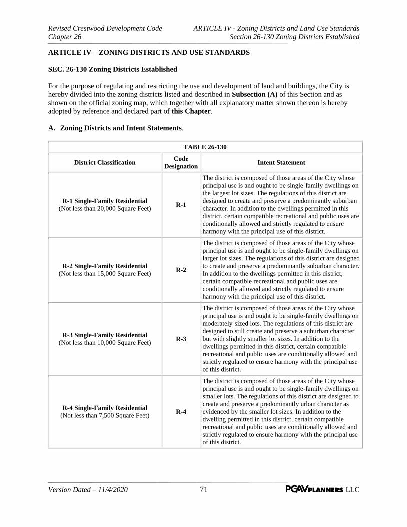
Revised Crestwood Development Code ARTICLE IV - Zoning Districts and Land Use Standards
Chapter 26 Section 26-130 Zoning Districts Established
Version Dated – 11/4/2020 71 LLC
ARTICLE IV – ZONING DISTRICTS AND USE STANDARDS
SEC. 26-130 Zoning Districts Established
For the purpose of regulating and restricting the use and development of land and buildings, the City is
hereby divided into the zoning districts listed and described in Subsection (A) of this Section and as
shown on the official zoning map, which together with all explanatory matter shown thereon is hereby
adopted by reference and declared part of this Chapter.
A. Zoning Districts and Intent Statements.
TABLE 26-130
District Classification Code
Designation Intent Statement
R-1 Single-Family Residential
(Not less than 20,000 Square Feet) R-1
The district is composed of those areas of the City whose
principal use is and ought to be single-family dwellings on
the largest lot sizes. The regulations of this district are
designed to create and preserve a predominantly suburban
character. In addition to the dwellings permitted in this
district, certain compatible recreational and public uses are
conditionally allowed and strictly regulated to ensure
harmony with the principal use of this district.
R-2 Single-Family Residential
(Not less than 15,000 Square Feet) R-2
The district is composed of those areas of the City whose
principal use is and ought to be single-family dwellings on
larger lot sizes. The regulations of this district are designed
to create and preserve a predominantly suburban character.
In addition to the dwellings permitted in this district,
certain compatible recreational and public uses are
conditionally allowed and strictly regulated to ensure
harmony with the principal use of this district.
R-3 Single-Family Residential
(Not less than 10,000 Square Feet) R-3
The district is composed of those areas of the City whose
principal use is and ought to be single-family dwellings on
moderately-sized lots. The regulations of this district are
designed to still create and preserve a suburban character
but with slightly smaller lot sizes. In addition to the
dwellings permitted in this district, certain compatible
recreational and public uses are conditionally allowed and
strictly regulated to ensure harmony with the principal use
of this district.
R-4 Single-Family Residential
(Not less than 7,500 Square Feet) R-4
The district is composed of those areas of the City whose
principal use is and ought to be single-family dwellings on
smaller lots. The regulations of this district are designed to
create and preserve a predominantly urban character as
evidenced by the smaller lot sizes. In addition to the
dwelling permitted in this district, certain compatible
recreational and public uses are conditionally allowed and
strictly regulated to ensure harmony with the principal use
of this district.

Revised Crestwood Development Code ARTICLE IV - Zoning Districts and Land Use Standards
Chapter 26 Section 26-130 Zoning Districts Established
Version Dated – 11/4/2020 72 LLC
TABLE 26-130
District Classification Code
Designation Intent Statement
R-5 Single-Family Residential
(Not less than 6,000 Square Feet) R-5
The district is composed of those areas of the City whose
principal use is and ought to be single-family dwellings on
small lots. The regulations of this district are designed to
create and preserve a predominately urban character as
evidenced by the small lot sizes. In addition to the
dwelling permitted in this district, certain compatible
recreational and public uses are conditionally allowed and
strictly regulated to ensure harmony with the principal use
of this district.
C-1 Local Business C-1
The district is composed of those areas of the City whose
principal use is and ought to be general retail, service, and
repair business activities which serve the entire City and
surrounding area. This district is provided to permit the
development of these business activities, to protect
adjacent areas against encroachment by incompatible uses,
and to lessen congestion on public streets. To these ends,
certain uses which would function more effectively in
other districts and would interfere with the operation of
these business activities and the purpose of this district,
have been excluded.
WROA
Watson Road Overlay Area WROA
The area consists of the properties fronting to Watson
Road within the eastern and western boundaries of the
City. It requires certain streetscape and design standards
for all new development on existing parcels or
combination of parcels and underlying permitted and
conditional uses are those as shown in Table 26-140
(Permitted Uses) for the C-1, PD-C, and PD-MXD
districts.
M-1 Light Industrial M-1
The district is composed of the area of the City whose
principal use is or ought to be light manufacturing,
warehousing, and other limited industrial uses. These uses
generate a minimum of noise, glare, odor, dust, vibration,
air and water pollutants, fire, explosive, radioactive and
other hazards, and harmful or obnoxious matter. This
district is provided to permit the development of these
industrial uses, to protect adjacent areas against
encroachment by incompatible uses, and to lessen
congestion on public streets. To these ends, certain uses
which would function more effectively in other districts
and would interfere with the operation of these industrial
activities and the purpose of this district have been
excluded.

Revised Crestwood Development Code ARTICLE IV - Zoning Districts and Land Use Standards
Chapter 26 Section 26-130 Zoning Districts Established
Version Dated – 11/4/2020 73 LLC
TABLE 26-130
District Classification Code
Designation Intent Statement
Planned Development Districts The purpose of the planned development districts is to
provide a means of achieving greater flexibility in
development of land in a manner not possible in
conventional zones; to encourage a more imaginative and
innovative design of projects; to promote a more desirable
community environment; and to retain maximum control
over both the structure and future operation of the
development. The planned development regulations are
not intended to allow excessive densities, or the
development of incompatible land uses, either within the
development, or as the development relates to the general
neighborhood. Establishment of and regulations pertaining
to Planned Development Districts are contained in Article
III, Section 26-090 (Applications and Procedures,
Planned Development).
PD-R
Planned Development-Residential PD-R
PD-C
Planned Development-Commercial PD-C
PD-M
Planned Development-Industrial PD-M
PD-MXD
Planned Development-Mixed Use PD-MXD
THE REMAINDER OF THIS PAGE INTENTIONALLY LEFT BLANK

Revised Crestwood Development Code ARTICLE IV - Zoning Districts and Land Use Standards
Chapter 26 Section 26-140 Districts and Uses
Version Dated – 11/4/2020 74 LLC
SEC. 26-140 Districts and Uses
A. Permitted Uses. In order to implement the intent of each zoning district and to regulate a variety of
compatible uses within zoning districts, use categories and general uses have been established for
principal uses of land and buildings. Table 26-140 indicates permitted uses (P) subject to general
district and building type standards or any specific use standards, and conditional uses (C) subject to
the discretionary review process in Article III, Section 26-100 (Applications and Procedures,
Conditional Use Permit). Use categories, general uses and specific types of uses are established in
Article IV, Section 26-130 (Zoning Districts Established) and specifically described in Article II,
Section 26-060 (Definitions, Description of Uses). This table enables general use categories. More
specific types of uses within these categories may be subject to additional standards in Section 26-
150 and Section 26-160 (Standards Applicable to All Districts and Standards Applicable to
Specific Uses and Districts), or be subject to conditional review processes indicated in Article III,
Section 26-100 (Applications and Procedures, Conditional Use Permit).
TABLE 26-140 – PERMITTED AND CONDITIONAL USES
LAND USE TYPE ZONING DISTRICT
P = Permitted
C = Use allowed via conditional use permit
WR-OD (not shown)
This is an overlay district along Watson Road.
Permitted uses are those permitted in C-1, PD-C, and
PD-MXD districts
Blank = Use not allowed
R-1
R-2
R-3
R-4
R-5
C-1
M-1
PD
-R
PD
-C
PD
-M
PD
-MX
D
RESIDENTIAL USES
Detached house P P P P P P C
Duplex P P C
3- / 4-Plex P C
Row House (3-8 units; 2- to 3-story P P
Walk-up Apartment (3- 12 units; 2- to 3-story) P P
Apartment Complex (garden apartment – density
based) P P
Mixed-use (residential above or behind street level
commercial) P
Accessory Dwelling
Group Homes
(subject to the provisions of Article XII, Section770 of this
Chapter) C C C C C C
Live/Work Unit C
COMMERCIAL – RETAIL USES
Retail – Limited (under 2.5K) P P P
Retail – Small (2.5K - 8K) P P P
Retail – General (8K -50K) P P P
Retail – Large (50K – 100K) P P C
Retail – Warehouse (over 100K) C P

Revised Crestwood Development Code ARTICLE IV - Zoning Districts and Land Use Standards
Chapter 26 Section 26-140 Districts and Uses
Version Dated – 11/4/2020 75 LLC
TABLE 26-140 – PERMITTED AND CONDITIONAL USES
LAND USE TYPE ZONING DISTRICT
P = Permitted
C = Use allowed via conditional use permit
WR-OD (not shown)
This is an overlay district along Watson Road.
Permitted uses are those permitted in C-1, PD-C, and
PD-MXD districts
Blank = Use not allowed
R-1
R-2
R-3
R-4
R-5
C-1
M-1
PD
-R
PD
-C
PD
-M
PD
-MX
D
Retail – Outdoor Sales, Limited C C
Retail – Outdoor Sales, General C C
Retail – Used C C
Restaurant – Micro/Mobile C P C C
Restaurant – Limited P P P
Restaurant – General P P P
Restaurant – Drive-in/Drive-thru C C C
Restaurant - Bar/Tavern C C C
Restaurant – Micro-brewery/winery C C C
Grocery – Convenience/ Market (under 5K) C C C
Grocery – Small Store ( under 40K) P P P
Grocery – Large Store (over 40K) P P P
Gas Station – Limited (4 pumps or less) C C
Gas Station – General (5 to 16 pumps) C C
Gas Station – Large (more than 16 pumps) C C
COMMERCIAL – OFFICE / SERVICE USES
Office – Home Occupation P P P P P P P
Office – Limited P P P P P
Office – General P P P P P
Service – Limited P P P P P
Service – General P P P P P
Animal Care or Clinic - Limited P P P P P
Animal Care or Clinic - General P P P P P
Lodging – B&B
Lodging – Inn P P C
Lodging – Hotel / Motel P P C
Recreation – Indoor, Limited P P P
Recreation – Indoor, General P P P
Recreation – Outdoor, Limited C C C

Revised Crestwood Development Code ARTICLE IV - Zoning Districts and Land Use Standards
Chapter 26 Section 26-140 Districts and Uses
Version Dated – 11/4/2020 76 LLC
TABLE 26-140 – PERMITTED AND CONDITIONAL USES
LAND USE TYPE ZONING DISTRICT
P = Permitted
C = Use allowed via conditional use permit
WR-OD (not shown)
This is an overlay district along Watson Road.
Permitted uses are those permitted in C-1, PD-C, and
PD-MXD districts
Blank = Use not allowed
R-1
R-2
R-3
R-4
R-5
C-1
M-1
PD
-R
PD
-C
PD
-M
PD
-MX
D
Recreation – Outdoor, General C C C
Residential Care – Limited C C C C C P P P P
Residential Care – General C C P P P P
Residential Care – Institutional Living C C C C
Vehicle Service / Repair – Limited C P C P
Vehicle Service / Repair – General C C C C
Vehicle Service / Repair - Heavy C C
INDUSTRIAL USES
Manufacturing – Artisan C P C P C
Manufacturing – Light P P
Manufacturing – General C C
Manufacturing – Heavy
Storage and Warehousing – Indoor, Limited C P C P
Storage and Warehousing – Indoor, General P C P
Storage and Warehousing – Outdoor C C
Storage and Warehousing – Outdoor, Junkyard
CIVIC/INSTITUATIONAL USES
Assembly – Limited (under 250) C C C C C C
Assembly – Small (251- 500) C C C
Assembly – Large (501- 1000) C C C
Assembly – Event Venue (1,000 +) C C C
Education – Neighborhood School (<10 acres) C C C C C C
Education - Campus (> 10 acres) C C C C C C
Education – Extension P P C
Open / Civic Space (parks, subdivision open space or common ground and buffers, trails, civic plazas, other public spaces)
P P P P P P P P P P P
Community and Public Service (post office, fire, police, rec center) C C C C C P P C P P C
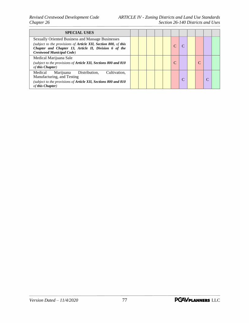
Revised Crestwood Development Code ARTICLE IV - Zoning Districts and Land Use Standards
Chapter 26 Section 26-140 Districts and Uses
Version Dated – 11/4/2020 77 LLC
SPECIAL USES
Sexually Oriented Business and Massage Businesses
(subject to the provisions of Article XII, Section 800, of this
Chapter and Chapter 13, Article II, Division 6 of the
Crestwood Municipal Code)
C C
Medical Marijuana Sale
(subject to the provisions of Article XII, Sections 800 and 810
of this Chapter) C C
Medical Marijuana Distribution, Cultivation, Manufacturing, and Testing
(subject to the provisions of Article XII, Sections 800 and 810
of this Chapter)
C C

Revised Crestwood Development Code ARTICLE IV - Zoning Districts and Land Use Standards
Chapter 26 Section 26-150 Standards Applicable to All Districts
Version Dated – 11/4/2020 78 LLC
SEC. 26-150 Standards Applicable to All Districts
A. Height Area and Bulk Standards. The height, area, and bulk requirements for the various districts
are established by Table 26-150 and depict the basic requirements applicable to each district.
However, the standards as set forth in Table 26-150 are subject to the exceptions and supplemental
standards in Subsection B of this Section and those in Section 26-160 (Standards Applicable to
Specific Uses and Districts) as may be applicable.
Min
. A
rea
(Sq
. F
t. o
r
Acr
es)
Min
. W
idth
@ B
ldg
.
Lin
e (F
eet)
Min
. W
idth
@ S
tree
t
R.O
.W.
(Fee
t)
Min
.
Dep
th
(Fee
t)
Ma
xim
um
Co
ver
ge
of
Bu
ild
ing
s a
nd
Str
uct
ure
s (%
)
Fro
nt
(Fee
t)
Sid
e
(Fee
t) 3
Rea
r (F
eet)
3
Pri
nci
pa
l
Bld
g.
(Sto
ries
/Fee
t)
Det
ach
ed
Ga
rag
e
(Fee
t) 1
Oth
er A
cc.
Str
uct
ure
s o
r
Ou
tbu
ild
ing
s
(Fee
t) 1
R-1
Sin
gle
-Fa
mil
y R
esid
enti
al
22
0,0
00
SF
10
05
01
50
30
45
12
35
or
20
% o
f
lot
dep
th b
ut
no
t gre
ater
than
50
2 1
/2 S
tori
es
bu
t n
ot
mo
re
than
35
15
10
R-2
Sin
gle
-Fa
mil
y R
esid
enti
al
21
5,0
00
SF
80
50
12
53
04
51
2
35
or
20
% o
f
lot
dep
th b
ut
no
t gre
ater
than
50
2 1
/2 S
tori
es
bu
t n
ot
mo
re
than
35
15
10
R-3
Sin
gle
-Fa
mil
y R
esid
enti
al
21
0,0
00
SF
75
50
12
53
03
58
30
or
20
% o
f
lot
dep
th b
ut
no
t gre
ater
than
35
2 1
/2 S
tori
es
bu
t n
ot
mo
re
than
35
15
10
R-4
Sin
gle
-Fa
mil
y R
esid
enti
al 2
7,5
00
SF
55
35
12
53
03
07
30
or
20
% o
f
lot
dep
th b
ut
no
t gre
ater
than
35
2 1
/2 S
tori
es
bu
t n
ot
mo
re
than
35
15
10
R-5
Sin
gle
-Fa
mil
y R
esid
enti
al
26
,00
0 S
F5
03
51
00
30
30
6
30
or
20
% o
f
lot
dep
th b
ut
no
t gre
ater
than
35
2 1
/2 S
tori
es
bu
t n
ot
mo
re
than
35
15
10
C-1
Lo
cal
Bu
sin
ess
5 A
C 4
NA
15
01
50
No
Lim
it3
0 5
5
25
ex
cep
t 5
0
wh
ere
abu
ttin
g a
n
"R"
dis
tric
t
2 1
/2 S
tori
es
bu
t n
ot
mo
re
than
35
1
NA
Su
bje
ct t
o 2
6-
15
0 &
26
-16
0
WR
OA
Wa
tso
n R
oa
d O
verl
ay
Are
a
M-1
Lig
ht
Ind
ust
ria
l5
AC
4N
A7
51
50
No
Lim
it3
05
2
No
ne
exce
pt
50
wh
ere
abu
ttin
g a
n
"R"
dis
tric
t
2 1
/2 S
tori
es
bu
t n
ot
mo
re
than
35
1
NA
Su
bje
ct t
o 2
6-
15
0 &
26
-16
0
PD
-R P
lan
ned
Dev
elo
pm
ent
Res
iden
tia
l2
.5 A
C
PD
-C P
lan
ned
Dev
elo
pm
ent
Co
mm
erci
al
2.5
AC
PD
-M P
lan
ned
Dev
elo
pm
ent
Ind
ust
ria
l2
.5 A
C
PD
-MX
D P
lan
ned
Dev
elo
pm
ent
Mix
ed U
se2
.5 A
C1 S
ee S
ecti
on
2
6-1
50
(B)
Exce
pti
on
s a
nd
Su
pp
lem
enta
ry S
tan
da
rds
for
add
itio
nal
reg
ula
tio
ns
2 S
ee S
ecti
on
26
-15
0(B
) a
nd
26
-16
0 f
or
app
lica
ble
ex
cep
tio
ns
3 C
orn
er l
ots
sh
all
hav
e a
sid
e yar
d a
nd
a r
ear
yar
d a
dh
eari
ng t
o t
he
req
uir
emen
ts s
pec
ifie
d.
In
ad
dit
ion
, th
e fr
on
t yar
d r
equ
irem
ents
sh
all
app
ly t
o a
ll a
reas
ad
join
ing s
tree
t ri
gh
ts-o
f-w
ay.
4 U
nle
ss a
bu
ttin
g a
n e
xis
tin
g c
om
mer
cial
(C
-1)
or
ind
ust
rial
(M
-1)
zon
ing d
istr
ict
5 E
xce
pt
as m
ay b
e re
qu
ired
in
th
e W
RO
A
All
Pla
nn
ed D
evel
op
men
t is
su
bje
ct t
o t
he
pro
vis
ion
s o
f A
rtic
le I
II,
Sec
tio
n 2
6-0
90
(P
lan
ned
Dev
elo
pm
ents
) an
d t
he
req
uir
emen
ts a
nd
stan
dar
ds
esta
bli
shed
by t
he
ord
inan
ce a
pp
rovin
g t
he
dev
elo
pm
ent
pla
n f
o r
hte
pro
ject
.
Zo
nin
g D
istr
ict
Ta
ble
26
-15
0 S
um
ma
ry o
f S
tan
da
rds
Lo
t A
rea
an
d C
ov
era
ge
Ya
rd R
equ
irem
ents
(S
etb
ack
s)M
axim
um
Bu
ild
ing
Hei
gh
t
See
Art
icle
IV
- S
ec.
26
-17
0

Revised Crestwood Development Code ARTICLE IV - Zoning Districts and Land Use Standards
Chapter 26 Section 26-150 Standards Applicable to All Districts
Version Dated – 11/4/2020 79 LLC
B. Exceptions and Supplemental Standards. The exceptions and supplemental standards as set forth
below shall apply:
1. In residential districts.
a. Subject to the provisions of Subsection (c) below, if a lot or tract of land has less area or
width, or both, than required in the district regulations, that lot or tract may be used for any of
the uses permitted by this section, including additions to existing structures and not
withstanding its nonconformance with this section, but in no instance shall there be a side
yard of less than eight (8) feet on each side of the dwelling.
b. Front yard. There shall be a front yard having a depth not less than that specified in Table
26-150, unless forty (40) percent or more of the frontage on one (1) side of the street between
two (2) intersecting streets is improved with buildings that have observed a front yard line
with a variation in depth of not more than ten (10) feet, in which case no building shall
project beyond the average front yard so established. Front yards shall be measured according
to future street and highway widening as provided for in City, St. Louis County, or State of
Missouri street and highway widening plans, and shall comply with the setback lines herein
provided for. Where lots have a double frontage, a required front yard shall be provided for
on both streets, except that the buildable depth of such lot shall not be reduced to less than
that specified in Table 26-150, in which latter event the Director of Public Services may
waive this requirement and the reduced yard shall apply to the street which will least affect
surrounding property.
c. Nonconforming lots of record. Notwithstanding limitations imposed or exceptions provided
by other provisions of this Chapter, a single-family dwelling and customary accessory
buildings or structures may be erected on any single lot of record at the effective date of
adoption or amendment of this Chapter. Such lot must be in separate ownership and not of
continuous frontage with other lots in the same ownership as of the date of adoption of this
Chapter or amendments thereto.
d. Additions or alterations on nonconforming lots. A building permit may be issued by the
Director of Public Services for an addition to, or alteration of, an existing building which is
located on a lot which is nonconforming only as to the side yard, provided that such addition
or alteration does not increase such nonconformity and provided that all other provisions of
the zoning ordinance are complied with.
e. All new property development subject to the provisions of this section and all existing
development to be modified or redeveloped and requiring the submission of a new site plan
or modification of an existing site plan shall comply with the applicable standards of other
Articles and Sections of this Chapter as follows:
Article V – Site and Landscape Design Standards
Article VI – Access and Parking
Article VII – Sign Regulations
Article VIII – Supplemental Standards
Article IX – Subdivision Standards
Article X – Floodway/Floodplain Management

Revised Crestwood Development Code ARTICLE IV - Zoning Districts and Land Use Standards
Chapter 26 Section 26-150 Standards Applicable to All Districts
Version Dated – 11/4/2020 80 LLC
2. In the C-1 Commercial District.
a. Buildings may exceed the heights as specified in Table 26-150 if the building conforms to
the following requirements: The ratio of the gross floor area of the building to the area of the
lot shall not exceed 1 to 1.5. The area of the lot shall mean the total area of the site, exclusive
of the area occupied by streets.
(1) Buildings exceeding the heights specified in Table 26-150 shall be subject to a sky
exposure plane when adjacent to residentially zoned properties. The sky exposure plane
will be measured from a line located thirty-five (35) feet above grade and fifty (50) feet
from the property line on the non-residential site and will have a slope of forty-five
degrees (45°) rising towards the center of the site. No portion of the building or structure
shall penetrate this sky exposure plane.
30’ PL
45°
50’
35’
“C-1” Zoned property “R” Zoned property

Revised Crestwood Development Code ARTICLE IV - Zoning Districts and Land Use Standards
Chapter 26 Section 26-150 Standards Applicable to All Districts
Version Dated – 11/4/2020 81 LLC
b. Site plan review is required by Article III, Section 26-110 or Section 26-120 (Applications
and Procedures, Major Site Plan and Design Review or Minor Site Plan) (if applicable)
and, in addition, for all new construction, additions to existing structures, and expansion or
improvements to parking areas, the following shall be required:
(1) All new property development subject to the provisions of this section and all existing
development to be modified or redeveloped and requiring the submission of a new site
plan or modification of an existing site plan shall comply with the applicable standards of
other Articles and Sections of this Chapter as follows:
Article V – Site and Landscape Design Standards
Article VI – Access and Parking
Article VII – Sign Regulations
Article VIII – Supplemental Standards
Article IX – Subdivision Standards
Article X – Floodway/Floodplain Management
c. Sidewalks shall be provided along all street frontages, the location to be approved by the
Director of Public Services.
d. All developed parcels shall be provided interior drives with a minimum width of pavement of
twenty-four (24) feet. Driveway openings shall be limited to not more than thirty-six (36) feet
in width and shall be limited to one (1) drive per one hundred (100) feet of lot width. All
roads and drives shall be paved with hard surface material meeting the specifications of the
City. Curbs and gutters shall be provided along all drives that do not abut parking areas. All
parking areas shall be edged with curbs and gutters. Surface or underground storm drainage
facilities shall be provided for all roads, drives, and parking areas as approved by the Director
of Public Services. All storm drainage will be directed into established surface or
underground storm drainage facilities.
3. In the M-1 Industrial District.
a. Corner lots shall have a side yard as specified in Table 26-150, except as provided for in
Section 26-160 (Standards Applicable to Specific Uses and Districts), lots with double
street frontage shall have a required front yard on both streets.
b. Site plan review is required by Article III, Section 26-110 or Section 26-120 (Applications
and Procedures, Major Site Plan and Design Review or Minor Site Plan) (if applicable)
and, in addition, for all new construction, additions to existing structures, and expansion or
improvements to parking areas, the following shall be required:
(1) All new property development subject to the provisions of this section and all existing
development to be modified or redeveloped and requiring the submission of a new site
plan or modification of an existing site plan shall comply with the applicable standards of
other Articles and Sections of this Chapter as follows:
Article V – Site and Landscape Design Standards
Article VI – Access and Parking
Article VII – Sign Regulations
Article VIII – Supplemental Standards
Article IX – Subdivision Standards

Revised Crestwood Development Code ARTICLE IV - Zoning Districts and Land Use Standards
Chapter 26 Section 26-150 Standards Applicable to All Districts
Version Dated – 11/4/2020 82 LLC
Article X – Floodway/Floodplain Management
c. Sidewalks shall be provided along all street frontages, the location to be approved by the
Director of Public Services.
d. All developed parcels shall be provided interior drives with a minimum width of pavement of
twenty-four (24) feet. Driveway openings shall be limited to not more than thirty-six (36) feet
in width and shall be limited to one (1) drive per one hundred (100) feet of lot width. All
roads and drives shall be paved with hard surface material meeting the specifications of the
City. Curbs and gutters shall be provided along all drives that do not abut parking areas. All
parking areas shall be edged with curbs and gutters. Surface or underground storm drainage
facilities shall be provided for all roads, drives, and parking areas as approved by the Director
of Public Services. All storm drainage will be directed into established surface or
underground storm drainage facilities.
THE REMAINDER OF THIS PAGE INTENTIONALLY LEFT BLANK

Revised Crestwood Development Code ARTICLE IV - Zoning Districts and Land Use Standards
Chapter 26 Section 26-160 Standards Applicable to Specific Uses and Districts
Version Dated – 11/4/2020 83 LLC
SEC. 26-160 Standards Applicable to Specific Uses and Districts. Unless otherwise stated, the
regulations hereafter established shall apply within all districts established by this Chapter. These general
regulations supplement and qualify the district regulations appearing elsewhere in this Chapter.
A. Height Exceptions.
1. Public and semi-public buildings. In any district, except residential districts, public or semi-
public buildings, such as hospitals, churches, sanitariums or schools, either public or private, may
be erected to a height not exceeding sixty (60) feet, provided that such buildings shall have yards
which shall be increased one (1) foot on all sides for each additional foot that such buildings
exceed the specified height limit as established by the regulations of the district in which such
buildings are situated.
2. Amateur radio antennas and towers and parabolic reflector antennas.
a. Definitions.
(1) Antenna. A metallic device having the primary purpose of sending and/or receiving
electromagnetic radiation.
(2) Antenna tower. Any fabrication or construction primarily designed or used for the
support of one (1) or more antenna; provided, however, that any fabrication or
construction which is less than six (6) feet in height shall not be considered to be an
antenna tower.
(3) EIA Standard 222. A reference to Electronic Industries Association Standard 222-E
effective 1991 entitled "Structural Standards for Steel Antenna Towers and Antenna
Supporting Structures."
(4) Ground-mounted antenna. Any antenna having any working element within five (5) feet
of grade.
(5) Parabolic reflector antenna. Any antenna having a curved reflector element, commonly
referred to as a satellite dish.
(6) Wire antenna. An antenna consisting exclusively of a length of wire and one (1) or more
insulators.
b. General.
(1) Effective as of July 25, 1995, a permit, as provided for herein, shall be required for the
construction or installation of a ground-mounted or roof-mounted antenna or antenna
tower for the operation of an amateur radio facility within the City.
(2) An application for a permit for the construction or installation of an amateur radio
antenna and/or antenna tower for operation of a licensed amateur radio facility shall be
filed on forms provided by the Director of Public Services and shall contain such
information as may be required therein, including:

Revised Crestwood Development Code ARTICLE IV - Zoning Districts and Land Use Standards
Chapter 26 Section 26-160 Standards Applicable to Specific Uses and Districts
Version Dated – 11/4/2020 84 LLC
(a) Detailed construction and installation plans.
(b) Site plan of the parcel upon which the installation is to be made showing the
specific location of the proposed installation, all improvements on the parcel and,
where the application requires consideration by the Board of Aldermen, the site
plan shall include the location of trees on such parcel, the general location of the
improvements on all adjoining properties and such other information as the
Director of Public Services deems appropriate to provide adequate information
for the Board of Aldermen. Such application shall be accompanied by
satisfactory evidence that the applicant or any occupant of the property for which
the antenna or antenna tower is proposed to be installed holds an existing
amateur radio license issued by the Federal Communications Commission.
(3) Issuance of permits.
(a) A permit for a ground-mounted antenna not extending more than forty (40) feet
above grade, an antenna mounted on a roof not extending more than eighteen
(18) feet above the point of mounting, an antenna mounted on a fixed antenna
tower which does not extend more than forty (40) feet above grade at the point of
installation, or an antenna mounted on a retractable or crank-up antenna tower
which does not extend more than sixty-five (65) feet above grade at the point of
installation when fully extended shall be issued by the Director of Public
Services upon the determination that the location, structural and wiring
requirements hereof are satisfied.
(b) A permit for a ground-mounted antenna extending more than forty (40) feet
above grade, an antenna mounted on a fixed antenna tower which extends more
than forty (40) feet above grade at the point of installation, or an antenna
mounted on a retractable or crank-up antenna tower which extends more than
sixty-five (65) feet above grade at the point of installation when fully extended
shall be issued or denied in accordance with the following:
(i) The application shall be referred to the Board of Aldermen for
consideration of issuance of a special permit. A public hearing shall be
held thereon, with at least fifteen (15) days public notice being published
and notice given to property owners within three hundred (300) feet of the
parcel for which the installation is proposed.
(ii) Upon findings as to whether the proposed conditional use permit is
required by topographical conditions or the operational parameters of the
antenna or the associated radio equipment to be utilized and as to whether
the proposed special permit conforms with the location, structural and
wiring requirements hereof, the Board of Aldermen shall approve or deny
the special permit and adopt findings and conclusions thereon.
(4) Location requirements.
(a) An antenna tower, ground-mounted antenna, and any portion of any base or
support thereof may be erected or installed only in the rear yard of the parcel
behind the principal building.

Revised Crestwood Development Code ARTICLE IV - Zoning Districts and Land Use Standards
Chapter 26 Section 26-160 Standards Applicable to Specific Uses and Districts
Version Dated – 11/4/2020 85 LLC
(i) On corner lots, each setback requirement along the street sides shall be
observed.
(ii) Any antenna tower or ground-mounted tower which exceeds forty (40) feet
in height shall be set back from all property lines at least one (1) additional
foot for every foot of height above forty-eight (48) feet, unless the Board of
Aldermen determines that reasonable provisions to protect adjoining
properties exist or that such setback requirements are unnecessary to
protect the public health, safety, or general welfare.
(b) Not more than one (1) antenna tower may be erected on any parcel; provided,
however, that an erected support used exclusively for the support of a wire
antenna and being no wider than six (6) inches at grade and having a height no
greater than forty (40) feet above grade shall not be considered an antenna tower
for the purposes of calculating the permitted number of such towers.
(c) No antenna tower may be erected on the roof of any building.
(d) Wire antennas utilizing existing building supports or natural supports, such as
trees, may be installed within the property boundary.
(5) Installation.
(a) All steel antenna towers and erected ground-mounted supports shall be designed,
erected, and maintained in accordance with the wind loading requirements of
EIA Standard 222-E.
(b) All aluminum antenna towers, ground-mounted antenna, and erected supports for
use with wire antenna shall be designed, erected, and maintained in accordance
with sound engineering practices.
(c) All antennas, antenna feed lines, and antenna controls shall be designed,
installed, and maintained in accordance with applicable requirements of the
City’s electrical code.
(d) All wiring to or from ground-mounted antennas or antenna towers located more
than five (5) feet from the nearest building shall be underground.
(6) Parabolic reflector antennas.
(a) The Director of Public Services shall issue a permit for a parabolic reflector
antenna upon determination that the requirements hereof regarding location,
structural components, screening, and wiring are satisfied.
(b) Location requirements.
(i) No parabolic reflector antenna having a reflector greater than twenty-four
(24) inches across may be erected or installed on any lot in the City other
than in the rear of the lot between the rear line of the principal building on
the lot and five (5) feet from the rear lot line. No antenna, nor any portion
of any base or support therefor, may be closer to any lot line than the
Revised Crestwood Development Code ARTICLE IV - Zoning Districts and Land Use Standards
Chapter 26 Section 26-160 Standards Applicable to Specific Uses and Districts
Version Dated – 11/4/2020 86 LLC
required side yard setbacks; provided, further, that on corner lots, no
antenna may be closer to any street than the principal building.
(ii) On any lot which is improved with a residence, no more than one (1)
parabolic reflector antenna, having a reflector of no more than twenty-four
(24) inches across, may be mounted on a roof. Any such antenna mounted
on a roof must be located on the side of the roof away from the most
heavily traveled adjoining street and may not extend above the height of
the highest point of the roof.
(iii) For each building in a commercial district, one (1) parabolic reflector
antenna, having a reflector no more than forty (40) inches across, may be
mounted on a roof. Any such antenna mounted on a roof must be so
located as to minimize the visibility of such antenna from the most heavily
traveled adjoining street.
(iv) Should there be severe practical difficulties in providing a ground location
within a C-1 or M-1 zoning district for parabolic reflector antennas greater
than forty (40) inches in diameter, the Planning Commission may approve
a roof installation, provided the same degree of screening as required above
can be achieved.
(c) Installation requirements.
(i) All antennas, antenna feed lines, and antenna controls shall be designed,
installed, and maintained in accordance with applicable requirements of the
City’s electrical code.
(ii) All wiring to or from ground-mounted parabolic reflector antennas located
more than five (5) feet from the nearest building wall shall be underground.
(iii) A ground-mounted parabolic reflector antenna shall not extend more than
ten (10) feet above grade and shall be screened from the view of the
traveling public and adjoining property owners by a sight-proof fence at
least six (6) inches higher than the maximum height of the antenna or
evergreen plantings at least one-half (½) the height of the antenna at the
time of planting. Any evergreen plantings installed in order to comply with
this requirement shall be of species readily capable of attaining a height of
at least six (6) inches higher than the antenna and of such density as to
reasonably screen the antenna from view. Any natural or artificial
screening shall be maintained in an attractive and first class condition at all
times, shall be subject to inspection by the City from time to time, and
shall be replaced or repaired if found to be deficient.
3. Structural projections. Except as hereinabove provided with respect to amateur radio antennas
and towers and parabolic reflector antennas, any chimneys, cooling towers, elevator headhouses,
monuments, stage towers or scenery lofts, tanks, water towers, ornamental towers and spires,
church steeples, radio towers, television towers, microwave towers, or necessary mechanical
appurtenances usually required to be placed above the roof level are not subject to the height
limitations contained in the district regulations with the following exception:
Revised Crestwood Development Code ARTICLE IV - Zoning Districts and Land Use Standards
Chapter 26 Section 26-160 Standards Applicable to Specific Uses and Districts
Version Dated – 11/4/2020 87 LLC
a. That such structural projections shall not exceed the height regulations of the district in which
the structure is situated by more than fifteen (15) percent;
b. That structural projections exceeding the above-height limitations shall be considered as
conditional uses and shall be processed in accordance with Article III, Section 26-100
(Applications and Procedures, Conditional Use Permit) of this Chapter;
c. Provided further that any such structural projections shall have yards which shall be increased
one (1) foot on all sides for each additional foot that such structures exceed the specified
height limit as established by the regulations of the district in which such buildings are
situated.
4. Height of dwellings. Residential structures in the dwelling districts may be increased in height by
not more than ten (10) feet when the side and rear yards are increased over the yard requirements
of the district in which they are located by not less than ten (10) feet, but they shall not exceed
three (3) stories in height.
B. Yard and Setback Exceptions in C-1 and M-1 Districts.
1. Generally. If a lot or tract of land has less area or width than required by the district regulations as
applicable, and was of record on adoption of this Chapter, that lot or tract may be used for any of
the uses permitted by this section, including additions to existing structure and not withstanding
its nonconformance with this section, but in no instance shall there be a side yard of less than five
(5) feet on each side of the building.
2. Front yard. There shall be a front yard having a depth of not less than thirty (30) feet, unless forty
(40) percent or more of the frontage on one (1) side of the street between two (2) intersecting
streets is improved with buildings that have observed a front yard line with a variation in depth of
not more than six (6) feet, in which case no building shall project beyond the average front yard
so established. Front yards shall be measured according to future street and highway widenings as
provided for in City, St. Louis County, or State of Missouri street and highway widening plans
and shall comply with the setback lines herein provided for. Where lots have a double frontage, a
required front yard shall be provided for on both streets, except that the buildable depth of such
lot shall not be reduced to less than forty (40) feet, in which latter event the Director of Public
Services may waive this requirement as to the street which will least affect surrounding property
values.
3. Structural projection. Every part of a required yard or court shall be open from its lowest point to
the sky unobstructed, except for the ordinary projection of sills, cornices, chimneys, buttresses,
ornamental features, and eaves provided, however, that none of the above projections shall extend
into a minimum yard more than thirty (30) inches; and provided further that canopies or open
porches may project a maximum of ten (10) feet into the required front or rear yard, and existing
open porches extending into the required yard shall not be enclosed. Slab type porches or paved
terraces having a maximum height of not more than twelve (12) inches above ground elevation at
any point may project into any yard, except that the projection into the front yard shall not exceed
ten (10) feet. For the purposes of this provision, mechanical units are not considered to be
structures.
4. Fire escapes/balconies. An open fire escape may project into a required side yard not more than
half the width of such yard, but not more than five (5) feet from the building. Fire escapes, solid

Revised Crestwood Development Code ARTICLE IV - Zoning Districts and Land Use Standards
Chapter 26 Section 26-160 Standards Applicable to Specific Uses and Districts
Version Dated – 11/4/2020 88 LLC
floored balconies, and enclosed outside stairways may project not more than four (4) feet into a
required rear yard.
5. Accessory buildings and structures. (See Section 26-160 (F), Accessory Buildings and
Structures).
6. Sight distance triangle. On a corner lot in any district, site development and landscaping shall
conform to the requirements of the sight distance triangle as provided for in Article V, Section
26-190 (Site and Landscape Design Standards, Scope, Purpose, Applicability and Conflicts)
of this Chapter.
7. Fences. A fence not more than six (6) feet in height is permitted; however, fences shall not be
permitted in front of the building line. (See Article V, Section 26-210 (Site and Landscape
Design Standards, Fencing).
8. Commercial/industrial rear yards. No rear yard shall be required in districts C-1 and M-1 or any
lot used for business or industrial purposes the rear line of which adjoins a railway right-of-way,
or which has a rear railway right-of-way, or which has a rear railway track connection.
9. Through lots. A through lot having one (1) end abutting a limited access highway, with no access
permitted to that lot from the highway, shall be deemed to front upon the street which gives
access to that lot.
C. Area Regulations; Maximum Lot Coverage Calculation.
In computing the amount of lot coverage, the amount of coverage shall include the total area of all
principal and accessory buildings as measured along the outside wall at ground level or above as
viewed from above and includes all projections other than open porches, fire escapes, canopies, or the
first three (3) feet of a roof overhang. Roads, driveways, parking lots, and swimming pools shall not
be included in maximum lot coverage requirements.
D. Access Regulations.
1. Access to business and industrial district. No land which is located in a residential district shall
be used for a major access route to any land which is located in any business or industrial district;
provided, however, that this section shall not prohibit pedestrian walks and driveway connections
between residential districts and neighborhood shops when incorporated as a part of a mixed-use
development district.
2. Street access. All lots shall abut a street other than an alley.
E. Required screening of mechanical equipment, trash, and loading areas for non-residential uses.
1. Ground-mounted equipment and loading areas. All mechanical equipment, trash receptacles,
storage of materials and equipment shall be within a fully enclosed building or in a side or rear
yard so screened by berms, dense vegetative plantings, wooden fences, or brick walls, or
combinations of these materials at least eight feet in height so that such materials and equipment
are not visible at six feet above the grade of the adjacent street(s) and adjoining property lines.

Revised Crestwood Development Code ARTICLE IV - Zoning Districts and Land Use Standards
Chapter 26 Section 26-160 Standards Applicable to Specific Uses and Districts
Version Dated – 11/4/2020 89 LLC
2. Roof-mounted equipment. Roof-mounted equipment shall be screened by an integral element of
the architectural design of the building or a separate, permanently installed screen which
harmonizes with the building in terms of material, color, and architectural styling. Screening shall
be of a height that is not less than the height of the roof-mounted equipment.
3. Trash containers. Outside rubbish, garbage, and dumpster containers if visible from normal
public traffic ways or residential areas shall be permanently screened from view, from all four
sides, one side to include a workable gate or door, with masonry walls. The walls shall have a
minimum height of six feet and a maximum height of eight feet. Screening, other than masonry,
may be permitted upon recommendation by the Planning, Zoning and Architectural Review
Commission and approval by the Board of Aldermen. All masonry screening required by this
section shall be comprised of a color and composition similar to that of the main structure of the
premises.
F. Accessory buildings and structures. Accessory buildings or structures must conform to all
provisions of this Chapter. On a corner lot, accessory buildings and structures cannot be located in a
required front or side yard.
1. Timing.
a. No accessory building or structure shall be used prior to the principal building or use,
except as a construction facility for the principal building.
b. Plans for the principal building must be submitted within 6 months of construction of
accessory building or structure to be used as a construction facility. If additional time is
needed re-application can be made and approved administratively where the contractor is
proceeding in good faith and encounters unanticipated delays or complications.
2. Attached accessory buildings. Any accessory building which is structurally attached to the
principal building of a lot shall be considered part of the principal building and shall comply with
all provisions of this Chapter pertaining thereto.
3. Detached garages.
a. Height: No detached garage shall be higher than the principal building or fifteen (15) feet,
whichever is lower, as measured from the ground to the highest point of the structure. In
addition, no detached garage shall have an exterior wall height in excess of ten (10) feet as
measured from the ground to the top of the wall.
b. Yard and area requirements. No detached garage shall be erected in any required front or
side yard. Detached garages may be located in the rear yard, but shall not occupy more than
thirty (30) percent of the rear yard area. No detached building or structure may be erected
closer than five (5) feet to the rear lot line, nor closer to the side lot line than the required
minimum side yard setback of the district. In addition, any detached garage must be at least
ten (10) feet away from the primary structure.
c. Erection and use. No accessory building shall be constructed upon a lot until the construction
of the main building has been commenced. No detached garage shall be used for dwelling
purposes.
d. Architectural compatibility. All detached garages must be of an architectural composition and
style which is compatible with the main structure located on the premises.

Revised Crestwood Development Code ARTICLE IV - Zoning Districts and Land Use Standards
Chapter 26 Section 26-160 Standards Applicable to Specific Uses and Districts
Version Dated – 11/4/2020 90 LLC
4. Other accessory structures or outbuildings.
a. Height. No detached accessory structure or outbuilding shall be higher than principal building
or ten (10) feet.
b. Yard and area requirements. No detached accessory building or structure shall be erected in
any required front or side yard. Detached accessory building may be located in the rear yard,
but shall not occupy more than thirty (30) percent of the rear yard area. No detached building
or structure may be erected closer than five (5) feet to the rear lot line nor closer to the side
lot line than the required minimum side yard setback of the district.
c. Erection and use. No accessory building shall be constructed upon a lot until the construction
of the main building has been commenced. No accessory building shall be used for dwelling
purposes.
d. No detached accessory building shall be erected within the City unless a permit has been
issued by the Director of Public Services or his or her designee. An application for such
permit shall be filed along with a site plan containing the following information:
1. The address of the property;
2. The name of all streets bounding the property;
3. The size and location of all buildings on the property, as dimensioned from the property
lines;
4. The location of the proposed detached accessory building, as dimensioned from the
property lines;
5. The location of the driveways and parking areas;
6. A description of the adjacent properties;
7. A north arrow;
8. A drawing scale.
The application and/or site plan shall clearly show the location of the detached accessory
building to be erected and the material which is to be used. Denial of a permit for the erection
of a detached accessory building shall be subject to review by the board of adjustment. No
permit shall be required to repair an existing detached accessory building.
5. Carports.
a. Code requirements. Carports are subject to the requirements for attached or detached
structures except as otherwise provided for in this section.
b. Carport storage restrictions. It is unlawful to store within a carport any construction material,
indoor furniture/appliances, or waste material of any kind, except in approved waste
receptacles. Any storage which would render the area unclean or unsafe is prohibited. Orderly

Revised Crestwood Development Code ARTICLE IV - Zoning Districts and Land Use Standards
Chapter 26 Section 26-160 Standards Applicable to Specific Uses and Districts
Version Dated – 11/4/2020 91 LLC
storage of outdoor equipment such as patio furniture, lawn care equipment, outdoor
recreation/sport equipment, grills, or firewood is acceptable. Storage of additional items is
permitted within enclosed portions of the carport or within plastic, wood, or metal storage
containers. It is the duty of the occupant and property owner to ensure that the carport is
maintained in a safe and sanitary condition.
6. Other prohibited structures and items. Notwithstanding any other provision of the Code to the
contrary, the following are prohibited in the front yard: swing sets, batting cages, trampolines,
playgrounds, forts, tree houses, inflatable bounce houses, playhouses, and indoor
furniture/appliances/fixtures. However, such items that are securely fastened, anchored, or affixed
to the ground or a tree located in a front yard as of the effective date of this ordinance may remain
as a nonconforming building or structure, subject to the regulations of Article IV, Section 26-180
(Zoning Districts and Use Standards, Non-Conforming Situations) of this Chapter.
Notwithstanding the foregoing, inflatable bounce houses may be erected in a front yard for a
temporary period not to exceed seventy-two (72) hours at a time, provided, however, no inflatable
bounce houses may be erected in a front yard on a particular parcel for more than seven (7) days
in a calendar year in the aggregate. For purposes of this subsection only, any area in front of the
front building line of the principal building on a parcel shall be considered a front yard.
G. Temporary Uses and Structures.
1. Temporary use permit. The Director of Public Services is authorized to issue a permit for the
temporary uses identified in Subsection (G)(2) of this Section. Any such permit shall be issued
for a specified period of time and shall contain such health, safety, and traffic restrictions deemed
reasonable by the Director of Public Services and may require such assurances or guarantees of
compliance with conditions as are deemed necessary by the Director of Public Services.
2. Temporary uses permitted. In addition to the uses approved subject to the restrictions of this
Article, the following temporary uses are authorized:
a. Christmas tree sales. Christmas tree sales in any business or industrial district for a period not
to exceed sixty (60) days. Display of Christmas trees need not comply with the applicable
yard setback requirements provided that no display will encroach within the required yard
setback for any district by more than fifty (50) percent and no display or equipment shall be
located within the thirty-foot (30) sight distance triangle of a street intersection as defined in
this Chapter.
b. Contractor’s offices. Temporary buildings or trailers may be used as construction offices,
field offices or for storage of materials to be used in connection with the development of the
tract, provided that the temporary structures are removed from the tract within thirty (30)
days after completion of the project development. Temporary buildings or trailers must also
be removed from the tract within thirty (30) days after voluntary suspension of work on the
project or development, or after revocation of building permits, or on order by the Director of
Public Services upon a finding by him that the temporary structure is deemed hazardous to
the public health and welfare. A bond in the amount of one thousand dollars ($1,000.00) for
their removal shall be posted with the City.
c. Real estate offices. Temporary real estate offices or sales offices may be established in a
display dwelling unit.

Revised Crestwood Development Code ARTICLE IV - Zoning Districts and Land Use Standards
Chapter 26 Section 26-160 Standards Applicable to Specific Uses and Districts
Version Dated – 11/4/2020 92 LLC
d. Seasonal sales. Seasonal sale of farm produce grown on the premises, in an R-1 district.
Structures incidental to such sale need not comply with the applicable front yard requirements
provided that no such structure shall be located within the thirty-foot (30) sight distance
triangle of a street intersection as defined in this Chapter. All such structures shall be
removed at the end of the season during which they are used.
e. Special promotional events by businesses. Special promotional events involve the temporary
display of merchandise or sales activities (including the provision of music, entertainment,
food, and beverages) which are accessory to, or promoting, the existing permitted or
conditionally permitted use(s) of a parcel.
(1) Any business conducting a special promotional event or events totaling more than thirty
(30) calendar days within a calendar year (either consecutive or in total) will require
approval of the Crestwood Planning Commission.
(2) As part of the special event, the installation or erection of temporary facilities or
temporary structures and approved signage may be included.
(3) All such promotional events shall be conducted within paved or enclosed areas of the
parcel and shall not otherwise interfere with traffic circulation or emergency access.
(4) All temporary facilities and/or signs used for any such special promotional event shall
conform with all applicable City ordinances.
3. Temporary dwelling structures. No cabin, garage, cellar, basement, or temporary structure
whether of a fixed or moveable nature may be erected, altered, or moved upon and used in whole
or in part for any dwelling purposes whatsoever for any length of time whatsoever.
4. Temporary commercial structures. Except as provided for in Subsections (2)(b) and (2)(e) of
this Section, no cabin, garage, storage facility, cellar, basement, tent, or other temporary structure
or facility, whether of a fixed or moveable nature, may be erected, installed, altered, or moved
upon and used in whole or in part for any commercial purposes whatsoever for any length of time
whatsoever.
H. Land and buildings.
1. Number of buildings permitted per lot. Every single-family dwelling hereafter erected or
structurally altered shall be located on a separate lot or tract. In no case shall there be more than
one (1) single-family dwelling on one (1) lot or tract except for accessory buildings or uses, as
defined herein, and except for any structure authorized as part of a special procedure requiring
submission to the Planning Commission of any type of site development plan for review and
approval. A residential lot must have frontage on a street.
2. Conversion or change in occupancy of single-family dwelling. In any district permitting uses
other than single-family dwellings, single-family dwellings shall not be converted to another use
without first obtaining a certificate of occupancy. No application for a building permit and/or a
certificate of occupancy for such a conversion of a single-family residence shall be approved
unless accompanied by a detailed site plan, as provided in Article III, Section 26-110
(Applications and Procedures, Major Site Plan and Design Review), including a floor plan,
showing full compliance with all other applicable regulations of this Chapter.
Revised Crestwood Development Code ARTICLE IV - Zoning Districts and Land Use Standards
Chapter 26 Section 26-170 Watson Road Overlay Area
Version Dated – 11/4/2020 93 LLC
SEC. 26-170 Watson Road Overlay Area
A. Purpose. The Watson Road Overlay Area (WROA) is intended, by site plan approval, design
standards, supplemental standards, and other procedures hereinafter set forth, to provide for the
development of retail, office, business and personal service, and multi-family uses for an area along
either side of the Watson Road Corridor in the City of Crestwood. It is intended to work in conjunction
with the existing regulations of this Chapter to foster a higher quality of architecture and site design
that creates a distinct character for the area and promotes an inviting, pedestrian-friendly environment.
The purposes of this area designation include the following goals and objectives:
1. Limit permitted uses for smaller parcels to encourage and promote property assembly for larger,
planned development;
2. Create a pedestrian-friendly, walkable environment with clear and ample access to the City, the
Great Rivers Greenway trail system, and nearby parks;
3. Encourage building placement and design along with site design that encourages creation of a
“sense of place” and that fosters an overall appearance supporting the Watson Road corridor as
destination location;
4. Promote a mix of land uses and density that creates an identity for the area and can offer the
potential to create a “live/work” environment that can take advantage of the WROA’s proximity to
public transit;
5. Encourage increased private investment;
6. Provide benefit to existing property owners though the increased value of land that these regulations
promote.
B. Area and Applicability. These provisions of this section shall apply to:
1. All properties with frontage to the north or south side of Watson Road within the City of Crestwood;
2. All development within the “WROA” Area involving:
a. New construction on a vacant or cleared site;
b. Rehabilitation of existing structures which exceeds current market value of the land and
improvements according to the most recent St. Louis County Assessor market valuation by
more than fifty (50) percent;
c. Developments representing a change of use from its most recent or current use to a use not of
the same type;
d. Developments which are no longer a legally non-conforming use in accord with the provisions
of Section 26-180 (Non-Conforming Situations) of this Article; or
e. New construction on a cleared site or renovation/rehabilitation of an existing building requiring
a building permit.
Revised Crestwood Development Code ARTICLE IV - Zoning Districts and Land Use Standards
Chapter 26 Section 26-170 Watson Road Overlay Area
Version Dated – 11/4/2020 94 LLC
2. In addition, a site plan or development plan approval based on the following:
a. If the project is located within the portion of the “WROA” zoned “C-1” Commercial District
or “M-1” Light Industrial District a site plan shall be required in conjunction with the
provisions of Article III, Section 26-110 or Section 26-120 (Applications and Procedures,
Major Site Plan and Design Review or Minor Site Plan) of this Chapter as may be
applicable;
b. If the project is proposed to be developed in accord the Planned Development provisions of
this Chapter, a preliminary and final development plan in accord with the provisions of Article
III, Section 26-090 (Applications and Procedures, Planned Development) shall be required.
C. Permitted and Conditional Uses - General. Any structure or land in the “WROA” Watson Road
Overlay Area may be used for purposes as listed in Article IV, Table 26-140 (Permitted Uses) of this
Chapter applicable to the “C-1” Commercial District, the “PD-C” Planned Development-Commercial
District, and the “PD-MXD” Planned Development-Mixed-Use District, subject to all other provisions
and limitations of this Chapter and of other applicable regulations, ordinances and statutes of the City,
County or State. In addition, permitted uses and conditional uses are subject to the following additional
requirements and restrictions:
1. All development shall be in accordance with the City’s adopted Comprehensive Plan or parts
thereof or applicable amendments, including proposed land use and public improvement elements.
2. All business, services, storage, merchandise display, repairing and processing shall be conducted
wholly within an enclosed building, except for accessory off-street motor vehicle parking for
customers, employees, residents or visitors and off-street loading or unless expressly permitted by
conditional use permit (see Article III, Section 26-100, Applications and Procedures,
Conditional Use Permit).
3. Used motor vehicles, trailers, boats or recreation vehicles may be sold only in conjunction with and
on the same lot or site as the sale of new vehicles of the same type and under the same business
ownership or management.
4. Processes and equipment employed, and goods processed or sold, should be limited to those which
are not objectionable by reason of odor, dust, smoke, cinders, gas, noise, vibration, refuse matter,
water-carried waste, pollutants or matter which in any manner create or constitute a nuisance.
D. Use Regulations.
1. As stated previously in this Section, the standards of the WROA are intended to foster creation of
a mixed-use location that is attractive as a place to shop, to work, and to live. Except for any special
requirements as stipulated hereafter in this Section, requirements pertaining to lot size, area, width,
and depth; floor area ratio; building bulk, height, and setback shall be those which apply in the
underlying district regulations.
2. The Planning Commission in conjunction with review by the Director of Public Services and other
key City planning and building review staff may recommend to the Board of Aldermen variance to
any of the underlying zoning or subdivision regulations of this Chapter that do not affect public
health or safety or create environment or other performance issues to achieve the intent of this
Section. Any such variance to the regulations of this Chapter shall be approved by an ordinance
enacted by the Board of Aldermen for the specific site and project via the site plan review process

Revised Crestwood Development Code ARTICLE IV - Zoning Districts and Land Use Standards
Chapter 26 Section 26-170 Watson Road Overlay Area
Version Dated – 11/4/2020 95 LLC
of Article III, Section 26-110, or Article III, Section 26-120 (Applications and Procedures,
Major Site Plan and Design Review or Minor Site Plan) of this Chapter or the Planned
Development process set forth in Article II, Section 26-090 or the site plan review process of
Article III, Section 26-090 (Applications and Procedures, Planned Development) of this
Chapter as may be applicable under Subsection (B)(3) of this Section above.
3. Buildings are encouraged to front to Watson Road with facades that have at least fifty (50) percent
of the ground floor with windows that provide a view into the space and entries that front to the
street along a tree lawn and sidewalk. The sidewalk shall not be less than ten (10) feet in width and
the tree lawn not less than five (5) feet as depicted in Figure D-3 below. The sidewalk shall be
intended to carry both pedestrian and bicycle traffic. Outdoor seating associated with restaurant
and bar establishments is not permitted on the sidewalks within the Right of Way.
4. No minimum side yard is required where commercial buildings are constructed simultaneously
with party walls or firewalls, otherwise a minimum side yard of ten (10) feet shall be provided
subject to the exceptions of Subsection (D)(5)(c) below (See Figure D-4 below):
Figure D-3 –Building Setbacks
Variable Lane Width

Revised Crestwood Development Code ARTICLE IV - Zoning Districts and Land Use Standards
Chapter 26 Section 26-170 Watson Road Overlay Area
Version Dated – 11/4/2020 96 LLC
5. For larger developments with multiple buildings, some buildings may be located in proximity to
the Watson Road frontage as provided for in Subsection (D)(1) above. However, in order to
provide viewsheds into the portion of the development behind the fronting buildings, buildings
located at the Watson Road frontage and adjacent to an entry road or drive shall be setback from
such roadway or drive as depicted in Figure D-5 below.
a. In locations where the side yard is adjacent to an existing or proposed street connecting to
Watson Road generally on a north/south axis, the side yard or building setback line shall
be not less than fifty (50) feet measured from the centerline of said street or not less than
thirty-two (32) feet from the back curb line of either side of said street;
Figure D-4 – Pedestrian Corridors Between Buildings
Figure D-5
Viewshed for Main Entry Road or Drives in Larger Developments
Entry Road or Drive in Larger Development

Revised Crestwood Development Code ARTICLE IV - Zoning Districts and Land Use Standards
Chapter 26 Section 26-170 Watson Road Overlay Area
Version Dated – 11/4/2020 97 LLC
b. In locations where the front yard is adjacent to an existing or proposed street connecting to
Watson Road generally on a north/south axis, the front yard or building setback line shall
be not less than fifty (50) feet measured from the centerline of said street or not less than
thirty-two (32) feet from the back curb line of either side of said street;
c. Either of these standards may be modified during the development plan or site plan review
process of Subsection (B)(3)(a) or (b) of this Section but in any event the viewshed
created by this standard shall not reduce the distance between buildings abutting either side
of such road or entry drive to less than one hundred (100) feet;
d. Minimum rear yard. A minimum rear yard of ten (10) feet shall be provided. If any
property adjacent to the site is zoned in an "R-1" through “R-5” or “PD-R” zoning
classification, there shall be a fifty (50) foot rear yard and a solid masonry fence complying
with the provisions of Article V, Section 26-210 (Site and Landscape Design Standards,
Fencing), of this Chapter; and
e. Transitional yards, etc.
(1) Where a side or rear lot line coincides with a side or rear lot line of any lot in an
adjacent residential zoning district ("R-1" through “R-5” or “PD-R”), then a
landscaped yard of at least twelve (12) feet in width complying with Article V,
Section 26-200 (Site and Landscape Design Standards, Landscape Design
Standards) of this Chapter shall be provided along such a lot. In addition, for any
use that involves the construction of a new structure or the expansion of an existing
structure, a solid masonry wall complying with the provisions of Section 26-210
(Site and Landscape Design Standards, Fencing) of this Chapter of at least six
(6) feet but not more than eight (8) feet in height shall be provided in such
transitional yard within two (2) feet of the property line.
i. Where the rear or side wall of any non-residential structure is located directly
across the street from the front yard of any residential structure located in a
residential district, a landscaped yard of at least twelve (12) feet in width
complying with the provisions of Article V, Sections 26-240 and 26-250 (Site and
Landscape Design Standards, Landscape Design and Fencing) of this Chapter
shall be provided along the entire length of such rear or side wall.
(3) The transitional yard requirement may be modified by conditional use permit,
development plan approval, or by site plan approval as provided in Article III,
Sections 26-090, 26-100, and/or 26-110 (Applications and Procedures, Planned
Development, Conditional Use Permit, Major Site Plan and Design Review),
of this Chapter. Such modifications may impose more stringent or less stringent
requirements in order to mitigate the adverse effects of one land use upon another
or conflicts between two different land uses.
(4) Yard requirements as required herein or in other provisions of this Chapter may
also be impacted by other provisions of the Crestwood Municipal Code relating to
fire and public safety requirements imposed during development plan, conditional
use permit, or site plan review by City staff.
Revised Crestwood Development Code ARTICLE IV - Zoning Districts and Land Use Standards
Chapter 26 Section 26-170 Watson Road Overlay Area
Version Dated – 11/4/2020 98 LLC
6. Off-street parking and loading. All off-street parking and loading is required to comply with
Article VI (Access and Parking) of this Chapter, but those requirements may be modified in
conjunction with the site plan review process to reduce parking requirements and minimize
paved surfaces based on the standards outlined in Subsection E.3, of this Section. Access to
off-street parking and loading must be accessed via controlled access points and may not allow
for parking that provides direct pull-in and back-out parking to and from Watson Road across
the site frontage. To reduce curb-cuts on to Watson Road, all off-street parking for new
development or redevelopment of existing sites must have access to an adjoining street other
than Watson Road and must provide for cross-access to adjacent property.
7. Environmental controls. All development shall conform with the environmental performance
standards provided in Article VIII, Section 26-370 (Supplemental Standards,
Environmental Performance Standards), and the stormwater management standards of
Article VI, Section 26-270 (Site and Landscape Design Standards, Stream Buffer
Protection), along with other applicable provisions of the Crestwood Municipal Code.
8. Signs. In conjunction with site plan review, the site plan must contain information to indicate
the type, , and location of all signage in compliance with the provisions of Article VII, of this
Chapter must be provided and approved as part of site plan approval.
E. Development requirements, guidelines, and standards. To achieve the goals and objectives as
outlined in Subsection (A) of this Section and achieve the City’s vision for the Watson Road Corridor,
the following development standards are established for uses within the Watson Road Corridor subject
to the provisions of Subsection (B) of this Section. It is recognized that not all of the standards may
be attainable with particular property or uses. Therefore, the regulations in the WROA are intended to
provide flexibility to property owners and developers for many types of development particularly with
respect to building height and development density. In addition, the regulations are meant to provide
a certain degree of latitude to the Planning Commission and the Board of Aldermen to vary from these
or other regulations when reviewing site plans in order to achieve the goals and objectives of the
Comprehensive Plan and these regulations. The degree to which a site plan for development meets or
exceeds the design standards set forth in this subsection shall be considered and will be evaluated when
considering site plans for proposed development. A developer should be prepared to explain why
certain development standards cannot be met or that alternatives serve the same purpose as the
standard. The standards are intended to allow the Watson Road Corridor to become another recognized
location within the City as a live/work/relax location. Examples of the various standards and/or
design features intended to be carried out within the WROA are included throughout this
section.
1. Building Design: New buildings should be designed to include common features and materials so
that a sense of place and character is created for the WROA.
a. Exterior building materials: Building materials should be used and installed in keeping with
the chosen architectural style. Building material colors should be varied and complementary
and three colors for all building elevations required. Except as minor accents for trim such as
window frames or entry doors, primary or garish colors should be avoided and subtle colors
and earth tones are preferred. Materials should be of a scale appropriate to the pedestrian and
complement adjacent structures. The table entitled “Exterior Material Legend” below provides
a listing of acceptable/generally unacceptable materials. This table is intended to provide
direction but is not intended to represent absolute approval or disapproval of any listed item
and will depend on building architecture.

Revised Crestwood Development Code ARTICLE IV - Zoning Districts and Land Use Standards
Chapter 26 Section 26-170 Watson Road Overlay Area
Version Dated – 11/4/2020 99 LLC
EXTERIOR MATERIAL LEGEND
Acceptable Exterior Materials Generally Unacceptable Exterior Materials
Brick or brick veneer Vinyl or aluminum siding
Natural Stone (limestone, brownstone, lannon
stone, marble, granite). Veneer based plywood siding
Metal panels (used as accent features, includes
types such as Alucobond, Alpolic, or similar) Plywood panels (such as T1-11)
Cement-fiber siding Plexiglas
Decorative Concrete Masonry Units (CMU)
or architectural cement block
Corrugated Metal with exposed fasteners (used as
accent features and comprising no more than 30%
of the exterior building materials used).
Concrete, including pre-cast panels (may be
used when incorporating color, texture and
architectural finish features)
Painted smooth concrete masonry units (unless
used in locations behind screen walls)
Exterior grade wood (must be appropriate
species for climate)
Exposed steel framing (unless integral to the
design)
Composite siding Corrugated tin roofing (unless dictated by the
specific architectural style)
EIFS or Stucco (generally above the first story
and not more than 30% of the wall area
exclusive of windows and doors)
Smooth-face concrete block
Vinyl trim (accent only) Standing seam or batten seam metal roofing
(unless dictated by the specific architectural style)
EXTERIOR MATERIAL LEGEND
Acceptable Exterior Materials Generally Unacceptable Exterior Materials
Glass block (may be used only as a feature
element, not for glazing or windows) Shake shingles
Brick and stone pavers
Manufactured stone
Commercial grade asphalt shingles
Slate roofing
Concrete tile roofing

Revised Crestwood Development Code ARTICLE IV - Zoning Districts and Land Use Standards
Chapter 26 Section 26-170 Watson Road Overlay Area
Version Dated – 11/4/2020 100 LLC
b. Building details: Each building shall incorporate several common architectural features,
appropriate for the architectural style chosen. Examples include pilasters, piers, columns,
friezes, cornices, and window surrounds. Building elements such as awnings, signs, doors,
windows, and lighting should complement the architecture of the building façade and finishes
(See Example 1).
c. Design features and structures: Use of awnings, canopies, or other design features should
enhance main facades, especially at building entries. Attached structures such as covered
arcades or porte cocheres shall be compatible with and complement the overall design of the
building and its façade (See Example 2).
d. Building entrances: Building entrances are required to be clearly delineated and indicate a
clear transition from the exterior to the interior of the building. Every main entrance is required
to have a special emphasis when compared to the other portions of the building. The building
address should be clearly displayed in a readable typeface of sufficient size for reading from a
vehicle at a reasonable distance and oriented to the street or drive frontage recognized by the
US Postal Service and the City’s fire and police departments (See Example 3).
Example 1
Example 2

Revised Crestwood Development Code ARTICLE IV - Zoning Districts and Land Use Standards
Chapter 26 Section 26-170 Watson Road Overlay Area
Version Dated – 11/4/2020 101 LLC
e. Façade articulation: Buildings and parking structures of three (3) stories or less in height
designed with completely flat facades and monotone color schemes are not permitted. All
buildings and parking structures are required to have horizontal and vertical façade variations
such as pop-outs, bays, recesses, arches, banding, columns, or similar features. Buildings of
more than three (3) stories may have a flat façade of uniform design above the third floor (See
Example 4).
f. Height and roofline: Single-story buildings should have varying roofline elevations to add
architectural interest and avoid the appearance of long, monotonous roofline expanses. A
variation such as a parapet or tower is required every 50’ of roofline. Also, if mechanical
HVAC equipment that is installed on the roof of any structure in the WROA is visible from
grade level in residential areas or, is visible from Watson Road or any primary access road
within a larger development, said equipment shall be screened by a wall with a finish surface
compatible in design and color to that which is used as a finish building wall material. The
back of parapets should also not be visible from Watson Road or any primary access road
within a larger development and must match the color and materials of the building (See
Example 5).
Example 3
Example 4

Revised Crestwood Development Code ARTICLE IV - Zoning Districts and Land Use Standards
Chapter 26 Section 26-170 Watson Road Overlay Area
Version Dated – 11/4/2020 102 LLC
g. Pedestrians/Bicycle Access: All buildings must be designed to encourage pedestrian activity
and social interaction and create a walkable environment that encourages pedestrian access, as
well as bicycle access, to and within the Watson Road Corridor and connectivity to the adjacent
greenway trail system.
h. Windows: Windows are key to the overall design of a building and the relationship between
the exterior and interior. Eye level windows are required to relate to the scale of a person.
Clear glass for storefronts, windows and doors, within the retail merchandising areas is
required. Slightly tinted glass for energy efficiency purposes may be used. Window tints shall
be grey, blue, or bronze. Mirrored glass is prohibited. Window signage is strongly
discouraged (See Example 6).
i. Signs: Along exterior roadways ground signs in conformance with Article VII (Sign
Regulations) are permitted. Signs along interior roadways and driveways may only be located
on buildings and will be planned for as part of the building’s overall design and should
integrate similar or complementary materials as the building, be harmonious in color, with
controlled lighting and must include information to indicate the type, size, and location of all
signage in compliance with Article VII of this Chapter (See Example 7). Window and
Accessory Signage as regulated in Article VII (Sign Regulations) is also permitted.
Example 5
Example 6

Revised Crestwood Development Code ARTICLE IV - Zoning Districts and Land Use Standards
Chapter 26 Section 26-170 Watson Road Overlay Area
Version Dated – 11/4/2020 103 LLC
(1) Corporate logos may be incorporated into a sign so long as the sign is compliant with the
provisions Article VII (Sign Regulations) of this Chapter and is an integrated element
of the building design and façade.
(2) Signs, other than those indicating entry or exit locations, and not be located on parking
structures or within parking lots except for instances where parking structure contain
ground floor retail uses.
(3) Billboards are not permitted on any property within the WROA District.
(4) Electronic Message Centers as defined in Article VII, Section 26-320 (Sign Regulations,
Design and Location Standards) are not permitted in the WROA. Existing electronic
message centers located within the WROA which were approved prior to the effective date
of this Code section are allowed to continue to operate until such time as the sign becomes
non-operational, is removed, is repaired or refurbished, or is substantially modified.
However, any existing sign may not be enlarged or otherwise altered to the extent that it is
no longer compliant with the provisions of Article VII, Section 26-320(D)(8) (Sign
Regulations, Standards and Requirements by Sign Type, Electronic Message Centers
or Displays).
2. Site Design. New developments are required to match or complement surrounding new
developments and landscapes to create a building and site design which follow the standards of this
Chapter and adds positively to the overall WROA environment. Where applicable and appropriate
site design should provide:
a. Outdoor seating at work places and restaurants that is:
(1) situated to provide a pleasant environment for users that is not adjacent to parked
automobiles or other environmental detriments;
(2) located so as not to block or constrict entry and exit doors or impede pedestrian or bicycle
movements; and
(3) not located within the 10-foot shared sidewalk and bikeway on either side of Watson Road.
b. Access to adjacent sidewalks or bikeways with a paved, ADA-accessible pathway of not less
than six (6) feet in width from building entries and that is clearly delineated through parking
areas or structures via changes in paving materials, texture, and/or color. Pedestrian easements
and connections of appropriate width that can connect to other uses within the area shall also
Example 7

Revised Crestwood Development Code ARTICLE IV - Zoning Districts and Land Use Standards
Chapter 26 Section 26-170 Watson Road Overlay Area
Version Dated – 11/4/2020 104 LLC
be provided where possible and appropriate with adjacent landscaping and lighting particularly
where such connections are between buildings (See Example 8).
c. To encourage and promote biking to and from the WROA bike racks shall be provided at
appropriate locations at any building.
d Elements such as plazas or large patio areas that can be used for occasional entertainment
events (subject to any required approvals in accord with the Crestwood Municipal Code) and
promote social interaction in pleasant environments.
e. Signage for wayfinding both within a development and the area overall that is of clear and
consistent design.
f. Public art of appropriate type and scale that can help to create an identity for the WROA.
g. Building placement: Building placement must comply with the following standards:
(1) The main façade of a building must be oriented to face the principal street on which it has
frontage.
(2) Buildings on corner lots must be oriented so that the main façade is giving equal treatment
to each street on which it has frontage. Also, these buildings should include a prominent
architectural feature of greater height than the rest of the roof, or emphasis at the corner
where the two public streets meet.
h. Utilities serving a site and the on-site structures must be located in underground easements that
can serve multiple properties.
i. Screening: In addition to the following, screening shall be in compliance with Article IV,
Section 26-160 (E) (Zoning Districts and Use Standards, Standards Applicable to Specific
Uses and Districts Required Screening of mechanical equipment, trash, and loading areas for
non-residential uses):
(1) Loading and service areas shall be screened with walls and landscaping. Where adjacent
to residential areas, loading and service areas shall be located away from bordering
residential property lines whenever possible and such areas must be completely screened
and appropriately buffered with appropriate trees in accord with the standards set forth in
Article V, Section 26-210 (Site and Landscape Design Standards, Fencing). In all
Example 8

Revised Crestwood Development Code ARTICLE IV - Zoning Districts and Land Use Standards
Chapter 26 Section 26-170 Watson Road Overlay Area
Version Dated – 11/4/2020 105 LLC
instances, views into loading and service areas from adjacent properties or uses must be
minimized.
(2) Mechanical equipment, whether ground level or roof top, shall be screened from ground-
level view. Large trash receptacles, dumpsters, utility meters, satellite dishes, antennas,
etc., shall be similarly treated and may not be located on the side of a building. Screening
material shall consist of a masonry wall, sight-proof fencing of aluminum, steel, vinyl,
dense landscaping, or any other such material that is found compatible and approved as
part of the site plan approval process.
(3) Chain-link fencing (including cloth, canvas, or vinyl-slat covered), smooth-face concrete
block, and barb or razor wire topped fences are prohibited.
j. Landscaping: The landscaping requirements shall be as established by Article V, Section 26-
200 (Site and Landscape Design Standards, Landscape Design Standards) of this
Chapter. In addition, the following requirements shall apply to all landscape plans:
(1) A landscape plan sealed by a landscape architect registered in Missouri shall be submitted
in conjunction with the development or site plan.
(2) A landscape plan shall be drawn to scale, include dimensions and distances, and clearly
delineate all existing and proposed vehicular movement and parking, and the location, size,
and description of all landscaping materials. All easements, transition buffer areas and
setback areas shall be labeled and dimensioned. Outdoor furniture and fixtures for
commercial and mixed-use development are encouraged and shall be considered part of
the landscaping plan and identified on the landscape plan. The landscape plan must include
an irrigation plan.
(3) The property owner or designated agent shall be responsible for the maintenance, repair,
and replacement of all landscaping materials. All plant material and landscaped bed areas
shall be tended and maintained in a healthy growing condition, free from refuse, debris and
weeds.
k. Lighting: Proper layout, height, fixture selection, and lighting level shall be incorporated as
part of the site design requirements (See Examples 9 and 10):
(1) Site lighting shall use LED bulb technology of low-intensity from a concealed source, shall
be of a clear white or amber light that does not distort colors, and shall not spill over onto
adjoining properties, highways, or in any way interfere with the vision of oncoming
motorists. Lighting fixtures shall be of a directional type capable of shielding the light
source from direct view. The development plan or site plan must show the relationship of
fixtures and the light patterns to each other, to the project site, to the unit development, and
to the adjacent rights-of-way.
(2) Fixtures used to accent architectural features, landscaping or art shall be located, aimed, or
shielded to minimize light spill into the surrounding environment. Light spill above the
roofline shall be prohibited.
(3) Architectural lighting shall be recessed under roof overhangs or generated from a
concealed source, low-level light fixture(s). Roof lights, lighted roof panels, and other
methods of illuminating buildings are deemed inappropriate and are not allowed.
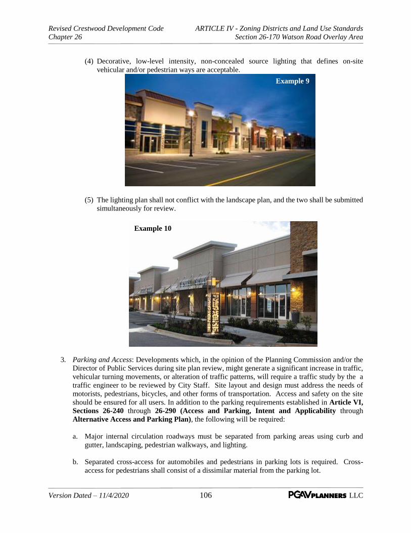
Revised Crestwood Development Code ARTICLE IV - Zoning Districts and Land Use Standards
Chapter 26 Section 26-170 Watson Road Overlay Area
Version Dated – 11/4/2020 106 LLC
(4) Decorative, low-level intensity, non-concealed source lighting that defines on-site
vehicular and/or pedestrian ways are acceptable.
(5) The lighting plan shall not conflict with the landscape plan, and the two shall be submitted
simultaneously for review.
3. Parking and Access: Developments which, in the opinion of the Planning Commission and/or the
Director of Public Services during site plan review, might generate a significant increase in traffic,
vehicular turning movements, or alteration of traffic patterns, will require a traffic study by the a
traffic engineer to be reviewed by City Staff. Site layout and design must address the needs of
motorists, pedestrians, bicycles, and other forms of transportation. Access and safety on the site
should be ensured for all users. In addition to the parking requirements established in Article VI,
Sections 26-240 through 26-290 (Access and Parking, Intent and Applicability through
Alternative Access and Parking Plan), the following will be required:
a. Major internal circulation roadways must be separated from parking areas using curb and
gutter, landscaping, pedestrian walkways, and lighting.
b. Separated cross-access for automobiles and pedestrians in parking lots is required. Cross-
access for pedestrians shall consist of a dissimilar material from the parking lot.
Example 9
Example 10

Revised Crestwood Development Code ARTICLE IV - Zoning Districts and Land Use Standards
Chapter 26 Section 26-170 Watson Road Overlay Area
Version Dated – 11/4/2020 107 LLC
c. Pedestrian cross-access within parking lots shall connect to sidewalks, bike paths, and/or multi-
use paths within the public rights-of-way.
d. Loading and service areas should be located away from street edge and public circulation
patterns.
e. Shared Off-Street Parking for Different Categories of Uses: In order to minimize stormwater
runoff through minimizing paved surfaces, development in the WROA should encourage
situations where shared parking might be appropriate. To encourage this concept and subject
to site plan review by the Planning Commission and written authorization of the City Planner,
business establishments may submit an alternate parking plan in conjunction with the
provisions of Article VI, Section 26-290 (Access and Parking, Alternative Access and
Parking Plan) of this Chapter. The reduction in parking quantities allowed through shared
parking shall be determined as a percentage of the minimum parking requirement as stated in
Article VI, Section 26-260 (Access and Parking, Design Requirements) of this Chapter
and the requirements for alternative parking plans of Section 26-290.
4. Clearance of Existing Improvements: Properties within the WROA that are cleared for future
redevelopment and are not subject to an approved site plan in accord with the provisions of
Subsection (A)(5) above must have properly issued demolition and grading permits requiring all
building and site improvements to be removed as part of the site clearance. In addition, the site
must be properly graded and seeded with grass within sixty (60) days of the completion of the
grading or within a time period specified by the permit (permits) in consideration of the time of the
year. Proper maintenance of the cleared site will be required in accord with the property
maintenance provisions of the Municipal Code.
THE REMAINDER OF THIS PAGE INTENTIONALLY LEFT BLANK
Revised Crestwood Development Code ARTICLE IV - Zoning Districts and Land Use Standards
Chapter 26 Section 26-180 Non-Conforming Situations
Version Dated – 11/4/2020 108 LLC
SEC. 26-180 Non-Conforming Situations
A. Purpose and Intent. The general policy of the City is to allow uses, buildings, and lots that were
created legally and in conformance with then-applicable requirements, but that do not conform to the
current applicable requirements of these regulations to continue. However, it is also the policy of the
City to bring such uses, buildings, and lots into conformance with current regulations as is reasonably
practical. Nonconformities are not to be expanded, and they should be abolished or become
conforming as quickly as the fair interest to the parties will permit. The intent of this section is to
balance the interests of property owners in past investments, discourage investment that expands or
reinforces nonconforming situations, and promote investment consistent with the Comprehensive
Plan and these regulations.
B. Scope of Provisions. The provisions of this division shall apply to all nonconforming uses, lands, and
structures. A nonconforming land use or structure is one which existed lawfully whether by variance
or otherwise, on the date this Chapter or Article or any amendment thereto became effective, and
which fails to conform to one (1) or more of the applicable regulations of this Chapter or such
amendment thereto.
Such nonconformities may be incompatible with and detrimental to permitted land uses and structures
in the zoning districts in which they are situated; they inhibit present and future development of
nearby properties; and they confer upon their owners and users a position of unfair advantage.
C. Nonconforming Uses of Lots. Where, on the date of adoption or amendment of this Chapter, a
lawful use of a parcel or lot exists that is no longer permissible under the provisions of this Chapter or
amendment thereto, such principal use may be continued so long as it remains otherwise lawful
subject to the following provisions:
1. Enlargement. No such nonconforming use of a parcel or lot shall be enlarged, expanded, or
extended to occupy a greater area of land than was occupied on the date of adoption or
amendment of this Chapter and no additional accessory use, building, or structure shall be
established thereon.
2. Relocation. No such nonconforming use of a parcel or lot shall be moved in whole or in part to
any other portion of such parcel or lot not so occupied on the date of adoption of this Chapter or
amendment thereto or to a parcel or lot not in conformance with this Chapter.
3. Discontinuance. If such nonconforming use of a parcel or lot ceases for any reason for a period of
more than one hundred eighty (180) consecutive days (except where government action causes
such cessation) the subsequent use of such parcel or lot shall conform to the regulations and
provisions set by this Chapter for the district in which such parcel or lot is located.
D. Nonconforming Buildings and Structures. Where, on the date of adoption or amendment of this
Chapter, a lawful building or structure exists that could not be built under the regulations of this Chapter
or amendment thereto by reason of restrictions upon lot area, lot width, lot coverage, height, open
spaces, off-street parking, loading spaces and setbacks, or other characteristics, such building or
structure may be continued so long as it remains otherwise lawful subject to the following provisions:
1. Enlargement. Such building or structure may be enlarged, expanded, extended, or altered only if
nonconformity is removed.

Revised Crestwood Development Code ARTICLE IV - Zoning Districts and Land Use Standards
Chapter 26 Section 26-180 Non-Conforming Situations
Version Dated – 11/4/2020 109 LLC
2. Damage. Should any such building or structure be damaged by any means to an extent of more than
fifty (50) percent of its replacement cost at the time of damage, it shall not be reconstructed except
in conformity with the provisions of this Chapter.
3. Relocation. Should any such building or structure be moved for any reason for any distance, it shall
thereafter conform to the regulations of the district in which it is located after it is moved.
E. Repairs and Maintenance.
1. Nothing in this Chapter shall be deemed to prohibit the restoration of any structure and its use
where such structure has been damaged by any means out of the control of the owner to an extent
less than fifty (50) percent of its replacement value (excluding the value of the land, the cost of
preparation of land, and the value of any foundation adaptable to a conforming use) at the time of
damage, provided the restoration of such structure and its use in no way increases any former
nonconformity, and provided further that restoration of such structure is begun within one
hundred eighty (180) days of such damage and diligently prosecuted to completion within two (2)
years following such damage.
2. Whenever such structure has been damaged to an extent of more than fifty (50) percent of its
replacement value (excluding the value of the land, the cost of preparation of land and the value
of any foundation adaptable to a conforming use) at the time of damage, as determined by the
Director of Public Services, or by any means within the control of the owner to any extent
whatsoever, the structure shall not be restored except in full conformity with all regulations of the
district in which such structure is situated.
3. When a structure is determined to be in violation of any applicable health or safety code by the
Director of Public Services under any applicable ordinance of the City and the cost of placing the
structure in condition to satisfy the standards under such ordinance shall exceed fifty (50) percent
of the reconstruction cost of the entire structure, such nonconforming structure shall not be
restored for the purpose of continuing a nonconforming use.
4. None of the restrictions contained in this section shall limit the authority of the Board of Zoning
Adjustment to grant relief for reconstruction of a nonconforming structure, as provided in Article
I, Section 26-020(D) (General Provisions, Administrative Review Bodies, Board of Zoning
Adjustment).
F. Change of Tenancy or Ownership. Provided there is no change in the nature or character, extent or
intensity of such nonconforming use, building, or structure, other than signage, there may be a change
of tenancy, ownership, or management of an existing nonconforming use, building, or structure.
G. Completion of Pending Construction and Building Permits. To avoid undue hardships, nothing in
this Chapter shall be deemed to require a change in plans, construction, or designated use of any
building on which actual construction was lawfully begun prior to the effective date of adoption or
amendment of this Chapter and upon which actual building construction has been carried on
diligently. Nothing herein contained shall require any change in the site plan or designated use of a
building for which a building permit had been heretofore issued or plans or final subdivision plats
which have been approved by the City at the time of the passage of this Chapter or amendment
provided that actual construction is begun within one hundred eighty (180) days of such permit
issuance of approval thereto.

Revised Crestwood Development Code ARTICLE IV - Zoning Districts and Land Use Standards
Chapter 26 Section 26-180 Non-Conforming Situations
Version Dated – 11/4/2020 110 LLC
H. Conditional uses. Any use existing at the time of adoption or amendment to this Chapter and which
is permitted as a conditional use in a district under the terms of this Chapter or amendment thereto
shall be deemed a conforming use in such district and shall without further action be considered a
conforming use.
I. Nonconforming Lots of Record. If through dedication of street right-of-way, the area of any lot or
parcel already established via the provisions of the subdivision regulations is decreased below the
minimum area required in the applicable zoning district, development rights shall not be denied.
J. Existence of Nonconforming Use. A nonconformity shall not be deemed to have existed on the date
this Chapter or any amendment thereto became effective; unless:
1. It was in being on a continuous basis and to its fullest extent on such date.
2. If such nonconformity is a use, such use had not been abandoned.
In cases of doubt, and on specific questions raised, whether a nonconforming use exists shall be a
question of fact and shall be decided by the Board of Aldermen after notice, a public hearing, and
receipt of a report and recommendation of the Planning Commission.
K. Nonconformity as Basis for Variance. The existence of any present nonconformity anywhere in the
City shall not itself be considered grounds for the issuance of a variance for other property.
L. Eventual Removal or Correction of Nonconforming Use. Within five (5) years of the date of the
adoption of this Chapter or the date of adoption of any applicable amendments to this Chapter, any
use which is or becomes a nonconforming use, shall be brought into conformance with the
environmental performance standards established in Article VIII, Section 26-370 (Supplemental
Standards, Environmental Performance Standards). Any use listed in this paragraph need not be
discontinued in the event that the adoption of this Chapter or amendments to this Chapter changes the
status of such use from that of a nonconforming use to that of a permitted use in the district in which
it is located.
THE REMAINDER OF THIS PAGE INTENTIONALLY LEFT BLANK

Revised Crestwood Development Code ARTICLE V -Site and Landscape Design Standards
Chapter 26 Section 26-190 Scope, Purpose, Applicability, Conflicts, and Definitions
Version Dated – 11/4/2020 111 LLC
ARTICLE V – SITE AND LANDSCAPE DESIGN STANDARDS
SEC. 26-190 Scope, Purpose, Applicability, Conflicts, and Definitions
A. Scope. This Article contains the performance standards and regulations pertaining to the landscape
elements of residential, commercial, and industrial properties; requirements for the provision of trees
along public rights-of-way; maintenance requirements for trees and other landscape components
adjacent to public rights-of-way; and administration and enforcement of these regulations.
B. Purpose. The purpose of this division is to establish minimum standards for the provision,
installation, maintenance, and removal of landscape plantings in order to achieve a healthy, visually
pleasing, and safe community by the following means: The purpose of this division is to establish
minimum standards for the provision, installation, maintenance, and removal of landscape plantings
in order to achieve a healthy, visually pleasing, and safe community by the following means:
1. Preservation of vegetation. Preserve existing natural vegetation and the incorporation of native
plants, plant communities, and ecosystems into landscape design, where possible.
2. Aesthetics. Improve the appearance of all areas through the incorporation of open space into
development in ways that harmonize and enhance the natural and built environment.
3. Land values. Maintain and increase the value of land by requiring landscape improvements to be
incorporated into development, thus becoming by itself a valuable capital asset.
4. Human values. Provide direct and important physical and psychological benefits to human beings
through the use of landscape materials to reduce noise and glare, to provide visual diversity and
seasonal interest, and visually soften the harsher aspects of urban development.
5. Improved design. Promote innovative and cost-conscious approaches to the design, installation,
and maintenance of landscaping, encouraging water and energy conservation.
C. Applicability. Except as otherwise specifically provided for herein, this division shall apply to any
existing development seeking to amend a conditional use permit, new development (including
redevelopment), any proposed landscaping change in excess of 20% of the landscaped area of a site,
maintenance and/or replacement of existing trees and landscaping on individual lots in the City; and
to the installation, maintenance, and/or replacement of trees in public rights-of-way or private streets
within all zoning districts.
1. When a landscape plan is required it shall comply with the following requirements and contain
the following elements:
a. A landscape plan for each lot or parcel involved in the proposed development shall be
prepared and sealed by a Missouri registered professional landscape architect.
b. Be drawn to scale, including dimensions and distances, and shall include;
c. Plans drawn at any scale, from one inch equals 20 feet to one inch equals 100 feet, on one
or more sheets not less than 24 inches by 36 inches, nor greater than 36 inches by 48 inches
in size; and shall include a north arrow, scale, date, and revision date block on each sheet;
d. The approximate area of the tract shall be stated in the nearest 0.1 of an acre;
Revised Crestwood Development Code ARTICLE V -Site and Landscape Design Standards
Chapter 26 Section 26-190 Scope, Purpose, Applicability, Conflicts, and Definitions
Version Dated – 11/4/2020 112 LLC
e. Dimensions of the tract;
f. Delineation and widths of streets, alley, or other rights-of-way, including radii of curves,
culs-de-sac, etc.;
g. Building setback lines, including side yard, rear yard, or proper line setback associated with
the tract, in accordance with the applicable zoning district classification and ordinances;
h. The location and identification of all existing trees, bushes, and plantings within the tract,
indicate which are to be removed and preserved;
i. The owners of record of land adjoining the tract; and
j. The proposed use of the tract.
k. Delineate the existing and proposed parking spaces, or other vehicular areas, access aisles,
driveways and similar features;
l. Designate by name and location the plant material to be installed or preserved in
accordance with the requirements of this division;
m. Identify and describe the location and characteristics of all other landscape materials to be
used;
n. Show all landscape features, including areas of vegetation to be preserved, in context with
the location and outline of existing and proposed buildings and other improvements on the
site, if any;
o. Include a tabulation clearly displaying the relevant statistical information necessary to
evaluate compliance with the provisions of this Article. This includes gross acreage, area
of preservation areas, number of trees to be planted or preserved, square footage of paved
areas, and such other information as required;
p. An irrigation plan indicating the location of sprinklers or water outlets; and
q. Contain such other information that may be required that is reasonable and necessary to
determine that the landscape plan meets the requirements of this Article.
D. Conflicts. If the provisions of this Article conflict with other sections of this Article or other
ordinances or regulations, the more stringent limitation or requirement shall govern or prevail to the
extent of the conflict.
E. Definitions. The following definitions shall apply in interpretation and enforcement of this division
unless otherwise specifically stated:
Buffer, Perimeter Landscape
A continuous area of land set aside along the perimeter of a lot in which plant materials may be used to
provide a transition between, and to reduce the environmental, aesthetic, and other impacts of, one type of
land use upon another.

Revised Crestwood Development Code ARTICLE V -Site and Landscape Design Standards
Chapter 26 Section 26-190 Scope, Purpose, Applicability, Conflicts, and Definitions
Version Dated – 11/4/2020 113 LLC
Caliper
The thickness (diameter) of a tree trunk, when measured 6” above the ground for trees less than 4” and
12” above the ground for trees greater than 4”.
Canopy Tree
A self-supporting woody plant of a species normally growing in the St. Louis metropolitan area to a
mature height of not less than 20 feet and a mature spread of not less than 15 feet.
Critical Root Zone (CRZ)
The area of tree roots within the crown dripline. This zone is generally defined as the area underneath a
tree's canopy, extending from the tree's trunk to a point no less than the furthest crown dripline.
Cultivar
An assemblage of cultivated plants which is clearly distinguished by any characters (morphological,
physiological, cytological or chemical) and which, when reproduced (sexually or asexually), retains its
distinguishing characteristics.
Cultivated Landscape Area
Planted areas that receive routine maintenance, such as mowing, irrigating, pruning, fertilizing, and
similar routine maintenance, so as to ensure healthy plants and a well-kept appearance.
Diameter at Breast Height (DBH):
The diameter of the trunk of a tree, in inches of diameter, measured at breast height four and one-half
(4.5) feet above the original soil or natural grade. If a tree forks or separates into two (2) or more trunks
below four and one-half (4.5) feet, then the trunk is measured at its narrowest point below the fork.

Revised Crestwood Development Code ARTICLE V -Site and Landscape Design Standards
Chapter 26 Section 26-190 Scope, Purpose, Applicability, Conflicts, and Definitions
Version Dated – 11/4/2020 114 LLC
Drip Line
A vertical line extending from the outermost branch tips of a tree to the finished grade below.
Ground Cover
Plants, other than turf grass, normally reaching an average maximum height of not more than 24 inches at
maturity.
Hedge
A landscape barrier consisting of a continuous, dense planting of woody vegetation which may be either
composed of trees or shrubs.
Irrigation System
A permanent, automatic artificial watering system installed below grade designed to transport and
distribute controlled amounts of water to plants.
Landscape Features
Any combination of nonliving landscape material, such as rocks, pebbles, sand, mulch, walls, fences or
decorative paving materials.
Landscape Plantings
Any combination of living plants, such as grass, ground cover, shrubs, vines, perennials, or trees.
Mulch
Nonliving organic or rock materials customarily used in landscaping designed to retain moisture, stabilize
soil temperatures, control weed growth, and retard erosion.
Plant Community
A natural association of plants that are dominated by one or more prominent species, or a characteristic
physical attribute.

Revised Crestwood Development Code ARTICLE V -Site and Landscape Design Standards
Chapter 26 Section 26-190 Scope, Purpose, Applicability, Conflicts, and Definitions
Version Dated – 11/4/2020 115 LLC
Shrub
A self-supporting woody perennial plant of low to medium height characterized by multiple stems and
branches continuous from the base, usually not more than 10 feet in height at its maturity.
Site-Specific Planting
The selection of plant materials which are particularly well-suited to withstand macro and micro climate
conditions that are specific to that location.
Species
A unit or group of similar individual plants within a greater genus sharing the same traits. For example.
Q.alba, White Oak.
Topping
The severe cutting back of limbs to stubs larger than three inches in diameter with the tree's crown to such
degree so as to distort the normal canopy shape, thus disfiguring the tree.
Understory Plant Material
Assemblages of natural low-level woody, herbaceous, and ground cover species which exist in the area
below the canopy of the trees.
Understory Tree
Any self-supporting woody plant which normally attains an overall height of no more than 30 feet at
maturity, usually with one main stem or trunk and many branches. It may appear to have several stems or
trunks in several species.
Variety
A term used in the botanical sense to constitute a group or class of plants subordinate to a species (e.g.,
subspecies). See definition for cultivar, sometime used interchangeable with cultivar.
Viable
When referring to a tree, shrub, or other type of plant, is a plant that, in the judgment of the Director of
Public Services or his/her designated representative, is capable of sustaining its own life processes,
unaided by man, for a reasonable period of time.
THE REMAINDER OF THIS PAGE INTENTIONALLY LEFT BLANK

Revised Crestwood Development Code ARTICLE V -Site and Landscape Design Standards
Chapter 26 Section 26-200 Landscape Design Standards
Version Dated – 11/4/2020 116 LLC
SEC. 26-200 Landscape Design Standards. The following standards shall be considered the minimum
requirements for the installation of all plant materials on lots or within public rights-of-way in all zoning
districts:
A. Size; digging.
1. Size specifications. Unless otherwise stated in this division, all size specifications for plant
materials shall be based upon the time of planting. When minimum caliper is specified for tree
plantings, the caliper of the tree trunk shall be taken at six inches above the ground level, up to
and including four-inch caliper size, and 12 inches above ground for larger sizes.
2. Digging in street rights-of-way or easements. It shall be the responsibility of the person planning
to install plant materials, within a street right-of-way or a utility easement, to notify any utility
company or public agency having any underground utilities within such right-of-way or
easement. This notification shall take place prior to any digging and all work shall be in
accordance with any rules and regulations as provided for by local or state law or by regulations
of the utility companies or public agency.
B. Minimum tree and shrub planting or preservation requirements.
1. Interference. Trees shall not be placed where they interfere with site drainage or where they shall
require frequent pruning in order to avoid interference with overhead utility lines.
2. Acceptable tree species, cultivars, or varieties. Trees planted on existing developed sites, in
conjunction with new developments and within public rights-of-way within all zoning districts,
shall be of the species, cultivars, or varieties listed in tables 1 through 4, on file with the City,
except as otherwise provided herein. The species, cultivar, and/or variety which are listed in table
4 are not acceptable for planting within the public rights-of-way due to susceptibility to salt
damage, potential for impeding sight-distance visibility, susceptibility to disease, potential for
growth into street pavement areas, and other potentially undesirable effects of such plantings. The
Director of Public Services shall have the right, from time to time, to modify, delete or add to the
species, cultivars or varieties listed in such tables.
2. Undesirable tree species, cultivars, or varieties. In order to protect the City's existing trees from
disease, to ensure that the species and varieties of trees which are planted will grow and be
healthy, will be resistant to storms, and do not present other undesirable effects, the trees listed on
file with the City, shall not be planted on existing development sites, in conjunction with new
developments or within public rights-of-way in any zoning district, except upon the approval of
the Planning Commission. The Planning Commission may allow for such exceptions where it is
demonstrated that such plantings will not be a detriment to adjoining streets, other nearby
property or the trees thereon.
3. Landscape materials.
a. Tree planting. Immediately upon planting, all trees shall conform to the American Standard
for Nursery Stock, published by the American Association of Nurserymen, Inc., as revised
from time to time, and have the following characteristics:
(1) In all residential zoning districts, all medium to large canopy trees shall be a minimum of
10 feet in height and shall have a minimum caliper of two inches. In all C-1 and M-1
districts, all medium to large canopy trees shall be a minimum of 12 feet in height and
shall have a minimum caliper of three inches.
Revised Crestwood Development Code ARTICLE V -Site and Landscape Design Standards
Chapter 26 Section 26-200 Landscape Design Standards
Version Dated – 11/4/2020 117 LLC
(2) All small understory trees shall be at least five feet in height, except where they are
fulfilling the requirement as a landscape buffer, in which case they shall be a minimum of
eight feet in height and shall have a minimum caliper of two inches.
b. Tree species mix. When more than 10 trees are to be planted to meet the requirements of this
division, at least two different species shall be provided.
4. Landscape plantings within or near street rights-of-way. In any zoning district where trees are to
be planted within or near a street right-of-way, the following standards shall apply:
a. Sight-distance triangle on private property. On a corner lot, development shall conform to the
requirements of a sight-distance triangle in which nothing shall be erected, placed, planted, or
allowed to grow between a height of two feet and 10 feet above the grades at the back of the
curb (or edge of pavement where no curb exists) of the intersecting streets, within the
triangular area formed by the right-of-way lines and a line connecting them at points 40 feet
from their point of intersection, or at equivalent points on private streets, except that the
sight-distance triangle may be increased, when deemed necessary for traffic safety, by the
Director of Public Services.
b. Sight-distance clearance within right-of-way. No tree or other landscape plantings exceeding
two feet in height at maturity shall be planted in public rights-of-way closer than 40 feet of
any street corner, measured from the point of intersecting curbs or edge of pavement. The
point of intersection is where the projection of a straight line along such curb or edge of
pavement of each street intersects with each other.
c. Plantings near fire hydrants. No shrubs or trees shall be located within 10 feet of a fire
hydrant.
d. Minimum distance between street and sidewalk. In no event shall a tree be planted where the
clear space between the curb and a sidewalk is less than four feet, except where authorized by
the Director of Public Services or his/her designated representative. Where there is space
between the curb, or edge of pavement, and sidewalk of not less than four feet, street trees
may be planted. Such street trees shall be placed midway between the curb, or edge of
pavement, and sidewalk wherever practical.
e. Street trees between street and sidewalk-medium canopy. Where the planting area between
the curb or edge of the roadway pavement and the edge of a sidewalk is limited to a width of
between four and five feet, only medium canopy trees shall be planted, except as provided for
in Subsection 8 below.
f. Street trees between street and sidewalk-large or medium canopy. Where the planting area
between the curb or edge of the roadway pavement and the edge of the sidewalk is greater
than five feet, medium and/or large canopy trees shall be planted, except as provided for in
Subsection 8 below.
g. Street trees where no sidewalk exists. On parcels of land where no sidewalk exists, the
required canopy trees shall be planted in an area not more than four feet nor less than three
feet from the back of the curb or the edge of street pavement.
h. Interference with overhead utility wires. In instances where canopy trees of either medium or
large size are likely to cause interference with overhead utility wires (as determined by the

Revised Crestwood Development Code ARTICLE V -Site and Landscape Design Standards
Chapter 26 Section 26-200 Landscape Design Standards
Version Dated – 11/4/2020 118 LLC
Director of Public Services or his/her designated representative), understory trees may be
acceptable for planting.
i. Tree plantings prohibited near public right-of-way. No tree of any type shall be planted on
private or public property within five feet of the right-of-way of any public street.
5. Required landscaping alongside lot lines. Except as otherwise provided for in these regulations,
landscape plantings of at least five feet in width shall be required along each side lot line. The
same shall apply to rear lot lines of corner lots, between the street and the established building
setback line. Such restrictions shall not apply where there is an existing driveway within such five
feet on a residential lot, which is being replaced.
C. Plant material installation. The following standards shall apply to all landscape installation projects
subject to regulation by this division:
1. Soil conditions. Soil utilized for the growing medium of plant materials shall be friable, well-
drained, local soil, capable of sustaining plant life. Areas which have been compacted by
construction activities shall be thoroughly cultivated to the full depth of the compaction. Soil
utilized for planting within these areas may be existing soil, provided it is friable, well-drained,
free of construction debris including, but not limited to, scrap wood, trash, chemical/oil spills,
excess paving materials, crushed rock, sand, natural site stones greater than one inch, mortar, and
all other non-soil materials.
2. Mulch. Organic mulches shall be used to reduce the growth of weeds, add nutrients to the soil,
and retain moisture over the root zones of plant materials. When appropriate, a minimum of three
inches of organic mulch shall be placed beneath all newly installed tree, shrub, and ground cover
planting areas. At no time shall rock of any size or variety be placed around any existing or newly
planted tree located in a public right-of-way.
3. Topsoil. The top four inches of the lawn bed for all areas to be seeded or sodded shall be topsoil.
D. Additional requirements in C-1 and M-1 districts.
1. Requirements for areas adjacent to streets.
a. A sufficiently landscaped strip of at least 10 feet in width shall be provided and maintained
within the required thirty-foot front yard and shall separate the off-street parking and drive
areas from any public or private street.
b. All landscaping within a C-1 or M-1 zoning district shall conform with an approved
landscape plan as detailed in Section 26-190 (C) (Scope, Purpose, Applicability and
Conflicts, Applicability) of this Article.
2. Requirements for off-street parking areas.
a. For any parking area containing more than five spaces, a minimum of 20 square feet of
interior landscaped area shall be provided within the parking lot for each parking space.
Landscape areas shall be uniformly distributed in one or more areas so as to break up the
apparent expanse of the paved parking areas. In order to qualify as interior landscaped area,
such area shall be located wholly within or projecting inward from the perimeter of the
parking area the landscaped strip, as required under subsection 1.a. above, shall not qualify as

Revised Crestwood Development Code ARTICLE V -Site and Landscape Design Standards
Chapter 26 Section 26-200 Landscape Design Standards
Version Dated – 11/4/2020 119 LLC
interior landscaped area. This requirement may be waived by the Planning Commission if the
Commission determines that there is not sufficient parking space available.
b. There shall be a minimum of one planting island, within and up to every 100 linear feet of
parking for each parking row. This requirement may be waived by the Planning Commission
if the Commission determines that there is not sufficient parking space to meet such a
requirement. Such islands shall be spaced evenly wherever possible and the ends of parking
rows abutting a circulation aisle shall be defined by a planting island wherever feasible.
These planting island areas shall be protected from vehicular encroachment by non-
mountable, reinforced concrete curbing of a type specified by the Director of Public Services.
The use of unreinforced extruded curbing of asphalt or other materials is prohibited.
c. Planting islands shall not be less than 90 square feet in area and eight feet wide, as measured
from back of curb to back of curb.
d. In instances where vehicle parking occurs perpendicular or parallel to parking islands, no
landscape plantings, other than low profile ground cover (grass, ivy, creeping juniper, wood
mulch, or similar materials), shall be installed within 18 inches of the back of the curb.
e. No landscape hedge, bushes, shrubs, or other low-growing plant material, wall or berm shall
exceed three feet in height within 90 feet of any driveway opening.
3. Buffer requirements. Where any parcel abuts any residential district or development, a fifty-foot
perimeter landscape buffer and a solid masonry fence six feet in height shall be provided and
maintained along all rear and side property lines where it abuts the residential district or
development. The buffer area shall contain evergreen plant material with a minimum height of
eight feet, planted in such a manner to achieve an effective spacing of six-foot on center. The
height of such fence and evergreen plant material may be reduced if used in conjunction with a
berm whose height in combination with the fence will achieve the standard specified herein. The
berm shall not exceed a slope of 30° and shall be completely covered with shrubs, grass, or other
living ground cover, in addition to the evergreen plant material specified herein.
4. Sodding requirements. All soil on the site which is not to be covered by buildings, parking and
loading areas, and driveways, and which is not subject to other landscape treatment in accord
with an approved site plan, shall be graded in accord with such site plan and covered with sod.
5. Irrigation. Landscaped areas shall be provided with adequate irrigation for the maintenance of
grass, shrubs, ground cover and other plant materials by utilizing a sprinkler system, hose bibs,
and/or such other method of providing water.
E. Additional requirements in R-1 through R-5 districts.
1. Street trees between street and sidewalk. New construction should have at least one canopy tree
for each 40 feet of frontage on a public or private street shall be installed in the area between the
sidewalk and the street edge or curb and shall be installed in accordance with the standards
provided for in this division.
2. Nonconforming situations. In circumstances where existing parcels meeting the standard
prescribed in subsection a above become nonconforming as a result of the loss of a canopy tree
due to storm damage, disease, or other means, the nonconforming condition shall be corrected as
soon as weather and planting conditions permit. Any tree which replaces an existing tree shall be

Revised Crestwood Development Code ARTICLE V -Site and Landscape Design Standards
Chapter 26 Section 26-200 Landscape Design Standards
Version Dated – 11/4/2020 120 LLC
selected and installed in accordance with the standards provided for in this division. The parties
responsible for correcting the nonconforming condition shall be as follows:
a. In such instances where public right-of-way is involved, the City shall be responsible for
correcting the nonconforming condition, except in instances where the property owner has
caused or condoned the damage; or
b. In such instances where private right-of-way is involved, the property owner shall be
responsible for correcting the nonconforming condition.
F. Maintenance
1. Maintenance Standards for trees and cultivated landscape areas. The following standards shall
apply to the maintenance of cultivated landscape areas, as defined in this division, and in public
rights-of-way in all zoning districts, unless otherwise specifically stated: a. Maintenance responsibility. The owner of land shall be responsible for the maintenance of all
landscape plantings located on his/her land and within the right-of-way to which the land
abuts, except for trees planted by the City within a public right-of-way. Trees planted by the
City and located within public rights-of-way shall be maintained by the City. All required
landscape plantings shall be maintained in a healthy and neat condition.
b. Vertical clearance requirements. In order to assure the safe and unimpeded progress of
emergency and street maintenance vehicles, all trees, plants and shrubs that are within or
adjacent to and overhanging any street, highway, road or thoroughfare shall be maintained to
have the following vertical clearances (when fully leafed):
i. A minimum height of 14 feet above the center line of the street, highway, road or
thoroughfare; and
ii. A minimum height of 12 feet above the curb, or edge of pavement (when no curbing is
present), of the street, highway, road or thoroughfare.
c. Removal or pruning of landscape plantings representing hazards or obstructions.
i. Diseased or damaged trees. Any dead or diseased tree, on private property or within
public rights-of-way, which constitutes a hazard to life or property; is diseased or infested
with destructive insects or fungi; or is injurious to sewers, electric power lines, gas lines,
water lines, or other public improvements shall be removed.
ii. Obstructions. It shall be the responsibility of the property owner to remove any trees,
shrubs, or parts thereof, which are planted on their property and which overhang or
interfere with traffic control devices, street lighting, public sidewalks, rights-of-way, or
property owned by the City.
iii. Removal or pruning order. The Director of Public Works, or the Director's designated
representative, shall have the authority to order the pruning or removal of any tree or part
thereof on private property or within a public right-of-way, which is in violation of the
regulations and standards contained in this division.
d. Stump removal. The stumps of all removed trees shall be ground out to at least three inches
below the ground level, the chips removed, the soil cavity filled with soil, and the area
Revised Crestwood Development Code ARTICLE V -Site and Landscape Design Standards
Chapter 26 Section 26-200 Landscape Design Standards
Version Dated – 11/4/2020 121 LLC
leveled. If the area where the tree is removed is to be paved, the top of the stump shall be
ground out to at least six inches below the ground level.
e. Required replacement of trees. Any existing trees or vegetation that satisfy the requirements
of this division which are removed shall be replaced with plantings which are of acceptable
type and species and in locations which comply with the provisions of this division and any
previously approved site and landscape plan. Such replacement shall take place within six
months of notification from the Director of Public Works, or the Director's designated
representative. Where such replacement involves properties within a C-1 or M-1 district, a
landscape plan shall not be required if the replacement plantings match a previously
approved landscape plan. If replacement will significantly vary from an approved landscape
plan, a new plan may be required.
f. Pruning.
i. All pruning should be accomplished according to standard horticultural practices.
ii. Trees may be periodically pruned or thinned in order to reduce the leaf mass and thus
increase visibility to the site and/or minimize damage from storms. Trees severely
damaged by storms or other causes, or trees under utility wires or other obstructions where
standard horticultural pruning practices are impractical, may be exempted from this
prohibition at the determination of the Director of Public Works, or the Director's
designated representative.
g. Mowing. Grass shall be limited to a height below the height designated as a public nuisance
in the City Code.
2. Procedures upon order to prune or remove.
a. In conjunction with the provisions of Subsection (F)(1) above, the following procedures shall
apply:
i. Written order. When the Director of Public Works, or the Director's designated
representative, finds it necessary to order the pruning or removal of trees or plants upon
private property, as provided for herein, then he/she shall serve a written order upon the
property owner to correct the condition creating danger, hazard, or obstruction. The order
required herein shall be served by at least one of the following methods:
a. By personal delivery of the order to the property owner of record;
b. By mailing a copy of the order to the address of the owner of the property based on
the most recent address on file in the office of the county assessor;
c. If the property owner cannot be located for service by the means specified in
subsections a and b above, then a copy of the order shall be posted on the property.
b. Time limit for compliance. The order required herein shall set forth a time limit for
complying with such order, which shall not be earlier than seven days from the date of the
order, except as provided for herein. Upon discovery of hazardous conditions which present
extreme danger to persons or property, the Director of Public Works, or the Director's
Revised Crestwood Development Code ARTICLE V -Site and Landscape Design Standards
Chapter 26 Section 26-200 Landscape Design Standards
Version Dated – 11/4/2020 122 LLC
designated representative, shall have the authority to require forthwith compliance
immediately upon service of the order.
c. Failure to comply with order. When a property owner to whom an order is directed fails to
comply within the specified period of time, the Director of Public Works, or the Director's
designated representative, shall remedy the condition or contract with others for such purpose
and charge the cost thereof to the person or party.
d. Immediate action by City. When, in the opinion of the Director of Public Works or the
Director's designated representative, there is an actual and imminent danger from a damaged
or diseased tree which would endanger life, or when any tree, or any part thereof, has fallen
and life is endangered, the Director of Public Works or the Director's designated
representative is authorized and empowered to take whatever action as may be necessary to
render the tree or part thereof temporarily safe, whether or not the notice procedure as
previously described in this section has been instituted.
e. Special assessment. The costs incurred in the performance of any procedure required as a
result of conditions as outlined in Subsections (3) and (4) above shall be billed to the owner
of the real property where such work is performed. If such bill is not paid within 30 days after
forwarding a statement therefor by the Director of Public Works, or the Director's authorized
representative, the costs shall be levied against the property, upon which such work was
performed, as a special assessment. The levying of the assessment herein shall not affect the
liability of the persons or parties where such work was performed. Such special assessment
shall be certified by the Director of Public Works to the City Clerk and shall thereupon
become and be a lien upon the property and shall be included in the next tax bill rendered to
the owner thereof unless paid before, and shall be collected in the same manner as other taxes
against the property.
3. Interference. It shall be unlawful to delay, or in any manner interfere with, the Director of Public
Works, or the Director's designated representative, in planting, pruning, spraying or removing
any tree, shrub, vine, or other plant in any public street, boulevard, alley, park, or other public
place, or in the removal of any stone, cement or other material from about the trunk thereof; to
interfere with or delay the Director of Public Works, or the Director's designated representative,
in the removal of dangerous or diseased trees on private property as provided for herein in
Subsection (F)(1); or to interfere with the Director of Public Works, or the Director's designated
representative, in the discharge of duties provided for in this division.
4. Replacement of landscaping within public right-of-way. If, as the result of the violation of any
provision of this division, the injury, mutilation, or death of a tree, shrub, or other plant located
within a public right-of-way is caused, the cost of repair or replacement of such tree, shrub, or
other plant shall be borne by the person or persons in violation. The replacement value of trees
and shrubs shall be determined in accordance with the latest revision of "A Guide to the
Professional Evaluation of Landscape Trees, Specimen Shrubs, and Evergreens," as published by
the International Society of Arboriculture and as revised from time to time.
THE REMAINDER OF THIS PAGE INTENTIONALLY LEFT BLANK

Revised Crestwood Development Code ARTICLE V -Site and Landscape Design Standards
Chapter 26 Section 26-210 Fencing
Version Dated – 11/4/2020 123 LLC
SEC. 26-210 Fencing. Fences may be erected on residential lots and in commercially and industrially-
zoned districts in the City subject to the following provisions of this Section and any other applicable
provision of this Chapter.
A. Where Erected. In residential and commercial districts fencing can be erected as follows:
1. Decorative and/or decorative sight-proof fences not more than six feet in height generally of the
types as shown in Figure 26-210 A may be located only within rear or side yards and are
prohibited from extending beyond the front building line. On corner lots having two “front yards”
(double frontage), fences may be located within the front yard deemed to be the side yard based
on the street frontage that the primary building entry faces.
Figure 26-210 A - Examples of Fence Types
Examples of Decorative Sight Proof Fences – Not to Exceed a Height of Six (6) Feet
Examples of Decorative Fences (open panel) – Not to Exceed a Height of Six (6) Feet

Revised Crestwood Development Code ARTICLE V -Site and Landscape Design Standards
Chapter 26 Section 26-210 Fencing
Version Dated – 11/4/2020 124 LLC
2. In residential districts and commercial districts which abut residential property, chain-link fencing
is permitted but must be vinyl-coated or powder-coated in black or other earth-tone colors such as
brown, tan, or dark green.
3. On corner lots, fences of any type may not be located in front of the building lines along the side
street in order to preserve a sight triangle as required by Article II, Section 26-040 (Definitions,
Defined Terms) of this Chapter. Figure 26-210 B shows permitted fence locations. A fence
with a setback of one (1) foot from the street right-of-way line provided that there are no
driveways facing such street within the same block. In such case a fence should be set back ten
(10) feet from the street right-of-way line.
10’
Setback
from
street
ROW
Driveway
1’ Setback from
street or sidewalk
30’
30’ 30’

Revised Crestwood Development Code ARTICLE V -Site and Landscape Design Standards
Chapter 26 Section 26-210 Fencing
Version Dated – 11/4/2020 125 LLC
4. All new or replacement fences shall be constructed with cross-framing and other structural support
which would comprise the “back” of a fence to face within or toward the area to be enclosed. This
standard is intended to apply to typical wood fencing panels and is not applicable to aluminum,
steel, wrought iron, or vinyl fencing systems where the structural components are part of the post
and panel system or to “board on board” wooden fencing where the vertical boards alternate to the
front and back side of the horizontal cross members.
5. No new fences shall be constructed of materials such as chicken coop wire, barbed wire, or bamboo.
Uncoated chain link fencing may be permitted in industrial areas; however, such fences may not
be topped by barbed wire or razor wire without receiving approval by formal action of the Planning
Commission.
6. All fences shall be kept in good repair and, if of a type other than non-rusting material, shall be
properly painted or preserved.
7. Any person, business, or entity who desires to erect a fence within the City shall file an application
for a fence permit with the Department of Public Services. Such application shall contain
information concerning the proposed dimensions and location of such fence to be constructed on
the property by depiction on a plat of the property or other drawing the clearly delineates the
location. This application information shall include the materials from which the fence is to be
constructed which can be provided in the form of photos or similar installations or manufacturer
cut sheets for the particular fence type or style. If the proposed fence appears to conform to the
provisions of this section, the Department of Public Services shall issue a permit. The application
fee shall be as established by the Board of Aldermen in accord with the provisions of this Chapter
or other applicable City code.
8. It shall be the duty of the Director of Public Services, or his/her designee, to enforce the provisions
of this section. Whenever the Director of Public Services or designee determines that a person is
violating the provisions of this section, he shall give notice of such alleged violation which shall:
a. Be in writing;
b. Be served upon the person, his agent, or a member of his immediate family personally, or
delivered by registered or certified mail to his last known address;
c. Contain a statement of the reason why it is being issued;
d. Contain a statement concerning what action should be taken to effect compliance with this
section; and
e. Allow a reasonable time for the performance of any act necessary to effect compliance.
9. When a person subject to the provisions of this section can show that the strict application of the
terms hereof will substantially impair the reasonable use and enjoyment of property, such person
may apply for an exception to the provisions of this section by filing a written application with the
Planning Commission. The Planning Commission shall conduct a hearing on said application after
written notice is sent to the owners of all property abutting the property upon which the fence is
sought to be erected by first class mail.
The Planning Commission may consider and allow exceptions from the strict application of this
section if such exceptions are in harmony with the purpose and intent of this section, and if they

Revised Crestwood Development Code ARTICLE V -Site and Landscape Design Standards
Chapter 26 Section 26-210 Fencing
Version Dated – 11/4/2020 126 LLC
will not be injurious to the surrounding property or otherwise detrimental to the public welfare,
taking into account the location of the property, the permitted uses of the property and nearby
properties, the prevailing traffic conditions on adjoining roadways and in the vicinity, and the
configuration of the property and improvements thereon.
In granting an exception, the Planning Commission or the designated committee may attach such
conditions as they deem necessary relating to location, design and landscaping to mitigate the
impact of the fence exception on the adjoining property or general neighborhood.
THE REMAINDER OF THIS PAGE INTENTIONALLY LEFT BLANK
Revised Crestwood Development Code ARTICLE V -Site and Landscape Design Standards
Chapter 26 Section 26-220 Site Lighting
Version Dated – 11/4/2020 127 LLC
SEC. 26-220 Site Lighting. In addition to the regulations established for the Watson Road Overlay Area
as set forth in Article IV, Section 26-170(E)(2)(k) (Zoning Districts and Use Standards, Watson Road
Overlay Area, Development Requirements, guidelines and standards, Site Design, Lighting) the
following site lighting standards and shall apply to all uses within the Watson Road Overlay Area, C-1
and M-1 districts and to all PD-C, PD-MXD developments, including all new developments, amendment
of an approved site plan, amendment of a conditional use permit, or any lighting change to an existing
development, involving new fixtures, standards, heads or luminaires.
A. General standards.
1. Site lighting shall include all lighting on property, other than lighting within a fully enclosed
building, provided that site lighting shall include interior lighting when used as accent lighting, as
provided in Subsection (A)(8) of this Section.
2. Site lighting fixtures shall be compatible with the building design and the adjoining landscape and
shall not be used in such a manner as to turn the building itself into "signage".
3. Excessive brightness of site lighting shall be avoided.
4. Site lighting shall not spill over to adjacent sites or properties.
5. Site lighting shall not create glare which is directed toward or reflected onto adjoining properties.
6. Site lighting shall not create glare which is directed toward or reflected onto streets, or interior
drives where such glare could negatively impact vehicular or pedestrian safety.
7. Except as may be provided elsewhere in this section, site lighting shall at no time be directed
upward, in a radiating and/or moving or sweeping pattern, or at any angle which will light
surfaces other than building walls, parking or pedestrian areas, and landscaped areas, and shall
not create lighting patterns which will direct light toward residential areas.
8. Except as may be authorized in Article VII (Sign Regulations), of this Chapter, the use of tube
lighting of any singular static color may be utilized as accent lighting in any location on the site,
including the exterior of a building or around any window as long as the lighting is recessed and
the tubing would not be visible from the street.
9. At the time of filing any application for any use, development, amendment or change as set out in
subsection (a) hereof, a lighting plan for site lighting shall be provided on a separate sheet. The
following information shall be submitted as part of the lighting plan:
a. Manufacturer's catalog cut sheet or other graphic and narrative description of the light
standards, fixture heads, and/or luminaires with specification data.
b. Photometric curves indicating both vertical and horizontal candle-power distribution.
c. A plan of the site superimposed with a grid of not more than twenty (20) feet between light
sources showing the calculated foot-candle levels at average site grade at the center of each
twenty-foot grid.
10. All site lighting shall be installed utilizing underground cable.
Revised Crestwood Development Code ARTICLE V -Site and Landscape Design Standards
Chapter 26 Section 26-220 Site Lighting
Version Dated – 11/4/2020 128 LLC
B. Illumination standards.
1. Except as otherwise provided in the following provisions of this section, all parking and loading
areas and walkways shall be illuminated so as to produce a uniform minimum average
illumination within such areas of two (2) foot-candles of illumination, measured at the ground
level.
2. Lighting fixtures or standards without cutoff-type luminaires or with globe-style luminaires shall
be no higher than fifteen (15) feet and shall have a maximum illumination output of not more
than ten thousand (10,000) lumens.
3. Lighting fixtures or standards with a cutoff-type luminaire shall be no higher than twenty-five
(25) feet with a maximum average illumination of the property, measured at ground level over the
site, of five (5) foot-candles.
4. Except as may be otherwise approved by the planning and zoning commission, where parking
and loading areas are adjacent to residential areas, the maximum average illumination of the area
between the rear building wall line and the property line abutting a residential area shall be one
(1) foot-candle measured at ground level over the site, provided that at the property line abutting
a residential area, the maximum illumination of the property shall be no higher than one-tenth
(0.1) foot-candle.
5. Where parking or loading areas abut residential property, the fixture head shall be of an
appropriate type which controls the lighting pattern and shields such residential property from
direct view of the light source. In order to achieve this end, reflector shields may be required for
fixture heads.
6. Globe-style fixture heads (including other shapes such as acorn or cylinder styles) may only be
used as decorative accents along the front of properties or buildings which face bordering streets
which are occupied by, or zoned for, commercial or light industrial uses and where adjoining uses
on the same side of the street are not residential. No such fixtures shall be located in any side or
rear yard. Globe-style fixture heads shall be of the types which are frosted or translucent so that
the bulb lighting source is not visible and that emitted light is diffused.
THE REMAINDER OF THIS PAGE INTENTIONALLY LEFT BLANK

Revised Crestwood Development Code ARTICLE V -Site and Landscape Design Standards
Chapter 26 Section 26-230 Stream Buffer Protection
Version Dated – 11/4/2020 129 LLC
SEC. 26-230 Stream Buffer Protection. In addition to any applicable requirements of Article IX, Section
26-440 (Subdivisions and Land Development, Land Development Standards) relating to storm water
drainage, regulations for providing stream buffer protection shall apply to all land development activity as
provided for in this Section.
A. Purposes. The purpose of this division is to protect the public health, safety, environment and general
welfare; to minimize public and private losses due to erosion, siltation and water pollution; and to
maintain stream water quality by provisions designed to:
1. Create buffer zones along the streams within the city for the protection of water resources;
2. Minimize land development within such buffers by establishing buffer zone requirements and by
requiring authorization for any such activities;
3. Protect, restore, and maintain the chemical, physical and biological integrity of streams and their
water resources;
4. Remove pollutants delivered in urban stormwater;
5. Reduce erosion and control sedimentation;
6. Protect and stabilize stream banks;
7. Provide for infiltration of stormwater runoff;
8. Maintain base flow of streams;
9. Contribute organic matter that is a source of food and energy for the aquatic ecosystem;
10. Provide tree canopy to shade streams and promote desirable aquatic habitat;
11. Provide riparian wildlife habitat;
12. Furnish scenic value and recreation opportunity; and
13. Provide opportunities for the protection and restoration of greenspace.
B. Applicability. This Section shall apply to land development activity involving new subdividing and
platting activities on property containing a stream protection area as defined in subsection(C) of this
Section. These requirements are in addition to, and do not replace or supersede, any other applicable
buffer or flood plain requirements established under State law, this Chapter, or City ordinance and
approval or exemption from these requirements do not constitute approval or exemption from buffer
requirements established under state law or city ordinance or from other applicable local, state or federal
regulations.
1. Exceptions. This division shall not apply to the following activities:
a. Work consisting of the repair or maintenance of any lawful use of land that is zoned and
approved for such use on or before the effective date of this division.
b. Existing development and ongoing land disturbance activities including but not limited to,
existing agriculture, silviculture, landscaping, gardening and lawn maintenance, except that

Revised Crestwood Development Code ARTICLE V -Site and Landscape Design Standards
Chapter 26 Section 26-230 Stream Buffer Protection
Version Dated – 11/4/2020 130 LLC
new development or land disturbance activities on such properties will be subject to all
applicable buffer requirements.
c. Any land development activity that is under construction, fully approved for development,
scheduled for permit approval or has been submitted for approval as of the effective date of
this division.
d. Land development activity that has not been submitted for approval, but that is part of a larger
master development plan, such as for an office park or other phased development that has been
previously approved within two (2) years of the effective date of this division.
e. Redevelopment within a residential or commercial property which currently encroaches within
the stream buffer so long as improvements do not exceed the existing encroachment.
2. Exemptions. The following specific activities are exempt from this division. Exemption of these
activities does not constitute an exemption for any other activity proposed on a property.
a. Activities for the purpose of building one (1) of the following:
1. A stream crossing by a driveway, transportation route or utility line;
2. Public water supply intake or public wastewater structures or stormwater outfalls;
3. Intrusions necessary to provide access to a property;
4. Public access facilities that must be on the water including boat ramps, docks, foot trails
leading directly to the river, fishing platforms and overlooks;
5. Unpaved foot trails and paths;
6. Activities to restore and enhance stream bank stability, vegetation, water quality and/or
aquatic habitat, so long as native vegetation and bioengineering techniques are used; or
7. Municipal public improvements.
b. Public sewer line easements. This includes such impervious cover as is necessary for the
operation and maintenance of the utility, including but not limited to, manholes, vents and valve
structures.
c. Land development activities within a park or right-of-way existing at the time this division
takes effect or approved under the terms of this division.
d. Within an easement of any utility existing at the time this division takes effect or approved
under the terms of this division, land disturbance activities and such impervious cover as is
necessary for the operation and maintenance of the utility, including but not limited to
manholes, vents and valve structures.
e. Emergency work necessary to preserve life or property. However, when emergency work is
performed under this section, the person performing it shall report such work to the Department
of Public Services on the next business day after commencement of the work. Within ten (10)
days thereafter, the person shall apply for a permit and perform such work within such time
period as may be determined by the Director of Public Services to be reasonably necessary to
correct any impairment such emergency work may have caused to the water conveyance
capacity, stability or water quality of the protection area.
f. Forestry and silviculture activities on land that is zoned for forestry, silvicultural or agricultural
uses and are not incidental to other land development activity. If such activity results in land
disturbance in the buffer that would otherwise be prohibited, then no other land disturbance
activity other than normal forest management practices will be allowed on the entire property
for three (3) years after the end of the activities that intruded on the buffer.
Revised Crestwood Development Code ARTICLE V -Site and Landscape Design Standards
Chapter 26 Section 26-230 Stream Buffer Protection
Version Dated – 11/4/2020 131 LLC
g. Any activities approved under a 404 permit issued by the Corps of Engineers and 401 water
quality certification issued by the Missouri Department of Natural Resources.
Any land development activity within a buffer established hereunder or any impervious cover within a
setback established hereunder is prohibited unless a variance is granted pursuant to Subsection (D)(2),
below.
C. Definitions. The following definitions shall apply when used in this Section:
Buffer
A stream, a natural or enhanced vegetated area (established by subsection)(D) of this Section, lying adjacent
to the stream.
Impervious cover
Any manmade paved, hardened or structural surface regardless of material. Impervious cover includes, but
is not limited to, rooftops, buildings, streets, roads, decks, swimming pools and any concrete or asphalt.
Land development
Any land change, including but not limited to clearing, grubbing, stripping, removal of vegetation,
dredging, grading, excavating, transporting and filling of land, construction, paving and any other
installation of impervious cover.
Land development activity(ies)
Those actions or activities which comprise, facilitate or result in land development.
Land disturbance
Any land or vegetation change, including, but not limited to, clearing, grubbing, stripping, removal of
vegetation, dredging, grading, excavating, transporting and filling of land, that do not involve construction,
paving or any other installation of impervious cover.
Land disturbance activity(ies)
Those actions or activities which comprise, facilitate or result in land disturbance.
Floodplain
Any land area susceptible to flooding, which would have at least a one (1) percent probability of flooding
occurrence in any calendar year based on the basin being fully developed as shown on the current land use
plan; i.e., the regulatory flood.
Parcel
Any plot, lot or acreage shown as a unit on the latest county tax assessment records.
Permit
The permit issued by the city required for undertaking any land development activity.
Person
Any individual, partnership, firm, association, joint venture, public or private corporation, trust, estate,
commission, board, public or private institution, utility, cooperative, city, county or other political
subdivision of the state, any interstate body or any other legal entity.
Protection area, or stream protection area
With respect to a stream, the combined areas of all required buffers and setbacks applicable to such stream.

Revised Crestwood Development Code ARTICLE V -Site and Landscape Design Standards
Chapter 26 Section 26-230 Stream Buffer Protection
Version Dated – 11/4/2020 132 LLC
Riparian
Belonging or related to the bank of a river, stream, lake, pond or impoundment.
Setback
With respect to a stream, the area established by Subsection (D)(1)(b) of this Section extending beyond
any buffer applicable to the stream.
Stream
Any stream, beginning at:
1. All natural watercourses depicted by a solid or dashed blue line on the most current United States
Geological Survey (U.S.G.S.) 7.5 Minute Series (Topographic) Maps for Missouri; or
2. A point in the stream channel with a drainage area of twenty-five (25) acres or more.
Stream bank
The sloping land that contains the stream channel and the normal flows of the stream. Where no established
top-of-bank can be determined, the stream bank will be the "ordinary high water mark" as defined by the
Corps of Engineers in Title 33 of the Code of Federal Regulation, Part 328.3.
Stream channel
The portion of a watercourse that contains the base flow of the stream.
D. Land Development Requirements. The land development requirement shall apply as set forth below:
1. Buffer and setback requirements. All land development activity subject to this division shall meet
the following requirements:
a. For streams depicted as a solid blue line on the U.S.G.S. map, an undisturbed natural vegetative
buffer shall be maintained for fifty (50) feet, measured horizontally, on both banks (as
applicable) of the stream as measured from the top of the stream bank. For all other streams
subject to this division, an undisturbed natural vegetative buffer shall be maintained for twenty-
five (25) feet, measured horizontally, on both banks (as applicable) of the stream as measured
from the top of the stream bank.
b. An additional setback shall be maintained for twenty-five (25) feet, measured horizontally,
beyond the undisturbed natural vegetative buffer, in which all impervious cover shall be
prohibited. Grading, filling and earthmoving shall be minimized within the setback.
c. No septic tanks or septic tank drain fields shall be permitted within the buffer or the setback.
2. Variance procedures. Variances from the above buffer and setback requirements may be granted
in accordance with the following provisions:
a. Where a parcel was platted prior to the effective date of this division, and its shape, topography
or other existing physical condition prevents land development consistent with this division,
and the board of adjustment of the city finds and determines that the requirements of this
division prohibit the otherwise lawful use of the property by the owner, the board of adjustment
of the city may grant a variance from the buffer and setback requirements hereunder, provided

Revised Crestwood Development Code ARTICLE V -Site and Landscape Design Standards
Chapter 26 Section 26-230 Stream Buffer Protection
Version Dated – 11/4/2020 133 LLC
such variance require mitigation measures to offset the effects of any proposed land
development on the parcel.
b. Except as provided above, the board of adjustment of the city shall grant no variance from any
provision of this division without first conducting a public hearing on the application for
variance and authorizing the granting of the variance by an affirmative vote of the board of
adjustment. The city shall give public notice of each such public hearing in a newspaper of
general circulation within the city. The city shall require that the applicant post a sign giving
notice of the proposed variance and the public hearing. The sign shall be of a size and posted
in such a location on the property as to be clearly visible from the primary adjacent road right-
of-way.
3. Conditions for considering variances. Variances will be considered only in the following cases:
a. When a property's shape, topography or other physical conditions existing at the time of the
adoption of this division prevents land development unless a buffer variance is granted.
b. Unusual circumstances when strict adherence to the minimal Buffer requirements in the
ordinance would create an extreme hardship.
Variances will not be considered when, following adoption of this division, actions of any property
owner of a given property have created conditions of a hardship on that property.
4. Information required. At a minimum, a variance request shall include the following information:
a. A site map that includes locations of all streams, wetlands, floodplain boundaries and other
natural features, as determined by field survey;
b. A description of the shape, size, topography, slope, soils, vegetation and other physical
characteristics of the property;
c. A detailed site plan that shows the locations of all existing and proposed structures and other
impervious cover, the limits of all existing and proposed land disturbance, both inside and
outside the buffer and setback. The exact area of the buffer to be affected shall be accurately
and clearly indicated;
d. Documentation of unusual hardship should the buffer be maintained;
e. At least one (1) alternative plan, which does not include a buffer or setback intrusion, or an
explanation of why such a site plan is not possible;
f. A calculation of the total area and length of the proposed intrusion;
g. A stormwater management site plan, if applicable; and,
h. Proposed mitigation, if any, for the intrusion. If no mitigation is proposed, the request must
include an explanation of why none is being proposed.
5. Factors for determination. The following factors will be considered in determining whether to issue
a variance:
Revised Crestwood Development Code ARTICLE V -Site and Landscape Design Standards
Chapter 26 Section 26-230 Stream Buffer Protection
Version Dated – 11/4/2020 134 LLC
a. The shape, size, topography, slope, soils, vegetation and other physical characteristics of the
property;
b. The locations of all streams on the property, including along property boundaries;
c. The location and extent of the proposed buffer or setback intrusion; and,
d. Whether alternative designs are possible which require less intrusion or no intrusion;
e. The long-term and construction water-quality impacts of the proposed variance;
f. Whether issuance of the variance is at least as protective of natural resources and the
environment.
E. Additional information requirements for development on buffer zone properties. Any permit
applications for property requiring buffers and setbacks hereunder must include the following:
1. A site plan showing:
a. The location of all streams on the property;
b. Limits of required stream buffers and setbacks on the property;
c. Buffer zone topography with contour lines at no greater than five-foot contour intervals;
d. Delineation of forested and open areas in the buffer zone; and,
e. Detailed plans of all proposed land development in the buffer and of all proposed impervious
cover within the setback;
2. A description of all proposed land development within the buffer and setback; and,
3. Any other documentation that the director of public services or board of adjustment may reasonably
deem necessary for review of the application and to ensure that this division is addressed in the
approval process.
All buffer and setback areas must be recorded on the final plat of the property following plan approval.
A note to reference the vegetated buffer shall state: "There shall be no clearing, grading, construction
or disturbance of vegetation except as permitted by the City of Crestwood Stream Buffer Protection
Ordinance".
F. Responsibility. Neither the issuance of a development permit nor compliance with the conditions
thereof, nor with the provisions of this division shall relieve any person from any responsibility
otherwise imposed by law for damage to persons or property; nor shall the issuance of any permit
hereunder serve to impose any liability upon the city, its elected officials, boards, commissions, officers
or employees, for injury or damage to persons or property.
G. Inspection. The city may cause inspections of the work in the buffer or setback to be made periodically
during the course thereof and shall make a final inspection following completion of the work. The
permittee shall assist the city in making such inspections. The city shall have the authority to conduct
such investigations as it may reasonably deem necessary to carry out its duties as prescribed in this
division, and for this purpose to enter at reasonable times upon any property, public or private, for the

Revised Crestwood Development Code ARTICLE V -Site and Landscape Design Standards
Chapter 26 Section 26-230 Stream Buffer Protection
Version Dated – 11/4/2020 135 LLC
purpose of investigating and inspecting the sites of any land development activities within the
protection area.
No person shall refuse entry or access to any authorized representative or agent who requests entry for
purposes of inspection, and who presents appropriate credentials, nor shall any person obstruct, hamper
or interfere with any such representative while in the process of carrying out official duties.
H. Violations, enforcement and penalties. In addition to any other remedies or penalties provide by this
Code or Missouri law, any action or inaction which violates the provisions of this division or the
requirements of an approved site plan or permit may be subject to the enforcement actions outlined in
this subsection. Any such action or inaction which is continuous with respect to time is deemed to be a
public nuisance and may be abated by injunctive or other equitable relief. The imposition of any of the
penalties described below shall not prevent such equitable relief.
1. Notice of violation. If the city determines that an applicant or other responsible person has failed
to comply with the terms and conditions of a permit, an approved site plan or the provisions of
this division, it shall issue a written notice of violation to such applicant or other responsible
person. Where a person is engaged in activity covered by this division without having first
secured the appropriate permit therefor, the notice of violation shall be served on the owner or the
responsible person in charge of the activity being conducted on the site. The notice of violation
shall contain:
a. The name and address of the owner or the applicant or the responsible person;
b. The address or other description of the site upon which the violation is occurring;
c. A statement specifying the nature of the violation;
d. A description of the remedial measures necessary to bring the action or inaction into
compliance with the Permit, the approved site plan or this division and the date for the
completion of such remedial action;
e. A statement of the penalty or penalties that may be assessed against the person to whom the
notice of violation is directed; and
f. A statement that the determination of violation may be appealed to the Director of Public
Services by filing a written notice of appeal within thirty (30) days after the notice of
violation (except that in the event the violation constitutes an immediate danger to public
health or public safety, twenty-four (24) hours' notice shall be sufficient).
2. Penalties. In the event the remedial measures described in the notice of violation have not been
completed by the date set forth for such completion in the notice of violation, any one (1) or more
of the following actions or penalties may be taken or assessed against the person to whom the
notice of violation was directed. Before taking any of the following actions or imposing any of
the following penalties, the city shall first notify the applicant or other responsible person in
writing of its intended action, and shall provide a reasonable opportunity, of not less than ten (10)
days (except that in the event the violation constitutes an immediate danger to public health or
public safety, twenty-four (24) hours' notice shall be sufficient) to cure such violation. In the
event the applicant or other responsible person fails to cure such violation after such notice and
cure period, the city may take any one (1) or more of the following actions or impose any one (1)
or more of the following penalties:
Revised Crestwood Development Code ARTICLE V -Site and Landscape Design Standards
Chapter 26 Section 26-230 Stream Buffer Protection
Version Dated – 11/4/2020 136 LLC
a. Stop work order - The city may issue a stop work order which shall be served on the
applicant or other responsible person. The stop work order shall remain in effect until the
applicant or other responsible person has taken the remedial measures set forth in the notice
of violation or has otherwise cured the violation or violations described therein, provided the
stop work order may be withdrawn or modified to enable the applicant or other responsible
person to take necessary remedial measures to cure such violation or violations.
b. Withhold certificate of occupancy - The city may refuse to issue a certificate of occupancy for
the building or other improvements constructed or being constructed on the site until the
applicant or other responsible person has taken the remedial measures set forth in the notice
of violation or has otherwise cured the violations described therein.
c. Suspension, revocation or modification of permit - The city may suspend, revoke or modify
the permit authorizing the land development project. A suspended, revoked or modified
permit may be reinstated after the applicant or other responsible person has taken the
remedial measures set forth in the notice of violation or has otherwise cured the violations
described therein, provided such permit may be reinstated (upon such conditions as the city
may deem necessary) to enable the applicant or other responsible person to take the necessary
remedial measures to cure such violations.
d. Civil penalties - In the event the applicant or other responsible person fails to take the
remedial measures set forth in the notice of violation or otherwise fails to cure the violations
described therein within ten (10) days (or such greater period as the city shall deem
appropriate) (except that in the event the violation constitutes an immediate danger to public
health or public safety, twenty-four (24) hours' notice shall be sufficient) after the city has
taken one (1) or more of the actions described above, the city may impose a penalty not to
exceed one thousand dollars ($1,000.00) (depending on the severity of the violation) for each
day the violation remains unremedied after receipt of the notice of violation.
e. Criminal penalties - For any violation of this division, the city may issue a citation to the
applicant or other responsible person, requiring such person to appear in Crestwood
Municipal Court to answer charges for such violation. Upon conviction, such person shall be
punished by a fine not to exceed one thousand dollars ($1,000.00) or imprisonment for ninety
(90) days or both. Each act of violation and each day upon which any violation shall occur
shall constitute a separate offense.
I. Administrative appeal and judicial review.
1. Administrative appeal. Any person aggrieved by a decision or order of the city, may appeal in
writing within fifteen (15) days after the issuance of such decision or order to the Director of
Public Services of the city and shall be entitled to a hearing before the board of adjustment of the
city within thirty (30) days of receipt of the written appeal.
2. Judicial review. Any person aggrieved by a decision or order of the City, after exhausting all
administrative remedies, shall have the right to appeal de novo to the St. Louis County Circuit
Court.
J. Severability. If this Section or any subsection, paragraph, clause, phrase or provision of this Section
shall be adjudged invalid or held unconstitutional, such decision shall not affect or invalidate the
remaining portions of this division.

Revised Crestwood Development Code ARTICLE VI -Access and Parking
Chapter 26 Section 26-240 Intent and Applicability
Version Dated – 11/4/2020 137 LLC
ARTICLE VI – ACCESS AND PARKING
SEC. 26-240 Intent and Applicability
A. Intent. The provisions of this Article are intended to provide for adequate off-street parking within
all of the zoning districts within the City in order to ensure appropriate and safe traffic circulation,
access for emergency services vehicles, and appropriate levels of off-street parking for residential,
commercial, and industrial areas that ensure the safety of residents, patrons, and workers.
B. Applicability. For every use, activity or structure permitted by this article and for all buildings or
structures erected in accordance therewith, there shall be provided sufficient space for access and off-
street standing, parking, circulation, unloading and loading of motor vehicles that may be expected to
transport its occupants, whether as patrons, residents, customers, employees, guests or otherwise, to
an establishment, activity or place of residence at any time under normal conditions of any purpose.
When a use is expanded, accessory off-street parking and loading shall be provided in accordance
with the regulations herein for the area or capacity of such expansion, and including that which would
be required for the previously existing uses, structure or activity.
THE REMAINDER OF THIS PAGE INTENTIONALLY LEFT BLANK

Revised Crestwood Development Code ARTICLE VI -Access and Parking
Chapter 26 Section 26-250 Site Plan Required
Version Dated – 11/4/2020 138 LLC
SEC. 26-250 Site Plan Required. Every building permit application for a new, enlarged, or remodeled
building, structure, or use other than a single-family residence shall include therewith a parking site and
landscape plan. In addition, such parking site and landscape plan requirements shall also apply to new,
enlarged, or remodeled parking facilities serving existing buildings, structures, or uses. Approval of such
a plan shall include, for review and approval by the Planning Commission, any and all existing parking
facilities currently serving the buildings, structures and uses for conformity with these regulations as well.
A. Parking plan requirements. In addition to the requirements of Article III, Sections 26-110,
(Applications and Procedures, Major Site Plan and Design Review) or Section 26-120 (Minor
Site Plan), the plan shall also specifically include the following:
1. Delineation of individual parking and loading spaces.
2. Circulation area necessary to serve spaces.
3. Access to streets and property to be served.
4. Driveway and traffic aisle width, location of all curbs and curbing materials.
5. Dimensions, continuity, and substance of required screening.
6. Grading, drainage, surfacing, and sub-grading details.
7. Delineation of obstacles to parking and circulation in finished parking area.
8. Specification as to signs and bumper guards.
9. A landscaping plan meeting the standards and requirements of Article V (Site and Landscape
Design Standards) of this Chapter.
10. Lighting including other pertinent details such as fixture cuts, light spread characteristics, etc.
11. Dimensions indicating setback and parking lot design layout.
THE REMAINDER OF THIS PAGE INTENTIONALLY LEFT BLANK

Revised Crestwood Development Code ARTICLE VI -Access and Parking
Chapter 26 Section 26-260 Design Requirements
Version Dated – 11/4/2020 139 LLC
SEC. 26-260 Design Requirements. The following design requires are applicable to all off-street parking
areas.
A. Surface material. Areas used for standing and maneuvering of vehicles shall have concrete or
asphaltic concrete surfaces, and maintained adequately for all-weather use.
B. Access to parking areas. All off-street parking spaces, except for single-family residential uses, that
make it necessary to back out directly into a public road are prohibited. Also, no driveway or parking
areas of an industrial, commercial, or multiple-family use that will lie adjacent to a one- or two-
family use or zoning district shall be located closer than 10 feet to the common property line.
C. Access near street corners. No entrance or exit for any off-street parking area with over four parking
spaces, nor any loading berth, shall be located within 75 feet of the intersection of any two street
right-of-way lines.
D. Drainage. All off-street parking areas shall be drained so as to prevent drainage onto abutting
properties or across sidewalks.
E. Lighting. Any lighting fixtures used to illuminate any off-street parking area shall be so arranged as
to reflect the light away from any adjoining residential lot, institutional premises, or adjacent streets
and shall comply with the provisions of Article V, Section 26-220 (Site Lighting) or, within the
Watson Road Overlay Area, the provisions of Article IV, Section 26-170(E)(2)(k) (Zoning Districts
and Use Standards, Watson Road Overlay Area, Development Requirements, guidelines and
standards, Site Design, Lighting).
F. Setback. All required parking spaces may be located in a required front yard, side yard or rear yard
provided that a five-foot setback shall be maintained between the parking space(s) and any property
line; however, in no instance shall a parking lot be located in a required transition strip. (See Article
V, Section 26-200, (Site and Landscape Design Standards, Landscaping and Streetscape
Standards)
Exception: Where the proposed parking area will be located with the side yard or front yard adjacent
to a C-1 or M-1 zoned property and where internal access will be provided between the two
properties, the five-foot setback requirement shall not apply.
Note: Within the Watson Road Overlay Area, other provisions of Article IV, Section 26-170, may
apply.
G. Striping required. Parking spaces for multiple-family dwellings (containing three or more dwelling
units) and non-residential uses shall be delineated by pavement striping and must meet minimal
parking stall sizes as described below in Subsection (H) of this Section.
H. Minimum off-street parking space dimensions. The regulations of this subsection shall govern the
dimensions of off-street parking spaces, including those provided in developments approved in
planned districts or by special procedure. Except as otherwise provided for in this subsection, all uses,
except for single-family residential, shall comply with the following parking requirements in Table
26-260 A below:

Revised Crestwood Development Code ARTICLE VI -Access and Parking
Chapter 26 Section 26-260 Design Requirements
Version Dated – 11/4/2020 140 LLC
Table 26-260 A – Parking Table
A B C D E F G
45° 9.0' 19.7' 12.5' 12.7' 51.9' 45.6
60° 9.0' 21.0' 17.5' 10.5' 59.5' 55.0
90° 9.0' 19.0' 22.0' 9.0' 60.0' —
Table Column Legend
A Parking angle
B Stall width
C Nineteen feet minimum stall to curb
D* Aisle width
E Curb length per car
F Curb to curb
G Center to center width of double row with
aisle between
* Additional width may be required where the
aisle serves as the principal means of access to
on-site buildings or structures.
1. In the event that the desired parking angle is not specified by the above table, the Director of
Public Services may specify other equivalent dimensions associated with the desired parking
angle by interpolating from dimensions listed in the table.
2. A stall dimension of 8 1/2 feet by 18 feet or equivalent may be utilized for off-street parking stalls
provided in excess of the minimum requirements as set forth in this section when designated for
compact car use.
3. On-site parallel parking stalls shall be nine feet by 22 feet adjacent to a twenty-two-foot two-way
lane or a fifteen-foot one-way lane.
4. Loading spaces shall have a minimum dimension of 12 by 35 feet and a vertical clearance of at
least 14 feet.
5. Parking spaces for the physically handicapped shall be provided as follows:
a. Parking spaces for the physically handicapped shall comply with the standards set forth by
the American National Standards Institute (ANSI) Code.
b. In shopping centers, ramps from parking areas or drive aisles for the physically handicapped
shall be provided along the sidewalks abutting building frontages at intervals of not more
than 60 feet.
c. The number of spaces that shall be reserved for the physically handicapped shall comply with
Table 26-260 B below:

Revised Crestwood Development Code ARTICLE VI -Access and Parking
Chapter 26 Section 26-260 Design Requirements
Version Dated – 11/4/2020 141 LLC
6. Curbed islands are required at ends of aisles where necessary for traffic control or drainage.
7. All parking and loading areas shall be properly screened and landscaped in accordance with the
standards and requirements of Article V (Site and Landscape Design Standards) of this
Chapter and in the Watson Road Overlay Area shall comply with the standards of Article IV,
Section 26-170 (D) (Zoning Districts and Use Standards, Watson Road Overlay Area, Use
Regulations) of this Chapter.
THE REMAINDER OF THIS PAGE INTENTIONALLY LEFT BLANK
Table 26-260 B
Handicapped Accessible Parking Spaces
Total Parking
Spaces Required
Required Number of
Handicapped
Accessible Spaces
Up to 25 1
26 to 50 2
51 to 75 3
76 to 100 4
101 to 150 5
151 to 200 6
201 to 300 7
301 to 400 8
401 to 500 9
501 to 1,000 2% of total
Over 1,000 20 plus 1 for each 100
over 1,000

Revised Crestwood Development Code ARTICLE VI -Access and Parking
Chapter 26 Section 26-270 Administrative Provisions and Special Requirements
Version Dated – 11/4/2020 142 LLC
SEC. 26-270 Administrative Provisions and Special Requirements. The following administrative
requirements, special provisions, or exceptions shall apply:
A. Determination of required number of spaces:
1. Fractional spaces. When determination of the number of off-street parking spaces required by
this regulation results in a requirement of a fractional space, the fraction of 1/2 or less may be
disregarded, and a fraction in excess of 1/2 shall be counted as one parking space.
2. Floor area. When used as a measurement for determining the number of parking spaces, shall
mean the gross floor area, except for areas used for storage areas, stairwells, and mechanical
equipment rooms.
3. Employees. "Employees," when used as a measurement for determining the number of parking
spaces for a new or established expanding business, shall be based on the number of employees in
the largest shift.
B. Parking exception for churches. Off-street minimum parking facilities required for churches may be
reduced by 50% where churches are located in nonresidential districts and within 300 feet of usable
public or private off-street parking areas.
C. Parking for multiple use buildings. The number of parking spaces required for land or buildings
used for two or more purposes, shall be the sum of the requirements for the various uses, computed in
accordance with this article. Parking facilities for one use shall not be considered as providing the
required parking facilities for any other use, except churches.
D. Use of required parking spaces. Required accessory off-street parking facilities provided for the
uses hereinafter listed shall be solely for the parking of motor vehicles in operating condition of
patrons, occupants, or employees of such uses and shall not be used for the storage of vehicles, boats,
motor homes, campers, mobile homes or materials or for the parking of trucks used in conducting the
business or use.
E. Parking in residential districts:
1. In residential zones, overnight parking shall be limited to passenger vehicles, recreational
vehicles, and not more than one commercial vehicle of the light delivery type, not to exceed one
ton in manufacturer's rated hauling capacity, shall be permitted per dwelling unit.
2. Parking spaces for all types of uses may be provided either in garages or parking areas
conforming with the provisions of this article. Required off-street parking spaces stipulated in this
article may not overlap sidewalks or the street right-of-way.
3. No person, firm, corporation, or partnership shall drive through, park, or conduct any activity
from a pick-up truck rated more than one ton, four-wheel van, semi-tractor, or commercial
vehicle upon any street, highway, or roadway within a residential area except for local deliveries.
The parking of such vehicles upon any private or public parking lot in any residential area is
expressly prohibited without the permission of the property owner or agent for the property. Any
police officer of the City may cause the removal of any vehicle or part thereof from any
residential area where found in violation of the requirements of this article. Any expense incurred
by said removal shall be at the expense of the driver, operator, or owner of the towed unit.

Revised Crestwood Development Code ARTICLE VI -Access and Parking
Chapter 26 Section 26-270 Administrative Provisions and Special Requirements
Version Dated – 11/4/2020 143 LLC
F. Accessory parking lots. All required off-street parking or loading spaces shall be provided on the
same parcel of land occupied by the use or building to which it is appurtenant; provided, however,
that where there are, in the judgment of the Planning, Zoning and Architectural Review Commission,
practical difficulties in satisfying the requirement for parking space and/or if the public safety or
convenience would be better served by another location, the City Planner may recommend to the
Planning Commission the authorization of an alternate location for any portion of the required
parking for a nonresidential use which will adequately serve the public interest, and the requirements
set forth in Subsection 26-290(M) (Alternative Access and Parking Plan, Off-Site Parking) of
this Article have been satisfied.
G. Changes in use. No off-street parking space required under this article shall be used for any other
purpose. Where a change in use creates greater parking requirements than the amount being provided,
an occupancy permit shall not be issued until provision is made for the increased amount of required
off-street parking.
H. Additions to structures, buildings or uses. Any use, structure or building in existence as of the
effective date of this ordinance which does not comply with this article may continue as a
nonconforming use in accordance with this chapter. If the use is changed, if the building or structure
utilized for such use shall be modified or altered in a manner that increases the floor area by more
than 15%, or if the nonconformity terminates or lapses for any of the reasons set forth in this chapter,
then such use must comply with the provisions of Section 26-280 (Required Parking and Loading
Spaces).
I. Existing parking. No parking area or parking space which exists at the time this article becomes
effective or which subsequent thereto is provided for the purpose of complying with the provisions of
this article shall thereafter be relinquished or reduced in any manner below the requirements
established by this article.
J. Maintenance of parking facilities. Any person operating or owning a parking lot shall keep it free,
as may be practical, of dust and loose particles and shall promptly remove the snow and ice from the
surface of the parking lot. Such persons shall also keep all adjacent sidewalks free from dirt, ice, sleet
and snow and shall keep the sidewalks in a safe condition for use by pedestrians. All signs, markers
or any other methods used to indicate direction of traffic movement and location of parking spaces
shall be maintained in a neat and legible condition. Likewise any walls, landscaping, including trees
and shrubbery, as well as surfacing and curbing of the parking lot, shall be maintained in good
condition throughout its use for parking purposes, and the Board of Aldermen shall have the authority
to prohibit the use of the area for parking purposes unless and until proper maintenance, repair or
rehabilitation is completed, including the replacement of any landscaping material which may die
from time to time, or the failure of the landscape irrigation or surface drainage system within the
parking area.
K. Alternative parking plans. An applicant may apply for an alternative parking plan pursuant to
Section 26-290 (Alternative Access and Parking Plan) of this Article.
THE REMAINDER OF THIS PAGE INTENTIONALLY LEFT BLANK
Revised Crestwood Development Code ARTICLE VI -Access and Parking
Chapter 26 Section 26-280 Schedule of Required Parking and Loading Spaces
Version Dated – 11/4/2020 144 LLC
SEC. 26-280 Schedule of Required Parking and Loading Spaces. The following parking and loading
requirements are applicable to the zoning districts of the City as created by Article IV (Zoning Districts
and Use Standards) of this Chapter.
A. Purpose. The purpose of this Article and this Section is to require the minimum amount of parking
spaces needed to adequately serve all land uses and properties through the accomplishment of the
following objectives:
1. To prevent the creation of surplus amounts of parking spaces which contribute to additional
single occupancy vehicle (SOV) trips being generated;
2. To reduce unnecessary amounts of impervious surface areas from being created within the City,
and particularly within the metropolitan sewer district; and
3. To lessen congestion, to prevent the deterioration of air quality, and to reduce the need for
expansions and alterations of existing roadways and related single occupancy vehicle (SOV)
related infrastructure.
The Board of Aldermen may, when approving a site plan in accordance with Article III
(Applications and Procedures) of this Chapter, allow the maximum parking space requirements
and ratios listed in this Section 26-280 (Schedule of Required Parking and Loading Spaces) to be
increased by up to 10% above the maximum parking space requirements and ratios specified for such
uses, if the Board finds that such increase would be consistent with the objectives of this Article and
consistent with the City’s Comprehensive Plan. In order to increase the maximum parking space
requirements and ratios specified in this Section by more than 10%, an alternative parking plan must
be granted by the Planning, Zoning and Architectural Review Commission pursuant to Section 26-
290 (Alternative Access and Parking Plan) of this Article. Likewise, within the Watson Road
Overlay Area overall reductions in parking requirements may be granted in accordance with the
standards as provided for in Article IV, Section 180(E)(3)(e) (Zoning Districts and Use Standards,
Watson Road Overlay Area, Development Requirements, Parking and Access) and Section 26-
290 (Alternative Access and Parking Plan) of this Article.
B. Minimum and maximum parking space requirements for various use types shall be as set forth
below:
Use Category Code Section
Residential Section 26-280 (B)(1)
Commercial Section 26-280 (B)(2)
Industrial and Transportation Section 26-280 (B)(3)
Cultural and Recreation Section 26-280 (B)(4)
Other Uses Section 26-280 (B)(5)
THE REMAINDER OF THIS PAGE INTENTIONALLY LEFT BLANK

Revised Crestwood Development Code ARTICLE VI -Access and Parking
Chapter 26 Section 26-280 Schedule of Required Parking and Loading Spaces
Version Dated – 11/4/2020 145 LLC
1. Residential:
Use Minimum Parking Required Maximum Parking
Requirement
Minimum
Loading
Requirement
Single-Family Dwellings 2.0/dwelling, including indoor;
may be on a driveway or in a
garage
n/a none
Duplexes 2.0/dwelling n/a none
Townhouses,
apartments, &
condominiums,
1 bedroom
1.5/dwelling 1.5/dwelling none
Townhouses,
apartments, &
condominiums
2(+) bedroom
2.0/dwelling 2.5/dwelling none
Motel/Hotel without
function rooms, retail
and/or eating
establishments
1.0/guest room, plus one space
per every two employees
n/a none
Motel/Hotel with
function rooms, retail
and/or eating
establishments
1.0/guest room, plus one space
per every two employees, plus
one space for each 250 square
feet of floor area therein
dedicated to function rooms,
retail or eating establishments,
excluding the area of guest rooms
n/a Table 22-280 B
2. Commercial uses:
Use Minimum Parking Required Maximum Parking
Requirement
Minimum
Loading
Requirement
Indoor retail uses. A minimum of 3.5 parking spaces
and a maximum of 4.5 parking
spaces for every 1,000 square feet
of gross floor area of retail use,
except as otherwise herein noted.
n/a Table 22-280 B
Personal service uses.
3.0/1000 GFA of personal service
use except as otherwise herein
noted.
3.5/1000 GFA of personal
service use except as
otherwise herein noted.
Table 22-280 B
General offices.
2.5/1000 GFA 4.0/1000 GFA Table 22-280 B
Banks and financial
institutions.
4.0/1000 GFA, plus one space for
each electronic teller, plus a
minimum of five stacking spaces
for each drive-through teller
position.
4.0/1000 GFA; There is no
maximum requirement for
stacking spaces.
None

Revised Crestwood Development Code ARTICLE VI -Access and Parking
Chapter 26 Section 26-280 Schedule of Required Parking and Loading Spaces
Version Dated – 11/4/2020 146 LLC
Use Minimum Parking Required Maximum Parking
Requirement
Minimum
Loading
Requirement
Automobile, truck,
recreational vehicle, and
equipment sales, lease
and service.*calculate
interior and exterior
display area and use
lesser number
1.0/3,000 open sales lot area
devoted to the sale, display, or
rental of such vehicles or
equipment
3.0/ 1,000 square feet of
interior showroom, plus a
maximum of three spaces
for every service bay in
garage repair areas
Table 22-280 A
Gasoline stations. 1.0/ parking space located at each
fuel dispenser, plus 3.5/1000
GFA of retail use
1.0/ parking space located
at each fuel dispenser, plus
4.5/1000 GFA of retail use
None
Car wash - full-service or
mechanical.
a. As a principal use. 3 stacking spaces for each
washing bay; plus 1.0 space per
employee per shift
No stacking maximum;
1.0 space per employee
per shift
None
b. As an accessory
use.
3.0 stacking spaces for each
washing bay
None None
Car wash - self-service. A minimum of three stacking
spaces for each car washing stall,
plus a minimum of one drying
space for each car washing stall.
None None
Clubs, lodges. The minimum required parking
must be equivalent to the
combined requirements set forth
in this article for all uses being
conducted, such as hotel,
restaurant, auditorium, etc.
The maximum required
parking must be equivalent
to the combined
requirements set forth in
this article for all uses
being conducted, such as
hotel, restaurant,
auditorium, etc.
The loading
spaces must be
equivalent to
the combined
requirements
set forth in this
article for all
uses being
conducted,
such as hotel,
restaurant,
auditorium, etc.
Food markets and
convenience stores under
5,000 square feet in floor
area
4.0/1000 GFA 4.0/1000 GFA Table 22-280 B
Food markets, grocery
stores, and convenience
stores over 5,000 square
feet in floor area.
5.0/1000 GFA 7.0/1000 GFA Table 22-280 A

Revised Crestwood Development Code ARTICLE VI -Access and Parking
Chapter 26 Section 26-280 Schedule of Required Parking and Loading Spaces
Version Dated – 11/4/2020 147 LLC
Use Minimum Parking Required Maximum Parking
Requirement
Minimum
Loading
Requirement
Funeral homes,
mortuaries.
A minimum of 1.0/ 4 seats (one
seat represents two feet of bench
length) in the parlor(s),
auditorium, or chapel.
10.0/4 seats, or 1.0/ 50
GFA when there is no
fixed seating.
None
General contracting
services.
4.0/1000 GFA, plus two spaces
for every three employees on the
maximum shift, plus one space
for every vehicle customarily
used in operation of the use or
stored upon the property.
None None
Restaurants, bars,
taverns without drive-
through facilities.
1.0/ 4 seats; plus 1.0/30 feet of
floor area devoted to standing or
waiting areas.
1.5/4 seats; plus 1.0/30
feet of floor area devoted
to standing or waiting
areas.
None
Restaurants, bars,
taverns with drive-
through or carry-out
facilities.
1.0/75 feet of floor area; plus a
minimum of five stacking spaces
for each drive-through window
and/or lane.
2.0/75 feet of floor area;
plus a minimum of five
stacking spaces for each
drive-through window
and/or lane.
None
Vehicle storage lots. 1.0/1000 GFA 1.0/1000 GFA None
Office/warehouse.
Parking and loading
spaces shall be calculated
based upon the use of
37 1/2% of the total
square footage of
building or buildings for
office use and the
remaining 62 1/2% will
be based on warehouse
use.
See Office, general above and
Warehouse in Section 26-280
(B)(3) below
See Office, general above
and Warehouse in Section
26-280 (B)(3) below
See Office,
general above
and Warehouse
in Section 26-
280 (B)(3)
below
THE REMAINDER OF THIS PAGE INTENTIONALLY LEFT BLANK
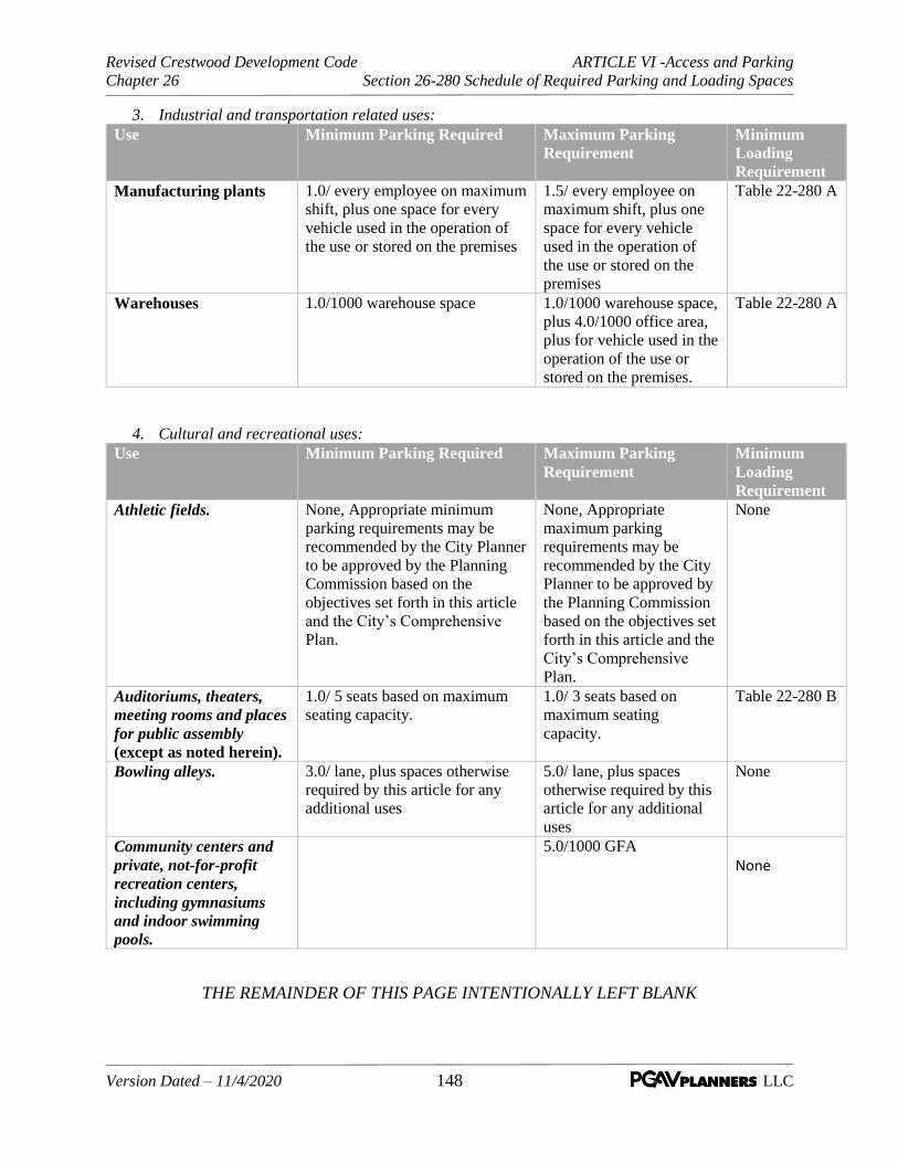
Revised Crestwood Development Code ARTICLE VI -Access and Parking
Chapter 26 Section 26-280 Schedule of Required Parking and Loading Spaces
Version Dated – 11/4/2020 148 LLC
3. Industrial and transportation related uses:
Use Minimum Parking Required Maximum Parking
Requirement
Minimum
Loading
Requirement
Manufacturing plants 1.0/ every employee on maximum
shift, plus one space for every
vehicle used in the operation of
the use or stored on the premises
1.5/ every employee on
maximum shift, plus one
space for every vehicle
used in the operation of
the use or stored on the
premises
Table 22-280 A
Warehouses 1.0/1000 warehouse space 1.0/1000 warehouse space,
plus 4.0/1000 office area,
plus for vehicle used in the
operation of the use or
stored on the premises.
Table 22-280 A
4. Cultural and recreational uses:
Use Minimum Parking Required Maximum Parking
Requirement
Minimum
Loading
Requirement
Athletic fields. None, Appropriate minimum
parking requirements may be
recommended by the City Planner
to be approved by the Planning
Commission based on the
objectives set forth in this article
and the City’s Comprehensive
Plan.
None, Appropriate
maximum parking
requirements may be
recommended by the City
Planner to be approved by
the Planning Commission
based on the objectives set
forth in this article and the
City’s Comprehensive
Plan.
None
Auditoriums, theaters,
meeting rooms and places
for public assembly
(except as noted herein).
1.0/ 5 seats based on maximum
seating capacity.
1.0/ 3 seats based on
maximum seating
capacity.
Table 22-280 B
Bowling alleys. 3.0/ lane, plus spaces otherwise
required by this article for any
additional uses
5.0/ lane, plus spaces
otherwise required by this
article for any additional
uses
None
Community centers and
private, not-for-profit
recreation centers,
including gymnasiums
and indoor swimming
pools.
5.0/1000 GFA
None
THE REMAINDER OF THIS PAGE INTENTIONALLY LEFT BLANK

Revised Crestwood Development Code ARTICLE VI -Access and Parking
Chapter 26 Section 26-280 Schedule of Required Parking and Loading Spaces
Version Dated – 11/4/2020 149 LLC
Use Minimum Parking Required Maximum Parking
Requirement
Minimum
Loading
Requirement
Gymnasium without
bleachers or fixed seating
(except as noted herein).
This subsection is not
applicable to
gymnasiums associated
with schools.
1.0/ 100 GFA
None
Handball, racquetball
courts.
3.0/ court None
Ice and roller rinks. 1.0/100 square feet of
skating area or playing
surface
None
Indoor soccer. See, Athletic Fields See Athletic Fields None
Parks, playgrounds,
picnic grounds.
See, Athletic Fields See Athletic Fields None
Recreation centers.
See, Athletic Fields See Athletic Fields None
Stadiums and
gymnasiums with
spectator facilities.
See, Athletic Fields See Athletic Fields None
Swimming pools.
See, Athletic Fields See Athletic Fields None
Tennis courts.
None 2.0/ court None
THE REMAINDER OF THIS PAGE INTENTIONALLY LEFT BLANK
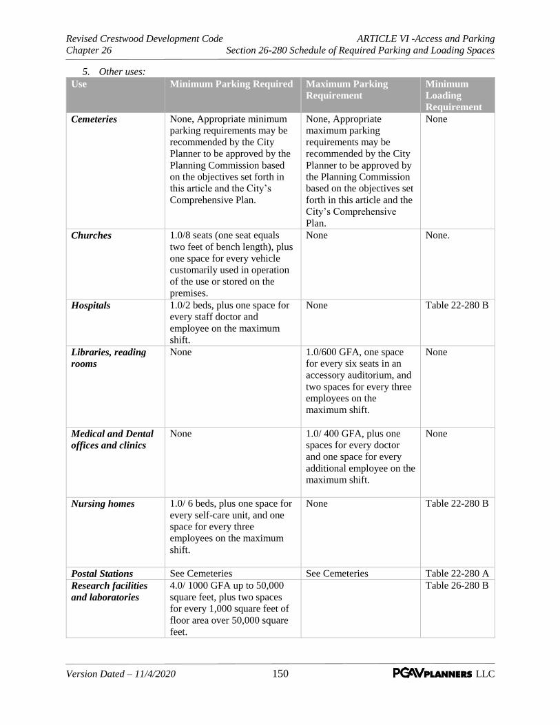
Revised Crestwood Development Code ARTICLE VI -Access and Parking
Chapter 26 Section 26-280 Schedule of Required Parking and Loading Spaces
Version Dated – 11/4/2020 150 LLC
5. Other uses:
Use Minimum Parking Required Maximum Parking
Requirement
Minimum
Loading
Requirement
Cemeteries None, Appropriate minimum
parking requirements may be
recommended by the City
Planner to be approved by the
Planning Commission based
on the objectives set forth in
this article and the City’s
Comprehensive Plan.
None, Appropriate
maximum parking
requirements may be
recommended by the City
Planner to be approved by
the Planning Commission
based on the objectives set
forth in this article and the
City’s Comprehensive
Plan.
None
Churches 1.0/8 seats (one seat equals
two feet of bench length), plus
one space for every vehicle
customarily used in operation
of the use or stored on the
premises.
None None.
Hospitals 1.0/2 beds, plus one space for
every staff doctor and
employee on the maximum
shift.
None Table 22-280 B
Libraries, reading
rooms
None 1.0/600 GFA, one space
for every six seats in an
accessory auditorium, and
two spaces for every three
employees on the
maximum shift.
None
Medical and Dental
offices and clinics
None 1.0/ 400 GFA, plus one
spaces for every doctor
and one space for every
additional employee on the
maximum shift.
None
Nursing homes 1.0/ 6 beds, plus one space for
every self-care unit, and one
space for every three
employees on the maximum
shift.
None Table 22-280 B
Postal Stations See Cemeteries See Cemeteries Table 22-280 A
Research facilities
and laboratories
4.0/ 1000 GFA up to 50,000
square feet, plus two spaces
for every 1,000 square feet of
floor area over 50,000 square
feet.
Table 26-280 B

Revised Crestwood Development Code ARTICLE VI -Access and Parking
Chapter 26 Section 26-280 Schedule of Required Parking and Loading Spaces
Version Dated – 11/4/2020 151 LLC
Use Minimum Parking Required Maximum Parking
Requirement
Minimum
Loading
Requirement
Schools,
nursery/preprimary/
day care
1.0/employee on maximum
shift. A paved unobstructed
pick-up space with adequate
stacking area (as determined
by the Director of Public
Services) shall be provided in
addition to standard driveway
and parking requirements. A
safety zone with a minimum
width of 15 feet shall be
established between parking
spaces in front of the building
entrance, in addition to
standard driveway parking
requirements.
None None.
Schools, public,
private, all grades,
and vocational
1.0 per employee None None
Veterinary clinics,
animal hospitals,
kennels
2.5/ per doctor, plus one for
every additional employee.
None None
Table 26-280 A Table 26-280 B
Gross Floor Area
(Square Feet)
Number of Minimum
10' x 40'
Loading Spaces
Number of Loading Spaces
5,000 to 24,000 1 Gross Floor Area
(Square Feet)
10' x 25'
Min.
10' x 40'
Min.*
24,000 to 60,000 2 2,000 - 10,000 1 1
60,000 to 96,000 3 10,000 - 25,000 2
96,000 to 144,000 4 25,000 - 100,000 2
144,000 to 192,000 5 For each additional
100,000
1 additional
192,000 to 240,000 6
240,000 to 294,000 7
294,000 to 348,000 8
For each additional
54,000
1 additional loading
space

Revised Crestwood Development Code ARTICLE VI -Access and Parking
Chapter 26 Section 26-280 Schedule of Required Parking and Loading Spaces
Version Dated – 11/4/2020 152 LLC
C. Final Determination. Where no minimum requirement is specified, or when one (1) or
more of the parking requirements may be construed as applicable to the same use, lot or building,
or where any other calculation clarification is required, the final determination of required
parking shall be made by the City Planner and/or the Director of Public Services/Works, unless
otherwise specified above.

Revised Crestwood Development Code ARTICLE VI -Access and Parking
Chapter 26 Section 26-290 Alternative Access and Parking Plans
Version Dated – 11/4/2020 153 LLC
SEC. 26-290 Alternative Parking Plans. As an incentive to reduce paved surfaces, stormwater runoff,
and air temperatures, the following provisions provide for alternative parking plans that are intended to
provide flexibility and shared parking arrangements.
A. Scope. This section authorizes building permit applicants submitting parking site plans to submit an
alternative parking plan pursuant to this Section, which is not required to meet the other standards of
this Article of this Chapter. An alternative parking plan may reduce the requirements for on-site
surface parking and encourages flexible solutions by developers, including the appearance or
necessity of parking garages.
B. Applicability. Applicants seeking approval of an alternative parking plan must secure approval of
such plan in accordance with the provisions of this Section. The Planning Commission is authorized
to approve alternative parking plans for any of the arrangements set forth in Subsections 26-290(F)
through O of this Article.
C. Contents. Alternative parking plans must be submitted in a form established by the Director of Public
Services and/or the City Planner and made available to the public in accordance with notification
requirements set forth in Article III, Section 26-110(F) (Applications and Procedures, Major Site
Plan and Design Review) of this Chapter. At a minimum, such plans must detail the type of
alternative proposed and the rationale for such a proposal, including any supporting research or
documentation required by the Director of Public Services and/or City Planner.
D. Review and approval. The Planning Commission is authorized to approve, approve with conditions,
or deny alternative parking plans in accordance with the site plan review procedure of Article III,
Section 26-110 (Applications and Procedures, Major Site Plan and Design Review) of this
Chapter.
1. Alternative parking plans will be given priority consideration that encourages ease of pedestrian
access from the nearest public right-of-way.
E. Approval criteria. The Planning Commission is authorized to approve an alternative parking plan as
provided herein if the applicant demonstrates to the satisfaction of the Planning Commission that the
proposed plan:
1. Will not substantially increase traffic hazards or congestion;
2. Will not adversely affect the character of surrounding commercial uses or adjacent residential
uses or of the neighborhood;
3. Will not substantially increase fire hazards or make difficult access by fire and emergency
services;
4. Will not adversely affect the general welfare of the community; and
5. Will not overtax public utilities.
F. Shared parking.
1. Shared parking represents an arrangement in which two or more uses with different peak parking
periods (hours of operation) use the same off-street parking spaces to meet their off-street parking
requirements. The following is a summary of the potential reductions:

Revised Crestwood Development Code ARTICLE VI -Access and Parking
Chapter 26 Section 26-290 Alternative Access and Parking Plans
Version Dated – 11/4/2020 154 LLC
a. Up to 100% if peak parking at different periods of the day or week;
b. Up to 15% with provisions for bicyclists;
c. Up to 100% for valet parking;
d. Up to 50% for large employers with transportation demand programs;
e. Up to 25% for uses located within 1,000 feet of a transit stop with ninety-minute or more-
frequent stops; and
f. Up to 15% for car-sharing programs.
2. A request for approval of a shared parking arrangement must be accompanied by such
information determined by the Director of Public Services to be necessary to evaluate the peak
parking demand characteristics or difference in hours and/or days of operation, including, but not
limited to, a description of the uses and their operational characteristics, a development plan, and
a parking study prepared by a licensed professional traffic engineer or equivalent qualified
professional which justifies the reduction in parking requested.
3. An agreement providing for the shared use of parking areas, executed by the parties involved,
must be filed with the Director of Public Services in a form approved by the City Attorney.
4. The Director of Public Services is authorized to require that an attested copy of the approved
alternative parking plan be filed with the St. Louis County Recorder of Deeds' office whenever
the Director of Public Services deems necessary to ensure long-term availability and viability of
the alternative parking arrangement. When recording of an agreement is required by the Director
of Public Services, no building permit or occupancy certificate may be issued without proof of
recordation.
G. Special facilities for bicyclists. The Planning Commission may authorize up to a 15% reduction in
the number of required off-street parking spaces for developments or uses that make special
provisions to accommodate bicyclists. Examples of eligible accommodations include, but are not
limited to enclosed bicycle lockers, employee shower facilities, dressing areas for employees, and on-
site public bicycle sharing stations. A reduction in required vehicle parking does not entitle the
applicant to a reduction in required bicycle parking.
H. Transit accessibility. The Planning Commission may authorize up to a 25% reduction in parking
ratios for uses located within 1,000 feet of a transit stop with ninety-minute or more-frequent service
during the hours of 7:00 a.m. to 9:00 p.m.
I. Pervious parking surfaces. The Director of Public Services may authorize a portion of required off-
street parking spaces be provided on pervious surfaces, to be approved by the Planning Commission.
J. Valet parking. The Planning Commission may authorize adequate means of valet parking as a means
of satisfying up to 100% of otherwise applicable off-street parking ratios, assuming the findings in
Subsection (E), above, are met.

Revised Crestwood Development Code ARTICLE VI -Access and Parking
Chapter 26 Section 26-290 Alternative Access and Parking Plans
Version Dated – 11/4/2020 155 LLC
K. Landscaping of recovered areas. Areas of the site recovered by an approved alternate parking plan,
and not used for permanent structures, shall be landscaped in accordance with Article V (Site and
Landscape Design Standards) of this Chapter.
L. Transportation demand management activities program. The Planning Commission may
authorize up to a 50% reduction in the number of required off-street parking spaces for large
employers (150 employees or more) that institute and commit to maintain a transportation demand
management activities program, including, but not limited to the following:
1. The appointment of a transportation coordinator with responsibility for disseminating information
on transit, ride-sharing and other alternative transportation options.
2. The institution of off-peak work schedules, allowing employees to arrive at times other than the
peak morning commute period.
3. The provision of specially marked spaces for each registered car pool and vanpool vehicles.
4. The provision of cash or in-kind financial incentives for employees commuting by car pool,
vanpool, and public transit.
M. Off-site parking. The Planning Commission may authorize any off-street parking spaces to be
located on a remote and separate lot from the lot on which the principal use is located, subject to the
standards of this section. Off-site parking space may be located no more than 1,000 feet from the
primary entrance of the use served to the nearest parking space, measured along the shortest legal,
practical walking route. This distance limitation may be modified by the Director of Public Services if
adequate assurances are offered that van or shuttle service will be operated between the shared lot and
the principal use.
1. Zoning classification. Off-site parking areas are accessory to the principal uses that the parking
spaces serve. Off-site parking areas require the same or a more intensive zoning classification
than that required for the most intensive of the served by the off-site parking area unless approved
as a conditional use permit pursuant to Article III, Section 26-100 (Applications and
Procedures, Conditional Use Permit).
2. Off-site parking agreement. An agreement providing for the use of off-site parking, executed by
the parties involved, must be filed with the Director of Public Services, in a form approved by the
City Attorney.
N. Car-share vehicles. The Planning Commission may authorize a portion of an applicant's required
off-street parking to be met by providing car-share vehicle parking on the development site, as
follows:
1. For any development, one parking space or up to 5% of the total number of required spaces,
whichever is greater, may be reserved for use by car-share vehicles. The number of required
parking spaces may be reduced by one space for every parking space that is leased by a car-share
program for use by a car-share vehicle. Parking for car-share vehicles may be provided in any
non-required parking space.
2. For any development that (a) is required to provide 20 or more spaces and (b) provides one or
more spaces for car-share vehicles, the number of required parking spaces may be reduced by
three spaces for each reserved car-share vehicle parking space or by 15% of the total number of

Revised Crestwood Development Code ARTICLE VI -Access and Parking
Chapter 26 Section 26-290 Alternative Access and Parking Plans
Version Dated – 11/4/2020 156 LLC
required spaces, whichever is less. An agreement between the property owner, renter, or applicant
and a car-share program must be filed with the Director of Public Services, in a form approved by
the Director of Public Services. The parking reduction will continue in effect only as long as the
agreement, binding on all parties, remains in force. Agreements must guarantee long-term
availability of the car-share vehicles. If the agreement lapses or is no longer valid, then the
normally required parking spaces must be provided as otherwise required by this article.

Revised Crestwood Development Code ARTICLE VII – Sign Regulations
Chapter 26 Section 26-300 Intent and Applicability
Version Dated – 11/06/2019 157 LLC
ARTICLE VII – SIGN REGULATIONS
SEC. 26-300 Intent and Applicability
A. Intent. The intent of this Article is to regulate and control the location, erection, number, and
maintenance of signs and matters relating thereto within the City of Crestwood in order to promote public
safety, health, and general welfare of the community, without infringing upon the rights granted by the First
Amendment to the Constitution of the United States of America and Article I, Section 8 of the Constitution
of the State of Missouri. These regulations are specifically designed to:
1. Provide uniform regulation and orderly development of signs consistent with established policies
and ordinances of the City.
2. Preserve the unique character of the City as reflected in distinct commercial and industrial areas by
ensuring signs contribute to an appropriate sense of place.
3. Enhance the visual quality of commercial and industrial areas by giving visual priority to buildings,
open spaces, streetscapes, and landscape.
4. Ensure safety of pedestrians, motorists or other users of the public rights-of-way and open spaces
by ensuring signs are maintained and structurally safe, do not distract or reduce the effectiveness
of public safety signs, and do not represent traffic hazards by virtue of their placement and lighting.
5. Promote economic viability by assuring that the city will be a visually pleasant place to visit,
conduct business, and live.
6. Provide effective and efficient identification and communication for businesses without excessive
competition for visual attention.
7. Protect property values by minimizing adverse effects of signs on adjacent property, which can
occur from conditions such as light trespass, obstructing the views and access, or visual clutter and
blight.
8. Allow signs that are compatible with their surroundings and aid in orientation.
9. Prohibit the placement of signs that contribute to sign clutter or conceal or obstruct adjacent land
uses or signs; to preclude signs from conflicting with the principal permitted use of the site and
adjoining sites; and to minimize the possible adverse effect of signs on nearby public and private
property.
10. Reduce visual clutter that may otherwise be caused by the proliferation, improper placement,
illumination, animation, excessive height, and excessive size (area) of signs which compete for the
attention of pedestrian and vehicular traffic.
B. Applicability. This Article shall apply in the following scenarios:
1. All new signs and replacement of existing signs shall require a sign permit demonstrating
compliance with these sign standards, unless exempt from a permit by Section 26-330 (Permit
Requirements and Exceptions) of this Article.

Revised Crestwood Development Code ARTICLE VII – Sign Regulations
Chapter 26 Section 26-300 Intent and Applicability
Version Dated – 11/06/2019 158 LLC
2. Ordinary maintenance, care or repair of existing signs, or change of copy without altering the
essential construction elements of an existing sign shall not require a permit for zoning and design
standards, but any electrical or building code issues may require permitting.
3. New commercial or industrial development, redevelopment, or rehabilitation involving multiple
buildings or buildings comprising multiple tenants and any development subject to site plan or
development plan review in conjunction with Article III, Section 26-090 (Planned
Development), or Section 26-110 (Major Site Plan) as required by the zoning district provisions
of Article IV, Sections 26-150(B) (Standards Applicable to All Districts, Exceptions and
Supplemental Standards) and Article IV, Section 26-170 (Watson Road Overlay Area)
applicable to the Watson Road Overlay Area shall include information to indicate the type, size,
and location of all signage in compliance with the provisions of Subsection 26-320 (Design and
Location Standards) of this Article and the design standards.
THE REMAINDER OF THIS PAGE INTENTIONALLY LEFT BLANK
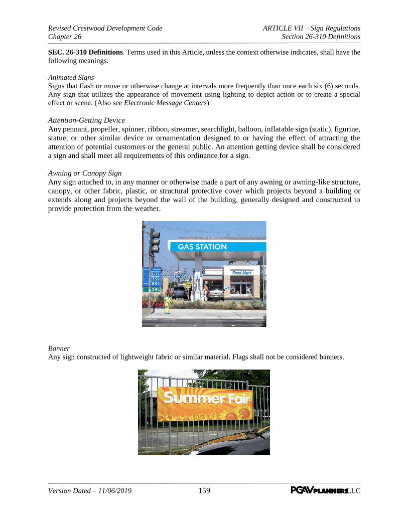
Revised Crestwood Development Code ARTICLE VII – Sign Regulations
Chapter 26 Section 26-310 Definitions
Version Dated – 11/06/2019 159 LLC
SEC. 26-310 Definitions. Terms used in this Article, unless the context otherwise indicates, shall have the
following meanings:
Animated Signs
Signs that flash or move or otherwise change at intervals more frequently than once each six (6) seconds.
Any sign that utilizes the appearance of movement using lighting to depict action or to create a special
effect or scene. (Also see Electronic Message Centers)
Attention-Getting Device
Any pennant, propeller, spinner, ribbon, streamer, searchlight, balloon, inflatable sign (static), figurine,
statue, or other similar device or ornamentation designed to or having the effect of attracting the
attention of potential customers or the general public. An attention getting device shall be considered
a sign and shall meet all requirements of this ordinance for a sign.
Awning or Canopy Sign
Any sign attached to, in any manner or otherwise made a part of any awning or awning-like structure,
canopy, or other fabric, plastic, or structural protective cover which projects beyond a building or
extends along and projects beyond the wall of the building, generally designed and constructed to
provide protection from the weather.
Banner
Any sign constructed of lightweight fabric or similar material. Flags shall not be considered banners.

Revised Crestwood Development Code ARTICLE VII – Sign Regulations
Chapter 26 Section 26-310 Definitions
Version Dated – 11/06/2019 160 LLC
Beacon
Any light with one (1) or more beams directed into the atmosphere or directed at one (1) or more points not
on the same lot as the light source; also, any light with one (1) or more beams that rotate or move.
Billboard
An outdoor sign, advertising an article or product not manufactured, assembled, processed, repaired, or sold
upon the premises upon which the sign is located or advertising a service not rendered upon the premises
upon which the sign is located.
Box sign
A wall sign in which all components are contained within a frame and not composed of individual letters.
Changeable Copy Sign
A sign or portion thereof with characters, letters, or illustrations that can be changed or rearranged without
altering the face or the surface of the sign (not including electronic message centers). A sign on which the
message changes more than eight (8) times per day shall be considered an animated sign or electronic
message center and not a changeable copy sign for purposes of this Article.

Revised Crestwood Development Code ARTICLE VII – Sign Regulations
Chapter 26 Section 26-310 Definitions
Version Dated – 11/06/2019 161 LLC
Directional sign
A sign which is designed and erected solely for the purpose of traffic or pedestrian direction and placed on
the property (except as otherwise provided for in this Article) to direct the public to building locations,
parking areas, or specific areas of a property or overall development.
Election Season The period from thirty (30) days prior to any election voted in by the residents of Crestwood until two (2)
days after such elections. Electronic Message Center or Display
Any sign, or portion of a sign, capable of displaying electronic content where the rate of change is
electronically programmed and can be modified by electronic processes. An electronic message center or
display may include computer programmable, microprocessor, or controlled electronic or digital video
displays and the images can be produced from LED technology, fiber optics, light bulbs, or other
illumination devices within the display area. Electronic message centers do not include projected images or
messages projected onto buildings or other objects.
Enforcement Official The Director of Public Services or his/her designee.
Engraved Sign or Tablet
Any sign that is cut into masonry or other surfaces.

Revised Crestwood Development Code ARTICLE VII – Sign Regulations
Chapter 26 Section 26-310 Definitions
Version Dated – 11/06/2019 162 LLC
Erect
To build, construct, attach, hang, place, suspend, affix, or paint signs.
Facing or surface
Any surface of a sign upon, against, or through which the message is displayed or illustrated on the sign.
Flag
A cloth with colors, patterns, and/or symbols, etc.
Flashing Sign
Signs that have flashing lights or intermittent illumination, except as otherwise defined herein, including
signs that draw attention to speed limits, stop signs, fire stations, school zones and similar governmental or
public uses.
Ground Sign
Any sign which has the top part of its face less than ten (10) feet above the ground and which is erected the
ground.
Handmade Sign
Any sign made of cardboard, poster board, paper, plywood, or other similar material, including any sign
with handwritten text or symbols.
Illuminated Sign
Any sign, which has characters, letters, figures, designs, or outlines illuminated by electric lights or
luminous tubes as a part of the sign proper. Such lighting may be internal to the sign structure or external
to the sign face, but part of the sign structure or mounting.
Incombustible Material
Any material, which will not ignite at or below a temperature of twelve hundred (1,200) degrees Fahrenheit
and will not continue to burn or glow at that temperature.
Light Standard Sign
A sign that has the lowest part of its face at least eight (8) feet above the ground and which is designed to
be attached to or a part of a light standard principally designed for illuminating a street, parking, or public
space area.

Revised Crestwood Development Code ARTICLE VII – Sign Regulations
Chapter 26 Section 26-310 Definitions
Version Dated – 11/06/2019 163 LLC
Main Traveled Way
The portion of the roadway designed for the movement of persons, including driving lanes, shoulders,
auxiliary lanes, and roadside picnic, parking, rest and observation areas, and other areas immediately
adjacent and contiguous to the traveled portion of the roadway and for the use of the traveling person, but
not necessarily located with the roadway right-of-way.
Marquee sign
Any structure attached to a building often forming a canopy or porte cochere over a building entry attached
at the building face and suspended from above or supported with posts or columns, or a free-standing
structure, with one (1) or more supports, onto which signage is affixed or incorporated.
Monument Sign
A sign generally having a low profile with little or no open space between the ground and the sign and
having a significant base constructed of materials such as, brick, stucco, stonework, textured wood, tile, or
textured concrete, or other similar materials that are compatible with the primary structure on the building.
Nits
Nits are the standard unit of brightness for electronic and digital signage. The nit, also known as “candelas
per square meter”, is a unit of measurement for the total brightness over one square meter of an LED display.
It is a measure of the light being emitted by the sign in contrast to foot-candles which measure the brightness
of the surface area or object that is being lighted.

Revised Crestwood Development Code ARTICLE VII – Sign Regulations
Chapter 26 Section 26-310 Definitions
Version Dated – 11/06/2019 164 LLC
Non-Conforming Sign
Any sign that does not conform to the requirements of this Article.
Obsolete Sign
Any sign that is no longer relating to current activities on a premises or lot.
Occupational Sign
All industrial, commercial and mercantile signs advertising the business on its premises or any of its
activities, including permanent theater signs.
Pennant
Any lightweight plastic, fabric, or other material whether or not containing a message of any kind,
suspended from a rope, wire, or string, usually in series, designed to move in the wind. Flags are not
considered pennants for the purposes of this definition.
Pole Sign
Any sign, which has the lowest part of its face, at least ten (10) feet above the ground and which is supported
by a freestanding pole except as noted in Subsection 26-320(D)(7) (Standards and Requirements by
Sign Type, Pole Signs) herein.
Portable Signs
Any sign not permanently affixed to the ground or other permanent structure. Also, a sign designed to be
transported, including, but not limited to: signs designed to be transported by means of wheels, signs
converted to A- or T-frames, menu and sandwich board signs, balloons, umbrellas, and signs attached to or
painted on vehicles parked and visible from the public right-of-way. Any sign designed to be transported,
which has had its means of transportation removed (wheels, trailer, etc.), shall still be considered a portable
sign.
Post and Panel Sign
A sign which uses one or more visible posts and is unlighted.
Revised Crestwood Development Code ARTICLE VII – Sign Regulations
Chapter 26 Section 26-310 Definitions
Version Dated – 11/06/2019 165 LLC
Projecting Sign
Any sign projecting outwardly from the building.
Reader Board
Any sign that has changeable or removable lettering, with the exception of marquee signs.
Residential Subdivision Sign
Any sign placed at or near the entrance of a residential subdivision.
Roof Sign
Any sign painted, erected, constructed and maintained upon the roof of any building, including wall signs
or projecting signs attached to a building wall, that extend above the roof line.
Shopping Center
An area containing three (3) or more shops, stores, and other places of business and located in the C-1 local
business district or in an approved planned development commercial district or mixed development district
under the zoning ordinance and providing off-street parking facilities in common for all businesses and
their customers.
Sign
Any letter, figure, design, symbol, trademark, panel, device or structure designed or intended to convey
information to the public in written or pictorial form, including without limitation, billboard, banner sign,
directional sign, ground sign, monument sign, portable sign, pole sign, wall sign, roof sign, projecting sign,
temporary sign, marquee, awning, canopy, when placed out of doors or in show display windows intended
to be visible from the outside.
Sign Area
The total area of the space to be used for advertising purposes, including the spaces between open-type
letters and figures, including the background structure, or other decoration or addition which is an integral
part of the sign. Sign supports shall be excluded in determining the area of a sign. The total allowable area
for a double faced sign, where the two (2) faces are not substantially parallel, shall be equal to the allowable
area for a single faced sign. See Section 26-320(A) (Design and Location Standards, Computation of
Area).
Structural Trim The molding, battens, cappings, nailing strips, latticing, and platforms which are attached to the sign
structure. Temporary Signs Signs which are not permanent in nature and typically are installed for a period of ninety (90) days or less.
Vintage Sign
An on-premise sign with unique identifying characteristics that, as designated by the Planning Commission,
contributes to the historical or cultural character of the neighborhood, city, or region and designated in
Subsection 26-320, D (Design and Location Standards, Vintage Signs) of this Article.
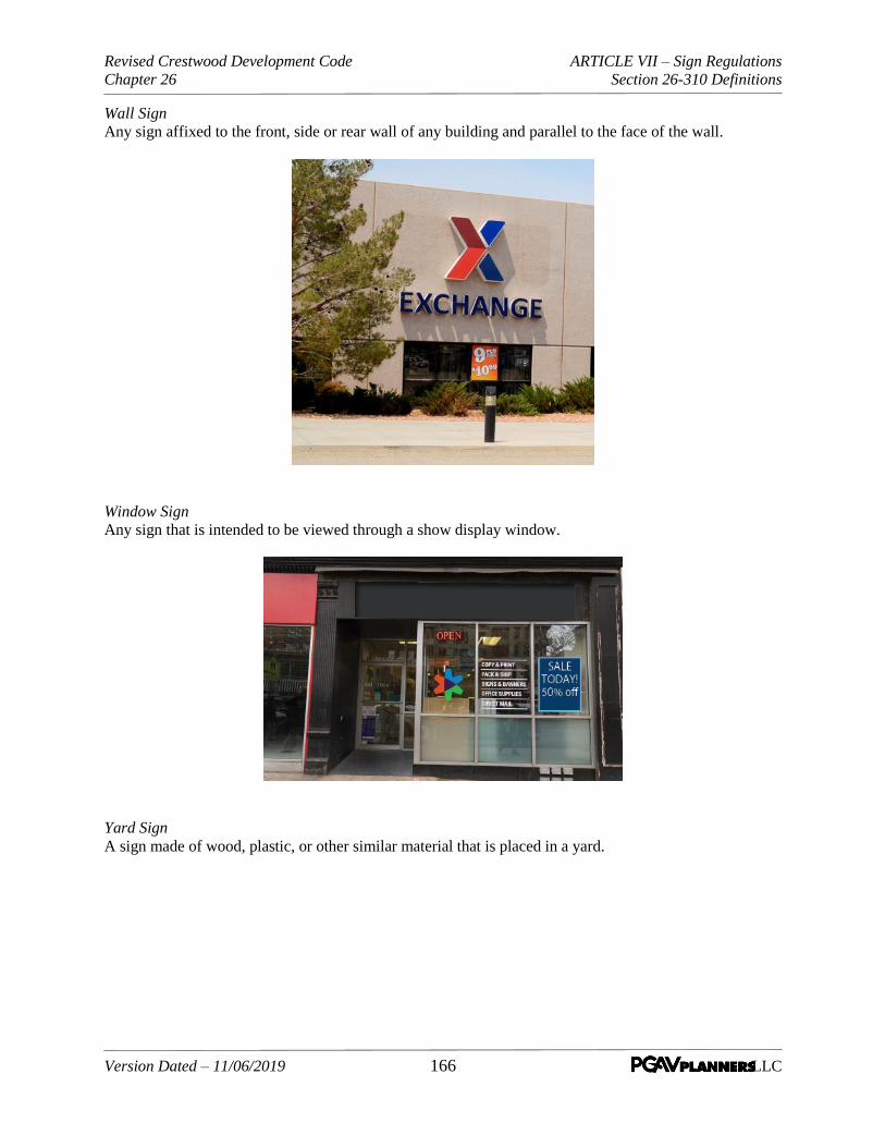
Revised Crestwood Development Code ARTICLE VII – Sign Regulations
Chapter 26 Section 26-310 Definitions
Version Dated – 11/06/2019 166 LLC
Wall Sign Any sign affixed to the front, side or rear wall of any building and parallel to the face of the wall.
Window Sign
Any sign that is intended to be viewed through a show display window.
Yard Sign A sign made of wood, plastic, or other similar material that is placed in a yard.

Revised Crestwood Development Code ARTICLE VII – Sign Regulations
Chapter 26 Section 26-320 Design and Location Standards
Version Dated – 11/06/2019 167 LLC
SEC. 26-320 Design and Location Standards. The following standards shall control the design and
location for computation of sign area and height.
A. Computation of Area. Except is may be otherwise provided for in this Subsection the computation
of sign area shall be as follows:
1. General Area Calculation. Signs mounted on or displayed as a standard geometrical shape shall
be measured by the standard mathematical formula for that shape. Signs mounted on or
displayed as an irregular shape shall be measured by the smallest area of up to two standard
geometrical shapes that can encompass the entire sign mounting.
2. Detached Signs. The area of the sign shall be computed by the entire area of the face of the
structure, cabinet, or module enclosed by the border of the frame.
Figure 26-010-3 General Sign Area
Signs are measured based upon the basic shape types or a combination or
multiple shapes. Displayed are examples of how a sign is measured and
real examples of signs and how they could be measured

Revised Crestwood Development Code ARTICLE VII – Sign Regulations
Chapter 26 Section 26-320 Design and Location Standards
Version Dated – 11/06/2019 168 LLC
3. Wall, window, or other building-mounted signs. Any building-mounted sign mounted on a
background shall be measured by the area of the background. If mounted directly on the wall,
the area shall be computed by means of the smallest single and continuous perimeter of up to
two standard geometric shapes that enclose the outer limits of the writing, emblem, or other
display. Gaps in writing, emblems, or other display greater than two times the height of the sign
area, when using the same single continuous perimeter above, may be subtracted from the
calculation of the sign area but shall be interpreted as two signs. The area of the wall or window
area for the purposes of determining an allowed percentage shall be the total surface of the wall
or window visible in an elevation view.
4. Double-faced Signs. Where the sign faces of a double-faced sign are no more than three feet apart
at any location, only one face will be measured in computing sign area. If the two faces of a
double-faced sign are of unequal area, the area of the sign will be the area of the larger face. In all
other cases, the areas of all faces of a multi-faced sign or the surface area of objects will be added
together to compute the area of the sign.
B. Computation of Height and Location.
1. Height. The height of a sign shall be computed as the distance from the base of the sign at normal
grade to the top of the highest attached component of the sign. Normal grade shall be the newly
established grade after construction, exclusive of any filling, berming, mounding, or excavating
solely for the purpose of locating the sign. In cases in which the normal grade cannot reasonably
be determined, sign height shall be computed on the assumption that the elevation of the normal
grade at the base of the sign is equal to the elevation of the nearest point of the crown of a public
street or the grade of the land at the principal entrance to the principal structure on the lot, whichever
is lower.
2. Location.
a. Signs shall be located on private property, unless otherwise permitted in this Chapter.
Figure 26-010-4 Building-Mounted Signs
Building-mounted signs can be measured as one sign or two depending on the
distance between the two. If the sign distance exceeds two times the height of the
sign it is measured at two signs they could be measured.

Revised Crestwood Development Code ARTICLE VII – Sign Regulations
Chapter 26 Section 26-320 Design and Location Standards
Version Dated – 11/06/2019 169 LLC
b. No sign shall be located within the thirty (30) foot sight distance triangle, of any corner lot as
defined in Article II, Section 26-040 (Defined Terms) of this Chapter or within a similar
area at the intersection of any property entry drive intersection with a public street.
C. Quantity of Signs per Business. Signage related to business locations shall be limited to the quantities
stipulated below:
1. Each individual building, or structure, occupied by one (1) business shall be allowed a maximum
of two (2) signs, which may be a wall sign, a projecting sign, a ground sign or a pole sign, provided
that there shall not be more than one (1) sign per type, except as detailed in subsection (2).
2. For a business located on a lot with multiple street or parking frontage, one (1) wall sign may be
permitted on each street/parking side of the building; one (1) projecting sign may be permitted on
each street/parking side of the building and one (1) pole sign or ground sign on such lot may be
permitted, provided that there shall not be more than two (2) types of signs.
3. Where more than one (1) business has a separate exterior entrance to a building, each business shall
be allowed two (2) signs, one (1) of which may be a wall sign and the other of which may be an
under-canopy sign or a sign as described under Subsection 26-320(D)(9) (Design and Location
Standards, Standards and Requirements by Sign Types, Shopping Center Identification
Signs) herein, if applicable.
4. Two (2) non-illuminated signs may be lettered on the glass show window or entry door of each
storefront of a business, as described under Subsection 26-320(D)(5) (Design and Location
Standards, Standards and Requirements by Sign Types, Window Signs).
5. A canopy or awning sign may be substituted for a permitted wall sign upon determination by the
Planning, Zoning, and Architectural Review Commission of a hardship warranting such sign,
provided that such sign is in compliance with all of the requirements of this Chapter and such
sign:
a. Maintain a clearance of at least thirteen (13) feet above grade where there will be vehicular
traffic beneath it or maintain a clearance of ten (10) feet above grade where there will be
pedestrian traffic beneath it.
b. Is painted or is of the same material as the awning or canopy when the sign is applied to cloth
or similar material.
c. Is not internally illuminated.
6. The limitation as to the number of signs shall not include window signs, directional signs, signs
directly facing the ordering area at a drive-thru restaurant, or monument or ground signs that
identify a shopping center, business, park, or multi-tenant development.
D. Standards and Requirements by Sign Type. The standards and requirements are provided by sign
type as follows. However, signs located within the Watson Road Overlay Area shall be subject to the
development standards of Article IV, Section 26-170 (Zoning Districts and Use Standards, Watson
Road Overlay Area) of this Chapter in addition to any applicable regulations for the sign type as
listed below:
Revised Crestwood Development Code ARTICLE VII – Sign Regulations
Chapter 26 Section 26-320 Design and Location Standards
Version Dated – 11/06/2019 170 LLC
1. Seasonal Signs and Displays. Decorations and displays shall be permitted, subject to the following
requirements:
a. No such display shall be in place for more than ninety (90) consecutive days.
b. No pennants or streamers shall be allowed.
c. Such sign or display shall conform with all applicable requirements of this Code.
2. Banner signs. Banner signs, outside of a building, are prohibited except for the following:
a. Temporary promotional banners as provided in Subsection 26-320(D)(3) (Design and
Location Standards, Standards and Requirements by Sign Types, Temporary Signs);
b. Temporary banners as provided for in Subsection 26-320(D)(13) (Design and Location
Standards, Standards and Requirements by Sign Types, Special Event Signage) (special
events);
a. Banners inside buildings may be used as windows signs, as provided for in Subsection 26-
320(D)(5) (Design and Location Standards, Standards and Requirements by Sign Types,
Window Signs).
3. Temporary Signs.
a. Temporary ground signs advertising or announcing a future commercial or industrial
development of the property on which such signs are located may be maintained subject to the
provisions of this chapter, provided such signs do not exceed one hundred (100) square feet in
area or remain longer than six (6) months.
b. Temporary ground signs shall be located so that no part of the sign projects within a five (5)-
foot setback line from the street right-of-way.
c. Temporary banner signs, used outside a building shall be permitted at the discretion of the
Director of Public Services. Such banner signs, if approved, shall be permitted in addition to
the quantity allowed under Subsection 26-320,(C) (Design and Location Standards,
Quantity of Signs per Business), for a period of up to thirty (30) days.
b. Temporary banner signs used outside a building, regarding promotional events shall be
permitted at the discretion of the Director of Public Services. Such banner signs, if approved,
shall be allowed in addition to the quantity allowed under Subsection 26-320(C) & (D)
(Design and Location Standards, Quantity of Signs per Business & Standards and
Requirements by Sign Types) for a period of up to thirty (30) days.
c. Temporary window signs permitted for no more than 30 days.
4. Wall signs. A wall sign shall comply with the following requirements:
a. A wall sign shall consist of individual letters with faces and returns of complementary colors.
Lettering on all wall signs shall have a minimum return of four (4) inches to provide a three-
dimensional style. Such sign shall not project beyond the building for a distance of more than
twelve (12) inches and no less than four (4) inches. If illumination is to be provided, the sign

Revised Crestwood Development Code ARTICLE VII – Sign Regulations
Chapter 26 Section 26-320 Design and Location Standards
Version Dated – 11/06/2019 171 LLC
shall be internally illuminated, or backlighted, so as to prevent glare upon the street or adjacent
property.
b. A wall sign shall be constructed of incombustible materials, except that moldings and capping
may be made of wood. A wall sign shall be safely and adequately attached to the building. No
wall sign shall cover the doors or windows of a building, or otherwise prevent free ingress and
egress to or from any window, door, or fire escape of a building.
c. A wall sign shall not extend downward nearer than eight (8) feet to the ground.
d. No wall sign shall extend above the roof line.
e. A building occupied by a single occupant that is not on a corner lot may have a wall sign with
an area up to twenty (20) percent of the area of the front wall of the building on which the sign
is to be installed. The maximum permitted sign area on any one (1) building occupied by a
single user shall not exceed two hundred fifty (250) square feet.
f. A building occupied by a single occupant that is located on a corner lot may have one (1) wall
sign on each street frontage, not exceeding the size limitations as set forth in subsection (e) of
this section for each sign.
g. A building with multiple occupants that is not on a corner lot shall be permitted to have one (1)
wall sign no greater than one hundred fifty (150) square feet. In addition, each occupant who
has a separate exterior business entrance may erect a wall sign which may be twenty (20)
percent of the front wall area of such business, but not greater than one hundred (100) square
feet. Such a wall sign may only be located on the portion of the building directly in front of the
business said sign is advertising.
h. A building with multiple occupants that is on a corner lot shall be permitted to have one (1)
wall sign no greater than one hundred fifty (150) square feet, on each street frontage. In
addition, each occupant who has a separate exterior business entrance located at the corner of
the building may erect one (1) wall sign on each street frontage, of up to twenty (20) percent
of the wall area facing the street, but not greater than one hundred (100) square feet for each
sign. Such a wall sign may only be located on the portion of the building directly in front of
the business said sign is advertising.
i. Box wall signs are not a permitted sign, but can be approved by the Planning, Zoning and
Architectural Review Commission on a case-by-case basis.
5. Window signs. All window signage shall comply with the following requirements:
a. Painting, decals, or vinyl lettering may be located on the door glass, provided that the lettering
does not cover more than twenty (20) percent of the door glass within which the lettering is
placed.
b. The total amount of window signage shall not be greater than twenty (20) percent of the total
window area.
c. For multiple occupant buildings, the preceding regulations apply to each occupant.

Revised Crestwood Development Code ARTICLE VII – Sign Regulations
Chapter 26 Section 26-320 Design and Location Standards
Version Dated – 11/06/2019 172 LLC
6. Ground sign
a. Unless provided otherwise, no ground sign shall be at any point over ten (10) feet above ground
level.
b. Every ground sign shall be stoutly constructed and anchored in a secure and substantial manner.
c. The ends of all such signs shall be at least six (6) feet from any wall or fence or any obstruction,
which would prevent a clear passage around.
d No ground sign shall exceed seventy-five (75) square feet for each face. Not more than one (1)
ground sign shall be erected on any one (1) lot or tract of land.
e. No ground sign when erected on a lot fronting on intersecting streets shall be erected within
sixty (60) feet of the intersection of the streets.
f. Ground signs shall be located such that no part of the sign projects beyond a five (5) foot
setback from the street right-of-way.
g. In the case of a multiple occupant building, one (1) ground sign shall be permitted.
7. Pole signs
a. Pole signs shall not exceed one hundred (100) square feet for each face, including air space
between parts of the sign situated on private property.
b. The maximum height of any pole sign shall be two and one-half (2½) times the largest sign
face dimension but not higher than twenty-eight (28) feet. The height restriction may be waived
or modified by the Director of Public Services if existing signage for an adjacent business
would block a proposed sign.
c. The pole sign shall be so located that no part of the sign projects beyond a five (5)-foot setback
line from the street right-of-way.
d. No pole sign shall extend downward nearer than ten (10) feet to the ground or pavement.
e. A pole sign shall be constructed of incombustible material.
f. Pole signs shall be proportioned so that the ratio of the height-to-width of the sign face is not
less than ½:1, or that the ratio of height-to-width does not exceed 1.33:1.
g. Double-faced pole signs shall be constructed with parallel faces having identical size and shape
so the back of the sign face is not visible.
h. The size of a support pole shall be proportioned and harmonious to the overall size of the sign.
The support pole shall be a color compatible with the sign face and frame.
i. A pole sign may include an electronic message center subject to the provisions of Subsection
26-320(D)(8) (Design and Location Standards, Requirements by Sign Types, Electronic
Message Centers) of this Article. The size of the electronic message center shall be limited to

Revised Crestwood Development Code ARTICLE VII – Sign Regulations
Chapter 26 Section 26-320 Design and Location Standards
Version Dated – 11/06/2019 173 LLC
seventy-five (75) percent of the area of the primary pole sign, not to exceed fifty (50) square
feet.
j. One (1) pole sign for each building fronting a public street, which is occupied by only one (1)
occupant, shall be allowed.
k. In the case of a multi-occupant building, one (1) pole sign shall be permitted.
8. Electronic Message Centers or Displays (hereinafter referred to as Display) In order to provide for
the safe and appropriate use of electronic message display signs, the installation of signs containing
such components, the regulations as follows are intended to ensure that the use of such signs will
not have a detrimental effect on the surrounding area or the public welfare and will be consistent
with the purpose and intent of this Article and this Chapter. The requirements for electronic
message centers are only applicable to signs installed after the effective date of this Code Section.
Existing electronic message centers which were approved by the Planning, Zoning, and
Architectural Review. Commission prior to the effective date of this Code section are allowed to
continue to operate until such time as the sign becomes non-operational or is substantially modified.
a. Electronic message display signs shall be subject to the site plan review and approval process
or development plan review process of Article III, Sections 26-090 or 26-110 (Applications
and Procedures, Planned Development or Major Site Plan and Design Review) of this
Chapter and subject to approval of a conditional use permit in accord with the provisions of
Article III, Section 26-100 (Applications and Procedures, Conditional Use Permit) of this
Chapter.
b. Modes of Operation. The following modes of operation are described for electronic message
signs:
(1) Static - Signs which include no animation or effects simulating animation.
(2) Fade - Signs where static messages are changed by means of varying light intensity, where
the first message gradually reduces intensity to the point of not being legible and the
subsequent message gradually increases in intensity to the point of legibility.
(3) Dissolve - Signs where static messages are changed by means of varying light intensity or
pattern, where the first message gradually appears to dissipate and lose legibility
simultaneous to the gradual appearance and legibility of the subsequent message.
(4) Traveling - Signs where the message is changed by the apparent horizontal movement of
the letters or graphic elements of the message.
(5) Scrolling - Signs where the message is changed by the apparent vertical movement of the
letters or graphic elements of the message.
(6) Animation/Video – Signs that incorporate animation elements to the message display or
contain video including such elements that are repeated or change on a recurring basis.
c. Standards. The following describes standards for the installation and use of electronic message
display signs:

Revised Crestwood Development Code ARTICLE VII – Sign Regulations
Chapter 26 Section 26-320 Design and Location Standards
Version Dated – 11/06/2019 174 LLC
(1) Zoning Districts: Electronic message display signs shall be permitted in any zoning district
subject to meeting the standards and criteria described herein and the requirements of
Section 26-320(D) (Design and Location Standards, Standards and Requirements by
Sign Type) of this Article and as may be applicable to the other requirements for the type
of sign in which the electronic message is to be incorporated (i.e. ground, monument, or
pole types).
(2) Message Displayed: Electronic Message Displays may display text, a graphic such as a
company logo, or a photograph or a combination thereof. No scrolling, animation, video,
horizontal or vertical travelling, fade or dissolve of the overall message or within elements
of the overall message display is permitted.
(3) Transitions: Electronic message display signs shall be operated in static display mode only
except for transitions between messages which shall be instantaneous. There shall be no
video, animation, fades, dissolves, travelling, or scrolling between messages.
(4) Display Time: Electronic message display signs shall be permitted to change their message
no more than once every thirty (30) seconds.
(5) Size: The area of the electronic display panel shall not be more than fifty (50) square feet
in size or seventy-five (75) percent of the total area of the sign, whichever is more
restrictive.
(6) Electronic message displays must be designed and equipped to immediately freeze the
display in one (1) position or discontinue if a malfunction occurs.
(7) No sounds can be emitted from an electronic message center.
(8) Height: The maximum height, as measured from the prevailing grade to the top of the
electronic message display panel on a ground mounted sign will be ten (10) feet, for any
pole sign shall be two and one-half (2 1/2 ) times the largest sign face dimension, but not
higher than twenty-either (28) feet.
d. Hours of Operation. Where electronic message display signs may face residential property in
adjacent residential zoning districts, such displays shall be turned off between 10:00 p.m. and
6:00 a.m. or by a time established in conjunction with the conditional use permit review and
approval process.
e. Sign Type. Electronic message display signs may be incorporated into freestanding (ground or
pole) signs;
f. Number. Only one (1) electronic message display sign shall be allowed as part of a shopping
center sign and only one (1) such sign shall be permitted per street frontage for a shopping
center. For individual uses, only one (1) electronic message display sign shall be permitted on
the premises per use.
g. Distance from Residential Use. Electronic message displays signs shall not be located within
one hundred (100) feet of any residence or residential zoning district as measured from the sign
to the property line of the residential use, provided that this Subsection (D)(8)(g) shall not be
applicable to churches or public schools within residential zoning districts, or within 100 feet
of a residential zoning district .
Revised Crestwood Development Code ARTICLE VII – Sign Regulations
Chapter 26 Section 26-320 Design and Location Standards
Version Dated – 11/06/2019 175 LLC
h. Distance from Other Signs. Electronic message display signs must be spaced a minimum of
one hundred and fifty (150) feet from other electronic message display signs.
i. Lighting Intensity and Color. Daytime lighting intensity must automatically reset to a lower
level for night time hours. To ensure compliance with this subsection, the sign must have an
automatic brightness control linked to ambient light levels.
(1) Brightness. Electronic message display shall come equipped with dimming technology that
automatically adjusts the display's brightness based on ambient light conditions and
complies with maximum night time brightness levels and may be adjusted to lower levels
if, upon determination by the Director of Public Services, the display is deemed to represent
an adverse impact on adjoining property or a hazard to public safety.
(2) Electronic message display signs shall not exceed a maximum illumination of three
hundred (300) NITS or five hundred (500) foot-candles during nighttime hours (between
dusk and dawn) and a maximum illumination of five thousand (5,000) NITS or five
thousand (5,000) foot-candles during daylight hours.
(3) Prior to the issuance of any permit, the owner shall provide the City with a certification
from the sign manufacturer stating that the sign is capable of complying with requirements
(1) and (2) above.
(4) Video or message displays that contain large background areas of bright white or other high
intensity colors are prohibited.
(5) The owner of an electronic message center shall arrange for an annual certification of the
light output standards established in Section 26-320(D)(8)(i) (Electronic Message
Centers or Displays, Lighting Intensity and Color), above, of this Article showing
compliance by an independent contractor and provide said certification to the City of
Crestwood.
(j) Electronic message display signs with under twenty (20) square feet of sign area, which are
ancillary in use, and which are not legible from vehicles traveling on the right of way are
exempt from subsections (D)(8)(a) and (D)(8)(c) – (D)(8)(h) of this Section. Such signs may
be erected and modified without an application for site plan review or for a conditional use
permit.
9. Shopping center signs.
a. For the purpose of this provision, a shopping center shall be a center having a total leasable
area of more than twenty thousand (20,000) square feet.
b. Any shopping center may erect a monument sign having a maximum height of twenty-five (25)
feet above grade on the property of the shopping center. However, no such sign shall be located
within the thirty (30) foot sight distance triangle of any property corner lot as defined in Article
I, Section 26-040 (General Provisions, Defined Terms) of this Chapter or within a similar
area at the intersection of any property entry drive intersection with a public street that may
obstruct the view for vehicles exiting the shopping center. Such sign may be composed of stone,
masonry, plastic masonry, or such other materials as are deemed consistent with the shopping

Revised Crestwood Development Code ARTICLE VII – Sign Regulations
Chapter 26 Section 26-320 Design and Location Standards
Version Dated – 11/06/2019 176 LLC
center improvements, on which individual signs may be placed in accordance with the
following standards:
(1) Maximum total sign area of all signs: Two hundred (200) square feet. This provision may
be modified by the Planning, Zoning, and Architectural Review Commission.
(2) The size of all letters shall be proportionate or harmonious in size to the overall area of
each sign.
(3) The background of each sign shall be compatible with the background of all other signs on
the monument.
(4) The total area of all of the signs located on such monument shall not exceed seventy-five
(75) percent of the total area of the monument. In making such determination, the area of
each sign shall be calculated on the basis of the total area of the background of each sign.
10. Office building signs.
a. For the purpose of this provision, an office building shall be any building where more than fifty
(50) percent of the building's leasable space is occupied for office usage.
b. Any building qualifying as an office building hereunder may erect a monument sign having a
maximum height of fifteen (15) feet above grade on the property of the office building, but in
no case shall the sign be higher than the roof line, and shall be so located as not to obstruct the
view for exiting the office building, and composed of stone, masonry, plastic masonry, or such
other materials as are deemed consistent with the office building improvements, on which
individual signs may be placed in accordance with the following standards:
(1) Maximum total sign area of all signs: One hundred fifty (150) square feet.
(2) The background of each sign shall be compatible with the background of all other signs on
the monument.
(3) The total area of all of the signs located on such monument shall not exceed seventy-five
(75) percent of the total area of the monument. In making such determination, the area of
each sign shall be calculated on the basis of the total area of the background of each sign.
11. Residential subdivision signs.
For each residential subdivision entry street, a residential subdivision sign may be installed by a
subdivision governing body and or subdivision residents, subject to the following regulations:
a. Any such sign shall be a ground sign, as defined in Subsection 26-320(D)(6) (Design
Standards and Locations, Standards and Requirements by Sign Types, Ground Signs)
and shall not exceed twenty-five (25) square feet in area, excluding any supports in the case of
a ground sign.
b. Any such sign may be a light standard sign, as defined in Subsection 26-320(D)(6) (Design
Standards and Locations, Standards and Requirements by Sign Types, Light Standard
Sign), and shall not exceed six square feet in area. A light fixture is not required.

Revised Crestwood Development Code ARTICLE VII – Sign Regulations
Chapter 26 Section 26-320 Design and Location Standards
Version Dated – 11/06/2019 177 LLC
c. No such sign shall be located within the sight distance triangle of as defined in Article II,
Section 26-040 (General Provisions, Defined Terms) of this Chapter at the street
intersection such that the view for vehicles exiting the subdivision would be obstructed.
d. Submission of plans. The plan for any proposed residential subdivision identification sign shall
be submitted to the Director of Public Services, who may impose such specifications, as
deemed necessary, for safety purposes prior to granting approval.
e. Location and placement. Any such sign shall be located on private property.
12. Billboards near highways in industrially or commercially zoned areas. Billboards shall be subject
to the approval of a conditional use permit in accord with the provisions of Article III, Section 26-
100 (Applications and Procedures, Conditional Use Permit) of this Chapter. Billboards shall
only be located in industrially or commercially zoned areas within six hundred sixty (660) feet of
the nearest edge of the right-of-way and visible from any part of the traveled way of a highway
which is a part of the interstate or primary system in this state, subject to the following regulations
or any superseding regulations of the Code of State Regulations for the Missouri Department of
Transportation, Title 7, Division 10, Chapter 6:
a. Size. The maximum sign area for any one (1) billboard shall be one thousand two hundred
(1,200) square feet with a maximum height of thirty (30) feet above pre-existing grade and a
maximum length of sixty (60) feet. Maximum size limitations shall apply to each side of a
billboard.
b. Lighting.
(1) Lighting shall conform to all standards found within Article V, Section 26-220 (Site and
Landscape Design Standards, Site Lighting).
(2) No revolving or rotating beam or beacon of light that simulates any emergency light or
device shall be permitted as part of any billboard. No flashing, intermittent, or moving light
or lights will be permitted except scoreboards and other illuminated signs designating
public service information, such as time, date or temperature, or similar information, will
be allowed.
(3) External lighting, such as floodlights, thin line, and gooseneck reflectors are permitted,
provided the light source is directed solely upon the face of the sign and is effectively
shielded so as to prevent beams or rays of light from being directed into any portion of the
main traveled way or onto adjacent property, and the lights are not of such intensity so as
to cause glare, impair the vision of the driver of a motor vehicle, or otherwise interfere with
the driver's operation of a motor vehicle.
(4) No sign shall be so illuminated that it interferes with the effectiveness of, or obscures an
official traffic sign, device, or signal.
c. Spacing.
(1) On interstate highways and freeways on the federal aid primary system, no billboard shall
be erected within one thousand five hundred (1,500) feet of an existing billboard on the
same side of the highway.

Revised Crestwood Development Code ARTICLE VII – Sign Regulations
Chapter 26 Section 26-320 Design and Location Standards
Version Dated – 11/06/2019 178 LLC
(2) On non-freeway federal-aid primary highways, no billboard shall be erected within one
hundred (100) feet of an existing sign or billboard.
ii. No billboard shall be located in such manner as to obstruct or otherwise physically or
visually interfere with the effectiveness of an official traffic sign, including directional
signs, signals or devices, or obstruct or physically interfere with a motor vehicle operator's
view of approaching, merging, or intersecting traffic.
d. Location. To provide a safety zone and to prevent injury or property damage to residentially
zoned properties resulting from billboard collapse, no portion of a billboard shall be located
within two hundred fifty (250) feet of any residentially zoned property.
e. Other regulations. All other provisions of this chapter relating to the design and construction
of signs and permit requirements shall apply equally to billboards authorized under this
Section.
13. Special event signage.
The following signs are permitted for a special promotional event authorized under Article IV,
Section 26-160(G)(2)(e) (Standards Applicable to Specific Uses and Districts, Temporary
Uses and Structures, Temporary Uses Permitted) of this Chapter:
a. Pennants and streamers that are securely fastened;
b. Search lights, flashing lights, inflatables, and balloons;
The Director of Public Services must approve all proposed signage prior to the event.
14. Bus shelter signage.
Signs shall be permitted on bus shelters within the city upon the approval of the Director of Public
Services. The size of the signage shall be limited to a cumulative twenty-four (24) square feet. A
permit for each sign shall be required.
15. Reader board signs.
a. Manual reader board signs shall not be permitted for use except by churches, schools, libraries,
governmental agencies, and civic organizations.
b. Manual reader board signs shall not exceed forty (40) square feet in area.
c. Movie theater signs require the approval of the Planning, Zoning, and Architectural Review
Commission.
16. Portable signs.
a. Portable signs are prohibited except vehicles that are used in the normal day-to-day operation
of the business may have a sign attached or painted on such vehicle identifying the name,
address, and type of business.

Revised Crestwood Development Code ARTICLE VII – Sign Regulations
Chapter 26 Section 26-320 Design and Location Standards
Version Dated – 11/06/2019 179 LLC
b. A business may park up to two (2) vehicles of the light delivery type (rated less than one (1)
ton manufacturers rated hauling capacity) containing such signage in front of the business
identified on the vehicle. Additional vehicles may be approved by the Planning, Zoning, and
Architectural Review Commission.
c. A- or T- frame signs, menu or sandwich board signs, balloons, or umbrellas placed no closer
than five (5) feet from the right-of-way line and in such a way that it does not impede pedestrian
traffic, Such signs may also be held or worn. Such signs can only be in place or in use from
10:00 a.m. to 8:00 p.m., Sunday through Saturday.
17. Projecting signs. A projecting sign shall comply with the following requirements:
a. A projecting sign not exceeding twenty-five (25) square feet in area for each building fronting
a public street shall be allowed, provided that, if a building is occupied by only one (1) user
and the front wall area adjoining the public street on which the building is located exceeds five
hundred (500) square feet, such building may have a projecting sign with an area equal to ten
(10) percent of the area of the front wall of the building but shall not exceed two hundred fifty
(250) square feet.
b. A building located on a corner lot may have one (1) projecting sign on each street side of the
building, but not exceeding the size limitations as set forth in subsection (a) of this Section for
each sign.
c. No projecting sign shall extend more than four (4) feet six (6) inches from the building,
including structural supporting or extending members attached to the building.
d. No projecting sign shall project nearer to the curb line than two (2) feet.
e. No projecting sign shall extend downward nearer than ten (10) feet to the ground or pavement.
f. No projecting sign shall extend above the roof line.
g. Every projecting sign shall be constructed of noncombustible material and braced to withstand
a horizontal wind pressure of not less than thirty (30) pounds for every square foot of surface
exposed and shall be securely attached to the building wall in an approved manner.
18. Directional signs. Small post signs indicating the direction to a business (exit and entrance) may
be erected and maintained subject to the following:
a. The Director of Public Services shall investigate and make a determination that the sign will
serve a public purpose.
b. Such sign shall not exceed eight (8) square feet in area and shall be installed in a manner and
at a height so as not to interfere with the safe, ordinary and lawful use of the main traveled way.
19. Marquees; marquee signs.
a. Marquees and marquee signs may extend to a point two (2) feet back of the curb line, but no
such marquee or marquee sign shall extend downward nearer than eleven (11) feet above the
level of the sidewalk at its lowest level.
Revised Crestwood Development Code ARTICLE VII – Sign Regulations
Chapter 26 Section 26-320 Design and Location Standards
Version Dated – 11/06/2019 180 LLC
b. An illuminated sign which may be placed on a marquee which may extend the entire length
and width of the marquee, provided such sign does not extend more than nine (9) feet above
nor one (1) foot below such marquee, but under no circumstances shall the sign or signs have
a vertical height greater than nine (9) feet.
c. No additional sign shall be attached to a marquee.
20. Under canopy signs.
a. Any under canopy sign shall not exceed four (4) square feet in area.
b. No under canopy sign shall project horizontally beyond the canopy or nearer to the curb line
than two (2) feet.
c. No under canopy sign shall extend downward nearer than ten (10) feet to the ground or
pavement.
d. Every under canopy sign shall be constructed of noncombustible material and shall be securely
attached to the canopy in an approved manner.
21. Engraved Signs or tablets.
a. Engraved signs and tablets shall not exceed four (4) square feet.
b. Tablets may be secured to the building when constructed of bronze or other incombustible
materials but shall not exceed four (4) square feet.
c. There shall be a maximum of two (2) engraved signs or tablets per business or residence.
Additional engraved signs or tablets may be approved by the Planning, Zoning, and
Architectural Review Commission in accordance with Section 26-360 (Appeals and
Variances) of this Article.
22. Vintage Signs. Vintage signs shall be determined as such by the Planning, Zoning, and Architectural
Review Commission. Traditionally, vintage signs are nonconforming signs that can represent
important elements of Crestwood’s heritage and enhance the character of a corridor,
neighborhood, or the community at large and should be preserved.
a. Purpose of Vintage Sign Regulations
(1). Provide for the preservation of the Crestwood’s unique character, history, and identity, as
reflected in its historic and iconic signs;
(2). Preserve the sense of place that existed within the central business district and in areas of
the City with concentration of surviving historic signs;
(3). Protect the community from inappropriate reuse of non-conforming and/or illegal signs
while ensuring that the signs are safe and well maintained;
(4). Allow the owner the flexibility to preserve historic and vintage signs. This classification
does not preclude owners from removing these signs.

Revised Crestwood Development Code ARTICLE VII – Sign Regulations
Chapter 26 Section 26-320 Design and Location Standards
Version Dated – 11/06/2019 181 LLC
b. Criteria for Identifying Vintage Signs
(1). The Planning Commission shall designate an existing sign as a vintage sign if the sign:
a. Has not been granted flexibility from the base zoning through a variance, modification,
or Planned Development agreement;
b. Is not a billboard as defined in Subsection 26-320(D)(12) (Design and Location
Standards, Billboards);
c. The sign is structurally safe or can be made safe without substantially altering its
historical appearance
d. Retains its original design character, or that character will be restored, based on historic
evidence such as drawings or photographs; and,
e. If the Planning, Zoning, and Architectural Review Commission determines that the sign
meets at least four (4) of the following criteria:
(i) The sign was specifically designed for a business, institution, or other
establishment on the site where the sign is located;
(ii) The sign is unique to the city or region;
(iii) The sign exhibits specific characteristics that enhance the streetscape or identity
of a neighborhood;
(iv) The sign is characteristic of a specific historic period;
(v) The sign is integral to the design or identity of the site or building where the sign
is located;
(vi) The sign represents an example of craftsmanship in the application of lighting
technique, use of materials, or design;
(vii) The sign was installed at least forty (40) years prior to the date of applications;
(viii) The sign retains the majority of its character-defining features (materials,
technologies, structure, colors, and/or shapes) that have historical significance,
are integral to the overall sign design, or convey historical or regional context;
and
(ix) The sign exemplifies the cultural, economic, and historic heritage of Crestwood.
(2). A designated vintage sign may:
a. Be relocated within its current site,
Revised Crestwood Development Code ARTICLE VII – Sign Regulations
Chapter 26 Section 26-320 Design and Location Standards
Version Dated – 11/06/2019 182 LLC
b. Be modified to account for changing uses within its current site. These modifications
shall be in the same style as the design of the original sign including:
(i) Shape and form,
(ii) Size,
(iii) Typography,
(iv) Illustrative Elements,
(v) Use of Color,
(vi) Character of Illumination, and
(vii) Character of Animation;
c. Be relocated to a new site for use as a piece of public art, provided that the original
design and character of the sign is retained, or will be restored, and it advertises a
business no longer in operation. Vintage signs may only be relocated for use as public
art to sites in the following districts: C-1, M-1, PD-C, PD-M, PD-MXD, and WROA.
(3). The Planning, Zoning and Architectural Review Commission may exempt a vintage sign
from the calculation of allowed signage on a site.
(4). Signs designated as vintage that are non-conforming as to type, size, height, or location are
exempt from the regulations governing non-conforming signs. However, changes to a
vintage sign may not increase the non-conformity unless a variance is granted.
(5). Classification as a vintage sign does not prevent the owner from demolishing the sign.
23. Accessory/Ancillary/Incidental Signs.
a. Accessory, ancillary, and incidental signs must be accessory to the use on the site and must not
be legible from off-site.
b. Any allowable sign type may be used as an ancillary sign, and if such sign is under twenty (20)
square feet, it is exempt from any process outlined in Article III, Section 26-100 (Applications
and Procedures, Conditional Use Permit).
c. Such signs require a permit unless otherwise exempted by Section 26-340(A) (Exemptions
and Prohibitions, Exemptions) of this Article.
THE REMAINEDER OF THIS PAGE INTENTIONALLY LEFT BLANK

Revised Crestwood Development Code ARTICLE VII – Sign Regulations
Chapter 26 Section 26-330 Permit Requirements and Exceptions
Version Dated – 11/06/2019 183 LLC
SEC. 26-330 Permit Requirements and Exceptions.
A. Permit Required. No sign shall be erected, nor the location of any existing sign changed, until the
Director of Public Services has issued a permit.
1. An application for a sign permit shall be accompanied by plans and specifications. The plans and
specifications must be drawn to scale and shall include the dimensions, material, and details of
construction of the proposed sign, together with an accurate colored rendering of the proposed sign.
A site plan of the property and/or building elevations indicating where the sign(s) is(are) to be
located must also be provided.
2. Before a permit can be granted for the installation of any sign, the applicant for said permit must
submit evidence of an agreement signed by the owner or owners of said property granting
permission to the applicant to install said sign and binding said owner or owners, their heirs and
assigns irrevocably to permit the city through its agents to enter on said real property for the purpose
of removing said sign or signs as provided under the provisions of this chapter, and waiving and
holding the city harmless from any damage to said real property occasioned by said sign removal.
3. Vintage Signs: In addition to the general application requirements in this Section for a sign permit,
an application requesting vintage sign designation or modification shall require:
a. Detailed drawings and/or photographs of the sign in its current condition,
b. Written narrative and supporting documentation demonstrating how the sign meets the
applicable criteria,
c. Detailed drawings of any modifications being sought,
d. Detailed drawings of any relocation being sought, and
e. Historic and current photographs of the sign.
4. The Director of Public Services may prescribe suitable regulations not inconsistent with the
provisions of this Section concerning the form and content of all applications for the various types
of permits herein required.
B. Permit Fees. A permit is required for the erection of signs.
1. Before the issuance of each required sign permit, a fee in the amount established by the Board of
Aldermen shall be paid to the City.
2. For each temporary sign requiring a permit, the fee shall be in the amount established by the Board
of Aldermen.
3. The provisions of the building code and electrical code of the City shall govern the construction,
alteration, and maintenance of all signs.
4. If the sign is illuminated, an electrical permit and inspection by St. Louis County shall be required.

Revised Crestwood Development Code ARTICLE VII – Sign Regulations
Chapter 26 Section 26-330 Permit Requirements and Exceptions
Version Dated – 11/06/2019 184 LLC
C. Permit Fee Exceptions. Signs listed in Subsection 26-340 (Exemptions and Prohibitions,
Exemptions) of this Article are not subject to payment of permits fees and may be erected according
to the standards provided for therein.
THE REMAINEDER OF THIS PAGE INTENTIONALLY LEFT BLANK

Revised Crestwood Development Code ARTICLE VII – Sign Regulations
Chapter 26 Section 26-340 Exemptions and Prohibitions
Version Dated – 11/06/2019 185 LLC
SEC. 26-340 Exemptions and Prohibitions.
A. Exemptions. Unless elsewhere specified in this Article, the following signs are exempt from the
preceding requirements contained in Subsections 26-320 (Permit Requirements and Exceptions) of
this Article:
1. A sign which is not illuminated and, if in a residential district (R-1, R-2, R-3, R-4, or R-5), does
not exceed eight (8) square feet in area, and if in any other district, does not exceed thirty-two
square feet. Only one (1) such sign may be placed on the lot or premises except that two (2) such
signs may be placed on double frontage lots. One (1) additional sign is permitted on residential
properties for a period of no more than 24 hours.
2. Temporary signs not over twenty-five (25) square feet for non-residential uses in a residential
district (R-1, R-2, R-3, R-4, or R-5).
3. One (1) additional sign consistent with the requirements of section 1 above, per street frontage if
a construction project is underway or has been completed within the last fourteen days on the lot
or premises on which the sign is placed. Such signs may not be illuminated signs and may not
exceed sixteen (16) square feet in surface area in residential districts, or thirty-two (32) square feet
in surface area in commercial districts.
4. Traffic or other municipal signs, and any signs required by federal, state, or local law, court order
or legal process.
5. Yard signs shall not exceed twenty-five (25) square feet and there may be no more than one (1) of
the same sign per street frontage. Additional ground signs are permitted under this Subsection
during an election season, however, two or more identical signs are not permitted Any additional
sign permitted during an election season, which is not removed after the end of an election season,
shall be considered a prohibited sign;
a. A yard sign may be placed on city property used as a polling place; the signs are only allowed
from 8:00 p.m. on the day prior to the vote until 7:00 a.m. of the day following the vote. Signs
placed on city property outside of these times will be promptly removed.
7. Professional name plates not exceeding three (3) square feet in area;
8. Window signs;
9. Occupational signs not over four (4) square feet in area (on building); and
10. Signs erected inside a building.
B. Signs and Devices Prohibited. The following signs and devices are prohibited in the City:
1. Conflicting signs: Signs or devices, which by color, location, or design resemble or conflict with
traffic control signs or devices;
2. Exterior use of advertising devices such as: Pennants affixed on poles, wires, or ropes, streamers,
wind operated devices, inflatables, search lights, flashing lights, and any other type of fluttering
devices, except that Flags, as defined in Section 26-310 (Definitions), shall not be prohibited by
this subsection.

Revised Crestwood Development Code ARTICLE VII – Sign Regulations
Chapter 26 Section 26-340 Exemptions and Prohibitions
Version Dated – 11/06/2019 186 LLC
3. Letters or pictures in the form of advertising printed or applied directly on the wall of a building;
4. Paper posters and painted signs applied directly to the wall of a building or pole or other support,
except for signage approved by the Planning, Zoning, and Architectural Review Commission as set
forth in Subsection 26-340(C) (Exemptions and Prohibitions, Signs and Devices Requiring
Approval of the Planning Commission) of this Article;
5. Signs painted on the inside or outside of windows, not including etched glass;
6. Signs advertising an article or product not manufactured, assembled, processed, repaired, or sold
upon the premises upon which the sign is located, unless otherwise permitted by ordinance;
7. Signs advertising a service not rendered on the premises upon which the sign is located, unless
otherwise permitted by ordinance;
8. Revolving signs of any type;
9. Signs in residential districts, except as otherwise permitted herein;
10. Signs with more than two (2) faces;
11. Roof signs;
12. Banners, pennants, or flags suspended from an awning;
13. Exterior banner signs, except as provided in Subsection 26-320(D)(2) (Standards and
Requirements by Sign Type, Banner Signs);
14. Signs placed in such a way as to create a traffic hazard;
15. Portable signs, except as provided in Subsection 26-320(D)(16) (Standards and Requirements
by Sign Type, Reader Board Signs);
16. Signs that display obscene, indecent, or immoral matters as defined in section 573.010, RSMo, as
amended;
17. Signs erected or maintained in such a manner that prevents free ingress to or egress from any door,
window, or fire escape. No sign of any kind shall be attached to a standpipe or fire escape;
18. Ground or wall signs lighted with gooseneck or other types of external reflectors erected and
maintained in a manner that creates glare upon the street, access drives, adjacent property, or may
impact the vision of pedestrians on adjacent sidewalks;
19. Signs with exposed raceways; and
20. Post and panel signs.

Revised Crestwood Development Code ARTICLE VII – Sign Regulations
Chapter 26 Section 26-340 Exemptions and Prohibitions
Version Dated – 11/06/2019 187 LLC
C. Signs and Devices Requiring Approval of the Planning Commission. The following signs and
devices require approval of the Planning Commission prior to receiving a permit:
1. Box signs used as wall signs.
2. Signs on parking lot light standards.
3. Marquee signs.
4. Signs containing flashers, animators, or mechanical movement or contrivances of any kind.
5. Professionally painted signs on sheet metal and affixed to the wall, but limited to the rear of
commercial businesses whose property is adjacent to Grant's Trail. Such signs, if approved by
Planning, Zoning, and Architectural Review Commission, cannot exceed fifty (50) square feet in
size.
6. Vintage Signs
THE REMAINDER OF THIS PAGE INTENTIONALLY LEFT BLANK

Revised Crestwood Development Code ARTICLE VII – Sign Regulations
Chapter 26 Section 26-350 Maintenance and Removal of Signs
Version Dated – 11/06/2019 188 LLC
SEC. 26-350 Maintenance and Removal of Signs
A. Maintenance. All signs shall be maintained in good repair.
1. Signs and their related support structures must be free of rust, peeling, flaking, fading, broken or
cracked surfaces, and broken or missing letters. Every supporting structure shall be kept in an
upright condition. Electronic message centers or displays shall have properly functioning electronic
components.
2. Where upon inspection by the Director of Public Services, or their designee, it has been determined
that any sign requires maintenance or repair, written notice to the owner, the tenant, and/or the
managing agent of the property on which any such sign is located shall be given by the Director of
Public Services. The property owner, tenant, and/or managing agent of the property shall be
provided with a period of thirty (30) day in which to correct the condition. The Director of Public
Services shall have the ability to grant, in writing, an extension of not more than 30 days.
3. Signs which are not properly maintained, and which have not been repaired within the time period
as specified in Subsection 26-350(A)(2) above, will be subject to removal in accord with the
provisions of Subsection 26-350(B) of this Section below.
B. Removal. Signs are subject to removal in accord with the provisions and procedures as follows:
1. The following signs are subject to removal:
a. Signs which are found to be unsafe and capable of creating a hazard to persons or property;
b. Signs which are prohibited under Subsection 26-340(B) (Signs and Devices Prohibited)
hereof;
c. Signs which are erected without a permit, if required under the sign code;
d. Signs for which required fees have not been paid; and
e. Signs that are not maintained in accordance with the requirements of Subsection 26-350(A)
(Maintenance) of this Section and this Article or other applicable City code requirements.
2. The Director of Public Services, or their designee, shall give written notice to the owner or the
managing agent of the property on which any such sign is located, directing its removal within
seven (7) days and informing such owner or managing agent that, if the sign is not removed within
such designated period, the Director of Public Services, or his/her designee, shall cause it to be
removed and the costs charged as a special tax bill. If the sign is not timely removed, the Director
of Public Services, or his/her designee, shall file a property lien with St. Louis County, cause the
same to be removed and certify the costs to the City Clerk and Code Enforcement Officer. The
Code Enforcement Officer shall file a property lien with St. Louis County against the property,
Any such tax bill, if not paid, shall bear interest at the rate of the prime rate plus one (1) percent.
3. The City, and any of its’ officials, is authorized to go upon any premises for the purpose of removal
of any sign under the provisions hereof. Signs so removed shall be retained by the city for a period
of thirty (30) days, and if payment of all expenses of the city in connection with such removal are
paid within such period, shall be returned to the owner. If not so claimed within such period of
time, the city may dispose of such sign in any manner, by destroying, or selling same.

Revised Crestwood Development Code ARTICLE VII – Sign Regulations
Chapter 26 Section 26-350 Maintenance and Removal of Signs
Version Dated – 11/06/2019 189 LLC
4. In addition to the procedures herein authorized, any person failing to remove any such sign, upon
notification to do so, shall, upon conviction, be subject to the penalties provided for violation of
city ordinances.
THE REMAINDER OF THIS PAGE INTENTIONALLY LEFT BLANK

Revised Crestwood Development Code ARTICLE VII – Sign Regulations
Chapter 26 Section 26-360 Appeals and Variances
Version Dated – 11/06/2019 190 LLC
SEC. 26-360 Appeals and Variances
A. Appeals.
1. Any person whose application for a permit for a sign has been denied may file an appeal with, and
seek a sign variance from, the Planning, Zoning, and Architectural Review Commission. An
application for a sign variance shall be accompanied by a filing fee in an amount established by the
Board of Aldermen. The Planning, Zoning, and Architectural Review Commission may not grant
a sign variance unless it finds that the granting of such a sign variance will alleviate a hardship or
difficulty, that such hardship or difficulty is of such substance and magnitude as to warrant such a
sign variance, that the public interest is secured and that the spirit of the sign code is observed. The
Planning, Zoning, and Architectural Review Commission may impose such conditions, as it deems
necessary to safeguard surrounding property and to prevent a misuse of the sign variance. Any
person whose request for a sign variance has been denied by the Planning, Zoning, and
Architectural Review Commission may seek a review of such denial by the Board of Aldermen by
filing a written request for review with the City Clerk within fifteen (15) days of receipt of
notification of denial from the Department of Public Works. The same standards for granting a sign
variance by the Planning, Zoning, and Architectural Review Commission shall apply for review by
the Board of Aldermen. Five (5) affirmative votes shall be required for the Board of Aldermen to
approve a sign variance.
2. Any person aggrieved by the approval of any permit by the enforcement official may appeal to the
Planning, Zoning, and Architectural Review Commission when it is alleged that such permit
violates any provision of sign code. The Planning , Zoning, and Architectural Review Commission
may revoke such permit upon a finding that such sign does not comply with all of the requirements
of the sign code.
B. Limitations on Sign Variances.
Variances shall only be granted for the size, location, and number of signs. Variances will not be granted
for prohibited signs.
THE REMAINDER OF THIS PAGE INTENTIONALLY LEFT BLANK

Revised Crestwood Development Code ARTICLE VIII – Supplemental Standards
Chapter 26 Section 26-370 Environmental Performance Standards
Version Dated – 11/06/2019 191 LLC
ARTICLE VIII – SUPPLEMENTAL STANDARDS
SEC. 26-370 Environmental Performance Standards.
A. Scope of Provisions. Every use, activity, process or operation located or occurring in the City shall
comply with the environmental performance standards prescribed in this division, and no existing use,
activity, process or operation shall be hereafter altered or modified so as to conflict with, or further
conflict with, such environmental performance standards. If, as of the date of adoption of this article,
the operations of any lawful existing use violates these environmental performance standards, such
operations shall not be varied or changed in any way as to increase the degree of such violation. The
operation of any existing conforming use in violation of the environmental performance standards
shall not in itself make such use subject to Article IV, Section 26-180, (Zoning Districts and Use
Standards, Non-Conforming Situations).
B. Administration and Enforcement.
1. All topics covered in Subsection (C) below are subject to all relevant adopted city codes and
ordinances and Article I, Section 26-010 (B) and (G) (General Provisions, Conflicts and
Resources, Guides, and Industry Standards).
Whenever, in the opinion of the Director of Public Services, there is a reasonable probability that
any use or occupancy violates these environmental performance standards, he shall give written
notice of at least seven days' duration that the use or occupancy must be corrected. In case of an
emergency he may take such immediate action as he deems appropriate to correct the violations.
He is hereby authorized to employ a qualified technician or technicians, such as the Fire Chief or
Fire Marshall or other trained professional to perform whatever investigations and analyses as are
necessary to determine whether or not they are, in fact, being violated.
2. In the event that a violation is found to exist, the violator shall be liable for the reasonable fee of
the technicians employed to perform such investigations and analysis. Such fees may be
recovered as a penalty in the same manner as, and in addition to, the penalties specified in Article
I, Section 26-030(C) (General Provisions, Enforcements, Penalties) of this Chapter.
C. Performance Standards.
1. Vibration. Every use shall be so operated that the maximum ground vibration generated is not
perceptible without instruments at any point on the lot line of the lot on which the use is located,
except that vibration caused by blasting conducted in accordance with the requirements of the
explosives code, Chapter 711, St. Louis County Revised Ordinances (SLCRO), may exceed these
limitations.
2. Noise. Every use shall be so operated that the pressure level of sound or noise generated does not
exceed the limitations of the noise control code, Chapter 625 SLCRO.
3. Odor. Every use shall be so operated that no offensive or objectionable odor is emitted in
accordance with the requirements of the air pollution code, Chapter 612 SLCRO.
4. Smoke. Every use shall be so operated that no smoke from any source shall be emitted that
exceeds the emission levels in the requirements of the air pollution code, Chapter 612 SLCRO.
Revised Crestwood Development Code ARTICLE VIII – Supplemental Standards
Chapter 26 Section 26-370 Environmental Performance Standards
Version Dated – 11/06/2019 192 LLC
5. Toxic gases. Every use shall be so operated that there is no emission of toxic, noxious, or
corrosive fumes or gases which exceed the emission levels, of the air pollution code, Chapter 612
SLCRO.
6. Emission of dirt, dust, fly ash, and other forms of particulate matter. The emission of dirt, dust,
fly ash and other forms of particulate matter shall not exceed the emission levels in the
requirements of the air pollution code, Chapter 612 SLCRO.
7. Radiation. Every use shall be so operated that there is no dangerous amount of radioactive
emissions.
8. Glare and heat. Any operation producing intense glare or heat shall be performed in an enclosure
in such manner as to be imperceptible along any lot line without instruments.
9. Fire and explosion hazard.
a. The storage or utilization of solid materials ranging from incombustible to moderate burning
is permitted.
b. The storage or utilization of solid materials ranging from free or active burning to intense
burning is permitted provided the following conditions are met:
(1) The materials shall be stored or utilized within completely enclosed buildings or
structures having incombustible exterior walls and handled in accordance with the
standards and regulations of the fire protection district and the National Fire Protection
Association or its successors.
(2) All such buildings shall be protected throughout by an automatic fire extinguishing
system installed in accordance with the standards and regulations of the fire protection
district and the National Fire Protection Association or its successors.
(3) Such materials, if stored outdoors, shall be no closer than 150 feet to the nearest lot line
or in conformance with the standards and regulations of the fire protection district and the
National Fire Protection Association or its successors.
c. The storage or utilization of flammable liquids or materials which produce flammable or
explosive vapors shall be permitted in accordance with the following limitations, exclusive of
storage in underground tanks and storage of finished products in original sealed containers:
(1) Such materials or products shall be stored or utilized within completely enclosed
buildings having incombustible exterior walls and handled in accordance with the
standards and regulations of the fire protection district and the National Fire Protection
Association or its successors, and, in addition, all such buildings shall be protected
throughout by an automatic fire extinguishing system installed in accordance with the
standards and regulations of the fire protection district and the National Fire Protection
Association or its successors.
(2) The above-ground outdoor storage of flammable liquids is prohibited.
(3) The total of the flammable liquids permitted on any tract shall not exceed 5,000 gallons.

Revised Crestwood Development Code ARTICLE VIII – Supplemental Standards
Chapter 26 Section 26-370 Environmental Performance Standards
Version Dated – 11/06/2019 193 LLC
10. Grease traps. Food service businesses within the City must comply with the following conditions
in connection with their use of grease traps.
a. Except as provided for in Subsection (10)(d) below, grease traps shall be physically cleaned
and the grease disposed of off-site at least once every three months and the business must
notify the City health inspector as to the date and time of each cleaning; and
b. Each business shall maintain records documenting grease trap cleanings which include the
date(s) of cleaning, time(s) of cleaning and disposal method. The records shall be maintained
for a period of 24 months from the date of any given manual cleaning; and shall be available
for review by the health inspector during the restaurant's normal business hours; and
c. If the City health inspector determines that any grease trap is not functioning properly or is
undersized, the business shall correct any such inadequacy in a manner deemed satisfactory
to the health inspector. The health inspector shall make a record of any inadequacies so
determined and the corrective measures taken: and
d. Upon a finding of documented continuous adequacy and sufficient capacity, the health
inspector shall be authorized to reduce the frequency of manual cleaning as required herein to
not less than once every six months; and
e. Any business violating any of the provisions of this section shall be guilty of an offense.
D. Future Revisions. Any addition, modification or change in any regulations, code, ordinance or other
standard referred to in the performance standard regulations shall become a part of these regulations.
THE REMAINDER OF THIS PAGE INTENTIONALLY LEFT BLANK

Revised Crestwood Development Code ARTICLE VIII – Supplemental Standards
Chapter 26 Section 26-380 Traffic Impact Studies
Version Dated – 11/06/2019 194 LLC
SEC. 26-380 Traffic Impact Studies. The regulations of this Section are intended to help ensure that the
traffic and transportation impacts of proposed developments are identified, evaluated and mitigated as
necessary. The purpose of a transportation impact study is to assess the effects that development will have
on traffic conditions, transit users, pedestrians, bicyclists and neighborhood livability.
A. When required.
1. A traffic impact study, at the applicant's expense, is required at the time of application for
approval of any residential or commercial development that qualifies as a major subdivision, as
defined by Article IX, Section 26-390(C) (Subdivisions and Land Development, Generally,
Subdivisions-Major) of this Chapter. A traffic impact study shall also be required at the time of
application for approval of any conditional use permit, unless waived by the Director of Public
Services pursuant to Subsection (c) of this section. The Director of Public Services shall not
waive the requirement of a traffic study for any application for approval of any conditional use
permit that includes the demolition or construction of a new structure or structures, preliminary
subdivision plat, or other similar site-specific development plan if, under the estimation of City
staff:
a. The proposed development, or phases of development, or contiguous tracts under the same
ownership, would accommodate or could be expected to generate 100 or more added vehicle
trips to or from the site during the peak traffic hour (based on the proposed development or
the adjacent roads and intersections); or
b. The proposed development, or phases of development, or contiguous tracts under the same
ownership, would accommodate or could be expected to generate 1,000 or more added
vehicle trips to or from the site during a twenty-four-hour period (based on the proposed
development or the adjacent roads and intersections).
2. In calculating the number of added vehicle trips expected to be generated, trip generation rates
must be obtained from the most recent editions of Trip Generation and Trip Generation
Handbook, published by the Institute of Transportation Engineers (ITE). Only "new" vehicle trips
will be counted; no pass-by or internal trip capture will be used in calculating "added vehicle
trips."
3. The Director of Public Services may waive the requirement for a traffic impact study, in whole or
in part, when the applicant shows that the proposed development's impact on adjacent roads,
intersections, pedestrian, bicycle and transit facilities will be minimal and insignificant, or will be
no greater than those projected by a traffic impact study prepared and submitted within the past
two years for the same site under the same or similar background conditions. The City Planner
must document the reasons for any waiver.
B. Study area.
1. The traffic impact study must address the proposed development's traffic impacts on at least:
a. Roads, sidewalks, bicycle routes, transit facilities and intersections within the development
site, as designated by City staff;
b. Road segments, sidewalks, bicycle routes, transit facilities and intersections abutting the
development site as designated by City staff; and

Revised Crestwood Development Code ARTICLE VIII – Supplemental Standards
Chapter 26 Section 26-380 Traffic Impact Studies
Version Dated – 11/06/2019 195 LLC
c. Off-site road segments and intersections where traffic from the proposed development is
expected to account for at least 10% of the road's or intersection approach leg's average daily
traffic.
C. Qualifications. Traffic impact studies must be prepared by a licensed professional civil engineer
registered in the State of Missouri and certified as a transportation or traffic engineer.
D. Study contents. Traffic impact studies must include charts, graphics, photos and narrative presenting
at least the following information:
1. A description of existing land uses and development intensities in the study area, the location and
characteristics of roads, sidewalks, bicycle routes, transit facilities and intersections in the study
area, and the existing traffic volumes and conditions (including levels of service) of those
facilities;
2. A description of the location and traffic-related characteristics (land use, intensity, expected date
of full build-out and occupancy, vehicular access points, pedestrian connections, bicycle routes
and transit facilities and characteristics, etc.) of the proposed development and other
developments in the study area that are under construction, approved, or pending approval, as
well as roadway and other transportation facilities and improvements in the study area that are
under construction, programmed or planned;
3. Projections of future background traffic (existing vehicular, pedestrian, bicycle and transit
volumes forecasted to build-out year levels based on agreed upon traffic growth rate) plus traffic
generated by other development in the study area that is under construction, approved, or pending
approval, future site traffic and total future traffic (the sum of future background traffic and future
site traffic);
4. Future background and site traffic projections must be made for the peak hours (as identified by
the Director of Public Services staff) of the adjacent road segments and intersections and for the
development's expected full build-out and occupancy date, and must include trip generation, trip
distribution (using pre-approved distribution by the Director of Public Services staff), and traffic
assignment estimates;
5. Studies of the proposed development's incremental impacts on:
a. Road capacity during peak hours at all site access points and at road segments and
intersections in the study area (including determination of the level of service for the road
segments and intersections, queuing vs. existing/proposed storage);
b. The need for signalization of intersections in the study area;
c. Pedestrian, bicycle and transit-user safety and convenience; and
d. Existing or potential high accident areas (as determined by City staff).
6. A qualitative study/review of sight distance at access points, when required by the Director of
Public Services staff;
7. A description of the location, nature, and extent of site access and transportation improvements
and other measures recommended to mitigate any failure to meet traffic operation standards due

Revised Crestwood Development Code ARTICLE VIII – Supplemental Standards
Chapter 26 Section 26-380 Traffic Impact Studies
Version Dated – 11/06/2019 196 LLC
to the proposed development's traffic impacts, including the expected effectiveness of each
mitigation measure in addressing deficiencies, the feasibility of implementing the measures,
suggested allocation of responsibility for funding and implementing the measures, the measures'
relationship to planned public transportation improvements, and a suggested time schedule for the
implementation of the measures;
8. Resumes of the preparers of the study, demonstrating specific education, training, and
professional experience in traffic-related studies and, if the study involves roadway or traffic
signal design, traffic engineering; and
9. Identification of all assumptions and data sources used in its projections, studies and
recommendations.
THE REMAINDER OF THIS PAGE INTENTIONALLY LEFT BLANK

Revised Crestwood Development Code ARTICLE IX – Subdivisions and Land Development
Chapter 26 Section 26-390 Generally
Version Dated – 11/06/2019 197 LLC
ARTICLE IX – SUBDIVISIONS AND LAND DEVELOPMENT
SEC. 26-390 Generally
A. Intent and Purpose. This article is intended to be utilized in conjunction with the zoning regulations
of this Chapter to ensure that the development of land within the City occurs in a manner that
protects, provides for and promotes the public health, safety, convenience, comfort, and general
welfare of the residents of the City. Specific purposes of this article include the following:
1. To ensure the orderly development or redevelopment of land;
2. To protect and conserve the value of buildings and other improvements, and minimize any
adverse impact of development on adjoining or other nearby properties;
3. To ensure proper legal descriptions and documentation of subdivided land for the protection of
both buyers and sellers of land;
4. To ensure that lot purchasers will receive a buildable, properly oriented lot, provided with
adequate facilities to meet day-to-day needs;
5. To establish standards of design (and reference other sources of design standards and procedures)
for subdivision improvements and improvements within unsubdivided developments to ensure
safe and proper construction of new streets, utilities, drainage facilities; erosion control; and
installation of street lighting;
6. To ensure a beneficial relationship between uses of land and buildings, and the street system,
including safe access and maneuvering of fire trucks and other emergency vehicles;
7. To designate and define the powers and duties of the officials administering and enforcing this
article; and
8. To establish penalties for the violation of this article.
B. Applicability. The regulations of this Article shall apply as follows:
1. The provisions of this article shall apply to every subdivision of land into two or more parcels and
including situations where there are proposed publicly dedicated streets, alleys, easements, parks,
common areas, or other facilities. The provisions of this article shall also apply to developments
subject to "planned development" approval under Article III, Section 26-090 (Applications and
Procedures, Planned Development), of this Chapter.
2. The improvement plan requirements and land development standards, as contained in this article,
shall also apply to unsubdivided developments, except for construction of improvements on
single-family and two-family residential lots.
3. Every proposed subdivision of land within the City shall be submitted to the Planning, Zoning
and Architectural Review Commission for its report and recommendation thereon to the Board of
Aldermen. The final plat of any subdivision shall not be recorded in the office of the county
recorder of deeds, unless and until such plat is approved in accordance with the provisions of this
article.
Revised Crestwood Development Code ARTICLE IX – Subdivisions and Land Development
Chapter 26 Section 26-390 Generally
Version Dated – 11/06/2019 198 LLC
4. The sale or transfer of small parcels of land, as determined by the Director of Public Services, to
or between adjoining property owners, where such sale does not create additional lots, is exempt
from the requirement of Board of Aldermen approval of a final plat. Prior to such sale or transfer
and recording thereof, the property owners involved shall comply with the boundary adjustment
provisions contained in Section 26-450(E) through (G) (Special Procedures, Boundary
Adjustments) of this Article.
5. Any court-ordered division of a tract of land shall comply with the requirements of this article.
C. Subdivisions – Major. Major subdivisions require the submittal of a sketch plat and approval of a
preliminary and a final plat, in accordance with the provisions of this article. A major subdivision is a
subdivision having any of the following characteristics:
1. The subdivision involves the creation of more than four lots;
2. The total area of the tract to be subdivided is greater than two acres in size;
3. There are proposed publicly dedicated streets, alleys, easements, parks, or other public lands; or
4. Any subdivision of a tract of land for which a rezoning is required for all or a portion of the tract,
including rezoning to a "PD" district.
D. Subdivisions – Minor. A minor subdivision is a subdivision that does not have any of the
characteristics of a major subdivision, as described in Subsection 26-390 (C) above. Lot splits and lot
consolidations are considered minor subdivisions. Minor subdivisions are not required to comply with
the sketch plat and preliminary plat provisions of this article.
E. Compliance with Zoning District Requirements. Subdivisions created in according with the
provisions of this Article shall comply with applicable provisions of Article IV (Zoning Districts
and Use Standards) of this Chapter.
1. Creation of lots. No lot shall be created, nor property transferred from one adjoining lot to
another, that results in any lot, and/or the use thereof, failing to comply with the requirements of
this Chapter.
2. Rezoning (zoning district map amendment). When a proposed subdivision would require that the
tract, or portion thereof, be rezoned, consideration of the preliminary plat and the rezoning
petition shall take place concurrently. The Planning Commission report on the preliminary plat
and the proposed rezoning shall be submitted to the Board of Aldermen. In no event shall the
Board of Aldermen approve a final plat prior to the Board adopting an ordinance approving the
rezoning of the subject tract, or portion thereof.
THE REMAINDER OF THIS PAGE INTENTIONALLY LEFT BLANK
Revised Crestwood Development Code ARTICLE IX – Subdivisions and Land Development
Chapter 26 Section 26-400 Subdivision Review and Approval Process
Version Dated – 11/06/2019 199 LLC
SEC. 26-400 Subdivision Review and Approval Process
A. General procedures. The following provides a brief summary of the steps in applying for and
securing approval of any subdivision of land within the City. Subdivisions that qualify as a "minor
subdivision" shall only be required to meet the requirements of the final subdivision plat stage.
Step 1: Pre-application sketch plat review (voluntary)
Step 2: Planning Commission work session (voluntary)
Step 3: Preliminary subdivision plat
Step 4: Improvement plans, guarantees, and trust indentures
Step 5: Final (record) plat
B. Pre-application review – Sketch plat review meeting. Prior to applying for preliminary plat review,
the prospective applicant may request a sketch plat review meeting with the Director of Public
Services. If the proposed plat is part of a planned development, this meeting shall satisfy the
requirement for the pre-application conference for a planned development. The Director of Public
Services may request that other City department representatives attend this meeting. At this meeting,
the prospective applicant shall provide general information on the proposed subdivision, including
site location, existing site conditions, and a sketch plat of the proposed subdivision. The sketch plat
meeting is a voluntary and informal procedure intended to benefit the prospective applicant by
allowing for an exchange of ideas and information. No formal approval from the Director of Public
Services or other City staff is required prior to proceeding with the preliminary plat review and
approval stage.
C. Pre-application review – Contents of sketch plat. The sketch plat shall be drawn at a scale of one-
inch equals 200 feet or greater, which may be drawn in neat freehand form. The sketch plat, and any
accompanying documents, shall include the following information, which may be based on sources
other than field survey data.
1. Name, address, and telephone number of the owner of record, applicant (if different than the
owner of record), engineer and/or land surveyor retained for preparing the plat.
2. Acreage, existing and proposed (if different) zoning classification of the tract to be subdivided.
3. The approximate location of all existing land uses and structures within the tract proposed to be
retained or demolished and all land uses and structures within 150 feet of the tract.
4. Existing and proposed trees or tree masses, including street trees.
5. Arrangement of all proposed lots and common areas.
6. Proposed location and width of street right-of-way, street pavement, alleys, and their relationship
to the existing adjacent street system.
7. Proposed location of private access drives.
8. Location and size of existing and proposed utility lines and easements.
9. The generalized drainage scheme, including proposed detention/retention facilities (show contour
intervals of five feet or less).

Revised Crestwood Development Code ARTICLE IX – Subdivisions and Land Development
Chapter 26 Section 26-400 Subdivision Review and Approval Process
Version Dated – 11/06/2019 200 LLC
10. A north arrow and scale.
D. Pre-application review – Planning Commission work session. Prior to formal application for
preliminary plat review, the applicant may submit the sketch plat for review at a work session held
with the Planning Commission. This work session is not mandatory, but is highly encouraged. If the
applicant wishes to take advantage of this work session, then the applicant shall request to be on the
Planning Commission agenda and submit the required number of copies of required documents as
indicated on the application according to the meeting schedule deadline.
E. Preliminary plat – Submittal requirements.
1. Application. An application for a preliminary plat shall be made in compliance with Article III,
Section 26-070(A)(1), Section 26-070(A)(2), and Section 26-070(A)(3)(a) (Applications and
Procedures, Common Procedures for All Applications, Applications and Fees).
2. Information. The preliminary plat shall be drawn at any scale, from one inch equals 20 feet to one
inch equals 100 feet in any increments of 10 feet, on one or more sheets not less than 24 inches
by 36 inches or greater than 36 inches by 42 inches in size. Also include a north arrow, scale,
date, and revision date block on each sheet. The plat shall contain the following information:
a. The name of the proposed subdivision, which shall be original and not a duplication of the
name of any previously recorded subdivision or development in the county.
b. A vicinity map showing the relationship of the tract to be subdivided to the surrounding
community. The vicinity map shall cover an area within a radius of one mile of the proposed
subdivision at a scale of one-inch equals 2,000 feet. The map shall generally locate arterial
streets, highways, railroads, and any significant landmarks which helps to locate the
subdivision tract.
c. The approximate area of the tract and the proposed lots therein stated in the nearest 0.1 of an
acre.
d. Dimensions of:
(1) The tract to be subdivided;
(2) Each proposed lot intended for sale or lease;
(3) Proposed common open space.
e. Sufficient existing and proposed contour data to indicate the slope and drainage of the tract
and the high and low points thereof. Contour data shall extend 150 feet beyond the limits of
the subdivision boundaries. USGS data is required.
f. Delineation and widths of proposed street, alley, or other rights-of-way, including radii of
curves, cul-de-sacs, and any additional rights-of-way along existing streets, as may be
required by the City or other public entity having jurisdiction, indicating all rights-of-way
proposed for dedication to the City or other public entity.
g. Building setback lines, including side yard, rear yard, or proper line setback associated with
each proposed platted lot, in accordance with the applicable zoning district classification. For

Revised Crestwood Development Code ARTICLE IX – Subdivisions and Land Development
Chapter 26 Section 26-400 Subdivision Review and Approval Process
Version Dated – 11/06/2019 201 LLC
detached single-family or two-family dwelling type lots, building setback lines may be
indicated in a typical lot detail.
h. Identification and delineation of any buffer areas required by Article IV, Sections 26-150,
Section 26-160, and/or Section 26-170 (Zoning Districts and Use Standards, Standards
Applicable to All Districts, Standards Applicable to Specific Uses and Districts, and/or
Watson Road Overlay Area) and Article V, Section 26-230 (Site and Landscape Design
Standards, Stream Buffer Protection).
i. Identification and delineation of lots, streets, alleys, and easements associated with all
adjoining subdivisions, drawn to the same scale in dashed lines (or half-toned) for a distance
of 150 feet from the boundaries of tract proposed to be subdivided.
j. The results of any tests made to ascertain subsurface soil conditions and water table.
k. The owners of record of land adjoining the area proposed to be subdivided.
l. The existing zoning district classification(s) of the tract proposed to be subdivided and the
adjoining properties, and the proposed zoning of the tract, if different.
m. Proposed use of each lot within the proposed subdivision.
n. The location of all existing storm sewer, sanitary sewer, water mains, gas mains, or other
underground utilities within the tract to be subdivided, and off-site where proposed
connections to the same are proposed.
o. The location and width of all easements necessary to accommodate utilities serving the
proposed subdivision.
p. Preliminary site drainage system, designed in accordance with the requirements of the MSD
and showing any proposed drainage swales, detention or retention areas, storm sewer pipes,
culverts, and any other storm drainage improvements (including any off-site improvements).
q. Preliminary layout of the sanitary sewer collection system, designed in accordance with the
requirements of the MSD and showing pipe sizes, manhole locations, approximate flow line
elevations, lift stations, and any other pertinent sanitary sewer facilities necessary to service
the development.
r. The delineation of FEMA-designated floodplain and floodway boundaries, if any.
s. Any proposed alteration, adjustment, or change in the elevation or topography of any
floodplain or floodway, as designated on the FEMA floodplain and floodway maps.
t. Delineation of plat phases and anticipated time schedule, if the subdivision is to be
constructed in phases.
u. The location and identification of all existing trees, within the tract proposed to be
subdivided, having a trunk size of eight inches in diameter or greater, as measured five feet
above the ground, indicating which trees are to be removed and preserved.

Revised Crestwood Development Code ARTICLE IX – Subdivisions and Land Development
Chapter 26 Section 26-400 Subdivision Review and Approval Process
Version Dated – 11/06/2019 202 LLC
v. Other significant natural features such as rock outcroppings, sinkholes, and any other key
natural features of the site.
w. A certification by a registered engineer or land surveyor, who prepared the plat, indicating
that the preliminary plat is a correct representation of all existing and proposed land divisions.
x. Signature Blocks
2. Supplemental information. The following supplemental information shall/may be required:
a. The following names and addresses (may be shown on the plat drawings):
(1) The record owner or owners of the tract;
(2) Applicant proposing the subdivision, if different than the record owner;
(3) The party who prepared the plat and the engineer who will design the subdivision
improvements, if retained at the preliminary plat stage.
b. Evidence of the applicant's ownership interest (e.g., title, option contract) of the tract
proposed to be subdivided.
3. Rezoning. When a proposed subdivision would require that the tract or portion thereof be
rezoned, a rezoning petition shall be initiated by the applicant simultaneously with the application
for preliminary plat approval.
F. Preliminary Plat – Review procedure.
1. Submission by applicant. After the sketch plat review meeting and the Planning Commission
work session (if elected by the applicant), the applicant shall submit a preliminary plat and other
information required by Subsection (E) of this Section to the Director of Public Services.
2. Staff review.
a. Completeness of submittal. Upon receipt of the preliminary plat and associated documents,
the Director of Public Services shall review the documents to determine acceptability for
submission. If the Director determines the submittal is complete, then the submittal shall be
date stamped.
b. Distribution. As soon as practical after acceptance of the preliminary plat submittal, the
Director of Public Services shall distribute copies of the preliminary plat to the Fire Marshal
and other City staff, as appropriate.
c. Staff review. Preliminary Plats will be reviewed in accordance with Article III, Section 26-
070(D) (Applications and Procedures, Common Procedures for All Applications).
Additionally, the Director of Public Services shall review the preliminary plat and solicit
comments from other City staff on such plat, with respect to meeting the requirements of this
Chapter, other applicable City regulations, and with respect to good site planning, both
within the tract to be subdivided and its relation to the surrounding area. The Director, with
the input of other City staff, shall identify any deficiencies and site planning issues.

Revised Crestwood Development Code ARTICLE IX – Subdivisions and Land Development
Chapter 26 Section 26-400 Subdivision Review and Approval Process
Version Dated – 11/06/2019 203 LLC
d. Recommendation. Staff shall recommend to the Planning Commission approval or
disapproval of the preliminary plat. A recommendation of disapproval shall be accompanied
by reasons. In recommending approval of a preliminary plat, Staff may recommend
conditions to be addressed and resolved.
3. Planning Commission action.
a. The Planning Commission shall consider the preliminary plat at the meeting scheduled for
review of the subject plat. A vote of disapproval shall be accompanied by reasons for such
action in the meeting minutes. In approving a preliminary plat, the Commission add
conditions to be addressed and resolved.
a. The Planning Commission may approve the plat, with conditions as recommended by Staff, if
any, or as the Commission may determine, by two-thirds majority vote.
b. If the Planning Commission vote is contrary to the Staff recommendation, then such vote
shall be by a two-thirds majority.
b. The Planning Commission shall take action on the preliminary plat within 60 days of its
consideration of such plat. Otherwise, the preliminary plat shall be deemed as recommended
for approval by the Commission, except that the Commission, with the consent of the
applicant, may extend this sixty-day period.
G. Preliminary plat – Effect of approval; period of validity.
1. Approval of the preliminary plat by the Planning Commission constitutes authorization for the
applicant to proceed with preparation of the improvement plans and related documentation.
2. The preliminary plat shall be valid for a period of one year from the date of Planning Commission
approval. In the case of phased developments, the period of validity for the first phase shall be
one year. Thereafter, application for final plat approval of subsequent phases shall be submitted to
the Director of Public Services within one year after recording the previous phase. In no case
shall any portion of a preliminary plat for a phased development be valid for more than three
years.
3. At such time the period of validity has expired, the Planning Commission approval of the
preliminary plat shall become null and void. In this event, a resubmission of the preliminary plat
shall be required if the applicant intends to pursue final plat approval. The Planning Commission
may grant up to a one-year extension from the date that the period of validity expired. The
Commission may deny such extension or reject the reapplication for the same preliminary plat
proposal in light of new facts and circumstances relating to the preliminary plat.
4. In the event that preliminary plat approval has expired, and such plat involved rezoning all or a
portion of the property comprising the subdivision plat, the Board of Aldermen may initiate
actions to rezone the property to its original or other appropriate zoning district, in accordance
with the procedures and requirements of the zoning regulations (see Article III, Section 26-090
(Applications and Procedures, Zoning Map and Text Amendments) of this Chapter).
H. Preliminary plat – Withdrawal of plat. The applicant may, at any time, withdraw a preliminary plat
from consideration. Such withdrawal shall be made in writing to the Director of Public Services or in

Revised Crestwood Development Code ARTICLE IX – Subdivisions and Land Development
Chapter 26 Section 26-400 Subdivision Review and Approval Process
Version Dated – 11/06/2019 204 LLC
a public meeting before the Planning Commission. If the applicant desires to resubmit such plat, or
modified version thereof, at a later date, then the entire review and approval procedure required by
this division shall apply. Withdrawal of an application for preliminary plat approval shall not entitle
the applicant to a refund of any required fees, nor shall any fees paid be credited to a future
application for preliminary plat approval.
i. Preliminary Plat-Appeal. Appeal of the Planning Commission’s decision can be made to the Board
of Alderman in accordance with the procedures outlined in Article III, Section 26-070(H)
(Applications and Procedures, Common Procedures for All Applications).
THE REMAINDER OF THIS PAGE INTENTIONALLY LEFT BLANK
Revised Crestwood Development Code ARTICLE IX – Subdivisions and Land Development
Chapter 26 Section 26-410 Improvement Plans
Version Dated – 11/06/2019 205 LLC
SEC. 26-410 Improvement Plans. Precedent to filing of the final plat, all engineering-related plans and
specifications shall be prepared, signed, and sealed by a registered professional engineer. Landscape plans
shall be prepared by a landscape architect. It shall be the applicant's responsibility to obtain any required
approvals from public agencies and utility companies having jurisdiction or authority (e.g., Metropolitan
St. Louis Sewer District (MSD), Missouri Department of Natural Resources (DNR) and the U.S. Army
Corps of Engineers (COE)).
A. Improvement plans – Submittal requirements.
1. Drawings. Except as otherwise required herein, the improvement plans shall be drawn at any
scale from one-inch equals 20 feet to one inch equals 100 feet in any increments of 10 feet, on
one or more sheets not greater than 24 inches by 36 inches in size, which shall include a north
arrow, scale, date, and revision date block on each sheet. The improvement plans shall contain the
following information:
a. Title page and index. The title page shall include the proposed name of the subdivision and
show the name, address, and telephone number of the developer and the
engineering/landscape design firm(s) who prepared the plans. If the set of improvement plans
contain more than five sheets, not including the title sheet, then an index sheet shall also be
provided.
b. Key map. If the subdivision is to be built in phases, provide a key map of the tract, showing
the general layout of the entire subdivision which, the applicable phase highlighted.
c. Street and utility plans.
(1) Plans and profiles. Plans and profiles for streets, sanitary sewers, and storm sewers shall
be drawn at a scale of one-inch equals 50 feet horizontal and one inch equals 10 feet
vertical, or as otherwise approved by the Director of Public Services.
(2) Streets and sidewalks. Typical street cross-sections shall be shown with complete
dimensions and construction information. Street profiles shall be provided, showing
existing and proposed elevations at fifty-foot intervals on the center line and at points
along the proposed street right-of-way, as measured along a line drawn perpendicular to
the center line stations.
(3) Sanitary sewers. Sanitary sewer plans shall show the alignment of all sewer mains,
manhole locations, and proposed easement locations and dimensions. Specific drawing
information shall be in accordance with the requirements of the MSD.
(4) Water distribution. Water distribution plans shall show the alignment of all water mains,
location of valves and fire hydrants, and proposed easement locations and dimensions.
Specific drawing information shall be in accordance with the requirements of the
Missouri American Water Company and specifications established by the City Fire
Marshal.
(5) Storm drainage plans. See subsection 1(d) of this Section below.
(6) Lighting plans. Show the location of proposed street lights and indicate the type of light
standards, fixtures, and the rated output (lumens) of the light sources.

Revised Crestwood Development Code ARTICLE IX – Subdivisions and Land Development
Chapter 26 Section 26-410 Improvement Plans
Version Dated – 11/06/2019 206 LLC
(7) Other utility plans. Show proposed locations of any other utilities, including easements.
Drawing information requirements for other utilities (e.g., electric, gas, telephone, cable
television, etc.) shall be in accordance with the requirements of the applicable utility
company.
d. Grading, storm drainage, and erosion control plans. A grading plan and stormwater pollution
prevention plan shall be submitted in accordance with the requirements of Chapter 7, Article
III, Grading and Excavating.
e. Landscape plans. A landscape plan for street trees shall be submitted in accordance with the
requirements of Article V, Section 26-200 (Site and Landscape Design Standards,
Landscape Design Standards) of this Chapter.
2. Supplemental information requirements. The following supplemental information shall/may be
required:
a. Cost estimates. Provide cost estimates for all site preparation and construction of
improvements, in sufficient detail for verification and approval by the Director of Public
Services. Identify any reference sources of costs used in preparing the cost estimates, or the
source of the cost estimate (e.g., if prepared by a utility company to be contracted to install
certain improvements).
b. Evidence of review by others. Provide written statements from (or correspondence from the
developer to) the following agencies indicating that the improvement plans for the
subdivision plat have been submitted for determination of compliance with their respective
rules and standards:
(1) Metropolitan St. Louis Sewer District;
(2) Missouri Department of Transportation, if access to the development is to be from a State
highway;
(3) St. Louis County Department of Transportation, if access to the development is to be
from a county arterial road;
(4) Missouri Department of Natural Resources (see subsection 1(d) above);
(5) U.S. Army Corps of Engineers; and
(6) Other agencies having review authority over any element of the proposed development.
B. Improvement plans – Review procedure.
1. Submission by applicant. After Board of Aldermen approval of the preliminary plat, the applicant
shall submit to the Director of Public Services improvement plans and other information required
by Section 26-400(E) (Subdivision Review and Approval Process, Preliminary Plat-
submittal requirements) to the Director of Public Services. It shall be the applicant's
responsibility to provide copies of improvement plans to the other applicable reviewing agencies
or utilities.

Revised Crestwood Development Code ARTICLE IX – Subdivisions and Land Development
Chapter 26 Section 26-410 Improvement Plans
Version Dated – 11/06/2019 207 LLC
2. Staff review. As soon as practical after receipt of the improvement plans, the Director of Public
Services shall distribute copies of the applicable documents to the Fire Marshal and other City
staff, as appropriate. The Director of Public Services, with the input of other City staff, shall
review the improvement plans and shall:
a. Determine compliance with the approved preliminary plat and compliance with the
requirements of this article, and other applicable City regulations; and
b. Verify accuracy of information provided, including cost estimates.
3. Evidence of approval by other agencies or utilities. The applicant shall provide evidence to the
Director of Public Services of the approval, or agreement to install improvements, from all
applicable reviewing agencies/utility companies, including payment of any required inspection
fees.
4. Approval. Upon determination by the Director of Public Services that the improvement plans
satisfy the requirements with this article, then such improvement plans shall be stamped as
approved and dated.
C. Improvement plans – Effect of approval; period of validity. Approval of the improvement plans
shall be valid for a period of two years from the date of approval. If the construction of improvements
has not been completed within the two-year period, the Director of Public Services may grant an
extension of up to one year for completion. Any request for an extension shall be filed in writing with
the Director of Public Services prior to the expiration of the approval. If construction has not been
commenced within the two-year period, the approval shall be void.
D. Improvement plans – As built drawings. After all required improvements, public or common
private improvements, have been installed, but before final approval or acceptance, the developer
shall submit as-built drawings of the improvements to the Director of Public Services.
E. Completion of Improvements Guaranteed – Completion deposits.
1. After the improvement plans have been approved and all inspection fees paid, but before approval
of the final subdivision plat, the developer shall guarantee the completion of all required
improvements in accordance with the regulations of this article. The developer shall either deposit
cash or an irrevocable letter of credit under a deposit agreement with the City to guarantee the
construction, installation and completion of the required improvements within the completion
period approved by the Director of Public Services, which shall not exceed two years, except as
such period may be extended as hereinabove provided.
2. No guarantee or deposit shall be given to the City for sanitary and storm sewer improvements, if
the MSD confirms that its requirements for assurance of completion are satisfied. This provision
shall not affect the intent or enforcement of any guarantee, escrow, or renewal, extension or
replacement thereof for plats approved prior to the effective date of this article.
F. Completion of Improvements Guaranteed –Deposit agreement.
1. Deposit agreement. Deposit agreements shall provide that there shall be deposited with the City:

Revised Crestwood Development Code ARTICLE IX – Subdivisions and Land Development
Chapter 26 Section 26-410 Improvement Plans
Version Dated – 11/06/2019 208 LLC
a. A cash amount not less than the estimate of the cost of the construction, completion and
installation of the improvements indicated on approved improvement plans and approved by
the Director of Public Services; or
b. A sight draft irrevocable letter of credit which may be renewable, issued under the Uniform
Customs and Practice for Documentary Credits (1983 Revision), International Chamber of
Commerce Brochure No. 400, as amended, payable at a local financial institution, in an
amount not less than the approved estimate of the cost of the construction completion and
installation of the improvements indicated on the approved improvement plans, with final
expiration date of not less than six months after the initial period allowed for completion of
required improvements, drawn in favor of the City and guaranteeing to the City the
availability, from time to time upon demand, of the balance under the deposit agreement and
letter of credit not theretofore released.
2. Pre-approval of financial institution. No financial institution shall be eligible to provide a letter of
credit, unless approved in advance by the Director of Public Services and the City Attorney on
such terms and criteria as may be established by the City.
G. Completion of Improvements Guaranteed – Release/reduction of completion deposits.
1. The deposit agreement shall be held by the City and remain in effect until such time as the
required improvements are completed in accordance with the requirements of this article. Partial
releases of the cash deposit or reductions in the letter of credit shall be made as follows:
a. Release/reduction. The Director of Public Services shall partially release the cash deposit or
reduce the letter of credit obligation for a category of improvement within 30 days of
completion of such category of improvement, minus a retention of 5%. A category of
improvement shall be deemed to be completed upon issuance of written approval from the
appropriate inspecting public authority and determination by the Director of Public Services
that such category of improvement has been completed in accordance with the applicable
standards of this article.
b. Release of balance. The developer shall be responsible for any defects, deficiencies and
damage to required improvements during the development of the subdivision. The remaining
funds or the balance of the letter of credit shall be held until such time as the subdivision has
been completed, in accordance with the standards of this article and the submittal of as-built
drawings of the improvements, as required in subsection (D) of this Section. If defects or
deficiencies are found on inspection, same shall be corrected by the developer prior to the
release of the remaining funds or the letter of credit.
H. Completion of Improvements Guaranteed – Failure to complete improvements.
1. The obligation of the developer to construct, complete and install the required improvements shall
not cease until the developer shall be finally released. If, after the improvement completion
period, the required improvements are not constructed, completed, or installed, or if the developer
shall violate any provision of the deposit agreement as determined by the Director of Public
Services, the Director of Public Services shall request the developer or letter of credit provider to
show cause, within not less than 10 days, why the City should not declare the developer in
default. If the developer or surety or letter of credit provider fails to cure any default or present
compelling reason why no default should be declared, the Director of Public Services shall
declare the developer in default and may take any one or more of the following actions:

Revised Crestwood Development Code ARTICLE IX – Subdivisions and Land Development
Chapter 26 Section 26-410 Improvement Plans
Version Dated – 11/06/2019 209 LLC
a. Deem the balance under the deposit agreement not theretofore released as forfeited to the
City, to be used to bring about the completion of the required improvements or other
appropriate purposes in the interest of the public safety, health, and welfare; or
b. Require the developer to submit an additional cash sum or letter of credit sufficient to
guarantee the completion of the required after recalculation in order to allow for any inflated
or increased costs of constructing improvements.
2. If the Director of Public Services determines that forfeiture of the remaining deposit under
subsection (H)(1)(a) of this Section, above will not allow completion of the required
improvements and if the developer fails to comply with the Director of Public Services'
requirements under subsection (H)(1)(b) of this section, above, the Director of Public Services
may suspend the right of anyone to build or construct on the undeveloped portion of the
subdivision. For the purpose of this subsection, the undeveloped portion of the subdivision means
all lots other than lots which have been sold for personal use and occupancy or are under bona
fide contract for sale to any person for personal use or occupancy. The Director of Public
Services shall give the developer 10 calendar days' written notice of an order under this
subsection, with copies to all issuers of letters of credit who have outstanding obligations for any
undeveloped portion of the subdivision, and shall record an affidavit of such notice with the
recorder of deeds. If, within the ten-day period after notice is given, the Director of Public
Services has not determined by compelling evidence that completion of the improvements is
adequately assured, the Director of Public Services shall order construction suspended on the
undeveloped portion of the subdivision. The order shall be served upon the developer, with a
copy to the issuer of the letter of credit, and a copy recorded with the recorder of deeds. Public
notice of such order shall be conspicuously and prominently posted by the Director of Public
Services at the subdivisions or lots subject to such order. The notice shall contain the following
minimum language, which may be supplemented at the discretion of the Director of Public
Services:
a. If such notice is for a subdivision:
THIS SUBDIVISION, (name of subdivision), HAS BEEN DECLARED IN DEFAULT BY
THE CITY OF CRESTWOOD DIRECTOR OF PUBLIC SERVICES. NO
DEVELOPMENT, CONSTRUCTION, BUILDING, OR DEMOLITION IN ANY
MANNER SHALL TAKE PLACE WITHIN THE LIMITS OF THIS SUBDIVISION
UNTIL SUCH TIME AS THE CITY OF CRESTWOOD DIRECTOR OF PUBLIC
SERVICES REMOVES THIS PROHIBITION. ANY DEVELOPMENT,
CONSTRUCTION, BUILDING, OR DEMOLITION IN ANY MANNER WHILE THIS
PROHIBITION IS IN EFFECT IS ILLEGAL AND SHALL BE ENFORCED PURSUANT
TO THE CRESTWOOD MUNICIPAL CODE.
b. If such notice is for a lot:
THIS LOT, (lot number), HAS BEEN DECLARED IN DEFAULT BY THE CITY OF
CRESTWOOD DIRECTOR OF PUBLIC SERVICES. NO DEVELOPMENT,
CONSTRUCTION, BUILDING, OR DEMOLITION IN ANY MANNER SHALL TAKE
PLACE WITHIN THE LIMITS OF THIS LOT UNTIL SUCH TIME AS THE CITY OF
CRESTWOOD DIRECTOR OF PUBLIC SERVICES REMOVES THIS PROHIBITION.
ANY DEVELOPMENT, CONSTRUCTION, BUILDING, OR DEMOLITION IN ANY

Revised Crestwood Development Code ARTICLE IX – Subdivisions and Land Development
Chapter 26 Section 26-410 Improvement Plans
Version Dated – 11/06/2019 210 LLC
MANNER WHILE THIS PROHIBITION IS IN EFFECT IS ILLEGAL AND SHALL BE
ENFORCED PURSUANT TO THE CRESTWOOD MUNICIPAL CODE.
The suspension shall be rescinded in whole or in part only when the Director of Public Services
has determined that completion of the improvements is adequately assured in all or an appropriate
part of the subdivision.
I. Maintenance of common areas and facilities – Trust indentures.
1. In any case where the establishment of common land (including pedestrian walkways and cul-de-
sac islands), street lighting, drainage facilities (such as detention basins, drainage pipe, and
ditches) or any other improvement requiring continuing maintenance, a trust indenture providing
for such maintenance shall be recorded simultaneously with the final plat.
2. The trust indenture shall provide that the common land be used for the benefit, use, and
enjoyment of the lot owners, present and future; for the proper maintenance and supervision by
the trustees who are selected to act in accordance with the terms of such indenture and the
applicable sections of this article; and that no owner shall have the right to convey such owner's
interest in the common land except as an incident of ownership of a platted lot.
3. Common land shall be conveyed by the owner in fee simple absolute title by warranty deed to the
subdivision association or trustees.
4. For single lot developments (e.g., commercial developments), the Director of Public Services
may accept script certifying the means of maintenance, placed on the plat or separate instrument
to be recorded simultaneously with the plat.
5. Any trust indenture required to be recorded, or recorded for the purpose of compliance with the
provisions of this Article shall provide for not less than the following representation of
purchasers of developed lots as trustees:
a. One-third of the trustees or officers shall be chosen by purchasers of developed lots after 50%
of the lots have been sold;
b. Two-thirds of the trustees shall be chosen by purchasers of developed lots after 95% of the
lots have been sold;
c. All of the association trustees shall be chosen by purchasers of developed lots after all of the
lots have been sold.
6. The term of the indentures for all types of subdivisions, including planned districts, shall be for
the duration of the subdivision. In the event that the subdivision is vacated, fee simple title shall
vest in the then lot or unit owners as tenants in common. The rights of the tenants in common
shall only be exercisable appurtenant to and in conjunction with their lot ownership. Any
conveyance or change of ownership of any lot shall convey with it ownership in the common
land, and no interest in the common land shall be conveyed by a lot owner except in the
conjunction with the sale of a lot. The sale of any lot or unit shall carry with it all the incidents of
ownership of the common land although such may not be expressly mentioned in the deed;
provided, however, that no right or power conferred upon the trustees shall be abrogated.
Revised Crestwood Development Code ARTICLE IX – Subdivisions and Land Development
Chapter 26 Section 26-410 Improvement Plans
Version Dated – 11/06/2019 211 LLC
7. Each trust indenture and warranty deed shall be accompanied by a written legal opinion from an
attorney licensed to practice in the State of Missouri, setting forth the attorney's legal opinion as
to the legal form and effect of the trust indenture and deed. The deed and trust indenture shall be
approved by the City Attorney prior to being filed with the county recorder of deeds
simultaneously with the recording of the final plat.
J. Maintenance of common areas and facilities - Disclosure of responsibility for maintenance of
streets.
1. Required. So long as there is a street not accepted by the City for maintenance within any
subdivision, no person shall sell, or offer to sell, or advertise for sale, any dwelling unit or
nonresidential property without disclosing to each prospective purchaser such purchaser's
responsibility with respect subdivision streets in the manner required by this section. For purposes
of this section, "prospective purchaser" includes any person making inquiry of any responsible
party with respect to purchase of a lot or dwelling unit.
2. Form of disclosure. Disclosure shall be made to each prospective purchaser in substantially the
following form:
THE CONSTRUCTION DESIGN OF THESE STREETS HAS BEEN APPROVED BY THE
CITY AND OFFERED FOR DEDICATION TO THE CITY. UNTIL SUCH TIME AS
STREETS ARE ACCEPTED BY THE CITY FOR MAINTENANCE, THE OWNERS OR
HOMEOWNERS' ASSOCIATION WILL BE RESPONSIBLE FOR ALL REPAIRS AND
MAINTENANCE.
Modification of the above language may be made only as necessary to plainly and accurately
portray the current and future status of subdivision streets. Any reference in such disclosure to a
board of trustees or similar persons shall reference the trust indenture which discloses the manner
of selection of trustees and the manner in which any costs borne by such persons will be defrayed.
3. Responsible parties. The requirements of this section shall be complied with by any developer,
development corporation, lender, title company, real estate broker, corporation, agent, manager or
management corporation, and each agent or employee of the foregoing to the extent of
involvement in marketing of property for sale.
4. Specific requirements. It shall be the responsibility of each responsible party to accomplish the
disclosure required by this section. Without limiting the generality of this obligation, the
disclosure, in any event:
a. Shall be prominently posted in the sales office;
b. Shall be contained in a contract for the sale of a lot or dwelling unit, and if not printed in "red
lettering" or similar highlighting, shall be specifically pointed out to a prospective purchaser
prior to execution of any such contract;
c. Shall be printed in readily legible typeface on any map or plat used for marketing purposes.
5. Exceptions. The disclosure required by this section need not be made:
a. In advertising by signage, radio, television, newspaper, or multiple listing service;

Revised Crestwood Development Code ARTICLE IX – Subdivisions and Land Development
Chapter 26 Section 26-410 Improvement Plans
Version Dated – 11/06/2019 212 LLC
b. By a person presently owning and who has never owned within the subdivision or
development more than the single unit which is offered for sale.
6. Pre-approval of modified disclosure.
a. Any proposed modification of the language of the required disclosure shall be submitted to
the City Attorney for approval, prior to use.
b. The City Attorney shall approve any modification which is factually accurate and serves to
inform a prospective purchaser at least as well as the language set forth above.
THE REMAINDER OF THIS PAGE INTENTIONALLY LEFT BLANK

Revised Crestwood Development Code ARTICLE IX – Subdivisions and Land Development
Chapter 26 Section 26-420 Final (Record) Plat
Version Dated – 11/06/2019 213 LLC
SEC. 26-420 Final (Record) Plat. The provisions of this section provide the requirements associated
with submitting and recording of the final plat.
A. Final (record) plat — Submittal and information requirements.
1. Application. An application for a preliminary plat shall be made in compliance with Article III,
Section 26-070(A)(1), Section 26-070(A)(2), and Section 26-070(A)(3)(a) (Applications and
Procedures, Common Procedures for All Applications, Applications and Fees).
2. Information. The final plat shall be drawn at any scale, from one-inch equals 20 feet to one inch
equals 100 feet in any increments of 10 feet, on one or more sheets not less than 8 1/2 inches by
14 inches or greater than 36 inches by 42 inches in size, including a north arrow, scale, date, and
revision date block. The plat shall contain all the information required in a preliminary plat, but in
its final form, subject to the following qualifications and additional information requirements:
a. All dimensions and bearings, both linear and angular, radii and arcs, necessary for locating
the boundaries of the subdivision, blocks, lots, streets, alleys, easements, and any other areas
for public or private use. The error of enclosure of the subdivision boundary survey shall not
exceed one foot for each 10,000 feet of perimeter survey. The linear dimensions shall be
expressed in feet and decimals of a foot.
b. Accurate distances and directions to the nearest permanent survey monument from which the
survey was made.
c. Location and description of all survey monuments.
d. When lots are located on a curve or when side lot lines are at angles (from the street right-of-
way) other than 90°, the width of lot at the front building setback line shall be shown.
e. The location and width of all easements necessary to accommodate utilities serving the
proposed subdivision.
f. Accurate delineation of any property designated for dedication for public use (e.g., streets), or
temporary public use (e.g., grading easements).
g. Names of streets.
h. Identification system for all lots and blocks.
i. Area in square feet for each lot or parcel, shown on the plat or on a supplemental sheet.
j. Zoning district classification, and zoning district boundary line when the subdivision is
located in more than one district. If the subdivision is coincident with a planned development
district, the ordinance number which created the "PD" district shall be indicated.
k. Certification by a state registered land surveyor, who performed the property survey, to the
effect that the plat represents a survey made by the surveyor, and that such survey complies
with the "Standards of Missouri Board for Architects, Professional Engineers and Land
Surveyors and Department of Natural Resources"; that the plat is a correct representation of
all exterior boundaries of the land surveyed and the subdivision of it; and that all monuments
indicated thereon actually exist and their location, size and material are correctly shown.

Revised Crestwood Development Code ARTICLE IX – Subdivisions and Land Development
Chapter 26 Section 26-420 Final (Record) Plat
Version Dated – 11/06/2019 214 LLC
l. Form of certificate of approval by the Planning Commission.
m. Boundary description of the subdivision, including the area of the subdivision to the nearest
100th of an acre.
B. Final (Record) Plat – Review and approval procedure.
1. Submission by applicant. After the approval of improvement plans, the applicant shall submit a
completed application, the final plat, and other information required by Section 26-420(A) above
to the Director of Public Services.
2. Staff review. Final Plats will be reviewed in accordance with Article III, Section 26-070(D)
(Applications and Procedures, Common Procedures for All Applications).
a. Completeness of submittal. Upon receipt of final plat and associated documents, the Director
of Public Services shall review the documents to determine acceptability for submission. If
the Director determines the submittal is complete, then the submittal shall be date stamped.
b. Distribution. As soon as practical after acceptance of the final plat submittal, the Director of
Public Services shall distribute copies of the final plat to the Fire Marshal and other City staff
as appropriate.
c. Staff review. The Director of Public Services shall review the final plat, and solicit comments
from other City staff on such plat, to determine compliance with the approved preliminary
plat, including any conditions of approval placed on the preliminary plat, and consistency
with the approved improvement plans.
3. Planning Commission review.
a. The Planning Commission shall review the final plat at the meeting scheduled for review of
the final plat. The Planning Commission shall make a determination whether the final plat is
in substantial compliance with the approved preliminary plat. The Commission shall
recommend to the Board of Aldermen approval or disapproval of the final plat. A vote of
disapproval shall be accompanied by reasons for such action in the meeting minutes.
b. The Planning Commission shall take action on the final plat within 60 days of its
consideration of such plat. Otherwise, the final plat shall be deemed as recommended for
approval by the Commission, except that the Commission, with the consent of the applicant,
may extend this sixty-day period.
4. Prerequisites to forwarding final plat to Board of Aldermen. Prior to the Director of Public
Services forwarding the recommendation of the Planning Commission regarding the final plat to
the Board of Aldermen, the applicant shall provide to the Director of Public Services the
following documents as they may be applicable:
a. Certificate of clear title, prepared by a duly authorized title company stating that the
signatures of all persons whose consent is necessary to the preparation and recording of such
plat and to the offer of dedication of any streets and/or other public places are shown on the
plat.

Revised Crestwood Development Code ARTICLE IX – Subdivisions and Land Development
Chapter 26 Section 26-420 Final (Record) Plat
Version Dated – 11/06/2019 215 LLC
b. The subdivision trust indenture and warranty deed for common land conveyance,
accompanied by a letter of compliance from an attorney.
c. Guarantee of installation of water mains from the St. Louis County Water Company, if not to
be installed by the developer of the subdivision.
d. Verification of street names and addresses from the St. Louis County Department of
Revenue.
e. Tax certificate or copy of paid tax bill for the property from the St. Louis County Collector of
Revenue.
f. Verification that the subdivision name is not a duplicate of another subdivision name in the
county from the St. Louis County Recorder of Deeds office.
g. Verification of payment of all inspection fees, where applicable.
h. Letter from the MSD certifying connection fees have been paid.
i. Deposit agreement (see Section 26-410(E) through (H) (Improvement Plans)).
5. Board of Aldermen action. As soon as practical after the Planning Commission makes its
recommendation and after the applicant complies with Subsection (B)(4)(a) through (i) of this
Section, above, the final plat shall be forwarded to the Board of Aldermen for its consideration.
Upon determination that the final plat is in full compliance with the requirements hereof, the
Board shall adopt an ordinance approving such final plat.
C. Recording of plat. After Board approval, the final plat shall be drawn or photographically
reproduced on mylar drafting film shall be submitted to the City for signature prior to recording. Pen
or laser plots on mylar film may be accepted so long as the image is permanent. Following the
recording of the final plat, one recorded copy of the subdivision plat, bearing the county recorder's
signature, seal, and notation as to plat book and page, shall be returned to the Director of Public
Services of Public Works, along with similarly recorded copies of trust indenture and any other
supporting documents required to be recorded by this Article. Subject to the provisions of Sections
26-450(A) through (D) of this Article, relating to approved display plats, no building permits shall
be issued prior to the Director of Public Services receipt of the record plat and any applicable
recorded documents.
D. Plat approval not acceptance for maintenance of dedications. Approval of a final plat does not
constitute acceptance by the City for the maintenance of any streets, sidewalks, parks or other public
facilities shown on the plat to be dedicated to the City. Such acceptance shall not occur until such
time that the Director of Public Services determines that the public improvements have been
completed in a satisfactory manner.
THE REMAINDER OF THIS PAGE INTENTIONALLY LEFT BLANK
Revised Crestwood Development Code ARTICLE IX – Subdivisions and Land Development
Chapter 26 Section 26-430 Land Development Standards
Version Dated – 11/06/2019 216 LLC
SEC. 26-430 Land Development Standards – Purpose, Intent, and Compliance with Design
Standards. The regulations of this Section are intended to control and enhance the layout of a
development, including the orientation of lots and structures thereon.
A. Purposes and Intent. The purpose of these regulations are as follows:
1. To provide desirable building sites logically related to topography, natural features, streets,
parking areas, common land (if any), other structures, and adjacent land uses;
2. Consideration for surrounding land uses, both in terms of the impact of the proposed development
on the surrounding area;
3. Consideration for any existing or potential impacts of adjacent land uses on the proposed
development;
4. Give due regard shall to natural features (such as large trees and watercourses), presence of
historic landmarks or districts, the proximity and density of nearby residential areas, and any
other on- or off-site conditions.
B. Compliance with Design Standards. Subdivisions or development shall comply with the standards
contained in this Article and this Section and any other detailed design criteria as specified by the
Director of Public Services, and any other utility companies or agencies having jurisdiction.
C. Design Standards – Streets, General.
1. Every street established after the effective date of this article shall be platted, designed and built
in accordance with the requirements of this division.
2. Private streets shall be prohibited, except for private drives primarily intended to provide access
to parking areas associated with multiple family residential developments, or road easements or
cross-access easements associated with nonresidential developments.
3. Half-width streets shall be prohibited.
4. The street layout shall be appropriate for the type of development proposed and properly
integrated with the street system in the area adjoining the development.
5. Residential streets shall be laid out to discourage through traffic and cul-de-sacs, to encourage
connectivity, to permit efficient drainage and utility systems, and to provide convenient and safe
access to lots.
6. In conjunction with satisfying the intent of subsection (C)(5) above, residential streets shall
interconnect with surrounding streets where determined to be necessary to permit the convenient
movement and dispersion of traffic within the local neighborhood and/or would facilitate the
access of emergency vehicles.
7. All dead-end streets shall be developed with a cul-de-sac turnaround, with a circular pavement
provided in accordance with this section, unless the Planning Commission recommends, and the
Board of Aldermen approves, an equally safe and maneuverable turnaround space. This
turnaround requirement shall not apply to dead-end "stub" streets having no more than four lots
fronting thereto and which do not exceed 250 feet in length as measured from the center line of

Revised Crestwood Development Code ARTICLE IX – Subdivisions and Land Development
Chapter 26 Section 26-430 Land Development Standards
Version Dated – 11/06/2019 217 LLC
the street intersection to the end of the stub street, provided that the Planning Commission and
Board of Aldermen determine that such street provides a safe means of access for police, fire, and
emergency vehicles.
8. Streets shall intersect, as nearly as possible, at right angles, and no street shall intersect with
another at less than 70°. Not more than two streets shall intersect at any one point.
9. Whenever possible, proposed street intersections along one side of a street shall coincide with
existing or proposed intersections on the opposite side of such street. In any event, where a
center-line offset ("jog") occurs at an intersection, the distance between the center lines of the
intersecting streets shall not be less than 150 feet when the intersected street is a residential street,
and not less than 200 feet when the intersected street is a collector street or highway.
10. Street right-of-way shall not be placed adjacent to side or rear property lines of a lot, tract, or
parcel in an established residential subdivision, except as is necessary to provide for future
connections to adjoining unsubdivided tracts where recommended by the Planning Commission
and approved by the Board of Aldermen. A minimum of a twenty-five-foot landscaped buffer,
established as common ground, shall be provided between the street right-of-way and the side or
rear property lines of the lots, tracts, or parcels, associated with the established residential
subdivision. Intersection roundings shall be exempt from this requirement.
11. Additional traffic lanes or other widening, pavement thickness, drainage facilities, granular base,
traffic control devices, and other improvements may be required to accommodate traffic volumes
projected to be generated by the development, unsuitable soil conditions, steep grades, or other
conditions.
D. Design Standards – Streets, Specific. All streets shall comply with the standard specifications of the
Department of Highways and Traffic of the County, except as modified herein. All streets shall
comply with the standard specifications outlined in the City’s adopted fire code. The City may require
additional right-of-way and/or improvements as may be required to accommodate the proposed
development and its impact on adjacent streets. The Director of Public Services may require that the
applicant for subdivision plat approval provide a traffic study to assist in determining what additional
improvements and/or right-of-way may be necessary. Where a development is accessed from a street
or highway under the jurisdiction of the state or county, any required improvements thereon and
intersecting streets or drives shall be designed and constructed in accordance with the requirements of
the respective agency.
1. Street design standards and requirements for the City’s two principal street types are provided for
in Table 26-430 below.
Table 26-430
Street Design Element
Dimensional Specifications
Minor (Residential)
Street
Non-Residential and
Collector Street
Street Width
Minimum Right-of Way 50 feet 60 feet
Minimum Pavement Width (measured to back of curb)
30 feet 38 feet
Cul-de-sac turnaround
Right-of-way 54 feet 67 feet

Revised Crestwood Development Code ARTICLE IX – Subdivisions and Land Development
Chapter 26 Section 26-430 Land Development Standards
Version Dated – 11/06/2019 218 LLC
Table 26-430
Street Design Element
Dimensional Specifications
Minor (Residential)
Street
Non-Residential and
Collector Street
Pavement Radius
(measured to back of curb)
42 feet 55 feet3
Intersection radii
Right-of-way 20 feet 30 feet
Pavement
(measured to back of curb)1
32 42 feet
Street Pavement Material Concrete Concrete
Curb and Gutter Concrete2 Concrete4
Street Grade
Maximum Slope 8% 6%
Minimum Slope 2% 2% 1 The Director of Public Services may permit comparable cut-offs or chords in lieu
of rounded corners 2 Vertical or lip (rolled) are permitted, with ADAAG compliant curb ramps provided
at sidewalk intersections 3 Exception: The Planning Commission may recommend, and the Board of
Aldermen may approve, a pavement radius of 42 feet where parking or loading
areas provide for suitable turnaround movements. 4 Vertical only, with ADAAG compliant curb ramps provided at sidewalk
intersections
2. Miscellaneous geometric requirements:
a. All pavement surfaces shall be centered within the right-of-way without exception.
b. The minimum height of the street crown shall be determined by using a cross slope of 2%, or
as required by the geometric pavement design approved by the Director of Public Services.
c. Intersections shall be designed with grades as level as possible, notwithstanding provisions
for proper drainage. Approaches to intersections shall not have a grade exceeding 3% for a
distance of not less than 150 feet, measured from the center line of the intersecting street.
3. Street names:
a. Proposed through streets, which are continuations of, or in general alignment with, existing
streets, shall bear the names of such existing streets.
b. Except as required under subsection a above, the name of a proposed street shall not duplicate
the name of any existing or platted street within the county.
c. All names of the streets proposed by the developer shall be approved by the County
Department of Revenue, prior to submitting the final plat to the City for review.
Revised Crestwood Development Code ARTICLE IX – Subdivisions and Land Development
Chapter 26 Section 26-430 Land Development Standards
Version Dated – 11/06/2019 219 LLC
E. Design Standards – Sidewalks and Pedestrian ways
1. Requirements.
a. Except as provided for herein, sidewalks shall be provided along both sides of any street,
including around any cul-de-sac.
b. Sidewalks or pedestrian ways may be required elsewhere within a development to provide
access to parks, schools, public transportation facilities, common land, or similar areas, when
the Planning Commission finds that such sidewalks or pedestrian ways are necessary to
promote public safety.
c. Sidewalks or pedestrian ways shall be constructed in accordance with the specifications
established by the Director of Public Services. The minimum requirements for sidewalks
shall be as follows:
(1) Residential sidewalks or pedestrian ways shall be concrete, having a minimum thickness
of four inches and increased to six inches at driveway entrances. The minimum width of
sidewalks in residential developments shall be four feet, except that wider widths may be
required by the Board of Aldermen upon recommendation from the Planning
Commission.
(2) Nonresidential sidewalks shall be concrete, having a minimum thickness of four inches
and increased to seven inches at driveway entrances. The minimum width of sidewalks in
nonresidential developments shall be four feet, except that wider widths may be required
by the Board of Aldermen upon recommendation from the Planning Commission.
(3) Sidewalks shall be handicapped accessible.
(4) Where sidewalks do not presently exist along Watson Road (a state highway), sidewalks
shall be provided; however, if the State Highway and Transportation Department
prohibits such sidewalks within the state right-of-way, then the sidewalks shall be placed
in a public easement outside of the right-of-way.
d. Pedestrian ways, as distinguished from sidewalks along streets, may be constructed with
other suitable materials; use of such materials shall be subject to the approval of the Director
of Public Services when the developer can demonstrate that:
(1) Such pedestrian ways would serve the residents of and visitors to the development as
adequately as concrete sidewalks; and
(2) Such pedestrian ways would be more appropriate with respect to the overall design theme
of the development.
2. Variance procedure. A developer may request a waiver from the requirement for sidewalks along
a street, in accordance with the variance procedure outlined in this article. The Director of Public
Services shall provide a report to the Planning Commission concerning the conditions within the
street right-of-way involved with the request. The Planning Commission may recommend, and
the Board of Aldermen may approve a waiver in the following cases:

Revised Crestwood Development Code ARTICLE IX – Subdivisions and Land Development
Chapter 26 Section 26-430 Land Development Standards
Version Dated – 11/06/2019 220 LLC
a. Where sidewalks are not deemed necessary for the public safety or where topographical or
other conditions make their installation and use impractical;
b. Where the applicant has submitted an alternative sidewalk plan that provides for more direct
and safer movement of pedestrian traffic; or
c. Where the applicant can demonstrate that justifiable conditions exist wherein the strict
application of requirements contained in this section would:
(1) Impose practical difficulties or particular hardship; or
(2) Create additional sidewalks that would not be in the public interest, and public safety
would be adequately accommodated without the sidewalks.
F. Design Standards – Lots.
1. General.
a. Every lot shall have access from a public street, except for nonresidential lots accessed by a
roadway easement or cross-access easement approved by the Board of Aldermen and
recorded on a record or easement plat.
b. The minimum area of lots shall be in accordance with the regulations of the zoning district in
which the lots are located.
c. The side lot lines of lots shall generally be at right angles to straight street lines, and radial to
curved street lines, unless a deviation from this general standard would provide a better street
and lot plan, in the judgment of the Planning Commission.
d. Through lots should be avoided, except where necessary to provide separation of the
subdivision from major or secondary streets, or as otherwise required by topography or
similar conditions.
e. Through lots shall have driveway access from the internal residential (local) street, unless it is
impractical to do so because of topography or similar conditions.
2. Corner lots.
a. Corner lots shall have adequate width to permit the required building setback lines from both
streets (see Article IV, Zoning Districts and Use Standards, of this chapter).
b. Corner lots, located at the intersection of a collector street and a residential (minor) street,
shall have driveway access from the residential (local) street, if possible. Driveways shall be
located as far from the street intersection as practical and shall not be located within the area
described in Article II, Subsection 26-040 (Definitions, Sight Distance Triangle).
3. Flag lots. Flag lots are not be permitted.

Revised Crestwood Development Code ARTICLE IX – Subdivisions and Land Development
Chapter 26 Section 26-430 Land Development Standards
Version Dated – 11/06/2019 221 LLC
G. Design Standards – Easements.
1. General requirements.
a. In any case in which a developer installs or causes the installation of water, sanitary sewer,
storm sewer, electrical power, telephone, cable television, or other facilities outside a public
street right-of-way, and intends that such facilities shall be owned, operated, or maintained by
a public utility or any entity other than the developer, the developer shall transfer to such
utility or entity the necessary ownership or easement rights to enable the utility or entity to
operate and maintain such facilities upon their completion and acceptance by the utility or
entity. Such easements shall be clearly indicated on the final subdivision plat or special
easement plat.
b. Where possible, easements should be located along rear and side lot lines. Such easements
shall not be less than 10 feet in width, which may be divided evenly between abutting
properties.
2. Storm drainage easements.
a. Storm drainage easements may be required for the proper drainage within and through a
development. Wherever a subdivision is traversed by a watercourse, drainage channel, or
stream, there shall be provided a drainage easement which shall be for the purpose of
widening, straightening, improving, and maintaining such drainageway. The width of the
drainage easement shall be as necessary for the access and maintenance of the drainageway
or as required by the MSD.
b. Access easements shall be established as necessary to provide an unobstructed route to the
storm drainage easement area for maintenance equipment. Separately designated access
easements shall not be less than 20 feet or as specified by the MSD.
H. Design Standards – Utilities.
.
1. Underground wiring required. All electric, lighting, telephone, and cable television distribution
lines shall be installed underground, except those feeder lines necessary to serve the development
and in locations approved by the Director of Public Services. Switching enclosures, pad mounted
transformers, and service pedestals may also be installed above ground. The Board of Aldermen
may approve, upon recommendations from the Planning Commission, above-ground installations
in whole or in part for developments, only when a request is submitted by the developer with
documentation that supports the impracticability of installing such utility lines underground.
2. Water facilities.
a. The developer shall secure water service to each lot within the development for the purpose
of providing sufficient potable water supply and fire protection.
b. The developer shall arrange for installation of water mains. Fire hydrants shall be located and
installed in accordance with specifications established by the City Fire Marshal.

Revised Crestwood Development Code ARTICLE IX – Subdivisions and Land Development
Chapter 26 Section 26-430 Land Development Standards
Version Dated – 11/06/2019 222 LLC
3. Sanitary and storm sewers.
a. Adequate sanitary sewer collection lines shall be provided and accessible to each lot. All
sanitary sewers, sanitary sewer connections, manholes, and other sanitary sewer installations
serving the development shall comply with MSD design standards and design standards
established by the Director of Public Services. In instances where there are differences
between MSD standards and those established by the Director of Public Services, the most
restrictive standard shall apply. The developer shall be responsible for installing all required
building service connections.
b. Every development shall be designed to control stormwater runoff. All storm sewers, storm
sewer connections, detention/retention facilities, and other storm drainage improvements
shall comply with MSD design standards and design standards established by the Director of
Public Services. In instances where there are differences between MSD standards and those
established by the Director of Public Services, the most restrictive standard shall apply.
c. Within the C-1 and M-1 zoning districts, all storm drainage detention facilities shall be
installed underground.
d. In residential developments, drainage/retention facilities and land area required to provide
access to such facilities shall be located within common ground. Drainage detention facilities
or other storm drainage facilities that will not be maintained by the MSD shall be conveyed to
the trustees of the subdivision for maintenance purposes, in accordance with this Chapter.
e. In single-lot developments, drainage detention facilities or other storm drainage facilities that
will not be maintained by the MSD shall be maintained by the property owner.
f. Drainage discharge. All drainage provisions shall be of such design to carry surface waters to
the nearest practical storm drain, natural water course or street, as approved by the Director of
Public Services. The finished grade of sites, one acre or greater in area, from which all or a
portion will drain into a natural and improved drainageway, shall be so designed so that
stormwater runoff is intercepted by diversion swales or area inlets, and lowered to a stable
outlet constructed of concrete, rip-rap, pipe or other techniques required by MSD or as
specified by the Director of Public Services. The rate of discharge of surface water runoff
shall be in accordance with the requirements of MSD, except that the Director of Public
Services may require a more restrictive discharge rate in areas where flash flooding, bank
erosion or other chronic stormwater drainage problems exist.
4. Other utilities. The design and installation of other utilities (e.g., electric distribution, gas mains
and services, telephone, and cable television) shall be provided at a service level necessary for the
development of, and in accordance with, the specifications, approval, and inspection requirements
of the applicable utility company.
I. Design Standards – Lighting.
1. All public streets and sidewalks in subdivisions shall be sufficiently illuminated to promote the
security of property and the safety of persons using such streets, sidewalks, or other common
areas or facilities. Effort shall be made to provide uniform surface illumination so as to avoid
dark spots or areas having significantly less light than the average illumination. Without limiting
the generality of the foregoing standard, the following minimum standards shall apply:

Revised Crestwood Development Code ARTICLE IX – Subdivisions and Land Development
Chapter 26 Section 26-430 Land Development Standards
Version Dated – 11/06/2019 223 LLC
a. Decorative street light standards for residential districts. All street light standards and fixtures
within residential developments shall be of Early American style (Union Electric Stock #38-
01-517 or #38-01-518 or equivalent), except where other light standards and fixtures may be
necessary for increased lighting levels and coverage. All light standards and fixtures shall be
subject to the approval of the Director of Public Services.
b. Illumination. Street light fixtures shall be light emitting diodes (LED). In residential districts,
each fixture shall have a minimum 9,500 lumen output, except that a higher lumen output
may be required where determined necessary by the Director of Public Services. In
residential districts, the maximum initial illumination level, five feet above the base of the
light source, shall be no greater than three footcandles, except at street intersections requiring
higher illumination levels. In nonresidential districts, each fixture shall have 25,500 lumen
output. Consideration shall be given to the lighting quality and color predominantly used in
that neighborhood, district, or immediate area.
c. Height. The lighting source shall not be less than 15 feet or greater than 25 feet above grade,
except as may be required for major streets and highways.
d. Location.
(1) General. Street lights shall be provided at each intersection of a street within the
subdivision, on street frontage between intersections, at each intersection of a street with
a sidewalk or pedestrian way, and at each cul-de-sac turnaround. Light standards shall not
be located within three feet of the back of the street curb. Where sidewalks are required,
street light standards shall be located between the sidewalk and the street curb. Variations
to the latter two requirements may be approved by the Director of Public Services so long
as proper illumination is achieved without impairing pedestrian and vehicular traffic
safety.
(2) Residential subdivisions. Residential streets shall have street lights installed at a
maximum spacing of 200 feet.
(3) Nonresidential subdivisions. Nonresidential streets shall have street lights installed at a
maximum spacing of 250 feet.
e. Installation expense, maintenance and operation. Street lights shall be installed at the expense
of the developer. Upon acceptance of streets for maintenance by the City, the City will
assume financial responsibility for the ensuing electric charges for street lights located in City
street rights-of-way. All other lighting expenses shall be the responsibility of the property
owner or the owners in common. In the latter case, the trust indenture, or similar instrument,
as required in this article, shall provide for the assessment and collection of moneys necessary
for the operation of the common lighting system.
J. Design Standards – Site grading and erosion control. The minimum standards of grading and
erosion control shall be as indicated in the requirements for a grading plan and stormwater pollution
prevention plan as provided in Chapter 7, Article III, Grading and Excavating.
K. Design Standards – Access for common land maintenance. Whenever areas designated and platted
as common land contain facilities for retention basins or recreational uses, and for which periodic
maintenance requires the use of heavy equipment, access to the common land shall be of sufficient
width and reasonably graded to permit access of such maintenance equipment.

Revised Crestwood Development Code ARTICLE IX – Subdivisions and Land Development
Chapter 26 Section 26-430 Land Development Standards
Version Dated – 11/06/2019 224 LLC
L. Design Standards – Exceptional development constraints and testing.
1. Exceptional development constraints. Where there is a question as to the suitability of a proposed
subdivision of land, or portion thereof, for its intended use, due to factors such as steep slopes,
rock, soil conditions, high water table, flood conditions or other adverse natural physical
conditions, the Director of Public Services may require test borings or other engineering
investigations to determine the severity of such conditions. The Director of Public Services may
withhold approval of improvement plans until engineering or other relevant studies are conducted
by the applicant and are presented to the Director of Public Services, which establish that the
methods proposed to alleviate any such conditions are adequate to avoid any danger to public
health, safety, welfare, or proposed improvements or structures. The Director of Public Services
may impose conditions on any applicable permit to ensure that the necessary measures are taken
to solve the problems created by unsuitable land conditions.
2. Construction testing. The Director of Public Services may require that the developer take
concrete cylinder or core samples and have laboratory tests conducted on same, and present same
to the Director of Public Services, for street and sidewalk pavements to ensure compliance with
design and construction requirements.
M. Design Standards – Permanent markers.
1. Survey monuments. All subdivision boundary corners and the four corners of all street
intersections shall be marked with monuments. Such monuments shall be constructed in
accordance with the "Standards of Missouri Board for Architects, Professional Engineers and
Land Surveyors and Department of Natural Resources."
2. Benchmark. A permanent benchmark shall be accessibly placed, the elevation of which shall be
based on USGS datum, and accurately noted on the final plat.
THE REMAINDER OF THIS PAGE INTENTIONALLY LEFT BLANK
Revised Crestwood Development Code ARTICLE IX – Subdivisions and Land Development
Chapter 26 Section 26-440 Vacation of Plats
Version Dated – 11/06/2019 225 LLC
SEC. 26-440 Vacation of Plats. An approved recorded plat may be vacated in accord with the procedures
set forth in this Section.
A. Methods
1. After recording an approved plat, it may be vacated by the owner of the land at any time before
the sale of any lot therein, by a written petition to the Board of Aldermen, to which a copy of the
plat is attached, indicating the area to be vacated.
2. When lots have been sold, but no buildings constructed thereon, the plat may be vacated in the
manner provided in paragraph 1 above by all the owners of lots in the plat joining in the
execution of a written petition.
3. The petition shall be filed, together with the required filing fee, with the City Clerk, who shall
give notice of the pendency of the petition in a public newspaper in the same manner as set forth
in Article III, Section 26-070 (E) (Applications and Procedures, Common Procedures,
Notice) of this Chapter.
4. If no opposition be made to the petition, the Board of Aldermen may vacate the same with such
restrictions as they may deem necessary for the public good. If opposition be made, the petition
shall be set down for a public hearing before the Board of Aldermen.
5. The Board of Aldermen may vacate any City-dedicated right-of-way, or part thereof, in a manner
prescribed by law and upon determining that the public interest will be served by such action.
B. Recording. The petitioner or petitioner's representative for plat vacation shall record the plat in the
according to Section 26-420(C) (Final (Record) Plat, Recording of Plat) and be required to comply
with the same requirements as set forth in this Chapter.
THE REMAINDER OF THIS PAGE INTENTIONALLY LEFT BLANK
Revised Crestwood Development Code ARTICLE III - APPLICATIONS AND PROCEDURES
Chapter 26 Section 26-080 Zoning Map and Text Amendments
Version Dated – 11/06/2019 226 LLC
SEC. 26-450 Special Procedures. The provisions of this Section provide requirements related to display
units and boundary adjustments. Applications in this Section shall be made in compliance with Article
III, Section 26-070(A)(1), Section 26-070(A)(2), and Section 26-070(A)(3)(a) (Applications and
Procedures, Common Procedures for All Applications, Applications and Fees).
A. Dwelling unit display procedure — Purpose and intent. The purpose of this section is to provide a
procedure whereby the construction of display dwelling units can begin prior to the recording of the
final subdivision plat.
B. Dwelling unit display procedure – Limitation on number of display units. There shall not be
more than three display dwelling units for subdivisions proposing less than 20 lots or units. One
additional display dwelling unit will be permitted for every 20 lots or units, or fraction thereof beyond
20. The total number of display dwelling units shall not exceed 10.
C. Dwelling unit display procedure – Review and approval procedure.
1. Subsequent to the Planning Commission approval of the preliminary plat, the developer may
submit to the Director of Public Services a display plat, and improvement plans associated with
same, for review by the Director.
a. Display plat. The display plat shall include a complete out boundary survey of the proposed
subdivision of land, and the location of each display dwelling unit in relation to the proposed
lots, including location of easements and building setback lines. The term "DISPLAY PLAT"
shall be prominently displayed on the plat drawing.
b. Improvement plans. The applicant shall submit improvement plans for the improvements
required to serve the display dwelling units. The submittal requirements shall be in
accordance with Subsection 26-410 (Improvement Plans), as applicable to the display plat
lots or units.
c. Approval required. No grading permit, construction improvement permit, or building permit
shall be issued for any development activity associated with a display plat until the Director
of Public Services has approved and has affixed his/her signature and dated the original of
such display plat.
D. Dwelling unit display procedure – Other Requirements.
1. The script on the display plat shall comply with the requirements of the Director of Public
Services including, but not limited to, the following:
a. The display plat shall become null and void upon the recording of the final (record) plat
which establishes that each display dwelling unit is on an approved lot.
b. No part of the proposed subdivision may be conveyed, nor an occupancy permit issued, for
any display dwelling until the display dwelling unit has been established on an approved lot.
2. The display plat shall be executed by the owner and any lienholder.
3. All improvements serving the display dwelling units shall be substantially complete prior to the
displays being open to the general public.
Revised Crestwood Development Code ARTICLE III - APPLICATIONS AND PROCEDURES
Chapter 26 Section 26-080 Zoning Map and Text Amendments
Version Dated – 11/06/2019 227 LLC
4. If initial construction of improvements or display dwelling units has not commenced within 90
days of approval by the Director of Public Services, such approval shall lapse and the display plat
shall be null and void.
5. A final plat for the display plat portion of the subdivision, or the entire subdivision, shall be
submitted, in accordance with Section 26-420(A) and (B), (Final [Record] Plat), within one
year of approval of the display plat, by the Director of Public Services. The developer may
request a time extension and the Board of Aldermen may approve an extension, upon
recommendation of same from the Planning Commission. If the final plat is not filed within the
required time period or approved extension thereof, the then-owner shall remove or cause to be
removed all display dwelling units from the property. Failure of the owner within one year plus
30 days of approval shall constitute the granting of authority of the City to remove or cause to
remove the display dwelling units to be removed, the cost of which shall be borne by the owner
and shall become a lien against the property.
6. The original copy of the approved display plat shall be filed in the office of the City Clerk and a
copy of same filed in the office of the Director of Public Services.
E. Boundary adjustments — Purpose and intent. The purpose of this section and Subsections F and
G is to allow adjustments to be made to lot lines of platted lots or other lawful parcels for the purpose
of adjusting the sizes of building sites or to bring nonconforming lots of record into compliance with
Article IV, Section 26-150, (Zoning Districts and Use Standards, Standards Applicable to All
Districts). It is not intended that extensive replatting be accomplished by use of this section and
Subsections F and G.
F. Boundary adjustments - Criteria.
1. No additional buildable lot shall be created by any boundary adjustment.
2. The affected lot or lots shall not be reduced below the minimum size and dimensional
requirements of Article IV, Section 26-150, (Zoning Districts and Use Standards, Standards
Applicable to All Districts).
G. Boundary adjustments – Procedure.
1. Boundary adjustment plats should submit forms in compliance with Article III, Section 26-
070(A)(1), Section 26-070(A)(2), and Section 26-070(A)(3)(a) (Applications and Procedures,
Common Procedures for All Applications, Applications and Fees)
2. The boundary adjustment shall be accomplished by plat and must include an adequate legal
description of the boundaries of the original lots and of the adjusted lots.
3. Lots not conforming to the regulations of Article IV, Section 26-150, (Zoning Districts and
Use Standards, Standards Applicable to All Districts) shall not be created.
3. The boundary adjustment plat shall be submitted to the Director of Public Services for review.
The Director shall approve or disapprove the boundary adjustment. In the case of approval, the
Director shall issue a certificate indicating his/her approval of the boundary adjustment. In the
case of disapproval, the Director shall indicate, in writing, the reasons for such disapproval.

Revised Crestwood Development Code ARTICLE III - APPLICATIONS AND PROCEDURES
Chapter 26 Section 26-080 Zoning Map and Text Amendments
Version Dated – 11/06/2019 228 LLC
4. The boundary adjustment plat, and the certificate of approval of same, shall be recorded at the
office of the St. Louis County Recorder of Deeds within 60 days of approval. If the said plat
and/or deeds, and certificate of approval, are not recorded within this period, the approval shall
expire.
5. Following the recording of the boundary adjustment documents, one original copy of the plat,
bearing the County Recorder's signature, seal, and notation of plat book and page, shall be
returned to the Director of Public Services.
THE REMAINDER OF THIS PAGE INTENTIONALLY LEFT BLANK
Revised Crestwood Development Code ARTICLE III - APPLICATIONS AND PROCEDURES
Chapter 26 Section 26-080 Zoning Map and Text Amendments
Version Dated – 11/06/2019 229 LLC
Section 26-460 Administration and Enforcement. The purpose of this Section is to provide for
administration and enforcement of this Article.
A. Fees, charges, and expenses. The Board of Aldermen shall establish a schedule of fees, charges, and
expenses, and a collection procedure for plat and improvement plan review, permits, inspections, and
other matters pertaining to this article. Such fees are in addition to any other fees required by other
agencies or utility companies. The schedule of fees shall be posted in the office of the Director of
Public Services and may be amended only by the Board of Aldermen. No plat or improvement plan
review shall be initiated, nor permits, waiver, or other approvals be issued, unless or until such
applicable fees, charges, or expenses established by the Board have been paid in full. No action shall
be taken on proceedings before the Board of Aldermen, unless or until such fees have been paid in
full.
B. Permits — Grading (on-site excavation and filling). A grading permit shall be required in
accordance with Chapter 7, Article III, Grading and Excavating. This permit shall not be issued
for new development until all improvement plans have been approved.
C. Permits — Improvement construction.
1. Applicability. Prior to the construction of improvements required under this article, an
improvement construction permit shall be obtained in accordance with this Section.
2. Issuance. An improvement construction permit may be issued by the Director of Public Services
following approval of the improvement plans in accordance with this Article.
D. Duties of Director of Public Services.
1. The provisions of this article shall be administered and enforced by the Director of Public
Services, who shall have the following duties and authority with respect this article:
a. Shall serve as the administrative officer in charge of carrying out the intent of this article.
b. May supplement the standards contained in this article with additional engineering design
standards, as necessary to accomplish the purposes and intent of this article.
c. May designate one or more additional members of the Department, as well as members of
other City departments who have a particular skill or competence, to act for the Director of
Public Services, and the term "Director of Public Services," as used elsewhere in this article,
shall be deemed to include such deputies.
d. May cause the cessation of any construction or reconstruction of any land improvements
which are in violation of this article by issuing a stop work order.
e. May refer any violation of this article to the City Attorney for prosecution or other
appropriate action when deemed necessary.
f. May adopt such administrative policies as necessary for carrying out administration and
enforcement responsibilities.

Revised Crestwood Development Code ARTICLE III - APPLICATIONS AND PROCEDURES
Chapter 26 Section 26-080 Zoning Map and Text Amendments
Version Dated – 11/06/2019 230 LLC
E. Inspection of land and improvements. The Director of Public Services is authorized to inspect or
cause to be inspected any land in the City, upon which any site grading or site improvements are
proposed or are in progress, so as to ensure the compliance with the provisions of this article. The
Director or his/her designated representative shall present proper identification upon demand when
entering upon any land or structure for purposes of this article.
F. Violations and penalties.
1. No property description of any subdivision within the jurisdiction of this article shall be entitled
to be recorded in the office of the county recorder of deeds or have any validity until it has been
approved in a manner prescribed in this article. In the event that any such unapproved property
description is recorded, it shall be considered invalid and the City Attorney may cause
proceedings to be instituted to have such plat or deed declared invalid.
2. Any person, firm, association, or corporation violating any provision of this article, or any
employee, assistant, agent, or any other person participating or taking part in, joining, or aiding in
a violation of any provision of this article, may be prosecuted as provided by law for the violation
of ordinances of the City.
3. Any such person who, having been served with an order to remove any such violation, fails to
comply with the order within 30 days after such order, or continues to violate any provisions of
the regulations made under the authority of this article in the respect named in such order, shall
also be subject to a civil penalty of $250.
4. In addition to the penalties hereinabove authorized and established, the City Attorney may take
such other actions at law or in equity as may be required to halt, terminate, remove, or otherwise
eliminate any violation of this article.
G. Waivers. When a developer or subdivider of land can show that a provision of this article would
cause unnecessary hardship if strictly adhered to, and when, in the opinion of the Planning
Commission, because of conditions peculiar to the site, the Planning Commission may grant a waiver
or modification to the provisions of this article. Any such waiver or modification thus approved shall
be entered in the minutes of the Planning Commission meeting, and the reasoning on which the
waiver or modification was justified shall be set forth. Approval of the waiver or modification by the
shall be by ordinance, usually as part of the ordinance approving the final plat of the subdivision.
Appeal of the Planning Commission’s decision can be made to the Board of Alderman in accordance
with the procedures outlined in Article III, Section 26-070(H) (Applications and Procedures,
Common Procedures for All Applications).
H. Amendments. The provisions of this article may be amended from time to time by ordinance.
Amendments shall be made in accordance with the procedures for text amendments as established by
Article I, Section 26-020(D) (General Provisions, Administration and Review Bodies, Board of
Adjustment) of this Chapter.
THE REMAINDER OF THIS PAGE INTENTIONALLY LEFT BLANK

Revised Crestwood Development Code ARTICLE X – Floodway/Floodplain Management
Chapter 26 Section 26-470 Statutory Authorization, Findings of Fact and Purposes
Version Dated – 11/06/2019 231 LLC
ARTICLE X – FLOODWAY/FLOODPLAIN MANAGEMENT
SEC. 26-470 Statutory authorization, findings of fact and purposes. The Legislature of the State of
Missouri has in 89.020, RSMo delegated the responsibility to local governmental units to adopt
floodplain management regulations designed to protect the health, safety, and general welfare. Therefore,
the Board of Aldermen of the City of Crestwood, Missouri, ordains as follows:
A. Findings of fact.
1. Flood losses resulting from periodic inundation. The special flood hazard areas of the City of
Crestwood, Missouri, are subject to inundation which results in loss of life and property, health
and safety hazards, disruption of commerce and governmental services, extraordinary public
expenditures for flood protection and relief, and impairment of the tax base; all of which
adversely affect the public health, safety and general welfare.
2. General causes of the flood losses. These flood losses are caused by (1) the cumulative effect of
development in any delineated floodplain causing increases in flood heights and velocities; and
(2) the occupancy of flood hazard areas by uses vulnerable to floods, hazardous to others,
inadequately elevated, or otherwise unprotected from flood damages.
3. Methods used to analyze flood hazards. The flood insurance study (FIS) that is the basis of this
Article uses a standard engineering method of analyzing flood hazards which consist of a series
of interrelated steps.
a. Selection of a base flood that is based upon engineering calculations which permit a
consideration of such flood factors as its expected frequency of occurrence, the area
inundated, and the depth of inundation. The base flood selected for this Article is
representative of large floods which are characteristic of what can be expected to occur on the
particular streams subject to this Article. It is in the general order of a flood which could be
expected to have a one-percent chance of occurrence in any one year as delineated on the
Federal Insurance Administrator's FIS, and illustrative materials for St. Louis County dated
February 4, 2015, as amended, and any future revisions thereto.
b. Calculation of water surface profiles are based on a standard hydraulic engineering analysis
of the capacity of the stream channel and overbank areas to convey the regulatory flood.
c. Computation of a floodway required to convey this flood without increasing flood heights
more than one foot at any point.
d. Delineation of floodway encroachment lines within which no development is permitted that
would cause any increase in flood height.
e. Delineation of flood fringe, i.e., that area outside the floodway encroachment lines, but still
subject to inundation by the base flood.
B. Statement of purpose. It is the purpose of this Article to promote the public health, safety, and
general welfare; to minimize those losses described in Subsection (A)(1), above; to establish or
maintain the community's eligibility for participation in the National Flood Insurance Program (NFIP)
as defined in 44 Code of Federal Regulations (CFR) 59.22(a)(3); and to meet the requirements of 44
CFR 60.3(d) by applying the provisions of this Article to:

Revised Crestwood Development Code ARTICLE X – Floodway/Floodplain Management
Chapter 26 Section 26-470 Statutory Authorization, Findings of Fact and Purposes
Version Dated – 11/06/2019 232 LLC
1. Restrict or prohibit uses that are dangerous to health, safety, or property in times of flooding or
cause undue increases in flood heights or velocities;
2. Require uses vulnerable to floods, including public facilities that serve such uses, be provided
with flood protection at the time of initial construction; and
3. Protect individuals from buying lands that are unsuited for the intended development purposes
due to the flood hazard.
THE REMAINDER OF THIS PAGE INTENTIONALLY LEFT BLANK

Revised Crestwood Development Code ARTICLE X – Floodway/Floodplain Management
Chapter 26 Section 26-480 General Provisions
Version Dated – 11/06/2019 233 LLC
SEC. 26-480 General provisions. The following general provisions shall apply to this Article:
A. Lands to which Article applies. This Article shall apply to all lands within the jurisdiction of the
City of Crestwood, Missouri, identified as numbered and unnumbered A zones and AE zones, on the
flood insurance rate maps (FIRMs) for St. Louis County on map panels 29189C0309K,
29189C0317K, 29189C0328K, and 29189C0336K dated February 4, 2015 as amended, and any
future revisions thereto. In all areas covered by this Article, no development shall be permitted
except through the issuance of a floodplain development permit, granted by the Board of Aldermen or
its duly designated representative under such safeguards and restrictions as the Board of Aldermen or
the designated representative may reasonably impose for the promotion and maintenance of the
general welfare, health of the inhabitants of the community, and as specifically noted in Sections 26-
480 and 26-510 of this Article.
B. Floodplain administrator. The Director is hereby designated as the floodplain administrator under
this Article.
C. Compliance. No development located within the special flood hazard areas of this community shall
be located, extended, converted, or structurally altered without full compliance with the terms of this
Article and other applicable regulations.
D. Abrogation and greater restrictions. It is not intended by this Article to repeal, abrogate, or impair
any existing easements, covenants, or deed restrictions. However, where this Article imposes greater
restrictions, the provisions of this Article shall prevail. All other ordinances inconsistent with this
Article are hereby repealed to the extent of the inconsistency only.
E. Interpretation. In their interpretation and application, the provisions of this Article shall be held to
be minimum requirements, shall be liberally construed in favor of the governing body, and shall not
be deemed a limitation or repeal of any other powers granted by state statutes.
F. Warning and disclaimer of liability. The degree of flood protection required by this Article is
considered reasonable for regulatory purposes and is based on engineering and scientific methods of
study. Larger floods may occur on rare occasions or the flood heights may be increased by man-made
or natural causes, such as ice jams and bridge openings restricted by debris. This Article does not
imply that areas outside the floodway and flood fringe or land uses permitted within such areas will
be free from flooding or flood damage. This Article shall not create a liability on the part of the City
of Crestwood, any officer or employee thereof, for any flood damages that may result from reliance
on this Article or any administrative decision lawfully made thereunder.
G. Severability. If any section, clause, provision, or portion of this Article is adjudged unconstitutional
or invalid by a court of appropriate jurisdiction, the remainder of this Article shall not be affected
thereby.
THE REMAINDER OF THIS PAGE INTENTIONALLY LEFT BLANK
Revised Crestwood Development Code ARTICLE X – Floodway/Floodplain Management
Chapter 26 Section 26-490 Definitions
Version Dated – 11/06/2019 234 LLC
SEC. 26-490 Definitions. Unless specifically defined below, words or phrases used in this Article shall
be interpreted so as to give them the same meaning they have in common usage and to give this Article
it’s most reasonable application:
100-Year Flood
See "base flood."
Accessory Structure
The same as "appurtenant structure."
Actuarial Rates
See "risk premium rates."
Administrator
The Federal Insurance Administrator.
Agency
The Federal Emergency Management Agency (FEMA).
Agricultural Commodities
Agricultural products and livestock.
Agricultural Structure
Any structure used exclusively in connection with the production, harvesting, storage, drying, or raising
of agricultural commodities.
Appeal
A request for review of the floodplain administrator's interpretation of any provision of this ordinance or a
request for a variance.
Appurtenant Structure
A structure that is on the same parcel of property as the principle structure to be insured and the use of
which is incidental to the use of the principal structure and is 400 square feet or less when measured at the
largest horizontal projections.
Area of Special Flood Hazard
Is the land in the floodplain within a community subject to a one-percent or greater chance of flooding in
any given year.
Base Flood
The flood having a one-percent chance of being equaled or exceeded in any given year.
Basement
Any area of the structure having its floor subgrade (below ground level) on all sides.
Building
See "structure."
Chief Executive Officer or Chief Elected Official
The official of the community who is charged with the authority to implement and administer laws,
ordinances, and regulations for that community.

Revised Crestwood Development Code ARTICLE X – Floodway/Floodplain Management
Chapter 26 Section 26-490 Definitions
Version Dated – 11/06/2019 235 LLC
Community
Any State or area or political subdivision thereof, which has authority to adopt and enforce floodplain
management regulations for the areas within its jurisdiction.
Development
Any man-made change to improved or unimproved real estate, including but not limited to buildings or
other structures, levees, levee systems, mining, dredging, filling, grading, paving, excavation or drilling
operations, or storage of equipment or materials.
Elevated Building
For insurance purposes, a non-basement building which has its lowest elevated floor raised above ground
level by foundation walls, shear walls, posts, piers, pilings, or columns.
Eligible Community or Participating Community
A community for which the Administrator has authorized the sale of flood insurance under the National
Flood Insurance Program (NFIP).
Existing Construction
For the purposes of determining rates, structures for which the "start of construction" commenced before
the effective date of the FIRM or before January 1, 1975, for FIRMs effective before that date. Existing
construction may also be referred to as "existing structures."
Existing Manufactured Home Park or Subdivision
A manufactured home park or subdivision for which the construction of facilities for servicing the lots on
which the manufactured homes are to be affixed (including, at a minimum, the installation of utilities, the
construction of streets, and either final site grading or the pouring of concrete pads) is completed before
the effective date of the floodplain management regulations adopted by a community.
Expansion To An Existing Manufactured Home Park or Subdivision
The preparation of additional sites by the construction of facilities for servicing the lots on which the
manufactured homes are to be affixed (including the installation of utilities, the construction of streets,
and either final site grading or the pouring of concrete pads).
Flood Boundary And Floodway Map (FBFM)
An official map of a community on which the administrator has delineated both special flood hazard areas
and the designated regulatory floodway.
Flood Elevation Determination
A determination by the administrator of the water surface elevations of the base flood, that is, the flood
level that has a one-percent or greater chance of occurrence in any given year.
Flood Elevation Study
An examination, evaluation and determination of flood hazards.
Flood Fringe
The area outside the floodway encroachment lines, but still subject to inundation by the regulatory flood.
Flood Hazard Boundary Map (FHBM)
An official map of a community, issued by the administrator, where the boundaries of the flood areas
having special flood hazards have been designated as (unnumbered or numbered) A zones.
Revised Crestwood Development Code ARTICLE X – Floodway/Floodplain Management
Chapter 26 Section 26-490 Definitions
Version Dated – 11/06/2019 236 LLC
Flood Insurance Rate Map (FIRM)
An official map of a community, on which the administrator has delineated both the special flood hazard
areas and the risk premium zones applicable to the community.
Flood Insurance Study (FIS)
An examination, evaluation and determination of flood hazards and, if appropriate, corresponding water
surface elevations.
Flood Or Flooding
A general and temporary condition of partial or complete inundation of normally dry land areas from (1)
the overflow of inland and/or (2) the unusual and rapid accumulation or runoff of surface waters from any
source.
Floodplain Management
The operation of an overall program of corrective and preventive measures for reducing flood damage,
including but not limited to emergency preparedness plans, flood control works, and floodplain
management regulations.
Floodplain Management Regulations
Zoning ordinances, subdivision regulations, building codes, health regulations, special purpose
ordinances (such as floodplain and grading ordinances) and other applications of police power. The term
describes such state or local regulations, in any combination thereof, that provide standards for the
purpose of flood damage prevention and reduction.
Floodplain or Flood-Prone Area
Any land area susceptible to being inundated by water from any source (see "flooding").
Floodproofing
Any combination of structural and nonstructural additions, changes, or adjustments to structures that
reduce or eliminate flood damage to real estate or improved real property, water and sanitary facilities, or
structures and their contents.
Floodway Encroachment Lines
The lines marking the limits of floodways on federal, state and local floodplain maps.
Floodway or Regulatory Floodway
The channel of a river or other watercourse and the adjacent land areas that must be reserved in order to
discharge the base flood without cumulatively increasing the water surface elevation more than one foot.
Freeboard
A factor of safety usually expressed in feet above a flood level for purposes of floodplain management.
Freeboard tends to compensate for the many unknown factors that could contribute to flood heights
greater than the height calculated for a selected size flood and floodway conditions, such as bridge
openings and the hydrological effect of urbanization of the watershed.
Functionally Dependent Use
A use that cannot perform its intended purpose unless it is located or carried out in close proximity to
water. This term includes only docking facilities and facilities that are necessary for the loading and
unloading of cargo or passengers but does not include long-term storage or related manufacturing
facilities.

Revised Crestwood Development Code ARTICLE X – Floodway/Floodplain Management
Chapter 26 Section 26-490 Definitions
Version Dated – 11/06/2019 237 LLC
Highest Adjacent Grade
The highest natural elevation of the ground surface prior to construction next to the proposed walls of a
structure.
Historic Structure
Any structure that is:
(a) Listed individually in the National Register of Historic Places (a listing maintained by the
Department of Interior) or preliminarily determined by the Secretary of the Interior as meeting the
requirements for individual listing on the National Register;
(b) Certified or preliminarily determined by the Secretary of the Interior as contributing to the
historical significance of a registered historic district or a district preliminarily determined by the
Secretary to qualify as a registered historic district;
(c) Individually listed on a state inventory of historic places in states with historic preservation
programs which have been approved by the Secretary of the Interior; or
(d) Individually listed on a local inventory of historic places in communities with historic
preservation programs that have been certified either:
(1) By an approved state program as determined by the Secretary of the Interior; or
(2) Directly by the Secretary of the Interior in states without approved programs.
Lowest Floor
The lowest floor of the lowest enclosed area, including basement. An unfinished or flood-resistant
enclosure, usable solely for parking of vehicles, building access, or storage, in an area other than a
basement area, is not considered a building's lowest floor, provided that such enclosure is not built so as
to render the structure in violation of the applicable floodproofing design requirements of this Article.
Manufactured Home
A structure, transportable in one or more sections, that is built on a permanent chassis and is designed for
use with or without a permanent foundation when attached to the required utilities. The term
manufactured home does not include a "recreational vehicle."
Manufactured Home Park or Subdivision
A parcel (or contiguous parcels) of land divided into two or more manufactured home lots for rent or sale.
Map
The flood hazard boundary map (FHBM), flood insurance rate map (FIRM), or the flood boundary and
floodway map (FBFM) for a community issued by the Federal Emergency Management Agency
(FEMA).
Market Value or Fair Market Value
An estimate of what is fair, economic, just and equitable value under normal local market conditions.
Mean Sea Level
For purposes of the National Flood Insurance Program (NFIP), the National Geodetic Vertical Datum
(NGVD) of 1929 or other datum, to which base flood elevations shown on a community's flood insurance
rate map (FIRM) are referenced.

Revised Crestwood Development Code ARTICLE X – Floodway/Floodplain Management
Chapter 26 Section 26-490 Definitions
Version Dated – 11/06/2019 238 LLC
New Construction
For the purposes of determining insurance rates, structures for which the "start of construction"
commenced on or after the effective date of an initial FIRM or after December 31, 1974, whichever is
later, and includes any subsequent improvements to such structures. For floodplain management
purposes, new construction means structures for which the "start of construction" commenced on or after
the effective date of the floodplain management regulations adopted by a community and includes any
subsequent improvements to such structures.
New Manufactured Home Park Or Subdivision
A manufactured home park or subdivision for which the construction of facilities for servicing the lot on
which the manufactured homes are to be affixed (including at a minimum, the installation of utilities, the
construction of streets, and either final site grading or the pouring of concrete pads) is completed on or
after the effective date of floodplain management regulations adopted by the community.
(NFIP)
The National Flood Insurance Program (NFIP).
Participating Community (Also Known As An "Eligible Community")
A community in which the administrator has authorized the sale of flood insurance.
Person
Includes any individual or group of individuals, corporation, partnership, association, or any other entity,
including federal, state, and local governments and agencies.
Principally Above Ground
That at least 51% of the actual cash value of the structure, less land value, is above ground.
Recreational Vehicle
A vehicle which is (a) built on a single chassis and (b) designed to be self-propelled or permanently
towable by a light-duty truck.
Remedy A Violation
To bring the structure or other development into compliance with federal, state, or local floodplain
management regulations; or, if this is not possible, to reduce the impacts of its noncompliance.
Repetitive Loss
Flood-related damages sustained by a structure on two separate occasions during a ten-year period for
which the cost of repairs at the time of each such flood event, equals or exceeds 25% of the market value
of the structure before the damage occurred.
Risk Premium Rates
Those rates established by the administrator pursuant to individual community studies and investigations
which are undertaken to provide flood insurance in accordance with Section 1307 of the National Flood
Disaster Protection Act of 1973 and the accepted actuarial principles. Risk premium rates include
provisions for operating costs and allowances.
Special Flood Hazard Area
See "area of special flood hazard."

Revised Crestwood Development Code ARTICLE X – Floodway/Floodplain Management
Chapter 26 Section 26-490 Definitions
Version Dated – 11/06/2019 239 LLC
Special Hazard Area
An area having special flood hazards and shown on an FHBM, FIRM or FBFM as zones (unnumbered or
numbered) A and AE.
Start Of Construction
Includes substantial improvements, and means the date the building permit was issued, provided the
actual start of construction, repair, reconstruction, rehabilitation, addition placement, or other
improvements were within 180 days of the permit date. The actual start means either the first placement
of permanent construction of a structure on a site, such as the pouring of slabs or footings, the installation
of piles, the construction of columns, any work beyond the stage of excavation, or the placement of a
manufactured home on a foundation. Permanent construction does not include land preparation, such as
clearing, grading and filling, the installation of streets and/or walkways, excavation for a basement,
footings, piers, foundations, the erection of temporary forms, nor installation on the property of accessory
structures, such as garages or sheds not occupied as dwelling units or not part of the main structure. For a
substantial improvement, the actual start of construction means the first alteration of any wall, ceiling,
floor, or other structural part of a building, whether or not that alteration affects the external dimensions
of the building.
State Coordinating Agency
That agency of the state government, or other office designated by the governor of the state or by state
statute at the request of the administrator to assist in the implementation of the National Flood Insurance
Program (NFIP) in that state.
Structure
For floodplain management purposes, a walled and roofed building, including a gas or liquid storage tank,
that is principally above ground, as well as a manufactured home. Structure for insurance purposes, means
a walled and roofed building, other than a gas or liquid storage tank that is principally above ground and
affixed to a permanent site, as well as a manufactured home on a permanent foundation. For the latter
purpose, the term includes a building while in the course of construction, alteration or repair, but does not
include building materials or supplies intended for use in such construction, alteration or repair, unless
such materials or supplies are within an enclosed building on the premises.
Substantial Damage
Damage of any origin sustained by a structure whereby the cost of restoring the structure to its before
damaged condition would equal or exceed 50% of the market value of the structure before the damage
occurred. The term includes repetitive loss buildings (see definition).
For the purposes of this definition, "repair" is considered to occur when the first repair or reconstruction
of any wall, ceiling, floor, or other structural part of the building commences.
The term does not apply to:
(a) Any project for improvement of a building required to comply with existing health, sanitary, or
safety code specifications which have been identified by the code enforcement official and which
are solely necessary to assure safe living conditions, or
(b) Any alteration of a "historic structure" provided that the alteration will not preclude the structure's
continued designation as a "historic structure," or
(c) Any improvement to a building.

Revised Crestwood Development Code ARTICLE X – Floodway/Floodplain Management
Chapter 26 Section 26-490 Definitions
Version Dated – 11/06/2019 240 LLC
Substantial Improvement
Any combination of reconstruction, alteration, or improvement to a building, taking place during a ten-
year period, in which the cumulative percentage of improvement equals or exceeds 50% of the current
market value of the building. For the purposes of this definition, an improvement occurs when the first
alteration of any wall, ceiling, floor, or other structural part of the building commences, whether or not
that alteration affects the external dimensions of the building. This term includes structures, which have
incurred "repetitive loss" or "substantial damage," regardless of the actual repair work done. The term
does not apply to:
(a) Any project for improvement of a building required to comply with existing health, sanitary, or
safety code specifications which have been identified by the code enforcement official and which
are solely necessary to assure safe living conditions, or
(b) Any alteration of a "historic structure" provided that the alteration will not preclude the structure's
continued designation as a "historic structure," or
(c) Any building that has been damaged from any source or is categorized as repetitive loss.
Substantially Improved Existing Manufactured Home Parks Or Subdivisions
Is where the repair, reconstruction, rehabilitation or improvement of the streets, utilities and pads equals
or exceeds 50% of the value of the streets, utilities and pads before the repair, reconstruction or
improvement commenced.
Variance
A grant of relief by the community from the terms of a floodplain management regulation. Flood
insurance requirements remain in place for any varied use or structure and cannot be varied by the
community.
Violation
The failure of a structure or other development to be fully compliant with the community's floodplain
management regulations. A structure or other development without the elevation certificate, other
certifications, or other evidence of compliance required by this Article is presumed to be in violation
until such time as that documentation is provided.
Water Surface Elevation
The height, in relation to the National Geodetic Vertical Datum (NGVD) of 1929 (or other datum where
specified) of floods of various magnitudes and frequent frequencies in the floodplain.
THE REMAINDER OF THIS PAGE INTENTIONALLY LEFT BLANK
Revised Crestwood Development Code ARTICLE X – Floodway/Floodplain Management
Chapter 26 Section 26-500 Administration
Version Dated – 11/06/2019 241 LLC
SEC. 26-500 Administration. Administration of the provisions of this Article shall be in accord with the
following:
A. Floodplain development permit (required). A floodplain development permit shall be required for
all proposed construction or other development, including the placement of manufactured homes, in
the areas described in Section 26-480(A) (General Provisions, Lands to which Article applies) of
this Article. No person, firm, corporation, or unit of government shall initiate any development or
substantial improvement or cause the same to be done without first obtaining a separate floodplain
development permit for each structure or other development.
B. Designation of floodplain administrator. The Director of Public Services is hereby appointed to
administer and implement the provisions of this Article.
C. Duties and responsibilities of floodplain administrator. Duties of the Director shall include, but
not be limited to:
1. Review of all applications for floodplain development permits to assure that sites are reasonably
safe from flooding and that the floodplain development permit requirements of this ordinance
have been satisfied;
2. Review of all applications for floodplain development permits for proposed development to
assure that all necessary permits have been obtained from federal, state, or local governmental
agencies from which prior approval is required by federal, state, or local law;
3. Review all subdivision proposals and other proposed new development, including manufactured
home parks or subdivisions, to determine whether such proposals will be reasonably safe from
flooding;
4. Issue floodplain development permits for all approved applications;
5. Notify adjacent communities and the Missouri State Emergency Management Agency (Mo
SEMA) prior to any alteration or relocation of a watercourse, and submit evidence of such
notification to the Federal Emergency Management Agency (FEMA);
6. Assure that the flood carrying capacity is not diminished and shall be maintained within the
altered or relocated portion of any watercourse;
7. Verify and maintain a record of the actual elevation (in relation to mean sea level) of the lowest
floor, including basement, of all new or substantially improved structures;
8. Verify and maintain a record of the actual elevation (in relation to mean sea level) that the new or
substantially improved non-residential structures have been floodproofed; and
9. When floodproofing techniques are utilized for a particular non-residential structure, the Director
of Public Services shall require certification from a registered professional engineer or architect.

Revised Crestwood Development Code ARTICLE X – Floodway/Floodplain Management
Chapter 26 Section 26-500 Administration
Version Dated – 11/06/2019 242 LLC
D. Application for floodplain development permit. To obtain a floodplain development permit, the
applicant shall first file an application in writing on a form furnished for that purpose. Every
floodplain development permit application shall:
1. Describe the land on which the proposed work is to be done by lot, block and tract, house and
street address, or similar description that will readily identity and specifically locate the proposed
structure or work;
2. Identify and describe the work to be covered by the floodplain development permit;
3. Indicate the use or occupancy for which the proposed work is intended;
4. Indicate the assessed value of the structure and the fair market value of the improvement;
5. Specify whether development is located in designated flood fringe or floodway;
6. Identify the existing base flood elevation and the elevation of the proposed development;
7. Give such other information as reasonably may be required by the Director of Public Services;
8. Be accompanied by plans and specifications for proposed construction; and
9. Be signed by the permittee or his authorized agent who may be required to submit evidence to
indicate such authority.
THE REMAINDER OF THIS PAGE INTENTIONALLY LEFT BLANK

Revised Crestwood Development Code ARTICLE X – Floodway/Floodplain Management
Chapter 26 Section 26-510 Provisions for Flood Hazard Reduction
Version Dated – 11/06/2019 243 LLC
Sec. 26-510 Provisions for flood hazard reduction. Certain standards for flood hazard reduction are set
forth as follows:
A. General Standards.
1. No permit for floodplain development shall be granted for new construction, substantial
improvements, and other improvements, including the placement of manufactured homes, within
any numbered or unnumbered A zones and AE zones, unless the conditions of this section are
satisfied.
2. All areas identified as unnumbered A zones on the FIRM are subject to inundation of the one-
hundred-year flood; however, the base flood elevation is not provided. Development within
unnumbered A zones is subject to all provisions of this ordinance. If flood insurance study data is
not available, the community shall obtain, review, and reasonably utilize any base flood elevation
or floodway data currently available from federal, state, or other sources.
3. Until a floodway is designated, no new construction, substantial improvements, or other
development, including fill, shall be permitted within any numbered A zone or AE zone on the
FIRM, unless it is demonstrated that the cumulative effect of the proposed development, when
combined with all other existing and anticipated development, will not increase the water surface
elevation of the base flood more than one foot at any point within the community.
4. All new construction, subdivision proposals, substantial improvements, prefabricated structures,
placement of manufactured homes, and other developments shall require:
a. Design or adequate anchorage to prevent flotation, collapse, or lateral movement of the
structure resulting from hydrodynamic and hydrostatic loads, including the effects of
buoyancy;
b. Construction with materials resistant to flood damage;
c. Utilization of methods and practices that minimize flood damages;
d. All electrical, heating, ventilation, plumbing, air-conditioning equipment, and other service
facilities be designed and/or located so as to prevent water from entering or accumulating
within the components during conditions of flooding;
e. New or replacement water supply systems and/or sanitary sewage systems be designed to
minimize or eliminate infiltration of flood waters into the systems and discharges from the
systems into flood waters, and on-site waste disposal systems be located so as to avoid
impairment or contamination; and
f. Subdivision proposals and other proposed new development, including manufactured home
parks or subdivisions, located within special flood hazard areas are required to assure that:
(1) All such proposals are consistent with the need to minimize flood damage;
(2) All public utilities and facilities, such as sewer, gas, electrical, and water systems are
located and constructed to minimize or eliminate flood damage;
(3) Adequate drainage is provided so as to reduce exposure to flood hazards; and

Revised Crestwood Development Code ARTICLE X – Floodway/Floodplain Management
Chapter 26 Section 26-510 Provisions for Flood Hazard Reduction
Version Dated – 11/06/2019 244 LLC
(4) All proposals for development, including proposals for manufactured home parks and
subdivisions, of five acres or 50 lots, whichever is lesser, include within such proposals
base flood elevation data.
5. Storage, material, and equipment.
a. The storage or processing of materials within the special flood hazard area that are in time of
flooding buoyant, flammable, explosive, or could be injurious to human, animal, or plant life
is prohibited.
b. Storage of other material or equipment may be allowed if not subject to major damage by
floods, if firmly anchored to prevent flotation, or if readily removable from the area within
the time available after a flood warning.
6. Accessory structures. Structures used solely for parking and limited storage purposes, not
attached to any other structure on the site, of limited investment value, and not larger than 400
square feet, may be constructed at-grade and wet-floodproofed provided there is no human
habitation or occupancy of the structure; the structure is of single-wall design; a variance has
been granted from the standard floodplain management requirements of this Article; and a
floodplain development permit has been issued.
B. Specific Standards.
1. In all areas identified as numbered and unnumbered A zones and AE zones, where base flood
elevation data have been provided, as set forth in Subsection 26-480(A) (2), (General
Provisions, Lands to which Article applies) the following provisions are required:
a. Residential construction. New construction or substantial-improvement of any residential
structures, including manufactured homes, shall have the lowest floor, including basement,
elevated to one foot above base flood elevation.
b. Non-residential construction. New construction or substantial improvement of any
commercial, industrial, or other non-residential structures, including manufactured homes,
shall have the lowest floor, including basement, elevated to one foot above the base flood
elevation or, together with attendant utility and sanitary facilities, be floodproofed so that
below the base flood elevation the structure is watertight with walls substantially
impermeable to the passage of water and with structural components having the capability of
resisting hydrostatic and hydrodynamic loads and effects of buoyancy. A registered
professional engineer or architect shall certify that the standards of this subsection are
satisfied. Such certification shall be provided to the floodplain administrator as set forth in
Subsection 26-500(C)(9) (Administration, Duties and Responsibilities of the Floodplain
Administrator).
c. Require, for all new construction and substantial improvements that fully enclosed areas
below lowest floor used solely for parking of vehicles, building access, or storage in an area
other than a basement and that are subject to flooding shall be designed to automatically
equalize hydrostatic flood forces on exterior walls by allowing for the entry and exit of
floodwaters. Designs for meeting this requirement must either be certified by a registered
professional engineer or architect or meet or exceed the following minimum criteria:
Revised Crestwood Development Code ARTICLE X – Floodway/Floodplain Management
Chapter 26 Section 26-510 Provisions for Flood Hazard Reduction
Version Dated – 11/06/2019 245 LLC
(1) A minimum of two openings having a total net area of not less than one square inch for
every square foot of enclosed area subject to flooding shall be provided; and
(2) The bottom of all openings shall be no higher than one foot above grade. Openings may
be equipped with screens, louvers, valves, or other coverings or devices provided that
they permit the automatic entry and exit of floodwaters.
C. Manufactured homes.
1. All manufactured homes to be placed within all unnumbered and numbered A zones and AE
zones, on the community's FIRM shall be required to be installed using methods and practices
that minimize flood damage. For the purposes of this requirement, manufactured homes must be
elevated and anchored to resist flotation, collapse, or lateral movement. Methods of anchoring
may include, but are not limited to, use of over-the-top or frame ties to ground anchors.
2. Require manufactured homes that are placed or substantially improved within unnumbered or
numbered A zones and AE zones, on the community's FIRM on sites:
a. Outside of manufactured home park or subdivision;
b. In a new manufactured home park or subdivision;
c. In an expansion to and existing manufactured home park or subdivision; or
d. In an existing manufactured home park or subdivision on which a manufactured home has
incurred substantial-damage as the result of a flood, be elevated on a permanent foundation
such that the lowest floor of the manufactured home is elevated to one foot above the base
flood elevation and be securely attached to an adequately anchored foundation system to
resist flotation, collapse, and lateral movement.
3. Require that manufactured homes to be placed or substantially improved on sites in an existing
manufactured home park or subdivision within all unnumbered and numbered A zones and AE
zones, on the community's FIRM, that are not subject to the provisions of Subsection (C)(2),
above, of this Article, be elevated so that either:
a. The lowest floor of the manufactured home is at one foot above the base flood level; or
b. The manufactured home chassis is supported by reinforced piers or other foundation elements
of at least equivalent strength that are no less than 36 inches in height above grade and be
securely attached to an adequately anchored foundation system to resist flotation, collapse,
and lateral movement.
D. Floodway. Located within areas of special flood hazard established in Subsection 26-480(A)
(General Provisions, Lands to which Article applies) are areas designated as floodways. Since the
floodway is an extremely hazardous area due to the velocity of flood waters that carry debris and
potential projectiles, the following provisions shall apply:
1. The community shall select and adopt a regulatory floodway based on the principle that the area
chosen for the regulatory floodway must be designed to carry the waters of the base flood without
increasing the water surface elevation of that flood more than one foot at any point.
Revised Crestwood Development Code ARTICLE X – Floodway/Floodplain Management
Chapter 26 Section 26-510 Provisions for Flood Hazard Reduction
Version Dated – 11/06/2019 246 LLC
2. The community shall prohibit any encroachments, including fill, new construction, substantial-
improvements, and other development within the adopted regulatory floodway unless it has been
demonstrated through hydrologic and hydraulic analyses performed in accordance with standard
engineering practice that the proposed encroachment would not result in any increase in flood
levels within the community during the occurrence of the base flood discharge.
3. If Subsection (D)(2), above, is satisfied, all new construction and substantial improvements shall
comply with all applicable flood hazard reduction provisions of Section 26-510.
4. In unnumbered A zones, the community shall obtain, review, and reasonably utilize any base
flood elevation or floodway data currently available from federal, state, or other sources as set
forth in Subsection (A)(2) of this Section.
E. Recreational vehicles.
1. Require that recreational vehicles placed on sites within all unnumbered and numbered A zones
and AE zones on the community's FIRM either:
a. Be on the site for fewer than 180 consecutive days;
b. Be fully licensed and ready for highway use (A recreational vehicle is ready for highway use
if it is on its wheels or jacking system, is attached to the site only by quick-disconnect type
utilities and security devices, and has no permanently attached additions); or
c. Meet the permitting, elevation, and the anchoring requirements for manufactured homes of
this ordinance.
THE REMAINDER OF THIS PAGE INTENTIONALLY LEFT BLANK

Revised Crestwood Development Code ARTICLE X – Floodway/Floodplain Management
Chapter 26 Section 26-520 Floodplain Management Variance Procedures
Version Dated – 11/06/2019 247 LLC
Sec. 26-520 Floodplain management variance procedures.
A. Establishment of appeal board. The Board of Adjustment as established by the City of Crestwood
in Article I, Section 26-020 (General Provisions, Administration and Review Bodies) of this
Article shall hear and decide appeals and requests for variances from the floodplain management
requirements of this Article.
B. Responsibility of appeal board. Where an application for a floodplain development permit or
request for a variance from the floodplain management regulations is denied by the Director of Public
Services, the applicant may apply for such floodplain development permit or variance directly to the
Board of Adjustment, as defined in Subsection (A) of this Section. The Board of Adjustment shall
hear and decide appeals when it is alleged that there is an error in any requirement, decision, or
determination made by the Director of Public Services in the enforcement or administration of this
Article.
C. Further appeals. Any person aggrieved by the decision of the Board of Adjustment or any taxpayer
may appeal such decision to the St. Louis County Circuit Court as provided in section 89.110 RSMo.
D. Floodplain management variance criteria. In passing upon such applications for variances, the
Board of Adjustment shall consider all technical data and evaluations, all relevant factors, standards
specified in other sections of this Article, and the following criteria:
1. The danger to life and property due to flood damage;
2. The danger that materials may be swept onto other lands to the injury of others;
3. The susceptibility of the proposed facility and its contents to flood damage and the effect of such
damage on the individual owner;
4. The importance of the services provided by the proposed facility to the community;
5. The necessity to the facility of a waterfront location, where applicable;
6. The availability of alternative locations, not subject to flood damage, for the proposed use;
7. The compatibility of the proposed use with existing and anticipated development;
8. The relationship of the proposed use to the comprehensive plan and floodplain management
program for that area;
9. The safety of access to the property in times of flood for ordinary and emergency vehicles;
10. The expected heights, velocity, duration, rate of rise and sediment transport of the flood waters, if
applicable, expected at the site; and,
11. The costs of providing governmental services during and after flood conditions, including
maintenance and repair of public utilities and facilities such as sewer, gas, electrical, and water
systems; streets; and bridges.

Revised Crestwood Development Code ARTICLE X – Floodway/Floodplain Management
Chapter 26 Section 26-520 Floodplain Management Variance Procedures
Version Dated – 11/06/2019 248 LLC
E. Conditions for approving floodplain management variances.
1. Generally, variances may be issued for new construction and substantial improvements to be
erected on a lot of 1/2 acre or less in size contiguous to and surrounded by lots with existing
structures constructed below the base flood level, providing Subsections (E)(2) through (6) of
this Section, below, have been fully considered. As the lot size increases beyond the one-half
acre, the technical justification required for issuing the variance increases.
2. Variances may be issued for the reconstruction, rehabilitation, or restoration of structures listed
on the National Register of Historic Places, the State Inventory of Historic Places, or local
inventory of historic places upon determination provided the proposed activity will not preclude
the structure's continued historic designation.
3. Variances shall not be issued within any designated floodway if any increase in flood levels
during the base flood discharge would result.
4. Variances shall only be issued upon a determination that the variance is the minimum necessary,
considering the flood hazard, to afford relief.
5. Variances shall only be issued upon:
a. A showing of good and sufficient cause,
b. A determination that failure to grant the variance would result in exceptional hardship to the
applicant, and
c. A determination that the granting of a variance will not result in increased flood heights,
additional threats to public safety, extraordinary public expense, create nuisances, cause fraud
on or victimization of the public, or conflict with existing local laws or ordinances.
6. An applicant shall be notified in writing over the signature of a community official that (1) the
issuance of a variance to construct a structure below base flood level will result in increased
premium rates for flood insurance up to amounts as high as $25 for $100 of insurance coverage
and (2) such construction below the base flood level increases risks to life and property. Such
notification shall be maintained with the record of all variance actions as required by this Article.
F. Conditions for approving variances for accessory structures.
1 Any variance granted for an accessory structure shall be decided individually based on a case by
case analysis of the building's unique circumstances. Variances granted shall meet the following
conditions as well as those criteria and conditions set forth in Subsections (D) and (E) of this
Section.
2. In order to minimize flood damages during the one-hundred-year flood and the threat to public
health and safety, the following conditions shall be included for any variance issued for accessory
structures that are constructed at-grade and wet-floodproofed.
a. Use of the accessory structures must be solely for parking and limited storage purposes in
zone A only as identified on the community's flood insurance rate map (FIRM).
Revised Crestwood Development Code ARTICLE X – Floodway/Floodplain Management
Chapter 26 Section 26-520 Floodplain Management Variance Procedures
Version Dated – 11/06/2019 249 LLC
b. For any new or substantially damaged accessory structures, the exterior and interior building
components and elements (i.e., foundation, wall framing, exterior and interior finishes,
flooring, etc.) below the base flood elevation, must be built with flood-resistant materials in
accordance with Subsection 26-480(A)(4)(b) (General Provisions, Lands to which this
Article applies) of this Article.
c. The accessory structures must be adequately anchored to prevent flotation, collapse, or lateral
movement of the structure in accordance with Subsection 26-530(A)(4)(a) of this Article.
All of the building's structural components must be capable of resisting specific flood-related
forces including hydro-static, buoyancy, and hydrodynamic and debris impact forces.
d. Any mechanical, electrical, or other utility equipment must be located above the base flood
elevation or floodproofed so that they are contained within a watertight, floodproofed
enclosure that is capable of resisting damage during flood conditions in accordance with
Subsection 26-480(A)(4)(d) ) (General Provisions, Lands to which this Article applies) of
this Article.
e. The accessory structures must meet all National Flood Insurance Program (NFIP) opening
requirements. The NFIP requires that enclosure or foundation walls, subject to the one-
hundred-year flood, contain openings that will permit the automatic entry and exit of
floodwaters in accordance with Subsection 26-520(B)(1)(c) of this Article.
f. The accessory structures must comply with the floodplain management floodway
encroachment provisions of Subsection 26-480(D)(2) (General Provisions, Abrogation and
greater restrictions). No variances may be issued for accessory structures within any
designated floodway, if any increase in flood levels would result during the one-hundred-year
flood.
g. Equipment, machinery, or other contents must be protected from any flood damage.
h. No disaster relief assistance under any program administered by any Federal agency shall be
paid for any repair or restoration costs of the accessory structures.
i. An applicant shall be notified in writing over the signature of a community official that (1)
the issuance of a variance to construct a structure below base flood level will result in
increased premium rates for flood insurance up to amounts as high as $25 for $100 of
insurance coverage and (2) such construction below the base flood level increases risks to life
and property. Such notification shall be maintained with the record of all variance actions as
required by this Article.
j. Wet-floodproofing construction techniques must be reviewed and approved by the
community and registered professional engineer or architect prior to the issuance of any
floodplain development permit for construction.
THE REMAINDER OF THIS PAGE INTENTIONALLY LEFT BLANK
Revised Crestwood Development Code ARTICLE X – Floodway/Floodplain Management
Chapter 26 Section 26-530 Penalties for Violation
Version Dated – 11/06/2019 250 LLC
SEC. 26-530 Penalties for violation. Violation of the provisions of this Article or failure to comply with
any of its requirements (including violations of conditions and safeguards established in connection with
granting of variances) shall constitute a misdemeanor. Any person who violates this Article or fails to
comply with any of its requirements shall, upon conviction thereof, be fined not more than $500, and in
addition, shall pay all costs and expenses involved in the case. Each day such violation continues shall be
considered a separate offense. Nothing herein contained shall prevent the City of Crestwood or other
appropriate authority from taking such other lawful action as is necessary to prevent or remedy any
violation.
THE REMAINDER OF THIS PAGE INTENTIONALLY LEFT BLANK
Revised Crestwood Development Code ARTICLE X – Floodway/Floodplain Management
Chapter 26 Section 26-540 Amendments
Version Dated – 11/06/2019 251 LLC
SEC. 26-540 Amendments. The regulations, restrictions, and boundaries set forth in this Article may
from time to time be amended, supplemented, changed, or appealed to reflect any and all changes in the
National Flood Disaster Protection Act of 1973, provided, however, that no such action may be taken
until after a public hearing in relation thereto, at which parties of interest and citizens shall have an
opportunity to be heard. Notice of the time and place of such hearing shall be published in a newspaper of
general circulation in the City of Crestwood. At least 20 days shall elapse between the date of this
publication and the public hearing. A copy of such amendments will be provided to the Region VII office
of the Federal Emergency Management Agency (FEMA). The regulations of this Article are in
compliance with the National Flood Insurance Program (NFIP) regulations.
THE REMAINDER OF THIS PAGE INTENTIONALLY LEFT BLANK

Revised Crestwood Development Code ARTICLE X – Floodway/Floodplain Management
Chapter 26 Section 26-550 Additional Standards Recommended by FEMA Region VII
Version Dated – 11/06/2019 252 LLC
SEC. 26-550 Additional standards recommended by FEMA Region VII. The following are additional
standards recommended by the regional office. While more stringent than the minimum standards of the
National Flood Insurance Program, they will greatly reduce the potential for significant flood damages in
the future.
A. Nonconforming use. A structure or the use of a structure or premises which was lawful before the
passage or amendment of the ordinance, but which is not in conformity with the provisions of this
Article may be continued subject to the following conditions:
1. If such use is discontinued for 12 consecutive months, any future use of the building premises
shall conform to this Article.
2. If any nonconforming use or structure is destroyed by any means, including flood, it shall not be
reconstructed if the cost is more than 50% of the market value of the structure before the damage
occurred except that if it is reconstructed in conformity with the provisions of this Article. This
limitation does not include the cost of any alteration to comply with existing state or local health,
sanitary, building, or safety codes or regulations or the cost of any alteration of a structure listed
on the National Register of Historic Places or a State Inventory of Historic Places.
3. A structure may be improved (remodeled or enlarged) without conforming to current
requirements for elevation so long as the cumulative value of all work done within the last five
calendar years does not exceed 50% of the structure's current market value. If the cumulative
value of the improvement does exceed 50% of the structure's current market value, the structure
must be brought into compliance with Subsection 26-480(C) (General Provisions, Compliance)
which requires elevation of residential structures to or above the base flood elevation or the
elevation/floodproofing of non-residential structures to or above the base flood elevation.
B. Critical facilities. Critical facilities are all new or substantially improved nonresidential facilities
including, but not limited to governmental buildings, police stations, fire stations, hospitals,
orphanages, penal institutions, communications centers, water and sewer pumping station, water and
sewer treatment facilities, community centers, transportation maintenance facilities, places of public
assembly, emergency aviation facilities, and schools.
1. All such facilities shall be elevated above the elevation of the five-hundred-year flood or together
with attendant utility and sanitary facilities, be floodproofed so that below such a level the
structure is water tight with walls substantially impermeable to the passage of water and with
structural components having the capability of resisting hydrostatic and hydrodynamic loads and
effects of buoyancy. A registered professional engineer or architect shall certify that the standards
of this subsection are satisfied. Such certification shall be provided to the official as set forth in
Subsection 26-500(C)(9) (Administration, Duties and Responsibilities of the Floodplain
Administrator).
2. All critical facilities shall have access routes which are above the elevation of the five-hundred-
year flood.
3. No critical facilities shall be constructed in the floodway.
C. Hazardous materials. All hazardous material storage and handling sites shall be located out of the
Special Flood Hazard Area.

Revised Crestwood Development Code ARTICLE X – Floodway/Floodplain Management
Chapter 26 Section 26-550 Additional Standards Recommended by FEMA Region VII
Version Dated – 11/06/2019 253 LLC
D. Freeboard recommendation. The following freeboard is recommended for all development types:
1. Residential. Section 26-510(B)(1)(a) (Provisions for Floodplain Hazard Reduction, Specific
Standards) a contains elevation requirement for residential development. The minimum
requirement, except where State law has a more stringent requirement, is for elevation to the base
flood elevation. It is recommended that communities require at least an additional one foot of
elevation. This will reduce the flood insurance premiums for residents and provide an additional
measure of safety.
2. Non-Residential. Section 26-510(B)(1)(b) (Provisions for Floodplain Hazard Reduction,
Specific Standards)contains elevation requirement for non-residential development. The
minimum requirement, except where state law has a more stringent requirement, is for elevation
or floodproofing to the base flood elevation. It is recommended that communities require at least
an additional one foot of elevation. This will reduce the flood insurance premiums for residents
and provide an additional measure of safety. This is especially true when a nonresidential
structure is floodproofed. Unless the floodproofed structure is floodproofed to one foot above the
base flood elevation, the flood insurance is rated at below base flood elevation.
THE REMAINDER OF THIS PAGE INTENTIONALLY LEFT BLANK

Revised Crestwood Development Code ARTICLE X – Floodway/Floodplain Management
Chapter 26 Section 26-560 Effective
Version Dated – 11/06/2019 254 LLC
SEC. 26-560 Effective. This Article shall be in full force and effect from and after its date of passage by
the Board of Aldermen and approval by the Mayor.
THE REMAINDER OF THIS PAGE INTENTIONALLY LEFT BLANK

Revised Crestwood Development Code ARTICLE XI – Urban Redevelopment Procedures
Chapter 26 Section 26-570 Title, Designation, and Authority
Version Dated – 11/06/2019 255 LLC
ARTICLE XI – URBAN REDEVELOPMENT PROCEDURES
SEC. 26-570 Title, Designation and Authority. This article shall be known and may be cited and
referred to as the "Crestwood Urban Redevelopment and Procedures Ordinance". Authority for the
enactment of this article is derived from Article VI, Section 21 and Article X, Section 7 of the Missouri
Constitution, as well as Chapter 353, Revised Statues of Missouri (2000), as amended, ("Chapter 353"),
the Urban Redevelopment Corporations Law.
THE REMAINDER OF THIS PAGE INTENTIONALLY LEFT BLANK

Revised Crestwood Development Code ARTICLE XI – Urban Redevelopment Procedures
Chapter 26 Section 26-580 Definitions
Version Dated – 11/06/2019 256 LLC
SEC. 26-580 Definitions. The following terms, whenever used or referred to in this article shall, unless a
different intent clearly appears from the context, be construed to have the following meanings:
Area
That portion of the City which the Board of Aldermen has found or shall find to be blighted, following a
public hearing thereon, so that the clearance, replanning, rehabilitation, or reconstruction thereof is
necessary to effectuate the purposes of Chapter 353 and this article. Any such area may include buildings
or improvements not in themselves blighted, and any real property, whether improved or unimproved, the
inclusion of which is deemed necessary for the effective clearance, replanning, reconstruction or
rehabilitation of the area of which such buildings, improvements or real property form a part.
Blighted Area
Those portions of the City which the Board of Aldermen shall determine that, by reason of age,
obsolescence, inadequate or outmoded design or physical deterioration, have become economic and social
liabilities, and that such conditions are conducive to ill health, transmission of disease, crime or inability
to pay reasonable taxes.
Blighting Analysis
A written analysis of the conditions of an area confirming that such area qualifies as a blighted area under
Chapter 353 and this article.
Board
The Board of Aldermen of the City of Crestwood, Missouri.
Chapter 353
Chapter 353 of the Missouri Revised Statutes, as same may be amended from time to time, and known as
the Urban Redevelopment Corporations Law.
City
The City of Crestwood, Missouri.
Corporation
An urban redevelopment corporation organized and existing under and pursuant to the provisions of
Chapter 353.
Development Contract
That contract or agreement entered into between the City and a corporation pursuant to an approved
development plan.
Development Plan
A plan completed in accordance with Section 26-610 (Development Plan Contents) of this Article and
including a blighting analysis, together with any amendments thereto, for the redevelopment of all or any
part of a blighted area.
Director
The Director of Public Services of the City of Crestwood, Missouri.
Mayor
The Mayor of the City of Crestwood, Missouri.

Revised Crestwood Development Code ARTICLE XI – Urban Redevelopment Procedures
Chapter 26 Section 26-580 Definitions
Version Dated – 11/06/2019 257 LLC
Real Property
Includes lands, buildings, improvements, land under water and any and all easements, franchises and
hereditaments, corporeal or incorporeal, and every estate, interest, privilege, easement, franchise and right
therein or appurtenant thereto, legal or equitable, including restrictions of record created by plat, covenant
or otherwise, rights-of-way, and terms for years.
Redevelopment
The clearance, replanning, reconstruction or rehabilitation of a blighted area, in whole or in part, and the
provision for such industrial, commercial, residential or public structures and spaces as may be
appropriate, including recreational and other facilities incidental or appurtenant thereto.
Redevelopment Project
A specific work or improvement to effectuate all or any part of a development plan.
THE REMAINDER OF THIS PAGE INTENTIONALLY LEFT BLANK

Revised Crestwood Development Code ARTICLE XI – Urban Redevelopment Procedures
Chapter 26 Section 26-590 Preparation of Blighting Analysis
Version Dated – 11/06/2019 258 LLC
SEC. 26-590 Preparation of Blighting Analysis. The Board may authorize the City Administrator to
prepare a blighting analysis or to select a planning consultant to prepare a blighting analysis evidencing
conditions of blight existing within an area. Such blighting analysis may be used by the Board to
determine if the area qualifies as a blighted area under Chapter 353 or any other economic development
or redevelopment law of the State of Missouri, providing for the clearance, replanning, reconstruction or
rehabilitation of a blighted area.
THE REMAINDER OF THIS PAGE INTENTIONALLY LEFT BLANK

Revised Crestwood Development Code ARTICLE XI – Urban Redevelopment Procedures
Chapter 26 Section 26-600 Invitation to Submit Proposed Development Plans
Version Dated – 11/06/2019 259 LLC
SEC. 26-600 Invitation to Submit Proposed Development Plans. Submission of proposal for
development plans within Chapter 353 Area shall be subject to the following process:
A. Published notice. Upon request by the City Administrator, the City Clerk shall publish a notice in the
newspaper of general circulation inviting, and the City may otherwise request, the submission of
proposed development plans in accordance with Section 26-610 (Development Plan Contents) of
this Article for the redevelopment of an area, regardless of whether the Board of Aldermen has, at the
time of publication, determined that such area qualifies as a blighted area. Such notice shall provide
that proposed development plans must be submitted to the City within no less than 30 days nor more
than 90 days following publication of such notice. If the Board rejects all proposed development
plans, or if none are submitted, the Board may direct the City Clerk to publish notice again and the
period of submission of proposed development plans shall begin anew. Such notice shall be sufficient
if it states that the City will consider one or more municipal finance incentives provided under state
law in connection with the proposed project.
B. Submitting parties. Notwithstanding anything to the contrary in Subsection (A) of this Section,
above, a party that has previously:
1. Responded to a request for redevelopment proposals for a specific site in the City; and
2. Been designated by the Board of Aldermen as the developer for such specific site or portion
thereof,
may submit a development plan for such site or portion thereof to the City at any time, regardless of
whether an invitation to submit proposed development plans for such site has been published pursuant
to Subsection (A) of this Section, above.
THE REMAINDER OF THIS PAGE INTENTIONALLY LEFT BLANK

Revised Crestwood Development Code ARTICLE XI – Urban Redevelopment Procedures
Chapter 26 Section 26-610 Development Plan Contents
Version Dated – 11/06/2019 260 LLC
SEC. 26-610 Development Plan Contents. Submission of a development plan shall comply with the
following requirements;
A. Filing fee. Any party submitting a development plan for review shall submit copies, and shall submit
a nonrefundable filing fee to the City in the amount designated in the Public Works fee schedule to be
used by the City to defray the expenses connected with the evaluation and review of the proposed
development plan.
B. Development Plan requirements. A development plan shall contain at least the following
information and data:
1. Legal description and plat. A legal description of the area by metes and bounds or other definite
designation and a scaled plat of the area;
2. Design plan. A narrative description and preliminary design plan of the proposed redevelopment
project and schematic drawings and elevations describing the general location of structures,
height, size and scale of structures, proposed land uses, open spaces, building materials, general
landscaping and traffic circulation;
3. Project phases. A statement of the various phases, if more than one is intended, by which the
redevelopment project is proposed to be constructed or undertaken, and the approximate time
limit for the commencement and completion of each phase, together with a legal description, or
other definite designation, of the real property to be included in each phase;
4. Unit specifications; availability. A statement of the character, type and quality of construction,
and where applicable, the approximate number of units, the square footage of the various units,
approximate rentals and approximate date of availability of the proposed units to be offered
during the construction by each phase, if at all, or upon completion of the redevelopment project;
5. Property to be demolished. A statement of the existing buildings or improvements in the blighted
area proposed to be demolished, in whole or in part, if at all, and an estimate of the timing of such
demolition;
6. Building rehabilitation. A statement of existing buildings to remain, if any, the proposed
improvements to each such building to remain and the approximate period of time during which
such improvements, repairs or alterations are to be made;
7. New construction. A statement of the general type, size, number, character and materials of each
new industrial, commercial, residential or other building or improvement to be erected or made
and the estimate of the timing of such construction;
8. Open space and other amenities. A statement of those portions, if any, of the blighted area which
may be permitted or will be required to be left as open space or improved with other amenities,
the use to which each such space is to be put, the period of time each such space will be required
to remain an open space or used for other amenities and the manner in which it will be improved
and maintained;
9. Property for public agencies. A statement of those portions, if any, of the area which are
proposed to be sold, donated, exchanged or leased to any public agency and an outline of the
terms of such proposed sale, donation, exchange or lease;

Revised Crestwood Development Code ARTICLE XI – Urban Redevelopment Procedures
Chapter 26 Section 26-610 Development Plan Contents
Version Dated – 11/06/2019 261 LLC
10. Zoning changes. A statement of the proposed changes, if any, in the Zoning Ordinance or zoning
map, necessary or desirable for the redevelopment project and its protection from blighting
influences;
11. Street changes. A statement of the proposed changes in streets or street levels and proposed street
closings within, adjacent to, or in the proximity of the area, if any;
12. Utility changes. A statement of the changes, if any, which will be required in utility sources to
accommodate the redevelopment project and changes, if any, in utility lines, easements, or
locations;
13. Acquisition plan, eminent domain. A statement giving: (i) the legal description, or other definite
designation, of the real property owned or under option or contract to purchase by the corporation
or its agent or affiliates; (ii) where known, or in the event the parties are unable to conclude a
voluntary conveyance, designation of the real property proposed to be acquired by eminent
domain by the corporation; and (iii) the time schedule for acquisition by either negotiated
purchase or exercise of the power of eminent domain;
14. Eminent domain by City. A statement giving the legal description of the real property, if any,
proposed to be acquired by the City on behalf of the corporation, the terms and conditions for
such acquisition, and the reasons why the aid of the City is sought for this purpose;
15. Financing. A detailed statement of the proposed method of financing the redevelopment project
which shall set forth the estimated development costs of the project and the proposed sources of
funds, debt and equity, to meet such estimated costs; a signed letter of commitment from the
financing entity evidencing that construction financing has been approved for the redevelopment
project (which letter may be conditioned upon and subject to completion of final plans and
specifications, final approval by the City of the development plan, negotiation of the development
contract and such other standard conditions as are found in construction financing commitment
letters); a detailed statement of the projected revenues and expenses during the first five years in
which the project is in operation; and the assurances, including performance bonds, if any, to be
given to the City by the corporation and its affiliates for the corporation's performance of its
obligations;
16. Management. A list of the persons proposed to be active in or associated with the management of
the redevelopment project during a period of at least two years following completion of
construction and a list of the officers, directors and principal stockholders of the corporation;
17. Qualifications. A statement detailing the experience and qualifications of the person or
corporation, including any principals, submitting the proposed development plan and proposed to
be actively involved in the overall direction and implementation of the redevelopment project;
18. Public property. A statement listing any real property in the area in public use or belonging to the
City, county, state or any political subdivision, thereof, together with a statement that the consent
of such entity, other than City, has been obtained for the acquisition of such property if such
property is to be acquired; and
19. Relocation. A statement of the proposed plan, if any, for the relocation of those persons who will
be displaced by the redevelopment project and the estimated costs thereof.

Revised Crestwood Development Code ARTICLE XI – Urban Redevelopment Procedures
Chapter 26 Section 26-610 Development Plan Contents
Version Dated – 11/06/2019 262 LLC
20. Other information. The development plan may also contain such other statements or exhibits as
may be deemed relevant by the corporation or is requested by the Board.
THE REMAINDER OF THIS PAGE INTENTIONALLY LEFT BLANK

Revised Crestwood Development Code ARTICLE XI – Urban Redevelopment Procedures
Chapter 26 Section 26-620 Supporting Evidence of Blight
Version Dated – 11/06/2019 263 LLC
SEC. 26-620 Supporting Evidence of Blight. Any application for approval of a development plan shall
be supported by factual evidence of blight that:
A. Relates to the area generally;
B. Relates to each specific property proposed to be acquired by the corporation;
C. Is sufficient to show that, by reason of age, obsolescence, inadequate or outmoded design or physical
deterioration, the properties involved have become economic and social liabilities, and that such
conditions are conducive to ill health, transmission of disease, crime or inability to pay reasonable
taxes; and
D. Is sufficient to support a finding of blight by the Board, in compliance with state law.
THE REMAINDER OF THIS PAGE INTENTIONALLY LEFT BLANK

Revised Crestwood Development Code ARTICLE XI – Urban Redevelopment Procedures
Chapter 26 Section 26-630 Public Hearing
Version Dated – 11/06/2019 264 LLC
SEC. 26-630 Public Hearing. At such time as determined by the City following the final date for
submission of proposed development plans, and if a proposed development plan, or more than one such
plan, has been submitted, the City Clerk shall publish notice in a paper of general circulation notifying all
interested parties in the proposed development plan(s) that a public hearing will be held on a date and
time certain, provided that the public hearing shall not be held less than 15 days prior to nor more than 30
days following publication of the notice provided for in this section. At the public hearing, interested
parties shall be afforded an opportunity to comment on the proposed grant of rights or powers to a
corporation with respect to a blighted area including, but not limited to, eminent domain. In addition, if
real property tax abatement, as contemplated by Section 26-610 (Development Plan Contents) of this
Article, is included in a proposed development plan, the City shall furnish each political subdivision
whose boundaries for ad valorem taxations purposes include any portion of the real property to be
affected by such tax abatement or exemption with a written statement of the impact on ad valorem
taxation such tax abatement or exemption will have on such political subdivision and a written notice of
the public hearing to be held pursuant to this section. The written statement and notice required by this
section shall be mailed to each political subdivision by registered or certified mail, postage prepaid, return
receipt requested, at least 10 days prior to the hearing.
THE REMAINDER OF THIS PAGE INTENTIONALLY LEFT BLANK

Revised Crestwood Development Code ARTICLE XI – Urban Redevelopment Procedures
Chapter 26 Section 26-640 Preliminary Approval of Development Plan
Version Dated – 11/06/2019 265 LLC
SEC. 26-640 Preliminary Approval of Development Plan. Upon receipt of a proposed development
plan containing the information as required in Section 26-610 (Development Plan Contents) of this
Article, the Board of Aldermen shall review the submitted material in accord with the following
provisions:
A. The Board may request, and receive, clarification of any proposed development plan. The Board in its
discretion, may waive any irregularity or omission in any proposed development plan;
B. Following the public hearing, the Board shall consider the merits of the proposed development plan(s)
and, in its discretion, by resolution, preliminarily, either:
1. Approve a development plan as proposed,
2. Approve a development plan with modifications and conditions, or
3. Disapprove a proposed development plan;
C. Following preliminary Board approval, the person or corporation submitting the proposed
development plan shall file evidence with the City Clerk that it is a lawfully organized corporation
and that such corporation is in good standing existing under Chapter 353.
THE REMAINDER OF THIS PAGE INTENTIONALLY LEFT BLANK

Revised Crestwood Development Code ARTICLE XI – Urban Redevelopment Procedures
Chapter 26 Section 26-650 Final Approval of Development Plan
Version Dated – 11/06/2019 266 LLC
SEC. 26-650 Final Approval of Development Plan. Final approval of a proposed development plan
shall be by ordinance. The ordinance approving a development plan shall contain:
A. A finding that the area qualifies as a blighted area, and that the clearance, redevelopment, replanning,
rehabilitation or reconstruction thereof is necessary for public convenience and necessity and
constitutes a public purpose;
B. A finding that construction of the redevelopment project is necessary for the preservation of the
public peace, property, health, safety, morals and welfare;
C. If the Board so determines, the finding and declaration that the exercise of the power of eminent
domain by the corporation is necessary to accomplish the purposes of the redevelopment project and
is in the best interests of the City;
D. Authority for the Mayor to enter into a development contract on behalf of the City with the
corporation;
E. A designation of the time within which all real property in the blighted area must be acquired by the
corporation, which may include acquisition by phases, and provision for the expiration of
development rights including the right of eminent domain in the event of failure of the corporation to
acquire ownership of the real property within the blighted area within the time limits specified;
F. A provision limiting the use of the blighted area to the use(s) described in the approved development
plan for a period of years;
G. Such other matters as may be deemed relevant by the Board, including, but not limited to, liquidated
damages and amount of performance and payment bonds, if any; and
H. If the Board so determines, a provision authorizing that any surplus earnings in excess of the rate of
net earnings provided in Chapter 353 may be held by the corporation as a reserve for maintenance of
such rate of return in the future and may be used by the corporation to offset any deficiency in such
rate of return which may have occurred in prior years; or to be used to accelerate the amortization
payments; or for the enlargement of the redevelopment project; or for reduction in rentals therein.
THE REMAINDER OF THIS PAGE INTENTIONALLY LEFT BLANK

Revised Crestwood Development Code ARTICLE XI – Urban Redevelopment Procedures
Chapter 26 Section 26-660 Tax Abatement
Version Dated – 11/06/2019 267 LLC
SEC. 26-660 Tax Abatement. Subject to approval of a development plan and other provisions of this
Article, the general ad valorem taxes on real property within the Chapter 353 Area may be abated subject
to the following:
A. The real property of a corporation acquired pursuant to this article shall not be subject to assessment
or payment of general ad valorem taxes imposed by the City, or by the state or any political
subdivision thereof, for a period of not in excess of 10 years after the date upon which such
corporation becomes owner of such real property, except to such extent and in such amount as may be
imposed upon such real property during such period measured solely by the amount of assessed
valuation of the land, exclusive of improvements, acquired pursuant to this article and owned by such
corporation, as was determined by the county assessor for taxes due and payable thereon during the
calendar year preceding the calendar year during which the corporation acquired title to such real
property; and the amounts of such tax assessments shall not be increased during such period so long
as the real property is owned by an urban redevelopment corporation and used in accordance with the
development plan authorized by the Board.
B. In the event, however, that any such real property was tax exempt immediately prior to ownership by
any urban redevelopment corporation, such assessor shall, upon acquisition of title thereto by the
corporation, promptly assess such land, exclusive of improvements, at such valuation as shall
conform to but not exceed the assessed valuation made during the preceding calendar year of other
land, exclusive of improvements, adjacent thereto or in the same general neighborhood, and the
amount of such assessed valuation shall not be increased during the period set pursuant to subsection
a of this section so long as such real property is owned by such corporation and used in accordance
with the development plan and approved by the Board.
C. For the next ensuing period not in excess of 15 years, ad valorem taxes upon such real property shall
be measured by the assessed valuation thereof as determined by such assessor upon the basis of not to
exceed 50% of the true value of such real property, including any improvements thereon, nor shall
such valuations be increased above 50% of the true value of such real property from year to year
during such next ensuing period so long as the real property is owned by the corporation and used in
accordance with an authorized development plan.
D. After a period totaling not more than 25 years, such real property shall be subject to assessment and
payment of all ad valorem taxes, based on the full true value of the real property; provided that after
the completion of the redevelopment project as authorized by law or ordinance whenever any
corporation shall elect to pay full taxes, or at the expiration of the period, such real property shall be
owned and operated free from any of the conditions, restrictions or provisions of this section, the
approving ordinance and any rule or regulation adopted pursuant to this article.
E. Notwithstanding any other provision of law to the contrary, payments in lieu of taxes may be imposed
by contract between the City and the corporation which receives tax abatement or exemption on
property pursuant to Chapter 353. Such payment shall be made to the collector of revenue of St. Louis
County by December 31 of each year that payments are due. The Board shall furnish the collector a
copy of such contract requiring payment in lieu of taxes. The collector shall allocate all revenues
received from such payment in lieu of taxes among all taxing authorities whose property tax revenues
are affected by the exemption or abatement on the same pro rata basis and in the same manner as the
ad valorem property tax revenues received by each taxing authority from such property in the year
such payments are due.

Revised Crestwood Development Code ARTICLE XI – Urban Redevelopment Procedures
Chapter 26 Section 26-670 Acceptance by Corporation
Version Dated – 11/06/2019 268 LLC
SEC. 26-670 Acceptance by Corporation. Authorization for the urban redevelopment corporation to
proceed with the redevelopment plan shall be subject to the following:
A. Upon enactment of an ordinance approving a development plan, the City shall enter into a
development contract with the corporation pursuant to the terms and conditions set forth in this article
and the ordinance approving the development plan. The corporation shall not have any of the benefits
of the ordinance approving the redevelopment plan until it has executed the development contract, by
its duly authorized officers.
B. A copy of the development contract between the City and the corporation for carrying out the
development plan shall be recorded by the corporation in the office of the Recorder of Deeds of St.
Louis County and proof of such recording shall be filed with the City Clerk. True copies of the
development plan approved by the Board by ordinance shall be retained with the authorizing
ordinance by the City Clerk.
THE REMAINDER OF THIS PAGE INTENTIONALLY LEFT BLANK

Revised Crestwood Development Code ARTICLE XI – Urban Redevelopment Procedures
Chapter 26 Section 26-680 Compliance with other City Ordinances
Version Dated – 11/06/2019 269 LLC
SEC. 26-680 Compliance with other City Ordinances.
A. Prior to the commencement of an approved redevelopment project, the corporation shall comply with
all other applicable ordinances, including without limitation, as necessary, all procedures for
rezoning, subdivision approval, street vacation and establishment.
B. The corporation shall pay when due and payable all such fees, licenses and other charges required by
the ordinances of the City applicable to such corporation or the redevelopment project to be
undertaken.
THE REMAINDER OF THIS PAGE INTENTIONALLY LEFT BLANK
Revised Crestwood Development Code ARTICLE XI – Urban Redevelopment Procedures
Chapter 26 Section 26-690 Monitoring of Compliance, Time Extensions, and Certification of Completion
Version Dated – 11/06/2019 270 LLC
SEC. 26-690 Monitoring of Compliance, Time Extensions, and Certification of Completion
A. Building permits. In the event an ordinance approves a development plan for a blighted area, no
building permit for construction in the area shall be issued unless the building plans are found by the
Director of Public Services to be in substantial compliance with the approved development plan, as
same may have been amended, modified or changed by ordinance, for the period during which the
development plan is in effect, and in compliance with all other applicable City ordinances.
B. Investigation and reports. It shall be the duty of the Director of Public Services, after a development
plan has been approved by the Board, to investigate and determine from time-to-time during
construction of the redevelopment project whether the corporation undertaking such development
plan is fully complying with the provisions thereof and its development contract with the City, and all
other applicable City ordinances, in the manner and at the times fixed therein for the performance of
the various phases thereof. The Director of Public Services shall make periodic reports to the Board
and the Mayor regarding same.
C. Time extension. The Board may, for good cause shown, grant to a corporation operating under an
approved development plan an extension of time in which to complete the redevelopment project, or
any phase, state or portion thereof.
D. Recommendation of certification:
1. When a corporation operating under an approved development plan shall have completed the
redevelopment project, or any phase thereof, in accordance with the provisions of the
development plan and all applicable City ordinances, the Director of Public Services, upon the
written request of such corporation, shall conduct an investigation, and if the Director of Public
Services determines that the redevelopment project or such phase thereof has been so completed,
he shall recommend to the Board that a certificate of full compliance in recordable form be issued
to such corporation for such phase or for the entire redevelopment project, as the case may be.
2. In the event it is determined that the redevelopment project or any phase thereof has not been so
completed, then the Board shall give notice by certified mail, return receipt requested, to the
corporation stating the reasons for the finding that there has not been substantial compliance.
THE REMAINDER OF THIS PAGE INTENTIONALLY LEFT BLANK

Revised Crestwood Development Code ARTICLE XI – Urban Redevelopment Procedures
Chapter 26 Section 26-700 Conveyance of Property
Version Dated – 11/06/2019 271 LLC
SEC. 26-700 Conveyance of Property. A corporation may sell or otherwise dispose of any or all of the
real property acquired by it for the purpose of a redevelopment project. Any such conveyance or other
disposition shall be subject to the terms of the approved development plan and development contract.
THE REMAINDER OF THIS PAGE INTENTIONALLY LEFT BLANK

Revised Crestwood Development Code ARTICLE XI – Urban Redevelopment Procedures
Chapter 26 Section 26-710 Remedies
Version Dated – 11/06/2019 272 LLC
SEC. 26-710 Remedies. Whenever any corporation operating under, or availing itself of the benefits of, a
development plan, does not substantially comply with the development plan and the development contract
with the City within the time limits and in the manner as therein stated, reasonable delays caused by
unforeseen circumstances beyond their control alone excepted, or shall do or permit to be done anything
in violation of the development plan, the development contract or this article, or omits to do anything
required of it by the development plan, the development contract or this article, or shall be about so to do,
permit to be done, or fail or omit to have done, then suit may be filed by the City for injunctive relief
and/or for damages against the corporation for breach of any of the terms, conditions and covenants of the
development plan, the development contract or this article. The Board may elect to terminate a
development contract for nonperformance or breach by the corporation. In the event the City prevails in
any action hereunder, it shall recover all of its attorney's fees, costs and damages arising out of such
action.
THE REMAINDER OF THIS PAGE INTENTIONALLY LEFT BLANK

Revised Crestwood Development Code ARTICLE XI – Urban Redevelopment Procedures
Chapter 26 Section 26-720 Acceptance of Application of State Enabling Act
Version Dated – 11/06/2019 273 LLC
SEC. 26-720 Acceptance of Application of State Enabling Act. The provisions of Chapter 353 are
hereby accepted and shall apply to all persons and corporations operating under this article insofar as the
same may be applicable thereto.
THE REMAINDER OF THIS PAGE INTENTIONALLY LEFT BLANK

Revised Crestwood Development Code ARTICLE XII – Special Uses
Chapter 26 Section 26-730 Purpose
Version Dated – 11/06/2019 274 LLC
ARTICLE XII- SPECIAL USES
SEC. 26-730 Purpose. The purpose of this Article is to provide for regulation of special uses that have
unique characteristics and are subject to restrictions not elsewhere provided for in this Chapter. These
uses are also subject to licensure, operation, and inspection requirements set forth elsewhere in the
Crestwood Municipal Code as noted herein.
THE REMAINDER OF THIS PAGE INTENTIONALLY LEFT BLANK
Revised Crestwood Development Code ARTICLE XII – Special Uses
Chapter 26 Section 26-740 Sexually Oriented Businesses and Massage Businesses
Version Dated – 11/06/2019 275 LLC
SEC. 26-740 Sexually Oriented Businesses and Massage Businesses. Sexually oriented businesses and
massage businesses are subject to the provisions of Chapter 13, Article II, Division 6 of the Crestwood
Municipal Code. Such business are defined in Chapter 13, Article II, Division 6, Section 13-162 as
follows:
A. Sexually Oriented Business. An inclusive term used to describe collectively: Adult cabaret; adult
motion picture theater; adult media store; and/or sex shop which has as a primary purpose the sale,
display or rental of goods that are designed for use in connection with specified sexual activities or
that emphasize matters depicting, describing or relating to specified sexual activities or specified
anatomical areas or has one of the following as a primary business purpose:
1. The provision of entertainment where the emphasis is on performances, live or otherwise, that
depict, portray, exhibit or display specified anatomical areas or specified sexual activities; or
2. The provision of nonmedical services related to specified sexual activities or specified anatomical
areas.
B. Massage Establishment. Any establishment having a fixed place of business where any person, firm,
association or corporation engages in or carries on or permits to be engaged in or carried on any
method of pressure on or friction against or stroking, kneading, rubbing, tapping, pounding, vibrating
or stimulating of the external soft parts of the body with the hands or with the aid of any mechanical
or electrical apparatus or applied with or without such supplementary aids as rubbing alcohol,
liniments, antiseptics, oils, powder, creams, lotions, ointments, or other similar preparation commonly
used in this practice.
C. Where Permitted. The uses as defined above are permitted in the C-1 and M-1 zoning districts but
are subject to the further location restrictions as provided for in Chapter 13, Article II, Division 6,
Section 13-173 and are further subject to the requirements of Article III, Section 26-100, and
Section 26-120, (Applications and Procedures, Conditional Use Permit and Minor Site Plan) of
this Chapter to ensure compliance with the requirements of Chapter 13, Article II, Division 6 of
the Crestwood Municipal Code.
D. Where Not Permitted. The uses provided for in this Section are not permitted in any Planned
Development district as provided for in Article III, Section 26-090 (Applications and Procedures,
Planned Development) of this Chapter created after the date of adoption of this Chapter.
THE REMAINDER OF THIS PAGE INTENTIONALLY LEFT BLANK

Revised Crestwood Development Code ARTICLE XII – Special Uses
Chapter 26 Section 26-750 Medical Marijuana
Version Dated – 11/06/2019 276 LLC
SEC. 26-750 Medical Marijuana. The purpose of this Section is to regulate the placement and licensing
of facilities for the dispensing, selling, cultivating, manufacturing, storing, and testing of marijuana and
marijuana-infused products, to the extent permitted by the Missouri Constitution, applicable statutes
enacted by the General Assembly, and regulations promulgated by the Missouri Department of Health
and Senior Services, and to protect the health, safety, and welfare of the residents, businesses, and
property owners in the City of Crestwood.
A. Definitions. Terms not expressly defined herein shall have the meaning set forth in Missouri.
Constitution. Art. XIV, Section 1(2), enacted as Amendment 2 (2018) to the Missouri Constitution
and approved by Missouri voters on November 6, 2018, relating to access to medical marijuana, if
defined therein. The following definitions shall apply in interpretation and enforcement of this
division, unless otherwise specifically stated:
“Marijuana” or “Marihuana”
Cannabis indica, Cannabis sativa, and Cannabis ruderalis, hybrids of such species, and any other strains
commonly understood within the scientific community to constitute marijuana, as well as resin extracted
from the plant and marijuana-infused products. “Marijuana” or “Marihuana” do not include industrial
hemp containing a crop-wide average tetrahydrocannabinol concentration that does not exceed three-
tenths of one percent on a dry weight basis, or commodities or products manufactured from industrial
hemp.
Marijuana-Infused Products
Products that are infused with marijuana or an extract thereof and are intended for use or consumption
other than by smoking, including, but not limited to, edible products, ointments, tinctures and
concentrates.
Medical Marijuana Cultivation Facility
A facility licensed by the Missouri Department of Health and Senior Services to acquire, cultivate,
process, store, transport, and sell marijuana to a medical marijuana dispensary facility, medical marijuana
testing facility, or to a medical marijuana-infused products manufacturing facility.
Medical Marijuana Dispensary Facility
A facility licensed by the Missouri Department of Health and Senior Services to acquire, store, sell,
transport, and deliver marijuana, marijuana-infused products, and drug paraphernalia used to administer
marijuana to a qualifying patient, a primary caregiver, another medical marijuana dispensary facility, a
medical marijuana testing facility, or a medical marijuana-infused products manufacturing facility.
Medical Marijuana-Infused Products Manufacturing Facility
A facility licensed by the Missouri Department of Health and Senior Services to acquire, store,
manufacture, transport, and sell marijuana-infused products to a medical marijuana dispensary facility, a
medical marijuana testing facility, or to another medical marijuana-infused products manufacturing
facility.
Medical Marijuana Testing Facility
A facility certified by the Missouri Department of Health and Senior Services to acquire, test, certify, and
transport marijuana.

Revised Crestwood Development Code ARTICLE XII – Special Uses
Chapter 26 Section 26-750 Medical Marijuana
Version Dated – 11/06/2019 277 LLC
B. General Requirements.
1. No medical marijuana cultivation facility, medical marijuana dispensary facility, medical
marijuana-infused products manufacturing facility, or medical marijuana testing facility shall be
operated within the City of Crestwood without a valid license issued by the Missouri Department
of Health and Senior Services. No marijuana or marijuana-infused products shall be acquired,
certified, cultivated, delivered, manufactured, processed, sold, stored, tested, or transported within
the City of Crestwood, except by persons or entities licensed for such purposes by the Missouri
Department of Health and Senior Services. All medical marijuana dispensaries, medical
marijuana-infused products manufacturing facilities, medical marijuana cultivation facilities, and
medical marijuana testing facilities shall prominently display said license in a highly visible
location, easily seen by patients on the dispensary’s sales floor.
2. No person shall possess or consume marijuana or marijuana-infused products in the City of
Crestwood except qualifying patients. No qualifying patient shall consume marijuana in a public
place, except public places where such consumption is expressly permitted by law.
3. A medical marijuana cultivation facility, medical marijuana dispensary facility, medical
marijuana-infused products manufacturing facility, or medical marijuana testing facility shall be
operated in the manner provided by Section 1 of Article XIV, Mo. Const., regulations
promulgated by the Missouri Department of Health and Senior Services, applicable state statutes,
and this division.
4. Medical marijuana cultivation facilities, medical marijuana dispensary facilities, medical
marijuana-infused products manufacturing facilities, and medical marijuana testing facilities shall
annually obtain a business license from the City as required by Chapter 13 of this Code, and shall
annually pay the applicable taxes and fees required by Chapter 13 of this Code.
5. Any person who violates this Section is guilty of an offense and shall be assessed a penalty in
accordance with Section 1-6 of this Code. The City shall have the authority to maintain civil suits
or actions in any court of competent jurisdiction for the purpose of enforcing the provisions of
this division. In addition to any other remedies, the city attorney may institute injunction,
mandamus or other appropriate action or proceeding to prevent violation of this division.
Additionally, the City may notify appropriate officials at the Missouri Department of Health and
Senior Services, or other law enforcement agencies, of violations of this division.
C. District Regulations, Conditional Use Permit Required.
1. A licensed medical marijuana dispensary facility shall be permitted as a conditional use in
properties zoned “C-1” or “PD-C.” A licensed medical marijuana cultivation facility, medical
marijuana-infused products manufacturing facility, or medical marijuana testing facility shall be
permitted as a conditional use in properties zoned “M-1” or “PD-M.” A medical marijuana
cultivation facility, medical marijuana dispensary facility, medical marijuana-infused products
manufacturing facility, or medical marijuana testing facility shall not be permitted in any other
zoning district within the City.
2. No medical marijuana cultivation facility, medical marijuana dispensary facility, medical
marijuana-infused products manufacturing facility, or medical marijuana testing facility shall be
located within five hundred feet of any then-existing elementary or secondary school, child day-
care center, or church.

Revised Crestwood Development Code ARTICLE XII – Special Uses
Chapter 26 Section 26-750 Medical Marijuana
Version Dated – 11/06/2019 278 LLC
3. No medical marijuana cultivation facility, medical marijuana dispensary facility, medical
marijuana-infused products manufacturing facility, or medical marijuana testing facility shall be
located within one thousand feet of another medical marijuana cultivation facility, medical
marijuana dispensary facility, medical marijuana-infused products manufacturing facility, or
medical marijuana testing facility.
4. No medical marijuana cultivation facility, medical marijuana dispensary facility, medical
marijuana-infused products manufacturing facility, or medical marijuana testing facility shall be
located on the same premises as a physician’s office.
5. All medical marijuana sales, distribution, manufacturing, cultivation and testing facilities are
subject to the following restrictions relating to hours of operation.
a. All sales or distribution of medical marijuana and any other products sold to the public
through a medical marijuana dispensary shall take place between the hours of 8:00 a.m. and
9:00 p.m., Sunday – Saturday. Medical marijuana dispensaries shall be secured and closed to
the public after the hours listed in this subsection, and no persons not employed by the
medical marijuana dispensary may be present in such a facility at any time it is closed to the
public.
b. All medical marijuana-infused products manufacturing facilities, medical marijuana
cultivation facilities, and medical marijuana testing facilities shall be closed to the public
between the hours of 7:00 p.m. and 7:00 a.m. No persons not employed by the business shall
be on the premises at any time.
6. All operations and all storage of materials, products, or equipment shall be within a fully secured
area inside the building structure. No outdoor storage shall be permitted on the property.
7. The review procedure for an application for a conditional use permit under this division shall be
in the manner set forth in Section 26-100 of this Code. The Board of Aldermen may impose such
restrictions on the time, place, and manner of operation of such facilities as it deems appropriate
for the protection of public health, safety, and welfare, and to ensure compliance with the
Missouri Constitution, applicable statutes and regulations, and this division.
8. A separate conditional use permit shall be required for each premises used for a medical
marijuana cultivation facility, medical marijuana dispensary facility, medical marijuana-infused
products manufacturing facility, or a medical marijuana testing facility. No two medical
marijuana cultivation facility, medical marijuana dispensary facility, medical marijuana-infused
products manufacturing facility, or a medical marijuana testing facility may be located within the
same premises, except that a medical marijuana dispensary facility and a medical marijuana
cultivation facility may be located on the same premises if both businesses are owned by the same
entity.
9. A conditional use permit for a medical marijuana cultivation facility, medical marijuana
dispensary facility, medical marijuana-infused products manufacturing facility, or medical
marijuana testing facility is not transferable or assignable, including, without limitation, not
transferable or assignable to a different premises, to a different type of business, or to a different
owner or licensee, without the permission of the Board of Aldermen. A conditional use permit for
a medical marijuana cultivation facility, medical marijuana dispensary facility, medical
marijuana-infused products manufacturing facility, or medical marijuana testing facility is valid
Revised Crestwood Development Code ARTICLE XII – Special Uses
Chapter 26 Section 26-750 Medical Marijuana
Version Dated – 11/06/2019 279 LLC
only for the owner(s) named thereon, the type of facility for which a conditional use permit has
been granted, and the location for which the permit is issued.
10. An application for a conditional use permit for a medical marijuana cultivation facility,
medical marijuana dispensary facility, medical marijuana-infused products manufacturing
facility, or medical marijuana testing facility shall be filed with the Department of Public
Services, with an application fee in an amount established by the Board of Aldermen. The
Department of Public Services may provide forms to applicants for that purpose.
D. Signs.
1. A sign for a medical marijuana cultivation facility, medical marijuana dispensary facility, medical
marijuana-infused products manufacturing facility, or medical marijuana testing facility shall
comply with the requirements of Article VII (Signs) of this Chapter, or any ordinance enacted
hereafter regulating signs.
2. A sign for a medical marijuana cultivation facility, medical marijuana dispensary facility, medical
marijuana-infused products manufacturing facility, or medical marijuana testing facility shall be
located on the same premises as the facility.
THE REMAINDER OF THIS PAGE INTENTIONALLY LEFT BLANK

Revised Crestwood Development Code ARTICLE XII – Special Uses
Chapter 26 Section 26-760 Telecommunications Towers and Facilities
Version Dated – 11/06/2019 280 LLC
SEC. 26-760 Telecommunications Towers and Facilities
A. Purposes. The purposes of these regulations are to regulate the placement and construction of
wireless communications facilities and support structures in order to protect the health, safety and
welfare of the public, while at the same time not unreasonably interfering with the development of the
competitive wireless telecommunications marketplace in the City. Specifically, this section is
intended to:
1. Provide for the appropriate location and development of wireless communications infrastructure
to serve the citizens and businesses of the City;
2. Minimize adverse visual impacts of wireless facilities and support structures through careful
design, siting, landscape screening and innovative camouflaging techniques;
3. Ensure that any new support structure is located in an area compatible with the neighborhood or
surrounding community to the extent possible;
4. Encourage the use of disguised support structures so as to ensure the architectural integrity and
the scenic qualities of areas within the City;
5. Ensure that regulation of wireless facilities does not have the effect of prohibiting the provision of
personal wireless services and does not unreasonably discriminate among providers of
functionally equivalent services; and
6. Comply with applicable law including the Federal Telecommunications Act of 1996, 47 U.S.C.
§ 332 and the Missouri Uniform Wireless Communications Infrastructure Deployment Act,
67.5090, RSMo, et seq.
B. Definitions. Any term not expressly defined herein shall have the meaning set forth in sections
67.5090 through 67.5104, RSMo. As used herein, the following terms shall have the meanings and
usages indicated:
Antenna
Any device that transmits and/or receives electromagnetic signals for voice, data or video
communications purposes including, but not limited to, television, AM/FM radio, microwave, wireless
communications services, and similar forms of communications. The term shall exclude satellite earth
station antennas less than six feet in diameter (mounted within 12 feet of the ground or building mounted)
and any receive-only home television antenna.
Cabinet
A structure for the protection and security of communications equipment associated with one or more
antennas where direct access to equipment is provided from the exterior and the horizontal dimensions of
which do not exceed four feet by six feet.
Collocation
The placement or installation of a new wireless facility on a structure that already has an existing wireless
facility, including electrical transmission towers, water towers, buildings, and other structures capable of
structurally supporting the attachment of wireless facilities in compliance with applicable codes.

Revised Crestwood Development Code ARTICLE XII – Special Uses
Chapter 26 Section 26-760 Telecommunications Towers and Facilities
Version Dated – 11/06/2019 281 LLC
Director
The Director of Public Services of the City or his or her designee.
Disguised Support Structure
Any freestanding, man-made structure designed for the support of wireless facilities, the presence of
which is camouflaged or concealed as an architectural or natural feature. Such structures may include, but
are not limited to, clock towers, observation towers, pylon signs, water towers, light standards, flag poles
and artificial trees.
FAA
The Federal Aviation Commission.
FCC
The Federal Communications Commission.
Height
The vertical distance measured from the base of the structure at mean ground level to its highest point and
including the main structure and all attachments thereto. Mean ground level shall be determined by the
average elevation of the natural ground level within a radius of 50 feet from the center location of
measurement.
Replacement
Includes constructing a new wireless support structure of equal proportions and of equal height or such
other height that would not constitute a substantial modification to an existing structure in order to
support wireless facilities or to accommodate collocation and includes the associated removal of the
preexisting wireless facilities or wireless support structure.
Shelter
A building for the protection and security of communications equipment associated with one or more
antenna(s) and where access to equipment is gained from the interior of a building.
Substantial Modification
The mounting of a proposed wireless facility on a wireless support structure which, as applied to the
structure as it was originally constructed:
1. Increases the existing vertical height of the structure by:
a. More than 10%; or
b. The height of one additional antenna array with separation from the nearest existing antenna not
to exceed 20 feet, whichever is greater; or
2. Involves adding an appurtenance to the body of a wireless support structure that protrudes
horizontally from the edge of the wireless support structure more than 20 feet or more than the width
of the wireless support structure at the level of the appurtenance, whichever is greater (except where
necessary to shelter the antenna from inclement weather or to connect the antenna to the tower via
cable);
3. Involves the installation of more than the standard number of new outdoor equipment cabinets for the
technology involved, not to exceed four new equipment cabinets; or

Revised Crestwood Development Code ARTICLE XII – Special Uses
Chapter 26 Section 26-760 Telecommunications Towers and Facilities
Version Dated – 11/06/2019 282 LLC
4. Increases the square footage of the existing equipment compound by more than 1,250 square feet.
Wireless Communications Service
Includes the wireless facilities of all services licensed to use radio communications pursuant to Section
301 of the Communications Act of 1934, 47 U.S.C. § 301.
Wireless Facility
The set of equipment and network components, exclusive of the underlying wireless support structure,
including, but not limited to, antennas, accessory equipment, transmitters, receivers, power supplies,
cabling and associated equipment necessary to provide wireless communications services.
Wireless Support Structure
A structure, such as a monopole, tower, or building capable of supporting wireless facilities. This
definition does not include utility poles.
C. General Requirements. The requirements set forth in this section shall be applicable to all wireless
facilities, wireless support structures cabinets and shelters installed, built or modified after January 1,
2018, to the full extent permitted by law.
1. Principal or incidental use. Wireless facilities and wireless support structures may be either a
principal use in all zoning districts or an accessory use to existing multifamily, institutional or
nonresidential uses, subject to any applicable zoning district requirement relating to location or
setback.
2. Building codes, safety standards and zoning compliance. To ensure the structural integrity of
wireless facilities and wireless support structures, such facilities and support structures shall be
constructed and maintained in compliance with all standards contained in any state or local
building code, National Electric Safety Codes, as amended from time to time. In addition to any
other approvals required hereunder, no wireless facilities and wireless support structures shall be
erected prior to the issuance of a building permit.
3. Regulatory compliance. All wireless facilities and wireless support structures shall meet or
exceed current standards and regulations of the FAA, FCC and any other governmental agency
with the authority to regulate such facilities and support structures. Should such standards or
regulations be amended, then the owner shall bring such facilities and support structures into
compliance with the revised standards or regulations within six months of the effective date of the
revision, unless an earlier date is mandated by the controlling agency.
4. Security. All wireless facilities and wireless support structures shall be protected from
unauthorized access by appropriate security devices. A description of proposed security measures
shall be provided as part of any application to install, build or modify wireless facilities and
wireless support structures. Additional measures may be required as a condition of the issuance of
a building permit or administrative permit as deemed necessary by the Director or the Board of
Aldermen in the case of a conditional use permit.
5. Lighting. Wireless facilities and wireless support structures shall not be lighted unless required by
the FAA or other governmental agency with authority to regulate. In such case, a description of
the required lighting scheme shall be made a part of the application to install, build or modify the
wireless facilities or wireless support structures.

Revised Crestwood Development Code ARTICLE XII – Special Uses
Chapter 26 Section 26-760 Telecommunications Towers and Facilities
Version Dated – 11/06/2019 283 LLC
6. Advertising. Unless a wireless facilities and/or wireless support structure is disguised in the form
of an advertising device, such as a pylon sign or similar structure, the placement of advertising on
support structures, cabinets or shelters regulated by this division is prohibited.
7. Design.
a. Wireless facilities and wireless support structures, except disguised support structures shall
maintain a galvanized steel finish or, subject to the requirements of the FAA and/or any
applicable governmental agency, be painted a neutral color consistent with the natural or built
environment of the site.
b. Wireless facilities other than antennae shall have an exterior finish compatible with the
natural or built environment of the site and shall also comply with such other reasonable
design guidelines as may be required by the City.
c. Wireless facilities mounted on a building or a disguised support structure shall be of a color
identical to or closely compatible with the surface to which they are mounted and should be
made to appear as unobtrusive as possible by location as far away as feasible from the edge of
a building. Wireless facilities and wireless support structures mounted on the ground shall not
exceed 100 feet in height, except as provided in Subsection (F)(3) of this Section. Wireless
facilities installed on a building shall not exceed 20 feet from the highest point of the
building, other than for licensed amateur radio uses.
d. Wireless facilities, wireless support structures and cabinets mounted on the ground shall be
surrounded by a landscape strip of not less than 10 feet in width and planted with materials
which will provide a visual barrier to a minimum height of six feet at the time of installation.
Such landscape strip shall be exterior to any security fencing. In lieu of the required
landscape strip, a minimum six-foot-high decorative fence or wall may be approved by the
Director of Public Services in the case of an application for a building permit or
administrative permit, or by the Board of Aldermen in the case of a conditional use
application, upon demonstration by the applicant than an equivalent degree of visual
screening is achieved.
e. All wireless support structures shall be separated from any single- or two-family residential
structure a distance equal to the height of the wireless support structures. Wireless support
structures on parcels adjacent to residentially zoned property shall meet the setbacks of the
applicable zoning districts required for a principal structure along the adjoining property
line(s). Where adjacent to nonresidential zoned property, wireless support structures shall
maintain setbacks as are required for accessory structures in such district.
f. Ground anchors of all guyed wireless support structures shall be located on the same parcel as
the wireless support structures and meet the setbacks of the applicable zoning district.
g. Vehicle or outdoor storage on any the site of any wireless facility or wireless support
structure is prohibited.
h. On-site parking for periodic maintenance and service shall be provided at all locations as
deemed necessary by the Director of Public Services or by the Board of Aldermen in the case
of a conditional use permit.

Revised Crestwood Development Code ARTICLE XII – Special Uses
Chapter 26 Section 26-760 Telecommunications Towers and Facilities
Version Dated – 11/06/2019 284 LLC
8. Time limits. All applications regarding wireless facilities and wireless support structures shall be
processed in accordance with the time limits established by sections 67.5090 through 67.5103,
RSMo.
9. Fees. Fees for applications regarding wireless facilities and wireless support structures shall not
exceed the limits established by 67.5090 through 67.5103, RSMo.
10. New wireless support structure/substantial modification. Prior to the issuance of a building
permit, administrative permit, or a conditional use permit, the City shall require an applicant
proposing to construct a new wireless support structure, or to make a substantial modification to a
wireless support structure, to include a copy of a lease, letter of authorization, or other agreement
from the property owner evidencing applicant's right to pursue the application and shall require
such applicant to comply with all applicable permitting and land use ordinances of the City. Any
decision denying such application shall be provided in writing to the applicant. With regard to an
application for a new wireless support structure, the applicant shall provide to the City a
statement affirming that it conducted an analysis of available collocation opportunities on existing
wireless towers within the same search ring defined by the applicant, solely for the purpose of
confirming that an applicant undertook such an analysis.
D. Permitted Use. The placement of the following is permitted in all zoning districts by issuance of a
building permit by St. Louis County:
1. Collocation and replacement applications, provided that no permit may be issued for collocation
to a certified historic structure as defined in 253.545, RSMo, until at least one public hearing has
been held by the Director of Public Services within 30 days prior to issuance. The Director of
Public Services shall post public notice of such hearing in a prominent location at the City
Government Center at least 15 days in advance of such hearing and shall provide written notice to
all property owners within the City limits whose property lies within 300 feet of the parcel for
which an application has been submitted. Collocation and replacement applications shall be
required to comply with all applicable state and local building codes, National Electric Safety
Code, recognized industry standards for structural safety, capacity, reliability, and engineering,
but shall not be required to comply with other zoning or land use requirements, including design
or placement requirements or public hearing review.
2. The mounting of antennas on any building or structure such as a water tower, provided that the
presence of the antennas is concealed by architectural elements or camouflaged by painting a
color identical to the surface to which they are attached.
3. The installation of antennas or the construction of a wireless facility or wireless support structure
or buildings or land owned by the City following the approval of a lease agreement by the Board
of Aldermen.
4. The installation of antennas or the construction of a wireless facility or wireless support structure
on buildings or land owned by the state or any agency of the federal government.
E. Administrative Permit Required. An administrative permit issued by the Director of Public
Services is required as set forth below:
1. Permitted placement. The placement of the following is permitted in all zoning districts upon
issuance of an administrative permit approved by the Director of Public Services:

Revised Crestwood Development Code ARTICLE XII – Special Uses
Chapter 26 Section 26-760 Telecommunications Towers and Facilities
Version Dated – 11/06/2019 285 LLC
a. The construction of a disguised support structure, provided that all related equipment shall be
placed underground when the structure is located on property zoned for residential use.
Equipment may be placed in a cabinet if the disguised support structure is incidental to a
multifamily, institutional, or nonresidential use.
b. The installation of wireless facilities or the construction of a wireless support structure on
buildings or land owned by a political subdivision of the state.
c. The placement of dual solar panel antennas on wooden or steel utility poles, not to exceed 40
feet in height, provided that all related equipment is contained in a cabinet.
d. Wireless support structures erected and maintained for a period not to exceed 30 days for the
purpose of replacing an existing tower, testing an existing or proposed network, or special
events requiring mobile towers.
2. Application procedures. Applications for administrative permits shall be made on the appropriate
forms to the Director of Public Services, accompanied by payment of the prescribed fee:
a. A detailed site plan, based on a closed boundary survey of the host parcel, shall be submitted
indicating all existing and proposed improvements including buildings, drives, walkway,
parking areas and other structures, public rights-of-way, the zoning categories of the subject
and adjoining properties, the location of and distance to off-site residential structures,
required setbacks, required buffer and landscape areas, hydrologic features, and the
coordinates and height above ground level of the existing or proposed wireless facility and/or
wireless support structure.
b. The application shall be reviewed by the Director of Public Services to determine compliance
with the applicable standards and transmit the application for review and comment by other
City departments as may be affected by the proposed wireless facilities and/or wireless
support structures.
c. The Director of Public Services shall issue a decision on the permit within the applicable time
limits. The Director of Public Services may consider the purposes of this division and the
factors established herein for granting a conditional use permit as well as any other
considerations consistent with this division and applicable law. A decision to deny an
application shall be made in writing, and state the specific reasons for the denial.
F. Conditional Use Permit Required. All proposals to install, build or modify a wireless facility or
wireless support structure not covered under Subsections 26-760(D) or (E) above, shall require the
approval of the Board of Aldermen by conditional use permit following receipt of recommendation
by the Planning, Zoning, and Architectural Review Commission and a duly advertised public hearing
by the Board of Aldermen.
1. Applications for a conditional use permit shall be filed and processed in the manner and time
frame as established under the zoning code and, if applicable, sections 67.5090 through 67.5103,
RSMo.
2. The review procedure for an application for a conditional use permit under this division shall be
in the manner set forth in Article III, Section 26-100 (Applications and Procedures,
Conditional Use Permit) of this Code. A decision by the Board on an application shall be

Revised Crestwood Development Code ARTICLE XII – Special Uses
Chapter 26 Section 26-760 Telecommunications Towers and Facilities
Version Dated – 11/06/2019 286 LLC
accompanied by substantial evidence supporting the decision, which shall be made a part of the
written record of the meeting at which a final decision on the application is rendered.
3. No wireless support structure shall be approved in excess of 100 feet in height unless the
applicant clearly demonstrates that such height is required for the proper function of the
applicant's system or that of a public safety communications system of a governmental entity
sharing the support structure. Such showing must also be supported by the opinion of a
telecommunications consultant hired by the City at the expense of the applicant. The report of the
consultant shall include a statement that no available alternatives exist to exceeding the height
limitation or the reason why such alternatives are not viable.
G. Removal of antenna support structures. Any wireless facility or support structure no longer used
for its original communications purpose shall be removed at the owner's expense. The owner and
applicable co-users shall provide the City with a copy of any notice to the FCC of intent to cease
operations and shall have 90 days from the date of ceasing operations to remove the facility and/or
support structure. In the case of co-use, this provision shall not become effective until all users cease
operations. Any wireless support structure, or the upper portion of any wireless support structure,
which is occupied by an inactive antenna for a period of six months shall be deemed a nuisance and
shall be removed by the City at the owner's expense.
H. Filing of bond or other security prior to permit issuance. To the extent permitted by law, any
applicant for a new wireless facility or wireless support structure not built as a disguised support
structure shall file with the City a bond or other security satisfactory to the City prior to the issuance
of any permit hereunder to ensure that such structure does not become unsafe or otherwise fail to
comply with the requirements of this division, including without limitation, failure to remove such
structure as required pursuant to subsection G of this Section, or any other applicable regulations. The
bond or security shall be in the form approved by the Director of Public Services, in an amount not
less than $15,000, or such additional amount as is determined by the Director of Public Services to
protect the City in the event of noncompliance with the requirements hereof.
I. Unlawful operation of wireless facilities or support structures. Notwithstanding any right that
may exist for a governmental entity to operate or construct a wireless facility or support structure, it
shall be unlawful for any person to erect or operate for any private commercial purpose any new
wireless facility or support structure in violation of this division, regardless of whether such facility or
support structure is located on land owned by a governmental entity.
THE REMAINDER OF THIS PAGE INTENTIONALLY LEFT BLANK
Revised Crestwood Development Code ARTICLE XII – Special Uses
Chapter 26 Section 26-770 Group Homes
Version Dated – 11/06/2019 287 LLC
SEC. 26-770 Group Homes
A. Definition: A group home is a single-family dwelling in which eight (8) or fewer unrelated mentally
or physically handicapped persons reside and live together functionally as a single housekeeping unit,
and may include two (2) additional persons acting as houseparents or guardians who need not be
related to each other or to any of the mentally or physically handicapped persons residing in the
home.
B. General Requirements
1. No more than eight (8) unrelated mentally or physically handicapped persons may reside in any
individual group homes.
2. Not more than two (2) additional persons acting as houseparents or guardians, who need not be
related to each other or to any of the mentally or physically handicapped persons residing in the
home, may also reside on the premises.
3. The exterior appearance of any group home and property shall be in reasonable conformance with
scale, massing, appearance, site design, architecture, other characteristics and general
neighborhood standards of the area within which the group home is located, as determined by the
reasonable professional administrative judgment of the Director of Public Services. The exterior
appearance of any group home and property shall be in reasonable conformance with the City’s
Property Maintenance Code as Set forth in Sections 7-32 through 7-37 of this Code, and applicable
provisions of the technical codes adopted pursuant to Section 7.1 of this Code,” Any person
aggrieved by a decision of the Director of Public Services under this subsection may appeal that
decision to the Board of Adjustment.
4. Each bedroom occupied by one (1) person shall contain at least eighty (80) square feet of floor
space.
5. Each bedroom occupied by more than one (1) person shall provide at least sixty (60) square feet
of floor space per person, and no more than four (4) persons shall occupy each bedroom.
6. Each home shall provide eighty (80) square feet of interior floor space, excluding bedrooms,
kitchens, bathrooms, closets and basements, for each occupant, including staff.
7. Each group home shall provide sufficient off-street parking in conformity with the parking
standards set forth in this Chapter to accommodate the needs of the houseparents, residents and
visitors to the premises. The City Planner shall establish the required number of parking spaces
for each group homes based upon:
a. The number of houseparents or guardians to reside in the home;
b. The reasonable needs and circumstances of the persons intended to reside in the home; and
c. The reasonably anticipated frequency and duration of visitors to the home.
Any person aggrieved by a decision by the City Planner as to the number or necessity of parking
spaces may appeal that decision to the Board of Adjustment.

Revised Crestwood Development Code ARTICLE XII – Special Uses
Chapter 26 Section 26-770 Group Homes
Version Dated – 11/06/2019 288 LLC
C. District Requirement, Conditional Use Permit Required
1. No group home shall be located within five hundred feet of any then-existing group home.
2. A separate conditional use permit shall be required for each premises used for group home.
3. A conditional use permit for a group home is not transferable or assignable, including, without
limitation, not transferable or assignable to a different premises, to a different type of business, or
to a different owner or licensee, without the permission of the Board of Aldermen. A conditional
use permit for a group home is valid only for the owner(s) named thereon, the type of facility for
which a conditional use permit has been granted, and the location for which the permit is issued.
4. An application for a conditional use permit for a group home shall be filed with the Department
of Public Services, with an application fee in an amount established by the Board of Aldermen.
The Department of Public Services may provide forms to applicants for that purpose.