MODERATE RESOLUTION SATELLITE DATA IN FOREST MONITORING SYSTEMS
6
MODERATE RESOLUTION SATELLITE DATA IN FOREST MONITORING SYSTEMS A. Kopka, M. Ehlers, J. Schiewe University of Münster, International Institute for Forest Ecosystem Management and Timber Utilization North- Rhine/Westphalia, Robert-Koch-Str. 26, 48149 Münster, Germany- [email protected] KEY WORDS: Climate Change, Forestry, Remote Sensing, Vegetation Model, MODIS, ASTER, LANDSAT, CORINE ABSTRACT: What are the benefits of moderate resolution data and which parameters could the user receive from these data? The following text tries to give some answers to this question.In an examination, the satellite images from the sensors MODIS (Moderate Resolution Imaging Spectroradiometer), ASTER (Advanced Space borne Thermal Emission and Reflection Radiometer) and LANDSAT are compared to show which parameters for vegetation models, e.g. the Leaf Area Index (LAI), the Normalized Differenced Vegetation Index (NDVI) or the Photo Synthetically Active Radiation (APAR) can be estimated. Therefore specific vegetation models were developed to estimate the “carbon reservoir”. In the present thesis the adapted model is the Global Production Efficiency Model (GLOPEM) invented by Goetz et al. (1996).All parameters were compared with a classification of the standard Maximum Likelihood (ML) and Minimum Distance to mean (MD) methods. The accuracy of the ASTER data in comparison with CORINE Land Cover 2000 lies around 80 percent and declares the best results. But also the results of the MODIS and LANDSAT images were beneath the marks of ASTER. 1. INTRODUCTION In 2008 the Kyoto Protocol to the United Nations framework convention on climate change has been started in which the leading industrial nations obligate themselves to reduce greenhouse gases from 2008 to 2012 by 5.2 percent. The European Union will play thereby a central role with their voluntary agreement about twenty percent up to the year 2020. Flexible mechanisms of compensation (such as the ‘Clean Development Mechanism’ and ‘Joint Implementation’) could help the carbon dioxide producing industries to implement their high aims. Based on these mechanisms tradable emission rights arise which advance - among other things - the regional measures and policies on the fixation of carbon in the form of biomass, e.g. by afforestation. The trade with the emission rights contains a lot of opportunities: With the publishing of the carbon dioxide balances, emissions from the industry obtain a real market value, particularly in dependence of the costs for avoiding of the emissions. As a result of this development the companies are interested in reducing atmospheric greenhouse gases in the future. But these environmental measures should be audited by an independent institution or system; conventional methods are not suitable for the controlling and monitoring. Large-scale and contemporary data products derived from moderate resolution satellite systems, such as MODIS (Moderate Resolution Imaging Spectroradiometer) can help to assist these monitoring systems. 2. METHODOLOGY In this paper - as a part of the dissertation - the benefit of remote sensing based vegetation models is analysed: In this case the Global Production Efficiency Model (GLOPEM) (fig.1) invented by Goetz et al. (1996) is adapted. Instead of TOMS/CERES and AVHRR the satellite images from the sensors MODIS (Moderate Resolution Imaging Spectroradiometer), ASTER (Advanced Space borne Thermal Emission and Reflection Radiometer) and LANDSAT are compared to show which parameters for vegetation models, e.g. the Leaf Area Index (LAI), the Normalized Differenced Vegetation Index (NDVI) or the Photo Synthetically Active Radiation (APAR) can be estimated. All parameters were calculated by the specifications of the model GLOPEM, except for the LAI, which was estimated with special software and validated by forest research data. Further important parameters of this vegetation model are the Fraction of Absorbed Photo Synthetically Active Radiation (FAPAR), the biophysical conversion factor (ε) and the autotrophic respiration (Ra). All parameters are important to determine the Net Primary Productivity (NPP), which balances the fraction of the photosynthesis and respiration in a forest stand. These indices are analysed and compared with the classification results of the three satellite images and also with the land cover information of CORINE (Coordinated Information on the European Environment) and terrestrial information (DLR 2006). All parameters as well as the radiation specific parameters are calculated based on remote sensing data and validated with further products, e.g. CORINE Land Cover 2000 data. Also special geo-information data, such as climate indices, a digital terrain model and forest inventory data are used for the examination. All images and geo data were integrated and analysed in a Geographic Information System (GIS). 3. RESEARCH AREA The research area of about 400 square kilometres is located in the European Geoparc TERRA.vita in Northern Germany in the forest district of Minden (s. fig.2). The TERRA.vita Geoparc with a size of 1250 square kilometres with its special vegetation, forest and agricultural sites in a hilly terrain represents a typical northern region of Germany (Europarc & IUCN 2000). Special investigations are made in the forest 1471
-
Upload
uni-osnabrueck -
Category
Documents
-
view
1 -
download
0
Transcript of MODERATE RESOLUTION SATELLITE DATA IN FOREST MONITORING SYSTEMS

MODERATE RESOLUTION SATELLITE DATA IN FOREST MONITORING SYSTEMS
A. Kopka, M. Ehlers, J. Schiewe
University of Münster, International Institute for Forest Ecosystem Management and Timber Utilization North-Rhine/Westphalia, Robert-Koch-Str. 26, 48149 Münster, Germany-
[email protected] KEY WORDS: Climate Change, Forestry, Remote Sensing, Vegetation Model, MODIS, ASTER, LANDSAT, CORINE ABSTRACT: What are the benefits of moderate resolution data and which parameters could the user receive from these data? The following text tries to give some answers to this question.In an examination, the satellite images from the sensors MODIS (Moderate Resolution Imaging Spectroradiometer), ASTER (Advanced Space borne Thermal Emission and Reflection Radiometer) and LANDSAT are compared to show which parameters for vegetation models, e.g. the Leaf Area Index (LAI), the Normalized Differenced Vegetation Index (NDVI) or the Photo Synthetically Active Radiation (APAR) can be estimated. Therefore specific vegetation models were developed to estimate the “carbon reservoir”. In the present thesis the adapted model is the Global Production Efficiency Model (GLOPEM) invented by Goetz et al. (1996).All parameters were compared with a classification of the standard Maximum Likelihood (ML) and Minimum Distance to mean (MD) methods. The accuracy of the ASTER data in comparison with CORINE Land Cover 2000 lies around 80 percent and declares the best results. But also the results of the MODIS and LANDSAT images were beneath the marks of ASTER.
1. INTRODUCTION
In 2008 the Kyoto Protocol to the United Nations framework convention on climate change has been started in which the leading industrial nations obligate themselves to reduce greenhouse gases from 2008 to 2012 by 5.2 percent. The European Union will play thereby a central role with their voluntary agreement about twenty percent up to the year 2020. Flexible mechanisms of compensation (such as the ‘Clean Development Mechanism’ and ‘Joint Implementation’) could help the carbon dioxide producing industries to implement their high aims. Based on these mechanisms tradable emission rights arise which advance - among other things - the regional measures and policies on the fixation of carbon in the form of biomass, e.g. by afforestation. The trade with the emission rights contains a lot of opportunities: With the publishing of the carbon dioxide balances, emissions from the industry obtain a real market value, particularly in dependence of the costs for avoiding of the emissions. As a result of this development the companies are interested in reducing atmospheric greenhouse gases in the future. But these environmental measures should be audited by an independent institution or system; conventional methods are not suitable for the controlling and monitoring. Large-scale and contemporary data products derived from moderate resolution satellite systems, such as MODIS (Moderate Resolution Imaging Spectroradiometer) can help to assist these monitoring systems.
2. METHODOLOGY
In this paper - as a part of the dissertation - the benefit of remote sensing based vegetation models is analysed: In this case the Global Production Efficiency Model (GLOPEM) (fig.1) invented by Goetz et al. (1996) is adapted. Instead of TOMS/CERES and AVHRR the satellite images from the sensors MODIS (Moderate Resolution Imaging
Spectroradiometer), ASTER (Advanced Space borne Thermal Emission and Reflection Radiometer) and LANDSAT are compared to show which parameters for vegetation models, e.g. the Leaf Area Index (LAI), the Normalized Differenced Vegetation Index (NDVI) or the Photo Synthetically Active Radiation (APAR) can be estimated. All parameters were calculated by the specifications of the model GLOPEM, except for the LAI, which was estimated with special software and validated by forest research data. Further important parameters of this vegetation model are the Fraction of Absorbed Photo Synthetically Active Radiation (FAPAR), the biophysical conversion factor (ε) and the autotrophic respiration (Ra). All parameters are important to determine the Net Primary Productivity (NPP), which balances the fraction of the photosynthesis and respiration in a forest stand. These indices are analysed and compared with the classification results of the three satellite images and also with the land cover information of CORINE (Coordinated Information on the European Environment) and terrestrial information (DLR 2006). All parameters as well as the radiation specific parameters are calculated based on remote sensing data and validated with further products, e.g. CORINE Land Cover 2000 data. Also special geo-information data, such as climate indices, a digital terrain model and forest inventory data are used for the examination. All images and geo data were integrated and analysed in a Geographic Information System (GIS).
3. RESEARCH AREA
The research area of about 400 square kilometres is located in the European Geoparc TERRA.vita in Northern Germany in the forest district of Minden (s. fig.2). The TERRA.vita Geoparc with a size of 1250 square kilometres with its special vegetation, forest and agricultural sites in a hilly terrain represents a typical northern region of Germany (Europarc & IUCN 2000). Special investigations are made in the forest
1471

The International Archives of the Photogrammetry, Remote Sensing and Spatial Information Sciences. Vol. XXXVII. Part B7. Beijing 2008
stands, with the species oak, spruce and beech. Therefore additional forest inventory data was collected.
Figure 1. Global Production Efficiency Model (GLOPEM) by Goetz et al. (1996)
Figure 2. The Geoparc TERRA.vita in Northern Germany, a view of LANDSAT TM (USGS 2001, TERRA.vita 2003)
1472

The International Archives of the Photogrammetry, Remote Sensing and Spatial Information Sciences. Vol. XXXVII. Part B7. Beijing 2008
The remote sensing satellite images from MODIS have a spatial resolution from 250 meters up to 500 meters. At least 21 scenes of MODIS were examined, investigated and estimated for a time series in 2003. In this case also change detection was calculated for the MODIS data. The LANDSAT images, as a well known and long-term satellite image data, with a spatial resolution of about 30 meters, were used in the present research. ASTER has the best spatial resolution of the investigated satellite images with 15 meters. All used satellite image data contain multi-spectral sensor information. Especially the spectral range of the visible light and the near infrared radiations were used for the examination.
4. RESULTS
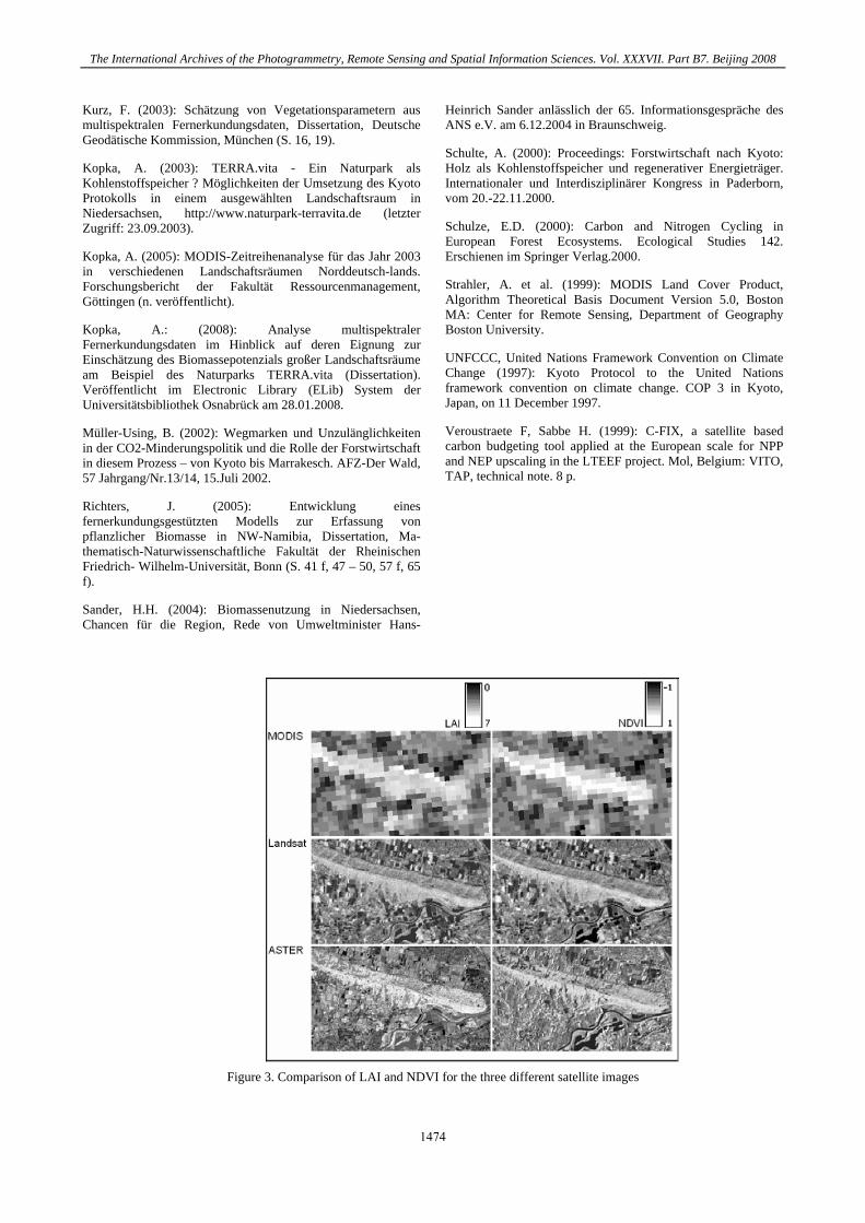
The Leaf Area Index (LAI) in combination with the Normalized Differenced Vegetation Index (NDVI) can very well be calculated from remote sensing data; especially the results from the ASTER images are significant (s. fig. 3). In addition all satellite images were classified with the standard Maximum Likelihood (ML) and Minimum Distance to mean (MD) methods. The following Error-Matrix gives a good impression of classification results of ASTER in comparison with CORINE Land Cover 2000 (s. fig. 4). The present examination shows that the Maximum Likelihood classification of the ASTER images, with accordance about over 80 percent with the ground truth, are best suited to calculate these parameters. The good results of the ASTER satellite data with the Maximum Likelihood classification, especially with the adjustment of the estimated spectral indices as the LAI (s. also fig. 5) were even better than the results of MODIS or LANDSAT. It explains on the one hand which parameters of the developed model can determined using remote sensing satellite images and, on the other hand, which parameters must be measured in the field to complete the statistics. The high chronology and availability of data with a moderate resolution compensates sometimes the disturbances and problems with the data evaluation and analysis. “Low- cost-data” could be used in large-scaled areas, especially for environmental research. But the primal condition for the use of satellite data - especially in vegetation models with multispectral data - is (and remains) the infrared channel. Summarized, the research shows the quality and robustness of the calculated parameters for the different satellite images MODIS, LANDSAT and ASTER in combination with CORINE and in the comparison with the terrestrial measurements. New improvements on these remote sensing based vegetation models are imaginable. At least moderate resolution satellite data can have a useful impact on forest monitoring systems.
REFERENCES
Blaschke, R. & Felbermeier, B. (2003): Satellitendaten für die Forstwirtschaft, Nutzungsanforderungen der forstlichen Praxis und Potential der optischen Satellitenfernerkundung, Forstliche Forschungsberichte München, Nr. 196, München.
BMELV, Bundesministerium für Ernährung, Landwirtschaft und Verbraucherschutz (2005): Die zweite
Bundeswaldinventur-BWI². Der Inventurbericht. Zu den Bundeswaldinventur-Erhebungen 2001 bis 2002 und 1986 bis 1988.
Böswald, K. (1996): Zur Bedeutung des Waldes und der Forstwirtschaft im Kohlenstoffhaushalt, eine Analyse am Beispiel des Bundeslandes Bayern. Forstliche Forschungsberichte München, Nr. 159, München (S. 4, 5 und 7).
Böswald, K., Martini, S. & Schröder, M. (2001): Das Bonn Agreement und die Rolle der Wälder. Erschienen in AFZ-Der Wald v. 56(23) S. 1246-1248.
Dawson, T.P., North, P., Plummer, S. E. & Curran, P.J. (2003): Forest ecosystem chlorophyll content: implications for remotely sensed estimates of net primary productivity, Taylor & Francis Ltd., Journal of Remote Sensing, Ausgabe 24, Nr. 3 (S. 612 f).
Di Bella, C.M., Paruelo, J.M., Becerra, J.E., Bacour, C., Baret, F. (2004): Effect of senescent leaves on NDVI- based estimates of fAPAR: experimental and modelling evidences, Taylor & Francis Ltd., International Journal of Remote Sensing, Ausgabe 35, Nr. 23, 2004 (S. 5425).
DLR, Deutsches Zentrum für Luft- und Raumfahrt (2006): Corine Landcover 2000 - Bodenbedeckungsdaten für Deutschland, http://www.corine.dfd.dlr.de/ intro_de.html (letzer Zugriff: 11.01.2006).
Ehlers, M. (2002): Fernerkundung für GIS- Anwender – Sensoren und Methoden zwischen Anspruch und Wirklichkeit, in: Blaschke, T. (Hrsg.), Fernerkundung und GIS: Neue Sensoren – innovative Methoden, Herbert Wichmann Verlag, Heidelberg (S. 18).
Europarc & IUCN (2000): Richtlinien für Managementkategorien von Schutzgebieten - Interpretation und Anwendung der Managemenkategorien in Europa. Europarc und WCPA Grafenau, Deutschland.
Goetz, S.J. & Prince, S.D. (1996): Remote sensing of net primary production in boreal forest stands, Departement of Geography, University of Maryland, Elsevier Science B.V., Agricultural and Forest Meteorology, Nr. 78, 1996 (S. 152, 159).
Goetz, S.J., Prince, S.D., Goward, S.N., Thawley, M.M. & Small, J. (1999): Satellite remote sensing of primary production: an improved production efficiency modelling approach, Elsevier Science B.V., Ecological Modelling, Nr. 122 (S. 239 – 247).
Gangkofner, U. (1996): Methodische Untersuchung zur Vor- und Nachbereitung der Maximum Likelihood Klassifizierung optischer Fernerkundungsdaten. Dissertation, Fakultät für Geowissenschaften der Ludwig-Maximilians- Universität, München (S. 15, 115, 136, 138).
Gower, S.T., Kucharik, C.J. & Norman, J.M. (1999): Direct and Indirect Estimation of Leaf Area Index, fAPAR, and Net Primary Production of Terrestrial Ecosystems, Elsevier Science Inc., Remote Sensing of the Environment, Nr. 70, 1999 (S. 30).
IPCC, Intergovernmental Panel on Climate Change (2007): http://www.ipcc.ch (letzter Zugriff: 10.05.2007).
Janssens, J. (2002): Risk Management of investments in Joint implementation and clean development mechanism projects. Dissertation der Universität St. Gallen.
1473
The International Archives of the Photogrammetry, Remote Sensing and Spatial Information Sciences. Vol. XXXVII. Part B7. Beijing 2008
Kurz, F. (2003): Schätzung von Vegetationsparametern aus multispektralen Fernerkundungsdaten, Dissertation, Deutsche Geodätische Kommission, München (S. 16, 19).
Kopka, A. (2003): TERRA.vita - Ein Naturpark als Kohlenstoffspeicher ? Möglichkeiten der Umsetzung des Kyoto Protokolls in einem ausgewählten Landschaftsraum in Niedersachsen, http://www.naturpark-terravita.de (letzter Zugriff: 23.09.2003).
Kopka, A. (2005): MODIS-Zeitreihenanalyse für das Jahr 2003 in verschiedenen Landschaftsräumen Norddeutsch-lands. Forschungsbericht der Fakultät Ressourcenmanagement, Göttingen (n. veröffentlicht).
Kopka, A.: (2008): Analyse multispektraler Fernerkundungsdaten im Hinblick auf deren Eignung zur Einschätzung des Biomassepotenzials großer Landschaftsräume am Beispiel des Naturparks TERRA.vita (Dissertation). Veröffentlicht im Electronic Library (ELib) System der Universitätsbibliothek Osnabrück am 28.01.2008.
Müller-Using, B. (2002): Wegmarken und Unzulänglichkeiten in der CO2-Minderungspolitik und die Rolle der Forstwirtschaft in diesem Prozess – von Kyoto bis Marrakesch. AFZ-Der Wald, 57 Jahrgang/Nr.13/14, 15.Juli 2002.
Richters, J. (2005): Entwicklung eines fernerkundungsgestützten Modells zur Erfassung von pflanzlicher Biomasse in NW-Namibia, Dissertation, Ma-thematisch-Naturwissenschaftliche Fakultät der Rheinischen Friedrich- Wilhelm-Universität, Bonn (S. 41 f, 47 – 50, 57 f, 65 f).
Sander, H.H. (2004): Biomassenutzung in Niedersachsen, Chancen für die Region, Rede von Umweltminister Hans-
Heinrich Sander anlässlich der 65. Informationsgespräche des ANS e.V. am 6.12.2004 in Braunschweig.
Schulte, A. (2000): Proceedings: Forstwirtschaft nach Kyoto: Holz als Kohlenstoffspeicher und regenerativer Energieträger. Internationaler und Interdisziplinärer Kongress in Paderborn, vom 20.-22.11.2000.
Schulze, E.D. (2000): Carbon and Nitrogen Cycling in European Forest Ecosystems. Ecological Studies 142. Erschienen im Springer Verlag.2000.
Strahler, A. et al. (1999): MODIS Land Cover Product, Algorithm Theoretical Basis Document Version 5.0, Boston MA: Center for Remote Sensing, Department of Geography Boston University.
UNFCCC, United Nations Framework Convention on Climate Change (1997): Kyoto Protocol to the United Nations framework convention on climate change. COP 3 in Kyoto, Japan, on 11 December 1997.
Veroustraete F, Sabbe H. (1999): C-FIX, a satellite based carbon budgeting tool applied at the European scale for NPP and NEP upscaling in the LTEEF project. Mol, Belgium: VITO, TAP, technical note. 8 p.
Figure 3. Comparison of LAI and NDVI for the three different satellite images
1474

The International Archives of the Photogrammetry, Remote Sensing and Spatial Information Sciences. Vol. XXXVII. Part B7. Beijing 2008
Figure 4. Error-Matrix of ASTER ML classification in comparison with CORINE
Figure 5: LAI (0 = transp.) and NDVI (top) with ML classification of ASTER (bottom)
1475

The International Archives of the Photogrammetry, Remote Sensing and Spatial Information Sciences. Vol. XXXVII. Part B7. Beijing 2008
1476