Modeling Submarine Landslide-Generated Waves in Lake Ohrid, Macedonia/Albania
11
Advances in Natural and Technological Hazards Research Submarine Mass Movements and Their Consequences Sebastian Krastel · Jan-Hinrich Behrmann David Völker · Michael Stipp Christian Berndt · Roger Urgeles Jason Chaytor · Katrin Huhn Michael Strasser · Carl Bonnevie Harbitz Editors 6th International Symposium
Transcript of Modeling Submarine Landslide-Generated Waves in Lake Ohrid, Macedonia/Albania

Advances in Natural and Technological Hazards Research
Submarine Mass Movements and Their Consequences
Sebastian Krastel · Jan-Hinrich BehrmannDavid Völker · Michael StippChristian Berndt · Roger UrgelesJason Chaytor · Katrin HuhnMichael Strasser · Carl Bonnevie Harbitz Editors
6th International Symposium

Chapter 44Modeling Submarine Landslide-GeneratedWaves in Lake Ohrid, Macedonia/Albania
Katja Lindhorst, Sebastian Krastel, Cord Papenberg,and Mohammed Heidarzadeh
Abstract We study potential tsunami hazards associated with submarine landslidesin Lake Ohrid, Macedonia/Albania. The transboundary Lake Ohrid located on theBalkan Peninsula shared by Macedonia and Albania is considered to be the oldest-continuously existing lake in Europe (2–5 Ma), though the age and the origin are notcompletely unraveled to date. Previous studies by means of hydroacoustic methodshave shown that the western margin of Lake Ohrid has a long history of masswasting. Based on seismic data, slide deposits are found in different stratigraphiclevels as well as on the lake floor where they have affected a large area. This studyis focused on the well-studied Udenisht Slide Complex covering an area of 27 km2
within the southwestern part of Lake Ohrid. The Udenisht slide is by far the largestmass movement with an average thickness of 30–40 m and an estimated volumeof about 0.11 km3. It is therefore well within the limits of submarine landslidesthat are known to be capable of triggering tsunamis. Using numerical modeling, thepropagation of a landslide-generated tsunami with an initial wave height of morethan 5 m has been calculated. Run-up heights estimated for coastal communitiesaround the lake are moderate in the north (2–3 m) can reach up to 10 m directly atthe site where the slide initiated. This study is a first generation of landslide tsunamihazard assessment for Lake Ohrid and further detailed modeling is recommendedfor the region.
Keywords Lake Ohrid • Submarine landslide • Tsunami • Numerical modeling
K. Lindhorst (�) • S. Krastel (�)Institute of Geosciences, Christian-Albrechts Universitat zu Kiel, Kiel, Germanye-mail: [email protected]; [email protected]
C. PapenbergHelmholtz Centre for Ocean Research Kiel, Kiel, Germany
M. HeidarzadehCluster of Excellence – The Future Ocean, Institute of Geosciences, Christian-AlbrechtsUniversity zu Kiel, Kiel, Germany
S. Krastel et al. (eds.), Submarine Mass Movements and Their Consequences, Advancesin Natural and Technological Hazards Research 37, DOI 10.1007/978-3-319-00972-8 44,© Springer International Publishing Switzerland 2014
497

498 K. Lindhorst et al.
44.1 Introduction and Study Area
Lake Ohrid situated on the Balkan Peninsula (Fig. 44.1) in a tectonically-formedbasin is most likely the oldest lake in Europe (2–5 Ma, Albrecht and Wilke 2008).Surrounded by high mountains, the surface of Lake Ohrid is located at an altitude of693 m above sea level. It extends 30 km north-south and 15 km east-west coveringan area of about 360 km2.
The total water volume of Lake Ohrid is 55 km3; maximum water depth reaches293 m (Popovska and Bonacci 2007). Previous geophysical investigations showedthe importance of Lake Ohrid as a valuable archive to study the sedimentaryevolution of a graben system over several million years (Lindhorst 2012).
Lake Ohrid has been formed as a pull-apart basin in Late Miocene with subse-quent E-W extension within the South Balkan Extensional Regime (Burchfiel et al.2008; Lindhorst 2012). The sedimentary infill within the central part of the basinindicates that Lake Ohrid existed continuously since its initial formation (Lindhorstet al. 2010). A first chronological model suggests that the oldest sediments withinthe deepest part of the basin are at least 2 Ma old (Lindhorst 2012). Acoustic datashow widespread mass wasting deposits.
In this study we investigate the tsunamigenic potential of landslides within LakeOhrid using numerical modeling. First, we briefly summarize mass wasting featureswithin the basin. Afterwards we present results of our modeling approach with
Fig. 44.1 General location map of Lake Ohrid on the Balkan Peninsula
44 Modeling Submarine Landslide-Generated Waves in Lake Ohrid. . . 499
a focus on wave amplitudes at several stations along the shore of Lake Ohrid.Our results increase the general understanding of landslide-generated hazard withinactive basins and can be seen as a case study for other deep lakes with steep flanksespecially in regions with high seismic activities such as the alpine lakes.
44.1.1 Mass Wasting in Lake Ohrid
Slide deposits are widespread within the basin and can be found at differentstratigraphic levels indicating that Lake Ohrid has a long history of mass wasting.Possible trigger mechanisms for submarine sliding events within Lake Ohrid werediscussed in Lindhorst et al. (2012). The fact that Lake Ohrid is located within aseismically active region and the location of the Udenisht slide is along the activemargin point to an earthquake as the most likely trigger for the Udenisht slide event.For example, Wagner et al. (2012) showed that an earthquake in the sixth centurymost likely triggered a slide in the northwestern part of Lake Ohrid.
Seismic cross sections of the southwestern part of Lake Ohrid show severalchaotic units interpreted as mass wasting deposits within the youngest sedimentarysuccession (Lindhorst et al. 2012). In total, six slide deposits stacked on top ofeach other have been mapped. Up to 75 m-thick sediments overlay the oldest slidedeposits (Lindhorst et al. 2012). The Udenisht slide complex is the most prominentsubaquatic failure event in Lake Ohrid. Sediment echosounder profiles across thesliding area only show a thin sedimentary cover. Taking the sedimentation rate intoaccount it was suggested that the event is younger than 1,500 years (Lindhorstet al. 2012). The sliding area can be identified by means of morphological dataas shown in Fig. 44.2. The Udenisht slide covers almost 10 % of the entire lakesurface. The Udenisht slide has a long run-out distance. Slide deposits are up to 50 mthick (Fig. 44.2). The volume of the slide is estimated to be �0.11 km3 (Lindhorstet al. 2012). Interpretation of the slide morphology suggest that the slide can beclassified as a retrogressive submarine mass movement with at least two sub-eventsand sudden failures of major blocks in the upper part of the slide area (Lindhorstet al. 2012). Although a distinct head wall of the slide has not been detected, wefound evidence that the major event was initiated in shallow water depth. In 2009 abathymetric survey was carried out by means of an ELAC Seabeam 1180 multibeamdevice resulting in a high resolution topography map (Fig. 44.2). The Udenisht slidearea is characterized by an upper slope area bounded by distinct sidewalls and a run-out area where slide deposits up to a thickness of 60 m can be found (Lindhorst et al.2010, 2012). Furthermore, the present topography excludes that the Udenisht slidewas triggered onshore. Seismicity along an active fault trending in NW-SE directionand crossing the upper part of the sliding area, has been interpreted as a trigger fora sub-event in a water depth of about 120 m (Lindhorst 2012).

500 K. Lindhorst et al.
Fig. 44.2 Bathymetric map of the southwestern part of Lake Ohrid showing the morphology ofthe Udenisht slide complex. Two seismic cross sections showing the slide deposits of the Udenishtslide (yellow dashed line in S-N direction) and the slump (E-W profile) further to the north thatwe used for evaluating input parameters of the modeled tsunami. Two additional slumps along thewestern margin are marked
44.1.2 Numerical Approach
We use the numerical model TUNAMI-N2 (Imamura et al. 2006; Yalciner et al.2004) to simulate the propagation of long waves generated by possible submarinelandslides within Lake Ohrid. Developed at the Tohoku University in Japan byFumihiku Imamura and Nobou Shuto, TUNAMI is one the famous international nu-merical codes validated with both laboratory and field tsunami data (Yeh et al. 1996).
Tsunami modeling is usually composed of three steps of (1) generation, (2)propagation and (3) inundation. Here, we prevent the waves from inundation ondryland by imposing a vertical wall near the shoreline. To estimate the run-upheights at the main coastal communities around Lake Ohrid, we calculate tsunamiwave height at offshore water depth and then apply an empirical equation toestimate the run-up heights. In our numerical simulations, wave evolution beyondwater depth of 20 m is prohibited, and then empirical equations are used to

44 Modeling Submarine Landslide-Generated Waves in Lake Ohrid. . . 501
estimate run-up heights. Therefore, near-shore wave phenomena such as wavebreaking are not considered here. This may imply an over-estimation of the run-up heights.
44.1.3 Initial Tsunami Wave
The initial tsunami wave amplitude will be build up during the acceleration timeof the underwater slump. Combined information from high resolution bathymetricand seismic data within the area of the Udenisht slide provide input parametersto constrain the exact location, water depth, slide direction, and the geometry ofthe slide. However, the initial failure mechanism is difficult to reconstruct becausewe do not find a distinct headwall today. In order to overcome this problem, weassume that the Udenisht slide initially started as a slump similar to those observedfurther to the North (Fig. 44.2). Based on this assumption we apply the semi-empirical formulas proposed by Watts et al. (2003) and Grilli and Watts (2005)for our numerical modeling of landslide tsunamis.
The modeled submarine slide is located on the upper slope in a water depth of120 m of the Udenisht slide complex and moves about 200 m downslope (Fig. 44.2).We further assume that a slide block rotates around a very small angle so thatthe movement can be described as a translation parallel to the slope. We do notaccount for deformation of the sliding block during the short acceleration time (t0)until the maximum depression at the water surface is reach and the initial tsunamiwave has been build-up. We assume a specific density of 1,900 g/cm3 and slidegeometry with width of 2,500 m, a length of 500 m, and a thickness of about 50 mresulting in a volume of 0.0625 km3 for the simulated sliding block. This volumeis half the volume of the Udenisht slide deposits (Lindhorst et al. 2012), whichwe consider as realistic initial slide volume because seismic data show significantentrainment of underlying sediments during slide propagation. The time t0 until themaximum surface depression was generated is 14.7 s. The resulting wave has awavelength �0 D 510 m and the characteristic wave height is 5.20 m. We calculatedan initial acceleration of a0 D 0.8 m/s2, a maximum velocity of umax D 11.4 m/s, acharacteristic distance of motion of S0 D 170 m, and a small angular displacementof �· D 0.54 rad.
44.2 Results
44.2.1 Wave Propagation and Estimated Run-Up Heights
The propagation of the modeled tsunami wave is shown in Fig. 44.3. Our modeledmass wasting event induces a tsunami wave reaching Progradec, Sveti Naum,Gradiste, Ohrid, and Struga after 0.5, 4, 4.5, 8, 10 min, respectively (Fig. 44.4).

502 K. Lindhorst et al.
Fig. 44.3 Tsunami wave distribution (red and blue colored) in Lake Ohrid after 4 mins. Isolinesshow wave propagation after initiation at the slide location (dashed square) over a time period of 10mins. After that time the tsunami has reached all the coastlines. Grey bars indicate run-up heightnormalized to the maximum run-up at Udenisht. Green dots are the virtual tidal gauge stations(Fig. 44.4)
Waves hit the coast at Udenisht immediately after failure occurs (Fig. 44.4). Themaximum wave heights at the virtual gauge stations off Udenisht, Progradec, SvetiNaum, Gradiste, Ohrid, and Struga are 75, 60, 120, 60, 23, and 13 cm, respectively.The time histories of tsunami waves at selected locations are shown in Fig. 44.4. Asshown, the artificial gauges are located at different water depths of 22, 18, 20, 18,and 20 m.
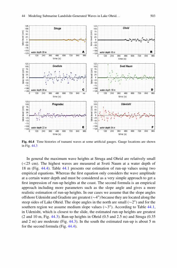
44 Modeling Submarine Landslide-Generated Waves in Lake Ohrid. . . 503
Fig. 44.4 Time histories of tsunami waves at some artificial gauges. Gauge locations are shownin Fig. 44.3
In general the maximum wave heights at Struga and Ohrid are relatively small(<25 cm). The highest waves are measured at Sveti Naum at a water depth of18 m (Fig. 44.4). Table 44.1 presents our estimation of run-up values using twoempirical equations. Whereas the first equation only considers the wave amplitudeat a certain water depth and must be considered as a very simple approach to get afirst impression of run-up heights at the coast. The second formula is an empiricalapproach including more parameters such as the slope angle and gives a morerealistic estimation of run-up heights. In our cases we assume that the slope anglesoffshore Udenisht and Gradiste are greatest (�4ı) because they are located along thesteep sides of Lake Ohrid. The slope angles in the north are small (�2ı) and for thesouthern region we assume medium slope values (�3ı). According to Table 44.1,in Udenisht, which is closest to the slide, the estimated run-up heights are greatest(2 and 10 m, Fig. 44.3). Run-up heights in Ohrid (0.5 and 2.5 m) and Struga (0.35and 2 m) are moderate (Fig. 44.3). In the south the estimated run-up is about 5 mfor the second formula (Fig. 44.4).

504 K. Lindhorst et al.
Table 44.1 Estimation of run-up values using empirical equation
LocationOffshore surfaceelevation (m) Water depth (m) Slope angle (ı) R1 (m)a R2 (m)b
Udenisht 0.76 54 4 1.8 10Progradec 0.6 22 3 0.8 4Sveti Naum 1.2 18 3 2 6Gradiste 0.6 20 4 1.2 5Ohrid 0.23 18 2 0.5 2.5Struga 0.13 20 2 0.35 2
aThe empirical equation by Ward and Asphaug (2003) was used: R1 D 5
qA.d/4 � 5
pd, where
A(d) is the tsunami amplitude at water depth dbThe equation proposed by Ward and Day (2007): R2 D 3:26 � H0 � .tan ˇ/0:42 �
�A0
H0
�0:41
,
in which H0 is the offshore water depth in meters, A0 is the wave amplitude at the water depthof H0 in meters, ˇ is the slope of the beach, and R is runup height in meters
44.3 Discussion and Conclusion
In order to discuss results of our modeled tsunami wave distribution across LakeOhrid we compare our estimated run-up value to an empirical formula of Lynett andLiu (2005). In their approach they calculated run-up heights by taking the geometry,submergence depth and slope angle of the failure area into account to estimate arun-up at the coast closest to the submarine landslide event. The equation by Lynettand Liu (2005) gives a run-up value of about 6 m which is close to the valuespresented here.
According to a morphological analysis, the tsunamigenic potential for theUdenisht slide has been characterized as low (Lindhorst et al. 2012). A longrun-out distance of slide material and the fact that the Udenisht slide has beencharacterized as a retrogressive event with at least two sub-events further reducethe absolute volume of individual failure events. However, this study illustratesthat, in general, sub-lacustrine mass failure events as observed within the modernlake floor morphology inhibit a tsunamigenic potential. Results from our numericalmodeling presented here show that an underwater slump with a shape similar tothat in the northwestern part located at the site of the Udenisht slide is capableto trigger a tsunami wave. Our preliminary modeling shows that this wave wouldpropagate across the entire lake in about 10 min but would have small to moderateestimated run-ups at the cities of Ohrid and Struga (see Table 44.1). At the villageof Udenisht and in the southern area of Lake Ohrid we find that the estimatedrun-ups are large enough to cause significant damages along the coast and arehence a potential hazard for the coastal communities. The time between landslideand tsunami arrival at Udenisht, Progradec, Sveti Naum, and Gradiste is less than5 min.
44 Modeling Submarine Landslide-Generated Waves in Lake Ohrid. . . 505
For our numerical solution we assume a simplistic scenario with the followingassumptions: (1), a simple geometry of the sliding block (2) non retrogressivebehavior of the slide, (3) the present of an intact block comparable to a slump,(4) a short horizontal displacement of �200 m, and (5) a submergence depthof about 120 m. A slump-type failure was considered in our modeling because,according to Watts et al. (2005), it has a higher potential to trigger a tsunami thansubmarine slides. The effect of retrogressive behavior of a landslide would reducethe maximum surface elevation and lead to smaller amplitudes (Bondevik et al.2005; Harbitz et al. 2006). On the other hand, intense slide deformation in shallowwater may increase coastal run-up by more than a factor of 2 and 3 (Grilli and Watts2005). Hence tsunamis of significant height would be triggered, if further failuresoccur at the uppermost part of the Udenisht slide area.
In order to evaluate the influence of slide volume and initial submergencedepth to the initial wave height we ran the tsunami model with higher and lowerslide volumes as well as with higher submergence depth as input parameters thanpresented here which would then effect the coastal amplification. We found thatthe initial wave height increases dramatically if the tsunami initiates in shallowerwater depth. We considered these heights as unrealistic for Lake Ohrid becausesuch an event during the last 2,000 years would have been mentioned in primarysources. Because our model does not allow wave breaking effect we could onlysimulate a tsunami in water depth greater than 50 m. The highest variability in inputparameters is slide volume. Although we have a good estimation of the volume thatgot deposited after the failure along the western margin but it is uncertain whetherthese deposits are evidences for one single event. In addition our morphological dataindicates that the Udenisht slide is a complex system of more than one event that isdifferent in size and submergence depth. In general, an increase in volume wouldalso increase the initial wave height and subsequently higher damages around thecoast of Lake Ohrid.
In conclusion, this study gives a first impression of the tsunamigenic potentialof sub-lacustrine mass movement events which are common within Lake Ohrid andhave been found in different stratigraphic levels. Our study suggests that a potentialtsunami hazard within Lake Ohrid cannot be neglected although our preliminarymodeling showed that the run-up values would be small. This approach, however,points to the urgent need for more sophisticated modeling approaches for landslidegenerated tsunamis in Lake Ohrid and comparable lakes.
Acknowledgments We thank the reviewers Hendrik Vogel and Ahmet C. Yalciner as well asthe editor Carl B. Harbitz for their comments and suggestions that improved the manuscript. TheTUNAMI-N2 code used is this paper is originally authored by Professors Fumihiku Imamura andNobou Shuto at the Tohoku University in Japan. TUNAMI-N2 is copyrighted to Professors AhmetC. Yalciner, Fumihiku Imamura and Costas E. Synolakis. We acknowledge them for developingand making available the code to scientists around the world. We also would like to thank SaschaBrune for his constructive cooperation regarding landslide tsunami modeling. We also thank C.Berndt for valuable comments.

506 K. Lindhorst et al.
References
Albrecht C, Wilke T (2008) Ancient Lake Ohrid: biodiversity and evolution. Hydrobiologia615:103–140. doi:10.1007/s10750-008-9558-y
Bondevik S, Løvholt F, Harbitz C, Mangerud J, Dawson A, Svendsen J (2005) The StoreggaSlide tsunami—comparing field observations with numerical simulations. Mar Petrol Geol22:195–208
Burchfiel B, Nakov R, Dumurdzanov N, Papanikolaou D, Tzankov T, Serafimovski T, King R,Kotzev V, Todosov A, Nurce B (2008) Evolution and dynamics of the Cenozoic tectonics ofthe South Balkan extensional system. Geosphere 4:918
Grilli ST, Watts P (2005) Tsunami generation by submarine mass failure. I: modeling, experimentalvalidation, and sensitivity analyses. J Waterw Port Coast Ocean Eng 131(6):283–297
Harbitz C, Løvholt F, Pedersen G, Masson D (2006) Mechanisms of tsunami generation bysubmarine landslides: a short review. Nor J Geol 86:255–264
Imamura F, Yalciner AC, Ozyurt G (2006) Tsunami modelling manual. UNESCO IOC interna-tional training course on Tsunami Numerical Modelling
Lindhorst K (2012) Neotectonic and sedimentary evolution of Lake Ohrid (Albania/Macedonia):acquisition and interpretation of new hydro-acoustic and seismic data. Unpublished PhD thesis,Christian-Albrechts-Universitat zu Kiel, Kiel
Lindhorst K, Vogel H, Krastel S, Wagner B, Hilgers A, Zander A, Schwenk T, Wessels M,Daut G (2010) Stratigraphic analysis of lake level fluctuations in Lake Ohrid: an integrationof high resolution hydro-acoustic data and sediment cores. Biogeosciences 7:3531–3548.doi:10.5194/bgd-7-3651-2010
Lindhorst K, Gruen M, Krastel S, Schwenk T (2012) Hydroacoustic analysis of mass wastingdeposits in Lake Ohrid (FYR Macedonia/Albania). In: Submarine mass movements and theirconsequences. Springer, Dordrecht, pp 245–253
Lynett P, Liu PL-F (2005) A numerical study of the run-up generated by three-dimensionallandslides. J Geophys Res 110(C3):C03006
Popovska C, Bonacci O (2007) Basic data on the hydrology of Lakes Ohrid and Prespa. HydrolProcess 21(5):658–664
Wagner B, Francke A, Sulpizio R, Zanchetta G, Lindhorst K, Krastel S, Vogel H, Daut G,Grazhdani A, Lushaj B (2012) Seismic and sedimentological evidence of an early 6th centuryAD earthquake at Lake Ohrid (Macedonia/Albania). Climate Past 8:2069–2078
Ward SN, Asphaug E (2003) Asteroid impact tsunami of 2880 March 16. Geophys J Int153(3):F6–F10
Ward SN, Day S (2007) Tsunami balls: a granular approach to tsunami runup and inundation.Commun Comput Phys 3(1):222–249
Watts P, Grilli S, Kirby J, Fryer G, Tappin D (2003) Landslide tsunami case studies using aBoussinesq model and a fully nonlinear tsunami generation model. Nat Hazards Earth SystSci 3(5):391–402
Watts P, Grilli S et al (2005) Tsunami generation by submarine mass failure. II: predictive equationsand case studies. J Waterw Port Coast Ocean Eng 131:298
Yalciner A, Pelinovsky E, Talipova T, Kurkin A, Kozelkov A, Zaitsev A (2004) Tsunamis in theBlack Sea: comparison of the historical, instrumental, and numerical data. J Geophys Res109(C12):C12023
Yeh HH-J, Liu PL, Synolakis C (1996) Long-wave runup models: Friday Harbor, USA, 12–17September 1995. World Scientific, Singapore