Migratory routes, domesticated birds and cercarial dermatitis
Upload
independentCategory
view
0download
0
MIGRATORY BIRD STOPOVER SITE ATTRIBUTES IN THE WESTERN LAKE ERIE BASIN
FINAL REPORT PREPARED BY
David N. Ewert, The Nature Conservancy Gregory J. Soulliere, Upper Mississippi River-Great Lakes Joint Venture,
U.S. Fish & Wildlife Service Robb D. Macleod, Ducks Unlimited
Mark C. Shieldcastle, Ohio Department of Natural Resources, Division of Wildlife Paul G. Rodewald, School of Environment and Natural Resources,
The Ohio State University Elaine Fujimura, The Nature Conservancy
Julie Shieldcastle, Black Swamp Bird Observatory Robert J. Gates, School of Environment and Natural Resources,
The Ohio State University
PREPARED UNDER CONTRACT WITH
The George Gund Foundation
April 2006
This document should be cited as: Ewert, D.N., G.J. Soulliere, R.D. Macleod, M.C. Shieldcastle, P.G. Rodewald, E. Fujimura, J.
Shieldcastle, and R.J. Gates. 2005. Migratory bird stopover site attributes in the western Lake Erie basin. Final report to The George Gund Foundation.
David N. Ewert The Nature Conservancy
101 East Grand River Lansing, MI 48906
Paul G. Rodewald School of Environment and Natural Resources
The Ohio State University 375 Kottman Hall 2021 Coffey Road
Columbus, OH 43210-1085
Gregory J. Soulliere Upper Mississippi River-Great Lakes Joint
Venture U.S. Fish and Wildlife Service
2651 Coolidge Road East Lansing, MI 48837
Elaine Fujimura The Nature Conservancy
6375 Riverside Drive, Suite 50 Dublin, OH 43017
Robb D. Macleod Ducks Unlimited
331 Metty Drive, Suite 4 Ann Arbor, MI 48103
Julie Shieldcastle Black Swamp Bird Observatory
P.O. Box 228 Oak Harbor, OH 43449
Mark C. Shieldcastle Crane Creek Wildlife Research Station Ohio Department of Natural Resources
Division of Wildlife 13229 W. State Route 2 Oak Harbor, OH 43449
Robert J. Gates School of Environment and Natural Resources
The Ohio State University 2021 Coffey Road
Columbus, OH 43210-1095
i
TABLE OF CONTENTS
Executive Summary 1 Introduction 3 Application of This Work 5 Identification of Stopover Site Attributes 6 Attributes and Scoring Systems of Stopover Sites by Bird Group 8
Waterfowl............................................................................................................................................... 8 Introduction...................................................................................................................................... 8 Priority Species ................................................................................................................................ 9 Assumptions and Caveats .............................................................................................................. 10 Landscape Attributes ..................................................................................................................... 10 Site Attributes ................................................................................................................................ 11 Research and Monitoring Needs .................................................................................................... 12 Attributes of Stopover Sites for Waterfowl Conservation and Management................................. 13
Shorebirds............................................................................................................................................. 15 Introduction.................................................................................................................................... 15 Priority Species .............................................................................................................................. 15 Assumptions and Caveats .............................................................................................................. 16 Landscape Attributes ..................................................................................................................... 16 Site Attributes ................................................................................................................................ 17 Research and Monitoring Needs .................................................................................................... 19 Attributes of Stopover Sites for Shorebird Conservation and Management.................................. 20
Raptors.................................................................................................................................................. 24 Introduction.................................................................................................................................... 24 Priority Species .............................................................................................................................. 24 Assumptions and Caveats .............................................................................................................. 24 Landscape Attributes ..................................................................................................................... 24 Site Attributes ................................................................................................................................ 25 Research and Monitoring Needs .................................................................................................... 25 Attributes of Stopover Sites for Raptor Conservation and Management....................................... 26
Landbirds.............................................................................................................................................. 26 Introduction.................................................................................................................................... 26 Priority Species .............................................................................................................................. 27 Assumptions and Caveats .............................................................................................................. 27 Landscape Attributes ..................................................................................................................... 28 Site Attributes ................................................................................................................................ 30 Research and Monitoring Needs .................................................................................................... 33 Attributes of Stopover Sites for Landbird Conservation and Management ................................... 33
Waterbirds (non-waterfowl, including marsh birds) ............................................................................ 36 Introduction.................................................................................................................................... 36 Priority Species .............................................................................................................................. 37 Assumptions and Caveats .............................................................................................................. 37 Landscape Attributes ..................................................................................................................... 37 Site Attributes ................................................................................................................................ 38 Research and Monitoring Needs .................................................................................................... 38 Priority Attributes of Stopover Sites for Waterbird Conservation and Management .................... 38
ii
Stopover Site Attributes in the Western Lake Erie Basin Shared by Two or More Groups of Birds 39
Acknowledgements 40 Literature Cited 41 Appendix A. Identified Stopover Sites in the Western Lake Erie Basin A-1 Appendix B. Threats to Stopover Sites B-1 Appendix C. Area of Concern Sites on the United States Side
of the Western Lake Erie Basin C-1 Appendix D. Scientific Names of Bird Species Noted in This Report D-1 Appendix E. Conservation Plans and Opportunities in the Western Lake Erie Basin E-1 Appendix F. Description of the GIS Data Layers F-1
Wetlands..............................................................................................................................................F-1 Michigan and Ohio Department of Natural Resources Maps..............................................................F-1 Potential Wetland Restoration.............................................................................................................F-1 DEM ....................................................................................................................................................F-2 Landcover............................................................................................................................................F-2
Appendix G. Recommendations for Shorebird Protection G-1 Appendix H. Estimates of Numbers of Birds Using the Lake Erie Coastal Area H-1 Appendix I. U.S. Fish and Wildlife Service Guidelines for Tower
and Wind Turbine Development I-1 Service Interim Guidelines for Recommendations on Communications Tower Siting,
Construction, Operation, and Decommissioning ...........................................................................I-1
iii
LIST OF TABLES AND FIGURE
Table 1. Stopover Site Attributes Common to Two or More Bird Groups ............................................. 2 Table 2. Expert-Based Scores Assigned to Waterfowl Stopover Site Attributes Available as Digital,
Spatial Data ............................................................................................................................. 14 Table 3. Habitat and Foraging Characteristics of Shorebirds Grouped by Guild.................................. 18 Table 4. Expert-Based Scores Assigned to Shorebird Stopover Attributes Available as Digital,
Spatial Data ............................................................................................................................. 22 Table 5. Expert-Based Scores Assigned to Landbird/Raptor Stopover Attributes
Available as Digital, Spatial Data ........................................................................................... 35 Table A-1. Important Ohio Stopover Sites Identified for This Project by Mark Shieldcastle.................A-2 Table A-2. Important Stopover Sites in the Western Lake Erie Basin, United States,
Noted by Bird Conservationists Familiar with the Area .......................................................A-3 Figure 1. Portion of the Western Lake Erie Basin Covered by This Plan ................................................ 4
1
EXECUTIVE SUMMARY
The western Lake Erie basin provides important stopover sites for all groups of migratory birds: waterfowl, shorebirds, raptors, other landbirds, and waterbirds (loons, grebes, cormorants, herons, rails, cranes, gulls and terns). The landscape has been dramatically altered from presettlement conditions yet the region remains important for birds to rest and feed so they can continue their migration in good physiological condition. Unfortunately, habitat loss in the region continues, potentially jeopardizing the ability of birds to maintain sufficient condition to successfully complete their migration. Consequently, it is critical and urgent to define, protect, restore, and better manage migratory bird stopover sites in the western Lake Erie basin. In this report, we (1) identify and summarize ecological and spatial attributes of migratory bird stopover sites in the United States portion of the western Lake Erie basin based on the literature and unpublished sources, and (2) outline a system for ranking the relative conservation importance of migratory bird stopover sites in the western Lake Erie basin that may also be useful elsewhere in the Great Lakes region and beyond. Application of this system may be especially useful for those seeking to optimize conservation of stopover sites for all groups of birds. We anticipate that the stopover site attributes and ranking system summarized here can serve as a model for identifying and prioritizing stopover sites for conservation action throughout the Great Lakes basin and beyond. Efforts have been initiated in Wisconsin to adopt this model for areas near the Lake Michigan and Superior coastlines. This work should provide an invaluable extension of our work in the western Lake Erie basin. Although each group of birds has specific migration habitat requirements, some stopover site attributes are common to species from two or more groups of birds (Table 1). Sites with these attributes may be disproportionately important for conservation purposes.
2
Table 1. Stopover Site Attributes Common to Two or More Bird Groups. Most species of each group are associated with a stopover site attribute
where indicated by an “X”. Owls are considered with landbirds.
Stopover site attribute Waterfowl Shorebirds Waterbirds Landbirds Raptors
High aquatic insect productivity, especially during spring
X X X X
Close proximity to the Great Lakes
X X X X X
Close proximity to intact natural or semi-natural habitats (e.g., forests, wetlands, etc.)
X X X X X
Moist soil, little vegetation X X X
Structurally diverse forests X X
Minimal human disturbance X X X X
Few or no towers X X X X X
Peninsulas and islands X X X
Low anthropogenic light levels (nocturnal migrants)
X X
3
INTRODUCTION
The western Lake Erie basin is dominated by the “Maumee Lake Plain,” a flat clay lake plain 32-70 km (20-40 miles) wide wrapping around western Lake Erie and Lake St. Clair (Albert 1995). Prior to Euro-American settlement, most of this clay lake plain supported upland and wetland hardwood forest. Extensive marshes occurred along the entire coast of the lakes. The marshes, reaching lakeward into water 1.5 m (5 feet) deep, were 3 km (2 miles) wide in places and extended long distances up major rivers. Lakeward from the marshes were beach ridge forests and broad zones of swamp forest, and in localized areas along Lakes Erie and St. Clair, there were 1-5 km (1-3 mile) wide expanses of wet prairie (Albert 1995). As water levels of the Great Lakes changed with precipitation cycles, coastal wetlands also underwent natural changes. Wet prairie, shallow marsh, and deep-water marsh zones shifted in location as the lake boundary moved inland and then back lakeward over time. This process, the dynamic lateral displacement of plant communities, further enhanced plant and wildlife diversity in the shoreline and nearshore wetland zone. The landscape of this region has changed dramatically over the past two centuries (Campbell 1995). Productive clay and loamy soils coupled with lake-moderated climate resulted in early and intensive agriculture in the western Lake Erie basin. Among the first areas in the region to be farmed by European settlers, most of the clay lands in the Maumee Lake Plain have been ditched and tiled and remain the most valued agricultural lands in this part of the Midwest. Shoreline dike construction and pumping have allowed vast expanses of wet prairie and some areas of marsh to be farmed. Remaining tracts of forest are generally <32 ha (80 acres) (Albert 1995). Erosion and sedimentation of the river systems, common today, were practically non-existent historically due to the stabilizing nature of the extensive forest and prairies (Lambert et al. 2001). The dynamic nature of coastal wetland plant communities has also been altered with the construction of dikes for farming and the “hardening” of the shoreline. Nearly all western Lake Erie marshes are now diked and much of the coastline has been hardened with groins, rip-rap, and other structures designed to prevent erosion (Bookhout et al. 1989). Lateral movement of plant communities resulting from lake level fluctuations has largely been eliminated within diked systems. Stopover sites in the Lake Erie region are important for all groups of birds and include several sites of global significance identified through Important Bird Areas programs (Lambert et al. 2001) and other conservation plans (see Appendix A for a list of identified stopover sites). The western Lake Erie basin, and neighboring Detroit River and Lake St. Clair, constitute one of the most important mid-continent areas for migrating birds. Although the region is only part of any migration route, the Ohio and Michigan portions of the western Lake Erie basin were selected as focus areas (see Figure 1) because so much of the landscape has been altered anthropogenically. Only 5% of the original 121,000 ha (307,000 acres) of Lake Erie marshes and swamps in northwestern Ohio remain (Bookhout et al. 1989), and habitat loss continues, further reducing the amount of habitat available for migrants. Compared to historical conditions, relatively few stopover sites remain; therefore, conservation of remaining stopover sites in this region is critical.
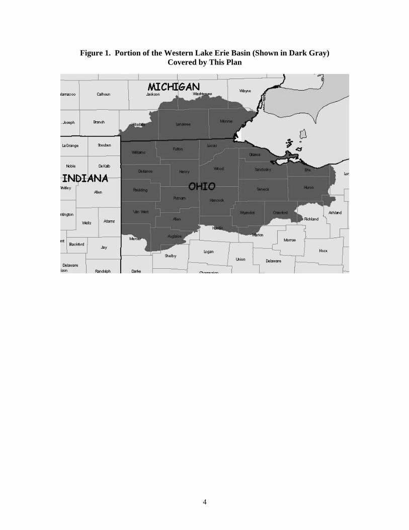
4
Figure 1. Portion of the Western Lake Erie Basin (Shown in Dark Gray) Covered by This Plan
5
APPLICATION OF THIS WORK
Comprehensive, published information on stopover sites in this region is surprisingly sparse. However, there is sufficient information to develop preliminary guidelines for ongoing and new efforts to protect, restore, and manage stopover sites in the western Lake Erie basin in the United States and, ultimately, Canada. Given the ongoing threats to stopover sites and potential for habitat restoration (e.g., agricultural programs), it is urgent to proceed with conservation using the best available knowledge (Knutson et al. 2001, Heglund and Skagen 2005). This report represents the first effort to compile and synthesize information on stopover sites for all groups of birds in the western Lake Erie basin; it is designed to facilitate the integrated and focused protection and restoration of migratory bird stopover sites in the western Lake Erie basin. We outline a region-specific set of stopover site attributes that we believe are required for migrating birds to reach breeding and wintering areas in good physiological condition. We also outline a system for scoring the relative conservation importance of migratory stopover sites in the western Lake Erie basin for individual bird groups (waterfowl, shorebirds, landbirds [including raptors], and waterbirds [loons, grebes, cormorants, herons, cranes, rails, gulls and terns]). In compiling the stopover site attributes, we also synthesized research and monitoring needs associated with each bird group (see associated “Research and monitoring needs” sections) and summarized threats to stopover sites (Appendix B), including those sites within Areas of Concern (Appendix C) for different groups of birds in the Ohio and Michigan portions of the Lake Erie basin. The scoring system outlined in this report can assist in the conservation of stopover sites in the western Lake Erie basin by allowing users to rank their relative importance and prioritize their conservation. To that end, it will be shared as a tool among other groups focused on biodiversity conservation in the western Lake Erie basin. Although specific attributes of stopover sites in the area will likely differ somewhat from other Great Lakes regions and beyond, both the methods for identifying stopover site attributes and the system for scoring stopover sites can serve as a model for developing similar tools in other regions. Scientific names of bird species referenced in this report are listed in Appendix D.
6
IDENTIFICATION OF STOPOVER SITE ATTRIBUTES
Based on a review of published and unpublished data, theses, reports, literature, and interviews with experts, we identified ecological and spatial attributes associated with heavily used or otherwise important stopover sites in the western Lake Erie basin. Expert opinion was particularly important in identifying stopover site attributes given the paucity of literature on stopover sites in the western Lake Erie basin (see also Lambert et al. 2001). Stopover sites that were considered to be “heavily used or otherwise important” (Appendix A) met one or more of the following criteria:
• high relative abundance of migrants at a site, • high or significant percentage of a species population using a site, • high or significant consistency of use between and within seasons (spring and fall), and • identified as important in selected bird conservation plans (e.g., Important Bird Areas, The
Nature Conservancy 1999). The spatial and ecological attributes that were determined to be associated with those stopover sites occur at two spatial scales: landscape-level and site-level. Landscape-level attributes likely determine which sites migrants choose from the array of available sites (Diehl et al. 2003), and site-level attributes determine whether the migrants—having chosen a particular site—can obtain adequate food, shelter, and protection to successfully continue and complete their migration. Landscape-level attributes may often be characterized using remotely sensed data (e.g., land use/land cover layers) or other spatial data layers. Due to their fine resolution, site-level attributes are frequently undetectable with remote sensing or similar technologies, including radar, and data obtained from intensive field studies may be required to characterize them.
Landscape attributes • Overall landscape type and cover, including vegetation and soils.
o Diversity and extent of natural or semi-natural habitat types (e.g., forests, wetlands, grasslands).
o Diversity and extent of natural or semi-natural unvegetated habitats (e.g., sandy beaches, mudflats, etc.).
o Extent of agricultural hydric soils. • Landscape pattern and context.
o Distance between patches of natural or semi-natural habitat (e.g., forests, wetlands, grasslands).
o Isolation and orientation of habitat patches. o Proximity to water (e.g., Lake Erie, impoundments, rivers, wetlands).
• Shoreline characteristics. o Substrate of nearshore waters. o Shoreline substrate (e.g., sand, mud). o Shoreline vegetation. o Whether shoreline is part of an island or peninsula.
7
Site attributes • Area of site (habitat patch). • Vegetation species composition and habitat structure. • Water quality. • Food availability during spring and fall. • Potential for restoration. • Species-specific stopover site requirements, especially for high-priority species.
Species-specific stopover site requirements are often not known. We compiled a list of species of highest conservation concern (emphasizing a global perspective) for each group of birds based on continental bird conservation plans (North American Waterfowl Management Plan 2004, U.S. Shorebird Conservation Plan 2004 – Brown et al. 2001, North American Landbird Conservation Plan - Rich et al. 2004, North American Waterbird Conservation Plan 2002 – Kushlan et al. 2002); species lists are given in sections for each bird group. As species-specific stopover requirements are determined, attributes of important stopover sites should be refined accordingly to further focus conservation work on species of highest conservation concern. By explicitly identifying the attributes known to be associated with heavily used or otherwise important stopover sites, we can develop a system for scoring all stopover sites in the region and determine their relative conservation importance, even where data on actual usage of the site by migrants is unavailable or incomplete.
8
ATTRIBUTES AND SCORING SYSTEMS OF STOPOVER SITES BY BIRD GROUP
To rank the relative importance of migratory stopover sites in the western Lake Erie basin, we developed scoring systems for sets of stopover site attributes identified for each of five bird groups: waterfowl, shorebirds, raptors, landbirds, and other waterbirds (loons, grebes, cormorants, herons, cranes, rails, gulls, terns). Each set of attributes is assigned a point total ranging from 1-5, very low to very high, respectively. If a stopover site has that set of attributes, it receives the assigned point value. The resulting scores indicate the sites’ relative importance to migrants for the group of birds for which the scoring system was developed. The scores can also be summed for all groups of birds for a single site so that its relative importance for all migratory birds can be assessed. Metadata for data layers referenced in this report appear in Appendix F.
WATERFOWL
Introduction
The lower Great Lakes, including western Lake Erie and neighboring Lake St. Clair, are recognized as areas of continental significance in the North American Waterfowl Management Plan (NAWMP 2004). More than 30 species of waterfowl use Great Lakes coastal waters and wetlands at some time during the year (Prince et al. 1992), with estimates approaching 3 million birds (Great Lakes Basin Commission 1975). Highest waterfowl concentrations during migration have occurred at the Long Point marshes (central Lake Erie basin), Lake St. Clair, southwestern Lake Erie, and the Detroit River (Dennis and Chandler 1974, Prince et al. 1992). The coastal wetlands and inland marshes of Ohio alone support an estimated 500,000 migrant waterfowl during fall migration (Bookhout et al. 1989). Principal species that migrate through the lower Great Lakes region include diving ducks such as Canvasback, Lesser Scaup, and Redhead, and dabbling ducks such as Mallard, Green-winged Teal, Blue-winged Teal, American Wigeon, and Wood Duck. Sea ducks, including Bufflehead and mergansers, are common; Lake Erie is an especially important stopover area for Red-breasted Mergansers (Anderson et al. 2002). In addition, western Lake Erie accounts for one of the largest fall and winter concentration areas for American Black Duck in the interior of North America (Bellrose 1980). Canada Goose populations of the giant and interior (Southern James Bay population) races use the Lake St. Clair and Lake Erie region for a key staging area, as do Tundra Swans. The spring migration staging period for waterfowl in the region occurs from late February or early March to early May, but concentrations of most species peak during March to early April (Anderson et al. 2002, Prince et al. 1992, Olson 2003). Fall migration extends over a three-to-four month period with different species peaking in abundance at different times. Migrant Blue-winged Teal are first to concentrate in lower Great Lakes coastal marshes around late August (Campbell 1968, Kelley 1978, Anderson et al. 2002), followed by movements of Wood Duck, American Black Duck, Northern Pintail, American Wigeon, and in some years early arriving scaup (Soulliere 2000, Soulliere and Luukkonen 2001, Anderson et al. 2002). By early to mid October, Mallard and Green-winged Teal are using the region in relative abundance. Lesser and Greater Scaup, Redhead, Canvasback, Tundra Swan and migrant Canada
9
Geese typically peak in abundance during late October and early November, with Common Goldeneyes signaling the end of the fall migration in the region by December (Anderson et al. 2002). Spring waterfowl inventories of coastal areas in the region have not been systematic so assessments of spring stopover sites remain inadequate. Distribution of migrants in spring may be more dispersed and in a wider variety of habitats compared to fall (Tina Yerkes, Ducks Unlimited, personal communication [the institutional affiliation of sources of unpublished information is only noted when that source is first referenced in the document]); Celeron Island, near the mouth of the Detroit River, has supported up to 155,000 waterfowl, including Tundra Swans, in spring, and up to 352,000 waterfowl in fall (Mikula 1968). Fall survey data can provide a comparison of species abundance over time in coastal areas as well as an indication of relative value of stopover sites to high priority species during fall migration. Fall waterfowl inventories reveal the special importance of this region to American Black Duck and Canvasback, duck species with relatively small continental populations. For example, 48,400 and 63,400 American Black Ducks were observed using western Lake Erie marshes during December 1986 and 1988, respectively, an estimated 65% of the American Black Ducks counted in the Mississippi Flyway during the mid-winter inventory (Bookhout et al. 1989). Numbers as high as 78,700 (1999) and 11,100 (1997) Canvasbacks have been counted during early November on Lake St. Clair and Lake Erie, respectively (Soulliere et al. 2000). During the 25-year period of 1974-1999, the coastal waters from Lake St. Clair to western Lake Erie accounted for 30-65% of all the Mississippi Flyway Canvasbacks found during the annual November Canvasback survey (Soulliere et al. 2000). Using satellite-transmitter technology, the duration of staging and relative importance of the lower Great Lakes region for the eastern population of Tundra Swans is being evaluated (Petrie 2005). About one half of this arctic nester’s life cycle is spent in migration, including staging areas, and fully one-third of their migration cycle is spent in the lower Great Lakes region (Petrie and Wilcox 2003).
Priority Species
Several waterfowl species that occur in the western Lake Erie Basin have been categorized in the North American Waterfowl Management Plan (http://birdhabitat.fws.gov/NAWMP; North American Waterfowl Management Plan 2004) as “high” and “moderately high” conservation concern. This designation is based on habitat threats, declining populations, limited distribution, or high recreational and economic importance. High conservation concern
• American Black Duck • Mallard • Lesser Scaup • Southern James Bay Canada Goose • Tundra Swan
Moderately high conservation concern
• Canvasback • Redhead • American Wigeon • Blue-winged Teal • Common Goldeneye • Long-tailed Duck
10
Wildlife conservation efforts often must focus on species of greatest conservation concern to help prioritize resource management decisions. Waterfowl are relatively well studied compared to other bird groups, yet many questions remain about habitat conservation.
Assumptions and Caveats
• Habitat abundance and quality on the breeding grounds is thought to dictate population recruitment and thus migratory waterfowl abundance (i.e., potential use of stopover sites).
• Availability of food during fall migration influences the length of time migrants remain at a site and availability of quality foods during spring migration may limit reproductive output.
• Shallow vegetated wetlands provide more food and cover to most migrating waterfowl than open deepwater sites (excluding some diving ducks). Manipulation of water levels within shallow impounded wetlands is often necessary to consistently produce native vegetation communities that waterfowl need in the Lake Erie region.
• Although fall-migrating waterfowl populations are relatively large and therefore require more food resources, food availability during spring migration could be more limiting when food and habitat requirements are more specific and more directly linked to reproductive success (Robert Gates, The Ohio State University, personal communication; Michael Eicholz, University of Southern Illinois, personal communication).
• Conservation, management, and enhancement of wetlands for migrating waterfowl produce habitat conditions that also attract non-waterfowl species, especially shorebirds and wading birds (Olson 2003).
Landscape Attributes
A mosaic of (a) shallow (0-1 m [0-3 feet]), temporary, isolated wetlands (important for invertebrate productivity), especially for early migrants, (b) large, shallow water wetlands, especially for later migrants, and (c) moist soil wetlands may be optimal for migrating dabbling ducks and Tundra Swans (Smith et al. 1989). Mallard, Tundra Swan, and other species also readily use dry harvested grain fields and temporary sheetwater wetlands in agricultural fields. Where agriculture dominates the landscape and wetlands are limited, spring migrating Mallards may depend on sheetwater wetlands during the day and emergent marshes at night, highlighting the importance of a landscape mosaic (LaGrange and Dinsmore 1989). Tundra Swans staging at Long Point, Ontario fed primarily in agricultural fields during the spring and in aquatic habitats during fall (Petrie and Wilcox 2003). Diving ducks require relatively deep open-water areas with adequate clarity and protection to assure food acquisition, whereas staging Canada Geese require open water of adequate size for safe roosting and drinking. Canada Goose food resources in the region are typically on dry agricultural fields during fall and spring. High numbers of waterfowl, such as Mallards and American Black Ducks tend to be near the Great Lakes shoreline due to the availability of various wetland types, large water bodies for roosting, and agricultural fields for feeding. High numbers of waterfowl are also at inland sites within the Lake Erie watershed such as Killdeer Plains Wildlife Areas, Ohio (Tina Yerkes, personal communication; Robert Gates, personal communication). Shallow, temporary wetlands and riparian areas tend to be found away from the shoreline, and they also provide critical stopover feeding sites for both migrants headed further north, and birds arriving to nest in the region (Bookhout et al. 1989). Nearshore open water or sparsely vegetated areas 1-5 m (3-16 feet) deep are where diving ducks most commonly occur. This moderate water depth zone, roughly 2-3 km (1-2 miles) wide around the perimeter of western Lake Erie and Lake St. Clair, has the greatest diving duck use in the region.
11
The Upper Mississippi River and Great Lakes Joint Venture implementation plan (USFWS 1998) assumed that availability of food is potentially more limiting during fall migration than during spring migration. However, recent work completed in the western Lake Erie basin found that energy available from wetland plant foods (measured in duck use-days) alone exceeded observed levels of use by waterfowl (also measured in duck use-days) during fall migration (Steckel 2003). Energetic carrying capacity of wetland plant foods declined in spring to levels that barely met or were below observed levels of waterfowl use and spring population objectives for the area (Steckel 2003). Therefore the overall abundance and distribution of food resources across the landscape appear to be more critical to migrating waterfowl during spring than in fall. Hunting activity clearly limited diurnal access to food resources by waterfowl in fall but human disturbance and impact on waterfowl feeding, courtship, and resting behaviors are not well understood. Human disturbance may be an especially important factor affecting diving ducks on open lakes during spring (Knapton et al. 2000).
Site Attributes
Waterfowl require food, water, cover, and space, with importance of each varying by species and by season. Coastal and interior open-water wetlands can provide adequate water, cover, and space for most species of waterfowl; food is often considered the limiting factor at stopover sites. In general, dabbling and diving ducks require invertebrates during spring, such as various species of aquatic insects, mollusks, worms, and leeches, and will eat invertebrates opportunistically the rest of the year (Bellrose 1980). Some diving ducks (e.g., Lesser Scaup, Common Goldeneye) retain an invertebrate-rich diet through much of the year. During spring migration, dabbling ducks (Mallard, Blue-winged Teal, American Wigeon, and Gadwall) selected ponds at Luther Marsh, Ontario, with the highest concentrations of invertebrates; pond surface area, shoreline development and percent basin slope had little influence on pond selection (Joyner 1980). Dabbling ducks typically feed in very shallow water up to about 0.5 m (1.5 ft) deep (Bellrose 1980). However, Mallards will also seek corn when available near marshes (Dennis and Chandler 1974), as will American Black Ducks and Wood Ducks, with wet agricultural fields being preferred. Mallards and American Black Ducks frequently fly up to 40 km (25 miles) to upland grain fields when native wetland foods are not available (Bellrose 1980), but field feeding locations <15 km (10 miles) from emergent marsh wetlands may be preferred (LaGrange and Dinsmore 1989). Most diving ducks require deeper water sites for feeding and loafing. Although Redheads may feed in <10 cm (<4 inches) of water and Lesser Scaups commonly use sites with water depths of 3-6 m (10-25 ft) (Bellrose 1980), most feeding sites used by diving ducks are in 2-5 m (6-15 ft) of water. Diving ducks using Lake Erie and Lake St. Clair have varied diets, with scaups and Common Goldeneyes consuming mollusks (80-99%) and Redheads and Canvasbacks eating primarily plants (50-99%) during fall and spring (Custer and Custer 1996). Zebra mussels have been a primary mollusk food source on Lakes Erie and St. Clair since their invasion, accounting for a majority of the mussels eaten by diving ducks (Hamilton and Ankney 1994, Custer and Custer 1996). Outside of spring, most duck species favor the leaves, seeds, and tubers (roots) of a variety of aquatic vegetation including pondweed (Potamogeton sp.) (Crowder and Bristow 1988, Knapton and Petrie 1999), smartweed (Polygonum sp.) (Crowder and Bristow 1988, Knapton and Petrie 1999), wild celery (Vallisneria americana) (Dennis and Chandler 1974, Korschgen et al. 1985, Schloesser and Manny 1990, Knapton and Petrie 1999), arrowhead (Sagittaria sp.) (Korschgen et al. 1988), muskgrass (Chara vulgaris) (Knapton and Petrie 1999), and naiad (Najas sp.) (Knapton and Petrie 1999). However, Eurasian watermilfoil (Myriophyllum spicatum) is rarely eaten by waterfowl (Knapton and Petrie 1999). Corn, barley, and wheat fields are used by Mallards (Gruenhagen and Fredrickson 1990), and some
12
managed areas have flooded corn fields in the fall, providing food for ducks and recreational hunting opportunity. Wood Ducks can be found using shallow water wetlands and river systems and feeding on similar foods as dabbling ducks during much of the year. However, they have a preference for more wooded and dense brushy areas (Bellrose and Holm 1994) where available. They often concentrate in thick buttonbush swamps for nighttime roosting in early fall, and they readily move inland to consume mast crops (especially acorns) in hardwood forests. Like other duck species, migrating Wood Ducks often associate with complexes of different wetland types in close proximity. Tundra Swans depend on sites with aquatic vegetation in 0.5-1.5 m (2-5 ft) of water, but will feed in grain fields (typically on waste corn) located <25 km (15 miles) from open-water wetlands during spring and occasionally in fall. Canada Geese use open water areas with a variety of depths as long as the sites are protected from wind and high waves. They can survive on aquatic vegetation, but more often feed in agriculture fields around the lower Great Lakes, typically <25 km (15 miles) from roost wetlands (Gregory Soulliere, U.S. Fish and Wildlife Service, personal observation). Their spring diet in this area is dominated by grasses, winter wheat, clover, alfalfa, and some waste grain. In the fall geese often feed on shoots of aquatic plants in wetlands, but readily move to agricultural fields to feed on winter wheat, clover, and waste grain (mostly corn) during late fall. Important stopover sites for waterfowl include Great Lakes coastal marshes and open water areas suitable for feeding and roosting and with low human disturbance (e.g., few powerboats [Dennis and Chandler 1974]). Low disturbance areas may be critical to ducks in spring when they need to satisfy greater nutritional requirements and are pressed by a shorter time period leading to reproduction. Diving ducks more commonly use open areas prone to human disturbance. Following disturbance by fishing boats on feeding areas in spring, diving ducks quickly returned to those feeding areas at Long Point Bay, Lake Erie (Knapton et al. 2000). However, in fall, staging diving ducks were not as quick to return to feeding sites. Disturbance during fall may not be as critical because birds are not constrained by the same migration and reproductive schedule compared to spring; this assumption requires further testing. Because staging diving ducks take flight when powerboats motor to within about 200 m (660 ft), a 300 m (990 ft) buffer around traditional concentration areas can limit the influence of disturbance (Knapton et al. 2000).
Research and Monitoring Needs
Several waterfowl habitat research needs appropriate for the western Lake Erie basin were identified in the NAWMP implementation strategy for the Upper Mississippi River and Great Lakes Joint Venture region (USFWS 1998). These and other waterfowl habitat research needs are listed below.
• Determine optimum spatial arrangement of wetland types within and between habitats including (1) inter-wetland distances, (2) juxtaposition with upland habitats such as cropland, urban areas, other human developments, and permanent grass/forest cover.
• Identify relationships between basin morphology, vegetation composition and structure (horizontal and vertical zonation) of wetlands, and use by waterfowl and other wetland species.
• Determine sources and effects of human disturbance on use of wetlands and open waters of Lake Erie by migrating waterfowl, including human presence/activity, water quality, pollutants, contaminants, and sedimentation.
• Determine importance of unmanaged wetlands and private lands to waterfowl during spring and fall migration.
13
• Determine the effectiveness of intensively managed waterfowl areas (i.e., cost, species response, significance to population maintenance, community health and sustainability) and of various management practices, using an adaptive approach, to enhance stopover habitat.
• Carrying capacity for waterfowl species of concern must be determined and compared with migration population objectives (e.g., duck-use days) to estimate necessary habitat conservation need (i.e., determine habitat management objectives based on migration population objectives).
• Migration habitat conservation targeted at waterfowl may have positive and negative influences on other species. The level of influence land managers have on “non-target” species must be determined, especially for species of concern.
• Determine potential nutritional and contaminant effects of a zebra mussel diet on diving ducks, particularly Lesser Scaup.
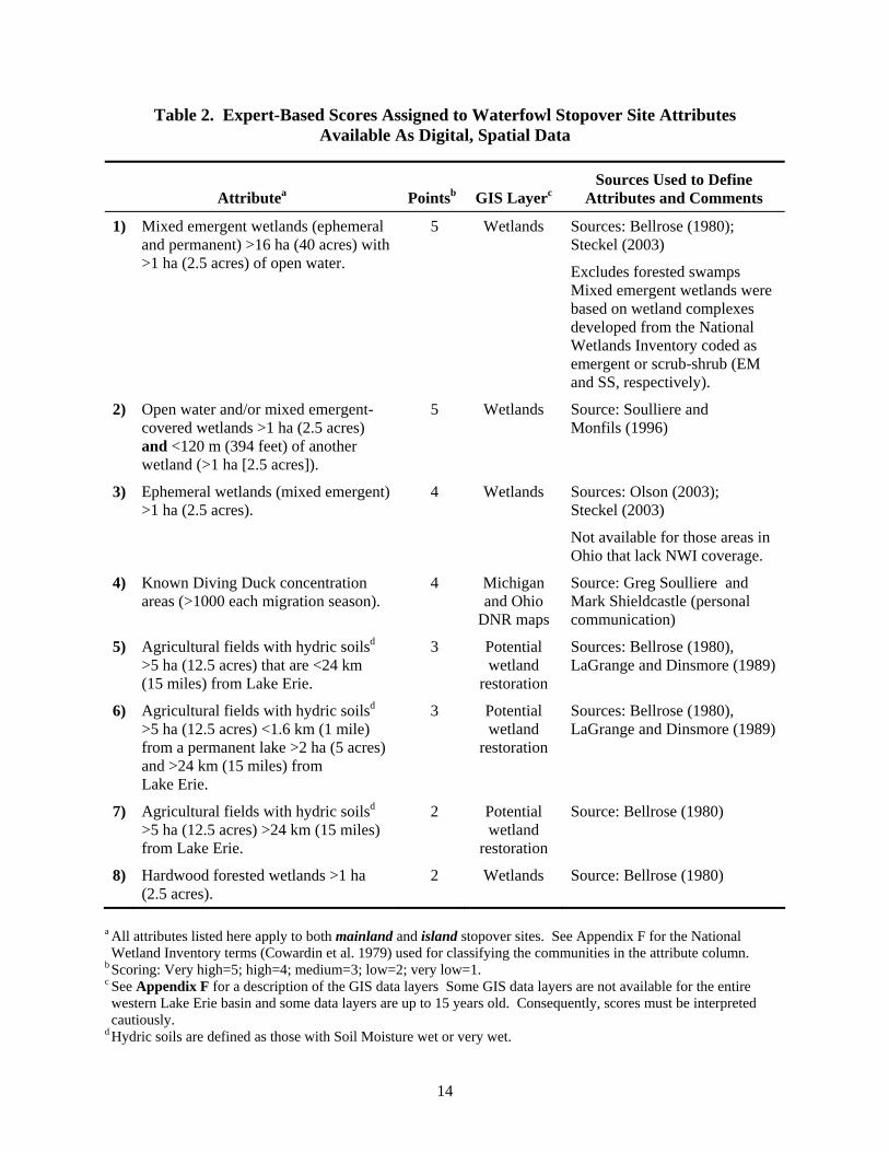
Attributes of Stopover Sites for Waterfowl Conservation and Management
Based on the available information, we summarized and ranked the relative importance of suites of attributes associated with stopover sites used by migrating waterfowl in the western Lake Erie basin. The following rankings and associated point values were assigned according to the relative importance of these suites of attributes to migrating waterfowl:
Very High 5 points High 4 points
Medium 3 points Low 2 points
Very Low 1 point The relative conservation importance of a stopover site to migrating waterfowl may be evaluated by applying the point values as outlined in Table 2. Many of these attributes can be evaluated using existing digital spatial data sets (e.g., land use/land cover, soils; see Table 2). The primary exception is diving duck concentrations; users applying this scoring system may find data on that attribute from the Michigan and Ohio Department of Natural Resources. A general summary of attributes important to migrating waterfowl is described below, followed by Table 2 which outlines the scoring system. The general summary of attributes can be used to qualitiatively fine-tune assessments of sites for conservation work.
• Wetland complexes of various sizes (2 to 500 ha, 5 to 1,200 acres) and with vegetative cover that provides multiple values under various environmental (or managed) conditions.
• Agricultural fields with hydric soils and potential wetland restoration sites <24 km (15 miles) of the Lake Erie shoreline.
• Shallow (0-1 m [0-3 feet]) and deep (>1 m) wetlands with adequate (or potential) water quality for aquatic plants and invertebrates.
• Complexes of large shallow and open-water marsh near (<16 km, [10 miles]) agricultural fields that are under a conservation tillage/no-till cultivation regime.
• Wetland and open-water sites near (<20 km, [12 miles]) large protected areas with little human disturbance.
• Ephemeral wetlands of various sizes (0.5-4 ha [1-10 acres]) in agricultural fields and pastured land.
14
Table 2. Expert-Based Scores Assigned to Waterfowl Stopover Site Attributes Available As Digital, Spatial Data
Attributea Pointsb GIS Layerc Sources Used to Define
Attributes and Comments
1) Mixed emergent wetlands (ephemeral and permanent) >16 ha (40 acres) with >1 ha (2.5 acres) of open water.
5 Wetlands Sources: Bellrose (1980); Steckel (2003)
Excludes forested swamps Mixed emergent wetlands were based on wetland complexes developed from the National Wetlands Inventory coded as emergent or scrub-shrub (EM and SS, respectively).
2) Open water and/or mixed emergent-covered wetlands >1 ha (2.5 acres) and <120 m (394 feet) of another wetland (>1 ha [2.5 acres]).
5 Wetlands Source: Soulliere and Monfils (1996)
3) Ephemeral wetlands (mixed emergent) >1 ha (2.5 acres).
4 Wetlands Sources: Olson (2003); Steckel (2003)
Not available for those areas in Ohio that lack NWI coverage.
4) Known Diving Duck concentration areas (>1000 each migration season).
4 Michigan and Ohio
DNR maps
Source: Greg Soulliere and Mark Shieldcastle (personal communication)
5) Agricultural fields with hydric soilsd >5 ha (12.5 acres) that are <24 km (15 miles) from Lake Erie.
3 Potential wetland
restoration
Sources: Bellrose (1980), LaGrange and Dinsmore (1989)
6) Agricultural fields with hydric soilsd >5 ha (12.5 acres) <1.6 km (1 mile) from a permanent lake >2 ha (5 acres) and >24 km (15 miles) from Lake Erie.
3 Potential wetland
restoration
Sources: Bellrose (1980), LaGrange and Dinsmore (1989)
7) Agricultural fields with hydric soilsd >5 ha (12.5 acres) >24 km (15 miles) from Lake Erie.
2 Potential wetland
restoration
Source: Bellrose (1980)
8) Hardwood forested wetlands >1 ha (2.5 acres).
2 Wetlands Source: Bellrose (1980)
a All attributes listed here apply to both mainland and island stopover sites. See Appendix F for the National Wetland Inventory terms (Cowardin et al. 1979) used for classifying the communities in the attribute column.
b Scoring: Very high=5; high=4; medium=3; low=2; very low=1. c See Appendix F for a description of the GIS data layers Some GIS data layers are not available for the entire western Lake Erie basin and some data layers are up to 15 years old. Consequently, scores must be interpreted cautiously.
d Hydric soils are defined as those with Soil Moisture wet or very wet.
15
SHOREBIRDS
Introduction
The principal area where shorebirds concentrate in large numbers in the Great Lakes region is the western Lake Erie basin. Lake Erie marshes in Ohio and Michigan were identified as a regionally important stopover site (criteria: >20,000 shorebirds/migration season or 5% of a flyway population) by the Western Hemisphere Shorebird Reserve Network. Shieldcastle (2000) noted that 38 shorebird species have been recorded in or near western Lake Erie marshes since 1993; in 2003 the number of spring migrant shorebirds was estimated to be 49,478 and in fall 88,525 (Shieldcastle and Shieldcastle 2003a). Crane Creek (Shieldcastle and Shieldcastle 2003a) and Pointe Mouillee (Michigan Department of Natural Resources, unpublished data) may be especially important shorebird stopover sites. Numbers vary considerably from year to year at any given site because of short and long term water level fluctuations (including seiches) in the Great Lakes, presence of sheetwater wetlands, flooded agricultural fields, and specific management activities at sites on or near the Great Lakes (Shieldcastle and Shieldcastle 2003a). Shorebirds use both inland wetlands and the Lake Erie shorelines, especially estuaries and managed marshes (Shieldcastle and Shieldcastle 2003a; Tara Baranowski and Robert Gates, The Ohio State University, unpublished data) during migration. Use varies by species and environmental conditions. Conserving wetland habitats at shorebird stopover sites will also benefit dabbling ducks and waterbirds that use shallow wetlands. Conversely, wetland conservation for migrating dabbling ducks and waterbirds also benefits migrating shorebirds if stopover sites are managed to produce appropriate vegetation communities, cover types, and water levels.
Priority Species
High priority shorebird species/populations (U.S. Shorebird Conservation Plan 2004) that migrate through the western Lake Erie basin include:
Highly imperiled global species • Piping Plover • Buff-breasted Sandpiper High concern global species • American Golden-Plover • Solitary Sandpiper • Upland Sandpiper • Hudsonian Godwit • Marbled Godwit • Short-billed Dowitcher • American Woodcock • Wilson’s Phalarope
16
High concern, North American populations • Whimbrel • Ruddy Turnstone • Red Knot • Sanderling
For two shorebird species, American Golden-Plover and Killdeer, the western Lake Erie basin may be a particularly important stopover region. Killdeers appear to concentrate in estuaries and American Golden-Plovers in agricultural fields (Mark Shieldcastle, Ohio Division of Wildlife, unpublished data). The muddy, western shorelines of Lake Erie may support more than 5% of the continental population of American Golden-Plover, Greater Yellowlegs, Lesser Yellowlegs, Solitary Sandpiper, Pectoral Sandpiper, and Short-billed Dowitcher during migration (Robert Russell, U.S. Fish and Wildlife Service, personal communication).
Assumptions and Caveats
• Shorebird use in the western Lake Erie basin is likely to be highly variable, temporally and spatially, for any one site because of (1) changing (daily, seasonal, annual) Lake Erie water levels, (2) rainfall, and (3) management practices (there is greater potential for relatively predictable habitat availability within diked marshes).
• As with other bird groups, we assume that a relatively consistent use of a site by a relatively large number of birds defines a good stopover site.
• Habitat (wetlands and agricultural lands) for migrating shorebirds has been categorized into five types (after Helmers 1992): beaches, dry mudflats, moist mudflats, shallow water (up to 5 cm [2 inches deep]) and deep water (5-20 cm [2-8 inches deep]).
• The spring migration period is critical to shorebirds as they accumulate nutrient reserves prior to arrival on their breeding grounds. Autumn migration is similarly important, as food availability and body condition can influence over-winter survival and other life history events (e.g., molt, spring migration, courtship and pairing). It is uncertain whether habitat conditions during autumn or spring migration have the greatest potential to limit populations. Nevertheless, there is evidence from the Lake Erie marsh region that habitat availability and conditions are more closely aligned with the needs of migrating shorebirds during spring than in autumn (Tara Baranowski and Robert Gates, unpublished data).
• A mosaic of habitats may be needed to account for different foraging behavior of shorebirds and changes in invertebrate abundance with changes in Lake Erie water levels and water management in impounded marshes.
• A few shorebirds, such as Upland Sandpiper, use upland short-grass sites, which are not covered by this assessment.
Landscape Attributes
Species such as Piping Plover, Black-bellied Plover, Ruddy Turnstone, Red Knot, White-rumped Sandpiper, Dunlin, Marbled Godwit, Hudsonian Godwit, and Sanderling tend to concentrate near Great Lakes shorelines in Ohio, including beaches, estuaries, and managed marshes (Campbell 1968, Shieldcastle and Shieldcastle 2003a, Tara Baranowski and Robert Gates, unpublished data, Peterjohn 1989). In Michigan, the following shorebird species are most concentrated along or near Great Lakes shorelines: Black-bellied Plover (especially Lake Erie), Piping Plover, American Avocet, Lesser Yellowlegs, Willet, Whimbrel, Hudsonian Godwit, Marbled Godwit (especially Lake Erie), Ruddy Turnstone, Red Knot, Sanderling, and Baird’s Sandpiper (Granlund et al. 1994).
17
This region historically has been extremely important for the sand beach-inhabiting shorebirds favoring the shores of the Great Lakes. This includes Piping Plover, Ruddy Turnstone, Semipalmated Sandpiper, Baird’s Sandpiper (uncommon), and Sanderling. Dunlin, Ruddy Turnstone, and Semipalmated Sandpiper also use inland, flooded agricultural fields (Robert Russell, personal communication). Impounded marshes provide the most consistently available source of habitat for migrating shorebirds during spring and autumn under a wide range of weather conditions (Tara Baranowski and Robert Gates, unpublished data). Sand beaches along the Lake Erie shoreline, and exposed mudflats in freshwater estuaries and river channels with a hydrological connection to Lake Erie, attract large numbers of shorebirds when strong southwest winds create seiches that temporarily lower water levels in the western Lake Erie basin (Tara Baranowski and Robert Gates, unpublished data). These same areas flood too deeply for shorebirds when northeasterly winds cause seiches that push water into the western Lake Erie basin. Inland wetlands (e.g., impounded marshes, flooded cropland) provide refuge for migrating shorebirds when lake levels rise. Numbers of shorebirds vary with seasonal and long-term changes in lake level, being perhaps more numerous during years in which mudflats are exposed by low water levels. Similarly, agricultural areas along or near the coast are used during springs when conditions are appropriate but are used much less than managed marshes or lake-affected habitats (Tara Baranowski and Robert Gates, unpublished data). While flooded cropland can attract high numbers of shorebirds, flooding is too transient and irregular to offset the importance of managed marshes, estuaries, and beaches where shallow water and adjacent mudflats are more consistently available (Tara Baranowski and Robert Gates, unpublished data). Even though shorebirds appear to be opportunistic, readily locating new sites (Bolton and Szanto 2003) as environmental conditions change, maintaining or restoring wetlands will be critical for shorebirds given the dramatic loss of wetlands, and areas that can be restored to wetlands, in the region. At least some species, such as American Golden-Plover, are more common inland or show no preference between inland or lakeshore sites. Wood County, Ohio and Hillsdale County, Michigan are important inland spring migration stopover areas for American Golden-Plovers (up to 200 observed/flock [Granlund et al. 1994]; up to 5,000 in the Toledo area [Campbell 1968]). Plovers select recently plowed fields, wet meadows and hayfields, flooded agricultural fields, recently burned prairies, and edges of drying wetlands (Robert Russell, personal communication). Black-bellied Plovers also use fields during spring migration (Paul Rodewald, The Ohio State University, personal communication). Islands in Lake Erie may provide refugia for migrant shorebirds as they can serve as "emergency stopover sites during storms and strong headwinds, and roosting sites for species bound or inbound for/from [the] mid-Atlantic coast" (Robert Russell, personal communication). The number of shorebirds using islands is uncertain but Semipalmated Plover, Greater Yellowlegs, Lesser Yellowlegs, Solitary Sandpiper, Spotted Sandpiper, Ruddy Turnstone, Sanderling, Semipalmated Sandpiper, and Least Sandpiper are most frequently seen; Red Knot and Short-billed Dowitcher occasionally occur on mudflats and reefs around South Bass Island, Ohio (Thomson 1994). More data are needed to evaluate the relative importance of islands as stopover sites for shorebirds.
Site Attributes
Shorebirds are likely to use some of the same areas as dabbling ducks. In the southwestern Lake Erie basin of Ohio, most shorebirds prefer mudflats with up to 20 cm (8 inches) of water and <25% vegetation cover (Black Swamp Bird Observatory 2004). Moist soils and flooded fields on farmlands are also used (Tara Baranowski and Robert Gates, unpublished data). During both spring and fall migration, habitats used include shallow wetlands (2-20 cm [1-8 inches]) and shallows of ephemeral and semi-permanent wetlands including flooded fields, drawn down ponds and reservoirs, marsh edges, and wet prairies. Creation of small roosting islands surrounded by water >9.5 cm (2 ft) in depth would benefit these species
18
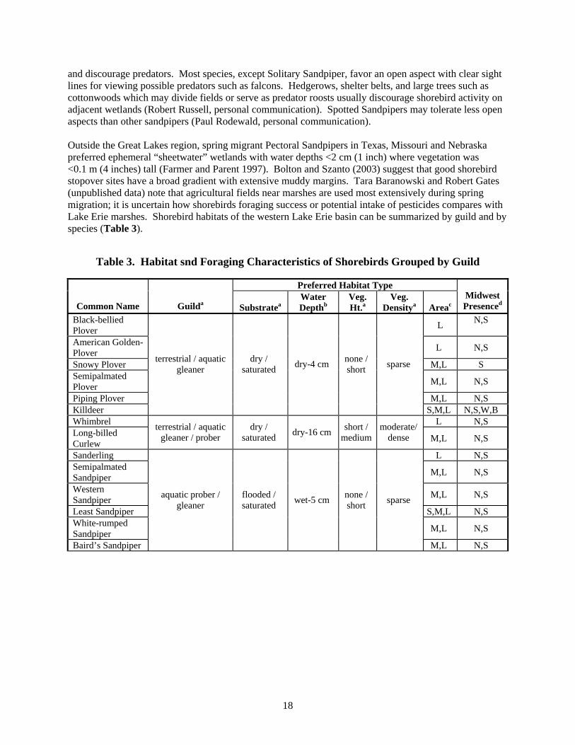
and discourage predators. Most species, except Solitary Sandpiper, favor an open aspect with clear sight lines for viewing possible predators such as falcons. Hedgerows, shelter belts, and large trees such as cottonwoods which may divide fields or serve as predator roosts usually discourage shorebird activity on adjacent wetlands (Robert Russell, personal communication). Spotted Sandpipers may tolerate less open aspects than other sandpipers (Paul Rodewald, personal communication). Outside the Great Lakes region, spring migrant Pectoral Sandpipers in Texas, Missouri and Nebraska preferred ephemeral “sheetwater” wetlands with water depths <2 cm (1 inch) where vegetation was <0.1 m (4 inches) tall (Farmer and Parent 1997). Bolton and Szanto (2003) suggest that good shorebird stopover sites have a broad gradient with extensive muddy margins. Tara Baranowski and Robert Gates (unpublished data) note that agricultural fields near marshes are used most extensively during spring migration; it is uncertain how shorebirds foraging success or potential intake of pesticides compares with Lake Erie marshes. Shorebird habitats of the western Lake Erie basin can be summarized by guild and by species (Table 3).
Table 3. Habitat snd Foraging Characteristics of Shorebirds Grouped by Guild
Preferred Habitat Type
Common Name Guilda Substratea Water Depthb
Veg. Ht.a
Veg. Densitya Areac
Midwest Presenced
Black-bellied Plover L N,S
American Golden-Plover L N,S
Snowy Plover M,L S Semipalmated Plover M,L N,S
Piping Plover M,L N,S Killdeer
terrestrial / aquatic gleaner
dry / saturated dry-4 cm none /
short sparse
S,M,L N,S,W,B Whimbrel L N,S Long-billed Curlew
terrestrial / aquatic gleaner / prober
dry / saturated dry-16 cm short /
medium moderate/
dense M,L N,S
Sanderling L N,S Semipalmated Sandpiper M,L N,S
Western Sandpiper M,L N,S
Least Sandpiper S,M,L N,S White-rumped Sandpiper M,L N,S
Baird’s Sandpiper
aquatic prober / gleaner
flooded / saturated wet-5 cm none /
short sparse
M,L N,S
19
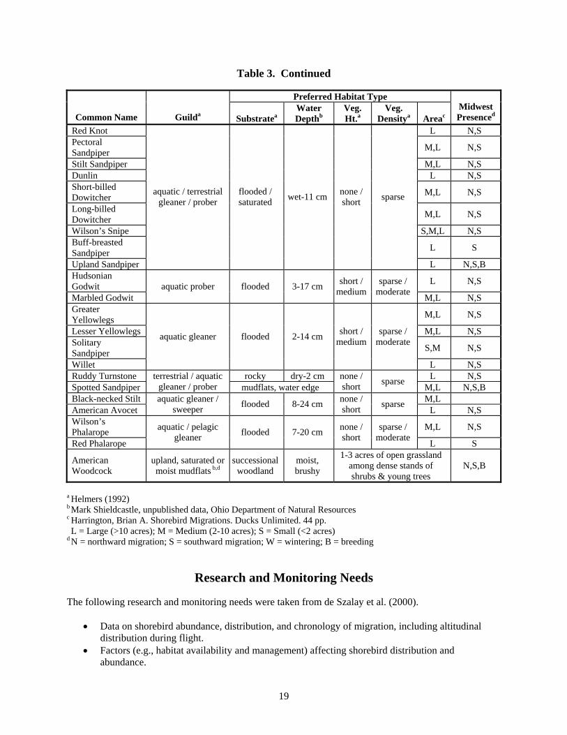
Table 3. Continued
Preferred Habitat Type
Common Name Guilda Substratea Water Depthb
Veg. Ht.a
Veg. Densitya Areac
Midwest Presenced
Red Knot L N,S Pectoral Sandpiper M,L N,S
Stilt Sandpiper M,L N,S Dunlin L N,S Short-billed Dowitcher M,L N,S
Long-billed Dowitcher M,L N,S
Wilson’s Snipe S,M,L N,S Buff-breasted Sandpiper L S
Upland Sandpiper
aquatic / terrestrial gleaner / prober
flooded / saturated wet-11 cm none /
short sparse
L N,S,B Hudsonian Godwit L N,S
Marbled Godwit aquatic prober flooded 3-17 cm short /
medium sparse /
moderate M,L N,S Greater Yellowlegs M,L N,S
Lesser Yellowlegs M,L N,S Solitary Sandpiper S,M N,S
Willet
aquatic gleaner flooded 2-14 cm short / medium
sparse / moderate
L N,S Ruddy Turnstone rocky dry-2 cm L N,S Spotted Sandpiper
terrestrial / aquatic gleaner / prober mudflats, water edge
none / short sparse M,L N,S,B
Black-necked Stilt M,L American Avocet
aquatic gleaner / sweeper flooded 8-24 cm none /
short sparse L N,S
Wilson’s Phalarope M,L N,S
Red Phalarope
aquatic / pelagic gleaner flooded 7-20 cm none /
short sparse /
moderate L S
American Woodcock
upland, saturated or moist mudflats b,d
successional woodland
moist, brushy
1-3 acres of open grassland among dense stands of shrubs & young trees
N,S,B
a Helmers (1992) b Mark Shieldcastle, unpublished data, Ohio Department of Natural Resources c Harrington, Brian A. Shorebird Migrations. Ducks Unlimited. 44 pp. L = Large (>10 acres); M = Medium (2-10 acres); S = Small (<2 acres)
d N = northward migration; S = southward migration; W = wintering; B = breeding
Research and Monitoring Needs
The following research and monitoring needs were taken from de Szalay et al. (2000).
• Data on shorebird abundance, distribution, and chronology of migration, including altitudinal distribution during flight.
• Factors (e.g., habitat availability and management) affecting shorebird distribution and abundance.
20
• Factors affecting turnover rates at stopover sites. • Distribution, abundance, conditions, and ownership of wetlands and other important
shorebird habitats, including anthropogenic influences, GIS mapping. • Shorebird nutritional requirements and food preferences; response of invertebrate food
resources to wetland dynamics and management activities. • Effects of human disturbance on shorebird foraging and how to reduce these impacts. • Effects of contaminants on shorebirds, especially at confined disposal facilities used by
foraging birds and contaminants from agricultural fields.
Attributes of Stopover Sites for Shorebird Conservation and Management
Based on the available information, we summarized and ranked the relative importance of suites of attributes associated with stopover sites used by migrating shorebirds in the western Lake Erie basin. The following rankings and associated point values were assigned according to the relative importance of these suites of attributes to migrating shorebirds:
Very High 5 points High 4 points
Medium 3 points Low 2 points
Very Low 1 point The relative conservation importance of a stopover site to migrating shorebirds may be evaluated by applying the point values as outlined in Table 4. Many of these attributes can be evaluated using existing digital spatial data sets (e.g., land use/land cover, soils; see Table 4). However some important information could not be summarized with digital, spatial data layers; this information is presented in the narrative below. The general summary of attributes can be used to qualitiatively fine-tune assessments of sites for conservation work. A general summary of attributes important to migrating shorebirds is described below, followed by Table 4, which outlines the scoring system.
• Very high priority. Moderate to large wetlands (>2 ha [5 acres], ideally within wetland complexes of hundreds of acres but >10 ha [25 acres]). The wetlands should be temporarily or seasonally flooded (a gradient of water depths ranging from mudflats to <20 cm [8 inches] of water depth is optimal because shorebirds typically prefer sparse vegetation). Wetlands should sustain short or sparse herbaceous vegetation (<25% cover), be free of invasive species, and <3 km (2 miles) from Lake Erie; this is an arbitrary distance that requires testing. Within diked marshes, wetland management should assure sustainable exotic-free mudflat/wetland communities usable by shorebirds during spring and fall migration. When managing water levels, timing is critical to ensure ecological requirements of shorebird species, especially those of particular concern, are met during peak migration periods.
• High priority. Moderate to large wetlands (>2 ha [5 acres], ideally within wetland complexes of hundreds of acres but >10 ha [25 acres]) >2 miles (3.2 km) from Lake Erie where water levels can be manipulated, perhaps near tributaries of major rivers, to create a complex of shorebird habitat types available throughout the migration season, including moist soils and/or shallow water with sparse herbaceous vegetation (<25% cover) during spring and fall migration. These areas are best located in former agricultural or other open areas so that
21
corridors of trees and shrubs, used by migrating landbirds and raptors, are not interrupted. The location of each habitat type will change over time. Other high priority areas needed as shorebird stopover sites include ephemeral or temorarily flooded wetlands (including those in agricultural fields) <16 km (10 miles) from the Lake Erie shoreline. These areas, because they are relatively close to Lake Erie, are thought to be relatively important stopover sites, even if the wetland is not part of a wetland complex.
• Medium priority. Any ephemeral or temporarily flooded wetland (including agricultural fields) inland from Lake Erie (>16 km [10 miles]) were considered to be lower priority than those closer to Lake Erie. Wetland complexes and isolated wetlands <10 ha (25 acres) are also considered to be medium priority. In addition, any wetland <10 ha (25 acres) is considered medium priority if it is within 1 m (3.3 ft) elevation of the absolute high or low water level of Lake Erie; we did not include this category in the formal ranking system however.
• Low priority. Mixed emergent wetlands less than <10 ha (25 acres) and >3.2 km (2 miles) from Lake Erie were considered to be low priority. These relatively small wetlands often have dense vegetation which support relatively few shorebirds.
22
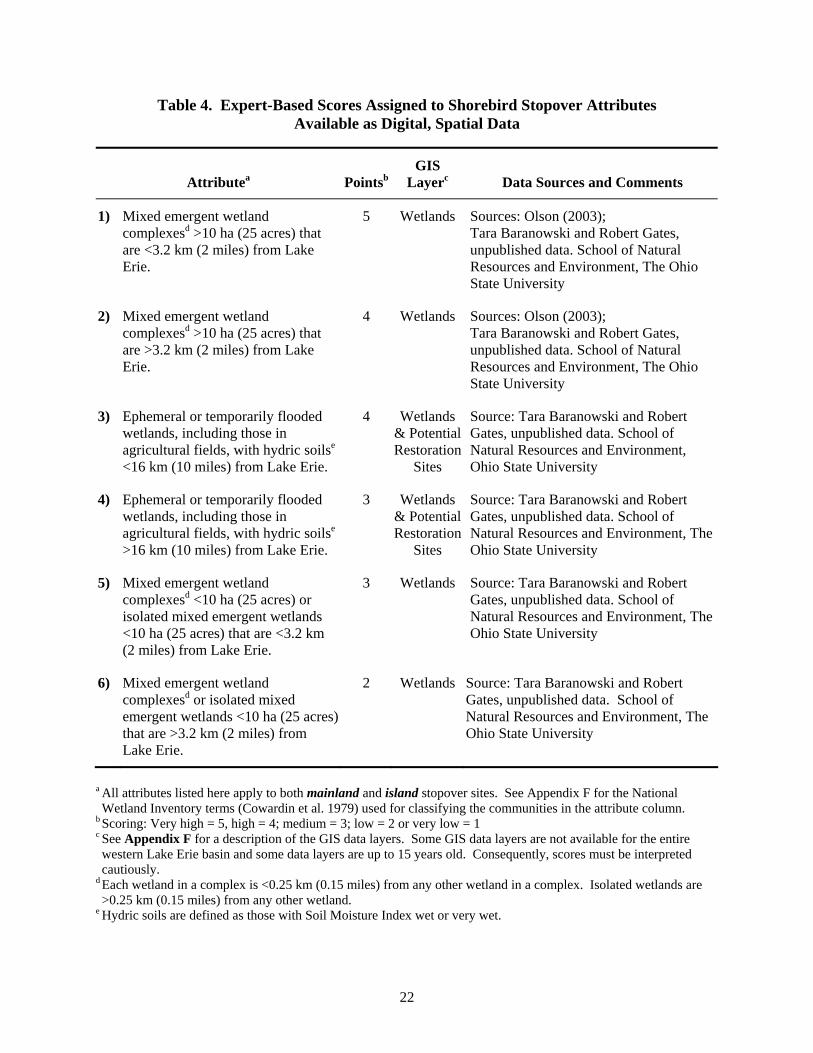
Table 4. Expert-Based Scores Assigned to Shorebird Stopover Attributes Available as Digital, Spatial Data
Attributea PointsbGIS
Layerc Data Sources and Comments
1) Mixed emergent wetland complexesd >10 ha (25 acres) that are <3.2 km (2 miles) from Lake Erie.
5 Wetlands Sources: Olson (2003); Tara Baranowski and Robert Gates, unpublished data. School of Natural Resources and Environment, The Ohio State University
2) Mixed emergent wetland complexesd >10 ha (25 acres) that are >3.2 km (2 miles) from Lake Erie.
4 Wetlands Sources: Olson (2003); Tara Baranowski and Robert Gates, unpublished data. School of Natural Resources and Environment, The Ohio State University
3) Ephemeral or temporarily flooded wetlands, including those in agricultural fields, with hydric soilse <16 km (10 miles) from Lake Erie.
4 Wetlands & Potential Restoration
Sites
Source: Tara Baranowski and Robert Gates, unpublished data. School of Natural Resources and Environment, Ohio State University
4) Ephemeral or temporarily flooded wetlands, including those in agricultural fields, with hydric soilse >16 km (10 miles) from Lake Erie.
3 Wetlands & Potential Restoration
Sites
Source: Tara Baranowski and Robert Gates, unpublished data. School of Natural Resources and Environment, The Ohio State University
5) Mixed emergent wetland complexesd <10 ha (25 acres) or isolated mixed emergent wetlands <10 ha (25 acres) that are <3.2 km (2 miles) from Lake Erie.
3 Wetlands Source: Tara Baranowski and Robert Gates, unpublished data. School of Natural Resources and Environment, The Ohio State University
6) Mixed emergent wetland complexesd or isolated mixed emergent wetlands <10 ha (25 acres) that are >3.2 km (2 miles) from Lake Erie.
2 Wetlands Source: Tara Baranowski and Robert Gates, unpublished data. School of Natural Resources and Environment, The Ohio State University
a All attributes listed here apply to both mainland and island stopover sites. See Appendix F for the National Wetland Inventory terms (Cowardin et al. 1979) used for classifying the communities in the attribute column.
b Scoring: Very high = 5, high = 4; medium = 3; low = 2 or very low = 1 c See Appendix F for a description of the GIS data layers. Some GIS data layers are not available for the entire western Lake Erie basin and some data layers are up to 15 years old. Consequently, scores must be interpreted cautiously.
d Each wetland in a complex is <0.25 km (0.15 miles) from any other wetland in a complex. Isolated wetlands are >0.25 km (0.15 miles) from any other wetland.
e Hydric soils are defined as those with Soil Moisture Index wet or very wet.
23
Management recommendations applicable to shorebirds in this region are described by de Szalay et al. (2000), Robert Russell (see Appendix G), Brad Andres: [email protected] or [email protected]), Management for breeding and migrating shorebirds in the Midwest (USFWS; http://www.nwrc.usgs.gov/wdb/pub/wmh/13_14.pdf), Managing seasonally flooded impoundments for migrant rails and shorebirds (http://www.biology.eku.edu/SUMITHRA/Migrat/READINGS/rundle.htm); and Species Management Abstract – North American shorebirds (The Nature Conservancy; http://conserveonline.org/2001/07/m/en/noamshor.doc). In addition, Robert Gates and his students, including Tara Baranowski (The Ohio State University), are evaluating shorebird stopover sites in the western Lake Erie basin of Ohio. They recommend the following:
• protection of beaches and estuaries with sparse vegetation that are subject to periodic exposure (e.g., seiches),
• protection of streamside mud banks during dry periods, • maintaining low-lying, sparsely vegetated agricultural fields, especially near wetlands and
marshes (spring only), and • slow draw downs of impounded marshes.
Implementation of these recommendations should assure that five primary habitats (beaches, dry mudflats, moist mudflats, shallow water (up to 5 cm [2 inches] deep) and deep water (5-20 cm [2-8 inches] deep) are collectively provided, at appropriate temporal and spatial scales, by land management agencies. For spring migrants this includes the period of late February/early March to early June, with peak migration being from 1 April to 15 June, depending on the species (Shieldcastle and Shieldcastle 2003a). Southbound migrants may be found from late June through November with peak dates, depending on species, ranging from July through November (Shieldcastle and Shieldcastle 2003a). Foraging by some shorebird species is reduced when they are disturbed by humans, dogs, horses, or vehicles (Lafferty 2001, Thomas et al. 2003). Lafferty (2001) recommended establishing 400 m (1,300 ft) protected zones, with 30 m (100 ft) buffers, for wintering western Snowy Plovers on California beaches and Thomas et al. (2003) suggested that Sanderlings not be approached closer than 30 m (100 ft). Response to disturbance may be related to condition of birds (Beale and Monaghan 2004) and amount of available habitat (Gill et al. 2001). It seems likely, however, that minimizing disturbance to shorebirds during migration is beneficial although it would be exceedingly difficult to demonstrate increased fitness with this approach. Still, “In the short-term, the most sensible approach may, therefore, be to concentrate research and protection efforts on species that are threatened or whose populations are declining, and for which human disturbance is implicated as a possible cause [of decline]” (Gill et al. 2001).
24
RAPTORS
Introduction
Concentrations of migrating raptors are highest along the southern shore of Lake Erie in spring (approximately 15,000 each spring [Shieldcastle and Shieldcastle 2003b]), the northern shore of Lake Erie in fall, and the western shore may be used in both spring and fall. At least some raptors tend to follow the shoreline and hence are largely responding to Lake Erie while other raptors migrate inland (Shieldcastle and Shieldcastle 2003b). Defining stopover sites for raptors is challenging because most migrate along migratory corridors rather than concentrating at discrete sites. Stopover sites and migration corridors for raptors can generally be considered a subset of critical stopover sites for landbirds because many raptors feed on landbirds during migration, especially accipiters (Shieldcastle and Shieldcastle 2003b) and falcons (see Aborn 1994). Consequently, landscape and site specific features that attract these birds will also be important to raptors (see Campbell 1968). For that reason, the attributes of raptor migration routes are treated with landbirds; background information on raptor migration in the western Lake Erie basin, however, is described separately from landbirds.
Priority Species
No species of hawks are considered to be of highest conservation concern by Partners in Flight except for the Red-shouldered Hawk, which is considered a Stewardship Species due to a high percent of its population being concentrated in a single biome. However, a number of raptor species that regularly migrate through the western Lake Erie basin are federally listed as endangered or threatened (Bald Eagle, Peregrine Falcon) or state-listed as endangered or threatened in Ohio or Michigan (Osprey, Bald Eagle, Northern Harrier, Cooper’s Hawk, Northern Goshawk, Red-shouldered Hawk, Merlin, and Peregrine Falcon). Of these species, the Bald Eagle and Merlin may migrate through the western Lake Erie basin in disproportionately high numbers (Mark Shieldcastle, unpublished data) and another species, Broad-winged Hawk, occasionally migrates through the region in extremely high numbers (up to 250,000 in one day) during fall (Chartier and Ziarno 2004).
Assumptions and Caveats
In this section we focus on diurnal raptors; owls are covered in the landbird section.
• We assume that raptors largely respond to abiotic factors, such as areas where thermals form, and barriers to migration (e.g., Lake Erie is a barrier for many raptors such as buteos), and much less to specific ecological attributes associated with sites, except where raptor migratory corridors occur due to high prey availability.
• We assume that the most important areas are those that host the largest number of individual raptors.
Landscape Attributes
Raptors migrate along Great Lakes shorelines (see Haugh 1984) with particularly high concentrations along geographical features such as ridges, and peninsulas that funnel large numbers of migrant raptors
25
(Kerlinger 1989) such as the tip of Point Pelee or mouth of the Detroit River. Raptors may also follow habitat corridors including wooded riparian systems through agricultural landscapes. Shieldcastle and Shieldcastle (2003b) noted considerable raptor migration, even at inland sites, with southwest winds. In spring migration, raptors, especially buteos, accipiters, and vultures, travel west about 0.8 km (0.5 mile) inland and parallel to the Lake Erie shoreline (Mark and Julie Shieldcastle, unpublished data). Raptors also travel through the area in spring but relatively few stop (Vic Fazio, personal communication); Bald Eagles, Osprey, falcons, and Northern Harriers tend to follow the shoreline (some being inland at least 4.2 km [2.5 miles]) while species dependent on thermals are usually 0.8-4.2 km (0.5-2.5 miles) inland (there is little monitoring further inland than 4.2 km [2.5 miles]). Buteos avoid migrating across large bodies of water (especially cool water), including Sandusky Bay. Pettingill (1962) noted that Broad-winged (less common in spring than fall), Red-shouldered, Red-tailed and Rough-legged Hawks, and Northern Harriers tend to follow shorelines while accipiters, falcons, and eagles often cross large water expanses. Spring migrant raptors which reach Lake Erie near Vermilion may diverge; those from Vermilion west tend to hug the shoreline and move west while those east of Vermilion follow the shoreline east (Bill Whan, Columbus, OH, personal communication). Occasionally at least some raptors and vultures perch in woodlots near the shoreline – up to 125 Turkey Vultures have been observed roosting in trees at Maumee State Park (Vic Fazio, personal communication). Accipiters, especially Sharp-shinned Hawks, follow treelines parallel to the shoreline, especially in the marshes (Vic Fazio, personal communication). Many of these birds have full crops in the morning suggesting that Sharp-shinned Hawks may, in part, be following treelines that are used by migrating landbirds (Vic Fazio, personal communication). During fall most migratory raptors follow the north shore of Lake Erie (Devereux et al. 1985). Large numbers of raptors may travel southwestward from extreme southeastern Michigan through the Oak Openings and forest patches in southwestern Lucas County, Ohio (Elliot Tramer, University of Toledo, personal communication). At least Merlins, some Broad-winged Hawks and other species migrate through the western Lake Erie islands, Ohio (at least Kelleys Island) during fall and presumably in Ontario as well. There are also minor movements of accipiters during spring (at least on South Bass Island). Merlins are noted at inland streams and lakes during migration in northwestern Ohio. Other raptors may also use corridors of natural cover along major river systems that empty into Lake Erie. Power line or highway rights-of-ways corridors (Derric Pennington, University of Minnesota, personal communication) are also used where there is habitat for prey.
Site Attributes
Specific site attributes associated with raptor migratory sites/corridors are not identified except for accipters, which prey upon landbirds, and are thus dependent on the same attributes as landbirds.
Research and Monitoring Needs
There is a need to maintain spring counts of migrants in the western Lake Erie basin of Ohio (Shieldcastle and Shieldcastle 2003b) and fall counts at the mouth of the Detroit River (Southeastern Michigan Raptor Research 2005). There is a need to separate causality from correlation in use of the same habitats by raptors and landbirds.
26
Attributes of Stopover Sites for Raptor Conservation and Management
Guidelines adopted for landbirds should generally be applicable to raptors, even if the function of the site is different. For example, isolated forest patches may modify thermal formation used by migrating raptors but provide food and shelter to landbirds. A list of attributes important to raptors can be found in the landbird section (Table 5).
LANDBIRDS
Introduction
Landbirds, a highly diverse group of species, typically migrate in broad fronts and may experience higher mortality during migration compared to the breeding and winter seasons (Sillett and Holmes 2002). Although landbirds use a wide range of cover types, and appear to be relatively flexible in habitat use, they are not randomly distributed across the landscape (Petit 2000), including the western Lake Erie basin region. Relatively high numbers of landbirds consistently occur at certain stopover sites (Ewert and Hamas 1996). Shieldcastle (2000) states that “spring passerine migration along the [Erie] lakeshore may be unsurpassed except by the Gulf coast in eastern North America.” Petit (2000) proposed the following considerations be part of conservation plans for landbird stopover sites with particular reference to forest-dependent landbirds:
• Quality and importance of a stopover site must consider geographic location and landscape context.
• Habitat patches adjacent to ecological barriers must be of high quality. • Habitat management and conservation priorities established in North America for breeding
birds will be useful for defining habitat needs for migrants. • Structurally diverse forests should be a high priority. • Landscape-level and regional conservation plans should provide a diverse set of habitats for
migrants. • Small sites should be maintained as “stepping stones” and refugia for migrants. • Local planning for management of stopover sites should consider the interaction between
landscape-level and regional issues.
27
Priority Species
Landbirds (including owls) of continental concern (see Rich et al. 2004) that consistently migrate through the western Lake Erie basin are classified into the following categories:
Watch list species: multiple causes for concern across entire range • Golden-winged Warbler • Kirtland’s Warbler • Henslow’s Sparrow
Watch list species: Moderately abundant or widespread with declines or high threats • Short-eared Owl • Prairie Warbler • Kentucky Warbler • Red-headed Woodpecker • Bay-breasted Warbler • Canada Warbler • Olive-sided Flycatcher • Cerulean Warbler • Dickcissel • Willow Flycatcher • Prothonotary Warbler • Rusty Blackbird • Wood Thrush • Worm-eating Warbler
Watch list species: Restricted distribution or low population sizes • Blue-winged Warbler
Of the landbird species of continental concern that migrate through the western Lake Erie basin, the area may be especially important for the Kirtland’s Warbler (see Byelich et al. 1985, Mike Petrucha, Michigan Department of Natural Resources, personal communication, see Campbell 1968) and Rusty Blackbird (Mark Shieldcastle, unpublished data). Other landbird species for which stopover sites in the western Lake Erie basin may be particularly important include Magnolia Warbler, Black-throated Blue Warbler, Black-and-white Warbler, American Redstart, Connecticut Warbler and Mourning Warbler, all of which are concentrated along beach ridges in spring migration (Mark Shieldcastle, unpublished data).
Assumptions and Caveats
There are few quantitative data on the ecology and distribution of migrant landbirds in the western Lake Erie basin, especially species-specific distributions. As a result, we also relied on results of studies outside the basin, and a relative wealth of observations from many field observers in the region, to identify attributes of stopover sites. Most data and observations are based on forest-dwelling birds. Consequently, attributes of stopover sites for landbird migrants defined here may be most applicable for species most dependent on forests. Further, stopover requirements of migrants, and therefore attributes of stopover sites, may be latitudinally specific (Smith and Norment 2005). More generally, we assume the following:
• Areas with the highest numbers or densities of migrant landbirds represent important stopover sites.
• The relative importance of any habitat patch to migrants likely varies with landscape features (e.g., amount of the landscape in natural cover, degree of fragmentation, proximity to Lake Erie).
28
• All types of stopover sites (e.g., fire escapes, convenience stores, full service hotels; see Mehlman et al. 2005) may be important because both food and shelter can be in limited supply given the scarcity of habitat in much of the western Lake Erie basin (Lambert et al. [2001]).
• The relative importance of a site may change within a season, between years, and by species (e.g., see Brawn and Stotz 2001).
Landscape Attributes
Based on weather surveillance radar, WSR-88D or NEXRAD, imagery (see Gauthreaux and Belser [2003]; Diehl and Larkin [2005] for an overview of application of NEXRAD imagery to bird migration), migrants appear to avoid at least some agricultural landscapes, and concentrate in relatively forested landscapes irrespective of core forest area in the Great Lakes basin (Bonter et al. 2002). However, these relationships may vary across the Great Lakes region (Bonter et al. 2002, Derric Pennington, personal communication). Areas with high light pollution, concentrations of towers, and tall buildings could be detrimental to migrating landbirds (Fatal Night Awareness Program 2005). There is growing concern about the effects of nearshore windmill turbines for electric-power generation on migrants although there are insufficient data to determine if wind farms kill many migrant landbirds.
Relationship to Lake Erie
In the western Lake Erie basin, migrating landbirds often concentrate adjacent to barriers (such as Lake Erie), especially when birds are stressed due to weather conditions (e.g., opposing winds, fog, precipitation). Landbird concentrations may be especially high at tips of peninsulas and on islands on Lake Erie (Anderson et al. 2002, Julie and Mark Shieldcastle, Black Swamp Bird Observatory, unpublished data) and elsewhere in the Great Lakes, including Lake Huron (David Ewert, The Nature Conservancy, personal observation). Islands, including Kelleys Island (Kelleys Island Audubon Club 2005; Vic Fazio, personal communication), harbor many migrants in both spring and fall and the islands from Ohio to Point Pelee, Ontario may be a migratory corridor for landbirds (Campbell 1968). During spring migration, high concentrations of migrants are noted at the south end of islands (fide John Ritzenthaler, Audubon Ohio, personal communication). On days with north winds relatively large numbers of migrants may occur away from the shoreline during spring (Paul Rodewald, personal communication). Shoreline areas provide the first available habitat for migrants traveling over the lake at or post-dawn (see Alerstam 1978, Diehl et al. 2003, Julie and Mark Shieldcastle, unpublished data, Allen Chartier, personal communication). Banding efforts from 1993-2003 at a coastline banding station (Navarre Marsh Station, Black Swamp Bird Observatory) resulted in an average of 120.0 birds/100 net hours during spring migration (Julie and Mark Shieldcastle, unpublished data) while an inland site at the University of Michigan-Dearborn campus (approximately 11 km [7 miles] inland from the Detroit River) yielded 40.0 birds/100 net hours during spring migration (Julie Craves, University of Michigan-Dearborn, unpublished data). During fall migration at the Dearborn site 52.8 birds/100 net hours were captured while at another inland site (near Alma, Michigan), 50.2 birds/100 net hours were caught during fall (Mike Bishop, Alma College, unpublished data). Landbirds may be particularly concentrated at the shoreline to 0.4 km (0.25 mile) from the shoreline. Relatively high numbers occur at least 1.7-5 km (1-3 miles) inland from Great Lakes shorelines, particularly along wooded and brushy beach ridges, and in areas with high aquatic insect productivity (Shieldcastle and Shieldcastle 2004). Landbird migrants were also concentrated <0.4 km (0.25 mile) of shoreline along the northern shore of Lake Huron (Ewert et al., in prep.), where midges were most
29
abundant, and <1 km (0.6 miles) of shore in Door County and the Green Bay shoreline of Wisconsin and adjacent Michigan (Feucht 2003). How migrating landbirds move among habitats in search of favorable foraging and resting sites following migration is little known however (Moore and Aborn 2000). However, landbird migrant movements near the Lake Erie shoreline are being evaluated by Paul Rodewald and recent studies on migrating Catharus thrushes in central Illinois stopover sites suggest that migrants remain with a 100 m diameter area (Cochran and Wikelski 2005). Diurnal landbird migrants largely follow the western Lake Erie shoreline westward from Vermilion while those east of Vermilion travel easterly (Mark Shieldcastle, unpublished data). At least some diurnal landbirds may also follow lines of trees parallel to the shoreline (Vic Fazio, personal communication), or habitat corridors (Allen Chartier, personal communication) as do predators such as Sharp-shinned Hawks. It is unknown how nocturnal migrants disperse along the Lake Erie shoreline. Habitat connectivity along the shoreline may be important, at least for these diurnal migrants, as waves of diurnal migrants seem to move in the appropriate direction for the migration season throughout the day (Allen Chartier, personal communication). Booth (1971) noted that the largest number of migrating Blue Jays along the southern Lake Michigan shoreline were along the immediate shoreline; Paul Rodewald (personal communication) found a similar relationship along the southern shore of Lake Erie. Areas with natural vegetation near Lake Erie, and other Great Lakes, appear to be most important for landbirds (Mark Shieldcastle, unpublished data; Jim McCormac, Ohio Division of Natural Areas and Preserves, personal communication; Ewert et al., in prep.), as the vegetation provides food and/or cover.
Relationship to Inland Systems: Riparian and Upland
Spring migrants may also concentrate along riparian corridors (Anderson et al. 2002, Allen Chartier, personal communication; Jim McCormac, personal communication), including those within urban areas (Julie Craves, personal communication; Derric Pennington, personal communication), and on islands (such as Missionary Island) in the Maumee River (Elliot Tramer, personal communication) and likely other rivers. Riparian corridors may funnel migrants toward Lake Erie (Robert Smith, University of Scranton, personal communication). Wet areas on forested floodplains provide good foraging substrate for Catharus thrushes, Seiurus warblers, and some sparrows (Julie Craves, personal communication). Inland concentrations are perhaps highest, or at least relatively high, along riparian corridors (Julie Craves, personal communication; Vic Fazio, personal communication), even if few aquatic insects are present (Julie Craves, personal communication), and in isolated patches of natural cover (Allen Chartier, personal communication). In the Lake Erie region, at least some riparian corridors (e.g., Touissaint River), have movements of landbirds 6.7 to 8.3 km (4-5 miles) inland (Vic Fazio, personal communication); landbird movements have also been noted in the Sandusky, Portage and Maumee River valleys (Campbell 1968). Inland sites, such as Resthaven Wildlife Area, Ohio (which is 9.6 km [6 miles] south of Sandusky Bay), and has a mosaic of impoundments, forests, scrub and grasslands), may also support high numbers of migrants. In central Ohio Rodewald and Matthews (2005) found higher numbers of migrants in upland wooded patches compared to riparian forests; this relationship has not been tested in the Lake Erie region. Large forest patches should be best for forest-dependent migrants (Paul Rodewald [unpublished data]), but small patches may be used heavily for relatively short periods of time (Craves and Gelderloos 1996) even though food supplies could be relatively low (see Burke and Nol 1998). Piaskowski and Albanese (2001) found high concentrations of migrants during both spring and fall migration in a small suburban forest/wetland site in Wisconsin that was 40 km (25 miles) inland from Lake Michigan. Recent work in Mississippi suggests that landbird migrants were more abundant in large (>30,000 ha [76,200 acres])
30
forest areas compared to small (<100 ha [254 acres]) woodlots during both fall and spring migration and arthropods were more abundant in large woodlots. Sites within 15-25 km (9-15 miles) of the Gulf Coast had greater bird abundance than those 35-60 km (22-37 miles) from the coast (Buler et al. 2004). Forest patches that are closer together, or connected by corridors (Petit 2000), may be best for migrants. Movement of post-breeding forest-inhabiting songbirds common to the Lake Erie region (Red-breasted Nuthatch, Black-capped Chickadee, Yellow-rumped Warbler, Red-eyed Vireo, and Golden-crowned Kinglet, was inhibited by gaps of inhospitable habitat in Quebec (Desrochers and Hannon 1997). Bird movements were little effected by gaps of open habitat <30 m (100 ft.) but “birds were three times less likely to cross 70-m (230 ft) gaps and about eight times less likely to cross 100-m (330 ft) gaps compared to similar distances in the forest”. Black-capped Chickadees have been found to avoid crossing openings 50 m (165 ft) wide when forest corridors are available but will cross openings over 200 m (660 ft) wide in the absence of forest corridors (Cassady St. Clair et al. 1998). In Alberta, several species of breeding birds (Least Flycatcher, White-throated Sparrow, Ovenbird, Mourning Warbler, Swainson’s Thrush, Song Sparrow, Swamp Sparrow, Yellow-rumped Warbler, and Yellow Warbler) moved more often within forested corridors and tended to avoid flying over open 200 m (660 ft) wide clear cuts and a 300 m (990 ft) wide lake (Machtans et al. 1996). At least for resident landbirds using forested woodlots in Ohio, large birds like Blue Jay were more likely to disperse further than small birds like Carolina Chickadee (Grubb and Doherty 1999). However, Bayne and Hobson (2001) found adult male Ovenbirds moved across open areas during the post-fledging period. Additional evaluation of migrant dispersion and dispersal is needed to prioritize the relative importance of woodlots to migrants (Wiedner et al. 1992, Diehl and Larkin 2003). Diehl and Larkin (2003) analyzed landbird migrant distribution in inland Illinois and adjacent Wisconsin during fall migration 1999 and spring migration 2000 using NEXRAD (WSR-88-D). They found that (1) the density of migrants did not vary with the amount of the landscape suitable as stopover sites, (2) higher densities of migrants occurred in small, isolated woodland patches compared to larger, less isolated woodland patches, (3) riparian areas had higher densities than upland areas (especially in fall), and (4) birds within 4 km (2.5 miles) from a patch reorient toward that patch as they descend following migration (migrants do not appear to orient to patches >4 km (2.5 miles) away). In a South Dakota study a slight decrease in landbird density was observed in small shelterbelts but there appeared to be no relationship with shelterbelt isolation (Martin 1980).
Site Attributes
The interaction between attributes of a site or habitat patch and the surrounding landscape, although little studied or described, requires further evaluation to refine recommendations for stopover site protection. Key research needs are described in the research needs section. Here we summarize information regarding site attributes that can be applied to the conservation of landbird stopover sites. During spring migration, interior portions of mature forests may be preferred, but in fall forest edges and early successional forests are often used (see Kilgo et al. 1999, Suthers et al. 2000, Swanson et al. 2003, Rodewald and Brittingham 2004). Within woodlots, in an inland area of southwestern Michigan, spring migrants often occurred near water (Ewert et al. 2004). In Illinois, landbird migrants are reported to concentrate near tree gaps (Blake and Hoppes 1986, Martin and Karr 1986) and in Pennsylvania, fall migrants selected forest edges where food was more abundant (Rodewald and Brittingham 2002, Rodewald and Brittingham 2004). Weise (1988) found high concentrations of migrants in both edges and interior of an inland, upland maple-beech forest and wetland deciduous forest complex at the Cedarburg Bog Forest, near Saukville, Wisconsin; Graber and Graber (1983) found that prey abundance during spring migration was similar between the forest-edge and forest interior. Elsewhere in the Midwest
31
migrants concentrate near forested wetlands during both spring (Weisbrod et al. 1993, Winker et al. 1992) and fall (Winker et al. 1992). Heterogeneous woodlots, those with diverse species cover, and complex vertical and horizontal structure, appear to be favored by migrants (Petit 2000, Wilson and Twedt 2003, Rodewald and Brittingham 2004). These woodlots may provide a broad array of habitats for different guilds of birds (Rodewald and Brittingham 2004) and support increased arthropod and fruit food supplies (in Rodewald and Brittingham 2004) compared to more mature forest. In the lower Mississippi River valley, different successional stages of various forest types attracted different suites of migrant landbird species (Wilson and Twedt 2003). Similar relationships, still not investigated, may occur in the western Lake Erie basin. Migrants may also selectively forage on different plant species. Oaks, hickories, and elms are heavily used during spring migration while foliage use of alien species of honeysuckle (Lonicera spp.) and common buckthorn (Rhamnus cathartica) is limited (Paul Rodewald, personal communication). Nashville Warblers glean fresh foliage and flowers of willow, cottonwood and box elder and Blackburnian Warblers may favor oaks during spring migration in the Toledo region (Anderson et al. 2002). In the Chicago area spring migrants select at least some species with newly emerged leaves or with flowers, especially American elm (Ulmus americana), burr oak (Quercus macrocarpa), and hawthorn (Crataegus sp..), and to a lesser extent horse chestnut (Aseculus glabra), Ohio buckeye (Aseculus hippocastanum), and crabapple; underutilized tree species included Norway maple (Acer platanoides), swamp white oak (Quercus palustris), cottonwood (Populus deltoides), black locust (Robinia pseudoacacia), silver maple (Acer saccharinum), basswood (Tilia americana), and white ash (Fraxinus pennsylvanica) (Pollock et al. 2004). They also found that some species, such as Blue-gray Gnatcatcher, Tennessee Warbler, Black-throated Green Warbler, Blackburnian Warbler, Bay-breasted Warbler, Palm Warbler, Rose-breasted Grosbeak, and Baltimore Oriole foraged in oaks heavily while other species may avoid oak (Ruby-crowned Kinglet, Yellow Warbler, Chestnut-sided Warbler, Magnolia Warbler, Yellow-rumped Warbler, American Redstart, Canada Warbler, and Wilson’s Warbler). Tennessee, Blackpoll and Palm Warblers forage heavily on oaks in southern and central Illinois (Graber and Graber 1983). Timing of spring migration in this region coincides with geometrid outbreaks (Graber and Graber 1983, Blake and Hoppes 1986, Martin and Karr 1986), a favored prey that is especially frequent on oaks, including shingle oak (Quercus imbricaria) (Graber and Graber 1983), and hickories (Carya spp); landbirds avoided sassafras (Sassafras albidum). Piaskowski and Albanese (2001) found that red oak (Quercus rubra), pussy willow (Salix discolor) and yellow bud hickory (Carya cordiformis) contained the highest number of arthropods used for food by warblers during spring migration in eastern Wisconsin, while common buckthorn and glossy buckthorn (Rhamnus frangula) contained the least. Maples and willows are used by migrants along the Rouge River (Julie Craves, personal communication); Allen Chartier (personal communication) noted that willow flowers are used by migrants. During spring migration in Illinois, Graber and Graber (1983) concluded that warblers maintained a positive energy balance when lepidoptera larval biomass was 0.7 gm/m2 but had a negative energy balance when larval biomass was 0.02 gm2. There is considerable variation in use of tree species by birds; however, as different plant species may receive differential use at different sites, between years, and at different sites (Judy Pollock, National Audubon Society, unpublished data). At least part of this variability may be due to inter-and intra-annual variation in prey (Graber and Graber 1983), especially frequently taken prey such as lepidoptera larvae, diptera, and homoptera (Piaskowski and Albanese 2001). In addition, it may be that many species of birds are selecting tree species that are flowering and with newly emerged leaves. During fall migration, edge habitats in riparian corridors with pokeweed (Phytolacca americana), gray dogwood (Cornus racemosa), honeysuckle (Lonicera sp.), grape (Vitus spp.), wingstem (Verbesina alternifolia), aster (Aster spp.), buckthorn (Rhamnus sp.), Canada thistle (Cirsium arvense), Virginia
32
creeper (Parthenocissus quinquefolia), and grasses are often used by landbirds (Julie Craves, unpublished data). Fruit is frequently consumed by landbirds during fall migration (see Parrish 2000, Suthers et al. 2000). Along the Ohio shore of western Lake Erie, migrants feed on grapes and fruit of rough-leaved dogwood (Cornus drummondii) in fall (Vic Fazio, personal communication). Allen Chartier (personal communication) notes that autumn olive is not a preferred fruit species in fall and that mulberries will be selected before autumn olive. Derric Pennington (unpublished data) found that native species of fruit were favored compared to amur honeysuckle (Lonicera maacki), a non-native species. Jim McCormac (personal communication) commented that bush honeysuckle (Lonicera tartarica) may be avoided. Vicki Piaskowski (unpublished data) found that during fall migration, in an area where common and glossy buckthorn were the predominant fruits present, the majority of bird fecal samples contained these fruits, indicating that non-native fruits are eaten by migrants. The highest concentration of spring migrants in the western Lake Erie basin appears to coincide with the distribution of midges (Bill Whan, personal communication). There are large numbers of midges (Chironomidae) throughout May near the shoreline, especially near coastal marshes (Mark Shieldcastle, unpublished data, Paul Rodewald, personal communication). Migrants feed on midges on vegetation, on beaches, and from spider webs during spring migration when few leaves are out, and when other prey may be scarce (Vic Fazio, personal communication; Jim McCormac, personal communication; Ewert et al., in prep.). Other aquatic invertebrates may also be taken by migrants in the western Lake Erie basin (Jim McCormac, personal communication) depending on timing of hatches. These may include mayflies (Hexagenia; >56% were within 100 m [330 ft] of the shoreline) and caddisflies (Hydropsychidae; approximately 85% were <100 m [330 ft] of the shoreline [Kovats et al. 1996]). There may also be regional and local differences regarding the timing of midge hatches and the presence of migrants along Lake Erie. During the first week of May, warblers can occur in large numbers along the western shore of Lake Erie where the midge hatch has already occurred and be absent at Arcola Creek, northeastern Ohio where lower temperatures delay the hatch until later in May (Pogacnik 1996). Apparently, most midges emerge when the water temperature reaches approximately 10º C (Armitage 1995) and midges may emerge from water up to 10 m (25 ft) deep. Wetlands with organic substrates are more productive than rocky shores (Jan Ciborowski, University of Windsor, personal communication). Midges have also been documented as an important food source along the northern Lake Huron shoreline (Dallman and Smith 1995, Smith et al. 1998) where midge larvae are common in Great Lakes coastal marshes (Burton et al. 2004). Similar relationships may exist along portions of nearshore areas of Lake Michigan (Hyde 1998, Grveles 1998), Lake Superior (Johansen 1993) and elsewhere along Lake Huron (Hazzard 2001). In addition to midges, there are relatively large numbers of spiders associated with the midges along the shore of northern Lake Huron that may provide food to migrating landbirds (Smith 2003). Midges and spiders may be particularly important prey in areas or during years when phenology is delayed and other prey are unavailable (Ewert et al., in prep.). Important negative site attributes within migratory pathways include communication towers and buildings with large windows. Bird mortality at towers and from birds hitting windows can be substantial, especially near the shores of the Great Lakes (Ogden 1996 and references therein) It is estimated that 100 million to 1 billion resident and migrant birds are killed by striking windows annually in the United States (in Ogden 1996). It may be that towers and buildings should not be near some stopover sites and, if so, it is unclear how far away these towers and buildings should be located from the highest priority sites. The U.S.Fish and Wildlife Service guidelines for locating, construction, operation and decommissioning towers to minimize impacts on migratory birds can be found at http://migratorybirds.fws.gov/issues/towers/comtow.html and the publication, Service Interim Guidance on Avoiding and Minimizing Wildlife Impacts from Wind Turbines, U.S. Fish and Wildlife Service is available at http://www.fws.gov/r9dhcbfa/wind.pdf (see Appendix I for guidelines for communications tower siting, construction, operation, and decommissioning). Unguyed towers <116 m (380 ft) tall, with
33
no lights (or, if lights, with white or red strobe lights) may be most likely to reduce mortality of migrants (Longcore et al. 2005, Gehring and Curry & Kerlinger 2005).
Research and Monitoring Needs
Additional research is needed to improve guidelines for protection of stopover sites in the western Lake Erie basin and to assess sensitivity of migrants to land use. We also need a better assessment of the number of migrants that travel through the region; some preliminary estimates of the number of migrating landbirds in the western Lake Erie basin can be found in Appendix H. Research needs include defining:
• Migrant distribution as a function of distance from Lake Erie. • Migrant distribution in different habitats (e.g., beach ridges, forest, scrub, grasslands, and
marshes) and in habitat patches of different sizes. • Dispersion of migrants at inland sites, including riparian systems and isolated habitat patches. • Relative use and importance of the most isolated habitat patches versus complexes of habitat
patches. • Effects of ecological barriers on migrant dispersal inland and near the shoreline. • Temporal changes in migrant distribution during the day as a function of distance from Lake
Erie, patch size, and degree of isolation. • Relative contributions of different habitat patches to energetic condition and survivorship of
migrants. • Altitude of flight and where migrants concentrate over Lake Erie and along the shoreline
before landing. • Value of different tree species for different bird species and during different periods of spring
and fall migration. • Species-specific stopover requirements, especially for watch list species (see Brawn and Stotz
2001). • How detectability of migrants varies with habitat, time of day, spring and fall migration,
migration period (early to late), and by sex.
Attributes of Stopover Sites for Landbird Conservation and Management
Based on the available information, we summarized and ranked the relative importance of suites of attributes associated with stopover sites used by migrating landbirds in the western Lake Erie basin. The following rankings and associated point values were assigned according to the relative importance of these suites of attributes to migrating landbirds:
Very High 5 points High 4 points
Medium 3 points Low 2 points
Very Low 1 point The relative conservation importance of a stopover site to migrating landbirds may be evaluated by applying the point values as outlined in Table 5. Although these attributes can be evaluated using
34
existing digital spatial data sets (e.g., land use/land cover, soils; see Table 5), some information could not be summarized with digital, spatial data layers. This information is presented in the narrative below to permit qualitative fine-tune assessments of sites for conservation work. A general summary of attributes important to migrating landbirds is described below, followed by Table 5 which outlines the scoring system.
• Very high priority. Strips of continuous undeveloped or natural habitat on the mainland (especially habitat paralleling Lake Erie and bays, on beach ridges and perhaps at tips of peninsulas), islands, and isolated habitat patches <0.4 km (0.25 miles) of Lake Erie where there is high insect productivity (especially midges and lepidoptera larvae), good habitat structural (vertical and horizontal) diversity, and woody species which bloom throughout the spring migration period (e.g., willow, elm, oak, and others) or fruit throughout fall migration, or where these characteristics can be restored.
• High priority. Undeveloped cover (area requirements are unknown) from 0.4-1.6 km (0.25 – 1 mile) of Lake Erie with the same characteristics as the highest priority sites.
• Medium priority. Strips of undeveloped or natural cover within 0.2 km (660 ft) of the edge of rivers, lakes and wetlands and that are >1.6 km (1 mile) from Lake Erie. It is unclear how wide the riparian corridors should be to benefit migrants but we adopted criteria for breeding birds (Knutson et al. 1996) in the Midwest as an initial approximation.
• Low priority. Undeveloped cover >1.6 km (1 mile) from Lake Erie and >4 km (2.5 miles) from any other undeveloped cover and undeveloped cover 0.2 km (660 ft) – 0.4 km (1,320 ft) from the edge of rivers, lakeshores, and wetlands that are >1.6 km (1 mile) from Lake Erie.
• Very low priority. Undeveloped cover (<4 km [2.5 miles] from any other cover) and >1.6 km (1 mile) from Lake Erie.
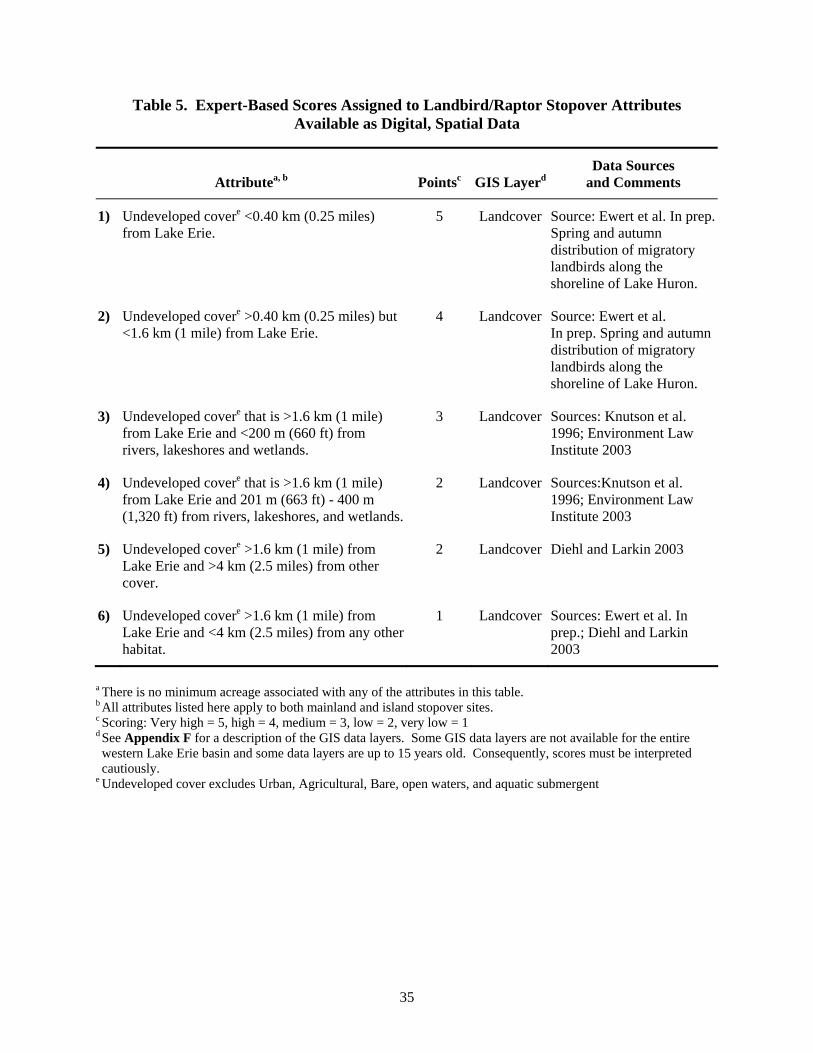
35
Table 5. Expert-Based Scores Assigned to Landbird/Raptor Stopover Attributes Available as Digital, Spatial Data
Attributea, b Pointsc GIS LayerdData Sources
and Comments
1) Undeveloped covere <0.40 km (0.25 miles) from Lake Erie.
5 Landcover Source: Ewert et al. In prep. Spring and autumn distribution of migratory landbirds along the shoreline of Lake Huron.
2) Undeveloped covere >0.40 km (0.25 miles) but <1.6 km (1 mile) from Lake Erie.
4 Landcover Source: Ewert et al. In prep. Spring and autumn distribution of migratory landbirds along the shoreline of Lake Huron.
3) Undeveloped covere that is >1.6 km (1 mile) from Lake Erie and <200 m (660 ft) from rivers, lakeshores and wetlands.
3 Landcover Sources: Knutson et al. 1996; Environment Law Institute 2003
4) Undeveloped covere that is >1.6 km (1 mile) from Lake Erie and 201 m (663 ft) - 400 m (1,320 ft) from rivers, lakeshores, and wetlands.
2 Landcover Sources:Knutson et al. 1996; Environment Law Institute 2003
5) Undeveloped covere >1.6 km (1 mile) from Lake Erie and >4 km (2.5 miles) from other cover.
2 Landcover Diehl and Larkin 2003
6) Undeveloped covere >1.6 km (1 mile) from Lake Erie and <4 km (2.5 miles) from any other habitat.
1 Landcover Sources: Ewert et al. In prep.; Diehl and Larkin 2003
a There is no minimum acreage associated with any of the attributes in this table. b All attributes listed here apply to both mainland and island stopover sites. c Scoring: Very high = 5, high = 4, medium = 3, low = 2, very low = 1 d See Appendix F for a description of the GIS data layers. Some GIS data layers are not available for the entire western Lake Erie basin and some data layers are up to 15 years old. Consequently, scores must be interpreted cautiously.
e Undeveloped cover excludes Urban, Agricultural, Bare, open waters, and aquatic submergent
36
WATERBIRDS (NON-WATERFOWL, INCLUDING MARSH BIRDS)
Introduction
Waterbirds and marsh birds are a diverse group that include wading and marsh birds (herons, cranes, rails, coot, cranes), colonial-nesting waterbirds (gulls, terns, cormorants and other Pelecaniformes), and other waterbirds (e.g., loons and grebes); species within each group range from solitary to colonial nesters. Spring migration timing for these species is variable, with American Coots and Ring-billed and Herring Gulls staging on western Lake Erie as early as early March (Granlund et al. 1994), and Double-crested Cormorants and several heron species arriving in mid-April to early May (Michigan Department of Natural Resources, Pointe Mouillee, unpublished data). Fall migration timing is not well documented, but species dependent on shallow wetlands generally migrate earlier than species that use open water. In addition, reverse movements of waterbirds (i.e., dispersal of birds, especially herons, from more southern locations) to the Lake Erie region underscores the potential importance of the area to waterbirds. Many waterbird species, especially marsh birds, are secretive and relatively difficult to observe and inventory during migration, so information on migrant use of the western Lake Erie basin is scarce. Some of the more visible species, such as the Great Blue Heron and American Coot, have been counted in large numbers on marshes along the Lake Erie coast during spring (Michigan Department of Natural Resources, Pointe Mouillee, unpublished data). Common Terns congregate near Port Clinton, Ohio during fall migration (Important Bird Area project 2005). The Black Swamp Bird Observatory (unpublished data) has collected data on rail habitat use along Lake Erie, but distinguishing between migrating and breeding wading birds has been difficult. Some of the wading bird species are at their spring migratory terminus when they reach western Lake Erie. Most egrets nesting in the Great Lakes region, for example, breed on islands in the western Lake Erie basin and Saginaw Bay (Wires and Cuthbert 2001). However, other wading bird species nest across mid and northern Michigan (Brewer et al. 1991), and elsewhere in the Great Lakes region (Sibley 2000) and may stopover in the western Lake Erie basin during migration. In addition to Great Blue Heron and American Coot, other waders regularly found in the area include Sandhill Crane, Great Egret, Green Heron, Black-crowned Night Heron, Sora, Virginia Rail, and Common Moorhen. Common Loon (uncommon), Pied-billed Grebe (common), and Horned Grebe (uncommon) are among the waterbirds most often observed on open waters of Lake Erie. Gulls are far more common, particularly Ring-billed and Herring Gulls, which have been found at some managed wetland locations by the hundreds as early as March (Michigan Department of Natural Resources, Pointe Mouillee, unpublished data). Large concentrations (thousands) of Bonaparte’s Gull, Herring Gull, Ring-billed Gull, and Common and Forster’s Tern have also been reported on western Lake Erie (see Campbell 1968, Granlund et al. 1994, Anderson et al. 2002). Smaller numbers of Great Black-backed Gulls and Caspian Terns occur along the Lake Erie coast during late spring and fall (Anderson et al. 2002).
37
Priority Species
Several waterbird species that occur in the western Lake Erie Basin during fall and spring migration have been categorized in the North American Waterbird Conservation Plan (http://www.waterbirdconservation.org) as “priority” species. This designation is based on one or more of the following criteria: habitat is threatened, abundance is declining, and/or distribution is limited (Kushlan et al. 2002). Priority species include:
• American Bittern • Yellow Rail • Least Bittern • Common Loon • Black-crowned Night Heron • Black Tern • Black Rail • Common Tern • King Rail
Assumptions and Caveats
• Data on habitat used by waterbirds during migration is sparse. • Because we lack detailed site-specific migration habitat, breeding habitat data was used to
supplement general attribute descriptions but we did not identify specific landscape and site attributes for migrating waterbirds.
• We assume the landscape and site attributes identified for other groups of wetland birds (waterfowl and shorebirds) will generally apply to waterbirds when they are roosting.
• We assume food resources and roosting sites with low disturbance are critical factors governing distribution during migration.
Landscape Attributes
Preferred habitat attributes of many wading birds are not well-studied, but appear to be intermediate between or overlapping shorebirds and waterfowl. During migration, Soras are reported using areas from dry grassy fields to wetlands of all sizes (Campbell 1968); they prefer shallow marshes with a mosaic of short to moderate height emergent vegetation and small open-water areas (Gregory Soulliere, personal communication). Most wading bird species are typically found in shallow emergent wetlands that provide a variety of food sources, from seeds and insects to snails and small fish. Other waterbirds are found in deeper water wetlands nearshore (grebes, coots, and cormorants) or in open-water sites (loons and cormorants). Terns and gulls use a variety of wetland and open-water sites, but typically also require islands, sand and gravel bars, rock rip-rap, piers, or pilings for roosting. Sites used by migrants likely change over time as changing water levels on Lake Erie dictate locations of sand bars, concentrations of prey, and distribution of wetlands. Consequently a landscape approach is likely to be needed when considering stopover sites for migratory waterbirds. Distribution of some waterbirds, such as gulls and terns, on open waters of Lake Erie has been described (see Stepanian and Waite 2003 and references therein). Gulls, terns, and cormorants may congregate where there are concentrations of small (<15 cm [6 inches]) fish in wetlands, river mouths, or nearshore waters. There are likely species-specific differences in food and habitat selection. Bonaparte’s Gulls, for example, have concentrated at schools of gizzard shad (Anderson et al. 2002) and emerald shiners during fall migration (Campbell 1968) and may be more common along lake beaches than in marshes (in Bent 1921). Stepanian and Waite (2003) noted that Ring-billed and Bonaparte’s Gull were found equally in four aquatic habitats: immediately offshore from refuges, developed shorelines, open water (water depth >10 m [33 feet]) and reefs and shoals (water depth 3-6 m [10-20 feet]). Double-crested Cormorants
38
occurred less frequently over open water compared to other habitats and Herring Gulls were found most frequently 0.5-0.8 km (0.3-0.5 miles) offshore of refuges.
Site Attributes
Emergent marshes are used by migrating wading birds. Managed coastal marshes (i.e., impounded by a dike system) account for the largest areas of this cover type around western Lake Erie. These areas may have clearer water and larger expanses of emergent aquatic vegetation than along the open shore of Lake Erie. Drawdowns, or de-watering of managed marshes, may attract hundreds of wading birds as fish and tadpoles become more concentrated and available (Ron Huffman, U.S. Fish and Wildlife Service, personal communication; Rick Foster, personal communication). This practice is most common during early summer, providing late spring migrants and local nesters with a concentrated food source. Waterbirds, especially those using expanses of open water, are sensitive to human disturbance. Black-crowned Night Herons, for example, roost on shrub-covered dikes within or adjacent to wetlands that have minimal human disturbance (Ron Huffman, personal communication). Buffer zones of approximately 250 m (825 feet) are recommended for airboat activity with cormorants (Rodgers and Schwikert 2000) and 100 m (330 feet) for waterbirds generally (Rodgers and Smith 1997). Personal watercraft and outboard motors should not be used within 140 m (462 feet) of gulls and terns (Rodgers and Schwikert 2000) in order to prevent disturbance. Migration habitat for Black Terns was described by Knutson et al. (2001) as areas of open water >3 ha (7 acres) and sandbars and beaches free of human disturbance which provide roosting areas.
Research and Monitoring Needs
• The timing, number, and location of waterbird species migrating through the region requires documentation.
• Habitat requirements of waterbird groups, particularly the wading birds, must be evaluated during both spring and fall migration.
• Determination of breeding and winter areas for waterbirds staging in the region will help identify migration corridors and other potential limiting factors in the life cycles of individual species starting with priority species.
• A program is needed to annually monitor migrant waterbird distribution and abundance to develop population goals and habitat conservation objectives, and to measure how well goals are being achieved.
Priority Attributes of Stopover Sites for Waterbird Conservation and Management
There are too few data to explicitly define attributes of stopover sites for waterbirds, although information that is available suggests conservation efforts should include the extensive wetlands and nearshore open-water areas of Lake Erie, Lake Erie islands, and nearby inland wetlands with at least some emergent vegetation. Sites with abundant food resources and limited human disturbance also appear to be important to this group of birds.
39
STOPOVER SITE ATTRIBUTES IN THE WESTERN LAKE ERIE BASIN SHARED BY TWO OR MORE GROUPS OF BIRDS
The following attributes are shared by at least some (but not all) species of concern within two or more groups of birds. Consequently sites with these attributes may have particularly high conservation value and should be a high priority for conservation work. However, the shared attributes described below are still, in many cases, working hypotheses that require further testing.
• High aquatic insect productivity, especially during spring: waterfowl, shorebirds, landbirds, waterbirds.
• Close proximity to the Great Lakes: waterfowl, shorebirds, raptors, landbirds, waterbirds. • Close proximity to other protected areas; a more intact landscape matrix: waterfowl,
shorebirds, raptors, landbirds, waterbirds. • Moist soil: waterfowl, shorebirds, waterbirds. • Structurally diverse forests: raptors, landbirds. • Lack of human disturbance: waterfowl, shorebirds, raptors, waterbirds. • Areas with few or no towers: waterfowl, shorebirds, raptors, landbirds, waterbirds. • High relative use of peninsulas, islands: waterfowl, raptors, landbirds. • Low light levels (anthropogenic): nocturnal migrants: shorebirds, landbirds.
40
ACKNOWLEDGEMENTS
Thanks to Doug Brewer (U.S. Fish and Wildlife Service), Allen Chartier, Julie Craves (University of Michigan-Dearborn), Patrick Doran (The Nature Conservancy), Victor Fazio III (bird conservationist), Colleen J. Feucht (University of Wisconsin-Green Bay), Dan Frisk (U.S. Fish and Wildlife Service), Vicki Piakowski (Zoological Society of Milwaukee), Derric Pennington (University of Minnesota), Judy Pollock (National Audubon Society), Jim McCormac (Ohio Department of Natural Resources), Robert Russell (U.S. Fish and Wildlife Service), Elliot Tramer (University of Toledo), Tara Baranowski (The Ohio State University), and Bill Whan (bird conservationist) for providing information on stopover sites. Rebecca Walling (Ducks Unlimited) provided a useful literature review of stopover sites for the region. Helen Enander (Michigan Natural Features Inventory), and Marshall Strong (Michigan Department of Natural Resources) provided GIS expertise. Rachel Bricklin (University of Michigan), Karen Cleveland (Michigan Department of Natural Resources), Julie Craves (Rouge River Bird Observatory), Bill Evans (Old Bird, Inc.), Mary Harkness (The Nature Conservancy), Pat Heglund (United States Geological Survey), Ron Larkin (Illinois Natural History Survey), David Mehlman (The Nature Conservancy), Andy Paulios (Wisconsin Department of Natural Resources), Doug Pearsall (The Nature Conservancy), Vicki Piakowski (Zoological Society of Milwaukee), Robert Smith (University of Scranton), and Tina Yerkes (Ducks Unlimited) commented on drafts of this report. We thank The George Gund Foundation for providing primary funding for this work. The U.S. Fish and Wildlife Service provided funding for a literature review of stopover sites for the western Lake Erie basin. This report is an outgrowth of a conference, Conservation of stopover habitat for migrating landbirds, held at Moss Point, Mississippi from 2-5 May 2001, which was partially funded by The George Gund Foundation. The Nature Conservancy hosted a group of stopover experts from throughout eastern North America and Canada to delineate conservation needs for migratory landbirds. The ideas generated at that conference provided the background, justification, and momentum for this evaluation of stopover sites in the western Lake Erie basin.
41
LITERATURE CITED
Aborn, D. A. 1994. Correlation between raptor and songbird numbers at a migratory stopover site. Wilson Bulletin 106:150-154.
Albert, D. A. 1995. Regional landscape ecosystems of Michigan, Minnesota, and Wisconsin. Upper Great
Lakes Biodiversity Committee. U. S. Forest Service Technical Report NC-178. 250 pp. Alerstam, T. 1978. Reoriented bird migration in coastal areas: dispersal to suitable resting grounds? Oikos
30:405-408. Anderson, M., E. Durbin, T. Kemp, S. Lauer, and E. Tramer. 2002. Birds of the Toledo area. Ohio
Biological Survey, Columbus. Anonymous. No date. The Lake Erie marshes focus area plan. A component of the North American
Waterfowl Management Plan’s Lower Great Lakes/St. Lawrence Basin Joint Venture. Division of Wildlife, Ohio Department of Natural Resources.
Armitage, P. D. 1995. Behaviour and ecology of adults. Pp. 194-224. In The Chironomidae: biology and
ecology of non-biting midges (P. D. Armitage, P. S. Cranston, and C. V. Pinder, eds.). Chapman and Hall, New York.
Bayne, E. M. and K. A. Hobson. 2001. Movement patterns of adult male Ovenbirds during the post-
fledging period in fragmented and forested boreal landscapes. Condor 103:343-351. Beale, C. M. and P. Monaghan. 2004. Behavioural responses to human disturbance: a matter of choice?
Animal Behaviour 68:1065-1069. Bellrose, F. C. 1980. Ducks, geese, and swans of North American. Stackpole Books, Harrisburg, PA. Bellrose, F. C. and D. J. Holm. 1994. Ecology and management of the wood duck. Stackpole Books,
Mechanicsburg, PA. Bent, A. C. 1921. Life histories of North American gulls and terns. Smithsonian Institution, United States
National Museum 113. Blake, J. G. and W. G. Hoppes. 1986. Influence of resource abundance on use of tree-fall gaps by birds in
an isolated woodlot. Auk 103:328-340. Bolton, M. R. and J. Szanto. 2003. Fourteen years of shorebird surveys near western Lake Erie. Ohio
Cardinal 26:140-144. Bonter, D., S. A. Gauthreaux, and T. M. Donovan. 2002. Are migratory birds selecting stopover sites
based on landscape characteristics? Remote sensing with WRS-88D (NEXRAD) radar in the Great Lakes basin. Final report submitted to the The Nature Conservancy, Great Lakes program.
Bookhout, T.A., K. E. Bednarik, and R. W. Kroll. 1989. The Great Lakes marshes. Pp. 131-156. In
Habitat management for migrating and wintering waterfowl in North America. (L. M. Smith, R. L. Pederson, and R. M. Kaminski, eds.). Lubbock, TX: Texas Tech University Press.
42
Booth, W. M. 1971. Migration of Blue Jays in southwestern Michigan. Jack-Pine Warbler 49:82-86. Brawn, J. D. and D. F. Stotz. 2001. The importance of the Chicago region and the “Chicago Wilderness”
initiative for avian conservation. Pp. 509-522. In Avian Ecology and Conservation in an urbanizing world (J. M. Marzluff, R. Bowman and R. Donnelly, eds.). Kluwer Academic Publishers, Boston.
Brewer, R., G. A. McPeek, and R. J. Adams, Jr. 1991. The atlas of breeding birds in Michigan. Michigan
State University Press, East Lansing. Brown, S., C. Hickey, B. Harrington, and R. Gill (eds.). 2001. United States shorebird conservtion plan,
2nd ed. Manomet Center for Conservation Sciences, Manomet, MA. 60 pp. Buler, J. J., F. R. Moore, and S. Woltmann. 2004. Landscape-scale habitat use by landbirds during
migration along the northern Gulf Coast: patch size matters. Abstract, American Ornithologists’ Union.
Burke, D. M. and E. Nol. 1998. Influence of food abundance, nest-site habitat, and forest fragmentation
on breeding Ovenbirds. Auk 115:96-104. Burton, T. M., D. G. Uzarski, and J. A. Genet. 2004. Invertebrate habitat use in relation to fetch and plant
zonation in northern Lake Huron coastal wetlands. Aquatic Ecosystem Health and Management 7:249-267.
Byelich, J., M.E. DeCapita, G. W. Irvine, R. R. Radtke, N. I. Johnson, W. R. Jones, H. Mayfield, and W.
J. Mahalak. 1985. Kirtland’s Warbler Recovery Plan, Updated 1985. Kirtland’s Warbler Recovery Team.
Campbell, L. 1968. Birds of the Toledo area. Toledo Blade Company, Toledo, Ohio. Campbell, L. W. 1995. The marshes of southwestern Lake Erie. Ohio University Press, Athens. Cassady St. Clair, C., M. Belisle, A. Desrochers, and S. Hannon. 1998. Winter responses of forest birds to
habitat corridors and gaps. Conservation Ecology [online] 2(2):13. (http://www.consecol.org/vol2/iss2/art13) (4 February 2000).
Chartier, A. T. and J. Ziarno. 2004. A birder’s guide to Michigan. American Birding Association, Inc. Chipley, R. M., G. H. Fenwick, M. J. Parr and D .N. Pashley. 2003. The American Bird Conservancy
Guide to the 500 Most Important Bird Areas in the United States: Key sites for birds and birding in all 50 states. Random House, New York.
Cochran, W. W. and M. Wikelski. 2005. Individual migratory tactics of New World Catharus thrushes.
Current knowledge and future. Tracking options from space. Pp. 274-289. In Birds of Two Worlds (R. Greenberg and P. P. Marra, eds.). John Hopkins Press, Baltimore and London.
Cowardin, L. M., V. Carter, F. C. Golet, and E. T. LaRoe. 1979. Classification of wetlands and deepwater
habitats of the United States. U. S. Department of the Interior, Fish and Wildlife Service, FWS/OBS-79/31. Reprinted 1992.
43
Craves, J. A. and O. G. Gelderloos. 1996. Birds of the Rouge River floodplain: Importance of an urban natural area to birds. Michigan Birds and Natural History 3:3-12.
Crowder, A. A. and J. M. Bristow. 1988. The future of waterfowl habitats in the Canadian lower Great
Lakes islands. Journal of Great Lakes Research 14:115-127. Custer, C. M. and T. W. Custer. 1996. Food habits of diving ducks in the Great Lakes after the zebra
mussel invasion. Journal of Field Ornithology 67:86-99. Dallman, M. and R. J. Smith. 1995. Avian predation on chironomids along the nearshore waters of Lake
Huron. Michigan Birds and Natural History 2:201-204. Dennis, D. G. and R. E. Chandler. 1974. Waterfowl use of the Ontario shorelines of the southern Great
Lakes during migration. Pp. 58-65. In Canadian Wildlife Service waterfowl studies in eastern Canada, 1969-73 (H. Boyd, ed.). Canadian Wildlife Service Report Series No. 29.
Desrochers, A. and S. J. Hannon. 1997. Gap crossing decisions by forest songbirds during the post-
fledging period. Conservation Biology 11:1204-1210. de Szalay, F., D. Helmers, D. Humburg, S. J. Lewis, B. Pardo, and M. Shieldcastle. 2000. Upper
Mississippi Valley/Great Lakes Regional Shorebird conservation plan. Version 1.0. Devereux, J. T., T. Carpenter, and K. Durham. 1985. Spring migration pattern of Sharp-shinned Hawks
passing Whitefish Point, Michigan. Journal of Field Ornithology 56:346-355. Diehl, R. H. and R. P. Larkin. 2003. Identifying high-use stopover habitat using Doppler radar. Final
report to The Nature Conservancy. Diehl, R. H. and R. P. Larkin. 2005. Introduction to the WSR-88D (NEXRAD) for ornithological
research. Pp. 876-888. In Bird Conservation Implementation and Integration in the Americas: Proceedings of the Third International Partners in Flight Conference 2002 (C. J. Ralph and T. D. Rich, eds.). U. S. Department of Agriculture, Pacific Southwest Research Station, Albany, California.
Diehl, R. H., R. P. Larkin, and J. E. Black. 2003. Radar observations of bird migration over the Great
Lakes. Auk 120:278-290. Environment Law Institute. 2003. Conservation Thresholds for land use planners. Environment Law
Institute, Washington, D.C. Ewert, D. N. and M. J. Hamas. 1996. Ecology of migratory landbirds during migration in the Midwest.
Pp. 200-208. In Management of Midwestern landscapes for the Conservation of Neotropical Migratory Birds (F. R. Thompson, III, ed.). U.S. Department of Agriculture, North Central Forest Experiment Station, General Technical Report NC-187.
Ewert, D. N., M. J. Hamas, R. J. Smith, and S. W. Jorgensen. In prep. Spring and autumn distribution of
migratory landbirds along the shoreline of Lake Huron. Ewert, D. N., R. J. Smith, and R. H. Diehl. 2004. Use of habitat patches by migratory birds during
migration in southwestern Michigan. Unpublished report, U.S. Fish and Wildlife Service.
44
Farmer, A. H. and A. H. Parent. 1997. Effects of the landscape on shorebird movements at spring migration stopovers. Condor 99:698-707.
Fatal Night Awareness Program. 2005. www.flap.org. Accessed 30 June 2005. Feucht, C. J. 2003. Is Lake Michigan’s Door Peninsula a significant stopover site for migratory birds?
M.S. thesis, University of Wisconsin-Green Bay. 37 pp. Gauthreaux, S. A. and C. G. Belser. 2003. Bird movements on Doppler Weather Surveillance Radar.
Birding 35:616-628. Gehring, J. amd Curry & Kerlinger, LLC. 2005. Avian collision study for the Michigan public safety
communications system (MPSCS): summary of fall 2005 field season. Gill, J. A., K. Norris, and W. J. Sutherland. 2001. Why behavioural responses may not reflect the
population consequences of human disturbance. Biological Conservation 97: 265-268. Graber, J. W. and R. R. Graber. 1983. Feeding rates of warblers in spring. Condor 85:139-150. Granlund, J., G. A. McPeek, R. J. Adams, P. C. Chu, J. Reinoehl, C. Nelson, R. Schinkel, M. Kielb,
S. Allen, and A. Trautman (G. A. McPeek and R. J. Adams, eds.). 1994. The birds of Michigan. Indiana University Press, Bloomington.
Great Lakes Basin Commission. 1975. Great Lakes Basin framework study. Appendix 17. Wildlife.
U.S. Department Interior, Bureau. Sport Fisheries and Wildlife Ann Arbor, MI 140 pp. Great Lakes Information Network. Areas of Concern (AOCs) in the Great Lakes region. May 2, 2005.
Available from http://www.great-lakes.net/envt/pollution/aoc.html Accessed June 30, 2005. Grubb, T. C., Jr. and P. F. Doherty, Jr. 1999. On home-range gap-crossing. Auk 116:618-628. Gruenhagen, N. M. and L. H. Fredrickson. 1990. Food use by migratory female mallards in northwest
Missouri. Journal of Wildlife Management 54:622-626. Grveles, K. M. 1998. Monitoring of migratory birds and identification of their stopover and breeding
habitats in four state parks along the western Lake Michigan shoreline. Unpublished report, Michigan State Parks Division.
Hamilton, D. J. and C. D. Ankney. 1994. Consumption of zebra mussels Dreissena polymorpha by diving
ducks in Lakes Erie and St. Clair. Wildfowl 45:159-166. Harrington, B. A. Shorebird migrations. Ducks Unlimited, 44 pp. Haugh, J. R. 1984. Raptors in migration. Pp. 35-48. In Raptor conservation in the next 50 years
(S. E. Senner, C. M. White, and J. R. Parrish, eds.). Raptor Research Report, No. 5. Hazzard, S. 2001. Habitat selection by landbirds at Port Crescent State Park and Albert E. Sleeper State
Park, Michigan. M.S. Thesis, Central Michigan University, Mt. Pleasant. Heglund, P. J. and S. K. Skagen. 2005. Ecology and physiology of en route nearctic-neotropical
migratory birds: a call for collaboration. Condor 107:193-196.
45
Helmers, D. L. 1992. Shorebird management manual. Western Hemisphere Shorebird Reserve Network, Manomet Bird Observatory, 58 pp.
Hyde, D. A. 1998. Stopover ecology of migratory birds along the central Lake Michigan shoreline.
M.S. thesis, Central Michigan University, Mt. Pleasant. Important Bird Area Project, Ohio. 2005. Available from http://www.audubonohio.org/bsc/bas./html.
Accessed 1 November 2005. Johansen, Jr., W. R. 1993. Habitat associations and stopover times of migrant landbirds within the
Whitefish Peninsula, Chippewa Co., Michigan. Unpublished report, Whitefish Point Bird Observatory.
Joyner, D. E. 1980. Influence of invertebrates on pond selection by ducks in Ontario. Journal of Wildlife
Management 44:700-705. Kelley, A. H. 1978. Birds of southeastern Michigan and southwestern Ontario. Cranbrook Institute of
Science, Bloomfield Hills, Michigan. Kelleys Island Audubon Club. 2005. http://kelleysislandnature.com/island_birding/banding_stats.htm.
Accessed 3 September 2005. Kerlinger, P. 1989. Flight strategies of migrating hawks. University of Chicago Press, Chicago, IL. Kilgo, J. C., K. V. Miller, and W. P. Smith. 1999. Effects of group-selection timber harvest in bottomland
hardwoods on fall migrant birds. Journal of Field Ornithology 70:404-413. Knapton, R. W. and S. A. Petrie. 1999. Changes in distribution and abundance of submerged macrophytes
in the inner bay at Long Point, Lake Erie: implications for foraging waterfowl. Journal of Great Lakes Research 25:783-798.
Knapton, R. W., S. A. Petrie, and G. Herring. 2000. Human disturbance of diving ducks on Long Point
Bay, Lake Erie. Wildlife Society Bulletin 28:923-930. Knutson, M. G., G. Butcher, J. Fitzgerald, and J. Shieldcastle. 2001. Partners in Flight Bird Conservation
Plan for the Upper Great Lakes Plain (Physiographic Area 16. U.S. Geological Service Upper Midwest Environmental Sciences Center in cooperation with Partners in Flight, La Crosse, Wisconsin.
Knutson, M. G., J .P. Hoover, and E. E. Klaas. 1996. The importance of floodplain forests in the
conservation and management of neotropical migratory birds in the Midwest. Pp. 168-188. In Management of midwestern landscapes for the conservation of neotropical migratory birds (F. R. Thompson, III, ed.). U.S. Department of Agriculture, North Central Forest Experiment Station, General Technical Report NC-187.
Korschgen, C. E., L. S. George, and W. L. Green. 1985. Disturbance of diving ducks by boaters on a
migrational staging area. Wildlife Society Bulletin 13:290-296. Korschgen, C. E., L. S. George, and W. L. Green. 1988. Feeding ecology of canvasbacks staging on pool
7 of the Upper Mississippi River. Pp. 237-249. In Waterfowl in winter (M. W. Weller, ed.). University of Minnesota Press, Minneapolis.
46
Kovats, Z. E., J. J.H. Ciborowski, and L. D. Corkum. 1996. Inland dispersal of adult aquatic insects. Freshwater Biology 36:265-276.
Kushlan, J. A., M .J. Steinkamp, K .C. Parsons, J. Capp, M. A. Cruz, M. Erwin, S. Hatch, S. Kress, R.
Milko, S. Miller, K. Mills, R. Paul, R. Phillips, J. E. Saliva, B. Sydeman, J. Trapp, J. Wheeler, and K. Wohl. 2002. Waterbird conservation for the Americas: the North American Waterbird Conservation Plan, version 1. Waterbird Conservation for the Americas. Washington, D.C. 78 pp.
Lafferty, K. D. 2001. Disturbance to wintering western snowy plovers. Biological Conservation 101:
315-325. LaGrange, T. G. and J .J. Dinsmore. 1989. Habitat use by mallards during spring migration through
central Iowa. Journal of Wildlife Management 53:1076-1081. Lambeck, R. J. 1997. Focal species: A multi-species umbrella for nature conservation. Conservation
Biology 11:849-856. Lambert, L., J. Robinson, M. Shieldcastle, and M. Austen. 2001. Lake Erie Lakewide Management Plan
(LaMP) Technical Report Series. Technical Report No. 5. Executive Summary: Degraded Wildlife Populations and loss of wildlife habitat. Unpublished report.
Longcore, T., C. Rich, and S. A. Gauthreaux. 2005. Scientific basis to establish policy regulating
communications towers to protect migratory birds: response to Avatar Environmental, LLC, report regarding migratory bird collisions with communications towers, WT Docket No. 03-187, Federal Communications Commission Notice of Inquiry. Report to American Bird Conservancy, Defenders of Wildlife, Forest Conservation Council and the Humane Society of the United States.
Machtans, C. S., M-A Villard, and S. J. Hannon. 1996. Use of riparian buffer strips as movement
corridors by forest birds. Conservation Biology 10:1366-1379. Martin, T. E. 1980. Diversity and abundance of spring migratory birds using habitat islands on the Great
Plains. Condor 82:430-439. Martin, T. E. and J. R. Karr. 1986. Patch utilization by migrating birds: resource oriented? Ornis
Scandinavica 17:165-174. Mehlman, D. W., S. E. Mabey, D. N. Ewert, C. Duncan, B. Abel, D. Cimprich, R. D. Sutter, and M.
Woodrey. 2005. Conserving stopover sites for forest-dwelling migratory landbirds. Auk 122:1281-1290.
Mikula, E. J. 1968. Importance of Celeron Island to waterfowl. Information Circular No. 149, Michigan
Department of Conservation, Game Division. 2 pp. Moore, F. R. and D. A. Aborn. 2000. Mechanisms of en route habitat selection: how do migrants make
habitat decisions during stopover? Studies in Avian Biology 20:34-42. The Nature Conservancy. 1999. Great Lakes ecoregional plan: a first iteration. The Nature Conservancy,
Great Lakes Program, Chicago, IL, USA. 85 pp + iv.
47
North American Waterfowl Management Plan. 2004. North American waterfowl management plan: strengthening the biological foundation (Implementation Framework). U.S. DOI, Fish and Wildlife Service and Environment Canada, Canadian Wildlife Service. 126 pp.
Ogden, L. J. E. 1996. Collision course: the hazards of lighted structures and windows to migrating birds.
World Wildlife Fund Canada and the Fatal Awareness Program. The Ohio Coastal Atlas. 2005. Office of Coastal Management, Ohio Department of Natural Resources. Olson, T. M. 2003. Variation in use of managed wetlands by waterfowl, wading birds, and shorebirds in
Ohio. M.S. Thesis, The Ohio State University. 102 pp. Parrish, J. D. 2000. Behavioral, energetic, and conservation implications of foraging plasticity during
migration. Studies in Avian Biology 20:53-70. Peterjohn, B. G. 1989. The birds of Ohio. Indiana University Press, Bloomington. Petit, D. R. 2000. Habitat use by landbirds along neararctic-neotropical migration routes: implications for
conservation of stopover habitats. Studies in Avian Biology 20:15-33. Petrie, S. 2005. Satellite tracking of Tundra Swans in eastern North America. Birding 37:180-185. Petrie, S. A. and K. L. Wilcox. 2003. Migration chronology of eastern population Tundra Swans.
Canadian Journal of Zoology 81:861-870. Pettingill, O. S. 1962. Hawk migrations around the Great Lakes. Audubon Magazine 64:44-45, 49. Piaskowski, V. and G. Albanese. 2001. Resource sampling of arthropods in all vegetation strata and
correlation with arthropods identified in fecal samples of insectivorous warblers at a spring migration stopover site. Abstract. American Ornithologists’ Union Meeting, Seattle, WA.
Pogacnik, J. 1996. Arcola Creek. Natural Resource Management Plan. Unpublished report, 55 pp. Pollock, J., K. Glennemeir, and D. Stotz. 2004. Migrant bird habitat study. Final report. Prince, H. H., Padding, P. I., and Knapton, R. W. 1992. Waterfowl use of the Laurentian Great Lakes.
Journal Great Lakes Research 18:673-699. Rich, T. D., C. J. Beardmore, H. Berlanga, P. J. Blancher, M. S. W. Bradstreet, G. S. Butcher, D. W.
Demarest, E. H. Dunn, W. C. Hunter, E .E. Ingio-Elias, J. A. Kennedy, A. M. Martell, A. O. Panjabi, D. N. Pashley, K. V. Rosenberg, C. M. Rustay, J. S. Wendt, and T. C. Will. 2004. Partners in Flight North American Landbird Conservation Plan. Cornell Lab of Ornithology, Ithaca, NY.
Rodewald, P. G. and M. C. Brittingham. 2002. Habitat use and behavior of mixed species landbird flocks
during fall migration. Wilson Bulletin 114:87-98. Rodewald, P. G. and M. C. Brittingham. 2004. Stopover habitats of landbirds during fall: use of edge-
dominated and early-successional forests. Auk 121:1040-1055.
48
Rodewald, P. G. and S. N. Matthews. 2005. Landbird use of riparian and upland forest stopover habitats in an urban landscape. Condor 107:259-268.
Rodgers, J. A. and S. T. Schwikert. 2000. Buffer-zone distances to protect foraging and loafing waterbirds
from disturbance by personal watercraft and outboard-powered boats. Conservation Biology 16:216-224.
Rodgers, J. A. and H. T. Smith. 1997. Buffer zone distances to protect foraging and loafing waterbirds
from human disturbance in Florida. Wildlife Society Bulletin 25:139-145. Scharf, W. C., M. L. Chamberlin, T. C. Erdman, G. W. Shugart, L. Shanks, and M. Landin. 1979. Nesting
and migration areas of birds of the U.S. Great Lakes (30 April to 25 August 1976). FWS/OBS – 77/2. Office of Biological Sciences, Fish and Wildlife Service, U.S. Department of Interior and Waterways Experiment Station, Army Corps of Engineers, U.S. Department of Defense.
Schloesser, D. W. and B. A. Manny. 1990. Decline of wild celery beds in the lower Detroit River,
1950-85. Journal of Wildlife Management 54:72-76. Shieldcastle, J. 2000. Western Hemisphere Shorebird Reserve Network. Lake Erie Marsh region.
Unpublished report. Shieldcastle, M. C. and J. A. Shieldcastle. 2003a. Migrational survey and habitat usage of shorebirds in
the Lake Erie marsh region. Progress Report-2003, BSBO-ONWR03-3. Shieldcastle, M. C. and J. A. Shieldcastle. 2003b. Spring migrational movement study of raptors on
Ottawa National Wildlife Refuge and surrounding Lake Erie marshes, Ohio. Progress Report-2003, BSBO-ONWR03-2.
Shieldcastle, M. C. and J. A. Shieldcastle. 2004. Migrational movements and habitat usage of passerines
on Ottawa National Wildlife Refuge and the surrounding Lake Erie marshes, Ohio. Progress Report – 2004, BSBO-ONWR04-1.
Sibley, D. A. 2000. National Audubon Society The Sibley Guide to Birds. Chanticleer Press, Inc., New
York. Sillett, T. S. and R. T. Holmes. 2002. Variation in survivorship of a migratory songbird throughout its
annual cycle. Journal Animal Ecology 71:296-308. Smith, L., M. Smith, R. L. Pederson, and R. M. Kaminski. 1989. Habitat management for migrating and
wintering waterfowl in North America. Texas Tech University Press. 560 pp. Smith, R. J. 2003. Resources and arrival of landbird migrants at their northerly breeding grounds: linking
en route with breeding season events. Ph.D. Dissertation, University of Southern Mississippi, Hattiesburg.
Smith, R., M. Hamas, M. Dallman, and D. Ewert. 1998. Spatial variation in foraging of the Black-
throated Green Warbler along the shoreline of northern Lake Huron. Condor 100:474-484. Smith, S. B. and C. J. Norment. 2005. Nocturnal activity and energetic condition of spring landbird
migrants at Braddock Bay, Lake Ontario. Journal of Field Ornithology 76:303-310.
49
Soulliere, G. J. 2000. Michigan waterfowl season: 1999-2000 review. Michigan Department of Natural Resources, Lansing, Wildlife Division. Report 3309. 7 pp.
Soulliere, G. J. and D. R. Luukkonen. 2001. Michigan waterfowl habitat and hunting season report,
2000-01. Michigan Department Natural Resources, Wildlife Division Report 3341. 10 pp. Soulliere, G. J., T. E. Maples, and E. N. Kafcas. 2000. Twenty-five years of canvasback inventory in
Michigan, 1974-1999. Michigan Department of Natural Resources, Wildlife Division Report 3309. 7 pp.
Soulliere, G. J. and M. J. Monfils. 1996. Waterbird use of a constructed wetland complex in eastern
Upper Michigan (year 3). Michigan Department of Natural Resources, Wildlife Division Report 3262. 12 pp.
Southeastern Michigan Raptor Research. 2005. www.smrr.net/what.shtml. Accessed 30 June 2005. Steckel, J. D. 2003. Food availability and waterfowl use on mid-migration habitats in central and northern
Ohio. M.S. Thesis, The Ohio State University. 82 pp. Stepanian, M. A. and T. A. Waite. 2003. Species density of waterbirds in offshore habitats in western
Lake Erie. Journal of Field Ornithology 74:381-393. Suthers, H. B., J. M. Bickal and P. G. Rodewald. 2000. Use of successional habitat and fruit resources by
songbirds during autumn migration in central New Jersey. Wilson Bulletin 112:242-260. Swanson, D. L., H. A. Carlisle, and E. T. Liknes. 2003. Abundance and richness of neotropical migrants
during stopover at farmstead woodlots and associated habitats in southeastern South Dakota. American Midland Naturalist 149:176-191.
Thomas, K., R. G. Kvitek, C. Bretz. 2003. Effects of human activity on the foraging behavior of
sanderlings, Calidris alba. Biological Conservation 109:67-71. Thomson, T. 1994. Birding in Ohio, 2nd edition. Indiana University Press, Bloomington and Indianapolis. U. S. Fish and Wildlife Service. 1998. Upper Mississippi River and Great Lakes Region Joint Venture of
the NAWMP 1998 Implementation Plan. U.S. Fish and Wildlife Service, Fort Snelling, MN. 58 pp.
U. S. Shorebird Conservation Plan. 2004. High priority shorebirds-2004. Unpublished report, U.S. Fish
and Wildlife Service, 4401 N. Fairfax Dr., MBSP 4107, Arlington, VA, 22203 U.S.A. 5 pp. Weisbrod, A. R., C. J. Burnett, J. G. Turner, and D. W. Warner. 1993. Migrating birds at a stopover site
in the St. Croix River Valley. Wilson Bulletin 105:265-284. Weise, C. M. 1988. Long-term population trends in songbirds: evidence from a general netting program.
University of Wisconsin-Milwaukee Field Station Bulletin 21:1-9. Wiedner, D. S., P. Kerlinger, D. A. Sibley, P. Holt, J. Hough, and R. Crossley. 1992. Visible morning
flight of neotropical landbird migrants at Cape May, New Jersey. Auk 109:500-510.

50
Wilson, R. R. and D. J. Twedt. 2003. Spring bird migration in Mississippi alluvial valley forests. American Midland Naturalist 149:163-175.
Winker, K., D. W. Warner, and A. R. Weisbrod. 1992. Migration of woodland birds at a fragmented
inland stopover site. Wilson Bulletin 104:580-598. Wires, L. R. and F. J. Cuthbert. 2001. Prioritization of waterbird colony sites for conservation in the U.S.
Great Lakes. Final report to the U.S. Fish and Wildlife Service.

APPENDICES
A-1
APPENDIX A. IDENTIFIED STOPOVER SITES IN THE WESTERN LAKE ERIE BASIN
Important stopover sites in The American Bird Conservancy Guide to the 500 Most Important Bird Areas in the United States (Chipley et al. 2003).
1. Open waters of Lake Erie including mouth of the Detroit River and Maumee Bay, Ohio and Michigan. Waterfowl (including Long-tailed Duck, Bufflehead, Common Goldeneye, Red-breasted and Common Merganser, Canvasback, scaup) and gulls (especially Bonaparte’s). Threats: oil and chemical spills, nutrient and other pollutants.
2. Cedar Point National Wildlife Refuge, Metzger Marsh Wildlife Area, Ottawa National Wildlife Refuge, Magee Marsh Wildlife Area, Ohio. Stopover for waterfowl, shorebirds and landbirds. Up to 50,000 shorebirds use the Lake Erie marshes, more than 100,000 waterfowl, including up to 70% of the Mississippi Flyway population of American Black Duck. Threats: lack of sufficient terrestrial and perhaps aquatic habitat for migrants; purple loosestrife.
3. Sandusky Bay, Ohio. 12,000 acres (Pickerel Creek Wildlife Area, Willow Point, Pipe Creek Wildlife Area, Sheldon’s Marsh, Winous Point Marsh Conservancy, Ottawa Shooting Club). Waterfowl (up to 1 million during fall migration including world’s largest staging area for American Black Duck and Red-breasted Merganser; up to 67,000 American Black Duck, 170,000 Red-breasted Merganser, 23,700 Canvasback, etc.), up to 5,000 shorebirds/day, very heavy concentrations of landbirds. Threats: excess recreational use, agricultural runoff, residential development.
Important stopover sites identified through the Important Bird Area project, Ontario (http://www.bsc-eoc.org/iba/site.cfm?).
• Lower Detroit River (155 km2). Globally significant waterfowl (Canvasback) late fall staging area. Threats: chemical and oil spills.
• Point Pelee (40 km2). Globally significant waterfowl concentrations (Red-breasted Merganser), waterbird concentrations (Bonaparte’s Gull, Common Tern, Forster’s Tern), landbird concentrations. Threats: airborne pollution, aquatic pollution (chemical, oil, agricultural), invasive species, fragmentation, overabundant deer.
• Pelee Island Natural Areas (77 km2) and Pelee Island archipelago (24 km2). Globally significant landbird concentrations, especially at Fish Point and Lighthouse Point Nature Preserves. Threats: extraction industry, other recreational events, recreation/tourism, urban/industrial development.
• Greater Rondeau Area (87 km2). Globally important waterfowl and migratory landbird concentrations. Threats: disturbance, introduced species (i.e., Phragmites), urban/industrial development.
• Holiday Beach/Big Creek (9 km2). Globally important raptor (Broad-winged Hawk, Merlin, Northern Harrier, Peregrine Falcon, Red-tailed Hawk), waterfowl (Red-breasted Merganser) and migratory landbird concentrations. Threats: agricultural pollution/pesticides, deforestation, wetland loss, urban/industrial development.
A-2
Important stopover sites identified in the Great Lakes ecoregion plan (The Nature Conservancy)
• Detroit River, MI • Lake Erie Metro Beach Metropark, MI • Pointe Mouillee, MI • University of Michigan-Dearborn campus (Dearborn Woods), MI (also identified by Julie
Craves) • Oak Openings, OH • Maumee River and Bay, OH and Erie Marsh, MI • Western Lake Erie marshes, OH • Sandusky Bay and River, OH • Western Lake Erie Islands, OH
Important stopover sites identified in the Ohio Coastal Atlas (2005)
• Kelleys Island • Crane Creek • Magee Marsh Wildlife Area • Metzger Marsh Wildlife Area • Ottawa National Wildlife Refuge • Sheldon Marsh State Nature Preserve
Table A-1. Important Ohio Stopover Sites Identified for This Project by Mark Shieldcastle (Unpublished Data)
Site Landbirds Raptors Wading
birds Waterfowl Shorebirds
Ottawa National Wildlife Refuge High Moderate High High High
Magee Marsh Wildlife Area High Moderate High High High
Ottawa Shooting Club High Moderate High High High
Cedar Point National Wildlife Refuge High Moderate High High Moderate
Navarre Unit, Ottawa National Wildlife Refuge
High Moderate High High Moderate
Pickerel Creek Wildlife Area Moderate Moderate High High Moderate
Metzger Marsh Wildlife Area Moderate Low High Moderate High
Pipe Creek Wildlife Area Low Low High Moderate Moderate
Resthaven Wildlife Area High Low Moderate Moderate Low
Oak Openings Metropolitan Park Moderate Moderate Low Low Low
A-3
Table A-2. Important Stopover Sites in the Western Lake Erie Basin, United States, Noted by Bird Conservationists Familiar with the Area
Site Waterfowl Shorebirds Landbirds / Raptors
Belle Isle, MIa Xd,k
Detroit River, MI Xd Xd
Erie Marsh, MIb Xk X Xd
Lake Erie MetropolitanPark, MI Xk Xk Xd
Pointe Mouillee State Game Area, MI Xk Xk Xd
Sterling State Park, MI Xd
Woodtick peninsula, MI Xk Xd
Cedar Point. National Wildlife Refuge, OH
Xg,l Xe,g,h Xg,h,j
Crane Creek estuary, OH Xf,g,l Xe,g,h,i,l Xg,h,j,l
Lake Erie Islands, OH Xl Xe,h,l
Magee Marsh Wildlife Area, OH Xg,l Xg,h,l Xg,h,j,l
Maumee Bay State Park, OH Xg,h,j
Metzger Marsh Wildlife Area, OH Xh,j
Muddy Creek Bay, OH Xf Xr Ottawa National Wildlife Refuge, OH Xg,l Xg,h,l Xg,h,j,l
Pearson Metroparkc, OH Xg
Potter’s Marsh, OH, OH Xf Resthaven Wildlife Area, OH Xh,j
Sandusky Bay, OH Xl Xl Xl
Sheldons Marsh State Nature Preserve, OH
Xl Xl
South Creek, OH Xi Winous Point, OH Xh Xh
a East side of middle part of island; between nature center and zoo (Allen Chartier, personal communication) b Especially southeastern portion of dike system (Allen Chartier, personal communication) c Of moderate importance (Paul Rodewald, unpublished data) d Allen Chartier (personal communication) e Campbell (1968) f Robert Gates (personal communication) g Paul Rodewald (unpublished data) h Scharf et al. (1979) i Tara Baranowski (personal communication) j Bill Whan (personal communication) k Chartier and Ziarno (2004) l Important Bird Area project, Audubon Ohio (contact: John Ritzenthaler) Additional information on stopover sites in the western Lake Erie basin, Ohio, should be available from John Ritzenthaler, Director of Habitat Conservation, Audubon Ohio, 692 North High Street, Suite 208, Columbus, OH 43215. Phone: 614-224-3303. Fax: 614-224-3305. Email: [email protected]
B-1
APPENDIX B. THREATS TO STOPOVER SITES (SEE ALSO APPENDIX A)
Threats to sites identified by Mark Shieldcastle:
• Invasive species (Phragmites, purple loosestrife, reed canary grass, flowering (umbrella) rush, garlic mustard, carp), development, fragmentation. Threat to all sites.
• Lake level. Threat to all sites except Resthaven and Oak Openings. Pearson is not threatened by lake levels (Paul Rodewald, personal communication).
• Towers. Threat to all sites except Magee Marsh. • Inappropriate management. Threat to the following sites: Metzger, Oak Openings.
Threats identified by others: habitat loss from marinas, agriculture (draining and tiling), dikes (enclosing marshes), and water-level management; other invasive species (bush honeysuckle), hardened shorelines, feral cats and dogs, pesticide spraying (e.g., gypsy moth), recreational overuse, lack of swamp and upland woodlands, wind farms, threats to aquatic insect (e.g., midges, stoneflies) productivity. See Appendix A for threats associated with specific stopover sites.
C-1
APPENDIX C. AREA OF CONCERN SITES ON THE UNITED STATES SIDE OF THE WESTERN LAKE ERIE BASIN
Areas of Concern (AOCs)
Remedial action plans (RAPs) are to be developed and implemented for all AOCs by United States and Canadian federal, state and/or provincial governments through the Great Lakes Water Quality Agreement. These sites are listed because actions taken to improve environmental conditions at Areas of Concern should explicitly include stopover sites for migratory birds (see Great Lakes Information Network 2005).
• Detroit River, Michigan • Maumee River, Ohio • River Raisin, Michigan • Rouge River, Michigan • St. Clair River, Michigan
D-1
APPENDIX D. SCIENTIFIC NAMES OF BIRD SPECIES NOTED IN THIS REPORT
1. Common Loon (Gavia immer) 2. Horned Grebe (Podiceps auritus) 3. Sharp-shinned Hawk (Accipiter
striatus) 4. Pied-billed Grebe (Podilymbus
podiceps) 5. Double-crested Cormorant
(Phalacrocorax auritus) 6. American Bittern (Botaurus
lentiginosus) 7. Least Bittern (Ixobrychus exilis) 8. Great Blue Heron (Ardea herodias) 9. Great Egret (Ardea alba) 10. Green Heron (Butorides virescens) 11. Black-crowned Night Heron
(Nycticorax nycticorax) 12. Trumpeter Swan (Cygnus buccinator) 13. Tundra Swan (Cygnus columbianus) 14. Canada Goose (Branta canadensis) 15. Wood Duck (Aix sponsa) 16. Mallard (Anas platyrhynchos) 17. American Black Duck (Anas rubripes) 18. Gadwall (Anas strepera) 19. Northern Pintail (Anas acuta) 20. American Wigeon (Anas americana) 21. Blue-winged Teal (Anas discors) 22. Green-winged Teal (Anas crecca) 23. Canvasback (Aythya valisineria) 24. Redhead (Aythya americana) 25. Greater Scaup (Aythya marila) 26. Lesser Scaup (Aythya affinis) 27. Common Goldeneye (Bucephala
clangula) 28. Bufflehead (Bucephala albeola) 29. Red-breasted Merganser (Mergus
serrator) 30. Northern Harrier (Circus cyaneus) 31. Cooper’s Hawk (Accipiter cooperii) 32. Northern Goshawk (Accipiter gentilis) 33. Red-shouldered Hawk (Buteo
lineatus) 34. Broad-winged Hawk (Buteo
platypterus) 35. Red-tailed Hawk (Buteo jamaicensis) 36. Rough-legged Hawk (Buteo lagopus)
37. Bald Eagle (Haliaeetus leucocephalus)
38. Osprey (Pandion haliaetus) 39. Merlin (Falco columbarius) 40. Peregrine Falcon (Falco peregrinus) 41. Common Moorhen (Gallinula
chloropus) 42. American Coot (Fulica americana) 43. King Rail (Rallus elegans) 44. Virginia Rail (Rallus limicola) 45. Sora (Porzana carolina) 46. Yellow Rail (Coturnicops
noveboracensis) 47. Black Rail (Laterallus jamaicensis) 48. Sandhill Crane (Grus canadensis) 49. Black-bellied Plover (Pluvialis
squatarola) 50. American Golden-Plover (Pluvialis
dominca) 51. Piping Plover (Charadrius melodus) 52. Semipalmated Plover (Charadrius
semipalmatus) 53. Snowy Plover (Charadrius
alexandrinus) 54. Killdeer (Charadrius vociferus) 55. American Avocet (Recurvirostra
americana) 56. Black-necked Stilt (Himantopus
mexicanus) 57. Greater Yellowlegs (Tringa
melanoleuca) 58. Lesser Yellowlegs (Tringa flavipes) 59. Solitary Sandpiper (Tringa solitaria) 60. Willet (Catoptrophorus
semipalmatus) 61. Spotted Sandpiper (Actitis macularia) 62. Upland Sandpiper (Bartramia
longicauda) 63. Whimbrel (Numenius phaeopus) 64. Long-billed Curlew (Numenius
americanus) 65. Hudsonian Godwit (Limosa
haemastica) 66. Marbled Godwit (Limosa fedoa) 67. Ruddy Turnstone (Arenaria interpres)
D-2
68. Red Knot (Calidris canutus) 69. Sanderling (Calidris alba) 70. Dunlin (Calidris alpina) 71. Pectoral Sandpiper (Calidris
melanotos) 72. White-rumped Sandpiper (Calidris
fuscicollis) 73. Baird’s Sandpiper (Calidris bairdii) 74. Western Sandpiper (Calidris mauri) 75. Semipalmated Sandpiper (Calidris
pusilla) 76. Least Sandpiper (Calidris minutilla) 77. Stilt Sandpiper (Calidris himantopus) 78. Long-billed Dowitcher (Limnodromus
scolopaceus) 79. Short-billed Dowitcher (Limnodromus
griseus) 80. Buff-breasted Sandpiper (Tryngites
subruficollis) 81. American Woodcock (Scolopax
minor) 82. Wilson’s Snipe (Gallinago delicata) 83. Wilson’s Phalarope (Phalaropus
tricolor) 84. Red Phalarope (Phalaropus fulicaria) 85. Bonaparte’s Gull (Larus philadephia) 86. Ring-billed Gull (Larus delawarensis) 87. Herring Gull (Larus argentatus) 88. Great Black-backed Gull (Larus
marinus) 89. Caspian Tern (Sterna caspia) 90. Common Tern (Sterna hirundo) 91. Forster’s Tern (Sterna forsteri) 92. Black Tern (Childonias niger) 93. Short-eared Owl (Asio flammeus) 94. Red-headed Woodpecker (Melanerpes
erythrocephalus) 95. Olive-sided Flycatcher (Contopus
cooperi) 96. Willow Flycatcher (Empidonax
traillii) 97. Least Flycatcher (Empidonax
minimus) 98. Red-eyed Vireo (Vireo olivaceus) 99. Blue Jay (Cyanocitta cristata) 100. Black-capped Chickadee (Poecile
atricapilla) 101. Carolina Chickadee (Poecile
carolinensis) 102. Red-breasted Nuthatch (Sitta
canadensis)
103. Golden-crowned Kinglet (Regulus satrapa)
104. Ruby-crowned Kinglet (Regulus calendula)
105. Blue-gray Gnatcatcher (Polioptila caerulea)
106. American Robin (Turdus migratorius) 107. Wood Thrush (Hylocichla mustelina) 108. Swainson’s Thrush (Catharus
ustulatus) 109. Tennessee Warbler (Vermivora
peregrina) 110. Blue-winged Warbler (Vermivora
pinus) 111. Golden-winged Warbler (Vermivora
chrysoptera) 112. Nashville Warbler (Vermivora
ruficapilla) 113. Yellow Warbler (Dendroica petechia) 114. Chestnut-sided Warbler (Dendroica
pensylvanica) 115. Magnolia Warbler (Dendroica
magnolia) 116. Black-throated Blue Warbler
(Dendroica caerulescens) 117. Cerulean Warbler (Dendroica
cerulea) 118. Blackburnian Warbler (Dendroica
fusca) 119. Yellow-rumped Warbler (Dendroica
coronata) 120. Black-throated Green Warbler
(Dendroica virens) 121. Kirtland’s Warbler (Dendroica
kirtlandii) 122. Prairie Warbler (Dendroica discolor) 123. Palm Warbler (Dendroica palmarum) 124. Bay-breasted Warbler (Dendroica
castanea) 125. Worm-eating Warbler (Helmitheros
vermivora) 126. Prothonotary Warbler (Protonotaria
citrea) 127. Black-and-white Warbler (Mniotilta
varia) 128. American Redstart (Setophaga
ruticilla) 129. Ovenbird (Seiurus aurocapillus) 130. Kentucky Warbler (Oporornis
formosus)
D-3
131. Connecticut Warbler (Oporornis agilis)
132. Mourning Warbler (Oporornis philadelphia)
133. Wilson’s Warbler (Wilsonia pusilla) 134. Canada Warbler (Wilsonia
canadensis) 135. Rose-breasted Grosbeak (Pheucticus
ludovicianus) 136. Dickcissel (Spiza americana) 137. Henslow’s Sparrow (Ammodramus
henslowii) 138. White-throated Sparrow (Zonotrichia
albicollis) 139. Song Sparrow (Melospiza melodia) 140. Swamp Sparrow (Melospiza
georgiana) 141. Rusty Blackbird (Euphagus carolinus) 142. Baltimore Oriole (Icterus galbula)
E-1
APPENDIX E. CONSERVATION PLANS AND OPPORTUNITIES IN THE WESTERN LAKE ERIE BASIN
• North American Waterfowl Management Plan (http://northamerican.fws.gov/NAWMP/images/update98.pdf)
• Partners in Flight (http://www.partnersinflight.org/) • Partners in Flight Prairie Peninsula regional plan (http://www.blm.gov/wildlife/pl_31sum.htm) • Partners in Flight Upper Great Lakes Plain regional plan
(http://www.blm.gov/wildlife/pl_16sum.htm) • US Shorebird Conservation Plan (http://www.manomet.org/USSCP/ or
http://shorebirdplan.fws.gov/) • Upper Mississippi River/Great Lakes shorebird regional plan
(ftp://diablo.manomet.org/USSCP/UMVGL5.doc) • North American Waterbird Conservation Plan (http://www.manomet.org/USSCP/ or
http://www.waterbirdconservation.org) • North American Bird Conservation Initiative (http://www.nabci.org/) • Great Lakes Ecoregion Plan, The Nature Conservancy (http://www.nature.org/greatlakes) • Ohio Bird Conservation Initiative (http://www.obcinet.org) • Michigan Bird Conservation Initiative (http://www.nabci-us.org/michigan/index.htm) • Urban Conservation Treaty for Migratory Birds (http://birds.fws.gov/uctmbga/overview.html) • Wildlife Habitat Council (http://[email protected]). Follow links to St Clair River waterways,
Corporate Campaign for Migratory Bird Conservation. • Detroit River International Wildlife Refuge
(http://www.fws.gov/midwest/planning/detroitriver/index.html) • Black Swamp Bird Observatory (http://bsbobird.org) • Southeastern Michigan Raptor Research Network (http://smrr.net) • U.S. Army Corps of Engineers
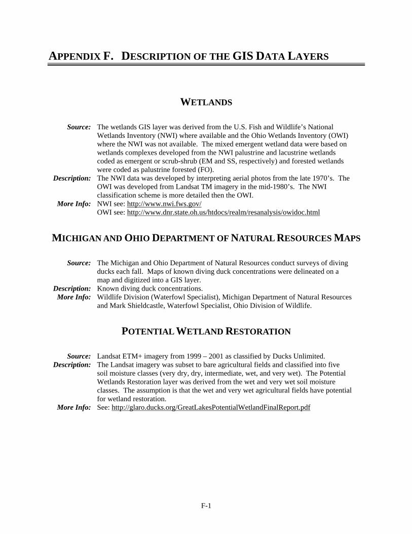
F-1
APPENDIX F. DESCRIPTION OF THE GIS DATA LAYERS
WETLANDS
Source: The wetlands GIS layer was derived from the U.S. Fish and Wildlife’s National Wetlands Inventory (NWI) where available and the Ohio Wetlands Inventory (OWI) where the NWI was not available. The mixed emergent wetland data were based on wetlands complexes developed from the NWI palustrine and lacustrine wetlands coded as emergent or scrub-shrub (EM and SS, respectively) and forested wetlands were coded as palustrine forested (FO).
Description: The NWI data was developed by interpreting aerial photos from the late 1970’s. The OWI was developed from Landsat TM imagery in the mid-1980’s. The NWI classification scheme is more detailed then the OWI.
More Info: NWI see: http://www.nwi.fws.gov/ OWI see: http://www.dnr.state.oh.us/htdocs/realm/resanalysis/owidoc.html
MICHIGAN AND OHIO DEPARTMENT OF NATURAL RESOURCES MAPS
Source: The Michigan and Ohio Department of Natural Resources conduct surveys of diving ducks each fall. Maps of known diving duck concentrations were delineated on a map and digitized into a GIS layer.
Description: Known diving duck concentrations. More Info: Wildlife Division (Waterfowl Specialist), Michigan Department of Natural Resources
and Mark Shieldcastle, Waterfowl Specialist, Ohio Division of Wildlife.
POTENTIAL WETLAND RESTORATION
Source: Landsat ETM+ imagery from 1999 – 2001 as classified by Ducks Unlimited. Description: The Landsat imagery was subset to bare agricultural fields and classified into five
soil moisture classes (very dry, dry, intermediate, wet, and very wet). The Potential Wetlands Restoration layer was derived from the wet and very wet soil moisture classes. The assumption is that the wet and very wet agricultural fields have potential for wetland restoration.
More Info: See: http://glaro.ducks.org/GreatLakesPotentialWetlandFinalReport.pdf
F-2
DEM
Source: USGS Digital Elevation Model (DEM). Description: The DEM’s were used to identify the historic high and low water marks for the
shorebird attributes. More Info: See: http://edc.usgs.gov/products/elevation/dem.html
LANDCOVER
Source: The landcover data were derived from NOAA’s CCAP landcover classification where available and from the USGS’s NLCD landcover where the CCAP data were not available.
Description: The landcover data were used to identify undeveloped land by merging the landcover classes. City boundaries were used to define and then clip-out urban areas so some potential stopover sites, especially for landbirds, are not shown.
More Info: CCAP see: http://www.csc.noaa.gov/crs/lca/ccap.html NLCD see: http://landcover.usgs.gov/natllandcover.asp
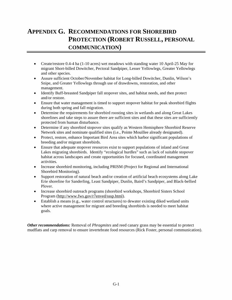
G-1
APPENDIX G. RECOMMENDATIONS FOR SHOREBIRD PROTECTION (ROBERT RUSSELL, PERSONAL COMMUNICATION)
• Create/restore 0.4-4 ha (1-10 acres) wet meadows with standing water 10 April-25 May for migrant Short-billed Dowitcher, Pectoral Sandpiper, Lesser Yellowlegs, Greater Yellowlegs and other species.
• Assure sufficient October/November habitat for Long-billed Dowitcher, Dunlin, Wilson’s Snipe, and Greater Yellowlegs through use of drawdowns, restoration, and other management.
• Identify Buff-breasted Sandpiper fall stopover sites, and habitat needs, and then protect and/or restore.
• Ensure that water management is timed to support stopover habitat for peak shorebird flights during both spring and fall migration.
• Determine the requirements for shorebird roosting sites in wetlands and along Great Lakes shorelines and take steps to assure there are sufficient sites and that these sites are sufficiently protected from human disturbance.
• Determine if any shorebird stopover sites qualify as Western Hemisphere Shorebird Reserve Network sites and nominate qualified sites (i.e., Pointe Mouillee already designated).
• Protect, restore, enhance Important Bird Area sites which harbor significant populations of breeding and/or migrant shorebirds.
• Ensure that adequate stopover resources exist to support populations of inland and Great Lakes migrating shorebirds. Identify “ecological hurdles” such as lack of suitable stopover habitat across landscapes and create opportunities for focused, coordinated management activities.
• Increase shorebird monitoring, including PRISM (Project for Regional and International Shorebird Monitoring).
• Support restoration of natural beach and/or creation of artificial beach ecosystems along Lake Erie shoreline for Sanderling, Least Sandpiper, Dunlin, Baird’s Sandpiper, and Black-bellied Plover.
• Increase shorebird outreach programs (shorebird workshops, Shorebird Sisters School Program (http://www.fws.gov/r7enved/sssp.html).
• Establish a means (e.g., water control structures) to dewater existing diked wetland units where active management for migrant and breeding shorebirds is needed to meet habitat goals.
Other recommendations: Removal of Phragmites and reed canary grass may be essential to protect mudflats and carp removal to ensure invertebrate food resources (Rick Foster, personal communication).
H-1
APPENDIX H. ESTIMATES OF NUMBERS OF BIRDS USING THE LAKE ERIE COASTAL AREA
Few systematic studies of migrants in the western Lake Erie basin have been published although some studies are in progress. Thus, estimates of numbers of birds migrating through the coastal areas of Lake Erie, especially landbirds, in northwestern Ohio are not easily compared between sites. This, in turn, makes it difficult to evaluate the relative importance of different sites and landscapes to migrants. Yet, there are at least orders of magnitude estimates provided by experts. We present their estimates in this appendix. These estimates provide general guidance regarding numbers of migrants in different parts of the region that have been valuable in defining attributes of stopover sites. These estimates are particularly useful when there is consensus of opinion. However, rigorous, comparative analyses remain to be done. The information provided in this appendix will be instrumental for design of future work and providing initial insight regarding regional properties of stopover sites.
Landbirds
Vic Fazio (personal communication) estimates that up to 50% of migrant landbirds may be <0.4 km (0.25 mile) of the shoreline, another 25% within the next 0.4 km (0.5 mile) of the shoreline and the remainder further inland; between Maumee and Sandusky Bays he estimates that there may be as many 250,000 landbirds during March, 100,000 in April and 75,000 in May on peak days with an average of one peak day/week during each of these months. There may be as many as 2,500 Rusty Blackbirds/day during spring migration (Vic Fazio, personal communication). These estimates are largely based on sightings of diurnal migrants hence the large numbers of early spring migrants when blackbirds and American Robins migrate through the region. Other estimates of the number of landbirds in the western Lake Erie basin, based on extrapolations from banding efforts by the Black Swamp Bird Observatory and The Ohio State University, suggests that numbers of landbirds likely exceed 1,000,000 birds on peak days in May (Mark and Julie Shieldcastle, unpublished data; Paul Rodewald, unpublished data). Julie Craves (personal communication; based on standardized mist netting efforts) estimates that up to 2 million migrants use an isolated 114 ha (290 acre) forest patch along the Rouge River in metropolitan Detroit each migration season (assuming that banding captures 1% of birds in an area). Ongoing studies by Black Swamp Bird Observatory and The Ohio State University should ultimately provide more accurate estimates of the number of landbirds passing through the western portion of the Lake Erie region.
I-1
APPENDIX I. U.S. FISH AND WILDLIFE SERVICE GUIDELINES FOR TOWER AND WIND TURBINE DEVELOPMENT
SERVICE INTERIM GUIDELINES FOR RECOMMENDATIONS ON COMMUNICATIONS TOWER SITING, CONSTRUCTION,
OPERATION, AND DECOMMISSIONING
1. Any company/applicant/licensee proposing to construct a new communications tower should be strongly encouraged to collocate the communications equipment on an existing communication tower or other structure (e.g., billboard, water tower, or building mount). Depending on tower load factors, from 6 to 10 providers may collocate on an existing tower.
2. If collocation is not feasible and a new tower or towers are to be constructed, communications service providers should be strongly encouraged to construct towers no more than 199 feet above ground level (AGL), using construction techniques which do not require guy wires (e.g., use a lattice structure, monopole, etc.). Such towers should be unlighted if Federal Aviation Administration regulations permit.
3. If constructing multiple towers, providers should consider the cumulative impacts of all of those towers to migratory birds and threatened and endangered species as well as the impacts of each individual tower.
4. If at all possible, new towers should be sited within existing “antenna farms” (clusters of towers). Towers should not be sited in or near wetlands, other known bird concentration areas (e.g., state or Federal refuges, staging areas, rookeries), in known migratory or daily movement flyways, or in habitat of threatened or endangered species. Towers should not be sited in areas with a high incidence of fog, mist, and low ceilings.
5. If taller (>199 feet AGL) towers requiring lights for aviation safety must be constructed, the minimum amount of pilot warning and obstruction avoidance lighting required by the FAA should be used. Unless otherwise required by the FAA, only white (preferable) or red strobe lights should be used at night, and these should be the minimum number, minimum intensity, and minimum number of flashes per minute (longest duration between flashes) allowable by the FAA. The use of solid red or pulsating red warning lights at night should be avoided. Current research indicates that solid or pulsating (beacon) red lights attract night-migrating birds at a much higher rate than white strobe lights. Red strobe lights have not yet been studied.
6. Tower designs using guy wires for support which are proposed to be located in known raptor or waterbird concentration areas or daily movement routes, or in major diurnal migratory bird movement routes or stopover sites, should have daytime visual markers on the wires to prevent collisions by these diurnally moving species. (For guidance on markers, see Avian Power Line Interaction Committee (APLIC). 1994. Mitigating Bird Collisions with Power Lines: The State of the Art in 1994. Edison Electric Institute, Washington, D.C., 78 pp, and Avian Power Line Interaction Committee (APLIC). 1996. Suggested Practices for Raptor Protection on Power Lines. Edison Electric Institute/Raptor Research Foundation, Washington, D.C., 128 pp. Copies can be obtained via the Internet at http://www.eei.org/resources/pubcat/enviro/, or by calling 1-800/334-5453).
I-2
7. Towers and appendant facilities should be sited, designed and constructed so as to avoid or minimize habitat loss within and adjacent to the tower “footprint”. However, a larger tower footprint is preferable to the use of guy wires in construction. Road access and fencing should be minimized to reduce or prevent habitat fragmentation and disturbance, and to reduce above ground obstacles to birds in flight.
8. If significant numbers of breeding, feeding, or roosting birds are known to habitually use the proposed tower construction area, relocation to an alternate site should be recommended. If this is not an option, seasonal restrictions on construction may be advisable in order to avoid disturbance during periods of high bird activity.
9. In order to reduce the number of towers needed in the future, providers should be encouraged to design new towers structurally and electrically to accommodate the applicant/licensee’s antennas and comparable antennas for at least two additional users (minimum of three users for each tower structure), unless this design would require the addition of lights or guy wires to an otherwise unlighted and/or unguyed tower.
10. Security lighting for on-ground facilities and equipment should be down-shielded to keep light within the boundaries of the site.
11. If a tower is constructed or proposed for construction, Service personnel or researchers from the Communication Tower Working Group should be allowed access to the site to evaluate bird use, conduct dead-bird searches, to place net catchments below the towers but above the ground, and to place radar, Global Positioning System, infrared, thermal imagery, and acoustical monitoring equipment as necessary to assess and verify bird movements and to gain information on the impacts of various tower sizes, configurations, and lighting systems.
12. Towers no longer in use or determined to be obsolete should be removed within 12 months of cessation of use.
Copyright © 2022 FDOKUMEN