Seismic characterization of geothermal sedimentary reservoirs
Upload
independentCategory
view
1download
0
1 23
Geo-Marine LettersAn International Journal ofMarine Geology ISSN 0276-0460 Geo-Mar LettDOI 10.1007/s00367-011-0239-x
Middle slope contourite deposits andassociated sedimentary facies off NEArgentina
Graziella Bozzano, Roberto A. Violante &Maria Elena Cerredo

1 23
Your article is protected by copyright and
all rights are held exclusively by Springer-
Verlag. This e-offprint is for personal use only
and shall not be self-archived in electronic
repositories. If you wish to self-archive your
work, please use the accepted author’s
version for posting to your own website or
your institution’s repository. You may further
deposit the accepted author’s version on a
funder’s repository at a funder’s request,
provided it is not made publicly available until
12 months after publication.

ORIGINAL
Middle slope contourite deposits and associated sedimentaryfacies off NE Argentina
Graziella Bozzano & Roberto A. Violante &
Maria Elena Cerredo
Received: 20 January 2011 /Accepted: 23 May 2011# Springer-Verlag 2011
Abstract The Argentine continental margin is character-ised by a large contourite depositional system driven bysouthern-sourced water masses flowing at different waterdepths. Interest in contourite deposits is increasing ingeoscience and related fields, though knowledge of theArgentine contourite system is still limited. In particular,studies based on core data providing detailed descriptionsof sedimentary facies are lacking, as are investigations ofprincipal sediment source areas and of key factors control-ling sedimentary processes. This study combines visualcore description and downcore grain-size analyses as wellas petrographic thin-section and magnetic susceptibilityanalyses of 14 cores from intermediate water depths of616–1,208 m to characterise contourite deposits on thenorth-eastern Argentinean slope. Gravel-rich, sandy–siltyand muddy contourites as well as hemipelagic facies wereidentified. The deposition of these contourites was presum-ably controlled by sea level, the depth range of theAntarctic water mass, climate conditions and windborneterrigenous supply. It is proposed that, during glaciallowstands, muddy contourites were deposited at depths<900 m, whereas sandy–silty sequences dominated atdeeper depths. During the late Pleistocene–Holocenetransition, sandy–silty contourites covered the entire middle
slope. Hemipelagic facies draped limited sectors of themiddle slope when the sea level reached the present-dayposition and gravel-rich contourites became restricted tocontouritic channels and moats. Northern Patagonia and thesouthern Pampa are the most plausible sources for sedi-ments deposited via along-slope processes, whereas theTandilia Range is the best candidate for sediments depositedvia down-slope processes.
Introduction
The study of contourite deposits is generating increasedinterest due to promising implications and applications forthe fields of geoscience and oceanography. Contourites playan important role in palaeoceanography because they areuseful recorders of past climate change and are critical todeveloping an improved understanding of bottom-watercirculation and ocean–climate coupling (Stow et al. 2002).Contourites are also relevant in geohazard evaluationsbecause they are potentially associated with slope instabil-ity on continental margins. Finally, these deposits are ofhigh economic interest to oil companies undertaking deep-water exploration (Rebesco and Camerlenghi 2008).
On the Argentine continental margin, large contouritedepositional systems (CDSs) and buried giant drifts haverecently been discovered in the southern part of the margin(Hernández-Molina et al. 2009, 2010). In the northernsector, contourites were first detected by means of Para-sound profiles (Segl and cruise participants 1994; Bleil etal. 2001) and later by investigations of surface sedimentsamples (Frenz et al. 2003). Recently, the complete CDShas been identified to characterise the Argentine andUruguayan slopes at water depths of 600 to 2,000 m(Violante et al. 2010; Krastel et al. 2011).
Responsible guest editor: A. Voelker
G. Bozzano (*) : R. A. ViolanteSección Geología Marina, Servicio de Hidrografía Naval,Av. Montes de Oca 2124,C1270ABV Buenos Aires, Argentinae-mail: [email protected]
M. E. CerredoDepartamento Cs Geológicas, FCEyN,Universidad de Buenos Aires,Ciudad Universitaria, Argentina
Geo-Mar LettDOI 10.1007/s00367-011-0239-x
Author's personal copy

This study of the middle slope contourite system off NEArgentina has the following objectives: (1) to describe thesedimentary facies, (2) to identify potential sediment sourceareas and possible links with along- and down-slopetransport processes, and (3) to use these results and existingknowledge from earlier studies to propose a palaeoceano-graphic reconstruction of contourite deposition during thelate Quaternary.
Physical setting
The study area is located within the northern sector of theArgentine continental margin at 37–39°S (Fig. 1) and isbounded to the west by the Buenos Aires province, a vast
region of lowlands (Pampas) interrupted by the Tandilia andVentania ranges. The Tandilia Hills reach the coast at 38°Sand are composed of an igneous metamorphic basementoverlain by a Precambrian and early Palaeozoic sedimen-tary cover with common quartz and quartz-arkosic arenites,dolostones, shales and fine-grained conglomerates (e.g.Teruggi and Kilmurray 1980; Iñiguez 1999; Dalla Salda etal. 2006). The Ventania Range is formed by an igneous-metamorphic basement and a Palaeozoic cover composedof quartzites, siltstones, sandstones and conglomerates (e.g.Kilmurray 1975; Sellés-Martinez 1989). The Pampas canbe subdivided into the southern and northern Pamparegions; the former is located between Ventania andTandilia, the latter between the Tandilia Range and theRio de la Plata axis located to the north (Fig. 1a). The
Fig. 1 a Location of the studyregion and surrounding geo-graphical areas referred to in thetext. North Patagonia comprisesthe Neuquén, Rio Negro and(southern tip of) Buenos Airesprovinces (map generated withGeoMapApp, http://www.geomapapp.org). b Close-up ofthe study area showing thecontinental slope off Mar delPlata, and the locations ofsediment cores along the threetransects. Dotted linesContouritic channels and moats,dashed line Mar del PlataCanyon axis (100 m isobaths)
Geo-Mar Lett
Author's personal copy

Pampas are mantled by late Pleistocene–Holocene loessdeposits and palaeosols formed since the early and mid-Holocene (e.g. Teruggi 1957; Zárate 2003; Kemp et al.2006). The loess deposits in the southern Pampa region arevolcaniclastic (e.g. Zárate 2003) with a Patagonian/southernAndean source, as confirmed by mineralogical and isotopicinvestigations (e.g. Smith et al. 2003). By contrast, sedi-ments in the northern Pampa region originate partly fromnorth-western areas of the Chilean Altiplano and the ParanáBasalt province (Smith et al. 2003).
Sediments from the coastal fringe display significantproportions of quartz, feldspar and lithic fragments ofAndean origin (Potter 1984). The shelf sector extendingfrom northern Patagonia to the Buenos Aires province(170–200 km wide) is covered by volcanic-pyroclasticelements, often referred to as the Pampean-Patagonian suite(e.g. Teruggi 1954). The inner shelf is covered by modernfine to medium siliciclastic sands, whereas relict sandsdeposited during the Pleistocene sea-level lowstands andtransgressive episodes characterise the outer shelf. Bioclastscan also be abundant in the latter sector, especially bivalveand gastropod shells, corals and bryozoans (Urien andEwing 1974). At water depths of 120 to 3,500 m, the slopedisplays significant changes in gradients enabling an upper,middle and lower sector to be distinguished. The upperslope (120–500 m) is steep (1:33) and exhibits an abruptshelf–upper slope transition; the middle slope (500–1,300 m) has a more gentle and less uniform gradient(1:120–1:160), whereas the lower slope (1,300–3,500 m) isagain steeper (1:20) and gradually merges into thecontinental rise. At approx. 38°S, 54°W, the slope is incisedby the Mar del Plata Canyon, which spans water depthsfrom 500 m to 3,900 m and has a WNW–ESE orientationand a total length of more than 110 km (Violante et al.2010; Krastel et al. 2011).
Ocean circulation in the northern sector of the Argentinecontinental margin has been described by several authors(e.g. Piola and Gordon 1989; Peterson and Stramma 1991;Peterson 1992; Tsuchiya et al. 1994; Talley 1996; Strammaand England 1999; Piola and Matano 2001). It ischaracterised by the Malvinas Current, a northward branchof the Antarctic Circumpolar Current, which carries coldand relatively fresh sub-Antarctic waters towards theequator. Near 39°S, the Malvinas Current collides with theBrazil Current, the western limb of the subtropical gyre thattransports warm and salty waters towards the pole. TheMalvinas Current, which extends from the sea surface tothe ocean floor, has a strong barotropic component and isconsequently steered by the bottom topography as itflows along the continental slope of South America. Atthe slope, the main water masses include (from top tobottom) the sub-Antarctic and subtropical surface watersin alternate layers, the Antarctic Intermediate Water
(AAIW, ~500–1,000 m), the Circumpolar Deep Water(CDW, ~1,000–3,500 m) and the Antarctic Bottom Water(AABW, >3,500 m). The North Atlantic Deep Water(NADW) penetrates into the CDW and divides it intoUpper (UCDW) and Lower Water (LCDW; Tsuchiya etal. 1994). The depth range influenced by the NADWvaries from 1,700 to 3,000 m in the Malvinas BrazilConfluence Zone (Stramma and England 1999).
In the study area, the middle slope is swept by theAAIW and UCDW. The AAIW is an intermediate-depthsalinity minimum layer (salinity <34.3 PSU) that descendsfrom the surface in the vicinity of the Polar Front and flowsnorthwards at depths centred at 700–1,000 m (Talley 1996;Piola and Matano 2001). This depth range is consistentwith measurements obtained from the Brazilian middleslope where the AAIW occurs at water depths of 550–1,200 m (Xavier et al. 1993). The UCDW has a sourceregion that differs from that of the overlying AAIW,although both water masses flow from the south towardsthe North Atlantic (Stramma and England 1999). In theSouth Atlantic, the UCDW is observed as a tongue ofoxygen minimum water underlying the oxygen maximumof the AAIW (Tsuchiya et al. 1994). The dynamics of thesewater masses are of special interest off Argentina; usingseismic and bathymetric data, Hernández-Molina et al.(2009) concluded that contouritic terraces occur at waterdepths that correlate well with the boundary of specificwater masses (AAIW–UCDW at 1,000 m and LCDW–AABWat 3,500 m).
Detrital sediment supply to the continental slope isprimarily via river and wind transport (e.g. Pierce andSiegel 1979; Gaiero et al. 2004). Fluvial sediment inputoccurs via the Rio de la Plata, Rio Colorado and RioNegro (Fig. 1). The Rio de la Plata is the major source,with a modern load of ~80×106 t/year (Gilberto et al.2004) consisting mainly of silts and silty clays withscarce biogenic components (e.g. Parker et al. 1987;Parker and Marcolini 1992). Today, the pattern of thesuspension cloud extending from the river mouth isgoverned by the seasonal wind regime, which favours anorthward plume extension (up to 27°S) during the winterand a southward one (down to 38°S) during the summer(Piola et al. 2005, 2008). Indeed, the isotopic signature ofthe Rio de la Plata sediments has been traced on the shelfto the north of the estuary up to 28°S (Mahiques et al.2008). The Rio Negro and Rio Colorado are two otherimportant rivers that are located in northern Patagonia,and flow from the Andean Cordillera to the SouthAtlantic Ocean. Their drainage areas are characterisedby volcanic rocks and late Tertiary volcaniclastic deposits.Thus, these rivers transport and deliver significantamounts of volcanic rock fragments to the ocean (Blasiand Manassero 1990).
Geo-Mar Lett
Author's personal copy

Along-slope and down-slope marine processes shape themorphology of the area (Hernández-Molina et al. 2009;Krastel et al. 2011). Down-slope processes are related inpart to the presence of the Mar del Plata Canyon and areassociated with slope instability, oversteeping and creepingeffects, resulting in the formation of both turbidite and masstransport deposits (Krastel et al. 2011). Along-slopeprocesses involve bottom current activity associated withthe dynamics of water masses of southern origin thattransport and rework sediments along their S–N path andgenerate contourite drifts, erosional terraces, contouritechannels and moats (Hernández-Molina et al. 2009).
Materials and methods
A suite of 14 sediment cores sampled along threeperpendicular slope transects were used (Table 1,Fig. 1b). Five cores were collected during the LITORALBONAERENSE IV cruise of 2009 onboard the ArgentineR/V Puerto Deseado (hereafter referred to as LBIV cores).In addition, information was compiled from another ninecores recovered during the following three oceanographiccruises: cruises M29 and M49/2 of 1994 and 2001onboard the German R/V Meteor, and cruise CORING2002 onboard the R/V Puerto Deseado. Data wereobtained from both published and unpublished sourcesfrom Pangaea/WDC-MARE (World Data Center forMarine Environmental Sciences, http://www.pangaea.de/),as well as from reports and core collections stored at theArgentine Navy Hydrographic Service.
Bathymetric data were obtained during the R/V PuertoDeseado and R/V Meteor cruises using Simrad EA 600
Hydrographic Echo Sounder and Parasound systems re-spectively. These data were combined with the ETOPO2dataset (U.S. Department of Commerce, National Oceanicand Atmospheric Administration, 2001, 2-minute GriddedGlobal Relief Data) to generate the bathymetric map shownin Fig. 1b.
LBIV cores were opened, described and photographedonboard. Sediment colour was determined using theMunsell colour chart. Descriptions and photographs of thenine cores were extracted from the respective cruise reports.
Magnetic susceptibility (MS) measurements on LBIVcores were obtained every 5 cm on half-cores at theDepartment of Geological Science, University of BuenosAires, using a Bartington MS2-B meter. The meter wasoperated at frequencies of 470 and 4,700 Hz, and resultsexpressed in cgs units. These were converted into SI unitsusing the formula #SIn ¼ 4p#cgsn .
MS measurements on core GeoB2703-5 (von Dobeneckand Bleil 2004) were taken every cm on half-cores at theMARUM IODP Core Repository, University of Bremen,with a multi-sensor core logger (Geotek; Bartington MS2-Epoint sensor). Results are expressed in SI units.
Proportions of sand and mud were estimated by wetsieving of 40 sub-samples from selected cores (T292, T294,T295, LBIV-5 and GeoB16813-1). In each case, the sandfraction was dry-sieved to calculate the contents of gravel(grain size >2 mm), very coarse sand (1–2 mm), coarse andmedium sand (250 μm–1 mm), and fine to very fine sand(63–250 μm). Moreover, the sand composition wasinvestigated under a stereomicroscope, counting repre-sentative aliquots of more than 300 grains. Fourpetrographic analyses were made from thin sections ofpebbles (2–64 mm) found in cores T292 and LBIV-5.
Table 1 Location, water depth and length of cores evaluated in the present study: 1 cruise M49/2, R/V Meteor (2001), 2 cruise M29, R/V Meteor(1994), 3 cruise Litoral Bonaerense IV, B/O Puerto Deseado (2009), 4 cruise Coring 2002, B/O Puerto Deseado (2002)
Transect Core name Latitude (S) Longitude (W) Depth (m) Core length (cm) Ref.
1 GeoB6812-1 38°18.2 54°47.7 734 186 1
GeoB6813-1 38°23.3 54°35.9 985 126 1
GeoB6815-1 38°24.1 54°33.4 1,156 48 1
GeoB6816-1 38°24.2 54°33.2 1,180 15 1
GeoB2703-5 38°30.6 54°12.1 1,189 467 2
LBIV-5 37°57.3 55°08.7 616 560 3
2 LBIV-4 37°56.4 54°45.7 753 664 3
LBIV-3 38°00.3 54°24.9 1,208 115 3
T292 37°19.0 54°22.2 860 112 4
3 T293 37°20.7 54°19.3 870 138 4
LBIV-1 37°23.4 54°15.3 913 530 3
T294 37°25.5 54°07.0 1,050 140 4
T295 37°28.6 54°08.0 1,100 427 4
LBIV-2 37°33.8 53°52.2 1,115 710 3
Geo-Mar Lett
Author's personal copy
Results
Facies description
Gravel-rich contourites
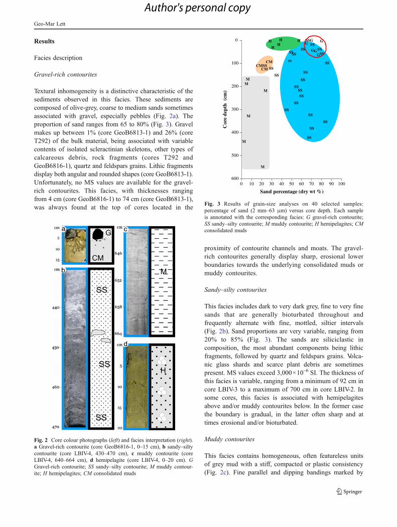
Textural inhomogeneity is a distinctive characteristic of thesediments observed in this facies. These sediments arecomposed of olive-grey, coarse to medium sands sometimesassociated with gravel, especially pebbles (Fig. 2a). Theproportion of sand ranges from 65 to 80% (Fig. 3). Gravelmakes up between 1% (core GeoB6813-1) and 26% (coreT292) of the bulk material, being associated with variablecontents of isolated scleractinian skeletons, other types ofcalcareous debris, rock fragments (cores T292 andGeoB6816-1), quartz and feldspars grains. Lithic fragmentsdisplay both angular and rounded shapes (core GeoB6813-1).Unfortunately, no MS values are available for the gravel-rich contourites. This facies, with thicknesses rangingfrom 4 cm (core GeoB6816-1) to 74 cm (core GeoB6813-1),was always found at the top of cores located in the
proximity of contourite channels and moats. The gravel-rich contourites generally display sharp, erosional lowerboundaries towards the underlying consolidated muds ormuddy contourites.
Sandy–silty contourites
This facies includes dark to very dark grey, fine to very finesands that are generally bioturbated throughout andfrequently alternate with fine, mottled, siltier intervals(Fig. 2b). Sand proportions are very variable, ranging from20% to 85% (Fig. 3). The sands are siliciclastic incomposition, the most abundant components being lithicfragments, followed by quartz and feldspars grains. Volca-nic glass shards and scarce plant debris are sometimespresent. MS values exceed 3,000×10–6 SI. The thickness ofthis facies is variable, ranging from a minimum of 92 cm incore LBIV-3 to a maximum of 700 cm in core LBIV-2. Insome cores, this facies is associated with hemipelagitesabove and/or muddy contourites below. In the former casethe boundary is gradual, in the latter often sharp and attimes erosional and/or bioturbated.
Muddy contourites
This facies contains homogeneous, often featureless unitsof grey mud with a stiff, compacted or plastic consistency(Fig. 2c). Fine parallel and dipping bandings marked by
0 20 40 60 80 10010 30 50 70 90
Sand percentage (dry wt %)
600
400
200
0
500
300
100
Cor
e d
epth
(cm
)
GG
GGG
CMCMSS
CM
H
SS
HHH
HSSSS
SS
SS
SSSS
SSSSSS
SS
SSSS
SS
SS
SS
SSSS
SS
SS
SS
MM
M
M
M
M
SSG
Fig. 3 Results of grain-size analyses on 40 selected samples:percentage of sand (2 mm–63 μm) versus core depth. Each sampleis annotated with the corresponding facies: G gravel-rich contourite;SS sandy–silty contourite; M muddy contourite; H hemipelagites; CMconsolidated muds
Fig. 2 Core colour photographs (left) and facies interpretation (right).a Gravel-rich contourite (core GeoB6816-1, 0–15 cm), b sandy–siltycontourite (core LBIV-4, 430–470 cm), c muddy contourite (coreLBIV-4, 640–664 cm), d hemipelagite (core LBIV-4, 0–20 cm). GGravel-rich contourite; SS sandy–silty contourite; M muddy contour-ite; H hemipelagites; CM consolidated muds
Geo-Mar Lett
Author's personal copy

subtle colour changes as well as bioturbation and burrowswere occasionally observed. Irregularly winnowed lag depos-its of coarser material (very fine sand) occur in lenses orlaminations. Sand contents are very low (2–5%), althoughoccasionally reaching 20% (Fig. 3). Microfossils are veryscarce or completely absent, and some sparse bivalveremains were found in core LBIV-5. MS values in generalare below 400–420×10–6 SI. The thickness of this faciesranges from 60 cm in core LBIV-4 to 404 cm in core LBIV-5.This facies is always overlain by gravel-rich or sandy–siltycontourites with sharp, at times erosional boundaries, insome cases strongly bioturbated (e.g. core LBIV-5).
Hemipelagites
This facies comprises olive grey silty sand and sandy silt;often, lighter- and darker-coloured layers conferred a non-homogenous aspect to these sediments (Fig. 2d). Sandcontents are variable, ranging from 28% to 57% (Fig. 3).Planktonic and benthic foraminiferal specimens make upthe coarse fraction, whereas the fine fraction is composed ofmineral grains. Globorotalia inflata, Globigerina bulloides,Neogloboquadrina pachyderma (both morphotypes) andGloborotalia truncatulinoides were identified within theplanktonic assemblage. Occasionally, small scleractinianfragments were also observed. MS values are similar orlower than those for sandy–silty contourites. Hemipelagiteswith a maximum thickness of 40–50 cm (core T295)always overlie the sandy contourites, with a very gradualtransition. In core LBIV-3 (1,208 m water depth), this faciesdisplays abundant benthic foraminiferal tests, numerousbioclasts and a few large specimens of the scleractinianBathelia candida (Moseley 1881), a colonial cold waterspecies that is typically distributed between water depths of500 and 1,250 m (Cairns 2009).
Consolidated muds
Consolidated muds are greenish-grey and semi- to highlyconsolidated, and may include hard mudstones. Theproportion of sand ranges from 16% to 26% in the threesamples analysed from core GeoB6813-1 (Fig. 3). The sandis generally composed of terrigenous material, radiolarianshaving been reported only from core GeoB6815-1 (Spieß etal. 2002). This sediment type was found at the base of coreslocated within contourite moats.
Facies distribution along cross-slope transects
In the following description of sedimentary facies alongthree perpendicular slope transects, transects 1 and 2 werelocated to the south of the Mar del Plata Canyon, andtransect 3 to the north of this canyon (Figs. 4 and 5).
Five cores were sampled along transect 1, of which threewere located near or within an erosional contouriticchannel. Core GeoB2703-5 was retrieved from the outerfringe of the middle slope where Parasound and seismicprofiles had revealed a large contourite drift accumulation(Segl and cruise participants 1994).
Core GeoB6812-1 (186 cm long) is primarily made up ofsandy–silty contourites with winnowed coarser material—twospecimens of solitary corals at 10 cm and a lens of bivalve andgastropod shells at 80 cm. Core GeoB6813-1 (126 cm long)displays a 74-cm-thick interval of gravel-rich contourites atthe top, with some small coral fragments clustered at 5 cm, aswell as mudstones and laminated sediments at the base ofthe interval. Semi-consolidated muds were found down-core (74–126 cm).
Core GeoB6815-1 (48 cm long) was located within theerosional channel and consists entirely of consolidatedmuds. Preliminary dating of the diatoms found in this coreindicates a biostratigraphic age of about 2–4 Ma at a coredepth of 0.35 m (Spieß et al. 2002). Core GeoB6816-1(15 cm long) comprises a 5-cm-thick top layer of gravel-rich contourites containing a large black rock fragment(5 cm in diameter), as well as sub-rounded and very hardmud clasts. An irregular, sharp erosional boundaryseparates this unit from underlying consolidated muds(5–15 cm). Core GeoB2703-5 (467 cm long) is made upentirely of sandy–silty contourites.
Transect 2 had three cores (Figs. 4 and 5). Core LBIV-5(560 cm long) contains less than 20 cm of hemipelagicfacies at the top, below which sandy–silty contourites occurin the interval from 20 to 156 cm. The base of this intervalcontains two lithic fragments 2–2.5 cm in diameter (Fig. 6),consisting of a quartz- and feldspar-rich sandstone and asilica-rich intrusive rock. Downcore, the interval from 156to 560 cm comprises muddy contourites that show intensebioturbation and burrowing, especially between 156 and186 cm, and sparse shell fragments throughout. Winnowedcoarser material occurs in lenses and parallel layers,particularly between 405 and 560 cm.
Core LBIV-4 (664 cm long) displays a 30-cm-thickinterval of hemipelagic facies at the top, followed by a unitof sandy–silty contourites down to 604 cm. The intervalfrom 604 to 664 cm consists of muddy contourites. CoreLBIV-3 (115 cm long) contains a 23-cm-thick interval ofhemipelagic facies associated with several specimens of B.candida, 5–6 cm in length, and with other, smaller bioclasts(coral and bryozoan debris, benthic Foraminifera). Down-core, the 23–115 cm interval consists of sandy–siltycontourites.
Transect 3 had six cores (Figs. 4 and 5). Core T292(112 cm long) contains a 3-cm-thick surface layer of gravel-rich contourites with lithic pebbles at the bottom. Petro-graphic analysis of two of the largest pebbles revealed that
Geo-Mar Lett
Author's personal copy

they consisted of volcanic-effusive rocks identified asrhyolite/rhyodacite and trachybasaltic lava (Fig. 7). Be-low the gravel-rich contourites, muddy contourites dom-inate up to the base of the core. The two units are
separated by a sharp, irregular and erosional contact withintense bioturbation.
Core T293 (138 cm long) displays an 8-cm-thick layer ofgravel-rich contourites without pebbles, followed by muddy
Fig. 5 Downcore distribution of sedimentary facies along the three transects. Magnetic susceptibility logs are depicted by white solid lines. Beloweach core name, the corresponding water depth is also indicated
Fig. 4 Core locations alongtransects 1, 2 and 3, showingdetails of the bottommorphology
Geo-Mar Lett
Author's personal copy

contourites down to the base of the core. The two units areseparated by a sharp erosional boundary with intensebioturbation. Core LBIV-1 (530 cm long) consists of a425-cm-thick interval of sandy–silty contourites followedby muddy contourites down to the base of the core. Theboundary between the two units is quite indistinct; only theMS data reveal an abrupt compositional change (Fig. 5).Core T294 (140 cm long) displays an 18-cm-thick hemi-pelagic drape followed by sandy–silty contourites down tothe bottom of the core.
Core T295 (427 cm long) is characterised by a surficial45-cm-thick layer of hemipelagic facies that graduallychanges into sandy–silty contourites down to the bottomof the core. Core LBIV-2 (710 cm long) displays more than700 cm of sandy–silty contourites. The low MS values inthe uppermost 45 cm (Fig. 5) are likely an artefact of thepartial filling of the sediment tube.
Discussion
Stratigraphy
Stratigraphic information from the study area is verylimited. Sediment composition is mainly clastic and ingeneral only surface samples contain sufficient fauna to beanalysed. However, three lines of information suggest thatthe age of the deposits from the study area span the periodfrom the Pleistocene to the Holocene: (1) three cores from
water depths of 1,836, 2,295 and 2,743 m beneath theMalvinas-Brazil Confluence Zone (37.54–39.29°S) hadsurface samples of modern age, and subsurface samples(10 cm core depth) with radiocarbon ages of 770, 780 and1,020 cal. years B.P. respectively (Mollenhauer et al. 2006);(2) a core located at 37.05°S and a water depth of 745 mcontained G. truncatulinoides, N. pachyderma (both mor-photypes) and G. bulloides in the core top (Boltovskoy1973); (3) in cores T294, T295 and LBIV-5 of the presentstudy, the hemipelagic intervals contained G. inflata, G.bulloides, N. pachyderma (both morphotypes) and a fewspecimens of G. truncatulinoides. Since the first occurrenceof both G. inflata and G. truncatulinodes has been dated at2.09 Ma (Berggren et al. 1995), these sediments can beattributed to at least the Pleistocene epoch.
Using the results obtained by Mollenhauer et al.(2006), a sedimentation rate of ~13 cm per 1,000 yearscan be inferred for the Holocene hemipelagic sediments ata water depth of ~2,000 m. This value is consistent withtypical sedimentation rates of 5 to 30 cm per 1,000 yearsreported for drifts (McCave 2008; Stow et al. 2008).Within this context, the preliminary biostratigraphic age(Pliocene–early Pleistocene) attributed to the diatomsfound in core GeoB6815-1 (Spieß et al. 2002) is notrepresentative of the contourite and hemipelagic facies.Instead, it suggests that the consolidated muds of transect1 might represent some sort of substratum or pavementreworked by intense current erosion.
Lithic fragments
In core LBIV-5 (transect 2), at the boundary betweensandy–silty and muddy contourite units at 150–156 cm coredepth, evidence of lithic fragments originating from quartz-feldspar-rich sandstone and silica-rich intrusive rocks isconsistent with the geology of the Tandilia Range wherearkosic arenites are common (Dalla Salda et al. 2006).Today, core LBIV-5 is located 200 km to the east of thisregion at a water depth of 616 m but, during periods of lowsea level, both the distance from the coastline and the waterdepth would have been reduced at this site. Based on thesedimentation rate of 13 cm per 1,000 years discussed
Fig. 6 Macro-photograph (left) and thin-section photograph of thequartz- and feldspar-rich sandstone identified in core LBIV-5 (cross-polarised light, right)
Fig. 7 Thin-section photographs(cross-polarised light) of the tra-chybasaltic lava identified in coreT292. Left: euhedral sanidinephenocryst in an intergranulargroundmass; flow bands outlinedby opaque material. Right: clino-pyroxene microphenocryst; sani-dine laths and interstitial olivine(orange) can be distinguished inthe groundmass
Geo-Mar Lett
Author's personal copy

above, the lithic fragments at 150–156 cm in core LBIV-5would have been deposited between 11.5 and 12 cal. yearsB.P. during the Pleistocene–Holocene transition. In this timeperiod, sea level along the Argentine margin was about80 m lower than today (Guilderson et al. 2000); therefore,the coastline would have shifted several km offshore, muchcloser to the core LBIV-5 location. In addition, thecontinental shelf off Mar del Plata is dissected by channels(Parker et al. 2008) that might have served as the principalroutes for down-slope processes. Once deposited, thiscoarse material would have persisted in the contouritesequence and would not have been subsequently reworkedby bottom currents, because of their relatively low velocity.
At the top of core T292 (transect 3), evidence of lithicfragments from rhyolite/rhyodacite and trachybasaltic lavasis consistent with these rocks today being very common inthe alkaline volcanic system drained by the Rio Negro andthe Rio Colorado (e.g. Ramos et al. 1982; Rapela et al.1988). These two rivers account for an important input ofsediment to the ocean, especially during periods of sea-level lowstands (Urien 1972). Near the river mouths, asubmerged delta system identified at a water depth of~50 m (Parker et al. 1996; Zárate 2003) has been attributedto runoff prior to the Holocene marine transgression cycle(Spalletti and Isla 2003). Relict sands are very common onthe Argentine outer shelf, as fluvial material is temporarilystored near the point of input and then resuspended anddeposited several times before escaping the shelf regime(Pierce and Siegel 1979). Near the mouths of the RioColorado and Rio Negro, however, gravel-sized calcareousdebris, beach rock fragments, and volcanic rocks up to50 mm in size have been observed (Urien and Ewing 1974).This is therefore the most likely source area of the lithicfragments contained in the gravel-rich contourites of coreT292. In general, coarse material on the outer shelf can beremobilised and exported from the shelf by the combinedeffect of severe storms and tidal currents, as well as slopewater intrusion (Carter and Lewis 1995; Harris et al. 1996).Today, the delta system off the Rio Colorado is affected byhigh-energy processes controlled by waves and tides(Spalletti and Isla 2003), and intense slope water intrusionshave been observed on the shelf near 41°S (Piola et al.2010). It is noteworthy that these intrusions are associatedwith surface drifters describing sharp inshore anticyclonicgyres near 41.5°S, which then move north-eastwards alongthe outer shelf before continuing offshore. Subsequently,the coarse material is transported to the north via along-slope processes (Pierce and Siegel 1979), probably throughthe contourite channels and moats observed on the middleslope. These are typical erosional features resulting fromstrong bottom current activity characterised by coarse-grained lag surfaces, and gravel and rock pavements(Stow et al. 2002).
Sandy–silty contourites
The results obtained from magnetic susceptibility analysesclearly enable to differentiate between sandy–silty andmuddy contourites in the cores, the MS values peaking insandy and decreasing in muddy intervals. Magneticsusceptibility has often been used as an indirect proxy forterrigenous sediment influx in various settings worldwide(e.g. Bloemendal 1980; Robinson 1990; Robinson et al.1995; Diekmann et al. 2000). Thus, sediment MS signa-tures are controlled primarily by the concentration andcomposition of magnetised minerals, followed by crystalsize and shape (Dearing 1994). In the present study area,the finding that contourite sands contain lithic fragments,quartz and feldspars as dominant components is consistentwith the volcaniclastic composition of sands covering theshelf sectors of northern Patagonia and the Buenos Airesprovince (e.g. Teruggi 1954; Etchichury and Remiro 1960;Blasi and Manassero 1990). High MS values in the sandy–silty contourites plausibly reflect the ferromagnetic (e.g.magnetite) and paramagnetic minerals (e.g. amphiboles,pyroxenes and micas) commonly included in volcaniclasticrocks. Thus, the volcaniclastic composition of the sandy–silty contourites suggests northern Patagonia and thePampas as the most likely source areas for these sediments.
Muddy contourites
Muddy contourites are commonly formed in regions of lowcurrent speed where fine-grained (<63 μm) mixed terrige-nous and biogenic material accumulates, the latter originat-ing from the settlement of pelagic organisms (Stow et al.2002). In the present case, sand accounts for approx. 5–20% of the bulk sediment; it is of terrigenous origin, similarto the sandy–silty facies.
Fine-grained sediments might have reached the oceanvia distal plumes of the Rio de la Plata and/or viawindborne dust from the continent. Today, significantproportions of clay-sized suspended material from the Riode la Plata settle by flocculation at the fresh–saline waterfront (Cavallotto and Violante 2005), its location beingcontrolled by wind intensity and coastline position (Huret etal. 2005). During glacial periods this front possibly shiftedoffshore, flocculation occurring at deeper locations andhence enabling clays from the Rio de la Plata to reach theslope. However, it is difficult to explain how these finesediments could have reached the study area under thisscenario because the present-day plume extension in winteris directed northwards (Piola et al. 2005, 2008). Anorthward component is also recognised in the sedimentdistribution off the Rio de la Plata estuary, where fluvio-marine facies have been traced on the Uruguayan middleshelf (Urien and Ewing 1974).
Geo-Mar Lett
Author's personal copy

An aeolian dust supply therefore seems to be a morelikely mechanism for the transport of fine sediments inthe present case. The arid region between 37 and 48°Sencompassing northern Patagonia and the southernPampa is a major source of modern dust (Prospero etal. 2002). Indeed, direct dust input from Patagonia todayrepresents approx. 90% (35 gm–2 year–1) of the particlemass delivered to the SW Atlantic (Gaiero et al. 2003,2004). During glacial periods, dust input from Patagoniaand the southern Pampa increased significantly (Groussetet al. 1992; Basile et al. 1997; Delmonte et al. 2004;Gaiero et al. 2004). In general terms, increased dustinessduring the last glacial maximum (LGM) reflects theexpansion of un-vegetated areas caused by a combinationof increased aridity and low atmospheric CO2 (Mahowaldet al. 1999). During the LGM, extra-Andean Patagoniaand the southern Pampa constituted a huge land surfacewith decreased soil moisture and vegetation cover(Sylvestre 2009), and the central plains of Argentina(25–30°S) were more arid than today (Piovano et al.2009). Evidence from pollen and mammal records showthat the southern Pampa experienced arid to semiaridconditions during the late Pleistocene, whereas morehumid and warmer conditions prevailed during the latePleistocene–Holocene transition (Quattrocchio et al.2008). Also, records of palaeosols suggest glacial aridconditions favouring the deposition of aeolian loess in thesouthern and northern Pampas (Zárate 2003; Kemp et al.2006). During glacial lowstands, the exposed Patagonianshelf presumably acted as an additional source for wind-borne dust supply to the ocean (Kaiser and Lamy 2010). Infact, atmospheric reconstruction models for the LGMestimate that, when accounting for the decrease in sealevel, the region between 31–50°S was more than sixtimes wider than today (Lunt and Valdes 2002). Further-more, glacial winds intensified aridity and increased dustmobilisation in the southern Pampa and Patagonia (Prieto1996; Lunt and Valdes 2001). Thus, the muddy contouritesidentified in the present study may incorporate significantamounts of aeolian dust exported from Patagonia, thesouthern Pampa and the exposed continental shelf duringperiods of low sea level.
This hypothesis is consistent with the high proportion offine-grained particles and the terrigenous origin of the sandfraction in the muddy contourites of the study area but doesnot automatically explain the low MS values that distin-guish this facies. The muddy and sandy–silty facies sharethe same volcaniclastic composition, and the lower MSsignatures of the muddy contourites can thus rather beexplained by a reduced grain size of ferromagnetic andparamagnetic components. Similar conclusions have beenreached by Kissel et al. (1999) in their analyses ofsediments from the North Atlantic. These authors have
shown that even slightly coarser grains of magnetite areassociated with susceptibility maxima, finer grains withsusceptibility minima.
Regarding the current speed regime that controlled theaccumulation of muddy vs. sandy–silty contourites on theArgentinean middle slope, no data are available toreconstruct the intensity of AAIW flow in the study areaduring glacial times. Using nutrient proxies in benthicforaminiferal tests from southern Brazil, however, Oppoand Horowitz (2000), Curry and Oppo (2005) and Makouet al. (2010) demonstrated that, during the LGM, the mainflow of AAIWat ~27°S was centred at 1,000–1,100 m andoccupied a depth range (900–1,270 m) that was narrowerthan that of the modern AAIW. In fact, the results of thepresent study have revealed the occurrence of muddycontourites in cores shallower than 750 m (transect 2) and910 m (transect 3) on the Argentinean middle slope. Thus,as observed in southern Brazil, the shrinkage of the AAIWduring the LGM might have favoured the deposition ofmuddy contourites at water depths shallower than 900 m;conversely, sandy–silty contourites would have formed atdepths exceeding 900 m.
Conclusions
Based on the above evaluation of sedimentary facies andsediment source areas, the following conclusions can bedrawn for middle slope contourite deposits and associatedsedimentary facies off NE Argentina during the lateQuaternary.
1. Four sedimentary facies characterise the middle slope atwater depths of 616–1,208 m. Sandy–silty and muddyfacies dominate the contourite deposits, whereasgravel-rich facies are restricted to contourite channelsand moats. Hemipelagic facies have a limited distribu-tion on the middle slope.
2. Northern Patagonia, the southern Pampa and relictsands of the continental shelf are a likely source for thesandy–silty facies. Increased dust supply from northernPatagonia, the southern Pampa and the glaciallyexposed continental shelf could account for the forma-tion of the muddy contourite facies. Lithic fragments ofthe gravel-rich facies likely originate from the relictgravel associated with the submerged delta system ofthe Rio Colorado in northern Patagonia. Along-slopeprocesses would have distributed and winnowed thesesediments from source to slope.
3. The Tandilia Range is a plausible source of isolatedrock fragments found in core LBIV-5, likely deliv-ered down-slope during the late Pleistocene–Holo-cene transition.
Geo-Mar Lett
Author's personal copy
4. During the last glacial period, a reduced depth range ofthe AAIW could have facilitated the accumulation ofmuddy contourites at water depths shallower than~900 m off NE Argentina, whereas sandy–siltysequences would have dominated at deeper depths.During the late Pleistocene–Holocene transition, arestored AAIW would have favoured sandy–siltycontourite formation along the entire middle slope.Once the present-day sea level was reached, hemi-pelagic facies would have draped limited sectors of themiddle slope.
5. This study represents the first attempt to describesedimentary facies distribution along the Argentineanmargin using core data. The proposed palaeoceano-graphic scenario of contourite deposition during thelate Quaternary remains speculative pending confir-mation by additional data. In particular, there is anurgent need to investigate adequate locations formore detailed stratigraphic analyses and inter-corecorrelations. If confirmed, then glacial dust fluxes tothe slope off Argentina have important globalbiogeochemical implications.
Acknowledgements This research was supported by the ArgentineNational Agency ANPCyT research projects PICT2003-14417 andPICT2010-0953. Magnetic susceptibility analyses on LBIV coreswere performed by M.J. Orgeira and Scleractinia identification by R.Garberoglio (Geological Science Department, Buenos Aires Univer-sity). This manuscript benefits from discussion with J.L. Cavallottoand assistance from S. Marcolini, H. Martinez and A. de León. Twoanonymous reviewers, A. Voelker (guest editor) and the journal editorsare acknowledged for insightful comments that contributed to improvethe quality of the manuscript.
References
Basile I, Grousset FE, Revel M, Petit JR, Biscaye PE, Barkov N(1997) Patagonian origin of glacial dust deposited in EastAntarctica (Vostok and Dome C) during glacial stages 2, 4 and6. Earth Planet Sci Lett 46:573–589
Berggren WA, Hilgen FJ, Langereis CG, Kent DV, Obradovich JD,Raffi I, Raymo ME, Shackleton NJ (1995) Late Neogenechronology: new perspectives in high-resolution stratigraphy.Geol Soc Am Bull 107(11):1272–1287
Blasi A, Manassero MJ (1990) The Colorado River of Argentina:source, climate, and transport as controlling factors on sandcomposition. J S Am Earth Sci 3:65–70
Bleil U, Alin A, Bickert T, Böke W, Breitzke M, Drachenberg S, EadesE, Frederichs T, Frenz M, Heuer V, Hilgenfeldt C, Hopfauf V, deLeón A, von Lom-Keil H, Michels K, Pfeifer K, Rosiak U,Rühlemann C, Segl M, Spieß V, Violante RA, Watanabe S,Westerhold T, Zatloucal N (2001) Report and preliminary resultsof Meteor Cruise 46/3, Montevideo-Mar del Plata, 4/01/2000-7/02/2000. Ber Fachber Geowiss Univ Bremen 172
Bloemendal J (1980) Paleoenvironmental implications of the magneticcharacteristics of sediments from deep sea drilling project Site514, Southeast Argentine Basin. In: Ludwig WJ, Krasheninnikov
VA et al (eds) Init Repts DSDP 71. US Government PrintingOffice, Washington, DC, pp 1097–1108
Boltovskoy E (1973) Estudio de testigos submarinos del Atlánticosudoccidental. Rev Museo Arg Ciencia Nat Bernardino RivadaviaVII(4):215–340
Cairns SD (2009) Online appendix. Phylogenetic list of the 711 validRecent azooxanthellate scleractinian species with their juniorsynonyms and depth ranges. In: Cold-water corals: the biologyand geology of deep-sea coral habitats. Cambridge UniversityPress, Cambridge, http://www.lophelia.org/online-appendices
Carter L, Lewis K (1995) Variability of the modern sand cover on atide and storm driven inner shelf, south Wellington, NewZealand. N Z J Geol Geophys 38(4):451–470
Cavallotto JL, Violante RA (2005) Geología y geomorfología del Ríode la Plata. In: de Barrio RE, Etcheverry RO, Caballé MF,Llambias E (eds) Geología y Recursos Minerales de la Provinciade Buenos Aires. XVI Congreso Geológico Argentino, La Plata,pp 237–254
Curry WB, Oppo DE (2005) Glacial water mass geometry and thedistribution of δ13C of ΣCO2, in the western Atlantic Ocean.Paleoceanography 20:PA1017. doi:10.1029/PA003i003p00317
Dalla Salda L, Spalletti LA, Poiré D, de Barrio R, Echeveste H,Benialgo A (2006) Tandilia. In: Aceñolaza FG (ed) Temas de laGeología Argentina I, Serie Correlación Geológica 21. INSU-GEO, Tucumán, pp 17–46
Dearing J (1994) Environmental magnetic susceptibility using theBartington MS2 system. Chi, Lincoln
Delmonte B, Basile-Doelsch I, Petit JR, Maggi V, Revel M, MichardA, Jagoutz E, Grousset F (2004) Comparing the Epica and Vostokdust records during the last 220,000 years: stratigraphicalcorrelation and provenance in glacial periods. Earth-Sci Rev66:63–87
Diekmann B, Kuhn G, Rachold V, Abelmann A, Brathauer U, FüttererDK, Gersonde R, Grobe H (2000) Terrigenous sediment supplyin the Scotia Sea (Southern Ocean): response to Late Quaternaryice dynamics in Patagonia and on the Antarctic Peninsula.Palaeogeogr Palaeoclimatol Palaeoecol 162(3/4):357–387
Etchichury MC, Remiro JR (1960) Muestras de fondo de laplataforma continental comprendida entre los paralelos 34° y36°30 de latitud sur y los meridianos 53°10 y 56°30 de longitudoeste. Rev Museo Arg Ciencia Nat Bernardino Rivadavia VI(4):1–70
Frenz M, Höppner R, Stuut J-BW, Wagner T, Henrich R (2003)Surface sediment bulk geochemistry and grain-size compositionrelated to the oceanic circulation along the South Americancontinental margin in the Southwest Atlantic. In: Wefer G,Mulitza S, Ratmeyer V (eds) The South Atlantic in the LateQuaternary: reconstruction of material budgets and currentsystems. Springer, Berlin, pp 347–373
Gaiero DM, Probst JL, Depetris PJ, Bidart SM, Leleyter L (2003) Ironand other transition metals in Patagonian riverborne and wind-borne materials: geochemical control and transport to thesouthern South Atlantic Ocean. Geochim Cosmochim Acta67:3603–3623
Gaiero DM, Depetris PJ, Probst J-L, Bidart SM, Leleyter L (2004)The signature of river- and wind-borne materials exported fromPatagonia to the southern latitudes: a view from REEs andimplications for palaeoclimatic interpretations. Earth Planet SciLett 219:357–376
Gilberto DA, Bermec CS, Acha EM, Mianzan H (2004) Large-scalespatial patterns of benthic assemblages in the SWAtlantic: theRio de la Plata estuary and adjacent shelf waters. EstuarineCoastal Shelf Sci 61:1–13
Grousset FE, Biscaye P, Revel M, Petit JR, Pye K, Joussaume S,Jouzel J (1992) Antarctic (Dome C) ice-core dust at 18 ky BP:isotopic constraints on origins. Earth Planet Sci Lett 111:175–182
Geo-Mar Lett
Author's personal copy

Guilderson TP, Burckle L, Hemming S, Peltier WR (2000) LatePleistocene sea level variations derived from the Argentine Shelf.Geochem Geophys Geosyst 1:1055. doi:10.1029/2000GC000098
Harris P, Tsuji Y, Marshall JF, Davies PJ, Honda N, Matsuda H (1996)Sand and rhodolith-gravel entrainment on the mid- to outer-shelfunder a western boundary current: Fraser Island continental shelf,eastern Australia. Mar Geol 129:313–330
Hernández-Molina FJ, Paterlini MC, Violante RA, Marshall P, SomozaL, Rebesco M (2009) A contourite depositional system in theArgentine slope: an exceptional record of the influence ofAntarctic water masses. Geology 37:507–510
Hernández-Molina FJ, Paterlini MC, Somoza L, Violante RA, AreccoMA, de Isasi M, Rebesco M, Uenzelmann-Neben G, Neben S,Marshall P (2010) Giant mounded drifts in the Argentine Continen-tal Margin: origins and global implications for the history ofthermohaline circulation. Mar Petrol Geol 27:1508–1530
Huret M, Dadou I, Dumas F (2005) Coupling physical andbiogeochemical processes in the Rio de la Plata plume. ContShelf Res 25:629–653
Iñiguez RAM (1999) La cobertura sedimentaria de Tandilia. In:Camino R (ed) Geología Argentina, Anales 29. SEGEMAR,Buenos Aires, pp 101–106
Kaiser J, Lamy F (2010) Links between Patagonian ice sheetfluctuations and Antarctic dust variability during the last glacialperiod (MIS 4–2). Quat Sci Rev 29:1464–1471
Kemp RA, Zárate M, Toms P, King M, Sanabria J, Arguello G (2006)Late Quaternary paleosols, stratigraphy and landscape evolutionin the Northern Pampa, Argentina. Quat Res 66:119–132
Kilmurray JO (1975) Las Sierras Australes de la provincia de BuenosAires: las fases de deformación y nueva interpretación estrati-gráfica. RAGA XXX:331–343
Kissel C, Laj C, Labeyrie L, Dokken T, Voelker A, Blamart D (1999)Rapid climatic variations during marine isotopic stage 3:magnetic analysis of sediments from Nordic Seas and NorthAtlantic. Earth Planet Sci Lett 171(3):489–502
Krastel S, Wefer G, Hanebuth TJJ, Antobreh AA, Freudenthal T, PreuB, Schwenk T, Strasser M, Violante R, Winkelmann D, M78/3shipboard scientific party (2011) Sediment dynamics and geo-hazards off Uruguay and the de la Plata River region (northernArgentina and Uruguay). Geo-Mar Lett (in press). doi:10.1007/s00367-011-0232-4
Lunt DJ, Valdes PJ (2001) Dust transport to Dome C, Antarctica at thelast glacial maximum and present day. Geophys Res Lett 28(2):295–298
Lunt DJ, Valdes PJ (2002) Dust deposition and provenance at the LastGlacial Maximum and present day. Geophys Res Lett 29:2085.doi:10.1029/2002GL015656
Mahiques MMM, Tassinari CCG, Marcolini S, Violante RA, FigueiraRCL, Silveira ICA, Burone L, Sousa SHM (2008) Nd and Pbisotope signatures on the Southeastern South American uppermargin: implications for sediment transport and source rocks.Mar Geol 250:51–63
Mahowald N, Kohfeld K, Hansson M, Balkanski Y, Harrison SP,Prentice CI, Schulz M, Rodhe H (1999) Dust sources anddeposition during the last glacial maximum and current climate: acomparison of model results with paleodata from ice cores andmarine sediments. J Geophys Res 104(D13):15,895–15,916.doi:10.1029/1999JD900084
Makou MC, Oppo DW, Curry WB (2010) South Atlantic intermediatewater mass geometry for the last glacial maximum from foraminif-eral Cd/Ca. Paleoceanography 25:PA4101. doi:10.1029/2010PA001962
McCave IN (2008) Size sorting during transport and deposition of finesediments: sortable silt and flow speed. In: Rebesco M,Camerlenghi A (eds) Contourites. Developments in Sedimentol-ogy, vol 60. Elsevier, Amsterdam, pp 121–142
Mollenhauer G, McManus JF, Benthien A, Müller PJ, Eglinton TI(2006) Rapid lateral particle transport in the Argentine Basin:molecular 14C and 230Thxs evidence. Deep-Sea Res I 53:1224–1243
Moseley HN (1881) Report on certain hydroid, alcyonarian, andmadreporarian corals procured during the voyage of HMSChallenger, in the years 1873–1876, Part III. On deep-seaMadreporaria. In: Thomson CW, Murray J (eds) Report of thescientific results of the voyage of HMS Challenger during theyears 1873–76. Zoology 2:127–208
Oppo DW, Horowitz M (2000) Glacial deep water geometry: SouthAtlantic benthic foraminiferal Cd/Ca and δ13C evidence. Paleo-ceanography 15(2):147–160. doi:10.1029/1999PA000436
Parker G, Marcolini S (1992) Geomorfología del Delta del Paraná y suextensión hacia el Río de la Plata. AAS Revista 47(2):243–249
Parker G, Marcolini S, Cavallotto JL, Violante RA (1987) Modeloesquemático de dispersión de sedimentos en el Río de la Plata.Cien Tecnol Agua 1(4):68–80
Parker G, Violante RA, Paterlini MC (1996) Fisiografía de laplataforma continental. In: Ramos VA, Turic MA (eds) Geologíay Recursos Naturales de la Plataforma Continental Argentina,XIII Congreso Geológico Argentino y III Congreso de Explor-ación de Hidrocarburos, Asociación Geológica Argentina-Instituto Argentino del Petróleo, Buenos Aires, Relatorio 1:1–16
Parker G, Violante RA, Paterlini MC, Costa IP, Marcolini S, CavallottoJL (2008) Las secuencias depositacionales del Plioceno-Cuaternario en la plataforma submarina adyacente al litoral deleste Bonaerense. Lat Am J Sedimentol Basin Anal 15(2):105–124
Peterson RG (1992) The boundary currents in the western ArgentineBasin. Deep-Sea Res 39(3/4):623–644
Peterson RG, Stramma L (1991) Upper-level circulation in the SouthAtlantic Ocean. Prog Oceanogr 26:1–73
Pierce JW, Siegel FR (1979) Suspended particulate matter on thesouthern Argentina shelf. Mar Geol 29:73–91
Piola AR, Gordon AL (1989) Intermediate waters in the western SouthAtlantic. Deep-Sea Res 36(1):1–16
Piola AR, Matano RP (2001) Brazil and Falklands (Malvinas) currents.In: Steele JH, Thorpe SA, Turekian KK (eds) Encyclopedia of oceansciences, vol. 1. Academic, London, pp 340–349
Piola AR, Matano RP, Palma ED, Möller OO Jr, Campos EJD (2005)The influence of the Plata River discharge on the western SouthAtlantic shelf. Geophys Res Lett 32:L01603. doi:10.1029/2004GL021638
Piola AR, Romero SI, Zajaczkovski U (2008) Space–time variabilityof the Plata plume inferred from ocean color. Cont Shelf Res 28(13):1556–1567
Piola AR, Martínez Avellaneda N, Guerrero RA, Jardón FP, Palma ED,Romero SI (2010) Malvinas-slope water intrusions on thenorthern Patagonia continental shelf. Ocean Sci 6:345–359
Piovano EL, Ariztegui D, Córdoba F, Cioccale M, Sylvestre F (2009)Hydrological variability in South America below the Tropic ofCapricorn (Pampas and Patagonia, Argentina) during the last13.0 Ka. In: Vimeux F, Sylvestre F, Khodri M (eds) Past climatevariability in South America and surrounding regions. Develop-ments in Paleoenvironmental Research, vol 14, part 3. Springer,Berlin, pp 323–351. doi:10.1007/978-90-481-2672-9_14
Potter PE (1984) South American modern beach sand and platetectonics. Nature 311:645–648
Prieto AR (1996) Late Quaternary vegetational and climatic changesin the Pampa grassland of Argentina. Quat Res 45:73–88
Prospero JM, Ginoux P, Torres O, Nicholson SE, Gill TE (2002)Environmental characterization of global sources of atmosphericsoil dust identified with the nimbus 7 total ozone mappingspectrometer (TOMS) absorbing aerosol product. Rev Geophys40:1002. doi:10.1029/2000RG000095
Geo-Mar Lett
Author's personal copy

Quattrocchio ME, Borromei AM, Deschamps CM, Grill SC, ZavalaCA (2008) Landscape evolution and climate changes in the LatePleistocene–Holocene, southern Pampa (Argentina): evidencefrom palynology, mammals and sedimentology. Quat Int181:123–138
Ramos VA, Niemeyer H, Skarmeta J, Muñoz J (1982) Magmaticevolution of the austral Patagonian Andes. Earth-Sci Rev18:411–443
Rapela CW, Spalletti LA, Merodio JC, Aragón E (1988) Temporalevolution and spatial variation of early Tertiary volcanism in thePatagonian Andes (40°S-42°30′S). J S Am Earth Sci 1:75–88
Rebesco M, Camerlenghi A (eds) (2008) Contourites. Developmentsin sedimentology, vol 60. Elsevier, Amsterdam
Robinson SG (1990) Applications for whole-core susceptibilitymeasurements of deep-sea sediments: ODP Leg 115 results. In:Duncan RA, Backman J, Peterson LC et al. (eds) Proc ODP SciRes 115:737–771
Robinson SG, Maslin MA, McCave IN (1995) Magnetic susceptibilityvariations in Upper Pleistocene deep-sea sediments of the NEAtlantic: implications for ice rafting and paleocirculation at theLast Glacial Maximum. Paleoceanography 10(2):221–250.doi:10.1029/94PA02683
Segl M, cruise participants (1994) Report and preliminary results ofMeteor-cruise M29/1. Ber Fachber Geowiss Univ Bremen 58
Sellés-Martinez J (1989) The structure of Sierras Australes (BuenosAires-Argentina): an example of folding in a transpressiveenvironment. J S Am Earth Sci 2:317–329
Smith J, Vance D, Kemp RA, Archer C, Toms P, King M, Zárate M(2003) Isotopic constraints on the source of Argentinian loess –with implications for atmospheric circulation and the provenanceof Antarctic dust during recent glacial maxima. Earth Planet SciLett 212:181–196
Spalletti LA, Isla FI (2003) Características y evolución del delta delRío Colorado (Colú-Leuvú), Provincia de Buenos Aires, Repúb-lica Argentina. AAS Revista 10(10):23–37
Spieß V, Albrecht N, Bickert T, Breitzke M, Brüning M, DreyzehnerA, Groß U, Krüger D, von Lom-Keil H, Möller HJ, Nimrich M,Ochsenhirt WT, Rudolf T, Seiter C, Truscheit T, Violante R,Westerhold T (2002) ODP Südatlantik 2001 Part 2, Cruise No.49, Leg 2, 13 February–7 March 2001, Montevideo–Montevideo.Ber Fachber Geowiss Univ Bremen
Stow DAV, Faugères J-C, Howe JA, Pudsey CJ, Viana AR (2002)Bottom currents, contourites and deep-sea sediment drifts:current state-of-the-art. In: Stow DAV, Faugères J-C, Howe JA,Pudsey CJ, Viana AR (eds) Deep-water contourite systems:modern drifts and ancient series, seismic and sedimentarycharacteristics. Geol Soc Lond Mem 22:7–20
Stow DAV, Hunter S, Wilkinson D, Hernández-Molina FJ (2008) Thenature of contourite deposition. In: Rebesco M, Camerlenghi A(eds) Contourites. Developments in Sedimentology, vol 60.Elsevier, Amsterdam, pp 143–156
Stramma L, England M (1999) On the water masses and meancirculation of the South Atlantic Ocean. J Geophys Res 104(9):20,863–20,883
Sylvestre F (2009) Moisture pattern during the Last Glacial Maximumin South America. In: Vimeux F, Sylvestre F, Khodri M (eds) Pastclimate variability in South America and surrounding regions.Developments in Paleoenvironmental Research, vol 14, part 1.Springer, Berlin, pp 3–27. doi:10.1007/978-90-481-2672-9_1
Talley LD (1996) Antarctic Intermediate Water in the South Atlantic.In: Wefer G, Berger WH, Siedler G, Webb DJ (eds) The SouthAtlantic: Present and past circulation. Springer, Berlin, pp 219–238
Teruggi ME (1954) El material volcánico-piroclástico en la sedimen-tación pampeana. AAS Revista 9:184–191
Teruggi ME (1957) The nature and origin of Argentine loess. JSediment Petrol 27:322–332
Teruggi ME, Kilmurray JO (1980) Sierras Septentrionales de laProvincia de Buenos Aires. In: Turner J (ed) Geología RegionalArgentina 2. Academia Nacional de Ciencias, Córdoba, pp 919–956
Tsuchiya M, Talley LD, McCartney MS (1994) Water-mass distribu-tions in the western South Atlantic; a section from South GeorgiaIsland (54°S) northward across the equator. J Mar Res 52:55–81
Urien CM (1972) Rio de la Plata Estuary environments. Geol Soc AmMem 133:213–234
Urien CM, Ewing M (1974) Recent sediments and environment ofsouthern Brazil, Uruguay, Buenos Aires and Rio Negro conti-nental shelf. In: Burk CA, Drake CL (eds) The geology ofcontinental margins. Springer, Berlin Heidelberg New York, pp157–177
Violante RA, Paterlini CM, Costa P, Hernández-Molina FJ, Segovia L,Cavallotto JL, Marcolini S, Bozzano G, Laprida C, GarcíaChapori N, Bickert T, Spieß V (2010) Sismoestratigrafía yevolución geomorfológica del talud continental adyacente allitoral del este bonaerense. Lat Am J Sedimentol Basin Anal 17(1):33–62
von Dobeneck T, Bleil U (2004) Susceptibility of sediment coreGeoB2703-5. doi:10.1594/PANGAEA.188784
Xavier AG, Marfinez MB, Lima JAM (1993) Analise preliminar dedados de corrente de fundo na Bacia de Campos. Petrobras/Cenpes/Diprex, Rio de Janeiro, Internal Rep Sepron 016/93
Zárate M (2003) Loess of southern South America. Quat Sci Rev22:1987–2006
Geo-Mar Lett
Author's personal copy
Copyright © 2022 FDOKUMEN