Assessment of slope stability using combined probabilistic ...
133
-
Upload
khangminh22 -
Category
Documents
-
view
1 -
download
0
Transcript of Assessment of slope stability using combined probabilistic ...


Assessment of slope stability using combined probabilistic and deterministic approach for selected sections along Gohatsion
Dejen route, Blue Nile gorge, Central Ethiopia
MSc Thesis, 2013 School of Earth science, Engineering Geology Steam, Addis Ababa University (ii)

Assessment of slope stability using combined probabilistic and deterministic approach for selected sections along Gohatsion
Dejen route, Blue Nile gorge, Central Ethiopia
MSc Thesis, 2013 School of Earth science, Engineering Geology Steam, Addis Ababa University (iii)
ADDIS ABABA UNIVERSITY
SCHOOL OF GRADUATE STUDIES
SCHOOL OF EARTH SCIENCE
ASSESSMENT OF SLOPE STABILITY USING COMBINED
PROBABLISTIC AND DETERMINISTIC APPROACH FOR SELECTED
SECTIONS ALONG GOHATSION DEJEN ROUTE, BLUE NILE GORGE,
CENTRAL ETHIOPIA
By
MULUGETA BEYENE
ENGINEERING GEOLOGY STREAM
APPROVED BY EXAMINING BOARD SIGNATURE
Dr. Seifu Kebede ___________________
Chairman
Dr. ___________________
Examiner
Dr. ___________________
Examiner
Dr. Tarun Kumar Raghuvanshi ___________________
Advisors

Assessment of slope stability using combined probabilistic and deterministic approach for selected sections along Gohatsion
Dejen route, Blue Nile gorge, Central Ethiopia
MSc Thesis, 2013 School of Earth science, Engineering Geology Steam, Addis Ababa University (iv)
DECLARATION
I hereby declare that the thesis entitled “ASSESSMENT OF SLOPE STABILITY
USING COMBINED PROBABLISTIC AND DETERMINISTIC APPROACH
FOR SELECTED SECTIONS ALONG GOHATSION DEJEN ROUTE, BLUE
NILE GORGE, CENTRAL ETHIOPIA” has been carried out by me under the
supervision of Dr. Tarun Kumar Raghuvanshi, School of Earth Sciences, Addis Ababa
University during the year 2013 as part of Master of Science Program in Engineering
Geology. I further declare that this work has not been submitted to any other University or
institution for the award of any degree or diploma and all sources of materials used for the
thesis have duly acknowledged.
MULUGETA BEYENE
Signature_____________________________
Place and date of submission: School of Graduate Studies, Addis Ababa University
June 2013

Assessment of slope stability using combined probabilistic and deterministic approach for selected sections along Gohatsion
Dejen route, Blue Nile gorge, Central Ethiopia
MSc Thesis, 2013 School of Earth science, Engineering Geology Steam, Addis Ababa University (v)
Abstract
The present research study was conducted in the study area defined by Gohatsion and Dejen
towns, in Abay Gorge, Central Ethiopia. The study area is about 185Kms north of Addis
Ababa on the main road that connects Addis Ababa to Bahir Dar town. The study area
witnesses severe problem of landslides during rainy seasons. Such slope failures in the area
frequently hampered the safe functioning of the road, which is the important link between the
Addis Ababa and the northern part of the country.
The main objective of the present research study was to evaluate the stability condition of
selected critical slope sections by combined deterministic and probabilistic methods for
existing and anticipated worst conditions to which the slopes would be subjected.
The general methodology followed includes; literature Review, collection of primary and
secondary data, analysis of data by different graphical, empirical and analytical approaches
through standard software, interpretation of results and finally based on the results
recommendations were evolved. Based on the field manifestations of actual and potential
instability, a total of four critical slope sections; two from failed colluvium section and two
from rock slopes were identified for further analysis. Later, relevant data pertaining to
various aspects related to geology, geomorphology, hydrogeology, climate etc. from both
primary and secondary sources was collected. The stability analysis of colluvium slopes were
made for the existing and anticipated worst conditions by utilizing SLIDE software that
supports both deterministic and probabilistic approaches. Similarly, for rock slope having
planar mode of failure ROCPLANE software that operate based on the principles of Modified
Analytical Technique proposed by Sharma et al., (1995) and support both deterministic and
probabilistic methods were also utilized for analysis.
The results from the present study in general indicates that the critical colluvium slope
sections, investigated in the present study, would be unstable during anticipated adverse
conditions and possibility of damage is unavoidable during the event of failure. The general
characteristics of these slides with respect to the mass involved in large quantities, deep
seated failure plane, groundwater conditions and progressive failure mode made it difficult to
suggest and implement any techno-economic feasible remedial measures. Therefore,
avoidance of these slope sections for any developmental activities would be more economic
and safer option. The stability analysis carried out for rock slope section by deterministic and
probabilistic approaches has revealed that the slope is stable and would be instable under
anticipated adverse conditions. However, manifestation of instability of this slope section was
observed during the field trip. Thus, stability analysis was made at slide block level. The
deterministic and probabilistic analysis results suggest possibility of rock block failures
during anticipated worst conditions. Thus, based on the general findings of the present
research suitable recommendations have been forwarded.
*****

Assessment of slope stability using combined probabilistic and deterministic approach for selected sections along Gohatsion
Dejen route, Blue Nile gorge, Central Ethiopia
MSc Thesis, 2013 School of Earth science, Engineering Geology Steam, Addis Ababa University (vi)
Acknowledgements
First of all I would like to express my profound gratitude and praises to the Almighty God for
all good graces and mercies he granted me in my life and throughout my thesis work.
I would like to respectfully render my regards and gratitude to my Supervisor Dr. Tarun
Kumar Raghuvanshi. Without his remarkable guidance, suggestions and comments, my work
wouldn’t have this shape and it would have been possible to complete my thesis in due time. I
have acquired a lot in the two years I have known him beyond his useful scientific qualities. I
really appreciate his brilliant thoughts, motivation and positive attitude which made my job
done.
My sincere thanks also goes to ERA (Ethiopian Roads Authority) for providing me secondary
data and transportation services during my field work. My appreciation especially goes to Mr.
Alemayehu (Research directorate) for his warm welcome and positive response during my
support request.
I am thankful to Addis Ababa University for providing a nice working environment and its
entire supportive staff who helped me by providing support what I needed on time.
I am also grateful to all my friends and classmates whom I have been with during my study
for two years and those who have been motivating me to finish my work on time.
I would also like to take the opportunity to express my gratitude to my families specially my
mother and father who had a pivotal role in every step of my academic achievements and
those who have been motivating me during my MSc. study from the beginning to the end.
Finally, last but not least, I am extremely grateful to my brother Tesfaye. I am quite sure that
it would not have been possible to accomplish my academic duties without benefiting the
material he provided me and for that it is impossible to compensate by words but I would like
to say THANK YOU for everything you lost for my academic achievements.
*****
Assessment of slope stability using combined probabilistic and deterministic approach for selected sections along Gohatsion
Dejen route, Blue Nile gorge, Central Ethiopia
MSc Thesis, 2013 School of Earth science, Engineering Geology Steam, Addis Ababa University (vii)
Table of Contents
No List of Contents Page No
Abstract
Acknowledgment
i
ii
List of Tables vi
List Figures vii
Chapter 1 Introduction
1.1 Preamble 1
1.2 Problem Statement 2
1.3 Significance of the Study 3
1.4 The Study area 4
1.4.1 Location and accessibility 4
1.4.2 Climate 4
1.4.3 Physiography 7
1.4.4 Seismicity of the study area 9
1.5 Objectives of the study 10
1.6 Analytical tools and Materials used 11
1.7 Limitations of the study 11
1.8 Future studies and extensions of the work 12
1.9 Research Work Presentation 12
Chapter 2 Literature review
14
2.1 Preamble 14
2.2 Landslide and Related Slope Instability Assessment Approaches 14
2.2.1 Deterministic approaches 15
2.2.2 Probabilistic approaches 16
2.3 Studies conducted by Deterministic and Probabilistic Approaches – A
Review
17
2.4 Landslide studies in Ethiopia – A Review 18
2.5 Contributing factors for slope instability 22
2.5.1 Geological factors 22
2.5.2 Geomorphic factors 23
2.5.3 Hydrologic factors 23
2.5.4 Land use and land cover 24
2.5.5 Earthquakes 25
2.5.6 Human Intervention 25
2.5.7 Weathering 26
2.6 Methodology evolved for the present study 26
Chapter 3 Geological setup of the Study Area
28
3.1 Regional Geology 28
Assessment of slope stability using combined probabilistic and deterministic approach for selected sections along Gohatsion
Dejen route, Blue Nile gorge, Central Ethiopia
MSc Thesis, 2013 School of Earth science, Engineering Geology Steam, Addis Ababa University (viii)
3.2 Regional Tectonic Setup and Structures 32
3.3 Local geology of the study area 33
3.4 Structures in the study area 40
Chapter 4 Methodology development
42
4.1 Basics of Deterministic and probabilistic approaches 42
4.2 General methodological procedure 43
4.3 Estimation/ Determination of input parameters 48
Chapter 5 Results and Discussions
50
5.1 Data processing 50
5.2 Critical failure surface determination 53
5.3 Detailed slope stability analysis of colluvium slopes by combined
deterministic and probabilistic approaches.
53
5.3.1 Deterministic Stability analysis of SL 1 Under static dry condition 53
5.3.2 Deterministic Stability analysis of SL 1under static saturated condition 55
5.3.3 Deterministic Stability analysis of SL 1under dynamic dry condition 56
5.3.4 Deterministic Stability analysis of SL 1under dynamic saturated
condition
57
5.3.5 Probabilistic Stability analysis of SL1under static dry condition 58
5.3.6 Probabilistic Stability analysis of SL1under static saturated condition 60
5.3.7 Probabilistic Stability analysis of SL1under dynamic dry condition 61
5.3.8 Probabilistic Stability analysis of SL1under dynamic saturated
condition
63
5.3.9 Deterministic Stability analysis of SL 4 (1) under static dry condition 64
5.3.10 Deterministic Stability analysis of SL 4(1) under static saturated
condition
66
5.3.11 Deterministic Stability analysis of SL 4(1) under dynamic dry
condition
67
5.3.12 Probabilistic analysis of SL 4 (1) under static dry condition 68
5.3.13 Probabilistic stability analysis of SL 4(1) under static saturated
condition
70
5.3.14 Probabilistic stability analysis of SL 4(1) under dynamic dry condition 72
5.3.15 Probabilistic stability analysis of SL 4(1) under dynamic saturated
condition
72
5.3.16 Deterministic stability analysis of SL 4(2) under static dry condition 74
5.3.17 Probabilistic stability analysis of SL 4(2) under static dry condition 75
5.4 Sensitivity analysis of colluvium slopes 76
5.5 Detail slope stability analysis of rock slopes by combined deterministic
and probabilistic approaches
80
5.5.1 Plane failure analysis 80
5.5.2 Kinematic analysis 83
5.5.3 Deterministic Factor of safety analysis of slope mass 86
5.5.4 Probabilistic plane failure analysis of slope mass 88
5.5.5 Deterministic Factor of safety analysis of slide block 89
5.5.6 Probability analysis of slide blocks 91
5.6 Sensitivity analysis of rock slopes 93
5.7 Discussion and Interpretation of results 93
98

Assessment of slope stability using combined probabilistic and deterministic approach for selected sections along Gohatsion
Dejen route, Blue Nile gorge, Central Ethiopia
MSc Thesis, 2013 School of Earth science, Engineering Geology Steam, Addis Ababa University (ix)
Chapter 6 Remedial measures and preventive options 6.1 Preamble 98
6.2 Major causes of Slope failure in the area 98
6.2.1 Geological factors 98
6.2.2 Geomorphic factors 99
6.2.3 Hydrologic factors 100
6.2.4 Human Intervention 101
6.3 Remedial Measures for soil slope/colluvium 102
6.3.1 Geometrical Method 102
6.3.2 Drainage Method 103
6.3.3 Retaining Structures 105
6.4 Remedial Measure for rock slopes. 106
6.5 Preventive options 107
Chapter 7 Conclusion and Recommendations
110
7.1 Conclusion 110
7.2 Recommendation 113
*****

Assessment of slope stability using combined probabilistic and deterministic approach for selected sections along Gohatsion
Dejen route, Blue Nile gorge, Central Ethiopia
MSc Thesis, 2013 School of Earth science, Engineering Geology Steam, Addis Ababa University (x)
List of Tables
No Table Name Page No
2.1 static equilibrium conditions satisfied by limit equilibrium methods 15
5.1 Input values and deterministic Factor of safety results of SL (1) at static
dry condition
52
5.2 Deterministic input values and static dry safety factor results of Travers
1(SL4, 1)
64
5.2.1 data pertaining RMR and average RMR value for SL 3 80
5.3 Preferred orientation of joint sets used for wedge mode of failure 84
5.4 Input values, Factor of safety of slope mass calculation and Probability of
failure determination under different condition for SL 3 slope section
having Plane Mode of Failure by ROCPLANE software.
86
5.5 The input values and factor of safety for slide blocks of SL 3 Slope
section under different condition by ROCPLANE software
88
5.6 Deterministic FOS for mean and Probability of failure for Slide Block
in SL3 Slope section by ROCPLANE software.
89
*****
Assessment of slope stability using combined probabilistic and deterministic approach for selected sections along Gohatsion
Dejen route, Blue Nile gorge, Central Ethiopia
MSc Thesis, 2013 School of Earth science, Engineering Geology Steam, Addis Ababa University (xi)
List of Figures
No Particulars Page
1.1 Location map of the study area 5
1.2 Graph showing monthly rainfall of Gohatsion station. 6
1.3 Graph showing monthly rainfall of Filiklik station. 6
1.4 Graph showing monthly rainfall of Dejen 7
1.5 Physiographic map of the area 8
1.6 Seismic risk map of Ethiopia 100 year return period, 0.99 probabilities. 9
3.1 Regional Geological Map 29
3.2 Regional tectonic stress regimes within and around the Blue Nile Basin 33
3.3 Lower sandstone unit 34
3.4 Geologic map of the area 35
3.5 Alternating shale, dolomite and gypsum layer within gypsum unit. 37
3.6 Pyroclastic deposit on basaltic unit (Gohatsion side). 39
3.7 Geological cross-section along the north–south section of the Abay River gorge 39
4.1 Method of slices. 42
4.2 Definition of POF and its relationship with FOS according to uncertainty
magnitude
47
4.3 General methodological procedures of the study 48
5.1 Geometry of the slope section (SL1) 54
5.2 SLIDE factor of safety results of SL1 under static dry condition 55
5.3 SLIDE safety factor results of SL 1under static saturated condition 56
5.4 SLIDE safety factor results of SL 1under dynamic dry condition 57
5.5 SLIDE safety factor results of SL 1under dynamic saturated condition 58
5.6 a SLIDE safety factor and probability of failure results of SL 1under static dry 59
5.6 b Probability distributions of safety factor results of SL 1under static dry
condition
60
5.7 a SLIDE safety factor and probability of failure results of SL 1under static
saturated condition
61
5.7 b probability distribution of safety factor results of SL 1under static saturated
condition
61
5.8 a SLIDE safety factor and probability of failure results of SL 1under dynamic
dry condition
62
5.8 b probability distribution of safety factor results of SL 1under dynamic dry
condition
62
5.9 a SLIDE safety factor and probability of failure results of SL 1under dynamic
saturated condition
63
5.9 b probability distribution of safety factor results of SL 1under dynamic
saturated condition
64
5.10 satellite image showing entire failure mass, scarp faces and borehole location 65
5.11
SLIDE Safety factor value under static dry by Bishop simplified and possible
slips surfaces.
66
5.12 SLIDE Safety factor value under static saturated condition surfaces 67
5.13 SLIDE deterministic safety factor calculation results under dynamic dry
condition
69
5.14 a SLIDE safety factor and probability of failure results of SL 4(1) under static
dry condition
69

Assessment of slope stability using combined probabilistic and deterministic approach for selected sections along Gohatsion
Dejen route, Blue Nile gorge, Central Ethiopia
MSc Thesis, 2013 School of Earth science, Engineering Geology Steam, Addis Ababa University (xii)
5.14 b SLIDE probability distributions of SL 4(1) factor of safety under static dry
condition
70
5.15 a SLIDE safety factor and probability of failure results of SL 4(1) under static
saturated condition
71
5.15 b SLIDE probability distributions of SL 4(1) factor of safety under static
saturated condition
71
5.16 a SLIDE safety factor and probability of failure results of SL 4(1) under
dynamic dry condition
72
5.16 b SLIDE probability distributions of SL 4(1) factor of safety under dynamic
dry condition
73
5.17 a SLIDE safety factor and probability of failure results of SL 4(1) under
dynamic saturated condition
73
5.17 b SLIDE probability distributions of SL 4(1) factor of safety under dynamic
saturated condition
74
3.18 Deterministic factor of safety of possible slip surfaces and photo of scarp
face opening at the slide scarp
75
3.19 a SLIDE probabilistic stability analysis of SL 4(1) under static dry condition 76
5.20 a Sensitivity result of factor of safety against input parameters for SL1 76
5.20 b Sensitivity result of factor of safety against input parameters for SL 4(1) 78
5.20 c Sensitivity result of factor of safety against input parameters for SL 4(2) 79
5.21 geometry of Typical slope used in analysis 83
5.22 Stereographic analysis for possible plane failure 84
5.23 preferred orientations of Joint sets 85
5.24 Stereographic analysis of wedge failure 86
5.25 Probability distributions of safety factor for variable H around their mean
value for slide blocks.
92
5.26 Sensitivity of safety factor toward various input parameters for slide blocks 93
*****

Assessment of slope stability using combined probabilistic and deterministic approach for selected sections along Gohatsion
Dejen route, Blue Nile gorge, Central Ethiopia
MSc Thesis, 2013 School of Earth science, Engineering Geology Steam, Addis Ababa University 1
Chapter 1
Introduction 1.1 Preamble
Slope stability is one of the major problems in geotechnical engineering where disasters
involve loss to life and related infrastructure (Pan et al., 2008; Kanungo et al., 2006; Dai et
al., 2002). The surface of the earth is continually being modified by mass movements
operating in response to gravitational forces. One effect of the mass movements termed
landslides can be to reduce the gradient of hill slopes to stable angles. Although there are
numerous natural drivers of landslides, in many cases landslides result directly from
disturbance of hillsides by road construction or other human activity (Gorsevski et al., 2006).
The effect increases with Population growth as a function of which the need to find stable
environment for agricultural land, infrastructural development and settlement aggravated the
problem especially in developing countries and caused an increased interest in slope stability
problems. This implies that it is very important to assess the stability of slopes or to predict
the likelihood of failures of a body of soil or rock with sloping surface for safe functioning of
hilly environments.
Slope failures in the form of landslide and rock fall are responsible for considerably greater
economic losses and human casualties than is generally recognized all over the world
(www.icsu-asia-pacific.org/resource_centre/Sassa-paper.pdf; www.emdat.be; Schuster and
Fleming, 1986; Keefer, 2000; Mario and Jibson, 2000; Dai et al, 2002; Kanungo et al., 2006;
Pan et al., 2008). Accounting for both the small but frequent and for the large and rarer
catastrophic landslides, it has been calculated that during one average year, landslides kill
about 5–7 people in Norway, 18 in Italy, 25–50 in USA, 186 in Nepal, 170 in Japan, and
140–150 in China (Sidle and Ochiai, 2006). However, the negative consequences of
landslides are not limited to loss of life, but include the destruction of houses and
infrastructures loss of productivity in the area affected (Turner and Schuster, 1996 as cited in
Pan et al., 2008), unpredictable changes in the local watercourse, and reduction of arable or
habitable land. Estimated costs of landslide damage (including both the direct costs caused by
destruction, and indirect costs due to long-time effects in the local economy) are about 4
billion USD in Japan, 70 million USD in Canada, 2.6–5 million USD in Italy (Sidle and
Ochiai, 2006).

Assessment of slope stability using combined probabilistic and deterministic approach for selected sections along Gohatsion
Dejen route, Blue Nile gorge, Central Ethiopia
MSc Thesis, 2013 School of Earth science, Engineering Geology Steam, Addis Ababa University 2
Ethiopia is topographically a unique country where landslides are most likely to occur. Blue
Nile gorge is one of the active landslide areas of the country. Although there were no
recorded casualties of ancient time, integrated studies conducted since 1990’s due to severity
of the problem revealed there were loss of life and property in Blue Nile gorge.
Landslides in the region include deep-seated rotational slumps, massive translational slides,
progressive creep movements, and debris- and mudflows. Rock falls on the other hand exist
largely as discernible block topples and wedge failures all along mountains, valley walls, and
road cuts (Lulseged Ayalew and Yamagishi, 2003).
The evolution of slope stability analysis in geotechnical engineering has followed closely the
development in soil and rock mechanics as a whole. Assessment of stability of slope is so
necessary from point of view of identifying potentially unstable areas in existing slopes and
for the design of new slopes by considering the integrity and future performance of slopes
associated with planned engineering construction. The engineering solutions to slope
instability problems require good understanding of analytical methods, investigative tools and
stabilization measures (Abramson et al., 2002).
Developmental activities may face great challenges due to unstable grounds. Similarly, the
slope failure may interrupt the established imperative services like traffic movement, water
supply, power production and similar infrastructures. Therefore, stability analyses are
necessary to save human lives, reduce property damages and provide continuous services of
existing structures. However, the chosen analysis method should be able to identify the
existing safety conditions and suggest for technically feasible and economically viable
solutions. As such combined methods will be used in this study for reliability and engineering
solutions.
1.2 Problem Statement
Slope instability is one of the most important concerns among researchers and professionals
in rock slope engineering. Slope failure is the second most destructive natural hazard after
earthquake (Li et al., 1999); however it is the most frequent geo-hazard. Loss of lives of
people living near to mountainous area and falling of blocks to the roads have enhanced the
necessity of using and developing much reliable methods to analyze the stability of those
vulnerable structures besides traditional slope stability analysis model (Gheibie, 2012).

Assessment of slope stability using combined probabilistic and deterministic approach for selected sections along Gohatsion
Dejen route, Blue Nile gorge, Central Ethiopia
MSc Thesis, 2013 School of Earth science, Engineering Geology Steam, Addis Ababa University 3
Visual inspection from the performance of existing structure in the vicinity of the site and
previous researches in the Blue Nile gorge revealed that there are active landslides in the
area. Besides, historical records of slope failures in the northern section of the basin indicated
that in 1960, a bigger landslide had destroyed the Gembechi village, and as a result 45 people
were killed (Lulseged Ayalew, 1999). Most recently road failure earlier than its life time and
various rock falls are also observed. In spite of previous research in this critical area on slope
instability with different methods most of which were GIS and traditional analysis, none of
them have been done without limitation that arise from parameters that were considered,
scale on which the study were conducted, financial constraints that existed and the limitation
on the models themselves. Thus, none of the previous researches has forwarded the real
solution to the instability problems and the area is still facing slope instability problems.
Further, landslides in the area have affected severely the road that connects Gohatsion with
Dejen town. In general, landslide zones are also increasing more than anticipated by previous
researches.
Many of the traditional slope stability assessment approaches are limited to a single valued
parameter to characterize slope failure in the form of safety factor. However, the inherent
variability of the geologic material and geomorphology of the area dictates a comparative use
of the two geotechnical models (Deterministic and probabilistic models) for the safe
performance of existing engineering structures and possible adverse effect the area may
experience in future.
1.3 Significance of the Study
The present study was attempted with a very important scientific significance and practical
worth. The scientific significance: slope stability analysis using combined models is a recent
development in slope engineering unlike earlier single conventional method of analysis.
Further, it is an interdisciplinary topic which synthesizes engineering geology, geotechnical
engineering, mathematic statistics, and computer. The achievement of the present study can
later be promoted for the development of these disciplines for further study in future.
As practical worth: combined deterministic and probabilistic slope analysis methods reflect
the property of slope engineering more realistically, by overcoming the restrictions of many
existing conventional slope stability analyses methods that depend on single value to
represent performance of entire slope, and evaluate the failure probability or reliability of the
slope more correctly and efficiently. Applying this study will enable people to consider the

Assessment of slope stability using combined probabilistic and deterministic approach for selected sections along Gohatsion
Dejen route, Blue Nile gorge, Central Ethiopia
MSc Thesis, 2013 School of Earth science, Engineering Geology Steam, Addis Ababa University 4
effects uncertainties and complex boundary condition of slope stability and based on the
results of these combined analysis methods, engineers can carry out risk analyses, risk
management, hazard forecasting and reinforcement design of slope failure in more
economical and reliable way for subsequent works in this particular area as well as in
different vulnerable areas elsewhere.
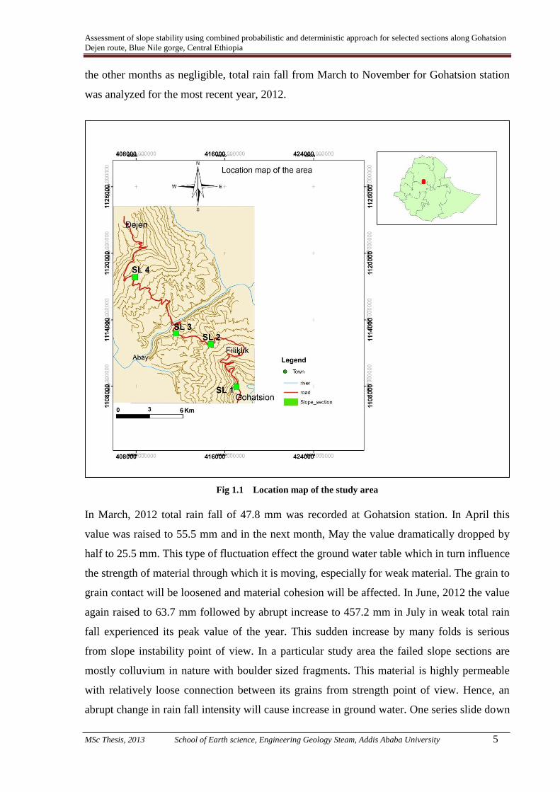
1.4 The Study Area
1.4.1 Location and Accessibility
The study area is located in the Blue Nile gorge (Locally known as Abay gorge) of Ethiopia,
situated in between Amhara and Oromia regional states of the country. The Area is accessible
by asphalted highway that connect Addis Ababa with Northern cities of the country
especially to Debre markos and Bahir Dar covering distance of 185 Km (Gohatsion, the town
to the Northern side of Abay river section) to 229 Km (Dejen, the town to the Southern Abay
river section ) of the main road from Addis Ababa. The study area is bounded geographically
by 408000 m and 42400 m Easting, 1108000 m and 1126000 m Northing in UTM projection.
As the area is topographically rugged, accesses to the specific selected slope sections were
challenging. Some of the colluvium sections had small local trails but for those rock slopes
there was no route to climb the cliffs. It was accessed by searching for gentle slopes around.
1.4.2 Climate
i) Rain fall: Rain fall data collected from three stations (Gohatsion (Fig 1.2), Filiklik (Fig
1.3) and Dejen (Fig.1.4)) in the study area shows Rainfall varies considerably from year to
year, with pronounced wetter and drier decadal cycles. The area receives maximum rain fall
in the months between end of May to September with its peak value in July and/or August.
From December to February the area is relatively dry.
The Abay Basin in general receives on average 1,535 mm of rainfall, ranging from 800 mm
to 2,220 mm and generally increasing with altitude. The record of monthly rain fall at
Gohatsion station from 1996 to 2012 indicates a big difference in between the years. Taking
randomly five years gap in between them the mean annual rain fall in 1996 was 126 mm and
this value reduced to 110 mm in the year 2001. However, in 2006 the value raised to 127
mm. Recent data in this station indicates there is low rain fall potential in 2012 with mean
annual value of 44.2 mm and annual rain fall of 1606.1 mm. By taking total precipitations of
Assessment of slope stability using combined probabilistic and deterministic approach for selected sections along Gohatsion
Dejen route, Blue Nile gorge, Central Ethiopia
MSc Thesis, 2013 School of Earth science, Engineering Geology Steam, Addis Ababa University 5
the other months as negligible, total rain fall from March to November for Gohatsion station
was analyzed for the most recent year, 2012.
Fig 1.1 Location map of the study area
In March, 2012 total rain fall of 47.8 mm was recorded at Gohatsion station. In April this
value was raised to 55.5 mm and in the next month, May the value dramatically dropped by
half to 25.5 mm. This type of fluctuation effect the ground water table which in turn influence
the strength of material through which it is moving, especially for weak material. The grain to
grain contact will be loosened and material cohesion will be affected. In June, 2012 the value
again raised to 63.7 mm followed by abrupt increase to 457.2 mm in July in weak total rain
fall experienced its peak value of the year. This sudden increase by many folds is serious
from slope instability point of view. In a particular study area the failed slope sections are
mostly colluvium in nature with boulder sized fragments. This material is highly permeable
with relatively loose connection between its grains from strength point of view. Hence, an
abrupt change in rain fall intensity will cause increase in ground water. One series slide down

Assessment of slope stability using combined probabilistic and deterministic approach for selected sections along Gohatsion
Dejen route, Blue Nile gorge, Central Ethiopia
MSc Thesis, 2013 School of Earth science, Engineering Geology Steam, Addis Ababa University 6
this station has been studied presently. Down on the way to Dejen, another station is found at
Filiklik on Southern Abay gorge. Topographically it is found at lower level in the gorge
relative to Gohatsion station which is found at a distance away from flank of the gorge.
This area receives lower annual rain fall
relative to upper Gohatsion station. The
annual rain fall of the area varies
between 573.3 mm to 2154.3 mm in the
years considered from 1996 to 2012.
These extreme values has been
recorded in the year 2007 (maximum)
and 2003 (minimum). Reconnaissance
survey made to identify critical section
revealed that there is a big slide in the
section.
Fig. 1.2 Graph showing monthly rainfall of
Gohatsion station.
The strange thing happened in 2007 in
Filiklik that the area received annual
rain fall difference of 916.2 mm more
than at Gohatsion in the same year.
May be this situation have exacerbated
the problem in the area more than ever.
However, it wasn’t considered in the
present study. Recorded rainfall data at
this section also shows that there are
variations in value from one month to
another.
Fig 1.3 Graph showing monthly rainfall of
Filiklik station.
Considering months from June to October as the highest rain fall receiving months and
neglecting others, most recent (2012) record of rain fall data in the area was compared to
observe peak rain fall receiving months. Accordingly, in July, 2012 the peak rain fall record
of the station was 235.6 mm. In August, of the same year the value slightly dropped to 213.3
mm and in September abruptly dropped to 156.6 mm. The record shows there was no
precipitation in October at the station but only this few months contributed to the total annual
rain fall of 1631.0 mm in the area.
0
100
200
300
400
500
Jan
Feb
Mar
Ap
r
May Jun
Jul
Au
g
Sep
Oct
No
v
De
s
1996 1997 1998 1999 2000
2001 2002 2003 2004 2005
2006 2007 2008 2009 2010
0
100
200
300
400
500
Jan
Feb
Mar
Ap
r
May Jun
Jul
Au
g
Sep
Oct
No
v
De
s
1996 1997 1998 1999 2000
2001 2002 2003 2004 2005
2006 2007 2008 2009 2010

Assessment of slope stability using combined probabilistic and deterministic approach for selected sections along Gohatsion
Dejen route, Blue Nile gorge, Central Ethiopia
MSc Thesis, 2013 School of Earth science, Engineering Geology Steam, Addis Ababa University 7
The third station considered in this study was on the way that is found to the Northern Abay
gorge at Dejen. In this section one big slide was selected for further analysis among other
critical sections. Dejen Received annual rainfall varying from 955.4 mm to 1985.1 mm in the
years 2012 and 2000, respectively. Rain fall was so uncertain that it is varying from year to
year and even from time to time by virtue of the areas location within the climatic zone.
The material on which the mass is failing happened to be colluvium which is relatively more
permeable and thought to contribute to raise ground water table of the site. Even when we
consider the most recent rain fall record (2012) of the site to characterize the area, it received
the maximum amount in July with 322.8 mm value.
It started dropping even in the month
that is expected to receive peak value in
August to 267.1 mm. Continuously
dropping it reached a value of almost 0
mm in October which is after two
months the area received its peak value.
In general the area is characterize by
uncertain rainfall intensity event and
amount which is also affecting the area
by virtue of its material characteristics it
is made of (colluvium soil of different
source rock in this case).
Fig. 1.4 Graph showing monthly rainfall of Dejen.
In the present study the contribution to and sensitivity of rainfall toward slope instability of
slopes under considerations has been analyzed for remedial design of the area.
ii) Temperature: The area is characterized by hot and dry climatic condition out of its
summer seasons. The mean annual temperature ranges from 5 to 30 ◦C depending on altitude
(Yilma and Awulachew, 2009).
1.4.3 Physiography
The geomorphology of the study area is influenced by the geology of the area. Geologically
the area is a succession of Mesozoic sedimentary rock underlain by basement rocks and
overlain by tertiary basalt. The Mesozoic succession is different from one unit to another in
0
100
200
300
400Ja
n
Feb
Mar
Ap
r
May Jun
Jul
Au
g
Sep
Oct
No
v
De
s
Rain fall(mm) Dejen
1996 1997 1998 1999
2000 2001 2002 2003
2004 2005 2006 2007
2008 2009 2010

Assessment of slope stability using combined probabilistic and deterministic approach for selected sections along Gohatsion
Dejen route, Blue Nile gorge, Central Ethiopia
MSc Thesis, 2013 School of Earth science, Engineering Geology Steam, Addis Ababa University 8
which weak rock material is overlain by competent rock which has probably contributed to
the present land siding and that has influenced in shaping the morphology of the gorge.
Several investigators believe that a series of tectonic disturbances during the geological past,
together with drainage-aided surface erosion, led the geomorphology of most parts of the
northwest Ethiopian highlands including the Blue Nile basin into the form that is observed
today (Lulseged Ayalew and Yamagishi, 2003). This conclusion has been made from
different geodynamics observed in the gorge but still there is lack of information in providing
the principal phases of basin development and/or landscape evolution in the region.
The slope gradient is most commonly greater than 45o and the bedrock is weakly to
moderately weathered with weakly developed colluvium soils along the road cut. The ridges
are generally convex and the side slopes are straight. Gentle hills consist of gently to
moderately sloping hills with colluvium toe slopes on the upper regions of the gorge along
the road cut.
On upper most of the two sides of gorge, agricultural practice is undertaken and the area is
generally sparsely vegetated.
Fig 1.5 Physiographic map of the area
Assessment of slope stability using combined probabilistic and deterministic approach for selected sections along Gohatsion
Dejen route, Blue Nile gorge, Central Ethiopia
MSc Thesis, 2013 School of Earth science, Engineering Geology Steam, Addis Ababa University 9
1.4.4 Seismicity of the Study Area
In Ethiopia, seismic activities follow narrow zones associated with structures of the Afar
depression and the main Ethiopian rift. The Seismic zone of Ethiopia have been delineated by
Gouin (1979) and later updated by (Laike Mariam Asfaw, 1986 Shiferaw Ayale, 2009). The
later work of Laike Mariam Asfaw (1986) included the previously omitted earthquake
parameters measurements of Southern Ethiopia. In addition, strain release and seismic risk
maps has been produced for earthquake from year 1400 to 1985 and 1900 to 1985; the
probable return period of destructive earthquakes has been considered and a discussion of
some unique features of earthquake hazard in the Afar Depression has been presented (Laike
Mariam Asfaw, 1986 as cited in Shiferaw Ayale, 2009).
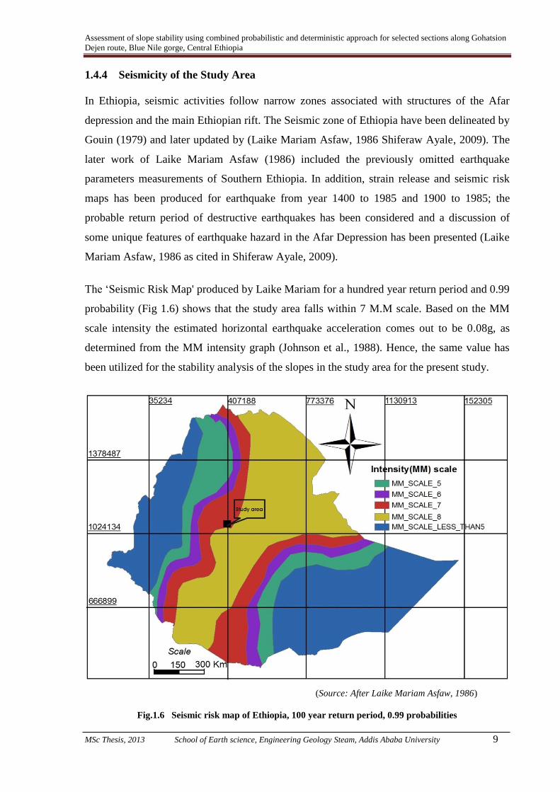
The ‘Seismic Risk Map' produced by Laike Mariam for a hundred year return period and 0.99
probability (Fig 1.6) shows that the study area falls within 7 M.M scale. Based on the MM
scale intensity the estimated horizontal earthquake acceleration comes out to be 0.08g, as
determined from the MM intensity graph (Johnson et al., 1988). Hence, the same value has
been utilized for the stability analysis of the slopes in the study area for the present study.
(Source: After Laike Mariam Asfaw, 1986)
Fig.1.6 Seismic risk map of Ethiopia, 100 year return period, 0.99 probabilities

Assessment of slope stability using combined probabilistic and deterministic approach for selected sections along Gohatsion
Dejen route, Blue Nile gorge, Central Ethiopia
MSc Thesis, 2013 School of Earth science, Engineering Geology Steam, Addis Ababa University 10
1.5 Objectives of the Study
A) General Objective:
Considering the previous studies done in reliability engineering related to slope stability on
the study area, this thesis was proposed to combine deterministic and probabilistic
approaches for stability assessment of slopes. The need of using these combined methods in
the study area was for the reason that in deterministic approaches the input variables are
assumed to have certain values, however, rock mass parameters are always contain
uncertainty and probabilistic approaches offer a systematic way of treating uncertainties and
quantifying the reliability of a design (Kirsten, 1983) which were not attempted before.
Therefore, both general and specific objectives were framed to come up with the better result
by these methods.
The general objective of this research is to develop combined deterministic and probabilistic
model for the assessment of active landslides by taking into consideration uncertain geologic
parameters resulting from variability and heterogeneity of stratigraphy, material properties
and conventional models. Uncertainty in geologic parameters are then justified by the most
detailed results of deterministic approach, expressing the hazard in absolute values in the
form of safety factors and accordingly delineating the current active site as well as possible
future landslide probability occurrence in the areas with their proper remedial measures.
B) Specific objectives:
For the accomplishment of general objective the following specific objectives were proposed.
(i) Delineating critical slope sections
(ii) Collection of relevant data to obtain sufficient information regarding the geological
structures and discontinuity patterns and the effect of their orientation on modes of
failure (planer and wedge failure analysis or circular if required) for further analysis.
(iii) Determination of geometry of rock cut in different areas to apply the rock fall
simulation analysis for the impact of falling rocks on the highway and inclination of
incompetent slopes for prediction of future impact.
(iv) To assess the stability of slopes under short term and long term conditions.
(v) Determination of the slopes sensitivity to different triggering mechanisms by
combined deterministic and probabilistic approaches.

Assessment of slope stability using combined probabilistic and deterministic approach for selected sections along Gohatsion
Dejen route, Blue Nile gorge, Central Ethiopia
MSc Thesis, 2013 School of Earth science, Engineering Geology Steam, Addis Ababa University 11
(vi) To assess the possibility of landslide involving natural or existing engineered slopes
in future by using uncertain geologic parameters and zoning the site.
(vii) Develop a mitigation strategy for each sections of the highway and dwellers of the
area those settled near to the verge of failure and development of alternative solutions
to minimize future problems
1.6 Analytical Tools and Materials Used
To meet out the objectives of the study and for the successful completion of the present
research work following analytical tools and materials were used:
Satellite image was used to mark scarp faces of critical sections from which slope
geometry was produced for analysis.
During data collection for discontinuities on rock mass rating (RMR), Schmidt Hammer
was used to estimate the rock strength.
Brunton compass was used for determinations of slope and discontinuity orientations.
Slope sections were located with the help of GPS. Also, GPS was used to estimate the
slope height on critical sections where the sections were inaccessible.
For preparations of maps, diagrams and graphics Arc GIS 10, Corel Draw 10, Picasa 3,
Micro Soft Excel and Global Mapper 11 were used.
Eventually, the analysis was carried out by Dip Analyst for kinematic check and by
ROCKSCIENCE package software’s, Rock PLANE and SLIDE 5 which supports both
deterministic and probabilistic approaches for stability analysis.
1.7 Limitations of the Study
The investigation and studies carried out in the present research were in the area defined by
Gohatsion and Dejen towns in Abay Gorge of Ethiopia. Therefore, the present research work
has to be looked within the geological context of this area. Geologically, the present area can
be described as successive Mesozoic sedimentary rocks underlain by basement complex and
overlain by tertiary basalts. Further, the present study was conducted under the constrains of
time, resource and financial limitations. All these constraints made the work very challenging
to study all the critical sections with varying geological, topographical and hydro –geological
setup. Therefore, in the present study based on the field manifestations of actual and potential
instability only 4 most critical slope sections were selected for combined deterministic and
probabilistic stability analysis.

Assessment of slope stability using combined probabilistic and deterministic approach for selected sections along Gohatsion
Dejen route, Blue Nile gorge, Central Ethiopia
MSc Thesis, 2013 School of Earth science, Engineering Geology Steam, Addis Ababa University 12
1.8 Scope for Future Studies and Extensions of the Research Work
In spite of the limitations, all efforts were made to produce reliable results with a
comprehensive methodology. Due to constrain of time, resources and financial limitations
only 4 most critical slope sections were selected and studied during the present study. Thus,
there is a need to extend this methodology to cover remaining slopes also in future studies so
that entire area can be thoroughly studied for all kinds of slopes and based on the anticipated
slope stability conditions appropriate engineering design for slopes can be worked out.
Although the two approaches; deterministic and probabilistic methods are complementary
most of the studies done before were based on individual approaches only. Even with in these
two individual approaches different methods do exist. It also sounds great if the analysis will
be attempted by all available methods within the individual approach and in combination
with the other approach to increase reliability of the approaches for detailed and site specific
studies.
1.9 Research Work Presentation
Chapter 1 of the thesis introduces some background on slope failures followed by problem
statement, objectives, general methodology, limitations, scope for future studies and
extension of research work and the general outline of the study area.
Chapter 2 deals with literature review. Previous works related to the current study has been
reviewed from which conceptual frame work was developed. General slope instability
contributing factors are also presented.
Chapter 3 focuses on geological set up of the study area. Regional geology has been
summarized, followed by discussion on local geology.
Chapter 4 covers the methodology development for the present study. All the analysis
procedures and in what way, what manner the combined approaches are used is discussed.
Chapter 5 is about results and discussion. It is the core of the present study and covers the
description on input data, analysis procedures, results and interpretations of the present
research. A detailed description on results and interpretation with respect to the objectives of
the study is also presented.

Assessment of slope stability using combined probabilistic and deterministic approach for selected sections along Gohatsion
Dejen route, Blue Nile gorge, Central Ethiopia
MSc Thesis, 2013 School of Earth science, Engineering Geology Steam, Addis Ababa University 13
Chapter 6 deals with possible remedial measures and preventive options for the critical slope
sections in the study area.
Chapter 7 of the thesis is about conclusion and recommendations. Conclusions were made
from the overall work accomplished during the present study. Finally, based on the findings
general recommendations for implementation is forwarded and presented in this chapter.
*****

Assessment of slope stability using combined probabilistic and deterministic approach for selected sections along Gohatsion
Dejen route, Blue Nile gorge, Central Ethiopia
MSc Thesis, 2013 School of Earth science, Engineering Geology Steam, Addis Ababa University 14
Chapter 2
Literature Review 2.1 Preamble
In hilly terrains slope instability is a major problem all over the world (www.icsu-asia-
pacific. org/resource_centre/Sassa-paper.pdf; www.emdat.be; Schuster and Fleming, 1986;
Keefer, 2000; Mario and Jibson, 2000; Dai et al, 2002; Kanungo et al., 2006; Pan et al.,
2008). The same is true in Ethiopia particularly in the highlands of the country (Engdawork
Mulatu et al., 2009; Ayalew and Yamagishi, 2003; Henok Woldegiorgis, 2008). The Blue
Nile Basin in Ethiopia witnesses a wave of landslides both small and large scale during the
rainy season. Such landslides and rock fall have been witnessed starting from some 150 km
downstream of Lake Tana up to the Sudan border (Ayalew and Yamagishi, 2003).
Slope instability is a geo-dynamic process that naturally shapes up the geo-morphology of the
earth. It became a major concern with the increased demand for development and expansion
of human settlements in those unstable slopes and as these areas posed an effect on the safety
of people and property (Weerasinghe et al., 1999).
In the present study the work of different researchers from different parts of the world and
highlands of Ethiopia on individual deterministic and probabilistic approach as well as the
output they have produced through comparative studies considering various instability
contributing factors and uncertainties in earth materials is reviewed.
2.2 Landslide and Related Slope Instability Assessment Approaches
The assessment of an existing unstable or potentially unstable slope, or of a slope to be cut,
provides the basis for the selection of slope treatments. Treatment selection requires
forecasting the form of failure, the volume of material involved, and the degree of the hazard
and risk. Assessment can be based on quantitative analysis in certain situations, but in many
cases must be based on qualitative evaluation of the slope characteristics and environmental
factors including weather and seismic activity (Hunt, 2005).
As per Banakia et al., (2013) there are two types of stability analysis against failure; that is
‘Deterministic’ and ‘Probabilistic’ analysis.
Assessment of slope stability using combined probabilistic and deterministic approach for selected sections along Gohatsion
Dejen route, Blue Nile gorge, Central Ethiopia
MSc Thesis, 2013 School of Earth science, Engineering Geology Steam, Addis Ababa University 15
2.2.1 Deterministic Approaches
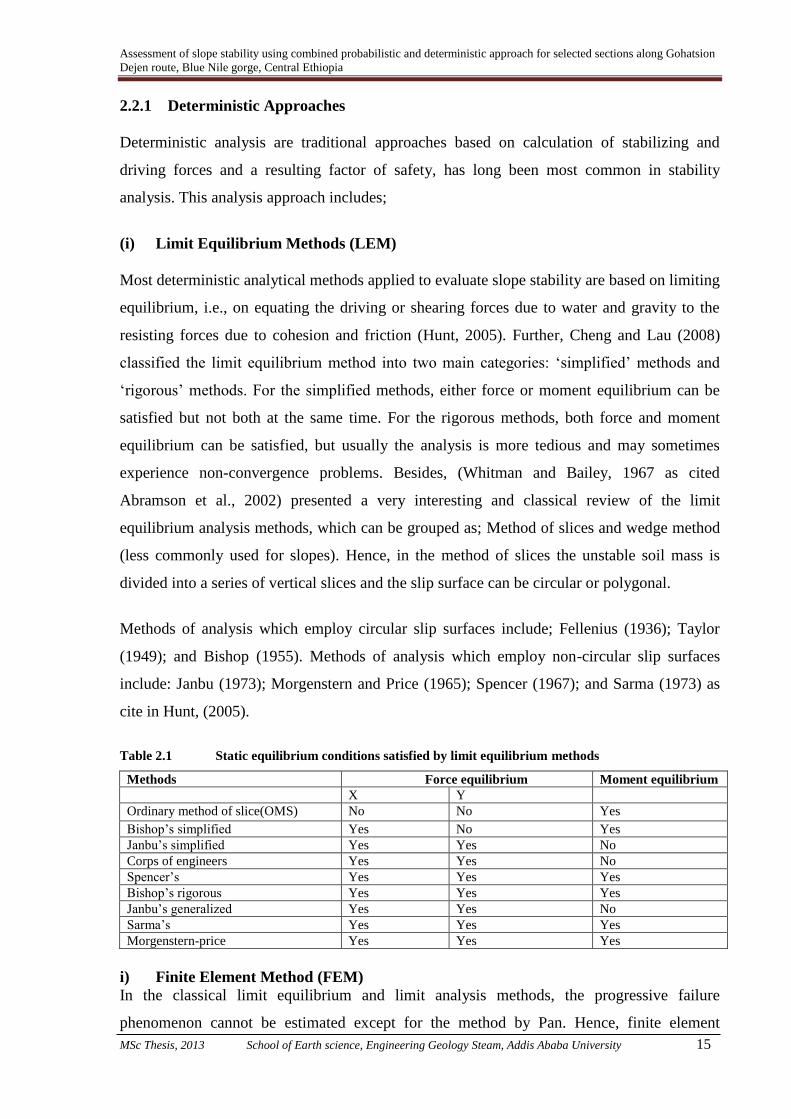
Deterministic analysis are traditional approaches based on calculation of stabilizing and
driving forces and a resulting factor of safety, has long been most common in stability
analysis. This analysis approach includes;
(i) Limit Equilibrium Methods (LEM)
Most deterministic analytical methods applied to evaluate slope stability are based on limiting
equilibrium, i.e., on equating the driving or shearing forces due to water and gravity to the
resisting forces due to cohesion and friction (Hunt, 2005). Further, Cheng and Lau (2008)
classified the limit equilibrium method into two main categories: ‘simplified’ methods and
‘rigorous’ methods. For the simplified methods, either force or moment equilibrium can be
satisfied but not both at the same time. For the rigorous methods, both force and moment
equilibrium can be satisfied, but usually the analysis is more tedious and may sometimes
experience non-convergence problems. Besides, (Whitman and Bailey, 1967 as cited
Abramson et al., 2002) presented a very interesting and classical review of the limit
equilibrium analysis methods, which can be grouped as; Method of slices and wedge method
(less commonly used for slopes). Hence, in the method of slices the unstable soil mass is
divided into a series of vertical slices and the slip surface can be circular or polygonal.
Methods of analysis which employ circular slip surfaces include; Fellenius (1936); Taylor
(1949); and Bishop (1955). Methods of analysis which employ non-circular slip surfaces
include: Janbu (1973); Morgenstern and Price (1965); Spencer (1967); and Sarma (1973) as
cite in Hunt, (2005).
Table 2.1 Static equilibrium conditions satisfied by limit equilibrium methods
Methods Force equilibrium Moment equilibrium
X Y
Ordinary method of slice(OMS) No No Yes
Bishop’s simplified Yes No Yes
Janbu’s simplified Yes Yes No
Corps of engineers Yes Yes No
Spencer’s Yes Yes Yes
Bishop’s rigorous Yes Yes Yes
Janbu’s generalized Yes Yes No
Sarma’s Yes Yes Yes
Morgenstern-price Yes Yes Yes
i) Finite Element Method (FEM)
In the classical limit equilibrium and limit analysis methods, the progressive failure
phenomenon cannot be estimated except for the method by Pan. Hence, finite element

Assessment of slope stability using combined probabilistic and deterministic approach for selected sections along Gohatsion
Dejen route, Blue Nile gorge, Central Ethiopia
MSc Thesis, 2013 School of Earth science, Engineering Geology Steam, Addis Ababa University 16
method has been proposed to overcome some of the basic limitations in the traditional
methods of analysis. At present, there are two major applications of the finite element in
slope stability analysis.
The first approach is to perform an elastic (or elasto-plastic) stress analysis by applying the
body force (weight) due to soil to the slope system. Once the stresses are determined, the
local factors of safety can be determined easily from the stresses and the Mohr–Coulomb
criterion. The global factor of safety can also be defined in a similar way by determining the
ultimate shear force and the actual driving force along the failure surface.
The second finite element slope stability approach is the strength reduction method (SRM).
The main advantages of the SRM are as follows: (i) the critical failure surface is found
automatically from the localized shear strain arising from the application of gravity loads and
the reduction of shear strength; (ii) it requires no assumption on the inter-slice shear force
distribution; (iii) it is applicable to many complex conditions and can give information such
as stresses, movements and pore pressures which are not possible with the LEM (Cheng and
Lau, 2008).
ii) Limit Analysis Method
The limit analysis adopts the concept of an idealized stress–strain relation, that is, the soil is
assumed as a rigid, perfectly plastic material with an associated flow rule. Without carrying
out the step-by-step elasto-plastic analysis, the limit analysis can provide solutions to many
problems.
2.2.2 Probabilistic Approaches
As a direct integration of the adopted performance functions for the ‘Factor of Safety’ (FOS)
is not feasible, the expected values and variance of the factor of safety may be approximated
probabilistically (Sharma, 2002) by;
i) Monte Carlo Simulation Method
This method effectively simulates the response of the factor of safety performance function to
randomly selected, discrete values of the component variables. The process is repeated many,
many times to obtain an approximate, discrete, ‘Probability Density Functions’ (PDF) of the
resulting FOS values, F. The component random variables for each calculation are selected
from a sample of random values that are based on the selected PDF of the random variables.

Assessment of slope stability using combined probabilistic and deterministic approach for selected sections along Gohatsion
Dejen route, Blue Nile gorge, Central Ethiopia
MSc Thesis, 2013 School of Earth science, Engineering Geology Steam, Addis Ababa University 17
Although these probability density functions can take on any shape, the normal, log normal,
triangular, beta, and uniform distributions are used for analysis (Abramson et al., 2002).
ii) Taylor Series Method
This method is based on the Taylor series expansion of the performance function about the
expected values of the random variables (Hahn and Shapiro, 1967 as cited in Abramson et al.,
2002). The main advantage of the Taylor series method is that as the terms are summed for
the variance, one can readily see the relative contribution of the uncertainty projected by each
component random variable. Although this method will give an exact solution for a linear
function, the first order approximations introduces errors for nonlinear performance
functions, such as; the ones typically used for the FOS (Abramson et al., 2002).
iii) Rosenblueth’s Point Estimate Method
It is originally proposed by Rosenblueth (1975) where the PDFs of the random variables are
simulated by “point” masses located at plus or minus one standard deviation from the mean
values. This method is direct and gives reasonably accurate results quickly (McGuffey et al.,
1981; Harr, 1987; wolf, 1996 as cited in Abramson et al., 2002).
iv) Fourier Analysis
If the complete joint PDF of the FOS is required rather than a Monte Carlo histogram of
possible FOS values, then one can use the Fourier analysis method, which is based on the
evolution of independent PDFs (Feller, 1966 as cited in Abramson et al., 2002). The main
difficulty with this Fourier method is the requirement of a linear performance function.
However, if a linear performance function can be identified, then an accurate, unique PDF of
the will be obtained, without any restriction on the type of input PDF that may be used to
define the component random variables. This allows the use of highly skewed PDF if
necessary (Abramson et al., 2002).
2.3 Studies conducted by Deterministic and Probabilistic Approaches – A Review
Parka and West (2000) have utilized probabilistic approach for rock wedge failure in South
Korea. Water pressure, joint orientation, joint dimension, and joint shear strength were
considered as probabilistic input parameters to evaluate probability of slope failure in the
study. In order to compare the probability of slope failure with the traditional deterministic
method, the Factor of Safety (FS) for each case was calculated.

Assessment of slope stability using combined probabilistic and deterministic approach for selected sections along Gohatsion
Dejen route, Blue Nile gorge, Central Ethiopia
MSc Thesis, 2013 School of Earth science, Engineering Geology Steam, Addis Ababa University 18
A total of six discontinuity sets were identified and for stability analysis, all possible
discontinuity combinations were delineated and checked for stability. Based on the
deterministic analysis results, it was concluded that the slope is stable and there is no
possibility of instability however; through probabilistic approach a low volume wedge failure
probability was anticipated.
MatRadhi et al (2008) have developed Probabilistic Approach for Rock Slope Stability
Analysis Using Monte Carlo Simulation and tested it by using data from Pos Selim Highway,
Malaysia. The probabilistic analysis was carried out using kinematic and kinetic analysis.
Kinematic analysis is based on stereographic projection analysis and kinetic analysis is based
on the deterministic analysis. From the total of six slope data collected, three of them had
Factor of safety less than unity which shows the slope is un-stable with possible planar failure
mode. Whilst for wedge failure analysis, all the slopes show FS greater than 1.00 indicating
stable condition. Further, Probabilistic analysis was developed for rock slope stability using
Monte Carlo Simulation. Monte Carlo simulation calculate the probability of failure for
planar and wedge type of failure. Finally, it was concluded that as factor of safety increases
the probability of failure decrease in variable ranges depending on dry or wet slope
conditions.
Gheibie (2012) utilized Probabilistic-numerical modeling for stability of a rock slope in
Amasya Turkey. He considered Joint Roughness Coefficient (JRC), Joint Compressive
strength (JCS), cohesion and angle of internal friction of the filled material. The analysis
indicated that the increase of cohesion decreases the displacements and failure probability of
the structure. Also, reduction of basic friction angle and joint wall compressive strength
increases the probability of failure and increases the displacement.
Ying (2002) studied slope stability by classical limit equilibrium methods through analysis by
considering various equations, unknowns and assumptions. The study also covered the
suitability of various methods of analysis, factor of safety calculated by considering different
examples from Hong Kong. The influence of tension crack, external loading, ground water
fluctuation on slope stability was also considered.
2.4 Landslide studies in Ethiopia – A Review
Landslide and related slope instability problems are common in highlands of Ethiopia.
Several studies has been conducted by various organization, instaurations and individuals in

Assessment of slope stability using combined probabilistic and deterministic approach for selected sections along Gohatsion
Dejen route, Blue Nile gorge, Central Ethiopia
MSc Thesis, 2013 School of Earth science, Engineering Geology Steam, Addis Ababa University 19
past by following various approaches. A review of all such works was made during the
present study and is summarized in the following paragraphs;
Gebretsadik Eshete (1982) conducted landslide studies in Dessie area. According to him two
of the common causes which seem to play a considerable role in causing instabilities in the
Dessie area are the water content and weathering. The water content at the time of rain
attributed to excess hydrostatic pressure which reduces the shearing resistance. The formation
of clay as a result of weathering in joints and faults can reduce the resistance and causes
sliding as a consequence.
Gezahegn and Dessie (1994) classify slope instabilities in the Abay Gorge and its tributaries
in to four types. These are (i) Continuously moving granular deposits from the slopes of
basalt escarpments, (ii) Rotational failure of colluvial soil, (iii) Gully erosion and (iv) Rock
fall and toppling. Based on their investigation they proposed a road realignment which
relatively avoided the landslide hazard zone.
Lulseged Ayalew and Vernier, (1999), has studied the causes and mechanisms of slope
instability in Dessie town. In this work, they examined the relationship between slope
instability and seasonal rainfall in the area. By taking the variation in moisture content of soil,
the rate of daily precipitation, the amount of cumulative precipitation, and mean annual
rainfall as variable, they derived a simple equation that is useful to determine the likelihood
of land sliding.
Getachew Lemmesa et al (2000) conducted mass movement hazard assessment in Betto,
Goffa district, North Omo Zone, Southern Ethiopia. The study identified that the main cause
of landslide was the existence of old landslides on steep slopes that was covered by deeply
weathered, closely jointed or sheared basaltic rocks.
Berhanu Temesigen et al (1999) conducted a research on landslide in the Wondo-Genet area.
In this research evaluation of the occurrences of landslides and their relationships with
various event controlling parameters was made using GIS and Remote Sensing techniques.
Lulseged Ayalew and Yamagishi (2003) described slope failures in the Abay Gorge from the
point of view of landscape evolution. In their study they related topographical characteristics
with the process of landslide and rock fall. They concluded that slope instability was part of

Assessment of slope stability using combined probabilistic and deterministic approach for selected sections along Gohatsion
Dejen route, Blue Nile gorge, Central Ethiopia
MSc Thesis, 2013 School of Earth science, Engineering Geology Steam, Addis Ababa University 20
the mega-forces that shaped the entire Abay river basin and that it also contributed to general
landscape evolution.
Tenalem Ayenew and Barbieri (2004) have conducted an inventory landslides and
susceptibility mapping in the Dessie area. During this study, four broad landslide
susceptibility zones and 22 specific active landslide sites were identified. According to this
research, the most important landslide types were complex earth and debris slides and flows
in silty clay soils associated with alluvial and colluvial deposits overlying highly weathered
basalts.
As cited by Jemal Saed (2005), the Transport Construction Design Share Company
(TCDSCo) carried out detailed geotechnical investigation project along the Gohatsion-Dejen-
Debre Markos road in 2003. This study revealed that thick unconsolidated colluvial soil mass
was responsible for the damage of the northern parts of the road.
Yodit Teferi (2005) conducted a research on Evaluation of Land Degradation and Landslide
Using Integrated GIS and Remote Sensing Approach around Sodo-Shone Area, Southern
Ethiopia. During her research she observed two types of mass movements; flow and rock fall
in the area. Mud flow was induced by intensive rainfall and observed in gently sloping areas
whereas the slope mainly ranges from 200-300 m whereas the rock fall was common in areas
where the slope angle exceeds 400.
Jemal Saed (2005) has conducted slope stability studies on the road section starting from
Gohatsion to Dejen towns. He made the quantitative analysis of critical slope sections
following limit equilibrium method.
Kifle Woldearegay (2008) carried out geological, geotechnical and geo-hydrological
investigations to understand the causes and triggering mechanisms of the large-scale
landslide in Tarmaber area, central highlands of Ethiopia. According to his research paper,
the localities “Yizaba Wein” and “Shotel Amba” areas, with an estimated total area of 35
square kilometer, were completely affected by a single major deep-seated landslide which
took place in September 12, 2006. More than 3000 people were displaced; 1250 dwelling
houses were demolished; and 4 Churches, 4 Mills, and one elementary school were
destroyed. The landslide also devastated about 1500 hectare of agricultural land and caused
damage to the natural environment.

Assessment of slope stability using combined probabilistic and deterministic approach for selected sections along Gohatsion
Dejen route, Blue Nile gorge, Central Ethiopia
MSc Thesis, 2013 School of Earth science, Engineering Geology Steam, Addis Ababa University 21
Henok Woldegeorgis (2008) had made landslide hazard zonation mapping in southern part of
Blue Nile Gorge using a Land Hazard Evaluation Factor (LHEF) to characterize the
Landslide Hazard potential in the study area. By utilizing the limit equilibrium method he
further made the quantitative analysis for critical slopes.
Shiferaw Ayele (2009) utilized remote sensing and GIS approach to delineate Landslide
Hazard zones in Abay Gorge (Gohatsion-Dejen), Central Ethiopia. The various causative
factors considered for this study were; geology, groundwater condition, drainage, slope,
structures, aspect and landuse/ land cover. In this study comparison of the landslide hazard
map was made with actual landslide events of the study area and found that 67% landslides
lie within the maximum hazard zone delineated by the study.
Fikre Girma (2010) conducted study in Ada Berga Woreda, Western Showa Zone, Oromiya
Region, Ethiopia by utilizing A Multi Method Approach to Study Landslide Hazard. For this
study various GIS and statistical tools were utilized to produce the landslide hazard zonation
map.
Jemal Ibrahim (2009) conducted study in Mersa and Wurgessa Area, North Wollo, Ethiopia
and carried out Landslide assessment and hazard zonation. For landslide hazard evaluation he
utilizes slope susceptibility evaluation parameter scheme.
Samuel Molla, (2011) conducted Slope stability analysis on a selected slope section along the
road Gohatsion – Dejen. He utilized limit equilibrium method for the quantitative assessment
of slope stability condition for various anticipated adverse conditions.
Yonathan Tsegaye (2011) conducted study in Tarmaber Area in Northern Ethiopia and
produced Landslide Hazard Zonation Map by utilizing Landslide Hazard Evaluation factor
scheme.
Lensa Negassa (2012) conducted Landslide Hazard Zonation Using Remote Sensing and
GIS Approach in Meta Robi Wereda, West Showa Zone, Oromiya, Ethiopia. The study
utilized Grid overlay analysis and GIS modeling tool. The various causative and triggering
factors were quantitatively assessed and evaluated to produce landslide hazard zonation map.
Similar landslide or slope stability studies were carried out by Lulseged Ayalew, (1999),
Kefeyalew Terefe, (2001), Gebretsidik Eshete, (1982), Mesfin Wubshet et al., (1994) etc.

Assessment of slope stability using combined probabilistic and deterministic approach for selected sections along Gohatsion
Dejen route, Blue Nile gorge, Central Ethiopia
MSc Thesis, 2013 School of Earth science, Engineering Geology Steam, Addis Ababa University 22
2.5 Contributing factors for slope instability
It is difficult to determine the type and likelihood of a slope failure event because numerous
factors interact in complex and often subtle ways to destabilize slopes. Despite the
challenges, many factors has been proved to be responsible to the instability of slopes which
are attributed to processes that increase shear stress or decrease shear strength of the soil or
rock mass (Abramson et al., 2002). In slope stability analysis, it is of fundamental importance
to identify causative factors for slope failure occurrences in a region, which often is difficult.
It is also usually hard to establish the relationships between various causative factors. Indeed,
the great variety of slope movements reflects the diversity of factors that may disturb the
slope stability (Arora and Anbalagan, 2010).
However, it may be possible to demarcate landslide susceptible areas by identifying and
analyzing the factors that have caused landslides in the past and under similar conditions in
the future. It is of primary importance to understand the conditions, under which mass
movements are caused and the factors that trigger the movements to recognize the extent of
danger and to propose adequate remedial measures. The major driving force that affects the
shearing stresses in a slope, gravity, is highly correlated to slope gradient. When the slope
gradient increases, the gravity and shearing stresses increase as well. A number of natural and
anthropogenic factors can significantly reduce stability of slopes and contribute for slope
failure (Aleotti and Chowdhury, 1999).
The major factors are discussed as below;
2.5.1 Geological factors
It is an important geological parameter as it is related to the basic characters of the slope
forming materials. There are two fundamental types of slope forming materials – loose,
unconsolidated materials and in-situ rocks. The unconsolidated materials, except older fluvial
materials, in general, have least shear strength and are more prone to failure. Particularly, if
they are charged with water, they show high potential to failure. The rocks are in general
more stable as compared to unconsolidated material.
The disposition of the structural discontinuities of primary and secondary origin in the rocks
such as; bedding, joints, foliations, faults and thrusts in relation to slope inclination and
direction has a great influence on the stability of slopes (Arora and Anbalagan, 2010). Many
slides occur in a geologic setting that places permeable sands and gravels above impermeable

Assessment of slope stability using combined probabilistic and deterministic approach for selected sections along Gohatsion
Dejen route, Blue Nile gorge, Central Ethiopia
MSc Thesis, 2013 School of Earth science, Engineering Geology Steam, Addis Ababa University 23
layers of silt and clay, or bedrock. Water seeps downward through the upper materials and
accumulates on the top of the underlying units, forming a zone of weakness.
2.5.2 Geomorphic factors
Geomorphic factors include slope shape and aspect. The distribution of slope categories is
dependent on the geomorphological history of the area. The angle of slope of each unit is a
reflection of a series of localized processes and controls, which have been imposed on the
slope (Long, 2008).
Slope shape has a strong influence on slope stability in steep terrain by concentrating or
dispersing surface and primarily subsurface water in the landscape. There are three basic
hydro geomorphic slope units: (i) divergent, (ii) planar or straight, and (iii) convergent. The
divergent or convex landform is most stable in steep terrain, followed by planar hill slope
segment and convergent or concave hills slope (least stable). The main reason is related to
landform structure affecting largely the concentration or dispersion of surface and sub-
surface water. Convergent hill slope tend to concentrate sub-surface water into small areas of
the slope, thereby generating rapid pore water pressure increase during storms or periods of
rainfall. If pore pressures develop in the hollow, the soil shear strength reduces to a critical
level and a landslide can occur. Hence, hollows are susceptible sites for initiation of debris
slide and debris flows (Hack and Goodlett, 1960; Dietrich and Dunne, 1978; Benda, 1990 as
cited in Long, 2008).
Slope aspect (direction) strongly affects hydrologic processes via evapotranspiration and thus
affects weathering processes and vegetation and root development, especially in drier
environments (Sidle and Ochiai, 2006). Altitude or elevation is usually associated with
landslides by virtue of other factors such as; slope gradient, lithology, weathering,
precipitation, ground motion, soil thickness and land use. The relative relief (gradient) refers
to the local height of the slope between the ridge top and valley floor in a slope facet. It has
also an important role in forming the size of the unstable wedges. The slope having higher
relative relief may form unstable rock wedges of big size with more probability of failures
(Long, 2008).
2.5.3 Hydrologic factors
Hydrologic processes in the form of precipitation (spatial and temporal distribution of
rainfall), water recharge into soil (and the potential for overland flow), lateral and vertical

Assessment of slope stability using combined probabilistic and deterministic approach for selected sections along Gohatsion
Dejen route, Blue Nile gorge, Central Ethiopia
MSc Thesis, 2013 School of Earth science, Engineering Geology Steam, Addis Ababa University 24
movement within the regolith, evapotranspiration and interception contribute to slope
instability (Long, 2008). Water is commonly the primary factor triggering a landslide. Slides
often occur following intense rainfall, when storm water runoff saturates soils on steep slopes
or when infiltration causes a rapid rise in groundwater levels. Groundwater may rise as a
result of heavy rains or a prolonged wet spell. As water tables rise, some slopes become
unstable due to increase in slope saturation building up positive pore water pressure. This
causes a decrease in the effective normal stress acting along the potential failure plane, which
in turn diminishes the available shear strength to a point where equilibrium can no longer be
sustained in the slope (Orense, 2004).
Hill slope hydrology is one of the most important factors in landslide triggering. Two
processes mainly control changes in slope hydrology that may lead to failure: infiltration of
water from the surface and rising of groundwater levels by impoundment of water in a
reservoir. However, in case of sub-surface water, it is only the shallow water close to the
surface that is important from the point of landslides as they can sufficiently reduce strength
of surface materials. The sub-surface water flowing at deeper levels which are not day-lighted
on surface is not important to be considered in slope stability analysis (UNIMIB, 2012).
Another important influence of water is to reduce angle of repose. The angle of repose is the
steepest angle at which a pile of unconsolidated grains remains stable, and is controlled by
the frictional contact between the grains. Hence, when the material becomes saturated with
water, the angle of repose is reduced to very small values and the material tends to flow like a
fluid. This is because the water gets between the grains and eliminates grain to grain
frictional contacts. In general, for dry materials the angle of repose increases with increasing
grain size, but usually lies between about 30 and 37o (Upreti & Dhital, 1996).
2.5.4 Land use and land cover
Land cover is an indirect indication of the stability of hill slopes. The thickly vegetated forest
areas are less prone to erosion and are generally more stable. However, the barren and
sparsely vegetated lands are more prone to erosion and instability (Anbalagan, 1992). Forest
cover smoothers the action of climatic agents on the slope and protects them from weathering
and erosion. A well spread-out root system increases the shearing resistance of the slope
materials. However, the growth of plants and other vegetation in the pre-existing plane of
joints of the rocks may also cause excess stress on joint walls due to increase in size of roots.
This phenomenon may push the slope materials out and cause landslides (Anbalagan, 1992).

Assessment of slope stability using combined probabilistic and deterministic approach for selected sections along Gohatsion
Dejen route, Blue Nile gorge, Central Ethiopia
MSc Thesis, 2013 School of Earth science, Engineering Geology Steam, Addis Ababa University 25
2.5.5 Earthquakes
Seismic activities have always been a main cause of landslides throughout the world. Any
time plate tectonics move the soil that covers and moves with it. When earthquakes occur on
areas with steep slopes, many times the soil slips causing landslides. Earthquakes in steep
landslide-prone areas greatly increase the likelihood that landslides will occur, due to ground
shaking alone, liquefaction of susceptible sediments, or shaking-caused dilation of soil
materials, which allows rapid infiltration of water. Rock falls and rock topples can also be
caused by loosening of rocks or rocky formations as a result of earthquake ground shaking
(Highland and Bobrowsky, 2008). Furthermore, ash and debris flows caused by earthquakes
can also trigger mass movement of soil.
There is one type of landslide that is typical for earthquakes, i.e. liquefaction failure which
can cause fissuring or subsidence of the ground. Liquefaction involves the temporary loss of
strength of sands and silts which behave as viscous fluids rather than as soils. This can have
devastating effects during large earthquakes (Long, 2008).
2.5.6 Human Intervention
Human activity can modify by remediating the influence of natural processes such as; rainfall
or toe erosion on slope stability but on the contrary, it can also substitute the natural
processes with an artificial equivalent, typically accelerated by several orders of magnitude
compared to natural timescales, as in the case, for example, of major earthworks or other
construction activities on slope (Gorsevski et al., 2006).
Landslides may result directly or indirectly from the activities of people. Among them are
improper or uncontrolled discharge from sanitation or drainage works and water pipes,
typically associated with human settlements and roads, especially in rural areas, which
increase water infiltration in the slope, and possibly soil erosion at points of concentrated
surface discharge. Excavation at the base of or on slopes and/or placement of fill at the top or
on slopes, altering the geometry of and the stress distribution in the slope is also another
influence. Quarrying and mining activities, altering the geometry of and the stress distribution
in the slope is an important factor. Vibration from blasting and heavy construction
equipment; besides causing transient stress changes which in extreme cases can trigger
landslides by themselves, vibrations can disturb the microstructure of soils or rocks, induce
fracturing in rock (UNIMIB, 2012)

Assessment of slope stability using combined probabilistic and deterministic approach for selected sections along Gohatsion
Dejen route, Blue Nile gorge, Central Ethiopia
MSc Thesis, 2013 School of Earth science, Engineering Geology Steam, Addis Ababa University 26
Farming is generally considered as having a low impact on landslides and is often the only
activity allowed in landslide prone areas. Even farming and collateral activities, however,
may trigger slope movements, directly or indirectly. When land is first turned to farming, this
often involves extensive deforestation which can lead to soil erosion and land sliding in hilly
or mountainous terrain (Glade 1998). However, probably the main cause of landslide
triggering due to farming is related to irrigation and drainage, which can alter the natural
groundwater conditions (UNIMIB, 2012).
Removal of vegetation for change of land use to agriculture can also facilitate slope
instability, reducing evapotranspiration, allowing increased infiltration and increased surface
erosion through loss of the shallow reinforcement provided by the root system (UNIMIB,
2012).
2.2.6 Weathering
Factors influencing the rate of weathering are among others climate (temperature and
rainfall), time and type of source rock (Lambe and Whitman, 1969). Weathering is the natural
process of breaking down rocks into soil through freeze-thaw, Wet-dry, and the slow action
of physical and chemical deterioration. Weathering has a large effect on the soil physical
properties that control land sliding such as texture, porosity and shrink-swell properties.
Weathering processes those that decompose the rock act as internal control that decreases
rock’s shearing strength and contribute to a low and/or reduced strength (Varnes, 1984).
Rocks exposed to difference in weathering changes from unweathered rock to soil. The depth
of this weathering is shallow for rocks like basalts that are fine grained. This condition leads
to surface sliding generally triggered by heavy rain fall (Cornforth, 2005). Cut slopes made
through sedimentary rocks may pass through sedimentary rock, partly to fully cemented
conglomerate, indurated sand, clay shale, etc. Over a years differential weathering may erode
the less resistant rock layer and under mining the slope above. Seepage occurring between
two layers of differential permeability can accelerate the weathering and erosion at the face.
2.6 Methodology Evolved for the Present Study
The thorough literature review made in the present study was to have a general background
and to evolve conceptual framework about landslide types, factors responsible for instability
and to know about various techniques generally used for analysis of slope stability.

Assessment of slope stability using combined probabilistic and deterministic approach for selected sections along Gohatsion
Dejen route, Blue Nile gorge, Central Ethiopia
MSc Thesis, 2013 School of Earth science, Engineering Geology Steam, Addis Ababa University 27
Thus, through this literature survey a general conceptual framework was developed and a
comprehensive methodology was evolved. The methodology followed in the present study
was based on the actual field data collection, procurement of data from secondary sources,
exhaustive analysis through standard graphical, analytical and empirical approaches, logical
interpretations of results and actual result based evaluation of feasible recommendations. For
analysis purpose deterministic and Limit equilibrium based probabilistic Monte Carlo
simulation approach was followed during the present study. Eventually, these combined
methods were applied to the identified critical slope sections in the study area and based on
the results suitable remedial measures were suggested.
*****

Assessment of slope stability using combined probabilistic and deterministic approach for selected sections along Gohatsion
Dejen route, Blue Nile gorge, Central Ethiopia
MSc Thesis, 2013 School of Earth science, Engineering Geology Steam, Addis Ababa University 28
Chapter 3
Geological setup of the Study Area
3.1 Regional Geology
The Blue Nile Gorge of Ethiopia is located in the central part of North-western plateau of
Ethiopian physiographic region. The evolution of the basin was associated with Triassic–
Cretaceous time NE–SW trending lithospheric extension that affected northern and central
Africa (Fairhead, 1988). This extension formed NW-trending Mesozoic rift basins including
the Muglad, the Melut, the Blue Nile and the Anza rift basins (Mc Hargue et al., 1992; Binks
and Fairhead, 1992 as cited in Gani et al., 2008). Although the architecture of Blue Nile basin
is poorly known, many studies indicate as it was formed during Mesozoic break-up of
Gondwana (Bosellini, 1989; Russo et al., 1994). Regardless of important studies on Blue
Nile, the stratigraphic and structural evolution of the Basin is not fully understood since much
of the basin’s geological record (Mesozoic and Precambrian rocks) is buried beneath the
extensive 500–2000 m thick Cenozoic volcanic rocks (Hofmann et al., 1997; Coulie et al.,
2003; Kieffer et al., 2004) and no sub-surface data are available. However, the ~ 1600 m deep
Gorge of the Nile (Gani and Abdelsalam, 2006; Gani et al., 2008) formed by the never
ceasing forces of erosion and transportation Blue Nile River on the North-western Ethiopian
Plateau provides good surface exposures suitable for focused stratigraphic and structural
studies that can be used for regional reconstruction of the geological history of the Blue Nile
Basin.
Geologically, the gorge contains the complete stratigraphy of Ethiopian geology starting from
Precambrian basement to Mesozoic sediment overlain by Tertiary basalt (Mogessie et al.,
2002). The age of the basement rocks are considered to be Neoproterozoic, ranging from 850
to 550 Ma as documented from U-Pb and Rb-Sr geo-chronologic studies (Tenalem Ayalew et
al., 1990). These rocks underlie the Mesozoic sedimentary rocks. The Mesozoic
sedimentation phase started following continuous subsiding period of the land and migration
of the sea from east, in the Ogaden towards the west and north covering the central part and
northern areas of the country. Blue Nile River basin is among the places in the country where
Mesozoic sediments are exposed. It is characterized by ~1400 m thick horizontal to sub-
horizontal successions of fluvial/ alluvial silica clastic and marine carbonate rocks, ranging in
age from Triassic to Cretaceous and showing evidence for different phases of marine

Assessment of slope stability using combined probabilistic and deterministic approach for selected sections along Gohatsion
Dejen route, Blue Nile gorge, Central Ethiopia
MSc Thesis, 2013 School of Earth science, Engineering Geology Steam, Addis Ababa University 29
transgression and regression (Gani et al., 2008). The oldest recorded deposits above the
basement are Paleozoic (Ordovician) continental sediments (Jepsen and Athearn, 1961). Fig.
3.1 shows the regional geological setup of the area.
(A) Distribution of Mesozoic sedimentary rocks in the Horn of Africa.
(B) Generalized geological map of the Gorge of the Nile (after Gani et al., 2008).
The rectangular box shows Gohatsion-Dejen part of Blue Nile gorge.
Fig. 3.1 Regional Geological Map
The Mesozoic sedimentary rocks exposed along the Gorge of the Nile are overlain by Mid-
Oligocene to Early Miocene volcanic flows known as the Trap Series, the thickness of which
reaches in some places ~2000 m (Coulie et al., 2003) as cited in Gani et al., 2008.

Assessment of slope stability using combined probabilistic and deterministic approach for selected sections along Gohatsion
Dejen route, Blue Nile gorge, Central Ethiopia
MSc Thesis, 2013 School of Earth science, Engineering Geology Steam, Addis Ababa University 30
The depositional evolution of the Gorge of the Nile including Mesozoic sedimentary rocks
has been modified from Russo et al., (1994) by Gani et al., (2006). Accordingly, it started
with; (i) Peneplanation of the Neoproterozoic basement outcrops; (ii) Post-rift stage (related
to Gondwana rifting), in which fluvial sedimentary rocks of the Triassic-Middle Jurassic
Lower Sandstone covered the Neoproterozoic basement rocks; (iii) First marine transgression
indicated by the glauconite bearing sandy mudstone beds deposited on top of the Lower
Sandstone; (iv) Early flooding stage and deposition of the Middle Jurassic Lower Limestone
which includes gypsum layers indicating drying of the basin; (v) Second phase of marine
transgression when the Middle-Late Jurassic Upper Limestone has been deposited; (vi)
Regression of the sea leading to the deposition of the Late Cretaceous Upper Sandstone in a
fluvial condition; (vii) Basaltic lava extrusion during the Middle Oligocene to Early Miocene
related to deep mantle plume activity (Marty et al., 1996; Ritsema and Heijst, 2000) and
regional tectonic activity associated with the East African Rift System; and (viii) Second
volcanic event leading to emplacement of the Quaternary volcanic rocks, which is one of the
important Quaternary tectonic events in the Blue Nile region.
Getaneh Assefa (1979, 1991) has established informally five formations for Mesozoic
sediments of Abay Gorge. These include;
i) Adigrat Sandstone
Also known as the Lower Sandstone unit, un- conformably overlies the basement and in
some places Paleozoic continental sediments. The thickness ranges from about 100 m to 700
m; and particularly ~ 300m in the Abay River Basin. It is a resistant unit forming nearly
vertical cliff on both sides of the river section. This unit consists mostly of sandstone
intercalated with layers of silt stone, mudstone and rare beds of conglomerate and shale
(Russo et al., 1994).
ii) Shale and Gypsum unit: (Strata of Abay of Krenkel 1926, or Gohatsion formation of
Geteneh Assefa, 1980).
This unit has ~ 450 m thickness consisting variable geological materials in it. The lower part
of the unit consists of inter-bedded silt stone and shale. The middle part consists of bio-
turbated mudstones, coquinoid siltstones which are very rich in peleycypods, and chicken
wire and laminated gypsum. The upper part includes barren greenish, reddish clays and silt
stone (Russo et al., 1994).

Assessment of slope stability using combined probabilistic and deterministic approach for selected sections along Gohatsion
Dejen route, Blue Nile gorge, Central Ethiopia
MSc Thesis, 2013 School of Earth science, Engineering Geology Steam, Addis Ababa University 31
iii) Limestone unit
This unit consists of ~ 600 m thick fossiliferous carbonate inter bedded with marl, shale, and
mudstone. The top most part of the unit which is oolitic, massive and cliff forming limestone
was named as Lagajimma Limestone by Aubry, (1886) as cited in Getaneh Assefa, 1991. The
maximum thickness of this unit part is 170 m. This hard limestone unit was formed in
shallow water, which is documented by the occurrence of oolitic bars, coral off shore patches
and more protected inshore facies. Boundaries on both sides of this unit are transitional. The
rest of the formation is dominated by marl and is thus informally known as marly limestone.
Both boundaries of these units are translational environmentally (Getaneh Assefa, 1991).
iv) Muddy Sandstone unit or Mugher Mudstone Unit
It is named after ‘River Mugher’ which is one of the tributaries of Abay River. The formation
rests conformably on lower Kimmeridgian laga Jimma limestone. It is either conformably
overlain by Debrelibanos sandstone or dis conformably overlain by the Tertiary basalts. The
unit is un-fosiliferous except the occurrence of wood fragments at few localities.
The mudstone is varicolored, including yellow, green, red, tan, white, and mottled as well as
purple, brownish, red, and various shades of gray. It is also characterized by desiccation
cracks, calcareous concretions, and numerous micaceous surfaces, subcuboidal blocky
structure, and Mottling. The muddy sandstone unit or Mugher Mudstone is not present in
some section but it is well exposed west of the confluence of the Bale and Mugher rivers
(Getaneh Assefa, 1980).
v) Debrelibanos Sandstone Unit: (Also known as Upper Sandstone Unit)
This unit has variable thickness from place to place ranging from 0 m near Gohatsion to 280
m near Lemi (Getaneh Assefa, 1991). It is composed of fine to medium grained sandstones
with local lenses of clay stone and conglomerates. Chronologically, since no bio-stratigraphic
or radiometric age data are available, this unit is determined to be of Late Jurassic–Early
Cretaceous age based on its stratigraphic relationship with overlying and underlying units
(Getaneh Assefa 1991; Russo et al., 1994).
The Upper Sandstone shows dune-scale trough cross-bedding and horizontal stratifications.
Distinct pebbles horizons are locally present and small channels with lateral accretion
surfaces are rarely observed. The overall depositional environment of this unit is interpreted

Assessment of slope stability using combined probabilistic and deterministic approach for selected sections along Gohatsion
Dejen route, Blue Nile gorge, Central Ethiopia
MSc Thesis, 2013 School of Earth science, Engineering Geology Steam, Addis Ababa University 32
to be continental alluvial to fluvial. Therefore, the unconformity (disconformity) at the base
of this unit marks a regional regression when rocks of Early Cretaceous are absent (Russo et
al., 1994).
3.2 Regional Tectonic Setup and Structures
The Blue Nile Basin is bounded to the E and SE by the tectonic escarpment of the uplifted
western flank of the Main Ethiopian Rift and to the N and S by the Axum–Adigrat and Ambo
lineaments, respectively (Gani et al., 2008). During the Triassic–Cretaceous time, northern
and central Africa was affected by lithospheric extension associated with NE–SW extension
(Fairhead 1988). This formed NW-trending Mesozoic rift basins including the Muglad, the
Melut, the Blue Nile and the Anza rift basins (McHargue et al., 1992; Binks and Fairhead,
1992). Bosellini (1989, 1992) and Russo et al. (1994) interpreted these structures as NW-
trending aulacogen-like rift basins extending northwestward from the NE-trending Karoo rift
which was formed in Late Palaeozoic–Jurassic times during Gondwana break-up. These rift
basins terminate sharply in the northwest against the NE-trending Central African Shear
Zone, which is considered to be a major dextral strike-slip shear zone (McHargue et al. 1992;
Binks and Fairhead, 1992). However, there might be some lithospheric extension to the north
of the shear zone, especially in the vicinity of the Blue Nile Basin (Millegan, 1990;
McHargue et al., 1992).
The southeastern continuation of the Mesozoic rift basins, especially in the highlands of
Ethiopia, is poorly understood. There, these basins are covered by 500–2000m thick pile of
Early–Late Oligocene volcanic rocks, and locally followed by ~300m thick sequence of
Quaternary volcanic rocks. These volcanic rocks are associated with the Afar Mantle Plume
and subsequent opening of the Afar Depression and the Main Ethiopian Rift (Hofmann et al.
1997; Abebe, T. et al., 2005).
The Blue Nile Basin in Ethiopia lies between 98N and 13850’N, and 34850’E and 39850’E
where the Blue Nile is incised into the ~2500m high (average) Northwestern Ethiopian
Plateau. The linear exposures in the Gorge of the Nile make it difficult to trace the trend of
extensional structures related to the Blue Nile Basin. Nevertheless, Mesozoic sedimentary
sections and a few observed NW-trending faults have led some authors to suggest that the
Blue Nile Basin is related to Mesozoic rift basins of eastern and central Africa (Bosellini,
1989, 1992). The presence of NW-trending sub-basins underneath Lake Tana has been taken
as evidence to support this notion (Hautot et al., 2006).

Assessment of slope stability using combined probabilistic and deterministic approach for selected sections along Gohatsion
Dejen route, Blue Nile gorge, Central Ethiopia
MSc Thesis, 2013 School of Earth science, Engineering Geology Steam, Addis Ababa University 33
Furthermore, it has been suggested that the Blue Nile Basin in Sudan continues south-
eastward through Ethiopia, across the NE-trending Main Ethiopian Rift to join the Ogaden
Basin in southeastern Ethiopia (Bosellini 1989; Russo et al. 1994).
The exposures of the Blue Nile Basin within the Northwestern Ethiopian Plateau are bordered
by the uplifted tectonic escarpments on the western flanks of the Afar Depression and the
Main Ethiopian Rift in the east and southeast, respectively, and in the west by the erosional
Tana escarpment. The Quaternary-aged E-trending Axum–Adigrat and Ambo lineaments
(Abebe, T. et al., 1998) bordered this region in the north and south, respectively, as cited in
Gani et al., 2008
The rectangular box assigned number 1 is Blue Nile gorge of study area (After; Gani et al., 2008)
Fig 3.2 Regional tectonic stress regimes within and around the Blue Nile Basin
3.3 Local geology of the study area
Gohatsion–Dejen section of Abay Gorge is one of the areas of the Gorge where the complete
geology of Ethiopia is exposed, starting from Precambrian basement to Mesozoic sediment
over lain by Tertiary basal. Fig. 3.4 presents the geology of the study area. However, the
basement rock is thin layer and practically not considered in this study. The sedimentation
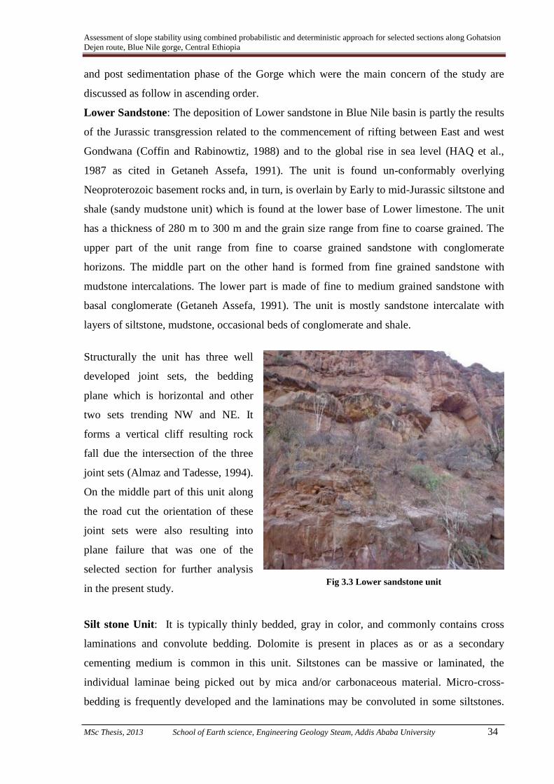
Assessment of slope stability using combined probabilistic and deterministic approach for selected sections along Gohatsion
Dejen route, Blue Nile gorge, Central Ethiopia
MSc Thesis, 2013 School of Earth science, Engineering Geology Steam, Addis Ababa University 34
and post sedimentation phase of the Gorge which were the main concern of the study are
discussed as follow in ascending order.
Lower Sandstone: The deposition of Lower sandstone in Blue Nile basin is partly the results
of the Jurassic transgression related to the commencement of rifting between East and west
Gondwana (Coffin and Rabinowtiz, 1988) and to the global rise in sea level (HAQ et al.,
1987 as cited in Getaneh Assefa, 1991). The unit is found un-conformably overlying
Neoproterozoic basement rocks and, in turn, is overlain by Early to mid-Jurassic siltstone and
shale (sandy mudstone unit) which is found at the lower base of Lower limestone. The unit
has a thickness of 280 m to 300 m and the grain size range from fine to coarse grained. The
upper part of the unit range from fine to coarse grained sandstone with conglomerate
horizons. The middle part on the other hand is formed from fine grained sandstone with
mudstone intercalations. The lower part is made of fine to medium grained sandstone with
basal conglomerate (Getaneh Assefa, 1991). The unit is mostly sandstone intercalate with
layers of siltstone, mudstone, occasional beds of conglomerate and shale.
Structurally the unit has three well
developed joint sets, the bedding
plane which is horizontal and other
two sets trending NW and NE. It
forms a vertical cliff resulting rock
fall due the intersection of the three
joint sets (Almaz and Tadesse, 1994).
On the middle part of this unit along
the road cut the orientation of these
joint sets were also resulting into
plane failure that was one of the
selected section for further analysis
in the present study.
Fig 3.3 Lower sandstone unit
Silt stone Unit: It is typically thinly bedded, gray in color, and commonly contains cross
laminations and convolute bedding. Dolomite is present in places as or as a secondary
cementing medium is common in this unit. Siltstones can be massive or laminated, the
individual laminae being picked out by mica and/or carbonaceous material. Micro-cross-
bedding is frequently developed and the laminations may be convoluted in some siltstones.
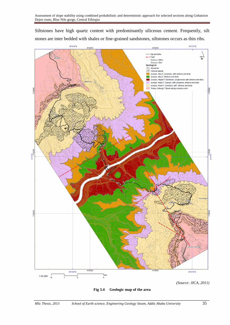
Assessment of slope stability using combined probabilistic and deterministic approach for selected sections along Gohatsion
Dejen route, Blue Nile gorge, Central Ethiopia
MSc Thesis, 2013 School of Earth science, Engineering Geology Steam, Addis Ababa University 35
Siltstones have high quartz content with predominantly siliceous cement. Frequently, silt
stones are inter bedded with shales or fine-grained sandstones, siltstones occurs as thin ribs.
(Source: JICA, 2011)
Fig 3.4 Geologic map of the area

Assessment of slope stability using combined probabilistic and deterministic approach for selected sections along Gohatsion
Dejen route, Blue Nile gorge, Central Ethiopia
MSc Thesis, 2013 School of Earth science, Engineering Geology Steam, Addis Ababa University 36
From strength point of view, grain interlocking is responsible for the principal increase in the
angle of shearing resistance and increased with increasing density (Bell, 2000).
Clay stone Unit: Typically it is variegated, friable to semi indurated facies containing
minerals such as; illite, kaolinite, calcite, dolomite, chert, quartz, chalcedony, and hematite. It
exhibits various types of sedimentary structures such as thin bedding, and thick to thin
laminations. Massive beds are very common. ‘Clay ball’ conglomerates within the clay stone
layers consist of sub rounded to angular fragments of clay stone, 1-2cm in length (Getaneh
Assefa, 1980).
From engineering point of view, the volume of clay soils is reduced as load is applied due to
reduction of void ratio. If such soil is saturated, then load is initially carried by pore water
which causes a pressure, the hydrostatic excess pressure to develop which finally dissipate
and transfer the load to soil structure (Padfield and Sharrock, 1983 as cited in Bell, 2000).
Lower limestone unit: This unit is also called Abay Limestone and categorized into Middle
Jurassicin age (Gani and Abdelsalam, 2006). It has a thickness ranging from 400 m to 450 m
in the type area measured with alternating layers of Limestone and gypsum where limestone
increases upward, bedded limestone at base sometimes bioturbated is available. Thinly
bedded siltstone along with shale is also recognized in this unit. Deposition of the Lower
Limestone indicates deepening of the basin. However, the alternation of gypsum and
limestone in the upper part of the unit indicates repetitive drying and flooding of an
evaporitic basin.
Where it is exposed in the type area, it is underlain by the glauconitic sandy mudstone unit or
the Triassic–Early Jurassic Sandstone and overlain by a Middle–Late Jurassic Upper
Limestone unit. The unit consists of a lower thinly bedded (average 20 cm) limestone interval
and an upper interval of alternating limestone and gypsum beds (Gani and Abdelsalam,
2006). The bedded limestone, grey in color, is sparsely fossiliferous with burrows including
Thalassinoides, Planolites and Ophiomorpha (Gani and Abdelsalam, 2006).
Gypsum unit: This unit having a thickness of ~ 253 m consists mainly of gypsum, shale,
Limestone and dolostone that are locally inter bedded with clay stone, siltstone, and
sandstone. The gypsum is gray, dark gray, bluish gray, and black, occurring either as
independent beds, several meters thick , with lenses of dolostone, shale, and claystone layers.
Both Nodular and lamina structures are common in this bed. The gypsum beds are

Assessment of slope stability using combined probabilistic and deterministic approach for selected sections along Gohatsion
Dejen route, Blue Nile gorge, Central Ethiopia
MSc Thesis, 2013 School of Earth science, Engineering Geology Steam, Addis Ababa University 37
characterized by mottled texture, and are inter-bedded with glauconitic mudstone beds and
rare thin sandstone beds, and thin limestone bed as discussed above (Getaneh Assefa, 1980).
The limestone is gray, yellowish gray or
brownish gray, occasionally containing
skeletal fragments of foraminifers, echinoids
and mollusks, brachiopods and calcareous
algae. The dolostone is gray or dark gray
with a content of dolomite ranging from 54
to 94% and averaging 84% (Getaneh Assefa,
1980).
The shale is greenish gray, yellow, green or
Fig 3.5 Alternating shale, dolomite and
gypsum layer within gypsum unit
dark gray, often calcareous or dolomitic, and contains a few thin laminae and veinlets of
gypsum. Where it is well exposed, especially in the Gohatsion section of the Gorge this unit
is found intercalated with variegated shale of differing thickness between gypsum beds
among other associated rocks. On the top part of this unit fragmented gypsiferous shell with
fingerprint like structure after the soft, shell part has been eroded away, is available. This unit
is experienced a differing degree of weathering which caused its color to change from gray to
dark gray or even black at few places.
Three well developed joint sets were noticed which contribute to slope failure. The inter-
sections of these discontinuity sets (on horizontal bedding and the other two joint sets) made
the unit susceptible to wedge failure as noticed on the main road cut from Gohatsion to
Dejen. Other modes of failures like rock fall and plane failures are also possible.
From instability point of view, gypsum is more readily soluble than limestone. Caverns and
sink holes are therefore more likely to develop rapidly in this rock unit than limestone (Eck
and Redfield, 1965 as cited in Bell, 2000). This means it is also susceptible to weathering
when exposed to differential surface moisture that makes it susceptible to failure through
continuous degradation of its strength which in turn reduces its unconfined compressive
strength mostly in case when it is available with other weak material like shale. In the present
study one slope section was selected from this unit (gypsum unit) which exhibits the above
mentioned typical properties.

Assessment of slope stability using combined probabilistic and deterministic approach for selected sections along Gohatsion
Dejen route, Blue Nile gorge, Central Ethiopia
MSc Thesis, 2013 School of Earth science, Engineering Geology Steam, Addis Ababa University 38
Antalo Limestone unit: This unit is also informally called Upper Limestone. The bottom
part of this unit is characterized by fossiliferous and burrowed mud-stone and oolitic
limestone with corals, stromatoporoids, bivalves, gastropods, echinoids, fora-minifers and
ostracods. Silty limestone with very thin marl layers follow. The upper part is formed by 5 m
thick massive limestone. Total thickness reaches about 180 m. The middle and the upper part
of the Antalo Limestone are characterized by marly limestone, silty limestone and hard
limestone at the top and a planar laminated oolitic and reef limestone, followed by bedded
mud-stones at the base. The maximum thickness of the oolitic unit is 170 m. This hard
limestone unit was formed in shallow water, which is documented by the occurrence of
oolitic bars, coral off shore patches and more protected inshore facies. Boundaries on both
sides of this unit are transitional (Mogessie et al., 2002).
Limestone is perhaps more prone to pre and post depositional changes than any other rock
type. After burial it can be modified to such an extent that their original characteristics are
obscured or even obliterated. The most profound changes in texture and composition are
those which lead to replacement of calcite by dolomite, silica, phosphate etc. Even many
changes may takes place during transformation from soft and porous sediment to dense and
less porous state as a result of disintegration change to soft sediments resulting in low
unconfined compressive strength. Further, limestone is susceptible to solution which
commonly removes shell fragments or even in rare cases ooids are removed. Sink holes may
develop where opened joints intersect and these may lead to an integrated system of sub-
terranean galleries and caverns. Fluctuation of water table with in the caverns increases the
down ward seepage gradient and accelerates downward erosion contributing to instability of
the area and hence affecting the stability of engineering structures (Bell, 2000).
Tertiary Volcanic Rocks: This unit consists of thick basalt with thin layers of pyroclastic
material and it is exposed on both sides of the gorge entrance.The exposed basalt is black
with associated blocky/ massive and columnar structures. The pyroclastic material deposits of
relatively less density is brownish in color with moderate degree of weathering where it is
exposed on the road side that extend from Gohatsion to Dejen. Further, it is characterized by
widely spaced vertical tension crack.
Locally, 1–3 cm thick sub-horizontal layering exists within the basalts which are generally
aphanitic, and locally vesicular, with the vesicles sometimes filled with zeolites, calcite and
quartz to form amygdaloidal texture. In a few places, the upper part of the basalts contains

Assessment of slope stability using combined probabilistic and deterministic approach for selected sections along Gohatsion
Dejen route, Blue Nile gorge, Central Ethiopia
MSc Thesis, 2013 School of Earth science, Engineering Geology Steam, Addis Ababa University 39
~1m thick horizons of dark brown clay topped by a fine - to coarse-grained pyroclastic layer
(Gani, et al., 2008).
The top part of this unit is a mixture of soil
and boulder sized basalt with varying degree
of weathering. The extent and areal coverage
beyond the flank of the Gorge was not
recognized but stream erosion of top soil up
to nearly Gohatsion town revealed as there is
basalt. However, map produced by different
authors (Gani et al, 2006, 2008, Henok
Woldegiorgis, 2008, Shiferaw Ayele, 2009)
indicated as this unit covers the entire
Gohatsion town and even by passes.
Fig 3.6 Pyroclastic deposit on basaltic unit
(Gohatsion side)
(After; Lulseged Ayalew and Yamagishi, H., 2003)
Fig 3.7 A geological cross-section along the north–south section of the Abay River gorge

Assessment of slope stability using combined probabilistic and deterministic approach for selected sections along Gohatsion
Dejen route, Blue Nile gorge, Central Ethiopia
MSc Thesis, 2013 School of Earth science, Engineering Geology Steam, Addis Ababa University 40
3.4 Structures in the Study Area
The pre-sedimentation, sedimentation and post-sedimentation phases of Blue Nile Gorge
were affected by variable geologic discontinuities that might be associated with tectonic
history of the area. Major geologic structures like faults were not mapped and interpreted
from satellite images in the present study. However, joint set discontinuities which control
rock slope stability in the area were measured and clearly identified. Previous studies carried
out in the area gave better understanding of the effects of structures on each unit. As per Gani
et al., (2008), the basement rocks (Neoproterozoic in age) are affected by normal faults with
throws ranging between 5 cm to 5m, the orientation of these faults varies considerably.
However, NNE- and ESE-trending normal faults are more common than NE- and NW-
trending faults. In contrast, fractures within the Neoproterozoic basement rocks are
dominantly NNE and ESE-trending. These fractures are clearly dilational with openings
ranging between 10 cm to 50 cm, sometimes filled with tectonic breccias. Despite the above
stated fault occurrence in the area, no other major fault was recognized during the present
field work.
The basement rock is un-conformably overlain by lower sandstone unit in the study area. The
Lower Sandstone unit is affected by dominant NW-trending normal faults and less dominant
N-trending normal faults, as well as NW- and ENE-trending fractures, which are mostly
dilational. Throws on the normal faults ranges between 50 cm to 8m, and fault zones range in
width between 10 cm to 10 m. In some places, the normal faults are characterized by the
smearing of mud layers and the presence of multiple internal fault surfaces (Gani et al.,
2008). Further, this unit has three discontinuity sets on the road side of studied section having
mean orientations of N310o/34
o, N 245
o /68
o and N 122
o /60
o. Besides, there are subordinate
structures including lateral accretion surfaces, horizontal stratification and ripple cross-
lamination. In some places, silicified tree trunks up to 4m long, mud-cracks and vertebrate
tracks are found within this unit (Gani et al., 2008).
There were no measured discontinuity orientations or recognized fault in Lower Limestone as
during the present study no critical slope section was selected in this unit. However, Gani et
al., (2008), discussed that this unit is cross-cut by NW-trending normal faults, NE- and NW-
trending dilational fractures and less-frequent NE-trending normal faults. Similarly, gypsum
unit is also affected by this type of structure. The fault planes exhibit both planar and listric
geometry with throws ranging between 10 cm to 2m and fault zones ranging in width from 15

Assessment of slope stability using combined probabilistic and deterministic approach for selected sections along Gohatsion
Dejen route, Blue Nile gorge, Central Ethiopia
MSc Thesis, 2013 School of Earth science, Engineering Geology Steam, Addis Ababa University 41
cm to 1m. Tilting roll-over anticlines and complex splay structures are common. In places,
listric faults, which occasionally flatten out to become layer-parallel structures, result in the
tilting of bedding planes to almost vertical.
Further, Gani et al., (2008) discussed that the Upper Limestone is affected by NW- and NE-
trending normal faults, the throws of which generally range between a few cm to 60m, but
with one fault having a 400 m throw. Fault zones range from a few cm to 50m in width.
Fractures within this unit are dilational and dominantly N-trending with subordinate ENE-
and NW-trending sets.
Normal faults in the Early–Late Oligocene basalts are dominantly N- to NE-trending and less
often NW-trending. These faults have throws ranging from a few cm to 50 m, and rarely ~
400m, with fault zones ranging between a few cm to ~50m wide. The dominant fractures are
dilational and are NNE- and E-trending with subordinate NW-trending set (Gani et al., 2008).
*****

Assessment of slope stability using combined probabilistic and deterministic approach for selected sections along Gohatsion
Dejen route, Blue Nile gorge, Central Ethiopia
MSc Thesis, 2013 School of Earth science, Engineering Geology Steam, Addis Ababa University 42
Chapter 4
Methodology
4.1 Basics of Deterministic and Probabilistic Approaches
In geotechnical field, slope stability analysis is very important for the safe functional design
of rock and soil slopes considering different critical parameters of working stability. Since
earlier time, most of the analyses were based on the conventional deterministic methods
which do not consider the effect of uncertainty associated with certain input parameters for
analysis. However, nature is so heterogeneous that unlike fabricated material in which we use
proportional input parameter for the required output, uncertainties are unavoidable both from
input parameter as well as from method of analysis point of view. Such uncertainties may
cause variation in probability of failure of slopes even for those having the same factor of
safety (Banakia et al., 2013).
For evaluating stability of the slopes against failure, there are two types of analyses:
deterministic and probabilistic analyses. Deterministic analyses are traditional approaches
like limit equilibrium methods (LEM) or finite element strength reduction methods (FE
SRM). To check the stability of the slopes in the LEM, a slip surface is assumed. Soil mass
above this slip surface is divided into slices and equilibrium equations are written for all
slices. Factor of safety is calculated by one of the limit equilibrium methods like Spencer
(Spencer, 1967), Bishop’s simplified method of slices (Bishop, 1955), Janbu’s method
(Janbu, 1973 etc. as cited in Banakia et al (2013).
To determine the Factor of Safety
(FOS) by the method of slices, a
circular slip surface with radius R is
assumed. The soil mass above the arc
is divided into a number of vertical
slices of width ‘b’ and varying height
‘h’. The base of each slice is
assumed to be a straight line inclined
at an angle ‘α’ to the horizontal and
with a length ‘l’.
Fig. 4.1 Method of slices

Assessment of slope stability using combined probabilistic and deterministic approach for selected sections along Gohatsion
Dejen route, Blue Nile gorge, Central Ethiopia
MSc Thesis, 2013 School of Earth science, Engineering Geology Steam, Addis Ababa University 43
The slope is divided into slices for analysis purposes only. It is assumed that all slices rotate
around the Centre of the circle ‘O’ as a whole body. This implies that forces must act
between the slices, termed inter slice forces (Abramson et al., 2002).
Probabilistic analyses on the other hand have been applied in slope stability more than any
other geotechnical problem most recently by taking into account uncertainties of input
parameters for analysis. Hence, Probability of failure (Pf) and reliability index (β) which are
outputs of probabilistic analyses are calculated by one of the two procedures: simulation-
based approach (e.g., Monte Carlo simulation; sub-set simulation) or analytical-based
approaches (e.g., first-order second-moment; first-order reliability method). Both analytical
and simulation based approaches require deterministic analysis that evaluate factor of safety.
Therefore, alternative grouping for probabilistic analyses is based on their deterministic part
that can be LEM-based probabilistic analyses or FE SRM-based probabilistic analyses. In the
present study taking in to consideration the various limitations, LEM-based probabilistic
analyses have been carried out for the accomplishments of the research objective.
4.2 General Methodological Procedure
The widely applied principle "the past and present are keys to the future", which implies that
landslides in future will be more likely to occur under those conditions which has led to the
past and present mass movements (Varnes, 1984; Carrara et al., 1991; Carrara et al., 1995).
The same principal is encompassed in the present study.
In the present study input parameters were conditioned based on the availability of data for
selected slope sections. Accordingly, geological, hydrogeological, meteorological and
seismic data was utilized for better characterization of the slopes. For the present study, based
on field manifestation of actual or potential instability, a total of four slopes were selected,
two from failed colluvium section and two from rock slope for, further analysis and study.
For successful completion of the above mentioned objectives the following methods and
procedures were followed;
Previous works related to present study were reviewed to get better understandings of models
used (Individual or comparative deterministic and probabilistic models). Besides, previous
works especially works related to geology and geomorphology of the area were reviewed to
understand the manner in which slopes have performed. Such understanding on geological

Assessment of slope stability using combined probabilistic and deterministic approach for selected sections along Gohatsion
Dejen route, Blue Nile gorge, Central Ethiopia
MSc Thesis, 2013 School of Earth science, Engineering Geology Steam, Addis Ababa University 44
and geomorphic processes and their possible effect on slope stability has helped in generating
reliable results with stability models.
After literature was reviewed a clear understanding on the study area as well as on various
stability methods was developed. Later, field work was conducted to collect all relevant data
pertaining to slope stability studies. Before starting any data collection in the field a
reconnaissance field survey was made to identify the critical slope sections. During this
reconnaissance, efforts were made to observe the manifestations of slope, actual and
potential, instability with particular emphasis to those slopes which fall along the road side.
Thus, a total of four critical slope sections were identified and were selected for further study.
Three of the slopes selected were located towards the Gohatsion side of the gorge and one
towards the Dejen side of the gorge. One of the three slopes located towards the Gohatsion
side of the gorge is composed of colluvium material which comprises mostly igneous rock
fragments of varied dimension in sandy silty soil matrix. The other two slopes are rocky
slopes within gypsum and lower sandstone units, respectively. The slope located towards the
Dejen side of the gorge is characterized by colluvium material. This slide is identified as a
single big slide with progressive secondary failures within the main slide.
During the present study, relevant data pertaining to various aspects related to geology,
geomorphology, hydrogeology, climate etc. from both primary and secondary sources was
collected or procured. From the selected critical rock slopes, structural data was collected for
Kinematic analysis and for later Kinetic analysis. Those rock slopes which satisfied the
kinematic conditions for respective mode of failure further stability analysis was carried out
by SLIDE and Rock PLANE software. For critical colluvium slope sections, general
geometry of the slopes and their relation with surface hydrology was established from field
measurement and from secondary data pertaining to depth to ground water table. Further,
critical failure surface was obtained by the grid search method of SLIDE software. Another,
important data that has a, direct or indirect, bearing on slope stability is data related to
Hydrogeology and Meteorology. The data on these aspects were collected from the secondary
sources. Also, seismic data was directly adopted from published paper and seismic intensity
zone in which the study area falls has been deduced. Accordingly, appropriate seismic
coefficient was deduced for dynamic slope stability analysis.
In the present study, deterministic Factor of safety of critical slopes was computed which is
used to indicate stability condition in quantitative terms based on limit equilibrium analysis.

Assessment of slope stability using combined probabilistic and deterministic approach for selected sections along Gohatsion
Dejen route, Blue Nile gorge, Central Ethiopia
MSc Thesis, 2013 School of Earth science, Engineering Geology Steam, Addis Ababa University 45
For those rock slopes which have satisfied the kinematic condition Factor of safety (FS) was
calculated as a general slope mass and by slicing the slope mass in to block level, separately.
For both rock and colluvium slopes the deterministic input parameters are considered to be
with fixed values which are generally obtained from the standard tables well supported by the
expert judgment. As a matter of fact these kinds of input parameters like; material strength,
joint geometry and pore water pressures in FS calculation are not precisely known. This is
because of uncertainties associated with; material homogeneity, modeling methods or the
personal experience with which these material properties were established and used as input
for analysis. This is the reason why some slopes fail even though their factor of safety is
greater than one (FS>1). Thus, representation of stability condition of a slope only by a single
value does not precisely indicate complete safety condition.
Another approach that is compatible with deterministic approach and uses all its input
parameters and Factor of safety by treating them as random variables to reduce uncertainty
and ensure reliability is Probabilistic approach. Probabilistic computation i.e. probabilistic
analysis provides a facility to utilize a range of each geo-mechanical parameter that indicates
the uncertainties involved in the rock mass (Banakia et al., 2013).
To perform probabilistic analysis, probability distribution for the factor of safety is assumed.
Later, the selected factor of safety is quantified under Monte Carlo Simulation (MCS) by
using a selected deterministic model (limit equilibrium in the present study). This is done by
generating pseudo random numbers of input parameters for a large number of times (10000
for the present study) and changing the geotechnical input parameters over wide range, which
is determined by the statistical parameters (mean, standard deviation, relative minimum and
relative maximum). Pseudo random numbers are a sequence of numbers that look like
random numbers by deterministic calculations. This is a suitable method for a computer to
generate a large number of reproducible random numbers and is used commonly today
(Rubinstein, 1981).
Monte Carlo method is simply a simulation-based method for calculating probability of
failure and reliability index. Regardless of the problem that MCS is used for, first step is
generating random numbers from a Probability Density Functions (PDF) like normal or log
normal PDF. Each of these random numbers is called a realization or a Monte Carlo seed
(Banakia et al., 2013).

Assessment of slope stability using combined probabilistic and deterministic approach for selected sections along Gohatsion
Dejen route, Blue Nile gorge, Central Ethiopia
MSc Thesis, 2013 School of Earth science, Engineering Geology Steam, Addis Ababa University 46
In the present study the shape of probability density function was considered as normal
distribution. To perform analysis by Monte Carlo Simulation under SLIDE software, critical
slip surface was identified through trial and error method. Thus, minimum factor of safety
was obtained through realization of soil strength parameters as their mean value was
determined.
Monte Carlo simulation is performed through step wise process as per Dai et al., 1993 as
follow;
i) Random numbers were generated which were independent random variables uniformly
over the unit interval between 0 and 1.
ii) Random numbers were transformed from a uniform distribution to the distribution
applicable to the component variable.
iii) Calculate values of all component variables based on the appropriate random numbers.
iv) Design variable was computed (i.e. factor of safety) using the generated values of the
component variables.
v) Step (i) to (iv) was repeated a large number of times. The numbers of times these steps
are repeated depend upon the variability of the input and output parameters and the
desired accuracy of the output i.e. the large number of iterations the more accurate the
output will be.
vi) Cumulative distribution was created of the design function using the data obtained from
the above simulations.
As discussed above, from Monte Carlo simulation results of factor of safety, probability of
failure and reliability of failure was calculated under SLIDE probabilistic sets. Reliability
analysis focuses on the most important aspect of performance, namely the probability of
failure (“failure” is a generic term for non-performance). The probability of failure is a more
consistent and complete measure of safety because it is invariant to all mechanically
equivalent definitions of safety and it incorporates additional uncertainty information (Phoon,
2008). The relationship between POF and FOS was established graphically (Fig. 4.2) (Tappia
et al, 2007 as cited in Chiwaye, 2010).
Sensitivity analysis of input parameters was conducted primarily to identify the factor which
contributes the most to slope instability i.e. to deduce that which input parameters may be
critical for the assessment of slope stability, and which input parameters are less important.

Assessment of slope stability using combined probabilistic and deterministic approach for selected sections along Gohatsion
Dejen route, Blue Nile gorge, Central Ethiopia
MSc Thesis, 2013 School of Earth science, Engineering Geology Steam, Addis Ababa University 47
Hence, a Sensitivity Plot was used to determine the value of a parameter which corresponds
to a specified Factor of Safety (e.g. Factor of Safety = 1). For one or more selected input
parameters, the user specifies a Minimum and a Maximum value. Later, each parameter can
be varied in uniform increments, between the Minimum and Maximum values, and the safety
factor of the Global Minimum slip surface is calculated at each value.
(Source: Tappia et al, 2007)
Fig 4.2 Definition of POF and its relationship with FOS according to uncertainty magnitude
While a parameter is being varied, all other input parameters are held constant, at their
MEAN values. This results in a plot of safety factor versus the input parameter(s), and allows
you to determine the “sensitivity” of the safety factor, to changes in the input parameter(s).
A steeply changing curve on a Sensitivity Plot indicates that the safety factor is sensitive to
the value of the parameter. A relatively “flat” curve indicates that the safety factor is not
sensitive to the value of the parameter (SLIDE, 2010).
After sensitivity of safety factor to various input parameters was determined the next step was
to propose remedial measures. It was proposed on the basis of existing slope stability
condition as well as for the anticipated adverse conditions to which the slope will be
subjected. Besides, proper preventive measures have also been suggested to reduce any
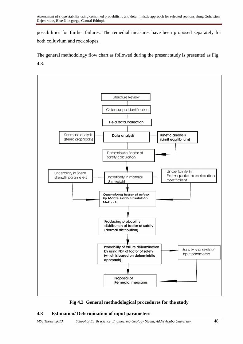
Assessment of slope stability using combined probabilistic and deterministic approach for selected sections along Gohatsion
Dejen route, Blue Nile gorge, Central Ethiopia
MSc Thesis, 2013 School of Earth science, Engineering Geology Steam, Addis Ababa University 48
possibilities for further failures. The remedial measures have been proposed separately for
both colluvium and rock slopes.
The general methodology flow chart as followed during the present study is presented as Fig
4.3.
Fig 4.3 General methodological procedures for the study
4.3 Estimation/ Determination of input parameters

Assessment of slope stability using combined probabilistic and deterministic approach for selected sections along Gohatsion
Dejen route, Blue Nile gorge, Central Ethiopia
MSc Thesis, 2013 School of Earth science, Engineering Geology Steam, Addis Ababa University 49
For rock slopes the rock mass was assumed to behave as a Coulomb material, its shear
strength depends upon cohesion and angle of internal friction. For the present analysis, shear
strength parameters were determined from standard table proposed by Hoek and Bray (1981),
correlated with RMR data collected from the field on rock slope. On the basis of RMR values
the rock mass can be classified in to five classes namely; very good (RMR 100-81), good
(80-61), fair (60-41), poor (40-21) and very poor (<20). Further, for each of rock mass classes
estimated range of cohesion and angle of internal friction are available. The Geometry of
each of the critical slope sections was estimated/ measured either in the field or was deduced
from the topographical maps. Unit weight of rock and colluviums soil mass was directly
adopted from the standard tables. Horizontal acceleration and depth to ground water was
adopted from secondary sources for stability analysis. A detailed description on all these
input parameters used in stability analysis is presented in following Chapter.
*****

Assessment of slope stability using combined probabilistic and deterministic approach for selected sections along Gohatsion
Dejen route, Blue Nile gorge, Central Ethiopia
MSc Thesis, 2013 School of Earth science, Engineering Geology Steam, Addis Ababa University 50
Chapter 5
Results and Discussion
5.1 Data Processing
During the present study in order to assess and characterize the slope stability condition of
selected critical slope sections comparative approach was followed. A reconnaissance field
trip was undertaken to identify the critical slope sections in the study area. For this
preliminary investigations were undertaken and slopes in the area were examined for visible
manifestations of actual or potential instability. Thus, based on the field manifestations four
critical slope sections, two from failed colluvium section and two from rock slopes were
identified for further analysis.
Further, relevant data pertaining to various aspects related to geology, geomorphology,
hydrogeology, climate etc. from both primary and secondary sources was collected or
procured. From selected rock slope sections systematic discontinuity data and data pertaining
to Rock Mass Rating (RMR) was collected. Later, discontinuity data was analyzed to deduce
the preferred orientations and RMR data was analyzed to characterize the rock mass present
on the critical slope sections. To deduce the stability condition the two critical rock slope
sections were subjected to Kinematic Check. Out of two only one critical rock slope section
satisfies the Kinematic Check thus, it was considered for further stability analysis. Further,
the two critical colluviums slope sections, which were already failed, were considered for
further analysis and to define their general stability characterized under existing and
anticipated adverse conditions. Thus, for stability analysis of these critical sections all
required necessary data for stability analysis was either collected in the field or was procured
from the secondary sources. In order to define the geometry and ground water condition
within the critical slopes data related to scarp faces for the big slides, scarp faces with in
failed masses, depth to ground water table, slope dimensions, distance from the scarp face to
toe of the slope and expanse of soil mass between scarp faces were collected. All these data
were later utilized for stability analysis.
For a slope instability assessment of individual slopes basic assumption was followed that
conditions which have led for the slope failure in the past if repeated again may result in
failure in future also. Besides, the conditions which were perhaps not existed in past and may

Assessment of slope stability using combined probabilistic and deterministic approach for selected sections along Gohatsion
Dejen route, Blue Nile gorge, Central Ethiopia
MSc Thesis, 2013 School of Earth science, Engineering Geology Steam, Addis Ababa University 51
have possible potential triggering effect for anticipated conditions in future were also
considered in the stability analysis.
For analysis purpose another assumption which was made is that the in-situ tests/
observations which were considered has perhaps provided reliable, economic and feasibility
material properties for realistic stability analysis.
Eventually the slope materials are described as such;
Basalt: The slope forming basalt in the study area is characterized by highly fractured,
angular to sub angular blocks of cobble to boulder size and columnar jointed on its cliff
portion covering most of the slope of the upper most part of Gohatsion side section. It is also
associated with fine to course grained sandy silt soil. Water permeability of the layer is controlled
by the columnar joints and wide open fractures and it is high.
Colluvium: It is characterized by a mixture of angular to sub-angular basalt, limestone and
gypsum rock bocks of cobbles/boulders (5-600 cm), gravel and sandy silt soil matrixes which
have come from the mountainous side cliff. The deposit overlies on the surface with 0-5 m
thickness, and partly intercalated with around 20 m thickness under the artificial
embankment. Water permeability of the deposit is considered to be very high (JICA, 2011).
Silt and shale: The units are mainly composed of siltstone and shale with minor limestone.
The siltstone unit is composed of silt/clay particles cemented together. It is found intercalated
with shale, mudstone and sandstone with calcite and/or gypsum veins in places. The color is
white brown to reddish brown which have been weathered and yellowish green to brownish
grey which are relatively fresh. The shale unit is argillaceous clastic sedimentary rock which
contains a lot of clay minerals. A part of the shale is totally changed to clay by weathering,
which is relatively soft and weak due to weathering.
Sandstone: It is horizontally bedded, moderately weathered and discontinuity sets orientation
defines its mode of failure and control its stability. Further, minor block failures and potential
instability was also noticed on the Lower sandstone unit. The sandstone is basically
composed of quartz grain, but sometimes contains reddish fragments, including pinkish or
slightly reddish color. Water permeability of the layer is considered to be relatively low.
Pyroclastic deposit: The unit is sandy tuff to tuffaceous sandstone with lenticular clayey
mud layers. On the bottom side of the road particularly on embankment sides layers of
unconsolidated ash deposit was observed. It is very soft and brittle, and is susceptible to

Assessment of slope stability using combined probabilistic and deterministic approach for selected sections along Gohatsion
Dejen route, Blue Nile gorge, Central Ethiopia
MSc Thesis, 2013 School of Earth science, Engineering Geology Steam, Addis Ababa University 52
weathering and erosion, resulting in a flat plane on top of the basalt. The color is mainly
white to grey which is relatively fresh area and grey to black brown which is highly
weathered.
5.2 Critical Failure Surface Determination
Both factor of safety and probability of failure determination in SLIDE software need a
critical slip surface to be determined from each combination of slope parameters. This critical
slip surface is a sliding surface with a minimum safety factor of material defined in Limit
equilibrium analysis and has circular geometry owing to the nature of material under
consideration. In their simplest form, limit equilibrium techniques examine static stability,
where a simple balance of disturbing and resisting forces is used. For example; this is to
search for the most likely depth of failure (i.e. most critical slip surface). In order to locate the
critical slip surfaces, a slip center search grid of 20 x 20 intervals was used for a safety factor
analysis of colluvium slopes from global minimum on SLIDE software. However,
ROCPLANE was used to directly calculate safety factors from failure mass dimensions. The
main focus in this analysis was along the road section. In general, such slip surface
emphasized along the road side was determined and for the entire slide mass the slip surface
was determined through query.
5.3 Detailed Slope Stability Analysis of Critical Colluvium Slopes by Combined
Deterministic and Probabilistic Approaches
5.3.1 Deterministic Stability analysis of SL 1 Under static dry condition
Slope location 1 (SL 1) is located within basaltic section and it appears just at the entrance of
the gorge from Gohatsion side. This critical slope is situated at the base of the basaltic cliff.
This slope section in general can be characterized by boulder sized colluvium material of
basaltic source material intercalated with thin layer of pyroclastic deposit and a matrix of
clay/ silt soil of low cohesion. Even at small scale the slope has complex geometry with
alternate bulging and sinking morphology characterized by small to widely (5cm to 25cm)
opened ground ruptures aligned nearly horizontal with respect to the top flat surface above
the basaltic cliff. As observed during the field trip this slope showed clear manifestations of
actual failure as evidenced from disposition of Gabion protection works provided along the
road side. Besides, displacement was also observed on the Extensometer installed along this
slope section. To obtain information about the slope performance, the length of the slope

Assessment of slope stability using combined probabilistic and deterministic approach for selected sections along Gohatsion
Dejen route, Blue Nile gorge, Central Ethiopia
MSc Thesis, 2013 School of Earth science, Engineering Geology Steam, Addis Ababa University 53
geometry was measured by GPS tracking system while minor surface irregularities were
neglecting. Further, slope inclination was assessed/ estimated along road side for stability
analysis purpose. Moreover, the sub-surface material condition was obtained from borehole
log prepared to determine depth of ground water table (JICA, 2011). From this bore hole log
slope cross section was prepared as presented in Fig 5.1. The prepared section was later
utilized for stability analysis carried out by deterministic and probabilistic methods.
The input parameters and values shown in Table 5.1 was used in the stability analysis carried
out for static dry, static saturated, dynamic dry and dynamic saturated conditions. Further in
probabilistic analysis with inclusion of their uncertainties the values were used in the form of
statistical parameters such as; mean standard deviation, relative minimum and relative
maximum. Because of the nature of the colluvium material present in this slope section (SL1)
sampling and laboratory analysis was not feasible therefore with careful observation and field
correlation all input parameters were adopted directly from standard table proposed by Hoek
and Bray (1981). To simulate the possible conditions under which the slope has possible
failed in past the analysis was carried out under different anticipated conditions as listed
above. The stability analysis was initiated with computation of deterministic safety factor the
same was later used as an input parameter in the probabilistic stability analysis.
Table 5.1 Input values and deterministic Factor of safety results of SL (1) at static dry condition
Material
type
C
(kN/m2)
Ø
(deg.)
γ
(kN/m3)
SLIDE Factor of safety results
Janbu
Simplified
Bishop Janbu
corrected
GLE Spencer
Colluvium 0 34 17 w
0.99
1.013
1.04
1.01
1.025 Basalt 300 40 27
Pyroclastic 0 32 10
A Perusal of results reveal that the deterministic factor of safety of the slope near road section
without earthquake loading (static analysis) and in dry state (ground water table was assumed
at its lowest level) comes out to be 1.013 (Stable condition) and for the entire section it is
1.114 (Stable condition) as shown in the Fig. 5.2. The safety factor results displayed in Fig.
5.2 were calculated from ‘Bishop Simplified’ method. Further, factor of safety results as
calculated by Janbu Simplified, Janbu Corrected, GLE and Spenser are presented in Table
5.1. Moreover, the critical slip surface depth as determine from this grid search was 16 m
below the road section for safety factor 1.013 and 64m for safety factor value of 1.114,
respectively.

Assessment of slope stability using combined probabilistic and deterministic approach for selected sections along Gohatsion
Dejen route, Blue Nile gorge, Central Ethiopia
MSc Thesis, 2013 School of Earth science, Engineering Geology Steam, Addis Ababa University 54
Fig 5.1a Cross section of SL1 slope section
Fig 5.1b Geometry and extent of slope with surface manifestations
of instability and borehole locations
Fig 5.1 Geometry of the slope section (SL1)
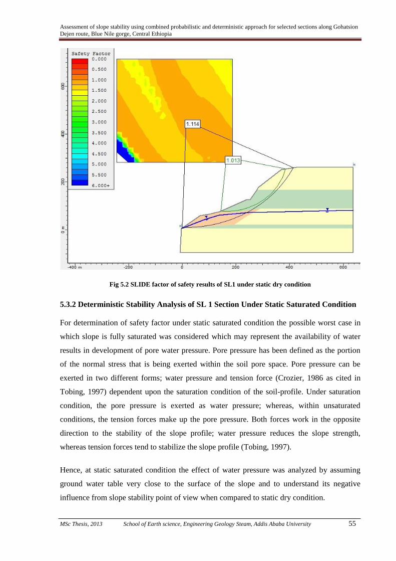
Assessment of slope stability using combined probabilistic and deterministic approach for selected sections along Gohatsion
Dejen route, Blue Nile gorge, Central Ethiopia
MSc Thesis, 2013 School of Earth science, Engineering Geology Steam, Addis Ababa University 55
Fig 5.2 SLIDE factor of safety results of SL1 under static dry condition
5.3.2 Deterministic Stability Analysis of SL 1 Section Under Static Saturated Condition
For determination of safety factor under static saturated condition the possible worst case in
which slope is fully saturated was considered which may represent the availability of water
results in development of pore water pressure. Pore pressure has been defined as the portion
of the normal stress that is being exerted within the soil pore space. Pore pressure can be
exerted in two different forms; water pressure and tension force (Crozier, 1986 as cited in
Tobing, 1997) dependent upon the saturation condition of the soil-profile. Under saturation
condition, the pore pressure is exerted as water pressure; whereas, within unsaturated
conditions, the tension forces make up the pore pressure. Both forces work in the opposite
direction to the stability of the slope profile; water pressure reduces the slope strength,
whereas tension forces tend to stabilize the slope profile (Tobing, 1997).
Hence, at static saturated condition the effect of water pressure was analyzed by assuming
ground water table very close to the surface of the slope and to understand its negative
influence from slope stability point of view when compared to static dry condition.

Assessment of slope stability using combined probabilistic and deterministic approach for selected sections along Gohatsion
Dejen route, Blue Nile gorge, Central Ethiopia
MSc Thesis, 2013 School of Earth science, Engineering Geology Steam, Addis Ababa University 56
Fig 5.3 SLIDE safety fac
tor results of SL 1 slope section under static saturated condition
The deterministic safety factor results for SL1 slope section under static saturated condition
for road section comes out to be 0.310 and for entire slope section it is 0.609. Thus, both the
sections under static saturated conditions represent unstable conditions as Safety factor in
both the cases is less than one.
5.3.3 Deterministic Stability Analysis of SL 1 Section Under Dynamic Dry Condition
With respect to geographical location of the study area it is very essential to consider the
effect of earth quake on slope stability for anticipated adverse condition. When an earthquake
occur the inertial forces from the slope’s own weight serves as additional driving /resisting
forces. Moreover, the strength parameters and the soil shear modulus are affected in addition
to the generation of excess pore water pressure in certain types of soils (in permeable soils
including colluvium); hence the response of a soil mass is totally different from the static
response (Hunt, 2005).
The rigorous SLIDE stability software facilitates to include the dynamic parameter and the
analysis can address the experience of slope under dynamic dry condition. Such dynamic
condition can be defined as when the slope is dry (the ground water table is at its lowest
level) and the slope is subjected to dynamic loading. The area fall within 7 MM intensity

Assessment of slope stability using combined probabilistic and deterministic approach for selected sections along Gohatsion
Dejen route, Blue Nile gorge, Central Ethiopia
MSc Thesis, 2013 School of Earth science, Engineering Geology Steam, Addis Ababa University 57
scale as per Seismic risk map of Ethiopia for 100 year return period as proposed by Laike
Mariam Asfaw (1986). Further, the horizontal seismic coefficient used for analysis was 0.08g
as determined from the MM intensity graph proposed by Johnson et al., 1988.
Fig. 5.4 SLIDE safety factor results of SL 1 Section under dynamic dry condition
The deterministic safety factor results for SL1 slope section under dynamic dry condition for
road section comes out to be 0.989 and for entire slope section it is 1.192. Thus, the stability
condition for road section under dynamic dry condition is unstable whereas, for entire section
it is stable. Here, it is worth mentioning that factor of safety for natural slopes is considered
safe when it is more than 1.0 however, for engineering applications such as; slopes along the
road cuts the design safe factor of safety is taken as greater than 1.5 (Hoek and Bray, 1981).
5.3.4 Deterministic Stability Analysis of SL 1 Section Under Dynamic Saturated
Condition
As already discussed the slope material of SL1 slope section is mainly comprises of
pyroclastic, fragmented basalt bounders, colluvium and gravel to clay sized soil mixtures.
When saturated, fine, especially loose sand is subjected to vibratory motions, such as those
caused by an earthquake, the sand can liquefy, losing almost all its shear strength and
possibly flowing like a dense fluid. Structures supported on such liquefying soil (like gabion

Assessment of slope stability using combined probabilistic and deterministic approach for selected sections along Gohatsion
Dejen route, Blue Nile gorge, Central Ethiopia
MSc Thesis, 2013 School of Earth science, Engineering Geology Steam, Addis Ababa University 58
mesh or protective walls on the road side) may fail catastrophically causing serious damage
(Richter, 1958).
Fig 5.5 SLIDE safety factor results of SL 1 Section under dynamic saturated condition
The deterministic safety factor results for SL1 slope section under dynamic saturated
condition for road section comes out to be 0.255 and for entire slope section it is 0.502. Thus,
both the sections under dynamic saturated conditions represent unstable conditions as Safety
factor in both the cases is less than one.
5.3.5 Probabilistic Stability analysis of SL1 Section under static dry condition
Probabilities and probabilistic methods are useful because of our ignorance of the true future
frequency of events or values of different parameters, such as shear strength (Lee and Jones,
2004). Hence, input parameter used in deterministic analysis (cohesion, fiction angle and unit
weights) was treated as random variables using normal (Gaussian) probability distribution.
The input parameters can have infinite numbers of possible outcomes rather than
deterministic which is binomial case where there are only two possible outcomes - failure or
no failure. For the present analysis, the random values were generated by Monte Carlo
method through repeated trials involving the random sampling of input parameters from an
input probability distribution (normal distribution). Each analysis is essentially deterministic,

Assessment of slope stability using combined probabilistic and deterministic approach for selected sections along Gohatsion
Dejen route, Blue Nile gorge, Central Ethiopia
MSc Thesis, 2013 School of Earth science, Engineering Geology Steam, Addis Ababa University 59
but repeated simulation allows a probability distribution to be produced for the results (i.e. an
output distribution).
Fig 5.6 (a) SLIDE safety factor and probability of failure results
of SL 1 section under static dry condition
For the present case (SL1 slope section under static dry condition) stability analysis was used
to generate estimates of the probability of slope failure that is the probability that the Factor
of Safety will be less than 1, based on many simulations using variable parameter values
(cohesion, friction angle and material unit weight).
The probability result (Fig5.6 (a)) indicates probability of failure of the slope is 37.55%
which is an indication of the beginning of failure. Further, reliability index of the slope were
0.34 and 0.32 for normal and log normal distributions, respectively. The reliability index
provides a more meaningful measure of stability than the factor of safety F.
Geotechnical engineers have long recognized that F has little physical meaning and that the
choice of a satisfactory value is fraught with difficulty.

Assessment of slope stability using combined probabilistic and deterministic approach for selected sections along Gohatsion
Dejen route, Blue Nile gorge, Central Ethiopia
MSc Thesis, 2013 School of Earth science, Engineering Geology Steam, Addis Ababa University 60
In contrast, the reliability index describes safety by the number of standard deviations (i.e. the
amount of uncertainty in the calculated value of F) separating the best estimate of F from its
defined failure value of 1.0. It is a more explicit approach (Baecher and Christian, 2003).
Fig 5.6 b) Probability distributions of safety factor results of SL 1 Section under static dry condition
5.3.6 Probabilistic Stability Analysis of SL1 Section Under Static Saturated Condition
The analysis of slope Section SL1 under static saturated condition assumed that the slope is
nearly fully saturated. Further, all the input parameters and calculation procedures were
followed in the similar manner as that was adopted for analysis under probabilistic static dry
condition with the exception of adding saturated unit weight of material for the said case.
The analysis result for slope section SL 1 under static saturated condition, probable
anticipated worst case, provided a probability of failure of 100% and minimum reliability
indexes of -16.289 under normal distribution and -8.651 under log normal distributions.
Further, the probability distribution of safety factor given in Fig. 5.7 (b) show the mean factor
of safety of slope under consideration is 0.308 among a range of safety factor values the slope
have.
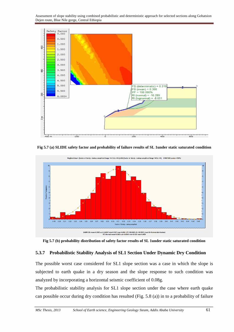
Assessment of slope stability using combined probabilistic and deterministic approach for selected sections along Gohatsion
Dejen route, Blue Nile gorge, Central Ethiopia
MSc Thesis, 2013 School of Earth science, Engineering Geology Steam, Addis Ababa University 61
Fig 5.7 (a) SLIDE safety factor and probability of failure results of SL 1under static saturated condition
Fig 5.7 (b) probability distribution of safety factor results of SL 1under static saturated condition
5.3.7 Probabilistic Stability Analysis of SL1 Section Under Dynamic Dry Condition
The possible worst case considered for SL1 slope section was a case in which the slope is
subjected to earth quake in a dry season and the slope response to such condition was
analyzed by incorporating a horizontal seismic coefficient of 0.08g.
The probabilistic stability analysis for SL1 slope section under the case where earth quake
can possible occur during dry condition has resulted (Fig. 5.8 (a)) in to a probability of failure
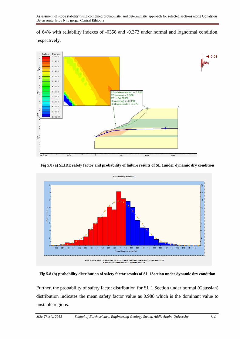
Assessment of slope stability using combined probabilistic and deterministic approach for selected sections along Gohatsion
Dejen route, Blue Nile gorge, Central Ethiopia
MSc Thesis, 2013 School of Earth science, Engineering Geology Steam, Addis Ababa University 62
of 64% with reliability indexes of -0358 and -0.373 under normal and lognormal condition,
respectively.
Fig 5.8 (a) SLIDE safety factor and probability of failure results of SL 1under dynamic dry condition
Fig 5.8 (b) probability distribution of safety factor results of SL 1Section under dynamic dry condition
Further, the probability of safety factor distribution for SL 1 Section under normal (Gaussian)
distribution indicates the mean safety factor value as 0.988 which is the dominant value to
unstable regions.

Assessment of slope stability using combined probabilistic and deterministic approach for selected sections along Gohatsion
Dejen route, Blue Nile gorge, Central Ethiopia
MSc Thesis, 2013 School of Earth science, Engineering Geology Steam, Addis Ababa University 63
5.3.8 Probabilistic Stability Analysis of SL1 Section under Dynamic Saturated
Condition
The most anticipated worst case for any slope is a condition when it is fully saturated and
subjected to an earth quake. The same condition was considered for SL 1 section and
Probabilistic stability analysis was performed.
Fig 5.9 (a) SLIDE safety factor and probability of failure results
of SL 1under dynamic saturated condition
The probabilistic stability analysis for SL1 slope section under the case where earth quake
can possible occur during fully saturated condition has resulted (Fig. 5.9 (a)) in to a
probability of failure of 100% with reliability indexes of -20.266 and -9.588 under normal
and lognormal condition, respectively.
Further, the probability distribution of safety factors (Fig. 5.9 (b)) indicates that the slope is
completely in a safety factor range of less than zero with a mean value of 0.254.

Assessment of slope stability using combined probabilistic and deterministic approach for selected sections along Gohatsion
Dejen route, Blue Nile gorge, Central Ethiopia
MSc Thesis, 2013 School of Earth science, Engineering Geology Steam, Addis Ababa University 64
Fig 5.9 (b) Probability distribution of safety factor results of SL 1under dynamic saturated condition
5.3.9 Deterministic Stability Analysis of SL 4 (1) Slope Section Under Static Dry
Condition
This particular slope section (SL 4 (1)) is located on the upper most part of Dejen side of the
gorge where slow but frequent sliding is taking place over past few years. During the present
study, for detailed analysis the big slide mass was divided in to two traverses with particular
emphasis to the road and upper scarp face. From these traverses prepared on satellite image
as shown in Fig 5.10 slope geometry was deduced. Further, with the secondary data on
borehole log as well as depth to ground water table, slope cross section was prepared.
The slope mass is characterized by thick colluvium cover with boulder to clay sized rock
material of gypsum, limestone, silt and clay origin. For safety factor computation and slope
analysis of this failure mass the input values were directly adopted from tables proposed
Hoek and Bray (1981) by careful conditioning to site specific material characteristics. During
field visit observations, secondary data review and the Google earth image interpretation it
was observed/ deduced that the failure mass is surrounded by two side streams and the
ground water table is at shallow depth which passes through colluvium deposit. Fig.5.10
shows the slope geometry, manifestations of slope instability and location of bore holes.

Assessment of slope stability using combined probabilistic and deterministic approach for selected sections along Gohatsion
Dejen route, Blue Nile gorge, Central Ethiopia
MSc Thesis, 2013 School of Earth science, Engineering Geology Steam, Addis Ababa University 65
For computation, in both approaches critical failure surface using Grid search method of
SLIDE software was used in similar manner as discussed earlier in this chapter. However, as
the main concern of this study was to assess the slope condition with respect to effect on the
road, the window of search in software was placed on the road to determine the slip surface.
Accordingly, slip surfaces were produced considering the road. Possible failure surfaces are
also shown in Fig. 5.11.
( Source: JICA, 2011)
Fig 5.10 Satellite image showing entire failure mass of Slope Section SL4 (1),
scarp faces and borehole location
The input data used for critical slope Section SL 4 (1) under static dry condition and output
results for deterministic analysis by different methods is presented in Table 5.2.
Table: 5.2 Deterministic input values and static dry safety factor results of Travers 1 (SL4, 1)
Material
type
C
(kN/m2)
Ø
(deg.) γ (kN/m
3)
SLIDE Factor of safety results of failure mass
emphasizing road.
Janbu Bishop Janbu
corrected GLE
Spence
r
Colluvium 0 34 17 1.532 1.604 1.605 1.599 1.600

Assessment of slope stability using combined probabilistic and deterministic approach for selected sections along Gohatsion
Dejen route, Blue Nile gorge, Central Ethiopia
MSc Thesis, 2013 School of Earth science, Engineering Geology Steam, Addis Ababa University 66
Silt and clay
soil 11 17 16
Fig 5.11 SLIDE Safety factor value under static dry by Bishop simplified and possible slips surfaces
Based on the geomorphology of the sliding mass and scarp faces of moving blocks possible
slip surfaces of the failure mass was produced which are shown in Fig 5.11. The perusal of
stability analysis results indicates that the assumed slip failure masses above the main moving
mass have safety factors less than it except the main scarp face which is at its verge of failure
with safety factor of 1.09. Under static dry condition the lowest safety factor in which the
water table was assumed at its lowest point is 1.6. As the Scarp face is the point where the
failure initiates, it is very important to calculate its safety from stability point of view. The
results of this analysis exactly supported what has been noticed in the field that the slope was
at the verge of failure. Further, this result dictates the necessity of analysis at saturated and
even at dynamic condition to understand the general stability state under anticipated adverse
conditions.
5.3.10 Deterministic Stability of SL 4(1) Section Under Static Saturated Condition

Assessment of slope stability using combined probabilistic and deterministic approach for selected sections along Gohatsion
Dejen route, Blue Nile gorge, Central Ethiopia
MSc Thesis, 2013 School of Earth science, Engineering Geology Steam, Addis Ababa University 67
Although the area is located in high seismic intensity zone as discussed previously there was
no slope failure that happened due to earth quake in the area. Thus, the most probable
anticipated worst case for landslide behavior would be under full saturated condition.
The typical slope section for anticipated worst condition with possible slip surface and
calculated safety factor is shown in Fig. 5.12.
Fig 5.12 SLIDE Safety factor value for SL 4(1) Section under static saturated condition
The stability analysis results of SL 4(1) Section under static saturated condition indicate
much difference in stability condition under saturated and dry state. The lowest possible
safety factor of failure mass is 0.7 which occur at the bottom of the big scarp face and the
entire section demonstrates safety factor of 0.83. Under anticipated worst static saturated
conditions Slope Section SL (1) would be unstable. The same fact has been reported in
previous studies as the progressive failure in this slope section has been observed during
rainy seasons over the past years. During rainy season it is most likely that the slope would be
fully saturated due to infiltration of rain water and general rise in groundwater table due to
recharge. Thus, the results during the present study very well validates to the actual slope
condition under worst condition.

Assessment of slope stability using combined probabilistic and deterministic approach for selected sections along Gohatsion
Dejen route, Blue Nile gorge, Central Ethiopia
MSc Thesis, 2013 School of Earth science, Engineering Geology Steam, Addis Ababa University 68
5.3.11 Deterministic Stability of SL 4 (1) Section Under Dynamic Dry Condition
As already discussed the study area fall within 7MM earth quake seismic zone and is located
at the margin of Ethiopian rift system which is seismically active therefore, significant
earthquake hazard exists in the area. Further, none of the landslide and associated slope
instability problems has been reported in the area which possibly triggered due to seismic
activities. However, possibility of future seismic activities in the area is most likely.
Therefore, it is mandatory to incorporate possible seismic factor to represent anticipated
worst conditions while performing stability analysis. Therefore, possible horizontal
earthquake acceleration was considered during stability analysis. Thus, the slope stability
analysis was made for anticipated condition represented by dynamic dry condition. It was
intended to examine the slope condition under the seismic loading when there is no effect of
water saturation over the slope.
The slope section representing the geometry of SL 4 (1) slope section under dynamic dry
condition and possible slip surface considered for this analysis are shown in Fig. 5.13.
The input parameters used for analysis of stability condition of SL 4 (1) slope section under
static dynamic condition were similar to what were taken for static dry condition except that
seismic coefficient of 0.08g was considered.
The stability analysis by deterministic approach using SLIDE indicates that safety factor of
1.144 for dynamic dry condition (Fig. 5.13). Thus, from natural slope stability point of view
the slope is stable under dynamic dry condition as the safety factor is more than 1.0.
However, from engineering design application point of view the slope can be considered as
unstable as the safety factor is less than 1.5.
5.3.12 Probabilistic analysis of SL 4 (1) Slope Section Under Static Dry Condition
Due to heterogeneity and material under consideration as well as the level of confidence in
in-situ test for material parameterization, the unit number that determines the safety or failure
of slope is not enough for engineering decision for slope design by itself. Therefore, for this
slope section (SL 4 (1) random values of input parameters has been generated in SLIDE
software for probabilistic analysis i.e. for probability of failure and reliability of slope
determination. Stability analysis was made for static condition and without taking any effect
of water saturation (dry condition).
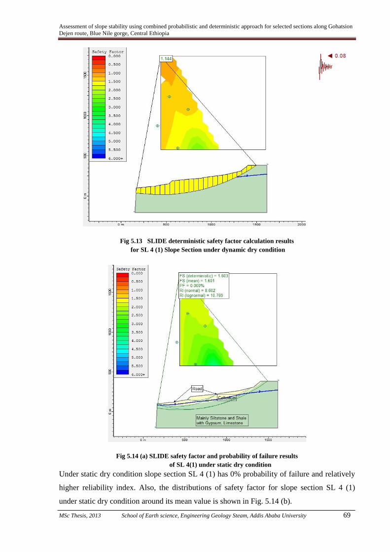
Assessment of slope stability using combined probabilistic and deterministic approach for selected sections along Gohatsion
Dejen route, Blue Nile gorge, Central Ethiopia
MSc Thesis, 2013 School of Earth science, Engineering Geology Steam, Addis Ababa University 69
Fig 5.13 SLIDE deterministic safety factor calculation results
for SL 4 (1) Slope Section under dynamic dry condition
Fig 5.14 (a) SLIDE safety factor and probability of failure results
of SL 4(1) under static dry condition
Under static dry condition slope section SL 4 (1) has 0% probability of failure and relatively
higher reliability index. Also, the distributions of safety factor for slope section SL 4 (1)
under static dry condition around its mean value is shown in Fig. 5.14 (b).

Assessment of slope stability using combined probabilistic and deterministic approach for selected sections along Gohatsion
Dejen route, Blue Nile gorge, Central Ethiopia
MSc Thesis, 2013 School of Earth science, Engineering Geology Steam, Addis Ababa University 70
Fig. 5.14 (b) SLIDE Probability distributions of SL 4(1) slope section
factor of safety under static dry condition
5.3.13 Probabilistic stability analysis of SL 4(1) Under Static Saturated Condition
The analysis of slope Section SL 4(1) under static saturated condition was carried out by
assuming that the slope is nearly fully saturated.
Further, all the input parameters and calculation procedures were followed in the similar
manner as that was adopted for analysis under probabilistic static dry condition with the
exception of adding saturated unit weight of material for the said case.
Also, the ground water table was assumed to be at or near the top surface of the slope.
The analysis results for slope section SL 4 (1) under static saturated condition, probable
anticipated worst case, provided a probability of failure of 100% and minimum reliability
indexes of -6.079 under normal distribution and -5.179 under log normal distributions
(Fig.5.15 (a)).
Further, the probability distribution of safety factor given in Fig. 5.15 (b) show the mean
factor of safety of slope under consideration is 0.763 among a range of safety factor values
the slope have.

Assessment of slope stability using combined probabilistic and deterministic approach for selected sections along Gohatsion
Dejen route, Blue Nile gorge, Central Ethiopia
MSc Thesis, 2013 School of Earth science, Engineering Geology Steam, Addis Ababa University 71
Fig 5.15 (a) SLIDE safety factor and probability of failure results of
SL 4(1) slope section under static saturated condition
Fig 5.15 (b) SLIDE probability distributions of SL 4(1)
slope section factor of safety under static saturated condition
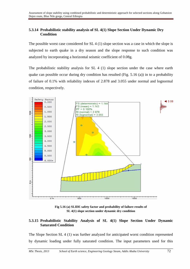
Assessment of slope stability using combined probabilistic and deterministic approach for selected sections along Gohatsion
Dejen route, Blue Nile gorge, Central Ethiopia
MSc Thesis, 2013 School of Earth science, Engineering Geology Steam, Addis Ababa University 72
5.3.14 Probabilistic stability analysis of SL 4(1) Slope Section Under Dynamic Dry
Condition
The possible worst case considered for SL 4 (1) slope section was a case in which the slope is
subjected to earth quake in a dry season and the slope response to such condition was
analyzed by incorporating a horizontal seismic coefficient of 0.08g.
The probabilistic stability analysis for SL 4 (1) slope section under the case where earth
quake can possible occur during dry condition has resulted (Fig. 5.16 (a)) in to a probability
of failure of 0.1% with reliability indexes of 2.878 and 3.055 under normal and lognormal
condition, respectively.
Fig 5.16 (a) SLIDE safety factor and probability of failure results of
SL 4(1) slope section under dynamic dry condition
5.3.15 Probabilistic Stability Analysis of SL 4(1) Slope Section Under Dynamic
Saturated Condition
The Slope Section SL 4 (1) was further analyzed for anticipated worst condition represented
by dynamic loading under fully saturated condition. The input parameters used for this
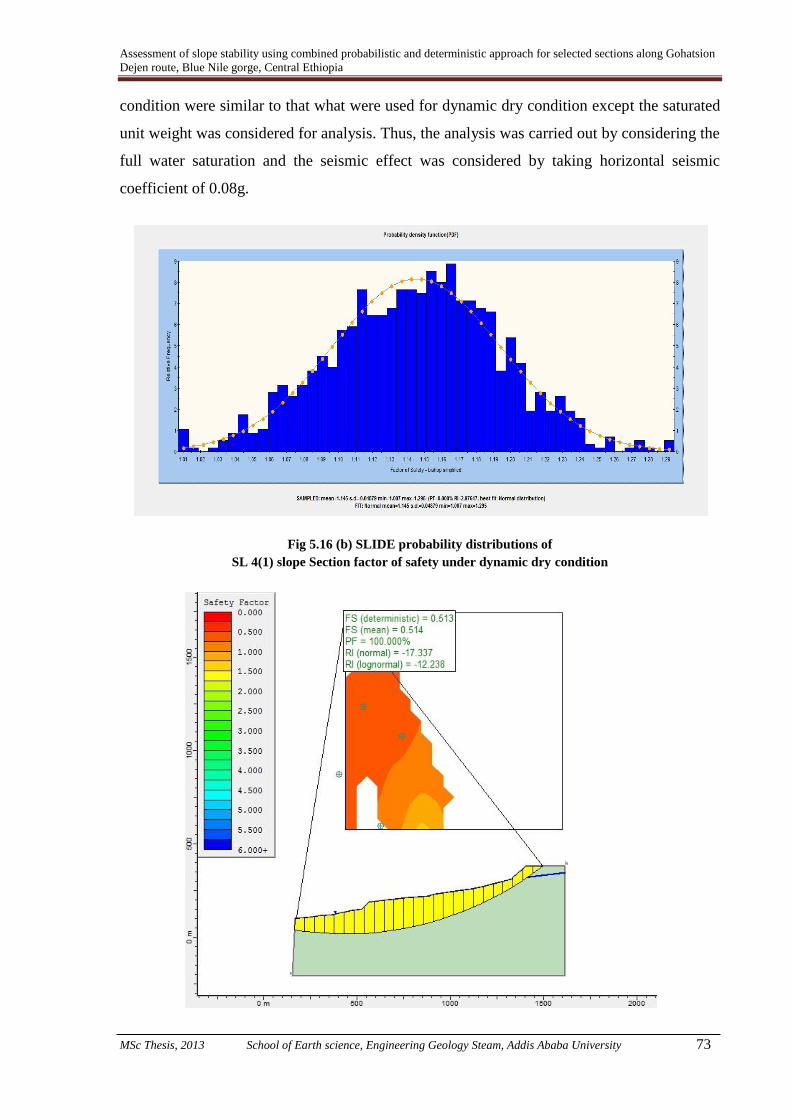
Assessment of slope stability using combined probabilistic and deterministic approach for selected sections along Gohatsion
Dejen route, Blue Nile gorge, Central Ethiopia
MSc Thesis, 2013 School of Earth science, Engineering Geology Steam, Addis Ababa University 73
condition were similar to that what were used for dynamic dry condition except the saturated
unit weight was considered for analysis. Thus, the analysis was carried out by considering the
full water saturation and the seismic effect was considered by taking horizontal seismic
coefficient of 0.08g.
Fig 5.16 (b) SLIDE probability distributions of
SL 4(1) slope Section factor of safety under dynamic dry condition

Assessment of slope stability using combined probabilistic and deterministic approach for selected sections along Gohatsion
Dejen route, Blue Nile gorge, Central Ethiopia
MSc Thesis, 2013 School of Earth science, Engineering Geology Steam, Addis Ababa University 74
Fig 5.17 (a) SLIDE safety factor and probability of failure results of
SL 4(1) Slope section under dynamic saturated condition
The stability analysis results for Slope Section SL 4 (1) indicates the probability of failure of
the slope to be 100% under dynamic saturated condition. It also possesses the minimum
reliability indexes of -17.337 and -12.238 under normal and log normal distribution,
respectively.
Fig 5.17 (b) SLIDE probability distributions of Slope Section SL 4(1)
factor of safety under dynamic saturated condition
5.3.16 Deterministic Stability Analysis of Slope Section SL 4(2) Under Static Dry
Condition
One of the two traverses selected for the Dejen side Colluvium side is SL 4 (2) as already
shown in Fig 5.10. The instability manifestation as observed on the slope extends from the
big scarp on the right side of damaged road on the way down to the gorge up to where the
assumed moving side mass block ends.
Even under static dry condition the stability condition of slope has nearly shown complete
instability which reduces the further necessity of conducting further analysis for the
remaining possible worst conditions. It is obvious that if the slope is unstable under static dry
condition than with water saturation and dynamic loading its stability will further be reduced.
The geometry of slope and possible slip surfaces and calculated safety factors under static dry
conditions are shown over slope section presented in Fig. 5.18.

Assessment of slope stability using combined probabilistic and deterministic approach for selected sections along Gohatsion
Dejen route, Blue Nile gorge, Central Ethiopia
MSc Thesis, 2013 School of Earth science, Engineering Geology Steam, Addis Ababa University 75
Different failure surfaces were assumed for the stability analysis. The minimum safety factor
for SL 4 (2) slope section under static dry condition comes out to be 0.709 which clearly
indicates that the slope is unstable.
Fi g 5.18 Deterministic factor of safety for SL 4 (2) slope section for possible slip surfaces.
5.3.17 Probabilistic Stability Analysis of SL 4(2) Slope Section Under Static Dry
Condition
For SL 4 (2) slope section random values of input parameters were generated in SLIDE
software for probabilistic analysis i.e. for probability of failure and reliability of slope
determination. Stability analysis was made for static condition and without taking any effect
of water saturation (dry condition).
The slope section showing the geometry of slope SL 4 (2) and probabilistic stability analysis
results are shown in Fig. 5.19 (a).
The stability analysis revealed that the probability of failure of the slope section SL 4 (2) is
99.490% with relatively smaller values for reliability index. To see how the ranges of factor

Assessment of slope stability using combined probabilistic and deterministic approach for selected sections along Gohatsion
Dejen route, Blue Nile gorge, Central Ethiopia
MSc Thesis, 2013 School of Earth science, Engineering Geology Steam, Addis Ababa University 76
of safety will be distributed around its mean value probability normal distribution was
analyzed and presented in Fig. 5.19 (b).
5.4 Sensitivity analysis of colluvium slopes
For two colluvium slopes on both sides of the Abay gorge, as discussed above, sensitivity
analysis was conducted. This sensitivity analysis was mainly conducted to have an idea that
on which input parameter the slope stability is influenced the most. In general, it was
intended to know the order of importance of various parameters that possibly influenced or
may influence the stability condition of the slopes.
Fig 5.19 (a) SLIDE Probabilistic stability analysis of Slope Section SL 4(2) under static dry condition

Assessment of slope stability using combined probabilistic and deterministic approach for selected sections along Gohatsion
Dejen route, Blue Nile gorge, Central Ethiopia
MSc Thesis, 2013 School of Earth science, Engineering Geology Steam, Addis Ababa University 77
Fig 5.19 (b) SLIDE probability distributions of SL 4(2) factor of safety under static dry condition
In the present study, sensitivity of total of three traverses selected within two colluvium
slopes (one on the Gohatsion side described as SL 1 and two on the Dejen side on big slide
referred as SL 4(1) and SL 4(2)) was carried out.
The sensitivity of various input parameters with respect to factor of safety for slope sections
SL1, SL 4 (1) and SL 4 (2) is presented through Fig. 5.20 (a), (b) and (c), respectively.
Fig 5.20 (a) Sensitivity result of factor of safety against input parameters for SL1
For slope section SL 1 the parameters for which sensitivity on factor of safety was assessed
are; Cohesion of Basalt (Cb), Angle of friction of Basalt (b), Unit weight of Basalt (b),
Angle of friction of Pyroclastic deposity (p), Unit weight of Pyroclastic deposity (b), Angle
of friction of Colluvium (C) and Unit weight of Colluvium (C).
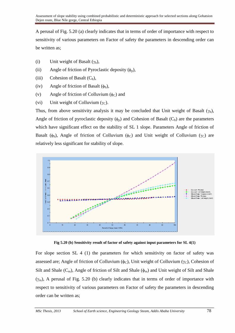
Assessment of slope stability using combined probabilistic and deterministic approach for selected sections along Gohatsion
Dejen route, Blue Nile gorge, Central Ethiopia
MSc Thesis, 2013 School of Earth science, Engineering Geology Steam, Addis Ababa University 78
A perusal of Fig. 5.20 (a) clearly indicates that in terms of order of importance with respect to
sensitivity of various parameters on Factor of safety the parameters in descending order can
be written as;
(i) Unit weight of Basalt (b),
(ii) Angle of friction of Pyroclastic deposity (p),
(iii) Cohesion of Basalt (Cb),
(iv) Angle of friction of Basalt (b),
(v) Angle of friction of Colluvium (C) and
(vi) Unit weight of Colluvium (C).
Thus, from above sensitivity analysis it may be concluded that Unit weight of Basalt (b),
Angle of friction of pyroclastic deposity (p) and Cohesion of Basalt (Cb) are the parameters
which have significant effect on the stability of SL 1 slope. Parameters Angle of friction of
Basalt (b), Angle of friction of Colluvium (C) and Unit weight of Colluvium (C) are
relatively less significant for stability of slope.
Fig 5.20 (b) Sensitivity result of factor of safety against input parameters for SL 4(1)
For slope section SL 4 (1) the parameters for which sensitivity on factor of safety was
assessed are; Angle of friction of Colluvium (C), Unit weight of Colluvium (C), Cohesion of
Silt and Shale (Css), Angle of friction of Silt and Shale (ss) and Unit weight of Silt and Shale
(ss), A perusal of Fig. 5.20 (b) clearly indicates that in terms of order of importance with
respect to sensitivity of various parameters on Factor of safety the parameters in descending
order can be written as;

Assessment of slope stability using combined probabilistic and deterministic approach for selected sections along Gohatsion
Dejen route, Blue Nile gorge, Central Ethiopia
MSc Thesis, 2013 School of Earth science, Engineering Geology Steam, Addis Ababa University 79
(i) Angle of friction of Silt and Shale (ss),
(ii) Unit weight of Silt and Shale (ss),
(iii) Unit weight of Colluvium (C),
(iv) Angle of friction of Colluvium (C),
(v) Cohesion of Silt and Shale (Css)
From the above sensitivity analysis it may be concluded that Angle of friction of Silt and
Shale (ss), Unit weight of Silt and Shale (ss) and Unit weight of Colluvium (C) are the
parameters which have significant effect on the stability of SL 4 (1) slope. Parameters Angle
of friction of Colluvium (C) and Cohesion of Silt and Shale (Css) are relatively less
significant for stability of slope.
For slope section SL 4 (2) the parameters for which sensitivity on factor of safety was
assessed are; Angle of friction of Colluvium (C), Unit weight of Colluvium (C), Cohesion of
Silt and Shale (Css), Angle of friction of Silt and Shale (ss) and Unit weight of Silt and Shale
(ss).
Fig 5.20 (c) Sensitivity result of factor of safety against input parameters for SL 4(2)
A perusal of Fig. 5.20 (b) clearly indicates that in terms of order of importance with respect
to sensitivity of various parameters on Factor of safety the parameters in descending order
can be written as;
(i) Angle of friction of Silt and Shale (ss),
(ii) Unit weight of Colluvium (C),
(iii) Angle of friction of Colluvium (C),

Assessment of slope stability using combined probabilistic and deterministic approach for selected sections along Gohatsion
Dejen route, Blue Nile gorge, Central Ethiopia
MSc Thesis, 2013 School of Earth science, Engineering Geology Steam, Addis Ababa University 80
(iv) Cohesion of Silt and Shale (Css),
(v) Unit weight of Silt and Shale (ss).
From the above sensitivity analysis it may be concluded that Angle of friction of Silt and
Shale (ss) and Unit weight of Colluvium (C) are the parameters which have significant effect
on the stability of SL 4 (1) slope. Parameters Angle of friction of Colluvium (C), Cohesion
of Silt and Shale (Css), Unit weight of Silt and Shale (ss) are in significant for stability of
slope.
5.5 Slope Stability Analysis of Rock Slopes by Combined Deterministic and
Probabilistic Approaches
5.5.1 Plane Failure Analysis
Rock slope stability critically depends on complex relationships between slope geometry and
strength parameters among others. During the present study, in order to characterize the rock
mass of slope of interest, discontinuity data pertaining to Rock Mass Rating System was
collected.
The Geo-mechanics Classification or the Rock Mass Rating (RMR) System was initially
developed at South African Council of Scientific and Industrial Research (CSIR) by
Beniawisky (1973) on the basis of his experiences in shallow tunnels in sedimentary rocks
(Kaiser et al., 1986) which later has undergone several modifications as cited in Singh and
Goel (1999).
In general, RMR value is determined as an algebraic sum of ratings for six parameters
namely; Uniaxial compressive strength (UCS) of intact rock material, Rock quality
designation (RQD), Joint or discontinuity spacing, Joint condition, Groundwater condition
and Joint orientation parameters.
During the present study the RMR data was collected from the rock slope which showed
manifestations for potential instability. Data pertaining to Uniaxial compressive strength
(UCS) of intact rock material, Rock quality designation (RQD), Joint or discontinuity
spacing, Joint condition, Groundwater condition and Joint orientation parameters was
collected at several locations. The average RMR value for the rock mass was 60 which
indicates the rock mass is fair rock.
Table 5.2.1 data pertaining RMR and average RMR value for SL 3

Assessment of slope stability using combined probabilistic and deterministic approach for selected sections along Gohatsion
Dejen route, Blue Nile gorge, Central Ethiopia
MSc Thesis, 2013 School of Earth science, Engineering Geology Steam, Addis Ababa University 81
Loc
atio
n
UCS RQD Condition of discontinuity
Spa
cing
GW
con
ditio
n
Orientat
ion of
disconti
nuity
RMR
value
SRV UCS JV RQD Pers
iste
nce
Apert
ure
roug
hnes
s
Infil
ling
weath
ering
SL 3 26 54 11 75 1 5 2 4 3 7 10 -5 60
Further, Calculations of safety factor on this section has indicated that the slope is stable for
both existing and anticipated adverse condition as discussed later in this section and shown in
Table 5.3. However, during the field visit it was observed that rock blocks has failed. To
account for such confusion the analysis was emphasized on individual block stability that
might contribute to the whole mass failure rather than analyzing the entire slope.
Block Failure in this jointed rock slope is controlled by three discontinuity sets the horizontal
bedding and two other joint sets dipping away from the slope mass with block movement in
the direction of joint plane. To observe how these orientations of discontinuity sets contribute
to failure, kinematic check was conducted that support analysis consideration at block level
as the slope seems susceptible to failure.
General condition for Plane failure
In general, it was realized that the geometry of slope section SL3 has upper slope which is
inclined at 200, therefore the analysis for Plane mode of failure was performed by
ROCPLANE which operate by modified analytical approach proposed by Sharma et al.
(1995) principles taking its advantage of considering upper slope angle. In the modified
Sharma et al. (1995) technique the following general conditions must be satisfied;
(i) The failure plan must strike parallel or nearly parallel (approx. + 20%) to the slope
face.
(ii) The dip of the failure plane must be smaller than the dip of the slope face (αp<αf).
(iii) The angle of internal friction (φ) of the failure plane must be smaller than the dip of
the failure plan (φ<αp).
(iv) The upper slope surface and tension crack must be inclined.
(v) The inclination of the upper slope must be smaller than the inclination of the failure
plan (αp>αs).
(vi) The tension crack must be present on the upper slope surface.

Assessment of slope stability using combined probabilistic and deterministic approach for selected sections along Gohatsion
Dejen route, Blue Nile gorge, Central Ethiopia
MSc Thesis, 2013 School of Earth science, Engineering Geology Steam, Addis Ababa University 82
Assumptions
For modified technique following assumptions were considered;
(i) The tension crack is filled with water to a vertical depth of Zw. The water from the
tension crack seeps along the failure surface and escape out on the slope face where the
failure surface daylights.
(ii) It is presumed that there is no resistance to sliding at the lateral boundaries of the slide.
As per the technique of plane failure analysis (Sharma et.al, 1995) the area, weight,
horizontal water forces and uplift water forces are calculated by the following equations;
Area of sliding mass
A=(h-ZI)cosecα ………..eq.5.1
Where;
………..eq.5.2
ZI = ZL – IG ………..eq.5.3
(
) √
………..eq.5.4
IG √
………..eq.5.5
Weight ‘W’ of the sliding mass
………..eq.5.6
Where, γ is the unit weight of the rock, ‘X’ and ‘D’ are the slope distance AF and GF,
respectively and ‘a’ is the height EF as shown in Fig.5.20.
X
………..eq.5.7
D =
………..eq.5.8
a
………..eq.5.9
Horizontal water force, V

Assessment of slope stability using combined probabilistic and deterministic approach for selected sections along Gohatsion
Dejen route, Blue Nile gorge, Central Ethiopia
MSc Thesis, 2013 School of Earth science, Engineering Geology Steam, Addis Ababa University 83
V
………..eq.5.10
Where, γw is the unit weight of water and Zw is the water level in the tension crack.
Uplift water force, U
U
p ………..eq.5.11
(Source: Sharma et al., 1995)
Fig. 5.21 Parameters and Geometric details to be considered in
Modified analytical Plane failure approach
5.5.2 Kinematic Analysis
Plane Mode of Failure
The kinematic analysis is an analysis performed to check whether structural discontinuity
orientation will result into slope failure or not by using the stereographic projection method
and examines which modes of slope failure are possible in a jointed rock mass (Yoon et al.,
2002) .

Assessment of slope stability using combined probabilistic and deterministic approach for selected sections along Gohatsion
Dejen route, Blue Nile gorge, Central Ethiopia
MSc Thesis, 2013 School of Earth science, Engineering Geology Steam, Addis Ababa University 84
If the failure plane has day lighted to slope face at angle gentler than slope face and greater
than friction angle the kinematic condition is satisfied for plane mode of failure. Further, the
dip vector of a representative discontinuity set (failure plane) falls within the critical zone,
“Kinematics” refers to the motion of bodies without reference to the forces that cause them to
move (Goodman, 1989).
Fig 5.22 Stereographic analysis for possible plane failure
Angular relationships between discontinuities and slope surfaces are applied to determine the
potential and modes of failures (Kliche, 1999). For the present slope dip and dip direction of
each discontinuity orientation was collected and provided as input in to Dip Analyst software
to perform the analysis.
The Markland test (Markland, 1972) is one of the kinematic analysis methods designated to
evaluate the possibility of plane failure.
The kinematic condition for plane failure is;
αf > αp > φ ………..eq.5.12
where; αf is the slope inclination, αp is the dip of the failure Plane and φ is the angle of
internal friction.

Assessment of slope stability using combined probabilistic and deterministic approach for selected sections along Gohatsion
Dejen route, Blue Nile gorge, Central Ethiopia
MSc Thesis, 2013 School of Earth science, Engineering Geology Steam, Addis Ababa University 85
If the condition specified in eq. 5.12 is satisfied, the Plane failure will possibly occur.
Fig 5.23 Preferred orientations of Joint sets
The greater amount of plane failure index is also evidence to support which mode of failure is
likely. For the slope is then kinematically unstable further stability analysis is needed.
Failure index is the ratio of total normalized weights of discontinuities that cause plane
failure to total number of discontinuities. A higher index value for a given type of failure
indicates a greater chance for that type of failure to occur, hence, plane failure in this case
(Yonathan Admassu, 2012). A typical rock unit (Lower sandstone unit) where data was taken
for preferred orientations of discontinuities developed three discontinuity sets.
Wedge Mode of Failure Analysis
Different types of failure modes are possible in rock slopes. It is the discontinuity orientation
and its relationship with slope failure that determines which mode of failure is likely on the
given slope. The wedge failure is a common type in jointed rock slopes than plane failure.
Markland (1972) proposed that wedge failures occur along the lines of intersection of joints
and hence, these intersections must ‘daylight’ in the slope faces. In order for the line of
intersection to ‘daylight’, the plunge of the intersection should be less than the dip angle of
the slope face measured along the trend of the intersection. In addition, the plunge of the
intersection must exceed the friction angle of the joint planes.

Assessment of slope stability using combined probabilistic and deterministic approach for selected sections along Gohatsion
Dejen route, Blue Nile gorge, Central Ethiopia
MSc Thesis, 2013 School of Earth science, Engineering Geology Steam, Addis Ababa University 86
As per Hoek and Bray (1981) unstable wedges may be formed in rock slopes cut by at least
two sets of discontinuities upon which sliding can occur.
In the present case from the stereographic results it was observed that three joint sets have
intersected each other but in the opposite direction to the great circle of slope face. Hence, the
kinematic conditions checked for wedge were not satisfied and it is also observed from
failure indices that there is no evidence of wedge failure but small amount of rock toppling
was observed. Further, if Kinematic condition is not satisfied there is no need of conducting
kinetic (limit equilibrium) analysis or later probabilistic analysis for this particular slope
section.
Fig 5.24 Stereographic analysis of wedge failure
The preferred orientation of joint sets were obtained from 121 Dip and dip direction
observations and is presented in Table 5.3.
Table 5.3 Preferred orientation of joint sets used for wedge mode of failure
Joint set Mean dip direction/ Mean dip
J1 219 / 41
J2 130 / 56
J3 169 / 62
5.5.3 Deterministic Factor of safety analysis of slope mass
The deterministic or physically based models are based on the physical laws of conservation
of mass, energy and momentum (Van Westen and Terlien, 1996).
Limit equilibrium (LE) method is the most popular deterministic model used to calculate
safety factor of slopes and same was used for analysis in present study. The LE procedure for

Assessment of slope stability using combined probabilistic and deterministic approach for selected sections along Gohatsion
Dejen route, Blue Nile gorge, Central Ethiopia
MSc Thesis, 2013 School of Earth science, Engineering Geology Steam, Addis Ababa University 87
calculating the factor of safety involves comparing the available shear strength along the
sliding surface with the force required to maintain the slope in equilibrium. In this method the
rock is assumed to be Mohr–Coulomb material in which the shear strength is expressed in
terms of the cohesion ‘C’ and friction angle ‘φ’, (Wyllie and Mah, 2004).
During the present study ‘Factor of safety’ was calculated for the slope having possible plane
mode of failure (SL 3 Slope Section). The FOS was calculated for existing and anticipated
condition separately. The conditions which were considered are; static dry, static saturated,
dynamic dry and dynamic saturated.
For analysis the shear strength input parameters for analysis were obtained directly from
standard table proposed by Hoek and Bray (1981) and from generalized Hoek and
Brown(2002) classification made on Roclab software. Further, the slope geometry was
deduced/ estimated in the field. All input data pertaining to slope geometry, shear strength
parameters, unit weight and seismic parameter were fed to Rock PLANE which operate based
on Sharma et al. (1995) Modified technique for Plane analysis owing to its upper slope angle.
For existing ‘static dry’ condition the assumption was made that there is no water pressure in
the tension crack or along the sliding plane. Thus, both uplift water force (u) and horizontal
water force (V) were taken equal to zero while computing FOS for ‘static dry’ condition.
The Factor of safety for static condition as per Sharma et al. (1995) is given by eq. 5.13
F =
………..eq.5.13
Where;
‘C’ is the cohesion, ‘A’ is the base area of the sliding mass, ‘W’ is the weight of the sliding
mass, ‘U’ is the uplift water force, ‘V’ is the water force acting on the rear face of the tension
crack and ‘φ’ is the angle of friction.
The factor of safety for dynamic condition as per Sharma et al. (1995) is given eq. 5.14;
F =
pp
p
Cos V ) (Sin w
Tan )Sin V-U- )Sin - Cos w((CA
Cosp
pp
…….. eq.5.14
Where ‘’ is the horizontal earthquake acceleration.
The Meteorological data of the area indicated that the area receives an average annual rain
fall of 1,535mm with peak value of 2,220mm. Thus, it may be considered that during rainy

Assessment of slope stability using combined probabilistic and deterministic approach for selected sections along Gohatsion
Dejen route, Blue Nile gorge, Central Ethiopia
MSc Thesis, 2013 School of Earth science, Engineering Geology Steam, Addis Ababa University 88
season the slope mass would be considerable saturated. For saturated condition analysis
varied water saturation situations were considered as when the tension crack would be filled
with water to its depth equal to 25%, 50%, 75%, and 100%.
Further, for dynamic condition horizontal seismic coefficient of 0.08g was considered.
The computed Factor of Safety for SL 3 slope section for various anticipated conditions along
with input data used is presented in Table 5.4.
Table 5.4 Input values, Factor of safety of slope mass calculation and Probability of failure
determination under different condition for SL 3 slope section having Plane Mode of
Failure by ROCPLANE software.
Condition H
(m)
C
Kpa
Φ
Deg.
KN/m3
(o)
Upper
slope
angle
of
water
KN/m3
α (g) Factor
of
safety
PF
%
Static dry 13 587 46 23 67 20 0 0 1.86 0
Static
saturated
A 13 440 34.5 24 67 20 10 0 1.25 0
B 13 293.5 23 25 67 20 10 0 0.76 100
C 13 147 12 26 67 20 10 0 0.38 100
D 13 6 5 28 67 20 10 0 0.2 100
Dynamic
dry
13 540 42 23 67 20 0 0.08 1.36 0
Dynamic
saturated
A 13 405 39.5 24 67 20 10 0.08 1.23 0
B 13 270 21 25 67 20 10 0.08 0.58 100
C 13 135 11 26 67 20 10 0.08 0.3 100
D 13 5.5 4.5 28 67 20 10 0.08 0.2 100
Note: A, B, C, D shows when water fills the tension crack 25%, 50%, 75% and 100% respectively
‘H’ – Height of slope, C – Cohesion, Φ- Angle of Friction, ϒ – Unit weight of rock, - slope inclination,
α – horizontal acceleration PF – Probability of Failure
A perusal of results of Factor of Safety as presented in Table 5.5 clearly indicates that Slope
Section SL 3 is a stable section at static dry and dynamic dry as well as at low percent of
water filling tension crack as FOS is greater than 1.0.
Even it is safe for engineering design application such as road construction at static dry
condition as it is having FOS much higher than 1.5. However, the slope is instable at
anticipated adverse conditions.
5.5.4 Probabilistic Plane Failure Analysis of SL 3 Slope Section
Unlike factor of safety that shows stability of slopes in deterministic method, probability of
failure shows safety of slope in probabilistic model. The probability of failure (PF) is defined
as the probability that the factor of safety is less than or equal to 1.
Pf = P{FOS ≤ 1} …….... eq.5.15

Assessment of slope stability using combined probabilistic and deterministic approach for selected sections along Gohatsion
Dejen route, Blue Nile gorge, Central Ethiopia
MSc Thesis, 2013 School of Earth science, Engineering Geology Steam, Addis Ababa University 89
However, factor of safety of greater than one doesn’t indicate a hundred percent stability of
slopes.
In the present analysis a probability of failure was realized to as 100% for static fully
saturated condition and for dynamic fully saturated condition (Table 5.4). These results
indicate slope section to be stable at existing condition however, during field visit it was
observed that rock blocks have failed from this slope sections. Thus it may be concluded that
the slope section as a whole is stable however isolated rock blocks may detach and slide
under saturated conditions.
5.5.5 Deterministic Factor of Safety Analysis of Slide Block in SL3 Slope Section
Slope on the lower sandstone unit (SL 3) has shown manifestation of instability and failure
despite the results of FOS (Table 5.4) obtained during present study and presented in
previous section. The slope mass present in SL 3 slope section is basically controlled by
through going, relatively closely spaced horizontal beddings generally dipping towards road
and two joint sets which are nearly perpendicular to bedding joint, one parallel to slope face.
Attempt were made to perform stability analysis to understand at what slope angle, which
condition and what slope height has controlled the mass failure, the slope mass was divided
into block of variable height, condition and angle as shown in Table 5.5.
The shear strength input parameters and unit weight of the blocks was directly adopted from
standard tables proposed by Hoek and Bray (1981) and Generalized Hoek and Brown criteria
from Roclab software.
Table 5.5 presents the input values and factor of safety for slide blocks of SL 3 Slope section
under different condition by Rock PLANE software.
For the analysis at block level Height of the slope was varied from 1m to 13m and potential
failure plane was varied from 25o to 40
o. This analysis was attempted to have an idea at what
height and by what angle the blocks have failed and will fall in future.

Assessment of slope stability using combined probabilistic and deterministic approach for selected sections along Gohatsion
Dejen route, Blue Nile gorge, Central Ethiopia
MSc Thesis, 2013 School of Earth science, Engineering Geology Steam, Addis Ababa University 90
Table 5.5 The input values and factor of safety for slide blocks of SL 3 Slope section under
different condition by ROCPLANE software
Condition H
(m)
C
Kpa
Φ
Deg.
KN/m3
(o)
w
KN/m3
α (g) Factor of safety for variable
25 30 35 40 Static dry 13 587 46 23 67 0 0 2.28 1.86 1.55 1.31
Static saturated A 13 440 34.5 24 67 10 0 1.54 1.25 1.03 0.87
B 13 293.5 23 25 67 10 0 0.97 0.76 0.64 0.54
C 13 147 12 26 67 10 0 0.47 0.38 0.32 0.24
D 13 6 5 28 67 10 0 0.28 0.22 0.15 0.1
Dynamic dry 13 540 42 23 67 0 0.08 1.58 1.36 1.12 0.98
Dynamic
saturated
A 13 405 39.5 24 67 10 0.08 1.5 1.23 1.04 0.88
B 13 270 21 25 67 10 0.08 0.7 0.58 0.41 0.32
C 13 135 11 26 67 10 0.08 0.35 0.3 0.24 0.2
D 13 5.5 4.5 28 67 10 0.08 0.25 0.2 0.18 0.12
Static dry 11 587 46 23 67 0 0 2.3 1.9 1.56 1.32
Static saturated A 11 440 34.5 24 67 10 0 1.53 1.25 1.05 0.9
B 11 293.5 23 25 67 10 0 0.95 0.77 0.65 0.55
C 11 147 12 26 67 10 0 0.47 0.4 0.32 0.27
D 11 6 5 28 67 10 0 0.2 0.2 0.18 0.15
Dynamic dry 11 540 42 23 67 0 0.08 1.65 1.4 1.2 1
Dynamic
saturated
A 11 405 39.5 24 67 10 0.08 1.5 1.25 1.05 0.9
B 11 270 21 25 67 10 0.08 0.7 0.6 0.48 0.3
C 11 135 11 26 67 10 0.08 0.36 0.29 0.2 0.15
D 11 5.5 4.5 28 67 10 0.08 0.15 0.11 0.10 0.1
Static dry 9 587 46 23 67 0 0 2.32 1.9 1.6 1.34
Static saturated A 9 440 34.5 24 67 10 0 2 1.3 1.06 0.9
B 9 293.5 23 25 67 10 0 1.8 0.8 0.7 0.56
C 9 147 12 26 67 10 0 0.95 0.4 0.33 0.17
D 9 6 5 28 67 10 0 0.2 0.18 0.15 0.11
Dynamic dry 9 540 42 23 67 0 0.08 1.65 1.4 1.2 1
Dynamic
saturated
A 9 405 39.5 24 67 10 0.08 1.51 1.2 1.04 0.9
B 9 270 21 25 67 10 0.08 0.71 0.65 0.55 0.5
C 9 135 11 26 67 10 0.08 0.36 0.3 0.25 0.2
D 9 5.5 4.5 28 67 10 0.08 0.15 0.15 0.12 0.1
Static dry 7 587 46 23 67 0 0 2.34 1.9 1.6 1.4
Static saturated A 7 440 34.5 24 67 10 0 1.6 1.3 1.08 0.92
B 7 293.5 23 25 67 10 0 1 0.8 0.7 0.48
C 7 147 12 26 67 10 0 0.5 0.4 0.32 0.21
D 7 6 5 28 67 10 0 0.2 0.15 0.13 0.1
Dynamic dry 7 540 42 23 67 0 0.08 1.7 1.41 1.2 1.03
Dynamic
saturated
A 7 405 39.5 24 67 10 0.08 1.52 1.3 1.08 0.92
B 7 270 21 25 67 10 0.08 0.72 0.66 0.56 0.41
C 7 135 11 26 67 10 0.08 0.4 0.32 0.28 0.22
D 7 5.5 4.5 28 67 10 0.08 0.2 0.18 0.15 0.1
Static dry 5 587 46 23 67 0 0 2.4 1.97 1.66 1.44
Static saturated A 5 440 34.5 24 67 10 0 1.6 1.32 1.12 0.97
B 5 293.5 23 25 67 10 0 1 0.82 0.69 0.6
C 5 147 12 26 67 10 0 0.5 0.42 0.35 0.3
D 5 6 5 28 67 10 0 0.2 0.16 0.13 0.1
Dynamic dry 5 540 42 23 67 0 0.08 1.73 1.45 1.25 1.08
Dynamic
saturated
A 5 405 39.5 24 67 10 0.08 1.6 1.3 1.1 0.98
B 5 270 21 25 67 10 0.08 0.75 0.6 0.54 0.4
C 5 135 11 26 67 10 0.08 0.4 035 0.32 0.27
D 5 5.5 4.5 28 67 10 0.08 0.2 0.16 0.14 0.12
Static dry 3 587 46 23 67 0 0 2.5 2.09 1.79 1.6
Static saturated A 3 440 34.5 24 67 10 0 1.7 1.4 1.2 1.06
B 3 293.5 23 25 67 10 0 1.05 0.9 0.76 0.67
C 3 147 12 26 67 10 0 0.52 0.42 0.35 0.28
D 3 6 5 28 67 10 0 0.2 0.18 0.14 0.13
Dynamic dry 3 540 42 23 67 0 0.08 1.8 1.45 1.27 1.14
Dynamic
saturated
A 3 405 39.5 24 67 10 0.08 1.62 1.35 1.17 1.03
B 3 270 21 25 67 10 0.08 0.9 0.67 0.59 0.53
C 3 135 11 26 67 10 0.08 0.4 0.34 0.31 0.29
D 3 5.5 4.5 28 67 10 0.08 0.21 0.19 0.16 0.13
Static dry 1 587 46 23 67 0 0 3.1 2.7 2.4 2.26
Static saturated A 1 440 34.5 24 67 10 0 2.1 1.84 1.66 1.58
B 1 293.5 23 25 67 10 0 1.4 1.2 1.07 1.02
C 1 147 12 26 67 10 0 0.63 0.6 0.53 0.5
D 1 6 5 28 67 10 0 0.5 0.46 0.42 0.32
Dynamic dry 1 540 42 23 67 0 0.08 2.3 2 1.86 1.78
Dynamic
saturated
A 1 405 39.5 24 67 10 0.08 2 1.7 1.6 1.5
B 1 270 21 25 67 10 0.08 1.09 0.9 0.85 0.82
C 1 135 11 26 67 10 0.08 0.5 0.41 0.35 0.32

Assessment of slope stability using combined probabilistic and deterministic approach for selected sections along Gohatsion
Dejen route, Blue Nile gorge, Central Ethiopia
MSc Thesis, 2013 School of Earth science, Engineering Geology Steam, Addis Ababa University 91
D 1 5.5 4.5 28 67 10 0.08 0.23 0.21 0.19 0.17
Note: A, B, C, D shows when water fills the tension crack 25%, 50%, 75% and 100% respectively. ‘H’ – Height of slope, C – Cohesion, Φ- Angle of
Friction, ϒ – Unit weight of rock, - slope inclination, α – horizontal acceleration Yellow marks show unstable slopes at all given sets of
conditions and red mark shows unstable slopes for considered long term/permanent slope design.
Further, for each combination of slope height and potential failure plane inclination FOS was
determined for static and dynamic conditions with varied water saturation conditions. The
results thus obtained are presented in Table 5.5.
A perusal of Table 5.5 indicates FOS of individual blocks, which varies considerable. Many
blocks become unstable under water saturation and dynamic conditions.
In Table 5.5 all those factor of safety which are shown in Yellow background indicates
unstable condition from natural slope stability point of view whereas those shown with red
background may become unstable for long term engineering design.
5.5.6 Probability Analysis of Slide Block in SL3 Slope Section
On the basis of the above deterministic calculation and by treating uncertain parameters
under 10,000 Monte Carlo simulations the probability of failures of individual blocks was
determined under the most favorable and the worst condition for variable slope height as
shown in Table 5.6.
Table 5.6 Deterministic FOS for mean (30◦) and Probability of failure for Slide Block in SL3
Slope Section by ROCPLANE software
Parameters Deterministic FOS for mean
i.e. 30◦
Probability of failure (%)
For variable Slope Height
Fix
ed p
ara
met
ers
Wors
t case
U max
and a
max
Best
case
U=0
and a
=0
No
water
but
earth
quake
No
earth
quake
but
water
Cases 13 11 9 7 5 3 1
H
13 0.2 1.86 1.36 0.22 Best
case =
0 0 0 0 0 0 0
11 0.11 1.91 1.4 0.2
9 0.13 1.93 1.41 0.18
7 0.18 1.95 1.3 0.15 Worst
case =
100 100 100 100 100 100 100
5 0..16 1.97 1.45 0.16
3 0.19 2.09 1.45 0.19
1 0.21 2.7 2 0.46
67 67 67 67 U but
no a =
100 100 100 100 100 100 100
30 30 30 30
Us angle 20 20 20 20 a but
no U =
0 0 0 0 0 0 0
Ra
. p
a U 100% 0 0 100%
a 0.08g 0g 0.08g 0g
Where = slope angle, = failure plane angle, a= horizontal seismic coefficient, U = water pore pressure, H
= height of the slide block, Ra. Pa= random parameter, Us angle= upper slope angle.

Assessment of slope stability using combined probabilistic and deterministic approach for selected sections along Gohatsion
Dejen route, Blue Nile gorge, Central Ethiopia
MSc Thesis, 2013 School of Earth science, Engineering Geology Steam, Addis Ababa University 92
Table 5.6 presents the comparison between Deterministic FOS with mean failure plane
inclination ( ) and Probability of failure for variable slope height blocks.
Height (H) = 13m
Height (H) = 11m
Height (H) = 9m
Height (H) = 7m
Rel
ativ
e Fr
equ
ency
Factor of Safety
Factor of Safety Factor of Safety
Factor of Safety R
elat
ive
Freq
uen
cy
Rel
ativ
e Fr
equ
ency
Rel
ativ
e Fr
equ
ency

Assessment of slope stability using combined probabilistic and deterministic approach for selected sections along Gohatsion
Dejen route, Blue Nile gorge, Central Ethiopia
MSc Thesis, 2013 School of Earth science, Engineering Geology Steam, Addis Ababa University 93
Height (H) = 5m
Height (H) = 3m
Fig 5.25 Probability distributions of safety factor for variable height (H)
around their mean value for slide blocks in Slope Section SL 3
A perusal of results presented in Table 5.6 indicates that Deterministic FOS with mean failure
plane inclination ( ) for worst conditions (full water saturation and dynamic loading)
indicates that the slope block of all height becomes unstable. The probability analysis also
indicated similar type of results. These blocks under worst condition have probability of
failure of almost 100%.
5.6 Sensitivity Analysis F for Rock Slope
From the probabilistic calculation results rock block presented in Table 5.6, sensitivity of
input variables was made to understand the relative influence on Factor of Safety. The
parameters for which senstivity analysis was made are; Slope angle, Slope height, Unit
weight, Failure plane angle, Friction angle, Water saturation, upper slope angle and cohesion.
Perusal of Fig. 5.26 clearly indicates the order of importance in terms of senstivity to FOS. In
order of importance the most significant factors are; Slope angle, Cohesion and Water
saturation. The other factors; Slope height, Unit weight, Failure plane angle, Friction angle
etc. are less senstivity for FOS.
Factor of Safety Factor of Safety
Rel
ativ
e Fr
equ
ency
Rel
ativ
e Fr
equ
ency

Assessment of slope stability using combined probabilistic and deterministic approach for selected sections along Gohatsion
Dejen route, Blue Nile gorge, Central Ethiopia
MSc Thesis, 2013 School of Earth science, Engineering Geology Steam, Addis Ababa University 94
Fig 5.26 Sensitivity of safety factor for various input parameters
for slide blocks in SL 3 Slope Section
5.7 Discussion and Interpretation of Results
In the present study analysis of colluvium slopes were made for the existing and anticipated
possible worst conditions by utilizing SLIDE software that supports both deterministic and
probabilistic approaches. Similarly, for rock slope having planar mode of failure
ROCPLANE software that operate based on the principles of Modified Analytical Technique
proposed by Sharma et al., (1995) and support both methods were also utilized for analysis.
Under static state the shear strength exceeds shear stress and the factor of safety is greater
than 1.0, which indicates stable natural slope. For slopes during verge of movement, shear
strength is just balanced by shear stress and the factor of safety is assumed to be 1.0 (Selby,
1993) which is at its critical state. However, from design point of view the minimum safety
factor of slope along road side is 1.2 (Hoek and Bray, 1989). For short term or temporary
stability factor of safety of greater than or equal to 1.3 and for long term or permanent
stability safety factor of 1.5 or greater can be considered.
The stability analysis results of the colluvium slope section (SL 1) found towards the
Gohatsion side of the gorge indicates that the factor of safety of the slope is 1.106 under static
dry condition. Further, under static fully saturated condition the factor of safety has dropped
from to 0.31 for the upper failure surface (SL 1) that passes below the road. From stability

Assessment of slope stability using combined probabilistic and deterministic approach for selected sections along Gohatsion
Dejen route, Blue Nile gorge, Central Ethiopia
MSc Thesis, 2013 School of Earth science, Engineering Geology Steam, Addis Ababa University 95
point of view this slope is irresistible for the anticipated adverse condition and shows signs of
devastation. This extreme drop in FOS (0.31) also tells how water is significant in instability
of the slope. This is because the slope material is permeable and it lets water pass through it
and facilitate the pore water pressure development in the slope reducing slope material
strength. Further, the analysis results for slope section SL 1 under dynamic dry condition
indicates a FOS value of 0.989 and for dynamic saturated condition FOS reduces to 0.25.
Moreover, the stability of the entire slope is not represented by a unit stability value only.
Hence, probabilistic analysis was conducted by taking deterministic input parameters and
treating them as random variable by using 10,000 Monte Carlo simulations for better
reliability of output. Accordingly, the probability of failure of the slope in static dry condition
is 0.1% whereas; with water saturation (fully) the probability of failure is 100%. Under
dynamic dry conditions the probability of failure is 64% and with water saturation (fully) the
probability of failure is 100%. Thus, the results indicate that the water saturation under static
or dynamic conditions will make slope unstable. Even, without water saturation under
dynamic condition the probability of failure of this slope (SL 1) are high.
Further, the sensitivity analysis conducted for this slope (SL 1) indicates that Unit weight of
Basalt (b), Angle of friction of pyroclastic deposity (p) and Cohesion of Basalt (Cb) are the
parameters which have significant effect on the stability of SL 1 slope. This is important
indication as heavy basalt is resting on lighter pyroclastic deposit.
Slope section SL 4 slope which is found on the Dejen side of the gorge is characterized by
colluvium type material of limestone, gypsum and basalt. For this slope section stability
analysis was carried out along two slope sections; SL 4(1) and SL 4(2). The SL 4(2) is
located towards the upper side of SL 4(1).
The stability analysis results for SL 4 (1) by deterministic method for static dry condition
indicates that the FOS for 3 failure surfaces from top to inside have values 4.7, 1.9 and 1.6,
respectively. The results reveal that firstly that it is a deep seated failure and secondly the
progressive mode of failure is controlled by material characteristic and slope morphology.
Further, under ‘static saturated’ condition FOS value for slip surface corresponding to
existing roads and scarp face indicates a decrease in FOS from 1.6 (static dry) to 0.83. This
indicates significant effect of water saturation which converts the most stable conditions to
totally unstable condition.

Assessment of slope stability using combined probabilistic and deterministic approach for selected sections along Gohatsion
Dejen route, Blue Nile gorge, Central Ethiopia
MSc Thesis, 2013 School of Earth science, Engineering Geology Steam, Addis Ababa University 96
The response of dynamic loading on SL 4(1) slope section in dynamic dry condition is not
that much significant as the FOS for entire slope section only reduces from 1.6 (static dry) to
1.144. Though from natural slope stability point of view value of FOS of 1.144 is stable but
from engineering design point of view it is unstable. Further, with water saturation and
dynamic loading the FOS value comes out to be 0.5, which indicates complete instability of
slope.
The probabilistic analysis for SL 4 (1) slope section for static dry condition indicates
probability of failure for entire slope equal to 0% which validates the deterministic value of
FOS equals to 1.6 and a stable condition. However, the probability of failure is 100% under
saturated condition for both static and dynamic situations.
The sensitivity analysis for SL 4 (1) slope section indicated that the slope is highly sensitive
to friction angle and unit weight of silt and shale. Factor of safety of the slope increased with
increase in silt and shale friction angle and unit weight as well as minor increase of colluvium
weight.
The deterministic stability analysis for SL 4 (2) slope section indicates a FOS of 0.709 under
static dry condition. The result indicates that slope is unstable even under the best condition
(static dry), therefore it is obvious that with water saturation and dynamic condition the slope
will be unstable. Thus, no further analysis was made for the anticipated worst conditions.
The probabilistic analysis for SL 4 (2) slope section also indicated the similar results. The
probability of failure under static dry condition comes out to be 99.4%. Thus, from the results
it can safely be deduced that SL 4(2) slope section is a massive deep seated progressive
failure. The instability was this slope can be attributed to nature of slope material,
stratigraphical settings and topographical controlled structure. From stratigraphic point of
view heavy colluvium material is resting on less dense but thinly bedded, shale and silts
which facilitate down slope progressive failure.
From sensitivity analysis of SL 4(2) slope section it may be concluded that Angle of friction
of Silt and Shale (ss) and Unit weight of Colluvium (C) are the parameters which have
significant effect on the stability of SL 4 (1) slope. Parameters Angle of friction of Colluvium
(C), Cohesion of Silt and Shale (Css), Unit weight of Silt and Shale (ss) are in significant for
stability of slope.

Assessment of slope stability using combined probabilistic and deterministic approach for selected sections along Gohatsion
Dejen route, Blue Nile gorge, Central Ethiopia
MSc Thesis, 2013 School of Earth science, Engineering Geology Steam, Addis Ababa University 97
Stability analysis of rock slope having planar mode of failure (SL 3) was carried out for entire
slope section and separately at a slide block level. From the results it was observed that the
slope mass is stable under static dry condition and instable under anticipated worst
conditions.
The stability analysis carried out for SL 3 slope section by deterministic and probabilistic
approaches has revealed that the slope is stable for existing conditions and would be instable
under anticipated conditions. However, manifestation of instability of this slope section
inspired to carry out analysis that observed during the field trip to have an idea how the
blocks have failed in the past or how they will fail in future, under which condition blocks
have failed and what combinations of slope height and failure plane inclination may result
into block failures.
For the analysis at block level Height of slope was varied from 1m to 13m by a difference of
2m and potential failure plane was varied from 25o to 40
o. Further, for each combination of
slope height and potential failure plane inclination FOS was determined for static and
dynamic conditions with varied water saturation conditions.
The results indicates that Deterministic FOS with mean failure plane inclination ( ) for
worst conditions (full water saturation and dynamic loading) indicates that the slope block
with greater height and greater failure plane inclination has more probability of failure and
more becomes unstable.
*****

Assessment of slope stability using combined probabilistic and deterministic approach for selected sections along Gohatsion
Dejen route, Blue Nile gorge, Central Ethiopia
MSc Thesis, 2013 School of Earth science, Engineering Geology Steam, Addis Ababa University 98
Chapter 6
Remedial Measures and Preventive Options
6.1 Preamble
As per slope stability analysis in the present study area most of the slope sections require
long-term stability for anticipated adverse conditions. However, identification and selection
of remedial measures for failed slope sections require an understanding of the mechanism
that led to the original failure, as well as potential remedies that can be used to eliminate or
reduce the chance of recurrence of the problem (Saleh and Wright, 1997).
There are many factors to cause failure of a slope and very often these factors are interrelated.
When a slope failed and remedial works are required, it is essential to carry out failure
investigation to find out the possible causes. Suitable remedial design can only be carried out
after knowing the causes of failure. Once the main causes of slope failure have been
identified, the remedial design can be carried out to correct the problems (Chen and Lim,
2005).
Further, Terzaghi (1950) stated that, “If a slope has started to move, the means for stopping
movement must be adapted to the processes which started the slide”. A number of remedial
measures exist for improving stability of soil and rock slopes. Some may be best suited as
preventive measures and some as remedial measures still others may be used as both
preventive and remedial measures. The remedial measure proposed for colluvium slopes may
not be restrictive but can be used for rock slopes based on its necessity. Hence, the major
causes of slope failures and the appropriate corrective measures for the potentially critical
slopes in the present study area are discussed in the followed paragraphs;
6.2 Major Causes of Slope Failure in the Area
6.2.1 Geological Factors
It may be reasonably expected that the properties of the slope-forming materials, such as;
strength and permeability that are involved in the failure, are related to the lithology, which
therefore should affect the likelihood of failure. The slope forming materials of the area are
mostly sedimentary rocks of different class caped by igneous rock on the top. The top basalt
unit is mostly fractured through which water can easily infiltrate to the underlying

Assessment of slope stability using combined probabilistic and deterministic approach for selected sections along Gohatsion
Dejen route, Blue Nile gorge, Central Ethiopia
MSc Thesis, 2013 School of Earth science, Engineering Geology Steam, Addis Ababa University 99
sedimentary unit. Further, it is fragmented into blocks of various size intercalated with thin
layers of loose silt and clay soils of unconsolidated materials those that have least shear
strength and more prone to failure. Particularly, if they are charged with water, they show
high potential to failure as seen from stability analysis results. The rocks underlying this
weak unconsolidated material (colluvium) is mostly limestone (locally, upper limestone) in
the area which is genetically carbonate and susceptible to solution when it is in contact with
acidic water. Besides, this limestone occur with layers of silt and shale which are relatively
weak and can easily erode when subjected to intense floods as in the case of summer season
of the country. These induce instability and result into failure of different level based on the
intensity of triggering factors.
The other geologic factor that plays a role in slope instability is structural discontinuities of
primary and secondary origin in the rocks. Geological structures are other geological factors.
There were no recognized small scale faults on the critical sections selected but as per Gani,
et al (2008) the Mesozoic sedimentary section is dominated by NW and NE-trending normal
faults where the lower part fracture of the stratigraphic section are NE and NW-trending
while the upper part of the Mesozoic section shows a fracture pattern in which N-trend
dominates. Hence, the rock slope failures of the area are mostly controlled by joints and
beddings while soil slopes are controlled by lithology.
6.2.2 Geomorphic Factors
Geomorphic factors include slope shape, aspect and gradient. The distribution of slope
categories is dependent on the geomorphological history of the area. The angle of slope of
each unit is a reflection of a series of localized processes and controls, which have been
imposed on the slope (Long, 2008).
The geomorphology of the area is so rugged that it is characterized by the above mentions
landforms. The main reason is related to landform structure affecting largely the
concentration or dispersion of surface and sub-surface water. For example Convergent hill
slope tend to concentrate sub-surface water into small areas of the slope, thereby generating
rapid pore water pressure increase during storms or periods of rainfall. If pore pressures
develop in the hollow, the soil shear strength reduces to a critical level and a landslide can
occur. Hence, hollows are susceptible sites for initiation of debris slide and debris flows
(Hack and Goodlett, 1960; Dietrich and Dunne, 1978; Benda, 1990 as cited in Long, 2008).

Assessment of slope stability using combined probabilistic and deterministic approach for selected sections along Gohatsion
Dejen route, Blue Nile gorge, Central Ethiopia
MSc Thesis, 2013 School of Earth science, Engineering Geology Steam, Addis Ababa University 100
Similarly, Slope aspect (direction) strongly affects hydrologic processes via
evapotranspiration and thus affects weathering processes and vegetation and root
development, especially in drier environments (Sidle and Ochiai, 2006).
Altitude or elevation is usually associated with landslides by virtue of other factors such as;
slope gradient, lithology, weathering, precipitation, ground motion, soil thickness and land
use.
The relative relief (gradient) refers to the local height of the slope between the ridge top and
valley floor in a slope facet. It has also an important role in forming the size of the unstable
wedges. The slope having higher relative relief may form unstable rock wedges of big size
with more probability of failures (Dai and Lee, 2002).
6.2.3 Hydrologic Factors
The meteorological data in the area dictates as the area receives a high mean monthly rainfall
in between June to September (summer season). There is no exact record of landslide history
in the area. An interview made with local people, previous research and stability analysis
results for saturated condition revealed that most of the slope failures commenced in the area
during rainy season.
As per Long, (2008) hydrologic processes in the form of precipitation (spatial and temporal
distribution of rainfall), water recharge into soil (and the potential for overland flow), lateral
and vertical movement within the regolith, evapotranspiration and interception contribute to
slope instability. Hence, water is commonly the primary factor triggering a landslide and
slides often occur following intense rainfall, when storm water runoff saturates soils on steep
slopes or when infiltration causes a rapid rise in groundwater levels.
Groundwater may rise as a result of heavy rains or a prolonged wet spell and this is why
ground water table is close to the surface at most of the studied sites. As water table rises,
some slopes become unstable due to increase in slope saturation thus, building up positive
pore water pressures. This causes a decrease in the effective normal stress acting along the
potential failure plane, which in turn diminishes the available shear strength to a point where
equilibrium can no longer be sustained in the slope (Orense, 2004).
Moreover, UNIMIB (2012) stated two processes mainly control changes in slope hydrology
that may lead to failure; (i) infiltration of water from the surface and (ii) rising of

Assessment of slope stability using combined probabilistic and deterministic approach for selected sections along Gohatsion
Dejen route, Blue Nile gorge, Central Ethiopia
MSc Thesis, 2013 School of Earth science, Engineering Geology Steam, Addis Ababa University 101
groundwater levels by impoundment of water in a reservoir. However, in case of sub-surface
water, it is only the shallow water close to the surface that is important from the landslides
point of view as they can sufficiently reduce strength of surface materials. The sub-surface
water flowing at deeper levels which are not day-lighted on surface is not important to be
considered in slope stability analysis. This conform the fact, as observed in the area where the
ground water table is close to the surface also reported in secondary data (JICA, 2011).
6.2.4 Human Intervention
Slope instability may result directly or indirectly from the activities of people. Among them
are improper or uncontrolled discharge from sanitation or drainage works and water pipes,
typically associated with human settlements and roads, especially in rural areas, which
increase water infiltration in the slope, and possibly soil erosion at points of concentrated
surface discharge. Excavation at the base of or on slopes and/or placement of fill at the top or
on slopes during road construction owing to its rugged topography, altering the geometry of
and the stress distribution in the slope is also another influence. Quarrying and mining
activities, altering the geometry of and the stress distribution in the slope is an important
factor. Vibration from blasting and heavy construction equipment; besides causing transient
stress changes which in extreme cases can trigger landslides by themselves, vibrations can
disturb the microstructure of soils or rocks, induce fracturing in rock (UNIMIB, 2012).
In the present study area there is gypsum quarry that alter slope geometry of the slope and at
the same time vibration from the excavators may contribute to rock fracture that indirectly
weaken the shale gypsum alternating layer in the unit finally inducing slope instability.
There is relatively low agricultural practice in the area. However, in and around big
colluviums slide towards Dejen side farming is being practiced. Farming related irrigation
practice may likely alter the natural ground water conditions. In the present study area there
was no clue about historical vegetation cover but removal of vegetation for change of land
use due to agricultural practice can also facilitate slope instability, reducing
evapotranspiration, allowing increased infiltration and increased surface erosion through loss
of the shallow reinforcement provided by the root system (UNIMIB, 2012). Besides, heavy
traffic movement which passes frequently on the road in the area may also gradually effect
grain to grain contacts of the underlying soft material and thus, inducing instability as
manifested on the road through distress.

Assessment of slope stability using combined probabilistic and deterministic approach for selected sections along Gohatsion
Dejen route, Blue Nile gorge, Central Ethiopia
MSc Thesis, 2013 School of Earth science, Engineering Geology Steam, Addis Ababa University 102
6.3 Remedial Measures for Soil Slope/ Colluvium
Consideration was given to a wide range of remedial measures based on providing long term
stability to the highway. Feasible remedial measures proposed will be as per the instability
contributing factors but they are interrelated. There are many methods to increase the stability
of a slope and to stabilize a failed slope. These methods may be adopted independently or in
combination. In general, commonly adopted remedial measures can be grouped into three
main categories: Geometrical method, Drainage method and Retaining method (Broms and
Wong, 1985 as cited in Chen and Lim, 2005).
6.3.1 Geometrical Method
This is the simplest and mostly cost effective method and involves changing the slope
geometry from a steep slope to a gentler slope to increase slope stability and hence these
method reduces the driving force. The geometry of the slope can be modified through
unloading/ excavation which involve:
i) Removal of the Head of the Slide
It involves removal of large quantities of material from the head of the slope to balance the
failure (Abramson, 2002).
The quantities of material to be removed depend on the geology of the area but as a guide line
one to two materials originally removed at the toe during construction should be excavated
from the head as stated by (Eckel, 1958 as cited in Rudolph et al., 1974).
However, as a practical matter the slope of interest (SL 1) in the present study is a weak slope
(colluvium) and it experiences two modes of failure. From the field observation it was
noticed as there is slope failure (i.e. failure occurs along the surface that intersects the slope
above the toe with road as a reference) as evidenced by failure of gabion protections at most
of the places. Further, the analysis also shows that it has circular base failure (i.e. the failure
surface passes below the toe of the cut slope that is below the road). Hence, removal of the
head of the slide may help to reduce driving force in the slope. Relatively as such it is a small
scale circular failure but care has to be taken that where to dump the excavated mass. This is
because if it is dumped on the toe it will increase the load at the base and eventually it will
contribute for future failure. The colluvium slope towards the Gohatsion side (SL 1), there is

Assessment of slope stability using combined probabilistic and deterministic approach for selected sections along Gohatsion
Dejen route, Blue Nile gorge, Central Ethiopia
MSc Thesis, 2013 School of Earth science, Engineering Geology Steam, Addis Ababa University 103
a village named “Shonkor” that is at the verge of failure and whenever excavation has to be
done the mass has to be taken far away from that village and the critical areas.
ii) Benching the Slope
The purpose of benching is to transform the behavior of one high slope into several lower
ones (Abramson, 2002).
For the big slide (SL 4) located on the Dejen side this is not feasible because the slope face is
long and there is also relatively wide agricultural practice on that slope. However, the slope
(SL 1) on the Gohatsion side is relatively short in length thus; applying this method would be
feasible especially emphasizing slope failure along the road. In general, these benches have to
be wide and as such it will reduce the subsequent maintenance costs and thereby offset
increased construction costs. It can also be used to control erosion and to establish vegetation
but it has to be provided with appropriate drainage systems.
6.3.2 Drainage Method
Drainage of surface and sub-surface water appears to be the most successful remedial
measure for the correction of active landslide problems. One of the slope failure factors is
saturation and pore water pressure building up in the sub-soil. If drainage system had been
provided, the chances of building up pore water pressure and saturation of subsoil can be
minimized (Chen and Lim, 2005).
In terms of hydrologic control of slope instability in the study area it can be stated that the
area is characterized by shallow ground water table and the area receives high intensity of
monthly rainfall during rainy season. Hence, providing appropriate drainage system is the
best corrective measure for the slopes under study as it has been observed that surface and
groundwater contributes significantly to instability. There are various drainage techniques
which are available to control ground water levels and the surface drainage. These can be
Surface drainage systems (mostly for preventive measures) and/or sub-surface drainage
systems.
Horizontal Drainage
The purpose of the horizontal or sub-horizontal drain is to remove excess water from a
hillside, cut slope, or embankment. A horizontal drainage system usually consists of 2-inch to
4-inch diameter steel pipes installed in the face of the slope. Although described as horizontal

Assessment of slope stability using combined probabilistic and deterministic approach for selected sections along Gohatsion
Dejen route, Blue Nile gorge, Central Ethiopia
MSc Thesis, 2013 School of Earth science, Engineering Geology Steam, Addis Ababa University 104
drains, the pipes usually vary in inclination from 2o to 20
o above the horizontal. The pipe is
usually perforated with 3/8-inch holes on approximately 3-inch centers (Rudolph J. et al.,
1974).
Horizontal drains have been used in three ways to remove excess water from the slope. They
may be used to divert water from its source, to lower the groundwater table in the slide area
or in adjacent areas, or to drain a pervious or artesian stratum. However, they have been used
only after site investigations indicate the presence of a high groundwater table, unfavorable
seepage forces, or possible locations of pervious strata which conforms exactly to the site
condition of the area. It have been successfully used on a wide variety of slope profiles and in
soils of markedly different engineering characteristics and most applicable when used to
drain water sources in deep seated slides (Baker, 1953 as cited in Rudolph J. et al., 1974).
As stated before in the present study area both critical slopes (SL 1 and SL 4) have irregular
surface geometry where alternate bulging and sinking is observed at many places including at
the toe of the slope. In such case horizontal drains may be installed around lower portions of
the slope possibly below the presumed phreatic water surface. However, care must be taken
to drain out water away from the slope face. Since, both the slides (SL 1 and SL 4) are active
and possibly comprise large saturated mass particularly during rainy season therefore large
diameter precast concrete pipes can be provided to collect and divert water away from the
slope sections.
Vertical Drains and Well Systems
Well systems have been employed in slope stabilization to control adverse groundwater
conditions in both cut and embankment sections. As landslide prevention or correction
measure well systems are most commonly used in conjunction with horizontal drains to
provide relief of hydrostatic pressure and gravity discharge of the subsurface water
respectively (Schweizer and Wright, 1974).
When employed for slope stabilization, vertical drains have been used for three basic
purposes as cited by Rudolph et al., (1974):
(i) To provide a drainage path between lenses or strata of water bearing material which are
separated by impervious layers (Palmer, 1950; Parrott, 1955);
(ii) To relieve artesian conditions which may develop at or below the surface of rupture
(Holm, 1969; Smith, 1964; Smith, 1969); and

Assessment of slope stability using combined probabilistic and deterministic approach for selected sections along Gohatsion
Dejen route, Blue Nile gorge, Central Ethiopia
MSc Thesis, 2013 School of Earth science, Engineering Geology Steam, Addis Ababa University 105
(iii) To relieve excess hydrostatic pressures in slopes of saturated clay and therefore
expedite conso1idation and increase the shear strength of the soil (Holm, 1969;
Fe11enius, 1955).
Root (1958) states that vertical drainage wells are equally applicable as corrective or
preventive measures. He also indicated that vertical drainage wells have been used with a
greater degree of success than horizontal drains in the correction and prevention of slides.
However, the statement that vertical drain have been more successful than horizontal drains
as a stabilization procedure may be misleading, according to the literature, vertical drains are
most often used in conjunction with horizontal drains to form an integrated drainage system,
rather than as a remedy in themselves (Rudolph et al., 1974).
In the present study area, combination usages of drainage systems may be necessary on both
the critical slope sections (SL1 and SL 4). This measure possibly will help to lower down the
ground water table as much as possible which is relatively shallow to the surface. Such
combined drainage measure may also help to keep the slope mass relatively dry and thus the
stability of slope may eventually improve.
6.3.3 Retaining Structures
This method is generally more costly. However, due to its flexibility in a constrained site, it is
always the most commonly adopted method. The principle of this method is to use a retaining
structure to resist the downward forces of the soil mass. The wall should be installed deep
enough so that the critical slip surface passes around it with an adequate factor of safety.
Several retention walls are there and due to its difficulty to block ground water flow, it should
be provided with appropriate drainage path.
Gravity retaining wall is trapezoidal in shape and require firm base for construction. It
achieves resistance to base sliding and overturning moment by its own weight.
For the present case gravity retaining walls are not feasible for both critical slope sections
(SL 1 and SL 4). In both the slope sections the thickness of colluviums mass is more and slip
surface is deep seated. Thus, getting a firm foundation for the wall below the failure surface
is practically not feasible. Also, the expected earth pressures due to thick colluviums material
must be very large therefore the required wall needs to be thick and high, which will not be
economic.
Assessment of slope stability using combined probabilistic and deterministic approach for selected sections along Gohatsion
Dejen route, Blue Nile gorge, Central Ethiopia
MSc Thesis, 2013 School of Earth science, Engineering Geology Steam, Addis Ababa University 106
Tieback wall can be used when space constraints limit excavation for footings of
conventional gravity wall. It carries the lateral earth pressure on the wall by tie system that
transfers the imposed load to a zone behind the potential or existing slip plane where
satisfactory resistance can be established.
In the present study area Gabion wall has been used to stabilize road side slides on both sides
of the gorge critical sites. This method as a means of permanent remedial measure cannot be
recommended for both critical sections (SL 1 and SL 4) as both the slides are active and
gabion may not withstand high lateral pressure. However, it may be used as a temporary
protection particularly along road side sections.
Retention net is also necessary for steep slopes susceptible to rock fall as in the case of the
present study slope of interests on the gypsum unit. Retaining wall was provided in the past
to arrest the rock fall however, rock fall has filled some of its portion. The situation is serous
as in near future the retention wall be ineffective and the rock fall will have direct impact on
road. Hence, retention wall to a desired height is required in this section along with retention
net.
6.4 Remedial Measure for Rock Slopes.
For the present study two rock slopes (SL 2 and SL 3) were identified as potentially critical
slopes. However, kinematic check revealed that only SL 3 slope section is potentially
unstable for possible plane failure thus, further stability analysis was made for it. However, it
is necessary to propose a corrective measure even for SL 2 slope section which did not
satisfied the kinematic condition. This is because some rock fall and minor block toppling has
been observed during the field work, particularly along the road side. There are several
methods available by which hard rock slopes can be stabilized.
Removal of unstable rock is typically necessary for slope rehabilitation whether to ensure
long term performance or simply for workers safety. The same is required in the present
study area, particularly slopes formed by lower sandstone unit in which unstable rock blocks
in upper reaches were observed. Also, where ever in this unit the bedding plane dips at more
angle towards the valley sliding is anticipated, the same fact was also realized in slide block
analysis for SL 3 slope section, presented in Chapter 5. Thus, it is required to remove all such
loose blocks with care so that the safety of existing road which passes nearby is ensured.

Assessment of slope stability using combined probabilistic and deterministic approach for selected sections along Gohatsion
Dejen route, Blue Nile gorge, Central Ethiopia
MSc Thesis, 2013 School of Earth science, Engineering Geology Steam, Addis Ababa University 107
Rock anchors are tensile units, fixed at one end, used to place large blocks in compression,
and should be installed nearly perpendicular to the joint. The ordinary types consist of rods
installed in drill holes either by driving and wedging, driving and expanding, or by grouting
with mortar or resins. Bolt heads are then attached to the rod and torqued against a metal
plate to impose the compressive force on the mass. Weathering of rock around the bolt head
may cause a loss in tension; therefore, heads are usually protected with concrete or other
means, or used in conjunction with concrete straps in high-risk conditions (Hunt, 2005).
Fully grouted rock bolts, provide a more permanent anchor than the ordinary anchor which is
subject to loss in tension with time from several possible sources including corrosion from
attack by aggressive water, anchorage slip or rock spalling around.
Regardless of rehabilitation methods chosen, additional catchment/ retention measures for
falling rock should be provided. This is because most of the rock slopes in the present study
area (like that of the slope in gypsum unit) contain small blocks of rock that may loosen up in
future though at present the rock mass as a whole seems stable. Hence, to avoid any future
rock falling or sliding particularly in slopes in gypsum unit catchments/ retention measures
like engineered benches, ditches, wide shoulders, berms, steel barriers, net may be provided
along with retention walls.
6.5 Preventive Options
The first step in stabilization correction should be to ensure that all surface runoff is
prevented from entering the slide area. This is required to minimize the possibility of surface
water percolating into a potentially weak or unstable area.
There are different types of surface drain used to control surface runoff.
(a) Catch water or interceptor drains In order to intercept and divert the water from the hill
slope, catch water drains shall be located very carefully, after the topography of the
ground is studied in detail. Catch water drains shall be lined and properly maintained
and shall be given a gradient of 1 in 50 to 1 in 33 to avoid high water velocity and
possible wash out. A number of inter-connecting lined catch water drains may need to
be reconstructed on the slope to collect the surface run-off if the area of slide is large.
Water from the catch water drains shall be diverted into a chute or a natural hill-side
drain or diverted by sloping drains and lead into culverts at a lower level finally to be
lead through chutes into the nearest natural water course (Bhavan et al., 1999).

Assessment of slope stability using combined probabilistic and deterministic approach for selected sections along Gohatsion
Dejen route, Blue Nile gorge, Central Ethiopia
MSc Thesis, 2013 School of Earth science, Engineering Geology Steam, Addis Ababa University 108
(b) Road side drains are provided on the road side at the foot of the hill slope to drain out
water from the road surface and the water from the portion of the hill slope below the
catch water drains. Road side drains are constructed of dry rubble stone masonry with
semi-circular saucer, rectangular, trapezoidal, angle drain and channel drain in sections.
Angle or kerb and channel drains are suitable where road width available is restricted
and in emergencies, it serves as an extra width and not easily damaged. The slope of the
bed shall be 1:20 to 1:25 to allow water to flow at self-cleaning velocity. If the grades
are rather steep, the side drains shall be stepped to break the velocity of water or
provided with small dry rubble stone masonry check walls to provide falls to minimize
bed scour. A shoulder of 0.3 m width may be provided between the edge of the drain
and the hill slope. Generally, lined side drains shall be constructed. However, unlined
side drains are sometimes provided on hard/stiffer strata (Bhavan et al., 1999).
In the present study area such road side drains are provided which are designed with
sufficient capacity to collect and carry water down slope. These are rectangular in
section and properly lined. However, during field visit it was observed that this drain
was blocked at several locations due to slided debris into it. For effective drainage and
slope protection from any surface flows it is required that these catch drains must be
cleaned regularly.
(c) Cross drains shall be provided at intervals of 4 to 6 per km depending upon the nature
of the terrain to prevent the road side drains from being overloaded and flooding the
road surface. These shall be provided at every point of natural barrier and water
crossing. The cross drainage structures are culverts, scuppers, causeways and minor or
major bridges (Bhavan et al., 1999).
Shotcrete can also be used to protect the slope from rainfall infiltration and maintain the slope
in its dry or partially dry state. Shotcrete may be effective for potentially unstable rock slopes
not only to reduce surface water infiltration but also to retain loose blocks. However, techno-
economic feasibility of this measure needs to be assessed over other measures before its
implementation.
Finally, in the present study area as observed and deduced from the stability analysis of the
colluvium slides (SL 1 and SL 4) water seems to be the most significant factor in inducing
instability of the soil mass. Therefore, effort must be made to provide measures by which soil

Assessment of slope stability using combined probabilistic and deterministic approach for selected sections along Gohatsion
Dejen route, Blue Nile gorge, Central Ethiopia
MSc Thesis, 2013 School of Earth science, Engineering Geology Steam, Addis Ababa University 109
mass may be depressurize and on the same time surface drainage should also be provided to
reduce the water infiltration. For depressurizing and surface drainage several methods were
discussed in the previous paragraphs any of these measures in combination may be adopted.
However, it may require further study to estimate the quantity of water to be depressurize or
drain on surface, accordingly the selection of method and its design can be worked out.
In general, rock slope sections in the study area are stable for existing and anticipated adverse
conditions. However, several slope sections manifested for loose block instability,
particularly in gypsum and lower sandstone units. As a preventive measure removal of such
rock blocks is required, if not for entire section at least for those sections where the road
passes nearby. Further, to avoid any future rock falling or sliding particularly in slopes in
gypsum unit catchments/ retention measures like engineered benches, ditches, wide
shoulders, berms, steel barriers, net may be provided along with retention walls.
*****

Assessment of slope stability using combined probabilistic and deterministic approach for selected sections along Gohatsion
Dejen route, Blue Nile gorge, Central Ethiopia
MSc Thesis, 2013 School of Earth science, Engineering Geology Steam, Addis Ababa University 110
Chapter 7
Conclusion and Recommendations
7.1 Conclusion
The present study was conducted in Abay Gorge, in between Gohatsion and Dejen town. The
study area is located 185Kms north of Addis Ababa on the main road that connects Addis
Ababa to Bahir Dar town.
The present study area, especially along the main road from Gohatsion to Dejen Towns
experiences major landslide problems during the rainy season. These slope failures have
resulted into loss of property and damage to other infrastructure present in the area. Such
slope failures in the area also hampered the safe functioning of the road, which is the
important link between the Addis Ababa, the capital city and the northern part of the country.
Landslides in the area include deep-seated rotational slumps, massive translational slides,
progressive creep movements and debris and mud flows. Rock falls also takes place largely
as discernible block topples and wedge failures all along mountains, valley walls, and road
cuts.
The main objective of the present study was to perform stability analysis of selected critical
slope sections by combined deterministic and probabilistic methods under static and dynamic
loading conditions. Deterministic analysis was carried out by Limit equilibrium approach,
i.e., a limiting value that can be reached when the forces acting to cause failure are in balance
with the forces acting to resist failure to find safety factor of the slope. Hence, resistance to
failure is provided by the shear strength mobilized along the failure surface. For compatibility
of the two approaches probabilistic analysis was carried out using deterministic parameters
by treating them as random variable for determination of probability of failure and reliability
index of slopes.
To meet out the objectives of the present research study, various activities were
accomplished. These include; literature Review, collection of primary and secondary data,
analysis of data by different graphical, empirical and analytical approaches through standard
software, interpretation of results and finally thesis compilation. From thorough literature
review a conceptual framework was developed which later helped in developing systematic
methodology for the present study.

Assessment of slope stability using combined probabilistic and deterministic approach for selected sections along Gohatsion
Dejen route, Blue Nile gorge, Central Ethiopia
MSc Thesis, 2013 School of Earth science, Engineering Geology Steam, Addis Ababa University 111
Based on the field manifestations of actual and potential instability, a total of four critical
slope sections; two from failed colluvium section and two from rock slopes were identified
for further analysis. Later, relevant data pertaining to various aspects related to geology,
geomorphology, hydrogeology, climate etc. from both primary and secondary sources was
collected or procured. The critical slope sections were treated by rigorous and simplified limit
equilibrium methods like; Janbu simplified, Bishop, Janbu corrected, GLE and Spencer for
safety factor determination under existing and anticipated adverse conditions. Later each
deterministic input parameter were treated as random values and quantified by Monte Carlo
simulation for further probabilistic analysis. Hence, the geotechnical input parameters has
been changed over wide range which is determined by statistical parameters (mean, relative
minimum, relative maximum and standard deviation) to calculate a range of safety factors
represented on histogram and to determine probability of failure under SLIDE and rock
PLANE software. The two rock slope sections were subjected to kinematic check. Only one
rock slope section satisfied the kinematic conditions for possible plane mode of failure. The
plane failure analysis was carried out by ROCPLANE that function on the basis of Modified
analytical approach proposed by Sharma et al. (1995).
From the results obtained from deterministic and probabilistic analysis the following
conclusions are drawn;
The slope section SL 1 is found to be in critical state under deterministic static dry
condition with FOS of 1.01 and this value further drop to 0.31 under static saturated
condition. The value drops even further under dynamic saturated condition. These results
indicate that slope section SL 1 would be unstable under anticipated adverse conditions.
From probabilistic analysis it is deduced that probability of failure of SL 1 slope in static
dry condition is 37.5% whereas; with water saturation (fully) the probability of failure is
100%. Under dynamic dry conditions the probability of failure is 64% and with water
saturation (fully) the probability of failure is 100%. Thus, the results indicate that the
water saturation under static or dynamic conditions will make slope unstable. Even,
without water saturation under dynamic condition the probability of failure of this slope is
high.
Similarly, stability analysis was carried out for other colluvium slope section (Dejen side)
SL 4 by deterministic and probabilistic approach. For better representation of slope

Assessment of slope stability using combined probabilistic and deterministic approach for selected sections along Gohatsion
Dejen route, Blue Nile gorge, Central Ethiopia
MSc Thesis, 2013 School of Earth science, Engineering Geology Steam, Addis Ababa University 112
stability condition during existing and anticipated worst conditions this analysis was
made along two critical slope sections SL 4 (1) and SL 4 (2).
The slide is progressive therefore stability analysis by deterministic approach was
attempted along three possible slip surfaces. The stability analysis results for SL 4 (1) by
deterministic method for static dry condition indicates that the FOS for 3 failure surfaces
from top to inside have values 4.7, 1.9 and 1.6, respectively. Further, under ‘static
saturated’ condition FOS value for slip surface corresponding to existing roads and scarp
face indicates a decrease in FOS from 1.9 (static dry) to 0.83. This indicates significant
effect of water saturation which converts the most stable conditions in to totally unstable
condition. The response of dynamic loading on SL 4(1) slope section in dry condition is
not that much significant as the FOS for entire slope section only reduces from 1.6 (static
dry) to 1.1. Further, with water saturation and dynamic loading the FOS value comes out
to be 0.513, which indicates complete instability of slope. The probabilistic analysis for
SL 4 (1) slope section for static dry condition indicates probability of failure for entire
slope equal to 0% which validates the deterministic value of FOS equals to 1.6 and a
stable condition. However, the probability of failure is 100% under saturated condition
for both static and dynamic situations. The sensitivity analysis for SL 4 (1) slope section
indicated that the slope is highly sensitive to friction angle and unit weight of silt and
shale.
Further, the deterministic stability analysis for SL 4 (2) slope section indicates a FOS of
0.709 under static dry condition. The result indicates that slope is unstable even under the
best condition (static dry), therefore it is obvious that with water saturation and dynamic
condition the slope will be unstable. Thus, no further analysis was made for the
anticipated worst conditions. The probabilistic analysis for SL 4 (2) slope section also
indicated the similar results. The probability of failure under static dry condition comes
out to be 99.4%. Thus, from the results it can safely be deduced that SL 4(2) slope section
is a massive deep seated progressive failure. From sensitivity analysis of SL 4(2) slope
section it may be concluded that Angle of friction of Silt and Shale (ss) and Unit weight
of Colluvium (C) are the parameters which have significant effect on the stability of SL 4
(1) slope.
Stability analysis of rock slope having planar mode of failure (SL 3) was carried out for
entire slope section and separately at a slide block level. From the results it was observed

Assessment of slope stability using combined probabilistic and deterministic approach for selected sections along Gohatsion
Dejen route, Blue Nile gorge, Central Ethiopia
MSc Thesis, 2013 School of Earth science, Engineering Geology Steam, Addis Ababa University 113
that the slope mass is stable under static dry condition and almost instable under
anticipated worst conditions.
The results of slide block analysis indicates that Deterministic FOS with mean failure
plane inclination for worst conditions (full water saturation and dynamic loading) for
block with higher height the more becomes they are unstable.
Finally, the main slope instability causative factors that were identified to be significant in
the present study area are; geologic factor (lithology and joint set discontinuity),
geomorphology, hydrology/hydrogeology, and human interventions. In general,
lithologically stiff and competent layers overlay the weak units which eventually induce
instability of slopes over the time. In rock slopes stability is mainly controlled by
characteristics of structural discontinuity. The variation in lithology has shaped the
geomorphology of the area in to different slope shape, direction and gradient that
probably made the area vulnerable to slope failures. The area receives high mean monthly
rainfall, particularly during rainy season which contributes to surface water increment and
significant recharge to ground water and soil saturation thus it increasing slope instable.
Further, human interaction through unplanned cultivation and irrigation practices, mining
activity and frequent alteration of slope geometry for road widening and maintenance also
contributes substantially for slope instability in the study area.
7.2 Recommendations
In general, based on the results of the present study following recommendations are
forwarded;
In terms of hydrologic control of slope instability particularly for colluviums active and
potential slope sections (SL 1 and SL 4) in the study area it can be stated that the area is
characterized by shallow ground water table and the area receives high intensity of
monthly rainfall during rainy season. Hence, providing appropriate drainage system is the
best corrective measure for the slopes under study as it has been observed that surface and
groundwater contributes significantly to instability. Effort must be made to provide
measures by which soil mass may be depressurize and on the same time surface drainage
should also be provided to reduce the water infiltration. For depressurizing and surface
drainage measures in combination may be adopted. However, it may require further study

Assessment of slope stability using combined probabilistic and deterministic approach for selected sections along Gohatsion
Dejen route, Blue Nile gorge, Central Ethiopia
MSc Thesis, 2013 School of Earth science, Engineering Geology Steam, Addis Ababa University 114
to estimate the quantity of water to be depressurize or drain on surface, accordingly the
selection of method and its design can be worked out.
Rock slope sections in the study area are stable for existing and anticipated adverse
conditions. However, several slope sections manifested for loose block instability,
particularly in gypsum and lower sandstone units.
As a preventive measure removal of such rock blocks is required, if not for entire section
at least for those sections where the road passes nearby. Further, to avoid any future rock
falling or sliding particularly in slopes in gypsum unit catchments/ retention measures like
engineered benches, ditches, wide shoulders, berms, steel barriers, net may be provided
along with retention walls.
In selected sections shotcrete may be effective for potentially unstable rock slopes not
only to reduce surface water infiltration but also to retain loose rock blocks. However,
techno-economic feasibility of this measure needs to be assessed over other measures
before its implementation.
For slope sections in lower sandstone unit (SL 3 and nearby sections) most of the
potential rock blocks are wide and it is appropriate to use rock anchor as a remedial
measure together with other rock block retention measures particularly in reaches where
road crosses nearby.
With current knowledge obtained from present slope stability analysis for anticipated
adverse conditions, a warning system can be implemented along with a proper disaster
management in the area. This may be helpful to alert the public according to the observed
and predicted probability of slope failure.
Shonkor village is located in the close vicinity of colluvium slide (SL 1) towards
Gohatsion side of the valley. An early warning and rehabilitation of village is required to
avoid any future damage and adverse effect on human life.
Further study to determine the extent and size of mass movements in active landslides of
the area are needed.
The results from the present study in general indicates that the critical colluvium slope
sections would be unstable during anticipated adverse conditions and likely loss to

Assessment of slope stability using combined probabilistic and deterministic approach for selected sections along Gohatsion
Dejen route, Blue Nile gorge, Central Ethiopia
MSc Thesis, 2013 School of Earth science, Engineering Geology Steam, Addis Ababa University 115
property and life would be unavoidable during the event of failure. The general
characteristics of these slides with respect to the mass involved in large quantities, deep
seated failure plane, groundwater conditions and progressive failure mode made it
difficult to suggest and implement any techno-economic feasible remedial measures.
Therefore, avoidance of these slope sections for any developmental activities would be
more economic and safer option.
In the present study all efforts were made to come up with reliable results by following a
combined deterministic and probabilistic slope stability analysis methods. A comprehensive
methodology was followed during the present study which was based on the actual field data
collection, procurement of data from secondary sources, exhaustive analysis through standard
graphical, analytical and empirical approaches, logical interpretations of results and actual
result based evaluation of feasible recommendations. However, this comprehensive
methodology was applied to selected slopes only which showed manifestations of actual or
potential instability. Thus, due to constrain of time, resources and financial limitations only 4
most critical slope sections were selected and studied during the present study. Thus, there is
a need to extend this methodology to cover remaining slopes also in future studies so that
entire area can be thoroughly studied for all kinds of slopes and based on the anticipated
slope stability conditions appropriate engineering design for slopes can be worked out.
*****
References
Abebe T, Maetti P, Bonini M, Corti G, Innocenti F, Mazzarini F, Pecksay Z. (2005).
Geological map of the northern Main Ethiopian Rift and its implications for the
volcano-tectonic evolution of the rift. Geological Society of America, Map and Chart
Series MCH094 (1:200,000): 20pp.
Abramson, L.W, Lee, T.S, Sharma, S., Boyce, G. (2002). Slope Stability Concepts. Slope
Stabilization and Stabilization Methods, Second edition, John Willey & Sons,
Chichester, UK: 736pp
Anbalagan, R. (1992). Landslide hazard evaluation and zonation mapping in mountainous
terrain. Eng. Geol. 32: 269–277.
Arora, K.R. (1997). Soil Mechanics and Foundation Engineering. Standard Publishers
Distributers, Delhi, India

Assessment of slope stability using combined probabilistic and deterministic approach for selected sections along Gohatsion
Dejen route, Blue Nile gorge, Central Ethiopia
MSc Thesis, 2013 School of Earth science, Engineering Geology Steam, Addis Ababa University 116
Arora, M.K. and Anbalagan, R. (2010). Living with landslide risk in Europe: Assessment,
effects of global change, and risk management strategies, IIT- Roorkee, 189pp
Assefa G. (1979). Clay mineralogy of the Mesozoic sequence in the Upper Abay (Blue Nile)
River Valley region. Ethiopian Journal of Science (Sinet) 3: 37–65pp.
Assefa, G. (1981). Gohatsion Formation: A new Lias - Malm and mapping to assess slope
stability of parts of the proposed Tehri dam reservoir, India' Quart .Jour. of Engg. Geol.
30: 27-36.
Assefa G. (1991). Lithostratigraphy and environment of deposition of the Late Jurassic–Early
Cretaceous sequence of the central part of Northwestern Plateau, Ethiopia. Neues
Jahrbuch fur Geologie und Paleontologie Abhandunglen 182: 255–284pp.
Banakia, R., Ahmada, F., Tabarrokia, M. and Yahayaa, A. (2013). Probabilistic Analyses of
Slopes: A State of the Art Review. International Journal of Current Engineering and
Technology, 6pp.
Bell.F.G. (2000). Engineering properties of soils and rocks, 4th
edition. Black well science,
London.493pp.
Bhawani Singh and Coel, R.K. (1999). Rock Mass Classification: A Practical Approach in
Civil Engineering. Elsevier Science Ltd. UK. Pp. 282.
Berhanu Temesgen et al., (1999): Landslide hazard on the slope of Dabicho Ridge,
Wondogenet area: The case of June 18, 1996 event. SINET Ethiopia. J. Sci., 22(1).
Bhavan, M., Shah, B., Marg., Z. (1999). Landslide control guideline-Indian standard. Bureau
of Indian standards, New delhi, 18pp.
Bosellini A. (1989). The continental margins of Somalia: their structural evolution and
sequence stratigraphy. Memorie di Scienze Geologische, Padova 41: 373–458pp.
Bromhead, E.N.(1986). The stability of slopes, 2nd
edition. Taylor and francis, London. PP.
416.
Chiwaye, H.T. (2010). A Comparison of the Limit Equilibrium and Numerical Modelling
Approaches to Risk Analysis for Open Pit Mine Slopes. Unpublished MSc thesis,
Johannesburg University.
Chen, C.S. and Lim, C.S.(2005). Some Case Histories of Slope Remedial Works. 3rd
International Conference on Geotechnical Engineering, Java, Indonesia.
Conforth, D. H. (2005). Landslide in practice: Investigation, analysis, and
remedial/preventive options in soils. John Wiley and sons, Inc., Hoboken, New jersey.
Crozier, M.J., (1986). Landslides: causes, consequences and environment. Croom Helm,
London. 252 pp.
Dai, F.C and Lee, C. F. (2002). Landslide characteristics and slope instability modeling using
GIS, Lantau Island, Hong Kong. Geomorphology 42, 213– 228.
Dai, Y., Fredlund, D.G., Stolte, W.J. (1993). A probabilistic slope stability analysis using
deterministic computer software. Probabilistic methods in Geotechnical engineering,
Canada. 8pp.

Assessment of slope stability using combined probabilistic and deterministic approach for selected sections along Gohatsion
Dejen route, Blue Nile gorge, Central Ethiopia
MSc Thesis, 2013 School of Earth science, Engineering Geology Steam, Addis Ababa University 117
Duncan C. Wyllie and Christopher W. Mah (2005). Rock Slope Engineering, 4th
ed., Institute
of Mining and Metallurgy, London, 456pp
Dahal, R.K., Yamanaka, M., Hasegawa, S., Bhandary, N.P. & Yatabe, R. (2010). Statistical
and deterministic landslide hazard assessment in the Himalayas of Nepal. Taylor &
Francis Group, London. Pp.8.
Engidawork Mulatu, Raghuvanshi T. K. and Bekelle Abebe,(2009). Landslide Hazard
zonation around Gilgel Gibe –II Hydroelectric project, Southwestern Ethiopia. Sinet:
Ethiop, J. Sci. 32(1). pp 9-20.
Fairhead JD. (1988). Mesozoic plate tectonic reconstructions of the central South Atlantic
Ocean. The role of West and Central African rift system. Tectonophysics 155: 181–
181pp.
Fikre Girma, (2010). A multimethod approach to study landslide hazard a case in Ada berga
woreda, west shoa zone, oromia region, Ethiopia. Unpublished MSc thesis, Addis
Ababa University.
Gani, N.DS. and Abdelsalam, MG. (2006). Remote sensing analysis of the Gorge of the Nile,
Ethiopia with emphasis on Dejen–Gohatsion region, Journal of African Earth Sciences,
Richardson, USA. pp. 16.
Gani N. Ds., Abdelsalam M. G., Gera S. and Gani M. R. (2008). Stratigraphic and structural
evolution of the Blue Nile Basin, Northwestern Ethiopian Plateau Geological Journal.
John Wiley & Sons, Ltd. pp. 27.
Gheibie, S. (2012). Probabilistic-Numerical Modeling Of Stability of a Rock Slope in
Amasya Turkey, Unpublished MSc Thesis, 176pp
Gheibie, S. (2012). Probabilistic-Numerical Modeling of Stability of a Rock Slope in Amasya Turkey.
Unpublished MSc thesis, Middle East Technical University
Gregory B. Baecher and John T. Christian, (2003). Reliability and Statistics in Geotechnical
Engineering. John Wiley & Sons Ltd, England. pp. 619.
Gorsevski, P.V., Jankowski, P. and Gessler, P.E. (2006). An heuristic approach for mapping
landslide hazard by integrating fuzzy logic with analytic hierarchy process. Control and
Cybernetics, 35, No. 1, 121-146pp.
Hautot S, Whaler K, Gebru W, Desissa M. 2006. The structure of a Mesozoic basin beneath
the Lake Tana area, Ethiopia, revealed by magnetotelluric imaging. Journal of African
Earth Sciences 44: 331–338.
Highland, L. M. and Bobrowsky, P. (2008). The Landslide Handbook—A Guide to
Understanding Landslides. U.S. Geological Survey Circular 1325, 147pp.
Henok Woldegiorgis, (2008). Landslide Hazard Zonation mapping in Blue Nile gorge.
Unpublished MSc thesis, Addis Ababa University.
Hoek, E. and Bray, J.W. (1981). Rock Slope Engineering (Revised Third Edition). Inst. of
Mining and Metallurgy, London. pp.358.
Assessment of slope stability using combined probabilistic and deterministic approach for selected sections along Gohatsion
Dejen route, Blue Nile gorge, Central Ethiopia
MSc Thesis, 2013 School of Earth science, Engineering Geology Steam, Addis Ababa University 118
Hunt. R. E. (2005). Geotechnical Engineering Investigation Handbook, 2nd
edition. Taylor &
Francis Group, United States of America, 1046pp.
Japan International Cooperation Agency (JICA), (2011). Immediate Countermeasures
against landslide and confirmatory survey. Unpublished Report for the Gohatsion Dejen
Road project, Addis Ababa, Ethiopia.
Jemal Ibrahim, (2009). Landslide assessment and hazard zonation in Mersa and Urgessa,
North wollo, Ethiopia.Unpublished MSc thesis, Addis Ababa Unoiversity.
Jemal Saed, (2005). Slope stability studies along Gohatsion Dejen Road. Unpublished MSc
Thesis, Addis Ababa University, Addis Ababa, Ethiopia.
Jepsen, D.H. and Athearn, M.J. (1961). Geologic plan and section of the left bank of the
Blue Nile Canyon near crossing of Addis Ababa-Debre Marcos road. US Department of
Interior/Ethiopia’s Water Resources Department, Addis Ababa.
Joanne E. Norris, Alexia Stokes, Slobodan B. Mickovski, Erik Cammeraat, Rens van Beek,
Bruce C. Nicoll and Alexis Achim,(2008). Slope Stability and Erosion Control: Eco-
technological Solutions. Springer, Netherland. Pp. 290.
Kanungo, D.P., Arora, M.K., Sarkar, S. and Gupta, R.P. (2006). A comparative study of
conventional, ANN black box, fuzzy and combined neural and fuzzy weighting
procedures for landslide susceptibility zonation in Darjeeling Himalayas. Eng. Geol. 85:
347–366.
Keefer, D.K., 1984. Landslides caused by earthquakes. Geol. Soc. Am. Bull. 95, 406–421.
Kifle Woldearegay. 2008. Charachterstics of a large-scale landslide triggered by heavy
rainfall in Tarmaber area, central highlands of Ethiopia. Geophysical Research
Abstracts, vol. 10
Kirsten, H. (1983). Significance of the probability of failure in slope engineering-Discussion.
Civ Eng S Afr, Vol 25, No 6, pp 317-332, 1983.
Laike Mariam Asfaw, (1986). Ethiopian Earthquakes, Earthquake parameters, strain release
and seismic risk. In: Proc. of SAREC-ESTC Conf. on Research Devl. and current
research activities in Ethiopia, 252-279pp.
Lee, E. M. and Jones, D. K. C. (2004). Landslide risk assessment. Thomas Telford Ltd,
London, pp. 462.
Lensa Negassa, (2012). Landslide hazard zonation using remote sensing and GIS- A case
study in meta robi woreda, west shoa zone, oromial, Ethiopia. Unpublished MSc thesis,
Addis Ababa University.
Li, T. B., Chen, M. D., Wang, L. S. (1999). Real-time following prediction of the landslides.
Chengdu University of Technology, Chengdu.
Long, N.T. (2008). Landslide Susceptibility Mapping Of The Mountainous Area In A Luoi
District, Thua Thien Hue Province, Vietnam. Unpublished PhD thesis, Vrije University,
Brussel, Belgium. .

Assessment of slope stability using combined probabilistic and deterministic approach for selected sections along Gohatsion
Dejen route, Blue Nile gorge, Central Ethiopia
MSc Thesis, 2013 School of Earth science, Engineering Geology Steam, Addis Ababa University 119
Lulseged Ayalew, (1999). The Effect of seasonal rainfall on Landslides in High lands of
Ethiopia, Bulletin, Engineering Geology and Environment 58, 19pp.
Lulseged Ayalew and Yamagishi H. (2003). Slope failures in the Blue Nile basin, as seen
from landscape evolution perspective. Geomorphology, 1 -22
Mario P. M and Jibson, R.W. 2000. A seismic landslide susceptibility rating of geologic units
based on analysis of characteristics of landslides triggered by the 17 January, 1994
Northridge, California earthquake. Eng. Geol. 58, 251–270.
Mohamed Mohieldin Fadlelmula Fadlelseed, (2007). Probabilistic Modeling of Failure in
Rock Slopes. MSc thesis, Middle East Technical University. pp. 143.
Mogessie, A., Krenn, K., Schafletchner, J., Kock, U., Egger, T., Goritching, B., Kosednar, B.,
Pitchler, H., Ofner, L., Bauernfeind, D., Tadesse, S., Hailu, K., and Demissie, M.
(2002). A geological excursion to the Mesozoic sediments of the Abay basin (Blue
Nile), recent volcanics of the main Ethiopian rift and basement rocks of the adola area,
Ethiopia. Mitt.Osterr.Miner.Ges. 32pp.
Mat Radhi, M. S., Pauzi, N. I. M and Omar, H. (2008). Probabilistic Approach of Rock Slope
Stability Analysis Using Monte Carlo Simulation, ICCBT, 37: 449-468
Nguyen Thanh Long., 2008. Landslide Susceptibility Mapping of the Mountainous Area in A
Luoi district, Thua Thien Hue Province, Vietnam. PhD thesis, Vrije universiteite
Brussel. Pp.255.
Olaleye, B.M and Ajibade Z.F.(2011). Kinematic Analyses of Different Types of Rock Slope
Failures in a Typical Limestone Quarry in Nigeria. Journal of Emerging Trends in
Engineering and Applied Sciences, Nigeria. Pp.7
Oriental/Japan Engineering Consultants (2008). Immediate Countermeasures against
landslide and confirmatory survey. Unpublished Report for the Gohatsion Dejen Road
project, Addis Ababa, Ethiopia.
Orense, R. P. (2004). Slope Failures Triggered by Heavy Rainfall. Philippine Engineering
Journal, 2:73–90.
Parka, H. and West, T.R. (2001). Development of a probabilistic approach for rock wedge
failure, Engineering Geology, 59: 233-251pp.
Phoon, K.K., (2008). Reliability-Based Design in Geotechnical Engineering. Taylor &
Francis, New York, NY 10016, USA, pp. 545.
Roodabeh Banakia, Fauziah Ahmada , Mohammad Tabarrokia and Ahmad Shukri Yahayaa (
2013). Probabilistic Analyses of Slopes: A State of the Art Review, International
Journal of Current Engineering and Technology, 3: 1-6
Rubinstein, R. Y. (1981). Simulation and the Monte Carlo Method. New York, John Wiley &
Sons.
Rudolph J. Schweizer and Stephen G. Wright (1974). Survey and Evaluation of Remedial
Measures for

Assessment of slope stability using combined probabilistic and deterministic approach for selected sections along Gohatsion
Dejen route, Blue Nile gorge, Central Ethiopia
MSc Thesis, 2013 School of Earth science, Engineering Geology Steam, Addis Ababa University 120
Earth Slope Stabilization, the Center for Highway Research the University of Texas at Austin
Austin, Texas, 138pp.
Russo A, Assefa G, Atnafu B. 1994. Sedimentary evolution of the Abby River (Blue Nile)
Basin, Ethiopia. Neues Jahrbuch fu¨r Geologie und Palae¨ontologie Monatshefte 5:
291–308.
Saleh, A.A., and Wright, S.G. (1997). Shear strength correlations and remedial measure
guidelines for long term stability of slopes constructed of high plastic clay soils.
Technical report from Center for transportation research, University of Texas.
Samuel Molla, (2011). Slope stability analysis on selected slope section along the road
Gohatsion-Dejen. Unpublished MSc thesis, Addis Ababa University.
Selby, M.J.(1993). Hill slope materials and processes, 2nd
edition. Oxford University press,
USA.451pp.
Slide, (2010). 2D limit equilibrium slope stability for soil and rock slopes - Slope Stability
Verification Manual (part (1)). Rock science Inc.
Sidle, R.C., and Ochiai, H., 2006. Landslides: processes, prediction, and landuse. American
Geophysical Union, Washington, D.C. Water Resources Monograph No.18: 312 pp.
Singh, B. and Goel, R.K. (1999). Rock Mass Classification-A Practical Approach in Civil
Engineering. Elsevier Science, Uk. 282pp.
Sharma, S., Raghuvanshi, T.K. and Anbalagan, R. (1995). Plane failure analysis in rock
slopes, Geot. and Geol. Eng. 13:105–113.
Shiferaw Ayele, (2009). Slope instability and hazard zonation mapping using remote sensing
and GIS techniques in Abay gorge (Gohatsion Dejen), central Ethiopia. Unpublished
MSc thesis, Addis Ababa University.
Pan, X., Nakamura, H., Nozaki, T. and Huang, X. (2008). A GIS-based landslide hazard
assessment by multivariate analysis. Landslides – Journal of the Japan Landslide
Society 45 (3) : 187-195pp.
Pathak, P. and Nilsen, B. (2004). Probabilistic rock slope stability analysis for Himalayan
condition, Bull Eng Geol Env.63:25–32
Tenalem Ayenew and Barbieri, G. (2004). Inventory of landslides and susceptibility mapping
in the Dessie area, Northern Ethiopia. Eng. Geol. 77:1–15pp.
Tenalem Ayalew, Bell K, Moore JM, Parrish RR. (1990). U-Pb and Rb-Sr geochronology of
the Western Ethiopian Shield. Geological Society of America Bulletin 102: 1309–
1316pp.
Thomas Glade, Malcolm Anderson and Michael J. Crozier., 2005. Landslide Hazard and
Risk. John Wiley & Sons Ltd, the Atrium, Southern Gate, England.
Toping, P.L.,(1997). Deterministic Landslide Stability Analysis: an example from NW
Oregon, Unpublished report, Oregon State University Corvallis.
UNIMIB, (2012). Landslide triggering mechanisms in Europe – Overview and State of the
Art, 7th Framework Program. Safe land. 378pp.

Assessment of slope stability using combined probabilistic and deterministic approach for selected sections along Gohatsion
Dejen route, Blue Nile gorge, Central Ethiopia
MSc Thesis, 2013 School of Earth science, Engineering Geology Steam, Addis Ababa University 121
Van Westen, C.J., and Terlien, M.T.J., (1996). An approach towards deterministic landslide
hazard analysis in GIS: a case study from Manizales, Colombia. In: Earth surface
processes and landforms, 21: 853-868.
Varnes, D.J., 1984. Landslide Hazard Zonation: A Review of Principles and Practice.
UNESCO, Paris, pp. 1–63.
Weerasinghe, K.M., Abeywickrema, H.V.M.P., Fowze, J.S.M. 3 Samarakoon, L. (1999). Use
of a Deterministic Slope Stability Predicting Tool for Landslide Vulnerability
Assessment in Ratnapura Area, Sri Lanka. Colombo, 17pp.
www.icsu-asia-pacific.org/resource_centre/Sassa-paper.pdf www.emdat.be EM-DAT: The OFDA/CRED International Disaster Database. Universite
Catholique de Louvain, Brussels, Belgium.
Yang Dai, Fredlund, D.G. and Stolte, W.J. (1993). A probabilistic slope stability analysis
using deterministic computer software. Conference on probabilistic methods in
geotechnical engineering, Canberra, Australia. pp. 267-274.
Yilma, A.D.; Awulachew, S.B. (2009). Blue Nile characterisation and geospatial atlas. CD-
ROM. Addis Ababa, Ethiopia: IWMI
Ying, L. (2002). Limit equilibrium methods for slope stability analysis. Unpublished MSc
thesis, Hong Kong University.
Yonathan Admassu, (2012). User’s guide DipAnalyst for windows.
Yonathan Tsegaye. (2011). Landslide hazard zonation mapping of Termaber area in central
Ethiopia. Unpublished MSc thesis, Addis Ababa University.
Yoon, W.S., Jeong, U.J. and Kim, J.H. (2002). Kinematic analysis for sliding failure of multi-
faced rock slopes. Eng. Geol. 67: 51–61
. *****