Multiple migmatite events and cooling from granulite facies ...
Upload
lmu-munichCategory
view
1download
0
Tectonic control on sedimentary facies pattern and sediment
accumulation rates in the Miocene foreland basin of the southern
Alborz mountains, northern Iran
Paolo Ballato,1 Norbert R. Nowaczyk,2 Angela Landgraf,1 Manfred R. Strecker,1
Anke Friedrich,3 and Saeid H. Tabatabaei4
Received 18 February 2008; revised 11 July 2008; accepted 28 July 2008; published 7 November 2008.
[1] The southern Alborz mountains of northern Iranare an integral part of the Arabia/Eurasia collisionzone. A magnetostratigraphic and rock magneticinvestigation of the Eyvanekey stratigraphic sectionin the southern Alborz mountains reveals thespatiotemporal character of sedimentary faciesmigration in the Alborz foreland basin. The sectionconstitutes three coarsening upward units (units 1, 2,and 3), comprising the Upper Red and Hezardarrehformations. Our data reveal that the Upper RedFormation was deposited between 17.5 and 7.5 Ma,while the depositional age of the top of theHezardarreh Formation can be extrapolated to�6.2 Ma. Slow sediment accumulation ratescorrelate with sedimentary facies comprisingprograding, coarsening-upward units. This is likelythe result of intraforeland uplift (units 1 and 2) andbasin inversion, probably associated with a growthsyncline located in the proximal foreland (unit 3). Incontrast, fine-grained strata at the bottom of each cycleare associated with faster sediment accumulation rates,testifying to enhanced flexural basin subsidence in thecourse of thrust loading. Progradation of coarse-grained facies also occurred during relatively fastsediment accumulation (top of unit 2), suggesting thatthe influx of coarse-grained sediment outpaced thestorage capacity of the proximal foreland. Thus,despite an overall southward propagation ofdeformation into the southern Alborz foreland, thelocus of active deformation must have migrated backand forth on a time scale of circa 0.7 to 2 Ma.Citation: Ballato, P., N. R. Nowaczyk, A. Landgraf, M. R.
Strecker, A. Friedrich, and S. H. Tabatabaei (2008), Tectonic
control on sedimentary facies pattern and sediment accumulation
rates in the Miocene foreland basin of the southern Alborz
mountains, northern Iran, Tectonics, 27, TC6001, doi:10.1029/
2008TC002278.
1. Introduction
[2] One of the salient features in many foreland basinsystems is the occurrence of prograding coarse-graineddeposits, which have often been interpreted as the directresponse to intensified tectonic activity in the orogen [e.g.,Armstrong and Oriel, 1965; Burbank et al., 1988; Brozovicand Burbank, 2000]. The interpretation that coarse-grainedfacies reflect tectonic activity has been proven in proximalforeland sectors with growth strata [e.g., Riba, 1976;DeCelles et al., 1991]. However, over the past two decades,the progradation of coarse-grained facies in medial to distalforeland sectors has been increasingly associated withwaning tectonic activity [e.g., Heller et al., 1988; Flemingsand Jordan, 1990; Paola et al., 1992; Marr et al., 2000]. Inthis case, progradation of coarse facies is time transgressiveand due to a reduction in thrust loading, erosion, andsubsequent isostatic rebound. Presumably, this could leadto a decrease in flexural subsidence accompanied by thedispersion of coarse-grained sediments. As a consequence,the onset of conglomerate deposition in a foreland basinshould vary spatially and not necessarily coincide with thechronology of thrust loading and coeval subsidence [Helleret al., 1988; Jordan et al., 1988, Flemings and Jordan,1990; Burbank, 1992]. In order to better understand andrefine the characteristics of these relationships, a high-resolution chronology of foreland basin strata and indepen-dent information on the timing of thrust initiation in theadjacent orogen are needed [e.g., Burbank et al., 1988;Meigs et al., 1995; Bullen et al., 2001; Echavarrıa et al.,2003].[3] Matters may be even more complicated, because
foreland basins may not constitute simple asymmetricsystems and may become compartmentalized with thedevelopment of thrust sheet top basins [Ori and Friend,1984]. Such compartmentalization may result from intra-foreland uplifts, which can induce progradation of coarse-grained facies [e.g., Clevis et al., 2004; Horton et al., 2004;Mortimer et al., 2007; Heermance et al., 2007]. Changingsurface erosion rates may also affect the temporal evolutionof grain size and sedimentation rate, resulting from newsource areas of differing erodibility exposed duringerosional unroofing [e.g., DeCelles et al., 1991; Carroll et
TECTONICS, VOL. 27, TC6001, doi:10.1029/2008TC002278, 2008ClickHere
for
FullArticle
1Institut fur Geowissenschaften, Universitat Potsdam, Potsdam, Germany.2Geoforschungszentrum, Section 3.3, Potsdam, Germany.3Department fur Geo- und Umweltwissenschaften, Ludwig-Maximilians
Universitat Munchen, Munich, Germany.4Building and Housing Research Center, Tehran, Iran.
Copyright 2008 by the American Geophysical Union.0278-7407/08/2008TC002278$12.00
TC6001 1 of 20

al., 2006] or from climate change on regional [e.g., Hortonand DeCe lles , 2001; Uba et al., 2007] or global scales [e.g.,Zhang et al., 2001; Molnar, 2004]. The complex interplayamong all of these factors will cause vertical and lateralgrain size changes associated with variations in sedimenta-tion rate, which are strongly dependent on the time scaleover which these processes occur [Paola et al., 1992; Marret al., 2000].[4] In the southern Alborz mountains of northern Iran,
well-preserved, late Cenozoic synorogenic clastic depositsin the Upper Red and Hezardarreh formations are organizedin three basin-wide coarsening and upward thickeningcycles. This configuration represents an ideal natural labo-ratory to evaluate and understand the significance of pro-gradational coarse-grained facies within a foreland basin.Despite the lateral continuity and good exposure of sedi-mentary units, very little is known about their sedimentaryfacies evolution, subsidence patterns, and age. Unfortunately,because of the virtual absence of biostratigraphic markersand radiometrically datable strata, age constraints on thesecontinental successions are ambiguous, with the Upper RedFormation considered to be post-Burdigalian in age on thebase of its relative stratigraphic position [see Jackson et al.,1990, and references therein]. The Hezardarreh Formation isinferred to be Pliocene on the base of lithostratigraphiccorrelation with the better studied Bakhtiyari Formationof the Zagros mountains farther south [Rieben, 1955].However, a recent study has shown that the Bakhtiyari
Formation does not represent a regionally contiguousdeposit postdating late Miocene-Pliocene shortening [e.g.,Berberian and King, 1981], but instead a progradationalsedimentary body, whose distal sectors advanced toward theforeland starting in early Miocene and probably Oligocenetime (�200 km in more than 20 Ma) [Fakhari et al., 2008].Dating the sedimentary sequence in the Alborz foreland istherefore crucial not only for unraveling the nature offoreland depositional cycles but also for establishing theregional deformation history of this poorly studied areawithin the Arabia Eurasia collision zone.[5] Here, we present new data from a magnetostrati-
graphic and rock magnetic study of the Eyvanekey sectionof the southern Alborz mountains at approximately 35�20Nlatitude and 52�10E longitude. This investigation providesthe first detailed chronology for the late Cenozoic syntec-tonic sedimentary units of this region. We combine faciescyclicity, variation in sediment accumulation rates, stratalrelationships, and independent information on the timing ofdeformation in the orogen [e.g., Axen et al., 2001; Guest etal., 2006b; Rezaeian et al., 2006] to advance our under-standing of the causes of sedimentary facies pattern devel-opment. In particular, we show how intrabasinal uplift canperturb the overall flexural foreland subsidence, thus mod-ifying sedimentary facies distributions within a forelandbasin system. Furthermore, our study offers new constraintson the late Cenozoic spatial evolution of deformation in the
Figure 1. DEM of Iran and adjacent regions showing seismicity data (1997 to 2006) with Mw > 5, fromthe NEIC-USGS catalogue (available at http://earthquake.usgs.gov/regional/neic). Black arrow shows thepresent-day motion of Arabian plate relative to Eurasia [Vernant et al., 2004a]. Black frame outlineslocation of Figure 2. The South Caspian Basin is marked by SCB, the Lut Block by LB, the Helmand Blockby HB, the Nayband-Gowk fault system by Ng, and the Neh-Zahedan fault system by Nz.
TC6001 BALLATO ET AL.: SEDIMENT ACCUMULATION RATE IN FORELAND BASIN
2 of 20
TC6001

Alborz mountains, and the initiation of flexural subsidencein the southern Alborz foreland basin.
2. Geologic History
2.1. Geodynamic and Structural Setting
[6] The closure of the Neotethys and the subsequent conti-nental collision between the Arabian and Eurasian plates hasproduced a large region of intracontinental contractionaldeformation that extends from Turkey to Afghanistan andPakistan [e.g., Jackson and McKenzie, 1984]. The timing ofthe collision has been placed anywhere between late Creta-ceous and Pliocene due to insufficient data coverage (forreviews, see McQuarrie et al. [2003] and Guest et al.[2006b, and references therein]). However, an increasingamount of new evidence suggests that the onset of the Ara-bia-Eurasia collision in Iran occurred between lateEocene andlate Oligocene time [Agard et al., 2005; Vincent et al., 2005;Verdel et al., 2007; Vincent et al., 2007, Allen and Armstrong,2008; Fakhari et al., 2008;Horton et al., 2008].[7] The present-day convergence between Arabia and
Eurasia is primarily accommodated by distributed shorten-ing and strike-slip faulting in the Zagros, Alborz, andKopeh Dagh ranges of Iran as well as along major intra-continental strike-slip faults, including the Nayband-Gowkand Neh-Zahedan fault systems [e.g., Jackson andMcKenzie, 1984; Berberian and Yeats, 1999] (Figure 1).These deformation belts separate rigid, aseismic crustalblocks, such as the South Caspian Basin, central Iran, theLut Block, and the Helman Block [e.g., Jackson andMcKenzie, 1984; Berberian and Yeats, 1999] (Figure 1).At the longitude of Tehran, space geodetic measurementsindicate north directed convergence between Arabia andEurasia at a rate of �22 mm/a [Vernant et al., 2004a;Masson et al., 2007] (Figure 1). Shortening is partitionedand accommodated by the Zagros fold and thrust belt at�6.5 mm/a and the Alborz mountains at �5 mm/a [Vernantet al., 2004b]. The remainder is absorbed by subduction ofthe South Caspian Basin beneath the Apsheron BalkhanSill, and strike-slip motion in the Alborz and Zagrosmountains [Jackson et al., 2002; Vernant et al., 2004a;Walpersdorf et al., 2006]. The NNE oriented shorteningdirection is thus oblique with respect to the overall strike ofthese ranges, leading to strain partitioning into dip-slip andstrike-slip faulting [Jackson et al., 2002; Talebian andJackson, 2002]. Strike-slip faulting is associated with theextrusion of the South Caspian Basin, which is movingnorthwestward at a rate of 11 ± 2 mm/a with respect toEurasia [Copley and Jackson, 2006; Hollingsworth et al.,2006]. This relative motion is responsible for left-lateralshearing in the Alborz at a rate of 4 ± 2 mm/a [Vernant etal., 2004b]. Since middle Pleistocene time, left-lateralstrike-slip faulting has been locally associated with trans-tension in the inner domain of the orogen [Ritz et al., 2006;Zanchi et al., 2006; Landgraf et al., 2008].[8] The Alborz mountains are up to 4850 m high and
have an unusual crustal thickness of 35–40 km, whichappears to be too thin for a mountain range of such height,suggesting the lack of a crustal root and the presence of a
shallow asthenosphere [Dehghani and Makris, 1984]. TheAlborz range records a complex geological history, includ-ing (1) the middle-late Triassic Eo-Cimmerian orogeny; (2)late Cretaceous-Paleocene shortening; (3) middle-lateEocene back-arc extension; and (4) finally, late Cenozoicshortening (for an overview, see Guest et al. [2006b, andreferences therein]). The final phase of deformation gener-ated 15 km of relief between the crest of the range and thebasement of the South Caspian Sea [Guest et al., 2007].[9] The overall style of deformation in the Alborz is
characterized by a system of double-verging reverse faults[e.g., Allen et al., 2003; Guest et al., 2006a] (Figure 2).Folds and faults are generally subparallel to the trend of therange, but also display complex anastomosing patterns,suggesting that deformation was also accommodated byoblique slip [Guest et al., 2006a; Zanchi et al., 2006;Landgraf et al., 2008] (Figure 2). While thrusting andfolding dominated the margins of the range, strike-slipfaults were active in the interior, reflecting a long historyof strain partitioning [Jackson et al., 2002; Guest et al.,2006a]. A recent study of the central Alborz mountainsreported inverted normal faults that were developed duringthe Eo-Cimmerian orogeny [Zanchi et al., 2006]. Thisinherited fault pattern appears to be responsible for thestrain partitioning during the late Cenozoic inversion, whichoccurred under an earlier NW to north oriented shorteningdirection, followed by a neotectonic NE oriented contrac-tion [Zanchi et al., 2006; Landgraf et al., 2008]. The Alborzmountains thus represent a crustal weak zone with evidencefor repeated reactivation of inherited crustal fabrics.
2.2. Stratigraphy of the Southern Alborz Mountains
[10] The rock successions of the Alborz mountains andadjacent areas constitute a complex and variable stratigraphydue to numerous tectonic events that have left their imprinton northern Iran [see Guest et al., 2006b, and referencestherein]. Here, we summarize the most important character-istics of the sedimentary units, with particular emphasis onlate Cenozoic deposits exposed in the southern Alborz.[11] The oldest units exposed in the Alborz are Precam-
brian low-grade metasediments [Assereto, 1966]. The fol-lowing Paleozoic to early Cenozoic sedimentary sequence isdiscontinuous, contains several angular unconformities, andconsists of quartzites, sandstones, limestones, shales, dolo-mites, and a minor component of volcanic rocks, depositedin continental and shallow marine depositional environ-ments [Assereto, 1966]. The Pre-Cambrian to early Ceno-zoic sedimentary sequence locally reaches �10 kmthickness [Assereto, 1966].[12] The superseding Karaj Formation (early to late
Eocene), consists of volcanoclastic sediments, which inthe southern Alborz attain a thickness of up to 6 km andpinch out toward the northern part of the range [Davoudzadehet al., 1997]. These deposits are widespread in NW Iran andare composed of lavas and green tuffs, with a lesser amountof shales, sandstones, mudstones, and calcareous tuff,deposited in a marine deep-water system [Davoudzadeh etal., 1997]. The protracted episode of voluminous volcanicdeposition was associated with regional rifting, ending in
TC6001 BALLATO ET AL.: SEDIMENT ACCUMULATION RATE IN FORELAND BASIN
3 of 20
TC6001
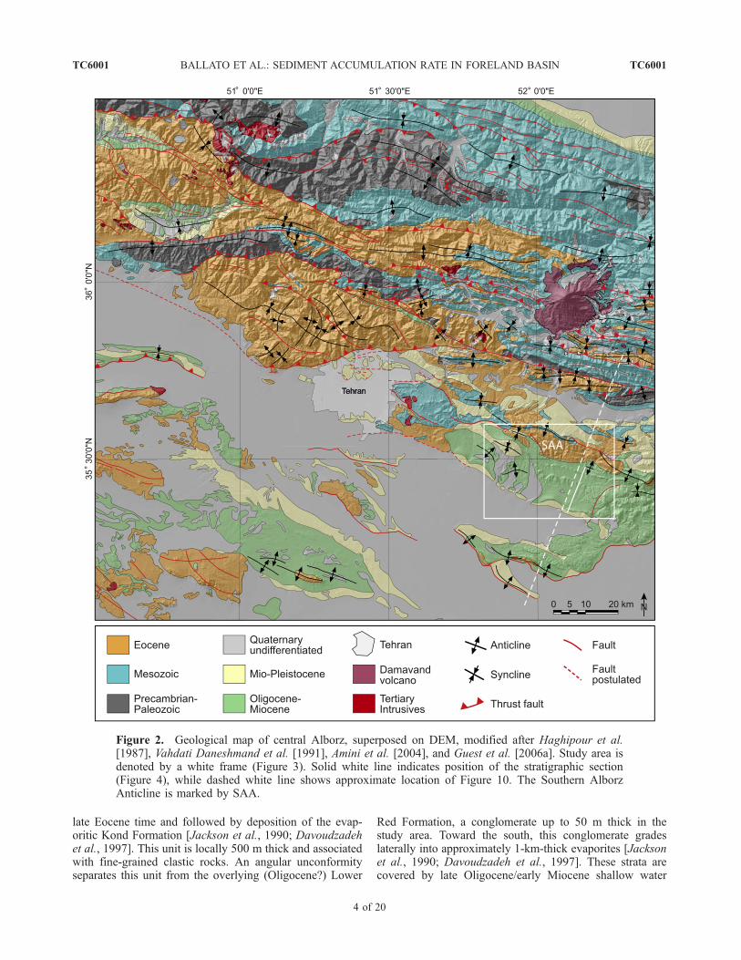
late Eocene time and followed by deposition of the evap-oritic Kond Formation [Jackson et al., 1990; Davoudzadehet al., 1997]. This unit is locally 500 m thick and associatedwith fine-grained clastic rocks. An angular unconformityseparates this unit from the overlying (Oligocene?) Lower
Red Formation, a conglomerate up to 50 m thick in thestudy area. Toward the south, this conglomerate gradeslaterally into approximately 1-km-thick evaporites [Jacksonet al., 1990; Davoudzadeh et al., 1997]. These strata arecovered by late Oligocene/early Miocene shallow water
Figure 2. Geological map of central Alborz, superposed on DEM, modified after Haghipour et al.[1987], Vahdati Daneshmand et al. [1991], Amini et al. [2004], and Guest et al. [2006a]. Study area isdenoted by a white frame (Figure 3). Solid white line indicates position of the stratigraphic section(Figure 4), while dashed white line shows approximate location of Figure 10. The Southern AlborzAnticline is marked by SAA.
TC6001 BALLATO ET AL.: SEDIMENT ACCUMULATION RATE IN FORELAND BASIN
4 of 20
TC6001

limestone, marl and minor gyprocks, with variable thick-ness, ranging from a few meters up to 1 km in central Iran[e.g., Bozorgnia, 1966; Reuter et al., 2007]. In the southernfoothills of the Alborz mountains, the superseding QomFormation, with strata as young as Burdigalian in age[Daneshian and Ramezani Dana, 2007], also containsconglomerates, and is a few hundred meters thick. Thefollowing (early to late Miocene?) Upper Red Formationcomprises red mudstones, evaporites, sandstones, and con-glomerates, and is locally up to 6 km thick [Jackson et al.,1990; Davoudzadeh et al., 1997]. At the base, these red beddeposits reflect a restricted marine and lagoonal environ-ment that records the upsection transition to a terrestrialdepositional setting [Jackson et al., 1990; Rahimpour-Bonab and Kalantarzadeh, 2005]. The Upper Red strataare covered by up to 1.5-km-thick conglomerates andsandstones of the Hezardarreh and Kahrizak formations(also known as units A and B), which were deposited inan alluvial fan system along the southern flank of the Alborz[Rieben, 1955]. Although poorly constrained, the Hezardar-reh Formation has been lithostratigraphically correlatedwith the coarse-grained Pliocene Batkhyari Formation ofthe Zagros mountains [Rieben, 1955]. This correlation,however, is probably an oversimplification. New data fromthe proximal part of the foreland basin system of the Zagrosmountains show that the onset of foreland basin sedimen-tation occurred during Oligocene to early Miocene time, andthat the coarse-grained facies of the Batkhyari Formationadvanced toward the foreland rather than being uniformlydeposited after a major phase of late Miocene-Plioceneshortening [Fakhari et al., 2008].
2.3. Stratigraphy of the Eyvanekey Section
[13] The Eyvanekey section is located �70 km east ofTehran. The studied section is perpendicular to the southernlimb of an anticline, here called the Southern AlborzAnticline (SAA), which we interpret as a breached northverging fault propagation fold (Figures 2, 3, and 4). Com-bined, the terrestrial deposits of the Upper Red and Hezar-darreh formations [Amini et al., 2004] (Figure 2) areapproximately 7400 m thick, and constitute three coarsen-ing upward units (units 1, 2 and 3) (Figures 3 and 4). Units1, 2 and part of unit 3 correspond to the Upper RedFormation, while subunit 3C represents the HezardarrehFormation.2.3.1. Unit 1[14] The first coarsening upward unit is �1.8 km thick
and consists of subunits 1A, 1B, and 1C. Subunit 1A is
composed of �800-m-thick, brick red mudstones interbed-ded with grayish green mudstones, gypsum layers, andtabular siltstones to fine-grained sandstone bodies. Theselayers are typically 5 to 50 cm thick. The red mudstoneshave a massive or laminated texture and occasionallydisplay mud cracks, indicating protracted subaerial expo-sure in a hot, arid climate. Syneresis cracks are also present,suggesting subaqueous dewatering of sediments probablydue to a high salinity contrast. The grayish green mudstonesare common at the bottom of the section, where they areorganized in packages of 3–4 m thickness. The salt layersare a few centimeters thick and are abundant at the bottomof the sequence. The siltstones and fine-grained sandstoneshave a sheet-like geometry and occasionally display ripples.Subunit 1B comprises �500-m-thick red mudstones inter-bedded with siltstones and fine- to medium-grained sand-stone bodies. The mudstones are massive to laminated,while the siltstone bodies have a sheet-like geometry andcontain ripples. The sandstone bodies have a gentle ero-sional base, and are up to 3 m thick and up to 50 m wide.They are amalgamated and form a branching geometry.Cross bedding at the base of each sandstone body generallyevolves to ripple structures upsection, and the tops of thesandstone bodies are usually bioturbated. Subunit 1C con-sists of 500-m-thick, light brown sandstone bodies withinterbedded lenses and layers of pebble conglomerates.Intercalated reddish centimeter-thick mudstones and veryfine tabular sandstones, grading into siltstones, also occur.The sandstone bodies are 1–10 m thick and severalhundreds of meters wide. Generally, they have an erosionalbase with rip-up clasts. The sandstones constitute a finingupward sequence with small- to medium-scale horizontaland trough cross bedding and ripples toward the top. Thetops of the sandstone bodies are generally bioturbated. Inaddition, these deposits frequently have small- to medium-scale water escape structures, suggesting a relatively highsediment accumulation rate. The thin-bedded sandstonesand siltstones (0.5–1 m) are characterized by ripples andhave a sheet-like or wedging geometry with a gentleerosional surface. The interbedded mudstones may displaymud cracks and are occasionally bioturbated. Importantly,to the west, the conglomeratic facies overlies the finer-grained units unconformably and pinches out to the north(Figure 3). Subunit 3C is marked by a progressive decreasein stratal dip angle from 38� to approximately 30�.[15] We interpret unit 1 to represent a playa lake, fluvial
channel, crevasse splay, and overbank depositional environ-ment. Taken together, the succession may reflect the tran-
Figure 3. (a) Shaded relief map of the study area showing location of three coarsening upward units, main geologicalstructures, unconformities, and paleomagnetic sample localities. The occurrence of coarse-grained facies within the threecoarsening upward units is also reflected by areas of higher topography. (b) Geological map of the study area, compiledfrom our own field mapping, ASTER imagery, and Amini et al. [2004]. The map shows the geometric relationship betweenthe undifferentiated pre-Miocene deposits (pre-Qom strata); the early Miocene Qom Formation [Daneshian and RamezaniDana, 2007]; the subunits 1A, 1B, 1C, 2A, 2B, 3A, and 3B representing the Upper Red Formation (early to late Miocene);the subunit 3C constituting the Hezardarreh Formation (late Miocene, after this study); and younger strata of unknown age.Note that subunit 1C truncates the underlying subunits 1A and 1B, while subunits 2A and 2B onlap onto subunit 1C. Aprogressive decrease of stratal dip angles marks the onset of subunits 1C and 3C deposition.
TC6001 BALLATO ET AL.: SEDIMENT ACCUMULATION RATE IN FORELAND BASIN
5 of 20
TC6001

sition from a playa (subunit 1A) to a distal river (subunit 1B)and braided river (subunit 1C) setting.2.3.2. Unit 2[16] The second coarsening upward unit is �1.9 km thick
and comprises two subunits (2A and 2B). Subunit 2A is�200 m thick and composed of red mudstones interbedded
with tabular siltstones to fine-grained sandstone bodies, fewgypsum layers, and rare grayish green mudstones. This unitis similar to subunit 1A, but additionally contains isolatedsandstone bodies with trough cross bedding evolving tohorizontal bedding and ripples. The following subunit 2Bconstitutes �1700 m of thick sandstone bodies with floating
Figure 3
TC6001 BALLATO ET AL.: SEDIMENT ACCUMULATION RATE IN FORELAND BASIN
6 of 20
TC6001

pebbles interlayered with reddish thin-bedded mudstonesand fine-grained sandstones and siltstones. The sandstonebodies increase in frequency and thickness toward the top ofthe unit (up to 40 m), with a width of several hundreds ofmeters. Generally, they have an erosional base and reacti-vation surfaces marked with rip-up clasts. Water escapestructures are also common. The thin-bedded sandstonesand siltstones are characterized by ripples and have a sheet-like or wedging geometry with a gentle erosional surface.The mudstones are moderately bioturbated and containgypsum-filled fractures. Subunit 2A and the base of subunit2B have onlap geometries against subunit 1C in the west(Figure 3).[17] Unit 2 is therefore interpreted to constitute fluvial
channel, crevasse splay, and overbank deposits, with minorplaya lake strata. Collectively, these deposits reflect anevolution from a playa lake (subunit 2A) to a braided river(subunit 2B) depositional system.2.3.3. Unit 3[18] The third coarsening upward unit is �3.7 km thick
and comprises subunits 3A, 3B, and 3C. Subunit 3A ismade up of 1100 m light brown mudstones and gypsumlayers. This unit also contains sandstones, whose occurrencedecreases upsection. These fine-grained deposits are gener-ally coarser than the sediments of the bottom of unit 1 and 2and contain abundant gypsum-filled fractures. Subunit 3B ismade up of 1700 m light brown and rare light greensandstones and siltstones, interbedded with reddish sandymudstones and conglomerates. Individual beds generally donot exceed 2 m thickness. The sandstones exhibit a wedginggeometry, with an erosional base, horizontal lamination andripple structures. The frequency of the sandstone bodiesincreases upsection. The sandy mudstones have a tabulargeometry and may contain mud cracks. The thickness andthe occurrence of conglomerate bodies increases upsection.Finally, the upper part of the section is a 900-m-thick, lightbrown pebble to cobble conglomerate (subunit 3C). Thispolymictic conglomerate is moderately to poorly sorted,mainly clast-supported with subrounded to well-roundedclasts. The deposit is poorly stratified and has crudelydeveloped parallel and through cross bedding. Clasts arepoorly imbricated, suggesting a medium to low-energystreamflow regime. At the bottom of this unit medium- tocoarse-grained strata and lenses of sandstones occur. To-ward the top the sandstones disappear. A progressivedecrease of stratal dip angles (�7�) marks the onset ofconglomerate deposition of subunit 3C, suggesting syntec-tonic sedimentation (Figure 3).[19] On the basis of these observations, we interpret unit
3 to be composed of playa lake, fluvial channel, crevassesplay, overbank, and alluvial fan deposits. Therefore, this
sequence characterizes a transition from playa lake (subunit3A) to braided river (subunit 3B), and alluvial fan deposi-tional environments (subunit 3C). Paleocurrent data docu-ment that the sediment source, at least since deposition ofsubunit 1C, was located to the north. The section does notcontain any faults or unconformities, suggesting that sedi-mentation was relatively continuous (Figure 3).
3. Methodology
3.1. Magnetostratigraphic Sampling Strategy
[20] The currently available age information for thedeformed and exposed sedimentary units along the southernAlborz mountains is tentative at best and fraught with manyerrors that make a rigorous assessment of the tectono-sedimentary evolution of this region difficult. In this studywe focus on the Upper Red Formation [Amini et al., 2004].We sampled a 6500-m-thick section from the bottom of unit1 to the top of subunit 3B for magnetostratigraphy (Figures 3and 4). The last conglomeratic subunit 3C, which approx-imately corresponds to the Hezardarreh Formation [Amini etal., 2004], was not sampled because of the lack of suitablefine-grained facies. The last 300 m of subunit 1B could notbe sampled because of poor exposure. The lack of freshoutcrops, coupled with the effects of weathering and thedevelopment of soil profiles, limited the density of samplingto an average distance of 17 m between sites. Samplespacing within subunit 2B was up to 35 m due to thefrequent channelized coarse-grained sandstones up to 40 mthick. We drilled at least three oriented standard cores persample from a total of 369 oriented hand samples.
3.2. Analytical Techniques
[21] The samples were analyzed at the Geoforschungs-zentrum Potsdam, Section 3.3. The majority of the speci-mens were subjected to stepwise thermal demagnetization,using at least 10 to 16 demagnetization steps ranging from50�C to 680�C. The thermal treatment was performed withan ASC Scientific TD48 oven, while natural remanentmagnetization (NRM) analysis was performed using a 2GEnterprises automatic DC-SQUID 755SRM cryogenic mag-netometer (noise level = 1 � 10�6 A/m). In some cases,alternating field demagnetization was also carried out usingthe in-line triaxial alternating field demagnetizer of thecryogenic magnetometer. Magnetic susceptibility was mea-sured after each demagnetization step with a BartingtonMS2B sensor in order to detect mineralogical alteration ofthe magnetic fraction induced by heating. The direction ofthe characteristic remanent magnetization (ChRM) wascalculated with the principal component analysis (PCA)
Figure 4. (a) Eyvanakey stratigraphic section representing the Upper Red (early to late Miocene) and the Hezardarreh(late Miocene, after this study) formations; see Figures 1, 2, and 3 for location. (b, c, and d) Rock magnetic propertiesversus stratigraphic thickness including the natural remanent magnetization (NRM) (Figure 4b), the bulk magneticsusceptibility (k) (Figure 4c), and the S ratio (Figure 4d). Note the logarithmic scale for NRM and k. Formations andrecognized units corresponding to three coarsening upward cycles are shown. Frequency plots for NRM, k, and S ratio arealso represented. The asymmetric Gaussian pattern for k and S ratio indicates the dominance of magnetite as the mostcommon phase carrying the magnetization.
TC6001 BALLATO ET AL.: SEDIMENT ACCUMULATION RATE IN FORELAND BASIN
7 of 20
TC6001

Figure 4
TC6001 BALLATO ET AL.: SEDIMENT ACCUMULATION RATE IN FORELAND BASIN
8 of 20
TC6001

[Kirschvink, 1980], applied to at least three successive datapoints.[22] Isothermal remanent magnetization (IRM) was con-
ducted with a 2G Enterprise 660 pulse magnetizer andmeasured with a Molyneux MiniSpin fluxgate magnetom-eter (noise level equal to 0.2 � 10�3 A/m). Samples wereexposed stepwise to peak fields of 5.7 to 2700 mT along thepositive z axis of the specimens in order to record completeIRM acquisition curves.
4. Paleomagnetic Results
4.1. Magnetic Mineralogy
[23] A suite of 156 samples was selected for IRM experi-ments in order to identify the ferromagnetic mineralogy.Two end-member spectra are recognized (Figure 5): (1) sam-ples sutured between 100 and 200 mT containing low-coercivity fraction, which can be ascribed to magnetite;and (2) samples that acquired the majority of IRM between600 and 1000, dominated by a high-coercivity componentthat can be attributed to hematite. The S ratio, which is a(nonlinear) estimate of the abundance of magnetite com-pared to that of antiferromagnetic minerals, mainly hema-tite, was also calculated. Hematite-dominated samples havean S ratio ranging from 0.2 to 0.4, while in magnetite-dominated samples the S ratio generally varies between 0.7and 1 (Figures 4 and 5). Most of the samples present amixture of the two components in different proportions. Theinflection point in the acquisition curve around 200–300 mTmarks the boundary between the saturation of magnetite andthe onset of magnetization of hematite (Figure 5). Further-more, most of the samples are not saturated at maximumfield of 2700 mT indicating the presence of another high-coercivity phase, such as goethite. This is in agreement withthe 40 to 20% drop of the initial NRM below 200�C(Figure 6). Interestingly, the majority of the samples areassociated with goethite, suggesting postdepositional chem-ical weathering.
4.2. Remanent Magnetization
[24] NRM intensities are characterized by a large range ofvalues (2 to 224 mA/m), indicating a variable content offerromagnetic minerals (Figures 4 and 6). Two vectorialcomponents have been commonly observed and in 75% ofthe samples a stable ChRM has been successfully isolated(Figure 6). The lower temperature component is ascribed to aviscous overprint due to the local present-day direction of themagnetic field. This contribution is probably related to thepresence of unstable magnetite and is commonly removedbelow 400�C. In some cases, the viscous component canaccount for up to 80% of the NRM intensity. The remainingstable component has a maximum unblocking temperaturebetween 450 and 680�C and represents the ChRM, whichreveals both normal and reverse polarities. IRM acquisitioncurves are in agreement with the demagnetization curve(Figures 5 and 6). Samples with magnetite exhibit a gradualdecrease in magnetization starting from �450�C (Ti magne-tite) up to 550–580�C. Samples with hematite show a sharp
decrease in NRM intensity above 600�C and the signalgenerally tends to zero at �680�C (Figure 6).[25] The reversal test [e.g., McFadden and McElhinny,
1990] was negative at the 95% confidence level, primarilybecause the mean reversed polarity inclination is �20�shallower than the expected inclination (Figure 7). This couldbe due to an incompletely removed magnetic component[e.g., Gilder et al., 2001]. Interestingly, the mean declinationof all samples shows a clockwise rotation of�17� (Figure 7).The magnetostratigraphic sequence was established fromsamples having a high-temperature stable component, usingthe principal component analysis (Figure 8) (auxiliarymaterial Data Set S1).1 This resulted in the identification of29 normal (1–26) and 27 reverse (a–y) main chrons.
4.3. Magnetostratigraphic Correlation
[26] We correlate the magnetostratigraphic sequence fromthe Upper Red Formation with the geomagnetic polaritytime scale [Cande and Kent, 1995] using the followingcriteria: (1) paleontological data indicate the youngest strataof the Qom Formation are Burdigalian in age (20.5 to16.4 Ma) [Daneshian and Ramezani Dana, 2007]; (2) thebottom of the magnetostratigraphic sequence is locatedwithin reversal event (y) of relatively long duration; (3) theupper half of the section is characterized by several normalevents of long duration (8 to 12), separated by short reverseevents (h to k); and (4) the youngest age component indetrital apatite fission track data (AFT) from the investigatedsection at about 3900 m of thickness is 13.3 Ma (Figure 8)[Rezaeian et al., 2006], implying that the depositional age ofthis strata must be younger. Figure 8 shows our correlationand provides the best fit in terms of interval numbers.[27] Because the youngest strata of the shallow water
marine carbonates are Burdigalian in age [Daneshian andRamezani Dana, 2007], our section must be younger than20.5 Ma. Considering that within the Burdigalian andshortly afterward there are only three long-duration reversalchrons (Figure 8), we place our first long-duration reverseevent (y) at the top of chron C5Dn. The relatively long-reversal chron at 15 Ma is not represented here, because itappears to coincide with the 300-m-wide outcrop gap at thetop of subunit 1B. The following magnetozones recorded inour study are characterized by a mixed polarity with short tomedium-term periods (reversal events k to x, and normalevents 12 to 25), which correlate with the interval betweenchron C5Bn.2n and C5r.1n. Upsection, the normal polaritiesare dominant (8 to 11) and associated with a relatively longnormal event (8). We correlate this magnetozone pattern(8 to 11) with the C5n.2n chron. This chron contains threecryptochrons of very short duration, which we correlatewith our reverse events h, i, and j. The upper part of thesection contains the three long-duration normal events 2, 4,and 6, which have been linked with chrons C4n.2n, C4An,and C4Ar.2n. Finally, detritial apatite fission track dating ofa sample collected at about 3900 m in the profile provides adepositional age of circa 10.1 Ma, which is younger than the
1Auxiliary materials are available at ftp://ftp.agu.org/apend/tc/2008tc002278.
TC6001 BALLATO ET AL.: SEDIMENT ACCUMULATION RATE IN FORELAND BASIN
9 of 20
TC6001

youngest AFT detrital cooling age of 13.3 Ma recorded[Rezaeian et al., 2006].[28] Our magnetostratigraphic sequence suggests that in
this area the Upper Red Formation (units 1 and 2 and part ofunit 3), was deposited between �17.5 and �7.6 Ma. This
would imply that the deposition of subunit 3C, whichcorresponds to the overlying Hezardarreh Formation, startedduring late Miocene and not in Pliocene time, as previouslyinferred [Rieben, 1955; Amini et al., 2004]. Importantly,there is a clear correlation between coarsening upward
Figure 5. Isothermal remanent magnetization (IRM) acquisition curve with a field up to 2700 mT,showing samples with a different proportion of the magnetic mineralogical phases: (a–b) magnetite-dominated, (c–d) hematite-dominated, and (e–f) mixed curves. SIRM represents the maximum IRMrecorded with a magnetic field of 2700 mT.
TC6001 BALLATO ET AL.: SEDIMENT ACCUMULATION RATE IN FORELAND BASIN
10 of 20
TC6001

cycles and accumulation rate (Figure 9). The fastest sedi-ment accumulation rates correlate with fine-grained sedi-ments, while the coarsest lithologies are associated withslow rates. If we consider that the sediment accumulationrate during the deposition of subunit 3C could have been
�0.65 mm/a, the extrapolated age of the top of the section(i.e., the top of the Hezardarreh Formation) might beyounger than or equal to 6.2 Ma. These findings imply thatthe pronounced thickness of �7400 m of sediment must
Figure 6. Vector endpoint diagrams plotted in tilt-corrected coordinates and normalized intensity decaycurves illustrating thermal demagnetization of NRM for the specimens documented in Figure 5. Blackand open squares are projected onto horizontal and vertical planes, respectively.
TC6001 BALLATO ET AL.: SEDIMENT ACCUMULATION RATE IN FORELAND BASIN
11 of 20
TC6001

have been deposited in a relatively short time period(�11 Ma) in this part of the basin.
4.4. Rock Magnetic Properties
[29] The bulk magnetic susceptibility (k) and the NRMfor the entire set of measured samples (369), associated withthe S ratio for the samples selected for IRM acquisition(156), were plotted as a function of stratigraphic thickness(Figure 4) (auxiliary material Data Sets S2 and S3). Thethree parameters are correlated and track three differentdomains. The first domain extends from the bottomupward to subunit 1C, and is characterized by k valuesgenerally lower than 500 � 10�6 SI, NRM values lowerthan 30 mA/m, and S ratio values between 0.2 and 0.8.The second domain coincides with the onset of coarse-grained sedimentation of subunit 1C and ends at thebottom of subunit 3A. This domain is characterized byscattered values of k (from �200 to 12,000 � 10�6 SI),NRM values ranging from 2 to 224 mA/m, and an S ratiobetween 0.5 and 0.9. The third domain begins at thebottom of subunit 3A and is characterized by a sharpdecrease in k and NRM up to one order of magnitudewith respect to the second domain, while the S ratio doesnot change significantly. Since the magnetic susceptibilityof magnetite is greater than that of hematite (goethite) byup to 100 (1000) times [Thompson and Oldfield, 1986],the bulk susceptibility is very sensitive to the presence ofmagnetite. The first domain is clearly enriched in hema-tite, although some levels may reflect the presence inmagnetite. The second domain records a sharp increase inmagnetite and the high susceptibility values suggest theexistence of multidomain grains [Butler, 1992]. Finally,the third domain exhibits susceptibility values intermedi-
ate with respect to the first and second domain, suggest-ing that magnetite is still the dominant magnetic fraction.
5. Discussion
5.1. Variation of Magnetic Properties
[30] In the studied section, variations in NRM, magneticsusceptibility, and S ratio allowed us to recognize threedomains (Figure 4). The first domain is hematite-dominatedand it spans the subunits 1A and 1B, while the second(subunit 1C, unit 2, and bottom of subunit 3A) and thirddomains (subunits 3A and 3B) are magnetite-dominated.Variations in magnetic properties have been linked to ped-ogenetic processes, tracing short-lived paleoenviromentalchanges [e.g., Maher and Thompson, 1991] or alternatively,to changes in sediment source, drainage pattern, sedimenttransport conditions or depositional environment [e.g., Gild-er et al., 2001]. In the Eyvanekey stratigraphic section, thelack of well-developed paleosol horizons, coupled with therelatively high sediment accumulation rate, suggests thatpedogenetic processes did not control the composition of themagnetic fraction. On the basis of the relatively longduration of the three domains and the coincidence betweenthe shift to the third domain as well as a compositionalchange in the sandstones (P. Ballato, unpublished data,2008), we suggest that the magnetic composition wasprobably controlled by changing source areas. This mayhave involved discrete erosional unroofing events and/ordrainage pattern reorganization triggered by tectonic activity.
5.2. Significance of Coarsening Upward Cycles andTrends in Accumulation Rate
[31] Our new data from the Eyvanekey section comprisesa continental clastic sequence approximately 7400 m thick,
Figure 7. Equal-area stereographic projection of ChRM directions used to constrain the magnetos-tratigraphy shown in Figure 8. Black and open squares are projected on the lower and upper hemisphere,respectively. The mean direction (star) and 95% confidence ellipses are also shown.
TC6001 BALLATO ET AL.: SEDIMENT ACCUMULATION RATE IN FORELAND BASIN
12 of 20
TC6001

organized in three coarsening upward cycles, depositedbetween �17.5 and �6.2(?) Ma (Figures 8 and 9). Thelarge amount of sediment deposited during this shortinterval suggests that the foreland basin was controlled bytectonic loading in the Alborz mountains. The averageaccumulation rate calculated for the Eyvanekey section is0.65 mm/a. This is 2 to 3 times higher than rates obtainedfrom similar studies carried out in several central Asianbasins associated with the India-Eurasia collision zone [e.g.,Charreau et al., 2005], but it is within the range of highestlong-term accumulation rates (0.5 to 0.7 mm/a) determinedfor the Himalayan and the Andean foreland basins [e.g.,Meigs et al., 1995; Echavarrıa et al., 2003]. The overall
high accumulation rate obtained in the Eyvanekey section ispunctuated by three prominent rate increases that started at�17.5, 13.8, and 10.3 Ma. We interpret these unusuallyhigh rates to reflect the onset of rapid tectonic uplift,loading, and fast exhumation (�17.5 Ma), coupled withpulses of accelerated exhumation at �13.8 and 10.3 Ma.5.2.1. First Cycle (Unit 1, �17.5 to �13.8 Ma)[32] The first relatively high accumulation rate
(0.8 mm/a) is documented in the strata at the bottom ofthe section, which were deposited subsequent to themarine carbonates of the Qom Formation (Figure 9).These carbonates, which in the southern Alborz foothillsrange in thickness between 250 (Eyvanekey section) and
Figure 8. (a) Eyvanakey sedimentary section and detailed magnetostratigraphy including(b) declinations and (c) inclinations plotted in tilt-corrected coordinates, (d) virtual geomagnetic poleVGP, and the correlation between (e) our magnetostratigraphic sequence and (f) the global geomagneticpolarity time scale of Cande and Kent [1995]. Boundaries between magnetozones were defined by themidpoint between two samples with opposite polarity. Frequency plots of inclination, declination, andVGP indicate a Gaussian bimodal data distribution. Grey diamond at �3900 m shows the position of thefission track dated sample, the youngest cooling age of which is 13.3 Ma [Rezaeian et al., 2006]. SeeFigure 4 for legend.
TC6001 BALLATO ET AL.: SEDIMENT ACCUMULATION RATE IN FORELAND BASIN
13 of 20
TC6001

400 m (Deh Namak section), were deposited betweenAquitanian and early Burdigalian [Daneshian andRamezani Dana, 2007]. This implies an accumulationrate of �0.05 to �0.13 mm/a. The onset of depositionof subunit 1A marked a fivefold to tenfold increase in thesediment accumulation rate, which was associated with asharp lithologic and sediment grain size change. AtEyvanekey, the Qom Formation constitutes marine shal-low water carbonates associated with several channelizedgravel bodies, while the coarsest grain fraction in thefollowing subunit 1A is fine to medium sand. This drasticvariation documents fundamental changes in the deposi-tional environment, basin geometry, and surface gradientsby �17.5 Ma.[33] In this context, we interpret these patterns to reflect
Miocene foreland basin initiation due to flexural subsidencein the course of crustal shortening and thickening. Thisprobably took place in the inner domain of the central
Alborz, as suggested by fission track cooling ages[Rezaeian et al., 2006]. The increase in sediment accumu-lation rate is in agreement with the results of numericalmodeling, which predicts enhanced subsidence in a forelandbasin responding to thrust loading [e.g., Heller et al., 1988;Flemings and Jordan, 1990; Sinclair et al., 1991](Figure 10). However, the onset of thrust loading couldhave occurred 1–2 Ma earlier than 17.5 Ma, since thebasinward sediment accumulation history may have beenprogressively out of phase with thrusting [Flemings andJordan, 1990]. Collectively, the onset of flexural subsidenceindicates quasi-continuous deformation in the southern cen-tral Alborz starting from the early Miocene. This followed anearlier Oligocene phase of uplift documented by the deposi-tion of the conglomeratic Lower Red Formation and theclastic facies of the Qom Formation [Allen et al., 2003].[34] Fine-grained deposition until �15.2 Ma indicates
that subsidence outpaced sediment supply until the arrival
Figure 9. Long-term and instantaneous sediment accumulation rate for the Eyvanakey section in mm/a.Lines for each curve have been interpolated using a linear best fit. R-squared coefficient is indicated inparentheses. The variation of the strata dip angle is also shown. Note that the dip angle decreases at thebase of subunits 1C and 3C.
TC6001 BALLATO ET AL.: SEDIMENT ACCUMULATION RATE IN FORELAND BASIN
14 of 20
TC6001

of conglomerates in the foreland basin [e.g., Heller et al.,1988; Flemings and Jordan, 1990]. The sediments at thebottom of the Eyvanekey section were probably depositedin an intermediate to distal position within the foreland.Interestingly, the influx of conglomerates correlates with thesharp decrease in the accumulation rate from 0.8 to0.31 mm/a at �15.2 Ma (Figure 9). This reduction appearsto have been linked with a decrease in the flexural subsi-dence due to the growth of an anticline within the forelandbasin, which corresponds to the present-day SAA. Stratalgeometric relationships support this interpretation, with thefolded subunits 1A and 1B truncated and overlain bysubunit 1C (Figures 3 and 9). Overall, the setting suggeststhat this part of the foreland system was incorporated into a
wedge top depozone [e.g., DeCelles and Giles, 1996;Simpson, 2006] by �15.2 Ma. The progradation ofcoarse-grained facies in the first cycle may have thereforebeen related to the onset of uplift within the foreland realm[Clevis et al., 2004; Horton et al., 2004; Heermance et al.,2007], rather than to postthrusting processes [e.g., Heller etal., 1988; Flemings and Jordan, 1990] (Figure 10).[35] Alternatively, the coarse-grained sedimentation may
have also been forced by high-frequency climate changeand a trend toward more erosive climate conditions, similarto what has been inferred for the global increase in thedeposition of coarse conglomerates in different orogensduring the Pliocene [e.g., Zhang et al., 2001; Molnar,2004]. Global climate reconstructions document global
Figure 10. N-S oriented sketch depicting the evolution of foreland basin and the spatiotemporalpatterns of sedimentary facies with respect to tectonic activity. For simplicity, only two faults have beenshown for illustrating the tectonic activity of the inner domain of the orogen.
TC6001 BALLATO ET AL.: SEDIMENT ACCUMULATION RATE IN FORELAND BASIN
15 of 20
TC6001

cooling during the expansion of Antarctic ice sheet atapproximately 14.5 Ma [e.g., Zachos et al., 2001]. Unfor-tunately, detailed paleoclimatic data for the Middle Eastduring Miocene time are not available to test whether thiswas a time of enhanced precipitation, erosion, and sedimentproduction. Available sedimentologic and stratigraphic datarecord protracted evaporite deposition in central and north-ern Iran since the late Eocene, suggesting a hot, arid climate[Jackson et al., 1990; Davoudzadeh et al., 1997]. However,moisture sourced in the Caspian and Black seas (Para-tethyan basins [e.g., Allen and Armstrong, 2008]) couldhave been forced into focused precipitation along theuplifting Alborz, Caucasus, and Kopeh Dagh ranges. Sucha scenario of enhanced rock uplift and construction of anorographic barrier could have eventually caused increasedsediment production and gravel progradation into the adja-cent forelands [Paola et al., 1992; Marr et al., 2000; Moraet al., 2008]. Thus, even if there is evidence for theincorporation of foreland sectors into a wedge top depo-zone, middle Miocene climatic forcing as a reason for theprogradation of coarse strata cannot be excluded.[36] In summary, the first coarsening upward cycle
records (1) the onset of flexural subsidence (�17.5 Ma),indicating the beginning of quasi-continuous deformation inthe southern central Alborz followed by (2) a decrease insubsidence (�15.2 Ma), due to local-scale uplift in thebasin, and possibly an additional superposed forcing effectrelated to climate change (Figure 10).5.2.2. Second Cycle (Unit 2, �13.8 to �10.3 Ma)[37] The second increase in accumulation rate (0.31 to
0.9 mm/a) occurred at the beginning of the second coarseningupward cycle at �13.8 Ma. It is associated with the deposi-tion of fine-grained deposits (Figure 9). Figure 3 shows theonlap of subunit 2A and part of subunit 2B onto the top of unit1, suggesting continued coeval growth of the anticline in theforeland basin. These relationships show that the overallflexural subsidence exceeded local uplift and burial of thegrowing structure beneath a thick cover of sediments(Figure 10). Therefore, the increase in accumulation rate at�13.8Ma reflects a backward shift in the locus of the tectonicactivity, with enhanced tectonic loading induced by crustalshortening and growth of the southern central part of theorogenic belt. Like unit 1, a lag time might have occurredbetween the enhanced activity in the orogen and the flexuralresponse of the foreland basin [Flemings and Jordan, 1990].[38] The upsection increase in the coarse-grained fraction
is coupled with a progressive increase in thickness andfrequency of coarse-grained, channelized sandstones, asso-ciated with a decrease in the accumulation rate to 0.3 mm/aat �13 Ma (Figure 9). It is not possible to determine,however, if the slowing down of foreland subsidence at�13 Ma is linked to increased uplift of the intrabasinalanticline or to reduced thrust loading and subsequentisostatic rebound resulting from enhanced erosion, possiblyassociated with changes in precipitation.[39] Interestingly, during deposition of the last 400 m of
channelized sandstones in this sequence, an increase in thesediment accumulation rate to 0.67 mm/a occurred at�11 Ma (Figure 9). This value is smaller than the rate
recorded at the bottom of the unit (0.9 mm/a), but muchgreater than the value obtained for the progradation ofcoarse-grained facies (0.3 mm/a). This rate increase is notassociated with a change in sedimentary facies and maxi-mum grain size, but does coincide with an increase insandstone thickness and frequency. Possibly, the increasein sediment accumulation rate is linked to faster exhumationrecorded at circa 12 Ma based on apatite (U-Th)-Hethermochronology in the central western Alborz [Guest etal., 2006b]. If true, a lag time of �1 Ma would haveoccurred between the faster exhumation in the orogen andthe onset of flexural subsidence in the foreland basin. Theoccurrence of thick sandstones coupled with a relativelyhigh sediment accumulation rate (0.67 mm/a) suggests thatthe amount of coarse-grained sediment available at that timewas probably too voluminous for having been stored alongthe basin margin [e.g., Heller et al., 1988; Paola et al.,1992; Marr et al., 2000] (Figure 10). This scenario thussuggests an overfilled basin allowing extensive syntectonicprogradation of coarse-grained facies into the forelandduring a period of increased subsidence within 1 Ma ofmajor exhumation, analogous to observations in the Hima-layan foreland basin [e.g., Burbank et al., 1988; Brozovicand Burbank, 2000].[40] In summary, the second coarsening upward cycle
consists of three episodes with long-term sediment accu-mulation rates of �0.9, 0.3, and 0.67 mm/a. We concludethat this reflects: (1) intensified shortening, uplift, anderosional exhumation at �13.8 Ma associated with forelandbasin subsidence, which outpaced the uplift of a local-scalestructure within the foreland; (2) decrease in subsidence(�13 Ma), probably due to intrabasinal uplift and possiblythe effect of superposed climate change and/or isostaticrebound; (3) renewed subsidence at �11 Ma, most likelycorrelated with accelerated exhumation recorded in theorogen at �12 Ma. This last event led to a phase ofpronounced sediment production and progradation ofcoarse-grained sediment toward the distal part of the fore-land (Figure 10).5.2.3. Third Cycle (Unit 3, �10.3 to �6.2(?) Ma)[41] The third episode characterized by high accumula-
tion rates began at �10.3 Ma. It was coupled with anorogen-ward shift of the sedimentary facies belt and dom-inant deposition of fine-grained sediments. Similar to theprevious cycles, the association of fast sediment accumula-tion rate and fine-grained facies reflects enhanced tectonicloading in the southern central part of the orogen. Theaccumulation rate of 2.2 mm/a is the highest recorded in thissection, and lasted approximately 0.7 Ma (Figure 9). Duringthis episode, a sharp change in magnetic parameters isrecorded. This is reflected by bulk magnetic susceptibilityand NRM (Figure 4), indicating an important variation insediment source areas. Taken together, these observationssuggest an important erosional unroofing event, which ledto the exposure of different source rocks and/or majordrainage reorganization in response to an intense phase oftectonic activity within the orogen (Figure 10).[42] The upsection increase in the mean grain size is
associated with a decreased accumulation rate (from 2.2 to
TC6001 BALLATO ET AL.: SEDIMENT ACCUMULATION RATE IN FORELAND BASIN
16 of 20
TC6001

0.65 mm/a) starting at �9.6 Ma, which was sustained untilthe onset of deposition of subunit 3C (Figure 9). Comparedto the previous cycles, the upsection decrease in accumula-tion rate during the third cycle is much larger, but theaccumulation rates are more than double those of theprevious cycles (fine-grained accumulation of 2.2 versus0.8 to 0.9 mm/a, and conglomerate accumulation of 0.65versus 0.3 mm/a). Throughout the entire third cycle, therelatively high accumulation rates, the progressive increaseof the coarse-grained, progressively tilted fraction culmi-nating in the deposition of 900 m of coarse conglomerates(subunit 3C), as well as recycling of clasts, suggest impor-tant tectonism in the orogen (Ballato, unpublished data,2008) (Figures 3, 9, and 10). These relationships indicatethat the deformation front, and hence the sediment source,must have advanced while the SSA was still activelygrowing. We suggest that the decrease in sediment accu-mulation rate at �9.6 Ma was linked to basin inversion,accompanied by the incorporation of the foreland sedimentsinto a growth syncline in the hanging wall of the blind thrustresponsible for the uplift of the SAA (Figure 10). Incorpo-ration of the basin into the orogenic wedge along the SSAforced the coarse-grained facies to bypass the upliftedfolded region and be deposited farther south, leading to atranslocation of the depozone into the proximal foreland.Climate forcing cannot be completely excluded to explainthese phenomena, but the �7� tilt of the strata suggestsdominant tectonic control (Figures 9 and 10). On the basisof our new magnetostratigraphy results, basin inversionmust have started at circa 9.6 Ma and could have beencompleted by about 6.2 Ma, as suggested by the extrapo-lated age for the youngest strata of this section.[43] Uplift of the SAA between circa 9.6 and 6.2(?) Ma
appears to have been coeval with rapid exhumation of theinner domain of the central Alborz range, recorded by rapidcooling at approximately 7Ma [Axen et al., 2001]. This phaseof accelerated tectonism has been associated with the reorga-nization of the Arabia-Eurasia deforming zone at circa 5 Ma[Westaway, 1994; Axen et al., 2001;Allen et al., 2004;Copleyand Jackson, 2006]. Although the timing of the reorganiza-tion is quitewell constrained, the causes of this process are notyet known [e.g., Copley and Jackson, 2006].[44] Summarizing, the third coarsening upward cycle
reflects two main processes: (1) an intense phase of thrustloading by �10.3 Ma, followed by (2) basin inversionbetween circa 9.6 and 6.2(?) Ma when the final uplift ofthe southern Alborz mountains was accomplished. Theseprocesses put the region of the Eyvanekey section into aproximal position in the foreland, promoting southwardpropagation of the foreland basin depozones (Figure 10).
5.3. Regional Versus Local Tectonic Effect on ForelandBasin Sedimentation
[45] The occurrence of fine-grained deposits associatedwith high sediment accumulation rate at the base of theUpper Red Formation (subunit 1A) suggests foreland basininitiation in the southern Alborz starting from early Mio-cene. Surprisingly, and in contrast with the evolution of ourstudy area, the South Caspian Basin, immediately to the
north of theAlborzmountains, does not record any significantincrease in subsidence pattern earlier than 5 Ma [Nadirov etal., 1997]. Presently,�75% of the suspended river load fromthe central western Alborz is delivered to the Caspian Basin,while the remainder enters basins in central Iran [Rezaeian etal., 2004]. This imbalance in sediment budgets is clearlyreflected by the drainage pattern north of the range, where themajority of rivers drain into the Caspian Sea. Nevertheless, acomparison of the sediment thickness deposited in centralIran and in the South Caspian Basin duringMiocene (5 versus3 km, respectively), and since Pliocene time (�2 versus 8 to12 km, respectively) [Jackson et al., 1990; Davoudzadeh etal., 1997;Allen et al., 2002;Brunet et al., 2003], suggests thatan important reorganization of the drainage pattern hadoccurred sometime between late Miocene and Pliocene time[Guest et al., 2006b]. Drainage reorganization might havebeen triggered by the regional sea level low stand phaseduring the Messinian salinity crisis at 5.5 Ma [Jones andSimmons, 1997], possibly in association with tectonic activ-ity. The prominent increase in tectonic subsidence in theSouthCaspianBasin from the Pliocene onwardmay have alsobeen coeval with the onset of Red Sea oceanic spreading andthe westward extrusion of Turkey, suggesting an importantplate tectonic reorganization of the Arabia-Eurasia collisionzone at circa 5Ma [Westaway, 1994;Axen et al., 2001;Allen etal., 2004; Copley and Jackson, 2006]. Therefore, during theearliest stages of mountain building in the Alborz, deforma-tion was probably located in the inner sectors of the present-day central Alborz range [Rezaeian et al., 2006] and thetectonic load mainly forced subsidence in the southernforeland basin. In contrast, during the Pliocene, acceleratedtectonic subsidence in the South Caspian Basin was probablytriggered by regional events [Westaway, 1994; Axen et al.,2001; Allen et al., 2004; Copley and Jackson, 2006] andfacilitated by lateral lithospheric strength contrasts[Mangino and Priestley, 1998; Guest et al., 2007], ratherthan tectonic loading induced by processes in the Alborzmountains.
5.4. Deformation Pattern
[46] The relationship between sediment accumulationrates, sedimentary facies, and stratal geometries within theAlborz foreland documents an overall southward propaga-tion of the deformation front. However, the locus ofdeformation did not move steadily southward, but ratherstepped forward and backward through time. Thus, onshorter time scales of circa 0.7 to 2 Ma, the orogen grewby a combination of frontal accretion and wedge internaldeformation, similar to predictions based on modelingstudies [e.g., Hoth et al., 2007; Naylor and Sinclair,2007]. Interestingly, the ratio between the fastest and theslowest sediment accumulation rate for each cycle is �3,suggesting a possible cyclicity in the relation between thrustactivity and surfaces processes. Furthermore, a high sedi-ment accumulation rate associated with the onlapping strataat the bottom of unit 2 indicates contemporaneous activityof both frontal and internal structures, suggesting that thestrain between active structures was transferred gradually[e.g., Hoth et al., 2007].
TC6001 BALLATO ET AL.: SEDIMENT ACCUMULATION RATE IN FORELAND BASIN
17 of 20
TC6001

[47] The inferred temporal shifts in the locus of defor-mation are compatible with deformation processes in acritical orogenic wedge [e.g., Davis et al., 1983; Dahlen,1990]. Internal wedge deformation through out-of-sequencethrusting thus alternated with wedge accretion and frontalthrusting associated with a change from a subcritical to acritical state, and vice versa [e.g., Davis et al., 1983;Dahlen, 1990; Hoth et al., 2007; Naylor and Sinclair,2007]. In such a system, the deformation patterns may havebeen dictated by the spatiotemporal distribution of erosion,the mode of erosion, and the rate of surface processes withrespect to the rate of deformation [e.g., Willett, 1999;Whipple and Meade, 2004; Hoth et al., 2006; Simpson,2006]. Although speculative, the evolution of the Alborzmountains and their orientation with respect the modernrainfall distribution [e.g., Alijani et al., 2008] and thedisparate nature of current erosion processes in the orogen[Rezaeian et al., 2004] suggests that the propagation of thedeformation front might have been linked to the growth ofan orographic barrier. In such scenario topographic growthwould have promoted a shift in erosion from the prowedge(southern flank) to the retrowedge (northern flank). In turn,this could have led to a southward propagation of thedeformation front, coupled with the development of a widerorogen [e.g., Willett, 1999; Whipple and Meade, 2004; Hothet al., 2006; Simpson, 2006].
6. Conclusions
[48] 1. Our magnetostratigraphic investigation of theforeland basin deposits of the southern Alborz mountainsdocuments that the Upper Red Formation, which corre-sponds to our coarsening upward units 1, 2 and subunits 3Aand 3B, was deposited approximately between 17.5 and7.6 Ma. Assuming a constant accumulation rate for the lastpart of the section, the depositional age of the top of theHezardarreh Formation (subunit 3C) in this area can beextrapolated to �6.2 Ma. These foreland strata are thusolder than the previously inferred Pliocene age. We correlatethe base of the Upper Red Formation with the onset offlexural subsidence related to crustal shortening and thick-ening in the central southern Alborz.[49] 2. We observe a systematic correlation between
coarsening upward cycles and accumulation rates(Figure 9). Fine-grained sedimentation and an increase insediment accumulation rates characterize the onset of eachcoarsening upward cycle. As predicted by numerical mod-eling [e.g., Heller et al., 1988; Flemings and Jordan, 1990;Sinclair et al., 1991], thrust loading induces maximumsubsidence adjacent to the thrust belt. Here, the coarse-grained fraction supplied by the uplifting range is spatiallyrestricted to the immediate vicinity of the range, while fine-grained sediments are deposited in distal sectors of theforeland basin. An increase in sediment accumulation rate
together with the occurrence of fine-grained facies thereforereflects enhanced tectonic activity in an actively deformingorogenic belt as documented for the units 1, 2, and 3,starting at � 17.5, 13.8, and 10.3 Ma, respectively. Thesubsequent progradation of coarse-grained facies is associ-ated with a decrease in sediment accumulation rates, sug-gesting that the overall tectonic subsidence decreased. Thiswas likely the result of a combination of several factors,including (1) onset and modifying influence of intraforelandbasin uplift as documented for unit 1 and partially for unit 2at �15 and 13 Ma, respectively, and (2) basin inversionassociated with the uplift of the SAA and the incorporationof the study area into a growth syncline located in aproximal foreland sector as documented for unit 3 by�9.6 Ma (Figure 10). Although the progradation ofcoarse-grained facies in each cycle is apparently related totectonic forcing, an additional contribution due to decreasedtectonic activity in the orogen with related flexural rebound,and an influence of climate change cannot be ruled out.[50] 3. The deposition of the coarse-grained facies com-
prising the top of unit 2 at �11 Ma, was associated with arelatively high sediment accumulation rate. This increase inaccumulation rate might be correlated with a phase of rapidexhumation and thrust loading in the orogen at about 12 Ma,documented by thermocronological. Such syntectonic pro-gradation suggests that the supply of the coarse-grainedfraction outpaced the storage capacity of the proximal partof the foreland.[51] 4. Our detailed chronology of the foreland basin
deposits allows us to trace the long-term tectonic evolutionof the Alborz mountains. Our data suggest that orogengrowth was related to a combination of thrust activity withinthe orogen and frontal accretion, as documented by theintraforeland uplift. This implies a back and forward mi-gration of the locus of tectonic activity superimposed on alonger-term southward migration of deformation fronts on atime scale of circa 0.7 to 2 Ma.
[52] Acknowledgments. This research was founded by the GermanScience Foundation (Leibniz Award to M. Strecker and grant STR 373/19-1to M. Strecker and A. Friedrich) and the graduate school program of theUniversity of Potsdam. We are indebted to the Tehran Building andHousing Research Center and the municipality of Kilan for logisticalsupport. A. Entezari, B. Keshavarzi, T. Roeper, and D. Pilz are kindlythanked for help with sampling and sample preparation. B. Fabian isthanked for figure drafting. We thank S. Gilder, B. Guest, B. Horton,J. Jackson, D. Melnik, D. Michalk, A. Mora, M. Parra, M. Rezaeian, J. F.Ritz, H. D. Sinclair, M. Szurlies, J. Zamagni, and G. Zeilinger for fruitfuldiscussions and suggestions that improved this work. C. E. Uba provided afundamental contribution for the interpretation of the sedimentary faciespattern within the foreland basin. S. Hoth reviewed an earlier version of themanuscript and provided helpful comments. T. Schildgen is thanked for herhelp with the text and constructive comments. We also acknowledge theconstructive reviews provided by M. B. Allen and M. F. Brunet. Theanalysis and presentation of paleomagnetic data were in part performedwith PMag Tools Version 4.2a by M. H. Hounslow.
ReferencesAgard, P., J. Omrani, L. Jolivet, and F. Mouthereau
(2005), Convergence history across Zagros (Iran):Constraints from collisional and earlier deforma-
t i on , I n t . J . Ear t h Sc i . , 94 , 401 – 419 ,doi:10.1007/s00531-005-0481-4.
Alijani, B., J. O’Brien, and B. Yarnal (2008), Spatialanalysis of precipitation intensity and concentration
TC6001 BALLATO ET AL.: SEDIMENT ACCUMULATION RATE IN FORELAND BASIN
18 of 20
TC6001

in Iran, Theor. Appl. Climatol., 94(1 –2), 107–124,doi:10.1007/s00704-007-0344-y.
Allen, M. B., and H. A. Armstrong (2008), Arabia –Eurasia collision and the forcing of mid-Cenozoicglobal cooling, Palaeogeogr. Palaeoclim. Palaeoe-col , 265 (1 – 2) , 52 – 58, doi:10.1016/ j .pa-laeo.2008.04.021.
Allen, M. B., S. Jones, A. Ismail-Zadeh, M. D.Simmons, and L. Anderson (2002), Onset of sub-duction as the cause of rapid Pliocene-Quaternarysubsidence in the South Caspian Basin, Geology,30, 775 –778, doi:10.1130/0091-7613(2002)030<0775:OOSATC>2.0.CO;2.
Allen, M., M. R. Ghassemi, M. Shahrabi, andM. Qorashi (2003), Accommodation of late Ceno-zoic oblique shortening in the Alborz range, north-ern Iran, J. Struct . Geol . , 25 , 659 – 672,doi:10.1016/S0191-8141(02)00064-0.
Allen, M., J. Jackson, and R. Walker (2004), Late Cen-ozoic reorganization of the Arabia-Eurasia colli-sion and the comparison of short-term and longterm deformation rates, Tectonics, 23, TC2008,doi:10.1029/2003TC001530.
Amini, B., H. Rashid, M. Rezaian, S. Allahmadadi,M. R. Zabihi, B. Vahdati Daneshmand, andM. Haddadan (2004), Geological map of Iran,Garmsar sheet, scale 1:100000, Geol. Surv. of Iran,Tehran.
Armstrong, F. C., and S. S. Oriel (1965), Tectonicdevelopment of Idaho-Wyoming thrust belt, AAPGBull., 49, 1847–1866.
Assereto, R. (1966), Explanatory notes on the geologi-cal map of Upper Djadjerud and Lar valleys (cen-tral Elburz, Iran), scale 1:50000, 86 pp., Inst. ofGeol., Univ. of Milan, Milan, Italy.
Axen, G. J., P. J. Lam, M. Grove, D. F. Stockli, andJ. Hassanzadeh (2001), Exhumation of the west-central Alborz mountains, Iran, Caspian subsi-dence, and collision-related tectonics, Geology,29, 559 –562, doi:10.1130/0091-7613(2001)029<0559:EOTWCA>2.0.CO;2.
Berberian, M., and G. C. P. King (1981), Towards apaleogeography and tectonic evolution of Iran,Can. J. Earth Sci., 18(2), 210–265.
Berberian, M., and R. S. Yeats (1999), Patterns of his-torical earthquake rupture in the Iranian Plateau,Bull. Seismol. Soc. Am., 89, 120–139.
Bozorgnia, F. (1966), Qom formation stratigraphy ofthe Central Basin of Iran and its intercontinentalposition, Bull. Iran. Pet. Inst., 24, 69– 75.
Brozovic, N., and D. W. Burbank (2000), Dynamic offluvial system and gravel progradation in the Hi-malayan foreland, Geol. Soc. Am. Bull., 112, 394–412 , do i :10 .1130 /0016 -7606(2000)112<0394:DFSAGP>2.3.CO;2.
Brunet, M. F., M. V. Korotaev, A. V. Ershov, and A. M.Nikishin (2003), The South Caspian Basin: A re-view of its evolution from subsidence modeling,Sediment. Geol., 156, 119 – 148, doi:10.1016/S0037-0738(02)00285-3.
Bullen, M. E., D. W. Burbank, J. I. Garver, and K. Y.Abdrakhmatov (2001), Late Cenozoic tectonic evolu-tion of the northwestern Tien Shan: New age esti-mates for the initiation of mountain building, Geol.Soc. Am. Bull., 113, 1544–1559, doi:10.1130/0016-7606(2001)113<1544:LCTEOT>2.0.CO;2.
Burbank, D. W. (1992), Causes of recent Himalayanuplift deduced from deposited patterns in theGanges basin, Nature, 357, 680–682, doi:10.1038/357680a0.
Burbank, D. W., R. A. Beck, R. G. H. Raynolds,R. Hobbs, and R. A. K. Tahirkheli (1988), Thrust-ing and gravel progradation in foreland basins: Atest of post-thrusting gravel dispersal, Geology, 16,1143 – 1146, doi:10.1130/0091-7613(1988)016<1143:TAGPIF>2.3.CO;2.
Butler, R. F. (1992), Paleomagnetism: Magnetic Do-mains to Geologic Terranes, 319 pp., BlackwellSci., Boston, Mass.
Cande, S. C., and D. V. Kent (1995), Revised calibra-tion of the geomagnetic polarity time scale for the
Late Cretaceous and Cenozoic, J. Geophys. Res.,100, 6093–6095, doi:10.1029/94JB03098.
Carroll, A. R., L. M. Chetel, and M. E. Smith (2006),Feast to famine: Sediment supply control on Lar-amide basin fi l l , Geology, 34 , 197 – 200,doi:10.1130/G22148.1.
Charreau, J., Y. Chen, S. Gilder, S. Dominguez, J. P.Avouac, S. Sen, D. J. Sun, Y. A. Li, and M. W.Wang (2005), Magnetostratigraphy and rock mag-netism of the Neogene Kuitun He section (north-west China): Implications for late Cenozoic upliftof the Tian Shan mountains, Earth Planet. Sci.Lett., 230, 177 – 192, doi:10.1016/j.epsl.2004.11.002.
Clevis, Q., G. de Jager, W. Nijman, and P. L. de Boer(2004), Stratigraphic signatures of translation ofthrust-sheet top basins over low-angle detachmentfaults, Basin Res., 16, 145 – 163, doi:10.1046/j.1365-2117.2003.00226.x.
Copley, A., and J. Jackson (2006), Active tectonics ofthe Turkish-Iranian Plateau, Tectonics, 25,TC6006, doi:10.1029/2005TC001906.
Dahlen, F. A. (1990), Critical taper model of fold-and-thrust belts and accretionary wedges, Annu. Rev.Earth Planet. Sci., 18, 55–99, doi:10.1146/annur-ev.ea.18.050190.000415.
Daneshian, J., and L. Ramezani Dana (2007), EarlyMiocene benthic foraminifera and biostratigraphyof the Qom Formation, Deh Namak, Central Iran,J. Asian Earth Sci., 29, 844 –858, doi:10.1016/j.jseaes.2006.06.003.
Davis, D., J. Suppe, and F. A. Dahlen (1983), Me-chanics of fold-and-thrust belts and accretionarywedges, J. Geophys. Res., 88, 1153 – 1172,doi:10.1029/JB088iB02p01153.
Davoudzadeh, M., B. Lammerer, and K. Weber-Diefenbach (1997), Paleogeography, stratigraphy,and tectonics of the Tertiary of Iran, Neues Jahrb.Geol. Palaeontol. Abh., 205, 33 –67.
DeCelles, P. G., and K. A. Giles (1996), Foreland ba-sins systems, Basin Res., 8, 105–123, doi:10.1046/j.1365-2117.1996.01491.x.
DeCelles, P. G., M. B. Gray, K. D. Ridgway, R. B.Cole, P. Srivastava, N. Pequera, and D. A. Pivnik(1991), Kinematic history of a foreland uplift fromPaleocene synorogenic conglomerate, BeartoothRange, Wyoming and Montana, Geol. Soc. Am.Bull., 103, 1458 – 1475, doi:10.1130/0016-7606(1991)103<1458:KHOAFU>2.3.CO;2.
Dehghani, G. A., and J. Makris (1984), The gravityfield and crustal structure of Iran, Neues Jahrb.Geol. Paleontol. Abh., 168, 215–229.
Echavarrıa, L., R. Hernandez, R. W. Allmendinger, andJ. Reynolds (2003), Subandean thrust and fold beltof northwestern Argentina: Geometry and timing ofthe Andean evolution, AAPG Bull., 87, 965–985,doi:10.1306/01200300196.
Fakhari , M. D., G. J . Axen, B. K. Horton,J. Hassanzadeh, and A. Amini (2008), Revisedage of proximal deposits in the Zagros forelandbasin and implications for Cenozoic evolution ofthe High Zagros, Tectonophysics, 451, 170–185,doi:10.1016/j.tecto.2007.11.064.
Flemings, P. B., and T. E. Jordan (1990), Stratigraphicmodeling of foreland basins: Interpreting thrust de-formation and lithosphere rheology, Geology, 18,430 – 434, doi:10.1130/0091-7613(1990)018<0430:SMOFBI>2.3.CO;2.
Gilder, S., Y. Chen, and S. Sen (2001), Oligo-Miocenemagnetostratigraphy and rock magnetism of theXishuigou section, Subei (Gansu Province, westernChina) and implications for shallow inclinations incentral Asia, J. Geophys. Res., 106, 30,505 –30,521, doi:10.1029/2001JB000325.
Guest, B., G. J. Axen, P. S. Lam, and J. Hassanzadeh(2006a), Late Cenozoic shortening in the westcen-tral Alborz mountains, northern Iran, by combinedconjugate strike-slip and thin-skinned deformation,Geosphere, 2, 35–52, doi:10.1130/GES00019.1.
Guest, B., D. F. Stockli, M. Grove, G. J. Axen, P. S.Lam, and J. Hassanzadeh (2006b), Thermal his-tories from the central Alborz mountains, northern
Iran: Implications for the spatial and temporal dis-tribution of deformation in northern Iran, Geol.Soc. Am. Bull., 118, 1507 – 1521, doi:10.1130/B25819.1.
Guest, B., A. Guest, and G. Axen (2007), Late Tertiarytectonic evolution of northern Iran: A case for sim-ple crustal folding, Global Planet. Change, 58,435 –453, doi:10.1016/j.gloplacha.2007.02.014.
Haghipour, A., H. Taraz, and F. Vahdati Daneshmand(1987), Geological quadrangle map of Iran, Tehransheet, scale 1:250000, Geol. Surv. of Iran, Tehran.
Heermance, R. V., J. Chien, D. W. Burbank, andC. Wang (2007), Chronology and tectonic controlsof Late Tertiary deposition in the southwesternTian Shan foreland, NW China, Basin Res., 19,599 –632, doi:10.1111/j.1365-2117.2007.00339.x.
Heller, P. L., C. L. Angevine, N. S. Winslow, andC. Paola (1988), Two-phase stratigraphic modelof foreland basin sequences, Geology, 16, 501 –504 , do i :10 .1130 /0091-7613(1988)016<0501:TPSMOF>2.3.CO;2.
Hollingsworth, J., J. Jackson, R. Walker, M. Geitanchi,and M. Bolourchi (2006), Strike-slip faulting, rota-tion, and along-strike elongation in the KopehDagh mountains, NE Iran, Geophys. J. Int., 166,1161 – 1177, doi:10.1111/j.1365-246X.2006.02983.x.
Horton, B. K., and P. G. DeCelles (2001), Modern andancient fluvial megafans in the foreland basin sys-tem of the central Andes, southern Bolivia: Impli-cations for drainage network evolution in fold-thrust belts, Basin Res., 13, 43– 63, doi:10.1046/j.1365-2117.2001.00137.x.
Horton, B. K., K. N. Constenius, and P. G. DeCelles(2004), Tectonic control on coarse-grained fore-land-basin sequences: An example from the Cor-dilleran foreland basin, Utah Geol., 32, 637–640,doi:10.1130/G20407.1.
Horton, B. K., J. Hassanzadeh, D. F. Stockli, G. J.Axen, R. J. Gillis, B. Guest, A. Amini, M. D.Fakhari, S. M. Zamanzadeh, and M. Grove(2008), Detritial zircon provenance of Neoprotero-zoic to Cenozoic deposits in Iran: Implications forchronostratigraphy and collision tectonics, Tecto-nophy s i c s , 451 , 9 7 – 122 , do i : 10 . 1016 /j.tecto.2007.11.063.
Hoth, S., J. Adam, N. Kukowski, and O. Oncken(2006), Influence of erosion on the kinematics ofbivergent orgens. results from scaled sandbox si-mulations, in Tectonics, Climate and LandscapeEvolution, Penrose Conference Series, edited byS. Willett et al., Spec. Pap. Geol. Soc. Am., 398,201 –225, doi:10.1130/2006.2398(12).
Hoth, S., A. Hoffmann-Rothe, and N. Kukowski(2007), Frontal accretion: An internal clock for bi-vergent wedge deformation and surface uplift,J. Geophys. Res., 112, B06408, doi:10.1029/2006JB004357.
Jackson, J. A., and D. P. McKenzie (1984), Activetectonics of the Alpine-Himalayan belt betweenwestern Turkey and Pakistan, Geophys. J.R. As-tron. Soc., 77, 185–264.
Jackson, M. P. A., R. R. Cornelius, C. H. Craig,A. Gansser, J. Stocklin, and C. J. Talbot (1990),Salt diapirs of the Great Kavir, central Iran, Mem.Geol. Soc. Am., 177, 139 pp.
Jackson, J., K. Priestly, M. Allen, and M. Berberian(2002), Active tectonics of the South Caspian Ba-sin, Geophys. J. Int., 148, 214–245, doi:10.1046/j.1365-246X.2002.01588.x.
Jones, R. W., and M. D. Simmons (1997), A review ofthe stratigraphy of Eastern Paratethys (Oligocene-Holocene), with particular emphasis on the BlackSea, in: Regional and Petroleum Geology of the
Black Sea and Surrounding Region, edited byA. Robinson, AAPG Mem., 68, 39–52.
Jordan, T. E., P. B. Flemings, and J. A. Beers (1988),Dating thrust-fault activity by use of foreland-basinstrata, in New Perspectives in Basin Analysis, edi-ted by K. L. Kleinspehn and C. Paola, pp. 307–330, Springer, New York.
TC6001 BALLATO ET AL.: SEDIMENT ACCUMULATION RATE IN FORELAND BASIN
19 of 20
TC6001

Kirschvink, J. L. (1980), The least-squares line andplane and analysis of paleomagnetic data, Geophys.J.R. Astron. Soc., 62, 699–718.
Landgraf, A., P. Ballato, M. R. Strecker, A. Friedrich,S. H. Tabatabaei, and M. Shahpasandzadeh (2008),Fault-kinematic and geomorphic observationsalong the North Tehran Thrust and Mosha FashamFault, Alborz mountains, Iran: Implications forfault-system evolution and interaction in a chan-ging tectonic regime, Geophys. J. Int, in press.
Maher, B. A., and R. Thompson (1991), Mineral mag-netic record of the Chinese loess and paleosols,Geo l o g y , 19 , 3 – 6 , do i : 1 0 . 11 30 / 00 91 -7613(1991)019<0003:MMROTC>2.3.CO;2.
Mangino, S., and K. Priestley (1998), The crustal struc-ture of the southern Caspian region, Geophys.J . I n t . , 1 3 3 , 6 3 0 – 6 4 8 , d o i : 1 0 . 1 0 4 6 /j.1365-246X.1998.00520.x.
Marr, J. C., J. B. Swenson, C. Paola, and V. R. Voller(2000), A two-diffusion model of fluvial stratigra-phy in closed depositional basins, Basin Res., 12,381–398, doi:10.1046/j.1365-2117.2000.00134.x.
Masson, F., M. Anvari, Y. Djamour, A. Walpersdorf,F. Tavakoli, M. Daignieres, H. Nankali, and S. vanGorp (2007), Large-scale velocity field and straintensor in Iran inferred from GPS measurements:New insight for the Present-day deformation pat-tern within NE Iran, Geophys. J. Int., 170, 436–440, doi:10.1111/j.1365-246X.2007.03477.x.
McFadden, P. L., and M. W. McElhinny (1990), Clas-sification of the reversal test in palaeomagnetism,Geophys. J. Int., 103, 725 – 729, doi:10.1111/j.1365-246X.1990.tb05683.x.
McQuarrie, N., J. M. Stock, C. Verdel, and B. P.Wernicke (2003), Cenozoic evolution of Neotethysand implications for the causes of plate motions,Geophys. Res. Lett., 30(20), 2036, doi:10.1029/2003GL017992.
Meigs, J. A., D. W. Burbank, and R. A. Beck (1995),Middle-Late Miocene (>10 Ma) formation of theMain Boundary thrust in the western Himalaya,Geology, 23, 423 – 426, doi:10.1130/0091-7613(1995)023<0423:MLMMFO>2.3.CO;2.
Molnar, P. (2004), Late Cenozoic increase in accumu-lation rates of terrestrial sediment: How might cli-mate change have affected erosion rates?, Annu.Rev. Earth Planet. Sci., 32, 67– 89, doi:10.1146/annurev.earth.32.091003.143456.
Mora, A., M. Parra, M. R. Strecker, E. R. Sobel, H.Hooghiemstra, V. Torres, and J. V. Jaramillo(2008), Climatic forcing of asymmetric orogenicevolution in the Eastern Cordillera of Colombia,Geol. Soc. Am. Bull., 120, 930–949, doi:10.1130/B26186.
Mortimer, E., B. Carrapa, I. Coutand, L. Schoenbohm,E. R. Sobel, J. Sosa Gomez, and M. R. Strecker(2007), Fragmentation of a foreland basin in re-sponse to out-of-sequence basement uplifts andstructural reactivation: El Cajon-Campo del Arenalbasin, NW Argentina, Geol. Soc. Am. Bull., 119,637–653, doi:10.1130/B25884.1.
Nadirov, R. S., E. Bagirov, M. Tagiyev, and I. Lerche(1997), Flexural plate subsidence, sedimentationrates, and structural development of the super-deepsouth Caspian basin, Mar. Pet. Geol., 14, 383 –400, doi:10.1016/S0264-8172(96)00054-2.
Naylor, M., and H. D. Sinclair (2007), Reconcilingpunctuated thrust deformation in the context of or-ogenesis: Implications for the localisation of upliftand exhumation, Geology, 35 , 559 – 562,doi:10.1130/G23448A.1.
Ori, G. G., and P. F. Friend (1984), Sedimentary basinsformed and carried piggyback on active thrustsheets, Geology, 12, 475–478, doi:10.1130/0091-7613(1984)12<475:SBFACP>2.0.CO;2.
Paola, C., P. L. Heller, and C. L. Angevine (1992), Thelarge-scale dynamics of grain-size variation in al-luvial basins, 1: Theory, Basin Res., 4, 73– 90.
Rahimpour-Bonab, H., and Z. Kalantarzadeh (2005),Origin of secondary potash deposits: A case fromMiocene evaporites of NW central Iran, J. AsianEar th Sc i . , 25 , 157 – 166 , do i :10 .1016 /j.jseaes.2004.02.004.
Reuter, M., W. E. Piller, M. Harzhauser, O. Mandic,B. Berning, F. Rogl, A. Kroh, M. P. Aubry,U. Wielandt-Schuster, and A. Hamedani (2007),The Oligi-/Miocene Qom Formation (Iran): Evi-dence for an early Burdigalian restriction of theTethyan seaway and closure of its Iranian gate-ways, Int. J. Earth Sci, doi:10.1007/s00531-007-0269-9, in press.
Rezaeian, M., N. Hovius, S. J. Dadson, and M. B.Allen (2004), Erosion of the Alborz mountainsconstrained by river gauging, Eos Trans. AGU,85(47), Fall Meet., Suppl, Abstract T31B-1289.
Rezaeian, M., A. Carter, N. Hovius, and M. Allen(2006), Deformation and cooling history of the Al-borz mountains, northern Iran, constrained by apa-tite fission track and apatite He/U-Th analyses,paper presented at European Conference on Ther-mochronology, Univ. of Bremen, Germany.
Riba, O. (1976), Syntectonic unconformities of theAlto Cardener, Spanish Pyrenees: A genetic inter-pretation, Sediment. Geol. , 15 , 213 – 233,doi:10.1016/0037-0738(76)90017-8.
Rieben, H. (1955), The geology of the Tehran plain,Am. J. Sci., 253, 617 –639.
Ritz, J.-F., H. Nazari, A. Ghassemi, R. Salamati,A. Shafei, S. Solaymani, and P. Vernant (2006),Active transtension inside central Alborz: A newinsight into northern Iran– southern Caspian geo-dynamics, Geology, 34, 477 – 480, doi:10.1130/G22319.1.
Simpson, G. D. H. (2006), Modelling interactions be-tween fold-thrust belt deformation, foreland flexureand surface mass transport, Basin Res., 18, 125 –143, doi:10.1111/j.1365-2117.2006.00287.x.
Sinclair, H. D., B. J. Coakley, P. A. Allen, and A. B.Watts (1991), Simulation of foreland basin strati-graphy using a diffusion model of mountain beltuplift and erosion: An example from the centralAlps, Switzerland, Tectonics, 10, 599 – 620,doi:10.1029/90TC02507.
Talebian, M., and J. A. Jackson (2002), Offset on theMain Recent Fault of NW Iran and implications forthe late Cenozoic tectonics of the Arabia-Eurasiacollision zone, Geophys. J. Int., 150, 422 –439,doi:10.1046/j.1365-246X.2002.01711.x.
Thompson, R., and F. Oldfield (1986), EnvironmentalMagnetism, 227 pp., Allen and Unwin, London.
Uba, C. E., M. R. Strecker, and A. K. Schmitt (2007),Increased sediment accumulation rates and climaticforcing in the central Andes during the late Mio-cene, Geology, 35, 979 – 982, doi:10.1130/G224025A.1.
Va h d a t i D a n e s hm a n d , F . , Z . H o s s e i n i ,A. Afsharinzadeh, and Z. Chaichi (1991), Geolo-gical quadrangle map of Iran, Amol sheet, scale1:250000, Geol. Surv. of Iran, Tehran.
Verdel, C., B. P.Wernicke, J. Ramezani, J. Hassanzadeh,P. R. Renne, and T. L. Spell (2007), Tertiary Cordil-leran-style metamorphic core complexes in the Sag-
hand region of central Iran,Geol. Soc. Am. Bull., 119,961–977, doi:10.1130/B26102.1.
Vernant, P., et al. (2004a), Present-day crustal deforma-tion and plate kinematics in the Middle East con-strained by GPS measurements in Iran and northernOman, Geophys . J . In t . , 157 , 381 – 398,doi:10.1111/j.1365-246X.2004.02222.x.
Vernant, P., J. Chery, R. Bayer, Y. Djamour, F. Masson,H. Nankali, J. F. Ritz, M. Sedighi, and F. Tavakoli(2004b), Deciphering oblique shortening of centralAlborz in Iran using geodetic data, Earth Planet.
Sc i . Le t t . , 223 , 177 – 185 , do i :10 .1016 /j.epsl.2004.04.017.
Vincent, S. J., M. B. Allen, A. D. Ismail-Zadeh,R. Flecker, K. A. Foland, and M. D. Simmons(2005), Insights from the Talysh of Azerbaijan intothe Paleogene evolution of the south Caspian re-gion, Geol. Soc. Am. Bull., 117, 1513 – 1533,doi:10.1130/B25690.1.
Vincent, S. J., A. C. Morton, A. Carter, S. Gibbs, andT. G. Barabadze (2007), Oligocene uplift of thewestern Greater Caucasus: An effect of initial Ara-bia –Eurasia collision, Terra Nova, 19, 160–166,doi:10.1111/j.1365-3121.2007.00731.x.
Walpersdorf, A., D. Hatzfeld, H. Nankali, F. Tavakoli,F. Nilforoushan, M. Tatar, P. Vernant, J. Chery, andF. Masson (2006), Difference in the GPS deforma-tion pattern of north and central Zagros (Iran), Geo-phys. J. Int., 167, 1077 – 1088, doi:10.1111/j.1365-246X.2006.03147.x.
Westaway, R. (1994), Present-day kinematics of theMiddle East and eastern Mediterranean, J. Geo-phys. Res., 99, 12,071 – 12,090, doi:10.1029/94JB00335.
Whipple, K., and B. J. Meade (2004), Controls on thestrength of coupling among climate, erosion, anddeformation in two-sided, frictional orogenicwedges at steady state, J. Geophys. Res., 109,F01011, doi:10.1029/2003JF000019.
Willett, S. D. (1999), Orogeny and orography; the ef-fects of erosion on the structure of mountain belts,J . Geophys . Res . , 104 , 28 ,957 – 28 ,982,doi:10.1029/1999JB900248.
Zachos, J., M. Pagani, L. Sloan, E. Thomas, andK. Billups (2001), Trends, rhythms and aberrationsin global climate 65 Ma to Present, Science, 292,686 –693, doi:10.1126/science.1059412.
Zanchi, A., F. Berra, M. Mattei, M. Ghassemi, andJ. Sabouri (2006), Inversion tectonics in centralAlborz, Iran, J. Struct. Geol., 28, 2023 – 2037,doi:10.1016/j.jsg.2006.06.020.
Zhang, P., P. Molnar, and W. R. Downs (2001), In-creased sedimentation rates and grain sizes 2 – 4Myr ago due to the influence of climate changeon erosion rates , Nature , 410 , 891 – 897,doi:10.1038/35073504.
���������P. Ballato, A. Landgraf, and M. R. Strecker, Institut
fur Geowissenschaften, Universitat Potsdam, Karl-Liebknecht-Strasse 24, D-14476 Potsdam, Germany.([email protected])
A. Friedrich, Department fur Geo- und Umwelt-wissenschaften, Ludwig-Maximilians UniversitatMunchen, Luisen-Strasse 37, D-80333, Munich,Germany.
N. R. Nowaczyk, Geoforschungszentrum, Section3.3, Telegrafenberg, D-14473 Potsdam, Germany.
S. H. Tabatabaei, Building and Housing ResearchCenter, Sheikh Fazlollah Express Way, Tehran, 13145-1696, Iran.
TC6001 BALLATO ET AL.: SEDIMENT ACCUMULATION RATE IN FORELAND BASIN
20 of 20
TC6001
Copyright © 2022 FDOKUMEN