Messinian forced regressions in the Adana Basin: a near-coincidence of tectonic and eustatic forcing
26
864 http://journals.tubitak.gov.tr/earth/ Turkish Journal of Earth Sciences Turkish J Earth Sci (2013) 22: 864-889 © TÜBİTAK doi:10.3906/yer-1208-3 Messinian forced regressions in the Adana Basin: a near-coincidence of tectonic and eustatic forcing Ayhan ILGAR 1, *, Wojciech NEMEC 2 , Aynur HAKYEMEZ 1 , Erhan KARAKUŞ 1 1 Department of Geological Research, General Directorate of Mineral Research and Exploration (MTA), 06520 Ankara, Turkey 2 Department of Earth Science, Faculty of Mathematics and Natural Sciences, University of Bergen, 5007 Bergen, Norway * Correspondence: [email protected] 1. Introduction e late Miocene Mediterranean event known as the Messinian salinity crisis was triggered by a glacioeustatic sea-level fall combined with the region’s tectonic separation from the Atlantic at the latest stages of the Alpine orogeny (Hsü et al. 1972; Ryan & Cita 1978; Cita & McKenzie 1986; Ryan 2009; Hüsing et al. 2010). e event culminated in the evaporitic Lago Mare phase of partial or nearly complete desiccation and ended with the Zanclean marine flooding, when the Atlantic waters reclaimed the Mediterranean Basin. A consentient 3-phase scenario for the Messinian event postulates (Roveri & Manzi 2006): (1) a preevaporitic phase 7.25–5.96 Ma B.P., when organic-rich euxinic deposits recorded a significantly reduced circulation of Mediterranean deep waters and when microbial stromatolitic limestones formed in some peripheral basins; (2) the deposition phase of Lower Evaporites 5.96–5.60 Ma B.P., when the precipitation of gypsum occurred in shallow-water peripheral basins; and (3) the deposition phase of Upper Evaporites 5.60–5.33 Ma B.P., when the nonmarine Lago Mare environment formed in the lowest parts of a desiccating Mediterranean Basin. e bulk amplitude of relative sea-level fall is estimated at 2000 to 3000 m (Ryan 2009). It may thus seem surprising that a regional event of such a great magnitude, originally recognised from thick evaporites in the centre of the Mediterranean Basin, is much less conspicuous at the basin margins, Abstract: is sedimentological and sequence-stratigraphic study focuses on the late Miocene deposits in one of the largest peri- Mediterranean basins of southern Turkey, the Adana Basin, which formed as a Tauride foreland depression accumulating molasse deposits. e Tortonian–Messinian shallow-marine Handere Formation, previously interpreted as a regressive succession, appears to have recorded several relative sea-level changes. e formation base recorded a forced regression attributed to the end-Serravalian (Tor- 1) eustatic fall in sea level. e lower to middle part of the formation is transgressive, culminating in offshore mudstones. e upper part is regressive and its 3 isolated conglomeratic members represent sharp-based Gilbert-type deltas with incised fluvial valley-fill deposits, recording a forced regression followed by marine reflooding. e time of this regression is biostratigraphically constrained to ~7.8 to 6.4 Ma B.P. on the basis of planktonic foraminifera in delta bottomset deposits. e regression is attributed to the tectonic conversion of the Adana foreland shelf into a piggyback basin, as indicated by seismic sections and compressional basin-margin deformation. e reflooding of the basin ~6.4 Ma B.P. is ascribed to a postthrusting flexural subsidence of the foreland under increased crustal load. e marine transgression brought an almost immediate evaporitic sedimentation, which suggests invasion of hypersaline Mediterranean water. e basin was subsequently emerged and its gypsiferous deposits were extensively eroded due to a second Messinian forced regression, attributed to the early evaporative drawdown in the Mediterranean Sea (~6 Ma B.P.). e postorogenic isostatic upliſt of the Taurides had meanwhile elevated the basin enough to prevent its reflooding by the Zanclean regional transgression. Stratigraphic comparison with coeval peri-Mediterranean basins to the west demonstrates that interbasinal correlations are difficult, and that a superficial linking of comparable events may be quite misleading. e local timing of the late Miocene relative sea-level changes and the landward extent of the Zanclean flooding were apparently determined by the combination of eustasy, tectonics, basin topography, and sediment supply, whereby the eustatic signal was modulated and oſten obscured by local conditions. However, the individual basin-fill successions bear a high-resolution record of local events and give unique insights into the local role of tectonics, sediment yield, and sea-level changes. Key Words: Sedimentology, sequence stratigraphy, Taurides, piggyback basin, Gilbert-type delta, incised valley-fill, Messinian salinity crisis, stratigraphic correlation Received: 10.08.2012 Accepted: 19.12.2012 Published Online: 26.08.2013 Printed: 25.09.2013 Research Article
Transcript of Messinian forced regressions in the Adana Basin: a near-coincidence of tectonic and eustatic forcing

864
http://journals.tubitak.gov.tr/earth/
Turkish Journal of Earth Sciences Turkish J Earth Sci(2013) 22: 864-889© TÜBİTAKdoi:10.3906/yer-1208-3
Messinian forced regressions in the Adana Basin: a near-coincidence of tectonic and eustatic forcing
Ayhan ILGAR1,*, Wojciech NEMEC2, Aynur HAKYEMEZ1, Erhan KARAKUŞ1
1Department of Geological Research, General Directorate of Mineral Research and Exploration (MTA), 06520 Ankara, Turkey2Department of Earth Science, Faculty of Mathematics and Natural Sciences, University of Bergen, 5007 Bergen, Norway
* Correspondence: [email protected]
1. IntroductionThe late Miocene Mediterranean event known as the Messinian salinity crisis was triggered by a glacioeustatic sea-level fall combined with the region’s tectonic separation from the Atlantic at the latest stages of the Alpine orogeny (Hsü et al. 1972; Ryan & Cita 1978; Cita & McKenzie 1986; Ryan 2009; Hüsing et al. 2010). The event culminated in the evaporitic Lago Mare phase of partial or nearly complete desiccation and ended with the Zanclean marine flooding, when the Atlantic waters reclaimed the Mediterranean Basin. A consentient 3-phase scenario for the Messinian event postulates (Roveri & Manzi 2006): (1) a preevaporitic phase 7.25–5.96 Ma B.P., when organic-rich euxinic deposits recorded a significantly
reduced circulation of Mediterranean deep waters and when microbial stromatolitic limestones formed in some peripheral basins; (2) the deposition phase of Lower Evaporites 5.96–5.60 Ma B.P., when the precipitation of gypsum occurred in shallow-water peripheral basins; and (3) the deposition phase of Upper Evaporites 5.60–5.33 Ma B.P., when the nonmarine Lago Mare environment formed in the lowest parts of a desiccating Mediterranean Basin. The bulk amplitude of relative sea-level fall is estimated at 2000 to 3000 m (Ryan 2009).
It may thus seem surprising that a regional event of such a great magnitude, originally recognised from thick evaporites in the centre of the Mediterranean Basin, is much less conspicuous at the basin margins,
Abstract: This sedimentological and sequence-stratigraphic study focuses on the late Miocene deposits in one of the largest peri-Mediterranean basins of southern Turkey, the Adana Basin, which formed as a Tauride foreland depression accumulating molasse deposits. The Tortonian–Messinian shallow-marine Handere Formation, previously interpreted as a regressive succession, appears to have recorded several relative sea-level changes. The formation base recorded a forced regression attributed to the end-Serravalian (Tor-1) eustatic fall in sea level. The lower to middle part of the formation is transgressive, culminating in offshore mudstones. The upper part is regressive and its 3 isolated conglomeratic members represent sharp-based Gilbert-type deltas with incised fluvial valley-fill deposits, recording a forced regression followed by marine reflooding. The time of this regression is biostratigraphically constrained to ~7.8 to 6.4 Ma B.P. on the basis of planktonic foraminifera in delta bottomset deposits. The regression is attributed to the tectonic conversion of the Adana foreland shelf into a piggyback basin, as indicated by seismic sections and compressional basin-margin deformation. The reflooding of the basin ~6.4 Ma B.P. is ascribed to a postthrusting flexural subsidence of the foreland under increased crustal load. The marine transgression brought an almost immediate evaporitic sedimentation, which suggests invasion of hypersaline Mediterranean water. The basin was subsequently emerged and its gypsiferous deposits were extensively eroded due to a second Messinian forced regression, attributed to the early evaporative drawdown in the Mediterranean Sea (~6 Ma B.P.). The postorogenic isostatic uplift of the Taurides had meanwhile elevated the basin enough to prevent its reflooding by the Zanclean regional transgression. Stratigraphic comparison with coeval peri-Mediterranean basins to the west demonstrates that interbasinal correlations are difficult, and that a superficial linking of comparable events may be quite misleading. The local timing of the late Miocene relative sea-level changes and the landward extent of the Zanclean flooding were apparently determined by the combination of eustasy, tectonics, basin topography, and sediment supply, whereby the eustatic signal was modulated and often obscured by local conditions. However, the individual basin-fill successions bear a high-resolution record of local events and give unique insights into the local role of tectonics, sediment yield, and sea-level changes.
Key Words: Sedimentology, sequence stratigraphy, Taurides, piggyback basin, Gilbert-type delta, incised valley-fill, Messinian salinity crisis, stratigraphic correlation
Received: 10.08.2012 Accepted: 19.12.2012 Published Online: 26.08.2013 Printed: 25.09.2013
Research Article

865
ILGAR et al. / Turkish J Earth Sci
where stratigraphic correlations of relative sea-level changes are difficult and controversial (Ryan 2009). One of the most contentious issues is the timing of the onsets of hypersalinity and evaporative drawdown in the Mediterranean Sea, with direct implications for the negative imbalance between the rate of water influx from the Atlantic and the regional rate of evaporation. Regional studies suggest that the first precipitates at the deep bottom of the Mediterranean Basin were preceded by a long stepwise advance towards hypersalinity, with gypsum in peripheral basins precipitated well before the nominal onset of the regional salinity crisis (see review by Ryan 2009). Most researchers also suggest that the salinity crisis was preceded by a considerable early drawdown, with the isolation of peripheral basins as evaporating lagoons and their eventual emergence (Rouchy 1982; Rouchy & Saint Martin 1992; Clauzon et al. 1996; Riding et al. 1999; Soria et al. 2005; Maillard & Mauffret 2006; Rouchy & Caruso 2006; Roveri & Manzi 2006). The early drawdown might not exceed 200 m (Dronkert 1985; Krijgsman et al. 1999), but would mark a negative water budget and would expectedly have a major impact on the peripheral basins and their stratigraphy. However, the peri-Mediterranean late Miocene stratigraphic record is fuzzy, combining relative sea-level changes caused by eustatic and local tectonic forcing.
The diversified tectono-geomorphic conditions of peripheral basins resulted in intricate stratigraphic successions that are difficult to correlate and also difficult to relate to the evaporitic successions in offshore wells. Regional correlations are complicated by the fact that evaporites are found in only some of the peripheral basins, where they may either predate or postdate the Mediterranean desiccation (Riding et al. 1999). The key indicator of the early evaporative drawdown in the peripheral basins might thus be not evaporites, but a regional surface of erosion (Ryan 2009). However, neither feature can easily be recognised and correlated in the basins (Riding et al. 1991, 1998; Roep et al. 1998; Soria et al. 2005; Roveri & Manzi 2006). The Messinian surface of subaerial erosion is highly irregular due to the varied rates of local denudation and it is not marked by any significant climatic change. It has been elevated by tectonics and overtaken by Plio–Pleistocene erosion in many basins (Glover et al. 1998; Dilek et al. 1999; Deynoux et al. 2005; Monod et al. 2006), and it splits into 2 or more erosion surfaces towards the deep part of the Mediterranean Basin (Ryan 2009) and commonly also landwards in the peripheral basins (Butler et al. 1995; Clauzon et al. 1996; Riding et al. 1998; Soria et al. 2003).
The evidence of late Miocene regressions, commonly multiple, has been recognised in virtually all peri-Mediterranean basins at both active and passive margins
(Ryan 2009), but these events are difficult to correlate and have been variously attributed to eustasy, high sediment supply, or local tectonic uplift (e.g., Clauzon et al. 1996; Riding et al. 1999; Karabıyıkoğlu et al. 2000; Larsen 2003; Soria et al. 2003, 2005; Deynoux et al. 2005; Flecker et al. 2005; Roveri & Manzi 2006; Çiner et al. 2008). Regional studies have pointed to the importance of local tectonics in controlling the late Miocene palaeogeography (Butler et al. 1995; Roveri & Manzi 2006). Many areas of the Mediterranean were still subject to the final stages of the Alpine orogeny at that time, whereas it is generally difficult to distinguish between eustatically forced and tectonically forced regressions, particularly if both factors were potentially involved. The local timing of the late Miocene relative sea-level changes and the landward extent of the Zanclean marine reflooding were probably both determined by the combination of eustasy, local tectonics, basin topography, and sediment supply.
This regional issue is addressed by the present study from the Adana Basin at the north-eastern corner of the Mediterranean (Figure 1a), where a regression due to tectonic inversion of the basin nearly coincided with the Messinian evaporative drawdown. The principal aims of the study are to: (1) give a palaeontologically constrained revised sequence stratigraphy of the Adana Basin, with a focus on the late Miocene part of the basin-fill succession; (2) assess the role of tectonics and eustasy in forcing the Messinian relative sea-level changes in the basin; and (3) compare the late Miocene stratigraphy of the Adana Basin with that of the adjacent peri-Mediterranean basins in order to draw regional implications.
2. TerminologyThe term “regression” denotes seaward displacement of shoreline, resulting in a relative increase of land area (Posamentier & Vail 1988; Posamentier et al. 1992). Regression reflects the interplay between the relative sea-level change (i.e. the available accommodation) and the supply of sediment to the shoreline (i.e. the accommodation infilling). Their interplay may result in a normal or a forced regression (Posamentier et al. 1992; Posamentier & Morris 2000). A normal regression signifies relative sea-level stillstand or slow rise, with the high sediment supply causing seaward shoreline displacement. A forced regression signifies a relative sea-level fall, with the latter causing seaward shoreline displacement, even if the sediment supply to the shoreline is negligible. A forced regression may be caused by a eustatic sea-level fall, a tectonic uplift, or a coincidental combination of these 2 factors.
The basic sequence-stratigraphic terminology used here is according to Catuneanu (2006). Stratigraphic sequence is a sedimentary succession deposited during a full cycle of

866
ILGAR et al. / Turkish J Earth Sci
Figure 1. (a) Topographic image of Anatolia (90-m resolution SRTM from Jarvis et al. 2008), showing the location of the Adana Basin and other main peri-Mediterranean Miocene basins and major tectonic lineaments referred to in the text. (b) Simplified geological map of the southern part of the Adana Basin and the adjacent Mut Basin (based on Şenel 2002 and Ulu 2002); note the study area in the former basin (frame) and the location of a late Tortonian delta in the latter basin. (c) Detailed geological map of the study area in the Adana Basin. Note the 3 isolated deltaic members of the uppermost Handere Formation. The points 1–7 in maps B and C indicate outcrop localities to which the paper’s other figures refer.
Oligocene
Lower Miocene
Middle Miocene
Middle-Upper Miocene
Middle-Upper Miocene
Middle Miocene
Upper Miocene
Pliocene-Pleistocene
Holocene
ophiolitic mélange
limestones & clastics
lacustrine carbonates
fluvial-lacustrine clastics
fluvial-lagoonal clastics
marine marl-limestones
reefal limestones
deep-marine clastics
fluvial-shallow marine clastics
alluvial terraces
alluvium
Palaeozoic & Mesozoic
bedrock
EXPLANATIONS
map C
Taurus Orogenic Belt
B
MuratlıMb.
Tepeçaylak Mb.
Söğütlü Mb.
Salbaş
Kuzgun
5 km
C
Handere Fm.conglomerates, sandstonesmudstones & gypsum
Kuzgun Fm.cong.,sst.& mudst
Karaisalı Fm.reefal limestones, marls
Carbonate bedrock
Late Miocene
Late Serravallian-early Tortonian
Middle Miocene
unconformity
unconformity
unconformity
unconformityalluvium
alluvial terraces
Holocene
Pliocene-Pleistocene
AGE FORMATION
Mesozoic
Güvenç Fm.mudstones, sandstones
GüvençFm.
Han
dere
Fm
.
KaraisalıFm.
deltaic membersGökkuyu evaporitic mb
A
1
2
3
4
67
5Çakıt river

867
ILGAR et al. / Turkish J Earth Sci
change in accommodation (i.e. its decrease and subsequent increase), coupled with sediment supply. The term “sedimentary system” denotes a sedimentary environment and refers to its specific facies assemblage, whereas a systems tract is a succession of such palaeoenvironmental facies assemblages. A sequence is considered to be a vertical succession of relatively conformable systems tracts, bounded by unconformities (erosional surfaces of sediment bypass) that grade seawards into correlative conformities. A parasequence is a succession of relatively conformable deposits bounded by flooding surfaces and lacking evidence of a relative base-level fall.
Following Helland-Hansen (2009), we distinguish 3 basic types of systems tracts as the building blocks of stratigraphic sequences: a forced-regressive systems tract (FRST) formed during a relative sea-level fall; a transgressive systems tract (TST) formed during a relative sea-level rise; and a normal-regressive systems tract formed during either highstand (HST) or lowstand (LST) and recording sea-level stability or minor relative rise. The basis for distinguishing systems tracts is the vertical stacking of sedimentary facies assemblages and the stratigraphic palaeoshoreline trajectory (Helland-Hansen & Martinsen 1996). A FRST has a falling trajectory, but the regressive shoreline shift may involve deposition or be fully erosional, depending on the sediment supply rate and the rate and magnitude of relative sea-level fall (Plint 1988; Helland-Hansen & Gjelberg 1994). With the sea-level fall compensated by tectonic subsidence, some sequences, referred to as the sequences of type 2 (Jervey 1988), may show no recognisable shoreline fall and masquerade as parasequences (e.g., Ghinassi 2007; Messina et al. 2007). Parasequences consist of a TST overlain by a HST.
The descriptive sedimentological terminology used in this study is according to Harms et al. (1975, 1982) and Collinson and Thompson (1982). In biostratigraphic analysis, the Mediterranean planktonic foraminifer zones of Iaccarino et al. (2007) are followed, and the definition of species is based mainly on Kennett and Srinivasan (1973), Iaccarino (1985), and Bolli and Saunders (1985). Biostratigraphic age estimates refer to the astronomically tuned ATNTS2004 scale (Lourens et al. 2004).
3. Regional geological settingThe Tauride orogen of southern Turkey is the youngest of the eastern peri-Mediterranean Alpine mountain chains. It is arbitrarily divided into 3 segments (Figure 1a): the Western Taurides, west of the Isparta Angle, passing westwards into the Hellenides and sometimes referred to as the Eastern Hellenides due to their tectonic link with the Hellenic subduction arc; the Central Taurides between the Isparta Angle and the Ecemiş Fault to the east; and the Eastern Taurides that pass eastwards into the Zagros Mountains. The orogeny culminated at the end of the
Eocene (Şengör 1987; Clark & Robertson 2002), but low-rate plate convergence in the Central Taurides persisted until the mid-Oligocene (Kelling et al. 1987; Andrew & Robertson 2002), when the Cyprian subduction arc eventually stepped back to the south of Cyprus (Figure 1a). Orogenic deformation proceeded until the late Miocene in the Eastern Taurides, where the Misis Structural High popped up by folding and thrusting (Michard et al. 1984; Aktaş & Robertson 1990; Dilek & Moores 1990; Yılmaz 1993; Yılmaz et al. 1993; Robertson 2000; Sunal & Tüysüz 2002), and also at the transition of the Western and Central Taurides, where the Lycian and Hoyran-Hadım nappe fronts collided north of the Isparta Angle (Collins & Robertson 1998, 2000; Poisson et al. 2003; Sagular & Görmüş 2006). The Miocene thus saw the last stages of localised compressional deformation, while the Taurides in general had already become subject to postorogenic isostatic uplift and crustal extension with the development of orogen-collapse basins (Seyitoğlu & Scott 1991, 1996; Jaffey & Robertson 2005; Bartol et al. 2011; Koç et al. 2011; Cosentino et al. 2012).
The peri-Mediterranean basins in southern Turkey formed nonsynchronously during the early Miocene and ranged from relatively simple intramontane grabens or half-grabens (Alçiçek et al. 2005; Alçiçek 2010) to more complex extensional depressions (Flecker et al. 1995, 2005; Larsen 2003; Şafak et al. 2005; Çiner et al. 2008), strike-slip pull-apart features (Ilgar & Nemec 2005), and compressional foreland troughs (Hayward 1984a, 1984b; Burton-Ferguson et al. 2005; Alçiçek & Ten Veen 2008). The basin-fill successions of these isolated molasse basins are highly diversified in terms of sedimentary facies and sequence stratigraphy, and are difficult to correlate (Tekeli & Göncüoğlu 1984; Yetiş et al. 1995; Durand et al. 1999; Bozkurt et al. 2000; Kelling et al. 2005). However, they provide crucial information on an early postorogenic tectono-geomorphic evolution of the Tauride belt and its interaction with the Mediterranean Sea. As pointed out by Kelling et al. (2005, pp. 1–13), the palaeogeographical and chronostratigraphical resolution of the local basin-fill successions far exceeds that of geophysical lithospheric models and gives unique regional insights into the relative role of tectonics, climate, sediment yield, and sea-level changes. Detailed palaeogeographical reconstructions and the recognition of major sediment-transfer fairways to the offshore zone (Satur et al. 2005) are vital to regional hydrocarbon prospecting (Görür & Tüysüz 2001).
The Adana Basin is one of the largest Miocene peripheral basins in southern Turkey, located between the Taurus orogenic front to the north-west and the Misis Structural High to the south-east (Figure 1a). The SW-trending basin passes offshore into the Cilicia Basin north of Cyprus. The Adana Basin and its smaller counterpart, İskenderun Basin on the other side of the Misis High,

868
ILGAR et al. / Turkish J Earth Sci
form the Çukurova Basin Complex at the Kahramanmaraş junction of the Afro-Arabian, Anatolian, and Eurasian plates (Ünlügenç et al. 1990). The structural development in this region involved 3 major tectonic lineaments (Figure 1a): the Bitlis-Zagros Suture Zone separating the Arabian and Anatolian-Eurasian plates; the eastern arm of the Cyprian arc of intra-Tethyan plate subduction; and the sinistral strike-slip Dead Sea Fault between Africa and Arabia, passing to the north-east into the East Anatolian Fault (Kelling et al. 1987; Ünlügenç et al. 1990; Williams et al. 1995; Robertson 2000). The system of the East Anatolian and North Anatolian faults lead the neotectonic westward “expulsion” of the compound Anatolian craton (Dewey & Şengör 1979; Şengör & Yılmaz 1981). Derivatives of this neotectonic strike-slip system include the Burdur-Fethiye-Pliny Fault to the west and the Ecemiş Fault separating the Adana Basin from the coeval Mut Basin (Figure 1a).
The Adana Basin formed in the early Miocene on a wedge-shaped sliver of the Tethyan shelf that was structurally entrapped between the Anatolian and Arabian plates and converted into the local Tauride foreland. Seismic interpretation by Burton-Ferguson et al. (2005) suggests that the Adana foreland developed by flexural subsidence under the load of a SE-advancing orogenic front and then turned into a piggyback basin in the Tortonian, with the Misis High pop-up ridge separating it from the İskenderun foredeep to the south-east (Figures 1a and 1b). The foreland model explains the Miocene strong subsidence and great thickness of sediments accumulated in the basin as well as the basin’s late Miocene compressional tectonic inversion.
4. Dynamic stratigraphy of the Adana BasinThe stratigraphy of the Adana Basin was established by Schmidt (1961) and refined by subsequent studies (Yalçın & Görür 1984; Kelling et al. 1987; Yetiş 1988; Ünlügenç et al. 1990; Görür 1992; Yetiş et al. 1995; Nazik 2004; Satur et al. 2005). The present study contributes further to this topic. The basin-fill succession comprises up to 6 km of Miocene to Quaternary siliciclastic and calcareous deposits. Bedrock consists of Palaeozoic and Mesozoic sedimentary rocks, which include Devonian coralline limestones and sandstones, Permo-Carbonifereous limestones, a Late Triassic to Cretaceous thick carbonate platform, and Late Cretaceous turbidites. These rocks were postdated by the tectonic emplacement of a nappe of Late Cretaceous ophiolitic mélange (Figure 1b).
Sedimentation in the basin commenced in the early Miocene with deposition of the alluvial fan redbeds of the Gildirli Formation (Figure 2), including conglomerates, sandstones, and mudstones. The Burdigalian to early Langhian Kaplankaya Formation recorded the first episode of marine sedimentation in the basin, with sandstones, siltstones, marlstones, and sandy limestones.
This transgressive formation has a broader lateral extent, particularly northwards, and unconformably overlies bedrock palaeotopography. Reefal limestones formed in the marginal zone of the basin, while open-marine deep neritic conditions prevailed in the basin interior. The Kaplankaya Formation thus passes laterally into and is partly overlain by the late Burdigalian–Serravalian reefal Karaisalı Formation, whose basinal equivalents are sublittoral tempestitic sandstones of the Cingöz Formation and offshore mudstones of the Güvenç Formation (Figure 2). There is also evidence of storm-generated erosive turbidity currents transferring abundant sand across the shelf edge to the deep-water realm of the adjoining Cilicia Basin (Satur et al. 2005). The reefal and coeval nearshore to offshore deposits show an overall shallowing-upwards trend, with the upper part of the Güvenç Formation increasingly richer in sandstones (Figure 2).
The marine sedimentation was interrupted when the basin emerged due to a relative sea-level fall at the end of Serravalian (Figure 2). River valleys were incised and then filled with the fluvial deposits of the Kuzgun Formation, as the basin was subsequently reflooded due to an early Tortonian relative sea-level rise. A transgressive ravinement surface with a lag of wave-worked oyster-bearing gravel marks the marine reflooding. The transgression initiated shallow-marine sedimentation with a second generation of reefal limestones along the basin margin, the Tırtar Formation, superimposed directly on the older limestones of the Karaisalı Formation (Figure 2). The coeval Handere Formation in the basin interior consists of shoreface sandstones that pass upward into finer-grained sandstones, siltstones, and mudstones of an offshore-transition environment and further into thick offshore mudstones (Figure 2). The deposition of offshore mudstones in the upper part of the Handere Formation marked the maximum marine flooding in the basin, reached in the late Tortonian.
These transgressive deposits are sharply overlain by the latest Tortonian–Messinian regressive deposits of the uppermost Handere Formation (Figure 2), which comprise shallow-marine sandstones and siltstones and include 3 isolated conglomeratic members (see the Muratlı, Tepeçaylak, and Sögütlü members in Figure 1c). These conglomeratic deposits, previously interpreted as fluvial, are the main topic of the present study, which documents them as sharp-based deltas with associated incised fluvial valley-fills. There are also erosional relics of the uppermost gypsiferous Gökkuyu Member of the Handere Formation preserved in the southern part of the basin (Figures 1c and 2). The evaporites overlie both the deltaic conglomeratic members and offshore clastic deposits of the Handere Formation. However, there is no evidence of the Zanclean regional marine transgression in

869
ILGAR et al. / Turkish J Earth Sci
Figure 2. Revised stratigraphy of the Adana Basin and its interpretation in terms of systems tracts. The letter code is as used in the text (terminology after Helland-Hansen 2009): LST – normal-regressive lowstand systems tract; TST – transgressive systems tract; HST – normal-regressive highstand systems tract; and FRST – forced-regressive systems tract.
Holocene TyrrhenianIonian
Calabrian
Gelasian
Piacenzian
Zanclean
Messinian
Tortonian
Serravallian
Langhian
Burdigalian
Aquitanian
Plei
stoc
ene
Plio
cene La
teE
arly
Mio
cene
Ear
lyLa
teM
iddl
e0
1
2
3
4
5
6
7
8
9
10
11
12
13
14
15
16
17
18
19
20
21
22
23
Chronostratigraphy (Ma)
Epoch Stage
MMi13
MNN2
MNN1
MNN3
MNN4
MNN5
MNN6
MN
N7
MNN8
MNN9
MNN10
MN
N11
MNN12
c
MNN1314-15
MNN16
MNN19
MNN18
MNN20MNN21
a
Nanno-fossil zones
Plankt.foramzones
1.81
2.59
3.60
5.33
7.25
11.61
13.65
15.97
20.43
MMi12
MMi11
b
ab
b
ab
c
MNN17
ADANA BASIN
?HST + FRST+ LST
TST
FRST + LST
HST
TST
LST
TST
FRST
Sequencestratigraphy
Post
- M
ioce
neal
luvi
um(fl
uvia
l ter
race
s)
HST
CingözFm.
Gildirli Fm.
MESOZOICBEDROCK
Kaplankaya Fm.
Güvenç Fm.Karaisalı Fm.
Gökkuyuevaporitic mb
Muratlıdeltaic mb
v v v v v v v
Handere Fm.
v v v v v v v
TırtarFm.
v v v v v v v v
MMi10MMi9MMi8
MMi7
MMi6
MMi5
Kuzgun Fm.
Mpl1Mpl2
Mpl3
Mpl4
Mpl5
Mpl6
Mple1
Mple2
c
b
a
b
a
abc
a
MMi4
MMi3
MMi2
MMi1
Nondistinctive Zone

870
ILGAR et al. / Turkish J Earth Sci
the basin. The post-Miocene deposits are fluvial terraces of coarse-grained alluvium with caliche.
The Messinian gypsum evaporites in the basin are up to a few metres thick (Figure 3a) and their main varieties range from massive to laminated and enterolithic (Figure 3b), micro- to coarse-crystalline (Figures 3c and 3d), nodular (Figure 3e), and wave-worked gypsarenitic (Figure 3f). X-ray diffraction data show that selenitic gypsum is the sole evaporitic mineral (Karakuş 2011). X-ray fluorescence analyses of major oxide composition indicate that the evaporitic precipitation occurred in homogeneous hydrochemical conditions, with a Sr-signature similar to the Messinian evaporites in adjacent peri-Mediterranean basins (Karakuş 2011).
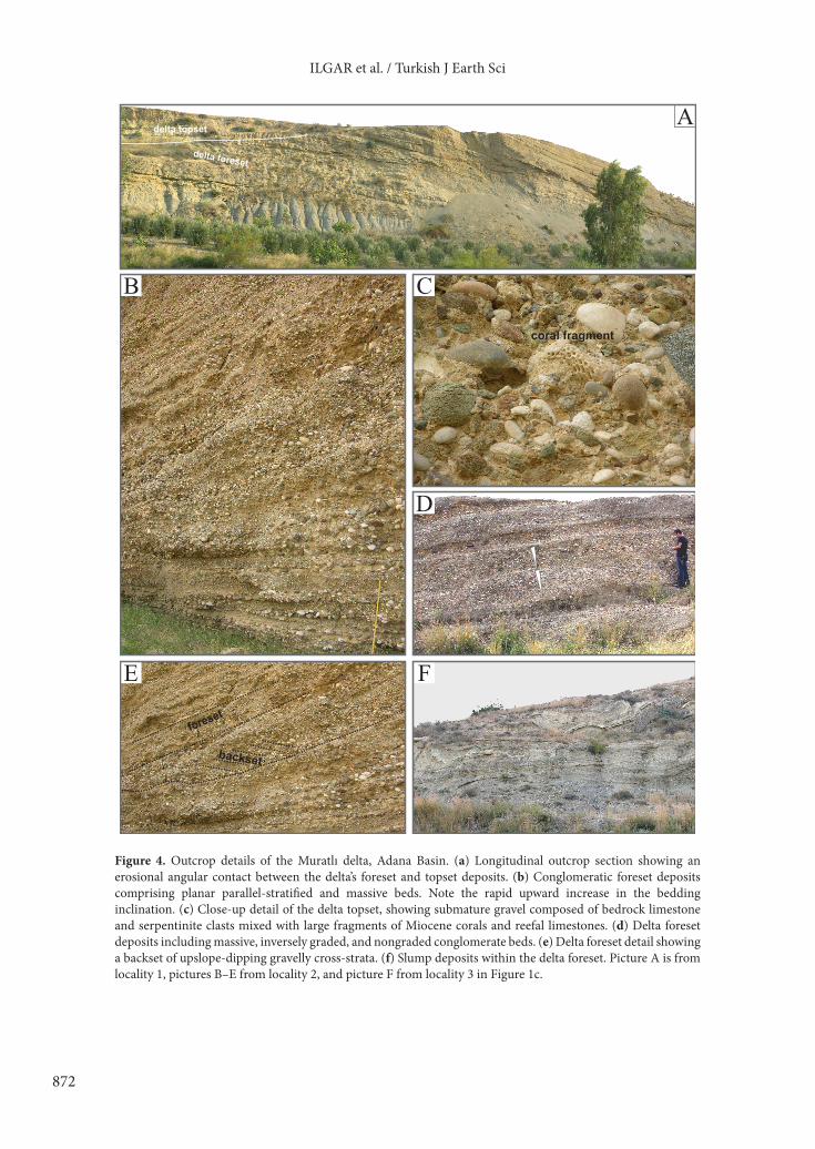
5. Facies architecture of deltaic membersThe study focuses on the 3 isolated conglomeratic members of the Handere Formation: the Muratlı, Tepeçaylak, and Sögütlü members (Figure 1c). They have been exhumed by Quaternary erosion and are laterally surrounded by sparsely preserved shallow-marine sandstones of the Handere Formation, with which they sharply overlie the formation’s offshore mudstones (Figure 2). These conglomeratic members consist of 2 main facies associations, Gilbert-type deltaic deposits and fluvial incised valley-fill deposits, which are described and interpreted in the present section. 5.1. Gilbert-type delta depositsThese conglomeratic deposits are generally well-bedded, forming clinoformal wedges that are stacked basinwards in a downstepping pattern and are up to 15–40 m thick. The clinoformal architecture consists of inclined foreset beds overlain by horizontal topset beds (Figure 4a), as is generally characteristic of Gilbert-type deltas (Barrell 1912; Colella 1988; Postma 1990). 5.1.1. Foreset faciesForeset deposits are conglomerate and subordinate sandstone beds inclined basinwards at up to 25° (Figure 4b). They show an overall coarsening-upwards trend and comprise facies commonly reported from Gilbert-type deltas (Postma 1984; Nemec et al. 1999; Lønne & Nemec 2004; Breda et al. 2007). Some outcrops show the foreset beds passing tangentially downdip into the gently inclined and finer-grained beds of delta toeset (Figure 4a). Conglomerate beds are 10–75 cm thick, but mainly 15–35 cm, and are tabular to mound-shaped. They consist of granule to coarse-pebble gravel and occasionally contain scattered cobbles of up to 15 cm in size. The gravel is subrounded to rounded and has mainly a clast-supported texture (Figure 4c). Clasts are derived from the bedrock Mesozoic limestones and serpentinite, and from the basin-margin Miocene reefal limestones. The matrix is moderately well-sorted sand with granules. Many conglomerate beds and the majority of associated sandstone beds
show planar-parallel stratification (Figure 4b) indicating tractional deposition from fully turbulent hyperpycnal flows (Bornhold & Prior 1990; Nemec 1990), which means river-generated low-density turbidity currents (sensu Lowe 1982). Massive conglomerate beds are nongraded or inversely graded (Figure 4d), tabular in dip section, and mound-shaped lenticular in strike section, interpreted to be deposits of cohesionless debris flows (Nemec & Steel 1984; Nemec 1990).
Sandstones predominate in the down-dip part of the foreset and at its toe, forming tabular or wedge-shaped beds that are 5–30 cm thick, composed of very coarse- to fine-grained sand and alternating with thin beds of granule conglomerate (Figure 4a). Common are scattered pebbles of up to 5 cm in size. The sandstone beds show planar-parallel stratification with or without normal grading and are often capped by current-ripple cross-lamination with down-dip transport direction. Some of the foreset beds, up to 40 cm thick, are isolated backsets of up-slope dipping cross-strata composed of coarse sand and/or fine-pebble gravel (Figure 4e). They occur on the stoss side of mound-shaped massive conglomerate bodies (debris-flow deposits) or as the infill of trough-shaped scours (delta-slope chutes). The backsets indicate tractional deposition by low-density turbidity currents subject to hydraulic jump (Nemec 1990). There are also sporadic slump deposits of variable scale and thickness (Figure 4f). 5.1.2. Topset faciesThe delta topset deposits (Figures 4a and 5) are pebble conglomerates and coarse-grained sandstones. Their fining-upwards bedsets, 60–140 cm thick, have erosional bases and are commonly stacked on top of one another, apparently representing multistorey palaeochannels of braided streams a few metres wide (Collinson 1996; Miall 1996). Their laterally discontinuous basal layers of coarse clast-supported conglomerate are thought to be channel-floor lag deposits (Miall 1985; Nemec & Postma 1993). Planar parallel-stratified and cross-stratified beds, 10–45 cm thick, are interpreted, respectively, to be deposits of longitudinal and transverse or oblique midchannel bars (Miall 1985; Nemec & Postma 1993).
The deltas suffered erosion and their topset deposits are inconsistently preserved, generally better in the upstream part (Figure 4a). The sparser downstream preservation of delta topset may be due to a negative subaerial accommodation (Bhattacharya & Willis 2001), or to removal by post-Miocene erosion (Figure 2). The relationship of the delta topset to the foreset is invariably oblique (erosional), which supports the notion of a falling delta-shoreline trajectory (Breda et al. 2007, 2009) based on evidence that the horizontal topset was incrementally stepping down in the basinward direction, as discussed in the next section.

871
ILGAR et al. / Turkish J Earth Sci
5.1.3. Bottomset faciesThe basal deltaic facies are only locally exposed, but are generally similar. The gently inclined delta-toe deposits (Figures 4a and 6) are thinly bedded, fine-grained sandstones and siltstones with plane-parallel stratification and minor ripple cross-lamination. Delta bottomset consists of thin siltstone and sandstone beds intercalated with mudstones (Figure 6). The microfauna content of these deposits is described in a subsequent section.5.2. Incised valley-fill depositsThis facies assemblage is exposed in a chance cross-cut section in the proximal part of the Muratlı Member (Figures 1c and 5), but similar unexposed deposits presumably also occur in the 2 other coeval deltaic members
of the Handere Formation, where no similar transverse sections are available. These deposits are recognisably coarser-grained, comprising pebble conglomerates and subordinate coarse-grained sandstones with scattered cobbles and boulders (Figure 5). Conglomerates are clast-supported, with a matrix of medium to coarse sand and granules. Gravel clasts are moderately sorted, mainly subangular to subrounded, and of the same provenance as the delta gravel. Scattered boulders are derived from the basin-margin Miocene reefal limestones. The deposits form erosionally based, vertically stacked fining-upwards bedsets (Figure 5) interpreted to be multistorey braided-stream palaeochannels (Collinson 1996; Miall 1996), mainly 0.8–1.6 m thick and 10–25 m wide. Coarse gravelly channel-floor lags are poorly developed, but solitary
Figure 3. Messinian evaporites in the Adana Basin. (a) An example outcrop of the evaporites at the top of Handere Formation. (b) Enterolithic gypsum. (c) Crystalline gypsum with a chevron growth structure. (d) Crystalline gypsum with a grassy growth structure. (e) Nodular gypsum. (f) Gypsarenite with wave-ripple cross-lamination. The coin (scale) is 2 cm.
A B
DC
E F
1 m
872
ILGAR et al. / Turkish J Earth Sci
Figure 4. Outcrop details of the Muratlı delta, Adana Basin. (a) Longitudinal outcrop section showing an erosional angular contact between the delta’s foreset and topset deposits. (b) Conglomeratic foreset deposits comprising planar parallel-stratified and massive beds. Note the rapid upward increase in the bedding inclination. (c) Close-up detail of the delta topset, showing submature gravel composed of bedrock limestone and serpentinite clasts mixed with large fragments of Miocene corals and reefal limestones. (d) Delta foreset deposits including massive, inversely graded, and nongraded conglomerate beds. (e) Delta foreset detail showing a backset of upslope-dipping gravelly cross-strata. (f) Slump deposits within the delta foreset. Picture A is from locality 1, pictures B–E from locality 2, and picture F from locality 3 in Figure 1c.
delta topset
delta foreset
A
B C
D
E F
foreset
backset
coral fragment

873
ILGAR et al. / Turkish J Earth Sci
or multiple cross-strata sets, 25–60 cm thick, indicate transverse or oblique midchannel bars (Miall 1985).
This contrasting facies assemblage in the Muratlı Member forms the infill of an axial valley that was deeply incised in the delta. The top part of the valley-fill and the surrounding host delta are not preserved in the outcrop section, but the measured depth of incision is at least 15 m and the valley width is up to 60 m. The incised valley is clearly not an integral part of the prograding delta’s topset (see discussion by Hampson et al. 1997) and instead indicates erosional cannibalisation of the delta by a deep incision of its fluvial feeder system in response to pronounced base-level fall (see Mellere et al. 2002; Ilgar & Nemec 2005; Breda et al. 2009). The high depth/width ratio of the valley and the scattered boulders suggest relatively rapid incision, with a minimal lateral shifting of the fluvial system (see Yoxall 1969; Wood et al. 1993) and with the stream competence significantly increased by the topographic confinement (Schumm 1993). The valley incision seems to have occurred concurrently with the late stages of the delta progradation, when the entrenching fluvial system acted as a feeder for the youngest telescoping parts of the delta (Figure 7a). The down-stepping pattern of delta topset (Figure 7b) strongly supports the notion of an incremental fall of the delta shoreline trajectory.
The relatively narrow valley filled with fluvial deposits indicates that the infilling of the valley was relatively rapid, under a high rate of sediment supply, with little lateral wandering of the river and no significant valley-side collapses at the sea-level lowstand stage.
6. Sequence-stratigraphic interpretationThe late Tortonian shoreline of the basin is represented by the reefal limestones of the Tırtar Formation, which were superimposed directly on the earlier basin-margin limestones of the Karaisalı Formation (Figure 2) and were later extensively eroded (Figure 1c). The 3 deltas in their location appear to have been offset basinwards by ~25 km with respect to the late Tortonian shoreline and emplaced directly onto the offshore mudstones of the Handere Formation, which indicates a forced-regressive erosional shift of the shoreline.
A forced regression is indicated by the downstepping geometry of the delta topset (Figure 7b), the clinoformal foreset wedges that sharply downlapped the basin floor (Figures 4a and 6), and further by the incision of fluvial valley along the delta axis (Figures 5 and 7a). The sharp, erosional basal surface of the delta marks an abrupt facies change and passes basinwards into a correlative depositional conformity (Figure 7a). The aggradational infilling of the incised valley documents a subsequent rise of relative sea level, and the overlying gypsiferous deposits indicate a brief drowning of the deltas. The evaporites occur as erosional relics of the latest marine deposits (HST) in the basin, which implies yet another subsequent forced regression (see the late Messinian erosional FRST in Figure 2).
The Tortonian–Messinian deposits of the Kuzgun and Handere formations (Figure 2) have previously been interpreted as a simple regressive succession (Yetiş 1988; Yetiş et al. 1995), which would imply a normal-regressive
Figure 5. An oblique transverse section through the Muratlı delta, Adana Basin, showing a gravel-filled axial fluvial valley deeply incised in the delta deposits. Palaeotransport direction is away from the viewer, obliquely to the right. Picture from locality 2 in Figure 1c.
°

874
ILGAR et al. / Turkish J Earth Sci
HST. The present study indicates that this sedimentary succession, in reality, bears a high-resolution record of several major sea-level changes in the basin and comprises 2 stratigraphic sequences bounded by the erosional surfaces of forced regression. The following interpretive stratigraphic scenario is suggested (Figure 2):
• The Kuzgun Formation represents a forced regression that is recognisable around the Mediterranean and attributed to the end-Serravalian (Tor-1) eustatic fall in sea level (Haq et al. 1988; Haq 1991); the formation’s erosional basal part is an erosional FRST, whereas the bulk of the formation comprises a LST and possibly the earliest TST.
• The main Tortonian part of the overlying Handere Formation and the coeval Tırtar Formation (basin-margin reefal platform) constitute a TST, recording the subsequent eustatic sea-level rise (Haq et al. 1988; Haq 1991). Basin subsidence may have enhanced this marine transgression.
• The upper part of the Handere Formation, with its isolated deltaic members, might have commenced its deposition as a normal-regressive HST, but there is
no facies evidence to support this notion. The lack of a recognisable HST suggests that the transgression was interrupted by a relative sea-level fall, which would mean a TST overlain directly by a depositional FRST. This stratigraphic configuration of systems tracts may indicate a eustatic transgression terminated by a tectonically forced stepwise regression.
• The sharp base of the deltaic members and coeval littoral deposits of the Handere Formation (Figure 7a) is a regressive surface of marine erosion (Plint 1988; Plint & Nummedal 2000), expectedly passing basinwards into a correlative conformity (MacEachern et al. 1999). This surface was developing incrementally during the entire time of the stepwise relative sea-level fall and hence is probably diachronous (Embry 2002).
• The sharp-based gravelly deltas and coeval shallow-marine deposits would thus represent a depositional forced regression (Plint 1988; Helland-Hansen & Gjelberg 1994; Plint & Nummedal 2000). The basinward advance of the deltas (FRST and LST) was followed by a relative sea-level rise (TST), when the incised valleys were filled with fluvial deposits and the deltas were shallowly drowned with an abrupt landward shift of the shoreline and river outlets.
• The marine transgression brought an almost immediate deposition of evaporites (HST), which suggests flooding by hypersaline sea water (Figure 7b). The Adana Basin was subsequently emerged and its gypsiferous deposits were extensively eroded due to another forced regression (the late Messinian FRST, Figure 2). The evaporitic Gökkuyu Member of the uppermost Handere Formation (Figure 2) is sparsely preserved in the northern part of the basin, but its thickness reaches a few hundred metres in the southern part and exceeds 1 km in the adjoining inner Cilicia Basin (Aksu et al. 2005; Burton-Ferguson et al. 2005). It can thus be precluded that these evaporates are local deposits, formed in an isolated coastal lagoon or sabkha.
It would then appear that 2 consecutive forced regressions occurred in the Adana Basin in the Messinian time, the first depositional and possibly forced by tectonics and the next erosional and probably eustatic. The key issue in this hypothetical scenario is the exact timing and actual causes of the 2 regressions, which apparently followed each other closely.
7. Biostratigraphic datingThe heterolithic, fine-grained bottomset deposits of the best-exposed Muratlı delta have been systematically sampled (Figure 6) to estimate the time of the delta progradation. The samples of mudstone and silty mudstone layers were disaggregated in a 30% hydrogen peroxide solution and washed over 63-, 125-, and 425-µm sieves. In total, 24 samples have been analysed (Figure 6), with a focus on planktonic foraminifera.
Figure 6. Simplified vertical profile of the bottomset part of the one of the Muratlı delta wedges, showing the pattern of sediment sampling for biostratigraphic analysis. The dots numbered 1–24 indicate the location of samples. Log from locality 2 in Figure 1c.

875
ILGAR et al. / Turkish J Earth Sci
Planktonic foraminifera occur throughout the studied section, except for 3 samples from its uppermost part (samples 18, 21, and 22 in Figure 6). The abundance of foraminifer assemblages varies from medium to low, whereas their diversity and degree of preservation are generally moderate to high. The lowermost part of the section (samples 1–5) lacks age-diagnostic species and
shows an assemblage of benthic forams (with Ammonia sp. and Elphidium spp.), echinid spines, gastropods, and rare specimens of Globoturborotalita, Globigerina, Orbulina, Globigerinella, and Globigerinoides.
Planktonic foraminifer assemblages are most diversified in the middle part of the section (samples 6–16, Figure 6), including Globorotalia suterae Catalano
A
25 km
reefal limestone
Surface of forcedregression
delta wedge
delta wedge
delta wedge
Messinian evaporitesoffshore
mudstones
B topsettopset
topset
200 m
step-downRelic evaporitic coveron terminal delta slope
Delta progradation direction
step-down
sea-level fall
Figure 7. (a) Schematic model for the downstepping forced-regressive progradation of the Muratlı delta with concurrent incision of an axial fluvial valley; diagram not to scale. (b) Panoramic view of the Muratlı delta longitudinal outcrop showing the downstepping pattern of clinoformal foreset wedges towards the left (SSE direction); picture from locality 2 in Figure 1c.

876
ILGAR et al. / Turkish J Earth Sci
a3a2
n
k
j2
d2
m2
i2
hf
d1
g
u
p
m1
i1
l1 l2
r
q
a1
s
o
t
c
j1
d3 e
b
Figure 8. Selected planktonic foraminifera identified in the latest Miocene delta bottomset deposits in the Adana and Mut basins: (a1) Turborotalita multiloba (Romeo) in spiral, (a2) umbilical, and (a3) side view, sample 20 from Adana Basin; (b) Turborotalita quinqueloba (Natland) in umbilical view, sample 9 from Adana Basin; (c) Tenuilellinata angustiumbilicata (Bolli) in umbilical view, sample 5 from Mut Basin; (d1) Neogloboquadrina acostaensis (Blow) in umbilical view and (d3) in spiral view, sample 2 from Mut Basin; (d2) Neogloboquadrina acostaensis (Blow) in umbilical view, sample 6 from Adana Basin; (e) Globigerinita glutinata (Egger) in umbilical view, sample 4 from Mut Basin; (f) Globigerinita uvula (Ehrenberg) in side view, sample 2 from Mut Basin; (g) Catapsydrax parvulus Bolli in umbilical view, sample 4 from Mut Basin; (h) Globigerinoides bollii Blow in umbilical view, sample 2 from Mut Basin; (i1) Neogloboquadrina continuosa (Blow) in spiral and (i2) umbilical view, samples 4 and 2 from Mut Basin; (j1) Globoturborotalita woodi (Jenkins) in spiral and (j2) umbilical view, sample 13 from Adana Basin; (k) Globoturborotalita apertura (Cushman) in umbilical view, sample 13 from Adana Basin; (l1) Neogloboquadrina humerosa (Takayanagi & Saito) in spiral and (l2) umbilical view, samples 11 and 9 from Adana Basin; (m1) Globorotalia suterae Catalano and Sprovieri in oblique and (m2) spiral view, sample 24 from Adana Basin; (n) Globoturborotalita decoraperta (Takayanagi & Saito) in spiral view, sample 24 from Adana Basin; (o) Orbulina universa d’Orbigny, sample 6 from Adana Basin; (p) Globigerinoides bulloideus Crescenti in spiral view, sample 1 from Mut Basin; (q) Globigerina bulloides d’Orbigny in spiral view, sample 6 from Adana Basin; (r) Globigerinella obesa (Bolli) in umbilical view, sample 13 from Adana Basin; (s) Orbulina suturalis Brönnimann, sample 9 from Adana Basin; (t) Globigerinella siphonifera (d’Orbigny) in side view, sample 6 from Adana Basin; and (u) Globigerinoides seigliei Bermudez and Bolli in spiral view, sample 3 from Mut Basin. The scale bar is 75 µm in pictures a–d and 100 µm in pictures e–u.

877
ILGAR et al. / Turkish J Earth Sci
and Sprovieri, Globoturborotalita apertura (Cushman), G. nepenthes (Todd), G. decoraperta (Takayanagi & Saito), G. woodi (Jenkins), Globigerinelloides bulloideus Crescenti, G. obliquus Bolli, G. trilobus (Reuss), G. quadrilobatus (d’Orbigny), Globigerina bulloides d’Orbigny, G. falconensis Blow, Globigerinella siphonifera (d’Orbigny), G. obesa (Bolli), Orbulina suturalis Brönnimann, O. universa d’Orbigny, Neogloboquadrina acostaensis Blow, N. humerosa Takayanagi & Saito, Dentoglobigerina altispira altispira (Cushman & Jarvis), Turborotalita quinqueloba (Natland), Tenuitellinata angustiumbilicata (Bolli), and Globigerinita uvula (Ehrenberg) (Figure 8). The presence of Globorotalia suterae Catalano & Sprovieri is particularly important, because its first stratigraphic occurrence serves to identify the base of subzone MMi12b (i.e. the Globorotalia suterae subzone of Iaccarino 1985) and is astronomically dated to 7.81 Ma B.P. (Figure 9; Sprovieri et al. 1999; Lourens et al. 2004; Iaccarino et al. 2007). The coeval occurrence of Globorotalia suterae Catalano & Sprovieri, Globigerinoides bulloideus Crescenti, and Globoturborotalita woodi (Jenkins) allows this part of the section to be assigned to undifferentiated biozone MMi12b–MMi13a (Figure 9; D’Onofrio et al. 1975; Iaccarino 1985; Iaccarino et al. 2007). The lack of the Globorotalia miotumida group (particularly Globorotalia
conomiozea Kennett, G. sahelina Catalano & Sprovieri, G. mediterranea Catalano & Sprovieri, and G. miotumida Jenkins) in the samples does not permit a more precise assignment. Other fauna in this part of the section includes scarce Bulimina echinata d’Orbigny, representatives of Uvigerina and Bulimina, miliolids, echinid spines, gastropods, and bivalves.
Sample 18 (Figure 6) bears no planktonic foraminifers, but contains some benthic forms, gastropods, bivalves, and other shell fragments. The slightly higher sample 20 (Figure 6) shows a planktonic foraminifer assemblage that consists almost entirely of Turborotalita multiloba (Romeo), T. quinqueloba (Natland), and Tenuitellinata angustiumbilicata (Bolli), accompanied by Bulimina echinata d’Orbigny, miliolids, and echinid spines. These foram species are known to have been most common prior to the deposition of the Messinian Lower Evaporites in the Mediterranean Sea (Kouwenhoven et al. 2006; Manzi et al. 2007; Morigi et al. 2007; Iaccarino et al. 2008; Orszag-Sperber et al. 2009; Di Stefano et al. 2010). Furthermore, Turborotalita multiloba (Romeo) is an important marker species in the Mediterranean, because its narrow stratigraphic range shortly predates the deposition of the Lower Evaporites (D’Onofrio et al. 1975; Iaccarino 1985). The first brief influx of this taxon is dated to 6.42 Ma B.P.,
Figure 9. Mediterranean planktonic foraminiferal biozones plotted against the ATNTS2004 magnetic chronostratigraphy, with the stratigraphic distribution of diagnostic species in the outcrop section sampled in the Adana Basin (Figure 6).
C3A
C3B
C4
C4A
10
9
8
7
6 6.033
7.140
7.528
8.699
7.246
Stag
e
Epoc
h
Perio
d
Mag
neto
zone
s
Pola
rity
Age
(Ma)
Chronostratigraphy ATNTS2004
MMi9
MMi11
a
c
Nondistinctive Zone
Mediterranean planktonic foraminiferal biostratigraphy
Mes
sini
anTo
rton
ianL
A T
E
N E
O G
E N
E
M I
O C
E N
E
C511
C3
MMi10
b
a
MM
i12
MM
i13
b
9.779
Glo
botu
rbor
otal
ita w
oodi
Glo
bige
rinoi
des
bullo
ideu
s
Neo
glob
oqua
drin
a hu
mer
osa
Glo
bige
rinel
la s
ipho
nife
ra
Turb
orot
alita
mul
tilob
a
Glo
boro
talia
sut
erae

878
ILGAR et al. / Turkish J Earth Sci
5 Middle MessinianGökkuyu Mb. evaporites
Early Messinian erosional unconformity (forced regression)Latest Tortonian–early Messinian
Gravelly deltaic member of Handere F.(cross-cut by incised fluvial valley)
Handere Fm. Misis High risesas a pop-up ridge
4
Late Burdigalian–Serravalian Cingöz Fm. - Güvenç Fm.
Kaplankaya Fm.Karaisalı Fm.
2
Proto-Misis High
Late Aquitanian–early BurdigalianBase-Miocene erosional unconformity Gildirli Fm.
1
Late MessinianLate Messinian erosional unconformity (forced regression)
6
InnerCilicia Basin
İskenderunBasin
Modern shoreline
Present-day erosionalmargin of Miocene basin(outcrop limit)
0 km 50A
Cross-section line
0.51.0
1.5
2.0
2.5
3.0
3.5
4.0
35 00'E 36 00'E
36 30'N
37 00'N
37 30'N
N
AdanaBasin
TortonianEarly Tortonian erosional unconformity
Kuzgun Fm.
Tırtar Fm. Handere Fm.
3
BNW SE
Figure 10. (a) The relationship of Adana Basin to adjacent structural units, with a seismic map of the base-Miocene unconformity in the basin (depths below sea level in seconds of 2-way travel time); modified from Burton-Ferguson et al. (2005, Fig. 8). Note the trough-shaped, SW-plunging basin-floor palaeotopography and the high palaeotopographic relief along the basin’s eastern margin (Misis High). The NW–SE cross-section line pertains to the cartoon below. (b) Schematic cartoon showing the interpreted Miocene tectono-stratigraphic development in the Adana Basin (based on key features revealed by the seismic sections in Burton-Ferguson et al. 2005; not to scale). The successive stages are: 1– The Mesozoic bedrock of the Tauride foreland, affected by thrusting and elevated in the Eocene, is gradually denudated by erosion and eventually covered with alluvial deposits in the late Aquitanian to early Burdigalian; 2– The area becomes a foreland shelf zone as a result of mid-Burdigalian marine transgression, which drowns the basin and is followed by a late Burdigalian to Serravalian normal regression; 3– The basin is emerged by early Tortonian eustatic sea-level fall, and the resulting erosional unconformity is covered with alluvial deposits and then drowned by marine transgression; 4– Orogenic thrusting in the latest Tortonian to early Messinian converts the basin into a piggyback feature, with the thrust-induced uplift causing a forced regression and progradation of Gilbert-type deltas incised by fluvial valleys; 5– The foreland subsides under the increased load of the orogen thrust-sheets, which invites a marine transgression that brings in hypersaline water; and 6– The basin is emerged and subject to erosion due to the late Messinian evaporative drawdown of the Mediterranean Sea. Post-Miocene extensional deformation not considered.

879
ILGAR et al. / Turkish J Earth Sci
within subzone MMi13b, before its common occurrence in subzone MMi13c (Sierro et al. 2001; Drinia et al. 2004; Lourens et al. 2004; Kouwenhoven et al. 2006; Manzi et al. 2007). The higher samples show no occurrence of Turborotalita multiloba (Romeo) and the stratigraphic level of sample 20 is thus tentatively assigned to subzone MMi13b (Figure 9).
Samples 21 and 22 (Figure 6) bear no planktonic foraminifera and contain miliolids, gastropods, ostracods, and echinid spines. Sample 24 from the top of the section is rich in planktonic foraminifera (Globorotalia suterae Catalano & Sprovieri, Globoturborotalita apertura (Cushman), G. nepenthes (Todd), G. decoraperta (Takayanagi & Saito), Neogloboquadrina acostaensis (Blow), N. humerosa (Takayanagi & Saito), Globigerina bulloides d’Orbigny, Orbulina universa d’Orbigny,
O. suturalis Brönnimann, O. bilobata d’Orbigny, and Globigerinella siphonifera (d’Orbigny); Figure 8) and also contains benthic foraminifers (Ammonia sp., Bulimina echinata d’Orbigny, and some miliolids and nodosarids), gastropods, bivalves, and echinid spines. However, it lacks Turborotalita multiloba (Romeo), Globigerinoides bulloideus Crescenti, and Globoturborotalita woodi (Jenkins), which allows this stratigraphic level to be also assigned to subzone MMi13b (Figure 9).
8. Discussion8.1. Interpretation of Miocene events in the Adana BasinIn this section, the chronology and regional causes of the late Miocene relative sea-level changes in the Adana Basin are discussed with reference to the basin’s tectonic development interpreted from multichannel seismic
Figure 11. Schematic interpretation of the latest Miocene relative sea-level changes in the Adana Basin (cf. Figure 2); the suggested time intervals are based on biostratigraphic dating. (a) The late Tortonian tectonic thrusting lifts up the basin and forces a gradual regression with the deposition of downstepping Gilbert-type deltas in FRST. (b) The postthrusting foreland subsidence due to crustal load results in shallow reflooding of the basin by hypersaline water, with evaporitic TST and HST. (c) The Mediterranean early evaporative drawdown causes the second eustatically forced and nondepositional regression (FRST) in the basin.

880
ILGAR et al. / Turkish J Earth Sci
sections by Burton-Ferguson et al. (2005). However, the chronostratigraphy of tectonic events suggested by these latter authors needs to be rectified in the light of outcrop-derived biostratigraphic data. The main corrections are as follows:
• The Güvenç Formation was considered by Burton-Ferguson et al. (2005, Fig. 3) to be of a Langhian to end-Tortonian age, whereas in reality it is no younger than Serravalian, truncated by the base-Tortonian erosional unconformity (Figure 2). The time-span of the Güvenç Formation is the same as that of the Cingöz Formation, which is its nearshore time-equivalent.
• The Kuzgun Formation was considered by Burton-Ferguson et al. (2005, Fig. 3) to be Tortonian to earliest Messinian in age, whereas in reality this terrestrial formation is of an earliest Tortonian age, covered transgressively by the marine Handere Formation whose basal part bears planktonic forams of zone MMi10 and nannofossils of the uppermost zone MNN7c (Figure 2).
• The Handere Formation was considered by Burton-Ferguson et al. (2005, Fig. 3) to be of a Pliocene age and overlying Messinian evaporites, whereas its actual age is Tortonian to Messinian and the Messinian evaporites occur at its top (Figure 2).
Accordingly, the timing of the Miocene events in the basin in our interpretation, summarised in Figure 10, differs slightly from the chronology suggested by Burton-Ferguson et al. (2005).
The seismic data indicate that the Miocene basin was initially a trough plunging towards the SW and passing into the Cilicia Basin (Figure 10a). The incipient Misis Structural High was probably a low-relief horst (Figure 10b; see Aksu et al. 2005, Fig. 8), perhaps shallowly submerged. Progressive unconformities on its flanks (Burton-Ferguson et al. 2005, Fig. 9) indicate that it became gradually elevated by differential subsidence during the Langhian–Tortonian and eventually popped up as a northward extension of the Kyrenia fold-and-thrust ridge in the latest Tortonian to early Messinian time (see Aksu et al. 2005, Fig. 12), when the Miocene succession also evidently underwent thrusting (Figure 10b; see Burton-Ferguson et al. 2005, Figs. 14 & 15). This event is thought to have marked the tectonic conversion of the Miocene Adana foredeep into a thrust-soled piggyback basin (Figure 10b).
The biostratigraphic data indicate that the forced regression which formed the Gilbert-type deltas and caused fluvial valley incision (Figure 11a) occurred in the latest Tortonian to early Messinian, ~7.8 to 6.4 Ma
1 m
A
B
1 m 1 m
SE
C
Figure 12. (a) Late Miocene shallow-marine deposits folded by compressional tectonic deformation at the inner margin of the Adana Basin; picture from locality 4 in Figure 1b. (b, c) The exhumed planes of extensional normal faults in Miocene limestones at the inner margin of the Mut Basin; picture from locality 5 and in Figure 1b.

881
ILGAR et al. / Turkish J Earth Sci
B.P. (Figure 9), predating the Messinian early evaporative drawdown of the Mediterranean Sea (dated to 5.96 ± 0.02 by Krijgsman et al. 1999). The cause of this stepwise and depositional forced regression is thought to have been the late Tortonian tectonic conversion of the Adana foredeep shelf into a thrust wedge-top (piggyback) basin, as is also evidenced by the compressional deformation of late Miocene basin-margin deposits (Figure 12a). The tectonic thrusting would likely cause a stepwise basin-floor uplift and relative sea-level fall (Figure 7b). The biostratigraphically constrained time frame for
the regression thus gives a more accurate timing of this tectonic event in the Adana Basin (cf. Burton-Ferguson et al. 2005).
The formation of a piggyback basin would signify the climax of the structural contraction and thickening of the orogen, which would normally be followed by a regulating flexural subsidence of the foreland under the increased crustal load (DeCelles & Giles 1996). Such an episode of postthrusting isostatic subsidence is thought to have terminated the basinward advance of the deltas (LST) and caused their shallow marine drowning (TST)
delta topset
delta foreset
A
C
coral fragments
coral and reefal limestone fragments
Delta topsetcoral and Miocene limestone blocks
large coral fragments
upslope-dipping backset deposits with large coral fragments
Delta foresetbioturbated sandstonesand oyster shells
Tırtar Fm.
Del
ta fo
rese
t
0
5
10
15
thic
knes
s (m
etre
s)
mudstone samples forplanktonic foraminifera
20
25
30
clay sand gravelsilt
foreset direction
D
backset
B
Figure 13. (a) Longitudinal outcrop section of the latest Tortonian Gilbert-type delta in the Mut Basin. (b) Vertical sedimentological log of the delta deposits, showing a coarsening-upwards coarse-grained succession overlying directly the Tırtar limestone. (c) Close-up view of the delta topset conglomerates, rich in pebble- to cobble-sized fragments of Miocene reefal limestones and corals. (d) A backset of upslope-dipping cross-strata within the delta conglomeratic foreset. Pictures and log from locality 7 in Figure 1b.

882
ILGAR et al. / Turkish J Earth Sci
in an estimated period between ~6.4 and ~6.0 Ma B.P. (Figure 11b). The marine highstand sedimentation (HST) was evaporitic, which indicates flooding by hypersaline water and thus suggests that the hypersalinity in the eastern Mediterranean Sea was reached at least ~6.5 Ma B.P. The deposition of gypsiferous HST was terminated by the regional onset of the early evaporative drawdown in the Mediterranean Sea ~6 Ma B.P. (Krijgsman et al. 1999), which caused the second, erosional forced Messinian regression in the Adana Basin (Figure 11c).
The early evaporative drawdown in the Mediterranean Sea might not exceed 200 m (Dronkert 1985; Krijgsman et al. 1999), but it was more than sufficient to emerge the shallow-marine peripheral basin. During the ensuing desiccation of the Mediterranean Sea, the postorogenic regional isostatic uplift (Jaffey & Robertson 2005; Cosentino et al. 2012) had apparently elevated the Adana Basin sufficiently high to prevent its reflooding by the Zanclean regional transgression dated to 5.3 Ma B.P. The basin thus remained terrestrial and accumulated a succession of Pliocene–Quaternary fluvial terraces (Figure 2) in response to the continuing uplift of the Taurides combined with concurrent eustatic sea-level changes (Haq et al. 1988). 8.2. Comparison with the Mut BasinThe end-Serravalian fall and rise of relative sea level recorded in the Adana Basin (Figure 2) are also well recognisable in the other Mediterranean peripheral basins of southern Turkey (Kelling et al. 2005), such as the adjacent Mut-Ermenek Basin (Atabey et al. 2000; Ilgar & Nemec 2005) and the Antalya Basin farther to the west (Figure 1a; Flecker et al. 1995; Karabıyıkoğlu et al. 2000; Deynoux et al. 2005; Monod et al. 2006; Çiner et al. 2008). An array of fan deltas prograded and became drowned in the Antalya Basin at that time (Larsen 2003), whereas an incised fluvial valley filled with a Gilbert-type delta, stratigraphically equivalent to the Kuzgun Formation in the Adana Basin (Figure 2), separates the amalgamated Burdigalian–Serravalian and Tortonian reefal platforms in the Ermenek Basin (Ilgar et al. unpublished data). The great amplitude of this early Tortonian eustatic cycle (see Haq et al. 1988) rendered it widely recognisable and correlative. However, the subsequent relative sea-level changes that occurred in these peripheral basins in Tortonian over a period of nearly 4 Ma are by no means correlative.
In contrast to the Adana Basin, the other peripheral basins formed as postorogenic intramontane collapse depressions and their individual sedimentation history had recorded the interplay between lower-amplitude eustatic cycles and the gradual isostatic uplift of the orogen, local extensional tectonics and variable sediment supply. The gravelly deltas that formed in these basins in the Tortonian are mainly noncorrelative local sequences
and parasequences. As an instructive example, we discuss here the development of a late Tortonian Gilbert-type delta in the nearby Mut Basin (Figure 13a; see locality in Figure 1b).
The late Tortonian deltaic deposits in the Mut Basin belong to the shallow-marine Ballı Formation (stratigraphic equivalent of the Handere Formation in the Adana Basin, Figure 2) and overlie sharply an erosional ramp of the basin-margin reefal limestones of the Tırtar Formation. The Gilbert-type delta prograded from the basin’s northern margin towards the SSW and formed a coarsening-upwards clastic succession up to 30 m thick (Figure 13b). The delta’s fluvial topset has an erosional base and consists of coarse conglomerates and subordinate sandstones, rich in pebble- to cobble-sized coral fragments and Miocene limestone debris (Figure 13c). The gravel is mainly angular to subangular and moderately sorted, with a clast-supported texture and a matrix of poorly sorted coarse sand and granules. Fining-upwards bedsets of planar parallel-stratified gravel, 40–90 cm thick, are thought to be multistorey palaeochannels of braided streams filled mainly by the deposition of longitudinal bars (Nemec & Postma 1993; Miall 1996). Nonstratified gravel beds relatively richer in sand matrix, with or without normal grading, are probably deposits of hyperconcentrated flows and debris flows generated by the sediment-sweeping action of stream floods (Wasson 1977, 1979; Nemec & Muszyński 1982; Ridgway & DeCelles 1993).
The erosional, oblique contact between the topset and foreset deposits (Figures 13a and 13b) indicates a nonrising trajectory of the delta shoreline (Breda et al. 2007), which may suggest a normal or a forced regression. Foreset beds are mainly tabular, 10–45 cm thick, and inclined at up to 25°, composed of fine- to very coarse-grained sandstones rich in granules and scattered pebbles of up to 4 cm in size. Scattered oyster shells and isolated burrows are also common. The beds have erosional bases and show plane-parallel stratification, with or without normal grading. Their tractional deposition is attributed to fully turbulent hyperpycnal flows, or river-generated low-density turbidity currents (sensu Lowe 1982). Among the foreset beds are backsets of upslope-dipping cross-strata (Figures 13b and 13d), which occur as the infill of delta-slope chutes, up to 250 cm deep. The chute-fill deposits are rich in large coral fragments and reefal limestone debris, up to 100 cm in size, derived from the basin-margin Miocene carbonate platform. Delta bottomset consists of thin siltstone and fine-grained sandstone beds intercalated with mudstones (Figure 13b).
The delta, thus built out directly on a wave-cut carbonate ramp, shows an erosional topset/foreset contact and contains debris derived from denudation of the basin-margin reefal limestones. Furthermore, the delta in its distal

883
ILGAR et al. / Turkish J Earth Sci
part is covered with thinly bedded reefal limestones, which indicates a shallow drowning, cessation of fluvial supply, and thus a considerable landward shift of the shoreline. There are no younger marine deposits in the basin, which implies its subsequent emergence. Taken together, the evidence indicates a forced regression followed by limited marine reflooding, and the delta’s association with the upper part of the Tırtar Formation might thus render it correlative with the deltas in the Adana Basin. In reality, the delta in the Mut Basin is significantly older than the deltas in the Adana Basin, as evidenced by biostratigraphic data.
The age of the deltaic deposits in the Mut Basin has been determined on the basis of planktonic foraminifera in 10 mudstone samples from a vertical outcrop section of the delta bottomset deposits. Planktonic foraminifera are abundant and well preserved, but show a relatively low to moderate diversity and are accompanied by benthic foraminifers (representatives of Ammonia, Elphidium, Bulimina, Bolivina, Uvigerina, Nonion, miliolids, and nodosarids), gastropods, bivalves, ostracods, and echinid spines. The dominant planktonic species are Globigerina and Globigerinoides, accompanied by abundant globoturborotalids, neogloboquadrinids, and orbulinids. All samples consistently contain Globigerina bulloides d’Orbigny, Globigerinoides trilobus (Reuss), G. quadrilobatus (d’Orbigny), G. obliquus Bolli, G. bulloideus Crescenti, Globigerinella obesa (Bolli), Neogloboquadrina acostaensis (Blow), N. continuosa (Blow), and Globoturborotalita woodi (Jenkins). Species that are less consistently present or rare include Globoturborotalita decoraperta (Takayanagi & Saito), Tenuitellinata angustiumbilicata (Bolli), Catapsydrax parvulus Bolli, Loeblich & Tappan, Globorotalia scitula (Brady), Globigerinita uvula (Ehrenberg), Globigerinita incrusta Akers, G. glutinata (Egger), and Globigerinoides seigliei Bermudez & Bolli. The majority are long-range species, but the cooccurrence of Neogloboquadrina continuosa (Blow), N. acostaensis (Blow), Globigerinoides bollii Blow, and G. seigliei Bermudez & Bolli indicates a Tortonian age of the deposits. The cooccurrence of these last 3 species suggests an age probably not older than biozone MMi11 (Figure 9; D’Onofrio et al. 1975; Iaccarino 1985; Iaccarino et al. 2007). The age can be constrained further by the presence of Neogloboquadrina continuosa Blow, whose last stratigraphic occurrence in the Mediterranean is in the subzone Globigerinoides obliquus extremus/G. bulloideus (Iaccarino 1985) or subzone MMi12a of Iaccarino et al. (2007). The deltaic bottomset deposits, coeval with the delta built-out, can thus be assigned to the biozone interval MMi11–MMi12a (Figure 9; D’Onofrio et al. 1975; Iaccarino 1985; Iaccarino et al. 2007). The delta thus appears to have prograded in an approximate time of
8.5–7.8 Ma B.P., which corresponds to the regressive part (8.3–7.8 Ma B.P.) of the third-order eustatic sea-level cycle TB3.2 of Haq et al. (1988).
In summary, the isolated late Tortonian delta in the Mut Basin, although seemingly correlative with similar deltas in the Adana Basin, is significantly older. Its development and drowning were apparently related to a third-order eustatic sea-level cycle, rather than local tectonics. There was no compressional Neogene deformation in the Mut Basin, whose margin instead shows normal faults indicating postorogenic tectonic extension (Figures 12b and 12c). The amplitude of eustatic cycle TB3.2 did not exceed 30 m (Haq et al. 1988), but the sea-level change was recognised in several other peri-Mediterranean basins (e.g., Rouchy & Saint Martin 1992; Larsen 2003; Roveri & Manzi 2006).
However, this eustatic cycle was also modulated by local tectonics and became recorded differently in different basins. The marine reflooding of the Mut Basin was probably outpaced by the regional isostatic uplift of the Central Taurides, whereby the basin became emerged well before the hypersalinity state and evaporative drawdown of the Mediterranean Sea. In the Adana Basin, this eustatic cycle went unrecognisable (Figure 2), probably because the low-amplitude eustatic sea-level fall was fully compensated by the postthrusting isostatic subsidence of the foreland basin. In the Antalya Basin, in contrast, the Tortonian succession as a whole is regressive (Flecker et al. 1995; Deynoux et al. 2005; Çiner et al. 2008), yet shows no less than 4 cycles of a marine drowning and renewed progradation of the basin-margin fan deltas (Larsen 2003). Their exact timing is uncertain and none of these cyclothems is recognisably forced-regressive, but at least some of them may be third-order eustatic sequences of type 2.
These regional comparisons illustrate the difficulty with interbasinal stratigraphic correlations and serve as a warning against a superficial linking of seemingly similar events in the late Miocene peri-Mediterranean basins (see also discussions by Clauzon et al. 1996; Soria et al. 2003; Roveri & Manzi 2006). Reliable stratigraphic correlations require biostratigraphic constraints, a good understanding of the basin’s bathymetric conditions and sedimentary systems, and a careful account of the basin’s tectonic development. False hypothetical correlations of regional events lead to mistaken regional interpretations.
9. ConclusionsThis combined sedimentological, sequence-stratigraphic, and biostratigraphic study of the late Miocene deposits in the Adana Basin has shown that the shallow-marine Handere Formation of Tortonian–Messinian age, previously interpreted as a simple regressive succession, bears a high-resolution record of several major relative
884
ILGAR et al. / Turkish J Earth Sci
sea-level changes in the basin. The base of this formation recorded a forced regression corresponding to the end-Serravalian (Tor-1) eustatic fall in sea level. The lower to middle part of the formation is transgressive, culminating in offshore mudstones. The upper part is regressive and its 3 isolated conglomeratic members represent sharp-based Gilbert-type deltas with axially incised fluvial valleys that recorded a depositional forced regression, biostratigraphically dated to ~7.8 to 6.4 Ma B.P. on the basis of planktonic foraminifera in delta bottomset deposits.
This latest Tortonian–early Messinian regression is attributed to the tectonic conversion of the Adana foredeep shelf into a piggyback basin, as is independently indicated by seismic profiles and compressional basin-margin deformation. The marine reflooding of the basin, estimated at ~6.4 to 6 Ma B.P., is ascribed to a postthrusting flexural subsidence of the foreland under increased crustal load. The transgression brought in evaporitic sedimentation, which suggests invasion of hypersaline Mediterranean water. The Mediterranean Sea in its eastern part would thus appear to have reached hypersalinity around 6.5 Ma B.P.
The basin was subsequently emerged and its gypsiferous deposits were extensively eroded due to another Messinian forced regression, which is attributed to the early evaporative drawdown of the Mediterranean Sea, regionally dated to ~6 Ma B.P. The Mediterranean Sea then desiccated. The postorogenic regional isostatic uplift of the Taurides had meanwhile elevated the Adana Basin sufficiently to prevent its reflooding by the Zanclean regional transgression at 5.3 Ma B.P. The basin remained terrestrial in the post-Miocene time, accumulating a
succession of fluvial terraces in response to the continuing slow uplift of the Taurides and eustatic sea-level changes.
Comparison with the late Miocene deposits in the adjacent Mut Basin and the Antalya Basin farther to the west demonstrates that interbasinal correlations in the peri-Mediterranean zone of Turkey are difficult and that a superficial linking of comparable events may be quite misleading. It would appear that the local timing of the late Miocene relative sea-level changes and the landward extent of the Zanclean marine reflooding were both determined by the combination of eustasy, local tectonics, basin topography, and sediment supply. The individual basin-fill successions, instead of being averaged by superficial correlation, should rather be analysed in detail as they bear a valuable high-resolution record of local events and give unique insights into the local role of tectonics, sediment yield, and sea-level changes. The eustatic signal in the peri-Mediterranean basins was variously modulated and often obscured by the local conditions, and its deciphering thus requires much caution.
AcknowledgmentsThe field study was funded by the General Directorate of Mineral Research and Exploration (MTA). We thank Tolga Esirtgen, Serap Demirkaya, Serap Akpınar, and Banu Türkmen for their valuable field assistance. The manuscript was first commented upon by Yavuz Hakyemez and then critically reviewed by Massimiliano Ghinassi, Mustafa Karabıyıkoğlu, and Olivier Monod, whose insightful and constructive comments are much appreciated. This paper is dedicated to Carlo Messina.
References
Aksu, A.E., Calon, T.J., Hall, J., Mansfield, S. & Yaşar, D. 2005. The Cilicia–Adana basin complex, Eastern Mediterranean: Neogene evolution of an active fore-arc basin in an obliquely convergent margin. Marine Geology 221, 121–159.
Aktaş, G. & Robertson, A.H.F. 1990. Tectonic evolution of the Tethys suture zone in SE Turkey: evidence from the petrology and geochemistry of Late Cretaceous and Middle Eocene extrusives. In: Malpas, J., Moores, E.M., Panayiotou, A. & Xenophontos, C. (eds), Ophiolites – Oceanic Crustal Analogues. Proceedings of the International Symposium Troodos 1987, Cyprus Geological Survey, Nicosia, pp. 311–328.
Alçiçek, H. 2010. Stratigraphic correlation of the Neogene basins in southwestern Anatolia: regional palaeogeographical, palaeoclimatic and tectonic implications. Palaeogeography Palaeoclimatology Palaeoecology 291, 297–318.
Alçiçek, M.C., Kazancı, N. & Özkul, M. 2005. Multiple rifting pulses and sedimentation pattern in the Çameli Basin, southwestern Anatolia, Turkey. Sedimentary Geology 173, 409–431.
Alçiçek, M.C. & Ten Veen, J.H. 2008. The late Early Miocene Acıpayam piggy-back basin: refining the last stages of Lycian nappe emplacement in SW Turkey. Sedimentary Geology 208, 101–113.
Andrew, T. & Robertson, A.H.F. 2002. The Beyşehir-Hoyran-Hadım nappes: genesis and emplacement of Mesozoic marginal and oceanic units of the northern Neotethys in southern Turkey. Journal of the Geological Society of London 159, 529–543.
Atabey, E., Atabey, N., Hakyemez, A., İslamoğlu, Y., Sözeri, Ş., Özçelik, N.N., Saraç¸ G., Ünay, E. & Babayiğit, S. 2000. Mut-Karaman arası Miyosen havzasının litosratigrafisi ve sedimantolojisi. Bulletin of Mineral Research and Exploration 122, 53–72.
Barrell, J. 1912. Criteria for the recognition of ancient delta deposits. Bulletin of the Geological Society of America 23, 377–446.
Bartol, J., Govers, R. & Wortel, R. 2011. The Central Anatolian Plateau: relative timing of uplift and magmatism. EGU2011 Geophysical Research Abstracts 13, 10326.

885
ILGAR et al. / Turkish J Earth Sci
Bhatacharya, J.P. & Willis, B.J. 2001. Lowstand deltas in the Frontier Formation, Powder River Basin, Wyoming: implications for sequence stratigraphic models. Bulletin of the American Association of Petroleum Geologists 85, 261–294.
Bolli, H.M. & Saunders, J.B. 1985. Oligocene to Holocene low latitude planktonic foraminifera. In: Bolli, H.M., Saunders, J.B. & Perch-Nielsen, K. (eds), Plankton Stratigraphy. Cambridge University Press, Cambridge, pp. 155–262.
Bornhold, B.D. & Prior, D.B. 1990. Morphology and sedimentary processes of the subaqueous Noeick River delta, British Columbia, Canada. In: Colella, A. & Prior, D.B. (eds), Coarse-grained Deltas. International Association of Sedimentologists, Special Publication 10, 169–181.
Bozkurt, E., Winchester, J.A. & Piper, J.D.A. (eds) 2000. Tectonics and Magmatism in Turkey and the Surrounding Area. Geological Society of London, Special Publication 173.
Breda, A., Mellere, D. & Massari, F. 2007. Facies and processes in a Gilbert-delta-filled incised valley (Pliocene of Ventimiglia, NW Italy). Sedimentary Geology 200, 31–55.
Breda, A, Mellere, D., Massari, F. & Asioli, A. 2009. Vertically stacked Gilbert-type deltas of Ventimiglia (NW Italy): The Pliocene record of an overfilled Messinian incised valley. Sedimentary Geology 219, 58–76.
Burton-Ferguson, R., Aksu, A.E., Calon, T.J. & Hall, J. 2005. Seismic stratigraphy and structural evolution of the Adana Basin, eastern Mediterranean. Marine Geology 221, 153–183.
Butler, R.W.H., Lickorish, W.H., Grasso, M., Pedley, H.M. & Ramberti, L. 1995. Tectonics and sequence stratigraphy in Messinian basins, Sicily: constraints on the initiation and termination of the Mediterranean salinity crisis. Bulletin of the Geological Society of America 107, 425–439.
Catuneanu, O. 2006. Principles of Sequence Stratigraphy. Elsevier, Amsterdam.
Çiner, A., Karabıyıkoğlu, M., Monod, O., Deynoux, M. & Tuzcu, S. 2008. Late Cenozoic sedimentary evolution of the Antalya Basin, southern Turkey. Turkish Journal of Earth Sciences 17, 1–41.
Cita, M.B. & McKenzie, J.A. 1986. The terminal Miocene event. In: Hsü, K.J. (ed.) Mesozoic and Cainozoic Oceans. Geodynamics Series, American Geophysical Union, Washington, DC, pp. 123–140.
Clark, M. & Robertson, A.H.F. 2005. Uppermost Cretaceous–Lower Tertiary Ulukışla Basin, south-central Turkey: sedimentary evolution of part of a unified basin complex within an evolving Neotethyan suture zone. Sedimentary Geology 173, 15–51.
Clauzon, G., Suc, J.P., Gautier, F., Berger, A. & Loutre, M.F. 1996. Alternative interpretation of the Messinian salinity crisis: Controversy resolved? Geology 24, 363–366.
Colella, A. 1988. Pliocene–Holocene fan deltas and braid deltas in the Crati Basin, southern Italy: a consequence of varying tectonic conditions. In: Nemec, W. & Steel, R.J. (eds), Fan Deltas – Sedimentology and Tectonic Settings. Blackie, London, pp. 50–74.
Collins, A.S. & Robertson, A.H.F. 1998. Processes of Late Cretaceous to Late Miocene episodic thrust sheet translation in the Lycian Taurides, SW Turkey. Journal of the Geological Society of London 155, 759–772.
Collins, A.S. & Robertson, A.H.F. 2000. Evolution of the Lycian allochthon, western Turkey, as a north-facing Late Palaeozoic to Mesozoic rift and passive margin. Geological Journal 34, 107–138.
Collinson, J.D. 1996. Alluvial sediments. In: Reading, H.G. (ed.), Sedimentary Environments: Processes, Facies and Stratigraphy. Blackwell Science, Oxford, pp. 37–82.
Collinson, J.D. & Thompson, D.B. 1982. Sedimentary Structures. Allen and Unwin, London.
Cosentino, D., Schildgen, T.F., Cipollari, P., Faranda, C., Gliozzi, E., Hudáčková, N., Lucifora, S. & Strecker, M.R. 2012. Late Miocene surface uplift of the southern margin of the Central Anatolian plateau, Central Taurides, Turkey. Bulletin of the Geological Society of America 124, 133–145.
DeCelles, G.P. & Giles, A.K. 1996. Foreland basin systems. Basin Research 8, 105–123.
Dewey, J.F. & Şengör, A.M.C. 1979. Aegean and surrounding regions: complex multiplate and continuum tectonics in a convergent zone. Bulletin of the Geological Society of America 190, 84–92.
Deynoux, M., Çiner, A., Monod, O., Karabıyıkoğlu, M., Manatschel, G. & Tuzcu, S. 2005. Facies architecture and depositional evolution of alluvial fan to fan-delta complexes in the tectonically active Miocene Köprüçay Basin, Isparta Angle, Turkey. Sedimentary Geology 173, 315–343.
Dilek, Y. & Moores, E.M. 1990. Regional tectonics of the eastern Mediterranean ophiolites. In: Malpas, J., Moores, E.M., Panayiotou, A. & Xenophotos, C. (eds), Ophiolites – Oceanic Crustal Analogues. Proceedings of the International Symposium Trodos 1987. Cyprus Geological Survey Department, Nicosia, pp. 295–309.
Dilek, Y., Whitney, D. & Tekeli, O. 1999. Links between tectonics processes and landscape morphology in an Alpine collision zone, south-central Turkey. Zeitschrift für Geomorphologie 118, 147–164.
Di Stefano, A., Verducci, M., Lirer, F., Ferraro, L., Iaccarino, S.M., Hüsing, S.K. & Hilgen, F.J. 2010. Paleoenvironmental conditions preceding the Messinian Salinity Crisis in the Central Mediterranean: integrated data from the Upper Miocene Trave section (Italy). Palaeogeography Palaeoclimatology Palaeoecology 297, 37–53.
D’Onofrio, S., Giannelli, L., Iaccarino, S., Morlotti, E., Romeo, M., Salvatorini, G., Sampò, M. & Sprovieri, R. 1975. Planktonic foraminifera of the Upper Miocene from some Italian sections and the problem of the lower boundary of the Messinian. Bollettino della Società Paleontologica Italiana 14, 177–196.
Drinia, H., Antonarakou, A., Tsaparas, N., Dermitzakis, M.D. & Kontakiotis, G. 2004. Foraminiferal record of environmental changes: preevaporitic diatomaceous sediments from Gavdos Island, southern Greece. Bulletin of the Geological Society of Greece 36, 782–791.
886
ILGAR et al. / Turkish J Earth Sci
Dronkert, H. 1985. Evaporite models and sedimentology of Messinian and recent evaporites. GUA Papers in Geology, Series 1, 24.
Durand, B., Jolivet, L., Horváth, F. & Séranne, M. (eds) 1999. The Mediterranean Basins: Tertiary Extension within the Alpine Orogen. Geological Society of London, Special Publication 156.
Embry, A.F. 2002. Transgressive-regressive (T-R) sequence stratigraphy. In: Armentrout, J. & Rosen, N. (eds), Sequence Stratigraphic Models for Exploration and Production: Gulf Coast. Society of Economic Paleontologists and Mineralogists, Gulf Coast Division Conference Proceedings, Houston, pp. 151–172.
Flecker, R., Poisson, A. & Robertson, A.H.F. 2005. Facies and palaeogeographic evidence for the Miocene evolution of the Isparta Angle in its regional eastern Mediterranean context. Sedimentary Geology 173, 277–314.
Flecker, R., Robertson, A.H.F., Poisson, A. & Müller, C. 1995. Facies and tectonic significance of two contrasting Miocene basins in south coastal Turkey. Terra Nova 7, 221–232.
Ghinassi, M. 2007. The effects of differential subsidence and coastal topography on high-order transgressive-regressive cycles: Pliocene nearshore deposits of the Val d’Orcia Basin, Northern Apennines, Italy. Sedimentary Geology 202, 677–701.
Görür, N. 1992. A tectonically controlled alluvial fan which developed into a marine fan-delta at a complex triple junction: Miocene Gildirli Formation of the Adana Basin, Turkey. Sedimentary Geology 81, 243–252.
Görür, N. & Tüysüz, O. 2001. Cretaceous to Miocene palaeogeographic evolution of Turkey: implications for hydrocarbon potential. Journal of Petroleum Geology 24, 119–146.
Hampson, G.J., Elliott, T. & Davies, S.J. 1997. The application of sequence stratigraphy to Upper Carboniferous fluvio-deltaic strata of the onshore UK and Ireland: implications for the southern North Sea. Journal of the Geological Society of London 154, 719–733.
Haq, B.U. 1991. Sequence stratigraphy, sea-level change, and significance for the deep sea. In: MacDonald, D.I.M. (ed.), Sedimentation, Tectonics and Eustasy: Sea-Level Changes at Active Margins. International Association of Sedimentologists, Special Publication 12, 3–39.
Haq, B.U., Hardenbol, J. & Vail, P.R. 1988. Mesozoic and Cenozoic chronostratigraphy and eustatic cycles. In: Wilgus, C.K., Hastings, B.S., Posamentier, H.W., Van Wagoner, J.C., Ross, C.A. & Kendall, C.G.S.C. (eds), Sea-Level Changes: An Integrated Approach. Society of Economic Paleontologists and Mineralogists, Special Publication 42, 71–108.
Harms, J.C., Southard, J.B., Spearing, D.R. & Walker, R.G. 1975. Depositional Environments as Interpreted from Primary Sedimentary Structures and Stratification Sequences. Society of Economic Paleontologists and Mineralogists, Short Course No. 2 Lecture Notes.
Harms, J.C., Southard, J.B. & Walker, R.G. 1982. Structures and Sequences in Clastic Rocks. Society of Economic Paleontologists and Mineralogists, Short Course No. 9 Lecture Notes.
Hayward, A.B. 1984a. Sedimentation and basin formation related to ophiolite nappe emplacement, Miocene, SW Turkey. Sedimentary Geology 40, 105–129.
Hayward, A.B. 1984b. Miocene clastic sedimentation related to the emplacement of the Lycian Nappes and the Antalya Complex, S.W. Turkey. In: Dixon, J.E. & Robertson, A.H.F. (eds.), The Geological Evolution of the Eastern Mediterranean. Geological Society of London, Special Publication 17, 403–414.
Helland-Hansen, W. 2009. Towards the standardization of sequence stratigraphy: discussion. Earth-Science Reviews 94, 95–97.
Helland-Hansen, W. & Gjelberg, J.G. 1994. Conceptual basis and variability in sequence stratigraphy: a different perspective. Sedimentary Geology 92, 31–52.
Helland-Hansen, W. & Martinsen, O.J. 1996. Shoreline trajectories and sequences: description of variable depositional-dip scenarios. Journal of Sedimentary Research 66, 670–688.
Hsü, K.J., Ryan, W.B.F. & Cita, M.B., 1972. Late Miocene desiccation of the Mediterranean. Nature 242, 240–244.
Hüsing, S.K., Oms, O., Agusti, J., Garcés, M., Kouwenhoven, T.J., Krijsman, W. & Zachariasse, W.J. 2010. On the late Miocene closure of the Mediterranean-Atlantic gateway through the Guadix Basin (southern Spain). Palaeogeography Palaeoclimatology Palaeoecology 291, 167–179.
Iaccarino, S.M. 1985. Mediterranean Miocene and Pliocene planktic foraminifera. In: Bolli, H.M., Saunders, J.B. & Perch-Nielsen, K. (eds), Plankton Stratigraphy. Cambridge University Press, Cambridge, pp. 283–314.
Iaccarino, S.M., Premoli Silva, I., Biolzi, M., Foresi, L.M., Lirer, F., Turco, E. & Petrizzo, M.R. 2007. Practical Manual of Neogene Planktonic Foraminifera. International School on Planktonic Foraminifera 6th Course, Università di Perugia Press, Perugia.
Ilgar, A. & Nemec, W. 2005. Early Miocene lacustrine deposits and sequence stratigraphy of the Ermenek Basin, Central Taurides, Turkey. Sedimentary Geology 173, 233–275.
Jaffey, N. & Robertson, A.H.F. 2005. Non-marine sedimentation associated with Oligocene-Recent exhumation and uplift of the Central Taurus Mountains, S. Turkey. Sedimentary Geology 173, 53–89.
Jarvis, A., Reuter, H.I., Nelson, A. & Guevara, E. 2008. Hole-filled SRTM for the Globe, Version 4. CGIAR-CSI SRTM 90m Database, http://srtm.csi.cgiar.org.
Jervey, M.T. 1988. Quantitative geological modeling of siliciclastic rock sequences and their seismic expression. In: Wilgus, C.K., Hastings, B.S., Posamentier, H.W., Van Wagoner, J.C., Ross, C.A. & Kendall, C.G.S.C. (eds), Sea-Level Changes: An Integrated Approach. Society of Economic Paleontologists and Mineralogists, Special Publication 42, 47–69.
Karabıyıkoğlu, M., Çiner, A., Monod, O., Deynoux, M., Tuzcu, S. & Örçen, S. 2000. Tectonosedimentary evolution of the Miocene Manavgat Basin, western Taurides, Turkey. In: Bozkurt, E., Winchester, J.A. & Piper, J.D.A. (eds), Tectonics and Magmatism in Turkey and the Surrounding Area. Geological Society of London, Special Publication 173, 271–294.
887
ILGAR et al. / Turkish J Earth Sci
Karakuş, E. 2011. Sedimentology of Messinian Evaporites in the Tarsus (Mersin) Area. Unpublished MSc Thesis, Ankara University.
Kelling, G., Gökçen, S., Floyd, P. & Gökçen, N. 1987. Neogene tectonics and plate convergence in the eastern Mediterranean: new data from southern Turkey. Geology 15, 425–429.
Kelling, G., Robertson, A.H.F. & Van Buchem, F. (eds) 2005. Cenozoic Sedimentary Basins of Southern Turkey. Sedimentary Geology 173 (Special Issue), 1–405.
Kennett, J.P. & Srinivasan, M.S. 1983. Neogene Planktonic Foraminifera: A Phylogenetic Atlas. Hutchinson & Ross, Stroudsburg, Pennsylvania, USA.
Koç, A., Kaymakçı, N., Van Hinsbergen, D.J.J., Kuiper, K.F. & Vissers, R.L.M. 2012. Tectono-sedimentary evolution and geochronology of the Middle Miocene Altınapa Basin, and implications for the Late Cenozoic uplift history of the Taurides, southern Turkey. Tectonophysics 532, 134–155.
Kouwenhoven, T.J., Morigi, C., Negri, A., Giunta, S., Krijgsman, W. & Rouchy, J.M. 2006. Paleoenvironmental evolution of the eastern Mediterranean during the Messinian: constraints from integrated microfossil data of the Pissouri Basin (Cyprus). Marine Micropaleontology 60, 17–44.
Krijgsman, W., Hilgen, F.J., Raffi, I., Sierro, F.J. & Wilson, D.S. 1999. Chronology, causes and progression of the Messinian salinity crisis. Nature 400, 652–655.
Krijgsman, W. & Meijer, P.T. 2008. Depositional environments of the Mediterranean “Lower Evaporites” of the Messinian salinity crisis: constraints from quantitative analyses. Marine Geology 253, 73–81.
Larsen, E. 2003. Stratigraphic Architecture of Littoral to Neritic Clastic Wedges: Sedimentology, Morphodynamics and Implications for Spatial Lithofacies Predictions. Dr. Sc. Dissertation, Bergen University, Bergen.
Lønne, I. & Nemec, W. 2004. High-arctic fan delta recording deglaciation and environment disequilibrium. Sedimentology 51, 553–589.
Lourens, L.J., Hilgen, F.J., Laskar, J., Shackleton, N.J. & Wilson, D. 2004. The Neogene Period. In: Gradstein F.M., Ogg J.G. & Smith A.G. (eds), A Geologic Time Scale. Cambridge University Press, Cambridge, pp. 409–440.
Lowe, D.R. 1982. Sediment gravity flows, II. Depositional models with special reference to the deposits of high-density turbidity currents. Journal of Sedimentary Petrology 52, 279–297.
MacEachern, J.A., Zaitlin, B.A. & Pemberton, S.G. 1999. A sharp-based sandstone succession of the Viking Formation, Joffre Field, Alberta, Canada: criteria for recognition of transgressively incised shoreface complexes. Journal of Sedimentary Research 69, 876–892.
Maillard, A. & Mauffret, A. 2006. Relationships between erosion surfaces and Late Miocene Salinity Crisis deposits in the Valencia Basin (northwestern Mediterranean): evidences for an early sea-level fall. Terra Nova 18, 321–329.
Manzi, V., Roveri, M., gennari, R., Bertini, A., Biffi, U., Giunta, S., Iaccarino, S.M., Lanci, L., Lugli, S., Negri, A., Riva, A., Rossi, M.E. & Taviani, M. 2007. The deep water counterpart of the Messinian Lower Evaporites in the Apennine foredeep: the Fanantello section (Northern Apennines, Italy). Palaeogeography Palaeoclimatology Palaeoecology 251, 470–499.
Mellere, D., Plink-Bjőrklund, P. & Steel, R.J. 2002. Anatomy of shelf deltas at the edge of a prograding Eocene shelf margin, Spitsbergen. Sedimentology 49, 1181–1206.
Messina, C., Rosso, A., Sciuto, F., Di Geronimo, I., Nemec, W., Di Dio, T., Di Geronimo, R., Maniscalco, R. & Sanfilippo, R. 2007. Anatomy of a transgressive systems tract revealed by integrated sedimentological and palaeoecological study: the Barcellona Pozzo di Gotto Basin, northeastern Sicily, Italy. In: Nichols, G., Paola, C. & Williams, E.A. (eds), Sedimentary Processes, Environments and Basins – A Tribute to Peter Friend. International Association of Sedimentologists, Special Publication 38, 367–400.
Miall, A.D. 1985. Architectural-element analysis: a new method of facies analysis applied to fluvial deposits. Earth-Science Reviews 22, 261–308.
Miall, A.D. 1996. The Geology of Fluvial Deposits. Springer-Verlag, Heidelberg.
Michard, A., Whitechurch, H., Ricou, L.E., Montigny, R. & Yazgan, E. 1984. Tauric subduction (Malatya–Elazığ provinces) and its bearing on tectonics of the Tethyan realm in Turkey. In: Dixon, J.E. & Robertson, A.H.F. (eds), The Geological Evolution of the Eastern Mediterranean. Geological Society of London, Special Publication 17, 361–373.
Monod, O., Kuzucuoğlu, C. & Okay, A.İ., 2006. A Miocene palaeovalley network in the Western Taurus (Turkey). Turkish Journal of Earth Sciences 15, 1–23.
Morigi, C., Negri, A., Giunta, S., Kouwenhoven, T.J., Krijgsman, W., Blanc-Valleron, M.M., Orszag-Sperber, F. & Rouchy, J.M. 2007. Integrated quantitative biostratigraphy of the latest Tortonian–early Messinian Pissouri section (Cyprus): An evaluation of calcareous plankton bioevents. Geobios 40, 267–279.
Nazik, A. 2004. Planktonic foraminiferal biostratigraphy of the Neogene sequence in the Adana Basin, Turkey, and its correlation with standard biozones. Geological Magazine 141, 379–387.
Nemec, W. 1990. Aspects of sediment movement on steep delta slopes. In: Colella, A. & Prior, D.B. (eds), Coarse-grained Deltas. International Association of Sedimentologists, Special Publication 10, 29–73.
Nemec, W., Lønne, I. & Blikra, L.H. 1999. The Kregnes moraine in Gauldalen, west-central Norway: anatomy of a Younger Dryas proglacial delta in a palaeofjord basin. Boreas 28, 454–476.
Nemec, W. & Muszyński, A. 1982. Volcaniclastic alluvial aprons in the Tertiary of the Sofia district (Bulgaria). Annales Societatis Geologorum Poloniae 52, 239–303.
888
ILGAR et al. / Turkish J Earth Sci
Nemec, W. & Postma, G. 1993. Quaternary alluvial fans in southwestern Crete: sedimentation processes and geomorphic evolution. In: Marzo, M. & Puigdefábregas, C. (eds), Alluvial Sedimentation. International Association of Sedimentologists, Special Publication 17, 235–276.
Nemec, W. & Steel, R.J. 1984. Alluvial and coastal conglomerates: their significant features and some comments on gravelly mass flow deposits. In: Koster, E.H. & Steel, R.J. (eds), Sedimentology of Gravels and Conglomerates. Canadian Society of Petroleum Geologists, Memoir 10, 1–31.
Orszag-Sperber, F., Caruso, A., Blanc-Valleron, M.M., Merle, D. & Rouchy, J.M. 2009. The onset of the Messinian salinity crisis: insights from Cyprus sections. Sedimentary Geology 217, 52–64.
Plint, A.G. 1988. Sharp-based shoreface sequences and ‘offshore bars’ in the Cardium Formation of Alberta: their relationship to relative changes in sea level. In: Wilgus, C.K., Hastings, B.S., Posamentier, H.W., Van Wagoner, J.C., Ross, C.A. & Kendall, C.G.S.C. (eds), Sea-Level Changes: An Integrated Approach. Society of Economic Paleontologists and Mineralogists, Special Publication 42, 357–370.
Plint, A.G. & Nummedal, D. 2000. The falling stage systems tract: recognition and importance in sequence stratigraphic analysis. In: Hunt, D. & Gawthorpe, R.L. (eds), Sedimentary Responses to Forced Regression. Geological Society of London, Special Publication 172, 1–17.
Poisson, A., Yağmurlu, F., Bozcu, M. & Şentürk, M. 2003. New insights on the tectonic setting and evolution around the apex of the Isparta Angle (SW Turkey). Geological Journal 38, 257–282.
Posamentier, H.W., Allen, G.P., James, D.P. & Tesson, M. 1992. Forced regressions in a sequence stratigraphic framework: concepts, examples, and exploration significance. Bulletin of the American Association of Petroleum Geologists 76, 1687–1709.
Posamentier, H.W. & Morris, W.R. 2000. Aspects of the stratal architecture of forced regressive deposits. In: Hunt, D. & Gawthorpe, R.L. (eds), Sedimentary Responses to Forced Regression. Geological Society of London, Special Publication 172, 19–46.
Posamentier, H.W. & Vail, P.R. 1988. Eustatic controls on clastic deposition: II. Sequence and systems tract models. In: Wilgus, C.K., Hastings, B.S., Posamentier, H.W., Van Wagoner, J.C., Ross, C.A. & Kendall, C.G.S.C. (eds), Sea-Level Changes: An Integrated Approach. Society of Economic Paleontologists and Mineralogists, Special Publication 42, 125–154.
Postma, G. 1984. Mass-flow conglomerates in a submarine canyon: Abrioja fan-delta, Pliocene, southeast Spain. In: Koster, E.H. & Steel, R.J. (eds), Sedimentology of Gravels and Conglomerates. Canadian Society of Petroleum Geologists, Memoir 10, 237–258.
Postma, G. 1990. An analysis of the variation in delta architecture. Terra Nova 2, 124–130.
Ridgway, K.D. & DeCelles, P.G. 1993. Petrology of mid-Cenozoic strike–slip basins in an accretionary orogen, St. Elias Mountains, Yukon Territory, Canada. In: Johnsson, M.J. & Basu, A. (eds), Processes Controlling the Composition of Clastic Sediments. Geological Society of America, Special Paper 284, 67–89.
Riding, R., Braga, J.C. & Martín, J.M. 1999. Late Miocene Mediterranean desiccation: topography and significance. Sedimentary Geology 123, 1–7.
Riding, R., Braga, J.C., Martín, J.M. & SÁnchez-Almazo, I.M. 1998. Mediterranean Messinian Salinity Crisis: constraints from a coeval marginal basin, Sorbas, SE Spain. Marine Geology 146, 1–20.
Riding, R., Martín, J.M. & Braga, J.C. 1991. Coral–stromatolite reef framework, Upper Miocene, Almería, Spain. Sedimentology 38, 799–818.
Robertson, A.H.F. 2000. Mesozoic-Tertiary tectonic-sedimentary evolution of a south Tethyan oceanic basin and its margins in southern Turkey. In: Bozkurt, E., Winchester, J.A. & Piper, J.D.A. (eds), Tectonics and Magmatism in Turkey and the Surrounding Area. Geological Society of London, Special Publication 173, 97–138.
Roep, T.B., Dabrio, C.J., Fortuin, A.R. & Polo, M.D. 1998. Late highstand patterns of shifting and stepping coastal barriers and washover fans (late Messinian, Sorbas Basin, SE Spain). Sedimentary Geology 116, 27–56.
Rouchy, J.M. 1982. La genèse des èvaporites messiniennes de Méditerrannée. Mémoirs du Museum d’Histoire Naturelle de Paris 50.
Rouchy, J.M. & Caruso, A. 2006. The Messinian salinity crisis in the Mediterranean basin: a reassessment of the data and an integrated scenario. Sedimentary Geology 188, 35–67.
Rouchy, J.M. & Saint Martin, J.P. 1992. Late Miocene events in the Mediterranean as recorded by carbonate-evaporitic relations. Geology 20, 629–632.
Roveri, M. & Manzi, V. 2006. The Messinian salinity crisis: looking for a new paradigm? Palaeogeography Palaeoclimatology Palaeoecology 238, 386–398.
Ryan, W.B.F. 2009. Decoding the Mediterranean salinity crisis. Sedimentology 56, 95–136.
Ryan, W.B.F. & Cita, M.B. 1978. The nature and distribution of Messinian erosion surfaces, indicators of a several kilometer-deep Mediterranean in the Miocene. Marine Geology 27, 193–230.
Şafak, Ü., Kelling, G., Gökçen, N.S. & Gürbüz, K. 2005. The mid-Cenozoic succession and evolution of the Mut basin, southern Turkey, and its regional significance. Sedimentary Geology 173, 121–150.
Sagular, E.K. & Görmüş, M. 2006. New stratigraphical results and significance of reworking based on nannofossil, foraminiferal and sedimentological records in the Lower Tertiary sequence from the northern Isparta Angle, Eastern Mediterranean. Journal of Asian Earth Sciences 27, 78–98.

889
ILGAR et al. / Turkish J Earth Sci
Satur, N., Kelling, G., Cronin, B.T., Hurst, A. & Gürbüz, K. 2005. Sedimentary architecture of a canyon-style fairway feeding a deep-water clastic system, the Miocene Cingöz Formation, southern Turkey: significance for reservoir characterisation and modelling. Sedimentary Geology 173, 91–119.
Schmidt, G.C. 1961. Stratigraphic nomenclature for the Adana region petroleum district VII. Petroleum Administration Bulletin 6, 47–63.
Schumm, S.A. 1993 River response to base level change: implications for sequence stratigraphy. Journal of Geology 101, 279–294.
Şenel, M. 2002. Geological Map of Turkey, 1:500 000, Sheet No. 14 (Konya). Maden Tetkik ve Arama Genel Müdürlüğü (MTA), Ankara.
Şengör, A.M.C. 1987. Tectonics of the Tethysides: orogenic collage development in a collisional setting. Annual Review of Earth and Planetary Sciences 15, 213–244.
Şengör, A.M.C. & Yılmaz, Y. 1981. Tethyan evolution of Turkey: a plate tectonic approach. Tectonophysics 75, 181–241.
Seyitoğlu, G. & Scott, B.C. 1991. Late Cenozoic crustal extension and basin formation in west Turkey. Geological Magazine 128, 155–166.
Seyitoğlu, G. & Scott, B.C. 1996. The cause of N-S extensional tectonics in western Turkey: tectonic escape vs back-arc spreading vs orogenic collapse. Journal of Geodynamics 22, 145–153.
Sierro, F.J., Hilgen, F.J., Krijgsman, W. & Flores, J.A. 2001. The Abad composite (SE Spain): a Messinian reference section for the Mediterranean and the APTS. Palaeogeography Palaeoclimatology Palaeoecology 168, 141–169.
Soria, J.M., Caracuel, J.E., Yébenes, A., Fernández, J. & Viseras, C. 2005. The stratigraphic record of the Messinian salinity crisis in the northern margin of the Bajo Segura Basin (SE Spain). Sedimentary Geology 179, 225–247.
Soria, J.M., Fernández, J., García, F. & Viseras, C., 2003. Correlative lowstand deltaic and shelf systems in the Guadix Basin (late Miocene, Betic Cordillera, Spain): the stratigraphic record of forced and normal regressions. Journal of Sedimentary Research 73, 912–925.
Sprovieri, M., Bellanca, A., Neri, R., Mazzola, S., Bonanno, A., Patti, B. & Sorgente, R. 1999. Astronomical calibration of late Miocene stratigraphic events and analysis of precessionally driven paleoceanographic changes in the Mediterranean basin. Memorie Società Geologica Italiana 54, 7–24.
Sunal, G. & Tüysüz, O. 2002. Palaeostress analysis of Tertiary post-collisional structures in the Western Pontides, northern Turkey. Geological Magazine 139, 343–359.
Tekeli, O. & Göncüoğlu, M.C. (eds) 1984. Geology of the Taurus Belt. Proceedings of International Symposium, MTA, Ankara.
Ulu, Ü. 2002. Geological Map of Turkey, 1:500 000, Sheet No. 15 (Adana). Maden Tetkik ve Arama Genel Müdürlüğü (MTA), Ankara.
Ünlügenç, U.C., Kelling, G. & Demirkol, C. 1990. Aspects of basin evolution in the Neogene Adana Basin, SE Turkey. Proceedings of the International Earth Sciences Congress on Aegean Regions, İzmir, pp. 353–369.
Wasson, R.J. 1977. Last-glacial alluvial fan sedimentation in the Lower Derwent Valley, Tasmania. Sedimentology 24, 781–799.
Wasson, R.J. 1979. Sedimentation history of the Mundi-Mundi alluvial fans, western New South Wales. Sedimentary Geology 22, 21–51.
Williams, G., Ünlügenç, U., Kelling, G. & Demirkol, C. 1995. Tectonic controls on stratigraphic evolution of the Adana Basin, Turkey. Journal of the Geological Society of London 152, 873–882.
Wood, L.J., Ethridge, F.G. & Schumm, S.A. 1993. The effects of rate of base-level fluctuation on coastal plain, shelf and slope depositional systems: an experimental approach. In: Posamentier, H.W., Summerhayes, C.P., Haq, B.V. & Allen, C.P. (eds), Sequence Stratigraphy and Facies Associations. International Association of Sedimentologists, Special Publication 18, 43–53.
Yalçın, M.N. & Görür, N., 1984. Sedimentological evolution of the Adana Basin. In: Tekeli, O. & Göncüoğlu, M.C. (eds), Geology of the Taurus Belt. Proceedings of International Symposium, MTA, Ankara, pp. 165–172.
Yetiş, C. 1988. Reorganization of the Tertiary stratigraphy in the Adana Basin, southern Turkey. Newsletters in Stratigraphy 20, 42–58.
Yetiş, C., Kelling, G., Gökçen, S. & Baroz, F. 1995. A revised stratigraphic framework for Later Cenozoic sequences in the northeastern Mediterranean region. Geologische Rundschau 84, 794–812.
Yılmaz, Y. 1993. New evidence and model on the evolution of the southeast Anatolian orogen. Bulletin of the Geological Society of America 105, 251–271.
Yılmaz, Y., Yiğitbaş, E. & Genç, Ş.C. 1993. Ophiolitic and metamorphic assemblages of southeast Anatolia and their significance in the geological evolution of the orogenic belt. Tectonics 12, 1280–1297.
Yoxall, W.H. 1969. The relationship between falling base level and lateral erosion in experimental streams. Bulletin of the Geological Society of America 80, 1379–1384.