Inland retroactive impact of climato-eustatic oscillations on Holocene Circumcaspian landscape and...
44
1
Transcript of Inland retroactive impact of climato-eustatic oscillations on Holocene Circumcaspian landscape and...
1

2
Scientific
Committee
Pavel AVETISYAN : Institute of Archaeology and Ethnography, Yerevan, Armenia
Jacques-Élie BROCHIER : UMR 7269 (LAMPEA), Aix-en-Provence
Christine CHATAIGNER : UMR 5133 (Archéorient), Lyon
Fahrad GULIYEV : Institute of Archaeology and Ethnography, Baku, Azerbaijan
Arkadi KARAKHANYAN : Institute of Geological Sciences, Yerevan, Armenia
Françoise LE MORT : UMR 5133 (Archéorient), Lyon
Pierre LOMBARD : UMR 5133 (Archéorient), Lyon
David LORDKIPANIDZE : Georgian National Museum, Tbilisi, Georgia
Bertille LYONNET : UMR 7192 (ProCauLAC), Paris
Dominique MARGUERIE : UMR 6566 (CReAAH), Rennes
Erwan MESSAGER : UMR 7263 (CEPAM), Nice
Emmanuelle VILA : UMR 5133 (Archéorient), Lyon
Organising
Committee
Alain BEECHING : Lyon-2 University & UMR 5133 (Archéorient), Lyon
Jwana CHAHOUD : UMR 5133 (Archéorient), Lyon
Christine CHATAIGNER : UMR 5133 (Archéorient), Lyon
Pierre LOMBARD : UMR 5133 (Archéorient), Lyon
Vincent OLLIVIER : UMR 7192 (ProCauLAC), Paris

3
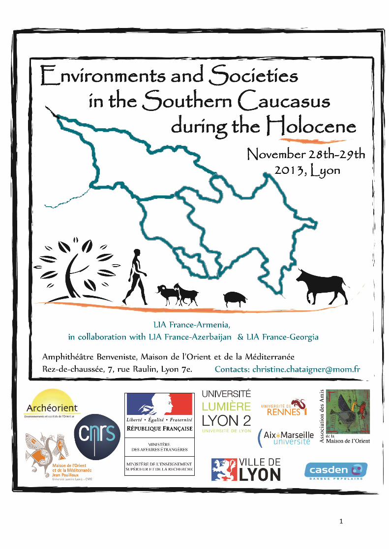
LIA CONFERENCE - PROGRAMME
“Environments and Societies in the Southern Caucasus during the Holocene”
Lyon, Maison de l'Orient, 28-29 November 2013
Thursday, November 28th
8h30 Welcome
Introduction
9h00 P. Avetisyan, P. Lombard, C. Chataigner
LIA France-Armenia (“Humans and Environments in Mountainous Habitats” - HEMHA): International Cooperation of Archaeologists and New Discoveries in Armenia.
9h10 A. Mgeladze, E. Messager
LIA France-Georgia (“Georgian Ancient Transcaucasia: Environments and Societies” – GATES)
9h20 E. Muradova, B. Lyonnet
LIA France-Azerbaijan (“Azerbaijan Archaeology and Archaeometry” – AzAr2)
Session 1. Vegetation and Climate
9h30 S. Joannin, A. Ali
Vegetation, fire and climate history of the Lesser Caucasus: a new Holocene record from Zarishat mire (Armenia)
10h00 C. Leroyer, D. Aoustin, A. Ali
Holocene vegetation, landscape, and human activity on Vanevan (Armenia)
10h30 Coffee break
11h00 F. Jude, D. Marguerie
Charcoals from Gegharot and Erebuni sites: witnesses of trees resource management - A first dendro-anthracological approach in western Armenia
11h30 E. Messager et al.
Late Quaternary record of vegetation changes on the Javakheti plateau (Georgia)
12h00 A. Decaix, E. Messager
Palaeoenvironments and agricultural practices in Azerbaijan during Neolithic, Chalcolithic and Early Bronze Age periods
12:30 Lunch

4
Thursday, November 28th
Session 2. Tectonics, Volcanism & landscape
14h00 A. Karakhanyan et al.
People and Faults: Archeoseismological Studies in Armenia
14h30 J-F. Ritz et al.
Impact of active faulting and large earthquakes on the landscape of Syunik and Shirak regions
15h00 S. Nomade et al.
Upper Pliocene to Lower Pleistocene volcanism in the Javakheti (Republic of Georgia): Impact on the landscape morphology and Human occupation
15h30 V. Ollivier, M. Fontugne
Inland retroactive impact of climato-eustatic oscillations on Holocene Circumcaspian landscape and societies
16h00 Coffee break
Session 3. Environmental crises and cultural changes
16h30 M. Fontugne
Sedimentary archives of past environmental conditions and 14C chronology uncertainties
17h00 J.-É. Brochier
Cultural changes, collapses and climato-environmental crisis
17h30 F. Magnin
From the domination of climate changes to the decline of dominating powers: ambivalence of data and epistemiologic obstacles
18h00 Discussion
20h00 Dinner (Brasserie Georges)

5
Friday, November 29th
8h30 Welcome
Session 4. Settlement patterns : socio-economic aspects and populations
9h00 M. Poulmarc'h, F. Le Mort
Unsuspected diversity and complexity of funerary practices in the South Caucasus populations, from the Neolithic to the Early Bronze Age
9h30 S. Haroutunian, R. Badalyan
A GIS analysis of Early Bronze Age settlement patterns in Armenia
10h00 O. Barge, J-E. Brochier, A. Karakhanyan Northernmost kites?
10h30 Coffee break
Session 5. Iron Age
11h00 S. Deschamps
Erebuni in the context of Urartean fortresses in the Ararat plain: sources & problems.
11h30 A. Rideaud, B. Helly
Ten years of archaeoseismological researches in Armenia.
12h00 M. Casanova, C. Lorre
The Necropolises of Azerbaijan during the Bronze and Iron Ages in the Lenkoran and the Lerik Areas (NABIALLA)
12h30 Lunch
6
Friday, November 29th
Session 6. Neolithic period
14h00 M. Arimura
Directions for future research on the Neolithic transition
14h30 C. Hamon, M. Jalabadze
Gadachrili Gora: a new neolithic excavation within the Shulaveri group (Chramis valley, Georgia)
15h00 B. Lyonnet et al.
The Neolithic levels of Mentesh Tepe (Azerbaijan)
15h30 R. Badalyan, A. Harutyunyan
Late Neolithic settlements of Ararat Valley (Armenia): the main results & prospects of the research
16h00 Coffee break
16h30 R. Hovsepyan
Neolithic agriculture in the Ararat valley (Armenia) and its comparison with the other territories of the South Caucasus
17h00 N. Benecke
Domestication in Transcaucasia – Archaeozoological and Palaeogenetic Evidence
17h30 A. Balasescu, E. Vila
The exploitation of animals by the Neolithic communities in the Ararat plain (Armenia)
18h00 Discussion
20h00 Dinner in the Old Lyon (bouchon "Les Lyonnais")

7
LIA CONFERENCE – ABSTRACTS “Environments and Societies in the Southern Caucasus
during the Holocene” Lyon, Maison de l'Orient, 28-29 November 2013
The Proceedings of this Conference will be published
in a special issue of Quaternary International
Session 1 – Vegetation and climate __________________________________________________________________________________
8
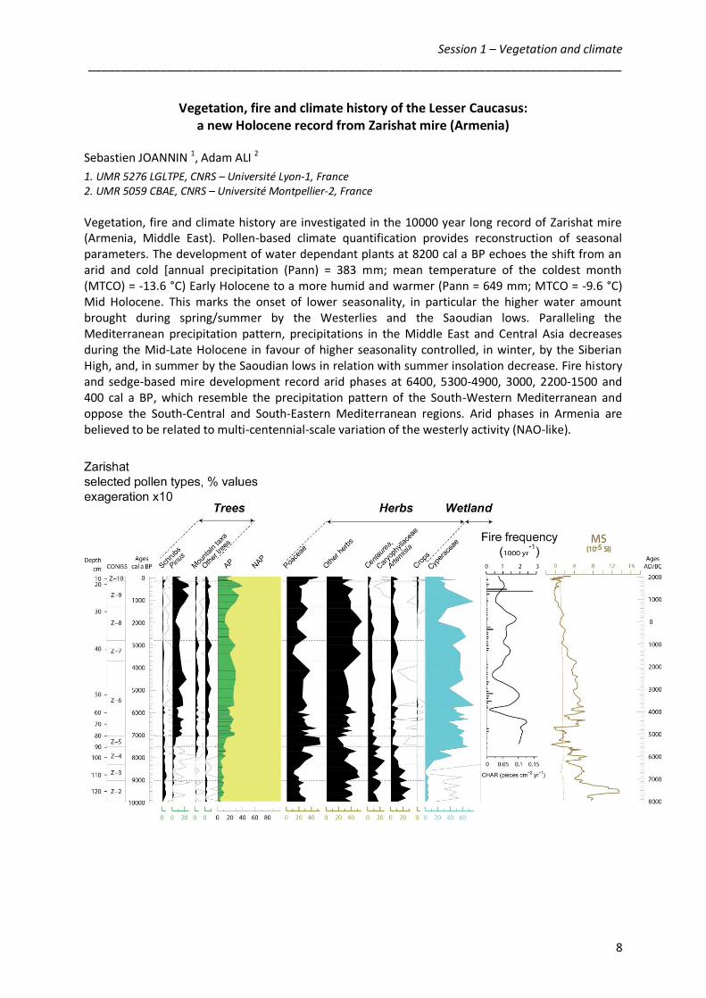
Vegetation, fire and climate history of the Lesser Caucasus: a new Holocene record from Zarishat mire (Armenia)
Sebastien JOANNIN 1, Adam ALI 2
1. UMR 5276 LGLTPE, CNRS – Université Lyon-1, France 2. UMR 5059 CBAE, CNRS – Université Montpellier-2, France
Vegetation, fire and climate history are investigated in the 10000 year long record of Zarishat mire (Armenia, Middle East). Pollen-based climate quantification provides reconstruction of seasonal parameters. The development of water dependant plants at 8200 cal a BP echoes the shift from an arid and cold [annual precipitation (Pann) = 383 mm; mean temperature of the coldest month (MTCO) = -13.6 °C) Early Holocene to a more humid and warmer (Pann = 649 mm; MTCO = -9.6 °C) Mid Holocene. This marks the onset of lower seasonality, in particular the higher water amount brought during spring/summer by the Westerlies and the Saoudian lows. Paralleling the Mediterranean precipitation pattern, precipitations in the Middle East and Central Asia decreases during the Mid-Late Holocene in favour of higher seasonality controlled, in winter, by the Siberian High, and, in summer by the Saoudian lows in relation with summer insolation decrease. Fire history and sedge-based mire development record arid phases at 6400, 5300-4900, 3000, 2200-1500 and 400 cal a BP, which resemble the precipitation pattern of the South-Western Mediterranean and oppose the South-Central and South-Eastern Mediterranean regions. Arid phases in Armenia are believed to be related to multi-centennial-scale variation of the westerly activity (NAO-like).

Session 1 – Vegetation and climate __________________________________________________________________________________
9
Holocene vegetation, landscape, and human activity on Vanevan (Armenia)
Chantal LEROYER 1, D. AOUSTIN 1, A. ALI 2
1. UMR 6566 CReAAH, CNRS – Université Rennes-1, Rennes 2. UMR 5059 CBAE, CNRS – Université Montpellier-2, Montpellier
The Vanevan sequence (N 40°11.748', E 45°40.099', 1926 m a.s.l.) is located south-east of Lake Sevan, in the central part of the Republic of Armenia. The coring of the Vanevan sequence was performed using a Russian corer by S. Joannin, A. Ali and V. Ollivier. A 164 cm long core was drilled, recovered in four sections (A : 0-56 cm ; B : 36-92 cm ; C : 72-128 cm ; D : 108-164 cm). From base to top, this core contains sandy silt (164 to 149 cm), organo-mineral clays (149 to 132 cm), organic clays (132 to 41 cm) and peaty sediment above. Pollen samples were taken at various intervals (3 to 6 cm) across the 164 cm of the core. A total of 33 pollen samples were analysed but two of them were sterile. The pollen diversity is established to 108 taxa with a mean taxonomic diversity of 43 taxa. A minimum of 202 to 1192 terrestrial pollen grains (excluding wetland plants and ferns spores) was counted per sample with a mean sum of 470. Pollen values were calculated as a percentage of total land pollen excluding Cyperaceae, aquatic plants and fern spores. The Holocene chronology is based on five AMS 14C ages. The Vanevan record covers the period between ca. 8850 and ca.4120 cal BP. The age-depth model is extrapolated to the base of the section D and to the top of the section A. The history of Vanevan mire vegetation is divided into five Local Pollen Assemblage Zones (LPAZ). Recorded in the sandy silt, zone Van 1 (ca. 8850 to ca. 8200 cal BP) is illustrated by a single sample because adjacent levels are sterile. It is dominated by taxa from open ground (Cichoroideae, Chenopodiaceae, Poaceae and Asteraceae) and steppic taxa such as Artemisia. Some shrubs (mainly Ephedra) are present. The landscape seems very open and dominated by steppic and shrubby vegetation. However taphonomic bias can be considered because Asteraceae, Cichoroideae and Chenopodiaceae are very resistant pollen grains to oxidation. Recorded in the organo-mineral clays, LPAZ Van 2 (ca.8000 to ca 7500 cal BP) shows a major change. Resistant pollen grains decrease strongly while other herbaceous taxa, mainly Poaceae, Cyperaceae and aquatic plants increase. LPAZ Van 2 is also characterized by development of woody taxa : mainly Quercus, Juniperus, Betula and Ulmus During this period, the landscape is more forested and the development of Cyperaceae and aquatic plants indicates the development of the mire. This major change suggests a possible hiatus but also a climate trigger. Recorded in the organic clays, LPAZ Van 3 (ca. 7400 to ca. 6900 cal BP) is characterized by the development of deciduous wood and Hippophae at the expense of Juniperus and Ephedra. It is also characterized by appearance of more thermophillous taxa such as Phyllirea and Olea. Aquatic vegetation increases. The landscape remains slightly wooded while a fairly deep water blade persists in the depression. Zone Van 4 (ca. 6900 to ca. 5900 cal BP) indicates a small decline of Poaceae and of arboreal taxa, mainly the deciduous oak woods, in the benefit of open ground taxa. Aquatic vegetation decrease while Cyperaceae, Sparganium and amphibious plant extent. The landscape is a little more open as the blade fell into the marsh. Recorded in the peaty sediment, Van 5 (ca. 5900 to ca. 4100 cal BP) is characterized by a large expansion of Poaceae and ferns at the expense of trees. Sparganium decreases but Typha increases. A wet meadow grows on Vanevan mire. The Vanevan pollen record offers the possibility to detect three phases of local-scale agriculture. The earliest indicators of agricultural practices are occasionally recorded during the LAPZ Van 2 and base of Van 3 from ca 8000-7150 cal BP (late Neolithic). The second phase of local-scale farming is recorded more strongly to the turn of zones Van3 and Van 4 between ca 6990 and 6790 cal BP (Early

Session 1 – Vegetation and climate __________________________________________________________________________________
10
Chalcolithic). The third is related in the end of LPAZ Van 4 from ca. 6480 to 5930 cal BP (Late Chalcolithique). Occurrences of crops and grazing pollen indicators disappear during LPAZ Van 5 : only Centaurea cyanus, Rumex acetosa and Juglans are recorded from ca 4890-4520 cal BP (Early Bronze Age).

Session 1 – Vegetation and climate __________________________________________________________________________________
11
Charcoals from Gegharot and Erebuni sites: witnesses of trees resource management.
A first dendro-anthracological approach in western Armenia. Fany JUDE 1, Dominique MARGUERIE 1
1. UMR 6566 CReAAH, CNRS – Université Rennes-1, Rennes
In the western part of Armenia, the excavations of the archaeological sites of Ghegarot (southern spur of Tsilkar mountain, Aragats region) and of Erebuni (Erevan district) provided a lot of charcoals very well preserved. The Bronze Age site of Ghegarot was digged under the supervision of R. Badalyan and A. T. Smith in the joint Armenian-American ArAGATS Project framework. Erebuni’s excavation is conducted by S. Deschamps, F. Fichet de Clairfontaine and F. Ter Martirossov since 1999 in an Armenian-French project concerning the Achaemenid period in Armenia and in the LIA HEMHA Project. The identifications of charcoals were carried out using the reference collection of the Archaeosciences Laboratory of University of Rennes 1 (CReAAH) and the atlas of microscopic wood anatomy of F. Schweingruber (1990). The examination of the structure along three splits under a reflected light microscope was systematically gone with an observation of the ligneous structure on transverse section using a stereomicroscope. This dendrological approach gives valuable data for aiding identification of the part of the woody plant the charcoals came from, recording the growth ring width, estimating the wood diameter, ascertaining the state of the wood before carbonization and about working marks when possible (Marguerie, Hunot 2007; Paradis et al., in press). The charcoal analysis of Ghegarot shows for the middle and late Bronze Age, the existence of small or medium-sized calibers of wood into the assemblages and the main presence of birch (except in T18, Δ16 pit). Three ecosystems seemed to be around the site during those periods: a forest with oaks, pines and elms, an open area with heliophilous trees and shrubs like wild fruit trees and maples and a riparian forest with hygrophilous trees like poplars and willows. More specifically, the collection of birches from at least two stands may be mentioned during the early Bronze Age. The ash trees disappearance, the wild fruit trees increase, the systematic presence of oak into the late Bronze Age assemblages could be interpreted as a human impact on the vegetation. Sometimes, large charcoals of pine or oak can have exceptional series of more than 60 tree-rings. Some of them show decreases of the growth may be related with specific climate conditions (Jude, Marguerie, 2012a). By this way, it could be the beginning of a dendrochronological curve’s building in western Armenia for the Bronze Age period. The charcoals analyzed on the Erebuni site, belonging to the 7th century BC, correspond largely to twigs, branches or young trunks. These woods came from forests but also heathlands and from some stands around marshes or by the streams (Jude, Marguerie, 2012b). The high frequency of charcoals of vine, more than 40% in the sample of the soil 1194, could be the anthracological proof of the winery practices by the Urartian people at Erebuni, practice in addition well documented among others by the archaeological artefacts. References
Jude F., Marguerie D., 2012a. Les charbons du site de Gegharot. In Chataigner, Avetisyan, Lombard (dir.) Rapport scientifique 2012 du LIA HEMHA : 11-19.
Jude F., Marguerie D., 2012b. Les charbons du site d’Erebuni. In Chataigner, Avetisyan, Lombard (dir.) Rapport scientifique 2012 du LIA HEMHA : 34-36.

Session 1 – Vegetation and climate __________________________________________________________________________________
12
Marguerie D., Hunot J.-Y., 2007. Charcoal analysis and dendrology, data from archaeological sites in north-western France. Journal of archaeological science, 34 : 1417-1433.
Schweingrüber F.H., 1990. Anatomy of European woods. Haupf publisher, Bern and Stuttgart, 800 p.
Paradis-Grenouillet S., Dufraisse A., Allée Ph., in press. Radius of curvature measurements and wood diameter: a comparaison of different image analysis techniques. In Damblon (Ed.) 4th International Meeting of Anthracology, Brussels: British Archaeological Report Series, 1063.

Session 1 – Vegetation and climate __________________________________________________________________________________
13
Late Quaternary record of vegetation changes on the Javakheti Plateau (Georgia)
Erwan MESSAGER 1, Soumaya BELMECHERI 2, Ulrich VON GRAFENSTEIN 3, Sébastien NOMADE 3, Jean-Pascal DUMOULIN 4, Vincent OLLIVIER 5, Pierre VOINCHET 6, Simon PUAUD 6, Alexandra COURTIN-NOMADE 7, Hervé GUILLOU 3, Ana MGELADZE 8, Arnaud MAZUY 1 David LORDKIPANIDZE 8
1. UMR 7264 CEPAM, CNRS – Université Nice Sophia Antipolis, Nice 2. Department of Meteorology, Pennsylvania State University, USA 3. UMR 8212 LSCE/IPSL, Laboratoire CEA-CNRS-UVSQ, Gif sur Yvette 4. UMS 2572, Laboratoire de Mesure du Carbone 14, CEA, Gif sur Yvette 5. UMR 7192 ProCauLAC, CNRS - Collège de France, Paris 6. UMR 7194 HNHP, CNRS - Museum national d'Histoire naturelle, Paris 7. Université de Limoges, GRESE, Limoges 8. Georgian National Museum, Tbilisi, Georgia
In the Javakheti highlands, two lakes were cored respectively in 2009 and 2011: the Lake Paravani (2073 m a.s.l, 41°27’N 43°48’E) and the palaeolake Nariani (2058 m a.s.l., 41°40' N 43°40'E). The sequences cover the end of Late-Glacial and the Holocene. They were investigated for a multi-proxy analysis. We will present the palynological and sedimentological data from these two lakes aiming to document palaeoecological changes in the central South Caucasus driven by climate and/or human impact. The investigations performed on the sediments has allowed us to characterize a unique vegetation history in relation to the post-glacial climatic variations and the dynamic of the Samsari-Javakheti glaciers. Three palaeoecological phases have been identified (Messager et al., 2013): - The first phase spanning the Younger Dryas and the Early Holocene, corresponds to a steppic environment with a limited lake productivity driven by a cold and particularly dry climate. - A second phase starts with an important expansion of trees at 8 300 cal years BP. As soon as the climatic and edaphic conditions were favourable, the main deciduous and coniferous trees expanded concurrently due to the proximity of glacial forest refugia located in western Caucasus. - A third phase starts at 3000-2000 cal BP and corresponds to the decline of forests on the plateau and the expansion of herbaceous formations, leading to the present-day steppic environment. This deforestation phase is driven by the deterioration of the climate conditions and human impact. References Messager, E., Belmecheri, S., von Grafenstein, U., Nomade, S., Ollivier, V., Voinchet, P., Puaud, S., Courtin-Nomade, A., Guillou, H., Mgeladze, A., Dumoulin, J.P., Mazuy, A., Lordkipanidze, D., 2013. Late Quaternary record of the vegetation and catchment-related changes from Lake Paravani (Javakheti, South Caucasus). Quaternary Science Reviews 77, 125-140.
Session 1 – Vegetation and climate __________________________________________________________________________________
14
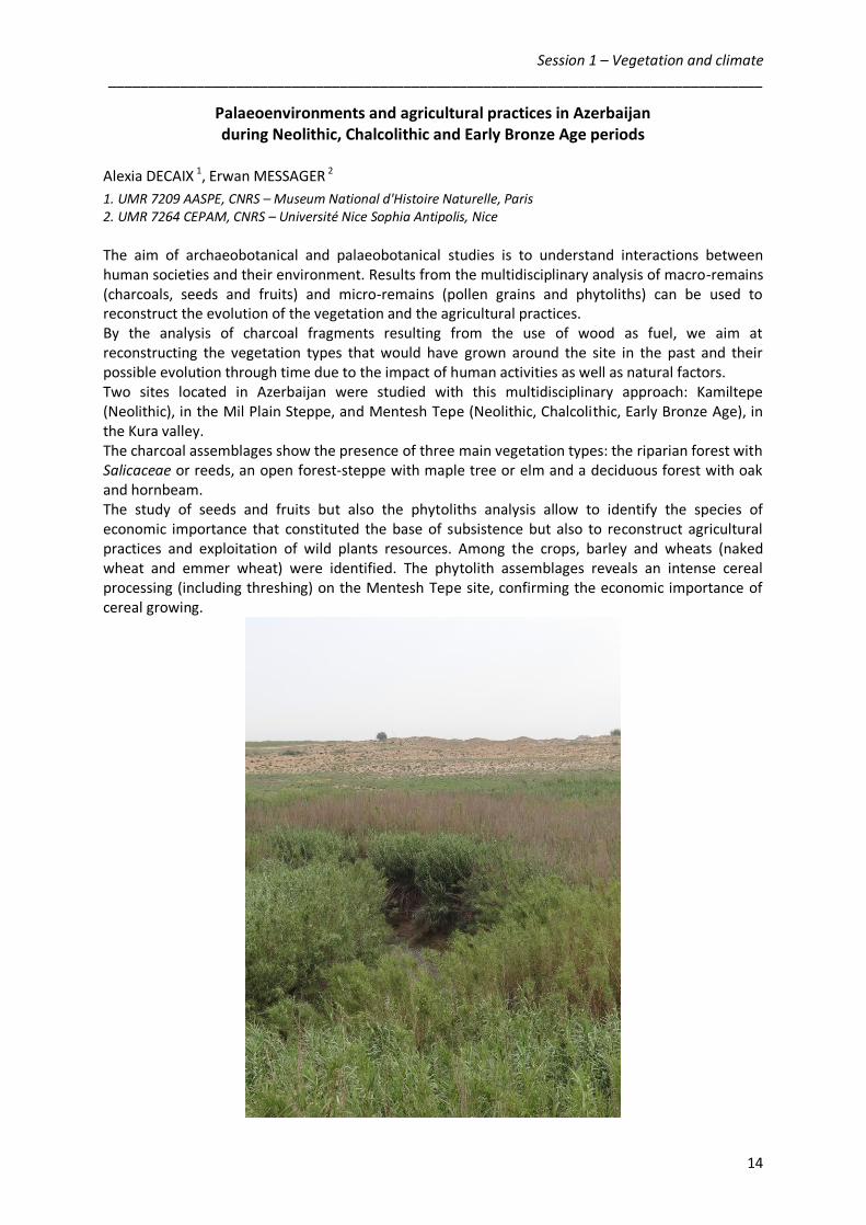
Palaeoenvironments and agricultural practices in Azerbaijan during Neolithic, Chalcolithic and Early Bronze Age periods
Alexia DECAIX 1, Erwan MESSAGER 2
1. UMR 7209 AASPE, CNRS – Museum National d'Histoire Naturelle, Paris 2. UMR 7264 CEPAM, CNRS – Université Nice Sophia Antipolis, Nice
The aim of archaeobotanical and palaeobotanical studies is to understand interactions between human societies and their environment. Results from the multidisciplinary analysis of macro-remains (charcoals, seeds and fruits) and micro-remains (pollen grains and phytoliths) can be used to reconstruct the evolution of the vegetation and the agricultural practices. By the analysis of charcoal fragments resulting from the use of wood as fuel, we aim at reconstructing the vegetation types that would have grown around the site in the past and their possible evolution through time due to the impact of human activities as well as natural factors. Two sites located in Azerbaijan were studied with this multidisciplinary approach: Kamiltepe (Neolithic), in the Mil Plain Steppe, and Mentesh Tepe (Neolithic, Chalcolithic, Early Bronze Age), in the Kura valley. The charcoal assemblages show the presence of three main vegetation types: the riparian forest with Salicaceae or reeds, an open forest-steppe with maple tree or elm and a deciduous forest with oak and hornbeam. The study of seeds and fruits but also the phytoliths analysis allow to identify the species of economic importance that constituted the base of subsistence but also to reconstruct agricultural practices and exploitation of wild plants resources. Among the crops, barley and wheats (naked wheat and emmer wheat) were identified. The phytolith assemblages reveals an intense cereal processing (including threshing) on the Mentesh Tepe site, confirming the economic importance of cereal growing.

Session 2 – Tectonics, volcanism, landscape __________________________________________________________________________________
15
People and Faults: Archeoseismological Studies in Armenia
A. Karakhanyan 1, R. Badalyan 2, A. Haroutyunian 2, A. Avagyan 1, Kh. Meliksetyan 1
1. Institute of Geological Sciences, Nat. Acad. Sciences of Armenia, Yerevan, Armenia 2. Institute of Archaeology and Ethnography, Nat. Acad. Sciences of Armenia, Yerevan, Armenia The archeoseismological and paleoseismological studies in Syunik have been carried out since 1997; during this period, 10 trenches were opened and excavations were conducted at 5 archeological sites. The studies of 1997–2005 revealed 3 strong earthquakes with the magnitudes of 7.2-7.3 and at least one volcanic eruption. The archeoseismological investigations in 2011–2013 under the LIA – HEMME Project helped to identify dislocations of the walls of ancient structures by surface breaks generated by two earthquakes. The offsets were identified at 4 archeological sites within the 52 km-long Syunik segment of the Pambak-Sevan-Syunik Fault. The horizontal offset of ancient structure walls ranged up to 8 m and 5.2 m for the first and second events, respectively (Fig.1 and 2). The analysis of archeological artifacts and radiocarbon age estimations enabled constraining the age of the earthquakes. These events occurred with a short interval one after another between the 12th-11th cc BC and the 1st-4th cc AD. Earthquake magnitudes estimated based on the displacement size correspond to7.5-7.6. The data provided by the archeoseismological studies in Syunik are important for seismic hazard assessment. The evidence attesting to the possibility of 7.5-7.6 magnitude earthquakes with displacements along surface ruptures ranging up to 8 m was collected for the first time in the Lesser Caucasus. The area in Syunik, where both mentioned events occurred, has been earlier demonstrated to have absolutely no historical earthquakes and just few minor earthquakes during the instrumental period of observations. This suggests seismic quiescence during 1700 years. The recurrence interval of M=7.4 strong earthquakes for the Syunik segment of the Pambak-Sevan-Syunik Fault is estimated at 1250 years and 1000 years by the exponential curve of Gutenberg-Richter, and by the characteristic earthquake model, respectively. Therefore, there is a significant rate of hazard posed by a strong earthquake in Syunik in near future.
S y u n i k 1
Apparently, two strong events occurred:• one dislocated the wall by 7.5 -7.8 m,had a magnitude of 7.5/7.6 and a 120 km-long surface rupture,• and one produced a 5.1 m-large offset ofwalls, had a magnitude of 7.3/7.4 andrupture length of 86 km.The 7.3-7.4 magnitude earthquake could
have happened after the 7.5 magnitudeevent, as it displaced the part of wallrepaired after the earthquake.
Reconstructed parts of the walls
The first earthquake
The second earthquake
Karkar 1
Fig. 1 Fig.2

Session 2 – Tectonics, volcanism, landscape __________________________________________________________________________________
16
Impact of active faulting and large earthquakes on the landscape of Syunik and Shirak regions
Jean-François RITZ 1, Mehr MKRTCHYAN 1,2, Ara AVAGYAN 2, Hamid NAZARI 3, Arkadi KARAKHANIAN 2, Paul-Henri BLARD 4, Shannon MAHAN 5, Michel PEYRET 1, Erik DOERFLINGER 1 , Philippe VERNANT 1
1. UMR 5243 Géosciences Montpellier, CNRS – Université Montpellier-2, Montpellier 2. Institute of Geological Sciences, Nat. Acad. Sciences of Armenia, Yerevan, Armenia 3. Research Institute for Earth Sciences, Geological Survey of Iran, Tehran, Iran 4. UMR 7358 CRPG, CNRS – Université de Lorraine, Vandoeuvre-lès-Nancy 5. US Geological Survey, Denver, USA
The Armenian territory is crossed by the NW-SE trending Pampak-Sevan-Syunik strike-slip fault (PSSF), a major active structure of the Lesser Caucasus. Partly reactivated during the Spitak M6.9 1988 earthquake, the fault has not produced large earthquakes in the recent history. However, paleoseismological investigations within its northern-(Pampak) and southern-(Sevan) parts suggest that the fault can produce large (M>7) earthquakes (Philip et al., 2001). After human artefacts found in trenches, these surface rupturing events have had strong impact on Bronze Age populations.
However, if the kinematics and paleoseismological behaviors of the fault are well described along its main section (Pampak-Sevan), what happens within its SE (Syunik) and NW (Shirak) terminations are still poorly known. One of the striking features characterizing these terminations is the difference of fault kinematics. Within its south-eastern termination, in the region of Syunik, the PSSF bends to the South and splits into NS normal fault segments defining NE-SW transtensional deformation, coinciding also with an intense Quaternary volcanic activity. Within its north-western termination, in the region of Shirak, the fault bends to the West and splits into several reverse fault segments defining NS compressional deformation. This geometrical and kinematics pattern suggests that the PSSF is presently rotating anticlockwise, which is also what suggests the regional velocity field defined by the GPS data (Karakhanian et al., 2013). In order to better characterize the active faulting within these two terminations zones, and therefore analyse its potential impact on prehistoric populations within the Syunik and Shirak regions, we carried out morphological and paleoseismological investigations.
Sketch map of the main active faults in Armenia Fault scarps affecting a glacial valley in Syunik region
In the region of Syunik, we continued and completed a preliminary paleosismological study (Avagyan, 2001), opening new trenches for dating the 2-3 last seismic events with radiocarbon and OSL ages. We also implemented new geochronological tools, such as in-situ produced cosmogenic 3He for

Session 2 – Tectonics, volcanism, landscape __________________________________________________________________________________
17
dating surface outwashes (fragments and pebbles of basalt) which are offset by normal faults. Evidences of human occupation (kurgans, walls) in the vicinity of the fault scarps allow analyzing the relative chronology of seismic activity and land use. Cosmogenic 3He was also applied on rock glaciers and scratched bedrocks to determine the local glacial chronology.
In the Shirak region, we conducted the same kind of analysis on a "pop up" structure (triangular-shaped crustal structure bounded by two thrust faults) located immediately northward of the Amasia village. "3He" dating of an abandoned uplifted valley should allow us to determine a minimum age for the beginning of the uplift, and calculate a long term minimum vertical slip rate. We have also been able to map new thrust faults that control the northern part of the basin northward the Amasia pop up structure.
Eastwards view of the 5km wide Amasia pop up structure Eastwards view the northern thrust fault scarp (note the abandoned uplifted valley in blue dashed line) (note the ruins above the scarp behind the incision)
References: Avagyan A, 2001, Estimation des vitesses de déplacements et des périodes de retour des forts séismes sur le système de faille de Pambak-Sevan-Sunik (Arménie). Segmentation et relations avec l’activité volcanique. Thèse de Doctorat à l'Université de Montpellier II, 246 pp. Karakhanyan A, P. Vernant, E. Doerflinger, A. Avagyan, H. Philip, R. Aslanyan, C. Champollion, S. Arakelyan, P. Collard, H. Baghdasaryan, M. Peyret, V. Davtyan, E. Calais and F. Masson, 2013, GPS constraints on continental deformation in the Armenian region and Lesser Caucasus, Tectonophysics 592, 39–45. Philip H., A. Avagyan, A. Karakhanian, J-F. Ritz and S. Rebai, 2001, Estimating slip rates and recurrence intervals for strong earthquakes along an intracontinental fault: example of the Pambak-Sevan-Sunik fault (Armenia), Tectonophysics 343, 205-232.

Session 2 – Tectonics, volcanism, landscape __________________________________________________________________________________
18
Upper Pliocene to Lower Pleistocene volcanism in the Javakheti (Republic of Georgia):
Impact on the landscape morphology and Human occupation
Sébastien NOMADE 1, Vincent SCAO 1, Hervé GUILLOU 1, Erwan MESSAGER 2, Ana MGELADZE 3, Laurent PERRIN, P. VOINCHET 4, David LORDKIPANIDZE 3
1. UMR 8212 LSCE/IPSL, Laboratoire CEA-CNRS-UVSQ, Gif sur Yvette 2. UMR 7264 CEPAM, CNRS - Université de Nice Sophia Antipolis, Nice 3. Georgian National Museum, Tbilisi, Georgia 4. UMR 7194 HNHP, CNRS - Museum national d'Histoire naturelle, Paris
The Homo genus occupation in the modern republic of Georgia is dated as old as 1.8 Ma. The site of Dmanisi, the earliest evidence of hominin outside of Africa, was retrieved in a sedimentary sequence resting on top of a lavas sequence known as the Mashavera. These lava flooded from the Javakheti plateau located about 35 km east (east of what?) between 1.84 Ma to 1.77 Ma (Messager et al., 2011). In order to understand the geological history of this prominent geological feature we initiated in 2009 a geochemical and geochronological study. In this contribution we will present a total of thirty ages (40Ar/39Ar and unspiked K/Ar) as well as geochemical analyses. Our results show that the geographically widespread Plio-Pleistocene volcanic plateau (1000-2100 m a.s.l.) composed of basalts and minor differentiated material was built in successive periods of volcanism between 3.8 and 1.0 Ma.
View of the Northern part of the Samsari ridge from the summit of the Godorebi volcano (2640m a.s.l.) dated at 240 ka. Volcanic edifices which are visible on this picture are dated between 430 and 180 ka. We could notice the moraines left by the glaciers on the foot of the domes.
The new chronology of the North-South orientated 40 km long Samsari volcanic ridge suggests at least two periods of activity ranging from 430 to 180 ka and 90 to 18 ka respectively. This ridge (2 100 to 3300 m a.s.l.) is build on top of a complex tectonic feature entirely composed of dacite (domes and lavas). We will show that the volcanic landforms inherited from the youngest activity are heavily marked by cryogenic activity linked to the most recent glacial periods (e.g. MIS4-MIS2, see picture above) and that many volcanic products such as obsidian (Le Bourdonnex et al., 2012) but also rhyodacite found in several places were used as raw material during the Paleolithic period. Finally, we will show how the landscape may have drived the location of hominin settlements in this region.

Session 2 – Tectonics, volcanism, landscape __________________________________________________________________________________
19
References François-Xavier Le Bourdonnec; Sébastien Nomade; Gerard Poupeau; Hervé Guillou; Nikolas Tushubramishvili; Marie-Hélène Moncel; David Pleurdeau; Tata Agapishvili; Pierre Voinchet; Ana Mgeladze; David Lordkipanidze (2012). Multiple origins of Bondi Cave and Ortvale Klde (NW Georgia) obsidians and human mobility in Transcaucasia during the Middle and Upper Palaeolithic. Journal of Archeological Science 39, 1317-1330. Messager E., Nomade S., Voinchet P., Ferring R., Mgeladze A., H. Guillou, Lordkipanidze D (2011). 40Ar/39Ar dating and phytolith analysis of the Early Pleistocene sequence of Kvemo-Orozmani (Republic of Georgia): chronological and palaeoecological implications for the hominin site of Dmanisi. Quaternary Science Review, 30, 3099-3108
Session 2 – Tectonics, volcanism, landscape __________________________________________________________________________________
20
Inland retroactive impact of climato-eustatic oscillations on Holocene Circumcaspian
landscapes and societies
Vincent OLLIVIER 1, Michel FONTUGNE 2
1. UMR 7192 ProCauLAC, CNRS - Collège de France, Paris 2. UMR 8212 LSCE/IPSL, Laboratoire CEA-CNRS-UVSQ, Gif sur Yvette
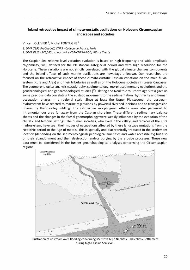
The Caspian Sea relative level variation evolution is based on high frequency and wide amplitude rhythmicity, well defined for the Pleistocene-Lateglacial period and with high resolution for the Holocene. These variations are not strictly correlated with the global climate changes components and the inland effects of such marine oscillations are nowadays unknown. Our researches are focused on the retroactive impact of these climato-eustatic Caspian variations on the main fluvial system (Kura and Arax) and their tributaries as well as on the Holocene societies in Lesser Caucasus. The geomorphological analysis (stratigraphy, sedimentology, morphosedimentary evolution), and the geochronological and geoarchaeological studies (14C dating and Neolithic to Bronze age sites) gave us some precious data correlating the eustatic movement to the sedimentation rhythmicity and human occupation phases in a regional scale. Since at least the Upper Pleistocene, the upstream hydrosystem have reacted to marine regressions by powerful riverbed incisions and to transgression phases by thick valley infilling. The retroactive morphogenic effects were also perceived to intramontainous area far away from the Caspian shoreline. These different sedimentary balance sheets and the changes in the fluvial geomorphology were weakly influenced by the evolution of the climatic and tectonic settings. The human societies, who lived in the valleys and terraces of the Kura hydrosystem, have seen their modes of occupations affected by these landscape mutations from the Neolithic period to the Age of metals. This is spatially and diachronically traduced in the settlement location (depending on the sedimentological/ pedological amenities and water accessibility) but also on their abandonment and their destruction and/or burying by the erosive processes. These new data must be considered in the further geoarchaeological analyses concerning the Circumcaspian regions.
Illustration of upstream over-flooding concerning Mentesh Tepe Neolithic-Chalcolithic settlement
during high Caspian Sea level.
Session 3 – Environmental crises and cultural changes ___________________________________________________________________________
21
Sedimentary archives of past environmental conditions and 14C chronology uncertainties
Michel FONTUGNE
UMR 8212 LSCE/IPSL, Laboratoire CEA-CNRS-UVSQ, Gif sur Yvette
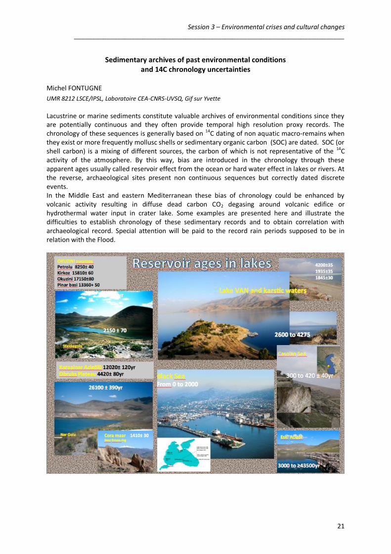
Lacustrine or marine sediments constitute valuable archives of environmental conditions since they are potentially continuous and they often provide temporal high resolution proxy records. The chronology of these sequences is generally based on 14C dating of non aquatic macro-remains when they exist or more frequently mollusc shells or sedimentary organic carbon (SOC) are dated. SOC (or shell carbon) is a mixing of different sources, the carbon of which is not representative of the 14C activity of the atmosphere. By this way, bias are introduced in the chronology through these apparent ages usually called reservoir effect from the ocean or hard water effect in lakes or rivers. At the reverse, archaeological sites present non continuous sequences but correctly dated discrete events. In the Middle East and eastern Mediterranean these bias of chronology could be enhanced by volcanic activity resulting in diffuse dead carbon CO2 degasing around volcanic edifice or hydrothermal water input in crater lake. Some examples are presented here and illustrate the difficulties to establish chronology of these sedimentary records and to obtain correlation with archaeological record. Special attention will be paid to the record rain periods supposed to be in relation with the Flood.

Session 3 – Environmental crises and cultural changes ___________________________________________________________________________
22
Cultural changes, collapses and climato-environmental crisis
Jacques-Élie BROCHIER
UMR 7269 LAMPEA, CNRS – Université Aix-Marseille, Aix-en-Provence
(Abstract not provided)

Session 3 – Environmental crises and cultural changes ___________________________________________________________________________
23
From the domination of climate changes to the decline of dominating powers: ambivalence of data and epistemiologic obstacles
Frédéric MAGNIN
UMR 7263 IMBE, CNRS – Université Aix-Marseille, Aix-en-Provence
(Abstract not provided)
Session 4 – Settlement patterns : socio-economic aspects and populations ___________________________________________________________________________
24
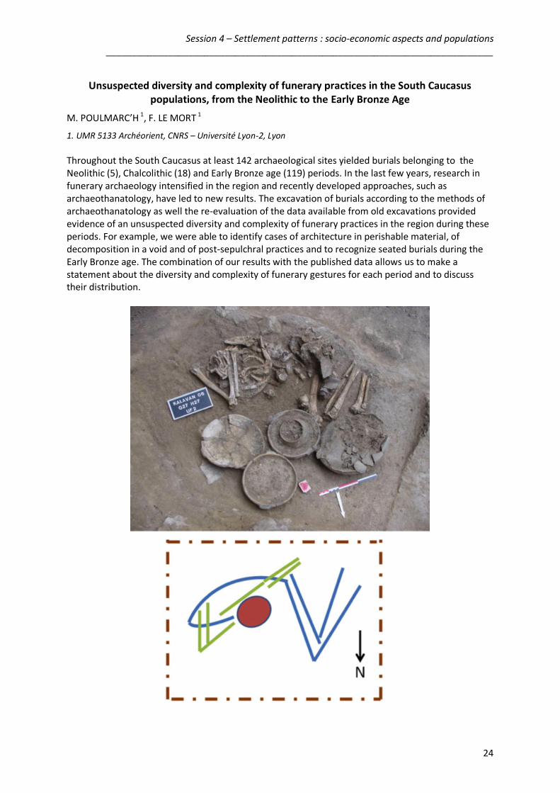
Unsuspected diversity and complexity of funerary practices in the South Caucasus populations, from the Neolithic to the Early Bronze Age
M. POULMARC’H 1, F. LE MORT 1
1. UMR 5133 Archéorient, CNRS – Université Lyon-2, Lyon
Throughout the South Caucasus at least 142 archaeological sites yielded burials belonging to the Neolithic (5), Chalcolithic (18) and Early Bronze age (119) periods. In the last few years, research in funerary archaeology intensified in the region and recently developed approaches, such as archaeothanatology, have led to new results. The excavation of burials according to the methods of archaeothanatology as well the re-evaluation of the data available from old excavations provided evidence of an unsuspected diversity and complexity of funerary practices in the region during these periods. For example, we were able to identify cases of architecture in perishable material, of decomposition in a void and of post-sepulchral practices and to recognize seated burials during the Early Bronze age. The combination of our results with the published data allows us to make a statement about the diversity and complexity of funerary gestures for each period and to discuss their distribution.

Session 4 – Settlement patterns : socio-economic aspects and populations ___________________________________________________________________________
25
A GIS analysis of Early Bronze Age settlement patterns in Armenia. Samuel Haroutunian 1, Ruben Badalyan 2
1. Université Paris-Sorbonne (Paris IV) 2. Institute of Archaeology and Ethnography, Nat. Acad. Sciences of Armenia, Yerevan, Armenia
During the Early Bronze Age, a large number of settlements of Kura-Araxes culture, with intensive agricultural activities, emerged in South-Caucasus. Since the first finds of archaeological reminds of this cultural phenomenon, more than 200 sites have been discovered in the territory of Republic of Armenia. The spatial organization of these Kura-Araxes sites has always been an issue in which the archaeologists focused a considerable attention. In fact, the complexity of landscape structure and heterogeneity of environment of the territory, comprising high plains and massif mountainous areas, had a significant impact on the organization of these settlements and on the land use patterns. For this study, a database of Kura-Araxes sites linked to a GIS has been created in order to facilitate the spatial analysis, taking in consideration the chronological evolution of sites based on stratigraphy, radiocarbon datings and relative chronology of pottery style. The spatial datas are then associated with specific environmental maps and reflects the dynamics of landscape use and allows us to examine the social and economic configuration during the Early Bronze.
Session 4 – Settlement patterns : socio-economic aspects and populations ___________________________________________________________________________
26
Northernmost kites ?
Olivier BARGE 1, Jacques-Elie BROCHIER 2, Arkadi KARAKHANYAN 3
1. UMR 5133 Archéorient, CNRS – Université Lyon-2, Lyon 2. UMR 7269 LAMPEA, CNRS – Université Aix-Marseille, Aix-en-Provence 2. Institute of Geological Sciences, Nat. Acad. Sciences of Armenia, Yerevan, Armenia
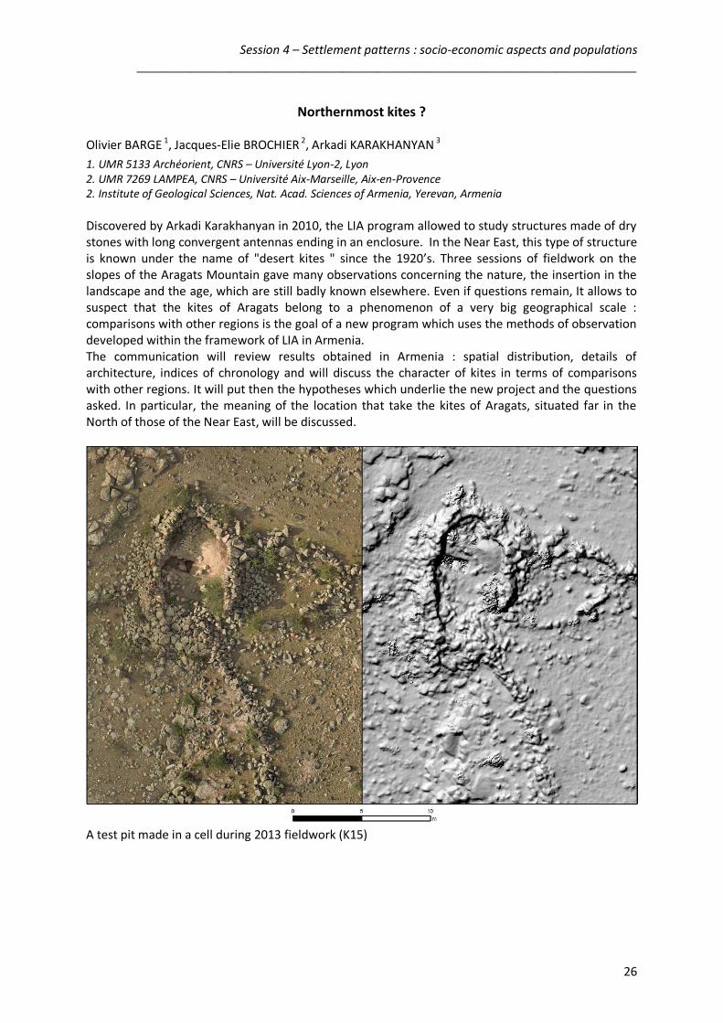
Discovered by Arkadi Karakhanyan in 2010, the LIA program allowed to study structures made of dry stones with long convergent antennas ending in an enclosure. In the Near East, this type of structure is known under the name of "desert kites " since the 1920’s. Three sessions of fieldwork on the slopes of the Aragats Mountain gave many observations concerning the nature, the insertion in the landscape and the age, which are still badly known elsewhere. Even if questions remain, It allows to suspect that the kites of Aragats belong to a phenomenon of a very big geographical scale : comparisons with other regions is the goal of a new program which uses the methods of observation developed within the framework of LIA in Armenia. The communication will review results obtained in Armenia : spatial distribution, details of architecture, indices of chronology and will discuss the character of kites in terms of comparisons with other regions. It will put then the hypotheses which underlie the new project and the questions asked. In particular, the meaning of the location that take the kites of Aragats, situated far in the North of those of the Near East, will be discussed.
A test pit made in a cell during 2013 fieldwork (K15)

Session 5 – Iron Age __________________________________________________________________________________
27
Erebuni in the context of ourartian fortresses of Araxe plain : sources and problems
Stéphane DESCHAMPS
UMR 6566 CReAAH, CNRS – Université Rennes-1; DRAC de Bretagne, Rennes
Erebuni fortress, located on the hill of Arin Berd (Yerevan) is one of the three main ourartian strongholds founded in the plain of the Araxes. Built during the reign of King Argishti in 782 BC, it marks the expansion of the kingdom of Urartu to the north from the reign of Menua and submission of Araxes plain during the reign of King Argishti. As Argishtihinili (Armavir), also founded by King Argishti and Teishebaini (Karmir Blour), founded by King Rusa II in the first quarter of the seventh century BC, they are both centers of power and control, religious centers and effective “granaries”. The research program conducted in Erebuni since 2008 as part of an Armenian-French archaeological expedition led to reconsider the archaeological data collected during pioneering excavations in the years 1950-60, both on topographical aspects (organization of the sanctuary of Haldi), but also - and perhaps especially - on chronological aspects. One of the most difficult issue concerns the transitional period between the fall of Urartean kingdom and the integration of Armenia in the Achaemenid Persian Empire. Long referred as late Urartu following hypothesis proposed by B. B. Piotrovsky after excavations of Teishebaini/Karmir Blour, suggesting the destruction of this fortress ca. 585 BC, at the time of the collapse of Urartu, this period should be reconsidered in its long-term to the light of new interpretations based in particular on the most recent studies of the ourartian corpus of inscriptions, or the Assyrian-Babylonian chronicles. This real transitional period covers almost a century between the mid-seventh to the mid-sixth century BC. Excavations conducted since 2008 in Erebuni fortress offer a new reading of this complex period which seems to develop in two phases, the second manifested by new monumental programs whose main columned hall of Erebuni, prior to the Achaemenid period, is the most significant element. Although archives from excavations realised during 1950-60 are lacking, these new data lead us to propose a new reading of late occupation fortresses of Araxes plain and to reconsider this period of Armenian history and its relations with Iran before the Achaemenid period.
Erebuni. The main columned hall area. The column bases, restored during the Soviet period,
succeeds Ourartian terraces whose eastern boundary is made of a row of large blocks.

Session 5 – Iron Age __________________________________________________________________________________
28
Ten years of archaeoseismological researches in Armenia Alain RIDEAUD 1, Bruno HELLY 2
1. Architecte DPLG, Mâcon, France 2. UMR 5189 HISoMA, CNRS – Université Lyon-2, Lyon
The results obtained from observations made during our missions in Armenia for the LIA programs are described here: I. We were able to highlight a number of seismic events unknown from the written sources and current catalogs : A) in the region Behura an earthquake shook a grave ( mound ) and buildings after the 7th century . BC. B) at Erebuni an earthquake ruined temple Khaldi at the end of the period urartu and led to the abandonment and the transformation of the neighborhood where it was established , probably in the late 7th century . BC. C) at Benjamine , an earthquake caused significant damage to a part of the Hellenistic period property , including the eastern gate tower and traces of repairs ensure that the event dates from the same période.D) The study of th bridge Garni and the village church of Garni led to highlight at least one event prior to the earthquake of 1679 , known from texts and serves as an anchor to all dating destruction in the region. II . The observations made on the construction of rural tradition called " azarashen " have not only to trace this building tradition at least until the Hellenistic period ( 4th century . Ave. ), but also and especially to appear as a criterion characteristic of disorders caused by the earthquake the rhomboid deformation of these building structures, resulting of and accompanied by the compression or extension of the walls according to their position relative to the direction of passage of the seismic waves .

Session 5 – Iron Age __________________________________________________________________________________
29
The Necropolises of Azerbaijan during the Bronze and Iron Ages in the Lenkoran and the Lerik Areas (NABIALLA)
Michèle CASANOVA 1, Christine LORRE 2
1. UMR 5133 Archéorient, CNRS – Université Lyon-2, Lyon 2. Musée des Antiquités Nationales, St-Germain-en-Laye
The paper will focus on the NABIALLA project that deals with the study of necropolises of the Lenkoran and the Lerik Areas during the Bronze and Iron Age (Azerbaïdjan) and that is conducted by Pr. Michele Casanova (University of Lyon 2, UMR 5133, Archéorient, CNRS), Christine Lorre, Curator for the Comparative Archaeology Department (National Museum of Archaeology, Saint-Germain-en-Laye, UMR 7041, ARSCAN, CNRS, France) and Abuzar Alakbarov, archaeologist (Institute of Archaeology and Ethnography). It will show the primary results of the last two years in fieldwork and museum studies.
Kravéladi IV © Mission du Lenkoran
This multidisciplinary project includes on one hand (Lenkoran Axis), fieldwork, the study of archaeological remains (ceramic, lithic, metal and bone material) as much as geomorphological analysis in the Lenkoran Valley. The French-Azeri Joint Expedition began to conduct surveys and excavation in the Lenkoran Valley (Lerik province) in 2012. The 2013 campaign consisted in surveys, soundings and excavations in the Lakerçay Valley. On the other hand (Morgan Axis), the project also intends to study again the material brought back by Jacques de Morgan in 1890 and housed in the National Museum of Archaeology in France, in order to improve the understanding of its chrono-cultural context and to publish it extensively, as much as possible in comparison with other material kept in archaeological museums of the Caucasus area. Studying the necropolises of Azerbaijan dating to the Bronze and Iron ages will allow us to improve the knowledge on burial practices especially in Southern Caucasus, but also to achieve stratigraphic data and chronology of the area, in order to better understand the influences that are exerted between Caucasus countries, Iran and North-Eastern Anatolia. The results will take into consideration recent excavations in other part of Azerbaijan as the Geranboy district (Ilanlitepe, Muncujuglutepe), Mingechevir and in Nakhichevan (Koulani, Khaj Bolagh, Sari Darreh, Ghizil Boroun and Kul Tepe), as well as in north-western Iran.

Session 6 – Neolithic period __________________________________________________________________________________
30
Directions for future research on the Neolithic transition Makoto ARIMURA
Kanazawa University, Japan
Since last decade, our knowledge on the Neolithic in the southern Caucasus has been substantial because of excavations of tell-type sites in the Ararat basin and Kura plain. So-called “Shulaveri-Shomu culture” (or recently renamed as “Aratashen-Shulaveri-Shomu culture”) proved the earliest Neolithic culture in the southern Caucasus and it appeared in the beginning of the 6th millennium BC. While recent excavations of “Aratashen-Shulaveri-Shomu culture” sites have been showing various aspects of this Neolithic culture, the origin of the Neolithic culture in the southern Caucasus still remains unclear. The sudden appearance of the “Aratashen-Shulaveri-Shomu culture” seems incoming of the Neolithic life-way from unknown land into the southern Caucasus. The important research filed concerning of the origin of the Neolithic culture in the southern Caucasus is the research of the early Holocene. In the literature in the past, the Mesolithic and the early Neolithic (or pre-pottery Neolithic) were set up as archeological periods in the early Holocene. Although several sites excavated in the soviet era are referred as Mesolithic or early Neolithic sites in the literature, it’s quite difficult to verify contents of these sites such as subsistence strategy, cultural relationship with later Neolithic cultures and so-on, due to the insufficient information from these sites. On the other hand, recent excavations at Kmlo-2 in Armenia and at Kotias Klde in Georgia have been revealing cultural entities in the early Holocene in the southern Caucasus. This report will treat current situation of the early Holocene study and show directions for future research on the early Holocene.
Session 6 – Neolithic period __________________________________________________________________________________
31
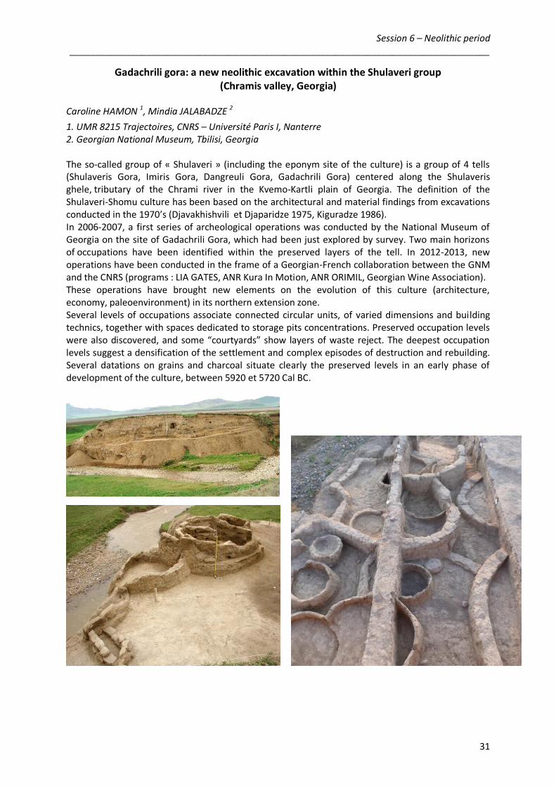
Gadachrili gora: a new neolithic excavation within the Shulaveri group (Chramis valley, Georgia)
Caroline HAMON 1, Mindia JALABADZE 2
1. UMR 8215 Trajectoires, CNRS – Université Paris I, Nanterre 2. Georgian National Museum, Tbilisi, Georgia The so-called group of « Shulaveri » (including the eponym site of the culture) is a group of 4 tells (Shulaveris Gora, Imiris Gora, Dangreuli Gora, Gadachrili Gora) centered along the Shulaveris ghele, tributary of the Chrami river in the Kvemo-Kartli plain of Georgia. The definition of the Shulaveri-Shomu culture has been based on the architectural and material findings from excavations conducted in the 1970’s (Djavakhishvili et Djaparidze 1975, Kiguradze 1986). In 2006-2007, a first series of archeological operations was conducted by the National Museum of Georgia on the site of Gadachrili Gora, which had been just explored by survey. Two main horizons of occupations have been identified within the preserved layers of the tell. In 2012-2013, new operations have been conducted in the frame of a Georgian-French collaboration between the GNM and the CNRS (programs : LIA GATES, ANR Kura In Motion, ANR ORIMIL, Georgian Wine Association). These operations have brought new elements on the evolution of this culture (architecture, economy, paleoenvironment) in its northern extension zone. Several levels of occupations associate connected circular units, of varied dimensions and building technics, together with spaces dedicated to storage pits concentrations. Preserved occupation levels were also discovered, and some “courtyards” show layers of waste reject. The deepest occupation levels suggest a densification of the settlement and complex episodes of destruction and rebuilding. Several datations on grains and charcoal situate clearly the preserved levels in an early phase of development of the culture, between 5920 et 5720 Cal BC.

Session 6 – Neolithic period __________________________________________________________________________________
32
The Neolithic levels of Mentesh Tepe (Azerbaijan) Bertille LYONNET 1, Fahrad GULIYEV 2, in collaboration with Laurence ASTRUC 3, Antoine COURCIER 4, D. GUILBEAU 4, Gaelle LE DOSSEUR 4, G. BRULEY-CHABOT 5, E. JOVENET 5, Laure PECQUEUR 5, Anaick SAMZUN 5, Michel FONTUGNE 6
1. UMR 7192 ProCauLAC, CNRS - Collège de France, Paris 2. Institute of Archaeology and Ethnography, Nat. Acad. Sciences Azerbaijan, Baku, Azerbaijan 3. UMR 7041 ArScAn, CNRS – Université Paris I, Nanterre 4. University Paris I 5. INRAP – National Institute of Preventive Archaeological Research, Paris 6. UMR 8212 LSCE/IPSL, Laboratoire CEA-CNRS-UVSQ, Gif sur Yvette
The site of Mentesh Tepe (Tovuz district in western Azerbaijan) is being excavated by a french-azerbaijanese team since 2008. Under architectural levels of the Bronze Age (kurgans of the Martkopi and Kura-Araxes cultures, Kura-Araxes pits-silos) and of the Chalcolithic period during the 5th millennium (rectangular buildings of unbaked bricks linked to a culture with painted ceramics contemporary to the Sioni culture), levels dating back to the Neolithic have been brought to light. The architecture is circular, made of plano-convex unbaked bricks or of beaten earth. The anthropic excavation of a vast depression may be the result of the making of the bricks. The material found in the buildings is not very abundant but characteristic of the late Neolithic: bone and horn tools, obsidian and other stone tools, ceramics, etc. Metallurgy also seems to be already present, though its evidence is indirect. To this can be added the discovery of several graves, one, at least, of a child and another containing, up to now, 27 individuals of all ages and both sex. Though very close to the site of Göy Tepe, excavated by our Azerbaijanese colleagues in collaboration with a Japanese team and attributed to the Shomu-Shulaveri culture, several differences in the material culture of the two sites have been noticed which put Mentesh aside of the most typical features of this culture: lesser importance of the bone industry, different lithic technology, scarcity of applied decoration on the ceramics and of basalt temper but presence of painted decoration and use of a vegetal temper, new shapes, etc… These differences had first been considered as a sign for a late date of Mentesh within the Shomu-Shulaveri group. Recent analysis and further research show that, on the contrary, it should be placed at an early stage, around 5700 BC.
Session 6 – Neolithic period __________________________________________________________________________________
33
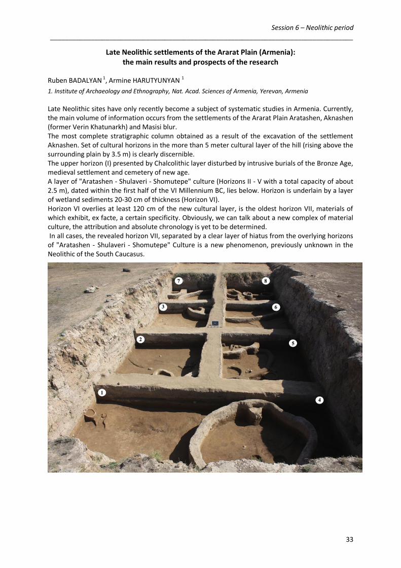
Late Neolithic settlements of the Ararat Plain (Armenia): the main results and prospects of the research
Ruben BADALYAN 1, Armine HARUTYUNYAN 1
1. Institute of Archaeology and Ethnography, Nat. Acad. Sciences of Armenia, Yerevan, Armenia
Late Neolithic sites have only recently become a subject of systematic studies in Armenia. Currently, the main volume of information occurs from the settlements of the Ararat Plain Aratashen, Aknashen (former Verin Khatunarkh) and Masisi blur. The most complete stratigraphic column obtained as a result of the excavation of the settlement Aknashen. Set of cultural horizons in the more than 5 meter cultural layer of the hill (rising above the surrounding plain by 3.5 m) is clearly discernible. The upper horizon (I) presented by Chalcolithic layer disturbed by intrusive burials of the Bronze Age, medieval settlement and cemetery of new age. A layer of "Aratashen - Shulaveri - Shomutepe" culture (Horizons II - V with a total capacity of about 2.5 m), dated within the first half of the VI Millennium BC, lies below. Horizon is underlain by a layer of wetland sediments 20-30 cm of thickness (Horizon VI). Horizon VI overlies at least 120 cm of the new cultural layer, is the oldest horizon VII, materials of which exhibit, ex facte, a certain specificity. Obviously, we can talk about a new complex of material culture, the attribution and absolute chronology is yet to be determined. In all cases, the revealed horizon VII, separated by a clear layer of hiatus from the overlying horizons of "Aratashen - Shulaveri - Shomutepe" Culture is a new phenomenon, previously unknown in the Neolithic of the South Caucasus.

Session 6 – Neolithic period __________________________________________________________________________________
34
Neolithic agriculture in the Ararat valley (Armenia) and its comparison with the other territories of the South Caucasus
Roman HOVSEPYAN
Institute of Archaeology and Ethnography, Nat. Acad. Sciences of Armenia, Yerevan, Armenia
The earliest agricultural sites in the territory of Armenia are known from the Ararat valley, around 850 m above sea level. Those sites represent “tell” like settlements of Late Neolithic period (VI millennium BC). Three of the many Neolithic settlements of the Ararat valley have been investigated for archaeobotany so far: Aknashen, Masis Blur and Aratashen. Assemblage of plant remains, their preservation and recorded taxa are similar in the above mentioned settlements pointing that plant economies and environment probably were also similar in these Neolithic settlements. Crop processing remains almost always present in large quantities in the building clay (mostly impressions) in addition with essential quantities of plant remains (charred and mineralized) recovered from the soil deposits of the settlements are evidence of well established and large scale agricultural activity in the studied area. The main crops cultivated were naked wheat(s) (Triticum aestivum/durum), part of which is hexaploid, i.e. bread wheat (Triticum aestivum), emmer (Triticum turgidum ssp. dicoccum), hulled and naked barleys (Hordeum vulgare), part of which are six-rowed subspecies (Hordeum vulgare subsp. vulgare convar. vulgare & H. vulgare ssp. vulgare convar. coeleste), small seeded lentil (Lens culinaris ssp. microsperma) and bitter vetch (Vicia ervilia). Grape (Vitis vinifera) and pea (Pisum sativum) could also be cultivated in lesser quantities. In addition to the mentioned known traditional cultigens large scale use and possible cultivation of two crucifers, desert alyssum (Alyssum turkestanicum ssp. desertorum) and small pod false flax (Camelina sativa ssp. microcarpa), are recorded, which is specific for the Ararat valley (for this moment). The second most notable specifics for the Neolithic agriculture of the Ararat valley is that scales of the cultivation of pulses did not yield scales of the cereals cultivation or even prevailed upon it. For the later periods, started from the Late Chalcolithic, the scales of the pulses cultivation drops and pulses (as well as oil producing plants) are not being recorded almost for all investigated Bronze Age sites of the South Caucasus.
Naked wheat (Triticum aestivum/turgidum)
(sond. A, UF 12 and UF 10)
Hulled barley (Hordeum vulgare)
(sond. A, UF 14)
Lentil (Lens culinaris)
(sond. A, UF 10) Situation with Neolithic agriculture in the Ararat valley seems generally similar with the other territories of the South Caucasus. The only notable differences in other Neolithic sites at Georgia and Azerbaijan that we could underline are 1) the absence of the alyssum and camelina, 2) prevailing of cereals over other cultivated plants. In addition, there are few other oil producing plants in some of newly investigated Neolithic sites from the territory of Azerbaijan. Above all this, the differences recorded can be just an illusory ones conditioned by differences in methodology and scales of investigations, and it is possible either ways, record of more differences or elimination of the present ones under light of the new data.

Session 6 – Neolithic period __________________________________________________________________________________
35
Animal Domestication in Transcaucasia – Archaeozoological and Palaeogenetic Evidence Norbert BENECKE
German Archaeological Institute, Berlin
The paper presents new archaeozoological and palaeogenetic data for animal domestication in the area of Transcaucasia coming from two recently excavated Neolithic sites: Aruchlo in Georgia and Kamiltepe in Azerbaijan. At both sites subsistence economy mainly relied upon animal keeping rather than on hunting, fishing or gathering throughout their occupation. Among the domestic animals cattle and sheep were the most important species for meat supply and consumption. The kill-off pattern in cattle and sheep is consistent with a mode of exploitation where milk or milk products were of some significance as foodstuff. Osteometric data suggest that cattle, pig, sheep and goat were already in a developed stage of domestication. All these species exhibit a clearly reduced mean body size compared to the wild relatives. Analysis of aDNA on bones of cattle, sheep and pig could demonstrate that genetic diversity is high and similar to the wild ancestors. The distribution of haplogroups exhibits a pattern which is different from that of Neolithic domestic animals in Southeast-Europe or Western Anatolia pointing to a different origin and / or mechanism of domestication. The exploitation of natural animal resources for providing food and raw materials was of limited significance at both sites. The percentage of game is about 3%. In Aruchlo, red deer was the most frequently hunted wild animal, while in Kamiltepe wild animals are mainly represented by gazelle and little bustard.
Session 6 – Neolithic period __________________________________________________________________________________
36
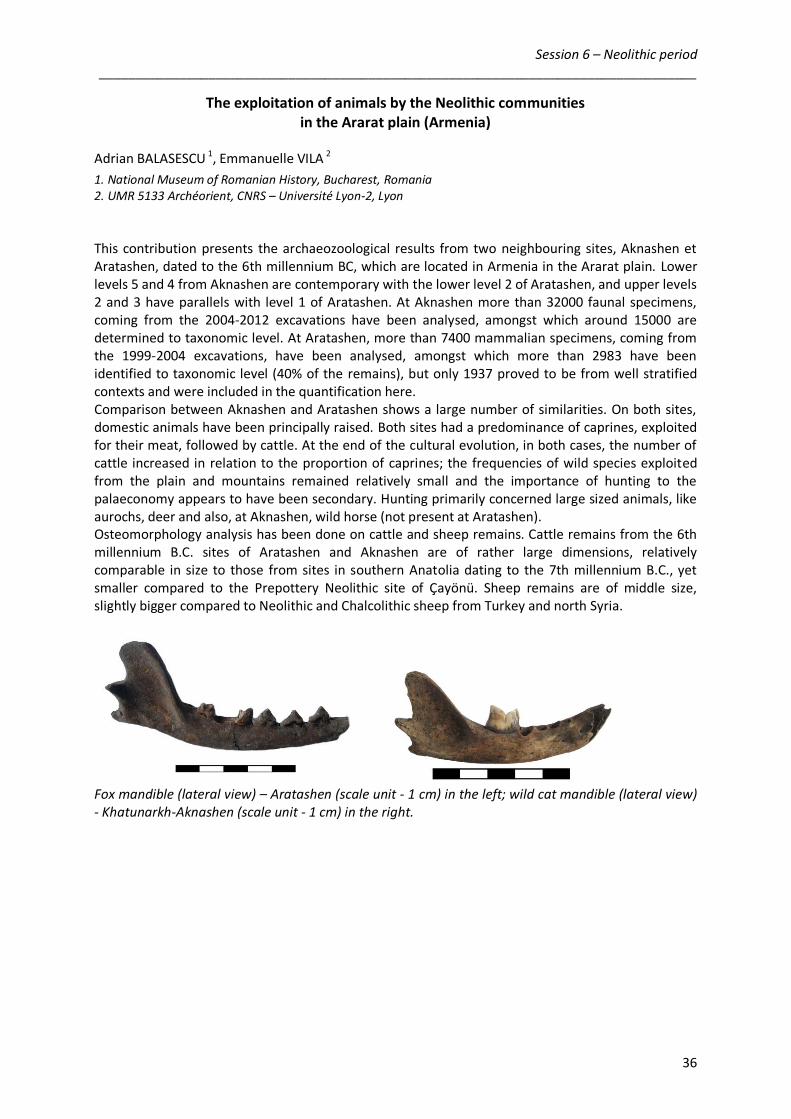
The exploitation of animals by the Neolithic communities in the Ararat plain (Armenia)
Adrian BALASESCU 1, Emmanuelle VILA 2
1. National Museum of Romanian History, Bucharest, Romania 2. UMR 5133 Archéorient, CNRS – Université Lyon-2, Lyon
This contribution presents the archaeozoological results from two neighbouring sites, Aknashen et Aratashen, dated to the 6th millennium BC, which are located in Armenia in the Ararat plain. Lower levels 5 and 4 from Aknashen are contemporary with the lower level 2 of Aratashen, and upper levels 2 and 3 have parallels with level 1 of Aratashen. At Aknashen more than 32000 faunal specimens, coming from the 2004-2012 excavations have been analysed, amongst which around 15000 are determined to taxonomic level. At Aratashen, more than 7400 mammalian specimens, coming from the 1999-2004 excavations, have been analysed, amongst which more than 2983 have been identified to taxonomic level (40% of the remains), but only 1937 proved to be from well stratified contexts and were included in the quantification here. Comparison between Aknashen and Aratashen shows a large number of similarities. On both sites, domestic animals have been principally raised. Both sites had a predominance of caprines, exploited for their meat, followed by cattle. At the end of the cultural evolution, in both cases, the number of cattle increased in relation to the proportion of caprines; the frequencies of wild species exploited from the plain and mountains remained relatively small and the importance of hunting to the palaeconomy appears to have been secondary. Hunting primarily concerned large sized animals, like aurochs, deer and also, at Aknashen, wild horse (not present at Aratashen). Osteomorphology analysis has been done on cattle and sheep remains. Cattle remains from the 6th millennium B.C. sites of Aratashen and Aknashen are of rather large dimensions, relatively comparable in size to those from sites in southern Anatolia dating to the 7th millennium B.C., yet smaller compared to the Prepottery Neolithic site of Çayönü. Sheep remains are of middle size, slightly bigger compared to Neolithic and Chalcolithic sheep from Turkey and north Syria.
Fox mandible (lateral view) – Aratashen (scale unit - 1 cm) in the left; wild cat mandible (lateral view) - Khatunarkh-Aknashen (scale unit - 1 cm) in the right.
37
LIA CONFERENCE – PARTICIPANTS “Environments and Societies in the Southern Caucasus
during the Holocene” Lyon, Maison de l'Orient, 28-29 November 2013

38
Ahmed-Adam Ali UMR 5059 – Centre de Bio-Archéologie et d'Ecologie (CBAE) Institut de Botanique, 163 rue Broussonet, 34090 Montpellier, France [email protected] Makoto Arimura Kanazawa University Japan [email protected] Pavel Avetisyan Institute of Archaeology and Ethnography, National Academy of Sciences, Republic of Armenia 15 Charents avenue, 0025 Yerevan, Armenia [email protected] Ruben Badalyan Institute of Archaeology and Ethnography, National Academy of Sciences, Republic of Armenia 15 Charents avenue, 0025 Yerevan, Armenia [email protected] Adrian Balasescu Centre National des Recherches Pluridisciplinaires Musée National d'Histoire de la Roumanie 12 Calea Victoriei, 30026 Bucarest, Roumanie [email protected]
Olivier Barge UMR 5133 – Archéorient Maison de l'Orient et de la Méditerranée, 7 rue Raulin, 69007 Lyon, France [email protected] Norbert Benecke German Archaeological Institute Berlin, Germany [email protected] Jacques-Elie Brochier UMR 7269 – Laboratoire Méditerranéen de Préhistoire Europe-Afrique (LAMPEA) MMSH, 5 rue du Château de l'Horloge, BP 647, 13094 Aix-en-Provence, France [email protected] Michèle Casanova UMR 5133 – Archéorient Maison de l'Orient et de la Méditerranée, 7 rue Raulin, 69007 Lyon, France [email protected] Christine Chataigner UMR 5133 – Archéorient Maison de l'Orient et de la Méditerranée, 7 rue Raulin, 69007 Lyon, France [email protected]

39
Alexia Decaix UMR 7209 – Archéozoologie, Archéobotanique : sociétés, pratiques et environnements Museum National d'Histoire Naturelle, bât. 56, 57 rue Cuvier, 75005 Paris, France [email protected] Stephane Deschamps Direction Générale des Affaires Culturelles (DRAC) de Bretagne Hôtel de Blossac, 6 rue du Chapître, 35000 Rennes, France [email protected] Michel Fontugne Laboratoire des Sciences du Climat et de l’Environnement, UMR 1572 CNRS, CEA, UVSQ, Parc du CNRS, 91198-Gif sur Yvette cedex, France. [email protected] Caroline Hamon UMR 8215 Trajectoires. Maison de l'archéologie - 21, allée de l'Université, 92023 Nanterre cedex France [email protected] Samuel Haroutunian Université Paris-Sorbonne (Paris IV) Institut d'Art et d'Archéologie, 3 rue Michelet, 75006 Paris, France [email protected]
Bruno Helly UMR 5189 – Histoire et Sources des Mondes Antiques (HiSoMA) Maison de l'Orient et de la Méditerranée, 7 rue Raulin, 69007 Lyon, France [email protected] Roman Hovsepyan Institute of Archaeology and Ethnography, National Academy of Sciences, Republic of Armenia 15 Charents avenue, 0025 Yerevan, Armenia [email protected] Mindia Jalabadze Georgian National Museum 3, Rustaveli Avenue, 0105 Tbilisi, Georgia [email protected] Sebastien Joannin UMR 5276 – Laboratoire de Géologie de Lyon, Terre, Planètes, Environnement (LGLTPE) Université Claude Bernard Lyon-1 Campus de la Doua, bât. GEODE, 2 rue Raphaël Dubois, 69622 Villeurbanne Cedex [email protected]

40
Fanny Jude UMR 6566 - Centre de Recherche en Archéologie, Archéosciences, Histoire (CReAAH) Université de Rennes 1, Bâtiment 24, Campus de Beaulieu, 35042 Rennes, France Arkadi Karakhanyan Institute of Geological Sciences National Academy of Sciences, Republic of Armenia 24a Marshall Baghramyan avenue, 0019 Yerevan, Armenia [email protected] Françoise Le Mort UMR 5133 – Archéorient Maison de l'Orient et de la Méditerranée, 7 rue Raulin, 69007 Lyon, France [email protected] Chantal Leroyer UMR 6566 - Centre de Recherche en Archéologie, Archéosciences, Histoire (CReAAH) Université de Rennes 1, Bâtiments 24-25, Campus de Beaulieu, 35042 Rennes, France [email protected] Pierre Lombard UMR 5133 – Archéorient Maison de l'Orient et de la Méditerranée, 7 rue Raulin, 69007 Lyon, France [email protected]
Christine Lorre Musée d'Archéologie nationale et Domaine national de Saint-Germain-en-Laye Château, place Charles de Gaulle, 78105 Saint-Germain-en-Laye, France [email protected] Bertille Lyonnet UMR 7192 – Proche-Orient, Caucase : Langues, Archéologie, Cultures (ProCauLAC), Collège de France, 52 rue du Cardinal Lemoine, 75005 Paris, France [email protected] Frederic Magnin UMR 7263 – Institut Méditerranéen de Biodiversité et d'Ecologie marine (IMBE) Europôle Méditerranéen de l'Arbois, Bat. Villemin, BP 80, 13545 Aix-en-Provence cedex 4 [email protected] Dominique Marguerie UMR 6566 - Centre de Recherche en Archéologie, Archéosciences, Histoire (CReAAH) Université de Rennes 1, Bâtiment 24, Campus de Beaulieu, 35042 Rennes, France [email protected]

41
Erwan Messager UMR 7264 – Cultures et Environnements, Préhistoire, Antiquité, Moyen Age (CEPAM) Pôle Universitaire SJA3, 24 avenue des Diables Bleus, 06357 Nice Cedex 4, France [email protected] Ana Mgeladze Georgian National Museum 3, Rustaveli Avenue, 0105 Tbilisi, Georgia [email protected] Elina Muradova Institute of Archaeology and Ethnography, National Academy of Sciences, Republic of Azerbaijan 31, H. Javid avenue, 370143 Baku, Azerbaijan Sebastien Nomade Laboratoire des Sciences du Climat et de l’Environnement, UMR 8212 CNRS, CEA, UVSQ, Parc du CNRS, 91198-Gif sur Yvette cedex, France. [email protected] Vincent Ollivier UMR 7192 – Proche-Orient, Caucase : Langues, Archéologie, Cultures (ProCauLAC) Collège de France, 52 rue du Cardinal Lemoine, 75005 Paris, France [email protected]
Modwene Poulmarc'h UMR 5133 – Archéorient Université Lyon 2, 7 rue Raulin, 69007 Lyon, France [email protected] Alain Rideaud Architecte DPLG 4 place du Champ de Mars, 71700 Tournus, France [email protected] Jean-François Ritz UMR 5243 – Géosciences Montpellier Université Montpellier-2, Place E. Bataillon, 34095 Montpellier cedex5 [email protected] Emmanuelle Vila UMR 5133 – Archéorient Maison de l'Orient et de la Méditerranée, 7 rue Raulin, 69007 Lyon, France [email protected]
42
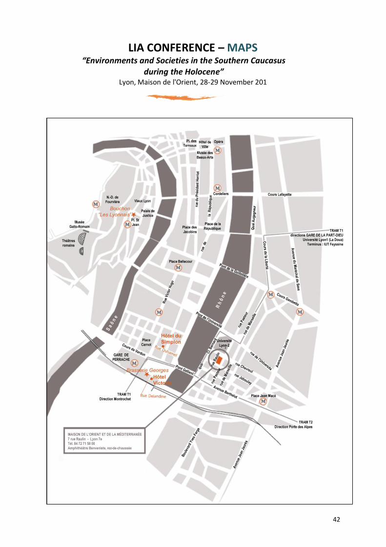
LIA CONFERENCE – MAPS “Environments and Societies in the Southern Caucasus
during the Holocene” Lyon, Maison de l'Orient, 28-29 November 201
44
LIA CONFERENCE – Notes “Environments and Societies in the Southern Caucasus
during the Holocene” Lyon, Maison de l'Orient, 28-29 November 201