A review of possible eustatic, isostatic and tectonic contributions in eight late-Holocene relative...
13
Quaternary Science Reviews 24 (2005) 1989–2001 A review of possible eustatic, isostatic and tectonic contributions in eight late-Holocene relative sea-level histories from the Mediterranean area Paolo Antonio Pirazzoli CNRS-Laboratoire de Ge´ographie Physique, 1 Place Aristide Briand, 92195 Meudon cedex, France Received 24 February 2004; accepted 22 June 2004 Abstract This paper consists of a comparison between eight late-Holocene sea-level histories investigated by the author in different Mediterranean areas and sea-level predictions in the same areas made by global isostatic models. The areas include three regions that are generally considered as tectonically relatively stable: (1) the southern coast of France, (2) Sardinia, and (3) the southern coasts of Tunisia, where late-Holocene evidence may be either of submergence, or of emergence. Also considered are: (4) a subsidence region in the northern Adriatic, and actively uplifting areas: (5) in Calabria, and (6) in Nisyros Island (Greece). Lastly, case studies in areas affected by repeated coseismic vertical displacements include: (7) western Crete and Antikythira Island in the Hellenic Arc, and (8) the Levant coasts of Turkey, Syria and the Lebanon. In each case the question of whether the evidence available may or may not be consistent with gradual isostatic or eustatic displacements has been explored. It appears that in non-tectonic areas the hydro-isostatic effects have been overestimated (Sardinia) or underestimated (southern Tunisia) by the same models. In the northern Adriatic, the closest Mediterranean area to the former Scandinavian ice sheet, glacio- eustatic effects are suspected to be almost absent. Our analysis failed to quantify isostatic effects in areas of rapid tectonic uplift (Calabria and Nisyros), but rejected predictions of significant isostatic subsidence in the Hellenic Arc and on the Levant coast. Finally, several data from tectonic and non-tectonic areas are consistent with nearly stable global eustasy since 6000 BP, thus challenging the assertion of significant additional melting of Antarctica after the complete melting of the former Northern Hemisphere ice caps. r 2005 Elsevier Ltd. All rights reserved. 1. Introduction The usefulness of global isostatic models is generally recognized in obtaining a first approximation of sea- level history in areas where no direct observations are available. However, the ability of model predictions should not be overestimated, because they do not represent the reality, as reliable and accurate field data do, but only first-order approximations of this reality based on simplified assumptions. In this study we have attempted to verify the degree of accurateness of late-Holocene sea-level predictions made by geophysical modellers in eight Mediterranean regions characterized by different tectonic settings. The Medi- terranean area has been chosen because (1) it is situated at an intermediate position between ‘‘ice-margin sites’’ and ‘‘far field sites’’ (in relation to the influence of former ice sheets), and (2) because there is disagreement between modellers on its position inside or outside a peripheral bulge around the former ice margin that tends to subside in late-glacial and postglacial times. On the other hand, in the late-Holocene the sea-level equation is simplified by the almost absence of eustatic changes, i.e. one of the major unknowns during the preceding periods, and this can make easier the determination of other factors contributing to relative changes in sea level. ARTICLE IN PRESS 0277-3791/$ - see front matter r 2005 Elsevier Ltd. All rights reserved. doi:10.1016/j.quascirev.2004.06.026 Tel.: +1 45 07 55 5. E-mail address: [email protected]
-
Upload
independent -
Category
Documents
-
view
0 -
download
0
Transcript of A review of possible eustatic, isostatic and tectonic contributions in eight late-Holocene relative...

ARTICLE IN PRESS
0277-3791/$ - se
doi:10.1016/j.qu
�Tel.: +1 45
E-mail addr
Quaternary Science Reviews 24 (2005) 1989–2001
A review of possible eustatic, isostatic and tectonic contributions ineight late-Holocene relative sea-level histories from the
Mediterranean area
Paolo Antonio Pirazzoli�
CNRS-Laboratoire de Geographie Physique, 1 Place Aristide Briand, 92195 Meudon cedex, France
Received 24 February 2004; accepted 22 June 2004
Abstract
This paper consists of a comparison between eight late-Holocene sea-level histories investigated by the author in different
Mediterranean areas and sea-level predictions in the same areas made by global isostatic models. The areas include three regions
that are generally considered as tectonically relatively stable: (1) the southern coast of France, (2) Sardinia, and (3) the southern
coasts of Tunisia, where late-Holocene evidence may be either of submergence, or of emergence. Also considered are: (4) a
subsidence region in the northern Adriatic, and actively uplifting areas: (5) in Calabria, and (6) in Nisyros Island (Greece). Lastly,
case studies in areas affected by repeated coseismic vertical displacements include: (7) western Crete and Antikythira Island in the
Hellenic Arc, and (8) the Levant coasts of Turkey, Syria and the Lebanon. In each case the question of whether the evidence
available may or may not be consistent with gradual isostatic or eustatic displacements has been explored.
It appears that in non-tectonic areas the hydro-isostatic effects have been overestimated (Sardinia) or underestimated (southern
Tunisia) by the same models. In the northern Adriatic, the closest Mediterranean area to the former Scandinavian ice sheet, glacio-
eustatic effects are suspected to be almost absent. Our analysis failed to quantify isostatic effects in areas of rapid tectonic uplift
(Calabria and Nisyros), but rejected predictions of significant isostatic subsidence in the Hellenic Arc and on the Levant coast.
Finally, several data from tectonic and non-tectonic areas are consistent with nearly stable global eustasy since 6000 BP, thus
challenging the assertion of significant additional melting of Antarctica after the complete melting of the former Northern
Hemisphere ice caps.
r 2005 Elsevier Ltd. All rights reserved.
1. Introduction
The usefulness of global isostatic models is generallyrecognized in obtaining a first approximation of sea-level history in areas where no direct observations areavailable. However, the ability of model predictionsshould not be overestimated, because they do notrepresent the reality, as reliable and accurate field datado, but only first-order approximations of this realitybased on simplified assumptions.
In this study we have attempted to verify the degree ofaccurateness of late-Holocene sea-level predictions made
e front matter r 2005 Elsevier Ltd. All rights reserved.
ascirev.2004.06.026
07 55 5.
ess: [email protected]
by geophysical modellers in eight Mediterranean regionscharacterized by different tectonic settings. The Medi-terranean area has been chosen because (1) it is situatedat an intermediate position between ‘‘ice-margin sites’’and ‘‘far field sites’’ (in relation to the influence offormer ice sheets), and (2) because there is disagreementbetween modellers on its position inside or outside aperipheral bulge around the former ice margin thattends to subside in late-glacial and postglacial times.
On the other hand, in the late-Holocene the sea-levelequation is simplified by the almost absence of eustaticchanges, i.e. one of the major unknowns during thepreceding periods, and this can make easier thedetermination of other factors contributing to relativechanges in sea level.
ARTICLE IN PRESSP.A. Pirazzoli / Quaternary Science Reviews 24 (2005) 1989–20011990
In order to attempt a wide approach, eight casestudies characterized by different tectonic settings, onwhich the author has acquired personal field experience,have been selected (Fig. 1): three regions where tectonicactivity can at first sight be neglected along a north–south transect in the central Mediterranean: (1) theProvenc-al coasts of France (bordering a deep sea basin),(2) coastal Sardinia (bordering deep sea basins), and (3)the coasts of southern Tunisia (bordering a shallow seabasin); three tectonically active areas: (4) the slightlysubsiding NE Adriatic coasts (bordering a shallow seabasin), (5) the rapidly uplifting Calabria coasts (border-ing deep sea basins), and (6) an active volcano (Nisyros)in the Aegean Sea; and lastly two regions affected byrepeated coseismic vertical displacements: (7) westernCrete and Antikythira Island, in the Hellenic Arc, and(8) the Levant coasts of Turkey, Syria and the Lebanon.
2. Methods
When dated evidence of a sea level different from thepresent one is obtained from field data, interpretation ofthe possible causes of vertical displacement generallyimplies some knowledge of the potential contribution ofmajor factors such as eustatic changes, tectonic uplift orsubsidence, and glacio- and hydro-isostatic impactsduring the period considered. The sea-level equationcan be written therefore:
ps ¼ eu þ te þ gi þ hi;
where ps is the elevation of the past shoreline, eu theeustatic position, te the tectonic (other than isostatic)component, gi the glacio-isostatic component and hi thehydro-isostatic component.
This is of course a simplified approach, neglecting lessimportant, though not always trivial contributions likehydrodynamic effects, changes in water density or otherlocal effects of climate (Morner, 1995). In other words,one deals with one equation with several unknownvariables, for which an infinite number of solutions ispossible.
In order to simplify the problem, it is advisable tolimit as much as possible the number of unknownfactors. For eustasy, it is generally agreed that changeshave been limited since the complete melting of theformer Northern Hemisphere ice sheets. Therefore, itwill be initially assumed that eustasy may be neglectedfor the 6000 radiocarbon years BP, though the validityof this assumption will be discussed later, when takinginto account the results previously obtained.
A tectonic rate of 0.1 mm/yr would imply a verticaldisplacement of 0.2 m during the last 2000 years and of0.5 m since the mid-Holocene. These values are of thesame order, or smaller, than the uncertainty marginsthat usually affect sea-level reconstructions. The eustatic
peak of 125 ka is generally estimated in a slightlyemerged position, at an elevation between the presentsea level and +8 m (Ku et al., 1974). At the rate of0.1 mm/yr, the 125 ka shoreline would have beenaffected by a vertical displacement of 712.5 m.
For a preliminary assessment of tectonic effects weshall follow the criteria suggested by Antonioli et al.(2002), based on the local position of the 125 kashoreline and assuming that the vertical displacementhas been gradual and that the shoreline elevation can beassessed with acceptable confidence. Therefore, incoastal regions where the 125 ka shoreline is situatedbetween �12 and +20 m, the local tectonic (other thanisostatic) rate will be considered as o0.1 mm/yr, i.e.negligible in the reconstruction of late-Holocene shore-line positions. Consequently, the full observed displace-ment can be interpreted as due to other isostatic causes.On the other hand, when the last Interglacial shoreline is420 m or o�12 m, a tectonic (other than isostatic)contribution cannot be neglected.
In the areas where tectonic activity can be neglected,the simplified sea-level equation for the late-Holocenebecomes:
ps ¼ gi þ hi
The glacio-isostatic component is active essentially inregions surrounding former ice sheets, where the ice loadhas produced an uplifted rim. During the deglaciation,the rim collapse produces subsidence (Daly, 1934). Dueto the viscosity of the asthenosphere, such subsidence isexpected to continue in the present time.
The hydro-isostatic component is due to the fact thatthe melt water from the ice sheets produced a load onthe ocean floor, that tends therefore to subside. Near thecoasts, however, the amount of subsidence has beenvariable, depending on the water depth, the width of thecontinental shelf, and the local topography.
Mathematical models generally estimate isostaticeffects caused by the last deglaciation with assumptionson the glacial history (thickness and distribution offormer ice sheets, duration of ice loads) and on thevisco-elastic processes of the Earth (lithosphere thick-ness, sublithospheric profile, lateral variations, andinternal transfer of mass and pressure). Isostatic modelsuse thereby a sea-level equation with a much increasednumber of unknown variables. Assumptions by mod-ellers tend to play with the variables involved so thatthe results mimic regional situations shown by fielddata. However, ‘‘there may be no single set of rheo-logical parameters that is appropriate for all regions’’(Lambeck et al., 2002), and ‘‘non-uniqueness arises’’ inthe interpretations proposed (Peltier et al., 2002).
Modellers interpret Mediterranean data in divergentways. According to Lambeck and Johnston (1995, p. 8)‘‘the glacio-isostatic term is important in shaping theoverall pattern of apparent land subsidence within a
ARTICLE IN PRESS
0 E
0 E
10 E
10 E
20 E
20 E
30 E
30 E
30˚
˚ ˚ ˚ ˚
˚˚
˚˚˚˚
N
30N
40N
40N
1
87 6
5
4
3
2
0 4020Km
0 10050Km
0 4020Km
0 5025Km
0 10050Km
1
2
6
4
5
La Ciotat Duino
Sistiana Rijeka
Bakar
Zadar
Istria
Cannes
Provence
Tharros
SantaReparata
Malfatano C.
Nora
OroseiGulf
Sardinia
AegeanSea
Pali
Kanoni C.
CalabriaScilla
Crotone
Nisyros I.
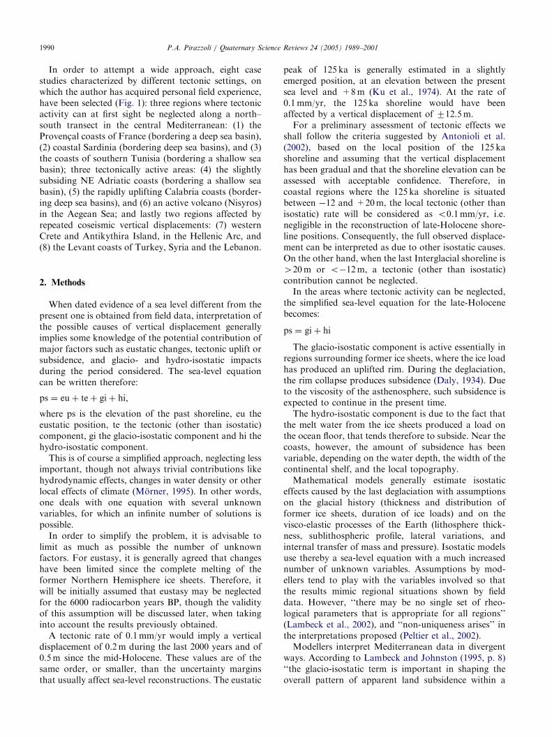
Fig. 1. Location map of the Mediterranean coastal areas considered. (1) Provence (France); (2) Sardinia (Italy); (3) Southern Tunisia; (4) North-
eastern Adriatic (Italy, Slovenia, Croatia); (5) Calabria (Italy); (6) Nisyros Island (Greece); (7) Western Crete and Antikythira Island (Greece); (8)
Levant coast of Turkey, Syria, and the Lebanon. Details of locations for southern Tunisia and the Lebanon can be found in Morhange and Pirazzoli
(in press) and in Morhange et al. (in preparation) respectively.
P.A. Pirazzoli / Quaternary Science Reviews 24 (2005) 1989–2001 1991
distance of typically 40–601 of the ice centres’’, i.e. ‘‘outof distances of 3000 km or more from the ice margin’’(Lambeck, 2002, p. 37). Therefore, according toLambeck (1995) subsidence of glacio-isostatic origin ispredominant in most of the Mediterranean Basin.
According to Peltier (1987), or Peltier et al. (inpreparation), on the other hand, the Mediterraneanregion is sufficiently remote from the NorthwestEuropean centre of deglaciation as to be little influencedby the collapse of the fore bulge that lay outboard of the
Fennoscandian ice-sheet at last glacial maximum. Therelative sea level signal in this region is expected to bemost significantly influenced by the local water loademplaced upon the basin itself.
It seemed interesting, therefore, to compare theglacio- and hydro-isostatic impacts predicted bymodellers with late-Holocene field data from a numberof significant Mediterranean areas. The aim of thispaper is not to discuss the assumptions used bymodellers, but only to explore whether selected field
ARTICLE IN PRESSP.A. Pirazzoli / Quaternary Science Reviews 24 (2005) 1989–20011992
data may or may not be consistent with the interpreta-tions proposed.
3. Results
3.1. The Provenc-al coasts of France
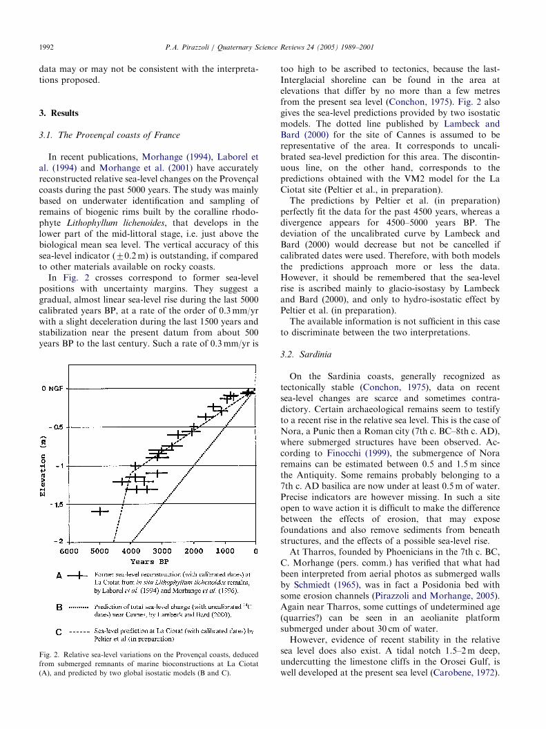
In recent publications, Morhange (1994), Laborel etal. (1994) and Morhange et al. (2001) have accuratelyreconstructed relative sea-level changes on the Provenc-alcoasts during the past 5000 years. The study was mainlybased on underwater identification and sampling ofremains of biogenic rims built by the coralline rhodo-phyte Lithophyllum lichenoides, that develops in thelower part of the mid-littoral stage, i.e. just above thebiological mean sea level. The vertical accuracy of thissea-level indicator (70.2 m) is outstanding, if comparedto other materials available on rocky coasts.
In Fig. 2 crosses correspond to former sea-levelpositions with uncertainty margins. They suggest agradual, almost linear sea-level rise during the last 5000calibrated years BP, at a rate of the order of 0.3 mm/yrwith a slight deceleration during the last 1500 years andstabilization near the present datum from about 500years BP to the last century. Such a rate of 0.3 mm/yr is
Fig. 2. Relative sea-level variations on the Provenc-al coasts, deduced
from submerged remnants of marine bioconstructions at La Ciotat
(A), and predicted by two global isostatic models (B and C).
too high to be ascribed to tectonics, because the last-Interglacial shoreline can be found in the area atelevations that differ by no more than a few metresfrom the present sea level (Conchon, 1975). Fig. 2 alsogives the sea-level predictions provided by two isostaticmodels. The dotted line published by Lambeck andBard (2000) for the site of Cannes is assumed to berepresentative of the area. It corresponds to uncali-brated sea-level prediction for this area. The discontin-uous line, on the other hand, corresponds to thepredictions obtained with the VM2 model for the LaCiotat site (Peltier et al., in preparation).
The predictions by Peltier et al. (in preparation)perfectly fit the data for the past 4500 years, whereas adivergence appears for 4500–5000 years BP. Thedeviation of the uncalibrated curve by Lambeck andBard (2000) would decrease but not be cancelled ifcalibrated dates were used. Therefore, with both modelsthe predictions approach more or less the data.However, it should be remembered that the sea-levelrise is ascribed mainly to glacio-isostasy by Lambeckand Bard (2000), and only to hydro-isostatic effect byPeltier et al. (in preparation).
The available information is not sufficient in this caseto discriminate between the two interpretations.
3.2. Sardinia
On the Sardinia coasts, generally recognized astectonically stable (Conchon, 1975), data on recentsea-level changes are scarce and sometimes contra-dictory. Certain archaeological remains seem to testifyto a recent rise in the relative sea level. This is the case ofNora, a Punic then a Roman city (7th c. BC–8th c. AD),where submerged structures have been observed. Ac-cording to Finocchi (1999), the submergence of Noraremains can be estimated between 0.5 and 1.5 m sincethe Antiquity. Some remains probably belonging to a7th c. AD basilica are now under at least 0.5 m of water.Precise indicators are however missing. In such a siteopen to wave action it is difficult to make the differencebetween the effects of erosion, that may exposefoundations and also remove sediments from beneathstructures, and the effects of a possible sea-level rise.
At Tharros, founded by Phoenicians in the 7th c. BC,C. Morhange (pers. comm.) has verified that what hadbeen interpreted from aerial photos as submerged wallsby Schmiedt (1965), was in fact a Posidonia bed withsome erosion channels (Pirazzoli and Morhange, 2005).Again near Tharros, some cuttings of undetermined age(quarries?) can be seen in an aeolianite platformsubmerged under about 30 cm of water.
However, evidence of recent stability in the relativesea level does also exist. A tidal notch 1.5–2 m deep,undercutting the limestone cliffs in the Orosei Gulf, iswell developed at the present sea level (Carobene, 1972).

ARTICLE IN PRESSP.A. Pirazzoli / Quaternary Science Reviews 24 (2005) 1989–2001 1993
With a rate of undercutting of about 1 mm/yr (Torunski,1979; Laborel et al., 1999) these notches would testify toa relative sea-level stability on the order of twomillennia.
The cements of some submerged ‘‘beachrocks’’ fromthe continental shelf of Sardinia have been dated byradiocarbon. Some of them indicate an apparent late-Holocene age (De Muro and Orru, 1998). The verticalaccuracy as sea-level indicators of these rock formationsis not known, however. Since they are described as4–5 m thick, whereas the local tidal range is 0.2–0.3 m,clearly they do not correspond to typical beachrocksformed in the intertidal range by the cementation ofbeach deposits (e.g.: Russell and McIntire, 1965). It ispossible that later underwater cementation has rejuve-nated some apparent ages.
Other beachrocks suggest relative sea-level stabilityduring at least the past 2000 years. In Santa ReparataBay, on the north coast of the island, a beachrockcontaining Roman sherds, already noticed by Ozer et al.(1984), is consistent with the present sea level. NearMalfatano Cape, on the south coast, another beachrockconsistent with the present sea level has given anuncalibrated radiocarbon age of 1430725 BP (Pirazzoliand Morhange, 2005). For other beachrocks at presentsea level or even slightly emerged, radiocarbon dating isin progress (Morhange et al., in preparation).
Isostatic models indicate in Sardinia a submergence of1.75–2 m since 2000 years BP (Lambeck et al., 2004), orof the order of 0.3 mm/yr (Peltier et al., in preparation)(Fig. 3). It can be estimated on the contrary that
Fig. 3. Predicted present-day rate of sea-level rise over the western
Mediterranean basin deduced from the VM2 viscosity model, taking
into account also the influence of ice-sheet loading and unloading that
occurred prior to Last Glacial Maximum, the hydro-isostatic effect due
to migration of the coastline on the continental shelf and the influence
of the feedback due to changing Earth rotation upon relative sea level
history (from Peltier et al., in preparation).
submergence has been almost negligible during the lasttwo millennia, apart from the sea level rise of 10–15 cmreported by tide gauges during the last century(Pirazzoli, 1986), and from other probably localphenomena at a few sites. If this interpretation iscorrect, then isostatic predictions, essentially of glacio-isostatic origin according to Lambeck et al. (2004), or ofhydro-isostatic origin according to Peltier, have bothbeen overestimated.
3.3. Southern Tunisia
Evidence of mid-Holocene emergence on the coasts ofsouthern Tunisia is discussed in detail by Pirazzoli andMorhange (2005) and Morhange and Pirazzoli (inpress), to which the reader may refer for moreinformation on methods, locations, data, and references.Discussion will be limited here to some implications ofthe sea-level curve obtained in that study (Fig. 4). Themaximal emergence peak (about 2 m) occurred around6000–5000 radiocarbon years BP and was probablyfollowed by a gradual sea-level fall to the presentsituation, at a rate of 0.35–0.4 mm/yr. Such a rate canhardly have a tectonic origin, because marine deposits ofthe Last Interglacial are found near the present sea levelor a few metres above it (Bouaziz et al., 2003; Jedouiet al., 2003). The origin of emergence is therefore isostatic,or more precisely hydro-isostatic, if the shallowness ofthe nearby marine basin is taken into account.
This interpretation is in contrast with the predictionsby the Lambeck (2002) model, because the southern
Fig. 4. Possible relative sea-level changes (dotted curve) during the
mid- and late-Holocene along the coast of southern Tunisia (after
Pirazzoli and Morhange, 2005). Vertical discontinuous bars corre-
spond to beach deposits dated by various authors and the numbers to
localities specified in Pirazzoli and Morhange (2005) and Morhange
and Pirazzoli (in press). The most significant index points to position
the sea-level peak are the two vertical arrows of locality 7 (El Grine),
that give indications deduced from two new samples of infralittoral
shells found in growth position, and the star, which refers to a previous
determination by Fontes and Perthuisot (1971).

ARTICLE IN PRESS
Fig. 5. Spatial pattern of predicted sea-level change of isostatic origin
at 6000 years BP for the Adriatic Sea region and for Greece and the
Aegean Sea region according to Lambeck and Johnston (1995). The
contours (in metres) specify the location of sea level relative to the
present value. Negative values correspond to sea levels at that epoch
below their present level. The ice-load term is the glacio-isostatic
contribution. The water-load term is the hydro-isostatic contribution.
P.A. Pirazzoli / Quaternary Science Reviews 24 (2005) 1989–20011994
Tunisian coasts are located at a distance of some2500 km from the ice margin of the former Scandinavianice sheet. At such distance, that model expects pre-dominance of glacio-isostatic subsidence and a relativesea-level rise of 4–5 m is expected since 6000 radio-carbon years BP (Lambeck et al., 2004).
According to the model by Peltier et al., extrapolationof the curves drawn in Fig. 3 suggests that a slightemergence is predicted in the area considered, but at arate probably not exceeding 0.1 mm/yr, i.e. four timessmaller than in the reality.
In conclusion, the isostatic models available, especiallythat proposed by Lambeck et al. (2004), clearly under-estimate hydro-isostatic effects in southern Tunisia.
3.4. The coasts of the north-eastern Adriatic Sea
The northern Adriatic is a shallow sea basin affectedby tectonic subsidence. Its western side is bordered bycoastal plains, where tectonic subsidence rates seem toincrease south-westwards: from about 0.3 mm/yr nearTrieste, to 0.5–0.8 mm/yr near Venice, and 1–2 mm/yr inthe Po Delta area (Bondesan et al., 1995; Carminati andDi Donato, 1999; Antonioli et al., 2003). The easterncoasts, on the other hand, are mainly made ofCretaceous and Paleogene carbonate rocks directlydipping into the shallow sea. No evidence of elevatedmarine deposits dating from the Last-Interglacial oreven from the Holocene has been reported. Even theerosional marks left by the present sea level are oftendifficult to recognize.
Underwater, however, the occurrence of a well-preserved tidal notch, indicating a former period ofrelative sea-level stability at 0.5–0.6 m below present, hasbeen observed at several places between Zadar and theItalian border (Pirazzoli, 1980; Fouache et al., 2000),while no other marks of Holocene sea levels wererecognized at greater depths.
Benac et al. (2004) surveyed underwater 32 sitesaround Rijeka Bay, mapping a submerged notchsituated generally between �0.5 and �0.6 m, exceptnear Bakar, where submergence increases slightly.According to Fouache et al. (2000) the notch levelabout 0.5 m deep seems to correspond to archaeologicalremains of Roman times in Istria. Recently, Antonioliet al. (2004b) have reported the occurrence of acontinuous submerged notch at �1.770.2 m betweenSistiana and Duino, at the beginning of the limestonecoast on the Italian side.
What is typical of most submerged notches in thenorth-eastern Adriatic area is the good state ofpreservation of their profile, especially in its upper part,suggesting that submergence was not a gradual event,but more likely a rapid one, possibly of coseismic origin.
Lambeck’s and Johnston’s (1995) model indicates inthe northern Adriatic a gradual sea-level rise of about
4 m since 6000 BP (Fig. 5) and between 1.0 and 1.5 msince 2000 BP. More recently, Lambeck et al. (2004)update the prediction to a sea-level rise between 0.5 and1.0 m since 2 ka BP. These predictions do not fit thedata, because the real submergence was less thanpredicted; and also because, according to the submergednotch profiles, submergence was not gradual. Note thatif only the water-load term of Fig. 5 was taken intoaccount, emergence of hydro-isostatic origin would havebeen between 2 and 3 m since 6000 BP and about 0.5 msince 2000 BP. According to the model by Peltier(Fig. 3), the north-eastern Adriatic area would have

ARTICLE IN PRESS
Fig. 6. Minimum positions of the relative sea level during the last 3000
years in Nisyros Island, Greece.
P.A. Pirazzoli / Quaternary Science Reviews 24 (2005) 1989–2001 1995
been affected recently by an emergence of about 0.1 mm/yr (i.e. of the order of 0.2 m since 2000 BP and 0.6 msince 6000 BP). Alone, these predictions are insufficientto fully explain the field data.
A tentative new interpretation can be proposed. At acertain moment, near the eustatic peak of the Holocenesea-level rise, in the northern Adriatic area there was aperiod of equilibrium between the regional tectonicsubsidence and hydro-isostatic emergence. These twoopposite phenomena caused the relative sea level toremain more or less stable for a few thousand years.This situation permitted the development of a tidalnotch and lasted at least until Roman times. Later, at adate not yet determined, a coseismic subsidence affectedpart of the area where the Adriatic microplate abutsagainst the Carnic and Julian Alps. The verticaldisplacement was much greater between Sistiana andDuino, on the Italian side, and slightly greater in theBakar Bay, than in most other coastal areas. The factthat no tidal notch can be observed above thesubmerged notch or at the present sea level suggeststhat gradual tectonic subsidence is now prevailing overhydro-isostasy (which is gradually decreasing with time),and/or that coseismic subsidence has been a relativelyrecent event.
If this interpretation is confirmed (e.g. by datingmarine deposits that correlate the beginning of thesubmerged notch development), then the existence ofglacio-isostatic effects would be challenged in this area,the nearest in the Mediterranean to the formerScandinavian ice sheet, and consequently in all theMediterranean basin.
3.5. Calabria
Located near a complex subduction zone andsurrounded by deep-sea basins, Calabria is known as aregion of rapid tectonic uplift, with rates exceeding1 mm/yr since the Last-Interglacial (Bordoni andValensise, 1998). However, emergence seems limited inthe Holocene. The first dated evidence of late-Holoceneemergence was provided by Pirazzoli et al. (1997): asample of calcareous algae collected in growth positionat +0.6 m, above an elevated beachrock near Crotone,was dated about 3000 BP. To explain the small amountof late-Holocene emergence, it was suggested byPirazzoli et al. (1997) that isostatic subsidence (ca0.3 mm/yr since 5000 BP according to Peltier; over1 mm/yr since 6000 BP, half of which of glacio-isostaticorigin, according to Lambeck and Johnston (1995))might have compensated part of the tectonic uplift.
More recently, Antonioli et al. (2004a) have identifiednear Scilla fossil beach deposits at 3–3.5 m above thepresent sea level, that have given radiocarbon agesbetween 2600 and 3900 BP. If these deposits wereleft near the former sea level, an uplift on the order of
1 mm/yr would be indicated, consistent with the tectonicuplift rate since the Last Interglacial in the area(Miyauchi et al., 1994), without any need of an isostaticcontribution. However, there is some evidence (poorlyrounded clasts) that the deposits were left underwater(Antonioli and Sylos Labini, 2003) at a depth, accordingto the local topography, not exceeding 3.4 m. Thismakes possible the occurrence of a faster tectonic rate,which would be even faster if an isostatic subsidencecomponent was also active.
In conclusion, the field information available is notsufficient for an accurate assessment of isostatic factorsin Calabria during the late-Holocene.
3.6. Nisyros island
Nisyros is a small (ca 42 sq km), almost circularvolcano at the SE edge of the Aegean volcanic arc,formed mainly during the late-Quaternary (Stiros,2000). A recent survey has reported evidence ofHolocene emergence on the northwest coast of theisland, between the village of Pali and Cape Kanoni(Stiros et al., in preparation). Several elevated samplesof fossil Dendropoma, Vermetus triqueter and othervermetids have been collected in growth position anddated by radiocarbon. These new results are summar-ized in Fig. 6, where the uncertainty margins in elevationand age of each dated sample are represented by arectangle and the dotted curve corresponds to a minimalrelative sea-level position during the last three millennia.The curve suggests a rather linear uplift trend during thelast 2000 years, at a rate of at least 1.7 mm/yr, possiblyslowing down during the first millennium BC.
This uplift, which affects the part of the island wherethe oldest rocks are exposed, is certainly mainly oftectono-volcanic origin. It may also mask an isostaticcomponent (a subsidence of ca 0.7 mm/yr according toLambeck and Johnston, 1995, or of less than 0.2 mm/yraccording to Peltier (pers. comm., March 1997)). More
ARTICLE IN PRESSP.A. Pirazzoli / Quaternary Science Reviews 24 (2005) 1989–20011996
detailed geological information would be necessary,however, before the isostatic component can be deter-mined with accuracy.
3.7. Western Crete and Antikythira Island
The area considered, about 200 km-long, parallel tothe Hellenic subduction trench, has been affected by anunusual series or seismo-tectonic movements. Thevertical displacements consisted in a sequence of tenrapid/sudden small relative sea-level rises (10–25 cmeach time) between about 4000 and 1500 years BP,without noticeable tilting, followed by a suddenemergence (reaching 2.7 m in Antikythira and as muchas 9 m in south-western Crete) and a general northwesttilting.
After the sudden emergence movement, that has beenascribed to a coseismic displacement accompanying thegreat earthquake of AD 365 on the basis of severalradiocarbon dates (Pirazzoli et al., 1982, 1996) and ofarchaeological evidence (Stiros, 2001; Stiros and Papa-georgiou, 2001), the relative sea level seems to haveremained almost stable up to the present time.
The sequence of sea-level changes between about 4000and 1500 BP has left a series of discrete, steppedshorelines consisting of bioconstructed rims (that havebeen used for radiocarbon dating) and of erosionalripple notches (photographs of the series of rims andripple notches have been published, e.g. by Pirazzoliet al. (1982) and Pirazzoli (1996)). The morphology ofthe stepped shorelines clearly shows that each of themdeveloped during a period of almost stable relative sealevel (lasting one to a few centuries, according toradiocarbon results) and that the changes from oneshoreline to the next one can have occurred only byrapid/sudden steps (Pirazzoli et al., 1996).
Isostatic model predictions for this area suggest theoccurrence of a gradual relative sea-level rise of over1.5 m since 2000 years BP and of over 6 m since 6000years BP (i.e. about 1 mm/yr) by Lambeck and Johnston(1995) (Fig. 5), and of about 2 m since 5000 years BP(i.e. 0.4 mm/yr) by Peltier (pers. comm., 1997).
Concerning the predictions by Lambeck and Johnston(1995), it has been noted by Stiros (1996, p. 683) that ifthey correspond to reality, they would ‘‘imply acomplicated pattern of tectonic motions for which thereis no easy reasonable explanation’’. More precisely, theassumption of a gradual sea-level rise of about 1 mm/yrshould be rejected not only because it is not consistentwith the morphological features during the period oftectonic paroxysm between 4000 and 1500 BP, but alsobecause it clearly does not correspond to the realityduring the last 1500 years.
The prediction by Peltier also overestimates theisostatic sea-level rise in this area. This overestimationof both modellers may be due, at least in part, to the fact
that isostatic models do not seem to take into accountthat near a subduction zone the real rigidity of the upperlayers of the earth crust must be much increased by thepresence at depth, beneath the lithosphere, of a secondplunging lithospheric slab.
3.8. The Levant coasts of Turkey, Syria and the Lebanon
Marks of two main elevated Holocene shorelines,(tidal notches and benches, bioconstructed rims) mayoften be found along the Levant coast, from both sidesof the Orontes Delta in Turkey (Pirazzoli et al., 1991), tothe coasts of Syria (Dalongeville et al., 1993) and tomost of the Lebanese littoral (Morhange et al., inpreparation).
In Turkey these two shorelines correspond to twoperiods of relative sea-level stability dated between atleast ca 5700 and 3000 radiocarbon years BP at about+2 m, and between ca 2800 and 1700 radiocarbon yearsBP at +0.8 m, respectively. Both periods ended with acoseismic uplift movement (Fig. 7).
In Syria, where the two elevated shorelines are slightlylower, the upper one, at about +1.2 m, has been datedbetween ca 6000 and 2900 radiocarbon years BP,whereas the lower one, at about +0.6 m, has beendated between 2600 and 1800 radiocarbon years BP(Fig. 8).
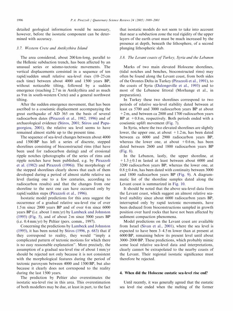
In the Lebanon, lastly, the upper shoreline, at+1.370.1 m lasted at least between about 6000 and3200 radiocarbon years BP, whereas the lower one, at0.870.4 m, has been dated with continuity between 3000and 1800 radiocarbon years BP (Fig. 9). A diagram-matic list of the shoreline samples dated along theLevant coast is summarized in Fig. 10.
It should be noted that the above sea-level data fromthe Levant coast, which suggest an almost relative sea-level stability since about 6000 radiocarbon years BP,interrupted only by rapid tectonic movements, havebeen deduced from bioconstructions sampled in growthposition over hard rocks that have not been affected bysediment compaction phenomena.
Model predictions on the Levant coast are availablefrom Israel (Sivan et al., 2001), where the sea level isexpected to have been 3–4.5 m lower than at present at6000 BP, remaining below its present level until about3000–2000 BP. These predictions, which probably mimicsome local relative sea-level data and interpretations,clearly cannot be extrapolated to the nearby coasts ofthe Levant. Their regional isostatic significance musttherefore be rejected.
4. When did the Holocene eustatic sea-level rise end?
Until recently, it was generally agreed that the eustaticsea level rise ended when the melting of the former

ARTICLE IN PRESS
Fig. 8. Erosional marks of two elevated shorelines, at about +0.6 and +1.0 m, respectively, near Ras el Bassit (Syria). Marine bioconstructions and
beach deposits associated to the uppermost bench have been dated (eight dates) between ca 6000 and 2900 radiocarbon years BP (between ca 4700
and 760 BC). The lower bench developed with an almost stable sea level between (six dates) ca 2600 and 1800 radiocarbon years BP (since at least
520 BC and until a coseimic uplift dated between AD 375 and 569 (Dalongeville et al., 1993; Pirazzoli et al., 1996). Photograph No. D326, August
1991.
Fig. 7. Marks of two elevated shorelines are visible near C- evlik (ancient Seleucia Pieria, Hatay, Turkey). The uppermost shore (S) is indicated by a
tidal notch and bench at about +2.9 m and corresponds to a relatively stable sea level dated (four dates) between ca 5700 and 3000 radiocarbon years
BP (between ca 4500 and 1000 BC). The lower elevated shoreline (arrow), at +0.8 m, was developed with an almost stable sea level between (seven
dates) at least 2800 and 1700 radiocarbon years BP (since at least 510 BC and until a coseismic uplift dated between AD 430 and 710, possibly the
earthquake of AD 526 that devastated Antioch and Seleucia Pieria) (Pirazzoli et al., 1991, 1996). The lower shoreline is marked, among others, by
spectacular bioconstructed cornices (two of them are visible) made by Dendropoma, ostreids and coralline algae. Photograph No. A719, May 1988.
P.A. Pirazzoli / Quaternary Science Reviews 24 (2005) 1989–2001 1997
Northern Hemisphere ice sheets was complete, i.e. towards6000 radiocarbon years BP. During the last decade,however, some isostatic modellers have claimed a latertime for the end of the Holocene eustatic sea-level rise.
Nakada and Lambeck (1988, 1989) assume that minormelting of the Antarctic ice sheet would have continued
after 6000 BP, producing an additional global sea-levelrise of about 3 m. According to Lambeck (2002), themajor part of this late global sea-level rise would haveoccurred in the interval of about 6000–3000 years BP.However, no evidence of such additional Antarcticmelting has been provided.
ARTICLE IN PRESS
Fig. 9. An elevated shoreline is well marked at about +0.8 to +1.0 on Ile du Phare, Lebanon. The floor of this elevated notch-bench profile was
eroded by an almost stable (70.3 m) sea level between (26 dates) ca 3000 and 1800 radiocarbon years BP (since ca 900–780 BC and until a coseismic
uplift, possibly at the time of the devastating earthquake of July 9, 551 AD). The upper part of the notch roof seems to be a remnant of a previous
slightly higher notch, corresponding to a higher sea level (shoreline II in Fig. 10, at ca +1.3 m, between 6000 and 3200 radiocarbon years BP).
(Pirazzoli et al., 1996; Morhange et al., in preparation). Photograph No. G670, July 2001.
Fig. 10. Correlation of elevated late Holocene shorelines from the Levant coasts between Hatay (Turkey) and the Lebanon. (A) tidal notch or sea-
erosion line; (B) bioconstructed rim in growth position (mainly: Dendropoma petraeum); (C) approximate conventional radiocarbon age (thousand
years) and laboratory number; (D) average of more than one age; star: archaeological data; Roman numerals: shoreline designation.
P.A. Pirazzoli / Quaternary Science Reviews 24 (2005) 1989–20011998
In another series of isostatic models, Antarcticmelting was assumed completed by 6000 BP for theICE-2 model (Peltier, 1988), then by 4000 BP for theICE-3G (Peltier, 1991), and for the ICE-4G (Nunn andPeltier, 2001). However, again, no field evidence infavour of this time drift was provided.
In a previous paper (Pirazzoli, 1998), it had beenshown that on the Iranian coasts the local 1–2 memergence predicted since 6000 years BP by isostaticmodels is in close agreement with field data when thelocal uplift rate of 0.2 mm/yr is taken into account,without any need to postulate an additional 2–3 m
ARTICLE IN PRESSP.A. Pirazzoli / Quaternary Science Reviews 24 (2005) 1989–2001 1999
eustatic sea-level rise after 6000 BP. In the Mediterra-nean, some of the case studies mentioned above can beused as a new test.
On the Provenc-al coast (Fig. 2), the gradualdeceleration in the sea-level rise during the last 5000years, shown by field data, has been ascribed mainly toisostatic processes. As there is no clear evidence for achange of trend since 4000 or 3000 years BP, there is nolocal support for a delayed eustatic sea-level rise.
In southern Tunisia, if a global sea-level rise of 3 mhad occurred since 6000 BP, then the emergence of theHolocene sea-level peak (Fig. 4), should have reached anelevation of 5 m above present, which seems excessivefor local hydro-isostatic effects.
Lastly on the Levant coasts (Fig. 10), there is clearmorphological and radiometric evidence that sea-levelremained stable, with an accuracy of 70.3 m, betweenca 6000 and 3000 radiocarbon years BP, then again,after a coseismic uplift, between ca 3000 and 1700radiocarbon years BP. The assumption of a significanteustatic rise after 6000 years BP, which may result froma modelling artifact, must therefore be rejected.
5. Conclusions
It has been attempted, in this study, to verify thedegree of accurateness of late-Holocene sea-level pre-dictions made by geophysical modellers in eightMediterranean regions. In areas where tectonic (otherthan isostatic) activity can at first sight be neglected, itappears that hydro-isostatic effects can be overestimated(Sardinia) as well as underestimated (southern Tunisia)by the same models.
In the north-eastern Adriatic, where geomorphologi-cal evidence suggest the occurrence of a coseismicsubsidence after Roman times, geophysical modelsalone fail to explain the field data. A dating of theperiod of development of the underwater notch occur-ring in this area would be essential, not only to explainthe local relative sea-level history, but also to confirm orexclude the occurrence of glacio-isostatic effects in theMediterranean.
Our approach has failed in the attempt to quantifyisostatic effects in areas of rapid tectonic uplift, likeCalabria or the volcanic Nisyros Island, where thepredictions should be confronted with more field data.On the other hand, in other tectonically active areaswhere vertical displacements tend to occur at the time ofoccasional coseismic displacements, as in Crete andAntikythira in Greece, and on the Levant coasts ofTurkey, Syria and the Lebanon, it has been possible todemonstrate that the rapid isostatic rates (especially ofglacio-isostatic origin) predicted by certain models areunrealistic and misleading.
Finally, several data from tectonic and non-tectonicareas are consistent with a global eustatic near stabilityduring the last 6000 years, challenging the assertionsrecently proposed by isostatic modellers of a significantadditional melting of the Antarctic ice sheet after 6000years BP.
It should be recognized, however, that if someweakenesses can be made evident in modelling results,many uncertainties still dominate also the observations,where field data are difficult to gather and interpret andgreatly scattered. In addition, few coastal sites in theworld have a solid history of tectonic motions.Discrepancies between field data and model predictions,when they are brought to light, can be useful becausethey may help us to use more accurate assumptions ondeglacial history, lithosphere thickness and mantleviscosity, and finally more reliable predictions of sea-level change. It is hoped that the above comparisonbetween field data and model predictions in theMediterranean area will contribute to an improvementof accuracy in the earth-model parameters used forglobal isostatic modelling and an increased interactionbetween modellers and field workers.
Acknowledgments
This research was partially funded by the CNRSEclipse programme, the Franco-Lebanese CEDREprogram no. F60/L58, and the Municipality Councilof Nisyros. It is a contribution to the IGCP Project437. Daniel Brunstein was of great help for the draw-ing of Fig. 1. N.-A. Morner and an anonymousreferee are thanked for constructive criticism and usefulsuggestions.
References
Antonioli, F., Sylos Labini, S., 2003. Escursione a Scilla. In: Antonioli,
F., Monaco, C. (Eds.), Il contributo dello studio delle antiche linee
di riva alla comprensione della dinamica recente. Escursioni nello
Stretto di Messina, Riassunti e guida alle ecursioni. Universita di
Messina, Dipartimento di Scienze della Terra, pp. 71–73.
Antonioli, F., Cremona, G., Immordino, F., Puglisi, C., Romagnoli,
C., Silenzi, S., Valpreda, E., Verrubbi, V., 2002. New data on the
Holocenic sea-level rise in NW Sicily (Central Mediterranean Sea).
Global and Planetary Change 34, 121–140.
Antonioli, F., Dai Pra, G., Segre, A.G., Sylos Labini, S., 2004a. New
data on late Holocene uplift rates in the Messina Strait area, Italy.
Quaternaria Nova VIII, 45–67.
Antonioli, F., Carulli, G.B., Furlani, S., Auriemma, R., Marocco, R.,
2004b. The enigma of submerged marine notches in Northern
Adriatic Sea. Quaternaria Nova VIII, 263–275.
Benac, C., Juracic, M., Bakran-Petricioli, T., 2004. Submerged tidal
notches in the Rijeka Bay NE Adriatic Sea: indicators of relative
sea-level change and of recent tectonic movements. Marine
Geology 212, 21–33.
Bondesan, M., Castiglioni, G.B., Elmi, C., Gabbianelli, G., Marocco,
R., Pirazzoli, P.A., Tomasin, A., 1995. Coastal areas at risk from

ARTICLE IN PRESSP.A. Pirazzoli / Quaternary Science Reviews 24 (2005) 1989–20012000
storm surges and sea-level rise in northeastern Italy. Journal of
Coastal Research 11, 1354–1379.
Bordoni, P., Valensise, G., 1998. Deformation of the 125 ka marine
terrace in Italy: tectonic implications. In: Stewart, I.S., Vita-Finzi,
C. (Eds.), Coastal Tectonics, vol. 146. Geological Society of
London, Spec. Publ, pp. 71–110.
Bouaziz, S., Jedoui, Y., Barrier, E., Angelier, J., 2003. Neotectonique
affectant les depots marins tyrrheniens du littoral sud-est tunisien:
implications pour les variations du niveau marin. Comptes Rendus
Geoscience 335, 247–254.
Carminati, E., Di Donato, G., 1999. Separating natural and
anthropogenic vertical movements in fast subsiding areas: the Po
Plain (N. Italy) case. Geophysical Research Letters 26 (15),
2291–2294.
Carobene, L., 1972. Osservazioni sui solchi di battente attuali ed
antichi nel golfo di Orosei in Sardegna. Bollettino della Societa
Geologica Italiana 91, 583–601.
Conchon, O., 1975. Les formations quaternaries de type continental en
Corse orientale. These es Sciences Naturelles, Universite de Paris
VI, 2 volumes.
Dalongeville, R., Laborel, J., Pirazzoli, P.A., Sanlaville, P., Arnold,
M., Bernier, P., Evin, J., Montaggioni, L.F., 1993. Les variations
recentes de la ligne de rivage sur le littoral syrien. Quaternaire 4,
45–53.
Daly, R.A., 1934. The Changing World of the Ice Age. Yale University
Press, New Haven 271p.
De Muro, S., Orru, P., 1998. Il contributo delle beach-rock nello studio
della risalita del mare olocenico: le beach-rock post-glaciali della
Sardegna nord-orientale. Il Quaternario 11 (1), 19–39.
Finocchi, S., 1999. La laguna e l’antico porto di Nora: nuovi dati a
confronto. Rivista di Studi Fenici 27 (2), 167–192.
Fontes, J.C., Perthuisot, J.P., 1971. Facies mineralogiques et
isotopiques des carbonates de la Sebkha el Melah (Zarzis, Tunisie:
les variations du niveau de la Mediterranee orientale depuis 40,000
ans. Revue de Geographie Physique et de Geologie Dynamique 13,
299–314.
Fouache, E., Dufaure, J.J., Faivre, S., 2000. New observations on the
evolution of the Croatian shore between Porec- and Zadar over the
past 2000 years. Zeitschrift fur Geomorphologie 122 (Suppl), 3–46.
Jedoui, Y., Reyss, J.L., Jallel, N., Montacer, M., Ismaıl, H.B.,
Davaud, E., 2003. U-series evidence for two high Last Interglacial
sea levels in southeastern Tunisia. Quaternary Science Reviews 22,
343–351.
Ku, T.L., Kimmel, M.A., Eastron, W.H., O’Neil, T.J., 1974. Eustatic
sea level 120000 years ago on Oahu, Hawai. Science 183, 959–962.
Laborel, J., Morhange, C., Lafont, R., Le Campion, J., Laborel-
Deguen, F., Sartoretto, S., 1994. Biological evidence of sea-level
rise during the past 4500 years on the rocky coasts of continental
southwestern France and Corsica. Marine Geology 120, 203–223.
Laborel, J., Morhange, C., Collina-Girard, J., Laborel-Deguen, F.,
1999. Littoral bio-erosion, a tool for the study of sea level
variations during the Holocene. Bulletin of the Geological Society
of Denmark 45, 144–148.
Lambeck, K., 1995. Late Pleistocene and Holocene sea-level change in
Greece and south-western Turkey: a separation of eustatic,
isostatic and tectonic contributions. Geophysical Journal Interna-
tional 122, 1022–1044.
Lambeck, K., 2002. Sea level change from mid Holocene to Recent
time: an Australian example with global implications. In: Ice
Sheets, Sea Level and the Dynamic Earth, Geodynamics Series,
vol. 29. American Geophysical Union, Washington, DC, p. 33–50.
Lambeck, K., Johnston, P., 1995. Land subsidence and sea-level
change: contributions from the melting of the last great ice sheets
and the isostatic adjustment of the Earth. In: Barends, F.B.J., et al.
(Eds.), Land Subsidence. Balkema, Rotterdam, pp. 3–18.
Lambeck, K., Bard, E., 2000. Sea-level change along the French
Mediterranean coast for the past 30 000 years. Earth and Planetary
Science Letters 175, 203–222.
Lambeck, K., Yokoyama, Y., Purcell, T., 2002. Into and out of the
Last Glacial Maximum: sea-level change during Oxygen Isotope
Stages 3 and 2. Quaternary Science Reviews 21, 343–360.
Lambeck, K., Antonioli, F., Purcell, A., Silenzi, S., 2004. Sea-level
change along the Italian coast for the past 10,000 years. Quaternary
Science Reviews 23, 1567–1598.
Miyauchi, T., Dai Pra, G., Sylos Labini, S., 1994. Geochronology of
Pleistocene marine terraces and regional tectonics in the Tyr-
rhenian coast of south Calabria, Italy. Il Quaternario 7, 17–34.
Morhange, C., 1994. La mobilite recente des littoraux provenc-aux:
elements d’analyse geomorphologique. These de doctorat en
Geographie Physique. Universite de Provence, Centre d’Aix,
janvier 1994, 269p.
Morhange, C., Laborel, J., Hesnard, A., 2001. Changes of relative sea
level during the past 5000 years in the ancient harbor of Marseilles,
Southern France. Palaeogeography, Palaeoclimatology, Palaeo-
ecology 166, 319–329.
Morhange, C., Pirazzoli, P.A., in press. Mid-Holocene emergence of
southern Tunisian coasts. Marine Geology, in press.
Morner, N.A., 1995. Earth rotation, ocean circulation and paleocli-
mate. Geo Journal 374, 419–430.
Nakada, M., Lambeck, K., 1988. The melting history of the late
Pleistocene Antarctic ice sheet. Nature 333, 36–40.
Nakada, M., Lambeck, K., 1989. Late Pleistocene and Holocene sea-
level change in the Australian region and mantle rheology.
Geophysical Journal 96, 497–517.
Nunn, P.D., Peltier, W.R., 2001. Far-Field test of the ICE-4G model
of global isostatic response to deglaciation using empirical and
theoretical Holocene sea-level reconstructions for the Fiji Islands,
southwestern Pacific. Quaternary Research 55, 203–214.
Ozer, A., Tucci, S., Ulzega, A., 1984. Les beach-rocks de Sardaigne:
distribution et implications paleogeographiques. In: Le Beach-
rock. Travaux de la Maison de l’Orient, Lyon 8, pp. 113–124.
Peltier, W.R., 1987. Mechanisms of relative sea-level change and the
geophysical responses to ice-water loading. In: Devoy, R.J.N.
(Ed.), Sea Surface Studies. Croom Helm, London, pp. 57–94.
Peltier, W.R., 1988. Lithospheric thickness, Antarctic deglaciation
history, and ocean basin discretization effects in a global model of
postglacial sea-level change: a summary of some sources of
nonuniqueness. Quaternary Research 29, 93–112.
Peltier, W.R., 1991. The ICE-3G model of late Pleistocene deglacia-
tion: construction, verification, and applications. In: Sabadini, R.,
et al. (Eds.), Glacial Isostasy, Sea Level and Mantle Rheology.
NATO ASI Ser., C, vol. 334. Kluwer, Dordrecht, pp. 95–119.
Peltier, W.R., Shennan, I., Drummond, R., Horton, B., 2002. On the
postglacial isostatic adjustment of the British Isles and the shallow
viscoelastic structure of the Earth. Geophysical Journal Inter-
national 148, 443–475.
Pirazzoli, P.A., 1980. Formes de corrosion marine et vestiges
archeologiques submerges: interpretation neotectonique de quel-
ques exemples en Grece et en Yougoslavie. Annales de l’Institut
Oceanographique 56 (Suppl.), 101–111.
Pirazzoli, P.A., 1986. Secular trends of relative sea-level (RSL) changes
indicated by tide-gauge records. Journal of Coastal Research
(Special Issue No. 1), 1–26.
Pirazzoli, P.A., 1996. Sea-level Changes – The Last 20 000 Years.
Wiley, Chichester.
Pirazzoli, P.A., 1998. A comparison between postglacial isostatic
predictions and late Holocene sea-level field data from Mediterra-
nean and Iranian coastal areas, GeoResearch Forum, Vols. 3 and
4. Trans Tech Publications, Switzerland, pp. 401–420.
Pirazzoli, P.A., Morhange, C., 2005. Interpretation des variations du
niveau de la mer a la fin de l’Holocene le long d’une transversale

ARTICLE IN PRESSP.A. Pirazzoli / Quaternary Science Reviews 24 (2005) 1989–2001 2001
nord-sud en Mediterranee centrale. In: Sanjaume Saumell, E. (Ed.),
Geomorfologia Litorali i Quaternari. Universidad de Valencia (in
press).
Pirazzoli, P.A., Thommeret, J., Thommeret, Y., Laborel, J., Mon-
taggioni, L.F., 1982. Crustal block movements from Holocene
shorelines: crete and Antikythira (Greece). Tectonophysics 86,
27–43.
Pirazzoli, P.A., Laborel, J., Saliege, J.F., Erol, O., Kaian, I., Person,
A., 1991. Holocene raised shorelines on the Hatay coasts (Turkey):
palaeoecological and tectonic implications. Marine Geology 96,
295–311.
Pirazzoli, P.A., Laborel, J., Stiros, S.C., 1996. Earthquake clustering in
the Eastern Mediterranean during historical times. Journal of
Geophysical Research 101 (B3), 6083–6097.
Pirazzoli, P.A., Mastronuzzi, G., Saliege, J.F., Sanso, 1997. Late
Holocene emergence in Calabria, Italy. Marine Geology 141,
61–70.
Russell, R.G., McIntire, W.G., 1965. Southern Hemisphere beach
rock. The Geographical Review 55, 17–45.
Schmiedt, G., 1965. Antichi porti d’Italia. L’Universo 45 (2), 225–274.
Sivan, D., Wdowinski, S., Lambeck, K., Galili, E., Raban, A., 2001.
Holocene sea-level changes along the Mediterranean coast of
Israel, based on archaeological observations and numerical model.
Palaeogeography, Palaeoclimatology, Palaeoecology 167, 101–117.
Stiros, S.C., 1996. Late Holocene relative sea level changes in SW
Crete: evidence of an unusual earthquake cycle. Annali di Geofisica
39 (3), 677–687.
Stiros, S.C., 2000. Fault pattern of Nisyros Island volcano (Aegean
Sea): structural and archaeological evidence. In: Mc Guirte, et al.
(Eds.), The Archaeology of Geological Catastrophes, Special
Publication 171. Geological Society of London, Washington, DC,
pp. 385–397.
Stiros, S.C., 2001. The AD 365 Crete earthquake and possible seismic
clustering during the fourth to sixth centuries AD in the Eastern
Mediterranean: a review of historical and archaeological data.
Journal of Structural Geology 23, 545–562.
Stiros, S.C., Papageorgiou, S., 2001. Seismicity of western Crete and
the destruction of the town of Kisamos at AD 365: archaeological
evidence. Journal of Seismology 5, 381–397.
Torunski, H., 1979. Biological erosion and its significance for the
morphogenesis of limestone coasts and for nearshore sedimenta-
tion (Northern Adriatic). Senckenbergiana Maritima 11, 193–265.