Growth patterns of a proximal terrigenous margin offshore the Guadalfeo River, northern Alboran Sea...
22
ORIGINAL RESEARCH PAPER Growth patterns of a proximal terrigenous margin offshore the Guadalfeo River, northern Alboran Sea (SW Mediterranean Sea): glacio-eustatic control and disturbing tectonic factors F. J. Lobo A. Maldonado F. J. Herna ´ndez-Molina L. M. Ferna ´ndez-Salas G. Ercilla B. Alonso Received: 3 March 2008 / Accepted: 27 August 2008 / Published online: 17 September 2008 Ó Springer Science+Business Media B.V. 2008 Abstract The shelf-upper slope stratigraphy offshore and around the Guadalfeo River on the northern continental margin of the Alboran Sea, Western Mediterranean Basin, has been defined through the interpretation of a grid of Sparker seismic profiles. We tried to identify evolutionary trends in shelf growth, as well as to determine the regional/ local factors that may modify the influence of glacio-eu- static fluctuations. Four major depositional sequences are identified in the sedimentary record by a detailed seismic interpretation, which defines three significant intervals of shelf-upper slope progradation, dominated by deposition of shelf-margin wedges, which resulted in uniform patterns of shelf-margin growth in response to significant sea-level falls. In contrast, the record of transgressive intervals is more variable, mainly as the result of distinct patterns of regressive-to-transgressive transitions. Major prograda- tional wedges are internally composed of seaward- prograding, landward-thinning wedges, interpreted to represent shelf-margin deltaic deposits. In contrast, the last aggradational interval is composed of shelf-prograding wedges that show distinct characteristics, in terms of seismic facies, morphology and distribution when com- pared with previous shelf-margin wedges. These shelf wedges are thought to represent the particular case of Regressive Systems or Shelf Margin Systems Tracts, and their development seems to be controlled by a drastic change in main depocenter location, which moved from the upper slope to the shelf during the Pleistocene. The stacking pattern of seismic units, the shallowness of the acoustic basement and the migration of the shelf break are used to infer spatial and temporal changes in tectonic subsidence-uplift rates, which interact with low-order gla- cio-eustatic changes. For much of the Pliocene-Quaternary, uplifted sectors alternated laterally with sectors experi- encing more subsidence. Subsequently, a significant change from lateral outgrowth to vertical accretion is recognised. This stratigraphic change could be related to the combined influence of increased subsidence rates on the shelf and the onset of higher-frequency glacio-eustatic cyclicity after the Mid Pleistocene Revolution that occurred around 1 Ma. Keywords Alboran Sea Á Pliocene Á Quaternary Á Proximal margin evolution Á Seismic stratigraphy Á Sequence stratigraphy Introduction The Messinian Salinity Crisis in the Mediterranean Sea was accompanied by a significant sea-level fall that began at 5.96 Ma (Gautier et al. 1994; Krijgsman et al. 1999), due to the combined influence of global eustatic lowering and tectonic uplift in the Strait of Gibraltar region (Lofi et al. F. J. Lobo (&) Á A. Maldonado CSIC-Instituto Andaluz de Ciencias de la Tierra, Facultad de Ciencias, Avenida de Fuentenueva s/n, 18002 Granada, Spain e-mail: [email protected] F. J. Herna ´ndez-Molina Departamento de Geociencias Marinas, Universidad de Vigo, 36200 Vigo, Spain L. M. Ferna ´ndez-Salas Instituto Espan ˜ol de Oceanografı ´a, Centro Oceanogra ´fico de Ma ´laga, Puerto Pesquero s/n, Apartado 285, 29640 Fuengirola, Spain G. Ercilla Á B. Alonso CSIC-Instituto de Ciencias del Mar, Paseo Marı ´timo de la Barceloneta 37-49, 08003 Barcelona, Spain 123 Mar Geophys Res (2008) 29:195–216 DOI 10.1007/s11001-008-9058-5
-
Upload
independent -
Category
Documents
-
view
3 -
download
0
Transcript of Growth patterns of a proximal terrigenous margin offshore the Guadalfeo River, northern Alboran Sea...

ORIGINAL RESEARCH PAPER
Growth patterns of a proximal terrigenous margin offshorethe Guadalfeo River, northern Alboran Sea (SW MediterraneanSea): glacio-eustatic control and disturbing tectonic factors
F. J. Lobo Æ A. Maldonado Æ F. J. Hernandez-Molina ÆL. M. Fernandez-Salas Æ G. Ercilla Æ B. Alonso
Received: 3 March 2008 / Accepted: 27 August 2008 / Published online: 17 September 2008
� Springer Science+Business Media B.V. 2008
Abstract The shelf-upper slope stratigraphy offshore and
around the Guadalfeo River on the northern continental
margin of the Alboran Sea, Western Mediterranean Basin,
has been defined through the interpretation of a grid of
Sparker seismic profiles. We tried to identify evolutionary
trends in shelf growth, as well as to determine the regional/
local factors that may modify the influence of glacio-eu-
static fluctuations. Four major depositional sequences are
identified in the sedimentary record by a detailed seismic
interpretation, which defines three significant intervals of
shelf-upper slope progradation, dominated by deposition of
shelf-margin wedges, which resulted in uniform patterns
of shelf-margin growth in response to significant sea-level
falls. In contrast, the record of transgressive intervals is
more variable, mainly as the result of distinct patterns of
regressive-to-transgressive transitions. Major prograda-
tional wedges are internally composed of seaward-
prograding, landward-thinning wedges, interpreted to
represent shelf-margin deltaic deposits. In contrast, the last
aggradational interval is composed of shelf-prograding
wedges that show distinct characteristics, in terms of
seismic facies, morphology and distribution when com-
pared with previous shelf-margin wedges. These shelf
wedges are thought to represent the particular case of
Regressive Systems or Shelf Margin Systems Tracts, and
their development seems to be controlled by a drastic
change in main depocenter location, which moved from the
upper slope to the shelf during the Pleistocene. The
stacking pattern of seismic units, the shallowness of the
acoustic basement and the migration of the shelf break are
used to infer spatial and temporal changes in tectonic
subsidence-uplift rates, which interact with low-order gla-
cio-eustatic changes. For much of the Pliocene-Quaternary,
uplifted sectors alternated laterally with sectors experi-
encing more subsidence. Subsequently, a significant
change from lateral outgrowth to vertical accretion is
recognised. This stratigraphic change could be related to
the combined influence of increased subsidence rates on
the shelf and the onset of higher-frequency glacio-eustatic
cyclicity after the Mid Pleistocene Revolution that occurred
around 1 Ma.
Keywords Alboran Sea � Pliocene � Quaternary �Proximal margin evolution � Seismic stratigraphy �Sequence stratigraphy
Introduction
The Messinian Salinity Crisis in the Mediterranean Sea
was accompanied by a significant sea-level fall that began
at 5.96 Ma (Gautier et al. 1994; Krijgsman et al. 1999), due
to the combined influence of global eustatic lowering and
tectonic uplift in the Strait of Gibraltar region (Lofi et al.
F. J. Lobo (&) � A. Maldonado
CSIC-Instituto Andaluz de Ciencias de la Tierra, Facultad de
Ciencias, Avenida de Fuentenueva s/n, 18002 Granada, Spain
e-mail: [email protected]
F. J. Hernandez-Molina
Departamento de Geociencias Marinas, Universidad de Vigo,
36200 Vigo, Spain
L. M. Fernandez-Salas
Instituto Espanol de Oceanografıa, Centro Oceanografico de
Malaga, Puerto Pesquero s/n, Apartado 285, 29640 Fuengirola,
Spain
G. Ercilla � B. Alonso
CSIC-Instituto de Ciencias del Mar, Paseo Marıtimo de la
Barceloneta 37-49, 08003 Barcelona, Spain
123
Mar Geophys Res (2008) 29:195–216
DOI 10.1007/s11001-008-9058-5

2003; Duvail et al. 2005). The basin was inundated during
the Early Pliocene, in response to a sudden warming epi-
sode and associated rise in global sea level (Haq et al.
1987). Afterwards, climatic and eustatic sea-level oscilla-
tions were characterised by two distinct evolutionary
trends. Most of the Pliocene was dominated by a general
cooling trend, punctuated by several marked warming and
cooling episodes (Zachos et al. 2001). The onset of sig-
nificant glaciations in the northern hemisphere recorded by
large d18O oscillations and also by a major sea-level fall at
about 3.8 Ma reflects a cooling episode (Jansen and Raymo
1996; Hardenbol et al. 1998; Zachos et al. 2001; Lambeck
et al. 2002). Another major global cooling event and sig-
nificant fall in global sea level is observed at about 2.4 Ma
(Haq et al. 1987).
The Quaternary was a period also characterised by
major climatic and sea-level changes, but in contrast gla-
cial–interglacial variations alternate at shorter time
intervals. The most significant change is known as the Mid-
Pleistocene Revolution or Mid-Pleistocene Transition,
which was initiated as early as 1.5 Ma and lasted until
0.6 Ma (Raymo 1992; Rutherford and D’Hondt 2000).
Before 1.5 Ma, 41 k.y. cycles were dominant in the d18O
isotopic record. From that time onwards, larger amplitude
100 k.y. cycles began to develop until 0.8–0.6 Ma, when
these cycles dominated (Clemens and Tiedemann 1997;
Raymo 1997; Clark et al. 1999). A major sea-level drop
inferred from d18O records and from outcrop data occurred
within the Mid-Pleistocene Revolution at 1.0–0.9 Ma
(Lowrie 1986; Haq et al. 1987; Kitamura and Kawagoe
2006). The 100 k.y. cycles are asymmetric, with long
(*90 k.y.) fluctuating cooling phases and rapid (10 k.y.)
warming terminations (Clark et al. 1999).
The study of the sedimentary record of those significant
environmental variations in proximal margin settings at the
Pliocene-Quaternary time scale can be regarded as rather
limited, in contrast to the relatively well known late Qua-
ternary shelf sedimentary record (Farran and Maldonado
1990; Ercilla et al. 1994; Chiocci et al. 1997; Chiocci 2000;
Hernandez-Molina et al. 2000; Tesson et al. 2000; Trincardi
and Correggiari 2000 amongst others). The Pliocene
and Quaternary shelf-upper slope sediment record of
siliciclastic mid-latitude continental margins is mainly
composed of shelf-margin deltas that can provide significant
information about the sedimentary response to sea-level
change, but to date this remains less well documented.
Only a few recent studies have focused on the large-scale
constructional patterns of proximal margin settings, par-
ticularly in the Mediterranean Sea (Lofi et al. 2003; Pepe
et al. 2003; Duvail et al. 2005). These studies document a
strong dominance of progradational packages, in contrast
to transgressive intervals, which are either not recognised
or tend to be under-represented (Hernandez-Molina et al.
2002). The study of the Pliocene-Quaternary sedimentary
record on terrigenous margins should help to improve low-
order sequence stratigraphic models. In addition, the
climatic and glacio-eustatic changes may interact at those
timescales with tectonically-induced changes in basement
subsidence, rock uplift and tectonic tilting, which all
influence the depositional patterns of sediments on conti-
nental margins and result in complicated sequence
stratigraphic patterns.
The Pliocene and Quaternary evolution of the conti-
nental margins of the southern Iberian Peninsula in the
Alboran Sea has been analysed in order to define the
general stratigraphic patterns. The Alboran Sea is a tec-
tonically active basin and the evolution of the depositional
bodies is largely influenced by the seismic activity, in
addition to climatic and eustatic oscillations (Maldonado
et al. 1992; Woodside and Maldonado 1992). However, a
dominant role for superimposed and hierarchical glacio-
eustatic fluctuations has been proposed for the northern
Alboran Sea shelf (Hernandez-Molina et al. 2002).
In this paper we focus on a specific sector of the central
continental shelf and upper slope of the northern Alboran
Sea, which shows significant physiographic variability, in
order to determine not only the glacio-eustatic control, but
also local tectonic and depositional factors influencing the
stratigraphic architecture. In particular, the recognition of a
dominantly aggradational interval in the most recent sedi-
mentary record, as well as the identification of different
types of regressive–transgressive transitions, may be
indicative of significant modifications of the original gla-
cio-eustatic control, or at least of the influence of distinct
patterns of relative sea-level changes. Another noteworthy
aim is to identify hierarchical patterns controlling deposi-
tional sequence generation and their role in constraining
proximal margin growth patterns. To complete these goals,
we describe the distribution, as well as the stratal and
growth patterns of the Pliocene and Quaternary deposits.
Physiography and surficial morphology
The Alboran Sea is the westernmost basin of the Medi-
terranean Sea. It is partially land-locked by Spain to the
north and Morocco to the south (Fig. 1). The northern
margin of the Alboran Sea comprises a narrow continental
shelf (2–20 km wide) with gradients less than 18 (Fig. 1b).
The minimum width of 2 km occurs offshore Cape Sacratif
(Carter et al. 1972). Maximum widths more than 20 km are
found offshore Malaga and Almerıa (Munoz et al. 2008).
The shelf break is located at variable water depths of 100–
125 m (Alonso and Maldonado 1992; Munoz et al. 2008).
The average gradient of the continental slope is close to 28(Carter et al. 1972).
196 Mar Geophys Res (2008) 29:195–216
123

The study area is located in the central part of the
northern Alboran Sea between La Herradura Beach to the
west and Cape Sacratif to the east, covering the continental
shelf and the upper slope. The coast has a subtropical cli-
mate, but the drainage area is constituted by the central
mountain ranges of the Betic Chains, which reach altitudes
of more than 3,300 m within a distance of 30 km from the
coast and have a snow reservoir for most of the year. The
main sediment supply to this margin sector is derived from
the Guadalfeo River, one of the main regional fluvial
sources with a permanent flow. The sediment contributions
from seasonal streams, such as the Verde River whose river
mouth is at Almunecar, have been much smaller (Fig. 2).
Limited prior studies on this area have reported the main
surficial morphologies and recent sedimentary processes
(Lobo et al. 2006; Fernandez-Salas et al. 2007). The most
significant recent deposits in the study area occur off river
mouths, such as the Guadalfeo and Verde rivers. There,
prodeltaic wedges exhibit shallow offlap breaks and the
frequent occurrence of crenulated sea floor; these mor-
phologies are related to rapid sedimentation processes led
by high-density sediment flows and limited lateral distri-
bution. Areal distribution of prodeltaic wedges changes
according to the size of the feeding river systems (Lobo
et al. 2006). The prodeltaic wedge offshore the Verde River
is limited to the inner shelf. Seaward, several morpholog-
ical highs occur on the middle shelf, establishing the
boundary with a flat outer shelf, which is covered by sev-
eral oblique large-scale bars at 90–100 m water depth.
In contrast, the outer shelf offshore the Guadalfeo River
prodelta shows numerous straight gullies, at water depths
greater than 88 m (Fig. 2).
Other significant morphological features are submarine
canyons, that are found in the eastern part of the study area
composing the Guadalfeo Canyon System (Perez-Belzuz
1999). Two main canyons with distinct morphological
characteristics are found in the study area. Several canyon
heads which connect with the Motril Canyon cut the outer
shelf south of Motril, at water depths as shallow as 70 m.
In contrast, the Carchuna Canyon cuts the entire shelf just
south of Cape Sacratif (Lobo et al. 2006) (Fig. 2).
Evolution of the Alboran Sea and its margins
Stratigraphic evolution
The opening of the Alboran Sea Basin took place from
Early to Late Miocene (Comas et al. 1992; Garcıa-Duenas
et al. 1992), when at least three sequences, mostly com-
posed of hemipelagic sediments and turbidites, were
deposited in the deep basin. Miocene deposits are overlaid
by a strong seismic reflector (M) attributed to the basin
dessication during the Messinian Salinity Crisis (Campillo
et al. 1992; Comas et al. 1992).
The present-day continental margins around the Alboran
Sea were built during the Pliocene and Quaternary. Four
major marginal constructional episodes during that period
Fig. 1 Geographical location
of: (a) the Alboran Sea in the
southwestern Mediterranean
Sea; and (b) the study area in
the northern margin of the
Alboran Sea. Coastline and
shelf break are highlighted in
red and orange colors in b
Mar Geophys Res (2008) 29:195–216 197
123

have been defined either as seismic units or depositional
sequences (Alonso and Maldonado 1992; Campillo et al.
1992; Ercilla et al. 1994; Perez-Belzuz et al. 1997; Perez-
Belzuz 1999; Hernandez-Molina et al. 2002). The main
growth patterns of the Alboran Sea are related to large
fluctuations of sea level, because the interpreted major
depositional sequences are bounded by regional erosive
discontinuities attributed to periods of global cooling and
significant sea-level falls, during the Early Pliocene, Late
Pliocene and mid-Pleistocene times, respectively (Perez-
Belzuz et al. 1997; Perez-Belzuz 1999; Hernandez-Molina
et al. 2002). Although these authors considered a Lower
Pliocene sequence, this should record only part of the Early
Pliocene because a regional hiatus has been identified in
the northern Alboran Sea margin at the base of the Pliocene
(Rodrıguez-Fernandez et al. 1999). These sequences are
also recognised in the basin deposits (Alonso and Maldo-
nado 1992; Campillo et al. 1992; Ercilla et al. 1994).
The Quaternary record of the northern Alboran Sea
margin was studied offshore and west of Malaga (Ercilla
et al. 1992, 1994; Ercilla and Alonso 1996). There, several
Quaternary depositional sequences are mainly composed of
lowstand systems tracts, represented on the shelf and shelf
break by shelf-margin deltas (Ercilla et al. 1992, 1994).
The most recent depositional sequence is dominated by a
regressive wedge (Hernandez-Molina et al. 2002), although
transgressive and highstand systems tracts are also sig-
nificantly preserved within the last Late Quaternary
depositional sequence, being the highstand system tract
mainly represented by stratified prodeltaic wedges (Ercilla
et al. 1992, 1994; Fernandez-Salas et al. 2003). This
depositional sequence is internally structured by higher-
frequency sub-orbital cycles (Hernandez-Molina et al.
1996).
Tectonic evolution
The opening and expansion of the basin occurred from
Early to Late Miocene during several rifting stages. The
basin underwent a significant tectonic change at the end of
the Late Miocene, when a general N–S compressive regime
involving folding and strike-slip faulting modified the
architecture of previous Miocene basins and margins
(Comas et al. 1992; Vazquez 2001; Ballesteros et al. 2008).
General N–S compression was still active during the
Early Pliocene, although a transtensive regime with an
E–W to ESE–WNW direction was active in the central and
western Alboran Sea (Campillo et al. 1992). Compression
was NNW–SSE directed during the Late Pliocene, causing
the development of structural inversions and a change to a
transpressive regime (Campillo et al. 1992; Campos et al.
1992; Ballesteros et al. 2008).
The compressive regime has remained during the Qua-
ternary, causing vertical movements in basins and margins
(Campos et al. 1992). As a consequence, the northern
margin of the Alboran Sea can be regarded as tectonically
Fig. 2 Multibeam bathymetry of the study area and position of seismic network used in this study. Interpreted seismic sections displayed in this
work are highlighted in blue color
198 Mar Geophys Res (2008) 29:195–216
123

active during the Quaternary. Tectonic processes have
interacted with sea-level variations (Alonso and Maldonado
1992; Ercilla et al. 1994; Ercilla and Alonso 1996). High-
frequency sequences exhibit high lateral variability under
the direct influence of tectonic tilting, which is related to
the compressional regime (Ercilla et al. 1992). Areas with
high tilting show limited development of sequences and
shelf-margin deltas, because of lack of shelf accommoda-
tion space. Laterally, areas with more subsidence show
better preserved shelf-margin deltas (Ercilla et al. 1994;
Ercilla and Alonso 1996).
A pattern of tectonic lateral variability due to the com-
pressive regime is also observed in the study area (Perez-
Belzuz 1999), where a central subsiding area offshore the
Guadalfeo River is laterally bounded by two uplifted sec-
tors. The zone offshore and west of Verde River has
undergone tectonic tilting for much of Pliocene-Quaternary
time. Finally, folds and strike-slip faulting caused base-
ment uplift in the southeastward part of the study area.
Methodology
Seismic stratigraphy concepts were applied to a regional
grid of seismic profiles collected with different seismic
systems of variable resolution (Fig. 2). A Sparker source
and a 3.5 kHz sub-bottom profiler were used during the G-
83-2 survey in 1990, when about 1,650 km of seismic lines
were collected onboard the research vessel ‘‘Investigador’’
within the framework of the project called ‘‘Mapa Geol-
ogico de la Plataforma Continental Espanola y Zonas
Adyacentes’’ carried out by the Spanish Geological Survey
(Fig. 2). For the purposes of the present study, we mainly
used seismic profiles obtained with the 1,000–4,500 J
Sparker source. The vertical scale of seismic profiles was
1 s, and the acquisition filter was 30–500 Hz. Seismic
profiles were collected obliquely to the coastline with a
primary NNE–SSW orientation and a secondary NW–SE
orientation.
Identified seismic units were classified as progradational
or aggradational units. In some seismic units a higher
frequency architectural level was identified, and these
elements were defined as sub-units. From the seismic
stratigraphy analysis, isopach maps of seismic units were
delineated from La Herradura Beach to the east of Motril
whenever possible. Maps of upper boundaries or fronts of
progradational units were also generated, in order to pro-
vide an estimate of changing paleotopographic conditions.
Both isopach and paleotopographic maps are given in
milliseconds of two-way travel time (TWT).
After the seismic stratigraphy approach, the ensuing
stratigraphy was interpreted by applying sequence stratig-
raphy concepts (Posamentier and Vail 1988). The early
work considered a depositional sequence to be composed
of a lowstand/shelf margin, transgressive and highstand
systems tract, which were defined relative to a curve of
eustatic fluctuations. The lowstand and shelf margin sys-
tems tracts are similar concepts, as they are related to the
sea-level fall through to early rise period. Lowstand sys-
tems tract are linked with type 1 sequence boundaries,
formed during a stage of rapid sea-level fall; in contrast, a
shelf margin systems tract is predicted to form during a
stage of slow sea-level fall (Posamentier and Vail 1988).
We have also included in the sequence stratigraphy
interpretation an additional systems tract to account for
deposits generated during relative sea-level falls, in order
to make a distinction with deposits generated during rela-
tive lowstands, which we include within the lowstand
systems tract. Although there are various terms to describe
that kind of deposits, such as ‘‘forced regressive wedge
systems tract’’ (Hunt and Tucker 1992) or ‘‘falling-stage
systems tract’’ (Plint and Nummedal 2000), we refer
generically to them as ‘‘regressive systems tracts’’ for
coherence with previous work in the region (Hernandez-
Molina et al. 2002). Under this assumption, sequence
boundaries are interpreted to be lowstand erosional sur-
faces truncating clinoforms of underlying regressive
system tracts and generated in response to major sea-level
falls. This style of sequence boundary is well documented
at the Pliocene and Quaternary scale (Trincardi and Corr-
eggiari 2000; Burger et al. 2002; Hernandez-Molina et al.
2002; Browne and Naish 2003).
Stratigraphic architecture and stacking patterns
Six seismic units that can be correlated at regional scale
were recognised overlying the acoustic basement and were
classified as progradational units or aggradational units
according to their seismic configuration, external shape
and/or internal stacking pattern (Figs. 3–8). Three progra-
dational units (PU) have been designated as Units PU C,
PU B and PU A from older to younger. Additionally, three
aggradational units (AU) named Units AU C, AU B and
AU A are intercalated between progradational units.
Careful examination of the internal architecture of those
units has allowed defining seismic sub-units within all
progradational units and within Unit AU A.
Acoustic basement occurrence
In the study area, three distinct morpho-tectonic sectors
were recognised according to the occurrence of the
acoustic basement, which is identified as zones of chaotic
and contorted reflections below well-stratified sediment
packages (Figs. 3, 4, 8). In the western sector offshore the
Mar Geophys Res (2008) 29:195–216 199
123
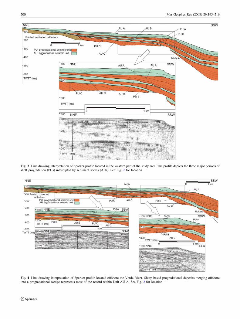
Fig. 3 Line drawing interpretation of Sparker profile located in the western part of the study area. The profile depicts the three major periods of
shelf progradation (PUs) interrupted by sediment sheets (AUs). See Fig. 2 for location
Fig. 4 Line drawing interpretation of Sparker profile located offshore the Verde River. Sharp-based progradational deposits merging offshore
into a progradational wedge represents most of the record within Unit AU A. See Fig. 2 for location
200 Mar Geophys Res (2008) 29:195–216
123

Fig. 5 Line drawing interpretation of Sparker profile taken offshore the Guadalfeo River, perpendicular to the shelf. The two main phases of
continental margin build-up (progradation and vertical growth) are clearly illustrated in this profile. See Fig. 2 for location
Fig. 6 Line drawing interpretation of Sparker profile offshore the Guadalfeo River, oblique to the shelf. The last phase of shelf aggradation
during development of Unit AU A is well represented. See Fig. 2 for location
Mar Geophys Res (2008) 29:195–216 201
123

Verde River the acoustic basement is located at shallow
depths ranging between 50 and 100 ms TWT below present
sea-level in the inner shelf (Figs. 3, 4, 6), although it may
be locally covered by channelised facies, interpreted as
Miocene fluvial deposits, as previously reported by Perez-
Belzuz (1999). The acoustic basement is not identified in
Sparker seismic profiles in the middle sector offshore the
Guadalfeo River. Finally, a shallow basement high occurs
in the eastern sector to the southeast of the Guadalfeo
River, generating a narrow shelf less than 4 km wide and
an abrupt slope. The basement high also controls the
location of the heads of the Motril Canyon. The acoustic
basement is detected in the upper slope where it develops a
structural high at depths greater than 360 ms (Figs. 8, 9a).
Here, the basement exhibits chaotic facies. The basement
high is bounded seaward by the Gualchos Fault, which
influences the high topographic gradient of this margin
segment (Perez-Belzuz 1999).
Progradational units
Progradational units onlap previous units and/or the acoustic
basement in the inner shelf domain. Internal configurations
of progradational units are dominated by seaward-directed,
parallel-oblique stratified reflections, which downlap the
lower boundaries and are erosionally truncated by the upper
boundaries, particularly in the mid to outer shelf. Upper
terminations tend to evolve to concordance on the upper
slope, although the upper boundaries also may show local
erosional truncation beyond the shelf break (Figs. 3–5).
The upper boundaries of progradational units show well-
defined shelf-to slope profiles (Fig. 9). The depths of the
upper boundaries in inner shelf settings are around or
slightly higher than 100 ms TWT. Seaward, the associated
shelf breaks occur at decreasing depths from older (at about
250 ms) to younger units (\200 ms). Paleotopographic
maps also show that progradational units are incised by a
Fig. 7 Line drawing interpretation of Sparker profile of the shelf southeastward of the Guadalfeo River, where the complex internal architecture
of Unit AU A is well shown. See Fig. 2 for location
202 Mar Geophys Res (2008) 29:195–216
123

tributary of the Motril Canyon, in the vicinity of the shelf
break (Fig. 9).
Externally progradational units exhibit well-developed
wedge shapes thoroughout most of the study area.
Landward terminations occur on the inner shelf west of
Salobrena, at variable distances of 2–4 km from the
present-day coastline (Fig. 10). The distribution pattern is
more complex in the eastern part of the study area
Fig. 8 Line drawing interpretation of Sparker profile from the eastern part of the study area, showing the occurrence of acoustic basement close
to the sea bottom, as well as significant erosion of most of the units in the proximity to Carchuna Canyon. See Fig. 2 for location
Fig. 9 Isobaths in milliseconds as two-way travel time (TWTT) of
the upper boundaries of progradational units. From bottom to top: (a)top boundary of Unit PU C; (b) top boundary of Unit PU B; (c) top
boundary of Unit PU A. A profile sketch from the middle part of the
study area highlighting the stratigraphic position of each upper
boundary is included in each map
Mar Geophys Res (2008) 29:195–216 203
123

Fig. 10 Isopach maps in milliseconds as two-way travel time (TWTT) of seismic units identified in the study area, with the exception of Unit PU
C, which lower boundary was not resolved in many places due to the presence of multiple; (a) AU C; (b) PU B; (c) AU B; (d) PU A; (e) AU A
204 Mar Geophys Res (2008) 29:195–216
123

southeastward of Motril, as the proximal unit termination
is not observed. In addition, progradational units pinch out
distally in several places, such as: (a) Unit PU C thins out
or disappears on the upper slope; (b) Units PU B and A
pinch out in the upper slope, possibly in relation with
canyon erosion processes.
Sediment thickness values are moderate on the shelf
(20–30 ms) but tend to increase in a seaward direc-
tion (Figs. 3–5). As a consequence, thicker sediments
are generally found on the upper slope. Unit PU B is
20–50 ms thick on the upper slope, although maximum
values close to 100 ms are related with the sediment
infilling of the Motril Canyon tributary (Fig. 10b). Two
main Unit PU A depocenters are recognised on the upper
slope: (a) offshore Almunecar, forming a W–E depo-
center which acquires a ENE–WSW orientation to the
east, with maximum thickness exceeding 160 ms; (b)
offshore Motril, where the depocenter seems to open
seaward, because we only recognise proximal distribu-
tion. The maximum thickness of this depocenter is at
least 200 ms. In between the two upper slope depocen-
ters, thickness values generally do not exceed 100 ms
(Fig. 10d).
Internal architecture of progradational units
Progradational units appear to be constituted of a number
of small-scale sub-units or shelf-margin wedges, bounded
by offlap surfaces with toplap to erosional truncations
(Fig. 11). Internal configuration is oblique-parallel and
changes from low-angle on the shelf to higher-angle on
the shelf break and upper slope. Upper slope facies also
show common sediment disruptions. In most of cases, the
shelf margin wedges may be considered as shelf-margin
deltas.
The shelf-margin wedges are generally disposed in a
fore-stepping stacking pattern, leading to the progressive
seaward migration of the shelf break. Each wedge dis-
plays its maximum thickness close to the offlap break,
reducing in thickness landward, where they pinch out on
the mid to outer shelf, and seaward, where distal toe-sets
amalgamate. This internal architecture is best observed in
the western sector of the study area offshore the Verde
River (Fig. 11a).
In other places, however, it is possible to distinguish
within progradational units a number of lenticular-shaped
units intercalated with progradational sub-units. This
Fig. 11 Drawing line interpretations of profiles perpendicular to the
margin highlighting a secondary order architectural level: (a) shelf-
margin wedges forming the progradational units; (b) shelf deposits
are occasionally found within progradational units, mainly in the shelf
offshore the Guadalfeo River; (c) shelf wedges stack vertically within
Unit AU A. See Fig. 2 for location. The different colors highlight the
separate seismic subunits within seismic units
Mar Geophys Res (2008) 29:195–216 205
123

pattern is best evidenced in the central sector of the study
area offshore the Guadalfeo River (Fig. 11b), suggesting
that progradational units are composed of minor shelf
wedges and shelf-margin wedges.
Aggradational units
These seismic units rest on underlying progradational units,
and are characterised by the general absence of internal
reflections (Fig. 3). Locally, some internal reflections tend
to be subparallel to unit boundaries, describing onlap rela-
tionships with regard to the lower boundary (Figs. 4, 5).
Unit AU A clearly differs from the general trend, as it shows
an overall aggradational pattern, best observed in the shelf
offshore the Guadalfeo pro-delta (Figs. 5–7). Consequently,
this unit is better described as a complex aggradational unit.
Aggradational units tend to pinch against the acoustic
basement on the inner shelf (Figs. 3, 6, 10a), except Unit AU
A, whose landward termination is not detected. On the shelf,
the thicknesses of Units AU C and B are almost constant, do
not exceed 20 ms, and normally are below 10 ms. As a
consequence, aggradational units exhibit sheet to tabular
external shapes on the shelf. Maximum thickness values are
found in the vicinity of the shelf break (Figs. 10a, c). The
thickness distribution pattern of Unit AU A is more irregular
on the shelf, as two main depocenters were identified
(Fig. 10e): (a) an outer shelf depocenter offshore Almune-
car, showing a W–E orientation for more than 5 km and with
maximum thickness above 50 ms; (b) an inner shelf depo-
center offshore Motril, showing a NW–SE orientation with
maximum thickness around 100 ms.
On the upper slope, thickness distributions show con-
trasting patterns between the three aggradational units:
(a) Unit AU C exhibits an upper slope depocenter
eastward of the Verde River, and mainly offshore
the Guadalfeo River (Fig. 5), with thicknesses above
80 ms and increasing eastward to more than 180 ms
offshore an upper slope acoustic basement high
(Fig. 10a).
(b) Unit AU B pinchs out in the upper slope, where it is
only recognised eastward of the Motril Canyon
tributary. The unit shows internal subparallel reflec-
tions and thicknesses above 50 ms (Fig. 10c).
(c) Unit AU A has a minimum thickness at the shelf
break. On the upper slope, thicknesses increase again,
at least offshore the Guadalfeo prodeltaic area, where
it is 70 ms thick (Fig. 10e).
Internal architecture of aggradational units
As noted before, the internal architecture of Unit AU A is
more complex than the architecture of underlying
aggradational units, which can be considered as simple
units because they do not show internal subdivisions on
the shelf. In detail, the aggradational pattern within Unit
AU A is generated by the vertical stacking of several sub-
units or shelf wedges (Fig. 11c). The vertical stacking
causes the shelf break to remain stationary or even to
migrate landward (Figs. 4, 5, 8). The sub-units tend to be
bounded by planar or undulating surfaces across the entire
shelf; the upper termination of internal reflections is
generally toplap offshore the Guadalfeo River, but ero-
sional truncation is also identified locally. A channelised
upper surface is also found above specific shelf wedges.
Each sub-unit shows parallel-oblique internal configura-
tions of diverse inclinations on the shelf, grading to
subparallel on the upper slope. Shelf sheets may be
observed intercalated between shelf wedges. Individual
wedges show relatively constant and moderate thickness
across the shelf and toward the shelf break, where they
become thinner. Seaward, they continue on the upper
slope as sheet deposits. Their landward termination is
generally located on the inner shelf, or even continuing
further landward.
The geometric characteristics observed offshore the
Guadalfeo River are indicative of deltaic wedges (Fig. 5),
which are considered the dominant shelf depositional type
in the Alboran Sea during the late Quaternary (Ercilla
et al. 1994). In contrast, sharp-based deposits without
aggraded bottomsets found offshore the Verde River
(Figs. 3, 4) probably suggest a lack of accommodation
space and the influence of higher energy depositional
environments, with development of shoreface and/or sand
ridge systems. Dominance of sharp-based deposits has
been linked to strong wave dominance in the Gulf of
Mexico (McKeown et al. 2004). The occurrence of high-
angle clinoforms downlapping on top of low-angle clino-
forms is observed in the outer shelf offshore the Verde
River, and offshore from a sharp-based deposit on the
middle shelf (Fig. 4). This stratigraphic pattern is attrib-
uted to the presence of sharp-based shoreface-delta front
deposits, which are considered to be an indicator of a
forced regression process (Posamentier and Morris 2000).
Moreover, it may indicate development of a long-distance
regression, favored by the low shelf gradients in this area.
Finally, mounded morphologies are also recognised off-
shore the Verde River. Similar geometrical patterns in the
stratigraphic record have been interpreted as sand ridges
(Yang 1989; Knutsen and Larsen 1996).
Stacking patterns of seismic units
The three distinct morpho-tectonic sectors recognised
according to the occurrence of acoustic basement also
control the stacking patterns of seismic units.
206 Mar Geophys Res (2008) 29:195–216
123

In the western sector offshore the Verde River, progra-
dational units show a fore-stepping, prograding pattern.
The shelf break migrated seaward offshore the Verde River
(Figs. 3, 4, 12).
In the middle sector offshore the Guadalfeo River,
progradational units stack vertically and the shelf break has
remained stationary (Figs. 5, 12).
Finally, in the eastern sector to the southeast of
Guadalfeo River, progradational units show limited or no
development, as in the case of Unit PU C, and the shelf
break may be either stationary or even migrate landward
(Figs. 7, 8, 12). The erosion associated with submarine
canyons and sediment instabilities due to the high slopes
associated to the basement high have also influenced this
evolution.
Sequence stratigraphy and chronostratigraphic
framework
Depositional sequences
On the basis of the proposed sequence stratigraphy termi-
nology explained above, we consider that the bulk of the
progradational units can be interpreted as regressive system
tracts (Fig. 13). Geometrical patterns such as prograding
clinoforms, wedge shapes and top erosion have been linked
to regressive deposition, leading to rapid margin progra-
dation in other Mediterranean margins at the Pliocene-
Quaternary scale, such as the southern continental margin
of the Alboran Sea (Gensous et al. 1986), the Gulf of Lions
(Lofi et al. 2003; Duvail et al. 2005) and the southern
Fig. 12 Seaward location of
different paleo-shelf breaks
developed within progradational
units and Unit AU A (present).
Former Units AU C and B did
not contribute to change paleo-
shelf break location
Fig. 13 Drawing line showing the sequence stratigraphy interpretation representative of the study area. This interpretation is based on seismic
line off Guadalfeo River provided in Fig. 5
Mar Geophys Res (2008) 29:195–216 207
123

Tyrrhenian Sea (Pepe et al. 2003). The dominance of
regressive wedges in the Pliocene and Quaternary succes-
sion has also been documented on several Atlantic margins
(Coppier and Mougenot 1982; Hernandez-Molina et al.
2002, 2006; Le Roy et al. 2004).
The identification of internal sub-units downstepping
towards the basin and leading to progressive seaward shelf
break migration and long-distance progradation can be
considered as a reliable indicator of deposition during
falling sea-level conditions (Browne and Naish 2003;
Hubscher and Spieß 2005). In addition, the major pro-
grading packages invariably show erosive surfaces on their
top boundary, related to the major sea-level falls at the
Pliocene-Quaternary scale (Estrada et al. 1997; Hernandez-
Molina et al. 2002). Regressive deposits show similar,
uniform geometric patterns in the interpreted sequences,
providing evidence that continental shelf construction
proceeded following a similar pattern during earlier phases.
It is possible, however, that the proximal part of progra-
dational units may also comprise high stand system tracts,
although poorly preserved due to major erosion concomi-
tant to ensuing sea-level falls.
Aggradational units are represented on the shelf either
by thin sheets or by aggradational packages, and onlap
relationships are observed locally. All these stratigraphic
features are compatible with an origin linked to rising sea
levels. We estimate that transgressive system tracts con-
stitute the core component of aggradational units (Fig. 13),
which would be equivalent to ravinement shoreface
deposits, interpreted as thin, high-energy sheet deposits
lying on an erosional surface (Proust et al. 2001; Hubscher
and Spieß 2005). However, we admit that those units could
have formed, at least partially, during highstand stages.
However, we do not have enough resolution to enable
discrimination between transgressive and highstand
deposits, which usually exhibit offlap and downlap patterns
(Browne and Naish 2003). Only in the case of Unit AU A is
the high stand system tract clearly recognised, as it is
represented by a seaward-thinning wedge with great
thickness in its proximal parts. This sediment wedge
comprises pro-deltaic deposits and laterally continuous
sediment wedges (Lobo et al. 2006). Previous studies in the
Alboran Sea interpret the main development of the proxi-
mal wedge as occurring during the Holocene highstand
(Ercilla et al. 1992, 1994; Ercilla and Alonso 1996).
Upper slope depocenters of aggradational units display
distinct stratigraphic relationships, with lateral shelf facies.
As a result the sequential interpretation is also variable
(Fig. 13). In the case of the upper slope depocenter of Unit
AU C, which is characterised by onlap terminations and a
major component of vertical aggradation, we interpret this
to represent lowstand deposition overlying the sequence
boundary. This upper slope wedge depocenter would be
equivalent to a progradational-aggradational set corre-
sponding to the lowstand systems tract in different shelf-
margin settings (Anderson et al. 1996; Proust et al. 2001).
The sequential interpretation of Unit AU A’s upper slope
depocenter is more controversial, as in most of the zones
shelf and upper slope deposits composing Unit AU A thin
or are eroded near or at the shelf break, making shelf-upper
slope correlation problematic. In some places, however,
upper slope facies seem to constitute the seaward prolon-
gation of shelf facies and should be considered as coeval;
therefore, upper slope facies are also considered to be part
of the transgressive system tract (Fig. 13).
According to this interpretation, the observed shelf and
upper slope sedimentary record may be classified into four
major depositional sequences of ‘‘n’’ order, separated by
regional erosional surfaces, which establish the upper
boundary of regressive system tracts (Fig. 13):
(a) A lower depositional sequence (DS 4) of which we
only observe the upper part, interpreted as a regres-
sive system tract (Unit PU C).
(b) A second depositional sequence (DS 3) characterised
by a lower aggradational interval (Unit AU C) and an
upper progradational interval (Unit PU B). The
aggradational interval is represented by an upper
slope depocenter interpreted as a lowstand systems
tract, and a sheet shelf deposit interpreted as a
transgressive system tract. The upper progradational
interval is considered to be a regressive system tract.
(c) A third depositional sequence (DS 2) characterised by
a lower transgressive system tract (Unit AU B) and an
upper regressive system tract (Unit PU A).
(d) An upper depositional sequence (DS 1) is basically
aggradational and interpreted as a transgressive
system tract-high stand system tract complex (Unit
AU A).
Chronostratigraphic framework: integration with DSDP
and ODP legs and other stratigraphic architectures
A realistic chronostratigraphic framework can be estab-
lished from comparison with previous studies that
correlated a regional grid of medium-resolution seismic
profiles with scientific drillings in the Alboran Sea such as
the Deep Sea Drilling Project (DSDP) Site 121 and the
Ocean Drilling Program (ODP) Site 976 (Comas et al.
1996, 1999), and also by the regional identification of the
acoustic basement in the continental margin, interpreted to
be the M reflector, developed during Miocene sea-floor
subaerial exposure (Perez-Belzuz 1999). In addition,
Hernandez-Molina et al. (2002) provides a general model
of Quaternary stratigraphic stacking patterns in the conti-
nental shelves of the southern Iberian Peninsula.
208 Mar Geophys Res (2008) 29:195–216
123

We found that the interpretation of the upper boundary
of Unit PU A as the Mid-Pleistocene regional discontinuity
is quite reasonable, for the following reasons: (a) the upper
boundary of Unit PU A is a widely recognized erosional
truncation across the shelf; (b) this surface represents the
most significant change of the stratigraphic stacking pattern
observed in the study area, as it separates seaward-pro-
grading packages below from progradational units
vertically stacked on top, i.e., a net change from shelf
progradation to shelf aggradation; (c) the Mid-Pleistocene
Revolution constitutes the most significant climatic change
during the Pliocene-Quaternary, as it marks the start of
100 k.y., high-amplitude glacio-eustatic cycles (Clemens
and Tiedemann 1997; Raymo 1997; Clark et al. 1999).
Taking into account this basic premise, our DS 1 would
have developed after the Mid-Pleistocene Revolution.
The chronostratigraphic framework of the three lower
sequences (DSs 2, 3 and 4) is more problematic. By cor-
relating sequence boundaries with well-known climatic and
eustatic changes during the Pliocene and early Quaternary,
two main hypotheses may be proposed:
(a) The observed shelf stratigraphy comprises the entire
Pliocene and Quaternary record overlying the M-
reflector on the Alboran Sea continental margin
(Perez-Belzuz 1999). Under this interpretation, the
three lower sequences would have developed during
the Early Pliocene, Late Pliocene and Early Quater-
nary (Table 1), led by circa 1.5 m.y. third order
cycles. The top erosional discontinuities would be
equivalent to the Lower Pliocene, Upper Pliocene and
Mid-Pleistocene regional discontinuities that have
been generated during periods of major sea-level falls
and important climatic changes (Hernandez-Molina
et al. 2002) (Table 1).
(b) The base of the Pliocene has not been preserved
according to some authors, because a regional hiatus
has been identified in the northern Alboran Sea
margin (Rodrıguez-Fernandez et al. 1999). In this
case, the lower depositional sequence would be
incomplete. By considering this hypothesis, the upper
boundary of Unit PU C, which is well marked, would
be interpreted as the Upper Pliocene regional discon-
tinuity, related to a relevant sea-level fall (Hernandez-
Molina et al. 2002). In contrast, the upper boundary of
Unit PU B shows less evidence of erosion and would
represent the Pliocene-Quaternary boundary, which is
less recognisable than the Upper Pliocene or the Mid-
Pleistocene regional discontinuities (Table 1).
Discussion
Stratigraphic variability of sequences
Major-scale sequences: regressive–transgressive
transitions
A major contribution of this work is the identification of
geometrical sedimentary patterns associated with trans-
gressive intervals at the Pliocene and Quaternary scale.
Previous interpretations have highlighted the poor repre-
sentation of transgressive and highstand intervals, leading
to pronounced asymmetrical sequences due to the strong
Table 1 Tentative chronologies based on correlation of the regional seismic grid with DSDP 121 and ODP 976 sites and previous chrono-
stratigraphic schemes of Perez-Belzuz (1999) and Hernandez-Molina et al. (2002)
LST: lowstand systems tract; TST: transgressive systems tract; HST: highstand systems tract; RST: regressive systems tract; SB: sequence
boundary; M: Late Messinian discontinuity; LPR: Lower Pliocene regional discontinuity; UPR: Upper Pliocene regional discontinuity; QB:
Pliocene-Quaternary boundary; MPR: Mid-Pleistocene regional discontinuity
Mar Geophys Res (2008) 29:195–216 209
123

dominance of regressive and lowstands deposits (Ercilla
et al. 1994; Chiocci et al. 1997; Hernandez-Molina et al.
2002). In the study area, each transgressive interval shows
a particular signature, which could indicate a relationship
with different transitions between lowering and rising sea-
levels. According to the stratigraphic representation of
transgressive deposits in the study area, it is possible to
observe different types of regressive–transgressive (R-T)
transitions (Fig. 14). There are two asymmetrical transi-
tions between DS 4 and 3, and between DS 3 and 2.
Between DS 4 and 3, the asymmetrical pattern (thick
wedge-shaped regressive system tract and thin transgres-
sive system tract) is interrupted by the presence of an upper
slope aggradational wedge interpreted as a lowstand sys-
tems tract. Between DS 3 and 2, the asymmetrical pattern
of systems tracts is clearer, as a wedge-shaped regressive
system tract is replaced landward by a sheet-shaped
transgressive system tract.
In contrast to earlier schemes, the transition between DS
2 and 1 seems to follow a more symmetrical pattern. This
cycle shows a relatively thick transgressive to highstand
interval represented by Unit AU A overlying the typical
wedge-shaped regressive system tract (Fig. 14c). On the
New Jersey margin, the identification of a thick, trans-
gressive component at the Pliocene-Quaternary scale was
related to long-term eustatic rise (Metzger et al. 2000). In
our study area, such a sea-level evolution following the
previous fall would result in a relatively symmetrical pat-
tern, with both gentle sea-level fall and rise.
We relate the existence of different kinds of regressive–
transgressive transitions to the combined influence of gla-
cio-eustatic changes and additional disruptive factors, such
as tectonic control and/or drastic variations of sediment
supply. The most common asymmetrical pattern would
support the leading control of glacio-eustatic processes.
Most of the shelf sequences at the Pliocene-Quaternary
scale are asymmetrical consistent with the leading control
of asymmetric sea-level changes (Chiocci et al. 1997;
Hernandez-Molina et al. 2002). The distinction between
observed asymmetrical cycles (between DS 4 and 3, and
between DS 3 and 2) refers to the different representation
of predominantly upper slope aggradational facies, inter-
preted as lowstand deposits. This difference may be
attributed either to different shapes of sea-level reversal
(Porebski and Steel 2003), or to drastic changes in sedi-
ment supply. Thus, the higher development of lowstand
facies observed in the transition between DS 4 and 3 could
indicate that the transition was not abrupt but gradual
(Fig. 14a). In contrast, the more strongly asymmetrical
pattern between DS 3 and 2 could indicate an abrupt
transition in the dominant sea-level cycle pattern, when
prolonged sea-level falls were followed by rapid, rather
abrupt rises (Fig. 14b). An alternative hypothesis should
consider a period of increased sediment discharge during
the transition between DS 4 and 3, in contrast to the
transition between DS 3 and 2, when the upper slope
underwent sediment starvation.
Finally, the identification of a more symmetrical tran-
sition between DS 2 and 1 must be considered a significant
anomaly in the otherwise generally symmetric pattern; we
ascribe this symmetric pattern to the disturbing effect
caused by tectonism acting on a regional to local scale, and
more precisely to enhanced subsidence.
Minor-scale sequences: implications for shelf build-up
The significant differences in terms of geometry, regional
distribution and internal configuration between shelf-mar-
gin wedges composing progradational units and shelf
wedges within Unit AU A are considered to reflect dif-
ferent types of generation under a sequence stratigraphy
perspective. Over the long term, the two contrasting
depositional modes lead to distinct patterns of shelf
construction.Fig. 14 Sketches summarizing the different styles of regressive to
trangressive transitions identified in northern Alboran Sea margin
210 Mar Geophys Res (2008) 29:195–216
123

Shelf-margin wedges may be considered as higher-order
(n ? 1) depositional sequences, almost exclusively com-
posed by regressive system tracts (Fig. 15). The lateral
stacking pattern and the limited extent of upper boundaries
would suggest the influence of eustatic cycles of moderate
amplitude, typically, 41 k.y. cycles, which dominated
before the Mid-Pleistocene Revolution (Clark et al. 1999;
Lisiecki and Raymo 2005). This inference agrees with our
observations, since shelf-margin wedges are found within
progradational units. The lack of identification of distal
aggradational facies implies that lowstand systems tracts
probably did not develop or instead that their development
was very limited.
In contrast, shelf wedges typically show two depocen-
ters, on the shelf and on the upper slope (Fig. 15). Shelf
wedges may also be interpreted as regressive system tracts,
but their widespread distribution and the existence of shelf-
wide unconformities are suggestive of the influence of
glacio-eustatic cycles of higher amplitude, such as the
dominant 100 k.y. cyclicity after the Mid-Pleistocene
Revolution. The influence of 100 k.y. cycles on the gen-
eration of shelf depositional cycles has been documented
from the Mediterranean Sea (Chiocci 2000; Trincardi and
Correggiari 2000; Rabineau et al. 2005). Another alterna-
tive would be to consider the shelf wedges as shelf margin
system tracts, which would highlight the different contri-
bution of the two types of wedges to shelf growth. Shelf-
margin wedges (typical regressive system tracts) would
prograde over a pre-existing shelf margin wedge, leading to
progressive seaward shelf break migration and thus causing
shelf lateral accretion (Fig. 15). In contrast, shelf wedges
(particular case of regressive or shelf margin system tracts)
would prograde above pre-existing wedges, but in this case
the shelf break would remain more or less stationary. The
consequence for shelf build-up would be that vertical
growth is favored, but lateral accretion is limited. All those
shelf wedges are overlain by a seaward-thinning inner
wedge, whose development has been ascribed to the
Holocene highstand (Lobo et al. 2006) (Fig. 15).
Finally, shelf wedges included within progradational
units need to have different sequential interpretations, as
they seem to be intercalated between shelf-margin wedges,
interpreted as regressive system tracts. Consequently, shelf
wedges would be deposited between successive sea-level
falls, and must be considered as transgressive and/or
highstand features.
Stacking patterns of depositional sequences: out versus
upbuilding
Spatial variation of stacking patterns: local tectonic
influences
The existence of laterally variable styles of continental
margin construction, as evidenced by different stacking
patterns and styles of shelf-break migration, is particularly
significant during deposition of progradational units. The
stacking pattern of depositional sequences is an indicator of
the balance between subsidence versus uplift and ulti-
mately on the general tectonic evolution of any particular
setting (Chiocci et al. 1997; Ridente and Trincardi 2002).
In addition, patterns of shelf-break migration can provide
information about the style of continental margin growth
(Fulthorpe and Austin 1998). The lateral variability of shelf
growth patterns (Fig. 16) can be attributed to the complex
interplay between low-order eustatic cycles and changing
tectonic regimes experienced in the study area during the
Pliocene-Quaternary. This variability has also been evi-
denced in neighboring areas of the Alboran Sea (Alonso
and Maldonado 1992; Ercilla et al. 1994; Estrada et al.
1997).
We estimate that the differences between morpho-tec-
tonic sectors identified in the study area are strongly
determined by the paleomorphology and lateral tectonic
variability (Figs. 16, 17). The lateral changes took place
over a long period during the Pliocene and Quaternary and
may be related to changes in the relationship between
subsidence and uplift (Fig. 17). In the southeastward part
of the study area folds and strike-slip faulting caused
basement uplift; as a consequence, shelf construction was
limited due to the absence of accommodation space and
Fig. 15 Idealized model of the internal architecture of progradational
units and the youngest Unit AU A: (a) summary of geometry and
internal architecture of a progradational unit; (b) summary of
geometry and internal architecture of Unit AU A
Mar Geophys Res (2008) 29:195–216 211
123

because of sediment instability processes related to can-
yon-headward erosion (Fig. 16). To the west, the rest of the
study area subsided more uniformly, although the dominant
compressive regime also caused an increase in tectonic
tilting towards the west, as documented in other sectors of
the northern Alboran Sea margin (Ercilla et al. 1992).
Thus, the stacking pattern tends to be aggradational off-
shore the Guadalfeo River, whereas the increased tectonic
tilting favored the strongest shelf margin progradation
offshore the Verde River. As a consequence, sediment
supply seems to be subordinated to tectonic behavior off-
shore the Guadalfeo and Verde Rivers, as major shelf break
Fig. 16 Fence diagrams showing the general stratigraphic architec-
ture in the study area. The shelf offshore the Verde River shows the
importance of progradational units that stack laterally. Eastward, the
shelf offshore the Guadalfeo River is affected by an important
subsidence that influences thick progradational and aggradational
units, whereas the occurrence of shallow acoustic basement in the
eastern part of the study inhibit the development of thick sequences,
favoring the erosion of deposits due to headward erosion by
submarine canyons and enhancing the development of Unit AU A
212 Mar Geophys Res (2008) 29:195–216
123

migration occurs offshore a minor river such as the Verde
River; in contrast, a stationary shelf break occurred off-
shore a major river at a regional scale such as the
Guadalfeo River.
This pattern agrees relatively well with onland infor-
mation of vertical displacements from Late Miocene to
present in the coastal zone of the Betic Cordilleras. The
zone around Motril corresponds to a boundary between the
eastern sector, characterised by uplift, and the western
sector between Almunecar and Salobrena (Fig. 2), which
has been dominated by tectonic subsidence (Sanz de
Galdeano and Lopez-Garrido 2000).
Temporal variation of stacking
patterns and shelf growth
The identification in the study area of a recent aggrada-
tional interval represented by Unit AU A can be considered
a significant peculiarity of this margin (Figs. 5–8). This
interval is recognised in each morpho-structural sector
defined above, although with greater development to the
southeast, where the basal boundary is below the seafloor
multiple (Fig. 17). In other words, a seismic unit equivalent
to Unit AU A is not recognised in other areas of the
Alboran Sea margin. This effect would support the influ-
ence of a local factor in generating the observed
architecture.
The existence of dominantly aggradational patterns
since the mid-Pleistocene phase can be attributed to
increased subsidence rates, as reported for example also
in the Gulf of Lions (Lofi et al. 2003). Geologic data
from onland areas support this theory (Armijo et al.
1977), as although tectonic tilting is considered to be
dominant during the Quaternary due to the NNW–SSE
compressive regime, there are specific margin segments
of more than 50 km length that have significantly sub-
sided, such as the continental margin offshore Motril
(Armijo et al. 1977).
The identification of the aggradational pattern in every
morpho-sedimentary sector of the study area indicates
isochronous and uniform subsidence. This inference also
implies a significant change in the tectonic regime within
the study area, and is particularly evident in the eastern
sector, which previously experienced uplift (Fig. 17).
When observed in detail, the aggradational interval
is composed of a number of progradational wedges
stacked vertically and separated by shelf-wide erosion
surfaces. The recognition of these shelf-wide surfaces
also indicates the effect of increased glacio-eustatic
fluctuations, particularly after the Mid-Pleistocene
Revolution. These high-frequency, high-amplitude
oscillations have been reinforced during the Pleistocene,
as reported in several other Mediterranean margins (e.g.,
Pepe et al. 2003; Duvail et al. 2005). As a consequence,
we estimate that the onset of higher amplitude fluctua-
tions combined with enhanced subsidence rates have
been responsible for the generation of the younger
aggradational interval.
Fig. 17 Synthetic seismic stacking patterns and relationship with the
tectonics of the different sectors (western, middle and eastern) in the
study area. Configurations A and B occur offshore Guadalfeo and
Verde rivers, which have undergone continuous subsidence during
most of Pliocene-Quaternary time. The more pronounced prograda-
tional stacking pattern observed offshore the Verde River is related to
increase tectonic tilting towards the west. Configuration C occurs in
the eastern part of the study area, where uplifting of acoustic
basement related to strike-slip faulting has occurred during a
significant Pliocene-Quaternary time interval. A change to increased
subsidence rates in this sector is indicated by enhanced development
of AU A. The tectonic scheme is modified from Perez-Belzuz (1999)
Mar Geophys Res (2008) 29:195–216 213
123

Conclusions
A sector of the northern margin of the Alboran Sea reveals
contrasting stacking patterns of depositional sequences,
which ultimately result from the complex interaction
between low-order glacio-eustatic fluctuations and regional
tectonics. The regional correlation suggests that most of the
observed shelf and upper slope record is Pliocene and
Quaternary in age.
Two levels of depositional sequence were defined.
Four major depositional sequences are represented by the
alternation between progradational and aggradational
units. Progradational units are top bounded by erosive
surfaces linked to the most pronounced Pliocene and
Quaternary climatic changes and marked sea-level falls.
They are mainly interpreted as regressive system tracts,
whose generation leads to uniform, relatively constant
shelf progradation. In contrast, aggradational units are
mainly interpreted as the result of transgressive intervals,
and their representation is variable within depositional
sequences. As a consequence, we identified at least three
types of regressive–transgressive transitions: strongly
asymmetric cycles with either gradual or abrupt transi-
tions, and a relatively symmetric cycle conditioned by the
unusual preservation of the transgressive to highstand
phase.
We also identified higher-order depositional sequences,
mainly within the progradational units but also within the
most recent aggradational unit. Within these higher-order
sequences, regressive deposition was again dominant in
the preserved stratigraphic record, but two contrasting
depositional styles are characterised. Shelf-margin wed-
ges, interpreted as deltaic lobes, stack laterally to
construct progradational units. In contrast, shelf wedges
with different origins (pro-deltaic, shoreface to sand ridge
systems) stacked vertically during the generation of the
most recent aggradational unit. The transition from shelf-
margin wedge to shelf delta development caused a sig-
nificant change of the overall shelf growth patterns, which
changed from mainly lateral accretion to a predominantly
vertical growth with limited lateral construction.
The stacking pattern of major depositional sequences
and the associated shelf break migration reveals spatial
changes for much of the Pliocene and Quaternary. A sub-
siding area offshore the Guadalfeo River was laterally
bounded by uplifted sectors, caused by tectonic tilting, or
by the activity of fault-controlled basement highs. The
most recent period, represented by a relatively thick ag-
gradational unit composed of vertically stacked
progradational wedges, reveals a significant temporal
change of subsidence rates, probably coupled with the
onset of high amplitude, 100 k.y. glacio-eustatic fluctua-
tions after the Mid-Pleistocene Revolution.
Acknowledgements Seismic profiles used to execute this work
were collected in the framework of the project entitled ‘‘Mapa Ge-
ologico de la Plataforma Continental Espanola y Zonas Adyacentes’’
executed by the Spanish Geological Survey. F.J. Lobo received
support from the Ramon y Cajal program, 2004 call. We also
acknowledge the work of two anonymous reviewers and the Editor in
Chief Peter Clift, which provided very detailed and constructive
comments that helped to reshape and improve the initial version. This
paper is a contribution to IGCP project n8 526: Risks, Resources, and
Record of the Past on the Continental Shelf.
References
Alonso B, Maldonado A (1992) Plio-Quaternary margin growth
patterns in a complex tectonic setting: Northeastern Alboran Sea.
Geo-Mar Lett 12:137–143. doi:10.1007/BF02084924
Anderson JB, Abdulah KC, Sarzalejo S, Siringan F, Thomas MA
(1996) Late Quaternary sedimentation and high-resolution
sequence stratigraphy of the east Texas shelf. In: De Batist M,
Jacobs P (eds) Geology of Siliciclastic Shelf Seas. Geol Soc,
London, Spec Publ 117, pp 95–124
Armijo R, Benkhelil J, Bousquet JC, Estevez A, Guiraud R, Montenat
C et al (1977) L’histoire tectonique recente (Tortonian a
Quaternaire) de l’Arc de Gibraltar et des bordares de la mer
d’Alboran. Les resultats de l’analyse structurale en Espagne.
Bull Soc Geol Fr 7:591–605
Ballesteros M, Rivera J, Munoz A, Munoz-Martın A, Acosta J, Carbo
A et al (2008) Alboran Basin, southern Spain—Part II: neogene
tectonic implications for the orogenic float model. Mar Petrol
Geol 25:75–101. doi:10.1016/j.marpetgeo.2007.05.004
Browne GH, Naish TR (2003) Facies development and sequence
architecture of a late Quaternary fluvial-marine transition, Can-
terbury Plains and shelf, New Zealand: implications for forced
regressive deposits. Sediment Geol 158:57–86. doi:10.1016/
S0037-0738(02)00258-0
Burger RL, Fulthorpe CS, Austin JA, Gulick SPS (2002) Lower
Pleistocene to present structural deformation and sequence
stratigraphy of the continental shelf, offshore Eel River Basin,
northern California. Mar Geol 185:249–281. doi:10.1016/
S0025-3227(02)00196-2
Campillo AC, Maldonado A, Mauffret A (1992) Stratigraphic and
tectonic evolution of the western Alboran Sea: Late Miocene to
recent. Geo-Mar Lett 12:165–172. doi:10.1007/BF02084928
Campos J, Maldonado A, Campillo AC (1992) Post-Messinian
evolutional patterns of the central Alboran Sea. Geo-Mar Lett
12:173–178. doi:10.1007/BF02084929
Carter TG, Flanagan JP, Reed Jones C, Marchant FL, Murchison RR,
Rebman JH (1972) A new bathymetric chart and physiography
of the Mediterranean Sea. In: Stanley DJ (ed) The Mediterranean
Sea: a natural sedimentation laboratory. Hutchinson & Ross,
Dowden, pp 1–23
Chiocci FL (2000) Depositional response to Quaternary fourth-order
sea-level fluctuations on the Latium margin (Tyrrhenian Sea,
Italy). In: Hunt D, Gawthorpe RLG (eds) Sedimentary responses
to forced regressions. Geol Soc, London, Spec Publ 17, pp 271–
289
Chiocci FL, Ercilla G, Torres J (1997) Stratal architecture of Western
Mediterranean Margins as the result of the stacking of Quaternary
lowstand deposits below ‘glacio-eustatic fluctuation base-level’.
Sediment Geol 112:195–217. doi:10.1016/S0037-0738(97)
00035-3
Clark PU, Alley RB, Pollard D (1999) Northern hemisphere ice-sheet
influences on global climate change. Science 286:1104–1111.
doi:10.1126/science.286.5442.1104
214 Mar Geophys Res (2008) 29:195–216
123

Clemens SC, Tiedemann R (1997) Eccentricity forcing of Pliocene-
Early Pleistocene climate revealed in a marine oxygen-isotope
record. Nature 385:801–804. doi:10.1038/385801a0
Comas MC, Garcıa-Duenas V, Jurado MJ (1992) Neogene tectonic
evolution of the Alboran Sea from MCS data. Geo-Mar Lett
12:157–164. doi:10.1007/BF02084927
Comas MC, Zahn R, Klaus A (1996) In: Proceedings of the Ocean
Drilling Program, initial reports 161. College Station, Texas,
1023 pp
Comas MC, Platt JP, Soto JI, Watts AB (1999) The origin and
tectonic history of the Alboran Basin: insights from Leg 161
results. In: Zahn R, Comas MC, Klaus A (eds) Proceedings of
the ODP scientific results, Ocean Drilling Program, College
Station, Texas, pp 555–579
Coppier G, Mougenot D (1982) Stratigraphie sismique et evolution
geologique des formations neogenes et quaternaires de la plate-
forme continentale portugaise au Sud de Lisbonne. Bull Soc
Geol Fr XXIV:421–431
Duvail C, Gorini C, Lofi J, Le Strat P, Clauzon G, dos Reis AT (2005)
Correlation between onshore and offshore Pliocene-Quaternary
systems tracts below the Roussillon Basin (eastern Pyrenees,
France). Mar Petrol Geol 22:747–756. doi:10.1016/j.marpetgeo.
2005.03.009
Ercilla G, Alonso B (1996) Quaternary siliciclastic sequence stratig-
raphy of western Mediterranean passive and tectonically active
margins: the role of global versus local controlling factors. In:
De Batist M, Jacobs P (eds) Geology of Siliciclastic Shelf Sea.
Geol Soc, London, Spec Publ 117, pp 125–137
Ercilla G, Alonso B, Baraza J (1992) Sedimentary evolution of the
northwestern Alboran Sea during the Quaternary. Geo-Mar Lett
12:144–149. doi:10.1007/BF02084925
Ercilla G, Alonso B, Baraza J (1994) Post-Calabrian sequence
stratigraphy of the northwestern Alboran Sea (southwestern
Mediterranean). Mar Geol 120:249–265. doi:10.1016/0025-3227
(94)90061-2
Estrada F, Ercilla G, Alonso B (1997) Pliocene-Quaternary tectonic-
sedimentary evolution of the NE Alboran Sea (SW Mediterra-
nean Sea). Tectonophysics 282:423–442. doi:10.1016/S0040-
1951(97)00227-8
Farran M, Maldonado A (1990) The Ebro continental shelf: Quater-
nary seismic stratigraphy and growth patterns. Mar Geol 95:289–
312. doi:10.1016/0025-3227(90)90121-Y
Fernandez-Salas LM, Lobo FJ, Hernandez-Molina FJ, Somoza L,
Rodero J, Dıaz del Rıo V et al (2003) High-resolution
architecture of late Holocene highstand prodeltaic deposits from
southern Spain: the imprint of high-frequency climatic and
relative sea-level changes. Cont Shelf Res 23:1037–1054. doi:
10.1016/S0278-4343(03)00120-1
Fernandez-Salas LM, Lobo FJ, Sanz JL, Diaz-del-Rio V, Garcia MC,
Moreno I (2007) Morphometric analysis and genetic implica-
tions of pro-deltaic sea-floor undulations in the northern Alboran
Sea margin, western Mediterranean Basin. Mar Geol 243:31–56.
doi:10.1016/j.margeo.2007.04.013
Fulthorpe CS, Austin JA Jr (1998) Anatomy of rapid margin
progradation; three-dimensional geometries of Miocene clino-
forms, New Jersey margin. AAPG Bull 82:251–273
Garcıa-Duenas V, Balanya JC, Martınez-Martınez JM (1992) Mio-
cene extensional detachments in the outcropping basement of the
northern Alboran Basin (Betics) and their tectonic implications.
Geo-Mar Lett 12:88–95. doi:10.1007/BF02084917
Gautier F, Clauzon G, Suc JP, Cravatte J, Violenti D (1994) Age et
duree de la crise de salinite messinienne. C R Acad Sci Paris
318:1103–1109
Gensous B, Tesson MR, Winnock E (1986) La marge meridionale
de la Mer d’Alboran: caracteres structuro-sedimentaires
et evolution recente. Mar Geol 72:341–370. doi:10.1016/0025-3227(86)90127-1
Haq BU, Hardenbol J, Vail PR (1987) Chronology of fluctuating sea
levels since the Triassic. Science 235:1156–1166. doi:
10.1126/science.235.4793.1156
Hardenbol J, Thierry J, Farley MB, Jacquin T, de Graciansky PC, Vail
PR (1998) Mesozoic and Cenozoic sequence chronostratigraphic
framework of European Basins. In: de Graciansky PC, Harden-
bol J, Jacquin T, Vail PR (eds) Mesozoic and cenozoic sequence
stratigraphy of European Basins. SEPM, Spec Publ 60 (Charts)
Hernandez-Molina FJ, Somoza L, Rey J (1996) Late Pleistocene-
Holocene high-resolution sequence analysis on the Alboran Sea
continental shelf. In: De Batist M, Jacobs P (eds) Geology of
Siliciclastic Shelf Seas, Geol Soc, London, Spec Publ 172, pp
139–154
Hernandez-Molina FJ, Somoza L, Lobo F (2000) Seismic stratigraphy
of the Gulf of Cadiz continental shelf: a model for Late
Quaternary very high-resolution sequence stratigraphy and
response to sea-level fall. In: Hunt D, Gawthorpe RLG (eds)
Sedimentary responses to forced regressions. Geol Soc, London,
Spec Publ 172, pp 329–362
Hernandez-Molina FJ, Somoza L, Vazquez JT, Lobo F, Fernandez-
Puga MC, Llave E et al (2002) Quaternary stratigraphic stacking
patterns on the continental shelves of the southern Iberian
Peninsula: their relationship with global climate and palaeoce-
anographic changes. Quat Int 92:5–23. doi:10.1016/S1040-
6182(01)00111-2
Hernandez-Molina FJ, Llave E, Stow DAV, Garcia M, Somoza L,
Vazquez JT, Lobo FJ, Maestro A, Diaz Del Rio V, Leon R,
Medialdea T, Gardner J (2006) The contourite depositional
system of the Gulf of Cadiz: a sedimentary model related to the
bottom current activity of the Mediterranean outflow water and
its interaction with the continental margin. Deep Sea Res II
53:1420–1463
Hubscher C, Spieß V (2005) Forced regression systems tracts on the
Bengal Shelf. Mar Geol 219:207–218. doi:10.1016/j.margeo.
2005.06.037
Hunt D, Tucker ME (1992) Stranded parasequences and the forced
regressive wedge systems tract: deposition during base-level fall.
Sediment Geol 81:1–9
Jansen E, Raymo ME (1996) Leg 162: new frontiers on past climates.
In: Jansen E, Raymo ME, Blum P et al (eds) Proceedings of the
Ocean Drilling Program, initial report 162, College Station, TX,
pp 5–20
Kitamura A, Kawagoe T (2006) Eustatic sea-level change at the Mid-
Pleistocene climate transition: new evidence from the shallow-
marine sediment record of Japan. Quat Sci Rev 25:323–335. doi:
10.1016/j.quascirev.2005.02.009
Knutsen SM, Larsen KB (1996) Late Pliocene sand ridges at the
western margin of the Barents Sea—do they monitor Late
Pliocene glaciations? Glob Planet Change 12:159–169. doi:
10.1016/0921-8181(95)00018-6
Krijgsman W, Hilgen FJ, Raffi I, Sierro FJ, Wilson DS (1999)
Chronology, causes and progression of the Messinian salinity
crisis. Nature 400:652–655. doi:10.1038/23231
Lambeck K, Esat TM, Potter EK (2002) Links between climate and
sea levels for the past three million years. Nature 419:199–206.
doi:10.1038/nature01089
Le Roy P, Sahabi M, Lahsini S, Mehdi K, Zourarah B (2004) Seismic
stratigraphy and cenozoic evolution of the mesetan moroccan
atlantic continental shelf. J Afr Earth Sci 39:385–392. doi:
10.1016/j.jafrearsci.2004.07.029
Lisiecki LE, Raymo ME (2005) A Pliocene-Pleistocene stack of 57
globally distributed benthic d18O records. Paleoceanography
20:PA1003. doi:10.1029/2004PA001071
Mar Geophys Res (2008) 29:195–216 215
123

Lobo FJ, Fernandez-Salas LM, Moreno I, Sanz JL, Maldonado A
(2006) The sea-floor morphology of a Mediterranean shelf fed by
small rivers, northern Alboran Sea margin. Cont Shelf Res
26:2607–2628. doi:10.1016/j.csr.2006.08.006
Lofi J, Rabineau M, Gorini C, Berne S, Clauzon G, De Clarens P et al
(2003) Plio-Quaternary prograding clinoform wedges of the
western Gulf of Lion continental margin (NW Mediterranean)
after the Messinian Salinity Crisis. Mar Geol 198:289–317. doi:
10.1016/S0025-3227(03)00120-8
Lowrie A (1986) Model for fine-scale movements associated with
climate and sea level changes along Lousiana shelfbreak growth
faults. Gulf Coast Assoc Geol Soc Trans 36:497–508
Maldonado A, Campillo AC, Mauffret A, Alonso B, Woodside J,
Campos J (1992) Alboran Sea Late Cenozoic tectonic and
stratigraphic evolution. Geo-Mar Lett 12:179–186. doi:10.1007/
BF02084930
McKeown HA, Bart PJ, Anderson JB (2004) High-resolution
stratigraphy of a sandy, ramp-type margin-Apalachicola, Florida,
USA. In: Anderson JB, Fillon RH (eds) Late Quaternary
stratigraphic evolution of the Northern Gulf of Mexico Margin.
SEPM Spec Publ 79, pp 25–41
Metzger JM, Flemings PB, Christie-Blick N, Mountain GS, Austin
JA, Hesselbo SP (2000) Late Miocene to Pleistocene sequences
at the New Jersey outer continental shelf (ODP leg 174A, sites
1071 and 1072). Sediment Geol 134:149–180. doi:10.1016/
S0037-0738(00)00018-X
Munoz A, Ballesteros M, Montoya I, Rivera J, Acosta J, Uchupi E
(2008) Alboran Basin, southern Spain—Part I: geomorphology.
Mar Petrol Geol 25:59–73. doi:10.1016/j.marpetgeo.2007.05.003
Pepe F, Sulli A, Agate M, Di Maio D, Kok A, Lo Iacono C et al
(2003) Plio-Pleistocene geological evolution of the northern
Sicily continental margin (southern Tyrrhenian Sea): new
insights from high-resolution, multi-electrode sparker profiles.
Geo-Mar Lett 23:53–63. doi:10.1007/s00367-003-0124-3
Perez-Belzuz F (1999) Geologıa del Margen y Cuenca del Mar de
Alboran durante el Plio-Cuaternario: Sedimentacion y tectonica.
PhD Thesis, University of Barcelona, 538 pp
Perez-Belzuz F, Alonso B, Ercilla G (1997) History of mud diapirism
and trigger mechanisms in the western Alboran Sea. Tectono-
physics 282:399–422. doi:10.1016/S0040-1951(97)00226-6
Plint AG, Nummedal D (2000) The falling stage systems tract:
recognition and importance in sequence stratigraphic analysis.
In: Hunt D, Gawthorpe RLG (eds) Sedimentary responses to
forced regressions. Geol Soc, London, Spec Publ 172, pp 1–17
Porebski SJ, Steel RJ (2003) Shelf-margin deltas: their stratigraphic
significance and relation to deepwater sands. Earth Sci Rev
62:283–326
Posamentier HW, Vail PR (1988) Eustatic controls on clastic
deposition II—sequence and systems tract models. In: Wilgus
CK, Hastings BS, Kendall CG StC, Posamentier HW, Ross CA,
Van Wagoner JC (eds) Sea-level changes—an integrated
approach. SEPM Spec Publ 42, pp 125–154
Posamentier HW, Morris WR (2000) Aspects of the stratal architec-
ture of forced regressive deposits. In: Hunt D, Gawthorpe RLG
(eds) Sedimentary responses to forced regressions. Geol Soc,
London, Spec Publ 17, pp 19–46
Proust JN, Mahieux G, Tessier B (2001) Field and seismic images of
sharp-based shoreface deposits: implications for sequence
stratigraphic analysis. J Sediment Res 71:944–957. doi:
10.1306/041601710944
Rabineau M, Berne S, Aslanian D, Olivet JL, Joseph P, Guillocheau F
et al (2005) Sedimentary sequences in the Gulf of Lion: a record
of 100,000 years climatic cycles. Mar Petrol Geol 22:775–804.
doi:10.1016/j.marpetgeo.2005.03.010
Raymo ME (1992) Global climate change: a three million year
perspective. In: Kukla Went E (ed) Start of a glacial, Proceed-
ings of the Mallorca NATO ARW, NATO ASI Series I, vol 3,
Springer-Verlag, Heidelberg, pp 207–223
Raymo ME (1997) The timing of major climate terminations.
Paleoceanography 12:577–585. doi:10.1029/97PA01169
Ridente D, Trincardi F (2002) Eustatic and tectonic control on
deposition and lateral variability of Quaternary regressive
sequences in the Adriatic Basin (Italy). Mar Geol 184:273–
293. doi:10.1016/S0025-3227(01)00296-1
Rodrıguez-Fernandez J, Comas MC, Soria J, Martın-Perez JA, Soto JI
(1999) The sedimentary record of the Alboran Basin: an attempt
at sedimentary sequence correlation and subsidence analysis. In:
Zahn R, Comas MC, Klaus A (eds) Proceedings of the Ocean
Drilling Program, scientific results, pp 69–76
Rutherford S, D’Hondt S (2000) Early onset and tropical forcing of
100,000-year Pleistocene glacial cycles. Nature 408:72–75. doi:
10.1038/35040533
Sanz de Galdeano C, Lopez-Garrido AC (2000) Las fallas Torto-
nienses a Cuaternarias entre Granada y la costa: El lımite
occidental del Nevado-Filabride y de las unidades Alpujarrides
inferiores. Rev Soc Geol Espana 13:519–528
Tesson M, Posamentier HW, Gensous B (2000) Stratigraphic
organization of Late Pleistocene deposits of the western part of
the Golfe du Lion Shelf (Languedoc Shelf), western Mediterra-
nean Sea, using high-resolution seismic and core data. AAPG
Bull 84:119–150
Trincardi F, Correggiari A (2000) Quaternary forced regression
deposits in the Adriatic Basin and the record of composite sea-
level cycles. In: Hunt D, Gawthorpe RLG (eds) Sedimentary
responses to forced regressions. Geol Soc, London, Spec Publ
172, pp 245–269
Vazquez JT (2001) Estructura del margen septentrional del Mar de
Alboran. PhD Thesis, Univ Complutense Madrid
Woodside JM, Maldonado A (1992) Styles of compressional neotec-
tonics in the eastern Alboran Sea. Geo-Mar Lett 12:111–116.
doi:10.1007/BF02084920
Yang CS (1989) Active, moribund and buried tidal sand ridges in the
East China Sea and the Southern Yellow Sea. Mar Geol 88:97–
116. doi:10.1016/0025-3227(89)90007-8
Zachos J, Pagani M, Sloan L, Thomas E, Billups K (2001) Trends,
rhythms, and aberrations in global climate 65 Ma to present.
Science 292:686–693. doi:10.1126/science.1059412
216 Mar Geophys Res (2008) 29:195–216
123