Master Plan Study on National Tourism Development in the ...
133
Japan International Cooperation Agency (JICA) Ministerio de Industria, Turismo, Integración y Negociaciones Comerciales Internacionales (MITINCI) Master Plan Study on National Tourism Development in the Republic of Peru (Phase 2) January, 2001 Pacific Consultants International Final Report Volume 4: EIA Report SSF JR 00-210 No.
-
Upload
khangminh22 -
Category
Documents
-
view
1 -
download
0
Transcript of Master Plan Study on National Tourism Development in the ...
Japan International Cooperation Agency (JICA)Ministerio de Industria, Turismo, Integración y Negociaciones Comerciales Internacionales (MITINCI)
Master Plan Studyon National Tourism Developmentin the Republic of Peru (Phase 2)
January, 2001Pacific Consultants International
Final ReportVolume 4: EIA Report
SSF
JR00-210
No.
Table of Contents
1. Construction of The New Trujillo Bypass Road ..........................................................1
2. Development of The Chan Chan Archaeological Park.................................................9
3. Tourism Improvement of Huacas del Sol y de La Luna Archaeological Sites ............17
4. Development of Parque de Baluarte (Fortress Park) ..................................................25
5. Tourism Improvement of El Brujo Archaeological Site.............................................33
6. Beautification of Conservation of The Historic Center of Pacasmayo........................43
7. Development of The Sipan Achaeological Park / Circuit Road Improvement ............49
8. Tourism Improvement of Batan Grande Reserve Zone..............................................57
9. Development of a Beach Resort Estate in Hermosa Beach ........................................65
10. Mangrove Tourism Improvement in Puerto Pizarro...................................................73
11. Improvement of Tumbes Airport...............................................................................81
12. Community Development of La Encantada Ceramic Village.....................................89
13. Construction of Allpahuayo-Mishana Field Museam.................................................97
14. Improvement of Quistococha Tourist Complex .......................................................107
15. San Juan Market Tourism Improvement..................................................................115
16. Training Lodges in The Pacaya-Samiria National Reserve ......................................121

Volume 4 Environmental Impact Assessment
Chapter 1 Construction of the New Trujillo Bypass Road 1
1. Construction of The New Trujillo Bypass Road
1.1 Introduction
The Local Government of Trujillo plans to execute the Construction of the by-pass of
Trujilllo in the districts La Esperanza, Florencia de Mora, El Porvenir, Trujillo andMoche, province of Trujillo and department of La Libertad. It will have the purpose of
avoiding that the current highway Trujillo-Huanchaco continues dividing Chan Chan'sarchaeological complex. It also will avoid cutting the communication of the district of
Huanchaco and the airport with its environment.
In the elaboration of the present Environmental Impact Assessment (EIA) it has been
considered the mitigation measures that will be necessary to apply to avoid thedeterioration of the environment. They will be carried out during and after the
construction and operation activities in order to avoid degrading the influence area and/orin another linked with this.
1.2 Legal and Institutional Framework
The Environmental Impact Assessment (EIA) of the Construction of the by-pass ofTrujillo has been carried out in the context of the effective legal and institutional norms.
In this sense, the study has been carried out keeping in mind the Political Constitution ofPeru, Code of Environment and of the Natural Resources, Law Framework for the Private
Investment Growth, Organic Law for the Sustainable Use of the Natural Resources, Lawof Evaluation of Environmental Impact for Works and Activities, General Law of Waters,
General Law of Expropriations, Law for the Development of the Tourist Activity,General Law of Protection to the Cultural Patrimony of the Nation, Organic Law of
Municipalities, Organic Law of the Sector Transports, Communications, Housing andConstruction, among others.
1.3 Description of the Project
The project consists on the construction of the highway by-pass of Trujillo that will
diminish the traffic volume in the historical center of Trujillo. It will provide analternative road that replaces the highway Huanchaco that divides the Chan Chan's
archaeological area (North Villarreal Avenue). It will also provide the connection withthe new access road that is shorter toward the Huacas of The Sun and of The Moon
(South Villarreal Avenue). See Figure Nº3.1.
The construction of the highway by-pass of Trujillo will have a length of 15.6 km and
will comprise two lames:
Construction of the North Villarreal Avenue, with an approximate distance 5.5 kilometers,
a width of 20 m, (the width to be paved will be 12 m, and the bike-via width will be 3 m).
Construction of the South Villarreal Avenue, with an approximate distance 10.1
kilometers, a width of 20 m (the width to be paved will be 12 m, and the bike-via widthwill be 3 m); it includes a bridge on the river Moche.
It will be foreseen that in the future the traffic volume will be approximately 10,000vehicles/day in both direction of the road.
Master Plan Study on National Tourism Development in the Republic of Peru (Phase 2)
2
1.4 Basic Environmental Outline
The project will be located along 5 districts of the city of Trujillo, framed in the following
coordinates UTM: AND 707000 and N 9110000, AND 728000 and N 9093000.
The climate in the study area is Arid and Warm, with low sprinkles among July to
September. The average annual temperature fluctuates from 16º to 28º C. The project islocated in a zone of life: dried up Desert - Subtropical (dd-S) with an annual media
biotemperature of 22ºC, and with annual total averages precipitation of 30 mm.
Fluvial valleys, marine terraces, and foot of mount and hills constitute it. Also, the
formations are of recent origin correspond the Mesozoic the Cretacic-third andQuaternary in the Cenozoic. In the Mesozoic there is the Andean Batholith formation that
are characterized to contain intrusions plutonic constituted by granites, grain-diorites,tonalitas, diorite; as well as, smaller intrusions as: andesitas, dacita, diabase, etc. In the
Cenozoic there are the formations of the Quaternary (undivided), in which aredistinguished Fluvial deposits, Alluvial deposits, eolian deposits and Marine deposits.
The soils where the project is located, is conformed according to their taxonomic units asCalifornian soil (Torrifluvents), Beach soil (Torripsamments), Esperanza soil
(Torripsamments) and Miscellaneous lands. According to the Capacity of Major Use,these soils belong to the Consociaciones Lands of Protection (X), and Crop in Clean (TO)
with irrigation limitations (r).
The study will be developed inside the basin of the river Moche. It has a total area of
drainage of 2,708 Km2 and a journey length of approximately 102-Km with averageslope of 4%. The river Moche presents own characteristics of torrent, being observed
differences among its extreme parameters. Also, the controlled maximum discharge hasbeen of 566.8 m3/sec and the minimum of zero, being the annual media of approximately
9.53 m3/sec that is equal to a half annual volume of 300.74 millions of cubic meter. Thedischarges usually concentrate on high degree during January to May, presenting an
accented shortage in July to September.
The biological environment is characterized by a scarce representation of wild species,
due to the dynamics of the human activities and to the growing urban expansion thatoccupies agricultural areas as well as marginal areas. Birds, hawk, some smaller rodents
and lizards constitute the fauna of these areas. The characteristic flora is constituted byCereus, Cephalacereusy melocactus; and surrounding the bed of the river Moche there is
Bynerium and Cortaderia.
The 5 districts for where the project will cross registers 490,913 inhabitants (INEI, 1993).
The main population is urban (99%). Considering a rate of growth of 1.9%, theprojections of population will be 676,029 inhabitants in the year 2010. The Economically
Active Population (PEA) in the county of Trujillo reached 201,213 people, while thePopulation Economically Non Activate (PENA) was 63.16% of the total population at
provincial level.
Most of the residents of the districts involved in the project have potable water, drainage
networks and electricity. According to the Agricultural National Census (INEI, 1994), theagricultural total land of the study area reaches 2,424.68 ha of the involved districts. Most
of these parts are under irrigation.
Volume 4 Environmental Impact Assessment
Chapter 1 Construction of the New Trujillo Bypass Road 3
There are archaeological places next to project areas such as, Chan Chan's ruins and the
Huacas del Sol y de la Luna. However the location of the Project will neither affect norput in risk these valuable patrimonies of the Nation.
1.5 Identification and Evaluation of Environmental Impacts
It has been necessary to use diverse methodologies for the identification and evaluation of
the environmental impacts that are presented during the construction and operation stagesof the Project. They identify, predict, interpret and communicate the beneficent and
harmful environmental impact such as the application of the Matrix type Leopold, Cause-Effect Diagram and use of Field Notes.
(1) Planning stage
Possible conflicts for expropriation of properties and affectation of constructions. It
will be foreseen that housings and properties of property of third will be affectedgenerating possible social and economic problems that should be resolved.
Expectations of employment generation. It is considered to diminish the unoccupiedpopulation's levels that is 19,924 inhabitants, in the area.
Possible interference with watering and electricity infrastructure. The presence ofirrigation channels of the Chavimochic Project, as well as, facilities of illumination
public's electric network foresee the occurrence of conflicts of the right of way.
(2) Construction stage
Light geomorphologic alteration. During the quarry exploitation and garbage deposition
areas, light changes will possibly be generated in the geomorphology, affecting the wildvegetation.
Ecological alterations taken place by temporary facilities. The camps, patio ofmachines, asphalt plants, concrete and crushing will generate temporary changes in the
use of soils, the air for emissions of gasses and noises, emission of particles, andcontamination of the soil for spills of fuels and lubricant.
Light alteration of the water quality. Due to construction of the bridge on the Mocheriver, increasing the water twobidity, affecting to the users that used the water down the
river on the structures projected.
Light alteration of the air quality. Due to the activities of earth vibrations during the
excavations, cleaning and clear of the land, transport of materials and elimination ofmaterial work surplus.
Light increment in the employment rate. The construction activities will require of therecruiting of non skilled manpower. The participation of labor local employed population
will allow him to diminish the unemployment rate in the area; as well as, increase itsacquisitive capacity.
(3) Operation stage
Improvement of the conditions for the traffic of vehicles. It will allow a major fluency
of the traffic for the area and improvements in the transport of products of the agriculturalarea for the case of the district of Moche.
Master Plan Study on National Tourism Development in the Republic of Peru (Phase 2)
4
Light increment of the employment rate. It will be due to the maintenance works along
the location of the highway; as well as, related with the cleaning of the bed of the riverMoche and execution of other small works of maintenance.
Light alteration of the air quality. Possible increment of emissions of nitrogen oxide,lead, monoxide of carbon and dioxide of sulfur, coming from the internal combustion of
the vehicles, considering that the road will cross through urban centers and agriculturalareas.
Risk of riverside erosion and flood. The right riverbank of the location area of thebridge is vulnerable to suffer fluvial erosion in the seasons of river flow growth (January -
April). Also, it can be generated periodical overflow as a consequence of the intensepluvial precipitation that takes place in the high basin.
Effects of the sand colmatation. In accordance of the climatic conditions existents, ispossible of the pressence of the sand colmation on the Villarreal Av. And will produce
car accidents and the erosion of the surface of road.
Geo-dynamic risks in the area of location of the road. The area where the road will be
located is seismically active; for that reason could be sismic occurence in the zone thatpossible the projected structures.
Risks of traffic accidents. With the new conditions of the Trujillo highway for theconstruction of the Project, and the increased of the vehicular flow not be discharged the
car accidents due to the projected highway will cross agricultural zones and the urbanexpansion.
Inadequate urban growth will be produce. The appropriation of the highway right dueto the inadecuated grown of the urban areas.
1.6 Environmental Management Plan
1.6.1 Program of Control and/or Environmental Mitigation
(1) Planning stage
The elaboration of a Plan of Compensation and Resettlement of the Population affectedby the Construction of the By-pass of Trujillo is recommended.
It is recommended to establish the mechanisms of direct negotiation, in order tocompensate economically those affected by the expropriation of the properties and the
constructions, according to the tariffs of the National Commission of Appraisals.
It is recommended to communicate to the populations involved in the influence area
about the recruiting politics of the manpower, workers' number and labor minimumrequirements for its recruiting.
It is recommended to coordinate with the farmers and the companies of services of thesectors where interference with watering and electricity infrastructures can be presented
in order to avoid conflicts due to the relocation and cut of the supply and/or use of thewater resource.
Volume 4 Environmental Impact Assessment
Chapter 1 Construction of the New Trujillo Bypass Road 5
(2) Construction stage
A high priority should be granted to the occupation of local manpower, making an
appropriate remuneration in agreement with the local and regional economy.
It is recommended the use of the quarries and existent and authorized garbage areas.
The localization of the camp, patio of machines, crushing areas and asphalt and concreteplants. Specifically it will be in appropriate areas.
The behavior of the work personnel should keep respect to the local population for notaltering the social relationships settled down in the place.
It should be used the roads or existent access roads, to arrive to areas where the temporaryfacilities will be located (camps, sources of materials, places of disposition of surpluses,
etc.) and the different work.
It should be completed the measures of management of material work surplus, signaling
of the work area and deviation of the vehicular traffic, increment of emission of dust andnoise levels, interference with infrastructures of public services, disposition areas,
conduction of vehicles and material transport, among others.
It is recommended to carry out the construction of the bridge in the periods of low water
of the river Moche (July to September). Also, the excessive destruction of the wildvegetation adjacent to the river should be avoided. It will avoid the fluvial erosion of the
area and the overflows toward the crop areas.
It is recommended to control the emission of dust by means of the disposition of a truck
cistern of permanent water in the work, to carry out periodic irrigation in the intervenedareas.
(3) Operation stage
It is recommended to carry out periodic actions of monitoring and control of the air
quality in the urban area, verifying that the levels of air quality do not overcome thePermissible Maximum Limits.
It is recommended to carry out the cleaning of the bed of the river Moche after eachavenue, as well as, the construction works of the upstream riverside defenses of the area
of location of the stirrups of the bridge. Those of the right riverbank mainly should reachas minimum the benchmark of the level of extraordinary maximum waters.
Those responsible for the project, jointly with the authorities of the Local Government ofTrujillo and the National Institute of Civil Defense (INDECI) and the population in
general will carry out prevention simulacrums, in order to avoid that the earthquakes andthe natural phenomena cause considerable personal damages.
It is recomended the periodicaly maintenance of the highway in the sector of theVillarreal Av. South and the plantation of the trees or bushes for the zone as a life barriers
in order to avoid the sand erosion because of the wind and to create good landscape withgardens.
1.6.2 Program of Environmental Monitoring
It is necessary the monitor of the air quality, over the control parameters, basicallynitrogen oxide, lead, monoxide of carbon and dioxide of sulfur.
Master Plan Study on National Tourism Development in the Republic of Peru (Phase 2)
6
Also is recommended the monitoring of an union troled urban grown, in order to avoid
the invasion of the highway that could be affected the high way pass right.
1.6.3 Program of Environmental Education
It is recommended the realization of chats, seminars, publication and diffusion ofeducational notes in order to achieve a major participation of the local population and the
work personnel in the activities of environment conservation. Also, to propitiate a newformation guided to take a major environmental conscience regarding the probable
environmental problems that could take place.
1.6.4 Program of Contingency
It is recommended to coordinate with the National Institute of Civil Defense (INDECI)and the population in general, to prevent and control natural disasters and labor accidents
that could happen in the area of influence of the project.
1.6.5 Program of Area Abandon
It is recommended to restore the soil occupied by the road up to reach the original
conditions after fulfilling their useful life; avoiding possible environmental problems thatcould take place for the abandon, negligence and damage of the works.
1.6.6 Program of Investments
In the Program of Investments the costs budget should be included in order to execute the
application of the measures recommended in the Environmental Management Plan.
(1) Program of control and/or environmental mitigation
- Quarry Reconditioning. It includes the rearrangement of the surface according to thegeomorphology of the environment. US $2,500
- Garbage Area Rehabilitation. It includes leveling-compressibility, layer of 0.5 m, with10 times of caterpillar tractor. US $1,500
- Reconditioning of camp and patio of machines. It includes the removal andelimination of the polluted soils with residuals of lubricant, fuels and fatty.
US $2,850
- Reconditioning of stockpile for asphalt, concrete and crushing plant. It includes theremoval and elimination of the polluted soils with residuals of asphalt, concrete, andcement. US $3,000
(2) Program de environmental monitoring
- Monitoring of the Air Quality and sound levels US $2,000
(3) Program of environmental education
- Activities of Education and Environmental training (Talks, bulletins, notes and otherinformative publications). US $3,000
(4) Program of contingencies
- Equipment of the unit of contingencies US $2,500
Volume 4 Environmental Impact Assessment
Chapter 1 Construction of the New Trujillo Bypass Road 7
1.7 Conclusions and Recommendations
1.7.1 Conclusions
Possible affectation of urban and agricultural properties; as well as, of constructions, dueto the minimum width required for the road around 20 m and the legal way right pass.
The highway will be located through the districts La Esperanza, Florencia de Mora, ThePorvenir, Trujillo and Moche.
The biological environment where the Project is developed is characterized by a scarcerepresentation of wild species of flora and fauna. It is mainly due to the dynamics of the
human being activities and the growing urban expansion that occupies agricultural areas;as well as, the increment of marginal urban areas.
The construction of the new Trujillo bypass is of primordial importance to avoid that thecurrent road toward Huanchaco continues affecting Chan Chan's archaeological complex;
also, this road will allow a direct entrance toward the Huaca del Sol y de la Luna.
The negative impacts that will be generated during the construction and operation of the
new Trujillo highway bypass are not restrictive to execute the work appropriately inharmony with the environment.
1.7.2 Recommendations
Because the area of work of the new Trujillo highway bypass is conformed by an urbanand agricultural sector, it is recommended to use the quarries and garbage areas that are in
use and with authorization to avoid affecting the landscape of the area.
The technical file of work execution should include all the recommendations and/or
measures of environmental mitigation according to the works that will be carried out,specifying the constructive technical details and the inclusion of the corresponding budget
costs.

Volume 4 Environmental Impact Assessment
Chapter 2 Development of The Chan Chan Archaeological Park 9
2. Development of The Chan Chan Archaeological Park
2.1 Introduction
Thanks to its varied biodiversity, with near 87 areas of natural life, and its great cultural
wealth, Peru is one of the countries with more possibilities of stirring up the interest ofthe tourist industry. In that sense, the execution of the Development Plan of Chan Chan's
Archaeological Complex is important because it will contribute to create the appropriateconditions to make of our country a tourist destination of world-wide level.
Evidently, the accomplishment of this Plan will give place to environmentalmodifications that should be foreseen. Precisely for that reason, the present Study of
Environmental Impact Assessment is carried out which constitutes an instrument of mainimportance to evaluate the environmental feasibility of the project. In general, the Study
of Environmental Impact Assessment comprises the analysis of the environmentalcomponents in the area of Chan Chan's Archaeological Complex. It means that the study
of the physical, biological, socioeconomic and cultural characteristics have beenconsidered in order to have a complete knowledge of the area.
Later on, it has correlated all the aspects linked to the development of the project with theenvironmental components taking account preventive and/or corrective measures during
the execution and operation of the project. In this way, the Study of the EnvironmentalImpact Assessment will help to avoid the deterioration of the environment and to
propitiate the achievement of a sustainable socioeconomic development in the region.
2.2 Institutional and Legal Framework
The Study of the Environmental Impact Assessment of the Development Plan of Chan
Chan's Archaeological Complex Project has been developed having as effectiveinstitutional and juridical framework the following norms:
(1) Legal framework
- Political Constitution of Peru.
- Code of Environment and Natural Resources (Legislative Decree Nº613).
- Law Framework for the Private Investment Growth (Legislative Decree Nº757).
- Organic law of Municipalities (Law Nº23853).
- Evaluation Law of the Environmental Impact Assessment for Works and Activities(Law Nº26786).
- Law for the Development of the Tourist Activity (Law Nº26961).
- General Law of Protection to the Cultural Patrimony (Law 24047).
- Norm of Organization and Functions of the National Institute of Culture (SupremeDecree Nº1-84-ED).
- Unique Text of Administrative Procedures of the National Institute of Culture(Supreme Decree Nº013-98-ED).
(2) Institutional framework
- Presidency of the Council of Ministers.
- National Commission of Environment.
Master Plan Study on National Tourism Development in the Republic of Peru (Phase 2)
10
- Ministry of Industry, Tourism, Integration and International Commercial Business.
- National Institute of Civil Defense.
- National Institute of Culture.
- Transitory Council of Regional Administration - La Libertad.
2.3 Description of the Project
Chan Chan's Archaeological Complex is located in the district of Huanchaco, at 4 km. ofthe city of Trujillo, in the rout toward the airport. It has an extension of 21 Km_. It has
been considered the following activities at a pre-feasibility level of the project:
1) Improvement of in site museum.
2) Construction of a Center of handicrafts production.
3) Intervention in the Tschudi Palace.
4) Investigation and conservation of the Toledo Huaca.
5) Recovery and conservation of the Toledo Lake.
6) Recovery of the Totorales.
7) Construction of a perimeter fence.
Besides these, the project proposes the following complementary activities: the general
cleaning of the Complex (moreover in the areas occupied by the invaders), the placementof signs of information (to show the visit routes appropriately) and the demolition of the
existent highway (to allow the archaeological rehabilitation of the area).
For the implementation of these measures it will be necessary the temporary construction
of offices, hygienic services, store, guidance and access roads, as well as the installationof the basic services (water and electric power) whose presence is indispensable in any
construction work.
2.4 Basic Environmental Outline
This issue comprises the knowledge and identification of the physical, biological andsocioeconomic aspects of the influence area of the Project.
(1) Physical environment
Since the geologic point of view, the evolution of the area has brought out units well
differentiated as fluvial valleys and marine terraces. According to the geologic map of thePeru there are formations of recent origin, as those that are present inside the environment
of Chan Chan's ruins. They correspond to the Quaternary one in the Cenozoic.
Three types are distinguished in the fluvial deposits: fluvial-alluvial and fuvial-alluvial.
The fluvial ones have few importance and are limited by rivers. They are composed bydifferent thickness of sand, gravels, round stones and slime and do not show stratification.
The alluvial deposits, located in the alluvial plain of the Moche river, are constituted byclay and sandy materials in different stratification degrees, variables of pH and
permeability. Finally, there are the marine deposits that are located toward the marinelittoral and constituted by poligenic conglomerates, gravels and sands of half grain to fine.
Volume 4 Environmental Impact Assessment
Chapter 2 Development of The Chan Chan Archaeological Park 11
Since the tectonic point of view, the region presents evidences of having suffered a strong
basement tectonism. It has probably produced regional metamorphism during the Pre-cambric. Since the economic point of view, the area does not present mineral resources.
The study area presents morphologic features that are the result of a long evolutionoriginated by tectonic and erosive factors. They have modeled the landscape toward its
current state. Basically in this valley two Big landscapes have been identified: Alluvial,conformed by a landscape (Valley of Alluvial Origin of the Quaternary Holocenic) and
Fluvio Marine, conformed by a landscape (Coastal Plain). The land forms vary from flatsurfaces to waved plane with lightly inclined slopes (0-4%).
The basin of the Moche river is in the north coast of the Peru, embracing part of thecounties of Trujillo, Otuzco and Santiago of Chuco, belonging to La Libertad department,
having a total surface of 2,708 km2, and being its net physics agricultural area of 10,550ha. Of the total surface, 52% corresponds the denominated “humid basin”. The Moche
river belongs to the hydrographic system of the Pacific, and has its origins in the Grandelake, at 3,988 meter over the sea level. Its basin has a total area of drainage of 2,708 km2
and a journey length of approximately 102 km. with an average slope of 4%.
The pluvial precipitation is stable without many variations inside the area and closely
linked to the prevailing conditions in the Pacific’s slope where the analysis of thedistribution of the precipitation gives 30 mm of total annual average. Exceptionally, these
characteristics are out of the normal average. When the Phenomenon El Niño is presented,there have been averages over the 900 mm (from January to April).
The temperature, according to the observed data, presents an annual average of 22ºC,with a minimum of 16ºC and a maximum of 28ºC. The evaporation, according to the
analysis of the data, presents the biggest indexes with values that from 82 to 114 mmfrom December to March. The relative humidity presents an annual average of 85%,
being observed that it increases from June to November (more than of 90%) anddiminishes less than 80% from December to April.
(2) Biological environment
It has been identified the following zone of life according to the classification of Dr. L.R.
Holdridge:
a. Dried up desert - subtropical (dd–S)
It is located in the low parts of the western counterfort of the mountain range in the
bottom of the valley of the Moche river, between the level sea and the 400 meters overthe sea level. They are characterized for presenting an arid climate, and an annual average
precipitation of 30 mm whose rains are not enough to satisfy the demand of water ofcrops. An agriculture of low irrigation is developed. Also they present an annual media
biotemperature around the 22ºC and an annual average of potential evapotranspirationthat varies in 2 to 4 times the value of the precipitation.
The relief is plane, alternating with small hills. The soils vary from deep to moderatelydeep. The vegetation is mainly constituted by groups of plants as Cereus, Cephalacereus
and Melocactus as well as groups of woody gramineous Bynerium and Cortaderia in theborders of the river.
Master Plan Study on National Tourism Development in the Republic of Peru (Phase 2)
12
The current use is dedicated to the cultivation of industrial varieties as sugar cane and
house consumption crops.
b. Socioeconomic environment
The total population of La Libertad Department is 1,270,261 inhabitants. The 68.52% isin the urban area and 39.46% in the rural area. The total population of Trujillo county is
631,989 inhabitants whose 93.14% is seated in the urban area and the rest in the rural area.Trujillo and La Esperanza are districts with the biggest population (247,048 and 105,361
inhabitants respectively).
The PEA (economically active population) is conformed by 201,213 people in Trujillo
county and 19,924 people are not employed (9.90%). On the other hand, the PENA(economically not activate population) is conformed by 344,931 people. The labor force
is concentrated on Trujillo with 82,637 people at district level.
2.5 Identification and Determination of Environmental Impacts Assessments
For the identification and determination of the environmental impacts that are presented
during the planning stages of the Project (construction and operation), it has beennecessary to use diverse methodologies, such as, the matrix type Leopold, diagrams
Cause-effect and Field Notes.
(1) Planning stage
Possible social conflicts. The most important conflicts will happen with the residents thatare still in the intangible area.
Light decrease of the agricultural production. In some cases, these invaders possessagricultural lands that should be eradicated before beginning the project.
(2) Construction stage
Possible destruction of the archaeological patrimony. The different works that will be
during the construction of the project could put in danger the cultural patrimony of thearea.
Possible decrease of tourist affluence. Those mentioned works could cause nuisances tothe tourists that visit the Archaeological Complex.
Light increase in the employment generation. The recruiting of local manpower for thebuilding works will improve the population's living standards in the city.
(3) Operation stage
Increase of the tourist activity. The construction of new facilities for the tourists willfacilitate the increase of the tourist flow in Chan Chan's Archaeological Complex.
Economic development of the region. The increment of the tourist flow will create theconditions for the improvement of the hotel and commercial infrastructure, generating
employment and contributing to the economic development of the region.
Protection of the Cultural Patrimony. The project will allow the Chan Chan's
conservation and investigation, contributing to a bigger knowledge and publicity ofcultural patrimony.
Volume 4 Environmental Impact Assessment
Chapter 2 Development of The Chan Chan Archaeological Park 13
2.6 Environmental Management Plan
2.6.1 Program of Environmental Prevention and/or Mitigation
(1) Planning stage
To avoid difficulties between the Contractor and the owners from the propertiessurrounded the work, it will be necessary to fulfill the following considerations:
- The Contractor's representatives should be identified properly by the owners and/orinhabitants from the properties surrounded the project.
- The population and the local authorities will be permanently informed about thecharacteristics of the project in a clear and accessible way.
- The Contractor should implement an office that permanently coordinates with thepopulation and the authorities in order to identify and to inform any situation of riskthat the project can generate.
(2) Construction stage
To avoid to damage the archaeological remains it is recommended:
- To choose well the location of the new constructions moreover the Center ofhandicrafts production and of the excursion routes.
- The material surpluses should be taken toward the areas previously indicated. Thelands bordering the alternative Highway must be watched over because they are oneof the most common areas for leaving building remains.
- To teach the workers the importance of the conservation of our historical patrimony.Especially illegal excavation should be watched over and prevented.
The following is recommended to avoid disturbing the tourists with the emission of noise
and dust:
- To wet the roads where vehicles and building machines transit daily.
- Workers should wear protection masks to avoid dust.
- To wet and cover the building materials with canvas before being transported.
- To check the conditions of the equipment and building machines. They should be inoptimum conditions and should have noise suppressors.
(3) Operation stage
To avoid to change the landscape it is recommended:
- The following elements: volume, scale, proportion, decoration, dimensions andmaterial.
- To avoid the possible collapse of the constructions it is recommended:
- To study the consumption of the underlying mantel in the eject level of the Mocheriver and to build drainage channels and collector gutters.
- To avoid changes in the air quality and sound levels it is recommended:
To plant trees along the alternative Highway and North Villareal avenue. Besides, toplace advertisement in the alternative Highway to indicate that it is forbidden to leave
dismounts in the pavement.
Master Plan Study on National Tourism Development in the Republic of Peru (Phase 2)
14
2.6.2 Program of Education and Environmental Training
The Program of education and environmental training has as general outline to educate, to
qualify and to inform the workers and residents of the surroundings about theenvironmental problems that were presented in the area like consequence of the
construction and operation of the project. In general it will be taken the followingmeasures:
1) The company contractor organized chats directed to its workers, so that they takeconscience of the importance to protect the archaeological areas inside the project. Itwill have a special care in avoiding the destruction, looting and traffic of thearchaeological patrimony.
2) The neighboring residents will be taught to respect Chan Chan's intangible area. Theywill compromise neither dirty nor to invade it in future.
2.6.3 Program of Contingencies
The Program of contingencies will establish the measures that should be continued in the
event of natural or manmade disasters, counteracting in a coordinated and immediate waythe damages. Especially it should be considered the following cases:
1) Earthquakes.
2) Fires.
3) El Niño Phenomenon.
2.6.4 Programs of Work Abandon
This program is designed to establish the process of abandonment of the installmentswhen have completed their useful life. It has as an objective to restore the original
conditions of the soil occupied by the infrastructure, in order to avoid adverse effects tothe environment.
The following actions are mentioned to continue for the retirement of the differentinstallments:
1) The built infrastructures will be disassembled and retired, trying not to affect thearchaeological patrimony.
2) The unleveled ones should be filled with appropriate material and similar to theoriginal.
3) The resulting materials of the demolition and cleaning will be deposited in the placesauthorized for such end
4) The whole surrounding area will be reconditioned, in order to harmonize with itsnatural environment.
2.6.5 Program of Investments
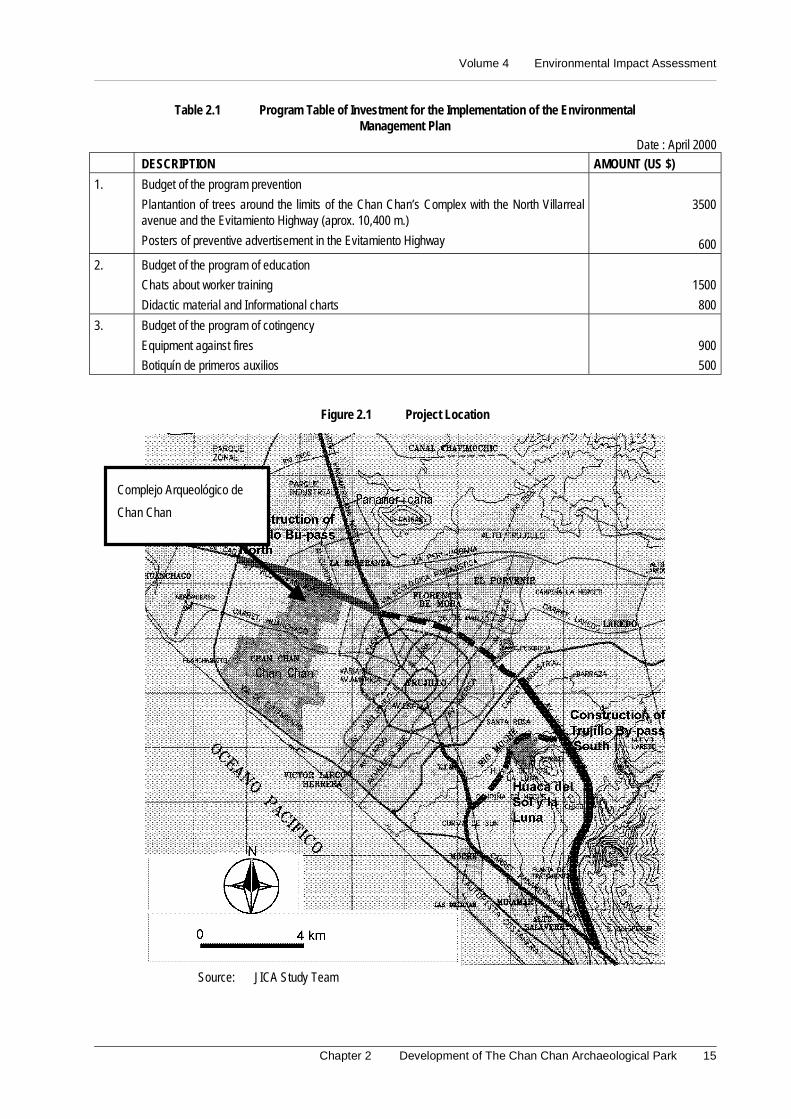
The following table shows the budget costs that correspond to the application of themeasures recommended in the Environmental Management Plan.
Volume 4 Environmental Impact Assessment
Chapter 2 Development of The Chan Chan Archaeological Park 15
Table 2.1 Program Table of Investment for the Implementation of the EnvironmentalManagement Plan
Date : April 2000
DESCRIPTION AMOUNT (US $)
1. Budget of the program prevention
Plantantion of trees around the limits of the Chan Chan’s Complex with the North Villarrealavenue and the Evitamiento Highway (aprox. 10,400 m.)
Posters of preventive advertisement in the Evitamiento Highway
3500
600
2. Budget of the program of education
Chats about worker training
Didactic material and Informational charts
1500
800
3. Budget of the program of cotingency
Equipment against fires
Botiquín de primeros auxilios
900
500
Figure 2.1 Project Location
Source: JICA Study Team
Complejo Arqueológico de
Chan Chan
Master Plan Study on National Tourism Development in the Republic of Peru (Phase 2)
16
2.7 Conclusions and Recommendations
2.7.1 Conclusions
- As well as it is demonstrated in this Study of Environmental Impact Assessment, theMaster Plan of Chan Chan's Archaeological Complex offers more benefits thandamages, contributing to the investigation and conservation of our archaeologicalpatrimony.
- The Plan considers two areas of intervention that practically no longer exist: theToledo lake and the totorales.
2.7.2 Recommendations
Therefore it is recommended:
- To invite the private company to cooperate with the execution of the project, as thecompany Backus does with El Sol Huaca and La Luna Huaca and the Wiese Bankdoes with El Brujo Complex. This will allow to implement this project in the shortestterm.
- To modernize the proposals of the project so that they contemplate two new scenarios:the nonexistence of Toledo lake and the little presence of totorales.

Volume 4 Environmental Impact Assessment
Chapter 3 Tourism Improvement of Huacas del Sol y de La Luna Archaeological Sites 17
3. Tourism Improvement of Huacas del Sol y de la Luna ArchaeologicalSites
3.1 Introduction
The Local Government of Moche plans to execute the Improvement of the
Archaeological Area of Huaca del Sol y de la Luna in order to conserve and show to thevisitors the archaeological remains found in the district of Moche, county of Trujillo and
department of La Libertad. These ruins that have a historical value are conformed by themost prominent structures that have been built during the time Moche, in the period Pre-
Inca.
In the elaboration of the present Environmental Impact Assessment (EIA), it has been
considered the mitigation measures that will be necessary to apply to avoid thedeterioration of the environment. It also will avoid that the own activities of the project
will degrade the environment in the influence area.
3.2 Legal and Institutional Framework
The Environmental Impact Assessment of the project Improvement of the ArchaeologicalArea of Huaca del Sol y de la Luna has been carried out in the context of the effective
legal and institutional norms.
In this sense, the study has been carried out keeping in mind the Political Constitution of
Peru, Code of Environment and the Natural Resources, Law Framework for the PrivateInvestment Growth, Organic Law for the Sustainable Use of the Natural Resources, Law
of Evaluation of Environmental Impact for Works and Activities, General Law of Waters,General Law of Expropriations, Law for the Development of the Tourist Activity,
General Law of Protection to the Cultural Patrimony of the Nation, Organic Law ofMunicipalities, Organic Law of the Sector Transports, Communications, Housing and
Construction, among others.
3.3 Description of the Project
The archaeological area of Huaca del Sol y de la Luna are located in the left riverbank ofthe river Moche, in the plain of the denominated Cerro Blanco. Politically it is located in
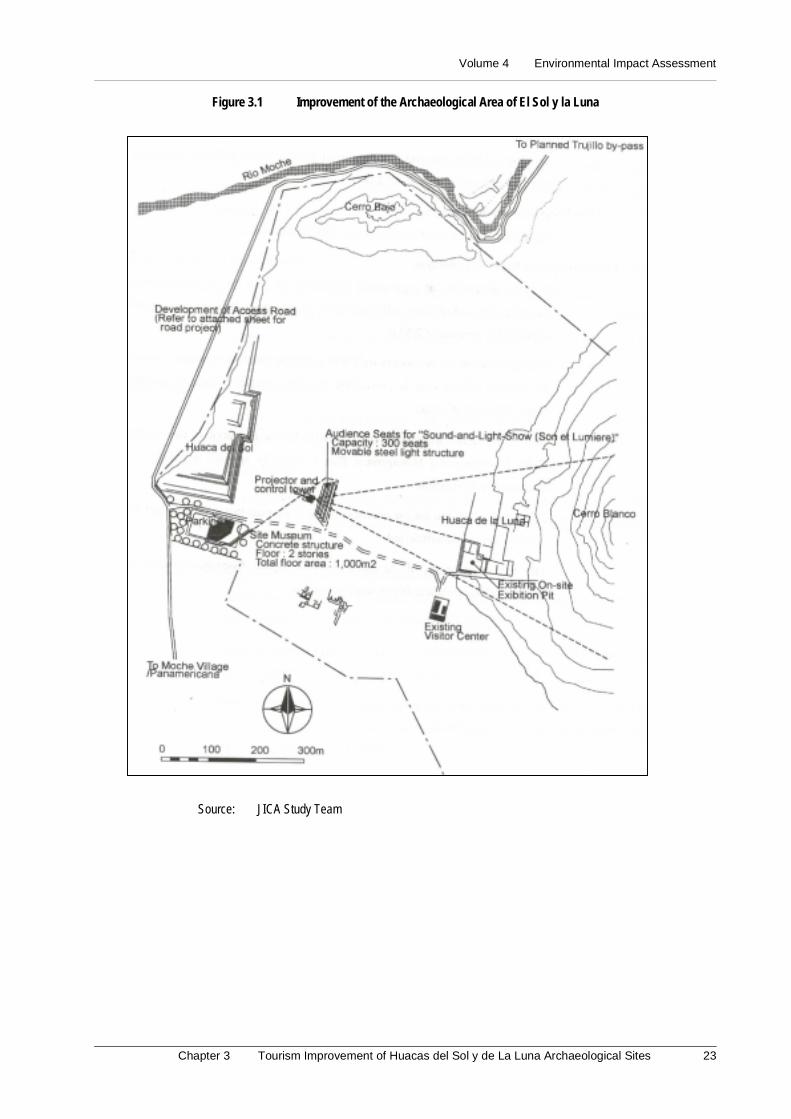
the countryside of Moche. It is located 5 km. toward the south of the city of Trujillo andabout 6 km. form the coast (See Figure 3.1).
The Project will comprise the construction of the following works:
Access Road. It will be located, conserving the route of an existent road that is at trail
level, with a narrow width and a deteriorated rolling surface that crosses an agriculturaltown. The projected access road will be paved, in a distance of 5.6 km and a width of
6.00 m. It will have lateral berm of 0.75 m to each side, with a total width of 7.5 m. Toextend and to connect the access road with the South Villarreal Avenue, a bridge will be
built on the existent irrigation structures.
In Site Museum. It will be used to show the archaeological remains in scale models,
boards of information with the detailed description, audiovisual services throughcomputers and other graphic techniques and auxiliary means.
Master Plan Study on National Tourism Development in the Republic of Peru (Phase 2)
18
Supply of water. It improves of the system of pumping of the underground water that is
used at the moment. Amplification and improvement of the supply of water driven bypipes of the SEDALIB.
Sewerage. Considering that SEDALIB plans to install a sewerage system for the villageof Moche and Las Delicias, a plant of treatment of sewerage waters will be built
discharging the water treated outside the archaeological area.
Electricity. It is foreseen the electricity supply, using the system of HIDRANDINA.
3.4 Basic Environmental Outline
The project will be located along a sector of the district of Moche, framed in the
coordinates following UTM: AND 723750 and N 9093500, AND 721000 and N 9103000.
The climate in the study area is Arid and Warm, with low sprinkles among July to
September. The project is ubicated in the zone of life dried up Desert - Subtropical (dd-S),with an annual media biotemperature of 22ºC and with annual total average precipitation
of 30 mm.
Fluvial valleys, marine terraces, and foot of mount and hills constitute it. Also, the
formations are of recent origin corresponding the Mesozoic of the Cretacic-Tertiary andQuaternary in the Cenozoic. In the Mesozoic, there is the formation Andean Batholith
that is characterized to contain plutonic intrusions constituted by granites, grain-diorites,tonalitas, diorite; as well as, smaller intrusions as andesitas, dacita, diabasa, etc. In the
Cenozoic, there are the formations of the Quaternary (undivided); in which aredistinguished fluvial, alluvial, and eolian and marine deposits.
The soils occupied by the project is conformed according to their taxonomy units as soilMoche (Torrifluvents), soil Delicias (Torripsamments), soil Barraza (Torripsamments)
and Miscellaneous lands. According to the Capacity of Major Use, these soils belong tothe Consociaciones Lands of Protection (X), and Crop in Clean (TO), with irrigation
limitations (r).
The study will be developed inside the basin of the river Moche. It has a total area of
drainage of 2,708 km2 and a journey distance of approximately 102 km. with a slopeaverage of 4%. The river Moche presents characteristic of torrent, being observed
differences among its extreme parameters. Also, the controlled maximum discharge hasbeen of 566.8 m3/sec and the minimum of zero, being the annual media around 9.53
m3/sec that equals to a annual media volume of 300.74 millions of cubic meter. Thedischarges usually concentrate on high degree, during January to May, presenting an
accented shortage from July to September.
The biological environment is characterized by a scarce representation of wild species,
due to the human activities and to the growing urban expansion that occupies agriculturaland marginal areas. The fauna present in these areas is birds, hawk, some smaller rodents
and small lizards. The characteristic flora is constituted by Cereus, Cephalacereusymelocactus; bordering the bed of the river Moche there is Bynerium and Cortaderia.
The districts of Moche and Trujillo involved under the direct influence area of the project,registered 269,048 inhabitants (INEI, 1993), with an urban population of 264,338
inhabitants and a rural one of 4,710. The Economically Active Population (PEA) in the
Volume 4 Environmental Impact Assessment
Chapter 3 Tourism Improvement of Huacas del Sol y de La Luna Archaeological Sites 19
county of Trujillo, reached 201,213 people, while the Population Economically Non
Activate (PENA), obtained 63.16% of the total population at provincial level.
According to the Agricultural National Census (INEI, 1994) the district of Moche
presents the biggest surface of agricultural lands (1269.97 Ha.), all them under irrigation.
In the work area, there are archeological evidences as the Huacas del Sol y de la Luna,
where it is foreseen that the Project works will neither affect nor put in risk these valuablepatrimonies of the Nation.
3.5 Identification and Evaluation of Environmental Impacts
It has been necessary to use diverse methodologies for the identification and evaluation of
the environmental impacts that are presented during the construction and operation stagesof the project. They identify, predict, interpret and communicate the beneficent and
harmful environmental impact such as the application of Matrix type Leopold, Cause-Effect Diagrams and the use of Field Notes.
(1) Planning stage
Possible conflicts for expropriation of properties and affectation of constructions. It
is foreseen that housings and properties of third ones will be affected generating possiblesocial and economic problems that should be resolved.
Expectations of employment generation. Keeping in mind that the unoccupiedpopulation is 8,345 inhabitants in the influence area of the project; there are big
possibilities of employment generation.
Possible interference with irrigation infrastructures. For the presence of irrigation
channels and of the right of via it is foreseen interference that should be taken intoaccount in the design of the road.
(2) Construction stage
Possible decrease of the tourist flow. It will be due to the increase of the emissions andnoises levels, caused by the land movement during the excavations, transport of materials
and elimination of work surplus, non-working machinery displacement. This effect willbe temporary, while the work lasts bringing consequences to the visitors to the
archaeological area and residents of the area.
Light geomorphologic alteration. During the exploitation of quarries and the use of the
garbage areas, be possibly generated light changes in the geomorphology, light removaland affectation of the wild flora and emissions of particles in the moment to load and
unload the construction materials and the surpluses.
Possible effects toward the ecological environment for temporary facilities. The
facilities of the camp, patio of machines, asphalt and crushing plants could generatetemporary changes in the use of the soil, emissions of gasses and noises, emission of
particles, spills of fuels and lubricant. The inadequate disposition of domestic solidresiduals and sewerage could induce to the proliferation of infectious vectors. The
operation of the crushing plant can affect the water due to the laundry of the stonymaterial.
Master Plan Study on National Tourism Development in the Republic of Peru (Phase 2)
20
Light increment of the employment rate. The construction activities will require the
recruiting of non qualified manpower. The participation of the employed local laborpopulation will allow him to diminish the unemployment rate in the area and increase the
acquisitive capacity of those residents that will participate in the project.
(3) Operation stage
Increase of the tourist activity. The construction of the access road will improve thedisplacement of the tourist toward the archaeological area. The in site museum will offer
the necessary conditions to show objects of historical value found in the Huacas. Also,the facilities of water, drainage and electricity will offer major comforts to the visitors.
Increase of the economic revenues. It will contribute to the increase of importantdevelopment poles in the field of the tourism. These economic activities will create new
work positions, what will allow improving the population's living standard
Conservation of the monumental group Huacas del Sol y de la Luna. The works of
improvement will allow to conserve and to show the architectural elements of theconstructions and the objects of historical value that were built during the culture Moche,
of the period Pre-Inca; that represents the humanity's cultural legacy.
Geo-dynamic risks in the area of the project. The area where the works will be located
is seismically active. The risks can be increased during the occurrence of the El Niñophenomenon.
Risks of traffic accidents. Due to the access road is located adjacent to inhabited andagricultural areas; the vehicular flow will be increased, for what the occurrence of
accidents is not discarted.
3.6 Environmental Management Plan
3.6.1 Program of Control and/or Environmental Mitigation
(1) Planning stage
The elaboration of a Plan of Compensation and Resettlement of the Population affected
by the construction of the access road is recommended.
It is recommended to establish the mechanisms of direct negotiation, in order to
compensate economically those affected by the expropriation of the properties and theconstructions, according to the tariffs of the National Commission of Appraisals and the
proprietor's respective approval.
It is recommended as priority to apply a politics of occupation of local manpower,
communicating to the population involved in the influence area, about the politicians ofrecruiting of the manpower, workers' number and labor minimum requirements for their
recruiting.
In the sectors where interference are presented with the watering infrastructure, it is
recommended to coordinate with the farmers in order to avoid conflicts for the relocationand the cut of the supply and/or use of the water resource.
(2) Construction stage
High priority should be granted to the occupation of local manpower, making an
appropriate remuneration in agreement with the local and regional economy.
Volume 4 Environmental Impact Assessment
Chapter 3 Tourism Improvement of Huacas del Sol y de La Luna Archaeological Sites 21
It is recommended the use of the quarries and existent and authorized garbage areas. In
the case they are determined specifically for the project, they should be exploited in theframework of an appropriate program of environmental management that considers
avoiding damages to the ecological environment.
The localization of the camp, patio of machines, asphalt and crushing plants, specifically
will be in appropriate areas, where their installation and operation do not generatenegative effects on the environment. In this sense, it should be kept in mind the
agricultural environment.
The dispositions of the work personnel's behavior should preserve the norm respect to the
local population, for non altering the social relationships in the area.
The elimination of solid waste and domestic liquids of the work should be governed by
the principles of basic reparation, avoiding the contamination of the surroundingenvironment of the work.
It should be used the existent ways or access roads, to arrive to the areas where thetemporary facilities will be located (camps, sources of materials, places of disposition of
surpluses, etc.) and the different work.
It is forbidden the abandon of material work surplus. They should be accumulated
temporarily in the work areas to be taken later to the areas of final disposition.
(3) Operation stage
For the control of the quality of the air in the area, it should be observed the levels of airquality (Maximum Limits Permissible-DIGESA).
Those responsible for the project, jointly with the authorities of the Local Government ofMoche and the National System of Civil Defense (SINADECI) and the population in
general will carry out prevention simulacrums, in order to avoid that the earthquakes andthe natural phenomena cause personal damages of consideration.
In order to avoid the occurrence of traffic accidents along the location of the access road,the respective signaling should be made.
3.6.2 Program of Environmental Monitoring
It will be carried out the annual monitoring of the air quality and control of the following
parameters: nitrogen oxide, lead, and monoxide of carbon and dioxide of sulfur. Theseparameters should not exceed the established permissible limits DIGESA.
3.6.3 Program of Environmental Education
It is recommended the realization of chats, seminars, publication and diffusion ofeducational notes. They are guided to achieve a major participation of the local
population and of the work personnel in the activities of environment conservation.
3.6.4 Program of Contingency
It is recommended to coordinate with the National System of Civil Defense (SINADECI)and the population in general. It is to prevent and control natural disasters and labor
accidents that could happen in the influence area of the project, during the construction ofthe works and operative life of the Project
Master Plan Study on National Tourism Development in the Republic of Peru (Phase 2)
22
3.6.5 Program of Area Abandon
In the case there is the area abandon, the soil occupied by the works will be restored up to
reach the original conditions.
3.6.6 Program of Investments
In the Program of Investments the budget profits are included to execute the applicationof the measures recommended in the Environmental Management Plan.
(1) Program of control and/or engvironmental mitigation
Quarry Reconditioning. It includes the restoration of the surface according to thegeomorphology of the environment. US $2,000
Garbage Area Reconditioning. It includes leveling-compressibility, layers of 0.5 m, with10 times of caterpillar tractor. US $1,500
Reconditioning of areas occupied by camp and patio of machines. It includes the removaland elimination of the polluted soils with residuals of lubricant, fuels and fatty.
US $2,500
Reconditioning of areas occupied by asphalt and crushing plants. It includes the removal
and elimination of the polluted soils with asphalt residuals, etc. US $2,500
(2) Program de environmental monitoring
Monitoring of the Air Quality US $1,700
(3) Program of environmental education
Activities of Education and Environmental training (talks, bulletins, notes and otherpublications). US $2,000
(4) Program of contingencies
Equipment of the unit of contingencies US $2,500
3.7 Conclusions and Recommendations
Possible affectation of agricultural properties, as well as, of constructions located in thearea of direct influence of the project, due to the minimum width required for the road of
7.50 m.
The construction of the access road will facilitate the direct entrance toward the Huacas
del sol y de la Luna, from the Pan-American Highway and the South Villarreal Avenue.
The environmental impacts are not restrictive for the execution of the project. If the
Environmental Management Plan is properly applied, the project is environmentallyfeasible.
It is recommended to use the quarries and garbage areas that at the moment are inexploitation and authorized.
The recommendations of the Environmental Impact Assessment should be included in thetechnical file of work execution.
Volume 4 Environmental Impact Assessment
Chapter 3 Tourism Improvement of Huacas del Sol y de La Luna Archaeological Sites 23
Figure 3.1 Improvement of the Archaeological Area of El Sol y la Luna
Source: JICA Study Team

Volume 4 Environmental Impact Assessment
Chapter 4 Development of Parque de Baluarte (Fortress Park) 25
4. Development of Parque de Baluarte (Fortress Park)
4.1 Introduction
The department of La Libertad has a rich historical patrimony, inheritance of the big
cultures that inhabited the territory. If these resources are well managed, they canpromote the tourist activity and contribute to the economic development of the region. In
that sense, it is important the execution of the Plan of Development “Parque del Baluarte”because it will contribute to improve the conditions to make Trujillo as an attractiveness
tourist destination.
Evidently, the accomplishment of the project will give place to environmental
modifications that should be foreseen. Precisely, for this reason the present Study ofEnvironmental Impact Assessment is carried out which constitutes an instrument of first
importance to evaluate the environmental feasibility of the project. In general, itcomprises the analysis of the environmental components in the area of the future “Parque
del Baluarte”. The study of the physical, socioeconomic and cultural characteristics arebeen considered to obtain an exact knowledge of the area.
Later on, all the aspects linked to the development of the project have correlated with theenvironmental components in order to obtain preventive and/or corrective measures to be
taken into account during the execution and operation of the project. This way, the Studyof Environmental Impact Assessment will help to avoid the deterioration of the
environment and to propitiate the achievement of a sustainable socioeconomicdevelopment of the city.
4.2 Institutional General and Legal Framework
The Study of the Environmental Impact Assessment of the Plan of Development Parquedel Baluarte Project has been developed having as effective juridical and institutional
framework, the following norms:
(1) Legal framework
- Political Constitution of Peru
- Code of Environment and Natural Resources (Legislative Decree Nº613)
- Law Framework for the Private Investment Growth (Legislative Decree Nº757)
- Organic Law of Municipalities (Law Nº23853)
- Law of Evaluation of the Environmental Impact Assessment for Works and Activities(Law Nº26786)
- General Law of Expropriations (Law Nº27117)
- Law for the Tourist Activity Development (Law Nº26961)
- General Law of Protection of the Cultural Patrimony (Law 24047)
- Norm of Organization and Functions of the National Institute of Culture (SupremeDecree Nº1 - 84 - ED)
- Unique Text of Administrative Procedures of the National Institute of Culture(Supreme Decree Nº013 - 98 - ED)
Master Plan Study on National Tourism Development in the Republic of Peru (Phase 2)
26
(2) Institutional framework
- Presidency of the Council of Ministers
- National Commission of Environment
- Ministry of Industry, Tourism, Integration and International Commercial Business
- National Institute of Civil Defense
- National Institute of Culture
- Transitory Council of Regional Administration - La Libertad
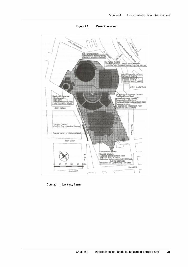
4.3 Description of the Project
The “Parque del Baluarte” Project is located at Trujillo city in the crossline of España andSinchi Roca avenues. Its name came from since the colony. There was one of the baluarte
of the fence that surrounded the city whose one wall can still be appreciated in the Españaavenue. The following activities have been considered in the pre-feasibility level study of
the project:
- Construction of a Center of Conventions
- Construction of a Center of local products promotion and a typical food restaurant
- Construction of a building to exhibit handicrafts
- Improvement of the Bulls Fight Square
- Construction of a parking building
- Construction of a commercial building
Also, for the implementation of these measures it will be necessary the temporary
construction of offices, hygienic services, stores and vigilance.
4.4 Basic Environmental Outline
This issue comprises the knowledge and identification of the physical and socioeconomic
aspects of the influence area of the Project.
(1) Biological environment
The Trujillo city is the capital of La Libertad department. It is located in the right side ofthe Moche river at 47 meters over the sea level and 5 km from the sea. It was founded in
1535 and still conserves hispanic features like the orthogonal line of its streets and artisticcolonial houses.
The heart of the city is the Historical Center that comprises the whole sector surroundedby the España avenue. It was built in the same place where the colonial fence that
protected to the city existed before. Around this area there were new settlements that wererecognized and transformed into districts like: La Esperanza, Florencia de Mora, El
Porvenir, and Víctor Larco Herrera.
The city has an airport for national flights and a connection with the Pan-American
highway. The most important local roads are: the Industrial Highway, the alternativeHighway and the avenues Las Americas, España and Larco Herrera.
The pluvial precipitation is stable, without many variations inside the area and is closelylinked to the prevailing conditions in the slope of the Pacific where the analysis of the
Volume 4 Environmental Impact Assessment
Chapter 4 Development of Parque de Baluarte (Fortress Park) 27
precipitation distribution of the precipitation gives 30 mm of total annual average.
Exceptionally, these characteristics are out of the normal average. When the PhenomenonEl Niño is presented, there were averages over the 900 mm (among the months of January
to April).
The temperature, according to the observed dates, presents an annual average of 22ºC,
with a minimum of 16ºC and a maximum of 28ºC. The evaporation, according to theanalysis of the data, presents the biggest indexes with values that vary from 82 to 114 mm
from December to March. The relative humidity presents an annual average of 85% andis increased from June to November (more than 90%). It diminishes less than 80% from
December to April.
(2) Socioeconomic environment
The total population of La Libertad department is 1,270,261 inhabitants whose 68.52% isin the urban area and 39.46% in the rural area. The total population of Trujillo county is
631,989 inhabitants whose 93.14% is seated in the urban area and the rest in the rural area.Trujillo and La Esperanza are districts with the biggest population (with 247,048 and
105,361 inhabitants respectively).
In Trujillo county, the PEA (economically active population) is conformed by 201,213
people and 19,924 people are not employed (9.90%). On the other hand, the PENA(economically not activate population) is conformed by 344,931 people. The labor force
is concentrated on Trujillo with 82,637 people.
4.5 Identification and Determination of Environmental Impacts Assessments
For the identification and determination of the environmental impacts that are presentedduring the planning stages of the project (construction and operation), it has been
necessary to use diverse methodologies such as the matrix type Leopold, Cause-Effectdiagrams and Field Notes.
(1) Planning stage
- Possible social conflicts. The most important conflicts will happen with the residentsof the Parque del Baluarte surroundings.
- Expectations for employment generation. Given the area of the project (more than30,000 m2), there will be big expectations of employment among the unoccupiedpopulation of the city.
(2) Construction stage
- Possible injures to the residents health. The different works that will allow theconstruction of the project can put in risk the resident health.
- Increase of the employment generation. The recruiting of local manpower and thepurchase of construction materials will impel the economic growth of the city.
(3) Operation stage
- Increase of the tourist activity. The construction of this type of infrastructure willcontribute to create the conditions to increase the tourist flow in the city.
- Economic development of the city. The increment of the tourist flow will create theconditions for the economic development of the city.
Master Plan Study on National Tourism Development in the Republic of Peru (Phase 2)
28
- Effects on the urban environment. For their volume and scale, the works will have asignificant visual incidence in the area.
4.6 Environmental Management Plan
4.6.1 Program of environmental mitigation and/or mitigation
(1) Planning stage
To avoid difficulties between the Contractor and the owners of the properties bordering tothe work, it will be necessary to fulfill the following considerations:
- The Contractor's representatives should be properly identified by the owners and/orinhabitants of the properties bordering to the project.
- The population and local authorities will be permanently informed of thecharacteristics of the project in a clear and accessible way.
- The Contractor should implement an office that permanently coordinates with thepopulation and the authorities in order to identify and to inform any situation of riskthat the project can generate.
- Before the beginning of works, it should be executed the Program of compensationand the re-settlement of population to avoid the possible occurrence of conflicts.
(2) Construction stage
To avoid to affect the population it is recommended:
- To wet the roads where the vehicles and building machines transit daily.
- Workers should wear protection masks to avoid dust.
- To wet and cover the building materials with canvas before being transported.
- The equipment should be in optimum conditions and have noise suppressors.
- To coordinate the qualification of alternating roads with the local authorities. In caseof Sinchi Roca avenue would be closed, it is recommended to use as alternating roadsthe streets Sabogal, Hernández and Union.
- Before beginning the demolitions, it will be had the respective municipal permits andwill be coordinated with the pertinent entities to avoid to affect the adjacent facilities.
(3) Operation stage
To avoid effects on the urban environment it is recommended:
- To verify that the decibel degree do not surpass the recommended levels. Also, theincrement of the activities in the area will make necessary a major police security,improvement of the urban furniture and more care in the cleaning of the streets.
4.6.2 Program of environmental monitoring
The Program of environmental monitoring will allow, after evaluating the environmentalvariables, to give information for the taking of decisions guided to the conservation of the
environment of the project. During the construction of the works, the following measureswill be verified:
Volume 4 Environmental Impact Assessment
Chapter 4 Development of Parque de Baluarte (Fortress Park) 29
a. Monitoring of air quality
b. Monitoring of noise levels
4.6.3 Program of compensation and population re-settlement
The place where a commercial building and a parking building will be built is occupied
by buildings from 3 to 4 floors made in bricks (aprox. 22 lots that occupy a total area of9,375 m2_). The place where a handicrafts building will be built is occupied by buildings
from 2 to 4 floors made in brick (aprox. 8 lots that occupy a total area of 1,000 m2_).
The place where the Center of promotion of local products and traditional foods will be
built is occupied by buildings from 1 to 2 floors made in brick and mud built (aprox. 13lots that occupy a total area of 1,600 m2_). The rest of the land is property of the CTAR
and is unoccupied. Previously it was the ex-railway station. The place where the Centerof conventions will be built is provisionally occupied for a circus and fairs. It is also part
of the ex-railway station.
4.6.4 Program of education and environmental training
The Program of education and environmental training education contains the outlines to
continue educating, training and making the workers and settlers to have conscious of theenvironmental problems that will be present in the area as a consequence of the
construction and operation of the project.
4.6.5 Program of contingencies
The Program of contingencies will establish the measures that should be followed in caseof natural or manmade disasters counteracting the damages that can be originated in a
coordinated and immediate way. Especially the following cases should be considered:
a. Earthquakes
b. Fires
4.6.6 Program of work abandon
This Program is designed to establish the process of abandon of an installation when ithas completed its useful life. In our case it is a permanent building constructed in an
urban area and the installations will not be abandoned except for expressed indication thatwill be pointed out in its moment.
4.6.7 Program of investments
The following table shows the budget costs that correspond to the application of the
measures recommended in the Environmental Management Plan
4.7 Conclusions and Recommendations
(1) Conclusions
For its magnitude and proximity to the Historical Center, the Project will impel the area,becoming a positive factor for the development of the city.
A part of the project will occupy the place of the ex-railway station. This is a wasted areaof the city because it is only used by eventual circuses and fairs. The intervention of it is
totally feasible.

Master Plan Study on National Tourism Development in the Republic of Peru (Phase 2)
30
However the other part will occupy residential and commercial areas. It will cause many
negative impacts affecting the feasibility of the project.
Table 4.1 Program Table of Investment for the Implementation ofthe Environmental Management Plan
Date: April 2000
DESCRIPTIONAMOU
(US 1.
2.
3.
4.
Budget of the program of prevention• Conditioning of garbage areas for material surplus (it includes leveling and
compressibility with layers of 0.5 m)Budget of the program monitoring• Semester control of air quality and sound levelsBugget of education• Training chats for workers• Didactic material and charts of informationBudget of contingency• Equipment against fires• First-aid kit
20
(2) Recommendations
Therefore it is recommended:
- To restate the intervention in the surroundings of The Bull Fighting Place because itdoes not have justification.
- To consider as an alternative the use of properties adjacent to the ex-railway station.These are occupied by street venders and by one-floor market what would facilitatetheir occupation.
- To consider the integration of the Parque del Baluarte with the Historical Centerthrough an urban treatment (soils, tree plantation, furniture) which considersespecially the wall that is in front of the intervention area.
Volume 4 Environmental Impact Assessment
Chapter 4 Development of Parque de Baluarte (Fortress Park) 31
Figure 4.1 Project Location
Source: JICA Study Team

Volume 4 Environmental Impact Assessment
Chapter 5 Tourism Improvement of El Brujo Archaeological Site 33
5. Tourism Improvement of El Brujo Archaeological Site
5.1 Introduction
Peru is owner of a nonpareil cultural and natural patrimony. An important part of this
legacy has last along time showing us nowadays a grandiose millennial past and a veryparticular biological wealth that constitute unique tourist attractiveness. The development
of the tourist activity will generate the performance of other productive activities with theconsequent employment generation and the increment of the living standard of the
resident of the influence area.
In this sense, it has been planned to carry out works of vial improvement and of tourist
infrastructure in the El Brujo Archaeological Complex. For this reason it is necessary theStudy of Environmental Impact Assessment (EIA) with the aim to identify and foresee
the environmental changes produced by the execution of the works. Also it establishes itspreventive and corrective measures to counteract the harmful environmental impacts and
to reinforce the beneficent impacts guided to the population's welfare.
5.2 Legal and Institutional Framework
The Study of the Environmental Impact Assessment of the El Brujo Tourism
Improvement will be developed having as juridical framework the effective institutionaland legal norms referred to the protection and environmental conservation and to the
cultural patrimony of the Nation.
Inside the main laws we have: the Political Constitution of Peru, Law of Evaluation of
Environmental Impact for Works and Activities, General Law of Waters, Organic Law ofMunicipalities, Code of Environment and Natural Resources, Penal Code, Crimes against
Ecology, Law and Regulation for the Development of the Tourist Activity, General Lawof Protection of the Cultural Patrimony of the Nation, General Law of Transport and
Terrestrial Traffic, General Law of Expropriations, among others.
To this respect, the institutions that participate bringing together the population's concerns
and efforts in the project area are the following ones: Presidency of the Council ofMinisters, National Council of the Environment (CONAM), Ministry of Industry,
Tourism, Integration and International Commercial Business (MITINCI), Ministry ofAgriculture through the National Institute of Natural Resources (INRENA), Ministry of
Education (MED) through the National Institute of Culture (INC), the Transitory Councilof Regional Administration - CTAR La Libertad.
5.3 Description of the Project
The works for the El Brujo Tourism Complex Improvement will be located in Magdalena
de Cao district, Ascope province at La Libertad department.
The Project comprises: the improvement of the access route from the North Panamerica
(Chocope) to the El Brujo Archeological Complex that has 18.3 km of distance and 8.4 mof widen (6 m of pavement and 1.2 m x 2 green belts); and the construction of a tourist
infrastructure: visitors' center (100 m2) with parking area (500 m2) and a trip route ofapproximately 1.6 Km.
Master Plan Study on National Tourism Development in the Republic of Peru (Phase 2)
34
5.4 Basic Environmental Outline
5.4.1 Climate
In the study area the following climatic types have been identified: The Arid and Warmclimate that is characterized by not presenting excess of water during the whole year and
a monthly average temperature of 22ºC and 30 mm of annual average precipitation andthe Semi warm and Dry climate that presents small or null deficiency of water and a
monthly average temperature of 22ºC and 45 mm of yearly average precipitation.
5.4.2 Hydrology
The improvement of the access road and the tourist infrastructure works will be carried
out in the low basin of the Chicama river which has an extension of 5,876 Km 2 from itsorigin in the high mines of Callacuyán (Cajamarca) up to its outlet in the Pacific Ocean.
The use of the water is dedicated to satisfy the demand of the agricultural, population,mining, and husbandry sectors. The agricultural sector has the major use with more than
92% of the total use of the basin. The use of water for irrigation is mainly centered in thevalley for sugar cane, corn, alfalfa and chickpea.
5.4.3 Geology
Since a geologic point of view, the evolution of the area has given place to units well
differed as fluvial valleys, marine terraces, mountain foot and hills.
They are distinguished by alluvial, fluvial and aeolian deposits and are extended in the
whole plain of the coast. The fluvial deposits are limited by the influence of the Chicamariverbed and are composed by sand of different thickness, gravels, round stones and slime
that do not show stratification. Loamy and sandy materials in different stratificationdegrees, permeability and pH variables constitute the alluvial deposits, located in the
alluvial plain of the Chicama River. The aeolian deposits, mainly limited by the hills andmountain foot, are accumulations of loose sand transported by wind, taking different
forms from small mounds up to dunes.
5.4.4 Soils
Physiographically, two Big Landscapes have been identified: The Alluvial Landscape andthe Great Hilly Landscape. The former is integrated by relatively plane areas originated
by all those fluvial deposits of the Chicama River. The Great Hilly Landscape formed bythe combined action of orogenic and epirogenic processes, especially in marine
environments where materials transported by waters have been deposited.
Chicama, Chocope and Huaca Soils and a miscellaneous area constitute the cartographic
units. Besides, the lands according to their Capacity of Major Use are the Classes: A1,with the Sub Class. (A1s); A2, with the Sub Class A2s(r) and the protection lands Xse.
5.4.5 Ecology
The influence area encloses two Zones of Life:
Super arid - Subtropical (dd-S) desert, located in the low parts of the western
counterfort of the Andes mountain range and in the bottom of the valley of the Chicamariver between the sea level and the 200 meters over the sea level; and it is characterized
by presenting an arid climate, with annual total average precipitation around 30 mm that
Volume 4 Environmental Impact Assessment
Chapter 5 Tourism Improvement of El Brujo Archaeological Site 35
are not enough to satisfy the water demand water for crops, being developed an
agriculture based on irrigation. The annual medium biotemperature oscillates around the22ºC. The average of total potential evapotranspiration per year varies in 2 to 4 times the
value of the precipitation, and;
The dried up - Subtropical (dd-PT) desert, comprises the low parts of the western
counterfort of the Andes mountain range and in the bottom of the valley of the riverChicama, between the 200 and 400 meters over the sea level. It presents a dry climate,
with annual total average precipitation around 45 mm that are not enough to satisfy thewater demand for crops, being developed an agriculture based on irrigation. The annual
medium biotemperature oscillates among the 23ºC.
5.4.6 Wild Fauna and Flora
The Study Project is located ecologically in a coastal environment where the human beingactivity has played an important role on the establishment of the flora and fauna of the
low part of the basin of the Chicama river since the pre Spanish periods.
The characteristic flora is constituted by Distichilis spicata and Sporobolus virginicus and
herbaeous communities that tolerate high salinity of soils. In the hills find Tillandsia
Iatifolia, Tillandsia strarninea, as well as, in the proximity of the sea or under the stony
and sandy hills. In the riverside the common species are Gynerium sagittatum,Phragmites australis, Cortaderia jubata, Baccharis lanceolata, Acacia macracantha,
Prosopis pallida, Salix chilensis, Sapindus saponaria, and Tessaria integrifolia.
In this region of the north-western coast of the country, a great agricultural activity is
developed that limits the presence of the animal diversity. Among the representativespecies of the grass fields are the following birds: Anthus Iutescens, Charadrius vociferus,
Thinocorus rumicivorus, Geosifta peruviana, and sometimes Muscigralla brevicauda. Inthe cultivated areas Pezites militaris and Sporophila sp. In the sandy beach find Larus
modestus that feeds almost exclusively of Emerita analoga. It is also a rest habitat ofPelecanus occidentalis, Larus marinus, Larus belcheri, and Larus pipixcan.
5.4.7 Cultural and Socio-economic Environment
The Ascope County has a population of 108,876 inhabitants whose 82.44% are in the
urban area and 17.56% in the rural area. The Chocope and Magdalena de Cao districtshave 29,959 and 2,318 inhabitants, respectively where the urban population's percentage
is high in both (87.82% and 50.99% respectively). The percentage of the total populationof these districts with relationship to the Ascope County is 29.62%.
The agriculture is the main economic activity that occupies more than 80% of the district.The main crop is sugar cane, being the Cartavio, Laredo and Casa Grande cooperatives
those that have the biggest production. The animal husbandry is in extensive form. Goatand bovine livestock are observed in all the towns.
At a level district the economically active population is employed, being theunemployment level for both districts of 14.77% and 7.53%, respectively.
Most of housings are built of adobe, however the district of Chocope has the biggestproportion of housings built of brick, block or cement, with the 34.25%. At a level district,
there is a high percentage the housings supplied by public net, with 71.46% at Chocope

Master Plan Study on National Tourism Development in the Republic of Peru (Phase 2)
36
and 37.92% at Magdalena de Cao. The hygienic service connected to the public net is of
64.84% and 28.54% for Chocope and Magdalena de Cao, respectively.
Between the main populated centers we have: Nazareno, Veracruz, Play, Salamanca,
Farías, Perseverance, Sintuco, Moncada, Ticmar, El Brujo, The Block, Mocollope.
La Libertad department has great tourist attractiveness because of its cultural and natural
beauty. In the influence area of the Study there are diverse archaeological remains whichmostly are in Magdalena de Cao district, very close to the river and sea shore: El Brujo’s
Archaeological Complex, Rosario’s Archaeological Zone located in the shore of Chicamariver (Right Margin) in the sector of Moncada Alta; Archaeological Area del Palmo
between the populated center of Ticmar and the Chicama river; Blanca Huaca and Huacadel Palmo.
5.5 Identification and Determination of Environmental Impacts
For the identification and determination of the environmental impacts that are presented
during the operation, construction and planning stages of the Project, it has beendetermined the following more significant impacts:
(1) Planning stage
- Possible conflicts of use of lands. The access highway will be located on agriculturallands that will be affected by the Road Right. It will generate possible conflicts ifthere are not agreements with the owners of the affected properties.
- Possible interference with watering and spread electric infrastructures. Parallel andvery close to the access road, there are watering channels that will have to berelocated because they occupy the Road Right. There also should be a new locationfor the electric posts for being outside of the Road Right.
- Compensation of properties. Because of the execution of the highway project willaffect crop areas, the owners of those lands should be compensated.
- Possible damage on the El Brujo Archaeological Complex. The location of the touristinfrastructure that will be built in the El Brujo Complex should contemplate therealization of detailed archaeological studies, in order to not deteriorate the culturalpatrimony of the area.
(2) Construction stage
- Increase of the noise levels and emissions. During the construction of the Chocope –El Brujo Complex access highway, there will be emissions of powder materialdiminishing the quality of air. Also, emissions of noises will be generated.
- Alteration of the geomorphology. This ecosystem component will be altered alongthe construction of the access road, due to the occupation of the space for the workand for the amplification of the highway width.
- Compressibility of soils and decrease of soil quality. The compressibility of soilswill be generated as a consequence of the transport of heavy machinery, vehicles andequipment movements. The soil quality can be affected by the accidental and/or notcontrolled pouring of polluting substances.
Volume 4 Environmental Impact Assessment
Chapter 5 Tourism Improvement of El Brujo Archaeological Site 37
- Interruption of the supply of irrigation water. During the construction, theirrigation channels will be affected generating possible conflicts with the agrariancooperative proprietors.
- Employment generation. Diverse types of employment will be generated to reboundpositively in the population’s economies near to the project.
- Alteration of the vehicular traffic. In the execution of the work activities, it ispossible that difficulties are presented to maintain the continuity of the traffic; keepingin mind that great part of the access road improvement will be developed over anexistent way between Magdalena de Cao and the North Pan-American (Chocope).
- Possible decrease of the quality of the surface water. The quality of the water ofcanals for irrigation that flow in parallel with the improvement road, also the water ofChicama river could be contaminated due that be used for the construction by spillaccidentally (carburants, greases, oils, lubricants, cement, concrete, etc.).
- Possible unforeseen damages on the El Brujo’s Archaeological Complex. Thecharacteristic works of the construction of the tourist infrastructure that will beexecuted in El Brujo Archaeological Complex Area could cause unforeseen damagesover areas what have not been studied yet.
(3) Operation stage
- Improvement of the commercialization of products. The project will allow thesocioeconomic growth of the residents of Magdalena de Cao and Chocope district,belonging to Ascope County in the north area of La Libertad department.
- Improvement of the vehicular traffic. The vehicular traffic that will circulate forthis road will use a shorteuer time, bringing comfort to people that will move for thishighway.
- Increase of the value of the land. The adjacent lands along the projected highwaywill elevate their commercial values. This effect is important, because they will haveaccess to more bank credits and this way to increase the agricultural productivity.
- Increase of the tourist activity. The major affluence of tourists at the El BrujoArcheological Complex will generate a light increase of the use of basic services anddomestic solid wastes. The latter will have an accurate management of water, sewageand treatment of the residual water and a correct management of the solid wastes inorder to prevent polluted the surface water, the soils and to prevent disturbing thelandscape.
5.6 Environmental Management Plan
5.6.1 Program of environmental mitigation and/or prevention
(1) Planning stage
- Measures in the Relationships with the Community and Properties Management.During the planning process of the projected road, difficulties can be presented
between the Contractor and the proprietors of the adjacent properties to the work thatwill be affected. It is necessary to have meetings in order to fix the precise estimation
of the properties.
Master Plan Study on National Tourism Development in the Republic of Peru (Phase 2)
38
(2) Construction stage
- Loss of agricultural areas and wild vegetation. The improvement of the highwaywill cause an unavoidable negative impact on the agricultural areas and naturalvegetation in the sector comprised between the El Brujo Complex and the Km 2+100for having a green belt very reduced.
- Increase of noise levels. In order to diminish the emission of noises during theconstructive phase, the equipment and machinery should be under good conditionsand noise suppressors should be used.
- Possible traffic increase. The improvement works of the access road toward thearchaeological area could originate traffic increase. To this respect, it will benecessary to coordinate alternating routes in order to not to damage or to delay theusers.
- Emission of powder material. In the constructive stage the tilts that cover the icongraphic murals of the Cao Viejo Huaca will be more hermetic in their borders to avoidthe deterioration of the coloring and ways of the same ones. The workers andoperatives should wear protection devices according to their special work.
- Possible occurrence of accidents. During the construction activities that will becarried out in the vial and tourist improvement, the possibility of occurrence of laboraccidents is not discarded. It is necessary to have a medical team of first aid.
- Geomorphologic alteration for quarry exploitation and use of garbage areas.This impact will be of moderate significance because the extracted volumes of thequarries and the material surpluses deposited in the garbage areas will not constitutebig quantities.
(3) Operation stage
- Improvement of the service to the local resident and tourist. The completion of theaccess highway will improve the service of transport toward the districts and smallertowns that are in surrounding, benefiting the residents who mobilize along this road;as well as, tourists that will come from Trujillo. It will become the shortest andpleasant journey.
- Increase in the affluence of tourists. The execution of the Project will contribute abigger affluence of national tourists and foreigners. Also, it will propitiate to that thetravel and tourism agencies include the visit to the El Brujo Complex in their touristpackages.
- Increase of the commercial activity. The biggest affluence of tourists to TrujilloCity and Magdalena de Cao district will allow that there is an increase of the goodsand services demand, generating new commercial activities.
5.6.2 Program of Environmental MonitoringThe main factors that require monitoring are:
- Monitoring of the quantity of powder material and of the sound levels.
- Constant Monitoring of the improvement work of the access road, construction of thecenter of visitors, parking areas and access route, exploitation of quarries, use ofgarbage areas, construction of camps and other activities.
Volume 4 Environmental Impact Assessment
Chapter 5 Tourism Improvement of El Brujo Archaeological Site 39
- Works of monitoring of the banks of the garbage areas and used quarries will becarried out.
- The correct operation of the drainage system built in the access road (obstruction,deterioration, etc.) should be monitored periodically.
5.6.3 Program of Social Compensation
The Program of Social Compensation, will be centered in the necessity of assuring a faircompensation to the proprietors of the crop lands that will be directly affected by the
location of the civil works of the highway North Pan-American (Chocope) – El Brujo.The areas that will be directly affected by the civil construction are the sector located
between the El Brujo Complex and the km 2.1; as well as those related to the constructionof access roads, location of camps, asphalt and crash stone areas. If the areas are located
in private property, they will be properly compensated in terms of appraisal negotiationsand land sale.
5.6.4 Program of Training and Environmental Education
The activities of environmental training are the following ones:
- During the construction stage, the Contractor Company will organize chats ofenvironmental education directed to its workers, so that they take conscience of theimportance that the archaeological and natural resources conservation of the projectarea has.
- In the construction stage, it will be necessary to maintain all the workers andemployees, without hierarchical distinctions, informed about the prevention ofaccidents and how to avoid actions that can generate emissions or nuisances.
- The Contractor Company will establish behavior norms to the work personnel,prohibiting the consumption of alcoholic drinks during the works and the illicitappropriation of archaeological goods.
- In order to prevent epidemic diseases, the foreign workers hired by the companycontractor should have a recent health certificate to discard all type of diseases.
5.6.5 Program of Contingency
The Program of Contingency will allow confronting the emergency situations related withthe environmental risks and accidents that can take place during the execution of the
Project. The identified potential risks are the following ones:
- Labor accidents during the construction of the access road and tourist infrastructure ormedical emergencies to visitors.
- Possible occurrence of earthquakes during the execution of the works.
5.6.6 Program of Abandon of the Project
It has as an objective to restore the soil where the El Brujo Complex’s center of visitorshas been built, allowing reaching the original and natural conditions of the earth surface
affected by the space occupation of the works.
5.6.7 Program of Investments
It has already been indicated mitigation and/or environmental control measures in order
to avoid and/or reduce the negative effects on the environment, as well as those that
Master Plan Study on National Tourism Development in the Republic of Peru (Phase 2)
40
produces the environment on the project. The necessary investment for the
implementation of the Environmental Management Plan reaches USA $ 45,905.84.
5.7 Conclusions and Recommendations
- The improvement of the North Pan-American (Chocope) – El Brujo Complex accesshighway, and tourist infrastructure is important for the integration and thesocioeconomic development of the populations of Magdalena de Cao and Chocope,located in the north coast of Ascope county in La Libertad department.
- El Brujo Complex’s west limit, very independent to the archaeological value thatpossesses as cultural patrimony of the Nation, converges with the sea. Thischaracteristic gives it an additional charm that should be exploited in order to attracttourists who enjoy the archaeological attractiveness and the contact with the marinelandscape.
- The most important environmental action in the highway improvement is theaffectation of 10 ha of crop lands approximately. There is the possibility of damagingarchaeological ruins that are underground during the constructive stage of the worksof tourist infrastructure.
- The phenomena of natural order, linked to internal geo dynamic events (earthquakes);eventually could affect the project, for what these aspects should be considered withthe factors of corresponding security in the design of works of vial and touristinfrastructure.
- In general, as a result of the Environmental Impact Assessment of the El Brujo touristimprovement is determined that none of the possible occurrences of negativeenvironmental impacts are restrictive important to execute the project. It is concludedthat if the Environmental Management is well carried out, the project isenvironmentally viable.
- Because the works of vial and tourist improvement will be executed in agriculturalareas, it is recommended to use the quarries and authorized garbage areas that are inwork at present to avoid to affect the landscape of the area.
- In the construction of the highway and the access roads, it should be used at maximumthe waste material. It will reduce the volume exploited in the quarries andconsequently, the use of areas of disposition of material surplus.
- The workers are absolutely prohibited to carry out excavation activities the El BrujoArchaeological Complex. It could alter the original context of the cultural place ofstudy.
- The Environmental Management Plan should be considered in the development of thecontent of the Technical File of Work Execution so that the EnvironmentalSupervision of the road Construction has the necessary elements to investigate theexecution of the measures that have been recommended in the Environmental ImpactAssessment.
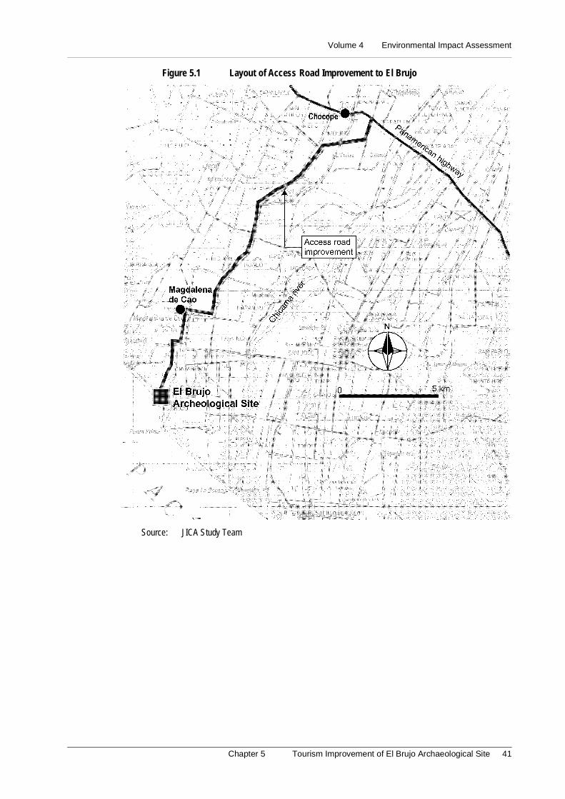
Volume 4 Environmental Impact Assessment
Chapter 5 Tourism Improvement of El Brujo Archaeological Site 41
Figure 5.1 Layout of Access Road Improvement to El Brujo
Source: JICA Study Team

Volume 4 Environmental Impact Assessment
Chapter 6 Beautification of Conservation of The Historic Center of Pacasmayo 43
6. Beatification and Conservation of the Historic Center of Pacasmayo
6.1 Introduction
The Environmental Impact Assessment of the Project “Beautification and Conservation
of the Historical Center of Pacasmayo” has as objective to identify, predict, interpret,communicate and determine the measures of mitigation of the environmental impacts that
the project could cause in the environment. Also, its objective is to propone the correctivemeasures more appropriate to avoid the occurrence of the same ones.
6.2 Legal and Institutional Framework
The Environmental Impact Assessment (EIA) of the Project has been carried out havinglike juridical framework the legal, institutional and technical norms that are effective in
the national, regional and sectional environment. They are direct related with theexecution of the Project in study. In this sense, it has been carried out taking in
consideration the Political Constitution of Peru, Law for the Development of the TouristActivity (Law Nº 26961), General Law of Protection of the Cultural Patrimony of the
Nation (Law N° 24047), Modification to the General Law of Protection of the CulturalPatrimony of the Nation (Law N° 26576), and Norma of Organization and Functions of
the National Institute of Culture (Supreme Decree N° 1-84-ED).
Equally, it has been considered the National Institute of Culture (INC), Ministry of
Industry, Tourism, Integration and International Commercial Business (MITINCI),National Institute of Civil Defense (INDECI), and the Transitory Council of Regional
Administration - CTAR La Libertad -
6.3 Description of the Project
The projected works are located in downtown of Pacasmayo in front of the sea, in themain entrance to the pier, the old rail station and the pier of Pacasmayo. Also, the City of
Pacasmayo is located among Trujillo, Chiclayo and Cajamarca, being its access, throughTrujillo, by the Pan-American Highway.
This Environmental Impact Assessment of the Project has as main works, the followingcomponents:
(1) Amplification of the Walk
Previously the local government has built a promenade in front of the coast, for what the
project outlines to extend this walk, so that it forms an orthogonal axis with the existentone and joints to the sea wall.
Master Plan Study on National Tourism Development in the Republic of Peru (Phase 2)
44
(2) Construction of tourist facilities
The project contemplates the reconstruction of the old existent railroad pier (wooden andsteel), located close to the sea wall and restored as Historical Museum and an internal
garden.
It is planned the construction of a restaurant and a cafeteria for the sale of food based on
seafoods, with the purpose of taking advantage of the local culinary art. The infrastructurewill be built of concrete, with a single floor, in a total area of 300 m2, with capacity for
150 seats, in the property of the ex-railway station. Equally, it is planned theimprovement of the current dike, conditioning it for the fishing, cruise of boats with a
walking promenade.
6.4 Basic Environmental Outline
6.4.1 Classification of Lands according to their Capacity of Major Use
The area of Pacasmayo presents lands with characteristic inappropriate for agriculture-husbandry and forest purposes (protection lands X); however, they have great economic
value for other uses such as the development of the tourist (areas of landscape andrecreational interest, etc.), industrial and commercial activity.
6.4.2 Geology
The area in study is part of the coastal coast, constituted by eroded processes that develop
formations of deposits through the geologic history. It is conformed by Alluvial Deposits,which cover big extensions, corresponding to the accumulation in form of a covering
along the coastal strip, formed by the fluvial streams.
6.4.3 Ecology
In accordance with the system of classification of zones of life of the Dr. L.R. Holdridge,it has been identified the zone of life dry desert - Premontano Tropical (dd –PT), typical
of the north region of Peru.
6.4.4 Flora and wild fauna
Since the Project in study is located ecologically in a desert and next to the sea, the flora
is composed by wild plants, mainly Ficus sp., and Schinus molle, and other ornamentalplants.
In other hand, the most significant animal species are birds, insects, spiders and scorpions.
6.4.5 Socioeconomic and cultural environment
The district of Pacasmayo, located in the province of the same name, has a population of23,705 inhabitants, concentrated in the urban area. The county Pacasmayo presents rates
of annual growth of 1.98%, while the district of the same name, has a rate lightly inferiorto 1.88%. Table 6.1 shows the estimated population for next ten years.
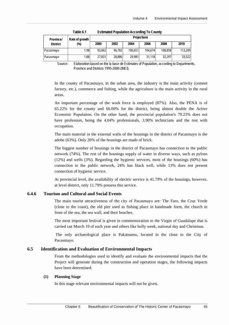
Volume 4 Environmental Impact Assessment
Chapter 6 Beautification of Conservation of The Historic Center of Pacasmayo 45
Table 6.1 Estimated Population According To CountyProjections
Province/District
Rate of growth(%) 2000 2002 2004 2006 2008 2010
Pacasmayo 1.98 93,062 96,782 100,651 104,674 108,858 113,209
Pacasmayo 1.88 27,831 28,886 29,981 31,118 32,297 33,522
Source: Elaboration based on the la base de Estimates of Population, according to Departments,Province and Districts 1995-2000 (INEI).
In the county of Pacasmayo, in the urban area, the industry is the main activity (cementfactory, etc.), commerce and fishing, while the agriculture is the main activity in the rural
areas.
An important percentage of the work force is employed (87%). Also, the PENA is of
65.22% for the county and 66.00% for the district, being almost double the ActiveEconomic Population. On the other hand, the provincial population's 79.23% does not
have profession, being the 4.04% professionals, 3.90% technicians and the rest withoccupation.
The main material in the external walls of the housings in the district of Pacasmayo is theadobe (63%). Only 20% of the housings are made of brick.
The biggest number of housings in the district of Pacasmayo has connection to the publicnetwork (74%). The rest of the housings supply of water in diverse ways, such as pylons
(12%) and wells (3%). Regarding the hygienic services, most of the housings (60%) hasconnection to the public network, 24% has black well, while 13% does not present
connection of hygienic service.
At provincial level, the availability of electric service is 41.79% of the housings, however,
at level district, only 11.79% possess this service.
6.4.6 Tourism and Cultural and Social Events
The main tourist attractiveness of the city of Pacasmayo are: The Faro, the Cruz Verde
(close to the coast), the old pier used as fishing place in handmade form, the church infront of the sea, the sea wall, and their beaches.
The most important festival is given in commemoration to the Virgin of Guadalupe that iscarried out March 19 of each year and others like holly week, national day and Christmas.
The only archaeological place is Pakatnamu, located in the close to the City ofPacasmayo.
6.5 Identification and Evaluation of Environmental Impacts
From the methodologies used to identify and evaluate the environmental impacts that the
Project will generate during the construction and operation stages, the following impactshave been determined:
(1) Planning Stage
In this stage relevant environmental impacts will not be given.
Master Plan Study on National Tourism Development in the Republic of Peru (Phase 2)
46
(2) Construction Stage
a. Slight increment of the employment
The presence of new workers in the area will increase the demand of products slightly,
mainly in restaurants, kiosks, etc. It will benefit the residents of the area who will offertheir products to the personnel of the works.
b. Slight reduction of the tourism
During the construction stage, it is foreseen that the visitors of the seawall will be bother
due to the dust increment and the noises that can be originated for the works. Equally, theaccess toward the inns located along the Pier will be difficult, reducing the tourism
slightly toward this place.
c. Disturbance in the neighborhood
During the Project works, the load vehicles will produce traffic increase because the
surroundings to the Historical Center have narrow streets, since it is a residential area(Urbanization Andrés Razuri). Also, there will emission of powder material and gasses.
The structures dedicated for the basic services (pipes of water, cables of light and/ortelephone) could be affected during the tasks of excavation and/or removal.
(3) Operation Stage
a. Increase of the tourist activity
Pacasmayo is the central point of the Corridor Trujillo–Chiclayo and nexus among both
cities so it is expected that the tourist activity increase, mainly close to the HistoricalCenter and the seawall.
b. Increase in the commercial dynamics of the City
The increase of the tourist flow will generate an increment in the commercial dynamics,mainly due to the revaluation of the properties located close to the Historical Center of
Pacasmayo. It will promote the private investment in the place.
6.6 Environmental Management Plan
6.6.1 Objective
The current Environmental Management Plan is developed to establish a group of
corrective measures that avoid and/or mitigate the negative environmental impacts andincrease the positive environmental impacts.
6.6.2 Program of Preventive and/or Corrective Measures
(1) Construction stage
It is recommended that the construction activities are carried out during the months of
smaller affluence of visitors (May and November). The top dates are New Year, HollyWeek and whole summer.
Once concluded the works, it should be proceeded to reorder the intervened area.
The works to carry out, as well as the hours of the traffic of heavy vehicles will be
coordinated with the Municipality. It is recommended that the traffic will be along F.A.Herrera Street because this is the only way that connects the city with the old Railroad
Volume 4 Environmental Impact Assessment
Chapter 6 Beautification of Conservation of The Historic Center of Pacasmayo 47
Station and the seawall. It is conformed for industrial locals minimizing the possible
nuisances to the urbanization Andrés Razuri.
It is recommended to make the necessary coordination among the Municipality,
companies responsible for the basic services and Contractor.
Informative bulletins will be distributed to communicate to the population about the
works to be made and the possible temporary interruption of such services (signaling thework areas). They will inform about the advantages of the Project, as well as the
nuisances that could cause during the construction stage.
(2) Operation stage
In this stage it is expected, fundamentally, an increment of the tourist flow in allPacasmayo, mainly in the Historical Center, increasing the commercial dynamics of the
place, as well as an improvement in the local urban landscape.
To avoid in crease of traffic volume in the Historical Center of Pacasmayo, it is
recommended to place an appropriate tourist signaling in the area. It will be coordinatedwith the corresponding Municipality about an available area for the parking when it is not
in operation the proposed internal parking.
6.6.3 Program of Environmental Education
The main activity contemplated in the Program of Environmental Education presently isthe organization of chats of environmental education – done by the Supervisor of the
Contractor Company - directed to the workers, to the local population regarding theprevention of accidents and of avoiding actions that can generate emissions or nuisances.
Besides, it is necessary the publication and diffusion of educational notes to thepopulation in general; and mainly, to those that inhabit bordering areas, explaining the
importance of the preservation environment.
6.6.4 Program of Contingencies
Identification of security areas for the protection of visitors and public in general in case
of possible events associated to seismic phenomena or of fires.
Coordination procedure with the local authorities of their actions according to their
function.
Coordination actions with the National Institute of Civil Defense (INDECI).
All the workers will be informed about the Program of Contingency and will receive thenecessary instructions.
It should be implemented a medical module for emergency cases and could be inside theCenter of Health (located to backs of the old Railroad Station).
6.6.5 Program of Investments
It has been indicated the measures of mitigation and/or environmental control that avoid
and/or reduce the negative effects on the environment and vice versa. The necessaryinvestment for the implementation of the Environmental Management Plan is shown in
the following Table 6.2.
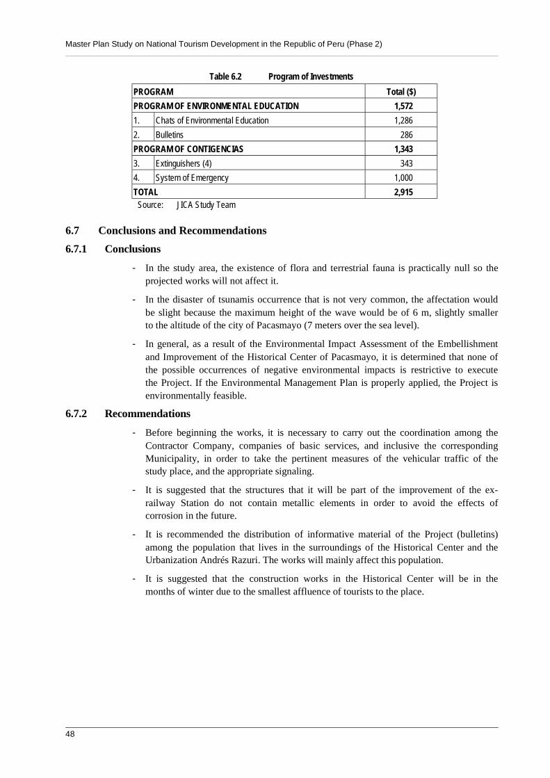
Master Plan Study on National Tourism Development in the Republic of Peru (Phase 2)
48
Table 6.2 Program of Investments
PROGRAM Total ($)
PROGRAM OF ENVIRONMENTAL EDUCATION 1,572
1. Chats of Environmental Education 1,286
2. Bulletins 286
PROGRAM OF CONTIGENCIAS 1,343
3. Extinguishers (4) 343
4. System of Emergency 1,000
TOTAL 2,915Source: JICA Study Team
6.7 Conclusions and Recommendations
6.7.1 Conclusions
- In the study area, the existence of flora and terrestrial fauna is practically null so theprojected works will not affect it.
- In the disaster of tsunamis occurrence that is not very common, the affectation wouldbe slight because the maximum height of the wave would be of 6 m, slightly smallerto the altitude of the city of Pacasmayo (7 meters over the sea level).
- In general, as a result of the Environmental Impact Assessment of the Embellishmentand Improvement of the Historical Center of Pacasmayo, it is determined that none ofthe possible occurrences of negative environmental impacts is restrictive to executethe Project. If the Environmental Management Plan is properly applied, the Project isenvironmentally feasible.
6.7.2 Recommendations
- Before beginning the works, it is necessary to carry out the coordination among theContractor Company, companies of basic services, and inclusive the correspondingMunicipality, in order to take the pertinent measures of the vehicular traffic of thestudy place, and the appropriate signaling.
- It is suggested that the structures that it will be part of the improvement of the ex-railway Station do not contain metallic elements in order to avoid the effects ofcorrosion in the future.
- It is recommended the distribution of informative material of the Project (bulletins)among the population that lives in the surroundings of the Historical Center and theUrbanization Andrés Razuri. The works will mainly affect this population.
- It is suggested that the construction works in the Historical Center will be in themonths of winter due to the smallest affluence of tourists to the place.
Volume 4 Environmental Impact Assessment
Chapter 7 Development of The Sipan Achaeological Park / Circuit Road Improvement 49
7. Development of the Sipán Archaeological Park/ Circuit RoadImprovement: Ferreñafe - Huaca Rajada – Cayalti
7.1 Introduction
Peru is owner of a nonpareil cultural and natural patrimony, which are exposed to the
eyes of the world like tourist attractiveness. Such archaeological, historical and naturalenvironments require works of improvement vial and of tourist infrastructure in order to
give comfort to the tourists. Also, it should be looked over the balance and harmoniccoexistence of the elements that comprise the ecosystems because some natural or
artificial strange agent can alter it irreversibly, originating environmental impacts.
In this sense, the present Study is an analysis process in which the characteristics of the
environment are confronted with the civil and vial works of the project “Development ofthe Sipán Archaeological Site” to estimate the possible environmental impacts.
7.2 Legal and Institutional Framework
The present Study of Environmental Impact will be developed having like juridical
framework the effective legal and institutional norms referred to the conservation andenvironmental protection and cultural patrimony of the Nation. Its main objectives are the
to promote and regulate the sustainable use of the natural resources.
The Legal framework is given by The Political Constitution of Peru (1993), Norma of
Organization and Functions of the National Institute of Culture (Supreme Decree Nº1-84-ED), General Law of Protection to the Cultural Patrimony of the Nation (Law Nº24047),
Law Nº26690 modifies article 228º of the Penal Code referred to sanction by damages tothe Prehispanic Cultural Patrimony, Law 26282 declares of national interest the
conservation, protection and promotion of the Archaeological Patrimony Sipán and theOrganic Law of Municipalities, among others.
The Institutional framework is conformed by: the Presidency of the Council of Ministers,the National Council of the Environment (CONAM), Ministry of Education - National
Institute of Culture (INC), Ministry of Industry, Tourism, Integration and InternationalCommercial Business (MITINCI), National Institute of Natural Resources (INRENA),
and the Transitory Council of Regional Administration - CTAR Lambayeque.
7.3 Description of the Project
The project comprises the construction of a highway that links the towns of Ferreñafewith Cayaltí, forming a trip route that involves the main archaeological sites of the city of
Chiclayo. Equally, the construction of infrastructures is carried out to offer comfort to thetourists in the Sipan Archaeological Complex. It includes the construction of Site
Museum.
The main works are the following: Improvement of the circuit road Ferreñafe - Pucalá,
Construction of the Highway Pucalá - Sipan, Improvement of the Pucalá–Rajada Huacaroad, Improvement of the Huaca Rajada - Cayaltí road and Construction of Sipán Site
Museum.

Master Plan Study on National Tourism Development in the Republic of Peru (Phase 2)
50
7.4 Basic Environmental Outline
7.4.1 Climate
For the analysis of the climate of the study area in study, four meteorological elementshas been considered: Pluvial Precipitation (30 mm annual average and 900 mm January
and April during the Niño phenomenon), Temperature (annual average of 22ºC),Evaporation (annual average more than 114 mm.) and relative humidity (annual average
more than 58%). According to these parameters, the climate varies according to thelocation of the altitude soils, being able to establish sectors with defined and
characteristic climatic types.
The climatic types in the study area: Arid and Warm Climate (AND d TO ') and the Dry
Climate and Warm Semi (D r B’4)
7.4.2 Hydrology
The knowledge of the behavior of the hydrological variables allows locating and
determining the environmental impacts that will happen by effect of theconstruction/improvement and operation of the circuit road Ferreñafe–Cayaltí.
The improvement/construction of the proposed tracts are developed among big extensionsof canebrakes, irrigated with the waters of the rivers Taymi, Lambayeque and Reque, by
means of a system of channels.
7.4.3 Geology
Since the Geologic point of view, the evolution of the area has given place to verydiffered units as fluvial valleys, foot of mount and hills. According to the Geologic Map
of the Peru, in this area there are of origin and of diverse antiquity formations, being theoldest ones, the Mesozoic of the Cretacic and the most recent ones that correspond to the
Quaternary in the Cenozoic.
7.4.4 Soils
Physiographically, the study area presents morphologic features that are as a result of along evolution originated by tectonic and eroded factors that have modeled the landscape
until its current state. Basically in this valley (02) Big Landscapes have been identified:Alluvial and Hilly that are very defined for the forms and characteristic of the relief,
lithology and formation processes.
The soils identified according to their origin materials in the area are Derived Soils of
Alluvial and Residual Materials.
03 Consociaciones and 01 Miscellany area constitute the cartographic units determined in
the study area: Reque Soil (Torrifluvents), Concordia Soil (Torrifluvents), Cayaltí Soil(Torripsamments) and miscellaneous lands.
According to the Regulation of Classification of Lands of the Ministry of Agriculture ofthe Peru Lands Able for Cultivation in clean (TO) and lands of Protection (X) are present
in the study area in Capacity of Major Use.
Volume 4 Environmental Impact Assessment
Chapter 7 Development of The Sipan Achaeological Park / Circuit Road Improvement 51
7.4.5 Ecology
In accordance with the system of classification of zones of life of the Dr. L.R. Holdridge,
there are two (02) zones of life: superarid–Premontano Tropical desert (ds – PT) anddesert perarid Premontano Tropical (dp- PT). See Ecological Map.
7.4.6 Wild Flora and Fauna
The representative flora is of the riverside mount. There are Gynerium sagittatum,
Phragmites australis, Cortaderia jubata, Baccharis lanceolata, Acacia macracantha,Prosopis pallida, Salix chilensis, Sapindus saponaria, Tessaria integrifolia, among others.
There are the following animals: Pseudalopex sechurae, Conepatus semistriatus, Sciurusstramineus, Phyllotis gerbillus, Columbine cruziana, Mimus longicandatus, Icterus
graceannae, Burhinus superciliaris, among others.
The acuatic animals are a few species like fishes “bagre”, “cascaje” and “life”.
7.4.7 Socio-Economic and Cultural environment
The influence area comprises the districts of Chiclayo, Zaña, Picsi (in the department ofChiclayo), and Ferreñafe, in the department of the same name. The total population of the
influence area was of 350,192 inhabitants, according to Population and Housing Censusof 1993. The counties of Chiclayo and Ferreñafe present rates of growth of 2.36 and 0.99,
respectively, being Chiclayo, the district of more population growth (annual 3.65%).
The main activity of the area is the agriculture dedicated to the cultivation of rice and
cane. Most of their production is dedicated to the market of Metropolitan Lima. Most ofthe work force concentrates on the county of Chiclayo, with 194,393 people, whose
11.94% (23,220) is unemployed.
Most of the housings are made of adobe. The district of Chiclayo presents housings made
of brick, block or cement (51%). In all the districts of the influence area, most of housingshave connection to the public net, with percentages major to 50%. The rest of the
housings is supplied of water in diverse ways (wells and pylons).
Regarding the hygienic services, most of the housings in the county of Chiclayo have
connection to the public net. The district of Zaña presents a high percentage of housingslack of connected hygienic services. The availability of electric service reaches 86% at
level of influence area (on the average).
The Pan-American Highway is the main one via of transport and communication that
crosses Chiclayo and joints the department of Lambayeque with La Libertad and Piura.There are many internal roads that joint Chiclayo with the rest of towns.
The department of Lambayeque, apart from the attractive of their landscape and of theirprevailing tranquility, possesses several cultural events and festival (mainly religious) that
constitute focuses of tourist attraction. There are also, numerous areas where it is possibleto find vestiges of the pre – Hispanic cultures that settled in the place, such as the
Cultures of Moche, Chimu, Mochica, Lambayeque and Sicán.
7.5 Identification and Evaluation of Environmental Impacts
It has been used matrix type Leopold, cause–effect diagrams and field notes to identifythe different environmental impacts finding the causes and altered environmental factors.
Master Plan Study on National Tourism Development in the Republic of Peru (Phase 2)
52
Under the signal considerations, it is presented the environmental impacts, during the
processes of planning, construction and of operation of the Project.
(1) Planning stage
The initial project could imply the acquisition of bordering terrenes. These can be madeexpensive, being to delay the beginning of the project.
(2) Construction stage
- Improvement in the commercial dynamics of the area. It will increase the commercialdynamics from the adjacent towns to the road, mainly in Huaca Rajada, Sipán, andCayalti.
- Affectation to the economic revenues of the merchants located in the outskirts of theComplex.
- Alteration of the scenic landscape. The aesthetics that presents the ArchaeologicalComplex of Sipan will change due to the modules that will have to provisionally beinstalled based on rustic materials.
- Light decrease of the tourist flow, during the construction stage. It is foreseen that thetourist will be bored by the dust and noise increment originated by the works.
- Possible contamination of the soils and courses of water, the lack of information orenvironmental conscience could make the operatives to wash the vehicles, machinesand/or equipment (tablespoons, shovels, bulldozers, load trucks, etc.) in the riversReque and/or Lambayeque or in other courses of water.
- Possible conflicts for the use of the earth (incorporation of busy lands to achieve theestablished width for the construction/improvement of the road).
- Possible affectation to the existent infrastructures, watering infrastructures (channels,gutters, etc.).
(3) Operation stage
- Socioeconomic develop of the area, the increase of the tourist flow not only willbenefit to the archaeological area of Sipán, but also to the city of Chiclayo.
- Revaluation of the Cultural Patrimony, the infrastructure and facilities improvementwill stand out the attractiveness of the Sipán Archaeological Site.
- Possible contamination of soils and sources of water, the major presence of touristswill generate an increase of solid residuals. Besides the effluents of the septic wells,flowing to the Reque river could be contaminated by nocive elements.
- Structural risk for presence of natural phenomena, it is foreseen that the proposedfacilities can be flooded.
- Conflict for the use of the earth, other local of selling products will suddenly appear.
7.6 Environmental Management Plan
The Environmental Management Plan for the Archaeological Center of Sipan is an
instrument of environmental administration. Here there are the environmental measuresthat avoid and/or minimize the effects that the project works produce on the environment
and vice verse.

Volume 4 Environmental Impact Assessment
Chapter 7 Development of The Sipan Achaeological Park / Circuit Road Improvement 53
7.6.1 Program of Preventive and Corrective Measures
(1) Planning stage
Previous to the beginning of the works, the entity responsible for the Project will sustainmeetings with the farmers and proprietors from the adjacent properties to the works.
(2) Construction stage
- Alteration of the scenic landscape, unavoidable during the constructive stage buttemporary because once concluded the works, the intervened area will be remodeled.
- Conflict with the owners of the possible affected properties, coordination andacquisition.
- Affectation to the economic revenues of the merchants located in the outskirts of theComplex, the merchants' temporary relocation.
- Possible contamination of the soils and courses of water, design of a system ofevacuation and/or treatment of sewerage coming from the bathrooms and otherfacilities.
- Possible affectation to the existent infrastructures, the construction of works of art isrecommended in the crossedline, such as sewers, gutters, etc.
- Risk of accidents, the workers and construction operatives have the correspondingdevices of security, such as work clothes, helmet, boots and those that can require forspecific reasons of their work and to place informative warnings.
(3) Operation Stage
- Improves in the population's living standards.
- Overflow of watering channels, to make the cleaning and periodic maintenance of theexistent perimetric channels.
- Possible risk of invasion of bordering areas, to coordinate with the Local Government,farmers and residents with the purpose of avoiding any type of invasion made by ofother residents.
7.6.2 Program of Environmental Education
- This program is guided to create environmental conscience to the personnel of workof the Contractor Company and to establish the necessary actions in order to preventand/or to avoid possible damages to the components of the environment.
- To prevent the adverse effects that could be given on the structures of the Project, dueto a possible management or inadequate use of the natural resources.
- During the construction stage, the Contractor Company will organize chats ofenvironmental education directed to all its workers and the local population.
- The Contractor Company will establish norms prohibiting the hunt activity, theconsumption of alcoholic drinks during the works, the illicit appropriation of goods,among others.
7.6.3 Program of Contingencies
- This Program has the purpose of establishing the measures and/or actions that shouldbe followed in case of natural disasters and the provoked by the man, counteractingthe damages that can be originated.

Master Plan Study on National Tourism Development in the Republic of Peru (Phase 2)
54
- To execute the control and rescue actions during the occurrence of labor accidents andother emergencies of health, during the construction of the Archaeological Center ofSipan and improvement of the tracts of the circuit road Ferreñafe - Cayaltí.
- The Company Responsible for the construction will establish a Unit of Contingency,being adapted to the minimum requirements, in function of the activity and of thegeophysical, climatic potential risks, of health, and catastrophes of the area.
- It will be settled down the communication procedures between the personnel of theemergency place and the Unit of Contingency, where the Supervisor of the work willbe responsible for informing the Coordinator of the company immediately, anycontingency that can be presented during the construction stage.
- Coordination actions will be carried out with the National Institute of Civil Defense(INDECI).
- All the workers will be informed of the Program of Contingency and will receive thenecessary instructions in this respect.
- To program the test of the teams in order to they can lend services in an opportuneway in an emergency.
- Monitoring Program Allways the fluents to the Reque river must be in the limits ofthe General Law of water class III, for that reason is recomended realize trimonthlymonitoring during the first year of el treatment of the water fluents.
7.6.4 Program of Investments
The measures of mitigation and/or environmental control have been settled down in orderto reduce the negative effects on the environment, as well as, those that the environment
produces on the project. The necessary investment for the implementation of theEnvironmental Management Plan ascends to the amount of US$15,463 dollars.
7.7 Conclusions and Recommendations
7.7.1 Conclusions
- The Archaeological Complex of Sipan as cultural patrimony of the Nation grants it anadditional attractiveness that should be exploited in order to attract tourists that enjoythe archaeological attractiveness and the contact with the nature.
- The present Project will contribute to the development of the department ofLambayeque, making it as an excellent tourist center.
- In general, as a result of the EIA of the tourist improvement of the ArchaeologicalComplex of Sipan and of the improvement/construction of the circuit roadFerreñafe–Cayaltí, it is determined that none of the possible occurrences of negativeenvironmental impacts are important restrictions to execute the Project. If theEnvironmental Management Plan is properly applied, the Project is environmentallyfeasible.
7.7.2 Recommendations
- There is the possibility to find pre-Spanish vestiges under the area where the vehicularparking, In Site Museum and other will be built. The necessary studies in this areashould be carried out.
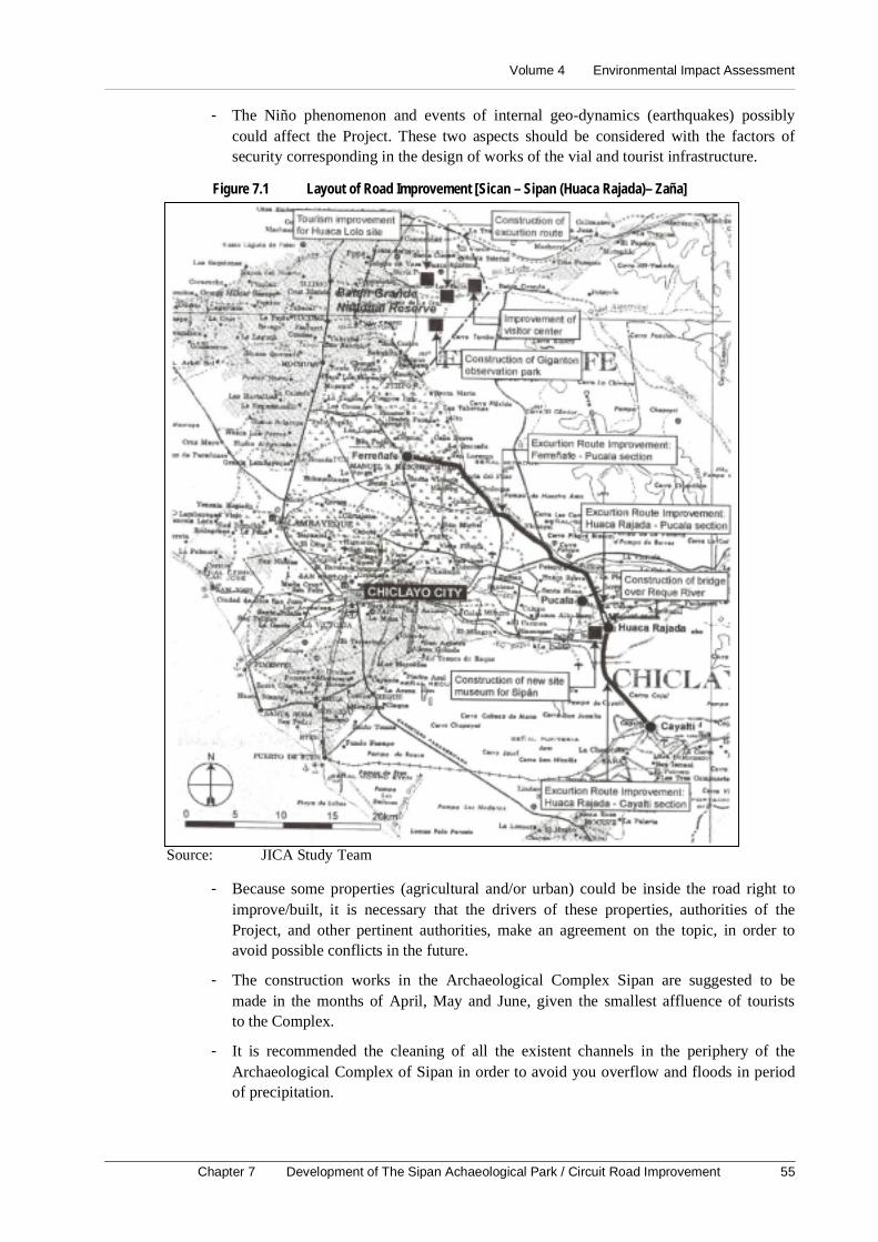
Volume 4 Environmental Impact Assessment
Chapter 7 Development of The Sipan Achaeological Park / Circuit Road Improvement 55
- The Niño phenomenon and events of internal geo-dynamics (earthquakes) possiblycould affect the Project. These two aspects should be considered with the factors ofsecurity corresponding in the design of works of the vial and tourist infrastructure.
Figure 7.1 Layout of Road Improvement [Sican – Sipan (Huaca Rajada)– Zaña]
Source: JICA Study Team
- Because some properties (agricultural and/or urban) could be inside the road right toimprove/built, it is necessary that the drivers of these properties, authorities of theProject, and other pertinent authorities, make an agreement on the topic, in order toavoid possible conflicts in the future.
- The construction works in the Archaeological Complex Sipan are suggested to bemade in the months of April, May and June, given the smallest affluence of touriststo the Complex.
- It is recommended the cleaning of all the existent channels in the periphery of theArchaeological Complex of Sipan in order to avoid you overflow and floods in periodof precipitation.

Master Plan Study on National Tourism Development in the Republic of Peru (Phase 2)
56
- The lands located inside the Archaeological Complex of Sipan, dedicated to theconstruction of the museum and parking area are able to be flood in season of rainsand/or occurrence of the Niño phenomenon. In their substitution, and given thetopographical conditions, the proposed museum could be located in the area definedby the landmarks 17 and 18 of the Area of the Reserve of the ArchaeologicalComplex of Sipan, to the north-east of the Tomb of the Mr. of Sipan. Also, the newplace for the parking area could be located in the back of the kiosks located in front ofthe Tourist Inn, to the north of the Tomb of the Mr. of Sipan.
Volume 4 Environmental Impact Assessment
Chapter 8 Tourism Improvement of Batan Grande Reserve Zone 57
8. Tourism Improvement of Batan Grande Reserve Zone
8.1 IntroductionThe Reserve Zone of Batan Grande (Bosque de Poma) has an extension of 13,400 ha. It is
a unique forest where algarrobo, guarangos, sapotes, faique and vichayos bloom. Also
there are animal species.
Therefore, the protection and conservation of this natural ecosystem is one of the most
important reasons to have control and surveillance of phenomena that can cause
deterioration of the landscape. Evidently, the Improvement of the Tourist Infrastructure
will bring environmental modifications that should be foreseen and mitigated, with the
purpose of achieving the sustainable use of the Reserve Zone and the environmental
feasibility of the project.
The Study of Environmental Impact will allow to identify, to predict, to evaluate, and tointerpret the environmental impacts generated by the project turistic Improvement of the
Reserve Zone of Batan Grande. It will establish the measures for its prevention, controland/or mitigation in its stages of planning, construction and operation.
8.2 Legal and Institutional Framework
The necessity to achieve the sustainable development of the country, with an appropriatemanagement of the environment and a tourist development, bears it is necessary to
establish juridical instruments. These promote the private investment in all the sectors ofthe economy (Tourism) and settles down the conservation, protection and preservation of
the environment and of the natural resources.
In this sense, the legal framework is given by: The Political Constitution of Peru (1993),
Supreme Decree Nº031–91-ED of October 16 of 199, Law Framework the PrivateInvestment Growth (D. Leg. Nº757), Law for the Development of the Tourist
Activity–Law Nº26961, General Law of Protection to the Cultural Patrimony of theNation (Law Nº24047), Law of Evaluation of Environmental Impact for Works and
Activities (Law Nº26786), among others.
The Institutional Framework is given by: the Presidency of the Council of Ministers
(National Council of the Environment - CONAM), Ministry of Agriculture (withINRENA), Ministry of Industry, Tourism, Integration and International Commercial
Business (MITINCI), Ministry of Education (National Institute of Culture - INC), theMunicipality of Pitipo, among others.
8.3 Description of the Project
The works projected for the Touristic Improvement of the Reserve Zone of Batan Grande
they are located in 13,400 ha belonging to the Reserve, district of Pitipo, county
Ferreñafe and department of Lambayeque. The access to the study area is carried out
through the route: Chiclayo–Ferreñafe–Pitipo–Batan Grande (36 Km. aprox.) and ofChiclayo–Mochumi–Tucume–Illimo.
The project contemplates the execution of the following civil works:
Master Plan Study on National Tourism Development in the Republic of Peru (Phase 2)
58
- Improvement of the roads of vehicular, equestrian trip and pedestrian.
- Construction of a pedestrian bridges on the Rio La Leche.
- Re-excavation of the Huaca Loro (King thumb) for the exhibition in site.
- Construction of an access road up to the summit of the cerro Gigantón andendowment of observation means.
- Improvement of the existent center of the Reserve Zone for the visitor.
- Construction of parking areas and hygienic services.
8.4 Basic Environmental Outline
8.4.1 Climate
The cold current of Humbolt and the Equatorial upstream influences the climatic factor inthe Reserve Zone of Batan Grande. Those originate a climatic imbalance, causing
torrential rains that increment the flow of the rivers. It is presented in sporadic form andwith intervals of time of 8–10 years.
Four meteorological elements are considered for the analysis of the climate in the area instudy. Pluvial precipitation (annual total average of 45 mm and 900 mm in the Niño
phenomenon), temperature (annual average media of 22ºC), evaporation (annual averagemore than 114 mm.), and the relative humidity (85% of relative humidity) are the
elements.
The climatic types identified in the area in study, used in the Dr. C.W. Thonrthwaite
system are Arid and Warm climate (AND d TO’) and Dry Climate and Warm Semi (D rB ‘4).
8.4.2 HydrologyThe Rio La Leche is the first source of water that has great influence in the Reserve Zone.
It allows irrigating agricultural areas, by means of a diversity of channels like Túcume
and Illimo. Other important flow of water is the Inca Taymi Channel that is limit of The
Reserve Zone of Batan Grande.
8.4.3 Geology
According to the Geologic Map of the Peru, in the area there are formations of origin ofthe Jurassic Mesozoic and of the Cretacic and the most recent one to the Quaternary one
in the Cenozoic. The Mesozoic inferior Jurassic is composed of volcanic rocks insertedwith impure limestone. The Mesozoic of the Cretacic represented by the group formed
Goyllarisquizga is formed of volcanic faces–sedimentary, extending in a large part of thecoast of Chiclayo.
In the Cenozoic the formations of the Quaternary where are distinguished Alluvial, fluvialand eolic deposits, are along the whole plain of the coast. Since the tectonic point of view,
the region presents evidences of having suffered a strong basement tectonism that hasprobably produced regional metamorphism during the Pre-cambric.
8.4.4 Soils
The soils identified according to their origin materials are: Derived Soils of Alluvial
Materials (clays, slimes, sands and gravels of round stones transported by the fluvial
Volume 4 Environmental Impact Assessment
Chapter 8 Tourism Improvement of Batan Grande Reserve Zone 59
action), Derived Soils of Residual Materials (of origin in situ, developed by
meteorization).
The cartographic units are constituted by 03 Consociaciones (soil the La Leche, Soledad
and Batán) and 01 area miscellaneous (miscellaneous lands). In each one of them it isdescribed and pointed out their geographical distribution.
Physiographically, the study area presents morphologic features originated by tectonicand eroded factors that have modeled the landscape until its current state. The following
units are identified Great Landscape Alluvial and Great Landscape Hilly.
According to the regulation of Classification of Lands of the Ministry of Agriculture of
Peru, the study area presents lands able for the Cultivation in clean (A) and Lands ofProtection (X) in terms of Capacity of Major Use.
8.4.5 Ecology
According to the system of classification of zones of life of the Dr. L.R. Holdridge, (04)
zones of life have been identified in the study area: superarid – Tropical desert (ds – T),superarid – Premontano Tropical desert (ds – PT), desert perarid Premontano Tropical
(dp- PT) and Tropical desert thicket (md – T).
8.4.6 Wild Flora and Fauna
The study project is located ecologically in a forest coastal environment. The presence ofhuman being manifested in this low part of the basin of Rio La Leche from pre-Spanish
periods has played a preponderant paper in the establishment of the flora and fauna.
Flora. Prosopis pallida, Acacia macracantha, Capparis scabrida, Caessalpina pay pay,
Parkinsonia aculeata, Schinus molle, Vellasia glabra, among others constitute the flora.
Fauna. The Bosque de of Poma is a refuge area for insects, spiders, mosquito and
scorpions. There are animals like small lizards of the gender Tropidurus, birds likeCalllopistes flavipunctatus, Parabuteo unicinetus, and Crotophaga sulcirostris. The coastal
fox Dusicyun sechurae is the only big mammal that can be observed with certainregularity.
8.4.7 Socio-Economic and Cultural Environment
The Total population in the study area is 52,078 inhabitants. 65.75% is in the urban areaand the remaining 34.25% in the rural area. Chiclayo is the department that presents the
biggest population growth (by 2010 of 965,448 inhabitants), followed by Lambayeque.
The Economically Active Population is mainly employed. The PENA at general level, is
almost double the PEA.
The Agriculture is the activity that occupies more than 80% of the surface and represents
the biggest percentage of the PEA. The animal husbandry is developed in extensive form,being observed the presence of goat, bovine and sheep livestock in towns.
62.22% of housings is supplied of water by public network while 16.42% obtains it bypublic's pylons. Wells, river canal or spring, etc supply the rest of the housings. The
situation is similar at district level.
Master Plan Study on National Tourism Development in the Republic of Peru (Phase 2)
60
The major availability of electric service at provincial level is in the county of Chiclayo
(80.82%) and at district level, Ferreñafe with 80.52% of the total of housings. The districtthat has smaller availability is Pitipo with 28,39% of the total of the housings.
Most of the population does not have a profession. Chiclayo has the highest percentage inprofessional people (5.21% of the total). People with some occupation represents 11.81%.
Ferreñafe has more professional people (5.42%), while the district of Pitipo reaches1.20% of 11,826 inhabitants.
Lambayeque is the region that conserves the history and the literature of manners of thePeriod Pre Inca. It has great tourist attractiveness due to its natural beauty, historical
remains, and coastal location, among others.
There are several archaeological remains in the study area. The main ones are mainly in
the districts of Pitipo, Tucume, and Zaña. They are The Pre Inca Sanctuary of Sipan, TheMurals of Ucupe, archaeological Area of Sican and the valley of the Pyramids of Tucume.
The Tourist infrastructure in the Department of Lambayeque has 137 establishments ofLodging. To district level Ferreñafe has 1 Hotel and 6 restaurants.
The Tourist Movement in the Region comprises 28,458 national tourists and 998 foreigntourists. For the National Reserve Zone of Batan Grande, the tourist movement comprises
512 visitors.
8.5 Identification and Evaluation of Environmental Impacts
For the identification of the environmental impacts, the Leopold Matrix, the cause-effectdiagram and field notes were used. The following impacts were determined:
(1) Planning Stage
Possible alteration of the natural ecosystem, the location of the tourist infrastructure could
alter the ecosystems of the forests, affect some fauna and flora species, and consequentlyof the Reserve Zone.
(2) Construction Stage
- The movement of lands of the quarries, the cuts and fillers, among others, determinesalteration of the landscape, the alteration that can take place in the forest andarchaeological areas.
- Dispersion of the fauna, due to the construction of access roads, the noise, etc., it willpropitiate a temporary dispersion of animal species from their natural habitats. Othersfactors that originated dispersion are hunt and deforestation.
- Loss of vegetable cover and of the floor. The works that will be executed will affectthe soil and vegetable covering.
- Employment generation. The construction works will demand the recruiting of nonqualified manpower.
Volume 4 Environmental Impact Assessment
Chapter 8 Tourism Improvement of Batan Grande Reserve Zone 61
(3) Operation Stage
- Revaluation and improvement of the Reserve Zone of Batan Grande: Bosque de Pomaand Archaeological Complex of Sicán. The project will facilitate the access withmajor dynamism in the area (tourists' affluence, commercial, economic, culturaldevelopment and of investigation).
- Increase of the tourist activity. The tourist activity will be increased, due to the majornational presence of tourists and foreigners.
- Recovery of the Historic/cultural and Natural Patrimony. The historical/ culturalpatrimony will be recovered making a rational use of this area of great value.
- Conflicts of Use of the soil of the Reserve Zone. The internal areas or close to the areaof more affluence are subject to possible invasions for the commercial dynamics thatcan be generated.
8.6 Environmental Management Plan
8.6.1 Program of Preventive and/or Corrective Measures
Environmental considerations to mitigate and/or to avoid the identified environmentalimpacts
(1) Planning Stage
To determine good locations for the pedestrian bridge on Rio La Leche and the access
road toward the watchtower. They should be in places where human activities have been
developed in order to avoid the destruction of the natural landscape.
(2) Construction Stage
- Alteration of the landscape. To define routes of entrance of the materials and thenecessary quantity to be used with the purpose to not accumulate building remains.The areas for construction will be wet, clear, taking off weeds and cleaning. Thefragile areas to the deterioration and/or alteration will be pointed out. The quarryshould be located in the south flank of the cerro Salinas and Gigantón.
- Dispersion of the fauna. The necessary quantity of workers should be use in order toavoid the temporary dispersion of the fauna. It is forbidden the hunt and fishing ofspecies. To coordinate the construction works with the authorities responsible for theReservation Zone.
- Elimination of the Vegetation. It should be avoided the destruction of trees. If therewere material of the cleaning and pruning of trees, they could be used by the residents.
- Risk of Accidents. The contractor will be responsible of the labor accidents. Thereshould be medical personal in case of accidents.
- Lost of the Productive Capacity of the Land. To destroy the trees as less as possibleand maintain the external form of the trees (covering, foliage, etc.) in the project area.
- Employment generation. The manpower should be qualified with experience insimilar works with the purpose of improving the quality of the project work.
(3) Operation Stage
- Increase of the Tourist activity in the Reserve Zone. The tourist infrastructures willbe the only access forms to the Reserve Zone.
Master Plan Study on National Tourism Development in the Republic of Peru (Phase 2)
62
- Favorable to the scientific investigation and the tourist development. A Programof Environmental Education and promotion of the Eco-tourism will be included.
- Conflict of use of Soils of the Reserve Zone and of bordering areas. To make apopulation census of the residents who have major influence of the area of the project.They will be the direct beneficiaries.
- Destruction of trees. To intensify the surveillance on the part of the competentauthorities: INRENA, Ecological Police and/or the Police of Highways.
8.6.2 Program of Environmental Monitoring
To check that the proposed mitigation measures are carried out, providing immediatewarnings about the environmental problems that are presented and to protect and/or to
avoid problems of contamination, destruction of trees, hunts.
- To carry out by means of samplings and periodic verifications the execution of thepreventive measures and corrective proposals.
- It should be controlled and/or monitor the quantity of people that visit the facilities ofthe Reserve Zone of Batan Grande.
8.6.3 Program of training, environmental Education and Promotion of the Ecotourism
- To design training measures and environmental education to protect the NaturalResources and outlines to foment the Eco-tourism. These measures are guided toavoid the deterioration of the natural resources and archaeological remains. There willbe posters of information for difussion of the care and importance of the resources. Itwill be supplemented with training activities to the tourists and residents and workpersonnel.
8.6.4 Program of Contingency
The Program of Contingency will allow confronting the emergency situations related with
the environmental risks and accidents that can take place during the construction andoperation stages of the Reserve Zone of Batan Grande.
The potential risk of the Bosque de Poma is referred to the occurrence of fires caused bythe residents or the visitors of the area.
It is recommended that the personnel in charge of the Center of Interpretation of theReserve Zone establish a Committee of Contingencies against risk of accidents and
eventualities at the beginning of the construction activities. It should be active during theoperation stage.
- It is indispensable that the Committee of Contingency has the following elements:
- Materials and appropriate inputs available for each case (Module of first aids).
8.6.5 Equipment against installed fires.
There is the possibility of occurrence of fires either for inflammable liquids (fuels,paintings, plastic and wooden material, etc) or for the material of construction of the
facilities. There will be systems and equipment for the control of fires, with preparedpersonnel for these eventualities.
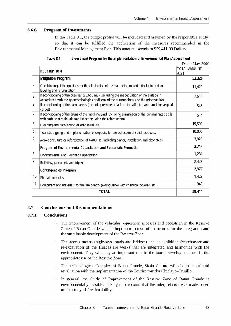
Volume 4 Environmental Impact Assessment
Chapter 8 Tourism Improvement of Batan Grande Reserve Zone 63
8.6.6 Program of Investments
In the Table 8.1, the budget profits will be included and assumed by the responsible entity,
so that it can be fulfilled the application of the measures recommended in theEnvironmental Management Plan. This amount ascends to $59,411.00 Dollars.
Table 8.1 Investment Program for the Implementation of Environmental Plan AssessmentDate : May 2000
DESCRIPTIONTOTAL AMOUNT(US$)
Mitigation Program 53,320
1. Conditioning of the qualities for the elimination of the exceeding material (including minorleveling and reforestation)
11,420
2. Reconditioning of the quarries (26,650 m3). Including the readecuation of the surface inaccordance with the geomorphologic conditions of the surroundings and the reforestation.
7,614
3. Reconditioning of the camp areas (including remote area from the affected area and the vegetalcarpet)
343
4. Reconditioning of the areas of the machine yard. Including elimination of the contaminated soilswith carburant residuals and lubricants, also the reforestation.
514
5. Cleaning and recollection of solid residuals 19,500
6. Touristic signing and implementation of deposits for the collection of solid residuals. 10,000
7. Agro-agriculture or reforestation of 4,400 Ha (including plants, installation and abonated) 3,929
Program of Environmental Capacitation and Ecoturistic Promotion 3,714
8. Environmental and Touristic Capacitation 1,286
9. Bulletins, pamphlets and triptych 2,429
Contingencies Program 2,377
10. First aid modules 1,429
11. Equipment and materials for the fire control (extinguisher with chemical powder, etc.) 949
TOTAL 59,411
8.7 Conclusions and Recommendations
8.7.1 Conclusions
- The improvement of the vehicular, equestrian accesses and pedestrian in the ReserveZone of Batan Grande will be important tourist infrastructures for the integration andthe sustainable development of the Reserve Zone.
- The access means (highways, roads and bridges) and of exhibition (watchtower andre-excavation of the Huaca) are works that are integrated and harmonize with theenvironment. They will play an important role in the tourist development and in theappropriate use of the Reserve Zone.
- The archaeological Complex of Batan Grande, Sicán Culture will obtain its culturalrevaluation with the implementation of the Tourist corridor Chiclayo–Trujillo.
- In general, the Study of Improvement of the Reserve Zone of Batan Grande isenvironmentally feasible. Taking into account that the interpretation was made basedon the study of Pre–feasibility.
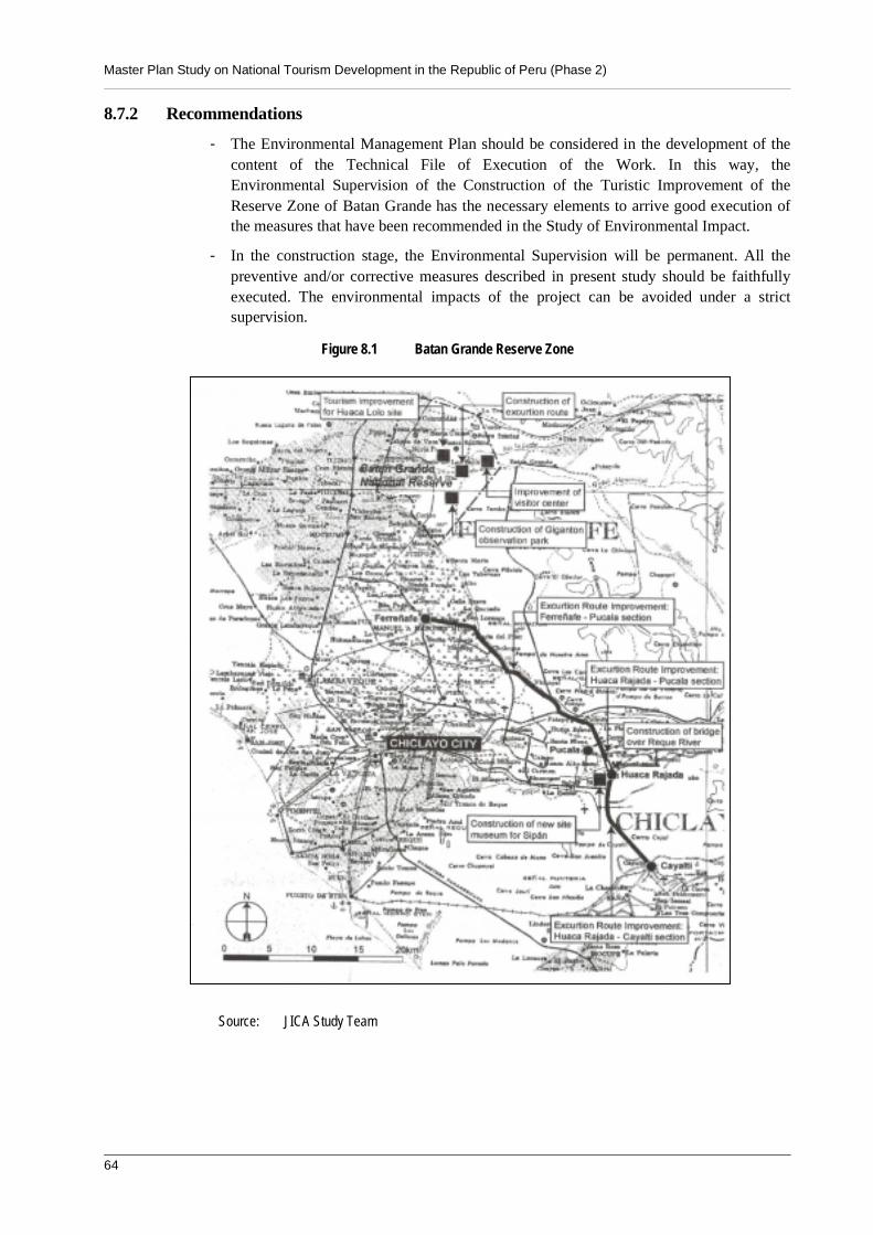
Master Plan Study on National Tourism Development in the Republic of Peru (Phase 2)
64
8.7.2 Recommendations
- The Environmental Management Plan should be considered in the development of thecontent of the Technical File of Execution of the Work. In this way, theEnvironmental Supervision of the Construction of the Turistic Improvement of theReserve Zone of Batan Grande has the necessary elements to arrive good execution ofthe measures that have been recommended in the Study of Environmental Impact.
- In the construction stage, the Environmental Supervision will be permanent. All thepreventive and/or corrective measures described in present study should be faithfullyexecuted. The environmental impacts of the project can be avoided under a strictsupervision.
Figure 8.1 Batan Grande Reserve Zone
Source: JICA Study Team
Volume 4 Environmental Impact Assessment
Chapter 9 Development of a Beach Resort Estate in Hermosa Beach 65
9. Development of a Beach Resort Estate in Hermosa Beach
9.1 Introduction
There are few countries in the world that present a huge variety of tourist attractiveness;
as the historical legacies left by the ancient inhabitants as natural landscapes. In this sense,Peru has these advantages that open a wide possibility to develop a consolidated tourist
industry if it is managed appropriately with sectional, regional and national politics.
The tourism industry maintains in an indirect way a better redistribution of the revenues;
so much those generated to the interior of the country like abroad. In this sense, it isnecessary to carry out public works guided to improve the tourist infrastructure.
9.2 Legal and Institutional Framework
The Environmental Impact Study for the development for Vacation Inmobiliary Center atPlaya Hermosa in Tumbes department will be developed having as juridical framework
the effective legal and institutional norms of conservation and environmental protection.
(1) Legal Framework
The Political Constitution of Peru is the juridical framework for all the activities that arecarried out inside the country. It is stood out in the article N° 2, among the person's
fundamental rights, the right to enjoy a balanced and appropriate environment to thedevelopment of life. The following main norms linked with the project are:
- Law Framework for the Private Investment Growth - Legislative Decree Nº757.
- Law of Evaluation of Environmental Impact for Works and Activities - Law 26786.
- General Law of Waters - Law Decree Nº17752.
- Supreme Decree Nº056-97-PCM settles down the cases in that approval of theEnvironmental Impact Assessment and Program of Adaptation of EnvironmentalManagement will require the Technical opinion of INRENA.
- Organic Law of Municipalities.
- Code of Environment and Natural Resources - Legislative Decree Nº613.
- Organic Law for the Sustainable Use of Natural Resources. Law Nº26821.
- Law On the Conservation and Sustainable Use of the Biological Diversity - LawNº26839.
- Law of Protected Natural Areas - Law Nº26834.
- Law for the Development of the Tourist Activity - Law Nº26961 (May 29 1998).
- Supreme Decree Nº002-2000-ITINCI (January 26 the 2000) approves Regulation ofthe Law for the Development of the Tourist Activity.
(2) Institutional Framework
The Institutional Framework is conformed by the group of public or private institutions
that participate in one or another way in the decisions of conservation of the environmentrelated with the execution of the project. The main institutions are:
- Ministry of Industry, Tourism, Integration and International Commercial Business(MITINCI)
Master Plan Study on National Tourism Development in the Republic of Peru (Phase 2)
66
- Ministry of Agriculture
- National Institute of Natural Resources (INRENA)
- Presidency of the Council of Ministers
- National Council of the Atmosphere (CONAM)
- Local Government
- National Institute of Civil Defense (INDECI)
- Transitory Council of Regional Administration - CTAR Tumbes
9.3 Description of the Project
The project for the construction for the Vacation Inmobiliary Center at Playa Hermosainclude the following component:
Hotel Complex in the beach resort: a lodging infrastructure will be built with a capacityof 50 to 125 rooms per hectare, with ten lots of 2 hectares for each one (20 Ha) for the
categories high and medium and 4 lots each one (4 hectares) for low categories. TheHotel Complex will be at a distance of 50 meters from the shore line. It will have
electricity services, water, sewage and basic infrastructure of communication.
Park of Tourism: A tourist park will be built in the middle of the complex with the
whole necessary infrastructure, including sport field, shopping center, restaurants andother auxiliary facilities.
Access roads: It has been considered the construction of two main roads for HermosaBeach Tourist Complex:
- Main access road: It begins from the Pan-American Highway with a length of 1.5 Km.,with a width of 15 m.
- Main road of the tourist Complex: It will have a distance of 1.3 Km and a width of12 m, also will have street lighting, vertical and horizontal signaling.
9.4 Basic Environmental Outline
9.4.1 Climatology
The information of the synoptic station of Tumbes has been taken as reference for theclimatological analysis. The annual average temperature is 24.95ºC, being July, August
and September the month with the smallest temperature with 23.2, 22.6 and 23ºCrespectively. March and April are the hottest ones with 27.0 and 26.9ºC, being very
favorable for tourist activities of the type Beach.
The precipitation is uniform with an average total annual precipitation of 112.5 mm, and
during El Niño Phenomenon the precipitation is increased up to 3,915.5 mm, what isequal to 34.8 times the estimated average.
9.4.2 Hydrology
The Tumbes River is the one with the greatest volume of water of the Peruvian coast,being even navigable in their inferior sector (from Tumbes town). This river always
maintains an important volume of running water from soils (94 m3/sec) During years ofstrong precipitation and exceptional floods, the flow reaches unforeseen volumes like
4,000 m3/sec, registered during El Niño Phenomenon.
Volume 4 Environmental Impact Assessment
Chapter 9 Development of a Beach Resort Estate in Hermosa Beach 67
9.4.3 Geology
The structural forms that have influenced the modeling of the region go from the coast
border to a hundred of meters over the sea level, standing out geomorphologic featuressuch as: islands, coast border, coastal plains and ejected cones. The study area is framed
inside the basin of the river Tumbes.
Since the point of view estratigraphic, lithologic, structural and geo-mechanic behavior,
the rocky outcrop according to the geologic scale, comprises from the Miocene to therecent Quaternary.
9.4.4 Soils
In the project area there are deep floors of half texture, imperfect drainage to poor and in
some areas with a phreatic layer at 50 or 60 cm of the surface. Their coloration variesamong very dark gray, brown to dark brown and sometimes black color in the surface.
Their reaction varies from moderately acid to moderately alkaline; in some cases it isextremely acid in the inferior horizons. About salinity they are moderate to lightly saline,
being increased to strongly saline to more depth. They present low capacity of cationicexchange and low values of organic matter content.
9.4.5 Ecology - Zones of Life
According to the Ecological Map of Peru (ONERN, 1976) based on the Dr. Leslie R.Holdridge system of zones of life, the Project area is located in the zone of life
denominated: desert thicket–Tropical Premontano, md-PT.
The Relationship of potential evapotranspiración should be in the range from 8 to 16. It
can be estimated a relationship of evapotranspiration 10 at 12 for the case of HermosaBeach. It means that the potential evapo-transpiration is 10 to 12 times superior to the
precipitation; being located in the county of humidity PERARIDO.
The project area is a beach, of plane relief, followed by a very dense pasture area without
presence of arboreal species. The sector of this zone of life is not optimum for potentialagricultural activities, but it has characteristics for recreational use.
9.4.6 Flora and Fauna
There is a characteristic sandy fringe and a fringe of pasture area of approximately 150
meters of wide at the beach sector. This pasture grows on saline sectors and covers thesoil densely. Among the species it can be mentioned: Distichlis spicata (salad grass), and
Brachiaria mutica (gramalote). Toward to the interior there are wide sectors of rice cropand sporadically some Prosopis chilensis (algarrobo) can be observed.
The fauna is very reduced and there are no mammals due to the human presence. It can beappreciated reptiles like Iguana sp. “pacazo” which are very common in the pasture area
and surroundings. There are only migratory birds because the open and trafficked beachdoes not constitute a refuge.
9.4.7 Socioeconomic Environment
The total population seated in the districts of Tumbes, Corrales and La Cruz, which will
be influenced by the development of the project, is 98,859 habitants. Its 52.28% (51,684people) are men and 47.71% (47,175) women. 75.46% (74,601 people) of the total
population are in the district of Tumbes.
Master Plan Study on National Tourism Development in the Republic of Peru (Phase 2)
68
The total PEA in the study area in 1993 is 31,909 inhabitants (equivalent to 37.87% of the
population from 5 years old to more). It is important to stand out that 89.41% of the PEAwas employed. The number of alphabet people of all the population of the districts in
study is 79,293, which allows for calculating a rate of illiteracy of 8.56%.
The district of Corrales presents the biggest percentage (11.60%) of homes without water,
drainage and electricity services, while Tumbes presents a bigger number of homes withwater supply, electric power supply and drainage service.
9.5 Identification and Evaluation of Environmental Impacts
For the identification and evaluation of environmental impacts it has been considered the
outlines of EIA of the Japan Bank for International Cooperation (JBIC former OECF )and the outlines that ECSA Engineers applies for these types of projects. For the present
Study of Environmental Impact, the impacts have been divided according to the executionstages, the same ones that are described as follows:
(1) Planning stage
Since the location of the works will occupy part of the existent agricultural lands, it is
possible that conflicts are presented with the farmers by the use of these areas, if they arenot properly compensated.
(2) Construction stage
Loss of vegetation: The location of the infrastructure in the beach resort will generate anunavoidable lost of natural vegetation for an extension of 25 ha and a reduction of
approximately 3 ha of areas dedicated to rice production.
Temporary interruption of the farmers' access road: During the construction of the
access road of 1.5 km, the farmers who use this road, will be interrupted by the presenceof machines and removal of materials.
Alteration of the landscape: In this stage it will be affected in a temporary way thelandscape quality as a consequence of land movements, displacement of machines and
equipment, conformation of the grade line, installation of camps, etc.
Risks of accidents: During the lapse of duration of the works, the occurrence of some
accident type is not discarded inside the work personnel and the local population thatmove for the work places.
Employment generation: The infrastructure works considered for the present projectwill require the recruiting of qualified and not qualified manpower so that it is waited that
the population of the project location will be employed.
Improvement in the commercial dynamics of the area: The biggest presence of
workers in the area will cause an increment in the commercial dynamics of the adjacenttowns to the work.
(3) Operation stage
Possible deterioration of the concrete infrastructure and metallic structures: Due to
the salinity and presence of sulfates for the vicinity of the marine waters, theinfrastructures and metallic structures can be affected.

Volume 4 Environmental Impact Assessment
Chapter 9 Development of a Beach Resort Estate in Hermosa Beach 69
Structural risk for presence of natural phenomena: According to the historical
antecedents, the seismic movements can reach intensities of IX in the Modified scale ofMercalli, being able to affect the built infrastructure.
Bigger generation of domestic residuals: The biggest presence of tourists will generatean increase of solids and liquids domestic residuals. These residuals can provoke risks of
contamination of the marine waters or accumulation of solid waste.
Improvement in the population's living standards: The presence of tourists will give to
the local towns, a major commercial development that will generate an increment of thedifferent products that are expended. As a consequence, it will increase in the
population's living standards.
9.6 Environmental Management Plan
The Environmental Management Plan for the Hermosa Beach Tourist Complex that is aninstrument of Environmental Administration, settles down the environmental measures
that avoid and/or minimize the effects on the environment and/or that the this affects thenew infrastructure.
9.6.1 Program of Corrective and Preventive Measures
The Program of Preventive and Corrective Measures allow to outline the measures of
technical, economic and social character that avoid and/or mitigate the direct and indirectharmful environmental impacts in the influence environment of the project.
(1) Planning stage
Previous to the beginning of the works, the entity responsible for the Project will havemeetings with the affected farmers, having as purpose to celebrate agreements for the use
of areas matched with the Project’s objective.
(2) Construction stage
- The constructive activities will be limited to the established areas inside the study ofEngineering.
- There must be a first-aid kit equipped with the medications, utensils and instrumentalminimum for cases of emergencies for accidents.
- To guide the workers so that they eat at places with the most appropriate hygienicconditions, in order to protect their own health.
(3) Operation stage
- To incentive the tourist activity of the Inca Ceramic Center and the care in the health,through warnings or advertising posters.
- To carry out jointly with the local authorities, prevention simulacrums in order toavoid that the natural phenomena cause personal damages of consideration.
- The responsible companies will not create false expectations to the population on newwork sources as a consequence of the project.
9.6.2 Program of Environmental Monitoring
The Program of Environmental Monitoring will allow to evaluate periodic, integrated and
permanently the dynamics of the environmental variables, in order to give precise and
Master Plan Study on National Tourism Development in the Republic of Peru (Phase 2)
70
modernized information, for the taking of decisions guided to the conservation of the
environment.
During the constructive stage it will be carried out monitoring of the air quality in the
work area which will allow preventing the contamination and breathing illnesses to theresidents and workers. This monitoreo will have a biannual frequency.
Once finished the constructive works, the stability of the banks in the areas of dispositionof material surpluses; as well as of the quarries should be monitored and verified.
9.6.3 Program of Environmental Education
During the construction stage, the Contractor Company will organize chats of
environmental education directed to its workers and the local population in order that theytake conscience of the importance that has the conservation of the natural resources in the
area of the project.
The Contractor Company will establish behavior norms to the work personnel,
prohibiting the activity of hunt of the wild fauna, the consumption of alcoholic drinksduring the works, the illicit appropriation of goods, among others.
9.6.4 Program of Contingencies
The Program of Contingency will allow to face the emergency situations related with the
environmental risks and accidents that can take place during the execution of the works ofthe Tourist Complex.
The quickest procedures in communication will settle down between the personnel of theemergency place and the Unit of Contingency, where the Supervisor of the work, will be
the responsible one of informing the Internal Coordinator of the company immediately,any contingency that can be presented.
The risks will be determined, and according to it, to establish emergency gangs withresponsibilities defined in each work area which will not necessarily be exclusive for this
work.
9.6.5 Program of Project Abandon
The Program of Project Abandon will begin previous communication with the Ministry of
Industry, Tourism, Integration and International Commercial Trade Negotiations(MITINCI); in accordance with the effective normative.
The conditioning of the surfaces used in the construction of the works includes aspects ofstuffing, reconstruction, substitution of the soil; re- conditioning it again with agricultural
earth that allows the development of the vegetation.
The possibility of returning the infrastructure to the local community, farmers or in its
defect to the entities of the State for its administration will be settled down. For thatpurpose, it will be coordinated with the corresponding sectors.
9.6.6 Program of Investments
The measures of mitigation and/or environmental control to avoid an/or reduce the
negative effects on the environment and vice versa have been identified. The necessary
Volume 4 Environmental Impact Assessment
Chapter 9 Development of a Beach Resort Estate in Hermosa Beach 71
investment for the implementation of the Environmental Management Plan ascends to the
amount of US $ 6,970.
9.7 Conclusions and Recommendations
9.7.1 Conclusions
- The development of the Vacation Inmobiliary Center at Playa Hermosa will allowconsolidating the commercial and economic growth, in the adjacent towns and inTumbes city, as a consequence of the benefits coming from the tourist, commercialactivity and services.
- Considering the dimensions of the Project and the distribution of the proposedinfrastructures, the natural landscape of the environment will not be affected,improving inclusive the aesthetics of a coastal spa.
- The area of Hermosa Beach presents excellent climatic conditions able to maintain ahomogeneous tourist flow along the year; the lowest averages correspond to July,August and September with values around de 23ºC.
- The project is guided according to the politics of national development, propitiatingnew investment opportunities, improving the living standards and generating newemployment positions.
- The area of the Project does not present natural resources of flora and fauna in dangeror in vulnerable condition. Besides, due to the magnitude and form of the Projectoperation, the biological environment will not be affected.
- In general, according to what is determined under the present Environmental ImpactAssessment, there are not negative environmental implications of consideration thatare restrictive to the execution of the project. If the Environmental Management Planis properly applied, the project is environmentally feasible.
9.7.2 Recommendations
- The plant species that are in the work area and have the best aesthetic conditionsshould be used inside the green areas considered by the project, avoiding as possible,to introduce new species different to the surrounding environment.
- In the construction of the projected works (Hotel Complex, access road, main via,etc.), the material to be eliminated should be used to a maximum, reducing the volumeto be eliminated, because the disposition of big volumes of material surpluses canalter the landscape.
- It should be considered all that is specified in the Environmental Management Planduring the construction of the works specified in the engineering study, such as: hotelcomplex, main access, main via, installation of basic services, among others.

Volume 4 Environmental Impact Assessment
Chapter 10 Mangrove Tourism Improvement in Puerto Pizarro 73
10. Mangrove Tourism Improvement in Puerto Pizarro
10.1 Generalities
The north coast of the Peruvian territory, mainly the department of Tumbes is generous in
beaches for recreation and tourism being favored by the favorable climatic conditions oftemperatures warm. The use of the beaches in this area can be carried out during the
whole year. Moreover, this area presents an attractive unique landscape due to theexistence of the tidelands and the forests of mangrove swamps. The development of the
tourist activity will develop and consolidate the industry of the tourism. It will contributeto the growth of the local and regional economy, generating new employment and other
benefits.
In this sense, the Tourist Corridor Tumbes-Piura will develop the Mangrove Tourism
Improvement of Puerto Pizarro's. The group of activities carried out in this work willbring changes and/or environmental modifications in diverse degrees of magnitude and
importance. It is necessary to execute the Environmental Impact Assessment (EIA) toidentify, predict, and interpret the probable environmental impacts as well as the
preventive and/or corrective measures that allow to mitigate and/or to avoid the negativeimplications and strengthen the positive implications.
10.2 Legal and Institutional Framework
The Study of Environmental Impact for the project Mangrove Tourism Improvement atPuerto Pizarro's will be developed having like juridical framework the legal and
institutional norms of effective environmental conservation and protection; and that theyhave as objective to promote and to regulate the sustainable use of the natural resources.
10.2.1 Legal Framework
- Political Constitution of Peru.
- Law of Evaluation of Environmental Impact for Works and Activities - Law 26786.
- Law Framework for the Private Investment Growth – Legislative Decree Nº757.
- Penal code, Crimes Against the Ecology (D. Leg. Nº635).
- General Law of Waters - Decree Law Nº17752.
- Cases in that approval of the Studies of Environmental Impact and Program ofAdaptation of Environmental Handling will require the Technical opinion of theINRENA – Supreme Decree Nº056-97-PCM.
- Organic Law of Municipalities (Law Nº23853).
- Code of the Environment and of the Natural Resources (Legislative Decree Nº613).
- Organic Law for the Sustainable Use of the Natural Resources (Law Nº26821).
- Law On the Conservation and Sustainable Use of the Biological Diversity - LawNº26839.
- Law of Protected Natural Areas - Law Nº26834.
- Supreme Decree 013-99-AG prohibit hunt, extraction, transport and/or export withcommercial ends of species of wild fauna not authorized by the INRENA, startingfrom January 1º the 2000.
Master Plan Study on National Tourism Development in the Republic of Peru (Phase 2)
74
- Law for the Development of the Tourist Activity - Law Nº26961 (May 29 1998).
- They approve Regulation of the Law for the Development of the Tourist Activity–D.S.Nº002-2000-MITINCI (January 26 the 2000).
10.2.2 Institutional Framework
- Ministry of Industry, Tourism, Integration and International Commercial Business(MITINCI).
- Ministry of Agriculture.
- National institute of Natural Resources (INRENA).
- Presidency of the Council of Ministers.
- National Council of Environment (CONAM).
- Committee of Coordination and Inter-institutional Support of the Mangrove Project.
- Transitory Council of Regional Administration - CTAR Tumbes.
10.3 Location and Description of the Project
The studied area is located in the low part of the basins of the rivers Tumbes and
Zarumilla. Its respective inter-basin is located in the district, county and department ofTumbes below the 35 meters over the sea level (see Map of Location).
The project comprises the improvement of the access road between the Pan-AmericanHighway and Puerto Pizarro and the construction of the entry vigilance post, signing and
landscape. At the moment, great part of the access road is covered by asphalt however thesurface of a certain section is deteriorated and without pavement.
The improvement of the access road will be carried out in a width of 8m. Its 6 m belongsto the portion with asphalt of the rolling surface and 2.4 m to the lateral berms (1.2 m for
side), being provided this way a quick access and insurance for the visitors.
10.4 Basic Environmental Outline
10.4.1 Climatology
The annual average temperature is 24.8ºC. August and September are the months ofsmaller temperature (23.0 and 23.1ºC) and the hottest ones, February and March, with
26.7ºC. The averages temperature of years 1982-83 reached 27.0ºC due to the presence ofthe El Niño phenomenon.
The precipitation is uniform and variable every year. The average total annualprecipitation is 168.6 mm without considering the Niño phenomenon of 1982-83. This
volume of precipitation average does not represent a problem in normal years andconcentrates during January to April. The rest of the year practically there is no rain.
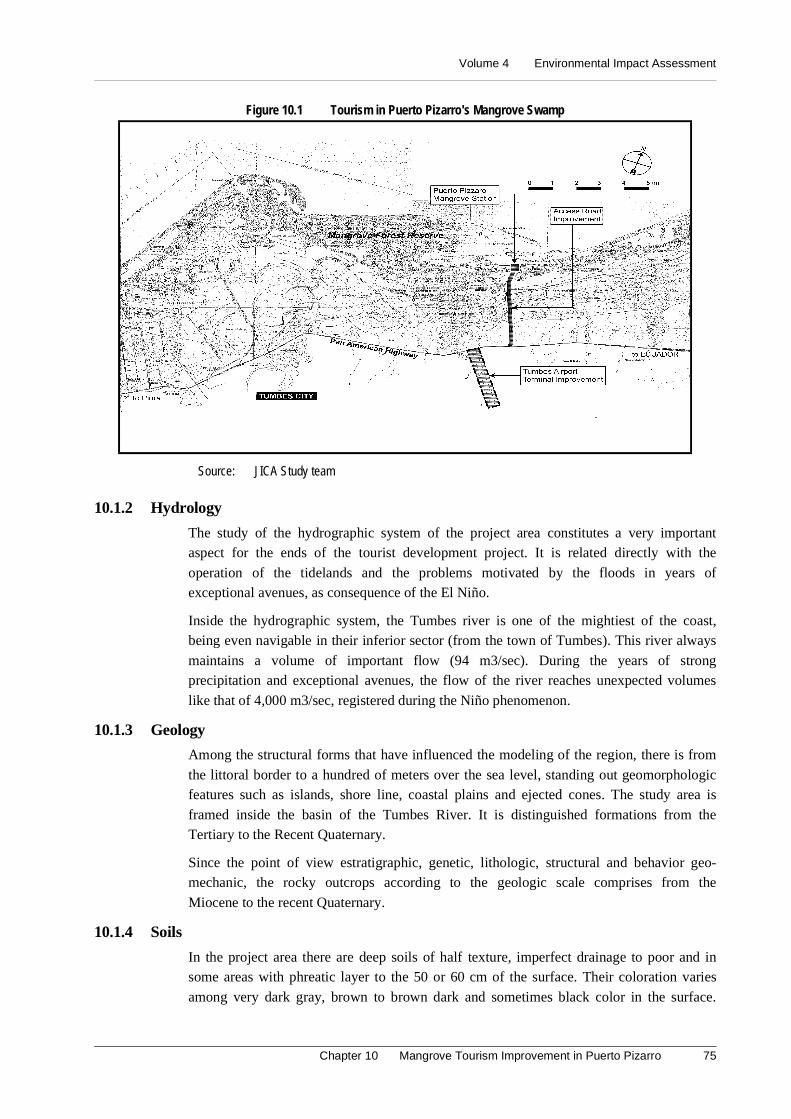
Volume 4 Environmental Impact Assessment
Chapter 10 Mangrove Tourism Improvement in Puerto Pizarro 75
Figure 10.1 Tourism in Puerto Pizarro's Mangrove Swamp
Source: JICA Study team
10.1.2 Hydrology
The study of the hydrographic system of the project area constitutes a very importantaspect for the ends of the tourist development project. It is related directly with the
operation of the tidelands and the problems motivated by the floods in years ofexceptional avenues, as consequence of the El Niño.
Inside the hydrographic system, the Tumbes river is one of the mightiest of the coast,being even navigable in their inferior sector (from the town of Tumbes). This river always
maintains a volume of important flow (94 m3/sec). During the years of strongprecipitation and exceptional avenues, the flow of the river reaches unexpected volumes
like that of 4,000 m3/sec, registered during the Niño phenomenon.
10.1.3 Geology
Among the structural forms that have influenced the modeling of the region, there is from
the littoral border to a hundred of meters over the sea level, standing out geomorphologicfeatures such as islands, shore line, coastal plains and ejected cones. The study area is
framed inside the basin of the Tumbes River. It is distinguished formations from theTertiary to the Recent Quaternary.
Since the point of view estratigraphic, genetic, lithologic, structural and behavior geo-mechanic, the rocky outcrops according to the geologic scale comprises from the
Miocene to the recent Quaternary.
10.1.4 Soils
In the project area there are deep soils of half texture, imperfect drainage to poor and insome areas with phreatic layer to the 50 or 60 cm of the surface. Their coloration varies
among very dark gray, brown to brown dark and sometimes black color in the surface.
Master Plan Study on National Tourism Development in the Republic of Peru (Phase 2)
76
Their reaction varies of moderately acid to moderately alkaline; in some cases, it is
extremely acid in the inferior horizons. They are moderate to lightly saline, beingincreased to strongly saline to more depth. They present low capacity of cation exchange
and low values in the content of organic matter.
10.1.5 Ecology – Zones of Life
According to the Ecological Map of the Peru (ONERN, 1976) based on the system of theDr. Leslie R. Holdridge of zones of life, the area of the Project is located in the zone of
denominated Mounts thorny–Tropical (mte-T), but very close to the desertthicket–tropical Premontano.
10.1.6 Flora
The predominant plant physiognomy of the sector of the road that joint the Pan-American
Highway with Puerto Pizarro is of the type shrubby thicket inside the Tropical Dry Forest.It is appreciated as a herbaceous with conspicuous presence of disperses arboreal species
like Bombax sp., Prosopis chilensis and Acacia macracantha.
The ecosystem mangrove swamp in Puerto Pizarro has a characteristic vegetation as
Rhizophara mangrove L., Avicennia germinans L., Laguncularia racenosa L. andConocarpus erectus L.
According to previous studies (ONERN, 1983), in the community swamp it has beenregistered 38 species of plants distributed in 31 genera and 19 families; also, it is pointed
out that it is a very dynamic ecosystem whose geo-forms and extension vary along theyears. It should also be kept in mind that this ecosystem is unique in the country what
makes its conservation indispensable.
10.1.7 Fauna
The fauna in the sector of the project is diverse where the fauna of the mangrove swamps
is different from the terrestrial one. Although among both there would be a narrowrelationship, mainly as for birds those inhabit both places. Among the main species are
mammals (Dusicyon sechurae, Eyra barbarian, Conepatus sp.), reptiles (Iguana sp.,Bothrops barnetti), birds (Fregata magnificens, Pelecanus thagus, Phoenicopterus ruber
chilensis, Casmerodius albus egretta), fish (Family Mugilidae, Sciaenidae and Ariidae)and gastropod (Anadara tuberculosa, Anadara grandis, Mytella guyanensis, Ostrea sp.,
Donax asper).
10.1.8 Socioeconomic Environment
According to Population and Housing Census of 1993, the total population seated in thedistricts of Tumbes, Corrals and La Cruz that will be influenced by the development of
the project, registered 98,859 inhabitants; of those which, 52.28% (51,684 people)correspond to the masculine sex. Urban and rural areas determine the socioeconomic
characteristics with a mainly urban population.
According to population's structure for economic activity presented by the INEI, the total
PEA in the study area for 1993, reached to 31,909 people (equivalent to 37.87% of thetotal population). 89.41% of the PEA was employed.
The number of people alphabet, in the whole population of the districts in study is of79,293. It represents a rate of illiteracy of 8.56%. The student population of the districts
Volume 4 Environmental Impact Assessment
Chapter 10 Mangrove Tourism Improvement in Puerto Pizarro 77
of the project has a low educational level where the primary level represents 46.94%.
17.17% only reached superior studies.
The cultural legacy of the populations of Tumbes, Corrals and La Cruz is manifested
through their customs, myths, beliefs, etc. It constitutes a living patrimony. The touristresources, not only comprises attractive landscapes, but also their people's local and
regional patrimony that many times reach international relevance.
The area where the project will be developed bases its tourist potential on the natural
beauty of its warm beaches, mangrove swamps and typical plates based on shellfish. Theeconomic importance of the sector resides in its capture of foreign currencies.
10.5 Identification and Evaluation of Environmental Impacts
For the identification and evaluation of the environmental impacts present during the
construction and operation stages of the Project, it has been necessary to usemethodologies. These are used to identify, predict, interpret and communicate the
beneficent and harmful environmental impacts. They are the Matrix of convergenceanalysis, Matrix Type Leopold and the Field Notes.
(1) Planning Stage
In this stage there are not relevant environmental impacts. The improvement of the
access road towards Puerto Pizarro will not affect the third people's properties. It will notbe necessary to carry out amplifications of the rolling surface.
(2) Construction Stage
Possible delay in the access to Puerto Pizarro. During the works of improvement of theaccess road to Puerto Pizarro, there could be traffic increase. It will be due to the
characteristic works of construction like movement of machines, transport of materials,placement of the asphalt, among others.
Nuisances to Puerto Pizarro's population for emission of noises and dust. Theactivities of improvement of the access road could generate annoying noises for the
residents seated to both sides of the road in Puerto Pizarro. It will due to the displacementand operation of machines, transport of construction material, and the work personnel's
movement, among others.
Possible occurrence of accidents. During the construction activities of the improvement
of the access road of Puerto Pizarro, there could happen labor accidents like bruises,mutilations, etc. It will be necessary to have medical support for cases of accidents.
Geomorphologic alteration for exploitation of quarries and use of garbage areas.This impact will not be of significance because the extracted volumes of the quarries and
the material surpluses deposited in the garbage areas will not be in big quantities. Therewill not be courts of banks for the improvement of the access road of approximately 4
kilometers long.
Possible transmission of illnesses for presence of mosquito. The tidelands, mangrove
swamps areas, rice crop and ponds for the shrimp cultivation constitute favorable habitatsfor the development of mosquito. They could move toward the place of the works and
cause nuisances to the workers.
Master Plan Study on National Tourism Development in the Republic of Peru (Phase 2)
78
Improvement of the hired personnel's welfare and local population. The activities for
the improvement of the access road to Puerto Pizarro will require the temporaryemployment of non qualified and qualified manpower. The workers will be the
economically active population of Puerto Pizarro.
(3) Operation Stage
Bigger affluence of tourists. The improvement of the access road to Puerto Pizarro willbe a quick and sure displacement of the users, favoring the biggest affluence of national
tourists and foreigners.
Increase of the commercial activity. The major affluence of tourists to Puerto Pizarro
will cause a major demand of goods and services. It will contribute the increment of thedynamics of the commercial activity, favoring to the families dedicated to the economic
activities that the tourism generates.
Indirect generation of employment. The increment of the commercial activity in Puerto
Pizarro will generate employment in an indirect way. Employment related to the touristactivity.
Increase of the solid residuals and liquids. At the moment, Puerto Pizarro's town lacksa sewer system (drainage net), causing health problems in the population. In this context,
there will be more health problems during the operation stage due to a major affluence ofvisitors and the increment of solid residuals and liquids.
Structural risk for presence of natural phenomena. The seismology characteristic ofthe region makes foreseen earthquakes of magnitude 8 to 9 in the scale of Richter. Also,
the Niño phenomenon that affects the north part of the country with approximate rhythmamong 10 to 15 years can damage the infrastructure vial and diminish the affluence of
tourists.
10.6 Program of Control and/or Environmental Mitigation
(1) Construction Stage
- It will be necessary to have to coordinate the construction works with the hours ofmore affluence of tourists. Also, there should be a way that allows the displacement ofvehicles at all times.
- The activities of improvement of the access road could generate annoying noises forthe residents of the area. Machines and load vehicles should be in optimum workconditions and use noise suppressors.
- The workers and operatives of more direct exposure to the particles generated mainlyby mechanical action of the machines will wear security devices as glasses, muffler,work clothes, helmet and those that can be required by specific reasons of their work.
- It will be necessary to have medical support for fortuitous cases of accidents. Also tohave to disposition a vehicle of quick displacement that allows the immediate transferto the hospital of the city of Tumbes.
- Later on, agricultural neighbor areas should be considered under a program of controlof mosquito. There should be a system of fish cultivation associated with thecultivation of rice.
Volume 4 Environmental Impact Assessment
Chapter 10 Mangrove Tourism Improvement in Puerto Pizarro 79
(2) Operation Stage
- The improvement of the access way will allow the entrance to Puerto Pizarro in quickform. It will favor the tourists and local population who use this infrastructure vial.However, there should be an appropriate signaling system that allows to the user asure displacement.
- It is necessary the implementation of new infrastructure of services for the touristdevelopment in Puerto Pizarro's town. It will be implemented an appropriate systemof water, drainage and treatment of residual waters. This development should bring arational use of the environment, with an effect multiplier in the improvement of thequality of the local population's life.
- The biggest affluence of tourists to Puerto Pizarro's town will allow to exist a majordemand of goods and services, contributing with the increment of the dynamics of thecommercial activity. It will favor the families dedicated to the economic activities thatthe tourism generates.
- The increment of the commercial activity in Puerto Pizarro's town will favor thegeneration of employment in an indirect way; mainly, employment related to thetourist activity. It is important that the local authorities develop in this stage a Plan ofTourist Development Puerto Pizarro.
10.6.2 Program of Environmental Monitoring
- The following factors will be monitor:
- Quantity of powder material that is emitted (dust rising) as consequence of the earthmovement and the traffic of machines, mainly load vehicles.
- The noise levels produced during the constructive activities.
- The works of improvement of the access road, exploitation of quarries, use of garbageareas, construction of camps and other activities. These works will be carried out,having in consideration the environmental measures that are developed in theEnvironmental Management Plan.
- The correct operation of the system of drainage built in the access road (deterioration,etc.).
10.6.3 Program of Education and Environmental Training
The activities contemplated inside the Program of Education and Environmental Training,are the following:
- During the construction stage, the Contractor Company will organize chats ofenvironmental education directed to its workers in order that they take conscience ofthe importance that has the conservation of the natural resources in the project area.
- The Contractor Company will establish behavior norms to the work personnel,prohibiting the activity of hunt of the wild fauna, the consumption of alcoholic drinksduring the works, the illicit appropriation of goods, among others.
- In order to prevent epidemic diseases, the foreign workers hired by the companycontractor, will have a recent health certificate to discard all type of diseases.
Master Plan Study on National Tourism Development in the Republic of Peru (Phase 2)
80
10.6.4 Plan of Contingency
The Plan of Contingency, contains actions that will embrace the whole area of direct
influence of the project, where the following works will be developed:
- There will be systems of supply and storage of water.
- It will be attached a plane of distribution of the equipment and accessories againstfires (extinguishers, emergency telephones, etc.), in the camp and the patio ofmachines that will be of the whole personnel's knowledge.
- According to the magnitude of inflammation of the equipment and the materials, theywill be equipped with extinguishers of fires, appropriate for cases of emergencies.
- To train a group of workers in the most elementary techniques against fires.
- To frequently check the operability of the equipment and diffuse its location, handlingand maintenance state.
- To put out a fire of liquids or inflammable gasses, cut the supply of products andsuffocate the fire using extinguishers of dry chemical powder, dioxide of carbon, or,to use dry sand or earth and to proceed to cool the tank with water.
10.6.5 Program of Investments
The budget profits assumed by the Contractor Company, so that the application of themeasures recommended in the Environmental Management Plan can be fulfilled, ascends
to the amount US$ 4,290.
10.7 Conclusions and Recommendations
- The execution of the project will have positive environmental implications favoringmainly to the tourist activity. The entire north coast of the Peruvian territory; mainlythe department of Tumbes is generous in coastal area for the recreation and thetourism. The attractive landscape of the tidelands and the forests of swamp favor thisplace.
- According to the ecological map of Peru, the area of the Project is located in the zoneof life denominated thorny Mount–Tropical (mte-T). The average characteristics are(Bio) Temperature of 24ºC or more and annual average total Precipitation among 250to 500 mm.
- As a result of the Study of Environmental Impact, it is determined that none of thepossible occurrences of negative environmental impacts are restrictive important toexecute the project. If the Environmental Management Plan is properly applied, theproject is environmentally feasible.
- Puerto Pizarro's tourist development will favor the major affluence of national touristsand foreigners. It is necessary for it, the implementation of new infrastructures ofservices for the tourist development. Also, an appropriate system of water, drainage,and treatment of residual waters and of solid residuals will be implemented.
- The works of improvement to be carried out in the access road could originate delaysto the users, being necessary to establish a work schedule that allows coordinating theconstruction works with increase of traffic volume. Also, during the works ofimprovement of the access road, there should be a way that allows the displacement ofvehicles at all times.
Volume 4 Environmental Impact Assessment
Chapter 11 Improvement of Tumbes Airport 81
11. Improvement of Tumbes Airport
11.1 Introduction
The improvement of the Tumbes Airport is a work of main importance that will allow to
the Peruvian Corporation of Commercial and Civil Aviation (CORPAC) to give a betterservice to users. It will incentive the massive arrival of tourists that will use of the
Tumbes – Piura Tourist Corridor that comprises the sustained use of the beach resourcesof Hermosa Beach and of the Mangrove Forest in Puerto Pizarro. As a consequence there
will be an increment of the arrival of tourists and in merchants that use this way as ameans of quick and sure displacement.
The activities that will be developed in the improvement of the Tumbes Airport will bringenvironmental changes and/or modifications in diverse degrees of magnitude and
importance. It is important to make the analysis of the structure and operation of theecosystems. In this way, it is indispensable the knowledge of the environmental, physical,
biological, cultural and socioeconomic components that allow to understand how thegroup of actions and activities that the execution of the project demands will affect the
surrounding environment and this the Project works.
11.2 Legal and Institutional Framework
The Study of Environmental Impact for the project Tourism in the Puerto Pizarro's
Mangrove Forest will be developed having as juridical framework the legal andinstitutional norms of effective environmental conservation and protection. They have as
objective to promote and to regulate the sustainable use of the natural resources.
11.2.1 Legal Framework
- Political Constitution of Peru
- Law of Evaluation of Environmental Impact for Works and Activities - Law 26786.
- Law Framework for Private Investment Growth- Legislative Decree Nº757.
- Penal Code, Crimes against the Ecology (D. Leg. Nº635).
- Supreme Decree N 056-97-PCM settles down cases in that approval of the Studies ofEnvironmental Impact and Program of Adaptation of Environmental Handling willrequire the Technical opinion of the INRENA.
- Organic Law of Municipalities (Law Nº23853).
- Code of the Environment and of the Natural Resources (Legislative Decree Nº613).
- Organic Law for the Sustainable Use of the Natural Resources (Law Nº26821).
- Law for the Development of the Tourist Activity - Law Nº26961 (May 29 1998).
- D.S. Nº002-2000-MITINCI (January 26 the 2000) approve Regulation of the Law forthe Development of the Tourist Activity.
- Organic law of the Sector Transports, Communications, Housing and Construction.
- Supreme Decree Nº013-97-Ag approve the Regulation of the Law Nº26737 thatregulates the Exploitation of Materials that carry and deposit Waters in their beds.
- Norms for the Use of Quarries Supreme Decree Nº37-96-EM.
Master Plan Study on National Tourism Development in the Republic of Peru (Phase 2)
82
11.2.2 Institutional Framework
- Ministry of Industry, Tourism, Integration and International Commercial Business(MITINCI).
- Presidency of the Council of Ministers.
- National Council of the Environment (CONAM).
- Transitory Council of Regional Administration - CTAR Tumbes.
- CORPAC
11.3 Location and Description of the Project
The Tumbes Airport is located approximately to 8 km to the Northeast of the city ofTumbes and to 10 km to the South of the border between Peru and Ecuador. Politically, it
is located in the district, county and department of Tumbes. Its access is from the Pan-American North by a way of 1.5 km long.
The Project to be executed comprises the following works:
Construction of the new terminal building. The current terminal building is small and
without a system of baggage transport, for what is necessary to build a new terminalbuilding designed simultaneously for the service of flights for national and foreigners
passengers with two band carriers of baggage (2 carrousels). The area to build willoccupy 6,000 m2. Also, the parking area will be enlarged and will occupy an area of
2,000 m2.
Improvement of the access road. The access way to improve has a length of 1.5 Km;
the width of the road will be of 8.4 m, corresponded 6 m for the asphalt portfolio and 2.4m for the lateral green belts (1.2 m for side). It also comprises the construction of a
control tower.
11.4 Basic Environmental Outline
11.4.1 Hydrology
- The study of the hydrographic system of the project area constitutes a very importantaspect for the ends of development tourist because it is related directly with theoperation of the tidelands and the problems motivated by the floods in years ofexceptional avenues as consequence of Niño phenomenon.
- The Tumbes river is one of the mightiest of the coast, being even navigable in theirinferior sector (from Tumbes town). This river always maintains a volume ofimportant running water from soils (94 m3/sec). During strong precipitation andexceptional avenues, the flow of the river ends up unforeseen volumes like that of4,000 m3/sec, registered during the Niño phenomenon.
11.4.2 Geology
- Among the structural forms that have controlled the modeling of the region, the sameone that goes from the coast border to a hundred of meters on the level of the sea. Ofheight, standing out geo-morphologic features such as: Islands, shore line, coastalplains and ejected cones. The study area is framed inside the basin of the riverTumbes. It is distinguished formation from the Tertiary to the Recent Quaternary.

Volume 4 Environmental Impact Assessment
Chapter 11 Improvement of Tumbes Airport 83
- Since the point of view estratigraphic, genetic, lithologic, structural and behavior geo-mechanic, the rocky outcrop according to the geologic scale comprises from theMiocene to the Recent Quaternary.
11.4.3 Soils
In the area of the project deep floors are presented, of half texture, imperfect drainage to
poor and in some areas with phreatic layer to the 50 or 60 cm of the surface. Theircoloration varies among very dark gray, brown to brown dark and sometimes black color
in the surface. Their reaction varies from moderately acid to moderately alkaline. In somecases it is extremely acid in the inferior horizons. They are moderate to lightly saline,
being increased to strongly saline at more depth. They present low capacity of cationexchange and low values in the content of organic matter.
11.4.4 Ecology – Zones of Life
According to the Ecological Map of Peru (ONERN, 1976) based on the Dr. Leslie R.
Holdridge system of zones of life, the Project area of Improvement of the Tumbes Airportis located in the zone of life denominated: Thorny Tropical Mount (mte-T). It is very
close to the desert thicket –tropical Premontano (enclosed map).
The average characteristics that identify this zone of life are the following (ONERN,
1976): Annual average bio-temperature of 24ºC or more, and an annual average totalPrecipitation among 250 to 500 mm. The data of the station of Port Pizarro close to this
zone of life has an arid tendency due to their low precipitation (168.6 mm).
The Relationship of potential evapo-transpiration is around 8. It means that the potential
evapo-transpiration is 8 times superior to the precipitation, being located in the ARIDcounty of humidity.
11.4.5 Flora
The vegetation that surrounds the project area is characteristic of the tropical dry forestalthough it is a zone with the presence of residents. The predominant plant physiognomy
is of shrubby thicket type inside the Tropical Dry Forest. It looks like herbaceous or verydense grass area with presence of arboreal species in a disperse way. There are tree
species as Bombax sp. (ceibo), Prosopis chilensis (algarrobo) and Acacia macracantha
(faique). The project of improvement practically will not affect the existent vegetation
because the constructions will be made on previous constructions or altered sectors.
11.4.6 Fauna
The fauna in the project area is very varied. The main species are: Mammals (Dusicyonsechurae, Eyra barbarian, Conepatus sp.); reptiles (Iguana sp., Bothrops barnetti); and
birds (Fregata magnificens, Pelecanus thagus, Phoenicopterus ruber chilensis,Casmerodius albus egretta).
11.4.7 Socioeconomic Framework
According to the Census of Population and Housing of 1993, the total population seated
in the districts of Tumbes, Corrals and the Cruz that will be influenced by thedevelopment of the project registered 98,859 inhabitants. 52.28% (51,684 people) are
men. Urban and rural areas determine the socioeconomic characteristics with a mainlyurban population.
Master Plan Study on National Tourism Development in the Republic of Peru (Phase 2)
84
According to population's structure for economic activity presented by the INEI, the total
PEA in the study area for 1993 was 84,249 people. It was equivalent to 85.22% of thetotal population. Its 52.23% (44,263 people) are men. 33.86% of the PEA was employed.
The total number of people alphabets in the districts of study is of 79,293. The rate ofilliteracy is 8.56%. The student population has a low educational level. The primary level
represents 46.94%. 17.17% only reached higher studies.
The cultural legacy of the populations of Tumbes, Corrals and La Cruz is manifested
through their customs, myths, beliefs, etc. The tourist resources not only compriseattractive landscapes, but also their people's local and regional patrimony that many times
reach international relevance.
The area where the project will be developed bases its tourist potential on the natural
beauty of its warm beaches, mangrove swamps and typical plates made of shellfish. Theeconomic importance of the sector resides in its contribution as captor of foreign
currencies.
11.5 Identification and Evaluation of Environmental Impacts
For the identification and evaluation of the environmental impacts that are presentedduring the construction and operation stages of the Project, it has been necessary to use
methodologies, to identify, to predict, to interpret and to communicate the positive andnegative environmental impacts. For example the application of: Matrix Type Leopold,
Cause-Effect diagrams and Field Notes. The identified impacts are described as follows:
(1) Planning Stage
There are not relevant environmental impacts in this stage. There will not neithercompensations nor expropriations for affectation of properties because the works of
improvement will be carried out under the area that corresponds to the Tumbes Airport.
(2) Construction Stage
Moderate loss of vegetation. It is foreseen that during the amplification works of the
access road to the airport, the construction of the terminal and the parking area will affectin moderate form the shrubby and herbaceous vegetation.
Possible delay in the access to the airport. The works of the improvement of the accessroad to the airport could originate traffic increase.
Possible occurrence of accidents. During the works of the improvement of the airport,there could happen labor accidents, as fallen, bruises, mutilations, etc. It is necessary to
have a medical personal for cases of accidents.
Geomorphologic alteration for exploitation of quarries and use of garbage areas.
This impact will not be significant because the extracted volumes of the quarries and thematerial surpluses deposited in the garbage areas will not be in big quantities.
Temporary alteration of the landscape quality. This impact will be unavoidable duringthe improvement of the airport. However, it will be temporal because the intervened area
will be adapted once the works are concluded. The Environmental Management Plan ofthe present Environmental Impact Assessment will be kept in mind.
Volume 4 Environmental Impact Assessment
Chapter 11 Improvement of Tumbes Airport 85
Improvement of the hired personnel's welfare and local population. The activities to
be carried out for the improvement of the Tumbes airport will require the temporaryemployment of qualified and non-qualified manpower. The economically active
population of Tumbes will be hired.
(3) Operation Stage
Major security and comfort to the user. The new infrastructure built in the TumbesAirport will allow lending a better service and comfort to the user. Also, the improvement
of the access road and the signaling work will allow giving major displacement andparking security.
Increase in the affluence of tourists. The improvement of the Tumbes Airport willcontribute to a major affluence of national tourists and foreigners.
Increase of the commercial activity. The major affluence of tourists to the city ofTumbes will allow a bigger demand of goods and services. It will favor to the families
dedicated to the economic activities that the tourism generates.
Indirect generation of employment. The increment of the commercial activity in the
city of Tumbes will favor to generate employment at indirect way. Mainly employmentrelated to the tourist activity.
11.6 Program of Control and/or Environmental Mitigation
(1) Construction stage
It will be necessary that the works of cleaning of vegetation will be limited to the areas
where the works and the access road will be carried out. The displacement of vehicles andmachines will be prohibited along areas of existent vegetation. The green areas that are
projected to develop will improve the intervened areas.
A schedule of work will be coordinated that allows to execute the works without harming
or delaying the users. Flights are from Monday to Friday between 8 and 10 in themorning. The works of improvement could be executed at the rest hours.
The workers and operatives of more direct exposure to the particles generated by themechanical action of the machines should wear security devices as glasses, muffler, work
clothes, helmet and those that can be required by specific reasons of their work.
It will be necessary to have medical support for fortuitous cases of accidents and
appropriated vehicles to carry people to the hospital of the city of Tumbes.
The new infrastructure of the airport is designed for national and international flights,
with revolving platforms of baggage, paved and signed parking area, improved accessroad and the construction of guard's house. All these will lend a better service to the client.
(2) Operation stage
The improvement of the airport of Tumbes will increase the affluence of national tourists
and foreigners. New infrastructures of services for the tourist development of Tumbesshould be executed specially in areas of exceptional originality and high quality as Playa
Hermosa and Puerto Pizarro.
Master Plan Study on National Tourism Development in the Republic of Peru (Phase 2)
86
The increment of the commercial activity in the city of Tumbes will generate employment
related to the tourist activity. It is important that the local authorities develop a Plan ofTourist Development that includes the sectors that receive bigger affluence of tourists like
Playa Hermosa, Puerto Pizarro and Jeli Beach.
The engineering designs to the constructions consider the natural phenomena that are
presented in the study area, as floods and earthquakes. All time that the Niñophenomenon is presented, there are precipitation with atypical intensity and not very
predictable effects.
11.6.2 Program of environmental monitoring
The following factors should be monitored:
- Quantity of powder material that is emitted (dust rising) as consequence of the earthmovement and the traffic of machines, mainly load vehicles.
- Noise levels that take place during the constructive activities.
- The works of improvement of the access road, exploitation of quarries, use of garbageareas, construction of camps and other activities. These works will be carried out,having in consideration the environmental measures that are developed in theEnvironmental Management Plan.
- The correct operation of the system of drainage built in the access road (deterioration,etc.).
11.6.3 Program of Education and Environmental Training
The activities contemplated inside the Program of Education and Environmental Training,are the following ones:
- During the construction stage, the Contractor Company will organize chats ofenvironmental education directed to its workers. They will take conscience of theimportance of the conservation of the natural resources in the project area.
- The Contractor Company will establish behavior norms of the work personnel,prohibiting the activity of hunt of the wild fauna, the consumption of alcoholic drinksduring the works, the illicit appropriation of goods, among others.
- In order to prevent epidemic diseases, the foreign workers have a recent certificate ofhealth to discard all type of diseases
11.6.4 Plan of Contingency
The Plan of Contingency contains actions that will embrace the whole area of directinfluence of the project. These are;
- There should be a plane of distribution of the equipment and accessories against fires(extinguishers, emergency telephones, etc.), in the camp and the patio of machines.The whole personnel will know it.
- According to the magnitude of inflammation of the equipment and the materialslocated in it, they will be equipped with extinguishers of fires, appropriate for cases ofemergencies.
- To train a group of workers in the most elementary techniques against fires.
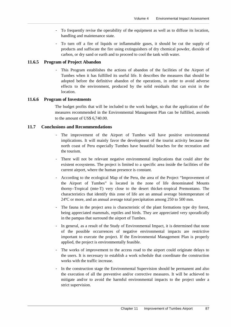
Volume 4 Environmental Impact Assessment
Chapter 11 Improvement of Tumbes Airport 87
- To frequently revise the operability of the equipment as well as to diffuse its location,handling and maintenance state.
- To turn off a fire of liquids or inflammable gases, it should be cut the supply ofproducts and suffocate the fire using extinguishers of dry chemical powder, dioxide ofcarbon, or dry sand or earth and to proceed to cool the tank with water.
11.6.5 Program of Project Abandon
- This Program establishes the actions of abandon of the facilities of the Airport ofTumbes when it has fulfilled its useful life. It describes the measures that should beadopted before the definitive abandon of the operations, in order to avoid adverseeffects to the environment, produced by the solid residuals that can exist in thelocation.
11.6.6 Program of Investments
The budget profits that will be included to the work budget, so that the application of themeasures recommended in the Environmental Management Plan can be fulfilled, ascends
to the amount of US$ 6,740.00.
11.7 Conclusions and Recommendations
- The improvement of the Airport of Tumbes will have positive environmentalimplications. It will mainly favor the development of the tourist activity because thenorth coast of Peru especially Tumbes have beautiful beaches for the recreation andthe tourism.
- There will not be relevant negative environmental implications that could alter theexistent ecosystems. The project is limited to a specific area inside the facilities of thecurrent airport, where the human presence is constant.
- According to the ecological Map of the Peru, the area of the Project “Improvement ofthe Airport of Tumbes” is located in the zone of life denominated Mountsthorny–Tropical (mte-T) very close to the desert thicket–tropical Premontano. Thecharacteristics that identify this zone of life are an annual average biotemperature of24ºC or more, and an annual average total precipitation among 250 to 500 mm.
- The fauna in the project area is characteristic of the plant formations type dry forest,being appreciated mammals, reptiles and birds. They are appreciated very sporadicallyin the pampas that surround the airport of Tumbes.
- In general, as a result of the Study of Environmental Impact, it is determined that noneof the possible occurrences of negative environmental impacts are restrictiveimportant to execute the project. If the Environmental Management Plan is properlyapplied, the project is environmentally feasible.
- The works of improvement to the access road to the airport could originate delays tothe users. It is necessary to establish a work schedule that coordinate the constructionworks with the traffic increase.
- In the construction stage the Environmental Supervision should be permanent and alsothe execution of all the preventive and/or corrective measures. It will be achieved tomitigate and/or to avoid the harmful environmental impacts to the project under astrict supervision.
Master Plan Study on National Tourism Development in the Republic of Peru (Phase 2)
88
Figure 11.1 Improvement of Access Road and Terminal Building
Source: JICA Study Team

Volume 4 Environmental Impact Assessment
Chapter 12 Community Development of La Encantada Ceramic Village 89
12. Community Development of La Encantada Ceramic Art Village
12.1 Introduction
Peru has had among their inhabitants since times before the Incas epoch people with huge
dexterity to manufacture ceramic objects using from rustic to sophisticated tools.Nowadays there are still places where people are devoted to the ceramic object
production but these do not reach the growth and the appropriate importance.
For such a reason, the future La Encantada Ceramic Center will try to change the current
situation and create new employment positions, not only for the increase of the ceramicactivity, but also for the tourist activity that could be given in the area. In the same way,
this construction would generate environmental impacts against the environment so thatthe present study seeks to outline activities and programs with measures of environmental
conservation.
12.2 Legal and Institutional Framework
The Environmental Impact Assessment of La Encantada Ceramic Village at Chulucanas
district will be developed having like juridical framework the effective legal andinstitutional norms of conservation and environmental protection.
a. Legal Framework
As a main juridical framework for all the activities that are carried out inside the country
there is the Political Constitution of Peru. The article 2º stood out, among the person'sfundamental rights, the right to enjoy a balanced and appropriate environment to the
development of life. The following main norms linked with the project are listed:
- Law Framework for the Private Investment Growth - Legislative Decree Nº757.
- Evaluation Law of Environmental Impact Assessment for Works and Activities - Law26786
- General law of Waters – Law Decree Nº17752.
- Supreme Decree Nº056-97-PCM establishes cases in that the approval of the Studiesof Environmental Impact and Program of Adaptation of Environmental Managementwill require the Technical opinion of INRENA.
- Organic Law of Municipalities
- Code of Environment and Natural Resources Legislative Decree Nº613
- Organic law for the Sustainable Use of Natural Resources- Law Nº26821
- Law of Protected Natural Areas - Law Nº26834
- Law for the Development of the Tourist Activity - Law Nº26961 (May 29, 1998)
- Supreme Decree Nº002 - 2000 - ITINCI (January 26 the 2000) approves theRegulation of the Law for the Development of the Tourist Activity.
b. Institutional Framework
The Institutional Framework is conformed by the group of public and private institutionsthat participate in one or another way in the decisions of environment conservation in
relation to the execution of the project. The main institutions related with the project are:

Master Plan Study on National Tourism Development in the Republic of Peru (Phase 2)
90
- Ministry of Industry, Tourism, Integration and International Commercial Business(MITINCI)
- Presidency of the Council of Ministers
- National Council of Environment (CONAM)
- National Institute of Civil Defense (INDECI)
- National Institute of Culture (INC)
- Local government
- Transitory Council of Regional Administration - CTAR Piura
12.3 Description of the Project
The project for the construction of La Encantada Ceramic Village includes the followingcomponents:
Ceramic Art Center: It is considered a total of 0.8 ha where the built area is 600 m2.
Improvement and Construction of Infrastructure at La Encantada town: It will be
done through the main via, creation of green areas, improvement of house facades of themain road, and placement of informative and/or preventive signs.
Improvement of the access way: It is considered of 3 km. long, 8.4 m wide (pave W=6m, green belts = 1.2 m x 2).
Installation of basic services: Systems of water, drainage and electric power will bedeveloped.
12.4 Basic Environmental Outline
12.4.1 Climatology
For the analysis of the climatological study was used the meteorological information ofthe ordinary climatological station of Chulucanas, at 95 m over the seal level and 4
kilometers far of La Encantada Town will be taken as reference for the climatologicalanalysis. The annual average temperature is 24.0ºC, oscillating from 21.7ºC in July and
August (winter) to 23.6ºC in February.
The annual precipitation is uniform and the total average volume is 174.9 mm. During the
years of El Niño phenomenon, the precipitation volume is distributed along the year but isstrongly concentrated only 4 months, from January to April (more than 95%), while there
is no rain in the rest of the years.
12.4.2 Hydrology
The main course of water involved with the influence area of the Project is the Piura river
that has its origin at Huancabamba county, to the southeast of Piura department and theNorth of the Porculla step, in the Sogorrón hill at 2680 m over the sea level. This river
has a length of 150 Km and a basin of 12,000 Km2 approximately. Its waters are used foragriculture, mainly in the well-known area as Bajo Piura where it is cultivated long fiber
cotton, corn, and house consumption crops.
Volume 4 Environmental Impact Assessment
Chapter 12 Community Development of La Encantada Ceramic Village 91
12.4.3 Geology
The geo-morphological features such as gulches, hills, witness hills and ejection cones
stand out among the structural forms that have influenced the modeling of the regionwhich goes from the river borders to the high parts of the area.
From the estratigraphic, lithologic, structural and geo-mechanic point of view, the rockyoutcrop according to the geologic scale comprises from the Half Cretacic to the
Quaternary. The volcanic rocks that appear for the present project belong to theCenomaniano–albiano of the Cretacic.
The existent deposits present a covering or upholstered with residual solid notconsolidated materials of variable thickness that are accumulated in the valleys or
topographical depressions, covering the rocks of the study area. Also, they have anirregular geographical distribution in the influence area of the Project. The deposits are
products of the meteorization, transport and erosion originated by the glacial, alluvialprocesses, coluviales and external geo-dynamic phenomena that have operated in the
study area during the geomorphologic history.
12.4.4 Soils
The study area is characterized for presenting lands located inside the arid plain of thecoast, where it is highlighted the wavy desert-plane extensive surfaces, the alluvial valley
of the Piura River. It is an area of intense agricultural activity, and scarce and low hills.
In the natural physiognomy of this area, it is highlighted the Torrifluvents, soils of
stratified morphology; the Torripsamment that are deep soils of sandy texture and theSalorthid that are soils with high content of salts. At a level of cartographic units it has
been identified four groups of soils and one of these is a unit non-soil or miscellaneousarea.
1) Encantada soil (Torrifluvents)
2) Sausal soil (Torriorthent)
3 ) Sandy soil (Torripsamment)
4 ) Group of soils Miscellaneous Lands.
12.4.5 Ecology - Zones of Life
According to the Ecological Map of Peru (ONERN, 1976) based on the Dr. Leslie R.
Holdridge system of zones of life, the Project area, is located in the zone of lifedenominated: Desert–Tropical thicket (md-T). The Relationship of potential
evapotranspiración is from 8 to 16, and in the specific case of Chulucanas it is around 8and 9, it means that the potential evapotranspiración according to this system is 8 to 9
times superior to the precipitation; being located in the county of humidity PERARIDO.
Toward the east, straight to the mountain range, there are more humid zones of life such
as Desert–Tropical Premontano thicket (md-PT). Toward the west, straight the sea, thereare the most dry and arid zones of life, as the perárido–Tropical Premontano desert (dp-
PT). La Encantada is located in a plain with a plant physiognomy of bushing thicket typeand with tree species of half to low height, disperse on a seasonal herbaceous vegetation
that grows in rainy season.

Master Plan Study on National Tourism Development in the Republic of Peru (Phase 2)
92
12.4.6 Flora and Fauna
The vegetation surrounding the project area is typical of algarrobal areas of the tropical
dry forest but it should be indicated that practically it is an area intervened due to thepresence of residents and agricultural and husbandry activities. Inside the tree species of
the direct influence area there are: Prosopis chilensis (Algarrobo) and Acacia
macracantha (Faique).
The fauna in the study area is not significant. Sporadically it is common to see smalllizards and pacasos (Iguana sp.) and birds from the Columbidae taxonomic family,
Leucippus baeri (picaflor), Synallaxis gujanensis (papamosa), Coragypus sp. (gallinazo),Columbine sp. (tortola), Zenaida auriculata (cuculi) and others.
12.4.7 Socioeconomic environment
Chulucanas district has a population of 74,089 inhabitants, being the 50.65% men and the
49.35% women. It is necessary to mention that 45.44% of the inhabitants of MorroponCounty belongs to this district.
For the Economically Active Population's (PEA) analysis it has been considered thepopulation from 6 years old to more, which ascend to 61,721 inhabitants, having a rate of
unemployment of 9.78% and a level of illiteracy of 20.8%. People with primaryeducation represent 52.11%, while with complete university level is 1.01%.
Of the total of existent housings in Chulucanas district, 21.30% does not have any of thebasic services, which makes foresee the low living standards of the population. 32.40%
does not have any type of house device.
12.5 Identification and Evaluation of Environmental Impacts
For the identification and evaluation of environmental impacts it has been considered the
outlines of EIA of the Japan Bank for International Cooperation (JBIC former OECF) andthe outlines that ECSA Engineers applies for these types of projects. For the present
Environmental Impact Assessment, the impacts have been divided according to theexecution stages. They are described as follows:
(1) Planning Stage
It is foreseen that the local population can begin a deforestation process of algarrobo as an
expectation for knowing the project works, increasing conforms the date of beginning isclose.
(2) Construction Stage
Employment generation: The construction of La Encantada Ceramic Village will absorb
the local unemployed population. It will allow to energize the economy of thesurroundings in a local and temporally way.
Loss of vegetation: At present there is an tree, bushing and seasonal vegetation in thearea where the Inca Ceramic Art Center will be located (0.8 ha.) and the amplification of
the width of access road will be carried out. This reduction will neither put in danger norextinct the existent species.
Risk of accidents: During the time of the works, the occurrence of some type of accidentis not discarded inside the work personnel, as well as in residents of the place.
Volume 4 Environmental Impact Assessment
Chapter 12 Community Development of La Encantada Ceramic Village 93
Temporary interruption of the access road: During the construction of the 3.0 km
access road, the residents and farmers who use this road will be impeded to use it due toconstruction works.
Improvement the commercial dynamics of the area: Due to a major presence ofworkers in the area, it is expected an increment in the commercial dynamics of La
Encantada and Huapalas Village.
Alteration of the landscape: In this stage, the quality of the landscape will be affected as
a consequence of the movement of lands, displacement of machinery and equipment,conformation of the grade line, installation of camps, emissions of powder material, loss
of vegetation, material transport, etc.
(3) Operation stage
Improvement in the inhabitant's living standards: The presence of the CeramicVillage, will give to the local towns, a major commercial development, as a consequence
of a major flow of tourists and buyers, generating an increment of the population's livingstandards.
Increase of the commercial value of the properties: Due to the presence of LaEncantada Ceramic Center, the value of the properties will begin a revaluation process,
since they will begin to have a bigger economic and commercial importance.
Possible urban expansion not planned: The commercial and tourist development of La
Encantada locality can generate an irregular urban growth in the riverbanks of the sameone, as well as in Huapalas Village.
Structural risk by natural phenomena: The internal geo-dynamic activity of the earthcan generate seismic movements; also, El Niño phenomenon that affects the north part of
the country with an approximate cycle among 10 to 15 years can damage theinfrastructure, tourists' affluence and buyers.
Employment generation: The operation works of the Inca Ceramic Center andpreparation of the ceramic articles for sale will generate new employment positions, for
the direct and indirect recruiting of manpower.
12.6 Environmental Management Plan
The Environmental Management Plan for La Encantada Ceramic Village is an instrumentof the Environmental Administration where is established the environmental measures
that avoid and/or minimize the effects on the environment; as well as, those that itproduces the this on the structures of the Project.
12.6.1 Program of Corrective and Preventive Measures
The Program of Corrective and Preventive Measures allows to outline the measures oftechnical, economic and social character that avoid and/or mitigate the direct and indirect
harmful environmental impacts in the influence environment of the project. Theconstruction and operation of the new Ceramic Center of La Encantada can generate them.
Master Plan Study on National Tourism Development in the Republic of Peru (Phase 2)
94
(1) Planning Stage
Before the beginning of works, the responsible entity of the project will accomplish
agreements for the use of areas with ends of the project. Besides, informativeadvertisement will be placed in areas where the work will be carried out.
(2) Construction Stage
- The manpower recruiting for the company manufacturer will be in a moderate way;nevertheless, the recruiting of local population will be priority, without creating falseexpectations.
- It will be necessary to have a medical group of first aids for fortuitous cases ofaccidents and an equipped first-aid kit.
- To coordinate a work schedule that allows the execution of works without disturbingthe users of the road.
(3) Operation Stage
- To incentive the tourist activity of the Inca Ceramic Center and the care of health,through warnings or advertising posters.
- Conversations should be carried out with the local government, farmers and residents,with the purpose of avoiding any type of invasion by other residents.
- To carry out jointly with the local authorities, prevention simulacrums, in order toavoid that the natural phenomena cause personal damages of consideration.
12.6.2 Program of Environmental Monitoring
The Program of Environmental Monitoring will allow evaluating periodic, integral and
permanently the dynamics of the environmental variables, with the purpose of givinginformation for the taking of decisions about environmental conservation.
During the constructive process it will be necessary to monitor the air quality and thestability of the banks as much in garbage areas as in quarries.
12.6.3 Program of Environmental Education
This program is fundamental to achieve the continuity of actions in order to conservepermanently the environment. It is mainly directed to technical personnel and workers
that will work in the area.
During the construction stage, the Contractor Company will organize chats of
environmental education directed to its workers and local population; in order that theytake conscience of the importance of the conservation of natural resources in the project
area.
The Contractor Company will establish behavior norms to the work personnel,
prohibiting the activity of hunt of wild fauna, the consumption of alcoholic drinks duringthe works, the illicit appropriation of goods, among others.
12.6.4 Program of Contingencies
For a correct and appropriate applicability of the Program, it is recommended that the
Company responsible for the construction establish a Unit of Contingency, being adapted
Volume 4 Environmental Impact Assessment
Chapter 12 Community Development of La Encantada Ceramic Village 95
to the minimum requirements, in function of the activity and of the geophysical, climatic
potential risks and catastrophes of the area.
The quickest procedures in communication will be settled down between the personnel of
the emergency place and the Unit of Contingency, where the Work Supervisor will beresponsible to inform the Internal Coordinator of the company immediately, about any
contingency that can be presented.
The risks will be determined, and according to them to establish emergency gangs with
responsibilities defined in each work area that will not necessarily be exclusive for thispurpose. All the workers will be informed about the Program of Contingency and will
receive the necessary instructions in this respect.
12.6.5 Program of Project Abandon
The Program of Project Abandon, will begin previous communication to the Ministry ofIndustry, Tourism, Integration and International Commercial Business (MITINCI); the
same one in accordance with the effective norm.
It will be given to know to the local authorities, the decision of to abandon and close the
infrastructure of the Inca Ceramic Art Center and other infrastructures. The constructionsthat will be demolished should have a demolition, elimination and are rehabilitation
programs.
It will be identified the measures to assure the stability of the re-level surfaces, of slopes
and to detect evidences of potential uncertainty and to incorporate in the plan therehabilitation, any system of drainage derivation or protection against the erosion,
especially the geo-technical and erosive stability.
12.6.6 Program of Investments
The measures of mitigation and/or environmental control to avoid and/or reduce thenegative effects on the environment and vice versa have been identified. The necessary
investment for the implementation of the Environmental Management Plan ascends to theamount of 7,070 American dollars.
12.7 Conclusions and Recommendations
12.7.1 Conclusions
- The construction of La Encantada Ceramic Art Village will allow consolidating thecommercial and economic growth, in La Encantada towns and Chulucanas City, as aconsequence of the implicit benefits of the production and commercialization ofceramic products and tourist activities.
- Considering the dimensions of the project, the natural landscape of the environmentwill not be affected significantly, even being able to improve the urban aesthetics ofLa Encantada Village.
- The project for the construction of the Ceramic Art Center is developed in theinfluence environment of the hydrographic basin of the Piura river whose geologicand morphologic characteristics are properly present for the placement of theproposed infrastructure.
Master Plan Study on National Tourism Development in the Republic of Peru (Phase 2)
96
- The conservation of the environment largely depends on the cares that the residentswill make on the environment, showing the importance of the environmentaleducation and conscience.
- The area of the Project does not present natural resources of flora and fauna in dangeror in vulnerable condition. Besides, due to the magnitude and form of the projectoperation, the biological atmosphere will not be affected.
- In general, according to what is determined under the present Environmental ImpactAssessment, there are not negative environmental implications of consideration thatare restrictive to the execution of the project. If the Environmental Management Planis properly applied, the project is environmentally feasible.
12.7.2 Recommendations
- The plant species (mainly algarrobo) that are in the area where the Inca Ceramic ArtCenter will be built, will be able to be used for the green areas considered inside theproject and in works of re-planting of areas in erosion danger.
- In the construction of the projected works (ceramic art center, access road, etc.), thematerial to be eliminated should be used to a maximum, reducing the volume to beeliminated because the disposition of big volumes of material surpluses can alter thelandscape.
- In the construction stage, the Environmental Supervision should be permanent and theentire preventive and/or corrective measures should be faithfully executed avoiding inthis way to generate environmental impacts negatives.

Volume 4 Environmental Impact Assessment
Chapter 13 Construction of Allpahuayo-Mishana Field Museam 97
13. Construction of Allpahuayo-Mishana Field Museum
13.1 Introduction
The Allpahuayo–Mishana Field Museum is a project of great importance, because one of
its main objectives is promoting the investigation of the biodiversity of the Allpahuayo–Mishana Reserve Zone and, propitiating ecotourism and recreation in this part of the
Amazon Region.
13.2 Legal and Institutional Framework
The Study of Environmental Impact of the Allpahuayo – Mishana Field Museum, will be
carried out by the juridical marks and the legal and institutional norms of conservationand effective environmental protection an to promote and regulate the sustainable use of
the natural resources.
The main norms are the followings: Political Constitution of Peru; Code of Environment
and of the Natural Resources; Law Framework for the Private Investment Growth; Lawof Evaluation of Environmental Impact for Works and Activities; Organic Law for the
Sustainable Use of the Natural Resources; Law On the Conservation and Sustainable Useof the Biological Diversity; Law of Protected Natural Areas; Law and Regulation for the
Development of the Tourist Activity; and others that define the “Reserved AreaAllpahuayo Mishana”; prohibition of the hunt, extraction, transport and/or export of wild
species with commercial ends not authorized by INRENA, starting from January 1 the2000.
It is important to mention the Project BIODAMAZ - Project Biological Diversity of thePeruvian Amazon that has an objective for conservation and sustainable use of the
biological diversity of this part of the Amazon Region. The project is financed by theGovernment of Finland.
13.3 Description of the Project
The Allpahuayo - Mishana Field Museum will be located in the Allpahuayo–Mishana
Reserve Zone. The project includes the construction of the following works:
Interpretation Center: Visitor center; laboratory and library; conference room and
dormitories; picnic site and multi-purpose field; botanical gardens; administration office;parking area and access way.
Field Museum: forest natural trail; resting place with shade, bench and toilet;observatory and signs.
The construction of the project will be in charge of the INRENA (National Institute ofNatural Resources) in cooperation with the Tripartit Consortium of the Institutiones that
form the Amazonium that are: Amazonia Peruana (IIAP), Centro de Estudios Teologicosdel Amazonas (CETA) and the Universidad Nacional del Amazonas Peruano (UNAP).
13.4 Basic Environmental Outline
13.4.1 Physical Environment
The climate in the study area is Humid Warm with an average of annual total pluvial
precipitation of 2,730 millimeters and annual media temperature of 26.3ºC.
Master Plan Study on National Tourism Development in the Republic of Peru (Phase 2)
98
In the study area, two physiography units have been identified:
- Antique Alluvial Terrace (TAA): constituted by alluvion silts that have reached aheight superior to the 10 meters that do not allow to be flooded; and
- Recent Alluvial Terrace (TAR): constituted by recent soils, transported by the riverand that reach relatively low heights, less than 10 meters.
There are two kinds of soil:
- Recent Alluvial Soil (SAR): It is located in the right riverbank of the river Nanay,The soil is very vulnerable to the periodic and permanent floods, and is subdivided inRecent Alluvial Soil Imperfectly Drained and Recent Alluvial Soil Poorly Drained.
- Antique Alluvial Soil (SAA): It is formed anciently, very deep, sandy alluvial silts(white sand), loose, without structure and excessively drained.
The study area has current use of Deforested Area; Primary Forest of High Terrace
(Varillal and Chamizal Forest); Primary Forest of Low Terrace (Flood Forest, Aguajal);meanders, highway and roads.
13.4.2 Biological Environment
The Allpahuayo – Mishana National Reserve presents a diverse ecosystem. It comprises
several types of forest (varillales and chamizales or forests over white sand); forests offlood terraces of the river Nanay; the numerous lakes of black water with its particular
fauna and flora; aguajales and forests in loamy hill; each one with their typicalcommunities of animals and plants.
13.4.3 Socioeconomic Environment
Total population of Iquitos is 261,648 inhabitants. Main economic activities are trade,
repair of vehicle, manufacturing industry, and agriculture, cattle husbandry, hunt andforestry.
Most of the houses in Iquitos are made of wood and calamine or cement fiber roof, 30,2%of the houses have roof made of leaves of palms (typical of this part of the Amazon). The
supply of water is mainly for the public net. 15.44% of the houses does not have hygienicservices. 78% of the houses have electric service.
The department of Loreto is characterized in its natural beauty, having several naturalattractiveness as: Quistococha Tourist Complex; Pacaya–Samiria National Reserve;
Allpahuayo–Mishana National Reserve; Bellavista–Nanay; Lake Morono Cocha; SantaClara; Saint Tomas; Port Almendra; Lake Rumococha; Zungaro Cocha; Lake Mapacocha,
among others.
One of main urban attractivenesses is the House of Iron; Ex-Hotel Palace; Square Julio
28 and the Seawall Tarapacá. Main festivities of the Region are the Carnivals; San Juan'sParty; Tourist Week of Iquitos; Festivity of the Nieves's Virgin; etc. The most important
ethnic groups are Witotos, Boras and Ocainas; Yaguas; Ticuna; Orejones; Jíbaros.
13.5 Identification and Evaluation of Environmental Impacts
For the identification and evaluation of the environmental impacts, a Leopold Type
Matrix has been used, the Checkup List of Canter for the Evaluation the effects of thebiological environmental; and field notes. The main impacts are shown in the table below.

Volume 4 Environmental Impact Assessment
Chapter 13 Construction of Allpahuayo-Mishana Field Museam 99
Table 13.1 Evaluation of Environmental Impacts
Planning Stage
・ Possible affectationto the Biodiversity
Construction Stage
・ Employment generation
・ Elimination of theVegetation
・ Dispersion of the fauna
Operation Stage
・ Elimination of the Vegetation
・ Favorable to the scientific investigation of theReserved Area Allpahuayo Mishana ReserveZone
・ Favorable to the environmental education
・ Favorable to the tourist development of theAllpahuayo Mishana National Reserve
・ Affectation to the capacity of load of the varillalesforest
・ Increase of the deforestation rate
・ Increase of the current Impact on the fauna
・ Increase of domestic residuals
・ Possibility of decrease of the water quality
・ Effect barrier taken place by the natural paths
Source: JICA Study Team
13.6 Environmental Management Plan
The measures that currenty constitute the Environmental Management Plan, are guided to
prevent, control, attenuate and compensate the alterations that be originated and put inrisk the stability of the ecosystems having man like the more important element. This plan
considers the implementation of the following programs:
13.6.1 Program of Preventive and/or Corrective
This program is constituted by the application of a group of preventive and/or corrective
measures to reduce and/or avoid the presence of probable environmental impacts; thosewhich could be generated during the stages of planning, construction and operation of the
project.
(1) Planning Stage
The measure recommended in this stage is to locate the Interpretation center, thebotanical garden, exhibition fields, and natural roads in areas where the forest has already
been intervened. They will be in areas of secondary forests in order to neither to harm norpropitiate the destruction of the forest. For such a reason, it is recommended to locate the
future works in lands of property of the IIAP, beside the highway, in areas alreadyintervened, and taking advantage of the roads and/or existent trails, made previously by
the IIAP and the INIA.
(2) Construction Stage
Elimination of the Vegetation: For the construction of the infrastructures, they will takeadvantage of areas without trees. If there were resulting material of the cleaning and
Master Plan Study on National Tourism Development in the Republic of Peru (Phase 2)
100
pruning of trees and bushes, these could be used by residents for construction of their
houses (trunks of more diameter), source of heating energy (firewood), food of livestock(fruits and leaves of some species). The residual material can be used as compost (leaves,
grasses, and manure diluted and mixed in puddles) in order to obtain organic manure fortheir use as natural fertilizer of the soil.
Dispersion of the fauna: In order to avoid the dispersion and/or the disappearance of thefauna, it is recommended: to use the minimum quantity of workers necessary in the
construction works of the facilities, because many fauna species are sensitive to thehuman presence; to prohibit the workers to hunt species; to coordinate the construction
works with those responsible for the Allpahuayo–Mishana Nationel Reserve in order tofollow their recommendations, and to avoid the smallest alteration to the fauna.
(3) Operation Stage
It is developed the following mitigation measures for each one of the environmental
impacts foreseen in the operation stage:
Affectation to the capacity carrying of the varillales forest: A study of the carrying
capacity of the reserve should be carried out. This study of Capacity of Load of theReservation would be part of the Master Plan. It is recommended to surrender the
permission for entrance to the reserved area the permission could be negotiated in theoffices of the IIAP, or in the CTAR Loreto, in order to control the number of visitors to
the reserved area.
Increase of the deforestation rate: It is recommended to intensify the vigilance of the
Ecological Police and/or the Highways Police, in the most accessible areas to the forest;the river, the gulches and the Iquitos – Nauta Road. The objectioes are; to supervise the
automated forest extraction very strictly; to establish norms that limit the deforestation tothe contiguous areas to the roads of penetration of the parceling; to guarantee the
continuity of the forest; and to assure certain sustainability in the forest and faunaproduction in the area.
Increase of the current Impact on the fauna : The Ecological Police, the HighwaysPolice, and the local authorities should assure the respect to the effective restrictions
related to the wild fauna. It is recommended in particular, the establishment of somecontrol and operative places to intercept the illegal trade of species of wild fauna and their
products.
Increase of domestic residuals : Mitigation measures for the negative impacts by a big
quantity of visitors to the reserve area: entrance to the varillales forest. It is included aProgram of Environmental Education to give the recommendations to the visitors about
the appropriate management of the domestic residuals inside the reserved area. Thereshould be surveillance to control that the visitors of the Museum obey the environmental
recommendations on the management of residuals.
Possibility of decrease of the water quality : To mitigate the impacts in the forest of
white sand like the contamination of the waters, it is recommended to design a system ofevacuation and/or treatment of waters coming from the bathrooms and other facilities of
the reserve area of the Allpahuayo – Mishana Field Museum.
Volume 4 Environmental Impact Assessment
Chapter 13 Construction of Allpahuayo-Mishana Field Museam 101
Effect barrier taken place by the natural paths : It is recommended that existing paths
should be improves for the natur trails used for tourism and recreation, but bot new roads,to avoid a major interference to the fauna. It is also recommended that the quantity of
people using the roads at the same time will be a maximum of 6 people (including theguide). In the case of access roads for the investigation, the existent ones should be used.
New roads of alone access will be justified for the investigation.
13.6.2 Specific recommendations for the operation of the Allpahuayo–Mishana Museum.
Inside the main specific recommendations that should be taken in consideration for theoperation of the Allpahuayo–Mishana Field Museum are as follows:
- The development of the recreational and tourist activities in the Allpahuayo–MishanaNational Reserve, will be carried out on the base of the corresponding plans andregulations of tourist and recreational use.
- The activities of the Allpahuayo–Mishana Field Museum should be on the elaboratedMaster Plan of the Reserve Area.
- The Allpahuayo–Mishana Museum could work inside the Area of Tourist andRecreational Use (see the Zoning Map elaborated by the IIAP in February of the2000).
- The Allpahuayo–Mishana Museum should coordinate with the Project BIODAMAZfor the execution.
- The activities of the Allpahuayo–Mishana Museum should loodinate with theTechnical Commission of the Allpahuayo–Mishana National Reserve.
- It is recommended that the participation and direct coordination with the IIAPresponsible for the Reserved Area, because the IIAP has a alan to construct the centerfacility of “Amazonium” in the reserve area
13.6.3 General recommendations for the operation of the Allpahuayo–Mishana FieldMuseum
In order to mitigate the environmental alterations generated by the facilities the
followings are also recommended:
- For any reason, the infrastructures should be located close to courses of water in orderto avoid the contamination of the water resource.
- The pruning of vegetation, hunting and illegal trade of fauna species, should beforbidden on the part of the work personnel.
- For this, it is necessary to try to conserve the natural topography to avoid the removalof the land as much as possible.
- As much as possible, the faciilities of the Museum will be built of typical constructionmaterial of the area, so that these harmonize with the environment.
- If it is necessary to remove soils in the location of the camps, the superficial coveringof removed organic material should be appropriately stored and protected for its lateremployment in the restoration of the altered area.
- It is forbidden to wash machines and vehicles on the channel of the courses of water across the Reserved Area.
Master Plan Study on National Tourism Development in the Republic of Peru (Phase 2)
102
13.6.4 Program of Environmental Monitoring
The monitoring for periodic verifications of the execution of the preventive and
corrective measures, should be carried out by the people responsible to the Museum. Thequantity of the visitors to the Museum should be controlled and monitored, because they
would affect the carrying capacity of the Allpahuayo – Mishana Reserve Zone.
Also, the monitoring will include some specific studies of observation and report of
possible erosion processes, especially in the most fragile areas in the forest such as thenatur trails and the picnic area. Also, it will include the observation and report of a
possible contamination of the courses of water close to the facilities a cross the reservearea.
13.6.5 Program of Training and Environmental Education
Training and environmental education measures for the protection of the forest over white
sand and wild fauna
These measures are guided to avoid the deterioration of the forest caused by the pruning,
hunting and contamination of soils and waters. People in charge of the Museum and theAllpahuayo - Mishana Reserve Zone will coordinate the delivery of bulletins that
includes mainly the importance of the care of the forests over white sand and standing outthe fragility of this ecosystem. This bulletin will give information with respect to the
legislation that prohibits the pruning in reserved areas; information with respect to theeffective legislation of fauna; besides rules for the appropriate management of the
domestic residuals including the identification of the places of final disposition of these.Also there should be training programs guiding the farmers and people that inhabits
inside the influence area of the reserved area
13.6.6 Plan of Contingency
It is recommended to establish a committee of contingencies against risk of accidents and
eventualities. It is indispensable that the contingency committee counts with: materialsand appropriate available inputs for each type of accidents (first-aid kit) and kit against
fires.
13.6.7 Plan of contingency against fires
The main outlines are distribution of the equipment and accessories against fire in thefacilities, evacuation devices, and to energize the training programs and field training for
all the employees the followings are required as well: to frequently revise the operabilityof the equipment; to diffuse its location, management and maintenance state.
To avoid fires, it should be kept all source of heat far from any inflammable material, notto smoke to the interior of the facilities, during the working hours not to take matches or
lighters in the pockets. Never leave piles of cloths soaked with gasoline or oil, andmaintain the place clean and in order. The Museum should have devices and tools like:
bucket, cripple, cylinders, wheelbarrows, brooms, extinguishers and boots of security
13.6.8 Program of Investments
In the table 13.2, losts for the Environmental Management plan to apply the meauresrecommended above, are estimated
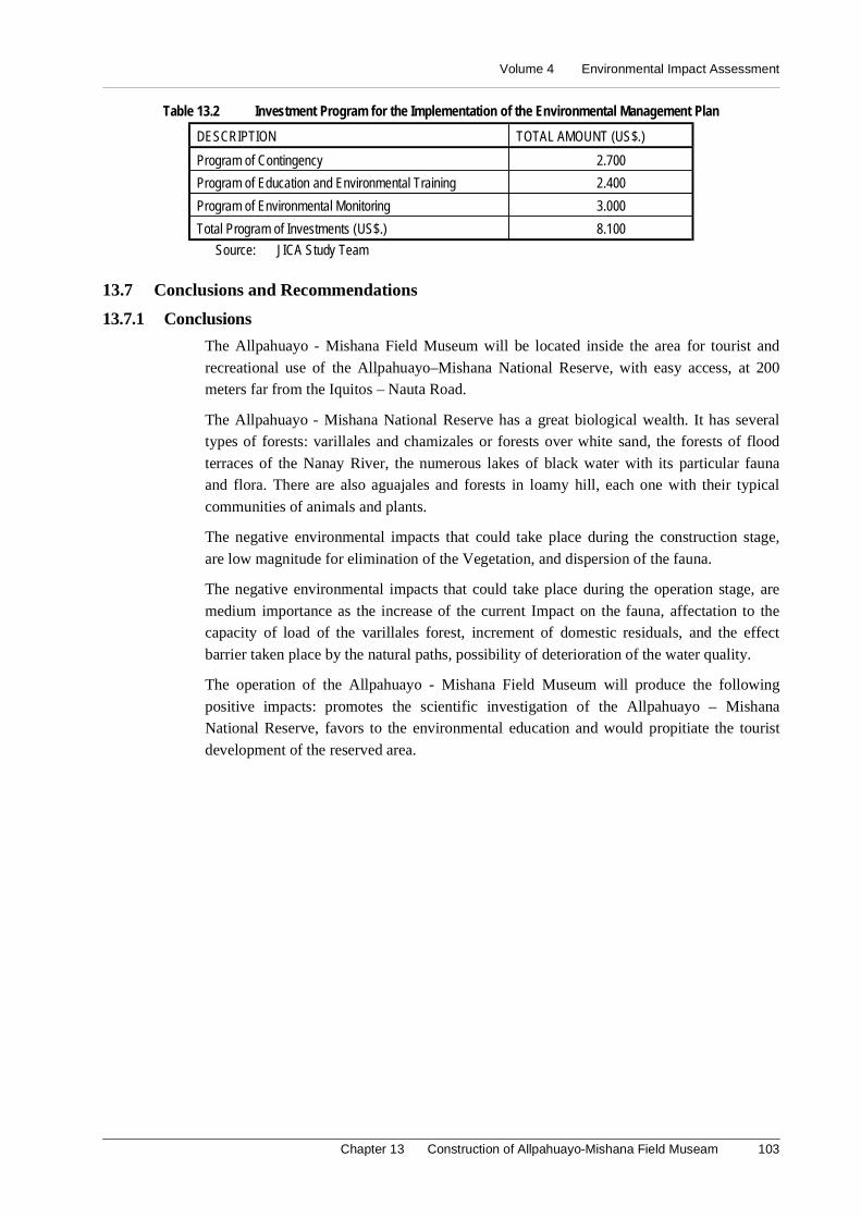
Volume 4 Environmental Impact Assessment
Chapter 13 Construction of Allpahuayo-Mishana Field Museam 103
Table 13.2 Investment Program for the Implementation of the Environmental Management Plan
DESCRIPTION TOTAL AMOUNT (US$.)
Program of Contingency 2.700
Program of Education and Environmental Training 2.400
Program of Environmental Monitoring 3.000
Total Program of Investments (US$.) 8.100
Source: JICA Study Team
13.7 Conclusions and Recommendations
13.7.1 Conclusions
The Allpahuayo - Mishana Field Museum will be located inside the area for tourist and
recreational use of the Allpahuayo–Mishana National Reserve, with easy access, at 200meters far from the Iquitos – Nauta Road.
The Allpahuayo - Mishana National Reserve has a great biological wealth. It has severaltypes of forests: varillales and chamizales or forests over white sand, the forests of flood
terraces of the Nanay River, the numerous lakes of black water with its particular faunaand flora. There are also aguajales and forests in loamy hill, each one with their typical
communities of animals and plants.
The negative environmental impacts that could take place during the construction stage,
are low magnitude for elimination of the Vegetation, and dispersion of the fauna.
The negative environmental impacts that could take place during the operation stage, are
medium importance as the increase of the current Impact on the fauna, affectation to thecapacity of load of the varillales forest, increment of domestic residuals, and the effect
barrier taken place by the natural paths, possibility of deterioration of the water quality.
The operation of the Allpahuayo - Mishana Field Museum will produce the following
positive impacts: promotes the scientific investigation of the Allpahuayo – MishanaNational Reserve, favors to the environmental education and would propitiate the tourist
development of the reserved area.
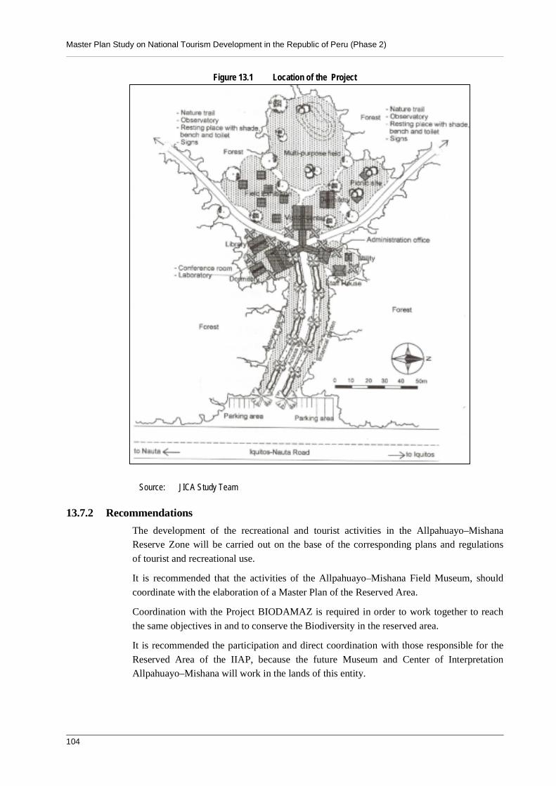
Master Plan Study on National Tourism Development in the Republic of Peru (Phase 2)
104
Figure 13.1 Location of the Project
Source: JICA Study Team
13.7.2 Recommendations
The development of the recreational and tourist activities in the Allpahuayo–MishanaReserve Zone will be carried out on the base of the corresponding plans and regulations
of tourist and recreational use.
It is recommended that the activities of the Allpahuayo–Mishana Field Museum, should
coordinate with the elaboration of a Master Plan of the Reserved Area.
Coordination with the Project BIODAMAZ is required in order to work together to reach
the same objectives in and to conserve the Biodiversity in the reserved area.
It is recommended the participation and direct coordination with those responsible for the
Reserved Area of the IIAP, because the future Museum and Center of InterpretationAllpahuayo–Mishana will work in the lands of this entity.
Volume 4 Environmental Impact Assessment
Chapter 13 Construction of Allpahuayo-Mishana Field Museam 105
The final design of the Allpahuayo – Mishana Field Museum must be included the design
of a system of Evaluation and treatment of water sewage of the bathrooms and otherinstallations of the Museum.

Volume 4 Environmental Impact Assessment
Chapter 14 Improvement of Quistococha Tourist Complex 107
14. Improvement of Quistococha Tourist Complex
14.1 Introduction
Tourism is one of biggest industries and of major growth of the world. It presents quite
favorable perspectives of growth in connection with the evolution of the world economy.Peru has huge tourist attractiveness, however it has stayed unaware to this growing
evolution.
MITINCI outlines plans to execute tourist projects in different areas and regions of the
country with the objective to revert this situation and the necessity of offering betterservices to the tourists. One of these is improvement of San Juan Market, in the Maynas
provice, department of Loreto.
The activities of the improvement of San Juan Market will bring changes and/or
environmental modifications in diverse degrees of magnitude and importance during theconstruction and operation stages. In this sense, it is necessary to carry out an
Environmental Impact Assessment (EIA) to identify, predict, interpret and communicatethe probable environmental impacts. It constitutes a tool or instrument of first importance
to evaluate the environmental implications that the project generates establishingpreventive and/or corrective measures.
14.2 Legal and Institutional Frameworka. Legal Framework
Political Constitution of Peru, Law Framework for the Investment Private Growth - D.
Leg.Nº757, Law of Evaluation of Environmental Impact for Works and Activities - Law26786, General Law of Waters - D.L. Nº17752, Organic Law of Municipalities, Code of
Environment and of the Natural Resources - D. Leg. Nº613, Organic law for theSustainable Use of the Natural Resources - Law Nº26821, Law On the Conservation and
Sustainable Use of the Biological Diversity - Law Nº26839, Law of Protected NaturalAreas - Law Nº26834, Law for the Development of the Tourist Activity - Law Nº2696,
Regulation of Law for the Development of the Tourist Activity– D.S. Nº002-2000-ITINCI; it declares of public necessity the qualification and operation of the Zonal,
Zoological and Botanical Park of the city of Iquitos - D.S. Nº102-72-VI. It is classifiedas National Tourist Park the Lake of Quistococha, inside the System of National Tourist
Reservations - R.S. Nº223-84-ITI/TUR. It is granted the Regional Governments theability to create Regional Zoological Parks inside its area of influence-D.S. Nº19-95-AG.
b. Institutional Framework
Ministry of Industry, Tourism, Integration and International Commercial Business(MITINCI), Presidency of the Council of Ministers, National Council of the Environment
(CONAM), National Institute of Civil Defense (INDECI), and Transitory Council ofRegional Administration - CTAR Loreto.
14.2.2 Description of the Project
The Quistococha Tourism Complex is located in the southwest part of the city of Iquitos,
on the Iquitos – Nauta Road, approximately 5 km away from the Airport of Iquitos. Thecomplex has a total area of approximately 369 ha, which includes the forests and the Lake
Quistococha (See Figure 14.1)
Master Plan Study on National Tourism Development in the Republic of Peru (Phase 2)
108
The project will construct, improve, and enlarge facilities in the Quistococha Tourism
Complex with the purpose to offer appropriate means of exhibition of the diverse faunaspecies, to increase the tourist attraction, besides to contribute to the environmental
education.
Expansion and renovation will be necessary for following facilities: ponds for paiches;
cages for birds; puddles of water or ponds for aquatic animals, the feline center and theisland of monkeys and others.
An aquarium exhibiting the most significant and attractive species from the AmazonRegion will be built for the visitors, likewise, the construction of a pond is foreseen for
manaties. As additional attractiveness to the Complex, there will be lodges beside the lakeQuistococha (on the white sandy beach), where the guests will be able to appreciate the
nature of a part of the Amazon Region.
14.2.3 Basic Environmental Outline
(1) Physical Environment
The climate is Humid-warm with an average of annual total pluvial precipitation that
varies between 2876.5 and 2,727.4 mm. The media temperatures are very uniform duringthe whole year. It registers 26.3ºC, with very slight descents during May, June and July.
According to the hydrological study, there is a tract of the river Itaya, located to the southof the lagoon. The flow fluctuates according to the stations of the year, being presented
the biggest discharges during the rainy summer (from December until the end of March).
The classes of soils are represented by Imperfectly Recent Alluvial Soils, drain and
poorly drain, Old Alluvial Soils that are strongly acid soils, low to moderate presence oforganic matter, a saturation of bases above 50%, low phosphorous concentration and high
proportion of potassium.
The use of the land in the aftected area of the project is conformed by areas with human
activity, early secondary forest, primary forest and the lagoon Quistococha.
(2) Biological Environment
For its geographical location, the lagoon and surrounding areas present the characteristic
of Tropical humid forest, denominated Low Forest or amazon penillano. However, duethe proximity to the urban area, their ecosystem has been altered in diverse sectors by
human activities.
Major plant species are Mauritia sp., Jessenia sp., Cmemidoria sp., Strychnos sp. Also,
diverse bromeliáceas and exotic orchids are presented. Major animal species are Bufospinulosus, Coragyps atratus, Crypturellus sp., Tinamus sp., Columba sp. and others.
(3) Socioeconomic Environment
According to Population and Housing Census of 1993, the Loreto Department registered
687,282 inhabitants. Its 66.49% (261,648 inhabitants) are in the district of Iquitos.50.26% (131,507) are women and 49.74% (130,141) are men. The biggest percentage
population (88.51%) is located in the urban area.
According to INEI, the main economic activity was commerce and repair of vehicles
(20.07% of the PEA) in the district of Iquitos in 1993.

Volume 4 Environmental Impact Assessment
Chapter 14 Improvement of Quistococha Tourist Complex 109
There were 43,592 houses made of wood (49.4%). 55.4% was supplied of water by
means of the public net. 54.29% of the houses connected hygienic services to the publicnetworks, 18.33% was connected to blind well, 15.44% did not have hygienic services
and 77.69% had readiness of electric service.
Major ethnic groups are: Witotos, Boras and Ocainas, Yaguas or Yahuas, Ticuna,
Orejones and Jibaros,
14.2.4 Identification and Evaluation of Environmental Impacts
It has been necessary to use diverse methodologies for the identification and evaluation ofthe environmental impacts expected during the construction and operation stages of the
Project. The beneficent and harmful environmental impacts are identified, predicted,interpreted and communicated by the application of Leopold Type Matrix, Cause-Effect
Diagrams and the use of Field Notes.
(1) Construction Stage
Aesthetic alteration of the Quistococha Tourism Complex. The present aesthetics ofthe Quistococha Tourism Complex will change due to the relocation of some facilities,
the necessity of pruning of some trees, as well as, the presence of waste, dismount andmaterials needed for the construction.
Interference and probable stress of the fauna in captivity. Because of the actions ofthe improvement process, the captive fauna will be disturbed. It is necessary to relocate
the animals temporarily in other environments.
Possible affectation to the water quality of the lagoon of Quistococha. The cleaning of
the facilities and cages, inadequate disposition of material surpluses, as well as, theorganic waste of the captive fauna and visitors will affect the water quality of the lagoon
Quistococha.
Annoyance to the visitors of the Complex. Due to the possibility of closing some
facilities and transfer of some animals temporarily, as well as the interruption of theaccess to diverse sectors, the visitors will be impeded to walk around all the facilities.
Affectation to the vegetation for disposition of material surpluses in garbage areas.The identified area for disposition of the material surpluses will temporarily affect on
shrubby vegetation and arboreal dispersed.
Possible occurrence of labor accidents. During the works of the improvement process,
there could be labor accidents as fallen, lesions, etc. that could commit in some cases thephysical integrity of the workers and operatives of the construction.
(2) Operation Stage
Improve of the economic revenues of the partner-craftsmen and the people of thetown. The improvement of the facilities of the Complex will increase affluence of the
visitors to this area. It will promote increasing economic revenues of the local employeesand commercial establishments.
Improve of the conditions and comfort of captive the fauna. The animals in captivitywill be better due to the improvement and amplification of their exhibition facilities. It
will decrease the stress conditions presented to some of these species.
Master Plan Study on National Tourism Development in the Republic of Peru (Phase 2)
110
A major knowledge about the natural environment of the Amazon Region. The
improvement of the Complex will increase opportunities to have a major approach to thenatural patrimony for the visitors, through the direct observation of the most
representative natural resources in the Amazon Region.
Possible affectation to water quality of the lagoon Quistococha. The influx of visitors
to the facilities of the Complex will increase a demand of sanitary services. More overmaintenance and cleaning works of the facilities and waste of the animals could generate
the alteration of the water quality of the lagoon.
14.3 Environmental Management Plan
14.1.1 Program of Control and/or Environmental Mitigation
(1) Construction Stage
- The areas for necessary activities of excavations, cleaning and elimination of thevegetable covering will be bounded exclusively. The material surpluses and waste willbe daily transported to the identified garbage area.
- The works will be executed progressively and for stages, in such a way, the levels ofnoise are bounded strictly in the work area. In cases to transfer and temporaryrelocate the fauna, provisional habitats should be provided with appropriate conditionsand minimum dimensions.
- In order to conserve the landscape of the area where the material surpluses will bedeposited, this area will have a plant covering at the end of the works by using nativespecies.
- The tools used for the works will be washed in the waters of the lagoon for any reason.Besides, it will not be spilled any type of residual liquid. On the other hand, thematerial surpluses will be derived to the identified garbage area.
- Informative warnings will be placed (in English and Spanish) to explain aboutexecuting works. The visitors could appreciate and travel around the enabled facilities.
- It will be necessary to fence the working area, and not to allow the access for notauthorized people, to informative posters.
- The workers and operatives of construction works will have the correspondingsecurity devices such as work clothes, helmets, boots and those that can require forspecific reasons of their work.
(2) Operation Stage
- The followings are recommended: the engineering study to consider buildings insideof the Complex; sewerage and systems of treatment of the residual waters.
- Garbage cans will be installed at different places. The quantity and dimension of thehygienic services should be in agreement to projections for the increase of the numberof visitors.
14.1.2 Program of Environmental Monitoring
- The main actions of the Program of Environmental Monitoring are referred to thecontrol of the water quality of the lagoon Quistococha in consideration of the GeneralLaw of Waters (Law Nº17752).
Volume 4 Environmental Impact Assessment
Chapter 14 Improvement of Quistococha Tourist Complex 111
- For Considerations to the qualification and construction of a treatment system ofresidual waters, the previous recommendations will be followed. Also, the observationand report are required for a possible contamination of the waters of the QuistocochaLagoon, especially on the beach and in the collectors where the treated residual waterswill be discharged.
14.1.3 Program of Education and Environmental Training
The activities contemplated for the Program of Education and Environmental Training,are the following ones:
- It is recommended to qualify officials, professional and technician personalresponsible for the Complex. The operatives and contractors of the improvementworks will be informed about the importance of the environmental conservation, sothat they can carry out their functions correctly. There will be communications forenvironmental education.
- Publication and diffusion of educational notes to the visitors in general, andexplaining the importance of the environment.
14.1.4 Program of Contingencies
For a correct and appropriate applicability of the Program of Contingencies, it isrecommended to establish a committee of contingencies against risk of accidents and
eventualities. The program will be carried out at the beginning of the activities of thecomplex improvement and will be active during the operation stage.
It is indispensable that the committee of contingencies has the following elements:
- Materials and available inputs appropriate for each case.
- Equipment against fires.
The operation personnel should be qualified to face at any cases of the diverse identifiedrisks
14.1.5 Program of Project Abandon
If it is considered to execute new projects with respect to constructions and improvement
of other facilities in the Complex in the future. The following actions to possibleenvironmental problems should be considered for the work abandon:
- Demolition of the built infrastructure and careful of dismounts and building remainsto a previous place determined as garbage area.
- The CTAR-Loreto will determine if part or the total of materials of easy removal andcollapsible as wood, calamine, etc., pass to own to third partners in donation, or in itsdefect they are sold.
14.1.6 Program of Investments
The budget profits necessary, so that it can be fulfilled the application of the measuresrecommended in the Programs considered in the Environmental Management Plan
ascends to:
- Preventive and/or Corrective Program US $ 2,800.00
- Program of Contingency US $ 2,700.00

Master Plan Study on National Tourism Development in the Republic of Peru (Phase 2)
112
- Program of Education and Environmental Training US $ 2,400.00
- Program of Environmental Monitoring US $ 750.00(quarterly).
Figure 14.1 Layout Plan of the Quistococha Tourism Complex
Source: JICA Study Team14.2 Conclusions and Recommendations
- The improvement of the Quistococha Tourism Complex will increase the offer ofvisitor attractiveness of the region of Loreto, increasing the average permanency ofvisitor. It will also improve the economy of the local population.
- The improvement of the Complex will favor a major affluence of national and foreignvisitors. For this, new infrastructure of services will be provided: an appropriatesystem of water, drainage, and treatment of residual waters and solid residuals.
- The Complex is inside an ecosystem classified as Tropical humid forest. However,due to the proximity to the urban area, its ecosystem has been altered in diversesectors by human activities.
- Must be built an assistans Comitee of INRENA and the ONG’s for the consult at theoperation and maintenance of the turistic Complex.
Volume 4 Environmental Impact Assessment
Chapter 14 Improvement of Quistococha Tourist Complex 113
- In general, as a result of the Environmental Impact Study, it is determined that none ofthe possible occurrences of environmental impacts are restrictive to execute theproject. For this reason, if the Environmental Management Plan is properly applied,the project is environmentally feasible.
- It is basic that sewerage and treatment of its residual waters will be provided in thecomplex since at the moment this type of water is poured directly to the lagoonQuistococha.

Volume 4 Environmental Impact Assessment
Chapter 15 San Juan Market Tourism Improvement 115
15. San Juan Market Tourism Improvement
15.1 IntroductionTourism is one of biggest industries and of major growth of the world. It presents quite
favorable perspectives of growth in connection with the evolution of the world economy.
Peru has huge tourist attractiveness, however it has stayed unaware to this growing
evolution.
MITINCI outlines plans to execute tourist projects in different areas and regions of the
country with the objective to revert this situation and the necessity of offering better
services to the tourists. One of these is improvement of San Juan Market, in the Maynas
province, department of Loreto.
The activities of the improvement of San Juan Market will bring changes and/or
environmental modifications in diverse degrees of magnitude and importance during the
construction and operation stages. In this sense, it is necessary to carry out an
Environmental Impact Assessment (EIA) to identify, predict, interpret and communicate
the probable environmental impacts. It constitutes a tool or instrument of first importance
to evaluate the environmental implications that the project generates establishing
preventive and/or corrective measures.
15.2 Institutional General and Legal Frameworka. Legal Framework
Political Constitution of Peru Law of Evaluation of Environmental Impact for Works and
Activities - Law 26786, Organic Law of Municipalities, Directive techniques forcommercialization of handicrafts made by spineless species and spoils of wild fauna
–Chief resolution Nº065-2000 - INRENA, Law Framework for the Private InvestmentGrowth – Legislative Decree Nº757 modified laws, Code of the Environment and of the
Natural Resources – Legislative Decree Nº 613 and their modified laws, Law for theDevelopment of the Tourist Activity - Law Nº 26961 and Regulation of the Law for the
Development of the Tourist Activity– D.S. Nº 002 - 2000 - ITINCI.
b. Institutional Framework
Ministry of Industry, Tourism, Integration and International Commercial Business(MITINCI), Presidency of the Council of Ministers, National Council of the Environment
(CONAM), National Institute of Civil Defense (INDECI), and Transitory Council ofRegional Administration - CTAR Loreto.
15.3 Description of the Project
San Juan Market Bautista is located in the City of Iquitos: the capital of Maynas, provinceLoreto department. The market occupies an adjacent area of 7,100m2, next to the Avenue
José Abelardo Quiñones, between the airport and the urban center of Iquitos.
The project, of San Juan Market tourism improvement includes construction of a
handicrafts training center, that will offer permanent training to the craftsmen.Reconstruction of workshops and stores will maintain the existing activities of artisans:
Master Plan Study on National Tourism Development in the Republic of Peru (Phase 2)
116
they can show and sell their works in the market. Restaurants, cafeterias and resting areas
with benches and gardens will be prepared for the visitors in the walk area.
The market is located in a favorable site of easy vehicular accessibility. The
administration office and a parking area, located on the Avenue José Abelardo Quiñones,will be improved. An access way to the interior of the market for vehicles is considered to
support the daily activities in the market and their maintenance.
15.4 Basic Environmental Outline
(1) Physical Environment
The climate is Humid-warm with an average of annual total pluvial precipitation that
varies between 2,876.5 and 2,727.4 mm. The media temperature is very uniform duringthe whole year. It is 26.3ºC with very slight descents during May, June and July.
According to the hydrological study, there are two (02) hydrographic basins. The basin ofthe river Nanay has an approximate journey of 300 km and the one of the river Itaya has
an approximate journey of 100 km.
Recently, Alluvial Flood Soils and Non Flood Old Alluvial Soil represent the classes of
soils. They are strong acid soils of low to moderate presence of organic matter, saturationof bases above 50%, low phosphorous concentration and high proportion of potassium.
The use of the land in the affected area of the project is conformed by Semi-urban areasand Non Flood and Flood Alluvial Forests and meanders.
(2) Biological Environment
The project site is located in the urban area. Therefore, regarding to a biologicalenvironment, the flora and the fauna of the affected area are conformed to the vegetation
of parks and ornamental gardens; as well as, some domestic animals and birds androdents.
However, it some arboreal species mixed with palms such as Jessenia sp., Mauritia sp.and Entorpe sp are identified. They have characteristics of flood lands and with imperfect
drainage.
(3) Socioeconomic Environment
According to Population and Housing Census of 1993, the Loreto Department registered687,282 inhabitants. 66.49% (261,648 inhabitants) is in the district of Iquitos. 50.26%
(131,507) are women and 49.74% (130,141) are men. The biggest percentage ofpopulation (88.51%) is located in the urban area.
According to INEI, the main economic activity was commerce and repair of vehicles(20.07% of the PEA) in the district of Iquitos in 1993.
43,592 houses were made of wood (49%). 55.4% was supplied of water by means of thepublic net. 54.29% of the houses connected hygienic services to the public networks,
18.33 connected to blind well, 15.44% did not have hygienic services. 77.69% hadreadiness of electric service.
Major ethnic groups are: Witotos, Boras and Ocainas, Yaguas or Yahuas, Ticuna,Orejones and Jibaros.
Volume 4 Environmental Impact Assessment
Chapter 15 San Juan Market Tourism Improvement 117
15.5 Identification and Evaluation of Environmental Impacts
It has been necessary to use diverse methodologies for the identification and evaluation of
the environmental impacts expected during the construction and operation stages of theproject. The beneficent and harmful environmental impacts are identifed, predicted,
interpreted and communicated by the applications of Matrix type Leopold, Cause-EffectDiagrams and the use of Field Notes.
(1) Construction Stage
Aesthetic alteration of the market. The present aesthetics of the market will change,
due that the stands-shops will have to provisionally be relocated, the pruning of sometrees, as well as the presence of waste and dismount.
Affectation of the economic revenues of the partner-craftsmen. The actions of theconstructive process and improvement would originate certain disorder that will be an
obstacle to the visitors who want to appreciate and/or acquire the products exposed by themerchants.
Affectation to the vegetation for disposition of material surpluses in garbage areas.The identified area as probable area for the permanent disposition of the material
surpluses will affect shrubby vegetation and arboreal dispersed.
Possible occurrence of labor accidents and affectation of the bordering populationand local trade. During the actions of improvement of the market, it is probable thatlabor accidents are presented. Also the surrounding population and the normal
development of the activities in the adjacent communal market will be disturbed due tothe sale of domestic products.
(2) Operation Stage
Improvement of the economic revenue of the partner-craftsmen. It is foreseen that theimprovement of the market will offer major comfort and attractiveness to the visitors to
appreciate and/or acquire products made by the partner-craftsmen of the San Juan market.
Probable unconformity of the partners of the handicraft for the non-constructionand qualification of the auditory. There is the possibility that the partner-craftsmen ofthe San Juan market show their unconformity in reference to the outline proposed for the
improvement of the market, due to the exclusion of the auditory where they program thecelebration of San Juan's party.
Possible affectation to the handicraft place for risk of eventualities and/or accidents.Considering the inflammable materials (paintings, lacquer, varnish, wood, etc.) used by
the artisans, fires could be originated in the handicraft market. The new stands-workshopswould also be built of materials of easy to combustion (wood, straw).
15.5.2 Program of Control and/or Environmental Mitigation
(1) Construction Stage
- The stands-shops will be relocated in orderly way that allows the easy access, offeringsecurity to the visitors. It is necessary that informative and/or preventiveadvertisement are placed (in English and Spanish language), where it is informedabout the nature of the works that are executed.
Master Plan Study on National Tourism Development in the Republic of Peru (Phase 2)
118
- It will be necessary that the excavations, cleaning and elimination of the vegetablecovering should be bounded exclusively to the necessary actions for the activities ofimprovement. The material surpluses and of waste will be transported daily to the areaidentified as garbage area.
- In order to conserve the landscape, the area will be covered with plants at the end ofthe working period by using native species.
- It will be necessary to fence the work area, and not to allow the access of notauthorized people by placing informative posters.
- The workers and operatives of construction works will have the correspondingsecurity devices such as work clothes, helmet, boots and those that can require forspecific reasons of their works.
(2) Operation Stage
- Equipment against fires will be settled down coordinating with the INDECI, with thepurpose that the partner-craftsmen receive orientation of the management of the sameones, and adopt measures of quick action in such a situation.
- Previous to the execution of improvement of the San Juan Market, it is recommendedto coordinate and to consult with the partner-craftsmen about the design of thefacilities and the possibility to install and enable a place where they carry out theirrecreation activities and festivities.
15.5.3 Program of Education and Environmental Training
The activities contemplated inside the Program of Education and Environmental Training,are the following ones:
- It is recommended to permanently qualify the partner-craftsmen, and the operativesand contractor of the improvement work about the importance of the environmentalconservation. In this case, they can carry out their functions correctly. There will bechats of environmental education.
- Publication and diffusion of educational notes to the population in general; and mainly,to those that inhabit bordering areas explaining the importance of the environment.
15.5.4 Program of Contingencies
For a correct and appropriate applicability of the Program of Contingencies, it isrecommended that the associations of craftsmen of the San Juan market form and
establish a committee of contingencies against risk of accidents and eventualities. It willbe carried out at the beginning of the activities of the market improvement and will be
active during the operation stage.
It is indispensable that the committee of contingencies has as minimum the following
elements:
- Materials and available inputs appropriate for each case.
- Equipment against fires.
The operation personnel should be qualified to face at any moment the diverse identified
risks.
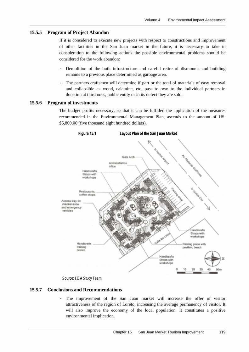
Volume 4 Environmental Impact Assessment
Chapter 15 San Juan Market Tourism Improvement 119
15.5.5 Program of Project Abandon
If it is considered to execute new projects with respect to constructions and improvement
of other facilities in the San Juan market in the future, it is necessary to take inconsideration to the following actions the possible environmental problems should be
considered for the work abandon:
- Demolition of the built infrastructure and careful retire of dismounts and buildingremains to a previous place determined as garbage area.
- The partners craftsmen will determine if part or the total of materials of easy removaland collapsible as wood, calamine, etc, pass to own to the individual partners indonation at third ones, public entity or in its defect they are sold.
15.5.6 Program of investments
The budget profits necessary, so that it can be fulfilled the application of the measures
recommended in the Environmental Management Plan, ascends to the amount of US.$5,800.00 (five thousand eight hundred dollars).
Figura 15.1 Layout Plan of the San Juan Market
Source: JICA Study Team
15.5.7 Conclusions and Recommendations
- The improvement of the San Juan market will increase the offer of visitorattractiveness of the region of Loreto, increasing the average permanency of visitor. Itwill also improve the economy of the local population. It constitutes a positiveenvironmental implication.
Master Plan Study on National Tourism Development in the Republic of Peru (Phase 2)
120
- The San Juan market will be improved and located in urban area. For this reason, thebiological environment of the direct affected area is conformed by parks andornamental gardens, as well as some birds and domestic animals.
- In general, as a result of the Environmental Impact Study, it is determined that none ofthe possible occurrences of negative environmental impacts are restrictive importantto execute the project. For this reason, if the Environmental Management Plan isproperly applied, the project is environmentally feasible.
- It will be convenient to coordinate and consult with the partner-craftsmen, to designthe improvement of the San Juan Market, and to study the possibility to install and toenable a place where they are carried out their recreation activities and festivities. Itwill have enough capacity to harbor the visitors who attend to these events.
Volume 4 Environmental Impact Assessment
Chapter 16 Training Lodges in The Pacaya-Samiria National Reserve 121
16. Training Lodges in the Pacaya-Samiria National Reserve
16.1 Introduction
16.1.1 Generalities
The tourism ecological will be incentive in the Pacaya-Samiria National Reserve, this
include to the organised and living population inside of the reserve in the conservationpractice giving them the opportunity for your development that could help them to
survive and to conserve their natural resources with the sustainable use. Oriented tovisitors who want see the nature, the flood forest, the cochas (swamps), tipishca (marshy
ground), flora, fauna and the cultural heritage present in this area, giving a quality servicewith a low environmental impact and a fair distribution of the benefices in harmony with
the objectives of the Reserve.
In that sense, before the construction of training lodges is necessary the realisation of the
environmental impact assessment that will permit to identify and predict theenvironmental changes produced for the execution of the works and establish the
adequate preventive and corrective measures and their implementation to oppose theenvironmental impacts injures and engage the benefices impacts that allow the well being
to the population.
16.1.2 Objectives of the Environmental Impact Assessment
To identify, predict, interpret and communicate the probably environmental impacts thatthe Construction of Training Lodges in the Pacaya – Samiria National Reserve project, it
could cause in any environmental components and the impact of the environmental overthe project too, proposing the more effectives correctives measures for prevent that these
environmental impacts damage the health and the well being of the people and the reserve.
16.2 Legal And Institutional Frame
The Environmental Impact Assessment Construction of training lodges for the Pacaya-Samiria National Reserve will be develop considering the legal and institutional norms
referred to the conservation and national environmental protection.
The principals norms are: Politic Constitution of Peru, Nature Resources and
Environmental Code, Protected Nature Areas Law, Law of Conservation and Use of theBiologic Diversity, Forestal and Wild Fauna Law, Environmental Impacts Evaluation
Law for Activities and Works, Water General Law, Municipalities Organic Law, PenalCode (Offense against the Ecology), Law and Rule for the Tourist Activity Development,
and others.
The institutions with participation in the project area, are: Ministers Council Presidency,
Environmental National Council (CONAM), Industry, Tourism, Integration andInternational Commercial Trade Ministry (MITINCI), Agriculture Ministry by means of
the Natural Resources National Institute (INRENA), Regional Administration TransitoryCouncil – CTAR Loreto, PRONATURALEZA, World Wildlife Fund (WWF), Peruvian
Amazonian Investigations Institute (IIAP), and others
16.3 Description of the Project
The construction of the lodges in the Pacaya-Samiria National Reserve will be located in
the humans establishments Veinte de Enero and San Martin de Tipishca. These humans
Master Plan Study on National Tourism Development in the Republic of Peru (Phase 2)
122
establishments are located in the district of Nauta and Parinari, province and department
of Loreto as is showed in the figure 16.1:
The project include the construction of rooms for the reception, buffet, offices, bedrooms
for the personal and instructors, classroom and others in each human establishment.
16.4 Basic Environmental Outline
16.4.1 Project influence area
(1) Indirect influence area
For delimited the indirect influence area of the Construction of Training Lodges in Veinte
de Enero and San Martin de Tipishca human establishment, kept in mind the naturallimits as Marañon, Yanayacu and Samiria rivers, the gorge and the tipishca of the Samira
that surround them. And the new zonification of the reserve considered in the Master Planfor the Biological Diversity Conservation and the Sustainable Development of the
Pacaya-Samiria National Reserve and its Mitigate Zone, and also the tourist andrecreative area.
(2) Direct influence area
This area has an action radio of 0.5 km approximately around the training lodges area in
Veinte de Enero and San Martin de Tipishca, where it has been planed the constructionand operation of them.
16.4.2 Weather
The weather that prevails where is planed develop the training lodges is hot and wet
normally, typical of the tropical wet forest with an annual media temperature around the27°C and rains over the 2900 mm.
These amazonian weather present anomalies during the year, called ¨small summers¨ and¨colders fronts¨. The ¨small summers¨ are dry periods registered on January and February
(months of more precipitations normally), during approximately one week. The ¨friajes¨are short periods among two or three days, where temperature down brusquely.
16.4.3 Hydrology
Two big rivers around the Pacaya Samiria Natural Reserve territory, for the north theMarañon river and for the south the Ucayali river – Puinhua canal. Both begin in the
oriental side of Los Andes and join near the Nauta for give the beginning of theAmazonas River. The basin of the rivers Samiria, Pacaya and Yanayacu-Pucate give the
characteristics to the hydrologic cycle of growing (February and March) and emptying(July and August) that determinate the fluvial and ecological dynamic of the area.
Veinte de Enero is located in the right side of the Yanayacu river and San Martin deTipishca is located in the Samiria river tipishca, both are human establishment seated
inside the reserve, in the low basin of the Marañon river.
16.4.4 Geology
The training lodges that will build in Veinte de Enero and San Martin de Tipishca, will beseated occupy recent quaternary alluvial deposits in the flood plain, occupying narrow
bands along the Samiria and Marañon.
Volume 4 Environmental Impact Assessment
Chapter 16 Training Lodges in The Pacaya-Samiria National Reserve 123
16.4.5 Soils
The kind of soils that characterize the zones in study are related with the geologic origin
and the time of formation of the parental material that give them their fertilitycharacteristic, as well as with their topography that determinate the drainage conditions.
(1) Physiography
Veinte de Enero and San Martin de Tipishca landscape is product of the fluvial dinamic
of the Marañon and Samiria rivers, being the recent fluvial plain landscape have the nextelements: Border Complex and Low Terrace.
The Border Complex is present in San Martin de Tipishca. It is formed when is brokenthe erosion – sedimentation balance, and prevail the lateral erosion in the big rivers grown
periods and the water expands for the flood plain, forming higher lands called restingas,alternating with the curved smoothly low parts called bajiales, also there are tahuampas
that are lands with very poor drainage.
The low terrace is present in Veinte de Enero; it is constituted with plain topography
lands, slopes of 0 - 2%. Due the little difference with the river level, suffers floods in thegrowing time.
(2) Soils classifications
The identified soils in Veinte de Enero and San Martin de Tipishca are: alluvial – fluvialsoils (Quaternary) that includes the fluvial soil and characterizes to have fertiles soils
deposited and erosioned annually for the Marañon river in the low parts of the islands,barreales and beaches.
(3) Lands classification according their capacity of use
According to the capacity of use of the lands, the project will be seated in the Xiw-F2W-
A3i association in San Martin de Tipishca, characterised for the prevalence of protectionlands, with very inefficiency drainage and with periodic flood problems, also for forestal
production lands with media agronomic quality related with drainage and with soilsmoderately profound with drainage good to medium, and texture medium to fine, and
reaction neutral to acid, with levels of fertility medium to low.
Veinte de Enero was placed in lands of the type F2sw, characterised for forestalls soils
with agrologic quality low with problems of soil and drainage.
16.4.6 Vegetation
The type of vegetation of River Forest of San Martin de Tipishca is characterised forspecies of rapid grow and the size is not too high.
This fringe of vegetation suffer periodically floodings and contain: beach vegetation,ceticos (Cecropia spp), pungales and beach vegetation.
The stationary flooding forest were is located in the zone near to Veinte de Enero,presented a vegetation predominantly low and other with trees of higher size. Here are
present the restingas.
Master Plan Study on National Tourism Development in the Republic of Peru (Phase 2)
124
16.4.7 Wild Flora and Fauna
(1) Flora
In the Pacaya-Samiria National Reserve has been determined 847 botanical species,contained in 471 genus and 118 families. The presence of Palms is very regular in the
area, represented for vegetables communities known like niejillales, yarinales, shapajalesand aguajales.
Also are the ojé (Ficus insipide), the quillobordon (Aspidosperma vargasii), the cedar(Cedrela odorata), the tornillo (Cedrelinga cateaneformis), the palms known like sacha
pona (Wettinia angusta), and the chonta (Attalea tessmannii), between others.
(2) Fauna
Wild fauna is very importance for their participation in the regional economical life and
for its representation of the fauna of the amazonic plain flooding.
Between the birds are registered 330 species grouping in 58 families, 6 species migrated
from the artic, 94 species of mammalian like the monkeys choros (Lagothrix lagotricha),the monkey coto (Alouatta seniculus), the black huapos (Pithecia monachus), the
maquisapas (Ateles spp), the marine cow or manatí (Trichechus inunguis), the big felines(Panthera onca), the otters (Pteronura brasiliensis) and (Lutra longicaudis), the river
dolphins (Inia geoffrensis) and (Sotalia pluviatilis), sachavacas or false cows (Tapirus
terrestris), deers (Mazma spp), majaz (Agouti paca), añujes (Dasyprocta sp), carachupas
(Dasypus sp), mancos (Eira barbara), bear anteater (Tamandria sp), between others.
In relation to the amphibious there are 55 species; 12 families of reptiles like black lizard
(Melanosuchus niger), with a low density population, and white lizard (Caiman
crocodylus) the yacumama (Eunectes muninus), the boa neck piece rainbow (Epicrates
cenchria), the charapa (Podocnemis expansa), and the taricaya (Podocnemis unifilis)between others.
Also are reported 259 species of fishes of great economical and nutritious importance tothe people of the Pacaya-Samiria National Reserve, between the paiche (Arapaima gigas)
this one suffer a strong pression for their capture for that reason are located to the lowzones of the river basins of Pacaya and Samiria.
16.4.8 Social Economical and Cultural Medium
(1) Veinte de Enero
This center is ubicated inside the reserve in lands of restinga, at the right side of theYanayacu river at 2 hours up water river from Nauta. With 220 inhabitants approximately,
grouped in 42 families. The houses are at more than 1 meter from the soil level becausethe floodings of winter. The rivers with the transportation in boats, canoes are the form of
use for hunting, fishing, cropping and extraction of wood and chonta.
They don’t have electricity, water supply, markets, etc. The education is only an initial
and primary level. They don’t have sanitary posts and the inhabitants used empiricalknowing for threat the minor sicks.
Volume 4 Environmental Impact Assessment
Chapter 16 Training Lodges in The Pacaya-Samiria National Reserve 125
(2) San Martin de Tipishca
San Martin de Tipishca, is ubicated inside the Reserve, at the border of the tipishca
(swamp) of the river Samiria, at the restinga lands. Distance at 4 hours up water Samiriariver from Nauta. The inhabitants are 380 people grouped in 58 families, that is organized
like Native Community and affiliated with the Indigenous Association for theDevelopment and Conservation of Samiria (AIDECOS).
Their crops lands are ubicated between the swamps (Tipishca) of river Samiria and riverMarañon.
The houses are made from wood and are at least 1 meter over the soil level because of thefloods. In the back yard are small horticolas pieces of land for fresh vegetables. The main
activity is the fish and in minor scale the agriculture.
The hidrobiologics resources of the tipishca (swamps) of the rivers Samiria and Yanayacu
are the main resource for the income and food of the families. The 100% of the productsof the fish, crop-fruit recollection and wood are exploited inside the Reserve.
The people almost always take advantage of their knowledge empirical for treatment ofsicks.
They don’t have electricity services, water potable supply, smalls markets, etc. Thepeople use artesian fired lamps with kerosene. The water supply is direct from the
tipishca (swamp).
16.5 Identification and Evaluation of the Environmental Impact
The impacts identificated and evaluated in the stages of planning, construction(installation) and operation of the project are the follow:
(1) Planning Stage
Small conflict for land tenure in people centers This conflict is between the people ofVeinte de Enero and San Martin de Tipishca and the project designers for the sens of
ownership and the private propriety.
(2) Construction Stage
Small modification of the landscape this is originated for the building construction oflodges floating platforms, access bridges camps and work areas, near to the settlement of
Veinte de Enero and San Martin de Tipishca.
Possible Temporary Disturb of Soil The installation of the camp, hygienic services,
discharge areas of materials and others, disturb the quality of soil (domestic wastes,cement spilling and others chemical contaminants).
Possible disturb of Natural Water Quality Alteration of the quality of water of therivers Yanayacu and Samiria due to the washing of contaminated soils for the effect of
the rains that affected to the fauna and vegetation aquatic and terrestrial of the settlementsdown water of the construction that used the river water.
Possible disturb of wild fauna and flora quality of life The alteration of water qualityof the rivers Yanayacu and Samiria due to the construction process and noises, damages
the life of the fauna and vegetation surroundings and down water of the constructionzones.
Master Plan Study on National Tourism Development in the Republic of Peru (Phase 2)
126
Possible furtive hunting and deforestation The wild fauna and flora in the
surroundings of the construction areas stimulated the hunting and deforestation for theworkers of the project, also they can invade the Reserve, trespassing the boundary not
authorised.
Possible affectation produced by the climatic conditions The climate produce
floodings over the construction areas and this difficult the construction of the lodges,damage the structures that been building also the flooding of the zones became infections
places. The wastes deposits will be ruined in case were located in floodings areas.
Possible affectation of the human health and the physical integrity The alteration of
the water quality will affect the human use for the workers and inhabitants of Veinte deEnero and San Martin de Tipishca, propitiated the generation of sicks. The accidents will
be produced for construction process and cars transportation.
Small jobs generation and improvement of the acquisition capacity The workers for
the construction of lodges will be hired from the settlement Veinte de Enero and SanMartin de Tipishca. The hired of local workers will be generated new income monetary
that bettering their acquisition capacity.
(3) Operation Stage
Landscape improvement The building of the training lodges will produce the landscapealteration for a positive mode, for the use of wood and works of improvement of
landscape proposal for the Project.
Tourist activity increase The use of the lodges, it will allow larger flow of tourist and
scientific persons to the Reserve, energizing the tourism for the settlements of SanMartin de Tipishca and Veinte de Enero.
Domestic waste generation Increasing the tourism in the Reserve and in San Martin deTipishca and Veinte de Enero settlements, it would generate a median quantity of
domestic waste, that could be throw over the soil, accumulated in inadequate areas ortransfer for the wind to the natural habitats of the flora and fauna.
Possible affectation of the fauna The tourist in their incursion to the Reserve forbidzones could be birds hunting or minor animals hunting.
The tourist major presence in the Reserve frighten the fauna contributing to the noiseemission for the visitors. Also the fauna could be affected for the rivers pollution.
Possible affectation of the flora The tourists could be damage the environment flora,destroyer for the footsteps and or extirpated, ruined its grow. Also the rivers Samiria and
Yanayacu polluted for the domestic waste damage the aquatic flora.
Lodges structure weakening due to the climatic conditions The periodically flooding
could affect the grounds and foundation of the lodges, also the structures of the septicwells. It the places of deposition of waste materials should be washed away for the water
and reach soils and natural water bodies.
Health affectation The people health of the Veinte de Enero and San Martin de Tipishca
could be affected for the infectious focus of the waste water disposal over the rivers
Volume 4 Environmental Impact Assessment
Chapter 16 Training Lodges in The Pacaya-Samiria National Reserve 127
Pacaya, Samiria and Yanayacu and for the lack of appropriate treatment of the river water
for human consume.
Light generation of jobs and light increase of local input The people of Veinte de
Enero and San Martin de Tipishca will be benefit when finished the construction worksdue to the increase of tourist activity for multiplied effects over another economic
activities, demanding more jobs and produced new incomes.
Light improvement of quality of life The people of Veinte de Enero and San Martin de
Tipishca will be benefit for the readiness of new incomes and for the increase of thequantity of tourist services, commercial and agricultural products this will be
improvement of the quality of life.
Light improvement of Reserve Conservation The training of a group of people of the
Veinte de Enero and San Martin de Tipishca settlements help to the better control of thepossible depredation of the fauna and flora, and also to avoid major pollution of soils and
water at the National Reserve Pacaya - Samiria.
16.6 Environmental Management Plan
Environmental Management Plan of the project “Construction of Training Lodges in thePacaya-Samiria Natural Reserve” has the objective of planning the correctives measures
that avoid and or mitigate the negatives environmental impacts in order to ensure theconservation of the area of direct influence of the project.
16.7 Program of Preventive and/or Correctives Measures
(1) Planning Stage
Light conflicts for the occupation of lands at people settlements Will be agreements
between the project executers and the people of Veinte de Enero and San Martin deTipishca respect to the use of areas for construction and let be know the advantage and
benefices of the Project.
(2) Construction Stage
Light modification of the landscape Adequate ubications for the temporaryinstallations will be considered. At the end of the work, will be reforested. The areas of
deposits of wastes of the construction must not affect the landscape.
Possible temporary alteration of soils It is considered to avoid the contaminants
spillways to external areas to the construction; adequate management of concrete;elimination of contaminants materials in ad hoc plastic deposits or cylinders with a sure
seal; the vehicles must have good mechanical conditions, in order to avoid escapes ofcarburants, oils and others.
Natural water quality alteration The measures for avoid the soil alteration are,forbidden the throw of wastes to the rivers or water courses, throw chemical substances in
adequate containers, avoid the washing of motorized vehicles over the rivers.
Possible affectation of wild fauna and flora Forbidden the fauna hunting and
depredation of natural flora to the workers of the construction, establish sanctions andimprovement with an adequate signally. For this purpose must be a coordination with
INRENA.
Master Plan Study on National Tourism Development in the Republic of Peru (Phase 2)
128
Affectations produced for climatic conditions In order to avoid affectations produced
for floodings over the construction areas, this work must be realized on the months ofJune – July. Also the areas of construction wastes must be ubicated in areas far away
from the flooding areas.
Affectation of health and physical integrity The camp will have a first-aid kit, with the
first aid medical assistance for light and emergency wound. In worst conditions must bego to the health posts of Nauta and Parinari, it should also have equipments for combat
the fired and equipments for treatment of river water for human consume.
(3) Operation Stage
Affectation of the flora and fauna The affectation of the flora and fauna for touristincursions to the authorised zones must be controlled by vigilance units from the
INRENA at the Reserve in coordination with the tourist guides, the adequate planning ofpaths and routes and signalled mechanisms.
Major generation of domestic wastes The lodger owners must be realize coordinationswith the Nauta and Parinari Municipalities in order to establish the way of eliminated the
liquid and solid wastes in appropriated places.
Weakened of the lodges structures due to climatic conditions The flooding of the
lodges constructions must be avoid considering in the design and in the construction stage,the level over the soil at meter and a half at least, in order to avoid the watering. The
septic wells must be cover with an impervious material.
Health Affectation Adequate deposition of the domestic liquid and solid wastes and the
readiness of adequate containers for its elimination, lectures about its correct depositionmust be dictate to tourists and also given information papers, the river water must be
treated for use.
16.8 Environmental Monitoring Program
At the construction stage, the monitoring must be realized permanently in order to get theobservance of the measures of the Environmental Management Plan recommended about
the use of containers for the deposition of waste materials from the construction and fromthe camps.
In the operation stage must be control and or monitoring the quantity of tourist populationin order to prevented using observations and reports for possible process of deterioration
of the vegetation.
Observation, evaluation and reports for possible contamination and pollution of the water
courses near from the lodges of training, the monitoring must be the INRENA and themembers from the local tourist organisation in charge of the operation of the lodges.
16.9 Program of Training and Environmental Education
The Program of Training and Environmental Education has actions for the environmentalconservation for prevented and or avoided damages to one or more components of the
system.
Volume 4 Environmental Impact Assessment
Chapter 16 Training Lodges in The Pacaya-Samiria National Reserve 129
At the construction stage, the contractor enterprise organized lectures of environmental
education to the workers and local people in order to take conscience of the importance ofthe conservation of the Natural Resources in the Project Zone.
In the operation stage must be given short letters to the tourist, with a clear explanationsfor the importance of the care of the Reserve, the used things allowed in accordance with
the zonification and fragility of the ecosystem, legislation that protect the reserved zonesand patterns for adequate management of the domestic waste.
16.10 Contingencies Program
The Contingencies Program allow affront the emergencies situations related with the
environmental risks and accidents that could be produced during the construction andoperation of the Project.
For that purpose is recommended establish an Contingency Unite with its chief in chargeof realized coordinations with local institutions and local authorities like the Sistema
Nacional de Defensa Civil (SINADECI) and Health Centres near.
Also must be establish communications procedures between the local personal of the
emergency and the unite of contingency for avoid any problem.
16.11 Program of abandonment of the Project
The program establish the necessary actions for the abandonment of the structures of thelodges of training and other structures at the Pacaya-Samiria National Reserve, when no
more use is necessary or are in its end useful life.
The local tourist organisation must be in charge for deciding the alternative utility of the
lodges of training. This could be used like centres of interpretation of flora y fauna or likevigilance posts for INRENA. Also the local tourist organisation proceeded to the retire
and deposition of the structures in areas of deposition of waste materials.
Abandonment chronogram will settle down previously communication and coordination
with INRENA and the regional office of the MITINCI.
Must be establish measures for the dismantlement of the structures (docks, bridges,
lodges and well septic) trough cleaning activities demolition, reforestation, revegetation,sealing and deposition of the wastes material to adequate areas.
16.12 Investment Program
In accordance to the measures of mitigation and or environmental control and theimplementation of the Programs of the Environmental Management Plan for the Project
“Construction of Lodges for Training in the Pacaya – Samiria Reserve”, the necessaryinvestment for its realization must be 7,160.00 U.S. Dollars.
16.13 Conclusions and Recommendations
- The climatic condition of the zones of the building lodges is warm and humid, with anaverage 27ºC. Landscape is product of the fluvial dynamic with Border Complex andLow Terrace; the soils are alluvial – fluvial, and according to capacity of the landspredominantly are of protection and forestal. The vegetation is of the river forests,with forests floodings.
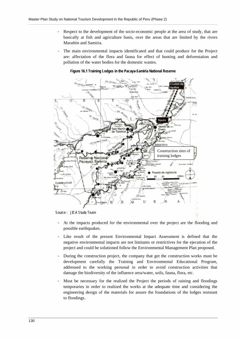
Master Plan Study on National Tourism Development in the Republic of Peru (Phase 2)
130
- Respect to the development of the socio-economic people at the area of study, that arebasically at fish and agriculture basis, over the areas that are limited by the riversMarañón and Samiria.
- The main environmental impacts identificated and that could produce for the Projectare: affectation of the flora and fauna for effect of hunting and deforestation andpollution of the water bodies for the domestic wastes.
Figure 16.1 Training Lodges in the Pacaya-Samiria National Reserve
- At the impacts produced for the environmental over the project are the flooding andpossible earthquakes.
- Like result of the present Environmental Impact Assessment is defined that thenegative environmental impacts are not limitants or restrictives for the ejecution of theproject and could be solutioned follow the Environmental Management Plan proposed.
- During the construction project, the company that get the construction works must bedevelopment carefully the Training and Environmental Educational Program,addressed to the working personal in order to avoid construction activities thatdamage the biodiversity of the influence area/water, soils, fauna, flora, etc.
- Must be necessary for the realized the Project the periods of raining and floodingstemporaries in order to realized the works at the adequate time and considering theengineering design of the materials for assure the foundations of the lodges resistantto floodings.
Source : JICA Study Team
Construction sites oftraining lodges
Volume 4 Environmental Impact Assessment
Chapter 16 Training Lodges in The Pacaya-Samiria National Reserve 131
- Must be considering the proposal for the Environmental Management Plan, Programof Preventives and or Correctives Measures, Environmental Monitoring Program,Program of training and Environmental Education, Contingencies Program, Programof Abandonment, and the Investments Program.