Master Plan of Bansgadhi
208
i PROJECT INFORMATION Name of the Project Consulting services for Preparation of Integrated Urban Development Plan of Bansgadhi Municipality, Bardiya Contract ID DUDBC/CS-QCBS-04-074/75 Project Executing Agency Government of Nepal, Ministry of Urban Development Department of Urban Development & Building Construction Babarmahal, Kathmandu, Nepal Name of the JV Consultant Naya Rastriya Engineering Consultancy Pvt. Ltd.- Moonlight Civil Solution Pvt. Ltd-Green Innovative Pvt. Ltd (NREC-MCS-GI JV) Project Commencement Date 2075-02-09 Projected Date of Completion 2075-11-08 SUBMISSION INFORMATION Name of the Report Consulting services for Preparation of Integrated Urban Development Plan of Bansgadhi Municipality, Bardiya Nos. of Volume I Volume Information Final Report Date of Submission ……………………………………… Submission Type Hard Copy Copies Produced 7 Copy Prepared By ……………………… Checked By ………………………… Reviewed By …………………………. Official Stamp ……………….
-
Upload
khangminh22 -
Category
Documents
-
view
0 -
download
0
Transcript of Master Plan of Bansgadhi
i
PROJECT INFORMATION
Name of the Project Consulting services for Preparation of Integrated Urban
Development Plan of Bansgadhi Municipality, Bardiya
Contract ID DUDBC/CS-QCBS-04-074/75
Project Executing Agency Government of Nepal, Ministry of Urban Development
Department of Urban Development & Building Construction
Babarmahal, Kathmandu, Nepal
Name of the JV Consultant Naya Rastriya Engineering Consultancy Pvt. Ltd.-
Moonlight Civil Solution Pvt. Ltd-Green Innovative Pvt.
Ltd (NREC-MCS-GI JV)
Project Commencement Date 2075-02-09
Projected Date of Completion 2075-11-08
SUBMISSION INFORMATION
Name of the Report Consulting services for Preparation of Integrated Urban
Development Plan of Bansgadhi Municipality, Bardiya
Nos. of Volume I
Volume Information Final Report
Date of Submission ………………………………………
Submission Type Hard Copy
Copies Produced 7 Copy
Prepared By ………………………
Checked By …………………………
Reviewed By ………………………….
Official Stamp ……………….

ii
ACKNOWLEDGEMENTS
This Final Report on preparation of Integrated Urban Development Plan of Bansgadhi
Municipality of Bardiya District has been prepared as per the ToR provided along with the
contract agreement. We are grateful to entire individuals who directly or indirectly helped us
during data collection, analyzing, workshop conduction and preparation of final documents.
We are greatly indebted to the constant support, interest and feedback of Mr. Salikram
Adhikari, Mayor and Mrs. Sushma Chaudhary, Deputy Mayor of Bansgadhi Municipality. We
also express our sincere thanks to Chairpersons and members of each ward committees in the
municipality. Mr. Amar Raj Khatri, Chief Administrative Officer, and other staffs, including
engineers of the Bansgadhi municipality for their continuous support.
The team of consultants would like to express its appreciation to DUDBC and IUDP
Committee, specially, Director General, Deputy Director General, Senior Divisional Engineer
(SDE), Project Director; senior Engineers, Engineers, Architects, Planners and other all
supporting team/staff of DUDBC for their constant support, appreciation, valuable suggestions
and comments during the process.
This report would not be completed without the support from members of Tole Development
Organizations (TDOs) and subsequent planning from the ward levels of Bansgadhi
Municipality. Similarly, the consultant would also like to express its appreciation to all the
officials of various government institutions and local stakeholders for their cooperation during
the project process.
iii
EXECUTIVE SUMMARY
The IUDP project has been executed by Department of Urban Development and Building
Construction, Ministry of Urban Development, Government of Nepal. Bansgadhi municipality
of Bardiya district in the Province 5 is also one of the project areas of IUDP where it is expected
to contribute overall development of the municipality in the long-run. The project comprises
various aspects of urban planning and analysis by incorporating multi-sectoral issues of
development, which includes physical, social, economic, financial, environmental and
institutional. The project is the comprehensive analysis of regional attributes, local needs and
aspirations, urban services and future prospects of this municipality for the subsequent 5, 10
and 15 Years. The rationality and scope of the project thus lies in the new context of state-
restructuring and urban planning.
Methodological approach: Both the qualitative and quantitative nature of data have been used
from primary and secondary sources. The process includes three sub-sequent phases: a)
literature review and desk study; b) field study and primary data collection; and c) analysis and
planning. The data collection tools include participatory rapid appraisal (PRA) and focused
group discussions (FGDs), key informant interviews (KIIs), and questionnaire survey. These
tools were mutually adopted and endorsed into the field along with Induction workshop, SWOT
analysis, discussion of vision setting and ward analysis. The field analysis then includes
sectoral workshop and consultation, linkage analysis, trend analysis, spatial analysis, gap
analysis which further proceeded with preparation of development plans as per the given ToR.
Opportunities and Challenges: In the new federal context of state-restructuring, recently
elected local government after a long political turmoil has been a great opportunity for
Bansgadhi municipality. Wider connectivity along with the national East-West highway and
various link roads is another opportunity for prosperous Bansgadhi. Close proximity to the
Bardiya National Park has also increased the potentiality of tourism development and
biodiversity conservation in this municipality. Moreover, market exposed to different areas and
urban centers including Nepalgunj, Dhangadhi and Butwal can enhance the economic
development of this municipality. However, apart from these opportunities, there are some
challenges in the municipality. The challenges include: increasing in-migration trends (from
northern Hilly regions to the plain region of Bansgadhi) as compared to out-migration (from
Bansgadhi to other urban areas within the district and outside); haphazard settlement and
absence of land use plan; lack of urban scale health and educational institutions; low
availability of recreational activities/ services, and institutional problems related to capacity
building and infrastructural development of the municipality in the changing context of local
development and federal set-up.
Long-term vision setting: Bansgadhi municipality is highly potential to cater long-term
development under major four sectors i.e. Agriculture; Health, sanitation and education;
Forestry and Industry. In particular, it has a huge potential to serve both as domestic market
center serving hinterland areas with close linkage through diverse goods and services.
Moreover, availability of abundant plain region and irrigation facility has enhanced the
probability of agricultural productivity and transformation of traditional agriculture to the
modern one along with grabbing local markets in and around the Bansgadhi municipality.
iv
Prosperity of Bansgadhi has been thus aimed along with the beautiful, greenery and healthy
city. This is how expressed in the long term vision- æ;'Gb/ xl/ofnL / ;kmf zx/; ;d[4 / ;d'Ggt afF;u9L gu/Æ. Compatible with this vision setting, an integrated urban
development plan seems to be a vital one in achieving the municipal vision and mission at large
by involving multiple sectors and stakeholders.
Trend Analysis: The consultants further studied the trend analysis of the municipality which
includes the review of prepared maps and other information which gives historical
development pattern in three sub-sequent points of time, i.e. 2004, 2010 and 2017. The trend
has been analyzed in terms of settlement structure, and changes in forest coverage, land use,
cultivation, and water bodies. The settlement area is increased by 1.29% in 13 years’ period.
This is a nominal increase and does not seem a significant change though, and could have been
happened probably due to the increasing market area, infrastructures and in-migration trend.
Following this, cultivation land is in decreasing trend in different years with a slow pace
(decreased by 0.76% in 10 years). Similarly, the percentage of land covered by forest in 2008,
2013 and 2018 has been remained almost constant, i.e. 55.284%, 54.914% and 54.959%
respectively. Likewise, water body in the municipality covers 1.54% in 2008, which is
decreased in 2013 i.e. 1.18% and again it is slightly increased in 2018 i.e. 1.23%.
Spatial analysis: The spatial analysis has been one of the impotant outcomes of this project
for this project. The planners have endorsed different analytical components to make a
comprehensive spatial analyis. This include:
Easy Accessibility Analysis: Accessibility analysis has been done bringing together
all aspects of transport system as per distribution of population and road network along
with spatial distribution of various infrastructures such as education facilities, health
facilities, market places etc. in different land zoning.
Linkage Analysis: Linkage analysis of the municipality indicates adjacency of the
municipality with its hinterlands in terms of social mobility and movement of goods,
services and people in and out involving both inter and intra regional perspectives.
Site Suitability Analysis: The demand for new residential areas in the municipality is
rapidly increasing because of increasing population, migration and urbanization. The
identified suitable settlement sites can be delineated on map, which shows the spatial
distribution of topographically suitable and safe, climatically pleasant and environment
friendly area for settlement, based on topographical, hydrological and environmental
data. Similarly, flood & drought susceptibility analysis, forest fire analysis, stream
order analysis, buffer analysis, Population served analysis have been also included to
compliment the spatial analysis.
Gap analysis: On the basis of infrastructure and necessities, a demand analysis has been also
included involving the parameters of population size, space requirement, and road types, etc.
as defined by Planning Norms and Standard 2013. The gap of infrastructures between existing
scenario and planning norms is studied which helps further for the planning of the municipality.
Multi-Sectoral Investment Plan (MSIP): Among all the development plans proposed with
the IUDP of Bansgadhi municipality, the MSIP has been a summarization of detail projects
and investment attributes for different years both in short term and long-term. It comprises
specific investment plan with respect to defined sectoral goals, objectives, strategies and

v
activities to fulfil the long-term vision of the municipality. In total, the projected MSIP budget
for 15 years in this municipality is NPR 24654.44 million, which has been allocated for
different plans and sectors. For completion of most of the strategic projects, time frame ranges
from 1-5 years to maximum time frame of 1-15 years particularly for physical infrastructures.
Detail engineering design of prioritized Major Projects: With consultation of local
stakeholders and municipal representatives of Bansgadhi municipality, Detail Engineering
Design of two projects has been recommended. They were selected among the prioritized list
of different projects. The selection of two projects and their detail Engineering Design (DEDs)
has been made out of the different project lists in the municipality which were then analyzed
on the basis of criteria provided by the DUDBC. The recommended DEDs in Bansgadhi
municipality are: a) DED-I (Road); and b) DED-II (Road). Each of the proposed DEDs
contained a detail drawing, design calculation and cost estimation. These prioritized projects
along with DEDs have been submitted to DUDBC in different Volumes IV and in the main
report as well Volume I.
Chapter outline:
Chapter 1 introduces the project “Integrated Urban Development Plan” with its goal and
objectives, scope; and expected outputs.
Chapter 2 presents the brief summary of literature review reflecting global trends and national
policies and practices on urban planning from the perspective of IUDP.
Chapter 3 provides the detail process of methodology involving data collection and analysis
tools and techniques.
Chapter 4 provides municipal profile of Bansgadhi municipality in detail, comprising different
dimensions of socio-economic, physical, institutional, land use, environmental and existing
livelihood conditions.
Chapter 5 provides the critical analysis of the existing situation using various analytic tools
and forecast a future need base demand by discussing Trend analysis, SWOT analysis, Ward
analysis, and Spatial analysis.
Chapter 6 presents the thematic urban plans along with Logical Framework Analysis (LFA),
viz. Physical Development Plan, Economic Development Plan, Financial Development Plan,
Social Development Plan, Culture and Tourism Development Plan, Institutional Development
Plan Environmental Management Plan, Disaster Risk Reduction Plan, Climate Change
Adaptation Plan, and Multi-Sectoral Investment Plan (MSIP).
Chapter 7 concludes the report of IUDP project (Vol. I) with final remarks and summarization
along with the informed recommendations.
vi
ACRONYMS/ABBREVIATIONS
BOOT Built Operate Own & Transfer
CBD Central Business District
CBO Community Based Organization
CBS Central Bureau of Statistics
CC Climate Change
CSO Civil Society Organization
DDC District Development Committee
DCCO District Coordination Committee Office
DOR Department of Road
DPP District Periodic Plan
DED Detailed Engineering Design
DTMP District Transport Master Plan
DTO District Transport Office
DUDBC Department of Urban Development and Building Construction
EIA Environmental Impact Assessment
EZ Economic Zone
FAR Floor Area Ratio
FGD Focused Group Discussion
FNCCI Federation of Nepalese Council of Commerce and Industries
FUG Forest User Group
GDP Gross Domestic Product
GESI Gender Equity and Social Inclusion
GIS Geographic Information System
GON Government of Nepal
GPS Global Positioning System
IAP Integrated Action Plan
IDP Integrated Development Plan
IEE Initial Environment Examination
INGO International Non-Governmental Organization
IT Information Technology
IUDP Integrated Urban Development Project
LSGA Local Self Governance Act
MHH Mid Hill Highway
MoFALD Ministry of Federal Affairs and Local Development
MoFAGA Ministry of Federal Affairs and General Administration
MoUD Ministry of Urban Development
MSIP Multi-sectorial Investment Plan
NBC Nepal Building Code
NGO Non-Governmental Organization
NPC National Planning Commission
NMD Poverty Mapping of District
NT New Town
NTPCO New Town Project Coordination Office
vii
PDP Periodic Development Plan
PPP Public Private Partnership
PRA Participatory Rural Appraisal
QA Quality Assurance
QMAS Quality Management cum Assurance System
SWOT Strength Weakness Opportunity & Threat
TDC Tole Development Committee
TDO Tole Development Organization
ToR Terms of Reference
UN United Nation
USD United States Dollar
WUC Water User Committee

viii
Table of Contents
PROJECT INFORMATION ............................................................................................... i
SUBMISSION INFORMATION ......................................................................................... i
ACKNOWLEDGEMENTS ................................................................................................ ii
EXECUTIVE SUMMARY ................................................................................................ iii
ACRONYMS/ABBREVIATIONS .................................................................................... vi
CHAPTER I: INTRODUCTION ....................................................................................... 1
1.1 Background of project ........................................................................................... 1
1.2 Objectives of the Study .......................................................................................... 2
1.3 Scope of Work ....................................................................................................... 3
1.4 Expected Output .................................................................................................... 4
1.5 Structure of the Report ........................................................................................... 8
CHAPTER II: METHODOLOGY ................................................................................... 10
2.1 Conceptual Framework ........................................................................................ 10
2.2 Field Team Mobilization ...................................................................................... 11
2.3 Secondary Data Collection and Conducting Survey ............................................. 11
2.4 Public Consultation Plan ...................................................................................... 11
2.5 Primary Data Collection ...................................................................................... 13
2.6 Preparation of GIS Base Map and preparation of Thematic Maps ........................ 14
2.7 Data Analysis ...................................................................................................... 20
2.8 Vision Setting ...................................................................................................... 21
2.9 Sectoral Development Plans................................................................................. 22
2.10 Multi Sectoral Investment Plan ............................................................................ 22
2.11 Preparation of DED ............................................................................................. 22
2.12 Preparation of Building Bye-Laws ....................................................................... 22
2.13 Limitations of the Study ....................................................................................... 22
CHAPTER - III: EXISTING SITUATION/STATUS ..................................................... 24
CHAPTER-IV: SITUATION ANALYSIS OF THE MUNICIPALITY ......................... 27
4.1 Trend Analysis .................................................................................................... 27
4.1.1 Demographic Analysis ................................................................................. 27
ix
4.1.2 Land Use Analysis and Urbanization............................................................ 27
Existing Land Use .................................................................................... 27
Housing.................................................................................................... 28
Existing Urban Structure .......................................................................... 29
Change in Built-Up Area .......................................................................... 29
Risk Analysis ........................................................................................... 34
Open Space .............................................................................................. 38
4.2 Spatial Analysis ................................................................................................... 38
4.3 Social Analysis .................................................................................................... 59
4.3.1 Education ..................................................................................................... 59
4.3.2 Health .......................................................................................................... 60
4.3.3 Recreation .................................................................................................... 60
4.3.4 Inclusion ...................................................................................................... 60
4.4 Economic Analysis .............................................................................................. 61
4.4.1 Agriculture ................................................................................................... 61
4.4.2 Livestock ..................................................................................................... 61
4.4.3 Mining ......................................................................................................... 61
4.4.4 Industry........................................................................................................ 61
4.4.5 Import and Export ........................................................................................ 61
4.4.6 Commercial ................................................................................................. 61
4.5 Financial Analysis ............................................................................................... 62
4.5.1 Revenue of Municipality .............................................................................. 62
4.5.2 Expenditure of Municipality ......................................................................... 63
4.6 Institutional Analysis ........................................................................................... 63
4.7 SWOT Analysis ................................................................................................... 64
4.7.1 Strengths ...................................................................................................... 65
4.7.2 Weaknesses .................................................................................................. 66
4.7.3 Opportunities ............................................................................................... 68
4.7.4 Threats ......................................................................................................... 69
4.8 Demand Analysis of Infrastructure ....................................................................... 69
4.9 Potential Lead Sector Identification ..................................................................... 77
CHAPTER V: DEVELOPMENT FRAMEWORK FOR MUNICIPALITY ................. 78
5.1 Vision of the Municipality ................................................................................... 78
5.2 Goal ..................................................................................................................... 78
5.3 Objectives ............................................................................................................ 78
5.4 Strategies ............................................................................................................. 78
5.5 Plans for Implementing Development Framework ............................................... 78
x
5.6 DED Selection ..................................................................................................... 79
CHAPTER VI: SECTORAL DEVELOPMENT PLANS ............................................... 88
6.1 Introduction ......................................................................................................... 88
6.2 Physical Development Plan.................................................................................. 88
6.2.1 Land Use Zoning ......................................................................................... 88
6.2.2 Urban Expansion .......................................................................................... 90
6.2.3 Physical Development Issues and Problems ................................................. 90
6.3 Urban Infrastructure Plan ..................................................................................... 91
6.3.1 Water Supply ............................................................................................... 91
6.3.2 Waste Water ................................................................................................ 93
6.3.3 Drainage ...................................................................................................... 94
6.3.4 Solid Waste .................................................................................................. 95
6.3.5 Electricity .................................................................................................... 97
6.3.6 Telecommunication ...................................................................................... 99
6.4 Urban Transport Plan ......................................................................................... 101
6.4.1 Road Classification with ROW .................................................................. 102
6.4.2 Road Network ............................................................................................ 105
6.4.3 Parking Management ................................................................................. 109
6.4.4 Issues and Problems ................................................................................... 109
6.5 Social Development Plan ................................................................................... 111
6.5.1 Education ................................................................................................... 111
6.5.2 Health ........................................................................................................ 112
6.5.3 Social Security ........................................................................................... 114
6.5.4 Culture and Sports...................................................................................... 115
6.5.5 Park and open spaces ................................................................................. 116
6.5.6 Urban Social Service Centre ...................................................................... 118
6.5.7 Social Development Issues and Problems ................................................... 118
6.6 Economic Development Plan ............................................................................. 119
6.6.1 Industrial Development and Trade Promotion ............................................ 119
6.6.2 Employment Generation, Poverty Reduction .............................................. 119
6.6.3 Regional Competiveness of Municipality ................................................... 120
6.6.4 Agriculture Development ........................................................................... 120
6.6.5 Strategic Location of Different Market Centre/Product Collect Centres ...... 121
6.6.6 Possible Economic Zones Based on Local Economic Growth Potentials .... 121
6.6.7 Potential and Problems of Economic Development Plan............................. 121
6.7 Tourism and Cultural Development Plan ........................................................... 122
6.7.1 Potentiality of Cultural and Tourism Development ..................................... 122
6.7.2 Conservation of both Material and Non-Material Cultures.......................... 123
6.8 Financial Development Plan .............................................................................. 126
xi
6.8.1 Municipality Revenue Improvement Plan (MRIP) ...................................... 126
6.8.2 Assessment of Possible Financial Resources .............................................. 127
6.8.3 Allocation of Development Budget ............................................................ 127
6.8.4 Promotional Strategy for Private Sector and Civil Society .......................... 129
6.8.5 Economic and Financial Analysis ............................................................... 130
6.8.6 Issues and Problems ................................................................................... 130
6.9 Environmental Management Plan ...................................................................... 132
6.9.1 Present Status ............................................................................................. 132
6.9.2 Issue and Problems .................................................................................... 133
6.9.3 Strategy for Environment Management Plan .............................................. 134
6.10 Disaster Risk Management Plan ......................................................................... 137
6.10.1 Present Status ............................................................................................. 137
6.10.2 Issues and Problems ................................................................................... 137
6.10.3 Adaptation Strategy for Disaster Management ........................................... 138
6.11 Climate Change Adaptation Plan ....................................................................... 141
6.11.1 Present Status ............................................................................................. 141
6.11.2 Issues and Problems of Disaster ................................................................. 141
6.11.3 Adaptation Strategy for Climate Change Mitigation ................................... 142
6.12 Institutional Development Plan .......................................................................... 144
6.12.1 Issues and Challenges ................................................................................ 146
CHAPTER VII: MULTI SECTOR INVESTMENT PLAN (MSIP)............................. 147
7.1 MSIP Program/ Project for Short Term .............................................................. 153
7.2 MSIP Program/ Project for Mid Term ................................................................ 163
7.3 MSIP Program/ Project for Long Term .............................................................. 169
ANNEXES ....................................................................................................................... 178
Annex 1: DED Selection Matrix ................................................................................ 183
Annex 2: DED Selection matrix of Bansgadhi Municipality ...................................... 187
List of Tables ............................................................................................................ 193
List of Figures ........................................................................................................... 194
List of Photos ............................................................................................................ 195
List of Maps .............................................................................................................. 195
Final Report: Preparation of Integrated Urban Development Plan (IUDP) of Bansgadhi Municipality
NREC-MCS-GI JV 1 | P a g e
1 CHAPTER I: INTRODUCTION
1.1 Background of project
In the changing context of federalism, the Local Governance Operation Act (2074 BS) is now
operating in the local units. Moreover, as a long-term policy initiative, GoN is providing
technical and financial supports to facilitate the integrated development plan (IDP of the local
units. Integrated Urban Development Project (IUDP) is highly prioritized policy approach
adopted by Department of Urban Development and Building Construction (DUDBC), Ministry
of Urban Development. Following this, the present report is based on the IUDP of Bansgadhi
municipality, which lies in the Bardiya district, Province No. 5.
The world is undergoing the largest wave of urban growth in history, particularly since 1950s
that accelerated further after 2000s. As per the estimation of UN agencies, more than half of
the world’s population now lives in towns and cities, and by 2030 this number will swell to
about 5 billion. Much of this urbanization will unfold in Africa and Asia, bringing huge social,
economic and environmental transformations (UNDESA, 2018). Nepal is one of the ten least
urbanized countries in the world. However, it is also one of the top ten fastest urbanizing
countries. A simple projection is that for the period 2014-2050, Nepal will remain amongst the
top ten fastest urbanizing countries in the world with a projected annual urbanization rate of
1.9 percent (UNDESA, 2014), which now switches around 60 percent urban population in
recent years after the federal set-up in the country (Economic Survey, 2018/2019).1
Keeping in view of this context, the Government of Nepal has already enacted and has been
implementing National Urban Policy since 2007. The policy is conspicuous by prioritizing
investment to the lagging regions of the country, while fostering development of regional cities
and intermediate towns as well. Therefore, with an objective with and objective of reducing
migration to capital and other larger cities, encouraging planned development of potential hill
cities and building infrastructures that can facilitate about one thousand populations in hilly
cities. With the promulgation of new constitution of Nepal in September 2015, there has been
subsequent changing in the local level unites in the federal context. The Constitution has
provisioned a three-tier of government: federal at the centre, provincial at the meso-level and
the local at the bottom (Art. 56, Part 5). The elections of all levels were held in 2017. Before
that, the government of Nepal has set up 753 local units replacing old municipalities and
Village Development Committees (VDCs). There are 460 rural municipalities and 293
municipalities, including 276 urban municipalities, 11 sub-metropolitan cities and 6-
metropolitan cities in different parts of country. However, as a Nepal is experiencing a new
political system of federalism, it is yet to be equipped with appropriate Acts and policies to
foster the spirit of development and constitution at large.
Nepal is urbanizing at a faster pace and this transformation is irreversible. However, in the
absence of coordinated planning and investment in urban sector, there is need to upscale the
1 https://mof.gov.np/uploads/document/file/pdf

Final Report: Preparation of Integrated Urban Development Plan (IUDP) of Bansgadhi Municipality
NREC-MCS-GI JV 2 | P a g e
level of innovation, impact and outcomes. Urbanization and urban development is influenced
and oriented by key policies of the state in sectors such as transport, agriculture, tourism,
industry etc in addition to the policy pursued in the urban sector. A brief review of the extant
policies such as National Transport Policy 2001, National Agricultural Policy 2004, National
Urban Policy 2007, Industrial Policy 2011, Tourism Policy 2008, National Land Use Policy
2015 and National Urban Development Strategy 2017 provides the context for the Integrated
Urban Development Plan (IUDP). The NUDS 2017 has provided a set of informed strategic
set-up in Nepal’s urban development. However, the reflection is pronounced in sprawled urban
form, haphazard land use with environment degradation, congestion, deficit in water supply
and other basic services. With six decades of planning experience, it is a high time to exercise
coordinated, integrated, focused and strategic investments that promote harmonized
development to fulfill our urban intentions. The preparation of IUDP is significant in this
direction.
In the changing context of federalism, the Local Governance Operation Act (2074 BS) is now
operating in the local units. The main objectives of this act is to implement the powers and
rights of local level provisioned by Constitution of Nepal promoting co-operations, co-
existence and coordination between federal, province and local levels ensuring people
participation, accountability, transparency in cost effective and qualitative service delivery, to
strengthen democratic republican governing system from local levels, and to strengthen local
governance developing local leadership to institutionalize legislative, executive and judicial
practices at the local level. The act details out the definition of rural municipality its criteria,
municipality, its criteria, role of local level. Likewise, it presents different sector wise function
of then municipality and the rural municipality. It highlights powers and function and
jurisdiction of ward offices to ensure administrative convenience to the local people.
1.2 Objectives of the Study
The main objective of the proposed assignment is to prepare Integrated Urban Development
Plan including Building By-laws of Municipalities. The other objectives are as follows:
1. To set out Long-term Vision and overall Goal, Objectives and Strategies for
Municipalities (for 15 years’ period) defining the status of the municipality where it
could stand after 15 years’ period.
2. To prepare Physical development plan, Social, Cultural, Economic, Financial, and
Institutional Development Plan; Environment Sensitive Plan, Urban Transportation
Plan, Multi-Sectoral Investment Plan (MSIP) etc. on the basis of vision, objectives and
strategies.
3. To prepare building By-laws to regulate development in the municipalities integrating
Land Use and road network-plan and long-term vision of the municipalities.
4. To prepare Detail Engineering Design of prioritized 2 sub-projects in each municipality
amounting not less than 30 crores for each project.
Final Report: Preparation of Integrated Urban Development Plan (IUDP) of Bansgadhi Municipality
NREC-MCS-GI JV 3 | P a g e
1.3 Scope of Work
The scope of consulting services for the preparation of Integrated Urban Development Plan is
wider and comprehensive from all dimension, including legal, developmental, ownership of
the local government, support of the federal governments, identification of the problems/
challenges, creation of base maps, formulation of different kinds of planning, preparation of
DED for most potential two projects, and so on:
Formulate state of vision of the municipality separately: The overall vision of the
municipality has included the desires of the municipality and their citizen and guided
with the principles. This vision has been also reflected in the subsequent development
plans.
Study and formulate a detailed plan: Different development plans as per the given ToR
have been prepared on the basis of base data and consultation of local stakeholders for
last 5 years and forecast for 5, 10 and 15 years.
Identify potential area for urban development based on land suitability and other
factors: This has been further followed with the analysis of present and future housing
needs/market, stock, conditions and recommend strategies for land acquisition,
distribution of land and housing in future.
Conduct studies on present and future (5, 10 and 15 years) demand in infrastructures:
It is carried out through a detailed institutional survey and public consultation regarding
the different kinds of infrastructures, including transportation, communication,
electricity, water supply and sewerage system /treatment plant, solid waste
management, landfill site etc. Analysis of demand should be in different scenarios and
aspects with facts and figures. Consultants have thus recommended major and minor
roads, highways, arterial roads, traffic circulation, truck yard, bus bays and bus parks
etc. The network plan of infrastructures, both existing and proposed have been also
shown in the base map.
Conduct studies on existing social infrastructure; including health, education, sports,
communication, security center and other community facilities by addressing present
deficiencies and future demands. The location and the requirement of land for all these
infrastructures can be identified in base map.
Identify and assess critical, sensitive and other natural resources; including parks,
green belts, recreational area, along with strategies for their conservation and
stewardship against the adverse impact of future development and land use changes. It
shows location and helps in calculation of requirement of such resources.
Verify Government, Guthi and Public Land; for future development and expansion of
the urban areas including land required for government and public purposes. Moreover,
preparation of appropriate plan and policies has been prepared to protect such land from
private/public encroachment and others.
Final Report: Preparation of Integrated Urban Development Plan (IUDP) of Bansgadhi Municipality
NREC-MCS-GI JV 4 | P a g e
Proposed Land Use Plan policy; for 15 years in the existing base map (plans) based on
vision policy of the municipality.
Building and Planning By-laws; is prepared for the construction of building and other
infrastructures with land use zoning i.e.,
i. Residential zone
ii. Institutional zone
iii. Industrial zone
iv. Preserved zone
v. Airport zone
vi. Recreation zone (sport, cinema theatre, swimming etc.)
vii. Urban expansion zone
viii. Stream/river banks zone
ix. Green zone
x. Apartment housing
xi. Petrol pump/Electric line/Cinema theatres and
xii. Mixed zone and others as per requirement.
The planning and building By-laws include the following areas:
a) Minimum plot area
b) Minimum width of roads
c) Maximum ground coverage
d) Maximum floor ratio (FAR)
e) Maximum building height
f) Maximum no of floors
g) Right of way of roads
h) Setback in four sides of building
i) Minimum parking area
j) Lift (Elevator)
k) Minimum distance to be left on the both sides of stream/river
In accordance with the “Basti Bikas, Sahari Yojana tatha Bhawan Nirman Sambandhi
Adharbhut Nirman Mapdanda, 2072”, the Building and Planning By-laws is prepared.
Detailed engineering design; prepared for at least 2 prioritized projects in each
municipality, each projects should not be less than 30 crores.
Executive summary of IUDP; for each municipality in Nepali and English language is
prepared for the purpose of approval from government of Nepal.
1.4 Expected Output
The complete Integrated Urban Development Plan includes the following output:
Municipality profile: An up to-date municipality profile has been prepared, comprising of
base-line information of the existing physical, social, economic, demographic, environment,
financial and organizational state of the municipality. Apart from the key statistics, such base
Final Report: Preparation of Integrated Urban Development Plan (IUDP) of Bansgadhi Municipality
NREC-MCS-GI JV 5 | P a g e
line information has also included textual descriptions, maps, charts, diagram, and key
problems prevailing in the settlements and the municipality.
Analysis: The Plan includes different types of analytical components. To mention:
Trend analysis: The analysis has revealed among other things growth trend of
population, migration, land use, infrastructure provisions, import-export of goods,
agricultural outputs, jobs, and other economic opportunities of last 10 years.
SWOT analysis: This reveals potentiality of the municipalities based on its strength
and opportunities. The analysis shall also reveal the weaker side of the municipalities
which tends to pose threat to the future development of the municipalities.
Spatial analysis: The analysis clearly presents demand and supply situation of vacant
land, besides including land develop-ability analysis. The analysis, therefore, shows
the location where the future growth can be channelized.
Financial analysis: The analysis reveals income potential (revenue and non-revenue)
and financing sources including expenditure pattern of the municipalities for the past
recent years and forecast for the future.
Municipal vision: To make the vision operational, necessary development principles
to guide the sectoral activities also need to be outlined. Vision and principles have been
formulated in consultation with municipality/Municipal body, local stakeholders.
Sectoral goals, objectives, output & programs: These plans are being formulated
mainly using Logical Framework Approach (LFA), and supplemented by performance
indicators by means of verification of such indicator as far as practicable. Sectors,
which are required to be included are - environmental, social, economic development,
disaster management, financial mobilization, and organization development. Such
sectoral plans and programs may be formulated in consultation with municipality, local
stakeholders and programs have to be prepared giving due attention to national
concerns such as poverty reduction and social inclusion.
Long-term Physical Development Plan (PDP): Physical plan generally reveals the future
desired urban form of the Municipality, keeping in view of planning horizon of 15 years and
also classify the municipality land revealing broadly urban areas, urban expansion areas,
natural resource areas and also calamity prone areas. Such physical plan would be separately
supplemented by the relevant data and thematic maps of existing land use, environmentally
sensitive areas, and infrastructure services such as road network with parking spaces,
transportation, water supply and drainage system, sewerage network, solid waste management
including landfill site, telecommunication network and electricity distribution network. A
classification of the open space has also been justified within municipality areas. Plan should
also be supplemented by social and economic data and thematic maps revealing the social and
economic infrastructures of the Municipality. New concepts such low carbon city, food green
city, garden city etc. have been also recommended wherever it is required.
Social Development Plan: Social development plan significantly contributes to bring
qualitative improvement in the lives of the common people. Attention shall be given focus on
social development program when social development program is getting priority in the
Final Report: Preparation of Integrated Urban Development Plan (IUDP) of Bansgadhi Municipality
NREC-MCS-GI JV 6 | P a g e
present context. The plan has been under formulation on the basis of the analysis of social
condition of municipal area. This essentially covers the following aspect:
Education
Public health
Security (physical as well as social)
Cultural and Sports
Parks& open spaces
Other urban social service centers (information, library, and space for social gathering,
etc.)
Others as per Municipality requirements
Conservation, Cultural& Tourism Development Plan: Cultural development plan
significantly contributes to bring qualitative improvement in the conservation of local cultural
heritage, art and architecture. Similarly, more attention should be given to the preservation of
tangible and intangible cultures. Cultural planning has been integrated with other planning.
This plan essentially covers the following aspect:
Identification and preservation of important Cultural heritage sites within the
Municipality Identification of specific non-material (in tangibles) cultures in the area
Plan for conservation of both material and non-material cultures and linked them to
tourism development plan
Culture centre (local craft, paint, architecture, museum, culture exchange, exhibition,
etc.)
Economic Development Plan: Economic development plan is based on the economic
potentiality of the municipalities or we can add new features for its identity e.g. Sport city or
IT City or Tourism City or Commercial city, Smart city etc. Such plan has covered the
following aspect:
Economic development plan: Areas of comparative advantage
Industry development (as per comparative advantage of the municipality / hinterland):
Trade promotion, Tourist development
Employment generation, poverty reduction
Regional competitiveness of the municipality
Agricultural development (commercialization of agro-forestry products- cold storage,
vegetable market, etc.)
Rural urban linkage- strategic location of different market centre/ product collection
centers
Micro/small industry and business promotion
Possible EZs based on local economic growth potentials (driving forces)
Others as per municipality requirements
Financial Development plan: The following aspects are kept considered while formulation
the financial plan:
Final Report: Preparation of Integrated Urban Development Plan (IUDP) of Bansgadhi Municipality
NREC-MCS-GI JV 7 | P a g e
Analysis and projection of municipality’s income and expenditure, revenue
improvement action plan,
Financial analysis and assessment of possible financial resources for the
implementation of IUDP in the municipality.
Allocation of development budget (for coming five year), cost sharing among sectoral
agencies, and expenditure management action plan
Promotional strategy of private sector and civil society (PPP)
Financial and economic analysis of proposed prioritized projects. Other’s as per
municipality’s requirements.
Institutional Development Plan: Human resources development plan and organizational
development plan are the areas of the institutional development plan. Following factors have
been considered in the formulation of institutional development plan.
Decentralization, good governance and mobilization of people’s participation
Appropriate and optimum use of local skills,
Review the existing human resources and propose the institutional setup to implement
the IUDP,
Institutional coordination and establishment of network,
Organizational capacity and capacity building.
Building By-laws: The complete planning and building By-laws should be formulated with
the overlay of cadastral map of the municipal area. This should be based on the municipal
vision and objectives. This may cover following;
General definition
Zoning classification and By-laws/ regulations
Implementation mechanism & procedures etc.
Multi-Sectoral Investment Plan (MSIP): The MSIP has revealed short and long-term
programs/projects, tentative cost estimate, and probable financing sources prioritized in
sequential manner for the planning period of each five years. Such programs/projects have
catered to both the short-term, mid-term and long-term needs of the municipality and the
wards, and should be consistent with the long-term development plan, sectoral goals and
objectives, and the vision. Furthermore, MSIP has clearly revealed programs/projects for each
fiscal year for the first five years. The municipal level plan/projects (Mega project) and the
projects that could be implemented exclusively by municipality also should be clearly
mentioned in MSIP. It is suggested that the plan/projects that have to be implemented by
different line agency in MSIP, included after thoroughly consultation with the concern offices.
Detail Engineering Design of Prioritized Major Projects: In order to prepare reliable project
banks for the recent execution of different projects in municipality, the project has prepared
Detail Engineering Design of minimum 2 projects in different sector in each municipality. It
has contained detail engineering and architectural design, detail cost estimate and BOQ. The
prioritized projects were identified in consultation with concerned municipalities but with the
Final Report: Preparation of Integrated Urban Development Plan (IUDP) of Bansgadhi Municipality
NREC-MCS-GI JV 8 | P a g e
rationale and discussed and approved by DUDBC. The cost estimate of each project has been
above 30 crores. Soil test was also conducted for DED project as per necessity. Necessary
details engineering drawings have been accordingly submitted in separate volumes (as
presented in Volume III-DED 1, Sections A, B, C & D; Volume III-DED 2, Sections A, B, C
& D).
Urban Transportation Management Plan
The following parameters have been integrated with proposed land use plan:
Road classification with right of way.
Road network.
Traffic management plan.
Parking management.
Road safety.
Preparation of Base Map
The Base map of the municipality has included (as also presented in Volume II):
GIS based base map including: existing streets (with coding system), building
footprints with building use, occupancy and general demographics based on the latest
archive satellite image.
Population density and growth rate
Existing land use (housing, commercial, industrial, agricultural, natural, mixed use,
guthi land, public space, squatted land…)
Slope and watershed analysis.
Transportation (roads with classification – national highways, feeder roads, district
roads and urban roads (administrative classification), parking space, bus park, public
transportation routes, frequencies and stops, airport and destinations)
Water supply, sewerage system (sewerage network, discharge points, treatment plant
if any).
Solid waste (coverage of public and private collection system, formal and informal
waste management sites, recycling points).
Electricity (production and transportation infrastructure, grid power coverage, street
lighting)
Public services (health, education, police, rescue services, cemeteries, administrative
services)
Environment (erosion, pollution, forest, water bodies)
Culture and tourism (temples, museums, cinemas, views, monuments, performance
places, festival routes)
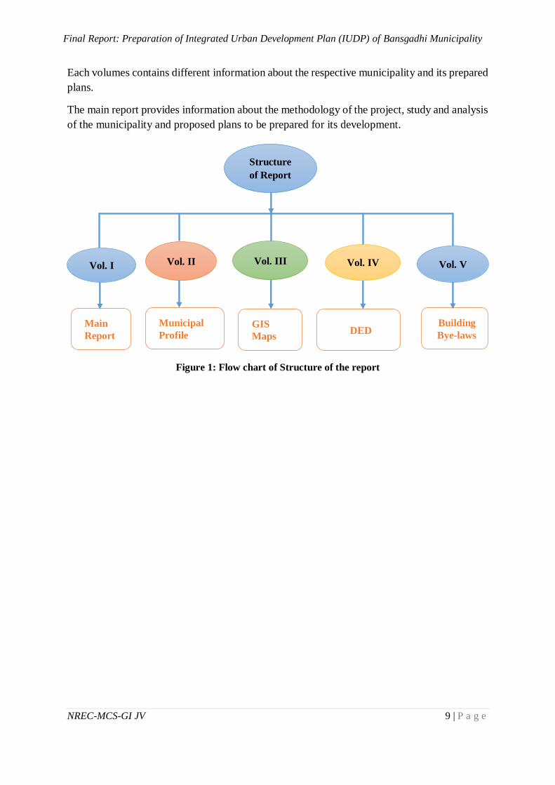
1.5 Structure of the Report
The report is divided into five volumes i.e. Volume I – Main Report, Volume II – Municipal
Profile, Volume III – Maps, Volume IV – Detailed Engineering Design and Volume V –
Building Bye Law. For easy management of the whole report, it is divided into such volumes.
Final Report: Preparation of Integrated Urban Development Plan (IUDP) of Bansgadhi Municipality
NREC-MCS-GI JV 9 | P a g e
Each volumes contains different information about the respective municipality and its prepared
plans.
The main report provides information about the methodology of the project, study and analysis
of the municipality and proposed plans to be prepared for its development.
Figure 1: Flow chart of Structure of the report
Main
Report
Municipal
Profile GIS
Maps DED
Building
Bye-laws
Vol. II Vol. IV Vol. I Vol. III Vol. V
Structure
of Report
Final Report: Preparation of Integrated Urban Development Plan (IUDP) of Bansgadhi Municipality
NREC-MCS-GI JV 10 | P a g e
2 CHAPTER II: METHODOLOGY
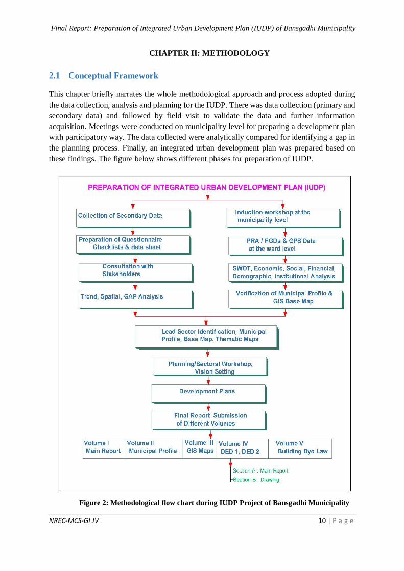
2.1 Conceptual Framework
This chapter briefly narrates the whole methodological approach and process adopted during
the data collection, analysis and planning for the IUDP. There was data collection (primary and
secondary data) and followed by field visit to validate the data and further information
acquisition. Meetings were conducted on municipality level for preparing a development plan
with participatory way. The data collected were analytically compared for identifying a gap in
the planning process. Finally, an integrated urban development plan was prepared based on
these findings. The figure below shows different phases for preparation of IUDP.
Figure 2: Methodological flow chart during IUDP Project of Bansgadhi Municipality
Final Report: Preparation of Integrated Urban Development Plan (IUDP) of Bansgadhi Municipality
NREC-MCS-GI JV 11 | P a g e
2.2 Field Team Mobilization
For conducting survey in the field, the required personals were appointed. Every team were
provided with questionnaires, secondary data, maps, GPS and other required materials. The
team consisted of a team leader, urban planner, engineer, social expert, GIS expert,
environment expert and surveyor. The complete team collected every information related to
the municipality for the preparation of the IUDP development plans.
2.3 Secondary Data Collection and Conducting Survey
The available maps and past data were collected from government and non-government
organizations such as Survey Department of Nepal, Central Bureau of Statistics, Department
of Urban Development and Building Construction, Municipality office etc. From Survey
Department, the available Topographical maps, District maps, Aerial photographs, Digital
Maps, Municipality Boundary etc. were collected. Furthermore, Internet based research was
done through which Google Earth, Google Map, Open Street Map etc. for map and MoFALD,
Data in Nepal, official Municipality Website, Rajpatra etc. were referred for the preparation of
municipal profile. All these maps and data were used to understand the geographical location,
climatic condition, road networks, existing topographical condition, demographic status,
economic & financial status, ethnic groups, settlement etc. Also, the prepared Municipality
Profiles and their Plans, Periodic Plan of District Coordination Committee (DCC), other
relevant plans & different reports of the stakeholders, were collected from municipal/ward
level offices and critically reviewed.
Similarly, relevant acts, regulations, planning norms & standards, guidelines etc. were also
summarized properly to visualize the concept of Integrated Development Plans and Building
By-laws for Nepalese context.
2.4 Public Consultation Plan
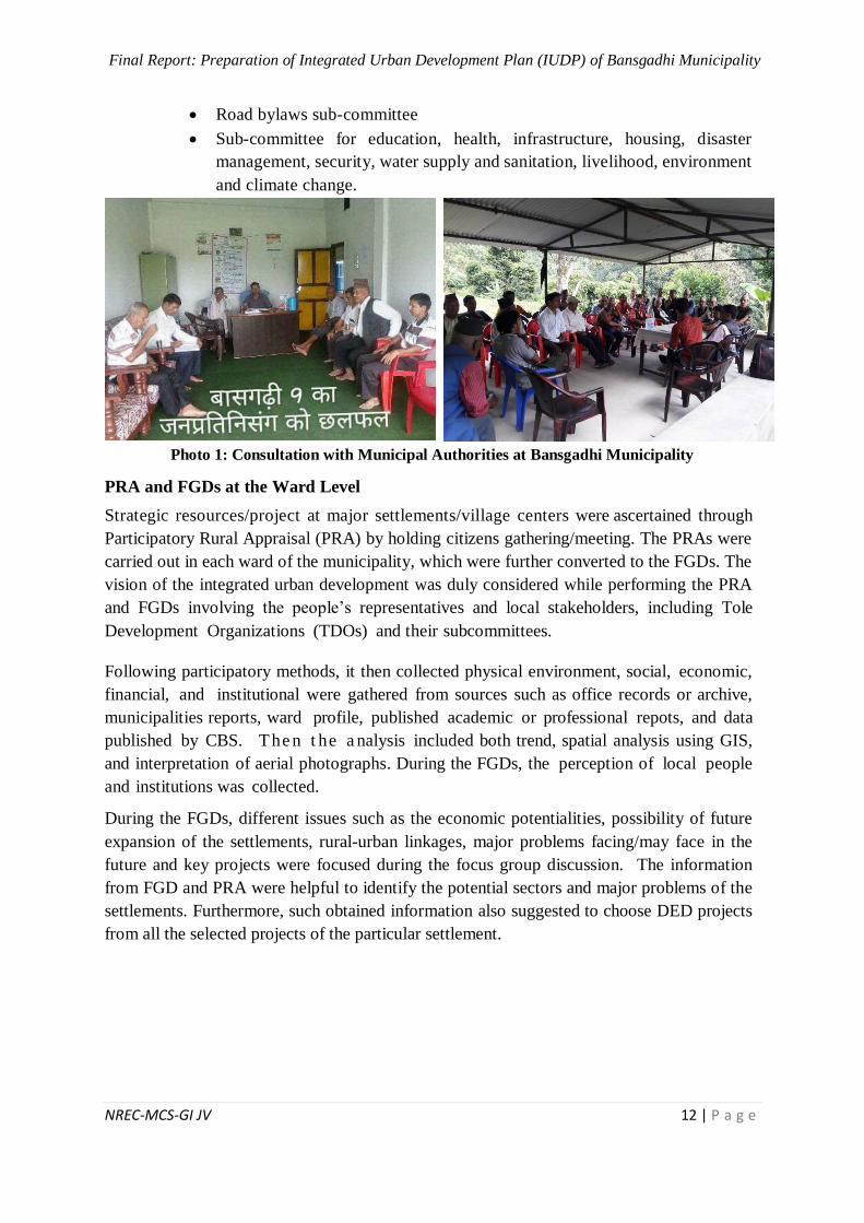
Induction Workshop at the Municipality Level
A one-day induction workshop was organized in the Bansgadhi municipality on Shrawan 11,
2075 BS. The concerned stakeholders were invited and they took participation, including
municipal council members, political leaders, people’s representatives, civil society groups and
government officials in the municipality.
An introductory power point presentation was held by the consultant depicting the concept
and need of planning, potential and prospects of the settlement and its possible lead
sectors. The major achievements and activities during the inductive workshops were:
Familiarization for the IUDP project
SWOT analysis (discussion about strength, weakness, opportunities and threats)
Discussion for Vision Setting (desire for changes, planning implications in
different sectors for the sustainable development of the municipality)
Formation of directive committee for the IUDP under the chair of chairperson of
the municipality
Formation of sub-committees in different themes:
Land use plan and building code sub-committee
Final Report: Preparation of Integrated Urban Development Plan (IUDP) of Bansgadhi Municipality
NREC-MCS-GI JV 12 | P a g e
Road bylaws sub-committee
Sub-committee for education, health, infrastructure, housing, disaster
management, security, water supply and sanitation, livelihood, environment
and climate change.
Photo 1: Consultation with Municipal Authorities at Bansgadhi Municipality
PRA and FGDs at the Ward Level
Strategic resources/project at major settlements/village centers were ascertained through
Participatory Rural Appraisal (PRA) by holding citizens gathering/meeting. The PRAs were
carried out in each ward of the municipality, which were further converted to the FGDs. The
vision of the integrated urban development was duly considered while performing the PRA
and FGDs involving the people’s representatives and local stakeholders, including Tole
Development Organizations (TDOs) and their subcommittees.
Following participatory methods, it then collected physical environment, social, economic,
financial, and institutional were gathered from sources such as office records or archive,
municipalities reports, ward profile, published academic or professional repots, and data
published by CBS. T he n t he a nalysis included both trend, spatial analysis using GIS,
and interpretation of aerial photographs. During the FGDs, the perception of local people
and institutions was collected.
During the FGDs, different issues such as the economic potentialities, possibility of future
expansion of the settlements, rural-urban linkages, major problems facing/may face in the
future and key projects were focused during the focus group discussion. The information
from FGD and PRA were helpful to identify the potential sectors and major problems of the
settlements. Furthermore, such obtained information also suggested to choose DED projects
from all the selected projects of the particular settlement.
Final Report: Preparation of Integrated Urban Development Plan (IUDP) of Bansgadhi Municipality
NREC-MCS-GI JV 13 | P a g e
Photo 2: FGD at Ward Level of Bansgadhi Municipality
Key Informants Interviews (KIIs)
Key Informant Interviews (KIIs) were conducted to gather the firsthand knowledge by
selecting representatives from civil society, political parties, local focal person, and ward
members. Information related to land use changes, local practices for developmental works,
potential sectors of the settlements, economic, social linkages etc. were collected through this
method.
Survey fill-up after the FGDs
After the completion of FGD, an Institutional Survey was conducted with a prepared set-up
of the questionnaire check-list. The information regarding educational, financial, social
institutions and others private and governmental agencies were collected using the checklist.
In addition, data related to open spaces, name of major settlements, touristic destinations,
agriculture practices, major market centers etc. were collected during the process.
2.5 Primary Data Collection
Preparation of Questionnaire and Checklists
The compilation of secondary data and maps was done after the Literature Review. Findings
of obtained secondary information were incorporated into larger database system and cross-
tabulated. On the basis of literature review and scope of work, checklists and questionnaires
were also prepared to collect primary data from field. The tools used for primary data
collection were Focus Group Discussion (FGD), Participatory Rural Appraisal (PRA), Global
Positioning System (GPS), Induction & Sectoral workshops etc.
Focus Group Discussion was held with different stakeholders like local people, local leaders,
Women group, Dalit, Janajati, Business community etc. Similarly, a Key Informant Survey
Final Report: Preparation of Integrated Urban Development Plan (IUDP) of Bansgadhi Municipality
NREC-MCS-GI JV 14 | P a g e
Questionnaire was also prepared to collect data from individuals, experts and different
institutions (i.e. municipalities/wards offices, DUDBC Division office, NGO/INGO,
municipality/district different line agencies etc.). These questionnaires and checklists has been
attached in annex section.
Consultation with Stakeholders
The consultants made an int ens ive consultation with the local stakeholders such as
representatives of municipalities, TDOs, user’s committee, concerned line agencies, local
people residing within the study area. An interaction was made with the local stakeholders
about the project being carried out by the consultant. They were fully informed about the
objective and the scope of the project. The consultant tried to eliminate any negative
rumors about the project during the discussion. Also, t hey tried to clarify the
ambiguit ies about project. The consultant not only expected the co-operation from
stakeholders but also tried to achieve participatory approach in execution of the project.
The objective of consultation was to gather information, sensitize local stakeholders and
identify problems which are done through.
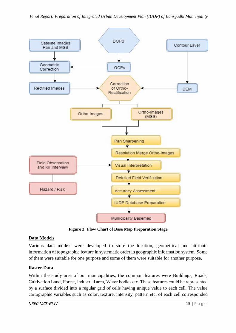
2.6 Preparation of GIS Base Map and preparation of Thematic Maps
A base map is the graphical representation of the spatial data and/or orthorectified imagery
which serves as background settings for overlay, dissemination, analysis and delineation of
spatial and non-spatial data.
GIS Base Map
Geographic Information System (GIS) is a computer based database system that contains
location information along with other attribute information of the ground features. Various
open source and proprietary programs such as QGIS, ArcGIS, Grass etc. can be used to retrieve
information from data base, perform various spatial analysis and delineate the results in
graphical and/ or in tabular form as per the requirement of the user.
A graphical representation of the database system that serves as background layout is called
GIS based base map. It contained location information, feature type information and attribute
information in tabular form which can be accessed from any GIS program and delineated in
graphical form as digital map.
This graphical form can be printed in required layout format and scale to generate a paper map.
The preparation of base map using high resolution satellite imagery involves various rigorous
steps which are diagrammatically described below:
Final Report: Preparation of Integrated Urban Development Plan (IUDP) of Bansgadhi Municipality
NREC-MCS-GI JV 15 | P a g e
Figure 3: Flow Chart of Base Map Preparation Stage
Data Models
Various data models were developed to store the location, geometrical and attribute
information of topographic feature in systematic order in geographic information system. Some
of them were suitable for one purpose and some of them were suitable for another purpose.
Raster Data
Within the study area of our municipalities, the common features were Buildings, Roads,
Cultivation Land, Forest, industrial area, Water bodies etc. These features could be represented
by a surface divided into a regular grid of cells having unique value to each cell. The value
cartographic variables such as color, texture, intensity, pattern etc. of each cell corresponded
Final Report: Preparation of Integrated Urban Development Plan (IUDP) of Bansgadhi Municipality
NREC-MCS-GI JV 16 | P a g e
to the ground feature. The GIS program could interpret the value while analyzing and
displaying the data in graphical form. This data storage format is called raster data format.
Vector Data
Each urban features have some geometrical shape associated with it along with its specific non-
spatial information. The geometry of the feature could be represented by set of point, line and
polygon and the non-spatial information could be attached to each geometric figure in the form
of attribute. Representation of ground feature using this method is called Vector data model.
Geo-referencing
The image data from any satellite sensor contained error due to different factors such as climate,
perturbation of satellite orbit, topographic undulations etc. In order to rectify the effects of
these factors on the geometry of the ground features, Geo-referencing of the satellite image has
been completed using the geodetic ground control points and DGPs points.
In Geo-referencing, several points of known coordinates with their known physical location on
the surface of the earth were collected. In GIS program, the points were identified on the
satellite image with the help of its D-Card and its coordinate is assigned. After assignment of
the coordinates of several points on satellite image, each pixel of the image re-defined its
coordinate on the basis of known coordinates. The detail of the coordinates of the ground
control points and its D-cards are attached in the Annex IV.
DGPS
Several Ground control points with high spatial accuracy were established using differential
global positioning system. These ground control points have been used for Geo-referencing of
the satellite image.
Datum and Projection System:
The datum, generally used in Nepal is Everest 1830 Spheroid datum. It is an oblate ellipsoid of
rotation formed by rotating an ellipse whose major axis and minor axis were nearly equal to
that of the equatorial axis and polar axis of the Earth.
Spatial data
The geometrical as well as attribute information of ground features has been stored in a
database called geo-database. GIS program has been used to retrieve the data and delineate it
in the form of map.
Final Report: Preparation of Integrated Urban Development Plan (IUDP) of Bansgadhi Municipality
NREC-MCS-GI JV 17 | P a g e
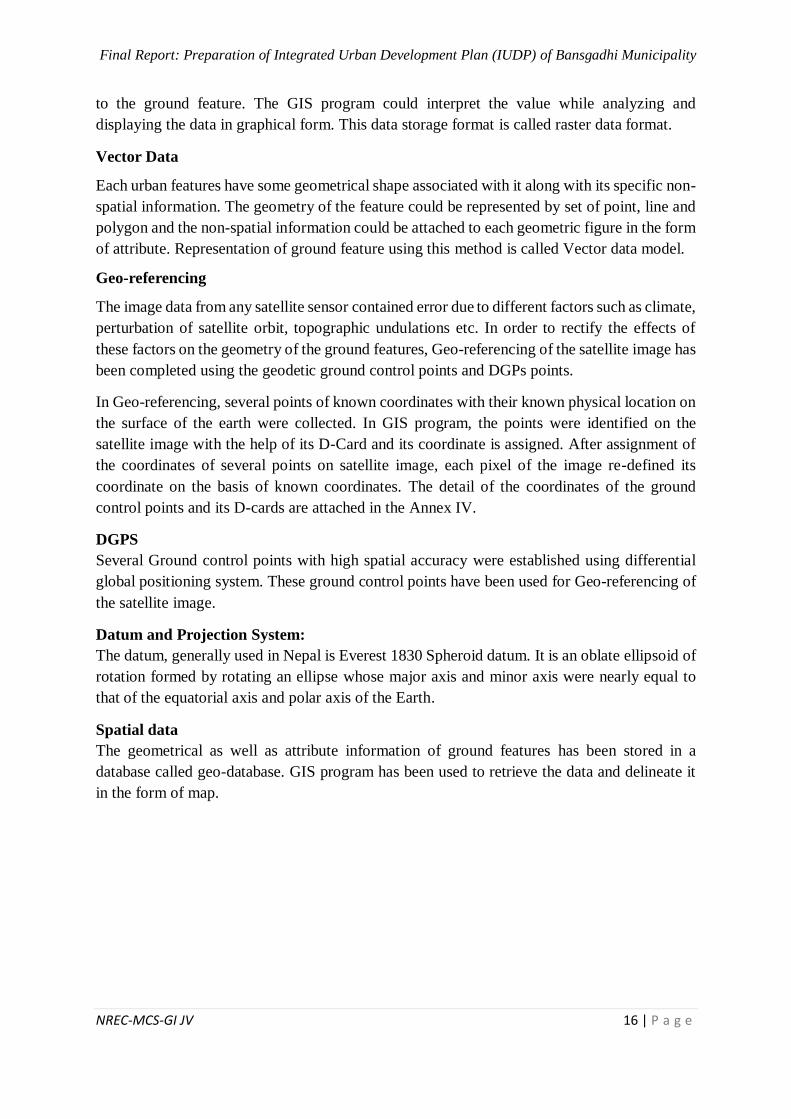
Figure 4: Spatial data of municipality
Non spatial data
The non-spatial data were delineated by using symbols corresponding to the service type of the
feature. These symbol enhanced the information. The non-spatial data such as names, service
type, ownership etc. of the ground features were acquired by physically visiting the site. For
the geographical location of the feature its GPS coordinate was noted and the feature type itself
were classified and recorded separately at the time of data collection. A data sheet was created
for each feature type such as school, health service, Government offices etc. along with its
geographical location. The sheet was added with the geometry table in GIS system. While
delineating the data, GIS program has delineated geometry data with any attribute information
associated with it as required by the user.
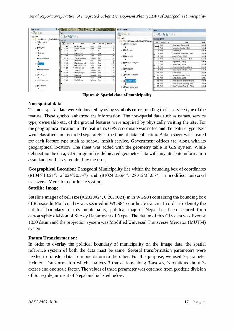
Geographical Location: Bansgadhi Municipality lies within the bounding box of coordinates
(81046’18.21”, 28024’20.54”) and (81024’35.66”, 28012’33.06”) in modified universal
transverse Mercator coordinate system.
Satellite Image:
Satellite images of cell size (0.2820024, 0.2820024) m in WGS84 containing the bounding box
of Bansgadhi Municipality was secured in WGS84 coordinate system. In order to identify the
political boundary of this municipality, political map of Nepal has been secured from
cartographic division of Survey Department of Nepal. The datum of this GIS data was Everest
1830 datum and the projection system was Modified Universal Transverse Mercator (MUTM)
system.
Datum Transformation:
In order to overlay the political boundary of municipality on the Image data, the spatial
reference system of both the data must be same. Several transformation parameters were
needed to transfer data from one datum to the other. For this purpose, we used 7-parameter
Helmert Transformation which involves 3 translations along 3-axeses, 3 rotations about 3-
axeses and one scale factor. The values of these parameter was obtained from geodetic division
of Survey department of Nepal and is listed below:
Final Report: Preparation of Integrated Urban Development Plan (IUDP) of Bansgadhi Municipality
NREC-MCS-GI JV 18 | P a g e
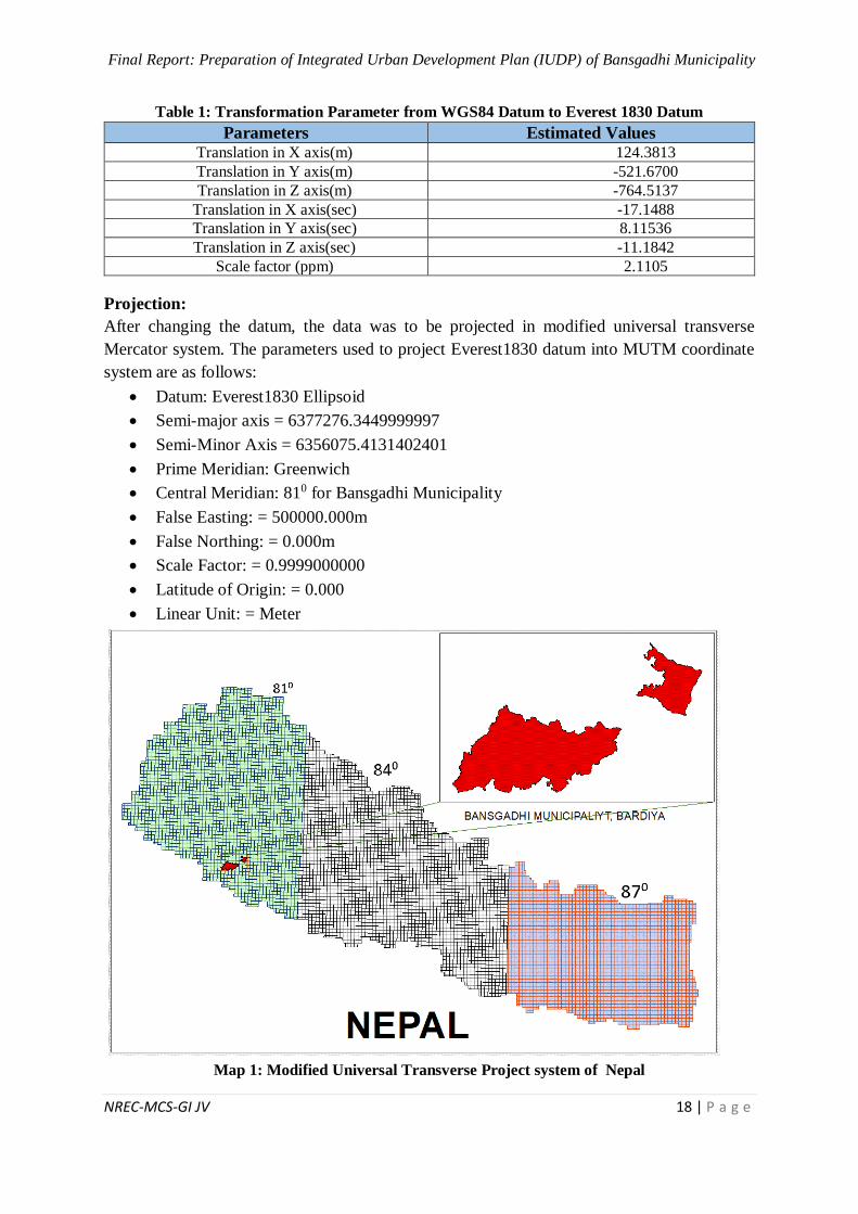
Table 1: Transformation Parameter from WGS84 Datum to Everest 1830 Datum
Parameters Estimated Values Translation in X axis(m) 124.3813
Translation in Y axis(m) -521.6700
Translation in Z axis(m) -764.5137
Translation in X axis(sec) -17.1488
Translation in Y axis(sec) 8.11536
Translation in Z axis(sec) -11.1842
Scale factor (ppm) 2.1105
Projection:
After changing the datum, the data was to be projected in modified universal transverse
Mercator system. The parameters used to project Everest1830 datum into MUTM coordinate
system are as follows:
Datum: Everest1830 Ellipsoid
Semi-major axis = 6377276.3449999997
Semi-Minor Axis = 6356075.4131402401
Prime Meridian: Greenwich
Central Meridian: 810 for Bansgadhi Municipality
False Easting: = 500000.000m
False Northing: = 0.000m
Scale Factor: = 0.9999000000
Latitude of Origin: = 0.000
Linear Unit: = Meter
Map 1: Modified Universal Transverse Project system of Nepal
Final Report: Preparation of Integrated Urban Development Plan (IUDP) of Bansgadhi Municipality
NREC-MCS-GI JV 19 | P a g e
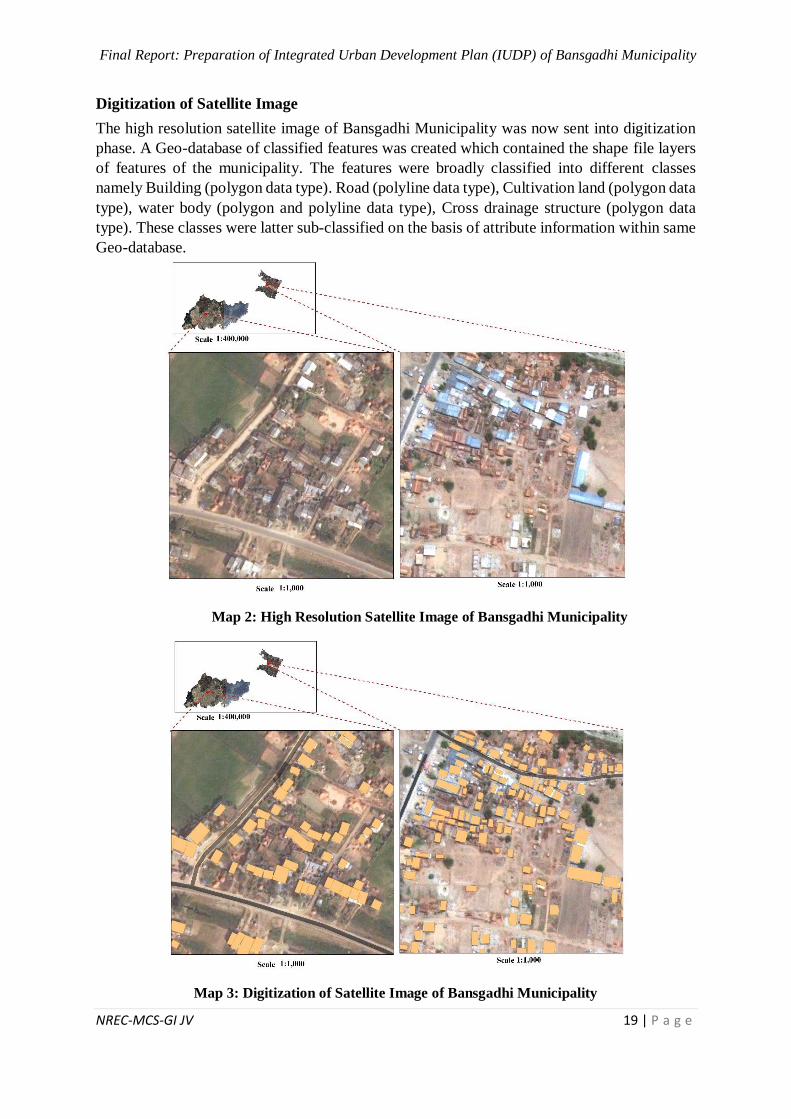
Digitization of Satellite Image
The high resolution satellite image of Bansgadhi Municipality was now sent into digitization
phase. A Geo-database of classified features was created which contained the shape file layers
of features of the municipality. The features were broadly classified into different classes
namely Building (polygon data type). Road (polyline data type), Cultivation land (polygon data
type), water body (polygon and polyline data type), Cross drainage structure (polygon data
type). These classes were latter sub-classified on the basis of attribute information within same
Geo-database.
Map 2: High Resolution Satellite Image of Bansgadhi Municipality
Map 3: Digitization of Satellite Image of Bansgadhi Municipality
Final Report: Preparation of Integrated Urban Development Plan (IUDP) of Bansgadhi Municipality
NREC-MCS-GI JV 20 | P a g e
Attribute Information Collection
In order to collect the attribute information of the ground features, a team of engineers was
mobilized in each municipality. Each team took a measuring tape, a GPS device, a topographic
map, data sheet and the base map of the municipality. This team has visited all the natural and
artificial ground features of all wards of the municipality. The team recorded the geographical
location of the feature from GPS and attribute information of the feature from direct
measurement, visual appearance, inquiry with local authority or inquiry with local resident.
The collected data sheet was digitized in excel sheet latter in the office. The spatial and non-
spatial data from Excel sheet was uploaded in digitized layers of the features. The features
classified in Geo-database were again sub-classified on the basis of attribute information using
GIS program.
2.7 Data Analysis
SWOT Analysis
To identify the strength, weakness, opportunity and threat of municipality SWOT analysis was
conducted. SWOT analysis was carried out at FGD in ward level and induction workshop at
municipality level; to identify the lead sectors for vision setting.
Ward Analysis
Ward analysis of municipality was done to rank the ward about its development with the help
of different 10 indicators. The used indicators were accessibility of motorable road,
predominance of Dalit, Janajati and minority, poorest community or lowest livelihood
opportunities, most affected wards by natural disaster, access to water supply, education,
health, prevalence of disaster risk, access to government services, presence of INGO/NGO.
Trend Analysis
Trend Analysis was done through the help of CBS data, maps and discussions. The data of
municipalities was provided through the sectorial workshop and induction report. The trend of
migration was identified according to the study of growing market areas. The land use pattern
of four different years was studied through maps and found out its land use changes. The
increasing pattern of settlement was seen and developing sectors were identified through the
land use map. The linkage of municipality and its market centers were studied through both
ways i.e. inter region and intra region. The actual trend of flow of goods and peoples was
studied during the analysis. Road network pattern was also analyzed. Developing scenario of
infrastructures were also analyzed. The various jobs and economic opportunities from past and
recent years; were also identified.
Spatial Analysis
Spatial analysis was conducted to identify and solve the complex location-oriented problems.
Spatial analysis helped decision makers to understand any event and its present and future
affects within its area of influence. Using spatial analysis, the information from many sources
were combined, overlaid and derived new sets of information by applying sophisticated set of
spatial operators. The spatial analysis has proven to be highly effective for evaluating service
area of some features, the most suitable geographic location for specific purposes, observing
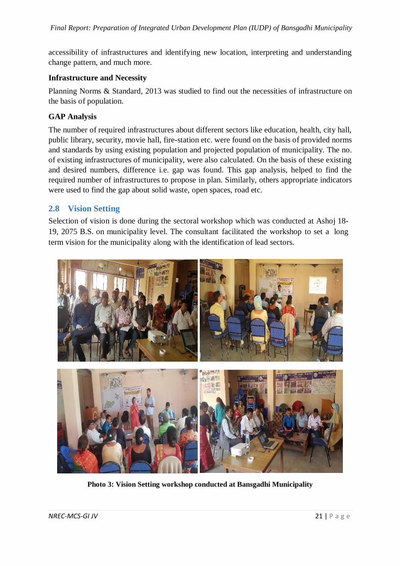
Final Report: Preparation of Integrated Urban Development Plan (IUDP) of Bansgadhi Municipality
NREC-MCS-GI JV 21 | P a g e
accessibility of infrastructures and identifying new location, interpreting and understanding
change pattern, and much more.
Infrastructure and Necessity
Planning Norms & Standard, 2013 was studied to find out the necessities of infrastructure on
the basis of population.
GAP Analysis
The number of required infrastructures about different sectors like education, health, city hall,
public library, security, movie hall, fire-station etc. were found on the basis of provided norms
and standards by using existing population and projected population of municipality. The no.
of existing infrastructures of municipality, were also calculated. On the basis of these existing
and desired numbers, difference i.e. gap was found. This gap analysis, helped to find the
required number of infrastructures to propose in plan. Similarly, others appropriate indicators
were used to find the gap about solid waste, open spaces, road etc.
2.8 Vision Setting
Selection of vision is done during the sectoral workshop which was conducted at Ashoj 18-
19, 2075 B.S. on municipality level. The consultant facilitated the workshop to set a long
term vision for the municipality along with the identification of lead sectors.
Photo 3: Vision Setting workshop conducted at Bansgadhi Municipality
Final Report: Preparation of Integrated Urban Development Plan (IUDP) of Bansgadhi Municipality
NREC-MCS-GI JV 22 | P a g e
2.9 Sectoral Development Plans
On the basis of various analyses (SWOT, Trend, Spatial, Gap, ward etc.) and the identification
of lead sectors, necessary activities of the different sectors were listed in Excel sheet with their
budget and different time frame. The prepared checklist format for MSIP was filled at the field.
This format became helpful to compile the important activities too. Thereafter, the different
Logical Framework Approaches (LFAs) of different sectors were tabulated for the formulation
of different development plans. The vision, goals, and strategies were determined for all
development plans after fixing the objectives. Eventually, the consultants prepared different
development plans, viz. physical development, social development, economic development,
financial development, conservation and tourism development, institutional development,
environmental management, disaster risk management plan, climate change adaptation plan
and multi-sectoral investment plan. Thus, all these plans constitute an Integrated Urban
Development Planning (IUDP) for this municipality.
2.10 Multi Sectoral Investment Plan
Various important sectors and programs were selected during the sectoral workshop.
Investment plans were prepared for every programs. Such plans revealed short and long term
programs, tentative cost estimate and probable financing sources. Those plans and programs
were prioritized in sequential manner for the planning period of each five years. Multi sectoral
investment plan was prepared for prioritizing projects according to its importance and
estimating required budget and investing sectors for related projects.
2.11 Preparation of DED
After the meetings and discussions with local bodies, related NGO/INGO, local parties and
other stakeholders, various plans and programs were listed which will help for the long term
development of the municipality. By considering the vision of the municipality and the DED
selection criteria provided by DUDBC, the major projects for DED were selected. Further, the
DED selection matrix is attached in Annex-1.
2.12 Preparation of Building Bye-Laws
Bye laws is the guiding factor for development of the municipality. Studying land use map and
the housing pattern of the municipality, bye laws was prepared. Various sectors like road, open
space, different institutes, industrial areas, river and lakes, etc. were considered during the
preparation of bye laws. Floor Area Ratio (FAR) and Ground Coverage Ratio (GCR) of
different area should be different considering its land use pattern and built up areas.
Considering the GIS based map and settlement pattern, bye laws for different areas will be
different. Further, derail bye laws of the municipality are presented in Volume-V.
2.13 Limitations of the Study
Though the IUDP project is comprehensive in nature and there are many activities/ tasks
assigned as per the ToR of the agreement, the report has been constrained along with the
following limitations:
Final Report: Preparation of Integrated Urban Development Plan (IUDP) of Bansgadhi Municipality
NREC-MCS-GI JV 23 | P a g e
i. Time span of the project is limited (9 months) as compared to a wide range of the
activities (to be done) to accomplish the project
ii. The ToR does not tell about the scope and mandates of Household Survey which, in
turn, significantly limits the validity and reliability of the findings
iii. The attribute information of individual house about roof type, construction material
type and house occupancy is not included in geo-database for preparation of base-map
because the household survey was out of the scope of the project.
iv. Database of the municipality is not established in a scientific system; so data is not
available to show the trend of demographic changes (including migration), agricultural
production, number of tourist flow, economy (expenditure, revenue) and climate
change
v. As per the new Constitution, the local levels are restructured in March 2017 (and
formed 753 local units) in which many former VDCs have been merged into a single
municipality; so that the integration of secondary data (including the CBS database of
2011) is also problematic to produce a congruence for a single new municipality in the
changing context (particularly in terms of demographic status, health and education,
and caste/ ethnicity)
The analysis of regional perspective (on competitiveness, external factors, tourism, market
relations and agriculture) has been limited due to data constraints as it would need a wider
domain of regional analysis and data integration. However, the linkage analysis can reveal
the regional comparative analysis
Final Report: Preparation of Integrated Urban Development Plan (IUDP) of Bansgadhi Municipality
NREC-MCS-GI JV 24 | P a g e
3 CHAPTER - III: EXISTING SITUATION/STATUS
Introduction: According to new administrative structure of Government of Nepal, Bansgadhi
Municipality is situated in Bardiya district in Province no. 5. Bansgadhi municipality lies
within a co-ordinate from (81046’18.21”, 28024’20.54”) and (81024’35.66”, 28012’33.06”).
It is located 25 km Northern wests from Bardiya headquarter Gulariya. Bansgadhi municipality
have an area of 206 Sq. km. The boundary of the Bansgadhi has been delineated as Banke
district at east, Barbardiya municipality at west, Bardiya National park at north and Badaiya
Lake at south. Bansgadhi municipality was initially formed in 2014 December by merging 3
VDCs including Sawikal Belwa, Motipur and Daudadakala. When the state-restructuring was
made in 2017, the previous boundary and area maintained same as previous. It consists of 9
wards.
Demographic Status: According to the Bansgadhi Municipality profile 2017, the total
household size is 13272. The total population of the municipality is 63287 where 30405
(48.04%) are male and 32882 (51.96%) are female. People from diverse ethnic and religious
groups live together with harmony in the municipality. The average household size of the
municipality is 4.8. The ward no. 8 is the largest in terms of household (i.e. 1821 HHs), but
ward no 9 have largest population size i.e. 8654. While as the smallest, ward no. 1 have only
502 HHs which have also the lowest population size, i.e. 2461in total.
Physical Status: The majority of total land area in Bansgadhi is covered by forest (i.e.
49.85%). 41.04% of land is occupied by cultivation, 7.75% is occupied by barren land. The
remaining 1.35% of land is covered by grassland, orchard, tree cluster, river, pond area, sand
area and built-up. Most of the road in the municipality are gravel roads, two roads are black
topped and others are earthen roads. Width of the road in the municipality ranges from 2m to
14m and the width of highway is 30m. The municipality also have the facility of postal services.
There are 3 postal service office in the municipality. In terms of telecommunication, GSM
(Nepal Telecom), CDMA and NCELL are widely used in the municipality. Only 4 wards (3,
5, 8 and 9) have solid waste collection facility. The municipality comprise with 96.1% toilet
facility including both Simple pit and RCC toilet in household level.
Social Status: It represents the colorful social structure of caste and ethnicity, including
Brahmin, Chhetri, Dalit, Janajati and mixed type. The majority (39.31%) of the people are
Madhesi Janajati. Similarly, Hilly (34.22%) are Brahmin/Chhetri/Thakuri & Sanyasi, (12.85%)
are hilly Dalit, (10.10%) are hilly Janajati and (3.51%) are Muslim and others. Furthermore,
the majority of people (96.86%) follows Hindu religion whereas (1.73%) follow Christian,
(1.23%) follow Muslim and remaining 0.18% follow Buddhist religion. In terms of educational
status 88.02% of the population is literate whereas remaining 11.98% are illiterate. There are
21 farmer’s group, 6 mother’s group, 10 youth clubs and 7 social groups. There are altogether
57 schools out of which two of them are providing technical subjects and 1 is providing
inclusive education for blind students. And there are 2 campus providing higher education.ie,
Bachelor in management faculty. There are altogether 3 health posts in ward no 3, 5 and 7, 2
Final Report: Preparation of Integrated Urban Development Plan (IUDP) of Bansgadhi Municipality
NREC-MCS-GI JV 25 | P a g e
urban health post and 1 community health post. The municipality consist of 1 permanent and
3 temporary police station.
Economic: The major market center of the municipality is Babai Chepang Market, Puspanagar
Market, Lakhana Market, Gaudi Market, Bansgadhi Market, Laxman Saptahik Market,
MachaGadh Market. In addition, on Sunday and Friday there is the conduction of Haat Bazar
in Mahadev Saptahik Market, ward no. 3 and in Laxman Market, Kakaura Market, ward no.8.
The majority of the people (31016) are engaged in Agriculture and animal husbandry.
Similarly, 4698 populations are engaged in Foreign employment, 3729 in labor work, 1042 in
business and 1019 in service sector. Rice mill, furniture, chowmein and grill are major
industries. The major crops produced in this municipality are paddy, wheat, mustard and Red
lintels. Fish farming, Poultry farm, cow farming, pig farming, buffalo farming is the growing
business in Bansgadhi municipality.
Environmental: The altitude of Bansgadhi municipality ranges from 146 to 1355 m from mean
sea level. The municipality comprise of Tropical (89% of area) and Subtropical (2% of area)
zone. The municipality covers northern slope Chure Range and Terai in southern. With regard
to the slop, 89% of the area is gentle, 10% of area is moderate and remaining 1% is steep. There
are 40 community forest in the municipality and it covers 2885 Hectors. The municipality
consist of 12 lakes. Babai River, Dunduwa River and Gyang River are the rivers that flows
through Bansbari municipality. To monitor the activities and protect the forest there are 3 Ilika
forest office. The average annual rainfall rain 1130 mm. The maximum temperature of this
municipal rise up to 43ºC and the temperature falls up to 7.5 ºC. The annual average maximum
wind speed is 1.39 m/s and the minimum is 1.20m/s. similarly, the annual average precipitation
ranges from 1321 mm to 1845mm.
Financial Status: In Bansgadhi, there are 25 cooperatives, 2 microfinances, 3 money transfer,
11 bank and there are other small financial institutions listed during the intuitional survey. The
total budget expenditure of the municipality is Rs.565628000. The total current year estimated
expenditure of the municipality is Rs.267700000. Similarly, the capital expenditure is
Rs.297928000. The total revenue collected for the municipality is Rs.303111000. The total
budget allocated for the municipality by the government of Nepal in fiscal year 2018-2019 is
Rs.157654000. And the estimated revenue from internal tax is Rs.145457000. As the revenue
of the municipality is lesser than the expenditure, the municipality has budget deficit.
Institutional organizational structure: After the federalization, the local government
operation Act, 2017 was introduced which provides the legal framework for local government
to operate. Bansgadhi municipality is operating as per the duties, function and responsibilities
as provided by the Act.
Religious, Culture and Tourism:
Due to the unique culture of the native people(Tharu) the municipality have its own culture
and tradition. Bardiya National Park, Chepang Village and Chayama Simsar area are the major
tourist destination in the municipality. Similarly, one of the major cultural heritage of this
Final Report: Preparation of Integrated Urban Development Plan (IUDP) of Bansgadhi Municipality
NREC-MCS-GI JV 26 | P a g e
municipality is Kedareshwar Dham which is located in ward no.5. Here are 17 such potential
tourism sites including 50 religious and cultural sites. In addition, as the municipality is
comprise of diverse ethnic and religious group they celebrate various festivals ranging from
new year, Buddhajayanti, Janai Purnima, Dashain, Tihar, Maghi to Christmas day.
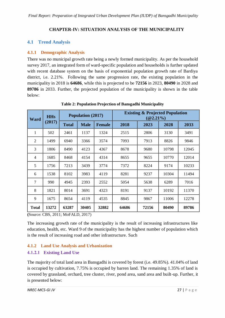
Final Report: Preparation of Integrated Urban Development Plan (IUDP) of Bansgadhi Municipality
NREC-MCS-GI JV 27 | P a g e
4 CHAPTER-IV: SITUATION ANALYSIS OF THE MUNICIPALITY
4.1 Trend Analysis
4.1.1 Demographic Analysis
There was no municipal growth rate being a newly formed municipality. As per the household
survey 2017, an integrated form of ward-specific population and households is further updated
with recent database system on the basis of exponential population growth rate of Bardiya
district, i.e. 2.21%. Following the same progression rate, the existing population in the
municipality in 2018 is 64686, while this is projected to be 72156 in 2023, 80490 in 2028 and
89786 in 2033. Further, the projected population of the municipality is shown in the table
below:
Table 2: Population Projection of Bansgadhi Municipality
Ward HHs
(2017)
Population (2017) Existing & Projected Population
(@2.21%)
Total Male Female 2018 2023 2028 2033
1 502 2461 1137 1324 2515 2806 3130 3491
2 1499 6940 3366 3574 7093 7913 8826 9846
3 1806 8490 4123 4367 8678 9680 10798 12045
4 1685 8468 4154 4314 8655 9655 10770 12014
5 1756 7213 3439 3774 7372 8224 9174 10233
6 1538 8102 3983 4119 8281 9237 10304 11494
7 990 4945 2393 2552 5054 5638 6289 7016
8 1821 8014 3691 4323 8191 9137 10192 11370
9 1675 8654 4119 4535 8845 9867 11006 12278
Total 13272 63287 30405 32882 64686 72156 80490 89786
(Source: CBS, 2011; MoFALD, 2017)
The increasing growth rate of the municipality is the result of increasing infrastructures like
education, health, etc. Ward 9 of the municipality has the highest number of population which
is the result of increasing road and other infrastructure. Such
4.1.2 Land Use Analysis and Urbanization
Existing Land Use
The majority of total land area in Bansgadhi is covered by forest (i.e. 49.85%). 41.04% of land
is occupied by cultivation, 7.75% is occupied by barren land. The remaining 1.35% of land is
covered by grassland, orchard, tree cluster, river, pond area, sand area and built-up. Further, it
is presented below:
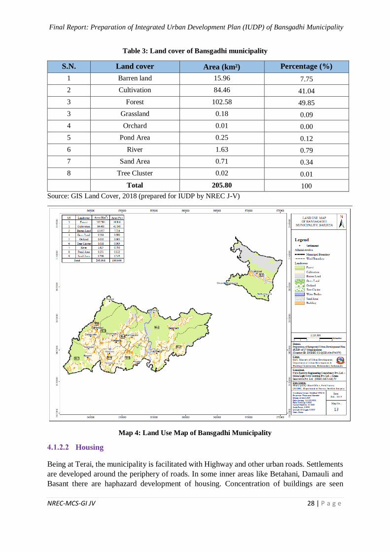
Final Report: Preparation of Integrated Urban Development Plan (IUDP) of Bansgadhi Municipality
NREC-MCS-GI JV 28 | P a g e
Table 3: Land cover of Bansgadhi municipality
S.N. Land cover Area (km²) Percentage (%)
1 Barren land 15.96 7.75
2 Cultivation 84.46 41.04
3 Forest 102.58 49.85
3 Grassland 0.18 0.09
4 Orchard 0.01 0.00
5 Pond Area 0.25 0.12
6 River 1.63 0.79
7 Sand Area 0.71 0.34
8 Tree Cluster 0.02 0.01
Total 205.80 100
Source: GIS Land Cover, 2018 (prepared for IUDP by NREC J-V)
Map 4: Land Use Map of Bansgadhi Municipality
Housing
Being at Terai, the municipality is facilitated with Highway and other urban roads. Settlements
are developed around the periphery of roads. In some inner areas like Betahani, Damauli and
Basant there are haphazard development of housing. Concentration of buildings are seen
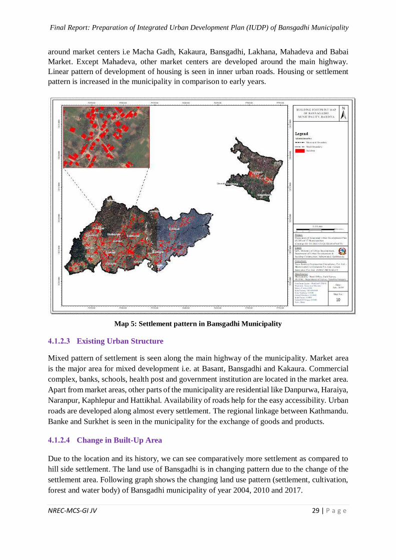
Final Report: Preparation of Integrated Urban Development Plan (IUDP) of Bansgadhi Municipality
NREC-MCS-GI JV 29 | P a g e
around market centers i.e Macha Gadh, Kakaura, Bansgadhi, Lakhana, Mahadeva and Babai
Market. Except Mahadeva, other market centers are developed around the main highway.
Linear pattern of development of housing is seen in inner urban roads. Housing or settlement
pattern is increased in the municipality in comparison to early years.
Map 5: Settlement pattern in Bansgadhi Municipality
Existing Urban Structure
Mixed pattern of settlement is seen along the main highway of the municipality. Market area
is the major area for mixed development i.e. at Basant, Bansgadhi and Kakaura. Commercial
complex, banks, schools, health post and government institution are located in the market area.
Apart from market areas, other parts of the municipality are residential like Danpurwa, Haraiya,
Naranpur, Kaphlepur and Hattikhal. Availability of roads help for the easy accessibility. Urban
roads are developed along almost every settlement. The regional linkage between Kathmandu.
Banke and Surkhet is seen in the municipality for the exchange of goods and products.
Change in Built-Up Area
Due to the location and its history, we can see comparatively more settlement as compared to
hill side settlement. The land use of Bansgadhi is in changing pattern due to the change of the
settlement area. Following graph shows the changing land use pattern (settlement, cultivation,
forest and water body) of Bansgadhi municipality of year 2004, 2010 and 2017.
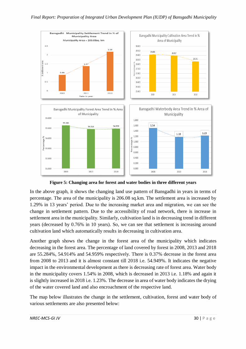
Final Report: Preparation of Integrated Urban Development Plan (IUDP) of Bansgadhi Municipality
NREC-MCS-GI JV 30 | P a g e
Figure 5: Changing area for forest and water bodies in three different years
In the above graph, it shows the changing land use pattern of Bansgadhi in years in terms of
percentage. The area of the municipality is 206.08 sq.km. The settlement area is increased by
1.29% in 13 years’ period. Due to the increasing market area and migration, we can see the
change in settlement pattern. Due to the accessibility of road network, there is increase in
settlement area in the municipality. Similarly, cultivation land is in decreasing trend in different
years (decreased by 0.76% in 10 years). So, we can see that settlement is increasing around
cultivation land which automatically results in decreasing in cultivation area.
Another graph shows the change in the forest area of the municipality which indicates
decreasing in the forest area. The percentage of land covered by forest in 2008, 2013 and 2018
are 55.284%, 54.914% and 54.959% respectively. There is 0.37% decrease in the forest area
from 2008 to 2013 and it is almost constant till 2018 i.e. 54.949%. It indicates the negative
impact in the environmental development as there is decreasing rate of forest area. Water body
in the municipality covers 1.54% in 2008, which is decreased in 2013 i.e. 1.18% and again it
is slightly increased in 2018 i.e. 1.23%. The decrease in area of water body indicates the drying
of the water covered land and also encroachment of the respective land.
The map below illustrates the change in the settlement, cultivation, forest and water body of
various settlements are also presented below:
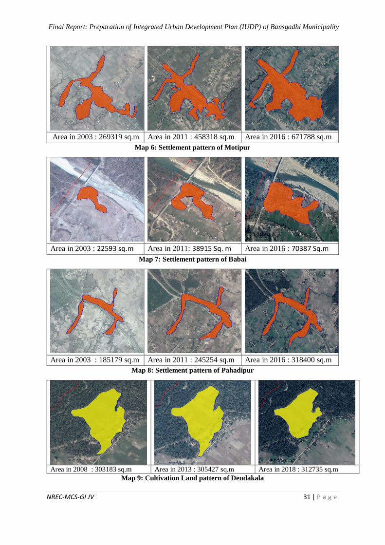
Final Report: Preparation of Integrated Urban Development Plan (IUDP) of Bansgadhi Municipality
NREC-MCS-GI JV 31 | P a g e
Area in 2003 : 269319 sq.m Area in 2011 : 458318 sq.m Area in 2016 : 671788 sq.m
Map 6: Settlement pattern of Motipur
Area in 2003 : 22593 sq.m Area in 2011: 38915 Sq. m Area in 2016 : 70387 Sq.m
Map 7: Settlement pattern of Babai
Area in 2003 : 185179 sq.m Area in 2011 : 245254 sq.m Area in 2016 : 318400 sq.m
Map 8: Settlement pattern of Pahadipur
Area in 2008 : 303183 sq.m Area in 2013 : 305427 sq.m Area in 2018 : 312735 sq.m
Map 9: Cultivation Land pattern of Deudakala
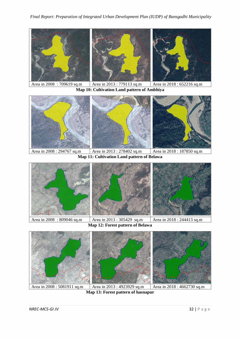
Final Report: Preparation of Integrated Urban Development Plan (IUDP) of Bansgadhi Municipality
NREC-MCS-GI JV 32 | P a g e
Area in 2008 : 709619 sq.m Area in 2013 : 779113 sq.m Area in 2018 : 652216 sq.m
Map 10: Cultivation Land pattern of Ambhiya
Area in 2008 : 294767 sq.m Area in 2013 : 278402 sq.m Area in 2018 : 187850 sq.m
Map 11: Cultivation Land pattern of Belawa
Area in 2008 : 809046 sq.m Area in 2013 : 305429 sq.m Area in 2018 : 244413 sq.m
Map 12: Forest pattern of Belawa
Area in 2008 : 5081911 sq.m Area in 2013 : 4923929 sq.m Area in 2018 : 4662730 sq.m
Map 13: Forest pattern of hasnapur
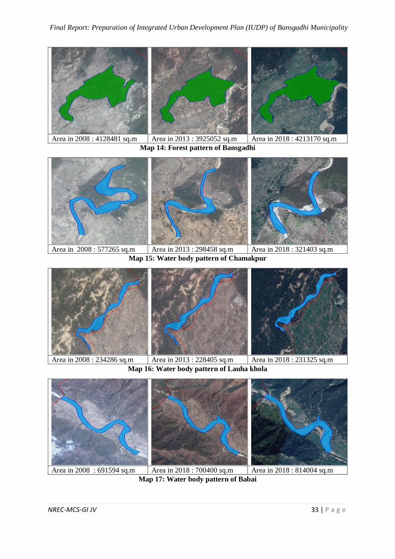
Final Report: Preparation of Integrated Urban Development Plan (IUDP) of Bansgadhi Municipality
NREC-MCS-GI JV 33 | P a g e
Area in 2008 : 4128481 sq.m Area in 2013 : 3925052 sq.m Area in 2018 : 4213170 sq.m
Map 14: Forest pattern of Bansgadhi
Area in 2008 : 577265 sq.m Area in 2013 : 298458 sq.m Area in 2018 : 321403 sq.m
Map 15: Water body pattern of Chamakpur
Area in 2008 : 234286 sq.m Area in 2013 : 228405 sq.m Area in 2018 : 231325 sq.m
Map 16: Water body pattern of Lauha khola
Area in 2008 : 691594 sq.m Area in 2018 : 700400 sq.m Area in 2018 : 814004 sq.m
Map 17: Water body pattern of Babai
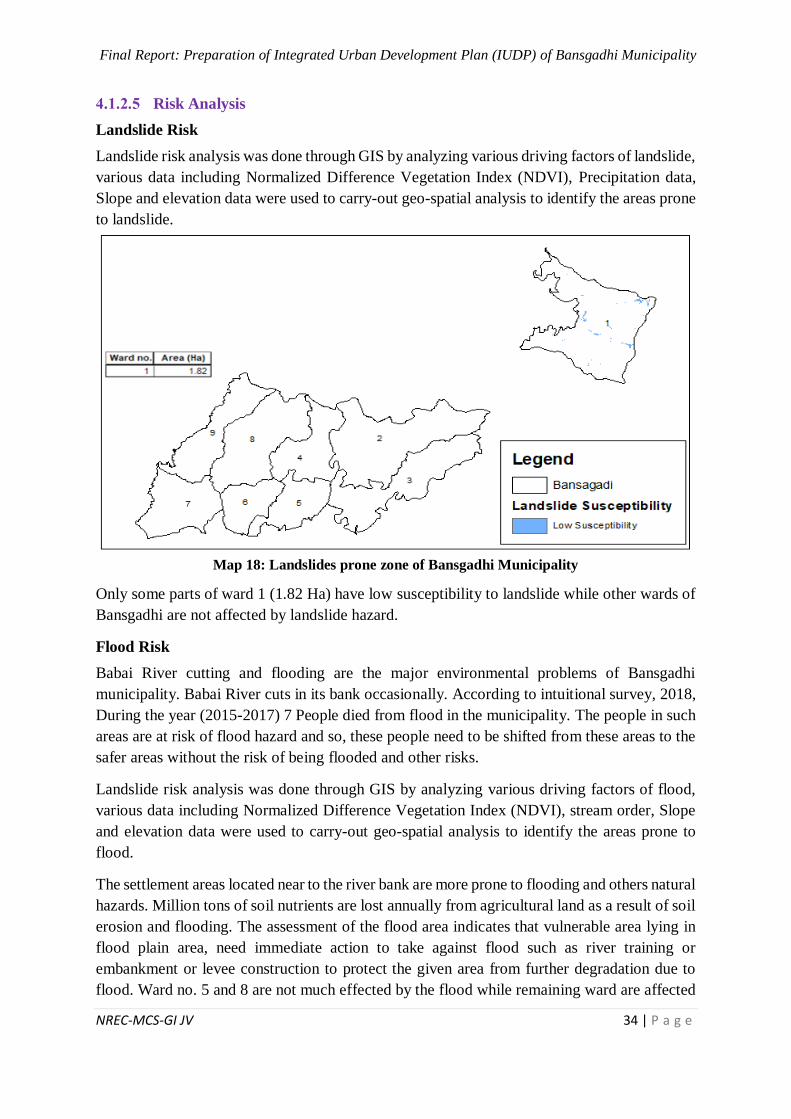
Final Report: Preparation of Integrated Urban Development Plan (IUDP) of Bansgadhi Municipality
NREC-MCS-GI JV 34 | P a g e
Risk Analysis
Landslide Risk
Landslide risk analysis was done through GIS by analyzing various driving factors of landslide,
various data including Normalized Difference Vegetation Index (NDVI), Precipitation data,
Slope and elevation data were used to carry-out geo-spatial analysis to identify the areas prone
to landslide.
Map 18: Landslides prone zone of Bansgadhi Municipality
Only some parts of ward 1 (1.82 Ha) have low susceptibility to landslide while other wards of
Bansgadhi are not affected by landslide hazard.
Flood Risk
Babai River cutting and flooding are the major environmental problems of Bansgadhi
municipality. Babai River cuts in its bank occasionally. According to intuitional survey, 2018,
During the year (2015-2017) 7 People died from flood in the municipality. The people in such
areas are at risk of flood hazard and so, these people need to be shifted from these areas to the
safer areas without the risk of being flooded and other risks.
Landslide risk analysis was done through GIS by analyzing various driving factors of flood,
various data including Normalized Difference Vegetation Index (NDVI), stream order, Slope
and elevation data were used to carry-out geo-spatial analysis to identify the areas prone to
flood.
The settlement areas located near to the river bank are more prone to flooding and others natural
hazards. Million tons of soil nutrients are lost annually from agricultural land as a result of soil
erosion and flooding. The assessment of the flood area indicates that vulnerable area lying in
flood plain area, need immediate action to take against flood such as river training or
embankment or levee construction to protect the given area from further degradation due to
flood. Ward no. 5 and 8 are not much effected by the flood while remaining ward are affected
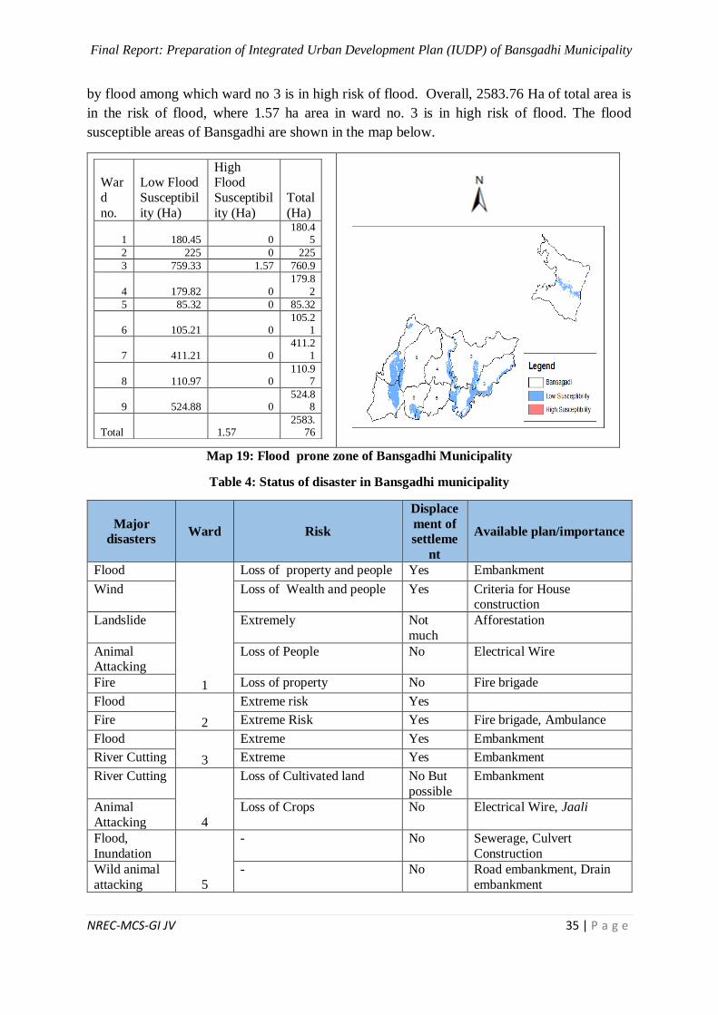
Final Report: Preparation of Integrated Urban Development Plan (IUDP) of Bansgadhi Municipality
NREC-MCS-GI JV 35 | P a g e
by flood among which ward no 3 is in high risk of flood. Overall, 2583.76 Ha of total area is
in the risk of flood, where 1.57 ha area in ward no. 3 is in high risk of flood. The flood
susceptible areas of Bansgadhi are shown in the map below.
War
d
no.
Low Flood
Susceptibil
ity (Ha)
High Flood
Susceptibil
ity (Ha)
Total
(Ha)
1 180.45 0 180.4
5
2 225 0 225
3 759.33 1.57 760.9
4 179.82 0
179.8
2
5 85.32 0 85.32
6 105.21 0 105.2
1
7 411.21 0 411.2
1
8 110.97 0 110.9
7
9 524.88 0 524.8
8
Total 1.57 2583.
76
Map 19: Flood prone zone of Bansgadhi Municipality
Table 4: Status of disaster in Bansgadhi municipality
Major
disasters Ward Risk
Displace
ment of
settleme
nt
Available plan/importance
Flood
1
Loss of property and people Yes Embankment
Wind Loss of Wealth and people Yes Criteria for House construction
Landslide Extremely Not
much
Afforestation
Animal Attacking
Loss of People No Electrical Wire
Fire Loss of property No Fire brigade
Flood
2
Extreme risk Yes
Fire Extreme Risk Yes Fire brigade, Ambulance
Flood
3
Extreme Yes Embankment
River Cutting Extreme Yes Embankment
River Cutting
4
Loss of Cultivated land No But
possible
Embankment
Animal
Attacking
Loss of Crops No Electrical Wire, Jaali
Flood,
Inundation
5
- No Sewerage, Culvert
Construction
Wild animal
attacking
- No Road embankment, Drain
embankment
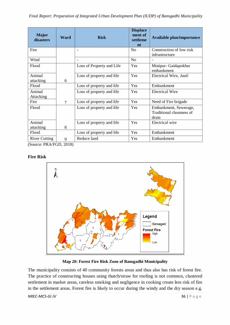
Final Report: Preparation of Integrated Urban Development Plan (IUDP) of Bansgadhi Municipality
NREC-MCS-GI JV 36 | P a g e
Major
disasters Ward Risk
Displace
ment of
settleme
nt
Available plan/importance
Fire - No Construction of low risk infrastructure
Wind - No -
Flood
6
Loss of Property and Life Yes Motipur- Gaidapokhar embankment
Animal
attacking
Loss of property and life Yes Electrical Wire, Jaali
Flood
7
Loss of property and life Yes Embankment
Animal
Attacking
Loss of property and life Yes Electrical Wire
Fire Loss of property and life Yes Need of Fire brigade
Flood
8
Loss of property and life Yes Embankment, Sewerage,
Traditional cleanness of
drain
Animal attacking
Loss of property and life Yes Electrical wire
Flood
9
Loss of property and life Yes Embankment
River Cutting Reduce land Yes Embankment
(Source: PRA/FGD, 2018)
Fire Risk
Map 20: Forest Fire Risk Zone of Bansgadhi Municipality
The municipality consists of 40 community forests areas and thus also has risk of forest fire.
The practice of constructing houses using thatch/straw for roofing is not common, clustered
settlement in market areas, careless smoking and negligence in cooking create less risk of fire
in the settlement areas. Forest fire is likely to occur during the windy and the dry season e.g.
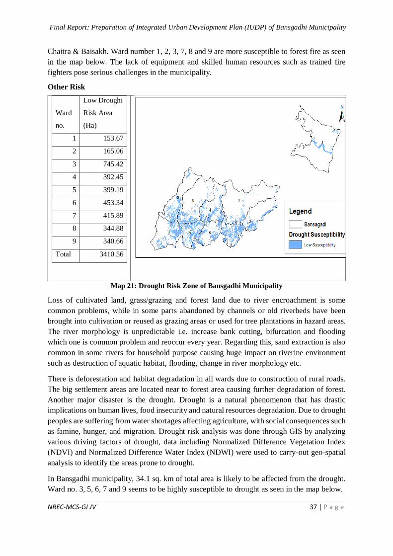
Final Report: Preparation of Integrated Urban Development Plan (IUDP) of Bansgadhi Municipality
NREC-MCS-GI JV 37 | P a g e
Chaitra & Baisakh. Ward number 1, 2, 3, 7, 8 and 9 are more susceptible to forest fire as seen
in the map below. The lack of equipment and skilled human resources such as trained fire
fighters pose serious challenges in the municipality.
Other Risk
Ward
no.
Low Drought
Risk Area
(Ha)
1 153.67
2 165.06
3 745.42
4 392.45
5 399.19
6 453.34
7 415.89
8 344.88
9 340.66
Total 3410.56
Map 21: Drought Risk Zone of Bansgadhi Municipality
Loss of cultivated land, grass/grazing and forest land due to river encroachment is some
common problems, while in some parts abandoned by channels or old riverbeds have been
brought into cultivation or reused as grazing areas or used for tree plantations in hazard areas.
The river morphology is unpredictable i.e. increase bank cutting, bifurcation and flooding
which one is common problem and reoccur every year. Regarding this, sand extraction is also
common in some rivers for household purpose causing huge impact on riverine environment
such as destruction of aquatic habitat, flooding, change in river morphology etc.
There is deforestation and habitat degradation in all wards due to construction of rural roads.
The big settlement areas are located near to forest area causing further degradation of forest.
Another major disaster is the drought. Drought is a natural phenomenon that has drastic
implications on human lives, food insecurity and natural resources degradation. Due to drought
peoples are suffering from water shortages affecting agriculture, with social consequences such
as famine, hunger, and migration. Drought risk analysis was done through GIS by analyzing
various driving factors of drought, data including Normalized Difference Vegetation Index
(NDVI) and Normalized Difference Water Index (NDWI) were used to carry-out geo-spatial
analysis to identify the areas prone to drought.
In Bansgadhi municipality, 34.1 sq. km of total area is likely to be affected from the drought.
Ward no. 3, 5, 6, 7 and 9 seems to be highly susceptible to drought as seen in the map below.
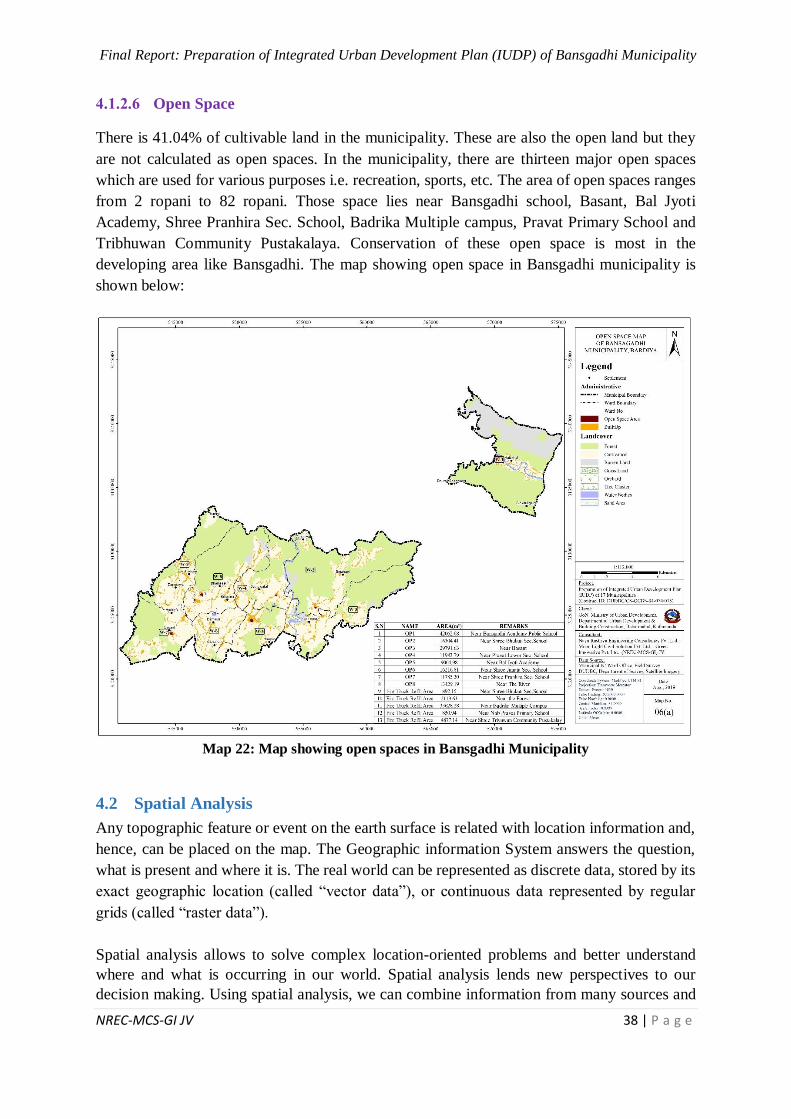
Final Report: Preparation of Integrated Urban Development Plan (IUDP) of Bansgadhi Municipality
NREC-MCS-GI JV 38 | P a g e
Open Space
There is 41.04% of cultivable land in the municipality. These are also the open land but they
are not calculated as open spaces. In the municipality, there are thirteen major open spaces
which are used for various purposes i.e. recreation, sports, etc. The area of open spaces ranges
from 2 ropani to 82 ropani. Those space lies near Bansgadhi school, Basant, Bal Jyoti
Academy, Shree Pranhira Sec. School, Badrika Multiple campus, Pravat Primary School and
Tribhuwan Community Pustakalaya. Conservation of these open space is most in the
developing area like Bansgadhi. The map showing open space in Bansgadhi municipality is
shown below:
Map 22: Map showing open spaces in Bansgadhi Municipality
4.2 Spatial Analysis
Any topographic feature or event on the earth surface is related with location information and,
hence, can be placed on the map. The Geographic information System answers the question,
what is present and where it is. The real world can be represented as discrete data, stored by its
exact geographic location (called “vector data”), or continuous data represented by regular
grids (called “raster data”).
Spatial analysis allows to solve complex location-oriented problems and better understand
where and what is occurring in our world. Spatial analysis lends new perspectives to our
decision making. Using spatial analysis, we can combine information from many sources and
Final Report: Preparation of Integrated Urban Development Plan (IUDP) of Bansgadhi Municipality
NREC-MCS-GI JV 39 | P a g e
derive new sets of information by applying a sophisticated set of spatial operators. So, the
spatial analysis has proven to be highly effective for evaluating the geographic suitability of
certain locations for specific purposes, estimating and predicting service provided area,
interpreting and understanding change pattern, observing accessibility of infrastructures and
identifying new location, and much more.
Easy Accessibility Analysis
Accessibility analysis is a very useful tool for bringing together all aspects of transport system
along with spatial distribution of various infrastructures such as education facilities, health
facilities, market places etc. in different land zoning. It provides an integrated measure of land
use system, the distribution of services and the distribution of population. The objective of
accessibility analysis is to identify the existing coverage/ service area by various public services
and allocation of potential new location of infrastructures (School, hospital, bank etc.) as per
distribution of population and road network.
For a particular facility within the town, there is certain area of influence of this facility, from
where the people can receive the service easily. For the people outside of the area of influence,
the access to that particular facility is difficult. Spatial analysis identifies the area, people from
where, have less or no facility of at all. The decision maker can use this information in order
to plan the location and size of new facility.
In order to complete the easy accessibility analysis in GIS, some criteria are to be fed to the
system. These criteria depend upon the research results in that particular area, physical
experience and results similar study. For easy accessibility buffer analysis in “Integrated Urban
Development Plan” project, the criteria are set on the basis of norms and standards of
Government of Nepal, topographic location, the morphology of the municipality, the road
network, the surface condition of the road network etc.
Health
For the health facility, maximum walking time and speed of the citizen are fed as criteria for
analysis in GIS system.
Analysis Criteria
Each citizen must not walk more than 30 minutes to reach the nearest health post.
Each citizen must not walk more than 45 minutes to reach the nearest Hospital.
The above mentioned criteria are set for walking distance. For citizen using a vehicle to reach
the facility, the travel time would be much lesser than mentioned above. Furthermore, the
walking speed of a normal citizen depends also upon the topography, road network and surface
type, rivers, streams and the cross drainage structures etc. of the municipality. For the
“Integrated Urban Development Plan” project, the following walking speed has taken for
spatial analysis.
In Terai region, the Walking Speed for a healthy citizen: 1.2 m/s
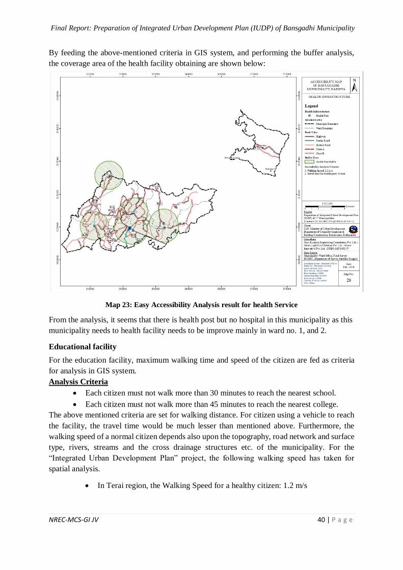
Final Report: Preparation of Integrated Urban Development Plan (IUDP) of Bansgadhi Municipality
NREC-MCS-GI JV 40 | P a g e
By feeding the above-mentioned criteria in GIS system, and performing the buffer analysis,
the coverage area of the health facility obtaining are shown below:
Map 23: Easy Accessibility Analysis result for health Service
From the analysis, it seems that there is health post but no hospital in this municipality as this
municipality needs to health facility needs to be improve mainly in ward no. 1, and 2.
Educational facility
For the education facility, maximum walking time and speed of the citizen are fed as criteria
for analysis in GIS system.
Analysis Criteria
Each citizen must not walk more than 30 minutes to reach the nearest school.
Each citizen must not walk more than 45 minutes to reach the nearest college.
The above mentioned criteria are set for walking distance. For citizen using a vehicle to reach
the facility, the travel time would be much lesser than mentioned above. Furthermore, the
walking speed of a normal citizen depends also upon the topography, road network and surface
type, rivers, streams and the cross drainage structures etc. of the municipality. For the
“Integrated Urban Development Plan” project, the following walking speed has taken for
spatial analysis.
In Terai region, the Walking Speed for a healthy citizen: 1.2 m/s
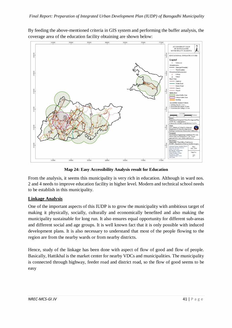
Final Report: Preparation of Integrated Urban Development Plan (IUDP) of Bansgadhi Municipality
NREC-MCS-GI JV 41 | P a g e
By feeding the above-mentioned criteria in GIS system and performing the buffer analysis, the
coverage area of the education facility obtaining are shown below:
Map 24: Easy Accessibility Analysis result for Education
From the analysis, it seems this municipality is very rich in education. Although in ward nos.
2 and 4 needs to improve education facility in higher level. Modern and technical school needs
to be establish in this municipality.
Linkage Analysis
One of the important aspects of this IUDP is to grow the municipality with ambitious target of
making it physically, socially, culturally and economically benefited and also making the
municipality sustainable for long run. It also ensures equal opportunity for different sub-areas
and different social and age groups. It is well known fact that it is only possible with induced
development plans. It is also necessary to understand that most of the people flowing to the
region are from the nearby wards or from nearby districts.
Hence, study of the linkage has been done with aspect of flow of good and flow of people.
Basically, Hattikhal is the market center for nearby VDCs and municipalities. The municipality
is connected through highway, feeder road and district road, so the flow of good seems to be
easy
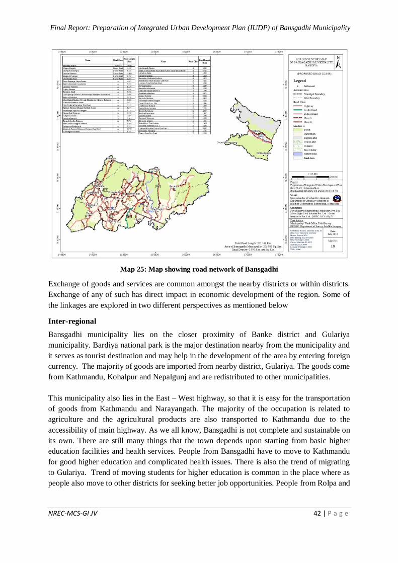
Final Report: Preparation of Integrated Urban Development Plan (IUDP) of Bansgadhi Municipality
NREC-MCS-GI JV 42 | P a g e
Map 25: Map showing road network of Bansgadhi
Exchange of goods and services are common amongst the nearby districts or within districts.
Exchange of any of such has direct impact in economic development of the region. Some of
the linkages are explored in two different perspectives as mentioned below
Inter-regional
Bansgadhi municipality lies on the closer proximity of Banke district and Gulariya
municipality. Bardiya national park is the major destination nearby from the municipality and
it serves as tourist destination and may help in the development of the area by entering foreign
currency. The majority of goods are imported from nearby district, Gulariya. The goods come
from Kathmandu, Kohalpur and Nepalgunj and are redistributed to other municipalities.
This municipality also lies in the East – West highway, so that it is easy for the transportation
of goods from Kathmandu and Narayangath. The majority of the occupation is related to
agriculture and the agricultural products are also transported to Kathmandu due to the
accessibility of main highway. As we all know, Bansgadhi is not complete and sustainable on
its own. There are still many things that the town depends upon starting from basic higher
education facilities and health services. People from Bansgadhi have to move to Kathmandu
for good higher education and complicated health issues. There is also the trend of migrating
to Gulariya. Trend of moving students for higher education is common in the place where as
people also move to other districts for seeking better job opportunities. People from Rolpa and
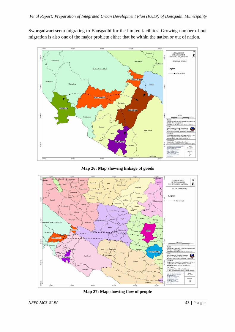
Final Report: Preparation of Integrated Urban Development Plan (IUDP) of Bansgadhi Municipality
NREC-MCS-GI JV 43 | P a g e
Sworgadwari seem migrating to Bansgadhi for the limited facilities. Growing number of out
migration is also one of the major problem either that be within the nation or out of nation.
Map 26: Map showing linkage of goods
Map 27: Map showing flow of people
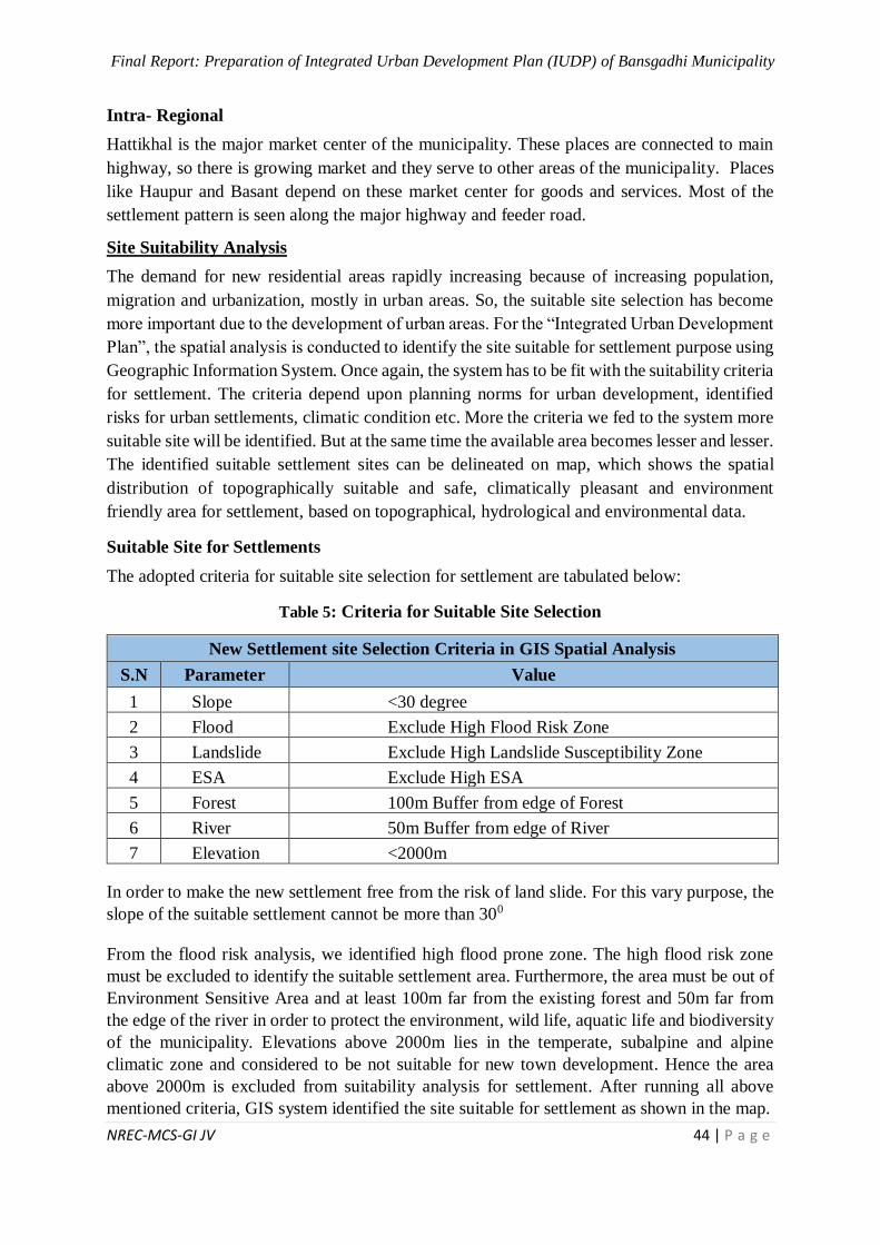
Final Report: Preparation of Integrated Urban Development Plan (IUDP) of Bansgadhi Municipality
NREC-MCS-GI JV 44 | P a g e
Intra- Regional
Hattikhal is the major market center of the municipality. These places are connected to main
highway, so there is growing market and they serve to other areas of the municipality. Places
like Haupur and Basant depend on these market center for goods and services. Most of the
settlement pattern is seen along the major highway and feeder road.
Site Suitability Analysis
The demand for new residential areas rapidly increasing because of increasing population,
migration and urbanization, mostly in urban areas. So, the suitable site selection has become
more important due to the development of urban areas. For the “Integrated Urban Development
Plan”, the spatial analysis is conducted to identify the site suitable for settlement purpose using
Geographic Information System. Once again, the system has to be fit with the suitability criteria
for settlement. The criteria depend upon planning norms for urban development, identified
risks for urban settlements, climatic condition etc. More the criteria we fed to the system more
suitable site will be identified. But at the same time the available area becomes lesser and lesser.
The identified suitable settlement sites can be delineated on map, which shows the spatial
distribution of topographically suitable and safe, climatically pleasant and environment
friendly area for settlement, based on topographical, hydrological and environmental data.
Suitable Site for Settlements
The adopted criteria for suitable site selection for settlement are tabulated below:
Table 5: Criteria for Suitable Site Selection
New Settlement site Selection Criteria in GIS Spatial Analysis
S.N Parameter Value
1 Slope <30 degree
2 Flood Exclude High Flood Risk Zone
3 Landslide Exclude High Landslide Susceptibility Zone
4 ESA Exclude High ESA
5 Forest 100m Buffer from edge of Forest
6 River 50m Buffer from edge of River
7 Elevation <2000m
In order to make the new settlement free from the risk of land slide. For this vary purpose, the
slope of the suitable settlement cannot be more than 300
From the flood risk analysis, we identified high flood prone zone. The high flood risk zone
must be excluded to identify the suitable settlement area. Furthermore, the area must be out of
Environment Sensitive Area and at least 100m far from the existing forest and 50m far from
the edge of the river in order to protect the environment, wild life, aquatic life and biodiversity
of the municipality. Elevations above 2000m lies in the temperate, subalpine and alpine
climatic zone and considered to be not suitable for new town development. Hence the area
above 2000m is excluded from suitability analysis for settlement. After running all above
mentioned criteria, GIS system identified the site suitable for settlement as shown in the map.
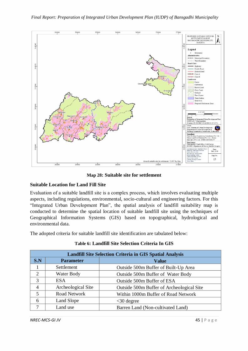
Final Report: Preparation of Integrated Urban Development Plan (IUDP) of Bansgadhi Municipality
NREC-MCS-GI JV 45 | P a g e
Map 28: Suitable site for settlement
Suitable Location for Land Fill Site
Evaluation of a suitable landfill site is a complex process, which involves evaluating multiple
aspects, including regulations, environmental, socio-cultural and engineering factors. For this
“Integrated Urban Development Plan”, the spatial analysis of landfill suitability map is
conducted to determine the spatial location of suitable landfill site using the techniques of
Geographical Information Systems (GIS) based on topographical, hydrological and
environmental data.
The adopted criteria for suitable landfill site identification are tabulated below:
Table 6: Landfill Site Selection Criteria In GIS
Landfill Site Selection Criteria in GIS Spatial Analysis
S.N Parameter Value
1 Settlement Outside 500m Buffer of Built-Up Area
2 Water Body Outside 500m Buffer of Water Body
3 ESA Outside 500m Buffer of ESA
4 Archeological Site Outside 500m Buffer of Archeological Site
5 Road Network Within 1000m Buffer of Road Network
6 Land Slope <30 degree
7 Land use Barren Land (Non-cultivated Land)
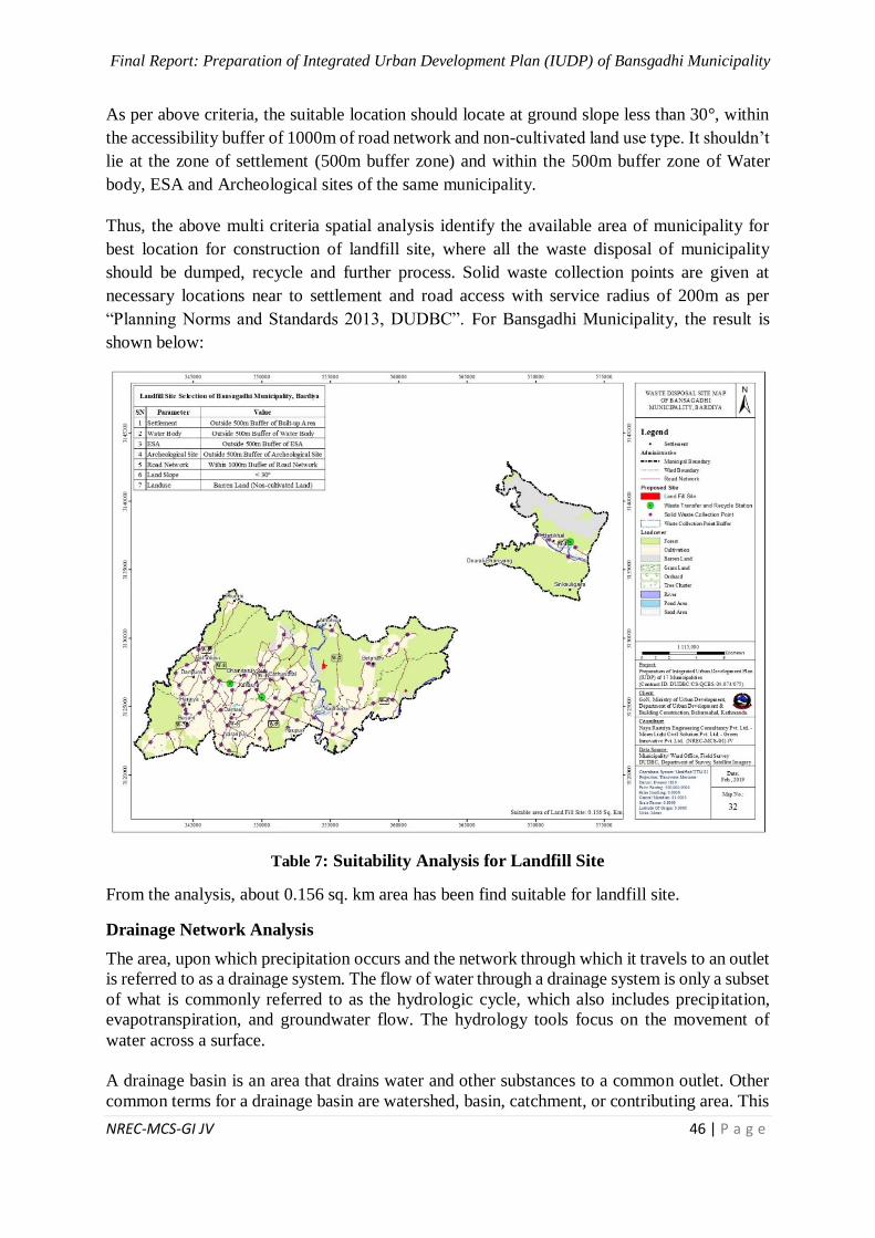
Final Report: Preparation of Integrated Urban Development Plan (IUDP) of Bansgadhi Municipality
NREC-MCS-GI JV 46 | P a g e
As per above criteria, the suitable location should locate at ground slope less than 30°, within
the accessibility buffer of 1000m of road network and non-cultivated land use type. It shouldn’t
lie at the zone of settlement (500m buffer zone) and within the 500m buffer zone of Water
body, ESA and Archeological sites of the same municipality.
Thus, the above multi criteria spatial analysis identify the available area of municipality for
best location for construction of landfill site, where all the waste disposal of municipality
should be dumped, recycle and further process. Solid waste collection points are given at
necessary locations near to settlement and road access with service radius of 200m as per
“Planning Norms and Standards 2013, DUDBC”. For Bansgadhi Municipality, the result is
shown below:
Table 7: Suitability Analysis for Landfill Site
From the analysis, about 0.156 sq. km area has been find suitable for landfill site.
Drainage Network Analysis
The area, upon which precipitation occurs and the network through which it travels to an outlet
is referred to as a drainage system. The flow of water through a drainage system is only a subset
of what is commonly referred to as the hydrologic cycle, which also includes precipitation,
evapotranspiration, and groundwater flow. The hydrology tools focus on the movement of
water across a surface.
A drainage basin is an area that drains water and other substances to a common outlet. Other
common terms for a drainage basin are watershed, basin, catchment, or contributing area. This
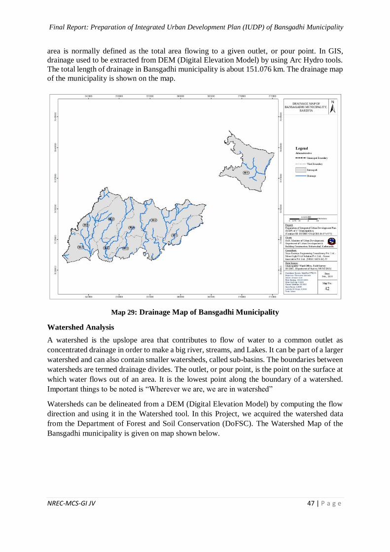
Final Report: Preparation of Integrated Urban Development Plan (IUDP) of Bansgadhi Municipality
NREC-MCS-GI JV 47 | P a g e
area is normally defined as the total area flowing to a given outlet, or pour point. In GIS,
drainage used to be extracted from DEM (Digital Elevation Model) by using Arc Hydro tools.
The total length of drainage in Bansgadhi municipality is about 151.076 km. The drainage map
of the municipality is shown on the map.
Map 29: Drainage Map of Bansgadhi Municipality
Watershed Analysis
A watershed is the upslope area that contributes to flow of water to a common outlet as
concentrated drainage in order to make a big river, streams, and Lakes. It can be part of a larger
watershed and can also contain smaller watersheds, called sub-basins. The boundaries between
watersheds are termed drainage divides. The outlet, or pour point, is the point on the surface at
which water flows out of an area. It is the lowest point along the boundary of a watershed.
Important things to be noted is “Wherever we are, we are in watershed”
Watersheds can be delineated from a DEM (Digital Elevation Model) by computing the flow
direction and using it in the Watershed tool. In this Project, we acquired the watershed data
from the Department of Forest and Soil Conservation (DoFSC). The Watershed Map of the
Bansgadhi municipality is given on map shown below.
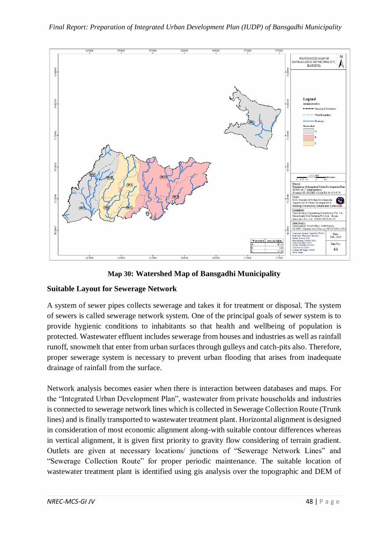
Final Report: Preparation of Integrated Urban Development Plan (IUDP) of Bansgadhi Municipality
NREC-MCS-GI JV 48 | P a g e
Map 30: Watershed Map of Bansgadhi Municipality
Suitable Layout for Sewerage Network
A system of sewer pipes collects sewerage and takes it for treatment or disposal. The system
of sewers is called sewerage network system. One of the principal goals of sewer system is to
provide hygienic conditions to inhabitants so that health and wellbeing of population is
protected. Wastewater effluent includes sewerage from houses and industries as well as rainfall
runoff, snowmelt that enter from urban surfaces through gulleys and catch-pits also. Therefore,
proper sewerage system is necessary to prevent urban flooding that arises from inadequate
drainage of rainfall from the surface.
Network analysis becomes easier when there is interaction between databases and maps. For
the “Integrated Urban Development Plan”, wastewater from private households and industries
is connected to sewerage network lines which is collected in Sewerage Collection Route (Trunk
lines) and is finally transported to wastewater treatment plant. Horizontal alignment is designed
in consideration of most economic alignment along-with suitable contour differences whereas
in vertical alignment, it is given first priority to gravity flow considering of terrain gradient.
Outlets are given at necessary locations/ junctions of “Sewerage Network Lines” and
“Sewerage Collection Route” for proper periodic maintenance. The suitable location of
wastewater treatment plant is identified using gis analysis over the topographic and DEM of
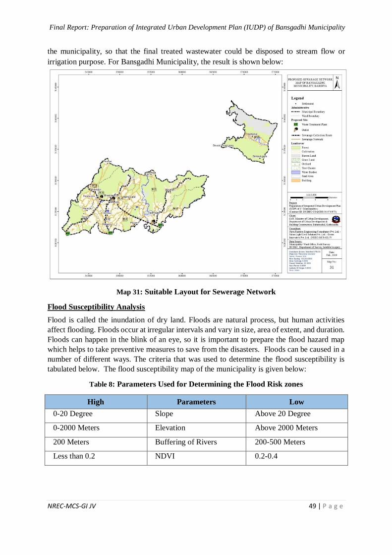
Final Report: Preparation of Integrated Urban Development Plan (IUDP) of Bansgadhi Municipality
NREC-MCS-GI JV 49 | P a g e
the municipality, so that the final treated wastewater could be disposed to stream flow or
irrigation purpose. For Bansgadhi Municipality, the result is shown below:
Map 31: Suitable Layout for Sewerage Network
Flood Susceptibility Analysis
Flood is called the inundation of dry land. Floods are natural process, but human activities
affect flooding. Floods occur at irregular intervals and vary in size, area of extent, and duration.
Floods can happen in the blink of an eye, so it is important to prepare the flood hazard map
which helps to take preventive measures to save from the disasters. Floods can be caused in a
number of different ways. The criteria that was used to determine the flood susceptibility is
tabulated below. The flood susceptibility map of the municipality is given below:
Table 8: Parameters Used for Determining the Flood Risk zones
High Parameters Low
0-20 Degree Slope Above 20 Degree
0-2000 Meters Elevation Above 2000 Meters
200 Meters Buffering of Rivers 200-500 Meters
Less than 0.2 NDVI 0.2-0.4
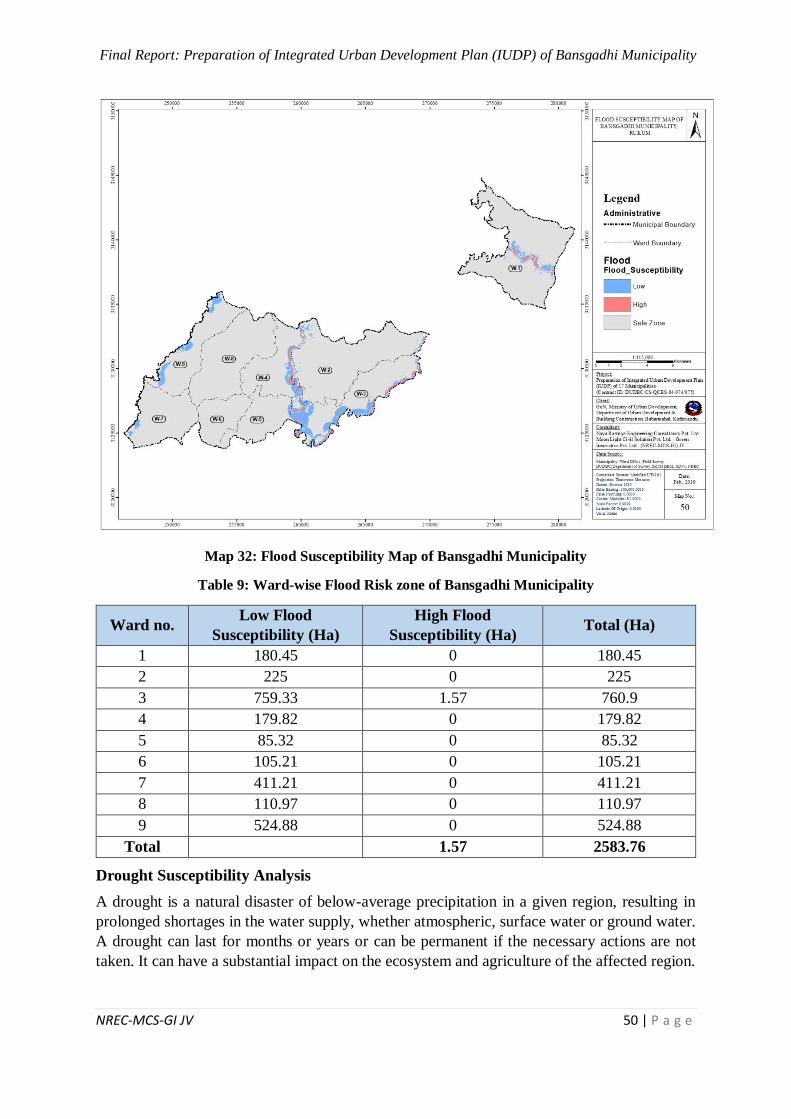
Final Report: Preparation of Integrated Urban Development Plan (IUDP) of Bansgadhi Municipality
NREC-MCS-GI JV 50 | P a g e
Map 32: Flood Susceptibility Map of Bansgadhi Municipality
Table 9: Ward-wise Flood Risk zone of Bansgadhi Municipality
Ward no. Low Flood
Susceptibility (Ha)
High Flood
Susceptibility (Ha) Total (Ha)
1 180.45 0 180.45
2 225 0 225
3 759.33 1.57 760.9
4 179.82 0 179.82
5 85.32 0 85.32
6 105.21 0 105.21
7 411.21 0 411.21
8 110.97 0 110.97
9 524.88 0 524.88
Total 1.57 2583.76
Drought Susceptibility Analysis
A drought is a natural disaster of below-average precipitation in a given region, resulting in
prolonged shortages in the water supply, whether atmospheric, surface water or ground water.
A drought can last for months or years or can be permanent if the necessary actions are not
taken. It can have a substantial impact on the ecosystem and agriculture of the affected region.
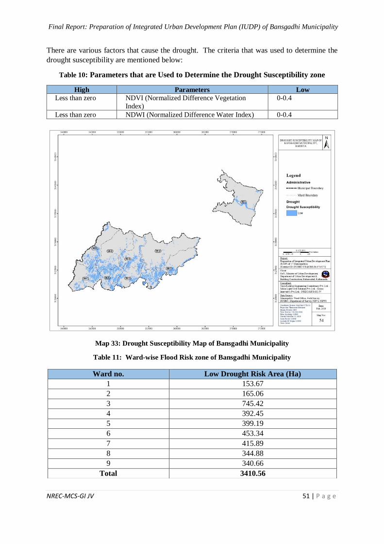
Final Report: Preparation of Integrated Urban Development Plan (IUDP) of Bansgadhi Municipality
NREC-MCS-GI JV 51 | P a g e
There are various factors that cause the drought. The criteria that was used to determine the
drought susceptibility are mentioned below:
Table 10: Parameters that are Used to Determine the Drought Susceptibility zone
High Parameters Low
Less than zero NDVI (Normalized Difference Vegetation
Index)
0-0.4
Less than zero NDWI (Normalized Difference Water Index) 0-0.4
Map 33: Drought Susceptibility Map of Bansgadhi Municipality
Table 11: Ward-wise Flood Risk zone of Bansgadhi Municipality
Ward no. Low Drought Risk Area (Ha)
1 153.67
2 165.06
3 745.42
4 392.45
5 399.19
6 453.34
7 415.89
8 344.88
9 340.66
Total 3410.56
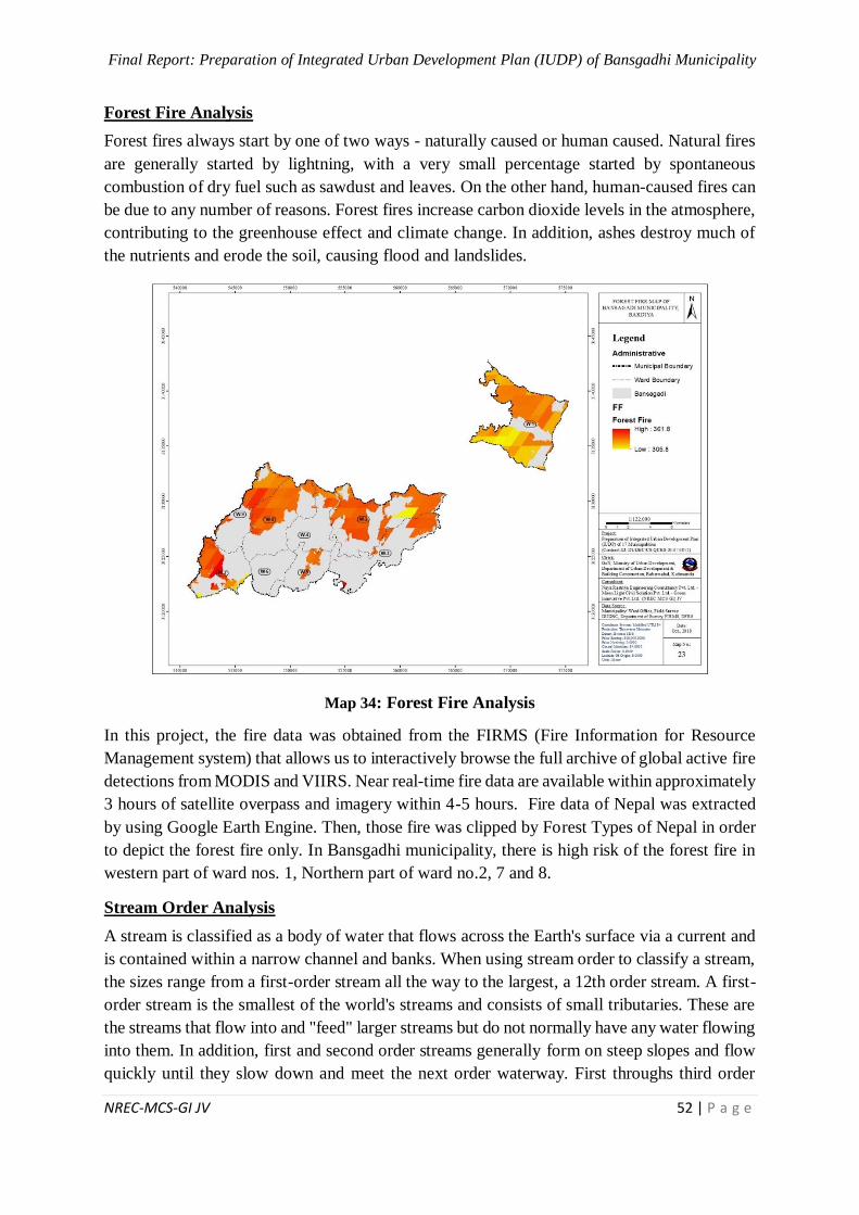
Final Report: Preparation of Integrated Urban Development Plan (IUDP) of Bansgadhi Municipality
NREC-MCS-GI JV 52 | P a g e
Forest Fire Analysis
Forest fires always start by one of two ways - naturally caused or human caused. Natural fires
are generally started by lightning, with a very small percentage started by spontaneous
combustion of dry fuel such as sawdust and leaves. On the other hand, human-caused fires can
be due to any number of reasons. Forest fires increase carbon dioxide levels in the atmosphere,
contributing to the greenhouse effect and climate change. In addition, ashes destroy much of
the nutrients and erode the soil, causing flood and landslides.
Map 34: Forest Fire Analysis
In this project, the fire data was obtained from the FIRMS (Fire Information for Resource
Management system) that allows us to interactively browse the full archive of global active fire
detections from MODIS and VIIRS. Near real-time fire data are available within approximately
3 hours of satellite overpass and imagery within 4-5 hours. Fire data of Nepal was extracted
by using Google Earth Engine. Then, those fire was clipped by Forest Types of Nepal in order
to depict the forest fire only. In Bansgadhi municipality, there is high risk of the forest fire in
western part of ward nos. 1, Northern part of ward no.2, 7 and 8.
Stream Order Analysis
A stream is classified as a body of water that flows across the Earth's surface via a current and
is contained within a narrow channel and banks. When using stream order to classify a stream,
the sizes range from a first-order stream all the way to the largest, a 12th order stream. A first-
order stream is the smallest of the world's streams and consists of small tributaries. These are
the streams that flow into and "feed" larger streams but do not normally have any water flowing
into them. In addition, first and second order streams generally form on steep slopes and flow
quickly until they slow down and meet the next order waterway. First throughs third order
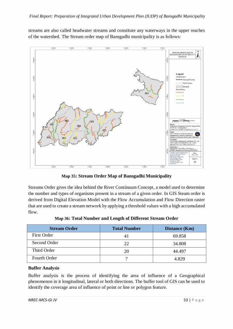
Final Report: Preparation of Integrated Urban Development Plan (IUDP) of Bansgadhi Municipality
NREC-MCS-GI JV 53 | P a g e
streams are also called headwater streams and constitute any waterways in the upper reaches
of the watershed. The Stream order map of Bansgadhi municipality is as follows:
Map 35: Stream Order Map of Bansgadhi Municipality
Streams Order gives the idea behind the River Continuum Concept, a model used to determine
the number and types of organisms present in a stream of a given order. In GIS Steam order is
derived from Digital Elevation Model with the Flow Accumulation and Flow Direction raster
that are used to create a stream network by applying a threshold values with a high accumulated
flow.
Map 36: Total Number and Length of Different Stream Order
Stream Order Total Number Distance (Km)
First Order 41 69.858
Second Order 22 34.808
Third Order 20 44.497
Fourth Order 7 4.829
Buffer Analysis
Buffer analysis is the process of identifying the area of influence of a Geographical
phenomenon in it longitudinal, lateral or both directions. The buffer tool of GIS can be used to
identify the coverage area of influence of point or line or polygon feature.
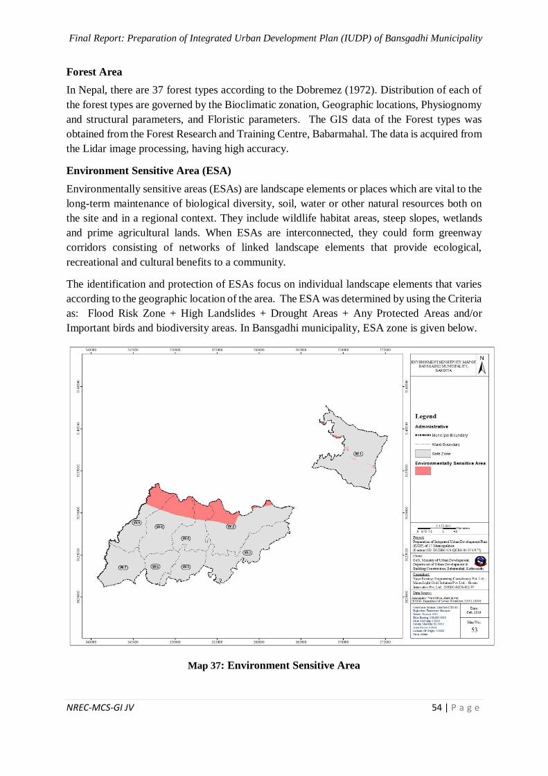
Final Report: Preparation of Integrated Urban Development Plan (IUDP) of Bansgadhi Municipality
NREC-MCS-GI JV 54 | P a g e
Forest Area
In Nepal, there are 37 forest types according to the Dobremez (1972). Distribution of each of
the forest types are governed by the Bioclimatic zonation, Geographic locations, Physiognomy
and structural parameters, and Floristic parameters. The GIS data of the Forest types was
obtained from the Forest Research and Training Centre, Babarmahal. The data is acquired from
the Lidar image processing, having high accuracy.
Environment Sensitive Area (ESA)
Environmentally sensitive areas (ESAs) are landscape elements or places which are vital to the
long-term maintenance of biological diversity, soil, water or other natural resources both on
the site and in a regional context. They include wildlife habitat areas, steep slopes, wetlands
and prime agricultural lands. When ESAs are interconnected, they could form greenway
corridors consisting of networks of linked landscape elements that provide ecological,
recreational and cultural benefits to a community.
The identification and protection of ESAs focus on individual landscape elements that varies
according to the geographic location of the area. The ESA was determined by using the Criteria
as: Flood Risk Zone + High Landslides + Drought Areas + Any Protected Areas and/or
Important birds and biodiversity areas. In Bansgadhi municipality, ESA zone is given below.
Map 37: Environment Sensitive Area
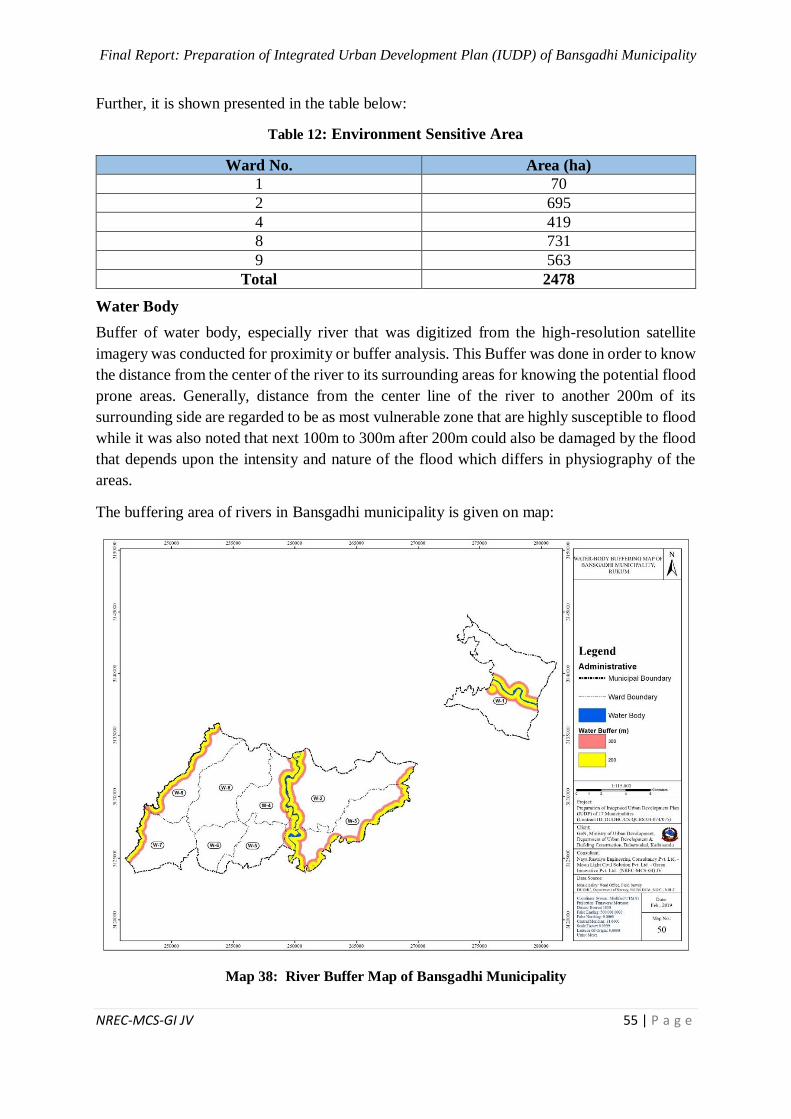
Final Report: Preparation of Integrated Urban Development Plan (IUDP) of Bansgadhi Municipality
NREC-MCS-GI JV 55 | P a g e
Further, it is shown presented in the table below:
Table 12: Environment Sensitive Area
Ward No. Area (ha)
1 70
2 695
4 419
8 731
9 563
Total 2478
Water Body
Buffer of water body, especially river that was digitized from the high-resolution satellite
imagery was conducted for proximity or buffer analysis. This Buffer was done in order to know
the distance from the center of the river to its surrounding areas for knowing the potential flood
prone areas. Generally, distance from the center line of the river to another 200m of its
surrounding side are regarded to be as most vulnerable zone that are highly susceptible to flood
while it was also noted that next 100m to 300m after 200m could also be damaged by the flood
that depends upon the intensity and nature of the flood which differs in physiography of the
areas.
The buffering area of rivers in Bansgadhi municipality is given on map:
Map 38: River Buffer Map of Bansgadhi Municipality
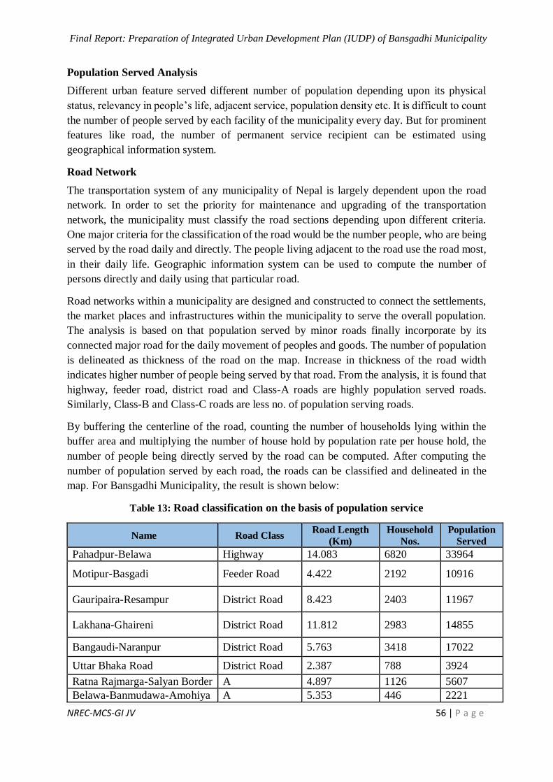
Final Report: Preparation of Integrated Urban Development Plan (IUDP) of Bansgadhi Municipality
NREC-MCS-GI JV 56 | P a g e
Population Served Analysis
Different urban feature served different number of population depending upon its physical
status, relevancy in people’s life, adjacent service, population density etc. It is difficult to count
the number of people served by each facility of the municipality every day. But for prominent
features like road, the number of permanent service recipient can be estimated using
geographical information system.
Road Network
The transportation system of any municipality of Nepal is largely dependent upon the road
network. In order to set the priority for maintenance and upgrading of the transportation
network, the municipality must classify the road sections depending upon different criteria.
One major criteria for the classification of the road would be the number people, who are being
served by the road daily and directly. The people living adjacent to the road use the road most,
in their daily life. Geographic information system can be used to compute the number of
persons directly and daily using that particular road.
Road networks within a municipality are designed and constructed to connect the settlements,
the market places and infrastructures within the municipality to serve the overall population.
The analysis is based on that population served by minor roads finally incorporate by its
connected major road for the daily movement of peoples and goods. The number of population
is delineated as thickness of the road on the map. Increase in thickness of the road width
indicates higher number of people being served by that road. From the analysis, it is found that
highway, feeder road, district road and Class-A roads are highly population served roads.
Similarly, Class-B and Class-C roads are less no. of population serving roads.
By buffering the centerline of the road, counting the number of households lying within the
buffer area and multiplying the number of house hold by population rate per house hold, the
number of people being directly served by the road can be computed. After computing the
number of population served by each road, the roads can be classified and delineated in the
map. For Bansgadhi Municipality, the result is shown below:
Table 13: Road classification on the basis of population service
Name Road Class Road Length
(Km)
Household
Nos.
Population
Served
Pahadpur-Belawa Highway 14.083 6820 33964
Motipur-Basgadi Feeder Road 4.422 2192 10916
Gauripaira-Resampur District Road 8.423 2403 11967
Lakhana-Ghaireni District Road 11.812 2983 14855
Bangaudi-Naranpur District Road 5.763 3418 17022
Uttar Bhaka Road District Road 2.387 788 3924
Ratna Rajmarga-Salyan Border A 4.897 1126 5607
Belawa-Banmudawa-Amohiya A 5.353 446 2221
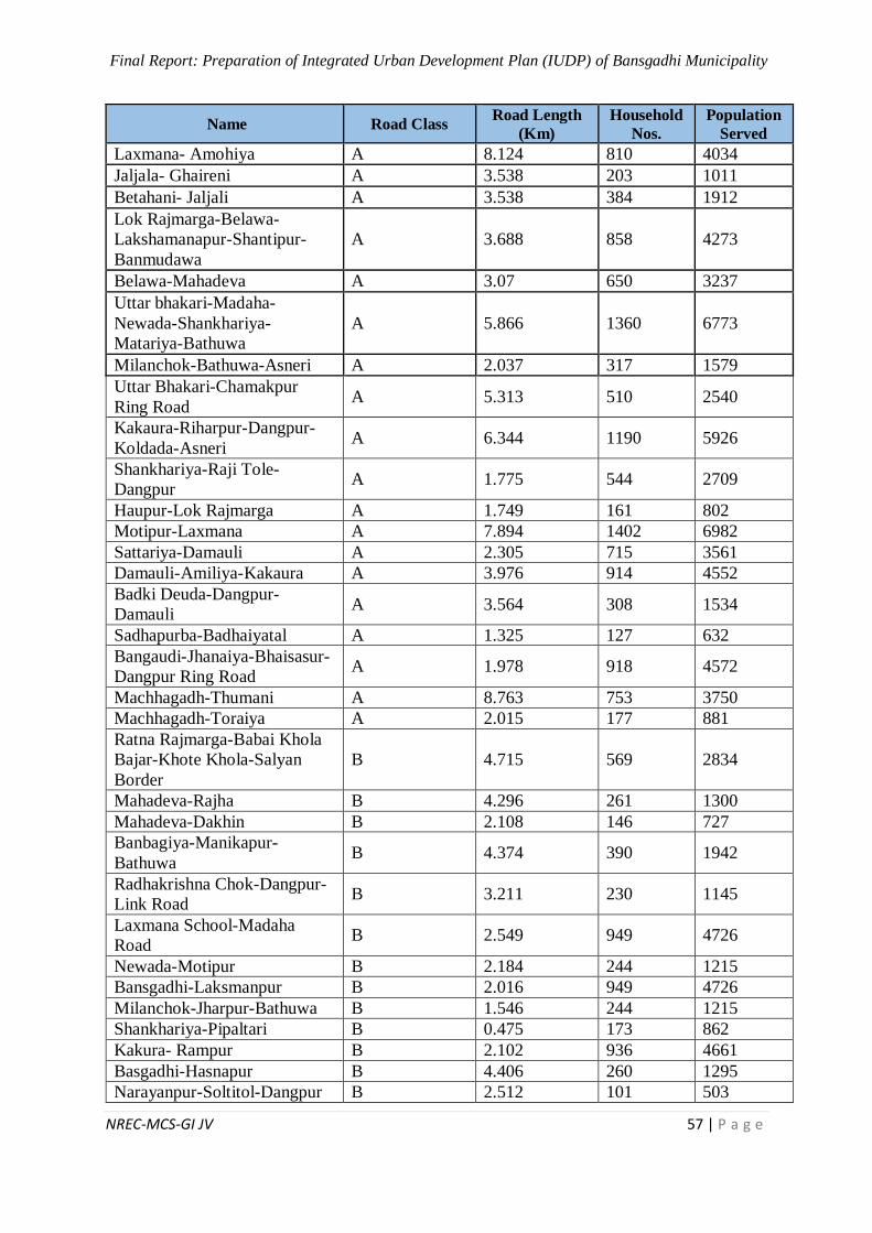
Final Report: Preparation of Integrated Urban Development Plan (IUDP) of Bansgadhi Municipality
NREC-MCS-GI JV 57 | P a g e
Name Road Class Road Length
(Km)
Household
Nos.
Population
Served
Laxmana- Amohiya A 8.124 810 4034
Jaljala- Ghaireni A 3.538 203 1011
Betahani- Jaljali A 3.538 384 1912
Lok Rajmarga-Belawa-
Lakshamanapur-Shantipur-
Banmudawa
A 3.688 858 4273
Belawa-Mahadeva A 3.07 650 3237
Uttar bhakari-Madaha-
Newada-Shankhariya-
Matariya-Bathuwa
A 5.866 1360 6773
Milanchok-Bathuwa-Asneri A 2.037 317 1579
Uttar Bhakari-Chamakpur
Ring Road A 5.313 510 2540
Kakaura-Riharpur-Dangpur-
Koldada-Asneri A 6.344 1190 5926
Shankhariya-Raji Tole-
Dangpur A 1.775 544 2709
Haupur-Lok Rajmarga A 1.749 161 802
Motipur-Laxmana A 7.894 1402 6982
Sattariya-Damauli A 2.305 715 3561
Damauli-Amiliya-Kakaura A 3.976 914 4552
Badki Deuda-Dangpur-
Damauli A 3.564 308 1534
Sadhapurba-Badhaiyatal A 1.325 127 632
Bangaudi-Jhanaiya-Bhaisasur-
Dangpur Ring Road A 1.978 918 4572
Machhagadh-Thumani A 8.763 753 3750
Machhagadh-Toraiya A 2.015 177 881
Ratna Rajmarga-Babai Khola
Bajar-Khote Khola-Salyan
Border
B 4.715 569 2834
Mahadeva-Rajha B 4.296 261 1300
Mahadeva-Dakhin B 2.108 146 727
Banbagiya-Manikapur-
Bathuwa B 4.374 390 1942
Radhakrishna Chok-Dangpur-
Link Road B 3.211 230 1145
Laxmana School-Madaha
Road B 2.549 949 4726
Newada-Motipur B 2.184 244 1215
Bansgadhi-Laksmanpur B 2.016 949 4726
Milanchok-Jharpur-Bathuwa B 1.546 244 1215
Shankhariya-Pipaltari B 0.475 173 862
Kakura- Rampur B 2.102 936 4661
Basgadhi-Hasnapur B 4.406 260 1295
Narayanpur-Soltitol-Dangpur B 2.512 101 503
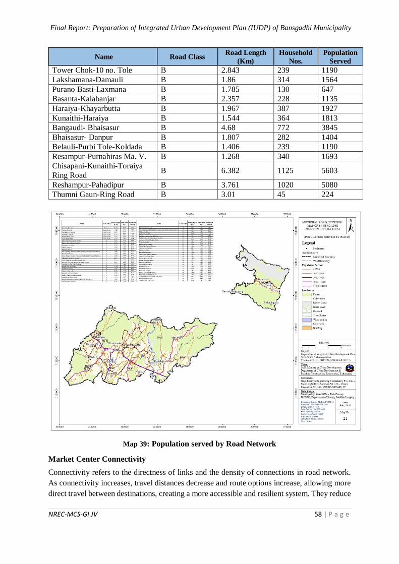
Final Report: Preparation of Integrated Urban Development Plan (IUDP) of Bansgadhi Municipality
NREC-MCS-GI JV 58 | P a g e
Name Road Class Road Length
(Km)
Household
Nos.
Population
Served
Tower Chok-10 no. Tole B 2.843 239 1190
Lakshamana-Damauli B 1.86 314 1564
Purano Basti-Laxmana B 1.785 130 647
Basanta-Kalabanjar B 2.357 228 1135
Haraiya-Khayarbutta B 1.967 387 1927
Kunaithi-Haraiya B 1.544 364 1813
Bangaudi- Bhaisasur B 4.68 772 3845
Bhaisasur- Danpur B 1.807 282 1404
Belauli-Purbi Tole-Koldada B 1.406 239 1190
Resampur-Purnahiras Ma. V. B 1.268 340 1693
Chisapani-Kunaithi-Toraiya
Ring Road B 6.382 1125 5603
Reshampur-Pahadipur B 3.761 1020 5080
Thumni Gaun-Ring Road B 3.01 45 224
Map 39: Population served by Road Network
Market Center Connectivity
Connectivity refers to the directness of links and the density of connections in road network.
As connectivity increases, travel distances decrease and route options increase, allowing more
direct travel between destinations, creating a more accessible and resilient system. They reduce
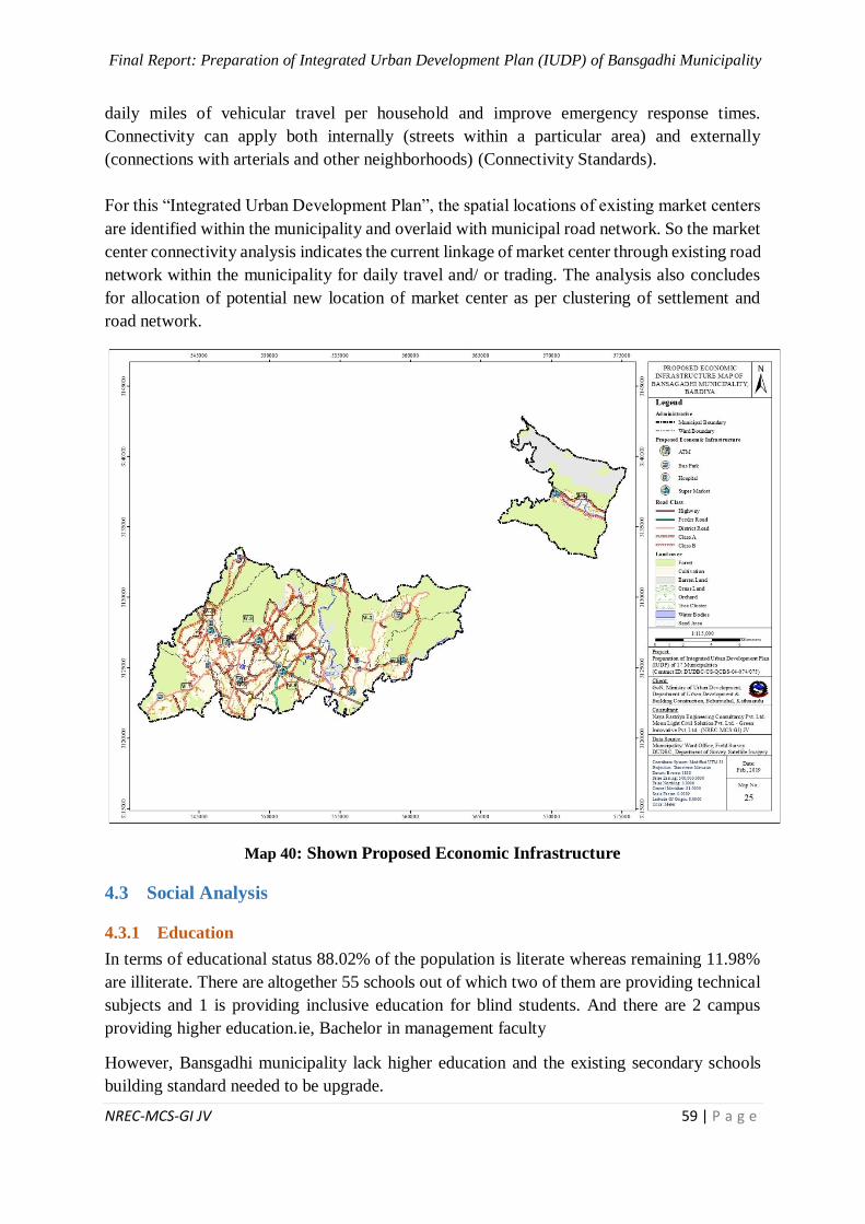
Final Report: Preparation of Integrated Urban Development Plan (IUDP) of Bansgadhi Municipality
NREC-MCS-GI JV 59 | P a g e
daily miles of vehicular travel per household and improve emergency response times.
Connectivity can apply both internally (streets within a particular area) and externally
(connections with arterials and other neighborhoods) (Connectivity Standards).
For this “Integrated Urban Development Plan”, the spatial locations of existing market centers
are identified within the municipality and overlaid with municipal road network. So the market
center connectivity analysis indicates the current linkage of market center through existing road
network within the municipality for daily travel and/ or trading. The analysis also concludes
for allocation of potential new location of market center as per clustering of settlement and
road network.
Map 40: Shown Proposed Economic Infrastructure
4.3 Social Analysis
4.3.1 Education
In terms of educational status 88.02% of the population is literate whereas remaining 11.98%
are illiterate. There are altogether 55 schools out of which two of them are providing technical
subjects and 1 is providing inclusive education for blind students. And there are 2 campus
providing higher education.ie, Bachelor in management faculty
However, Bansgadhi municipality lack higher education and the existing secondary schools
building standard needed to be upgrade.
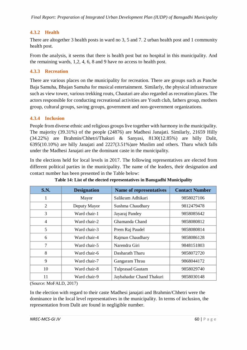
Final Report: Preparation of Integrated Urban Development Plan (IUDP) of Bansgadhi Municipality
NREC-MCS-GI JV 60 | P a g e
4.3.2 Health
There are altogether 3 health posts in ward no 3, 5 and 7. 2 urban health post and 1 community
health post.
From the analysis, it seems that there is health post but no hospital in this municipality. And
the remaining wards, 1,2, 4, 6, 8 and 9 have no access to health post.
4.3.3 Recreation
There are various places on the municipality for recreation. There are groups such as Panche
Baja Samuha, Bhajan Samuha for musical entertainment. Similarly, the physical infrastructure
such as view tower, various trekking routs, Chautari are also regarded as recreation places. The
actors responsible for conducting recreational activities are Youth club, fathers group, mothers
group, cultural groups, saving groups, government and non-government organizations.
4.3.4 Inclusion
People from diverse ethnic and religious groups live together with harmony in the municipality.
The majority (39.31%) of the people (24876) are Madhesi Janajati. Similarly, 21659 Hilly
(34.22%) are Brahmin/Chhetri/Thakuri & Sanyasi, 8130(12.85%) are hilly Dalit,
6395(10.10%) are hilly Janajati and 2227(3.51%)are Muslim and others. Tharu which falls
under the Madhesi Janajati are the dominant caste in the municipality.
In the elections held for local levels in 2017. The following representatives are elected from
different political parties in the municipality. The name of the leaders, their designation and
contact number has been presented in the Table below:
Table 14: List of the elected representatives in Bansgadhi Municipality
S.N. Designation Name of representatives Contact Number
1 Mayor Salikram Adhikari 9858027106
2 Deputy Mayor Sushma Chaudhary 9812479478
3 Ward chair-1 Jayaraj Pandey 9858085642
4 Ward chair-2 Ghamanda Chand 9858080812
5 Ward chair-3 Prem Raj Paudel 9858080814
6 Ward chair-4 Rajman Chaudhary 9858086128
7 Ward chair-5 Narendra Giri 9848151803
8 Ward chair-6 Dasharath Tharu 9858072720
9 Ward chair-7 Gangaram Thrau 9868044172
10 Ward chair-8 Tulprasad Gautam 9858029740
11 Ward chair-9 Jaybahadur Chand Thakuri 9858030148
(Source: MoFALD, 2017)
In the election with regard to their caste Madhesi janajati and Brahmin/Chhetri were the
dominance in the local level representatives in the municipality. In terms of inclusion, the
representation from Dalit are found in negligible number.

Final Report: Preparation of Integrated Urban Development Plan (IUDP) of Bansgadhi Municipality
NREC-MCS-GI JV 61 | P a g e
4.4 Economic Analysis
4.4.1 Agriculture
In Bansgadhi municipality wide range of agricultural products are produced.
Commercialization in agriculture is essential. Vegetable farming and fish farming has been
gradually increasing in the municipality. Paddy, wheat, Red Lintels, and mustard are the major
crops produced in the municipality.
4.4.2 Livestock
Along with the agricultural activities, recent trend in the municipality is seen as the
commercialization of livestock farming for the income generation and promotion of the
livelihood. The farms have been also developed as the animal pocket center that Buffalo, goat,
pig, chicken and cow are the major animal pocket areas of Bansgadhi municipality. Majority
of population is involved in Agriculture and labor. In addition of profession some people are
involving in business as well. In Bansgadhi municipality, economic condition of the people of
this area is better in comparison to rest of the local bodies of the Bardiya district. People have
been involved in different economic activities beside agriculture. They have more than one
source of income. Some members of such families are employed in government offices,
corporations and Foreign Employment.
4.4.3 Mining
The mines and minerals in the municipality yet to be explored but the extraction of sand, stone
and pebble are common in the municipality.
4.4.4 Industry
In Bansgadhi there are number of small, medium scale and cottage industries. Basnet
Chowmein factory, Rara Noodles Company, CG Company, Atithi water company, Pragati
herbs company are the major industry in the municipality. Beside this Rice mill, furniture and
grill are widely found in the municipality.
4.4.5 Import and Export
Exchange of goods and services are common amongst the nearby districts or within districts.
Exchange of any of such has direct impact in economic development of the region. Bansgadhi
municipality lies on the closer proximity of Banke district and Gulariya municipality. Bardiya
national park is the major destination nearby from the municipality and it serves as tourist
destination and may help in the development of the area by entering foreign currency. The
majority of goods are imported from nearby district, Gulariya. The goods come from
Kathmandu, Kohalpur and Nepalgunj and are redistributed to other municipalities.
4.4.6 Commercial
There are 10 major market areas in the municipality. Usually, Haat bazar is conducted in
Mahadiwa and laxmana area. Other small market includes Chepang and Kakaura bazar. The
list of name of the major markets and its types has been presented below:
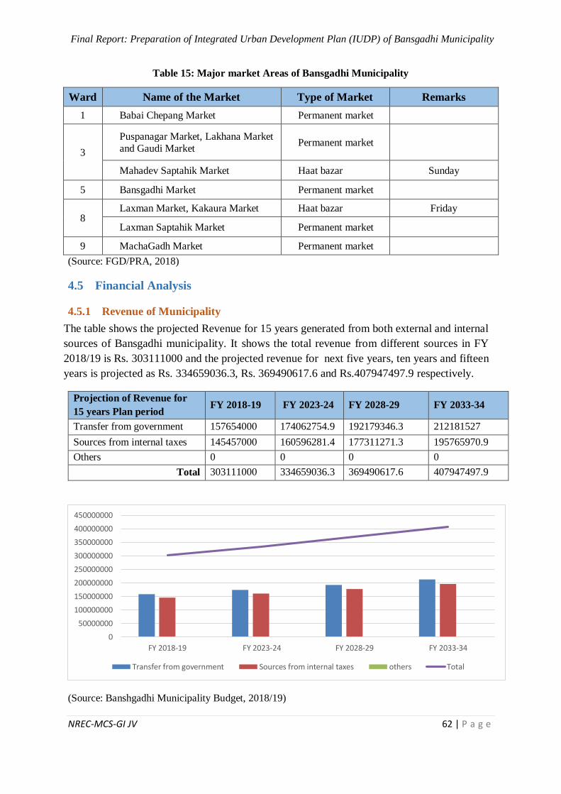
Final Report: Preparation of Integrated Urban Development Plan (IUDP) of Bansgadhi Municipality
NREC-MCS-GI JV 62 | P a g e
Table 15: Major market Areas of Bansgadhi Municipality
Ward Name of the Market Type of Market Remarks
1 Babai Chepang Market Permanent market
3
Puspanagar Market, Lakhana Market
and Gaudi Market Permanent market
Mahadev Saptahik Market Haat bazar Sunday
5 Bansgadhi Market Permanent market
8 Laxman Market, Kakaura Market Haat bazar Friday
Laxman Saptahik Market Permanent market
9 MachaGadh Market Permanent market
(Source: FGD/PRA, 2018)
4.5 Financial Analysis
4.5.1 Revenue of Municipality
The table shows the projected Revenue for 15 years generated from both external and internal
sources of Bansgadhi municipality. It shows the total revenue from different sources in FY
2018/19 is Rs. 303111000 and the projected revenue for next five years, ten years and fifteen
years is projected as Rs. 334659036.3, Rs. 369490617.6 and Rs.407947497.9 respectively.
Projection of Revenue for
15 years Plan period FY 2018-19 FY 2023-24 FY 2028-29 FY 2033-34
Transfer from government 157654000 174062754.9 192179346.3 212181527
Sources from internal taxes 145457000 160596281.4 177311271.3 195765970.9
Others 0 0 0 0
Total 303111000 334659036.3 369490617.6 407947497.9
(Source: Banshgadhi Municipality Budget, 2018/19)
0
50000000
100000000
150000000
200000000
250000000
300000000
350000000
400000000
450000000
FY 2018-19 FY 2023-24 FY 2028-29 FY 2033-34
Transfer from government Sources from internal taxes others Total
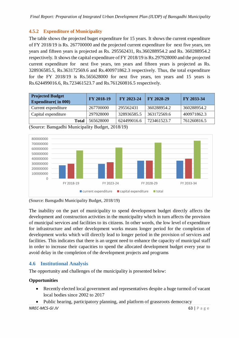
Final Report: Preparation of Integrated Urban Development Plan (IUDP) of Bansgadhi Municipality
NREC-MCS-GI JV 63 | P a g e
4.5.2 Expenditure of Municipality
The table shows the projected buget expenditure for 15 years. It shows the current expenditure
of FY 2018/19 is Rs. 267700000 and the projected current expenditure for next five years, ten
years and fifteen years is projected as Rs. 295562431, Rs.360288954.2 and Rs. 360288954.2
respectively. It shows the capital expenditure of FY 2018/19 is Rs.297928000 and the projected
current expenditure for next five years, ten years and fifteen years is projected as Rs.
328936585.5, Rs.363172569.6 and Rs.400971862.3 respectively. Thus, the total expenditure
for the FY 2018/19 is Rs.565628000 for next five years, ten years and 15 years is
Rs.624499016.6, Rs.723461523.7 and Rs.761260816.5 respectively.
Projected Budget
Expenditure( in 000) FY 2018-19 FY 2023-24 FY 2028-29 FY 2033-34
Current expenditure 267700000 295562431 360288954.2 360288954.2
Capital expenditure 297928000 328936585.5 363172569.6 400971862.3
Total 565628000 624499016.6 723461523.7 761260816.5
(Source: Bansgadhi Municipality Budget, 2018/19)
(Source: Bansgadhi Municipality Budget, 2018/19)
The inability on the part of municipality to spend development budget directly affects the
development and construction activities in the municipality which in turn affects the provision
of municipal services and facilities to its citizens. In other words, the low level of expenditure
for infrastructure and other development works means longer period for the completion of
development works which will directly lead to longer period in the provision of services and
facilities. This indicates that there is an urgent need to enhance the capacity of municipal staff
in order to increase their capacities to spend the allocated development budget every year to
avoid delay in the completion of the development projects and programs
4.6 Institutional Analysis
The opportunity and challenges of the municipality is presented below:
Opportunities
Recently elected local government and representatives despite a huge turmoil of vacant
local bodies since 2002 to 2017
Public hearing, participatory planning, and platform of grassroots democracy
0
100000000
200000000
300000000
400000000
500000000
600000000
700000000
800000000
FY 2018-19 FY 2023-24 FY 2028-29 FY 2033-34
current expenditure capital expenditure total
Final Report: Preparation of Integrated Urban Development Plan (IUDP) of Bansgadhi Municipality
NREC-MCS-GI JV 64 | P a g e
Special focus on education, health and social sector
Wider road connectivity in and out
Issues of children, women, youth, elderly people and marginalized communities/
groups
Abundant of natural resources in the municipality to foster socio-economic
development of the municipality
While some communities are growing and prospering, many have opportunities that
make it easy to provide or pay for basic services such as policing, recreational services
and emergency measures planning, or to manage day-today operations and plan for the
future.
Challenges:
Current local governance legislation is prescriptive in nature. Many communities feel
constrained by these specific requirements. Others feel that if an issue isn’t expressly
identified in law, they cannot take action. A balanced approach will be required going
forward
Low literacy rate, life expectancy, HDI and other development indices as compared to
the national average and high rates of HPI and MPI
Institutional problems related to capacity building, offices infrastructures.
Lack of urban scale health institutions with basic facilities including maternity services
and other emergency services.
In many smaller rural areas, the population is declining as residents are moving to more
urban areas. This reduces the amount of property taxes collected, resulting in less
revenue coming in to support the delivery of services to the community
Lack of sufficient appointment of technical manpower in education and up-gradation
of existing infrastructure of existing schools and community schools.
4.7 SWOT Analysis
SWOT analysis is the part of situational analysis. Basically it is divided into two parts i.e.
internal factors (strength, weakness) and external factors (opportunity, threats)
SWOT Analysis Framework:
Internal Analysis
Strength
Weaknesses
External Analysis
Opportunities
Threats
SWOT Analysis
Final Report: Preparation of Integrated Urban Development Plan (IUDP) of Bansgadhi Municipality
NREC-MCS-GI JV 65 | P a g e
Internal forces
Internal factors of SWOT analysis consists two factors i.e. strength and weakness. Strength is
its positive factors while weakness is negative.
4.7.1 Strengths
The strength of the municipality is listed in the table below:
Table 16: Strength Analysis of the municipality
Indicator Strength
Physical
Infrastructure
East – West Highway passes through the municipality
Having 3 black topped roads
Existence of ring road
Access of roads to all wards
Geographical topography is good for development
Land allocated for playground
Biological diversity (Vegetation and Wild Animals)
Access to communication facility
Large no. of population 24667 served by Lok Rajmarga
Social
Social harmony
Majority of people 96.86% follows Hindu religion
Elaka Prahari Karyalaya and Police Posts present for security
Literacy rate of municipality is 88.02%
Announcement of total Immunised municipality
Availability of 1 hospital (S.O.S.), 5 government health posts, 1 Community health
unit, 30 small health institutes (medical halls, clinics etc.)
Availability of schools in all wards
Existing 55 schools and 2 colleges
Out of 55 schools, 1 is providing inclusive education for blind students
Existing 2 overhead water tanks and other 7 under construction for drinking purpose
Economic
Availability of 7 major market areas (Babai Chepang, Puspanagar, Lakhana,
Gaudi, Bansgadhi, Laxman Saptahik & Machagadh)
Existing 3 local markets (Haat Bazzar) Mahadev Saptahik, Laxman, Kakaura
Presence of financial institutions commendable (25 cooperatives, 11 banks, 3
money transfers, 1 microfinance, 2 others)
Existing 54 small, medium & cottage industries (32 rice mills, 3 furnitures, 3 grill udhyogs, 16 others)
Environment
Fully cleaned areas announced
Open defecation free municipality announced
Concept of green city adopted -- trees plantation in Bansgadhi and Machagadh
areas
Public open spaces and playground present
Solid Waste Management by pit, bucket and ring system
Agriculture &
Livestock
Availability of 41.04 % cultivated land in municipality
Agriculture is the main occupation of this municipality
Major crops produced in this municipality are paddy, wheat, mustard and Red
lintels
Growing business trend of fish farming, poultry farm, cow farming, pig farming,
buffalo farming
Final Report: Preparation of Integrated Urban Development Plan (IUDP) of Bansgadhi Municipality
NREC-MCS-GI JV 66 | P a g e
Indicator Strength
Existing 9 major irrigation projects in the municipality
Natural
Resources
Presence of abundant forests (having 49.85 % forest area)
Existing 40 no. of community forests
Availability of Bardiya National Park
Existing numerous water resources: major rivers like Babai, Dunduwa & Gyang,
Karnali River, Bheri River etc. and also having more than 20 kholas (Khote Khola, Sabang Khola, Bhagaha Khola, Dondre Khola, Chyama Nadikhola, Ghahare
Khola, Lauwa Khola etc.)
Municipality consists construction materials i.e. metamorphic rocks such as slate,
phyllite, quartzite etc. in the Mahabharata range
Human
Resources
New formulated municipality enhances the manpower strength of existing demography
Tourism
Existing natural environment, Bardiya national park and available other resources could be part of ecological tourism.
Religious sites and temples
Availability of 44 hindu temples (Deuti Bajai, Kalika, Ban Devi, Bhagawati, Shiva,
Taal Barahi Temple etc.), Bouddha Sadan Gumba, Banbagiya Church, Madina
Mosque
Existing 9 no. of taals (Motipur, Bansgadhi, Laxman, Riyali, Barhabigaha, Rampur, Haupur, Nimaha, Banasapti)
Governance
System
New federal systems and new municipality boundary provides development potential by linking central and local government
Rising awareness of grass root democracy
Woman right has been enhanced by providing the essential post as chairperson or
vice chairperson
Source: Induction workshop (municipal level) and PRA/FGD (Ward levels)
4.7.2 Weaknesses
The weakness of the municipality is listed in the table below:
Table 17: Weakness Analysis of the municipality
Indicator Weakness
Physical
Infrastructure
Having large no. of earthen roads & then gravel
Lack of municipal building and ward building
Lack of bus park, proper public & commercial buildings within municipality
Lack of area for cremation
Improper and haphazard settlement
Lack of rainwater harvesting
Lack of fire station
Lack of conference hall
Lack of sport centres
Lack of Implementation of Building byelaws
Social
Health service not sufficient for the total population
Lack of government health posts at wards 1, 3, 4 ,8
Hospital for Emergency Service facility not available
Trained teaching staffs insufficient for quality education
Difficulty of volunteering in laborious works
Final Report: Preparation of Integrated Urban Development Plan (IUDP) of Bansgadhi Municipality
NREC-MCS-GI JV 67 | P a g e
Indicator Weakness
Lack of management and proper infrastructures in schools
Lack of suitable technical and vocational schools/colleges
Lack of public library (Community)
Lack of Central Library
Lack of old age home
Lack of sufficient drinking water
Lack of treatment plant for drinking purpose
Lack of proper public taps facility
Economic
Finance for development is insufficient
Weak market management system
Lacking of adequate data and weak analytical system
Tax leakage
Less entire income of municipality
Unemployment
Environment
Weak Implementation of Open Defecation Free area
Lack of public awareness in terms of solid waste management
Lack of waste water treatment plant
Unmanaged playground
No proper drain facility
Lack of sewerage system
No dumping site
Absence of landfill site
Lack of proper public toilets
Agriculture &
Livestock
Agriculture system is subsistence and traditional
Lack of cold store
Irrigation facility not sufficient
Existing 7.75 % barren land
Shortage of trainings for farmers
Natural
Resources
Lack of preservation and management of natural resources
Presence of members in community forest not satisfactory
Contamination of water resources
Collection of fuelwood through forests
Lack of proper fire equipment facility to prevent from forest fire
Deforestation
Human
Resources
Lack of technical manpower
Management problem
Tourism
Problem in advertisement, publicity and maintenance of touristic sites
Problem in road accessibility to link with such touristic sites, temples…etc.
Lack of financing for tourism development
Lack of proper buffer zone of national park and nearer settlements
Lack of museum
Governance
System
Capacity deficit in terms of new governance structure.
Lack of transparency and information sharing.
Lack of incorporating technology in administrative work.
Source: Induction workshop (municipal level) and PRA/FGD (Ward levels)
Final Report: Preparation of Integrated Urban Development Plan (IUDP) of Bansgadhi Municipality
NREC-MCS-GI JV 68 | P a g e
External forces
External factors of SWOT analysis consists two factors i.e. opportunity and threats.
Opportunity is its positive factors while threat is negative.
4.7.3 Opportunities
The opportunities of the municipality are listed in the table below:
Table 18: Opportunities Analysis of the municipality
Indicator Opportunity
Physical
Infrastructure
Upgradation of roads (earthen, gravel, ring road etc.)
Pedestrians roads and cycle footpaths should be constructed
Development of Information and computer technology
Promote solar streetlights and digital boards
Social
Management and strengthening of existing health services
Construction of well-equipped government hospital (25-50 beds)
Encouraging education to the backward community people and economically deprived people
Ensure yoga and meditation centre
Economic
Providing loan facilities for the locals
Increment of job employment through industries establishment
Formation of Medicinal herbal centre
Export of wood products, herbals, rivers products etc.
Environment
Promotion of 3Rs concept for solid waste management at all HHs levels
Installation of Reed Bed Treatment plant
Protecting natural species and tree plantation in open areas
Promoting environment cleanliness in sufficient way
Agriculture &
Livestock
Commercialization of agricultural products;
Identification of major agricultural products, pocket areas and research on opportunity of organic farming and alternate farming technologies.
Natural
Resources
Effective investment on existing natural resources like forests, rivers etc. for
sustainable development
Regularised markets of natural resources
Enhancement of irrigation facility for high productivity
Human
Resources
Trainings and awareness campaigns, investment on skilled technology driven manpower.
Tourism Opportunity for adventurous and natural tourism.
Opportunity of ecotourism flourishment.
Governance
System
Power and authority of local governance to take decisions at local level;
Allocation of financial budgets as per the vision of municipality.
Source: Induction workshop (municipal level) and PRA/FGD (Ward levels)
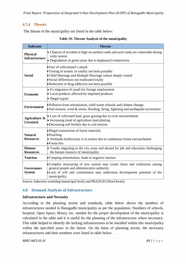
Final Report: Preparation of Integrated Urban Development Plan (IUDP) of Bansgadhi Municipality
NREC-MCS-GI JV 69 | P a g e
4.7.4 Threats
The threats of the municipality are listed in the table below:
Table 19: Threats Analysis of the municipality
Indicator Threats
Physical
Infrastructure
Chances of accident is high on earthen roads and such roads are vulnerable during
rainy season
Degradation of green areas due to haphazard construction
Social
Fear of wild animal’s attack
Testing of arsenic in totality not been possible
Child Marriage and Multiple Marriage culture deeply rooted
Social differences not eradicated totally
Reduction of drug addiction not been possible
Economic
Ex migration of youth for foreign employment
Local products affected by imported products
Illegal export
Environment Pollution from urbanization, solid waste refusals and climate change;
Soil erosion, wind & storm, flooding, firing, lightning and earthquake occurrence
Agriculture &
Livestock
Loss of cultivated land, grass grazing due to river encroachment
Increasing trend of agriculture land plotting
Decreasing soil fertility due to soil erosion
Natural
Resources
Illegal transactions of forest materials
Poaching
Wetlands biodiversity is in extinct due to continuous forest encroachment
Forest-fire
Human
Resources
Youths migrating to the city areas and abroad for job and education challenging the human resource of municipality
Tourism Creeping urbanisation, leads to negative tourism
Governance
System
Complex structuring of new system may create chaos and confusions among general people and administrative authority.
Lack of will and commitment may undermine development potential of the
municipality.
Source: Induction workshop (municipal level) and PRA/FGD (Ward levels)
4.8 Demand Analysis of Infrastructure
Infrastructure and Necessity
According to the planning norms and standards, table below shows the numbers of
infrastructures needed in Bansgadhi municipality as per the population. Numbers of schools,
hospital, Open Space, library, etc. needed for the proper development of the municipality is
calculated in the table and it is useful for the planning of the infrastructure where necessary.
This table helped to identify the lacking infrastructures to be installed within this municipality
within the specified years in the future. On the basis of planning norms, the necessary
infrastructures and their numbers were listed in table below.
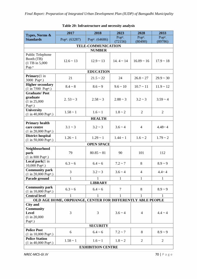
Final Report: Preparation of Integrated Urban Development Plan (IUDP) of Bansgadhi Municipality
NREC-MCS-GI JV 70 | P a g e
Table 20: Infrastructure and necessity analysis
Types, Norms &
Standards
2017 2018 2023 2028 2033
Popⁿ. (63287) Popⁿ. (64686) Popⁿ.
(72156) Popⁿ.
(80490) Popⁿ.
(89786)
TELE-COMMUNICATION
NUMBER
Public Telephone
Booth (TB) (1 TB in 5,000
Pop.ⁿ
12.6 ~ 13 12.9 ~ 13 14. 4 ~ 14 16.09 ~ 16 17.9 ~ 18
EDUCATION
Primary(1 in 3000 Popⁿ.)
21 21.5 ~ 22 24 26.8 ~ 27 29.9 ~ 30
Higher secondary
(1 in 7500 Popⁿ.) 8.4 ~ 8 8.6 ~ 9 9.6 ~ 10 10.7 ~ 11 11.9 ~ 12
Graduate/ Post
graduate
(1 in 25,000
Popⁿ.)
2. 53 ~ 3 2.58 ~ 3 2.88 ~ 3 3.2 ~ 3 3.59 ~ 4
University
(1 in 40,000 Popⁿ.) 1.58 ~ 1 1.6 ~ 1 1.8 ~ 2 2 2
HEALTH
Primary health
care centre
(1 in 20,000 Popⁿ.)
3.1 ~ 3 3.2 ~ 3 3.6 ~ 4 4 4.48~ 4
District hospital
(1 in 50,000 Popⁿ.) 1.26 ~ 1 1.29 ~ 1 1.44 ~ 1 1.6 ~ 2 1.79 ~ 2
OPEN SPACE
Neighbourhood
park
(1 in 800 Popⁿ.)
79 80.85 ~ 81 90 101 112
Local park(1 in
10,000 Popⁿ.) 6.3 ~ 6 6.4 ~ 6 7.2 ~ 7 8 8.9 ~ 9
Community park
(1 in 20,000 Popⁿ.) 3 3.2 ~ 3 3.6 ~ 4 4 4.4~ 4
Parade ground 1 1 1 1 1
LIBRARY
Community park
(1 in 10,000 Popⁿ.) 6.3 ~ 6 6.4 ~ 6 7 8 8.9 ~ 9
Central level 1 1 1 1 1
OLD AGE HOME, ORPHANGE, CENTER FOR DIFFERENTLY ABLE PEOPLE
City and
Community
Level
(1 in 20,000
Popⁿ.)
3 3 3.6 ~ 4 4 4.4 ~ 4
SECURITY
Police Post
(1 in 10,000 Popⁿ.) 6 6.4 ~ 6 7.2 ~ 7 8 8.9 ~ 9
Police Station
(1 in 40,000 Popⁿ.) 1.58 ~ 1 1.6 ~ 1 1.8 ~ 2 2 2
EXHIBITION CENTRE

Final Report: Preparation of Integrated Urban Development Plan (IUDP) of Bansgadhi Municipality
NREC-MCS-GI JV 71 | P a g e
Types, Norms &
Standards
2017 2018 2023 2028 2033
Popⁿ. (63287) Popⁿ. (64686) Popⁿ.
(72156) Popⁿ.
(80490) Popⁿ.
(89786)
City level
(1 in 50,000 Popⁿ.) 1 1 1.4 ~ 1 1.6 ~ 2 1.79 ~ 2
CITY HALL
Multipurpose
Hall
(1 in 10,000 Popⁿ.)
6 6.4 ~ 6 7.2 ~ 7 8 8.9 ~ 9
SPORTS COMPLEX
City level
(1 in 50,000
Popⁿ.)
1 1 1.4 ~ 1 1.6 ~ 2 1.79 ~ 2
District sports
center
(1 in 1,00,000
Popⁿ.)
0.63~ 1 0.64 ~ 1 0.72 ~ 1 0.8 ~ 1 0.89 ~ 1
MOVIE HALL
City and local
level
(5 seats per 1000 Popⁿ.)
316 323 361 402 449
VEGETABLE MARKET
Neighbourhood
level (1 in 6,000 Popⁿ.)
10.56 ~ 11 10.78 ~ 11 12 13.4 ~ 13 14.96 ~ 15
PARKING SPACE
Parking space
(1 in 3,000 Popⁿ.) 21 21.56 ~ 22 24 26.8 ~ 27 29.9 ~ 30
(Source: Planning Norms & Standards, 2013)
GAP Analysis
Gap analysis is one of the important tools for urban planning and analysis. It consists of all the
appropriate concepts and standards by making objectives, identifying lead sectors and setting
vision to achieve the goal for integral development. As there has been re-structuring of the
local levels in 2017 as per the Constitution of Nepal, there occurs vast gap between existing
conditions and desired outcomes in the municipalities. Desired outcomes are the required
infrastructures and services which are also defined by Planning Norms and Standard 2013
on the basis of population size, space requirement, road types, etc. To fulfill the desired
outcomes, there needs analysis of gap between existing condition and proposed items, which
is known by “Gap Analysis” in short. The Gap analysis of the Bansgadhi municipality is
presented below:
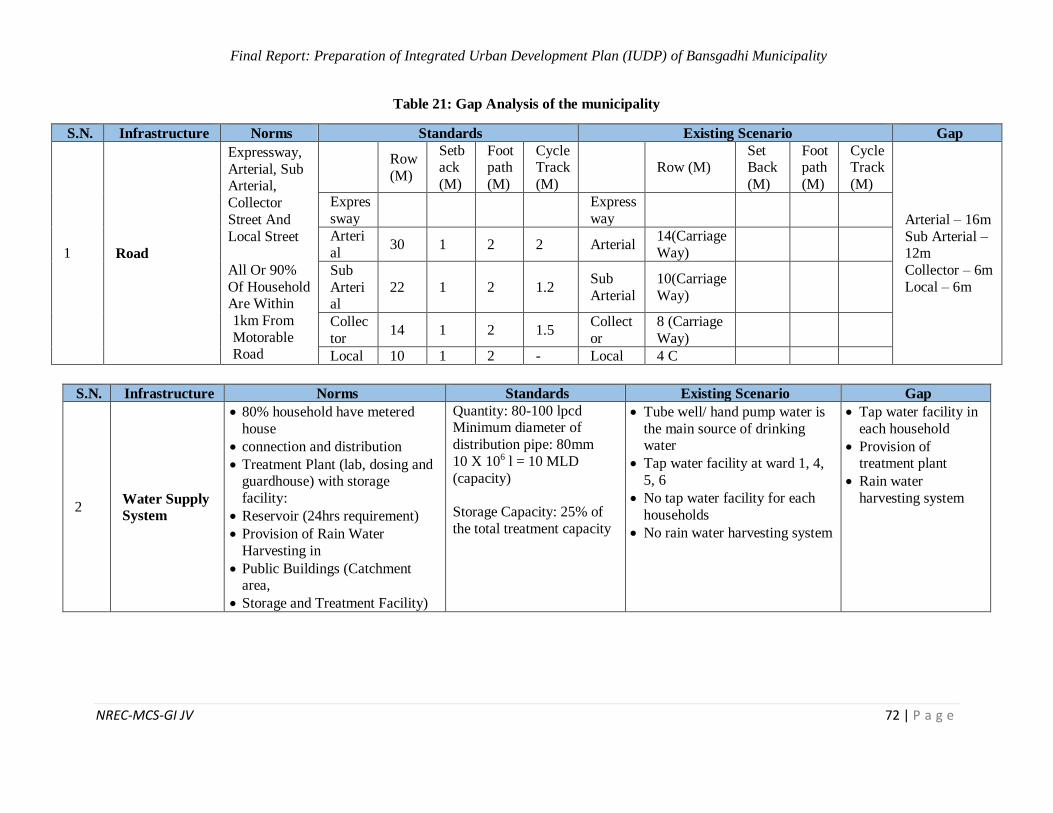
Final Report: Preparation of Integrated Urban Development Plan (IUDP) of Bansgadhi Municipality
NREC-MCS-GI JV 72 | P a g e
Table 21: Gap Analysis of the municipality
S.N. Infrastructure Norms Standards Existing Scenario Gap
1 Road
Expressway,
Arterial, Sub Arterial,
Collector
Street And
Local Street
All Or 90%
Of Household Are Within
1km From
Motorable Road
Row
(M)
Setback
(M)
Footpath
(M)
Cycle Track
(M)
Row (M) Set Back
(M)
Footpath
(M)
Cycle Track
(M)
Arterial – 16m
Sub Arterial – 12m
Collector – 6m
Local – 6m
Expres
sway
Express
way
Arteri
al 30 1 2 2 Arterial
14(Carriage
Way)
Sub
Arterial
22 1 2 1.2 Sub
Arterial
10(Carriage
Way)
Collec
tor 14 1 2 1.5
Collect
or
8 (Carriage
Way)
Local 10 1 2 - Local 4 C
S.N. Infrastructure Norms Standards Existing Scenario Gap
2 Water Supply
System
80% household have metered
house
connection and distribution
Treatment Plant (lab, dosing and guardhouse) with storage
facility:
Reservoir (24hrs requirement)
Provision of Rain Water
Harvesting in
Public Buildings (Catchment area,
Storage and Treatment Facility)
Quantity: 80-100 lpcd Minimum diameter of
distribution pipe: 80mm
10 X 106 l = 10 MLD
(capacity)
Storage Capacity: 25% of
the total treatment capacity
Tube well/ hand pump water is
the main source of drinking water
Tap water facility at ward 1, 4,
5, 6
No tap water facility for each
households
No rain water harvesting system
Tap water facility in
each household
Provision of treatment plant
Rain water
harvesting system
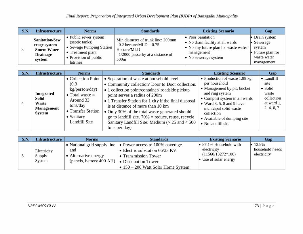
Final Report: Preparation of Integrated Urban Development Plan (IUDP) of Bansgadhi Municipality
NREC-MCS-GI JV 73 | P a g e
S.N. Infrastructure Norms Standards Existing Scenario Gap
3
Sanitation/Sew
erage system
Storm Water
Drainage
system
Public sewer system
(septic tanks)
Sewage Pumping Station
Treatment plant
Provision of public latrines
Min diameter of trunk line: 200mm 0.2 hectare/MLD – 0.75
Hectare/MLD
1/2000 passerby at a distance of
500m
Poor Sanitation
No drain facility at all wards
No any future plan for waste water
management
No sewerage system
Drain system
Sewerage
system
Future plan for waste water
management
S.N. Infrastructure Norms Standards Existing Scenario Gap
4
Integrated
Solid
Waste
Management
System
Collection Point
(0.3
kg/person/day)
Total waste =
Around 33
tons/day
Transfer Station
Sanitary
Landfill Site
Separation of waste at household level
Community collection/ Door to Door collection.
1 collection point/container/ roadside pickup
point serves a radius of 200m
1 Transfer Station for 1 city if the final disposal
is at distance of more than 10 km
Only 30% of the total waste generated should
go to landfill site. 70% = reduce, reuse, recycle
Sanitary Landfill Site: Medium (> 25 and < 500
tons per day)
Production of waste 1.98 kg per household
Management by pit, bucket
and ring system
Compost system in all wards
Ward 3, 5, 8 and 9 have
municipal solid waste
collection
Available of dumping site
No landfill site
Landfill site
Solid
waste
collection
at ward 1, 2, 4, 6, 7
S.N. Infrastructure Norms Standards Existing Scenario Gap
5
Electricity
Supply System
National grid supply line
and
Alternative energy
(panels, battery 400 AH)
Power access to 100% coverage.
Electric substation 66/33 KV
Transmission Tower
Distribution Tower
150 – 200 Watt Solar Home System
87.1% Household with electricity
(11560/13272*100)
Use of solar energy
12.9% household needs
electricity
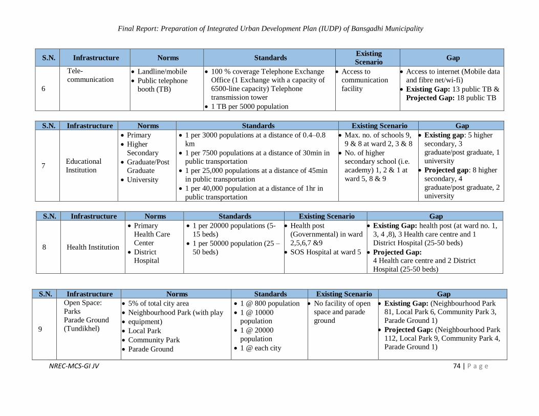
Final Report: Preparation of Integrated Urban Development Plan (IUDP) of Bansgadhi Municipality
NREC-MCS-GI JV 74 | P a g e
S.N. Infrastructure Norms Standards Existing
Scenario Gap
6
Tele-
communication Landline/mobile
Public telephone booth (TB)
100 % coverage Telephone Exchange Office (1 Exchange with a capacity of
6500-line capacity) Telephone
transmission tower
1 TB per 5000 population
Access to communication
facility
Access to internet (Mobile data and fibre net/wi-fi)
Existing Gap: 13 public TB &
Projected Gap: 18 public TB
S.N. Infrastructure Norms Standards Existing Scenario Gap
7 Educational
Institution
Primary
Higher
Secondary
Graduate/Post Graduate
University
1 per 3000 populations at a distance of 0.4–0.8
km
1 per 7500 populations at a distance of 30min in public transportation
1 per 25,000 populations at a distance of 45min
in public transportation
1 per 40,000 population at a distance of 1hr in
public transportation
Max. no. of schools 9,
9 & 8 at ward 2, 3 & 8
No. of higher secondary school (i.e.
academy) 1, 2 & 1 at
ward 5, 8 & 9
Existing gap: 5 higher
secondary, 3 graduate/post graduate, 1
university
Projected gap: 8 higher
secondary, 4
graduate/post graduate, 2 university
S.N. Infrastructure Norms Standards Existing Scenario Gap
8 Health Institution
Primary
Health Care
Center
District Hospital
1 per 20000 populations (5-
15 beds)
1 per 50000 population (25 –
50 beds)
Health post
(Governmental) in ward
2,5,6,7 &9
SOS Hospital at ward 5
Existing Gap: health post (at ward no. 1,
3, 4 ,8), 3 Health care centre and 1
District Hospital (25-50 beds)
Projected Gap: 4 Health care centre and 2 District
Hospital (25-50 beds)
S.N. Infrastructure Norms Standards Existing Scenario Gap
9
Open Space:
Parks
Parade Ground (Tundikhel)
5% of total city area
Neighbourhood Park (with play
equipment)
Local Park
Community Park
Parade Ground
1 @ 800 population
1 @ 10000 population
1 @ 20000
population
1 @ each city
No facility of open space and parade
ground
Existing Gap: (Neighbourhood Park 81, Local Park 6, Community Park 3,
Parade Ground 1)
Projected Gap: (Neighbourhood Park
112, Local Park 9, Community Park 4, Parade Ground 1)
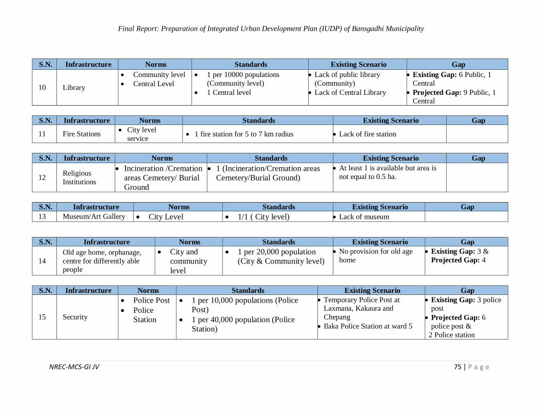
Final Report: Preparation of Integrated Urban Development Plan (IUDP) of Bansgadhi Municipality
NREC-MCS-GI JV 75 | P a g e
S.N. Infrastructure Norms Standards Existing Scenario Gap
10 Library
Community level
Central Level
1 per 10000 populations
(Community level)
1 Central level
Lack of public library
(Community)
Lack of Central Library
Existing Gap: 6 Public, 1
Central
Projected Gap: 9 Public, 1 Central
S.N. Infrastructure Norms Standards Existing Scenario Gap
11 Fire Stations City level
service 1 fire station for 5 to 7 km radius Lack of fire station
S.N. Infrastructure Norms Standards Existing Scenario Gap
12 Religious
Institutions
Incineration /Cremation
areas Cemetery/ Burial
Ground
1 (Incineration/Cremation areas
Cemetery/Burial Ground)
At least 1 is available but area is
not equal to 0.5 ha.
S.N. Infrastructure Norms Standards Existing Scenario Gap
13 Museum/Art Gallery City Level 1/1 ( City level) Lack of museum
S.N. Infrastructure Norms Standards Existing Scenario Gap
14
Old age home, orphanage,
centre for differently able people
City and
community
level
1 per 20,000 population
(City & Community level)
No provision for old age
home
Existing Gap: 3 &
Projected Gap: 4
S.N. Infrastructure Norms Standards Existing Scenario Gap
15 Security
Police Post
Police
Station
1 per 10,000 populations (Police
Post)
1 per 40,000 population (Police
Station)
Temporary Police Post at Laxmana, Kakaura and
Chepang
Ilaka Police Station at ward 5
Existing Gap: 3 police post
Projected Gap: 6
police post &
2 Police station

Final Report: Preparation of Integrated Urban Development Plan (IUDP) of Bansgadhi Municipality
NREC-MCS-GI JV 76 | P a g e
S.N. Infrastructure Norms Standards Existing Scenario Gap
16 Exhibition Centers City level 1 per 50000 population
(City level)
Existing Gap: 1 & Projected
Gap: 2
S.N. Infrastructure Norms Standards Existing Scenario Gap
17 Conference
Hall City hall
(Multipurpose)
1 per 10000 population (City
hall, Multipurpose) Lack of conference hall
Existing Gap: 6 & Projected
Gap: 9
S.N. Infrastructure Norms Standards Existing Scenario Gap
18 Sport complex
City level (football
ground, volley ball,
swimming pool etc)
District Sports
Centre
1 per 50000 populations (City
level)
1 per 100000 populations
(District Sport Centre)
Lack of sport centres Existing Gap: 1 city level sports centre and 1 district sport center
Projected Gap: 2 city level
sports centre and 1 district sport
center
S.N. Infrastructure Norms Standards Existing Scenario Gap
19 Movie Hall City and local
level
5 seats per 1000
population (City & local
level)
Existing Gap: 2 Movie Hall (150
seats/Hall)
Projected Gap: 3 Movie Hall (150 seats/Hall)
S.N. Infrastructure Norms Standards Existing Scenario Gap
20 Vegetable Market
Neighbourhood
Level 1 in 6000 population (NBH level)
10 major markets having
mixed type products
Existing Gap: 11 & Projected
Gap: 15
S.N. Infrastructure Norms Standards Existing Scenario Gap
21 Parking Space Parking (Two/ three/ four
wheeler) Taxi park 1 parking lot for 3000 population
Existing Gap: 22 & Projected
Gap: 30
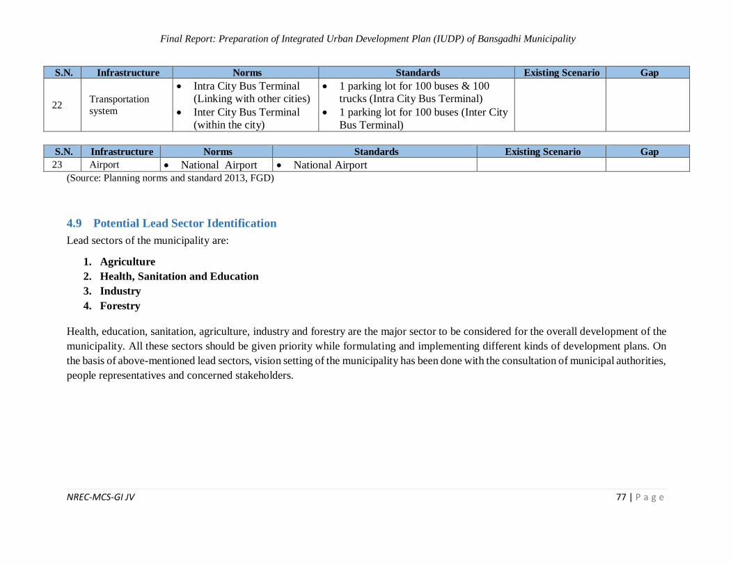
Final Report: Preparation of Integrated Urban Development Plan (IUDP) of Bansgadhi Municipality
NREC-MCS-GI JV 77 | P a g e
S.N. Infrastructure Norms Standards Existing Scenario Gap
22 Transportation
system
Intra City Bus Terminal
(Linking with other cities)
Inter City Bus Terminal
(within the city)
1 parking lot for 100 buses & 100
trucks (Intra City Bus Terminal)
1 parking lot for 100 buses (Inter City
Bus Terminal)
S.N. Infrastructure Norms Standards Existing Scenario Gap
23 Airport National Airport National Airport
(Source: Planning norms and standard 2013, FGD)
4.9 Potential Lead Sector Identification
Lead sectors of the municipality are:
1. Agriculture
2. Health, Sanitation and Education
3. Industry
4. Forestry
Health, education, sanitation, agriculture, industry and forestry are the major sector to be considered for the overall development of the
municipality. All these sectors should be given priority while formulating and implementing different kinds of development plans. On
the basis of above-mentioned lead sectors, vision setting of the municipality has been done with the consultation of municipal authorities,
people representatives and concerned stakeholders.
Final Report: Preparation of Integrated Urban Development Plan (IUDP) of Bansgadhi Municipality
NREC-MCS-GI JV 78 | P a g e
5 CHAPTER V: DEVELOPMENT FRAMEWORK FOR MUNICIPALITY
5.1 Vision of the Municipality
Slogan of Vision:
æ;'Gb/ xl/ofnL / ;kmf zx/
;d[4 / ;d'Ggt afF;u9L gu/Æ With the above selected vision slogan, it truly clarifies the people of Bansgadhi are confident that
their municipality will only prosper through proper and strategic development plans oriented
towards clean and beautiful Bansgadhi municipality.
5.2 Goal
The long-term goal of this municipality is to promote greenery and sanitation to make it a livable
and prosperous urban center in the long run.
5.3 Objectives
Bansgadhi Municipality for-sees their municipality to flourish under major sectors i.e. Agriculture,
Industry, Health and education. People of Bansgadhi wishes to visualize their city as beautiful and
picturesque, which clearly suggest their intentions of clean and healthy city environment. Though,
the word beautiful itself is an abstract terminology and could mean different to different people
but to citizen of Bansgadhi, beauty of their city is guided with its cleaner, and healthier natural
environment. A city can never prosper with proper and strategic investment on education and
health of its citizens. In fact, education and well-being of its citizens are key indicators of
development index (HDI) of the city to mark its prosperity. Hence, in order to foresee the
prosperous Bansgadhi, the plans and programmes must safeguard wellbeing and education of its
citizens.
5.4 Strategies
Infrastructure development
Tourism development
Participatory planning
Well-being of deprived and vulnerable sections of society
Disaster risk management
Market center development
Local governance and service delivery
5.5 Plans for Implementing Development Framework
To meet the above stated vision, goals and objective of the municipality, various plans are prepared
for subsequent 5-10-15 years. Every single plan has been an unaavoidbale part of the the integrated
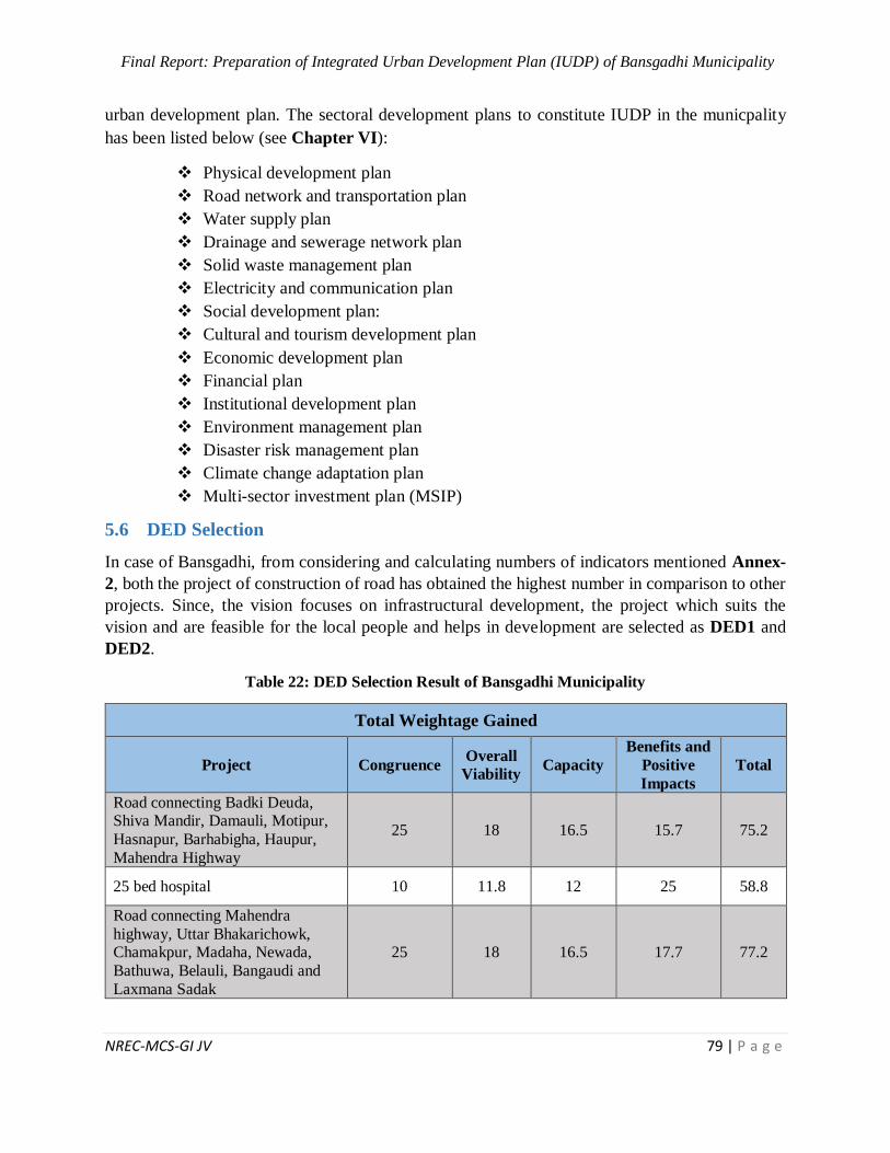
Final Report: Preparation of Integrated Urban Development Plan (IUDP) of Bansgadhi Municipality
NREC-MCS-GI JV 79 | P a g e
urban development plan. The sectoral development plans to constitute IUDP in the municpality
has been listed below (see Chapter VI):
Physical development plan
Road network and transportation plan
Water supply plan
Drainage and sewerage network plan
Solid waste management plan
Electricity and communication plan
Social development plan:
Cultural and tourism development plan
Economic development plan
Financial plan
Institutional development plan
Environment management plan
Disaster risk management plan
Climate change adaptation plan
Multi-sector investment plan (MSIP)
5.6 DED Selection
In case of Bansgadhi, from considering and calculating numbers of indicators mentioned Annex-
2, both the project of construction of road has obtained the highest number in comparison to other
projects. Since, the vision focuses on infrastructural development, the project which suits the
vision and are feasible for the local people and helps in development are selected as DED1 and
DED2.
Table 22: DED Selection Result of Bansgadhi Municipality
Total Weightage Gained
Project Congruence Overall
Viability Capacity
Benefits and
Positive
Impacts
Total
Road connecting Badki Deuda, Shiva Mandir, Damauli, Motipur,
Hasnapur, Barhabigha, Haupur,
Mahendra Highway
25 18 16.5 15.7 75.2
25 bed hospital 10 11.8 12 25 58.8
Road connecting Mahendra
highway, Uttar Bhakarichowk, Chamakpur, Madaha, Newada,
Bathuwa, Belauli, Bangaudi and
Laxmana Sadak
25 18 16.5 17.7 77.2
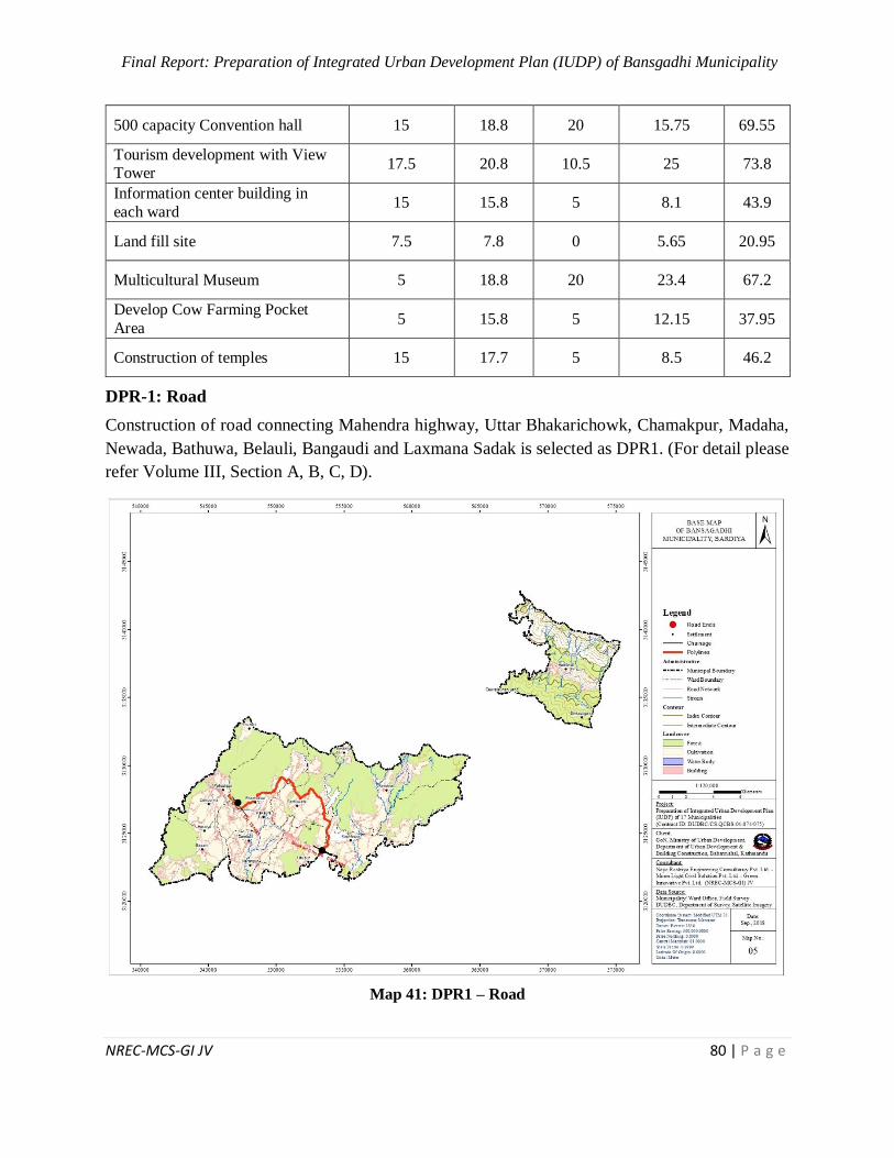
Final Report: Preparation of Integrated Urban Development Plan (IUDP) of Bansgadhi Municipality
NREC-MCS-GI JV 80 | P a g e
500 capacity Convention hall 15 18.8 20 15.75 69.55
Tourism development with View Tower
17.5 20.8 10.5 25 73.8
Information center building in
each ward 15 15.8 5 8.1 43.9
Land fill site 7.5 7.8 0 5.65 20.95
Multicultural Museum 5 18.8 20 23.4 67.2
Develop Cow Farming Pocket
Area 5 15.8 5 12.15 37.95
Construction of temples 15 17.7 5 8.5 46.2
DPR-1: Road
Construction of road connecting Mahendra highway, Uttar Bhakarichowk, Chamakpur, Madaha,
Newada, Bathuwa, Belauli, Bangaudi and Laxmana Sadak is selected as DPR1. (For detail please
refer Volume III, Section A, B, C, D).
Map 41: DPR1 – Road

Final Report: Preparation of Integrated Urban Development Plan (IUDP) of Bansgadhi Municipality
NREC-MCS-GI JV 81 | P a g e
Figure 6: Road Cross Section of Settlement Terai Area
Figure 7: Road Cross Section for Non-Settlement Terai Area

Final Report: Preparation of Integrated Urban Development Plan (IUDP) of Bansgadhi Municipality
NREC-MCS-GI JV 82 | P a g e
Table 23: Features of DPR1
Features Description
Name of the Road
Bhakari Chowk – Chamakpur – Madaha – Newada –
Batuwa – Belauli Bangaurdi – Laxmana Urban Road), ,
Bardiya, (CH: 0+000-13+633.73) KM, Bansghadi
municipality
Location
Region: Mid-Western Development Region
Province: 05
District: Bardiya
Municipality / Rural Municipality Bansagadhi
Major Settlements Khaireni chowk, Buddhachowk, Narayanpur and
Pragatinagar.
Length 13.633 km
Starting Point Bhakari Chowk
End Point: Bangauri Chowk
Geographical Features
Terrain Plain
Altitudinal Range 162 m to172 m
Climate: Sub-tropical
Geology: Boulders, gravel, sand, silt and clay
Meteorology: Unevenly Distributed Precipitation Controlled by
Monsoon
Design Standard
Standard NRS 2070
Existing Surface: Mostly Earthen surface, Partly metallic and gravel surface
Proposed Pavement: Asphalt type pavement
Geometrics
Right of Way: 15 m on either sides (Center line)
Formation Width: 10
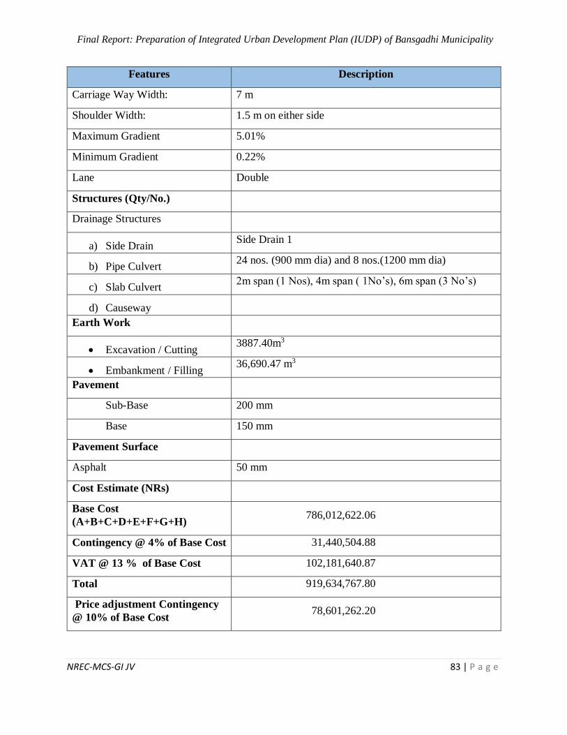
Final Report: Preparation of Integrated Urban Development Plan (IUDP) of Bansgadhi Municipality
NREC-MCS-GI JV 83 | P a g e
Features Description
Carriage Way Width: 7 m
Shoulder Width: 1.5 m on either side
Maximum Gradient 5.01%
Minimum Gradient 0.22%
Lane Double
Structures (Qty/No.)
Drainage Structures
a) Side Drain Side Drain 1
b) Pipe Culvert 24 nos. (900 mm dia) and 8 nos.(1200 mm dia)
c) Slab Culvert 2m span (1 Nos), 4m span ( 1No’s), 6m span (3 No’s)
d) Causeway
Earth Work
Excavation / Cutting 3887.40m3
Embankment / Filling 36,690.47 m3
Pavement
Sub-Base 200 mm
Base 150 mm
Pavement Surface
Asphalt 50 mm
Cost Estimate (NRs)
Base Cost
(A+B+C+D+E+F+G+H) 786,012,622.06
Contingency @ 4% of Base Cost 31,440,504.88
VAT @ 13 % of Base Cost 102,181,640.87
Total 919,634,767.80
Price adjustment Contingency
@ 10% of Base Cost 78,601,262.20
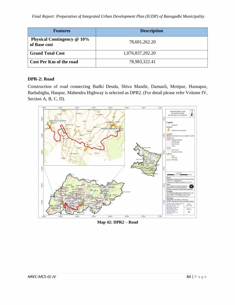
Final Report: Preparation of Integrated Urban Development Plan (IUDP) of Bansgadhi Municipality
NREC-MCS-GI JV 84 | P a g e
Features Description
Physical Contingency @ 10%
of Base cost 78,601,262.20
Grand Total Cost 1,076,837,292.20
Cost Per Km of the road 78,983,322.41
DPR-2: Road
Construction of road connecting Badki Deuda, Shiva Mandir, Damauli, Motipur, Hasnapur,
Barhabigha, Haupur, Mahendra Highway is selected as DPR2. (For detail please refer Volume IV,
Section A, B, C, D).
Map 42: DPR2 – Road
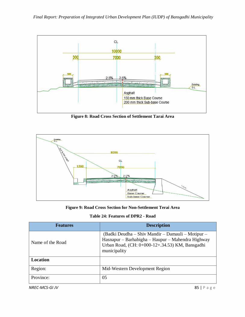
Final Report: Preparation of Integrated Urban Development Plan (IUDP) of Bansgadhi Municipality
NREC-MCS-GI JV 85 | P a g e
Figure 8: Road Cross Section of Settlement Tarai Area
Figure 9: Road Cross Section for Non-Settlement Terai Area
Table 24: Features of DPR2 - Road
Features Description
Name of the Road
(Badki Deudha – Shiv Mandir – Damauli – Motipur –
Hasnapur – Barhabigha – Haupur – Mahendra Highway
Urban Road, (CH: 0+000-12+.34.53) KM, Bansgadhi
municipality
Location
Region: Mid-Western Development Region
Province: 05
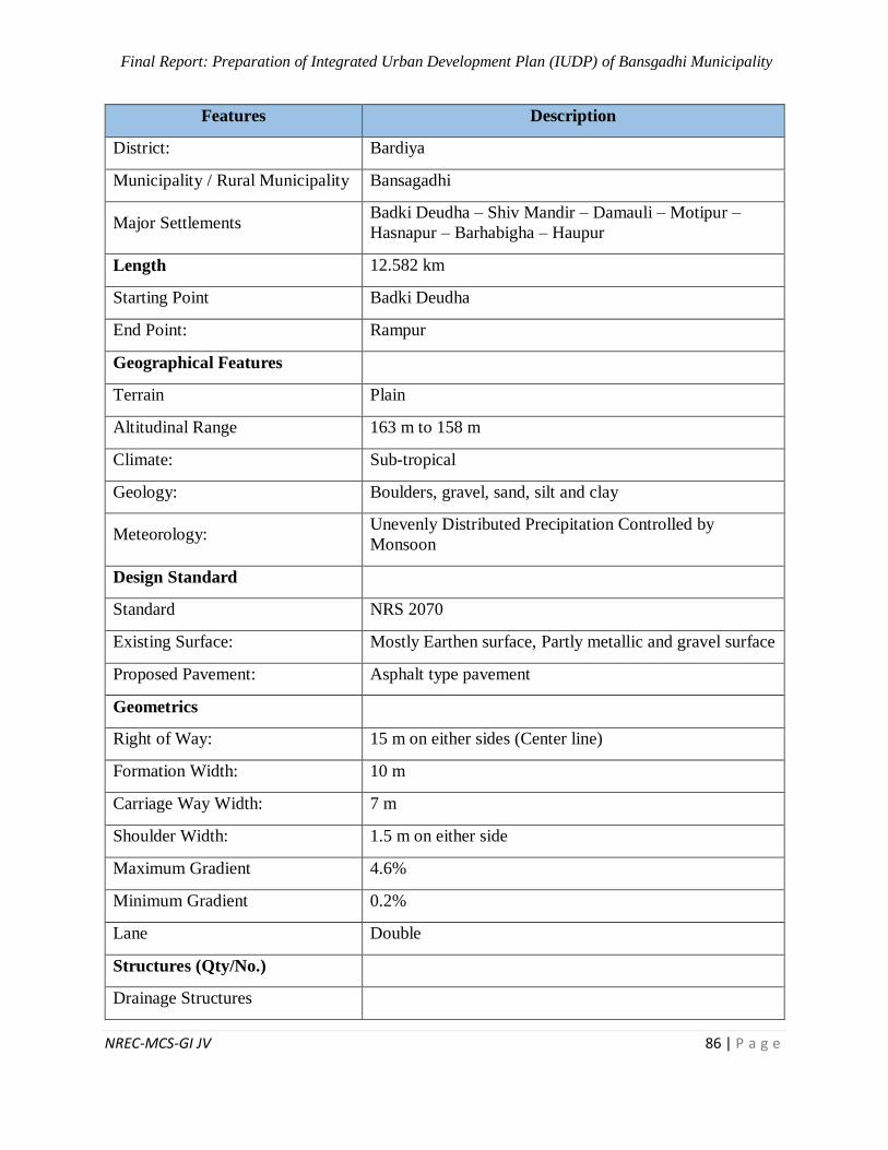
Final Report: Preparation of Integrated Urban Development Plan (IUDP) of Bansgadhi Municipality
NREC-MCS-GI JV 86 | P a g e
Features Description
District: Bardiya
Municipality / Rural Municipality Bansagadhi
Major Settlements Badki Deudha – Shiv Mandir – Damauli – Motipur –
Hasnapur – Barhabigha – Haupur
Length 12.582 km
Starting Point Badki Deudha
End Point: Rampur
Geographical Features
Terrain Plain
Altitudinal Range 163 m to 158 m
Climate: Sub-tropical
Geology: Boulders, gravel, sand, silt and clay
Meteorology: Unevenly Distributed Precipitation Controlled by
Monsoon
Design Standard
Standard NRS 2070
Existing Surface: Mostly Earthen surface, Partly metallic and gravel surface
Proposed Pavement: Asphalt type pavement
Geometrics
Right of Way: 15 m on either sides (Center line)
Formation Width: 10 m
Carriage Way Width: 7 m
Shoulder Width: 1.5 m on either side
Maximum Gradient 4.6%
Minimum Gradient 0.2%
Lane Double
Structures (Qty/No.)
Drainage Structures
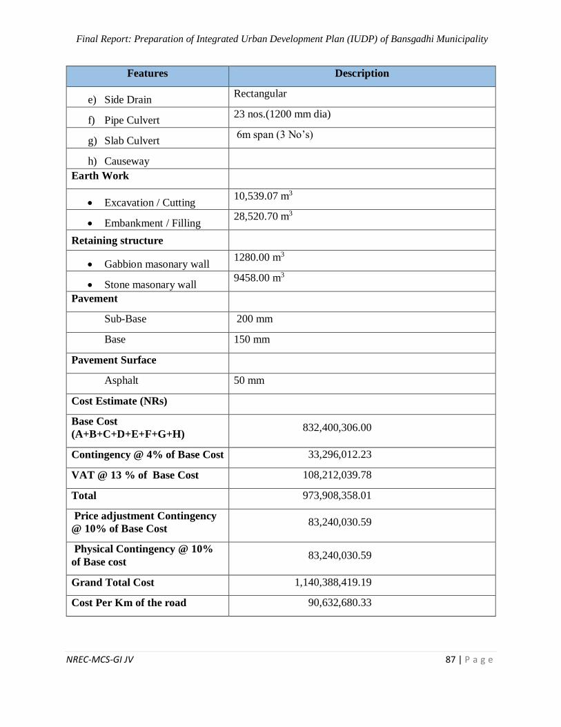
Final Report: Preparation of Integrated Urban Development Plan (IUDP) of Bansgadhi Municipality
NREC-MCS-GI JV 87 | P a g e
Features Description
e) Side Drain Rectangular
f) Pipe Culvert 23 nos.(1200 mm dia)
g) Slab Culvert 6m span (3 No’s)
h) Causeway
Earth Work
Excavation / Cutting 10,539.07 m3
Embankment / Filling 28,520.70 m3
Retaining structure
Gabbion masonary wall 1280.00 m3
Stone masonary wall 9458.00 m3
Pavement
Sub-Base 200 mm
Base 150 mm
Pavement Surface
Asphalt 50 mm
Cost Estimate (NRs)
Base Cost
(A+B+C+D+E+F+G+H) 832,400,306.00
Contingency @ 4% of Base Cost 33,296,012.23
VAT @ 13 % of Base Cost 108,212,039.78
Total 973,908,358.01
Price adjustment Contingency
@ 10% of Base Cost 83,240,030.59
Physical Contingency @ 10%
of Base cost 83,240,030.59
Grand Total Cost 1,140,388,419.19
Cost Per Km of the road 90,632,680.33
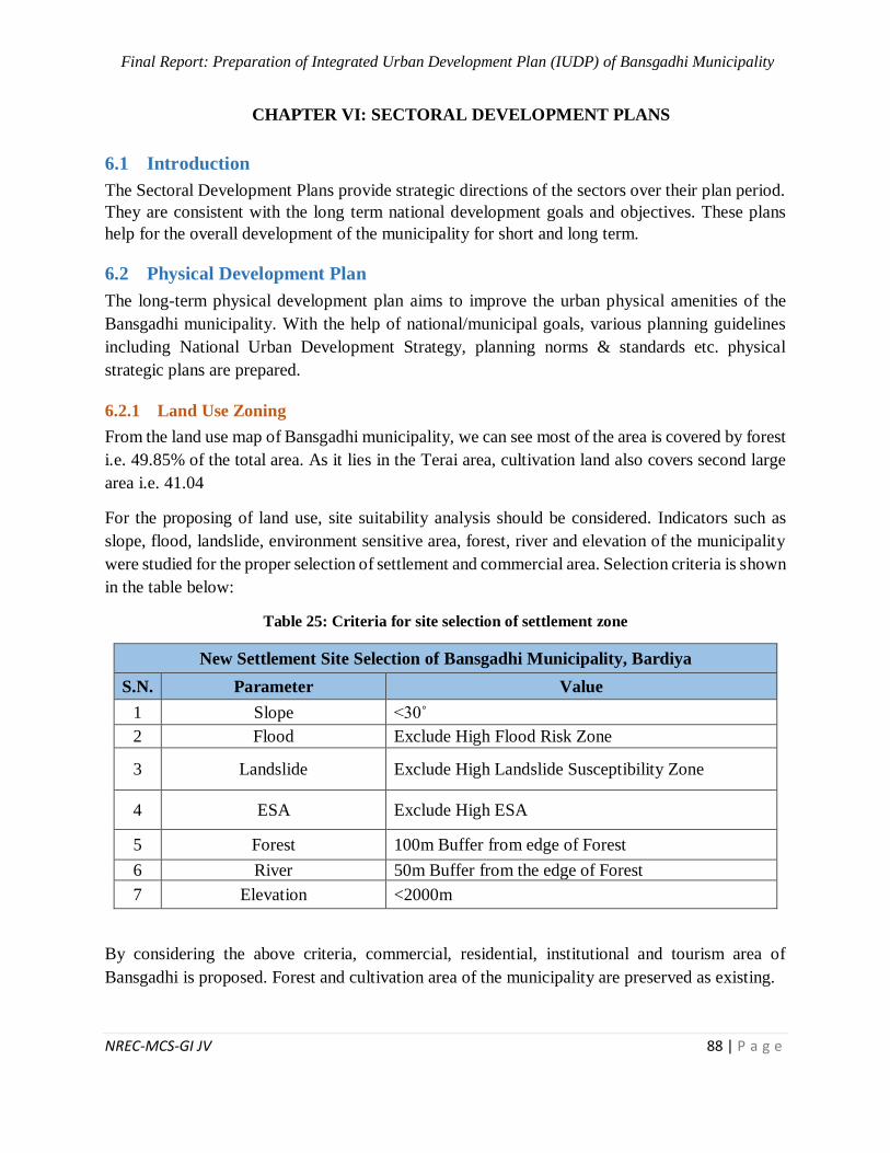
Final Report: Preparation of Integrated Urban Development Plan (IUDP) of Bansgadhi Municipality
NREC-MCS-GI JV 88 | P a g e
6 CHAPTER VI: SECTORAL DEVELOPMENT PLANS
6.1 Introduction
The Sectoral Development Plans provide strategic directions of the sectors over their plan period.
They are consistent with the long term national development goals and objectives. These plans
help for the overall development of the municipality for short and long term.
6.2 Physical Development Plan
The long-term physical development plan aims to improve the urban physical amenities of the
Bansgadhi municipality. With the help of national/municipal goals, various planning guidelines
including National Urban Development Strategy, planning norms & standards etc. physical
strategic plans are prepared.
6.2.1 Land Use Zoning
From the land use map of Bansgadhi municipality, we can see most of the area is covered by forest
i.e. 49.85% of the total area. As it lies in the Terai area, cultivation land also covers second large
area i.e. 41.04
For the proposing of land use, site suitability analysis should be considered. Indicators such as
slope, flood, landslide, environment sensitive area, forest, river and elevation of the municipality
were studied for the proper selection of settlement and commercial area. Selection criteria is shown
in the table below:
Table 25: Criteria for site selection of settlement zone
New Settlement Site Selection of Bansgadhi Municipality, Bardiya
S.N. Parameter Value
1 Slope <30˚
2 Flood Exclude High Flood Risk Zone
3 Landslide Exclude High Landslide Susceptibility Zone
4 ESA Exclude High ESA
5 Forest 100m Buffer from edge of Forest
6 River 50m Buffer from the edge of Forest
7 Elevation <2000m
By considering the above criteria, commercial, residential, institutional and tourism area of
Bansgadhi is proposed. Forest and cultivation area of the municipality are preserved as existing.
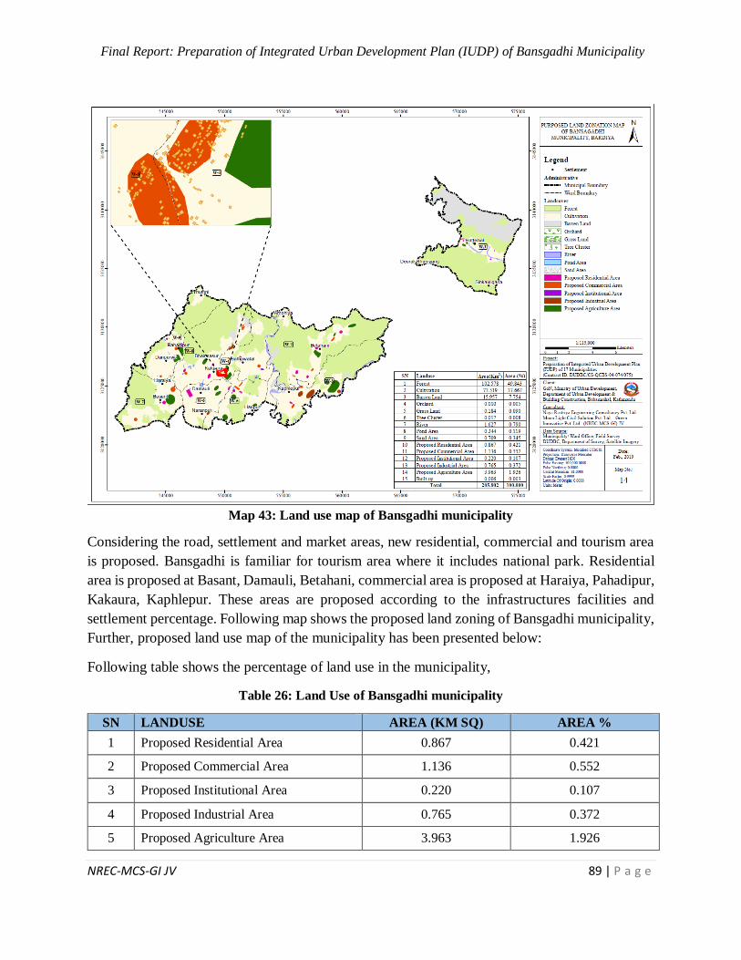
Final Report: Preparation of Integrated Urban Development Plan (IUDP) of Bansgadhi Municipality
NREC-MCS-GI JV 89 | P a g e
Map 43: Land use map of Bansgadhi municipality
Considering the road, settlement and market areas, new residential, commercial and tourism area
is proposed. Bansgadhi is familiar for tourism area where it includes national park. Residential
area is proposed at Basant, Damauli, Betahani, commercial area is proposed at Haraiya, Pahadipur,
Kakaura, Kaphlepur. These areas are proposed according to the infrastructures facilities and
settlement percentage. Following map shows the proposed land zoning of Bansgadhi municipality,
Further, proposed land use map of the municipality has been presented below:
Following table shows the percentage of land use in the municipality,
Table 26: Land Use of Bansgadhi municipality
SN LANDUSE AREA (KM SQ) AREA %
1 Proposed Residential Area 0.867 0.421
2 Proposed Commercial Area 1.136 0.552
3 Proposed Institutional Area 0.220 0.107
4 Proposed Industrial Area 0.765 0.372
5 Proposed Agriculture Area 3.963 1.926
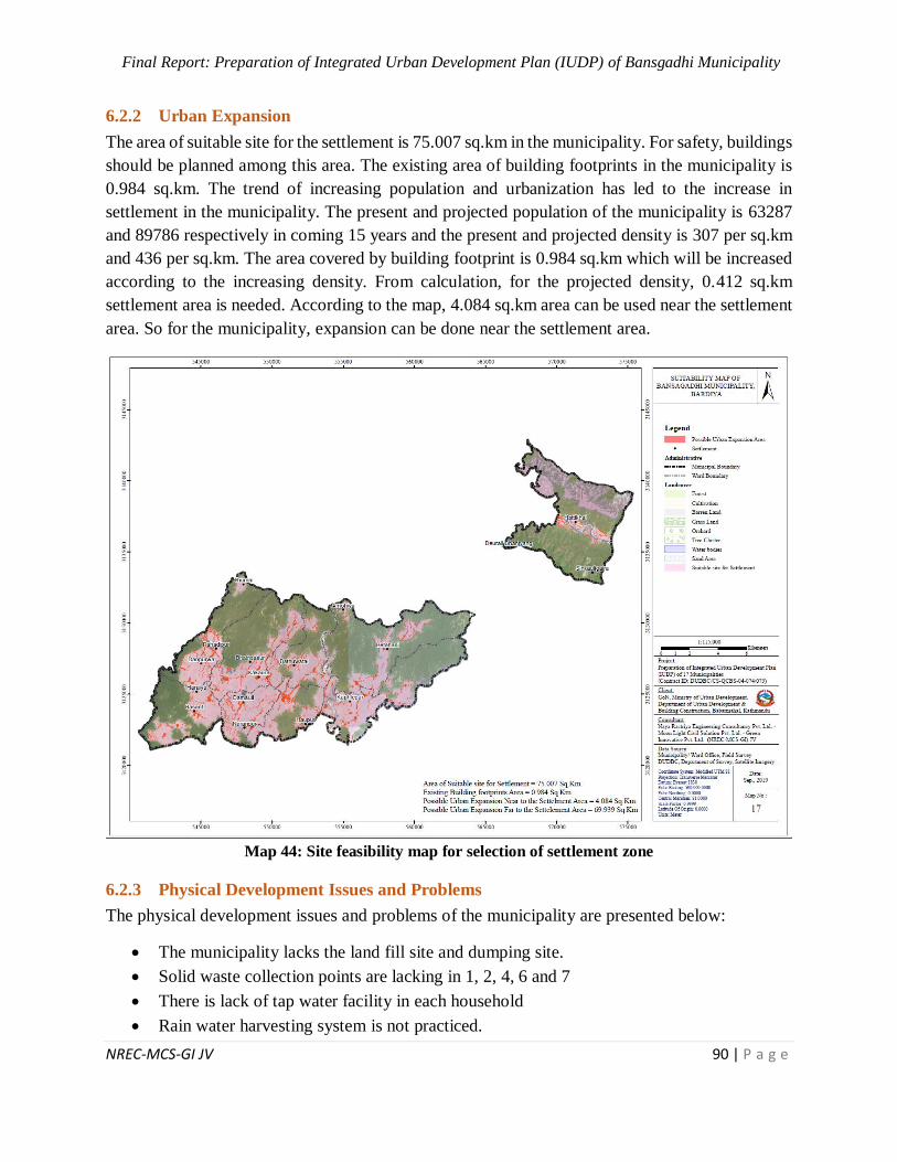
Final Report: Preparation of Integrated Urban Development Plan (IUDP) of Bansgadhi Municipality
NREC-MCS-GI JV 90 | P a g e
6.2.2 Urban Expansion
The area of suitable site for the settlement is 75.007 sq.km in the municipality. For safety, buildings
should be planned among this area. The existing area of building footprints in the municipality is
0.984 sq.km. The trend of increasing population and urbanization has led to the increase in
settlement in the municipality. The present and projected population of the municipality is 63287
and 89786 respectively in coming 15 years and the present and projected density is 307 per sq.km
and 436 per sq.km. The area covered by building footprint is 0.984 sq.km which will be increased
according to the increasing density. From calculation, for the projected density, 0.412 sq.km
settlement area is needed. According to the map, 4.084 sq.km area can be used near the settlement
area. So for the municipality, expansion can be done near the settlement area.
Map 44: Site feasibility map for selection of settlement zone
6.2.3 Physical Development Issues and Problems
The physical development issues and problems of the municipality are presented below:
The municipality lacks the land fill site and dumping site.
Solid waste collection points are lacking in 1, 2, 4, 6 and 7
There is lack of tap water facility in each household
Rain water harvesting system is not practiced.
Final Report: Preparation of Integrated Urban Development Plan (IUDP) of Bansgadhi Municipality
NREC-MCS-GI JV 91 | P a g e
Drainage and Sewerage system is not available
There is lack of health post at ward no. 1, 3, 4 and 8 and there is lack of health care center
and district hospital
There is lack of Composting system.
12.9% household have no access to electricity.
6.3 Urban Infrastructure Plan
For the sustainable and prosperous development of the municipality, urban infrastructure plan is
important. It discusses about water supply plan, drainage network, solid waste, electricity and
telecommunication plan.
Major guiding principle for urban infrastructure plan are presented below:
Improvement in management of infrastructure investment, to achieve sustainable outcomes
Enhance synergy among the actors in sanitation development, including municipal
government agencies, the private sector, NGOs, and others.
Participatory approach in SWM, so that people take it as asset to their personal level rather
than the liability.
Mandatory provision of installing alternative source of energy for at least 25% of total
energy usage in the building. Especially in case of public, institutional and commercial
building.
6.3.1 Water Supply
Availability of water resources makes Bansgadhi good location with sufficient attributes of water
supply resources. The water supply facility is also promoted by the community approach. Tube
well, tap and well are the major source of water supply for drinking purpose. 94.31% household
use tubewell as the major source due to the flat land of the municipality. Public water supply
facilities and water supply for city purpose are often ignored in the planning. With the following
strategic frameworks, water supply plan is proposed for the long term strategy.
Objective:
Equitable, safe, adequate and affordable water supply facility to each households and
institutions and for municipal purpose
Sustainable water supply measures
Strategy:
Continuous water supply system installed in each household by regular monitoring of its
quality
Strategic Projects:
With the above-mentioned framework, it is much clear regarding the strategy of water supply.
Water supply lines laid on the urban roads along with drainage pipe are some of the primary
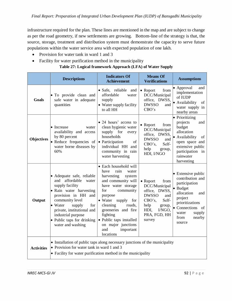
Final Report: Preparation of Integrated Urban Development Plan (IUDP) of Bansgadhi Municipality
NREC-MCS-GI JV 92 | P a g e
infrastructure required for the plan. These lines are mentioned in the map and are subject to change
as per the road geometry, if new settlements are growing. Bottom-line of the strategy is that, the
source, storage, treatment and distribution system must demonstrate the capacity to serve future
populations within the water service area with expected population of one lakh.
Provision for water tank in ward 1 and 3
Facility for water purification method in the municipality
Table 27: Logical framework Approach (LFA) of Water Supply
Descriptions Indicators Of
Achievement
Means Of
Verifications Assumptions
Goals
To provide clean and
safe water in adequate
quantities
Safe, reliable and
affordable water supply
Water supply facility
to all HH
Report from DCC/Municipal
office, DWSS,
DWSSO and CBO’s
Approval and implementation
of IUDP
Availability of
water supply in nearby areas
Objectives
Increase water availability and access
by 80 percent
Reduce frequencies of
water borne diseases by 60%
24 hours’ access to
clean hygienic water supply for every
households
Participation of
individual HH and community in rain
water harvesting
Report from
DCC/Municipal office, DWSS,
DWSSO and
CBO’s, Self-help group,
HDI, I/NGO
Prioritizing
projects and
budget allocation
Availability of
open space and
extensive public participation in
rainwater
harvesting
Output
Adequate safe, reliable and affordable water
supply facility
Rain water harvesting
provision in HH and community level
Water supply for
private, institutional and
industrial purpose
Public taps for drinking
water and washing
Each household will
have rain water harvesting system
and community will
have water storage for community
purpose
Water supply for
cleaning roads,
greeneries and fire fighting
Public taps installed
on major junctions
and important locations
Report from
DCC/Municipal
office, DWSS, DWSSO and
CBO’s, Self-
help group,
HDI, I/NGO, PRA, FGD, HH
survey
Extensive public
contribution and participation
Budget
allocation and
project prioritizations
Connections of
water supply
from nearby
source
Activities
Installation of public taps along necessary junctions of the municipality
Provision for water tank in ward 1 and 3
Facility for water purification method in the municipality
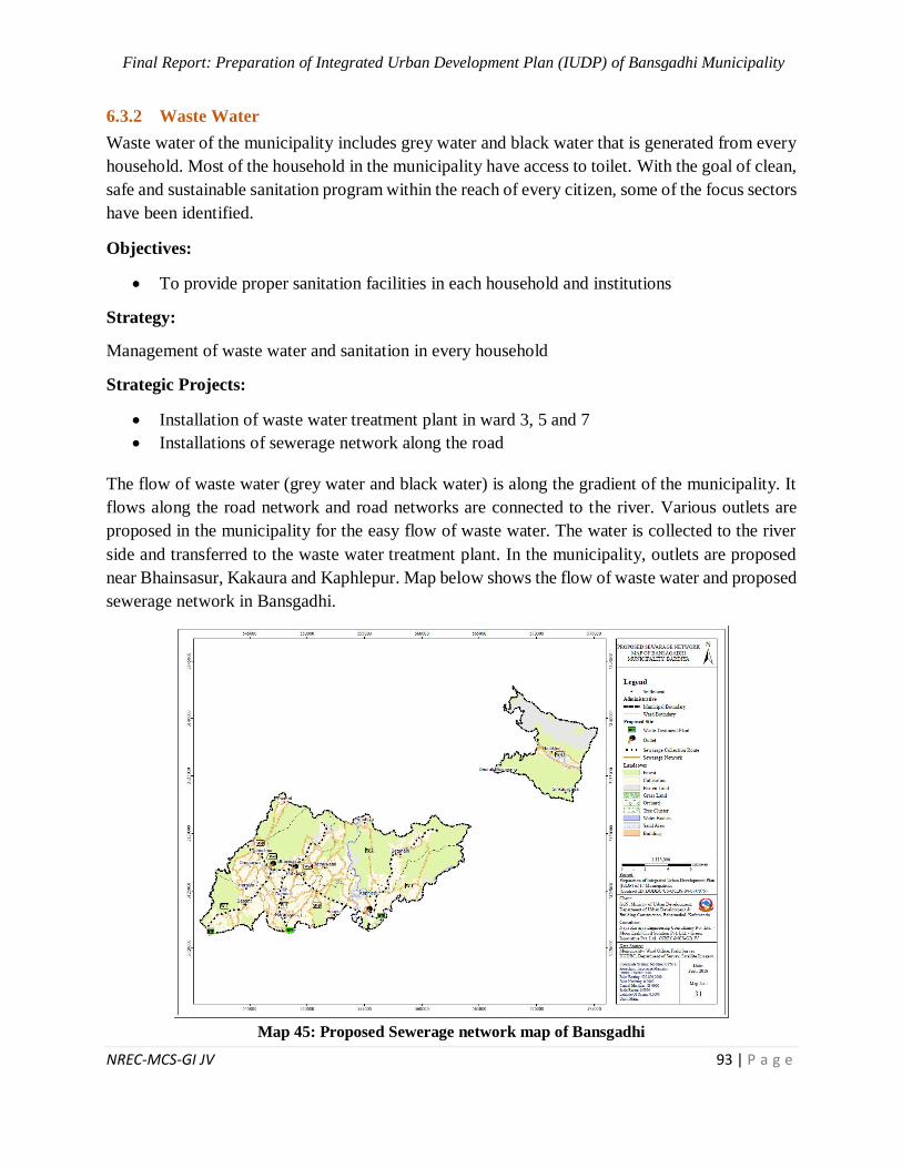
Final Report: Preparation of Integrated Urban Development Plan (IUDP) of Bansgadhi Municipality
NREC-MCS-GI JV 93 | P a g e
6.3.2 Waste Water
Waste water of the municipality includes grey water and black water that is generated from every
household. Most of the household in the municipality have access to toilet. With the goal of clean,
safe and sustainable sanitation program within the reach of every citizen, some of the focus sectors
have been identified.
Objectives:
To provide proper sanitation facilities in each household and institutions
Strategy:
Management of waste water and sanitation in every household
Strategic Projects:
Installation of waste water treatment plant in ward 3, 5 and 7
Installations of sewerage network along the road
The flow of waste water (grey water and black water) is along the gradient of the municipality. It
flows along the road network and road networks are connected to the river. Various outlets are
proposed in the municipality for the easy flow of waste water. The water is collected to the river
side and transferred to the waste water treatment plant. In the municipality, outlets are proposed
near Bhainsasur, Kakaura and Kaphlepur. Map below shows the flow of waste water and proposed
sewerage network in Bansgadhi.
Map 45: Proposed Sewerage network map of Bansgadhi
Final Report: Preparation of Integrated Urban Development Plan (IUDP) of Bansgadhi Municipality
NREC-MCS-GI JV 94 | P a g e
6.3.3 Drainage
Sustainable sanitation for healthy, green and clean city is the goal of Bansgadhi municipality. As
demanded by the people of Bansgadhi in many public hearings, they want the city to be free from
urban pollutions. One of the major problems in the urban areas is unscientific drainage system
along with unsanitary disposal of such drainage and sewerage. With the goal of clean, safe and
sustainable sanitation program within the reach of every citizen, some of the focus sectors have
been identified.
Objective:
Sanitation facilities in each household and institutions.
Efficient and effective sewer and drainage networks within the city Open Defecation free
zone
Strategy:
Provision of drainage in every side of the road and its treatment for proper reuse
Strategic Projects:
Drainage and sanitation is day to day process, hence needs to have some certain level of awareness
in people. Apart from that there are some important large scale infrastructures required to control
the drainage mechanism for the city including some required treatment plant. Some of the
important projects are identified as:
Design of the integrated drainage network and laying around the city considering the slope
of Bansgadhi.
Reed Bed Treatment plant in some identified location
Table 28: Logical framework Approach (LFA) of Drainage and Sewerage Network
Descriptions Indicators Of
Achievement
Means Of
Verifications Assumptions
Goals
Clean, safe and affordable, sustainable sanitation and
terrain friendly drainage
system
Sanitation facilities in each household and institutions.
Provision of sustainable
sanitation and
drainage system for all HH
Report from DCC, Municipal
office, DWSS,
RWSSP, NWSC, STWSSSP
Implementation
of IUDP
Budget
allocation
Objectives
Efficient and effective
sewer and drainage
networks in the city
Toilet facility in every
households and institution equipped with septic tank
Make the city “Open
Defecation Free Zone”
All houses and
institution with
toilet and septic
tank
Clean, green and healthy city
People
motivated
Report from
DCC, Municipal office, DWSS,
RWSSP, NWSC,
STWSSSP
Availability of
technology and
skilled
manpower
Monitoring by concerned
authority

Final Report: Preparation of Integrated Urban Development Plan (IUDP) of Bansgadhi Municipality
NREC-MCS-GI JV 95 | P a g e
Descriptions Indicators Of
Achievement
Means Of
Verifications Assumptions
To aware people about
healthy sanitation and
drainage system
toward cleaning
their own city Use of public
toilets by
people
Budget allocation
Output
Each HH and institution
with toilet and septic tank
Drainage and sewerage
lines installed along the road side of capacity as per
demand
Drain water treatment plant
installed at the exit of drainage
Easily accessible public
toilets in public spaces
100% HH with proper toilet and
septic tank
Integrated
sewerage system
Use of drain
water in various
purpose
Open defecation free city
No collection of
rainwater on
road
Report from DCC, Municipal
office, DWSS,
RWSSP, NWSC, STWSSSP,
PRA, FGD, HH
survey
Monitoring by
concerned authority
Budget
allocation
Availability of
technology and skilled
technicians
Maintenance
issue
Maintenance issue
Activities
Installation of waste water treatment plant in ward 3, 5 and 7
Upgrade existing sewerage systems including drainage and sewerage pipe along the
roads
Establishment of public toilet in public zone
Programs on public awareness through radio/TV broadcasting/Publicity
Use moderns technology and adopt the 3Rs (reducing, recycling and reuse of waste)
6.3.4 Solid Waste
To attain the goal of systematic, effective and sustainable solid waste management, it is very
important to proceed through the level of awareness of people in the town. In today’s context the
proper disposal of waste from household has been a major problem. So segregation of solid waste
at household level is also emphasized. Clean and dirt free Bansgadhi is envisioned by every citizen
of the municipality. Participatory approach of solid waste management is one of the most important
aspect of implementation.
Objective:
Extensive promotion reuse, reduce and recycle of solid waste (3R)
Effective management of sanitary land fill site
To develop collection point and transfer station in the municipality
Strong institutional mechanism for solid waste management
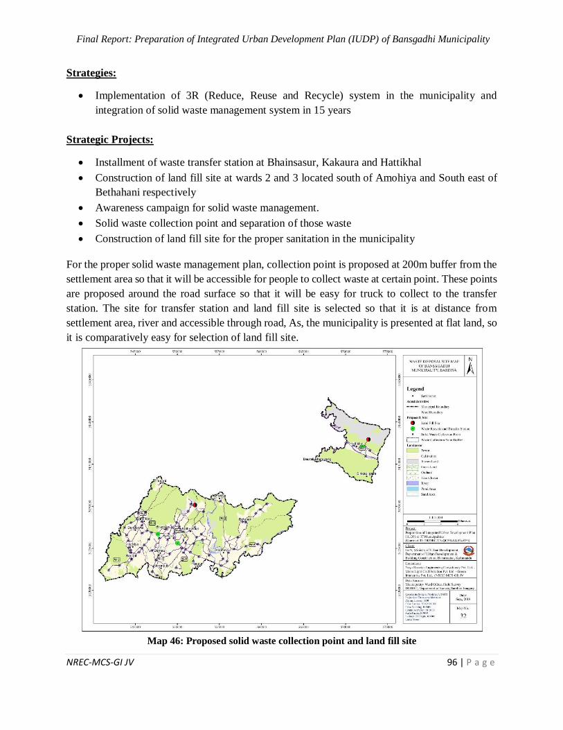
Final Report: Preparation of Integrated Urban Development Plan (IUDP) of Bansgadhi Municipality
NREC-MCS-GI JV 96 | P a g e
Strategies:
Implementation of 3R (Reduce, Reuse and Recycle) system in the municipality and
integration of solid waste management system in 15 years
Strategic Projects:
Installment of waste transfer station at Bhainsasur, Kakaura and Hattikhal
Construction of land fill site at wards 2 and 3 located south of Amohiya and South east of
Bethahani respectively
Awareness campaign for solid waste management.
Solid waste collection point and separation of those waste
Construction of land fill site for the proper sanitation in the municipality
For the proper solid waste management plan, collection point is proposed at 200m buffer from the
settlement area so that it will be accessible for people to collect waste at certain point. These points
are proposed around the road surface so that it will be easy for truck to collect to the transfer
station. The site for transfer station and land fill site is selected so that it is at distance from
settlement area, river and accessible through road, As, the municipality is presented at flat land, so
it is comparatively easy for selection of land fill site.
Map 46: Proposed solid waste collection point and land fill site
Final Report: Preparation of Integrated Urban Development Plan (IUDP) of Bansgadhi Municipality
NREC-MCS-GI JV 97 | P a g e
Table 29: Logical framework Approach (LFA) of Solid Waste Management
Descriptions Indicators Of
Achievement
Means Of
Verifications
Assumptions
Goals Systematic, effective and sustainable
management of solid
waste
Clean and healthy city with sustainable solid
waste management
Participatory approach
of SWM with Refine, Recycle and Reuse
(3R) concept
Report from DCC,
Municipal
office, DWSS,
RWSSP.
NWSC,
Approval and implementation
of IUDP
Availability of
landfill site
Objectives Extensive reduce, reuse
and recycle of solid
waste (3R)
Maintaining clean and healthy environment by
minimizing adverse
effect of the solid waste in public health and
environment
Effective management
of sanitary land fill site and organic
Production of energy
from solid waste
100% houses to be
provided with dustbin to separate degradable
and non-degradable
waste
Clean city without dumping of solid
waste on road side
Report from
DCC,
Municipal office,
DWSS,
RWSSP. NWSC,
STWSSSP
Efficiency of
bio gas on
winter season
Use of separate dustbin for
separate waste
Project
prioritization and budget
allocation
Output Sanitary land fill site
Bio gas installed
Clean city with property laid out dustbin on road
side
Community
participation extended, waste collection
activities coordinated
Landfill site
Functional SWM units in Bansgadhi
Municipality and
nearby rural municipalities
100% of HH waste
collected in Bansgadhi
Municipality
Report from DCC,
Municipal
office, DWSS,
RWSSP.
NWSC, STWSSSP,
PRA, FGD,
HH survey
Budget allocation and
project
prioritization
Operation of bio gas on
winter season
People
participation
Activities Instalment of waste transfer station at Bhainsasur, Kakaura and Hattikhal
Establishment of sanitary land fill site at wards 2 and 3 located south of Amohiya and
South east of Bethahani respectively
Segregation of waste in household level
Installation of solid waste bins along the road side and in public spaces.
Provision of separate dustbin for HH for degradable and non-degradable waste
6.3.5 Electricity
With the primary goal or providing, electricity and communication service to each individual in
the town, the electricity plan is basically focused on optimization of resources in distribution of
electricity services. Every household in Bansgadhi have access to electricity facility. Target of
affordable and accessible electricity and communication are to be backed up by some objectives
as follows.

Final Report: Preparation of Integrated Urban Development Plan (IUDP) of Bansgadhi Municipality
NREC-MCS-GI JV 98 | P a g e
Objective:
Access of universal and affordable electricity and communication services.
Promotion of alternative energy resources: Solar and wind energy
Techno friendly city development
Strategies:
Connecting power line with national grid
Provision of smart electricity grid in each settlement for exchange of surplus energy among
alternative energy and national grid
Strategic Projects:
With those basic guidelines mentioned above promoting alternative energy and electrification of
each household with NEA national grid, some of the important strategic projects identified are:
Connecting the power line with National grid
Construction of hydropower
Map below shows the accessibility of electricity in Bansgadhi municipality. Almost every wards
of the municipality have access to electricity facility. Those areas which are not in reach of
electricity should be provided with the access to those during planning phase.
Map 47: Electricity facility in Bansgadhi municipality
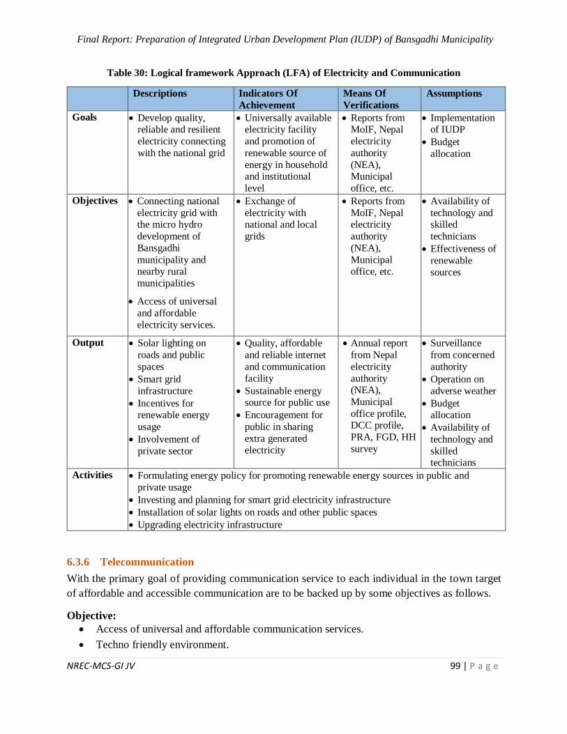
Final Report: Preparation of Integrated Urban Development Plan (IUDP) of Bansgadhi Municipality
NREC-MCS-GI JV 99 | P a g e
Table 30: Logical framework Approach (LFA) of Electricity and Communication
Descriptions Indicators Of
Achievement
Means Of
Verifications
Assumptions
Goals Develop quality, reliable and resilient
electricity connecting
with the national grid
Universally available electricity facility
and promotion of
renewable source of
energy in household and institutional
level
Reports from MoIF, Nepal
electricity
authority
(NEA), Municipal
office, etc.
Implementation of IUDP
Budget
allocation
Objectives Connecting national
electricity grid with the micro hydro
development of
Bansgadhi
municipality and nearby rural
municipalities
Access of universal
and affordable
electricity services.
Exchange of
electricity with national and local
grids
Reports from
MoIF, Nepal electricity
authority
(NEA),
Municipal office, etc.
Availability of
technology and skilled
technicians
Effectiveness of
renewable
sources
Output Solar lighting on
roads and public
spaces
Smart grid
infrastructure
Incentives for renewable energy
usage
Involvement of
private sector
Quality, affordable
and reliable internet
and communication
facility
Sustainable energy source for public use
Encouragement for
public in sharing
extra generated electricity
Annual report
from Nepal
electricity
authority (NEA),
Municipal
office profile, DCC profile,
PRA, FGD, HH
survey
Surveillance
from concerned
authority
Operation on
adverse weather
Budget allocation
Availability of
technology and
skilled technicians
Activities Formulating energy policy for promoting renewable energy sources in public and
private usage
Investing and planning for smart grid electricity infrastructure
Installation of solar lights on roads and other public spaces
Upgrading electricity infrastructure
6.3.6 Telecommunication
With the primary goal of providing communication service to each individual in the town target
of affordable and accessible communication are to be backed up by some objectives as follows.
Objective:
Access of universal and affordable communication services.
Techno friendly environment.
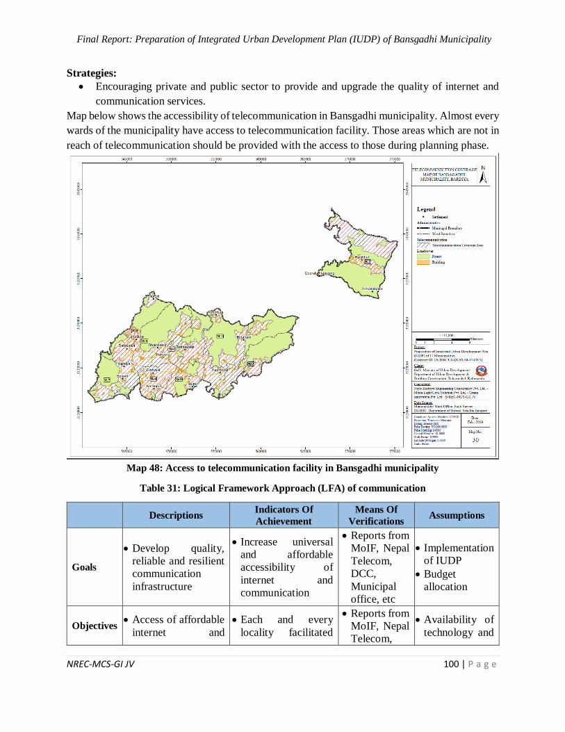
Final Report: Preparation of Integrated Urban Development Plan (IUDP) of Bansgadhi Municipality
NREC-MCS-GI JV 100 | P a g e
Strategies:
Encouraging private and public sector to provide and upgrade the quality of internet and
communication services.
Map below shows the accessibility of telecommunication in Bansgadhi municipality. Almost every
wards of the municipality have access to telecommunication facility. Those areas which are not in
reach of telecommunication should be provided with the access to those during planning phase.
Map 48: Access to telecommunication facility in Bansgadhi municipality
Table 31: Logical Framework Approach (LFA) of communication
Descriptions Indicators Of
Achievement
Means Of
Verifications Assumptions
Goals
Develop quality,
reliable and resilient
communication
infrastructure
Increase universal
and affordable
accessibility of
internet and
communication
Reports from
MoIF, Nepal
Telecom,
DCC,
Municipal
office, etc
Implementation
of IUDP
Budget
allocation
Objectives Access of affordable
internet and
Each and every
locality facilitated
Reports from
MoIF, Nepal
Telecom,
Availability of
technology and
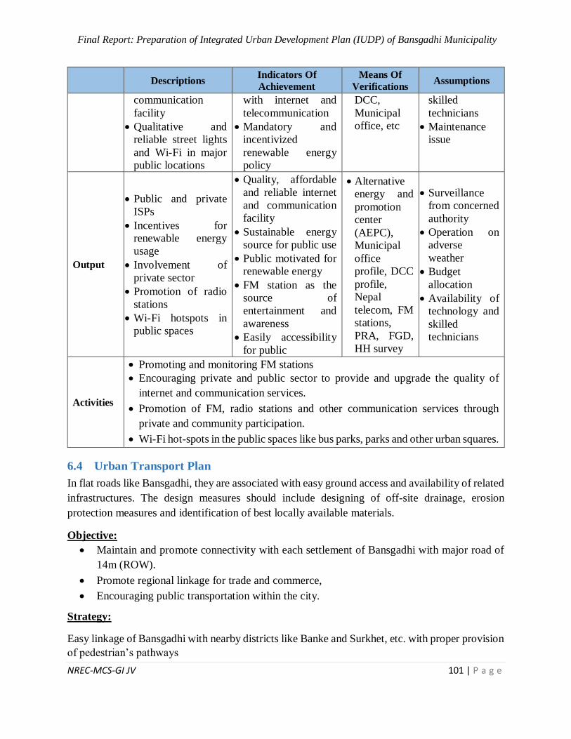
Final Report: Preparation of Integrated Urban Development Plan (IUDP) of Bansgadhi Municipality
NREC-MCS-GI JV 101 | P a g e
Descriptions Indicators Of
Achievement
Means Of
Verifications Assumptions
communication
facility
Qualitative and
reliable street lights
and Wi-Fi in major
public locations
with internet and
telecommunication
Mandatory and
incentivized
renewable energy
policy
DCC,
Municipal
office, etc
skilled
technicians
Maintenance
issue
Output
Public and private
ISPs
Incentives for
renewable energy
usage
Involvement of
private sector
Promotion of radio
stations
Wi-Fi hotspots in
public spaces
Quality, affordable
and reliable internet
and communication
facility
Sustainable energy
source for public use
Public motivated for
renewable energy
FM station as the
source of
entertainment and
awareness
Easily accessibility
for public
Alternative
energy and
promotion
center
(AEPC),
Municipal
office
profile, DCC
profile,
Nepal
telecom, FM
stations,
PRA, FGD,
HH survey
Surveillance
from concerned
authority
Operation on
adverse
weather
Budget
allocation
Availability of
technology and
skilled
technicians
Activities
Promoting and monitoring FM stations
Encouraging private and public sector to provide and upgrade the quality of
internet and communication services.
Promotion of FM, radio stations and other communication services through
private and community participation.
Wi-Fi hot-spots in the public spaces like bus parks, parks and other urban squares.
6.4 Urban Transport Plan
In flat roads like Bansgadhi, they are associated with easy ground access and availability of related
infrastructures. The design measures should include designing of off-site drainage, erosion
protection measures and identification of best locally available materials.
Objective:
Maintain and promote connectivity with each settlement of Bansgadhi with major road of
14m (ROW).
Promote regional linkage for trade and commerce,
Encouraging public transportation within the city.
Strategy:
Easy linkage of Bansgadhi with nearby districts like Banke and Surkhet, etc. with proper provision
of pedestrian’s pathways
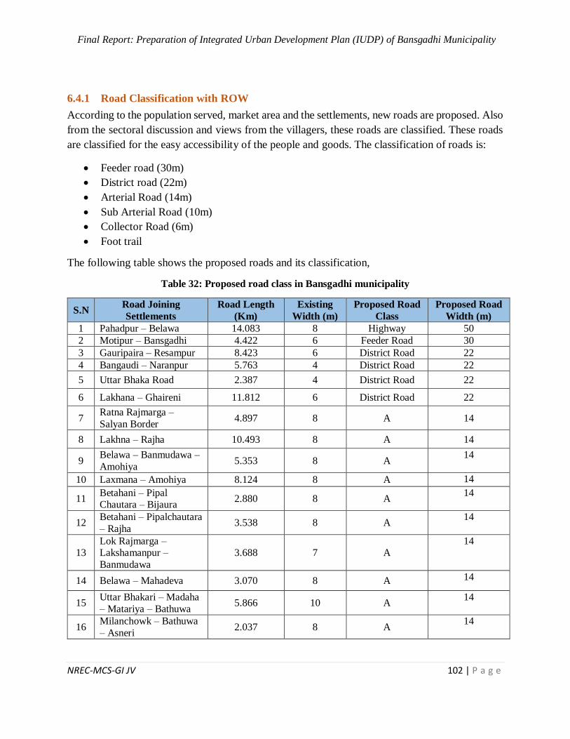
Final Report: Preparation of Integrated Urban Development Plan (IUDP) of Bansgadhi Municipality
NREC-MCS-GI JV 102 | P a g e
6.4.1 Road Classification with ROW
According to the population served, market area and the settlements, new roads are proposed. Also
from the sectoral discussion and views from the villagers, these roads are classified. These roads
are classified for the easy accessibility of the people and goods. The classification of roads is:
Feeder road (30m)
District road (22m)
Arterial Road (14m)
Sub Arterial Road (10m)
Collector Road (6m)
Foot trail
The following table shows the proposed roads and its classification,
Table 32: Proposed road class in Bansgadhi municipality
S.N Road Joining
Settlements
Road Length
(Km)
Existing
Width (m)
Proposed Road
Class
Proposed Road
Width (m)
1 Pahadpur – Belawa 14.083 8 Highway 50
2 Motipur – Bansgadhi 4.422 6 Feeder Road 30
3 Gauripaira – Resampur 8.423 6 District Road 22
4 Bangaudi – Naranpur 5.763 4 District Road 22
5 Uttar Bhaka Road 2.387 4 District Road 22
6 Lakhana – Ghaireni 11.812 6 District Road 22
7 Ratna Rajmarga –
Salyan Border 4.897 8 A 14
8 Lakhna – Rajha 10.493 8 A 14
9 Belawa – Banmudawa –
Amohiya 5.353 8 A
14
10 Laxmana – Amohiya 8.124 8 A 14
11 Betahani – Pipal Chautara – Bijaura
2.880 8 A 14
12 Betahani – Pipalchautara
– Rajha 3.538 8 A
14
13 Lok Rajmarga – Lakshamanpur –
Banmudawa
3.688 7 A 14
14 Belawa – Mahadeva 3.070 8 A 14
15 Uttar Bhakari – Madaha
– Matariya – Bathuwa 5.866 10 A
14
16 Milanchowk – Bathuwa
– Asneri 2.037 8 A
14
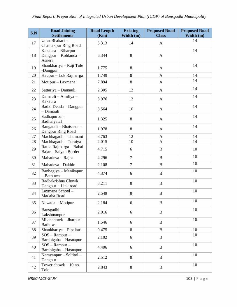
Final Report: Preparation of Integrated Urban Development Plan (IUDP) of Bansgadhi Municipality
NREC-MCS-GI JV 103 | P a g e
S.N Road Joining
Settlements
Road Length
(Km)
Existing
Width (m)
Proposed Road
Class
Proposed Road
Width (m)
17 Uttar Bhakari –
Chamakpur Ring Road 5.313 14 A
14
18 Kakaura – Riharpur – Dangpur – Koldanda –
Asneri
6.344 8 A 14
19 Shankhariya – Raji Tole
-Dangpur 1.775 8 A
14
20 Haupur – Lok Rajmarga 1.749 8 A 14
21 Motipur – Laxmana 7.894 8 A 14
22 Sattariya – Damauli 2.305 12 A 14
23 Damauli – Amiliya –
Kakaura 3.976 12 A
14
24 Badki Deuda – Dangpur – Damauli
3.564 10 A 14
25 Sadhapurba –
Badhaiyatal 1.325 8 A
14
26 Bangaudi – Bhaisasur – Dangpur Ring Road
1.978 8 A 14
27 Machhagadh – Thumani 8.763 12 A 14
28 Machhagadh – Toraiya 2.015 10 A 14
29 Ratna Rajmarga – Babai
Bajar – Salyan Border 4.715 6 B 10
30 Mahadeva – Rajha 4.296 7 B 10
31 Mahadeva - Dakhin 2.108 7 B 10
32 Banbagiya – Manikapur – Bathuwa
4.374 6 B 10
33 Radhakrishna Chowk –
Dangpur – Link road 3.211 8 B
10
34 Laxmana School – Madaha Road
2.549 8 B 10
35 Newada – Motipur 2.184 6 B 10
36 Bansgadhi –
Lakshmanpur 2.016 6 B
10
37 Milanchowk – Jharpur –
Bathuwa 1.546 6 B
10
38 Shankhariya – Pipaltari 0.475 8 B 10
39 SOS – Rampur – Barabigaha – Hasnapur
2.102 6 B 10
40 SOS – Rampur –
Barabigaha – Hasnapur 4.406 6 B
10
41 Narayanpur – Soltitol – Dangpur
2.512 8 B 10
42 Tower chowk – 10 no.
Tole 2.843 8 B
10
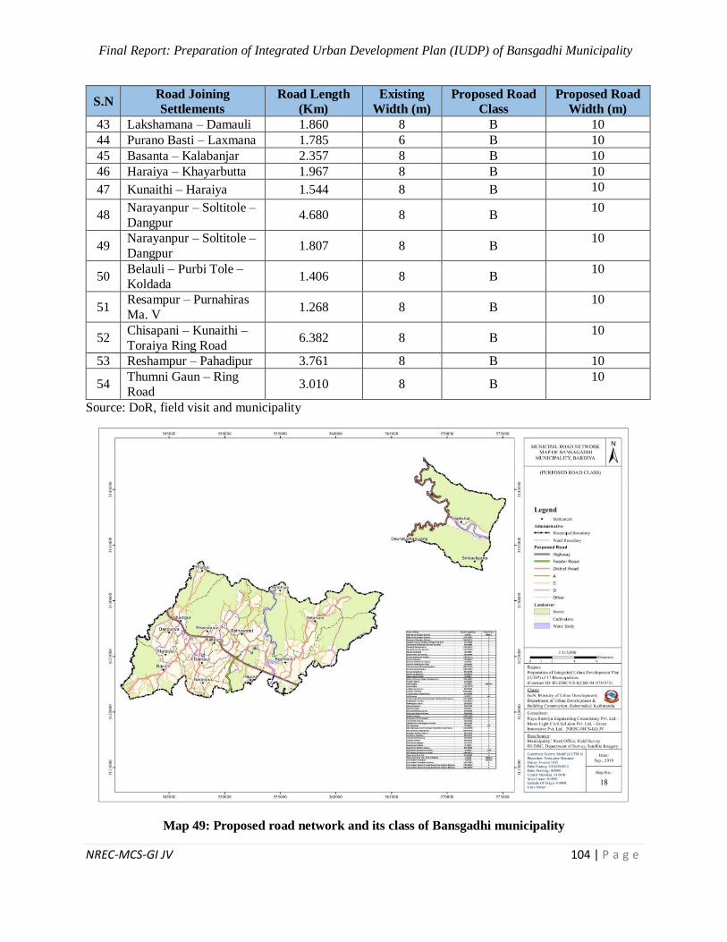
Final Report: Preparation of Integrated Urban Development Plan (IUDP) of Bansgadhi Municipality
NREC-MCS-GI JV 104 | P a g e
S.N Road Joining
Settlements
Road Length
(Km)
Existing
Width (m)
Proposed Road
Class
Proposed Road
Width (m)
43 Lakshamana – Damauli 1.860 8 B 10
44 Purano Basti – Laxmana 1.785 6 B 10
45 Basanta – Kalabanjar 2.357 8 B 10
46 Haraiya – Khayarbutta 1.967 8 B 10
47 Kunaithi – Haraiya 1.544 8 B 10
48 Narayanpur – Soltitole –
Dangpur 4.680 8 B
10
49 Narayanpur – Soltitole –
Dangpur 1.807 8 B
10
50 Belauli – Purbi Tole –
Koldada 1.406 8 B
10
51 Resampur – Purnahiras
Ma. V 1.268 8 B
10
52 Chisapani – Kunaithi –
Toraiya Ring Road 6.382 8 B
10
53 Reshampur – Pahadipur 3.761 8 B 10
54 Thumni Gaun – Ring
Road 3.010 8 B
10
Source: DoR, field visit and municipality
Map 49: Proposed road network and its class of Bansgadhi municipality
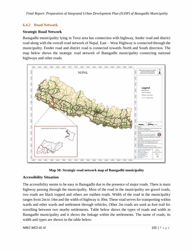
Final Report: Preparation of Integrated Urban Development Plan (IUDP) of Bansgadhi Municipality
NREC-MCS-GI JV 105 | P a g e
6.4.2 Road Network
Strategic Road Network
Bansgadhi municipality lying in Terai area has connection with highway, feeder road and district
road along with the overall road network of Nepal. East – West Highway is connected through the
municipality. Feeder road and district road is connected towards North and South direction. The
map below shows the strategic road network of Bansgadhi municipality connecting national
highways and other roads.
Map 50: Strategic road network map of Bansgadhi municipality
Accessibility Situation
The accessibility seems to be easy in Bansgadhi due to the presence of major roads. There is main
highway passing through the municipality. Most of the road in the municipality are gravel roads,
two roads are black topped and others are earthen roads. Width of the road in the municipality
ranges from 2m to 14m and the width of highway is 30m. These road serves for transporting within
wards and other wards and settlement through vehicles. Other 2m roads are used as foot trail for
travelling between two nearby settlements. Table below shows the types of roads and width in
Bansgadhi municipality and it shows the linkage within the settlements. The name of roads, its
width and types are shown in the table below:
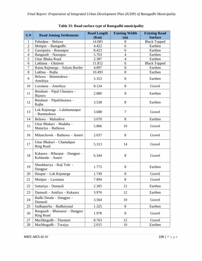
Final Report: Preparation of Integrated Urban Development Plan (IUDP) of Bansgadhi Municipality
NREC-MCS-GI JV 106 | P a g e
Table 33: Road surface type of Bansgadhi municipality
S.N Road Joining Settlements Road Length
(Km)
Existing Width
(m)
Existing Road
Surface
1 Pahadpur – Belawa 14.083 8 Black Topped
2 Motipur – Bansgadhi 4.422 6 Earthen
3 Gauripaira – Resampur 8.423 6 Earthen
4 Bangaudi – Naranpur 5.763 4 Earthen
5 Uttar Bhaka Road 2.387 4 Earthen
6 Lakhana – Ghaireni 11.812 6 Black Topped
7 Ratna Rajmarga – Salyan Border 4.897 8 Earthen
8 Lakhna – Rajha 10.493 8 Earthen
9 Belawa – Banmudawa –
Amohiya 5.353 8 Earthen
10 Laxmana – Amohiya 8.124 8 Gravel
11 Betahani – Pipal Chautara –
Bijaura 2.880 8 Earthen
12 Betahani – Pipalchautara – Rajha
3.538 8 Earthen
13 Lok Rajmarga – Lakshamanpur – Banmudawa
3.688 7 Gravel
14 Belawa – Mahadeva 3.070 8 Earthen
15 Uttar Bhakari – Madaha – Matariya – Bathuwa
5.866 10 Gravel
16 Milanchowk – Bathuwa – Asneri 2.037 8 Gravel
17 Uttar Bhakari – Chamakpur
Ring Road 5.313 14 Gravel
18 Kakaura – Riharpur – Dangpur –
Koldanda – Asneri 6.344 8 Gravel
19 Shankhariya – Raji Tole -
Dangpur 1.775 8 Earthen
20 Haupur – Lok Rajmarga 1.749 8 Gravel
21 Motipur – Laxmana 7.894 8 Gravel
22 Sattariya – Damauli 2.305 12 Earthen
23 Damauli – Amiliya – Kakaura 3.976 12 Earthen
24 Badki Deuda – Dangpur – Damauli
3.564 10 Gravel
25 Sadhapurba – Badhaiyatal 1.325 8 Earthen
26 Bangaudi – Bhaisasur – Dangpur
Ring Road 1.978 8 Gravel
27 Machhagadh – Thumani 8.763 12 Gravel
28 Machhagadh – Toraiya 2.015 10 Earthen

Final Report: Preparation of Integrated Urban Development Plan (IUDP) of Bansgadhi Municipality
NREC-MCS-GI JV 107 | P a g e
S.N Road Joining Settlements Road Length
(Km)
Existing Width
(m)
Existing Road
Surface
29 Ratna Rajmarga – Babai Bajar –
Salyan Border 4.715 6 Earthen
30 Mahadeva – Rajha 4.296 7 Earthen
31 Mahadeva - Dakhin 2.108 7 Earthen
32 Banbagiya – Manikapur –
Bathuwa 4.374 6 Earthen
33 Radhakrishna Chowk – Dangpur
– Link road 3.211 8 Earthen
34 Laxmana School – Madaha Road
2.549 8 Gravel
35 Newada – Motipur 2.184 6 Earthen
36 Bansgadhi – Lakshmanpur 2.016 6 Earthen
37 Milanchowk – Jharpur –
Bathuwa 1.546 6 Gravel
38 Shankhariya – Pipaltari 0.475 8 Earthen
39 SOS – Rampur – Barabigaha –
Hasnapur 2.102 6 Gravel
40 SOS – Rampur – Barabigaha – Hasnapur
4.406 6 Gravel
41 Narayanpur – Soltitol – Dangpur 2.512 8 Earthen
42 Tower chowk – 10 no. Tole 2.843 8 Earthen
43 Lakshamana – Damauli 1.860 8 Gravel
44 Purano Basti – Laxmana 1.785 6 Earthen
45 Basanta – Kalabanjar 2.357 8 Earthen
46 Haraiya – Khayarbutta 1.967 8 Earthen
47 Kunaithi – Haraiya 1.544 8 Gravel
48 Narayanpur – Soltitole –
Dangpur 4.680 8 Earthen
49 Narayanpur – Soltitole – Dangpur
1.807 8 Earthen
50 Belauli – Purbi Tole – Koldada 1.406 8 Earthen
51 Resampur – Purnahiras Ma. V 1.268 8 Gravel
52 Chisapani – Kunaithi – Toraiya
Ring Road 6.382 8 Black Topped
53 Reshampur – Pahadipur 3.761 8 Gravel
54 Thumni Gaun – Ring Road 3.010 8 Gravel
(Source: DoR, field visit and municipality)
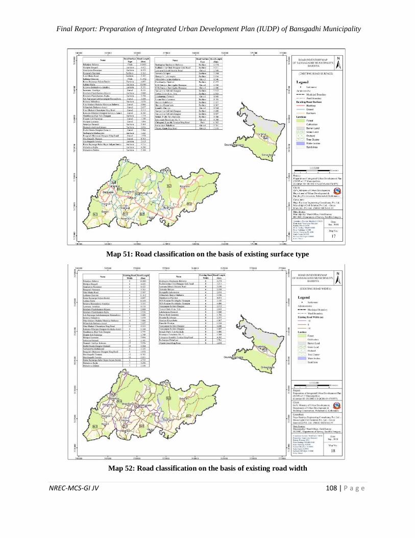
Final Report: Preparation of Integrated Urban Development Plan (IUDP) of Bansgadhi Municipality
NREC-MCS-GI JV 108 | P a g e
Map 51: Road classification on the basis of existing surface type
Map 52: Road classification on the basis of existing road width
Final Report: Preparation of Integrated Urban Development Plan (IUDP) of Bansgadhi Municipality
NREC-MCS-GI JV 109 | P a g e
6.4.3 Parking Management
Parking plays vital role to enhance the transportation system. Parking management refers to
various policies and programs that result in more efficient use of parking resources. Cost-
effective parking management programs can usually reduce parking requirements by 20-40%
compared with conventional planning requirements, providing many economic, social and
environmental benefits. Parking management system plays and will continue to play an
important role in the revitalization of urban areas. Each form of parking management has its own
benefits and disadvantages. Without the implementation of parking management system,
vehicles are useless.
Objectives:
Encourage use of alternative modes and reduce motor vehicle use (thereby reducing traffic
congestion, accidents and pollution).
Reduce compaction in the street and increment in the proper flow of vehicles
Strategy:
Parking space serving multiple users and destinations
Establishing of maximum parking standards
Improving parking facility design and operations to help solve problems and support
parking management
Strategic projects:
Preparing plan for proper parking management
Provision for separate parking space rather than parking along road side
6.4.4 Issues and Problems
The major problem of the municipality related to transportation is that, most of the roads are
earthen and graveled. As a result, it is very hard to travel during rainy season. There is no proper
bus stand, signal and bus stop in the municipality.
Table 34: Logical Framework Approach (LFA) of Urban Transportation
Descriptions Indicators Of
Achievement
Means Of
Verifications
Assumptions
Goals
Safe and
convenient
movement of
goods, services
and people in the
municipality and
periphery
Ease on modes of
transportation in the
municipality and its
periphery
Interlinkage of
Bansgadhi
Municipality with
nearby cities
City profile,
DCC/Municipal
office report,
DoR/DTMP
report, Traffic
report, I/NGO’s
reports/ HDI
Approval and
Implementation
of IUDP
Prioritization
of IUDP
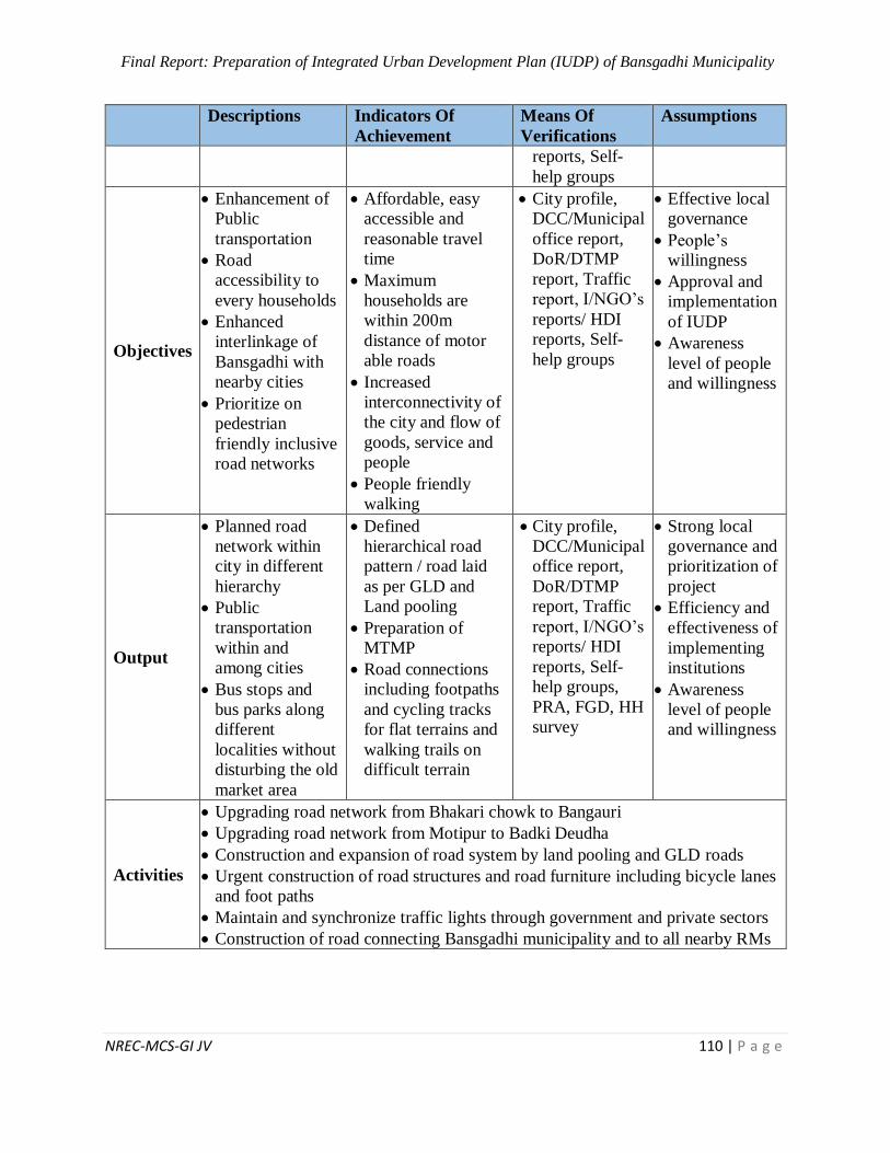
Final Report: Preparation of Integrated Urban Development Plan (IUDP) of Bansgadhi Municipality
NREC-MCS-GI JV 110 | P a g e
Descriptions Indicators Of
Achievement
Means Of
Verifications
Assumptions
reports, Self-
help groups
Objectives
Enhancement of
Public
transportation
Road
accessibility to
every households
Enhanced
interlinkage of
Bansgadhi with
nearby cities
Prioritize on
pedestrian
friendly inclusive
road networks
Affordable, easy
accessible and
reasonable travel
time
Maximum
households are
within 200m
distance of motor
able roads
Increased
interconnectivity of
the city and flow of
goods, service and
people
People friendly
walking
City profile,
DCC/Municipal
office report,
DoR/DTMP
report, Traffic
report, I/NGO’s
reports/ HDI
reports, Self-
help groups
Effective local
governance
People’s
willingness
Approval and
implementation
of IUDP
Awareness
level of people
and willingness
Output
Planned road
network within
city in different
hierarchy
Public
transportation
within and
among cities
Bus stops and
bus parks along
different
localities without
disturbing the old
market area
Defined
hierarchical road
pattern / road laid
as per GLD and
Land pooling
Preparation of
MTMP
Road connections
including footpaths
and cycling tracks
for flat terrains and
walking trails on
difficult terrain
City profile,
DCC/Municipal
office report,
DoR/DTMP
report, Traffic
report, I/NGO’s
reports/ HDI
reports, Self-
help groups,
PRA, FGD, HH
survey
Strong local
governance and
prioritization of
project
Efficiency and
effectiveness of
implementing
institutions
Awareness
level of people
and willingness
Activities
Upgrading road network from Bhakari chowk to Bangauri
Upgrading road network from Motipur to Badki Deudha
Construction and expansion of road system by land pooling and GLD roads
Urgent construction of road structures and road furniture including bicycle lanes
and foot paths
Maintain and synchronize traffic lights through government and private sectors
Construction of road connecting Bansgadhi municipality and to all nearby RMs
Final Report: Preparation of Integrated Urban Development Plan (IUDP) of Bansgadhi Municipality
NREC-MCS-GI JV 111 | P a g e
6.5 Social Development Plan
Social development plan of Bansgadhi municipality has been prepared in order to enhance the
quality of life of the citizens along with their social security, health and educational amenities, and
accessible service delivery systems in the municipality.
6.5.1 Education
There are altogether 57 schools out of which two of them are providing technical subjects and one
is providing inclusive education for students with disability. There is the availability of school and
higher education facilities, but numbers of students are gradually increasing and do not consistent
till higher level because of lack of the technical education and higher educational institutions in
Bansgadhi. The areas like Sawikal Belwa, Motipur and Daudadakala are more accessible for
educational services. Moreover, educational dependency has been increasing to Gulariya
(Bardiya), Tikapur (Kailali) and Nepalgunj and Kohalpur (Banke). The literary status is between
male and female of 5 years and above age groups does seem more varies greatly in this. As per the
municipal profile statistics, the literacy rate remains 88.02% in 2017 has been an average rate of
literacy, which accounts for 90.75% for the male and 85.49% for the female. So, increment in
literacy rate seems not a big problem. However, promotion of quality higher education has been
the major challenge for this municipality, which has been now only accessed through Bansgadhi
Multiple Campus and Bardiya Multiple Campus.
By analyzing this situational gap, the following LFA has been prepared for the educational
development of Bansgadhi municipality.
Table 35: Logical Framework Approach (LFA) of Education
Logical Framework Approach (LFA) of Education
Goals Provide equity-based opportunities in education with quality services
Expand employment-based vocational education
Objectives
Achieve 100% literacy in the municipality.
Specific guidelines for non-formal education and formal education
(pre-elementary, elementary, secondary and higher)
Increase in quality of education and easily accessibility of higher and
technical education/ training with adoption of specific strategies.
Education for all: regardless of sex, caste, region and age group
Prop-people administration and governance in the educational sector
Means of
verification Municipality plans and programs, DoE report
Assumption
Government prioritization and budget allocation in education sector
Provincial support from province 5
Inclusive education for all
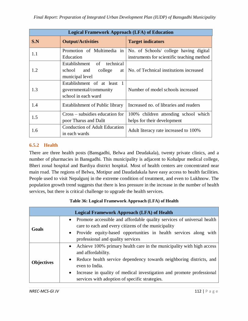
Final Report: Preparation of Integrated Urban Development Plan (IUDP) of Bansgadhi Municipality
NREC-MCS-GI JV 112 | P a g e
Logical Framework Approach (LFA) of Education
S.N Output/Activities Target indicators
1.1 Promotion of Multimedia in
Education
No. of Schools/ college having digital
instruments for scientific teaching method
1.2
Establishment of technical
school and college at
municipal level
No. of Technical institutions increased
1.3
Establishment of at least 1
governmental/community
school in each ward
Number of model schools increased
1.4 Establishment of Public library Increased no. of libraries and readers
1.5 Cross – subsidies education for
poor Tharus and Dalit
100% children attending school which
helps for their development
1.6 Conduction of Adult Education
in each wards Adult literacy rate increased to 100%
6.5.2 Health
There are three health posts (Bansgadhi, Belwa and Deudakala), twenty private clinics, and a
number of pharmacies in Bansgadhi. This municipality is adjacent to Kohalpur medical college,
Bheri zonal hospital and Bardiya district hospital. Most of health centers are concentrated near
main road. The regions of Belwa, Motipur and Daudadakala have easy access to health facilities.
People used to visit Nepalgunj in the extreme condition of treatment, and even to Lukhnow. The
population growth trend suggests that there is less pressure in the increase in the number of health
services, but there is critical challenge to upgrade the health services.
Table 36: Logical Framework Approach (LFA) of Health
Logical Framework Approach (LFA) of Health
Goals
Promote accessible and affordable quality services of universal health
care to each and every citizens of the municipality
Provide equity-based opportunities in health services along with
professional and quality services
Objectives
Achieve 100% primary health care in the municipality with high access
and affordability.
Reduce health service dependency towards neighboring districts, and
even to India.
Increase in quality of medical investigation and promote professional
services with adoption of specific strategies.

Final Report: Preparation of Integrated Urban Development Plan (IUDP) of Bansgadhi Municipality
NREC-MCS-GI JV 113 | P a g e
Logical Framework Approach (LFA) of Health
Health for all: regardless of sex, caste, region and age group
Pro-people administration and governance in the health sector of
municipality (both community/ governmental and private)
Specific guidelines for private health institutions to operate and provide
the health services within the municipality
Means of
Verification
Health survey, DHS
Municipal Profile, Progress Report etc.
Assumption
Budget allocation; support from federal and provincial govt.
Proper health service for mother and child
Availability of land and priority of national government
S.N Output/Activities Target indicators
1 Construction of well – equipped hospital, health post, birthing centre
1.1
Construction of 50 bedded hospital
with specific OPD and consultants
system with emergency services (as a
part of Kohalpur Medical College)
% Increase in number of patient
Reduction in the distance and time
for the out of the service delivery
1.2 Construction of Birthing Centre % reduction in MMR and CMR
1.3 Construction of additional health post
with lab services in each wards
% of health cases addressed at local
levels
1.4 Establishment of Khop Clinic and
Gaughar Clinic in each wards % reduction in TFR, MMR and CMR
1.5 Establishment of Blood Bank Increased access to emergency service
1.6 Establishment of Medical College for
paramedical course
Increased enrolment of students in
medical science
2 Promoting health standards
2.1 Provision of drinking water and
sanitation in health posts % increase in clean health provision
2.2 Conduction of program for 100%
vaccination in each ward
Decrease of epidemics and
communicable disease
2.3 Informative and awareness programs
initiated for women in wards % women participants increased
2.4 Declaration of the municipality as an
ODA Observed Safe and clean city
2.5 Health awareness program and free
health camp
% increased to health access health for
every citizens
3 Provision of facilities and infrastructures related to health
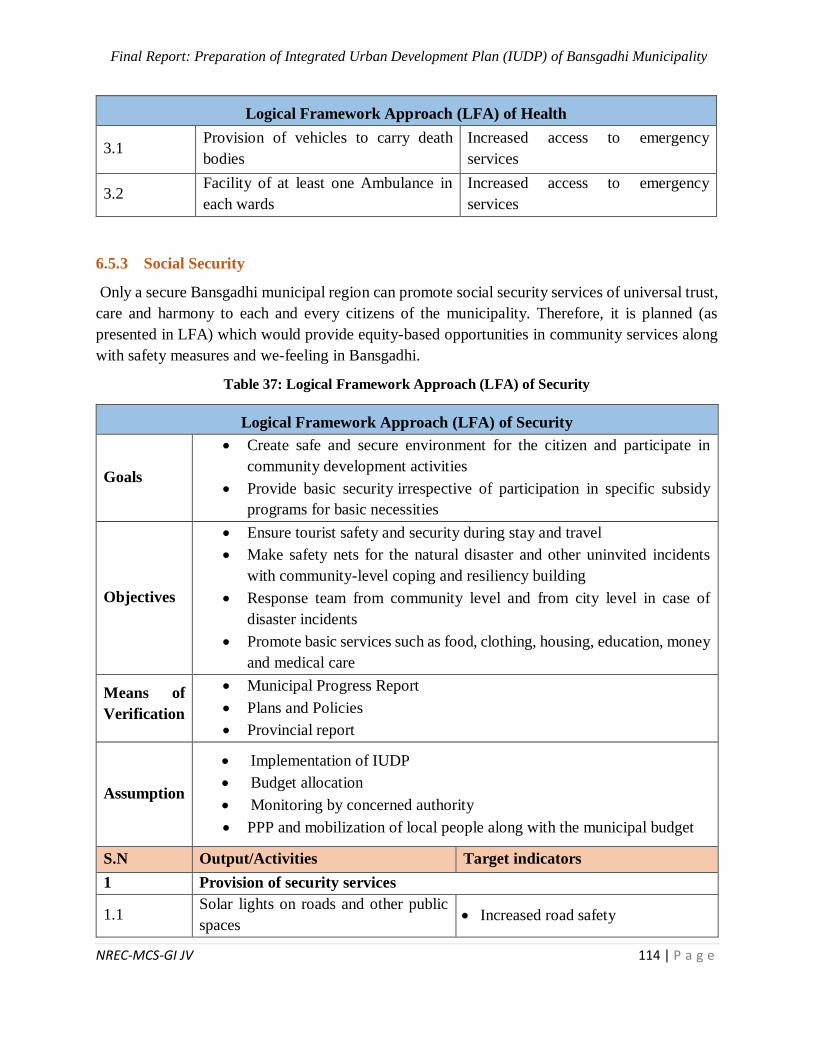
Final Report: Preparation of Integrated Urban Development Plan (IUDP) of Bansgadhi Municipality
NREC-MCS-GI JV 114 | P a g e
Logical Framework Approach (LFA) of Health
3.1 Provision of vehicles to carry death
bodies
Increased access to emergency
services
3.2 Facility of at least one Ambulance in
each wards
Increased access to emergency
services
6.5.3 Social Security
Only a secure Bansgadhi municipal region can promote social security services of universal trust,
care and harmony to each and every citizens of the municipality. Therefore, it is planned (as
presented in LFA) which would provide equity-based opportunities in community services along
with safety measures and we-feeling in Bansgadhi.
Table 37: Logical Framework Approach (LFA) of Security
Logical Framework Approach (LFA) of Security
Goals
Create safe and secure environment for the citizen and participate in
community development activities
Provide basic security irrespective of participation in specific subsidy
programs for basic necessities
Objectives
Ensure tourist safety and security during stay and travel
Make safety nets for the natural disaster and other uninvited incidents
with community-level coping and resiliency building
Response team from community level and from city level in case of
disaster incidents
Promote basic services such as food, clothing, housing, education, money
and medical care
Means of
Verification
Municipal Progress Report
Plans and Policies
Provincial report
Assumption
Implementation of IUDP
Budget allocation
Monitoring by concerned authority
PPP and mobilization of local people along with the municipal budget
S.N Output/Activities Target indicators
1 Provision of security services
1.1 Solar lights on roads and other public
spaces Increased road safety
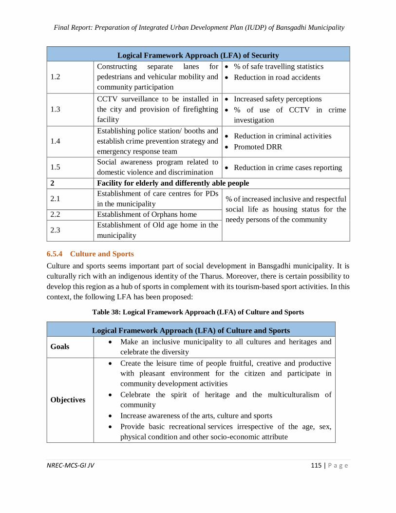
Final Report: Preparation of Integrated Urban Development Plan (IUDP) of Bansgadhi Municipality
NREC-MCS-GI JV 115 | P a g e
Logical Framework Approach (LFA) of Security
1.2
Constructing separate lanes for
pedestrians and vehicular mobility and
community participation
% of safe travelling statistics
Reduction in road accidents
1.3
CCTV surveillance to be installed in
the city and provision of firefighting
facility
Increased safety perceptions
% of use of CCTV in crime
investigation
1.4
Establishing police station/ booths and
establish crime prevention strategy and
emergency response team
Reduction in criminal activities
Promoted DRR
1.5 Social awareness program related to
domestic violence and discrimination Reduction in crime cases reporting
2 Facility for elderly and differently able people
2.1 Establishment of care centres for PDs
in the municipality % of increased inclusive and respectful
social life as housing status for the
needy persons of the community
2.2 Establishment of Orphans home
2.3 Establishment of Old age home in the
municipality
6.5.4 Culture and Sports
Culture and sports seems important part of social development in Bansgadhi municipality. It is
culturally rich with an indigenous identity of the Tharus. Moreover, there is certain possibility to
develop this region as a hub of sports in complement with its tourism-based sport activities. In this
context, the following LFA has been proposed:
Table 38: Logical Framework Approach (LFA) of Culture and Sports
Logical Framework Approach (LFA) of Culture and Sports
Goals Make an inclusive municipality to all cultures and heritages and
celebrate the diversity
Objectives
Create the leisure time of people fruitful, creative and productive
with pleasant environment for the citizen and participate in
community development activities
Celebrate the spirit of heritage and the multiculturalism of
community
Increase awareness of the arts, culture and sports
Provide basic recreational services irrespective of the age, sex,
physical condition and other socio-economic attribute
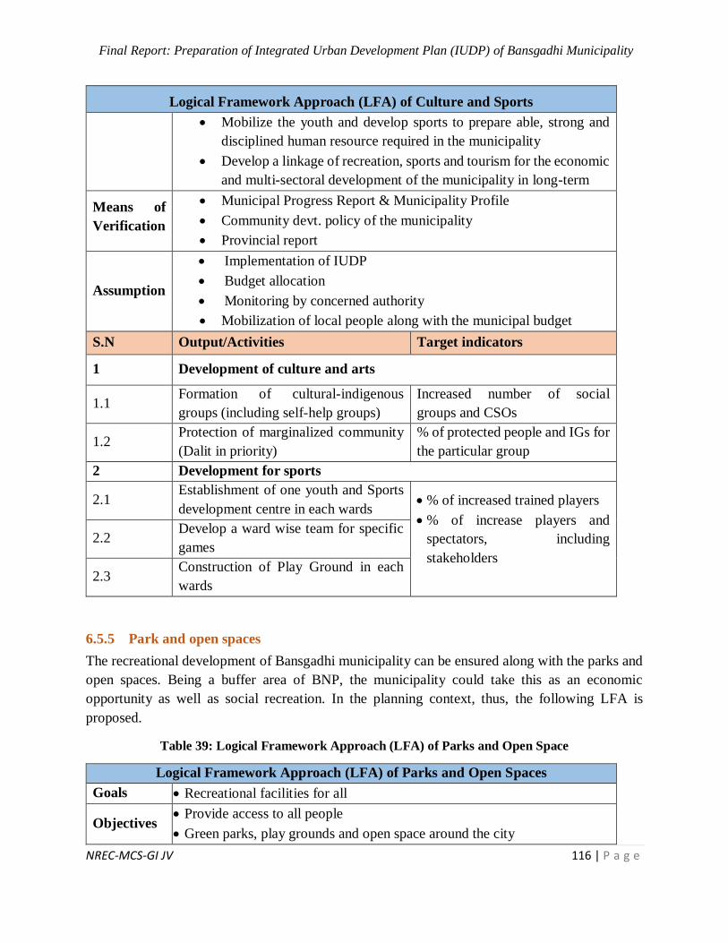
Final Report: Preparation of Integrated Urban Development Plan (IUDP) of Bansgadhi Municipality
NREC-MCS-GI JV 116 | P a g e
Logical Framework Approach (LFA) of Culture and Sports
Mobilize the youth and develop sports to prepare able, strong and
disciplined human resource required in the municipality
Develop a linkage of recreation, sports and tourism for the economic
and multi-sectoral development of the municipality in long-term
Means of
Verification
Municipal Progress Report & Municipality Profile
Community devt. policy of the municipality
Provincial report
Assumption
Implementation of IUDP
Budget allocation
Monitoring by concerned authority
Mobilization of local people along with the municipal budget
S.N Output/Activities Target indicators
1 Development of culture and arts
1.1 Formation of cultural-indigenous
groups (including self-help groups)
Increased number of social
groups and CSOs
1.2 Protection of marginalized community
(Dalit in priority)
% of protected people and IGs for
the particular group
2 Development for sports
2.1 Establishment of one youth and Sports
development centre in each wards % of increased trained players
% of increase players and
spectators, including
stakeholders
2.2 Develop a ward wise team for specific
games
2.3 Construction of Play Ground in each
wards
6.5.5 Park and open spaces
The recreational development of Bansgadhi municipality can be ensured along with the parks and
open spaces. Being a buffer area of BNP, the municipality could take this as an economic
opportunity as well as social recreation. In the planning context, thus, the following LFA is
proposed.
Table 39: Logical Framework Approach (LFA) of Parks and Open Space
Logical Framework Approach (LFA) of Parks and Open Spaces
Goals Recreational facilities for all
Objectives Provide access to all people
Green parks, play grounds and open space around the city
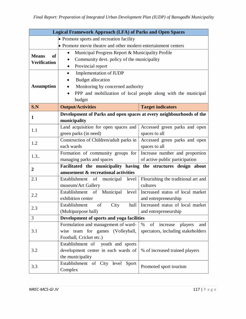
Final Report: Preparation of Integrated Urban Development Plan (IUDP) of Bansgadhi Municipality
NREC-MCS-GI JV 117 | P a g e
Logical Framework Approach (LFA) of Parks and Open Spaces
Promote sports and recreation facility
Promote movie theatre and other modern entertainment centers
Means of
Verification
Municipal Progress Report & Municipality Profile
Community devt. policy of the municipality
Provincial report
Assumption
Implementation of IUDP
Budget allocation
Monitoring by concerned authority
PPP and mobilization of local people along with the municipal
budget
S.N Output/Activities Target indicators
1 Development of Parks and open spaces at every neighbourhoods of the
municipality
1.1 Land acquisition for open spaces and
green parks (in need)
Accessed green parks and open
spaces to all
1.2 Construction of Children/adult parks in
each wards
Accessed green parks and open
spaces to all
1.3.. Formation of community groups for
managing parks and spaces
Increase number and proportion
of active public participation
2 Facilitated the municipality having the structures design about
amusement & recreational activities
2.1
Establishment of municipal level
museum/Art Gallery
Flourishing the traditional art and
cultures
2.2 Establishment of Municipal level
exhibition center
Increased status of local market
and entrepreneurship
2.3 Establishment of City hall
(Multipurpose hall)
Increased status of local market
and entrepreneurship
3 Development of sports and yoga facilities
3.1
Formulation and management of ward-
wise team for games (Volleyball,
Football, Cricket etc.)
% of increase players and
spectators, including stakeholders
3.2
Establishment of youth and sports
development center in each wards of
the municipality
% of increased trained players
3.3 Establishment of City level Sport
Complex Promoted sport tourism
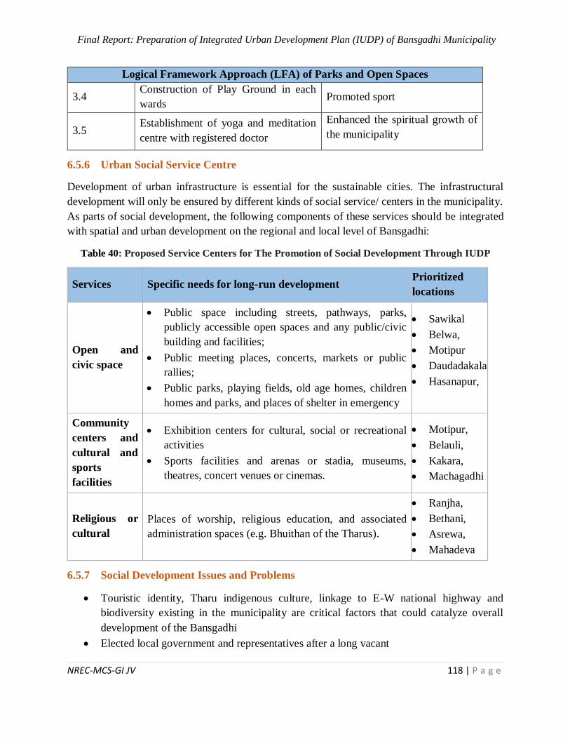
Final Report: Preparation of Integrated Urban Development Plan (IUDP) of Bansgadhi Municipality
NREC-MCS-GI JV 118 | P a g e
Logical Framework Approach (LFA) of Parks and Open Spaces
3.4 Construction of Play Ground in each
wards Promoted sport
3.5 Establishment of yoga and meditation
centre with registered doctor
Enhanced the spiritual growth of
the municipality
6.5.6 Urban Social Service Centre
Development of urban infrastructure is essential for the sustainable cities. The infrastructural
development will only be ensured by different kinds of social service/ centers in the municipality.
As parts of social development, the following components of these services should be integrated
with spatial and urban development on the regional and local level of Bansgadhi:
Table 40: Proposed Service Centers for The Promotion of Social Development Through IUDP
Services Specific needs for long-run development Prioritized
locations
Open and
civic space
Public space including streets, pathways, parks,
publicly accessible open spaces and any public/civic
building and facilities;
Public meeting places, concerts, markets or public
rallies;
Public parks, playing fields, old age homes, children
homes and parks, and places of shelter in emergency
Sawikal
Belwa,
Motipur
Daudadakala
Hasanapur,
Community
centers and
cultural and
sports
facilities
Exhibition centers for cultural, social or recreational
activities
Sports facilities and arenas or stadia, museums,
theatres, concert venues or cinemas.
Motipur,
Belauli,
Kakara,
Machagadhi
Religious or
cultural
Places of worship, religious education, and associated
administration spaces (e.g. Bhuithan of the Tharus).
Ranjha,
Bethani,
Asrewa,
Mahadeva
6.5.7 Social Development Issues and Problems
Touristic identity, Tharu indigenous culture, linkage to E-W national highway and
biodiversity existing in the municipality are critical factors that could catalyze overall
development of the Bansgadhi
Elected local government and representatives after a long vacant
Final Report: Preparation of Integrated Urban Development Plan (IUDP) of Bansgadhi Municipality
NREC-MCS-GI JV 119 | P a g e
Public hearing and grassroots democracy along with rising awareness and expectations
Social mobility and technological development in the changing context
Tourism linkages through Bardiya National Park—a source of revenue plus touristic
identity
Special focus on education, health and social sector; growing concerns and issues of
children, women, youth, elderly people and marginalized communities/ groups
Lack of urban scale health institutions with basic facilities including maternity services and
other emergency services.
Institutional problems related to capacity building and offices infrastructures
6.6 Economic Development Plan
6.6.1 Industrial Development and Trade Promotion
Rice Mill, Furniture, Grill Mill, Noodles, Chowmein, Herbs Company, Masala etc are the major
small and medium scale industries inside the municipality with inter domestic markets like
Lakhna, Uttarbhakhari, Bansghadi, Tharugaun, Motipur, Hasnapur and intra domestic markets like
Banke, Gulariya, Nepalgunj and Kathmandu. Therefore, they are generating some employment
opportunities for local people.
With easy availability of local manpower and local, the number of micro-enterprises can be
increased. With only a few products being focused by the available industries, there’s opportunity
to explore further especially with products of livestock especially as this is gaining popularity.
With road facilities (graveled and pitch) that joins the municipality to major market centers and
even other cities of the country. Output of the enterprises can be well traded to those areas. A good
food storage center can aid to the agriculture as well as industry sector of the municipality. There’s
no difficulty of importing raw materials as per the necessity nor is trading of the output. If the
products aren’t traded in market outside the municipality, the municipality may not be able to
absorb all the products of the industries and thus the output may be underutilized. Making a spot
for the products in the bigger market will be a huge challenge.
6.6.2 Employment Generation, Poverty Reduction
According to Small Area Estimates of Poverty, during 7 years (2003/04 to 2010/11), poverty was
reduced from 41% to 22% with a rate of 47%. It is assumed that during current past 7 years
(2011/12 to 2018/19) it is reduced by 28% due to earthquake and trade disturbance between India
and Nepal. Therefore, poverty incidence in this municipality for fiscal year 2018/19 becomes 16%.
With the economic activities continuing accordingly, the rate is assumed to reach 13% in 2023,
8% in 2028 and 4% in 2033. But this assumption has not considered the fact that remittance has
slowly started to show voluntary unemployment in the country as a whole and this municipality
will not be an exception.
Final Report: Preparation of Integrated Urban Development Plan (IUDP) of Bansgadhi Municipality
NREC-MCS-GI JV 120 | P a g e
This will be a reality assumed that the activities mentioned in the LFA are run smoothly along with
the assumptions put forward for each indicator are not hindered in any form throughout the years.
6.6.3 Regional Competiveness of Municipality
Bansgadhi is slowly becoming popular in commercialized banana and poultry farming. It however
doesn’t have an advantage against other municipalities of province 5 due to the people more
focusing upon earning from the natural visiting sites available. The municipality has flourished in
terms of tourism. A huge population is benefitted by the Bardiya National Park available as a
neighbor both directly (accommodation for tourists) and indirectly (raw materials from the park).
6.6.4 Agriculture Development
Paddy, wheat, Red Lintels, and mustard are the major crops produced in the municipality. In
Bansgadhi municipality wide range of agricultural products are produced and marketed in Lakhna,
Uttarbhakhari, Bansghadi, Tharugaun, Motipurand Hasnapur markets.
Opportunities
The municipality being engaged in both seasonal and non-seasonal cropping pattern produces
more crops and vegetables. It has a good road network to Kathmandu, Nepalgunj, Gulariya and
even neighboring country India which can be used for giving the production its due value. Reu
Irrigation Project and Babai Irrigation Project in this municipality promote the agricultural
products.
Challenges
Agricultural status of Nepal is in poor condition and Bansgadhi is no exception. With the
population there being lesser interested towards agriculture with years passing by, the situation
will worse off. Similarly lack of modern technologies and skilled manpower are considered as
major challenges for agriculture in this municipality.
Livestock
Commercialization of livestock farming is the recent trend of this municipality. It is considered
that people have been earning better and living a good life. With Kathmandu, Nepalgunj, Gulariya
being its other markets along with the internal markets more people have been attracted towards
livestock.
Opportunities
With commercialization of livestock attracting the present people, further financial help in the field
can aid for attracting more youth towards livestock. India being a close international market and
easy access to the city areas of Kathmandu, Nepalgunj, Banke and Gulariya can make the livestock
products get the price it deserves.
Challenges
Being a traditional job, retaining the people in this field will be a challenge if there’s no
sustainability.
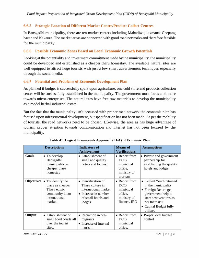
Final Report: Preparation of Integrated Urban Development Plan (IUDP) of Bansgadhi Municipality
NREC-MCS-GI JV 121 | P a g e
6.6.5 Strategic Location of Different Market Centre/Product Collect Centres
In Bansgadhi municipality, there are ten market centers including Mahadiwa, laxmana, Chepang
bazar and Kakaura. The market areas are connected with good road networks and therefore feasible
for the municipality.
6.6.6 Possible Economic Zones Based on Local Economic Growth Potentials
Looking at the potentiality and investment commitment made by the municipality, the municipality
could be developed and established as a cheaper tharu homestay. The available natural sites are
well equipped to attract huge tourists with just a few smart advertisement techniques especially
through the social media.
6.6.7 Potential and Problems of Economic Development Plan
As planned if budget is successfully spent upon agriculture, one cold store and products collection
center will be successfully established in the municipality. The government must focus a bit more
towards micro-enterprises. The natural sites have free raw materials to develop the municipality
as a model herbal industrial estate.
But the fact that the municipality isn’t accessed with proper road network the economic plan has
focused upon infrastructural development, but specification has not been made. As per the mobility
of tourists, the road networks need to be chosen. Likewise, the area as has huge advantage of
tourism proper attention towards communication and internet has not been focused by the
municipality.
Table 41: Logical Framework Approach (LFA) of Economic Plan
Descriptions Indicators of
Achievement
Means of
Verifications
Assumptions
Goals To develop
Bansgadhi
municipality as cheaper tharu
homestay
Establishment of
small and quality
hotels and lodges
Report from
DCC/
municipal office,
ministry of
tourism,
Private and government
partnership for
establishing the quality hotels and lodges
Objectives To identify the
place as cheaper Tharu ethnic
community in an
international market.
Identification of
Tharu culture in international market
Increase in number
of small hotels and
lodges
Report from
DCC/ municipal
office,
ministry of finance, IRO
Skilled Youth retained
in the municipality
Foreign Return get government help to
start new ventures as
per their skill
Capital Budget fully utilized
Output Establishment of small food courts all
over the tourist
sites.
Reduction in out-migrants
Increase of internal
tourism
Report from DCC/
municipal
office,
Proper local budget control
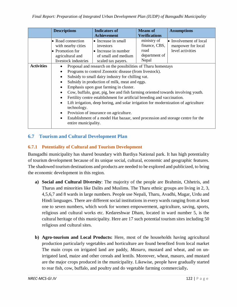
Final Report: Preparation of Integrated Urban Development Plan (IUDP) of Bansgadhi Municipality
NREC-MCS-GI JV 122 | P a g e
Descriptions Indicators of
Achievement
Means of
Verifications
Assumptions
Road connection with nearby cities
Promotion for
agricultural and
livestock industries
Increase in small investors
Increase in number
of small and medium
scaled tax payers.
ministry of
finance, CBS,
road department of
Nepal
Involvement of local manpower for local
level activities
Activities Proposal and research on the possibilities of Tharu homestays
Programs to control Zoonotic disease (from livestock).
Subsidy to small dairy industry for chilling vat.
Subsidy in production of milk, meat and eggs.
Emphasis upon goat farming in cluster.
Cow, buffalo, goat, pig, bee and fish farming oriented towards involving youth.
Fertility centre establishment for artificial breeding and vaccination.
Lift irrigation, deep boring, and solar irrigation for modernization of agriculture technology.
Provision of insurance on agriculture.
Establishment of a model Hat bazaar, seed procession and storage centre for the
entire municipality.
6.7 Tourism and Cultural Development Plan
6.7.1 Potentiality of Cultural and Tourism Development
Bansgadhi municipality has shared boundary with Bardiya National park. It has high potentiality
of tourism development because of its unique social, cultural, economic and geographic features.
The shadowed tourism destinations and products are needed to be explored and publicized, to bring
the economic development in this region.
a) Social and Cultural Diversity: The majority of the people are Brahmin, Chhetris, and
Tharus and minorities like Dalits and Muslims. The Tharu ethnic groups are living in 2, 3,
4,5,6,7 and 8 wards in large numbers. People use Nepali, Tharu, Avadhi, Magar, Urdu and
Hindi languages. There are different social institutions in every wards ranging from at least
one to seven numbers, which work for women empowerment, agriculture, saving, sports,
religious and cultural works etc. Kedareshwar Dham, located in ward number 5, is the
cultural heritage of this municipality. Here are 17 such potential tourism sites including 50
religious and cultural sites.
b) Agro-tourism and Local Products: Here, most of the households having agricultural
production particularly vegetables and horticulture are found benefited from local market
The main crops on irrigated land are paddy, Masuro, mustard and wheat, and on un-
irrigated land, maize and other cereals and lentils. Moreover, wheat, masuro, and mustard
are the major crops produced in the municipality. Likewise, people have gradually started
to rear fish, cow, buffalo, and poultry and do vegetable farming commercially.
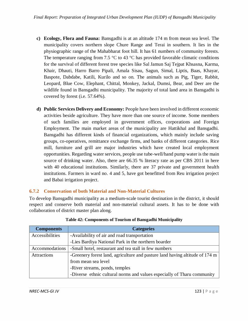
Final Report: Preparation of Integrated Urban Development Plan (IUDP) of Bansgadhi Municipality
NREC-MCS-GI JV 123 | P a g e
c) Ecology, Flora and Fauna: Bansgadhi is at an altitude 174 m from mean sea level. The
municipality covers northern slope Chure Range and Terai in southern. It lies in the
physiographic range of the Mahabharat foot hill. It has 61 numbers of community forests.
The temperature ranging from 7.5 °C to 43 °C has provided favorable climatic conditions
for the survival of different forest tree species like Sal Jamun Saj Tejpat Khsasna, Karma,
Khair, Dhauti, Harro Barro Pipali, Amala Sisau, Sagun, Simal, Liptis, Baas, Khayar,
Baspote, Dabdabe, Katili, Kurilo and so on. The animals such as Pig, Tiger, Rabbit,
Leopard, Blue Cow, Elephant, Chittal, Monkey, Jackal, Dumsi, Bear, and Deer are the
wildlife found in Bansgadhi municipality. The majority of total land area in Bansgadhi is
covered by forest (i.e. 57.64%).
d) Public Services Delivery and Economy: People have been involved in different economic
activities beside agriculture. They have more than one source of income. Some members
of such families are employed in government offices, corporations and Foreign
Employment. The main market areas of the municipality are Hattikhal and Bansgadhi.
Bansgadhi has different kinds of financial organizations, which mainly include saving
groups, co-operatives, remittance exchange firms, and banks of different categories. Rice
mill, furniture and grill are major industries which have created local employment
opportunities. Regarding water services, people use tube-well/hand pump water is the main
source of drinking water. Also, there are 66.35 % literacy rate as per CBS 2011 in here
with 40 educational institutions. Similarly, there are 37 private and government health
institutions. Farmers in ward no. 4 and 5, have got benefitted from Reu irrigation project
and Babai irrigation project.
6.7.2 Conservation of both Material and Non-Material Cultures
To develop Bansgadhi municipality as a medium-scale tourist destination in the district, it should
respect and conserve both material and non-material cultural assets. It has to be done with
collaboration of district master plan along.
Table 42: Components of Tourism of Bansgadhi Municipality
Components Categories
Accessibilities -Availability of air and road transportation
-Lies Bardiya National Park in the northern boarder
Accommodations -Small hotel, restaurant and tea stall in few numbers
Attractions
-Greenery forest land, agriculture and pasture land having altitude of 174 m
from mean sea level
-River streams, ponds, temples
-Diverse ethnic cultural norms and values especially of Tharu community

Final Report: Preparation of Integrated Urban Development Plan (IUDP) of Bansgadhi Municipality
NREC-MCS-GI JV 124 | P a g e
Amenities
-Traditional musical instruments Panche Baja and Bhajan Samuha (A group
of people singing a religious song with traditional musical instruments)
-Religious and cultural feasts and festivals as well as trade fares
-Local Tharu culture, indigenous technologies food products and festivals
Activities -Babai River (Babai Valley) bank beach sports, organic local food,
sightseeing, trekking and hiking
Actors
-Youth club, fathers group, mothers group, cultural groups, saving groups,
government and non-government organizations
Affinities -Mutual understanding among villagers belong to all the religious groups
Advertisements
-Descriptive information through maps and magazines
-Hosts request guests to visit again in the villages
-Networking with tour and travel agents
For the conservation of material and non-material cultures, following policy options are presented
below:
Integrated and facilitative infrastructure development in already available and newly explored
touristic sites.
Developing and differentiating the tourism sector and attracting foreign investors as well as
Non Residential Nepali.
Developing local level tourism development and management committee for planning,
implementing and monitoring tourism related projects providing tourism services.
Making arrangement for Tourist Police to advise and assist tourists in safety and security
during traveling, trekking, and other adventurous sports and night staying.
Promotion of sustainable livelihood program linking with tourism by commercialization of
rural products and providing training to them as of such.
Proper marketing of the tourism related services in national and international tourism market.
Establishment of cultural museum, fun parks, view towers and learning resource centers.
Table 43: Logical Framework Approach (LFA) of Tourism Development Plan
Logical framework Approach (LFA) of Tourism Development
Goals Develop tourism sector for economic progress and creating employment
opportunities.
Promote sustainable growth through the conservation of natural and
cultural resources.
Objectives To coordinate with public, private, cooperative and community sector to
promote and develop tourism.
To develop easy accessibility/connectivity with nearby touristic
destination.
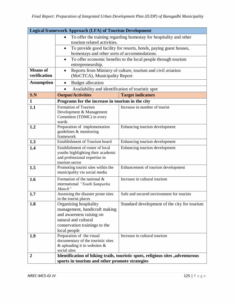
Final Report: Preparation of Integrated Urban Development Plan (IUDP) of Bansgadhi Municipality
NREC-MCS-GI JV 125 | P a g e
Logical framework Approach (LFA) of Tourism Development
To offer the training regarding homestay for hospitality and other
tourism related activities.
To provide good facility for resorts, hotels, paying guest houses,
homestays and other sorts of accommodations.
To offer economic benefits to the local people through tourism
entrepreneurship.
Means of
verification Reports from Ministry of culture, tourism and civil aviation
(MoCTCA), Municipality Report
Assumption Budget allocation
Availability and identification of touristic spot
S.N Output/Activities Target indicators
1 Programs for the increase in tourism in the city
1.1 Formation of Tourism Development & Management
Committee (TDMC) in every
wards
Increase in number of tourist
1.2 Preparation of implementation guidelines & monitoring
framework
Enhancing tourism development
1.3 Establishment of Tourism board Enhancing tourism development
1.4 Establishment of roster of local
youths highlighting their academic
and professional expertise in
tourism sector
Enhancing tourism development
1.5 Promoting tourist sites within the
municipality via social media
Enhancement of tourism development
1.6 Formation of the national &
international “Youth Samparka
Manch”
Increase in cultural tourism
1.7 Assessing the disaster prone sites in the tourist places
Safe and secured environment for tourists
1.8 Organizing hospitality
management, handicraft making
and awareness raising on
natural and cultural
conservation trainings to the
local people
Standard development of the city for tourism
1.9 Preparation of the visual
documentary of the touristic sites
& uploading it in websites & social sites
Increase in cultural tourism
2 Identification of hiking trails, touristic spots, religious sites ,adventurous
sports in tourism and other promote strategies
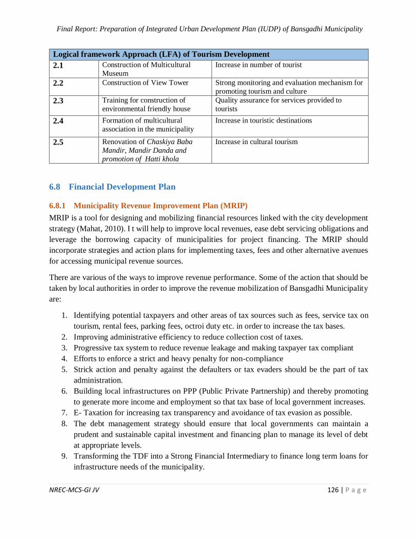
Final Report: Preparation of Integrated Urban Development Plan (IUDP) of Bansgadhi Municipality
NREC-MCS-GI JV 126 | P a g e
Logical framework Approach (LFA) of Tourism Development
2.1 Construction of Multicultural
Museum
Increase in number of tourist
2.2 Construction of View Tower Strong monitoring and evaluation mechanism for
promoting tourism and culture
2.3 Training for construction of
environmental friendly house
Quality assurance for services provided to
tourists
2.4 Formation of multicultural
association in the municipality
Increase in touristic destinations
2.5 Renovation of Chaskiya Baba
Mandir, Mandir Danda and promotion of Hatti khola
Increase in cultural tourism
6.8 Financial Development Plan
6.8.1 Municipality Revenue Improvement Plan (MRIP)
MRIP is a tool for designing and mobilizing financial resources linked with the city development
strategy (Mahat, 2010). I t will help to improve local revenues, ease debt servicing obligations and
leverage the borrowing capacity of municipalities for project financing. The MRIP should
incorporate strategies and action plans for implementing taxes, fees and other alternative avenues
for accessing municipal revenue sources.
There are various of the ways to improve revenue performance. Some of the action that should be
taken by local authorities in order to improve the revenue mobilization of Bansgadhi Municipality
are:
1. Identifying potential taxpayers and other areas of tax sources such as fees, service tax on
tourism, rental fees, parking fees, octroi duty etc. in order to increase the tax bases.
2. Improving administrative efficiency to reduce collection cost of taxes.
3. Progressive tax system to reduce revenue leakage and making taxpayer tax compliant
4. Efforts to enforce a strict and heavy penalty for non-compliance
5. Strick action and penalty against the defaulters or tax evaders should be the part of tax
administration.
6. Building local infrastructures on PPP (Public Private Partnership) and thereby promoting
to generate more income and employment so that tax base of local government increases.
7. E- Taxation for increasing tax transparency and avoidance of tax evasion as possible.
8. The debt management strategy should ensure that local governments can maintain a
prudent and sustainable capital investment and financing plan to manage its level of debt
at appropriate levels.
9. Transforming the TDF into a Strong Financial Intermediary to finance long term loans for
infrastructure needs of the municipality.
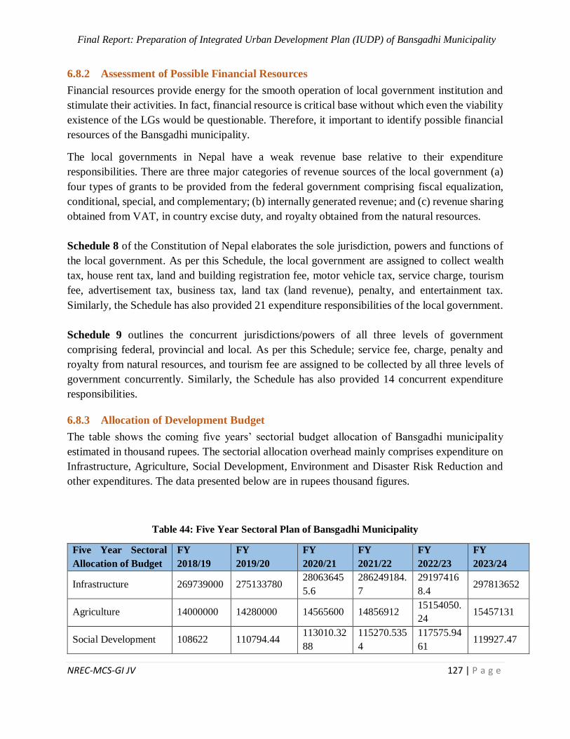
Final Report: Preparation of Integrated Urban Development Plan (IUDP) of Bansgadhi Municipality
NREC-MCS-GI JV 127 | P a g e
6.8.2 Assessment of Possible Financial Resources
Financial resources provide energy for the smooth operation of local government institution and
stimulate their activities. In fact, financial resource is critical base without which even the viability
existence of the LGs would be questionable. Therefore, it important to identify possible financial
resources of the Bansgadhi municipality.
The local governments in Nepal have a weak revenue base relative to their expenditure
responsibilities. There are three major categories of revenue sources of the local government (a)
four types of grants to be provided from the federal government comprising fiscal equalization,
conditional, special, and complementary; (b) internally generated revenue; and (c) revenue sharing
obtained from VAT, in country excise duty, and royalty obtained from the natural resources.
Schedule 8 of the Constitution of Nepal elaborates the sole jurisdiction, powers and functions of
the local government. As per this Schedule, the local government are assigned to collect wealth
tax, house rent tax, land and building registration fee, motor vehicle tax, service charge, tourism
fee, advertisement tax, business tax, land tax (land revenue), penalty, and entertainment tax.
Similarly, the Schedule has also provided 21 expenditure responsibilities of the local government.
Schedule 9 outlines the concurrent jurisdictions/powers of all three levels of government
comprising federal, provincial and local. As per this Schedule; service fee, charge, penalty and
royalty from natural resources, and tourism fee are assigned to be collected by all three levels of
government concurrently. Similarly, the Schedule has also provided 14 concurrent expenditure
responsibilities.
6.8.3 Allocation of Development Budget
The table shows the coming five years’ sectorial budget allocation of Bansgadhi municipality
estimated in thousand rupees. The sectorial allocation overhead mainly comprises expenditure on
Infrastructure, Agriculture, Social Development, Environment and Disaster Risk Reduction and
other expenditures. The data presented below are in rupees thousand figures.
Table 44: Five Year Sectoral Plan of Bansgadhi Municipality
Five Year Sectoral
Allocation of Budget
FY
2018/19
FY
2019/20
FY
2020/21
FY
2021/22
FY
2022/23
FY
2023/24
Infrastructure 269739000 275133780 28063645
5.6
286249184.
7
29197416
8.4 297813652
Agriculture 14000000 14280000 14565600 14856912 15154050.
24 15457131
Social Development 108622 110794.44 113010.32
88
115270.535
4
117575.94
61 119927.47
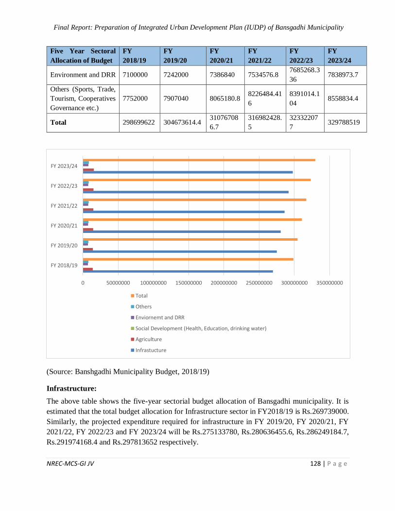
Final Report: Preparation of Integrated Urban Development Plan (IUDP) of Bansgadhi Municipality
NREC-MCS-GI JV 128 | P a g e
Five Year Sectoral
Allocation of Budget
FY
2018/19
FY
2019/20
FY
2020/21
FY
2021/22
FY
2022/23
FY
2023/24
Environment and DRR 7100000 7242000 7386840 7534576.8 7685268.3
36 7838973.7
Others (Sports, Trade,
Tourism, Cooperatives
Governance etc.)
7752000 7907040 8065180.8 8226484.41
6
8391014.1
04 8558834.4
Total 298699622 304673614.4 31076708
6.7
316982428.
5
32332207
7 329788519
(Source: Banshgadhi Municipality Budget, 2018/19)
Infrastructure:
The above table shows the five-year sectorial budget allocation of Bansgadhi municipality. It is
estimated that the total budget allocation for Infrastructure sector in FY2018/19 is Rs.269739000.
Similarly, the projected expenditure required for infrastructure in FY 2019/20, FY 2020/21, FY
2021/22, FY 2022/23 and FY 2023/24 will be Rs.275133780, Rs.280636455.6, Rs.286249184.7,
Rs.291974168.4 and Rs.297813652 respectively.
0 50000000 100000000 150000000 200000000 250000000 300000000 350000000
FY 2018/19
FY 2019/20
FY 2020/21
FY 2021/22
FY 2022/23
FY 2023/24
Total
Others
Enviornemt and DRR
Social Development (Health, Education, drinking water)
Agriculture
Infrastucture
Final Report: Preparation of Integrated Urban Development Plan (IUDP) of Bansgadhi Municipality
NREC-MCS-GI JV 129 | P a g e
Agriculture:
It is estimated that the total budget allocation for agriculture sector in FY2018/19 is Rs.14000000.
Similarly, the projected expenditure required for agriculture in FY 2019/20, FY2020/21, FY
2021/22, FY 2022/23 and FY 2023/24 will be Rs.14280000, Rs.14565600, Rs.14856912,
Rs.15154050.24 and Rs.15457131 respectively.
Social Development (Health, Education, Drinking Water):
It is estimated that the total budget allocation for social development sector in FY2018/19 is
Rs.108622. Similarly, the projected expenditure required for social development in FY 2019/20,
FY2020/21, FY 2021/22, FY 2022/23 and FY 2023/24 will be Rs.110794.44, Rs.113010.3288,
Rs.115270.5354, Rs.117575.9461 and Rs.119927.47 respectively.
Environment and Disaster Risk Reduction:
It is estimated that the total budget allocation for Environment and Disaster Risk Reduction sector
in FY2018/19 is Rs.7100000. Similarly, the projected expenditure required for Environment and
Disaster Risk Reduction in FY 2019/20, FY2020/21, FY 2021/22, FY 2022/23 and FY 2023/24
will be Rs.7242000, Rs.7386840, Rs.7534576.8, Rs.7685268.336 and Rs.7838973.7 respectively.
Other Sector (Sports, Trade, Tourism, Cooperatives Governance etc.):
It is estimated that the total budget allocation for other sector (Sports, Trade, Tourism,
Cooperatives Governance etc.) in FY2018/19 is Rs.7752000. Similarly, the projected expenditure
required for other overhead in FY 2019/20, FY2020/21, FY 2021/22, FY 2022/23 and FY 2023/24
will be Rs.7907040, Rs.8065180.8, Rs.8226484.416, Rs.8391014.104 and 8558834.4 respectively.
6.8.4 Promotional Strategy for Private Sector and Civil Society
Civil society and private leadership tend to be micro in governance and development approach
focusing on implementation and acting as interlocutors of the people at community levels. Their
proximity to communities makes them excellent animators, good at the identification of local
needs and solutions. Therefore, there is need to promote the private and civil society by following
ways:
Developing honest partnerships with local governments. In order to increase transparency
in each and every aspects of local government
Engaging Private Sector and Civil Society in policy development, identification of issues
and acting as opinion makers as they are good at identifying local needs and solutions.
Engaging local government in local analysis, planning and implementation of governance
and development projects and programme, and sharing comparative advantages of private
and civil society in leadership, resources and capacities.
Building social capital by mobilizing citizen’s full participation in determining local
priorities and,
Final Report: Preparation of Integrated Urban Development Plan (IUDP) of Bansgadhi Municipality
NREC-MCS-GI JV 130 | P a g e
Capacity development through human resource development, other resources and
institutional capacitation in most of the basic social services areas, such as education,
health, water etc.
6.8.5 Economic and Financial Analysis
Agriculture is the main occupation and major source of livelihood in this municipality. The
development of market can provide aid in the commercialization of agricultural products, which
can help the agricultural products to identify its place, major agricultural products and pocket areas
inside and outside the municipality. In Bansgadhi municipality wide range of agricultural products
are produced and marketed in Lakhna, Uttarbhakhari, Bansghadi, Tharugaun, Motipur and
Hasnapur markets.
With commercialization of livestock attracting the present people, further financial help in the field
can aid for attracting more youth towards livestock farming. Provision of insurance may be a good
opportunity for new entrepreneur. It has a good road network to Kathmandu, Nepalgunj, Gulariya
and even neighboring country India which can be used for giving the production its due value. Reu
Irrigation Project and Babai Irrigation Project in this municipality promote the agricultural
products.
With easy availability of local manpower and local, the number of micro-enterprises can be
increased. With only a few products being focused by the available industries, there’s opportunity
to explore further especially with products of livestock especially as this is gaining popularity.
With road facilities (graveled and pitch) that joins the municipality to major market centers and
even other cities of the country, output of the enterprises can be well traded to those areas
The Bansgadhi municipality is rich in ecological and cultural diversity. Existing natural
environment, Bardiya national park and available other resources could be part of ecological
tourism. The opportunity for adventurous and natural tourism is high in this area.
Due to the good provision of roads and highway inside the municipality, there will be easy
transport of goods from the market. We can find cheap labor within the municipality attracting
large scale industries to be established along with FDI.
The projected revenue and expenditure of Banganga municipality suggests that there will always
be always fiscal deficit for next 15 years as per the projection. Banganga municipality requires that
each year’s budget be balanced. Balancing the budgets will require a combination of expenditure
reduction and/or increment in revenues.
6.8.6 Issues and Problems
Threat of wild animals due to lack of proper fencing.
Illegal transaction of forest materials.
Forest fire and damage of corps by wild animals.
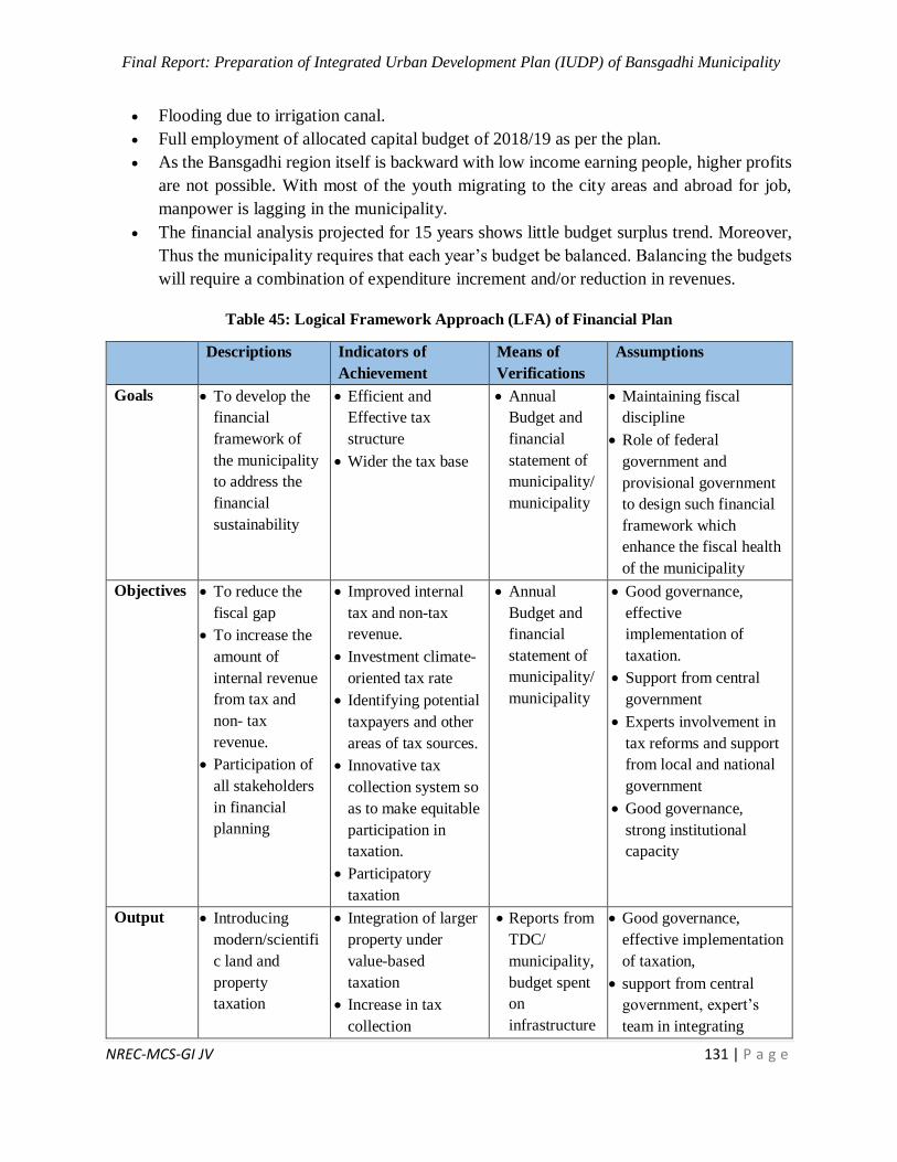
Final Report: Preparation of Integrated Urban Development Plan (IUDP) of Bansgadhi Municipality
NREC-MCS-GI JV 131 | P a g e
Flooding due to irrigation canal.
Full employment of allocated capital budget of 2018/19 as per the plan.
As the Bansgadhi region itself is backward with low income earning people, higher profits
are not possible. With most of the youth migrating to the city areas and abroad for job,
manpower is lagging in the municipality.
The financial analysis projected for 15 years shows little budget surplus trend. Moreover,
Thus the municipality requires that each year’s budget be balanced. Balancing the budgets
will require a combination of expenditure increment and/or reduction in revenues.
Table 45: Logical Framework Approach (LFA) of Financial Plan
Descriptions Indicators of
Achievement
Means of
Verifications
Assumptions
Goals To develop the
financial
framework of
the municipality
to address the
financial
sustainability
Efficient and
Effective tax
structure
Wider the tax base
Annual
Budget and
financial
statement of
municipality/
municipality
Maintaining fiscal
discipline
Role of federal
government and
provisional government
to design such financial
framework which
enhance the fiscal health
of the municipality
Objectives To reduce the
fiscal gap
To increase the
amount of
internal revenue
from tax and
non- tax
revenue.
Participation of
all stakeholders
in financial
planning
Improved internal
tax and non-tax
revenue.
Investment climate-
oriented tax rate
Identifying potential
taxpayers and other
areas of tax sources.
Innovative tax
collection system so
as to make equitable
participation in
taxation.
Participatory
taxation
Annual
Budget and
financial
statement of
municipality/
municipality
Good governance,
effective
implementation of
taxation.
Support from central
government
Experts involvement in
tax reforms and support
from local and national
government
Good governance,
strong institutional
capacity
Output Introducing
modern/scientifi
c land and
property
taxation
Integration of larger
property under
value-based
taxation
Increase in tax
collection
Reports from
TDC/
municipality,
budget spent
on
infrastructure
Good governance,
effective implementation
of taxation,
support from central
government, expert’s
team in integrating
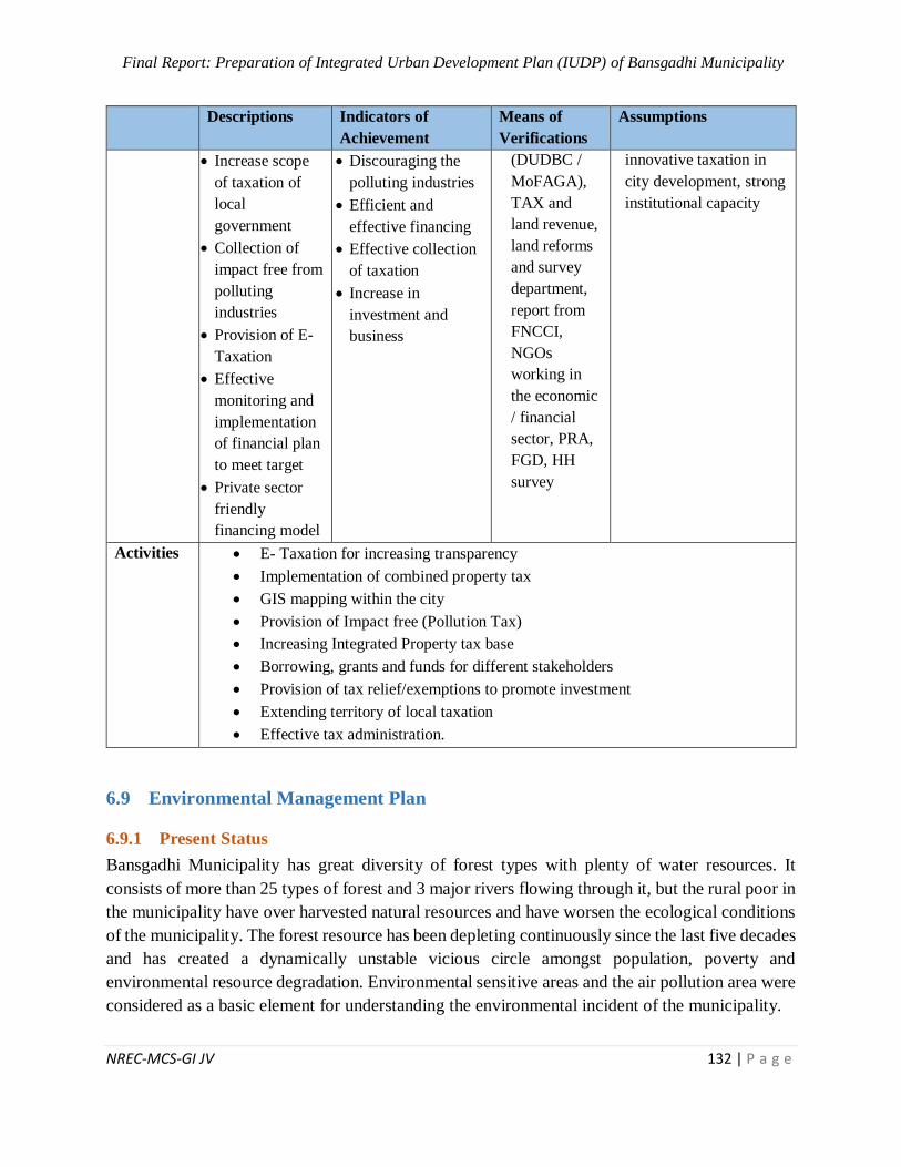
Final Report: Preparation of Integrated Urban Development Plan (IUDP) of Bansgadhi Municipality
NREC-MCS-GI JV 132 | P a g e
Descriptions Indicators of
Achievement
Means of
Verifications
Assumptions
Increase scope
of taxation of
local
government
Collection of
impact free from
polluting
industries
Provision of E-
Taxation
Effective
monitoring and
implementation
of financial plan
to meet target
Private sector
friendly
financing model
Discouraging the
polluting industries
Efficient and
effective financing
Effective collection
of taxation
Increase in
investment and
business
(DUDBC /
MoFAGA),
TAX and
land revenue,
land reforms
and survey
department,
report from
FNCCI,
NGOs
working in
the economic
/ financial
sector, PRA,
FGD, HH
survey
innovative taxation in
city development, strong
institutional capacity
Activities E- Taxation for increasing transparency
Implementation of combined property tax
GIS mapping within the city
Provision of Impact free (Pollution Tax)
Increasing Integrated Property tax base
Borrowing, grants and funds for different stakeholders
Provision of tax relief/exemptions to promote investment
Extending territory of local taxation
Effective tax administration.
6.9 Environmental Management Plan
6.9.1 Present Status
Bansgadhi Municipality has great diversity of forest types with plenty of water resources. It
consists of more than 25 types of forest and 3 major rivers flowing through it, but the rural poor in
the municipality have over harvested natural resources and have worsen the ecological conditions
of the municipality. The forest resource has been depleting continuously since the last five decades
and has created a dynamically unstable vicious circle amongst population, poverty and
environmental resource degradation. Environmental sensitive areas and the air pollution area were
considered as a basic element for understanding the environmental incident of the municipality.

Final Report: Preparation of Integrated Urban Development Plan (IUDP) of Bansgadhi Municipality
NREC-MCS-GI JV 133 | P a g e
I. Environment Sensitivity Areas
Among 9 wards have 5 wards environmentally sensitive areas constituting a total of 24.8 sq. km.
Ward 1 has problems of flood, landslide and drought while some part of ward 2, 4, 8 and 9 falls
under Bardiya National Park and includes some ecologically important areas.
II. Potential Air Pollution Areas
In Bansgadhi municipality, potential air pollution was mapped out using different criteria that are
responsible for pollution. Approximately, 8 sq. km area of ward no. 5 and 6 are most likely to be
effected from air pollution. To mitigate the air pollution, it is important to make the local people
of those wards aware about the concept of Reduce, Reuse and Recycle. Also, it is necessary to
motivate them to carry-out plantation in collaboration with the relevant stakeholders.
6.9.2 Issue and Problems
Housing and Urbanization
Like many other municipalities the development and urbanization is happening around the city
centers and along the major roads in a dispersed pattern creating unmanaged urban areas. Some
other specific major problems found in this municipality are loss of agricultural land due to urban
expansion, lack of enforcement of zoning in the urban areas, weak local government institutions
who handle urban problems, inadequate and unplanned road and migration of rural people to urban
area at an increasing rate.
Sanitation and Solid waste
There is lack of waste water management and solid waste management in the municipality. People
are not aware about the concept of reduce, reuse and recycle, also there is lack of proper and
sufficient no. of toilets in the area. There is no appropriate landfill site and septic tank system.
There is no compost system in the municipality. Solid waste management and open drainage
system are the main sanitation problem of this area which might be causative factors for water
borne diseases.
Agricultural Practices
Agriculture is the main occupation and major source of livelihood in the municipality but the
agriculture system is subsistence and traditional. Commercialization in agriculture is essential.
Vegetable farming and fish farming has been gradually increasing in the municipality but lack of
modern technology is major obstacle for agricultural commercialization. Irrigation is a primary
source for the agriculture to promote its productivity and commercialization. It is however partly
developed in Bansgadhi municipality of Bardiya.
Water Resources
The major rivers contributing the watershed area in the municipality are Babai River, Dunduwa
River and Gyang River. Drinking water supply and poor sanitation is one of the main
environmental issues in the municipality. Many wards in the municipality do not have good water
Final Report: Preparation of Integrated Urban Development Plan (IUDP) of Bansgadhi Municipality
NREC-MCS-GI JV 134 | P a g e
supply system. There are different sources of drinking water in Bansgadhi municipality out of
which tube well/hand pump water is the main source of drinking water. There is necessity of tap
in all households in the municipality.
Natural Resources and Biodiversity
The rural poor in the municipality have over harvested natural resources and have worsen the
ecological conditions of the municipality. The municipality is rich in natural resources and the
forest resource has been depleting continuously since the last five decades. This has created a
dynamically unstable vicious circle amongst population, poverty and environmental resource
degradation.
Education and Awareness
There is lack of higher secondary school and college near municipality so many students leave
study after SLC. Also there is lack of sufficient appointment of technical manpower in education
and upgradation of existing social and physical infrastructure of existing schools and community
schools. The level of environmental awareness is generally low. This does much to exacerbate the
process of environmental degradation.
Health
There are few health posts in different wards but there is lack of urban scale health institutions
with good facilities.
6.9.3 Strategy for Environment Management Plan
1. Provision of decision making to keep a proper environment
2. Use minimum resources with maximum efficiency
3. Use of renewable resources
4. Enhancement of natural areas along with ecosystem health
5. Sustainable development in urban and rural areas
6. Promotion of environment friendly materials
7. Disposal of treated effluent
8. Promotion of 3R (Reduce, Reuse and Recycle) concept for solid waste management
9. Development of proper drainage system
Final Report: Preparation of Integrated Urban Development Plan (IUDP) of Bansgadhi Municipality
NREC-MCS-GI JV 135 | P a g e
Table 46: Logical Framework Approach (LFA) of Environmental Management Plan
Descriptions Indicators of
Achievement
Means of Verifications Assumptions
Goals
To build green, clean and healthy
city
Eco friendly and
sustainable infrastructure
development
Reports from
Department of
Environment,
Department of Forests,
City Profile
Approval and
implementation of
IUDP budget
allocation
Objectives
To prevent and solve
environmental problems
To develop monitoring systems
To warn threats and identify
opportunities
To suggest measures for resource
conservation
To develop a strategy for the
improvement of quality of life
To suggest long-term and short-
term policies for sustainable
development
To raise awareness among locals
Use of renewable
resources
Use of non-waste
technology
Proper drainage and
waste management
system
Less pollution
Conserved water bodies,
forest and agricultural
land
Improvement in quality
of life
Sustainable development
of resources
Knowledge of
environmental benefits
and problems to the
locals
Reports from
Department of
Environment,
Department of Forests,
City Profile,
Department of
Hydrology and
Meteorology,
DCC/municipal office,
DoR and I/NGOs
Approval and
implementation of
IUDP
Availability of
alternatives
Implementation of
land use plan
Maintenance of open
spaces
Final Report: Preparation of Integrated Urban Development Plan (IUDP) of Bansgadhi Municipality
NREC-MCS-GI JV 136 | P a g e
Descriptions Indicators of
Achievement
Means of Verifications Assumptions
Output
Less use of non-renewable
resources
Less use of chemical fertilizers
and pesticides
Better provision for waste
management and sewerage
system
Suitable site for landfill
Conservation of water and natural
resources
Aware local people about
environmental issues and
solutions as well
Promotion of renewable
resources and farm yard
manure and compost
fertilizers
Sewerage and waste
management system
Control of pollution
Conserved water sources,
forest areas and disturbed
areas
Reports from
Department of
Environment,
Department of Forests,
City Profile,
Department of
Hydrology and
Meteorology,
DCC/municipal office,
DoR and I/NGOs,
PRA, FGD, HH
survey
Maintenance and
care of plants
Public preference
Surveillance by
concerned authority
Availability of space
Activities
Formulating policies, plans related to environmental conservation and their implementation
Plantation on barren lands
Conservation of natural resources
Improving waste management system and developing proper sewerage system
Forming awareness programs
Promoting use of farm yard manure and compost fertilizers
Final Report: Preparation of Integrated Urban Development Plan (IUDP) of Bansgadhi Municipality
NREC-MCS-GI JV 137 | P a g e
6.10 Disaster Risk Management Plan
6.10.1 Present Status
Bansgadhi municipality faces many natural hazards due to absence of effective disaster
management plan. Babai River cutting and flooding are the major environmental problems of
Bansgadhi municipality. Babai River cuts in its bank occasionally. According to intuitional survey,
2018, during the year (2015-2017) 7 People died from flood in the municipality. Major portion of
the municipality is covered with forests so there is significant risk of forest fire as well. Bansgadhi
municipality is located in proximity with Bardiya National Park and thus faces many animal
attacks. There are also major risks from hazards like landslides. Disaster management plan
therefore needs to be specific addressing all the issues and causative agents of disasters in
Bansgadhi municipality. High population growth with haphazard migration and encroachment
into marginal land, ecologically sensitive areas, deforestation, agricultural activities on steep
slopes, lack of disaster awareness and preparedness have resulted in vulnerability of natural
resources and communities of Bansgadhi municipality. These hazards mixed with vulnerabilities
have contributed to turning the hazard events into disasters with large numbers of casualties and
huge damage and loss of homes and assets every year.
6.10.2 Issues and Problems
Landslide Risk
Landslide risk analysis was done through GIS by analyzing various driving factors of landslide,
various data including Normalized Difference Vegetation Index (NDVI), Precipitation data, Slope
and elevation data were used to carry-out geo-spatial analysis to identify the areas prone to
landslide.
Flood Risk
Flood risk analysis was done through GIS by analyzing various driving factors of flood, various
data including Normalized Difference Vegetation Index (NDVI), stream order, Slope and elevation
data were used to carry-out geo-spatial analysis to identify the areas prone to flood. The settlement
areas located near to the river bank are more prone to flooding and others natural hazards. Million
tons of soil nutrients are lost annually from agricultural land as a result of soil erosion and flooding.
The assessment of the flood area indicates that vulnerable area lying in flood plain area, need
immediate action to take against flood such as river training or embankment or levee construction
to protect the given area from further degradation due to flood. Ward no. 5 and 8 are not much
effected by the flood while remaining ward are affected by flood among which ward no 3 is in
high risk of flood. Overall, 2583.76 Ha of total area is in the risk of flood, where 1.57 ha area in
ward no. 3 is in high risk of flood.
Final Report: Preparation of Integrated Urban Development Plan (IUDP) of Bansgadhi Municipality
NREC-MCS-GI JV 138 | P a g e
Fire Risk
The municipality consists of 40 community forests areas and thus also has risk of forest fire. The
practice of constructing houses using thatch/straw for roofing is not common, clustered settlement
in market areas, careless smoking and negligence in cooking create less risk of fire in the settlement
areas. Forest fire is likely to occur during the windy and the dry season e.g. Chaitra & Baisakh.
Ward number 1, 2, 3, 7, 8 and 9 are more susceptible to forest fire. The lack of equipment and
skilled human resources such as trained fire fighters pose serious challenges in the municipality.
Other Risk
Loss of cultivated land, grass/grazing and forest land due to river encroachment is some common
problems, while in some parts abandoned by channels or old riverbeds have been brought into
cultivation or reused as grazing areas or used for tree plantations in hazard areas. The river
morphology is unpredictable i.e. increase bank cutting, bifurcation and flooding which one is
common problem and reoccur every year.
Regarding this, sand extraction is also common in some rivers for household purpose causing huge
impact on riverine environment such as destruction of aquatic habitat, flooding, change in river
morphology etc. There is deforestation and habitat degradation in all wards due to construction of
rural roads. The big settlement areas are located near to forest area causing further degradation of
forest. Another major disaster is the drought. Drought is a natural phenomenon that has drastic
implications on human lives, food insecurity and natural resources degradation.
Due to drought peoples are suffering from water shortages affecting agriculture, with social
consequences such as famine, hunger, and migration. Drought risk analysis was done through GIS
by analyzing various driving factors of drought; data including Normalized Difference Vegetation
Index (NDVI) and Normalized Difference Water Index (NDWI) were used to carry-out geo-spatial
analysis to identify the areas prone to drought. In Bansgadhi municipality, 34.1 sq. km of total area
is likely to be affected from the drought. Ward no. 3, 5, 6, 7 and 9 seems to be highly susceptible
to drought.
6.10.3 Adaptation Strategy for Disaster Management
❖ Ensure that disaster risk reduction is a priority with a strong basis for implementation
❖ Identify, assess and monitor disaster risks and enhance early warning
❖ Use education and innovation to build a culture of safety and resilience at all levels
❖ Reduce the underlying risk factors
❖ Strengthen disaster preparedness for effective response.
❖ Promote awareness campaign regarding pre-disaster and post-disaster events.
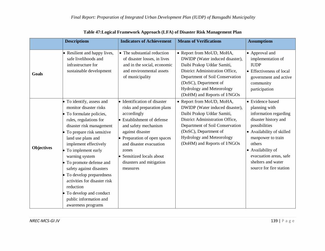
Final Report: Preparation of Integrated Urban Development Plan (IUDP) of Bansgadhi Municipality
NREC-MCS-GI JV 139 | P a g e
Table 47:Logical Framework Approach (LFA) of Disaster Risk Management Plan
Descriptions Indicators of Achievement Means of Verifications Assumptions
Goals
Resilient and happy lives,
safe livelihoods and
infrastructure for
sustainable development
The substantial reduction
of disaster losses, in lives
and in the social, economic
and environmental assets
of municipality
Report from MoUD, MoHA,
DWIDP (Water induced disaster),
Daibi Prakop Uddar Samiti,
District Administration Office,
Department of Soil Conservation
(DoSC), Department of
Hydrology and Meteorology
(DoHM) and Reports of I/NGOs
Approval and
implementation of
IUDP
Effectiveness of local
government and active
community
participation
Objectives
To identify, assess and
monitor disaster risks
To formulate policies,
rules, regulations for
disaster risk management
To prepare risk sensitive
land use plans and
implement effectively
To implement early
warning system
To promote defense and
safety against disasters
To develop preparedness
activities for disaster risk
reduction
To develop and conduct
public information and
awareness programs
Identification of disaster
risks and preparation plans
accordingly
Establishment of defense
and safety mechanism
against disaster
Preparation of open spaces
and disaster evacuation
zones
Sensitized locals about
disasters and mitigation
measures
Report from MoUD, MoHA,
DWIDP (Water induced disaster),
Daibi Prakop Uddar Samiti,
District Administration Office,
Department of Soil Conservation
(DoSC), Department of
Hydrology and Meteorology
(DoHM) and Reports of I/NGOs
Evidence based
planning with
information regarding
disaster history and
possibilities
Availability of skilled
manpower to train
others
Availability of
evacuation areas, safe
shelters and water
source for fire station
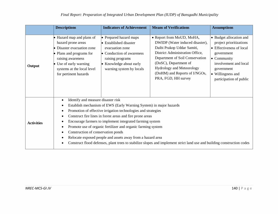
Final Report: Preparation of Integrated Urban Development Plan (IUDP) of Bansgadhi Municipality
NREC-MCS-GI JV 140 | P a g e
Descriptions Indicators of Achievement Means of Verifications Assumptions
Output
Hazard map and plans of
hazard prone areas
Disaster evacuation zone
Plans and programs for
raising awareness
Use of early warning
systems at the local level
for pertinent hazards
Prepared hazard maps
Established disaster
evacuation zone
Conduction of awareness
raising programs
Knowledge about early
warning system by locals
Report from MoUD, MoHA,
DWIDP (Water induced disaster),
Daibi Prakop Uddar Samiti,
District Administration Office,
Department of Soil Conservation
(DoSC), Department of
Hydrology and Meteorology
(DoHM) and Reports of I/NGOs,
PRA, FGD, HH survey
Budget allocation and
project prioritizations
Effectiveness of local
government
Community
involvement and local
government
Willingness and
participation of public
Activities
Identify and measure disaster risk
Establish mechanism of EWS (Early Warning System) in major hazards
Promotion of effective irrigation technologies and strategies
Construct fire lines in forest areas and fire prone areas
Encourage farmers to implement integrated farming system
Promote use of organic fertilizer and organic farming system
Construction of conservation ponds
Relocate exposed people and assets away from a hazard area
Construct flood defenses, plant trees to stabilize slopes and implement strict land use and building construction codes
Final Report: Preparation of Integrated Urban Development Plan (IUDP) of Bansgadhi Municipality
NREC-MCS-GI JV 141 | P a g e
6.11 Climate Change Adaptation Plan
The impacts of climate change are already being witnessed globally. In particular, Least Developed
Countries (LDCs), as defined by the United Nations (UN), “are highly vulnerable to economic and
environmental shocks and have low levels of human assets”.
6.11.1 Present Status
Bansgadhi Municipality is particularly vulnerable to climate change impacts for a variety of
environmental, social, and economic reasons. In addition, Bansgadhi experiences heavy monsoon
events which contribute to natural disasters such as food, river cutting and landslides. Last but
unfortunately not least, Bansgadhi municipality experiences high flood activity each year. Natural
disasters such as those described are anticipated to increase in frequency and intensity if not
planned earlier.
Based on priority risks (and eventually opportunities), adaptation goals, objectives and targets will
vary from one community to another one as a consequence of various factors, such as types and
magnitude of projected climatic changes and impacts, availability of financial resources, areas on
which the community has direct responsibilities and influence. This means that it is not possible
to prescribe them in general, but they will have to be selected case by case, community by
community. Hence, this climate change adaptation plan will guide all the stakeholders with
upcoming possible actions that can be taken to cope with the consequences of the climate change.
Poverty and a lack of individual and institutional capacity are the primary reasons that the
population of Bansgadhi is particularly vulnerable to climactic changes. In addition, about 15% of
the population relies directly on agriculture for their livelihood and the sector contributes one-
quarter of Nepal’s gross domestic product; regrettably, agriculture is highly sensitive to climactic
and biophysical changes. The population of Bansgadhi are the much vulnerable to climate change,
largely due to high reliance on subsistence agriculture.
6.11.2 Issues and Problems of Disaster
Agriculture and Food Security
The productivity and the quality of agricultural products is decreasing due to the change in
precipitation, temperature, occurrence of drought, new plant diseases and pathogens etc.
Therefore, people have started to use chemical fertilizers, pesticides and insecticides in excessive
amount to enhance the productivity. Chemical fertilizers increase the productivity in short term
but do not increase the quality of soil in long term, also they have different harmful effects on the
land and health of people who use or consume the products. The chemicals are absorbed in the soil
and are transported with rain water to various water bodies in the watershed, also they are
associated with other problems such as chemical burn to crops, increased air pollution,
acidification of the soil and mineral depletion of the soil, salinization etc. Similarly, the credits of
pesticides include enhanced economic potential in terms of increased production of food and fiber,
Final Report: Preparation of Integrated Urban Development Plan (IUDP) of Bansgadhi Municipality
NREC-MCS-GI JV 142 | P a g e
and amelioration of vector-borne diseases, and then their debits have resulted in serious health
implications to people and environment. There is now overwhelming evidence that some of these
chemicals do pose a potential risk to humans and other life forms and unwanted side effects to the
environment.
Forest and Biodiversity
Ecosystem and climate models suggest that climate change will have a variety of impacts on the
distribution of forest organisms and populations as well as impact ecosystem function and
composition. In general, it is expected that habitats will shift towards the poles and move upwards
in elevation. With the shift of these habitats, forest biodiversity will be forced to adapt and as a
result, species compositions in forests is likely to change and those species and populations which
are already vulnerable will potentially become extinct. Further with climate change there will be a
greater incidence of extreme climatic events, such as floods and droughts. These types of events
will further affect forest plant and animal populations and can leave forests more prone to
disturbances such as fire and diseases. The impacts of climate change have already been started in
this municipality such as early flowering, unseasonal raining, drought, heavy rainfall, introduction
of invasive or alien species, new type of plant pathogens etc. This situation eventually affecting to
people living in rural and remote areas where their livelihoods are highly dependent on forests and
biodiversity for the ecosystem services they provide.
Water Resources
Erratic and excessive precipitation is common phenomenon in the Terai belt of Nepal. Because of
the heavy rainfall, high wind speed and river cutting in the municipality soil erosion in a common
problem which gradually decreases the productivity of land. In the lower belt, there is problem of
waterlogging and clean drinking water due to poor drain system of urban areas as well as the use
of chemicals in the agricultural land. In the Whole municipality, the Ground water is shrinking
that leads to shortage of drinking water.
Human Health
The socioeconomic costs of health problems caused by climate change are considerable. Many
diseases are associated with the local climate combined with the sanitation status of the area;
diseases such as diarrhea are most common in summer when the temperature and precipitation is
high. New borne diseases are seen which were not common in previous time. Climate change is
bringing new and emerging health issues which will lead to increased risk of cardiovascular,
respiratory and renal diseases in the municipality.
6.11.3 Adaptation Strategy for Climate Change Mitigation
Create awareness on climate change and its adaptation strategies
Increase the use of efficient domestic appliances
Improve environmental sanitation by strengthening institutions and enforcement of laws
and bye laws
Final Report: Preparation of Integrated Urban Development Plan (IUDP) of Bansgadhi Municipality
NREC-MCS-GI JV 143 | P a g e
Promote the development of modern information management system
Identify gaps in existing land-use regulations and review policies to deal with land
management issues
Preserve/conserve water resources
Build and strengthen capacity of local farmers to increase agricultural productivity and
awareness of climate issues.
Table 48: Logical Framework Approach (LFA) Climate Change Adaptation Plan
Descriptions Indicators of
Achievement
Means of
Verifications
Assumptions
Goals
To strengthen resilience, adaptive
capacity and reduce
vulnerability to the
adverse impacts of climate change
Climate responsive built
environment
Report from Meteorological
Forecasting
Division, DOE,
city profile, Department of
Hydrology
Approval and implementation
of IUDP budget
allocation
Objectives
To improve
awareness and preparedness for
future climate
change
To mitigate climate
change impact and promote adaptation
strategies
To increase the
robustness of infrastructure
development
To conserve and
enhance the health of natural system
Increase in level of awareness and
preparedness of
locals
Use of effective
technology
Mitigation of impacts of climate
change
Good condition of
infrastructure
Healthy natural system
Report from
Meteorological Forecasting
Division, DOE,
city profile,
Department of Hydrology and
Meteorology,
Analysis of climate change
data over period
of time and reports from
I/NGOs
Budget
allocation for campaign
Impact of global
warming
Availability of
land for
industrial zone
Output
Locals aware about
impacts of climate
change
Development of mitigation and
adaptation strategies
of climate change
Infrastructure robustness increased
Sufficient ground
water recharge and
rain on time
Sensitized locals
about climate
change
Mitigation and adaptation
strategy
development
Sustainable development of
infrastructure
Report from Meteorological
Forecasting
Division, DOE, city profile,
Department of
Hydrology and Meteorology,
Analysis of
climate change
data over period of time and
reports from
Budget for program and
campaign
Availability of
climate responsive
material
Implementation
of IDP
Impact of global warming
Implementation
of IDP bye laws

Final Report: Preparation of Integrated Urban Development Plan (IUDP) of Bansgadhi Municipality
NREC-MCS-GI JV 144 | P a g e
Descriptions Indicators of
Achievement
Means of
Verifications
Assumptions
Increase in
ground water
table
I/NGOs, PRA,
FGD, HH survey Material used in
roads and
pavements
Availability of land for
industrial zone
Activities
Formation of climate change adaptation specific policies, programmes and plans and
their effective implementation
Replacing traditional and fossil fuels by clean energy alternatives
Promoting diversified agricultural production to reduce climate risk
Encouraging agroforestry in private land
Promoting water conservation and rainwater harvesting in areas where there is stress due to climate change
Promotion of sustainable forest management
Training to local farmers on growing off-season vegetables
Promoting use of farm yard manure and compost fertilizers
Developing systems for monitoring drinking water, food and air quality in affected
areas
6.12 Institutional Development Plan
Institutional development plan for Bansgadhi municipality has been prepared in order to support
and execute the IUDP in long run. The present status of the HR management shows that there are
75 persons employed in this municipality which also includes the people working in ward offices.
The municipality has following sections in its service delivery:
Administration
Education
Revenue
Account
Technical
Agricultural
Veterinary
Women and children welfare
The service delivery and good governance system in the municipality could be promoted along
with the increment of this number along with the widening of sectoral services and workforces. It
would thus contribute the proper execution of Local Government Operation Act, 2017 in the
changing context of federalism.
Final Report: Preparation of Integrated Urban Development Plan (IUDP) of Bansgadhi Municipality
NREC-MCS-GI JV 145 | P a g e
Table 49: LFA for Institutional Development
Logical Framework Approach (LFA) of Institutional Development
Goals Promote good governance along with transparency, accountability, right
to information, and responsibility
Objectives
Strengthen the organizational capacity and scientific human resource
and leadership development
Promote sensitization and we-feeling of local heritage, resource, skills,
indigenous practices and appropriate technologies
Enhance alternatives of development for the benefit of the local
community and its identity in the long-run
Legislation and implementation of IUDP
Means of
verification
Reports from Ministry of Federal Affairs and General Administration
(MoFAGA), Municipality Report
Assumption IUDP as a municipal plan and availability of skilled HR
S.N Output/Activities Target indicators
1 Putting in place a fair and effective
property taxation system. % increase in tax/ revenue collection
2 Action Plan for a New Local
Governance System in the municipality
Increased implementation of IUDP
and linkage to the Provicnal
government
3 Establishment and restructuring of
service deliveries
Reduced rate of service delivery
delay
4 Devolution of resources along with the
authority % increased sectoral performances
5
Increasing performance and capacity
building of the government employees
with regular training and exchange of
knowledge within the department
Increased number of training and
capability formation activities
Increment in performed services
6 Integrated service through single
window system
Formation of integrated service
center (City Center)
7
Separate authority for monitoring and
evaluation of public services and
projects
Increased People’s participation
Rate of project completion
increased
Proposed Additional sections for IUDP (along with continuation of existing)
Final Report: Preparation of Integrated Urban Development Plan (IUDP) of Bansgadhi Municipality
NREC-MCS-GI JV 146 | P a g e
Logical Framework Approach (LFA) of Institutional Development
GIS and database section
Child and women welfare section
Youth and sport section
Indigenous knowledge and technology section
Tourism development and hospitality section
Research and development section
Monitoring and evaluation section
Social and cultural development section
Land use and management section
Agriculture development section
Banking and co-operative section
Human resource section
Good governance and leadership section
IUDP steering section
6.12.1 Issues and Challenges
Current local governance legislation is prescriptive in nature. A balanced approach
will be required going forward
Lack of sufficient appointment of technical manpower and up-gradation of existing
infrastructure of services
Local government and leadership incepted since 2017 in the federal context along with
the issues of children, women, youth, elderly people and marginalized communities/
groups
Abundant of natural resources in the municipality to foster socio-economic
development of the municipality
Institutional problems related to capacity building and offices infrastructures
Special focus on education, health and social sector; Public hearing, participatory
planning, and platform of grassroots democracy
The long-term vision of Bansgadhi municipality has two dimensions: beautiful, green and clean
city (;'Gb/ xl/ofnL / ;kmf zx/ ) and prosperous and developed city ( ;d[4 / ;d'Ggt afF;u9L gu/
). With the above selected vision slogan, it truly clarifies the people of Bansgadhi are confident
that their municipality will only prosper through proper and strategic development plans oriented
towards clean and beautiful Bansgadhi municipality. Sectoral policies, strategies and institutional
set-up should be accordingly devised. For this, an institutional development plan seems to be a
vital one in achieving the municipal vision and mission at large by involving different sections of
service delivery and components of good governance.
Final Report: Preparation of Integrated Urban Development Plan (IUDP) of Bansgadhi Municipality
NREC-MCS-GI JV 147 | P a g e
7 CHAPTER VII: MULTI SECTOR INVESTMENT PLAN (MSIP)
As we’ve already discussed in earlier sections of financial plan and economic development plan,
a city development of 15-year plan with ambition of one lakh population needs lots of investment.
With model of public private partnership modality of infrastructural Investment, it is also expected
to have investment of private sector in city infrastructure projects. Apart from security and major
strategic roads, in most of the sector we can expect the investment from private sectors and from
other donor agencies. We have to understand that this entire budget should be funneled down
through the single channel of local project implementation body, which could be TDC or any other
new autonomous body. For this projects are identified under different sections, which could be
new construction, upgrading existing scenario or upgrading the existing quality or capacity. With
some standard rate of similar contemporary projects, under different headings, cost estimation is
allocated. As we know that these development plans have target period of 15 years, we’ve divide
into 3 major milestones, short term, midterm and long term projects. Depending upon the priority
of the project and possible budget required, different projects are put under different time frame.
Some longer term projects may fall under different time period and some of the projects are
continuous process throughout the development, like: training and updating the institutional
capacity.
Highest investment is done under health and physical infrastructures. Apart from the road, health
and education are the most prioritized sector under social development plan to increase the
dependency of the town within VDC and between the cities. In yearly basis, budget will be spent
on training and awareness campaigns on various issues on longer term. It is also important to
consider that large amount of investment is under the recreation, where as that will be spent on
buying chunk of lands on urban areas, as the city is already grown or cost is very high. Good
investment is allocated on improving the institutional capacity of the different service oriented
institutions in the form of institutional development plan, financial plan or in terms of security as
well by making citizen friendly city.
Large investment is expected from private sectors as well, especially in the field of housing, job
opportunities, entertainments, recreations and others. Private sectors are obvious to focus on profit
oriented investment such as in industries, economic field along with some well-known field like
education and health. In the field of solid waste management, disaster risk mitigation plan,
environment conservation plan or in the field of climate change, non-governmental organizations
are expected to be in good part. Such national and international organizations will help to improve
the institutional capacity as well as promote the awareness regarding the topic. Finally, it is
expected that more participatory model of investment is promoted which not only eases the
investment burden of central government but also helps to build the ownership among the resident
of that city. Basic summary of the MSIP is shown below:
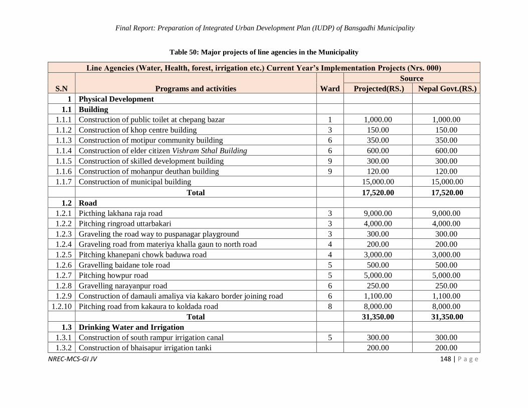
Final Report: Preparation of Integrated Urban Development Plan (IUDP) of Bansgadhi Municipality
NREC-MCS-GI JV 148 | P a g e
Table 50: Major projects of line agencies in the Municipality
Line Agencies (Water, Health, forest, irrigation etc.) Current Year’s Implementation Projects (Nrs. 000)
S.N Programs and activities Ward
Source
Projected(RS.) Nepal Govt.(RS.)
1 Physical Development
1.1 Building
1.1.1 Construction of public toilet at chepang bazar 1 1,000.00 1,000.00
1.1.2 Construction of khop centre building 3 150.00 150.00
1.1.3 Construction of motipur community building 6 350.00 350.00
1.1.4 Construction of elder citizen Vishram Sthal Building 6 600.00 600.00
1.1.5 Construction of skilled development building 9 300.00 300.00
1.1.6 Construction of mohanpur deuthan building 9 120.00 120.00
1.1.7 Construction of municipal building 15,000.00 15,000.00
Total 17,520.00 17,520.00
1.2 Road
1.2.1 Picthing lakhana raja road 3 9,000.00 9,000.00
1.2.2 Pitching ringroad uttarbakari 3 4,000.00 4,000.00
1.2.3 Graveling the road way to puspanagar playground 3 300.00 300.00
1.2.4 Graveling road from materiya khalla gaun to north road 4 200.00 200.00
1.2.5 Pitching khanepani chowk baduwa road 4 3,000.00 3,000.00
1.2.6 Gravelling baidane tole road 5 500.00 500.00
1.2.7 Pitching howpur road 5 5,000.00 5,000.00
1.2.8 Gravelling narayanpur road 6 250.00 250.00
1.2.9 Construction of damauli amaliya via kakaro border joining road 6 1,100.00 1,100.00
1.2.10 Pitching road from kakaura to koldada road 8 8,000.00 8,000.00
Total 31,350.00 31,350.00
1.3 Drinking Water and Irrigation
1.3.1 Construction of south rampur irrigation canal 5 300.00 300.00
1.3.2 Construction of bhaisapur irrigation tanki 200.00 200.00
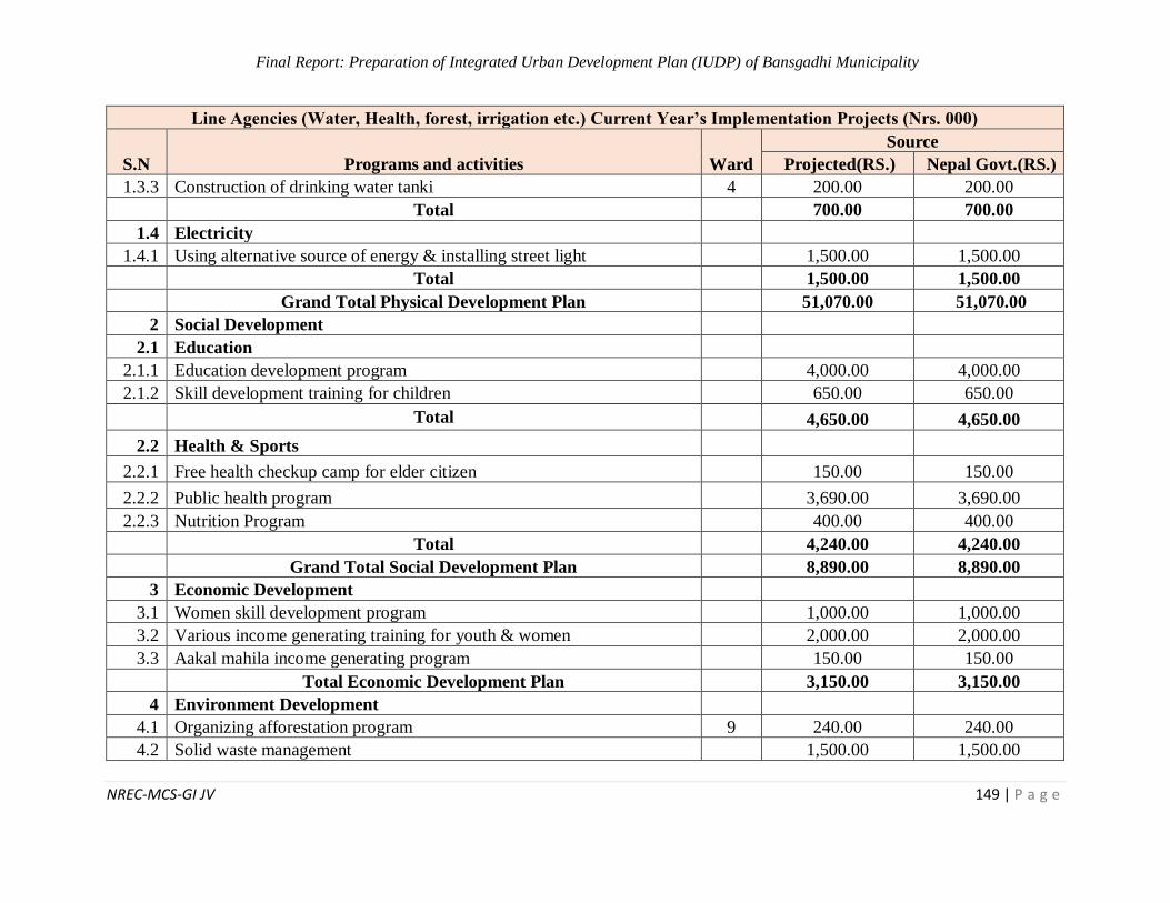
Final Report: Preparation of Integrated Urban Development Plan (IUDP) of Bansgadhi Municipality
NREC-MCS-GI JV 149 | P a g e
Line Agencies (Water, Health, forest, irrigation etc.) Current Year’s Implementation Projects (Nrs. 000)
S.N Programs and activities Ward
Source
Projected(RS.) Nepal Govt.(RS.)
1.3.3 Construction of drinking water tanki 4 200.00 200.00
Total 700.00 700.00
1.4 Electricity
1.4.1 Using alternative source of energy & installing street light 1,500.00 1,500.00
Total 1,500.00 1,500.00
Grand Total Physical Development Plan 51,070.00 51,070.00
2 Social Development
2.1 Education
2.1.1 Education development program 4,000.00 4,000.00
2.1.2 Skill development training for children 650.00 650.00
Total 4,650.00 4,650.00
2.2 Health & Sports
2.2.1 Free health checkup camp for elder citizen 150.00 150.00
2.2.2 Public health program 3,690.00 3,690.00
2.2.3 Nutrition Program 400.00 400.00
Total 4,240.00 4,240.00
Grand Total Social Development Plan 8,890.00 8,890.00
3 Economic Development
3.1 Women skill development program 1,000.00 1,000.00
3.2 Various income generating training for youth & women 2,000.00 2,000.00
3.3 Aakal mahila income generating program 150.00 150.00
Total Economic Development Plan 3,150.00 3,150.00
4 Environment Development
4.1 Organizing afforestation program 9 240.00 240.00
4.2 Solid waste management 1,500.00 1,500.00
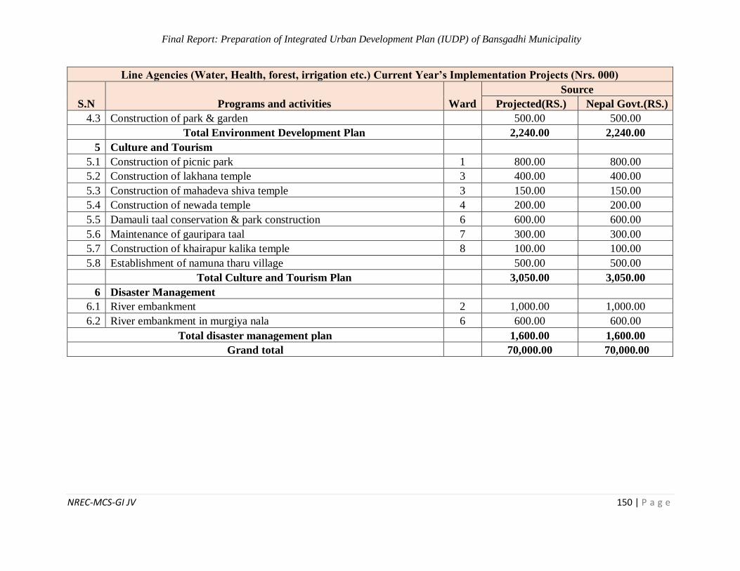
Final Report: Preparation of Integrated Urban Development Plan (IUDP) of Bansgadhi Municipality
NREC-MCS-GI JV 150 | P a g e
Line Agencies (Water, Health, forest, irrigation etc.) Current Year’s Implementation Projects (Nrs. 000)
S.N Programs and activities Ward
Source
Projected(RS.) Nepal Govt.(RS.)
4.3 Construction of park & garden 500.00 500.00
Total Environment Development Plan 2,240.00 2,240.00
5 Culture and Tourism
5.1 Construction of picnic park 1 800.00 800.00
5.2 Construction of lakhana temple 3 400.00 400.00
5.3 Construction of mahadeva shiva temple 3 150.00 150.00
5.4 Construction of newada temple 4 200.00 200.00
5.5 Damauli taal conservation & park construction 6 600.00 600.00
5.6 Maintenance of gauripara taal 7 300.00 300.00
5.7 Construction of khairapur kalika temple 8 100.00 100.00
5.8 Establishment of namuna tharu village 500.00 500.00
Total Culture and Tourism Plan 3,050.00 3,050.00
6 Disaster Management
6.1 River embankment 2 1,000.00 1,000.00
6.2 River embankment in murgiya nala 6 600.00 600.00
Total disaster management plan 1,600.00 1,600.00
Grand total 70,000.00 70,000.00
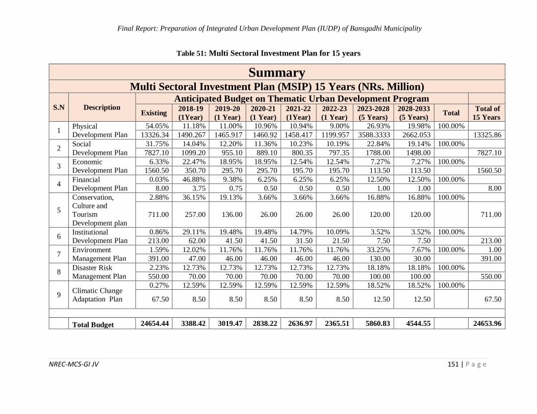
Final Report: Preparation of Integrated Urban Development Plan (IUDP) of Bansgadhi Municipality
NREC-MCS-GI JV 151 | P a g e
Table 51: Multi Sectoral Investment Plan for 15 years
Summary Multi Sectoral Investment Plan (MSIP) 15 Years (NRs. Million)
S.N Description Anticipated Budget on Thematic Urban Development Program
Existing 2018-19
(1Year)
2019-20
(1 Year)
2020-21
(1 Year)
2021-22
(1Year)
2022-23
(1 Year)
2023-2028
(5 Years)
2028-2033
(5 Years) Total
Total of
15 Years
1 Physical Development Plan
54.05% 11.18% 11.00% 10.96% 10.94% 9.00% 26.93% 19.98% 100.00%
13326.34 1490.267 1465.917 1460.92 1458.417 1199.957 3588.3333 2662.053 13325.86
2 Social
Development Plan
31.75% 14.04% 12.20% 11.36% 10.23% 10.19% 22.84% 19.14% 100.00%
7827.10 1099.20 955.10 889.10 800.35 797.35 1788.00 1498.00 7827.10
3 Economic Development Plan
6.33% 22.47% 18.95% 18.95% 12.54% 12.54% 7.27% 7.27% 100.00%
1560.50 350.70 295.70 295.70 195.70 195.70 113.50 113.50 1560.50
4 Financial
Development Plan
0.03% 46.88% 9.38% 6.25% 6.25% 6.25% 12.50% 12.50% 100.00%
8.00 3.75 0.75 0.50 0.50 0.50 1.00 1.00 8.00
5
Conservation, Culture and
Tourism
Development plan
2.88% 36.15% 19.13% 3.66% 3.66% 3.66% 16.88% 16.88% 100.00%
711.00 257.00 136.00 26.00 26.00 26.00 120.00 120.00 711.00
6 Institutional Development Plan
0.86% 29.11% 19.48% 19.48% 14.79% 10.09% 3.52% 3.52% 100.00%
213.00 62.00 41.50 41.50 31.50 21.50 7.50 7.50 213.00
7 Environment
Management Plan
1.59% 12.02% 11.76% 11.76% 11.76% 11.76% 33.25% 7.67% 100.00% 1.00
391.00 47.00 46.00 46.00 46.00 46.00 130.00 30.00 391.00
8 Disaster Risk
Management Plan
2.23% 12.73% 12.73% 12.73% 12.73% 12.73% 18.18% 18.18% 100.00%
550.00 70.00 70.00 70.00 70.00 70.00 100.00 100.00 550.00
9 Climatic Change Adaptation Plan
0.27% 12.59% 12.59% 12.59% 12.59% 12.59% 18.52% 18.52% 100.00%
67.50 8.50 8.50 8.50 8.50 8.50 12.50 12.50 67.50
Total Budget 24654.44 3388.42 3019.47 2838.22 2636.97 2365.51 5860.83 4544.55 24653.96
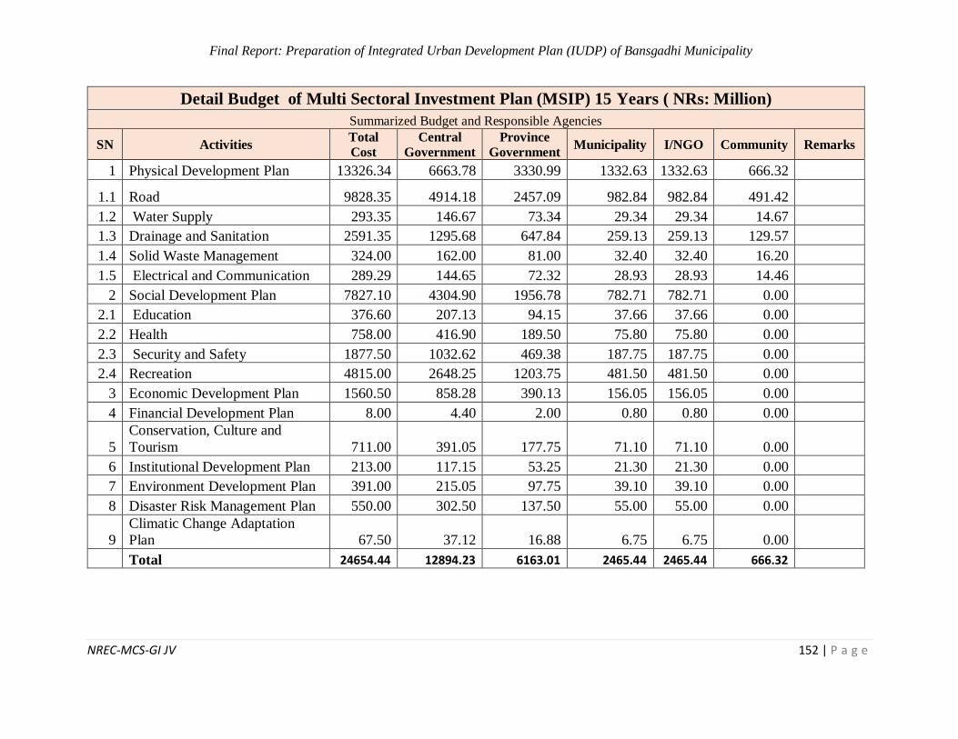
Final Report: Preparation of Integrated Urban Development Plan (IUDP) of Bansgadhi Municipality
NREC-MCS-GI JV 152 | P a g e
Detail Budget of Multi Sectoral Investment Plan (MSIP) 15 Years ( NRs: Million)
Summarized Budget and Responsible Agencies
SN Activities Total
Cost
Central
Government
Province
Government Municipality I/NGO Community Remarks
1 Physical Development Plan 13326.34 6663.78 3330.99 1332.63 1332.63 666.32
1.1 Road 9828.35 4914.18 2457.09 982.84 982.84 491.42
1.2 Water Supply 293.35 146.67 73.34 29.34 29.34 14.67
1.3 Drainage and Sanitation 2591.35 1295.68 647.84 259.13 259.13 129.57
1.4 Solid Waste Management 324.00 162.00 81.00 32.40 32.40 16.20
1.5 Electrical and Communication 289.29 144.65 72.32 28.93 28.93 14.46
2 Social Development Plan 7827.10 4304.90 1956.78 782.71 782.71 0.00
2.1 Education 376.60 207.13 94.15 37.66 37.66 0.00
2.2 Health 758.00 416.90 189.50 75.80 75.80 0.00
2.3 Security and Safety 1877.50 1032.62 469.38 187.75 187.75 0.00
2.4 Recreation 4815.00 2648.25 1203.75 481.50 481.50 0.00
3 Economic Development Plan 1560.50 858.28 390.13 156.05 156.05 0.00
4 Financial Development Plan 8.00 4.40 2.00 0.80 0.80 0.00
5
Conservation, Culture and
Tourism 711.00 391.05 177.75 71.10 71.10 0.00
6 Institutional Development Plan 213.00 117.15 53.25 21.30 21.30 0.00
7 Environment Development Plan 391.00 215.05 97.75 39.10 39.10 0.00
8 Disaster Risk Management Plan 550.00 302.50 137.50 55.00 55.00 0.00
9
Climatic Change Adaptation
Plan 67.50 37.12 16.88 6.75 6.75 0.00
Total 24654.44 12894.23 6163.01 2465.44 2465.44 666.32
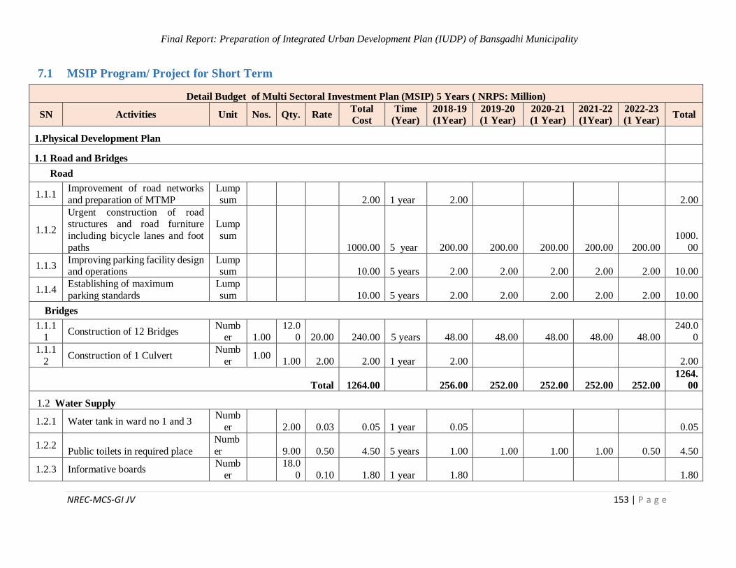
Final Report: Preparation of Integrated Urban Development Plan (IUDP) of Bansgadhi Municipality
NREC-MCS-GI JV 153 | P a g e
7.1 MSIP Program/ Project for Short Term
Detail Budget of Multi Sectoral Investment Plan (MSIP) 5 Years ( NRPS: Million)
SN Activities Unit Nos. Qty. Rate Total
Cost
Time
(Year)
2018-19
(1Year)
2019-20
(1 Year)
2020-21
(1 Year)
2021-22
(1Year)
2022-23
(1 Year) Total
1.Physical Development Plan
1.1 Road and Bridges
Road
1.1.1 Improvement of road networks
and preparation of MTMP
Lump
sum
2.00 1 year 2.00 2.00
1.1.2
Urgent construction of road structures and road furniture
including bicycle lanes and foot
paths
Lump
sum
1000.00 5 year 200.00 200.00 200.00 200.00 200.00
1000.
00
1.1.3 Improving parking facility design and operations
Lumpsum
10.00 5 years 2.00 2.00 2.00 2.00 2.00 10.00
1.1.4 Establishing of maximum
parking standards
Lump
sum
10.00 5 years 2.00 2.00 2.00 2.00 2.00 10.00
Bridges
1.1.11
Construction of 12 Bridges Numb
er 1.00 12.0
0 20.00 240.00 5 years 48.00 48.00 48.00 48.00 48.00 240.0
0
1.1.1
2 Construction of 1 Culvert
Numb
er 1.00
1.00 2.00 2.00 1 year 2.00 2.00
Total 1264.00 256.00 252.00 252.00 252.00 252.00
1264.
00
1.2 Water Supply
1.2.1 Water tank in ward no 1 and 3 Numb
er
2.00 0.03 0.05 1 year 0.05 0.05
1.2.2 Public toilets in required place
Numb
er 9.00 0.50 4.50 5 years 1.00 1.00 1.00 1.00 0.50 4.50
1.2.3 Informative boards Numb
er
18.0
0 0.10 1.80 1 year 1.80 1.80
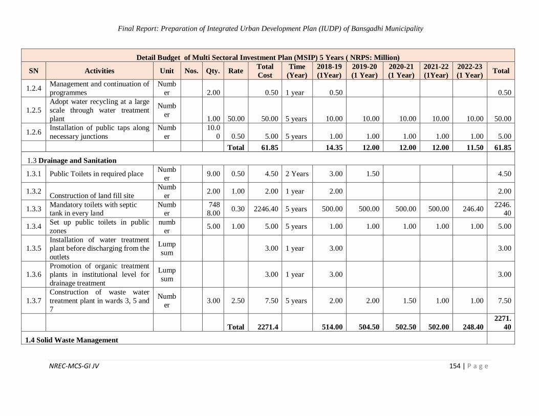
Final Report: Preparation of Integrated Urban Development Plan (IUDP) of Bansgadhi Municipality
NREC-MCS-GI JV 154 | P a g e
Detail Budget of Multi Sectoral Investment Plan (MSIP) 5 Years ( NRPS: Million)
SN Activities Unit Nos. Qty. Rate Total
Cost
Time
(Year)
2018-19
(1Year)
2019-20
(1 Year)
2020-21
(1 Year)
2021-22
(1Year)
2022-23
(1 Year) Total
1.2.4 Management and continuation of
programmes
Numb
er
2.00 0.50 1 year 0.50 0.50
1.2.5
Adopt water recycling at a large
scale through water treatment plant
Numb
er
1.00 50.00 50.00 5 years 10.00 10.00 10.00 10.00 10.00 50.00
1.2.6 Installation of public taps along
necessary junctions
Numb
er
10.0
0 0.50 5.00 5 years 1.00 1.00 1.00 1.00 1.00 5.00
Total 61.85 14.35 12.00 12.00 12.00 11.50 61.85
1.3 Drainage and Sanitation
1.3.1 Public Toilets in required place Numb
er 9.00 0.50 4.50 2 Years 3.00 1.50 4.50
1.3.2 Construction of land fill site
Numb
er 2.00 1.00 2.00 1 year 2.00 2.00
1.3.3 Mandatory toilets with septic tank in every land
Number
7488.00
0.30 2246.40 5 years 500.00 500.00 500.00 500.00 246.40 2246.
40
1.3.4 Set up public toilets in public
zones
numb
er 5.00 1.00 5.00 5 years 1.00 1.00 1.00 1.00 1.00 5.00
1.3.5 Installation of water treatment plant before discharging from the
outlets
Lump
sum 3.00 1 year 3.00 3.00
1.3.6 Promotion of organic treatment plants in institutional level for
drainage treatment
Lump
sum 3.00 1 year 3.00 3.00
1.3.7
Construction of waste water
treatment plant in wards 3, 5 and 7
Numb
er 3.00 2.50 7.50 5 years 2.00 2.00 1.50 1.00 1.00 7.50
Total 2271.4 514.00 504.50 502.50 502.00 248.40
2271.
40
1.4 Solid Waste Management

Final Report: Preparation of Integrated Urban Development Plan (IUDP) of Bansgadhi Municipality
NREC-MCS-GI JV 155 | P a g e
Detail Budget of Multi Sectoral Investment Plan (MSIP) 5 Years ( NRPS: Million)
SN Activities Unit Nos. Qty. Rate Total
Cost
Time
(Year)
2018-19
(1Year)
2019-20
(1 Year)
2020-21
(1 Year)
2021-22
(1Year)
2022-23
(1 Year) Total
1.4.1 Establishment of three WTP in
wards 3,5 and 7
Numb
er 3.00 1.00 3.00 2 Years 2.00 1.00 3.00
1.4.2
Construction of three waste
transfer and recycle station in wards 8,4 and 1
Number
3.00 1.00 3.00 2 Years 2.00 1.00 3.00
1.4.3
Construction of land fill site in
wards 2 and 3 located south of
Amohiya and South east of Bethahani respectively
Number
2.00 1.00 2.00 2 Years 1.00 1.00 2.00
1.4.4
Establishment of 3 waste transfer
and recycle station in Wards: 8,4 and 1
Number
3.00 2.00 6.00 3 years 2.00 2.00 2.00 6.00
Total 14.00 7.00 5.00 2.00 14.00
1.5 Electrical and Communication
1.5.1
Extension of electricity and
telecommunication network in
all wards
Sq.
Km
102.
58 0.50 51.29 5Years 15.00 10.00 10.00 10.00 6.29 51.29
1.5.2 Installation of solar lights along
roads and public places
Lump
sum 25.00 5 years 5.00 5.00 5.00 5.00 5.00 25.00
1.5.3 Upgrading electricity
infrastructures
Lump
sum 10.00 5 years 2.00 2.00 2.00 2.00 2.00 10.00
1.5.4 Promoting and monitoring FM
stations
Lump
sum 0.50 1 years 0.50 0.50
1.5.5 Connecting power line with
national grid
Lump
sum 10.00 5 years 2.00 2.00 2.00 2.00 2.00 10.00
1.5.6
Laying underground wires for
electricity and communication
purpose
Lumpsum
10.00 5 years 2.00 2.00 2.00 2.00 2.00 10.00
1.5.7 Subsidizing on alternative source of energy
Lumpsum
5.00 5 years 1.00 1.00 1.00 1.00 1.00 5.00
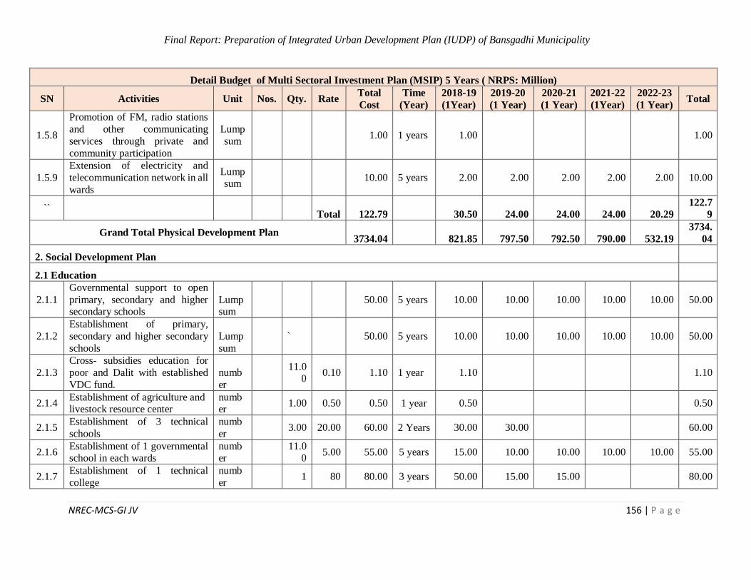
Final Report: Preparation of Integrated Urban Development Plan (IUDP) of Bansgadhi Municipality
NREC-MCS-GI JV 156 | P a g e
Detail Budget of Multi Sectoral Investment Plan (MSIP) 5 Years ( NRPS: Million)
SN Activities Unit Nos. Qty. Rate Total
Cost
Time
(Year)
2018-19
(1Year)
2019-20
(1 Year)
2020-21
(1 Year)
2021-22
(1Year)
2022-23
(1 Year) Total
1.5.8
Promotion of FM, radio stations
and other communicating
services through private and
community participation
Lump
sum 1.00 1 years 1.00 1.00
1.5.9
Extension of electricity and
telecommunication network in all
wards
Lumpsum
10.00 5 years 2.00 2.00 2.00 2.00 2.00 10.00
`` Total 122.79 30.50 24.00 24.00 24.00 20.29
122.7
9
Grand Total Physical Development Plan 3734.04 821.85 797.50 792.50 790.00 532.19
3734.
04
2. Social Development Plan
2.1 Education
2.1.1
Governmental support to open
primary, secondary and higher secondary schools
Lumpsum
50.00 5 years 10.00 10.00 10.00 10.00 10.00 50.00
2.1.2
Establishment of primary,
secondary and higher secondary
schools
Lump
sum
` 50.00 5 years 10.00 10.00 10.00 10.00 10.00 50.00
2.1.3
Cross- subsidies education for
poor and Dalit with established
VDC fund.
numb
er
11.00
0.10 1.10 1 year 1.10 1.10
2.1.4 Establishment of agriculture and livestock resource center
number
1.00 0.50 0.50 1 year 0.50 0.50
2.1.5 Establishment of 3 technical
schools
numb
er 3.00 20.00 60.00 2 Years 30.00 30.00 60.00
2.1.6 Establishment of 1 governmental school in each wards
number
11.0
0 5.00 55.00 5 years 15.00 10.00 10.00 10.00 10.00 55.00
2.1.7 Establishment of 1 technical
college
numb
er 1 80 80.00 3 years 50.00 15.00 15.00 80.00
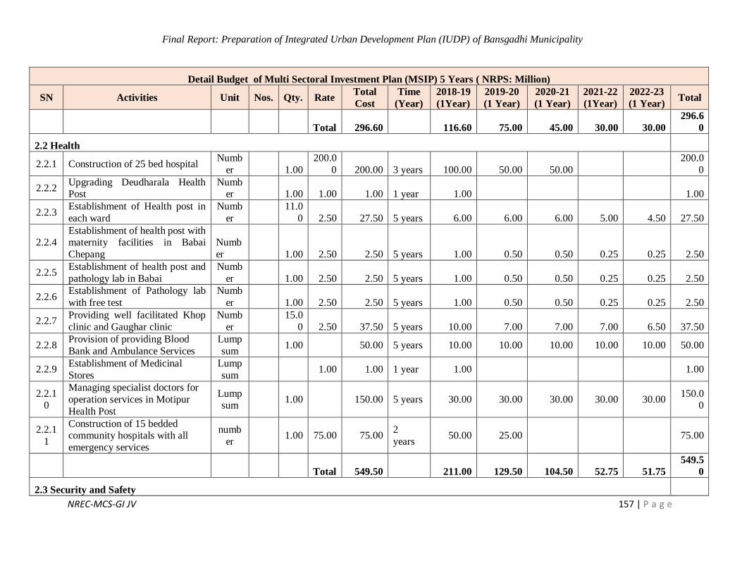
Final Report: Preparation of Integrated Urban Development Plan (IUDP) of Bansgadhi Municipality
NREC-MCS-GI JV 157 | P a g e
Detail Budget of Multi Sectoral Investment Plan (MSIP) 5 Years ( NRPS: Million)
SN Activities Unit Nos. Qty. Rate Total
Cost
Time
(Year)
2018-19
(1Year)
2019-20
(1 Year)
2020-21
(1 Year)
2021-22
(1Year)
2022-23
(1 Year) Total
Total 296.60 116.60 75.00 45.00 30.00 30.00
296.6
0
2.2 Health
2.2.1 Construction of 25 bed hospital Numb
er
1.00
200.0
0 200.00 3 years 100.00 50.00 50.00
200.0
0
2.2.2 Upgrading Deudharala Health Post
Number
1.00 1.00 1.00 1 year 1.00 1.00
2.2.3 Establishment of Health post in
each ward
Numb
er
11.0
0 2.50 27.50 5 years 6.00 6.00 6.00 5.00 4.50 27.50
2.2.4 Establishment of health post with maternity facilities in Babai
Chepang
Numb
er 1.00 2.50 2.50 5 years 1.00 0.50 0.50 0.25 0.25 2.50
2.2.5 Establishment of health post and
pathology lab in Babai
Numb
er
1.00 2.50 2.50 5 years 1.00 0.50 0.50 0.25 0.25 2.50
2.2.6 Establishment of Pathology lab
with free test
Numb
er
1.00 2.50 2.50 5 years 1.00 0.50 0.50 0.25 0.25 2.50
2.2.7 Providing well facilitated Khop
clinic and Gaughar clinic
Numb
er
15.0
0 2.50 37.50 5 years 10.00 7.00 7.00 7.00 6.50 37.50
2.2.8 Provision of providing Blood
Bank and Ambulance Services
Lump
sum 1.00 50.00 5 years 10.00 10.00 10.00 10.00 10.00 50.00
2.2.9 Establishment of Medicinal
Stores
Lump
sum 1.00 1.00 1 year 1.00 1.00
2.2.10
Managing specialist doctors for
operation services in Motipur
Health Post
Lumpsum
1.00 150.00 5 years 30.00 30.00 30.00 30.00 30.00 150.0
0
2.2.1
1
Construction of 15 bedded community hospitals with all
emergency services
numb
er 1.00 75.00 75.00
2
years 50.00 25.00 75.00
Total 549.50 211.00 129.50 104.50 52.75 51.75
549.5
0
2.3 Security and Safety
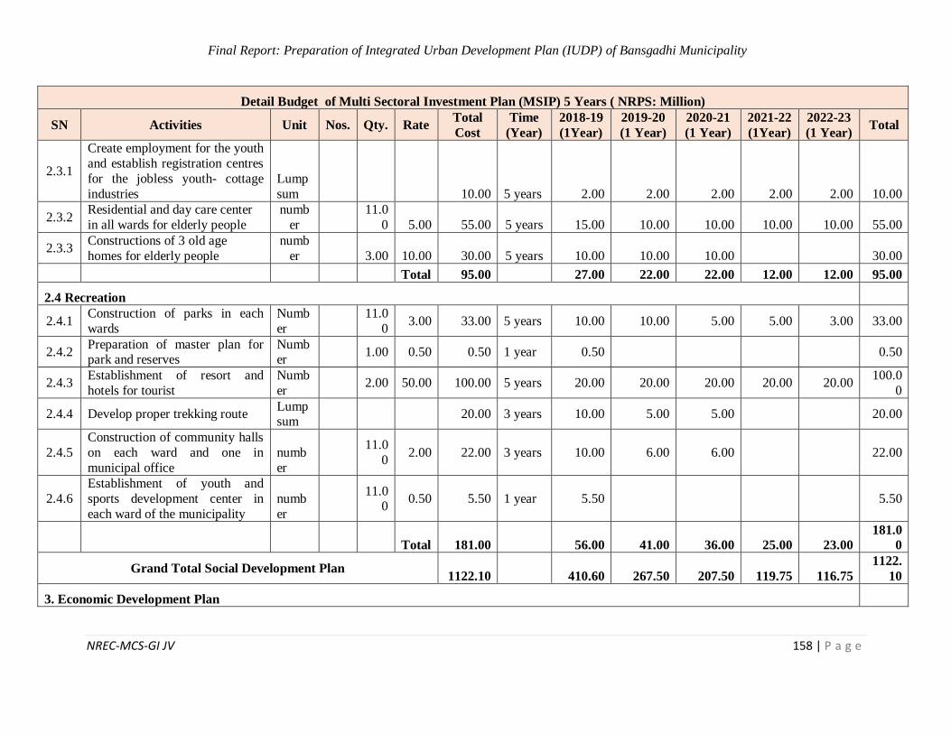
Final Report: Preparation of Integrated Urban Development Plan (IUDP) of Bansgadhi Municipality
NREC-MCS-GI JV 158 | P a g e
Detail Budget of Multi Sectoral Investment Plan (MSIP) 5 Years ( NRPS: Million)
SN Activities Unit Nos. Qty. Rate Total
Cost
Time
(Year)
2018-19
(1Year)
2019-20
(1 Year)
2020-21
(1 Year)
2021-22
(1Year)
2022-23
(1 Year) Total
2.3.1
Create employment for the youth
and establish registration centres
for the jobless youth- cottage
industries
Lump
sum 10.00 5 years 2.00 2.00 2.00 2.00 2.00 10.00
2.3.2 Residential and day care center
in all wards for elderly people
numb
er
11.0
0 5.00 55.00 5 years 15.00 10.00 10.00 10.00 10.00 55.00
2.3.3 Constructions of 3 old age
homes for elderly people
numb
er
3.00 10.00 30.00 5 years 10.00 10.00 10.00 30.00
Total 95.00 27.00 22.00 22.00 12.00 12.00 95.00
2.4 Recreation
2.4.1 Construction of parks in each
wards
Numb
er
11.0
0 3.00 33.00 5 years 10.00 10.00 5.00 5.00 3.00 33.00
2.4.2 Preparation of master plan for park and reserves
Number
1.00 0.50 0.50 1 year 0.50 0.50
2.4.3 Establishment of resort and
hotels for tourist
Numb
er 2.00 50.00 100.00 5 years 20.00 20.00 20.00 20.00 20.00
100.0
0
2.4.4 Develop proper trekking route Lumpsum
20.00 3 years 10.00 5.00 5.00 20.00
2.4.5
Construction of community halls
on each ward and one in
municipal office
numb
er
11.0
0 2.00 22.00 3 years 10.00 6.00 6.00 22.00
2.4.6
Establishment of youth and
sports development center in
each ward of the municipality
numb
er
11.00
0.50 5.50 1 year 5.50 5.50
Total 181.00 56.00 41.00 36.00 25.00 23.00
181.0
0
Grand Total Social Development Plan 1122.10 410.60 267.50 207.50 119.75 116.75
1122.
10
3. Economic Development Plan
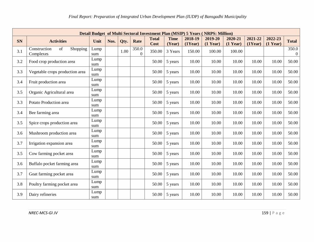
Final Report: Preparation of Integrated Urban Development Plan (IUDP) of Bansgadhi Municipality
NREC-MCS-GI JV 159 | P a g e
Detail Budget of Multi Sectoral Investment Plan (MSIP) 5 Years ( NRPS: Million)
SN Activities Unit Nos. Qty. Rate Total
Cost
Time
(Year)
2018-19
(1Year)
2019-20
(1 Year)
2020-21
(1 Year)
2021-22
(1Year)
2022-23
(1 Year) Total
3.1 Construction of Shopping
Complexes
Lump
sum 1.00
350.0
0 350.00 3 Years 150.00 100.00 100.00
350.0
0
3.2 Food crop production area Lump
sum 50.00 5 years 10.00 10.00 10.00 10.00 10.00 50.00
3.3 Vegetable crops production area Lump
sum 50.00 5 years 10.00 10.00 10.00 10.00 10.00 50.00
3.4 Fruit production area Lump
sum 50.00 5 years 10.00 10.00 10.00 10.00 10.00 50.00
3.5 Organic Agricultural area Lump
sum 50.00 5 years 10.00 10.00 10.00 10.00 10.00 50.00
3.3 Potato Production area Lump
sum 50.00 5 years 10.00 10.00 10.00 10.00 10.00 50.00
3.4 Bee farming area Lump
sum 50.00 5 years 10.00 10.00 10.00 10.00 10.00 50.00
3.5 Spice crops production area Lump
sum 50.00 5 years 10.00 10.00 10.00 10.00 10.00 50.00
3.6 Mushroom production area Lump
sum 50.00 5 years 10.00 10.00 10.00 10.00 10.00 50.00
3.7 Irrigation expansion area Lump
sum 50.00 5 years 10.00 10.00 10.00 10.00 10.00 50.00
3.5 Cow farming pocket area Lump
sum 50.00 5 years 10.00 10.00 10.00 10.00 10.00 50.00
3.6 Buffalo pocket farming area Lump
sum 50.00 5 years 10.00 10.00 10.00 10.00 10.00 50.00
3.7 Goat farming pocket area Lump
sum 50.00 5 years 10.00 10.00 10.00 10.00 10.00 50.00
3.8 Poultry farming pocket area Lump
sum 50.00 5 years 10.00 10.00 10.00 10.00 10.00 50.00
3.9 Dairy refineries Lump
sum 50.00 5 years 10.00 10.00 10.00 10.00 10.00 50.00
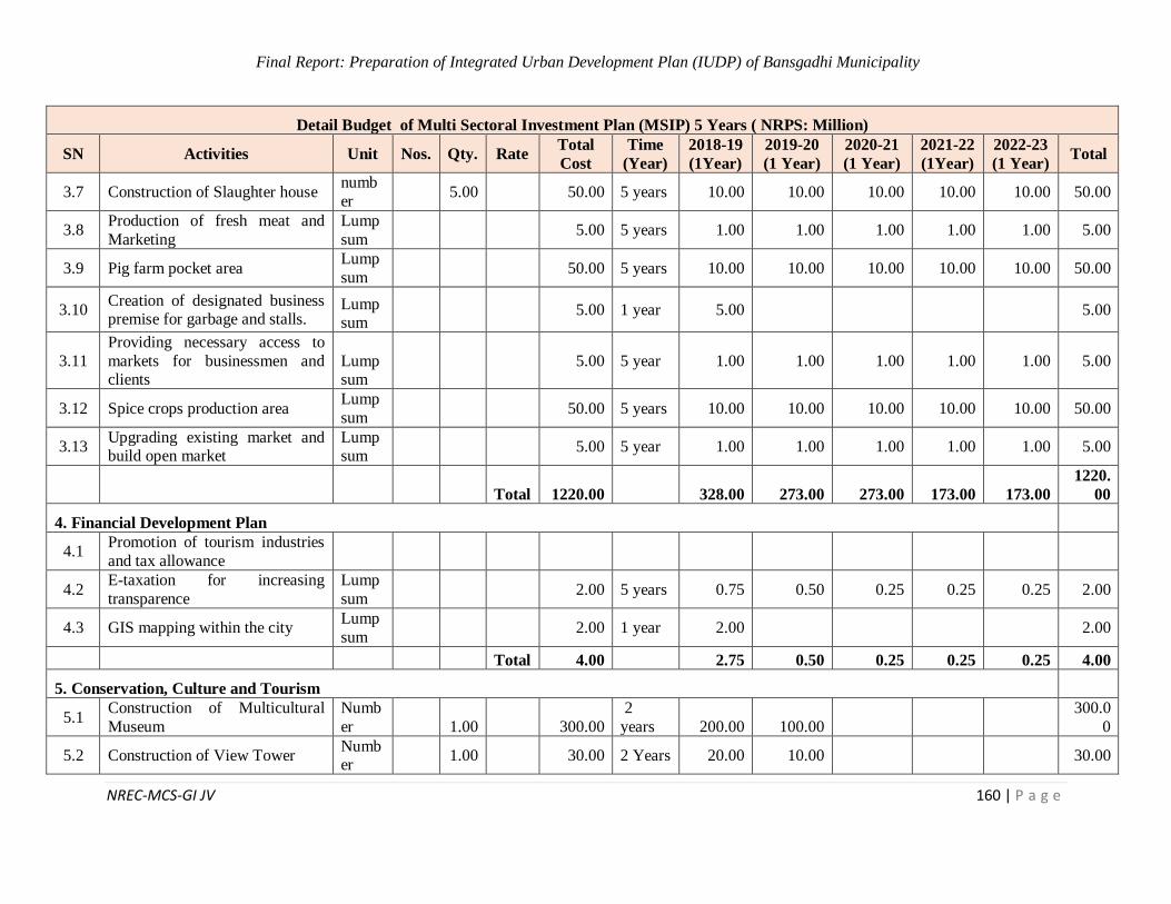
Final Report: Preparation of Integrated Urban Development Plan (IUDP) of Bansgadhi Municipality
NREC-MCS-GI JV 160 | P a g e
Detail Budget of Multi Sectoral Investment Plan (MSIP) 5 Years ( NRPS: Million)
SN Activities Unit Nos. Qty. Rate Total
Cost
Time
(Year)
2018-19
(1Year)
2019-20
(1 Year)
2020-21
(1 Year)
2021-22
(1Year)
2022-23
(1 Year) Total
3.7 Construction of Slaughter house numb
er 5.00 50.00 5 years 10.00 10.00 10.00 10.00 10.00 50.00
3.8 Production of fresh meat and
Marketing
Lump
sum 5.00 5 years 1.00 1.00 1.00 1.00 1.00 5.00
3.9 Pig farm pocket area Lump
sum 50.00 5 years 10.00 10.00 10.00 10.00 10.00 50.00
3.10 Creation of designated business premise for garbage and stalls.
Lumpsum
5.00 1 year 5.00 5.00
3.11
Providing necessary access to
markets for businessmen and clients
Lumpsum
5.00 5 year 1.00 1.00 1.00 1.00 1.00 5.00
3.12 Spice crops production area Lump
sum 50.00 5 years 10.00 10.00 10.00 10.00 10.00 50.00
3.13 Upgrading existing market and build open market
Lumpsum
5.00 5 year 1.00 1.00 1.00 1.00 1.00 5.00
Total 1220.00 328.00 273.00 273.00 173.00 173.00
1220.
00
4. Financial Development Plan
4.1 Promotion of tourism industries
and tax allowance
4.2 E-taxation for increasing
transparence
Lump
sum 2.00 5 years 0.75 0.50 0.25 0.25 0.25 2.00
4.3 GIS mapping within the city Lump
sum 2.00 1 year 2.00 2.00
Total 4.00 2.75 0.50 0.25 0.25 0.25 4.00
5. Conservation, Culture and Tourism
5.1 Construction of Multicultural
Museum
Numb
er 1.00 300.00
2
years 200.00 100.00
300.0
0
5.2 Construction of View Tower Number
1.00 30.00 2 Years 20.00 10.00 30.00
Final Report: Preparation of Integrated Urban Development Plan (IUDP) of Bansgadhi Municipality
NREC-MCS-GI JV 161 | P a g e
Detail Budget of Multi Sectoral Investment Plan (MSIP) 5 Years ( NRPS: Million)
SN Activities Unit Nos. Qty. Rate Total
Cost
Time
(Year)
2018-19
(1Year)
2019-20
(1 Year)
2020-21
(1 Year)
2021-22
(1Year)
2022-23
(1 Year) Total
5.3 Formation of multicultural
association in the municipality
Lump
sum 0.50 1 year 0.50 0.50
5.4
Preparation of tourism
development plan along with its implementation guidelines and
monitoring framework
Lump
sum
10.00 1 year 10.00 10.00
5.5
Formation of tourism
development and management committee
Lumpsum
0.50 1 year 0.50 0.50
5.6
Renovation of Chaskiya Baba
Mandir, Mandir Danda and Hatti khola
Lumpsum
10.00 5 year 2.00 2.00 2.00 2.00 2.00 10.00
Total 351.00 233.00 112.00 2.00 2.00 2.00
351.0
0
6. Institutional Development Plan
6.1 Establishment of Information Centre Building of all department
in all wards
Numb
er 9.00 20.00 180.00
5
years 50.00 40.00 40.00 30.00 20.00
180.0
0
6.2 Establishment of communication centers for common information
sharing platform
numb
er 1.00 10.00 10.00 1 year 10.00 10.00
6.3
Creation of interactive website to
minimize paper work and single window system
numb
er 1.00 0.50 0.50 1 year 0.50 0.50
Total 190.50 60.50 40.00 40.00 30.00 20.00
190.5
0
7. Environment Development Plan
7.1 Fire Path Construction
Lump
sum 50.00 5 years 10.00 10.00 10.00 10.00 10.00 50.00
7.2 Preparation of multi hazard map
and RSLUP
numb
er 1.00 0.50 0.50 1 year 0.50 0.50
Final Report: Preparation of Integrated Urban Development Plan (IUDP) of Bansgadhi Municipality
NREC-MCS-GI JV 162 | P a g e
Detail Budget of Multi Sectoral Investment Plan (MSIP) 5 Years ( NRPS: Million)
SN Activities Unit Nos. Qty. Rate Total
Cost
Time
(Year)
2018-19
(1Year)
2019-20
(1 Year)
2020-21
(1 Year)
2021-22
(1Year)
2022-23
(1 Year) Total
7.3 Preparation of its bye laws and
implementation
Lump
sum 0.50 0.50 1 year 0.50 0.50
7.4
Identification of high risk area in
all urban area and relocating disaster prone settlement
Lump
sum 50.00 5 years 10.00 10.00 10.00 10.00 10.00 50.00
Total 101.00 21.00 20.00 20.00 20.00 20.00
101.0
0
8. Disaster Risk Management Plan
8.1
Preparation of Risk Sensitive
Land Use Plan and strict implementation
Lumpsum
50.00 5 years 10.00 10.00 10.00 10.00 10.00 50.00
8.2
Identification of high risk area
with hazard mapping and resettlement
Lumpsum
100.00 5 years 20.00 20.00 20.00 20.00 20.00 100.0
0
8.3 Identification and delineation of
disaster evacuation zone
Lump
sum 50.00 5 years 10.00 10.00 10.00 10.00 10.00 50.00
Total 200.00 40.00 40.00 40.00 40.00 40.00
200.0
0
9. Climatic Change Adaptation Plan
9.1 Develop pedestrian friendly
roads
Lump
sum 10.00 5 years 2.00 2.00 2.00 2.00 2.00 10.00
9.2 Paving water recharge pavements Lump
sum 10.00 5 years 2.00 2.00 2.00 2.00 2.00 10.00
9.3 Land use zoning and buffer
around the industrial zones
Lump
sum 10.00 5 years 2.00 2.00 2.00 2.00 2.00 10.00
Total 30.00 6.00 6.00 6.00 6.00 6.00 30.00
Grand Total 6952.64 1923.70 1556.50 1381.25 1181.00 910.19
6952.
64
Final Report: Preparation of Integrated Urban Development Plan (IUDP) of Bansgadhi Municipality
NREC-MCS-GI JV 163 | P a g e
7.2 MSIP Program/ Project for Mid Term
Detail Budget of Multi Sectoral Investment Plan (MSIP) 10 Years ( NRPS: Million)
SN Activities Unit Nos. Qty. Rate Total
Cost
2018-19
(1Year)
2019-20
(1 Year)
2020-21
(1 Year)
2021-22
(1Year)
2022-23
(1 Year)
2023-28
(5Year) Total
1.Physical Development Plan
1.1 Road and Bridges
Road
1.1.1 Construction and expansion of road system by land pooling
and GLD roads
Lump
sum
1000.
00 100.00 100.00 100.00 100.00 100.00 500.00
1000.
00
1.1.2 Maintain and synchronize traffic lights through
government and private sectors
Lump
sum
100.0
0 8.00 8.00 8.00 8.00 8.00 60.00
100.0
0
1.1.3
Construction of road
connecting Bansgadhi municipality and to all nearby
RMs
Lumpsum
500.00
30.00 30.00 30.00 30.00 30.00 350.00 500.0
0
1.1.4 Programs on public awareness
regarding road safety
Lump
sum
7.50 0.50 0.50 0.50 0.50 0.50 5.00 7.50
1.1.5
Plantation of trees along the
road to provide shading for
foot travelers
Lumpsum
25.00 2.00 2.00 2.00 2.00 2.00 15.00 25.00
1.1.6 Monitoring and evaluation on privately owned or managed
public transportation
Lump
sum
7.50 0.50 0.50 0.50 0.50 0.50 5.00 7.50
Bridges
1.1.1
1
Upgrading trail bridges to
Sustainable Bridges
Lump
sum
100.0
0 10.00 10.00 10.00 10.00 10.00 50.00
100.0
0
1.1.12
Construction of RC,
suspension and suspended
bridge for quick accessibility
Lump
sum
100.0
0 10.00 10.00 10.00 10.00 10.00 50.00
100.0
0
Final Report: Preparation of Integrated Urban Development Plan (IUDP) of Bansgadhi Municipality
NREC-MCS-GI JV 164 | P a g e
Detail Budget of Multi Sectoral Investment Plan (MSIP) 10 Years ( NRPS: Million)
SN Activities Unit Nos. Qty. Rate Total
Cost
2018-19
(1Year)
2019-20
(1 Year)
2020-21
(1 Year)
2021-22
(1Year)
2022-23
(1 Year)
2023-28
(5Year) Total
Total
1840.
00 161.00 161.00 161.00 161.00 161.00 1035.00
1840.
00
1.2 Water Supply
1.2.1 Upgrading infrastructure for Babai Irrigation Projects
Lumpsum
50.00 4.00 4.00 4.00 4.00 4.00 30.00 50.00
1.2.2 Informative programmes Numb
er
18.0
0 0.50 9.00 0.60 0.60 0.60 0.60 0.60 6.00 9.00
1.2.3 Water purification method Lumpsum
7.50 0.50 0.50 0.50 0.50 0.50 5.00 7.50
1.2.4 Application of water
purification method Lumpsum
5.00 0.40 0.40 0.40 0.40 0.40 3.00 5.00
Total 71.50 5.50 5.50 5.50 5.50 5.50 44.00 71.50
1.3 Drainage and Sanitation
1.3.1
Programmes on public
awareness through radio,
TV, broadcasting priority
Lump
sum 1.50 0.10 0.10 0.10 0.10 0.10 1.00 1.50
1.3.2
Use of modern technology and
adopt 3R's ( Reduce, Reuse
and Recycle.
Lumpsum
1.50 0.10 0.10 0.10 0.10 0.10 1.00 1.50
1.3.3 Construction of sewerage
network Km
142.
63 0.50 71.32 5.00 5.00 5.00 5.00 5.00 46.32 71.32
Total 74.32 5.20 5.20 5.20 5.20 5.20 48.32 74.32
1.4 Solid Waste Management
1.4.1 Construction of Landfill Site and Providing Drainage
Facilities
Numb
er
1.00
100.0
0
100.0
0 10.00 10.00 10.00 10.00 10.00 50.00
100.0
0
1.4.2 Installation of bio gas Numb
er
10.0
0 7.50 75.00 5.00 5.00 5.00 5.00 5.00 50.00 75.00
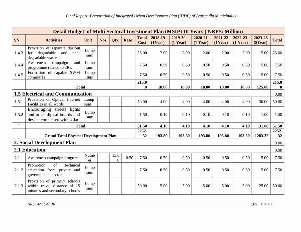
Final Report: Preparation of Integrated Urban Development Plan (IUDP) of Bansgadhi Municipality
NREC-MCS-GI JV 165 | P a g e
Detail Budget of Multi Sectoral Investment Plan (MSIP) 10 Years ( NRPS: Million)
SN Activities Unit Nos. Qty. Rate Total
Cost
2018-19
(1Year)
2019-20
(1 Year)
2020-21
(1 Year)
2021-22
(1Year)
2022-23
(1 Year)
2023-28
(5Year) Total
1.4.3
Provision of separate dustbin
for degradable and non-degradable waste
Lump
sum
25.00 2.00 2.00 2.00 2.00 2.00 15.00 25.00
1.4.4 Awareness campaign and
programme related to 3R's
Lump
sum
7.50 0.50 0.50 0.50 0.50 0.50 5.00 7.50
1.4.5 Formation of capable SWM committee
Lumpsum
7.50 0.50 0.50 0.50 0.50 0.50 5.00 7.50
Total
215.0
0 18.00 18.00 18.00 18.00 18.00 125.00
215.0
0
1.5 Electrical and Communication 0.00
1.5.1 Provision of Optical Internet Facilities in all wards
Lumpsum
50.00 4.00 4.00 4.00 4.00 4.00 30.00 50.00
1.5.2
Encouraging streets lights
and other digital boards and
device connected with solar
Lumpsum
1.50 0.10 0.10 0.10 0.10 0.10 1.00 1.50
`` Total 51.50 4.10 4.10 4.10 4.10 4.10 31.00 51.50
Grand Total Physical Development Plan
2252.
32 193.80 193.80 193.80 193.80 193.80 1283.32
2252.
32
2. Social Development Plan 0.00
2.1 Education 0.00
2.1.1 Awareness campaign program Numb
er
15.0
0 0.50 7.50 0.50 0.50 0.50 0.50 0.50 5.00 7.50
2.1.2 Promotion of technical education from private and
governmental sectors
Lump
sum
7.50 0.50 0.50 0.50 0.50 0.50 5.00 7.50
2.1.3 Provision of primary schools within travel distance of 15
minutes and secondary schools
Lump
sum
50.00 5.00 5.00 5.00 5.00 5.00 25.00 50.00
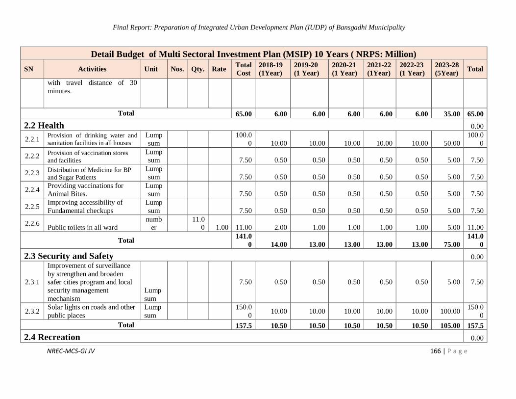
Final Report: Preparation of Integrated Urban Development Plan (IUDP) of Bansgadhi Municipality
NREC-MCS-GI JV 166 | P a g e
Detail Budget of Multi Sectoral Investment Plan (MSIP) 10 Years ( NRPS: Million)
SN Activities Unit Nos. Qty. Rate Total
Cost
2018-19
(1Year)
2019-20
(1 Year)
2020-21
(1 Year)
2021-22
(1Year)
2022-23
(1 Year)
2023-28
(5Year) Total
with travel distance of 30
minutes.
Total 65.00 6.00 6.00 6.00 6.00 6.00 35.00 65.00
2.2 Health 0.00
2.2.1 Provision of drinking water and
sanitation facilities in all houses
Lump
sum
100.0
0 10.00 10.00 10.00 10.00 10.00 50.00
100.0
0
2.2.2 Provision of vaccination stores
and facilities
Lumpsum
7.50 0.50 0.50 0.50 0.50 0.50 5.00 7.50
2.2.3 Distribution of Medicine for BP
and Sugar Patients
Lump
sum
7.50 0.50 0.50 0.50 0.50 0.50 5.00 7.50
2.2.4 Providing vaccinations for Animal Bites.
Lumpsum
7.50 0.50 0.50 0.50 0.50 0.50 5.00 7.50
2.2.5 Improving accessibility of
Fundamental checkups
Lump
sum
7.50 0.50 0.50 0.50 0.50 0.50 5.00 7.50
2.2.6 Public toilets in all ward
number
11.0
0 1.00 11.00 2.00 1.00 1.00 1.00 1.00 5.00 11.00
Total 141.0
0 14.00 13.00 13.00 13.00 13.00 75.00
141.0
0
2.3 Security and Safety 0.00
2.3.1
Improvement of surveillance
by strengthen and broaden safer cities program and local
security management
mechanism
Lump
sum
7.50 0.50 0.50 0.50 0.50 0.50 5.00 7.50
2.3.2 Solar lights on roads and other
public places
Lump
sum
150.0
0 10.00 10.00 10.00 10.00 10.00 100.00
150.0
0
Total 157.5 10.50 10.50 10.50 10.50 10.50 105.00 157.5
2.4 Recreation 0.00
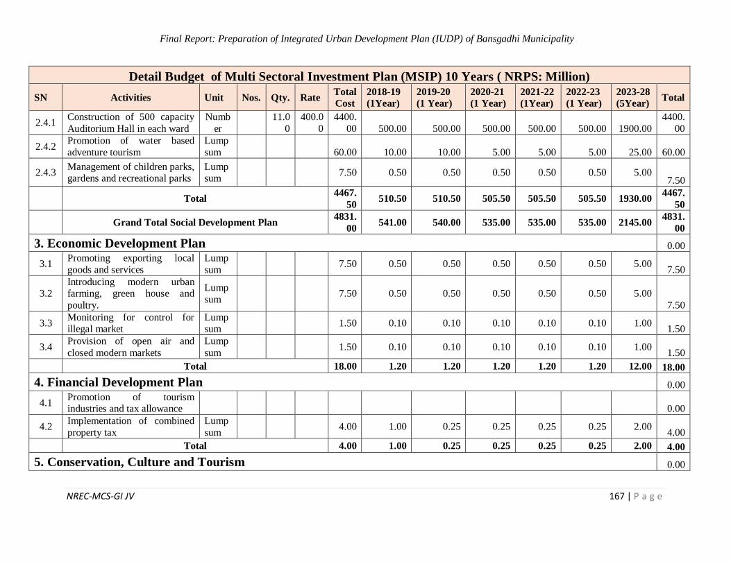
Final Report: Preparation of Integrated Urban Development Plan (IUDP) of Bansgadhi Municipality
NREC-MCS-GI JV 167 | P a g e
Detail Budget of Multi Sectoral Investment Plan (MSIP) 10 Years ( NRPS: Million)
SN Activities Unit Nos. Qty. Rate Total
Cost
2018-19
(1Year)
2019-20
(1 Year)
2020-21
(1 Year)
2021-22
(1Year)
2022-23
(1 Year)
2023-28
(5Year) Total
2.4.1 Construction of 500 capacity
Auditorium Hall in each ward
Numb
er
11.0
0
400.0
0
4400.
00 500.00 500.00 500.00 500.00 500.00 1900.00
4400.
00
2.4.2 Promotion of water based
adventure tourism
Lump
sum 60.00 10.00 10.00 5.00 5.00 5.00 25.00 60.00
2.4.3 Management of children parks, gardens and recreational parks
Lumpsum
7.50 0.50 0.50 0.50 0.50 0.50 5.00 7.50
Total 4467.
50 510.50 510.50 505.50 505.50 505.50 1930.00
4467.
50
Grand Total Social Development Plan 4831.
00 541.00 540.00 535.00 535.00 535.00 2145.00
4831.
00
3. Economic Development Plan 0.00
3.1 Promoting exporting local
goods and services
Lump
sum 7.50 0.50 0.50 0.50 0.50 0.50 5.00
7.50
3.2 Introducing modern urban farming, green house and
poultry.
Lump
sum 7.50 0.50 0.50 0.50 0.50 0.50 5.00
7.50
3.3 Monitoring for control for illegal market
Lumpsum
1.50 0.10 0.10 0.10 0.10 0.10 1.00 1.50
3.4 Provision of open air and
closed modern markets
Lump
sum 1.50 0.10 0.10 0.10 0.10 0.10 1.00
1.50
Total 18.00 1.20 1.20 1.20 1.20 1.20 12.00 18.00
4. Financial Development Plan 0.00
4.1 Promotion of tourism industries and tax allowance
0.00
4.2 Implementation of combined
property tax
Lump
sum 4.00 1.00 0.25 0.25 0.25 0.25 2.00
4.00
Total 4.00 1.00 0.25 0.25 0.25 0.25 2.00 4.00
5. Conservation, Culture and Tourism 0.00
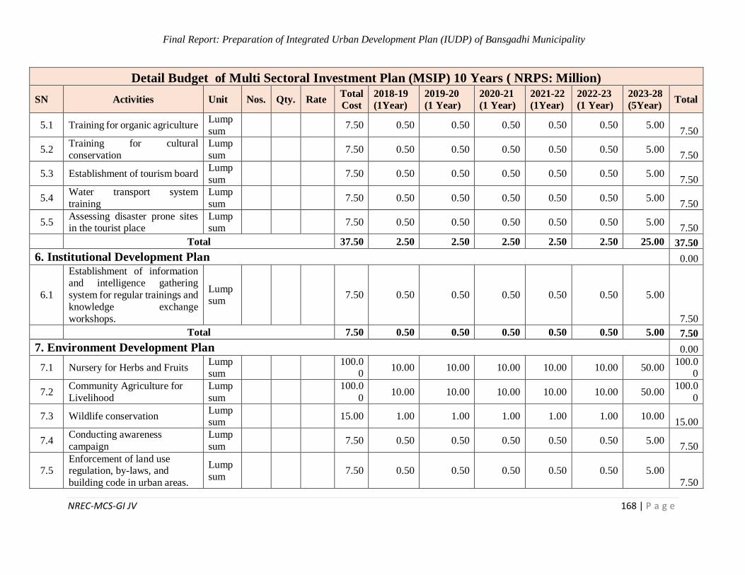
Final Report: Preparation of Integrated Urban Development Plan (IUDP) of Bansgadhi Municipality
NREC-MCS-GI JV 168 | P a g e
Detail Budget of Multi Sectoral Investment Plan (MSIP) 10 Years ( NRPS: Million)
SN Activities Unit Nos. Qty. Rate Total
Cost
2018-19
(1Year)
2019-20
(1 Year)
2020-21
(1 Year)
2021-22
(1Year)
2022-23
(1 Year)
2023-28
(5Year) Total
5.1 Training for organic agriculture Lump
sum 7.50 0.50 0.50 0.50 0.50 0.50 5.00
7.50
5.2 Training for cultural
conservation
Lump
sum 7.50 0.50 0.50 0.50 0.50 0.50 5.00
7.50
5.3 Establishment of tourism board Lump
sum 7.50 0.50 0.50 0.50 0.50 0.50 5.00
7.50
5.4 Water transport system
training
Lump
sum 7.50 0.50 0.50 0.50 0.50 0.50 5.00
7.50
5.5 Assessing disaster prone sites in the tourist place
Lumpsum
7.50 0.50 0.50 0.50 0.50 0.50 5.00 7.50
Total 37.50 2.50 2.50 2.50 2.50 2.50 25.00 37.50
6. Institutional Development Plan 0.00
6.1
Establishment of information and intelligence gathering
system for regular trainings and
knowledge exchange
workshops.
Lumpsum
7.50 0.50 0.50 0.50 0.50 0.50 5.00
7.50
Total 7.50 0.50 0.50 0.50 0.50 0.50 5.00 7.50
7. Environment Development Plan 0.00
7.1 Nursery for Herbs and Fruits Lumpsum
100.0
0 10.00 10.00 10.00 10.00 10.00 50.00
100.00
7.2 Community Agriculture for
Livelihood
Lump
sum
100.0
0 10.00 10.00 10.00 10.00 10.00 50.00
100.0
0
7.3 Wildlife conservation Lumpsum
15.00 1.00 1.00 1.00 1.00 1.00 10.00 15.00
7.4 Conducting awareness
campaign
Lump
sum 7.50 0.50 0.50 0.50 0.50 0.50 5.00
7.50
7.5 Enforcement of land use regulation, by-laws, and
building code in urban areas.
Lump
sum 7.50 0.50 0.50 0.50 0.50 0.50 5.00
7.50
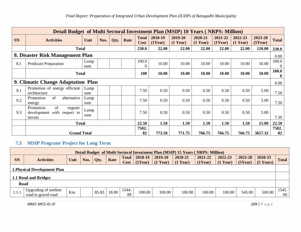
Final Report: Preparation of Integrated Urban Development Plan (IUDP) of Bansgadhi Municipality
NREC-MCS-GI JV 169 | P a g e
Detail Budget of Multi Sectoral Investment Plan (MSIP) 10 Years ( NRPS: Million)
SN Activities Unit Nos. Qty. Rate Total
Cost
2018-19
(1Year)
2019-20
(1 Year)
2020-21
(1 Year)
2021-22
(1Year)
2022-23
(1 Year)
2023-28
(5Year) Total
Total 230.0 22.00 22.00 22.00 22.00 22.00 120.00 230.0
8. Disaster Risk Management Plan 0.00
8.1 Predicate Preparation Lumpsum
100.0
0 10.00 10.00 10.00 10.00 10.00 50.00
100.00
Total 100 10.00 10.00 10.00 10.00 10.00 50.00 100.0
0
9. Climatic Change Adaptation Plan 0.00
9.1 Promotion of energy efficient
architecture
Lump
sum 7.50 0.50 0.50 0.50 0.50 0.50 5.00
7.50
9.2 Promotion of alternative
energy
Lump
sum 7.50 0.50 0.50 0.50 0.50 0.50 5.00
7.50
9.3 Promotion of organic development with respect to
terrain
Lump
sum 7.50 0.50 0.50 0.50 0.50 0.50 5.00
7.50
Total 22.50 1.50 1.50 1.50 1.50 1.50 15.00 22.50
Grand Total
7502.
82 773.50 771.75 766.75 766.75 766.75 3657.32
7502.
82
7.3 MSIP Program/ Project for Long Term
Detail Budget of Multi Sectoral Investment Plan (MSIP) 15 Years ( NRPS: Million)
SN Activities Unit Nos. Qty. Rate Total
Cost
2018-19
(1Year)
2019-20
(1 Year)
2020-21
(1 Year)
2021-22
(1Year)
2022-23
(1 Year)
2023-28
(5Year)
2028-33
(5 Years) Total
1.Physical Development Plan
1.1 Road and Bridges
Road
1.1.1 Upgrading of earthen road to gravel road
Km 85.83 18.00 1544.
89 100.00 100.00 100.00 100.00 100.00 545.00 500.00
1545.00
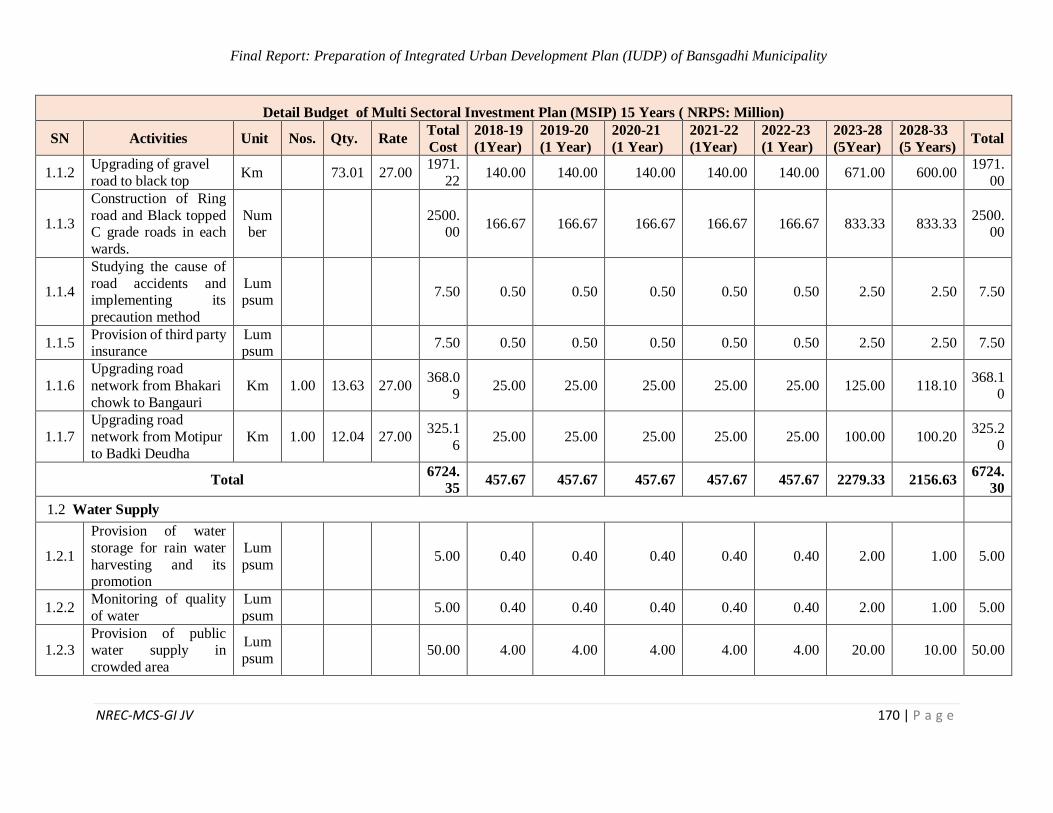
Final Report: Preparation of Integrated Urban Development Plan (IUDP) of Bansgadhi Municipality
NREC-MCS-GI JV 170 | P a g e
Detail Budget of Multi Sectoral Investment Plan (MSIP) 15 Years ( NRPS: Million)
SN Activities Unit Nos. Qty. Rate Total
Cost
2018-19
(1Year)
2019-20
(1 Year)
2020-21
(1 Year)
2021-22
(1Year)
2022-23
(1 Year)
2023-28
(5Year)
2028-33
(5 Years) Total
1.1.2 Upgrading of gravel
road to black top Km 73.01 27.00
1971.
22 140.00 140.00 140.00 140.00 140.00 671.00 600.00
1971.
00
1.1.3
Construction of Ring
road and Black topped C grade roads in each
wards.
Number
2500.
00 166.67 166.67 166.67 166.67 166.67 833.33 833.33
2500.00
1.1.4
Studying the cause of
road accidents and implementing its
precaution method
Lumpsum
7.50 0.50 0.50 0.50 0.50 0.50 2.50 2.50 7.50
1.1.5 Provision of third party insurance
Lumpsum
7.50 0.50 0.50 0.50 0.50 0.50 2.50 2.50 7.50
1.1.6
Upgrading road
network from Bhakari
chowk to Bangauri
Km 1.00 13.63 27.00 368.0
9 25.00 25.00 25.00 25.00 25.00 125.00 118.10
368.10
1.1.7
Upgrading road
network from Motipur
to Badki Deudha
Km 1.00 12.04 27.00 325.1
6 25.00 25.00 25.00 25.00 25.00 100.00 100.20
325.2
0
Total 6724.
35 457.67 457.67 457.67 457.67 457.67 2279.33 2156.63
6724.
30
1.2 Water Supply
1.2.1
Provision of water
storage for rain water
harvesting and its promotion
Lum
psum 5.00 0.40 0.40 0.40 0.40 0.40 2.00 1.00 5.00
1.2.2 Monitoring of quality
of water
Lum
psum 5.00 0.40 0.40 0.40 0.40 0.40 2.00 1.00 5.00
1.2.3 Provision of public water supply in
crowded area
Lum
psum 50.00 4.00 4.00 4.00 4.00 4.00 20.00 10.00 50.00
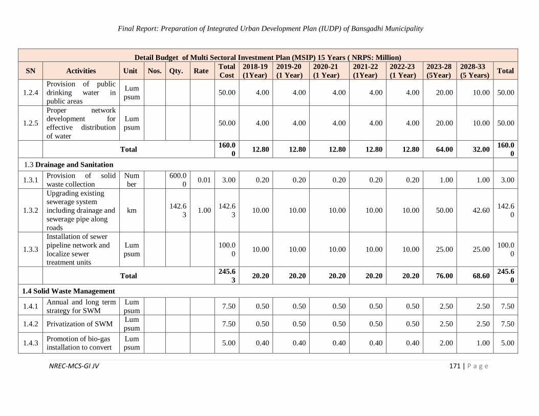
Final Report: Preparation of Integrated Urban Development Plan (IUDP) of Bansgadhi Municipality
NREC-MCS-GI JV 171 | P a g e
Detail Budget of Multi Sectoral Investment Plan (MSIP) 15 Years ( NRPS: Million)
SN Activities Unit Nos. Qty. Rate Total
Cost
2018-19
(1Year)
2019-20
(1 Year)
2020-21
(1 Year)
2021-22
(1Year)
2022-23
(1 Year)
2023-28
(5Year)
2028-33
(5 Years) Total
1.2.4
Provision of public
drinking water in
public areas
Lum
psum 50.00 4.00 4.00 4.00 4.00 4.00 20.00 10.00 50.00
1.2.5
Proper network development for
effective distribution
of water
Lum
psum 50.00 4.00 4.00 4.00 4.00 4.00 20.00 10.00 50.00
Total 160.0
0 12.80 12.80 12.80 12.80 12.80 64.00 32.00
160.0
0
1.3 Drainage and Sanitation
1.3.1 Provision of solid
waste collection
Num
ber
600.0
0 0.01 3.00 0.20 0.20 0.20 0.20 0.20 1.00 1.00 3.00
1.3.2
Upgrading existing sewerage system
including drainage and
sewerage pipe along
roads
km 142.6
3 1.00
142.6
3 10.00 10.00 10.00 10.00 10.00 50.00 42.60
142.6
0
1.3.3
Installation of sewer
pipeline network and
localize sewer treatment units
Lum
psum
100.0
0 10.00 10.00 10.00 10.00 10.00 25.00 25.00
100.0
0
Total 245.6
3 20.20 20.20 20.20 20.20 20.20 76.00 68.60
245.6
0
1.4 Solid Waste Management
1.4.1 Annual and long term
strategy for SWM
Lum
psum 7.50 0.50 0.50 0.50 0.50 0.50 2.50 2.50 7.50
1.4.2 Privatization of SWM Lum
psum 7.50 0.50 0.50 0.50 0.50 0.50 2.50 2.50 7.50
1.4.3 Promotion of bio-gas installation to convert
Lumpsum
5.00 0.40 0.40 0.40 0.40 0.40 2.00 1.00 5.00
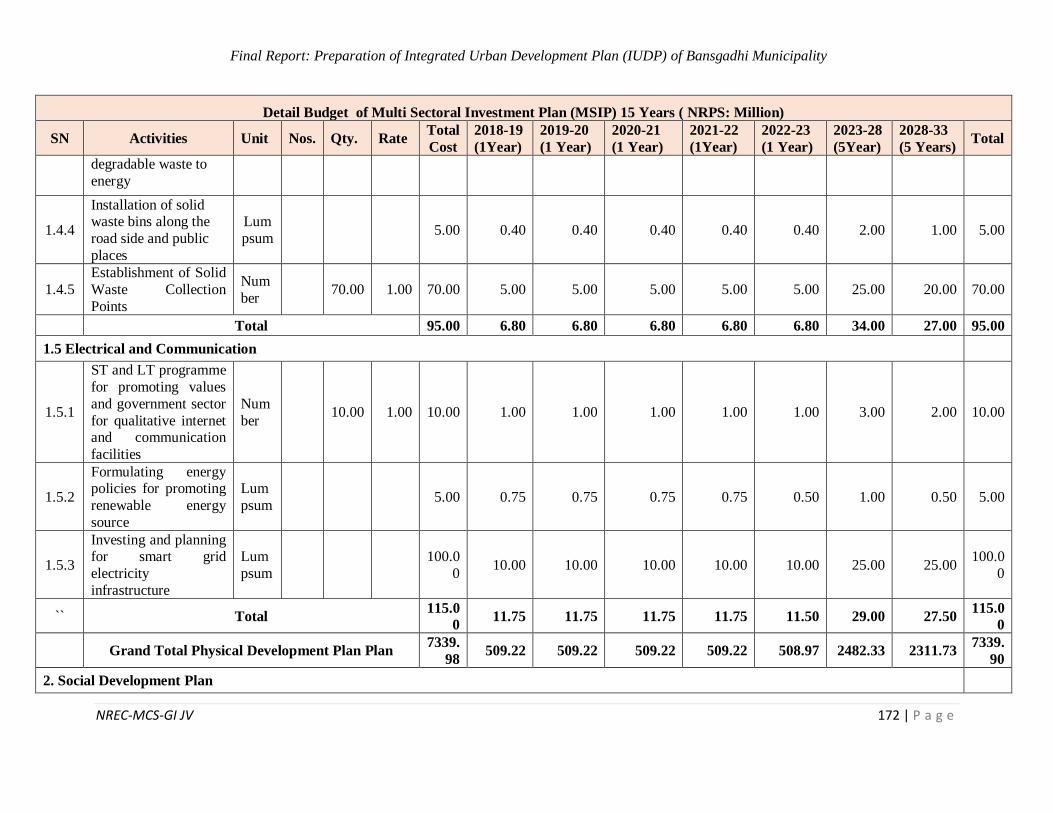
Final Report: Preparation of Integrated Urban Development Plan (IUDP) of Bansgadhi Municipality
NREC-MCS-GI JV 172 | P a g e
Detail Budget of Multi Sectoral Investment Plan (MSIP) 15 Years ( NRPS: Million)
SN Activities Unit Nos. Qty. Rate Total
Cost
2018-19
(1Year)
2019-20
(1 Year)
2020-21
(1 Year)
2021-22
(1Year)
2022-23
(1 Year)
2023-28
(5Year)
2028-33
(5 Years) Total
degradable waste to
energy
1.4.4
Installation of solid waste bins along the
road side and public
places
Lum
psum 5.00 0.40 0.40 0.40 0.40 0.40 2.00 1.00 5.00
1.4.5
Establishment of Solid
Waste Collection
Points
Num
ber 70.00 1.00 70.00 5.00 5.00 5.00 5.00 5.00 25.00 20.00 70.00
Total 95.00 6.80 6.80 6.80 6.80 6.80 34.00 27.00 95.00
1.5 Electrical and Communication
1.5.1
ST and LT programme
for promoting values
and government sector
for qualitative internet and communication
facilities
Num
ber 10.00 1.00 10.00 1.00 1.00 1.00 1.00 1.00 3.00 2.00 10.00
1.5.2
Formulating energy policies for promoting
renewable energy
source
Lum
psum 5.00 0.75 0.75 0.75 0.75 0.50 1.00 0.50 5.00
1.5.3
Investing and planning for smart grid
electricity
infrastructure
Lum
psum
100.0
0 10.00 10.00 10.00 10.00 10.00 25.00 25.00
100.0
0
`` Total 115.0
0 11.75 11.75 11.75 11.75 11.50 29.00 27.50
115.0
0
Grand Total Physical Development Plan Plan 7339.
98 509.22 509.22 509.22 509.22 508.97 2482.33 2311.73
7339.
90
2. Social Development Plan
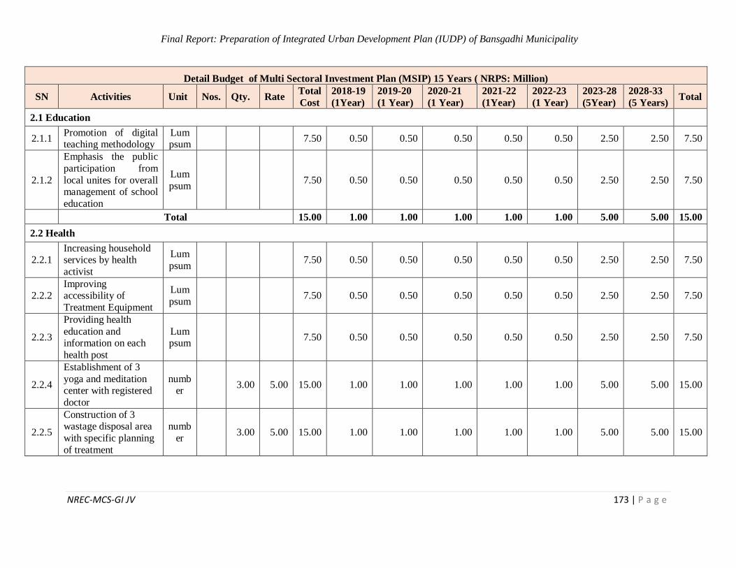
Final Report: Preparation of Integrated Urban Development Plan (IUDP) of Bansgadhi Municipality
NREC-MCS-GI JV 173 | P a g e
Detail Budget of Multi Sectoral Investment Plan (MSIP) 15 Years ( NRPS: Million)
SN Activities Unit Nos. Qty. Rate Total
Cost
2018-19
(1Year)
2019-20
(1 Year)
2020-21
(1 Year)
2021-22
(1Year)
2022-23
(1 Year)
2023-28
(5Year)
2028-33
(5 Years) Total
2.1 Education
2.1.1 Promotion of digital teaching methodology
Lumpsum
7.50 0.50 0.50 0.50 0.50 0.50 2.50 2.50 7.50
2.1.2
Emphasis the public
participation from
local unites for overall management of school
education
Lum
psum 7.50 0.50 0.50 0.50 0.50 0.50 2.50 2.50 7.50
Total 15.00 1.00 1.00 1.00 1.00 1.00 5.00 5.00 15.00
2.2 Health
2.2.1 Increasing household services by health
activist
Lum
psum 7.50 0.50 0.50 0.50 0.50 0.50 2.50 2.50 7.50
2.2.2 Improving accessibility of
Treatment Equipment
Lum
psum 7.50 0.50 0.50 0.50 0.50 0.50 2.50 2.50 7.50
2.2.3
Providing health
education and information on each
health post
Lumpsum
7.50 0.50 0.50 0.50 0.50 0.50 2.50 2.50 7.50
2.2.4
Establishment of 3
yoga and meditation center with registered
doctor
number
3.00 5.00 15.00 1.00 1.00 1.00 1.00 1.00 5.00 5.00 15.00
2.2.5
Construction of 3 wastage disposal area
with specific planning
of treatment
numb
er 3.00 5.00 15.00 1.00 1.00 1.00 1.00 1.00 5.00 5.00 15.00
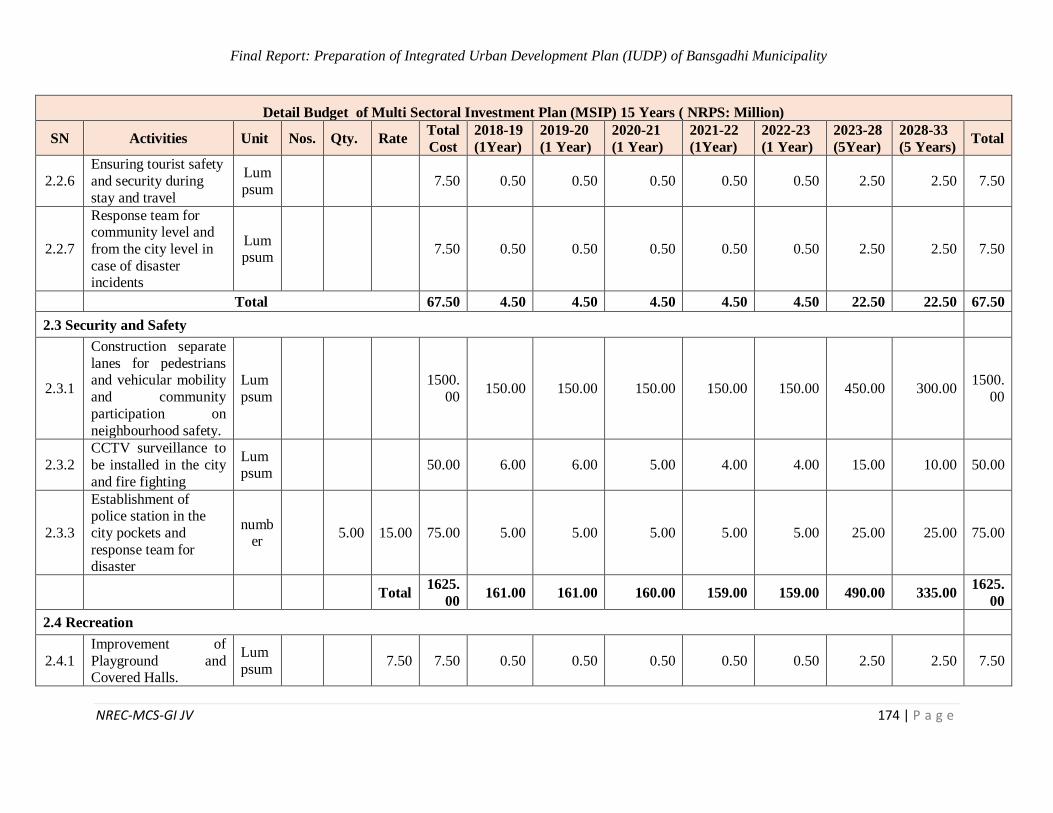
Final Report: Preparation of Integrated Urban Development Plan (IUDP) of Bansgadhi Municipality
NREC-MCS-GI JV 174 | P a g e
Detail Budget of Multi Sectoral Investment Plan (MSIP) 15 Years ( NRPS: Million)
SN Activities Unit Nos. Qty. Rate Total
Cost
2018-19
(1Year)
2019-20
(1 Year)
2020-21
(1 Year)
2021-22
(1Year)
2022-23
(1 Year)
2023-28
(5Year)
2028-33
(5 Years) Total
2.2.6
Ensuring tourist safety
and security during
stay and travel
Lum
psum 7.50 0.50 0.50 0.50 0.50 0.50 2.50 2.50 7.50
2.2.7
Response team for community level and
from the city level in
case of disaster incidents
Lumpsum
7.50 0.50 0.50 0.50 0.50 0.50 2.50 2.50 7.50
Total 67.50 4.50 4.50 4.50 4.50 4.50 22.50 22.50 67.50
2.3 Security and Safety
2.3.1
Construction separate
lanes for pedestrians and vehicular mobility
and community
participation on
neighbourhood safety.
Lum
psum
1500.
00 150.00 150.00 150.00 150.00 150.00 450.00 300.00
1500.
00
2.3.2
CCTV surveillance to
be installed in the city
and fire fighting
Lumpsum
50.00 6.00 6.00 5.00 4.00 4.00 15.00 10.00 50.00
2.3.3
Establishment of police station in the
city pockets and
response team for disaster
number
5.00 15.00 75.00 5.00 5.00 5.00 5.00 5.00 25.00 25.00 75.00
Total 1625.
00 161.00 161.00 160.00 159.00 159.00 490.00 335.00
1625.
00
2.4 Recreation
2.4.1
Improvement of
Playground and Covered Halls.
Lum
psum 7.50 7.50 0.50 0.50 0.50 0.50 0.50 2.50 2.50 7.50
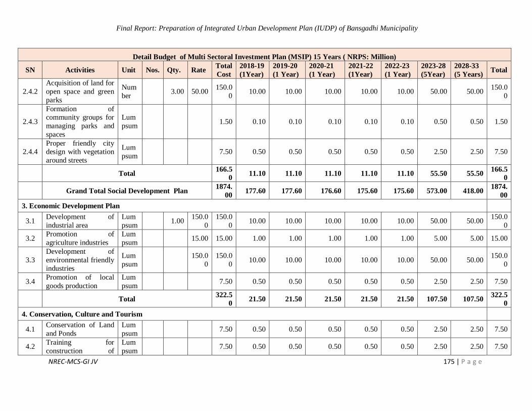
Final Report: Preparation of Integrated Urban Development Plan (IUDP) of Bansgadhi Municipality
NREC-MCS-GI JV 175 | P a g e
Detail Budget of Multi Sectoral Investment Plan (MSIP) 15 Years ( NRPS: Million)
SN Activities Unit Nos. Qty. Rate Total
Cost
2018-19
(1Year)
2019-20
(1 Year)
2020-21
(1 Year)
2021-22
(1Year)
2022-23
(1 Year)
2023-28
(5Year)
2028-33
(5 Years) Total
2.4.2
Acquisition of land for
open space and green
parks
Num
ber 3.00 50.00
150.0
0 10.00 10.00 10.00 10.00 10.00 50.00 50.00
150.0
0
2.4.3
Formation of community groups for
managing parks and
spaces
Lum
psum 1.50 0.10 0.10 0.10 0.10 0.10 0.50 0.50 1.50
2.4.4 Proper friendly city design with vegetation
around streets
Lum
psum 7.50 0.50 0.50 0.50 0.50 0.50 2.50 2.50 7.50
Total 166.5
0 11.10 11.10 11.10 11.10 11.10 55.50 55.50
166.5
0
Grand Total Social Development Plan 1874.
00 177.60 177.60 176.60 175.60 175.60 573.00 418.00
1874.
00
3. Economic Development Plan
3.1 Development of
industrial area
Lum
psum 1.00
150.0
0
150.0
0 10.00 10.00 10.00 10.00 10.00 50.00 50.00
150.0
0
3.2 Promotion of
agriculture industries
Lum
psum 15.00 15.00 1.00 1.00 1.00 1.00 1.00 5.00 5.00 15.00
3.3
Development of
environmental friendly industries
Lum
psum
150.0
0
150.0
0 10.00 10.00 10.00 10.00 10.00 50.00 50.00
150.0
0
3.4 Promotion of local
goods production
Lum
psum 7.50 0.50 0.50 0.50 0.50 0.50 2.50 2.50 7.50
Total 322.5
0 21.50 21.50 21.50 21.50 21.50 107.50 107.50
322.5
0
4. Conservation, Culture and Tourism
4.1 Conservation of Land
and Ponds
Lum
psum 7.50 0.50 0.50 0.50 0.50 0.50 2.50 2.50 7.50
4.2 Training for
construction of
Lum
psum 7.50 0.50 0.50 0.50 0.50 0.50 2.50 2.50 7.50

Final Report: Preparation of Integrated Urban Development Plan (IUDP) of Bansgadhi Municipality
NREC-MCS-GI JV 176 | P a g e
Detail Budget of Multi Sectoral Investment Plan (MSIP) 15 Years ( NRPS: Million)
SN Activities Unit Nos. Qty. Rate Total
Cost
2018-19
(1Year)
2019-20
(1 Year)
2020-21
(1 Year)
2021-22
(1Year)
2022-23
(1 Year)
2023-28
(5Year)
2028-33
(5 Years) Total
environmental friendly
house
4.3 Construction of
temples
Lum
psum
150.0
0 10.00 10.00 10.00 10.00 10.00 50.00 50.00
150.0
0
4.4 Construction of
Museums
Lum
psum
150.0
0 10.00 10.00 10.00 10.00 10.00 50.00 50.00
150.0
0
4.5
Conservation and
development of wetland area
Lum
psum 7.50 0.50 0.50 0.50 0.50 0.50 2.50 2.50 7.50
Total 322.5
0 21.50 21.50 21.50 21.50 21.50 107.50 107.50
322.5
0
5. Institutional Development Plan
5.1
Provide education and
capacity building for
participatory
integrated development plan
Lumpsum
7.50 0.50 0.50 0.50 0.50 0.50 2.50 2.50 7.50
5.2
Separate authority for
monitoring and evaluation of
government works for
quality and timely
completion
Lum
psum 7.50 0.50 0.50 0.50 0.50 0.50 2.50 2.50 7.50
Total 15.00 1.00 1.00 1.00 1.00 1.00 5.00 5.00 15.00
6. Environment Development Plan
6.1 Development of
alternative energy
Lum
psum 7.50 0.50 0.50 0.50 0.50 0.50 2.50 2.50 7.50
6.2
Conducting forest
conservation
Programmes
Lumpsum
7.50 0.50 0.50 0.50 0.50 0.50 2.50 2.50 7.50
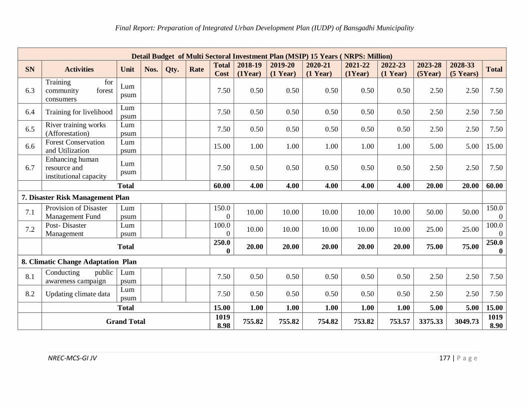
Final Report: Preparation of Integrated Urban Development Plan (IUDP) of Bansgadhi Municipality
NREC-MCS-GI JV 177 | P a g e
Detail Budget of Multi Sectoral Investment Plan (MSIP) 15 Years ( NRPS: Million)
SN Activities Unit Nos. Qty. Rate Total
Cost
2018-19
(1Year)
2019-20
(1 Year)
2020-21
(1 Year)
2021-22
(1Year)
2022-23
(1 Year)
2023-28
(5Year)
2028-33
(5 Years) Total
6.3
Training for
community forest
consumers
Lum
psum 7.50 0.50 0.50 0.50 0.50 0.50 2.50 2.50 7.50
6.4 Training for livelihood Lumpsum
7.50 0.50 0.50 0.50 0.50 0.50 2.50 2.50 7.50
6.5 River training works
(Afforestation)
Lum
psum 7.50 0.50 0.50 0.50 0.50 0.50 2.50 2.50 7.50
6.6 Forest Conservation and Utilization
Lumpsum
15.00 1.00 1.00 1.00 1.00 1.00 5.00 5.00 15.00
6.7
Enhancing human
resource and
institutional capacity
Lumpsum
7.50 0.50 0.50 0.50 0.50 0.50 2.50 2.50 7.50
Total 60.00 4.00 4.00 4.00 4.00 4.00 20.00 20.00 60.00
7. Disaster Risk Management Plan
7.1 Provision of Disaster
Management Fund
Lum
psum
150.0
0 10.00 10.00 10.00 10.00 10.00 50.00 50.00
150.0
0
7.2 Post- Disaster Management
Lumpsum
100.0
0 10.00 10.00 10.00 10.00 10.00 25.00 25.00
100.00
Total 250.0
0 20.00 20.00 20.00 20.00 20.00 75.00 75.00
250.0
0
8. Climatic Change Adaptation Plan
8.1 Conducting public
awareness campaign
Lum
psum 7.50 0.50 0.50 0.50 0.50 0.50 2.50 2.50 7.50
8.2 Updating climate data Lum
psum 7.50 0.50 0.50 0.50 0.50 0.50 2.50 2.50 7.50
Total 15.00 1.00 1.00 1.00 1.00 1.00 5.00 5.00 15.00
Grand Total 1019
8.98 755.82 755.82 754.82 753.82 753.57 3375.33 3049.73
1019
8.90
Final Report: Preparation of Integrated Urban Development Plan (IUDP) of Bansgadhi Municipality
NREC-MCS-GI JV 178 | P a g e
REFERENCES
“Smart cities – Ranking of European medium-sized cities”, Centre of Regional Science, Vienna
UT, October 2007
ADB. (2008). Nepal: Melamchi Water Supply Project. Manila: Asian Development Bank.
Available at: http://www.adb.org/printpdf/projects/31624-023/main
ADB. (2009). Nepal: Second Small Towns Water Supply and Sanitation Sector Project. Manila:
Asian Development Bank. Available at: http://www.adb.org/printpdf/projects/41022-
022/main
ADB. (2010a). Nepal: Secondary Towns Integrated Urban Environmental Improvement Project.
Manila: Asian Development Bank. Available at:
http://www.adb.org/printpdf/projects/36188-023/main
ADB. (2010b). Nepal: Kathmandu Sustainable Urban Transport Project. Manila: Asian
Development Bank. Available at: http://www.adb.org/printpdf/projects/44058-013/main
ADB. (2013a). Nepal Country Partnership Strategy 2013 – 2017. Manila: Asian Development
Bank. Available at: http://www.adb.org/sites/default/files/institutional-
document/34001/files/cps-nep-2013-2017.pdf
ADB. (2013b). Nepal: Kathmandu Valley Wastewater Management Project. Manila: Asian
Development Bank. Available at: http://www.adb.org/printpdf/projects/43524-014/main
ADB. (2014a). Nepal: Third Small Towns Water Supply and Sanitation Sector Project. Manila:
Asian Development Bank. Available at: http://www.adb.org/printpdf/projects/35173-
013/main
ADB. (2014b). Nepal: Far Western Region Urban Development Project. Manila: Asian
Development Bank. Available at: http://www.adb.org/printpdf/projects/47252-001/main
ADB. (2015a). Nepal: Kathmandu Valley Water Supply Improvement Project – Additional
Financing. Manila: Asian Development Bank. Available at:
http://www.adb.org/printpdf/projects/34304-044/main
ADB. (2015b). Nepal: Integrated Urban Development Project. Manila: Asian Development Bank.
Available at: http://www.adb.org/printpdf/projects/42161-013/main
Bakrania, S. (2015). Urbanisation and urban growth in Nepal (GSDRC Helpdesk Research
Report 1294), Birmingham, UK: GSDRC, University of Birmingham.
CBS. (2012). National Population and Housing Census 2011: National Report. Kathmandu:
Central Bureau of Statistics, Government of Nepal. Available at:
http://countryoffice.unfpa.org/nepal/drive/Nepal-Census-2011-Vol1.pdf
CBS. (2014). National Population and Housing Census 2011: Urban Tables. Kathmandu: Central
Bureau of Statistics, Government of Nepal. Available at:

Final Report: Preparation of Integrated Urban Development Plan (IUDP) of Bansgadhi Municipality
NREC-MCS-GI JV 179 | P a g e
http://elibrary.xyz/cbs/image/data/Population/Urban%20Volume/UrbanVolume_Part01
Choe, K. and Pradhan, P. (2010). Unleashing Economic Growth: Region-based Urban
Development Strategy for Nepal. Manila: Asian Development Bank. Available at:
http://www.adb.org/sites/default/files/publication/27498/unleashing-economic-growth-
nepal.pdf
Devkota, K. (2013). Dynamics of Urbanization in Nepal: The Role and Response of Local
Government. Kathmandu: Alliance for Social Dialogue. Available at:
http://asd.org.np/wpcontent/uploads/2015/03/dynamics_of_urbanization_in_nepal.pdf
Devkota, K. (2013). Dynamics of Urbanization in Nepal: The Role and Response of Local
Government. Kathmandu: Alliance for Social Dialogue. Available at:
http://asd.org.np/wpcontent/uploads/2015/03/dynamics_of_urbanization_in_nepal.pdf
Devkota, K. (2014). New Municipalities: A Decision Without Vision. Nepali Headlines [online].
Available at: http://nepaliheadlines.com/new-municipalities-decision-without-vision/
Devkota, K. (2018). Challenges of Inclusive Urbanization in the Face of Political Transition in
Nepal. In Handbook of Research on Urban Governance and Management in the
Developing World (pp. 159-171). IGI Global.
DFID. (2014). Nepal Local Governance Support Program: Annual Review. London: Department
for International Development. Available at:
http://iati.dfid.gov.uk/iati_documents/4767179.odt
Dhakal, R. (2004). Urban Land Development Planning Effort in Kathmandu Valley. Tokyo: Asian
Area Studies of City Planning.
Ebenezer Howard's three magnets. (2014, December 05). Retrieved from The Guardian:
https://www.theguardian.com/cities/2014/dec/05/ebenezer-howards-three-magnets
GIZ. (2015). Overview of GIZ-Supported Projects in Nepal: August 2015. Kathmandu: GIZ
Office Kathmandu.
Goh, L. E. (n.d.). Planning that works: Housing Policy and Economic development in singapore.
Journal of Planning Education and Resarch.
Hardy, D. (2011). Garden Cities: Practical Concept, Elusive Reality. Journal of Planning History.
Heritage Foundation: Letchworth Garden City. (2015, 10 29). Retrieved from
http://www.letchworth.com/heritage-foundation/altering-your-home
Hugo, G. (2017). New forms of urbanization: beyond the urban-rural dichotomy. London & New
York: Routledge.
International IDEA. (2015). Constitutional Bill of Nepal 2015 – Revised Draft - Unofficial
English Translation by International IDEA. Stockholm: International IDEA. Available
at:
Final Report: Preparation of Integrated Urban Development Plan (IUDP) of Bansgadhi Municipality
NREC-MCS-GI JV 180 | P a g e
http://www.inseconline.org/linkedfile/Bill%20Of%20Constitution%202015%20Sept.pd
f
ISKANDAR Regional Development Authority. (n.d.). Retrieved from BACKGROUND OF LOW
CARBON SOCIETY IN ISKANDAR MALAYSIA:
http://iskandarmalaysia.com.my/green/low.html
JICA. (2015). Maps of JICA Major Projects – Nepal: Tokyo: Japan International Cooperation
Agency. Available at: https://libportal.jica.go.jp/fmi/xsl/library/Data/PlanInOperation-
e/EastSouthAsia/060_Nepal-e.pdf
JICA. (undated a). Country Assistance Policy for Nepal. Tokyo: Japan International Cooperation
Agency. Available at: http://www.np.emb-japan.go.jp/oda/odapolicy.pdf
JICA. (undated b). Project Outline: Hydro-microbiological Approach for Water Security in
Kathmandu Valley, Nepal. Available at:
http://www.jica.go.jp/project/english/nepal/008/outline/index.html
JICA. (undated c). Activities in Nepal. Available at:
http://www.jica.go.jp/nepal/english/activities/water.html#01
KC., A. (2015). Role of Good Urban Governance for Comprehensive Planning in Nepal: Actors
and Participation. Unpublished Master Thesis. Lalitpur: Tribhuwan University.
Letchworth Garden City. (n.d.). Retrieved from Letchworth Garden City:
http://www.spatialagency.net/database/why/political/garden.cities
Madakam S., Ramaswamy R. (2013). The State of Art: Smart Cities in India: A Literature Review
Report. Mumbai, India (2013).
MoFALD. (2013). Local Governance and Community Development Program (LGCDP II):
Program Document FY 2013/14 – 2016/17. Kathmandu: Ministry of Federal Affairs and
Local Development, Government of Nepal. Available at:
http://www.lgcdp.gov.np/phase2/sites/default/files/resource_docs/LGCDP_Pogramme_
Document_phase_II.pdf
MoPPW. (2009). National Urban Water Supply and Sanitation Sector Policy. Kathmandu: Ministry
of Physical Planning and Works, Government of Nepal. Available at:
http://dwss.gov.np/email_soft/file/LJypnKindex.pdf
MoUD. (2015). National Urban Development Strategy 2015. Kathmandu: Ministry of Urban
Development, Government of Nepal. Available at: http://www.moud.gov.np/pdf/NUDS-
2015-final-draft.pdf
Muzzini, E. and Aparicio, G. (2013). Urban Growth and Spatial Transition in Nepal. Washington
D.C.: World Bank. Available at: http://dx.doi.org/10.1596/978-0-8213-9659-9
Final Report: Preparation of Integrated Urban Development Plan (IUDP) of Bansgadhi Municipality
NREC-MCS-GI JV 181 | P a g e
National Urban Development Strategy. (2017). National Urban Development Strategy,
Governemnt of Nepal, Kathmandu.
New Spotlight. (2014a, 21 November). Nepal Government declares 61 new municipalities. New
Spotlight [online]. Available at: http://www.spotlightnepal.com/News/Article/Nepal-
Government-declares-newmunicipalities
New Spotlight. (2014b, 26 December). Municipalities Mean Improving Lives. New Spotlight
[online]. Available at: http://www.spotlightnepal.com/News/Article/Municipalities-
Mean-Improving-Lives
North Hertfordshire District Council. (2007). Letchworth Garden City Town Centre Strategy
:Supplementary Planning Document.
Practical Action Nepal. (undated). Urban Waste Water and Sanitation – Nepal.
Available at: http://practicalaction.org/urban-waste-water-sanitation-nepal
Pradhan, P.K. (2012). Concept and Methods: Urbanization in Nepal. Kathmandu: Tribhuvan
University.
Pradhan, P.K. (2015). Impediments to the Development of a Balanced Urban System. A Paper to
the Department of Urban Development and Building Construction, Government of
Nepal. Kathmandu: Tribhuvan University.
Raj Pant, P. and Dongol, D. (2009, February). Kathmandu Valley Profile: Briefing Paper. Paper
presented at Governance and Infrastructure Development Challenges in the Kathmandu
Valley, Kathmandu. Available at:
http://www.eastwestcenter.org/fileadmin/resources/seminars/Urbanization_Seminar/Ka
thmandu_Valley_Brief_for_EWC___KMC_Workshop__Feb_2009_.pdf
Sharma, S., Pandey, S., Pathak, D. and Sijapati-Basnett, B. (2014). State of Migration in Nepal.
Kathmandu: Centre for the Study of Labour and Mobility. Available at:
http://www.ceslam.org/docs/publicationManagement/STATE%20OF%20MIGRATIO
N%20IN%20NEPAL1404964819.pdf
TDF. (2014). Town Development Fund Brochure. Kathmandu: Town Development Fund.
Available at: http://www.tdf.org.np/new/custom/uploads/notice/9967.pdf
Thapa, G. (2015, 19th September). Govt declares 26 new municipalities. The Kathmandu Post
[online]. Available at: http://kathmandupost.ekantipur.com/news/2015-09-19/govt-
declares-26-new-municipalities.html
The Netherlands... actually the greenest city in the world. Retrieved from
http://sustainableurbandelta.com/wp-content/uploads/2015/11/NewspaperFD-
20151003.pdf
The World Bank (IRBD-IDA). (n.d.). Retrieved from Zoning and Landuse Planning: https://urban-
regeneration.worldbank.org/node/39

Final Report: Preparation of Integrated Urban Development Plan (IUDP) of Bansgadhi Municipality
NREC-MCS-GI JV 182 | P a g e
Town and Country Planning Association. (2007). Best Practice in Urban Extensions and New
Settlements : A report on emerging good practice. London: RAP Spiderweb Ltd.
UN DESA. (2014). World Urbanization Prospects: 2014 Revision. New York: United Nations
Department of
Economic and Social Affairs. Available at:
http://esa.un.org/unpd/wup/FinalReport/WUP2014-Report.pdf
UN DESA. (2018). 2018 Revision of World Urbanization Prospects: New York: United Nations
Department of
Economic and Social Affairs. Available at:
https://www.un.org/development/desa/publications/2018-revision-of-world-
urbanization-prospects.html
UN. (2012). United Nations Development Assistance Framework for Nepal: 2013 – 2017.
Kathmandu: united Nations Country Team Nepal.
http://un.org.np/sites/default/files/UNDAF_2013-2017.pdf
UN-Habitat. (2010). Nepal Urban Housing Sector Profile. Nairobi: United Nations Human
Settlements Program. Available at:
http://un.org.np/sites/default/files/NEPAL%20Housing%20Profile_2.pdf
UN-Habitat. (undated). UN-Habitat projects in Nepal. Available at: http://unhabitat.org/nepal/
WB. (2011). Urban Governance and Development Program: Emerging towns project – Project
Appraisal. Washington D.C.: World Bank. Available at:
http://wwwwds.worldbank.org/external/default/WDSContentServer/WDSP/IB/2011/04
/14/000333037_20110414000935/Rendered/PDF/592910PAD0P1200e0only0900BOX
358335B.pdf
WB. (2013a). Nepal Pro-Poor Urban Regeneration Pilot Project - Project Information Document.
Washington D.C.: World Bank. GSDRC Helpdesk Research Report.
WB. (2013b). Metropolitan Planning and Management in the Kathmandu Valley: Advisory Note
and Action Plan. Washington D.C.: World Bank. Available at:
http://wwwwds.worldbank.org/external/default/WDSContentServer/WDSP/IB/2013/10
/11/000333037_20131011150250/Rendered/PDF/ACS58120REVISE0ration0Advisory
WB. (2014). Country Partnership Strategy for Nepal – FY 2014-2018. Washington D.C.: World
Bank. Available at:
http://wwwwds.worldbank.org/external/default/WDSContentServer/WDSP/IB/2014/05
/08/000442464_20140508100553/Rendered/PDF/831480CAS0P133080Box385199B0
Wikantiyoso, R., & Tutuko, P. (2013, August). Planning Review: Green City Design Approach for
Global Warming. ISPSD International review for spatial planning and sustainable
development, spatial planning and sustainable development, ISSN: 2187-3666 (online),
3,
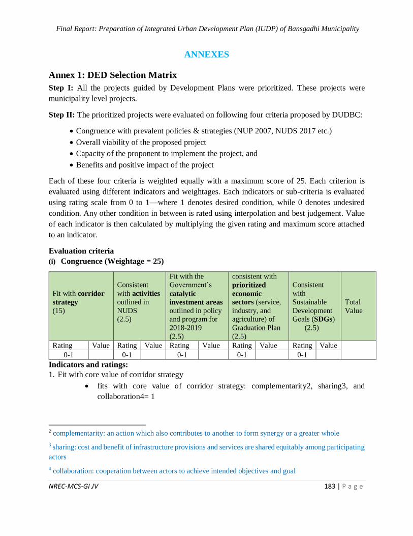
Final Report: Preparation of Integrated Urban Development Plan (IUDP) of Bansgadhi Municipality
NREC-MCS-GI JV 183 | P a g e
ANNEXES
Annex 1: DED Selection Matrix
Step I: All the projects guided by Development Plans were prioritized. These projects were
municipality level projects.
Step II: The prioritized projects were evaluated on following four criteria proposed by DUDBC:
Congruence with prevalent policies & strategies (NUP 2007, NUDS 2017 etc.)
Overall viability of the proposed project
Capacity of the proponent to implement the project, and
Benefits and positive impact of the project
Each of these four criteria is weighted equally with a maximum score of 25. Each criterion is
evaluated using different indicators and weightages. Each indicators or sub-criteria is evaluated
using rating scale from 0 to 1—where 1 denotes desired condition, while 0 denotes undesired
condition. Any other condition in between is rated using interpolation and best judgement. Value
of each indicator is then calculated by multiplying the given rating and maximum score attached
to an indicator.
Evaluation criteria
(i) Congruence (Weightage = 25)
Fit with corridor
strategy
(15)
Consistent
with activities
outlined in
NUDS (2.5)
Fit with the Government’s
catalytic
investment areas outlined in policy and program for
2018-2019
(2.5)
consistent with
prioritized
economic
sectors (service,
industry, and agriculture) of
Graduation Plan
(2.5)
Consistent
with
Sustainable
Development Goals (SDGs)
(2.5)
Total
Value
Rating Value Rating Value Rating Value Rating Value Rating Value
0-1 0-1 0-1 0-1 0-1
Indicators and ratings:
1. Fit with core value of corridor strategy
fits with core value of corridor strategy: complementarity2, sharing3, and
collaboration4= 1
2 complementarity: an action which also contributes to another to form synergy or a greater whole
3 sharing: cost and benefit of infrastructure provisions and services are shared equitably among participating
actors
4 collaboration: cooperation between actors to achieve intended objectives and goal
Final Report: Preparation of Integrated Urban Development Plan (IUDP) of Bansgadhi Municipality
NREC-MCS-GI JV 184 | P a g e
Doesn’t fit with core value of corridor strategy = 0
2. Consistent with activities outlined in NUDS
Links with activities identified by NUDS = 1
Doesn’t link with activities identified by NUDS = 0
3. Consistent with policy and program for 2018-2019
Fits with catalytic investment areas (agriculture, Energy, Transport, Physical
infrastructure, information technology, tourism, and urban development) = 1
Does not fit with the catalytic investment areas = 0
4. Consistent with prioritized economic sectors of Graduation Plan
In line with prioritized economic sectors (service, industry, and agriculture) of the
Graduation Plan (2015-2021) = 1
Not in line with prioritized economic sectors of the Graduation Plan = 0
5. Consistent with SDGs
In line with multiple goals outlined in the SDGs = 1
Not in line with any of the goals outlined in the SDGs = 0
(ii) Overall viability (Weightage = 25)
Technical
(7)
Financial
(5)
Social
(4)
Environmental
(4)
Economic
(5)
Total
Value
Rating Value Rating Value Rating Value Rating Value Rating Value
0-1 0-1 0-1 0-1 0-1
Indicators and rating:
1) Technical:
Project which has already been assessed and has some degree of readiness (max rating 0.4),
for which land is available (max rating 0.2), proposed in safer location (max rating 0.2),
and project of this kind is already tested/worked out elsewhere in other municipalities (max
rating 0.2) = 1
Project which lacks preliminary assessment and readiness (rating 0), for which land is not
available (rating 0), proposed in unsafe location (rating 0), and project of this kind is not
tested/worked out in any other municipalities (rating 0) = 0
2) Financial:
Commitment for financial contribution from municipality = 1
No commitment for financial contribution from municipality = 0
Final Report: Preparation of Integrated Urban Development Plan (IUDP) of Bansgadhi Municipality
NREC-MCS-GI JV 185 | P a g e
3) Social:
Unlikely displacement of households (max rating 0.5), and households of
peripheral areas are also served by the project (max rating 0.5) = 1
Potential displacement of households (rating = 0), and households of peripheral
areas also not served by the project (rating = 0) = 0
4) Environmental:
Unlikely detrimental effect on natural resources and wildlife habitat = 1
Potential effect on natural resources and wildlife habitat = 0
5) Economic:
Potentiality to add to income from taxation, user’s fees-- leading to widening and
increase in revenue base of municipality = 1
Lacks potentiality to add to income from taxation, user’s fees-- leading to widening
and increase in revenue base of municipality = 0
(iii) Capacity (Weightage = 25)
Overall Competitiveness
(12) Experience of IFI
(8)
Experience of
collaborative project
(with national agencies)
(5)
Total Value
Rating Value Rating Value Rating Value
0-1 0-1 0-1
Indicators and rating:
1) Project Municipality is overall competitive (competitiveness score5 > 75) = 1
Project Municipality is not overall competitive (competitiveness score < 25) = 0
2) Project Municipality has IFI experience = 1
Project Municipality has no IFI experience = 0
3) Project Municipality has experience of collaborative project (with national agencies) = 1
5 Competitiveness score of the municipalities used for the purpose is the measure of four variables: physical,
economic, social, and institutional. Physical is measured by indicators: connectivity, and basic urban
infrastructure condition. Economic is measured by indicators: market potential, and industrial activities.
Social is measured by indicators: human development, and ethnic/cultural diversity. Institutional capacity
is measured by indicators: pass or fail in Minimum Conditions evaluated by then Local Body Fiscal
Commission.
Final Report: Preparation of Integrated Urban Development Plan (IUDP) of Bansgadhi Municipality
NREC-MCS-GI JV 186 | P a g e
Project Municipality has no experience of collaborative project (with national agencies) =
0
(iv) Benefits and Positive Impact (Weightage = 25)
Geographic
Extent
(4)
Population
Extent (4)
Accumulation
of Productive
Assets
(4)
Positive Economic and Social
Impacts and Benefits
Including Agglomeration
Benefits
(13)
Total
Value
Rating Value Rating Value Rating Value Rating Value
0-1 0-1 0-1 0-1
Indicators:
1) Geographical Extent
Project is likely to include two or more than two municipalities = 1
Project is likely to include one ward only = 0
2) Population Extent
Project is likely to benefit more than 100,000 people = 1
Project is likely to benefit less than 1,000 people = 0
3) Accumulation of Productive Assets
Project has substantive potential for accumulating or forming productive assets in
the corridor (project cost > USD 10 million) = 1
Project has no substantive potential for accumulating or forming productive assets
in the corridor (project cost < USD 1 million) = 0
4) Benefits and impacts
Likely to create jobs (rating 0.25), increase productivity (rating 0.25), increase
opportunities for youth and disadvantaged groups (rating 0.25), and become
catalytic medium to cluster and expand additional investment in the area (rating
0.25) = 1
Unlikely to create jobs (rating 0.25), increase productivity (rating 0.25), increase
opportunities for youth and disadvantaged groups (rating 0.25), and become
catalytic medium to cluster and expand additional investment in the area (rating
0.25) = 0
From the above criteria, those two projects which gained the highest marks were selected as the
DED.

Final Report: Preparation of Integrated Urban Development Plan (IUDP) of Bansgadhi Municipality
NREC-MCS-GI JV 187 | P a g e
Annex 2: DED Selection matrix of Bansgadhi Municipality
Detail Engineering Design (DED) is the major element for the development of the municipality,
which symbolizes the vision and perspectives of the municipal bodies. Several major projects of
the municipality were selected from the FGD and sectoral meeting and discussions with other
municipal authorities. Along with that, the criteria provided by DUDBC is mainly considered
during the selection of two DED. The evaluation method incorporates major two steps as described
below,
a. First step involves categorization of proposed projects suggested and demanded from the
corridor municipalities into three levels viz. (a) regional (b) municipal (c) wards. The regional
level projects are the one which crosses the boundary of a municipality to include or link two
or more than two municipalities. It also includes such project though confined to a single
municipality but the impact of which is experienced in wider perspective which enables
municipality to participate, and integrate in a regional development process, such as the urban
corridor region of the municipalities.
The municipal level projects are the one which extends beyond the urban core of the
municipality which help in linking other activity centers and peripheral areas of the
municipality. The impact of municipal projects is experienced in wider area and population of
the municipality. The examples of which, may include projects such as rural to urban roads that
enhance rural/urban interface and interactions. The ward level projects are comparatively very
smaller in scope & cost and also its impact is expected to be confined to a limited local area
comprising of a few wards e.g. of ward level projects.
b. Second step involves evaluating the categorized projects (in sequential order from regional to
municipal ward level) and prioritizing them by evaluating them based on following four criteria
proposed by DUDBC namely
Congruence with prevalent policies
Overall viability of the proposed project
Capacity of the proponent to implement the project, and
Benefits and positive impact of the project
Each of these four criteria is weighted equally with a maximum score of 25. Each criteria is
evaluated using different indicators and weightages. Each indicators or sub-criteria is evaluated
using rating scale from 0 to 1—where 1 denotes desired condition, while 0 denotes undesired
condition. Any other condition in between is rated using interpolation and best judgement. Value
of each indicator is then calculated by multiplying the given rating and maximum score attached
to an indicator.
Hence, both the construction of road has gain the highest number due to which they are selected
as major projects. Following table shows the criteria and weightage gained by every selected
projects,
Final Report: Preparation of Integrated Urban Development Plan (IUDP) of Bansgadhi Municipality
NREC-MCS-GI JV 188 | P a g e
Table 52: DED Selection Criteria
Congruence (Weightage = 25)
S.N. Projects
Fit with
corridor
strategy (15)
Consistent
with activities
outlined in
NUDS (2.5)
Fit with the
Government’s
catalytic
investment
areas outlined
in policy and
program for
2018-2019 (2.5)
Consistent with
prioritized
economic sectors
(service,
industry, and
agriculture) of
Graduation Plan
(2.5)
Consistent with
Sustainable
Development
Goals (SDGs)
(2.5)
Total
Value
Rating Value Rating Value Rating Value Rating Value Rating Value
0-1 0-1 0-1 0-1 0-1
1
Road connecting Badki Deuda,
Shiva Mandir, Damauli, Motipur,
Hasnapur, Barhabigha, Haupur,
Mahendra Highway
1 15 1 2.5 1 2.5 1 2.5 1 2.5 25
2 25 bed hospital 0 15 1 2.5 1 2.5 1 2.5 1 2.5 10
3
Road connecting Mahendra
highway, Uttar Bhakarichowk,
Chamakpur, Madaha, Newada,
Bathuwa, Belauli, Bangaudi and Laxmana Sadak
1 15 1 2.5 1 2.5 1 2.5 1 2.5 25
4 500 capacity Convention hall 1 15 0 2.5 0 2.5 0 2.5 0 2.5 15
5 Tourism development with View
Tower 1 15 0 2.5 1 2.5 0 2.5 0 2.5 17.5
6 Information center building in
each ward 0.5 15 1 2.5 1 2.5 1 2.5 0 2.5 15
7 Land fill site 0 15 1 2.5 1 2.5 0 2.5 1 2.5 7.5
8 Multicultural Museum 0 15 1 2.5 1 2.5 0 2.5 0 2.5 5
9 Develop Cow Farming Pocket
Area 0 15 0 2.5 0 2.5 1 2.5 1 2.5 5
10 Construction of temples 0.5 15 1 2.5 1 2.5 1 2.5 0 2.5 15
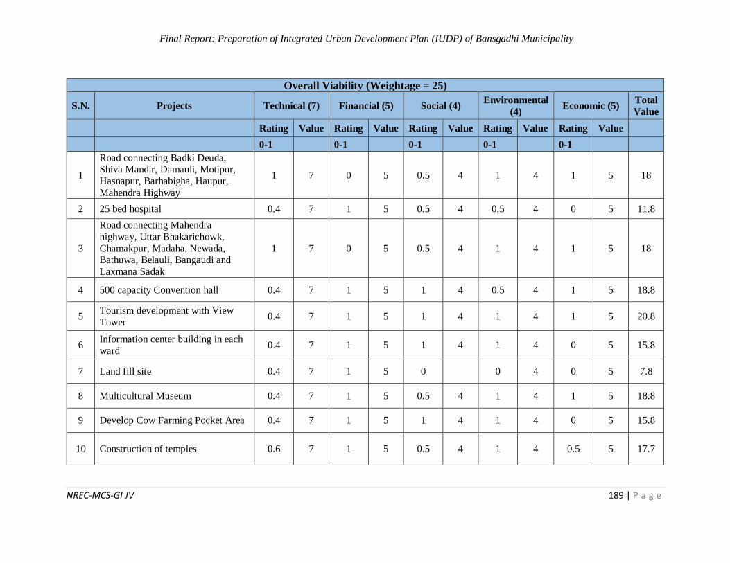
Final Report: Preparation of Integrated Urban Development Plan (IUDP) of Bansgadhi Municipality
NREC-MCS-GI JV 189 | P a g e
Overall Viability (Weightage = 25)
S.N. Projects Technical (7) Financial (5) Social (4) Environmental
(4) Economic (5)
Total
Value
Rating Value Rating Value Rating Value Rating Value Rating Value
0-1 0-1 0-1 0-1 0-1
1
Road connecting Badki Deuda, Shiva Mandir, Damauli, Motipur,
Hasnapur, Barhabigha, Haupur,
Mahendra Highway
1 7 0 5 0.5 4 1 4 1 5 18
2 25 bed hospital 0.4 7 1 5 0.5 4 0.5 4 0 5 11.8
3
Road connecting Mahendra
highway, Uttar Bhakarichowk,
Chamakpur, Madaha, Newada, Bathuwa, Belauli, Bangaudi and
Laxmana Sadak
1 7 0 5 0.5 4 1 4 1 5 18
4 500 capacity Convention hall 0.4 7 1 5 1 4 0.5 4 1 5 18.8
5 Tourism development with View
Tower 0.4 7 1 5 1 4 1 4 1 5 20.8
6 Information center building in each
ward 0.4 7 1 5 1 4 1 4 0 5 15.8
7 Land fill site 0.4 7 1 5 0 0 4 0 5 7.8
8 Multicultural Museum 0.4 7 1 5 0.5 4 1 4 1 5 18.8
9 Develop Cow Farming Pocket Area 0.4 7 1 5 1 4 1 4 0 5 15.8
10 Construction of temples 0.6 7 1 5 0.5 4 1 4 0.5 5 17.7
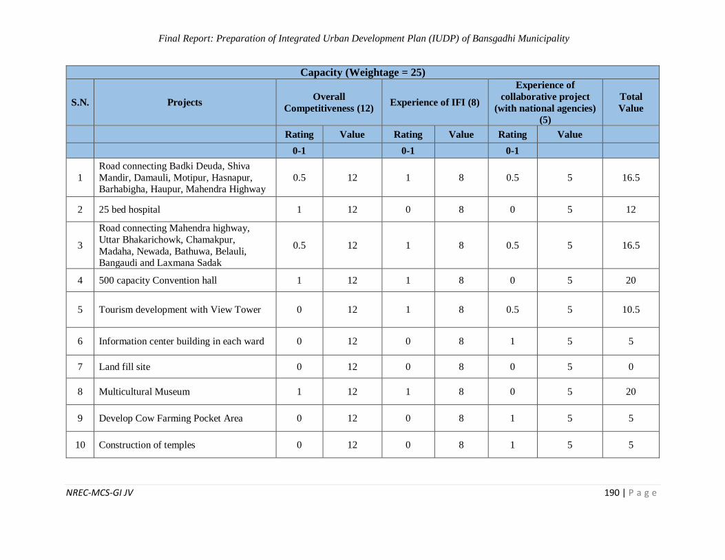
Final Report: Preparation of Integrated Urban Development Plan (IUDP) of Bansgadhi Municipality
NREC-MCS-GI JV 190 | P a g e
Capacity (Weightage = 25)
S.N. Projects Overall
Competitiveness (12) Experience of IFI (8)
Experience of
collaborative project
(with national agencies)
(5)
Total
Value
Rating Value Rating Value Rating Value
0-1 0-1 0-1
1
Road connecting Badki Deuda, Shiva
Mandir, Damauli, Motipur, Hasnapur, Barhabigha, Haupur, Mahendra Highway
0.5 12 1 8 0.5 5 16.5
2 25 bed hospital 1 12 0 8 0 5 12
3
Road connecting Mahendra highway,
Uttar Bhakarichowk, Chamakpur,
Madaha, Newada, Bathuwa, Belauli, Bangaudi and Laxmana Sadak
0.5 12 1 8 0.5 5 16.5
4 500 capacity Convention hall 1 12 1 8 0 5 20
5 Tourism development with View Tower 0 12 1 8 0.5 5 10.5
6 Information center building in each ward 0 12 0 8 1 5 5
7 Land fill site 0 12 0 8 0 5 0
8 Multicultural Museum 1 12 1 8 0 5 20
9 Develop Cow Farming Pocket Area 0 12 0 8 1 5 5
10 Construction of temples 0 12 0 8 1 5 5
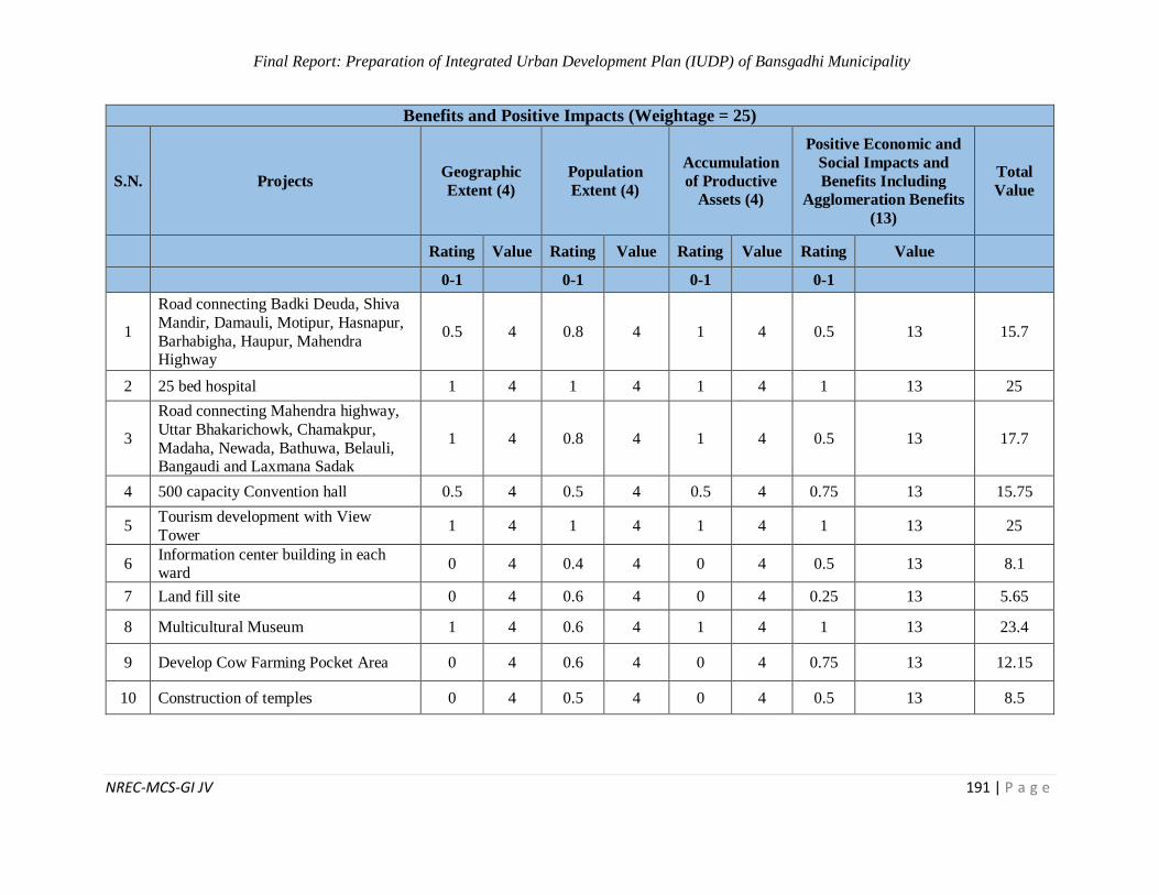
Final Report: Preparation of Integrated Urban Development Plan (IUDP) of Bansgadhi Municipality
NREC-MCS-GI JV 191 | P a g e
Benefits and Positive Impacts (Weightage = 25)
S.N. Projects Geographic
Extent (4)
Population
Extent (4)
Accumulation
of Productive
Assets (4)
Positive Economic and
Social Impacts and
Benefits Including
Agglomeration Benefits
(13)
Total
Value
Rating Value Rating Value Rating Value Rating Value
0-1 0-1 0-1 0-1
1
Road connecting Badki Deuda, Shiva
Mandir, Damauli, Motipur, Hasnapur,
Barhabigha, Haupur, Mahendra Highway
0.5 4 0.8 4 1 4 0.5 13 15.7
2 25 bed hospital 1 4 1 4 1 4 1 13 25
3
Road connecting Mahendra highway,
Uttar Bhakarichowk, Chamakpur,
Madaha, Newada, Bathuwa, Belauli, Bangaudi and Laxmana Sadak
1 4 0.8 4 1 4 0.5 13 17.7
4 500 capacity Convention hall 0.5 4 0.5 4 0.5 4 0.75 13 15.75
5 Tourism development with View
Tower 1 4 1 4 1 4 1 13 25
6 Information center building in each ward
0 4 0.4 4 0 4 0.5 13 8.1
7 Land fill site 0 4 0.6 4 0 4 0.25 13 5.65
8 Multicultural Museum 1 4 0.6 4 1 4 1 13 23.4
9 Develop Cow Farming Pocket Area 0 4 0.6 4 0 4 0.75 13 12.15
10 Construction of temples 0 4 0.5 4 0 4 0.5 13 8.5
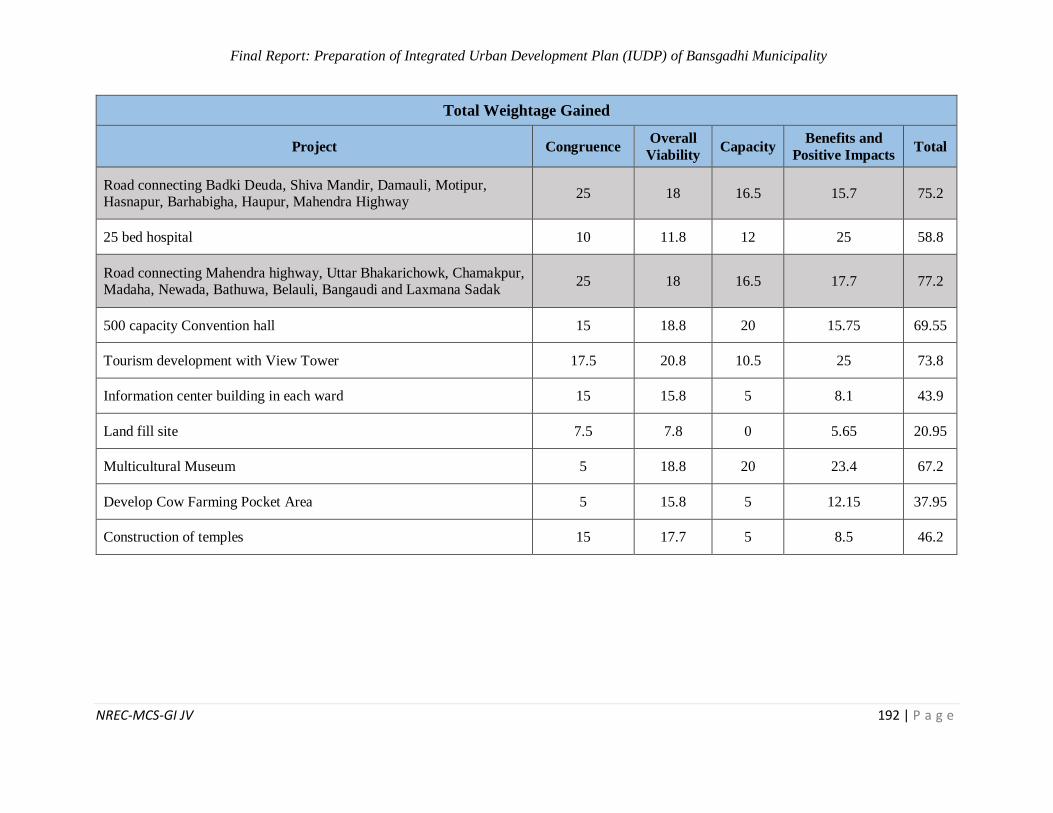
Final Report: Preparation of Integrated Urban Development Plan (IUDP) of Bansgadhi Municipality
NREC-MCS-GI JV 192 | P a g e
Total Weightage Gained
Project Congruence Overall
Viability Capacity
Benefits and
Positive Impacts Total
Road connecting Badki Deuda, Shiva Mandir, Damauli, Motipur, Hasnapur, Barhabigha, Haupur, Mahendra Highway
25 18 16.5 15.7 75.2
25 bed hospital 10 11.8 12 25 58.8
Road connecting Mahendra highway, Uttar Bhakarichowk, Chamakpur, Madaha, Newada, Bathuwa, Belauli, Bangaudi and Laxmana Sadak
25 18 16.5 17.7 77.2
500 capacity Convention hall 15 18.8 20 15.75 69.55
Tourism development with View Tower 17.5 20.8 10.5 25 73.8
Information center building in each ward 15 15.8 5 8.1 43.9
Land fill site 7.5 7.8 0 5.65 20.95
Multicultural Museum 5 18.8 20 23.4 67.2
Develop Cow Farming Pocket Area 5 15.8 5 12.15 37.95
Construction of temples 15 17.7 5 8.5 46.2
Final Report: Preparation of Integrated Urban Development Plan (IUDP) of Bansgadhi Municipality
NREC-MCS-GI JV 193 | P a g e
List of Tables
Table 1: Transformation Parameter from WGS84 Datum to Everest 1830 Datum...................... 18
Table 2: Population Projection of Bansgadhi Municipality ........................................................ 27
Table 3: Land cover of Bansgadhi municipality ......................................................................... 28
Table 4: Status of disaster in Bansgadhi municipality ................................................................ 35
Table 5: Criteria for Suitable Site Selection ............................................................................... 44
Table 6: Landfill Site Selection Criteria In GIS ......................................................................... 45
Table 7: Suitability Analysis for Landfill Site ............................................................................ 46
Table 8: Parameters Used for Determining the Flood Risk zones ............................................... 49
Table 9: Ward-wise Flood Risk zone of Bansgadhi Municipality............................................... 50
Table 10: Parameters that are Used to Determine the Drought Susceptibility zone ..................... 51
Table 11: Ward-wise Flood Risk zone of Bansgadhi Municipality ............................................ 51
Table 12: Environment Sensitive Area ...................................................................................... 55
Table 13: Road classification on the basis of population service ................................................ 56
Table 14: List of the elected representatives in Bansgadhi Municipality .................................... 60
Table 15: Major market Areas of Bansgadhi Municipality ......................................................... 62
Table 16: Strength Analysis of the municipality ........................................................................ 65
Table 17: Weakness Analysis of the municipality ...................................................................... 66
Table 18: Opportunities Analysis of the municipality ................................................................ 68
Table 19: Threats Analysis of the municipality .......................................................................... 69
Table 20: Infrastructure and necessity analysis .......................................................................... 70
Table 21: Gap Analysis of the municipality ............................................................................... 72
Table 22: DED Selection Result of Bansgadhi Municipality ...................................................... 79
Table 23: Features of DPR1 ...................................................................................................... 82
Table 24: Features of DPR2 - Road ........................................................................................... 85
Table 25: Criteria for site selection of settlement zone ............................................................... 88
Table 26: Land Use of Bansgadhi municipality ......................................................................... 89
Table 27: Logical framework Approach (LFA) of Water Supply ............................................... 92
Final Report: Preparation of Integrated Urban Development Plan (IUDP) of Bansgadhi Municipality
NREC-MCS-GI JV 194 | P a g e
Table 28: Logical framework Approach (LFA) of Drainage and Sewerage Network ................. 94
Table 29: Logical framework Approach (LFA) of Solid Waste Management............................. 97
Table 30: Logical framework Approach (LFA) of Electricity and Communication .................... 99
Table 31: Logical Framework Approach (LFA) of communication ......................................... 100
Table 32: Proposed road class in Bansgadhi municipality ........................................................ 102
Table 33: Road surface type of Bansgadhi municipality .......................................................... 106
Table 34: Logical Framework Approach (LFA) of Urban Transportation ................................ 109
Table 35: Logical Framework Approach (LFA) of Education .................................................. 111
Table 36: Logical Framework Approach (LFA) of Health ....................................................... 112
Table 37: Logical Framework Approach (LFA) of Security..................................................... 114
Table 38: Logical Framework Approach (LFA) of Culture and Sports..................................... 115
Table 39: Logical Framework Approach (LFA) of Parks and Open Space ............................... 116
Table 40: Proposed Service Centers for The Promotion of Social Development Through IUDP
............................................................................................................................................... 118
Table 41: Logical Framework Approach (LFA) of Economic Plan .......................................... 121
Table 42: Components of Tourism of Bansgadhi Municipality ................................................ 123
Table 43: Logical Framework Approach (LFA) of Tourism Development Plan ....................... 124
Table 44: Five Year Sectoral Plan of Bansgadhi Municipality ................................................. 127
Table 45: Logical Framework Approach (LFA) of Financial Plan ........................................... 131
Table 46: Logical Framework Approach (LFA) of Environmental Management Plan .............. 135
Table 47:Logical Framework Approach (LFA) of Disaster Risk Management Plan ................. 139
Table 48: Logical Framework Approach (LFA) Climate Change Adaptation Plan ................... 143
Table 49: LFA for Institutional Development .......................................................................... 145
Table 50: Major projects of line agencies in the Municipality .................................................. 148
Table 51: Multi Sectoral Investment Plan for 15 years ............................................................. 151
Table 52: DED Selection Criteria ............................................................................................ 188
List of Figures
Figure 1: Flow chart of Structure of the report .............................................................................9

Final Report: Preparation of Integrated Urban Development Plan (IUDP) of Bansgadhi Municipality
NREC-MCS-GI JV 195 | P a g e
Figure 2: Methodological flow chart during IUDP Project of Bansgadhi Municipality............... 10
Figure 3: Flow Chart of Base Map Preparation Stage ................................................................ 15
Figure 4: Spatial data of municipality ........................................................................................ 17
Figure 5: Changing area for forest and water bodies in three different years .............................. 30
Figure 6: Road Cross Section of Settlement Terai Area ............................................................. 81
Figure 7: Road Cross Section for Non-Settlement Terai Area .................................................... 81
Figure 8: Road Cross Section of Settlement Tarai Area ............................................................. 85
Figure 9: Road Cross Section for Non-Settlement Terai Area .................................................... 85
List of Photos
Photo 1: Consultation with Municipal Authorities at Bansgadhi Municipality ........................... 12
Photo 2: FGD at Ward Level of Bansgadhi Municipality ........................................................... 13
Photo 3: Vision Setting workshop conducted at Bansgadhi Municipality ................................... 21
List of Maps
Map 1: Modified Universal Transverse Project system of Nepal ............................................... 18
Map 2: High Resolution Satellite Image of Bansgadhi Municipality .......................................... 19
Map 3: Digitization of Satellite Image of Bansgadhi Municipality ............................................. 19
Map 4: Land Use Map of Bansgadhi Municipality .................................................................... 28
Map 5: Settlement pattern in Bansgadhi Municipality ............................................................... 29
Map 6: Settlement pattern of Motipur ........................................................................................ 31
Map 7: Settlement pattern of Babai ........................................................................................... 31
Map 8: Settlement pattern of Pahadipur ..................................................................................... 31
Map 9: Cultivation Land pattern of Deudakala .......................................................................... 31
Map 10: Cultivation Land pattern of Ambhiya .......................................................................... 32
Map 11: Cultivation Land pattern of Belawa ............................................................................. 32
Map 12: Forest pattern of Belawa .............................................................................................. 32
Map 13: Forest pattern of hasnapur ........................................................................................... 32
Map 14: Forest pattern of Bansgadhi ......................................................................................... 33
Map 15: Water body pattern of Chamakpur ............................................................................... 33
Final Report: Preparation of Integrated Urban Development Plan (IUDP) of Bansgadhi Municipality
NREC-MCS-GI JV 196 | P a g e
Map 16: Water body pattern of Lauha khola .............................................................................. 33
Map 17: Water body pattern of Babai ........................................................................................ 33
Map 18: Landslides prone zone of Bansgadhi Municipality ....................................................... 34
Map 19: Flood prone zone of Bansgadhi Municipality.............................................................. 35
Map 20: Forest Fire Risk Zone of Bansgadhi Municipality ........................................................ 36
Map 21: Drought Risk Zone of Bansgadhi Municipality ............................................................ 37
Map 22: Map showing open spaces in Bansgadhi Municipality ................................................. 38
Map 23: Easy Accessibility Analysis result for health Service ................................................... 40
Map 24: Easy Accessibility Analysis result for Education ......................................................... 41
Map 25: Map showing road network of Bansgadhi .................................................................... 42
Map 26: Map showing linkage of goods .................................................................................... 43
Map 27: Map showing flow of people ....................................................................................... 43
Map 28: Suitable site for settlement .......................................................................................... 45
Map 29: Drainage Map of Bansgadhi Municipality ................................................................... 47
Map 30: Watershed Map of Bansgadhi Municipality ................................................................. 48
Map 31: Suitable Layout for Sewerage Network ....................................................................... 49
Map 32: Flood Susceptibility Map of Bansgadhi Municipality .................................................. 50
Map 33: Drought Susceptibility Map of Bansgadhi Municipality .............................................. 51
Map 34: Forest Fire Analysis .................................................................................................... 52
Map 35: Stream Order Map of Bansgadhi Municipality............................................................. 53
Map 36: Total Number and Length of Different Stream Order................................................... 53
Map 37: Environment Sensitive Area ........................................................................................ 54
Map 38: River Buffer Map of Bansgadhi Municipality ............................................................. 55
Map 39: Population served by Road Network ............................................................................ 58
Map 40: Shown Proposed Economic Infrastructure ................................................................... 59
Map 41: DPR1 – Road .............................................................................................................. 80
Map 42: DPR2 – Road .............................................................................................................. 84
Map 43: Land use map of Bansgadhi municipality .................................................................... 89
Final Report: Preparation of Integrated Urban Development Plan (IUDP) of Bansgadhi Municipality
NREC-MCS-GI JV 197 | P a g e
Map 44: Site feasibility map for selection of settlement zone .................................................... 90
Map 45: Proposed Sewerage network map of Bansgadhi ........................................................... 93
Map 46: Proposed solid waste collection point and land fill site ................................................ 96
Map 47: Electricity facility in Bansgadhi municipality .............................................................. 98
Map 48: Access to telecommunication facility in Bansgadhi municipality ............................... 100
Map 49: Proposed road network and its class of Bansgadhi municipality ................................. 104
Map 50: Strategic road network map of Bansgadhi municipality ............................................. 105
Map 51: Road classification on the basis of existing surface type ............................................ 108
Map 52: Road classification on the basis of existing road width .............................................. 108