Douglas County - 2020 Master Plan
348
DOUGLAS COUNTY 2020 MASTER P LAN A COMMUNITY TO MATCH THE SCENERY ADOPTED BY THE BOARD OF COUNTY COMMISSIONERS ON DECEMBER 9, 2020
-
Upload
khangminh22 -
Category
Documents
-
view
3 -
download
0
Transcript of Douglas County - 2020 Master Plan

Douglas County2020 Master Plan
a CoMMunity to MatCh the sCenery
Adopted by the boArd of County Commissioners on deCember 9, 2020

Preface
PREFACE
Pursuant to NRS 278, the Douglas County Master Plan with the accompanying tables,
diagrams, figures and charts consists of eight elements and represents the County’s
comprehensive long-term plan for growth and development. The 2020 Update was
prepared with the assistance of Wood Rogers.
Special Note: This Master Plan was prepared while Douglas County and the Nation were
in the midst of the COVID-19 pandemic and constraints were imposed on the process as
a result. It remains uncertain what potential changes in the conduct of business and
society our county will experience. As such, county officials should be encouraged to
reexamine changing data and behavior, and support revisions in the Master Plan as
warranted.

Preface
MASTER PLAN AMENDMENTS
Master Plan amendments can be initiated by the Douglas County Community
Development Department (as in the case of five-year updates), or by individual property
owners. Master Plan Amendments are required for any proposals to change the future
land use designation on the future land use maps, to change water or wastewater service
boundaries or the urban service area boundary, as well as to change any goals, policies,
or actions in the adopted Master Plan.
To amend the Master Plan, an applicant must meet the four findings specified in Section
20.608.040 of the Douglas County Code:
1. The proposed amendment is consistent with the policies embodied in the adopted
master plan and the applicant has demonstrated the amendment proposes the
overall goals and objectives of the master plan and has demonstrated a change in
circumstances since the adoption of the plan that makes it appropriate to
reconsider one or more of the goals and objectives or land use designations.
2. The proposed amendment is based on a demonstrated need for additional land to
be used for the proposed use, and that the demand cannot be reasonably
accommodated within the current boundaries of the area.
3. The proposed amendment would not materially affect the availability, adequacy,
or level of service of any public improvement serving people outside of the
applicant’s property and will not be inconsistent with the adequate public facilities
policies contained in Chapter 20.100 of Title 20.
4. The proposed amendment is compatible with the actual and master planned use
of the adjacent properties and reflects a logical change to the boundaries of the
area in that it allows infrastructure to be extended in efficient increments and
patterns, it creates a perceivable community edge as strong as the one it replaces,
and it maintains relatively compact development patterns.
The Planning Commission is responsible for reviewing Master Plan Map and Text
Amendments and forwarding a recommendation of approval or denial to the Board of
Commissioners. A two-thirds majority vote is required for approval.

Acknowledgments
ACKNOWLEDGEMENTS
2020 Acknowledgements Board of County Commissioners Barry Penzel, Chairman Larry Walsh, Vice-Chairman John Engels, Commissioner Dave Nelson, Commissioner Wesley Rice, Commissioner
Planning Commission Kirk Walder, Chairman Maureen Casey, Vice Chairwoman David Akola, Member Bryce Clutts, Member Kristi Kandel, Member Mark Neddenriep, Member Bryan Oland, Member
Office of the County Manager Patrick Cates, County Manager Jenifer Davidson, Assistant County Manager Melissa Blosser, Public Relations Manager Bailey Gumm, Community Relations Specialist Natalie Wood, Administrative Services Manager Administrative Team; Amy Poole, Paula Lochridge, and Marcia Johnson
Other County Departments and Divisions Scott Morgan, Director, Community Services Phil Ritger, Director, Public Works Courtney Walker, Stormwater Program Manager Ron Sagen, Director, 911 Emergency Services Terri Willoughby, Chief Financial Officer Amy Dodson, Library Director Lisa Granahan Economic Vitality Manager Chris Johnson, Director Minden-Tahoe Airport Community Development Department Thomas Dallaire, P.E., Director Samuel Booth, AICP, Planning Manager Lorenzo Mastino, AICP, Senior Planner

Acknowledgments
Tim Davis, Acting Building Official Jeremy Hutchings, P.E., County Engineer Lucille Rao, Assistant Planner Coleen Thran-Zepeda, Development Coordinator Ann Damian, Administrative Assistant
Douglas County Geographic Information Systems Matt Richardson, GIS Leah Montoya, GIS Dan Deegan, GIS
Clerk-Treasurer’s Office Kathy Lewis, Clerk-Treasurer Nicki Leeper, Clerk Supervisor
Assessor’s Office Trent Tholen, Assessor
District Attorney’s Office Mark Jackson, District Attorney Doug Ritchie, Deputy District Attorney Cynthia Gregory, Deputy District Attorney Sam Taylor, Deputy District Attorney
Sheriff’s Office Sheriff Dan Coverly Undersheriff Ron Elges Towns and General Improvement Districts Erik Nilssen, Manager, Town of Gardnerville JT Chevallier, Manager, Town of Genoa JD Frisby, Manager, Town of Minden Greg Reed, Manager, Gardnerville Ranchos John Lufrano, Manager, Indian Hills Aaron Hughes, Manager, Topaz Ranch Estates Peter Baratti, Minden-Gardnerville Sanitation
Fire Districts East Fork Fire Protection District - Tod Carlini Tahoe Douglas Fire Protection District, Eric Guevin

Acknowledgments
Other Agencies Federal Water Master’s Office – David Wathen Carson River Water Master (East Fork) - Mike Rippe Carson River Water Master (West Fork) -Steve Wilcox Allerman Upper-Virginia Irrigation Co. Inc. - Gary Aiazzi, Manger / Ditch Rider Carson Valley Chamber of Commerce – Bill Chernock and Alicia Main Douglas County School District – Keith Lewis Gardnerville Water Company – Mark Lovelady NV Energy – Mark Sullivan Washoe Tribe of Nevada and California - Rob Beltramo
Consultant Team Wood Rodgers, Inc. Logan Simpson UNR – Center for Economic Development

Acknowledgments
2016 Acknowledgements The 2016 Update of the Douglas County Master Plan was prepared by Wells Barnett Associates, LLC, with the help of Candace Stowell, and included the contributions of the following individuals and organizations:
Board of Commissioners Barry Penzel, Chair Steve Thaler, Vice-Chair Nancy McDermid Larry Walsh Dave Nelson
Planning Commission Margaret Pross, Chairwoman Anje de Knijf, Vice-Chairwoman James R. Madsen Jo Etta Brown Frank Godecke Stacy Noyes Bryan Davis
Office of the County Manager Larry Werner, County Manager Melissa Blosser, Public Information Debbie Beam, Administrative Services Manger
Community Development Department Mimi Moss, Director Dave Lundergreen, Building Official Erik Nilssen, County Engineer Jeane Cox, Administrative Services Manager Ann Damian, Administrative Assistant Heather Ferris, Planning Manager Steve Mason, Associate Planner Lucille Rao, Assistant Planner Linda Doherty, Counter Technician Coleen Thran-Zepeda, Development Coordinator Clerk-Treasurer Kathy Lewis, Clerk-Treasurer

Acknowledgments
Assessor Doug Sonnemann
District Attorney’s Office Mark Jackson, District Attorney Doug Ritchie, Deputy District Attorney Cynthia Gregory, Deputy District Attorney Zach Wadle, Deputy District Attorney Mary Anne Martin, Deputy District Attorney
Sheriff’s Office Sheriff Ron Pierini, Undersheriff Paul Howell Karis Drake
Other County Departments and Divisions Scott Morgan, Director, Community Services Carl Ruschmeyer, Director, Public Works Ron Sagen, Director, 911 Emergency Services Amy Dodson, Library Director Lisa Granahan Economic Vitality Manager Bobbi Thompson, Minden-Tahoe Airport
Towns and General Improvement Districts Tom Dallaire, Manager, Town of Gardnerville Jenifer Davidson, Manager, Town of Minden Phil Ritger, Manager, Town of Genoa Bob Spellberg, Manager, Gardnerville Ranchos John Lufrano, Manager, Indian Hills Aaron Hughes, Manager, Topaz Ranch Estates Frank Johnson, Minden-Gardnerville Sanitation Fire Districts East Fork Fire Protection District – Tod Carlini Tahoe Douglas Fire Protection District – Eric Guevin
Diagrams Prepared by Matt Richardson, GIS Leah Montoya, GIS

Acknowledgments
Partner Agencies Carson River Water Master (West Fork)
- Charlie Condron Carson Valley Agricultural Association
– Barbara Byington, Mark Neddenriep Carson Valley Chamber of Commerce
- Bill Chernock Carson Valley Conservation District
- Mike Hayes Carson Water Subconservancy District - Ed James, Brenda Hunt Douglas County Historical Society –Cindy Rogers, Dennis Little Douglas County School District –Terri White, Holly Luna Douglas Disposal/South Tahoe Refuse – Jeff Tillman, Terry Trease, Jeanne Lear Family Support Council – Steve Decker Federal Water Master’s Office
– David Wathen Friends in Service Helping (FISH)
– Jim Peckham Frontier Communications – Jo Jo Myers Gardnerville Water Company
– Mark Gonzales NV Division of Wildlife – Bonnie Weller NV Energy – Mark Sullivan NV Governor’s Office of Energy
– Matthew Tuma, Suzanne Linfante NV State Demographer – Jeff Hardcastle NV Department of Conservation & Natural Resources/State Lands
– Brandi Re NV Department of Conservation & Natural Resources/NV Division of Environmental
Protection/Air Quality Planning – Danilo Dragoni, Darren Winkelman, Sigurd Jaunarajs
NV Department of Conservation & Natural Resources/NV Division of Environmental Protection/Bureau of Water Quality – Jean Stone
NV Department of Conservation & Natural Resources/NV Division of Environmental Protection/Bureau of Safe Drinking Water – Kim Borgzinner
NV Housing Division – CJ Manthe, Ann Hawkins
NV Rural Housing Authority – Gary Longaker, Bill Brewer, Jeni Chavez, Rose Cook, Jack White, Beth Dunning
Acknowledgments
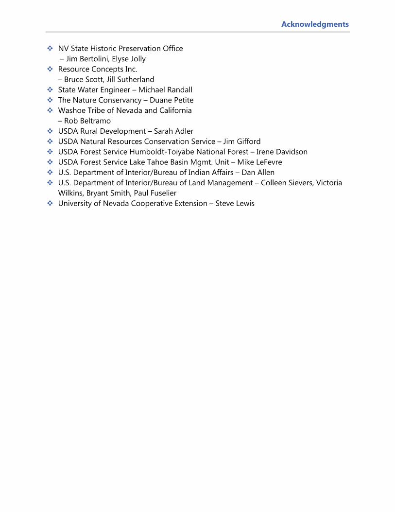
NV State Historic Preservation Office – Jim Bertolini, Elyse Jolly
Resource Concepts Inc. – Bruce Scott, Jill Sutherland
State Water Engineer – Michael Randall The Nature Conservancy – Duane Petite Washoe Tribe of Nevada and California
– Rob Beltramo USDA Rural Development – Sarah Adler USDA Natural Resources Conservation Service – Jim Gifford USDA Forest Service Humboldt-Toiyabe National Forest – Irene Davidson USDA Forest Service Lake Tahoe Basin Mgmt. Unit – Mike LeFevre U.S. Department of Interior/Bureau of Indian Affairs – Dan Allen U.S. Department of Interior/Bureau of Land Management – Colleen Sievers, Victoria
Wilkins, Bryant Smith, Paul Fuselier University of Nevada Cooperative Extension – Steve Lewis

Table of Contents
TABLE OF CONTENTS
EXECUTIVE SUMMARY 1 Geography 2 History 3 Government 4 Land Jurisdictions 5 Tahoe Regional Planning Agency 7 Population 9 Housing 13 Economy 17 Education 20
1. LAND USE & HISTORIC PRESERVATION 23 PURPOSE 23 GOALS 24 POLICIES 24 LAND USES IN DOUGLAS COUNTY 28 REGIONS & COMMUNITY PLANS 32 CARSON VALLEY REGION 36 AGRICULTURE COMMUNITY PLAN 38 AIRPORT COMMUNITY PLAN 40 EAST VALLEY COMMUNITY PLAN 44 FISH SPRINGS COMMUNITY PLAN 48 FOOTHILL COMMUNITY PLAN 52 GARDNERVILLE RANCHOS COMMUNITY PLAN 56 GENOA COMMUNITY PLAN 60 INDIAN HILLS/JACKS VALLEY COMMUNITY PLAN 64 JOHNSON LANE COMMUNITY PLAN 69 GARDNERVILLE & MINDEN COMMUNITY PLANS 72 GARDNERVILLE COMMUNITY PLAN 73 MINDEN COMMUNITY PLAN 75 RUHENSTROTH COMMUNITY PLAN 77 PINENUT REGION 80

Table of Contents
SIERRA REGION 82 TAHOE REGION 84 TOPAZ REGION 86 TOPAZ LAKE COMMUNITY PLAN 88 TOPAZ RANCH ESTATES/HOLBROOK JUNCTION COMMUNITY PLAN 91 ANTELOPE VALLEY COMMUNITY PLAN 94 HISTORIC PRESERVATION IN DOUGLAS COUNTY 97 LOOKING TO THE FUTURE 103
2. AGRICULTURE & CONSERVATION 107 PURPOSE 107 GOALS 107 POLICIES 108 CURRENT TRENDS 110 LOOKING IN THE FUTURE 141
3. ECONOMIC DEVELOPMENT 147 PURPOSE 147 GOALS 147 POLICIES 148 CURRENT TRENDS 150 LOOKING TO THE FUTURE 161
4. GROWTH MANAGEMENT & HOUSING 169 PURPOSE 169 GOALS 169 POLICIES 170 HOUSING & GROWTH MANAGEMENT IN DOUGLAS COUNTY 172 LOOKING TO THE FUTURE 194
5. PUBLIC FACILITIES, SERVICES & RECREATION 199 PURPOSE 199 GOALS 199 POLICIES 200 CURRENT TRENDS 203 LOOKING TO THE FUTURE 258
6. PUBLIC SAFETY 265 PURPOSE 265 GOALS 265

Table of Contents
POLICIES 266 CURRENT TRENDS 269 LOOKING TO THE FUTURE 302
7. RESERVED FOR FUTURE WASHOE TRIBE ELEMENT 305 8. IMPLEMENTATION 307 LIST OF MAPS, TABLES, FIGURES, DIAGRAMS 321

Acronyms
ACRONYMS
ADA Americans with Disabilities Act
BIA Bureau of Indian Affairs
BLM Bureau of Land Management
CASA Court Appointed Special Advocates
CDBG Community Development Block Grant
CDP Census Designated Place
CHAS Comprehensive Housing Affordability Study
CIP Capital Improvement(s) Program/Plan(s)
CLG Certified Local Government
CRS Community Rating System
CVTA Carson Valley Trails Association
CWSD Carson Water Subconservancy District
DCC Douglas County Code
DCIS Design Criteria and Improvement Standards
DCSO Douglas County Sheriff’s Office
DCPW Douglas County Public Works
EFFPD East Fork Fire and Paramedic Districts
FAA Federal Aviation Administration
FEMA Federal Emergency Management Agency
FIRM Flood Insurance Rate Map
FIS Flood Insurance Study
FMR Fair Market Rent
GID General Improvement District
GIS Geographic Information Systems
HUD Department of Housing and Urban Development
ISO Insurance Services Office
JLEC Judicial and Law Enforcement Center
LI Low Income
LOS Level of Service
MGSD Minden-Gardnerville Sanitation District
MPDF Multiple Property Documentation Form
MSW Municipal Solid Waste
NDEP Nevada Division of Environmental Protection
NDOT Nevada Department of Transportation
NFIP National Flood Insurance Program
NFPA National Fire Protection Association
NRS Nevada Revised Statutes
NTCD Nevada Tahoe Conservation District
PAS Plan Area Statement
SAFE Special Advocates for Elderly
SHPO State Historic Preservation Office
TDFPD Tahoe Douglas Fire Protection District
TDR Transfer Development Right
TMP Transportation Master Plan
TRE Topaz Ranch Estates
TRPA Tahoe Regional Planning Agency
TTD Tahoe Transportation District
USDA United States Department of Agriculture
USFS United States Forest Service
V&T Railway Virginia and Truckee Railway
WNHC Western Nevada HOME Consortium

Overview
OVERVIEW
The process to update the Master Plan began in 2016 and included extensive public
outreach efforts. For this reason, the Board of County Commissioners and the Planning
Commission decided to retain the public input and draft language from 2016 and use it
as the basis for the text update in 2020. The matrix below contains the existing Master
Plan elements from the 2011 adopted plan, the draft elements from 2016 and the
proposed elements from the 2020 update.
Chapter Matrix for 2011 Master Plan to 2016 Master Plan to the 2020 Master Plan
2011 Master Plan Chapters (13)
2016 Draft Master Plan Chapters (12)
2020 Draft Master Plan Chapters (8) What’s new with 2020
1. Framework Executive Summary 1. County Profile
Executive Summary & Community Profile
Background, Intro, new data collection
2. Land Use 3. Washoe Tribe Lands 10. Historic Preservation
6. Historic Preservation 8. Land Use
1. Land Use & Historic Preservation
Incorporate new map and revised community plans and descriptions, consolidate, improve messaging. Washoe Tribe Element reserved as Element 7 for joint planning.
7. Agriculture 8. Environmental Resources & Conservation
2. Agriculture 3. Conservation
2. Agriculture & Conservation
Consolidation, possible discussion/graphics on intro to TDR program related to conservation?
9. Economic Development
4. Economic Development
3. Economic Development
Consolidation, new recommendations
4. Housing 6. Growth Management
5. Growth Management 7. Housing
4. Growth Management & Housing
New Master Plan Map, improve discussion on TDR, consolidate and improve messaging
11. Parks & Rec 12. Public Services and Facilities
9. Parks and Rec 10. Public Facilities and Services
5. Public Facilities, Services & Recreation
Consolidation – will incorporate previous Public Facilities chapter as well as parks and rec chapters.
5. Transportation Reserved
Incorporated by reference in 5. Public Facilities & Services
Essentially an Exec Summary of the Transportation Plan and key projects map, include airport.
12. Public Services and Facilities 11. Public Safety 6. Public Safety Removed Public Safety from
Public Services and Facilities.
13. Implementation 12. Implementation 8. Implementation Summary of Goals/Policies, develop strategies for implementation.

Overview
In September, Douglas County staff in partnership with Wood Rodgers held four (4) in
person and live streamed public workshops in September 2020, with approximately 20
attendees and 30 live stream viewers. The workshop presentations were also recorded
and placed on the Master Plan Text Update website. To date, the presentations have been
viewed 185 times. In addition, staff solicited feedback from the public on the proposed
goals contained in the Master Plan beginning September 1st through September 30th. The
survey received 1,518 views from the public, and generated input from 1,015 participants.
This document includes a preview of the proposed Master Plan format, the proposed
goals as revised and presented in the workshops, and the newly proposed policies and
actions based on feedback from the Board of County Commission, the Planning
Commission and members of the public.

Page intentionally left blank

Overview
Page | xvi
Minden, NV, Douglas County seat

Executive Summary
Page | 1
EXECUTIVE SUMMARY
Douglas County is one of the original nine counties established in 1861 as part of the
Nevada Territory. Today, Douglas County is one of 17 counties in the State of Nevada
and one of the smallest in the State, ranking 15th
in size. There are three unincorporated towns in the
County: Gardnerville, Genoa, and Minden. The
Town of Minden has been the county seat since
1916. Figure ES1 provides a snapshot of Douglas
County demographics and statistics.
Almost 70 percent of the
land1 in Douglas County is
federally owned.
1 “Land” refers to parcels and does not include rights-of-way or water bodies. Total land area includes 28,395 parcels with 455,275 acres.
Figure ES1 - Douglas County, NV at a Glance

Executive Summary
Page | 2
GEOGRAPHY
Douglas County is located in the northwestern portion of Nevada and is bordered
by the State of California to the west and southwest, the consolidated municipality
of Carson City to the north, and Lyon County to the northeast and east (see Diagram
ES1). The County is one of the smallest in the State of Nevada with a total area of 737.7
square miles or 472,133 acres. The terrain includes the Carson Range of the Sierra
Nevada Mountains in the west and the Pine Nut Mountains in the east. The elevations in
Douglas County range from 9,593 feet at East Peak to approximately 4,640 feet where
the Carson River flows into Carson City. Most of the County is located in the Great Basin
Desert and is characterized by an arid climate. The Carson Valley lies in the middle of the
County and covers approximately 420 square miles. The Valley is a productive
agricultural region that depends on the Carson River Watershed. Other water bodies in
Douglas County include Lake Tahoe (shared with the State of California), Topaz Lake
(shared with the State of California), and the Walker River.
DIAGRAM ES1 - DOUGLAS COUNTY VICINITY MAP

Executive Summary
Page | 3
HISTORY
Douglas County contains ancestral lands belonging to the Washoe Tribe and
former trading posts and settlements from the 1800s such as Double Springs
and Mottsville.
The oldest non-indigenous settlement in the County and the State of Nevada is the
Town of Genoa, established in1851 and formerly known as Mormon Station. Genoa
served as the first seat of government for Douglas County and has a local historic
district. A portion of the Town is on the National Register of Historic Places.
The Town of Gardnerville, established in 1879, was named after John Gardner. The
Town’s history is heavily influenced by Danish and Basque settlers. “Because of its
location along the route to the Esmeralda Mining District and Bodie (where a major gold
strike in 1878 heralded a mining boom), Gardnerville soon came to serve as a feed stop
for the 24-horse freight teams traveling between Carson City and the mining camps”
(Town of Gardnerville).
The Town of Minden, established in 1906, was planned by the Dangberg family to serve
workers in ranching and farming operations. The Dangberg Land and Livestock
Company operated cattle and sheep ranches in Douglas County and Alpine County,
California. Minden’s growth was spurred with the extension of the Virginia & Truckee
(V&T) Railway to Minden in 1906. Douglas County’s history includes lumber barons such
as Duane L. Bliss. Glenbrook was the site of a significant milling operation for his Carson
Tahoe Lumber and Fluming Company.
Many of the civic and commercial buildings in Gardnerville and Minden, including the
Douglas County Historic Courthouse in Minden and the Gardnerville High School (now
the Carson Valley Museum and Cultural Center), were designed by Nevada architect
Frederick DeLongchamps.
Senator Stephen A. Douglas (1813–1861)
Douglas County is named after Stephen A. Douglas, a U.S. Senator from
Illinois, famous champion of the Mexican War—and powerful Chair of the
Senate Committee on Territories. Douglas, a “popular sovereignty”
Democrat, was largely responsible for the Compromise of 1850 and the
controversial Kansas-Nebraska Act of 1854, which opened some previously
prohibited territories to slavery and helped fuel the formation of the
Republican Party. Douglas is also famously remembered for his lively
senatorial debates with Abraham Lincoln in 1858, which lost him the popular vote.

Executive Summary
Page | 4
GOVERNMENT
Douglas County is governed by a five-member elected Board of County
Commissioners. Other elected officials include the District Attorney, Sheriff,
Assessor, Recorder, Public Administrator, District Court Judges, Justices of the Peace,
and Clerk-Treasurer. The General Fund budget for fiscal year 2019–2020 was
approximately $50.3 million, with a total annual budget for Douglas County of $106.3
million. In fiscal year 2019–2020, there were 557.8 full-time employees in Douglas
County (excluding the unincorporated towns of Gardnerville, Genoa, and Minden).
Each of the three unincorporated towns has an elected five-member town board as well
as a Town Manager. There are 31 taxing districts in Douglas County, including 17
General Improvement Districts (GIDs). Douglas County has the highest number of GIDs
in the State of Nevada. The GIDs include communities such as the Gardnerville Ranchos
and Indian Hills in the Carson Valley and Kingsbury and Round Hill at Lake Tahoe.
Figure ES2 - A History of Douglas County

Executive Summary
Page | 5
Bureau of Indian Affairs, 58,210 , 12%
Bureau of Land Management, 167,865 ,
36%
Bureau of Reclamation, 567 , 0%
State of Nevada, 1,643 , 0%
United State Forest Service, 86,185 , 18%
United State Fish and Wildlife (Fish Hatchery),
24 , 0%
Washoe Tribe, 3,749 , 1%
Lake Tahoe & Topaz, 16,866 , 4%
Local Goverment or Private Ownership,
137,033 , 29%
The East Fork Fire and Protection Districts provide fire protection and paramedic
services for the Carson Valley portion of Douglas County, and the Tahoe-Douglas Fire
Protection District serves the Tahoe Basin portion. The U.S. Forest Service (USFS) and the
Bureau of Land Management (BLM) are the primary respondents to fires on federal
lands.
The County owns and manages the Minden-Tahoe Airport, which was established in
1942 to support military operations during World War II. Today, the airport serves as a
general aviation airport and an aerial firefighting center (Sierra Front Interagency
Dispatch Center). As of October 2020, there are approximately 430 aircraft based at the
airport.
The county-owned Douglas Area Rural Transit (DART) provides local public transit
services in the Carson Valley, with connections to regional express services by the Tahoe
Transportation District.
LAND JURISDICTIONS
Similar to many counties in Nevada, most of the acreage in Douglas County is
under the jurisdiction of the federal government. Federal lands account for
67.9 percent of the parcel acreage in Douglas County. Figure ES3 and Diagram ES2
display the amount and location of federal lands within the County. The Bureau of Land
Management properties are located to the east in the Pinenut Region; the U.S. Forest
Service properties are located to the west in the Carson Range of the Sierra Nevada
Mountains and in the southernmost portion of the County.
Figure ES3 - Land Ownership in Douglas County (Acres)

Executive Summary
Page | 6
DIAGRAM ES2 - LAND OWNERSHIP IN DOUGLAS COUNTY

Executive Summary
Page | 7
Private property outside of Tahoe Basin is regulated by Douglas County. In 2002,
Douglas County voters approved the Sustainable Growth Initiative (SGI). Due to
litigation, the SGI was never implemented, but the Board of Commissioners adopted a
Building Permit Allocation and Growth Management Ordinance in 2007. The new
ordinance created a residential allocation system for all of Douglas County except the
Tahoe Basin. The Great Recession of 2007–2009 essentially stopped all growth in the
County. As a result, many residential allocations were not used and were rolled over to
the next quarterly allocation cycle, becoming “excess” allocations. Excess allocations,
which were 560 in July 2011, increased to 882 in July 2016 and to 1,946 in September
2020.
TAHOE REGIONAL PLANNING AGENCY (TRPA)
The Tahoe Basin portion of Douglas County is under the
jurisdiction of the Tahoe Regional Planning Agency.
Following the adoption of the TRPA Regional Plan in
1987, a growth management system was put in place to
limit development around Lake Tahoe. A new regional
plan was adopted by TRPA in December 2012, and Douglas County was the first
government member to adopt an area plan (South Shore Area Plan) that was consistent
with the new TRPA Regional Plan.

Executive Summary
Page | 8
DIAGRAM ES3 - TAHOE DOUGLAS AREA PLAN
Executive Summary
Page | 9
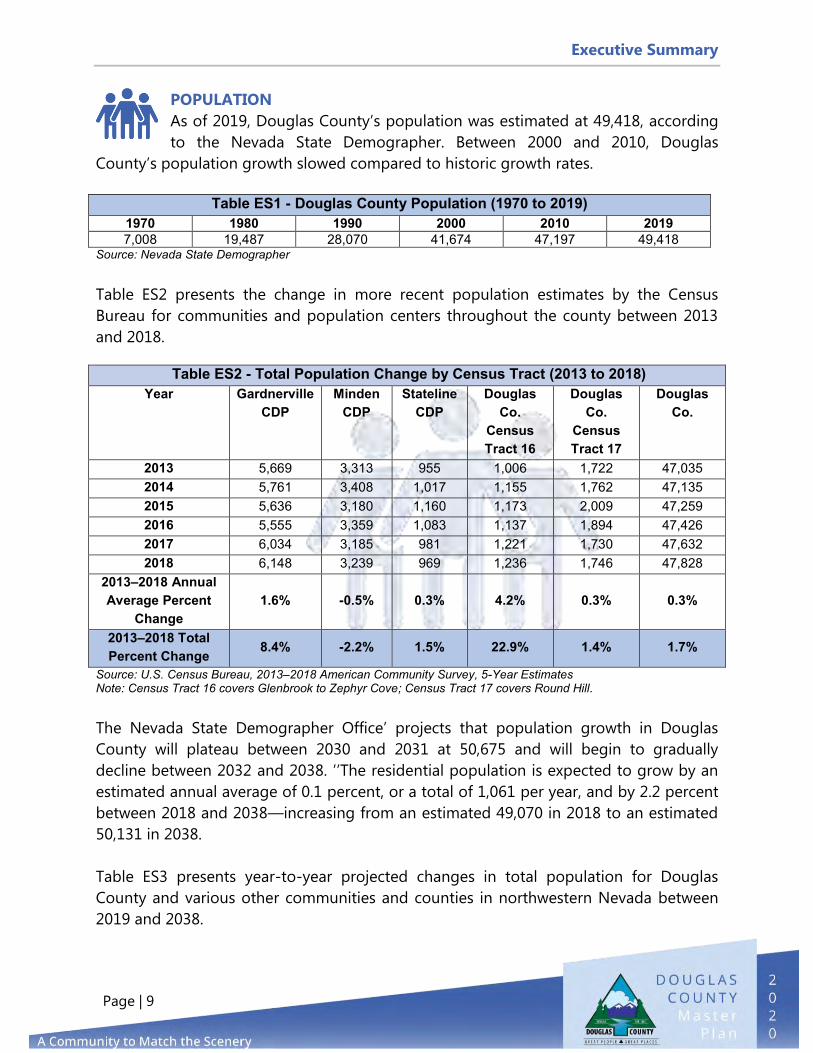
POPULATION
As of 2019, Douglas County’s population was estimated at 49,418, according
to the Nevada State Demographer. Between 2000 and 2010, Douglas
County’s population growth slowed compared to historic growth rates.
Table ES1 - Douglas County Population (1970 to 2019)
1970 1980 1990 2000 2010 2019 7,008 19,487 28,070 41,674 47,197 49,418
Source: Nevada State Demographer
Table ES2 presents the change in more recent population estimates by the Census
Bureau for communities and population centers throughout the county between 2013
and 2018.
Table ES2 - Total Population Change by Census Tract (2013 to 2018) Year Gardnerville
CDP Minden
CDP Stateline
CDP Douglas
Co. Census Tract 16
Douglas Co.
Census Tract 17
Douglas Co.
2013 5,669 3,313 955 1,006 1,722 47,035 2014 5,761 3,408 1,017 1,155 1,762 47,135 2015 5,636 3,180 1,160 1,173 2,009 47,259 2016 5,555 3,359 1,083 1,137 1,894 47,426 2017 6,034 3,185 981 1,221 1,730 47,632 2018 6,148 3,239 969 1,236 1,746 47,828
2013–2018 Annual Average Percent
Change 1.6% -0.5% 0.3% 4.2% 0.3% 0.3%
2013–2018 Total Percent Change
8.4% -2.2% 1.5% 22.9% 1.4% 1.7%
Source: U.S. Census Bureau, 2013–2018 American Community Survey, 5-Year Estimates Note: Census Tract 16 covers Glenbrook to Zephyr Cove; Census Tract 17 covers Round Hill.
The Nevada State Demographer Office’ projects that population growth in Douglas
County will plateau between 2030 and 2031 at 50,675 and will begin to gradually
decline between 2032 and 2038. ’’The residential population is expected to grow by an
estimated annual average of 0.1 percent, or a total of 1,061 per year, and by 2.2 percent
between 2018 and 2038—increasing from an estimated 49,070 in 2018 to an estimated
50,131 in 2038.
Table ES3 presents year-to-year projected changes in total population for Douglas
County and various other communities and counties in northwestern Nevada between
2019 and 2038.

Executive Summary
Page | 10
Table ES3 - Population Projections for Northwestern Nevada by County With Major
Regional Employment Impacts (2019 to 2038) Year Douglas
County Carson
City Lyon
County Mineral County
Storey County
Washoe County
2019 49,418 56,321 56,836 4,615 4,346 469,963 2020 49,695 56,546 57,987 4,561 4,465 479,336 2021 49,916 56,748 59,075 4,520 4,587 488,344 2022 50,110 56,960 60,112 4,498 4,715 496,955 2023 50,285 57,155 61,090 4,487 4,843 504,992 2024 50,416 57,325 61,992 4,489 4,972 512,264 2025 50,488 57,450 62,788 4,501 5,098 518,651 2026 50,532 57,547 63,512 4,513 5,228 524,466 2027 50,584 57,635 64,174 4,531 5,366 529,810 2028 50,626 57,707 64,770 4,549 5,499 534,585 2029 50,660 57,752 65,303 4,568 5,633 538,911 2030 50,673 57,790 65,788 4,584 5,759 542,877 2031 50,675 57,814 66,229 4,603 5,882 546,509 2032 50,656 57,828 66,616 4,625 6,000 549,838 2033 50,627 57,821 66,948 4,649 6,112 552,861 2034 50,581 57,805 67,240 4,668 6,219 555,585 2035 50,515 57,763 67,482 4,692 6,315 558,001 2036 50,414 57,697 67,676 4,712 6,405 560,085 2037 50,286 57,599 67,822 4,734 6,490 561,897 2038* 50,131 57,475 67,927 4,752 6,565 563,434
2019 to 2038 Annual Average Percentage
Change 0.1% 0.1% 1.0% 0.1% 2.2% 1.0%
Source: Nevada State Demographer, Nevada County Population Projections 2019 to 2038, prepared October 1, 2019 * Note: Nevada State Demographer Population Projections are only included through 2038.
Table ES4 presents four growth scenarios for Douglas County, which are consistent with
the State Demographer and 2017 Transportation Master Plan projections. These include
a very slow growth rate of 0.1 percent growth per year (as estimated by the Nevada
State Demographer), slow growth rate of 1 percent per year, historic growth rate of 1.3
percent per year, and maximum growth rate of 2 percent per year. It should be noted
that the slow growth rate of 1 percent per year was developed internally by Douglas
County, the historic growth rate of 1.3 percent per year was based on 2010 and 2011
U.S. Census Data, and the maximum growth rate was established by Douglas County
Title 20.
Figure ES4 is a graph depicting population projections under the proposed rates of
growth (slow, historic, and maximum scenarios) through 2038.

Executive Summary
Page | 11
*Note: Nevada State Demographer Population Projections only include 2019 through 2038.
Given the growth management strategies that Douglas County has in place, future
growth will likely trend between the very slow (0.1%) and slow (1%) growth rates over
the next 20 years, equating to a population of between 50,000 and 60,000 by 2038.
Table ES4 - Douglas County Population Growth Scenarios Scenario 2020 2030 2038*
State Demographer (0.1%) 49,695 50,673 50,131 Low Growth (1.0%) 49,912 55,134 59,702
Historic Growth (1.3%) 50,060 56,963 63,163 Maximum Growth (2.0%) 50,406 61,445 71,993
Source: Nevada State Demographer and 2017 Douglas County Transportation Plan Projections
Figure ES4 - Douglas County Population Projections through 2038

Executive Summary
Page | 12
The median age of the residential population of Douglas County continued to increase
between 2013 and 2018, rising from an estimated 47.9 years of age in 2013 to an
estimated 51.5 years of age in 2018, a net increase of 3.6 years or 7.5 percent. The
median age of the various communities and population centers throughout Douglas
County experienced a mix of both increase and decline. Table ES5 provides more details
on median age within Douglas County.
Table ES5 - Median Age Change (2013 to 2018) Year Gardnerville
CDP Minden
CDP Stateline
CDP Douglas
Co. Census Tract 16
Douglas Co. Census
Tract 17
Douglas Co.
2013 43.0 50.0 39.2 57.4 45.6 47.9 2014 41.4 51.6 34.9 58.1 41.0 48.5 2015 46.5 53.7 35.1 60.2 40.9 49.4 2016 48.3 49.9 34.1 61.7 40.2 50.1 2017 43.8 53.9 34.4 61.8 42.9 50.8 2018 42.0 55.1 31.9 61.4 39.1 51.5
Percent Change
-2.3% 10.2% -18.6% 7.0% -14.3% 7.5%
Average 44.2 52.4 34.9 60.1 41.6 49.7 Source: U.S. Census Bureau, 2013–2018 American Community Survey, 5-Year Estimates Note: Census Tract 16 covers Glenbrook to Zephyr Cove; Census Tract 17 covers Round Hill
Table ES6 presents the change in the median age for Douglas County compared to
various other communities and counties in northwestern Nevada, including the change
in median age for the State of Nevada and the United States between 2013 and 2018.
Table ES6 - Median Age Change (2013 to 2018) Year Douglas
County Carson
City Lyon
County Mineral County
Storey County
Washoe County
State of Nevada
United States
2013 47.9 41.9 41.6 50.1 54.4 37.2 36.6 37.3 2014 48.5 42.3 42.6 47.1 54.2 37.5 36.9 37.4 2015 49.4 42.6 43.2 48.7 54.7 37.6 37.2 37.6 2016 50.1 43.1 43.7 49.2 54.4 37.9 37.5 37.7 2017 50.8 43.0 43.8 46.7 54.4 38.0 37.7 37.8 2018 51.5 42.8 44.1 50.1 52.9 38.1 37.9 37.9
Percent Change
7.5% 2.1% 6.0% 0.0% -2.8% 2.4% 3.6% 1.6%
Average 49.7 42.6 43.2 48.7 54.2 37.7 37.3 37.6 Source: U.S. Census Bureau, 2013–2018 American Community Survey, 5-Year Estimates

Executive Summary
Page | 13
HOUSING
Between 2013 and 2018, the total number of housing units in Douglas County,
including owner-occupied and renter-occupied, increased by 561 units or 1.4
percent. The majority of this additional housing stock was added in the Gardnerville
Census Designated Place (CDP) and the Minden CDP, whereas the Stateline CDP saw a
decrease of 30 housing units. A CDP is a concentration of population defined by the
United States Census Bureau for statistical purposes only.
Table ES7 presents the change in total number of housing units, both owner-occupied
and renter-occupied, for Douglas County and various communities and population
centers throughout the county between 2013 and 2018.
Table ES7 - Total Number of Housing Units (Owner-Occupied and Renter-Occupied, Studio through 5-Bedroom or More (2013 to 2018)
Year Gardnerville CDP
Minden CDP
Stateline CDP
Douglas County Census Tract 16
Douglas County Census Tract 17
Douglas County
2013 2,744 1,569 482 1,630 1,279 23,647 2014 2,688 1,617 454 1,646 1,262 23,677 2015 2,638 1,594 492 1,696 1,333 23,710 2016 2,706 1,616 468 1,710 1,291 23,810 2017 2,730 1,637 444 1,727 1,281 24,063 2018 2,842 1,662 452 1,704 1,273 24,208
2013–2018
Actual Change
98
93 -30 74 -6 561
2013–2018 Percent Change
3.6% 5.9% -6.2% 4.5% -0.5% 2.4%
2013–2018 Average 2,725 1,616 465 1,686 1,287 23,853
Source: U.S. Census Bureau, 2013–2018 American Community Survey, 5-Year Estimates Note: Census Tract 16 covers Glenbrook to Zephyr Cove; Census Tract 17 covers Round Hill
Between 2014 and 2018, a significant majority of Douglas County’s housing stock was
owner-occupied, at an annual average 58.7 percent. In the Carson Valley area, which
includes the Gardnerville CDP and Minden CDP, the annual average was 65.7 percent.
However, a significant minority of the housing stock in the Tahoe Basin area, including
the Stateline CDP, Douglas County Census Tract 16, and Douglas County Census Tract
17, was owner-occupied, with an annual average of just 30.5 percent.

Executive Summary
Page | 14
Table ES8 presents the change in the percentage of total housing stock identified as
owner-occupied for Douglas County, the Carson Valley area, the Tahoe Basin area, the
State of Nevada, and the United States between 2014 and 2018.
Table ES8 - Percentage of Housing Units Owner-Occupied (2014 to 2018) Year Carson Valley Tahoe Basin Douglas
County State of Nevada
United States
2014 66.7% 29.7% 59.3% 47.2% 56.3% 2015 65.4% 28.2% 57.9% 47.0% 56.0% 2016 64.9% 30.0% 57.9% 47.0% 55.9% 2017 65.5% 31.9% 58.8% 47.7% 56.0% 2018 66.0% 32.6% 59.4% 48.6% 56.1%
2014-2018
Actual Change
-0.7%
2.9% 0.1% 1.4% -0.2%
2014-2018 Annual Average
65.7% 30.5% 58.7% 47.5% 56.1%
Source: Center for Regional Studies, The College of Business, University of Nevada, Reno Between 2014 and 2018, a significant minority of Douglas County’s housing stock was
renter-occupied, at an annual average of 25.4 percent. In the Carson Valley area, the
annual average was 26.5 percent, and in the Tahoe Basin area, the annual average was
21 percent. Comparatively, for the State of Nevada, an annual average of 38.3 percent of
the state’s housing stock was renter-occupied.
During the same period, a significant portion of Douglas County’s existing housing stock
remained vacant, at an annual average of 15.9 percent. In the Carson Valley area, the
annual average was 7.8 percent,’ and in the Tahoe Basin area, the annual average was
48.6 percent.
Table ES9 presents the change in the percentage of total housing stock identified as
renter-occupied for Douglas County, the Carson Valley area, the Tahoe Basin area, the
State of Nevada, and the United States between 2014 and 2018. Source: Center for Regional Studies, The College of Business, University of Nevada, Reno
In fiscal year 2020, there were an estimated 25,367
total housing units in Douglas County, with an
estimated 19,787 housing units in the Carson
Valley area and an estimated 5,580 housing units
in the Tahoe Basin area. There was a 5.3 percent
5.3 percent increase in total
housing units since 2010 from
24,095 to 25,367 (2020).

Executive Summary
Page | 15
increase in total housing units. Single-family detached units remained the dominant
type of housing stock available for Douglas County, the Carson Valley area, and the
Tahoe Basin area.
Table ES9 - Percentage of Housing Units Renter-Occupied (2014 to 2018)
Year Carson Valley Tahoe Basin Douglas County
State of Nevada
United States
2014 25.0% 20.8% 24.1% 37.6% 31.2% 2015 26.1% 23.1% 25.5% 38.3% 31.7% 2016 27.0% 21.1% 25.8% 38.8% 32.0% 2017 27.3% 20.4% 25.9% 38.5% 31.8% 2018 27.2% 19.4% 25.6% 38.5% 31.7%
2014-2018
Actual Change
2.2% -1.4%
1.5% 0.9% 0.5%
2014-2018 Annual Average
26.5% 21.0% 25.4% 38.3% 31.7%
Table ES10 presents the number of single-family detached, single-family attached,
multi-family, and mobile home housing units for Douglas County, the Carson Valley
area, and the Tahoe Basin area for fiscal year 2020.
Source: Center for Regional Studies, The College of Business, University of Nevada, Reno
Douglas County’s housing stock has continued to significantly age; 23.6 percent was
built between 1990 and 1999, 20.4 percent was built between 1970 and 1979, and 19.8
percent was built between 2000 and 2009. Approximately 50.5 percent of all housing
units (owner-occupied, renter-occupied, and vacant) in Douglas County will have
reached the end of the state’s required 50-year depreciation schedule for the purposes
of estimating assessed value and final ad valorem property tax revenue within the next
10 to 19 years. Although a residual 25 percent taxation will remain at the end of this 50-
year depreciation schedule, this represents a significant erosion of Douglas County’s
Table ES10 - Total Number of Housing Units by Type of Structure (Fiscal Year 2020) Type of Structure Carson
Valley Percent of Total
Tahoe Basin
Percent of Total
Douglas County
Percent of Total
Single-Family Detached 16,086 81.3% 2,911 52.2% 18,997 74.9% Single-Family Attached 1,072 5.4% 2,109 37.8% 3,181 12.5%
Multi-family 1,049 5.3% 450 8% 1,499 5.9% Mobile Homes 1,580 8.0% 110 2.0% 1,690 6.7%
Total 19,787 100% 5,580 100.0% 25,367 100%

Executive Summary
Page | 16
property tax base. Approximately 83 percent of the Tahoe Basin area’s total housing
stock will reach the end of the state-mandated 50-year depreciation schedule within the
next 10 to 15 years.
Table ES11 presents the estimated year of construction by group for all housing (owner-
occupied, renter-occupied, and vacant) for the Carson Valley, the Tahoe Basin area, and
Douglas County for fiscal year 2020.
Table ES11 - Year Built, All Housing Units (Owner-Occupied, Renter-Occupied, and Vacant), Fiscal Year 2020
Year Group Carson Valley
Percent of Total Tahoe Basin
Percent of Total
Douglas County
Percent of Total
Built 2016 or Later 849 4.3% 113 2.0% 962 3.8%
Built 2010 to 2015 518 2.6% 59 1.1% 577 2.3%
Built 2000 to 2009 4,604 23.3% 417 7.5% 5,021 19.8%
Built 1990 to 1999 5,599 28.3% 373 6.7% 5,972 23.6%
Built 1980 to 1989 3,638 18.4% 1,330 23.8% 4,968 19.6%
Built 1970 to 1979
3,306 16.7% 1,861 33.4% 5,167 20.4%
Built 1960 to 1969 668 3.4% 855 15.3% 1,523 6.0%
Built 1950 to 1959 179 1% 241 4.3% 420 1.7%
Built 1940 to 1949 118 0.6% 90 1.6% 208 0.8%
Built 1939 or Earlier 283 1.4% 238 4.3% 521 2.%
Total 19,762 100% 5,577 100.0% 25,339 100%
Source: Center for Regional Studies, The College of Business, University of Nevada, Reno; Data provided by the Douglas County Assessor’s Office

Executive Summary
Page | 17
ECONOMY
Table ES12 presents median household income, median family income, and per
capita income for Douglas County, various other communities and counties
throughout northwestern Nevada, the State of Nevada, and the United States for 2013
to 2018.
Table ES12 - Median Household Income, Median Family Income, and Per Capita Income (2013 to 2018)
Year Douglas County
Carson City
Lyon County
Mineral County
Storey County
Washoe County
State of Nevada
United States
Median Household Income 2013 $60,100 $51,957 $46,137 $35,017 $61,573 $53,040 $52,800 $53,046 2018 $62,503 $52,034 $55,493 $41,163 $62,284 $61,155 $57,598 $60,293
Median Family Income 2013 $67,597 $63,883 $52,918 $61,226 $64,173 $64,556 $61,359 $64,719 2018 $74,741 $66,904 $65,817 $52,336 $69,327 $75,054 $68,700 $73,965
Per Capita Income 2013 $34,123 $26,264 $21,757 $23,146 $33,472 $28,670 $26,589 $28,155 2018 $36,390 $29,767 $26,855 $22,897 $35,887 $33,546 $29,961 $32,621
Source: U.S. Census Bureau, 2013–2018 American Community Survey, 5-Year Estimates
Since the Great Recession, median household incomes, median family incomes, and per
capita (mean) incomes for Douglas County have grown significantly. For all of Douglas
County, median household income has increased from an estimated $60,100 in 2013 to
an estimated $62,503 in 2018, which is a net increase of $2,403 or 4 percent. Between
2013 and 2018, the annual average median household income in Douglas County was
$60,171, second only to the annual average median household income in Storey County
($63,773) of all communities and counties in northwestern Nevada.
Median family income in Douglas County increased from an estimated $67,597 in 2013
to an estimated $74,741 in 2018, which is a net increase of $7,144 or 10.6 percent.
Between 2013 and 2018, the annual average median family income in Douglas County
was $69,513, which was the single largest annual average median family income for all
of northwestern Nevada during that period. Only Washoe County, with an annual
average median family income of $68,585, and Storey County, with an annual average
median family income of $67,382, had comparable annual average median family
incomes between 2013 and 2018.
Per capita income in Douglas County increased from an estimated $34,123 in 2013 to an
estimated $36,390 in 2018, which is a net increase of $2,267 or 6.6 percent. Between
2013 and 2018, the annual average per capita income in Douglas County was $34,772,

Executive Summary
Page | 18
the second largest annual average per capita income for all of northwestern Nevada
during that period. Only Storey County, with an annual average per capita income of
$35,507, had a higher annual average per capita income.
Table ES13 presents the change in the estimated civilian unemployment rate for
Douglas County, various other communities and counties throughout northwestern
Nevada, the State of Nevada, and the United States for 2013 to 2018.
Table ES13 - Civilian Labor Force Unemployment Rate (2013 to 2018) Year Douglas
County Carson
City Lyon
County Mineral County
Storey County
Washoe County
State of Nevada
United States
2013 10.8% 17.5% 17.7% 15.9% 15.2% 11.1% 12.5% 9.7% 2014 9.5% 14.5% 15.6% 16.2% 13.0% 10.6% 11.8% 9.2% 2015 8.5% 11.3% 13.6% 15.4% 10.3% 9.1% 10.5% 8.3% 2016 7.5% 9.5% 11.8% 13.0% 4.1% 8.0% 9.3% 7.4% 2017 6.2% 7.7% 9.8% 20.6% 4.2% 6.8% 8.0% 6.6% 2018 5.2% 6.2% 8.7% 14.8% 4.3% 5.6% 6.9% 5.9%
2013–2018
Actual Change
-5.6% -11.3% -9.0% -1.1% -10.9% -5.5% -5.6% -3.8%
2013–2018
Percent Change
-51.9% -64.6% -50.8% -6.9% -71.7% -49.5% -44.8% -39.2%
2013–2018
Average 8.0% 11.1% 12.9% 16.0% 8.5% 8.5% 9.8% 7.9%
Source: U.S. Census Bureau, 2013–2018 American Community Survey, 5-Year Estimates
Between 2013 and 2018, Douglas County’s civilian labor force unemployment rate
declined significantly, from an estimated 10.8 percent in 2013 to an estimated 5.2
percent in 2018. ’Its annual average civilian labor force unemployment rate of 8 percent
was the lowest of all communities and counties throughout northwestern Nevada. This
was significantly lower than the average annual civilian unemployment rate for the State
of Nevada, which was 9.8 percent between 2013 and 2018, and the average civilian
unemployment rate for the United States, which was 7.9 percent between 2013 and
2018.
Figure ES5 presents total employment by major industry for the civilian employed
population 16 years and over for Douglas County in 2018.

Executive Summary
Page | 19
Figure ES5 - Total Employment by Major Industry Sector for Douglas County (2018)
Source: U.S. Census Bureau, 2018 American Community Survey, 5-Year Estimates
In 2018, the industry Educational Services, Health Care, and Social Assistance was the
single largest sector in terms of total employment in Douglas County, employing an
estimated 3,764 individuals and accounting for 18 percent of the County’s total civilian
employed population. The Arts, Entertainment, Recreation, Accommodation, and Food
Services industry was the second largest sector, employing 3,483 individuals or 16.6
percent. Public Administration was the third largest industry sector, employing 2,044
individuals or 9.8 percent, and Retail was the fourth largest industry sector, employing
1,954 individuals or 9.3 percent.
In 2020, just 63.5 percent of the civilian workforce lived and worked in Douglas County.
An estimated 36.5 percent of the county’s population, commuted for work to other
communities in northwestern Nevada and east central California. In contrast, 59.8
percent of all jobs in Douglas County were held by people who lived in Douglas County.
Approximately 40.2 percent of all jobs in Douglas County were held by people who lived
outside of Douglas County in communities located throughout northwestern Nevada
and east central California and who commuted into the county for work.

Executive Summary
Page | 20
Figure ES6 compares the commuting patterns of Douglas County’s residential
population (or civilian workforce) with the commuting patterns of workers who were
employed in Douglas County in 2020.
Figure ES6 - Commuting Patterns for Douglas County in 2020
Source: United States Census Bureau, 2020. Residence County to Workplace County Commuting Flows for the United States and Puerto Rico Sorted by Residence Geography; 5-Year American Community Survey
An increasingly large percentage of Douglas County’s population relies on employment
opportunities outside of Douglas County; these workers commute daily to other
communities. An increasingly large percentage of all jobs available in Douglas County
are being filled by workers who live outside the County but commute daily into the
County.
EDUCATION
The Douglas County School District operates three high schools, two middle
schools, and seven elementary schools, which served a total student

Executive Summary
Page | 21
population of 6,054 in Fiscal Year (FY) 2014–2015 and 5,786 in FY 2019–2020. The
District also operates two alternative schools, Aspire Academy High School and
Jacobsen High School (at China Spring Youth Camp). The Douglas County School
District spent $10,668 per pupil in FY 2013–2014 and $13,674 in FY 2019–2020. By
comparison, the State of Nevada spent $8,576 per pupil in FY 2013–2014 and $9,352 in
FY 2019-2020.
According to the U.S. News 2019 ranking of United States public high schools, George
Whittell High School ranked ninth and Douglas High School ranked 22nd out of 139
public high schools in Nevada. The Douglas County School District had one of the
highest graduation rates (four-year adjusted cohort) in the State for the 2019–2020
school year. Figure ES7 shows the graduation rates for Douglas County, adjacent public
school districts, and the State of Nevada. The Douglas County School District had a
graduation rate of 91.26 percent while the Carson City and the Lyon County School
Districts had graduation rates of 86.79 percent and 86.46 percent, respectively. For this
same period, the graduation rate was 93.24 percent for Douglas High School and 96.43
percent for George Whittell High School.
ES7 - Graduation Rates for 2019–2020 School Year

Executive Summary
Page | 22
Total student enrollment in the Douglas County School District has been decreasing for
several years, whereas student enrollment has been trending upward the past five years
in Lyon County and Carson City. Figure ES8 compares student enrollment figures for all
three school districts since the 2010–2011 school year.
Figure ES8 - Student Enrollment in Douglas County, Lyon County, and Carson City
Source: State of Nevada Department of Education http://www.doe.nv.gov/DataCenter/Enrollment/
2010-2011
2011-2012
2012-2013
2013-2014
2014-2015
2015-2016
2016-2017
2017-2018
2018-2019
2019-2020
Douglas County 6336 6273 6121 6121 6054 6041 5932 5813 5856 5787
Lyon County 8541 8228 8059 8086 8065 8129 8348 8986 9105 9042
Carson City 7529 7530 7545 7525 7526 7833 8093 8184 8221 8219
4500
5000
5500
6000
6500
7000
7500
8000
8500
9000
9500
Stu
de
nts
En
rolle
d

Page intentionally left blank

Preface
Page | ii
Scenic morning, photo by John Walker

1 – Land Use & Historic Preservation
Page | 23
PURPOSE
This Element discusses current and future land use patterns and provides guidance to property owners, residents, and elected officials regarding development proposals within Douglas County. It describes the county’s regions, communities, and historic preservation programs and policies, and acts as the basis for all the remaining Elements of the Master Plan. Land use in Douglas County is strongly tied to the desire to preserve agriculture and open spaces. Many residents support the idea that the County should remain rural and celebrate the heritage that started with the settlers of the Carson Valley in the 1800s. Programs such as the Transfer of Development Rights (TDR), as described in Element 4, Growth Management & Housing, balance the need to preserve quality of life, rural character, and open space with the need to properly plan for growth and development in locations where infrastructure and services are available and the impact of growth can be mitigated. This Element is a key component to the appropriate provision of public safety, public facilities, services, recreation, and transportation infrastructure and lays the foundation for future business development opportunities as identified in Element 3, Economic Development. Understanding land use demands and trends is an integral part of the Master Plan. The tracking of development patterns, permit issuance, and service demands provides insight to ensure that revitalization and investment in the County protects the interest and desires of the community while achieving its strategic objectives. This section includes goals and policies to evaluate future land use requests, providing tools to make informed decisions and future modifications to the plan.
1. LAND USE & HISTORIC PRESERVATION

1 – Land Use & Historic Preservation
Page | 24
GOALS
The following goals, policies, and actions for Douglas County Land Use and Historic Preservation set forth priorities to protect and support land use in the County.
Retain the beauty, the natural setting/resources, and rural/agricultural character of the County while providing opportunities for managed growth and development.
Locate commercial and industrial development in areas that are consistent with the County's economic development strategy.
Preserve and promote historic, cultural, and archaeological structures, landmarks, sites, and resources as integral parts of the past and focal points to shape the County's future identity.
POLICIES
Promote the renovation and reuse of existing buildings.
Establish and maintain land use plans to provide areas for different types of future land use and intensity. Plan public services and facilities that are appropriate to the planned land uses.
Consider issues of community character, environmental impact, resident security and safety, aesthetics, and efficient service delivery when reviewing development proposals.
Include provisions in the Development Code for acquisition, construction, and maintenance of trails and trailhead facilities during project review. Such provisions may include allowing developers to utilize a density transfer for land set aside for public access or waiver of Parks and Recreation fees in lieu of dedication of such lands to the County.

1 – Land Use & Historic Preservation
Page | 25
Revise zoning districts and other development regulations, as appropriate, to allow development compatible with the Master Plan land use designations.
Ensure that the Master Plan’s Future Land Use Map is not interpreted to affect the status of existing legal uses, densities, or intensities that are not consistent with the land use designation shown on the Land Use Map for the site. Such uses shall be considered legal non-conforming uses, and the Development Code shall set forth specific provisions to implement this policy.
Designate Urban Service Areas, where development of an urban character exists or is developing, within identified urban communities. New development in these areas may be approved by Douglas County if it is consistent with the land use designations shown on the Land Use Map, if services are available at the appropriate urban levels, if applicable policies of the Community Plan and Master Plan have been met, and if it is developed in accordance with the Development Code.
Plan urban communities to provide a balance of land uses, including sufficient commercial areas to meet the needs of community residents.
Plan locations within Urban Service Areas for multi-family residential uses along collector or arterial streets, adjacent to non-residential uses, and adjacent to other residential areas where the site configuration and project design can provide compatibility between residential uses.
Provide for the use of flexible community design techniques within Urban Service Areas to establish or revitalize neighborhoods. Mixed-Use Commercial projects, high-density traditional design, and planned developments are examples of these techniques, which should be considered when site design or neighborhood compatibility concerns can best be addressed by a project with mixed uses or densities.
Plan and provide for services to urban communities at established urban service levels, while allowing rural communities to be served in a safe manner by rural standards of service.

1 – Land Use & Historic Preservation
Page | 26
When adjacent to Federal lands, development that is part of a Land Division Application shall provide access to those lands, as determined by the Board of Commissioners.
Plan for a buffer or transition area separating urban land uses from existing rural residential uses.
Give first priority to development of vacant or under-utilized land in the communities (“infill” and “redevelopment”) and second priority to development that expands the community. Ensure that the County’s policies regarding public service provision supports these priorities.
Protect residential neighborhoods from encroachment of incompatible activities and uses that may have a negative impact on quality of life. Design and site proposed non-residential development adjacent to residential neighborhoods to protect the privacy of residences. Encourage the design of new commercial developments as integrated centers or compatible infill within developed communities rather than as small individual strip development projects.
Establish design standards and guidelines to ensure that commercial development in the historic centers of Minden, Gardnerville, and Genoa is compatible with the traditional development styles in these areas and creates or enhances their distinct identities. In Minden and Gardnerville, these standards should be compatible with the Plan for Prosperity to the greatest extent practicable.
Protect industrially designated areas from the encroachment and effects of incompatible uses in adjacent areas.
Support, whenever feasible, the preservation of the county’s rich cultural heritage, including the establishment of additional historic districts to protect significant historic properties.

1 – Land Use & Historic Preservation
Page | 27
Cooperate with, encourage, and support the development of historical preservation efforts in the County, the Towns of Gardnerville, Minden, and Genoa, and other entities in Douglas County. Develop appropriate programs to establish guidelines for new development that is adjacent to historic structures and for the rehabilitation/reuse of historic structures to preserve their character and setting.
Use distinctive signage or other techniques to reflect the heritage of historic routes, trails, and sites, including the Emigrant Trail, the Pony Express Route, and the V&T Railway.
Create and encourage incentives for preservation of historic properties and sites. These could include property tax relief, special zoning districts, and bonus densities for additional TDRs.
Maintain Community Plans and Regions to establish the policies necessary to reflect and enhance each community’s desired character.

1 – Land Use & Historic Preservation
Page | 28
LAND USES IN DOUGLAS COUNTY
Douglas County contains 455,275 acres of land base designated for future land use. This land base value excludes the lake areas of Lake Tahoe (approximately 15,817 acres) and Topaz Lake (approximately 1,049 acres). In an effort to protect the public health, safety, and welfare of Douglas County’s residents and property owners, a land use plan was first developed in 1996. As part of this effort, land uses were identified to provide sufficient land for residential, commercial, mixed-use, industrial, and public uses by designating future land uses in appropriate locations to preserve and protect important natural and historic resources while enabling the County to provide adequate public services. There are 12 Future Land Use designations identified on the Douglas County Master Plan Land Use map in four specific categories: (1) Receiving, (2) Non-Residential, (3) Resource, and (4) Residential. Each Future Land Use, except for the Washoe Tribe land use, is equivalent to specific zoning districts identified in Douglas County Code Title 20. Washoe Tribe land use designations, such as agriculture and commercial, have been incorporated into the Land Use Element Community Plan future land use maps whenever possible. Bureau of Indian Affairs (BIA) land is not identified as Washoe Tribe land; see the land ownership map in the Executive Summary.

1 – Land Use & Historic Preservation
Page | 29
Table L1 - Future Land Use Categories (Master Plan and Douglas County Code Title 20)
Receiving Land Use Equivalent Base Zoning Districts Land Use Description
Receiving Area Allowed in all base zoning districts; requires a Specific Plan or Planned Development.
Designates parcels within Community Plans identified for future urban development that require, in most circumstances, development rights from sending areas (A-19 and FR-19 zoning districts) in Douglas County.
Non-Residential Land Uses
Equivalent Base Zoning Districts Land Use Description
Commercial
NC - Neighborhood Commercial OC - Office Commercial GC - General Commercial MUC - Mixed-Use Commercial - Maximum residential unit density 16 dwelling units/acre MFR - Multi-Family Residential TC - Tourist Commercial
Designates parcels appropriate for neighborhood, office, regional commercial, mixed-use, multi-family, and tourist commercial development.
Industrial GI - General Industrial LI - Light Industrial SI - Service Industrial
Designates parcels intended for various intensities of industrial development, including offices, warehouses, and manufacturing businesses.
Community Facility AP - Airport PF - Public Facility*
Designates parcels intended specifically to airport-related industrial and public facilities lands used for public and quasi-public purposes.
Recreation PR - Private Recreation Designates parcels used or intended for privately owned golf courses, tennis clubs, and similar recreation.
Resource Land Uses Equivalent Base Zoning Districts & Residential
Density Land Use Description
Forest and Range
FR-40 - Forest and Range - 40-acre minimum
FR-19 - Forest and Range - 19-acre minimum
Designates public lands managed by the U.S. Forest Service, Bureau of Land Management, and Bureau of Indian affairs as well as private lands representing the vast majority of the future land use. Most parcels are located in the Pinenut, Sierra, and Topaz regions.
Agriculture A-19 - Agriculture - 19-acre minimum
Designates private parcels currently used for farming and ranching operations, many of which are located in floodplain areas of the Carson Valley.
Washoe Tribe Based on the Washoe Tribe’s 2008 Integrated Resource Management Plan
Designates existing parcels under control of the Washoe Tribe of Nevada and California. All Washoe parcels include land use designations, such as agricultural and commercial.

1 – Land Use & Historic Preservation
Page | 30
Table L1 - Future Land Use Categories (Master Plan and Douglas County Code Title 20)
Residential Land Uses
Equivalent Base Zoning Districts & Residential
Density Land Use Description
Rural Residential
RA-5 - Rural Agriculture - 5-acre minimum
RA-10 Rural Agriculture - 10-acre minimum
Designates parcels intended for low-density residential development of 5 to 10 acres per dwelling. Provides for residential development outside of towns and GIDs that do not require urban services.
Single Family Estates
SFR-1 – Single Family Estates - 1-acre minimum
SFR-2 – Single Family Estates - 2-acre minimum
Designates parcels of 1 to 2 acres per dwelling unit and is intended for rural medium-density residential development (urban services could be provided).
Single Family Residential
SFR ½ - Maximum density - 2 dwelling units/acre
SFR 12,000 - Maximum density - 3.63 dwelling units/acre
SFR 8,000 - Maximum density - 5.45 dwelling units/acre
SFR-T 8,000 - Maximum density - 5.45 dwelling units/acre
SFR-T 6,000 - Maximum density - 7.26 dwelling units/acre
SFR-T 4,000 - Maximum density - 10.89 dwelling units/acre
SFR-T 3,000 - Maximum density - 14.52 dwelling units/acre
Designates parcels at urban and suburban densities ranging from 3,000 square feet to ½ acre per dwelling unit and townhomes, manufactured home parks, and duplexes. The following urban services are required to serve these parcels: paved roads, parks and pedestrian connectivity, and water and sewer connectivity.
Multi-Family Residential MFR - Multi-Family Residential - Maximum Density of 16
dwelling units/acre
Designates parcels within urban service areas suitable for multi- family development of up to 16 dwelling units per acre, or more with density bonuses.
*Public Facility Zoning is permitted in all land uses
1 – Land Use & Historic Preservation
Page | 31
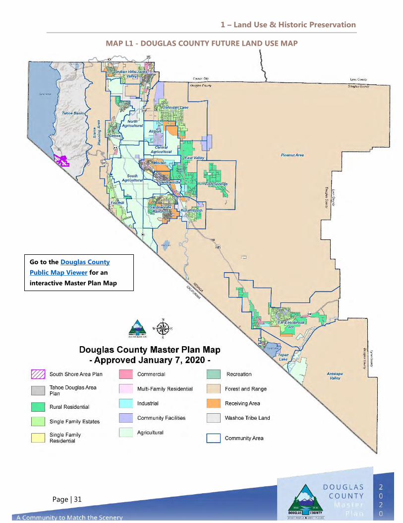
MAP L1 - DOUGLAS COUNTY FUTURE LAND USE MAP
Go to the Douglas County Public Map Viewer for an interactive Master Plan Map

1 – Land Use & Historic Preservation
Page | 32
REGIONS & COMMUNITY PLANS
Douglas County is divided into two Townships: East Fork and Tahoe (Diagram L1). Geographically, the County is comprised of five distinct regions: Carson Valley, Pinenut, Sierra, Topaz, and Tahoe Basin (Diagram L2). Community Plans within the regions express the vision that residents have for the diverse communities while preserving and promoting their unique identity.
1) The Carson Valley Region includes the unincorporated towns of Gardnerville, Genoa, and Minden. For planning purposes, there are 12 different Community Plans for the Carson Valley: Agriculture, Airport, East Valley, Fish Springs, Foothill, Gardnerville Ranchos, Genoa, Indian Hills/Jacks Valley, Johnson Lane, Gardnerville, Minden, and Ruhenstroth.
2) The Pinenut Region is the largest planning area and the least developed in the County.
3) The Sierra Region straddles the portion of Douglas County between the Carson Valley and the Tahoe Basin.
4) The Tahoe Basin Region is also under the authority of the Tahoe Regional Planning Agency (TRPA), although located partially in Douglas County. There are two community plans called “Area Plans” in the Tahoe Basin, which are under the 2012 TRPA Regional Plan: the South Shore Area Plan and the Tahoe Douglas Area Plan.
5) The Topaz Region includes the communities of Topaz Ranch Estates (TRE)/Holbrook Junction and Topaz Lake, with a community plan representing both areas. The Spring Valley area is included in the Topaz Ranch Estates/Holbrook Junction Community Plan. Although Antelope Valley and the Walker River Valley are distinct areas in southern Douglas County, there currently is no community plan for these areas.
The Community Plan areas extend beyond the boundaries of existing towns or GIDs to provide opportunities for growth. The Genoa Community Plan, for example, extends north and south of the actual Town of Genoa and reflects existing and proposed developments that are in proximity to the Town. Regions and Community Plans include information about specific community policies and diagrams from the Douglas County Future Land Use Map representing the most appropriate planned use of land for an area. This map, which is amended from time to time via the Master Plan Amendment process described in Title 20, can be found in its most current version on the Douglas County website.

1 – Land Use & Historic Preservation
Page | 33
DIAGRAM L1 - DOUGLAS COUNTY TOWNSHIPS

1 – Land Use & Historic Preservation
Page | 34
DIAGRAM L2 - DOUGLAS COUNTY REGIONS
Carson Valley Region, 111,978 , 25%
Pinenut Region, 222,246 , 49%
Sierra Region,
19,311 , 4%
Tahoe Basin Region,
23,458 , 5%
Topaz Region,
78,251 , 17%
1 – Land Use & Historic Preservation
Page | 35

1 – Land Use & Historic Preservation
Page | 36
CARSON VALLEY REGION
The Carson Valley is bounded by the Sierra Nevada Mountains on the west and the Pine Nut Mountains on the east. The north boundary is the Douglas County line, and the south boundary is the California/Nevada state line. The valley averages 12 miles wide east to west and 18 miles long. Ranching and farming are the heritage of the Carson Valley. Although much of the ownership and boundaries have changed, the majority of the significant farmland is still in operation. Diagram L3- Carson Valley Region
The Carson Valley has a very high percentage of low- to medium- density residential development, constituting almost 98 percent of all residential land use. High-density and very high-density residential uses occupy about
two percent of all residential land in Carson Valley, and agricultural lands account for 29,594 acres. Carson Valley is also the location for most of the industrial and commercial land use in the county. Within the Carson Valley Regional Plan, there are 12 Community Plans. Each of the communities has distinctive land use identities.
The Carson Valley Region totals 141,572 acres or 31.1 percent of the total acreage in the County.
Foothill, 6,679 , 6% Genoa, 6,363
, 6% Ruhenstroth, 5,092 , 5%
Fish Springs, 12,197 , 11%
Johnson Lane, 17,181 , 15%
Airport, 3,870 , 3%
Minden, 4,353 , 4%
East Valley, 8,755 , 8%
Gardnerville Ranchos, 6,713 , 6%
Gardnerville, 2,604 , 2%
Indian Hills/Jacks Valley, 8,577 , 8%
Agriculture, 29,594 , 26%

1 – Land Use & Historic Preservation
Page | 37
OUR VISION FOR THE CARSON VALLEY - A diverse mix of lifestyles, from mixed-use Main Streets to quiet
residential areas, ranches, and farmlands - Preservation of our historic downtowns and sites - The primary center of arts, culture, services, and amenities in the
County

1 – Land Use & Historic Preservation
Page | 38
AGRICULTURE COMMUNITY PLAN
The Agriculture Community Plan is divided into three sub-areas—north, central, and southern portions of Carson Valley—that contain most of the productive irrigated farms and ranch lands in Douglas County. The total acreage in the community plan is 29,594 acres. The landscape slopes gently to the north by northwest, and the majority of the lands are located within the flood zones from both branches (east fork and west fork) of the Carson River. The network of irrigation ditches and facilities in the valley is an intricate system conveying the waters from the Carson River to the irrigated farmland and back. There are three water masters that regulate the flow of the irrigation water in accordance with the Alpine Decree. Both forks of the Carson River merge in the center of the Carson Valley before flowing into Carson City.
COMMUNITY-SPECIFIC POLICIES Preserve and enhance the existing scenic character, beauty, and agricultural resources of the north, central, and south agricultural communities.
Use the Master Plan and development regulations to maintain and/or enhance the existing rural and scenic character of the community.
Land Use Acres Percentage
Agricultural 24,768 85% Washoe Tribe Land 1,996 7%
Forest & Range 1,498 5% Receiving Area 660 2%
Community Facilities 139 1%
Photo by Vivian Powers
VISION STATEMENT Agriculture in Douglas County will remain a key part of our identity, and the mindful and sustainable use of agricultural resources will be protected, encouraged, and supported.

1 – Land Use & Historic Preservation
Page | 39
DIAGRAM L4 - AGRICULTURE COMMUNITY

1 – Land Use & Historic Preservation
Page | 40
AIRPORT COMMUNITY PLAN
The Airport Community Plan covers approximately 3,870 acres and is centrally located in the Carson Valley. Agriculture and vacant lands comprise more than 50 percent of the community, which includes the Minden-Tahoe Airport, the Carson Valley Ranch receiving area (to the east), various business parks, and agricultural lands to the south and west. Receiving area south of Johnson Lane provides additional opportunity for the use of TDR. The County envisions industrial offices and/or single family estates to be expanded with full water and sewer connections. The wetland/floodplain in the southeast portion of the community provides an area for groundwater recharge and aviation safety. The community facilities, located on the western portion of the airport property, include aviation businesses, private aircraft hangars, and the County’s Public Works Department. Industrial offices are encouraged along Johnson Lane to buffer the residential uses to the north.
Land Use Acres Percentage Agricultural 1,413 37% Community Facilities 967 25% Industrial 892 24% Receiving Area 445 12% Forest & Range 41 1% Single Family Estates 29 1%
Other Relevant Plans Airport Master Plan
VISION STATEMENT The Airport Community Plan will focus on creating a state-of-the art transportation hub while continuing to be recognized as a premier soaring destination. The Airport Community will become a logistics center for commerce, offering a convenient location for industrial and agricultural uses.

1 – Land Use & Historic Preservation
Page | 41
DIAGRAM L5 - AIRPORT COMMUNITY
1 – Land Use & Historic Preservation
Page | 42
COMMUNITY-SPECIFIC POLICIES Use zoning, the Airport Master Plan, the project review process, and design guidelines to promote development that will enhance property values and the aesthetics of the Airport Community while maintaining a buffer around the airport perimeter for safety and noise abatement.
Encourage industrial and commercial uses to be developed along the south side of Johnson Lane and design them to be compatible with planned residential development in the vicinity, minimizing aesthetic and maintaining the views from existing properties located north of Johnson Lane.
Regulate direct access on Airport Road, Heybourne Road, Johnson Lane, and East Valley Road to maintain the function and safety of these collector roads. Extend Vicki Lane to the south of Johnson Lane and promote the connection of East Valley Road.
Have property owners prepare a specific plan for the receiving areas of the Airport Community area for review by Douglas County. New single family estates or other land uses that are proposed need to address a variety of issues that include on- and offsite flooding and drainage controls and conveyances, downstream routing of the storm water, infrastructure connections to community sewer and water systems, traffic and roadways, land use compatibility, and overall community design.
Require the paving of all public roads in the Airport Community. Driveways, parking areas, loading areas, and other high activity areas in non-residential developments shall be paved and shall not require the installation of streetlights, curbs, gutters, or sidewalks.
Preclude land uses in the flight path that pose unacceptable hazards to airport operations or development near the airport, per the Airport Master Plan.
Pursue funding for a Federal Aviation Administration (FAA) Part 150 Noise Study and Part 77 Hazard Study in order to prepare an Airport Overlay Zoning District for the Minden-Tahoe Airport.

1 – Land Use & Historic Preservation
Page | 43

1 – Land Use & Historic Preservation
Page | 44
EAST VALLEY COMMUNITY PLAN
The East Valley Community Plan area includes approximately 8,577 acres and is located on the east side of the Carson Valley, south of the Johnson Lane Community, east of central Agricultural, Minden, and Gardnerville Communities, and north of Ruhenstroth. The community enjoys views across the Carson Valley agricultural lands, with open spaces across the scenic vistas of the Sierra Nevada Mountains to the west and Pine Nut Mountain range to the east. This area is primarily comprised of single family estates and rural residential parcels, public lands, and the employment center of Williams Ridge Technology Park (at the southwestern border of Pinenut Road). Williams Ridge Industrial Park is envisioned to have improved access on Pinenut Road as more industry is located there. Grant Drive could be extended to East Valley Road, where Sawmill could connect to improve industrial access to Highway 395.
Land Use Acres Percentage Rural Residential 4,894 58% Forest & Range 2,541 30% Community Facilities 400 5% Industrial 382 4% Single Family Estates 230 3%
VISION STATEMENT East Valley will be a very low-density rural residential community providing access to the Pine Nut mountain range for outdoor recreation, nature, and wildlife experiences. It will be serviced by employment and retail centers located in adjacent industrial and business parks.

1 – Land Use & Historic Preservation
Page | 45
COMMUNITY-SPECIFIC POLICIES
Designate East Valley as a community with rural and potential urban service areas.
Plan for a buffer or transition area separating urban land uses from existing rural residential use.
Prohibit new commercial/industrial land use designations in the East Valley Community Plan and encourage development of infill in the existing business parks.
Limit expansion of public facility uses within the East Valley Community Plan unless the use is found to be compatible with the existing rural character of the community plan area.
Work with the BLM to identify areas to be included as permanent publicly accessible open space along the eastern side of the East Valley Community.
Maintain all single family estate designations within the East Valley Community at a two-acre minimum parcel size.
Allow the use of individual sewage disposal systems and domestic wells for service in this rural community, unless water quality studies identify the need for community systems.
Coordinate with and strongly encourage the BLM to plan, design, and maintain trails and public access points to the federal lands within the East Valley Community. Hiking, bicycling, and equestrian trails should be planned with appropriately designed trailheads.

1 – Land Use & Historic Preservation
Page | 46
1 – Land Use & Historic Preservation
Page | 47
DIAGRAM L6 - EAST VALLEY COMMUNITY

1 – Land Use & Historic Preservation
Page | 48
FISH SPRINGS COMMUNITY PLAN
The Fish Springs Community includes approximately 12,197 acres, primarily Forest and Range land use with rural residential, agricultural, and public facilities land. The area received its name from Fritz Elges, who constructed a covered dug-out reservoir in which carp (oily freshwater fish) were grown. Thus, an early effort of aquaculture gave the area its name. The Fish Springs Community is separated from the Carson Valley by the easterly hills of the Pine Nut Range. The community consists of single family residences characterized by lots between one and 10 acres in size generally scattered throughout the area. Based on historic patterns and topography, it is assumed this pattern of development will continue.
The only public facilities in the community are the Fish Springs Volunteer Fire Department and two parcels of land owned by Douglas County on either side of Fish Springs Road at the entrance to the canyon.
Land Use Acres Percentage Forest & Range 9,473 78% Rural Residential 2,471 20% Agriculture 59 1% Community Facilities 48 1%
VISION STATEMENT Fish Springs will be a very low-density rural community providing access to majestic scenery and improved access to outdoor recreation, nature, and wildlife experiences.
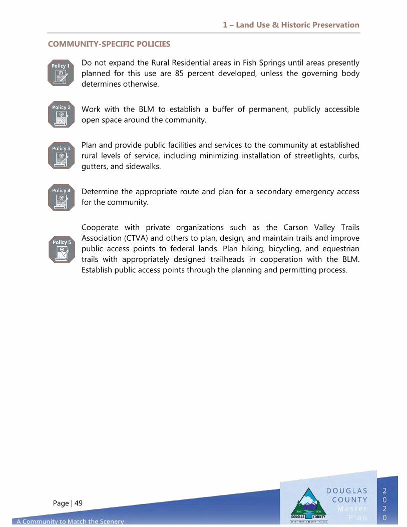
1 – Land Use & Historic Preservation
Page | 49
COMMUNITY-SPECIFIC POLICIES
Do not expand the Rural Residential areas in Fish Springs until areas presently planned for this use are 85 percent developed, unless the governing body determines otherwise.
Work with the BLM to establish a buffer of permanent, publicly accessible open space around the community.
Plan and provide public facilities and services to the community at established rural levels of service, including minimizing installation of streetlights, curbs, gutters, and sidewalks.
Determine the appropriate route and plan for a secondary emergency access for the community.
Cooperate with private organizations such as the Carson Valley Trails Association (CTVA) and others to plan, design, and maintain trails and improve public access points to federal lands. Plan hiking, bicycling, and equestrian trails with appropriately designed trailheads in cooperation with the BLM. Establish public access points through the planning and permitting process.
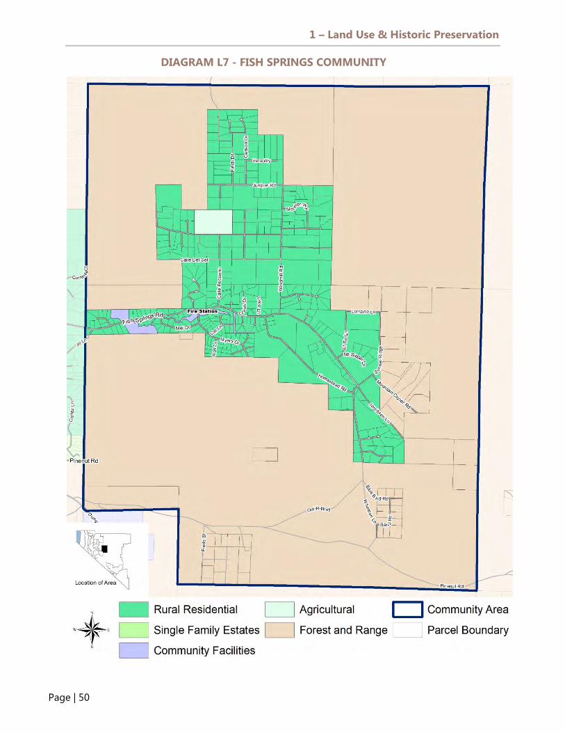
1 – Land Use & Historic Preservation
Page | 50
DIAGRAM L7 - FISH SPRINGS COMMUNITYON STATEMEN

1 – Land Use & Historic Preservation
Page | 51

1 – Land Use & Historic Preservation
Page | 52
FOOTHILL COMMUNITY PLAN
The Foothill Community area includes approximately 6,679 acres of Forest and Range, Single Family Estate, and Rural Residential areas with parcel sizes between one and ten acres adjacent to agricultural lands. In the mid-1800s, the Mottsville and Sheridan settlements were established in the Foothill Community, and both of these names are used today to identify these settlement areas. The Foothill Community is a picturesque setting overlooking agricultural fields nestled at the foot of the pine-covered Carson Range of the Eastern Sierra Nevada Mountains. The community enjoys a rural environment with a low population. Agricultural fields surround the community to the north, east, and south, and a cluster of homes along Foothill Road serves as a central access spine for the community. There are some residential developments on smaller lots (Sheridan Acres) with lot sizes of approximately one-half acre. This community is currently an area of exclusive custom-built homes, and it is assumed this pattern of development will continue. Foothill has no commercial or industrial land uses. The Sheridan Volunteer Fire Department and the Mottsville Cemetery are the only public facilities located in the Community.
Land Use Acres Percentage Forest & Range 2,192 34% Agricultural 2,097 33% Single Family Estate 1,940 31% Rural Residential 117 2% Community Facilities 6 0%
VISION STATEMENT The Foothill Community will be a quiet collection of clustered residences providing picturesque views of the Carson Valley and the opportunity to experience the rich local history and culture.

1 – Land Use & Historic Preservation
Page | 53
COMMUNITY SPECIFIC POLICIES
Continue to develop the Foothill Community as a residential community area with rural levels of service.
Do not support the installation of streetlights, curbs, gutters, or sidewalks within the Foothill Community except on collector roads.
Require development in designated high fire hazard areas to provide appropriate emergency access.
Require development of lands within areas of identified active fault zones to conform to seismic development policies.
Work with the USFS to establish areas of permanent publicly accessible open space along the western boundary of the Foothill Community and a network of hiking, bicycling, and equestrian trails with accessible trailheads.

1 – Land Use & Historic Preservation
Page | 54
DIAGRAM L8 - FOOTHILL COMMUNITY

1 – Land Use & Historic Preservation
Page | 55

1 – Land Use & Historic Preservation
Page | 56
GARDNERVILLE RANCHOS COMMUNITY PLAN
The Gardnerville Ranchos area includes approximately 6,713 acres and is home to the largest population base in Douglas County. In the mid-1960s, C.E. (Red) Swift owned a large tract of land on which he wanted to build homes. Douglas County required the proposed subdivision to have a municipal water system and paved roads. Swift tried to get the land annexed to the towns of Minden and Gardnerville but was turned down because of the proximity of the land to the towns. The Gardnerville Ranchos General Improvement 318 District was then created by Douglas County Ordinance 147 on April 9, 1965. The District is one of the oldest GIDs in the County. The Gardnerville Ranchos Community Plan lies in the south-central portion of the Carson Valley. The community, which was historically used as ranching land, now maintains both urban and rural residential areas.
Land Use Acres Percentage Agricultural 2,622 42% Single Family Residential 1,248 20% Receiving Area 902 14% Single Family Estate 457 7% Rural Residential 450 7% Community Facilities 214 3% Forest & Range 85 2% Multi-family Residential 95 2% Recreation 101 2% Commercial 64 1% Industrial 14 0% Washoe Tribe Land 1 0%
VISION STATEMENT
The future vision for the Gardnerville Ranchos Community Plan area is to retain the community’s rural character and aesthetics. The Gardnerville Ranchos residents share a strong sense of community. Passive and recreational open spaces are identified as fundamental features in all new development projects to serve both new and existing residents. Bicycle, pedestrian, and equestrian nature corridors can connect the Ranchos to the Douglas County Community Center and adjacent communities. Particular attention is given to prevent overdevelopment of the designated receiving area in the plan area while providing housing opportunities that meet the needs of the Gardnerville Ranchos Community. Roadway designs should improve traffic circulation patterns, and proactive roadway maintenance programs will assure safe and smooth conditions. Low-impact development practices are employed to protect and ensure the District’s low-cost, superior quality and quantity of ground water today and into the future.

1 – Land Use & Historic Preservation
Page | 57
DIAGRAM L9 - GARDNERVILLE RANCHOS COMMUNITY

1 – Land Use & Historic Preservation
Page | 58
COMMUNITY-SPECIFIC POLICIES
Designate Gardnerville Ranchos as a community with defined urban and rural areas. These areas shall be distinct, and different standards shall be applied to each area.
Encourage development of neighborhood commercial uses to adequately serve the community.
Ensure adequate provision of park sites to meet the needs of the growing community.
Plan, construct, and operate parks in the Gardnerville Ranchos Community that are consistent with the County’s park standards in the Parks and Recreation section of the Public Facilities, Services, and Recreation Element.
Work closely with the Douglas County School District in the development, maintenance, and joint operation of school park sites in the community.
Work with the Gardnerville Ranchos GID to improve gateways into Gardnerville Ranchos to further delineate and enhance the image of the community.
Encourage water system connections for emergency services to be made between the Gardner Ranchos GID and Gardnerville Water.

1 – Land Use & Historic Preservation
Page | 59

1 – Land Use & Historic Preservation
Page | 60
GENOA COMMUNITY PLAN
Nestled at the foot of the Carson Range of the east slope of the Sierra Nevada Mountains, the Genoa Community Plan area includes approximately 6,363 acres along the western edge of Carson Valley. Much of the Town boundary is formed by U.S. Forest Service property. Genoa, which was settled in 1851, is the oldest town in Nevada and holds an important place in the history of Nevada and the West. Explorers and trappers often made their way through this area when heading west to California. In June of 1851, John Reese and his party built a trading post, and the area began to attract settlers, becoming a permanent settlement known as Mormon Station; it was renamed as Genoa in 1855. Many of the structures in the Town are included on the National Register of Historic Places. The commercial properties along Main Street are within the Genoa Historic District, which includes restrictions on development and strict architectural standards.
Land Use Acres % Forest & Range 2,232 37% Agricultural 2,018 33% Recreation 627 10% Single Family Estate 449 7% Rural Residential 395 6% Commercial 150 3% Single Family Residential 233 4% Community Facilities 14 0%
VISION STATEMENT
Genoa will remain a symbol of the early settlement of Douglas County and the State of Nevada, maximizing the opportunities arising from the intersection of historic preservation, heritage tourism, and its potential as a gateway to the Tahoe Basin.

1 – Land Use & Historic Preservation
Page | 61
COMMUNITY SPECIFIC POLICIES
Use the Master Plan and development regulations to maintain or enhance the existing rural, agricultural, and historic character of the community. Support the expansion of commercial development in the Town of Genoa in a manner that is compatible with the Town's existing historic character. Work with the Town to establish appropriate parking requirements for the commercial corridor. Ensure that development regulations support growth in the bed and breakfast industry in Genoa to preserve existing historic homes and to promote tourism of Genoa's historic resources. Continue to use design review to ensure that new commercial development is compatible with the historic character of the Town of Genoa. Ensure that this process addresses the amount, scale, design, location, and intensity of development. Periodically review the advisability of expanding the historic district of the Town of Genoa.
Encourage the displacement of overhead power and communication transmission lines to underground facilities in the Town of Genoa. Encourage a quiet residential neighborhood and do not approve any development or projects that will unreasonably disrupt the livelihood or peace of the residents. Ensure that all streets in the Town are designed for slow speeds and safe vehicular and pedestrian routes. Ensure that local roads in the Town continue to reflect the rural character while controlling dust. Coordinate with the Nevada Department of Transportation to ensure that modifications to State Route 206, Genoa Lane, and Jacks Valley Road are compatible with the existing character of Genoa and increase the safety or desirability of pedestrian traffic.

1 – Land Use & Historic Preservation
Page | 62
DIAGRAM L10 - GENOA COMMUNITY

1 – Land Use & Historic Preservation
Page | 63

1 – Land Use & Historic Preservation
Page | 64
INDIAN HILLS/JACKS VALLEY COMMUNITY PLAN
The Indian Hills/Jacks Valley Community, located at the north end of the Carson Valley, is the northern gateway of Douglas County. Spanning approximately 8,577 acres, the community consists of the commercial center adjacent to the Carson City and Douglas County lines of the North Valley area. The community is bisected by the Jacks Valley Wildlife Management area on USFS and BIA land, including the Clear Creek Tahoe development. The mountains of the Toiyabe National Forest to the west augment the natural open spaces and contribute to the picturesque scenery that is such an important part of this community’s character. This area lies between the steep slopes of the Sierras to the northwest and the broad floodplain of the Carson River to the southeast. The community is primarily residential, with some commercial and industrial land at the Highway 395, Mica Drive, Jack Valley Road, and Topsy intersections. Though Indian Hills/Jacks Valley is one community plan, it is composed of four distinct neighborhoods: (1) Indian Hills General Improvement District, (2) North Valley Area, (3) Silverado, and (4) Alpine View Estates.
Other Relevant Plans North Douglas County Specific Plan Clear Creek Tahoe Specific Plan

1 – Land Use & Historic Preservation
Page | 65
COMMUNITY SPECIFIC POLICIES
Limit commercial development outside of the existing business corridors along U.S. 395 to neighborhood commercial uses that serve the needs of the community’s residents.
Ensure that the commercial designation located at the intersection of Jacks Valley Road and Highway 395 provides for mixed residential and commercial uses.
Ensure that commercial designations associated with the resort/casino area in the south portion of the plan area are oriented toward tourism.
Ensure that commercial designations at the gateway to Douglas County/Carson City provide for regional commercial activities. The commercial designation on U.S. Forest Service lands anticipates land trades to private ownership but should only be permitted in exchange for open space lands in Douglas County.
Land Use Acres % Forest & Range 3,899 48% Single Family Estate 969 12% Community Facilities 613 8% Single Family Residential 600 7% Washoe Tribe Land 571 7% Recreation 370 5% Agricultural 343 4% Commercial 323 4% Receiving Area 307 4% Multi-family Residential 78 1% Rural Residential 28 0%
VISION STATEMENT Indian Hills/Jacks Valley will continue to provide a variety of lifestyle choices ranging from rural estates to small single family residential lots, with more urbanized development centered around the Topsy Lane and Jacks Valley Road corridor along Highway 395.

1 – Land Use & Historic Preservation
Page | 66
Use zoning, the project review process, and design guidelines to ensure that multi-family and non-residential developments are compatible with nearby development.
Minimize the number of points of access to U.S. Highway 395, Sunridge Road, Topsy Lane, Vista Grande Blvd., and Jacks Valley Road. Limit direct access from private property. Require connection to a centralized water system and a sewage treatment and disposal system for all new development in areas designated for urban development.
Require the paving of local streets in new urban and rural developments. Pave streets in urban areas to urban standards; pave streets in rural areas to rural standards.
Ensure that future development in the Clear Creek Specific Plan Development, which is characterized by golf estate lots surrounded by alpine meadows and forest lands, is consistent with the specific plan and remains hidden from offsite views. Maintain buffer areas with the Alpine View Estates and Freedom Ranch subdivisions to the southeast.
Ensure that future development in the North Douglas County Specific Plan Development, which is characterized by a mix of regional commercial, multi-family, and high-density single family developments, is consistent with the specific plan and is evaluated on its impact on regional infrastructure.
Indian Hills General Improvement District area consists of a mixture of detached single family homes, manufactured housing, and apartments in a suburban residential development setting. A neighborhood commercial center is located on Mica Drive (one of the gateways into the community), and a large regional commercial shopping center is located on the north end of the community along Highway 395 at Jacks Valley Road. Silverado area consists primarily of detached single family homes on an average lot size of one acre. The area includes the Sierra Estates General Improvement District, serving around 64 single family custom-built homes of various styles and sizes. Jacks Valley’s community character is rural, with medium to large lots in a suburban residential setting with unpaved streets.

1 – Land Use & Historic Preservation
Page | 67
Alpine View Estates is situated along the foothills of Jacks Valley with spectacular views of the eastern slope of the Sierra Nevada mountain range. Residents enjoy the conservation area and preserved agricultural fields, where cattle graze year-round. Alpine View Estates has detached single family, custom-built homes, which are generally large and upscale, on an average lot size of two acres. Alpine View Estates’ community character is rural residential parcels of two acres with paved streets. Vacant land and public open space dominate the undeveloped parts of this community.

1 – Land Use & Historic Preservation
Page | 68
DIAGRAM L11 - INDIAN HILLS/JACKS VALLEY COMMUNITY

1 – Land Use & Historic Preservation
Page | 69
JOHNSON LANE COMMUNITY PLAN
The Johnson Lane Community Plan is located in the northeast corner of the Carson Valley and consists of approximately 17,181 acres. The area has characteristics of a rural residential community. Residents of this area overlook the Carson Valley and enjoy access to open public lands, the Pine Nut Mountains to the east, and the scenic vistas of the tree-covered Sierra Nevada mountain range to the west. This community is primarily developed with single family estates and rural residential areas containing individual custom-built homes, with forest and range land surrounding the community, and it is assumed this pattern of development will continue to expand. There is a concern regarding the nitrates in the groundwater, and future development should connect to a municipal water system. Sewer connectivity is also encouraged. The only commercial development in the Johnson Lane Community today is a small neighborhood commercial use on the northwest corner of Johnson Lane and Clapham Lane. The Douglas County North Valley Wastewater Treatment Plant is located within the community area. The Incline Village General Improvement District (IVGID) wetlands are also located in this area. Several areas along the north side of Johnson Lane and adjacent to U.S. Highway 395 are considered prime farmland.
Land Use Acres % Forest & Range 11,836 71% Single Family Estate 3,173 19% Community Facilities 1,293 8% Rural Residential 192 1% Receiving Area 178 1% Agricultural 20 0% Commercial 5 0% Industrial 0.08 0%
VISION STATEMENT Johnson Lane will be a primarily residential community characterized by improved infrastructure, protection from natural hazards, resources best management practices, and easy access to the Pine Nut range.
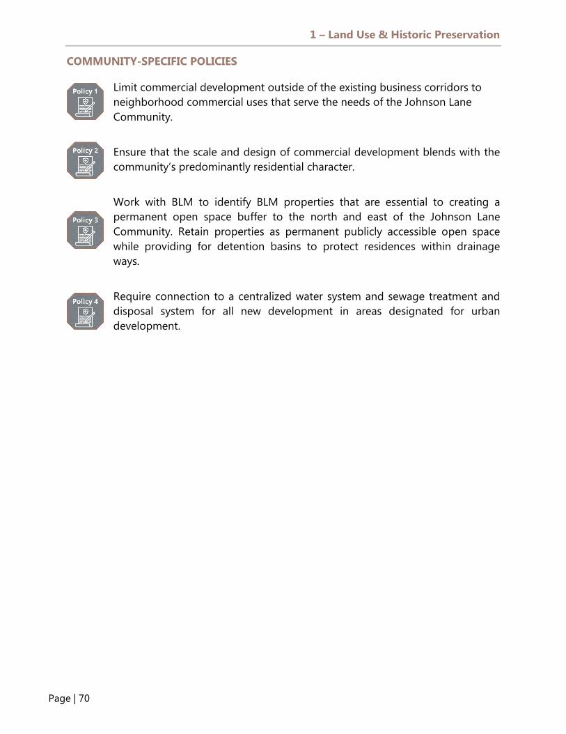
1 – Land Use & Historic Preservation
Page | 70
COMMUNITY-SPECIFIC POLICIES
Limit commercial development outside of the existing business corridors to neighborhood commercial uses that serve the needs of the Johnson Lane Community.
Ensure that the scale and design of commercial development blends with the community’s predominantly residential character.
Work with BLM to identify BLM properties that are essential to creating a permanent open space buffer to the north and east of the Johnson Lane Community. Retain properties as permanent publicly accessible open space while providing for detention basins to protect residences within drainage ways.
Require connection to a centralized water system and sewage treatment and disposal system for all new development in areas designated for urban development.

1 – Land Use & Historic Preservation
Page | 71
DIAGRAM L12 - JOHNSON LANE COMMUNITY

1 – Land Use & Historic Preservation
Page | 72
GARDNERVILLE AND MINDEN COMMUNITY PLANS
Goals and Policies for the Gardnerville Community Plan are contained in the 2018 Minden/Gardnerville Plan For Prosperity. The Plan for Prosperity was created by the Towns of Gardnerville and Minden in their capacity as advisory bodies to Douglas County. Douglas County will utilize the goals and policies contained in the Plan for Prosperity to the greatest extent possible. Click here to view the Minden and Gardnerville Plan for Prosperity.
VISION STATEMENT “Minden and Gardnerville envision vibrant downtowns that are regional destinations and the hearts of their communities. Their town centers will be mixed-use, feature cultural facilities, have a full annual events calendar, and have integrated arts programming. Their successful Main Street Districts are enabled by a completed Muller Parkway allowing through traffic to bypass Main Street. The Parkway supports redesign of the main street and historic Railroad Avenue portions of Highway 395 as pedestrian-oriented experiences. Trails will connect the town centers with new parks along Martin Slough and Muller Parkway, which double as detention facilities that reduce flooding. Neighborhoods will have definable centers including parks, schools, libraries, and their own namesake streets. New neighborhoods will include housing supporting the needs of existing and future residents. The Towns envision new types of housing including mixed-use development in the downtowns and agri-neighborhoods on the Towns’ edges.” – Minden and Gardnerville Plan for Prosperity, December 2018
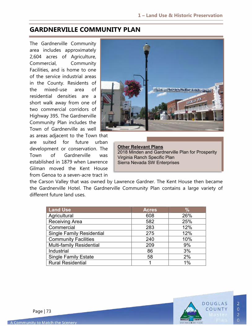
1 – Land Use & Historic Preservation
Page | 73
GARDNERVILLE COMMUNITY PLAN
The Gardnerville Community area includes approximately 2,604 acres of Agriculture, Commercial, Community Facilities, and is home to one of the service industrial areas in the County. Residents of the mixed-use area of residential densities are a short walk away from one of two commercial corridors of Highway 395. The Gardnerville Community Plan includes the Town of Gardnerville as well as areas adjacent to the Town that are suited for future urban development or conservation. The Town of Gardnerville was established in 1879 when Lawrence Gilman moved the Kent House from Genoa to a seven-acre tract in the Carson Valley that was owned by Lawrence Gardner. The Kent House then became the Gardnerville Hotel. The Gardnerville Community Plan contains a large variety of different future land uses.
Land Use Acres % Agricultural 608 26% Receiving Area 582 25% Commercial 283 12% Single Family Residential 275 12% Community Facilities 240 10% Multi-family Residential 209 9% Industrial 86 3% Single Family Estate 58 2% Rural Residential 1 1%
Other Relevant Plans 2018 Minden and Gardnerville Plan for Prosperity Virginia Ranch Specific Plan Sierra Nevada SW Enterprises

1 – Land Use & Historic Preservation
Page | 74
DIAGRAM L13 - GARDNERVILLE COMMUNITY

1 – Land Use & Historic Preservation
Page | 75
MINDEN COMMUNITY PLAN
The Minden Community Plan is approximately 4,353 acres and includes the Town and adjacent areas that are suitable for future urban development or otherwise preserved for open space. Minden was founded in 1905 and contains many structures and sites of historic value, including 10 properties that are listed on the National Register of Historic Places. On average, this community provides a residential density of five units per acre. Several areas are designated as Receiving Areas in the Minden Community Plan and are located generally north and southwest of Minden. The development of these properties will be dependent upon the preparation and adoption of comprehensive specific plans for the areas that specify densities and land uses, and this mitigates planning and environmental issues. The areas should be developed as distinct neighborhoods compatible and complementary to surrounding neighborhoods. A variety of residential densities should be utilized with the predominant land use being single family. Multi-family uses, except Mixed-use Commercial Districts, where appropriate, should be limited to small enclaves spread throughout the community rather than concentrated. Housing for seniors and affordable housing should be included in the overall housing mix. Community support facilities should be provided, such as parks and church sites. Natural drainage features should be incorporated into the neighborhood designs to enhance open space elements that create linear parks and pathways to connect elements of the existing towns. Buffering of agricultural lands should be included in future development.
Land Use Acres Percentage Agricultural 1,612 40% Receiving Area 1,111 27% Industrial 488 12% Single Family Residential 455 11% Commercial 158 4% Community Facilities 133 3% Multi-family Residential 62 2% Single Family Estate 16 1% Rural Residential 2 0%
Other Relevant Plans 2018 Minden and Gardnerville Plan for Prosperity Nevada Northwest Specific Plan

1 – Land Use & Historic Preservation
Page | 76
DIAGRAM L14 - MINDEN COMMUNITY

1 – Land Use & Historic Preservation
Page | 77
RUHENSTROTH COMMUNITY PLAN
Ruhenstroth is located in the southeastern part of the Carson Valley Region and consists of approximately 5,092 acres. Its residents enjoy the scenic vistas of the Carson Range of the Sierra Nevada Mountains and the rugged terrain of the Pine Nut Mountains. The Fairgrounds are located in this community and are the largest public facility in the County for special events. The Washoe Tribe’s Dresslerville Community is also located in this area. Given the County’s need to diversify the stock of available housing, there is some potential to provide for expanded future land uses in this community as reflected in the 130-acre transition area adjacent to Pinenut Road. This area requires the adoption of a Specific Plan, with strict limits on allowed development that will encourage a mix of housing types to serve the area’s existing and expected population. This area was created to provide for an active adult and over 55-year-old community with a maximum of 250 dwelling units, necessary neighborhood services, and a mix of housing types, including small-lot development that allows for maximum retention of agricultural land and open space.
Land Use Acres Percentage Forest & Range 2,307 47% Single Family Estate 787 16% Washoe Tribe Land 727 15% Agricultural 358 7% Rural Residential 278 6% Community Facilities 269 6% Receiving Area 131 3%
Other Relevant Plans Corley Ranch Specific Plan Dry Creek Estates Settelmeyer Ranches
VISION STATEMENT Ruhenstroth will keep flourishing as a rural community nestled in the hills surrounding the East Fork Carson River, with a local economy centered on the Washoe Tribe's Dresslerville Community and the Lahontan National Fish Hatchery Complex.

1 – Land Use & Historic Preservation
Page | 78
COMMUNITY SPECIFIC POLICIES
Restrict commercial development to the transition area and comply with applicable intensity standards and design guidelines. Commercial development shall not be considered as consistent with the desired character of the original Ruhenstroth developed area, exclusive of the transition area.
Complete any rehabilitation or reuse of any gravel pit according to site plans approved by Douglas County that result in development compatible with the surrounding Ruhenstroth community and that use regrading, revegetation, and other techniques to minimize the visual and environmental impacts of the site.
Seek to create a permanent buffer of open space around the originally developed part of the Ruhenstroth community, exclusive of the transition area.
Require paving of roads within the Ruhenstroth community and do not support the installation of streetlights, curbs, gutters, or sidewalks.
Allow the use of individual sewage disposal systems and domestic wells for service in the community unless continuing water quality studies identify the need for community systems. Continue making long-range plans to provide community water and sewer services to the area.
Construct a road to connect the Ruhenstroth community to Pinenut Road to provide a second access out of the community during an emergency.

1 – Land Use & Historic Preservation
Page | 79
DIAGRAM L15 - RUHENSTROTH COMMUNITY

1 – Land Use & Historic Preservation
Page | 80
PINENUT REGION
The Pinenut area is located in the eastern part of Douglas County and includes portions of the Pine Nut Range, including the lower lying foothills to the Carson Valley. Several year-round creeks flow from natural springs in the Pine Nut Range to the valley below. The areas of potential wetlands are in the Mud Lake area in the far west edge of the plan area. Due to the topography and rural setting, the area is unlikely to develop any significant employment base. The scenic quality of the Pinenut area is the picturesque forested lands overlooking the Carson Valley and the lower open range lands. The elements include piñon- and juniper-covered mountains and lower-elevation sagebrush
terraces. The Pinenut Region is the largest of the five regional plan areas, comprising 222,246 acres or about 49 percent of the county, and is one of the least developed areas in the County. This area has the largest acreage of publicly owned land, comprising of 194,810 acres. The Pinenut Allotments comprise 23 percent of the land in the Pinenut Region. Allotment lands south of the Ruhenstroth community along U.S. Highway 395 South have seen increased residential development in the form of manufactured homes with little or no infrastructure. Of the urbanized land, residential and industrial/transportation categories make up the greatest share. Residential development is solely comprised of Rural Residential use designations totaling 650 acres.
Other Relevant Plans BLM Resource Management Plan (2016) BIA Pinenut Allotments Washoe Tribe IRM Plan Douglas County Master Plan Conservation Element
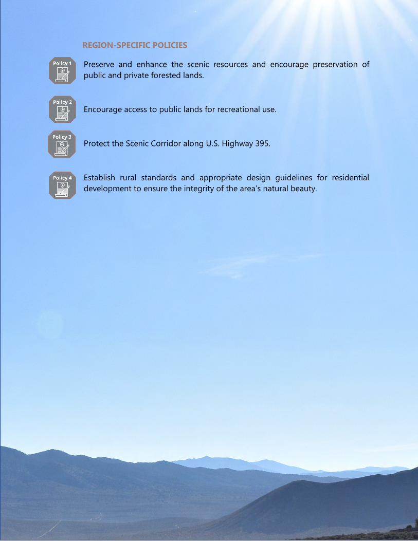
1 – Land Use & Historic Preservation
Page | 81
REGION-SPECIFIC POLICIES
Preserve and enhance the scenic resources and encourage preservation of public and private forested lands.
Encourage access to public lands for recreational use.
Protect the Scenic Corridor along U.S. Highway 395.
Establish rural standards and appropriate design guidelines for residential development to ensure the integrity of the area’s natural beauty.

1 – Land Use & Historic Preservation
Page | 82
SIERRA REGION
The Sierra Region, approximately 19,311 acres, lies between the Carson Valley and the Tahoe Basin and is very sparsely populated. About 75 percent of the lands in the area are in public ownership. Due to the topography, little development will occur. The only major arterial road in the area is Kingsbury Grade, which traverses the Regional Plan. The Sierra Regional Plan is known for its natural beauty and recreational amenities, including Heavenly Ski Resort. The Heavenly ski area encompasses a large area, including private and U.S. Forest Service lands in both Nevada and California. The Sierra Regional Plan is comprised of steep, forested slopes. About 84 percent of the County’s privately owned
forest land lies in the community. This area will continue to act as a buffer between the Tahoe and Carson Valley Regional Plans; there is very little development with the exception of the Tahoe Village and the Summit Village neighborhoods. These two neighborhoods contain approximately 850 dwelling units outside of the Tahoe Basin and are primarily comprised of timeshare condominiums. Therefore, the community contains a limited permanent residential population; the estimated population in 2010 was approximately 169. The Tahoe Village and Summit Village neighborhoods are serviced by the Kingsbury General Improvement District (KGID), which is located within the Tahoe Basin; their populations are included in the Tahoe Basin population numbers.

1 – Land Use & Historic Preservation
Page | 83
REGION-SPECIFIC POLICIES
Preserve and enhance scenic resources and encourage preservation of public and private forested lands.
Encourage private land/public land exchange to increase public land holdings within the Sierra area consistent with the Master Plan.
Encourage access to public lands for recreational use through approved access points.
Require development in areas of moderate to steep slopes (greater than 10 percent) to conform to the hillside development policies.
Support efforts to implement the Heavenly Ski Resort Master Plan.
Encourage new development to be infill within the KGID service area.
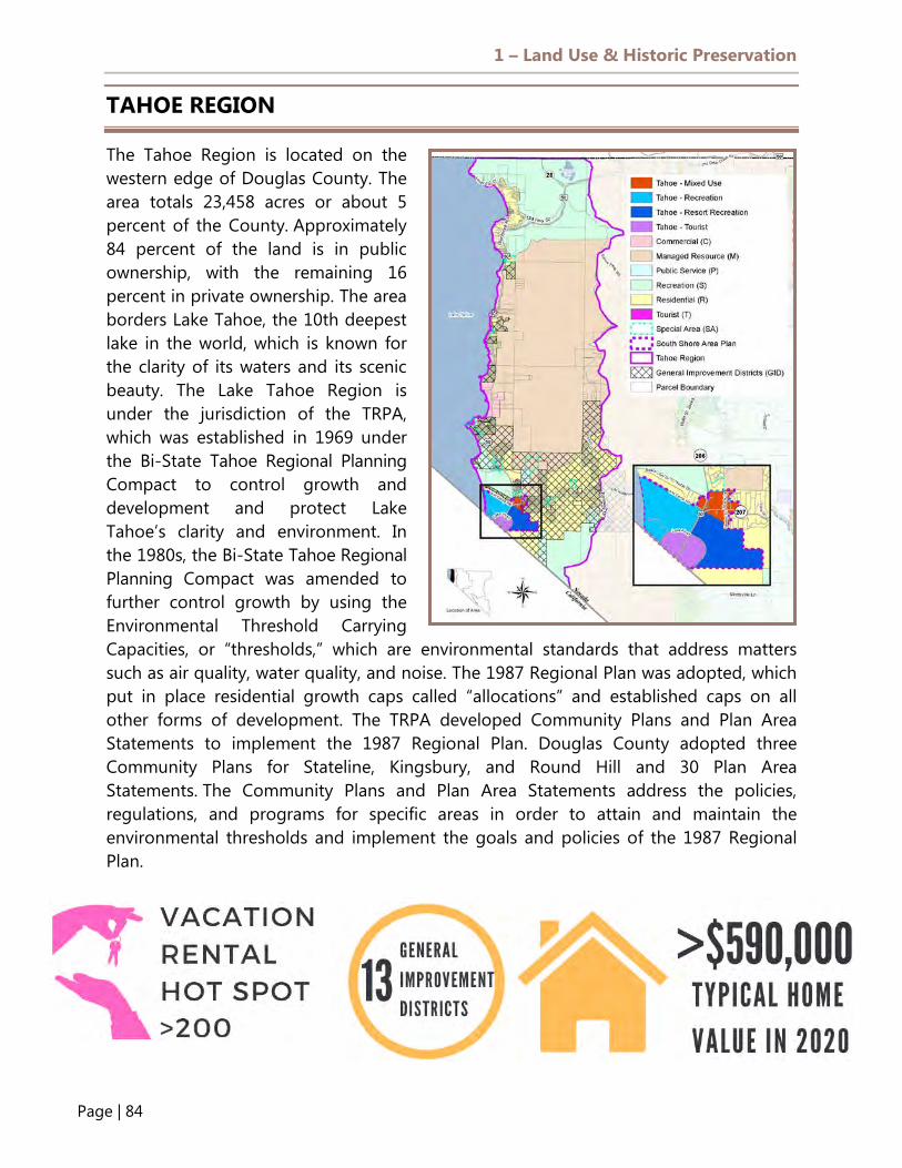
1 – Land Use & Historic Preservation
Page | 84
TAHOE REGION
The Tahoe Region is located on the western edge of Douglas County. The area totals 23,458 acres or about 5 percent of the County. Approximately 84 percent of the land is in public ownership, with the remaining 16 percent in private ownership. The area borders Lake Tahoe, the 10th deepest lake in the world, which is known for the clarity of its waters and its scenic beauty. The Lake Tahoe Region is under the jurisdiction of the TRPA, which was established in 1969 under the Bi-State Tahoe Regional Planning Compact to control growth and development and protect Lake Tahoe’s clarity and environment. In the 1980s, the Bi-State Tahoe Regional Planning Compact was amended to further control growth by using the Environmental Threshold Carrying Capacities, or “thresholds,” which are environmental standards that address matters such as air quality, water quality, and noise. The 1987 Regional Plan was adopted, which put in place residential growth caps called “allocations” and established caps on all other forms of development. The TRPA developed Community Plans and Plan Area Statements to implement the 1987 Regional Plan. Douglas County adopted three Community Plans for Stateline, Kingsbury, and Round Hill and 30 Plan Area Statements. The Community Plans and Plan Area Statements address the policies, regulations, and programs for specific areas in order to attain and maintain the environmental thresholds and implement the goals and policies of the 1987 Regional Plan.
1 – Land Use & Historic Preservation
Page | 85
REGION-SPECIFIC POLICIES
Encourage preservation of natural resources and lands.
Support the unique recreation business opportunities without compromising the enjoyment of activities for local residents.
Promote an integrated regional approach to planning between Tahoe and the Carson Valley.

1 – Land Use & Historic Preservation
Page | 86
Antelope Valley, 47,349 , 61%
Topaz Lake,
4,089 , 5%
TRE/ Holbrook
Jct, 26,813 , 34%
TOPAZ REGION
The Topaz Region is located in the southern portion of Douglas County along U.S. Highway 395 and consists of approximately 78,251 acres. Around 2,065 acres are devoted to urban uses, with 80 percent of the urban land allocated to residential uses. There are three distinct areas in the Regional Plan: Topaz Ranch Estates/Holbrook Junction, Topaz Lake, and Antelope Valley. Community plans for Topaz Lake, Topaz Ranch Estates/Holbrook Junction have been adopted and are referenced in their Community Plan section. There are agricultural lands and riparian vegetation along the Walker River, which separates Antelope Valley from the rest of the Topaz area. The topography is
characterized by steep slopes, sparsely wooded piñon pines, hillsides, and a scattering of agricultural lands. One of the challenges of future development in this region is the lack of municipal water service and sewage infrastructure. This makes Topaz an area for which future growth will have to be curtailed in order to maintain good soil and water quality, and that will most likely resemble an “off-grid” type of rural living.

1 – Land Use & Historic Preservation
Page | 87
REGION-SPECIFIC POLICIES
Provide community services and facilities to meet the needs of Topaz area residents.
Coordinate and cooperate with other providers, where applicable, to plan and provide public facilities and services to the rural development areas of the Topaz communities at established rural levels of service. Work to upgrade facilities in existing rural areas over time and with available resources.
Ensure that the Douglas County School District continues to monitor the need for development and location of potential school sites in the Topaz area.
Allow the use of individual sewage disposal systems and domestic wells for service in rural residential areas of Topaz unless continuing water quality studies identify the need for community systems.
Coordinate and cooperate with the BLM to plan public access and use of BLM lands in the Topaz area, particularly where they are adjacent to Topaz Park or other County recreational facilities.

1 – Land Use & Historic Preservation
Page | 88
TOPAZ LAKE COMMUNITY PLAN
The Topaz Lake Community includes approximately 4,089 acres in the southern portion of Douglas County bounded by Topaz Lake, U.S. Highway 395, and the California state line on the west. The existing Topaz Lodge Casino and commercial land use designations flank U.S. Highway 395, which forms the western boundary of the residential area. The Topaz Marina area has limited seasonal commercial use. The Topaz Lake Community consists of commercial land uses along U.S. Highway 395 and relatively high-density residential uses. To the east along the north shore of Lake Topaz, the land use designation is farm, forestry, and open reserve. Lot sizes in the original subdivision vary from 5,000 square feet to just under one-half acre. Lot sizes that have developed on the hillside to the north vary from one to five acres. There are no industrial or multi-family land uses currently within the Community Plan. Most of the commercially zoned parcels in the Topaz Lake Community Plan are undeveloped.
Land Use Acres Percentage Forest & Range 3277 83% Single Family Estate 226 6% Agricultural 252 6% Rural Residential 30 1% Community Facilities 166 4%
VISION STATEMENT Topaz Lake will provide a year-round epicenter of recreational activities, strengthening its businesses and providing increased amenities and services for its residents.

1 – Land Use & Historic Preservation
Page | 89
COMMUNITY-SPECIFIC POLICIES
Designate Topaz Lake as a rural community and maintain the existing rural character of the residential areas.
Designate areas for compact commercial development where commercial centers are established and can be expanded.
Require that all street types in new urban and rural development areas are paved and minimize the installation of streetlights, curbs, gutters, and sidewalks.
Evaluate the special recreational needs of senior citizens in the Topaz communities and include these in recreational facility planning.
Continue to provide county-wide park services and facilities at Topaz Lake Park as long as the leasehold is maintained.
Encourage expansion and consolidation of water service systems.
Require that all new individual sewage disposal systems are located on a parcel or parcels with a minimum of one acre, per NAC 444.

1 – Land Use & Historic Preservation
Page | 90
DIAGRAM L16 - TOPAZ LAKE COMMUNITY

1 – Land Use & Historic Preservation
Page | 91
TOPAZ RANCH ESTATES/HOLBROOK JUNCTION COMMUNITY PLAN
The TRE/Holbrook Community Plan consists of approximately 26,813 acres and is located in the southern portion of Douglas County along U.S. Highway 395 to the north of Topaz Lake. The area includes Spring Valley, which is located approximately five miles north of Holbrook Junction. Topaz Ranch/Holbrook is located to the north and west of State Route 208 and is separated from Topaz Lake by Wild Oat Mountain. Topaz communities have natural features, including the location of a major range-front fault, that impact development in the area. The Topaz floodplain map depicts areas that are within the 100-year floodplain. Areas outside of the 100-year floodplain that have locally significant flood potential are not shown on this map. However, one such area exists in TRE due to the drainage of Minnehaha Canyon. These features raise concerns about slope stability, seismic hazard, fire, and flood hazards and will affect the type, location, and design of future development.
Land Use Acres Percentage Forest & Range 18,581 71% Rural Residential 3,821 15% Single Family Estate 2,259 9% Commercial 376 1% Agricultural 326 1% Community Facilities 309 1% Receiving Area 242 1% Industrial 205 1% Multi-family Residential 28 0%
VISION STATEMENT Topaz Ranch Estates/Holbrook Junction will remain a low-density rural community that is focused on providing improved access and transportation to services and the strengthening of neighborhood-scale local businesses.

1 – Land Use & Historic Preservation
Page | 92
COMMUNITY-SPECIFIC POLICIES
Designate the TRE/Holbrook area as a rural community and maintain the existing rural character of the residential areas of the community.
Encourage Single Family Residential – Two-acre Minimum as a standard for areas designated as single family estates.
Encourage the TRE GID to use the same roadway paving standards established for County roads, and encourage the GID to pave existing collector roadways.
Encourage expansion of the TRE municipal water system.
Continue to cooperate with the TRE GID in assessing flash flooding hazards in this community and evaluating potential facility needs and funding sources for related drainage improvements.
Evaluate the special recreational needs of senior citizens in the TRE/Holbrook communities and include these in recreational facility planning.
Land uses in the TRE/Holbrook community include limited irrigated agriculture, range lands, forested lands, rural residential, and a limited amount of commercial. The existing rural residential areas are on lots ranging in size from one to 10 acres, with the majority of the existing homes on lots in the two to two-and-one-half-acre range. The irrigated agricultural lands lie in the southeast portion of this community, and range lands are located on the western side. A small industrial area is located just southeast of the intersection of U.S. Highway 395 and Highway 208 to serve the region’s industrial needs. Future Development and Receiving Area
An area south of TRE is designated as a Receiving Area. A plan that specifies densities and uses and mitigates planning and environmental issues must be prepared and adopted prior to establishing this area for actual development, and rights must be acquired to support the densities. Overall, the new development area is anticipated to be designed for compatible uses with the existing community. The concept of developing a small, reasonably self-contained neighborhood is proposed; this neighborhood would contain several housing types, including limited multi-family housing and densities, and would be supported with community and commercial facilities. A community of 1,000 to 2,000 units is anticipated, which would require water and sewer systems.

1 – Land Use & Historic Preservation
Page | 93
DIAGRAM L17 - TOPAZ RANCH ESTATES/HOLBROOK JUNCTION COMMUNITY PLAN

1 – Land Use & Historic Preservation
Page | 94
ANTELOPE VALLEY COMMUNITY PLAN
The Antelope Valley Community Plan is the lower triangular-shaped region in southern Douglas County bounded by Walker River to the north, the Nevada/California State line to the west, and the Wellington Hills to the east. The two land use designations in this plan are Agricultural and Forest and Range. With limited access to power and communications, Antelope Valley is the most sparsely populated community in the county. Antelope Valley comprises approximately 47,349 acres; 33,356 are public lands of the Toiyabe National Forest controlled by the United States Forest Service. Except for access from Eastside Lane, there are only dirt trails to access the area. The community is a popular area for public off-highway vehicle (OHV) use and camping; there are a number of creeks in the area, such as Desert Creek that drains easterly through the most southerly tip of Douglas County into Smith Valley.
Land Use Acres Percentage Forest & Range 44,865 95% Agricultural 2,484 5%
2017 Flood Source: Walker River Irrigation District website https://youtu.be/lSdFbHu3Tb0
VISION STATEMENT Antelope Valley will remain a very low-density rural community focused on providing access to public lands, the Walker River, and other recreational use areas.

1 – Land Use & Historic Preservation
Page | 95
DIAGRAM L18 - ANTELOPE VALLEY COMMUNITY PLAN
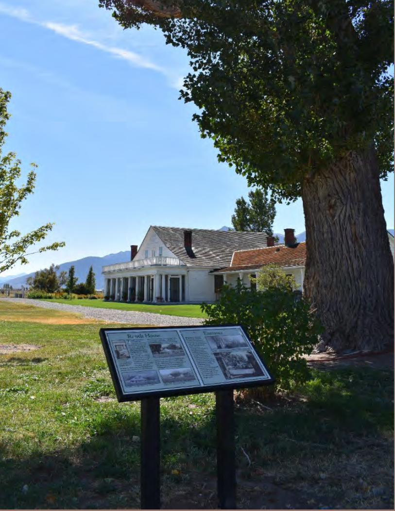
1 – Land Use & Historic Preservation
Page | 96

1 – Land Use & Historic Preservation
Page | 97
HISTORIC PRESERVATION IN DOUGLAS COUNTY
Historic Preservation in Douglas County involves federal, state, and local governments’ civic organizations, such as the Douglas County Historical Society, Lake Tahoe Historical Society, and the Genoa Historic District Commission. Private individuals and businesses are also involved in preserving historic and culturally significant resources in Douglas County. Historic preservation efforts help honor the people, buildings, and places associated with the development of Douglas County while providing educational opportunities for residents and visitors as well as opportunities for sustainable development through the reuse of existing structures for new purposes. Typically, places and structures are considered historic when they are at least 50 years old. According to NRS 381.195, “historic” is defined as the “middle of the 18th century until 50 years before the current year”; anything before the middle of the 18th century is defined as “prehistoric.” Given that the Washoe People inhabited Douglas County for thousands of years prior to the 1800s when settlement of the European-Americans began, Douglas County contains both historic and prehistoric sites and buildings. The Genoa Historic Overlay District is the only local historic district in Douglas County and only applies to non-residential zoned parcels in the Town of Genoa within the boundary of the district. The district was created in 1974 as a zoning overlay district and is authorized under Douglas County Code Chapter 20.680. The Genoa Historic District Commission (Douglas County Code Chapter 2.28) is responsible for reviewing any architectural changes to non-residential buildings that are visible from the main street public right-of-way.

1 – Land Use & Historic Preservation
Page | 98
National and State Register of Historic Places Historic Markers The National Register of Historic Places is under the National Park Service (U.S. Department of the Interior). Table L2 shows the buildings, sites, districts, and structures in the National Register and the location of the properties. Table L3 shows the state register.
Table L2 - Douglas County Properties on the National Register of Historic Places Date of Listing Name Location
1975 Genoa Historic District* Genoa 1978 Minden Flour Milling Company* - 6th St. and U.S. 395 Minden 1979 Carson Valley Hospital* - 1466 U.S. 395 Gardnerville 1979 Lake Shore House* - Glenbrook Rd. Glenbrook 1980 Home Ranch - west of Minden on Hwy. 88 Minden 1983 Carson Valley Improvement Club Hall - 1606 Esmeralda Ave. Minden 1986 Douglas County Courthouse - 1616 Eighth St. Minden 1986 Farmers Bank of Carson Valley -1597 Esmeralda Ave. Minden 1986 Minden Butter Manufacturing Company - 1617 Water St. Minden 1986 Minden Inn - 1594 Esmeralda Ave. Minden 1986 Minden Wool Warehouse - 1615 Railroad Ave. Minden 1986 Friday’s Station – U.S. 50 near SR 207 Stateline 1989 Arendt Jensen House* - 1243A and 1243B Eddie St. Gardnerville 1992 Douglas County High School - 1477 U.S. 395 Gardnerville 1994 Arendt Jensen, Jr. House - 1431 Ezell St. Gardnerville 2000 Farmers Bank of Carson Valley* - 1596 Esmeralda Ave. Minden 2001 Lena N. Gale cabin*- 726 Cedar St. Zephyr Cove 2001 Jobs Peak Ranch - 144 Summit Ridge Genoa 2003 Gardnerville Branch Jail* - 1440 Courthouse St. Gardnerville 2004 Reese-Johnson-Virgin House (Pink House)* - 193 Genoa Lane Genoa 2004 TAHOE (Shipwreck) Lake Tahoe 2008 Gardnerville Elementary School - 1290 Toler Ave. Gardnerville 2008 Minden Elementary School - 1638 Mono Ave. Minden 2016 Dance Hill (It-goom-mum the weh-weh-ush-shah-ish TCP) Washoe Tribe
Source: Nevada State Historic Preservation Office (SHPO) *Properties that are also listed on the State Register of Historic Places
Table L3 - Douglas County Properties Listed Only in the State Register of Historic Places
Date of Listing Name Location 1988 George Brown House - 1452 Main Street Gardnerville 1981 Walley’s Hot Springs - Foothill Rd. Genoa 1988 Bliss Boat House - 1851 Glenbrook Rd Glenbrook 1987 Dangberg House - 1600 6th St. Minden
Source: Nevada SHPO, Douglas County GIS
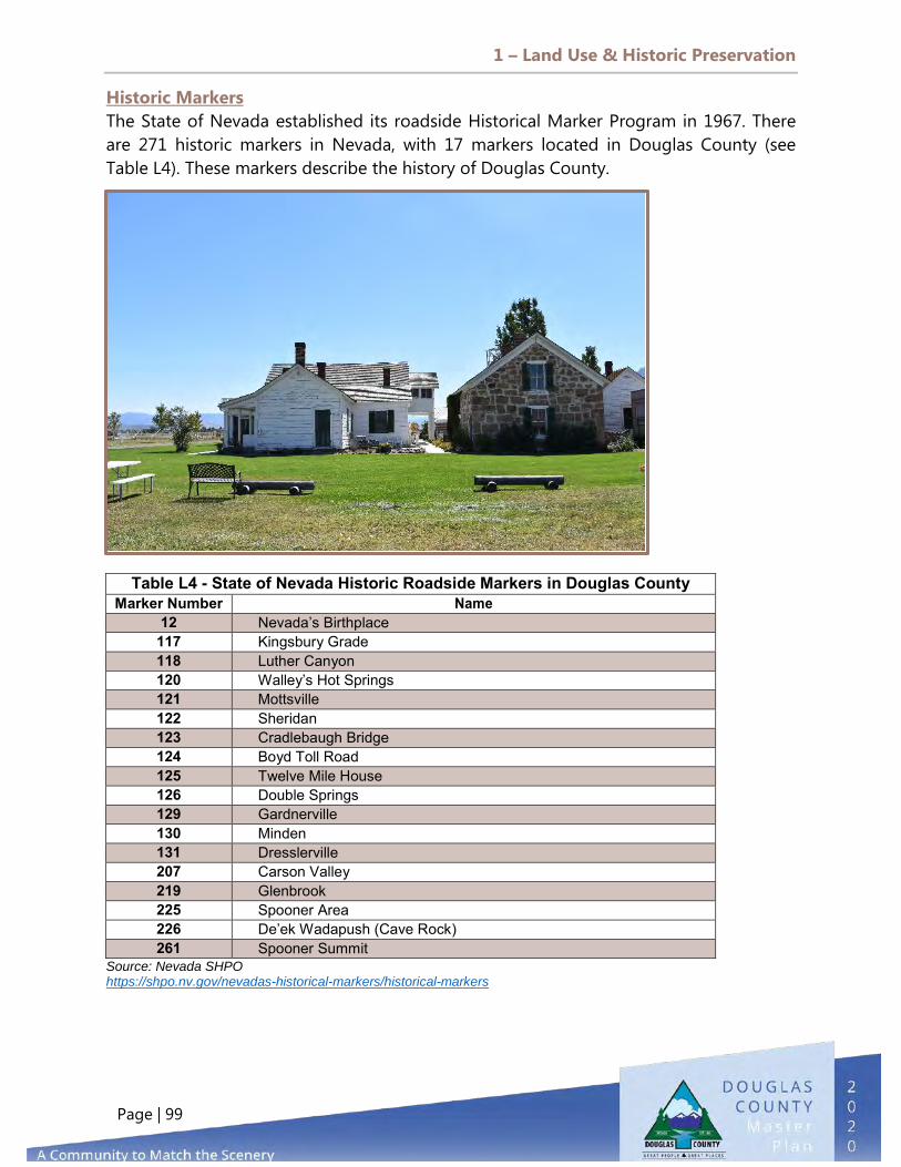
1 – Land Use & Historic Preservation
Page | 99
Historic Markers The State of Nevada established its roadside Historical Marker Program in 1967. There are 271 historic markers in Nevada, with 17 markers located in Douglas County (see Table L4). These markers describe the history of Douglas County.
Source: Nevada SHPO https://shpo.nv.gov/nevadas-historical-markers/historical-markers
Table L4 - State of Nevada Historic Roadside Markers in Douglas County Marker Number Name
12 Nevada’s Birthplace 117 Kingsbury Grade 118 Luther Canyon 120 Walley’s Hot Springs 121 Mottsville 122 Sheridan 123 Cradlebaugh Bridge 124 Boyd Toll Road 125 Twelve Mile House 126 Double Springs 129 Gardnerville 130 Minden 131 Dresslerville 207 Carson Valley 219 Glenbrook 225 Spooner Area 226 De’ek Wadapush (Cave Rock) 261 Spooner Summit

1 – Land Use & Historic Preservation
Page | 100
DIAGRAM L19 - NATIONAL & STATE REGISTER OF HISTORIC PLACES

1 – Land Use & Historic Preservation
Page | 101
SHPO Multiple Property Document Form In 2018, the Nevada State Historic Preservation Office (SHPO) adopted a study called Multiple Property Documentation Form (MPDF), which provides a context for the agricultural development of Carson and Eagle Valleys in Nevada. The report mentions the Wilhelm Lampe Ranch/Jacobs Berry Farm. Also significant to the valley’s ranching history is the Dangberg Home Ranch, which was listed on the National Register in 1980. In addition to being a useful research tool, the MPDF allows for a streamlined process to nominate important agricultural properties in Carson Valley to the National Register of Historic Places. Staff at the Nevada SHPO can assist interested property owners who wish to pursue National Register listing. Recognizing farms, ranches, and other agricultural resources in Carson Valley on the National Register provides official acknowledgement of the importance of agriculture to Douglas County’s development, enhances the heritage tourism and marketing opportunities for valley business owners, and allows property owners to leverage historic preservation incentives to preserve historic farms and ranches.
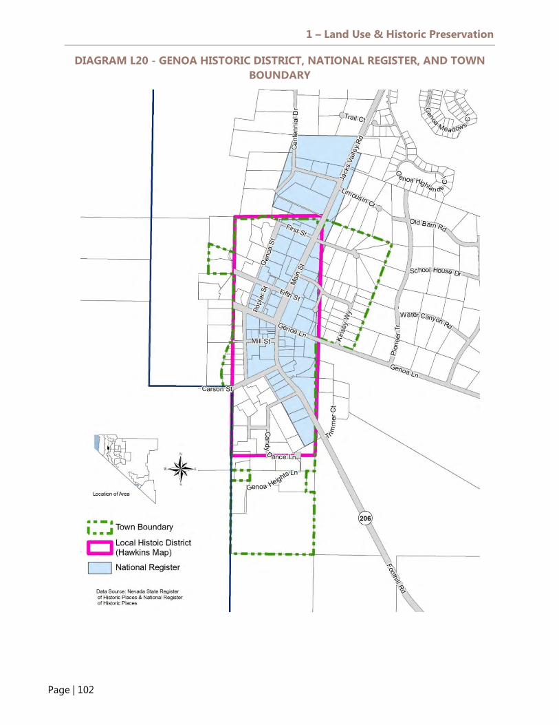
1 – Land Use & Historic Preservation
Page | 102
DIAGRAM L20 - GENOA HISTORIC DISTRICT, NATIONAL REGISTER, AND TOWN BOUNDARY
1 – Land Use & Historic Preservation
Page | 103
LOOKING TO THE FUTURE
Preservation of Historic Resources Douglas County does not consider historic resources in the development review process. Property owners are not required to submit information on historic resources that may be impacted by a Master Plan Amendment or Zoning Map Amendment. There are a number of opportunities to recognize historic resources and further support additional preservation efforts throughout Douglas County: Further education efforts by providing information about historic resources,
such as the National Register listings and the Historic Markers, on the Douglas County web site. The State of Nevada established the Centennial Ranch program several years ago to honor farming families who have owned farms and ranches for at least 100 years. The Douglas County Historical Society established an historic award program in 2014; the first recognition award was given that year to J.T. Basque Bar and Dining Room.
Apply to be a certified local government (CLG) through the SHPO, making Douglas County eligible for CLG funds. There are currently four CLGs in the State of Nevada: City of Las Vegas, City of Reno, Carson City, and Storey County. CLGs are eligible to apply for Historic Preservation funds from the SHPO. Every year, Nevada SHPO is required to give a minimum of 10 percent of its National Park Service Federal Historic Preservation Funds to CLGs in Nevada. The State receives approximately $80,000 per year from the National Park Service, and the City of Las Vegas does not usually apply for CLG funds.
Protect Historic Resources. Dance Hill is now listed on the National Register of Historic Places but is not currently protected from vandalism, OHV use, and target practice. Although efforts have been made to create an agreement between the Washoe Tribe and government entities, including Douglas County, there has been little progress on this issue.
Work with the Genoa Historic Commission to update the current design manual with review by the Planning Commission and Board of Commissioners. The manual has not been updated in several years and was never adopted by the Board of Commissioners. Ultimately, the manual should be adopted and incorporated into the County’s Design Criteria and Improvement Standards manual.

1 – Land Use & Historic Preservation
Page | 104
All proposals for new development or structure modifications that are visible from the right-of-way must be reviewed by the Genoa Historic Commission, the members of which are appointed by the Board of County Commissioners. Although an appointed body, the Commission has no staff support from Douglas County, and agendas and meetings are not currently posted on the County web site. Unlike local historic districts in Carson City and Reno, the Genoa local historic district only covers non-residential properties. The district does not regulate alterations, additions, or new construction for any other buildings or properties within the boundary of the local district. The current design manual used by the Genoa Historic Commission has not been updated in several years and was never adopted by the Board of Commissioners.
Douglas County should work with the Genoa Historic Commission to update the manual with review by the Planning Commission and Board of Commissioners. Ultimately, the manual should be adopted and incorporated into the County’s Design Criteria and Improvement Standards manual. Multi-Family Residential Zoning in Douglas County As of 2020, property owners must have a multi-family residential land use designation in order to propose multi-family residential zoning. To encourage more multi-family residential development, Douglas County could permit multi-family residential zoning in the Commercial Land Use Designation. The mixed-use commercial zoning district, which allows up to 16 dwelling units per acre, is already a permitted zoning district within the Commercial land use designation. Douglas County should consider allowing applicants to request zoning map amendments for multi-family residential zoning in the commercial land use category to facilitate additional housing, including affordable housing, within the County. To encourage more residential density, it may also be appropriate to require a minimum density of 10 to 12 units per acre for proposed multi-family residential development. Need for Parcel-Based GIS Land Uses and Zoning It is estimated that more than 100 parcels in the County contain more than one land use designation or zoning district. This creates problems when development proposals are brought forward to the County. A related issue is the lack of parcel-based land uses and zoning in the County. Douglas County GIS uses shape files for its land use and zoning layers, which can cause errors in map displays and parcel analysis. Douglas County should consider working with affected property owners to create uniform land uses and zoning on these parcels and should update GIS shape files based on updated information.

1 – Land Use & Historic Preservation
Page | 105
Receiving Areas Designation and Future Land Use Map Updates Many receiving areas that were subject to a development application are now built out, but processes in the zoning ordinance set up a mechanism to reflect this change in the Land Use Map, with the result that most of them are still shown as a legacy receiving areas. Once the area is developed, the county should establish an efficient process to reflect the land use change in a way that the official map shows a category consistent with the development on the ground. In 2019, as part of the Master Plan update process, Community Development removed Receiving Area from these built-out subdivisions; this should be continued in the future.

1 – Land Use & Historic Preservation
Page | 106

2 – Agriculture & Conservation
Page | 107
wetlanrec
PURPOSE
The purpose of the Agriculture and Conservation Element is to provide an overview of the agriculture industry and to report on the conservation and preservation efforts of Douglas County. This Element discusses conservation tools used to preserve agriculture farmlands as open space, the County’s Transfer Development Rights (TDR) program, and the Southern Nevada Public Lands Management Act (SNPLMA). In addition to land conservation, this section provides a discussion on renewable energy, water supplies (both surface and underground water sources), and water quality.
GOALS
The following goals, policies, and actions for the Douglas County Agriculture & Conservation Element set forth future priorities for the County.
Enhance our air and water quality. Protect and expand open space and natural areas while allowing development that acknowledges and enhances agricultural areas. Encourage the efficient use of energy resources. Protect sensitive wildlife, vegetation, and habitat.
2. AGRICULTURE & CONSERVATION

2 – Agriculture & Conservation
Page | 108
Protect and encourage ranching, farming, agricultural activities, and supportive industries.
POLICIES
Cooperate with private and public agencies to protect water quality throughout the region.
Encourage the agricultural community to retain its water rights and protect water quality.
Design development to minimize the amount of newly created impervious surfaces. Encourage open spaces and landscaped areas.
Utilize historic drainage patterns and maintain operations for the benefit of the downstream users of the irrigation network. Maintain pre-development conditions except as part of a regional drainage plan. Maintain runoff rates and volumes.
Ensure that industrial uses implement best management practices and ongoing monitoring programs aimed at reducing the potential for impacts to groundwater quality.
Obtain existing non-supplemental groundwater rights for quasi-municipal use when such rights become available.
Buffer water bodies, wetlands, and riparian areas from development.
Protect prime farmland by discouraging development patterns that harm this important resource.

2 – Agriculture & Conservation
Page | 109
Coordinate programs for public acquisition and development of open space areas with efforts to protect land for agricultural use.
Avoid locating noise-sensitive land uses such as hospitals, schools, and homes in existing and anticipated noise impact areas. Work with the Minden-Tahoe Airport as part of the development review process to determine where aviation easements are necessary.
Effectively sustain ranchlands and farmlands in prime agricultural areas through a combination of land use planning tools that meet agricultural land conservation goals.
Leverage a variety of funding sources to finance publicly accessible open space.
Encourage incorporation of energy conservation features in the design of all new construction and substantial rehabilitation projects, both public and private.
Protect environmentally sensitive and habitat areas that serve valuable ecological functions by limiting their development or by requiring mitigation of adverse impacts resulting from development.
Work with the USFS, BLM, and Nevada Department of Wildlife to retain and enhance the viability of wildlife habitats and migration corridors.
Protect against and mitigate invasive and non-native species.
Ensure the continuation of agriculture as a distinct and significant land use in the county. Define agricultural uses as economic development. Promote and encourage agriculture as an important industry and a desirable land use that defines the desired character of the county.
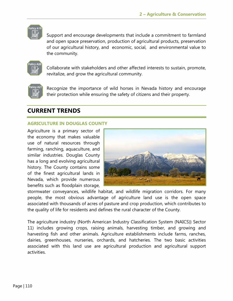
2 – Agriculture & Conservation
Page | 110
Support and encourage developments that include a commitment to farmland and open space preservation, production of agricultural products, preservation of our agricultural history, and economic, social, and environmental value to the community.
Collaborate with stakeholders and other affected interests to sustain, promote, revitalize, and grow the agricultural community.
Recognize the importance of wild horses in Nevada history and encourage their protection while ensuring the safety of citizens and their property.
CURRENT TRENDS
AGRICULTURE IN DOUGLAS COUNTY Agriculture is a primary sector of the economy that makes valuable use of natural resources through farming, ranching, aquaculture, and similar industries. Douglas County has a long and evolving agricultural history. The County contains some of the finest agricultural lands in Nevada, which provide numerous benefits such as floodplain storage, stormwater conveyances, wildlife habitat, and wildlife migration corridors. For many people, the most obvious advantage of agriculture land use is the open space associated with thousands of acres of pasture and crop production, which contributes to the quality of life for residents and defines the rural character of the County. The agriculture industry {North American Industry Classification System (NAICS)} Sector 11) includes growing crops, raising animals, harvesting timber, and growing and harvesting fish and other animals. Agriculture establishments include farms, ranches, dairies, greenhouses, nurseries, orchards, and hatcheries. The two basic activities associated with this land use are agricultural production and agricultural support activities.
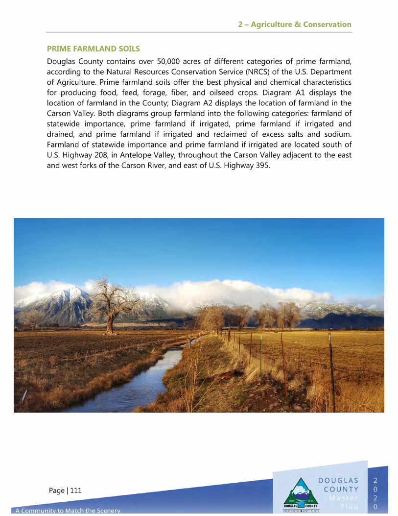
2 – Agriculture & Conservation
Page | 111
PRIME FARMLAND SOILS Douglas County contains over 50,000 acres of different categories of prime farmland, according to the Natural Resources Conservation Service (NRCS) of the U.S. Department of Agriculture. Prime farmland soils offer the best physical and chemical characteristics for producing food, feed, forage, fiber, and oilseed crops. Diagram A1 displays the location of farmland in the County; Diagram A2 displays the location of farmland in the Carson Valley. Both diagrams group farmland into the following categories: farmland of statewide importance, prime farmland if irrigated, prime farmland if irrigated and drained, and prime farmland if irrigated and reclaimed of excess salts and sodium. Farmland of statewide importance and prime farmland if irrigated are located south of U.S. Highway 208, in Antelope Valley, throughout the Carson Valley adjacent to the east and west forks of the Carson River, and east of U.S. Highway 395.
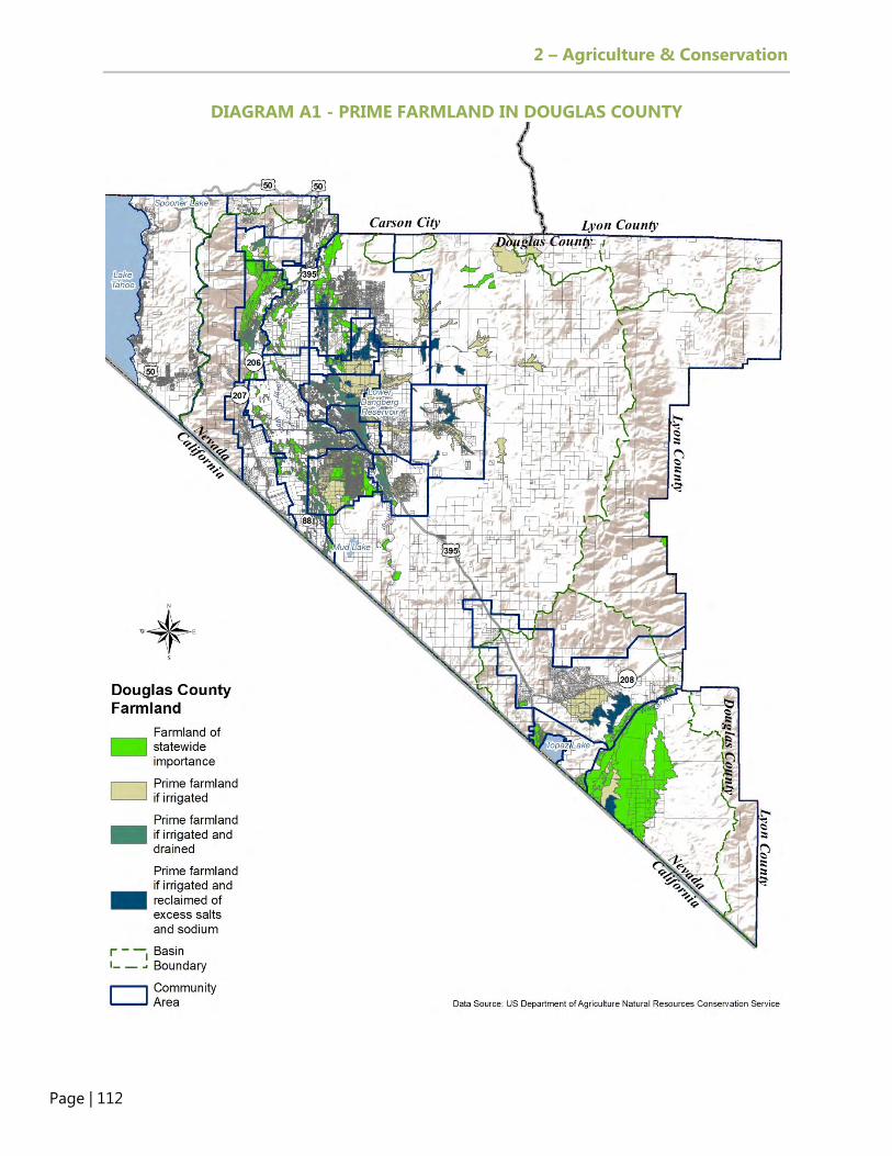
2 – Agriculture & Conservation
Page | 112
DIAGRAM A1 - PRIME FARMLAND IN DOUGLAS COUNTY

2 – Agriculture & Conservation
Page | 113
DIAGRAM A2 - PRIME FARMLAND IN CARSON VALLEY

2 – Agriculture & Conservation
Page | 114
FARMS IN DOUGLAS COUNTY There are different estimates of the number of farms in Douglas County. The 2012 Census of Agriculture (by the U.S. Department of Agriculture) reports a total of 255 farms in the County; the 2017 census shows that number dropped to 239 farms. Table A1 includes information on the number of farms and farm acreage in Douglas County and other counties in Northern Nevada. Churchill County has the highest number of farms at 504, although Washoe County contains the most farmland with 501,310 acres. Table A2 contains historical numbers of farms in Douglas County.
Table A1 - Farms in Selected Northern Nevada Counties (2017)
County Number of Farms Land in Farms (acres)
Average Farm Size (acres)
Carson City 17 966 57 Churchill 504 249,832 496 Douglas 239 118,320 495 Lyon 312 181,354 581 Washoe 353 501,310 1,420 Source: U.S. Department of Agriculture, Census of Agriculture The largest single agricultural commodity in Nevada is cattle and calf production. According to the 2017 Census of Agriculture, the number of head in Douglas County () was 17,023 and accounted for 3.6 percent of the state inventory. Lyon County had 53,063 head or 11.1 percent of the total; Churchill County had 60,209 head or 12.6 percent of the total.
As of January 1, 2016, farmers in Nevada are required to obtain a Producers Certificate to sell their farm products directly to the public. At present, there are only seven certified producers in Douglas County as compared to 205 certified producers statewide.

2 – Agriculture & Conservation
Page | 115
Table A2 - Census of Agriculture for Douglas County (1945–2017)
Year Total Farms
Land in Farms (acres)
Average Size of Farm (acres)
Total County Land Area (acres)
Farmland as Percentage of
Total Land Area
1945 131 216,678 1,654 450,683 48.1% 1950 139 226,902 1,632 450,683 50.3% 1959 108 235,016 2,176 450,683 52.1% 1964 98 228,233 2,329 450,683 50.6% 1969 99 160,861 1,625 450,683 35.7% 1974 107 162,037 1,514 450,683 36.0% 1978 131 107,307 819 450,683 23.8% 1982 159 112,769 709 450,683 25.0% 1987 202 114,574 567 450,683 25.4% 1992 172 79,635 463 450,683 17.7% 1997 156 90,372 579 450,683 20.1% 2002 178 210,952 1,185 450,683 46.8% 2007 179 91,046 509 450,683 20.2% 2012 255 100,944 396 450,683 22.4% 2017 239 118,320 495 450,683 26.3% Source: U.S. Department of Agriculture, Census of Agriculture The 2002 Census of Agriculture reported total land in farms at 210,952 acres in Douglas County. It is unclear why the number spiked in 2002 as it does not follow the trend, which ranged between approximately 80,000 and 118,000 acres from 1992 to 2017. The Douglas County Assessor’s Office reports the total acreage that qualifies for NRS 361 agricultural use value taxation’ and reported around 77,000 acres as of October 2020.
DEVELOPMENT REGULATIONS The Douglas County Consolidated Development Code (Title 20) contains the zoning and subdivision regulations for agricultural land uses. Title 20 spells out the County’s Right to Farm Policy, which says, in part, “it is the declared policy of Douglas County to conserve, protect, enhance, and encourage agricultural operations within the County.” This is intended to promote a good neighbor policy and to protect agricultural operations from nuisance complaints from adjacent owners of non-agricultural properties, provided that the agricultural operations are conducted in conformance with County regulations. Agricultural uses are permitted in the Agriculture 19-acre minimum (A-19) zoning district. Many land uses are allowed by right in the A-19 zoning district, such as “agricultural products processing” and “animal keeping.” Other uses, such as

2 – Agriculture & Conservation
Page | 116
“agricultural products retail outlet,” are allowed by special use permit only (requiring approval by the Planning Commission).
LOCATION OF AGRICULTURE IN DOUGLAS COUNTY Table A3 provides information on the amount of acreage in each community plan that qualifies for NRS 361A. The property owners who are agricultural producers qualify for an agricultural use assessment based on NRS 361A. This statute, passed in 1975 by the Nevada Legislature, allows agricultural and open space real property to be considered separate classes for taxation purposes. Agricultural use assessments are lower than full cash value assessments. If properties are converted to a higher use, however, the property owner must pay the taxes deferred on the property for up to seven years. To qualify for this lower property value, the land must be devoted to agricultural use for at least three consecutive years prior and must produce a minimum gross income of $5,000 per year from agricultural activities.
Source: Douglas County GIS and Douglas County Assessor, October 2020
Table A3 - NRS 361A Agricultural Acreage, by Community Plan
Community Plan NRS 361A Acreage
Number of Agricultural
Parcels
Total Parcel Acreage in
Community Plan
Percentage of NRS 361A Acreage
Agricultural, Central 4,042 87 4,047 99.9% Agricultural, North 5,494 80 9,393 58.5% Agricultural, South 14,651 381 16,155 90.7% Airport 1,878 54 3,870 48.5% Antelope Valley 7,894 7 47,349 16.7% East Valley 996 38 8,755 11.4% Fish Springs 98 4 12,197 0.8% Foothill 2,742 108 6,679 41.1% Gardnerville 699 28 2,604 26.8% Gardnerville Ranchos 2,626 79 6,713 39.1% Genoa 2,661 45 6,363 41.8% Indian Hills/Jacks Valley 869 16 8,577 10.1% Johnson Lane 1,439 36 17,181 8.4% Minden 2,885 59 4353 66.3% Pinenut Region 18,578 175 222,246 8.4% Ruhenstroth 606 7 5,092 11.9% Sierra Region 266 5 19,311 1.4% Tahoe Basin 0 0 23,458 0.0% Topaz Lake 985 2 4,089 24.1% Topaz Ranch Estates/Holbrook Jct. 6,677 65 26,813 24.9%
Total Acreage 76,086 1,276 455,245 16.7%

2 – Agriculture & Conservation
Page | 117
DIAGRAM A3 - NRS 361 AGRICULTURAL PARCELS IN DOUGLAS COUNTY

2 – Agriculture & Conservation
Page | 118
DIAGRAM A4 - NRS 361 AGRICULTURAL PARCELS IN CARSON VALLEY

2 – Agriculture & Conservation
Page | 119
DIAGRAM A5 - NRS 361 AGRICULTURAL PARCELS IN SOUTHERN DOUGLAS COUNTY

2 – Agriculture & Conservation
Page | 120
CONSERVATION IN DOUGLAS COUNTY Air Quality Under the 1970 Clean Air Act, the Environmental Protection Agency (EPA) is required to set National Ambient Air Quality Standards (NAAQS) for six common-criteria air pollutants: ozone, particulate matter, carbon monoxide, nitrogen dioxide, sulfur dioxide, and lead. The NAAQS include primary and secondary standards. The primary standards protect public health while the secondary standards protect public welfare (e.g., soils, water, and vegetation). The State Air Quality Planning Division monitors and reports on air quality for all Nevada counties except Clark and Washoe Counties. There are two air quality monitoring stations in Douglas County. One station is operated by TRPA for purposes of monitoring TRPA thresholds and is located on Market Street in the Lake Tahoe Basin. The other is operated by the Bureau of Air Quality in the Nevada Division of Environmental Protection (NDEP) and is located in Aspen Park within the Gardnerville Ranchos General Improvement District. The Aspen Park station is a special purpose monitoring site (established 2006; recognized by EPA 2013) that monitors particulate matter (PM) pollution of 2.5 micrometers in diameter or smaller in ambient air.
PM 2.5 can deleteriously affect people with lung and heart conditions, especially in sensitive groups such as the elderly, pregnant women, fetuses, and children, and it contributes to visible haze (smog) in the atmosphere. Under NAAQS, PM 2.5 is not allowed to exceed 11 micrograms per cubic meter of air for the Annual Design Value or 35 micrograms per cubic meter of air for the 24-hour design value.
One micrometer is defined as one-millionth of a meter in width; 2.5 micrometers pollution is so small that it can only be seen with an electron microscope.

2 – Agriculture & Conservation
Page | 121
Figure A1 displays the 24-hour design values for PM 2.5 since 2006 at the Gardnerville Ranchos air quality monitoring station. Although this monitoring station shows that PM 2.5 standards have been below the 24-hour design value of 35 micrograms per cubic meter, there have been exceedances (EE). The EPA exception events rule allows states to “flag” data as an exceptional event and to exclude the data for this reason. NDEP believes these PM 2.5 exceedances are usually caused by wildfires in Douglas County and surrounding regions.
Figure A1 - Gardnerville Ranchos PM 2.5 Monitoring Station 24-hour Design Values (EE Excluded)
There are currently 17 businesses in the County that operate with NDEP air quality permits, including Starbucks, Harrah’s, Harveys, and Bing Construction. Any process or activity that is an emission source requires an air quality permit from NDEP to ensure that regulated pollutants do not harm public health or cause deteriorated conditions in areas that have clean air. Table A4 provides additional information on the companies with air quality discharge permits in Douglas County. Air quality operating permits are categorized as either Class 2 or Class 3 based on the amount of emissions.

2 – Agriculture & Conservation
Page | 122
Table A4 - Companies with Air Quality Operating Permits
Company Class Emissions (ton/year)
A & A Construction, Inc. Class 3 0.8697 Aervoe Industries, Inc. Class 2 0.0257 American AVK Company Class 2 3.9887 Bing Construction Co. of Nevada Class 2 14.4297 Carson Valley Veterinary Hospital Class 3 0.5117 Columbia Properties Tahoe, LLC Class 2 6.8817 Harrah’s Lake Tahoe Hotel Casino Class 2 82.4117 Harvey’s Resort Hotel Casino Class 2 12.0477 New Cingular Wireless PCS, LLC, DBA AT&T Mobility Class 3 0.0207 North Sails Nevada Class 2 3.1967 OS Operations, Inc. Class 2 9.077 Starbucks Coffee Company Class 2 152.625 Verizon Wireless Class 3 0.171 Verizon Wireless Class 3 0.016 Verizon Wireless Class 3 0.009 Verizon Wireless Class 3 0.002 Verizon Wireless Class 3 0.010
Source: Bureau of Air Quality, Nevada Division of Environmental Protection, December 2016
PROTECTION OF OPEN SPACE AND SENSITIVE AREAS Open space areas in Douglas County include public lands managed by the BLM and USFS, agricultural areas, and undeveloped private lands. Many of these areas include floodplains and wetlands and provide important ecosystem benefits. In addition, protection of open space areas helps preserve the scenic qualities of the County. Private open space lands can be protected from development through fee simple purchase, purchase of development rights, or conservation easements. NRS 111.390 through 111.440 is the Nevada Conservation Easement law. Open space easements and acquisitions have been purchased through the County’s TDR program and the SNPLMA. The County’s development regulations also help protect open space through the Planned Development Overlay District and the Clustered Development provisions of the Development Code.

2 – Agriculture & Conservation
Page | 123
Transfer Development Rights Conservation Easements The County’s TDR program was adopted in 1996 and allows property owners in “sending areas” (A-19 and FR-19 zoning districts) to transfer their development rights to designated receiving areas based on execution of conservation easements. Property owners obtain bonus development rights if the conservation easement includes floodplain acreage. To date, 4,065.40 acres of private land have been preserved as open space under the County’s TDR program. Table A5 provides information on the lands protected as open space during the last 20 years.
Table A5 - TDR Conservation Easements, 2002–2020
Property Owner Conservation Easement (Acreage)
Alton and Susan Anker 375.77
Galeppi Land & Livestock 700.02
Henningsen Nevada Trust 100.48
Hussman Land & Livestock 260.74
Kent and Marie Neddenriep 100.42
Little Mondeaux Limousine Corp. 2,238.81
West Side Nevada, LLC 289.16
Total 4,065.40 Source: Douglas County Community Development Department
Diagram A6 depicts the location of the conservation easements created through the TDR program. Additional information on the development rights created by the TDR program is provided in Element 4, Growth Management & Housing.

2 – Agriculture & Conservation
Page | 124
DIAGRAM A6 - TDR CONSERVATION EASEMENTS

2 – Agriculture & Conservation
Page | 125
Southern Nevada Public Lands Management Act The SNPLMA (Public Law 105-263) was passed in 1998 and allows the BLM to utilize the proceeds from BLM land sales in Clark County for different purposes, including acquisition of environmentally sensitive lands. The first SNPLMA environmentally sensitive land transaction in Douglas County was the 300-acre conservation easement for the Hussman property in Gardnerville.
Table A6 - Completed SNPLMA Environmentally Sensitive Land Acquisitions (2004–2020)
Project Name & Property Owner Acres Description
Carson Valley Conservation Easement Group A - Hussman 300.00 BLM purchased the conservation easement for this property in
FY 2006. Carson Valley Conservation Easement Group A - River Fork Ranch/Nature Conservancy
739.00 BLM purchased the conservation easement for this property in FY 2007.
Carson Valley Conservation Easement Group B - White 139.00 BLM purchased the conservation easement for this property in
2008 Carson Valley Conservation Easement Group B - Stodieck 153.00 BLM purchased the conservation easement for this property in
2009.
Carson Valley Conservation Group D - Scossa 530.00
BLM purchased the conservation easement for two parcels in 2008. The property contains hot springs and the only known colony of the Carson Valley Silverspot Butterfly in Douglas County.
Adams Canyon - Eagle Ridge at Genoa 722.47
The USFS purchased this inholding in 2007. The property includes a segment of the Pony Express Historic Trail and provides critical deer winter range habitat.
Ranch 1 - Lekumberry 357.44
BLM purchased the conservation easement for three separate parcels in 2014, including the Wasson Ranch, the Slaughterhouse Ranch, and a parcel located along Centerville Lane. The easements will protect habitat for sensitive and listed species and floodplain functions of the Carson River.
Jacks Valley Ranch Conservation Easement - Ascuaga
1,233.00
The USFS will acquire a conservation easement over 1,233 acres of ranchland and forest to protect migratory corridors, wildlife habitat, historic structures, and Native American cultural resources.
TOTAL 4,173.91 Source: BLM SNPLMA website (www.blm.gov/snplma )
Recently, land around the Dangberg Home Ranch was chosen for SNPLMA funding. With this latest project, which is currently in progress, the BLM will acquire an agricultural conservation easement on approximately 1,373 acres of the historic Dangberg Home Ranch to consolidate federal management of other BLM-owned conservation easements and create a large unfragmented agricultural landscape. The BLM is also in the process of acquiring
SNPLMA has protected over 4,173 acres in Douglas County. An additional 15,895 acres are currently in progress for acquisition or conservation.

2 – Agriculture & Conservation
Page | 126
approximately 14,522 acres of vacant land located in the Pine Nut Mountain Range to consolidate federal ownership and management for the protection of bi-state sage-grouse habitat, other wildlife habitat, cultural resources, riparian areas, and improvement of public access. Once completed, these two projects will add nearly 16,000 acres of additional lands acquired or conserved through the SNPLMA program.
Staff photo. Dangberg Home Ranch 2020
Diagram A7 displays the location of completed SNPLMA conservation acquisitions and easements in the Carson Valley portion of Douglas County.

2 – Agriculture & Conservation
Page | 127
DIAGRAM A7 - COMPLETED SNPLMA ENVIRONMENTALLY SENSITIVE LAND ACQUISITIONS

2 – Agriculture & Conservation
Page | 128
FLOODPLAIN PROTECTION Douglas County includes 31,582 acres of riverine and alluvial fan floodplains. Riverine floodplains allow floodwaters to disperse over normally flat areas adjacent to rivers and streams and reduce the energy of the water flow, thus protecting downstream properties. Riverine floodplains provide areas of groundwater recharge and wildlife habitat, and their locations are relatively predictable. Alluvial fan floodplains, on the other hand, are not easily predictable, carry high velocity flows, and often carry sediment.
Table A7 — 100-Year Floodplain Acreage by Community Plan Area
Community Plan Total Acreage 100-Year Floodplain Acreage
Percentage in Floodplain
Agricultural, Central 4,519.71 594.91 13.2% Agricultural, North 12,904.96 4,860.59 37.7% Agricultural, South 15,847.30 9,024.15 56.9% Airport 4,678.00 407.91 8.7% Antelope Valley 47,348.90 1,573.62 3.3% East Valley 9,922.45 757.97 7.6% Fish Springs 12,197.05 525.72 4.3% Foothill 6,679.16 358.00 5.4% Gardnerville Ranchos 6,672.82 1,093.03 16.4% Genoa 6,362.75 2,129.07 33.5% Indian Hills/Jacks Valley 5,056.27 758.52 15.0% Johnson Lane 17,984.13 1,348.24 7.5% Minden/Gardnerville 4,052.55 1,785.05 44.0% Pinenut 222,245.87 2,450.43 1.1% Ruhenstroth 5,091.94 1,009.40 19.8% Sierra 19,369.53 4.23 0.0% Tahoe Basin 39,249.66 487.63 1.2% Topaz Lake 5,145.08 204.14 4.0% Topaz Ranch Estates/Holbrook Jct. 26,813.46 2,209.05 8.2% TOTAL 472,141.59 31,581.66 6.7% Source: Douglas County GIS
The majority of floodplain areas in Douglas County are located in the Carson Valley. Of the 31,582 acres of floodplain in the County, 24,653 acres or 78 percent are found in the Carson Valley.

2 – Agriculture & Conservation
Page | 129
Diagram A8 displays the location of floodplain areas within the Carson Valley portion of Douglas County.
Muller Lane, December 2015
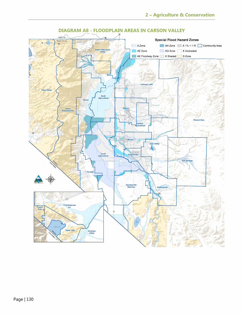
2 – Agriculture & Conservation
Page | 130
DIAGRAM A8 - FLOODPLAIN AREAS IN CARSON VALLEY

2 – Agriculture & Conservation
Page | 131
Many of the riverine floodplain areas in the Carson Valley have been protected from development through Douglas County’s TDR program. As shown in Figure A2, 72 percent of the conservation easement acreage (2,941 acres) is located inside floodplains.
Figure A2 - Douglas County TDR Conservation Easements Protecting Floodplains
Floodplain regulations and public safety issues are discussed in Element 6, Public Safety.
RENEWABLE ENERGY The State of Nevada Renewable Portfolio Standard, as set forth in NRS 704.7801, has set a goal of 50 percent renewable energy by 2030. The portfolio standard requires each electric utility in Nevada to sell a percentage of electricity from renewable sources. This percentage increases every year until reaching the 50 percent standard. For calendar year 2020, not less than 22 percent of the total amount of electricity sold by the provider to its retail customers in Nevada must be from renewable sources. The Governor’s Office of Energy manages several tax incentive, grant, and loan programs to encourage the development of clean energy in Nevada. The Office of Energy has provided six Direct Energy Assistance Loans (DEALs) to state employees who live in Douglas County. The DEAL program provides up to $6,000 in loans for energy-efficiency upgrades. To date, the Office of Energy has not provided any renewable energy tax abatements to Douglas County.
72%
28%

2 – Agriculture & Conservation
Page | 132
Douglas County has amended its development regulations during the last 10 years to encourage the development of different types of renewable energy in the County. Douglas County adopted wind energy regulations in 2007 and solar regulations in 2016 that limit 10-megawatt solar facilities to FR-40 zoning only with the approval of a special use permit.
WATER Douglas County includes 26 square miles of surface water bodies and seven different groundwater basins. The largest surface water body is Lake Tahoe, and the largest groundwater basin is the Carson Valley Hydrographic Basin. The potable water supply is largely dependent on groundwater wells while irrigation water is largely dependent on surface water. Water quality is compromised from non-point sources that threaten both surface waters and underground aquifers. More information on water supply and water quality is presented in Diagram A9.
Topaz Lake. Photo by Alicia Jensen.
The most significant water basins are the Carson Valley, Lake Tahoe, and Antelope Valley basins. The County also includes small portions of the Churchill Valley, Dayton Valley, Eagle Valley, and Smith Valley water basins. Diagram A9 depicts the different hydrographic basins in Douglas County.
Water Basins in Douglas County

2 – Agriculture & Conservation
Page | 133
DIAGRAM A9 - HYDROGRAPHIC BASINS IN DOUGLAS COUNTY
Hydrographic Areas
2 – Agriculture & Conservation
Page | 134
Water Supply The State of Nevada is responsible for protecting this critical resource by monitoring pumpage in the water basins and approving or denying applications for new water withdrawals, including transbasin diversions. Each groundwater reservoir provides a perennial yield. According to the State, “withdrawals of groundwater in excess of the perennial yield may contribute to adverse conditions such as water quality degradation, storage depletion, diminishing yield of wells, increased economic pumping lifts, and land subsidence.” Water law in Nevada is based on prior appropriation (first in time, first in right) and beneficial use (e.g., irrigation, recreation, and municipal uses). All water uses in Nevada require a permit from the State Engineer except for domestic uses and uses that pre-date Nevada’s water laws, which are known as pre-statutory vested rights. The water supply for Douglas County includes groundwater wells and surface water. Water is used for farm irrigation and recreation, industrial, and domestic uses. Douglas County residents obtain drinking water either through individual wells or public water purveyors. Additional information on water purveyors is provided in Element 5, Public Facilities, Services, and Recreation. Property owners are allowed to drill wells for domestic water without obtaining a permit from the State Engineer if they pump less than two acre feet of water per year (NRS 534.180). One acre foot of water covers one acre of land to a depth of one foot and is equal to 325,851 gallons. Annual reports for each basin describe the amount of pumpage by manner of use. These annual reports also detail when the State Water Engineer has denied new appropriations. More information on water usage in Antelope Valley, Carson Valley, and Lake Tahoe Basins can be found on the State of Nevada Division of Water Resources website, and a discussion of water resources and services can be found in Element 5, Public Facilities, Services, and Recreation.

2 – Agriculture & Conservation
Page | 135
Figure A3 - Groundwater Pumping Carson Valley by Manner of Use (in Acre Feet)
Water Quality Clean water regulations for the country were established with the 1972 Federal Water Pollution Control Act, also known as the Clean Water Act. The NDEP is responsible for implementing the Clean Water Act with oversight from the EPA. The Carson Water Subconservancy District (CWSD) is the designated Clean Water Act Section 208 water quality planning body for the Carson River. In 2007, CWSD completed the Carson River Watershed Stewardship Plan, which was last updated in 2017. The Stewardship Plan sets forth specific water quality projects for the Carson River Watershed. NDEP is required to submit a list of waters that do not meet the standards of the Clean Water Act, also known as the 303(d) list of impaired waters. Further, NDEP is required to develop a water quality plan or total maximum daily load (TMDL) for waters on the 303(d) list. Water quality standards are established based on the beneficial uses for each water body, such as irrigation, aquatic life, and recreation. TMDL plans establish pollution budgets for specific pollutants. The Carson River had TMDL plans approved in 2005 for phosphorus and in 2007 for total suspended solids and turbidity. The Lake Tahoe TMDL Plan for Nevada was approved by the EPA on August 16, 2011.

2 – Agriculture & Conservation
Page | 136
The 2014 Integrated Water Quality Report for Nevada provides information on the water body segments that are either still on the 303(d) list or are new additions to the list. The report includes assessments of 660 water body segments, including the Carson River, Walker River, and Topaz Lake. Discharge of treated wastewater into Lake Tahoe or the Carson River is not allowed. Discharges into the Carson River ended in 1987. All treated wastewater in Douglas County is used as effluent for farms, golf courses, or engineered wetlands. During the 2013 water year, for example, wastewater utilities such as the Incline Village General Improvement District (IVGID) and the Douglas County Sewer Improvement District transferred more than 3,000 acre feet of wastewater from the Lake Tahoe Basin into the Carson Valley. Since there are no direct discharges, or “point” sources of pollution, the threats to clean water in Douglas County come from “non-point” sources. “Non-point” sources include septic tanks, stormwater runoff, and agricultural activities, and to a lesser extent, airborne deposits of dust and other aerosol pollutants. Douglas County is under the Small Area Municipal Storm Sewer System (MS4) permit for the Johnson Lane, Indian Hills/Jacks Valley, and Clear Creek areas in northern Douglas County, as approved by NDEP. As such, the MS4 permit requires minimum control measures to manage non-point sources of pollution. The existing MS4 permit expired in 2015 but has been administratively continued by NDEP. The new MS4 permit is expected to be expanded to include Gardnerville, Gardnerville Ranchos, and Minden. In 2012, Douglas County adopted the Community Wellhead Protection Plan as an amendment to the Master Plan. This plan was prepared by the NDEP with the assistance of a task force that included County, Town, and GID representatives. As documented in the Wellhead Protection Plan, certain land uses, such as gasoline stations, are known to create potential contaminants for public drinking water. Groundwater is also threatened by nitrates caused by concentrations of septic systems. There are 6,162 individual septic systems on 5,960 parcels in Douglas County (outside of the Tahoe Basin). More information on individual septic disposal systems is presented in Element 5, Public Facilities, Services, and Recreation.
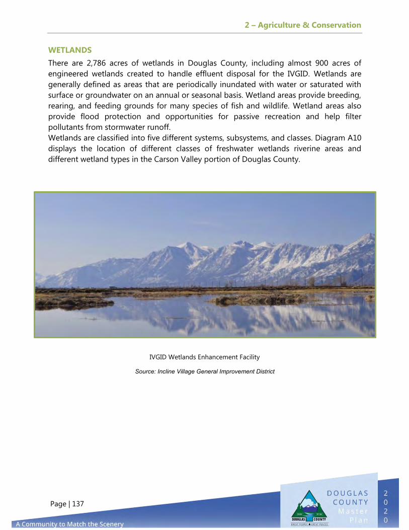
2 – Agriculture & Conservation
Page | 137
WETLANDS
There are 2,786 acres of wetlands in Douglas County, including almost 900 acres of
engineered wetlands created to handle effluent disposal for the IVGID. Wetlands are
generally defined as areas that are periodically inundated with water or saturated with
surface or groundwater on an annual or seasonal basis. Wetland areas provide breeding,
rearing, and feeding grounds for many species of fish and wildlife. Wetland areas also
provide flood protection and opportunities for passive recreation and help filter
pollutants from stormwater runoff.
Wetlands are classified into five different systems, subsystems, and classes. Diagram A10
displays the location of different classes of freshwater wetlands riverine areas and
different wetland types in the Carson Valley portion of Douglas County.
IVGID Wetlands Enhancement Facility
Source: Incline Village General Improvement District

2 – Agriculture & Conservation
Page | 138
DIAGRAM A10 - WETLANDS IN THE CARSON VALLEY

2 – Agriculture & Conservation
Page | 139
WILDLIFE The Federal Endangered Species Act of 1973 protects endangered and threatened species of animals and plants. An endangered species is in danger of extinction throughout all or a significant portion of its range. A threatened species is likely to become endangered within the foreseeable future throughout all or a significant portion of its range. In Douglas County, endangered species include the Sierra Nevada yellow legged frog, the cui-ui, and the Carson wandering skipper. Threatened species include the Lahontan cutthroat trout and Webber’s iIvesia. The wolverine is proposed to be listed as a threatened species. Table A9 provides additional information on current listings of endangered and threatened species in Douglas County.
Table A9 - Endangered and Threatened Species in Douglas County
Species Endangered Threatened Threats
Amphibians Sierra Nevada Yellow-Legged Frog None Habitat destruction, disease
Fishes Cui-ui Lahontan Cutthroat Trout Isolation, non-native species
Flowering Plants None Webber’s Ilvesia
Urban development, OHVs and recreation use, livestock grazing and trampling, wildfire and suppression activities. There is final critical habitat designation.
Insects Carson Wandering Skipper None
Livestock grazing, off-road vehicle use, development, gas and geothermal development
Mammals None Wolverine is Proposed as Threatened Climate Change
Source: U.S. Fish and Wildlife Service, Nevada Office In 2013, the U.S. Fish and Wildlife Service proposed listing the bi-state sage-grouse distinct population segment as a threatened species under the Endangered Species Act but withdrew it from the candidate species list in April 2015 as a result of the conservation plan spearheaded by the Governor’s office. The primary threats to sage-grouse are wildland fires and encroachment of piñon and juniper woodland. The U.S. Fish and Wildlife Service operates the Lahontan National Fish Hatchery, which is located south of Gardnerville and manages the recovery of the cui-ui and the Lahontan cutthroat trout. Diagram A11 displays the distribution and movement corridors of mule deer and pronghorn antelope in Douglas County.
Carson Wandering Skipper
Source: US Fish & Wildlife Services

2 – Agriculture & Conservation
Page | 140
DIAGRAM A11 – MULE DEER AND PRONGHORN ANTELOPE DISTRIBUTION AND MOVEMENT CORRIDORS

2 – Agriculture & Conservation
Page | 141
LOOKING TO THE FUTURE
Conserving Open Space and Protecting Agriculture Lands There are several tools available to protect key agriculture land and conserve prime open space. These tools include the TDR program (further discussed in Element 1, Land Use & Historic Preservation), Open Space Acquisition, Regulatory Exemptions and Incentives, and the Livestock Overlay Zoning District. Transfer Development Rights (Douglas County Development Code Section
20.500). The TDR program allows property owners in “sending areas” (A-19, FR-19 zoning districts) to sell development rights to designated “receiving areas.” Development rights can’t be transferred off the property until the owner has obtained a TDR certificate from the County. Property owners must record a deed restriction or grant a perpetual open space access easement to the County (or another entity approved by the Board of Commissioners). Establishing a TDR bank is a strategy used in many jurisdictions and would help jump start the TDR program.
TDR banks allow the local government to purchase TDRs and hold them for sale to developers.
Open Space Acquisition. County residents value the open spaces of Douglas County. To preserve these spaces, additional strategies are needed to complement private market mechanisms. Douglas County has discussed the public purchase of open space in every Master Plan since 1996, but a funding mechanism will need to be identified to create a program. However, in 2000 and 2020, Douglas County voters rejected a quarter-cent sales tax to fund the purchase of open space. More information on these issues and opportunities are addressed in the 2007 Update to the Douglas County Open Space and Agricultural Lands Preservation Implementation Plan.
To date, the TDR program has created almost 4,000 acres of conservation easements but no new conservation easements have been established through the program since 2009.

2 – Agriculture & Conservation
Page | 142
Regulatory Exemptions & Incentives. There are several exemptions and incentives in the Douglas County Development Code that support agriculture.
A clustered development regulation, adopted for the purpose of preserving agricultural lands and open space, requires at least 70 percent open space in a proposed development. In return, a residential development is allowed a density bonus of 2.5 units for each unit (allowed by right) in the zoning district designated as open space.
Subdivision of parcels less than A-19 for ranch heritage and agricultural 2-acre parcels allows for one-time creation of a non-conforming A-19 parcel, provided that the property owner creates a conservation easement of at least 100 acres of irrigated agricultural land. The agricultural two-acre parcels provision allows up to three parcels of two to five acres to be created every 15 years for property owners with more than 100 acres of irrigated agricultural land. There is no limit on the density created by these provisions.
The Special Occasion Home Ordinance was adopted in 2013 to allow property owners with historic properties to use them for weddings, business meetings, or retreats. The regulation allows owners of farms and ranches to obtain additional revenue.
The Growth Management Ordinance requires property owners to obtain a building permit allocation for new dwellings but exempts housing for agricultural purposes specifically for accessory dwellings on A-19 parcels as well as dwelling units created under the Ranch Heritage or Agricultural 2-acre parcels from the allocation requirements of the Growth Management Ordinance.
New Opportunities have been expressed by farmers to create a new agricultural zoning district requiring a minimum parcel size of 100 acres. The purpose would be to allow additional land uses that are currently prohibited in the A-19 zoning district. Another option would be to allow more retail and commercial activities within the A-19 zoning district.
Given the longstanding agricultural heritage of Douglas County, there may be an opportunity to create more connections between the existing agricultural industry and new residential development. The concept of developing new subdivisions with a farming component (e.g., agrihoods) is becoming increasingly popular. Developments that preserve existing farm structures may offer an opportunity to protect the County’s agricultural heritage. . For more information on this approach, see Element 1, Land Use & Historic Preservation.

2 – Agriculture & Conservation
Page | 143
Livestock Overlay Zoning District.
Many local communities are
loosening their residential zoning
regulations to allow more agricultural
activities, such as a limited number of
small livestock.
The Douglas County Development
Code includes a livestock overlay
zoning district. The overlay district
establishes criteria for allowing
livestock, such as horses and goats,
on residential parcels less than one
acre, at specified densities of one animal unit per 10,000 square feet. By comparison,
Carson City allows chickens, pigs, rabbits, bees, and goats (Sections 7.02 and 7.13) on
residential parcels less than one acre; these uses are allowed by right and do not
require an overlay district.
The County could consider expanding the types of animals allowed in the existing
livestock overlay zoning district and/or allow some agricultural uses on residential
properties less than one acre by right.
Water Supply and Water Quality
Douglas County farmers rely
on the Carson and Walker
Rivers to provide flood and
sprinkler irrigation. Farmers
also rely on the effluent from
wastewater providers in the Carson Valley and Tahoe Basin. The majority of the farmers
in the Carson Valley rely on the surface water rights that were awarded as part of the
1980 Alpine Decree settlement. Historically, groundwater has not been the primary
water source for most agricultural operations in Douglas County. The State of Nevada
prohibits new wells to be drilled for agricultural operations. With drought and concerns
Currently, the livestock overlay zoning district only applies to 631 parcels in the Gardnerville Ranchos Community Plan area and four parcels in the Ruhenstroth Community Plan area.
In 2016, 12 Nevada counties were declared as primary natural disaster areas due to drought. Douglas County was included in this declaration.

2 – Agriculture & Conservation
Page | 144
over long-term climate change, the protection and conservation of water becomes more and more important to the state. During the 2013 session, the Nevada Legislature allowed for emergency drilling of stock water wells for counties that were under a drought declaration or contiguous to counties under a drought declaration. Emergency drilling permits are good for one year to provide water for livestock. There is a need to reduce non-point runoff into the Carson River, which is still listed on the EPA 303 (d) list of impaired waters due to several constituent pollutants, including phosphorus, nitrogen, turbidity, and E. Coli. Protecting surface water and groundwater from pollution requires controlling non-point sources, and many successful strategies can be employed to reduce these pollutants. Low-impact development (LID) and best management practices (BMPs) can
help filter stormwater on-site, thus removing pollutants prior to discharge into surface water bodies. Section 6.1.3.7 of the Douglas County Design Criteria and Improvement Standards Manual provides information on LID practices; however, the County currently does not require LID practices. In 2015, Tte CWSD prepared a new report on LID, Low Impact Development in the Carson River Watershed. According to this report, the main goal of LID, is to “decrease the amounts of pollutants delivered to the local waterways by infiltrating stormwater on-site.” All property owners in the Tahoe Basin are already required to implement LID practices as part of the TRPA Best Management Practices Program, and Reno and Washoe Counties now require LID practices. Carson City is currently preparing a LID ordinance in conjunction with the update of the Carson City Stormwater Management Plan.
Agricultural BMPs protect public health and safety. The County should work with
farmers and ranchers on waste management practices and expanded setbacks along streams. Improving water quality in the Carson River will benefit all residents and property owners, will help restore aquatic life in the river, and will facilitate development of recreation activities.
Douglas County can pursue grant funding for water quality improvement
projects through the EPA 319 program as well as the NRCS watershed initiatives. The Carson River Watershed Stewardship Plan was prepared by the CWSD in 2007 and updated in 2017. Completion of an updated Stewardship Plan will allow CWSD jurisdictions to have 100 percent access to EPA 319 funding (although a 50 percent match is required). The NRCS watershed initiative is providing $33 million to Churchill County for watershed improvements along the Carson River.

2 – Agriculture & Conservation
Page | 145
The Community Wellhead Protection Plan, adopted in 2012, presents an opportunity for the County to take additional measures to protect groundwater wells.
Air Quality There are several opportunities to ensure that air quality does not worsen in Douglas County in relation to PM 2.5. Voluntary programs, such as the NDEP wood stove exchange program, help retire polluting wood stoves and should be supported by the County. Similar to Washoe County, Douglas County should create voluntary no-burn days when weather conditions are adverse and should monitor new wood stove installations or replacements for statistical purposes. Conservation Indicators or Thresholds The data on air quality, water quality, and water supply are prepared by several different state agencies but there is no central data source that can be used to understand the trends for different natural resources. Given the importance of protecting natural resources in Douglas County, it would be helpful to develop conservation indicators that are similar to Truckee Meadows Tomorrow for lands outside of the Lake Tahoe Basin.. TRPA has adopted environment threshold carrying capacities for air, water, soil, and other environmental features. Environmental Review Nevada does not require an environmental review for development proposals, although legislation has been proposed in the past (e.g., Senate Bill 277 in the 2015 Legislative Session). Environmental review under the National Environmental Protection Act (NEPA) is only triggered if a project involves federal funding or federal permits. It may be appropriate for the County to develop measurable environmental review criteria for (1) significant development proposals and/or (2) projects proposed in sensitive development areas. The establishment of specific environmental review criteria could include information on prime farmland soils, brownfields, geologic hazards, riparian areas, historic and cultural resources, floodplains and wetlands, threatened or endangered species, wildlife habitat and wildlife migration corridors, wellhead protection areas, and other environmental resource matters addressed in the Master Plan and other County adopted documents.

2 – Agriculture & Conservation
Page | 146

3 – Economic Development
Page | 147
PURPOSE
The purpose of the Economic Development Element is to establish goals, policies, and
actions that are focused on questions of prosperity, conservation, job creation, and
quality of life in a manner that is consistent with the remaining objectives of the Master
Plan and the values of Douglas County residents. This Element defines a future for the
Douglas County economy that enhances the quality of the downtowns, identifies
economic development strategies that complement existing business clusters, and
preserves the natural resources that are fundamental to the past and future character of
the community. In other words, “to create an economy that matches the scenery.” The
Economic Development Element discusses the County’s revitalization strategy and is
centered on five guiding principles and three focus areas.
GOALS
The following goals, policies, and actions for the Douglas County Economic
Development Element set forth future priorities for the County.
Foster a diverse regional economy that adapts to changing needs of the
workforce and enables business development, retention, and expansion.
Emphasize the importance of creating our unique identity and developing
vibrant centers for our economic prosperity.
3. ECONOMIC DEVELOPMENT

3 – Economic Development
Page | 148
Capitalize on outdoor recreation, lifestyle, and agriculture as business
opportunities.
Provide access to high-quality education and support the development of
a skilled workforce.
POLICIES
Continue the ongoing efforts to improve the Douglas County approval process
for businesses and industry and incorporate feedback during the development
permit process.
Continue to research, adapt, and adopt best demonstrated practices from
other communities and jurisdictions.
Continue to recruit, retain, and expand businesses and industries that enhance
our local economy.
Support programs aimed at strengthening the accessible labor pool, such as
attainable housing, recreational opportunities, transportation alternatives, and
higher/continued education.
Support and participate in regional economic development programs,
projects, and activities.
Ensure that downtowns and neighborhood centers keep serving as essential
community assets and comprise a significant portion of economic
opportunities for our residents, with multiple benefits for the County and
region.
Seek infrastructure improvements that support economic development
efforts.
Promote the revitalization of Stateline through the South Shore Revitalization
Plan.

3 – Economic Development
Page | 149
Increase opportunities for public art by recognizing the economic benefits of
promoting public art and culture through increasing tourism, creating jobs for
artists, and building a source of community pride.
Support environmental remediation to improve the built environment.
Promote the revitalization of the Towns of Minden, Gardnerville, and Genoa
and their Main Street program(s) and activities as key to the Douglas County
local economy.
Continue to improve outdoor recreation opportunities to build economic
development through visitation while improving quality of life for residents.
Promote agricultural tourism as a way to link agricultural production and
processing with tourism, in order to promote local businesses.
Grow, diversify, and promote educational opportunities aimed at attracting
and developing a qualified and accessible labor pool in order to promote
business retention, expansion, and attraction efforts.
Capitalize on economic development opportunities spurring from the
proximity to the Tahoe-Reno Industrial Center, one of the largest business
parks in the world.
Encourage training and assistance through the University of Nevada Reno,
Western Nevada Community College, and Nevada Small Business
Development Center.
Promote cultural tourism, which is defined as “travel directed toward
experiencing the arts, heritage, and special character of unique places.”
Ensure that the County’s zoning and land use regulations support the
development of live/work space for artists in a variety of settings around the
County.

3 – Economic Development
Page | 150
ECONOMIC VITALITY VISION STATEMENT
To create a thriving economy inspired by Douglas County’s greatest assets and the
values of the community and to be recognized as one of the “Best Communities” to live,
work, learn, and play.
CURRENT TRENDS
Douglas County’s economy was built on a foundation of agriculture, farming, and
ranching. Since its establishment in 1861, the County has transitioned from an agrarian-
based community to a more diverse economy that includes manufacturing, professional
services, tourism, retail, and agri-business. The County’s employment base has also
expanded and diversified over time. The first wave of expansion after World War II
resulted from the growth of gaming and the Lake Tahoe casinos and the expansion of
Bently Nevada Corporation. Along with the nation, the County went through a housing
boom in the first part of the 21st century. In recent years, the economy in Douglas
County and throughout Nevada has slowed due to a significant loss of jobs in Nevada’s
primary industries—gaming and construction. To create an environment conducive to
job growth and encourage economic development, the County developed the Economic
Vitality Strategy and Action Plan, which was adopted by the Board of Commissioners in
September of 2010.
LOCAL ECONOMY AND OUTLOOK 2021
Overall, economic conditions are improving in the County, with the unemployment rate
continuing to trend lower. However, the September 2020 rate was 6.8 percent as
compared with 3.4 percent in September of 2019, which was the lowest unemployment
rate in Douglas County history. The 2020 unemployment spike can be directly attributed
to the effects of the 2020 Coronavirus pandemic on the local economy; the
unemployment rate in February 2020 (pre-pandemic) was 4 percent. This compares to
national and state unemployment rates for September of 7.9 percent and 12.6 percent
respectively.
Residential building permits, a leading indicator of economic activity, have decreased
slightly from the prior year, primarily due to issues related to the pandemic that caused
delays in permitting. An average number of 177 new residential permits were issued
between 2015 and 2019, an improvement over the average of 81.6 new residential
permits issued between 2010 and 2014, though the full effects of the pandemic remain
unseen. The sales price of residential homes in Douglas County in 2019 was 28 percent
higher than in 2017, with the County’s median sales price increasing to $481,843. Total
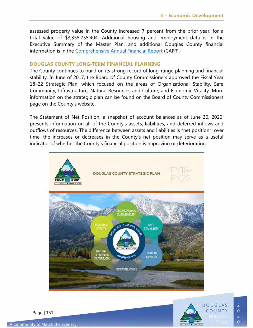
3 – Economic Development
Page | 151
assessed property value in the County increased 7 percent from the prior year, for a
total value of $3,355,755,404. Additional housing and employment data is in the
Executive Summary of the Master Plan, and additional Douglas County financial
information is in the Comprehensive Annual Financial Report (CAFR).
DOUGLAS COUNTY LONG-TERM FINANCIAL PLANNING
The County continues to build on its strong record of long-range planning and financial
stability. In June of 2017, the Board of County Commissioners approved the Fiscal Year
18–22 Strategic Plan, which focused on the areas of Organizational Stability, Safe
Community, Infrastructure, Natural Resources and Culture, and Economic Vitality. More
information on the strategic plan can be found on the Board of County Commissioners
page on the County’s website.
The Statement of Net Position, a snapshot of account balances as of June 30, 2020,
presents information on all of the County’s assets, liabilities, and deferred inflows and
outflows of resources. The difference between assets and liabilities is “net position”; over
time, the increases or decreases in the County’s net position may serve as a useful
indicator of whether the County’s financial position is improving or deteriorating.

3 – Economic Development
Page | 152
ECONOMIC DEVELOPMENT GUIDING PRINCIPLES
Douglas County’s economic vitality strategy focuses on improving the economic well-
being of a community through efforts that entail job creation, job retention, tax base
enhancements, and quality of life improvements. These efforts rely on five guiding
principles:
1) Improve business climate
2) Preserve the natural environment and improve infrastructure
3) Enhance education and workforce
4) Maintain exceptional quality of life
5) Attract business that are unique and marketable
Bentley Science Park, Minden, NV

3 – Economic Development
Page | 153
ECONOMIC DEVELOPMENT FOCUS AREAS
Drawing on the five guiding principles, the County’s economic development efforts are
centered on three areas: (1) develop distinctive downtowns, (2) capitalize on outdoor
recreation and lifestyle, and (3) develop a thriving climate for business and learning.
Develop Distinctive Downtowns
This focus area includes the Towns of Gardnerville, Genoa, and Minden and the casino
core at Stateline. The County remains committed to partnering with these entities to
provide assistance and funding to help revitalize the downtowns and spur investment.
This includes working with Gardnerville, Minden, Carson Valley Visitors Authority, and
the Carson Valley Chamber of Commerce to implement the Valley Vision Plan (2013)
and the Minden and Gardnerville Plan for Prosperity (2018). This focus area also includes
collaboration on the Gardnerville Main Street program. For Stateline, this involves

3 – Economic Development
Page | 154
working with casinos, resorts, and other property owners, Tahoe Visitors Authority, and
Tahoe Chamber of Commerce in the Stateline core to implement the South Shore Vision
and South Shore Area Plan update. These efforts and partnerships will continue to
diversify the economy and reduce reliance on gaming revenues.
Capitalize on Outdoor Recreation and Lifestyle
As noted in the Douglas County Valley Vision Plan (page 28), “parks, natural areas, and
scenic landscapes have great economic value. They help protect the Valley’s agricultural
heritage, attract tourism and recreation, and ensure the integrity of naturally functioning
ecosystems. Preserving scenic
vistas and establishing trails to
the abundant outdoor
amenities also strengthens the
connection that people have
with their neighbors and the
surrounding environment.”
This focus area includes efforts
to capitalize on the County’s
greatest asset, its spectacular
natural setting. With snow and
water skiing locations, hiking
and biking trails (both
improved and unimproved)
that surround and connect
communities, and access to federal lands, the
County offers residents and visitors a variety
of recreation opportunities too numerous to
count. The County will continue to encourage and support efforts to expand the existing
trail network and to make outdoor recreation experiences and events prominent
features of a thriving Douglas County economy.
Develop a Thriving Climate for Business and Learning
This focus area involves growing targeted sectors, identifying new employment
opportunities, working closely with education partners to align curriculum and
educational experiences to target the needs of manufacturing and recreation business,
and evaluating opportunities for development process improvement. A number of
studies have been completed to identify new employment opportunities and target
centers in Douglas County, including the Douglas County Valley Vision Plan (2013) and
Lake Tahoe ranked No. 3 on U.S.
News and World Report’s “Best
Small Towns to Visit in the USA”
(2019).
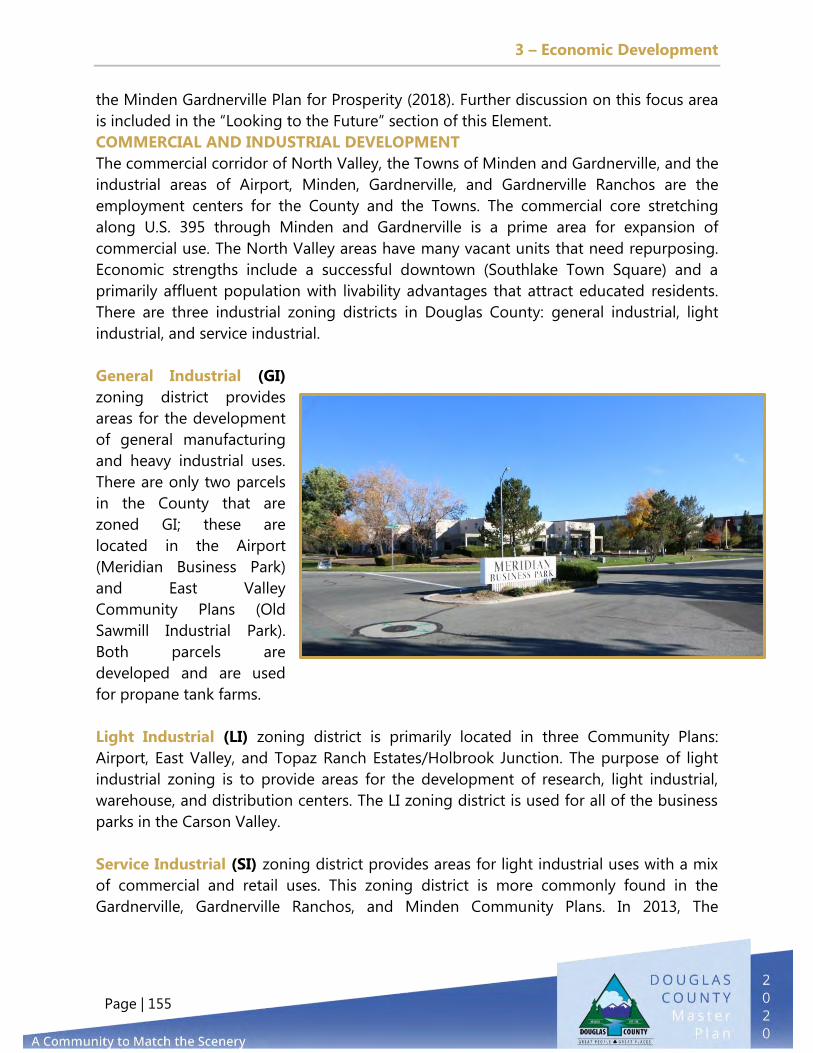
3 – Economic Development
Page | 155
the Minden Gardnerville Plan for Prosperity (2018). Further discussion on this focus area
is included in the “Looking to the Future” section of this Element.
COMMERCIAL AND INDUSTRIAL DEVELOPMENT
The commercial corridor of North Valley, the Towns of Minden and Gardnerville, and the
industrial areas of Airport, Minden, Gardnerville, and Gardnerville Ranchos are the
employment centers for the County and the Towns. The commercial core stretching
along U.S. 395 through Minden and Gardnerville is a prime area for expansion of
commercial use. The North Valley areas have many vacant units that need repurposing.
Economic strengths include a successful downtown (Southlake Town Square) and a
primarily affluent population with livability advantages that attract educated residents.
There are three industrial zoning districts in Douglas County: general industrial, light
industrial, and service industrial.
General Industrial (GI)
zoning district provides
areas for the development
of general manufacturing
and heavy industrial uses.
There are only two parcels
in the County that are
zoned GI; these are
located in the Airport
(Meridian Business Park)
and East Valley
Community Plans (Old
Sawmill Industrial Park).
Both parcels are
developed and are used
for propane tank farms.
Light Industrial (LI) zoning district is primarily located in three Community Plans:
Airport, East Valley, and Topaz Ranch Estates/Holbrook Junction. The purpose of light
industrial zoning is to provide areas for the development of research, light industrial,
warehouse, and distribution centers. The LI zoning district is used for all of the business
parks in the Carson Valley.
Service Industrial (SI) zoning district provides areas for light industrial uses with a mix
of commercial and retail uses. This zoning district is more commonly found in the
Gardnerville, Gardnerville Ranchos, and Minden Community Plans. In 2013, The

3 – Economic Development
Page | 156
Community Development Department initiated amendments to the light industrial and
service industrial zoning districts to allow more recreational and retail/personal services
in both zoning districts and to eliminate the screening requirements for accessory solar
energy systems. These amendments were approved by the Board of Commissioners on
April 4, 2013.
Table E1- Commercial and Industrial Future Land Use by Community Area
Diagrams E1–E4 show the location of commercial and industrial zoning in Douglas
County and whether the acreage is developed or vacant. Diagram E1 shows the location
of business parks in the Airport and East Valley Community Plans. Diagram E2 shows the
location of service industrial parcels in Gardnerville and Minden while Diagram E3 shows
the location of service industrial acreage in Gardnerville Ranchos. Diagram E4 displays
the location of light industrial acreage in the Topaz Ranch Estates/Holbrook Junction
Community Plan.
Community Area Future Land Use
Vacant Acres
Developed Acres
TotalAcres
%Vacant
Airport Industrial 431 461 892 48%East Valley Industrial 328 54 382 86%
Commercial 102 181 283 36%Industrial 14 71 86 17%
Commercial 16 48 64 25%Industrial 0 14 14 0%
Genoa Commercial 19 131 150 13%Indian Hills/Jacks Valley Commercial 159 165 323 49%Johnson Lane Commercial 4 1 5 80%
Commercial 15 143 158 10%Industrial 164 325 488 34%
Sierra Region Commercial 0 5 5 0%Commercial 182 194 376 48%
Industrial 35 171 205 17%Topaz Lake Commercial 39 25 64 61%
Commercial 535 886 1,422 38%Industrial 540 635 1,175 46%
Gardnerville
Gardnerville Ranchos
Minden
T R E/Holbrook Jct
County Wide

3 – Economic Development
Page | 157
DIAGRAM E1 - BUSINESS PARKS AND INDUSTRIAL & COMMERCIAL ZONING IN
SELECTED CARSON VALLEY COMMUNITY PLANS

3 – Economic Development
Page | 158
DIAGRAM E2 - INDUSTRIAL & COMMERCIAL ZONING IN SELECTED CARSON
VALLEY COMMUNITY PLANS

3 – Economic Development
Page | 159
DIAGRAM E3 - INDUSTRIAL & COMMERCIAL ZONING IN
GARDNERVILLE RANCHOS COMMUNITY PLAN

3 – Economic Development
Page | 160
DIAGRAM E4 - INDUSTRIAL & COMMERCIAL ZONING IN TOPAZ RANCH
ESTATES/HOLBROOK JUNCTION COMMUNITY PLAN

3 – Economic Development
Page | 161
LOOKING TO THE FUTURE
CRITICAL ISSUES CONFERENCE SURVEY
At the 2019 Critical Issues Conference, the participants were asked: “In less than three
words, what would you tell a prospective new business about why your business is
located in Douglas County?” Top answers included quality of life, life/work balance, and
community. The survey asked employers if they intended to make investments in capital
or equipment during the next three years. The majority of respondents (84 percent)
stated that they were planning to do so.
The survey also asked employers if they planned to add new positions during the next
three years. Again, the majority of respondents (69 percent) stated they did.
In response to the survey question, “Regarding housing stock to serve your employees,
how does the situation compare to this time last year?”, 69 percent stated there was
“worse/less housing available.” In the 2018 poll, 84 percent indicated they believed there
was not enough housing stock to serve their employees. For information on proposed
goals, policies, and actions to address housing needs in Douglas County, please refer to
Element 4, Growth Management & Housing.
TARGET INDUSTRY OPPORTUNITIES
In 2012, the Western Nevada Development District assisted the County with
funding to analyze opportunities around the advanced manufacturing sector.
The study determined the County had a robust technology sector (advanced
manufacturing, clean technology, and research and development companies), which
represented 141 technology companies with more than 1,800 employees and accounted
for $111 million in annual wages. The average annual wage for the technology sector
was $61,666 in the first quarter of 2012, as compared to the average County wage of
$39,297 in the same quarter.
As a result of the study, the County partnered with the Northern Nevada Development
Authority (NNDA) to bolster recruitment and expansion of the industry. Between 2010
and 2016, the number of companies in the advanced manufacturing sector has
increased by 13.8 percent. While job numbers remain relatively flat over that period,
outreach visits to local companies indicate that many are planning investments in capital
projects and expansion of operations.
As of 2019, manufacturing represents 9.2 percent of the jobs in Douglas County, with an
average annual wage of $81,653. Leisure and hospitality, the largest industry in the
County, represents 29 percent of jobs, with an average annual wage of less than half of
the manufacturing wage. Growing the number of manufacturing businesses and jobs

3 – Economic Development
Page | 162
presents the greatest opportunity to diversify the Douglas County economy and move
away from its reliance on tourism and leisure jobs. Two strategies are in place to make
this happen.
First is working with the Northern Nevada Development Authority (NNDA) and property
owners to certify sites under the Nevada Certified Site Program. A Certified Site
designation serves as pre-qualification; among other criteria, it indicates that a
property’s title is clear, that it possesses sufficient utilities and other infrastructure for
commercial use, that it is properly zoned, and that it has adequate transportation access
for such uses.. NNDA sponsors the Certified Sites Program to enhance the region’s
appeal to companies not currently located here.
Second is a continued retention and expansion effort by the County’s Economic Vitality
Accelerating Advanced Manufacturing team, which consists of members of the business
community and JOIN, Inc. The team does regular targeted outreach to existing
manufacturers to offer resources in the areas of supply chain and workforce while also
addressing any issues the businesses may have related to infrastructure or regulatory
matters.
Another related area of opportunity is the aerospace and aviation industry. Outreach to
the manufacturing industry also identified a group of businesses that service the
aerospace and aviation industry. Minden is well known throughout the world for the
exceptional soaring conditions of mountain waves in winter and thermal activity in the
spring and summer. Both conditions attract soaring pilots from around the globe year-
round, which is not the
case in many soaring areas.
Combined with
investments at the Minden-
Tahoe Airport to expand
utilities to the east side,
allowing for more private
hangar and business space,
this makes the area ripe for
attraction of additional
aviation businesses,
aircraft, and jobs in the
aeronautical fields.
The estimated economic impact of the
Minden-Tahoe Airport, with 137
airport and aviation jobs and 390
based aircraft (2016) is $52 million.).

3 – Economic Development
Page | 163
ATTRACTING REMOTE, CONTRACT, AND INDEPENDENT WORKERS
The recently completed Tahoe Prosperity Center Economic Forecasting and
Resilience Analysis (August 2020) makes recommendations about attracting
remote workers. According to the report, “COVID-19 has changed the
structure of the workforce, and more people than ever are working remotely. This
enables the region to leverage its strengths to attract high-wage remote earners. The
Tahoe Basin should focus on attracting workers in fields related to the clusters that exist
in the region.” As a member of the Tahoe Prosperity Center (TPC), Douglas County has
the opportunity to work with the TPC to explore the growth and retention of remote
workers in the Tahoe Basin. Additional efforts on both a county and regional level could
be explored.
EDUCATION AND WORKFORCE
Nevada is expected to have a shortage of more than 28,000 middle-skilled
workers by 2024. Work-based learning (WBL) is a way to enable employers
to develop a pipeline of skilled and work-ready employees who often
remain on the job after completion of a WBL program.
Career Bound NV is a WBL strategy that combats issues employers face by offering
students an opportunity to apply classroom instruction in real-world workplaces,
ensuring that learning is relevant to the needs of students and employers. It connects to
meaningful career pathways while supporting schools and employers in developing
workforce solutions for Nevada. In partnership with Douglas County’s Economic Vitality
Program, JOIN, Inc. facilitated WBL placements at Douglas High School beginning in fall
2019, connecting with counselors, teachers, students, and employers via dedicated case
managers. Fifteen students participated in the pilot project. Future opportunities include
post-pandemic expansion and a sustainable funding source for the program.
DOWNTOWN REVITALIZATION AND MAIN STREET PROGRAMS
The South Shore Vision Plan was completed in 2011, and the Valley Vision
Plan in 2013. Both plans were the result of collective community processes
to define how South Shore/Stateline and Carson Valley areas should evolve
over the next 20 to 30 years.
Progress was made in the implementation of the South Shore Vision Plan, which
influenced the update of the TRPA Regional Plan Amendment in 2012 and the adoption
of the South Area Plan in 2013. It was the catalyst to begin the transformation of the
South Shore from an area focused on gaming to a world-class destination where
recreation and entertainment are the major attraction and gaming is an amenity. As a

3 – Economic Development
Page | 164
result, significant private sector investments were made in resort-related properties on
both sides of the state line. An update to the South Shore Area Plan is currently in draft
form and is expected to be completed in the near future.
In 2020, the Tahoe Douglas Visitors Authority broke ground on the Tahoe South Event
Center. The approximately 138,000 square foot building is at the corner of U.S. Highway
50 and Lake Parkway in the MontBleu parking lot. It will be a publicly owned indoor
multi-use assembly, event, and entertainment venue that will attract a wide range of
year-round conventions, trade shows, special events, and entertainment.
In 2018, the TRPA Governing Board approved the Tahoe Transportation District’s U.S. 50
South Shore Community Revitalization Project. This project will set the stage for a major
makeover to a stretch of Highway 50 in the Stateline area. The project will realign about
one mile of the highway to run behind the casino core and Heavenly Village, improving
traffic flow for people driving through the area. The old highway alignment will be
turned into a two-lane Main Street on both sides of the state line through a process
called the Main Street Management Plan and will create the first major community hub
at Tahoe that is not on a major highway. Although realignment of the highway is still
several years in the future, near-term efforts will focus on exploring the creation of a
Special Improvement District for the management and operation of the new Main
Street.
Both the Tahoe South Event Center and the U.S. 50 South Shore Community
Revitalization Project are expected to significantly increase annual spending, room
revenues, and tax revenues to local jurisdictions.
The Towns of Minden and Gardnerville also experienced private sector investment since
the development of the Valley Vision plan in 2013. Major investments have occurred at
Sharkey’s Casino and the Overland Restaurant & Pub in Gardnerville and the Carson
Valley Inn, TJ’s Corral, and COD Casino in Minden. In 2019, the Bently Heritage Estate
Distillery opened to visitors with the potential to be a catalyst spurring revitalization of
downtown Minden.
Other progress includes the creation and growth of the Main Street Program, a key
component of the County’s Economic Vitality Program (Distinctive Downtowns). A Main
Street Program was established for Gardnerville in 2008 as the first designated
accreditation in Nevada and now successfully operates in partnership with Accredited
Main Street America.
The Main Street Gardnerville program saw growth in the number of businesses, adding
a net of 80 new businesses since 2009. There are other opportunities to support both
downtown areas, including completion of the grant-funded Martin Slough Trail, which

3 – Economic Development
Page | 165
will add a 2.5-mile urban link between the two towns, preparation of a retail market
analysis and marketing strategy for the downtown areas of the towns as envisioned in
the 2018 Minden and Gardnerville Plan for Prosperity, and evaluation of Development
Code amendments to reduce or waive off-street parking requirements in the
downtowns.
PUBLIC ART AND CULTURE
“Transforming the Copeland building into a Regional Arts Center reactivates the area and creates the opportunity for an arts district along U.S. 395.” - Douglas County Valley Vision, 2013 The integration of public art and culture into the County’s overall economic strategy has
been identified as an opportunity for growth and expansion in the 2013 Douglas County
Valley Vision and the 2018 Minden and Gardnerville Plan for Prosperity. Public art and
culture can be an essential part of Douglas County, both intrinsically and economically,
and can have a significant impact on the quality of life for residents and visitors. At the
same time, however, the ability of the arts to thrive and grow in Douglas County faces
challenges. Individual artists of all disciplines have limited access to funding. Nonprofit
arts organizations experience tougher competition for funding to maintain stability and
growth. Schools face budget constraints that may force arts programs to be cut. In
addition, space for local artists’ housing, studios, and exhibits is limited. Public input has
called for more arts- and culture-related venues and activities in the community.

3 – Economic Development
Page | 166
Including arts and culture as central to revitalization plans may help make an area a
pedestrian-friendly magnet for music, theater, dance, and visual arts, for dining,
shopping, and entertainment, and for festivals and events. Arts facilities and cultural
events tend to attract more
residents, tourists, and
employees to a community.
They provide employment
opportunities through
support services to the arts,
expand tax base, and
increase property values. The
arts provide measurable
benefits in the form of
increased business, tourism,
and revenue. Public art
should reflect the community
in which it resides, bring
people together, revitalize
neighborhoods, help drive the local economy, honor local heritage and history, and
enhance quality of life. Art in Public Places Programs provide an ongoing funding source
through developer fees or requirements for art projects for visible projects that affect
the whole community. This can include art in new developments, art in public spaces
through contribution to a central fund, art at the Town’s gateways, and focal points and
spaces for the creation and presentation of art.

3 – Economic Development
Page | 167
BING MATERIALS GRAVEL OPERATION
The Bing Materials gravel operation, which is located on Kimmerling Road in the
Gardnerville Ranchos Community Plan, is designated as a Receiving Area and contains
178.45 acres. The gravel operation, which may end in the near future, presents a
significant development opportunity for Douglas County. It may be appropriate for the
County to begin discussions with the owner and community residents about potential
redevelopment options for area before the next Master Plan update.
REGIONAL ECONOMIC DEVELOPMENT EFFORTS
The Western Nevada Development District has identified three economic development
projects in its new five-year Comprehensive Economic Development Strategy for 2020
through 2025: development of a Douglas County Business Incubator Project, a separate
Douglas County–Main Street Incubator Project, and potential future development of the
Muller Parkway area. Additional region-wide economic development goals for the next
five years include improved rural or non-metropolitan connectivity with larger urban
population centers throughout the region and the development and execution of a
regional economic resiliency plan.
Members of the Western Nevada Development District include Carson City, Churchill
County, Douglas County, Mineral County, Pershing County, Storey County, Washoe
County, and the individual municipalities of Fallon, Fernley, Lovelock, Reno, and Sparks.
Continued emphasis on improving regional connectivity between established urban
population centers and more rural or non-metropolitan communities throughout the
region and within Douglas County is essential to the District’s overall goal of improving
regional economic growth. As a significant portion of Douglas County’s existing
population commutes out of the County to other communities throughout
northwestern Nevada and as a significant portion of the workforce that works in
Douglas County lives in communities in northwestern Nevada outside of Douglas
County, continued regional economic growth and improved economic integration is
vital to the County’s long-term economic vitality. The Western Nevada Development
District will continue to work with member counties and municipalities to identify state
and federal funding sources dedicated to the improvement of the region’s
transportation network and infrastructure, while encouraging additional job and
business creation, attraction, retention, and expansion efforts in existing population and
employment centers to improve regional income and the incomes of Douglas County
residents.

3 – Economic Development
Page | 168

4 – Growth Management & Housing
Page | 169
PURPOSE
The purpose of the Growth Management & Housing Element is to review current
strategies to manage growth in Douglas County and to establish an adequate amount
of housing inventory to meet the income levels and demands of County residents
without compromising the quality of life of our community. This Element includes an
overview of the housing sales and trends and a review of the County’s Building Permit
Allocation, Growth Management Ordinance, and Transfer Development Rights program.
GOALS
The following goals, policies, and actions for the Douglas County Growth Management
Element set forth future priorities for the county.
Keep growth in Douglas County to a sustainable level that natural and
fiscal resources can support.
Direct development to locations within or adjacent to existing
communities where public services and facilities can easily be provided
and a sense of community created or enhanced.
Increase awareness of the affordable housing needs in Douglas County
and increase the diversity of available homeownership opportunities.
4. GROWTH MANAGEMENT & HOUSING

4 – Growth Management & Housing
Page | 170
Offer lifestyle options and environments that people of all ages and
families can enjoy.
Increase housing opportunities for households with special needs,
including persons with physical and mental disabilities, the elderly, and
at-risk children.
POLICIES
Continue to implement the Building Permit Allocation and Growth
Management Ordinance; report to the Planning Commission and the Board of
County Commissioners on the effectiveness and possible improvements on an
annual basis.
Use Element 1, Land Use & Historic Preservation to designate areas for
distinct urban and rural communities. Ensure that the designated
development areas of these communities do not include land that cannot be
served with adequate services and facilities during the time frame of the
Master Plan.
Limit extension of urban levels of public services to rural areas except in cases
in which the extension is necessary for the provision of public health and
safety.
Ensure that projects proposed in the Capital Improvement Program are
consistent with the goals and policies in the Growth Management Element of
the Master Plan.
Support annexations to unincorporated towns or to service areas of providers
(such as GIDs) that are compatible with the Master Plan’s identified urban
service areas.
Prohibit new receiving areas outside of urban service areas.
4 – Growth Management & Housing
Page | 171
Coordinate with service providers to consider modifications to the urban
service boundaries during five-year updates of the Douglas County Master
Plan.
Promote development that enhances the quality, desirability, and integrity of
neighborhoods.
Continue to support and retain Nevada Rural Housing Authority and United
States Department of Agriculture (USDA) first-time homebuyer programs in
Douglas County.
Continue to pursue state and local home rehabilitation and weatherization
programs to reduce ownership expenses and improve health and safety
concerns.
Promote cooperative efforts to preserve and expand current attainable and
workforce housing.
Allow accessory dwelling units (ADUs) and County guesthouses.
Promote the provision of a variety of housing options throughout the County.
Cooperate with developers in the production of dwelling units accessible to
persons with disabilities. Encourage developers to consider incorporating
minimal changes in the percentage of new units, which would make them
more usable for persons with disabilities while not otherwise affecting their
marketability.
Work with local housing groups to assist disabled persons with accessibility
modifications. Encourage housing finance agencies such as USDA, Nevada
Housing Division, and the Rural Nevada Housing Authority to make available
housing rehabilitation funds for accessibility projects in Douglas County.
Support the development and update of architectural design standards or
guidelines that are based on the character of the various Douglas County
Communities.

4 – Growth Management & Housing
Page | 172
HOUSING & GROWTH MANAGEMENT IN DOUGLAS COUNTY
HOUSING INVENTORY AND MARKET SEGMENTS
According to the Center for Regional Studies, the College of Business, University of
Nevada, Reno, there are about 25,367 housing units in Douglas County. Approximately
75 percent of the housing stock are single family detached units, 12 percent are single
family attached, 6 percent are multi-family residential (MFR) units, and 7 percent are
manufactured housing.
Figure G1 - Housing Types
Source: Douglas County Assessor
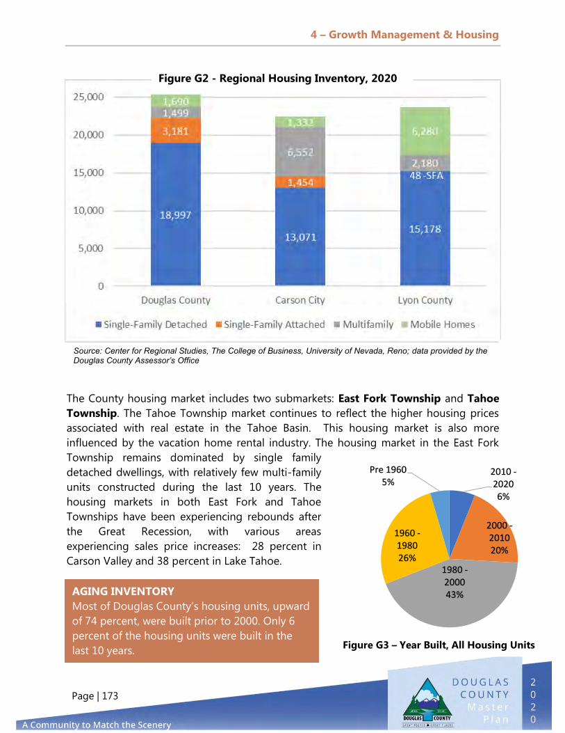
4 – Growth Management & Housing
Page | 173
2010 - 2020 6%
2000 - 2010 20%
1980 - 2000 43%
1960 - 1980 26%
Pre 1960 5%
AGING INVENTORY
Most of Douglas County’s housing units, upward
of 74 percent, were built prior to 2000. Only 6
percent of the housing units were built in the
last 10 years.
The County housing market includes two submarkets: East Fork Township and Tahoe
Township. The Tahoe Township market continues to reflect the higher housing prices
associated with real estate in the Tahoe Basin. This housing market is also more
influenced by the vacation home rental industry. The housing market in the East Fork
Township remains dominated by single family
detached dwellings, with relatively few multi-family
units constructed during the last 10 years. The
housing markets in both East Fork and Tahoe
Townships have been experiencing rebounds after
the Great Recession, with various areas
experiencing sales price increases: 28 percent in
Carson Valley and 38 percent in Lake Tahoe.
Source: Center for Regional Studies, The College of Business, University of Nevada, Reno; data provided by the Douglas County Assessor’s Office
Figure G2 - Regional Housing Inventory, 2020
Figure G3 – Year Built, All Housing Units

4 – Growth Management & Housing
Page | 174
The increase in home buying has also been fueled by historically low interest rates.
Improved housing markets will result in improved employment numbers for
construction and related industries but will also affect housing affordability, especially if
development of lower price-point products and/or rental inventory continues to shrink
in favor of exclusively expensive homes. In 2020, The National Low-Income Housing
Coalition (NLIHC) identified Douglas County as the third most expensive housing market
in Nevada after Clark County and the Reno MSA. When compared to the latter two,
however, Douglas County has a significantly lower percentage of renters—30 percent
versus 47 percent and 42 percent, respectively.
WORKFORCE AND AFFORDABLE HOUSING
Services related to the housing in Douglas County are currently provided by the Douglas
County Social Services (DCSS) and the Douglas Community Development Departments
(DCCD). DCSS receives federal and
state funding to provide emergency
housing vouchers and case
management. DCCD reviews all
development proposals, applies for
Community Development Block Grant
(CDBG) funding on behalf of the
County, Towns, and nonprofit
organizations, and monitors the deed
restricted units at Arbor Gardens.
The County is in the process of
adopting a Memorandum of
Understanding (MOU) with the
Nevada Rural Housing Authority that
supports the development of
affordable housing, rehabilitation of
existing structures, and various
affordable housing initiatives. One of
the first steps in the MOU is to
develop a task force to review
impediments to affordable housing.
Many low-income renting families
spend over half of their income on
housing costs, largely due to
Figure G4 - House Sales Information

4 – Growth Management & Housing
Page | 175
stagnating wages combined with overall living cost increases. Only very low-income
families qualify for affordable housing programs, leaving many in the limbo of not
making enough money to feel secure but making too much to qualify for assistance.
Moreover, not everyone who is entitled to participate in assistance programs gets help.
Under those conditions, a growing number of people across the nation are living one
misstep or emergency away from eviction. Evictions are a traumatic experience for
everyone involved, especially the tenants who lose their homes; in most cases, the
experience will have lifelong consequences for them and their families.
Employee Housing
The lack of affordable housing in Douglas County that is based on the family’s income
level makes it difficult to recruit new public- and private-sector employees. This directly
impacts economic development strategies—and during past stakeholder interviews, a
similar issue has been brought up repeatedly by a variety of employers. Higher house
pricing and a lack of diverse housing types lead employees to choose to live outside of
Douglas County and commute to work. Similarly, many employment and educational
opportunities for younger people of working age generates a reverse commute pattern
of County residents living in single family homes but travelling daily toward Carson City
and Washoe County. This adds to traffic congestion on county, state, and federal roads,
particularly on U.S. 395. Achieving a better balance of housing and job inventory
diversity could minimize certain infrastructure costs and negative external-factors and
ultimately increase the overall quality of life in the County. Developers should be
encouraged to recognize this need in the planning process, and the County should
consider incentives during the permit process to encourage new developments to
include these types of units in their proposed development.
Exceptions for Affordable Housing
The County’s Growth Management Ordinance has been amended over the years to
provide exemptions for certain types of housing. Currently, deed-restricted affordable
housing is exempt from the Growth Management Ordinance, and developers do not
need to secure allocations for the affordable units. All property owners who wish to
construct an ADU on their property, however, must currently apply for a Building Permit
Allocation under the County’s Growth Management Ordinance. Since many of the ADUs
provide affordable housing for relatives and/or a small number of tenants, revising the
Growth Management Ordinance to exempt ADUs from portions of it would be beneficial
to our residents that fall within lower income brackets.
Douglas County adopted the Density Bonus and Affordable Housing Agreement
Ordinance in 1996. Prior to 2001, the ordinance allowed affordable housing developers

4 – Growth Management & Housing
Page | 176
to request a density bonus of up to 25 percent when either: (1) up to 20 percent of the
units are affordable to households earning between 51 percent and 80 percent of the
County’s median income or (2) at least 15 percent of the units are affordable to
households earning up to 50.9 percent of the median income. In 2001, the County
amended this ordinance to also allow a density bonus if at least 20 percent of the units
are owner-occupied single family residences for households with incomes up to 110
percent of median income. The density bonus ordinance requires developers to record a
deed restriction maintaining affordability for 30 years for rental housing or 15 years for
for-sale housing. The only development containing affordable owner-occupied housing
is Arbor Gardens. This 160-unit development includes 78 deed-restricted units, most of
which were purchased between 2003 and 2006. The Affordable Housing Agreement for
Arbor Gardens requires the developer to restrict the sale of these homes to households
with incomes at 110 percent or less of the County median income. The Fiscal Year 2020
Median Income in Douglas County for a family of four was $74,741 (see Table ES12 in
the Executive Summary).
Applying the 110 percent income qualification would mean that a family of four could
have a household income as high as $82,215. The 15-year deed restrictions for the
affordable units at Arbor Gardens began to expire in 2018. Although DCCD
communicates with realtors who represent potential buyers of deed-restricted units to
ensure the potential buyer meets the income restrictions, it has been noted that some of
the deed-restricted units have either been rented or sold to buyers who are not income-
qualified. The Density Bonus Program was last used in 2007 for the Summit Crest
Apartments on Mica Drive in the Indian Hills GID.
Photo: Arbor Gardens

4 – Growth Management & Housing
Page | 177
There are seven locations totaling 309 units in Carson Valley (see Diagram G1) that offer
affordable units to the public. Of the products available, Arbor Gardens is the only one
that includes detached single family residences, and Parkway Vista (30 units) is the only
senior living complex. Both of these are located in the Town of Gardnerville. Another
complex, Summit Crest Apartments, is located in Indian Hills. The remaining four
apartment complexes are located in the Towns of Minden and Gardnerville and contain
173 units. The Tahoe Basin (Diagram G2) has four apartment complexes containing 133
units of affordable housing; additional housing is needed there.
Photo: Summit Crest Apartments
Photo: Aspen Grove

4 – Growth Management & Housing
Page | 178
DIAGRAM G1 - AFFORDABLE HOUSING IN THE EAST FORK TOWNSHIP

4 – Growth Management & Housing
Page | 179
DIAGRAM G2 - AFFORDABLE HOUSING IN TAHOE TOWNSHIP
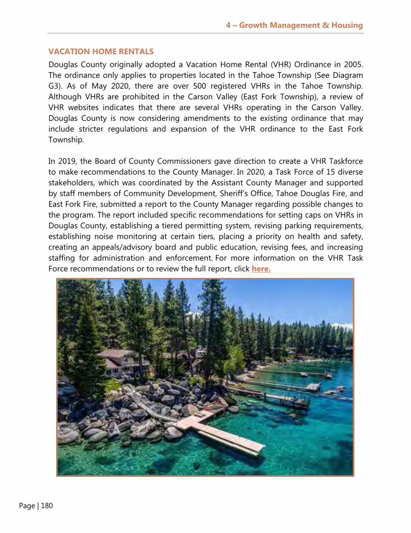
4 – Growth Management & Housing
Page | 180
VACATION HOME RENTALS
Douglas County originally adopted a Vacation Home Rental (VHR) Ordinance in 2005.
The ordinance only applies to properties located in the Tahoe Township (See Diagram
G3). As of May 2020, there are over 500 registered VHRs in the Tahoe Township.
Although VHRs are prohibited in the Carson Valley (East Fork Township), a review of
VHR websites indicates that there are several VHRs operating in the Carson Valley.
Douglas County is now considering amendments to the existing ordinance that may
include stricter regulations and expansion of the VHR ordinance to the East Fork
Township.
In 2019, the Board of County Commissioners gave direction to create a VHR Taskforce
to make recommendations to the County Manager. In 2020, a Task Force of 15 diverse
stakeholders, which was coordinated by the Assistant County Manager and supported
by staff members of Community Development, Sheriff’s Office, Tahoe Douglas Fire, and
East Fork Fire, submitted a report to the County Manager regarding possible changes to
the program. The report included specific recommendations for setting caps on VHRs in
Douglas County, establishing a tiered permitting system, revising parking requirements,
establishing noise monitoring at certain tiers, placing a priority on health and safety,
creating an appeals/advisory board and public education, revising fees, and increasing
staffing for administration and enforcement. For more information on the VHR Task
Force recommendations or to review the full report, click here.

4 – Growth Management & Housing
Page | 181
DIAGRAM G3 - VACATION HOME RENTALS IN THE TAHOE TOWNSHIP

4 – Growth Management & Housing
Page | 182
Source: Douglas County Community Development
GROWTH MANAGEMENT
Building permit activity in Douglas County has increased since the Great Recession
period. Permits for new single family homes totaled 418 in 2006 but dropped to 38 in
2011. Permits for new single family homes exceeded 100 in all calendar years following
2013. Although the single family market is improving, the multi-family market has
remained lackluster. Since 2006, only six duplex units and 152 multi-family units have
been constructed in Douglas County. The 21 multi-family units constructed in 2010
were for the Mahogany Court affordable apartments in Minden, and the 34 units
constructed in 2013 included 30 units for the Parkway Vista Affordable Senior
development in Gardnerville. Building permits for new manufactured single family
homes have been consistently less than four per year.
Figure G6 shows building permits issued for single family dwellings (SFDs) in Douglas
County from January 2017 through October 2020. A total of 235 SFD permits were
issued in calender year 2018 as compared to 154 SFD permits issued in 2019, which is a
35 percent decrease. Calender Year 2020 is on track to exceed 2019 permit totals, with
178 SFD permits issued through October 2020.
0
50
100
150
200
250
300
350
400
450
2006 2007 2008 2009 2010 2011 2012 2013 2014 2015 2016 2017 2018 2019
Single-Family 418 153 58 46 38 39 53 113 165 146 164 170 235 154
Man. Home 4 3 1 3 1 2 0 1 2 2 4 2 0 2
Duplex 2 0 2 0 0 2 0 0 0 0 0 2 2 6
Multi-Family 0 77 20 0 21 0 0 34 0 0 0 62 13 27
Figure G5 - Residential Building Permits by Structure Type
Single-Family Man. Home Duplex Multi-Family
Source: Douglas County Building Department 2020

4 – Growth Management & Housing
Page | 183
Source: Douglas County Community Development
Growth management involves balancing protection of the natural environment with new
urban and suburban development using tools such as annual building permit caps
and/or urban growth boundaries. Growth management seeks to balance the need for
investment and reinvestment—which is vital to the healthy renewal of revenue sources
used to provide services to our residents—against the need for sustainable use of
natural resources and provision of amenities at a desirable per capita rate. There is often
a concern that growth management strategies may be too restrictive and cause
increases in housing prices and/or raw land prices; on the other hand, an overly rapid
increase in population and excessive urbanization are not part of the vision for a County
that seeks to remain mostly rural and prizes its lower-density status and abundant open
spaces.
The Douglas County Master Plan and the Douglas County Development Code provide
the guidance and regulations regarding the appropriate types and location of different
types of development. To help ensure that new development does not strain resources,
the County has adopted three main growth management tools that are further analyzed
in the sections below: (1) building permit and growth management allocation ordinance,
(2) transfer development rights program, and (3) urban service areas.

4 – Growth Management & Housing
Page | 184
Growth Management Ordinance
The County’s Building Permit Allocation and Growth Management Ordinance was
adopted in 2007 to “preserve and enhance the quality of life for the communities and
inhabitants of Douglas County.” The Growth Management Ordinance was adopted on
the basis of a 2 percent annual population growth rate (compounded annually) for the
County over a 50-year period for the Douglas County population outside of TRPA
jurisdiction. The non-Tahoe Basin population was projected to reach 47,389 by 2016 in
the original ordinance using a 2 percent compound growth rate. The annual growth rate
for the entire County averaged 1.39 percent between 2000 and 2010 and has averaged
0.3 percent per year since 2010. The total number of annual residential allocations was
set at 317 permits in 2007, for example, and gradually increases to 837 allocations by
the year 2056. Of the 26,812 allocations available between 2007 and 2056, 4,773 are
available for vested projects and 22,039 are available for project (6,612) and individual
(15,427) allocations.
All new residential buildings, including ADUs, require a building permit allocation from
the County. The ordinance allows no more than 2,200 exempt allocations over the 50-
year period. Exemptions are allowed for:
1) Residential units that are part of a “vested” project or a development agreement with
the County
2) Residential units for a parcel created under Ranch Heritage or Agriculture - Two-acre
parcels
3) Residential units for an accessory dwelling unit on an A-19 parcel
4) Residential unit deed restricted affordable housing
The Board of Commissioners is required to review the ordinance every five years, and
such review may occur during a Master Plan review. The review must determine if
administrative procedures should be changed but prohibits changing the number of
allocations.

4 – Growth Management & Housing
Page | 185
Source: Douglas County Community Development
Table G1 - Available Residential Allocations by Category
Year
(a) Total
Allocations Available
(b) Less Vested
Project Allocations*
(c) Remaining
Allocations*** (a–b)
(d) Remaining Allocations
Available for Individuals**
(70% of c)
(e) Remaining Allocations Available
for Projects**
(30% of c) 2007–2008 317 149 168 118 50 2008–2009 323 151 172 120 52 2009–2010 330 155 175 123 53 2010–2011 336 158 178 125 53 2011–2012 343 161 182 127 55 2012–2013 350 164 186 130 56 2013–2014 357 168 189 132 57 2014–2015 364 171 193 135 58 2015–2016 371 174 197 138 59 2016–2017 379 178 201 141 60 2017–2018 386 182 204 143 61 2018–2019 394 186 208 146 62 2019–2020 402 190 212 148 64 TOTAL 4,652 2,187 2,465 1,726 740 Total Issued 1,178 831 347 483 114 Excess N/A N/A 2,118 1,243 626
Source: Douglas County Community Development, January 2020 * 4,767 Vested Allocations were available through 2032, but 1,356 Vested Allocations have expired and were not put back into the allocation pool. ** If allocations are not used within one year, they expire and are put back into the pool. *** This table does not reflect the individual and project pools of allocations, which contain the sum of unused allocations from previous years. As of 10/31/2020, the individual pool contains 1,344 allocations and the project pool contains 592 allocations. Transfer of Development Rights Program (TDR) and Receiving Areas
The TDR program allows property owners in sending areas (A-19, FR-19 zoning districts)
to sell development rights to parcels designated as receiving areas in the Douglas
County Future Land Use Map. The TDR program is described in greater detail in Element
2, Agriculture and Conservation.
Table G2 - Available Residential Allocations by Category Status of TDR Program
Certified TDR TDR Transferred TDR Remaining Conservation Easement Acreage
3,921 3,715 206 4,065.40

4 – Growth Management & Housing
Page | 186
There are 4,559 acres designated with a future land use of receiving area in the Douglas
County Master Plan (see Table G3). The receiving area designation means being set up
to receive TDR that are transferred off County sending areas (A-19 and FR-19 zoning
districts). Receiving areas are land use designations and do not affect the existing
zoning on the affected parcels. Most receiving areas have approved developments, such
as Clear Creek in the Jacks Valley/Indian Hills Community Plan, Virginia Ranch in the
Gardnerville Community Plan, and Heybourne Meadows in the Minden/Gardnerville
Community Plan. Some receiving areas lack any approved development plans and have
remained undeveloped for decades. The potential population growth associated with
this build-out of approved developments within the receiving areas is 7,216 persons
(3,032 units x 2.38 person per household [PPH]).
Table G3 - Receiving Area Acreage by Community Plan
Community Plan Area Receiving Area
Total Acres % Vacant Vacant
Acres Developed
Acres Airport 444.9 - 444.9 100% Central Agricultural 660.4 - 660.4 100% Gardnerville 307.9 274.4 582.3 53% Gardnerville Ranchos 708.1 193.7 901.8 79% Indian Hills/Jacks Valley 142.9 164.4 307.3 46% Johnson Lane 177.9 - 177.9 100% Minden 1,111.2 - 1,111.2 100% Ruhenstroth 131.1 - 131.1 100% TRE/Holbrook Junction 21.4 220.4 241.8 9% Total Receiving Area in Douglas County 3,705.9 853.0 4,558.9 81%
Source: Douglas County GIS, Douglas County Community Development

4 – Growth Management & Housing
Page | 187
Table G4 - Douglas County VESTED Project List (2020)
Source: Douglas County Community Development (2020) *Residence 1861 Apartments is approved as Phase II of Parkway Vista at the current time.

4 – Growth Management & Housing
Page | 188
Table G5 - Douglas County PROJECTS List (2020)
Source: Douglas County Community Development (2020)
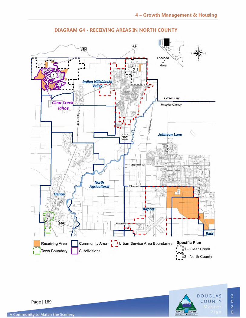
4 – Growth Management & Housing
Page | 189
DIAGRAM G4 - RECEIVING AREAS IN NORTH COUNTY
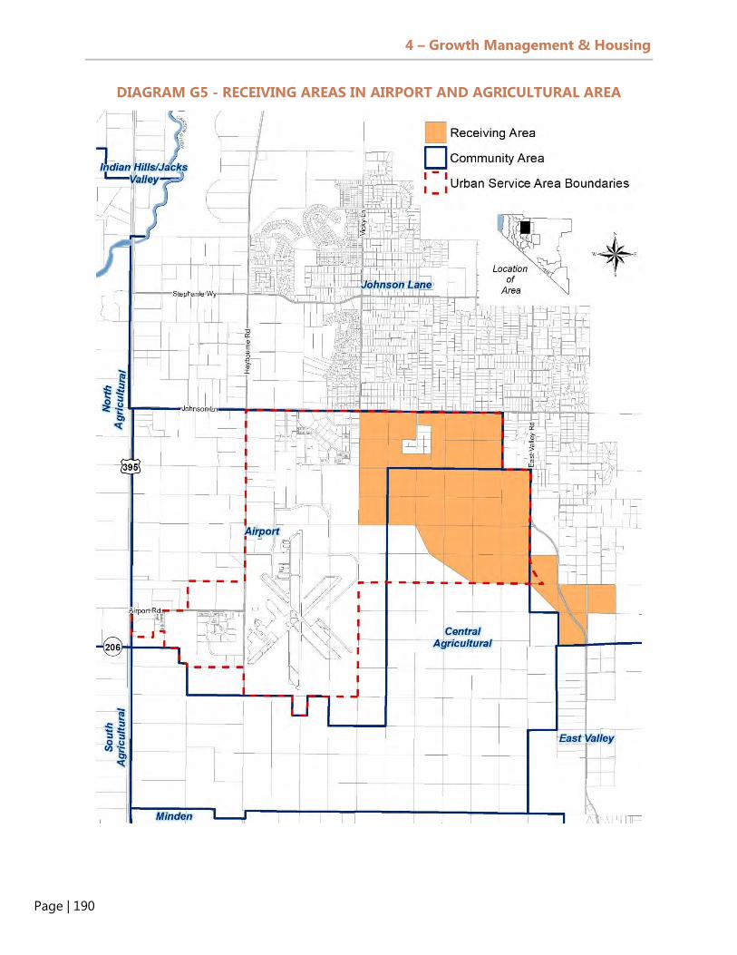
4 – Growth Management & Housing
Page | 190
DIAGRAM G5 - RECEIVING AREAS IN AIRPORT AND AGRICULTURAL AREA

4 – Growth Management & Housing
Page | 191
DIAGRAM G6 - RECEIVING AREAS IN GARDNERVILLE, GARDNERVILLE RANCHOS,
MINDEN, AND RUHENSTROTH

4 – Growth Management & Housing
Page | 192
DIAGRAM G7 - RECEIVING AREAS IN THE TOPAZ REGION

4 – Growth Management & Housing
Page | 193
Urban Service Areas
Urban service areas were established in 1996 and are located in the Carson Valley
portion of Douglas County. The purpose of urban service areas is to force high-density
residential development and commercial and industrial development, due to availability
of infrastructure and established development patterns. Many of the urban service areas
have boundaries that are nearly similar to existing GIDs and town boundaries. Urban
service areas help concentrate urban scale development in areas with public services
and utilities. They are intended to serve residential development at densities of one unit
per 0.5 acre or greater and with urban services, such as paved roads and public water
and wastewater services. Development outside of urban service areas, on the other
hand, is planned for rural residential development, which equates to residential densities
of one dwelling unit per 0.5 acre or lower. The lowest density residential zoning district
is the RA-10 district (one dwelling unit per 10 acres or 0.10 units per acre). See Table L1
in Element 1, Land Use & Historic Preservation for more density values per zoning
district.
Residential Build-out Analysis
Table G6 provides an updated analysis of potential residential growth outside of the
Tahoe Basin; information on residential growth in the Tahoe Basin is available in the
South Shore and Tahoe Douglas Area Plans. According to this review of undeveloped
residential parcels, there are 9,485 acres of vacant residential-zoned land that could
create 10,285 dwelling units (an average of 1.08 dwelling units per acre) based on
allowable density for each zoning district. It should be noted that the residential build-
out analysis does not take into account any agricultural ranch heritage parcels of two to
five acres.
Table G6 – Undeveloped Residential Acreage Outside Receiving Areas by Residential Zoning District*
Residential Zoning Districts Total Acreage
# of Potential Dwelling Units
Potential Population Growth
(DU x 2.38 PPH) RA-10 (0.1 dwelling unit per acre) 81 8 19 RA-5 (0.2 dwelling unit per acre) 5,663 1,133 2,696 SFR-2 (0.5 dwelling unit per acre) 1,498 749 1,783 SFR-1 (1 dwelling unit per acre) 1,378 1378 3,280 SFR-1/2 (2 dwelling units per acre) 180 359 855 SFR 12,000 (3.63 dwelling units per acre) 105 315 705
SFR 8,000 (5.45 dwelling units per acre) 285 1,282 3,051 MFR (16 dwelling units per acre) 264 3,169 7,541 MUC (16 dwelling units per acre) 31 374 891 TOTAL 9,485 8,768 20,867 Source: Douglas County GIS, September 2020

4 – Growth Management & Housing
Page | 194
LOOKING TO THE FUTURE
ESTIMATED POTENTIAL GROWTH FOR DOUGLAS COUNTY
The potential growth in the County is based on the approved developments in receiving
areas and the vacant residential parcels located outside of receiving areas. For this
analysis, the conversion from acres to dwelling units is not assumed to have a direct
density based on the listed minimum dwelling units per acre allowed for each project’s
land use zone. With every project, there are design inefficiencies with parcel layout
being larger than the minimum parcel sizes, road rights-of-way, and parks or drainage
facilities. These inefficiencies reduce the actual dwelling unit per acre used for this
estimate of potential growth. An assumed reduction of 25 percent is used for this
exercise. The analysis shows the following:
A. Current Population
a. The current population of Douglas County is 49,418, per Table ES1 in the Executive
Summary.
B. Receiving Areas
a. Build-out for receiving areas: At 16 units / acre X 0.75 X 4,559 acres = 54,707
units creating an additional population of 130,203, this estimate is not feasible.
b. Based on approved developments and densities within each community plan area:
9,746 units could be created in vacant receiving area (average 2.14 units per
acre).
c. Population build-out: Receiving area 9,746 Units X 2.38 persons / dwelling unit =
23,196.
C. Undeveloped Residential Parcels Outside of Receiving Areas:
a. Build-out for undeveloped residential parcels, including all projects listed in the
project and vested projects list and not including the 0.75 inefficiencies
deduction: 8,768 units.
b. Population build-out for undeveloped residential parcels: 8,768 units x 2.38 =
20,867 persons.
Total Build-out:
a. 18,514 dwelling units on 14,045 acres (average 1.31 units per acre)
b. 93,481 overall potential population for Douglas County
A significant amount of vacant residential land is located outside of urban service areas
and will remain low density and rural in character. Most of the approved developments

4 – Growth Management & Housing
Page | 195
located in receiving areas are vested projects and will not be constrained by the
County’s Growth Management Ordinance. These vested project units will expire in the
next 36 years, ending in 2056. Development of vacant residential parcels outside of
receiving areas may not happen for another 40 to 50 years with the current trend in the
County’s growth.
INCREASING HOUSING DIVERSITY
The housing stock in Douglas County continues to contain more than 70 percent single
family detached units. While this product is marketable to many people, there are two
cases to make in favor of housing diversity:
1) Treating the housing portfolio as any other kind of investment would result in a
larger variety of housing inventory that makes the local market more resilient in
times of crisis or during consumer preference shifts.
2) Providing different lifestyle options to different groups gives more choices to
residents in household configuration, design, and amenity types.
To encourage more housing diversity and more affordable owner- and renter-occupied
residential development, the County could pursue the following options:
a. Identify zoning code and building code barriers to certain types of
developments that are currently under-represented because they are
technically not allowed or are too costly, such as tiny homes, modular units
that can be assembled on-site, container homes, and small footprint and low-
density multi-family products such as duplexes and fourplexes. After doing so,
code amendments could be brought forward for consideration.
b. Remove the requirement that multi-family residential development obtain
multi-family residential land use designation for MFR zoning, and permit MFR
zoning as a permitted zoning district within the commercial land use category.
c. Lower the percentage of commercial usage required in mixed-use commercial
(MUC) zoning districts.

4 – Growth Management & Housing
Page | 196
BUILDING PERMIT ALLOCATION AND GROWTH MANAGEMENT ORDINANCE
The County’s Building Permit Allocation and Growth Management Ordinance was
adopted in 2007, and the Board of Commissioners is required to review the ordinance
every five years; such review may occur during a Master Plan review. The first review of
the Growth Management Ordinance occurred in October 2011, but no changes were
made.
TRANSFER OF DEVELOPMENT RIGHTS (TDR) PROGRAM
The County’s TDR program has successfully preserved over 4,000 acres of agricultural
lands in the Carson Valley. The program transfers development rights to designated
receiving areas, but property owners do not need TDRs outside of the receiving areas
for rezoning proposals. Since there have not been many new TDRs certified since 2009,
it may be time to re-examine the effectiveness of the entire program.
The County may want to consider whether all or some rezoning requests within the
urban service areas (or town or GID) should require TDRs. The demand for TDRs would
likely increase if all rezoning actions for higher density residential development and
commercial or industrial development required TDRs. For example, if a property owner
wanted to rezone a vacant residential property in Gardnerville from SFR-12,000 to multi-
family residential, the County could require TDRs as part of the rezoning application. In
some jurisdictions, such as in King County, Washington, there are no receiving area land
use designations; the receiving areas are specific zoning districts. For Douglas County,
this would eliminate the future land use designation of receiving area, and a Future Land
Use Plan would need to be created in its place so the County could plan future land uses
within those areas.
The County could also explore the establishment of a TDR bank, as well as a well-
managed and transparent “development rights marketplace” for owners and developers
to coordinate and transfer such rights. A TDR bank can typically purchase, hold, and sell
development rights and sometimes can use the proceeds to buy more development
rights, thus creating a revenue source for open space acquisition or public purpose
project development. Successful TDR banks operate in King County, Washington and
Palm Beach County, Florida.
UPDATE THE DENSITY BONUS AND AFFORDABLE HOUSING AGREEMENT
ORDINANCE
The County could increase the supply of affordable housing by requiring developers of
large subdivisions to provide a certain percentage of the units as affordable housing.

4 – Growth Management & Housing
Page | 197
Arbor Gardens is a good example of how this can work. Several changes to the County’s
Density Bonus Ordinance could be considered:
1) Remove the 2001 amendment that raised the income limit to 110 percent of median
income for the deed-restricted units in the Arbor Gardens subdivision.
2) Remove the reference to special needs populations in the current ordinance. None
of the affordable housing agreements target special needs populations.
3) Remove the “adverse impact” language in the current ordinance. This is a broad term
that raises possible fair housing concerns.
4) Make the Density Bonus Agreement mandatory for all residential developments
(owner- and renter-occupied units) with more than 50 dwelling units. For example, a
proposed subdivision with 160 units would be given a density bonus in return for the
provision of affordable housing units.
5) Explore incentives for landlords to accept Housing Choice Vouchers. Many do not
accept these, which can restrict the supply of housing available for voucher holders.

4 – Growth Management & Housing
Page | 198

5 – Public Facilities, Services, & Recreation
Page | 199
PURPOSE
The purpose of the Public Facilities, Services, and Recreation Element is to review the
availability and capacity of various public facilities, services, and parks and recreation in
Douglas County and to properly plan for and mitigate the impact of growth on those
areas.
GOALS
The following goals, policies, and actions for the Douglas County Public Facilities,
Services, and Recreation Element set forth future priorities for the county.
Support regional approaches to providing public services and facilities in
coordination with General Improvement Districts, the Towns, the State,
and other jurisdictions.
Maintain service delivery standards that are consistent with County
values and that promote a high quality of life.
Ensure the timely provision of community facilities, services, and
infrastructure, requiring that new development pays its equitable share
of the costs for public services and facilities that are needed to serve it.
Preserve and enhance public lands throughout the County and promote a
broad distribution and connectivity of trails, parks, open spaces, natural
areas, sensitive habitat(s), and recreational resources.
5. PUBLIC FACILITIES, SERVICES, & RECREATION
5 – Public Facilities, Services, & Recreation
Page | 200
Provide and maintain an integrated transportation system for the safe,
efficient movement of people and goods throughout Douglas County.
POLICIES
Continue to acquire and develop facilities through partnerships with other
public and private entities, including Douglas County School District, Nevada
Division of State Parks, Tahoe Regional Planning Agency, Nevada Department
of Transportation, and private enterprises.
Promote and encourage a coordinated regional approach to the disposal and
use of treated effluent and wastewater management.
Promote and encourage a coordinated regional approach to water service,
water conservation, and water resource management.
Participate in the development of an interjurisdictional approach to protect
critical aquifer recharge areas.
Facilitate the coordinated development of goals, policies, and programs for
water resource management in the County, working with agencies such as the
Carson Water Subconservancy District, General Improvement Districts, the
Towns, the Washoe Tribe, and other appropriate water purveyors.
Constantly seek out new sources of traditional, private, and alternative funding
for facility construction and maintenance.
Promote broadband connections and high-speed internet access throughout
public facilities.
Expand recycling efforts and implement additional waste diversion programs.

5 – Public Facilities, Services, & Recreation
Page | 201
Ensure that neither new development nor the expansion of service areas are
allowed to decrease a system’s level of service below state or federal
standards.
Rural areas may be served by individual sewage disposal systems if
groundwater quality will not result in degradation beyond federal and state
standards.
Identify barriers and develop strategies to meet service delivery goals.
Analyze, evaluate, and plan for the expansion/reduction of public buildings
and facilities to meet increased/decreased demand for government services.
Continue to make available to County residents and visitors a variety of active
and passive park facilities and recreation programs that satisfy their needs,
improve their physical and mental well-being, and enhance their quality of life.
Create an edifying and positive public image for the community through the
appropriate maintenance of parks and publicly owned landscaped areas.
Foster an atmosphere in which members of the community can voice ideas
and concerns related to the proper planning and management of county
facilities and services.
Operate and maintain indoor facilities that appeal to the recreational and
social needs of citizens of all ages.
Continue to support the development of single-track trails, multi-use trails,
bike lanes, and trailheads that provide access and connection between
neighborhoods, recreation facilities, points of interest, and places of
employment.
Continue development of adventure-related facilities, such as skateboard
parks and BMX tracks, in appropriate areas of county-owned and managed
properties.
5 – Public Facilities, Services, & Recreation
Page | 202
Include special use areas for dog owners and their pets, whether on- or off-
leash, in future park developments, as deemed appropriate.
Continue to plan for the needs and preserve the rights of current and future
residents, especially their access to public parks and recreation opportunities.
Maintain clear and simple mechanisms by which the public can make
donations for art, park, and recreation improvements for public facilities and
programs.
Continually recruit and develop volunteer resources, which are deemed critical
to the success of our recreational endeavors.
Continue to support the joint use agreement with the Douglas County School
District, which supports joint free use of County and school facilities.
Develop and maintain facilities that support the cultural and performing arts
interests of our residents and visitors.
Conserve open space to promote recreation opportunities and the responsible
use of public lands.
Coordinate with and strongly encourage the Bureau of Land Management to
plan, design, and maintain trails and public access points to federal lands. Plan
hiking, bicycling, and equestrian trails with appropriately designed trailheads.
Assist the Carson Valley Trails Association and Tahoe Rim Trail Association in
developing new trails by providing access to federal lands within Douglas
County.
Continue to promote increased library visitation through an awareness
campaign and the hosting of local events.
Cooperate with other service providers to coordinate the timing of capital
projects, in order to ensure that requirements of adequacy and concurrency
are met and to develop programs to reduce the cost of providing public
services and facilities.

5 – Public Facilities, Services, & Recreation
Page | 203
Evaluate potential capital projects according to an established set of criteria to
determine their importance in implementing the Master Plan’s goals and
policies, with priority given to projects identified in the Master Plan.
Identify opportunities for studios, rehearsal halls, theaters and concert halls,
dance rehearsal and performance spaces, exhibition spaces and galleries,
multi-purpose centers, classrooms, administrative offices, and art storage
facilities.
CURRENT TRENDS
Fundamental to the effective management of growth and development in a community
is proper planning and providing for services and facilities to support and mitigate the
impact of that growth. In Douglas County, these services and facilities include those
operated and maintained by the County and by other public or private agencies. The
services that are most impacted by growth are transportation, water and wastewater
service, solid waste, and floodplain management. The Douglas County Transportation
Plan was adopted by the County Commission in 2019 and is available online. Floodplain
management is addressed in Element 6, Public Safety. General government services,
libraries, schools, and parks and recreation are discussed in this Element.
GENERAL IMPROVEMENT DISTRICTS
GIDs are authorized under NRS Chapter 318 and provide many different services,
including streets, sidewalks, and storm drainage. Under Chapter 318, the governing
body may collect tax revenues for each GID and issue debt for various infrastructure
projects. A governing body cannot initiate GIDs if they are proposed within seven miles
of the boundary of an incorporated city or unincorporated town.
There are currently 17 GIDs in Douglas County
that were established under NRS 318. Beginning
in the 1960s, several GIDs were approved by the
Douglas County Board of Commissioners to
provide a mix of different urban services,
including streets, sidewalks, streetlights, drainage, water and sewer service, and parks
and recreation, to specific communities such as Gardnerville Ranchos (created by County
ordinance on April 9, 1965). Diagrams PF1–PF3 display the location of GIDs in the
Douglas County has more GIDs
than any county in the State of
Nevada.

5 – Public Facilities, Services, & Recreation
Page | 204
Carson Valley Region, the Topaz Region, and the Tahoe Basin Region. Diagram PF4
displays the location of the unincorporated towns.
Table PF1 - Douglas County General Improvement Districts by Region*
General Improvement District # Parcels Total Acreage Number of Dwelling Units (2016)
Carson Valley Region Gardnerville Ranchos GID 4,174 2,410.56 4,277
Indian Hills GID 1,862 1,389.67 1,831 Sierra Estates GID 67 65.06 70
Subtotal 6,103 3,865.29 6,178 Tahoe Basin Region
Cave Rock GID 132 65.02 90 Elk Point GID 97 22.24 101
Kingsbury GID 2,840 4,980.33 2,358 Lakeridge 101 31.01 78
Logan Creek GID 72 67.10 22 Marla Bay GID 122 29.28 126
Oliver Park GID 92 39.14 453 Round Hill GID 634 667.96 577
Skyland GID 237 73.65 232
Tahoe-Douglas GID N/A N/A 705 Zephyr Cove GID 79 21.99 77
Zephyr Heights GID 291 83.88 240 Zephyr Knolls GID 94 22.94 63
Subtotal 4,791 6,104.54 4,417 Topaz Region
Topaz Ranch Estates GID 909 2,852.08 779
Subtotal 909 2,852.08 779
Grand Total 11,803 12,821.91 11,374
Total County Private 28,395 450,678.38 24,663
Percentage GID 41.6% 2.8% 46.1%
Source: Douglas County GIS parcel data, Douglas County Assessor 2016 Housing Counts. Table PF1 does not include Douglas County Paramedic/Ambulance; Minden-Gardnerville Sanitation District, Tahoe Douglas Fire Protection District, and Mosquito Abatement District.

5 – Public Facilities, Services, & Recreation
Page | 205
DIAGRAM PF1 - GIDs IN CARSON VALLEY REGION

5 – Public Facilities, Services, & Recreation
Page | 206
DIAGRAM PF2 - GIDs IN TOPAZ REGION

5 – Public Facilities, Services, & Recreation
Page | 207
DIAGRAM PF3 - GIDs IN THE TAHOE BASIN

5 – Public Facilities, Services, & Recreation
Page | 208
UNINCORPORATED TOWNS
The Towns of Genoa, Gardnerville, and
Minden were created by the Board of
County Commissioners in accordance
with NRS Chapter 269, Unincorporated
Towns. Each of the three Towns provides
a different combination of services
permitted by NRS and the County Code,
including streets, sidewalks, streetlights,
drainage, water service, trash, and parks
and recreation. Under Chapter 269, the
County Commission may levy a tax for
each Town.
Table PF2 - Douglas County Unincorporated Towns
Unincorporated Town # Parcels Total Acreage Number of Dwelling
Units (2020) Gardnerville 2,430 1347.81 2,794
Genoa 152 176.88 120
Minden 1,976 938.50 1,671 Grand Total 4,558 2,463.19 4,585
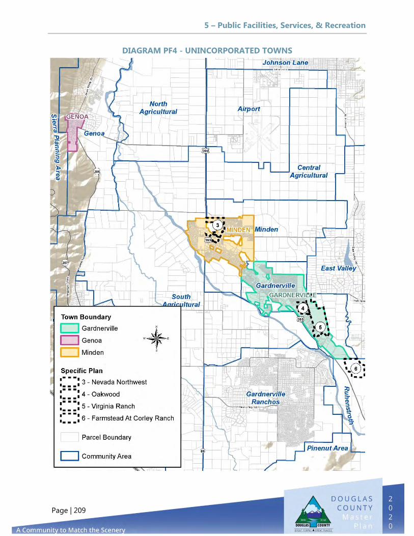
5 – Public Facilities, Services, & Recreation
Page | 209
DIAGRAM PF4 - UNINCORPORATED TOWNS

5 – Public Facilities, Services, & Recreation
Page | 210
WATER SERVICE AND RESOURCE MANAGEMENT
There are 39 public water systems in Douglas County: 26 in the Carson Valley and Topaz
Regions and 13 in the Tahoe Basin Region. Public water systems have at least 15
connections or serve an average of 25 people for at least 60 days per year. Water
systems are classified as either community systems, non-transient non-community, or
transient non-community.
Under the Douglas County Development Code, new development is exempt from
connecting to a public water supply if the area is not identified in the Master Plan as
anticipating connection to or construction of a water system. In areas where public
water supply is currently within 2,000 feet, developments must be approved with
conditions requiring installation of a water distribution system that connects to the
public water supply.
Douglas County’s Carson Valley Water Utility serves residential, commercial, and
industrial development in the Airport, Johnson Lane, and Genoa areas, the Clear Creek
development south of U.S. Highway 50, and developments along Foothill Road and the
Douglas County Fairgrounds east of U.S. Highway 395. The Gardnerville Water Company
serves the Town of Gardnerville, adjacent areas, and the Washoe Tribe Travel
Plaza/Casino south of Pinenut Road. The Town of Minden provides water to portions of
Douglas County, the Indian Hills GID, and Carson City (as a result of the inter-tie
project). The Gardnerville Ranchos GID provides residential and commercial water
service to residents and businesses south of the Towns and west of U.S. Highway 395,
with over 4,400 residential customers.
Table PF3 - Major Water Systems in Carson Valley
Carson Valley Water Utility
(Douglas County)
Gardnerville Water Co.
Gardnerville Ranchos
GID
Town of Minden
Indian Hills GID
Sierra Estates
GID Active Wells 14 7 7 9 3 2 Storage Tanks 14 2 2 1 5 1 Service Connections 3,429 2,400 4,479 1,600 1,810 67
Population Served 8,161 5,712 10,660 3,808 4,308 160
Source: NDEP, Drinking Water Branch, Water Systems Population was calculated by taking the number service connections multiplied by 2.38 people per connection.
The Topaz Ranch Estates (TRE) Water Utility serves residents that are part of the TRE
GID, located near Topaz Lake on Highway 208 in southern Douglas County,
approximately 17 miles south of Gardnerville.

5 – Public Facilities, Services, & Recreation
Page | 211
The Topaz Lake Water Company is a small system that serves 14 connections in
southern Douglas County outside of the GID.
Table PF4 - Major Water Systems in Topaz Region
Topaz Ranch Estates Topaz Lake Water Co. Active Wells 2 3 Storage Tanks 4 N/A Service Connections 748 14 Population Served 2,100 40
Source: NDEP, Drinking Water Branch, Water Systems
In the Tahoe Basin, Douglas County operates the Cave Rock, Skyland, Uppaway, and
Zephyr Water Systems. Other major water system providers include Edgewood Water
Company, Elks Point, Kingsbury GID, Logan Creek, and Round Hill. Most water systems
in the Tahoe Basin rely on Lake Tahoe intake systems instead of groundwater.
Table PF5 - Major Water Systems in Tahoe Basin Cave Rock
& Skyland Uppaway Zephyr Edgewood
Water Co. Elks Point
Kingsbury GID
Logan Creek
Round Hill
# Wells or Intake Intake 2 Intake Intak
e 2 Intake 1 Intake Tanks 6 3 1 2 3 8 1 5 Service Connections 546 35 465 21 88 2450 22 479 Population Served 1267 85 1209 3800 325 3839 60 1200 Source: NDEP, Drinking Water Branch, Water Systems Diagrams PF5–PF8 depict the service areas of public water systems in Douglas County.
Diagram PF6 depicts the existing service area of the Gardnerville Water Company and
the Expansion Area contained in the Water Company’s 2007 Master Plan. Almost the
entire existing service area is within the County’s urban service boundary, except for a
parcel adjacent to Stodick Park north of Toler Lane and the Washoe Tribe Travel Plaza
south of Pinenut Road.
Diagram PF7 depicts water purveyors in the Topaz Region. Besides the Topaz Ranch
Estates GID, there are smaller water systems located at Holbrook Junction and near
Topaz Lake.

5 – Public Facilities, Services, & Recreation
Page | 212
DIAGRAM PF5 - WATER SYSTEMS IN THE CARSON VALLEY

5 – Public Facilities, Services, & Recreation
Page | 213
DIAGRAM PF6 - WATER SYSTEMS IN GARDNERVILLE

5 – Public Facilities, Services, & Recreation
Page | 214
DIAGRAM PF7 - WATER SYSTEMS IN THE TOPAZ REGION

5 – Public Facilities, Services, & Recreation
Page | 215
DIAGRAM PF8 - WATER SYSTEMS IN THE TAHOE BASIN

5 – Public Facilities, Services, & Recreation
Page | 216
Figure PF1 - Carson Valley Water Use by Purveyor
0
1000
2000
3000
4000
5000
6000
7000
(AF)
Water YearGRGID IHGID GWCo. Minden Douglas Co. Carson City
Water Service Planning
The Town of Gardnerville, the Town of Minden, the Gardnerville Ranchos General
Improvement District and North Douglas County water services areas are projected to
experience the most population growth in the County over the next 10 years. The
capacity of public water systems in Douglas County to meet water demand for
residential, commercial, and industrial customers will depend on the following factors:
Future water levels for groundwater and surface water during drought periods
Water Conservation measures, including metering and potential state restrictions on
water use
Maintenance of existing infrastructure to meet high demand periods during the
summer days
Protection of wellheads from contamination
Need for backup systems, as required by the Nevada Administrative Code
The major challenges for water purveyors in the County include fixing old piping,
maintaining or replacing groundwater wells, carrying out water conservation measures,
meeting fire flow requirements, complying with Clean Water Act regulations (e.g.,

5 – Public Facilities, Services, & Recreation
Page | 217
reducing arsenic levels), and properly planning for future demand. Douglas County has
acquired older water systems in the Tahoe Basin and the Carson Valley that did not
meet Clean Water Act regulations and continues to spend funds on upgrading older
water systems. To meet federal arsenic standards in the Carson Valley, the County has
constructed the 24-inch inter-tie project and purchases wholesale water from the Town
of Minden.
Douglas County Consolidated Water Utilities
Over time, Douglas County has hired consultants to carry out preliminary engineering
reports (PERs) to identify deficiencies and provide recommendations and costs for
needed improvements to the County’s water systems in the valley and at the lake. In
2018, Douglas County combined the county-operated valley and lake systems into one
water utility, and in 2019 adopted a revised water rate structure to ensure that the
operational and maintenance needs of the combined systems were met. The
consolidation of the County systems and the revised rate structure will allow the County
to address the most critical and the critical capital improvement projects more quickly
and to spread the cost of these much-needed improvements across a larger base of
customers, mitigating the impact of proposed rate increases. Douglas County’s Capital
Improvement Program includes planning and funding for over $30 million in water
facility upgrades for the Douglas County Water Utility over the next 10 years. In 2019,
Douglas County worked with Manhard Consulting to update a portion of the 2009
North Douglas County Water System Analysis. This update included the North Douglas
County Specific Plan, which encompasses the revised land use areas and water system
layout of three future developments: Riverwood, Big George Ventures, and Valley Knolls.
The process is underway to complete, in June 2021, a Carson Valley Water Facilities
Master Plan that will include a current system evaluation and operations analysis to
assist the County with future operational and management decisions. The Plan will
evaluate the Carson Valley area of the Douglas County Water Utility, including East
Valley, North County, Clear Creek, West Valley (including Montana, Genoa, and
Walley’s), Foothill (including Sheridan Acres, Job’s Peak, and Sierra County Estates), and
the Fairgrounds.
The plan will provide the County with:
An overview of existing systems within the plan area, including current system size,
supply sources, distribution facilities, and storage components
A summary of surface and underground water rights that are either currently owned
by the County or potentially available in the administrative basin and that could
support the County

5 – Public Facilities, Services, & Recreation
Page | 218
A Capital Improvement Plan (CIP) defining key infrastructure necessary to provide
services within the plan area and/or interconnect existing utilities
A comprehensive planning document to guide future decisions related to managing
a reliable and sustainable water system
Town of Minden Water Utility
In 2017, the Town of Minden contracted with Sunrise Engineering to conduct a Water
System Analysis to assist the Town with planning the prudent management of the
Town’s water resources. In 2018, the Town amended its water system analysis to include
a future service area identified in the Town’s Plan for Prosperity. This future service area
included all 1,044 acres of the Park Ranch Holdings and extended to the south side of
the Minden-Tahoe Airport. As calculated, based on the average Minden residential use,
each residential unit would utilize 656 gallons of water, and 2,500 homes would use
approximately 1,250 gallons per minute or the equivalent of one new municipal well in
the Town.
Gardnerville Water Company
The Gardnerville Water Company (GWC) is a nonprofit company owned by the property
owners of Gardnerville. GWC is managed by a five-member board of directors, the
members of which are elected by the property owners. GWC has approximately 2,400
water service connections, including residential, commercial, and irrigation. GWC has its
own Master Plan, which is currently under contract with Resource Concepts, Inc. (to be
updated). The updated Master Plan will be available through the water company and
will include planned growth for the system and its future service area. GWC has
established reserves, which it will use to fund needed infrastructure improvements or
repairs within the system. The GWC Master Plan shows that the company has sufficient
water supply, water rights, infrastructure, and water quality to meet projected demand.
Gardnerville Ranchos General Improvement District Water Utility
The Gardnerville Ranchos General Improvement District (GRGID) projects water demand
at future potential service area build-out, including remaining receiving area, based on
anticipated land use of 4,400 additional residential dwelling units. The GRGID Board
advises in a Water System Status and Outlook 2020 report that the development of a
study/analysis of the Carson Valley watershed is essential to future growth and water
service planning for the GID. This analysis should include the impact of projected
development for the region on the availability of water resources in the Gardnerville
Ranchos. The GRGID outlook report outlines the following growth considerations for
GRGID:

5 – Public Facilities, Services, & Recreation
Page | 219
Accommodate future growth at 10-year and 20-year demand projections, additional
well(s), storage capacity, and additional water sources will have to be identified to
accommodate continued growth beyond the 20-year demand projections.
Future growth may require the construction of one or more arsenic treatment
facilities.
As future growth is planned, the water model should be updated to reflect actual
development densities, water demands, and connection points to determine the
need and timing for upgrades within the GRGID water system.
Future growth projects will be funded through a special assessment levied upon new
development within the district; this is currently set at $4,431 per Equivalent Dwelling
Unit (EDU) effective November 12, 2019 for newly created parcels. One EDU equals
one single family home.
WATER RESOURCE MANAGEMENT
In 2012, the U.S. Geological Survey (USGS) published Scientific Investigations Report
2012-52621: Assessing Potential Effects of Change in Water Use with a Numerical
Groundwater-Flow Model of the Carson Valley, Douglas County, Nevada, and Alpine
County, California. To gauge the impact of increased growth and development on the
aquifer, the USGS used a groundwater model to analyze four water-use scenarios
against a base water scenario (total water pumped in 2005) over 55 years. “The four
scenarios included: (1) total pumping rates increased by 70 percent, including an
additional 1,340 domestic wells, (2A) total pumping rates more than doubled with
municipal pumping increased by a factor of four, (2B) maximum pumping rates of 2A
with 2,040 fewer domestic wells, and (3) maximum pumping rates of 2A with 3,700 acres
removed from irrigation” (USGS Scientific Investigations Report 2012-5262, page 69).
According to the summary section of the report (page 69), the water model predicted
that increasing groundwater pumping to meet the maximum level of demand under the
most extreme of the four different scenarios “would result in 40–60 ft. of water table
decline on the west and east sides of the Carson Valley” and “would be offset primarily
by decreased flow in the Carson River by a loss of groundwater storage.” Under the
most extreme scenario input in the model, the total amount of municipal water pumped
would increase by four times over what it was in 2005 for all of Carson Valley, with 3,700
1 Yager, R.M., Maurer, D.K., and Mayers, C.J., 2012. Assessing potential effects of changes in water use with a numerical groundwater-flow model of Carson Valley, Douglas County, Nevada, and Alpine County, California: U.S. Geological Survey Scientific Investigations Report 2012–5262.

5 – Public Facilities, Services, & Recreation
Page | 220
acres removed from irrigation. The USGS
report also states that additional monitoring
of water levels is needed to verify the
accuracy of the water model. Recently,
members of the County Commission and
several Carson Valley water purveyors
expressed a desire to partner with USGS to
update this study and model. Developing a
complete understanding of the availability and quality of water in the Carson
Valley/Carson River Basin will be critical to protecting water resources for the future.
Water is a finite resource; collaborative management strategies are needed to ensure
that use does not exceed the amount of perennial yield in the basin. The Tahoe Basin
Region of Douglas County is under the jurisdiction of the Tahoe Regional Planning
Agency (TRPA), which was established in 1969 under the Bi-State Tahoe Regional
Planning Compact (Public Law 91-148) to control growth and development and protect
Lake Tahoe’s clarity and environment. The California-Nevada Interstate Compact
controls water supply for the Lake Tahoe Basin and allocates 11,000 acre-feet annually
to the State of Nevada. Water resources at the lake should continue to be
collaboratively managed by local governments, the existing water purveyors, TRPA, and
the Nevada State Division of Water Resources.
WASTEWATER SERVICES
Wastewater services in the Carson Valley region of Douglas County are provided by
three public wastewater systems and several private package systems. In the Lake Tahoe
Basin region of Douglas County, several GIDs and Sewer Improvement Districts (SIDs)
provide wastewater services. Under the current Douglas County Development Code,
property owners are not required to hook up to public wastewater systems if the
wastewater service area is not identified and are permitted to use individual sewage
disposal systems (ISDSs). For properties located within an anticipated public wastewater
service area but not within 2,000 feet of a sewer main, an ISDS may be utilized on an
interim basis. However, the property owner must make provisions for connections to the
system, including installation of sewer laterals and dry sewer lines within the project or
mandatory connection when located within 330 feet of an existing sewer line.
Carson Valley Region
The three public wastewater systems in the Carson Valley are (1) the Douglas County
North Valley Wastewater Treatment Service Area (NVWTSA), (2) the Minden-Gardnerville
Sanitation District (MGSD), and (3) Indian Hills GID (IHGID).

5 – Public Facilities, Services, & Recreation
Page | 221
Table PF6 - Wastewater Service Providers in the Carson Valley
Douglas County North Valley MGSD Indian Hills
GID Current Treatment (MGD) 0.30 1.5 to 1.6 0.30
Treatment Capacity 0.68 2.8 0.60
Number of Equivalent Dwelling Units (EDUs) 2,599 7,513 N/A
Source: 2015 CH2M Hill Technical Memos on North Valley Wastewater Treatment Plant (NVWTP), MGSD Interview, MGSD Master Plan (2012). Treatment and capacity are noted in millions of gallons per day (MGD).
North Valley Wastewater Treatment Service Area
The NVWTSA currently encompasses the regions of East Valley/Johnson Lane, North
County, Airport, Walley’s, Genoa, Genoa Lakes, and Canyon Creek/Montana. The North
Valley Wastewater Treatment Plant recently completed a facility upgrade to double the
treatment capacity to 680,000 gallons per day (0.68 MGD). With this facility expansion,
the NVWTP has the capacity to treat an additional 3500 EDUs.
Minden Gardnerville Sanitation District
The MGSD Wastewater Treatment Facility is located in Minden and serves the Towns of
Minden and Gardnerville. By contract, they also service the Gardnerville Ranchos area, as
well as other developments such as the Bently Science Park and the Washoe Tribe,
which are not located within the annexed area of the district but are within the district
service area. The secondary treated effluent is stored in 600 acre-foot reservoirs located
on Muller Lane. Effluent disposal is by irrigation on approximately 2,000 acres of land at
the Gallepi Ranch (formerly Dangberg Ranch) and Bently property, which are located
north of the treatment facility. MGSD is currently treating approximately 1.5 to 1.6 MGD
with a treatment capacity of 2.8 MGD. The MGSD facility has the capacity to treat an
additional 10,000 EDUs.
Indian Hills General Improvement District
The IHGID Wastewater Treatment Facility is located in the southern portion of the
district and serves the Indian Hills/Jacks Valley community and portions of the Genoa
community. Effluent is stored in a series of storage ponds, and disposal is on the
Sunridge Golf Course located east of Highway 395. The IHGID is currently treating
300,000 gallons per day (0.3 MGD) and has a treatment capacity of 600,000 gallons per
day.

5 – Public Facilities, Services, & Recreation
Page | 222
Topaz Region
The Topaz Lodge in the Topaz Lake Community Plan is served by the Topaz Lodge
Wastewater Treatment System, a package treatment plant with a secondary treatment
process, extended aeration, and filtration and chlorination. Effluent disposal is through a
leach field. The rated capacity of the treatment plant is 0.025 MGD, which can be
reached on a busy weekend day, according to the Topaz Lake Area Water & Wastewater
Master Plan. This facility serves only the Topaz Lodge; all other uses in the Topaz Region
are served by individual sewage disposal systems.
Tahoe Basin Region
In the Lake Tahoe Basin Region of Douglas County, there are five public wastewater
systems: (1) Douglas County Lake Tahoe Sewer Authority (formerly DCSID), which
provides service to its own service area as well as four additional separate Districts, (2)
Kingsbury GID, (3) Elk Point Sanitation District, (4) Tahoe Douglas Sewer Improvement
District, and (5) Round Hill GID. The Douglas County Lake Tahoe Sewer Authority has a
rated treatment capacity of 3.75 MGD. After treatment at their facility, the reclaimed
effluent is pumped out of the Lake Tahoe Basin to the east side of the Carson Valley,
where it can be used for agricultural irrigation purposes.
1. Douglas County Lake Tahoe Sewer Authority
The Douglas County Lake Tahoe Sewer Authority serves five separate Districts: KGID,
RHGID, Elk Point Sanitation District, Tahoe-Douglas District, and its own service area.
The facility has a rate capacity of 3.75MGD. After treatment, the reclaimed wastewater is
pumped out of the Lake Tahoe Basin to the Carson Valley, to either the Park Cattle
Company Land Application Site or Bently Reservoir. Effluent is stored at the Bently
Reservoir until it is used to irrigate seasonal crops (alfalfa) at the Bently Agro-dynamics
Land Application Site. The Buckeye Creek effluent storage reservoir is currently off-line.
2. Kingsbury General Improvement District (KGID)
KGID, a Tahoe-based system, collects wastewater from the portion of the Summit Village
and Tahoe Village areas, which extend into the Sierra Regional Plan. KGID contracts with
DCSID (not affiliated with Douglas County) for sewer treatment and disposal services.
Diagrams PF9–PF11 display the service areas for different wastewater providers.
Diagram PF10 displays the MGSD service boundary and the current district boundary. It
should be noted that district boundary does not reflect areas where MGSD provides
contracted services.

5 – Public Facilities, Services, & Recreation
Page | 223
3. Elk Point Sanitation District
The Elk Point Sanitation District, established in 1969 per NRS 318, funds operations
furnishing sanitary sewer facilities within the Elk Point area.
4. Tahoe Douglas Sewer Improvement District (TDSID)
TDSID, established in 1969, per NRS 318, is a sewer collection district on the east shore
of Lake Tahoe. The District maintains 19 pump stations and 40 miles of sewer line.
5. Round Hill General Improvement District (RHGID)
RHGID, a Tahoe-based system, collects wastewater from the area in the Round Hill
Community Plan. RHGID contracts with the Douglas County Lake Tahoe Sewer Authority
(not affiliated with Douglas County) for sewer treatment and disposal services.

5 – Public Facilities, Services, & Recreation
Page | 224
DIAGRAM PF9 - WASTEWATER SERVICE AREA IN THE CARSON VALLEY REGION

5 – Public Facilities, Services, & Recreation
Page | 225
DIAGRAM PF10 - WASTEWATER SERVICE AREA, MINDEN-GARDNERVILLE
SANITATION DISTRICT

5 – Public Facilities, Services, & Recreation
Page | 226
DIAGRAM PF11 - WASTEWATER SERVICE IN THE TAHOE BASIN REGION

5 – Public Facilities, Services, & Recreation
Page | 227
INDIVIDUAL DISPOSAL SYSTEMS
There are approximately 5,960 parcels in Douglas County that contain septic systems,
which are primarily concentrated in the Johnson Lane, Ruhenstroth, and East Valley
communities.
In recent technical memos on the North Valley Wastewater Treatment Plant, engineering
consultants CH2M Hill stated there were 421 parcels located within 330 feet of sewer
lines and another 1,048 parcels in the Johnson Lane community that are more than 330
feet from the nearest sewer line. County code requires those parcels within 330 feet to
hook up to sewer services, thereby reducing septic tank concentrations while also
increasing flows to the County’s wastewater treatment plant.
PUBLIC WASTEWATER SYSTEM DEFICIENCIES
The recent Douglas County’s North Valley Wastewater Treatment Plant expansion cost
approximately $12 million. Funding for this project was provided by Redevelopment
Agency funding, State Revolving Funds (SRF), CIP funds, and CDBG funds.
Wastewater system upgrades have been carried out for the Indian Hills GID, as shown in
Table PF7 below. The USDA Rural Development Program provided a loan of $1.5 million
for sludge dewatering. The Pine View Estates south of Ruhenstroth has also obtained
assistance from the USDA Rural Development program to evaluate the septic problems
within this subdivision.
Table PF7 - USDA Rural Development Community Program Loans and Grants for Wastewater
Recipient Project Project
Description Fiscal Year
Date Obligated
USDA Loan Amount
USDA Grant Amount
Indian Hills GID Sludge Dewatering
Sludge Dewatering FY11 8/1/11 $1,512,000
Pine View Estates H.O.A.
SEARCH Grant
PER/ER for wastewater FY15 5/19/15 $30,000
Total $1,512,000 $30,000 Source: USDA RD Community Program

5 – Public Facilities, Services, & Recreation
Page | 228
DIAGRAM PF12 - SEPTIC SYSTEMS IN THE JOHNSON LANE COMMUNITY PLAN

5 – Public Facilities, Services, & Recreation
Page | 229
SOLID WASTE
Douglas County is required to submit a solid waste management plan to NDEP every
five years, pursuant to NAC section 444.658. The current Solid Waste Management Plan
for the County was approved by NDEP on April 9, 2014. A 2020 update to the plan is in
process, pending NDEP review. A voter-initiated ballot measure that restricts mandatory
garbage service for County residents was passed in the 1994 general election, but it
allows residents to request garbage pick-up services on a voluntary subscription basis.
The only mandatory trash service is in the Towns of Gardnerville and Minden. Douglas
Disposal has the current franchise agreement with Douglas County. Solid waste is
transported either to the Douglas County Transfer Station or the South Tahoe Refuse
Transfer Station. Waste is consolidated at the Transfer Stations and then transported to
the Lockwood Sanitary Landfill in Storey County or to the Carson City Landfill. Douglas
County’s only landfill closed in 1993. The design capacity of the Douglas County
Transfer Station is 112.5 tons per day. According to the 2014 Solid Waste Management
Plan, the current usage at the Douglas County Transfer Station is 69.3 tons per day.
Recycling
Per NRS 444A, only six counties in Nevada are currently required
to provide recycling and hazardous waste disposal programs.
Counties with populations greater than 100,000 (Clark and
Washoe Counties) are required to provide curbside recycling.
Counties with populations between 45,000 and 100,000 are
required to provide recycling and hazardous waste centers but are
not required to provide curbside recycling. Carson City and the
City of Elko do provide curbside recycling to their residents, even
though both communities are below the 100,000-population
threshold.
The only curbside recycling in Douglas County is in the Tahoe Basin with the Blue Bag
single-stream recycling program. Douglas Disposal provides numerous recycling
programs in the Carson Valley, ranging from direct drop-off at the Douglas County
Transfer Station to community-based recycling centers at area elementary schools and
other Town and GID locations, but there is no curbside recycling program.
Table PF8 compares recycling rates for Nevada, Carson City, Douglas County, and
Washoe County. The recycling rate is based on the ratio of municipal solid waste (MSW)
that is recycled to the tons of total MSW generated (which includes recycled MSW). The
State of Nevada’s recycling goal is 25 percent, and Douglas County has consistently

5 – Public Facilities, Services, & Recreation
Page | 230
exceeded this rate, averaging 55.3 percent from 2013 through 2017. By comparison, the
State of Nevada’s recycling rate averaged 23.1% for that same time period.
Table PF8 - Recycling Rates for Nevada, Douglas County, and Adjacent Counties County 2014 2015 2016 2017
Douglas County 55.5% 62.3% 49.6% 51.6%
Carson City 29.2% 28.5% 29.0% 26.7%
Washoe County 33.5% 31.4% 29.5% 24.6%
State of Nevada 23.8% 20.8% 20.7% 21.0% Source: 2019 Recycling and Waste Reduction Report, Nevada Division of Environmental Protection
The County’s high recycling rate is likely the result of two programs: (1) the Blue Bag
program in the Tahoe Basin, and (2) the composting and biofuel programs operated by
private businesses, such as Bently Ranch and Full Circle Compost. Douglas Disposal
commenced a six-month pilot curbside recycling program in February 2017 for 140
customers in Gardnerville Ranchos. This was a single-stream pilot recycling program.
The Town of Gardnerville also commenced a curbside pilot recycling program in 2017,
which served 180 customers. Single-stream recycling, which allows residents to place all
recyclables into one container, as opposed to sorting paper, glass, and cans into
different containers, has been shown to increase the recycling rate.
ABOVEGROUND UTILITY PLAN
In 2013, several sections of the planning enabling sections of the NRS were amended to
require counties to add aboveground utility plans (NRS 278.165) to the Public Facilities,
Services, and Recreation Element; this Element was amended in March 2015 to
incorporate such a plan.
In compliance with the NRS, the County adopted, by reference, the BLM Utility Corridors
identified in the Carson Field Office Consolidated Resource Management Plan (2001)
and subsequent amendments. Additional corridors may be adopted through the
County’s Master Plan Amendment process, as requested. Diagram PF13 depicts the
location of utility corridors in the 2001 BLM Carson City District Resource Management
Plan. One utility corridor is depicted in the Topaz Region near the Walker River, and a
second corridor is located in the northeast corner of the County.

5 – Public Facilities, Services, & Recreation
Page | 231
DIAGRAM PF13 - UTILITY CORRIDORS

5 – Public Facilities, Services, & Recreation
Page | 232
GENERAL GOVERNMENT SERVICES
Douglas County owns and operates a number of facilities to provide government
services to residents in and around the County. These facilities house over 20
departments, including several with multiple divisions. However, with a county-wide
population approaching 50,000 residents, operations in many departments have
exceeded capacity at multiple locations, requiring some divisions to be split between
multiple buildings. Functions such as assessments, recording, records management,
elections, planning, permitting, code enforcement, public works, courts, public safety,
emergency communications, internal service departments (information technology,
finance, and human resources), and similar activities all require additional space. The
County has conducted two space needs assessments to determine the existing capacity,
useful life, technology requirements, and accessibility of County facilities.
Douglas County Law Enforcement
Judicial Law Enforcement Center (JLEC)
Source: Douglas County Justice & Law Enforcement Center 2020 Analysis for Renovation and Expansion, prepared by TSK Architects for Douglas County, June 2020.

5 – Public Facilities, Services, & Recreation
Page | 233
The existing Douglas County JLEC was constructed in 1980 when the county population
was approximately 19,400 residents. The building is two stories, with concrete masonry
exterior and metal framed interior partitions. The original facility included a large open
lobby area, three sizable waiting areas, a two-story sky lit atrium, and an exercise area. In
response to expanding needs, all of these areas have been converted to security
functions and department offices.
The first floor is dedicated to the Sheriff's operations and includes the County Jail, which
was expanded in 2011 and solidified the building as the primary jail location. The second
floor of the facility houses two district courtrooms and one East Fork justice courtroom,
the District Attorney’s office, Constable’s office, court administration, court computer,
Justice and District Court Clerks’ offices, and juvenile probation. The law library and the
Court Appointed Special Advocates (CASA) and Special Advocates for Elderly (SAFE)
offices are also on this floor.
When it opened in 1982, the facility was planned to meet the justice and law
enforcement needs of Douglas County for 20 years. Now, some 33 years later, with a
county-wide population approaching 50,000 residents, building operations are showing
signs of pressure. As the population has grown, so have the needs of the center. The
facility has significant, immediate deficiencies in security, overcrowding, and
accessibility. These issues, which reflect increased population and caseloads, prevent the
current users and staff from operating in a safe and efficient manner.
The JLEC assessment examines the need for additional courtrooms, staff, and net square
feet based on different population projections. The assessment reviewed programming
and site concepts for additional expansion. The following represents the immediate
deficiencies of all agencies in the JLEC building:
The District Attorney's office has inadequate office space on site for its support and
professional staff and inadequate conference areas for conferences, meetings,
witness preparation, and victim support and preparation.
There is no secure access to the facility for judicial officers.
There is no separation for victims and perpetrators of criminal offenses. There are no
private meeting spaces for attorneys and clients. The courtrooms, hallways, and
clerk's offices are overcrowded.
The Sheriff's office has inadequate space for the patrol, administration, records, and
investigations divisions. The street enforcement team is off-site. The investigations
division does not have adequate working space or interview facilities.

5 – Public Facilities, Services, & Recreation
Page | 234
The alternative sentencing department does not have a secure waiting area,
adequate space, or adequate separation between offices and laboratory facilities.
Building security has a design bottleneck at the entrance to the facility.
The Constable's office has minimal, inadequate office space.
An additional courtroom and space for associated support staff is needed. This
facility would provide room for an additional Justice of the Peace or for support
staffing by the Tahoe Justice of the Peace. It would also provide space for specialty
courts, child support enforcement, and other quasi-judicial and administrative
proceedings.
Projected needs are included in the analysis for deliberate and efficient capital
improvements planning.
The County has taken some steps to mitigate some of these concerns. The County
leases a building across the street from the JLEC facility for the majority of the civil
division of the District Attorney’s office; this lease frees up space within existing offices
for the District Attorney to expand into a bigger area. In addition, the County has
contracted with TSK Architects to develop design options to renovate and expand the
existing facility or to construct a new facility on a site to be determined. The 2017
preliminary cost estimate of the first design to renovate and expand the existing facility
(the current option contemplated by the County) is in excess of $30 million.
Douglas County Public Works
Douglas County Public Works (DCPW) offices and main facilities are located on the
northern end of the shared Douglas County Service Yard adjacent to the Minden-Tahoe
Airport. The DCPW main office is located in Minden at 1120 Airport Rd., Building F-2.
DCPW also maintains satellite facilities throughout the county, including a separate
facilities maintenance workshop, satellite facilities at utility pumping stations, and sewer
treatment facilities.
The assessment for DCPW analyzed existing space needs and projected needs based on
increases in population over time. A conceptual cost estimate for the proposed
improvements is $15.5 million.

5 – Public Facilities, Services, & Recreation
Page | 235
Source: Douglas County Public Works Facilities Master Plan, March 2019, prepared by TSK Architects.
DCPW divisions are assigned a range of facilities and assets on this site, including:
1. Administration/Engineering - Building F-2
2. Fleet Maintenance - Building H-2
3. Exterior and Conex Storage
4. Transportation Engineering Yard
5. Roads/Utility Services Shops

5 – Public Facilities, Services, & Recreation
Page | 236
DIAGRAM PF14 - DOUGLAS COUNTY FACILITIES

5 – Public Facilities, Services, & Recreation
Page | 237
DOUGLAS COUNTY SCHOOL DISTRICT
Enrollment for the 2019–2020 school year for Douglas County School District was just
over 6,000 students. The District’s total student enrollment has continued to decline for
several years. Figure PF1 displays the enrollment figures, starting with the 2010–2011
school year. Total enrollment was 6,336 in the 2010–2011 school year but decreased to
5,786 students in the 2019–2020 school year. Total enrollment was 7,035 in the 2005–
2006 school year.
Figure PF2 - Douglas County Student Enrollment (2010–2020)
SoSource: State of Nevada Department of Education
According to a letter from the School District dated June 20, 2020, there is theoretical
excess capacity in each elementary, middle, and high school in Douglas County. The
ability to serve additional students resulting from growth would depend on the location
of future development. The School District indicates it may need to rezone existing
school boundaries to accommodate increased demand. A review of student capacity
numbers provided by the School District Business Office indicates there is enough
capacity to serve 1,733 additional students.
Table PF9 provides information on the estimated capacity for each school along with the
actual student enrollment for the 2019–2020 school year.

5 – Public Facilities, Services, & Recreation
Page | 238
Table PF9 - School Capacity vs. Actual Enrollment
School Estimated Capacity
2019–2020 Enrollment
Excess Capacity Utilization %
Elementary School CC Meneley Elementary 563 474 89 84% Gardnerville Elementary 570 387 183 68% Jacks Valley Elementary 563 441 122 78%
Minden Elementary 468 417 51 89% Piñon Hills Elementary 689 290 399 42%
Scarselli Elementary 594 397 197 67% Zephyr Cove Elementary 253 148 105 58%
Middle School Carson Valley Middle 802 717 85 89%
Pa Wa Lu Middle 782 561 221 72% High School
Aspire Academy 100 86 14 86% Douglas High School 1920 1677 243 87%
George Whittell 354 144 210 41% Total 7,658 5,739* 1,919 75% Source: Nevada Report Card, October 2020 * Note: Nevada Report Card and State of Nevada Department of Education have slightly different numbers for enrollment. Table PF10 contains an analysis of the number of students enrolled by residential unit in
each school zone boundary. Monitoring enrollment by unit in each zone will help the
County project anticipated enrollment numbers in certain areas that are anticipated to
be impacted by growth in the coming years.
Table PF10 - School Enrollment by Residential Unit
School Residential Units
2019–2020 Enrollment
Enrollment per unit
Elementary School CC Meneley Elementary 3,293 474 0.14 Gardnerville Elementary 3,033 387 0.13 Jacks Valley Elementary 3,318 441 0.13
Minden Elementary 3,282 417 0.13 Piñon Hills Elementary 2,811 290 0.10
Scarselli Elementary 3,282 397 0.12 Zephyr Cove Elementary 5,554 148 0.03
Middle School Carson Valley Middle 11,515 717 0.06
Pa Wa Lu Middle 8,096 561 0.07 High School
Aspire Academy 0 86 N/A Douglas High School 19,610 1677 0.09
George Whittell 5,554 144 0.03

5 – Public Facilities, Services, & Recreation
Page | 239
DIAGRAM PF15 - RESIDENTIAL COUNT BY ELEMENTARY SCHOOL

5 – Public Facilities, Services, & Recreation
Page | 240
DIAGRAM PF16 - RESIDENTIAL COUNT BY MIDDLE SCHOOL

5 – Public Facilities, Services, & Recreation
Page | 241
DIAGRAM PF17 - RESIDENTIAL COUNT BY HIGH SCHOOL

5 – Public Facilities, Services, & Recreation
Page | 242
DOUGLAS COUNTY PUBLIC LIBRARY
The Douglas County Public Library system consists of the main library in Minden, the
Lake Tahoe Branch Library in Zephyr Cove, a bookmobile (mobile library), a satellite
library at China Spring Youth Camp and Aurora Pines Girls Facility, which includes
dormitory and classroom collections, and a small reading library at the Lake Tahoe
Juvenile Detention Facility.
The mission of the Douglas County Public Library is to provide a wide range of library
materials, services, and programs to meet the informational, recreational, and cultural
needs of the citizens of Douglas County.
The Library offers an extensive range of services, materials, programs, and technology at
both public facilities, including reference and referral in person, by telephone, and by
email to assist residents in accessing information. The Library offers programs for
children, teens, families, and seniors; delivery of materials to homebound patrons;
borrowing of materials not available locally; display space for community interests, art,
and exhibits; and orientation sessions for students and other youth groups. It also offers
a variety of electronic databases accessible from the library, school, home, or work;
downloadable eBooks, eAudiobooks, magazines, music, and movies; public-use
typewriters and computers; wireless internet connectivity and wireless printing;
individual instruction in technology resources and mobile technology; free test
proctoring for distance learners; and technology for patrons with visual disabilities.
The Douglas County Public Library developed a long-range plan to maintain quality
services, value, and convenience for patrons, which will be implemented over the next
10 years. The long-range plan guides the Library in achieving objectives and action
plans and is designed to identify achievable goals with a commitment to meeting the
needs of the residents of Douglas County.
Table PF11 - Library Visits (FY 2013 to FY 2019)
Year No. of Visits 2012–13 148,834 2013–14 153,699 2014–15 120,192 2015–16 117,677 2016–17 113,119 2017–18 110,749 2018–19 116,490

5 – Public Facilities, Services, & Recreation
Page | 243
Table PF12 – Registered Library Users
Fiscal Year 12–13 13–14 14–15 15–16 16–17 17–18 18–19
Total Number 37,112 38,286 35,216 32,652 32,050 31,173 29,999
Percentage of County Population 77.3% 79.9% 72.5% 67.7% 66.4% 64.5% 62.1%
The Douglas County Public Library budget is approximately $1,500,000 per year for
operating expenses and $500,000 for services and supplies. Funding for the Library
comes from a percentage of sales tax set by resolution of the Commission and general
fund revenue. The Library Board of Trustees prepares and submits the annual budget to
the County for final consideration and approval.
Specific library facility needs are:
An expansion for the Minden Library of approximately 2,500 square feet to be used
primarily for collection shelving and a shipping and receiving area, as identified in
the 5-year Capital Improvement Plan
Seating capacity of 196 or 4.1 seats for every 1,000 people served
Increased public computer access, utilizing both desktop and laptop technology, to
provide 72 workstations or 1.5 computers for every 1,000 people served
Enhanced public programming space, including a large meeting room dividable into
two or three separate spaces with seating capacity for 300, adequate storage, and
current Audio Visual (AV) projection technology
A computer lab to offer hands-on technology training
A Teen Zone to provide space specifically for teenagers
Two enclosed group study rooms for students, tutoring and similar uses
Shelving to accommodate an increase in the physical collection of books and AV
media with a total collection size of 190,000, excluding digital collections
Increased incorporation of self-service technologies for improved staff productivity
Increased volunteer and staff workspace and storage space

5 – Public Facilities, Services, & Recreation
Page | 244
DIAGRAM PF18 - SCHOOL & LIBRARY FACILITIES IN NORTH COUNTY

5 – Public Facilities, Services, & Recreation
Page | 245
DIAGRAM PF19 - SCHOOL & LIBRARY FACILITIES IN THE CARSON VALLEY

5 – Public Facilities, Services, & Recreation
Page | 246
DIAGRAM PF20 - SCHOOL & LIBRARY FACILITIES IN THE PINENUT & TOPAZ
REGIONS

5 – Public Facilities, Services, & Recreation
Page | 247
DIAGRAM PF21 - SCHOOL & LIBRARY FACILITIES IN THE TAHOE BASIN REGION

5 – Public Facilities, Services, & Recreation
Page | 248
DOUGLAS COUNTY TRANSPORTATION MASTER PLAN
The Douglas County Transportation Master Plan (TMP)
adopted in 2019 establishes a blueprint to address current
and planned transportation challenges in the County
through the year 2040. The TMP also identifies a range of
policies and strategies to guide decision-making around
eight transportation elements that make up the chapters of
the TMP. The overarching goals of the TMP are:
Provide and maintain an integrated transportation
system for the safe, efficient movement of people and
goods throughout Douglas County.
Provide appropriate transportation facilities to ensure a
high quality of life for Douglas County residents.
The Bicycle/Pedestrian/Trails Element of the TMP is comprised of two separate
documents that are incorporated by reference: the Douglas County Comprehensive
Trails Plan and the Douglas County Bicycle Plan. These documents identify bicycle and
pedestrian facilities throughout the county, with the Douglas County Bicycle Plan
supplementing the information contained in the Douglas County Comprehensive Trails
Plan.
A copy of the Transportation Master Plan can be found on the County’s website at
www.douglascountynv.gov.
TMP Elements:
Historic and Projected
Growth
Travel Demand Modeling
Streets and Highways
Public Transportation
Bicycle/Pedestrian/Trails
Airport
Financial
Lake Tahoe

5 – Public Facilities, Services, & Recreation
Page | 249
PARKS AND RECREATION IN
DOUGLAS COUNTY
Douglas County contains significant
open space, parks, and recreation
resources, including almost 250,000
acres of federal public lands
managed by the U.S. Forest Service
and the Bureau of Land
Management. There are multiple
social, environmental, and
economic benefits associated with
the development of parks and
recreation as well as many
challenges in meeting different and
sometimes conflicting interests
between recreation stakeholders (e.g., equestrians vs. bicyclists). The County is fortunate
to have a voter-approved one-quarter cent sales tax and dedicated Lodgers License Tax
to support the operation and maintenance of the County’s Park and Recreation
Facilities. Because this funding is not tied to property tax, it does not increase
proportionally with population increases.
Parks and Recreation Inventory
The parks and recreation inventory in the County includes regional, neighborhood, and
special facilities located in all areas. Tables PF13–PF15 show there are 1,655.05 acres of
regional parks, 519.05 acres of neighborhood parks, and 97.06 acres of special facilities.
Figure 3 does not include private recreation facilities, such as golf courses. Regional
parks in Douglas County
include Topaz Lake
Regional Park, Van-Sickle
Bi-State Park in Stateline,
and Spooner Lake (Lake
Tahoe State Park) in
Glenbrook. River Fork
Ranch in Genoa, which is
owned by The Nature
Conservancy, can also be
considered a regional
park. River Fork Ranch
contains 805 acres and
Figure PF3: Park Acreage in Douglas County by Type

5 – Public Facilities, Services, & Recreation
Page | 250
includes public trails adjacent to the west fork of the Carson River.
Table PF13 - Regional Parks in Douglas County Name of Facility Acreage Owner Status
Cave Rock 3.21 State of Nevada Developed Nevada Beach 57.45 U.S. Forest Service Developed Round Hill Pines Resort 124.88 U.S. Forest Service Developed River Fork Ranch 805.00 The Nature Conservancy Developed Spooner Lake 478.51 State of Nevada Developed Topaz Lake Regional Park 164.60 Douglas County Partially Developed Zephyr Cove Beach/Resort 16.78 U.S. Forest Service Developed Van-Sickle Bi-State Park 4.62 State of Nevada Developed Total 1,655.05
Table PF14 - Neighborhood/Community Parks in Douglas County
Name of Facility Acreage Owner Status Arbor Gardens Park 1.11 Town of Gardnerville Developed Blue Rock Park 1.56 Gardnerville Ranchos Developed Brautovich Park 4.60 Douglas County Developed Circle Park 1.08 Town of Gardnerville Developed Community Park 1.04 Town of Minden Developed Dresslerville Park 3.00 HOA Developed Genoa Town Park 1.04 Town of Genoa Developed Genoa Lane River Park (Willow Bend Park) 5.79 Douglas County Undeveloped/Received Q1
Funds Herbig Park 20.06 Douglas County Developed Heritage Park 3.95 Town of Gardnerville Developed James Lee Park 74.40 Indian Hills GID Developed Johnson Lane Park 74.24 Douglas County Partially Developed Kahle Park 17.53 Douglas County Developed Lampe Park 37.99 Douglas County Developed Minden Town Park 1.29 Town of Minden Developed Robert Spellberg Recreation Complex 20.76 Gardnerville Ranchos GID Developed
Multi-Use Park 14.00 Douglas County Developed Rocky Bend Park 7.33 Douglas County Undeveloped Ranchos Aspen Park 20.03 Douglas County Developed Ranchos Birch Park 17.39 Gardnerville Ranchos GID Undeveloped Ranchos Conifer Park 11.55 Douglas County Undeveloped River Bend Park 3.68 Douglas County Undeveloped/Received Q1
Funds Saratoga Springs Park 13.10 HOA Partially Developed School Site Park 2.39 Douglas County Developed Seeman Ranch 31.21 Douglas County Undeveloped Stodick Park 15.00 Douglas County Developed Sunridge North Park 2.35 Indian Hills GID Developed Sunridge South Park 2.62 Indian Hills GID Developed Jake’s Wetland Park 7.45 Town of Minden Developed Topaz Ranch Estates Park 9.25 Douglas County Developed Westwood Village 2.30 Town of Minden Developed Wildhorse Park 3.04 HOA Developed

5 – Public Facilities, Services, & Recreation
Page | 251
Table PF14 - Neighborhood/Community Parks in Douglas County
Name of Facility Acreage Owner Status Valley Vista Park 3.76 Indian Hills GID Developed Zephyr Cove Park 83.16 Douglas County Developed TOTAL 519.05
There are currently 519.05 acres of neighborhood and community parks in Douglas
County. Almost all of the parks listed in Table PF14 are fully developed. As shown in
Table PF15, there are 97.06 acres of several special use facilities in Douglas County,
including the Carson Valley Swim Center, Dangberg Home Ranch Historic Park, and
Mormon Station.
Table PF15 - Special Use Facilities in Douglas County
Name of Facility Acreage Owner Status Bently Science Park 2.22 Bently Family Developed Carson Valley Swim Center 3.23 East Fork Swim District Developed Dangberg Home Ranch Historic Park 5.50 Douglas County Developed
High School Tennis 2.00 Douglas County Developed Fairgrounds 35.40 Douglas County Developed Model Airplane Park 3.98 Douglas County Developed Mormon Station 2.38 State of Nevada Developed Shooting Range 39.35 Douglas County Developed Skate Park 3.00 Douglas County Developed Total 97.06
The new Douglas County Community and Senior Center opened in December 2014. This
83,000-square foot facility has almost 1,000 visitors per day (as of September 2015),
1,854 total memberships, and 1,251 active annual memberships. The new senior center
offers meals and activities and an adult day club to provide respite for caregivers.
Diagrams PF22–PF26 depict the locations of regional parks, neighborhood parks, and
special facilities in Douglas County.

5 – Public Facilities, Services, & Recreation
Page | 252
Table PF16 - Community Centers
Name of Facility Size (Square Feet) Owner Activities
Kahle Community Center 22,423 Douglas County Gymnasium Kids Club Recreation Classes Sports Leagues
Community Center and Senior Center 83,000 Douglas County
Gymnasium Recreation Classes Sport Leagues Adult Day Club
Tahoe Senior Center 2,178 Douglas County Volunteer Activities
Topaz Ranch Estates 3,603
Douglas County Congregate Meals Neighborhood Activities
Total 111,204
Douglas County Community & Senior Center

5 – Public Facilities, Services, & Recreation
Page | 253
DIAGRAM PF22 - PARKS IN NORTH DOUGLAS COUNTY

5 – Public Facilities, Services, & Recreation
Page | 254
DIAGRAM PF23 - PARKS IN CENTRAL DOUGLAS COUNTY

5 – Public Facilities, Services, & Recreation
Page | 255
DIAGRAM PF24 - PARKS IN SOUTH DOUGLAS COUNTY

5 – Public Facilities, Services, & Recreation
Page | 256
DIAGRAM PF25 - PARKS IN TOPAZ RANCH ESTATES/TOPAZ LAKE

5 – Public Facilities, Services, & Recreation
Page | 257
DIAGRAM PF26 - PARKS IN THE TAHOE BASIN

5 – Public Facilities, Services, & Recreation
Page | 258
LOOKING TO THE FUTURE
Public Facility Service Areas Vs. Urban Service Boundary
As shown on the water and wastewater maps included in this Element, the location of
the Master Plan Urban Service Boundary does not always coincide with the service area
for different water and wastewater providers. The North Valley Wastewater Treatment
Area, for example, covers the Clear Creek development and subdivisions north of the
Town of Genoa, which are not included within the Urban Service Boundary.
There is an urban service boundary for the Airport Community Plan, which is within the
North Valley Wastewater Treatment Area, but none of Johnson Lane is included within
the urban service area, despite dense residential development and the need to
encourage property owners to hook up to the North Valley Treatment Plant.
Septic Systems and Groundwater Contamination
In the past, the County has established assessment districts to convert septic systems to
community wastewater systems. It may be time to explore setting up new assessment
districts for areas with septic tank concentrations that can be served by either Douglas
County or MGSD. The overconcentration of septic systems in Johnson Lane and
Ruhenstroth contribute to nitrate concentration that can harm groundwater.
Water Service and Conservation
In 2019, the Nevada State Legislature adopted Senate Bill 150 (NRS Chapter 278.0228)
requiring “the governing body of a county or city to develop and maintain a water
resource plan.” This plan must include the identification of all known sources of water,
groundwater, and effluent for use within the community, an analysis of water demand
and projected demand caused by anticipated growth, and an analysis of whether the
sources of water in the community are “of sufficient quality and quantity to satisfy the
existing and expected demands.” If the analysis determines there is not sufficient water
of quality or quantity, then the County is required to come up with a plan for obtaining
it. The plan is required to be completed by 2029; once complete, it must be updated
every 10 years. To meet this requirement, the County will need to continue to
coordinate with water purveyors in the community to evaluate water quantity and
quality issues and develop regional planning approaches to water resources and
conservation.
Each of the water purveyors in the County have developed separate water conservation
plans. In 2008, Douglas County adopted a Douglas County Utilities Water Conservation
Plan, pursuant to NRS Chapter 540, Planning and Development of Water Resources. This

5 – Public Facilities, Services, & Recreation
Page | 259
plan was drafted “based on the living and service area” for Douglas County Utilities in
accordance with the provisions of NRS 540.141. The Plan is required to be updated
every five years. Water conservation for the region will be an important element of the
water resource plan and should also be addressed in coordination with each of the
purveyors in the County.
Financing for Public Facilities
Although the Douglas County Development Code includes provisions regarding impact
fees, the County has not established any impact fees to provide for public facilities.
Under NRS 278B, these fees may only be used for certain types of capital improvements,
such as parks, fire and police stations, wastewater, drainage, and streets. Under Nevada
law, impact fees cannot be used for school facilities.
The impact fee section of the Douglas County Development Code was adopted as part
of the 1996 Consolidated Development Code and set forth that the Planning
Commission would act as the capital improvements advisory committee for impact fees.
The Planning Commission considered potential impact fees to pay for transportation
improvements several years ago but decided against recommending this funding
mechanism to the Board of Commissioners.
In 2018, Douglas County contracted House Moran Consulting, Inc. to conduct a
feasibility study to evaluate the viability of an impact fee program for the County. The
study involved evaluating regulatory requirements contained in NRS 278B, collecting
available land use and capital improvement information, and determining the
practicality and efficacy of an Impact Fee Program.
Analysis of Impact Fees by House Moran Consulting2
Several factors contribute to making an impact fee program for Douglas County
infeasible. These factors include low growth rates, low density, and existing fee
collection programs. These factors are not insurmountable but would need to be
addressed if the County decides to implement an impact fee program:
Growth Rates: The County has implemented a growth management plan to
control growth throughout the County. Impact fees are generated by new
development. Higher growth rates result in a favorable distribution of cost on a
per unit basis; low growth rates result in distributing cost of infrastructure among
2 Source: Impact Fee Feasibility Study, Douglas County, Nevada, prepared by Douglas County and House Moran Consulting, Inc., May 1, 2018.

5 – Public Facilities, Services, & Recreation
Page | 260
a relatively small number of units and higher impact fee on a unit basis. If unit
fees are too high, new development will likely not occur.
Density: High-density developments are very favorable to an impact fee program.
The close proximity and connectivity of infrastructure keeps unit rates relatively
low. When developments are spread apart, the cost of infrastructure increases
dramatically, thereby increasing the unit fees. Douglas County has pockets of
high-density development with large areas of low-density development in
between. A non-contiguous service area may be required to capture a sufficient
number of high-density areas into an impact fee program.
Existing fee collection programs: Douglas County has ordinances for fee
collection programs. These ordinances include collecting fees for schools,
transportation, parks, sanitary connections, and growth management. If the
County wanted to implement an impact fee program and include any of the
above-referenced infrastructure types, the ordinances would need to be
discontinued.
The primary advantages of implementing an impact fee program for the County are:
The program would be in alignment with the goals, policies, and actions in Element
4, Growth Management & Housing.
The fee collection process would be consolidated, allowing for a single accounting
system for all fees.
All capital improvements would be included and managed under a single program.
The cost for capital improvements associated with new construction would directly
proportional to the impact fees collected.
Existing residents wouldn’t bear the cost of new development through increased
taxes.
Revenue generated would be earmarked exclusively for infrastructure for new
development.
The land use plan and capital improvement plan would be properly synchronized.
The program would be incrementally implemented with the most critical and/or
most costly infrastructure.
Disadvantages of adopting an impact fee program for the County are:
Several actions would be required to establish an impact fee program, which would
require time and resources.
5 – Public Facilities, Services, & Recreation
Page | 261
New development occurring outside the defined Service Areas would not be
included in an impact fee program, thus not generating funds for infrastructure in
those outlying areas.
Instead of impact fees, Douglas County has utilized development agreements, bonds,
grants, and loans to pay for public facilities. The County adopted residential construction
taxes to help fund facility needs for roads, parks, and schools, per County Code, but
revenues from these taxes have not been sufficient.
Major repairs and improvements are forecast and timed through the Douglas County
CIP, which identifies priorities and funding for each capital improvements project. The
cycle of needs identification, needs analysis, and project programming should be
reviewed to ensure that adequate services and facilities are prioritized and funded to
meet the goals of the community.
School District Facility Needs
The School District is currently facing $38.8 million in capital needs. The School District
was not successful in securing a quarter-cent sales tax from Douglas County voters in
2016 and will need to carry out capital improvements on a “pay as you go” basis. In
addition to property tax revenues for operations and debt service, the School District
receives funding from the Residential Construction Tax (RCT) based on $1,600 per
residential building permit and funds from the Motor Vehicle Privilege Tax. The RCT
currently provides approximately $200,000 per year but was as high as $1,039,104 in FY
2004–2005. The School District currently faces a challenge with bonding capacity and
will not qualify to go out to bond for eight more years without identifying an additional
source of tax revenue.
Open Space and Recreation Zoning
Douglas County does not have a specific zoning district for public open space, parks,
and recreation parcels. There are three possible Master Plan land use designations for
parks and open space: Recreation, Community Facility, and Forest and Range. Each land
use designation permits specific zoning districts.
Under the Recreation land use designation, Private Recreation (PR) is the only
compatible zoning district, and it is intended to provide commercially oriented
recreational land uses, such as tennis clubs and golf clubs, on privately owned parcels.
The second land use designation used for parks is Community Facility, which includes
the PF (Public Facility) and AP (Airport) zoning districts. The PF zoning district includes a

5 – Public Facilities, Services, & Recreation
Page | 262
variety of public facility uses, including schools, fire stations, wastewater treatment
facilities, wells, and government buildings.
The third land use designation, Forest and Range, includes the zoning districts FR-19
(Forest and Range-19 acre) and FR-40 (Forest and Range-40 acre). Most of the federal
lands managed by the Bureau of Land Management and the U.S. Forest Service are
zoned as FR-40. Many private parcels, including inholdings, are zoned FR-19, however. It
may be appropriate to create a new zoning district for 0pen space and parks (OSP) to
protect existing areas and to facilitate development of new open space and park areas.
Table PF17 – Existing Open Space and Park Land Uses and Zoning Districts Current Land Use Designation Compatible Zoning Districts
Recreation PR - Private Recreation
Community Facility PF - Public Facility AP - Airport
Forest and Range FR-40 FR-19
Carson River and Walker River Open Space and Recreation Corridors
There are several opportunities to expand and develop open space and recreation
activities along the Carson and Walker Rivers. It would be appropriate for the County to
pursue the development of a River Corridor Open Space Plan for the different branches
of the Carson and Walker Rivers.
The River Fork Ranch, which is owned and managed by The Nature Conservancy, is an
example of a project that provides access to the Carson River, protects the floodplain
from development, and restores the health of the Carson River. The Bently-Kirman Trail,
which is located north of Heybourne Road, is another example of such a project.
During 2017, the Nevada Legislature approved funding for the creation of the new
Walker River State Recreation Area along 29 miles of the East Walker River in Lyon and
Mineral Counties. This new recreation area was facilitated by the Walker Basin
Conservancy and will eventually provide public access to the river corridor as well as
camping facilities. There may be an opportunity to look at a similar recreation corridor
along the West Walker River in Douglas County. In 2013 and 2014, The Nature
Conservancy acquired conservation easements for the Fairfield Ranch (3,843 acres) and
Wade Fernley (605 acres) properties along the West Walker River in Douglas County.

5 – Public Facilities, Services, & Recreation
Page | 263
Under NRS 376A, counties are permitted to go to the voters to request a one-quarter of
one percent sales tax increase to fund open space programs, provided that an open
space plan has been adopted by the governing body prior to the vote. Under the NRS,
open space includes preservation of land to conserve and enhance natural or scenic
resources as well as the development of recreational sites. Douglas County prepared the
necessary Open Space Plan prior to a 2001 vote on the proposed open space sales tax,
but the 2001 vote was not successful. In 2007, the County prepared an updated Open
Space and Agricultural Lands Preservation Implementation Plan for the purpose of
returning to the voters for approval of an open space sales tax. The open space sales tax
initiative will go before voters during the November 2020 election. Should the initiative
gain approval, the County will need to implement the tax and update the 2007 Plan.
It should be noted that the NRS statute allowing the voter-approved quarter-cent sales
tax for open space acquisition appears to remove counties with a population of less
than 100,000 after September 29, 2029. Beginning on October 1, 2029, only counties
with a population of more than 100,000 but less than 700,000 will be permitted to
propose a quarter-cent sales tax for open space acquisition. Douglas County’s
population is projected at around 60,000 people by 2040.
Update of the Douglas County Trails Plan
The County continues to work with the Carson Valley Trails Association, the Tahoe Rim
Trail Association, and the United States Forest Service and Bureau of Land Management
to expand trails and improve trailheads throughout Douglas County. The Douglas
County Trails Plan was adopted in June 2003. Although there has been some success in
expanding the trail network in Douglas County by approximately 50 miles since 2011,
the absence of an updated Trails Plan makes it more and more difficult for the County
to obtain land for trails during future development and does not allow the County to
carry out an updated analysis of trail priorities and funding needs.

5 – Public Facilities, Services, & Recreation
Page | 264
6 – Public Safety
Page | 265
PURPOSE
The purpose of the Public Safety Element is to review the public safety services and
capacity in Douglas County. This section provides an update on fire protection,
emergency medical, emergency management, law enforcement, and emergency
services. Consistent with NRS 278.160.1(g), this Element also identifies potential types of
natural and manmade hazards, including floods, landslides, fires, hazardous materials,
and earthquakes.
GOALS
The following goals, policies, and actions for the Douglas County Public Safety Element
set forth future priorities for the county.
Provide the community with increased safety from natural hazards
through compatible design and development practices that protect
ecosystem values and minimize damage to life, property, and fiscal
resources.
Protect public health, safety, and welfare with professional law
enforcement, fire protection, and emergency medical services.
6. PUBLIC SAFETY

6 – Public Safety
Page | 266
POLICIES
Consider dedicating flood-prone areas, including wetlands, sloughs, arroyos,
alluvial fans, detention facilities, and other flood risk areas for public usage as
parkways, sports facilities, neighborhood parks, recreational areas, and wildlife
habitat. Obtain adequate rights-of-way for the conveyance of storm water to
the Carson River.
Use non-structural flood control measures such as zoning limitations, open
space acquisition, and watershed management within the Carson River
floodplain and tributary watersheds as alternatives to structural measures.
Encourage maintenance of historic stormwater discharge rates and volumes
into surface water systems via the promotion of state-of-the-art stormwater
management techniques.
Assist the agricultural community in maintenance of irrigation systems used
for drainage and/or flood control.
Require sufficient easement widths for improvements and maintenance along
all conveyance ditches that will be used for stormwater flood flows.
Review encroachments and structure setbacks and require easement
placements on future maps to eliminate conflicts and to ensure that
maintenance of the conveyance ditch and/or storm drain system can be
achieved.
Continue to work with the Carson Water Subconservancy District, the BLM, and
the USFS to address the upstream source area of flooding.
Give top priority to areas where flooding of structures occurs for both
structural and non-structural improvements.
Support updates and refinements to the East Fork Fire and Tahoe Douglas Fire
Protection Districts’ Standard of Cover.
6 – Public Safety
Page | 267
Work with the Nevada Division of Forestry, Nevada State Lands, the BLM, and
the USFS to implement fuels reduction projects on state and federal lands in
and around communities.
Continue to encourage and require development to mitigate safety hazards
and economic costs from natural- and human-caused events that may affect
natural resources and watersheds.
Promote sustainable best management practices in hazard areas (i.e., flood,
wildfire, geologic) that protect ecosystem values while minimizing catastrophic
damage to life and property.
Develop emergency management and hazard mitigation programs and
regulations, standards, and guidelines to be relevant at the individual,
household, community, county, and regional levels.
Prohibit development on steep slopes and poor soils.
Require strict adherence to building code recommendations for potential
seismic events to protect individuals, buildings, and infrastructure, given that
the community is located in a seismically active area.
Implement and regularly update the Hazard Mitigation Plan.
Ensure that all local roads meet the current design standard of conveying the
25-year storm.
Enhance the quality of life and security of all by providing fair, consistent,
effective, and professional law enforcement services.
Work with UNR Cooperative Extension, East Fork Fire Protection District, and
Tahoe Douglas Fire Protection District to encourage and support efforts to
reduce hazardous fuels on private property.
6 – Public Safety
Page | 268
Support efforts to identify hazards to the Minden-Tahoe Airport to protect the
safety of the public and aircraft operators.
Reduce exposure to pollutants and promptly mitigate spills and releases of
toxic chemicals.
Coordinate a shared approach with community agencies toward reducing
criminal activity through educational efforts that focus on crime prevention.
Include coordination with major institutional, commercial, and corporate
stakeholders.
Require development in designated high fire hazard areas to provide
appropriate emergency access.
Consider the adoption of the Wildland Urban Interface Code and consider the
adoption and updating of a Community Wildfire Protection Plan (CWPP).
Encourage the use of social networks to communicate matters of public safety.
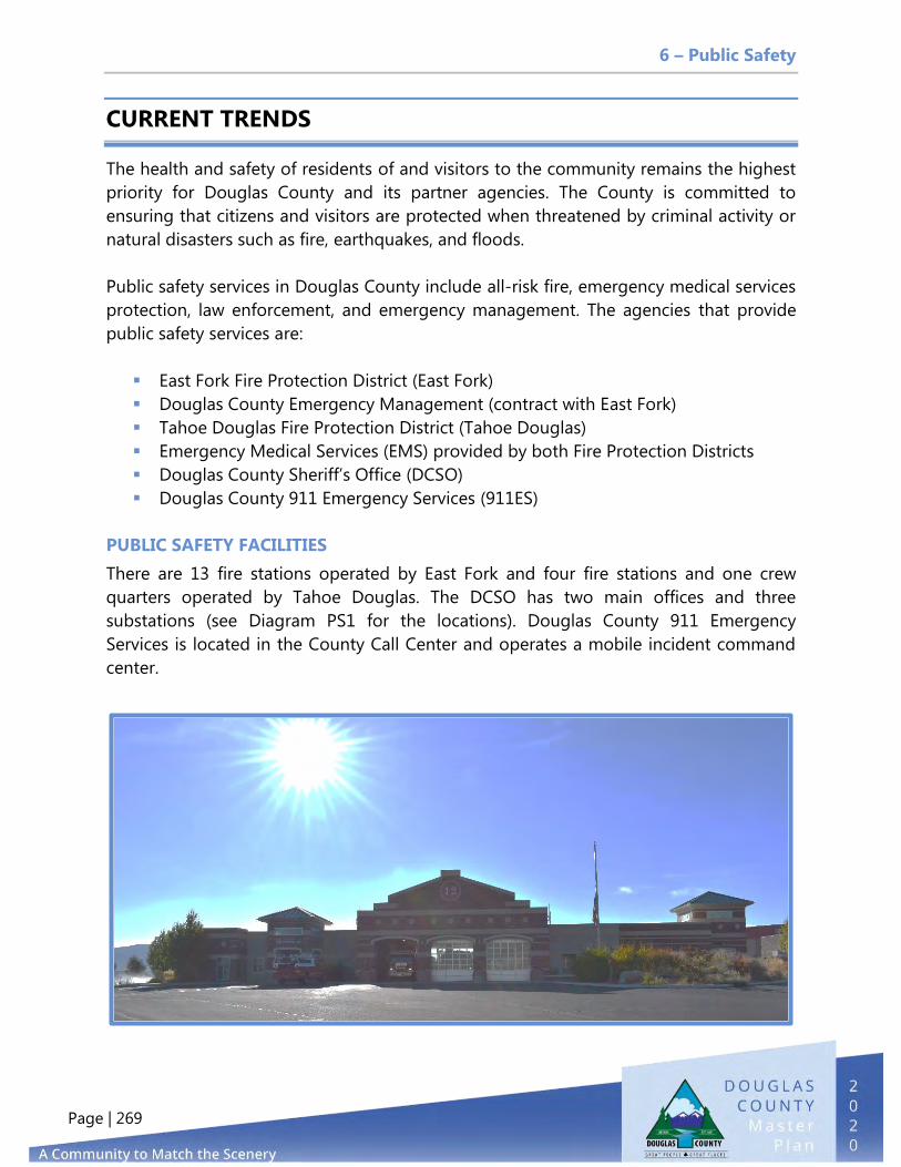
6 – Public Safety
Page | 269
CURRENT TRENDS
The health and safety of residents of and visitors to the community remains the highest
priority for Douglas County and its partner agencies. The County is committed to
ensuring that citizens and visitors are protected when threatened by criminal activity or
natural disasters such as fire, earthquakes, and floods.
Public safety services in Douglas County include all-risk fire, emergency medical services
protection, law enforcement, and emergency management. The agencies that provide
public safety services are:
East Fork Fire Protection District (East Fork)
Douglas County Emergency Management (contract with East Fork)
Tahoe Douglas Fire Protection District (Tahoe Douglas)
Emergency Medical Services (EMS) provided by both Fire Protection Districts
Douglas County Sheriff’s Office (DCSO)
Douglas County 911 Emergency Services (911ES)
PUBLIC SAFETY FACILITIES
There are 13 fire stations operated by East Fork and four fire stations and one crew
quarters operated by Tahoe Douglas. The DCSO has two main offices and three
substations (see Diagram PS1 for the locations). Douglas County 911 Emergency
Services is located in the County Call Center and operates a mobile incident command
center.

6 – Public Safety
Page | 270
DIAGRAM PS1 - LOCATIONS OF PUBLIC SAFETY FACILITIES IN DOUGLAS COUNTY
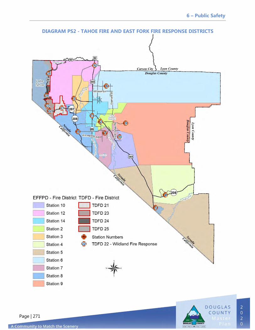
6 – Public Safety
Page | 271
DIAGRAM PS2 - TAHOE FIRE AND EAST FORK FIRE RESPONSE DISTRICTS

6 – Public Safety
Page | 272
FIRE PROTECTION AND EMERGENCY MEDICAL SERVICES
In Douglas County, fire protection and emergency medical services are provided by East
Fork and Tahoe Douglas. East Fork serves the entire Carson Valley and Topaz Regions as
well as a portion of the Tahoe Basin Region. Tahoe Douglas covers the following
communities in the Tahoe Basin: Upper Kingsbury, Stateline, Round Hill, Marla Bay,
Zephyr Heights, Zephyr Cove, Uppaway, and Glenbrook. East Fork Fire Protection District (EFFPD)
East Fork is an NRS 474 Fire District identified in Douglas
County Code 18.10. The district was created by ordinance by
the Douglas County Board of Commissioners in 1981, and
the Commissioners served as the Board of Fire
Commissioners for the first 35 years of East Fork’s existence.
In 2016, the Board of County Commissioners passed an
ordinance to recognize and reconstitute the district under
the provisions of NRS 474.010–474.450, thus treating the
district as if it were created by election and allowing for an
independent Board of Directors. The first Board was interviewed and appointed by the
Douglas County Board of Commissioners on January 4, 2017. It is now an independent
and publicly elected body.
East Fork covers 694 square miles of the County’s 737.7 square-mile area. The Pinenut
Region is mostly under the jurisdiction of the BLM and BIA, but there are some privately
owned properties in the region. The boundaries of the district extend into the Lake
Tahoe Basin. While the majority of lands in the Tahoe Basin are under the jurisdiction of
the USFS, some private property does exist. The initial response resources from local
government are provided to those areas under a Memorandum of Understanding
between the EFFPD and Tahoe Douglas Fire. Jurisdiction is maintained by the East Fork

6 – Public Safety
Page | 273
Fire Protection District.
East Fork is an all-risk fire and EMS agency that provides services primarily through
career personnel. Volunteer personnel provide logistical support in several areas. The
district answers approximately 6,500 calls for service annually and serves a population of
approximately 43,000 residents (15.11 calls per 1,000 residents), which increases
seasonally to approximately 60,000. Many aid agreements have been approved with
various Nevada, California, and federal (USFS and BLM) fire service agencies to provide
seamless responses to citizens of Douglas County and bordering areas, including
Boundary Drop Agreements with the Carson City
Fire Department and Tahoe Douglas. The District
also provides all-risk services to tribal lands of the
Washoe Tribe within its boundary and paramedic
services to Alpine County. Furthermore, East Fork
serves as the Emergency Management
Department for Douglas County under an inter-
local agreement contract with Douglas County.
Table PS1 provides information on calls for
service between 2012 and 2019.
East Fork provides a variety of services, including structural firefighting; wildland
firefighting; aircraft rescue and firefighting; technician-level rope rescue; hazardous
materials mitigation and response; technician-level vehicle extrication rescue;
operations-level water rescue; basic, intermediate and advanced life support EMS and
transport; internal training; regionalized external training; community risk reduction,
community paramedicine, and fire safety inspections; code enforcement; plans review;
and public education.
Standards of Cover and Insurance Service Office (ISO) Rating
The East Fork Fire Protection District Board of Directors adopted the Standards of Cover
in July 2017. The Standards of Cover describes the East Fork service district areas and
includes a community risk analysis and analysis of capabilities. East Fork has identified a
need for an additional manned fire facility on the east side of the Martin Slough, west of
the proposed Muller Parkway.
The Standards of Cover places a strong emphasis on rapid, adequate service delivery for
both fire and EMS response and reflects the District’s commitment toward firefighter
safety. The goal is to provide adequate life safety and/or fire attack resources in the pre-
Table PS1 - EFFPD Calls for Service Calendar Year Calls
2012 5,510 2013 5,452 2014 5,887 2015 6,033 2016 6,292 2017 6,540 2018 6,507 2019 6,753

6 – Public Safety
Page | 274
flashover stage of the fire, allowing victims of fire the greatest possible chance of
survival.
East Fork has improved its Public Protection Classification with the Insurance Service
Office (ISO)/Commercial Risk Services, Inc. The Public Protection Classification Number
is used by the insurance industry to determine premiums for residential and commercial
property. East Fork’s current ISO Fire Suppression Rating Schedule is a Class 3 for 85
percent of the district. Double Spring Flat within the Topaz Ranch Estates/Holbrook
junction community area is a Class 10.
East Fork Response Districts and Staffing
The district is divided into smaller response districts, providing for the closest unit to
respond to requests for assistance. Each of these districts represents a different level of
hazard and response needs. Of the 13 fire stations, seven are staffed with volunteers,
five are staffed with career personnel, and one is leased to the USFS for seasonal staffing
and is used as a reserve station. There are currently 23 career staff employees at Stations
1, 4, 7, 12, and 14 who are supported logistically by 70 volunteers at Stations 2, 3, 5, 6, 8,
9, and 10. The 70 volunteers include 8 attack volunteers and 62 logistics volunteers; 42
of the volunteers are also wildland trained. Table PS2 provides the ratio of career
firefighters for every 1,000 residents.
Tahoe Douglas Fire Protection District
The Tahoe Douglas Fire Protection District (Tahoe Douglas)
serves the Tahoe Basin portion of Douglas County; it was
established and organized in 1946 under NRS 318. Tahoe
Douglas provides fire protection, EMS, water rescue, bomb
response, hazardous materials, marine firefighting, advanced
life support ambulance, and rescue services to its community
(referred to in County documents as the Tahoe Township).
Tahoe Douglas also provides service to adjacent agencies in
Table PS2 - Staffing Ratios for Career On-Duty Firefighters Ratio
East Fork Fire District 0.51/1,000 residents Tahoe Douglas Fire District 2.6/1,000 residents Western States 0.85/1,000 residents U.S. 1.34/1,000 residents

6 – Public Safety
Page | 275
accordance with mutual and automatic aid agreements.
Policy direction for Tahoe Douglas is provided by an elected five-member Board of
Trustees. The Board provides the necessary power and authority to govern the
provisions of fire protection and emergency services. The Board appoints the fire chief,
who is responsible for implementing Board policy
and overseeing the operation of the fire district. The
Tahoe Township is located in the Tahoe Basin within
an area of the Carson Range and is identified as a
spur of the Sierra Nevada Range. This area includes
Stateline and smaller communities along U.S.
Highway 50 from the California border to the
Douglas/Carson County line and easterly up Nevada
State Route 207, Kingsbury Grade.
Standards of Cover and ISO Rating
The Tahoe Douglas Fire Protection District is composed of five response districts. The
Stateline area, the most urbanized of them, hosts several large hotel resort casinos,
residences, condominiums, apartments, and a wide variety of businesses. The tourist
population in this area could increase the size of the population base more than 100,000
during peak seasonal and holiday periods. The 2018 Standards of Cover and
Deployment Plan describes the Tahoe Fire service district area (see Diagram PS3) and
includes a community risk analysis, development and population growth, critical tasking
and alarm assignments, review of historical system performance, performance
objectives, and measures with conclusions and recommendations. Tahoe Douglas plans
for an additional fire station to service the Stateline core redevelopment area as
identified in the Standards of Cover Assessment. The district is working with property
owners to obtain land in the northeast area of the Hard Rock parking garage on loop
road. The district fleet maintenance facility is also in need of replacement and
expansion. As of the latest survey (2014), ISO gave Tahoe Douglas a rating of Class 3/3Y.
Tahoe Douglas employs 47 emergency response personnel for EMS, rescue, and fire
suppression activities (not including the seasonal
wildland and fuels reduction crews), serving a full-
time resident population and protecting an area of
approximately 17 square miles. No less than 15
personnel are on duty at all times. The full-time
resident population of the fire district service area is
5,000. Tahoe Douglas provides its community with 9.4
career firefighters per 1,000 residents, with 2.4
firefighters per 1,000 population on duty at all times.

6 – Public Safety
Page | 276
Diagram PS3 -Tahoe Douglas Fire District
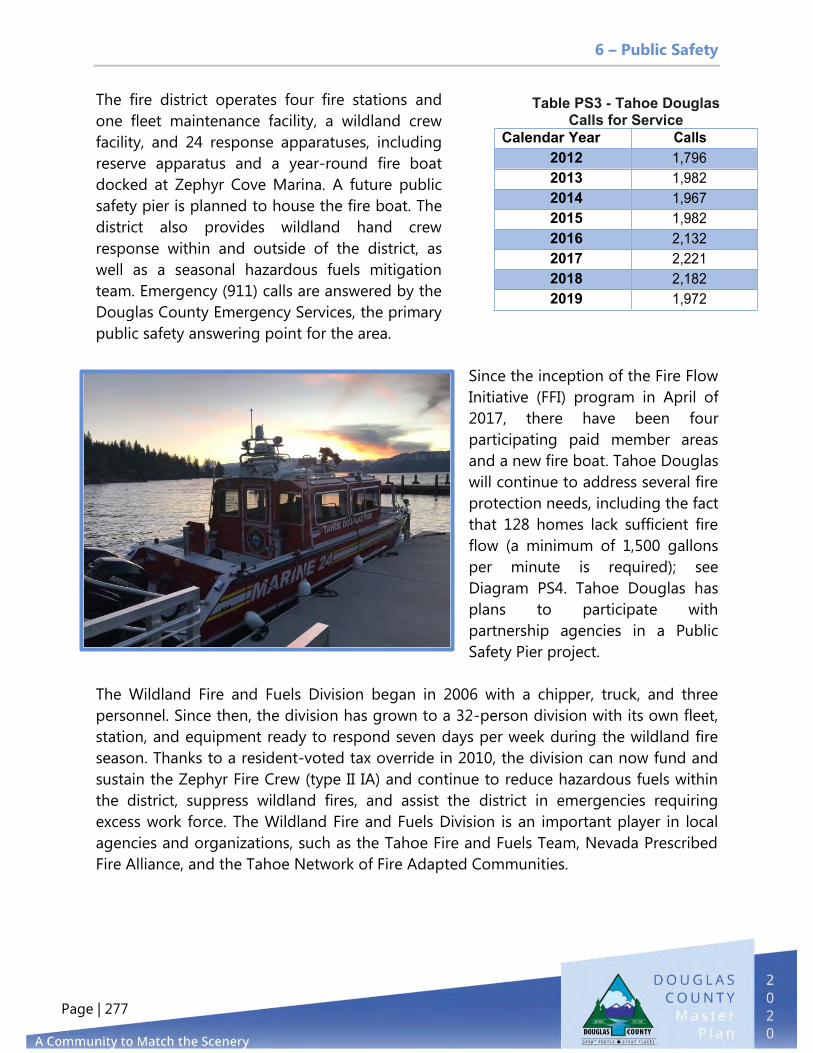
6 – Public Safety
Page | 277
The fire district operates four fire stations and
one fleet maintenance facility, a wildland crew
facility, and 24 response apparatuses, including
reserve apparatus and a year-round fire boat
docked at Zephyr Cove Marina. A future public
safety pier is planned to house the fire boat. The
district also provides wildland hand crew
response within and outside of the district, as
well as a seasonal hazardous fuels mitigation
team. Emergency (911) calls are answered by the
Douglas County Emergency Services, the primary
public safety answering point for the area.
Since the inception of the Fire Flow
Initiative (FFI) program in April of
2017, there have been four
participating paid member areas
and a new fire boat. Tahoe Douglas
will continue to address several fire
protection needs, including the fact
that 128 homes lack sufficient fire
flow (a minimum of 1,500 gallons
per minute is required); see
Diagram PS4. Tahoe Douglas has
plans to participate with
partnership agencies in a Public
Safety Pier project.
The Wildland Fire and Fuels Division began in 2006 with a chipper, truck, and three
personnel. Since then, the division has grown to a 32-person division with its own fleet,
station, and equipment ready to respond seven days per week during the wildland fire
season. Thanks to a resident-voted tax override in 2010, the division can now fund and
sustain the Zephyr Fire Crew (type II IA) and continue to reduce hazardous fuels within
the district, suppress wildland fires, and assist the district in emergencies requiring
excess work force. The Wildland Fire and Fuels Division is an important player in local
agencies and organizations, such as the Tahoe Fire and Fuels Team, Nevada Prescribed
Fire Alliance, and the Tahoe Network of Fire Adapted Communities.
Table PS3 - Tahoe Douglas Calls for Service
Calendar Year Calls 2012 1,796 2013 1,982 2014 1,967 2015 1,982 2016 2,132 2017 2,221 2018 2,182 2019 1,972

6 – Public Safety
Page | 278
The Tahoe Douglas Fire
Protection District's Fire
Prevention Bureau is
committed to protecting the
community from the impacts
of fires and other
emergencies. The Fire
Prevention Bureau achieves
this goal by implementing
strategies in accordance with
the National Fire Protection
Association (NFPA) Fire Safety
Concepts Tree. The Bureau
educates the community
about how to prepare for,
prevent, and react to fires,
medical emergencies, and
other life- or property-
threatening situations. The
bureau is also responsible for
the fire and life safety plan
review and inspection
program, which serves as
both an educational tool and
a means to ensure that fire
hazards are abated and
engineered fire resistance and
protection systems are
maintained. The Tahoe
Douglas Fire Protection
District has a long-standing
Fire and Life Safety Inspection Program. All occupancies are inspected annually with the
exception of R-2s with less than five units and R-3s. Occupancies are inspected in
accordance with the currently adopted editions of the International Fire and Building
Codes. The Tahoe Douglas Fire Prevention Bureau inspects all permitted VHRs. One of
every four homes (currently around 600 units) within the district is a VHR. The average
occupancy in each unit is 10 persons; the highest occupancy is 26 persons. The average
size is 2,131 square feet; the largest unit is 10,000 square feet, and many are multi-story.
These residential group R3 occupancies are primarily permanent in nature; a change of
Diagram PS4 –Insufficient Fire Flow Area

6 – Public Safety
Page | 279
use is permitted through Douglas County. VHRs are primarily transient in nature and
present a higher hazard, based on life and fire risk.
The 2012 International Wildland Urban Interface (WUI) code has been adopted by the
Nevada Fire Marshal. Tahoe Douglas has adopted the 2018 International Wildland
Urban Interface Code, Class 1, Ignition Resistant Building Standards for all new
construction (Douglas County Ordinance 2019-1546, effective July 2019). Tahoe Douglas
strives to provide educational materials and defensible space evaluations to every
member of the community. Every residence in the district is on a four-year rotating
cycling to be evaluated for code compliance with necessary follow-up and enforcement.
Fire Prevention will also assist the community by issuing TRPA tree removal permits for
trees that create a fire threat to surrounding structures. Diagram PS2 shows the
boundary lines and response districts for East Fork and Tahoe Fire.
LAW ENFORCEMENT
The DCSO serves as the County’s only local law enforcement agency
within both the Tahoe and East Fork Townships. The main base of
operations is located in the Town of Minden at the Judicial and Law
Enforcement Building on Buckeye Road, which houses the main jail.
Substations are located in Lake Tahoe, Indian Hills, Gardnerville
Ranchos, and Holbrook Junction. The DCSO currently employs 130 staff
members, including 110 sworn officers. Table PS4 provides the staffing
ratios for law enforcement officers per 1,000 residents, as of July 2020.
Table PS4 - Staffing Ratios for Law Enforcement (July 2020) Ratio
DCSO 2.22 officers/1,000 residents Nevada 2.95 officers/1,000 residents National 2.80 officers/1,000 residents
DCSO provides a wide range of specialized services, such as special weapons and tactics
(SWAT), crisis negotiation, bomb squad, K-9, motorboat patrol, search and rescue,
School safety intervention, and youth education programs. Douglas County participates
in regional support roles to other partnering agencies. The DCSO operates four
divisions: administration, investigations, jail, and patrol.
Administration
The administration division is comprised of command staff and is largely responsible for
internal governance. Administration also includes youth services and records
management functions.

6 – Public Safety
Page | 280
Investigations
The investigations division has six investigators assigned to general investigations and
four assigned to narcotics enforcement. The division is assigned about 1,500 felony
crime investigations per year. The narcotics unit initiates about 100 cases per year.
Jail
The JLEC contains the Douglas County District Court, the District Attorney’s office, the
Sheriff’s office, and the county jail, which has 130 bed spaces (or 3.24 beds per 1,000
residents). The building is comprised of 9,723 square feet of administrative space, court
rooms, and jail facilities. See Element 5, Public Facilities, Services, and Recreation for
more information on the JLEC. The Lake Tahoe Substation is the only full-service
substation and includes 22 bed spaces for inmates.
Patrol
The patrol division includes six sergeants, 38 patrol
deputies, and six traffic enforcement positions for a
total of 50 personnel, approximately 0.95 officers per
1,000 residents. The national average is 2.5 officers
per 1,000 residents. The average response time for all
calls of service is approximately 11 minutes. The
Patrol Division issues about 5,200 citations per year,
responds to approximately 40,100 calls for service,
and investigates about 400 to 500 traffic accidents annually. The patrol division also
serves as Deputy Coroner under Nevada law and investigates approximately 264 death
investigations per year. Table PS5 provides the data on calls for service, arrests, citations,
and jail bookings between 2010 and 2019.
Table PS5 - Statistics for Douglas County Sheriff’s Office
Year Calls for Service Arrests Citations
Total Bookings in
Jail
Total Releases from Jail
Average Daily Jail
Population 2010 40,374 2,426 5,036 2,578 2,602 81 2011 42,557 2,462 5,944 2,491 2,482 60 2012 42,155 2,663 5,966 2,675 2,711 63 2013 36,164 2,495 5,717 2,848 2,557 63 2014 35,753 3,007 5,577 3,030 2,583 76 2015 36,825 2,090 5,879 2,776 2,586 62 2016 42,536 2,031 9,819 2,767 2,417 59 2017 39,806 1,902 5,818 2,451 2,161 47 2018 40,780 2,104 5,211 2,836 2,438 59 2019 38,655 1,748 4,295 2,654 2,302 71

6 – Public Safety
Page | 281
Crime Rate
Crime data shown in Figure PS1 includes violent crimes such as criminal homicide, rape,
robbery, and aggravated assault, and property crimes such as burglary, larceny-theft,
motor vehicle theft, and arson. For calendar year 2018, the crime rate for Douglas
County was 13.47 crimes per 1,000 residents.
Figure PS1 - Crimes in Douglas County (2006–2018) (Note: State did not report Douglas County data in 2019 annual report)
Source: Uniform Crime Reporting, Nevada Department of Public Safety, 2019.
DOUGLAS COUNTY 911 EMERGENCY SERVICES
911 communication services are provided by the
Douglas County 911 Emergency Services Department.
911ES is a consolidated multi-agency regional
communications center serving Douglas County,
Nevada, and Alpine County, California.
The 911ES Department is an accredited center of
excellence for Fire Communications and Medical
Communications through the International Academy of Emergency Dispatch. The
department is currently working toward accreditation for its Law Enforcement
Communications program. The center provides full-time communications services to the
East Fork Fire Protection District, the Tahoe Douglas Fire Protection District, the Douglas
County Sheriff’s office, the Washoe Tribe Police Department, and Alpine County
Emergency Services (Sheriff, Fire, and EMS). The Douglas County Technology Services
87 69 62 107
61 59 53 66 78 69 67 65 65
1008 920
747 706
818 742
829 815 759
859 859 773
603
0
200
400
600
800
1000
1200
2006 2007 2008 2009 2010 2011 2012 2013 2014 2015 2016 2017 2018
Violent Crimes Property Crimes

6 – Public Safety
Page | 282
Department, Infrastructure and Operations Division provides emergency and non-
emergency radio and telephone maintenance services for East Fork, Tahoe Douglas, the
Sherriff’s office, and other Douglas County users. Table PS6 compares the 911ES call
statistics from 2010 to 2019. The Other Agencies category includes calls for citizens or
other user agencies, such as the GIDs and utility companies.
Table PS6 - 911 Emergency Services Calls (2010–2019)
Agency 2010 2013 2016 2019 % Change (2016)
East Fork Fire Protection District 4,805 5,452 6,292 6,753 6.83%
Douglas County Sherriff's Office 41,008 36,673 43,011 40,160 -7.10%
Tahoe Douglas Fire 1,730 1,982 2,132 1,972 -8.11%
Washoe Tribe Police Department 1,895 2,100 2,787 2,352 -18.49%
Other Agencies 16,828 29,561 27,722 21,509 -28.89%
TOTAL 66,266 75,768 81,944 72,746 -12.64%
Agency 2010 2013 2016 2019 Percent Change (2016)
East Fork Fire Protection District 4,805 5,452 6,292 6,753 6.83%
Douglas County Sheriff's Office 41,008 36,673 43,011 40,160 -7.10%
Tahoe Douglas Fire 1,730 1,982 2,132 1,972 -8.11%
Washoe Tribe Police
Department 1,895 2,100 2,787 2,352 -18.49%
Other Agencies 16,828 29,561 27,722 21,509 -28.89%
TOTAL 66,266 75,768 81,944 72,746 -12.64%

6 – Public Safety
Page | 283
NATURAL HAZARDS
The top five natural hazards identified in the 2019 Douglas County Hazard Mitigation
Plan are flooding, earthquakes, wildland fires, drought, and severe events. The Public
Safety Element focuses on flooding, earthquakes, and wildfires due to the frequency of
these events during the last 20 years.
Flooding
Floodplain management remains a significant issue for residents and property owners in
Douglas County. The County has 31,582 acres of riverine and alluvial fan floodplains. The
primary cause of riverine flooding is winter rainstorms saturating and melting the Sierra
snowpack at elevations between 4,500 and 8,000 feet or higher. Though most winter
storms bring snow to elevations above 6,000 feet, a pattern of warm storms (known as
Atmospheric Rivers or Pineapple Express because they come from the warm Pacific
Islands) occasionally dumps rain at higher elevations. Winter floods can occur at any
time between November and April in successive years or may not occur at all for many
years.
Riverine floodplains allow floodwaters to disperse over normally flat areas adjacent to
rivers and streams and reduce the energy of the water flow, thus protecting downstream
properties. Riverine floodplains provide areas of groundwater recharge as well as wildlife
habitat areas, and their locations are relatively predictable.
Alluvial fan floodplains, on
the other hand, are not
predictable and carry high
velocity flows with large
amounts of sediment. The
small creeks and typically
dry washes that flow into
the Carson Valley from the
surrounding mountain
ranges are susceptible to
occasional flash floods
during thunderstorm
events, creating walls of
water that rush through
canyons and ravines onto
the valley floor in just
minutes or hours. These

6 – Public Safety
Page | 284
alluvial fan floods are normally associated with intense summer thunderstorms.
Localized flooding occurs during these larger storm events that are common in the
northern Nevada high-desert environment, and Douglas County recognizes that flash
flooding is an issue that our residents face each year. The county annually provides
flood awareness literature to residents in an effort to bring awareness to the causes of
flash flooding and to make recommendations for preparing for a flood.
To address these concerns,
the County has begun
developing drainage Master
Plans by region. Information
regarding these drainage
Master Plans can be found
on the County’s Flood
Protection web page.
Nevada Flood Chronology
records retained by the
United States Geologic
Survey note that flooding in
the Carson River Watershed
also occurs as part of the
natural cycle of snowpack
melt, rain on snow events, extended high-water flow events (succession of multiple
storm events), alluvial fan flooding, flash flooding, and debris flows. The Carson River
has limited storage capacity and no flood control structures. Open floodplains along the
river help “store and slow” runoff and overflow from the river, protecting houses and
structures in developed areas of the County. Additional information on protection of
floodplains is addressed in Element 2, Agricultural and Conservation.
In 2018, the Carson Water Subconservancy District worked with Michael Baker
International to prepare a Carson River Watershed Floodplain Management Plan. The
purpose of this Regional Floodplain Management Plan (RFMP) is to create a long‐term
vision and develop strategies that utilize a Living River Approach for meeting floodplain
management objectives to reduce flood damage impacts in the Carson River Watershed.
The RFMP revision process reviews regional flood risks and suggests watershed‐wide
strategies and actions to mitigate and reduce these hazards and risks while maintaining
objectives. It also documents regional and local progress on meeting plan objectives.
The RFMP builds on the plan that was first adopted in 2008 by the five County boards
impacted by the Carson River and updated in 2013. To increase flood safety related to

6 – Public Safety
Page | 285
the Carson River, the CWSD’s Carson River Watershed Floodplain Management Plan
recommended a number of flood risk reduction and floodplain strategies for the region,
which are categorized as follows:
Protect natural floodplain function and values
Set higher regulatory standards
Collect flood data information and maintenance
Balance channel migration and bank erosion monitoring
Increase floodplain and flood hazard outreach and education
Reduce infrastructure impact
Map/study alluvial fans
Minimize stormwater mitigation
National Flood Insurance Program and Community Rating System
Douglas County participates in the National Flood Insurance Program (NFIP) Community
Rating System (CRS) so that property owners can acquire discounted flood insurance.
This program is a voluntary incentive program that recognizes and encourages
community floodplain management activities that exceed the minimum NFIP
requirements. Through participation in this program, residents' flood insurance premium
rates are discounted to reflect the reduced flood risk resulting from community actions
for reducing flood damage to insurable properties, strengthening and supporting the
insurance aspects of the NFIP, and encouraging a comprehensive approach to
floodplain management.
Currently, Douglas County is rated a 6, which gives property owners that are required to
obtain flood insurance a 20 percent discount. CRS classes are based on 18 creditable
activities organized under four categories: Public Information, Mapping and Regulations,
Flood Damage Reduction, and Flood Preparedness.
Constructing in the Special Flood Hazard Areas or Floodplain
Douglas County has had floodplain regulations since 1974. Floodplain development
permits, floodplains, and special requirements for land division in the Special Flood
Hazard Area (SFHA) are all covered in Title 20 of the Douglas County Consolidated
Development Code. SFHAs are defined as areas that will be inundated by the flood
event having a one percent chance of being equaled or exceeded in any given year. The
one percent annual chance flood is also referred to as the base flood or 100-year flood.
These Federal Emergency Management Agency (FEMA) flood zones are typically A, AO
(with depth associated), AH, and AE. X-shaded is defined as the 500-year flood, with a
0.2 percent annual chance of flooding in a given year. Flood events in Douglas County

6 – Public Safety
Page | 286
can cause extensive damage to private and public property (roads, utilities, etc.). In
extreme flooding events, loss of life is possible. The County entered the National Flood
Insurance Program in 1975 under the Emergency Program and entered the regular
program on March 28, 1980. According to the 2019 Hazard Mitigation Plan, there are
1,077 flood insurance policies in Douglas County, and there have been 117 losses
totaling $2,943,995 (this is 2012 data; new data is scheduled to be updated in 2020).
Diagrams PS5—PS7 display the location of special flood hazards areas throughout
Douglas County.

6 – Public Safety
Page | 287
DIAGRAM PS5 - SPECIAL FLOOD HAZARD ZONES IN CARSON VALLEY REGION

6 – Public Safety
Page | 288
DIAGRAM PS6 - SPECIAL FLOOD HAZARD ZONES IN TOPAZ RANCH

6 – Public Safety
Page | 289
DIAGRAM PS7 - SPECIAL FLOOD HAZARD ZONES IN TAHOE BASIN REGION

6 – Public Safety
Page | 290
Earthquakes
Nevada is ranked third highest in the United States for the number of large earthquakes.
Douglas County has been shaken by earthquakes in 1887, 1932, 1933, and 1994. Over
3,700 earthquakes were recorded in the county between 1970 and 2010 (see Figure
PS2). In Figure PS2, small yellow dots are earthquake magnitudes of four or less, smaller
orange dots are magnitude of 4 to 4.9, larger darker orange dots are magnitude 5 to
5.9, and large red dots are magnitude 6 and higher.
Date Magnitude Nearest Community Effects
June 3, 1887 6.5 Carson City Building damage, liquefaction
Dec. 20, 1932 7.1 Gabbs Gabbs Surface rupture, chimney damage
June 25, 1933 6 Wabuska Building and chimney damage
Sept. 12, 1994 5.8 Gardnerville Chimney damage, foundation cracking
Figure PS2 - 1840's to 2010 Earthquakes in Douglas County (dePolo
and dePolo (2012)
The largest faults located in
Douglas County:
1) Genoa Fault
2) Eastern Carson Valley
Fault Zone
3) Smith Valley Fault
4) Antelope Valley Fault
5) Eastern Antelope
Valley Fault
6) Double Spring Flat
Fault Zone
7) Mud Lake Fault Zone

6 – Public Safety
Page | 291
The estimated maximum magnitude of earthquakes for the major faults in Douglas
County range from 6.5 to 7.2. These major earthquakes usually occur every few
thousand to tens of thousands of years along any individual fault. The high earthquake
hazard in the County is the result of these larger faults and hundreds of other smaller
faults. For earthquake preparedness, risk mitigation, and emergency and recovery
planning purposes, having a better understanding of the largest earthquakes that can
occur in the county is paramount.
With seismic events, liquefaction hazards exist in the Carson Valley, along the shores of
South Lake Tahoe, in northern Antelope Valley, and in several small basins. Liquefaction
occurs in places where groundwater is shallow and sediments—classically fine sands—
are young and unconsolidated. When these types of saturated sediments are shaken
strongly for a period of time, they can consolidate and expel the water from pore
spaces. When pore pressure increases rapidly and cannot be dissipated, the
phenomenon of liquefaction occurs, during which the soil column can behave as a
liquid. When this happens, a sand/water mixture can discharge water out of the ground,
the land surface can flow downhill or sideways, and the ground may no longer be able
to support the weight of buildings. Buildings on liquefied ground can sink and break up;
other effects of liquefaction are the violent oscillations that are potentially damaging to
buildings and infrastructure.
Diagram PS8 displays the County’s faults lines and hazard area. Diagrams PS9–PS11
display the geologic hazards with fault lines, liquefaction susceptible areas, alluvial
deposit areas, and subsurface material types throughout Douglas County.

6 – Public Safety
Page | 292
DIAGRAM PS8 - DOUGLAS COUNTY LONG-TERM HAZARD AREA

6 – Public Safety
Page | 293
DIAGRAM PS9 - CARSON VALLEY REGION - GEOLOGIC FEATURES / FAULTS

6 – Public Safety
Page | 294
DIAGRAM PS10 - PINENUT REGION - GEOLOGIC FEATURES / FAULTS
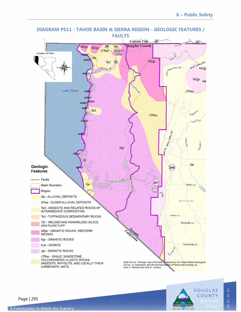
6 – Public Safety
Page | 295
DIAGRAM PS11 - TAHOE BASIN & SIERRA REGION - GEOLOGIC FEATURES /
FAULTS

6 – Public Safety
Page | 296
Wildland Fires
As shown in Table PS7, since 2011, almost 73,000 acres in Douglas County have burned,
taking 28 structures and resulting in a total cost of more than $29 million. The Bison
Fire, which started on July 4, 2013, was started by lightning and burned 24,000 acres, at
a cost of $8.6 million.
Table PS7 - Larger Wildland Fire Loss History (2011–2020)
Fire Name Date Started Acres Burned
Structures Lost Cause Cost
Ray May August 16, 2011 3,815 2 Human $1,231,574
Holbrook September 10, 2011 133 0 Undetermined $226,896
Burbank September 30, 2011 1,113 0 Lightning $1,515,000
TRE May 22, 2012 7,153 17 Human (Illegal burning) $3,411,412
Preacher June 1, 2012 1,076 0 Lightning $835,000
Springs June 22, 2012 1,191 0 Lightning $688,000
Bison July 4, 2013 24,000 0 Lightning $8,600,000
Carter Springs September 21, 2013 3,400 0 Undetermined $1,310,000
Frontage October 9, 2016 100 2 Undetermined $3,000,000
Cutter October 3, 2017 650 0 Lightning $1,300,000
James Loop July 9, 2018 250 0 Human (Construction) $800,000
Slinkard August 28, 2020 9,000 0 Unknown Unknown
Monarch June 24, 2020 2,330 - Lightning -
Numbers July 6, 2020 18,342 7 Human (roadside exhaust debris) $6,500,000
Totals for Douglas County: 72,553 28 $29,417,882.00 Source: East Fork Fire Protection District
To date, the County has not adopted the 2018 International Wildland Urban Interface
Code for the East Fork Township, but the code is applied to construction within the
Tahoe Douglas Fire District. The State of Nevada adopted the entire code in 2012 as
modified in NAC 477.
Diagrams PS12–PS14 display the locations of wildland fires between 2000 and 2019.

6 – Public Safety
Page | 297
DIAGRAM PS12 - WILDLAND FIRES IN THE CARSON VALLEY REGION

6 – Public Safety
Page | 298
DIAGRAM PS13 - WILDLAND FIRES IN THE PINENUT REGION
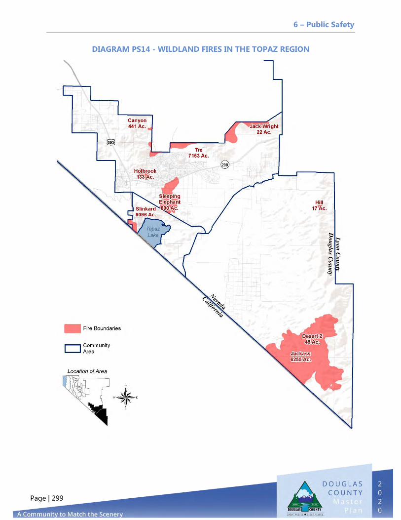
6 – Public Safety
Page | 299
DIAGRAM PS14 - WILDLAND FIRES IN THE TOPAZ REGION
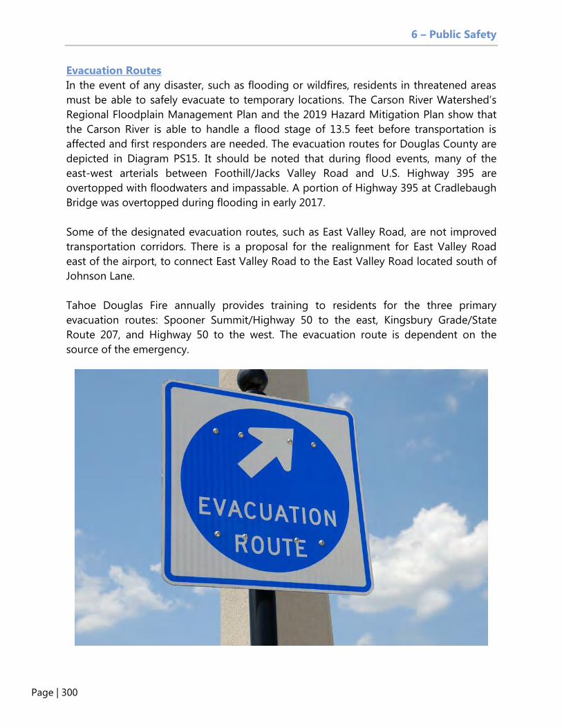
6 – Public Safety
Page | 300
Evacuation Routes
In the event of any disaster, such as flooding or wildfires, residents in threatened areas
must be able to safely evacuate to temporary locations. The Carson River Watershed’s
Regional Floodplain Management Plan and the 2019 Hazard Mitigation Plan show that
the Carson River is able to handle a flood stage of 13.5 feet before transportation is
affected and first responders are needed. The evacuation routes for Douglas County are
depicted in Diagram PS15. It should be noted that during flood events, many of the
east-west arterials between Foothill/Jacks Valley Road and U.S. Highway 395 are
overtopped with floodwaters and impassable. A portion of Highway 395 at Cradlebaugh
Bridge was overtopped during flooding in early 2017.
Some of the designated evacuation routes, such as East Valley Road, are not improved
transportation corridors. There is a proposal for the realignment for East Valley Road
east of the airport, to connect East Valley Road to the East Valley Road located south of
Johnson Lane.
Tahoe Douglas Fire annually provides training to residents for the three primary
evacuation routes: Spooner Summit/Highway 50 to the east, Kingsbury Grade/State
Route 207, and Highway 50 to the west. The evacuation route is dependent on the
source of the emergency.
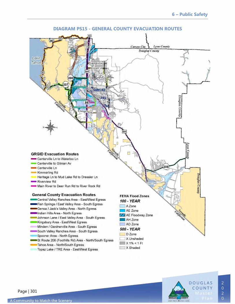
6 – Public Safety
Page | 301
DIAGRAM PS15 - GENERAL COUNTY EVACUATION ROUTES

6 – Public Safety
Page | 302
LOOKING TO THE FUTURE
Increasing Public Safety with Business Registration
Douglas County does not require a business registration to do business in the County. A
business registration would identify materials as well as occupancy loads. The County
also does not require a review to check compliance with building, zoning, and fire codes
before a new business starts to operate. East Fork has a voluntary incident response
registration form that is used for fictitious name registration. Requiring a business to
submit for a registration would:
Increase public safety if the County were able to review all existing and new
businesses to determine if hazardous materials are involved, where the hazards
are located on the site, and if there are other conflicting uses adjacent to that
hazard
Assist the DCSO with nuisance bars for noncompliance of code
Assist Code Enforcement with code violations
Provide the opportunity for the county to track and monitor sales data
Wildland Urban Interface Code
Douglas County has not adopted the Wildland Urban Interface Code for the East Fork
Fire Protection District. This code covers sprinklers, building materials, and defensible
space and would allow the County to potentially obtain additional reimbursement from
the federal government after a fire event and lower insurance rates for the county
residents. Adopting the WUI Code would ensure that new construction would be
resistant to fire ignition, providing additional safety to the residents of the County who
live adjacent to forested lands. Tahoe Douglas Fire has adopted the WUI Code and is
utilizing an enforcement program.
Recruitment and Retention of Public Safety Personnel
According to the Douglas County Sheriff’s Office, East Fork Fire Protection District, and
Tahoe Douglas Fire, the Douglas County School District and Douglas County have a big
challenge in recruiting new officers, volunteers, and employees. The cost of housing in
Douglas County is a primary concern, and it is noted that employees are not able to
obtain housing on the salaries offered by the agencies.
East Fork Fire needs an additional fire station east of Martin Slough and west of
East Valley.
Tahoe Douglas Fire needs an additional fire station in the Casino Core in South
Lake Tahoe.

6 – Public Safety
Page | 303
Tahoe Douglas Fire needs to reconstruct and expand their fleet maintenance
facility.
Evacuation Routes
The existing evacuation routes map needs to be updated to reflect actual road
conditions and may need to distinguish between existing routes and planned
improvements to the routes. The Hazard Mitigation Plan requires improvements to
routes in emergencies. Some of these improvements include:
Buckeye Road from Heybourne Road to Highway 395 over the Martin Slough
needs to be raised to allow passage in a flood event.
The realignment for East Valley Road from Fremont Street to East Valley Road
should be a priority, in addition to obtaining the right-of-way for East Valley
Road from Stockyard Road to East Valley Road, connecting to Johnson Lane.
The County should consider an additional route for evacuation purposes from
Fish Springs and the Topaz and Holbrook Junction areas. Minden-Tahoe Airport
It would be beneficial to conduct a Part 77 study to determine how to protect the
airspace surfaces around the Minden-Tahoe Airport to prevent structures that would
interfere with aircraft landings and departures. For example, in 1967 neighboring Carson
City adopted an Airport Clearance Zone (Chapter 16.02 of the Municipal Code). This
ordinance restricts heights and prohibits public assembly land uses such as schools and
hospitals.
Douglas County should also consider creating an Airport Zoning Overlay District to
protect airplane operations and to protect the public from potential airplane accidents
during departures or landings.

6 – Public Safety
Page | 304
Page intentionally left blank

7 – Washoe Tribe
Page | 305
7. WASHOE TRIBE
PURPOSE
Reserved for future Washoe Tribe Element
GOALS
Reserved for future Washoe Tribe Element
TBD
TBD
POLICIES
TBD
TBD

7 – Washoe Tribe
Page | 306
Page intentionally left blank

Implementation
Page | 307
PURPOSE
The purpose of the Implementation Element is to set forth the Master Plan work program to provide direction to staff from the Board on priorities for future accomplishments.
MASTER PLAN ACTION MATRIX
The Action Matrix for the 2020 update of the Douglas County Master Plan lists the actions for each Master Plan Element along with the priority for each action item. These priorities are subject to staffing resources and budget constraints identified by the Board. Priority is categorized by a time frame based on four levels: (1) one to three years, (2) three to five years, (3) five to ten years or longer, and (4) ongoing items that may be addressed each year. These actions identify amendments that may need to be added to the Douglas County Development Code and define actions that should be included in the County’s five-year Capital Improvement Program. The Matrix will be updated as part of the annual Master Plan reporting process.
8. IMPLEMENTATION

Implementation
Page | 308
Priority Explanation in Years | 1–3 (High), 3–5 (Medium), 5–10 (Low)
Priority
LAND USE & HISTORIC PRESERVATION
Amend Title 20 to incorporate the Master Plan land use designations and compatible zoning districts. 1–3
Amend the Master Plan Land Use Designation Table to allow multi-family residential zoning in the Commercial land use category.
1–3
Ensure that Douglas County Community Development works with Douglas County GIS, the Recorder’s Office, and affected property owners to eliminate parcels with split land uses, split zoning, and other mapping inconsistencies.
3–5
Ensure that Douglas County Community Development periodically amends the Master Plan Future Land Use Map to change the future land use designation for built-out receiving areas.
1–3
Support the Towns of Gardnerville and Minden in submitting Historic District nomination packages to the State of Nevada.
3–5
Apply for Certified Local Government status with the State of Nevada Historic Preservation Office.
5–10
Support efforts to secure state, federal, or other funding directed toward revitalizing historic areas or maintaining historic buildings and sites.
1–3
Continue to support proposed Main Street legislation in the Nevada Legislature to provide financial and technical resources.
Ongoing
Evaluate the creation of a county-wide Historic Preservation Board and program.
1–3
Examine changes to Title 20 to establish a 10-acre Rural Agriculture zoning district in keeping with the preservation of our rural nature.
1–3

Implementation
Page | 309
Priority LAND USE & HISTORIC PRESERVATION
Examine changes to Title 20 to clarify the use of TDRs. 1–3
Priority Explanation in Years | 1–3 (High), 3–5 (Medium), 5–10 (Low)
Priority
AGRICULTURE & CONSERVATION
Investigate creating an Open Space Land Trust to facilitate planning and implementation of an Open Space Acquisition Program.
1–3
Update the 2007 Open Space and Agricultural Lands Preservation plan prior to September 29, 2029, and incorporate the development of a River Corridor Open Space plan addressing the branches of the Carson and Walker
Rivers.
3–5
Evaluate and update the definition of publicly valuable open space to include the provision of active recreation opportunities in less critical habitat to relieve recreation pressure in areas of more critical habitat and to manage public
lands access.
5–10
Establish an open space acquisition program. 1–3
Prepare recommendations for establishment of a TDR bank to encourage conservation of open space areas in the County. 1–3
Prepare a Low-Impact Development Ordinance for all new residential, commercial, and industrial development to reduce pollutants from entering surface waters in Douglas County.
1–3
Work with NDEP and the Carson Water Subconservancy District to remove one or more river segments from the EPA list of 303 (d) impaired waters.
3–5
Develop comprehensive storm drainage design criteria for developed areas in conjunction with the Towns and GIDs. 3–5

Implementation
Page | 310
Priority
AGRICULTURE & CONSERVATION
Develop and implement a stormwater management plan. 5–10
Implement the Clear Creek and Johnson Lane Stormwater Management Plans as required by the EPA’s MS4 National Pollutant Discharge Elimination System (NDPES) Permit.
1–3
Amend the Development Code to include noise standards for noise-generating activities, including limitations on hours of operation during the day.
3–5
Evaluate and update agricultural exemptions and incentives to encourage agricultural conservation of open space and the continuation of agricultural activities.
3–5
Evaluate agricultural zoning districts and property tax structure to support perpetual farming and agricultural uses in specific areas.
5–10
Minimize conversion of agricultural land to non-agricultural uses and ensure that recognized needs for growth are met by infill and contiguous development.
Ongoing
Provide procedures for the acquisition, dedication, or purchase of agricultural preservation easements, by public or nonprofit entities, as a means to retain land in agriculture.
1–3
Expand and improve drainage facilities on U.S. Highway 395 at Smelter Creek south of Gardnerville and from Minden north to Cradlebaugh Bridge.
1–3
Protect wetlands to provide for groundwater recharge, flood protection, sediment and pollution control, wildlife habitat, and open space.
1–3
Service development occurring at urban densities with a sanitary sewer utility. 3–5
Implement the Agrihood Strategy Framework accepted by the Board of County Commissioners on September 3, 2020. 1–3
Implementation
Page | 311
Priority
AGRICULTURE & CONSERVATION
Include provisions in the Development Code for the mandatory use of TDRs to increase density associated with a zoning map amendment.
1–3
Create alternatives to the urban development of existing agricultural lands to preserve those agricultural areas. 1–3
Priority Explanation in Years | 1–3 (High), 3–5 (Medium), 5–10 (Low)
Priority
ECONOMIC DEVELOPMENT
Consider amendments to the Development Code to allow permanent sidewalk merchandise displays in the downtowns. 1–3
Complete infrastructure projects, such as the Martin-Slough Trail, Muller Parkway, and utilization of Complete Streets vision and plan for U.S. Highway 395.
1–3
Implement the South Shore Area Plan for Stateline. 1–3
Complete the Tahoe Douglas Area Plan. 1–3
Implement the Expanded Kahle Drive Vision Plan. 3–5
Explore the creation of an Improvement District under NRS Chapter 271 for the Stateline area. 3–5
Develop a communication and marketing plan for the Minden-Tahoe Airport. 3–5
Update the Airport Economic Impact Study. 5–10

Implementation
Page | 312
Priority
ECONOMIC DEVELOPMENT
Plan and develop the east side of the Minden-Tahoe airport to facilitate business development, retention, and expansion. 5–10
Seek funding to improve bicycle, pedestrian, and equestrian infrastructure that supports economic development. 3–5
Continue to work with our network of partners to promote and advocate for outdoor recreation experiences. Ongoing
Advocate for trails as part of infrastructure and development opportunities. Ongoing
Develop a GIS layer for the public viewer that shows existing trails in Douglas County. 3–5
Explore tools to promote economic development that do not require the investment of local funds. 3–5
Evaluate and update land use regulations to foster a positive atmosphere and attract appropriate types of business to the community. Promote the types of uses that provide middle-income jobs and promote entrepreneurship.
1–3
Explore tools to connect local consumers to local suppliers. 3–5
Support local employees through efforts to make housing, daycare, and other needs more accessible and affordable. 3–5
Maintain locations for light industry and evaluate and update regulations relating to live/work light industry opportunities. 1–3
Develop a strategy to attract and retain independent, contract, and remote workers. 3–5
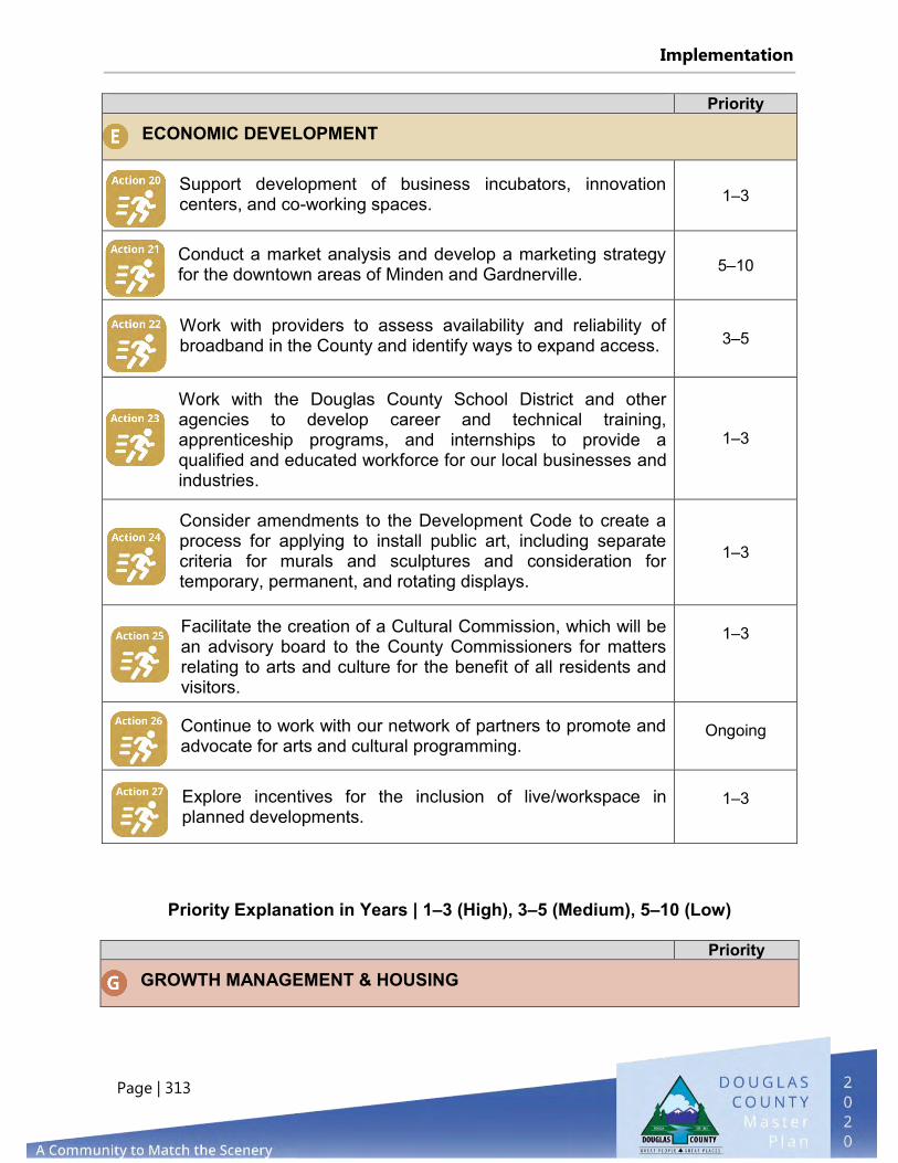
Implementation
Page | 313
Priority
ECONOMIC DEVELOPMENT
Support development of business incubators, innovation centers, and co-working spaces. 1–3
Conduct a market analysis and develop a marketing strategy for the downtown areas of Minden and Gardnerville. 5–10
Work with providers to assess availability and reliability of broadband in the County and identify ways to expand access. 3–5
Work with the Douglas County School District and other agencies to develop career and technical training, apprenticeship programs, and internships to provide a qualified and educated workforce for our local businesses and industries.
1–3
Consider amendments to the Development Code to create a process for applying to install public art, including separate criteria for murals and sculptures and consideration for temporary, permanent, and rotating displays.
1–3
Facilitate the creation of a Cultural Commission, which will be an advisory board to the County Commissioners for matters relating to arts and culture for the benefit of all residents and visitors.
1–3
Continue to work with our network of partners to promote and advocate for arts and cultural programming.
Ongoing
Explore incentives for the inclusion of live/workspace in planned developments.
1–3
Priority Explanation in Years | 1–3 (High), 3–5 (Medium), 5–10 (Low)
Priority
GROWTH MANAGEMENT & HOUSING

Implementation
Page | 314
Priority
GROWTH MANAGEMENT & HOUSING
Develop key indicators to monitor the impacts of growth and the progress toward implementing the County’s growth management programs; report annually on their effectiveness and possible improvements.
1–3
Ensure that the Community Development Department provides input during the preparation of the annual CIP to ensure consistency with the Master Plan and the Growth Management Chapter of the Douglas County Development Code.
Ongoing
Analyze the effectiveness of the TDR program before the next update of the Douglas County Master Plan and prepare recommendations on sending and receiving areas and TDR values.
1–3
Evaluate and update land development regulations in rural areas to better protect wildlife habitat, habitat connections, scenic vistas, and rural character.
1–3
Evaluate and update design regulations to encourage quality public space. 3–5
Amend the Douglas County Development Code to include minimum density requirements in the multi-family residential and mixed-use commercial zoning districts.
1–3
Revise the Master Plan land use designations to permit multi-family zoning within the Commercial land use designation. 1–3
Review the single-family design standards in the Development Code to determine whether impediments exist for the development of moderately priced entry-level homes, including single-family attached units.
1–3
Revise the criteria in the Mixed-Use zoning district to reduce the percentage of commercial usage required. 1–3

Implementation
Page | 315
Priority
GROWTH MANAGEMENT & HOUSING
Prepare recommendations for amending the Development Code to require developers to include a percentage of affordable units in large subdivisions in return for a density bonus.
1–3
Explore the viability of community land trusts to develop and maintain entry-level housing stock for households with incomes below 80 percent of median income.
3–5
Priority Explanation in Years | 1–3 (High), 3–5 (Medium), 5–10 (Low)
Priority
PUBLIC FACILITIES, SERVICES, & RECREATION
Develop a facilities master plan to address space needs for government services. 3–5
Identify critical services and define desired service levels from government service providers that address all policies of this section.
3–5
Define desired service levels and establish clear expectations for service providers to ensure efficient and cost-effective delivery of services.
3–5
Explore the feasibility of connecting communities with high concentrations of private wells, such as Ruhenstroth, Johnson Lane, Topaz Lake and Topaz Ranch Estates, to public water systems.
1–5
Create incentives to encourage existing development to connect to public water and sewerage systems upon public service provider’s system expansion, particularly in areas with high concentration of nitrates reaching groundwater, such as Johnson Lane and Ruhenstroth.
3–5

Implementation
Page | 316
Evaluate and update development exaction regulations to address capital improvements, intersection impacts, road or turning lane impacts, impacts to water or the sewer system, and other needs.
1–3
Evaluate the feasibility of establishing impact fees in urban service/receiving areas (areas where increased density is proposed) to support expansion of required infrastructure and public facilities.
1–3
Identify appropriate locations for infrastructure before it is needed by projecting the location of future growth. 1–3

Implementation
Page | 317
Priority PUBLIC FACILITIES, SERVICES, & RECREATION
Evaluate and update the definition of publicly valuable open space to include the provision of active recreation opportunities in less critical habitat in order to relieve recreation pressure in areas of more critical habitat and to manage public lands access.
1–3
Evaluate private land recreation needs and management to relieve the impact on public lands. 3–5
Establish an open space acquisition program that identifies acquisition area priorities based on capital costs, operation and maintenance costs, accessibility, open space needs, resource preservation, ability to complete or enhance the existing open space linkage system, and unique environmental features. Techniques for acquisition may include fee simple acquisition, acquisition of development rights, transfer of development rights, clustering, or other measures.
1–3
Utilize State of Nevada standards for the evaluation of new septic systems on the basis of the site’s susceptibility to groundwater pollution by septic effluent.
3–5
Continue to monitor areas with high septic system densities for signs of groundwater contamination from nitrates. Ongoing
Prepare amendments to the Development Code to support a Dig Once policy for underground telecommunications and fiber infrastructure.
1–3
Evaluate database offerings, including Nevada State Library and other database additions/subtraction. 3–5
Pursue development of a trail concept plan for the upper Kingsbury Grade segment of the Pony Express National Historic Trail.
3–5

Implementation
Page | 318
Priority PUBLIC FACILITIES, SERVICES, & RECREATION
Update the Comprehensive Trails Plan. 3–5
Partner with and support USGS to update the Numerical Groundwater-Flow Model of the Carson Valley, Douglas County, Nevada, and Alpine County, California, in order to develop a complete understanding of the availability and quality of water in the Carson Valley/Carson River Basin.
1–3
Develop a regional water resource plan, pursuant to NRS 278. 3–5
Update the water conservation plan, pursuant to NRS 540. 3–5
Update the Nevada 80th Session’s AB240 growth management report, as required.
Ongoing
Implement the Airport, Johnson Lane, Alpine View Estates, and Ruhenstroth Area Drainage Master Plans. 1–3
Encourage funding for art and cultural facilities and form a public arts coalition between the Towns of Minden and Gardnerville, Main Street Gardnerville, the Carson Valley Arts Council, and other interested parties to enhance cultural and performing arts.
1–3
Investigate the feasibility of a County hospital with mental health facilities, including facilities for special needs children and adults.
Ongoing
Examine feasibility studies for arts complexes and the development and design of a theater venue for the Carson Valley.
1–3
Assist in the improvement of arts organizations’ existing facilities to enhance the quality and quantity of arts offerings.
1–3
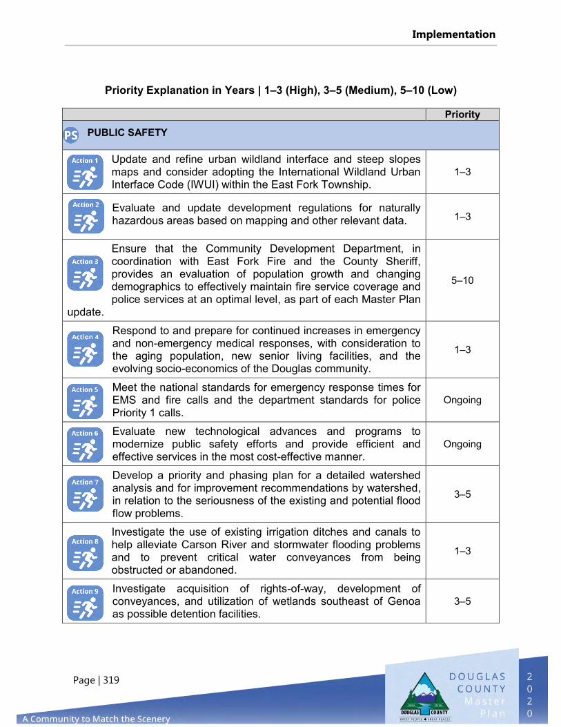
Implementation
Page | 319
Priority Explanation in Years | 1–3 (High), 3–5 (Medium), 5–10 (Low) Priority
PUBLIC SAFETY
Update and refine urban wildland interface and steep slopes maps and consider adopting the International Wildland Urban Interface Code (IWUI) within the East Fork Township.
1–3
Evaluate and update development regulations for naturally hazardous areas based on mapping and other relevant data. 1–3
Ensure that the Community Development Department, in coordination with East Fork Fire and the County Sheriff, provides an evaluation of population growth and changing demographics to effectively maintain fire service coverage and police services at an optimal level, as part of each Master Plan
update.
5–10
Respond to and prepare for continued increases in emergency and non-emergency medical responses, with consideration to the aging population, new senior living facilities, and the evolving socio-economics of the Douglas community.
1–3
Meet the national standards for emergency response times for EMS and fire calls and the department standards for police Priority 1 calls.
Ongoing
Evaluate new technological advances and programs to modernize public safety efforts and provide efficient and effective services in the most cost-effective manner.
Ongoing
Develop a priority and phasing plan for a detailed watershed analysis and for improvement recommendations by watershed, in relation to the seriousness of the existing and potential flood flow problems.
3–5
Investigate the use of existing irrigation ditches and canals to help alleviate Carson River and stormwater flooding problems and to prevent critical water conveyances from being obstructed or abandoned.
1–3
Investigate acquisition of rights-of-way, development of conveyances, and utilization of wetlands southeast of Genoa as possible detention facilities.
3–5

Implementation
Page | 320
Priority
PUBLIC SAFETY
Establish and enhance neighborhood programs to involve the community in crime and fire prevention, disaster preparedness, and shelter management.
3–5
Study the areas developed by serial land parceling and verify the current water conveyance capacity of the infrastructure. Note deficiencies and correct, as practicable. Analyze downstream capacities and improve if needed.
3–5
Explore and expand the use of social networks as a communication tool to reach as many residents as possible with public safety matters.
1–3
MASTER PLAN ANNUAL REPORTS AND ACCOMPLISHMENTS
The Planning Commission is required to submit an annual report to the Board of Commissioners on the implementation status of the Master Plan (NRS 278.190). When the 2011 Master Plan (15-year update) was adopted on March 1, 2012, it contained 95 actions. When the South Shore Area Plan was adopted by the County in 2013, 11 more actions were added, increasing the total to 106 actions. The Planning Commission has submitted four annual reports (in 2012, 2013, 2014, and 2015) to the Board of Commissioners on the implementation status of each action. The 2015 Annual Report stated that 22 actions had been completed, 33 actions were underway, and 51 had not been started. In 2016, 2017, 2018, 2019, and 2020, data from the report was presented to the Planning Commission and the Board of Commissioners as part of the 20-year Master Plan update.

LIST OF MAPS
CHAPTER 1 – LAND USE & HISTORIC PRESERVATION
Map L1: Douglas County Future Land Use Map 31
LIST OF TABLES
EXECUTIVE SUMMARY
Table ES1: Douglas County Population 1970 to 2019 9
Table ES2: Total Population Change by Census Tract (2013 to 2018) 9
Table ES3: Population Projections for Northwestern Nevada by County 10
Table ES4: Douglas County Population Growth Scenarios 11
Table ES5: Median Age Change in Douglas County (2013 to 2018) 12
Table ES6: Median Age Change (2013 to 2018) 12
Table ES7: Total Number of Housing Units 13
Table ES8: Percentage of Housing Units Owner-Occupied (2014 to 2018) 14
Table ES9: Percentage of Housing Units Renter-Occupied (2014 to 2018) 15
Table ES10: Total Number of Housing Units by Type of Structure (2020) 15
Table ES11: Year Built, All Housing Units 16
Table ES12: Median Household Income, Median Family Income, and Per Capita
Income (2013 to 2018) 17
Table ES13: Civilian Labor Force Unemployment Rate (2013 to 2018) 18
ELEMENT 1 – LAND USE & HISTORIC PRESERVATION
Table L1: Future Land Use Categories (Master Plan and Douglas County Code) 28
Table L2: Douglas County Properties on the National Register of Historic Places 91
Table L3: Douglas County Properties Listed Only on the State Register of
Historic Places 91
Table L4: State of Nevada Historic Roadside Markers in Douglas County 92
ELEMENT 2 – AGRICULTURE & CONSERVATION
Table A1: Farms in Selected Northern Nevada Counties (2017) 114
Table A2: Census of Agriculture for Douglas County (1945-2017) 115
Page | 321

Table A3: NRS 361A Agricultural Acreage, by Community Plan 116
Table A4: Companies with Air Quality Operating Permits 122
Table A5: TDR Conservation Easements, 2002-2020 123
Table A6 – Completed SNPLMA Environmentally Sensitive Land Acquisitions 125
Table A7: 100 Year Floodplain Acreage, by Community Plan Area 128
Table A8: Water Pumpage, by Basin & Manner of Use 135
Table A9: Endangered and Threatened Species in Douglas County 139
ELEMENT 3 – ECONOMIC DEVELOPMENT
Table E1: Principal Taxpayers in Douglas County Fiscal Year End June 2020 156
ELEMENT 4 – GROWTH MANAGEMENT & HOUSING
Table G1: Available Residential Allocations, by Category 184
Table G2: Available Residential Allocations, by Category Status of TDR Program 185
Table G3: Receiving Area Acreage by Community Plan 185
Table G4: Douglas County VESTED Project List (2020) 186
Table G5: Douglas County PROJECTS List (2020) 187
Table G6: Undeveloped Residential Acreage Outside Receiving Areas, by
Residential Zoning District 192
ELEMENT 5 – PUBLIC FACILITIES, SERVICES & RECREATION
Table PF1: Douglas County General Improvement Districts, by Region 204
Table PF2: Douglas County Unincorporated Towns 208
Table PF3: Major Water Systems in Carson Valley 210
Table PF4: Major Water Systems in Topaz Region 211
Table PF5: Major Water Systems in Tahoe Basin 211
Table PF6: Wastewater Service Providers in the Carson Valley 221
Table PF7: USDA RD Community Program Loans and Grants for Wastewater 227
Table PF8: Recycling Rates for Nevada, Douglas County, and Adjacent Counties 230
Table PF9: School Capacity vs. Actual Enrollment 238
Table PF10: School Enrollment by Residential Unit 238
Table PF11: Library Visits, FY 2013 to FY 2019 242
Table PF12: Registered Library Users 243
Table PF13: Regional Parks in Douglas County 250
Table PF14: Neighborhood/Community Parks in Douglas County 250
Table PF15: Special Use Facilities in Douglas County 251
Table PF16: Community Centers 252
Table PF17: Existing Open Space and Park Land Uses and Zoning Districts 262
ELEMENT 6 – PUBLIC SAFETY
Table PS1: EFFPD Calls for Service 273
Table PS2: Staffing Ratios for career On-Duty Firefighters 274
Table PS3: Tahoe Douglas Calls for Service 277
Table PS4: Staffing Ratios for Law Enforcement (July 2020) 279
Table PS5: Statistics for Douglas County Sheriff’s Office 280
Table PS6: 911 Emergency Services Call, 2010 – 2019 282
Table PS7: Larger Wildland Fire Loss History 2011-2020 296
ELEMENT 7 – RESERVED FOR FUTURE WASHOE TRIBE ELEMENT
None
LIST OF FIGURES
EXECUTIVE SUMMARY
Figure ES1: Douglas County, NV at A Glance 1
Figure ES2: A History of Douglas County 4
Figure ES3: Land Ownership in Douglas County 5
Figure ES4: Douglas County Population Projections through 2038 11
Figure ES5: Total Employment by Major Industry Sector for Douglas County 19
Figure ES6: Commuting Patterns for Douglas County for 2020 20
Figure ES7: Graduation Rates for 2019-2020 School Year 21
Figure ES8: Student Enrollment in Douglas, Lyon, and Carson City 22
ELEMENT 1 – LAND USE & HISTORIC PRESERVATION
Figure L1: Carson Valley Region 35
ELEMENT 2 – AGRICULTURE & CONSERVATION
Figure A1: Gardnerville Ranchos PM 2.5 Monitoring Station 24 Hour Design
Values (EE Excluded) 121

Figure A2: Douglas County TDR Conservation Easements Protecting Floodplains 131
Figure A3: Groundwater Pumping Carson Valley by Manner of Use (in acre feet) 135
ELEMENT 3 – ECONOMIC DEVELOPMENT
None
ELEMENT 4 – GROWTH MANAGEMENT & HOUSING
Figure G1: Housing Types 172
Figure G2: Regional Housing Inventory (2020) 173
Figure G3: Year Built, All Housing Units 173
Figure G4: House Sales Information 174
Figure G5: Building Permits by Structure Type 182
ELEMENT 5 – PUBLIC FACILITIES, SERVICES & RECREATION
Figure PF1: Carson Valley Water Use by Purveyor…………………………………………………..216
Figure PF2: Douglas County Student Enrollment (2010-2020) 237
Figure PF3: Park Acreage in Douglas County, by Type 249
ELEMENT 6 – PUBLIC SAFETY
Figure PS1: Crimes in Douglas County, 2006-2018 281
Figure PS2: 1840's to 2010 Earthquakes in Douglas County 290
ELEMENT 7 – RESERVED FOR FUTURE WASHOE TRIBE ELEMENT
None
LIST OF DIAGRAMS
EXECUTIVE SUMMARY
Diagram ES1: Douglas County Vicinity Map 2
Diagram ES2: Land Ownership in Douglas County 6
Diagram ES3: Tahoe Douglas Area Plan 8
ELEMENT 1 – LAND USE & HISTORIC PRESERVATION
Diagram L1: Douglas County Townships 33
Diagram L2: Douglas County Regional Area 34
Diagram L3: Agricultural Community 38
Diagram L4: Airport Community 41
Diagram L5: East Valley Community 38
Diagram L6: Fish Springs Community 38
Diagram L7: Foothill Community 50
Diagram L8: Gardnerville Ranchos Community 53
Diagram L9: Geno Community 57
Diagram L10: Indian Hills/Jacks Valley Community 62
Diagram L11: Johnson Lane Community 65
Diagram L12: Gardnerville Community 68
Diagram L13: Minden Community 70
Diagram L14: Ruhenstroth Community 70
Diagram L15: Topaz Lake Community 84
Diagram L15: Topaz Lake Community 84
Diagram L16: Topaz Ranch Estates/Holbrook Junction Community 87
Diagram L17: Antelope Valley Community Plan 89
Diagram L18: National & State Register of Historic Places 93
Diagram L19: Genoa Historic District, National Register & Town Boundary 95
ELEMENT 2 – AGRICULTURE & CONSERVATION
Diagram A1: Prime Farmland in Douglas County 112
Diagram A2: Prime Farmland in Carson Valley 113
Diagram A3: NRS 361 Agricultural Parcels in Douglas County 117
Diagram A4: NRS 361 Agricultural Parcels in Carson Valley 118
Diagram A5: NRS 361 Agricultural Parcels in Southern Douglas County 119
Diagram A6: TDR Conservation Easements 124
Diagram A7: Completed SNPLMA Environmentally Sensitive Land Acquisitions 127
Diagram A8: Floodplain Areas in Carson Valley 130
Diagram A9: Hydrographic Basins in Douglas County 133
Diagram A10: Wetlands in The Carson Valley 138
Diagram A11: Mule Deer and Pronghorn Antelope Distribution and Movement
Corridors 140

ELEMENT 3 – ECONOMIC DEVELOPMENT
Diagram E1: Business Parks and Industrial & Commercial Zoning in The Airport
and East Valley Community Plans 157
Diagram E2: Industrial & Commercial Zoning in Gardnerville And Minden
Community Plans 158
Diagram E3: Industrial & Commercial Zoning in Gardnerville Ranchos Community
Plan 159
Diagram E4: Industrial & Commercial Zoning in Topaz Ranch Estates/Holbrook
Junction Community Plan 160
ELEMENT 4 – GROWTH MANAGEMENT & HOUSING
Diagram G1: Affordable Housing in The East Fork Township 178
Diagram G2: Affordable Housing in Tahoe Township 179
Diagram G3: Vacation Home Rentals in The Tahoe Township 181
Diagram G4: Receiving Areas in North County 188
Diagram G5: Receiving Areas in Airport and Agricultural Area 189
Diagram G6: Receiving Areas in Gardnerville, Gardnerville Ranchos, Minden, And
Ruhenstroth 190
Diagram G7: Receiving Areas in The Topaz Region 191
ELEMENT 5 – PUBLIC FACILITIES, SERVICES & RECREATION
Diagram PF1: GIDs In Carson Valley Region 205
Diagram PF2: GIDs In Topaz Region 206
Diagram PF3: GIDs In the Tahoe Basin 207
Diagram PF4: Unincorporated Towns 209
Diagram PF5: Water Systems in The Carson Valley 212
Diagram PF6: Water Systems in Gardnerville 213
Diagram PF7: Water Systems in Topaz Region 214
Diagram PF8: Water Systems in the Tahoe Basin 215
Diagram PF9: Wastewater Service Area in The Carson Valley Region 224
Diagram PF10: Wastewater Service Area, Minden-Gardnerville Sanitation District 225
Diagram PF11: Wastewater Service in The Tahoe Basin Region 226
Diagram PF12: Septic System in The Johnson Lane Community Plan 228
Diagram PF13: Utility Corridors 231
Diagram PF14: Douglas County Facilities 236

Diagram PF15: Residential Count by Elementary School 239
Diagram PF16: Residential Count by Middle School 240
Diagram PF17: Residential Count by High School 241
Diagram PF18: School & Library Facilities in North County 244
Diagram PF19: School & Library Facilities in The Carson Valley 245
Diagram PF20: School & Library Facilities in The Pinenut & Topaz Region 246
Diagram PF21: School & Library Facilities in The Tahoe Basin Region 247
Diagram PF22: Parks in North Douglas County 253
Diagram PF23: Parks in Central Douglas County 254
Diagram PF24: Parks in South Douglas County 255
Diagram PF25: Parks in Topaz Ranch Estates/Topaz Lake 256
Diagram PF26: Parks in the Tahoe Basin 257
ELEMENT 6 – PUBLIC SAFETY
Diagram PS1: Location of Public Safety Facilities in Douglas County 270
Diagram PS2: Tahoe Fire and East Fork Fire Response Districts 271
Diagram PS3: Tahoe Douglas Fire District 276
Diagram PS4: Fire Districts in Douglas County 278
Diagram PS5: Special Flood Hazard Zones in Carson Valley Region 287
Diagram PS6: Special Flood Hazard Zones in Topaz Ranch 288
Diagram PS7: Special Flood Hazard Zones in Tahoe Basin Region 289
Diagram PS8: Douglas County Long Term Hazard Area 292
Diagram PS9: Carson Valley Region - Geologic Features / Faults 293
Diagram PS10: Pinenut Region - Geologic Features / Faults 294
Diagram PS11: Tahoe Basin & Sierra Region - Geologic Features / Faults 295
Diagram PS12: Wildland Fires in The Carson Valley Region 297
Diagram PS13: Wildland Fires in The Pinenut Region 298
Diagram PS14: Wildland Fires in The Topaz Region 299
Diagram PS15: General County Evacuation Routes 301
ELEMENT 7 – RESERVED FOR FUTURE WASHOE TRIBE ELEMENT
None

Douglas County
a CoMMunity to MatCh the sCenery