Master Plan for Delhi-2021 - DDA
322
DELHI DEVELOPMENT AUTHORITY Master Plan for Delhi-2021 (Incorporating modifications up to 30 th June, 2021) Draft compilation for reference only
-
Upload
khangminh22 -
Category
Documents
-
view
0 -
download
0
Transcript of Master Plan for Delhi-2021 - DDA

DELHI DEVELOPMENT AUTHORITY
Master Plan for Delhi-2021(Incorporating modifications up to 30th June, 2021)
Draft compilation for reference only

MASTER PLAN
FOR
DELHI – 2021
Prepared by Delhi Development Authority and approved by the Central Government under Section 11A(2) of Delhi Development Act 1957 and notified on 7th February 2007 (The Gazette of India, Extraordinary, Part II–Section 3 Subsection (ii) No. 125 (Magha 18, 1928) vide S.O. 141- (E). Reprinted edition dated May 2010 incorporates Gazette notifications of
amendments / modifications up to October 2009. Draft incorporating modifications notified by Central Government upto
30th June 2021 for reference only. In case of any legal / official purpose, notifications issued by Central
Government to be referred.
DELHI DEVELOPMENT AUTHORITY

MPD-2021 modified upto 30/06/2021
ii)
MINISTRY OF URBAN DEVELOPMENT GOVERNMENT OF INDIA
(Delhi Division)
NOTIFICATION
New Delhi, the 7th February, 2007
S.O. 141.–(E) Whereas extensive modifications which the Central Government
proposed to make in the Master Plan for Delhi keeping in view the perspective for Delhi for the year 2021 and growing new dimensions in urban development were published vide Public Notice in the Gazette of India Extraordinary S.O. No. 318(E) dated 16th March, 2005 by the Delhi Development Authority inviting objections/ suggestions as required by sub-section (3) of Section 11-A of the Delhi Development Act, 1957 (61 of 1957), within ninety days from the date of the said notice.
2. Whereas, the objections/suggestions received with regard to the said
public notice have been considered by a Board of Enquiry set up by the Delhi Development Authority and also by the Delhi Development Authority, and the Central Government has, after carefully considering all aspects of the matter, decided to extensively modify the Master Plan for Delhi.
3. Now, therefore, in exercise of the powers conferred by sub-section (2)
of Section 11-A of the said Act, the Central Government hereby approves the Master Plan for Delhi with the perspective for the year 2021, as an extensive modification to the Master Plan for Delhi with perspective for the year 2001, as notified vide Ministry of Urban Development Notification S.O. No. 606 (E) dated 1.8.1990 along with all the amendments carried out till date therein. The said Master Plan for Delhi with perspective for the 2021 as notified herein shall come into effect from the date of Publication of this Notification in the Gazette of India.

MPD-2021 modified upto 30/06/2021
iii)
MASTER PLAN FOR DELHI – 2021
CONTENTS
Sl. No. Chapters Page No.
- Introduction 1 - 7
1. Regional and Sub-Regional Frame 8 - 10
2. Population and Employment 11 - 14
3. Delhi Urban Area 2021 15 - 31
4. Shelter 32 - 63
5. Trade and Commerce 64 - 82
6. Wholesale Trade 83 - 91
7. Industry 92 - 115
8. Government Offices 116 - 118
9. Environment 119 - 131
10. Conservation of Built Heritage 132 - 134
11. Urban Design 135 - 140
12. Transportation 141 - 183
13. Social Infrastructure 184 - 226
14. Physical Infrastructure 227 - 238
15. Mixed Use Regulations 239 - 259
16. Landuse Plan 260 - 262
17. Development Code 263 - 279
18. Plan Review and Monitoring 280 - 290
19. Land Policy 291 - 297
20. Transit Oriented Development (TOD) Policy 298 - 308


MPD-2021 modified upto 30/06/2021
1
MASTER PLAN FOR DELHI – WITH THE PERSPECTIVE FOR THE YEAR 2021
INTRODUCTION 1. Delhi, the focus of the socio-economic and political life of India, a symbol of ancient values
and aspirations and capital of the largest democracy, is assuming increasing eminence among the great cities of the world.
Growing at an unprecedented pace, the city needs to be able to integrate its elegant past as well as the modern developments into an organic whole, which demands a purposeful transformation of the socio-economic, natural and built environment. The city will be a prime mover and nerve centre of ideas and actions, the seat of national governance and a centre of business, culture, education and sports.
2. Apart from critical issues such as land, physical infrastructure, transport, ecology and
environment, housing, socio-cultural and other institutional facilities, the cornerstone for making Delhi a world-class city is the planning process itself and related aspects of governance and management. This needs a co-ordinated and integrated approach amongst several agencies involved with urban services and development along with a participatory planning process at local levels.
VISION 3. Vision-2021 is to make Delhi a global metropolis and a world-class city, where all the
people would be engaged in productive work with a better quality of life, living in a sustainable environment. This will, amongst other things, necessitate planning and action to meet the challenge of population growth and in-migration into Delhi; provision of adequate housing, particularly for the weaker sections of the society; addressing the problems of small enterprises, particularly in the unorganized informal sector; dealing with the issue of slums, up-gradation of old and dilapidated areas of the city; provision of adequate infrastructure services; conservation of the environment; preservation of Delhi's heritage and blending it with the new and complex modern patterns of development; and doing all this within a framework of sustainable development, public private and community participation and a spirit of ownership and a sense of belonging among its citizens.
REVIEW OF PAST EXPERIENCE 4. The process of planned development of the National Capital began with enactment of the
Delhi Development Act 1957, followed by the promulgation of the Master Plan of Delhi in 1962 (MPD-62).
5. The MPD-62 set out the broad vision for the development of Delhi and, with a view to
realizing the development plan underlying this vision, a scheme of Large Scale Acquisition and Development of Land was also formulated. The aim of the latter was to ensure that the spatial pattern of development and use of land could conform to the development plan and infrastructure and services could be laid out to match the same. At that early stage, the process of planned development was envisaged as a public sector led process with very little private participation in terms of development of both, shelter and infrastructure services. The philosophy of public sector led growth and development process continued in general till the process of economic reforms was initiated in the early nineties. Therefore, the Master Plan for Delhi 2001 (MPD-2001) also substantially reiterated the

MPD-2021 modified upto 30/06/2021
2
planning process, which had been outlined in MPD-62. These plans could be seen mainly as land use plans with a three level hierarchy i.e. Master Plan, Zonal Plans and Layout Plans for specific development schemes within each zone.
6. The population of Delhi in 2001 was 138 lakh as against the MPD-2001 projection of 128
lakh. This has had its inevitable implications and impact in terms of shelter, including squatter settlements, and other infrastructure facilities.
Some issues that arise for consideration and are also directions for policy include: i) Review of the scheme of large scale development and acquisition and its relevance in
the present context; ii) Alternative options for development of areas identified for urbanization in MPD-
2021; iii) Evolving a system under which planning for, and provision of basic infrastructure
could take place simultaneously with reference to (i) and (ii) above; and iv) Involving the private sector in the assembly and development of land and provision
of infrastructure services.
7. One of the most important aspects of planned development pertains to the provision of adequate well-planned shelter and housing for the different categories of inhabitants of the city. The quantitative and qualitative shortages and deficiencies in this regard have been observed while formulating the MPD-2021. In turn, this should also be seen in concert with the involvement of the private sector in land assembly and development.
8. Two major challenges which have emerged in the wake of the developments outlined
above relate to the phenomenon of unauthorized colonies and squatter / jhuggi jhompri settlements. This reality will have to be dealt with not only in its present manifestation, but also in terms of future growth and proliferation.
9. The exercises done for the MPD-2021 show that there is a need for redevelopment and
densification of the existing urban areas and city improvement. This aspect is a major component of the new Master Plan. It calls for a comprehensive redevelopment strategy for accommodating a larger population, strengthening of infrastructure facilities accompanied by creation of more open spaces at the local level by undertaking measures for redevelopment of congested areas.
10. Another important development observed during the period of the last Master Plan is the
phenomenal growth of automobiles in Delhi. This has resulted in a variety of problems pertaining to congestion, pollution, safety of travel and parking etc., which need to be addressed.
11. The NCT of Delhi has been divided into 15 Zones from A to H and J to P, of which 8 Zones
are in the urban area, one in Riverbed and remaining 6 in the rural area. So far, Zonal Plans in respect of 11 zones (including sub cities of Dwaraka, Rohini and Narela) have been notified with the approval of the Government of India. It is pertinent to finalise the Zonal Plans for all the planning zones within a year from the date of notification of the MPD-2021.
12. The experience of the past two Master Plans shows that projections regarding various
basic infrastructure services have been made with reference to the population growth projections and the increased urbanization requirements. However, the infrastructure provisions especially those related to water and power have not matched the pace of development.

MPD-2021 modified upto 30/06/2021
3
METHODOLOGY ADOPTED FOR PLAN PREPARATION 13. Keeping in view the democratic procedure and statutory obligations, the Draft Plan was
prepared after obtaining the views of the public. It also included extensive consultations at the pre-planning stage by involving local bodies, Government of NCT of Delhi, public sector agencies, professional groups, resident welfare associations, elected representatives, etc.
14. The Ministry of Urban development issued guidelines in 2003 for the preparation of the
MPD 2021 which inter alia emphasised the need to explore alternate methods of land assembly, private sector participation, and flexible land use and development norms. The Authority also had the benefit of the reports of 12 study groups set up with experts and stakeholders on various aspects such as shelter, demography, conservation, transportation, industry, environment, mixed use, infrastructure, trade and commerce etc. Details of the study groups are given in Annexure-V. Five seminars were organised on various aspects involving experts in the field, representatives of GNCTD and local bodies and NGOs.
15. The DDA has also made presentations on the draft MPD 2021 before various forums
including the Consultative Committee of Parliament, Lt Governor, Delhi, Chief Minister Delhi and the Cabinet of GNCTD and the Group of Ministers set up by the Central Government. The Draft MPD 2021 was also discussed at length in the Legislative Assembly of NCT of Delhi and the suggestions made by the members were considered and forwarded by the Delhi cabinet to the Authority and the Ministry of Urban Development for its consideration. A large number of representations received in the Ministry of Urban Development from various interest groups such as lawyer, doctors, Chartered Accountants, traders, residents, etc were also considered. Personal interaction with various interest groups as well as elected representatives including Members of Parliament, Members of Legislative assembly, Municipal Councillors were held by the Minister and Minister of state for Urban development at various points in time.
16. The Draft Master Plan was notified for inviting public objections / suggestions through
Gazette Notification dated 16.03.2005 and public notice in newspapers on 08.04.2005. In response, about 7000 objections / suggestions were received, which were considered by the Board of Enquiry which met on 17 occasions and also afforded personal hearing to about 611 persons / organizations. The Authority considered the revised draft MPD 2021 along with the report of the Board of Enquiry in three sittings held on 29.12.2006, 4.1.2007 and 19.1.2007 before it was sent to the Ministry of Urban Development for approval. The Ministry of Urban development considered the proposal in the light of the inputs received from DDA and from various quarters and finally approved the Master Plan for Delhi 2021 in the present form.
17. The success of Master Plan depends on conversion of the policies and strategies outlined
in it into time bound development and action plans, periodic reviews and close monitoring, besides the people's will and willingness to adhere to discipline in the use of land, roads, public space and infrastructure. Any issue arising from interpretation of the provisions of this Master Plan will be settled by DDA in consultation if required with Central Government.
MAJOR HIGHLIGHTS OF THE PLAN 18. The Master Plan incorporates several innovations for the development of the National
Capital. A critical reform has been envisaged in the prevailing land policy and facilitating

MPD-2021 modified upto 30/06/2021
4
public - private partnerships. Together with planned development of new areas, a major focus has been on incentivising the recycling of old, dilapidated areas for their rejuvenation. The Plan contemplates a mechanism for the restructuring of the city based on mass transport. The Perspective Plans of physical infrastructure prepared by the concerned service agencies should help in better coordination and augmentation of the services.
19. The Master Plan envisages vision and policy guidelines for the perspective period upto
2021. It is proposed that the Plan be reviewed at five yearly intervals to keep pace with the fast changing requirements of the society.
20. The following critical areas have been the focal points of the Plan:
(a) Land Policy:
The land policy 1[based on the optimum utilisation of available resources, both, public and private in land assembly, development and housing to be as per Chapter 19.0.]
(b) Public Participation and Plan Implementation: Decentralised local area planning by participatory approach; Performance oriented planning and development, with focus on implementation
and monitoring.
(c) Redevelopment: Incentivised redevelopment with additional FAR has been envisaged as a major element of city development covering all the areas; Planned Areas: Influence Zone along MRTS and Major Transport Corridor;
underutilised / low-density areas; Special Area; shopping / commercial centres; Industrial areas / clusters and resettlement colonies.
Unplanned Areas: Villages; unauthorised colonies and JJ Clusters.
(d) Shelter: Shift from plotted housing to group housing for optimal utilization of land; Private sector participation for development / redevelopment of housing; Removing unnecessary controls (like height) for optimum utilization of land and
to facilitate creation of 'signature' projects. Enhancement of ground coverage, FAR and height for all categories of residential
plots.
(e) Housing for poor In-situ slum rehabilitation, including using land as a resource for private sector
participation; In order to prevent growth of slums, mandatory provision of EWS housing /
slum rehabilitation in all group housing to the extent 2[minimum 15% of the
proposed FAR on the plot.]
Housing for urban poor to the extent of 50-55% of total; Recategorisation of housing types, development control norms and differential
densities to make EWS /LIG housing viable and economical.
1 Modified vide S.O. 2687(E) dated 05-09-2013 2 Modified vide S.O. 1215(E) dated 13-05-2013

MPD-2021 modified upto 30/06/2021
5
(f) Environment: Special emphasis on conservation of the Ridge. Rejuvenation of River Yamuna through a number of measures including
ensuring adequate flow in river by release of water by riparian states, refurbishment of trunk sewers, treatment of drains, sewering of unsewered areas, treatment of industrial affluent, recycling of treated effluent and removal of coliforms at STPs.
Provision of lung spaces / recreational areas and green belt to the extent of 15 to 20% of land use.
Multipurpose grounds: A special category for marriages / public functions.
(g) Unauthorised Colonies: Unauthorised colonies, which are to be regularised as per government policy, should be effectively incorporated in the mainstream of urban development. This requires provision of infrastructure development, services and facilities for which differential norms and procedures have been devised.
(h) Mixed Use:
To meet the growing demand of commercial activities and overcome the shortfall of available commercial space, a liberalized provision of Mixed Use in residential areas has been adopted adhering to the requisites of the environment, while achieving better synergy between workplace, residence and transportation.
2183 streets have been notified by the GNCTD vide notification dated 15.09.06 for local commercial and mixed-use activities.
Small shops of daily needs have been permitted on ground floor, in residential areas.
(i) Trade & Commerce: District & Community Centres are proposed to be developed as facility corridors
along major transport networks to prevent unintended and unplanned ribbon development and for better synergy between public transport and work centres.
Development of Integrated Freight Complexes / Wholesale Markets at the urban periphery.
Mandatory provisions for service and repair activities. Informal shops, weekly markets, handicrafts bazaars, used books / furniture /
building materials bazaars to be developed. Enhancement of FAR.
(j) Informal Sector:
The informal and organised sector is a major source of employment in the economic fabric of the city for which the following approach is proposed: Earmarking of 'Hawking' and 'No Hawking' Zones at neighbourhood and cluster
levels. The weekly markets to be identified and planned / developed. New areas for informal trade to be developed and integrated with housing,
commercial, institutional and industrial areas. Provision of common basic services like toilets, water points, etc. Institutionalizing designs of stalls, push-carts and mobile vans. Involvement of NGOs envisaged.

MPD-2021 modified upto 30/06/2021
6
(k) Industry: Environment as a major concern and listing of prohibited industries. Modernisation / up-gradation of existing industries including non-conforming
industrial centres. Special provisions for service and repair centres. Inclusion of new activities like IT industry, etc. Enhancement of FAR.
(l) Conservation of Heritage:
Identification of heritage zones and archaeological parks. Development of Special Conservation plans for listed buildings and precincts.
(m) Transportation:
The proposals include the following: Unified Metro Transport Authority Synergy between landuse and transport A new parking policy including private sector development of parking facilities,
increase in norms for parking space, multi-level parking and underground parking.
Integrated multimodal public transport system to reduce dependence on personalised vehicles.
Road and rail based mass transport system to be a major mode of public transport, optimal use of existing road network and development of missing links.
Restructuring of existing network through expressways, elevated roads, arterial roads, distributor roads and relief roads.
Provision for introducing cycle tracks, pedestrian and 1 [differently abled
persons] friendly features in arterial and sub-arterial roads.
(n) Health Infrastructure: Health facilities proposed to achieve norms of 5 beds / 1000 population Enhancement of FAR for hospitals and other health facilities. Nursing Homes, clinics etc. also allowed under relaxed Mixed Use norms.
(o) Educational Facilities:
Rationalisation of planning norms with enhanced floor area. Locating new school sites adjacent to parks / playgrounds. Provision for vocational and other educational facilities. Schools and training centres for mentally / physically challenged with
differential development norms.
(p) Disaster Management: Disaster Management centre provided in each administrative zone. Building regulations for safety of structures as per seismic zone. Land Use zoning as per microzonation.
(q) Provision of Sports Facilities:
Provisions for sports infrastructure for local, national and international events. Incentives provided for sports facilities and swimming pools in schools, clubs
and group housing.
1 Modified vide S.O. 2895(E) dated 23-09-2013

MPD-2021 modified upto 30/06/2021
7
(r) Focus on Infrastructure Development:
Perspective Plans for Water, Power, Drainage & Solid Waste Management of Service Agencies part of MPD-2021. Alternative Sources of energy and new technology. The Plan gives emphasis on energy conservation, efficiency and exploring alternative sources of energy.
Realistic standards of water supply for equitable distribution.
--- x---x---x---x---x---


MPD-2021 modified upto 30/06/2021
8
1. REGIONAL AND SUB-REGIONAL FRAME
Delhi as the National Capital has a distinct and unique character. It is a growing
and expanding magnet of attraction for people from all across the country and also a hub for the region surrounding it. Planning for a metropolis like Delhi, therefore, cannot be limited within its boundaries.
The physical potential for further urbanization within the NCT is reducing
although there is a virtual urban continuum between Delhi and the surrounding areas, which lie in the States of Uttar Pradesh and Haryana. With the imperatives of growth and development, the problems of Delhi have become complex, which have to be viewed both as a challenge in terms of the pressures of regular and floating in-migration, as well as an opportunity in terms of planning and development in a regional context.
1.1. BALANCED REGIONAL DEVELOPMENT
In recognition of the above factors, the Central Government enacted the National Capital Region Planning Board Act, 1985. The National Capital Region (NCR) Planning Board, constituted under the Act, is charged with the responsibility of coordinating the efforts of the adjoining States through the instrumentality of Regional and Sub-Regional Plans. The present National Capital Region (NCR) comprises of a total area of 33,578 sq. km. including areas of Delhi (1483 sq. kms), Haryana (13413 sq. kms.), Uttar Pradesh (10853 sq. kms.) and Rajasthan (7829 sq. kms).
1.2. POLICY ZONES
The Regional Plan 2021 has been drawn up with reference to the following four Policy Zones: - i) NCT of Delhi. ii) Central National Capital Region – Central NCR iii) Highway Corridor Zone iv) Rest of NCR.
1.2.1. NATIONAL CAPITAL TERRITORY OF DELHI
In the National Capital Territory of Delhi, the basic policy is to achieve environmentally sustainable development / re-development considering the limitations of land and water with significantly improved quality of infrastructure.
1.2.2. CENTRAL NATIONAL CAPITAL REGION (CENTRAL NCR)
The Central NCR (earlier the Delhi Metropolitan Area) as defined in the Regional Plan – 2021, comprises of the notified / controlled development areas of the neighboring towns of Ghaziabad – Loni, NOIDA, Gurgaon-Manesar, Faridabad-Ballabhgarh, Bahadurgarh and Sonepat-Kundli, and

MPD-2021 modified upto 30/06/2021
9
the extension of the ridge in Haryana, having an area of about 2000 sq. kms. It has been suggested that the opportunities presented by the Central NCR should be maximized to enable it to compete effectively with the NCT of Delhi, offering comparable employment, economic activities, comprehensive transport system, housing, social infrastructure and quality of life and environment. Together with this larger industries should be located in the urbanisable areas in this zone.
1.2.3. HIGHWAY CORRIDOR ZONE
The NCR Plan has proposed promotion of planned and regulated development along the National Highways. However, while planning for these Zones, due care has to be taken to ensure that the activities being permitted are segregated from highway traffic through proper green belts, and regulated and controlled access to the Highways. The identified Highway Corridor Zones will also have to be notified by the respective State Governments with appropriate regulations for their development.
1.2.4. REST OF NCR
In the Rest of the NCR (approximately 29,795 sq. kms.), the basic policy of the Regional Plan – 2021 is aimed at accelerated development of the urban and rural areas. For this, infrastructure has to be substantially upgraded at local and regional level (both by the State and Central Government) in order to induce growth in these areas, specifically in identified settlements / Metro Centres. It is felt that this will make them more attractive for locating economic and allied activities and for attracting private sector investment.
1.3. FRAME WORK FOR SUB- REGIONAL DEVELOPMENT
As a follow up of the Regional Plan-2021 and in consonance with, under Section 17 of the NCRPB Act, 1985, a Sub-Regional Plan for Delhi is to be prepared by GNCT-Delhi. It is suggested that a High Level Group may be constituted by GNCT-Delhi to implement the policies of the Regional Plan and ensure timely preparation of the Sub-Regional Plan.
As already mentioned Delhi has a limited area of 1483 sq. kms., out of which about half of the area is already urbanized. For the remaining area, optimum utilization of land is required so that while providing for the urbanization requirements, the natural features like the ridge and other major green areas, defined water bodies and areas of ecological importance could be conserved.
In this background, it has been suggested that: i) As per NCR Plan, no new Central Government and Public Sector Undertaking
offices should be located in NCTD. However, this would be possible only after

MPD-2021 modified upto 30/06/2021
10
a time bound action plan is prepared together with suitable incentives and disincentives.
ii) Industrial growth in Delhi should be restricted to high-tech with emphasis on units, which require skill, less manpower and energy and do not create pollution / nuisance.
iii) Legal and fiscal measures should be adopted to restrict employment in industries and distributive trade.
iv) Major regional transport corridor and communication network needs to be strengthened to enhance economic development within the region and decentralization of the distributive trade.
v) The natural features such as Forest, Wild life Sanctuary, Ridge, River Yamuna and other water bodies should be conserved and kept free from unrestricted and unplanned urban development.
NCR Plan-2021 has proposed the availability of urbanisable land in NCT-Delhi for 2021, which is given in Table 1.0.
Table 1.0: Availability of Urbanisable Land in NCT - Delhi for 2021
S. No. Land Use Area (Ha.) Percentage to Total Area
(Ha.)
1 Total Geographical Area – NCT Delhi 148300 100
2 Built –up Area (As per IRS IC LISS III Satellite data 1999)
70162 47.31
3 Natural Features (Forest, Wild Life Sanctuary, Ridge, River Yamuna and Other Water Bodies / Drains)
19509.10 13.16
4 Sub- Total (Built-Up + Natural Features) 89671.10 60.47
5 Balanced land available in NCT - Delhi (1-4) 58628.90 39.53
6 Land to be kept reserved for:
(i) Disposal of Solid Waste generated up to 2051 (sanitary landfill & statutory green belts)
10000 6.74
(ii) Metro Services / Utilities e.g. power plant, grid station water and sewerage treatment plant, etc.
10000 6.74
(iii) Agriculture zone in NCT Delhi including dairy farming, horticulture, greenbelts etc.
11000 7.42
7 Sub Total – 6 31000 20.90
8 Proposed/Actual Land available for urbanization (5-7)
27628.90* 18.63
9 Total Urbanisable area 2021 (including built up area 1999) (2+8)
97790.90 65.94
10 Population, which can be accommodated in 97790.90 ha. @ 225 PPH = 220 lakh
* This included unplanned and existing built up area. Source: NCR Plan 2021


MPD-2021 modified upto 30/06/2021
11
2. POPULATION AND EMPLOYMENT
As per 2001 Census, NCT of Delhi had a total population of 138 lakh. NCT Delhi
is highly urbanized with 93.18% of its population living in urban areas as against the national average of 27.81%. During 1991-2001, the urban population of Delhi increased at 3.87 % annual growth rate. With the continuation of the present population trend, the total population of NCTD by the year 2011 and 2021 would be 182 lakh and 225 lakh respectively. Envisaging a balanced regional development, the population for the NCTD has been projected as under: 2.1. POPULATION
The population assignment stipulated in the Regional Plan-2021 for the National Capital Region (NCR) and National Capital Territory of Delhi (NCTD) are as given below:
TABLE 2.1: Population Assignment – 2021
Area Population (In lakh)
NCR 641.38
NCTD 220-230 Source: NCR Plan – 2021.
While it may not be possible to make an accurate forecast, the expectation is that the population of Delhi may range between 220 to 230 lakh in the year 2021. However, requirement of land, provision of infrastructure and transportation, etc. should be planned for the projected population of 230 lakh. 1[As per 2011 Census, NCT of Delhi had a population of 167.9 lakh. During 2001-2011, the urban population of Delhi increased at 21.2% decadal growth rate.]
2.2. POPULATION ESTIMATES AT FIVE YEAR INTERVALS
The population estimates for NCTD at five year intervals are given in the following table:
Table 2.2 Five Yearly estimates of Projected Population
Year Population (In lakh) 2001 138.0 2006 162.0 2011 182.0 2016 199.0 2021 230.0
Source: Census of India and projections by DDA Sub-Group (MPD- 2021)
1 Added vide S.O. 3173(E) dated 12-12-2014

MPD-2021 modified upto 30/06/2021
12
During the course of implementation of the plan, attempts should be made to restrict the population of Delhi lower than 220 lakh by 2021. To a substantial extent, this depends on the effective implementation of the policies and proposals of the Regional Plan -2021 NCR by the Government of NCT Delhi/Agencies, DDA, concerned Central Govt. Department and other NCR participating States.
2.3. NATURAL GROWTH AND INMIGRATION
There has been increase in natural growth from 55.80% in 1981 to 59.21% in 1991 and 60.18% in 2001 and decrease in the net migrants from 44.20% in 1981 to 40.78% in 1991 and 39.82% in 2001. However, a reduction in the rate of natural growth and increase in migration between 2001and 2021 is envisaged in the MPD 2021. The net increase of population in NCT-Delhi is given below:
Table 2.3 Population in NCT-Delhi
Year Addition by
Natural Growth Increase by Migration
Net Increase (in lakh)
1981 12.0 (55.8%)
9.52 (44.2%)
21.54 (100%)
1991 18.9 (59.2%)
13.05 (40.8%)
32.0 (100%)
2001 26.66 (60.18%)
17.64 (39.82%)
44.30 (100%)
2011 24.2 (54.8%)
20.0 (45.2%)
44.2 (100%)
2021 24.0 (50%)
24.0 (50%)
48.0 (100%)
Note: Figures (in bracket) indicate percentage to total net increase. Source: Census of India and projections by DDA Sub-Group (MPD- 2021)
2.4. ELDERLY AND CHILDREN POPULATION
The DDA Sub-group (MPD-2021) projected that the Rate of elderly population (persons aged +60) is expected to increase from 5.9% in 2001 to 10.7% in 2021. At the same time population of children (aged 0-14 years) would decrease from 29.5% in 2001 to 21.75 % in 2021. The details break-up of elderly people and children are given below.
Table 2.4. Elderly and Children population
Year Population in lakh
Elderly (+60year) Children (0-14year) 1991 4.5 (4.8%) 32.8 (34.8%) 2001 8.1 (5.9%) 40.6 (29.5%) 2011 14.2 (7.8%) 45.0(24.7%) 2021 24.6 (10.7%) 49.9 (21.7%)
Figures (in bracket) indicate percentages to the total population. Source: Census of India and projections by DDA Sub-Group (MPD- 2021)

MPD-2021 modified upto 30/06/2021
13
The above age-group wise distribution of population should form the basis for providing special facilities to the elderly such as old age homes, low floor buses, special seats in buses, special seats in public toilets and ramps in public buildings.
2.5. EMPLOYMENT
The participation rate (Working Population / Total Population x 100) for the last two decades for Delhi is as given below:
Table 2.5. Participation rate of population
Year Male Female Total
1991 28.8 3.7 32.5
2001 28.3 4.4 32.72 Source: Census of India and projections by DDA Sub-Group (MPD- 2021)
With the generation of employment in different sectors, the participation rate for 2021 would be 38.1 percent in NCTD. Based on the assigned population of 220 lakh, this would generate a total work force of 83.82 lakh by 2021.
2.6. PROJECTED WORK FORCE FOR NCTD-2021.
The work force in different economic sectors has been assigned as follows:
Table 2.6: Projected Work Force for NCTD-2021
SECTORS
WORK FORCE (IN LAKH)
%
1 Agricultural Etc. 0.67 0.8
2 Manufacturing, Processing, Servicing, Repairs Household Industry
0.34 0.4
3 Other Than Household Industry 17.52 20.9
4 Construction 5.95 7.1
5 Trade And Commerce 25.31 30.2
6 Transport, Storage & Communications
6.20 7.4
7 Other Services * 27.83 33.2
Total 83.82 100 Source: Census of India and projections by DDA Sub-Group (MPD- 2021). *Includes Central Govt., Quasi Govt., Delhi Admin., Local Bodies and Private Sector etc.
The demographic trends indicate the following: (i) The rate of growth of the elderly population is expected to show an
increasing trend from 5.9% in 2001 to 10.7% in 2021.

MPD-2021 modified upto 30/06/2021
14
(ii) It is projected that the gender composition will shift significantly to a greater parity between numbers of males and females with 102 lakh females and 106 lakh males in 2021.
The trend discerned from a comparison of the 1991 Census and 2001 Census shows that the percentage of combined workforce in ‘Primary activities, Industry & Construction’ is declining and that in ‘Services’ is increasing. In keeping with this decline, emphasis should be laid on tertiary sector activities such as commerce, sports, IT applications, cultural activities and tourism.
--- x---x---x---x---x---

MPD-2021 modified upto 30/06/2021
15
3.0 DELHI URBAN AREA - 2021
In 2001, about 702 sq km of area was estimated to have been built up,
accommodating about 138 lakh population. To accommodate the projected population of 230 lakh by the year 2021, a three-pronged strategy is recommended:
i. To encourage the population to deflect in the NCR towns; ii. To increase the population holding capacity of the area within existing urban
limits through redevelopment; and iii. Extension of the present urban limits to the extent necessary.
3.1 POPULATION HOLDING CAPACITY OF DELHI
The area within the existing urbanisable limits of Delhi Urban Area-2001 consists of the planning zones A to H and the Dwarka, Rohini, Narela Sub-city projects. Population holding capacity of A to H zones is to be enhanced through a redevelopment strategy and modified development norms. This will be related with: i. Residential development types and their potential for higher absorption. ii. Redensification of housing areas developed at lower densities and along
selected sections of the Metro corridor. iii. Redevelopment areas should be identified by the concerned agencies and
Special Redevelopment Schemes should be prepared with regard thereto for implementation within a stipulated time framework.
iv. Employment areas / centres v. Augmentation and rationalisation of infrastructure - physical and social. vi. Increase in transportation network capacity.
The holding capacity of Dwarka, Rohini Phase III, IV & V and Narela is proposed to be enhanced through: i. Early and full utilisation of the planned areas and, ii. Implementation of the schemes under planning stages.
Existing residential areas may provide a potential to accommodate about 153 lakh population ultimately i.e. 114 lakh in Zones A to H and 39 lakh in Dwarka, Rohini Phase III, IV & V and Narela.
Table 3.1: Zonewise Estimated Holding Capacity of Existing Urban Area (Population in ‘000)
Zone Holding capacity MPD
2001 Existing population
2001 Holding capacity
2021 A 420 570 570 B 630 624 630 C 751 679 788 D 755 587 813 E 1789 2798 2800 F 1278 1717 1975 G 1490 1629 1955

MPD-2021 modified upto 30/06/2021
16
H 1865 1226 1865
Sub total 8978 9830 11400 Dwarka 597 1300
Rohini III 96 160 Rohini IV& V 198 820
Narela 179 1620
Sub total 3222 1070 3900
GRAND TOTAL
122 Lakh 109 lakh 153 Lakh
Note: Population figures are only broad planning guidelines
The remaining population for the year 2021 will have to be accommodated in the planned new urban extensions.
3.2 URBAN EXTENSION
Out of the remaining 77 lakh (230-153 lakh) population, 29 lakh already exists in villages, census towns, unauthorised colonies and JJ clusters in the present rural areas. Therefore about 48 lakh additional population is to be accommodated in the future urban extensions. Due to land constraint in the NCTD, the areas earmarked as rural / agricultural in the previous Master Plans have always been under pressure for utilisation for various urban activities and have virtually lost their original character. In future, urbanisation has to be in the areas that have development pressure / potential like the areas along the major transport corridors and fringes of already urbanised areas. It is envisaged that major rural areas would be absorbed as urban extension from time to time with due regard to balanced city development. At the first instance, to accommodate the projected additional population @ 250-300 pph average city level density, the requirement for urban extension would be 20,000-22,000 ha. of land within development time frame of 15 -16 years. The immediate urban extension could be in the zones of J to L, N & P (I & II). 1[In order to accommodate the additional population, the land required for urban extension, will have to be assembled for planned development as per the land policy given in Chapter 19.0.] Considering the constant pressure on the rural land, new farmhouses and motels shall not be permitted in the proposed Urban Extension as per MPD-2021. 2[Motels with sanctioned plans as on 07/02/2007 or whose proposal of Motel has been acceded to 3{(including all such proposal of motels which were in process of examination or matter challenged in the court of law or having approval in files from DDA or 4[concerned municipal body] or not acceded to due to enforcement of
1 Modified vide S.O. 2687(E) dated 05-09-2013 2 Added vide S.O. 2555 (E) dated 26-10-2012 3 Added vide S.O. 2759(E) dated 13-09-2013 and S.O. 2799(E) dated 16-09-2013
4 Modified vide S.O. 3173 (E) dated 12-12-2014

MPD-2021 modified upto 30/06/2021
17
MPD-2021 on 07.02.2007 are also eligible for sanction)} and located in Commercial Areas or Proposed Facility Corridor in Zonal Development Plans and other use Zones, shall be permissible subject to Development Control conditions mentioned in Table 5.4 and clause in Chapter 17.0.] 1[However, the land pockets of minimum 0.4 ha (4000 sqm) may be developed in areas separately Notified as Low Density Residential Area”. Relaxation in the minimum size of plot shall be allowed to the extent of land which farm owners have surrendered for road widening/public facility to 2[concerned municipal body] / Local authority causing land holding less than 1 acre.]
3.2.1 GREEN BELT
The previous Master Plan proposals for retention of Green Belt have not been maintained and a considerable part has already been utilised for both, planned and unplanned developments.
The Plan stipulates that the land upto the depth of one peripheral village revenue boundary along the border of NCTD, wherever available, would be maintained as Green Belt. Considering the constant pressure on the rural land, new motels shall not be permitted in the green belt. However, existing village abadis, regularized unauthorized colonies and approved motels may continue in the green belt. (Refer Table 9.4, Chapter 9.0 Environment, for permissibility). GNCTD shall be responsible for ensuring utilization of land in Green belt in accordance with permissible uses.
Land in the Urban Extension is proposed to be broadly distributed in different land uses in the following manner as shown in Table 3.2.
Table 3.2: Land use Distribution
Land use % of Land Residential 45-55 Commercial 4-5 Industrial 4-5 Green/ Recreational* 15-20 Public & Semi-Public Facilities 8-10 Circulation 10-12
* This does not include green areas within the various gross land use categories.\
On an average the space required per person would be 40 sqm, covering about 920 sqkm of urban area for the projected population of 230 lakh in year 2021.
1 Added vide S.O. 1199 (E) dated 10.05.2013
2 Modified vide S.O. 3173(E) dated 12-12-2014

MPD-2021 modified upto 30/06/2021
18
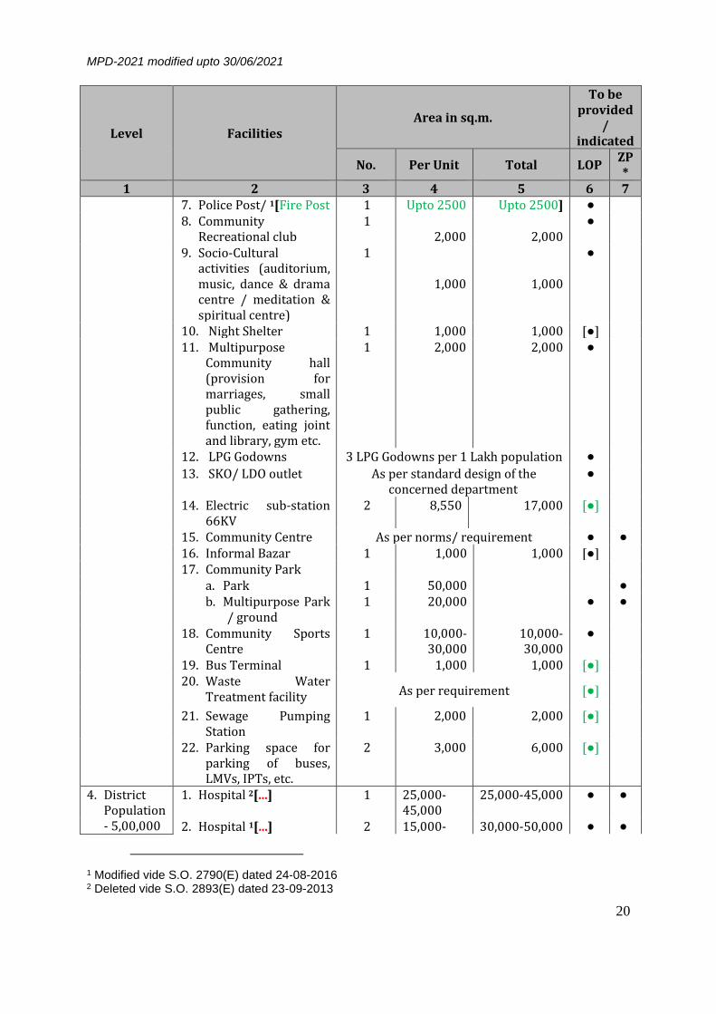
3.2.2 HIERARCHY OF URBAN DEVELOPMENT A planned city for an environment of convenience should have a hierarchical cellular structure; with nuclei to contain essential facilities and services at different levels. The pattern of a community module is conceived as residential area containing a 'neighbourhood' with senior secondary school and shopping facilities for day-to-day needs. The higher level of additional facilities is to be provided at Community, District and Zonal / sub-city levels. Such a structure could be maintained in the process of the preparation of plans on the basis of the standards set in the Table 3.3:
1[Table 3.3: Hierarchy of Urban Development]
Level Facilities Area in sq.m.
To be provided
/ indicated
No. Per Unit Total LOP ZP*
1 2 3 4 5 6 7 1. Housing
Area Population- 5,000
1. Convenience shopping 1 1,000 1,000 ● 2. Totlot 20 125 2,500 ● 3. Housing area Park 1 5,000 5,000 ● 4. Housing area Play
ground 1 5,000 5,000
5. Anganwari 1 200-300 400-600 ● 6. Milk Booth 1 As per standard design of
the concerned Department ●
2. Neighbor-hood Population- 10,000
1. Primary School 1 2,000-4,000
2,000-4,000 ●
2. Sr. Secondary School 1 6,000-8,000
6,000-8,000 ●
3. Religious building 2 400 800 ● 4. Electric Sub Station 11
KV 1 80 80 ●
5. Banquet Halls 1 800-2,000 800-2,000 ●
6. Local shopping 1 3,000 3,000 ●
7. Service Market 1 2,000 2,000 ● 8. Informal Bazaar /
Rehri Bazar 1 1,000 1,000
9. Three wheeler & Taxi Stand
1 400 400 ●
10. Neighborhood Park 1 10,000 10,000 ● 11. Neighborhood Play
Area 1 5,000-
10,000 5,000-10,000 ●
1 Table modified vide S.O. 2895(E) dated 23-09-2013

MPD-2021 modified upto 30/06/2021
19
Level Facilities Area in sq.m.
To be provided
/ indicated
No. Per Unit Total LOP ZP*
1 2 3 4 5 6 7 12. Underground water
tank with booster station and OHT
1 2,000 2,000 ●
13. Sewage Pumping Station
1 500 500 ●
14. Coaching centres, IT & language training centres
1 500 500 ●
15. Dhalao including segregation
1 200 200 ●
16. Dispensary 1 800-1,200 800-1,200 ● 17. Local level waste
water treatment facility
1[18. Sewage Treatment Plant (up to 22.7 MLD)
#(including 50 sqm / MLD for Sewage Pumping Station and 50 sqm / MLD for Effluent Pumping Station)
As per requirement ●
As per require-ement
650 sqm / MLD]
3. Community Population- 1,00,000
2[1. Hospital* 2 2,000– 15,000
4,000 – 30,000 ● ●
2. Tertiary Health Care Centre
1 10,000-15,000
10,000 - 15,000] ● ●
3. a) Family Welfare Centre b) Pediatric Centre c) Geriatric centre d) Diagnostic center
1 1 1 1
500-800
Each
500-800
Each
●
4. Maternity Home 2 1,000-2,000
2,000-4,000 [●]
5. Nursing Home/ Polyclinic
2 1,000-2,000
2,000-4,000 [●]
6. Dispensary for pet animals & birds
1 300 300 ●
1 Added vide S.O. 2617 (E) dated 29.06.2021 2 Modified vide S.O. 2893(E) dated 23-09-2013 Table modified vide S.O. 2895(E) dated 23-09-2013
MPD-2021 modified upto 30/06/2021
20
Level Facilities Area in sq.m.
To be provided
/ indicated
No. Per Unit Total LOP ZP*
1 2 3 4 5 6 7 7. Police Post/ 1[Fire Post 1 Upto 2500 Upto 2500] ● 8. Community
Recreational club 1
2,000
2,000 ●
9. Socio-Cultural activities (auditorium, music, dance & drama centre / meditation & spiritual centre)
1
1,000
1,000
●
10. Night Shelter 1 1,000 1,000 [●] 11. Multipurpose
Community hall (provision for marriages, small public gathering, function, eating joint and library, gym etc.
1 2,000 2,000 ●
12. LPG Godowns 3 LPG Godowns per 1 Lakh population ●
13. SKO/ LDO outlet As per standard design of the concerned department
●
14. Electric sub-station 66KV
2 8,550 17,000 [●]
15. Community Centre As per norms/ requirement ● ● 16. Informal Bazar 1 1,000 1,000 [●] 17. Community Park
a. Park 1 50,000 ● b. Multipurpose Park
/ ground 1 20,000 ● ●
18. Community Sports Centre
1 10,000-30,000
10,000-30,000
●
19. Bus Terminal 1 1,000 1,000 [●] 20. Waste Water
Treatment facility As per requirement [●]
21. Sewage Pumping Station
1 2,000 2,000 [●]
22. Parking space for parking of buses, LMVs, IPTs, etc.
2 3,000 6,000 [●]
4. District Population- 5,00,000
1. Hospital 2[...] 1 25,000-45,000
25,000-45,000 ● ●
2. Hospital 1[...] 2 15,000- 30,000-50,000 ● ●
1 Modified vide S.O. 2790(E) dated 24-08-2016 2 Deleted vide S.O. 2893(E) dated 23-09-2013

MPD-2021 modified upto 30/06/2021
21
Level Facilities Area in sq.m.
To be provided
/ indicated
No. Per Unit Total LOP ZP*
1 2 3 4 5 6 7 25,000
3. Veterinary Hospital for pet animals & birds
1 2,000 2,000 [●]
4. Vocational Training Centre: (ITI / Polytechnic / Vocational Training Institute / Management Institute / Teacher Training Institute etc.) Research and Development Centre
1
4,000 4,000 ● ●
5. School for Mentally Challenged
2 2,000 4,000 ●
6. School for 1[differently-abled persons]
2 2,000 4,000 ●
7. General College 1 As per the UGC norms 8. Professional College
(Engineering) 1 As per the AICTE norms ●
9. Police Station 2 2[Upto 1 Ha
Upto 2 Ha [●] ●
10. Fire Station (5 to 7 km radius)
2 Upto 1 Ha Upto 2 Ha] ● ●
11. Old Age Home 1 1000 1000 ●
12. Care Centre for Physically/ Mentally Challenged
1 1,000 1,000 [●]
13. Working women-men hostel
1 1,000 1,000 [●]
14. Adult Education Centre
1 1000 1,000 ●
15. Orphanage/ Children’s Centre (one each)
1 1,000 1,000 [●]
16. Electric sub-station 220 KV
1 29,600 29,600 ● ●
17. District Centre 1 4,00,000 4,00,000 ● ● 18. Service Market 1 60,000 60,000 ● ●
1 Modified vide S.O. 2895(E) dated 23-09-2013 2 Modified vide S.O. 2790(E) dated 24-08-2016

MPD-2021 modified upto 30/06/2021
22
Level Facilities Area in sq.m.
To be provided
/ indicated
No. Per Unit Total LOP ZP*
1 2 3 4 5 6 7 19. Bus Terminal 1 2,000 2,000 [●] 20. Bus Depot 1 4,000 4,000 ● 21. District park 2,90,000 ●
a. Park 1 2,50,000 b. Multipurpose ground / Park
1 40,000
22. District Sports Centre 1 30,000-1,00,000
30,000-1,00,000
●
23. Recreational club 1 5,000 5,000 ● 24. Cremation ground 1 4,000 4,000 ●
5. Zonal / Sub-City Population 10,00,000
1. Medical College 1 As per Medical Council of India/ Regulatory Body
●
2. Nursing and Paramedic Institute
1 2,000 2,000 ●
3. Telephone Exchange 1 2,500 2,500 [●] 4. RSU (Remote
Subscribe Unit) 1 for 3 km
radius 300 300 ●
5. Sub City Wholesale Market
1 1,50,000 1,50,000 ●
6. Bus Depot As per requirement ● 7. Head Post Office &
Administration Office 1 2,500 2,500 [●]
8. Sewage Pumping Station
1 2,500 2,500 [●]
9. Municipal Office for water & sewerage
1 1,000 1,000 [●]
10. Sewerage Treatment Plant (180 mld)
1 2,34,000 2,34,000 ●
11. City Park 10,80,000 ● a. Park 1 10,00,000 b. Multipurpose
ground 1 80,000
12. Old Age Home 2 1,000 1,000 [●] 13. Divisional Sports
Centre 1 3,00,000 3,00,000 ●
14. Burial ground / Cemetery
1 10,000 10,000 ●
15. Religious Centre 1 40,000 40,000 ● 16. Science Centre As per requirement ●

MPD-2021 modified upto 30/06/2021
23
Level Facilities Area in sq.m.
To be provided
/ indicated
No. Per Unit Total LOP ZP*
1 2 3 4 5 6 7 17. 1[Socio-Cultural
Centre 18. 2[#Sewage Treatment
Plant (up to 22.7 MLD)
#(including 50 sqm / MLD for Sewage Pumping Station and 50 sqm / MLD for Effluent Pumping Station)
As per requirement ●]
As per Require
ment
1100 Sqm/MLD]
LOP - Layout Plan ZP - Zonal Plan 3[Note: * Size of hospital will be restricted upto 1.5 ha. in residential area, with preference to
plot having three side open and having minimum 18 m ROW on one side. Total floor area of the hospital shall be governed as per the total number of beds allowed in it.
2{# The area norms are for new proposed facilities.}] In addition, the following facilities shall also be provided at city level:
Table 3.4: City Level Facilities
Facilities No. Area (in ha.) 1. University Campus
a) Academic incl. Administration b) Residential c) Sports & Cultural Activities d) Parks & Landscape
4 sites in Urban Extension Up to 20.0
2. 4 [District office and battalion 1 for each administrative zone
Upto 1.0
3. Police Lines Upto 1.0
4. District Jail 1 25 lakh population Upto 2.0
5. Police Training Institute/ College City level Upto 5.0
1 Added vide S.O. 2790(E) dated 24-08-2016 2 Added vide S.O. 2617 (E) dated 29-06-2021 3 Added vide S.O. 2893(E) dated 23-09-2013 4 Added vide S.O. 2790(E) dated 24-08-2016

MPD-2021 modified upto 30/06/2021
24
6. Police Firing Range (To be located in fringe area) 7. Police Camp
8. Interstate Bus Terminus (ISBT) As per requirement 10.0 9. International Conventional Centre At city level As per requirement 10. Fire Training Institute/ College City level (One site in
Urban Extension) Upto 5.0
11. Disaster Management Centre 1 for each administrative zone.
Upto 5.0 Ha. Including suitable open area (2Ha) for soft parking, temporary shelter, parade ground etc.]
12. Exhibition-cum-Fair Ground 2 sites in Urban Extension.
Up to 40.0 each
13. Religious Centre 1 25 lakh population 4.0
14. Integrated Office Complex 1 for each administrative zone.
1.5
15. Amusement Park Up to 10 ha. in District Park.
16. International Sports Complex About 200 Ha to be reserved wherever possible in Urban Extension.
17. Veterinary Institute As per Veterinary Council of India / Ministry norms (subject to availability of land.
Note: i) Post office counter, telegraph office, courier service counter, Internet counter, bank
counter / ATM permitted in all use zones / under mixed use as per requirement. ii) These are suggestive norms and lower norms could be adopted in built up areas /
special areas, etc. iii) For the Zonal Development Plans in Urban Extension, the facility belts/corridors
shall be detailed out in the layout plans.
3.3 REDEVELOPMENT OF EXISTING URBAN AREA The scope for development of urban extensions on a large scale is restricted due to limitations of buildable / urbanizable land in Delhi. Therefore, the option of redevelopment through a process of reorganisation and utilisation of the land already developed will be a major element of the overall city development plan. A redevelopment strategy for accommodating more population in a planned manner is to be taken up on priority in all use zones for efficient and optimum utilization of the existing urban land, both in planned and unplanned areas. This would have to be based on provision of infrastructure viz. water supply, sewerage, road network, open spaces and the essential social infrastructure. To encourage the growth impulse for regeneration in the target redevelopment areas, the possible incentives and modalities recommended include grant of planning permission at the scheme level with permission to reorganize / pool properties for planning purposes, provision of social infrastructure through Transferable Development Rights or Accommodation Reservation and reduced space standards for unplanned areas, enhanced FAR for specified redevelopment

MPD-2021 modified upto 30/06/2021
25
areas and application of flexible concept of mix-use zones in Special Area & Villages on scheme basis. 3.3.1 REDEVELOPMENT STRATEGY
The target areas for redevelopment will have to be identified on the basis of their need for up-gradation and potential for development. Redevelopment Schemes will be prepared by the respective local body / land owners / residents. The concerned local body should promote private land owners to take up assembly and redevelopment of 1[land as per the criteria below]. Some of the areas identified are: 3.3.1.1 Planned Areas
A. Influence Zone along MRTS 2[...] Corridor 3[The] growth of Delhi has 2[...] over the years has been on the ring and radial pattern with reliance on road based public transport. The development envisaged by the previous Plans was poly nodal with 3[a] hierarchy of Commercial Centres located either on ring or radial roads. The proposed MRTS network will bring sizable urban area within walking distance from the proposed stations. This will have an impact on the existing structure of the city and consequently its development. This changed scenario provides opportunities for city restructuring and optimum utilization of the land along the MRTS corridors. In this process, a sizable proportion of the additional population with requisite facilities and employment can be absorbed along these corridors. Influence Zone along MRTS corridor is envisaged as intensive development zone. 4[The concept of Transit Oriented Development shall be adopted for development within the Influence Zone, such that maximum number of people can live, work or find means of recreation within walking / cycling distance of the MRTS corridors / stations.] The scheme for 1[Development /] Redevelopment of Influence Zone shall be prepared 5[as per Chapter 20.0 Transit Oriented Development.]
B. Re-densification of low-density areas
1 Modified vide S.O. 1914(E) dated 14-07-2015 2 Deleted vide S.O. 1914(E) dated 14-07-2015 3 Added vide S.O. 1914(E) dated 14-07-2015
4 Modified vide S.O. 1914(E) dated 14-07-2015
5 Modified as S.O. 4614 (E) dated 24-12-2019

MPD-2021 modified upto 30/06/2021
26
There is a large proportion of underused land with a number of vacant sites as well as dilapidated built-up areas lying vacant in the city. Many of such areas are owned by Government of India. Such areas are recommended to be planned for redevelopment with higher density in order to make optimum use of land resource as per the prescribed norms.
C. Redevelopment of Other Developed areas In Delhi, including New Delhi (NDMC area), a large number of housing, commercial and industrial areas are old and characterized by poor structural condition, sub-optimal utilisation of land, congestion, poor urban form, inadequate infrastructure services, lack of community facilities, etc. These are to be redeveloped as per the prescribed norms and development controls and with the initiative / consultation with the Residents' society / RWA / Traders' Associations.
3.3.1.2 Special Area The Special Area as defined in the Plan has been divided into three separate parts, namely (i) Walled City (ii) Walled City and Extension and (iii) Karol Bagh. These are characterized by a mix of different land uses and have similarities in compact built form, narrow circulation space and low-rise high-density developments, mainly accommodating residential, commercial - both retail or wholesale and industrial uses. Therefore, it is important that the areas, which are already established with identified uses, continue to play an active economic role. The Authority may further designate certain other areas as 'Special Area'. The strategy is to provide suitable framework for allowing mix-use activities appropriate to the character of the areas as per the individual schemes having greater flexibility in terms of permitting variety of uses namely, commercial use (shops, offices, banks etc.), household industries or outlets for specialized services etc. However, the criterion of selection of the mix-use activities shall be as per Mixed Use Regulations. Required parking and open spaces will have to be provided as per the norms, while reduced space norms for other facilities may be accepted. The redevelopment areas should ensure modern services and amenities, thereby eliminating risk generating structures and activities. The regulations for Special Area shall be different from other areas. All these areas are to be brought within the planning

MPD-2021 modified upto 30/06/2021
27
purview. For this, the owners can jointly redevelop on the basis of the norms and regulations to be prescribed. A. Shahjahanabad (Walled City)
The most important part of the Special Area is the traditional City of Shahjahanabad, part of which is a core of the business district. The area is prone to commercialisation, particularly with improved accessibility due to the MRTS. The Plan proposes to regulate and shift noxious and hazardous wholesale trades and industrial activity from this area. Traditional areas in Walled City need special treatment to conserve its heritage value while retaining the residential character. Redevelopment of government owned katras is to be taken on priority. However, redevelopment would also be promoted in privately owned katras simultaneously. Permission of activities in use premises and building control regulations shall be as follows: i) The area surrendered for public facilities or for heritage
value to be used as tradable FAR. ii) Street pattern: iii) The street pattern in residential area is proposed to be
restructured with linkages from the metro stations. The minimum road width and prioritizing of road widening are dictated by fire and other disaster management criteria. The streets, having 30m to 50m lengths, shall have a minimum of 3m width and streets having more than 50m length shall have a minimum of 4.5m width. Common facilities shall be located with linkages to pedestrian roads and metro stations.
iv) Subject to preparation and approval of an Integrated Redevelopment Scheme, higher FAR and other development controls can be considered. This provision is also subject to requirement of heritage controls, parking, accessibility of emergency vehicles and basic services.
B. Walled City Extension Pahar Ganj, Sadar Bazar, Roshanara Road and their adjoining areas comprise the Walled City and Extension. These are old congested built-up areas and for up-gradation of the environment in these areas, minimum level of infrastructure and parking facilities should be provided. The redevelopment in these areas shall be in accordance with the respective comprehensive redevelopment schemes with conservative surgery as a planning tool, as far as possible.

MPD-2021 modified upto 30/06/2021
28
In the Special Area Plan, use zones have been marked in different pockets of the `Other Urban Renewal Areas'. These pockets shall be planned for the respective use zones assigned. The redevelopment schemes for different use zones shall generally adopt regulations prescribed in the Development Code except in cases where special provisions have been made / proposed in this Plan.
C. Karol Bagh Karol Bagh has become one of the important commercial centre outside the Walled City. The invasion of commercial activity has pushed out the residential use substantially. Karol Bagh area is due for comprehensive redevelopment on the basis of mixed-use concept with provisions of parking and up-gradation of facilities and utilities. The gridiron pattern should be treated as an asset to regulate and pedestrianize the traffic movement.
3.3.1.3 Unplanned Areas A. Slum and JJ Clusters, Resettlement Colonies and
Unauthorised Colonies In-situ up-gradation of the land pockets of slum and JJ Clusters, which are not required for public / priority use is the first option for provision of affordable housing for rehabilitation of squatters. Resettlement colonies though planned, are also to be upgraded in a similar way for infrastructure provision. Similarly, unauthorized colonies slated for regularization are also proposed to be improved through redevelopment by ensuring participation of the inhabitants.
B. Villages The villages in Delhi have undergone significant physical and functional transformation related with their specific location. Villages are characterized by a mix of different land uses and have similarities in compact built form, narrow circulation space and low-rise high-density developments. These mainly accommodate residential, commercial and industrial uses and function as a mix. It is important that these areas, which are already established with identified uses, continue to play an active economic role. Comprehensive schemes for the development of villages should be prepared by the concerned local bodies with the aim of provision of optimal facilities and services within the abadis and integration with the surrounding areas. Towards the latter objective, development along the peripheries of the

MPD-2021 modified upto 30/06/2021
29
villages should be carefully planned, wherever necessary for the provision of services and green / open areas, circulation, etc. This aspect should also be kept in view while preparing layout plans for urban extension areas. For provision of social and educational facilities, reduced space standards shall be adopted. The facilities like community hall, dispensary etc. may be grouped together depending on the availability land. Small shops shall be permissible in residential plots on ground floor as per provisions of Mixed Use Regulations in village abadi including rural (para 15.6.3).
3.3.2 1[POLICY] FOR REDEVELOPMENT SCHEMES
The basic objective of redevelopment is to upgrade the area by implementing specific schemes on the basis of existing physical and socio-economic conditions in the following way: i) Influence Zone along MRTS Corridor and the Sub-Zones for
redevelopment and renewal should be identified on the basis of physical features such as metro, roads, drains, high tension lines and control zones of Monuments / Heritage areas, etc. 2[and designated as TOD 3{Node} Zone with additional norms applicable as per 1{Chapter 20.0 Transit Oriented Development.}]
ii) The residents / cooperative societies / private developers should get the layout and services plan prepared in consultation with the concerned authority for approval.
iii) Within the overall Redevelopment / Regularisation plans, building plan approval shall be at following two stages: a) Planning Permission for an area of around 4 Ha. 4[However, in
1{Influence Zone of TOD Node, TOD} schemes shall be 1{as per Chapter 20.0 Transit Oriented Development.}] This permission may not be required in case an approved layout / Redevelopment / Regularisation plan exists.
b) 1. Cluster Block 2[approval may be given to DE] for a
minimum area of 3000 sq.m. 2[only if an approved influence zone plan or integrated scheme for the area exists.] The owners should pool together and reorganise their
1 Modified vide S.O. 1914(E) dated 14-07-2015 2 Added vide S.O. 1914(E) dated 14-07-2015 3 Modified as S.O. 4614 (E) dated 24-12-2019 4 Modified vide S.O. 1914(E) dated 14-07-2015

MPD-2021 modified upto 30/06/2021
30
individual properties so as to provide minimum 30% of area as common green / soft parking besides circulation areas and common facilities.
1[...] 2. Individual buildings shall be given sanction by the
concerned authority within the framework of cluster block 2[approval 1{as per applicable policy.}]
c) The norms of Group Housing with respect to ground coverage, basement, parking, setbacks etc. (except FAR) shall be applicable 1[in all areas except TOD Zone where TOD norms shall be applicable.]
iv) Amalgamation and reconstitution of the plots for planning purpose will be permitted.
v) To incentivise the redevelopment a maximum overall FAR of 50%
over and above the existing permissible FAR on individual plots subject to a maximum of 400 shall be permissible. Higher FAR shall however not be permissible in redevelopment of Lutyens Bungalow Zone, Civil Lines Bungalows Area and Monument regulated Zone. 2[In case of residential premises, wherever dwelling units are proposed, the number of dwelling units may increase in same proportion as FAR]
vi) In case of plots with service lanes, the lane area may be included in the
scheme. However, no FAR / coverage will be granted and the area shall be used as public area.
vii) The standards of housing density, minimum width of roads and community facilities can be relaxed, wherever justified, by planning considerations (e.g., pedestrianization of the area).
viii) The Public and Semi-public uses and services like hospitals 3[/ tertiary health care centres], dispensaries, colleges, schools, police stations, fire stations, post offices, local government offices, parking etc. shall be retained in their present locations as far as possible and if not, relocated as part of the redevelopment scheme. Alternative sites shall be indicated in the Redevelopment Schemes / Zonal Development Plans. Any change or addition thereof shall be in accordance with the overall policy frame prescribed in the plan.
ix) Reduced space standards may be adopted for community facilities / social infrastructure for the areas mentioned in 4.2.2.2 B sub para (ii)
1 Deleted vide S.O. 4614 (E) dated 24-12-2019 2 Added vide S.O. 2690 (E) dated 11-08-2016 3 Added vide S.O. 2893 (E) dated 23-09-2013

MPD-2021 modified upto 30/06/2021
31
'social'. The land required for any public purpose may be acquired with the consent of the owner through issue of Development Rights Certificate in lieu of payment towards cost of land as per the prescribed regulations. The concept of Accommodation Reservation i.e. allowing construction of community facilities without counting in FAR may also be utilized.
x) Subject to preparation and approval of integrated / comprehensive Redevelopment schemes and provision of parking and services, 1[upto] 10% of the FAR may be allowed for commercial use and 10% of the FAR for community facilities with a view to trigger a process of self-generating redevelopment. • 2[Within TOD Node, the permissible mix of uses within FAR
utilization and indicative mix of uses shall be as per Chapter 20.0 Transit Oriented Development.]
xi) The circulation pattern should include segregation of pedestrian and vehicular traffic, entry control, access of emergency vehicles to every block, provision of adequate parking etc.
xii) Appropriate levies for increased FAR, and landuse conversion shall be charged from the beneficiaries by the competent authority as per prevailing rules / orders.
xiii) Urban Design and Heritage 2[Conservation] to be ensured as per the 1[regulations /] guidelines.
xiv) The land use shall be governed as per the Master Plan / Zonal Development Plan. The non-residential use will be permitted as per the provisions of the Mixed Use Regulations and Special Area Regulations. 1[The MRTS Influence Zone shall be designated as TOD Zone and norms shall be applicable as per Section 12.18.]
3 [...] --- x---x---x---x---x---
1 Modified vide S.O. 4614(E) dated 24-12-2019
2 Added vide S.O. 1914 (E) dated 14-07-2015
3 Deleted vide S.O. 4614 (E) dated 24-12-2019

MPD-2021 modified upto 30/06/2021
32
4.0 SHELTER
The policy regarding “Shelter” is based on the goal of ensuring ‘Shelter for All’ by
harnessing the potential of the public, private / corporate and household sectors. It aims to ensure effective housing and shelter options for all citizens, especially for the vulnerable groups and the poor, by creation of adequate housing stock on either rental or ownership basis. It envisages the role of the public agencies as facilitator through policy and strategic interventions.
Housing has a strong spatial relationship with employment, social services and
other urban activities. The policy for development of housing could act as major tool for influencing the efficiency and equity of urban areas, besides its direct role in the provision of shelter.
4.1 HOUSING NEED
As per the Census 2001, Delhi has 24.5 lakh Census houses under the category of residence and residence-cum-other uses, in which 25.5 lakh households are residing. This reflects a net housing shortage of about 1.0 lakh houses / dwelling units. The households are accommodated in a variety of housing types including different categories of planned built housing, squatter settlements, unauthorized colonies, traditional areas and villages. The Sub-group on Shelter noted that up to the year 1991, the contribution to housing stock through institutional agencies was only 53% (excluding squatter housing). Therefore, the component of housing through non-institutional sources, viz., unauthorized colonies, squatter / JJ clusters, etc., is quite significant. This trend has continued in the current decade as well and has to be kept in view while determining the plan and strategy for housing. Based on the projected population of 230 lakh by 2021, the estimated additional housing stock required will be around 24 lakh dwelling units. This includes an estimated housing requirement of 20 lakh dwelling units for additional population and backlog of about 4 lakh units comprising of 1 lakh net shortage and the rest by dilapidated and Kutcha structures requiring replacement. It has also been assessed that around 40% of housing need can potentially be satisfied through redevelopment / up-gradation of existing areas of Delhi. This may be met in the present urban limits of A to H zones and in the sub cities of Dwarka, Rohini and Narela. This implies that the remaining 60% of the requirement would have to be met through 14.4 lakh new housing units to be provided in new areas. In order to ensure that housing need is accommodated in the urban extension, the Zonal Plans for 2021 should be prepared within 12 months. Keeping in view the socio-economic composition of the population, it is estimated that around 50-55% of the housing requirement would be for the urban poor and

MPD-2021 modified upto 30/06/2021
33
the economically weaker sections in the form of houses of two rooms or less. Based on past experience it is necessary to distinguish between the urban poor comprising the inhabitants of squatter settlements / pavement dwellers, etc. and other economically weaker sections of the society, conventionally classified in the form of EWS, LIG, etc. The role of the government would have to be both as a provider and facilitator. The category of the urban poor is to be broadly catered in old and new urban areas through up-gradation of old / traditional areas, employers and industrial housing, group housing and also in unauthorised regularised colony infills. A possible indicative scenario in terms of mode of housing supply in different types of development for the next two decades emerges as under:
Table 4.1 Indicative Distribution of Housing Types
Housing Type Development Agencies Housing Component (%)
EWS / LIG Others Total Slum & JJ - In-situ Rehabilitation Relocation / Reconstruction & Up-gradation
Public, Private, Co-op Society
25 - 25
Houses on Independent Plots & Redevelopment
Public, Private 4 4 8
Group Housing (Min. 35% of total DUs mandatory 2 room or less)
Public, Private, Co-op Society
14 28 42
Employer Housing Central / State Govt. 2 2 4 Unauthorised Regularised colonies infill
Co-op Society/ Residents’ Association / Private
6 9 15
Other Housing areas, Up-gradation of Old areas/ Traditional areas/ Villages
Public, Private, Co-op Society
3 3 6
TOTAL 54 46 100
4.2 HOUSING STRATEGY
The proposed housing strategy incorporates specific approaches for development of new housing areas, up-gradation and re-densification through redevelopment of existing housing areas including unauthorized colonies, housing in villages and Special Area. Looking at the possible distribution of housing types, the future requirement of shelter provision will be dominated by small dwelling units. In view of the limited availability of land and increased requirement of housing, plotted residential development shall be discouraged. It is proposed to adopt a multi-pronged housing strategy for provision of housing stock and for delivery of serviced land, involving the private sector to a significant extent, public agencies and co-operative societies etc. The overall responsibility for

MPD-2021 modified upto 30/06/2021
34
provision of land and facilitation of adequate housing to meet the projected demand lies with the DDA in collaboration with GNCTD and other agencies. Planning norms, land use zoning, density, FAR, and building controls have been reviewed for housing, both in new areas to be opened up and for redevelopment of existing areas. In the context of housing strategy, it is essential to optimise utilization of land and space with a view to increasing net residential density. These norms and controls should also be reviewed periodically (preferably every five years) by DDA and suitably modified / updated to meet the requirements of the citizens. It has been observed that the practice of prescribing FAR / density norms without distinguishing between housing categories in terms of plinth area, can result in over population or under population on the one hand, and non-optimal design and under-utilisation of the utility network, on the other. The norms should provide options to achieve the density and FAR both in Ground + 3 or 4 storeyed walk-up structures, without lift or in high-rise construction. 1[] 2[As the development of housing in new area or redevelopment of existing housing stock in built up area to be taken by the Public Agencies, Society or private developers the upper limit of density be taken as 200 DUs/ha.(900pph) with flexible Dwelling Unit sizes to achieve optimal utilization of land. The density for Slum & JJ clusters (In-situ up-gradation/ Rehabilitation/ Redevelopment of Slum & JJ Clusters, Resettlement Colonies) and EWS Public Housing Schemes be maximum 900 DUs/ ha.] The Central Government may relax density and other norms in consultation with DDA for public housing and projects of national importance.
In case of plotted development, the permissible number of dwelling units will be as prescribed for different plot sizes given in the development controls. In case of Bungalow area (Part zone D) any residential density in group housing pockets shall be prescribed on the basis of detailed scheme. In case of Civil Lines Bungalow Area, the development controls for group housing shall be as prescribed in the Zonal Development Plan of zone ‘C’. To make the construction activity more environment friendly, the choice of alternative building materials and techniques have to be reoriented and promoted for construction activity. Building technology parks and mobile expositions for cost effective materials and techniques are to be explored for new housing areas and redevelopment schemes. Standard specifications may also be incorporated in the Government Schedule and may be adopted for public buildings and housing schemes.
1Deleted vide S.O. 1215 (E) dated 13-05-2013 2Added vide S.O. 1215 (E) dated 13-05-2013 and modified vide S.O. 2894 dated 23-09-2013

MPD-2021 modified upto 30/06/2021
35
4.2.1 NEW HOUSING AREAS
Even if the assumptions regarding the extent of housing that could be met by redevelopment of the existing areas actually materialize, there would still be a need for the development of housing to the extent of at least 75,000 DUs per annum in different categories. This implies that specific plans would have to be evolved by DDA with the approval of the Competent Authority and action be taken with reference to the following: (i) Determination of area requirement; (ii) Identification of the areas for urbanization / housing development; (iii) Evolving the pattern and norms for new housing development; (iv) The mode and manner of development, and the roles of the private
and public sectors in this process. As already indicated, more than 50% of the new housing would be in the form of one and two room units with average plinth area of about 25 sq.m. to 40 sq.m. The average plinth area per house to be achieved in various neighbourhoods will also depend on composition of various income groups to be accommodated in the composite housing schemes. The policy should indicate that EWS & LIG houses after construction by a private group shall be handed over to the nodal agency/ agencies and these should be allotted to eligible beneficiaries. The new housing developed through the aforementioned methods should be based on a composite area basis and should cater to the special needs of elderly, handicapped and single occupants. With these aspects and planning norms, the land required to be developed in new housing will be to the tune of around 450-500 ha. per annum.
4.2.2 RESTRUCTURING AND UP-GRADATION OF THE EXISTING AREAS In Delhi, a large number of areas are old and are characterized by poor structural condition of buildings, sub-optimal utilisation of land, congestion, poor urban form, inadequate infrastructure services, lack of community facilities, etc. The housing stock in both planned and unplanned areas can be enhanced through various approaches as given below.
4.2.2.1 Planned Areas
A. Plotted / Group Housing
The flats built by DDA, particularly those, which have become aged, may be redeveloped with permission and subject to the condition that the structural safety of other flats is not impinged. Already developed group housing inclusive of public (DDA and others), co-operative housing may be redeveloped on the basis of prescribed norms and

MPD-2021 modified upto 30/06/2021
36
regulations by formulating co-operative societies or self-managing communities. The funds for redevelopment should be contributed by the residents.
B. Employer Housing
In Delhi after Independence, substantial areas were developed at low density and have potential for densification. These are mainly government and cantonment areas. In order to optimally utilise these prime lands there is need of intensive development. On a conservative estimate the present housing stock can be increased to more than double. Infrastructure enhancement and provision for additional housing can be financed from the funds generated through cross-subsidisation between commercial and residential use for EWS and LIG categories.
C. Bungalow Area
Lutyens’ Bungalow Zone comprises of large size plots and has a very pleasant green environment. The essential character of wide avenues, large plots, extensive landscape and low rise development, has a heritage value which has to be conserved. Mixed use, high intensity development along MRTS corridor and de-densification of trees / reduction of green cover is not permitted at all. The strategy for development in this zone will be as per the approved plans and the LBZ guidelines, as may be issued by the Government of India from time to time. Civil Lines also has Bungalow Area of which the basic character has to be maintained.
1[D. Low Density Residential Area
The majority of Farm Houses in the urban extension areas are located on lands where ground water has already been severely depleted or close to such depletion. Further, intensification of residential density and heavy additional load on civic infrastructure such as water supply, Drainage, Sewerage, Parking etc. is highly undesirable in such areas from environmental considerations. Therefore, villages containing existing farm houses clusters are notified as “Low Density Residential Area” (list of village at Annexure- 4.0 (I). Low Density Residential Plots are also allowed in the village falling in Green belt (list of villages in Green Belt at Annexure-4.0 (II).]
1Added vide S.O. 1744 (E) dated 18-06-2013

MPD-2021 modified upto 30/06/2021
37
4.2.2.2 Traditional Inner City and Unplanned Areas
The congested areas of the city have a predominant residential component like Shahjehanabad (Walled City), and its Extensions, Karol Bagh (Special Area) and villages. The unauthorised / regularised colonies, which are unplanned areas, have a role to play as a housing stock provider. All these areas should be redeveloped ensuring modern services and amenities for a safe residential environment and in the process, eliminating risk prone structures and activities. The owners can jointly redevelop the areas based on the prescribed guidelines. A. Special Area and Villages
The Old City areas, Shahjehanabad (Walled City), and its Extensions, Karol Bagh (designated as Special Area) are fast changing their residential character to non-residential use, but still have a residential component. The non-residential uses of varying degrees have developed with time depending on their location, related with accessibility and the established trade. In the case of traditional inner city areas, it is essential first to distinguish between the heritage segment of the area and the non-heritage segment of the area. Well-designed Special Area Redevelopment Schemes must be prepared for traditional areas giving the development control parameters for the heritage areas keeping in view archaeological norms / architectural character and general parameters for the non-heritage segment of the traditional area. Each Special Area Redevelopment Scheme should entail an enumeration of the monuments and old buildings within the heritage areas, which must be conserved. The 1[concerned municipal body] is the nodal agency who should prepare Special Area Redevelopment Schemes for all traditional areas within a time frame. The basic objective of Special Area Redevelopment Scheme in traditional areas is to bring about in situ improvements which help in improving architectural character of the area, i.e., design and layout, as well as revitalising trade and commerce in the area. The villages are also considered at par with these as they also have the same traits. The socio-economic changes in these old
1 Modified vide S.O. 3173(E) dated 12-12-2014

MPD-2021 modified upto 30/06/2021
38
unplanned areas, especially in villages, have been substantial. The redevelopment plans should ensure that the permissibility of mixed use zoning at property or within the premise level is compatible to the predominant residential areas.
B. Unauthorised / Regularised Unauthorised Colonies Unauthorised colonies in Delhi pose a serious human problem as a huge population is living in these colonies. The issue of existing unauthorized colonies has engaged attention since the mid-seventies when a policy for regularization was formulated. 567 out of 607 listed unauthorized colonies were regularised till October 1993, but many more unauthorized colonies have come up since then. Such colonies are to be identified by the Govt. of NCTD. The present method of regularization of unauthorized colonies is by the provision of basic infrastructure to improve the environment. However, regularization has not really brought in any tangible improvement. Effectively, the process has only led to de-facto tenure rights on the land and access to services. In all unauthorised colonies whether on private or public land, regularization should be done as per the government orders issued from time to time. It must be ensured that for improvement of physical and social infrastructure, the minimum necessary / feasible level of services and community facilities are provided. (i) Physical: Plans for provision of services shall be
prepared by the concerned local bodies. (ii) Social: For provision of social facilities, reduced space
standards shall be adopted. Depending on the availability of land, facilities like community hall, dispensary etc. can be grouped together. a) Primary school 800sq.m. per 5000 population b) Sr. Secondary School 2000sq.m per 10000 population
The above norms can be further relaxed for existing recognised schools on the basis of minimum norms prescribed by the Education Department, GNCTD / Central Board of Secondary Education.
c) The following facilities can be clubbed in a composite facility centre (500-1000 sqm.) (i) Multi-purpose community hall - 100 sqm. (ii) BastiVikas Kendra - 100 sqm. (iii) Religious site - 100 sqm. (iv) Police Post - 100 sqm.

MPD-2021 modified upto 30/06/2021
39
(v) Health Centre - 100 sqm. (vi) Park/Shishu Vatika- 200 sqm. (vii) Area for essential retail outlets e.g., Milk Booth,
Fair Price Shop, Kerosene shop, etc. may be provided.
(viii) Provisions for informal trade units and weekly market to be made, wherever necessary.
1[d)In case separate facility plots as per MPD norms are not feasible, the facilities may be clubbed and provided on the basis of ground realities and also by using the concept of Accommodation Reservation (AR).]
4.2.3 HOUSING FOR URBAN POOR
The category of urban poor for purpose of the Plan would mainly comprise the inhabitants of squatter settlements and informal service providers. Such services could include domestic help, hawkers and vendors, low paid workers in the industrial, commercial and trade / business sectors, etc. These include both existing population and future migrants. In terms of housing requirements of the city, this continues to be the single biggest challenge and would require a mix of approaches and innovative solutions.
4.2.3.1 Rehabilitation / Relocation of Slum & JJ Clusters
In so far as the existing squatter settlements are concerned, the present three-fold strategy of relocation from areas required for public purpose, in-situ up-gradation at other sites to be selected on the basis of specific parameters and environmental up-gradation to basic minimum standards shall be allowed as an interim measure. Rest of the clusters, till they are covered by either of the first two components of the strategy, should be continued. During the Plan period 1981-2001, sites and services approach based relocation was employed in which resettlement of squatter slums was done on 18 sqm and 12.5 sqm. plots (transit accommodation)allotted to eligible persons on licence basis. This has led to a number of aberrations and there are several aspects, due to which this approach needs to be progressively abandoned and substituted by an alternate approach. Broadly, speaking this alternate approach should have the following components: (i) Resettlement, whether in the form of in-situ up-gradation or
relocation, should be based mainly on built up accommodation of around 25 sq. m with common areas and
1Added vide S.O. 2890(E) dated 23-09-2013

MPD-2021 modified upto 30/06/2021
40
facilities, rather than on the model of horizontal plotted development.
(ii) The concept of land as a resource should be adopted to develop such accommodation with private sector participation and investment, to the extent possible.
(iii) Incentives by way of higher FAR, part commercial use of the land and, if necessary and feasible, Transfer of Development Rights should be provided.
(iv) A cooperative resettlement model with adequate safeguards may be adopted with tenure rights being provided through the institution of Co-operative Societies.
(v) The provision of accommodation should be based on cost with suitable arrangements for funding / financing, keeping in view the aspect of affordability and capacity to pay.
(vi) In cases of relocation, the sites should be identified with a view to develop relatively small clusters in a manner that they can be integrated with the overall planned development of the area, particularly keeping in view the availability of employment avenues in the vicinity. Very large resettlement sites could lead to a phenomenon of planned slums.
(vii) Suitable arrangement for temporary transit accommodation for families to be rehabilitated should be made. This may preferably be near or at the same site and the utilization of these may be synchronised with the phases of implementation of the scheme of in-situ up-gradation.
(viii) Community Based Organisations (CBOs) and Non-Governmental Organisations (NGOs) should be closely involved in the resettlement process.
4.2.3.2 Resettlement Colonies Most of the resettlement colonies have been provided with essential services, but the immediate need is of individual services i.e. water, sewerage and electricity. To ensure healthy and better environment, the construction of houses needs to be based on approved / standard building plans. Co-operative societies / private developers / govt. agencies may come forward for redevelopment based on the incentives as applicable for the Squatter Rehabilitation Scheme. Reconstruction of existing plotted development, group housing should be

MPD-2021 modified upto 30/06/2021
41
encouraged as per the Redevelopment Guidelines given in para 4.2.3.4.
4.2.3.3 New Housing for Urban Poor
New housing should be in the form of one or two room units, which would be developed through public and private agencies and through Cooperative societies. As this category constitutes bulk of the housing stock that has to be catered at an affordable price to the lowest income bracket as housing for Economically Weaker Sections (EWS),this is often done by cross-subsidization. For this purpose, adequate land would be earmarked for EWS housing. The developers of group housing shall ensure that minimum 1[15% of proposed FAR to be] constructed for Community-Service Personnel / EWS and lower income category.2[Employer Housing of Central Government, State Government and other Government Agencies are not required to follow the requirement of FAR or Dwelling Units for Community Service Personnel / EWS and lower income category.] In old built up areas, this may be as redevelopment schemes or industrial housing, etc., whereas, in urban extensions, the acquisition and development cost of this land should be borne by rest of the project. Such reserved lands should be handed over to a designated agency for promoting housing for low income and weaker sections. The pattern of EWS housing shall be such as to ensure optimal utilization of land in a sustainable manner. For that purpose, multi- storied housing will be the preferred option. Apart from mandatory provision for EWS housing in all group housing projects/ schemes, the primary responsibility for creating adequate stock of housing for urban poor shall be borne by public agencies.
4.2.3.4 Slum & JJ Redevelopment Regulations and Guidelines for Collective Community Rehabilitation / Relocation - In-situ Up-gradation / Rehabilitation of Slum & JJ Clusters, Resettlement Colonies, 3[schemes for rehabilitation of project-affected persons# and Unsafe Buildings*#] 4[and EWS public housing schemes]
1 Modified vide S.O. 1215 (E) dated 13-05-2013 2 Added vide S.O. 1277(E) dated 19-05-2009 3 Added vide S.O. 2894(E) dated 23-09-2013 and modified vide S.O. 2895(E) dated 23-09-2013 4 Added vide S.O. 2895(E) dated 23-09-2013

MPD-2021 modified upto 30/06/2021
42
The 1[implementing agency / corporate body concerned] should work out schemes for collective community rehabilitation/ relocation and explore the possibility of involving private sector/slum cooperatives. In existing resettlement colonies, redevelopment, regular servicing and maintenance, which are overdue, are to be based on the guidelines and incentives as applicable for the Slum& JJ Rehabilitation Scheme 1[schemes for rehabilitation of project-affected persons# and for Unsafe Buildings*#] 2[and EWS public housing schemes.] The following guidelines with site-specific relaxations may be adopted as required. Regular monitoring of executed schemes and revision of these guidelines at the time of preparation of new schemes is essential. Group housing norms shall be applicable with the following conditions: (i) 1[Minimum plot size 2000 sqm (on a min. ROW of 9m).] 1[In
case of Public Housing, the Technical Committee of DDA may relax minimum plot size by 10 %.]
(ii) Maximum 1[900 DUs/ha] on residential component of the land.
(iii) The scheme should be designed in a composite manner with an overall maximum FAR of 400 on the residential component of the land 1[(including facilities i.e., Facility for the level as indicated in Table.3.3 of Chapter 3 based on the population accommodated under the project/scheme)] 3[The maximum FAR of 300 on the remunerative component of the land shall be applicable irrespective of the landuse. Any use/ mix of uses shall be permitted as proposed by the developer entity within the overall FAR of 300, in the remunerative component as per MPD provisions. In case the developer entity proposes mix of uses, the parking and other development control norms will be applicable on pro-rata basis, on the FAR utilized for the particular use.]
(iv) Mixed land use / commercial component 4[(including all commercial activities as permitted under Table 5.1 of Chapter 5)] up to 10% of permissible FAR in the residential component of the land. 1[In addition 4{to the above}, 10% of the permissible FAR 4{may} be permitted for home based economic activities (i.e., Group-A Household Industries as given in Annexure I of Chapter 7) to the beneficiaries of the
1Modified vide S.O. 2894(E) dated 23-09-2013 2 Added vide S.O. 2895 (E) dated 23-09-2013 3 Modified vide S.O. 4674(E) dated 23-12-2020 4 Added vide S.O. 475 (E) dated 28-01-2019

MPD-2021 modified upto 30/06/2021
43
project/ scheme.] 1[All the commercial activities shall be permissible irrespective of the land use subject to all statutory clearances and shall in no case compromise with the basic community needs and infrastructure facilities required to be provided as per MPD-2021.]
(v) Specific situations may require clubbing of scattered squatters with JJ sites in the neighbourhood to work out an overall comprehensive scheme.
(vi) The minimum residential component of the land area for rehabilitation of squatters has to be 60% and maximum area for remunerative use has to be 40%.
(vii) Area of dwelling unit for 2[EWS or rehabilitation shall be minimum 25 sqm and max. 40 sq. mt. and room sizes as per IS: 8888.]
(viii) 3[Common parking is to be provided for residential component at 0.5 ECS per 100 sqm of floor area which can be relaxed wherever required. Parking for remunerative purposes shall be as applicable for the relevant land use.]
(ix) No restriction on ground coverage (except set backs) (x) Schemes shall be approved by concerned local body. (xi) Schemes / designs should be compatible for 4[differently-
abled persons]. (xii) Norms for Social Infrastructure shall be as per 4.2.2.2 B sub
para (ii) ‘Social’. (xiii) Norms for Physical Infrastructure shall be as per note (iv) of
Table 4.2.
5[Note: * Unsafe buildings are to be determined by the statutory
competent authority. # In case of Schemes for Rehabilitation of Project-affected
Persons & Unsafe Buildings, this will only be applicable for those schemes wherein these guidelines are adopted. Disposal and eligibility for allotment of the built flats/plots for Schemes for Rehabilitation of Project-affected Persons & Unsafe Buildings shall be governed by the separate policy already formulated or yet to be framed by the Housing & Lands Departments of DDA.]
3[Slum & JJ Clusters on plots smaller than 2000 sqm be relocated instead of taking up in-situ rehabilitation as per the above-cited guidelines.]
1 Added vide S.O. 475 (E) dated 28-01-2019 2 Modified vide S.O. 2894(E) dated 23-09-2013 3 Added vide S.O. 2895 (E) dated 23-09-2013 4 Modified vide S.O. 3173 (E) dated 12-12-2014 5 Added vide S.O.2894(E) dated 23-09-2013

MPD-2021 modified upto 30/06/2021
44
4.3 NIGHT SHELTER
1[The provision of night shelters is envisaged to cater to the shelterless, which should be provided as per requirements and should be identified keeping in view major work centres. Special provisions should be made for the homeless, women and children including the differently-abled 2{persons}, orphans and old age persons.] 3[Further, to the development of night shelters by GNCTD/DUSIB/ 4{concerned municipal body}/ DDA as per MPD-2021, provisions for night shelter should also be made in existing buildings and in new proposed constructions within the Railway Terminals, Bus Terminals, Wholesale/Retail markets, Freight Complexes, Police Stations, etc. by the agencies concerned such as Railways, Health, Industry, DTC, Police, etc., wherever available, with suitable modifications into night shelters as well as by adopting innovative concepts such as integrated complex with commercial space on the ground floor and night shelters on the first floor.] In addition, multi-purpose use of the existing facility buildings may be allowed for night shelter purpose. Provision should also be made for converting existing buildings, wherever available, with suitable modifications into night shelters.3[Since land is a constraint, the endeavour should be to optimally utilize the land for creating multipurpose facilities in residential and PSP plots.]
On the basis of the 2001 Census of houseless population, at least 25 sites should be earmarked in Delhi for night shelters. In order to make the provision of this facility financially sustainable for the local body, innovative concepts such as integrated complex with commercial space on the ground floor and night shelter on the first floor should be explored. The guidelines and incentive package should be designed by the concerned local agency in collaboration with the Govt of NCT-Delhi with a view to develop self-sustaining night shelters. One night shelter shall be provided for 1 lakh population. 3[The actual location and need of night shelter is to be decided by the Local Authorities / GNCTD based on practical demand / assessment. However, in this regard for the geographical distribution of Night Shelters a minimum of at least one Night Shelter per administrative unit such as the Revenue Sub-Division or jurisdiction of Police Station may also be taken as criteria for planning purposes.]
4.4 DEVELOPMENT CONTROLS FOR RESIDENTIAL USE ZONE
In the residential use zone there are two sub-zones, RD - Residential Area (including villages within Laldora located in any use zone) and RF - Foreign Mission. Permission of use premises in sub-use zone RD shall be as per permissibility given in the respective chapters.
1 Modified vide S.O. 2894(E) dated 23-09-2013 2 Added vide S.O.2895(E) dated 23-09-2013 3 Added vide S.O. 2894(E) dated 23-09-2013 4 Modified vide S.O. 3173 (E) dated 12-12-2014

MPD-2021 modified upto 30/06/2021
45
4.4.1 PERMISSION OF USE PREMISES INTHE SUB USE ZONE – FOREIGN MISSION (RF)
Use premises in the Foreign Mission sub use zone as part of the approved layout plan. i. Foreign Mission ii. Housing (for the Mission
Employees) iii. Guest House iv. Local Shopping v. Bank vi. Recreational Club vii. Health Centre- Hospital, 1
1[/Tertiary health care centre,] Dispensary
viii. Integrated Residential School
ix. Cultural and Information Centre x. Police Post and Fire Station xi. Post and Telegraph office
4.4.2 2[A] SUB-DIVISION OF RESIDENTIAL ZONE (RD) INTO USE PREMISES
The sub-division of residential use zone into use premises and subsequent approval of the layout plans shall be governed by the following norms: The residential area can have both the plotted and group housing. In case of group and cluster court housing the minimum plot size shall be 3000 sqm. (2000 sqm for slum re-housing plot with differential infrastructure norms). The provision of requisite social infrastructure shall be governed by the norms for residential neighbourhood of 10,000 population. In any residential sub division plan the minimum area reserved for social infrastructure shall be about 7 sqm per person.
2[4.4.2 B USE PREMISES FOR RESIDENTIAL USE ZONE AT COMMUNITY LEVEL
AND ABOVE Following Use Premises are to be provided/ permitted while preparing plans for Residential use zone at Community level and above: i. Family Welfare Centre/ Pediatric Centre/Geriatric Centre/ Diagnostic
Center ii. Maternity Home iii. Nursing Home/Polyclinic iv. Dispensary for pet animals & birds v. Police Post vi. Community Recreational Club Socio-Cultural activities (auditorium,
music, dance & drama centre/meditation & spiritual centre)
1Added vide S.O. 2893 (E) dated 23-09-2013 2 Added vide S.O. 2895(E) dated 23-09-2013

MPD-2021 modified upto 30/06/2021
46
vii. Night Shelter viii. Multipurpose Community hall (provision for marriages, small public
gathering, function, eating joint and library, gym etc.) ix. Electric sub-station 66 KV x. Informal Bazaar xi. Bus terminal xii. Old age Home xiii. Care Centre for Physically/Mentally challenged xiv. Working women- men hostel xv. Adult Education Centre xvi. Orphanage/Children's centre xvii. Sewage Pumping Station xviii. Waste Water Treatment Facility xix. Telephone Exchange xx. Head Post Office & Administration Office xxi. Municipal Office for water & sewerage xxii. Parking space for parking of buses, LMVs, IPTs, etc.]
Table 4.2 Infrastructure Requirement for layout at Residential Neighbourhood level
S.No. Use Premises No. of units
Unit Area (ha.) Total land
(ha.) (a) Education 1. Primary School 1 0.20-0.40 0.20-0.40 2. Senior Secondary School 1 0.60-0.80 0.60-0.80 (b) Shopping 3. Local Convenience shopping 1 0.40 0.40 4. Service Market 1 0.20 0.20 5. Informal Bazaar 1 0.10 0.10 (c) Other Community Facilities 6. Milk Booth -- As per standard norms (in LSC) 7. Banquet Hall 1 0.08-0.20 0.08-0.20 8. Religious Building 2 0.04 0.08 9. Housing Area Play ground 2 0.5 1.0 10. Neighbourhood Play area 1 1.0 1.0
11. Anganwari 2 0.02-0.03 0.04-0.06 (d) Recreational
12. Tot lot @ 0.50sq.m/person - 0.0125 0.5 13. Housing Area Park 2 0.5 1.0 14. Neighbourhood Park 1 1.0 1.0 (e) Utilities
1[15. Area for segregation of waste and parking of utility vehicles.]
1 0.02 0.02
1 Modified vide S.O. 2895(E) dated 23-09-2013

MPD-2021 modified upto 30/06/2021
47
16. Underground water tank 1 0.20 0.20 17. Local level waste water
treatment facility Wherever feasible
(f) Transportation 18. Three wheeler and Taxi
Stand 1 0.04 0.04
Notes: i. These facilities should preferably be located along internal roads with minimum
12 m ROW, unless specified. The development of the infrastructure should be monitored to assess the achievement in the relevant sectors.
ii. The open space at the neighbourhood level shall be provided @ 4.5 sq.m. per person Minimum size of tot lot at cluster level shall be 125 sq.m.
iii. The location of schools and Anganwaris should be made in the layout plan in cluster form to facilitate sharing of common parking space and playground.
iv. The planning of physical infrastructure shall be governed by the following norms: a) Underground tank, sewerage-pumping system shall be provided as per
requirement. b) Rainwater harvesting shall be an integral part of the storm water drainage
plan at the time of sanction of layout plan for all the plots. c) The natural drainage pattern is not to be disturbed. d) Dual pipe system of recycled water is recommended in new areas and
redevelopment schemes. e) Dhalaos including facility of segregation of biodegradable and recyclable
solid waste should be provided. f) Electric sub station shall be provided as per requirement. g) Pole mounted electric transformers for augmenting electric supply in already
developed areas are recommended. h) Non-conventional sources i.e. solar energy etc is recommended for public
areas in all the establishments. i) Provisions for decentralised sewerage treatment plant and segregated waste
disposal shall be made where centralised system is not available. It shall be ensured that no untreated effluent is allowed to exit / spill out of the scheme area.
v. Planning of the residential neighbourhood regarding circulation system, including safety requirements shall be governed by the BIS standards or as per the norms of the concerned agencies.
vi. Suitable landscape plans for the neighbourhood shall be prepared, indicating in reasonable detail, the landscape development of the parks and roadside plantation etc.

MPD-2021 modified upto 30/06/2021
48
vii. These are suggestive norms and lower norms could be adopted in built up areas / Special Areas, etc.
1[viii. Local Bodies to ensure removal of existing dhalaos in phases.]
Table 4.3: Uses / Use Activities Permitted in Use Premises
Use Premises Definition Use/ Use Activities Permitted * Residential Plot - Plotted Housing
A Premise for one or more than one dwelling unit and may have on it one main building block and one accessory block for garages and service personnel.
Residence, mixed use activity as per the Master Plan provisions/ Registered RWA/ Society Office (50 sq.m.)
Residential Plot - Group Housing
A premise of size not less than 3000 sqm (2000 sqm. for slum/ JJ rehabilitation 2[and 1670 sqm. i.e., 2000 sq.yds. for Redevelopment Areas / Rehabilitation area / Special Area / Village (Lal Dora / Firni) / Extended Lal Dora)] comprising of residential flats with basic amenities like parking, park, convenience shops, public utility etc.
Residential flat, mixed use activity as per the Master Plan provisions, retail shops of confectionery, grocery & general merchandise, books and stationery, Chemist, Barber, Laundry, Tailor, Vegetable Shop (On ground floor with an area up to 20 sqm. each). Community Room, Society office, Crèche / Day Care Centre, religious, Senior citizen recreation room, swimming pool.
Residential Flat Residential accommodation for one family / household as part of group housing.
Residence, mixed use activity as per the Master Plan provisions.
Residential Premises Special Area
A residential premise in Special Area.
As per Special Area Regulations
Slum/ rehabilitation
Residential accommodation provided- JJ as part of slum area resettlement/ rehabilitation
As per Slum Area Redevelopment Regulations
Foreign Mission
A Premise for the foreign mission.
Foreign Mission and related facilities / offices 3[]
1 Added vide S.O. 2895(E) dated 23-09-2013 2 Added vide S.O. 2894(E) dated 23-09-2013 3 Deleted vide S.O. 225 (E) dated 02-02-2012

MPD-2021 modified upto 30/06/2021
49
Hostel A premise in which residential accommodation in the form of rooms is provided, usually attached to an institution, with or without dining facility.
1[i) Hostel, Old Age Home, ii) Dining Area, Watch and Ward Residence (20 sqm), Service Shops of Barber, Laundry, Soft Drink and Snack Stall to be restricted up to 20% of floor area. ]
Guest House, Lodging &Boarding House, 1[Sarai]
A premise providing temporary accommodation for short durations.
1[i. Guest Rooms ii. Watch and Ward Residence (20 sqm), Service Shops of Barber, Laundry, Soft Drink and Snack Stall to be restricted up to 20% of floor area.]
Dharamshala or its equivalent
A premise providing temporary accommodation for short duration on no-profit basis.
1 [i. Dharamshala, ii. Service Personnel Shops of Barber & Laundry, Soft Drink & Snack Stall to be restricted up to 20% of floor area.]
Rain Basera (Night Shelter)
A premise having the facility for providing the night accommodation to individuals without any charges or with token charges. It may run by local government or voluntary agencies. **
Night Shelter and related facilities.
2[Low Density Residential Plot
Existing farm houses in urban extension regularised as per Policy and new Low Density Residential Plots to be permitted in the green belt and in Low Density Residential Area in the Urban Extension.
Low Density Residential/Housing Plots, service Personnel Residence, watch and Ward residence, subject to further uses as per Para 4.4.3.G.]
3[Studio Apartment
A premise in which residential accommodation in the form of multipurpose rooms is provided for Individual/Family.
i) Suite ii) Caretaker’s Office, Retail Shops, Dining and supporting facilities, as per the requirement to be restricted up to 10% of floor area.]
1Modified vide S.O. 2895(E) dated 23-09-2013 2 Modified vide S.O. 1199(E) dated 10-05-2013 3 Added vide S.O. 2895(E) dated 23-09-2013

MPD-2021 modified upto 30/06/2021
50
1[State Bhawan/ State Guest Houses
A Government owned premise for providing the short term/transit accommodation for the guests of State Government and Central Government.
Guest Room, Conference Halls, and related facilities, Government Offices/ Souvenir shops/ Restaurant, ATM and upto 15% of maximum FAR can be utilized for staff residential accommodation]
* Pre 1962 plotted double storied flats shall be treated as Residential Plots. * Bed and Breakfast accommodation may be a permissible activity in residential
plot/ flat, if registered under the Scheme notified by Ministry of Tourism, GoI/ GNCTD from time to time.
2[** As land is a constraint, the endeavour should be to optimally utilize the land for
creating multipurpose facilities in residential and PSP plots. Night shelter should also be made in existing buildings and in new proposed
constructions within the Railway Terminals, Bus Terminals, Wholesale/Retail markets, Freight Complexes, Police Stations etc. by the agencies concerned such as Railways, Health, Industry, DTC, Police, etc., wherever available, with suitable modifications into night shelters as well as by adopting innovative concepts such as integrated complex with commercial space on the ground floor and night shelter on the first floor.]
4.4.3 CONTROL FOR BUILDING/ BUILDINGS WITHIN RESIDENTIAL
PREMISES
A. Residential Plot - Plotted Housing
Maximum ground coverage, FAR, number of dwelling units for different size of residential plots shall be as per the following table:
Area of Plot
(sq. m) Max. Ground Coverage %
FAR No. of DUs
3[1 Upto 50 90* 350 3]
2 Above 50 to 100 90* 350 4
3 Above 100 to 250 75** 300** 4
4 Above 250 to 750 75 225 6
5 4[Above 750 to 1000 50 200 9
6 Above 1000 to 1500 50 200 9
7 Above 1500 to 2250 50 200 12
1 Added vide S.O. 1208(E) dated 23-03-2016 2 Added vide S.O. 2894(E) dated 23-09-2013 3 Added vide S.O. 2690(E) dated 11-08-2016 4 Modified vide S.O. 2983(E) dated 26-11-2014

MPD-2021 modified upto 30/06/2021
51
8 Above 2250 to 3000 50 200 15
9 Above 3000 to 3750 50 200 18
10 Above 3750 50 200 21]
Notes: 1. The local body concerned shall be competent to disregard variation
of upto 2% in plot size, arising from conversion of area from sq. yard to sq.m. and to grant the norms applicable to the lower category of plot size in accordance to para (ii) below.
2. *100% ground coverage shall be eligible for regularization of construction, already existing as on 22.09.06 on payment of charges as notified.
3. Minimum size of the residential plot shall be 32 sqm. However, in case of Government sponsored economically weaker section schemes, size could be reduced further.
4. **100% ground coverage and 350 FAR shall be eligible for regularization of construction already existing as on 22.09.06 on payment of charges as per the notification, in respect plot size between 100 to 175sqm.
5. Permissible FAR and Dwelling Units shall not be less than MPD-2001 norms.
Terms and Conditions: i. The additional number of dwelling units would be subject to
payment of levy for the augmentation of civic infrastructure.
ii. The total coverage and FAR permissible in any plot in a category, shall not be less than that permissible and available to the largest plot in the next lower category.
iii. 1[Height: Maximum height of the building shall be 15m in plots without stilt parking and 17.5m in plots with stilt parking. Such residential building shall not be considered as high rise building. For purpose of fire and life safety requirements, clearance of Fire Department will be obtained by the individual plot owner.]
iv. Subdivision of plots is not permitted. However, if there are more than one buildings in one residential plot, the sum of the built up
1 Modified vide S.O. 2894(E) dated 23-09-2013

MPD-2021 modified upto 30/06/2021
52
area and ground coverage of all such buildings, shall not exceed the built up area and ground coverage permissible in that plot.
v. The mezzanine floor, and service floor, if constructed, shall be counted in the FAR.
vi. Basement: Basement shall not be counted towards FAR if used for purposes permissible under Building byelaws namely household storage and parking. Basement area shall not extend beyond the coverage on the ground floor as per permissible and sanctioned built up area, but may extend to the area below the internal courtyard and shaft. Basement if used in terms of Chapter 15.0. Mixed Use regulations shall count towards FAR and shall be liable to payment of appropriate charges, if it exceeds the permissible FAR.
vii. Stilts: If the building is constructed with stilt area of non-habitable height (less than 2.4m), used for parking, such stilt area shall not be included in FAR but would be counted towards the height of the building.
viii. Parking: Parking space shall be provided for within the residential plot as follows: a) 2 Equivalent Car Space (ECS) in plots of size 250-300 sq.m. b) 1 ECS for every 100 sq.m. built up area, in plots exceeding
300 sq.m., provided that, if the permissible coverage and FAR is not achieved with the above-mentioned parking norms in a plot, the parking norms of the preceding category shall be allowed.
ix. Density: For the purpose of density calculations, the dwelling unit shall be considered to accommodate 4.5 persons and the servant quarter to accommodate 2.25 persons.
x. The minimum setbacks shall be as given in the following table:
S.No
.
Plot size (in sq.m.) Minimum Setbacks (in metre) Front Rear Side(1) Side(2)
1 Below 100 0 0 0 0 2 Above 100 and upto 250 3 0 0 0 3 Above 250 and upto 500 3 3 3 0 4 Above 500 and upto 2000 6 3 3 3 5 Above 2000 and upto 10000 9 6 6 6 6 Above 10000 15 9 9 9
a) In case the permissible coverage is not achieved with the
above-mentioned setbacks in a plot, the setbacks of the preceding category may be allowed.
MPD-2021 modified upto 30/06/2021
53
b) In the case of construction in the future, a minimum 2m x 2m open courtyard shall be provided for in residential plots of area of 50 sqm. to 100 sqm.
xi. Number of servant quarters shall be provided as per approved layout plan and shall be constructed within the stipulated height. However, if the garage block space is merged with the main building, no separate servant quarter block or servant quarter, as part of main building shall be allowed. However, provision for a servant’s room as part of the dwelling unit within the permissible coverage FAR shall be allowed.
xii. Each servant quarter shall comprise of one habitable room of area not less than 11 sqm. floor area, exclusive of cooking verandah, bathroom and lavatory. The maximum size of servant quarter shall be 25 sqm. If larger in size, the servant’s quarter shall be counted in density as a full dwelling unit.
xiii. Plot owners / allottees seeking extra coverage, additional floor or part thereof, over and above Gazette Notification dated 23.07.98, as per above mentioned norms shall be charged betterment levy (or additional FAR charges) at the rates notified with the approval the Government from time to time. This is in addition to the levy payable on the additional FAR allowed vide notification dated 23.07.98 and over the FAR allowed vide notification dated 15.05.95.
xiv. Plot owners / allottees seeking regularization of construction in terms of the additional coverage allowed under this notification, shall have to pay a penalty and compounding charges notified with the approval of the Government, over and above the betterment levy referred to in para (xiii) above.
xv. Plot owners / allottees seeking regularization of additional height in terms of this notification, will have to pay penalty and special compounding charges notified with the approval of the Government, in addition to betterment levy referred to in para (xiv).
xvi. The amount so collected be deposited in an escrow account by the local body concerned for incurring expenditure for developing parking sites, augmentation of amenities / infrastructure and environmental improvement programmes and a quarterly statement of the income and expenditure of the account shall be rendered by the local bodies to the Government.

MPD-2021 modified upto 30/06/2021
54
xvii. 1[Enroachment on public land shall not be regularized and shall be removed before the local body grants sanction for regularization of additional construction or height except the following:- a) Projections / chajjas / covered chajjas built up portion which
existed before 7.2.2007 upto 1m above 3m height from the ground level shall be regularized for plot size upto 175 sqm on roads below 24m ROW in pre-1962 colonies (except for A & B category), in unplanned areas (including special area, village abadi and unauthorized regularized colonies) and re-settlement colonies. The owners /occupiers shall have to obtain structural safety certificate and fire clearance within a reasonable period of time as notified by the Government. Such projections / built up portion thereon shall be counted in FAR and in case of excess FAR over and above permissible FAR, such FAR in excess shall be regularized subject to payment of appropriate charges as approved by the Government.
b) The local body concerned shall carry out a survey within a period of two months from the date of notification of all such projections eligible to be regularized and put such list in public domain for objections from the occupiers / owners and any person of the public against inclusion / exclusion of such projection in the list and the list thereafter will be finalized within a period of one month after considering such objections received in writing.]
xviii. Every applicant seeking sanction or regularization of additional FAR and/ or height shall submit a certificate of structural safety obtained from a structural engineer. Where such certificate is not submitted or the Building is otherwise found to be structurally unsafe, formal notice shall be given to the owner by the local body concerned, to rectify the structural weakness within a reasonable stipulated period, falling which the building shall be declared unsafe by the local body concerned and shall be demolished by owner or the local body.
xix. Standard Plans: There are a number of standard building plans designed and approved by the Authority. Such plans shall continue to operate whenever applicable. Such plans shall be modified as per the applicable development controls.
1Substituted vide S.O. 2034(E) dated 12-08-2008

MPD-2021 modified upto 30/06/2021
55
xx. 1[Amalgamation of the two plots upto 64 sq.m maximum will be permitted with following conditions: Local Body will simultaneously modify the Layout Plan. The maximum Ground Coverage, setbacks, parking, Dwelling
Units etc. shall be for the amalgamated plot size. The maximum FAR permissible shall not be less than the
permissible in case of two individual plots.]
B. Residential Plot – Group Housing
Minimum size of plot 3000 sq.m. Maximum Ground Coverage 33.3% 2[(in case of addition/ alteration
of existing DUs for availing balance FAR, ground coverage upto 40% may be allowed)]
Maximum FAR 200 Height NR (Subject to clearance from AAI/Fire
Department and other statutory bodies. Parking 2.0 ECS/100 sqm built up area 3[and 0.5
ECS/100 sqm. for EWS/Service Personnel housing]
i. 4[ The upper limit of density be taken as 200 DUs/ha.(900pph) with flexible Dwelling Unit sizes to achieve optimal utilization of land. The density for Slum & JJ clusters (In-situ up-gradation/ Rehabilitation/ Redevelopment of Slum & JJ Clusters, Resettlement Colonies) and EWS Public Housing Schemes be maximum 900 DUs/ ha.].
ii. 5[Plots for group housing should be located on roads facing a minimum width of 18 m ROW (7.5m ROW for Redevelopment Areas / Rehabilitation area / Special Area / Village (Lal Dora / Firni) / Extended Lal Dora)]
iii. 6[Additional floor area minimum 400 sq.m or at the rate 0.6% of permissible FAR shall be allowed free from FAR to cater to community needs such as community / recreational hall, crèche, library, reading room, senior citizen recreation room / club and society office]
iv. The Central Government in consultation with the DDA may relax density and other norms for public housing and projects of national importance.
1 Added vide S.O. 2894(E) dated 23-09-2013 2 Added vide S.O. 2690 (E) dated 11-08-2016 3 Added vide S.O. 2889(E) dated 23-09-2013 4 Substituted vide S.O. 1215(E) dated 13-05-2013 and S.O. 2894(E) dated 23-09-2013 5 Modified vide S.O. 2894(E) dated 23-09-2013 6Modified vide S.O. 1215(E) dated 13-05-2013

MPD-2021 modified upto 30/06/2021
56
v. 1[The developer shall ensure that minimum 15% of the proposed FAR to be constructed for Community-Service Personnel / EWS and lower category. Such flats should have a area between 2{25 to 40 sqm.}]. 3[This 15% of the proposed FAR for Community Service Personnel / EWS and lower category housing would be over and above 200 Permissible FAR and density of 200 DUs.] Employer Housing of Central Government, State Government and other Government Agencies are not required to follow the requirement of FAR or Dwelling Units for Community Service Personnel / EWS and lower income category. 4[50% of the EWS Housing Stock shall be retained by Developer Entity (DE) and disposed only to the Apartment owners, at market rates, to house Community Service Personnel (CSP) working for the Residents/Owners of the Group Housing. These will be developed by DE at the respective Group Housing site/premises or contiguous site. Remaining 50% of DUs developed by DE to be sold to 5{the eligible beneficiaries identified by DDA / local bodies as per DDA Policy.} These can be developed by DE at an alternate nearby site. Necessary 5{parking,} commercial and PSP facilities shall also be provided by the DE for this separate housing pocket. The EWS housing component created by the DE shall be subject to quality assurance checks, as prescribed in this regard by Govt./DDA. The final handing/taking over of this component shall be subject to fulfilling the quality assurance requirements. The DE shall be allowed to undertake actual transfer/transaction of saleable component under its share/ownership to the prospective buyers only after the prescribed land and EWS housing component 5{sold / transferred to the eligible beneficiaries identified by DDA / local bodies at the rates prescribed by DDA.}]
vi. Ground coverage up to 40% may be allowed to achieve low-rise high-density housing without lifts.
vii. Levy on additional FAR shall be at rates notified with the approval of Government from time to time.
viii. Stilts: If the building is constructed with stilt area of non- habitable height and is proposed to be used for parking, landscaping etc. the stilt floor need not be included in FAR and shall be counted towards height.
ix. Basement, if constructed, and used only for parking, utilities and services shall not be counted towards FAR.
1 Modified vide S.O. 1215 (E) dated 13-05-2013 2 Modified vide S.O. 2895(E) dated 23-09-2013 3 Added vide S.O. 1277(E) dated 19-05-2009 and modified vide S.O. 1215(E) dated 13-05-2013 4 Added vide S.O. 2889(E) dated 23-09-2013 5 Modified vide S.O. 4125 (E) dated 16.11.2020.

MPD-2021 modified upto 30/06/2021
57
x. 1[In case of Redevelopment Areas/ Rehabilitation area/ Special Area/ Village/ (Lal Dora/Firni)/Extended Lal Dora, the minimum size of plot for Group Housing shall be 1670 sqm. (2000 sq.yds.) on roads having a minimum width of 7.5m ROW subject to meeting parking requirements within the plot and NOC from the Traffic Police Deptt. and the Fire Deptt. of GNCTD. Such plots shall be incorporated as group housing plots in the Development/Layout Plans of these areas to be prepared, subsequently, if such, plans are not already approved.]
C. Cluster Court Housing
Minimum size of plot 3000 sqm. Maximum FAR 175 Maximum height 15.0m with maximum coverage 100% subject to
light and ventilation condition
i. The net housing density permissible shall be 225 DUs per Ha. with 15% variation on either side and could be averaged for more than one pocket.
ii. Minimum street in front of pocket to be 12 m. iii. No projection outside the building envelope allowed. iv. Each cluster court house is for one dwelling for a single family. v. Basement:
a) Basement if constructed shall not be included in FAR calculations.
b) Basement shall be below the ground floor. Basement area may, however, be extended below the internal courtyard and shaft.
vi. Stilts: If the building is constructed with the stilt area of non-habitable height and is proposed to be used for parking, landscaping etc., the stilt floor need not be included in the FAR but would becounted towards height (within stipulated height).
vii. Parking: Parking shall be provided as per group housing norms.
viii. Density: For the purpose of density calculations, the dwelling unit shall be considered to accommodate 4.5 persons and the servant quarter to accommodate 2.25 persons.
ix. Servant quarter: No separate servant quarter block or servant quarter as part of main building shall be allowed if the garage block space is merged with the main building. Provision for a servant’s room as part of the dwelling unit within the permissible coverage and
1 Added vide S.O. 2894(E) dated 23-09-2013

MPD-2021 modified upto 30/06/2021
58
FAR shall be allowed with maximum size of servant quarter as 25 sqm and if larger in size would be counted as a full dwelling unit.
D. Foreign Mission
Maximum Ground Coverage 25% Maximum FAR 75 Maximum height 15 m.
Basement upto the building envelope line to the maximum extent of 50% of plot area shall be allowed and if used for parking and services should not be counted in FAR.
E. Hostel / Guest House / Lodging & Boarding House / Dharamshala
Min. Plot size 500 sqm. Maximum ground coverage 30% Maximum floor area ratio 120 Maximum height 15 m.
(i) Parking to be provided @ 2 ECS per 100 sq.m. of built up area. (ii) These norms shall not be applicable for Guest House under Mixed
Use Regulations.
F. Night Shelter
1 [ Min. Plot Size 100 sqm. Max. Ground Coverage 60% Max. FAR 200 Max. Height 26m
Parking: (i) NIL, for plots measuring less than 500 sqm.
(ii) 2 cars/ service vehicles, for plots measuring 500 sqm and above.]
2 [G. Low Density Residential Plots
i. Minimum Plot Area 0.4 3[ha] ii. Max. FAR - 20 (without any charges)
- above 20 upto 30(with additional charges to be notified by the competent authority)
- for plots more than 1 acre, the
1 Modified vide S.O. 1596(E) dated 29-04-2016 2 Modified vide S.O. 1199(E) dated 10-05-2013 3 Modified vide S.O. 3173(E) dated 12-12-2014

MPD-2021 modified upto 30/06/2021
59
portions remaining (if any) after plot-subdivision will get the benefit of FAR only on prorata basis
iii. Max. Height 12 meter iv. Min width of
continuous road in front
6 meter*
v. Min. green area 50% vi. No. of main dwelling
units permitted - 1[Two Dwelling Units on LDRA plot
of one acre (0.4 ha) may be permitted with FAR of 20 and for additional 10 FAR i.e. from 20 to 30 one additional Dwelling Unit is allowed subject to payment of requisite charges as approved and notified by the Government of India.]
- EWS unit of 60 sqm per acre in addition to permitted FAR.
Other Controls:
i. Where the property abuts urban road, the dwelling house building should be setback from the centre line of that road by 30m. Where the property abuts village road, the building setback from the centre line of that road should be 15m in the front side and 5 metres on three sides.
ii. For dwelling unit on National Highways, the prescribed norms of NHAI will be applicable.
iii. For infrastructure roads etc. Land holders will be required to cede land to enable to building up of infrastructure after Public Notice and hearing by the Authority.
iv. Every part of the building including the basement used for normal habitation will be counted in FAR. Basement used for recreational purpose, home office, storage, parking, services and utilities installation will not be counted in FAR.
v. Pool/pond/water bodies are permitted and excluded from FAR and setback norms.
vi. The watch & ward guard unit will be permitted adjacent to boundary or entrance gate as per provision for Building Byelaws and it is to be excluded from FAR and setback norms.
1 Modified vide S.O. 2912(E) dated 25-09-2013

MPD-2021 modified upto 30/06/2021
60
vii. For plots 0.4 to 2 1[ha] the use activities such as
Fitness/wellness Centres, Naturopathy Clinics may be allowed subject to the condition that minimum 50% of Plot area be left for soft parking and landscaping. For activities permitted, provision for parking must be ensured within the plot.
viii. Apart from use/activities permitted in (vii) above, for plots more than 2.0ha(5acres) located on roads of minimum width of 18m, use/activities such as recreational/club may be allowed subject to the conditions that minimum 50% of plot area be left for soft parking, maximum 25% plot area for landscaping and maximum 25% of the plot area for functions/building purposes.
ix. No Low density residential premises would be built on lands notified for acquisition, the legality of which has been upheld by the Hon’ble Supreme Court, except if it falls within the boundary of an unauthorised colony listed for regularization as per Union Government’s decision of 8th February, 2007 in accordance with the regulations No. S.O. 683(E) dated 24-03-2008 pertaining to regulation of Unauthorised colonies or unless the acquisition is denotified.
x. Rain water harvesting and waste water recharging shall be mandatory with provision for storage for surface run-off water to improve the depleting ground water levels.
* In certain cases where access to Farm Houses/Country Homes is
only by private road or exceptionally restricted by the Dead end Road, the Road width will be governed as per the sanctioned layout plan. For the purpose of subdivision of land which is minimum 2 acres and above, an internal road of minimum width 6m may be planned as a feeder to the subdivided plots (of minimum 1 acre each). Such plots will get benefit of FAR and Ground coverage on proportionate land surrendered for planning of such roads. Necessary provision shall be made by the plot owner for parking of emergency vehicles like Police, Ambulance, Fire tender etc.
Owner is required to submit an undertaking along with proposal and plans for sanction of Country Home to Local Authority about his willingness to surrender land for road widening. Reference of this undertaking shall be recorded on plan by Local authority while releasing the plan.]
1 Modified vide S.O. 3173(E) dated 12-12-2014

MPD-2021 modified upto 30/06/2021
61
1[H. STUDIO APARTMENTS
Minimum size of plot 2000 sqm.
Maximum Ground Coverage 33.3%
Maximum FAR 200
Height NR (Subject to clearance from AAI / Fire Department and other statutory bodies)
Parking 2.0 ECS/100 sqm built up area
Other Controls for studio apartments: i. The maximum size of the apartment will be 60 sqm built-up. ii. The plots should be located on road facing minimum width of
12m. iii. Basement, if constructed, and used only for parking, utilities and
services shall not be counted towards FAR.]
2[I. STATE BHAWAN/ STATE GUEST HOUSES
Maximum Ground Coverage
50%
Maximum FAR 200
Height - No Restriction (Subject to clearance from AAI/ Fire Department and other statutory/ security clearances that may be required from time to time)
- In case of Sub-Zone D-13 of Zone-D, the maximum height is capped at 26 mt (subject to Fire and other statutory/ security clearances that may be required from time to time).
Other Controls: Parking to be provided @ 3{1.0} ECS per 100 sq.m. of built up area]
1 Added vide S.O. 2895(E) dated 23-09-2013 2 Added vide S.O. 1208(E) dated 23-03-2016 3 Modified vide S.O. 776(E) dated 19-02-2021

MPD-2021 modified upto 30/06/2021
62
1[Annexure- 4.0 (I)]
2[List of villages declared as Low Density Residential Area (LDRA) in Urban Extension:
1. Sayurpur*
2. Satbari*
3. Chattarpur
4. Khanpur
5. Devli*
6. Bhatti*
7. FatehpuriBeri*
8. Asola*
9. Jounapur
10. Chandan Hula
11. Gadaipur
12. Sultanpur
13. Mehrauli*
14. Rajokri
15. Samlakha
16. Ghitorni*
17. Rangpuri*
18. HolambiKhurd
19. Bakoli
20. Bakatawarpur
21. Hiranki
22. Bijwasan
23. Bamnoli
Note: i) 3[Transit Oriented Development (TOD) policy would not be applicable to the
influence zone of MRTS corridors lying within the villages falling in Low Density Residential Area.]
ii) Low Density Residential area in 5 villages mentioned at Sr. No. 1 to 5 shall be subject to relevant stipulations imposed by the Authority arising from Supreme Courts orders.
iii) *Villages where low density residential development may be allowed in the areas other than those falling under Regional Park.
iv) Any approved Layout/ Scheme falling in the above villages shall be deemed to have been approved under clause 3(4) of Development Code of MPD-2021.
v) The term “Village” refers to “Revenue Village Boundary”].
1 Modified vide S.O. 3173(E) dated 12-12-2014 2 Added vide S.O. 1744 (E) dated 18-06-2013 3 Modified vide S.O. 1914(E) dated 14-07-2015

MPD-2021 modified upto 30/06/2021
63
1[Annexure- 4.0 (II)]
2[List of villages in Green Belt where Low Density Residential Plots are permitted:
Sl.
No.
Planning
Zone Name of Village
(1) Zone G 1. Bijwasan (Part)
2. Kapashera
3. Salahpur
(2) Zone J 4. Rajokri (Part)
(3) Zone K-II 5. Bamnoli (Part) 6. Bijwasan (Part)
(4) Zone L 7. Badusaria
8. Bakargarh
9. Deorala
10. Dhansa
11. Ghalibpur
12. Ghumanhera
13. Isapur
14. Jainpur
15. JharodaKalan (Part)
16. Jhatikara
17. Kair
18. Kanganheri
19. Mitraon (Part)
20. MndhelaKalan
21. MundhelaKurd
22. Nanakheri
23. Raghopur
24. Rauta
25. Shikarpur
26. Surekhpur (Part)
27. TikriKalan (Part)
(5) Zone P-I 28. Bakaner
29. Ghoga
30. Lampur
31. Mamurpur
(6) Zone P-II 32. Hamidpur
33. Jhangola
34. Palia
35. Singhu
36. Tajpurkalan
(7) Zone N 37. Auchandi
38. Mungeshpur
39. Qutabgarh
40. Khor Punjab
41. Chatesar
42. Jaunti
43. GarhiRindhala
44. Nizampur-Rashidpur
45. TIkriKalan (Part)
46. Hareoli
(8) Zone E 47. Mandoli Source: As per Zonal Development Plan-2021]
--- x---x---x---x---x---
1 Modified vide S.O. 3173(E) dated 12-12-2014 2 Added vide S.O. 1744 (E) dated 18-06-2013

MPD-2021 modified upto 30/06/2021
64
5.0 TRADE AND COMMERCE
Shopping and commercial areas reflect the economy and the image of the city. As
per the Economic Survey of Delhi 2001-2002, there were about 2.3 lakhs retail enterprises in Delhi with an employment of 5.4 lakhs engaged in trade, commerce and allied services. It is expected that the number of enterprises in retail trade are likely to increase to about 4.15 lakhs by 2021 and the corresponding employment is likely to increase to about 9.63 lakhs. In addition to these, large number of enterprises in sectors such as restaurants and hotels, finance & insurance, real estate & business operate from commercial centres. This indicates the predominance of retail and allied service activities in the economic structure of the city.
The major changes in the economic structure are due to liberalization of the
economy, entry of multinational companies in the consumer sector, improved telecommunication system, increased per capita income and the purchasing power of the people.
5.1 PRE 1962 / MPD-1962 COMMERCIAL AREAS
Residential areas and streets / stretches earlier declared as commercial areas / streets or where commercial use was allowed in MPD-1962 shall continue such use at least to the extent as permissible in MPD-1962. Commercial activities existing from prior to 1962 in residential areas are also permitted subject to documentary proof thereof.
5.2 HIERARCHY OF COMMERCIAL AREAS
The following five-tier system of Commercial Areas is envisaged to accommodate required shopping, commercial office and other service activities like cinema, hotel and restaurant and various community services and facilities in an integrated manner. In addition, some components of commercial use are also provided under mixed use, non-hierarchical commercial centres, and informal sector in the selected areas along the MRTS corridor.
Table 5.1: Five-Tier System of Commercial Areas
Tier I II III IV V
Population About 5 lakhs
About 1 lakh About 10,000 About 5,000
Metropolitan City Centre (Pertains to already developed Central Business
District Centre
Community Centre
Local Shopping Centre
Convenience Shopping Centre

MPD-2021 modified upto 30/06/2021
65
Tier I II III IV V District)
Area (Ha.) - 40 4.0 0.3 0.1 Activities Permitted
Retail Shopping, Stockists and dealers of medicines and drugs, Commercial and Offices of local bodies, PSUs, Cinema, Cineplex, Hotels, Restaurants, Banquet Halls, Socio-Cultural activities / Recreational Club, Service Apptts, Coaching Centres/ Training Institutes, Police Post, Fire Post. Tel. Exchange, Post & Telegraph Office, Petrol Pump / CNG Station, Bus Terminal, Informal Trade.
Retail Shopping, Stockists and dealers of medicines and drugs, Commercial and Offices of local bodies, PSUs, Cinema, Cineplex, Hotels, Restaurants, Banquet Halls, Socio-Cultural activities / Recreational Club, Service Apptts, Coaching Centres/ Training Institutes, Police Post, Fire Post. Tel. Exchange, Post & Telegraph Office, Petrol Pump / CNG Stn., Bus Terminal, Repair / Services, Bank, ATM, Guest House, Nursing Home, Informal Trade.
Retail Shopping, Stockists and dealers of medicines and drugs, Commercial and Offices of local bodies, PSUs, Cinema, Cineplex, Hotels, Service Apptts. Restaurants, Banquet halls, Guest House, Nursing Home, Dispensary, Clinical Lab. Clinic & Poly Clinic, Coaching Centres / Training Institutes, Police Post, Post Office, Petrol Pump / CNG Station, Repair / Services, Bank, ATM, Informal Trade, Multi level parking.
Retail Shopping, Stockists and dealers of medicines and drugs, Commercial Offices, Clinical Laboratory, Clinic & Poly Clinic, Repair / Services, Bank, ATM, Guest House, Nursing Home, Informal Trade. Coaching Centres / Training Institutes, Restaurant.
Retail Shopping, Local level service activities, Repair, 1[Office up to 125 sqm.*], Bank, ATM, Informal Trade, Restaurant
2[* The provision of offices space upto 125 sq.mtr. to be applicable from the prospective date of notification in view of clause 3 (4) of Development Code.]
1 Added vide S.O. 1215(E) dated 13-05-2013 2 Added vide S.O. 1215(E) dated 13-05-2013

MPD-2021 modified upto 30/06/2021
66
Notes: i. Besides the above, retail shopping of desired level shall also be provided in all
work centres and transportation nodes. ii. Utilities, Public Conveniences shall be provided as per requirement. iii. Service & Repair and Informal activities should be provided as Service
markets and Informal bazaar. iv. The mandatory requirement of parking as per prescribed standards would be
met through multi level parking as far as possible in Metropolitan City Centre, District Centre and Community Centre.
v. 1[The non-residential activities permitted as per Mixed Use Regulations with stipulations for category of colony, road ROW etc. in residential plots will be permitted in Commercial Centres.]
5.3 METROPOLITAN CITY CENTRE
The existing CBDs are Connaught Place and its Extension, commercial areas in Walled City and its Extension and Karol Bagh. These have all the necessary ingredients to emerge as Metropolitan City Centres. These Metropolitan City Centres, need to be seen in the light of the historical legacy of the pre-colonial and post-colonial capital cities of the so called old and new Delhi, are envisaged as a city level centre for shopping, entertainment, socio-cultural and all other activities indicated in respect of District Centres. A comprehensively planned and attractive built environment will therefore need to be conceptualized and implemented to develop these as unique centres and major attraction of the city, apart from their commercial and social value for the citizens. The Urban Design guidelines for Metropolitan City Centre are given in Chapter 11.0 Urban Design. 5.3.1 CONNAUGHT PLACE & EXTENSION
The development of the Metropolitan City Centre in harmony with the existing urban form of the classical Connaught Circus and multi-storeyed buildings in its extension is envisaged to bring in visual integration in the overall urban form. The areas included in the Metropolitan City Centre would be Connaught Place & Extension (Janpath, Sansad Marg, Baba Kharag Singh Marg, Panchkuian Road, Barakhamba Road, Kasturba Gandhi Marg), Gole Market, Mandi House, Pragati Maidan, Indraprastha Estate.
1 Added vide S.O. 2895(E) dated 23-09-2013

MPD-2021 modified upto 30/06/2021
67
An integrated plan incorporating urban design, landscape, traffic and transportation schemes, safe pedestrian walkways, parking areas, recreational and cultural areas etc. is to be prepared for its development.
5.3.2 SHAHJAHANABAD (WALLED CITY) AND EXTENSIONS The commercial areas in Shahjahanabad (Walled City) and Extensions would be delineated in Special Area / Zonal Plan (as provided for in para 16.2 (5)). These traditional areas need to be treated carefully and sensitively in view of their high density and multiple uses. The aim is to revitalize the glory of Walled city and its economic & tourism potential.
5.3.3 KAROL BAGH
Commercial area of Karol Bagh has become one of the important centre in the Special Area, for which development norms / regulations have been given in Chapter 17.0 Development Code.
5.4 DISTRICT CENTRE / SUB- CENTRAL BUSINESS DISTRICT
The District Centres are meant to serve as the apex of the multi-nodal activities of the community, which should be conceived as major shopping centers, while serving the community with a reasonable variety of other services and facilities and also centres of socio-cultural activity where the community can get together. MPD-2001 proposed two sub CBDs with norms of District Centres (namely Shahadara and in Urban Extension). These are now proposed to be dealt as District Centres. The emphasis in these centers should be on commerce and their related activities. The District Centres already developed or in advanced stages of development are: i) Nehru Place ii) Rajendra Place iii) Bhikaji Cama Place iv) Janakpuri v) Laxmi Nagar vi) Shivaji Place (Raja Garden) vii) Jhandewalan viii) Netaji Subhash Place (Wazirpur) ix) Saket x) Manglam Place (Rohini)
These centres were developed on the basis of integrated schemes and some of these need upgradation in terms of infrastructure, parking spaces, hawking plazas, physical infrastructure and built environment. The implementing agency / land owning agency can undertake review of the schemes for their upgradation and optimum utilisation of land. The implementing agency should formulate action plans by involving developers and owners associations to improve the environment through self-sustaining schemes, which should include provisions for their subsequent maintenance and upkeep.

MPD-2021 modified upto 30/06/2021
68
Other District Centres in Delhi Urban Area (DUA)-2001, in the process of development yet to be developed are as indicated below:
i) Trans Yamuna Area- Shahdra ii) Rohini - Twin District Centre iii) Peeragarhi (Rohtak Road) iv) Paschim Vihar v) Shalimar Bagh vi) Dheerpur Extension (Jahangirpuri) vii) Majnu ka Tila (Khyber Pass) viii) Dilshad Garden ix) Shastri Park (Shahdara) x) Mayur Vihar xi) Rohini Ph-III /IV /V xii) Dwarka xiii) Narela
5.5 NON - HIERARCHICAL COMMERCIAL CENTRES
Besides the above District Centres, the following Non Hierarchical Commercial Centres shall be developed with specific schemes for each centre: i) Commercial Centre at Asaf Ali Road ii) Commercial Centre adjoining Metropolitan Passenger Terminal, Okhla
(Jasola) iii) Commercial Centre Laxmi Bai Nagar iv) Commercial Centre, Nehru Nagar (Near Ring Rail) The following other existing non-hierarchical commercial centres, which are also providing services at city level, would also need to be redeveloped: i) Central market – Lajpat Nagar ii) INA market iii) Sarojini Nagar market iv) Any other area as may be identified The development control norms for the above areas shall be as per approved schemes and any enhancement in FAR wherever approved shall be subject to charging appropriate levies from the beneficiaries.
5.6 COMMUNITY CENTRE (CC) LOCAL SHOPPING CENTRE (LSC) / CONVENIENCE
SHOPPING CENTRE (CSC) 5.6.1 The Community Centres should be conceived as shopping and business
centres catering to the needs of the population at community level. These centres may have Retail Shopping, Commercial and Government Offices, Local Body / Public Sector Undertaking offices, Cinema / Cineplexes, Hotels, Restaurants, Banquet halls and Guest House, Nursing Home, Dispensary, Clinical Laboratory, Clinic & Poly Clinic facilities together with other community facilities as indicated in table 5.1.

MPD-2021 modified upto 30/06/2021
69
1[5.6.2 The LSC / CSC will cater to the day-to-day needs of the local population. Some areas developed prior to 1962 like Lajpat Nagar, Rajouri Garden, Tilak Nagar, Kamla Nagar or such other colonies which existed prior to MPD-1962 but were not included in the Master Plan of Delhi (subject to documentary proof) having concentration of commercial activities, may continue subject to conditions prescribed under the Mixed Use Regulations. The existing built-up commercial centres may be redeveloped if need be with enhanced FAR subject to payment of appropriate levies. To incentivize the redevelopment the maximum FAR equivalent to residential plot as per the residential plotted development given under Para 4.4.3 shall be applicable on the entire plot of LSC/CSC as a comprehensive scheme. Parking to be provided as per MPD-2021 norms.
5.6.3 Shop-cum-residence complexes (Shop-cum-residence plots / shop plots)
later designated as CC/LSC/CSC (as already earmarked / shown in the respective Zonal Development Plans / Sub-Zonal Plans or to be declared / notified by ULBs / GNCTD) shall be allowed to continue with the activities permissible in the Local Shopping Centre with the following conditions: a. FAR of such plot shall be as prescribed for respective size of the
residential plotted development or lease deed / conveyance deed / sale deed / allotment conditions, whichever is more. However, in case total FAR in the existing building is exceeding the permissible FAR on the plots of size above 100 sq.m and upto 250 sq.m., such excess FAR (upto max. 350 FAR) shall be permitted subject to payment of penalty charges 2{as prescribed with the approval of Government.}
b. Payment of use conversion charges from “Residential” to ‘Commercial” shall be applicable as prescribed with the approval of Government.
c. LSCs, CSCs and shop plots which are already under commercial use zone are not be liable to pay any conversion charges.
d. Commercial establishments / shop plots under the above category not having any deviation from already approved layout plans / lease deed / conveyance deed / sale deed are not be liable to pay any additional charges.
e. Additional FAR shall be permitted on payment of additional FAR charges, as applicable.
5.6.4 Other existing shop-cum-residence plots shall also be allowed to continue with original permitted use with the FAR of residential plotted development. The upper floors can be converted to commercial use after paying the applicable charges.
5.6.5 The basement shall be permitted in shop-cum-residence plots / complexes
later designated as CC/LSC/CSC subject to relevant provisions under mixed
1 Added vide S.O. 3026 (E) dated 21-06-2018
2 Modified vide S.O. 2273(E) dated 02-07-2019

MPD-2021 modified upto 30/06/2021
70
use regulations. If such use of basement leads to exceeding the permissible FAR on the plot, such excess FAR shall be subject to payment of applicable charges prescribed with the approval of Government.
5.6.6 In all the above cases, owner shall obtain the approval of revised building
plans for any addition / alteration / new construction / conversion from the concerned local body subject to all statutory clearances w.r.t. relevant provisions of building bye laws, structural safety, fire safety etc.
5.6.7 Parking provisions shall be as per prevailing norms for residential plotted
development and as stipulated in para 5.6.8 and para 5.6.9. One time parking charges shall be paid either as down payment or in maximum four installments subject to payment of applicable charges as prescribed with the approval of Government.
5.6.8 In order to meet the parking requirements, concerned local bodies along
with concerned traders / establishments / RWAs shall identify and develop the land for providing shared / common parking. 5% additional Ground Coverage shall be permissible within the scheme area for the provision of public parking.
5.6.9 In order to promote parking, the owner of the plot will be allowed to
amalgamate the plots upto minimum plot size of 1000 sq.m, to provide additional parking on the amalgamated plot. Such plots shall be entitled for a rebate of 50% in conversion charges.
5.6.10 In case there is no parking facility available in the vicinity, concerned local
body may declare such areas as pedestrian shopping streets / areas. Public transport authority shall ensure last mile connectivity to these areas. ]
5.7 COMMERCIAL CENTRES IN URBAN EXTENSION
5.7.1 SUB CITY LEVEL COMMERCIAL AREAS
In Urban Extension, District Centres and Community Centres could be developed wherever possible, in a linear form as commercial cum facility corridors along major transport networks. Such corridors will have non-residential uses like Commercial, Recreational, Public and Semi public, Utilities, Service and Repair, etc. with detailed Urban Design and landscape schemes. The aim is to prevent unintended and unplanned ribbon development. The proposed MRTS stations and bus terminals, as the case may be, shall be integrated within these facility corridors.\
5.7.2 LOCAL LEVEL COMMERCIAL AREAS In case of Urban Extensions it is proposed to combine and integrate LSC and CSC at neighborhood level to ensure their location within walkable distance.

MPD-2021 modified upto 30/06/2021
71
5.8 1[(A)] HOTELS
Delhi is emerging as an international centre of education, health care, tourism, sports and business, which require complimentary facilities such as hotels catering to various economic groups. Such uses are proposed as part of commercial use (Community Centres and above), Public Semi-Public facilities, wholesale markets, transport nodes, etc. Hotels are permitted in Commercial Use Zone,] Commercial Centres in Industrial Use Zone, and Transport Nodes (ISBT, Bus Depot/ Terminal, Railway Station, Airport, Integrated Freight Complex, Metropolitan Passenger Terminal) and other use zones - where already existing and where building plans are approved by the Competent Authority. The maximum ground coverage and FAR in such cases shall be as per the sanctioned building plans but in no case exceeding the permissible ground coverage and FAR of that use zone. This is subject to the provision of parking as per norms.
2[5.8 (B) LONG TERM (SERVICE APARTMENTS) AND SHORT TERM ACCOMMODATION In order to cater to the long term accommodation requirement, service apartments are proposed as per the parameters stipulated by Ministry of Tourism and Culture, GOI. To cater to low tariff short term accommodation, a hierarchy of Guest House, Lodging and Boarding House/ Dharamshala/ Hostel have been proposed. These are to be provided/ permitted while modifying existing and/or preparing schemes for Commercial, Industrial, Public Semi Public and Transportation Use Zones.]
5.9 SERVICE MARKETS
Special attention is required for the low turnover and space extensive shops for fruits and vegetables, service and repair, junk and scrap materials (kabari), building materials, automobile workshops etc. The grouping of such activities with planned retail markets leads to conversion of shops into high profit commercial activity. To avoid continuance of this situation, about 10% of the unutilized sites of LSC / CSC are proposed to be converted into Service Markets. In Urban Extensions, sites for such service markets at two levels should be established in the initial stages of development to avoid unauthorized ribbon development and misuse of residential premises.
1 Added vide S.O. 2895(E) dated 23-09-2013 2 Added vide S.O. 2895(E) dated 23-09-2013

MPD-2021 modified upto 30/06/2021
72
Table 5.2: Norms for Service Markets & Organised Informal Bazaars
Sub City level (DC / CC) Community Level (LSC / CC) Population About 5 lakhs About 100,000 Service Market Area (ha.) 6.0 0.2 Activities Permitted
Service and repair activities as specified in Industries chapter. Retail and Limited Wholesale for low turnover activities, like Auto workshops, Fruit & vegetable, General Merchandise, Hardware and Building materials, Gas Godowns.
Service and repair activities as specified in the Industries chapter. Low turnover activities, like Auto workshops, Fruit & vegetable, General Merchandise, Hardware and Building materials, Kabari.
Informal Bazaar Area (ha.) 5.0 0.1 Activities Permitted
Informal shops, Weekly markets, Organised eating places, Handicraft bazaar, used Book / Furniture / Building materials bazaar, Cycle & Rickshaw repairs, Kabari, etc.
Informal shops, Weekly markets, Handicraft bazaar, Cycle & Rickshaw repair, Kabari, etc.
Note: Utilities, Public Conveniences shall be provided as per requirement.
5.10 INFORMAL SECTOR
Large sections of unemployed and under employed population in rural areas and small towns look forward to the metropolitan cities like Delhi for employment and enter the city to move up the economy ladder. This brings forth a multitude of small enterprises and petty trading activities in the informal sector. Thus, a metropolis like Delhi has organized sector and an equally large informal sector. This sector with highly reduced needs of floor space and investment is important as a source of employment and services in the economic fabric of the city. A survey conducted by the Directorate of Economics and Statistics on unorganized trading activity in Delhi estimated the total number of unorganized trading enterprises as 2 lakh and the number of persons employed about as 3.18 lakh. The contribution of this sector, which is measured in terms of Gross Value added to the economy of Delhi, was estimated at Rs. 1.01 lakh per enterprise per annum. The informal sector units locate themselves strategically near work centres, commercial areas, outside the boundaries of schools colleges, hospitals 1[/tertiary
1 Added vide S.O. 2893(E) dated 23-09-2013

MPD-2021 modified upto 30/06/2021
73
health care centres], and transport nodes and near large housing clusters. A very high percentage of this activity has been observed in the Walled city, Trans Yamuna area and old commercial areas. A large number of units are mobile in nature. 5.10.1 POLICY FOR EXISTING AREAS
Keeping in view the National Policy on Urban Street vendors the following provisions are made: i) The location / concentration of present stationary informal units shall
be considered on case to case basis and steps for relocation / improvement shall be taken. It should be ensured that such activities do not spill over on the right of way. The Government / concerned local agency should coordinate the policy.
ii) The areas of informal sector shall have suitable public conveniences and solid waste disposal arrangements.
iii) Formulation of guidelines for schemes would include 'Hawking' and 'No Hawking' Zones. Specific areas should be earmarked for stationary and mobile street vendors by the concerned local authority in consultation with RWAs.
iv) The local authorities should take up new designs of stalls, push-carts and mobile vans of various sizes and with cleaning facilities, giving due consideration to urban design requirement of specific area, where informal shopping is being permitted.
v) Defining the role and responsibility of NGOs along with specific obligations on part of hawkers towards the society for maintenance of law and order within the hawking zones and weekly markets.
vi) An informal unit shall not be permitted within a distance equivalent to half the width of the road, from an intersection.
5.10.2 ORGANISED INFORMAL SECTOR PLACES (Haat)
There are large numbers of informal sector units in the city but no organized clusters. There is a need to provide for organised informal eating-places along with casual shopping, etc. to be located strategically in the city and at the following locations:
i) Near TV Tower Pitampura. iv) Geeta colony ii) Near sub C.B.D. Trans Yamuna Area v) Adjacent to transport nodes
including ISBT iii) Rohini
Implementing agency may identify locations as per requirement for such activities.

MPD-2021 modified upto 30/06/2021
74
5.10.3 INFORMAL BAZAAR In new urban areas, informal bazaars could form part of the planned commercial areas at two levels. These could be implemented in the initial planning stages along with development of residential areas. The planning norms are given in the Table 5.3.
5.10.4 WEEKLY MARKETS
Weekly market, which is the traditional style of retail shopping, is quite popular in Delhi especially among the lower and middle-income groups. These markets are held in various areas. Further, parking and other open spaces within the service markets and commercial centres should be so planned that weekly markets can operate in these areas. The specific locations and timings of operation of such markets should be specified and regulated by the concerned local body.
5.10.5 PLANNING NORMS FOR INFORMAL TRADE
The informal sector trade should be incorporated in the planned development in various use zones. The provision of informal sector trade units should be ensured at the time of sanction of building plans / layout plans as per the norms given in the Table 5.3.
Table 5.3: Planning Norms
1 Added vide S.O. 2893(E) dated 23-09-2013
S. No. Use Zones / Use premise No. of Informal shops / Units
i) Retail trade: Metropolitan City Centre, District Centre, Community Centre, Convenience Shopping Centre,
3 to 4 units per 10 formal shops (to be provided in informal bazaar / service market components)
ii) Government and Commercial Offices
5 to 6 units per 1000 employees
iii) Wholesale trade and Freight Complexes
3 to 4 units per 10 formal shops
iv) Hospital 1[/Tertiary Health Care Centre]
3 to 4 units per 100 beds
v) Bus Terminal 1 unit for two bus bay vi) Schools
Primary Secondary/ Senior Secondary/Integrated
3 to 4 units 5 to 6 units
vii) Parks District Parks Neighbourhood parks
8 to 10 units at each major entry 2 to 3 units
viii) Residential 1 unit / 1000 population
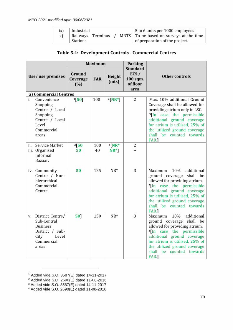
MPD-2021 modified upto 30/06/2021
75
Table 5.4: Development Controls - Commercial Centres
Use/ use premises
Maximum Parking Standard
ECS / 100 sqm. of floor
area
Other controls Ground
Coverage (%)
FAR Height (mts)
a) Commercial Centres i. Convenience
Shopping Centre / Local Shopping Centre / Local Level Commercial areas
1[50] 100
2[NR*] 2 Max. 10% additional Ground Coverage shall be allowed for providing atrium only in LSC. 3[In case the permissible additional ground coverage for atrium is utilised, 25% of the utilized ground coverage shall be counted towards FAR.]
ii. Service Market iii. Organised
Informal Bazaar.
3[50 50
100 40
4[NR* NR*]
2 --
iv. Community Centre / Non-hierarchical Commercial Centre
50 125 NR* 3 Maximum 10% additional ground coverage shall be allowed for providing atrium. 2[In case the permissible additional ground coverage for atrium is utilised, 25% of the utilized ground coverage shall be counted towards FAR.]
v. District Centre/ Sub-Central Business District / Sub-City Level Commercial areas
50] 150 NR* 3 Maximum 10% additional ground coverage shall be allowed for providing atrium. 2[In case the permissible additional ground coverage for atrium is utilised, 25% of the utilized ground coverage shall be counted towards FAR.]
1 Added vide S.O. 3587(E) dated 14-11-2017 2 Added vide S.O. 2690(E) dated 11-08-2016 3 Added vide S.O. 3587(E) dated 14-11-2017 4 Added vide S.O. 2690(E) dated 11-08-2016
ix) Industrial 5 to 6 units per 1000 employees x) Railways Terminus / MRTS
Stations To be based on surveys at the time of preparation of the project.

MPD-2021 modified upto 30/06/2021
76
Use/ use premises
Maximum Parking Standard
ECS / 100 sqm. of floor
area
Other controls Ground
Coverage (%)
FAR Height (mts)
b) Metropolitan City Centre / Central Business District i. Commercial
Plot: Retail & Commerce Metropolitan City Centre i.e. Connaught Place & its Extension
25 150 NR* 3 i. The size of the plot shall be as in the layout of commercial area and any subdivisional of the plot in Connaught Place and its extension should not be permitted.
ii. The development controls shall be in accordance with the comprehensive plan of the area to be reframed by the local body.
iii. (a) In case of Connaught Place, the existing height shall be maintained and FAR could be achieved by increasing proportionate ground coverage. (b) No basement shall be permitted in middle circle of Connaught Place. (c) Mandatory Architectu-ral Controls shall be applicable.
ii. Commercial Complex at Fire Brigade Lane and Janpath Lane
25 150 NR* 3 i. Ground coverage and FAR shall be calculated on the area of presently available plots.
ii. The area shall be developed on the basis of comprehensive scheme.
c) Hotel 40 1[i) Plot below 30
m ROW
– 325
NR* 3@ i) Maximum 10% additional ground coverage shall be allowed for providing atrium. In case, the permissible additional ground coverage for atrium is utilised, 25% of the utilised ground coverage shall be counted
1 Modified vide S.O. 2034(E) dated 12-08-2008 and S.O. 678(E) dated 04-03-2014

MPD-2021 modified upto 30/06/2021
77
Use/ use premises
Maximum Parking Standard
ECS / 100 sqm. of floor
area
Other controls Ground
Coverage (%)
FAR Height (mts)
(ii) Plot
30 m &
above –
375]
towards FAR. ii) Maximum 20% of the FAR
can be used for the Commercial offices, Retail & Service shops.
iii) The enhanced FAR will be allowed subject to payment of charges to be prescribed/ notified by the Government.
1[d)Service Apartments
30 225 NR* 2]
e) Any other Commercial Centre
i. (Including Commercial component along with Railway / MRTS Stations / ISBT)
25 100 NR* 3 Subject to statutory clearances. The development controls can vary subject to approved scheme.
ii. Asaf Ali Road (the area shown as commercial strip in Delhi Gate – Ajmeri Gate scheme)
80 200 20 3 Setbacks are not mandatory In case of rebuilding stilts shall be provided for parking.
2[f) Motels (with
sanctioned plans as on 07-02-2007 or whose proposal of Motel has been acceded to, 3{(including all such proposal of
40** 175^ NR* 3.0 ECS per 100 sq.metres of floor area (as per Development Code Chapter of MPD – 2021). All
i) Maximum 175 FAR 5 [] shall be permissible on the plot area disclosed in the sanctioned plan as on 07-02-2007 in conformity with Government of India Notification S.O. 550 (E) dated 16-06-1995 and motel guidelines issued by Government of India, MoUD on 04-03-2002.
1 Added vide S.O. 2895(E) dated 23-09-2013 2 Added vide S.O. 2555(E) dated 26-10-2012 3 Modified vide S.O. 2759(E) dated 13-09-2013 and S.O. 2799(E) dated 16-09-2013 5 Deleted vide S.O. 2190(E) dated 18-07-2013

MPD-2021 modified upto 30/06/2021
78
Use/ use premises
Maximum Parking Standard
ECS / 100 sqm. of floor
area
Other controls Ground
Coverage (%)
FAR Height (mts)
motels which were in process of examination or matter challenged in the court of law or having approval in files from DDA or 1[ concerned municipal body] or not acceded to due to enforcement of MPD-2021 on 07.02.2007 are also eligible for sanction)}, which are in Commercial Areas or proposed Facility Corridor in Zonal Development Plans and Other use Zones)
guest parking must be catered to within the motel premises themselves.
ii) The motels shall face the road of minimum 30 mts. ROW (if additional land is required for road widening, same to be kept reserved out of the motel area).
iii) Other norms and permissible activities shall be the same as applicable to hotel use premise.
iv) Water, electric supply, sewerage, drainage, traffic circulation, provision of linking road of adequate ROW and other such infrastructure shall have to be provided by the owner at their own cost till the same is made available by the service providing agencies. The Motel owner will have to pay the external development charges including provision of linking road of adequate ROW as demanded by the concerned agencies.
v) All motels should follow rainwater harvesting and energy conservation provision laid down under Notification and Building Bye-Laws issued by MoUD/GOI.
vi) Disposal of waste in motels will be responsibility of the motel owner and net pollution discharge from the motels should be zero.
vii) Modern techniques shall have to be adopted in disposal of waste in motels viz. segregation of solid
1 Modified vide S.O. 3173(E) dated 12-12-2014

MPD-2021 modified upto 30/06/2021
79
Use/ use premises
Maximum Parking Standard
ECS / 100 sqm. of floor
area
Other controls Ground
Coverage (%)
FAR Height (mts)
waste into compostable and non-compostable. Compostable waste should be deposited in localized compost pits; non-compostable should be incinerated in incinerators maintained by the motel, subject to pollution control norms. The building shall have dual piping system. Mini sewage treatment plant shall be constructed within premises for treatment of sewage and utilizing the treated water for purposes other than drinking, with dual piping system.
viii) Revised building plans will be submitted to the local bodies i.e., 1{concerned municipal body}/ DDA as the case may be for sanction under building bye laws.]
2[^Note- Additional FAR Charges, Conversion Charges, Betterment Levy/ External
Development Charges etc. shall be payable as decided by the Government from time to time.
* No restriction subject to clearance from Airport Authority of India and Fire
Department of GNCTD.]
3[** Ground Coverage up to 50% instead of 40% will be permissible to achieve the enhanced FAR at site(s), if their exist any height restriction from Airport Authority of India.]
1[i. NR* - No Restriction, subject to clearance from AAI, Delhi Fire Service and other
statutory bodies.]
1 Modified vide S.O. 3173(E) dated 12-12-2014 2 Added vide S.O. 2555(E) dated 26-10-2012 3 Added vide S.O. 2759(E) dated 13-09-2013 and modified vide S.O. 2799(E) dated 16-09-2013

MPD-2021 modified upto 30/06/2021
80
ii. FAR# - 2[The norms of 325 FAR below 30m ROW or 375 FAR on 30m ROW or above and 40% ground coverage shall be applicable in respect of all (I) hotels including hotel plots in (a) Commercial Centres (iv), (v) and (b) Metropolitan City Centre/Central Business District except those located in LBZ area, Civil Lines Bungalow Area and hotels existing on heritage structures and (II) Hotel-cum-commercial plots. This shall apply to all categories of hotels mentioned at para 5.8. The FAR for Commercial Centres mentioned at Table 5.4(a) and (b) as well as Hotel-cum-commercial plots where apportionment of FAR shall be as per original lease conditions and shall stand enhanced automatically to that extent, for this purpose only if not available.]
3[iii. In case of revision of building plans to avail additional FAR, hotel can avail
additional FAR only if adequate parking provision is made within the plot itself.]
4[@ - In respect of hotels where the building plans stand sanctioned prior to
27.1.2006, parking standard of 3 ECS for 100 sqm of floor area shall be applicable only for the additional FAR which will be availed consequent upon amendment to MPD-2021. In respect of hotels where the building plans have been sanctioned on or after 27.1.2006, the parking standard of 3 ECS for 100 sqm of floor area shall be applicable to the entire plot.]
Notes: i) The utilities such as, underground water storage tank, roof top water harvesting
system, separate dry and wet dustbins, post delivery counter etc. are to be provided within the plot. All hotels, restaurants, auto workshops, hospitals 5[/ tertiary health care centres] etc. will have to make arrangements for solid waste disposal and primary effluent treatment.
ii) Individual plot with floor area of 5000 sq.m. or above will provide ESS and generator within the plot. They have to submit energy consumption / audit at the time of sanction of building plans.
iii) Height subject to clearance from ASI, Airport Authority of India, Delhi Fire Service and concerned authority.
iv) Wherever parking is provided within the plot / basement and is misused, the same is liable to municipalisation / taken over by the authority.
v) Wherever redevelopment of existing commercial areas stipulate preparation of a comprehensive scheme, the same can be initiated jointly by the lessees / owners themselves and submitted to land owning agency / planning authority for approval. Wherever any enhancement in FAR is approved, the same will be subject to charging appropriate levies from the beneficiaries. For Metropolitan City Centre, in Special Area, development controls shall be as per approved scheme.
1 Modified vide S.O. 2034(E) dated 12-08-2008 2 Modified vide S.O. 558(E) dated 26-02-2009 and S.O. 678(E) dated 04-03-2014 3 Added vide S.O. 678(E) dated 04-03-2014 4 Modified vide S.O. 2034(E) dated 12-08-2008 5 Added vide S.O. 2893(E) dated 23-09-2013

MPD-2021 modified upto 30/06/2021
81
1[vi) In case of Commercial Centres in a) i. to v., the maximum Ground Coverage shall be inclusive of Atrium.
vii) In case of integrated schemes of Commercial Centres, amalgamation and sub-division of the plots is permitted for activities as permitted in Table 5.1 of the respective hierarchy of commercial centres subject to payment of requisite charges as notified by the Competent Authority from time to time.]
Table 5.5: Definitions and Activities Permitted in Use Premises
Use
premise Definition Activities permitted
Retail Shop A premise for sale of commodities directly to consumer with necessary storage.
Retail Shop, Repair Shop, Personnel Service Shop.
Repair Shop A premise equivalent of a of a retail shop for carrying out repair of household goods, electronic gadgets, automobiles, cycles etc.
Retail Shop, Repair Shop, Personnel Service Shop.
Personnel Service Shop
A premise equivalent of retail shop providing personnel services like tailor barber etc.
Retail Shop, Repair Shop, Personnel Service Shop.
Vending Booth
A premise in the form of booth for sale of commodities of daily needs either through a mechanical installation or otherwise.
Vending Booth
Convenience Shopping Centre
A group of shops in residential area serving a population of about 5,000 persons.
As given in table 5.1.
Local Shopping Centre
A group of shops in residential area serving a population of 10,000 persons
As given in table 5.1
Commercial Office
A premise used for offices of profit making organizations.
Commercial Office, retail & personal Service Shop, Restaurant, Bank, Post & Telegraph Office.
Bank A premise for offices to perform banking function and operation.
Bank, Watch & Ward Residence (upto 20 sqm.) commercial office, Canteen
Motor Garage and workshop
A premise for servicing and repair of automobiles.
Motor garage and Work Shop, retail shop (spare parts), Soft drinks and Snacks stall)
1 Added vide S.O. 3587(E) dated 14-11-2017

MPD-2021 modified upto 30/06/2021
82
Cinema / Cineplex
A premise with facilities for projection of movies and stills with a covered space to seat audience.
Cinema, Watch & Ward Residence (upto 20 sqm.) Administrative Office, Soft Drink & Snack Stall, Retail Shop & Commercial office.
Restaurant A premise used for serving food items on commercial basis including cooking facilities. It may have covered or open space or both for sitting arrangement.
Restaurant
Hotel 1[A premise having minimum 10 lettable rooms for lodging of and boarding of 15 persons or more on short / long term basis.]
Hotel, 2[Service Apartment,] Banquet / Conferencing facilities, Restaurant, Swimming pool, Health Club, Food court, Discotheque. Commercial offices, retail & service shops to be restricted to 20% of floor area.
Service Apartment
A premise fully furnished, serviced and self contained with meal preparation and used for short-term 3[/ long term] accommodation.
i) 4[Guest suite, Conference facilities, Office
ii) Retail / Service shops, Dining and supporting facilities, as per the requirement] to be restricted up to 20% of floor area.
Informal Sector Weekly Market/
An area used once in a week by a group of informal shop establishments in the form of a market. These markets shift from one area to another on different days of the week.
Weekly market, informal Retail trade, Soft Drink and Snack Stall (All structures will be either temporary or mobile), only for one day in a week.
Informal Sector Unit
Retail/ service unit, stationary or mobile, working without roof including small khokhas on roadside. Street vendor- A person who offers goods or services for sale to the public without having a permanent built up structure but with a temporary static structure or mobile stall (or head load).
Informal Sector Unit
--- x---x---x---x---x---
1 Modified vide S.O. No. 678(E) dated 04-03-2014
3 Modified vide S.O. no. 2895(E) dated 23-09-2013


MPD-2021 modified upto 30/06/2021
83
6.0 WHOLESALE TRADE
Delhi is the biggest consumption centre in North India. It has attained the status
of a major distribution centre by virtue of its geographical location and other historical factors.
As per Economic Survey of Delhi 2001-2002, there are about 37,000 wholesale
enterprises in Delhi with an employment of about 1.6 lakh. In addition there are about 6,500 enterprises of storage and warehousing providing employment to 27,000 persons. It is expected that the number of enterprises in wholesale trade may increase to about 66,000 by 2021 leading to increase in employment to about 2.85 lakh persons. Some of the major commodities involved in the wholesale trade are textile and related products, food items, auto-parts and machinery, hardware and building materials, paper and stationery, fruits and vegetables and Iron and Steel.
Around 20% of the total wholesale trade enterprises of urban Delhi are located
in the walled city, accounting for around 12% of the employment. The average enterprise in the Walled City has less employment but high turnover in comparison to units in other areas. In order to decentralise wholesale trade, the planned markets were developed at Azadpur, Naraina, Okhla, Narela, Keshopur, etc.
6.1 CITY LEVEL WHOLESALE MARKETS
6.1.1 EXISTING MARKETS IN SPECIAL AREA In case of existing developed areas, all wholesale markets generated with hazardous materials should be developed in decentralized manner and shifted to the areas assigned for these. All unauthorized encroachments / projections on roads / government land should be removed to facilitate easy movement of traffic. Further extension of the wholesale activity in the Walled City and its Extension shall be totally stopped by giving incentives and disincentives as under: i) Incentives:
a) The liasioning offices of the traders/ agents to continue in the present location;
b) Development of New counter markets for wholesale trade and warehousing;
c) The new counter markets should have access from National Highway, arterial networks and connectivity with MRTS; and
d) Incentives such as Transferable Development Rights (TDR) and reduced taxes to enable start up / expanding of activity in the new markets.

MPD-2021 modified upto 30/06/2021
84
ii) Disincentives: a) Restriction on the entry of heavy goods vehicles in the Special
area; b) Storage of hazardous / inflammable commodities like paper,
plastic / PVC, chemicals, petroleum and its products; should be discouraged.
c) Restriction on storage / warehousing of bulky commodities like food grains, fruits and vegetables, dairy, poultry / fish products, iron and steel, and building materials; and
d) Non-renewal of trade licenses for Wholesale Trade in non-conforming areas.
Sadar Bazar
The old congested built up areas like Sadar bazaar have serious problems of traffic congestion, inadequate physical and social infrastructure, lack of open spaces etc. The wholesale market of Sadar bazaar needs to be redeveloped at the same location with necessary infrastructure and parking required for wholesale trade.
6.1.2 PROPOSED WHOLESALE MARKETS WITHIN INTEGRATED FREIGHT
COMPLEXES It is proposed to develop new wholesale markets as counter markets to cater to the demands of the growing population of Delhi only, near the rail and road entry points of NCTD. These should be linked with the proposed Wholesale Markets within Integrated Freight Complexes where the wholesale business could be operated more efficiently in a better environment. The break up of land requirement for different commodities at various locations should be decided at the time of preparation of schemes for the complex by the implementing agency. Wholesale markets within Integrated Freight Complexes are to be developed as per requirement. The new wholesale markets shall provide facilities for: i) Intra-urban freight movement and interchange of mode. ii) Warehousing and storage facilities. iii) Servicing, lodging and boarding, idle parking and other required
facilities.
6.2 SUB-CITY LEVEL MARKETS
Delhi has become an agglomeration of cities over a period of time. Sub-City level wholesale markets shall cater to the needs of population at local level. These markets of medium size need to be dispersed throughout the city to enable even distribution of commodities from these complexes to the retail outlets.

MPD-2021 modified upto 30/06/2021
85
Most of the existing planned markets and warehousing were developed in early seventies for specific commodities. Due to their proximity to residential area, these markets need to be redeveloped to overcome the environmental and traffic problems. 1[To incentivize the redevelopment, a maximum overall FAR of 50% over and above the permissible FAR shall be given.] The traders associations shall share the responsibility of redevelopment to modern wholesale markets. The beneficiaries will have to pay the betterment charges to the implementing agency. Space for commodities that are not permissible in mixed use streets under para 15.6. shall be made available in wholesale city level market and sub-city level market to enable their relocation. Some of the existing planned Wholesale Markets, Warehousing and Transport Centres are as given in Table 6.1.
Table 6.1: Sub-City Level Markets
S. No. Location Commodity / Activities
i) Azadpur Fruit and vegetable
ii) Okhla Fruit and vegetable
iii) Keshopur Fruit and vegetable iv) Naraina Iron and Steel v) Sanjay Gandhi Transport Centre Transport / Warehousing
vi) Rohtak Road Transport Centre Transport / Warehousing
vii) Narela Food grains viii) Najafgarh Food grains
2[ix Kirti Nagar Timber]
In addition to above, the following wholesale markets are to be developed: i) Loni Road ii) Rohini Ph-IV / V iii) Dwarka Sub-City iv) Narela Sub-City
In Urban Extension, about 8-10 ha. of land for about one million population should be provided for such Sub-City level markets. The different commodities to be provided at various locations should be decided at the time of preparation of schemes by the implementing agency. These markets shall have adequate parking, repair and servicing facilities. Land should be identified in each zone accordingly.
1 Added vide S.O. 1215(E) dated 13.05.2013 2 Added vide S.O. 2690(E) dated 11-08-2016

MPD-2021 modified upto 30/06/2021
86
6.3 STORAGE OF OIL, CNG AND LPG
Shakurbasti Oil Depot has been shifted to a site between Ghevra and Tikri Kalan, which will be a major storage site for oil. The land thus vacated should be partly utilized for Disaster Management Centre and rest for recreational activities. No new Depots for oil and LPG shall be developed in NCT of Delhi. The new depots required for the increased energy requirement shall be developed in the National Capital Region and the supply of Oil / LPG / CNG etc. to Delhi should be through pipelines.
Table 6.2: Development Controls – Wholesale Trade
Use/ Use Premises
Maximum Parking
Standard ECS/100 sq.m. of
floor area
Definition Activities Permitted
Ground Coverage
% FAR
Height (m)
Integrated Freight Complex / Wholesale Market
30 80 No Restriction subject to
(i)
3 Wholesale Market. A premise from where goods and commodities are sold and delivered to retailers. The premises include storage and godown, loading and unloading 1[facilities].
Wholesale shop, Godown and storage, Commercial office (restricted to 25% of the total floor area), 2[Night Shelter]
Notes: i) Height subject to clearance from Airport Authority of India, Fire Department and
other statutory bodies. ii) In case of plots upto 300 sqm. common parking is to be provided. iii) In case of plots of size 300 sqm and above, the utilities such as E.S.S., underground
water storage tank, roof top water harvesting system, separate dry and wet dustbins, solar heating / lighting system etc. are to be provided within the plot.
iv) In case of individual plots not forming part of any comprehensive / integrated development scheme, the development controls shall be as per already approved scheme / layout plan.
1-2 Added vide S.O. 2894(E) dated 23-09-2013

MPD-2021 modified upto 30/06/2021
87
1[6.4 NORMS FOR REDEVELOPMENT OF GODOWN CLUSTERS EXISTING IN NON-CONFORMING AREAS
The National Capital Territory of Delhi Laws (Special Provisions) Seconds Act- 2011 provides for formulation of “policy or plan for orderly arrangement regarding schools, dispensaries, religious institutions, cultural institutions, storages, warehouses and godowns used for agricultural inputs or produce (including dairy and poultry) in rural areas built on agricultural land and guidelines for redevelopment for existing Godown clusters (including those for a storages of non- agricultural goods) required to cater to the needs of the peoples of the National Capital Territory of Delhi”
6.4.1 NORMS FOR REDEVELOPMENT OF GODOWN CLUSTERS IN NON-
CONFORMING AREAS
Following norms will be followed in redevelopment process, keeping in view the existing ground realities as well as the imperatives of planned development. 6.4.1.1 Stand alone Godown plots which do not form part of any cluster
shall be governed with the following conditions:
i. Stand alone godowns (storage of non polluting / non hazardous materials) shall be allowed only which are having direct access from minimum 30 mtr ROW road.
ii. In village abadi (laldora area) and extended laldora areas,
storage godowns of non-polluting / non-hazardous materials shall be allowed only which are having direct access from a. 9 mtr. RoW with plot size upto 300 sq.m (7.5 mtr. in case
the road is defined / approved by the revenue deptt.) b. 12 mtr. RoW for plot size above 300 sqm .
iii. These godowns shall be allowed subject to fulfillment of
parking requirements within the plot and NOC from the Traffic Police Deptt. and the Fire Deptt. of GNCTD.
iv. The loading / unloading facility from the vehicles shall be
provided within the plot.
v. Owners of standalone godowns needs to get the plans approved 2{by 31.12.2020}. The owners of plots falling in nonconforming areas and existing godowns located on less
1 Added vide S.O. 3027(E) dated 21.06.2018
2 Modified vide S.O. 3844 (E) dated 24.10.2019

MPD-2021 modified upto 30/06/2021
88
than 30.0 m 1{ROW} will have to shift to the other conforming areas / godown clusters 2{by 31.12.2020}. Such godowns functioning in non-conforming areas shall have to close down within the above said time period.
6.4.1.2 Non-conforming clusters of godowns / warehousing activities of minimum 2 Ha. contiguous area and having concentration of more than 55 percent of the plots within the clusters may be considered for redevelopment of area identified on the basis of actual surveys.
After notification of such clusters by the local bodies / GNCTD, the redevelopment scheme will have to be prepared by the society (to be formed by the land owners) based on following norms / conditions and thereafter approval by concerned local body. i. The cluster should have direct access from a road of
minimum 30mt RoW.
ii. Formation of group or society shall be mandatory to facilitate preparation of redevelopment scheme / plan, development of services, parking and maintenance, pollution control and environment management.
iii. Amalgamation and reconstitution of plots shall be
permissible for redevelopment within the scheme area.
iv. Owners of the godowns shall have to obtain the requisite statutory clearances from the concerned agencies, wherever necessary. After approval of the Layout Plan for redevelopment by the society, the identified clusters will be processed for change of land use on receiving the proposal from local body.
v. Other stipulations shall include: a) About 10% area is to be reserved for circulation / roads /
service lanes. b) About 10% area of semi permeable surface for common
parking, idle parking and loading / uploading areas. c) About 10% of the area to be reserved for associated
infrastructure requirement such as Electric Sub-stations, Fire Station, Police Post, servicing, lodging and Boarding and informal market areas etc. as per the norms.
d) Preparation of Plan for water supply from DJB / Central Ground Water Authority (wherever required) along with
1-2 Modified vide S.O. 3844 (E) dated 24.10.2019

MPD-2021 modified upto 30/06/2021
89
requirement for pumping stations, storage tanks, ground water recharging / rainwater harvesting and Drainage plan as per norms.
e) About 8% of the area shall be reserved for parks / green buffer.
f) Utilities such as ESS, underground water storage tank, rain water harvesting system, solar heating / lighting systems etc. will be provided within the plot.
g) All plots within the scheme should have direct access from road of minimum12 mts RoW.
vi. Other provisions / development control norms shall be
applicable as prescribed. Note: Subject to availability of land for these facility mentioned at v) (a, b, c, e) within godown cluster or in the surrounding area be considered.
vii. Requisite conversion charges and any other levies as decided
by the Government from time to time (wherever applicable) would be required to be paid to the concerned Authority.
viii. Redevelopment plans of individual clusters will have to be prepared by the society and thereafter approved by the concerned local authority / MCD. The redevelopment shall be completed within three years from the date of approval of the plans.
ix. Clusters, which fail to complete the redevelopment proposals within the period specified as above, shall have to shift to other conforming areas and these godowns functioning in non-conforming clusters shall have to close down. In such cases, the licensing authority will not renew the licenses to such godowns without obtaining land use clearance from the competent authority. Further, no new licenses will be issued in non-conforming areas, without obtaining land use clearance.
6.4.2 OTHER CONDITIONS
6.4.2.1. Development control norms for the godown plot incorporating the
risk based classification as per Table 3.2 of UBBL 2016, shall be as follows:
Plot Size (in sq m)
Max. Gr. Coverage
(%)
Max. FAR
Max. Height
Parking

MPD-2021 modified upto 30/06/2021
90
Up to 500 70 140 Below 15 m - Common parking to be provided in case of plots upto 300 sq.m.
- 3 ECS / 100 sq.m. of floor area for plots above 300 sq.m.
Above 500 - 2000 60 120 Below 15 m
Above 2000 - upto 10,000
50 100 Below 15 m
Above 10,000 40 80 Below 15 m
Notes: 1. Wherever the building regulations are given for different categories of plots, the
covered area and the floor area shall in no case be less than the permissible covered area and floor area respectively for the largest size of plot in the lower category.
2. Conformity to fire safety norms based on Risk based classification as per UBBL 2016; Delhi Fire Services Act.
3. Common parking shall be provided for plots up to 300sqmt. size and front setback shall be provided without boundary wall for use of parking and loading / unloading purposes.
4. For plots above 300 sq.m, provision for parking and loading / unloading shall be made by the owners within their plots.
5. Provision / use of basement shall be as per the stipulations of MPD-2021. 6. Workroom / Office (not exceeding 25% of the permissible FAR) related to
godown activity within godown premises shall be allowed in a covered permanent structure with proper arrangements of dust and pollution control subject to clearance from statutory bodies.
6.4.2.2. The remaining plot owners shall be allowed to continue with
existing use or conversion to godowns or any permissible use as per provisions stipulated in the MPD / UBBL / policy guidelines and after obtaining clearances / permissions from all statutory bodies.
6.4.2.3. All the Redevelopment Schemes under these guidelines shall conform to all the statutory provisions and Master Plan stipulations / UBBL, 2016.
6.4.2.4. The concerned local body and the stakeholders will work out the mechanism for the recovery of stipulated levies / charges.
6.4.2.5. In case of surrender of land for road widening, the FAR of the original plot will be permissible.
6.4.2.6. The implementation of these regulations be brought out by the Local Body as part of User Friendly Guide covering the Frequently Asked Questions (FAQs) for such projects.
6.4.2.7. The following areas shall not be eligible for godown clusters redevelopment scheme: Bungalow Zones (New Delhi & Civil Lines), the Ridge, River Bed (Zone-O), areas along water bodies, canals, sensitive areas from security point of view, conservation & heritage areas, reserved/protected forests, DDA flats, Cooperative

MPD-2021 modified upto 30/06/2021
91
Group Housing Societies, Government flats/bungalows/employer housing etc. and their immediate proximity.]
--- x---x---x---x---x---

MPD-2021 modified upto 30/06/2021
92
7.0 INDUSTRY
As per Economic Survey of Delhi 2001-02, there were about 1,29,000 industrial
units in Delhi in 1998 against 85,050 units in 1991. A door-to-door industrial survey revealed that an average unit employed 9 workers while 30% of the units employed 4 workers or less. The survey also revealed that textiles products (garments) units constitute the largest number, followed by repair services and electrical machinery. The table below shows the growth of industrial units and employment.
Year No. of Industries No. of Employees 1981 42,000 5,68,910 1991 85,050 7,30,951 1998 1,29,000 14,40,000
Source: Economic Survey of Delhi 2001-02
The issue of industries in Delhi has been a subject of extensive debate, controversy
and concern over the past decade. This has centred mainly on the aspects of pollution and negative environmental impact of industries, the existence and continued growth of industries in non-conforming areas and the issue of classification and permissibility with reference to household industries. Serious concern has been expressed regarding the continued existence and further proliferation of industries in contravention of Master Plan provisions.
7.1 STRATEGY
Keeping in view the position brought out above as also in the context of the continuing pressure of population growth in Delhi, the following broad policy would be required for the industrial sector:
i) Promote hi-tech and low volume -high value added industries, which are not labor intensive.
ii) Encourage modernization and technological up-gradation of existing industries required for day-to-day needs of the people of the city.
iii) Take corrective measures with regard to industries in non-conforming industrial areas in terms of environmental and other norms as may be prescribed.
iv) Provide suitable incentives and disincentives, and other measures, for shifting and relocation of industrial units not conforming to the land use norms.
v) Review, and possibly widen, the scope of permissibility of household industrial units subject to adherence to pollution control norms and environmental considerations, fire safety regulations and other relevant factors, particularly the aspect of infrastructure services.

MPD-2021 modified upto 30/06/2021
93
7.2 CLASSIFICATION OF INDUSTRIES
The classification of Industries is proposed to be simplified with prohibited category and non-prohibited category subject to proposals regarding specific category of industries permitted in different use zones. Further, all planned industrial areas are designated under a single landuse category namely Industry. The standards prescribed by the pollution control authorities would have to be met by all industrial units, in addition to specific conditions in terms of number of workers and power load in specified categories. Industries listed under prohibited category shall not be permitted to be set up in Delhi (Annexure - III). The existing industrial units under prohibited category need to relocate themselves outside Delhi, within a period of three years.
7.3 PERMISSIBILITY OF INDUSTRIAL UNITS IN DIFFERENT USE ZONES AND USE
PREMISES
For the industrial classification, the limits of aforesaid parameters shall be fixed according to the nature of industries, area and the nature of industrial development. The threshold parameters for industrial units are given in table 7.1.
Table 7.1: Parameters for Industrial Units in Different Use Zones and Use Premises
Use Zone / Use Premises
Groups Permitted (Refer Annexure)
Conditions
Max. no. of workers
Max. Industrial
Power Load (KW)
Residential Use a) Residential A 1[9] 1[11] b) Villages (Abadi) A+A1 1[9] 1[11] Commercial Use a) Convenience
Shopping Centre, Local Shopping Centre.
A+ A1+B Service / repair / packaging / assembly (without manufacturing) of permissible industries.
5 11
b) Community Centre. 9 11
c) District Centre, d) Service Market,
Service Centre.
19 11
1 Modified vide S.O. 888 (E) dated 18-02-2019

MPD-2021 modified upto 30/06/2021
94
Industrial Use a) Plotted development All industries except those
prohibited and of Non-polluting & non-hazardous nature,
As per need As per need
b) Flatted Industries All industries except those prohibited, and of Non-polluting & non-hazardous nature, excluding industries producing noise / water / vibrations / odour pollution
1[As per need] As per need
Notes: i) Maximum no. of workers shall be as per notification issued by the competent
authority from time to time. ii) The power requirement for operating pollution control devices and non-
manufacturing use shall be over and above the aforesaid permissible load. iii) Existing Industrial Estates in the Growth Centres shall be considered as
industrial use.
7.4 HOUSEHOLD / SERVICE INDUSTRIES
i) Household industrial units with maximum 2[9] workers and 2[11] kilowatt power may be allowed to continue in residential areas and new industrial units of this type could be permitted in residential areas 3[.] with the condition that no polluting industrial unit shall be permitted as household industry. 4[.]
ii) Household industrial units shall be allowed on any floor to the extent of 50% of permissible floor area of the dwelling unit.
iii) Further additions / alterations to the list of Household Industries could be made, if considered appropriate and in public interest by the Central Government to do so.
iv) No inflammable or hazardous substance is permitted to be stored. v) Separate industrial electric connection (single phase) and Municipal License,
would be necessary to set up a household industry.
7.5 NO INDUSTRIAL ACTIVITY ZONE
In order to maintain the city's ambience and pollution free environment in important and historic areas of Delhi, following locations are categorized as 'No Industrial Activity Zone' where no industrial activity including household industry, shall be permitted. a) Lutyens' Bungalow Zone b) Civil Lines Bungalow Area c) Employer Housing
1 Modified vide S.O. 3904(E) dated 29-10-2020 2 Modified vide S.O. 888 (E) dated 18-02-2019 3 Modified vide S.O. 4434 (E) dated 11-12-2019 4 Deleted vide S.O. 333 (E) dated 16-01-2019

MPD-2021 modified upto 30/06/2021
95
d) Group Housing (excluding Janata Flats)
7.6 INDUSTRIAL AREA REDEVELOPMENT SCHEMES
The redevelopment schemes cover the following aspects: i. Modernization and upgradation of existing planned industrial areas; and, ii. Redevelopment of areas, which have become industrialized over the period of
the two Master Plans even though not designated as such.
7.6.1 EXISTING PLANNED INDUSTRIAL AREAS These industrialized areas were developed in the 70's and over the years, have deteriorated considerably in terms of physical infrastructure and, in some cases deficiencies on this score have persisted in an overall sense. Besides, there have been changes in the nature of activities in some of the areas and there have also been demands for using part of the plots for activities, which could be classified as commercial. There may also be a need to see whether further densification is possible in terms of creating smaller plots by sub-divisions to accommodate a larger number of industries / units. Guidelines for redevelopment of existing industrial areas shall be framed within 2 years by DDA in consultation with GNCTD and the local body. Till such time, the existing sub divisions may continue. There is, therefore, a need for modernization and up-gradation of the existing industrial areas with due regard to environmental considerations. Since most of the Industrial areas are located along the Mass Public Transport Corridors, there is also a need for optimizing the use around these areas through the process of redevelopment. This process of upgradation and redevelopment will need to be carried out in a planned manner, and in a public-private partnership framework, in which the entrepreneurs contribute to the betterment and subsequent maintenance through suitable Operation and Maintenance arrangements. 7.6.1.1 Industrial activity shall be conducted at the following locations in the
Industrial Use Zone, as indicated in the Land Use Plan:
ZONES A to H: Naraina Indl. Area, Jhandewallan Flatted Factory, Motia Khan Scheme, DCM Flatted Factory Complex, Shahzada Bagh Indl. Area, Gulabi Bagh Indl. Area, Rajasthan Udyog Nagar G.T. Road near Jahangirpuri, SMA Co-op. Indl. Estate G.T. Road near Jahangirpuri, SISI Indl. Area G.T. road near Jahangirpuri, G.T. Karnal Road Indl. Area near Rana Pratap Bagh, Hindustan Prefab Ltd., Indl. Area near Shivaji Rly Stn. (Minto Road), Okhla Indl. Area Ph.I, II & III, Mohan Co-op Indl. Area, SISI Complex Okhla near Modi Flour Mills, Najafgarh Road Indl. Area near Zakhira, Kirti Nagar Indl. Area,
MPD-2021 modified upto 30/06/2021
96
Mayapuri Ph. I & II, Udyog Nagar Rohtak Road, Keshav Pur Leather Tannery Scheme (part of Service Centre) near Vikaspuri, Wazirpur Industrial Area, Lawrence Road Indl. Area, Mangolpuri Indl. Area Ph.I & II, Jhilmil Indl. Area, Patparganj Indl. Area, Friends Colony Indl. Area, Narela Indl. Estate, Bawana Indl. Estate, Khanjhawala Indl. Estate, PVC Bazar Tikri Kalan. a) Additional Industrial Areas will be indicated while preparing
plans for Urban Extension Areas. b) The approved Work-cum-Industries Centres, Service Centres
etc., where development has been undertaken in accordance with the land use / earlier Master Plans, shall continue to be industrial subject to conformity with provisions stipulated.
1[7.6.1.2 Pre-1962 / MPD-1962 Industrial Areas Industrial Areas, existing prior to 1962 or where Industrial Use was allowed in MPD-1962, shall continue such use at least to the extent as permissible in MPD-1962, subject to documentary proof thereof. The standards prescribed in Para 7.2 shall have to be met by all such industrial units.]
7.6.2 REDEVELOPMENT OF UNPLANNED INDUSTRIAL AREAS
Besides the planned Industrial Areas, the Govt. of Delhi has notified following non-conforming clusters of industrial concentration having more than 70% plots in the cluster with industrial activities for redevelopment. 1. Anand Parbat 2. Shahdara 3. Samai Pur Badli 4. Jawahar Nagar 5. Sultanpur Mazra 6. Hastsal Pocket – A 7. Naresh Park Extension 8. Libaspur 9. Peeragarhi Village 10. Khyala 11. Hastsal Pocket – D 12. Shalamar Village 13. New Mandoli 14. Nawada 15. Rithala 16. Swarn Park Mundka 17. Haiderpur
1 Added vide S.O. 2894(E) dated 23-09-2013

MPD-2021 modified upto 30/06/2021
97
18. Karawal Nagar 19. Dabri 20. Basai Darapur
1[21. Prahladpur Banger 22. Mundka and Mundka Udyog Nagar]
The redevelopment process involves preparation of redevelopment plans for widening of roads, laying of services, development of open space and parking etc. In practical terms, these areas are deficient in terms of services and endanger the environment. The redevelopment of such areas needs to be based on clearly defined parameters in terms of the types of industries which may be permitted, spatial planning norms and environment related conditionalities regarding the provision of essential infrastructure with the participation of the owners / entrepreneur in a systematic manner. 7.6.2.1 Norms for Redevelopment of clusters of Industrial
Concentration in Non-Conforming Areas
Keeping in view the existing realities, as well as the imperatives of planned development, the following norms will have to be followed in the redevelopment process. Non-conforming clusters of industrial concentration of minimum 4 2[ha] contiguous areas, having more than 70% plots within the cluster under industrial activity / use may be considered for redevelopment of area identified on the basis of actual surveys. After notification of such clusters by GNCTD, the redevelopment scheme will have to be prepared by the concerned local body / land owning agency in consultation with the Society (to be formed by the land owners) based on the following norms / conditions: i. The cluster should have direct approach from a road of at least
18 m R/W. ii. Formation of Society shall be mandatory to facilitate
preparation of redevelopment plan, pollution control and environmental management, development of services and parking and maintenance.
iii. Only permissible industries having clearance from DPCC shall be permitted.
iv. Amalgamation and reconstitution of plots shall be permissible for redevelopment.
v. All the units shall have to obtain the statutory clearances. The industrial units shall have separate electric connections.
1 Added vide S.O. 2894(E) dated 23-09-2013 2 Modified vide S.O. 3173(E) dated 12-12-2014

MPD-2021 modified upto 30/06/2021
98
vi. Other stipulations shall include - a) 1[About] 10% area is to be reserved for circulation / roads
/ service lanes. b) 2[About]10% of semi-permeable surface for parking and
loading / unloading areas. c) 3[About] 10% of total area to be reserved for infrastructure
requirements like CETP, Sub-Stations. Pump House, Fire Station, Police post, etc. as per the norms.
d) Preparation of: - Plan for water supply from DJB / Central Ground Water
Authority (wherever required) along with requirement for pumping stations, storage tanks, ground water recharging / rainwater harvesting.
- Drainage plan as per norms. e) 8% of the cluster area shall be reserved for parks / green
buffer. f) Plots measuring more than 100 sqm to have minimum 9.0
m. ROW. g) Plots measuring less than 100 sqm to have minimum 7.5 m.
ROW. h) Common parking to be provided for plots below 60 sqm,
whereas for plots above 60 sqm front set back (min. 3 m) shall be provided without boundary wall for parking and loading and unloading.
4[i) Alternatively, the society may adopt the option of preparation of layout plan / Redevelopment scheme based on the land distribution as stipulated in Table 7.2 of the MPD 2021.
j) About 3% area shall be permitted under commercial use.]
vii. Other provisions / development control norms shall be applicable as prescribed. Depending upon ground conditions, the Technical Committee of DDA may relax the norms up to 10%. 5[Note: Subject to availability of land for these facility mentioned at
vi (a, b, c, e) with Industrial cluster or in the surrounding area be considered.]
The redevelopment work may be undertaken by the societies voluntarily or by the concerned local body / agencies. In case the agencies take up the redevelopment work for execution, they shall collect the charges from the individual industries themselves directly. Requisite charges for change in land use, enhanced FAR
1-3Modified vide S.O. 1215(E) dated 13-05-2013 4 Added vide S.O. 3904(E) dated 29-10-2020
5Added vide S.O. 1215(E) dated 13-05-2013

MPD-2021 modified upto 30/06/2021
99
and land (wherever applicable) would be required to be paid to the concerned Authority. The redevelopment shall be completed within the period specified by the Delhi Development Authority, Local Bodies in this regard. Clusters, which fail to complete the redevelopment proposals within the period specified as above, shall have to shift to other conforming industrial areas and the units functioning in non-conforming clusters shall have to close down. In such cases, the licensing authority will not renew / issue the licenses to industrial units without obtaining land use clearance from the competent authority. Further, no new licenses will be issued in non-conforming areas, without obtaining land use clearance. The following areas shall not be eligible for industrial clusters redevelopment scheme: Bungalow Zones (New Delhi & Civil Lines), the Ridge, River Bed (Zone-O), areas along water bodies, canals, sensitive areas from security point of view, conservation & heritage areas, reserved / protected forests, DDA flats, Cooperative Group Housing Societies, Government flats / bungalows / employer housing etc. and their immediate proximity.
7.7 NEW INDUSTRIAL AREAS
Development of new industrial areas in Greenfield areas of NCT of Delhi should be largely planned for the purpose of relocation of existing industries and for the development of a limited type of new industries for the following purposes: a) Relocation of permissible industries from the non-conforming clusters that are
not eligible for regularization / development; and b) Green field sites for Hi-tech industries.
New industrial activity in the NCT of Delhi should be restricted to hi-tech areas 1[and service based industries. These activities shall be permissible in existing industrial areas subject to the payment of infrastructure upgradation charges to be decided and recovered by concerned Authority / local body] as given below: 1[1. Software Industry
a. Computer hardware and software industry and industries doing system
integration using computer hardware and software. b. Industries integrating and manipulating the interfaces of the computers
and telecom facilities. c. Software products and Mobile Applications
1Added and Modified vide S.O. 3904(E) dated 29-10-2020

MPD-2021 modified upto 30/06/2021
100
2. IT Service Industry
a. Internet & Email Services Provider b. World wide Web Services Provider Ecommerce & content development. c. Electronic Data Interchange (EDI) Services d. Video conferencing, V SAT, ISDN services e. Electronic Data Centre activities
3. ITES Industry
a. Customer interaction services, e.g, call/ contact centres and email help
desks b. Back office processing c. Finance and accounting (provided remotely) d. Insurance claims processing (provided remotely) e. HR services & Other Consulting (provided remotely) f. Web site development and maintenance services g. Remote education g. Business Process Outsourcing, Knowledge Process Outsourcing h. Software Extension development i. Electronic Design & Product Development j. Engineering Design & Product Development k. Industries catering to the information needs of uses by providing
databases or access to databases spread throughout the globe. l. Industries providing the facilities for sophisticated testing of different or
all components of the information technology. m. Telecommunications and enabling services.
4. Media
a. TV and video programme production. b. Photo composing and desktop publication. c. Publishing d. Audiovisual services
5. Biotechnology/ Medical a. R&D and manufacture of products or processes, which use or are derived
by using specific living systems (plants, animals and microbes or parts thereof) and or enzymes/ biocatalysts derived there from
b. Genetic Engineering & Contract Research & Clinical Trials c. Medical Transcription Services
6. Research & Development and Design
a. Electronics R&D-Design & Product Development b. Engineering R&D- Design & Product Development

MPD-2021 modified upto 30/06/2021
101
c. Biotechnology R&D d. Design Garments Industry, Gems & Jewellery, Web Design etc e. Textile designing and fabric testing, etc. f. Inter-Disciplinary R&D Services
7. Business Services (Provided Remotely)*
a. Legal Services b. Financial, Accounting, auditing, book keeping and Taxation services c. Architectural & Engineering Services d. Advertising Agency and Training Services e. Market Research and public opinion services f. Placement, Management, Higher Education and Consulting Services g. Equity Research
8. Educational Services*
a. Vocational Training Centre (ITI / Polytechnic / Vocational Training
Institute / Management Institute / Teacher Training Institute for the AICTE / NCTE approved courses as per AICTE / NCTE Norms. (The above educational activities shall be allowed maximum upto the level of under graduate diploma courses.)
9. Others*
a. Packaging b. Electronic goods, Power (Electrical) Distribution services c. Service and repair of TV and other electronic items.
Note: 1. * The minimum ROW of a street or stretch of road on which the activities
mentioned in Sl. No. 7 to 9 are permissible is as follows: i. Plots upto 1000 sqm- 12 m ROW
ii. Plots above 1000 sqm- 18 m ROW 2. Any recommendation for additions/ alterations to the above list forwarded by
DSIIDC in consultation with Industries department of GNCTD shall be incorporated, if considered appropriate and in public interest by the Central Government.
3. Warehousing within the plot in 10% limit other than in identified clusters is to be provided as incidental storage accruing out of the industrial activity in the respective plot (raw material, finished products, etc., storage).]

MPD-2021 modified upto 30/06/2021
102
7.8 INDUSTRY USE ZONE – GUIDELINES The subdivision of industrial use zone into use premises and subsequent approval of layout plans for industrial estates shall be governed by the following norms: i. The new industrial areas to be developed may have plotted development for
individual industrial units. 1[.] ii. The provision of land for the required facilities in industrial areas shall
conform to norms given in the Table 7.2. iii. All new Industrial Estates shall have approach from a road of at least 30 m
ROW. iv. Plots measuring less than 100 sqm. and will face 9 m ROW roads whereas plots
measuring more than 100 sqm. will face 12 m ROW roads. v. Individual industrial plots facing main peripheral roads shall have access from
dedicated service road after leaving green buffer. vi. The listed water bodies and / or any water body above 1 Ha. size are
mandatory to be systematically included in the landscape plan. vii. Minimum 10m wide green buffer shall be provided along peripheral / access
roads in the industrial areas. viii. The provision of Rainwater harvesting as an integral part of the landscape and
storm water drainage plan at the time of sanction of layout plan shall be prepared.
ix. The provision of minimum 30% of semi-permeable surface in all parking and loading / unloading areas.
x. Grease traps should be provided near automobile washing area. xi. New Industrial areas should be located along major arterial roads. Major
infrastructure network like CNG, LPG, oil, optical fibre, electricity, etc. to be made available along this corridor through underground pipelines.
xii. Optimum utilisation of industrial areas should be made by way of development of flatted factories complexes.
xiii. All industries should have provision for separating the solid waste before disposal. No untreated effluent shall be allowed to be discharged in the water bodies, open areas etc., outside the Industrial area. Primary treatment of the effluent shall be done at the plot level as per requirement.
xiv. The provision of CETPs, solid waste separation / treatment plants shall be made at the industrial cluster level.
xv. Proper disaster arrangements shall be made by the concerned agency for meeting any emergency situation arising due to fire, explosion, sudden leakage of gas or other natural calamities like earthquake, flood, etc.
xvi. Industries in future may be grouped on the basis of common requirements such as effluent treatment, interdependence and nuisance value (fire hazard, noise, etc.).
xvii. Selection of trees and plants shall be made keeping in view aspects such as distinctive avenue development, round the year flowering in park areas (either mixed or in cluster form) and shade requirements in specific areas.
1 Deleted vide S.O. 333 (E) dated 16-01-2019

MPD-2021 modified upto 30/06/2021
103
1[Table 7.2: Norms for Land Distribution in Industrial Areas
Sl. No.
Use Premises Percentage
1 Industrial Plots (Net Area) 45-50
2 Residential* 20
3 Recreational: Buffer Zone, Parks, Water Bodies, Green under HT lines, etc.
8-10
4 Commercial: Shopping Centre, Petrol Pumps, Guest House / Budget hotels, Lodging and Boarding, Service and Repair shops, Communication / Telephone Exchange, etc.
2-3
5 Facilities Public and Semi-Public: Fire Station / Fire Post, Police
Station / Police Post, Hospital / 2{Tertiary Health care Centre} /Dispensary, ITI / Polytechnic, Dharamshala, Night Shelter, Day Care Centre, etc.
Utilities: Electric Sub-Station, CETPs, Pumping Stations, Underground Reservoirs / Fire Fighting Tanks and other utilities, etc.
6-8
6 Transportation: Circulation, Loading / Unloading Area, Parking, ideal truck Parking, Goods Vehicle Parking etc.
16-18]
Total 100
3[Note:
* Residential Use premise shall be carved out in the industrial area of urban extension. In case of residential use premises regulations for Group Housing shall apply. The land shall be reserved for facilities as per residential facilities. This housing would be for workers engaged in the industrial sector. These provisions to be applicable to New Industrial Area.]
1 Modified vide S.O. 1215(E) dated 13-05-2013 2 Added vide S.O. 2893(E) dated 23-09-2013 3 Added vide S.O. 1215(E) dated 13-05-2013

MPD-2021 modified upto 30/06/2021
104
Table 7.3: Development Control Norms
Use Premises
Maximum Parking standard ECS /
100 sqm of floor area
Activities Permitted
Definition Gr.Cov
(%)
FAR
Ht (m)
Industrial Plot
i. 1[Upto 50 sqm.
100 200 8 2 Industrial units: unit retail sales outlet and administrative office upto maximum 10% of floor area on ground floor only; residential flat upto the maximum extent of 5% of the floor space or 50 sqm. whichever is less for watch & ward and supervision, incidental storage [--]related to the industrial activity, commercial activity as per footnote (vi).
2{A premise for industrial activity with non-hazardous, non-polluting performance.}
ii. Above 50 sqm & upto 400 sqm
60 1[200] 15 2
iii. a. Above 400 sqm & upto 2,000 sq.m b. Above 2,000 sqm]
1[50]
1[40]
1[200]
1[200]
1[NR*]
1[NR*]
2
Flatted group Industry (Minimum plot size – 400 sqm. & 1[upto 2,000 sqm.)]
30 1[200] 26
2 Industrial units; administrative office, watch and ward, maximum upto 5% of floor area or 20 sqm. whichever is less, storage related to the manufacturing activity, commercial activity as per footnote (vi).
3{A premise having a group of small industrial units with common services and facilities of non-polluting nature.}
1[Flatted group Industry (Minimum plot size –
1[30] 1[200] 1[NR*]
1 Modified vide S.O. 3904(E) dated 29-10-2020 23 Modified vide S.O. 1215(E) dated 13-05-2013

MPD-2021 modified upto 30/06/2021
105
2,000 sqm. & upto 20,000 sqm)]
1[Flatted group Industry (above 20,000 sq.m.)]
1[30] 1[200] 1[NR*]
1[Notes:
*Subject to clearance from AAI / Fire Department and other statutory bodies. # The additional FAR Charges shall be payable as decided by the Government from time to time.]
i. In case of plots upto 60 sqm. common parking shall be provided. ii. In case of plots of size 500 sqm and above, the utilities such as E.S.S., underground
water storage tank, roof top water harvesting system, separate dry and wet dustbins, solar heating / lighting system etc. shall be provided within the plot.
iii. Identified Service Centres shall be planned as per plotted industrial area norms.
iv. Development of IT hardware and software permissible under industrial use.
v. 2[Banquet hall shall be permissible in Industrial premises subject to specifications / regulations as may be prescribed, along with conversion charges as prescribed by the Government from time to time.]
vi. 3[Industrial units / plots abutting roads of 24m ROW and above shall be eligible for conversion to commercial use within the existing development control norms, subject to payment of conversion charges 4{computed on current market value of commercial area and cost of parking as decided by the Government from time to time. The activities permissible in Community Centre will be permitted in such plots.} In addition, multilevel parking shall be permissible activity. However, this shall not be permitted on non-conforming / regularized industrial cluster. The above provision shall not affect the Supreme Court orders in any way.]
vii. 5[Industrial plots abutting roads of 24m ROW and above shall be eligible for conversion to 6{Hospital / Tertiary Health Care Centre} (up to 100 beds) within the existing development control norms, subject to the conditions (a) the number of
1 Modified vide S.O. 3904(E) dated 29-10-2020 2 Substituted vide S.O. 2034(E) dated 12-08-2008 3 Added vide S.O. 1215(E) dated 13-05-2013 4 Modified vide S.O. 1215(E) dated 13-05-2013 5 Added vide S.O. 1215(E) dated 13-05-2013 6 Modified vide S.O. 3904(E) dated 29-10-2020

MPD-2021 modified upto 30/06/2021
106
beds to be accommodated on a plot shall be worked out 1{@ 100 sqm 80 sqm} of gross floor area per bed and (b) payment of conversion charges as prescribed by the government from time to time. The activities permissible in 2{Hospital / Tertiary Health Care Centre} (Table 13.20) shall be permitted in such plots. However, this shall not be permitted on non-conforming/ regularized industrial cluster. The above provision shall not affect the Supreme Court orders in any manner.
viii. In the redevelopment of industrial plots, 1.5 times of permissible FAR has already been notified in Notification S.O. 683 (E) dated 01.04.2011 regarding Regulations and Guidelines for Existing Planned Industrial Area, therefore, the incentive of 1.5 times of permissible FAR shall be allowed on all permissible uses on industrial plot.
ix. Banquet Hall, Restaurant, Recreational Club, Hostel & Old age home, Community and Recreational hall, Nursing Home & Health Centre are permitted as part of modification in layout plan of industrial area where also enhanced FAR 1.5 times of permissible FAR of respective Use shall be allowed.
x. As per the Notification S.O. 683 (E) dated 01.04.2011, minimum plot size eligible for redevelopment is given 1000 sqm. whereas some of the plots are less than 50-100 sq.mts from area limit of 1000 Sq.mts. In such redevelopment relaxation in area upto 5% in lower limit of plot size shall be permitted.
xi. The development control norms i.e. Ground Coverage, FAR etc. of respective use premises while allowing redevelopment/ reconstruction on the individual industrial plots shall be adhered to and there shall be no height restriction. 3{The height permitted shall be subject to clearance from AAI, Delhi Fire Services and other statutory bodies.} In case of addition, alteration or change of use within permissible category in existing building to achieve permissible FAR, already sanctioned ground coverage shall continue, if parking requirement or sufficient open space around building is made available.
xii. In existing Industrial Units/ plots with an area of 3000 sq.mtrs. or above abutting road of 24mtr. ROW and above shall be eligible for Residential use (Group Housing) within development control norms of group housing along with incentive 1.5 times FAR of permissible FAR of Group Housing subject to payment of Conversion charges as prescribed by the Government from time to time for respective use. Required Commercial preferably and PSP activity for residential population, and working space up to 15% of Permissible FAR shall also be allowed. Sub-division of larger Industrial plot or amalgamation of smaller Industrial plots will be allowed in existing areas as well as approved schemes/ layouts/ building plans on these Industrial Plots. Rain water harvesting preferably with Rain water storage for re-use & STP, Dual piping system use of solar electricity shall be provided to minimize
1 Modified vide S.O. 2893(E) dated 23-09-2013
2-3 Modified vide S.O. 3904(E) dated 29-10-2020

MPD-2021 modified upto 30/06/2021
107
the additional burden on infrastructure services. This provision shall not affect any Court Orders.]

MPD-2021 modified upto 30/06/2021
108
ANNEXURE –1[7.0 (I)]
CLASSIFICATION OF INDUSTRIES
GROUP - A HOUSEHOLD INDUSTRIES 1. Agarbatti and similar products 2. Aluminium hanger (excluding wire drawing and anodizing). 3. Ayurvedic / Homoeopathic / Unani medicines. 4. Assembly and repair of electronic goods. 5. Assembly and repair of sewing machines. 6. Assembly of hand tools. 7. Assembly of Badminton shuttlecocks. 8. Assembly and repair of electrical gadgets, cooler/heater etc. 9. Assembly and repair of typewriter (excluding Font Casting). 10. Assembly of Bakelite Switches. 11. Assembly and repair of measuring instruments (excluding handling of Mercury and
hazardous materials). 12. Atta Chakkies. 13. Batik works. 14. Block making and photo enlarging. 15. Biscuit, pappey, cakes and cookies making. 16. Button making, fixing of button and hooks. 17. Bookbinding. 18. Brushes and brooms (by hand). s 19. Calico and Textile products. 20. Cane and bamboo products. 21. Cassettes recording. 22. Clay and modeling with / without Plaster of Paris. 23. Coir and jute products. 24. Cardboard boxes. 25. Candles. 26. Copper and brass art wares. 27. Cordage, rope and twine making. 28. Carpentary. 29. Contact Lens. 30. Canvas bags and hold-alls making. 31. Candies, sweets, rasmalai etc. (when not canned). 32. Cotton / silk printing (by hand). 33. Computer repairing and cyber information Centre. 34. Computer Software. 35. Dari and carpet weaving. 36. Detergent (without bhatti). 37. Data processing.
1 Modified vide S.O. 3173(E) dated 12-12-2014

MPD-2021 modified upto 30/06/2021
109
38. Dairy products e.g. Cream, ghee, paneer, etc. 39. Dry Cleaning (excluding big workshops). 40. Desk Top Publishing. 41. Embroidery. 42. Enameling Vitreous (without use of coal). 43. Framing of pictures and mirrors. 44. Fountain pens, ball pens and felt pens. 45. Gold and Silver thread, kalabattu. 46. Hosiery products (without dyeing and bleaching). 47. Hats, caps, turbans including embroideries. 48. Information Technology enabled services 49. Ink making for fountain pens. 50. Interlocking and buttoning. 51. Jewellery items. 52. Khadi and handloom. 53. Khus tattis. 54. Knitting works. 55. Lace products. 56. Leather footwear. 57. Leather belts and assembly of buckles (by hand) 58. Leather and rexine made ups. 59. Milk Cream Separation. 60. Manufacture of Jute products. 61. Manufacture of Bindi. 62. Name plate making. 63. Production of following items.
i. Blanco cakes ii. Brushes iii. Kulfi and confectionery. iv. Crayons. v. Jam, jellies and fruit preserves. vi. Musical instruments (including repairs). vii. Lace work and like. viii. Ornamental leather goods like purses, handbags. ix. Small electronic components.
64. Paper stationery items and book binding. 65. Pith hat, garlands of flowers and pitch. 66. P.V.C. products (maximum one moulding machine). 67. Paper machine. 68. Perfumery and cosmetics 69. Photosetting. 70. Photostat and cyclostyling. 71. Photo copying of drawings including enlargement of drawings. 72. Packaging of Shampoos. 73. Packaging of Hair Oil. 74. Preparation of Vadi, Papad etc. 75. Processing of condiments, spices, groundnuts and dal etc.

MPD-2021 modified upto 30/06/2021
110
76. Pan masala. 77. Production of Sweets and Namkeens (less than one ton/day) 78. Paper Mache 79. Paper cup. Plates, files cover and letter pads (without printing). 80. Photography (developing and printing). 81. Repair of watches and clocks. 82. Rakhee making 83. Repair of domestic electrical appliances. 84. Readymade garments (without washing). 85. Repair of bicycles. 86. Repair and assembly of computer hardware. 87. Repair of bags, brief cases, suitcases, except use of leather and PVC material. 88. Repairing of Water meters, stabilizer, UPS, etc. 89. Rubber Stamps. 90. Stone engraving. 91. Sports goods/Sports Nets. 92. Surgical bandage rolling and cutting. 93. Stove pipe, safety pins and aluminium buttons (by hand press). 94. Silver foil making. 95. Saree fall making. 96. Shoe laces. 97. Stamp pads. 98. Screen Printing. 99. Tailoring. 100. Thread balls and cotton fillings. 101. Toys and dolls. 102. Ties. 103. Tomato Ketchup. 104. Umbrella assembly. 105. Utensil washing powder (only mixing and packaging). 106. Velvet embroidered shoes / shawls. 107. Vermicelli and macaroni. 108. Wood carving and decorative wood wares. 109. Wool balling and lachee making. 110. Wooden / cardboard jewellery boxes (subject to no objection certificate from the
department). 111. Wool knitting (with machine). 112. Zari Zardozi.
GROUP A - 1 HOUSEHOLD INDUSTRIES PERMISSIBLE IN VILLAGES (ABADI) 1. Black smithy. 2. Cane and bamboo products. 3. Clay and modelling with / without Plaster of Paris. 4. Dari / Carpet / Sari weaving (except dying & bleaching). 5. Ice cream and water-cooling by Refrigeration. (without cold storage)

MPD-2021 modified upto 30/06/2021
111
6. Stone engraving. 7. Village pottery Industry (without bhatti). 8. Village oil ghani. 9. Wood carving and decorative wood wares.
None of the industries mentioned in Group A and A-1 shall carry out the following processes: i. Anodising ii. Bleaching iii. Burning of coal iv. Canning Facility v. Dyeing vi. Electroplating vii. Moulding works viii. Use of CFC gases ix. Varnishing x. Washing
Notes: i. Storing of chemicals listed under schedule I and/ or II of the Manufacture, Storage
and import of hazardous Chemical Rules, 1989 and Public Liability Insurance Act, 1990 shall be prohibited.
ii. No effluent / emissions shall be allowed to be generated by the units and these shall adhere to the noise standards as stipulated by Ministry of Environment and Forests, Government of India.
1[ANNEXURE -7.0 (II)]
GROUP - B INDUSTRIES PERMISSIBLE IN COMMERCIAL CENTRES 1. Air Conditioner Parts. 2. Aluminium doors / windows / fittings / furniture. 3. Assembly and repair of Cycles. 4. Auto Parts. 5. Belts and Buckles. 6. Bulbs (battery). 7. Cloth Dyeing. 8. Cotton ginning. 9. Cycle Chain / Locks. 10. Diamond Cutting and Polishing work. 11. Electric fittings (switch, plug pin etc.) 12. Elastic products. 13. Engineering works.
1 Modified vide S.O. 3173(E) dated 12-12-2014
MPD-2021 modified upto 30/06/2021
112
14. Foundry (small job works as per prescribed limits of Industries Department / DPCC).
15. Ice-cream and water cooling by Refrigeration (without cold storage) 16. Ice boxes and cooler bodies. 17. Iron grills and door making. 18. Jute products. 19. Key Rings. 20. Knife making. 21. Marble stone items. 22. Metal lathe cutting. 23. Motor winding works. 24. Printing Press. 25. Screws and nails. 26. Scissors making. 27. Spectacles and Optical frames. 28. Steel Furniture / Almirah. 29. Steel lockers 30. Steel Springs. 31. Surgical instruments and equipments. 32. Table lamps and shades. 33. Tin box making. 34. Transformer covers. 35. TV, Radio, Cassette recorders etc. 36. TV / Radio / Transistor cabinets. 37. Typewriter parts manufacturing and assembly. 38. Water meter repairing. 39. Water tanks. 40. Welding works. 41. Wire Knitting. 42. Wooden furniture works. 43. Information Technology enabled Services.
1[ANNEXURE –7.0 (III)]
PROHIBITED / NEGATIVE LIST OF INDUSTRIES Industries manufacturing the following shall be prohibited within National Capital Territory of Delhi. 2[However, Environment Department, GNCTD in consultation with Industries department, GNCTD shall take the final decisions to ascertain a particular activity/Industry/ factory to fall under the said list as per the parameters/ norms set by the CPCB and adopted by the DPCC.] 1. Arc / Induction Furnace
1 Modified vide S.O. 3173(E) dated 12-12-2014 2 Added vide S.O. 2890(E) dated 23-09-2013

MPD-2021 modified upto 30/06/2021
113
2. Acids 3. Alkalis 4. Animal & fish oils 5. Aldehydes 6. Acid slurry 7. Acetylides, phridines, iodoform, chloroform, E-nepthol, etc. 8. Ammonium sulphoajanide, arsenic and its compounds, barium carbonate, barium
cyanide, barium ethyle sulphate, barium acetate cinnabar, copper sulphocyanide, ferrocyanide, hydro cyanide, hydro cyanic acid, potassium biocalate, potassium, cyanide, prussiate of potash, phynigallc acid, silver cyanide
9. Aircraft building. 10. Abattoirs, animal blood processing (except existing, relocation 1{and modern
abattoir with latest technology shall be permitted subject to all clearances from the concerned agencies and compliance with the National Green Tribunal’s Orders in this regard). These will be dependent strictly on the need of the NCT of Delhi to be determined by the concerned local body/ authority.}
11. Bitumen blowing (hot) 12. Brick kiln (using fresh earth as raw material, coal as fuel) 13. B-nepthol 14. Bakelite powder (starting from formaldehyde) 15. Barely malt and extract 16. Bone-grist, bone-meal, salting of bones, storages of bones in open, bone drying 17. Bone charcoal manufacturing 18. Blast furnaces - coal fired 19. Bicycles (integrated plant) 20. Brewery and potable spirits 2{(However, microbreweries upto 500 L/day capacity may
be allowed to be set up at any Restaurant / Hotel /Club subject to installation of on-site waste water treatment facility and compliance to all other regulatory requirements)}
21. Chlorinated paraffin wax purification 22. Carbon black 23. Cement industry 24. Calcium carbide, phosphorous, aluminum dust paste and powder, copper, zinc, etc.
(electrothermal industries) 25. Cranes, hoists and lifts (excluding assembly) 26. General industrial machinery (such as hydraulic equipments, drilling equipments,
boilers, etc.) 27. DOP (Dioctyl Phthalate), DBP & Plasticizer 28. Dry cell battery 29. Dye & dye intermediates 30. Distillation of wood, chemical seasoning of wood (excluding natural seasoning) 31. Explosives, i.e., Fireworks, Gunpowder, Guncotton, etc. 32. Earth moving machinery / equipment (manufacturing of assembly) 33. Electric wires and cables (more than 100 workers, 2000 sqm plot)
1 Added vide S.O. 1997(E) dated 03-06-2016 2 Added vide S.O. 924 (E) dated 20-02-2019

MPD-2021 modified upto 30/06/2021
114
34. Fatty acids 35. Fungicides & pesticides 36. Flexographic ink 37. Fuel oils, illuminating oils and other oils such as stchetic oil, shoal oil, lubricants 38. 1[Foundries (Cupola Furnace)*] 39. Gas compressors 40. Graphite production 41. Glass furnace (more than 1 ton / day capacity) 42. Gases-carbon-disulphide, ultramarine blue, chlorine, hydrogen, sulphur dioxide,
acetylene, etc. (other than LPG / CNG / Oxygen / medical gases) 43. Glandular / glandes extraction 44. Glue and gelatine from bones and flesh 45. Hot mix plant (except those approved by DPCC / CPCB) 46. Hazardous waste processing viz. hospital/ 2[tertiary health care centre/]
medical/industrial waste. 3[(However, modern hazardous waste processing plant with latest technology shall be permitted subject to all clearances, including environmental clearances, from concerned agencies and compliance with the National Green Tribunal’s orders in this regard. These will be dependent strictly on the need of the NCT of Delhi to be determined by local body/ authority).]
47. Polyurethene foam 48. Industrial gelatine, nitro glycerine and fulminate 49. Iron / steel metal forging (using pneumatic hammer). 50. Industrial gelatine, nitro glycerine and fulminate 51. Industrial trucks, trailers, etc. 52. Linear alkyd benzene 53. Lead manufacturing including secondary lead industry (recovery of lead from waste
scrap) 54. Lime kiln. 55. Leather tanning and dyeing (raw hides/skins to semi finish) 56. Locomotives and wagons 57. Methanol 58. Methylated spirit 59. Mechanical stone crushers & washing of coarse sand 60. Manufacturing of pulp & paper 61. Melamine resin 62. Mineral salts (which involve use of acids: CuSO4, FESO4, alum, etc.) 63. Manufacturing of diesel engines, generators except assembly 64. Motor cycles, scooters, cars, tempos, trucks, etc. 65. News print manufacturing, pulping, fresh paper making 66. Nitrogeneors and phosphatic fertilizers, except mixing of fertilizers for
compounding (large scale) 67. Organic solvent, chlorinated minerals, methanol, aldehydes, methylated spirits 68. Petroleum coke processing, not as fuel
1 Modified vide S.O. 2890(E) dated 23-09-2013 2 Added vide S.O. 2893(E) dated 23-09-2013 3 Added vide S.O. 2433(E) dated 15-07-2016

MPD-2021 modified upto 30/06/2021
115
69. Potteries / refractories (using coal or furnace oil) 70. Polyethylene polymers including resins 71. Paint industry (nitro Cellulose & Alkyd resin based) 72. Plasticisers manufacturing 73. Pyridines 74. Phenol formaldehyde resin and powder 75. Porcelain product potteries (using coal of production capacity more than 2 tonne
per day) 76. Rubber solution and thinner (using naptha and rubber scrap) 77. Roasting of Ore Sulphide Oxides of mixtures 78. Rayon fibre manufacturing 79. Refractories 80. Reclamation of rubber. 81. Production of tyres and tubes (devulcanisation) 82. Saccharine 83. Secondary Zine industry 84. Synthetic rubber 85. Smelting 86. Sewing machines (integrated units) except assembly 87. Sluice gates and gears 88. Stainless Steel Pickling 89. Steam engines 90. Steel pipes and tubes (continuous welded/seamless) 91. Sugar, khand sari 92. Sodium silicatc industry (more than 1 tonne/day) 93. Stone quarrying 94. Textile (more than 100 workers in all shifts, I acre of land, 100 LKD of water) 95. Thorium, radium and similar isotopes and recovery of rare earth 96. Turbines 97. Urea & Phenyl Formaldehyde resin 98. Vegetable oil hydrogenerated 99. Waste (crude / burnt) oil processing (refinery) Notes: i. A public utility service involving any of the activities referred to above shall be
permitted subject to environmental laws. ii. Further additions / alterations to the list of Prohibited Industries could be made if
considered appropriate and in public interest by the Central Government to do so. 1[iii. * However, continuity of any type of furnace shall be within set parameters of CPCB &
DPCC.]
--- x---x---x---x---x---
1 Added vide S.O. 2890(E) dated 23-09-2013


MPD-2021 modified upto 30/06/2021
116
8.0 GOVERNMENT OFFICES
Delhi being the country’s capital provides excellent opportunities in service
sector. It has attracted people in government and quasi government sector from all parts of India. The growth in the sector was significant till 1981. However, as per the report on Economic Census, 2003, the employment in government sectors is on decline. The table below shows the growth of employment in different government sectors.
Table 8.1: Employment in Govt. and Quasi Govt. Sector (in Lakh)
S. No. Category 1981 1991 2000 2003
1. Central Government 2.25 (6.64)
2.15 (-4.44)
2.13 (-0.93)
2.14
2. Government of NCTD 0.58 (9.43)
1.04 (9.31)
1.13 (8.65)
1.21
3. Quasi Government (Central + State) 1.41 (151.79)
2.14 (51.77)
2.04 (-4.67)
1.96
4. Local Bodies 1.17 (30)
0.83 (-29.06)
0.95 (14.46)
0.93
TOTAL 5.33 (30)
6.16 (15.57)
6.25 (1.46)
6.24
Figures in brackets indicate decadal growth rate in percentage. Source: Directorate of Employment, GNCTD and MPD-2001
8.1. DECENTRALIZATION OF OFFICES
As per NCR Plan, no new Central Government and Public Sector Undertaking offices should be located in NCTD. However, the issue of shifting existing Government / PSU offices from Delhi as well as restricting the setting up of new offices would only be possible after a time bound action plan is prepared together with suitable incentives and disincentives.
8.2. OPTIMUM UTILIZATION OF GOVERNMENT LAND
Government of India, Govt. of NCTD and local bodies are occupying prime land in Delhi for their offices. Most of the offices have been setup immediately after Independence. Large areas are underutilized and have completed their economic life. Due to downsizing of government employment and need for generation of resources by the ministries, optimum utilization of existing government offices / land could be achieved by the following measures: i) Intensive utilization of existing government offices/land. ii) Utilization of Surplus land by the government for residential development. iii) Utilization of 10% of total FAR for commercial uses to make the restructuring
process financially feasible. This shall be subject to approval of land owning agency and concerned local body.

MPD-2021 modified upto 30/06/2021
117
Major GNCTD Offices, which were located in Old Secretariat building, have been shifted to the new premises at Indraprastha Estate. Old Secretariat is a historical building and needs to be conserved. Barracks area adjacent to the Old Secretariat could be redeveloped to accommodate additional GNCTD Offices.
Presently District courts are located at Tis Hazari, Karkarduma and Rohini Sub-city. Land has been earmarked at following locations to accommodate new District Courts. i) Near Saket District Centre -7 ha. ii) Narela Sub-City - 3ha. iii) Dwarka Sub-City- 3 ha.
Major employment of the Local Bodies and GNCTD should be accommodated in the public and semi-public facility areas such as health facilities, education etc. The head quarters of the Municipal Corporation of Delhi would be housed in the proposed Civic Centre under construction on Jawahar Lal Nehru Marg, which has been designated as Non-Hierarchical commercial centre.
In the Urban Extension as far as possible, the government offices should be provided along the MRTS corridor. Four sites (10-15 Ha. each) for the offices of the Govt. of NCT Delhi, Courts and Local Bodies, etc. should be provided.
1[Table 8. 2: Planning Standards & Development Controls for Government Land
Use Category
Sl. No.
Category Pop. / unit (approx.)
Plot Area
Ground Coverage
(%)
FAR** Parking (ECS/ 100
Sq.m Floor Area)
1 District Court, Integrated Office Complex, Government Offices (Central / State Government / Local Bodies)
As per requirement
Upto 1 Ha.*
50 300 2
Other Controls: * **
For all new allotments only. Land already allotted not covered under this provision. The maximum FAR for Use Premises located in Zone O, and Bungalow Area of Zone C and Zone D, will be 200, along with other provisions given in Zonal Development Plans.
i. Residential Use – Maximum up to 5% of permissible FAR can be utilized for residential activities.
1 Modified vide S.O. 2790 (E) dated 24-08-2016

MPD-2021 modified upto 30/06/2021
118
ii. Height – No Restriction, subject to clearance from AAI, Delhi Fire Service and other statutory bodies.
iii. Other controls for setbacks, basement, services plans etc. as per Chapter 17.0 Development Code.
iv For intensive utilization of existing Government buildings / land, as mentioned in para 8.2 following will be applicable in case of redevelopment: - Utilization of 10% of total permissible FAR for Commercial Uses to make the redevelopment process financially feasible. This shall be subject to approval of land owning agency and concerned local body.
v. Up to 10% variation in plot size is permitted. Differential norms will be applicable to Special Area, Regularized Unauthorized Colonies, Urban Villages and Resettlement Colonies.
vi. Public sector Undertaking / Commercial offices to be restricted to 10% of the total floor area.
2{vii. The norms of Govt. land (use undetermined) shall be as per approved layout / scheme, for which development controls shall be as per respective use premises.} Table 8. 3: Definitions and Permissible Use Premises in Sub Use Zones
Sl. No.
Category Definitions Activities Permitted
1 Integrated Office Complex / Government Offices (Central / State Government / Local Bodies)
Premises used for the office of Central Government, Local Government and Local Bodies.
Government Offices, Residential (maximum 5% of FAR), Retail shop of Chemist, Book and stationery, Consumer Store, Canteen, Post office, Bank Extension Counter etc.
2 District Court/ Family Courts
Premises used for the offices of Judiciary.
Court, Residential (maximum 5% of FAR), Canteen, Restaurant, Ancillary services and Retail shop, Library, Dispensary, Administrative offices, Banks, Post offices, Police post, Fire post, Lawyer’s chamber.]
--- x---x---x---x---x---
____________________________ 2 Added vide S.O. 925 (E) dated 20-02-2019


MPD-2021 modified upto 30/06/2021
119
9.0 ENVIRONMENT
Creation of a sustainable physical and social environment for improving quality
of life is one of the major objectives of the plan. The almost unprecedented scale and speed of urbanisation in Delhi has resulted in enormous pressures on the physical environment with a severe adverse impact in terms of pollution, and today Delhi is considered to be among the most polluted cities in the world.
The city’s environment can essentially be seen in terms of two components of
urban management- the environment per se, or the habitat, and services management. The former pertains to the natural features and resources including: the elements of air and noise, water (water bodies-river, lakes, drains and ponds and ground water) and land with reference to open spaces, green areas and other surface and sub-surface conditions. The latter is related to the built environment and includes the environmental infrastructure - water supply, sewerage, solid waste disposal, and the transportation network.
In the above stated background the following three fold approach and strategy will need to be adopted. i) Management of Natural Resources and the related environment infrastructure and
services in a manner that would lead to optimisation of use of natural resources, and reduction/abatement of pollution.
ii) Conservation and Development of the Natural features with a view to enhancing their environmental value; and
iii) Development and preservation of open spaces, greens and landscape /recreational areas.
A clear approach towards management of 4 types of wastes generated in Delhi, namely Solid Waste, Hazardous Waste, Bio-Medical Waste and Electronic Waste, should be adopted. The approach should take into account the need for adopting the Clean Development Mechanism (CDM) and the awareness of the carbon credits that can be earned and encashed through a planned and organized mechanism, to be developed for this purpose.
9.1 NATURAL RESOURCES
Natural Resource Conservation includes management of water (surface and ground), air and noise. 9.1.1 WATER (SURFACE AND GROUND)
a) The surface water resources in Delhi are basically comprised of the river Yamuna, drains and the lakes/ponds. The ground water in Delhi occurs in confined and semi-confined conditions, with depths varying from 1 m to 10 m below the ground level and in the alluvial terrain, several sandy aquifers occur at different levels upto a depth of 70 m.

MPD-2021 modified upto 30/06/2021
120
Based on studies and statistics, some of the striking features that are revealed about the surface water resources in Delhi are: i. The Yamuna river and the drains are highly polluted; ii. The supply of water for human use is too much in absolute terms,
but is characterized by iniquitous distribution in per capita terms in different areas, and significant wastage;
iii. Assuming that 80 percent of the water is converted into waste water, the capacity to treat waste water is grossly deficient; Various options for the re-use of treated waste water must be explored and implemented.
iv. The actual quantity of waste water treated is much below the installed capacity on account of missing links in sewer connectivity between the generation points and treatment plants and choking/silting of sewer lines, etc. The missing links in sewer connectivity must be covered for its continuity from the generation point to the treatment plant.
v. The planned re-use of treated waste water is minuscule; vi. The treated wastewater is being largely put back into the drains
and gets polluted again before flowing into the river Yamuna, which receives 70 percent of its waste from the 22 kms. of its flow through urban Delhi which, in turn, constitutes only 2 percent of the total length of the river basin stretching from its point of origin till its merger into the Ganga at Allahabad;
vii. A large number of the traditional water bodies in the form of ponds, etc. (excluding areas of unintended water logging along railway tracks, highways and canals etc.) have been encroached or have otherwise become defunct.
viii. The standards for STP / CETP developed by Central Pollution Control Board / Delhi Pollution Control Committee should be adhered to.
ix. The public participation and education programmes must be encouraged so that the sensitivity of the water resource is understood by the consumers, students and RWAs.
b) Groundwater is one of the major sources for water supply in many
parts of the country. In Delhi too, ground water contributes a substantial quantity of water supply. Especially in new development areas, groundwater is largely being used as drinking water resources. The Central Ground Water Board (CGWB) assessed the total groundwater potential to be 292 million cubic meters (MCM) in 2003 as compared to 428.07 MCM in 1983, showing an overdraft and reduction of around 130 MCM over the past 20 years. Out of the 6 blocks into which Delhi is divided, significant over drawl / reduction has been observed in the Najafgarh and Mehrauli blocks. Rapid urbanisation leading to reduction in recharge of aquifers, increasing demand in the agriculture, industrial and domestic sectors, stress put on groundwater resources in periods of drought/deficient rainfall, and unplanned withdrawal from the sub soil aquifers, have been mainly responsible for decline in groundwater levels.

MPD-2021 modified upto 30/06/2021
121
The average annual rainfall in Delhi is 611 mm. However, recharge of ground water gets limited due to decreased availability of permeable surfaces owing to urbanisation, and the runoff getting diverted into the sewers or storm water drains that convey the water into the river Yamuna. The annual rainwater harvesting potential has been assessed at 900 billion litres or 2500 million litres per day. If even 25% of this could be harvested it would imply availability of 625 mld, which would be nearly equivalent to the presently estimated deficiency. This is in addition to the potential for roof water harvesting assessed at around 27 mld.
The existing drainage basins shall have to be made self-sustainable in water management by integrating water-sewerage-drainage systems. New projects and upgradation of present infrastructure should be taken up in addition to promotion of water conservation through an integrated and a community driven model. Complimentary short term and long-term strategies as mentioned above will need to be initiated.
c) Development of parks and green corridors along the Nallahs should
incorporate conservation of ground water and water bodies. To recharge the ground water, conservation of water bodies and rainwater shall be essential. The area near Najafgarh Jheel and its surroundings and the Ridge can also be used as potential water conservation area.
d) To increase sub-surface soil water through seepage of rain water,
porous paving tiles should be used in the pavements and soft parking areas. All the new bridges / flyovers must have the provision for rain water harvesting.
Water bodies, having a minimum size of surface area of 1 ha., shall be preserved by the concerned authorities. Further efforts shall be made at the local level to retain smaller water bodies.
9.1.2 AIR
Despite various initiatives and measures taken over the past few years, like introduction of CNG and EURO II norms etc., the air quality in the city, in terms of pollution levels, has continued to be a matter of concern, and has been responsible for a number of respiratory diseases, heart ailments, eye irritation, asthma, etc. The three main sources of air pollution in Delhi are vehicular emission (around 70 percent) industrial emissions (around 20 percent) with a major element of this coming from the three thermal power plants, and from other sources such as diesel generator sets and domestic cooking, burning of biomass, etc.
Apart from the issue of pollution on account of industries, the major area of planning and intervention would relate to transportation planning. With the phenomenal growth in the number of vehicles, almost 8-10 times in the

MPD-2021 modified upto 30/06/2021
122
last two decades in absolute terms, the most significant aspect in the context of congestion and pollution, relates to the growth in personalised transport as compared to the availability of public transport. It has been estimated that buses, which constitute barely 1.2 percent of the total number of vehicles, cater to around 60 percent of the total transport load, while personal vehicles –cars and scooters, though almost 93 percent of the total number of vehicles, cater to around only 30 percent of the travel demand. Such a huge share of private vehicles in Delhi, while serving a relatively limited purpose in terms of the transportation modal split, obviously creates tremendous pressure on road space, parking, and pollution directly and through congestion.
Public transportation planning must, therefore, drive the future policy. So far public transport is largely seen as the transport mode for the not so well off and poorer sections of the community, who cannot afford to own/use personal transport. An important element of policy would now also have to aim to make public transport a mode for personal vehicle owners and users through a mix of incentives and disincentives. Apart from aspects like frequency, inter-modal integration, a possible single ticketing system, use of parking policy as a means to influence vehicle use, etc., the quality of public transport, particularly buses, would need to be significantly upgraded, inter-alia, keeping the element of clean transport in view.
Another issue which has been raised in the context of vehicular congestion and pollution relates to the policy of mixed land use, which will also have to be carefully considered.
The other elements which would need carefully thought out policy measures would relate to the operation of existing Power plants to significantly reduce the pollution arising from them, and industries, both in terms of pollution control in designated industrial areas, and relocation of non-conforming industries.
As per the Government of India Notification, it is mandatory for all construction agencies to use Fly Ash bricks or tiles or clay fly ash bricks along with pond ash in the construction of roads / flyovers embankments and reclamation of low-lying areas. To control the ambient air quality of Delhi, it may be made mandatory that all commercial vehicles (like trucks and tempos) are converted into CNG. All Thermal Power plants located in the NCT of Delhi should be gradually converted to gas based plants.
9.1.3 NOISE Noise is emerging as a major pollutant and irritant as well as a constant source of disturbance and health hazards. Against a permissible level of 50-60 dB (A), the sound level in Indian cities often exceeds 80 dB (A). Faulty and leaking silencers, over-use of horns and vehicles plying on roads accentuate noise level, besides the noise from commercial and industrial

MPD-2021 modified upto 30/06/2021
123
activities, unabated use of sound amplifiers, generator sets and fire- crackers etc.
The Noise Pollution (Regulation & Control) Rules 2000 specify the noise levels in the industrial area, commercial area, residential area and silence zone. It also specifies banning of all noise creating activities between 10 PM to 6 AM, which may be adhered to by the concerned agencies.
By proper land use planning, such as location of public, semi-public and commercial activities along major transport arteries, a buffer can be created for residential zones. Green buffer through thin leaved trees, land formations, mounds, embankments, etc. along major roads could also provide effective barriers to transmission of noise. It is also necessary to improve monitoring and effective implementation of the Noise Pollution (Level) Rules 2000 and, to notify certain areas as ‘No Horn Zones’. The design and surface material of roads and pavements should also ensure reduction of noise. The concerned authorities should prepare area wise traffic calming schemes and a Noise Monitoring and Control Plan (NMCP).
Working in night shifts for household industries or non-conforming industries in the residential areas should be prohibited. Areas located within the air funnel should be planned with due consideration of noise generated from the aeroplanes.
Environmentally stressed zones in Delhi should be identified and local area environment management plans should be prepared for such areas, together with regular monitoring.
9.2 NATURAL FEATURES
The major natural features and eco-systems of Delhi are the river Yamuna, together with a network of streams/drains that empty into the river, and the Aravalli Range. Both of these are in a state of considerable degradation, and it is of vital importance to conserve and rejuvenate these ecosystems. This has regional bearing, therefore, surrounding states also have to contribute towards their conservation and rejuvenation. 9.2.1 RIVER YAMUNA
Once the lifeline, which spawned the many civilisations and Cities that grew in the area of the present NCT of Delhi, the River Yamuna today suffers from inadequate flow and quantum of water and an extremely high degree of pollution. The length of the river in the NCT of Delhi is 48 kms from Palla in the North to Okhla in the South, with a total river bed/flood plane area of around 97 sq.kms. which is about 7 percent of the total area of Delhi. A little over 50 percent of the river lies North of Wazirabad and the rest, around 22 kms., to its South, in the Urban area of Delhi. Apart from being the main sources of water supply for Delhi, it is one of the major sources of ground water recharge. However, over the years, rapid urbanisation,

MPD-2021 modified upto 30/06/2021
124
encroachments on the river banks, over exploitation of natural resources/water, and serious deficiencies and backlog in sanitation and waste water management services, have resulted in the dwindling of water flow in the river and extremely high levels of pollution in the form of BOD and Coliforms, etc. As against the stipulated 3mg./1, the designated water quality for bathing purposes, the water quality data for 2003-04 suggests that the BOD values range from 1-3 mg/1 at Palla, 5.56 mg/1 at Nizamuddin and nearly 7 mg/l at Okhla. Similarly, at all locations, except Palla, the total coliform levels are many times higher than the minimum tolerable standards for drinking and bathing purposes.
The major source of pollution in the river to the extent of about 80%, is the discharge of treated and untreated waste water through the 22 major drains, which flow into the river(Annexure-I). The CPCB data shows that six of these drains viz. the Najafgarh and the Supplementary Drain, the Shahdara Drain, the Drain near Sarita Vihar, the Maharani Bagh Drain, the Barapulla drain and the Sen Nursing Home Drain contribute almost 90 percent of the flow and 80 percent BOD load levels respectively.
The concerned agencies must ensure that through public awareness campaigns, people are discouraged from throwing garbage into the river or the drains and measures are taken to prevent throwing of garbage by the habitations along side. Regular de-silting of the drains should also be undertaken.
1. Measures for rejuvenation of River Yamuna
a) The issue of pollution in the river Yamuna has engaged the
attention of the Supreme Court for the last several years, and it constituted a Committee with Secretary, Ministry of Urban Development as a Member, to draw up an Action plan for the cleaning/rejuvenation of the Yamuna River. A summary of the recommendations of the Committee is given in Annexure II.
b) Apart from the above measures, steps would also need to be taken to augment ground recharge from the river and decentralised wastewater treatment system. The creation of ‘regulated flood plane reservoirs’, for storing the excess monsoon overflow at suitable locations would augment the water retention capacity of the riverbed. The upstream of Wazirabad Barrage and some other areas offer such a potential. To facilitate ground water recharge it may also be ensured that minimum required flow in the river during lean season exists. The reservoirs may be created in low-lying areas.
c) At another level, a strategy for the conservation/development of the Yamuna River Bed area needs to be developed and implemented in a systematic manner. This issue is sensitive both in terms of the environment and public perceptions. Any such strategy will need to take into account the cycle of flood occurrences and flood zones, the ground water recharge potentials

MPD-2021 modified upto 30/06/2021
125
and requirements, potential for reclamation derived from the foregoing considerations, designation and delineation of appropriate land uses and aesthetics of the River Front which should be more fully integrated with the city and made more accessible-physically, functionally and visually.
d) Environmental study of the existing major drains should be conducted before their covering.
9.2.2 REGIONAL PARK
The Aravalli Range in the NCT of Delhi comprises of the rocky outcrop stretching from the University in the North to the NCT Border in the South and beyond, and sizeable areas of the same have been designated as the Ridge. This is not a continuum as various intervening stretches have, over a period of time, been brought under urbanisation - for example the Central Ridge area was planned as an integral part of New Delhi, at the time of the development of New Delhi as the Capital in the early part of the twentieth century. The Master Plan of Delhi – 2001 identified the Regional Park into four parts as below: 1. Northern Ridge 87 ha. 2. Central Ridge 864 ha. 3. South Central Ridge (Mehrauli) 626 ha. 4. Southern Ridge 6200 ha.
Subject to verification, the area of Regional Park is 7777 1[ha]. Part of this has been notified as Reserve Forest under the Indian Forest Act, 1927 vide Notification dated 24.5.94 and 02.04.96. There are discrepancies between the area notified and the physical boundaries of the total area owned by various agencies – DDA, CPWD, NDMC, 2[concerned municipal body], Forest Department and the Ministry of Defence. Till the exact boundaries are identified by the Forest Department, the boundary indicated in the Master Plan for Delhi (land use plan) as Regional Park shall continue.
9.3 GREEN / RECREATIONAL AREAS
Delhi has a much larger green cover than any of the other metropolitan city in the country, and could well be called a “Green City”. The green / recreational use constitutes 8,722 ha of land as per MPD 2001, which is around 19% of the total urban land area of 44,777 ha. This includes 1577 ha. under the Northern, Central and South Central Ridge (the remaining area of the Ridge is in the rural area). The balance area under recreational/ green use i.e. 7145 ha. is in the form of District Parks, City Parks, Community Parks etc. comprising around 15% of the total urban land area. In addition to this, a large chunk of green area is provided in the form of Neighborhood Parks / Tot lots in the gross residential use zones, plantations / greens in large campuses like President’s Estate, JNU, IARI, Delhi University, plantations along drains and roadside plantations. In addition to above, two Bio-diversity parks are under development by the DDA.
1-2 Modified vide S.O. 3173(E) dated 12-12-2014

MPD-2021 modified upto 30/06/2021
126
In the Urban Extension the green cover is to be provided at the rate of 15% of the total land, excluding the Ridge/ Regional Park. Out of this, some area shall be developed in the form of formal parks for the community and the rest shall be developed as woodlands and incidental greens for balancing the environment. This will be in addition to the development of specialized parks like Bio-Diversity Parks, plantation along the roads, drains, riverbank, etc. Further, Sports Complexes, which were included in the green / recreational use category under the MPD-2001 will be seen under a separate category of sports. One of the main reasons for this modification is that, Delhi is emerging as an important centre for National and International sports events. Sports facilities are being developed by various agencies besides DDA in Delhi, mostly as a part of recreational activity/ facility. As a result there is still a need for planned and structured sports infrastructure which can take care of training needs of sportsmen and also act as integrated sports complexes for national and international events. This will not disturb the green areas, which are meant for recreational purposes. Keeping this in mind, sports facilities have been included as a part of social infrastructure, which in turn may help to develop better sports infrastructure for training needs, related logistics and sports medicine etc. This will also facilitate private participation. Integrated sports complexes are envisaged under one roof to accommodate variety of sports and related functions, by way of facilitating wide-range of permissibility, ground coverage and FAR. Table 9.1: Planning Norms, Standards for Recreational Areas/ Parks at Sub-
City Level
S.No
Category Planning Norms & Standards Population / Unit
(Approx.) Plot Area (Ha)
1. City Park 10 lakh 100 2. District Park 5 lakh 25 3. Community Park 1 lakh 5
Note: 5 to 10 % of the Multipurpose Ground area will be under use for rainwater harvesting / water body.
Table 9.2: Planning Norms, Standards for Recreational Areas / Parks at
Neighbourhood Level
S. No.
Category Planning Norms & Standards Population / Unit
(Approx.) Plot Area (Ha)
1. Neighbourhood Park1[* ] 10000 1.0 2. Housing Area Park 5000 0.5 3. Tot lot at Housing Cluster Level 250 0.0125
2[* Multi-gyms would be permissible in parks having an area of one ha. and would have built-up area upto 225 sq.m.]
1 Added vide S.O. 2890(E) dated 23-09-2013

MPD-2021 modified upto 30/06/2021
127
9.4 MULTIPURPOSE GROUNDS Experience shows that formal parks are fouled if used for marriages/ public functions etc. Therefore, a special category is proposed to take care of the same at three levels in the following manner:
Table 9.3: Planning Norms, Standards for Multipurpose Grounds
S.No
Category Planning Norms & Standards Pop./ Unit (Approx.)
Plot Area (Ha)
1. City Multipurpose Ground 10 lakh 8
2. District Multipurpose Ground 5 lakh 4
3. Community Multipurpose Ground 1 lakh 2
Other Controls:
i) Minimum 50% of total area shall be under Soft Parking and remaining 50% shall be utilized for activities.
ii) Minimum 3% of the remaining area (excluding Soft Parking area) shall be utilized for Electric Sub Station, Toilets, Security and other marriage related activities etc.
iii) Multipurpose Ground can be sub-divided suitably with minimum of 0.5 ha of plot area to accommodate number of functions at one time.
iv) Park / multipurpose ground shall have provisions for rainwater harvesting
9.5 AMUSEMENT PARK Amusement Park up to 10 Ha. may be permitted in District Park. Following development controls shall be applicable:
i) Max Ground Coverage- 5% ii) Max. FAR- 7.5 iii) Max. Height- 8 mt iv) Parking- 3 ECS / 100 sqm. of floor area with the stipulation to provide min.
parking for 100 cars. 9.6 GREEN BELT
The Plan provides for agricultural land as Green Belt along the border of NCT of Delhi, in synergy with the provisions of Regional Plan 2021 of NCR. The belt extends from the NCTD boundary up to a depth of one peripheral revenue village boundary, wherever possible.

MPD-2021 modified upto 30/06/2021
128
Table 9.4: Permission of Use Premises in Sub Use Zones
S. No. Use Zone Activities Permitted 1. Green Belt Forest, Agriculture use, Vegetation belt, Dairy Farms,
Piggery, Poultry farms, 1 [Low Density Residential Plots], Wild life sanctuary, Bird sanctuary, Biodiversity Park, Veterinary Centre, Police Post, Fire Post, Smriti Van, Plant Nursery, Orchard, Area for water-harvesting, Floriculture farm, Open Playground, Agro forestry, Amenity structures (List given in note). Existing village Abadis, already Regularised Unauthorised colonies and already approved Motels may continue 2 [subject to development control conditions mentioned in Table 5.4 and Clause in Chapter 17.0].
2. Regional Park Ridge, Residential Flat (For watch & ward), Picnic Hut, Park, Shooting Range, 3[Bio-diversity Park], Zoological Garden, Bird Sanctuary, Botanical Garden, Local Government Office (Maintenance), Open Air Theatre, Police Post, Fire Post, Orchard, Plant Nursery and Forest. Approved Farm Houses sanctioned prior to 01.08.90 4 [or subsequently if approved by 5 [concerned municipal body], as per the policy applicable for regularization of the existing farm houses subject to necessary clearances from the Central Empowered Committee of Supreme Court and the Ridge Management Board of GNCTD are allowed.]
3. City park Aqua park/water sports park, Arboretum, 6 [Bio-diversity Park], Botanical Garden, National Memorial (approved by Cabinet/ Govt. of India), Amphitheatre, Open Playground, Aquarium, Other activities same as permitted in District Park. 30% of the area shall be developed with plantation of native species.
4. District Park District Park, Theme park, 7 [Bio-diversity Park], Recreational Club, National Memorial , Open-air food court, Children Park, Orchard, Plant Nursery, Area for water harvesting, Archaeological Park, Specialized Park, Amusement Park, Children Traffic Park, Sports activity, Playground, Amenity structures.
1 Modified vide S.O. 1199(E) dated 10-05-2013 2 Added vide S.O. 2555(E) dated 26-10-2012 3 Added vide S.O. 2532 (E) dated 19-10-2012 4 Modified vide S.O. 1199(E) dated 10-05-2013 5 Modified vide S.O. 3173(E) dated 12-12-2014 67 Added vide S.O. 2532 (E) dated 19-10-2012

MPD-2021 modified upto 30/06/2021
129
Restaurant in a District Park having an area above 25 Ha. subject to following: a. Area of the restaurant plot shall not be more than
0.8 Ha or 1% of the District Park, whichever is less. b. Restaurant plot shall have no physical segregation
from the rest of the District Park area. c. The building shall be a single storey structure with
max. FAR of 5 and height not more than 4m. without any residential facility and to harmonize with the surroundings.
d. In case there is no parking lot in the vicinity, parking should be provided at a reasonable distance from the restaurants. Parking area should not form part of the restaurant complex / greens.
e. 30% of the area shall be developed as dense plantation.
5. Community Park
Park, Children Park, Open-air food court, Playground etc.
6. Multipurpose Ground
Public meeting ground, Public address podium, Social functions, Soft drink and snack stalls etc.
Notes: i) The following amenity structures are permissible in the above use premises
except in Central Vista and Heritage areas: Toilet blocks, Pump Room, Electric Room, Guard Room, Equipment Room,
ii) Interpretation Centre and Administrative office is permissible only in Heritage Areas.
1[iii) Multi-gyms would be permissible in parks having an area of one ha. and would have built-up area upto 225 sq.m.]
2 [9.7 BIO-DIVERSITY PARK
The activities and development control norms permitted in Bio-diversity Parks are as under: a. Orchards, Specialized Parks like Butterfly Parks, Fernarium etc. Facilities for
Flora & Fauna, Water Harvesting Structures, Open Air-Theatre, Food courts, Scientific Laboratories, Interpretation Centre, Administrative Office, Camping Site. Amenity Structures – Toilet Block, Pump Room, Electric Room, Guard Room and Equipment Room.
b. Maximum Permissible Area of built structures shall be 0.5% of Biodiversity Park area or 10000 sqm., whichever is less.
c. Building within the Bio-diversity parks would be restricted to 2 storeys with a maximum height of 12 m for sloping roof structures and should meet “green building” criteria (Griha 4 star rating).
d. Parking may be provided in the lots of 20 to 25 ECS at different locations, as per requirement.]
1 Added vide S.O. 2890(E) dated 23-09-2013 2 Added vide S.O. 2532 (E) dated 19-10-2012

MPD-2021 modified upto 30/06/2021
130
ANNEXURE 1[9.0 (I)] LIST OF DRAINS OUT FALLING INTO RIVER YAMUNA: 1. Najafgarh drain 2. Magazine Road drain 3. Sweeper Colony drain 4. Khyber pass drain 5. Metcalfe drain 6. Kudsia Bagh drain 7. Moat drain 8. Trans Yamuna MCD drain 9. Mori Gate drain 10. Civil Mill Drain 11. Power House drain
12. Sen Nursing Home drain 13. Drain No. 14 14. Barapullah Drain 15. Maharani Bagh drain 16. Kalkaji drain 17. Okhla drain 18. Tughlakabad drain 19. Shahdara drain 20. Sarita Vihar Drain 21. LPG Bottling Plant Drain 22. Tehkhand Drain
ANNEXURE 1[9.0 (II)]
RECOMMENDATIONS OF THE COMMITTEE UNDER SECRETARY (UD) MOUD, GOVT. OF INDIA, FOR YAMUNA ACTION PLAN (2004) 1. Minimum flow in river Yamuna to be ensured by Riparian states by releasing
adequate water.
2. Refurbishment of Trunk Sewerage System DJB has a network of approx. 130 Kms. length of trunk sewerage system to convey the collected sewage to different STPs for treatment. Nearly 91 Km of sewer lines are in highly dilapidated condition and have been silted to the extent of 50% to 70% at different stretches. Therefore, rehabilitation of following three major trunk sewers is proposed to be taken up under the Yamuna Action Plan. a) Rehabilitation of Ring Road trunk sewer under Yamuna Action Plan-II (YAP-II) b) Rehabilitation of Bela Road trunk sewer under YAP-II c) Rehabilitation of West Delhi trunk sewer under YAP-III
3. Treatment of the flows in Najafgarh and Shahdara drains.
The drains contributing maximum to the pollution load in the river water are Najafgarh and Shahdara drains. Action plan to check flows in Najafgarh Drain and Shahdara drain is recommended. The untreated sewage results in pollution of the water flowing in the drain and affects its quality by increasing BOD level and suspended solid. Majority of the untreated sewage is contributed by unauthorised colonies. It would be possible to treat this sewage only after laying of internal sewerage system or installation of decentralized treatment plants, which are proposed to be attempted by 1[concerned municipal body] on pilot basis.
1 Modified vide S.O. 3173(E) dated 12-12-2014

MPD-2021 modified upto 30/06/2021
131
4. Laying of Sewer Lines in the un-sewered areas of Delhi DJB has pointed that it has laid internal sewerage system in 482 unauthorized / regularised colonies and in 98 urban villages of Delhi. The sewerage systems in 496 unauthorized / regularised colonies and 103 urban villages are likely to be laid by December 2005. In 516 unauthorized / regularised colonies and 105 urban villages, sewerage systems are expected to be completed by May 2006.
5. Slum Cluster and Yamuna River Bed
One of the contributory factors to the flow of untreated sewage into river Yamuna is the slum clusters that have come up unauthorisedly on both eastern and western bank of river Yamuna. Local bodies have already removed several JJ Clusters existing on the Western Bank. Slum clusters need to be cleared from riverbed.
6. Treatment of Industrial Effluent
Delhi Small Industries Development Corporation has constructed 10 Common Effluent Treatment Plants (CETPs) having an installed capacity of 133 mld for treating the industrial effluent before they are discharged into the drains/river. Better capacity utilisation and laying of conveyance system wherever required is needed.
7. Utilisation of Treated Effluent
Currently 109.5 MGD of treated effluent is being supplied by DJB to CPWD, DDA, Pragati Power Plant and Minor Irrigation Department. Additional 241 MGD is available for other user agencies. The issue of utilising the additional treated water is being deliberated by CPWD.
8. Removal of Coliform at STPs
The task force has set up a committee to determine the permissible level of coliform in the treated wastewater and the process required for achieving the same keeping in view its techno-economic feasibility.
--- x---x---x---x---x---

MPD-2021 modified upto 30/06/2021
132
10.0 CONSERVATION OF BUILT HERITAGE
10.1 CONSERVATION OF BUILT HERITAGE Delhi is a historical city, whose remnants are spread right from Mehrauli to Shahjahanabad having large number of monuments scattered all over Delhi. The built heritage of Delhi is an irreplaceable and non-renewable cultural resource. Besides being part of life for many, it has educational, recreational and major tourism potential. It enhances Delhi's environment, giving it identity and character. It encompasses culture, lifestyles, design, materials, engineering and architecture. The Heritage Resources include symbols of successive civilizations and cities that came up over the millennia, historic buildings and complexes, historical gardens, water engineering structures and their catchments, the remains of fortified citadels, places for worship and for the deceased, historic cities and villages, unearthed heritage and their components. The surveys conducted by the DDA & INTACH identify 1208 historical monuments in Delhi of which the Archaeological Survey of India has declared 170 monuments as protected. In addition to these 1[concerned municipal body], NDMC and the State Archaeological Department have published lists of Heritage Buildings.
10.2 CONSERVATION STRATEGY The agencies concerned with the protection of Delhi's Built Heritage are ASI, GNCTD, State Archaeology Department, NDMC, 2[concerned municipal body] Cantonment Board and DDA. Built heritage of Delhi needs to be protected, nourished and nurtured by all citizens and passed on to the coming generations. It is suggested that with the aim of framing policies and strategies for conservation, appropriate action plans may be prepared by all the agencies. These should include promotion of conservation of the civic and urban heritage, architecturally significant historical landmarks, living monuments, memorials and historical gardens, riverfront, city wall, gates, bridges, vistas, public places, edicts and the ridge. It is recommended that these should be suitably incorporated while preparing layout plans / schemes. In case of major monuments it is necessary that the surrounding area should be identified in the layout / detail plan, and should have building controls in relation to height, material and spread of the monuments. It will also be necessary to maintain close interaction and coordination between all these agencies keeping in view the following objectives and requirements. i. Maintain and update a database.
1-2 Modified vide S.O. 3173(E) dated 12-12-2014

MPD-2021 modified upto 30/06/2021
133
ii. Develop organizational capacity for heritage management. iii. Define all the applicable terms. iv. Listing of Heritage Buildings based on the following criteria:
a) The age of the building; b) Its special value for architectural or cultural reasons or historical
periods; c) Its relevance to history; d) Its association with a well-known character or event; e) Its value as part of a group of buildings; f) The uniqueness of the building or any object or structures fixed to the
building or forming part of the land and comprised within the curtilage of the building.
v. Prepare guidelines for development, redevelopment, additions alterations, repairs, renovations and reuse of the heritage buildings.
vi. Implementing programmes for education and awareness.
10.3 HERITAGE ZONES Heritage Zone is an area, which has significant concentration, linkage or continuity of buildings, structures, groups or complexes united historically or aesthetically by plan or physical development. The following areas have been identified as Heritage Zones as indicated in the Zonal Plan: i. Specific heritage complex within Walled City of Delhi, Shahjahanabad. ii. Specific heritage complex within Lutyens Bungalow Zone. iii. Specific heritage complex within Nizamuddin and Humayun's Tomb
Complex. iv. Specific heritage complex within Mehrauli area. v. Specific heritage complex within Vijay Mandal - Begumpur - Sarai Shahji -
Lal Gumbad. vi. Specific heritage complex within Chirag Delhi.
1[Heritage Zones mentioned in para (i) and (ii) have been nominated by GNCTD for inclusion as ‘Imperial Cities of Delhi’ in UNESCO’s list of World Heritage Cities.] However more areas 2[may] be added to this list based on studies by concerned agencies.
10.4 ARCHAEOLOGICAL PARK Archaeological Park is an area distinguishable by heritage resource and land related to such resources, which has potential to become an interpretive and educational resource for the public in addition to the value as a tourist attraction All decisions regarding Built Heritage in general and Archeological Parks in particular should be based on evaluation of the pertinent aspects like form and
1 Added vide S.O. 678(E) dated 04-03-2014 2 Modified vide S.O. 678(E) dated 04-03-2014

MPD-2021 modified upto 30/06/2021
134
design, materials and substance, use and function, traditions and techniques, location and setting, spirit and feeling and other internal and external factors. The following areas have been designated as Archaeological Parks: i. Mehrauli Archaeological Park. ii. Tughlaquabad Archaeological Park. iii. Sultan Garhi Archaeological Park. Other areas can be added to the list on the basis of studies.
10.5 SPECIAL CONSERVATION PLANS Each local body / land owning agency should formulate "Special Development Plans" for the conservation and improvement of listed heritage complexes and their appurtenant areas. Alteration or demolition of any listed heritage building is prohibited without the prior approval of the Competent Authority. The development plans / schemes for such areas shall conform to the provisions, in respect of Conservation of Heritage Sites including Heritage Buildings, Heritage Precincts and Natural Feature Areas.
--- x---x---x---x---x---


MPD-2021 modified upto 30/06/2021
135
11.0 URBAN DESIGN
A city is an assemblage of buildings and streets, system of communication and
utilities, places of work, transportation, leisure and meeting places. The process of arranging these elements both functionally and beautifully is the essence of Urban Design. Delhi had a traditional Urban Design, which is reflected in the glory of 17th century Shahajahanabad and New Delhi. In the course of time Delhi has been becoming amorphous aggregate of masses and voids.
The Walled City of Shahjahanabad has certain urban form characteristics. The Jama Masjid is a dominating feature located on hilltop and is different, both in form and scale from the other developments of the city. The boulevard of Chandni Chowk was its commercial centerpiece, with certain visual character terminating at two landmarks viz. Red Fort and Fatehpuri Mosque at its ends.
In the planning of New Delhi in 1916, the Central Vista was conceived as a landscaped stretch to form continuity between the ridge and the river Yamuna. The stretch with the Rashtrapati Bhawan and the India Gate at two ends has tremendous visual quality and is one of the finest examples of Urban Design and monumentality in planning in the world. The Jama Masjid was visually linked with Parliament House and Connaught Place.
The following aspects need to be considered to arrive at the basis for policies
affecting the urban fabric: i) Areas of significance in built environment. ii) Visual integration of the city. iii) Policy for tall buildings. iv) Policy on unhindered access movement, parking and pedestrian realm. v) Policy on Hoardings, Street furniture and Signage. vi) Urban Design Scheme. vii) Policy for design of pedestrian realm. viii) City structure plan and Urban Design objective. ix) Policy for conservation of Heritage precincts Buildings and Zones.
11.1 SIGNIFICANT AREAS OF BUILT ENVIRONMENT
The areas identified for Urban Design guidelines are as given below:
11.1.1 METROPOLITAN CITY CENTRE
1. Connaught Place and Extensions
The various proposals are:
i) Detailed Urban Design and Landscape Schemes should be prepared to integrate MRTS stations, safe pedestrian walkways, parking areas, recreational and cultural areas, etc.

MPD-2021 modified upto 30/06/2021
136
ii) The intermediate public transport such as monorail, battery operated / high capacity buses, sky buses should be introduced to increase the mobility within the City Centre.
iii) Activities such as viewing gallery, open-air theatres, amusement parks, mini-golf courses / sports activities, food plazas etc. should be introduced to make them more attractive even after working hours.
iv) The envelope, FAR, architectural features of the buildings in the Connaught Circus – Connaught Place should be retained as existing.
v) Continuity of the sidewalks should be maintained in terms of the width, surface treatment, curb cuts, tree and street furniture locations, for the pedestrians and 1[differently abled persons].
vi) Use of alternative renewable sources of energy should be encouraged for new buildings (especially those of commercial or institutional nature), traffic signals and public signage, etc.
2. Walled City and Extensions
The various proposals for revitalizing the glory of Walled City are:
i) Conservation approach to retain the overall traditional character of the Walled City.
ii) Visual integration of major landmarks to revitalise the past glory.
iii) Many areas in Shahjahanabad should be pedestrianised and made completely free of vehicular traffic so as to restore the human scale and convenient living.
iv) Judicious use of existing spaces for development of recreational uses.
v) MRTS station areas should be dealt as per specific Urban Design schemes and be declared as pedestrian zones.
vi) Introduction of activities such as traditional / craft bazaar / heritage walk / rides to attract tourists. Generation of urban culture at neighbourhood level such as festivals/fairs, kite flying etc.
vii) Environmental up-gradation to reduce degenerative effects of traffic congestion.
viii) Rejuvenation and conservation through management options, financing incentives, innovative development controls.
1 Substituted vide S.O. no. 2895(E) dated 23-09-2013

MPD-2021 modified upto 30/06/2021
137
11.1.2 DISTRICT CENTRES
A District Centre should have all the components to create a pleasant environment with easy accessibility from the major transport nodes and surrounding residential areas through pedestrian approach or by subways etc. Planned District Centres can be best utilized for creating public spaces.
11.1.3 OTHER AREAS
Other areas of urban design importance are as follows:
a. Central Vista and the areas in its North and South, Lutyen's Bungalow Zone.
b. Ancient settlements. c. Historical Monuments and Gardens. d. Exhibition grounds, Zoo etc. e. Areas along entry routes and other important routes in Delhi. f. Republic day parade route. g. Road and Rail, MRTS corridors, entries, and terminals. h. City as a whole for aerial view.
11.2 VISUAL INTEGRATION
Delhi has a tremendous diversity of built form, color, scale and texture with a heterogeneous end product from aesthetic point of view. Visual integration can possibly be achieved by identifying features such as appropriately conserved historic buildings and heritage zones, which integrate and provide strong visual identity.
The important mass movement corridors i.e., Ring road / Outer ring road and major radials are used by city dwellers for internal city commuting. These corridors along with newly introduced MRTS corridors have potential to acquire an additional dimension of visual quality and integration. The studies and proposals for ring road and MRTS corridors should be formulated to improve, geometry, landscaping, street furniture, signage, introduction of urban forms at selected points and clearance of unsightly developments.
Other important elements for the integration of different parts of the city, planned at different times are (i) flora i.e. tree plantation, (ii) linking open spaces and (iii) harmonious treatment for major ecological features i.e. the Ridge and the River Yamuna.
11.3 TALL BUILDINGS
The height of buildings (above and below the ground) needs to be seen in the light of modern technology with due consideration for natural disasters like earthquakes, floods etc.

MPD-2021 modified upto 30/06/2021
138
Restrictions on tall buildings would be necessary in important areas like Lutyen's Bungalow Zone, Civil lines and North Delhi campus. In case of Urban Extension, areas for specific Urban Design projects and tall buildings should be identified.
11.4 URBAN CORRIDORS
Delhi with huge intra city trip lengths and increasing number of personalized vehicles, few imperatives cannot be ignored for its sustainable and healthy growth, such as more dependency on efficient, convenient and safe modes of public transport, linking large number of work centres with residential areas and overall disincentives for the private vehicle ownership.
11.4.1 CITY GATEWAYS
1. Road:
i) Non-residential public buildings with pleasing appearance should be located on entry corridors.
ii) Attractive landscape should be developed in accordance with the highway landscape norms.
iii) Segregation of goods and passenger vehicles at the entry point through separate lanes to improve the visual environment.
2. Rail:
i) Enhancing visual experience for commuters through appropriate landscape along railway tracks.
ii) Reconstruction / redevelopment of existing stations should be undertaken through comprehensive Urban Design schemes.
iii) Attractive designs should be evolved for new stations.
3. Air: i) Natural and built environment should be revitalized to give
an impression of global city. ii) The overall green cover in this zone should be enhanced and
protected.
11.4.2 MRTS CORRIDOR
City structure of Delhi had been conceived in terms of hierarchies with CBD, District Centres and Community Centres in descending order of importance. With the development and introduction of MRTS, need is felt to connect these scattered districts with more imageable components. These components with enhanced built up areas and activities, form a network by which the experience of various District and commercial centres becomes a part of continued urban experience.

MPD-2021 modified upto 30/06/2021
139
11.5 SERVICES
The organization of services makes the city to work along with the buildings and the open spaces. Services and public amenities should, therefore, be provided in a coordinated way, conforming to the National Building Code, wherever applicable.
11.5.1 PUBLIC AMENITIES
The clean, litter free public spaces add to the pleasant built environment. Thus the design, location and maintenance of public amenities such as public toilets, garbage bins, bus stops, etc. determine the quality of public spaces. These should be located appropriately while formulating the schemes.
11.5.2 PARKING
Access to the parking should be well defined and conducive to its usage, whether at the surface or underground. Basement parking lots need to be structured legibly and access to vertical cores clearly defined. Surface parking should be located in a manner that does not diminish or hinder the continuity and homogeneity of the spatial and pedestrian movement.
11.6 HOARDINGS, STREET FURNITURE & SIGNAGE
Hoardings, sign boards, directional boards, bill boards, neon sign bards, balloons, banners etc. have become symbols of present day urban scape and important instruments of outdoor publicity and public information. These, if located properly and aesthetically, may enhance the visual quality of the city. Otherwise, these may cause hazards, obstruction and visual pollution etc.
11.6.1 STREET FURNITURE & SIGNAGE
Public art is an important part of the urban spatial experience, which can be incorporated in the form of functional objects such as street furniture and paving designs. Street furniture and signage should be designed sensitively considering the land use, intensity of activity and other identified design districts. Their design must also reflect respect to pedestrians and 1[differently abled persons]. Access provisions for the 2[differently abled persons] should be made from the street to overcome curb heights, rain water gratings etc.
1 Substituted vide S.O. no. 2895(E) dated 23-09-2013 23 Substituted vide S.O. no. 2895(E) dated 23-09-2013

MPD-2021 modified upto 30/06/2021
140
Parking spaces close to the entrance should be reserved for 1[differently abled persons]. Exclusive parking bays are proposed near major intersections as part of road R/W with adequate landscaping to provide for parking of mobile repair vans, PCR vans, ambulances, cranes, fire tenders and other public utility vehicles.
11.6.2 ROAD SIGNAGE & SAFETY
Safety of road users shall be one of the prime consideration while planning / designing of road network and infrastructure. A major cause for present day chaos on the roads is that the road infrastructure, signage and road markings are not in accordance to the standards laid down by the Motor Vehicle Rules and Highway Code.
Appropriate road signage and markings are excellent means of educating road users about road safety rules and road discipline and add to the road beautification. These prevent the deviant behaviour of motorists and at the same time provide useful route related information. Concerned road owning agencies shall be responsible for installing the appropriate road signage and markings on regular basis.
Few other measures by the concerned agencies shall be: i. Provision of adequate pedestrian facilities. ii. Removal of encroachments from footpaths. iii. Improvement in accident handling and reporting.
11.7 PEDESTRIAN FRIENDLY CITY
Major work centres, where large number of pedestrian networks emerge and culminate, should have enhanced facilities for the pedestrians. This will lead to more sensitive and intricate design of street furniture, making major image able components part of daily urban experience. Pedestrian networks affect spaces in a very distinctive way. Establishment of pedestrian networks in any area reveals its vitality. They provide richness in terms of spatial experience and community interaction etc.
11.8 URBAN DESIGN SCHEME
In case of development / redevelopment of an area of around 4 ha. an Urban Design scheme shall be prepared for approval by the Competent Authority.
--- x---x---x---x---x---
1 Substituted vide S.O. no. 2895(E) dated 23-09-2013

MPD-2021 modified upto 30/06/2021
141
1[12.0 TRANSPORTATION]
The period between 1981 and 2001 and subsequently 2011 has seen a
phenomenal increase in the growth of vehicles and traffic in Delhi. There has been a rise in per capita trip rate (excluding walk trips) from 0.72 in 1981 to 0.87 in 2001 and exponentially more in 2011. Keeping in view the population growth, this translates into an increase from 45 lakh trips to around 118 lakh trips in 2001 and 144 lakh trips till 2008. As per the Transport Demand Forecast Study (TDFS) undertaken by GNCTD and approved by the UTTIPEC in 2011, it is seen that between 2001 and 2008, the private motor vehicle trips have increased from 28% to 35% and non-motorized vehicle trips from 9% to 15%, however bus trips have unfortunately decreased from 60% to 42% of the total number of trips.
Besides the above, Delhi has developed as a seamless city and an urban
continuum comprising of a number of rapidly growing towns in Haryana and UP. This has added to the flow and movement of traffic within Delhi.
Despite measures by way of increasing the length of the road network and road
surface space through widening, construction of a number of flyovers / grade separators and, launching of the Metro, the traffic congestion has continued to increase unabated. This has its inevitable consequences in terms of accidents, pollution, commuting time, and wasteful energy / fuel consumption.
Based on the rate of increase in the number of trips between 1981 and
2001/2011, it is estimated that the total trips would rise to 280 lakh by the year 2021, including 257 lakh motorized trips and 23 lakh non-motorized trips. In this context, it needs to be noted that roads already occupy approx. 21 percent of the total area of the city, which clearly limits the potential for increase in road space.
Apart from the problems and requirements of transportation at the macro level,
there are special problems in specific areas, particularly the old city, which deserve special attention. Special requirements also tend to arise from the mega events such as the Commonwealth Games.
The plan and strategy for transportation will have to be worked out in this
background. The broad aim of this would be to ensure safe and economical commuting between place of origin and destination, convenient and quick access to all areas for all sections of the society, reduction of pollution and congestion, energy efficiency and conservation, safety for all sections of the road and transport users and, towards meeting these objectives, providing a significant increase in efficient rapid public transport systems and facilities with a corresponding reduction in individual private transport usage. This is in addition to pedestrianisation and properly planned use of non-motorised transport systems throughout the city.
The National Urban Transport Policy, 2006 had also recognized that ‘people
occupy center stage in our cities and all plans would be for their common benefit and
1 Chapter revised vide S.O. 1914(E) dated 14-07-2015

MPD-2021 modified upto 30/06/2021
142
well being and recommended to make our cities most livable and to allow the cities to evolve into an urban form that is better suited to support the main socio-economic activities that take place in the city’. In addition, the National Mission on Sustainable Habitat (NMSH), 2011 provides various parameters ‘to address the issue of mitigating climate change by taking appropriate action with respect to the transport sector such as evolving integrated land use and transportation plans, achieving a modal shift from private to public modes of transportation, and encouraging the use of non-motorized transport”. The Transport policy for Delhi aims to deliver the objectives of NUTP and NMSH through its vision, policies, strategies and standards.
The Vision for Delhi is to have a mobility transition which will deliver a
sustainable urban transport system for the city that is equitable, safe, comfortable, affordable, energy efficient and environment-friendly; a system that satisfies the mobility needs of all sections of the population and enhances their quality of life.
The seven primary objectives of the Transport Policy are as follows:
1. 80:20 modal share, favouring Public Transport excluding walk trips by 2021. 2. Reduction in vehicular emissions to meet the National Ambient Air Quality Standard. 3. Achieving Zero fatality through an uncompromising approach to reduction of
fatalities of all road and transport users. 4. Safety and accessibility for all through safe, convenient, comfortable and barrier-free
movement for all users. 5. Bringing about a more equitable allocation of road space with people, rather than
vehicles, as its main focus. 6. Affordability by providing range of mobility options for all users. 7. Efficiency in movement of people and goods.
The following strategy will be followed in order to meet these objectives:
i. Preparation and operationalisation of an integrated and mutually complementary multi-modal transportation and traffic plan comprising the Road, Rail and Metro-rail network, so that work centers / residences are within a walkable distance.
ii. Providing safe facilities for pedestrians, bicyclists, differently abled persons, children, women and the elderly and Intelligent Transport System (ITS) enabled public transport, taxis and three-wheeled scooter rickshaws (TSR) to arrive at truly integrated multimodal system.
iii. Optimal use and utilisation of the existing road network and full development of ROW by removing all impediments and equitable distribution of road space as per National Urban Transport Policy. All arterial roads will be restructured to allow for smooth and safe flow of buses non-motorised transport and pedestrians to minimize pollution and congestion.
iv. Restructuring of the finer street networks and creating alternate access ways and reducing congestion on the existing roads to the extent possible. New Urban Link Roads should also be identified as additional or alternative links, wherever possible, to reduce congestion.
v. Planning of new road network in such a manner as to prevent possibilities of future congestion by modifying road sections to promote use of public transport, non-motorized transport and walking, which would reduce use of private

MPD-2021 modified upto 30/06/2021
143
transport modes. vi. Making all roads usable and safe at all times for women, children, elderly and the
differentially abled. vii. Planned and targeted expansion of the Metro-rail network. viii. Expansion and strengthening / restructuring of the Ring Rail System and sub-
urban rail system. ix. Developing an integrated relationship between the bus, rail and metro-system to
provide for seamless multi-modal transport, through provision of additional stations, park and ride facilities, introduction of single multi-modal ticketing, etc. The choice of technology for the multimodal public transport system (Bus Rapid Transit System, Metro, Mono-Rail, Light Rail etc.) be based on comparative cost-effectiveness analysis studies to ensure rapid development of public transport and to ensure judicious use of public funds. Public transport modes be made more reliable and affordable to the end-user to induce shift from private modes.
x. Development of a comprehensive parking policy by the concerned local bodies in line with the broad aims of the Plan for transportation mentioned earlier, including measures for linking new vehicle registration with owner parking facilities.
xi. Establishment of a quick and efficient transport network between the NCR and the NCT of Delhi.
xii. Provision of directional Goods and Passenger Terminals with adequate infrastructure.
xiii. Review of the licensing policy and systems, and effective arrangements for training of drivers / transport operators.
12.1. INTEGRATED MULTI-MODAL TRANSPORT SYSTEM
Keeping in view the diverse built up physical forms within the city, it is logical to state that a single mode of transport cannot practically and effectively, serve the needs of the city. Accordingly, an Integrated Multi-Modal Transport System suitable for the overall structure of the city and at the same time interlinking the various sub-structures is necessary. It is envisaged that the future transport system shall consist of a mix of rail and road based systems which may include Metro Rail, ring rail, dedicated rail corridors for daily commuters, (IRBT / RRTS corridors as identified in NCR Plan 2021), Bus Rapid Transit System (BRTS), Bus (both State run and private), other mass transit modes as technologies become available and Intermediate Passenger Transport (IPT) including Feeder Services, Taxis, Auto-rickshaws and Cycle-rickshaws and private modes. In addition, all roads should be made pedestrian, bicycle / non-motorized transport (NMT)-friendly and for children, elderly and the differently abled.
12.2. METROPOLITAN TRANSPORT AUTHORITY
Establishment of a single authority is the need of the hour for planning / development of an integrated system, implementation and enforcement of the policies, which may be framed in that context. Inter alia, this would help to avoid wasteful expenditure and other problems that could arise from duplication, overlap and even mutually exclusive and contradictory facilities. Therefore, a single unified Metropolitan Transport Authority, on the lines recommended by

MPD-2021 modified upto 30/06/2021
144
the National Transport Policy Committee, needs to be established on priority by GNCTD.
12.3. ROADS
Delhi is planned on a ring - radial pattern with a hierarchical road network. Broadly, the road network is designed for regional, intra - city and local traffic. The proposed roads are classified taking into account the land use pattern and road system hierarchy with recommended right of ways as follows: 1. National Highways
All National Highways (5 Nos.) are connected to the city’s Ring-Radial arterial road network system resulting in regional traffic passing through the city in absence of any bypass. National Highways Authority of India (NHAI) should incorporate the Street Design Regulations [Annexure-12.0 (I)] while designing the National highways in Delhi during strengthening/ re-designing/ widening/ upgrading of the National Highways in Delhi as per periodic maintenance by the road owning agency. The recommended Right of Way (ROW) is 90 meters, wherever possible. However, within the city it shall not be less than 60 meters. All the National Highways within the NCTD shall be access controlled upto the Delhi Border and follow regulations as per the Arterial roads.
2. Arterial Roads
Arterial Roads provide long distance mobility connecting one part of the city to another, carrying heavy volume of traffic of all modes. These include ROW above 30 m, and need to have multi-modal high-capacity Public transportation systems apart from private motor vehicular movement space, in addition to fully segregated space for pedestrians and NMT.
3. Collector Roads
Collector roads provide connections between neighbourhoods and also connect local streets to arterial roads. All roads with ROW above 12 m to 30 m may be considered as collector roads. However, the existing roads which are less than 30m yet functioning as Arterial Roads on ground may be continued in future also.
4. Local Streets
These are intended for neighbourhood (or local) use on which through traffic is to be discouraged. The suggested ROW is 9 to 12 m in the existing and proposed urban area. These roads should be made pedestrian and bicycle friendly by using modern traffic calming designs to keep the speeds within limits as per design. A special cell should be set up within Transport Department for developing standards and guidelines for traffic calming designs and for their implementation in the whole city in a phased manner.

MPD-2021 modified upto 30/06/2021
145
As a matter of general policy, it is proposed that for all categories of roads, the full cross section should be developed in future and no encroachments will be permitted on the existing road network. Further, the development of roads should start from the extremes ends of the designated ROW. The following definitions for various components of Roads may be considered for planning and enforcement purposes: i) ‘Right of way’ (ROW) is a reserved space for movement of all modes of
traffic which includes pedestrian, cycles, cycle rickshaws, buses, cars, scooter, taxis, autorickshaws, etc. ROWs are shown on the Zonal Plan and Master Plan of Delhi with designated widths. Space for services, underground / overground utilities, public conveniencies and amenities, vendors drinking water kiosks, etc, must be planned and reserved within the ROW, without encroaching on walking space or motor vehicle movement space, as per street design regulations.
ii) ‘Carriageway’ is a reserved space for movement of motorized vehicles only, in case segregated space is reserved for non-motorized vehicles within the ROW, and for mixed traffic in case segregated space is not reserved for NMT.
iii) NMV / Cycle Track – is a reserved space for movement of non-motorized vehicles like cycle, cycle rickshaws and hand pull carts.
iv) Cross-section of the road- shows the typical space reservation along the width of the ROW for all motorized vehicles (cars, scooter, buses etc.) non-motorized vehicles (cycle, cycle rickshaws etc.), pedestrians, medians, street furniture, utilities, etc. within the Right of Way (ROW).
Table 12.1: Guidelines for Road Hierarchy
Arterial Roads Collector Roads Local Streets
RIGHT OF WAY > 30 M >12 - 30 M 9 - 12 M
SUGGESTED SPEED LIMIT
40 - 50 km/hr 20 - 30 km/hr 10 - 20 km/hr
SPEED CONTROL
Enforcement and Traffic Calming required
Enforcement and Traffic calming required.
Enforcement and Traffic calming required
BUSWAYS Segregated busways (3.5 M) per direction
Demarcated bus-lanes (3.3 M) per direction.
No segregated bus lanes required.
MOTORIZED LANES
2 to 3 motorized lanes (min. 3.3 m wide each) per direction, excluding busways
1 to 2 motorized lanes (min. 3.1 m wide each) per direction, excluding buslanes
No minimum lane width specification.
CYCLE/ NMV TRACKS
Segregated cycle tracks required; min. 2.5 m wide for two-way movement.
Traffic calming essential where segregated cycle lanes (min. 2.5 m) are not provided.
No special provision for cyclists
SERVICE LANES Service lanes required. No service lane required
No service lane required

MPD-2021 modified upto 30/06/2021
146
MEDIANS AND JUNCTIONS
Continuous median; all openings and intersections accompanied by signals and traffic calming.
Intermittent or No median; openings/ intersections accompanied by signals and traffic calming.
No medians; traffic calmed crossings, or mini roundabouts
12.3.1. ROAD NETWORK AND CONNECTIVITY
In the current scenario, only arterial roads are forming the network system of the city. There is complete absence of a secondary road network system resulting in restricted distribution of traffic over a network and concentration of even local traffic on arterial roads, resulting in congestion on these roads. Further, closure of medians all along arterial / sub-arterial roads to have signal-free corridors, have restricted movement of traffic / people between neighbourhoods on either side. Moreover, connections between colonies are also not planned to enable direct connectivity to local destinations, forcing people to come on to arterial roads to make even short local trips. In order to reduce congestion on the existing roads, it is proposed to identify additional/ alternative links and access corridors to augment the current network, with the following measures: i. Augmentation of road network to distribute high traffic volume
over multiple roads, instead of stand-alone corridor / junction capacity improvement strategies.
ii. Road networks to be planned with a vehicular route network of approximately 250 m c/c, as also specified in the NMSH parameters, 2011. Additional pedestrian/ NMT thoroughfares should be provided as required.
iii. Road networks/ alignments need to be planned with minimum disruption of existing settlements/ structures and environmentally significant areas sensitive to such development.
iv. All roads to be cleared from impediments and developed as per street design regulations [Annexure-12.0 (I)].
v. Area level parking management should be taken up as part of network improvement for effective utilization of the capacity of roads to augment the network.
vi. In urban extension, alignment of all right-of-ways should be based on ground realities to minimise disruption to existing settlements. The right-of-ways of Zonal Plan roads may be reconsidered as required, if network augmentation as per above criteria is achieved through a greater number of roads with smaller ROWs.
vii. All UERs to be designed and implemented with a mass transit system such as a Metro, LRT, BRT etc.

MPD-2021 modified upto 30/06/2021
147
12.3.2. ROAD MAINTENANCE AND MANAGEMENT
Factors like achieving good level of service and removal of impediments go a long way in providing safety and usability and all vulnerable road users. Therefore, the institutional mechanism for long term, regular maintenance and management of roads needs to be strengthened by all road owning and maintaining agencies. Maintenance of road and transport infrastructure should be part of construction and retrofitting projects by all road owning agencies.
12.3.3. INTERSECTIONS AND CROSSINGS
Intersections and crossings are the most crucial components of a road network system as they allow directional traffic to move through the junctions, resulting in complex movements and conflict points for MV, NMV and pedestrian traffic. Intersections must be designed to reduce delays and increase safety for all road users, with a priority to non-motorized and public transport modes. The design of intersections with proper signalization and signage, markings etc. is very important for regulated and safe movement of all modes. Road owning agencies concerned shall be responsible for installing the appropriate road signages and markings, and maintaining them on regular basis.
In Delhi the average distance of signalized intersections allowing movement of all modes, is very large. This creates barriers to movement of pedestrians, cyclists and public transport users for crossing the road or interchanging between modes or accessing destinations. To facilitate easy interchange between modes and allow local trips to be made on NMT or foot, mid-block crossings need to be provided at approximately every 250 metres or less.
In addition, pedestrians including children, women, elderly and the differentially-abled, must be given the shortest possible direct route to cross the street, therefore the most preferred crossing for them is “at-grade” with signalization, both at intersections and mid-block crossings.
Pedestrian signals should be synchronized with the nearest traffic signals, for smooth movement of traffic along with safe pedestrian/ NMT crossing.
Foot Over Bridges (FOBs) are to be considered as an exception, not the rule. They are to be provided only under circumstances where no at-grade crossings are feasible. For rapid transit corridors, grade separated crossings such as FOBs may be considered in case no other solution is possible at grade. Grade separators may also be provided at junctions as per codes, where thoroughfare traffic may be in high volume. Care must be taken that

MPD-2021 modified upto 30/06/2021
148
local level connectivity at the ground level and safe at-grade crossings are provided for all modes as per the criteria of this Section. In any case, grade separator should not be implemented as a stand-alone project but as part of a comprehensive network plan with traffic circulation system and traffic management measures for an influence area around the junction.
12.3.4. REGIONAL NETWORK & CONNECTIVITY
The primary function of the regional road network is to provide strategic regional linkages for safe and efficient movement of both passengers and goods between the NCT and other regional centres. While this is essential, it is equally critical to ensure the mobility and safety needs of local communities and neighborhoods are not compromised. In this regard, Regional Plan-2021 for NCR has proposed regional road connectivity and transportation connectivity like Regional Rapid Transit System (RRTS) which have been incorporated in the ‘Sub Regional Transport Network Plan for Delhi’ at [Annexure-12.0 (II)] for providing strong linkages between Delhi and its neighbouring states, with an efficient transportation links for performing work and other trips in a regular manner. The following strategies may be adopted: i) Discourage vehicular trips external to Delhi to go through the NCT. ii) All national highways within the NCT boundary to be treated as
urban arterial roads and retrofit as per street design regulations [Annexure-12.0 (I)].
iii) To segregate passengers and goods movements to improve safety and efficiency.
12.4. MASS RAPID TRANSIT SYSTEM (MRTS)
Mass Rapid Transit System may be defined as any system with capacity to carry greater than 10,000 persons per hour per direction. The Metro Rail System is one of the most important component of a Mass Rapid Transport System (MRTS) in the City. The Metro Rail network for the entire city has been identified in various phases, which comprises of a network of underground, elevated and surface corridors aggregating to more than 300 Kms. and is expected to carry 108 lakh daily passengers with an average trip length of 15 Km. by 2021. Phase I and Phase II of the network are already implemented and operational. Phase III is under implementation and Phase IV is in the planning stages. All corridors (including Phase-IV) are shown in the comprehensive ‘Sub Regional Transport Network Plan for Delhi’ at Annexure-12.0 (II). It is expected that about 60% of the urban area will be within 15-minute walking distance from the proposed MRTS stations, after full development of the system. Additional areas could come within easy access and connectivity with the Metro Rail through inter-linkages with other transport modes. About 15% of urban

MPD-2021 modified upto 30/06/2021
149
area of Delhi is likely to be directly affected, and may undergo a dramatic impact and change. Further, due to development of economic activities along the Metro Corridors and optimization of connectivity provided by it, the ridership on the Metro is expected to grow substantially over time. Correspondingly, it is expected that vehicular trips may also progressively shift from road-based transport to MRTS, particularly, with reference to the longer trip lengths (greater than 10 Kms) within the city.
To achieve the above potential impact of the Metro Rail System a number of measures will be necessary. These will include the following: i. Preparation of detailed plans to facilitate and encourage direct pedestrian
access to the Metro Rail System/ Station. ii. Preparation of detailed multi-modal transport plans with reference to each
major Metro Station, with particular reference to bus transport routes, which could provide inter-linkages and feeder arrangements.
iii. Parking arrangements for all modes at Metro Stations, in particular for IPT and NMT modes along with all conveniences required for metro commuters.
iv. Provision of Park and Ride facilities at identified points from where feeder bus services would be available, or convenient direct pedestrian access would be feasible.
v. For any green open space / recreational areas taken up by DMRC for construction purposes, adequate compensation of green space must be provided by DMRC by providing public spaces within the metro station plot / premises, so that local population may also be served.
12.4.1. SYNERGY BETWEEN TRANSPORT AND LAND USE
The concept of the Master Plan for Delhi 1962 was based on a poly-nodal, polycentric, distribution of work centres, largely based on road transport nodes. A major fall-out of this has been distortion between infrastructure, transport and land use. To achieve spatial balance, development should take place according to new corridors of mass movement. This has implications in terms of land use planning along the Mass Rapid Transport / Transit System. This would not only help to solve, to some extent, the enormous problems of mass transportation, but would also generate a dynamic potential for growth and employment. This is particularly true for the Metro Rail System. In this context 2[area mostly falling within 500m radius around the transit station shall be delineated as the Intense Development area. All TOD Schemes will be limited to this 500m Intense Development Area as per the policy.] The concept of Transit Oriented Development (TOD) needs to be adopted such that maximum number of people can live, work or find means of recreation within walking/ cycling distance of the MRTS corridors/ stations.
2 Modified S.O. 4614 (E) dated 24-12-2019.

MPD-2021 modified upto 30/06/2021
150
TOD is essentially any development, macro or micro, that is focused around a transit node, and facilitates complete ease of access to the transit facility, thereby inducing people to walk and use public transportation over personal modes of transport. TOD is generally characterized by compact, high-density, mixed use development near new or existing high quality public transportation infrastructure that provides housing, employment, entertainment and civic functions within walking distance of the transit system. Pedestrian-oriented design features of TODs encourage residents and workers to use their cars less and ride public transit more. The primary goals of TOD are to: 1. Reduce/ discourage private vehicle dependency and induce public
transport use – through policy measures, design interventions & enforcement.
2. Provide public transit access to the maximum number of people through densification and enhanced connectivity.
A dynamic city-level integrated transport-land use model for Delhi needs to be prepared to assess transportation and landuse planning needs of the city. It is proposed that integrated redevelopment schemes of the influence area of MRTS stations be prepared based on TOD principles.
12.4.2. TRANSIT ORIENTED DEVELOPMENT (TOD) PRINCIPLES
i. Pedestrian & Non-Motorized Transport (NMT) Friendly Environment • Design for pedestrian safety, comfort and convenience. • Create street-level activity and vibrant urban spaces. • Provide amenities and infrastructure for pedestrians, cyclists,
NMT and public transport users. • All streets and public spaces shall be universally accessible.
ii. Connectivity and Network Density
• Disperse high traffic volumes of traffic over a network of streets rather than concentrating traffic on few major streets and junctions.
• Provide the shortest direct route to pedestrians and non-motorized modes to station as well as between individual buildings/ complexes.
• Integration of infrastructure development and travel demand management (TDM) strategies e.g. bus lanes, station plazas, intersections improvements, etc.
iii. Multi-Modal Interchange • Minimize travel time and cost for majority of commuters.
Provide multiple mode options for all sections of society with

MPD-2021 modified upto 30/06/2021
151
safety and affordability. Ensure reliable, frequent and affordable public transport systems/ networks across the city. Minimize the number and time required for mode transfers for maximum number of commuters.
• Prioritize pedestrians, public transport, IPT and NMT modes over private modes in design and management of urban spaces.
iv. Inducing Modal Shift • As far as possible, locate public transport stations, homes, jobs
and civic facilities within easy access of each other, to incentivize walking and cycling/ NMT use especially for short distances.
• Dis-incentivize private motor vehicle use. Limit supply and appropriately price private parking spaces to discourage private vehicle use in TOD Zones.
v. Placemaking and Ensuring Safety • Create a safe, vibrant, comfortable urban “place”, by providing
round-the-clock active streets and incidental spaces to relax. Introduce mixed land use and other informal street activities like vendors, etc. to promote round-the-clock activity and also promote informal surveillance.
• Minimize boundary walls and setbacks of compounds, and build to the edge of the street R/W. Street walls with transparency, built-to-edge buildings, minimum setbacks and non-opaque fences help provide natural surveillance of public spaces.
vi. High Density, Mixed-use, Mixed-Income Development near stations • Maximize densities within TOD, in order to facilitate maximum
number of people walking or cycling, or use NMT or feeder services easily to access public transit facility.
• In greenfield development, higher the density, lower the per kilometre infrastructure cost.
• Enable a balanced mix of jobs and housing along MRTS corridors coupled with caps on parking supply, higher housing affordability through design and technology options, and improved efficiency and equity in the resulting developments.
12.5. BUS
Apart from the Metro Rail System, buses will continue to be the other major public transport in the city. The Bus Transport system is presently estimated to carry around 23.40 lakh passengers per day (2002). Even after the introduction/ expansion of the Metro, major dependence will continue to be on Bus Transport as a form of comfortable and convenient public movement within the city. Therefore bus service needs to be made comfortable, affordable and reliable and safe so that is a viable alternative to private modes.

MPD-2021 modified upto 30/06/2021
152
However, keeping in view the extension of road network in Delhi on one hand and the existing / likely congestion on the roads on the other, it is necessary to take steps for rationalization of Bus Transport. This would entail action on the following fronts: i. Bus routes in Delhi need to be rationalized to connect to Metro/ MRTS/
RRTS stations as well as local/ city level destinations to provide convenience to all bus commuters.
ii. Park and ride facilities will have to be developed at important bus terminals.
iii. The quality and design of buses would have to be significantly improved with a view to provide comfort and universal accessibility to the riders thereby making bus travel a part of an efficient mass public transport system which could also help to reduce private vehicle usage.
iv. New bus terminals need to be planned and developed in strategic locations, except in Zone-O, to make the use of public transport convenient for all commuters.
v. On all new arterial roads, road owning agencies to incorporate provision for MRTS, NMV lanes and footpaths, in addition to motor-vehicle lanes, as per the street design regulations [Annexure-12.0 (I)].
12.6. INTERMEDIATE PUBLIC TRANSPORT (IPT)
There should be vigorous effort to reduce private vehicle dependency and increase facility of public transport in all areas of the city. In areas that are not served by buses within 500 M walking distance from homes, alternative planned IPT systems need to be introduced to better serve the population. Definition of IPT is provided in Annexure-12.0 (I).
12.7. NON-MOTORIZED TRANSPORT (NMT)
12.7.1. BICYCLE/ CYCLE-RICKSHAW
Bicycle / cycle-rickshaw could be an important mode of travel, particularly with reference to short and medium trip lengths. To the extent that it meets individual or public transport requirements, it is a non-energy consuming and non-polluting mode of transport. However, there are several issues which have to be kept in view while planning in respect of these modes. With a mixed type of fast moving traffic on the roads, travel by bicycle and rickshaws is very unsafe. Data has shown that although approximate 35% of population of Delhi owns cycles, only a fraction of them use cycles for commuting due to the lack of safe cycling facilities or cycle-parking facilities.
In so far as rickshaws are concerned, apart from issues pertaining to the aspect of mixed traffic, this mode also provides employment to a very large number of unskilled workers residing in the city.

MPD-2021 modified upto 30/06/2021
153
In view of the above, the following actions should be considered/ taken: i. Prepare a cycling masterplan for the city that creates a network of
routes integrating all arterial roads, eco-mobility corridors along nallahs, heritage routes, school precincts as well as other recreational routes.
ii. On all arterial roads fully segregated cycle/NMT tracks should be provided with provision for safe parking in park and ride lots. Wherever full ROW is not available, the cycles/ NMT may be allowed to flow in mixed-traffic condition.
iii. In urban extension, cycle tracks should be provided at the sub-arterial and local level roads and streets.
iv. In all areas of the city, the use of cycles / rickshaw as a non-motorised mode of transport should be consciously planned along with pedestrianisation.
v. Plan and implement city wide, affordable and accessible cycle sharing / rental schemes to encourage public transit users in particular and public in general to use cycle as a mode to perform their first and last mile journey as well as to make regular short trips without using private vehicles.
vi. A cycle sharing/ rental system could be planned/ implemented by any public/ private agency comprising of an owner and an operator, with the govt. playing the role of facilitator. The extant guidelines in this regard may be followed.
vii. In case new pedestrian/ NMT networks need to be added in built-up/ developed areas, appropriate incentives may be given. Detailed cycle sharing system policy and guidelines shall be prepared by concerned local body separately.
12.7.2. PEDESTRIANS
Walking is the most important and sustainable mode of transport. In Delhi, about 35% of the commuters of the city use walking as the only means of travel for short trips, in addition to public transport users. Therefore, the right to walk safely is a non-negotiable condition. For this, the following steps need to be taken: i. All roads must provide proper footpaths as per street design
regulations [Annexure-12.0 (I)] and adequate share of walking space within ROW.
ii. All pedestrian facilities should be barrier free for universal access by all persons with reduced mobility including those with hearing and visual impairments.
iii. All impediments/ encroachments shall be removed from footpaths all over the city to create safe walking environment in all colonies, office /shopping areas, terminal areas etc which will encourage more people to walk.
iv. As mentioned in the NMSH Parameters (MOUD, 2011), at least five safe street-level crossing opportunities per kilometre of road with approximately 250 m being maximum spacing between two

MPD-2021 modified upto 30/06/2021
154
crossings should be provided. Depending on context, these crossings may be signalized and/ or traffic calmed to reduce vehicular speed and increase safety.
v. Pedestrian Signals should be synchronized with the nearest full-traffic signals, for smooth movement of traffic along with safe pedestrian/ NMT crossing.
vi. Pedestrian oriented vehicle-free spaces throughout Delhi need to be created. Major work centres, where large number of pedestrian networks emerge and culminate, should have enhanced facilities for the pedestrians.
vii. New areas should plan for pedestrian zones, plazas, activity spaces based on locations of public transport nodes/ stations, employment centres, residential communities and local/city level destinations.
viii. Street-level activity and well-watched streets need to be created through mixed-use, avoiding opaque boundary walls, creation of hawking/vending zones and round-the-clock activities, to ensure a safe environment for pedestrians.
ix. Planning, design, implementation and maintenance of pedestrian routes and facilities needs to be prioritized.
x. As per NMSH parameters, to create active streets for pedestrian security and enjoyment: (1) Primary pedestrian access for buildings should be from the main street, with location as per shortest walking distance from nearest bus-stop; (2) The main building facade should face the street, located on the property line without setback or with active use within set back and transparent edge that contribute to street safety. Commercial frontages should have facades with minimum 50% transparency (untinted) to facilitate visual surveillance of streets, Compound walls, if present, should be transparent above a height of 100 cm. High security government buildings may apply for exemption. (4) Vending spaces should be marked in addition and adjacent to the walking path, especially along high pedestrian volume areas to activate the street and make it safe. Space to be planned for utilities including drinking water kiosks and toilets, so that the walking space is enhanced but not compromised.
12.8. TRANSPORTATION FOR SPECIAL AREAS
Central congested areas of the Walled City, Sadar Bazar, Karol Bagh and other similar areas like certain Trans Yamuna areas are characterized by heavy traffic congestion. In order to address this problem a medium capacity Mass Transit system comprising of BRTS, Light Rail Transit System (LRT) and battery operated bus system may be considered on selected routes based on feasibility.
For proper functioning of above said systems a restraint on the use of private modes and provision of parking would be required. This would be necessary in order to revitalize the area and to improve its environment quality. This will also increase accessibility to such areas considerably.

MPD-2021 modified upto 30/06/2021
155
In order to manage the additional traffic of Metro stations at Old Delhi, Chandni Chowk and Chawri Bazar, the following management measures are required to be taken:- i. Need based traffic circulation schemes integrating various modes. ii. Improvement of major road stretches and intersections like Ajmeri Gate,
Fountain Chowk, Fatehpuri Chowk, Kaudia Pul, Khari Baoli, etc. iii. Removal of encroachments from footpaths to facilitate smooth pedestrian
movement. iv. The movement of heavy vehicles will continue to be banned in the Walled
City. However, for the servicing of this area light commercial goods vehicles may be allowed during the night.
12.9. RAIL
In the National Capital Territory of Delhi both intercity and intra-city passenger movements are being catered to by the existing rail network comprising the Regional and Ring Rail Systems respectively. • The ring railway system is currently one of the most under-utilized public
transport systems of Delhi. It is still a very affordable mode of transport for long distance commuters due to its speed and low cost. However due to bad connectivity to the station areas, lack of integration with Metro and bus stops, etc. it is not considered a desirable option for long distance commutes.
• Incentives such as TOD may be provided to ring railway at particular stations which may overlap with Metro stations or Railway terminals, in order to generate cross-subsidy for improvement of the system.
• Railways must cooperate with city agencies in facilitating better connectivity, access and multi-modal integration at all their stations within city limits.
In order to improve the ridership on Ring Rail, the following is proposed: a) Restructuring land use around the following:
i. Anand Parbat ii. INA Colony iii. Pusa Institute iv. Kirti Nagar
b) Accessibility improvement and augmentation of infrastructure on ring rail
stations: i. Shivaji Bridge ii. Bhairon Marg iii. Kasturba Nagar (Sewa Nagar) iv. Lajpat Nagar v. Kirti Nagar vi. Shakur Basti

MPD-2021 modified upto 30/06/2021
156
vii. Sarai Rohilla
c) Provision of Halt Stations on ring rail at the following locations: i. Moti Bagh ii. Bhairon Road iii. Hans Bhawan (ITO) iv. Ganesh Nagar v. Preet Vihar vi. Shyamlal College
The interchange points of Regional Rail, MRTS, Ring Rail and any other future rail network should be developed as interchange stations/ convergence zone where guidelines for multi-modal integration are to be followed. The change over facilities should integrate ISBTs/ local bus stands/ feeder buses/ IPT modes, wherever feasible, and they should also include approach roads, pedestrian walkways, parking areas for various modes including feeder buses/ IPT modes and adequate public conveniences, etc.
12.10. MODAL SPLIT
The transport network is based on the modal split for Delhi to cater to 280 lakh trips by the year 2021 as given below:
1. Present Scenario
As per Modal Split (2001) among the vehicular trips, maximum 60% trips are being performed by buses, which include chartered and school buses. The personalised modes of transport are carrying about 35.9% of vehicular trips. The modal split projected for the years 2011 and 2021 is as follows:
Table 12.1 Modal Split Projections
Mode Modal Split (%)
2011 2021
Public Transport (including Rail/ Light Rail/ MRTS/ IRBT/ Bus/ Tram)
70.25 80.0
Personal modes (including Personal Fast Modes / Hired Fast Modes/ Hired Slow Modes/ Bicycle)
29.75 20.0
12.11. INTERCITY PASSENGER MOVEMENT
In 2001, on a normal week day 56.46% of the commuters visited Delhi by Road, 42.67% by Rail and 0.87% by Air.
Table 12.2: Passenger Trips at Outer Cordons per Day
Medium Total Passengers Commuters
Road 15.98 lakh 9.59 lakh

MPD-2021 modified upto 30/06/2021
157
(56.46%) Rail 12.08 lakh
(42.67%) 9.06 lakh
Air 0.22 lakh (0.87%)
N.A.
12.11.1. RAIL
As per Regional Plan-2021 for NCR, the total of 625 trains including 253 long distance passenger trains and 176 EMU trains (suburban trains) were handled at the three major railway stations in Delhi viz. Old Delhi, New Delhi and Hazrat Nizamuddin. Apart from this, large number of goods trains move into and out of NCR. The commuter traffic in NCR is about 0.61 million per day.
Several directional Metropolitan Passenger Terminals (MPT) have been proposed to decongest the central area. These are: i. Anand Vihar, East Delhi ii. Bijwasan in Dwarka, South-West Delhi iii. Holumbi Kalan in Narela, North Delhi iv. Tikri Kalan, West Delhi v. Hazrat Nizammudin, South East Delhi vi. Kashmere Gate, North Delhi
It is proposed to integrate the Inter State Bus Terminals with the direction metropolitan passenger terminals.
National Capital Region Planning Board has prepared ‘Functional Plan on Transport for NCR-2032’ which recommended the following eight Regional Rapid Transit System (RRTS) corridors in the National Capital Region (NCR) with high speed rail based commuter transit system along with up-gradation of the National Highways from the present level of 4-6 lanes to 8-10 lanes:
S.No. Corridor Length
1 Delhi-Ghaziabad-Meerut 90 2 Delhi-Gurgaon-Rewari-Alwar 180 3 Delhi-Sonipat-Panipat 110 4 Delhi-Faridabad-Ballabgarh-Palwal 60 5 Ghaziabad-Khurja-Aligarh 83 6 Delhi-Bahadurgarh-Rohtak 70 7 Ghaziabad-Hapur 57 8 Delhi-Shahdra-Baraut 56
Following three RRTS corridors have been prioritized: i) Delhi-Sonipat-Panipat (111 km) ii) Delhi-Gurgaon-Rewari-Alwar (180 km) iii) Delhi-Ghaziabad-Meerut (90 km)

MPD-2021 modified upto 30/06/2021
158
National Capital Region Transport Corporation (NCRTC) has been registered under the Companies Act to design, develop, implement, finance, operate and maintain RRTS in NCR. RRTS stations should have direct interchange facilities with all integrated passenger terminals, metro stations and ISBTs to provide seamless travel facilities to commuters. Since RRTS is a Mass Rapid Transit System, Transit Oriented Development (TOD) along RRTS corridors shall be permissible as per the provisions of the Master Plan.
12.11.2. BUS
The total passenger trips per day catered by road-based transport are 15.97 lakh, out of which about 9.54 lakh (60%) are commuters. Majority of such trips are by bus. Out of four new Interstate Bus Terminals (ISBT) as proposed in MPD-2001, only one at Anand Vihar in East Delhi has been developed as a part of Metropolitan Rail Terminal. The terminal at Dwarka (Bijwasan) has also been included in Dwarka Project. The remaining two terminals at Okhla (Madanpur Khadar) and Narela (Holumbi Kalan) are yet to be developed. In order to cater to the additional passenger requirements, it is proposed to develop the following ISBTs (10 Ha each) along the Metropolitan Passenger Terminals: i. At Bijwasan, Dwarka. ii. At Holambi Kalan, Narela Subcity. iii. At Sarai Kale Khan. The existing Bus terminal may be upgraded
and be linked to Hazrat Nizammudin Railway Station. iv. At Tikri Kalan. v. At Kashmere Gate. vi. At Anand Vihar.
Apart from above ISBT, it is proposed to identify exclusive bus terminal sites at the intersection points of NH and outer ring road/ ring road to cater to the passenger movement. These may be developed at: i. Dhaula Kuan. ii. IFC Madanpur Khadar to relieve Intercity Passenger congestion at
Ashram Chowk. iii. Tikri Kalan to relieve Intercity Passenger congestion at Peeragarhi
Chowk. iv. Narela to relieve Intercity Passenger congestion at Outer Ring
Road and G.T. Karnal Road Junction-Jahangirpuri Byepass.
A smaller Terminal at Narela Railway Station and ISBT along G.T. Road may be considered. The above concept may be applied wherever

MPD-2021 modified upto 30/06/2021
159
possible to intercept Intercity Passenger Traffic at Arterial roads. 12.11.3. AIR
The International and Domestic air passenger movement in Delhi is catered to by Indira Gandhi International Airport and Palam Airport. This has been linked to other parts of the city and urban extension through the transport networks to facilitate fast movement.
Table 12.3: Distribution of Daily Air passengers (as per NCR
Regional Plan-2021)
Indira Gandhi International Airport (IGIA) is the major airport in NCR. In terms of traffic volumes, it is second to Mumbai, and handles annually about 35.88 million passengers and 0.56 million tonnes of cargo traffic (2011-12). Presently it has three operational runways with a peak hour handling capacity of 75 aircraft movement. There are three separate terminal areas for domestic passengers, international passengers and cargo.
The Airport connects 60 destinations all over the globe through 51 international airlines. Of the passenger traffic, about 76% was generated within NCTD, 19% in NCR. (excluding NCTD) and 5% beyond NCR. Besides, it is expected to handle a large quantity of cargo on commissioning of Delhi Mumbai Industrial Corridor (DMIC).
A strong and vibrant economy of Delhi Metropolitan Area provides a backdrop to a healthy demand for air travel. IGI Airport, Delhi has witnessed a phenomenal growth of traffic during the last few years both on account of business travel and leisure trips.
In order to meet the requirements of growing traffic and to upgrade the facilities to world-class standards, phased development of the airport has been initiated according to a Master Plan. The first phase of development has been completed in early 2010, in line with the Commonwealth Games. The airport has been connected by an expanded NH-8, as well as the MRTS by providing a rail station close to the passenger terminal to shorten the journey time. The development of the airport will also require augmentation of utilities serving the airport, particularly power supply, water supply and drainage facilities.
Passenger Traffic International 30% of total passengers
Domestic 70% of total passengers
Cargo Traffic International 65% of total cargo
Domestic 35% of total cargo

MPD-2021 modified upto 30/06/2021
160
12.11.4. GOODS MOVEMENT
With the expansion of commercial and industrial activities in Delhi Metropolitan Area, the goods movement within urban area and outside has grown considerably, leading to environmental deterioration in the city.
In 2001, on an average day, the goods movement by various modes at outer cordons in Delhi was as under:
Table 12.4: Goods Traffic at Outer Cordons
Road 68808 vehicles/day
Rail 1463 wagons/ day
Air 644 tonnes/ day
1. Goods movement by Rail
Presently the goods are terminating as below:
Iron and Steel Tuglaqabad (Bahadurgarh) thereafter by road to
Naraina Food Grains Delhi Cantt., Narela, Ghevra Coal Badarpur Border, Rajghat, I.P.Thermal Power
Station. Fruits and Vegetables
Naya Azadpur
Fuel Shakur Basti Cement Shakur Basti, Naya Azadpur, Safdarjung Rail
siding.
2. Goods movement by Road Out of the total Goods traffic volume, major share is handled by the points at NH-8, NH-1, NH-24 and Kalindi Kunj. On an average day in 2001, about 68,808 goods vehicles were entering and/or leaving Delhi. Movement of incoming /outgoing goods traffic in 2001, on different highways and other major roads on average weekday, is given as under: Table 12.5: Directional Distribution of Daily Goods Traffic in
Delhi – 2001
Name of Location No. of Goods Vehicles Modal Share (%) South and South East Kalindi Kunj 9948 14.46

MPD-2021 modified upto 30/06/2021
161
Name of Location No. of Goods Vehicles Modal Share (%) Badarpur Border (NH-2) 5993 8.71 North and North East Singhu Border (NH-1) 8542 12.41 Loni Border 4881 7.10 West Tikri Border (NH-10) 4460 6.48 South West Sirhole Border (NH-8) 9139 13.28 Dundahera Border 4933 7.17 East Ghaziabad Border (NH-24) 7914 11.51 Chilla Check Post 2101 3.05 Jhundupura 1376 2.01 Gazipur 2220 3.22
12.12. INTEGRATED FREIGHT COMPLEXES
Integrated Freight Complexes have been recommended for the integration of goods movement by road and rail. These would consist of wholesale market, warehousing, road for trucks and rail transport terminals so as to curtail the movement of heavy vehicles within the city. The freight complexes are to be located in the places where they intercept the maximum possible regional goods traffic entering Delhi.
Based on the pattern of goods traffic movement in Delhi, following sites for Integrated Freight Complexes (IFC), are presently at various stages of planning and/ or development and one more new site is proposed in Urban Extension area. These freight complexes shall be dedicated to meet the demand of Delhi's needs and not cater to the distributive requirements of regional goods. i. Madanpur Khadar (NH-2) ii. Gazipur (NH-24) iii. Narela (NH-1) iv. Dwarka (NH-8) v. New site in Urban Extension (Rohtak Road) Tikri Kalan
12.13. FUEL STATIONS
The environmental concerns have been constantly advocating identification of clean and environment friendly fuels. Presently, the main fuel types being used include: Petrol, Diesel and CNG. These fuels are being made available from Petrol Pumps and CNG stations.
With the advancement of technology some new types of clean fuels may also be used in future. CNG stations may be permitted in all use zones except in ‘Regional Park/ Ridge’, developed district parks and Zone ‘O’. Petrol pumps are permissible in all use zones except in Zone ‘O’ and recreational use zone.
MPD-2021 modified upto 30/06/2021
162
12.13.1. FUEL STATIONS IN URBAN AREAS.
Fuel Stations are permissible on Master Plan / Zonal Plan roads and shall not be permitted in absence of an approved Zonal Plan of the area.
At the time of preparation of layout plans of various use zones namely viz. residential, commercial, industrial, PSP facilities and other areas, the location of Fuel Stations should be provided as per the norms given in Table 12.6.
12.13.2. DEVELOPMENT CONTROL NORMS AND PERMISSIBILITY
The regulations for locating the fuel stations -cum-service stations, the development control and permissibility shall be governed by the policy / decision by competent Authority / Government Notifications issued from time to time. Fuel stations shall be regulated by the following controls:
i. Fuel stations shall be located on roads of minimum 30m ROW. ii. The plot size for fuel stations shall be minimum of 30m X 36m
and maximum of 33m X 45m (75m X 40m for CNG mother station as per requirement).
iii. The minimum distance of plot from the ROW line of road intersections shall be as follows: a. For minor roads having less than 30m ROW - 50m b. For roads of ROW 30m or more- 100m c. Frontage of plots should not be less than 30m.
iv. Maximum Ground Coverage: 20%, Maximum FAR: 40
v. Maximum Height: 6m
vi. Canopy: equivalent to ground coverage within set back.
vii. Maximum 10 FAR permissible for non-inflammable, non-hazardous commercial activities subject to payment of conversion charges/ levies as may be prescribed by the government from time to time.
viii. In case of existing petrol pumps the provision of maximum 10 FAR for commercial activity would be permissible only to those fuel stations / petrol pumps which conform to the controls given in i, ii, and iii, above subject to payment of appropriate fees/ levies/ misuse, penalty and other charges.
ix. Dispensing capacity of CNG stations should be substantially
increased to cater to the increasing demand from all types of CNG vehicles.

MPD-2021 modified upto 30/06/2021
163
Table 12.6: Norms for Fuel Stations
S.
No Land Use/Use Premises Norms
1. Residential Use Zone Two Fuel Stations (One Petrol Pump + One CNG station) per 150 ha. of gross residential area
2. Industrial Use Zone Two Fuel Stations (One Petrol Pump + One CNG station) per 40 ha. of gross industrial area
3. Freight Complexes Four Fuel Stations (Two Petrol Pumps + Two CNG stations) in each
4. District Centres Four Fuel Stations (Two Petrol Pumps + Two CNG stations) in each district centre
5. Community Centre Two Fuel Stations (One Petrol Pump + One CNG station) in each
6. Public & Semi Public use zone
Two Fuel Stations (One Petrol Pump + One CNG station) in each PSP area.
7. Security Forces Campus / Police / Hospitals / Tertiary Health Care Centres / Govt.
For captive use / as per requirement.
12.13.3. CNG SERVICE STATIONS
Already existing authorized CNG service stations for public transport vehicles may continue for this purpose alone, till regulations in this regard are notified or the Zonal Plans for such areas are finalized, whichever is earlier. While finalizing Zonal Plans, efforts may be made to integrate such service stations in the Plan.
12.14. PARKING
With the phenomenal increase in personalized motor vehicles, one of the major problems being faced today is an acute shortage of parking space. In the absence of adequate organized parking space and facilities, valuable road space is being used for vehicular parking. The problem of parking in the city can be broadly divided into the following categories: i) Along streets ii) In planned commercial centres. iii) In residential colonies. iv) In the large institutional complexes. Experience has shown that: (a) The provisions relating to parking within the plot area are normally not

MPD-2021 modified upto 30/06/2021
164
adhered to resulting in vehicles spilling over on to the roads and adding to congestion; and
(b) The lack of enforcement and inadequate policy interventions has resulted in growth of parking demand along with growth of vehicles in the city.
In the above background, the whole subject of parking has become a matter of serious public concern and requires a carefully considered policy and planned measures to alleviate the problem to the maximum feasible extent in existing areas and for adequate provisioning with reference to future developments. As recommended by the Environment Pollution (Prevention & Control) Authority for the National Capital Region, the approach should be focused more on demand management (restricting vehicle numbers) through enforcement and pricing policy rather than only on increasing supply of parking. Parameters for the National Mission on Sustainable Habitat (NMSH) of 2011 state that parking management strategies should be aimed at encouraging more efficient use of existing parking facilities, reduce parking demand and shift travel to non-private modes. Individual user of personal vehicle should pay for the use of the space for parking. Therefore, the ‘user pays’ principle should govern the pricing of parking. Parking is a consumer commodity, not a legal right. No subsidized parking is to be provided in public spaces. To ensure accessibility to maximum number of people, parking for para-transport / feeder modes/ NMT is to be prioritized and subsidized. In areas designated for public parking, short term parking must be prioritized over long-term parking, in order to maximize turnover and enable economic vibrancy. The parking policy for the Delhi aims to deliver the objectives of NMSH, through its vision, policies, following strategies and standards:
Private vehicle must be parked on ‘a fully-paid rented or owned’ space, based on the ‘user pays’ principle.
Parking management must be effectively used as a tool to reduce overall demand for parking space.
Pricing and enforcement will be key drivers to eliminate or reduce long term on-street parking demand for private vehicles.
Planning and design of public parking facilities (surface, underground or multi-level) in an area need to provide for all modes and include creation of pedestrianized areas/ public spaces in the area with necessary amenities.
Parking is permitted in all use zones except Recreational Open space, which shall not be used or converted for parking. No environmentally sensitive lands shall be used/ converted for parking of any kind. Surface Parking would only be provided to meet the parking requirement of the park premise. Creation of underground parking structures within or under green recreational open spaces is prohibited under all circumstances.
Parking spaces will be adequately provided on priority basis for IPT, pick and ride and feeder systems especially non-motorised transport and fully subsidized.

MPD-2021 modified upto 30/06/2021
165
In this background, the following measures are proposed:
12.14.1. PARKING STANDARDS IN USE PREMISES
Parking is one of the utilities permitted in all use zones except in regional park/ ridge, recreational open space and parks as per the approved Zonal Plan/ layout plan. Parking standards have been prescribed in each use premises. However, where not prescribed, these will be followed as per standards given in Development Code section of the Master Plan. The standards given are in Equivalent Car Space (ECS) which include parking for all types of vehicles i.e. cars, scooters, cycles, light and heavy commercial vehicles, buses etc. as per Chapter 17: Development Code. Parking adequacy statement/study for large projects like Stadia, Shopping Malls, Multiplexes will be desirable. Mode-wise parking spaces are to be marked on drawings to be submitted for approval.
12.14.2. PUBLIC PARKING
Major efforts will have to come through the creation of public facilities in designated commercial/ work centres and other areas and corridors where significant commercial activity has developed by way of mixed use. In the context of the latter, it would also need to be linked to pedestrianisation within the identified areas. In the above context following steps would be necessary:
12.14.2.1. PARKING MANAGEMENT DISTRICTS
Parking Management District (PMD) provide comprehensive facilities for all modes including pedestrians, NMT, cycle tracks, NMT and IPT parking, vending zones, bus stops, public amenities, etc. in addition to on-street and/or off-street parking for private vehicles. PMDs are to be planned to improve availability of on-street and off-street parking and promote greater walking, cycling and public transport use. A PMD provides more net available parking space in an area by increasing parking turnover through good design, management and pricing strategies. A portion of the revenue generated could be used for local improvement of footpaths, cycle-tracks, and maintenance of facilities with involvement of the local communities.
Parking facilities to be provided as part of the overall PMD plan incorporating all modes, with a clear cut community benefit strategy. Any development of multilevel parking facilities shall be strictly as per PMD plan.

MPD-2021 modified upto 30/06/2021
166
Municipalities and/or planning bodies should develop detailed parking management plans for such districts, with physical design and demarcation of spaces on ground and strict enforcement. The following strategy should be applied:
i. Total parking capacity of the PMD to be defined based on ground surveys, capacity analysis and Transport Impact Assessment if required.
ii. Encroachments and impediments to be removed to provide more space for pedestrians, NMT, vending zones and public amenities.
iii. ‘Short-Term’ and ‘Long term’ parking spaces with the PMD must be identified, demarcated and priced appropriately to reduce demand, and be managed by a single agency.
iv. Stringent provisions by way of fines and other penal actions need to be provided for violation of parking rules. Proper signage and markings must be provided to enable effective enforcement.
v. A graded parking fee structure should be evolved as a measure of parking demand management, and encouraging use of public transport.
vi. In congested areas, ‘park and walk’/ ‘park and ride’ facilities may be planned in PMDs. Street improvements must be implemented in about 10-minute walking catchment of such facilities to make it comfortable and convenient for commuters/ shoppers.
vii. All existing areas of concentration of business/ commercial activity, where absence of adequate parking and congestion is visible, should be identified and listed based on studies of vehicle/ modal volumes. Comprehensive area level PMD plan must be prepared by local bodies in consultation with planning bodies, multi-disciplinary experts and local stakeholders.
viii. Major corridors along which commercial activity has grown over the years by way of mixed land use should be identified and taken up for redevelopment with a major objective being the identification and development of areas for parking, green development and pedestrianisation.
ix. In all new Commercial/ Business/ Industrial centres,

MPD-2021 modified upto 30/06/2021
167
adequate parking on the surface as well as below and above the ground must be provided.
x. The development of multilevel parking facilities may be taken up, wherever, feasible in a public private partnership framework, with private sector investment and involvement.
xi. Entire stretches of road or areas other than the demarcated/ designated/ managed parking areas, should be declared as ‘no parking zones’ in the PMDs. Enforcement agency/ traffic police to be responsible for penalizing, removing or taking action against violators.
xii. Advanced public information systems regarding parking supply availability should be provided though websites, on-ground display and digital media, to guide people in making travel/ mode choices.
xiii. The use of basement wherever provided for parking, must be strictly adhered to.
xiv. Serious consideration should be given to evolve a policy linking registration of new vehicles to availability of owner parking facilities.
xv. All encroachments on land earmarked for public parking should be removed.
xvi. Wherever feasible, space on roofs, under stilts and basements should be exploited to the optimum for parking so as to reserve the maximum ground space for landscape development, pedestrian movement, etc.
12.14.3. PARKING PRICING
The supply of free / inexpensive parking at the final destination is a key decision factor for people choosing to drive a personal vehicle, rather than taking a bus, Metro, IPT, NMT, walk or carpool. It is suggested that the following pricing strategies be employed to manage and bring down public parking space demand:
i) Pricing of parking should be based on principle of ‘user pay’, reflecting the cost of the public good – precious urban space. Current parking rates in cities are low and act as a hidden subsidy to the car owners. Parking rates should be freed up and market driven. Parking revenue should be augmented and utilised to create a dedicated fund for public transport.
ii) No government subsidized parking for private motor vehicles is to
be provided in public spaces or roads. High parking fee should be

MPD-2021 modified upto 30/06/2021
168
charged in order to make the use of public transport attractive. Efforts should be made to make cycle parking attractive to promote use of cycling.
iii) Implement localized variable scale of parking fee based on time, location and use based local demand and congestion levels. As a thumbrule – higher the congestion, higher the fee to be levied in the area to reduce parking demand.
iv) Curb Spillover Parking Impact: Spillover parking from high-priced areas should be minimized (through pricing and enforcement) as it may cause excessive congestion within neighbourhood streets making access difficult for emergency vehicles. Market-rate parking pricing is to be applied to this entire zone, not just a few streets. The entire area should be implemented as a PMD zone.
v) Actual Parking pricing rates may be taken up by ULBs from time to time as per their notifications based on the above suggested principles.
12.14.3.1. PARK AND RIDE
Apart from providing Park and Ride facilities with reference to integration between the Road and Metro Rail / Rail Transport systems, such facilities would also need to be provided to reduce the problem of parking on main arterial roads in the context of identified work and activity centres which may not be directly connected by the MRTS and to encourage use of public transport.
(i) Park & Ride facilities for private vehicles should be provided at peripheral locations abutting Highways and MRTS/BRTS/RRTS stations as per requirement, coupled with excellent public transport linkages to the city centre and various work centres. Subsequently, highway entry tolls for private transport should be increased substantially to discourage private vehicle commutes and cross-subsidize public transport.
(ii) Subsidized park and ride facilities for bicycle users with convenient interchange at all MRTS stations are a mandatory requirement, to promote this sustainable mode of transport.
12.14.3.2. PARKING FACILITIES FOR BUSES IN DTC DEPOTS
There is an acute shortage of parking facilities for buses in the city. Therefore, the planning for bus depots and terminals capacity and future requirement needs to be done comprehensively.

MPD-2021 modified upto 30/06/2021
169
i. As per norms of bus parking, adequate bus parking and terminal spaces in the city should be provided in the city.
ii. The selection and allocation of depot lands needs to be planned in sync with the routing of both DTC and cluster buses, so that dead mileage and other losses to the transport agency may be minimized.
iii. To ensure optimum utilization of land, multi-level parking for buses is to be prioritized. Norms for multilevel bus parking shall be as per 12.14.3.6 below.
iv. As far as possible, all bus depots must function as Terminals as well.
v. Large public parking facilities, underside of flyovers, wide arterial roads and underused areas of the city should be permitted for use in off-peak hours for parking of public / private buses and commercial vehicles, chargeable at appropriate rates.
vi. Planning and provision of space for private buses, private commercial vehicles, trucks and logistics terminals at the peripheries of the city, need to planned at the Zonal Plan level.
12.14.3.3. PARKING FOR NMT AND IPT
Fully subsidized parking facilities for IPT and NMT modes are mandatory at all terminals, stations and bus stops, on all roads of 18 m and above (and not prohibited on any road), near all major public buildings and destinations. In areas where provision of adequate IPT/ NMT parking is not possible within ROW, setbacks of use premises may be acquired. Parking spaces for differently abled to be provided as per code.
12.14.3.4. PARKING IN RESIDENTIAL AREAS
Over the years a large number of the residential areas have been experiencing severe problems of vehicular congestion and shortage of parking space. Most of the parking is, in fact, being done on the road, which significantly reduces the carriageway width. The problem has been exacerbated by the traffic congestion generated by schools in residential use areas. Some measures required to alleviate the problem are:
i. Parking of all vehicles of any residential building,

MPD-2021 modified upto 30/06/2021
170
group housing, commercial building etc to be provided within the plot area / building only. Parking outside the plot area (i.e. on the ROW of road, public spaces) will not be permissible and should be penalized. RWA with the help of local police may enforce the same.
ii. Road cross sections may be redesigned wherever possible to accommodate planned car parking along the residential streets, and also creating more surface movement space.
iii. Paid on-street and off-street parking to be developed for long term and short term parking provisions.
iv. Resident Welfare Associations will have to be called upon to participate in this process by raising contributions from the residents on the basis of objective criteria such as number of cars owned, etc.
v. Problem of congestion arising on account of the traffic generated by schools have to be specifically addressed, and the main responsibility for putting up the required additional facilities has to be borne by the schools themselves.
12.14.3.5. PARKING STANDARDS FOR PUBLIC PARKING
Public parking for all modes may also be provided at designated / demarcated locations at off-street parking locations in form of surface, underground or multi-level parking. Short term and long term parking should be differentiated and provided based on local demand and provided as per comprehensively planned Parking Management Districts (Section 12.4.2.1). On-street parking may be planned as per Street Design Regulations [Annexure-12.0 (I)]. Majority of on-street parking spaces should be for hired / shared IPT and NMT modes. Only short-term parking for private modes may be provided on street. Off-street parking may be provided as per the following:
12.14.3.6. 3[MULTI]-LEVEL PARKING FOR PUBLIC BUSES
Land is scarce and efficient use of land for bus parking is essential. At the same time, in order to reduce dead mileage and making buses travel to locations outside the city to
3 Modified vide S.O. 126 (E) dated 13-01-2017

MPD-2021 modified upto 30/06/2021
171
depots in large plots of land, it is more desirable to provide them parking within developed urban areas in multi-use multilevel parking facilities. 4[..] Within developed urban areas, 5[multi]-level parking should be developed as mixed use projects with the following norms: i. Minimum Plot Size – 20,000 sq.m. ii. An FAR of 100 is permissible over 50% of plot area.
Norms for podium based buildings shall be applicable as per Chapter 17: Development Code.
iii. Operational structures and circulation areas may cover 100% of the plot area and shall not be counted towards FAR. The site must accommodate at least the required bus parking space on site at the rate of minimum 1 bus per 70 sq.m.
iv. If the bus depot site lies with the MRTS influence zone, Norms as per 12.18.1-2 shall be applicable.
v. The maximum height shall be as per local constraints like flight paths, heritage zones, etc.
vi. There will be no restriction on the number of levels of basement subject to structural safety, or till minimum 1 m above post monsoon ground water level of the site or safe distance above post monsoon ground water table.
vii. In case of integrated schemes, development controls including height shall be as per approved scheme or as per local restrictions if any.
12.14.3.7. MULTI-LEVEL PARKING FOR PRIVATE MODES
Several multilevel parking projects have been implemented by local bodies / agencies in the recent past. It has been seen that none of the parking lots are being used even to half their capacity due to availability of unlimited subsidized parking on streets/ public spaces in the vicinity of these projects. In other words, low-pricing of on-street parking is leading to failure of off-street multilevel parking facilities. Therefore, multi-level parking projects should be integrated as part of comprehensive PMD schemes at designated locations. In order to ensure viability of the projects and optimum use, strict enforcement and appropriate pricing of on-street parking, is required. Preferably, on-street and off-street parking (including multi-level) should be managed
3-4 Modified vide S.O. 126 (E) dated 13-01-2017

MPD-2021 modified upto 30/06/2021
172
and enforced by a single agency. All multi-level or exclusive parking facilities for private parking shall also provide at least 10% of total space provision for IPT modes, NMV and feeder buses, as per local requirement. Detailed regulations and comprehensive parking policy may be worked out subsequently, in consultation with all stakeholders. For plots for multi-level car parking already earmarked / designated by local bodies, the existing development control norms will continue, as follows: i. Minimum Plot Size – 1000 sqm. ii. In order to compensate the cost of Multi-level parking
and also to fulfill the growing need of parking spaces within urban area, a maximum of 25 % of gross floor area may be utilized as commercial / office space.
iii. In addition to the permissible parking spaces on max. FAR, 3 times additional space for parking component shall be provided.
iv. Maximum FAR permissible shall be 100 (excluding parking area) or as per the comprehensive scheme. However, no FAR shall be permissible in plots / existing buildings where 5% addl. ground coverage is permissible (Refer para 8 (4) i) Parking Standards, Chapter 17.0 Development Code).
v. Maximum ground coverage shall be 66.6%. The maximum height shall be restricted to permissible height of the land use in which the plot falls. There will be restriction on the number of levels of basement subject to structural safety.
vi. In case of comprehensive schemes, development controls including height shall be as per approved scheme.
vii. Number of basements - No Limit, subject to adequate safety measures.
viii. For development of Multilevel Parking, models should be worked out to encourage the private sector initiative with restricted commercial component, not exceeding 10% limited to FAR 40 on the plot.
ix. Specific proposals requiring relaxation in above-mentioned norms for already designated sites would be referred to the Authority.
12.15. REGISTRATION AND LICENSING
The aspects of registration and training of transport operators / drivers needs to be viewed as an important element of the overall transport plan and policy. Licensing system should be made strict to create awareness about traffic rules

MPD-2021 modified upto 30/06/2021
173
and regulations among road users. 12.16. BARRIER FREE ENVIRONMENT
A major consideration in the planning and design of outdoor and indoor movement should be such that people with disability, older persons, women and children may move about without help from others. This requires that: i) All public spaces, paths and pavements shall be flat, uniform, non-skid and
free from unnecessary obstacles with necessary features required as per codes for barrier-free movement.
ii) Orientation points, guide routes, universal signage and auditory signals should be provided for the differently disabled;
iii) Information and warning signs must be understandable, clear and well lit.
12.17. TRAFFIC IMPACT ASSESSMENT (TIA)
The goal of a traffic impact assessment is to determine potential impacts of traffic changes caused by large proposed developments on city level transportation infrastructure i.e. capacity of roads and transit systems, and to identify any infrastructure and transit improvements or mitigation measures needed to ensure that transport networks will operate acceptably and safely upon completion of the proposed development. Comprehensive policy about Traffic Impact Assessment (TIA) should be prepared and placed before the Authority. The benefits of Traffic Impact Assessment are:
i. Providing decision makers with a consistent basis on which to assess transportation implications of proposed development applications.
ii. Providing a rational basis on which to evaluate if the type and scale of the development is appropriate for a specific site and what improvements may be necessary to provide safe and efficient traffic, pedestrian, cycling and transit flow.
iii. Providing a basis for determining existing or future transportation system deficiencies that should be addressed.
iv. Addressing transportation related issues associated with development proposals that may be of concern to neighbouring residents, businesses and other stakeholders.
v. Providing a basis for negotiations for improvements and funding in conjunction with planning applications.
vi. A traffic impact assessment may vary in scope and complexity depending on the type and size of the proposed development.
Table 12.7: Development Controls for Transportation

MPD-2021 modified upto 30/06/2021
174
S. No
Use Premises
Activities Permitted Development Controls (4) Area
under Operation
(%)
Area under
building (%)
FAR*
Floor area that can be utilised for
passenger accommodation
1. Airport All facilities related to Airport / Aviation Passengers as decided by Airport authority of India including watch & ward.
-NA-
2. Rail Terminal/ Integrated Passenger Terminal Metropolitan Passenger Terminal
All facilities related to Railway, Passengers, operations, Goods handling, passenger change over facilities, including watch & ward, Hotel, Night Shelter.
All Rail Terminals / Integrated Passenger Terminals/ Metropolitan Passenger Terminals may be developed as per TOD norms, subject to traffic and transportation studies related to surrounding road network.
3. Rail Circulation
All facilities related to Railway Tracks, operational Areas including watch & ward.
-NA-
4. Bus Terminal/ Bus Depot
All facilities related to Bus & Passengers, parking including watch & ward, Soft Drink & Snack Stall, Administrative Office, Other Offices, and Hotel, Night Shelter, Commercial, Social infrastructure, Residential, Service Apartments, hostels.
50 50 100 25%
(100 in case of
multilevel parking)
A Multilevel bus parking is permitted in all Use Zones except Recreational Open Space and environmentally sensitive areas.
B Site must accommodate at least the required number of bus parking space on site at the rate of minimum 1 bus per 70 sq.m.
C Additional multi-level bus parking norms shall be as per Section 12.14.3.6.
D All bus depots/ terminals within Influence Zone of MRTS corridors excluding in Zone-‘O’ to be developed as per TOD norms 6[…] except for those corridors lying within Low Density Residential Area (LDRA) of Urban Extension.
6 Deleted vide S.O. 4614 (E) dated 24-12-2019

MPD-2021 modified upto 30/06/2021
175
S. No
Use Premises
Activities Permitted Development Controls (4) Area
under Operation
(%)
Area under
building (%)
FAR*
Floor area that can be utilised for
passenger accommodation
5. ISBT All facilities related to Bus & Passengers, parking including watch & ward, Bus Terminal, Soft Drink & Snack Stall, Administrative Office, hotel, Night Shelter, Commercial, Social Infrastructure, Residential, Service Apartments, Hostels
a. Maximum Ground coverage: 40% b. FAR: 100, subject to the following:
(i) FAR shall be available on a maximum area of 10 ha. or area of site whichever is less.
(ii) ISBT, including operational structures: Maximum FAR 70
(iii) Hotel/ passenger accommodation and facilities: Maximum FAR 30.
c. Parking: In addition to the requirement of parking for ISBT/ buses, parking for Hotel / passenger accommodation and facilities shall be at the rate of 2 ECS per 100 sq.m. of floor area.
d. The development shall be undertaken in a composite manner.
e. However, ISBTs within Influence Zone of MRTS corridors to be developed per TOD norms 7[.] except for those corridors lying within Low Density Residential Area (LDRA) of Urban Extension.
6. Toll
Plaza Toll collection booth, utilities, facilities and required infrastructure.
-NA-
7. Road Circulation
All types of road, street furniture, vending zones, bus shelters, underground & over ground services utilities, signals, metro tracks as part of R/W, sub-ways, under-passes, ROB & RUB including watch & ward.
Development of roads shall be as per Street Design Regulations [Chapter 12, Annexure-12.0 (I)]
8. Metro Yards Idle parking of coaches, washing and cleaning facilities, maintenance related facilities, watch & ward and staff related facilities.
80% 20% 100 15%
7[…]
* The F.A.R. is to be calculated on the Building Plot. Area under Bus Shelter not to be included in FAR.
Development Controls for Metro Stations and Railway Stations / Terminals:
7 Deleted vide S.O. 4614 (E) dated 24-12-2019.

MPD-2021 modified upto 30/06/2021
176
1. Metro Stations along with property development (composite development)
up to a maximum area of 3.0 ha shall be permitted in all Use Zones, except in Recreational and Regional Park/ Ridge Use Zone, Lutyens’ Bungalow Zone and Heritage Zones.
2. This enabling provision of property development would have the following
broad development controls:
i. TOD norms as per Section 12.18 and 17.0 Development Code shall apply to all property development of metro/ railway stations, except for those corridors lying within Low Density Residential Area (LDRA) of Urban Extension.
ii. Within about 500 m of the metro station, pedestrians, public transport users, IPT and NMT modes need to be prioritized over private modes. The following guidelines for multi-modal integration may be followed:
Table 12.8: Guidelines for multimodal integration at metro stations
Approx. walking distance from exits
Facility / amenity and preferred location:
Within 100 m Bus stops; vendor zones; convenience shopping; cycle-rental station, high occupancy feeder stop/ stand, public toilets; pedestrian-only plazas.
Beyond 100 m Private car/ taxi "drop-off" location only; validated car parking facility for metro users (park & ride) may be provided.
Within 500 m Cycle-rickshaw stand; cycle-parking stand; IPT/ auto-rickshaw stand, improved lighting, proper signage, information for modal interchange and way-finding; interchange between any two mass rapid transit modes (Railway, Metro, RRTS, etc.)
iii. The development shall be undertaken in a composite manner and DMRC shall obtain approval of all the concerned local bodies/ agencies.
3. The following structures shall be treated as operational structures: i. All Metro Stations and tracks supporting at grade, elevated and
underground including entry structures, ancillary buildings to house DG sets, chilling plants and electric substation, supply exhaust and tunnel ventilation shafts etc.
ii. Depots and maintenance workshops. iii. Traction sub-stations. iv. Operational Control Centers. v. Police Station. vi. Recruitment and Training Centers for operational and maintenance
staff. vii. Housing for operational staff and Metro security personnel only.

MPD-2021 modified upto 30/06/2021
177
viii. Rehabilitation work to be undertaken for the construction of Metro Project.
ix. Shops in Metro Stations to cater to the public amenities. x. Structures above platform over the foot print of the Metro Stations.
8[…]
8 Deleted vide S.O. 4614 (E) dated 24-12-2019.

MPD-2021 modified upto 30/06/2021
178
Annexure-12.0 (I) Street Design Regulations
Based on the overall Mobility, Safety and Environmental Goals for the City, the following Regulations must be followed for design, execution, management and maintenance of all Roads:
1. To Promote Preferable Public Transport Use:
1A. Streets should be Retrofit for equal or higher priority for Public Transit and
Pedestrians.
1B. Prohibit street parking or enforce high parking charges for private vehicles on public streets and spaces, in order to encourage use of other modes.
1C. Provide dedicated lanes for high occupancy vehicles (HOVs) and carpool during peak hours.
1D. Provide transit-oriented mixed landuse patterns and redensify city within walking distance of MRTS stops, wherever permissible.
2. For Safety of All Road Uses by Design:
2A. Limit speed by design on urban arterial roads and sub-arterial streets to 50
kmph and on collector and local streets to 30 kmph. Street design should be used as a means of limiting speed where possible aided by enforcement in the case of higher speed limit.
2B. Traffic calming of all streets with ROW of 12 m or less, through narrowing of driveway and meandering path with use of trees, islands and street furniture. Speed should be limited to 20 km/hr by design.
2C. Maximum kerb height shall not exceed 150 mm, as higher kerbs are difficult to climb for pedestrians causing them to walk on carriageways. Higher kerbs are also dangerous for speeding vehicles during off-peak hours as they may cause overturning of vehicles, accidents, etc. Final road level should be fixed for all streets in the city. When repaving
roads, previous layers must be scraped such that final road level remains the same.
Footpath level should never be more than 150 mm above adjoining carriageway level.
2D. Intermittent buffers, bollards and other physical elements should be used to protect footpaths from encroachment by motor vehicle parking. However, such elements should not form a barrier, such as continuous railings, that constrain

MPD-2021 modified upto 30/06/2021
179
access to pedestrians. Active enforcement is required to protect encroachment of footpaths.
2E. Corner radius of Kerb should not exceed 12 m, in order to control speeding of vehicles at blind turns and intersections, causing accidents. No slip roads or free left turns should be provided on Collector or Local Streets. In case slip roads or turning pockets are provided on Arterial roads, safe at-grade pedestrian crossings with traffic calming and signal should be provided.
2F. Multi-Utility Zone (MUZ) of minimum 1.8 m width should be provided on all Collector and Arterial Roads, to accommodate bus stops, street utilities, trees, street furniture, planting for storm water management; IPT/NMT stands, paid idle parking, etc. so that these don’t encroach upon the carriageway or safe pedestrian movement spaces.
2G. Secure parking facilities and services for cyclists/ NMT should be provided on all Collector and Arterial Roads.
2H. Provide Accessible Public Toilets at every 500-800 M distance – preferably located close to bus stops for easy access by pedestrians and public transport users.
3. For Pedestrian Safety, Comfort and Convenience on All Streets:
3A. Pedestrians should remain at ground level with comfortable and safe access
and minimum detours from the most direct path, unless there is no other alternative.
3B. A continuous unobstructed footpath on each side of all streets with ROW wider than 12m. Minimum width of footpath should be 1.8 m (with clear height 2.4 m.) in addition to space for trees/greenery/vending spaces and surface utilities. Width of footpath shall be determined based on pedestrian volume and have to be wider than 1.8 m wherever required.
3C. Frontage Zone or Dead Width: For sidewalks in shopping areas, an extra 1 m should be added to the footpath width. In residential areas, a dead width of 0.5 m may be added.
3D. On streets with ROW of 18 m or less, if pedestrian traffic is greater than 8000 per hour in both directions together, the entire ROW should be notified for pedestrianization. Streets may be considered for pedestrianization even if pedestrian traffic is lower than 8000 per hour depending on the potential to improve economic activity and/or safety and convenience.
3E. Elevation of footpaths over the carriageway at all times should be <150 mm and adequate cross slope for storm water runoff. The elevation should be low enough for pedestrians to step onto and off of the footpath easily.

MPD-2021 modified upto 30/06/2021
180
3F. All facilities and amenities should be barrier free for universal access by all persons with reduced mobility including those with hearing and visual impairments.
3G. At least 5 safe Street-Level Crossing Opportunities per kilometer of street with 250 m being maximum spacing between two crossings. Depending on context, these crossings may be signalized and/or traffic calmed (through raising crosswalk over street level by 150 mm) to reduce vehicular speed. Pedestrian refuge with a minimum width of 1 m at each street crossing
location after crossing 7 m of one way motor vehicle carriageway or 10 m of two way motor vehicle carriageway at non signalized midblock crossings. Pedestrian refuge width may be expanded to 1.75 m where possible to accommodate a bicycle.
Grade separated structures (foot-overbridges and pedestrian-subways) should be avoided to prevent unnecessary detours to reach destinations.
If grade-separated pedestrian crossings are unavoidable due to presence of highways in peripheral zones of urban areas, then such crossings structures should be frequent. There must be at least 4 crossing opportunities per kilometer in areas with development at edges. Every crossing should be universally accessible.
3H. Natural Surveillance or “eyes on the street” should be enabled on all roads by removing setbacks and boundary walls and building to the edge of the street ROW, wherever permitted as per norms. This would allow people from inside to look out on to the pavement, thus discouraging harassment of women on footpaths, bus-stops and public spaces. The main building facade should face the street, located on the property
line without setback or with active use within set back and transparent edge that contribute to street safety. Commercial frontages should have facades with minimum 50% transparency (untinted) to facilitate visual surveillance of streets.
In case enclosure of sites is required, transparent fencing should be used above 300 mm height from ground level.
Vending spaces should be marked in addition and adjacent to the walking path, especially along high pedestrian volume areas to activate the street and make it safe. Space to be planned for utilities including drinking water kiosks and toilets so that the walking space is enhanced but not compromised.
3I. Provide adequate low-mast Street Lighting for pedestrians and bicycles, in addition to any high-mast lighting provided for the carriageway. Approx. 20 lux level is suitable for non-shopping areas and footpaths and 25-30 lux-level is

MPD-2021 modified upto 30/06/2021
181
required for shopping areas, bus-stops, Metro station exits and any areas where pedestrians are expected to gather or wait.
3J. Provide Dustbins, post-boxes, signage and other public amenities at street corners for high usability.
4. For climatic comfort for all Road Users:
4A. Trees are an essential component for all streets – to provide shade to
pedestrians/cyclists and reduce solar gain. At least 125 trees per km for streets with ROW smaller than 12 m. At least
125 trees per km per footpath on streets with ROW greater than 12 m. Spacing of trees at no place should be greater than 12 m except at intersections.
4B. High albedo (diffuse reflectivity) materials should be used for paving to reduce urban heat island effect.
4C. Built to Pavement Edge Buildings with overhangs and arcades provide good protection to pedestrians.
5. To ensure universal accessibility and amenities for all street users:
5A. All facilities and amenities should be barrier free for universal access by all
persons with reduced mobility including those with hearing and visual impairments, as per Codes.
5B. Continuous barrier free pavement should be provided for ease of movement for elderly/ persons with disabilities. Pavement height of the footpath should be maintained at a constant level of 150 mm all along the ROW, for proper provision of table-tops / ramps, etc. at various locations such as entry to properties, crossings, etc.
5C. Provide at-grade crosswalks (and foot-over-bridges on highways or BRT corridors) at intervals of approx.70-250 M, aligning with location of transit stops, type of street / landuse activities and neighbouring building entries and destinations.
5D. Provide Accessible Public Toilets should be provided every 500-800 M distance, preferably located close to bus stops for easy access by pedestrians and public transport users.
6. To reduce Urban Heat Island Effect and Aid Natural Storm Water Management:
6A. Decrease impervious surfaces through permeable paving, tree planting zones,
etc. to increase ground water infiltration & prevent seasonal flooding.

MPD-2021 modified upto 30/06/2021
182
6B. Integrate Natural Storm Water filtration and absorption into street design through bio-filtration beds, swales and detention ponds.
6C. Decrease Heat Island Effect (HIE) by increasing greenery, planting trees, using reflective paving, etc.
7. Intermediate Public Transport:
Intermediate Public Transport (IPT) are hired / shared modes of transport that may serve as feeders to trunk public transport systems or as another alternative to private transport use. IPT includes cycle-rickshaws, auto-rickshaws, e-rickshaws, taxis and any other vehicle type serving as a shared mode / feeder service that is also prescribed under the Motor Vehicle Act. Taxis play an important role in providing an integrated transport service which should also be available on road like all other metro cities for people who choose not to use a car and combine taxi with public transport for certain trips. Auto-rickshaws also play an essential role as a shared or hired mode of public transport which provide door-to-door connectivity for a variety of trips and provide an affordable alternative to private modes. Adequate space for IPT, Bus, private bus, truck and commercial parking must be provided on all Layout Plans.
8. Definition of Mass Rapid Transit System (MRTS):
Mass Rapid Transit System (MRTS) may be defined as any public transit system having the capacity to carry more than 10,000 peak hour peak direction trips (PHPDT).

MPD-2021 modified upto 30/06/2021
183
Annexure- 12.0 (II) Sub Regional Transport Network Plan for Delhi

MPD-2021 modified upto 30/06/2021
184
13.0 SOCIAL INFRASTRUCTURE
The quality of life in any urban centre depends upon the availability of and
accessibility to quality social infrastructure. Social infrastructure can be looked at in terms of the facilities indicated in the City Level Master Plan, and Community Facilities, which are indicated at the layout plan level in various use zones. Together, these include social infrastructure facilities pertaining to health, education, sports facilities, socio-cultural activities, communications, security and safety, and other community facilities pertaining to recreation, religious activities, social congregations and community events, cremation / burial grounds etc. These are generally planned in terms of population norms with stipulated permissibility conditions and development controls. 13.1 HEALTH
The capital city is strategically located and has many specialised health facilities, which serve the city population as well as that of the region, and in many respects the country as a whole. As per available statistics, there are 23 types of health units (facilities) in Delhi. The total numbers of health units are 1914 and the number of beds is 30,667. The existing bed density per thousand population in Delhi works out to only 2.2. The World Health Organization (WHO) has recommended a norm of 5 beds per thousand population. It is estimated that the total number of beds required in the year 2021 will be about 1,15,000. The following broad strategies are proposed in order to meet the requirements of health related infrastructure: i. Shortfall in the availability of number of beds per 1000 population is
proposed to be met through- a) Enhancement in FAR for various levels of health facilities; b) Promoting rebuilding of the existing old hospitals and; c) Shifting of contagious diseases hospitals from existing urban areas to
the proposed urban extension with proper seclusion facilities and connectivity, and using the space thus made available for general hospitals.
ii. Essential provisions shall be made for Old Age Home-cum-Care Centres for Senior Citizens and Mentally Challenged by way of specialised / target group oriented facilities, which will also relieve the pressure on general hospitals to some extent.
iii. Premises earmarked for health facilities should also include other medical streams like Ayurvedic / Homeopathic medicine, governed by any statutory code / body.
iv. Complementary health facilities at par should be developed in the NCR to reduce burden on Delhi.

MPD-2021 modified upto 30/06/2021
185
There shall be following 1[.] health facilities for the city population: i. 2[Hospitals category:
a) Hospital (category of hospital shall be governed by number of beds, which shall be regulated with respect to maximum permissible FAR and area per bed is 80 sqm.)
b) Tertiary Health Care Centre; c)] Other health facilities, which include maternity home, nursing home,
family welfare centre, polyclinic, paediatrics centre, geriatric centre, diagnostic centre, etc.
ii. For health care of animals and pets the following 3 tier of health facilities
has been proposed: a) Veterinary Hospitals for pet / domestic animals and birds shall be
provided as per need. b) Dispensary for pet animals and birds shall be provided in all the zones
at Community Level. c) Pet clinic is permitted in all landuse zones except in Recreational use
zone.
3[Table 13.1: Planning Norms and Standards for Health Facilities
Sl. No. Category Population /
Unit Plot Area (approx.)
1
5.0 lakh 2.5 ha to 4.5 ha 2 Hospital 2.5 lakh 1.5 ha to 2.5 ha 3 1.00 lakh 0.2 ha. to 1.5 ha.* 4 Tertiary Health Care Centre 1.00 lakh 0.2 ha. to 1.5 ha. ] 5 Other Health Facilities
a. i. Maternity Home
1 per 50000
1000 sqm to 2000 sqm
ii. Nursing Home/ Polyclinic
1 per 50000 1000 sqm to 2000 sqm
iii. Dispensary 1 per 10000 800 sqm to 1200 sqm
b. i. Family Welfare Centre
ii. Pediatric Centre iii. Geriatric Centre iv. Diagnostic Centre.
1 each per 50000
500 sqm to 800 sqm each
6 a. Veterinary Hospital for pet animals and birds
1 per 5.0 lakh 2000 sq m. (Subject to availability of land)
b. Dispensary for pet animals and birds
1 per 1.0 lakh 300 sq m.
1 Deleted vide S.O. 2893(E) dated 23-09-2013 2 Modified vide S.O. 2893(E) dated 23-09-2013 3 Modified vide S.O. 2893(E) dated 23-09-2013

MPD-2021 modified upto 30/06/2021
186
Sl. No. Category Population /
Unit Plot Area (approx.)
7 a. Medical College 1 per 10 lakh As per norms of Medical Council of India / Regulatory Body (subject to availability of land)
b. Nursing and Paramedic Institute
1 per 10 lakh 2000 sqm (Subject to Nursing Council of India / Ministry of Health norms).
c. Veterinary Institute As per requirement
As per the Veterinary Council of India / Ministry norms (subject to availability of land)
1[Note: * Size of hospital plot will be restricted up to 1.5 ha. in residential area, with
preference to plot having three side open and having minimum 18m ROW on one side. Total floor area of the hospital shall be governed as per the total number of beds allowed in it.]
Table 13.2: Development Controls for Health Facilities
Sl. No.
Category Maximum
Other Controls Ground Coverage
FAR Height
2[1] 3[Hospital / Tertiary Health Care Centre
Ground coverage to be decided by interse building to building distances as per Building Bye Laws and fire tender movement requirements, subject to a maximum 40% excluding 5% additional ground coverage for multi-level parking
FAR on plot facing ROW should be subject to NOC from all concerned agencies depending on locations shall be as under.
a. RoW less than 24m
250
b. RoW 24M upto 30M
300
c. RoW 30M and above
375
For plots falling under Influence Zones of MRTS/ Major Transport
No height restriction subject to clearance from AAI, DFS, DMA, NMA. NBC to process the proposed revision of NBC as soon as possible. Till the time the NBC is revised, Delhi Fire Services (DFS) may allow no restriction of height for health care
1. Upto 25% of the permitted FAR can be utilized for residential use of essential staff, dormitory/ hostel for attendants of the patients, Crèche etc.
2. Parking standard @ 2.0 ECS/100 Sqm of floor area.
3. Maximum 10% ground coverage shall be allowed for providing atrium*. In case, the permissible additional ground coverage for atrium is utilized 25% of the utilized ground coverage
1 Added vide S.O. 2893(E) dated 23-09-2013 2 Modified vide S.O. 3173(E) dated 12-12-2014 3 Modified vide S.O. 2893(E) dated 23-09-2013

MPD-2021 modified upto 30/06/2021
187
Sl. No.
Category Maximum
Other Controls Ground Coverage
FAR Height
Corridors such as Metro and BRT Corridors, 50% more FAR should be available.
facilities with commensurate fire and life safety measures, subject to clearance from AAI, DFS,DMA, NMA and other statutory provisions.
shall be counted toward FAR
4. Multi Level Podium parking shall be permissible to the extent of building envelope lines, free from FAR and ground coverage to facilitate ample parking in spaces, subject to structural safety.
5. 1[Maximum 10% of the achieved FAR shall be free if utilized for waiting & reception area. However, this area shall be taken into account for the provision of hospital parking as per norms. ]
6. Service floor of height 1.8m shall not be counted In FAR.]
2[2] Other Health Facilities a. i. Maternity
Home ii. Nursing
Home / Polyclinic / Dispensary
b. i. Family
Welfare Centre
ii. Paediatric Centre
iii. Geriatric Centre
30% 150 26 m Parking standard @ 2.0 ECS/ 100 sqm of floor area.
1 Added vide S.O. 2689(E) dated 11-08-2016 2 Modified vide S.O. 3173(E) dated 12-12-2014

MPD-2021 modified upto 30/06/2021
188
Sl. No.
Category Maximum
Other Controls Ground Coverage
FAR Height
iv. Diagnostic Centre
1[3] a. Veterinary Hospital for pet animals and birds
30% 150 26 m Parking standard @ 1.33 ECS/ 100 sqm of floor area.
b. Dispensary for pet animals and birds
35% 100 26 m Parking standard @ 1.33 ECS/ 100 sqm of floor area.
1[4] a. Medical College
As per norms of Medical Council of India / Regulatory Body
b. Nursing and Paramedic Institute
30% 150 26 m Parking standard @ 2 ECS/ 100 sqm of floor area.
c. Veterinary Institute
As per the Veterinary Council of India / Ministry norms
1[* Natural sky light condition is exempted for Atrium and construction over the Atrium may be allowed.
# Height restriction of 30 mts. in Hospital Buildings should be reviewed in consultation with Fire Deptt. of GNCTD]
Notes: 1. Plot area for all 2[Hospital/ Tertiary Health Care Centre would be worked out @
80sqm] of gross floor area per bed. However, for other health facilities like Maternity / Nursing homes, family Welfare and other centres, the plot area would be worked out @ 60 sqm of gross floor area per bed.
2. Max. upto 300 sqm of floor area shall be allowed to be used for community space / religious shrine / crèche / chemist shop/bank counter on Hospital sites and also Medical College / Nursing and Paramedic Institutes sites.
Other controls:
a. In case of super specialty medical facilities / hospitals duly certified as such by the competent authority, the gross area shall be worked out @ upto 3[80] sqm per bed.
b. In case of existing premises / sites, the enhanced FAR shall be permitted, subject to payment of charges as may be prescribed by the Authority / land owning agency and other clearances.
c. 4[Basement after utilization for Parking; Services Requirements such as air conditioning plant and equipment, water storage, boiler, electric sub-station, HT &
1 Added vide S.O. 2893(E) dated 23-09-2013 2 Modified vide S.O. 2893(E) dated 23-09-2013

MPD-2021 modified upto 30/06/2021
189
LT panel rooms, transformer compartment, control room, pump house, generator room; staff locker room, staff changing room, staff dining facilities without kitchen facility, Central sterile supply deptt., back end office; Other Mechanical Services; Installation of Electrical and fire fighting equipments; and Other Services like kitchen, laundry and radiology lab and other essential services required for the maintenance/functioning of the building may be used for healthcare facilities with prior approval of the concerned agencies.]
d. Other controls related to basements etc. are given in the Development Code chapter.
1[e. The bed count of a Health Facility may be allowed as per permissible FAR, needs of the community and demand studies.
f. Environment clearances shall be made mandatory considering that bio wastes are generated. Environmental clearances are mandatory as per the prevailing regulations related to the environment.
g. Zero discharge for sewerage shall be enforced at the cost of the promoters and post treatment water can be used by premises for its needs of horticulture, flushing, coolant tower, washing or disposal to other construction sites. These issues concerned the local bodies and can be dealt accordingly as per existing regulations at the time of sanctioning the plan.
h. The additional power requirements shall be met by power supply from grid and till such time by means of suitable captive generation.]
13.2 EDUCATION
The literacy rate in Delhi has increased from 75.3% in the year 1991 to 81.82% in the year 2001. In overall terms Delhi has a fairly elaborate network of educational institutions from the pre-primary / primary to the higher education and professional education levels. At present there are 2416 primary schools, 755 middle schools, and 1576 secondary / senior secondary schools. At the higher/ professional education levels, there are 114 colleges for general education, 8 engineering colleges, 4 universities, 7 deemed universities and one Open University. However, there is a deficiency in few planning zones, particularly in the field of school education. Further, keeping in view the fast changing national and global economic scenario, the employment and educational requirements are also undergoing a rapid change involving the development of new professional and vocational avenues for specialised education. A number of coaching centres, computer training institutes and language / training classes are opening up. However, these are mainly operated by the private sector. Suitable provision for
1 Added vide S.O. 2893(E) dated 23-09-2013

MPD-2021 modified upto 30/06/2021
190
such centres in commercial areas is desirable with a view to enhancing the financial resources of the concerned land owning agency. With the consequent potential for availability of financial resources for this purpose, involvement of the private sector in the development of educational facilities is growing. Keeping the need for expansion and diversification as brought out above, the availability of land could become a major constraining factor. It has, therefore, become necessary to develop policies and norms, which would enable optimal utilisation of land and available educational infrastructure. As far as school education is concerned, the policy should be geared to encourage integrated schools from the pre-primary to the higher secondary level, rather than allocating space separately for Nursery Schools, Primary Schools and Middle Schools. Primary Schools may specifically be set up by the Delhi Government or the Local Civic Bodies. Following planning policy parameters are proposed: i. Differential norms and standards for various educational institutes /
institutions shall be applicable in the light of the norms of the concerned controlling authorities e.g. University Grants Commission (UGC) / All India Council for Technical Education (AICTE) / Directorate of Education, GNCTD / Central Board of Secondary Education (CBSE) etc.
ii. Coaching centres / vocational training centres would be permissible in school classes after school hours with (a) prior approval of Competent Authority in the case of schools run by GNCTD or local body and (b) with prior intimation to lessor and payment of fee to be prescribed in the case of schools run privately on leased land. Structured courses leading directly to degree / diploma shall however not be permitted.
iii. The educational institution premises may be permitted to function in two shifts, subject to statutory approvals and any other conditions that may be stipulated by the relevant competent authority.
iv. Nursery School may function as part of Primary School / Secondary School / Senior Secondary School, wherever needed. Separate / exclusive Nursery Schools are permitted in residential premises as per the Mixed-use policy.
v. Requirement of schools and training centres for mentally and 1[differently abled persons] with differential development norms are given.
1-6 Modified vide S.O. 2895(E) dated 23-09-2013 7 Modified vide S.O. 3491 (E) dated 21-11-2016

MPD-2021 modified upto 30/06/2021
191
Table 13.3: Planning Norms and Standards for Education Facilities
Sl. No. Category Population / unit (approx.) Plot Area 1 Primary School 10,000 7[ 0.2 ha 2 Sr. Secondary School 2[/ Secondary
School] 10,000 0.4 - 0.8 ha]
3 School for Mentally challenged 10.0 lakh 0.2 ha 4 School for 3[differently abled persons] 10.0 lakh 0.2 ha
Table 13.4: Development Controls for Education Facilities
Sl. No.
Category Maximum Other Controls Gr.
Cov. FAR Height
1 Play School, Coaching Centre, Computer-Training Institute, physical Education Centre etc.
N.A. N.A. N.A. 1. Practice of providing dedicated Nursery School plots in the layout plan discontinued as same is permissible in mixed use. Parking standard @ 1.33 ECS / 100 sq m of floor area.
2. In case of schools for mentally 4[ challenged / differently abled persons] 20% of max. FAR can be utilized for residential use of essential staff and student accommodation. Parking standard: - Primary School / Middle School @
1.33 ECS / 100 sq m of floor area. - Sr. Sec. School @ 2.00 ECS / 100 sq
m of floor area. The areas earmarked for parking if misused, liable to be municipalized / taken over.
3. Other controls related to basements etc. are given in the Development Code chapter.
2 Nursery School 33.33% 100 15 m 3 Primary school 30% 120 18 m 4 Sr. Secondary
School 5[/ Secondary School]
35% 150 18 m
5 School for Mentally challenged
50% 120 18 m
6 School for 6[differently abled persons]
50% 120 18 m
Notes: Pre-Primary Schools / Nursery Schools / Montessary Schools / Creche, Play Schools, are permissible in residential use premises as per Mixed use policy.
Other Controls:
1. In case of new schools, the front boundary wall shall be recessed by 6 m to accommodate visitors parking within setback area.
2. Upto 10% variation in plot size is permitted. Differential norms will be applicable to Special Area, Regularized Unauthorized Colonies, Urban Villages and Resettlement Colonies.
3. Playground shall be developed on pool basis in different areas at neighborhood level.

MPD-2021 modified upto 30/06/2021
192
Table 13.5: Planning Norms and Standards for Education Facilities (Higher Education) Sl. No.
Category Pop./ unit (approx.)
Plot Area
1 Vocational Training Centre(ITI/ Polytechnic / Vocational Training Institute/ Management Institute/ Teacher Training Institute etc.), Research and Development centre
5.0 lakh 0.4 ha
2 General College 5.0 lakh As per UGC norms
3 Professional College (Technical)
5.0 lakh As per the AICTE norms.
4 University Campus including International Education Centre (IEC) – Large campus (10 ha and above) will be divided into following four parts: a) Academic including Administration (45% of total
land area). b) Residential (25% of total land area). c) Sports and Cultural activities (15% of total land
area). d) Parks and Landscape (15% of total land area).
4 sites in urban
extension.
Upto 20.0 ha
Upto 10% variation in plot size is permitted.
Table 13.6: Development Controls for Education Facilities (Higher Education)
Sl. No.
Category Maximum
Other Controls Ground Coverage
FAR Height
1 Vocational Training Centre (ITI/Polytechnic / Vocational/ Training Institute/ Management Institute/ Teacher Training Institutes etc.) / Research and Development centre.
35%
1[225] 37 m 1. 2[Upto 30% of max. permissible FAR can be used for hostel accommodation for the students.]
2. Parking standard @ 1.33 ECS / 100 sq m of floor area. The areas earmarked for parking if misused liable to be municipalized / taken over by the authority.
3. Other controls related to basements etc. are given in the Development Code chapter.
2 General College
3 Professional College (Technical)
1 Modified vide S.O. 2895(E) dated 23-09-2013

MPD-2021 modified upto 30/06/2021
193
Sl. No.
Category Maximum
Other Controls Ground Coverage
FAR Height
4 University Campus including International Education Centre (IEC) – Large campus (10 ha and above) will be divided into following four parts:
1. Parking standard @ 1.33 ECS / 100 sq m of floor area.
2. Other controls related to basements etc. are given in the Development Code chapter.
3. Landscape plan to be prepared.
a) Academic including Administration (45% of total land area)
30% 1[225] 37 m
b) Residential (25% of total land area)
1. Regulations for group housing shall apply.
2. The land shall be reserved for facilities as per residential norms.
c) Sports and Cultural activities (15%)
10% 15 26 m
d) Parks and Landscape (15%)
N. A.
2[5 College i. In case of old colleges plot
will be divided as follows:
Area per college : 4.0 ha
a. College Building area
1.8 ha
45%
b. Play field area
1.8 ha
45%
c. Residential including hostel area
0.4 ha
10%
ii. In case of variation in
area the % to be followed.
1. Development control norms for academic college building area & residential will be same as S. No. 4 above]
1 Modified vide S.O. 2895(E) dated 23-09-2013 2 Added vide S.O. 1215(E) dated 13-05-2013

MPD-2021 modified upto 30/06/2021
194
13.3 SPORTS FACILITIES Delhi is emerging as an important centre for National and International Sports events. Sizeable sports facilities have been developed in the City by various agencies like the Sports Authority of India (SAI), Delhi Development Authority (DDA), GNCTD, etc. However, sports activities, so far, been dealt with as a part of Recreational use. It is also felt that many of the facilities, which have been developed, could actually be seen as recreation and / or club type of facilities. As a result, even though the DDA has developed a large network of excellent sports facilities, over and above the facilities developed by the SAI, etc. there is an evident need for a properly planned and structured sports infrastructure in the city which, inter alia, should also be able to take care of mega / international sporting events, such as the forthcoming Commonwealth Games in 2010. Even the various facilities, which have been developed as pure sports facilities, suffer from lack of full and proper utilisation, and there are issues related to maintenance and resources for the same. With reference to the latter, for example, the Jawahar Lal Nehru Stadium premises are, on the one hand, presently under use for a variety of non-sports related activities and on the other hand, the Stadium itself cannot be used for anything but sports activities. The latter aspect, in turn, is characterised by gross under utilisation. This also brings out the need for developing and prescribing planning and development control norms geared to planned, practical and proper development of sports facilities as an important component of social development and optimum utilisation of the facilities to be developed. In addition to the above, there is a trend for development of gyms, spas, bowling alleys etc. at neighbourhood level. Since these are mostly being established as commercial ventures, provision of land / space for these should be made in commercial premises. 13.3.1 PROVISION OF SPORTS FACILITIES
Sports activities are an important part of physical and social development of an individual and, at another level sports activities have a significant aspect of, and potential in the form of congregational and competitive events at the community, city, national and international levels. Keeping this in view norms and space standards separately for sports facilities at neighbourhood level and city level have been proposed with the aim of development of sports and play areas for all age groups at appropriate levels.
Table 13.7: Planning Norms and Standards for Sports Facilities
Sl. No.
Category Pop. / Unit (Approx.)
Plot Area (Ha.)*
1 Divisional Sports Centre / Golf Course
10 lakh 10 to 30 & above

MPD-2021 modified upto 30/06/2021
195
Sl. No.
Category Pop. / Unit (Approx.)
Plot Area (Ha.)*
2 District Sports 1[ Complex] 5 lakh 3 to 10 3 Community Sports Centre 1 lakh 1 to 3 4 Neighborhood Play area 10,000 0.5 to 1 5 Housing Area Play Ground 5,000 0.5
* Subject to availability of land.
Notes: i. The sports facilities shall be developed according to proper layout plan and
landscape plan with adequate parking facility. ii. The existing sports infrastructure shall be upgraded and efficiently re-
planned to provide better facilities. iii. New play fields shall be preferably provided / developed in the vicinity of
educational institutions and landscape areas. iv. The playground and sports facilities should be accessible by a network of
pedestrian and cycle tracks wherever feasible. 2[v. Multi-gyms would be permissible in parks having an area of one ha. and
would have built up area upto 225 sq.m.]
13.3.2 INTERNATIONAL SPORTS EVENTS Suitable area of about 200 ha. shall be reserved for International Sports events wherever possible.
13.3.3 DEVELOPMENT CONTROLS The development controls for the various sports facilities will be as indicated below: Maximum ground coverage 20% including amenity structures Max. FAR 40 Height NR (Subject to clearance from AAI, Fire
Dept. and other statutory bodies). Parking 2 ECS/ 100 sqm of floor area. Other Development Controls:
i. To incentivise development of sports facilities and swimming pool (upto maximum 100 sqm) within the group housing areas, schools, clubs, etc. shall not be counted towards ground coverage and FAR.
ii. All these various sports facilities shall have layout plan, landscape plan, and parking plan, etc.
1 Modified vide S.O. 2890(E) dated 23-09-2013 and S.O. 149(E) dated 20-01-2014 2 Added vide S.O. 2890(E) dated 23-09-2013

MPD-2021 modified upto 30/06/2021
196
13.4 COMMUNICATIONS - POST / TELEGRAPH / TELEPHONE FACILITY With liberalisation and technological advancement, communication has become very important medium of accessibility. Following means of communication are available: 13.4.1 POST AND TELEGRAPH
Post and Telegraph is one of the most popular means of communication. The provision and management of Post and Telegraph facility in Delhi is the responsibility of Post Master General of Delhi Circle. At present Delhi has 553 post offices and 36 telegraph offices. Although, the number of telegraph offices is decreasing due to availability of other easier, cheaper and faster modes of communication these facilities still serve considerable population both at the city level and National level. The future space norms have been worked out accordingly.
13.4.2 TELEPHONE With privatisation of tele-communication sector most of the space requirement is expected to be satisfied in private sector. There are 267 telephone exchanges in Delhi with provision of 140 lakh connections, which works out to be 145 connections per thousand population. The introduction of mobile telephony has completely transformed the telecommunication system in the city. Therefore, the future space requirement for telephone network has been worked out accordingly. Table 13.8: Planning Norms and Standards for Communication Facilities
Sl. No.
Category Population / Unit
(approx) Plot Area
A. POST & TELEGRAPH
1 a) Post Office Counter (without delivery)
b) Courier Service Office
1. No specific site reservation to be kept in the layout plan.
2. Permitted in all use / zones / under mixed use as per requirement except in Recreational use zone. 2 Telegraph office (Booking &
Delivery)
3 Head Post Office with Administrative office & with / without delivery office.
10.0 lakh 2500 sq m.
B TELEPHONE

MPD-2021 modified upto 30/06/2021
197
Sl. No.
Category Population / Unit
(approx) Plot Area
4. a) Telephone Exchange
b) RSU (Remote Subscriber Units)
10.0 lakh
1 for 3 Km radius
2500 sq m.
300 sqm.
1[5. Media & News Agency including Media Centre
10 lakh As per Requirement]
Upto 10% variation in plot size is permitted.
Table 13.9: Development Controls for Communication Facilities
Sl. No.
Category Maximum
Other Controls Ground Coverage
FAR Height
A POST & TELEGRAPH 1 a) Post Office Counter
(without delivery) b) Courier Service
Office
No specific site reservation to be kept in the layout plan since permitted in all use zones / under mixed use as per requirement, except in Recreational use zone
2 Telegraph office (Booking & Delivery)
3 Head Post Office with Administrative office & with / without delivery office
30% 120 26 m
1. Upto 15% of max. FAR can be utilized for residential use of essential staff.
2. Parking standard @ 1.33 ECS / 100 sq m of floor area.
3. Other controls related to basements etc. are given in the Development Code chapter.
B TELEPHONE 4 a) Telephone
Exchange 30% 120 26 m
b) RSU (Remote Subscriber Units)
30% 100 15 m
2[5 Media & News Agency including Media Training Centre
35% 150 26 Upto 30% max. Permissible. FAR can be used for hostel accommodation for
1 Added vide S.O. 465(E) dated 15-02-2016 2 Added vide S.O. 465(E) dated 15-02-2016

MPD-2021 modified upto 30/06/2021
198
Sl. No.
Category Maximum
Other Controls Ground Coverage
FAR Height
the students and residential use for essential staff.
2. Parking standard @ 1.33 ECS / 100sqm of floor area. The areas earmarked for parking if misused liable to be municipalized/taken over by the authority.
3. Other controls related to basement etc. are given in the Development Code chapter.]
13.5 SECURITY- POLICE
Law and order are increasingly becoming a matter of concern in Delhi. For maintenance of proper law and order, the security force must keep pace with the growth and development of an area. The main agency looking after security aspect in the city is Delhi Police. At present, there are 123 police stations, 80 police posts, 10 Delhi Armed Police battalions, 9 District offices of DCPs and 9 District Lines.
1[Table 13.10: Planning Standards & Development Controls for Public Semi-
Public (Government Use Premises)
Sl. No.
Category Pop. / unit (approx.)
Plot Area
Maximum Ground
Coverage (%)
FAR** Parking (ECS/ 100
Sq.m Floor Area)
1 Traffic and Police control room
As per requirement
1. As per requirement on major road junctions/ stretches etc. as part of road right of way based on site feasibility.
2. Maximum area = 25 sq m.
N.A.
1 Added vide S.O. 2790(E) dated 24-08-2016

MPD-2021 modified upto 30/06/2021
199
Sl. No.
Category Pop. / unit (approx.)
Plot Area
Maximum Ground
Coverage (%)
FAR** Parking (ECS/ 100
Sq.m Floor Area)
2 Police Outpost As per requirement, Permissible in all use premises/ zone, and to be provided in schemes as per requirement.
Upto 150 sq.m
75 300 1.33
3 Police Post, Fire Post.
1.0 lakh Upto 2500 sq.m
50 300 2. 0
4 Police Station, Fire Station
2.5 lakh Upto 1 Ha.
50 300 2. 0
5 Police Lines, District Office and Battalion
District / One for each administrative zone
Upto 1 Ha.
50 300 2. 0
6 District Jail 25.0 lakh Upto 2 Ha.
50 300 2. 0
7 Police Training Institute / College, Fire Training Institute / College, Police Firing Range, Police camp including Central Police Organization / Security Forces, Disaster Management Centre
City level Upto 5 Ha.
50 300 2. 0
Other Controls: ** The maximum FAR for Use Premises located in Zone O, and Bungalow Area of Zone
C & Zone D, will be 120, along with other provisions given in Zonal Development Plans.
i. Residential Use – Maximum up to 30% of permissible FAR can be utilized for residential activities. The activities permitted within residential component shall be as per Residential Plot - Group Housing.

MPD-2021 modified upto 30/06/2021
200
ii. Height – No Restriction, subject to clearance from AAI, Delhi Fire Service and other statutory bodies.
iii. Other controls for setbacks, basement, services plans etc. as per Chapter 17.0 Development Code.
iv. For intensive utilization of existing government buildings / land, as mentioned in para 8.2 following will be applicable in case of redevelopment: - Utilization of 10% of total permissible FAR for Commercial Uses to make the
redevelopment process financially feasible. v. Use premises such as National Security Establishments and Disaster Management
Units shall be permitted within the categories mentioned in above Table. ]
1[Table 13.11: Development Controls for Security (Police) Facilities] Sl. No.
Category Maximum Other Controls Ground
Coverage FAR Height
1 Police Post 35% 150 15 m. 1. Upto 30% of max. FAR can be utilized for residential use of essential staff 2[(except Police Station which will as per ** of Notes below the Table).]
2. Parking standard @ 2.00 ECS / 100 sq m of floor area.
3. Additional space available in police station due to increased development controls shall be used for locating Civil Defence and Home Guards etc.
4. Upto 15% of max. FAR can be utilized for residential use/hostel for essential staff and student accommodation, in Police Training Institute / college.
5. Other controls related to basements etc. are given in the Development Code chapter.
2 Police Station 30% 200** 26 m. 3 District Office and
Battalion 30% 120 26 m.
4 Police Lines Land Distribution: i) Administration 20% ii) Residential 30% iii) Sports & Facilities 10% iv) Open Spaces 40%
5 District Jail 30% 120 26 m
6 Police Training Institute / College*
30% 120 26 m.
7 Police Firing Range
12.5% 25 9 m.
8 Police camp including Central Police Organization /Security Forces*
12.5% 25 9 m.
9 Traffic and police control room
1. As per requirement on major road junctions / stretches etc. as part of road right of way based on site feasibility.
2. Maximum area = 25 sq m.
*Including Central Security Forces Notes:
** 60% of the plot land shall be utilized for the Police Station with 200 FAR and 40% of the plot land shall be utilized for Police Personnel Housing with 400 FAR. Whereas other Development Control Norms i.e., ground coverage, set-back and parking requirement, etc. shall be as prescribed in Table 13.11 and para 4.4.3.B Residential Plot-Group Housing, respectively. Existing police station sites shall also be eligible for afore-said provision. ]
1 Deleted vide S.O. 2790(E) dated 24-08-2016

MPD-2021 modified upto 30/06/2021
201
13.6 SAFETY
13.6.1 FIRE
Fire services have to play pivotal role and be fully prepared in protecting people from fire hazards, building collapses, road accidents and other unforeseen emergencies etc. At present, there are 36 fire stations in Delhi.
1[Table 13.12: Planning Norms and Standards for Safety / Fire Facilities]
Sl. No
Category Population / Unit (approx.) Plot Area
1 Fire Post 3 to 4 km radius 2000 sqm 2 Fire Station 5 to 7 km radius 1.0 Ha. 3 Disaster
Management Centre One in each Administrative Zone
1.0 Ha. along with suitable open area (2Ha) for soft parking, temporary shelter, parade ground etc.
4 Fire Training Institute / College
City level (one site in urban extension)
3.0 Ha.
2[Table 13.13: Development Controls for Safety / Fire Facilities]
Sl. No.
Category Maximum Other Controls
Ground Coverage
FAR Height
1 Fire Post 30% 120 26 m. 1. Upto 25% of max. FAR can be utilized for residential use of essential staff in fire station.
2. Parking standard @ 1.33 ECS / 100 sq m of floor area.
3. Upto 15% of max. FAR can be utilized for residential use/hostel for essential staff and student accommodation, in Fire Training Institute / college.
4. Other controls related to basements etc. are given in the Development Code chapter.
2 Fire Station 30% 120 26 m. 3 Disaster
Management Centre
30% (on building
area only)
120 26 m.
4 Fire Training Institute / College
30% 120 26 m.
13.6.2 GUIDELINES FOR LOCATING FIRE STATIONS & OTHER FIRE
FIGHTING FACILITIES IN URBAN EXTENSION
i. Fire stations should be located so that the fire tenders are able to reach any disaster site within 3-5 minutes.
ii. Fire Stations shall be located on corner plots as far as possible and on main roads with minimum two entries.
1 Deleted vide S.O. 2790(E) dated 24-08-2016 2 Deleted vide S.O. 2790(E) dated 24-08-2016

MPD-2021 modified upto 30/06/2021
202
iii. In the new layouts, concept of underground pipelines for fire hydrants on the periphery, exclusively for fire fighting services should be considered.
iv. Fire stations are permitted in all land use zones except in Recreational use zone.
v. Necessary provisions for laying underground / over ground fire fighting measures, water lines, hydrants etc. may be kept wherever provision of fire station is not possible.
vi. The concerned agencies shall take approval from Fire Department for fire fighting measures while laying the services for an area.
13.6.3 DISASTER MANAGEMENT CENTRE
According to the Indian Seismic Zone map, Delhi is placed in Seismic Zone IV, which means high damage risk zone. In the past, several earthquakes of Richter magnitude 5.5 to 6.7 have occurred in the National Capital Territory of Delhi. Two major lineaments, namely Delhi-Haridwar ridge and Delhi-Muradabad faults pass through the territory, both having potential of generating earthquakes of the magnitude upto 6.5 to 6.7 in future. Such natural and man-made disasters neither can be prevented nor predicted. However, with the technological advancement to some extent mechanism can be developed to mitigate the after effects of the disaster. Areas of vulnerability can be identified and necessary measures can be proposed by the concerned agencies. The concerned local bodies should keep updating the building bye-laws to safeguard against disasters and ensure effective and impartial enforcement. Following policies and strategies for disaster management are proposed: 1. Pre-Disaster Preparedness
i. a) Micro-zonation surveys should be referred for land use planning and be considered while preparing the Zonal Plans and Layout Plans.
Seismic micro-zonation for selected areas having high growth rates should be taken up on priority.
On the basis of vulnerability studies and hazard identification, which includes soil conditions, probable intensity of earthquake, physiographic conditions of the area, fault traces, etc., local level land use zoning and planning should be undertaken.
MPD-2021 modified upto 30/06/2021
203
b) Building bye-laws should incorporate the aspects of Multi Hazard Safety, and Retrofitting.
Priority should be given to public buildings (such as hospitals 1[/tertiary health care centres], educational, institutional, power stations, infrastructure, heritage monuments, lifeline structures and those which are likely to attract large congregation) for their ability to withstand earthquake of the defined intensity.
Suitable action should be taken for retrofitting and strengthening of structures identified as vulnerable as per earthquake manuals and National Building Code. A techno-legal regime has to be adopted for provisions on Multi Hazard Safety aspects.
ii. Delhi Fire Services being the nodal agency for disaster management should identify vulnerable areas such as areas with high density and poor accessibility in the city and propose suitable measures. Proposed Disaster Management Centres should be established in every zone to deal with the disasters, including bio-chemical and nuclear disasters.
iii. Sensitize people, particularly school children, about after effects of disaster.
iv. Make people aware through media campaigns and advertisements about emergency procedures and location of emergency shelters etc.
2. Post Disaster Management
i. It has been observed that any disaster is generally followed
by break down of communication lines and disruption of essential services. Therefore, the key communication centres should be protected from natural disasters i.e. flood, fire and earthquake etc. and services restoration should be taken up on top most priority. Necessary setup should be created in each of the concerned department for such eventualities.
ii. Standard type designs and layout should be prepared by the local bodies and made available to the people so that crucial time is not lost in approval of layout plans and building plans after disaster. Disaster Management Centres have been proposed to serve people in the case of disaster and provide emergency shelters.
1 Added vide S.O. 2893(E) dated 23-09-2013

MPD-2021 modified upto 30/06/2021
204
13.7 DISTRIBUTIVE FACILITIES
Milk, Fruit, vegetable and LPG are the basic requirements of the day-to-day life, and should have proper distribution set-up. PDS facilities / fair price shops may be provided in close proximity to EWS / LIG housing / resettlement colonies at the same standard as the milk / vegetable booths.
Table 13.14: Planning Norms and Standards for Distributive Services
Sl. No.
Category Population / unit
1 Milk Booth /Milk and Fruit & Vegetable Booth
One per 5000 population. As per standard design of the concerned department.
2 LPG godown including booking office
3 LPG godowns per one lakh population.
3 SKO / LDO outlets As per standard design of the concerned department.
Table 13.15: Development Controls for Distributive Services
Sl. No.
Category
Maximum
Other Controls Ground Coverage
FAR Height
1 Milk Booth /Milk and Fruit & Vegetable Booth
Permitted in all zones as per approved layout plan.
2 LPG godown including booking office
i. Plot size – upto 600 sqm including booking office and security hut.
ii. Permitted in all use zones except in residential and recreational use zones subject to statutory clearances.
3 SKO / LDO outlets i. Permitted in all use zones except in residential and recreational use zones subject to statutory clearances.

MPD-2021 modified upto 30/06/2021
205
13.8 SOCIO - CULTURAL FACILITIES
Table 13.16: Planning Norms and Standards for Socio-Cultural Facilities
Sl. No.
Category Population /
unit (approx.) Plot Area
1 a) Banquet Hall 10000 800-2000 sqm
b) Multipurpose Community Hall which may include provision for marriages, small public gathering, function, eating joint, and library etc.
1.0 lakh 2000 sqm
2 a) Community Recreational Club 1.0 lakh 2000 sqm
b) Recreational Club 5.0 lakh 5000 sqm
3 Socio-cultural activities such as auditorium, music, dance & drama centre/ meditation & spiritual centre etc.
1.0 lakh
1000 sqm
4 Exhibition –cum-Fair Ground 2 sites in new urban extension
Upto 40 ha. Each
5 Science Centre 10.0 lakh As per requirement
6 International Convention Centre City Level As per requirement
1[7 Socio-Cultural Centre Sub-City Level As per Requirement]
Table 13.17: Development Controls for Socio-Cultural Facilities
Sl. No.
Category
Maximum
Other Controls Ground Coverage
FAR Height
1 a) Multipurpose Community Hall
30% 120 26 m 1. Parking standard @ 3.0 ECS / 100 sq m of floor area.
2. Other controls related to basements etc. are given in the Development Code chapter.
b) Banquet Hall 30% 120 26 m
2 a) Community Recreational Club
2[30% 120] 26 m Parking standard @ 2 ECS / 100 sq m of floor area
1 Added vide S.O. 2790(E) dated 24-08-2016 2 Modified vide S.O. 2895(E) dated 23-09-2013

MPD-2021 modified upto 30/06/2021
206
Sl. No.
Category
Maximum
Other Controls Ground Coverage
FAR Height
b) Recreational Club
3 Socio-cultural activities such as auditorium, music, dance & drama centre/ meditation & spiritual centre etc.
35% 120 26 m 1. Parking standard @ 2 ECS / 100 sq m of floor area.
2. A proper scheme for visitors parking and parking adequacy statement shall be prepared taking into consideration large number of visitors.
4 Exhibition –cum - Fair Ground
20% 20 -- Subject to statutory clearances
5 Science Centre 30% 120 26 m Parking standard @ 2 ECS
6 International Convention centre
1[40%] 120 NR, subject to approval of AAI, Fire Department and other statutory bodies
i. Parking standard @ 2 ECS/ 100sqm of floor area. 1[ii. Exhibition space, Convention and meeting space shall be minimum 40% of floor area. Retail trade, office space/ commercial office, Hotels and related activities shall be upto maximum 60% of floor area.]
2[7 Socio-Cultural Centre
40% 120 NR, subject to approval of AAI, Fire Department and other statutory bodies.
1. Parking standard @ 2 ECS / 100 sq m of floor area.
2. Socio Cultural activities shall be minimum 40% of floor area. Retail trade, office space/ commercial office, Hotels and related activities shall be upto maximum 60% of floor area.]
1 Added vide S.O. 1901(E) dated 26-05-2016 2 Added vide S.O. 2790(E) dated 24-08-2016

MPD-2021 modified upto 30/06/2021
207
Notes:
i) The Recreational Clubs located in LBZ Area, Civil Lines Bungalow Area, Recreational Use Zones and existing on Heritage Structures will be dealt on case to case basis and Technical Committee of DDA will approve the Development Controls norms based on the existing status.]
ii) In the open area apart from outdoor games / sport facilities, swimming pool would be permissible upto a area of 300 sqm. free from ground coverage.
iii) In case of Banquet Hall a) Basements within the ground envelope shall be allowed for parking. Stilt floor
for parking is permissible. b) 30% of basement area for services / storage shall not be counted in FAR.
1[v) In case of International Convention Centre, maximum 10% ground coverage shall
be allowed for providing atrium. In case, the permissible additional ground coverage for atrium is utilized, 25% of the utilized ground coverage shall be counted towards FAR.]
13.9 OTHER COMMUNITY FACILITIES
The Planning Norms, Standards and Development Controls for other facilities such as old age homes, religious facilities, etc. are as given in Table 13.18.
Table 13.18: Planning Norms and Standards for Other Community Facilities
Sl. No.
Category Population / Unit
(approx.)
2[.] Plot Area
1 a) Old Age Home b) Care Centre for 3[differently abled
persons]- Mentally challenged c) Working women- men hostel d) Adult Education Centre e) Orphanage/ Children’s centre (One
each)
5 lakh Each category
for 10 lakh
4[Maximum] 1000 sqm subject to availability of land
f) Night shelter 5[*] 6[1 lakh 7[Minimum 100 sqm, subject to availability of land.]
g) 8[Service Apartment 100000 Minimum 2000 sqm.]
1 Added vide S.O. 2890(E) dated 23-09-2013 2 Deleted vide S.O. 2894(E) dated 23-09-2013 3 Modified vide S.O. 2895(E) dated 23-09-2013 3_5 Modified vide S.O. 2894(E) dated 23-09-2013
7 Modified vide S.O. 1596(E) dated 29-04-2016 8 Added vide S.O. 2895(E) dated 23-09-2013

MPD-2021 modified upto 30/06/2021
208
Sl. No.
Category Population / Unit
(approx.)
2[.] Plot Area
2 Religious Facilities a) At neighbourhood level b) At sub city level in urban extension
5000
10 lakh
1[Max.] 400 sqm 2[Max.] 4.0 Ha.
3 Anganwari a) Housing area / cluster
5000
3[Max.] 200-300 sqm
Upto 10% variation in plot size is permitted.
4[* The actual location and need of night shelter is to be decided by the Local Authorities / GNCTD based on practical demand / assessment. For geographical distribution of Night Shelters a minimum of at least one Night Shelter per administrative unit such as the Revenue Sub-Division or jurisdiction of Police Station may also be taken as criteria for planning purposes.]
7 [Notes:
i) The minimum size of the apartment will be 40 sqm built-up. ii) The plots should be located on road facing minimum width of 12m. iii) Basement, if constructed, and used only for parking, utilities and services shall not
be counted towards FAR.]
Table 13.19: Development Controls for Other Community Facilities
Sl. No.
Category
Maximum
Other Controls Ground Coverage
FAR Height
1 5[Old Age Home / Care Centre for differently abled persons] / Mentally challenged/ Working women /men hostel / Adult Education Centre / Orphanage / Children’s Centre 6
30 % 120 26 m 1. Parking standard @ 1.8 ECS / 100 sqm of floor area.
2. Other controls related to basements etc. are given in the Development Code chapter.
2 Religious a) At neighbourhood
level
35 % 70 15 m including shikhara
110 Modified vide S.O. 2894(E) dated 23-09-2013
11 Added vide S.O. 2894(E) dated 23-09-2013 5 Modified vide S.O.2895(E) dated 23-09-2013 6 Modified vide S.O. 1596(E) dated 29-04-2016

MPD-2021 modified upto 30/06/2021
209
Sl. No.
Category
Maximum
Other Controls Ground Coverage
FAR Height
1[ b) At sub city level in urban extension*
30 % 100 26 m 1. Parking Standards 2.0 ECS / 100 Sqm. of Floor area.
2. A proper scheme for visitors parking and parking adequacy statement shall be prepared taking into consideration large number of visitors. ]
3 Anganwari
a) At Housing area / cluster level
30 % 60 15 m
2[4 Service Apartment 30 % 225 NR* (subject to approval of AAI, Fire Department and Other Statutory Bodies.)
Parking @ 2 ECS per 100 sqm. of floor area. Other controls related to basements etc. are given in the Development Code chapter.]
3 [5 Night Shelter 60 % 200 26 m Parking: (i) NIL, for plots measuring less than 500 sqm. (ii) 2 cars/ service vehicles, for plots measuring 500 sqm and above.]
* These facilities should be developed in a composite manner to accommodate a number of religious institutes / premises with common facilities.
Note: Sites for Dhobi ghats / laundry shall be provided in Residential use zone / PSP
facility areas as per the norms of local body.
1 Modified vide S.O. 3216(E) dated 22-09-2020 2 Added vide S.O.2895(E) dated 23-09-2013 3 Modified vide S.O. 1596(E) dated 29-04-2016

MPD-2021 modified upto 30/06/2021
210
13.10 CREMATION GROUND, BURIAL GROUND & CEMETERY At present there are 59 cremation grounds and 4 graveyards (qabristans) of the 1[Municipal Corporation of Delhi] and Delhi Waqf Board has 53 burial grounds. i) In the existing cremation grounds, provision of crematorium is to be made.
ii) In proposed urban extension new burial grounds / crematorium / cremation grounds / cemetery etc. are to be planned with proper parking and landscape provisions. The plot area to be 2[up to 0.5 Ha.] per 5.0 lakh population for a cremation ground and upto 1.0 Ha. per 10 lakh population for a cemetery and burial ground subject to availability of land.
iii) 3[In proposed urban extension new burial grounds/ crematoriums are to be planned for pet and stray animals. The plot area to be up to 0.2Ha. per 10 lakh population.
iv) Burial Grounds for pet animals should be located separately from burial grounds, crematoriums and cemetery.]
13.11 PUBLIC & SEMI-PUBLIC FACILITIES / PREMISES
The following norms shall be applicable in case of PSP facilities / premises, for which specific development controls have not been specified.
1. Max. Ground Coverage 30%
2. Max. Floor Area Ratio 120
3. Max. Height 26 m.
Other controls:
Parking @ 2 ECS/ 100 sqm. of floor area. Other controls as given in Development Code chapter.
Note:
i) 4[In case of plots allotted to political parties by the government land housing agencies, up to 15% of maximum FAR may be utilized for residential hostel accommodation.]
ii) 5[Amalgamation of the smaller PSP plots or sub division of the larger PSP plots for a single or its multiple use, is allowed with the permissible PSP facilities as per the provisions of MPD-2021.]
1 Modified vide S.O.3173(E) dated 24-08-2016 2 Added vide S.O. 2789(E) dated 24-08-2016 3 Added vide S.O. 2789(E) dated 24-08-2016 4 Added vide S.O. 2894(E) dated 23-09-2013 5 Added vide S.O. 2895(E) dated 23-09-2013

MPD-2021 modified upto 30/06/2021
211
DEFINITIONS AND PERMISSIBLE USE PREMISES IN SUB USE ZONES
Table 13.20: Health Facilities
Sl. No. Use Premises Definitions Activities Permitted
1. Hospital A premise providing medical facilities of general or specialised nature for treatment of indoor and outdoor patients. It may be managed by public, private or charitable institution.
Hospital, Staff accommodation, patient attendant accommodation, Institutional Hostel, Medical College, 1[(only on plot size 2.5 ha. to 4.5 ha., approximately),] Parking, Retail Shop. (canteen, confectionery, grocery & general merchandise, books and stationery, chemist, barber, launderer, vegetable), Bank extension counter.
2. Primary Health Centre/Family Welfare Centre/ Pediatric Centre/ Geriatric Centre/ Diagnostic Centre
A premise having facilities for treating indoor and outdoor patients having upto 10-15 beds. It may be managed by a public or charitable institution on non-commercial basis. It includes family welfare centre & maternity home.
Health Facility Watch & Ward Residence (Upto 20 sqm), Chemist Shop (Upto 20 sqm), Soft Drink & Snack Stall.
3. Dispensary A premise having facilities for medical advice and provision of medicine, managed by public or charitable institutions.
Dispensary, Watch & Ward Residence (Upto 20 sqm), Chemist Shop (Upto 20 sqm), Soft Drink & Snack Stall.
4. Nursing Home/ Maternity Home / Polyclinic
A premise having medical facilities for indoor and outdoor patients having upto 50 beds. It may be managed by a doctor or a group of doctors. In case of polyclinic, it shall be managed by a group of doctors.
Nursing Home, Watch &Ward Residence (Upto 20 sqm), Chemist Shop (Upto 20 sqm), Soft Drink & Snack Stall.
5. Clinic A premise with facilities for treatment of outdoor patients by a doctor.
Clinic
6. Clinical Laboratory
A premise with facilities for carrying out various tests for confirmation of symptoms of a disease.
Clinical Laboratory, Watch &Ward Residence (Upto 20 sqm), Chemist Shop (Upto 20sqm), Soft Drink & Snack Stall.
1 Added vide S.O. 2893(E) dated 23-09-2013

MPD-2021 modified upto 30/06/2021
212
Sl. No. Use Premises Definitions Activities Permitted
7. Veterinary Hospital for pet animals and birds
A premise having medical facilities for indoor and outdoor treatment of pets animals and birds. It may be managed by a public or charitable institution or on community basis.
Hospital with Surgeon’s lab, office, operation theater, examination room, X-ray rooms, wards, reception, store, kitchen, etc; staff accommodation, Watch & Ward Residence (Upto 20 sqm), Chemist Shop (Upto 20 sqm), Diagnostic Centre.
8. Dispensary for pet animals and birds
Premises having facilities for medical advice and provision of medicines, managed by public/private or charitable institutions.
Surgeon’s lab, office, Operation Theater, examination room, wards, reception, store, kitchen, etc
9. Voluntary Health Service
A premise having medical facilities for treatment of outdoor patients and other like blood bank etc. by voluntary institutions. This service may also take the form of temporary camp with charitable motive.
Voluntary Health Service, Watch & Ward Residence (upto 20 sqm), Administrative Office, Dispensary, Canteen.
10. Veterinary Institute
A premise having educational and playing facilities for students of under-graduate & post-graduate courses along with research facilities under a university.
College, Residential Flat (For maintenance staff), Institutional Hostel, Retail Shops of area 20 sqm each (confectionery, grocery and general merchandise, books & stationery, chemist, barber, launderer, vegetable), Canteen, Bank Extension Counter, Auditorium, Indoor Games Hall, Swimming Pool, Play Ground, Post Office Counter Facility, Facilities for Indoor & Outdoor Treatment for Pets, Animals & Birds.
1[11 Tertiary health care centre
A premise providing advanced health care facilities of specialised nature such as super specialty/ multi-specialty health care, types of rehabilitation centre, etc. for treatment of patients. It may be managed by public, private or charitable institution.
Hospital, Staff accommodation, patient attendant accommodation, Institutional Hostel, Health care management centre, Parking, Retail Shop (canteen, confectionery, grocery & general merchandise, books and stationery, chemist, barber, launderer, vegetable), Bank extension counter and
1 Added vide S.O. 2893(E) dated 23-09-2013

MPD-2021 modified upto 30/06/2021
213
Sl. No. Use Premises Definitions Activities Permitted
other specific facility(ies) required for diagnosing/treatment/ rehabilitation of such patients.]
Table 13.21: Educational Facilities
Sl. No. Use Premises Definition Activities Permitted
1. Pre-Primary/ Nursery/ Montessary/ Creche & Day Care Centre
A premise having nursery facilities for infants during day time. The centre may be managed by an individual or an institution on commercial or non-commercial basis.
Creche & Day care Centre, Watch & Ward Residence (upto 20 sqm).
2. Primary School A premise having educational and playing facilities for students upto V standard.
Nursery School, Primary School, Watch & Ward Residence (Upto 20 sqm). Books & Stationery Shop (Upto 20 sqm.), Soft Drink & Snack Stall.
3. Middle School A premise having educational and playing facilities for students upto VIII standard.
Nursery School, Middle School, Watch & Ward Residence (Upto 20 sqm), Books & Stationery Shop (Upto 20 sqm.), Soft Drink and Snack Stall.
4 1[ (a) ]
Senior Secondary School
A premise having educational and playing facilities for students upto XII standard.
Nursery School, Sr. Secondary School, Watch & Ward Residence (Upto 20 sqm), Books and Stationery Shop, Uniform Shop (Upto 20 sqm each) Soft Drink & Snack Stall, Canteen, Bank Extension Counter, Auditorium, Indoor Games Hall, Swimming Pool, Post Office Counter Facility.
2[ 4 (b) Secondary School A premise having educational and playing facilities for students from VI to XII standard.
Secondary School, Watch & Ward Residence (Upto 20 sqm), Books and Stationery Shop, Uniform Shop (Upto 20 sqm each), Soft Drink & Snack Stall, Canteen, Bank Extension Counter, Auditorium, Indoor Games Hall, Swimming Pool, Post Office Counter Facility.]
1 Added vide S.O. 2895(E) dated 23-09-2013

MPD-2021 modified upto 30/06/2021
214
Sl. No. Use Premises Definition Activities Permitted
5. School for Mentally challenged & 1[differently abled persons]
A premise having educational (formal and vocational) and playing facilities for mentally challenged & 2[ differently abled persons]
School, Ward & Watch Residence (Upto 20 sqm), workshop, sale counter, hostel facility (15% of permissible built up area), Books & Stationery Shop (Upto 20 sqm), Canteen, Bank Extension Counter, Post Office Counter facility, Indoor Games Hall, Upto 20% of max. FAR can be utilized for residential use of essential staff and student accommodation, office, professional activity, rehabilitation centre.
6. College (including Professional College)
A premise having educational and playing facilities for students of under-graduate & post-graduate courses under a university. It includes all professional disciplines.
College, Residential Flat (For maintenance staff), Hostel, Retail Shops of area 20 sqm each (confectionery, grocery and general merchandise, books & stationery, chemist, barber, launderer, vegetable), Canteen, Bank Extension Counter, Auditorium, Indoor Games Hall, Swimming Pool, Playground, Post Office Counter facility.
7. Library A premise having a large collection of books for reading and reference for general public or specific class.
Library, Watch & Ward Residence (upto 20 sqm.), canteen, exhibition and art gallery, auditorium.
8. Technical Training centre / Institute, Nursing and Paramedic Institute
A premise with facilities for training in discipline of technical nature. It includes technical school and industrial training institute etc.
Technical Training Centre, Residential flat (for maintenance staff), Books and stationery and chemist shops (Upto 20 sqm each) Canteen, Bank Extension counter, Auditorium, Post Office Counter facility.
9. Vocational Training Institute
A premise with training facilities for short term courses for discipline e.g. Commercial, Secretarial, Nursing training etc., preparatory to the employment in certain profession & trade. It shall be
Vocational Training Institute, Watch & Ward Residence (upto 20 sqm.), Hostel (only in case of Government Centres), Books & Stationery Shop (Upto 20 sqm.), Canteen, Library, Chemist Shop (Upto 20 sqm),
14 Modified vide S.O. 2895(E) dated 23-09-2013

MPD-2021 modified upto 30/06/2021
215
Sl. No. Use Premises Definition Activities Permitted
run by public or charitable institution on non-commercial basis. It includes training-cum-work centre.
Bank Extension Counter, Auditorium, Post Office Extension Counter Facility.
10. Commercial and secretarial training centre
A premise having training facilities for stenography, correspondence, record keeping etc.
Commercial and secretarial training centre, Watch & Ward Residence (upto 20 sqm.), Canteen.
11. Hotel Management Institute
A premise with training facilities for hotel management discipline. It shall be run by public/ private body. It includes training-cum-work-centre.
Hotel Management Institute, Watch & Ward Residence (Upto 20 sqm), Books and stationery and chemist shops (Upto 20 sqm each) Canteen, Bank Extension counter, Auditorium, Post Office Counter facility.
12. Social Welfare Centre
A premise having facilities for welfare and promotion of community development. It shall be run by a public and charitable institution.
Social Welfare Centre, Watch & Ward Residence (upto 20 sqm.) canteen, Exhibition cum sale counter.
13. Research and Development Centre
A premise providing facilities for research and development for any specific field.
Research and Development Centre, Watch & Ward Residence (upto 20 sqm.) residential flat,(For maintenance staff) Hostel, Canteen, Bank Extension counter, Library, Post Office counter facility.
14. University Campus and International Education Centre
A premise having an educational institution designed for instruction, examination, or both, of students in many branches of advanced learning, conferring degrees in various faculties, and often embodying colleges and similar institutions.
Educational Institution, Colleges, Residential Flat (for maintenance staff), Institutional Hostel, Retail Shops of area 20 sqm each (confectionery, grocery and general merchandise, books & stationery, chemist, barber, launderer, vegetable), Residential, Library, Bank Extn. Counter, Auditorium, Post Office Extn. Counter Facility, Canteen, Indoor Games Hall.
Table 13.22: Sports Facilities
Sl. No. Use Premises Definition Activities Permitted
1. Divisional Sports Centre/ Golf Course
A premise for Outdoor and Indoor games with pavilion buildings, stadium structure for
a. Sports related Commercial component - 5% of total floor area.

MPD-2021 modified upto 30/06/2021
216
Sl. No. Use Premises Definition Activities Permitted
spectators and related facilities. b. Multiuse Stadium (Seating capacity 15,000).
c. Multipurpose Hall (Seating capacity 4,000) for Exhibitions, Trade Shows, Banquets, Multiple sports & related events,
d. Aquatic Centre (covered or otherwise with full size competition pool, a training / lap pool, diving pool which can also be used for Water Polo and Synchronized swimming as well as other aquatic recreational facilities like waterslides, wave pool, hydrotherapy pool, Akhara etc.
e. Facilities for Outdoor Sports like Cricket, Football, Hockey Grounds etc including extreme sports & Golf Course/ Range.
f. Sports academy for multiple sports events.
g. Sports Medicine Centre. h. Residential
accommodation / Hostel, Watch & Ward Residence.
i. Playground. 2. District Sports
Centre A premise for Outdoor and Indoor games with pavilion buildings, stadium structure for spectators and related facilities.
a. Indoor Stadium with ancillary halls for basket ball, badminton, table-tennis, volley ball, swimming pool.
b. Facilities like open Cricket, Football and Hockey grounds, Skating Rinks, Jogging track, Cricket practice nets, children’s’ corner, etc.
c. Provision for extreme sports like skate boarding, etc., can also be made.
d. At least one of these can be designed for a sports academy/ sports training centre for multiple sports

MPD-2021 modified upto 30/06/2021
217
Sl. No. Use Premises Definition Activities Permitted
events with residential accommodation/ hostel. Retail shops, bank, post office & sports related commercial component - 5% of total FAR.
e. Playgrounds. 3. Community
Sports Centre A premise used for Outdoor Games. It may have landscaping, parking facility, public toilets etc.
These can have facilities like open Cricket, Football and Hockey grounds, Volleyball courts, Skating Rinks, Jogging track, Cricket practice nets, children’s’ corner, etc. Besides, amenities for small change rooms, offices, lavatories and store rooms should be provided. In these some provision for extreme sports like skate boarding, etc., can also be provided, Playgrounds, sports centre related component maximum 5% of FAR for sports, retail shops, cafeteria/ snack bar.
Table 13.23: Communication Facilities
S. No. Use Premises Definition Activities Permitted
Post Office 1. Post office
Counter (without delivery)
A premise with facilities of post office counter only (without post delivery)
Post office counter, watch and ward residence (upto 20 sq mt).
2. Post and Telegraph office (Booking & Delivery)
A premise with facility for postal and telegraphic communication.
Telegraph office, watch and ward residence (upto 20 sq mt).
3. General and Head Post Office with Administrative office with/without delivery office
A premise with facility for postal and telecommunication to and from a number of post offices attached to it.
Head post office, general post office, watch and ward residence (upto 20 sq.mt), canteen.
Telephone 4. Telephone
Exchange/ RSU A premise having central facilities for operation of telephone system for a
Telephone Exchange/RSU, Logistics, Watch & Ward Residence (upto 20 sqm.)

MPD-2021 modified upto 30/06/2021
218
S. No. Use Premises Definition Activities Permitted
designated area. canteen. 5. Radio &
Television Station
A premise with facilities for recording, broadcast and transmission of news and other programmes through the respective medium. It may include some hostel accommodation for artists, transmission facilities like towers.
Radio and television station, watch and ward residence (upto 20 sqm) hostel, library and canteen.
6. Transmission Tower and wireless station
A premise used for installation of a tower for communication purposes.
Transmission tower, watch and ward residence (upto 20 sqm).
7. Satellite and Tele- Communication Centre
A premise with facilities for research & development of satellite & telecommunication technology.
Satellite and telecommunication centre, residential flat (for maintenance staff), watch and ward residence (upto 20 sqm) research laboratory, canteen.
8. Observatory & Weather Office
A premise with facilities for research and development of data relating to weather and forecasting thereof.
Observatory and weather office, residential flat (for maintenance staff), watch and ward residence (upto 20sqm).
1[9. Media & News Agency including Media Training Centre
A premise having facility of Print, Television & Internet, News gathering and News Dissemination with or without training/ education of all arms of media.
Facilities for Media (print, television & internet), news gathering and news dissemination, training, auditorium, library, press club, dining area, snacks stall and hostel accommodation for students and residential accommodation for essential staff.
Table 13.24: Security Facilities
Sl. No. Use Premises Definitions Activities Permitted
1. Police post
A premise having facility for a local police post of a temporary nature or on smaller scale as compared to a police station.
Police Post, essential staff housing.
1 Added vide S.O. 465(E) dated 15-02-2016

MPD-2021 modified upto 30/06/2021
219
Sl. No. Use Premises Definitions Activities Permitted
2. Police station A premise having facilities for offices of local police post.
Police Station, essential staff housing, canteen, bank extension counter, 1[Night Shelter]
3. District Police Office and Battalion
A premise having facilities for the offices and paramilitary forces.
District Police Office and Civil Defence & Home Guard residential flat (For maintenance staff) Hostel Play Ground, canteen, bank extension counter.
4. Police Line An area having facilities for work and residential accommodation of paramilitary forces.
Police line and related facilities.
5. Jail A premise with facilities for detention, confinement and reform of criminals under the law
Jail and related facilities.
6. Police Training Institute/ College
A premise having facilities for training of paramilitary forces.
Training institute/college, residential flat (for maintenance staff), hostel, retail shops of area 20 sqm each, confectionery, grocery, merchandise, books and stationary, chemist, barber, laundry, vegetable, canteen, bank extension counter, auditorium, indoor, outdoor games, swimming pool, playground, post office counter facility.
7. Police Firing Range
A premise having facilities for firing practice of the paramilitary forces.
Police firing range (Temporary Structure only).
8. Traffic and Police Control Room
A premise of temporary structures having facilities for the managing of traffic, & law and order related issues.
Temporary traffic and police control room.
9. Civil defense and home guards etc.
A premise having facilities for offices and other functions of civil organization for internal defence.
Civil Defence & Home guard residential flat (for maintenance staff) hostel play ground, canteen, bank counter.
10. Forensic science laboratory
A premise having facility for application of medical knowledge.
Forensic science laboratory and related facilities.
1 Added vide S.O. 2894(E) dated 23-09-2013

MPD-2021 modified upto 30/06/2021
220
Sl. No. Use Premises Definitions Activities Permitted
1 [11. Police Outpost A premise having facilities for providing security and maintaining Law & Order in an area where high foot falls are reported such as Malls, Shopping Complexes, Institutional areas, Rail/Bus/Air terminals etc.
Police Outpost, officers room with facilities for recording NCR (Non Cognizable Report) and storing emergency equipments, dormitory with toilet & bath facilities, kitchen etc.
12. National Security Establishments
A premise having establishments undertaking issues of National Security or as defined/ notified by GOI from time to time.
First Aid Facility, Emergency Backup, Temporary Communication Centre, Disaster Preparedness, Watch & Ward residence (upto 20 sq.m), if required, and related facilities. ]
Table 13.25: Safety – Fire
S. No. Use Premises Definitions Activities Permitted
1. Fire post
Premises with lesser degree of facilities for fire fighting. The post may be attached to specific premises with fire prone activities.
Fire post with residential flat for staff.
2. Fire station
A premise having facility for fire fighting for a catchment area assigned to it. It may include residence of essential staff.
Fire station, residential flat, service workshop.
3. Fire station with essential residential accommodation
A premise having facility for fire fighting for a catchment area assigned to it. It includes residence of essential staff.
Fire station residential flat (for maintenance staff), hostel (for employees), service workshop.
4. Fire Training Institute
A premise having facilities of training for emergency times in case of fire, building collapse etc.
Fire training centre, hostels, staff residences, open practice grounds, fire station, watch and ward residence (upto 20 sq m) etc.
5. Disaster Management Centre
A premise having facility of disaster emergency backup, hospital facility, training centre for disaster preparedness, wireless communication etc.
Disaster management training centre, hospital 2[/ tertiary health care centre], open grounds for practice and relief camps, communication centre, hostels, staff residences, fire station, watch and ward
1 Added vide S.O. 2790(E) dated 24-08-2016 2 Added vide S.O. 2893(E) dated 23-09-2013

MPD-2021 modified upto 30/06/2021
221
S. No. Use Premises Definitions Activities Permitted
residence (upto 20 sq m) etc. 1[6. Disaster
Management Units
A premise having establishments undertaking issues of Disaster Management or as defined/ notified by GOI from time to time.
First Aid Facility, Emergency Backup, Temporary Communication Centre, Disaster Preparedness, Watch & Ward residence (upto 20 sq.m), if required and related facilities.]
Table 13.26: Distributive Services
S. No. Use Premises Definitions Activities Permitted
1. Milk Booth/Milk and Fruit & Vegetable Booth/Delhi Milk Supply Booth
A premise with basic facility for the supply of daily groceries to the local population.
Booth/ built structure for display and sale of dairy products/ fruits and vegetables etc.
2. Dairy Farm A premise with facility for rearing and processing of dairy products. It may have temporary structures for sheds of animals.
Dairy farm, watch & ward residence (upto 20 sqm.) All structures shall be temporary in nature.
3. Poultry Farm A premise with facility for rearing and processing of poultry products. It may have temporary structures for sheds of birds.
Poultry farm, watch & ward residence (upto 20 sqm.) All structures shall be temporary in nature.
4. Piggery A premise with facility for rearing and processing of piggery products. It may have temporary structures for sheds of pigs.
Piggery shed, watch & ward residence (upto 20 sqm.). All structures shall be temporary in nature.
5. LPG godown including booking office
A premise for the booking, storing and supply of LPG to local population.
Booking office, store/ godown, watch & ward residence (upto 20 sqm.).
6. SKO/LDO outlets A premise with facility of retail storage of SKO/LDO for supply to local population.
Booking office, store/ godown, watch & ward residence (upto 20 sqm.).
7. Gas godown
A premise having the facility of wholesale storage of LPG, godown, etc.
Gas godown, watch & ward residence (upto 20 sqm.) Care taker office.
Table 13.27: Socio-Cultural and Community Facilities
1 Added vide S.O. 2790(E) dated 24-08-2016

MPD-2021 modified upto 30/06/2021
222
Sl. No. Use Premises Definitions Activities Permitted
1. Multipurpose Community Hall, Barat ghar
A premise having an enclosed space for various social and cultural activities.
Community Hall, Watch & Ward Residence (upto 20 sqm.) Soft Drink and Snack Stall and library etc.
2. Music Dance and Drama Training Centre
A premise having facilities for imparting training and coaching for music, dance and dramatics.
Music, dance and drama training centre, watch and ward residence (up to 20 sq m.), canteen, auditorium.
3. Yoga Meditation, Spiritual and Religious Discourse Centre
A premise having facilities for self attainment, achieving higher quality of mind and body, spiritual and religious discourse etc.
Yoga centre, meditation, spiritual and religious discourse centre, watch and ward residence (up to 20 sq mt), hostel, soft drink and snack stall.
4. Recreational Club A premise having the facility for recreation with indoor sports, swimming pool, outdoor sports, socializing and gathering space for small functions with restaurant.
Recreational club, watch & ward residence (upto 20 sqm.) Residential flat (for maintenance staff), swimming pool, indoor and outdoor games facilities club.
5. Banquet Hall A premise to hold small public gatherings, community functions, marriages, etc.
Hall for public gatherings, marriages, cooking facilities and other logistics.
6. Open air theater A premise having facilities for audience seating and a stage for performance and open to sky.
Open Air theatre, Watch & Ward Residence (upto 20 sqm.) canteen.
7. Auditorium A premise having an enclosed space to seat audience and stage for various performances like concerts, play, recitals, functions etc.
Auditorium, Watch & Ward Residence (upto 20 sqm.) canteen.
8. Museum A premise with facilities for storage and exhibition of objects illustrating antiques, natural history, art etc.
Museum, Watch & Ward Residence (upto 20 sqm.) canteen.
9. Exhibition-cum-Fair Ground
A premise having facilities for the exhibition and display and other cultural activities for a group of participants.
Fair Ground, Residential Flat (for maintenance staff) Exhibition Centre (Temporary in nature) Restaurant, Soft Drink & snack Stall, Police Post, Fire Post, bank Extension counter facility, Post Office counter facility.
10. Museum, exhibition centre and art gallery, auditorium and open air theatre
Combination of Museum, exhibition centre and art gallery, auditorium and open air theatre.
Museum, Exhibition Centre and Art Gallery Auditorium and Open Air theatre, Watch & Ward Residence (upto 20 sqm.)
11. Cultural and A premise with facility for Cultural and Information

MPD-2021 modified upto 30/06/2021
223
Sl. No. Use Premises Definitions Activities Permitted
Information Centre
cultural and information services for an institution, state, and country.
Centre, Watch & Ward Residence (up to 20 sqm.) Hostel, Canteen, Bank Extension Counter Facility, Auditorium (Up to 500 seating capacity) Library, Exhibition and Art Gallery.
12. Social and Cultural Institute
A premise with facilities for activities of socio-cultural nature run by a public, voluntary or individual on primarily non commercial basis.
Social and Cultural Institute, Watch & Ward Residence (upto 20 sqm.) Soft Drink & Snack Stall, Restaurant, Canteen, Bank Extension Counter Facility Auditorium, Library, Music, Dance, and Drama Training Centre, Museum, Exhibition Centre and Art Gallery.
13. International Convention Centre
A premise having all facilities for international / national conferences, meetings, symposium, etc.
International Convention Centre, 1[ Exhibition space, Convention and meeting space, office space/ commercial office, retail trade, Hotels with permissibility of activities as per Table 13.17 and Table 5.5.]
14. Planetarium A premise having the facility of watching and observing the sky and universe and information dissemination.
Planetarium, watch & ward residence (upto 20 sqm.), cafeteria.
15. Rain Basera (Night Shelter)
A premise having the facility for providing the night accommodation to individuals without any charges or with token charges. It may run by local government or voluntary agencies.
Night Shelter and related facilities.
16. Anganwari
Anganwari as a space provision at residential housing / neighbourhood level is a centre to provide service for children of 0 to 6 years age, pregnant women, feeding mothers, etc. under the Integrated Child Development Scheme (ICDS).
Kitchen, Toilet & Hall.
17. Dharamshala and its equivalent
A premise providing temporary accommodation for short
Dharmshala, personnel service shops of barber and
1 Added vide S.O. 1901(E) dated 26-05-2016

MPD-2021 modified upto 30/06/2021
224
Sl. No. Use Premises Definitions Activities Permitted
duration on no profit basis. launderer, soft drinks and snack bar (upto 20 sq m).
18. Adult Education Centre
A premise having the facility of formal education and training to adults with flexible timings.
Flexible use given to a primary school, community centre or any such community building.
19. Reformatory A premise with facilities for behavioural reforms.
Reformatory and Orphanage, Residential Flat (For maintenance staff), Hostel, Personnel Service shop (upto 20 sqm.).
20. Orphanage A premise having the facility of boarding of children who are bereaved of parents. It may or may not have educational facilities.
Hostels, residence (for management and maintenance staff), primary school, watch and ward residence (upto 20 sq m).
21. Reformatory and Orphanage
A premise with facilities for confinement and behavioural reform, boarding of children who are bereaved of parents. It may or may not have educational facilities.
Reformatory and Orphanage, Residential Flat (For maintenance staff), Hostel, Personnel Service shop (upto 20 sqm.).
22. Old Age Home/Care Centre for 1[differently abled persons] / Mentally challenged / Working women/ Men Hostel
A premise having the facility of caring and training boarding & lodging of the elderly / 2[differently abled persons] / mentally challenged / working women / men.
Care home with residential facility, residence (for management and maintenance staff), primary school, recreational, library, health, gym, canteen, dining facility.
23. Religious Premises / Building
A premise dedicated to the service of the objects of religious nature. It may have different nomenclature in different religions / faiths.
Temple, Mosque, Church, Gurdwara, Synagogue, Ashram, Bathing Ghat, Gaushala, Dargah, Charitable Dispensary, Library. 2[The following activities allowed for Religious plots at Sub-City level: a. Training Centre for Yoga b. Spiritual activities &
Meditation, Museum/Art Gallery/Exhibition Centre
c. Auditorium
1 Modified vide S.O. 2895(E) dated 23-09-2013
2 Added vide S.O. 3216 (E) dated 22-09-2020

MPD-2021 modified upto 30/06/2021
225
Sl. No. Use Premises Definitions Activities Permitted
d. Accommodation for preachers/ devotees/ management staff (Max. 15% of total FAR)
e. Canteen/ Restaurant, Langar Hall/ Kitchen
f. Bank extension Counter /ATM facility, Prayer halls.]
24. Dhobi Ghat/ Machine Laundry - public utility premises
A premise used for cleaning and drying of clothes and linen.
Overhead tank, Underground Tank, Oxidation Pond, Septic Tank Sewerage Pumping station, Public Toilet & Urinal, Electric Sub-station, Dhallao and Dustbin, Dhobi Ghat, Machine Laundry.
1[25 Short Term Accommodation (Hostel / Guest House / Boarding and Lodging House / Working women-men Hostel / Service Apartment)
A premise fully furnished, serviced and self-contained with meal preparation and used for short term or long term individual, family or corporate accommodation
i) Guest Suite ii) Conference Facilities,
Office, Retail and Service Shops and Common Dining Facilities, and other facilities supporting the main activity (restricted up to 20% of permissible FAR).]
2[26. Socio-Cultural Centre
A premise with facilities that promote culture & other activities that include traditions or living expressions such as oral traditions, performing arts, social practices, rituals, festive events, knowledge and practices concerning nature and the universe or the knowledge and skills.
Outdoor spaces / amphitheatre for cultural activities, museums (art, cultural artifacts, natural history, science, community etc.), planetarium, auditorium, exhibition areas, convention centre, literary / film festival, Film centre, Multipurpose training and meeting rooms, Areas for public education, Documentation centre, library, Temporary as well as permanent exhibition areas, commercial office / retail space, Guest rooms, Hotels with permissibility of activities as per Table 13.17 and Table 5.5. ]
1 Added vide S.O. 2895(E) dated 23-09-2013 2 Added vide S.O. 2790(E) dated 24-08-2016

MPD-2021 modified upto 30/06/2021
226
Table 13.28: Cremation / Burial Ground and Cemetery
Sl. No. Use Premises Definitions Activities Permitted
1. Burial ground A premise with facilities for burying of dead bodies.
Burial Ground, Cremation Ground Cemetery and Crematorium, retail shops of Wood, flowers and related materials, Watch & Ward Residence (upto 20 sqm.).
2. Cremation ground
A premise with facilities of performing last rites of dead bodies by burning.
3. Cemetery A premise with facilities for burying of dead bodies.
Facility for registration of deaths, sheds for performing rituals, drinking water, parking, etc.
4. Crematorium A premise with facilities for last rites of the deceased.
--- x---x---x---x---x---

MPD-2021 modified upto 30/06/2021
227
14.0 PHYSICAL INFRASTRUCTURE
A key issue related to the sustainable development of Delhi, and a minimum quality and standard of living pertains to the availability of, and accessibility to basic infrastructure facilities viz. water, power, sewerage, drainage and solid waste management. The rapid and almost uncontrolled growth of population has put these facilities under severe pressure, and there are significant deficiencies. Even a cursory analysis of the present state of affairs, infrastructure problems could become a cause of crisis. Sewerage and solid waste management are GNCTD affairs but water supply, power and drainage are Inter-State issues. Thus critical need of advance action and arrangement is required for the adequate provision of physical infrastructure. For each component a broad augmentation plan is essential to meet the projected requirement. GNCTD should prepare a detailed and integrated plan in coordination with concerned authorities, NGOs and community groups.
The Master Plan envisages an integrated approach that packages mutually
supportive infrastructure components i.e. water-sewerage-drainage for recycling, harvesting and optimal use of water; solid waste-sewerage-power for power generation, etc. Innovative techniques for the use of alternative technologies like solar energy, recycling, etc., are also to be encouraged. The Plan accepts the need for institutional capacity building, “User Pays” approach and public private partnership as tools for institutional strengthening. To improve the efficiency and to boost the performance, more community participation and decentralised management is required. Technical feasibility of rehabilitation/ augmentation network of sewerage, water supply and drainage is required on priority for old built up areas and the areas identified for redevelopment. 14.1 PROJECTED REQUIREMENTS FOR THE YEAR 2021
The existing availability and projected requirement for physical infrastructure components as indicated by the agencies concerned are given in the Annexure I to IV.
14.2 WATER
Delhi depends largely on river Yamuna and partially on river Ganga for its share of raw water. For sustainable development of Delhi, it is essential to ensure adequate supply of water in terms of reliability, quality and quantity. Although, Delhi has an average water availability of 225 lpcd, the distribution of the same is not uniform. Some areas get 24 hrs water supply, whereas some get hardly 1-2 hr water in a day. In line with the norms laid down in CPHEEO Manual 1999, in respect of mega cities, after taking into account 15% losses, the minimum water supply @ 172 lpcd will have to be ensured for domestic use for the projected population. The water requirement has to be made from river water allocation and ranney wells in Yamuna flood plains. The future supply crucially depends on the progress of the proposed dams in U.P, Uttranchal and H.P; Satluj Yamuna link canal and Sharda Yamuna link canal. Further it will also depend upon the conveyance system, which should be in place before the release of allocated

MPD-2021 modified upto 30/06/2021
228
water to Delhi. However to some extent localised ground water extraction and its supply after treatment to prescribed level of quality may also be required to meet up the demands. In addition, promotion of recycled wastewater based on techno economic feasibility is also to be done by the concerned agencies for water augmentation. To improve the water supply in accordance with the projected requirement upto the year 2021 Inter-State river water allocation is required to be worked out. All measures are to be taken to reduce unaccounted flow of water (UFW) and production losses at existing water treatment plants. The drainage basins shall be made self-sustainable in water management by integrating water-sewerage-drainage systems. It is imperative to not only initiate new projects and upgrade present infrastructure, but also to promote water conservation through an integrated and a community driven model, comprising of complimentary short term and long term measures as given below: 1. Towns/cities have so far been planned by their respective authorities for
their individual needs. There has been total lack of regional approach for sustainable use of available water and its conveyance from areas of plenty to scarcity. The raw water augmentation should not be territory specific but it should be on regional basis irrespective of State boundaries.
2. Recycling of treated wastewater with separate lines for potable water and recycled water. For this, dual pipeline system has to be introduced in a phased manner in all the areas.
3. Ground water recharging through rain water harvesting, conserving water bodies and controlling groundwater extraction: i. Groundwater extraction is to be controlled through registering
boreholes and recharging according to test yields. Ground water management is to be enforced by concerned agency.
ii. Focused planning and action will be required to be taken to prepare and implement rain water as roof water harvesting schemes both with the aim of optimizing water use and ground water recharge. For this suitable mandatory provision should be made for planning and construction of various schemes.
iii. Blue print is required to be prepared for Integrated Water Management of all the water resources in the NCR as well as potential for water reservoirs in Himachal Pradesh and Uttaranchal. Further it is vital to identify all the potential surface water sources, ground water aquifers and inter-basin opportunities for transfer of water to the region. This should include water mapping, desilting of existing lakes/depressions for augmentation of storage of rain/flood water, capturing the monsoon run off, rain water harvesting, reuse and recycling of waste water and measures for conservation of water, inter-basin transfer of water. It should also ensure the conservation of

MPD-2021 modified upto 30/06/2021
229
natural depressions, water bodies, flood plains and aquifers. Major water bodies can be developed as places of tourist interest/picnic spots to make them sources of revenue as well as to ensure their protection. The concepts of ‘zero run-off drainage’, with retention ponds, sediments traps and balancing lakes should be adopted, with a segregated wastewater disposal system. A green network overlapping the blue network would protect the ecology of aquifers, and also provide a pleasant environment. Simple methods of site planning, which incorporate porous/semi permeable paving, drop inlet/down pipe, sediment trap, retention ponds, etc. will contribute in maintaining ground water table.
iv. Yamuna River, major drains and canals, with indiscriminate dumping
of wastes, have become polluted and foul. These need strict pollution control measures and eco-sensitive land use controls. Water flow needs to be controlled and stabilized and marked at each kilometer station. The valleys should be zoned as water portals, so that these are flanked with greenery, farmlands and forests.
v. One of the prime objectives of development should be to live in harmony with the environment. Efforts should be made to improve the quality of river-water, to secure its continuous flow and to encourage the return of aquatic life. This needs improvement of drainage, waste water treatment and pollution abatement by sewerage improvement. The surplus water during the monsoons should be retained in balancing ponds along the riverbed rather than allowing it to the downstream areas.
vi. The drains and waterfront can be landscaped in the form of interconnected parkways. There is no need for elaborate gardening of the greenways, but wild, simple and natural stretch by itself would be ecologically important. Such trails could be one of the cheapest forms of drainage and recreation.
vii. Water supply in new areas should incorporate separate lines – one for washing, water coolers and garden taps, the second for supplying potable water. All non-residential buildings having a discharge of over 10,000 litres a day should incorporate a wastewater recycling. The capacity of the sewage treatment plants / recycling plants would be equal to or more than the water inflow requirements so that it may be possible to treat major part of the discharge excepting toilets and kitchen discharge. Keeping in view the uses of recycled water, a policy shall be formulated for determining the optimum water requirements for various uses.
viii. The wasteful practice of ‘drill, pump, and spill’ has to be replaced by efficient methods of water conservation, use, and recycling as standard and mandatory procedures. There is a need to incorporate

MPD-2021 modified upto 30/06/2021
230
the mandatory stipulation of water saving/waterless flushing system in the Building Bye-laws.
ix. At the time of preparation of zonal Development Plans, water bodies, large depressions and other ground water recharging areas will be identified and protected from unintentional filling and encroachments.
x. At the time of preparation of Zonal Development Plans, appropriate areas should be identified and earmarked for utilities pertaining to Power (Power Plants and Substations), Water (Sewage Treatment Plants and Sewage Pumping Stations) and Solid Waste management (Solid Waste Treatment Plants and Sanitary landfill sites). Appropriate land should accordingly be earmarked for solid waste management keeping in view a long-term perspective.
4. Where the hazard of pollution exists, the minimum charge for operating permits should cover the expenses of adequate policing and controls. Mandatory performance bonds and liability insurance should pay for all damages plus any corrective measures, which might be needed. As a governing rule, no new development, manufacturing, process or operation of any polluting activity should be permitted, which may result in the significant degradation of any water resource.
5. About half of the water that is treated and distributed at public expense is non-revenue water. This is due to unrecorded usage or illegal taps and water connections. Reducing water losses is cheaper than augmenting water capacity for such losses.
To provide additional supply of water, augmentation of existing water treatment plants is proposed as given in Table 14.2. The actual provision of water treatment plants should be monitored depending on availability of raw water and need of potable water. Corresponding requirement of land shall be kept in view.
Table 14.1 Water Augmentation Plan
S. No Water Treatment Plants Capacity 2001
(in mgd) Capacity* 2021
(in mgd)
1. Chandrawal I & II 90 100
2. Wazirabad 120 130
3. Haiderpur I & II 200 216
4. Bhagirathi 100 110
5. Dwarka - 40
6. Sonia Vihar - 140
7. Nangloi 40 40
8. Bawana - 20
9. Okhla - 20
10. Ranney wells at Okhla 100 12

MPD-2021 modified upto 30/06/2021
231
S. No Water Treatment Plants Capacity 2001
(in mgd) Capacity* 2021
(in mgd)
11. Palla and other ground water sources
- 91
Total 650 919
* Capacity 2021 is as proposed by DJB.
In addition, new water treatment plants may be identified for potable water requirement.
14.3 SEWERAGE
Sewerage is the core element of physical infrastructure that determines the environmental status of any city and requires minute planning, development and management. Development of appropriate sewerage system with efficient sewage treatment is vital to facilitate balanced and harmonized development. Augmentation of existing inadequate systems / treatment facilities as well as adoption of new technologies of waste treatment demands special efforts. Further, it is pertinent to point-out that the existing capacity of sewerage system in Delhi is grossly inadequate, as only about 55% of the population is covered under organised sewerage system and about 15% under on-site sanitation systems. Rest of the population does not have proper access to sanitation facilities. The sewage treatment facility is also inadequate. The increasing pollution in the river Yamuna is a major indicator of lack of sewage treatment facilities. By the year 2021 entire Delhi should be served by regular sewerage system. It should be developed in a phased manner. The areas where immediate regular sewerage system is not available, low cost sanitation system by individual families could be adopted as a short-range provision. These should be planned in such a way that in the long term regular sewerage could be provided. To improve the sewerage and sanitation, the surface drainage and sewerage systems would have to be developed in an integrated manner. Planning of the city must incorporate land at appropriate locations for sewage treatment plants (STPs), sewage pumping stations, recycling plants for waste water, sewage treatment plants, common effluent treatment plants (CETPs) with supportive distributive infrastructure i.e. conveyance system to be laid to carry treated wastewater from STPs to the areas for alternative uses. Decentralised STPs with smaller capacities are to be provided at the community / subcity level. Possibility of recovering energy/ gas as fuel from sewage shall be explored. The liquid waste would be taken care of by augmenting the capacity of existing treatment plants as well as through new sewerage treatment plants. The sewerage system is designed to handle domestic liquid waste @ 80 % of the water supply, which has to cater to 1100 mgd (4950 mld) of waste water by the year 2021. The wastewater is also generated due to the use of ground water drawn from the boreholes installed by the public. The needed capacity has to be

MPD-2021 modified upto 30/06/2021
232
monitored with provision of water recycling infrastructure and mini/decentralised treatments. The treated sewage effluent should be recycled for non-potable uses like gardening, cooling towers, etc. The sewerage augmentation plan is given in Table 14.2.
Table 14.2 : Sewerage Augmentation Plan
S. No. Treatment Plant Capacity 2001 (in mgd)
Capacity* 2021 (in mgd)
1. Okhla 140 170 2. Keshav Pur 72 72 3. Nilothi 40 70 4. Coronation pillar 40 50 5. Rithala 80 110 6. Kondli 45 90 7. Others
a) Sen Nursing Home Nalla STP b) Delhi Gate Nalla STP c) Yamuna Vihar d) Timarpur e) Mehrauli
2.2 2.2 20 6 5
2.2 17 45 6 5
8. New plants in North Delhi a) Narela / Alipur b) Rohini
10 15
50 55
9. New plants in West Delhi a) Dwarka / Pappankalan b) Najafgarh
20 5
40 5
10. New plants in South Delhi a) Vasant Kunj b) Ghitorni c) Badarpur
5 5 -
5 5 8
Total 512.4 805.2 * Total sewerage treatment capacity based on 80% of water supply of 2011. Capacity 2021 is as proposed by DJB
In addition, new sewerage treatment plants may be identified as per requirement
14.4 DRAINAGE
Drainage has two aspects: flood protection and storm water discharge, which are interrelated. The storm water and flood protection in Delhi are not local but have regional bearing including areas of Haryana and Rajasthan. The main drainage system of Delhi is such that all water collected through main drains, link drains and small rivulets is discharged into Yamuna. On the basis of topographical characteristics and existing drainage network, NCT of Delhi has been divided into five drainage basins namely Najafgarh, Alipur, Shahdara, Khushak nallah and Mehrauli. The blockage of natural channel is a matter of concern. It is mainly because of the encroachment by slum dwellers along the drains which causes choking of drains and flooding in the upstream areas due to reduced carrying capacity. The other major reason is dumping of solid waste in the drains causing

MPD-2021 modified upto 30/06/2021
233
blockage. The blockage of natural depressions and drainage channels must be prohibited. To improve the drainage system of Delhi, effluent treatment plants should be provided at outfall of drains and aeration units at interceptions with advanced techniques for maintenance of drains. A time bound action program for augmentation and capacity revision of existing and new drains (due to increase in run off from urban extensions) is also vital. Check dams and depression/ lakes may be designed for increasing ground water table and as storm water holding points wherever needed. The design shall preserve the natural drainage pattern after the development of an area. Drainage should be linked with the ecology and green networks, by adopting the concept of “bio-drainage”. Regular desilting of drains and control of dumping of solid waste / malba into the drains should be taken up. Public awareness program need to be taken up in association with NGOs and RWAs to make the people aware about the consequences of dumping malba in the drains. Other measures essential for proper drainage are the following: 1) Drainage to be integral part of Road Development Plans / flyover / Grade
Separators. 2) A proper database should be prepared and GIS based drainage mapping
and planning should be promoted. 3) Sub-wells need to be developed under flyovers for trapping rainwater. 4) Pump houses in low-lying areas should be provided with back-up power. 5) Remodelling of selected drains may also be required considering the
upstream flow in the region.
14.5 POWER The present total availability of power is 3170 MW. The existing power generation stations within Delhi and their capacity are given:
Table 14.3: Existing Power generation Stations in Delhi
Station Installed Capacity (MW) Present Generation (Max) (MW)
Rajghat Power Station 135 105 IP Power Station 247.5 160 GT Power Station 282 210 Pragati Power Station 330 330 Badarpur Thermal Power Station
705 630
Total 1699.5 1435 Source: GNCT-Delhi

MPD-2021 modified upto 30/06/2021
234
Based on the 17th Electricity Power Survey of India, Central Electricity Authority (CEA), requirement of power for Delhi in the year 2021, as tentatively estimated by the Delhi Transco Ltd. is 11000 MW. To meet the additional requirement of 7830 MW, the concerned agencies need to augment the power supply and improve the transmission and distribution system. The additional power requirement would be met from allocated share from the grid system and local generation for which required land component will be identified. Further, land for transmission network and grid stations will be identified in the Zonal Development Plans / Urban Extension Plans as per requirement. A 400 KV ring has been established around Delhi to draw power from northern regional grid. A detailed Sectoral Plan for power development in NCT-Delhi may be prepared by the concerned agencies in consultation with DDA within one year after the approval of the MPD-2021.
Table 14.4: Proposed Power Plants in NCTD
1. Pragati-II 330.0 2. Pragati-III 1000.0 3. I.P. 700.0
Total 2030
Outside NCTD
Location Generation For Delhi Year of Commissioning Jhajjar (Haryana) 1500 MW 750 MW 2010 DVC (West Bengal) 2600 MW 2600 MW 2007-11 THDC (Uttranchal) 1000MW 600 MW 2010 TOTAL 3950 MW 2011
The remaining power requirements are proposed to be met from the power projects proposed to be taken up during the 11th Plan period. The Government of NCT of Delhi should enter into power purchase agreements with power generating companies for effectively meeting Delhi’s power demand within a perspective plan framework. The erstwhile Delhi Vidyut Board (DVB) has been re-structured into separate companies for generation, transmission and distribution of power.
Following critical areas need to be attended for energy efficiency: i) The concept of energy efficiency should begin with the idea of Zero-fossil
Energy Development (ZED) which envisages an urban form and design of passive building envelope that reduce the demand for power to the point where it becomes economically viable to use energy from renewable resources. This involves a holistic approach combining the issues and actions at various levels of planning, design, construction and maintenance leading to a sustainable and energy efficient regime. The city geometry, restructuring and zoning with self-contained neighbourhoods could minimise the need to travel and substantial saving of recurring energy/ fuel

MPD-2021 modified upto 30/06/2021
235
consumption. Integrated mass transport system, traffic and transit operation and management, better tele-communications, promoting bicycles and NMV transport, is another major area of energy efficient habitat. The introduction of energy audit and design of energy efficient buildings by site planning, heights, form, construction and materials and reducing energy demand by passive micro-climatic design approach, intelligent energy controls, heat recovery, landscape, opening design, furnishings, etc., are the critical considerations. The key to future is a cybernetic form of sustainable energy, which integrates symbosis, recycling and energy chains.
ii) Load management techniques and energy accounting should be adopted.
Schemes to minimise power thefts/ losses by improved metering arrangements should be enforced.
iii) Non-conventional energy sources like recovering energy from sewerage,
solar energy, etc. should be used for street lighting, lighting at public spaces, open areas, traffic signals, hoardings, etc.
iv) To supplement part of the estimated growing power requirement, non-
conventional sources / solar energy and other actions proposed are as follows: 1. Solar energy should be encouraged for all establishments with floor
area of more than 300 sqm. 2. Solar Panels for public advertising, lighting in open areas, public
utilities, streets, etc. 3. As alternate mandatory arrangement during power cuts to replace
generators/inverters etc. 4. Adoption of Load Management Technique. 5. Tariff restructuring and improved metering arrangement to minimize
power thefts/losses. 6. Interim solutions of single point connection in unauthorized colonies
and jhuggies. 7. Private Sector Participation in different stages of Power generation,
transmission and distribution. 8. Incentivising energy savings and use of energy efficient gadgets. 9. Public awareness, capacity building and training.
v) As per Asian Development Bank’s report (1997) potential in saving due to
better overall efficiency in domestic sector is about 20% by adopting following measures: a) Replacement of low efficiency incandescent lamp with high efficiency
fluorescent tubes (CFLs) without compromising with the lumens output.
b) Similarly for refrigerators, which account for 30% of total electricity consumed, measures like increased thickness of foam insulation, use of high coefficient compressors increased evaporator surfaces, use of tighter door seals and through technical improvements can reduce

MPD-2021 modified upto 30/06/2021
236
consumption from 540 KWH/year to 300 KWH/year (for a 165 litre refrigerator).
c) Incandescent bulbs, neon tubes and fluorescent lamps are giving way to light-emitting microchips that work longer, use less power and allow the use of light in new ways. The chips, known as light emitting diodes, or LEDs have huge performance advantages in many mundane tasks (such as traffic lights). These consume 80 per cent less electricity than the bulbs and have longer life. Moreover, they have the safety advantage of gradually fading instead of burning out. This eventually results in huge savings in terms of energy and maintenance costs.
14.6 SOLID WASTE
The problem of solid waste management in Delhi is assuming serious proportions due to increasing population, urbanisation, changing lifestyles and consumption patterns. The garbage from unauthorised developments, slums, JJ settlements, etc is not collected which further adds to the environmental degradation. The projected average garbage generation upto the year 2021 is @ 0.68 kg per capita per day and total quantum of solid waste is 15750 tons/day as given in Table 14.5.
Table 14.5: Quantum of Municipal Solid Waste (Tons/Day)
Local body area Existing capacity 2001
Projected generation for 2021
MCD 5250 15100 NDMC 245 550 Cantonment 48 100 Total 5543 15750
Management of solid waste involves waste generation, segregation and storage; waste collection; waste transfer/ transportation; treatment, recycle, reuse, recovery; and disposal. For effective waste management, its segregation at the community and neighbourhood level is imperative. The waste shall be segregated and collected, in separate chambers at dhalaos. For this, involvement of rag pickers with RWAs, CBOs and NGOs is to be encouraged. The projected composition of municipal waste for the Plan period is estimated as given in Table 14.6. For biodegradable and recyclable waste, which is segregated at the source, decentralised treatment at neighbourhood level may be adopted, while for non-biodegradable, centralised treatment may be followed.
Table 14.6: Projected Composition of Total Municipal Solid Waste for 2021
Constituents Quantum (in tones) Percentage to total waste Bio-degradable 6000 38 Non Bio-degradable 6000 38 Recyclable 3750 24 Total 15750 100

MPD-2021 modified upto 30/06/2021
237
Notes:
(i) Above figures are based on Report on Solid Waste Management in Delhi conducted by NEERI, Nagpur through DDA;
(ii) Figures of MCD are based on ‘Feasibility study in Master Plan for Optimal Waste Treatment & Disposal for the entire State of Delhi’ June, 2004 by COWI Consultants appointed by MCD.
The other type of specialised waste includes biomedical waste; hazardous waste from industries; construction debris and fly ash; meat processing centre etc. Disposal of bio-medical waste is to be as per bio-medical waste rules and hazardous waste requires special handling according to hazardous waste handling rules. Proper dumping, recycling and reuse of construction debris and fly ash have to be linked. Meat processing centre waste is to be recycled for chicken feed etc. Considering the nature of solid waste and the economic aspects of its disposal, major part of solid waste especially non bio-degradable has to be disposed off in sanitary landfills. Recycling should be preferred than disposing off the waste in sanitary landfill sites’ wherever possible. The segregation of solid waste should start at the point of generation of the waste. It should be collected in two separate bags of green and black colour. The involvement of RWAs and Rag pickers association will reduce the quantum of waste drastically. And it will also result in the reduction of area required for landfill sites. Further, some more viable alternatives to landfills are vermiculture, fossilisation, composting etc. Waste Minimisation Circles (WMCs) should be constituted and made effective. Implementation and monitoring & Bio-Medical Wastes (Handling & Management) Rules, 1998, for hospitals, 1[tertiary health care centres,] nursing homes, and clinics should be taken up. The sites, which are filled up or are in operation, are given in Table 14.7. The filled up sites may be reused for plantation or as recreational area. The proposed sites for sanitary landfill and compost plants are to be finalised by the MCD.
Table 14.7: Existing Landfill sites for Waste Management
S. No. Location Area (in ha.) Remarks
1. Kailash Nagar, East Delhi 1.8 Filled up 2. Tilak Nagar, West Delhi 16.0 Filled up 3. Subroto Park - Filled up 4. Purana Qila/Bharion Road 2.7 Filled up 5. Timarpur 16.0 Filled up 6. Sarai Kale Khan 24.0 Filled up 7. Gopal pur 4.0 Filled up 8. Chhaterpur 1.7 Filled up 9. S.G.T. Nagar 14.4 Filled up 10. I.P. Deoit 1.8 Filled up
1 Added vide S.O. 2893(E) dated 23-09-2013

MPD-2021 modified upto 30/06/2021
238
11. Sunder Nagar 2.8 Filled up 12. Tuglakabad Extension 2.4 Filled up 13. Haider Pur 1.6 Filled up 14. Mandawali Fazilpur 2.8 Filled up 15. Rohini Phase III 4.8 Filled up 16. Near Hastal Village in West Delhi 9.6 Filled up 17. Site near Ghazipur Dairy Farm 28.0 In operation 18. Site near Jhangipur / Bhalswa 16.0 In operation 19. Okhla Phase I 12.8 In operation 20. Crossing on G.T. Karnal Road 3.2 In operation 21. Jaitpur / Tajpur 9.84 New 22. Near Puthkhurd 55.0 New 23. Bawana to Narela Road 28.0 New 24. Sultanpur Dabas (Bawana) 16.0 New
Appropriate land should be earmarked for solid waste management keeping in view a long-term perspective.
The area required for solid waste disposal through various technologies including sanitary landfill sites shall be reserved in the Zonal Plans. This shall also include buffer zone of ‘no development’ around landfill sites. Keeping in view the fact that finding new sanitary landfill sites in Delhi is becoming extremely difficult, there is no option, but to resort to alternative and decentralised methods of waste treatment, reduction, recycle and use, which include vermiculture, fossilisation and composting. Pilot projects in this regard have been taken up by the MCD with the consultants.
--- x---x---x---x---x---

MPD-2021 modified upto 30/06/2021
239
15.0 MIXED USE REGULATIONS
The policy acknowledges the need for permitting use of land for purposes other
than that for which it was originally envisaged and lays down the conditions under which this may be applied in different situations. The general procedure to be followed for implementation of the said policy, and mitigating measures to be taken to counter the effect of such non-intended use in such area also described. 15.1 GOVERNING PRINCIPLES FOR MIXED USE
i) Mixed use means the provision for non-residential activity in residential premises.
ii) The policy aims to balance the socio-economic need for such activity and the environmental impact of the said activity in residential areas.
iii) Mixed use allows access to commercial activities in the proximity of the residences and reduces the need for commuting across zones in the city. However, at the same time, it needs to be regulated in order to manage and mitigate the associated adverse impact related to congestion, increased traffic and increased pressure on civic amenities.
iv) The over-riding principles for permitting mixed use are the need to acknowledge and make adequate provision for meeting community needs, mitigating environmental impact and providing for safe and convenient circulation and parking.
v) Mixed-use, (including small shops as per para 15.6.3.) shall not be permitted in the Lutyens' Bungalow Zone, Civil Lines bungalow zone, government housing, institutional / staff housing of public and private agencies and buildings / precincts listed by the Heritage Conservation Committee.
15.2 MIXED USE IN RESIDENTIAL AREAS
15.2.1 DIFFERENTIATED APPROACH
i) The need for differentiated approach to mixed use policy arises from the fact that Delhi, being the country's capital and an important centre of economic activity has a large diversity in the typology of residential areas. Apart from the planned residential colonies built as part of Lutyens' Delhi as well as through the process of planned development undertaken by the Delhi Development Authority, there are authorized residential areas in the Walled City, Special areas and urban villages. Other planned areas include resettlement colonies and pre-Delhi Development Act colonies, including post-partition rehabilitation colonies and pre-1962 residential colonies as per list given in Annexure-I. There are also regularized-unauthorized colonies; unauthorized colonies as well as slums and jhuggi jhompri clusters in various parts of Delhi.

MPD-2021 modified upto 30/06/2021
240
ii) Moreover, the extent of non-residential activity seen as being necessary or desirable by the residents themselves varies from area to area based on the socio-economic status of the residents as well as the past pattern of development in that area. While certain colonies may need non-residential activity as an integral part of their livelihood, some others may wish to preserve the residential character of their colonies and neighbourhood.
iii) Hence, it is proposed to follow a differentiated approach in the application of the mixed-use policy in Delhi. The differentiated approach would be based on categorization of colonies from A to G as adopted by 1[concerned municipal body] for unit area method of property tax assessment as applicable on 7.9.2006. Any change in the categorization of these colonies shall not be made applicable for the purpose of this chapter without prior approval of Central Government.
15.2.2 TYPES OF MIXED USE
Subject to the provisions of this chapter, the following three broad types of mixed use shall be permissible, in residential premises: i) Commercial activity in the form of retail shops as per conditions
given in para 15.6 in plots abutting notified mixed use streets. ii) "Other activity" broadly in the nature of 'Public and Semi-Public'
facilities listed in para 15.7.1 and as per conditions specified in para 15.7, in plots abutting roads of minimum ROW prescribed in para 15.3.2.
iii) Professional activity as per conditions specified in para 15.8. The above mentioned types of mixed use shall be subject to the general terms and conditions specified in the succeeding paragraphs.
15.3 IDENTIFICATION OF MIXED USE AREAS IN EXISTING URBAN AREAS AND
URBANIZABLE AREAS The identification of mixed use areas / streets in both the urbanized / urban as well as urbanizable areas of Delhi would be as follows: 15.3.1 In already urbanized / urban areas, mixed use shall be permissible in
the following areas: i) On all streets / stretches already notified by the competent
authority. ii) Residential areas and streets / stretches earlier declared as
commercial areas / streets or where commercial use was allowed in MPD-1962 shall continue such use at least to the extent as permissible in MPD-1962.
1 Modified vide S.O. 3173(E) dated 12-12-2014

MPD-2021 modified upto 30/06/2021
241
iii) Commercial activity existing from prior to 1962 in residential areas, subject to documentary proof thereof.
iv) Identification and notification of mixed use streets in future shall be based on the criteria given in para 15.3.2 and as per procedure prescribed in para 15.3.3, and given wide publicity by the local bodies concerned.
v) Plotted development in pre-1962 colonies listed in Annexure I shall be treated as rehabilitation colonies in their respective categories (A to G) for the purpose of this Chapter.
15.3.2 The extent of mixed use permissible in various categories of colonies is further clarified as follows:
1. In colonies falling in categories A and B No commercial activities will be permissible in the colonies of A & B categories except the following: Professional activity, subject to conditions given in para 15.8,
mixed use and commercial activity up to one plot depth, in plots abutting Master Plan roads that are notified as mixed use streets, and commercial streets respectively, since such roads are not internal to the colonies (provided that the request of the RWA concerned shall not be necessary for notifying the Master Plan roads abutting the colonies, as mixed use streets on commercial streets).
1["Other activity" restricted to guest houses, nursing homes and pre-primary schools, as defined in para 15.7.1, subject to conditions contained in para 15.7, in plots abutting roads of minimum 18m ROW in regular plotted development, since these activities are in the nature of 'Public and Semi-Public' facilities. New banks 2{.} and NGOs will not be permissible. Banks which existed as on 7.9.2006 and NGOs which existed as on 7.2.2007, fitness centres and wellness centres 2{.} (as defined in para 15.7.1), in accordance with notifications issued in this regard from time to time, and are on plots abutting roads of minimum 18m ROW, on the date of notification, shall however, continue.]
Retail shops in terms of para 15.6 on such mixed use streets with a minimum 18m ROW, within the colony, in regular residential plotted development, as are notified in terms of para 15.3.3, if there is a specific request of the RWA concerned, in terms of para 15.10.
1 Substituted vide S.O. 2034(E) dated 12-08-2008
2 Deleted vide S.O. 1090 (E) dated 16-03-2020

MPD-2021 modified upto 30/06/2021
242
Note: Commercial activity on mixed use streets, within A & B category colonies, earlier notified under MPD-2001 shall cease with immediate effect (other than in plots abutting Master Plan roads).
2. In colonies falling in categories C & D
Mixed use in the form of Retail shops shall continue to be
permissible as per conditions in para 15.6, in plots abutting notified mixed use streets.
"Other activity" in terms of para 15.7 shall be permissible in plots abutting roads of minimum 18m ROW in regular plotted development, 13.5m ROW in rehabilitation colonies and 9m ROW in Walled City, regularized -unauthorized colonies, resettlement colonies, Special Areas, and urban villages, subject to conditions in para 15.7.
Notification of mixed use streets in future, of minimum 18 m ROW in regular residential plotted development, 9 m ROW in rehabilitation colonies and any road in regularized- unauthorized colonies, resettlement colonies, Walled City, Special Area and urban villages in terms of para 15.3.3 shall be subject to consultation with RWAs concerned in terms of para 15.10.
Mixed use shall be permissible in pedestrianized shopping streets as per para 15.3.3.
Professional activities shall be permissible as per conditions laid down in para 15.8.
3. In colonies falling in categories E, F and G Retail shops shall continue to be permissible as per conditions
in para 15.6., in plots abutting notified mixed use streets. "Other activity" in terms of para 15.7 shall continue to be
permissible in plots abutting roads of minimum 13.5m ROW in regular plotted development, 9m ROW in rehabilitation colonies and any road in Walled City, regularized-unauthorized colonies, resettlement colonies, Special areas, and urban villages subject to conditions in para 15.7.
Professional activities shall be permissible subject to conditions in para 15.8.
Notification of mixed use streets in future, of minimum 13.5m ROW in regular residential plotted development, 9m ROW in rehabilitation colonies and any road in regularized-unauthorized colonies, resettlement colonies, Walled City, Special Area and urban villages shall be in terms of para 15.3.3.
Mixed use shall be permissible in pedestrianised shopping streets as per para 15.3.3.

MPD-2021 modified upto 30/06/2021
243
4. Group housing in all categories of colonies
1[Only professional activity, small shops in terms of para 15.6.3
and tution centres for school children only shall be permissible. Retail shops specifically provided for in the lay out plan of group housing under para 15.4(ii) would be permissible.] 2[In case of Employer Housing (government housing, institutional/ staff housing of public and private agencies), the use activities permitted in Table 4.3 for ‘Residential Plot- Group Housing’ will be allowed as part of the approval of the Layout Plan. Non-residential activity will not be permitted within residential plot/ flat.]
5. In respect of colonies falling in NDMC area Excluding Lutyens' Bungalow Zone, government housing, institutional and staff housing of public and private agencies and buildings / precincts listed by the Heritage Conservation Committee, existing mixed use streets / stretches will be notified by NDMC. Future notification of mixed use streets / stretches will be done on a field level survey to assess the community needs, environmental impact and traffic circulation/ adequate parking and in consultation with Residents Welfare Associations concerned.
15.3.3 NOTIFICATION OF MIXED USE STREETS IN URBAN AREAS
i) 3[Where more than 50% of the plots in a stretch / street, are having shops / offices and other activities permitted in Local Shopping Centres on ground floor, such streets / stretches shall be eligible for notification as mixed use street.]
ii) The minimum ROW for identification of a street or stretch of road as mixed use street would be follows*: In A & B Colonies : 18m ROW in regular plotted
development on the specific request of RWAs.
In C & D colonies : 18 m ROW in regular residential plotted development, 9 m ROW in rehabilitation colonies and any road in regularized- unauthorized colonies, resettlement
1 Substituted vide S.O. 2034(E) dated 12-08-2008 2 Added vide S.O. 678(E) dated 04-03-2014 3 Substituted vide S.O. 2034(E) dated 12-08-2008

MPD-2021 modified upto 30/06/2021
244
colonies, Walled City, Special area and urban villages; in consultation with RWA concerned.
In E, F & G Colonies : 13.5m ROW in regular plotted development, 9m ROW in rehabilitation colonies and any road in Walled City, regularized-unauthorized colonies, resettlement colonies, Special Areas, and urban villages.
* Provided that consistency shall be maintained by the local body
in determining the ROW whether the street is bordered by service road, green verge, park or not.
iii) Streets of less than 6 m ROW notified as mixed use streets or as
commercial streets, in regularised-unauthorised colonies, resettlement colonies, Special Area, urban villages, will be declared as pedestrian shopping streets (PSS) and will not be open to motorized transport.
Note:
a) Request of the RWA concerned or consultation with RWAs concerned, shall not be necessary for notifying the Master Plan roads abutting the colonies as mixed use streets, since such roads are not internal to the colonies.
b) Specific request of or consultation with RWA concerned shall be governed by Para 15.10.
iv) For the notification of mixed use streets, in areas that have not
been surveyed or have been surveyed but streets have not been notified pursuant to notification dated 7.9.2006, local bodies shall be required to carry out within a reasonable time of the notification coming into force, and with due expedition, and not later than 90 days, a survey of all streets of the above-mentioned width, if not already done, with a view to identifying stretches of such streets as mixed use streets.
1[Note-1: The local body shall carry out a survey in those streets / roads in urban villages and regularized-unauthorized colonies not surveyed pursuant to the provisions of MPD-2021 notified on 7.2.2007, within a period of three months of this Notification.]
v) The field survey shall assess the extent of existing non-residential
use on the streets, the stretch of the street to be notified, the
1 Added vide S.O. 2034(E) dated 12-08-2008

MPD-2021 modified upto 30/06/2021
245
additional requirement of civic amenities and the provision for traffic circulation and parking.
vi) The notification shall be issued by the Urban Development Department, GNCTD immediately after the field survey is completed.
15.3.4 NOTIFICATION OF MIXED USE STREETS IN URBANISABLE AREAS IN
FUTURE
In new urbanisable areas, mixed use shall be permissible in the following areas: i) In newly developed residential areas, mixed use as specified above
shall be permitted only on residential plots abutting 18m. ROW roads.
ii) The layout plan in newly developed urban extension shall earmark
such stretches / plots and notify them under the mixed use policy at the time of grant of permission for layout plan in the case of private development and at the time of disposal by allotment or auction in the case of areas developed by DDA.
iii) In the Abadi area of villages in urbanisable area, mixed use shall be
permissible as per the provisions of urban villages and for this purpose, local bodies shall be required to carry out within a reasonable time of the notification coming into force, and with due expedition, and not later than 90 days, a survey of all streets of the above-mentioned width, if not already done, with a view to identifying stretches of such streets as mixed use streets.
15.4 GENERAL TERMS AND CONDITIONS GOVERNING MIXED USE
In terms of the conditions prescribed for different categories of colonies, in para 15.3.2, and provided that the plot abuts a notified mixed use street (in the case of retail shops) or a road of prescribed minimum ROW (in the case of other mixed use activities), mixed use shall be permitted, subject to the following general terms and conditions: In residential plotted development i) Where there is only one dwelling unit in a residential plot, only one type of
mixed use (i.e. retail shop as per para 15.6 or professional activity or one of the other activities listed in para 15.7) shall be permissible in that unit.
ii) Where there are more than one dwelling units in a residential plot, each of the dwelling units will be permitted to have only type of mixed use activity

MPD-2021 modified upto 30/06/2021
246
(either retail shop as per para 15.6. or professional activity or any one of the other activities listed in para 15.7).
In group housing
Only professional activity and small shops in terms of para 15.6.3 shall be permissible. Retail shops specifically provided for in the lay out plan of group housing would be permissible. 1[However, the entire ground floor of DDA flats on mixed use / commercial use area / stretches / roads is allowed for mixed use / commercial use 2{as notified vide S.O. 2034(E) dated 12.08.2008. Whereas w.e.f. 25.09.2013 only one retail shop of maximum size of 20 sqm is permitted and rest of the area may be used for professional activity.} No amalgamation of two or more DDA flats shall be allowed.]
Other terms and conditions i) No encroachment shall be permitted on the streets or public land. ii) Development control norms as applicable for the particular residential use
will continue to be applicable, even if the plot / dwelling unit is put to mixed use.
iii) If the notified street is a Master Plan road, and if a service road is available or provided for by local bodies, then, the mixed use premises should be approached from such service road and not directly from the main carriageway.
iv) In plotted development, front setback should not have boundary wall, so that it can be used for additional parking.
v) Parking @ 2.0 ECS per 100 sqm built up area shall be provided within the premises. 3[Residents/ traders’ organizations/ private parties shall be responsible for providing for their own private parking facilities.] This condition shall apply even if residential premises are used only for professional activity.
vi) Common parking areas would be earmarked 3[by the concerned local bodies] on notified mixed use streets taking into account the additional load on traffic and parking consequent upon notification of the street under Mixed Use Policy. If no parking space is available, land/ plot on the said street may be made available by 3[the concerned traders/ establishments, and public shared parking facilities provided before approval/ notification of the said building/ project/ street as mixed-use.]
4[vii) Issues related to mixed-use streets for which conversion charges have already been levied by local bodies needs to be addressed by the concerned local body.]
1 Added vide S.O. 2034(E) dated 12-08-2008 2 Added vide S.O. 678(E) dated 04-03-2014 3 Modified vide S.O. 1914(E) dated 14-07-2015 4 Added vide S.O. 1914(E) dated 14-07-2015

MPD-2021 modified upto 30/06/2021
247
15.5 PERMISSIBLE AND NON-PERMISSIBLE USES Any trade or activity involving any kind of obnoxious, hazardous, inflammable, non-compatible and polluting substance or process shall not be permitted.
15.6 1[RETAIL SHOPS AND OFFICES]
15.6.1 2[(i) Retail shops and Offices shall be permitted on plots abutting streets notified for mixed use only on the ground floor upto the maximum permissible ground floor coverage.
(ii) Mixed use from basement on such streets may be allowed, subject to relevant provisions of building bye-laws, structural safety and fire safety clearance. However, if such use of basement leads to exceeding the permissible FAR on the plot, such FAR in excess shall be used, subject to payment of appropriate charges prescribed with the approval of Government. Paras 15.3.2.1, 15.3.2.2., 15.3.2.3, 15.3.3(i) and 15.4 and any other relevant provisions shall be read along with the above provisions.]
15.6.2 The following activities shall not be allowed under Mixed Use:
a) Retail shops of building materials [timber, timber products (excluding furniture), marble1, iron and steel, (gravel, cement and sand2], firewood, coal and any fire hazardous and other bulky materials.
b) Repair shops / workshops of automobiles, tyre resoling and re-treading, and battery charging.
c) Storage, go-down and warehousing. d) Junk shop (except paper and glass waste) e) Liquor shop f) Printing, dyeing and varnishing g) Any other activity that may be notified from time to time by
Government.
Notes: Will not include: 1) Business of finished marble products where cutting and polishing
activity of marble is not undertaken 3[will be permitted only on residential plots of minimum 100 sqm size abutting ROW of 18m and above. The maximum permissible ground coverage shall be 50%
2) Retail shops of gravel, sand and cement shall be permissible in residential plots of at least 100 sqm abutting ROW of 18m and above in notified mixed use streets in E, F and G category colonies,
1-2 Modified vide S.O. 2034(E) dated 12-08-2008
3 Added vide S.O. 2789 (E) dated 24-08-2016

MPD-2021 modified upto 30/06/2021
248
provided that the material is kept entirely within the plot premises. The maximum permissible ground coverage shall be 50%. The shops which were in existence in consonance with MPD-2021 provisions prior to notification of this amendment shall be allowed to continue.]
3) Repair shops and workshops in case of automobiles shall not be prohibited on plots abutting mixed-use streets or commercial streets of right of way (ROW) of 30m or more.
15.6.3 1[Small shops of maximum 20 sqm area each, restricted to maximum permissible number of DUs in the plot or four numbers, whichever is less, trading in or dealing with the following specified 24 items / activities are allowed on ground floor only in residential plot, excluding A & B category of colonies. However, small shops of maximum 20 sqm area each, restricted to maximum permissible number of dwelling units in the plot or four in number, whichever is less, trading in or dealing with specified items / activities existing as on 7.2.2007 may continue on ground floor only in a residential plot in A & B category of colonies but in future only one small shop of 20 sqm area shall be allowed on ground floor in a residential plot in A & B category of colonies.]
i) Vegetables / fruits / flowers ii) Bakery items / Confectionary items; iii) Kirana / General store; iv) Dairy product; v) Stationery / Books / Gifts / Book binding; vi) Photostat / Fax / STD / PCO; vii) Cyber café / Call phone booths; viii) LPG booking office / Showroom without LPG cylinders; ix) Atta Chakki; x) Meat / Poultry and Fish shop; xi) Pan shop; xii) Barber shop / Hair dressing salon / Beauty parlour; xiii) Laundry / Dry cleaning / ironing; xiv) Sweet shop / Tea stall without sitting arrangement; xv) Chemist shop / Clinic / Dispensary / Pathology lab; xvi) Optical shop; xvii) Tailoring shop; xviii) Electrical / Electronic repair shop; and xix) Photo studio; xx) Cable TV / DTH Operation; xxi) Hosiery / Readymade Garments / Cloth shop; xxii) ATM xxiii) Cycle Repair Shop xxiv) Ration shop & Kerosene Shop under PDS.
1 Modified vide S.O. 2034(E) dated 12-08-2008

MPD-2021 modified upto 30/06/2021
249
Any other item / activity that may be notified by the Central Government.
15.7 OTHER ACTIVITY 15.7.1 Subject to the general conditions given in para 15.4 and additional
conditions given in para 15.7.3, the following public and semi-public activities shall also be permitted in the residential plots abutting roads of minimum ROW prescribed in 15.7.2, whether or not the road is notified as mixed use street: a. Pre-primary school (including nursery / Montessori school,
creche.) b.
i) Nursing home ii) Clinic, Dispensary, Pathology lab and Diagnostic center. iii) 1[Wellness Centers including Day Spas / Weight Loss Centres /
Ayurvedic Centres offering Ayurvedic treatment / Salons offering fitness & aesthetic medical services 2{.}]
c. Guest house (including lodging houses) irrespective of number of rooms.
d. Bank e. Fitness Centre (including gymnasium, yoga / meditation centre)
2{.}. f. Coaching centres / tuition centres other than those imparting
structured courses leading directly to the award of a degree or diploma or conducting classes such as a regular school.
g. 3[Non-profit making Non-Governmental Organizations (NGOs) existing as on 7.2.2007 and registered as such under Section 12A read with Section 12AA(1)(b) of the Income Tax Act, 1961.]
h. 4[Vocational Training Centre (ITI / Polytechnic / Vocational Training Institute / Management Institute / Teacher Training Institute for the AICTE / NCTE approved courses (diploma level) as per AICTE / NCTE Norms.]
i. 5[Hostel/ paying-guest accommodation] j. 6[Other activities which are non-polluting, non-hazardous and not
prohibited by law in residential areas shall be permitted. This shall include the activities carried out by the differently-able persons as per their individual skill sets.]
1 Added vide S.O.2034 (E) dated 12-08-2008 2 Deleted vide S.O. 1090 (E) dated 16-03-2020 3 Added vide S.O.2034 (E) dated 12-08-2008 4 Added vide S.O. 678(E) dated 04-03-2014 5 Added vide S.O. 2690 (E) dated 11-08-2016 6 Added vide S.O. 3026 (E) dated 21-06-2018

MPD-2021 modified upto 30/06/2021
250
1[Notes: Banks lockers if part of existing bank shall be allowed in the respective basements of same premises.]
15.7.2 The minimum ROW of a street or stretch of road on which the above-
mentioned other activities are permissible is as follows:
In A & B Colonies*: 18m ROW in regular plotted development;
Notes: * Banks 2[...] shall however, not be permissible, except those already
operating as on 07.09.06. In C & D colonies: 18 m ROW in regular residential plotted
development, 13.5 m ROW in rehabilitation colonies and 9 m ROW in regularized- unauthorized colonies, resettlement colonies, Walled City, special area and urban villages; and in pedestrian shopping streets ( of less than 6 m ROW).
In E, F &G Colonies: 13.5 m ROW in regular plotted development, 9 m
ROW in rehabilitation colonies and 6m ROW in Walled City, regularized- unauthorised colonies, resettlement colonies, Special areas, and urban villages and in pedestrian shopping streets (of less than 6m ROW).
3[Note: Coaching centres / tuition centres shall also be allowed to
operate on a minimum ROW of 9m unless lesser ROW is specified, in all colonies planned and developed prior to 1962 including A and B category colonies.]
15.7.3 4[The above mentioned public and semi-public activities shall be subject to the following overriding conditions on the general conditions prescribed in preceding paras:]
i) Subject to the specific conditions mentioned in succeeding paras, the minimum size** of the plot on which these activities shall be permissible, on streets of prescribed minimum ROW, shall be 200 sqm in regular plotted development, 75 sqm in rehabilitation
1 Added vide S.O. 3844 (E) dated 24-10-2019 2 Deleted vide S.O.2034 (E) dated 12-08-2008 3 Added vide S.O.2034 (E) dated 12-08-2008 4 Modified vide S.O.2034 (E) dated 12-08-2008

MPD-2021 modified upto 30/06/2021
251
colonies, regularized -unauthorized colonies, resettlement colonies, Walled City, Special Area & urban villages subject to the following specific conditions.
ii) 1[Banks shall be permissible on maximum 2/3rd of FAR subject to
600 sqm while guest house, nursing homes, Wellness Centres including Day Spas / Weight Loss Centres / Ayurvedic Centres offering Ayurvedic treatment/salons offering fitness & aesthetic medical services will be permissible upto 3/4th of the floor area.]
iii) Nursing Homes, dispensaries, clinics, 2[Wellness Centres including Day Spas/ Weight Loss Centers/ Ayurvedic Centres offering Ayurvedic treatment/ Salons offering fitness & aesthetic medical services,] 3[Multidisciplinary Clinics for persons with Learning Disabilities (facilities for care of the elderly and disabled shall be permissible under this category)] and pathology labs shall be permissible: on minimum plot size of 100 sqm in regular plotted development on 13.5 m ROW in C & D colonies and 9 m ROW in E, F & G colonies. 4[However, the minimum plot size shall be 50 sqm for clinics, dispensaries and pathology labs shall be permissible: on minimum plot size of 100 sqm in regular plotted development on 13.5 m ROW in C & D colonies and 9 m ROW in E, F & G colonies.] However, the minimum plot size shall be 50 sqm for clinics, dispensaries and pathology labs running in these colonies and also in E, F and G category colonies. In Walled City, Walled city extension, villages and unauthorized-regularized colonies, conditions of plot size and minimum ROW shall not be applicable.]
iv) Nursing Homes, 5[Wellness Centres including Day Spas / Weight Loss Centres/ Ayurvedic Centres offering Ayurvedic treatment / Salons offering fitness & aesthetic medical services] operating in plots abutting Master Plan roads and Zonal Plan roads shall be permissible up to 100% of built up area and the limit on the size of the plot would not apply. 6[New wellness centre from the date of notification shall only be allowed on ground floor and basement.]
v) Guest Houses operating in plots abutting streets of prescribed minimum ROW in Special Area and in plots abutting Master Plan roads and Zonal Plan roads shall be permissible up to 100% of built up area and the limits on the size of the plot shall not apply. Provided that except in LBZ and Civil Line Bungalow Zone, Guest House that were operating validity under provisions of 7[MPD],
1 Substituted vide S.O. 2034 (E) dated 12-08-2008 2 Inserted vide S.O. 2034 (E) dated 12-08-2008 3 Added vide S.O. 2866(E) dated 10-12-2012 4 Added vide S.O. 2866(E) dated 10-12-2012 5 Inserted vide S.O. 2034 (E) dated 12-08-2008 6 Added vide S.O. 1090 (E) dated 16-03-2020 7 Modified vide S.O. 1998 (E) dated 03-06-2016

MPD-2021 modified upto 30/06/2021
252
prior to 1[31.12.2010 would continue to the extent as was permissible at that time. For Guest Houses, which were already in existence prior to 07.02.2007, the requirement of RoW would be as provided for in notification dated 07.05.1999 subject to the provisions of the National Building Code, Building Bye Laws, 1983, Delhi Fire Service Act, 2007, Delhi Fire Service Rules, 2010 and other statutory bodies as applicable under relevant Acts/ Rules.]
vi) 2[Pre-primary school (other than those on plots abutting commercial streets) shall be restricted only to the ground floor upto the permissible ground coverage. Fitness Centre (including Gymnasium, Yoga / Meditation Centre), 3{.} is permitted on all floors. It is also permitted in the basement subject to relevant provisions of Building Bye Laws, structural safety norms and fire safety clearance. In case the use of basement leads to exceeding the permissible FAR on the plot, such FAR in excess shall be used subject to payment of appropriate charges prescribed with the approval of Government.] 4[New fitness centre from the date of notification shall only be allowed on ground floor and basement.]
vii) 5[Coaching centres and tuition centres referred to in para 15.7.1 (f) including computer coaching and language coaching centres shall
be permissible upto 2/3rd of the maximum permissible FAR of the plot size subject to a maximum of 500 sqm built area and basement. There shall be no restriction on the size of the plot. Use of basement shall be subject to clearance from the fire authorities and other statutory bodies as per the relevant provisions of MPD 2021 and Unified Building Bye-Laws, 1983, amended from time to time. In case the use of basement for coaching centres and tuition centres including computer coaching and language coaching activity leads to exceeding the permissible FAR on the plot, such FAR in excess shall be used subject to payment of appropriate charges prescribed with the approval of Government. Other existing coaching/tuition centres may be allowed to continue till end of May, 2008 and shift to conforming locations by then. The tuition centres for school children only, shall also be permissible in the ground floor dwelling of any group housing on a maximum floor area of 100 sqm or 50% of the floor area of the flat, whichever is less.]
viii) The above mentioned activities shall also be subject to any other specific terms and conditions, as may be prescribed in the relevant statutes / acts applicable to them.
1 Modified vide S.O. 1771(E) dated 12-05-2016 2 Substituted vide S.O. 2034 (E) dated 12-08-2008 3 Deleted vide S.O. 1090 (E) dated 16-03-2020 4 Added vide S.O. 1090 (E) dated 16-03-2020 5 Modified vide S.O.2034 (E) dated 12-08-2008

MPD-2021 modified upto 30/06/2021
253
ix) It shall be the responsibility of the plot allottee / owner to make arrangements for parking so that the parking does not encroach / spill over on public land.
x) 1[NGOs as referred to in Clause (g) of Sub-para 15.7.1, if not registered as yet, should get themselves registered within one year from the date of Notification. Activities of NGOs will be allowed to continue only from that part of the premises which was in use as on 7.2.2007 without permitting any further increase subject to the condition that it is less than 3/4th of the floor area.]
xi) 2[The activity given in Para 15.7.1 (h) shall be permitted on individual residential plots of size 1000 sq.m. and above.]
Note:
**Variation of ± 5% in plot size may be disregarded. 15.7.4 BANQUET HALL
Banquet Hall shall also be permissible in industrial and commercial areas including notified commercial streets under Mixed Use Regulations. Development control norms in respect of ground coverage, FAR, height and basement shall be applicable as per master plan norms for the specific land use for that premises till specific regulations are notified for this purpose.
3[15.7.5 Restaurants on ground floor only with valid appropriate licenses and with all statutory clearances, as existing on or before the date of notification shall only be permissible on notified mixed use streets.]
15.8 PROFESSIONAL ACTIVITY Subject to the general terms and conditions specified in para 15.4, professional activity is permissible in plotted development and group housing under the following specific conditions: (i) Professional activities shall mean those activities involving services based
on professional skills namely Doctor, Lawyer, Architect, and Chartered Accountant, Company secretary, Cost and Works Accountant, Engineer, Town Planner, Media professionals and Documentary Film maker, Management Professionals* 4[and Dietician/ Nutritionists.]
(ii) In group housing, and plotted development with multiple dwelling units, professional activity shall be permitted on any floor subject to maximum of
1 Added vide S.O.2034 (E) dated 12-08-2008 2 Added vide S.O. 678 (E) dated 04-03-2014 3 Added vide S.O.3844 (E) dated 24-10-2019 4Added vide S.O. 2789 (E) dated 24-08-2016

MPD-2021 modified upto 30/06/2021
254
50% of the permissible or sanctioned FAR, whichever is less, of each dwelling unit.
(iii) In the case of plotted development with single dwelling unit, professional activity shall be permissible on any one floor only, but restricted to less than 50% of the permissible or sanctioned FAR whichever is less on that plot.
(iv) 1[Professional activity in basements is permissible in plotted development, subject to relevant provisions of Building Bye-Laws, structural safety norms and fire safety clearance. In case, the use of basement for professional activity leads to exceeding the permissible FAR on the plot, such FAR in excess shall be used subject to payment of appropriate charges prescribed with the approval of Government.]
2[Note : * Management professional shall be the one holding MBA degree / diploma from AICTE / UGC / Centrally recognized institutions or institutes of national importance and having membership of Delhi Management Association.]
15.9 REGISTRATION OF MIXED USE PREMISES AND PAYMENT OF CHARGES
(i) In respect of a residential premises already under mixed use or intended to be put to mixed use, the owner / allottee / resident of the plot / dwelling unit, in case of plotted development and dwelling unit in the case of group housing, shall be required to declare such mixed-use by filling up a form in this respect and depositing it with the local body concerned any pay one-time registration charges at rates to be notified with the approval of the Central Government.
(ii) The premises under mixed use shall also be liable for payment of mixed- use charges every Year to the local body concerned at the rates notified with the approval of Central Government, for the period during which the property is put to mixed use. Such payment will be made by the property owner / allottee voluntarily before 30th June of every year in respect of the previous assessment year (April - March). 3[…]
(iii) No modification to the building for using residential premises for non-residential activities, under the mixed use policy, shall be permitted unless the allottee / owner has obtained sanction of revised building plans and has paid necessary fees or charges.
(iv) The local body concerned shall be responsible for the conduct of test check of properties under mixed use, whether registered with it or not.
1Added vide S.O.2034 (E) dated 12-08-2008 2 Added vide S.O.1135 (E) dated 14-05-2008 3 Deleted vide S.O.3844 (E) dated 24-10-2019

MPD-2021 modified upto 30/06/2021
255
(v) 1[In addition to other penal action available under the relevant act,
properties found to be under mixed use, without registration or in violation of the terms of this notification shall be liable to pay, to the local body, a penalty 2{as prescribed with the approval of Government.}]
(vi) 3[In respect of residential premises already under mixed use on 7.2.2007 in Special area, the owner / allottee / occupier of the plotted development shall be required to declare such mixed use by filling up a form in this respect and depositing it with local body concerned and pay one time registration charges and conversion charges without penalty on or before 30.6.2009 at the rate to be notified with the approval of the Government from time to time.]
15.10 CONSULTATION WITH RWAs
(i) The Residents Welfare Association (RWA) shall be a body registered before 21.07.06, or registered for at least three years under any statute, such as Societies Registration Act.
(ii) Consultation with the RWA concerned for the purposes of declaring mixed use streets shall be done by the local bodies concerned.
(iii) Genuine efforts for meaningful consultation with RWAs shall be made by the local bodies. Such efforts may include wide publicity to the proposed consultations, maintenance of record of consultation and providing access to those records to RWA concerned and public.
(iv) Consultation with the RWA concerned shall be limited to identification of mixed use streets, and not for grant of permission in individual cases. However, RWAs shall have a right to be heard in cases of complains of public nuisance and non-permissible uses.
15.11 CONDITIONS FOR DENIAL / WITHDRAWAL / RESTRICTIONS OF MIXED USE
15.11.1 Permission or registration for mixed use can be cancelled or suspended by the concerned local body in case of violation of any of the conditions under which such mixed use is permissible / permitted.
15.11.2 The following non-residential activities, not covered under the mixed use policy, shall be permissible in residential areas under the following conditions:
1 Modified vide S.O.3026 (E) dated 21-06-2018 2 Modified vide S.O. 2273(E) dated 02-07-2019 3 Added vide S.O. 2034 (E) dated 12-08-2008

MPD-2021 modified upto 30/06/2021
256
(i) All such non-conforming schools operating on private lands and existing on or before 01.07.06 shall be required to conform to the prevailing norms within three years. Such schools shall apply to the concerned local body to consider for regularisation by modification in the layout plan, failing which these shall be closed down / shift to conforming premises.
(ii) In addition, coaching centers and tuition centers referred to in para 15.7.1, running in residential premises, shall be allowed to continue till the end of May, 2008.
15.12 COMMERCIAL STREETS AND AREAS
15.12.1 The following streets / stretches of streets or areas may be notified as commercial streets or commercial areas by the local authority*:
a) Where more than 70% of the plots abutting roads of ROW of 24m or more, in a stretch of at least 300m, in regular plotted development are under commercial use, provided that no street in colonies in A and B categories shall be notified as commercial street.
b) Where more than 70% of the properties abutting roads of less width than 24m ROW, in a stretch of at least 100m, in rehabilitation colonies, regularized-unauthorized colonies, resettlement colonies, Walled City, Special Area and urban villages and local commercial streets / areas declared under MPD-1962 as per para 15.3.1; and
c) 1[In E, F and G category colonies, where, 80% of residential plots are under mixed use, or if there are 150 shops, within a contiguous area of 1 2{ha} the Local Body shall carry out a survey in such areas within a period of three months from the date of this Notification.]
d) Any street less than 6m ROW if declared as commercial streets shall be a pedestrian shopping street and not open to motorized transport.
* Provided that consistency shall be maintained by the local body in determining the ROW whether the street is bordered by service road, green verge, park or not.
1 Modified vide S.O.2034 (E) dated 12-08-2008 2 Modified vide S.O. 3173(E) dated 12-12-2014
MPD-2021 modified upto 30/06/2021
257
15.12.2 For the notification of commercial streets / areas, in areas that have not been surveyed or have been surveyed but streets have not been notified pursuant to notification dated 7.9.2006, local bodies shall be required to carry out within a reasonable time of the notification coming into force, and with due expedition, and not later than 90 days, a survey of all streets of the above-mentioned width / areas, if not already done, with a view to identifying stretches of such streets / areas as commercial streets / areas.
1[Note 1 : The local body shall carry out a survey in those areas / streets /
roads in urban villages and regularized-unauthorized colonies not surveyed pursuant to the provisions of MPD-2021 notified on 7.2.2007, within a period of three months of this notification.]
15.12.3 After identification is done, notification of commercial stretches /
streets by the Urban Development Department, GNCTD would necessitate compliance to the following terms and conditions:
(i) Preparation of revised layout plan / Scheme for such areas / streets with the approval of the local body / Authority;
(ii) The lay-out plan / Scheme for such areas / streets should indicate adequate provision for circulation, parking, open spaces and other planning norms;
(iii) Common parking areas would be earmarked taking into account the additional load on traffic and parking consequent upon notification of the street as commercial area / street. If no parking space is available, land / plot on the said street / area may be made available by traders association, wherever possible, or acquired for construction of parking facilities, preferably, multi level parking. Development of such parking facilities may be done by either the traders association or by local bodies and may include public-private partnership as a model for implementation.
(iv) 2[On notification of a commercial street / area under this clause, such streets / areas shall be considered as local shopping centres as mentioned in Chapter 5 of this Plan. The plot owners / allottees on these commercial streets / areas shall have to pay conversion charges as prescribed by the Government from time to time, in respect of the built up area which shall not exceed the residential development control norms applicable to the plot. This is a one-time facility for plot allottees / owners in such commercial areas /
1 Added vide S.O.2034 (E) dated 12-08-2008 2 Modified vide S.O.2034 (E) dated 12-08-2008

MPD-2021 modified upto 30/06/2021
258
streets and shall not be construed as relaxation of the development control norms in future.]
(v) Any other condition that may be prescribed by Government from time to time.
(vi) One time facility for all activities permitted in Local Shopping Centres shall be permissible in commercial streets and areas including multi-level parking. In addition, banquet halls shall also be permissible for which regulations may be prepared.
(vii) 1[Commercial activity in basement on such streets / areas (later designated as CC/LSC/CSC) shall be permitted, subject to relevant provisions of building bye-laws, structural safety and fire safety clearance etc. However, if such use of basement leads to exceeding the permissible FAR on the plot, such excess FAR shall be used subject to payment of appropriate charges as prescribed with the approval of Government.]
ANNEXURE- 2[15.0 (I)]
LIST OF PRE-1962 BUILT UP RESIDENTIAL AND REHABILITATION COLONIES
1. Aliganj 30. Nanakpura 2. Andha Mughal 31. Nicholson Marg 3. Balbir Nagar 32. New Rajinder Nagar 4. Bharat Nagar 33. Old Rajinder Nagar
5. B. K. Dutt Colony 34. Outram Lines 6. Dishad Garden 35. Patel Nagar (E) 7. Gandhi Nagar 36. Patel Nagar (W) 8. Geeta Colony 37. Patel Nagar (S) 9. Gulabi Bagh 38. Pratap Nagar 10. Inderpuri 39. Prem Nagar 11. Jangpura - A 40. Punjabi Bagh 12. Jangpura - B 41. Rajouri Garden 13. Jangpura Extn. 42. Rana Pratap Bagh 14. Jawahar Nagar 43. Ramesh Nagar 15. Kalkaji 44. Ram Nagar 16. Kamla Nagar 45. Rohtas nagar
17. Karol Bagh 46. Roop Nagar 18. Kingsway Camp 47. Sarai Rohilla 19. Kirti Nagar 48. Shahdara 20. Kishan Ganj 49. Shakti Nagar
1 Modified vide S.O.3026 (E) dated 21-06-2018 2 Modified vide S.O. 3173(E) dated 12-12-2014

MPD-2021 modified upto 30/06/2021
259
21. Kishan Nagar 50. Sheikh Sarai
22. Lajpat Nagar - I to IV 51. Shivaji Park 23. Malka Ganj 52. Subhash Nagar 24. Malviya Nagar 53. Tilak Nagar 25. Mansarovar Garden 54. Timar Pur 26. Model Basti 55. Tihar - I & II 27. Model Town 56. Vinoba Puri 28. Moti Nagar 57. Vijay Nagar 29. Multan Nagar
--- x---x---x---x---x---

MPD-2021 modified upto 30/06/2021
260
16.0 LAND USE PLAN
The Land Use Plan-2021 has been prepared based on i) The policies enunciated for different urban activities, ii) Requirement of additional social and physical infrastructure, iii) Transportation and work centres, iv) Already approved Zonal Development Plans and land use modifications.
In order to control the development, the areas have been designated as one of the 27 use zones identified in the Development Code. These use zones have been classified broadly in nine categories of land uses namely Residential, Commercial, Industrial, Recreational, Transportation, Utility, Government, Public & Semi - Public Facilities and Agriculture & Water Body. The development in these use zones would be carried out in accordance with the regulations as laid down in the Development Code and respective chapters.
16.1 ZONAL DEVELOPMENT PLANS
The NCTD has been divided in 15 Zones (Divisions) designated 'A' to 'P' (except Zone 'I') in the Master Plan 2021. The Zonal Plans of eleven zones for the perspective year 2001 have been approved and notified whereas the Zonal Plans for the zones 'N (North West Delhi-III)', 'K' (part) between Dwarka & Rohini, 'J' (South Delhi- II), L (West Delhi -III), O (River Yamuna), P- II (North Delhi) are at various stages of preparation and process. The boundaries of the zones 'O', 'P' and 'N' as given in the MPD-2001 have been modified and accordingly the areas have been computed approximately as given in the Table 16.1
Table 16.1: Zone wise Area
Zone Name of Zone Area (Ha.) A Old City 1159 B City Extn. (Karol Bagh) 2304 C Civil Line 3959 D New Delhi 6855 E Trans Yamuna 8797 F South Delhi-I 11958 G West Delhi-I 11865 H North West Delhi-I 5677 J South Delhi-II 15178 K K-I West Delhi-II
K-II Dwarka 5782 6408
L West Delhi-III 22840 M North West Delhi-II 5073 N North West Delhi-III 13975 *O River Yamuna / River Front 8070 P P-I Narela
P-II North Delhi 9866 8534
* The above areas are approximate and the re-delineation and rezoning of the zones can be done with the approval of the Authority.

MPD-2021 modified upto 30/06/2021
261
Mapping of the NCT of Delhi would be done using remote sensing and GIS tools and will also be updated from time to time to have valuable data as regards ground situation and also to have inputs to detect and prevent unauthorised development and encroachment on public land and to facilitate the protection of greens. The Zonal plans shall detail out the policies of the Master Plan 2021 and act as link between the Layout Plan and Master Plan. The development schemes and layout plans indicating various use premises shall conform to the Master Plan / Zonal Plans. The Zonal Plans of the areas shall be prepared under Section 8 and processed under Section 10 and simultaneously the modifications of land uses shall be processed under Section 11(A) of the Delhi Development Act, 1957. Already approved Sub Zonal (earlier Zonal) Plans in conformity with the Master Plan shall continue for the areas where the Zonal Plans have not been approved. The Zonal Plans in the form of structure plans shall be prepared within 12 months of the approval of the MPD-2021.
In absence of Zonal Plan of any area, the development shall be in accordance with the provisions of the Master Plan. No urban activity shall be permitted in the proposed Urban Extension without change of land use / modification to the Master Plan as per the Delhi Development Act, 1957.
16.2 SPECIAL AREA REGULATIONS
The Walled City and its Extensions, Karol Bagh and the contiguous area in between has been designated as Special Area for the purpose of development since this area cannot be developed on the basis of normal regulations given in the development code. The Redevelopment Scheme for this Special Area should be prepared and notified by the 1[concerned municipal body] within three years. Special Area Building regulations shall be prepared by the Authority in consultation with the local body within a period of three years and notified with the approval of the Central Government.
The Authority may declare other historical / pre-1962 developed areas as Special Area. The development within these areas shall be governed as per the following norms and regulations (also refer 3.3.2 'Guidelines for Redevelopment Schemes' and 4.2.2. 'Restructuring and Upgradation of the existing areas):
Permission of use / use activities in use premises.
1. The noxious industries and hazardous trades shall be shifted from the
Special Area within a maximum period of five years, and shall be replaced by other compatible uses.
2. The Public and Semi-public uses and services like Hospitals, 2[Tertiary Health Care Centre,] Dispensaries, Colleges, Schools, Police Stations, Fire Stations, Post Offices, Local Government Offices, Parking etc. shall be retained in their present locations and additional sites could be indicated in
1 Modified vide S.O.3173(E) dated 12-12-2014 2 Added vide S.O.2893(E) dated 23-09-2013

MPD-2021 modified upto 30/06/2021
262
the Redevelopment Schemes / Zonal Plans. Any change or additions thereof shall be in accordance with the overall policy frame prescribed in the plan.
3. 1[Special Area Building Regulations shall be framed for special area,
unauthorized regularized colonies and village abadis. Owners in special area, unauthorised regularized colonies and village abadi shall register themselves with the Local Body within the next six months. They will also submit a certificate of structural safety by qualified engineers. Owners / occupiers of properties beyond 15 m height may bring the structure within prespcribed height by 30th June, 2009. Till such time, no punitive action would be taken against these structures beyond 15 m height. Subsequent to this date, subject to height restriction of 15 m, all buildings covered by such registration shall be exempted from punitive action till Special Area Building Regulations for these areas are notified or maximum three years, whichever is earlier.]
4. Regulations for special specific areas shall be as under:
i) Lajpat Rai Market: The single storeyed market on either side of
Chandni chowk shall be retained.
ii) The isolated use premises like School adjoining Jama Masjid, Presentation Convent School and the Church at Kashmere Gate, Municipal Offices at Old Hindu College Building Complex shall be retained with existing building volume. Any additions or alterations shall be within the overall policy frame of conservation.
iii) Karol Bagh: Landuse and Development Code as per approved Zonal Development Plan and Local Area Plans.
iv) The redevelopment schemes for different use zones generally shall adopt regulations prescribed in the Development Code. However, the Authority may adopt suitable regulations in case where either it is not feasible or not advisable to adopt the general regulations prescribed.
5. Re-development Plan and Schemes for the Special Area should be prepared
by the local body within three years of approval of the MPD 2021. In this Plan, the Metropolitan City Centres as referred in 5.3, Chapter 5.0 Trade and Commerce, shall be delineated based on survey. Till such time, status quo shall be maintained.
--- x---x---x---x---x---
1 Modified vide S.O.2034(E) dated 12-08-2008


MPD-2021 modified upto 30/06/2021
263
17.0 DEVELOPMENT CODE
INTRODUCTION
The purpose of the code is to promote quality of built environment by organising the most appropriate development of land in accordance with the development policies and land use proposals contained in the Plan.
It is a systematic code to ascertain the use activity (use) at two levels: i. Conversion of Use Zone into Use Premises (layout); and ii. Permission of Use Activities on Use Premises. The code differentiates
between the Use Zone and Use Premises. ENFORCEMENT OF THE CODE
To regulate development in the National Capital Territory of Delhi within the framework of the land use plan, the following shall be observed:
CLAUSE 1.0 TITLES AND EXTENT
1(1) This code may be called the Development Code. 1(2) It covers the National Capital Territory of Delhi.
CLAUSE 2.0 DEFINITIONS
In this code unless the context otherwise require: 2(1) Land use Plan means the plan indicating Use Zones as defined in Clause
4.0. 2(2) Zonal Development Plan means a plan for one of the zones (divisions) of
the National Capital Territory of Delhi containing detailed information regarding provision of social infrastructure, parks and open spaces, circulation system, etc.
2(3) Local Area Plan means the plan of a Ward / Sub Zone to be prepared and
approved by the concerned local body. 2(4) Layout Plan means a Plan indicating configuration and sizes of all Use
Premises. Each Use Zone may have one or more than one Layout Plan depending upon the extensiveness of the area under the specific Use Zones and vice-versa. A layout plan shall have at least two use premises (apart from Recreational, utilities and transportation) and a minimum area of 1 Ha. below which it shall be termed as site plan or sub division plan.

MPD-2021 modified upto 30/06/2021
264
Layout Plan will indicate the location of all proposed and existing roads with their widths, dimensions of plots along with building lines and setbacks, location of drains, public facilities and services and electric lines etc, statement indicating the total area of the site, area under roads, open spaces for parks, playground, recreational spaces and other public places, as required by specific sections of the development code.
2(5) Site Plan: A Detailed Plan showing the proposed placement of structures,
parking areas, open space, landscaping, and other development features, on a parcel of land, as required by specific sections of the development code.
2(6) Use Zone means an area for any one of the Specified Use Category of the
urban functions as provided for in Clause 4.0. 2(7) Use Premises means one of the many sub divisions of a Use Zone,
designated in an approved layout plan, for a specific Use. Land use of a premise has to be determined on the basis of an approved layout plan.
2(8) Special Area means an area with special characteristics designated as
such in the Plan for development / redevelopment. 2(9) Commercial Centres include a Metropolitan City Centre, District Centre,
Community Centre, Local Shopping Centre, Convenience Shopping Centre and Non-Hierarchical Commercial Centres, Wholesale and Warehousing.
2(10) 1[Conversion charges / other levies as prescribed by the Government
from time to time shall be payable wherever land use conversion is enabled at premise level by the Master Plan / Zonal Plan, Mixed Use Regulation and other Regulations.]
CLAUSE 3.0 ESTABLISHMENT OF USE ZONES AND USE PREMISES
3(1) The National Capital Territory of Delhi is divided into 9 land use
categories as mentioned in clause 4.0 3(2) Each land Use category is assigned number of use zones, which shall be
further subdivided into required number of Use Premises with or without conditions in Layout Plans.
3(3) Each use premises shall be permitted to have specific uses / use activities
out of the prescribed uses / use activities with or without conditions.
1 Modified vide S.O. 2034(E) dated 12-08-2008

MPD-2021 modified upto 30/06/2021
265
3(4) The Layout Plans already approved by the Authority or any other local authority concerned in accordance with law shall be deemed to have been approved under this code.
3(5) An area in respect of which there is no approved Layout Plan shall be
governed by the provisions of the Master Plan / Zonal Development Plan. 3(6) In case of Urban Design schemes, Redevelopment along MRTS Corridor,
Urban Renewal schemes etc. on comprehensive basis the minimum area prescribed for planning and approval: a) Scheme area for redevelopment - 4 Ha. b) Plot area for redevelopment - 3000 sqm.
3(7) Accommodation Reservation (AR) and Transfer of Development Control
Rights (TDR) are used as development control tools for implementing plans for redevelopment schemes in urban areas.
3(8) A landscape plan shall be prepared in case of the premises of size 3000
sqm. and above. 3(9) The natural drainage pattern shall not be disturbed. 3(10) Rainwater harvesting shall form an integral part of the storm water
drainage plan, at the time of sanction of any layout plan. SANCTION OF PLANS
3(11) Layout Plans / Site Plans and Building plans shall be approved by the
Local Bodies and Authority in their areas of jurisdiction. 3(12) Authority / Local Body(s) shall be empowered after levying penalty to
compound deviations from limits of coverage/ FAR to the extent of 5% of the permissible coverage and FAR, subject to maximum of 13.5 sqm. in building(s) / premises at the time of considering the completion / occupancy certificate. In Group Housing schemes and Public & semi-public facilities, 5% FAR beyond permissible FAR can be compounded by the authority / Local Body at the time of considering the completion/occupancy certificate.
3(13) Wherever required, the Technical Committee of the DDA shall formulate
policy guidelines for the sanctioning of local area plans, layout plans, comprehensive schemes, re-development schemes, urban renewal schemes and multi-storeyed buildings in all land use categories. The Technical Committee shall be empowered to call for the plans from the development organisations / Local Bodies and would give directions / recommendations wherever necessary.

MPD-2021 modified upto 30/06/2021
266
CLAUSE 4.0 USE ZONES DESIGNATED
There shall be 9 Land Use categories subdivided into use Zones as given below: RESIDENTIAL
RD Residential area RF Foreign Mission
COMMERCIAL
C1 Retail Shopping, General Business and Commerce, District Centre, Community Centre, Non Hierarchical Commercial Centre.
C2 Wholesale, Warehousing, Cold Storage and Oil Depot C3 Hotels
INDUSTRIAL
M1 Manufacturing, Service and Repair Industry.
RECREATIONAL P1 Regional Park P2 City Park, District Park, Community Park. P3 Historical Monuments
TRANSPORTATION
T1 Airport T2 Terminal / Depot - Rail / MRTS / Bus / Truck T3 Circulation - Rail / MRTS / Road
UTILITY
U1 Water (Treatment Plant etc.), U2 Sewerage (Treatment Plant etc.), U3 Electricity (Power House, Sub-Station etc.) U4 Solid Waste (Sanitary landfill etc.) U5 Drain
GOVERNMENT
G1 President Estate and Parliament House G2 Government Office / Courts G3 Government Land (use undetermined)
PUBLIC AND SEMIPUBLIC FACILITES
PS1 Hospital, 1[Tertiary Health Care Centre,] Education and Research University / University centre, College, Social - Cultural, Socio Cultural Complex/ Centre, Police / Police Headquarter / Police
1 Added vide S.O. 2893 (E) dated 23-09-2013

MPD-2021 modified upto 30/06/2021
267
Lines, Fire Stations / Disaster Management Centres, Religious, Burial Ground / Cremation.
PS2 Transmission Site / Centre PS3 Sports Facilities / Complex / Stadium / Sports Centre.
GREEN BELT / AND WATER BODY A1 Plant Nursery A2 Green Belt / Agricultural Green A3 River and Water body
1[...]
Mixed Use Zone
A use zone in the Land Use Plan could be indicated as consisting of more than one use zones.
CLAUSE 5.0 USE PREMISES DESIGNATED
The use premises and Uses / Use Activities with similar nomenclature are given with the controls of specific premises in the respective chapters.
CLAUSE 6.0 LOCATION AND BOUNDARIES FOR USE ZONES
6(1) Any one of the use zones may be located at one or more than one places as
shown in the Land Use Plan. 6(2) The boundaries of various pockets of use zones are defined in land Use
Plan by features like roads, railway tracks, drains etc. CLAUSE 7.0 LOCATION AND BOUNDARIES OF USE PREMISES
7(1) The location and boundaries of each use premises shall conform to as
specified in the layout plan with reference to important bench mark like road, drain or other physical features.
7(2) Any change in the location, boundaries and predominant use of use
premises due to any reason whatsoever and duly approved shall be incorporated in layout plan.
CLAUSE 8.0 SUB DIVISION OF USE ZONES, PERMISSION OF USE PREMISES IN USE
ZONES AND CONTROL OF BUILDINGS 8(1) SUB-DIVISON OF USE ZONES INTO USE PREMISES
1 Deleted vide S.O. 4614 (E) dated 24-12-2019.

MPD-2021 modified upto 30/06/2021
268
The objective of these regulations is to guide the preparation of layout plans for residential and industrial use zones. These regulations include norms for provision of facilities and circulation system. The service plans corresponding to these layout plans for provision of physical infrastructure like water supply, sewerage, drainage, etc., shall conform to municipal byelaws. The use zone other than residential and industrial shall have integrated plans governed by respective building control regulations. Integrated plan differs from customary layout plan as in the former the regulations are for the total plot and sub-divisions are done for the development purpose. The norms for sub-division of residential and manufacturing use zone into use premises are given in respective chapters.
SUB / CLAUSE 8(2) PERMISSION OF USE PREMISES IN USE ZONES (As part of approval of layout plan or as a case of special permission from the Authority)
Permission of selected Use Premises in Use Zones RD, C1, C2, M, PS
Sl. No.
Use Premises Use Zones
RD C1 C2 M PS RD RESIDENTIAL
i Residential plot – Plotted Housing P P** NP NP NP 1[ii Residential plot – Group Housing P P NP P P]
2[ iii Studio Apartment P NP NP NP NP] iv Residence - cum - Work Plot P P NP NP NP v Foreign mission P P NP NP NP vi Hostel / Old age home P P NP P P
3[vii Short term Accommodation – Hostel / Guest house / Lodging & Boarding House / Sarai / Working Women-Men Hostel, Dharamshala and its equivalent / Service Apartment
P P P P P]
viii 4[Multipurpose Community Hall / Barat Ghar
P P NP P P
ix Night Shelter P P P P P x Community / Recreational Hall,
Library, Reading Room, Society Office, Crèche and Day Care Centre.
P P P P P
xi 3[State Bhawan/ State Guest Houses P P P P P] C COMMERCIAL i Local Level (Convenience / Local
shopping centre) P P P P P
1 Modified vide S.O. 1215(E) dated 13-05-2013 2 Added vide S.O. 2895(E) dated 23-09-2013 3 Modified vide S.O. 2895(E) dated 23-09-2013 4 & 3 Modified vide S.O. 3348(E) dated 17-10-2017

MPD-2021 modified upto 30/06/2021
269
ii Cinema / Multiplexes NP P P P* NP iii Service markets / Informal Bazaars P P P P NP iv Wholesale Trade NP P P NP NP v Storage, godown and warehousing,
cold storage & Ice factory, gas godown.
NP NP P P NP
R RECREATIONAL Recreational (Park, Play grounds,
Swimming Pool) / Sports Complex/ Stadium/ Amusement parks/ Recreational Clubs etc.
P P P P P
M INDUSTRY i Industrial plot, flatted group industry NP NP NP P NP ii Service centre & Service industry NP P P P NP T TRANSPORTATION Circulation (Road network with street
furniture, Bus terminal, MRTS stations, Parking etc.
P P P P P
Bus depot & Workshop NP NP NP P NP G GOVERNMENT i Local / Government maintenance
Offices P P P P P
ii Offices of utility services providing agencies
P P P P P
1[iii Government Offices (Central / State Government / Local Bodies)
NP P P P P
iv District Court/ Family Courts NP P P P P] PS PUBLIC AND SEMI PUBLIC
FACILITIES
2[i Hospital (0.2 ha. to 1.5 ha.) P P NP P P ii Tertiary Health Care Centre P P NP P P] ii Primary Health Centre / Family
Welfare Centre / Maternity Home / dispensary etc.
P P NP P P
iii Nursing Home / poly clinic / clinic / clinical laboratory etc.
P P NP P* P
iv Dispensary for pet and animals P P P P P v Primary school / Middle school P NP NP NP P vi Sr. Secondary School P NP NP NP P vii School for Mentally Challenged 3[/
differently abled persons] P NP NP NP P
viii Technical Training centre (ITI / Polytechnic/ Vocational/ Training Institute/ Management institute/ Teacher Training Institute, etc.)
P P NP NP P
1 Modified vide S.O. 3348(E) dated 17-10-2017 2 Modified vide S.O. 2893(E) dated 23-09-2013 3 Added vide S.O. 2895(E) dated 23-09-2013

MPD-2021 modified upto 30/06/2021
270
ix Facilities - Bus terminal, taxi stand, milk / vegetable booths, religious premises, vending booth, petrol / CNG filling pump, recreational club, 1[police outpost, police post, police station, fire post,] fire station, post office, & telegraph office and telephone exchange.
P P P P P
P: Permitted P*: Permitted only in Commercial Centres NP: Not Permitted P**: Special permission as per Mixed use/ Special Area Regulations
Notes: i) Park, Open Parking, Circulation and Public Utilities are permitted in
all use zones.
ii) Limited remunerative uses may be permitted for making environmental upgradation of social upliftment projects such as covering of drains, in-situ rehabilitation schemes etc. financially viable. The activities and extent of the use permitted to be decided by DDA.
iii) Property development in area around Metro Stations(composite) upto a maximum area of 3.0 Ha., shall be permitted in all use zones, except Recreational and Ridge / regional park use zone subject to approval of the Technical Committee of DDA.
iv) The permission of use premise in the following use zones shall be
governed by the specific function of the use zone.
C3- Hotel, P3- Historical Monuments, T1- Airport, T2- Terminal / Depot - Rail / MRTS / Bus / Truck, T3- Circulation - Rail / MRTS / Road, U1-Water, U2-Sewerage, U3-Electricity, U4-Solid Waste, U5-Drain, G1-President Estate & Parliament House, G3-Government Land (Use Undetermined), PS1 -Cremation and Burial Ground, Religious, A2-Green Belt and A3-River & Water Body.
2[v) Land use of Village Abadi (Lal Dora / firni) 3{and Extended Lal Dora}
located in any use zone is residential.]
4[vi) Motels with approved plans as on 07/02/2007 or whose proposal of Motel has been acceded to 5{(including all such proposal of motels
1 Added vide S.O. 2790(E) dated 24-08-2016 2 Modified vide S.O. 2034(E) dated 12-08-2008 3 Added vide S.O. 2890(E) dated 23-09-2013 4 Added vide S.O. 2555 (E) dated 26-10-2012 5 Modified vide S.O. 2759(E) dated 13-09-2013 and S.O. 2799(E) dated 16-09-2013

MPD-2021 modified upto 30/06/2021
271
which were in process of examination or matter challenged in the court of law or having approval in files from DDA or 1[concerned municipal body] or not acceded to due to enforcement of MPD-2021 on 07.02.2007 are also eligible for sanction)} and located in Commercial Areas or Proposed Facility Corridor in Zonal Development Plans and Other Use Zones (which have been established under MoUD Notification dated 16-06-1995 of the notified Zonal Development Plans under MPD-2021 which were having Rural Use Zone / Green Belt prior to 07-02-2007) shall be permissible subject to Development Control conditions mentioned in Table 5.4.]
2[vii) New Temporary cinemas shall not be permissible, however already
existing Temporary Cinemas shall be allowed to continue on permanent basis as per the conditions given below: a) Seat Capacity - Minimum 300 seats in one or
more cinema halls b) Minimum road R/W in
front - 18 mt.
c) Parking Requirement - 3 ECS per 100 sqmt of Built up space (with in Plot Area)
d) Maximum Ground Coverage - 50% (subject to minimum setbacks as per MPD – 2021 to be adhered)
e) FAR - 100 subject to a maximum built up area of 3000 sqmt. In case, the plot size is more than 4000 sqmt. And is located on 24 mt. ROW, maximum FAR allowed not to exceed 4000 sqmt. Subject to undertaking traffic impact study, availability of the road width and the surrounding development so that it may not cause traffic congestion in the area.
f) Plot size - Min. 1200 sqmt & max. 4000 sqmt. In case a cinema hall has more land, the rest of the area would be kept Green.
g) Max. Permissible Height - 15mts. h) Commercial activity shall be permissible after excluding the
space required for capacity of 300 seated cinema hall. The
1 Modified vide S.O. 3173(E) dated 12-12-2014 2 Added vide S.O. 1487(E) dated 07-06-2013

MPD-2021 modified upto 30/06/2021
272
commercial space will be for the activities as permissible for Local Shopping Centre (LSC) in MPD – 2021.
i) Cinema would confirm to the Cinematography act and other statutory provisions. Multiplexes shall accordingly be permissible.
j) Landuse conversion charges, FAR charges, betterment levis and other charges will be levied as approved by the Government from time to time.
k) The local body and Licensing Authorities shall ensure that the above conditions are compiled before renewing the license.
l) The Temporary Cinema existing on Government Land shall not continue.
m) The excess land in such cases if required for larger public purposes shall be acquired and developed as per the local area need/Master Plan provisions by the concerned local agencies. Individual cases will be processed as per the above provisions after the enabling provisions are made in the MPD- 2021 for Change of Landuse. It should be ensured that adequate parking facilities are provided within the respective plot areas.]
1[viii) Size of hospital plot will be restricted upto 1.5 ha. in residential area,
with preference to plot having three side open and having minimum 18m ROW on one side. Total floor area of the hospital shall be governed as per the total number of beds allowed in it.
ix) The bed count of a Health Facility may be allowed as per permissible
FAR, needs of the community and demand studies.]
2[x) Extension of Lal Dora/firni, located in any use-zone, be considered as residential as per the notification by Revenue Deptt., GNCTD.
xi) In Village Abadi (Lal Dora/firni) and Extended Lal Dora, the
facilitiesrecommended for neighbourhood population of 10,000 (as per Table 4.2) to be permitted on plots facing a minimum road of 9 m.]
3[xii) Use premise which are to be provided/permitted while preparing
plans for Residential Use Zone at community level given in para 4.4.2 A and B, shall be permitted in other use zones as above. These Use Premises are also permitted while preparing layout plans for respective Use Zone with the approval of concerned local body and approval of the Authority is not required.]
1 Added vide S.O. 2893(E) dated 23-09-2013 2 Added vide S.O. 2894(E) dated 23-09-2013 3 Added vide S.O. 2895(E) dated 23-09-2013

MPD-2021 modified upto 30/06/2021
273
8(3) REGULATIONS FOR BUILDING CONTROLS WITHIN USE PREMISES
The objective of these regulations is to provide controls for building(s) within use premises excluding the internal arrangement, which are covered in Building Bye-laws.
General Notes:
1. Where development controls are not stipulated for any use premise,
the same can be formulated by the Authority.
2. The mezzanine floor and service floor wherever provided shall be considered as a part of the total FAR. 1[In case of the buildings with 26 m. and more height in all use-zones, Technical Committee of DDA may permit the following in special circumstances: a) In case of provision of stack-parking in stilt floor or basement,
minimum height should be 2.5 m.
b) Intermittent service floor may be permitted for installation of equipments and services required for the maintenance of the building with prior approval of the agencies concerned and are not to be counted in FAR. The height of the service floor is to be decided based on the depth of structural members, the height requirement for providing water-reservoirs, other equipments, etc. The height of Service floor in the building shall be limited to 1.8 m.]
3. If the building is constructed with stilt area of non-habitable height (2.4 mts) and is proposed to be used for parking, landscaping, etc. the stilt floor need not be included in FAR.
4. Wherever the building regulations are given for different categories of plots, the area covered and the floor area shall in no case be less than the permissible covered area and floor area respectively for the largest size of plot in the lower category.
5. 2[In case of all the plots of size 1000 sq.m. and above, except ‘Residential Plot – Plotted Housing’, atrium will be permitted with stipulations – Maximum 10% additional ground coverage shall be allowed for providing atrium. In case, the permissible additional ground coverage for atrium is utilized, 25% of the utilized ground coverage shall be counted towards FAR.]
1 Added vide S.O. 2895(E) dated 23-09-2013 2 Added vide S.O. 678(E) dated 04-03-2014

MPD-2021 modified upto 30/06/2021
274
Table 17.1: Minimum Setbacks (Other than Residential Plotted
Development)
Sl. No.
Plot size (in sq.m) Minimum Setbacks
Front (m) Rear (m) Side (m)
(1) Side (m)
(2) 1 Upto 60 0 0 0 0 2 Above 60 & upto
150 3 1.5 (avg.) - -
3 Above150 & upto 300
4 2 (avg.) - -
4 Above 300 upto 500
4 3 3 -
5 Above 500 upto 2,000
6 3 3 3
6 Above 2,000 upto 10,000
9 6 6 6
7 Above 10,000 15 12 12 12 1[Minimum Setbacks for integrated TOD schemes:
Plot / scheme size (in sq.m)
Minimum Setbacks Front*
(m) (for all edges
facing a public ROW
of 18 m+)
Rear (m) Side (m)
(1) Side (m)
(2) Setback to be handed back to local
body as public roads (at least 20% of plot/scheme area)
8 Above 3,000 upto 10,000
0 6 6 6
9 Above 10,000 0 12 12 12]
Note:
i. In case the permissible coverage is not achieved with the above given setbacks, the setbacks of the preceding category may be 2[allowed].
3[…]
ii. The setbacks are subject to requirements of height and ventilation as per building byelaws. 3[…]
iii. In case a layout is sanctioned with more than the minimum prescribed setbacks, the same shall be followed in the sanction of the building plans.
1 Added vide S.O. 1914 (E) dated 14-07-2015 2 Modified vide S.O. 1914 (E) dated 14-07-2015
3 Deleted vide S.O. 4614 (E) dated 24-12-2019.

MPD-2021 modified upto 30/06/2021
275
iv. The Technical Committee of DDA may relax setbacks, ground coverage and height in special circumstances.
v. ESS wherever required to be provided within the plot, is allowed by shifting of side / rear setbacks. 1[...]
8(4) PARKING STANDARDS
Parking Standards have been prescribed in each use premises however, where it is not prescribed, it will be followed as given in the Table 17.2.
Table 17.2: Parking Standards
Sl. No.
Use Premises Permissible Equivalent Car Spaces
(ECS) per 100 sqm. of floor area 1[*]
1. Residential 2.0 2. Commercial 3.0 2[**] 3. Manufacturing 2.0
4. Government 1.8 5. Public and Semi Public-
Facilities 2.0
1[…] 2[Notes:
* Additional parking may be created within integrated schemes only as paid, shared parking facilities accessible to general public at all times.
** Planned commercial centres may be developed / redeveloped as per integrated schemes, in which mixed use component may be introduced along with comprehensive PMD plans, feeder systems, public spaces, etc. In such cases, parking norms may be rationalized and ECS norms for mixed use may be applied subject to approval of Technical Committee of DDA. Activities permitted shall be as per Table 5.1 of the Master Plan.]
i) In existing buildings having plot area of more than 2000 sqm., an extra ground coverage of 5% shall be permissible for construction of automated multi-level parking to provide dedicated parking structures for additional needs.
ii) For the provision of car parking spaces, the space standards shall be as given in Table 17.3.
Table 17.3: Space Standards for Car Parking
Sl. No. Type of Parking Area in sqm. per ECS 1. Open 23 2. Ground floor covered 28 3. Basement 32 4. Multi level with ramps 30 5. Automated multilevel with lifts 16
1 Deleted vide S.O. 4614 (E) dated 24-12-2019 2 Added vide S.O. 1914 (E) dated 14-07-2015

MPD-2021 modified upto 30/06/2021
276
iii) In the use premises, parking on the above standards shall be
provided within the plot.
iv) 1[In cases, where the building (except hotel) with sanctioned plan is existing/ under construction and where building plans stand sanctioned as per MPD-2001, the parking is to be provided for additional FAR availed, shall be as per the parking standards prescribed in MPD- 2021.]
2[v) Parking is one of the utilities permitted in all use zones except in regional park / ridge, Recreational Open Space and parks as per the approved Zonal Plan/ layout plan.
vi) The standards given in Equivalent Car Space (ECS) shall include parking for all types of vehicles i.e. cars, scooters, cycles, light and heavy commercial vehicles, buses etc. Parking adequacy statement / study for large projects like Stadia, Shopping Malls, Multiplexes will be desirable. Mode-wise parking spaces are to be marked on drawings to be submitted for approval.]
2[Table 17.4: Indicative On-site Parking (ECS) Requirements for
projects*
Mode ECS
Standard by mode
Area in Sq.m. (including
circulation)
Distribution by mode - per 1 ECS / 100 sq.m. of Built Up Area for all projects
Distribution by mode per 1 ECS / 100 sq.m. of Built Up Area within TOD Zone.
Cars/ Taxis 1 23.00 0.60 0.60
2 Wheelers 0.25 5.75 0.25 0.10 Cycles 0.1 2.30 0.05 0.10 Buses/ Shared Vans 3.5 80.50 0.05 0.10 Commercial vehicles 3.5 80.50 0.05 0.10
Total
1.00 ECS 1.00 ECS * The above figures are indicative and may be customized on case to case
basis. However minimum proportion of cycle parking is mandatory.]
8(5) BASEMENTS
a) Basement(s) upto the setback line maximum equivalent to parking and services requirement, such as Air Conditioning Plant and equipment, water storage, Boiler, Electric Sub-Station HT and LT Panel rooms, Transformer Compartment, Control Room, Pump
1 Added vide S.O. 1603(E) dated 17-07-2012 and S.O. 1706(E) dated 26-07-2012 2 Added vide S.O. 1914 (E) dated 14-07-2015

MPD-2021 modified upto 30/06/2021
277
House, Generator Room and other mechanical services and installation of electrical and fire fighting equipments, and other services required for the maintenance of the building with prior approval of the concerned agencies, could be permitted and not to be counted in FAR. 1[In case of Hotels Laundry, Cold Room for storing Food articles, Linen store, Garbage room, Housekeeping store and cold storage may be allowed.]
b) 2[The basement(s) beyond building line shall be kept flushed with the ground and shall be ventilated with mechanical means of ventilation; and]
c) Basement(s) shall be designed to take full load of the fire tender, wherever required and subject to adequate safety measures.
d) In case the basement is used for activity in conformity with the use premises, wherever permitted, the same shall be counted in FAR subject to clearance from the Fire Authorities and other statutory bodies.
e) Parking area, if misused, is liable to be municipalized / taken over by the Local Body / Authority.
f) The ESS, fire fighting installations and underground water tank shall neither be counted in ground coverage nor in FAR.
3[8(6) SERVICES PLAN
The Developing Agency should provide for the following in layout plans of plots of size 3000 sq.m and above: i) Recycling of treated waste water with separate lines for potable
water and recycled water. Dual piping system to be introduced.
ii) Ground water recharge through rain water harvesting, conserving water bodies and regulating groundwater abstraction.
iii) Treated sewage effluent should be recycled for non-potable uses like gardening, washing of vehicles, cooling towers, etc.
iv) Utilities such as, underground water storage tank, roof-top water harvesting system, separate dry and wet dustbins etc. are to be provided within the plot.
1 Modified vide S.O. 678(E) dated 04-03-2014 2 Modified vide S.O. 1215(E) dated 13-05-2013 3 Added vide S.O. 2894(E) dated 23-09-2013

MPD-2021 modified upto 30/06/2021
278
v) All hospitals, commercial, industrial, hotels, restaurants, auto
workshops, etc. will have to make arrangements for primary effluent treatment within the plot.
vi) Provide ESS and generator and to submit energy consumption/audit will be submitted at the time of sanction of building plans.
vii) Provision of cavity walls, atriums, shading devices in buildings will be encouraged to make them energy efficient.
viii) Solar heating system will be provided on all plots with roof area of 300 sqm and above.
ix) In order to encourage the above, 1% to 4% extra ground coverage and FAR, on each, may be given as an incentive by the local bodies, depending upon the provisions made. In exceptional cases 5% incentive may be permitted.
x) These incentives shall be based on the rating criteria prescribed by ‘Green Rating for Integrated Habitat Assessment’ (GRIHA) for green buildings.
xi) In case of non-compliance of above, after obtaining occupancy certificate, penalty at market rate shall be levied for incentive FAR by land owning agency.
The regulations for enforcement of above shall be prepared by the Director, Local Self Government, GNCTD in consultation with Environment Department, GNCTD within a period of six months (after notification of modifications) and notified with the approval of the Authority/Central Government
8 (6).1 Neighbourhood Level
i) The listed water bodies and/or any water body above 1 ha. size are mandatory to be systematically included in the landscape plan.
ii) Decentralised STPs with smaller capacities are to be provided at the community level. Possibility of generating energy/gas as fuel from sewage shall be explored.
iii) Municipal Waste of biodegradable and recyclable waste is to be segregated at source; decentralized treatment at neighbourhood level may be adopted; whereas for non-biodegradable waste centralized treatment may be followed.]

MPD-2021 modified upto 30/06/2021
279
1[8(7) HIGH RISE BUILDINGS
a) Buildings taller than 15M (without stilt) and 17.5M (including stilt) in all use zones will be considered as a High Rise Building.
b) In case of provision of stack-parking in stilt floor, minimum height of 2.4 m. for stilt floor may be relaxed. However, in case of stack parking the height shall be as per design and structural safety requirement.
c) Intermittent service floor may be permitted for installation of equipments and services required for the maintenance of the building with prior approval of the agencies concerned and is not to be counted in FAR. The height of the service floor is to be decided based on the depth of structural members, the height requirement for providing water-reservoirs, other equipments, etc. Height below bottom of any beam shall not be more than 1.8 m. from the finished floor level excluding false floor if any.
d) Basement will be permitted within the setback lines subject to clearance from local bodies / deptts. concerned municipal corporation and Fire Deptt. Where there are no setbacks, basements should be permitted upto 2 meters and where there is setback, it should be 6 meters from the plot boundary.
e) Podium(s) will be permitted within the setback lines subject to clearance from the fire department. The movement of vehicles and parking shall be restricted within the podium. Rooftop to be allowed for uses such as swimming pool, landscaping, and related structures.
f) Other conditions for basement will be as Sub-Clause 8(5).]
--- x---x---x---x---x---
1 Added vide S.O. 678(E) dated 04-03-2014

MPD-2021 modified upto 30/06/2021
280
18.0 PLAN REVIEW AND MONITORING
Plan Monitoring is essential to evaluate the changes required to improve the
quality of life in the city. Properly phased monitoring makes the plan responsive to the emerging socio-economic forces. Implementation of the plan can be effective only when monitored and reviewed at appropriate periods.
No long-range plan can be implemented as it is. The process of implementation
has to be divided into various time frames depending on the projects & schemes. To study the effect of implementation of these projects, monitoring is required from time to time for each of the various aspects of the master plan. A scientific monitoring framework is essential for: 1) Effective implementation of plan within the plan period, thereby achieving the
intended targets. 2) Respond to the changing socio-economic needs of the people of the city. 3) To check unintended growth within the city. 4) Time lags between various implementation schemes and emerging needs of the
people. 5) Review the appropriateness of the plan policies.
Monitoring framework for targets of the master plan helps in judging the
performance of various sectors, which need priority. Critical aspects and their targets need shorter monitoring period so that they can be constantly reviewed from time to time.
The Plan period is proposed to be divided in three phases taking 2006 as the
base year. However, the targets, which are not achieved within the defined period, shall be carried forward in the next phase.
The following table lists the different sectors, their targets to be achieved and the
period of monitoring. This table is however, not a programme of development but it provides a scale to assess the achievements in different sectors for the city development.
However, infrastructure facilities at neighbourhood level should be monitored in
consonance with neighbourhood development / redevelopment scheme.
Table 18.1 Monitoring Framework for Development
Components Unit Period of Monitoring
Phase I upto 2011
Phase II 2011-2016
Phase III 2016-2021
Target upto 2021
I. POPULATION (For Infrastructure Provision)
Lakhs 138-182 182-199 199-230 230
II. NEW HOUSING No. in lakhs DUs
7 9.0 8.0 24 lakhs DUs
R* N* R N R N R N

MPD-2021 modified upto 30/06/2021
281
Components Unit Period of Monitoring
Phase I upto 2011
Phase II 2011-2016
Phase III 2016-2021
Target upto 2021
3.5 3.5 3.5 5.5 3.0 5.0 10 14
a) Housing for Urban poor through Slum & JJ approaches
No. in lakhs 2 years 0.7 1.0 0.7 1.6 0.6 1.4 2.0 4.0
b) Houses as Independent Plots & Redevelopment
No. in lakhs 2 years 0.35 0.2 0.35 0.3 0.3 0.3 1.0 0.8
c) Group Housing (35% of total DU’s mandatory not to exceed 2 room or less)
No. in lakhs 2 years 0.84 1.9 0.84 3.0 0.72 2.7 2.4 7.6
d) Employer Housing No. in lakhs 1 year 0.14 0.15 0.14 0.25 0.12 0.2 0.4 0.6
e) Unauthorized Regularised colonies**
No. in lakhs 1 year 1.05 0.15 1.05 0.25 0.9 0.2 3.0 0.6
f) Other Housing areas Upgradation of Old areas Traditional / Villages**
No. in lakhs 4 years 0.42 0.1 0.42 0.16 0.36 0.14 1.2 0.4
* Includes backlog housing stock & replacement
III.PHYSICAL INFRASTRUCTURE
a) Augmentation of water distribution
Mgd 5 years 351 139 240 730
b) Construction of new treatment plants
Mgd 5 years 129 51 89 269
c) Augmentation of sewerage T Plants.
Mgd 15 years
282 112 194 588
d) Construction of new sewerage treatment plants
Mgd 5 years 140 56 97 293
e) Augmentation of power distribution system
MW 2 years 3744 1447 2639 7830
f) Development of sanitary landfill sites
Ha 5 years 98 39 68 205
g) Construction/ development of compost/ incineration plants
Ha 5 years 15 6 11 32.0
h) Municipal Solid Waste Tons 1 Year 4900 1939 3368 10207
IV. SOCIAL INFRASTRUCTURE
a.Health
i. 1[Hospital (2.5 ha. to 4.5 ha.)
No. 2 years 9 3 6 18
ii. Hospital (1.5 ha. to 2.5 ha.) No. 1 year 18 6 12 36
iii. Hospital (0.2 ha. to 1.5 ha.) No. 1 year 43 17 30 90
iv. Tertiary Health Care Centre (0.2 ha. to 1.5 ha.)*
No. 1 year 43 17 30 90
v. Veterinary hospitals No. 1 year 6 6 6 18
1 Modified vide S.O. 2893(E) dated 23-09-2013

MPD-2021 modified upto 30/06/2021
282
Components Unit Period of Monitoring
Phase I upto 2011
Phase II 2011-2016
Phase III 2016-2021
Target upto 2021
vi. Dispensary for pet animals No. 1 year 43 17 30 90
* Note: The number of the various facilities in absolute numbers required for various plan period upto the year 2021 have been worked out but in case of Tertiary health care centre since this is a new premise proposed to be worked out by the Health Deptt. of Delhi Govt.]
b. Education
i. School for 1[differently abled persons]
No. 2 years 4 2 3 9
ii. School for mentally handicapped
No. 2 years 4 2 3 9
iii. Vocational Training Centre
No. 1 year 9 3 6 18
iv. General college No. 5 year 9 3 6 18
v. Professional College No. 10 years 9 3 6 18
vi. Medical college No. 10 year 4 2 3 9
vii. Nursing and Paramedic Institute
No. 5 year 4 2 3 9
viii. Training –Cum-Research Institute in Veterinary Sciences
As per requirement
ix. University Campus Including International Education Centre (IEC)
No. 10 years 4 sites in Urban Extension
c. Communication
i. Head post office-administrative office
No. 5 year 4 2 3 9
ii. Telephone Exchange No. 5 year 4 2 3 9
d. Security- Police
i. Police Station No. 1 year 17 7 12 36
ii. Police line No. 1 year 1 for each administrative zone
iii. District jail No. 5 years 1 1 1 4
iv. District office and battalion
No. 1 year I for each administrative Zone
v. Police training institute/ college
City level 5 years As per demand
vi. Police firing range City level 5 years As per demand
vii. Traffic and police control room
City level 5 years As per demand
e. Safety- Fire
i. Fire station No. 1 year As per demand
ii. Disaster Management Centre
No. 1 year 1 in each administrative Zone
iii. Fire Training Institute No. 1 year City level (One site in Urban Extension)
1 Modified vide S.O. 2895(E) dated 23-09-2013

MPD-2021 modified upto 30/06/2021
283
Components Unit Period of Monitoring
Phase I upto 2011
Phase II 2011-2016
Phase III 2016-2021
Target upto 2021
f.Socio-cultural facilities
i. Multipurpose community hall
No. 5 years As per residential development phase
ii. Community Recreational Club
No. 5 years
iii. Recreational Club No. 5 years 9 3 6 18
iv. Socio Cultural Activities Centre
No. 5 years 43 17 30 90
v. Exhibition sites No. 5 years 2 sites in Urban
Extension
g. Other community facilities
i. Old Age Home No. 5 years 9 3 6 18
ii. Working women hostels No. 5 years 9 3 6 18
iii. Night Shelters No. 5 years 9 3 6 18
iv. Care centre for mentally and 1[differently abled persons]
No. 5 years 9 3 6 18
v. Adult Educational centres
No. 5 years 9 3 6 18
vi. Orphanage No. 5 years 9 3 6 18
vii. Science Centre No 4 2 3 9
viii. Religious Premises
At sub city level in urban extension
No 10 years 5 2 2 9
i. Cremation grounds No. 10 years 9 3 6 18
Cemetery / burial grounds
No. 10 years 4 2 3 9
V. TRADE AND COMMERCE
a. Metropolitan City Centre
i. Preparation of integrated schemes & specific projects
No. 5 years 1 - 1 2
b. District Centre/ Sub CBD
i. Upgradation of existing areas
No. 5 Years 6 2 2 10
ii. Under implementation No. 5 Years 9 2 2 13
iii. New locations in urban extension
To be located along major arterial road as per norms.
c. Community Centre
i. Upgradation of existing areas
No. 5 Years 20 10 10 40
ii. Under implementation in DUA -81
No. 5 Years 22 10 10 42
iii. New locations in urban extension/ Projects
To be located along major arterial road as per norms
1 Modified vide S.O. 2895(E) dated 23-09-2013

MPD-2021 modified upto 30/06/2021
284
Components Unit Period of Monitoring
Phase I upto 2011
Phase II 2011-2016
Phase III 2016-2021
Target upto 2021
VI. TRANSPORT
a) Fully/Partially segregated cycle tracks.
No. 1year As per requirements
b) MRTS Length in k.m.
5 years 120 47.5 82.5 250
c) Construction of grade separators
No. 2 years Should coincide with 5 year plan and monitored on regular basis.
d) Development of urban relief roads
No. 2 Years
e) Construction of interstate bus terminals
No. 1 Year
f) Construction of Metropolitan Passenger Terminals
No. 5 Years 5
g) Integrated Freight Complexes
No. 1 Year 5
h) Petrol pumps & CNG stations
No. 1 Year As per norms
VII.RESTRUCTURING ALONG MRTS NETWORK
i. Upgradation of existing areas
No. 2 years As per phasing of MRTS Network
ii. New locations in urban extension
No. 2 years
VIII. INDUSTRIES
i. Redeveloped / Upgradation
No. 3 years To be Redeveloped / Upgraded as per norms
ii. New locations in urban extension
No. 3 years To be located as per norms
IX. GOVERNMENT OFFICES / DISTRICT COURT
i. Redeveloped / Upgradation
No. 3 years
Area located in MRTS influence zone ii. New locations in urban
extension No. 3 years
X. ENVIRONMENT
New landscape/Recreational area.
i. City park No. 10 years 4 2 3 9
ii. District Park No. 5 years 9 3 6 18
iii. Community Park No. 1 year 43 17 30 90
iv. City Multipurpose ground
No. 10 years 4 2 3 9
v. District Multipurpose ground
No. 5 years 9 3 6 18
vi. Community Multipurpose ground
No. 1 year 43 17 30 90
vii. Divisional Sports Centres No. 5 years 4 2 3 9
viii. District Sports Centres No. 1 year 9 3 6 18
ix. Community Sports Centres
No. 5 years 43 17 30 90
* R- Redevelopment; N- New Housing; ** No additional land required

MPD-2021 modified upto 30/06/2021
285
18.2 MAJOR ISSUES
1. The Planning process needs reforms and capacity building to meet projected targets adequately, such as preparation of Sub-Regional Plan, Zonal Plans etc.
2. Local level participation in the planning process, its coordination, planning and building approvals, slum rehabilitation, social housing and legal reforms also requires attention for implementation of provisions of the Master Plans.
3. Monitoring & Review of Master Plan should be done through indicators of physical and socio-economic changes.
Taking into account the above, it is proposed to formulate a separate Monitoring Unit and a team of action groups which will function within the specified prescribed norms and social indicators within the overall framework of the Master Plan.
18.3 MONITORING UNIT A dedicated Monitoring Unit with modern data processing facilities should be set up which would be responsible for collection and analysis of primary and secondary data and bringing the important changes to the notice of the authority comprehensively. This unit should also be in-charge of overall monitoring of implementation of the approved development plans and layout plans. A suitable mechanism by way of high-level committee under Lt. Governor, Delhi is also proposed to be set up for periodic review and monitoring of the plan. To enable this, apart from targets arising from various infrastructure plans etc., other action points emerging from the proposals made in the plan for various sectors would also be listed out, to enable monitoring of timely implementation / identifying the need for any changes / corrections.
18.4 MANAGEMENT ACTION GROUPS
It is proposed that for participatory planning, the following management action groups and initiatives are taken for addressing the major issues. These groups would work on following Planning indicators. 18.4.1 PLANNING INDICATORS
The following would be the indicators of physical and socio-economic changes to be monitored periodically. 1) Demographic: Population size, Population distribution in relation
to holding capacity, Age sex structure, Household size, Rate of migration, Causes of migration etc.

MPD-2021 modified upto 30/06/2021
286
2) Landuse: Landuse pattern, Development / Layout plans etc.
3) Housing: Slum and squatter settlements, Household with essential
services
4) Social Infrastructure: Mortality Rate and Infant Mortality Rate, access of population to safe drinking water, access to low cost sanitation, removal of solid waste per capita, distribution of police and fire services, requirement of old age homes, working women's hostels, adult education centres etc.
5) Transport: Percentage trips by public transport (modal split), cost of using and operating different modes, passenger capacity and distance traveled by public transport per year in relation to population, facilities provided on railways / metro stations / I.S.B.T, Requirement of petrol pumps & CNG stations.
6) Economic Aspects: Distribution of households by income, consumption expenditure, employment, participation rate, employment in different sectors, shifting / relocation of industries, growth of informal sector, shifting of government offices etc.
7) Environment: Air pollution, Water pollution, Noise, Quality of water of River Yamuna, Ridge area conservation etc
8) Natural Disasters: Floods intensity areas & effected population, any other natural disasters etc.
It is proposed to organize the following groups for follow up planning and integrated implementation of the Plan:
18.4.2 HIGH LEVEL GROUP FOR SUB-REGIONAL PLAN FOR DELHI
As a follow up of the Regional Plan-2021 and in consonance with Section 17 of the NCRPB Act, 1985, a Sub-Regional Plan for Delhi is to be prepared by GNCT-Delhi.
18.4.3 ENVIRONMENT PLANNING AND COORDINATION GROUP
The Group will evolve strategies for sustainable development, with major issues as conservation of Yamuna River bed and flood plain (including defining the same), Ridge etc. It will evolve a mechanism to coordinate the interventions of the several organizations involved in this cross-cutting task.

MPD-2021 modified upto 30/06/2021
287
18.4.4 DELHI UNIFIED METROPOLITAN TRANSPORT GROUP
This group shall be responsible to prepare an action programme to coordinate a sustainable and balanced public transport system and will prepare traffic management strategic action plans with emphasis on movement of people and goods. The group will also evolve a parking policy and identify a Parking Authority for Delhi.
18.4.5 INFRASTRUCTURE DEVELOPMENT GROUP
The Infrastructure Development Group (IDG) will comprise of experts and agencies namely the PWD, 1[concerned municipal body], NDMC, NHAI, DMRC, I&F Deptt, DJB, Power Companies, DDA, etc. This group will streamline infrastructure planning strategies and practices and formulate projects with latest technological and management interventions.
18.4.6 ENFORCEMENT AND PLAN MONITORING GROUP
The Enforcement and Plan Monitoring Group (EG) may comprise of the professionals, concerned local bodies and residents and evolve strategic action plans to ensure enforcement of the Plan. It will work out the implementation strategy and Monitoring System to review the progress periodically.
18.4.7 SPATIAL DATA INFRASTRUCTURE (SDI) GROUP
The SDI Group will ensure that the documentation, information with respect to settlements, colonies, villages, buildings, utilities, transport network, land use etc. incorporating upto date Geographical Information System, land / ground surveys, layout plans and land use plans are systematically organized and disseminated. This will develop a common database and provide a platform for documentation, planning and timely implementation of the Plan.
18.4.8 LOCAL LEVEL PARTICIPATORY PLANNING GROUP
The Group will define local areas and work out systems and procedures so that the local governments could take up the preparation of local level plans by participatory process. The institutional capacity building for this purpose should be taken up as a priority.
1 Modified vide S.O. 3173(E) dated 12-12-2014

MPD-2021 modified upto 30/06/2021
288
18.4.9 COMMON PLATFORM FOR BUILDING APPROVALS
To streamline the process of building approvals and to bring together many agencies involved in planning permissions and approvals, the Group shall work out the establishment of a common platform. The aim will be to devolve the process of building approvals and to deregulate, wherever necessary, and to review the Building Bye-laws and procedures.
18.4.10 SLUM REHABILITATION AND SOCIAL HOUSING GROUP
The Group will work out policies, physical and financial strategies and organizational structure for slum & JJ rehabilitation with the objective to make Delhi Slum free within a time frame.
18.4.11 LEGAL FRAMEWORK REVIEW GROUP
It is time that the present legal framework is reviewed and the framing of the following Regulations are taken up: a) Land Assembly and Private Sector Participation in Housing and
Land Development.
b) Regularisation & Up-gradation of Unauthorised Colonies and areas of mixed use.
c) Local level Planning Regulations.
18.5 REVIEW
Timely review of the plan with the help of above groups and monitoring unit shall ensure mid-term correction and modifications if needed in the Plan Policies as well as the implementation procedures, which will help to re-adjust the events in the plan that could not be foreseen or anticipated during the Plan Formulation. If the plan is timely monitored and appropriately reviewed, the policies can be moulded in the right direction according to the present needs of the people of the city.
18.6 PROGRAMME OF ACTION
Chapter No.
Title Programme of Action Instrument/
Agency 2.0 Population &
Employment The projected population for NCT Delhi will be reviewed after Census figures of 2011 are published.
DDA and concerned agencies

MPD-2021 modified upto 30/06/2021
289
Chapter No.
Title Programme of Action Instrument/
Agency 3.0 Population
Holding Capacity of Delhi
Redevelopment areas should be identified and Special Redevelopment Schemes should be prepared for implementation within a stipulated time framework.
DDA, 1[concerned municipal body], NDMC & Cantonment Board
4.1 Housing Need In order to ensure that housing need is accommodated in the Urban Extension, the Zonal Plans for 2021 should be prepared within 12 months.
DDA
4.2 Housing Strategy 4.2.1 New Housing
Areas A suitable policy and guidelines involving Public Private Sectors is to be framed. The policy should ensure that a min. provision of 55% percent of the housing is for EWS & LIG.
DDA in collaboration with the Government of NCT of Delhi and the Ministry of Urban Development
4.2.2.2A. Restructuring and Upgradation of the Existing Areas Traditional
Inner City and Unplanned Areas
Special Area and Villages
Heritage Conservation Zone
Special Area Redevelopment Schemes must be prepared for traditional areas, giving the development control parameters for the heritage areas keeping in view archeological norms / architectural character and general parameters for the non-heritage segment of the traditional area. Each Special Area Redevelopment Scheme for a traditional area should entail an enumeration of the monuments and old buildings within the heritage areas which must be conserved .
2[concerned municipal body], DDA & ASI
4.2.2.2B. Unauthorized / Regularised Colonies
In all unauthorised colonies, whether on private or public land, regularization should be done as per the government orders issued from time to time. It must be ensured that for improvement of physical and social infrastructure, the minimum necessary / feasible level of services and community facilities are provided.
DDA, 3[concerned municipal body] & GNCTD
4.2.3.4 Housing for the Urban Poor Guidelines for Collective
The concerned implementing agency/ corporate body should work out schemes for collective community rehabilitation/ relocation and explore
DDA, 4[concerned municipal body], GNCTD
1-2 Modified vide S.O. 3173(E) dated 12-12-2014
3-4 Modified vide S.O. 3173(E) dated 12-12-2014

MPD-2021 modified upto 30/06/2021
290
Chapter No.
Title Programme of Action Instrument/
Agency Community Rehabilitation/ Relocation - In-situ Upgradation/ Rehabilitation of Slum & JJ Clusters & Resettlement Colonies
the possibility of involving private sector/slum cooperatives. In existing resettlement colonies, redevelopment, regular servicing and maintenance, , are to be based on the guidelines and incentives as applicable for the Squatter Rehabilitation Scheme.
4.3 Night Shelters On the basis of 2001 Census of Houseless population at least 25 sites should earmarked in Delhi for Night Shelters.
DDA, 1[concerned municipal body], NDMC & GNCTD.
14.0 Physical Infrastructure
Provision of physical infrastructure like power, water, sewerage and solid waste disposal to be ensured for the projected population.
DJB, Delhi Transco Ltd., 2[concerned municipal body], GNCTD and other concerned agencies.
16.0 Landuse Zonal Development Plans of MPD-2021 should be prepared and notified within 1 year of approval of the MPD-2021.
DDA
Note: Detailed Action Plans shall be prepared by the concerned departments / organizations
/ local bodies specifying time lines.
--- x---x---x---x---x---


MPD-2021 modified upto 30/06/2021
291
19.0 1LAND POLICY
Land acquisition and planned development in Delhi has not kept pace with the
increasing demands of urbanization during the last five decades. The prevailing large-scale Land Acquisition, Development and Disposal Policy of Delhi (1961), allows for development of land through acquisition and subsequent planning by DDA. Acquisition of land at such large scale could not be conducted in a time bound manner and this led to a mismatch between the pace of growth, and the demand and supply for built-up space and other physical, social and institutional infrastructure.
Land Pooling is a new paradigm for the urban development of Delhi, wherein the
private sector will play an active role in assembling land and developing physical and social infrastructure. Under this concept, owners or groups of owners will pool land parcels for development as per prescribed norms and guidelines, making them partners in the development process. For integrated planning of a sector, the land required for development of roads, utilities, greens and other infrastructure shall be made available to the DDA and service providing agencies for development as per approved Zonal Development Plan (ZDP) and sector layout plans. Planned development will increase the value of their land through provision of infrastructure and public facilities. The outcomes are expected to be world class ‘smart’ and sustainable neighborhoods, sectors and zones, planned and executed as per the availability of water, power and other infrastructure.
This Policy is applicable in the proposed urbanizable areas of Urban Extension
for which Zonal Plans have been notified.
19.1 Guiding Principles i. Pooling of land under this Policy will be done on the basis of sectors (as
defined in the Regulations) and as delineated in the Zonal Development Plans.
ii. The Policy is open to all landowners who own land in the areas notified by DDA/Government under the Policy. Landowners with any size of land may register and express their interest to participate as per the application process specified in the Regulations.
iii. In order to ensure unified planning, servicing and subdivision/share of the land in a sector as per Land Policy and Regulations, a minimum of 70% contiguous land of the developable area within the sector, free of encumbrances, is required to be pooled to make the sector eligible for development. When such minimum contiguity is achieved in a sector, DDA will intimate all the constituent landowners forming part of the contiguous
1 New chapter added vide S.O. 2687 (E) dated 06.09.2013 modified vide S.O. 5220 (E) dated 11.10.2018

MPD-2021 modified upto 30/06/2021
292
land in the sector to form a consortium as defined in the Regulations. Isolated land parcels of 2 ha and above falling in a sector, that are not a part of 70% contiguous land shall also be eligible for being part of the Consortium based on feasibility of the layout plan.
iv. Of the pooled land, the Consortium will retain 60% and hold the remaining 40% on behalf of DDA, to be surrendered (free of encumbrances) as and when required to DDA/ service providing agencies for development of city level physical infrastructure, recreational and public/semi-public (PSP) facilities as per the ZDPs and layout plan of a sector. Each landowner will surrender land proportionate to the area of land pooled, irrespective of land uses assigned to their original land in the ZDP.
v. The 60% land shall be utilized by the Consortium for development of residential, commercial, public and semi-public facilities as per the Policy.
vi. The Consortium will mutually decide a formula for redistribution of developed land/ built space, or any other form of fair exchange as part of an “Implementation Plan” and convey the same to DDA with the consent of all landowners.
vii. The final development of the 60% land shall be taken-up by the Consortium only after obtaining the necessary approvals as specified in the Regulations. The 60% land can also be developed as separate sub-projects by those landowners/ group of landowners who have chosen to work as separate Developer Entities (DEs), only after the overall integrated planning has been completed by the Consortium and all due approvals have been obtained. The DE can be:
a. An individual land owner who has pooled one or more parcels of land in the sector, adding up to a minimum of 2 hectares;
b. A group of land owners who have collectively pooled one or more land parcels adding up to a minimum of 2 hectares who have voluntarily grouped together, through a valid and legally enforceable agreement for taking up development;
c. An entity (developer/business/corporate entity) representing a group of landowners who have pooled one or more land parcels adding up to a minimum of 2 hectares, through a legally binding agreement.
The limit of 2 hectares has been set to ensure adequate return of land for development.
viii. Adequate provision of EWS housing shall be ensured in the new development area as per the Master Plan.
ix. External Development Charges (EDC) shall be applicable on the entire area of pooled land to cover the actual cost of providing city-level infrastructure.

MPD-2021 modified upto 30/06/2021
293
x. Land parcels in a sector that remain un-pooled may be allowed to develop at a later stage subject to:
a. workability of the proposed layout plan in terms of accessibility and other functional requirements;
b. making 45% land available for city level infrastructure/facilities or as determined by the Authority from time to time;
c. Payment of updated applicable EDC for infrastructure and services.
19.2 Role of DDA and/or Government
i. Ensure smooth and fair implementation of the Policy.
ii. Overall planning with respect to ZDP and the land to be utilized by DDA and service providing agencies for provision of city level physical infrastructure, recreational and public/semi-public (PSP) facilities.
iii. Revision of ZDPs as and when required for new development areas, including delineation of sector boundaries.
iv. Facilitation of the entire process of planning and development by DEs/Consortium through a Single Window System for application, verifications, approvals, licenses, etc. in a time bound manner, as per process specified in the Regulations.
v. Overall monitoring of provision of relevant infrastructure for water supply, sewerage, drainage, power, transportation etc., by service providing agencies in a time bound manner.
vi. Acquisition of any land, which has not been offered under land policy and is required for effectuating the policy in any sector, in accordance with law. The cost of such acquisition shall be borne by the DEs/Consortium.
vii. Ensuring sale of EWS housing stock handed over by the DE/Consortium to DDA as per Policy.
viii. Setting up and operation of a robust and credible dispute resolution mechanism to address grievances/disputes that may arise during the implementation of the Policy.
19.3 Role of the DE / Consortium
i. A Consortium of constituent landowners will be created for unified planning, servicing and subdivision/ share of the land or any other defined action for development of sectors under the Land Policy as per prescribed norms and guidelines.

MPD-2021 modified upto 30/06/2021
294
ii. Development and finalization of the Implementation Plan with the approval of all constituent landowners as per clause 19.1(iii) will be the responsibility of the Consortium.
iii. Preparation of layout plans and detailed site plans for the remaining 60% land as per the provisions of the ZDP and prevailing Master Plan, through a consultative process involving all DEs/ landowners will be the responsibility of the Consortium.
iv. Undertaking watch and ward of the land to be surrendered (free of encumbrances) as and when required to DDA/ service providing agencies will be the responsibility of the Consortium.
v. Timely payment of External Development Charges (EDC) to DDA and service providing agencies towards the cost of developing public infrastructure and services, through the Single Window System and as per timelines specified in the Regulations. EDC shall be payable on the total pooled land.
vi. Seeking necessary approvals, inter-alia, of layout plans and detailed site plans, through the Single Window System established by DDA.
vii. Time bound development of all internal roads and other related infrastructure such as water supply lines, power supply, rain water harvesting, sewage treatment plants, water treatment plants, and parking including provision of multi-level parking facilities wherever required, falling in its share of the land, as per Policy and Regulations.
viii. Time bound development and maintenance of the entire development as per approved layout plan, including all the neighborhood level facilities i.e. open spaces, roads and services, till the area is handed over to the concerned Urban Local Body (ULB) for maintenance. The deficiency charges, if any, shall be borne by the DEs/Consortium at the time of handing over of the services to the ULB.
ix. Time bound transfer of the share of built-up space/land to constituent landowners/DEs as mutually agreed in the Implementation Plan.
x. Ensure development of the prescribed built up space/dwelling units for EWS Housing component as per Clause 19.4(vi).
xi. Sell 50% of the EWS housing stock to 1[the eligible beneficiaries identified by DDA / local bodies as per DDA Policy.]
xii. Dispose the remaining 50% of EWS housing stock only to the residents within the new development, at market rates, to house community service personnel working for the residents/owners. These will be developed by
1 Modified vide S.O. 4125 (E) dated 16.11.2020.

MPD-2021 modified upto 30/06/2021
295
the DE/Consortium at the respective Group Housing site/premises or contiguous site. The DE/Consortium shall be allowed to undertake actual transfer/transaction of this 50% stock to the prospective buyers only after fulfilling the requirements mentioned in Clause 19.3(xi).
xiii. Bearing the cost of acquisition of land acquired by DDA as per law for the public purpose of ensuring the planned development of infrastructure in the Zones and sectors where the Land Policy is applicable.
19.4 Norms for Land Pooling and Development Control Norms
The proposed land pooling and development by DE/Consortium shall be based on the following norms:
i. The Land Use distribution at the city level for the urbanizable areas in the Urban Extensions adopted for this Policy is as under: o Gross Residential: 53% o Commercial: 5% o Industrial: 4% o Recreational: 16% (does not include green areas within the various
gross land use categories) o Public & Semi- Public Facilities (PSP): 10% o Roads & Circulation: 12%
ii. The above land use distribution will split on a 40:60 basis. A minimum of 40% of pooled land in every sector shall be reserved for city level infrastructure (surrendered as and when required to DDA and service providing agencies for provision of infrastructure). A maximum of 60% of pooled land in every sector shall be available to DE/Consortium for development. The distribution of land uses shall be as follows:
Land Use Area of Pooled Land
Minimum 40% Maximum 60% Gross Residential -- 53% Commercial -- 5% Industrial 4% -- Recreational 16% -- PSP 8% 2% Roads and circulation 12% --
iii. Sub-division of Gross Residential areas and provision of facilities (local and city level) shall be as per the Master Plan. Land requirement for provision of neighborhood level internal roads/ infrastructure/ services (including water supply lines, power supply, rain water harvesting, STP, WTP etc.) as earmarked in the layout plan will be met equitably by all the landowners/DEs.

MPD-2021 modified upto 30/06/2021
296
iv. 50% of the plots earmarked for neighborhood level health and education facilities, within the Gross Residential Use (53%) in a sector, to be returned to DDA for allotment to government agencies/ departments.
v. Amalgamation and sub-division of city level PSP plots as well as commercial plots shall be allowed. On the amalgamated/ subdivided plots, minimum area requirements/ norms of Master Plan shall be applicable for development of any use premise. In such cases, adherence to Master Plan requirements/norms shall be mandatory. The DE/Consortium may also adopt innovative ways for achieving a vertical mix of uses (residential, commercial, PSP) within a building. Application of vertical mix of uses shall be in adherence to the prescribed additional developmentcontrols mentioned in Clause 19.4(viii) and is restricted to developments under the Land Policy.
vi. Development control norms under the Policy are:
a. FAR for Residential, City Level Commercial and City Level PSP shall be as per prevailing Master Plan.
b. Residential FAR for Group Housing to be applicable on Net Residential land.
c. Net Residential land to be a maximum of 55% of Gross Residential land.
d. For the purpose of providing EWS housing, the DE/Consortium shall utilize a mandatory FAR of 15% over and above the maximum permissible residential FAR. The resultant increase in density shall be considered over and above the permissible density as per Master Plan.
e. EWS Housing unit size shall range between 30-40 sq.m.
f. Adequate parking shall be provided by the DE/Consortium as per MPD. In case of the EWS housing component, a norm of 0.5 ECS/100 sq.m. of BUA shall be followed.
vii. The Consortium/DE shall be compensated in the form of Tradable FAR as per conditions specified in the Regulations, if it is unable to utilize the entire allowable FAR within the 60% land. DDA may identify receiving sites for such Tradable FAR, which would be based on availability of critical resources such as water, proximity to transport infrastructure, etc.
viii. Additional development controls for urban design, landscape and built environment to be notified as part of the ZDPs for land pooling zones shall apply uniformly for all developments under the Policy. These controls will regulate building and site level aspects and promote sustainable environment management systems through integration of blue and green infrastructure in the sector layout plans.

MPD-2021 modified upto 30/06/2021
297
19.5 Framework for Implementation of the Policy
i. A website, to serve as a Single Window System, will be created for the purpose of implementing the Land Policy. This Single Window System will provide the interface between DDA and landowners/DEs/Consortium(s), host all the necessary information, and provide the appropriate interfaces with regulatory agencies through online forms and protocols.
ii. The detailed Regulations for operationalization of the Land Policy, including process and timeframe for participation, shall be formulated in a time bound manner. The Regulations shall be put up in public domain (online and through newspapers) for inviting views of the stakeholders within a period of 30 days.
iii. A two-stage Grievance Redressal Mechanism will be constituted within DDA to resolve all disputes and anomalies emerging from the implementation of the Policy.
iv. DDA will create dedicated multi-disciplinary teams for managing the Single Window System based implementation. These teams will be drawn from different divisions/departments within DDA and will manage documentation, coordination with other agencies, site inspection, approval of alignments and site layouts, and other matters that will be defined in the Regulations. The option of outsourcing certain parts of the operations (as required) may also be considered.
--- x---x---x---x---x---

MPD-2021 modified upto 30/06/2021
298
1[20.0 TRANSIT ORIENTED DEVELOPMENT (TOD) POLICY]
Transit-Oriented Development (TOD) is an innovative urban paradigm that
involves leveraging existing and upcoming public transit infrastructure and associated large number of users, to ensure sustainable mobility and optimize utilization of land through compact mixed-use development.
A TOD approach in Delhi will help in bringing people and jobs closer to mass
transit and lead to much needed integration of land use and transport in the city. It will result in compact, walkable, mixed-use developments within influence zones of transit stations. This is a critical paradigm shift that can potentially improve public transit ridership, reduce vehicular congestion, and reduce greenhouse emissions and pollution in the long term.
TOD is also an important strategy for unlocking the latent economic potential
and land values in the city. It will facilitate the development/regeneration of select nodes/areas in the city through planned intensification of uses and activities, infusion of new infrastructure and improvements in the public realm. This will also allow the city to capitalise on the large-scale investments being made into public transit infrastructure - Metro Rail, Regional Rapid Transit System (RRTS), etc., by facilitating the improvement of old housing stock in addition to creation of new housing stock and economic centres around strategically located transit nodes and opening up opportunities for value capture.
The following key outcomes shall be targeted through the TOD Policy for Delhi.
a. Optimised density and diversification of uses and activities: This will be facilitated through higher FAR norms and compact mixed-use development, with augmentation of infrastructure by respective service providing agencies, and application of norms for green buildings and environment conservation. Such an approach will result in achieving an optimum mix of activities and higher job densities close to public transit systems, unlock the development potential of these areas and facilitate value capture.
b. Enhanced mobility:
Pedestrian and NMT friendly environment - providing highest priority to pedestrians and NMT, through various strategies such as restricted and high-priced public parking, traffic management plans, street improvements and creation of a fine network of pedestrian and NMT routes.
Modal shift in favour of public transport through multi-modal integration, enhanced walkability and last mile connectivity. a) Groups, with barrier-free universal access, achieved through place-
making strategies for Improved public realm: Generation of a vibrant
1 Chapter added vide S.O. 4614(E) dated 24-12-2019
MPD-2021 modified upto 30/06/2021
299
and safe public realm for all age creation of public plazas and open/green spaces, multi-utility zones, spaces for public art, etc.
b) Multi-modal integration
20.1 DEFINITIONS
i. “TOD Nodes” - select mass transit stations identified by DDA. The provisions of this Policy shall only be applicable in the Influence Zones (defined in Clause 20.1.ii) of such identified TOD Nodes.
ii. “Influence Zone”- an approximate area of 800m radius (walking distance of 5-10-minutes) from the points of alighting at the station. The centroid of transit station shall be used by DDA to delineate the Influence Zone. The Influence Zone will have two components:
a. “TOD Planning Area”- a notional area of 800m radius around transit stations. Influence Zone Plans shall be prepared for the TOD Planning Area. Actual boundaries of TOD Planning Area will be delineated by DDA through a realignment plan bounded by a physical boundary features.
b. “Intense Development Area”-a smaller notional area of 500m radius within the TOD Planning Area. The norms and incentives of this Policy can only be availed by preparing TOD Schemes falling completely or partly within this area.
iii. “Influence Zone Plan” (IZP)- an integrated plan, prepared for the TOD Planning Area. This will be customized to the site characteristics and context of each TOD Node, detailing various area improvement works such as road widening (if required for infrastructure augmentation), upgrading public streets to include multi-utility zones, and facilities for IPT, pedestrian and NMT facilities, multi-modal integration, provision of public parking, urban furniture, signage, public conveniences, street vending zones and others. An approved IZP for a TOD Node is a prerequisite for submission and sanction of any TOD Schemes in that node.
iv. “TOD Scheme” - means a development proposal for an area of minimum 1 Ha, fulfilling all eligibility criteria’s.
v. “Developer Entity” (DE) - a government or constituent land/property owner, a group of constituent land/property owners, or an entity (developer/business/corporate entity) representing the constituent land/property owners who intend to plan and develop a TOD Scheme. If the DE comprises of multiple entities, they have to come together through a valid and legally enforceable agreement between all the constituent land/property owners to participate.
20.2 GUIDING PRINCIPLES
i. This will provide higher norms for FAR and mix of uses. In order to manage the impacts of such developments and maximise the opportunities, the Policy will be implemented strategically in select TOD Nodes with high development

MPD-2021 modified upto 30/06/2021
300
potential. This will enable the creation of well-planned growth centres, developed as per sustainability principles, and capable of developing into future economic drivers and cultural hubs for the city.
ii. DDA will undertake a rapid assessment of the development potential of the various transit nodes in the city and identify a limited number of TOD Nodes on the basis of their strategic importance and ease of implementation.
a. Such transit nodes shall be along Metro Rail, Railway, RRTS or any public transit system having the capacity to carry 10,000 or more peak hour peak direction traffic (PHPDT).
b. Strategic nodes will be identified on the basis of the following broad considerations:
The nodes shall have sites that can be readily taken up as TOD Schemes (adding up to a minimum of 8 Ha), such as vacant or underutilised government lands, government housing, commercial centres, industrial estates, etc. Availability of such sites will ensure that trigger projects can be taken up on priority to provide the necessary impetus for other projects to come up in the node;
They shall have a good mix of green field and/or low-density brown field sites;
Their location shall be strategic – either as economic/cultural hubs for the city or as potential triggers for development/regeneration of under-developed areas in the city.
They shall be amenable to augmentation of infrastructure such as water supply, sewerage, etc.
iii. Additionally, further TOD nodes may be considered only if adequate interest has been expressed by constituent land and property owners i.e., at least 8 Ha of land is proposed to be developed in the form of a single or multiple TOD Schemes. A joint application shall be made to DDA comprising of the following:
a. Map showing the sites proposed to be developed as TOD Scheme/s, b. List of landowners with details of location and area of land proposed
under the TOD Schemes, c. Letters of consent from all the land and property owners involved.
DDA shall examine such proposals and may consider such nodes for inclusion under the
Policy.
iv. DDA will prepare an IZP for the delineated TOD Planning Area of each TOD Node. DDA may appoint expert consulting firms/institutions to expedite the process of IZP preparation. DE scan also prepare IZPs for specific TOD Nodes and submit the same to DDA for scrutiny and final approval.
a. In case two or more TOD Nodes are in close proximity with overlapping TOD Planning Areas, such areas shall be planned as an integrated IZP.

MPD-2021 modified upto 30/06/2021
301
b. The IZP shall integrate any other plans or schemes proposed for the area such as plans for enhancing walkability, street improvement, Parking Management District Plans, etc. Any Multi-Modal Integration (MMI), station area development projects proposed around the transit stations by concerned transit agencies shall also be considered while preparing the IZP.
c. The IZPs may be updated/revised over time (as required) to reflect the changes due to development activity, to ensure that they continue to meet the needs of the area.
v. All lands and properties within the respective Influence Zones will be eligible to undertake development as per the norms of this Policy, provided they fulfil the requirements for undertaking TOD Schemes as set out under Clause 20.2.i. Interested land owners may apply as a DE by preparing a TOD Scheme as per procedures set out in the Regulations.
vi. While participation under the TOD Policy is voluntary, the Development Control Norms of this Policy can only be availed by participating through approved TOD Schemes. Land/property owners within the TOD Nodes who do not participate in the TOD Policy may undertake additions/alterations to their existing buildings as per the existing permissible FAR.
20.2 TOD SCHEMES
i. TOD Schemes must fulfil the following criteria in order to be eligible:
a. A TOD Scheme must cover a minimum area of 1 Ha. TOD Schemes may fully or partly fall within the Intense Development Area of a TOD Node. In any case:
At least 50% of the scheme area shall fall in the Intense Development Area,
The entire scheme area shall fall within the TOD Planning Area.
b. A TOD Scheme must be accessible from an existing road having a minimum ROW of 18m, of a continuous length equivalent to at least 25% of the perimeter of the scheme.
ii. Plots earmarked for Housing area and Neighbourhood level PSPs (except senior secondary schools and parks) can be included within TOD Schemes, provided that the underlying land belongs to the DE/constituent landowners of the DE. In such cases, equivalent facilities of the same type and of the same area shall be provided in the scheme. These facilities shall be over and above the mandatory PSP requirements prescribed under this Policy.
iii. A TOD Scheme can be constituted of separate plots adding up to 1 Ha that may
be non-contiguous. In case , the plots are connected by either:
Public roads (less than 18mROW) Public drains (not more than 5mwidth)

MPD-2021 modified upto 30/06/2021
302
Public parks (not exceeding the open space hierarchy of ‘tot lots’ as per MPD)
These shall not be considered for meeting the 1 Ha area requirement or for computation of permissible FAR/ ground coverage.
iv. Amalgamation and reconstitution of plots (including Housing Area and Neighbourhood PSPs) will be permitted for all TOD Schemes. Reconfiguration of existing roads and open spaces within a TOD Scheme area shall be permitted, provided that:
a. the reconfigured layout provides equal or more area under roads and open spaces. In areas where a fine network of streets for pedestrian movement already exists, it shall be preserved as far as possible.
b. due approval has been obtained from the concerned area agency in case of public parks and roads. Such public areas shall be handed over to the concerned public agency and remain open to public at all times.
c. there is zero or minimal damage to existing trees.
v. In case of brown field sites, increase in the number of dwelling units shall be permitted under this Policy. However, the DE shall maintain the existing DU density as part of the reconstituted TOD Scheme.
vi. TOD Schemes may be comprised of plots of same or different land uses (typically large schemes with vacant lands) or different use premises (typically brown field sites where gross land uses have been divided into smaller plots of different use premises as per approved layout plan). The permissible mix of uses for each plot in a TOD Scheme depending upon the assigned land use/use premise shall be as per the table below:
Table 20.1: Mix of Uses/ Distribution of FAR in TOD
Land use/ use
premise of plot as
per ZDP/ Layout
Plan
Permissible Mix of Uses (distribution of FAR in TOD Scheme)
Minimum
FAR for
Residential
uses
Minimum
FAR for
Commercial
uses
Minimum
FAR for
PSP
and/or
utilities
Other uses
Residential 50% 10% 20% Other uses* are
permitted up to 20%.
Commercial 30% 50% 10%
Other uses* are
permitted up to 10%.
Industrial 30% 10% 10%
Remaining 50% of FAR
to be for Industrial use.

MPD-2021 modified upto 30/06/2021
303
Land use/ use
premise of plot as
per ZDP/ Layout
Plan
Permissible Mix of Uses (distribution of FAR in TOD Scheme)
Minimum
FAR for
Residential
uses
Minimum
FAR for
Commercial
uses
Minimum
FAR for
PSP
and/or
utilities
Other uses
Government 30% 10% 10%
Remaining 50% of FAR
may be for any
Government use.
Transportation
30% 10% 10%
Remaining 50% of FAR
may be for any use
after meeting all
operational
requirements for
transportation
facilities.
Mixed-use 30% 10% 10% Remaining 50% of FAR
may be for any use
PSP (only housing
area and
neighbourhood
level PSP plots
allowed as per
Clause 20.2.ii)
The FAR for such plots shall be entirely utilised for PSPs and/or
utilities in the TOD Scheme.
* This remaining FAR can be utilised as a mix of residential, commercial and PSP in any proportion as per project requirement.
vii. FAR and mix of uses will be separately calculated for each constituent plot in a TOD Scheme. The overall mix of uses for a TOD Scheme shall be a sum total of the mix computed for each constituent plot. The DE shall have the flexibility to utilise such mix on the entire reconstituted scheme area as per design considerations, provided that the overall mix is maintained. The prescribed mix can also be achieved through vertical mixing of uses within buildings, provided that:
a. Only non-manufacturing industries (service industry like IT/ITES, BPO/KPO, etc.) and non-polluting MSME units are combined with other uses like residential, commercial and institutional,
b. Educational institutions, anganwadis, crèches, old age homes, etc., are not combined with health facilities, penal institutions such as correction facilities, jails, etc. or manufacturing and/or warehousing facilities,
c. Educational and health facilities as mentioned above shall mandatorily be developed on the lower floors, preferably with access to open spaces being planned as part of the TOD Scheme,

MPD-2021 modified upto 30/06/2021
304
d. Separate entry/exits and service cores will have to be provided as required in buildings with vertical mix of uses, complying with statutory requirements of prevalent UBBL.
viii. The DE shall provide the following mandatory public areas as part of TOD Scheme layouts:
a. Green Public Space:
20% of the area of the amalgamated plot shall be designated as Green Public Space for public use. The DE shall design and develop the Green Public Space as per approved layout plan, and hand it over to the concerned local body for maintenance. No parking shall be permitted under or within such greens.
Additional 10% green/recreational area shall be developed by the DE for exclusive use of the occupants. This may include plazas, tot-lots, green spaces, gardens, common areas, etc., that can also be provided on top of basements, podiums, terraces, etc. The extent of Podium area used for this purpose shall not be included for computation of ground coverage.
Such greens shall remain un-gated and open to public at all times and have direct access from a major ROW (18m or above) on at least one side. The DE shall provide at least one consolidated green with a minimum area of 2000 sq.m.
Concerned local body may utilize up to a maximum of 20% of the land reserved for Green Public Spaces under each TOD Scheme for provision of public utilities envisaged under the IZPs.
b. Public road network: DE shall provide additional roads/streets for public use within the TOD Scheme as per the following norms.
Road networks to be planned with a vehicular route network of approximately 250m c/c and pedestrian network of approximately 100m c/c.
Based on ground conditions, the street grid (i.e. c/c spacing between ROWs) requirement within the TOD scheme area may be relaxed up to a maximum of 10%.
c. All such public areas including greens and roads shall be designed and developed by the DE and handed over free of encumbrances to the concerned local body for maintenance.
viii. City-level PSP plots (community, district or zonal PSPs and secondary schools) cannot be part of any TOD Scheme. However, in order to meet the additional requirement for health, education and other PSP facilities to cater to the enhanced densities in TOD Nodes, any such PSP plots (greater than or equal to 1 Ha) falling entirely within the TOD Planning Area shall be permitted to apply as stand-alone TOD Schemes. Such schemes can avail an additional FAR of 1.5

MPD-2021 modified upto 30/06/2021
305
times the existing permissible FAR up to a maximum of 500. The following additional conditions shall apply:
a. Mix use norms shall not be applicable to such sites, and the existing use premise shall be retained.
b. In case of school plots, the existing area under playgrounds shall be retained or increased within the same plot.
c. ROW of the adjoining road shall not be less than 30m.
vii. TOD Schemes falling in two TOD Nodes (where the influence zones of such TOD Nodes are adjacent and contiguous) can be considered for approval, provided they meet all other conditions under this Policy.
viii. In case of MRTS agencies (DMRC/ RRTS) and Railways, the operational areas for transportation such as tracks, depots, etc. shall not be considered as part of TOD scheme area for calculation of FAR/ ground coverage/ minimum scheme area for application of TOD norms. Joint ventures for Station Area Development can be considered between the Railways/MRTS Agencies and other adjoining land-owning agencies (both public and private).Wherever feasible, concourse level integration between TOD Scheme developments and mass transit stations shall be ensured, and the cost for the same shall be borne by the DE.
20.3 FRAMEWORK FOR IMPLEMENTATION OF THE POLICY
i. DDA will facilitate implementation of this Policy, and will have the following responsibilities:
a. Identify TOD Nodes eligible for undertaking TOD development as per the provisions of this Policy, and update/revise the same from time to time as required.
b. Delineate Influence Zones of TOD Nodes. c. Prepare/ensure preparation of IZPs for all TOD Nodes as per the provisions
of the Policy and Regulations. d. Set up and manage a dedicated TOD Fund for each TOD Node e. Set up a dedicated portal or microsite for all matters pertaining to
implementation of the TOD Policy.
ii. A Committee shall be set up under the chairpersonship of the Lieutenant Governor of Delhi comprising of representatives from DDA, various service providing agencies and all local bodies. This Committee will be responsible for:
a. Approval of any new TOD Nodes (other than any priority nodes identified under the Regulations).
b. Coordinate and monitor the works undertaken by various agencies for area improvement as prescribed in the IZP.
c. Sanction all expenditure for area improvement from the TOD Funds.
iii. TOD Schemes shall be approved by the local body through an appropriate sanctioning committee with representation from DDA and other concerned

MPD-2021 modified upto 30/06/2021
306
departments and service providing agencies. TOD Schemes on DDA land shall be approved by DDA as per standard procedures.
iv. The DE shall pay Additional FAR Charges to the respective local bodies for undertaking area improvement and infrastructure augmentation works (as required). Additionally, TOD Charges shall be collected by DDA and ring-fenced through a dedicated TOD Fund set up for each TOD Node.
v. Projects for Multi-Modal Integration (MMI) within the TOD Nodes may be implemented by the concerned mass transit agency or through partnerships with other public / private agencies. The TOD Planning Area shall be designated as a zero-tolerance zone for traffic violations and any management initiatives such as parking regulation, one-way/two-way traffic management, etc., including measures recommended in the IZP, shall be implemented by the Delhi Traffic Police.
vi. Grievance Redressal for anomalies/grievances that arise during the implementation of the Policy shall be as per Regulations.
vii. Concerned local bodies shall integrate the development controls of this Policy with their existing approval systems to ensure transparent and fast-track approval of TOD Schemes.
viii. The DE shall pay all applicable fees and charges and execute the development in accordance with the provisions detailed in the Regulations.
20.4 DEVELOPMENT CONTROL NORMS FOR TOD SCHEMES
i. The Development Control Norms of this Policy shall be applicable to all TOD Schemes and prevail in case of conflict with any other policy/provisions within the MPD. Development under TOD Schemes can be a mix of new development, partial/full reconstruction and partial/full retrofitting of existing structures. The strategy to be adopted shall be detailed by the DE as part of the TOD Scheme submission and approved as per the process laid out in the Regulations.
ii. FAR
a. The FAR for a TOD scheme shall be calculated as the sum of FAR calculations for all constituent plots. FAR entitlement for each constituent plot shall be calculated as follows:
The FAR shall be 1.5 times the existing permissible FAR on the plot or 300, whichever is more.
The maximum FAR limit for any plot included in TOD Schemes shall be 500.
Larger TOD Schemes with an area of 4 Ha and direct access from roads of 30m RoW, will be eligible for FAR of 500 on all constituent plots, if feasible.
b. While consumption of the entire entitled FAR is not mandatory, the following shall be ensured by all TOD Schemes:

MPD-2021 modified upto 30/06/2021
307
Minimum FAR utilisation shall be equivalent to the existing permissible FAR for each of the plots.
Overall proportion of mix of uses shall always be maintained.
c. In case of TOD Schemes that include existing service lanes/ public roads/ public drains/ public parks, etc., land under such areas shall not be considered for computation of FAR.
d. Any public amenities provided as part of the development such as public toilets, bridges, etc. shall be free of FAR, subject to the condition that they are maintained regularly by the DE and remain open and accessible to public at all times of the day, failing which, the concerned local body shall take over the same.
e. TOD Schemes that are not able to utilise the permissible FAR due to height restrictions, may be allowed relaxations in ground coverage and setbacks as per MPD, without compromising the area to be maintained under Green Public Spaces.
iii. Ground Coverage: shall be a maximum of 40% of the entire TOD Scheme/plot area.
iv. EWS Housing: DE shall utilize a mandatory FAR of 15% over and above the maximum permissible residential FAR for provision of good quality EWS housing, as per the norms of MPD.
v. Parking
a. On-street parking should be provided only where necessary within the influence zones of TOD Nodes. No free (un-paid) on-street parking to be provided for private vehicles and it should be priced higher than off-street parking.
b. TOD Schemes shall provide 1.33 Equivalent Car Space (ECS) per 100 sq.m. of covered area, with mandatory 10% of the parking area earmarked for bicycles.
c. DE shall provide at least 50% of all parking facilities within TOD schemes as ‘public parking’ facility, in the form of at-grade parking wherever feasible.
d. Parking may be in the form of stack parking, surface parking, podium parking, stilt parking on surface or within basements or podiums, or any other innovative methods, all of which shall be counted towards ECS requirement.
e. No parking shall be permitted on or under any designated Green Public Space.
ix. The entire development has to be compliant with the mandatory sustainability provisions given in the UBBL and prevailing MPD. These include:

MPD-2021 modified upto 30/06/2021
308
a. Water Conservation and Management, including Rain Water Harvesting (by Recharge), Low Water Consumption Plumbing Fixtures, Waste Water Recycle and Reuse and Reduction of hard cape.
b. Solar Energy Utilization, including Installation of Solar Photovoltaic Panels, and Installation of Solar Assisted Water Heating Systems
c. Energy efficiency, including Low Energy Consumption Lighting Fixtures (Electrical Appliances - BEE Star and Energy Efficient Appliances) and Energy Efficiency in HVAC systems
d. Waste Management, including Segregation of Waste and Organic Waste Management
Universal barrier-free access - All public spaces, roads, Green Public Spaces, parking areas, buildings, etc. within TOD Schemes and all area improvement works taken up as per the approved IZPs shall be designed for barrier free universal access as per Harmonised Guidelines and Space Standards for Barrier Free Built Environment for Persons with Disability and Elderly Persons, 2016 of the Ministry of Housing and Urban Affairs, Govt. of India.
Additional Development Controls for urban design, landscape and built environment shall be notified separately to regulate building and site-level aspects such as active frontage, streetscapes, integration of green-blue infrastructure, etc.
--- x---x---x---x---x---