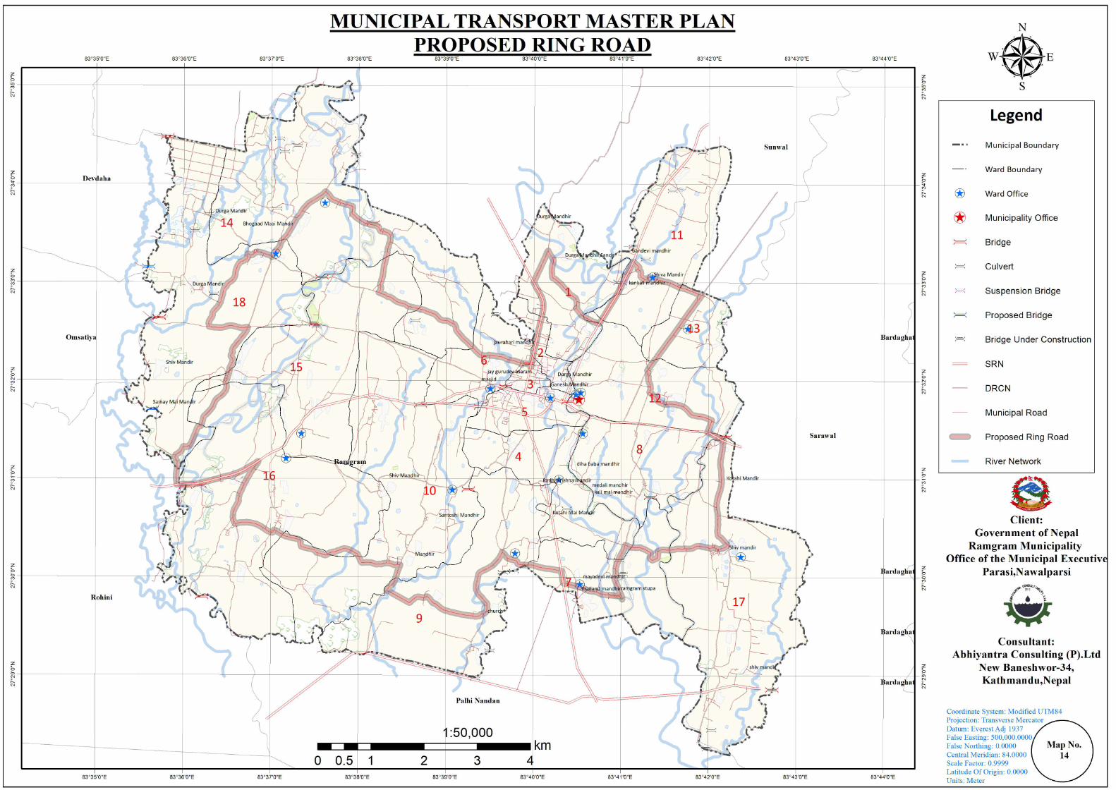
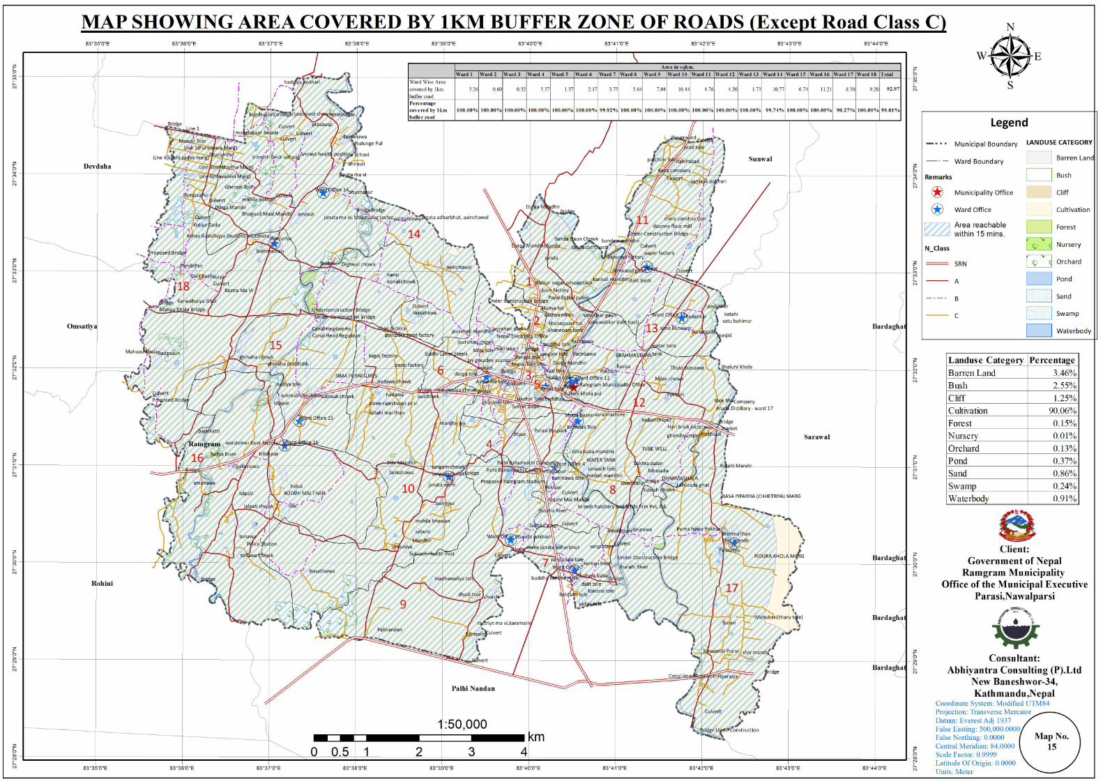
Municipality Transport Master Plan (MTMP) Ramgram ...
132
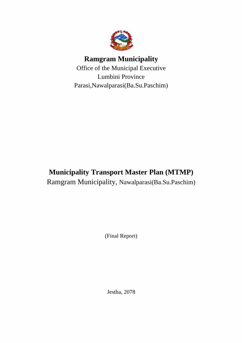
Ramgram Municipality Office of the Municipal Executive Lumbini Province Parasi,Nawalparasi(Ba.Su.Paschim) Municipality Transport Master Plan (MTMP) Ramgram Municipality, Nawalparasi(Ba.Su.Paschim) (Final Report) Jestha, 2078
-
Upload
khangminh22 -
Category
Documents
-
view
0 -
download
0
Transcript of Municipality Transport Master Plan (MTMP) Ramgram ...
Ramgram Municipality
Office of the Municipal Executive
Lumbini Province
Parasi,Nawalparasi(Ba.Su.Paschim)
Municipality Transport Master Plan (MTMP)
Ramgram Municipality, Nawalparasi(Ba.Su.Paschim)
(Final Report)
Jestha, 2078
Final Report MTMP Ramgram Municipality
ii
Ramgram Municipality
Office of the Municipal Executive
Lumbini Province
Parasi,Nawalparasi(Ba.Su.Paschim)
Municipality Transport Master Plan (MTMP) Ramgram Municipality, Nawalparasi(Ba.Su.Paschim)
(Final Report)
SUBMITTED BY:
Abhiyantra Consulting Pvt. Ltd,
New Baneshwor-34, Kathmandu
Final Report MTMP Ramgram Municipality
iii
Acknowledgement
The Consultant team would like to express our deep sense of gratitude to Municipality
President Narendra Kumar Gupta, Deputy President Rambha Kunwar, Chief Administrative
Officer Rajesh Panthi, Account Officer Kundan Kumar Chaudhary and Engineer Satish Kumar
Gupta of Ramgram Municipality Office for providing us the opportunity for the “Preparation
of Municipal Transport Master Plan for Ramgram Municipality”.
We would also like to present our gratitude to all the staff members of the municipality, all the
members of the ward committee, the representatives from different political parties and
volunteers for their support and contribution for making the working environment easy and
pleasant.
We would like to thank all the citizens for their patience and friendly environment who were
directly and indirectly involved in the data collection process. We are greatly thankful to
everyone who helped in facilitating us for data collection. We thank the volunteers who helped
for traffic vehicle count on the major road linkages.
The study team
Final Report MTMP Ramgram Municipality
iv
Executive Summary
Transport facilities help in developing access with the rural-urban linkages. Road accessibility
can reduce isolation, stimulate crop production and marketing activities, encourage public
services and help to transfer technology. Road building has been seen to bring about notable
enthusiasm and visible changes in rural life. Road infrastructure is considered as “the
infrastructure for infrastructure”. However, in the absence of notable criteria and rational
guidelines, road construction is carried out in adverse manner resulting in haphazard use and
wastage of limited resources. Municipal Transport Master Plan is prepared for assessing and
planning the present road and transport infrastructures and facilities within the municipality
and the surrounding municipality.
Ramgram Municipality is located in Nawalparasi District, a Terai district of Lumbini Province,
which was established in 2053 covering an area of 93.91 square kilometres with 18 numbers
of wards and population of 60,069 according to CBS 2011.
This study also formulated the road hierarchy for the various roads namely Class A, B, and C.
Class C basically deals with access while Class A and B basically deal with mobility and
accessibility to higher services. The total lengths of Class A, B and C roads are 83.53Km,
80.65Km and 147.65Km respectively. Class A, B and C roads are proposed with appropriate
cycle track, footpath, and green belt the cost of which is calculated as equivalent to the cost of
gravelling.
Due to the limitation of the municipality budget, the roads are required to be ranked based on
the provision of ToR. For the short term implementation of MTMP, it is assumed that roads
are constructed upto gravel. And the budget capacity of municipality increases by 7.5% each
year. Based on these assumptions, five-year implementation plan is prepared. This shows the
budget required for the first five year as 1916 million rupees. There is gap between the
estimated budget and the present municipality budget. For example in the case of first year
plan, the estimated budget is 330 million whereas the projected budget of municipality for this
year is 161 million. This gap in budget should be fulfilled by outer sources.
Non-motorised travel mode and green belt are given consideration while designing different
class of roads. Median strip is used to separate opposing traffic flow and hence provide safety.
Also separate footpath and cycle track is provided to facilitate the active user. Preparation of
MTMP is the first effort for the planned development of the municipal area. This is an
opportunity for implementing a sustainable transport system in the municipality. The study
being its first should be periodically reviewed and revised along with integration with other
plans. This will ensure efficient use of available resources and proper development of the
municipality. For effective MTMP, it needs to be compatible with comprehensive town
planning and land use policy
Final Report MTMP Ramgram Municipality
v
Acronyms/abbreviations
DDC District Development Committee
DTMP District Transport Master Plan
GIS
GPS
Geographic Information System
Global Positioning System
IDPM Indicative Development Potential Map
MIM Municipality Road Inventory Map
MRCC
NMT
MTMP
MTPP
VDC
Municipality Road Coordination Committee
Non- Motorized Transport
Municipality Transport Master Plan
Municipality Transport Perspective Plan
Village Development Committee
MTPP
PCU
DOLI
Municipality Transport Perspective Plan
Passenger Car Unit
Department of Local Infrastructure
OD Origin and Destination
ToR
HH
Terms of Reference
Household
VDCs
PT
Min.
Km.
Sq. km
Ha
Village Development Committees
Public Transport
Minute
Kilometre
Square Kilometre
Hectare
Final Report MTMP Ramgram Municipality
vi
Table of Contents
Acknowledgement ................................................................................................................... iii
Executive Summary .................................................................................................................. iv
Acronyms/abbreviations ............................................................................................................ v
Table of Contents ...................................................................................................................... vi
List of Tables ......................................................................................................................... viii
List of figures ......................................................................................................................... viii
CHAPTER I: INTRODUCTION ........................................................................................ 1
1.1 Background: ..................................................................................................................... 1
1.2 Objectives ........................................................................................................................ 1
1.3 Scope of work: ................................................................................................................. 2
1.4 Limitation of Study: ......................................................................................................... 4
1.5Approach and Methodology: ............................................................................................ 4
1.5.1. Secondary Data Collection ...................................................................................... 5
1.5.2. Primary Data Collection: ......................................................................................... 7
1.5.3. Data Processing, Analysis and Presentation of Reports .......................................... 8
1.5.4. Preparation of Visionary city development plan ..................................................... 8
1.5.5. Preparation of Indicative Development Potential Map (IDPM) .............................. 8
1.5.6. Digital Name Coding ............................................................................................... 8
1.5.7. Scoring criteria ...................................................................................................... 10
1.5.8. Presentation of results ............................................................................................ 10
1.6 Organization of Report .............................................................................................. 11
CHAPTER II: REVIEW OF EXISTING STATUS OF MUNICIPALITY ............................ 12
2.1 Income and Vehicle ownership ............................................................................. 12
2.2 Trip Purpose and Mode: ........................................................................................ 13
2.3 Origin and Destination Study: ............................................................................... 16
2.4 Road inventory ...................................................................................................... 18
2.5 Road Safety............................................................................................................ 19
2.6 Active road users ................................................................................................... 19
2.7 Public transportation .............................................................................................. 20
2.8 Mobility and accessibility ...................................................................................... 20
2.9 Land use ................................................................................................................. 21
Final Report MTMP Ramgram Municipality
vii
2.10 Visionary City development Plan ...................................................................... 22
Chapter III: Indicative Development Potential Map ................................................................ 23
3.1 Summary of municipality profile .............................................................................. 23
3.1.1 Physical Location and the Geographical characteristics ....................................... 23
Study Area: .......................................................................................................................... 23
3.1.2 Socio Economic Characteristics ............................................................................ 24
a. Population.................................................................................................................. 24
b. Religion Festival and Caste ................................................................................... 25
c. Educational and Occupational Status ........................................................................ 26
3.2 List of development potential areas .......................................................................... 27
3.3 Briefs on development potential areas ...................................................................... 27
3.4 Indicative development potential map(IDPM) .......................................................... 27
Chapter IV: Forecast and planning .......................................................................................... 30
4.1 Projection Of Population............................................................................................... 30
4.2 Formulation Of Road Hierarchy ................................................................................... 30
4.3 Accessibility And Mobility Scenario ............................................................................ 47
4.4 Transport Infrastructure Planning ................................................................................. 49
4.5 Short Term Municipality Transport Master Plan .......................................................... 50
4.6 Medium Term Municipality Transport Master Plan ..................................................... 51
4.7 Long Term Municipality Transport Master Plan .......................................................... 51
Chapter V: Five years municipal transport master plan ........................................................... 53
5.1 Perspective plan of municipal road network ............................................................. 53
5.2 Scoring criteria and score .......................................................................................... 54
5.3 Gap in Budget............................................................................................................ 60
5.4 Staging Implementation ............................................................................................ 63
Chapter VI: Conclusion and Recommendations ...................................................................... 65
Glossary ................................................................................................................................... 66
Final Report MTMP Ramgram Municipality
viii
List of Tables
Table 1: Scoring Criteria for prioritization of municipal roads ............................................... 10
Table 2: Income Status from sample data ................................................................................ 12
Table 3 Vehicle ownership on the basis of population and household .................................... 13
Table 4 Population distribution Ward wise ............................................................................. 24
Table 5: Distribution of population by caste/ethnicity ............................................................ 25
Table 6: Traffic count stations/locations .................................................................................. 30
Table 7: Comparison of Criterion of Road hierarchy .............................................................. 32
Table 8: Score of each municipal road .................................................................................... 54
Table 9: Budget allocation for different interventions year wise ............................................ 60
Table 10:Class wise Implementation plan for first five year construction (Amount) ............. 62
Table 11:Class wise Implementation plan for first five-year construction (Road Length) ..... 62
List of figures
Figure 1: Methodological framework ........................................................................................ 6
Figure 2:- Income status from sample population ................................................................... 12
Figure 3 vehicle ownership of sample population ................................................................... 13
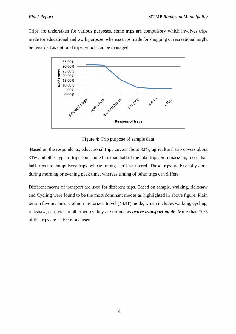
Figure 4: Trip purpose of sample data ..................................................................................... 14
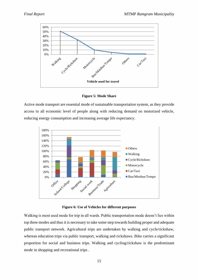
Figure 5: Mode Share............................................................................................................... 15
Figure 6: Use of Vehicles for different purposes ..................................................................... 15
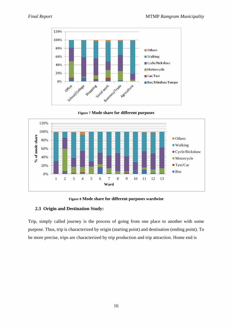
Figure 7 Mode share for different purposes ............................................................................. 16
Figure 8 Mode share for different purposes wardwise ............................................................ 16
Figure 9: Road users ................................................................................................................ 20
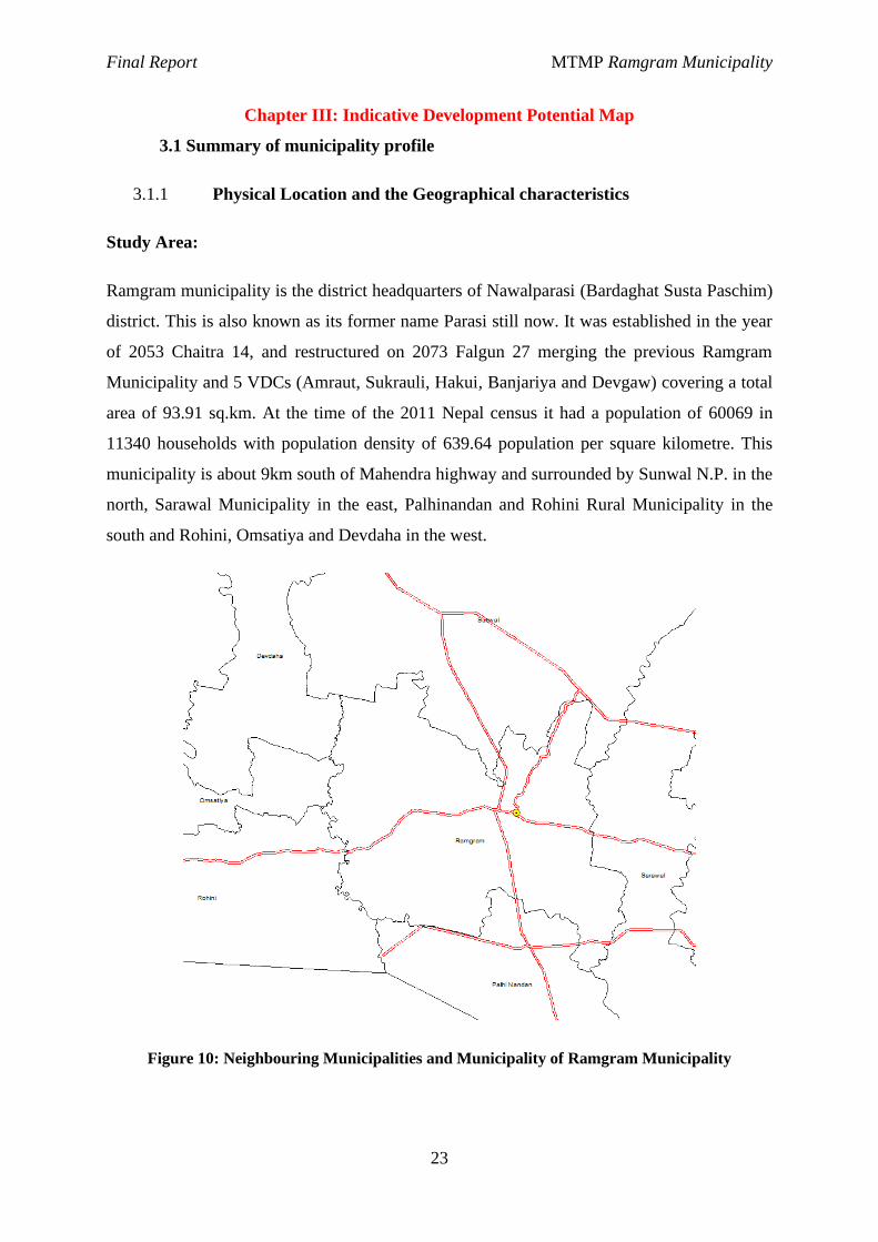
Figure 10: Neighbouring Municipalities and Municipality of Ramgram Municipality .......... 23
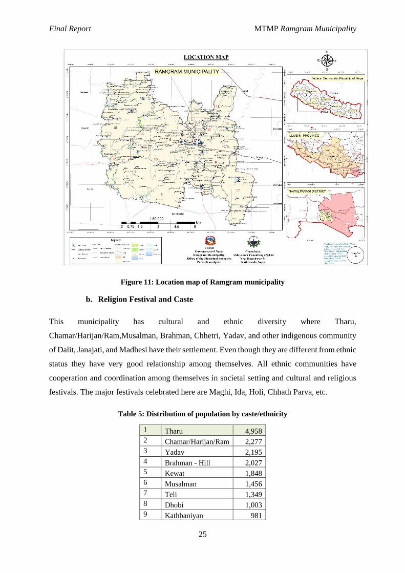
Figure 11: Location map of Ramgram municipality................................................................ 25
Figure 12: Education status of sample population ................................................................... 26
Figure 13 Occupational distribution ........................................................................................ 26
Figure 14: Education and Occupation Relationship ................................................................ 27
Figure 15 Typical cross section of Class A road ..................................................................... 34
Figure 16: Typical cross section of Class B roads ................................................................... 35
Figure 17 Typical cross section of Class C road...................................................................... 37
Figure 18: Twenty Years budget forecast ................................................................................ 54
Figure 19: Budget Allocation................................................................................................... 59
Figure 20: Yearly Budget for the MTMP ................................................................................ 60
Figure 21 Projected and required budget for the five year ...................................................... 61
Final Report MTMP Ramgram Municipality
1
CHAPTER I: INTRODUCTION
This chapter briefly explains the background and study of the study area along with the scopes
and objectives associated with the preparation of Municipal Transport Master Plan of Ramgram
Municipality, Nawalparasi (Bardaghat Susta Paschim).
1.1 Background:
Life in cities-i.e., organized human settlements, which are mostly referred to as communities
is only possible if people have mobility in daily basis. Residential area is separate from
workplaces, major shopping is concentrated in identifiable centers, and larger entertainment
and relaxation facilities are found at specific locations. They have to have accessibility. Unlike
in a rural context, very few of these destinations are reachable on foot; at least, they tend not
to be within a convenient walking distance for all.
Transport facilities help in developing access with the rural-urban linkages. Road accessibility
can reduce isolation, stimulate crop production and marketing activities, encourage public
services and help to transfer technology. Road building has been seen to bring about notable
enthusiasm and visible changes in rural life. Road infrastructure is considered as “the
infrastructure for infrastructure”. However, in the absence of notable criteria and rational
guidelines, road construction is carried out in adverse manner resulting in haphazard use and
wastage of limited resources.
Municipal area by its nature will attract more population as socio-economic growth and other
infrastructure development will gain pace. The municipality and its surrounding municipalities
will see a rapid increase in housing, infrastructure and urban services demand. In this regard,
Ramgram Municipality is initiating the formulation of Municipal Transport Master Plan for
assessing the present road and transport infrastructures and facilities within the municipality.
So as to be presented as proper municipality or a city, it must have a very good mobility and
accessibility by public or private means of transportation.
1.2 Objectives
The prime objective of this study is to prepare the Municipal Transport Master Plan (MTMP).
The planning approach is participatory and bottom-up from the settlement level. It includes a
constructive plan to incorporate all present and tomorrow’s transportation needs. The specific
objectives of the MTMP as indicated in ToR are as follows:
1. Prepare the Municipality Inventory (MIM) of all road networks.
2. Identify the major road networks linking the municipality with the surrounding areas.
3. Prepare Indicative Development Potential Map (IDPM).
4. Prepare visionary city development plan
5. Collection of demands for new/rehabilitation transport linkages from
Municipalities/settlements based on city development plan.
Final Report MTMP Ramgram Municipality
2
6. Analyse the present mobility and accessibility situation.
7. Identify and prioritize the interventions based on mobility and accessibility situation.
8. Develop scoring criteria and its approval from Municipality.
9. Prepare the Perspective Plan of transport services and facilities (Municipal Transport
Perspective Plan)
10. Prepare physical and financial implementation plan of prioritized roads for the MTMP
period.
11. Prepare a five years Municipality Transport Master Plan (MTMP).
1.3 Scope of work:
The scope of this work is summarized as:
a. Accessibility data Collection and Analysis.
The accessibility situation is evaluated from the settlement level and data is collected.
Various surveys carried out to gain such data including their travel patterns,
questionnaire surveys and origin-destination survey.
b. Analyze Mobility status of the municipality
Mobility status is studied. This is important especially because the road network has
provided accessibility in Nawalparasi district to nearly 100% of the population. The
question then arises on how efficiently; economically and safely the goods and
passengers are transported, which is indicated by mobility.
c. Assess the condition of public transportation
Data on different public transportation routes and their operation characteristics, which
operate within the municipal area and to other adjoining area, is collected and studied.
d. Assess safety status and issues
Road safety status and issues is accessed. For this, roadside condition survey during
road inventory survey and other accident data is reviewed. Possible interventions to
make the roads safer are proposed and recommended.
e. Prepare the Indicative Municipality Development Potential Map (IDPM) and visionary
city development plan
IDPM is prepared using topographical base maps and digitized GIS maps. In the IDPM,
potential areas for development are identified and prioritized through ranking.
f. Prepare Municipality Inventory Map (MIM) of existing roads within Ramgram
Municipality.
Municipality Inventory Map linking to strategic road networks such as national
highways, district core road network, main trails and bridges is prepared. The inventory
map has included the road names, total length and breadth of the roads, surface type,
existing condition, Right of way, vehicular traffic and pedestrian traffic flow etc.
Final Report MTMP Ramgram Municipality
3
g. Collection of demands for New/Upgrading/Rehabilitation transport Linkages from
Wards/Settlements
Data regarding the construction, maintenance or rehabilitation of roads according to the
existing condition and demand is done. Such data was collected through ward meeting
or community level discussion. The demand data was collected in priority order for
each ward. The roadside conditions of all the linkages were noted during the road
inventory survey.
h. Scoring criteria
Scoring criteria to screen and prioritize all interventions potential interventions for
proper allocation of limited budget is developed and approved by the municipality.
i. Road classification and Nomenclature
Metric system of nomenclature is used and applied the same classification throughout
the data collection.
j. Preparation of perspective plan of interventions of services and facilities.
The data collected through accessibility survey, demand survey and inventory maps are
used to prepare a perspective plan of interventions of services and facilities. All the
identified interventions are screened and rated on the basis of approved criteria and
forwarded to Municipality council meetings. The final perspective plan has been shown
in GIS maps.
k. Prepare a realistic physical and Financial Implementation Plan of Prioritised Roads for
the MTMP period
Resources required for the implementation of the MTMP is assessed and the financial
plan (required) for the next five years is prepared.
l. Prepare Municipal Transport Master Plan (MTMP) of Ramgram Municipality.
Municipal Transport Master Plan (MTMP) is prepared with due consideration to the
existing situation of: vehicular parking, travel routes, modes of transport, etc and
purpose for future urban growth. A base scenario of the existing road and transport
network and management based on the O-D survey and O-D matrix, and prepare road
inventory map and transport infrastructure network and management plan based on the
travel demand forecast, population growth forecast, and growth rate of vehicular and
transport infrastructure is prepared.
m. Medium term and long term planning
The scope of work demands a detailed work plan for five years period (short term).
Forecast/estimate of the demand for medium term (10 years) and long term (20 years)
is done and recommended a framework to guide future interventions and planning
processes.
Final Report MTMP Ramgram Municipality
4
1.4 Limitation of Study:
✓ Lack of Comprehensive Town Development Plan, Proper Land Use Policy and
Drainage Network Master Plan, which could have affect the future overall
development pattern, and hence future development of these policy need to be based
on the proposed MTMP.
✓ Unavailability of alignment of East West Railway, presence of which could have leads
to certain change in proposed class of roads.
✓ Lack of base year data for traffic the traffic projection is based on the sample data
survey which could not represent the true condition.
1.5Approach and Methodology:
Municipal Transport Master Plan has been prepared using participatory bottom-up approach
and differs from conventional practices of trickle-down approach. Techno-Political interface
has been incorporated in the planning process, where active participation from representatives
of political parties, line agencies, municipality officials is crucial. The Municipal Road
Coordination Committee (MRCC) has been constituted as authorized legislative body of
municipality. This body, comprising all political parties’ representatives and concerned
technical officials, helps in necessary policy decisions during the MTMP preparation and
implementation process.
The study started with preliminary planning or desk study where basic background of
municipality is studied with help of secondary data including census data, GIS data. The study
got acceleration with formation of MRCC and inspection report. Various field surveys were
carried out with objective of collecting primary data on transportation network, trip
characteristics and service facilities. Along with the primary data, demands for various
transportation projects (construction/upgrading/maintenance) were obtained from each ward.
Also, potential areas/locations for various facilities were also identified based on interaction
with local people and MRCC. The scoring criteria for prioritizing road network was identified
based on ToR and will be approved by municipality. Then, the hierarchy of roads will be
purposed and perspective plan of various interventions will be purposed and analysed based on
available fund and finally physical and financial implementation plan of prioritized roads for
MTMP period. After analysis, the study will come up with potential roads, that need immediate
intervention and roads that need to be given consideration for effective future planning.
Final Report MTMP Ramgram Municipality
5
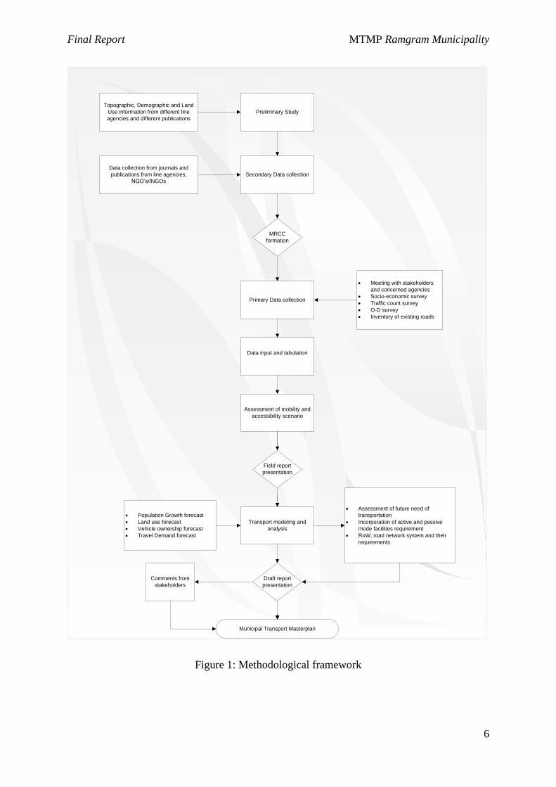
All the above-mentioned strategy adopted for data collection, processing and analysis is
summarized in the following figure in next page.
1.5.1. Secondary Data Collection
Any sorts of data that were collected from secondary sources are called secondary data. These
data were collected from annual report published by district level offices and consultation with
various concerned stakeholders. Municipal Road Coordination Committee (MRCC), which
compromises people from various fields and political parties, is the next source for various
secondary data. Field study was also carried out for general socio-economic assessment of the
Municipality that includes collection of data regarding high development potential areas such
as extensive agriculture, horticulture, livestock farming, high value cash crops, cottage and
agro-based industries, centre for business/commerce/markets places, tourism area, service
centers (hospital, health post, agriculture service sub-center etc.). The information about
demographic data of municipality, various maps showing service centers, transport
infrastructure inventory, past plans and sector study reports, sector standards and policy targets
were collected from the secondary sources, which includes Bureau of Statistics, Survey
Department, Local NGOs, line agencies, DDC, municipality etc. Digitized topographic maps,
administrative map of municipality, strategic road network map prepared by DoR, etc. were
some other secondary data that were used during the study.
Final Report MTMP Ramgram Municipality
6
Preliminary Study
Secondary Data collection
Topographic, Demographic and Land
Use information from different line
agencies and different publications
Data collection from journals and
publications from line agencies,
NGO’s/INGOs
MRCC
formation
Primary Data collection
· Meeting with stakeholders
and concerned agencies
· Socio-economic survey
· Traffic count survey
· O-D survey
· Inventory of existing roads
Data input and tabulation
Assessment of mobility and
accessibility scenario
Transport modeling and
analysis
· Population Growth forecast
· Land use forecast
· Vehicle ownership forecast
· Travel Demand forecast
· Assessment of future need of
transportation
· Incorporation of active and passive
mode facilities requirement
· RoW, road network system and their
requirements
Field report
presentation
Draft report
presentation
Comments from
stakeholders
Municipal Transport Masterplan
Figure 1: Methodological framework
Final Report MTMP Ramgram Municipality
7
1.5.2. Primary Data Collection:
Primary information on present household and trip characteristics, traffic characteristics,
existing accessibility and mobility level of settlements, prioritized road network required for
each ward are obtained via various reliable methods. Tracking of the existing road network
along with detail information of its width, surface type and possible intervention required for
the effectiveness of services is also carried out.
The primary data collection methods carried out in the field was:
· Origin and Destination (OD) Survey
· Road Inventory Survey
· Demand Survey
· Public Transport and Services Study
Household questionnaire method is used to conduct the OD surveys which gave various
information on questionnaire reflecting personal, household and trip making characteristics.
This survey will also help to visualize the accessibility and mobility scenario of road network
and to public transportation from the settlement/wards. As all the household can’t be covered
a realistic and statistically significant sample size was calculated based on probabilistic method.
Road inventory survey was conducted to collect data on its condition of road, road linkage,
road safety status and issues that need to be highlight. It helps in field validation of base maps
and also assists in preparation of road inventory map, nomenclature and coding of the road
linkages and to propose various interventions.
Road Demand survey comprised of interaction session with the members of wada nagarik
manch followed by asking them to fill up demand survey form, which includes demand of new
facility or interventions to improve existing roads based on priority.
Classified vehicle count will be conducted so as to reflect the usage of various vehicles in the
certain route, especially where maximum volume occurs. Twelve-hour count has been planned
at required location and the vehicles have to be classified to different types and finally traffic
volume have to be converted to passenger car unit (PCU) to visualize the exact condition. This
is not yet conducted due to less volume of traffic on the roads due to blockade in the fuels in
market which don’t gives the real condition of traffic.
Final Report MTMP Ramgram Municipality
8
Public Transport and Services Study highlights the services provided by public transportation
and location of various services and facilities. It was carried out by directly interviewing the
route operators.
1.5.3. Data Processing, Analysis and Presentation of Reports
Data collected at field were first entered at MS office tools (MS excel and Word) and GIS
database. All the complete and reliable sets of data were transformed into useable information
and the present scenario of municipality are shown through graphs, figures and tables.
Similarly, those which were entered into GIS database provide various types of maps.
Population and traffic were forecasted for the MTMP and MTPP time period. Various
transportation models were used for interpretation and forecasting. And, finally various
intervention were purposed and their economic analysis were also performed.
1.5.4. Preparation of Visionary city development plan
A creative description of Ramgram’s future, the vision guides our decisions, helps us set
direction and encourages us to align our priorities as we work to make Ramgram the city we
want it to become in the year 2092/93 is the visionary city development plan. This will be
finalised by the municipality. Based on this vision, the urban transportation planning is to be
done.
1.5.5. Preparation of Indicative Development Potential Map (IDPM)
IDPM is basically the indication of the existing and potential market/service centers (key
growth centers) and the areas having various development potentials such as high value cash
crops, agro-based industries and tourism. Thus, IDPM shows the areas of high value cash crops,
tourism potential, extensive agriculture, extensive horticulture, livestock farming, fisheries,
hydropower location and the other social service centers areas such as hospital, post office,
telecommunication, school, campus, ward centers, security offices and large settlements,
important historic and religious places. Finally, it indicates the grading of various markets of
the district thus providing the basis of network planning.
1.5.6. Digital Name Coding
Final Report MTMP Ramgram Municipality
9
Digital Name is a code given to each road which is unique and generated by an order of
alphabetical and numerical digits. Each code is different to the other and forms the basis of
differentiating from other road.
The first step taken in naming the streets is to identify the start and end point of a street. This
was done with the help of municipal officials and local participation. A start point may be
defined as a point located in the western end of a street, if the street is aligned in the West-East
alignment and vice-versa. Similarly, in case of a street aligned in the North-South alignment,
the start point shall be located in the Northern end of the street.
If the alignment of a street is not exactly North-South or West-East then the start point is
defined by the angle by which a street is deviated from the North-South or the West-East line.
If a street’s deviation is within 45 degrees from North-South line then its start point shall be on
the Northern end, else on the Western end of the West-East line. Although the above
convention was followed, the situation of streets in some places can imply the method to be
impractical. Hence, major service centres and markets or thoroughfares are also considered as
the reference point for start point of a street.
After the designation of the start and end points, streets are assigned a unique code in the format
A010101. The first letter in the Code represents a major road network (SRN, DRCN or Feeder
Roads) in the municipality, which shall be taken as the reference for the Digital Name Coding
of the municipal roads. The 2nd and 3rd number represent the number of primary branches from
this major road network. Similarly, 4th and 5th number represent the number of secondary
branches from the primary branches linking the major road and so on which maintains a
hierarchy in coding. Each code may contain 1 letter only to a combination of 15 numbers and
letters or more.
While coding, the streets branching from the main streets to the left are given only odd numbers
(A01 or A13) and those branching from the right are given even numbers (A02 or A10). The
major issue in Digital Name Coding process arises in the coding of new roads in the future.
This issue is important as the codes are allocated progressively to each street and any new street
shall be given a subsequent code after the last assigned code depending upon the left or right
side of the street. The new Digital codes will break the continuity of the Digital naming of the
streets but whatsoever these codes will be used for computer database as the local people only
use street names for the recognition of the roads in the municipality.
Final Report MTMP Ramgram Municipality
10
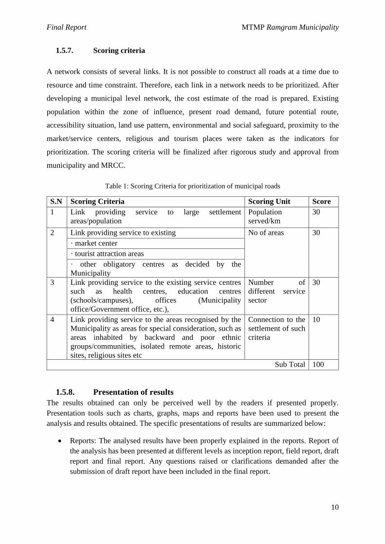
1.5.7. Scoring criteria
A network consists of several links. It is not possible to construct all roads at a time due to
resource and time constraint. Therefore, each link in a network needs to be prioritized. After
developing a municipal level network, the cost estimate of the road is prepared. Existing
population within the zone of influence, present road demand, future potential route,
accessibility situation, land use pattern, environmental and social safeguard, proximity to the
market/service centers, religious and tourism places were taken as the indicators for
prioritization. The scoring criteria will be finalized after rigorous study and approval from
municipality and MRCC.
Table 1: Scoring Criteria for prioritization of municipal roads
S.N Scoring Criteria Scoring Unit Score
1 Link providing service to large settlement
areas/population
Population
served/km
30
2 Link providing service to existing No of areas 30
· market center
· tourist attraction areas
· other obligatory centres as decided by the
Municipality
3 Link providing service to the existing service centres
such as health centres, education centres
(schools/campuses), offices (Municipality
office/Government office, etc.),
Number of
different service
sector
30
4 Link providing service to the areas recognised by the
Municipality as areas for special consideration, such as
areas inhabited by backward and poor ethnic
groups/communities, isolated remote areas, historic
sites, religious sites etc
Connection to the
settlement of such
criteria
10
Sub Total 100
1.5.8. Presentation of results
The results obtained can only be perceived well by the readers if presented properly.
Presentation tools such as charts, graphs, maps and reports have been used to present the
analysis and results obtained. The specific presentations of results are summarized below:
· Reports: The analysed results have been properly explained in the reports. Report of
the analysis has been presented at different levels as inception report, field report, draft
report and final report. Any questions raised or clarifications demanded after the
submission of draft report have been included in the final report.
Final Report MTMP Ramgram Municipality
11
· Charts and graphs: Relevant type of charts, tables and graphs have been used in the
reports to present the information. Charts are especially useful to deliver the
information more effectively.
· Maps: As the ToR demands, maps of road inventory, indicative development potential
map, land use map and municipality transport prospective plan map has been prepared.
· In addition to the reports, the obtained results have been shared via presentation and
electronic copy of GIS maps.
The analysed data and obtained results in the form of numbers/ tables and maps have been
collected in and presented as final report in two volumes. The results have been presented and
discussed among the municipality authorities and other stakeholders before preparing the final
report.
1.6 Organization of Report
Section 1 presents the concept and context of MTMP and lists out the objectives and scope of
the same.
Section 2 briefly explains the method used to conduct the study, analyse the data and
presentation of the findings.
Section 3 presents the basic profile of the study area through the available census data and
sample data collected and the existing scenario of the study municipality with reference to
transport in the municipality.
Section 4 gives the comprehensive forecast of the population, transport and other development
scenario. It also gives the picture of the implications that may arise and the transport
infrastructure to meet the demand and accelerate the development. It also describes the short
term, medium term and long term plan. It also describes the formulation of road hierarchy and
name and description of different classes of roads
Section 5 is dedicated to the five year (short term) municipality transport master plan (MTMP).
It gives the comprehensive strategic framework, perspective plan of the municipal roads,
budget expenditure, financial institution, capital investment plan and the staging
implementation plan.
Section 6 summarizes the report and gives necessary recommendations.
Final Report MTMP Ramgram Municipality
12
CHAPTER II: REVIEW OF EXISTING STATUS OF MUNICIPALITY
The chapter deals with the present condition and scenario of the municipality based on various
primary and secondary data sources. Socio-economic, trip, land use and transportation
characteristics are basically deals in this chapter along with analysing accessibility and mobility
scenario within the municipality. The basic data source of the analysis is the collected primary
data.
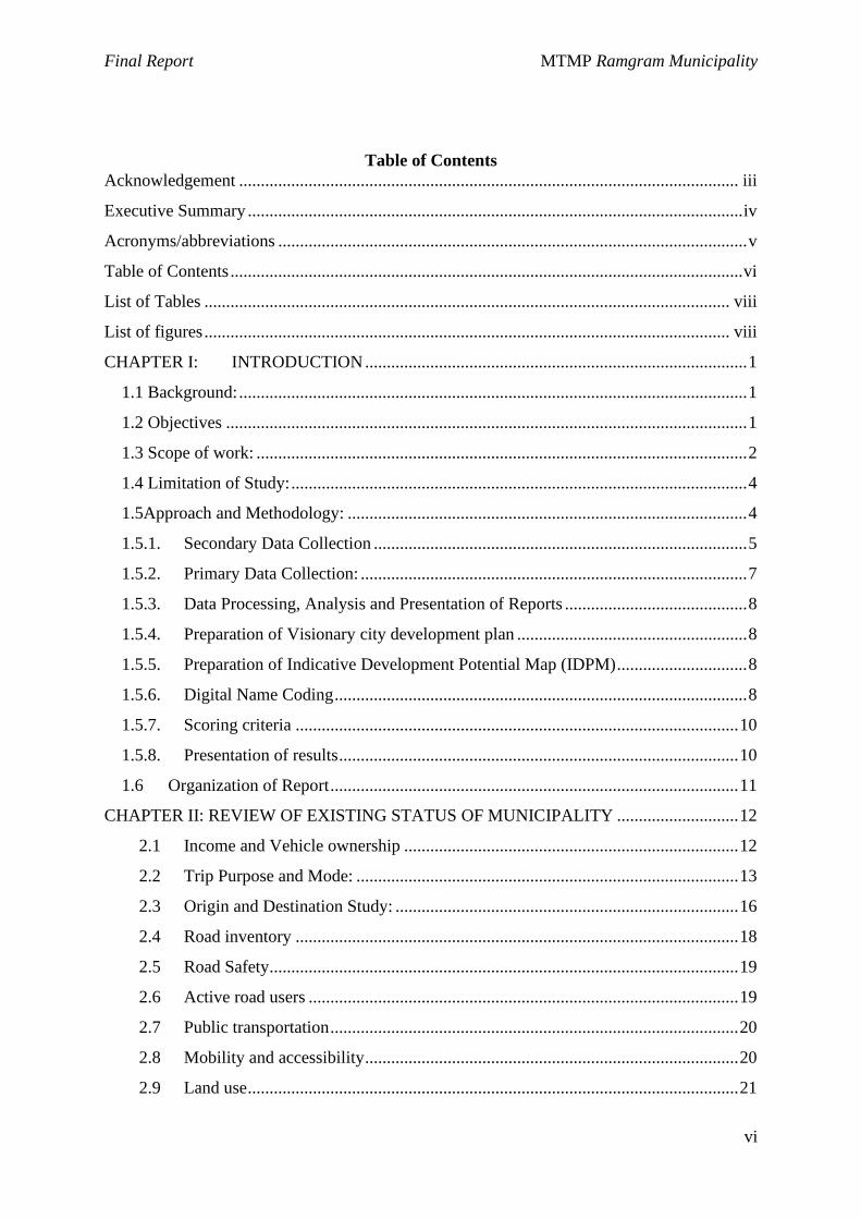
2.1 Income and Vehicle ownership
Figure 2:- Income status from sample population
Annual or monthly earning of each household has significant role in the trip characteristics and
finally on the overall planning aspects of the locality. Higher the income, people tends to live
luxurious life i.e. tends to have their own vehicle and so on. The income characteristics are
aggregated in household level, which revealed that majority of them (52%) are at low income
status (monthly income less than NRs. 20,000) and just a few (4.7%) have income level more
than 40,000. Income level also affects vehicle ownership pattern. Most of the people with
House Hold income less than 20,000 own cycle and as income increases ownership of
motorbike increases.
Table 2: Income Status from sample data
Income in Thousands per month Number of family Family having
Motorcycle Family having
Bicycle
<20 155 30 142
0% 10% 20% 30% 40% 50% 60%
<20
>60
20-30
30-40
40-50
40-60
% of sample population
Av
era
ge
inco
me
in T
ho
usa
nd
s p
er
mo
nth
Final Report MTMP Ramgram Municipality
13
Income in Thousands per month Number of family Family having
Motorcycle Family having
Bicycle
20-30 93 48 63
30-40 35 12 31
40-50 1 1 1
40-60 12 7 10
>60 1 1
Grand Total 297 98 248
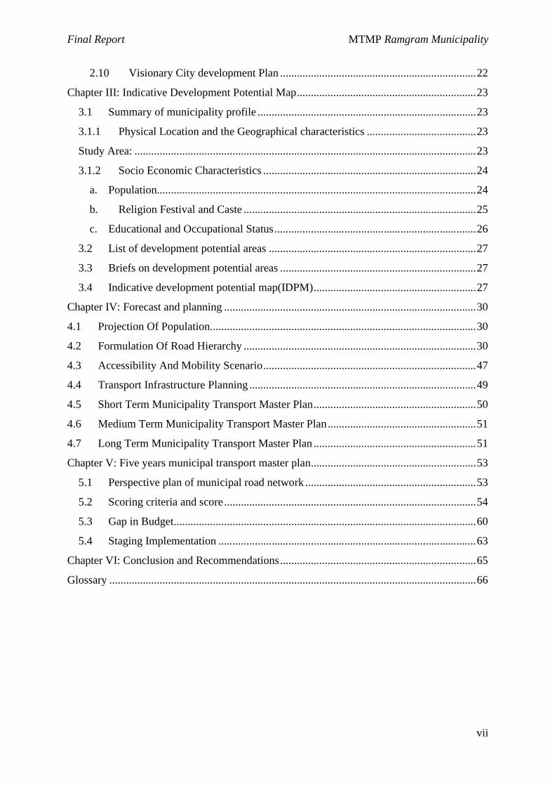
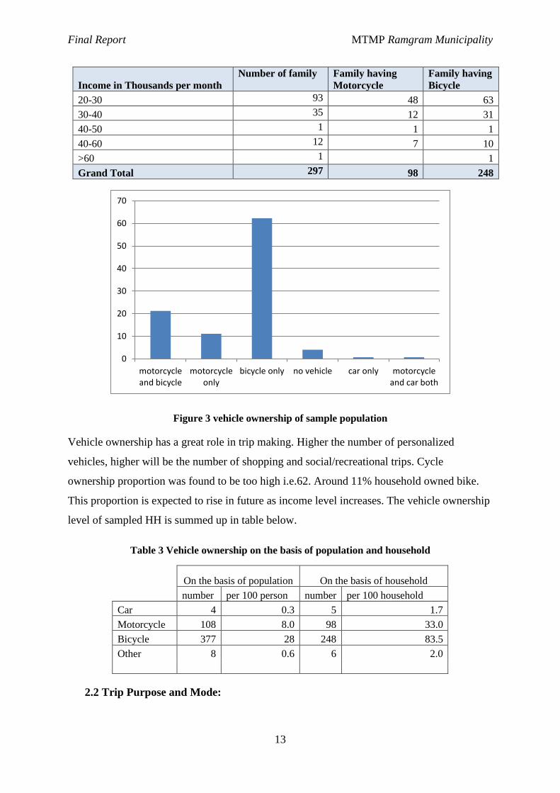
Figure 3 vehicle ownership of sample population
Vehicle ownership has a great role in trip making. Higher the number of personalized
vehicles, higher will be the number of shopping and social/recreational trips. Cycle
ownership proportion was found to be too high i.e.62. Around 11% household owned bike.
This proportion is expected to rise in future as income level increases. The vehicle ownership
level of sampled HH is summed up in table below.
Table 3 Vehicle ownership on the basis of population and household
On the basis of population On the basis of household
number per 100 person number per 100 household
Car 4 0.3 5 1.7
Motorcycle 108 8.0 98 33.0
Bicycle 377 28 248 83.5
Other 8 0.6 6 2.0
2.2 Trip Purpose and Mode:
motorcycleand bicycle
motorcycleonly
bicycle only no vehicle car only motorcycleand car both
0
10
20
30
40
50
60
70
Final Report MTMP Ramgram Municipality
14
Trips are undertaken for various purposes, some trips are compulsory which involves trips
made for educational and work purpose, whereas trips made for shopping or recreational might
be regarded as optional trips, which can be managed.
Figure 4: Trip purpose of sample data
Based on the respondents, educational trips covers about 32%, agricultural trip covers about
31% and other type of trips contribute less than half of the total trips. Summarizing, more than
half trips are compulsory trips, whose timing can’t be altered. These trips are basically done
during morning or evening peak time, whereas timing of other trips can differs.
Different means of transport are used for different trips. Based on sample, walking, rickshaw
and Cycling were found to be the most dominant modes as highlighted in above figure. Plain
terrain favours the use of non-motorized travel (NMT) mode, which includes walking, cycling,
rickshaw, cart, etc. In other words they are termed as active transport mode. More than 70%
of the trips are active mode user.
0.00%5.00%
10.00%15.00%20.00%25.00%30.00%35.00%
% o
f Tr
ave
l
Reasons of travel
Final Report MTMP Ramgram Municipality
15
Figure 5: Mode Share
Active mode transport are essential mode of sustainable transportation system, as they provide
access to all economic level of people along with reducing demand on motorized vehicle,
reducing energy consumption and increasing average life expectancy.
Figure 6: Use of Vehicles for different purposes
Walking is most used mode for trip in all wards. Public transportation mode doesn’t lies within
top three modes and thus it is necessary to take some step towards building proper and adequate
public transport network. Agricultural trips are undertaken by walking and cycle/rickshaw,
whereas education trips via public transport, walking and rickshaws. Bike carries a significant
proportion for social and business trips. Walking and cycling/rickshaw is the predominant
mode in shopping and recreational trips .
0%
10%
20%
30%
40%
50%
60%
Vehicle used for travel
0%
20%
40%
60%
80%
100%
120%
140%
160%
180%
Others
Walking
Cycle/Rickshaw
Motorcycle
Car/Taxi
Bus/Minibus/Tempo
Final Report MTMP Ramgram Municipality
16
Figure 7 Mode share for different purposes
Figure 8 Mode share for different purposes wardwise
2.3 Origin and Destination Study:
Trip, simply called journey is the process of going from one place to another with some
purpose. Thus, trip is characterized by origin (starting point) and destination (ending point). To
be more precise, trips are characterized by trip production and trip attraction. Home end is
0%
20%
40%
60%
80%
100%
120%
1 2 3 4 5 6 7 8 9 10 11 12 13
% o
f m
od
e sh
are
Ward
Others
Walking
Cycle/Rickshaw
Motorcycle
Taxi/Car
Bus
Final Report MTMP Ramgram Municipality
17
always trip production and the location which attract the produced trips for various causes (job,
shopping, and entertainment) are attraction end of trips. Most of the trips are home based trips
with different destination. Out of 1351 respondent surveyed 598 respondent 1276 make trips
for some purpose. Trip chaining, going at various destination points in the form of chain in a
single day, was rarely found in the study area. Household survey shows that nearly 40% trips
were directed toward ward numbers 2, 3 and 5 that is the main service center.

Final Report MTMP Ramgram Municipality
18
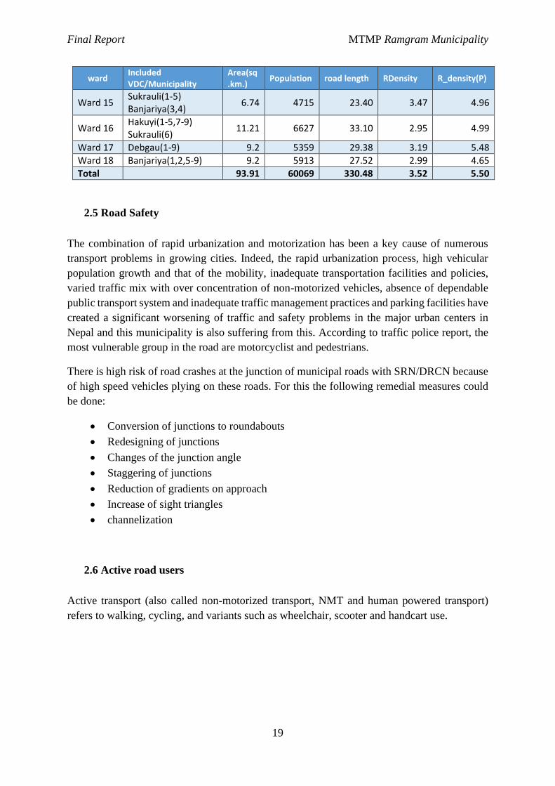
2.4 Road inventory
Road inventory survey was done and details of all the roads and cross structures were collected.
Total length of all the roads is 330.48 Km of which nearly 78.95 Km is earthen, 153.96km is
gravelled and 97.57 Km is blacktopped including 30.36 km SRN.
At present the road density of about 3.52 Km per square Km for the municipality. Similarly the
road density per thousand populations is nearly 5.5km.
Ward Earthen Gravelled Metalled Total
1 3.26 4.37 7.49 15.12
2 - 1.92 4.19 6.11
3 0.12 1.10 2.69 3.91
4 1.36 6.34 5.34 13.04
5 0.53 2.15 9.40 12.07
6 2.23 2.17 4.43 8.83
7 1.37 8.13 4.57 14.07
8 2.75 5.52 4.49 12.76
9 4.06 9.72 3.50 17.28
10 15.37 10.79 9.36 35.52
11 5.91 7.45 4.81 18.17
12 1.80 9.41 7.77 18.98
13 1.81 3.17 2.67 7.66
14 7.04 23.18 3.34 33.57
15 11.36 6.79 5.25 23.40
16 8.86 17.42 6.82 33.10
17 6.47 17.69 5.23 29.38
18 4.64 16.65 6.23 27.52
Total 78.95 153.96 97.57 330.48
ward Included VDC/Municipality
Area(sq.km.)
Population road length RDensity R_density(P)
Ward 1 Ramgram(1) 3.27 2214 15.12 4.62 6.83
Ward 2 Ramgram(2) 0.69 2904 6.11 8.85 2.10
Ward 3 Ramgram(3) 0.32 2550 3.91 12.22 1.53
Ward 4 Ramgram(4) 3.37 2084 13.04 3.87 6.26
Ward 5 Ramgram(5) 1.37 1917 12.07 8.81 6.30
Ward 6 Ramgram(6) 2.17 1866 8.83 4.07 4.73
Ward 7 Ramgram(7) 3.76 2713 14.07 3.74 5.19
Ward 8 Ramgram(8) 3.64 2125 12.76 3.51 6.01
Ward 9 Ramgram(9) Sanai(4,5)
7.04 2480 17.28 2.45 6.97
Ward 10 Ramgram(10) Sukrauli(7-9) Hakuyi(6)
10.44 4213 35.52 3.40 8.43
Ward 11 Ramgram(11) 4.77 3900 18.17 3.81 4.66
Ward 12 Ramgram(12) 4.2 2107 18.98 4.52 9.01
Ward 13 Ramgram(13) 1.73 1429 7.66 4.43 5.36
Ward 14 Amaraut(1-9) 10.79 4953 33.57 3.11 6.78
Final Report MTMP Ramgram Municipality
19
ward Included VDC/Municipality
Area(sq.km.)
Population road length RDensity R_density(P)
Ward 15 Sukrauli(1-5) Banjariya(3,4)
6.74 4715 23.40 3.47 4.96
Ward 16 Hakuyi(1-5,7-9) Sukrauli(6)
11.21 6627 33.10 2.95 4.99
Ward 17 Debgau(1-9) 9.2 5359 29.38 3.19 5.48
Ward 18 Banjariya(1,2,5-9) 9.2 5913 27.52 2.99 4.65
Total 93.91 60069 330.48 3.52 5.50
2.5 Road Safety
The combination of rapid urbanization and motorization has been a key cause of numerous
transport problems in growing cities. Indeed, the rapid urbanization process, high vehicular
population growth and that of the mobility, inadequate transportation facilities and policies,
varied traffic mix with over concentration of non-motorized vehicles, absence of dependable
public transport system and inadequate traffic management practices and parking facilities have
created a significant worsening of traffic and safety problems in the major urban centers in
Nepal and this municipality is also suffering from this. According to traffic police report, the
most vulnerable group in the road are motorcyclist and pedestrians.
There is high risk of road crashes at the junction of municipal roads with SRN/DRCN because
of high speed vehicles plying on these roads. For this the following remedial measures could
be done:
· Conversion of junctions to roundabouts
· Redesigning of junctions
· Changes of the junction angle
· Staggering of junctions
· Reduction of gradients on approach
· Increase of sight triangles
· channelization
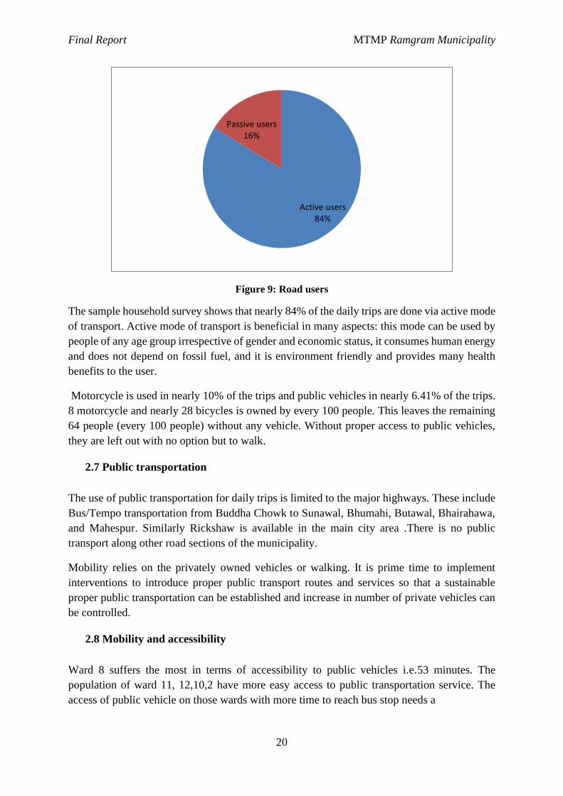
2.6 Active road users
Active transport (also called non-motorized transport, NMT and human powered transport)
refers to walking, cycling, and variants such as wheelchair, scooter and handcart use.
Final Report MTMP Ramgram Municipality
20
Figure 9: Road users
The sample household survey shows that nearly 84% of the daily trips are done via active mode
of transport. Active mode of transport is beneficial in many aspects: this mode can be used by
people of any age group irrespective of gender and economic status, it consumes human energy
and does not depend on fossil fuel, and it is environment friendly and provides many health
benefits to the user.
Motorcycle is used in nearly 10% of the trips and public vehicles in nearly 6.41% of the trips.
8 motorcycle and nearly 28 bicycles is owned by every 100 people. This leaves the remaining
64 people (every 100 people) without any vehicle. Without proper access to public vehicles,
they are left out with no option but to walk.
2.7 Public transportation
The use of public transportation for daily trips is limited to the major highways. These include
Bus/Tempo transportation from Buddha Chowk to Sunawal, Bhumahi, Butawal, Bhairahawa,
and Mahespur. Similarly Rickshaw is available in the main city area .There is no public
transport along other road sections of the municipality.
Mobility relies on the privately owned vehicles or walking. It is prime time to implement
interventions to introduce proper public transport routes and services so that a sustainable
proper public transportation can be established and increase in number of private vehicles can
be controlled.
2.8 Mobility and accessibility
Ward 8 suffers the most in terms of accessibility to public vehicles i.e.53 minutes. The
population of ward 11, 12,10,2 have more easy access to public transportation service. The
access of public vehicle on those wards with more time to reach bus stop needs a
Active users84%
Passive users16%
Final Report MTMP Ramgram Municipality
21
consideration. The mobility of more accessible wards for public vehicles needs consideration as well.
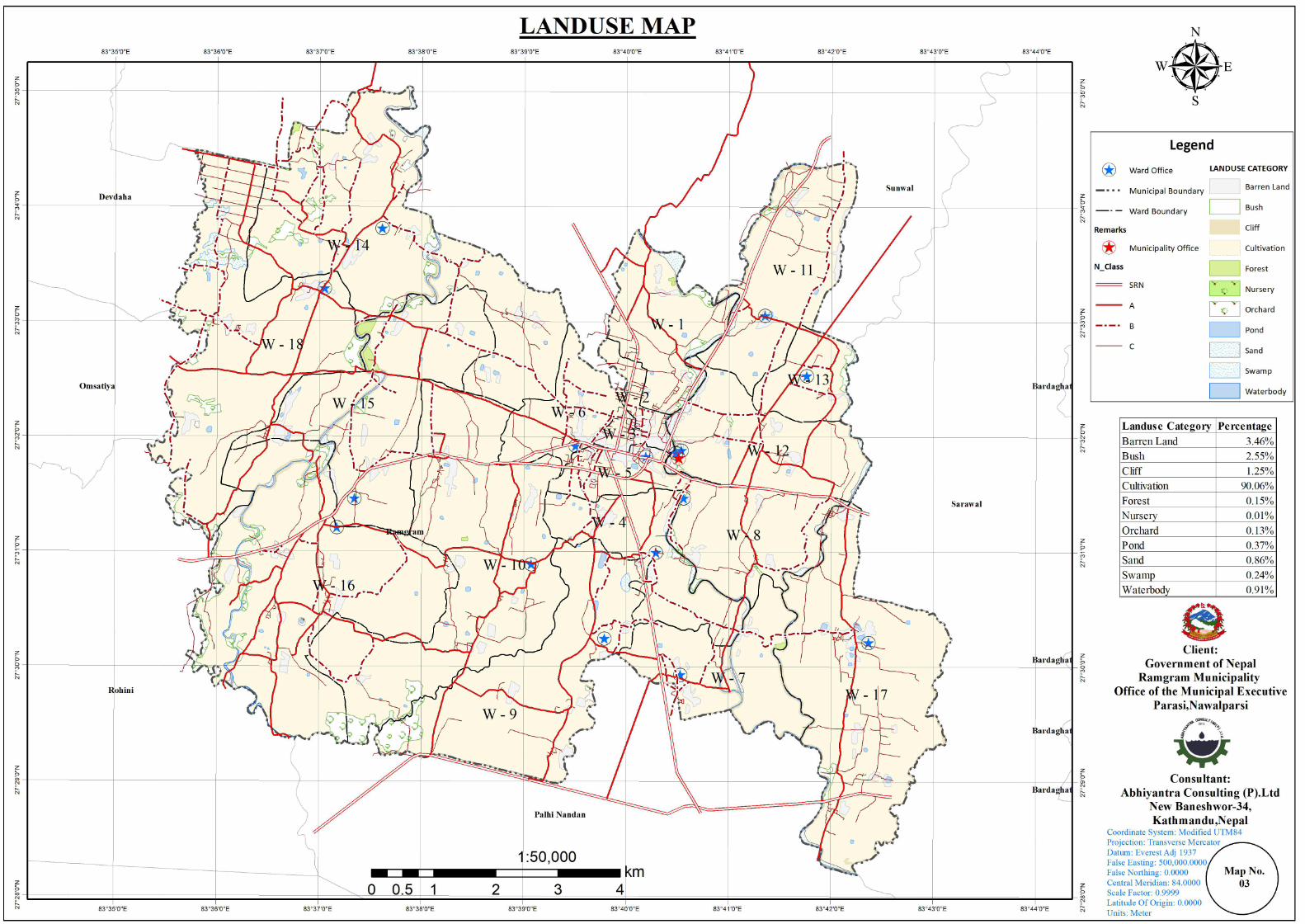
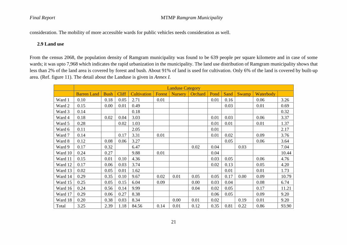
2.9 Land use
From the census 2068, the population density of Ramgram municipality was found to be 639 people per square kilometre and in case of some
wards; it was upto 7,968 which indicates the rapid urbanization in the municipality. The land use distribution of Ramgram municipality shows that
less than 2% of the land area is covered by forest and bush. About 91% of land is used for cultivation. Only 6% of the land is covered by built-up
area. (Ref. figure 11). The detail about the Landuse is given in Annex I.
Landuse Category
Barren Land Bush Cliff Cultivation Forest Nursery Orchard Pond Sand Swamp Waterbody
Ward 1 0.10 0.18 0.05 2.71 0.01 0.01 0.16 0.06 3.26
Ward 2 0.15 0.00 0.01 0.49 0.03 0.01 0.69
Ward 3 0.14 0.18 0.32
Ward 4 0.18 0.02 0.04 3.03 0.01 0.03 0.06 3.37
Ward 5 0.28 0.02 1.03 0.01 0.01 0.01 1.37
Ward 6 0.11 2.05 0.01 2.17
Ward 7 0.14 0.17 3.31 0.01 0.01 0.02 0.09 3.76
Ward 8 0.12 0.08 0.06 3.27 0.05 0.06 3.64
Ward 9 0.17 0.32 6.47 0.02 0.04 0.03 7.04
Ward 10 0.24 0.27 9.88 0.01 0.04 10.44
Ward 11 0.15 0.01 0.10 4.36 0.03 0.05 0.06 4.76
Ward 12 0.17 0.06 0.03 3.74 0.02 0.13 0.05 4.20
Ward 13 0.02 0.05 0.01 1.62 0.01 0.01 1.73
Ward 14 0.29 0.35 0.10 9.67 0.02 0.01 0.05 0.05 0.17 0.00 0.09 10.79
Ward 15 0.25 0.05 0.15 6.04 0.09 0.00 0.03 0.04 0.08 6.74
Ward 16 0.24 0.56 0.14 9.99 0.04 0.02 0.05 0.17 11.21
Ward 17 0.29 0.06 0.27 8.38 0.06 0.05 0.09 9.20
Ward 18 0.20 0.38 0.03 8.34 0.00 0.01 0.02 0.19 0.01 9.20
Total 3.25 2.39 1.18 84.56 0.14 0.01 0.12 0.35 0.81 0.22 0.86 93.90
Final Report MTMP Ramgram Municipality
22
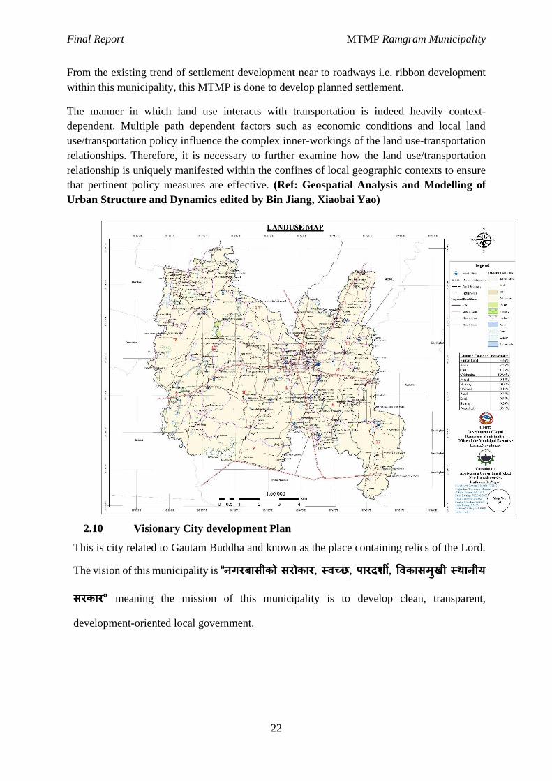
From the existing trend of settlement development near to roadways i.e. ribbon development
within this municipality, this MTMP is done to develop planned settlement.
The manner in which land use interacts with transportation is indeed heavily context-
dependent. Multiple path dependent factors such as economic conditions and local land
use/transportation policy influence the complex inner-workings of the land use-transportation
relationships. Therefore, it is necessary to further examine how the land use/transportation
relationship is uniquely manifested within the confines of local geographic contexts to ensure
that pertinent policy measures are effective. (Ref: Geospatial Analysis and Modelling of
Urban Structure and Dynamics edited by Bin Jiang, Xiaobai Yao)
2.10 Visionary City development Plan
This is city related to Gautam Buddha and known as the place containing relics of the Lord.
The vision of this municipality is “नगरबासीको सरोकार, स्वच्छ, पारदर्शी, ववकासमुखी स्थानीय
सरकार” meaning the mission of this municipality is to develop clean, transparent,
development-oriented local government.
Final Report MTMP Ramgram Municipality
23
Chapter III: Indicative Development Potential Map
3.1 Summary of municipality profile
3.1.1 Physical Location and the Geographical characteristics
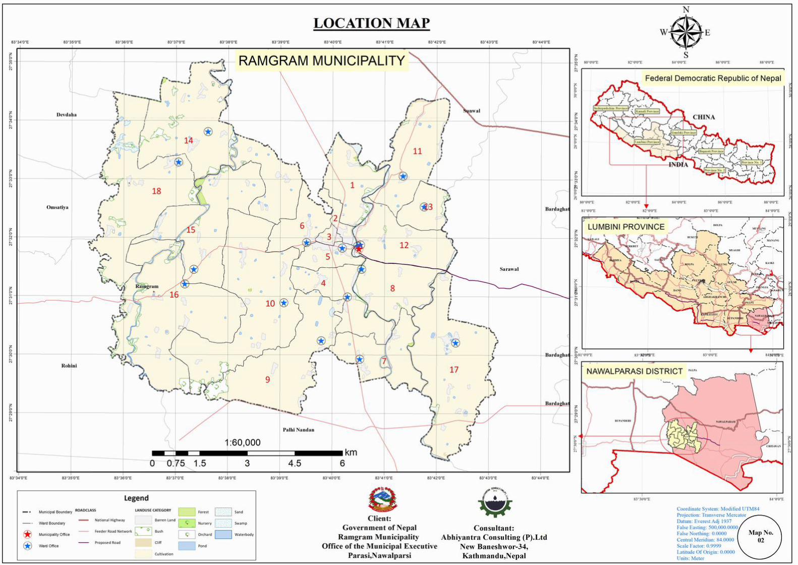
Study Area:
Ramgram municipality is the district headquarters of Nawalparasi (Bardaghat Susta Paschim)
district. This is also known as its former name Parasi still now. It was established in the year
of 2053 Chaitra 14, and restructured on 2073 Falgun 27 merging the previous Ramgram
Municipality and 5 VDCs (Amraut, Sukrauli, Hakui, Banjariya and Devgaw) covering a total
area of 93.91 sq.km. At the time of the 2011 Nepal census it had a population of 60069 in
11340 households with population density of 639.64 population per square kilometre. This
municipality is about 9km south of Mahendra highway and surrounded by Sunwal N.P. in the
north, Sarawal Municipality in the east, Palhinandan and Rohini Rural Municipality in the
south and Rohini, Omsatiya and Devdaha in the west.
Figure 10: Neighbouring Municipalities and Municipality of Ramgram Municipality
Final Report MTMP Ramgram Municipality
24
3.1.2 Socio Economic Characteristics
a. Population
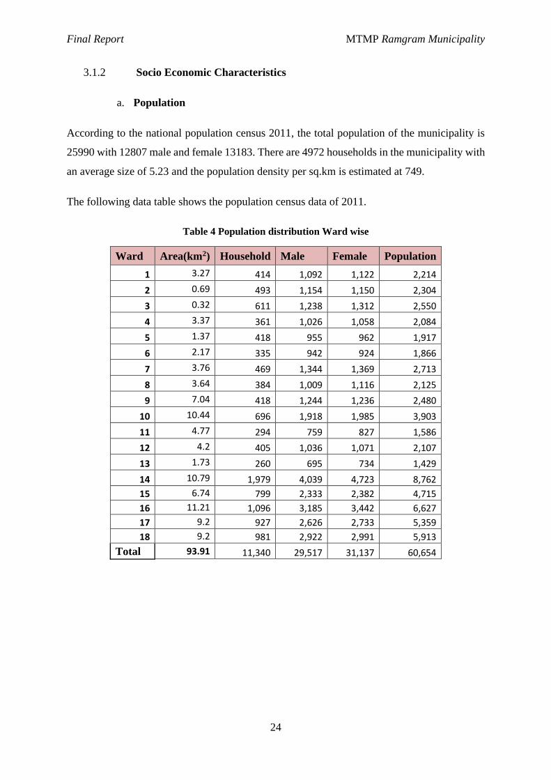
According to the national population census 2011, the total population of the municipality is
25990 with 12807 male and female 13183. There are 4972 households in the municipality with
an average size of 5.23 and the population density per sq.km is estimated at 749.
The following data table shows the population census data of 2011.
Table 4 Population distribution Ward wise
Ward Area(km2) Household Male Female Population
1 3.27 414 1,092 1,122 2,214
2 0.69 493 1,154 1,150 2,304
3 0.32 611 1,238 1,312 2,550
4 3.37 361 1,026 1,058 2,084
5 1.37 418 955 962 1,917
6 2.17 335 942 924 1,866
7 3.76 469 1,344 1,369 2,713
8 3.64 384 1,009 1,116 2,125
9 7.04 418 1,244 1,236 2,480
10 10.44 696 1,918 1,985 3,903
11 4.77 294 759 827 1,586
12 4.2 405 1,036 1,071 2,107
13 1.73 260 695 734 1,429
14 10.79 1,979 4,039 4,723 8,762
15 6.74 799 2,333 2,382 4,715
16 11.21 1,096 3,185 3,442 6,627
17 9.2 927 2,626 2,733 5,359
18 9.2 981 2,922 2,991 5,913
Total 93.91 11,340 29,517 31,137 60,654
Final Report MTMP Ramgram Municipality
25
Figure 11: Location map of Ramgram municipality
b. Religion Festival and Caste
This municipality has cultural and ethnic diversity where Tharu,
Chamar/Harijan/Ram,Musalman, Brahman, Chhetri, Yadav, and other indigenous community
of Dalit, Janajati, and Madhesi have their settlement. Even though they are different from ethnic
status they have very good relationship among themselves. All ethnic communities have
cooperation and coordination among themselves in societal setting and cultural and religious
festivals. The major festivals celebrated here are Maghi, Ida, Holi, Chhath Parva, etc.
Table 5: Distribution of population by caste/ethnicity
1 Tharu 4,958 2 Chamar/Harijan/Ram 2,277 3 Yadav 2,195 4 Brahman - Hill 2,027 5 Kewat 1,848 6 Musalman 1,456 7 Teli 1,349 8 Dhobi 1,003 9 Kathbaniyan 981
Final Report MTMP Ramgram Municipality
26
1 Tharu 4,958 10 Chhetree 778 11 Others 7,118
Total 25,990
c. Educational and Occupational Status
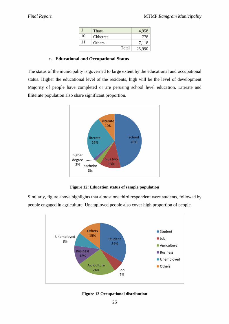
The status of the municipality is governed to large extent by the educational and occupational
status. Higher the educational level of the residents, high will be the level of development
Majority of people have completed or are perusing school level education. Literate and
Illiterate population also share significant proportion.
Figure 12: Education status of sample population
Similarly, figure above highlights that almost one third respondent were students, followed by
people engaged in agriculture. Unemployed people also cover high proportion of people.
Figure 13 Occupational distribution
school46%
plus two13%
bachelor3%
higher degree
2%
literate26%
iliterate10%
Student34%
Job7%
Agriculture24%
Business12%
Unemployed8%
Others15%
Student
Job
Agriculture
Business
Unemployed
Others
Final Report MTMP Ramgram Municipality
27
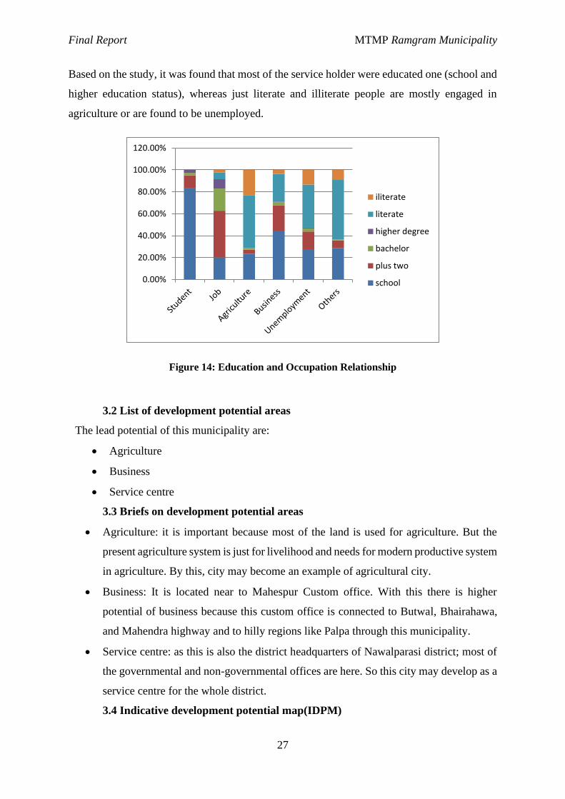
Based on the study, it was found that most of the service holder were educated one (school and
higher education status), whereas just literate and illiterate people are mostly engaged in
agriculture or are found to be unemployed.
Figure 14: Education and Occupation Relationship
3.2 List of development potential areas
The lead potential of this municipality are:
· Agriculture
· Business
· Service centre
3.3 Briefs on development potential areas
· Agriculture: it is important because most of the land is used for agriculture. But the
present agriculture system is just for livelihood and needs for modern productive system
in agriculture. By this, city may become an example of agricultural city.
· Business: It is located near to Mahespur Custom office. With this there is higher
potential of business because this custom office is connected to Butwal, Bhairahawa,
and Mahendra highway and to hilly regions like Palpa through this municipality.
· Service centre: as this is also the district headquarters of Nawalparasi district; most of
the governmental and non-governmental offices are here. So this city may develop as a
service centre for the whole district.
3.4 Indicative development potential map(IDPM)
0.00%
20.00%
40.00%
60.00%
80.00%
100.00%
120.00%
iliterate
literate
higher degree
bachelor
plus two
school
Final Report MTMP Ramgram Municipality
28
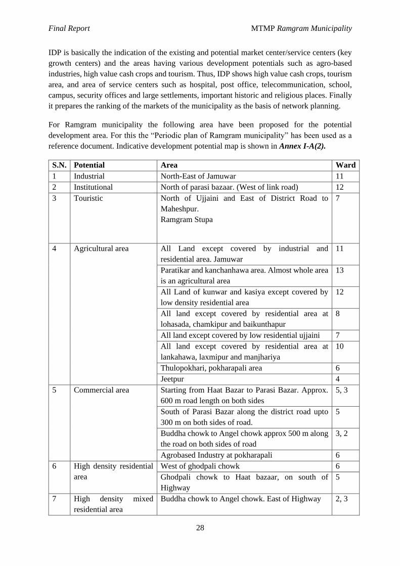
IDP is basically the indication of the existing and potential market center/service centers (key
growth centers) and the areas having various development potentials such as agro-based
industries, high value cash crops and tourism. Thus, IDP shows high value cash crops, tourism
area, and area of service centers such as hospital, post office, telecommunication, school,
campus, security offices and large settlements, important historic and religious places. Finally
it prepares the ranking of the markets of the municipality as the basis of network planning.
For Ramgram municipality the following area have been proposed for the potential
development area. For this the “Periodic plan of Ramgram municipality” has been used as a
reference document. Indicative development potential map is shown in Annex I-A(2).
S.N. Potential Area Ward
1 Industrial North-East of Jamuwar 11
2 Institutional North of parasi bazaar. (West of link road) 12
3 Touristic North of Ujjaini and East of District Road to
Maheshpur.
Ramgram Stupa
7
4 Agricultural area All Land except covered by industrial and
residential area. Jamuwar
11
Paratikar and kanchanhawa area. Almost whole area
is an agricultural area
13
All Land of kunwar and kasiya except covered by
low density residential area
12
All land except covered by residential area at
lohasada, chamkipur and baikunthapur
8
All land except covered by low residential ujjaini 7
All land except covered by residential area at
lankahawa, laxmipur and manjhariya
10
Thulopokhari, pokharapali area 6
Jeetpur 4
5 Commercial area Starting from Haat Bazar to Parasi Bazar. Approx.
600 m road length on both sides
5, 3
South of Parasi Bazar along the district road upto
300 m on both sides of road.
5
Buddha chowk to Angel chowk approx 500 m along
the road on both sides of road
3, 2
Agrobased Industry at pokharapali 6
6 High density residential
area
West of ghodpali chowk 6
Ghodpali chowk to Haat bazaar, on south of
Highway
5
7 High density mixed
residential area
Buddha chowk to Angel chowk. East of Highway 2, 3
Final Report MTMP Ramgram Municipality
29
S.N. Potential Area Ward
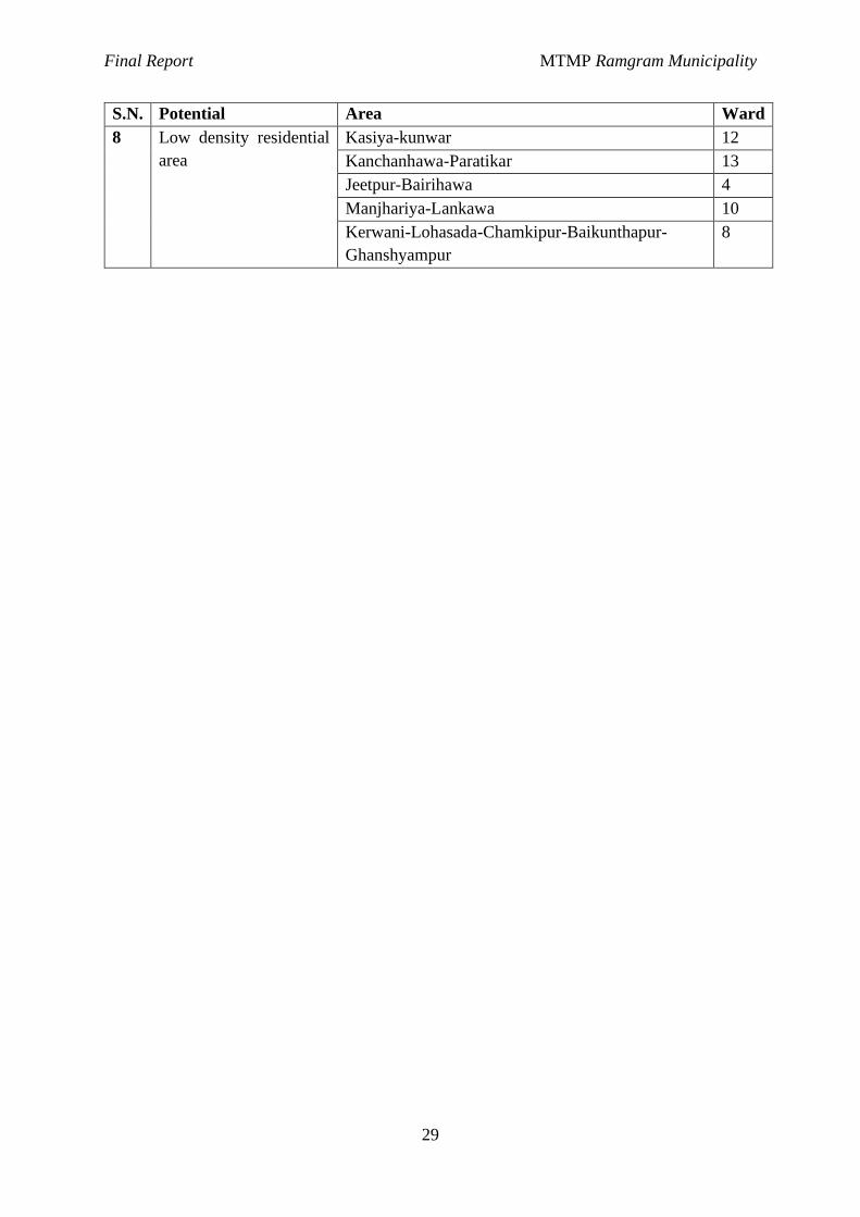
8 Low density residential
area
Kasiya-kunwar 12
Kanchanhawa-Paratikar 13
Jeetpur-Bairihawa 4
Manjhariya-Lankawa 10
Kerwani-Lohasada-Chamkipur-Baikunthapur-
Ghanshyampur
8
Final Report MTMP Ramgram Municipality
30
Chapter IV: Forecast and planning
4.1 Projection Of Population
Municipality is an urban area or an urbanizing area and one of the characteristics of an urban
area is higher population densities and corresponding higher demand for services and facilities
all of which directly demands proper transport infrastructure. For sustainable supply of
transport infrastructure, it is pertinent to forecast the population in the future so that the
infrastructures can be planned and constructed accordingly.
A population forecast requires certain information on historic population counts, births, deaths,
other rates which affect population change. Population forecasting is essentially a matter of
judgment in selecting the kind of forecast to present, in determining the procedures for making
it, and in appraising effects of the factors that induce population changes. The problem, of
course, is much simpler for areas which have shown marked stability in the size of their
populations for several decades, and for which no great change in the economic and social
conditions of the locality seems likely. On the other hand it may be extremely difficult and
complex for areas which have had sharp fluctuations in the direction or rate of population
change in the past, and which may continue to have them.
The main factors affecting the population projection are birth rate, death rate and migration to
the city/town concerned. Out of these factors, the migration is chief factor. The factors for
migration may be the desire for better economic opportunities, desire for better living or
housing conditions (this applies particularly to short distance migration within the same general
locality), movement for reasons of health, education, or retirement etc. The level of national
economic activity also affects the direction of migration. When employment is high or rising,
the movement is generally from rural areas and small towns to the medium-size and larger
cities, because of the relatively larger rate of wages and economic opportunities in urban areas.
Traffic condition of Ramgram Municipality
One day traffic count survey was conducted at Ramgram municipality at six locations/links
known as Buddhachowk (3 directions), Bhumai road, Mahespur road and Hulaki sadak (Way
to Biakundthapur). The details of traffic count data are presented in the Annex II-H. This data
can be used as the baseline data for the future transportation planning and design.
Table 6: Traffic count stations/locations
SN count station name location Remarks
1 Way to Bhumai in front of lawyers office Parasi-Bhumai Road
2 East of buddha chowk Buddha chowk Buddha Chowk
3 West of buddha chowk Buddha chowk Buddha Chowk
4 Maheshpur chowk Bus Bisauni Parasi-Maheshpur
5 Way to Sunwaul Infront of SBI bank Parasi-Sunwaul
6 Hulaki road Infront of municipality office Parasi-Baikunthapur
4.2 Formulation Of Road Hierarchy
Final Report MTMP Ramgram Municipality
31
Roadways serve a variety of functions, including but not limited to the provision of direct
access to properties, pedestrian and bicycle paths, bus routes and catering for through traffic
that is not related to immediate land uses. Many roads serve more than one function and to
varying degrees, but it is clear that the mixing of incompatible functions can lead to problems.
Thus it is important to distinguish road in different class or type based on various criteria. A
road hierarchy is a means of defining each roadway in terms of its function such that
appropriate objectives for that roadway can be set and appropriate design criteria can be
implemented. It is an important tool of road network and land use planning to asset
management.
Road hierarchy restricts or reduces direct connections between certain types of links, for
example residential streets and arterial roads, and allows connections between similar order
streets (e.g. arterial to arterial) or between street types that are separated by one level in the
hierarchy (e.g. arterial to highway and collector to arterial.) These hierarchical distinctions of
road types become clearer when considering the recommended design specifications for the
number of through lanes, design speed, intersection spacing and driveway access.
A well formed road hierarchy will reduce overall impact of traffic by concentrating longer
distance flow onto routes in less sensitive locations, ensuring land uses and activities that are
incompatible with traffic flow are restricted from routes where traffic movement should
predominate and preserving areas where through traffic is discouraged.
The road hierarchy principles will assist planning agencies via orderly planning and provision
of public transport routes, pedestrian and bicycle routes. It also identifies the effects of
development decisions in and on surrounding areas and roadways within the hierarchy and also
facilitates urban design principles such as accessibility, connectivity, efficiency, amenity and
safety. Further, it also identifies treatments such as barriers, buffers and landscaping to preserve
amenity for adjacent land uses.
This study also formulates the road hierarchy for the various roads. After going through large
number of literature, the study has proposed four level hierarchy roads namely Class A, B, C
and D. Class C and D basically deals with access while Class A and B basically deals with
mobility and accessibility to higher services.
Final Report MTMP Ramgram Municipality
32
Table 7: Comparison of Criterion of Road hierarchy
Criteria Class B Class C Class C
Purpose Mobility and control access Access and mobility Access
Function
Connection between Class A
and C roads; and also
Provide alternative
connection routes between
Class A
Connects higher
order roads and
mobility to local
trips
Connect local
trips to higher
level roads
Support through movement
of traffic Access to property
direct access to
property
Segregated NMT facilities
and Bus lay-bys
Segregated NMT
facilities
Local NMT
movement
High access to Public
transport
Limited access to
public transport
Maintenance
Responsibility Municipality
Municipality &
Community Community
Design Speed
(Kmph) 50 40 30
Radius (m) 110 40 20
Minimum Right
of Way(m) 15 10 6*
Extra width at
curve (m) 2.5 1.5 1
Based on various literature, the recommended right of way of ToR doesn’t seems to be justifiable
one as there is necessity of arterial road within the municipality. Also, the road space needs to be
distributed to all road users equally with provision of green belt, cycle track thus there need to be a
provision for green belt cycle track and footpath. After proper study the RoW of 30, 20, 14 and 6m
is recommended for class A, B, C and D road respectively.
Type of City Criteria
ROW based on Road Hierarchy (m)
Expressway Arterial Sub arterial Collector Local
Sub city 10,000-40,000 - - 30 20 10
City 40,000- 100,000 - 50 30 20 10
Sub Metro City 100,000-300,000 50 30 20 10 10
Ref: Planning Norms and Standard 2015, GoN, DUDBC
ROW based on Road Hierarchy (m)
Expressway Arterial Sub arterial Collector Local
- 50-60 30-40 20-30 10-20
Ref: Nepal Urban Road Standard 2068 (draft)
Standard Cycle Track Footpath (Minimum) Median Strip
NURS 2068 draft 2 m on both side 2 m on both side 5 m
NRS 2070 2 m on both side 1.5 m on both side 5 m

Final Report MTMP Ramgram Municipality
33
Criteria Class B Class C Class C
Setback distance
(m) 4 2 1.5
Access Control Applicable Not Applicable Not Applicable
Public transport
services
Mass Transit, Local Public
transport
No public
transportation
No public
transportation
* The roads fulfilling the minimum width of road criteria set by the municipality
ward A B C SRN Total
1 3.60 0.45 9.15 1.91 15.12
2 1.29 4.16 0.66 6.11
3 0.96 1.83 1.06 3.85
4 2.72 3.13 5.07 2.12 13.04
5 0.77 2.45 5.74 3.11 12.07
6 1.37 3.74 2.56 1.16 8.83
7 6.20 5.09 1.19 1.59 14.07
8 1.52 4.00 6.37 0.87 12.76
9 9.97 1.49 5.71 17.17
10 10.77 3.70 18.51 2.54 35.52
11 1.22 3.30 9.94 3.72 18.17
12 5.02 2.84 7.00 4.13 18.98
13 3.72 2.69 1.25 7.66
14 7.95 12.61 13.00 33.57
15 6.31 6.28 9.21 1.60 23.40
16 17.47 3.44 9.73 2.46 33.10
17 5.98 1.30 20.74 1.36 29.38
18 9.22 9.58 8.73 27.52
Total 93.81 68.34 139.89 28.28 330.32
Class A Roads
All major roads which connect one or more major Growth Centres (market, tourism Centre,
industry, etc.) or several Wards with high network coverage, connected directly or through
the National Strategic Road Network or district road falls on the road class A. The proposed
right of way for this class of road is 15m which includes footpath, cycle track, greenery, and
the carriageway as shown below in the cross section.

Final Report MTMP Ramgram Municipality
34
Code Road Name Metalled Earthen Gravelled Total
A01 Basabashi-Manari(Hulaki)-Devgaun-Pipariya-Mahespur Road 4.36 1.62 5.98
A02 Ramjanaki Marg 0.93 4.29 5.22
A03 Harkatta (MRM)-Baikunthapur(Hulaki)-Deurawa-Ramgram Stupa Road 7.80 0.61 3.82 12.23
A04 Bikunthapur-Milanchowk to east Road - 1.37 1.37
A05 Charandas Baba Marga 0.16 1.16 0.54 1.85
A06 Ramgram N.P-Sanda-Shantapur-Badera-Bargoriya Mandir Road 1.23 4.10 5.34
A07 Sunwal-Parasi Road-Durga Mandhir - 1.06 1.06
A08 Buddha Marga - 1.51 1.51
A09 Buddha Tole-Parasi Road Section - 0.40 0.40
A10 Jitpur(Ramgram N.P)-Brahmpurwa-Bairawa-Bishnupura Road 3.35 2.16 5.51
A11 Jokwar Marga 0.74 0.49 1.22
A12 Shaid Jagdish Paswan Marg( Bairawa-Lalitpur-Lankahawa-Hakaui Road) 1.40 2.14 2.41 5.95
A13 Majariya-Jamuniya-Sanahi-Ragargunj Road 2.02 3.40 5.42
A14 Pul to santoshi mandir road - 0.98 0.98
A15 Samaye Devi Marga - 2.06 2.06
A16 Bijaya Path 0.57 1.34 1.54 3.45
A17 Nandan Marga 1.63 0.92 2.55
A18 Sunwal-Parsawal-Amraut-Banjaria-Ghina-Bakena-Lalpati-Tonwa Road 4.86 11.59 16.45
A19 Tonawa chowk to south road - 1.57 1.57
A20 Kalika Path(Lalpati to Turiya khola) - 1.09 1.09
A21 Lalpati-Turiya Khola Marga - 0.49 0.74 1.23
A22 Shikshya Path 0.83 1.40 2.23
A23 Hulaki road (Naduwa) - 0.36 0.36
A24 Factory Branch 0.53 0.53
A25 Purano Hulaki(Butwaliya Marga) 2.98 1.87 2.32 7.16
A26 Pokharapali(Ramgram N.P)-Banjariya-Dharampur-Bairagnath Road 4.66 2.32 6.98
A27 Aananda Marga - 0.30 1.81 2.11
A28 Rastriye Ma Vi-Brahmathan Road - 1.64 1.64
Figure 15 Typical cross section of Class A road
Final Report MTMP Ramgram Municipality
35
Class B road
All roads which connect to a major road network and other roads of similar hierarchy with
a road connecting major Growth Centre of the same or neighbouring wards which provide
access between Class A and class C road falls on the category of class B. The right of way
of this class road is 10m.
Brief about the Class B roads:
Code Road Name Metalled Earthen Gravelled Total
B01 DAHACHANDI CHOWK-CHANDRAGADHI-WARD 4 OFFICE ROAD 0.40 4.18 4.58
B02 Lohasada-Dharmashala-Bhaluhi Marg 0.84 1.29 2.12
B03 Buddhanagar tole-Ramjanaki-Dalit tole-Yadav tole road - 1.19 1.19
B04 Ward 7 office-Ramjanaki tole road - 0.40 0.40
B05 Buddha Sandesh tole road - 0.34 0.34
B06 Dalit tole road - 0.25 0.25
B07 Uttam ma. vi.- Sangralaye road section - 0.73 0.73
B08 Janata AaBi-Naudihawa-Parasi Maheshpur road jodne marga - 0.17 1.03 1.21
B09 Kalika Marga 0.23 0.39 0.62
B10 Krishi Marga(Ward 9) - 0.87 0.87
B11 Unwach Marga 1.38 1.38
B12 Bagaicha Marga Road 0.12 0.37 0.49
B13 Milanchowk-Janata Pravi-Saratikar road - 1.58 0.58 2.16
B14 Samayemai Marga - 0.53 0.53
B15 Ram Marga 0.80 0.80
B16 Buddha Marga(Karagar to Janata Pra vi) - 1.33 1.33
B17 Shiva Marg 0.60 0.16 0.75
B18 Padatikar Jholunge pul road - 0.48 0.48
B19 santoshi marga(Ward 11) - 3.09 3.09
B20 Udhyog Banijya Sangh Marga 0.45 0.45
B21 Durga Marga 0.73 0.73
B22 Haatbazar-Dursanchar-Sangam tole road 0.56 0.56
B23 Sena sadak(Om Shanti Marga) 0.58 0.12 0.70
B24 Ghantaghar to Balmandir tole Road 0.41 0.41
B25 Shanti Marga 0.20 0.20
B26 Aadarsha Marga 0.43 0.43
Figure 16: Typical cross section of Class B roads
Final Report MTMP Ramgram Municipality
36
Code Road Name Metalled Earthen Gravelled Total
B27 Ghodpali tole-Jitpur road 1.18 1.18
B28 Kalika Marga 0.37 0.37
B29 Ward 6 office-Pragati chowk-Jaurahari Road 0.90 0.59 1.49
B30 Shankar Marga - 0.74 0.74
B31 Hakui-Naudihawa Road - 0.71 1.49 2.20
B32 Sita Path - 0.09 0.09
B33 Janaki Path - 0.47 0.47
B34 Kothai Mai Marga - 2.05 2.05
B35 Sukrauli Nahar Krishi Sadak - 0.47 0.47
B36 Krishi marga - 0.30 0.30
B37 Trilok Path-Nandan Marga jodne road - 0.32 0.32
B38 Shiv path - 0.42 0.42
B39 Krishi bato - 1.33 1.33
B40 Turiya Marga(Sukrauli chowk to Digwal chowk) 1.50 1.44 2.94
B41 Furniture Tole Marga - 0.98 0.98
B42 Naduwa chowk to north factory road - 1.13 1.13
B43 Karwala Path - 0.13 0.11 0.24
B44 Kali Marga 0.23 0.31 0.54
B45 Loktantrik Chowk-Omshanti chowk-Jaurahari chowk-Nanai road 0.98 2.65 3.63
B46 Nanai-Pathardewa-Bhusanpur Road 0.43 2.29 2.72
B47 Janata Aabi jane road - 0.61 0.61
B48 Ahirauli Marga - 0.36 0.36
B49 Mahila Pokhari-Janata AABI-Hadaiya Mai road - 2.87 2.87
B50 Bramha marga - 1.22 1.22
B51 Krishi Marga ward 14 - 0.70 0.70
B52 Shanti Dip Marga - 1.02 0.49 1.51
B53 Bouddha Marg 2.48 1.17 3.65
B54 Chandragadhi Path - 0.16 0.16
B55 Laxmi Marg(Kotiya dada) 0.32 0.37 0.70
B56 Siddhartha Marg - 1.10 1.10
B57 Panditpur-Badagaun-Samay mai mandir road 0.60 2.13 2.73
B58 Hadaiya Mai Marga - 0.77 0.77
B59 Hille Marga - 1.17 1.17
B60 Shiva Marg - 0.21 0.21
B61 Shanti Marga - 0.15 0.15
Class C Roads
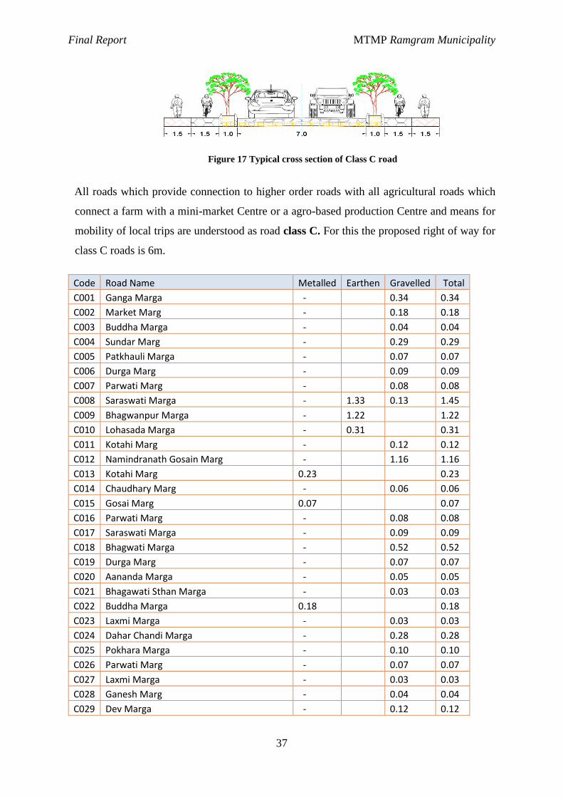
Final Report MTMP Ramgram Municipality
37
All roads which provide connection to higher order roads with all agricultural roads which
connect a farm with a mini-market Centre or a agro-based production Centre and means for
mobility of local trips are understood as road class C. For this the proposed right of way for
class C roads is 6m.
Code Road Name Metalled Earthen Gravelled Total
C001 Ganga Marga - 0.34 0.34
C002 Market Marg - 0.18 0.18
C003 Buddha Marga - 0.04 0.04
C004 Sundar Marg - 0.29 0.29
C005 Patkhauli Marga - 0.07 0.07
C006 Durga Marg - 0.09 0.09
C007 Parwati Marg - 0.08 0.08
C008 Saraswati Marga - 1.33 0.13 1.45
C009 Bhagwanpur Marga - 1.22 1.22
C010 Lohasada Marga - 0.31 0.31
C011 Kotahi Marg - 0.12 0.12
C012 Namindranath Gosain Marg - 1.16 1.16
C013 Kotahi Marg 0.23 0.23
C014 Chaudhary Marg - 0.06 0.06
C015 Gosai Marg 0.07 0.07
C016 Parwati Marg - 0.08 0.08
C017 Saraswati Marga - 0.09 0.09
C018 Bhagwati Marga - 0.52 0.52
C019 Durga Marg - 0.07 0.07
C020 Aananda Marga - 0.05 0.05
C021 Bhagawati Sthan Marga - 0.03 0.03
C022 Buddha Marga 0.18 0.18
C023 Laxmi Marga - 0.03 0.03
C024 Dahar Chandi Marga - 0.28 0.28
C025 Pokhara Marga - 0.10 0.10
C026 Parwati Marg - 0.07 0.07
C027 Laxmi Marga - 0.03 0.03
C028 Ganesh Marg - 0.04 0.04
C029 Dev Marga - 0.12 0.12
Figure 17 Typical cross section of Class C road
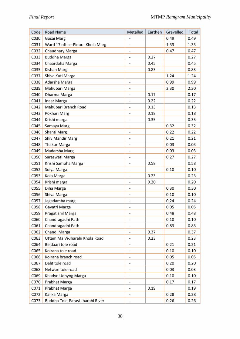
Final Report MTMP Ramgram Municipality
38
Code Road Name Metalled Earthen Gravelled Total
C030 Gosai Marg - 0.49 0.49
C031 Ward 17 office-Pidura Khola Marg - 1.33 1.33
C032 Chaudhary Marga - 0.47 0.47
C033 Buddha Marga - 0.27 0.27
C034 Chaardaha Marga - 0.45 0.45
C035 Kishan Marg - 0.83 0.83
C037 Shiva Kuti Marga - 1.24 1.24
C038 Adarsha Marga - 0.99 0.99
C039 Mahubari Marga - 2.30 2.30
C040 Dharma Marga - 0.17 0.17
C041 Inaar Marga - 0.22 0.22
C042 Mahubari Branch Road - 0.13 0.13
C043 Pokhari Marg - 0.18 0.18
C044 Krishi marga - 0.35 0.35
C045 Samaya Marg - 0.32 0.32
C046 Shanti Marg - 0.22 0.22
C047 Shiv Mandir Marg - 0.21 0.21
C048 Thakur Marga - 0.03 0.03
C049 Madarsha Marg - 0.03 0.03
C050 Saraswati Marga - 0.27 0.27
C051 Krishi Samuha Marga - 0.58 0.58
C052 Soiya Marga - 0.10 0.10
C053 Kola Marga - 0.23 0.23
C054 Krishi marga - 0.20 0.20
C055 Diha Marga - 0.30 0.30
C056 Shiva Marga - 0.10 0.10
C057 Jagadamba marg - 0.24 0.24
C058 Gayatri Marga - 0.05 0.05
C059 Pragatishil Marga - 0.48 0.48
C060 Chandragadhi Path - 0.10 0.10
C061 Chandragadhi Path - 0.83 0.83
C062 Chandi Marga - 0.37 0.37
C063 Uttam Ma Vi-Jharahi Khola Road - 0.23 0.23
C064 Beldaari tole road - 0.21 0.21
C065 Koirana tole road - 0.10 0.10
C066 Koirana branch road - 0.05 0.05
C067 Dalit tole road - 0.20 0.20
C068 Netwari tole road - 0.03 0.03
C069 Khadye Udhyog Marga - 0.10 0.10
C070 Prabhat Marga - 0.17 0.17
C071 Prabhat Marga - 0.19 0.19
C072 Kalika Marga - 0.28 0.28
C073 Buddha Tole-Parasi-Jharahi River - 0.26 0.26
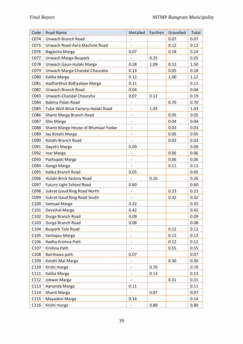
Final Report MTMP Ramgram Municipality
39
Code Road Name Metalled Earthen Gravelled Total
C074 Unwach Branch Road - 0.07 0.07
C075 Unwach Road-Aara Machine Road - 0.12 0.12
C076 Bagaicha Marga 0.07 0.18 0.24
C077 Unwach Marga-Buspark - 0.25 0.25
C078 Unwach Gaun-Hulaki Marga 0.28 1.09 0.12 1.50
C079 Unwach Marga-Chandal Chauraha 0.13 0.05 0.18
C080 Kalika Marga 0.12 1.00 1.12
C081 Aadharbhut Bidhyalaye Marga 0.11 0.11
C082 Unwach Branch Road 0.04 0.04
C083 Unwach-Chandal Chauraha 0.07 0.12 0.19
C084 Bakhra Palan Road - 0.70 0.70
C085 Tube Well-Brick Factory-Hulaki Road - 1.03 1.03
C086 Shanti Marga Branch Road - 0.05 0.05
C087 Shiv Marga - 0.04 0.04
C088 Shanti Marga-House of Bhumaar Yadav - 0.03 0.03
C089 Jay Kotahi Marga - 0.05 0.05
C090 Kotahi Branch Road - 0.03 0.03
C091 Gayetri Marga 0.09 0.09
C092 Inar Marga - 0.06 0.06
C093 Pashupati Marga - 0.06 0.06
C094 Ganga Marga - 0.11 0.11
C095 Kalika Branch Road 0.05 0.05
C096 Hulaki-Brick factory Road - 0.26 0.26
C097 Future Light School Road 0.60 0.60
C098 Sukrat Gaud Ring Road North - 0.23 0.23
C099 Sukrat Gaud Ring Road South - 0.32 0.32
C100 Samsad Marga 0.32 0.32
C101 Devsthal Marga 0.42 0.42
C102 Durga Branch Road 0.09 0.09
C103 Durga Branch Road 0.08 0.08
C104 Buspark Tole Road - 0.12 0.12
C105 Santapur Marga - 0.12 0.12
C106 Radha Krishna Path - 0.12 0.12
C107 Krishna Path - 0.55 0.55
C108 Bairihawa path 0.07 0.07
C109 Kotahi Mai Marga - 0.30 0.30
C110 Krishi marga - 0.70 0.70
C111 Kalika Marga - 0.13 0.13
C112 Jokwar Marga - 0.31 0.31
C113 Aananda Marga 0.11 0.11
C114 Shanti Marga - 0.07 0.07
C115 Mayadevi Marga 0.14 0.14
C116 Krishi marga - 0.80 0.80
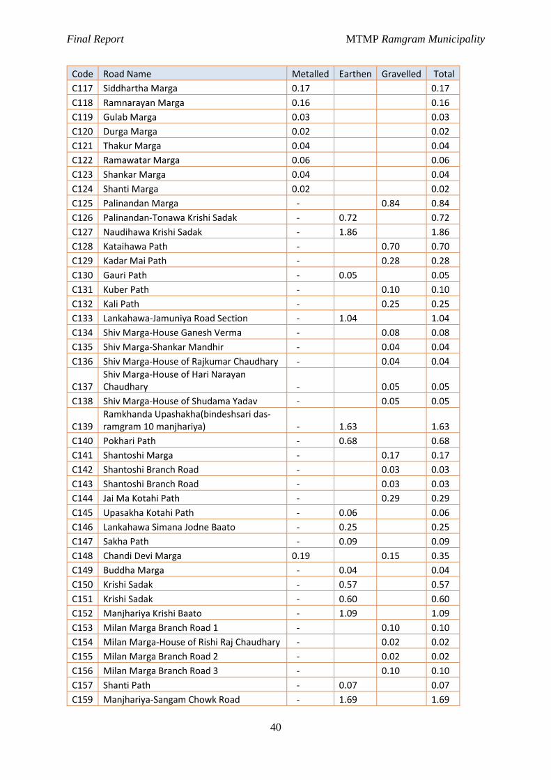
Final Report MTMP Ramgram Municipality
40
Code Road Name Metalled Earthen Gravelled Total
C117 Siddhartha Marga 0.17 0.17
C118 Ramnarayan Marga 0.16 0.16
C119 Gulab Marga 0.03 0.03
C120 Durga Marga 0.02 0.02
C121 Thakur Marga 0.04 0.04
C122 Ramawatar Marga 0.06 0.06
C123 Shankar Marga 0.04 0.04
C124 Shanti Marga 0.02 0.02
C125 Palinandan Marga - 0.84 0.84
C126 Palinandan-Tonawa Krishi Sadak - 0.72 0.72
C127 Naudihawa Krishi Sadak - 1.86 1.86
C128 Kataihawa Path - 0.70 0.70
C129 Kadar Mai Path - 0.28 0.28
C130 Gauri Path - 0.05 0.05
C131 Kuber Path - 0.10 0.10
C132 Kali Path - 0.25 0.25
C133 Lankahawa-Jamuniya Road Section - 1.04 1.04
C134 Shiv Marga-House Ganesh Verma - 0.08 0.08
C135 Shiv Marga-Shankar Mandhir - 0.04 0.04
C136 Shiv Marga-House of Rajkumar Chaudhary - 0.04 0.04
C137 Shiv Marga-House of Hari Narayan Chaudhary - 0.05 0.05
C138 Shiv Marga-House of Shudama Yadav - 0.05 0.05
C139 Ramkhanda Upashakha(bindeshsari das-ramgram 10 manjhariya) - 1.63 1.63
C140 Pokhari Path - 0.68 0.68
C141 Shantoshi Marga - 0.17 0.17
C142 Shantoshi Branch Road - 0.03 0.03
C143 Shantoshi Branch Road - 0.03 0.03
C144 Jai Ma Kotahi Path - 0.29 0.29
C145 Upasakha Kotahi Path - 0.06 0.06
C146 Lankahawa Simana Jodne Baato - 0.25 0.25
C147 Sakha Path - 0.09 0.09
C148 Chandi Devi Marga 0.19 0.15 0.35
C149 Buddha Marga - 0.04 0.04
C150 Krishi Sadak - 0.57 0.57
C151 Krishi Sadak - 0.60 0.60
C152 Manjhariya Krishi Baato - 1.09 1.09
C153 Milan Marga Branch Road 1 - 0.10 0.10
C154 Milan Marga-House of Rishi Raj Chaudhary - 0.02 0.02
C155 Milan Marga Branch Road 2 - 0.02 0.02
C156 Milan Marga Branch Road 3 - 0.10 0.10
C157 Shanti Path - 0.07 0.07
C159 Manjhariya-Sangam Chowk Road - 1.69 1.69
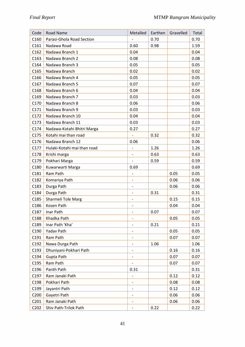
Final Report MTMP Ramgram Municipality
41
Code Road Name Metalled Earthen Gravelled Total
C160 Parasi-Ghola Road Section - 0.70 0.70
C161 Nadawa Road 0.60 0.98 1.59
C162 Nadawa Branch 1 0.04 0.04
C163 Nadawa Branch 2 0.08 0.08
C164 Nadawa Branch 3 0.05 0.05
C165 Nadawa Branch 0.02 0.02
C166 Nadawa Branch 4 0.05 0.05
C167 Nadawa Branch 5 0.07 0.07
C168 Nadawa Branch 6 0.04 0.04
C169 Nadawa Branch 7 0.03 0.03
C170 Nadawa Branch 8 0.06 0.06
C171 Nadawa Branch 9 0.03 0.03
C172 Nadawa Branch 10 0.04 0.04
C173 Nadawa Branch 11 0.03 0.03
C174 Nadawa-Kotahi Bhitri Marga 0.27 0.27
C175 Kotahi mai than road - 0.32 0.32
C176 Nadawa Branch 12 0.06 0.06
C177 Hulaki-Kotahi mai than road - 1.26 1.26
C178 Krishi marga - 0.63 0.63
C179 Pokhari Marga - 0.59 0.59
C180 Kuwarwarti Marga 0.69 0.69
C181 Ram Path - 0.05 0.05
C182 Komariya Path - 0.06 0.06
C183 Durga Path - 0.06 0.06
C184 Durga Path - 0.31 0.31
C185 Sharmeli Tole Marg - 0.15 0.15
C186 Kosen Path - 0.04 0.04
C187 Inar Path - 0.07 0.07
C188 Khadka Path - 0.05 0.05
C189 Inar Path 'Kha' - 0.21 0.21
C190 Yadav Path - 0.05 0.05
C191 Ram Path - 0.07 0.07
C192 Nawa Durga Path - 1.06 1.06
C193 Dhuniyani-Pokhari Path - 0.16 0.16
C194 Gupta Path - 0.07 0.07
C195 Ram Path - 0.07 0.07
C196 Panth Path 0.31 0.31
C197 Ram Janaki Path - 0.12 0.12
C198 Pokhari Path - 0.08 0.08
C199 Jayantri Path - 0.12 0.12
C200 Gayetri Path - 0.06 0.06
C201 Ram Janaki Path - 0.06 0.06
C202 Shiv Path-Trilok Path - 0.22 0.22
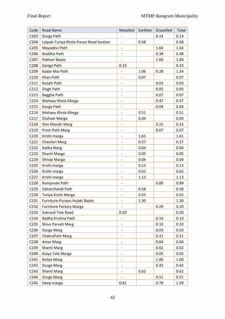
Final Report MTMP Ramgram Municipality
42
Code Road Name Metalled Earthen Gravelled Total
C203 Durga Path - 0.14 0.14
C204 Lalpati-Turiya Khola-Parasi Road Section - 0.58 0.58
C205 Mayadevi Path - 1.64 1.64
C206 Buddha Path - 0.38 0.38
C207 Pokhari Baato - 1.60 1.60
C208 Ganga Path 0.33 0.33
C209 Kadar Mai Path - 1.06 0.28 1.34
C210 Khan Path - 0.07 0.07
C211 Kotahi Path - 0.03 0.03
C212 Singh Path - 0.05 0.05
C213 Baggha Path - 0.07 0.07
C214 Mahaau Khola Marga - 0.47 0.47
C215 Durga Path - 0.04 0.04
C216 Mahaau Khola Marga - 0.51 0.51
C217 Diuhaar Marga - 0.04 0.04
C218 Shiv Mandir Marg - 0.15 0.15
C219 Prem Path Marg - 0.07 0.07
C220 Krishi marga - 1.61 1.61
C221 Chautari Marg - 0.27 0.27
C222 Kalika Marg - 0.04 0.04
C223 Shanti Marga - 0.05 0.05
C224 Shivaji Marga - 0.04 0.04
C225 Krishi marga - 0.13 0.13
C226 Krishi marga - 0.62 0.62
C227 Krishi marga - 1.13 1.13
C228 Ramjanaki Path - 0.89 0.89
C229 Daharchandi Path - 0.58 0.58
C230 Turiya Krishi Marga - 0.55 0.55
C231 Furniture-Purano Hulaki Baato - 1.30 1.30
C232 Furniture Factory Marga - 0.29 0.29
C233 Sukrauli Tole Road 0.20 0.20
C234 Radha Krishna Path - 0.19 0.19
C235 Shiva Parvati Marg - 0.10 0.10
C236 Durga Marg - 0.03 0.03
C237 ChakraPath Marg - 0.21 0.21
C238 Amar Marg - 0.04 0.04
C239 Shanti Marg - 0.02 0.02
C240 Kuiya Tole Marga - 0.05 0.05
C241 Koliya Marg - 1.00 1.00
C242 Durga Marg - 0.42 0.42
C243 Shanti Marg - 0.62 0.62
C244 Durga Marg - 0.51 0.51
C245 Deep marga 0.81 0.78 1.59
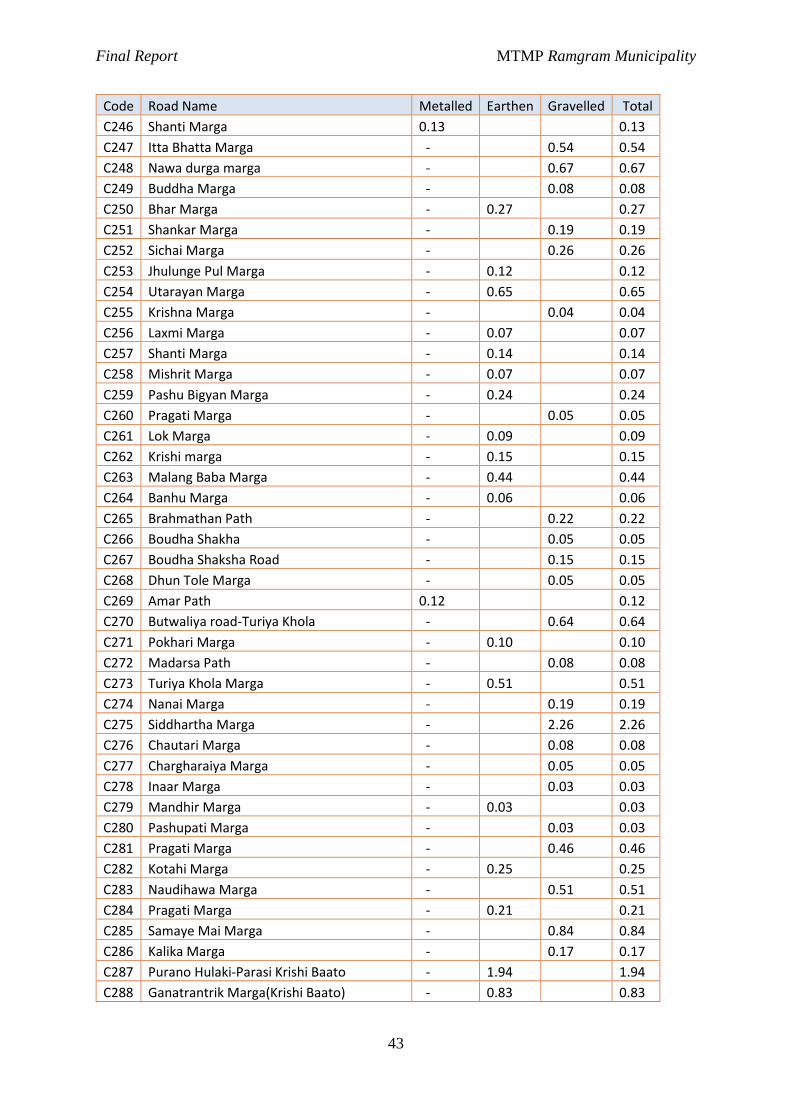
Final Report MTMP Ramgram Municipality
43
Code Road Name Metalled Earthen Gravelled Total
C246 Shanti Marga 0.13 0.13
C247 Itta Bhatta Marga - 0.54 0.54
C248 Nawa durga marga - 0.67 0.67
C249 Buddha Marga - 0.08 0.08
C250 Bhar Marga - 0.27 0.27
C251 Shankar Marga - 0.19 0.19
C252 Sichai Marga - 0.26 0.26
C253 Jhulunge Pul Marga - 0.12 0.12
C254 Utarayan Marga - 0.65 0.65
C255 Krishna Marga - 0.04 0.04
C256 Laxmi Marga - 0.07 0.07
C257 Shanti Marga - 0.14 0.14
C258 Mishrit Marga - 0.07 0.07
C259 Pashu Bigyan Marga - 0.24 0.24
C260 Pragati Marga - 0.05 0.05
C261 Lok Marga - 0.09 0.09
C262 Krishi marga - 0.15 0.15
C263 Malang Baba Marga - 0.44 0.44
C264 Banhu Marga - 0.06 0.06
C265 Brahmathan Path - 0.22 0.22
C266 Boudha Shakha - 0.05 0.05
C267 Boudha Shaksha Road - 0.15 0.15
C268 Dhun Tole Marga - 0.05 0.05
C269 Amar Path 0.12 0.12
C270 Butwaliya road-Turiya Khola - 0.64 0.64
C271 Pokhari Marga - 0.10 0.10
C272 Madarsa Path - 0.08 0.08
C273 Turiya Khola Marga - 0.51 0.51
C274 Nanai Marga - 0.19 0.19
C275 Siddhartha Marga - 2.26 2.26
C276 Chautari Marga - 0.08 0.08
C277 Chargharaiya Marga - 0.05 0.05
C278 Inaar Marga - 0.03 0.03
C279 Mandhir Marga - 0.03 0.03
C280 Pashupati Marga - 0.03 0.03
C281 Pragati Marga - 0.46 0.46
C282 Kotahi Marga - 0.25 0.25
C283 Naudihawa Marga - 0.51 0.51
C284 Pragati Marga - 0.21 0.21
C285 Samaye Mai Marga - 0.84 0.84
C286 Kalika Marga - 0.17 0.17
C287 Purano Hulaki-Parasi Krishi Baato - 1.94 1.94
C288 Ganatrantrik Marga(Krishi Baato) - 0.83 0.83
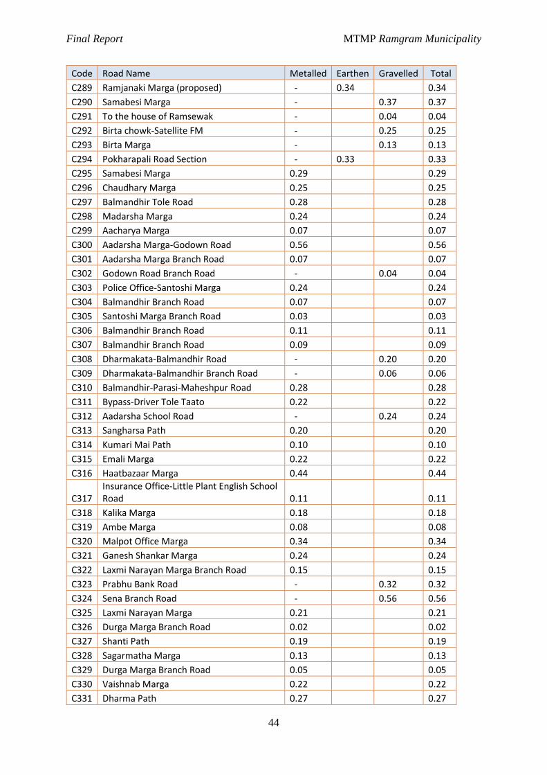
Final Report MTMP Ramgram Municipality
44
Code Road Name Metalled Earthen Gravelled Total
C289 Ramjanaki Marga (proposed) - 0.34 0.34
C290 Samabesi Marga - 0.37 0.37
C291 To the house of Ramsewak - 0.04 0.04
C292 Birta chowk-Satellite FM - 0.25 0.25
C293 Birta Marga - 0.13 0.13
C294 Pokharapali Road Section - 0.33 0.33
C295 Samabesi Marga 0.29 0.29
C296 Chaudhary Marga 0.25 0.25
C297 Balmandhir Tole Road 0.28 0.28
C298 Madarsha Marga 0.24 0.24
C299 Aacharya Marga 0.07 0.07
C300 Aadarsha Marga-Godown Road 0.56 0.56
C301 Aadarsha Marga Branch Road 0.07 0.07
C302 Godown Road Branch Road - 0.04 0.04
C303 Police Office-Santoshi Marga 0.24 0.24
C304 Balmandhir Branch Road 0.07 0.07
C305 Santoshi Marga Branch Road 0.03 0.03
C306 Balmandhir Branch Road 0.11 0.11
C307 Balmandhir Branch Road 0.09 0.09
C308 Dharmakata-Balmandhir Road - 0.20 0.20
C309 Dharmakata-Balmandhir Branch Road - 0.06 0.06
C310 Balmandhir-Parasi-Maheshpur Road 0.28 0.28
C311 Bypass-Driver Tole Taato 0.22 0.22
C312 Aadarsha School Road - 0.24 0.24
C313 Sangharsa Path 0.20 0.20
C314 Kumari Mai Path 0.10 0.10
C315 Emali Marga 0.22 0.22
C316 Haatbazaar Marga 0.44 0.44
C317 Insurance Office-Little Plant English School Road 0.11 0.11
C318 Kalika Marga 0.18 0.18
C319 Ambe Marga 0.08 0.08
C320 Malpot Office Marga 0.34 0.34
C321 Ganesh Shankar Marga 0.24 0.24
C322 Laxmi Narayan Marga Branch Road 0.15 0.15
C323 Prabhu Bank Road - 0.32 0.32
C324 Sena Branch Road - 0.56 0.56
C325 Laxmi Narayan Marga 0.21 0.21
C326 Durga Marga Branch Road 0.02 0.02
C327 Shanti Path 0.19 0.19
C328 Sagarmatha Marga 0.13 0.13
C329 Durga Marga Branch Road 0.05 0.05
C330 Vaishnab Marga 0.22 0.22
C331 Dharma Path 0.27 0.27
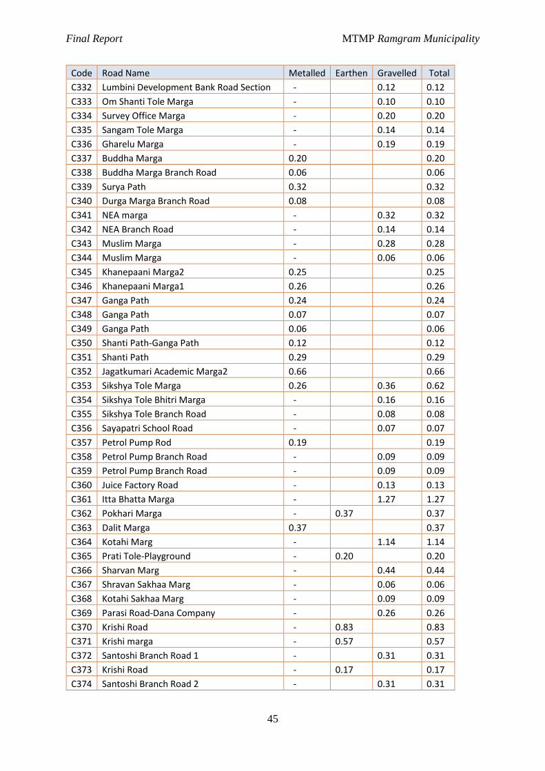
Final Report MTMP Ramgram Municipality
45
Code Road Name Metalled Earthen Gravelled Total
C332 Lumbini Development Bank Road Section - 0.12 0.12
C333 Om Shanti Tole Marga - 0.10 0.10
C334 Survey Office Marga - 0.20 0.20
C335 Sangam Tole Marga - 0.14 0.14
C336 Gharelu Marga - 0.19 0.19
C337 Buddha Marga 0.20 0.20
C338 Buddha Marga Branch Road 0.06 0.06
C339 Surya Path 0.32 0.32
C340 Durga Marga Branch Road 0.08 0.08
C341 NEA marga - 0.32 0.32
C342 NEA Branch Road - 0.14 0.14
C343 Muslim Marga - 0.28 0.28
C344 Muslim Marga - 0.06 0.06
C345 Khanepaani Marga2 0.25 0.25
C346 Khanepaani Marga1 0.26 0.26
C347 Ganga Path 0.24 0.24
C348 Ganga Path 0.07 0.07
C349 Ganga Path 0.06 0.06
C350 Shanti Path-Ganga Path 0.12 0.12
C351 Shanti Path 0.29 0.29
C352 Jagatkumari Academic Marga2 0.66 0.66
C353 Sikshya Tole Marga 0.26 0.36 0.62
C354 Sikshya Tole Bhitri Marga - 0.16 0.16
C355 Sikshya Tole Branch Road - 0.08 0.08
C356 Sayapatri School Road - 0.07 0.07
C357 Petrol Pump Rod 0.19 0.19
C358 Petrol Pump Branch Road - 0.09 0.09
C359 Petrol Pump Branch Road - 0.09 0.09
C360 Juice Factory Road - 0.13 0.13
C361 Itta Bhatta Marga - 1.27 1.27
C362 Pokhari Marga - 0.37 0.37
C363 Dalit Marga 0.37 0.37
C364 Kotahi Marg - 1.14 1.14
C365 Prati Tole-Playground - 0.20 0.20
C366 Sharvan Marg - 0.44 0.44
C367 Shravan Sakhaa Marg - 0.06 0.06
C368 Kotahi Sakhaa Marg - 0.09 0.09
C369 Parasi Road-Dana Company - 0.26 0.26
C370 Krishi Road - 0.83 0.83
C371 Krishi marga - 0.57 0.57
C372 Santoshi Branch Road 1 - 0.31 0.31
C373 Krishi Road - 0.17 0.17
C374 Santoshi Branch Road 2 - 0.31 0.31
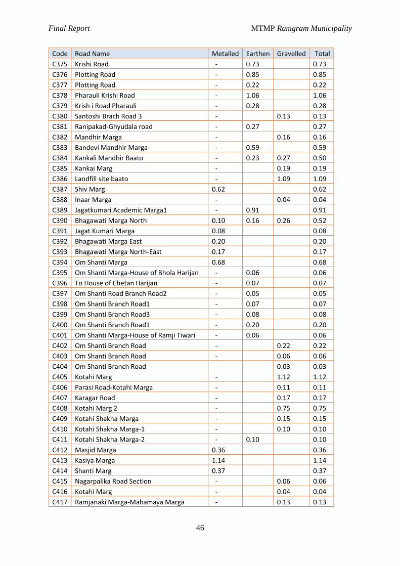
Final Report MTMP Ramgram Municipality
46
Code Road Name Metalled Earthen Gravelled Total
C375 Krishi Road - 0.73 0.73
C376 Plotting Road - 0.85 0.85
C377 Plotting Road - 0.22 0.22
C378 Pharauli Krishi Road - 1.06 1.06
C379 Krish i Road Pharauli - 0.28 0.28
C380 Santoshi Brach Road 3 - 0.13 0.13
C381 Ranipakad-Ghyudala road - 0.27 0.27
C382 Mandhir Marga - 0.16 0.16
C383 Bandevi Mandhir Marga - 0.59 0.59
C384 Kankali Mandhir Baato - 0.23 0.27 0.50
C385 Kankai Marg - 0.19 0.19
C386 Landfill site baato - 1.09 1.09
C387 Shiv Marg 0.62 0.62
C388 Inaar Marga - 0.04 0.04
C389 Jagatkumari Academic Marga1 - 0.91 0.91
C390 Bhagawati Marga North 0.10 0.16 0.26 0.52
C391 Jagat Kumari Marga 0.08 0.08
C392 Bhagawati Marga East 0.20 0.20
C393 Bhagawati Marga North-East 0.17 0.17
C394 Om Shanti Marga 0.68 0.68
C395 Om Shanti Marga-House of Bhola Harijan - 0.06 0.06
C396 To House of Chetan Harijan - 0.07 0.07
C397 Om Shanti Road Branch Road2 - 0.05 0.05
C398 Om Shanti Branch Road1 - 0.07 0.07
C399 Om Shanti Branch Road3 - 0.08 0.08
C400 Om Shanti Branch Road1 - 0.20 0.20
C401 Om Shanti Marga-House of Ramji Tiwari - 0.06 0.06
C402 Om Shanti Branch Road - 0.22 0.22
C403 Om Shanti Branch Road - 0.06 0.06
C404 Om Shanti Branch Road - 0.03 0.03
C405 Kotahi Marg - 1.12 1.12
C406 Parasi Road-Kotahi Marga - 0.11 0.11
C407 Karagar Road - 0.17 0.17
C408 Kotahi Marg 2 - 0.75 0.75
C409 Kotahi Shakha Marga - 0.15 0.15
C410 Kotahi Shakha Marga-1 - 0.10 0.10
C411 Kotahi Shakha Marga-2 - 0.10 0.10
C412 Masjid Marga 0.36 0.36
C413 Kasiya Marga 1.14 1.14
C414 Shanti Marg 0.37 0.37
C415 Nagarpalika Road Section - 0.06 0.06
C416 Kotahi Marg - 0.04 0.04
C417 Ramjanaki Marga-Mahamaya Marga - 0.13 0.13
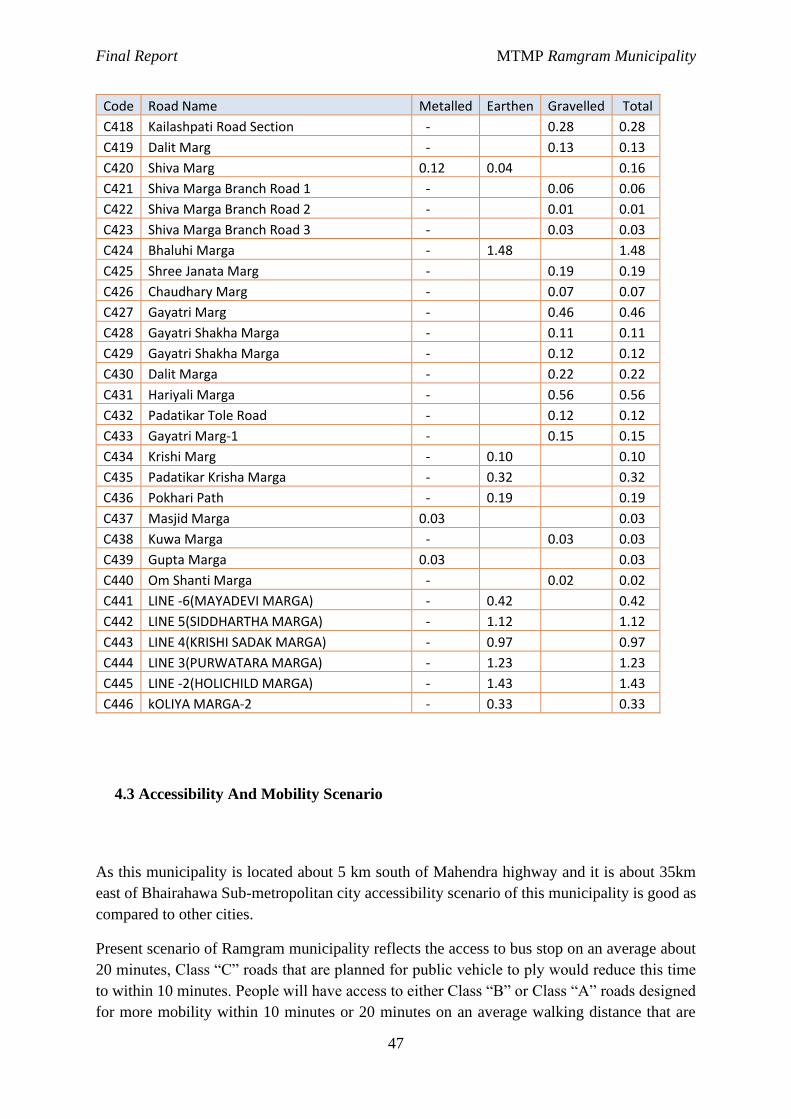
Final Report MTMP Ramgram Municipality
47
Code Road Name Metalled Earthen Gravelled Total
C418 Kailashpati Road Section - 0.28 0.28
C419 Dalit Marg - 0.13 0.13
C420 Shiva Marg 0.12 0.04 0.16
C421 Shiva Marga Branch Road 1 - 0.06 0.06
C422 Shiva Marga Branch Road 2 - 0.01 0.01
C423 Shiva Marga Branch Road 3 - 0.03 0.03
C424 Bhaluhi Marga - 1.48 1.48
C425 Shree Janata Marg - 0.19 0.19
C426 Chaudhary Marg - 0.07 0.07
C427 Gayatri Marg - 0.46 0.46
C428 Gayatri Shakha Marga - 0.11 0.11
C429 Gayatri Shakha Marga - 0.12 0.12
C430 Dalit Marga - 0.22 0.22
C431 Hariyali Marga - 0.56 0.56
C432 Padatikar Tole Road - 0.12 0.12
C433 Gayatri Marg-1 - 0.15 0.15
C434 Krishi Marg - 0.10 0.10
C435 Padatikar Krisha Marga - 0.32 0.32
C436 Pokhari Path - 0.19 0.19
C437 Masjid Marga 0.03 0.03
C438 Kuwa Marga - 0.03 0.03
C439 Gupta Marga 0.03 0.03
C440 Om Shanti Marga - 0.02 0.02
C441 LINE -6(MAYADEVI MARGA) - 0.42 0.42
C442 LINE 5(SIDDHARTHA MARGA) - 1.12 1.12
C443 LINE 4(KRISHI SADAK MARGA) - 0.97 0.97
C444 LINE 3(PURWATARA MARGA) - 1.23 1.23
C445 LINE -2(HOLICHILD MARGA) - 1.43 1.43
C446 kOLIYA MARGA-2 - 0.33 0.33
4.3 Accessibility And Mobility Scenario
As this municipality is located about 5 km south of Mahendra highway and it is about 35km
east of Bhairahawa Sub-metropolitan city accessibility scenario of this municipality is good as
compared to other cities.
Present scenario of Ramgram municipality reflects the access to bus stop on an average about
20 minutes, Class “C” roads that are planned for public vehicle to ply would reduce this time
to within 10 minutes. People will have access to either Class “B” or Class “A” roads designed
for more mobility within 10 minutes or 20 minutes on an average walking distance that are

Final Report MTMP Ramgram Municipality
48
designed for greater mobility. Planning work has focused on reducing access directly to
highways, subsequent developments are recommended for national authority to develop
required infrastructures.
ward Area(sq.km.) Population road length R_Density R_density(P)
Ward 1 3.27 2214 15.12 4.62 6.83
Ward 2 0.69 2904 6.11 8.85 2.10
Ward 3 0.32 2550 3.91 12.22 1.53
Ward 4 3.37 2084 13.04 3.87 6.26
Ward 5 1.37 1917 12.07 8.81 6.30
Ward 6 2.17 1866 8.83 4.07 4.73
Ward 7 3.76 2713 14.07 3.74 5.19
Ward 8 3.64 2125 12.76 3.51 6.01
Ward 9 7.04 2480 17.28 2.45 6.97
Ward 10 10.44 4213 35.52 3.40 8.43
Ward 11 4.77 3900 18.17 3.81 4.66
Ward 12 4.2 2107 18.98 4.52 9.01
Ward 13 1.73 1429 7.66 4.43 5.36
Ward 14 10.79 4953 33.57 3.11 6.78
Ward 15 6.74 4715 23.40 3.47 4.96
Ward 16 11.21 6627 33.10 2.95 4.99
Ward 17 9.2 5359 29.38 3.19 5.48
Ward 18 9.2 5913 27.52 2.99 4.65
Total 93.91 60069 330.48 3.52 5.50
Ward A B C SRN Total
Area covered by road
total area in sq km
% of road
1 3.60 0.45 9.15 1.91 15.12 0.17 3.27 5.22
2 1.29 4.16 0.66 6.11 0.06 0.69 8.35
3 0.96 1.83 1.06 3.91 0.05 0.32 16.38
4 2.72 3.13 5.07 2.12 13.04 0.17 3.37 4.93
5 0.77 2.45 5.74 3.11 12.07 0.16 1.37 11.96
6 1.37 3.74 2.56 1.16 8.83 0.11 2.17 4.98
7 6.20 5.09 1.19 1.59 14.07 0.20 3.76 5.29
8 1.52 4.00 6.37 0.87 12.76 0.13 3.64 3.49
9 9.97 1.49 5.71 17.28 0.20 7.04 2.82
10 10.77 3.70 18.51 2.54 35.52 0.39 10.44 3.70
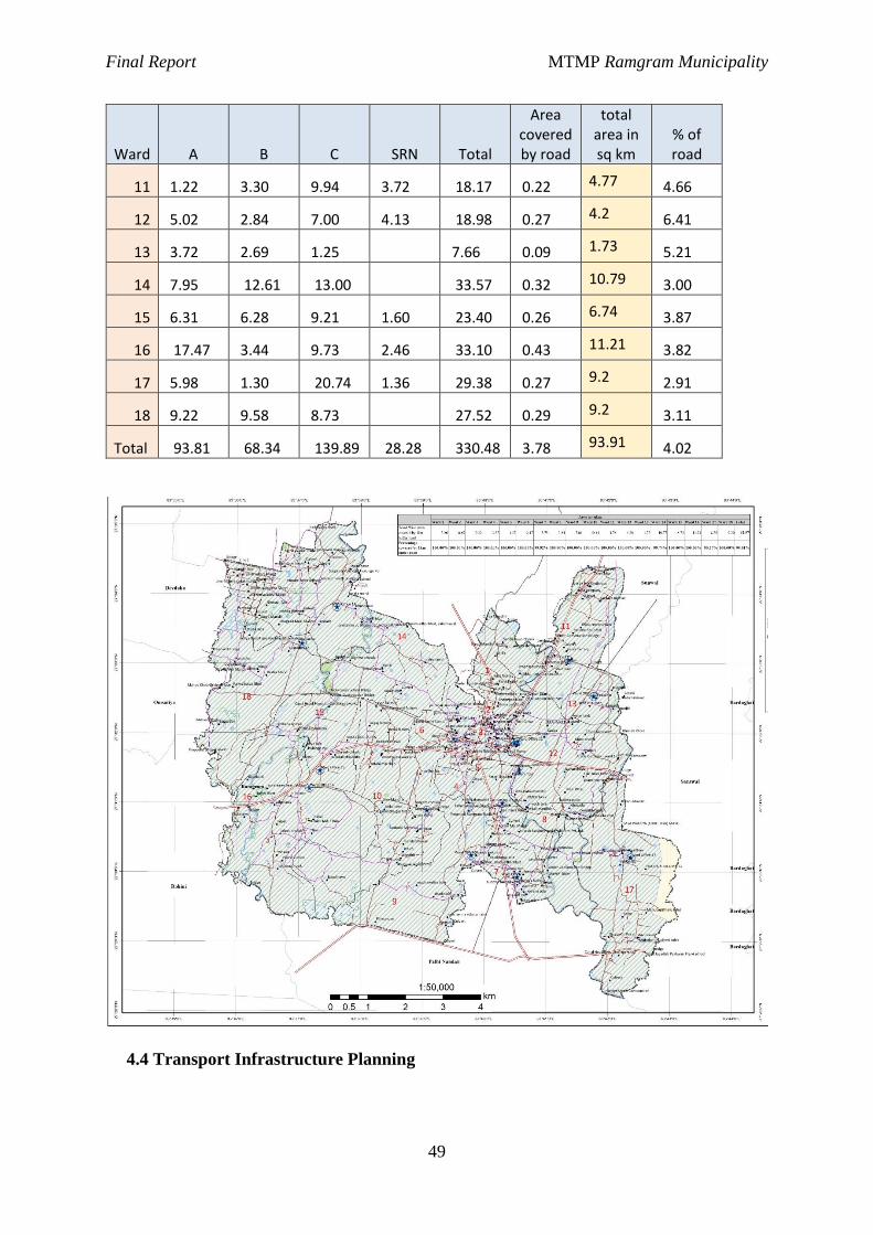
Final Report MTMP Ramgram Municipality
49
Ward A B C SRN Total
Area covered by road
total area in sq km
% of road
11 1.22 3.30 9.94 3.72 18.17 0.22 4.77 4.66
12 5.02 2.84 7.00 4.13 18.98 0.27 4.2 6.41
13 3.72 2.69 1.25 7.66 0.09 1.73 5.21
14 7.95 12.61 13.00 33.57 0.32 10.79 3.00
15 6.31 6.28 9.21 1.60 23.40 0.26 6.74 3.87
16 17.47 3.44 9.73 2.46 33.10 0.43 11.21 3.82
17 5.98 1.30 20.74 1.36 29.38 0.27 9.2 2.91
18 9.22 9.58 8.73 27.52 0.29 9.2 3.11
Total 93.81 68.34 139.89 28.28 330.48 3.78 93.91 4.02
4.4 Transport Infrastructure Planning
Final Report MTMP Ramgram Municipality
50
Land use and transport, developed road hierarchy, accessibility and mobility scenario are the
policy level guidelines for development and planning of transport infrastructures.
Most of the households own bicycle. Nearly 2.37% of household do not own any type of
vehicle, whereas 73.91% of people own bicycle. Thus from the perspective of sustainable
transport also, we need to protect the peoples’ utilization of bicycle in planning works.
From data of vehicle ownership with 73.91% of household owning at least a bicycle and mode
share of 46% of cycle and rickshaw, the planning works has incorporated this scenario by
facilitating dedicated cycle lanes in class A and class B roads.
While 25% of the trips made as of today is on foot, the planning works has incorporated
footpaths for pedestrians segregated from carriage-way width.
With projection of population at present growth rate by geometrical increment method,
population would rise above 36,738 in 20 years which will certainly grow in economic size
and have better income scenario. People will aspire to have private vehicles of their own to
increase mobility, requiring greater road space width which will be provisioned by class A
and class B roads but the aim of sustainable transport and accessibility policy will be to check
private ownership of vehicles under control
Class A and Class B Road would have provision of bus-bay to facilitate public transit riders.
Green belts would be developed for aesthetic purpose and noise reduction purpose as well as
segregation of pedestrians from road traffic. Road side furniture would be installed as deemed
necessary.
4.5 Short Term Municipality Transport Master Plan
The short term municipality transport master plan has been developed to guide the municipal
investments on road infrastructure through 2078/79. This short-term plan will mainly focus on
the demand by the people and for the accessibility of the people in the first step. The plan will
advance the municipality towards the medium- and long-term plan as outlined in the later
topics.
Short term planning elements generally known as transportation system management (TSM)
are basically meant for efficient use of existing and proposed infrastructure (Verma &
Ramanayya, 2015). Short term MTMP refers to maintenance and upgrading of the existing
road networks to the proposed standards to support the present and future (5 years) transport
demand paving the demand for the implementation of medium term and long-term plan. It also
includes construction of new road linkages which are necessary to support the current road
network and the envisaged road network for the future. The interventions are applied to the
road sections based on their priorities (based on the developed scoring criteria) and the annual
Final Report MTMP Ramgram Municipality
51
budget. The transport infrastructure envisaged at the end of five years plan is for the
development and maintenance of access road linkages and collector roads that maintains a road
hierarchy (as formulated above) and justifies the construction and development of higher
hierarchy roads in the medium and long term (in short term if justified).
As such, short term plan focuses on the accessibility of all the settlements, moving towards
mobility to increase the access to wider services, thus paving the way for development of proper
sustainable public transport services within and around the municipality. The strategy and
investment plans for short term municipality transport master plan is elaborated in the next
section.
· For the case Ramgram municipality, it is planned to construct Class A, B and C roads 2-
lane, 2-lane and intermediate lane respectively within this period.
· In the short-term planning, it is planned to open the new track and gravel them within this
period.
· For the case of Class A road which also forms a Ring road is planned to complete its 2-lane
track within this period.
· Similarly, for the case of Class B and C roads, it is planned to open track and gravel as far
as possible within this period.
4.6 Medium Term Municipality Transport Master Plan
· The development of the road network in medium term plan includes opening of the track
and clearing the right of way (ROW) along the Class B roads. The period of short term plan
controls the encroachment and urban sprawl growth along the ROW of the Class B roads.
· All Class “A” and “B” roads are desired to be constructed in this time period. The second
MTMP should be compatible with the present MTMP and medium term plan.
· Utilities management is also one of the challenges in long run. The area of green belt, cycle
track, and footpath can be used for utilities management. It is recommended not to provide
water pipe, sewer in the road, rather, the sewer is recommended to construct below the
footpath in the form of cover drain. Similarly, water supply pipe and telephone line can be
lain off below the green belt (at medium strip or about separator of carriageway and cycle
track or footpath) for effectiveness of roadway.
· Also, if possible the construction of cross drainage structure, like bridges which need to be
increased, should be constructed within this period.
· Similarly, parking facility for the vehicles within the municipality should be planned within
this period.
4.7 Long Term Municipality Transport Master Plan
The development of Class A roads is necessary in the long run of the municipality for the
structured development of the road network hierarchy and thus the proper development of the
trips and the municipality as a whole. The period of short term and medium term plan controls
the encroachment and urban sprawl growth along the ROW of the Class “A” roads.
Final Report MTMP Ramgram Municipality
52
Long term municipality transport master plan envisages the development of the roads of all
hierarchy within the municipality as depicted by the perspective plan whose demand is set out
by the indicative potential development of the municipality.
Short term period (first five years) identifies the higher hierarchy roads necessary for the
municipality in the long run and set necessary bylaws. It also implements those higher
hierarchy roads in the policy level by controlling the development of other structures within
the proposed ROW and shifting of the existing structure away. It will facilitate clearing of the
ROW and track opening during the medium term time period (five to ten years). During
medium term plan, these roads will be developed to certain level as per the existing demand.
During this time period all the roads of this MTMP should be completed in full phase with full
interventions. There should be 4 lanes in Class A, 2 lanes in Class B, and single lane in Class
C. There should be footpath, cycle track and green belts in Class A, B and C roads.
Final Report MTMP Ramgram Municipality
53
Chapter V: Five years municipal transport master plan
5.1 Perspective plan of municipal road network
Perspective plan of municipal road network includes the maintenance of the access and
collector roads and development of higher hierarchy road corridors supporting mobility of the
roads. First five years should focus on development of existing access roads and their
maintenance. It also incorporates construction of new road linkages to provide basic access to
the settlements. Roads of Class “C” will also be widened to its functional width providing
proper cycle tracks and pedestrian ways where permitted by the available road space. During
this period formulated road hierarchy will be implemented in terms of policy and enforcement
of bylaws. Within 2 years other complementary plans of land use and city development will be
developed. In the third year, the MTMP and its perspective plan should be revised in
coordination with the other plans formulated and changes captured during this period.
Year five to ten will then implement the higher hierarchy roads in stages of clearing of the
required ROW road space and construction of necessary infrastructure. Proper development
stages of roads should be planned (construction of Class “A” roads to the standards of Class
“C”, then gradually upgrading to Class “B” and then to Class “A”). Other implementation
strategies should also be developed and finalized at the end of this period. The road network
developed during this period shall complete construction of Class “C” roads. This will demand
higher class roads to support the local road networks. Gradual upgrading of the higher hierarchy
road networks during year ten to twenty will be justified by the traffic generated and level of
mobility demanded to support the emerging economy.
Financial institution and capital investment plan
To determine how much of the proposed work can be carried out in the 5-year MTMP period,
it is necessary to estimate the budget available in this period. This is done by estimating the
amount of money available from different sources based on the actual amounts of the current
or last financial year, assuming certain growth rates for each funding source.
It is recommended that the planning section of municipality should incorporate funding source
from different line agencies as well as NGOs, INGOs, people’s contribution fund for proper
management, infrastructure development and maintenance of road within the municipality.
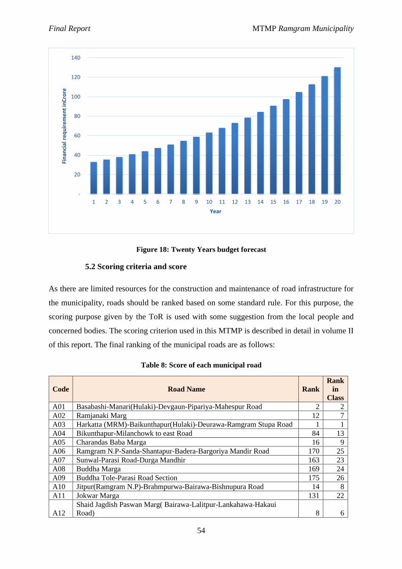
Final Report MTMP Ramgram Municipality
54
Figure 18: Twenty Years budget forecast
5.2 Scoring criteria and score
As there are limited resources for the construction and maintenance of road infrastructure for
the municipality, roads should be ranked based on some standard rule. For this purpose, the
scoring purpose given by the ToR is used with some suggestion from the local people and
concerned bodies. The scoring criterion used in this MTMP is described in detail in volume II
of this report. The final ranking of the municipal roads are as follows:
Table 8: Score of each municipal road
Code Road Name Rank
Rank
in
Class
A01 Basabashi-Manari(Hulaki)-Devgaun-Pipariya-Mahespur Road 2 2
A02 Ramjanaki Marg 12 7
A03 Harkatta (MRM)-Baikunthapur(Hulaki)-Deurawa-Ramgram Stupa Road 1 1
A04 Bikunthapur-Milanchowk to east Road 84 13
A05 Charandas Baba Marga 16 9
A06 Ramgram N.P-Sanda-Shantapur-Badera-Bargoriya Mandir Road 170 25
A07 Sunwal-Parasi Road-Durga Mandhir 163 23
A08 Buddha Marga 169 24
A09 Buddha Tole-Parasi Road Section 175 26
A10 Jitpur(Ramgram N.P)-Brahmpurwa-Bairawa-Bishnupura Road 14 8
A11 Jokwar Marga 131 22
A12
Shaid Jagdish Paswan Marg( Bairawa-Lalitpur-Lankahawa-Hakaui
Road) 8 6
-
20
40
60
80
100
120
140
1 2 3 4 5 6 7 8 9 10 11 12 13 14 15 16 17 18 19 20
Fin
anci
al r
eq
uir
em
en
t in
Cro
re
Year
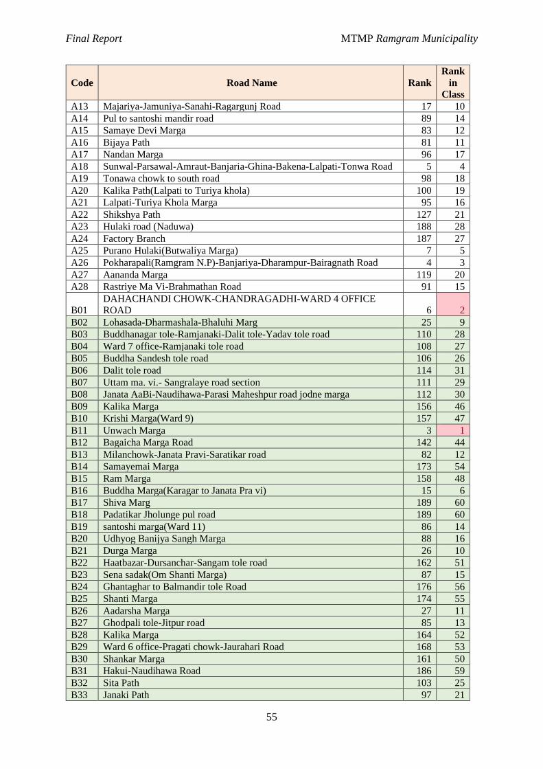
Final Report MTMP Ramgram Municipality
55
Code Road Name Rank
Rank
in
Class
A13 Majariya-Jamuniya-Sanahi-Ragargunj Road 17 10
A14 Pul to santoshi mandir road 89 14
A15 Samaye Devi Marga 83 12
A16 Bijaya Path 81 11
A17 Nandan Marga 96 17
A18 Sunwal-Parsawal-Amraut-Banjaria-Ghina-Bakena-Lalpati-Tonwa Road 5 4
A19 Tonawa chowk to south road 98 18
A20 Kalika Path(Lalpati to Turiya khola) 100 19
A21 Lalpati-Turiya Khola Marga 95 16
A22 Shikshya Path 127 21
A23 Hulaki road (Naduwa) 188 28
A24 Factory Branch 187 27
A25 Purano Hulaki(Butwaliya Marga) 7 5
A26 Pokharapali(Ramgram N.P)-Banjariya-Dharampur-Bairagnath Road 4 3
A27 Aananda Marga 119 20
A28 Rastriye Ma Vi-Brahmathan Road 91 15
B01
DAHACHANDI CHOWK-CHANDRAGADHI-WARD 4 OFFICE
ROAD 6 2
B02 Lohasada-Dharmashala-Bhaluhi Marg 25 9
B03 Buddhanagar tole-Ramjanaki-Dalit tole-Yadav tole road 110 28
B04 Ward 7 office-Ramjanaki tole road 108 27
B05 Buddha Sandesh tole road 106 26
B06 Dalit tole road 114 31
B07 Uttam ma. vi.- Sangralaye road section 111 29
B08 Janata AaBi-Naudihawa-Parasi Maheshpur road jodne marga 112 30
B09 Kalika Marga 156 46
B10 Krishi Marga(Ward 9) 157 47
B11 Unwach Marga 3 1
B12 Bagaicha Marga Road 142 44
B13 Milanchowk-Janata Pravi-Saratikar road 82 12
B14 Samayemai Marga 173 54
B15 Ram Marga 158 48
B16 Buddha Marga(Karagar to Janata Pra vi) 15 6
B17 Shiva Marg 189 60
B18 Padatikar Jholunge pul road 189 60
B19 santoshi marga(Ward 11) 86 14
B20 Udhyog Banijya Sangh Marga 88 16
B21 Durga Marga 26 10
B22 Haatbazar-Dursanchar-Sangam tole road 162 51
B23 Sena sadak(Om Shanti Marga) 87 15
B24 Ghantaghar to Balmandir tole Road 176 56
B25 Shanti Marga 174 55
B26 Aadarsha Marga 27 11
B27 Ghodpali tole-Jitpur road 85 13
B28 Kalika Marga 164 52
B29 Ward 6 office-Pragati chowk-Jaurahari Road 168 53
B30 Shankar Marga 161 50
B31 Hakui-Naudihawa Road 186 59
B32 Sita Path 103 25
B33 Janaki Path 97 21
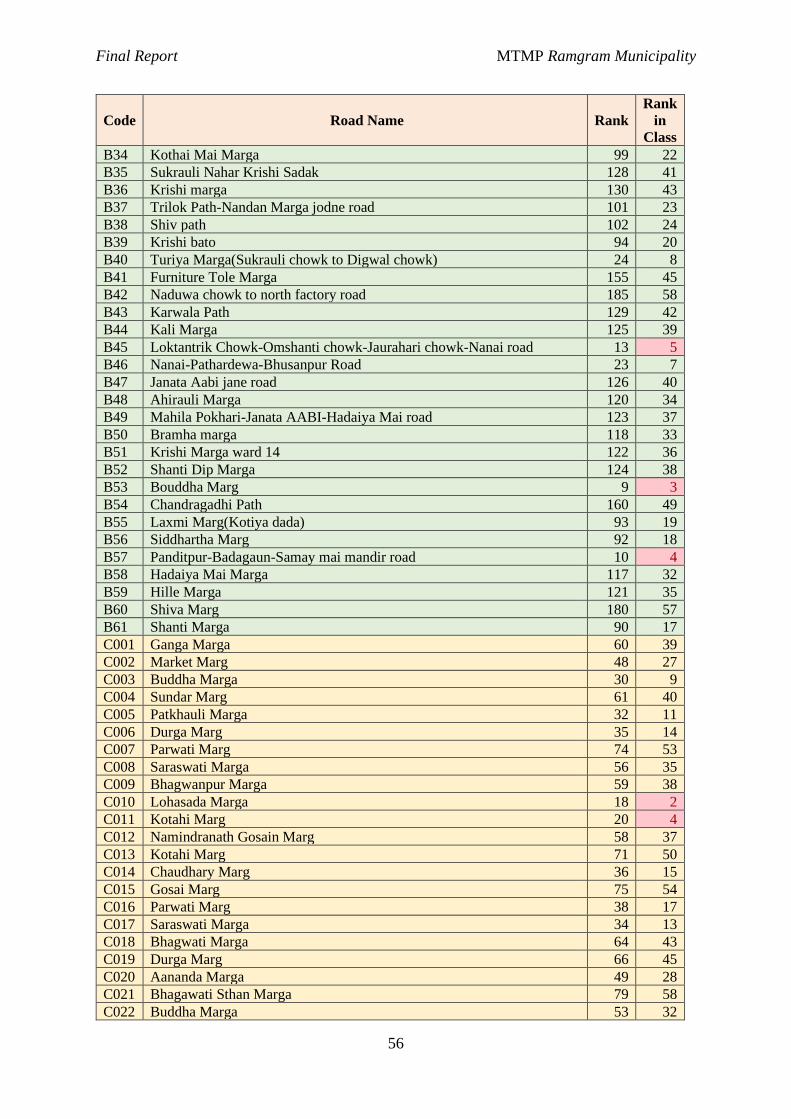
Final Report MTMP Ramgram Municipality
56
Code Road Name Rank
Rank
in
Class
B34 Kothai Mai Marga 99 22
B35 Sukrauli Nahar Krishi Sadak 128 41
B36 Krishi marga 130 43
B37 Trilok Path-Nandan Marga jodne road 101 23
B38 Shiv path 102 24
B39 Krishi bato 94 20
B40 Turiya Marga(Sukrauli chowk to Digwal chowk) 24 8
B41 Furniture Tole Marga 155 45
B42 Naduwa chowk to north factory road 185 58
B43 Karwala Path 129 42
B44 Kali Marga 125 39
B45 Loktantrik Chowk-Omshanti chowk-Jaurahari chowk-Nanai road 13 5
B46 Nanai-Pathardewa-Bhusanpur Road 23 7
B47 Janata Aabi jane road 126 40
B48 Ahirauli Marga 120 34
B49 Mahila Pokhari-Janata AABI-Hadaiya Mai road 123 37
B50 Bramha marga 118 33
B51 Krishi Marga ward 14 122 36
B52 Shanti Dip Marga 124 38
B53 Bouddha Marg 9 3
B54 Chandragadhi Path 160 49
B55 Laxmi Marg(Kotiya dada) 93 19
B56 Siddhartha Marg 92 18
B57 Panditpur-Badagaun-Samay mai mandir road 10 4
B58 Hadaiya Mai Marga 117 32
B59 Hille Marga 121 35
B60 Shiva Marg 180 57
B61 Shanti Marga 90 17
C001 Ganga Marga 60 39
C002 Market Marg 48 27
C003 Buddha Marga 30 9
C004 Sundar Marg 61 40
C005 Patkhauli Marga 32 11
C006 Durga Marg 35 14
C007 Parwati Marg 74 53
C008 Saraswati Marga 56 35
C009 Bhagwanpur Marga 59 38
C010 Lohasada Marga 18 2
C011 Kotahi Marg 20 4
C012 Namindranath Gosain Marg 58 37
C013 Kotahi Marg 71 50
C014 Chaudhary Marg 36 15
C015 Gosai Marg 75 54
C016 Parwati Marg 38 17
C017 Saraswati Marga 34 13
C018 Bhagwati Marga 64 43
C019 Durga Marg 66 45
C020 Aananda Marga 49 28
C021 Bhagawati Sthan Marga 79 58
C022 Buddha Marga 53 32
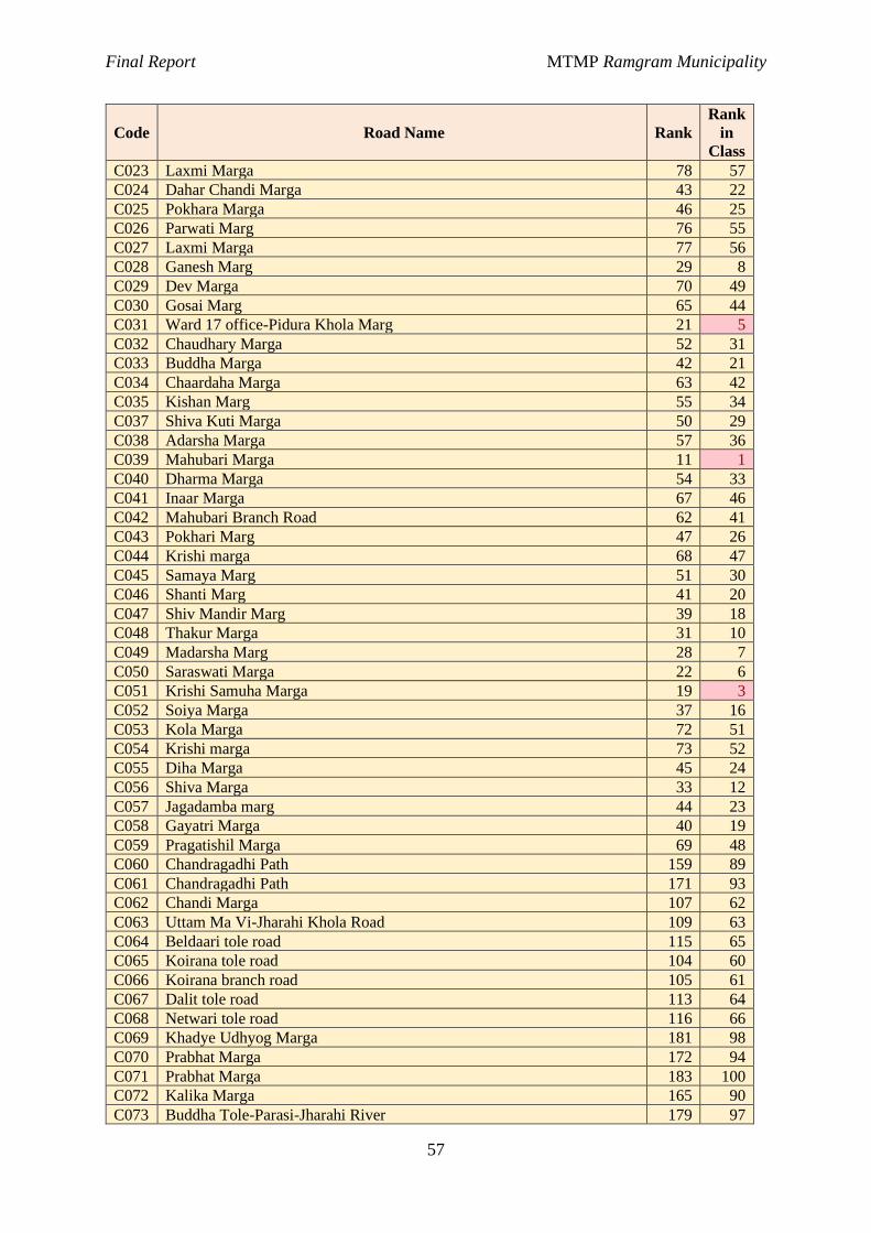
Final Report MTMP Ramgram Municipality
57
Code Road Name Rank
Rank
in
Class
C023 Laxmi Marga 78 57
C024 Dahar Chandi Marga 43 22
C025 Pokhara Marga 46 25
C026 Parwati Marg 76 55
C027 Laxmi Marga 77 56
C028 Ganesh Marg 29 8
C029 Dev Marga 70 49
C030 Gosai Marg 65 44
C031 Ward 17 office-Pidura Khola Marg 21 5
C032 Chaudhary Marga 52 31
C033 Buddha Marga 42 21
C034 Chaardaha Marga 63 42
C035 Kishan Marg 55 34
C037 Shiva Kuti Marga 50 29
C038 Adarsha Marga 57 36
C039 Mahubari Marga 11 1
C040 Dharma Marga 54 33
C041 Inaar Marga 67 46
C042 Mahubari Branch Road 62 41
C043 Pokhari Marg 47 26
C044 Krishi marga 68 47
C045 Samaya Marg 51 30
C046 Shanti Marg 41 20
C047 Shiv Mandir Marg 39 18
C048 Thakur Marga 31 10
C049 Madarsha Marg 28 7
C050 Saraswati Marga 22 6
C051 Krishi Samuha Marga 19 3
C052 Soiya Marga 37 16
C053 Kola Marga 72 51
C054 Krishi marga 73 52
C055 Diha Marga 45 24
C056 Shiva Marga 33 12
C057 Jagadamba marg 44 23
C058 Gayatri Marga 40 19
C059 Pragatishil Marga 69 48
C060 Chandragadhi Path 159 89
C061 Chandragadhi Path 171 93
C062 Chandi Marga 107 62
C063 Uttam Ma Vi-Jharahi Khola Road 109 63
C064 Beldaari tole road 115 65
C065 Koirana tole road 104 60
C066 Koirana branch road 105 61
C067 Dalit tole road 113 64
C068 Netwari tole road 116 66
C069 Khadye Udhyog Marga 181 98
C070 Prabhat Marga 172 94
C071 Prabhat Marga 183 100
C072 Kalika Marga 165 90
C073 Buddha Tole-Parasi-Jharahi River 179 97
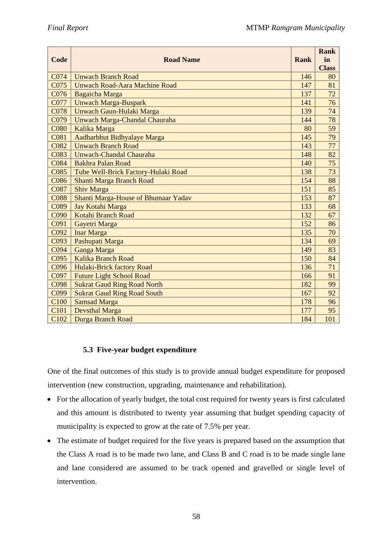
Final Report MTMP Ramgram Municipality
58
Code Road Name Rank
Rank
in
Class
C074 Unwach Branch Road 146 80
C075 Unwach Road-Aara Machine Road 147 81
C076 Bagaicha Marga 137 72
C077 Unwach Marga-Buspark 141 76
C078 Unwach Gaun-Hulaki Marga 139 74
C079 Unwach Marga-Chandal Chauraha 144 78
C080 Kalika Marga 80 59
C081 Aadharbhut Bidhyalaye Marga 145 79
C082 Unwach Branch Road 143 77
C083 Unwach-Chandal Chauraha 148 82
C084 Bakhra Palan Road 140 75
C085 Tube Well-Brick Factory-Hulaki Road 138 73
C086 Shanti Marga Branch Road 154 88
C087 Shiv Marga 151 85
C088 Shanti Marga-House of Bhumaar Yadav 153 87
C089 Jay Kotahi Marga 133 68
C090 Kotahi Branch Road 132 67
C091 Gayetri Marga 152 86
C092 Inar Marga 135 70
C093 Pashupati Marga 134 69
C094 Ganga Marga 149 83
C095 Kalika Branch Road 150 84
C096 Hulaki-Brick factory Road 136 71
C097 Future Light School Road 166 91
C098 Sukrat Gaud Ring Road North 182 99
C099 Sukrat Gaud Ring Road South 167 92
C100 Samsad Marga 178 96
C101 Devsthal Marga 177 95
C102 Durga Branch Road 184 101
5.3 Five-year budget expenditure
One of the final outcomes of this study is to provide annual budget expenditure for proposed
intervention (new construction, upgrading, maintenance and rehabilitation).
· For the allocation of yearly budget, the total cost required for twenty years is first calculated
and this amount is distributed to twenty year assuming that budget spending capacity of
municipality is expected to grow at the rate of 7.5% per year.
· The estimate of budget required for the five years is prepared based on the assumption that
the Class A road is to be made two lane, and Class B and C road is to be made single lane
and lane considered are assumed to be track opened and gravelled or single level of
intervention.
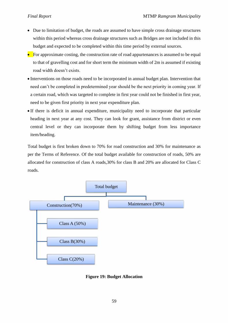
Final Report MTMP Ramgram Municipality
59
· Due to limitation of budget, the roads are assumed to have simple cross drainage structures
within this period whereas cross drainage structures such as Bridges are not included in this
budget and expected to be completed within this time period by external sources.
· For approximate costing, the construction rate of road appurtenances is assumed to be equal
to that of gravelling cost and for short term the minimum width of 2m is assumed if existing
road width doesn’t exists.
· Interventions on those roads need to be incorporated in annual budget plan. Intervention that
need can’t be completed in predetermined year should be the next priority in coming year. If
a certain road, which was targeted to complete in first year could not be finished in first year,
need to be given first priority in next year expenditure plan.
· If there is deficit in annual expenditure, municipality need to incorporate that particular
heading in next year at any cost. They can look for grant, assistance from district or even
central level or they can incorporate them by shifting budget from less importance
item/heading.
Total budget is first broken down to 70% for road construction and 30% for maintenance as
per the Terms of Reference. Of the total budget available for construction of roads, 50% are
allocated for construction of class A roads,30% for class B and 20% are allocated for Class C
roads.
Figure 19: Budget Allocation
Total budget
Construction(70%)
Class A (50%)
Class B(30%)
Class C(20%)
Maintenance (30%)
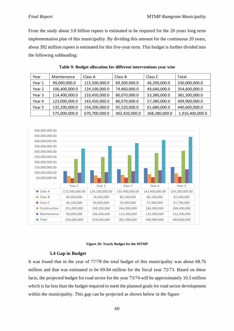
Final Report MTMP Ramgram Municipality
60
From the study about 3.8 billion rupees is estimated to be required for the 20 years long term
implementation plan of this municipality. By dividing this amount for the continuous 20 years,
about 392 million rupees is estimated for this five-year term. This budget is further divided into
the following subheading:
Table 9: Budget allocation for different interventions year wise
Year Maintenance Class A Class B Class C Total
Year 1 99,000,000.0 115,500,000.0 69,300,000.0 46,200,000.0 330,000,000.0
Year 2 106,400,000.0 124,100,000.0 74,460,000.0 49,640,000.0 354,600,000.0
Year 3 114,400,000.0 133,450,000.0 80,070,000.0 53,380,000.0 381,300,000.0
Year 4 123,000,000.0 143,450,000.0 86,070,000.0 57,380,000.0 409,900,000.0
Year 5 132,200,000.0 154,200,000.0 92,520,000.0 61,680,000.0 440,600,000.0
575,000,000.0 670,700,000.0 402,420,000.0 268,280,000.0 1,916,400,000.0
Figure 20: Yearly Budget for the MTMP
5.4 Gap in Budget
It was found that in the year of 77/78 the total budget of this municipality was about 68.76
million and that was estimated to be 69.84 million for the fiscal year 72/73. Based on these
facts, the projected budget for road sector for the year 73/74 will be approximately 10.5 million
which is far less than the budget required to meet the planned goals for road sector development
within the municipality. This gap can be projected as shown below in the figure:
Year 1 Year 2 Year 3 Year 4 Year 5
Class A 115,500,000.00 124,100,000.00 133,400,000.00 143,400,000.00 154,200,000.00
Class B 69,300,000 74,500,000 80,100,000 86,100,000 92,500,000
Class C 46,200,000 49,600,000 53,400,000 57,400,000 61,700,000
Construction 231,000,000 248,200,000 266,900,000 286,900,000 308,400,000
Maintenance 99,000,000 106,400,000 114,400,000 123,000,000 132,200,000
Total 330,000,000 354,600,000 381,300,000 409,900,000 440,600,000
-
50,000,000.00
100,000,000.00
150,000,000.00
200,000,000.00
250,000,000.00
300,000,000.00
350,000,000.00
400,000,000.00
450,000,000.00
500,000,000.00
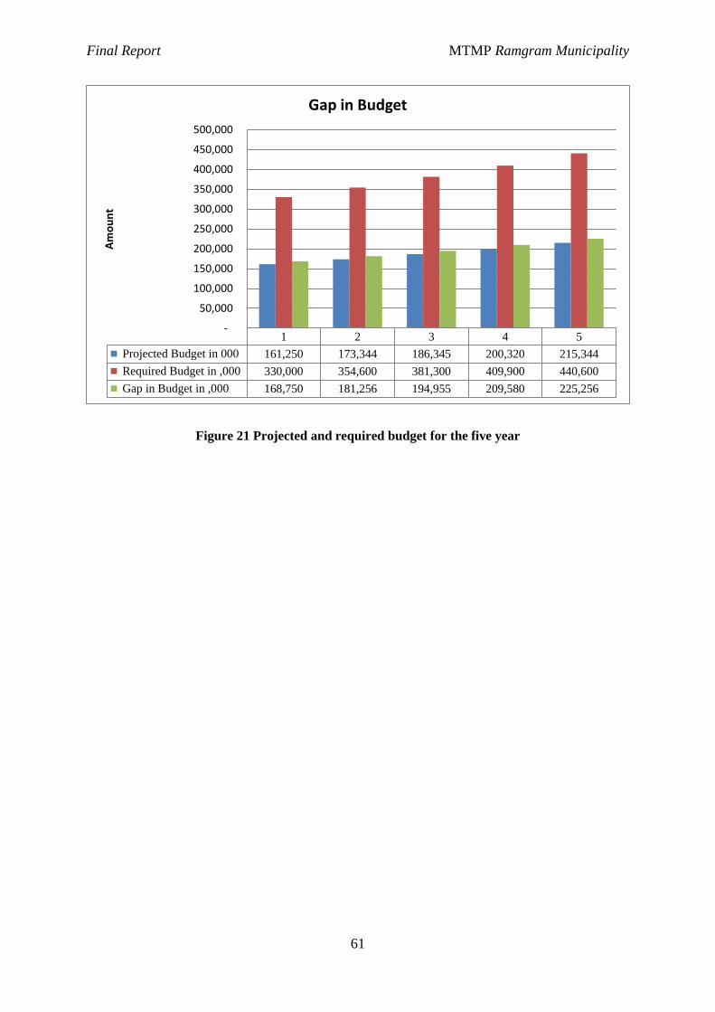
Final Report MTMP Ramgram Municipality
61
Figure 21 Projected and required budget for the five year
1 2 3 4 5
Projected Budget in 000 161,250 173,344 186,345 200,320 215,344
Required Budget in ,000 330,000 354,600 381,300 409,900 440,600
Gap in Budget in ,000 168,750 181,256 194,955 209,580 225,256
-
50,000
100,000
150,000
200,000
250,000
300,000
350,000
400,000
450,000
500,000
Am
ou
nt
Gap in Budget
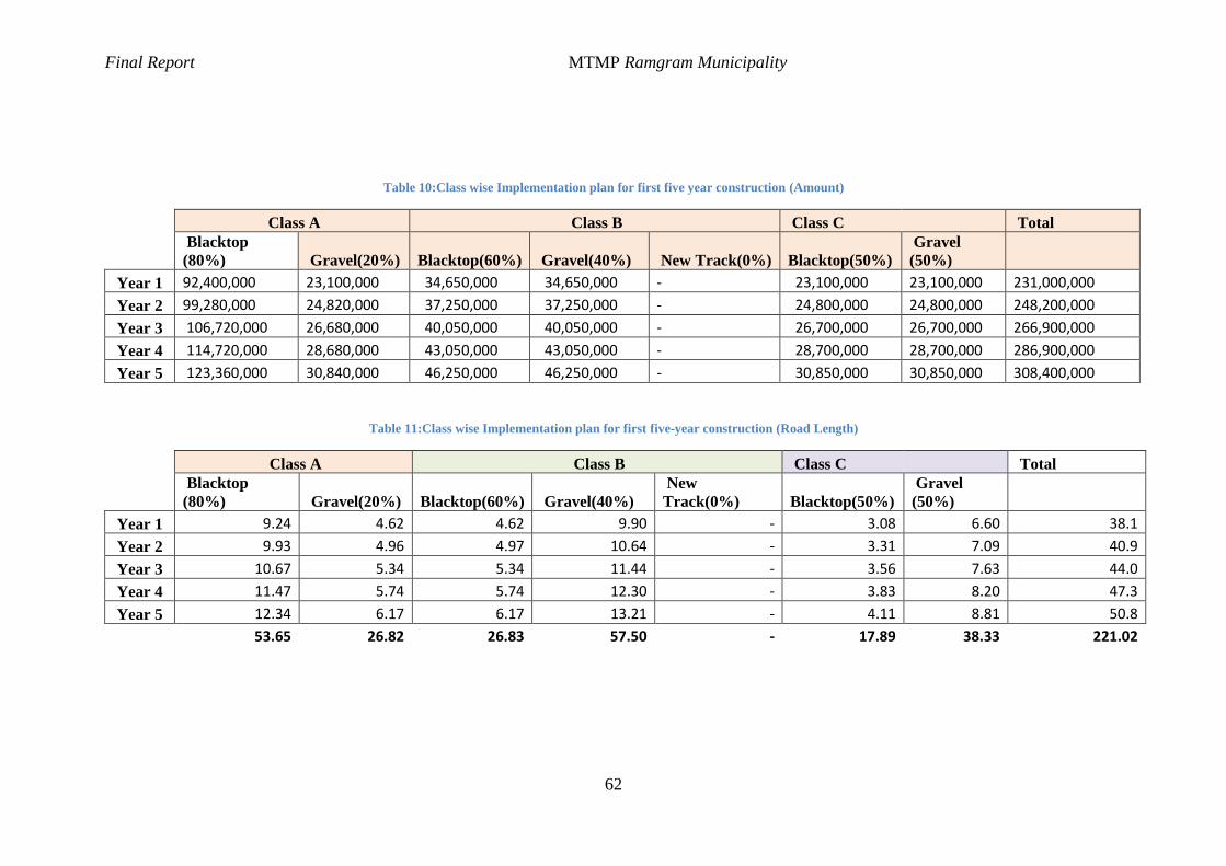
Final Report MTMP Ramgram Municipality
62
Table 10:Class wise Implementation plan for first five year construction (Amount)
Class A Class B Class C Total
Blacktop
(80%) Gravel(20%)
Blacktop(60%) Gravel(40%) New Track(0%)
Blacktop(50%)
Gravel
(50%)
Year 1 92,400,000 23,100,000 34,650,000 34,650,000 - 23,100,000 23,100,000 231,000,000
Year 2 99,280,000 24,820,000 37,250,000 37,250,000 - 24,800,000 24,800,000 248,200,000
Year 3 106,720,000 26,680,000 40,050,000 40,050,000 - 26,700,000 26,700,000 266,900,000
Year 4 114,720,000 28,680,000 43,050,000 43,050,000 - 28,700,000 28,700,000 286,900,000
Year 5 123,360,000 30,840,000 46,250,000 46,250,000 - 30,850,000 30,850,000 308,400,000
Table 11:Class wise Implementation plan for first five-year construction (Road Length)
Class A Class B Class C Total
Blacktop
(80%) Gravel(20%)
Blacktop(60%) Gravel(40%)
New
Track(0%)
Blacktop(50%)
Gravel
(50%)
Year 1 9.24 4.62 4.62 9.90 - 3.08 6.60 38.1
Year 2 9.93 4.96 4.97 10.64 - 3.31 7.09 40.9
Year 3 10.67 5.34 5.34 11.44 - 3.56 7.63 44.0
Year 4 11.47 5.74 5.74 12.30 - 3.83 8.20 47.3
Year 5 12.34 6.17 6.17 13.21 - 4.11 8.81 50.8
53.65 26.82 26.83 57.50 - 17.89 38.33 221.02
Final Report MTMP Ramgram Municipality
63
5.5 Staging Implementation
Mid period review
In light of present context without proper land use and city development plans of the
municipality, the formulated municipal transport plan for five years and long term perspective
plan cannot be complete. Comprehensive drainage plan and layout also guides the placement
of cross drainage structures along the roads. Therefore, a mid period review is necessary. This
review follows the formulation of comprehensive city development plan and land use plan.
These plans will bolster the transport master plan and also suggest necessary deviations and
revisions. The surveys conducted to prepare this MTMP are baseline survey for future
planning. In reference to these surveys, the mid period review will track the changes and its
effect on the formulated five year plan and long term perspective plan. Based on the
recommendations of land use and city development plan, and the changes during the first two
years in the road infrastructure and road traffic the mid period review will guide MTMP in the
later stages.
The next MTMP will be prepared in the sixth year which will create a void in continuity of
transport infrastructure development during the sixth year. The mid period year shall also
formulate implementation and investment plan for that period which will be carried over the
next MTMP.
Yearly maintenance plan
According to the yearly progress of transport infrastructure development and construction,
yearly maintenance plan should be prepared. This maintenance plan addresses the recurrent
maintenance, specific maintenance and emergency maintenance requirements of the municipal
roads.
Stages of development of roads
Visualization of stages of development of roads is very important aspect of long term
municipality transport master plan (perspective plan). Current land use and road side
development may not allow immediate implementation of wider roads. These restrictions
should be addressed in various stages. The stages can be visualized in reference to various
variables.
Final Report MTMP Ramgram Municipality
64
The prime stage is the formulation of policy and plans. This stage formulates the hierarchy and
their geometric and physical characteristics, purpose and functions along with necessary ROW.
With the formulation of road hierarchy, road bylaws will be enforced. It should be followed by
formulation of proper implementation strategies for/and use of various tools for land
acquisition and compensation, method and stages of construction of roads and road side
infrastructures and enforcement of road discipline and right of users. Development of such
policies will support continuous development of the roads. The next stage is to clear the total
right of way so that other infrastructures integrated with road can be developed. Until the end
of clearing of proper right of way, the policies should be strong and well-informed. This will
mark the entry to the next stage which is construction of full phase of all hierarchy roads.
Construction of higher hierarchy roads should be done in stages according to the necessity as
guided by the developed lower hierarchy roads and corresponding demand of higher hierarchy
roads they generate. The first stage should connect the pedestrian path and cycle tracks along
with double lane carriageway for all higher hierarchy roads. The development of Class “A”
roads should follow construction of road space to the standard of Class “C” then gradually
expanding to Class “B” and finally to Class “A”. Class “B” roads should also follow the same
development stages. Construction of well-connected pedestrian way, cycle tracks and green
belt along the edges of the ROW restricts any possible encroachment of the road space.
Final Report MTMP Ramgram Municipality
65
Chapter VI: Conclusion and Recommendations
Municipality Transport Master Plan has been prepared for Ramgram Municipality. A series
surveys for data collection, series of different level interaction with the locals and various
authorities was conducted. The study has identified all the roads of the municipality, their status
and interventions required. The map of IDPM, MIM, MTPP and other maps are prepared.
Detail implementation strategy and budged expenditure plans have been prepared. The
inventory shows that majority of roads are narrow and needs maintenance and upgrading. This
is in line with the demand by the wards. The accessibility of roads has addressed most of the
settlements but their mobility is very low. Access to facilities is hindered due to lack of reliable
and safe public transport services within the municipality. Introduction of proper city buses
and public transport is pertinent to fuel the development process at earliest.
The study has formulated hierarchy of roads which is necessary for long term rapid
development of the municipality area. The report presents the necessary functions of the roads
and their characteristics. Possible cross sections are also recommended. The study has shown
high proportion of active road users which have been addressed thorough provision of
pedestrian facilities and bicycle tracks in all roads except access roads. This is necessary to be
implemented as the developed cities are having trouble to address the demand of active mode
user friendly urban road infrastructures, Ramgram Municipality has the opportunity to sustain
the road users and create a sustainable and well-planned urban road network and infrastructure.
As the implementation strategy suggests, the municipality needs to develop proper framework
and policies for the implementation of the perspective plans, built the capacity of the
municipality and the local organizations and committees and proper stages of development of
the roads.
This study, being first of its type for the municipality, should be revised and integrated with
other plans that will be developed in coming years. Periodic review and update of the plans is
necessary according to the change in land use and traffic that occurs in the future. A mid period
review in the third year and five yearly MTMP should be prepared every five years. Comments
and suggestions suggested during the draft report presentation had been incorporated in the
final report.
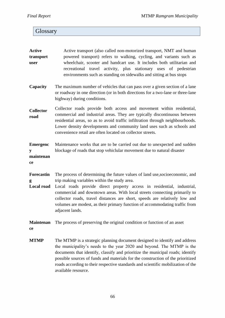
Final Report MTMP Ramgram Municipality
66
Glossary
Active
transport
user
Active transport (also called non-motorized transport, NMT and human
powered transport) refers to walking, cycling, and variants such as
wheelchair, scooter and handcart use. It includes both utilitarian and
recreational travel activity, plus stationary uses of pedestrian
environments such as standing on sidewalks and sitting at bus stops
Capacity
Collector
road
The maximum number of vehicles that can pass over a given section of a lane
or roadway in one direction (or in both directions for a two-lane or three-lane
highway) during conditions.
Collector roads provide both access and movement within residential,
commercial and industrial areas. They are typically discontinuous between
residential areas, so as to avoid traffic infiltration through neighbourhoods.
Lower density developments and community land uses such as schools and
convenience retail are often located on collector streets.
Emergenc
y
maintenan
ce
Maintenance works that are to be carried out due to unexpected and sudden
blockage of roads that stop vehiclular movement due to natural disaster
Forecastin
g
The process of determining the future values of land use,socioeconomic, and
trip making variables within the study area. Local road Local roads provide direct property access in residential, industrial,
commercial and downtown areas. With local streets connecting primarily to
collector roads, travel distances are short, speeds are relatively low and
volumes are modest, as their primary function of accommodating traffic from
adjacent lands.
Maintenan
ce
The process of preserving the original condition or function of an asset
MTMP
The MTMP is a strategic planning document designed to identify and address
the municipality’s needs to the year 2020 and beyond. The MTMP is the
documents that identify, classify and prioritize the municipal roads; identify
possible sources of funds and materials for the construction of the prioritized
roads according to their respective standards and scientific mobilization of the
available resource.
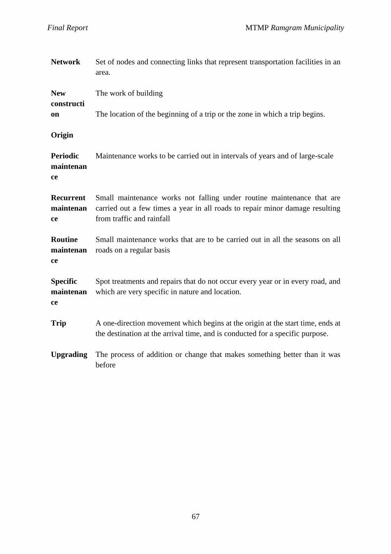
Final Report MTMP Ramgram Municipality
67
Network
New
constructi
on
Origin
Set of nodes and connecting links that represent transportation facilities in an
area.
The work of building
The location of the beginning of a trip or the zone in which a trip begins.
Periodic
maintenan
ce
Maintenance works to be carried out in intervals of years and of large-scale
Recurrent
maintenan
ce
Small maintenance works not falling under routine maintenance that are
carried out a few times a year in all roads to repair minor damage resulting
from traffic and rainfall
Routine
maintenan
ce
Small maintenance works that are to be carried out in all the seasons on all
roads on a regular basis
Specific
maintenan
ce
Spot treatments and repairs that do not occur every year or in every road, and
which are very specific in nature and location.
Trip
Upgrading
A one-direction movement which begins at the origin at the start time, ends at
the destination at the arrival time, and is conducted for a specific purpose.
The process of addition or change that makes something better than it was
before

Final Report MTMP Ramgram Municipality
68
References
Australia, M. R. (2011). Road Hierarchy Criteria.
Central Bureau of Statistics. (2013). National Census 2011. Kathmandu: Government of
Nepal, National Planning Commission Secretariat.
Cole, S. (2005). Applied Transport Economics Policy, Management and Decision Making.
London: Kogan Page Limited.
Elgar, E. (2002). Transport Economics. Cheltenham: Edward ELgar Publishing Limited.
Eppell, V. A., Bunker, J., & McClurg, B. (2001). A four level road hierarchy for network
planning and management. Proceedings 20th ARRB Conference. Melbourne: Jaeger,
Vicki, Eds.
kadiyali, D. L. (2011). Traffic Engineering and Transport planning.
Litman, T. (2015). Evaluating Active Transport Benefits and Costs (Guide to valuing walking
and cycling improvements and encouragement programs). Victooria Transport Policy
Institute.
McClurg, B., Bunker , J., & Eppell, V. (2001). A four level road hierarchy for network
planning and management. ARRB. Melbourne.
Meyer M.D & Miller E.J. Urban Transportation Planning.
National Planning Commission. (2012). National population and housing census ( A national
report). Kathmandu: Central Bureau of Statistics.
Government of Nepal, (2068). Nepal Urban Road Standard 2068 (Draft).
Department of Roads, Nepal Road Standard 2070.
TRB. (2013). Transit capacity and quality of service manual. Washington D.C.: Transit
cooperative research program.
Periodic plan of Ramgram Municipality
Final Report MTMP Ramgram Municipality
69
Road Inventory:
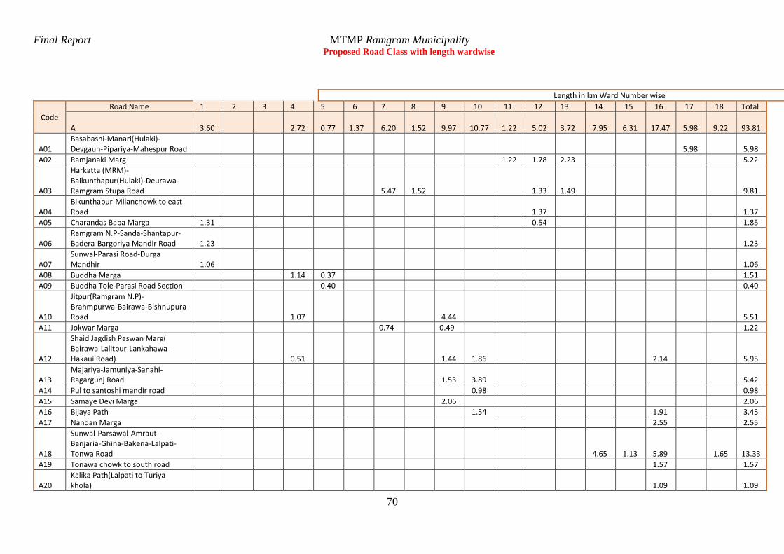
Final Report MTMP Ramgram Municipality
70
Proposed Road Class with length wardwise
Length in km Ward Number wise
Code
Road Name 1 2 3 4 5 6 7 8 9 10 11 12 13 14 15 16 17 18 Total
A 3.60 2.72 0.77 1.37 6.20 1.52 9.97 10.77 1.22 5.02 3.72 7.95 6.31 17.47 5.98 9.22 93.81
A01 Basabashi-Manari(Hulaki)-Devgaun-Pipariya-Mahespur Road 5.98 5.98
A02 Ramjanaki Marg 1.22 1.78 2.23 5.22
A03
Harkatta (MRM)-Baikunthapur(Hulaki)-Deurawa-Ramgram Stupa Road 5.47 1.52 1.33 1.49 9.81
A04 Bikunthapur-Milanchowk to east Road 1.37 1.37
A05 Charandas Baba Marga 1.31 0.54 1.85
A06 Ramgram N.P-Sanda-Shantapur-Badera-Bargoriya Mandir Road 1.23 1.23
A07 Sunwal-Parasi Road-Durga Mandhir 1.06 1.06
A08 Buddha Marga 1.14 0.37 1.51
A09 Buddha Tole-Parasi Road Section 0.40 0.40
A10
Jitpur(Ramgram N.P)-Brahmpurwa-Bairawa-Bishnupura Road 1.07 4.44 5.51
A11 Jokwar Marga 0.74 0.49 1.22
A12
Shaid Jagdish Paswan Marg( Bairawa-Lalitpur-Lankahawa-Hakaui Road) 0.51 1.44 1.86 2.14 5.95
A13 Majariya-Jamuniya-Sanahi-Ragargunj Road 1.53 3.89 5.42
A14 Pul to santoshi mandir road 0.98 0.98
A15 Samaye Devi Marga 2.06 2.06
A16 Bijaya Path 1.54 1.91 3.45
A17 Nandan Marga 2.55 2.55
A18
Sunwal-Parsawal-Amraut-Banjaria-Ghina-Bakena-Lalpati-Tonwa Road 4.65 1.13 5.89 1.65
13.33
A19 Tonawa chowk to south road 1.57 1.57
A20 Kalika Path(Lalpati to Turiya khola) 1.09 1.09
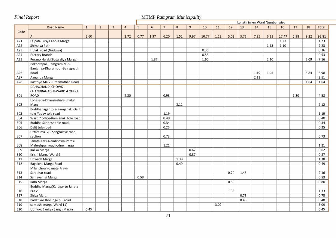
Final Report MTMP Ramgram Municipality
71
Length in km Ward Number wise
Code
Road Name 1 2 3 4 5 6 7 8 9 10 11 12 13 14 15 16 17 18 Total
A 3.60 2.72 0.77 1.37 6.20 1.52 9.97 10.77 1.22 5.02 3.72 7.95 6.31 17.47 5.98 9.22 93.81
A21 Lalpati-Turiya Khola Marga 1.23 1.23
A22 Shikshya Path 1.13 1.10 2.23
A23 Hulaki road (Naduwa) 0.36 0.36
A24 Factory Branch 0.53 0.53
A25 Purano Hulaki(Butwaliya Marga) 1.37 1.60 2.10 2.09 7.16
A26
Pokharapali(Ramgram N.P)-Banjariya-Dharampur-Bairagnath Road 1.19 1.95 3.84 6.98
A27 Aananda Marga 2.11 2.11
A28 Rastriye Ma Vi-Brahmathan Road 1.64 1.64
B01
DAHACHANDI CHOWK-CHANDRAGADHI-WARD 4 OFFICE ROAD 2.30 0.98 1.30 4.58
B02 Lohasada-Dharmashala-Bhaluhi Marg 2.12 2.12
B03 Buddhanagar tole-Ramjanaki-Dalit tole-Yadav tole road 1.19 1.19
B04 Ward 7 office-Ramjanaki tole road 0.40 0.40
B05 Buddha Sandesh tole road 0.34 0.34
B06 Dalit tole road 0.25 0.25
B07 Uttam ma. vi.- Sangralaye road section 0.73 0.73
B08 Janata AaBi-Naudihawa-Parasi Maheshpur road jodne marga 1.21 1.21
B09 Kalika Marga 0.62 0.62
B10 Krishi Marga(Ward 9) 0.87 0.87
B11 Unwach Marga 1.38 1.38
B12 Bagaicha Marga Road 0.49 0.49
B13 Milanchowk-Janata Pravi-Saratikar road 0.70 1.46 2.16
B14 Samayemai Marga 0.53 0.53
B15 Ram Marga 0.80 0.80
B16 Buddha Marga(Karagar to Janata Pra vi) 1.33 1.33
B17 Shiva Marg 0.75 0.75
B18 Padatikar Jholunge pul road 0.48 0.48
B19 santoshi marga(Ward 11) 3.09 3.09
B20 Udhyog Banijya Sangh Marga 0.45 0.45
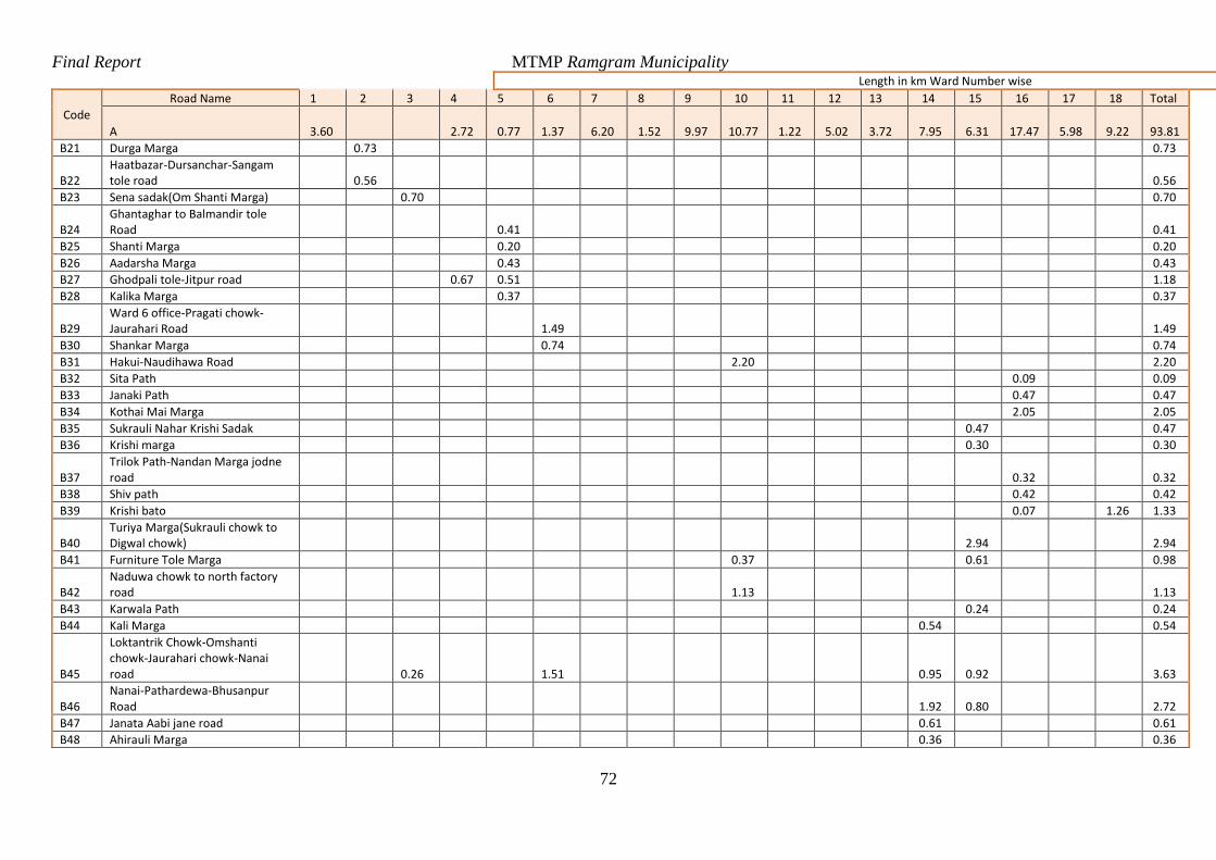
Final Report MTMP Ramgram Municipality
72
Length in km Ward Number wise
Code
Road Name 1 2 3 4 5 6 7 8 9 10 11 12 13 14 15 16 17 18 Total
A 3.60 2.72 0.77 1.37 6.20 1.52 9.97 10.77 1.22 5.02 3.72 7.95 6.31 17.47 5.98 9.22 93.81
B21 Durga Marga 0.73 0.73
B22 Haatbazar-Dursanchar-Sangam tole road 0.56 0.56
B23 Sena sadak(Om Shanti Marga) 0.70 0.70
B24 Ghantaghar to Balmandir tole Road 0.41 0.41
B25 Shanti Marga 0.20 0.20
B26 Aadarsha Marga 0.43 0.43
B27 Ghodpali tole-Jitpur road 0.67 0.51 1.18
B28 Kalika Marga 0.37 0.37
B29 Ward 6 office-Pragati chowk-Jaurahari Road 1.49 1.49
B30 Shankar Marga 0.74 0.74
B31 Hakui-Naudihawa Road 2.20 2.20
B32 Sita Path 0.09 0.09
B33 Janaki Path 0.47 0.47
B34 Kothai Mai Marga 2.05 2.05
B35 Sukrauli Nahar Krishi Sadak 0.47 0.47
B36 Krishi marga 0.30 0.30
B37 Trilok Path-Nandan Marga jodne road 0.32 0.32
B38 Shiv path 0.42 0.42
B39 Krishi bato 0.07 1.26 1.33
B40 Turiya Marga(Sukrauli chowk to Digwal chowk) 2.94 2.94
B41 Furniture Tole Marga 0.37 0.61 0.98
B42 Naduwa chowk to north factory road 1.13 1.13
B43 Karwala Path 0.24 0.24
B44 Kali Marga 0.54 0.54
B45
Loktantrik Chowk-Omshanti chowk-Jaurahari chowk-Nanai road 0.26 1.51 0.95 0.92 3.63
B46 Nanai-Pathardewa-Bhusanpur Road 1.92 0.80 2.72
B47 Janata Aabi jane road 0.61 0.61
B48 Ahirauli Marga 0.36 0.36
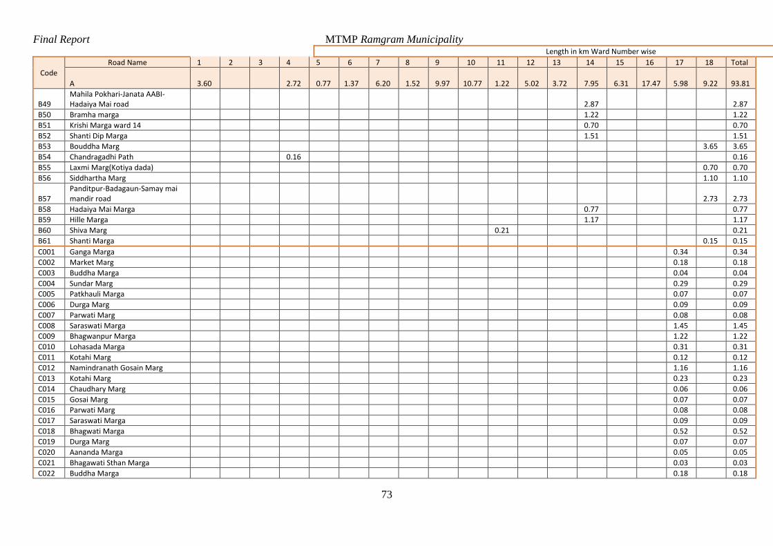
Final Report MTMP Ramgram Municipality
73
Length in km Ward Number wise
Code
Road Name 1 2 3 4 5 6 7 8 9 10 11 12 13 14 15 16 17 18 Total
A 3.60 2.72 0.77 1.37 6.20 1.52 9.97 10.77 1.22 5.02 3.72 7.95 6.31 17.47 5.98 9.22 93.81
B49 Mahila Pokhari-Janata AABI-Hadaiya Mai road 2.87 2.87
B50 Bramha marga 1.22 1.22
B51 Krishi Marga ward 14 0.70 0.70
B52 Shanti Dip Marga 1.51 1.51
B53 Bouddha Marg 3.65 3.65
B54 Chandragadhi Path 0.16 0.16
B55 Laxmi Marg(Kotiya dada) 0.70 0.70
B56 Siddhartha Marg 1.10 1.10
B57 Panditpur-Badagaun-Samay mai mandir road 2.73 2.73
B58 Hadaiya Mai Marga 0.77 0.77
B59 Hille Marga 1.17 1.17
B60 Shiva Marg 0.21 0.21
B61 Shanti Marga 0.15 0.15
C001 Ganga Marga 0.34 0.34
C002 Market Marg 0.18 0.18
C003 Buddha Marga 0.04 0.04
C004 Sundar Marg 0.29 0.29
C005 Patkhauli Marga 0.07 0.07
C006 Durga Marg 0.09 0.09
C007 Parwati Marg 0.08 0.08
C008 Saraswati Marga 1.45 1.45
C009 Bhagwanpur Marga 1.22 1.22
C010 Lohasada Marga 0.31 0.31
C011 Kotahi Marg 0.12 0.12
C012 Namindranath Gosain Marg 1.16 1.16
C013 Kotahi Marg 0.23 0.23
C014 Chaudhary Marg 0.06 0.06
C015 Gosai Marg 0.07 0.07
C016 Parwati Marg 0.08 0.08
C017 Saraswati Marga 0.09 0.09
C018 Bhagwati Marga 0.52 0.52
C019 Durga Marg 0.07 0.07
C020 Aananda Marga 0.05 0.05
C021 Bhagawati Sthan Marga 0.03 0.03
C022 Buddha Marga 0.18 0.18
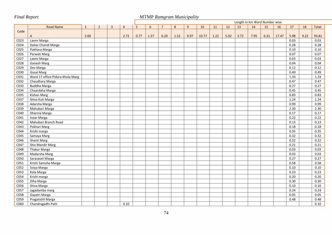
Final Report MTMP Ramgram Municipality
74
Length in km Ward Number wise
Code
Road Name 1 2 3 4 5 6 7 8 9 10 11 12 13 14 15 16 17 18 Total
A 3.60 2.72 0.77 1.37 6.20 1.52 9.97 10.77 1.22 5.02 3.72 7.95 6.31 17.47 5.98 9.22 93.81
C023 Laxmi Marga 0.03 0.03
C024 Dahar Chandi Marga 0.28 0.28
C025 Pokhara Marga 0.10 0.10
C026 Parwati Marg 0.07 0.07
C027 Laxmi Marga 0.03 0.03
C028 Ganesh Marg 0.04 0.04
C029 Dev Marga 0.12 0.12
C030 Gosai Marg 0.49 0.49
C031 Ward 17 office-Pidura Khola Marg 1.33 1.33
C032 Chaudhary Marga 0.47 0.47
C033 Buddha Marga 0.27 0.27
C034 Chaardaha Marga 0.45 0.45
C035 Kishan Marg 0.83 0.83
C037 Shiva Kuti Marga 1.24 1.24
C038 Adarsha Marga 0.99 0.99
C039 Mahubari Marga 2.30 2.30
C040 Dharma Marga 0.17 0.17
C041 Inaar Marga 0.22 0.22
C042 Mahubari Branch Road 0.13 0.13
C043 Pokhari Marg 0.18 0.18
C044 Krishi marga 0.35 0.35
C045 Samaya Marg 0.32 0.32
C046 Shanti Marg 0.22 0.22
C047 Shiv Mandir Marg 0.21 0.21
C048 Thakur Marga 0.03 0.03
C049 Madarsha Marg 0.03 0.03
C050 Saraswati Marga 0.27 0.27
C051 Krishi Samuha Marga 0.58 0.58
C052 Soiya Marga 0.10 0.10
C053 Kola Marga 0.23 0.23
C054 Krishi marga 0.20 0.20
C055 Diha Marga 0.30 0.30
C056 Shiva Marga 0.10 0.10
C057 Jagadamba marg 0.24 0.24
C058 Gayatri Marga 0.05 0.05
C059 Pragatishil Marga 0.48 0.48
C060 Chandragadhi Path 0.10 0.10
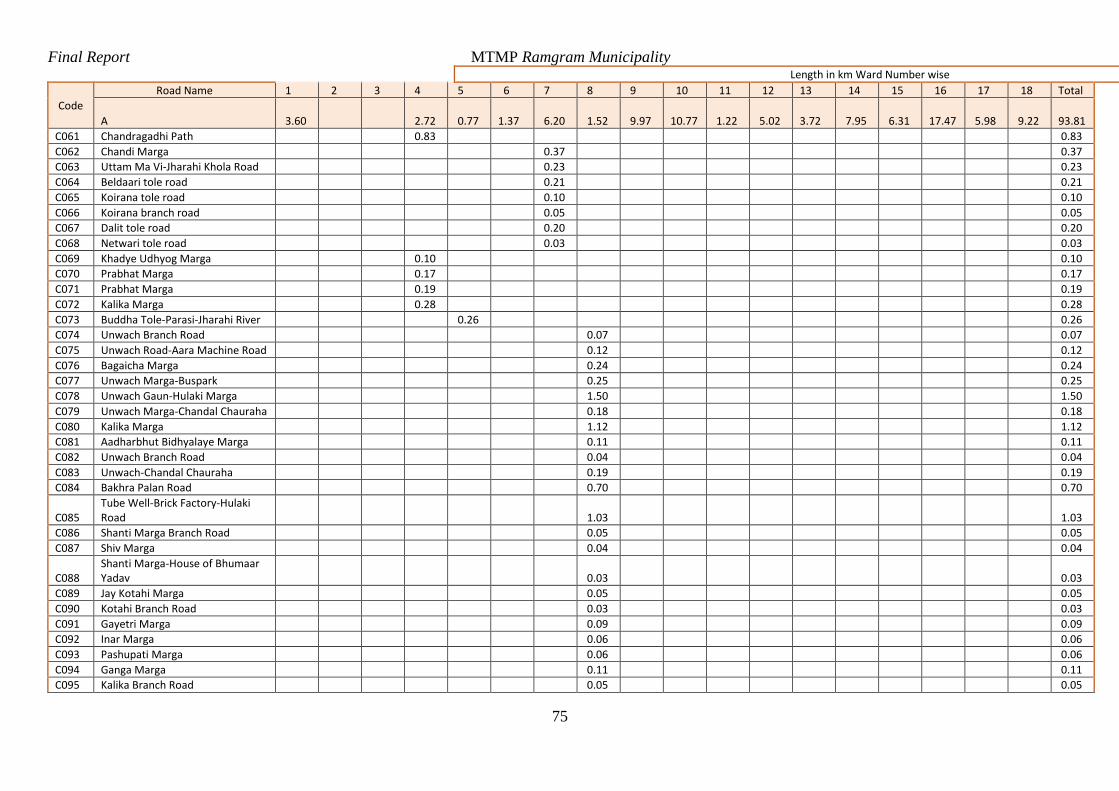
Final Report MTMP Ramgram Municipality
75
Length in km Ward Number wise
Code
Road Name 1 2 3 4 5 6 7 8 9 10 11 12 13 14 15 16 17 18 Total
A 3.60 2.72 0.77 1.37 6.20 1.52 9.97 10.77 1.22 5.02 3.72 7.95 6.31 17.47 5.98 9.22 93.81
C061 Chandragadhi Path 0.83 0.83
C062 Chandi Marga 0.37 0.37
C063 Uttam Ma Vi-Jharahi Khola Road 0.23 0.23
C064 Beldaari tole road 0.21 0.21
C065 Koirana tole road 0.10 0.10
C066 Koirana branch road 0.05 0.05
C067 Dalit tole road 0.20 0.20
C068 Netwari tole road 0.03 0.03
C069 Khadye Udhyog Marga 0.10 0.10
C070 Prabhat Marga 0.17 0.17
C071 Prabhat Marga 0.19 0.19
C072 Kalika Marga 0.28 0.28
C073 Buddha Tole-Parasi-Jharahi River 0.26 0.26
C074 Unwach Branch Road 0.07 0.07
C075 Unwach Road-Aara Machine Road 0.12 0.12
C076 Bagaicha Marga 0.24 0.24
C077 Unwach Marga-Buspark 0.25 0.25
C078 Unwach Gaun-Hulaki Marga 1.50 1.50
C079 Unwach Marga-Chandal Chauraha 0.18 0.18
C080 Kalika Marga 1.12 1.12
C081 Aadharbhut Bidhyalaye Marga 0.11 0.11
C082 Unwach Branch Road 0.04 0.04
C083 Unwach-Chandal Chauraha 0.19 0.19
C084 Bakhra Palan Road 0.70 0.70
C085 Tube Well-Brick Factory-Hulaki Road 1.03 1.03
C086 Shanti Marga Branch Road 0.05 0.05
C087 Shiv Marga 0.04 0.04
C088 Shanti Marga-House of Bhumaar Yadav 0.03 0.03
C089 Jay Kotahi Marga 0.05 0.05
C090 Kotahi Branch Road 0.03 0.03
C091 Gayetri Marga 0.09 0.09
C092 Inar Marga 0.06 0.06
C093 Pashupati Marga 0.06 0.06
C094 Ganga Marga 0.11 0.11
C095 Kalika Branch Road 0.05 0.05
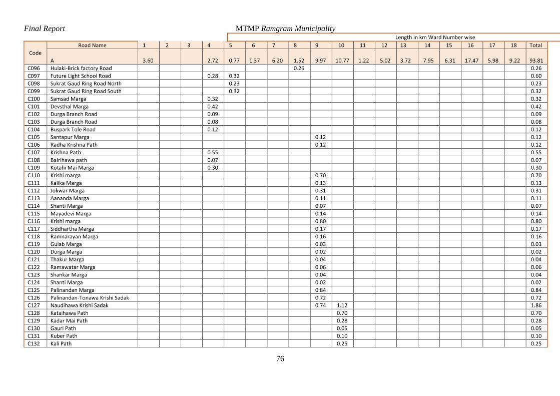
Final Report MTMP Ramgram Municipality
76
Length in km Ward Number wise
Code
Road Name 1 2 3 4 5 6 7 8 9 10 11 12 13 14 15 16 17 18 Total
A 3.60 2.72 0.77 1.37 6.20 1.52 9.97 10.77 1.22 5.02 3.72 7.95 6.31 17.47 5.98 9.22 93.81
C096 Hulaki-Brick factory Road 0.26 0.26
C097 Future Light School Road 0.28 0.32 0.60
C098 Sukrat Gaud Ring Road North 0.23 0.23
C099 Sukrat Gaud Ring Road South 0.32 0.32
C100 Samsad Marga 0.32 0.32
C101 Devsthal Marga 0.42 0.42
C102 Durga Branch Road 0.09 0.09
C103 Durga Branch Road 0.08 0.08
C104 Buspark Tole Road 0.12 0.12
C105 Santapur Marga 0.12 0.12
C106 Radha Krishna Path 0.12 0.12
C107 Krishna Path 0.55 0.55
C108 Bairihawa path 0.07 0.07
C109 Kotahi Mai Marga 0.30 0.30
C110 Krishi marga 0.70 0.70
C111 Kalika Marga 0.13 0.13
C112 Jokwar Marga 0.31 0.31
C113 Aananda Marga 0.11 0.11
C114 Shanti Marga 0.07 0.07
C115 Mayadevi Marga 0.14 0.14
C116 Krishi marga 0.80 0.80
C117 Siddhartha Marga 0.17 0.17
C118 Ramnarayan Marga 0.16 0.16
C119 Gulab Marga 0.03 0.03
C120 Durga Marga 0.02 0.02
C121 Thakur Marga 0.04 0.04
C122 Ramawatar Marga 0.06 0.06
C123 Shankar Marga 0.04 0.04
C124 Shanti Marga 0.02 0.02
C125 Palinandan Marga 0.84 0.84
C126 Palinandan-Tonawa Krishi Sadak 0.72 0.72
C127 Naudihawa Krishi Sadak 0.74 1.12 1.86
C128 Kataihawa Path 0.70 0.70
C129 Kadar Mai Path 0.28 0.28
C130 Gauri Path 0.05 0.05
C131 Kuber Path 0.10 0.10
C132 Kali Path 0.25 0.25
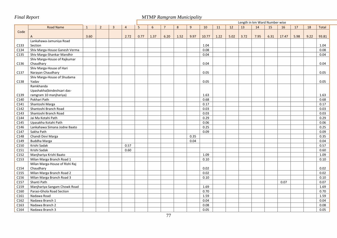
Final Report MTMP Ramgram Municipality
77
Length in km Ward Number wise
Code
Road Name 1 2 3 4 5 6 7 8 9 10 11 12 13 14 15 16 17 18 Total
A 3.60 2.72 0.77 1.37 6.20 1.52 9.97 10.77 1.22 5.02 3.72 7.95 6.31 17.47 5.98 9.22 93.81
C133 Lankahawa-Jamuniya Road Section 1.04 1.04
C134 Shiv Marga-House Ganesh Verma 0.08 0.08
C135 Shiv Marga-Shankar Mandhir 0.04 0.04
C136 Shiv Marga-House of Rajkumar Chaudhary 0.04 0.04
C137 Shiv Marga-House of Hari Narayan Chaudhary 0.05 0.05
C138 Shiv Marga-House of Shudama Yadav 0.05 0.05
C139
Ramkhanda Upashakha(bindeshsari das-ramgram 10 manjhariya) 1.63 1.63
C140 Pokhari Path 0.68 0.68
C141 Shantoshi Marga 0.17 0.17
C142 Shantoshi Branch Road 0.03 0.03
C143 Shantoshi Branch Road 0.03 0.03
C144 Jai Ma Kotahi Path 0.29 0.29
C145 Upasakha Kotahi Path 0.06 0.06
C146 Lankahawa Simana Jodne Baato 0.25 0.25
C147 Sakha Path 0.09 0.09
C148 Chandi Devi Marga 0.35 0.35
C149 Buddha Marga 0.04 0.04
C150 Krishi Sadak 0.57 0.57
C151 Krishi Sadak 0.60 0.60
C152 Manjhariya Krishi Baato 1.09 1.09
C153 Milan Marga Branch Road 1 0.10 0.10
C154 Milan Marga-House of Rishi Raj Chaudhary 0.02 0.02
C155 Milan Marga Branch Road 2 0.02 0.02
C156 Milan Marga Branch Road 3 0.10 0.10
C157 Shanti Path 0.07 0.07
C159 Manjhariya-Sangam Chowk Road 1.69 1.69
C160 Parasi-Ghola Road Section 0.70 0.70
C161 Nadawa Road 1.59 1.59
C162 Nadawa Branch 1 0.04 0.04
C163 Nadawa Branch 2 0.08 0.08
C164 Nadawa Branch 3 0.05 0.05
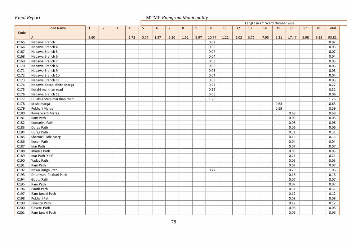
Final Report MTMP Ramgram Municipality
78
Length in km Ward Number wise
Code
Road Name 1 2 3 4 5 6 7 8 9 10 11 12 13 14 15 16 17 18 Total
A 3.60 2.72 0.77 1.37 6.20 1.52 9.97 10.77 1.22 5.02 3.72 7.95 6.31 17.47 5.98 9.22 93.81
C165 Nadawa Branch 0.02 0.02
C166 Nadawa Branch 4 0.05 0.05
C167 Nadawa Branch 5 0.07 0.07
C168 Nadawa Branch 6 0.04 0.04
C169 Nadawa Branch 7 0.03 0.03
C170 Nadawa Branch 8 0.06 0.06
C171 Nadawa Branch 9 0.03 0.03
C172 Nadawa Branch 10 0.04 0.04
C173 Nadawa Branch 11 0.03 0.03
C174 Nadawa-Kotahi Bhitri Marga 0.27 0.27
C175 Kotahi mai than road 0.32 0.32
C176 Nadawa Branch 12 0.06 0.06
C177 Hulaki-Kotahi mai than road 1.26 1.26
C178 Krishi marga 0.63 0.63
C179 Pokhari Marga 0.59 0.59
C180 Kuwarwarti Marga 0.69 0.69
C181 Ram Path 0.05 0.05
C182 Komariya Path 0.06 0.06
C183 Durga Path 0.06 0.06
C184 Durga Path 0.31 0.31
C185 Sharmeli Tole Marg 0.15 0.15
C186 Kosen Path 0.04 0.04
C187 Inar Path 0.07 0.07
C188 Khadka Path 0.05 0.05
C189 Inar Path 'Kha' 0.21 0.21
C190 Yadav Path 0.05 0.05
C191 Ram Path 0.07 0.07
C192 Nawa Durga Path 0.77 0.29 1.06
C193 Dhuniyani-Pokhari Path 0.16 0.16
C194 Gupta Path 0.07 0.07
C195 Ram Path 0.07 0.07
C196 Panth Path 0.31 0.31
C197 Ram Janaki Path 0.12 0.12
C198 Pokhari Path 0.08 0.08
C199 Jayantri Path 0.12 0.12
C200 Gayetri Path 0.06 0.06
C201 Ram Janaki Path 0.06 0.06
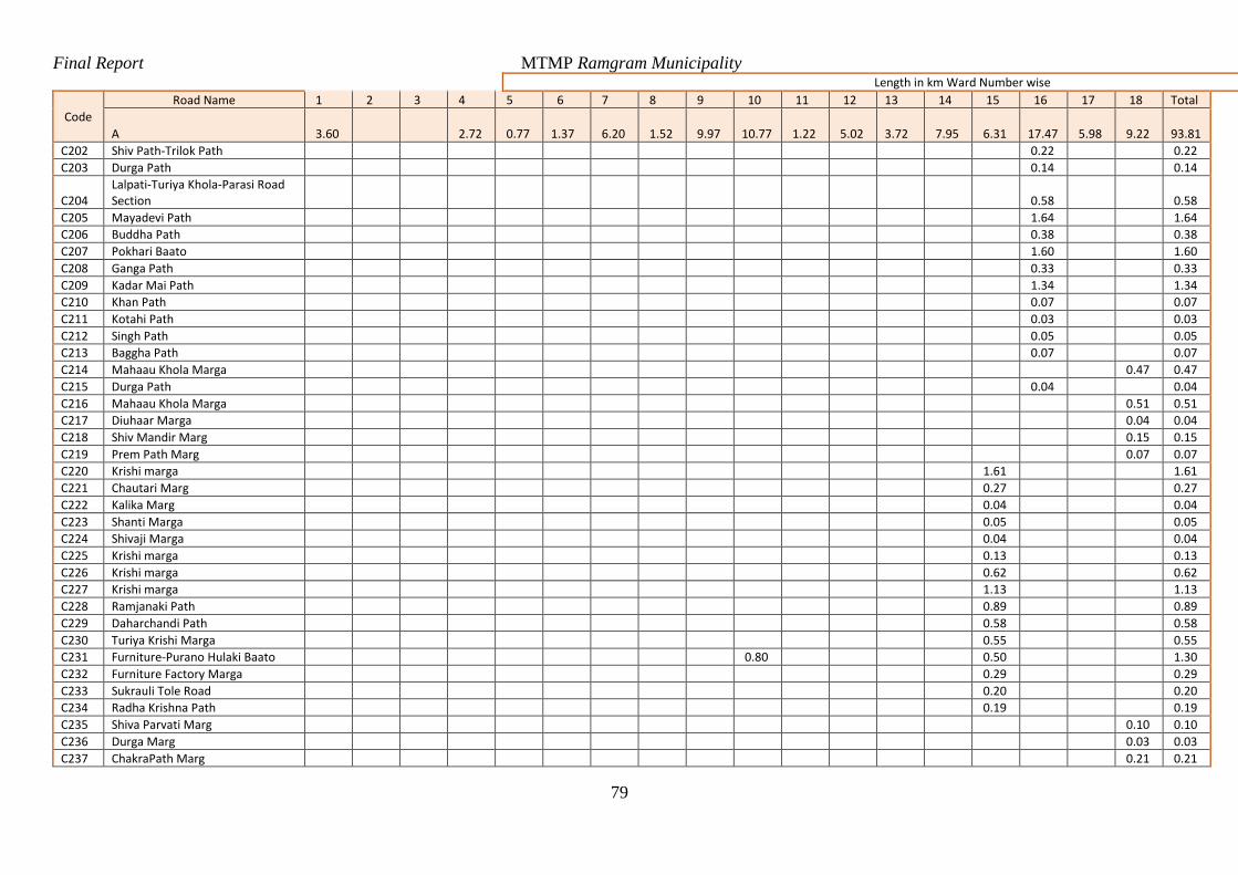
Final Report MTMP Ramgram Municipality
79
Length in km Ward Number wise
Code
Road Name 1 2 3 4 5 6 7 8 9 10 11 12 13 14 15 16 17 18 Total
A 3.60 2.72 0.77 1.37 6.20 1.52 9.97 10.77 1.22 5.02 3.72 7.95 6.31 17.47 5.98 9.22 93.81
C202 Shiv Path-Trilok Path 0.22 0.22
C203 Durga Path 0.14 0.14
C204 Lalpati-Turiya Khola-Parasi Road Section 0.58 0.58
C205 Mayadevi Path 1.64 1.64
C206 Buddha Path 0.38 0.38
C207 Pokhari Baato 1.60 1.60
C208 Ganga Path 0.33 0.33
C209 Kadar Mai Path 1.34 1.34
C210 Khan Path 0.07 0.07
C211 Kotahi Path 0.03 0.03
C212 Singh Path 0.05 0.05
C213 Baggha Path 0.07 0.07
C214 Mahaau Khola Marga 0.47 0.47
C215 Durga Path 0.04 0.04
C216 Mahaau Khola Marga 0.51 0.51
C217 Diuhaar Marga 0.04 0.04
C218 Shiv Mandir Marg 0.15 0.15
C219 Prem Path Marg 0.07 0.07
C220 Krishi marga 1.61 1.61
C221 Chautari Marg 0.27 0.27
C222 Kalika Marg 0.04 0.04
C223 Shanti Marga 0.05 0.05
C224 Shivaji Marga 0.04 0.04
C225 Krishi marga 0.13 0.13
C226 Krishi marga 0.62 0.62
C227 Krishi marga 1.13 1.13
C228 Ramjanaki Path 0.89 0.89
C229 Daharchandi Path 0.58 0.58
C230 Turiya Krishi Marga 0.55 0.55
C231 Furniture-Purano Hulaki Baato 0.80 0.50 1.30
C232 Furniture Factory Marga 0.29 0.29
C233 Sukrauli Tole Road 0.20 0.20
C234 Radha Krishna Path 0.19 0.19
C235 Shiva Parvati Marg 0.10 0.10
C236 Durga Marg 0.03 0.03
C237 ChakraPath Marg 0.21 0.21

Final Report MTMP Ramgram Municipality
80
Length in km Ward Number wise
Code
Road Name 1 2 3 4 5 6 7 8 9 10 11 12 13 14 15 16 17 18 Total
A 3.60 2.72 0.77 1.37 6.20 1.52 9.97 10.77 1.22 5.02 3.72 7.95 6.31 17.47 5.98 9.22 93.81
C238 Amar Marg 0.04 0.04
C239 Shanti Marg 0.02 0.02
C240 Kuiya Tole Marga 0.05 0.05
C241 Koliya Marg 1.00 1.00
C242 Durga Marg 0.42 0.42
C243 Shanti Marg 0.62 0.62
C244 Durga Marg 0.51 0.51
C245 Deep marga 1.59 1.59
C246 Shanti Marga 0.13 0.13
C247 Itta Bhatta Marga 0.54 0.54
C248 Nawa durga marga 0.67 0.67
C249 Buddha Marga 0.08 0.08
C250 Bhar Marga 0.27 0.27
C251 Shankar Marga 0.19 0.19
C252 Sichai Marga 0.26 0.26
C253 Jhulunge Pul Marga 0.12 0.12
C254 Utarayan Marga 0.65 0.65
C255 Krishna Marga 0.04 0.04
C256 Laxmi Marga 0.07 0.07
C257 Shanti Marga 0.14 0.14
C258 Mishrit Marga 0.07 0.07
C259 Pashu Bigyan Marga 0.24 0.24
C260 Pragati Marga 0.05 0.05
C261 Lok Marga 0.09 0.09
C262 Krishi marga 0.15 0.15
C263 Malang Baba Marga 0.44 0.44
C264 Banhu Marga 0.06 0.06
C265 Brahmathan Path 0.22 0.22
C266 Boudha Shakha 0.05 0.05
C267 Boudha Shaksha Road 0.15 0.15
C268 Dhun Tole Marga 0.05 0.05
C269 Amar Path 0.12 0.12
C270 Butwaliya road-Turiya Khola 0.64 0.64
C271 Pokhari Marga 0.10 0.10
C272 Madarsa Path 0.08 0.08
C273 Turiya Khola Marga 0.51 0.51
C274 Nanai Marga 0.19 0.19
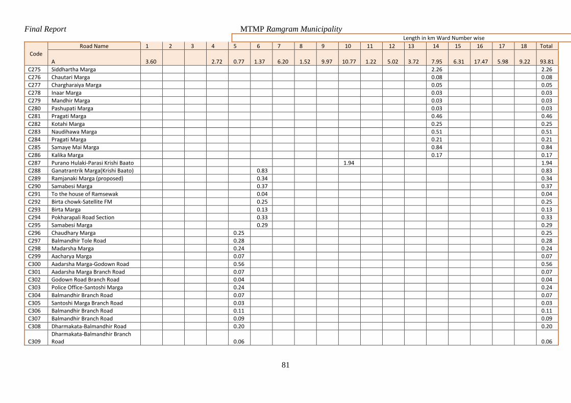
Final Report MTMP Ramgram Municipality
81
Length in km Ward Number wise
Code
Road Name 1 2 3 4 5 6 7 8 9 10 11 12 13 14 15 16 17 18 Total
A 3.60 2.72 0.77 1.37 6.20 1.52 9.97 10.77 1.22 5.02 3.72 7.95 6.31 17.47 5.98 9.22 93.81
C275 Siddhartha Marga 2.26 2.26
C276 Chautari Marga 0.08 0.08
C277 Chargharaiya Marga 0.05 0.05
C278 Inaar Marga 0.03 0.03
C279 Mandhir Marga 0.03 0.03
C280 Pashupati Marga 0.03 0.03
C281 Pragati Marga 0.46 0.46
C282 Kotahi Marga 0.25 0.25
C283 Naudihawa Marga 0.51 0.51
C284 Pragati Marga 0.21 0.21
C285 Samaye Mai Marga 0.84 0.84
C286 Kalika Marga 0.17 0.17
C287 Purano Hulaki-Parasi Krishi Baato 1.94 1.94
C288 Ganatrantrik Marga(Krishi Baato) 0.83 0.83
C289 Ramjanaki Marga (proposed) 0.34 0.34
C290 Samabesi Marga 0.37 0.37
C291 To the house of Ramsewak 0.04 0.04
C292 Birta chowk-Satellite FM 0.25 0.25
C293 Birta Marga 0.13 0.13
C294 Pokharapali Road Section 0.33 0.33
C295 Samabesi Marga 0.29 0.29
C296 Chaudhary Marga 0.25 0.25
C297 Balmandhir Tole Road 0.28 0.28
C298 Madarsha Marga 0.24 0.24
C299 Aacharya Marga 0.07 0.07
C300 Aadarsha Marga-Godown Road 0.56 0.56
C301 Aadarsha Marga Branch Road 0.07 0.07
C302 Godown Road Branch Road 0.04 0.04
C303 Police Office-Santoshi Marga 0.24 0.24
C304 Balmandhir Branch Road 0.07 0.07
C305 Santoshi Marga Branch Road 0.03 0.03
C306 Balmandhir Branch Road 0.11 0.11
C307 Balmandhir Branch Road 0.09 0.09
C308 Dharmakata-Balmandhir Road 0.20 0.20
C309 Dharmakata-Balmandhir Branch Road 0.06 0.06
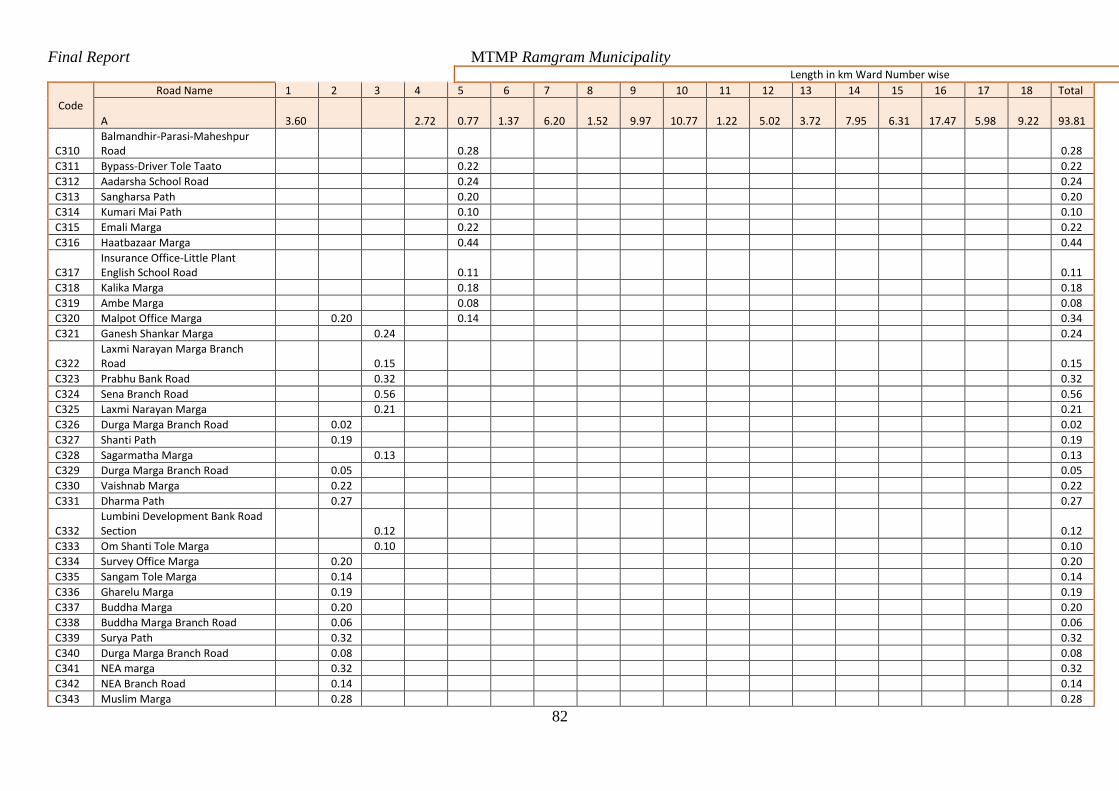
Final Report MTMP Ramgram Municipality
82
Length in km Ward Number wise
Code
Road Name 1 2 3 4 5 6 7 8 9 10 11 12 13 14 15 16 17 18 Total
A 3.60 2.72 0.77 1.37 6.20 1.52 9.97 10.77 1.22 5.02 3.72 7.95 6.31 17.47 5.98 9.22 93.81
C310 Balmandhir-Parasi-Maheshpur Road 0.28 0.28
C311 Bypass-Driver Tole Taato 0.22 0.22
C312 Aadarsha School Road 0.24 0.24
C313 Sangharsa Path 0.20 0.20
C314 Kumari Mai Path 0.10 0.10
C315 Emali Marga 0.22 0.22
C316 Haatbazaar Marga 0.44 0.44
C317 Insurance Office-Little Plant English School Road 0.11 0.11
C318 Kalika Marga 0.18 0.18
C319 Ambe Marga 0.08 0.08
C320 Malpot Office Marga 0.20 0.14 0.34
C321 Ganesh Shankar Marga 0.24 0.24
C322 Laxmi Narayan Marga Branch Road 0.15 0.15
C323 Prabhu Bank Road 0.32 0.32
C324 Sena Branch Road 0.56 0.56
C325 Laxmi Narayan Marga 0.21 0.21
C326 Durga Marga Branch Road 0.02 0.02
C327 Shanti Path 0.19 0.19
C328 Sagarmatha Marga 0.13 0.13
C329 Durga Marga Branch Road 0.05 0.05
C330 Vaishnab Marga 0.22 0.22
C331 Dharma Path 0.27 0.27
C332 Lumbini Development Bank Road Section 0.12 0.12
C333 Om Shanti Tole Marga 0.10 0.10
C334 Survey Office Marga 0.20 0.20
C335 Sangam Tole Marga 0.14 0.14
C336 Gharelu Marga 0.19 0.19
C337 Buddha Marga 0.20 0.20
C338 Buddha Marga Branch Road 0.06 0.06
C339 Surya Path 0.32 0.32
C340 Durga Marga Branch Road 0.08 0.08
C341 NEA marga 0.32 0.32
C342 NEA Branch Road 0.14 0.14
C343 Muslim Marga 0.28 0.28
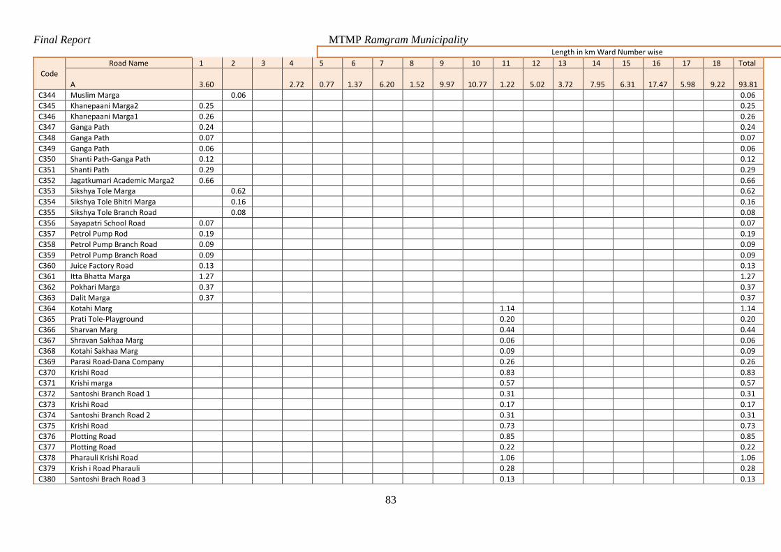
Final Report MTMP Ramgram Municipality
83
Length in km Ward Number wise
Code
Road Name 1 2 3 4 5 6 7 8 9 10 11 12 13 14 15 16 17 18 Total
A 3.60 2.72 0.77 1.37 6.20 1.52 9.97 10.77 1.22 5.02 3.72 7.95 6.31 17.47 5.98 9.22 93.81
C344 Muslim Marga 0.06 0.06
C345 Khanepaani Marga2 0.25 0.25
C346 Khanepaani Marga1 0.26 0.26
C347 Ganga Path 0.24 0.24
C348 Ganga Path 0.07 0.07
C349 Ganga Path 0.06 0.06
C350 Shanti Path-Ganga Path 0.12 0.12
C351 Shanti Path 0.29 0.29
C352 Jagatkumari Academic Marga2 0.66 0.66
C353 Sikshya Tole Marga 0.62 0.62
C354 Sikshya Tole Bhitri Marga 0.16 0.16
C355 Sikshya Tole Branch Road 0.08 0.08
C356 Sayapatri School Road 0.07 0.07
C357 Petrol Pump Rod 0.19 0.19
C358 Petrol Pump Branch Road 0.09 0.09
C359 Petrol Pump Branch Road 0.09 0.09
C360 Juice Factory Road 0.13 0.13
C361 Itta Bhatta Marga 1.27 1.27
C362 Pokhari Marga 0.37 0.37
C363 Dalit Marga 0.37 0.37
C364 Kotahi Marg 1.14 1.14
C365 Prati Tole-Playground 0.20 0.20
C366 Sharvan Marg 0.44 0.44
C367 Shravan Sakhaa Marg 0.06 0.06
C368 Kotahi Sakhaa Marg 0.09 0.09
C369 Parasi Road-Dana Company 0.26 0.26
C370 Krishi Road 0.83 0.83
C371 Krishi marga 0.57 0.57
C372 Santoshi Branch Road 1 0.31 0.31
C373 Krishi Road 0.17 0.17
C374 Santoshi Branch Road 2 0.31 0.31
C375 Krishi Road 0.73 0.73
C376 Plotting Road 0.85 0.85
C377 Plotting Road 0.22 0.22
C378 Pharauli Krishi Road 1.06 1.06
C379 Krish i Road Pharauli 0.28 0.28
C380 Santoshi Brach Road 3 0.13 0.13
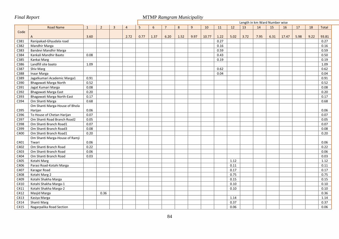
Final Report MTMP Ramgram Municipality
84
Length in km Ward Number wise
Code
Road Name 1 2 3 4 5 6 7 8 9 10 11 12 13 14 15 16 17 18 Total
A 3.60 2.72 0.77 1.37 6.20 1.52 9.97 10.77 1.22 5.02 3.72 7.95 6.31 17.47 5.98 9.22 93.81
C381 Ranipakad-Ghyudala road 0.27 0.27
C382 Mandhir Marga 0.16 0.16
C383 Bandevi Mandhir Marga 0.59 0.59
C384 Kankali Mandhir Baato 0.08 0.43 0.50
C385 Kankai Marg 0.19 0.19
C386 Landfill site baato 1.09 1.09
C387 Shiv Marg 0.62 0.62
C388 Inaar Marga 0.04 0.04
C389 Jagatkumari Academic Marga1 0.91 0.91
C390 Bhagawati Marga North 0.52 0.52
C391 Jagat Kumari Marga 0.08 0.08
C392 Bhagawati Marga East 0.20 0.20
C393 Bhagawati Marga North-East 0.17 0.17
C394 Om Shanti Marga 0.68 0.68
C395 Om Shanti Marga-House of Bhola Harijan 0.06 0.06
C396 To House of Chetan Harijan 0.07 0.07
C397 Om Shanti Road Branch Road2 0.05 0.05
C398 Om Shanti Branch Road1 0.07 0.07
C399 Om Shanti Branch Road3 0.08 0.08
C400 Om Shanti Branch Road1 0.20 0.20
C401 Om Shanti Marga-House of Ramji Tiwari 0.06 0.06
C402 Om Shanti Branch Road 0.22 0.22
C403 Om Shanti Branch Road 0.06 0.06
C404 Om Shanti Branch Road 0.03 0.03
C405 Kotahi Marg 1.12 1.12
C406 Parasi Road-Kotahi Marga 0.11 0.11
C407 Karagar Road 0.17 0.17
C408 Kotahi Marg 2 0.75 0.75
C409 Kotahi Shakha Marga 0.15 0.15
C410 Kotahi Shakha Marga-1 0.10 0.10
C411 Kotahi Shakha Marga-2 0.10 0.10
C412 Masjid Marga 0.36 0.36
C413 Kasiya Marga 1.14 1.14
C414 Shanti Marg 0.37 0.37
C415 Nagarpalika Road Section 0.06 0.06
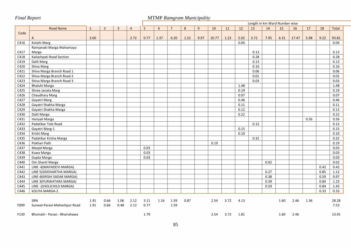
Final Report MTMP Ramgram Municipality
85
Length in km Ward Number wise
Code
Road Name 1 2 3 4 5 6 7 8 9 10 11 12 13 14 15 16 17 18 Total
A 3.60 2.72 0.77 1.37 6.20 1.52 9.97 10.77 1.22 5.02 3.72 7.95 6.31 17.47 5.98 9.22 93.81
C416 Kotahi Marg 0.04 0.04
C417 Ramjanaki Marga-Mahamaya Marga 0.13 0.13
C418 Kailashpati Road Section 0.28 0.28
C419 Dalit Marg 0.13 0.13
C420 Shiva Marg 0.16 0.16
C421 Shiva Marga Branch Road 1 0.06 0.06
C422 Shiva Marga Branch Road 2 0.01 0.01
C423 Shiva Marga Branch Road 3 0.03 0.03
C424 Bhaluhi Marga 1.48 1.48
C425 Shree Janata Marg 0.19 0.19
C426 Chaudhary Marg 0.07 0.07
C427 Gayatri Marg 0.46 0.46
C428 Gayatri Shakha Marga 0.11 0.11
C429 Gayatri Shakha Marga 0.12 0.12
C430 Dalit Marga 0.22 0.22
C431 Hariyali Marga 0.56 0.56
C432 Padatikar Tole Road 0.12 0.12
C433 Gayatri Marg-1 0.15 0.15
C434 Krishi Marg 0.10 0.10
C435 Padatikar Krisha Marga 0.32 0.32
C436 Pokhari Path 0.19 0.19
C437 Masjid Marga 0.03 0.03
C438 Kuwa Marga 0.03 0.03
C439 Gupta Marga 0.03 0.03
C440 Om Shanti Marga 0.02 0.02
C441 LINE -6(MAYADEVI MARGA) 0.42 0.42
C442 LINE 5(SIDDHARTHA MARGA) 0.27 0.85 1.12
C443 LINE 4(KRISHI SADAK MARGA) 0.38 0.59 0.97
C444 LINE 3(PURWATARA MARGA) 0.39 0.84 1.23
C445 LINE -2(HOLICHILD MARGA) 0.59 0.84 1.43
C446 kOLIYA MARGA-2 0.33 0.33
SRN 1.91 0.66 1.06 2.12 3.11 1.16 1.59 0.87 2.54 3.72 4.13 1.60 2.46 1.36
28.28
F009 Sunwal-Parasi-Maheshpur Road 1.91 0.66 0.48 2.12 0.77 1.59 7.53
F130 Bhumahi - Parasi - Bhairahawa 1.79 2.54 3.72 1.81 1.60 2.46
13.91
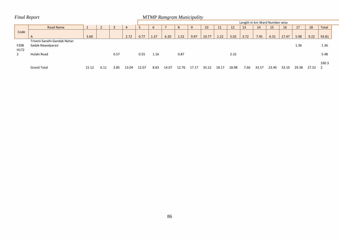
Final Report MTMP Ramgram Municipality
86
Length in km Ward Number wise
Code
Road Name 1 2 3 4 5 6 7 8 9 10 11 12 13 14 15 16 17 18 Total
A 3.60 2.72 0.77 1.37 6.20 1.52 9.97 10.77 1.22 5.02 3.72 7.95 6.31 17.47 5.98 9.22 93.81
F208 Triveni-Sanahi-Gandak Nahar Sadak-Nawalparasi 1.36 1.36
H1722 Hulaki Road 0.57 0.55 1.16 0.87 2.32 5.48
Grand Total 15.12 6.11 3.85
13.04
12.07 8.83
14.07
12.76
17.17
35.52
18.17
18.98 7.66
33.57
23.40
33.10
29.38
27.52
330.32
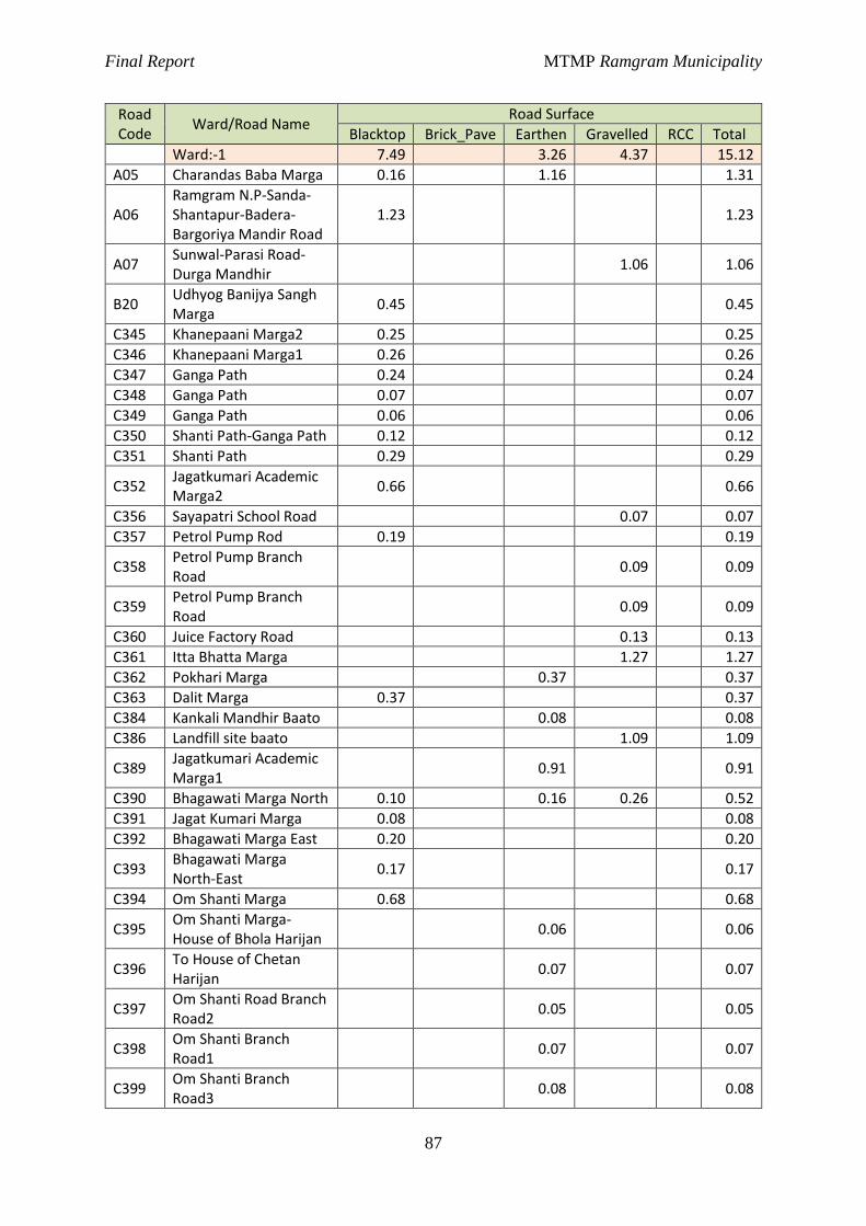
Final Report MTMP Ramgram Municipality
87
Road Code
Ward/Road Name Road Surface
Blacktop Brick_Pave Earthen Gravelled RCC Total
Ward:-1 7.49 3.26 4.37 15.12
A05 Charandas Baba Marga 0.16 1.16 1.31
A06 Ramgram N.P-Sanda-Shantapur-Badera-Bargoriya Mandir Road
1.23 1.23
A07 Sunwal-Parasi Road-Durga Mandhir
1.06 1.06
B20 Udhyog Banijya Sangh Marga
0.45 0.45
C345 Khanepaani Marga2 0.25 0.25
C346 Khanepaani Marga1 0.26 0.26
C347 Ganga Path 0.24 0.24
C348 Ganga Path 0.07 0.07
C349 Ganga Path 0.06 0.06
C350 Shanti Path-Ganga Path 0.12 0.12
C351 Shanti Path 0.29 0.29
C352 Jagatkumari Academic Marga2
0.66 0.66
C356 Sayapatri School Road 0.07 0.07
C357 Petrol Pump Rod 0.19 0.19
C358 Petrol Pump Branch Road
0.09 0.09
C359 Petrol Pump Branch Road
0.09 0.09
C360 Juice Factory Road 0.13 0.13
C361 Itta Bhatta Marga 1.27 1.27
C362 Pokhari Marga 0.37 0.37
C363 Dalit Marga 0.37 0.37
C384 Kankali Mandhir Baato 0.08 0.08
C386 Landfill site baato 1.09 1.09
C389 Jagatkumari Academic Marga1
0.91 0.91
C390 Bhagawati Marga North 0.10 0.16 0.26 0.52
C391 Jagat Kumari Marga 0.08 0.08
C392 Bhagawati Marga East 0.20 0.20
C393 Bhagawati Marga North-East
0.17 0.17
C394 Om Shanti Marga 0.68 0.68
C395 Om Shanti Marga-House of Bhola Harijan
0.06 0.06
C396 To House of Chetan Harijan
0.07 0.07
C397 Om Shanti Road Branch Road2
0.05 0.05
C398 Om Shanti Branch Road1
0.07 0.07
C399 Om Shanti Branch Road3
0.08 0.08

Final Report MTMP Ramgram Municipality
88
Road Code
Ward/Road Name Road Surface
Blacktop Brick_Pave Earthen Gravelled RCC Total
C400 Om Shanti Branch Road1
0.20 0.20
C401 Om Shanti Marga-House of Ramji Tiwari
0.06 0.06
C402 Om Shanti Branch Road 0.22 0.22
C403 Om Shanti Branch Road 0.06 0.06
C404 Om Shanti Branch Road 0.03 0.03
F009 Sunwal-Parasi-Maheshpur Road
1.91 1.91
Ward:-2 4.19 1.92 6.11
B21 Durga Marga 0.73 0.73
B22 Haatbazar-Dursanchar-Sangam tole road
0.56 0.56
C320 Malpot Office Marga 0.20 0.20
C326 Durga Marga Branch Road
0.02 0.02
C327 Shanti Path 0.19 0.19
C329 Durga Marga Branch Road
0.05 0.05
C330 Vaishnab Marga 0.22 0.22
C331 Dharma Path 0.27 0.27
C334 Survey Office Marga 0.20 0.20
C335 Sangam Tole Marga 0.14 0.14
C336 Gharelu Marga 0.19 0.19
C337 Buddha Marga 0.20 0.20
C338 Buddha Marga Branch Road
0.06 0.06
C339 Surya Path 0.32 0.32
C340 Durga Marga Branch Road
0.08 0.08
C341 NEA marga 0.32 0.32
C342 NEA Branch Road 0.14 0.14
C343 Muslim Marga 0.28 0.28
C344 Muslim Marga 0.06 0.06
C353 Sikshya Tole Marga 0.26 0.36 0.62
C354 Sikshya Tole Bhitri Marga
0.16 0.16
C355 Sikshya Tole Branch Road
0.08 0.08
C412 Masjid Marga 0.36 0.36
F009 Sunwal-Parasi-Maheshpur Road
0.66 0.66
Ward:-3 2.63 0.12 1.10 3.85
B23 Sena sadak(Om Shanti Marga)
0.58 0.12 0.70
B45 Loktantrik Chowk-Omshanti chowk-
0.26 0.26
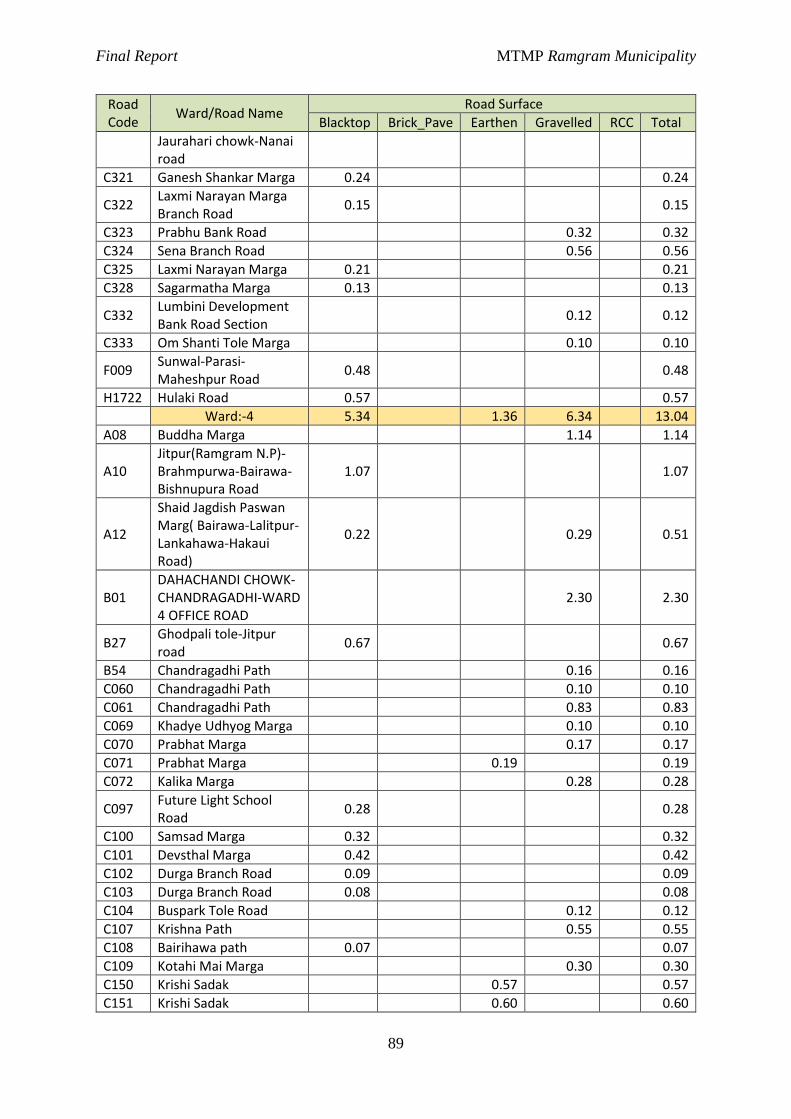
Final Report MTMP Ramgram Municipality
89
Road Code
Ward/Road Name Road Surface
Blacktop Brick_Pave Earthen Gravelled RCC Total
Jaurahari chowk-Nanai road
C321 Ganesh Shankar Marga 0.24 0.24
C322 Laxmi Narayan Marga Branch Road
0.15 0.15
C323 Prabhu Bank Road 0.32 0.32
C324 Sena Branch Road 0.56 0.56
C325 Laxmi Narayan Marga 0.21 0.21
C328 Sagarmatha Marga 0.13 0.13
C332 Lumbini Development Bank Road Section
0.12 0.12
C333 Om Shanti Tole Marga 0.10 0.10
F009 Sunwal-Parasi-Maheshpur Road
0.48 0.48
H1722 Hulaki Road 0.57 0.57
Ward:-4 5.34 1.36 6.34 13.04
A08 Buddha Marga 1.14 1.14
A10 Jitpur(Ramgram N.P)-Brahmpurwa-Bairawa-Bishnupura Road
1.07 1.07
A12
Shaid Jagdish Paswan Marg( Bairawa-Lalitpur-Lankahawa-Hakaui Road)
0.22 0.29 0.51
B01 DAHACHANDI CHOWK-CHANDRAGADHI-WARD 4 OFFICE ROAD
2.30 2.30
B27 Ghodpali tole-Jitpur road
0.67 0.67
B54 Chandragadhi Path 0.16 0.16
C060 Chandragadhi Path 0.10 0.10
C061 Chandragadhi Path 0.83 0.83
C069 Khadye Udhyog Marga 0.10 0.10
C070 Prabhat Marga 0.17 0.17
C071 Prabhat Marga 0.19 0.19
C072 Kalika Marga 0.28 0.28
C097 Future Light School Road
0.28 0.28
C100 Samsad Marga 0.32 0.32
C101 Devsthal Marga 0.42 0.42
C102 Durga Branch Road 0.09 0.09
C103 Durga Branch Road 0.08 0.08
C104 Buspark Tole Road 0.12 0.12
C107 Krishna Path 0.55 0.55
C108 Bairihawa path 0.07 0.07
C109 Kotahi Mai Marga 0.30 0.30
C150 Krishi Sadak 0.57 0.57
C151 Krishi Sadak 0.60 0.60
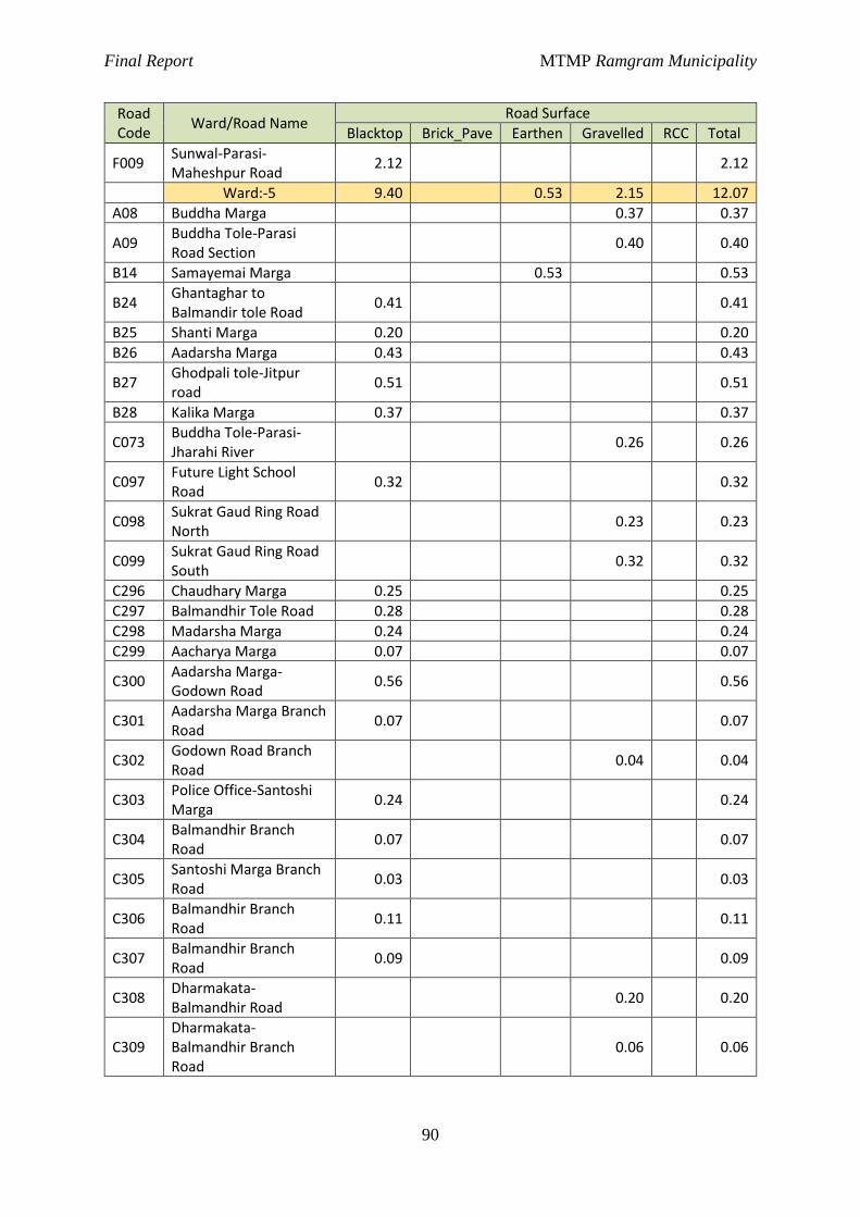
Final Report MTMP Ramgram Municipality
90
Road Code
Ward/Road Name Road Surface
Blacktop Brick_Pave Earthen Gravelled RCC Total
F009 Sunwal-Parasi-Maheshpur Road
2.12 2.12
Ward:-5 9.40 0.53 2.15 12.07
A08 Buddha Marga 0.37 0.37
A09 Buddha Tole-Parasi Road Section
0.40 0.40
B14 Samayemai Marga 0.53 0.53
B24 Ghantaghar to Balmandir tole Road
0.41 0.41
B25 Shanti Marga 0.20 0.20
B26 Aadarsha Marga 0.43 0.43
B27 Ghodpali tole-Jitpur road
0.51 0.51
B28 Kalika Marga 0.37 0.37
C073 Buddha Tole-Parasi-Jharahi River
0.26 0.26
C097 Future Light School Road
0.32 0.32
C098 Sukrat Gaud Ring Road North
0.23 0.23
C099 Sukrat Gaud Ring Road South
0.32 0.32
C296 Chaudhary Marga 0.25 0.25
C297 Balmandhir Tole Road 0.28 0.28
C298 Madarsha Marga 0.24 0.24
C299 Aacharya Marga 0.07 0.07
C300 Aadarsha Marga-Godown Road
0.56 0.56
C301 Aadarsha Marga Branch Road
0.07 0.07
C302 Godown Road Branch Road
0.04 0.04
C303 Police Office-Santoshi Marga
0.24 0.24
C304 Balmandhir Branch Road
0.07 0.07
C305 Santoshi Marga Branch Road
0.03 0.03
C306 Balmandhir Branch Road
0.11 0.11
C307 Balmandhir Branch Road
0.09 0.09
C308 Dharmakata-Balmandhir Road
0.20 0.20
C309 Dharmakata-Balmandhir Branch Road
0.06 0.06
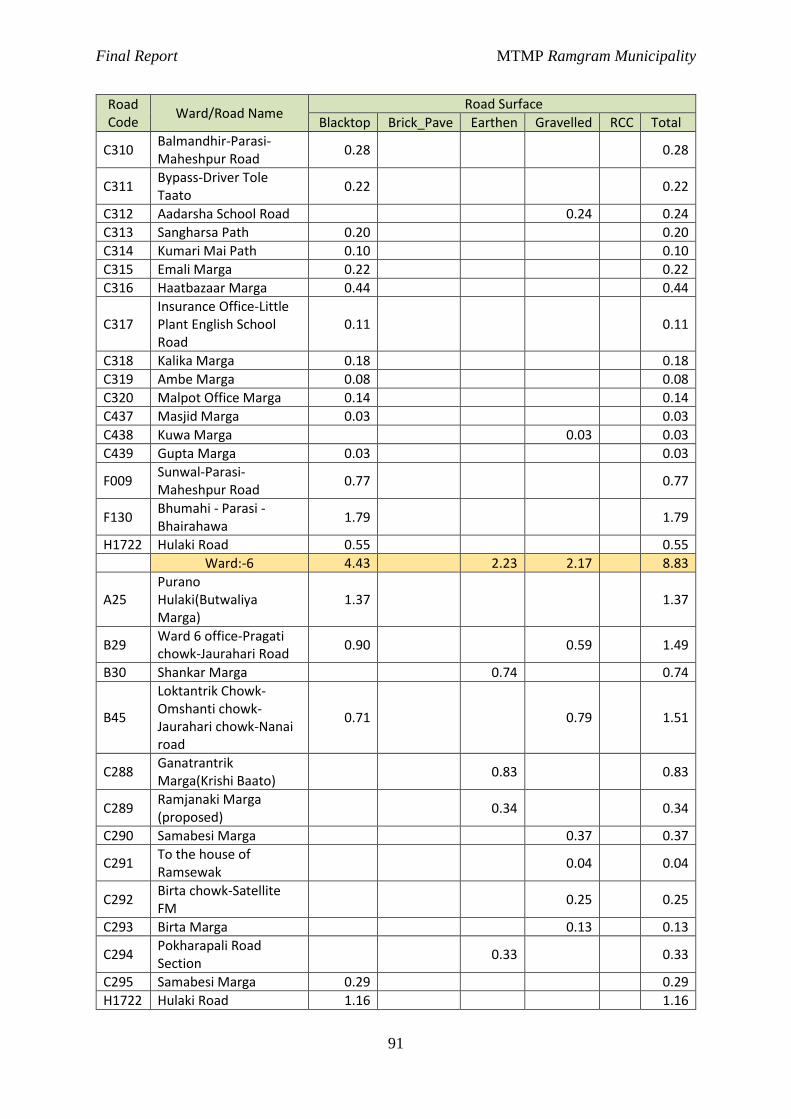
Final Report MTMP Ramgram Municipality
91
Road Code
Ward/Road Name Road Surface
Blacktop Brick_Pave Earthen Gravelled RCC Total
C310 Balmandhir-Parasi-Maheshpur Road
0.28 0.28
C311 Bypass-Driver Tole Taato
0.22 0.22
C312 Aadarsha School Road 0.24 0.24
C313 Sangharsa Path 0.20 0.20
C314 Kumari Mai Path 0.10 0.10
C315 Emali Marga 0.22 0.22
C316 Haatbazaar Marga 0.44 0.44
C317 Insurance Office-Little Plant English School Road
0.11 0.11
C318 Kalika Marga 0.18 0.18
C319 Ambe Marga 0.08 0.08
C320 Malpot Office Marga 0.14 0.14
C437 Masjid Marga 0.03 0.03
C438 Kuwa Marga 0.03 0.03
C439 Gupta Marga 0.03 0.03
F009 Sunwal-Parasi-Maheshpur Road
0.77 0.77
F130 Bhumahi - Parasi - Bhairahawa
1.79 1.79
H1722 Hulaki Road 0.55 0.55
Ward:-6 4.43 2.23 2.17 8.83
A25 Purano Hulaki(Butwaliya Marga)
1.37 1.37
B29 Ward 6 office-Pragati chowk-Jaurahari Road
0.90 0.59 1.49
B30 Shankar Marga 0.74 0.74
B45
Loktantrik Chowk-Omshanti chowk-Jaurahari chowk-Nanai road
0.71 0.79 1.51
C288 Ganatrantrik Marga(Krishi Baato)
0.83 0.83
C289 Ramjanaki Marga (proposed)
0.34 0.34
C290 Samabesi Marga 0.37 0.37
C291 To the house of Ramsewak
0.04 0.04
C292 Birta chowk-Satellite FM
0.25 0.25
C293 Birta Marga 0.13 0.13
C294 Pokharapali Road Section
0.33 0.33
C295 Samabesi Marga 0.29 0.29
H1722 Hulaki Road 1.16 1.16
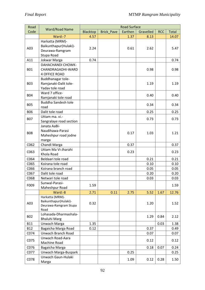
Final Report MTMP Ramgram Municipality
92
Road Code
Ward/Road Name Road Surface
Blacktop Brick_Pave Earthen Gravelled RCC Total
Ward:-7 4.57 1.37 8.13 14.07
A03
Harkatta (MRM)-Baikunthapur(Hulaki)-Deurawa-Ramgram Stupa Road
2.24 0.61 2.62 5.47
A11 Jokwar Marga 0.74 0.74
B01 DAHACHANDI CHOWK-CHANDRAGADHI-WARD 4 OFFICE ROAD
0.98 0.98
B03 Buddhanagar tole-Ramjanaki-Dalit tole-Yadav tole road
1.19 1.19
B04 Ward 7 office-Ramjanaki tole road
0.40 0.40
B05 Buddha Sandesh tole road
0.34 0.34
B06 Dalit tole road 0.25 0.25
B07 Uttam ma. vi.- Sangralaye road section
0.73 0.73
B08
Janata AaBi-Naudihawa-Parasi Maheshpur road jodne marga
0.17 1.03 1.21
C062 Chandi Marga 0.37 0.37
C063 Uttam Ma Vi-Jharahi Khola Road
0.23 0.23
C064 Beldaari tole road 0.21 0.21
C065 Koirana tole road 0.10 0.10
C066 Koirana branch road 0.05 0.05
C067 Dalit tole road 0.20 0.20
C068 Netwari tole road 0.03 0.03
F009 Sunwal-Parasi-Maheshpur Road
1.59 1.59
Ward:-8 2.71 0.11 2.75 5.52 1.67 12.76
A03
Harkatta (MRM)-Baikunthapur(Hulaki)-Deurawa-Ramgram Stupa Road
0.32 1.20 1.52
B02 Lohasada-Dharmashala-Bhaluhi Marg
1.29 0.84 2.12
B11 Unwach Marga 1.35 0.03 1.38
B12 Bagaicha Marga Road 0.12 0.37 0.49
C074 Unwach Branch Road 0.07 0.07
C075 Unwach Road-Aara Machine Road
0.12 0.12
C076 Bagaicha Marga 0.18 0.07 0.24
C077 Unwach Marga-Buspark 0.25 0.25
C078 Unwach Gaun-Hulaki Marga
1.09 0.12 0.28 1.50
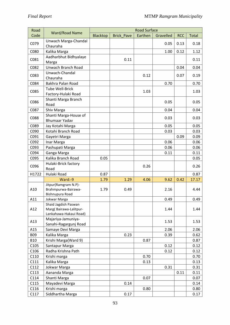
Final Report MTMP Ramgram Municipality
93
Road Code
Ward/Road Name Road Surface
Blacktop Brick_Pave Earthen Gravelled RCC Total
C079 Unwach Marga-Chandal Chauraha
0.05 0.13 0.18
C080 Kalika Marga 1.00 0.12 1.12
C081 Aadharbhut Bidhyalaye Marga
0.11 0.11
C082 Unwach Branch Road 0.04 0.04
C083 Unwach-Chandal Chauraha
0.12 0.07 0.19
C084 Bakhra Palan Road 0.70 0.70
C085 Tube Well-Brick Factory-Hulaki Road
1.03 1.03
C086 Shanti Marga Branch Road
0.05 0.05
C087 Shiv Marga 0.04 0.04
C088 Shanti Marga-House of Bhumaar Yadav
0.03 0.03
C089 Jay Kotahi Marga 0.05 0.05
C090 Kotahi Branch Road 0.03 0.03
C091 Gayetri Marga 0.09 0.09
C092 Inar Marga 0.06 0.06
C093 Pashupati Marga 0.06 0.06
C094 Ganga Marga 0.11 0.11
C095 Kalika Branch Road 0.05 0.05
C096 Hulaki-Brick factory Road
0.26 0.26
H1722 Hulaki Road 0.87 0.87
Ward:-9 1.79 1.29 4.06 9.62 0.42 17.17
A10 Jitpur(Ramgram N.P)-Brahmpurwa-Bairawa-Bishnupura Road
1.79 0.49 2.16 4.44
A11 Jokwar Marga 0.49 0.49
A12 Shaid Jagdish Paswan Marg( Bairawa-Lalitpur-Lankahawa-Hakaui Road)
1.44 1.44
A13 Majariya-Jamuniya-Sanahi-Ragargunj Road
1.53 1.53
A15 Samaye Devi Marga 2.06 2.06
B09 Kalika Marga 0.23 0.39 0.62
B10 Krishi Marga(Ward 9) 0.87 0.87
C105 Santapur Marga 0.12 0.12
C106 Radha Krishna Path 0.12 0.12
C110 Krishi marga 0.70 0.70
C111 Kalika Marga 0.13 0.13
C112 Jokwar Marga 0.31 0.31
C113 Aananda Marga 0.11 0.11
C114 Shanti Marga 0.07 0.07
C115 Mayadevi Marga 0.14 0.14
C116 Krishi marga 0.80 0.80
C117 Siddhartha Marga 0.17 0.17
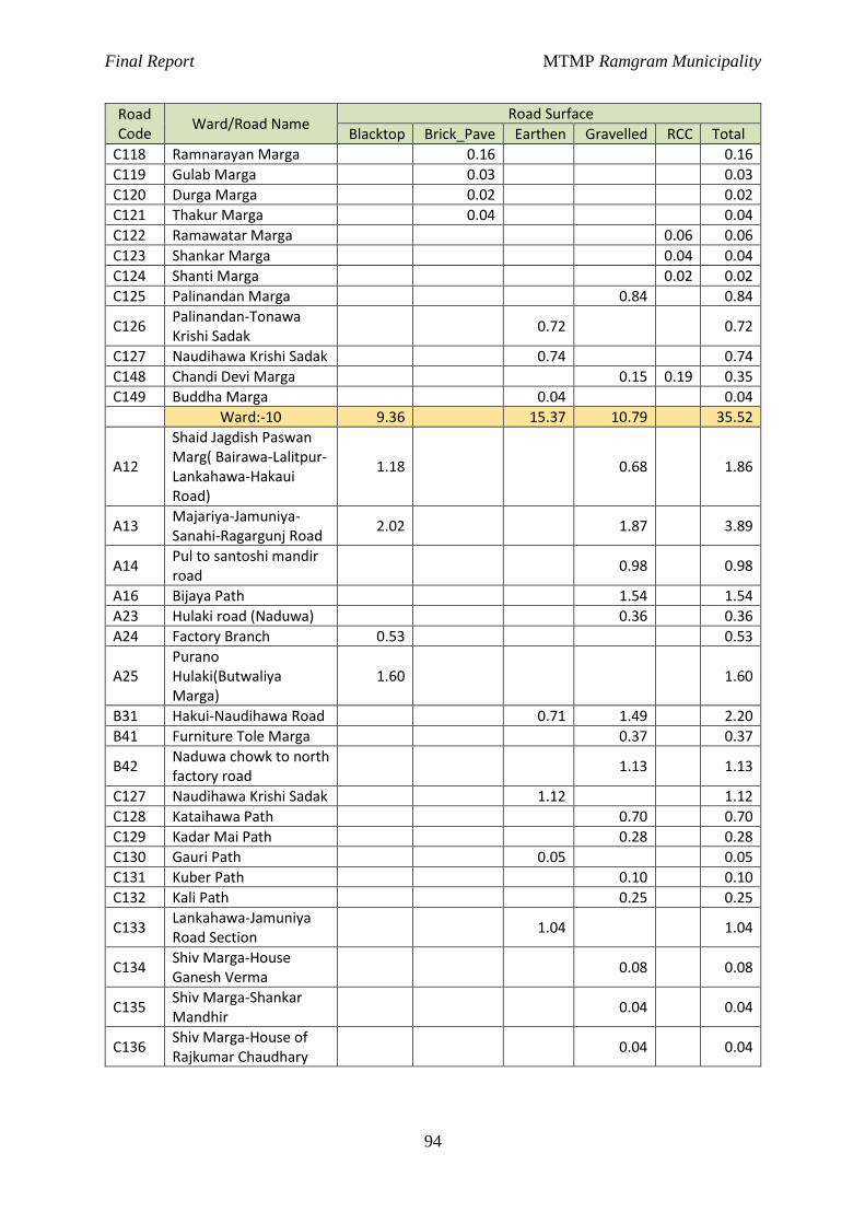
Final Report MTMP Ramgram Municipality
94
Road Code
Ward/Road Name Road Surface
Blacktop Brick_Pave Earthen Gravelled RCC Total
C118 Ramnarayan Marga 0.16 0.16
C119 Gulab Marga 0.03 0.03
C120 Durga Marga 0.02 0.02
C121 Thakur Marga 0.04 0.04
C122 Ramawatar Marga 0.06 0.06
C123 Shankar Marga 0.04 0.04
C124 Shanti Marga 0.02 0.02
C125 Palinandan Marga 0.84 0.84
C126 Palinandan-Tonawa Krishi Sadak
0.72 0.72
C127 Naudihawa Krishi Sadak 0.74 0.74
C148 Chandi Devi Marga 0.15 0.19 0.35
C149 Buddha Marga 0.04 0.04
Ward:-10 9.36 15.37 10.79 35.52
A12
Shaid Jagdish Paswan Marg( Bairawa-Lalitpur-Lankahawa-Hakaui Road)
1.18 0.68 1.86
A13 Majariya-Jamuniya-Sanahi-Ragargunj Road
2.02 1.87 3.89
A14 Pul to santoshi mandir road
0.98 0.98
A16 Bijaya Path 1.54 1.54
A23 Hulaki road (Naduwa) 0.36 0.36
A24 Factory Branch 0.53 0.53
A25 Purano Hulaki(Butwaliya Marga)
1.60 1.60
B31 Hakui-Naudihawa Road 0.71 1.49 2.20
B41 Furniture Tole Marga 0.37 0.37
B42 Naduwa chowk to north factory road
1.13 1.13
C127 Naudihawa Krishi Sadak 1.12 1.12
C128 Kataihawa Path 0.70 0.70
C129 Kadar Mai Path 0.28 0.28
C130 Gauri Path 0.05 0.05
C131 Kuber Path 0.10 0.10
C132 Kali Path 0.25 0.25
C133 Lankahawa-Jamuniya Road Section
1.04 1.04
C134 Shiv Marga-House Ganesh Verma
0.08 0.08
C135 Shiv Marga-Shankar Mandhir
0.04 0.04
C136 Shiv Marga-House of Rajkumar Chaudhary
0.04 0.04
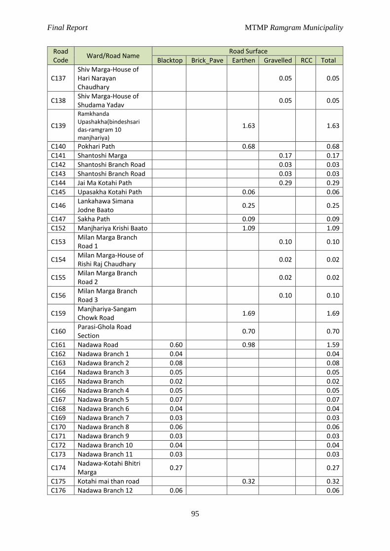
Final Report MTMP Ramgram Municipality
95
Road Code
Ward/Road Name Road Surface
Blacktop Brick_Pave Earthen Gravelled RCC Total
C137 Shiv Marga-House of Hari Narayan Chaudhary
0.05 0.05
C138 Shiv Marga-House of Shudama Yadav
0.05 0.05
C139
Ramkhanda Upashakha(bindeshsari das-ramgram 10 manjhariya)
1.63 1.63
C140 Pokhari Path 0.68 0.68
C141 Shantoshi Marga 0.17 0.17
C142 Shantoshi Branch Road 0.03 0.03
C143 Shantoshi Branch Road 0.03 0.03
C144 Jai Ma Kotahi Path 0.29 0.29
C145 Upasakha Kotahi Path 0.06 0.06
C146 Lankahawa Simana Jodne Baato
0.25 0.25
C147 Sakha Path 0.09 0.09
C152 Manjhariya Krishi Baato 1.09 1.09
C153 Milan Marga Branch Road 1
0.10 0.10
C154 Milan Marga-House of Rishi Raj Chaudhary
0.02 0.02
C155 Milan Marga Branch Road 2
0.02 0.02
C156 Milan Marga Branch Road 3
0.10 0.10
C159 Manjhariya-Sangam Chowk Road
1.69 1.69
C160 Parasi-Ghola Road Section
0.70 0.70
C161 Nadawa Road 0.60 0.98 1.59
C162 Nadawa Branch 1 0.04 0.04
C163 Nadawa Branch 2 0.08 0.08
C164 Nadawa Branch 3 0.05 0.05
C165 Nadawa Branch 0.02 0.02
C166 Nadawa Branch 4 0.05 0.05
C167 Nadawa Branch 5 0.07 0.07
C168 Nadawa Branch 6 0.04 0.04
C169 Nadawa Branch 7 0.03 0.03
C170 Nadawa Branch 8 0.06 0.06
C171 Nadawa Branch 9 0.03 0.03
C172 Nadawa Branch 10 0.04 0.04
C173 Nadawa Branch 11 0.03 0.03
C174 Nadawa-Kotahi Bhitri Marga
0.27 0.27
C175 Kotahi mai than road 0.32 0.32
C176 Nadawa Branch 12 0.06 0.06
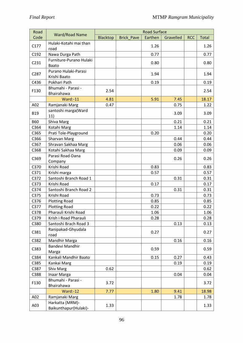
Final Report MTMP Ramgram Municipality
96
Road Code
Ward/Road Name Road Surface
Blacktop Brick_Pave Earthen Gravelled RCC Total
C177 Hulaki-Kotahi mai than road
1.26 1.26
C192 Nawa Durga Path 0.77 0.77
C231 Furniture-Purano Hulaki Baato
0.80 0.80
C287 Purano Hulaki-Parasi Krishi Baato
1.94 1.94
C436 Pokhari Path 0.19 0.19
F130 Bhumahi - Parasi - Bhairahawa
2.54 2.54
Ward:-11 4.81 5.91 7.45 18.17
A02 Ramjanaki Marg 0.47 0.75 1.22
B19 santoshi marga(Ward 11)
3.09 3.09
B60 Shiva Marg 0.21 0.21
C364 Kotahi Marg 1.14 1.14
C365 Prati Tole-Playground 0.20 0.20
C366 Sharvan Marg 0.44 0.44
C367 Shravan Sakhaa Marg 0.06 0.06
C368 Kotahi Sakhaa Marg 0.09 0.09
C369 Parasi Road-Dana Company
0.26 0.26
C370 Krishi Road 0.83 0.83
C371 Krishi marga 0.57 0.57
C372 Santoshi Branch Road 1 0.31 0.31
C373 Krishi Road 0.17 0.17
C374 Santoshi Branch Road 2 0.31 0.31
C375 Krishi Road 0.73 0.73
C376 Plotting Road 0.85 0.85
C377 Plotting Road 0.22 0.22
C378 Pharauli Krishi Road 1.06 1.06
C379 Krish i Road Pharauli 0.28 0.28
C380 Santoshi Brach Road 3 0.13 0.13
C381 Ranipakad-Ghyudala road
0.27 0.27
C382 Mandhir Marga 0.16 0.16
C383 Bandevi Mandhir Marga
0.59 0.59
C384 Kankali Mandhir Baato 0.15 0.27 0.43
C385 Kankai Marg 0.19 0.19
C387 Shiv Marg 0.62 0.62
C388 Inaar Marga 0.04 0.04
F130 Bhumahi - Parasi - Bhairahawa
3.72 3.72
Ward:-12 7.77 1.80 9.41 18.98
A02 Ramjanaki Marg 1.78 1.78
A03 Harkatta (MRM)-Baikunthapur(Hulaki)-
1.33 1.33
Final Report MTMP Ramgram Municipality
97
Road Code
Ward/Road Name Road Surface
Blacktop Brick_Pave Earthen Gravelled RCC Total
Deurawa-Ramgram Stupa Road
A04 Bikunthapur-Milanchowk to east Road
1.37 1.37
A05 Charandas Baba Marga 0.54 0.54
B13 Milanchowk-Janata Pravi-Saratikar road
0.12 0.58 0.70
B15 Ram Marga 0.80 0.80
B16 Buddha Marga(Karagar to Janata Pra vi)
1.33 1.33
C405 Kotahi Marg 1.12 1.12
C406 Parasi Road-Kotahi Marga
0.11 0.11
C407 Karagar Road 0.17 0.17
C408 Kotahi Marg 2 0.75 0.75
C409 Kotahi Shakha Marga 0.15 0.15
C410 Kotahi Shakha Marga-1 0.10 0.10
C411 Kotahi Shakha Marga-2 0.10 0.10
C413 Kasiya Marga 1.14 1.14
C414 Shanti Marg 0.37 0.37
C415 Nagarpalika Road Section
0.06 0.06
C416 Kotahi Marg 0.04 0.04
C424 Bhaluhi Marga 1.48 1.48
C425 Shree Janata Marg 0.19 0.19
C426 Chaudhary Marg 0.07 0.07
C427 Gayatri Marg 0.46 0.46
C428 Gayatri Shakha Marga 0.11 0.11
C429 Gayatri Shakha Marga 0.12 0.12
C430 Dalit Marga 0.22 0.22
C433 Gayatri Marg-1 0.15 0.15
C434 Krishi Marg 0.10 0.10
F130 Bhumahi - Parasi - Bhairahawa
1.81 1.81
H1722 Hulaki Road 2.32 2.32
Ward:-13 2.67 1.81 3.17 7.66
A02 Ramjanaki Marg 0.46 1.77 2.23
A03
Harkatta (MRM)-Baikunthapur(Hulaki)-Deurawa-Ramgram Stupa Road
1.49 1.49
B13 Milanchowk-Janata Pravi-Saratikar road
1.46 1.46
B17 Shiva Marg 0.60 0.16 0.75
B18 Padatikar Jholunge pul road
0.48 0.48
Final Report MTMP Ramgram Municipality
98
Road Code
Ward/Road Name Road Surface
Blacktop Brick_Pave Earthen Gravelled RCC Total
C417 Ramjanaki Marga-Mahamaya Marga
0.13 0.13
C418 Kailashpati Road Section
0.28 0.28
C419 Dalit Marg 0.13 0.13
C420 Shiva Marg 0.12 0.04 0.16
C421 Shiva Marga Branch Road 1
0.06 0.06
C422 Shiva Marga Branch Road 2
0.01 0.01
C423 Shiva Marga Branch Road 3
0.03 0.03
C432 Padatikar Tole Road 0.12 0.12
C435 Padatikar Krisha Marga 0.32 0.32
Ward:-14 2.68 7.04 23.18 0.66 33.57
A18
Sunwal-Parsawal-Amraut-Banjaria-Ghina-Bakena-Lalpati-Tonwa Road
1.74 2.92 4.65
A26
Pokharapali(Ramgram N.P)-Banjariya-Dharampur-Bairagnath Road
1.19 1.19
A27 Aananda Marga 0.30 1.81 2.11
B44 Kali Marga 0.31 0.23 0.54
B45 Loktantrik Chowk-Omshanti chowk-Jaurahari chowk-Nanai road
0.95 0.95
B46 Nanai-Pathardewa-Bhusanpur Road
1.48 0.43 1.92
B47 Janata Aabi jane road 0.61 0.61
B48 Ahirauli Marga 0.36 0.36
B49 Mahila Pokhari-Janata AABI-Hadaiya Mai road
2.87 2.87
B50 Bramha marga 1.22 1.22
B51 Krishi Marga ward 14 0.70 0.70
B52 Shanti Dip Marga 1.02 0.49 1.51
B58 Hadaiya Mai Marga 0.77 0.77
B59 Hille Marga 1.17 1.17
C243 Shanti Marg 0.62 0.62
C245 Deep marga 0.81 0.78 1.59
C246 Shanti Marga 0.13 0.13
C247 Itta Bhatta Marga 0.54 0.54
C248 Nawa durga marga 0.67 0.67
C249 Buddha Marga 0.08 0.08
C250 Bhar Marga 0.27 0.27
C251 Shankar Marga 0.19 0.19
C252 Sichai Marga 0.26 0.26
C253 Jhulunge Pul Marga 0.12 0.12
Final Report MTMP Ramgram Municipality
99
Road Code
Ward/Road Name Road Surface
Blacktop Brick_Pave Earthen Gravelled RCC Total
C254 Utarayan Marga 0.65 0.65
C255 Krishna Marga 0.04 0.04
C256 Laxmi Marga 0.07 0.07
C257 Shanti Marga 0.14 0.14
C258 Mishrit Marga 0.07 0.07
C259 Pashu Bigyan Marga 0.24 0.24
C260 Pragati Marga 0.05 0.05
C261 Lok Marga 0.09 0.09
C262 Krishi marga 0.15 0.15
C263 Malang Baba Marga 0.44 0.44
C264 Banhu Marga 0.06 0.06
C275 Siddhartha Marga 2.26 2.26
C276 Chautari Marga 0.08 0.08
C277 Chargharaiya Marga 0.05 0.05
C278 Inaar Marga 0.03 0.03
C279 Mandhir Marga 0.03 0.03
C280 Pashupati Marga 0.03 0.03
C281 Pragati Marga 0.46 0.46
C282 Kotahi Marga 0.25 0.25
C283 Naudihawa Marga 0.51 0.51
C284 Pragati Marga 0.21 0.21
C285 Samaye Mai Marga 0.84 0.84
C286 Kalika Marga 0.17 0.17
C440 Om Shanti Marga 0.02 0.02
C442 LINE 5(SIDDHARTHA MARGA) 0.27 0.27
C443 LINE 4(KRISHI SADAK MARGA)
0.38 0.38
C444 LINE 3(PURWATARA MARGA) 0.39 0.39
C445 LINE -2(HOLICHILD MARGA) 0.59 0.59
Ward:-15 5.25 11.36 6.79 23.40
A18
Sunwal-Parsawal-Amraut-Banjaria-Ghina-Bakena-Lalpati-Tonwa Road
1.13 1.13
A22 Shikshya Path 1.13 1.13
A25 Purano Hulaki(Butwaliya Marga)
1.65 0.45 2.10
A26
Pokharapali(Ramgram N.P)-Banjariya-Dharampur-Bairagnath Road
1.95 1.95
B35 Sukrauli Nahar Krishi Sadak
0.47 0.47
B36 Krishi marga 0.30 0.30
B40 Turiya Marga(Sukrauli chowk to Digwal chowk)
1.50 1.44 2.94
B41 Furniture Tole Marga 0.61 0.61
Final Report MTMP Ramgram Municipality
100
Road Code
Ward/Road Name Road Surface
Blacktop Brick_Pave Earthen Gravelled RCC Total
B43 Karwala Path 0.13 0.11 0.24
B45
Loktantrik Chowk-Omshanti chowk-Jaurahari chowk-Nanai road
0.92 0.92
B46 Nanai-Pathardewa-Bhusanpur Road
0.80 0.80
C178 Krishi marga 0.63 0.63
C179 Pokhari Marga 0.59 0.59
C220 Krishi marga 1.61 1.61
C221 Chautari Marg 0.27 0.27
C222 Kalika Marg 0.04 0.04
C223 Shanti Marga 0.05 0.05
C224 Shivaji Marga 0.04 0.04
C225 Krishi marga 0.13 0.13
C226 Krishi marga 0.62 0.62
C227 Krishi marga 1.13 1.13
C228 Ramjanaki Path 0.89 0.89
C229 Daharchandi Path 0.58 0.58
C230 Turiya Krishi Marga 0.55 0.55
C231 Furniture-Purano Hulaki Baato
0.50 0.50
C232 Furniture Factory Marga
0.29 0.29
C233 Sukrauli Tole Road 0.20 0.20
C234 Radha Krishna Path 0.19 0.19
C271 Pokhari Marga 0.10 0.10
C272 Madarsa Path 0.08 0.08
C273 Turiya Khola Marga 0.51 0.51
C274 Nanai Marga 0.19 0.19
F130 Bhumahi - Parasi - Bhairahawa
1.60 1.60
Ward:-16 6.82 8.86 17.42 33.10
A12
Shaid Jagdish Paswan Marg( Bairawa-Lalitpur-Lankahawa-Hakaui Road)
2.14 2.14
A16 Bijaya Path 0.57 1.34 1.91
A17 Nandan Marga 1.63 0.92 2.55
A18 Sunwal-Parsawal-Amraut-Banjaria-Ghina-Bakena-Lalpati-Tonwa Road
5.89 5.89
A19 Tonawa chowk to south road
1.57 1.57
A20 Kalika Path(Lalpati to Turiya khola)
1.09 1.09
A21 Lalpati-Turiya Khola Marga
0.49 0.74 1.23
A22 Shikshya Path 0.83 0.27 1.10
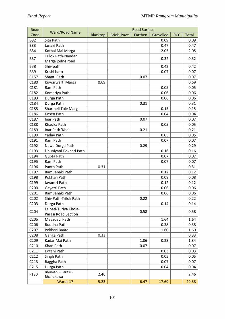
Final Report MTMP Ramgram Municipality
101
Road Code
Ward/Road Name Road Surface
Blacktop Brick_Pave Earthen Gravelled RCC Total
B32 Sita Path 0.09 0.09
B33 Janaki Path 0.47 0.47
B34 Kothai Mai Marga 2.05 2.05
B37 Trilok Path-Nandan Marga jodne road
0.32 0.32
B38 Shiv path 0.42 0.42
B39 Krishi bato 0.07 0.07
C157 Shanti Path 0.07 0.07
C180 Kuwarwarti Marga 0.69 0.69
C181 Ram Path 0.05 0.05
C182 Komariya Path 0.06 0.06
C183 Durga Path 0.06 0.06
C184 Durga Path 0.31 0.31
C185 Sharmeli Tole Marg 0.15 0.15
C186 Kosen Path 0.04 0.04
C187 Inar Path 0.07 0.07
C188 Khadka Path 0.05 0.05
C189 Inar Path 'Kha' 0.21 0.21
C190 Yadav Path 0.05 0.05
C191 Ram Path 0.07 0.07
C192 Nawa Durga Path 0.29 0.29
C193 Dhuniyani-Pokhari Path 0.16 0.16
C194 Gupta Path 0.07 0.07
C195 Ram Path 0.07 0.07
C196 Panth Path 0.31 0.31
C197 Ram Janaki Path 0.12 0.12
C198 Pokhari Path 0.08 0.08
C199 Jayantri Path 0.12 0.12
C200 Gayetri Path 0.06 0.06
C201 Ram Janaki Path 0.06 0.06
C202 Shiv Path-Trilok Path 0.22 0.22
C203 Durga Path 0.14 0.14
C204 Lalpati-Turiya Khola-Parasi Road Section
0.58 0.58
C205 Mayadevi Path 1.64 1.64
C206 Buddha Path 0.38 0.38
C207 Pokhari Baato 1.60 1.60
C208 Ganga Path 0.33 0.33
C209 Kadar Mai Path 1.06 0.28 1.34
C210 Khan Path 0.07 0.07
C211 Kotahi Path 0.03 0.03
C212 Singh Path 0.05 0.05
C213 Baggha Path 0.07 0.07
C215 Durga Path 0.04 0.04
F130 Bhumahi - Parasi - Bhairahawa
2.46 2.46
Ward:-17 5.23 6.47 17.69 29.38
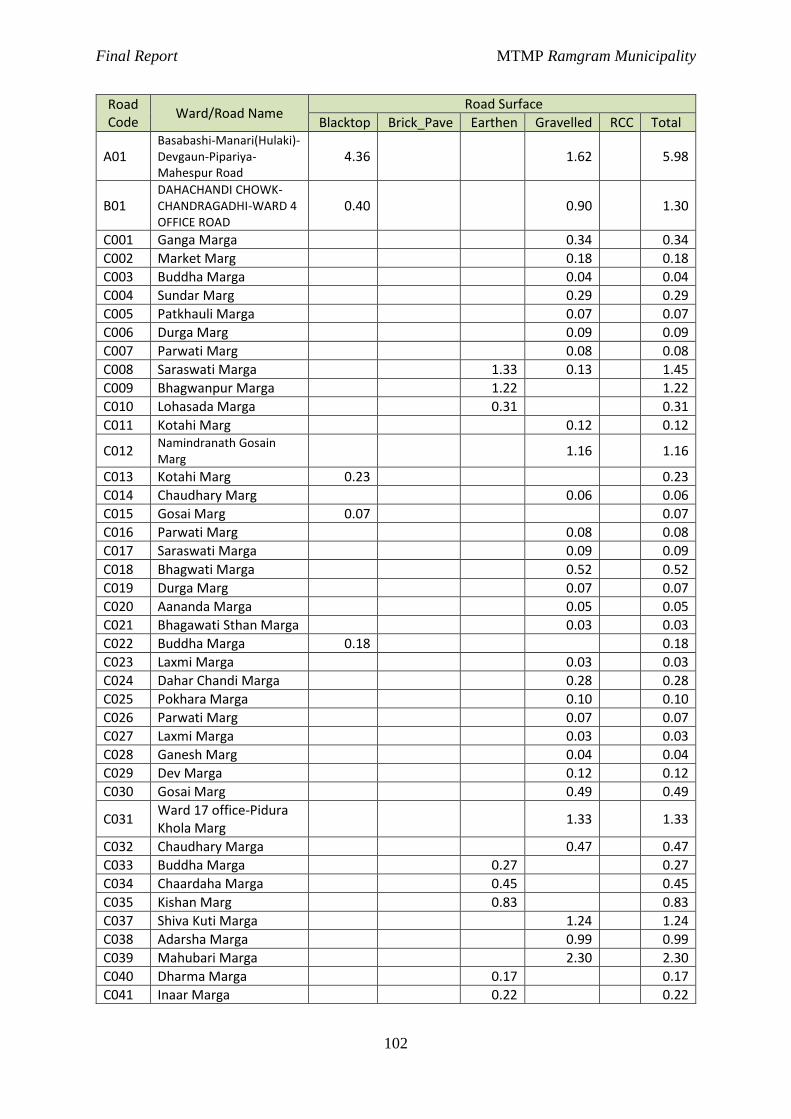
Final Report MTMP Ramgram Municipality
102
Road Code
Ward/Road Name Road Surface
Blacktop Brick_Pave Earthen Gravelled RCC Total
A01 Basabashi-Manari(Hulaki)-Devgaun-Pipariya-Mahespur Road
4.36 1.62 5.98
B01 DAHACHANDI CHOWK-CHANDRAGADHI-WARD 4 OFFICE ROAD
0.40 0.90 1.30
C001 Ganga Marga 0.34 0.34
C002 Market Marg 0.18 0.18
C003 Buddha Marga 0.04 0.04
C004 Sundar Marg 0.29 0.29
C005 Patkhauli Marga 0.07 0.07
C006 Durga Marg 0.09 0.09
C007 Parwati Marg 0.08 0.08
C008 Saraswati Marga 1.33 0.13 1.45
C009 Bhagwanpur Marga 1.22 1.22
C010 Lohasada Marga 0.31 0.31
C011 Kotahi Marg 0.12 0.12
C012 Namindranath Gosain Marg
1.16 1.16
C013 Kotahi Marg 0.23 0.23
C014 Chaudhary Marg 0.06 0.06
C015 Gosai Marg 0.07 0.07
C016 Parwati Marg 0.08 0.08
C017 Saraswati Marga 0.09 0.09
C018 Bhagwati Marga 0.52 0.52
C019 Durga Marg 0.07 0.07
C020 Aananda Marga 0.05 0.05
C021 Bhagawati Sthan Marga 0.03 0.03
C022 Buddha Marga 0.18 0.18
C023 Laxmi Marga 0.03 0.03
C024 Dahar Chandi Marga 0.28 0.28
C025 Pokhara Marga 0.10 0.10
C026 Parwati Marg 0.07 0.07
C027 Laxmi Marga 0.03 0.03
C028 Ganesh Marg 0.04 0.04
C029 Dev Marga 0.12 0.12
C030 Gosai Marg 0.49 0.49
C031 Ward 17 office-Pidura Khola Marg
1.33 1.33
C032 Chaudhary Marga 0.47 0.47
C033 Buddha Marga 0.27 0.27
C034 Chaardaha Marga 0.45 0.45
C035 Kishan Marg 0.83 0.83
C037 Shiva Kuti Marga 1.24 1.24
C038 Adarsha Marga 0.99 0.99
C039 Mahubari Marga 2.30 2.30
C040 Dharma Marga 0.17 0.17
C041 Inaar Marga 0.22 0.22
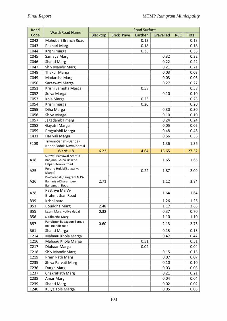
Final Report MTMP Ramgram Municipality
103
Road Code
Ward/Road Name Road Surface
Blacktop Brick_Pave Earthen Gravelled RCC Total
C042 Mahubari Branch Road 0.13 0.13
C043 Pokhari Marg 0.18 0.18
C044 Krishi marga 0.35 0.35
C045 Samaya Marg 0.32 0.32
C046 Shanti Marg 0.22 0.22
C047 Shiv Mandir Marg 0.21 0.21
C048 Thakur Marga 0.03 0.03
C049 Madarsha Marg 0.03 0.03
C050 Saraswati Marga 0.27 0.27
C051 Krishi Samuha Marga 0.58 0.58
C052 Soiya Marga 0.10 0.10
C053 Kola Marga 0.23 0.23
C054 Krishi marga 0.20 0.20
C055 Diha Marga 0.30 0.30
C056 Shiva Marga 0.10 0.10
C057 Jagadamba marg 0.24 0.24
C058 Gayatri Marga 0.05 0.05
C059 Pragatishil Marga 0.48 0.48
C431 Hariyali Marga 0.56 0.56
F208 Triveni-Sanahi-Gandak Nahar Sadak-Nawalparasi
1.36 1.36
Ward:-18 6.23 4.64 16.65 27.52
A18 Sunwal-Parsawal-Amraut-Banjaria-Ghina-Bakena-Lalpati-Tonwa Road
1.65 1.65
A25 Purano Hulaki(Butwaliya Marga)
0.22 1.87 2.09
A26 Pokharapali(Ramgram N.P)-Banjariya-Dharampur-Bairagnath Road
2.71 1.12 3.84
A28 Rastriye Ma Vi-Brahmathan Road
1.64 1.64
B39 Krishi bato 1.26 1.26
B53 Bouddha Marg 2.48 1.17 3.65
B55 Laxmi Marg(Kotiya dada) 0.32 0.37 0.70
B56 Siddhartha Marg 1.10 1.10
B57 Panditpur-Badagaun-Samay mai mandir road
0.60 2.13 2.73
B61 Shanti Marga 0.15 0.15
C214 Mahaau Khola Marga 0.47 0.47
C216 Mahaau Khola Marga 0.51 0.51
C217 Diuhaar Marga 0.04 0.04
C218 Shiv Mandir Marg 0.15 0.15
C219 Prem Path Marg 0.07 0.07
C235 Shiva Parvati Marg 0.10 0.10
C236 Durga Marg 0.03 0.03
C237 ChakraPath Marg 0.21 0.21
C238 Amar Marg 0.04 0.04
C239 Shanti Marg 0.02 0.02
C240 Kuiya Tole Marga 0.05 0.05
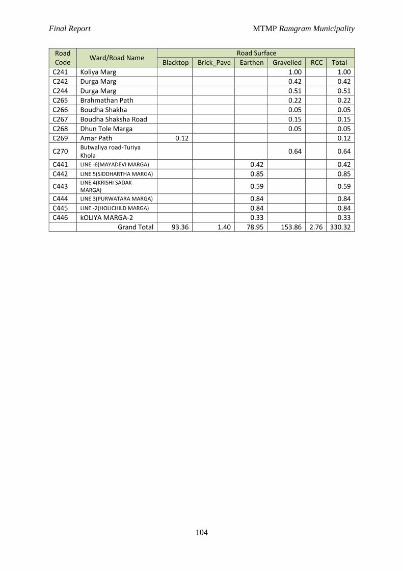
Final Report MTMP Ramgram Municipality
104
Road Code
Ward/Road Name Road Surface
Blacktop Brick_Pave Earthen Gravelled RCC Total
C241 Koliya Marg 1.00 1.00
C242 Durga Marg 0.42 0.42
C244 Durga Marg 0.51 0.51
C265 Brahmathan Path 0.22 0.22
C266 Boudha Shakha 0.05 0.05
C267 Boudha Shaksha Road 0.15 0.15
C268 Dhun Tole Marga 0.05 0.05
C269 Amar Path 0.12 0.12
C270 Butwaliya road-Turiya Khola
0.64 0.64
C441 LINE -6(MAYADEVI MARGA) 0.42 0.42
C442 LINE 5(SIDDHARTHA MARGA) 0.85 0.85
C443 LINE 4(KRISHI SADAK MARGA)
0.59 0.59
C444 LINE 3(PURWATARA MARGA) 0.84 0.84
C445 LINE -2(HOLICHILD MARGA) 0.84 0.84
C446 kOLIYA MARGA-2 0.33 0.33
Grand Total 93.36 1.40 78.95 153.86 2.76 330.32