I | Page Doctorate in Educational Psychology Professional ... - -ORCA
Upload
khangminh22Category
view
1download
0
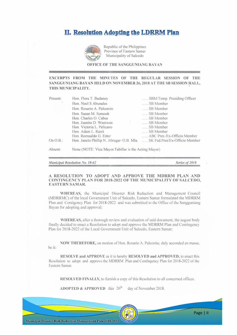
Page | I
Page | II
Page | III
Page | IV
Page | V
1. Republic Act 10121 otherwise known as the Philippine Disaster Risk Reduction
Act of 2021 provides that it shall be the policy of the State to uphold the people’s
constitutional rights to life and property by addressing the root causes of
vulnerabilities to disasters, strengthening the country’s institutional capacity for
disaster risk reduction and management and building the resilience of local
communities to disaster including climate change.
The law likewise mandates the LGUs in partnership with stakeholders to
prepare and implement a Disaster Risk Reduction and Management Plan that is
holistic, comprehensive, integrated, responsive and proactive to enhance the
prevention, mitigation, preparedness, response, rehabilitation and recovery
capabilities.
2. Republic Act 9729 otherwise known as Climate Change Act of 2009 directs the
LGUs to mainstream Climate Change Adaptation and Mitigation in local plans. It
likewise mandates the preparation of Climate Change Action Plan to the impacts of
climate change.
3. The National Disaster Risk Reduction and Management Plan (NDRRMP) 2011 –
2028 outlines the activities aimed at strengthening the capacity of the national
government and the LGUs together with partner stakeholders, to build the disaster
resilience of communities and to institutionalize arrangements and measures for
reducing disaster risks, including projected climate risks.
4. NDRRMC-DBM-DILG Joint Memorandum Circular No. 2013-01 re: Utilization
of Local Disaster Risk Reduction and Management Fund (LDRRMF)
5. NDRRMC-DILG-DBM-CSC Joint Memorandum Circular No. 2014-01 dated
April 4, 2014 re: Implementing Guidelines for the Establishment of Local DDRM
Offices (LDRRMOs) or Barangay DRRM Committees BDRRMCs in Local
Government Units (LGUs)
6. Municipal Ordinance No.15-01 Series of 2015 Creating MDRRM Officer II,
Bearing Item 2015-02, Salary Grade 15, and Institutionalizing the MDRRM
Council of Salcedo, E. Samar
Page | VI
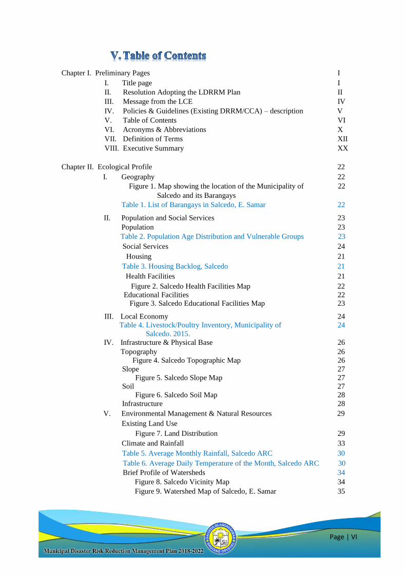
Chapter I. Preliminary Pages I
I. Title page I
II. Resolution Adopting the LDRRM Plan II
III. Message from the LCE IV
IV. Policies & Guidelines (Existing DRRM/CCA) – description V
V. Table of Contents VI
VI. Acronyms & Abbreviations X
VII. Definition of Terms XII
VIII. Executive Summary XX
Chapter II. Ecological Profile 22
I. Geography 22
Figure 1. Map showing the location of the Municipality of 22
Salcedo and its Barangays
Table 1. List of Barangays in Salcedo, E. Samar 22
II. Population and Social Services 23
Population 23
Table 2. Population Age Distribution and Vulnerable Groups 23
Social Services 24
Housing 21
Table 3. Housing Backlog, Salcedo 21
Health Facilities 21
Figure 2. Salcedo Health Facilities Map 22
Educational Facilities 22 Figure 3. Salcedo Educational Facilities Map 23
III. Local Economy 24
Table 4. Livestock/Poultry Inventory, Municipality of 24
Salcedo. 2015.
IV. Infrastructure & Physical Base 26
Topography 26
Figure 4. Salcedo Topographic Map 26
Slope 27
Figure 5. Salcedo Slope Map 27
Soil 27
Figure 6. Salcedo Soil Map 28
Infrastructure 28
V. Environmental Management & Natural Resources 29
Existing Land Use
Figure 7. Land Distribution 29
Climate and Rainfall 33
Table 5. Average Monthly Rainfall, Salcedo ARC 30
Table 6. Average Daily Temperature of the Month, Salcedo ARC 30
Brief Profile of Watersheds 34
Figure 8. Salcedo Vicinity Map 34
Figure 9. Watershed Map of Salcedo, E. Samar 35
Page | VII
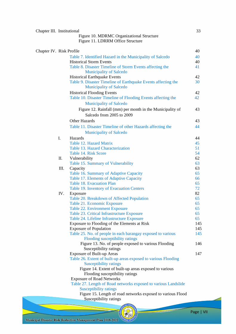
Chapter III. Institutional 33
Figure 10. MDRMC Organizational Structure
Figure 11. LDRRM Office Structure
Chapter IV. Risk Profile 40
Table 7. Identified Hazard in the Municipality of Salcedo 40
Historical Storm Events 40
Table 8. Disaster Timeline of Storm Events affecting the 41
Municipality of Salcedo
Historical Earthquake Events 42
Table 9. Disaster Timeline of Earthquake Events affecting the 30
Municipality of Salcedo
Historical Flooding Events 42
Table 10. Disaster Timeline of Flooding Events affecting the 42
Municipality of Salcedo
Figure 12. Rainfall (mm) per month in the Municipality of 43
Salcedo from 2005 to 2009
Other Hazards 43
Table 11. Disaster Timeline of other Hazards affecting the 44
Municipality of Salcedo
I. Hazards 44
Table 12. Hazard Matrix 45
Table 13. Hazard Characterization 51
Table 14. Risk Score 54
II. Vulnerability 62
Table 15. Summary of Vulnerability 63
III. Capacity 63
Table 16. Summary of Adaptive Capacity 65
Table 17. Elements of Adaptive Capacity 66
Table 18. Evacuation Plan 65
Table 19. Inventory of Evacuation Centers 72
IV. Exposure 82
Table 20. Breakdown of Affected Population 65
Table 21. Economic Exposure 65
Table 22. Environment Exposure 65
Table 23. Critical Infrastructure Exposure 65
Table 24. Lifeline Infrastructure Exposure 65
Exposure to Flooding of the Elements at Risk 145
Exposure of Population 145
Table 25. No. of people in each barangay exposed to various 145
Flooding susceptibility ratings
Figure 13. No. of people exposed to various Flooding 146
Susceptibility ratings
Exposure of Built-up Areas 147
Table 26. Extent of built-up areas exposed to various Flooding
Susceptibility ratings
Figure 14. Extent of built-up areas exposed to various
Flooding susceptibility ratings
Exposure of Road Networks
Table 27. Length of Road networks exposed to various Landslide
Susceptibility ratings
Figure 15. Length of road networks exposed to various Flood
Susceptibility ratings
Page | VIII
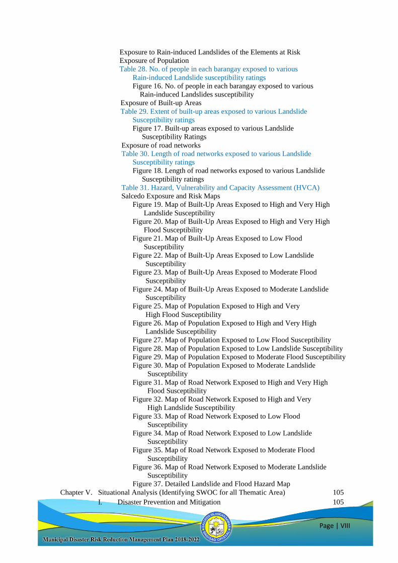
Exposure to Rain-induced Landslides of the Elements at Risk
Exposure of Population
Table 28. No. of people in each barangay exposed to various
Rain-induced Landslide susceptibility ratings
Figure 16. No. of people in each barangay exposed to various
Rain-induced Landslides susceptibility
Exposure of Built-up Areas
Table 29. Extent of built-up areas exposed to various Landslide
Susceptibility ratings
Figure 17. Built-up areas exposed to various Landslide
Susceptibility Ratings
Exposure of road networks
Table 30. Length of road networks exposed to various Landslide
Susceptibility ratings
Figure 18. Length of road networks exposed to various Landslide
Susceptibility ratings
Table 31. Hazard, Vulnerability and Capacity Assessment (HVCA)
Salcedo Exposure and Risk Maps
Figure 19. Map of Built-Up Areas Exposed to High and Very High
Landslide Susceptibility
Figure 20. Map of Built-Up Areas Exposed to High and Very High
Flood Susceptibility
Figure 21. Map of Built-Up Areas Exposed to Low Flood
Susceptibility
Figure 22. Map of Built-Up Areas Exposed to Low Landslide
Susceptibility
Figure 23. Map of Built-Up Areas Exposed to Moderate Flood
Susceptibility
Figure 24. Map of Built-Up Areas Exposed to Moderate Landslide
Susceptibility
Figure 25. Map of Population Exposed to High and Very
High Flood Susceptibility
Figure 26. Map of Population Exposed to High and Very High
Landslide Susceptibility
Figure 27. Map of Population Exposed to Low Flood Susceptibility
Figure 28. Map of Population Exposed to Low Landslide Susceptibility
Figure 29. Map of Population Exposed to Moderate Flood Susceptibility
Figure 30. Map of Population Exposed to Moderate Landslide
Susceptibility
Figure 31. Map of Road Network Exposed to High and Very High
Flood Susceptibility
Figure 32. Map of Road Network Exposed to High and Very
High Landslide Susceptibility
Figure 33. Map of Road Network Exposed to Low Flood
Susceptibility
Figure 34. Map of Road Network Exposed to Low Landslide
Susceptibility
Figure 35. Map of Road Network Exposed to Moderate Flood
Susceptibility
Figure 36. Map of Road Network Exposed to Moderate Landslide
Susceptibility
Figure 37. Detailed Landslide and Flood Hazard Map
Chapter V. Situational Analysis (Identifying SWOC for all Thematic Area) 105
I. Disaster Prevention and Mitigation 105
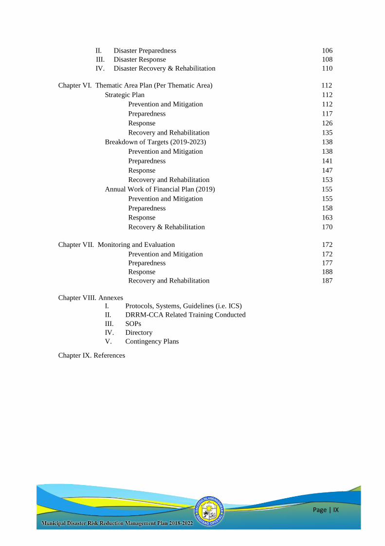
Page | IX
II. Disaster Preparedness 106
III. Disaster Response 108
IV. Disaster Recovery & Rehabilitation 110
Chapter VI. Thematic Area Plan (Per Thematic Area) 112
Strategic Plan 112
Prevention and Mitigation 112
Preparedness 117
Response 126
Recovery and Rehabilitation 135
Breakdown of Targets (2019-2023) 138
Prevention and Mitigation 138
Preparedness 141
Response 147
Recovery and Rehabilitation 153
Annual Work of Financial Plan (2019) 155
Prevention and Mitigation 155
Preparedness 158
Response 163
Recovery & Rehabilitation 170
Chapter VII. Monitoring and Evaluation 172
Prevention and Mitigation 172
Preparedness 177
Response 188
Recovery and Rehabilitation 187
Chapter VIII. Annexes
I. Protocols, Systems, Guidelines (i.e. ICS)
II. DRRM-CCA Related Training Conducted
III. SOPs
IV. Directory
V. Contingency Plans
Chapter IX. References
Page | X
ABC Association of Barangay Council
AMURT Ananda Marga Universal Relief Team
BBB Build Back Better
BDRRMC Barangay Disaster Risk Reduction and Management
Council
BFP Bureau of Fire Protection
CAPDEV Capacity Development
CBHVCA Community-Based Hazard Vulnerability and
Capacity Assessment
CCA Climate Change Adaptation
CP Contingency Plan
CRM Community Resource Management
CRS Catholic Relief Services
CSO Civil Society Organization
DANA Damage and Needs Assessment
DILG Department of Interior and Local Government
DOST Department of Science and Technology
DRRM Disaster Risk Reduction Management
ESSU Eastern Samar State University
EWS Early Warning System
HEMS Health Emergency Management Systems
HEPRRP Health Emergency Preparedness Response and
Recovery Plan
HFA Hyogo Framework for Action
HVCA Hazard Vulnerability and Capacity Assessment
ICRC International Committee of the Red Cross
IEC Information Education Communication IYCF Infant and Young Child Feeding
LCE Local Chief Executive
LEWS Local Early Warning System
LGU Local Government Unit
MASOF Matarinao School of Fisheries
MAO Municipal Agriculture Office/r
MDRRMC Municipal Disaster Risk Reduction and
Management Council
MDRRMO Municipal Disaster Risk Reduction and
Management Office/r
MDRRMP Municipal Disaster Risk Reduction and
Management Plan
MENRO Municipal Environment and Natural Resources
Office/r
MGB Mines and Geoscience Bureau
MHO Municipal Health Office/r
MPAs Marine Protected Areas
MHPSS Mental Health and Psychosocial Services
MSWDO Municipal Social Welfare and Development Office/r
Page | XI
NDCC National Disaster Coordinating Council
NDRRMC National Disaster Risk Reduction and Management
Council
NGO Non-Government Organization
OCD Office of Civil Defense
OMAS Office of the Municipal Agricultural Services
PCVA Participatory Capacity and Vulnerability
Assessment
PDRRMC Provincial Disaster Risk Reduction Management
Council
PHILVOLCS Philippine Institute of Volcanology and Seismology
PKKK Pambansang Koalisyon ng mga Kababaihan sa
Kanayunan
PO Private Organization
PEIS PHILVOLCS Earthquake Intensity Scale
RA Republic Act
RDANA Rapid Damage and Needs Assessment
SNHS Salcedo National High School
SOP Standard Operating Procedure
SRR Search Rescue and Retrieval
SVHS Salcedo Vocational High School
TLS Temporary Learning Shelter
TNHS Tagbacan National High School
UNDP United Nations Development Programme
UNICEF United Nation Children’s Emergency Fund
WASH Water Sanitation and Health|
WHO World Health Organization |
WMO World Meteorological Organization

Page | XII
Adaptation – the adjustment in natural human systems in response to actual or expected
climatic stimuli or their effects which moderates harm or exploits beneficial
opportunities.
Biological hazard - process or phenomenon of organic origin or conveyed by biological
vectors, including exposure to pathogenic micro-organisms, toxins and bioactive
substances that may cause loss of life, injury, illness or other health impacts, property
damage, loss of livelihoods and services, social and economic disruption, or
environmental damage.
Capacity – a combination of all strengths and resources available within a community,
society or organization that can reduce the level of risk or effects of a disaster. Capacity
may include infrastructure and physical means, institutions, societal coping abilities, as
well as human knowledge, skills and collective attributes such as social relationships,
leadership and management. Capacity may also be described as capability.
Capacity Development (CAPDEV) - the process by which people, organizations and
society systematically stimulate and develop their capacities over time to achieve social
and economic goals, including through improvement of knowledge, skills, systems, and
institutions.
Civil Defense – disaster preparedness and prevention activities, other than military
actions, geared towards the reduction of loss of life and property brought about by
natural and human-induced disasters. Civil Defense may also be referred to as Civil
Protection.
Civil Society Organizations (CSOs) - non-state actors whose aims are neither to
generate profits nor to seek governing power, CSO’s unite people to advance shared goals and interests. They have a presence in public life, expressing the interests and
values of their members or others, and are based on ethical, cultural, scientific, religious
or philanthropic considerations. CSO’s include nongovernment organizations NGO’s),
professional associations, foundations, independent research institutes, community-
based organizations (CBO’s), faith-based organizations, people’s organizations, social
movements, and labor unions
Climate Change – (a.)The Inter-governmental Panel on Climate Change (IPCC)
defines climate change as: “a change in the state of the climate that can be identified
(e.g., by using statistical tests) by changes in the mean and/or the variability of its
properties, and that persists for an extended period, typically decades or longer. Climate
change may be due to natural internal processes or external forcings, or to persistent
anthropogenic changes in the composition of the atmosphere or in land use”.
(b.) The United Nations Framework Convention on Climate Change (UNFCCC)
defines climate change as “a change of climate which is attributed directly or indirectly
to human activity that alters the composition of the global atmosphere and which is in
addition to natural climate variability observed over comparable time periods”.
Page | XIII
Community-Based Disaster Risk Reduction and Management (CDRRM) - a process
of disaster risk reduction and management in which at risk communities are actively
engaged in the identification, analysis, treatment, monitoring and evaluation of disaster
risks in order to reduce their vulnerabilities and enhance their capabilities, and where
the people are at the heart of decision-making and implementation of disaster risk
reductions and management activities.
Contingency Planning - a management process that analyzes specific potential events
or emerging situations that might threaten society or the environment and establishes
arrangements in advance to enable timely, effective and appropriate responses to such
events and situations.
Coping capacity - the ability of people, organizations and systems, using available
skills and resources, to face and manage adverse conditions, emergencies or disasters.
Critical facilities - the primary physical structures, technical facilities and systems
which are socially, economically or operationally essential to the functioning of a
society or community, both in routine circumstances and in the extreme circumstances
of an emergency.
Disaster - a serious disruption of the functioning of a community or a society involving
widespread human, material, economic or environmental losses and impacts, which
exceeds the ability of the affected community or society to cope using its own resources.
Disasters are often described as a result of the combination of the exposure to a hazard;
the condition of vulnerability that are present; and insufficient capacity or measures to
reduce or cope with the potential negative consequences. Disaster impacts may include
loss of life, injury, disease and other negative effects on human, physical and social
well-being, together with damage to property, destruction of assets, loss of services,
social and economic disruption and environmental degradation.
Disaster Mitigation –the lessening or limitation of the adverse impacts of hazards and
related disasters. Mitigation measures encompass engineering techniques and hazard-
resistant construction as well as improved environmental policies and public awareness.
Disaster Preparedness - the knowledge and capacities developed by governments,
professional response and recovery organizations, communities and individuals to
effectively anticipate, respond to and recover from, the impacts of likely, imminent or
current hazard events or conditions. Preparedness action is carried out within the
content of disaster risk reduction and management and aims to build the capacities
needed to efficiently manage all types of emergencies and achieve orderly transitions
from response to sustained recovery. Preparedness is based in a sound analysis of
disaster risk and gook linkages with early warning systems, and includes such activities
as contingency planning, stockpiling of equipment and supplies, the development of
arrangements for coordination, evacuation and public information, and associated
training and field exercises. These must be supported by formal institutional, legal and
budgetary capacities.
Disaster Prevention - the outright avoidance of adverse impacts of hazards and related
disasters. It expresses the concept and intention to complexly avoid potential adverse
impact through action taken in advance such as construction of dams or embankments
Page | XIV
that eliminate flood risks, land-use regulations that do not permit any settlement in high-
risk zones, and seismic engineering designs that ensure the survival and function of a
critical building in any likely earthquake.
Disaster Response - the provision of emergency services and public assistance during
or immediately after a disaster in order to save lives reduces health impacts, ensure
public safety and meet the subsistence needs of the people affected. Disaster response
is predominantly focused on immediate and short-term needs and is sometimes called
“disaster relief”.
Disaster Risk - the potential disaster losses in lives, health status, livelihood, assets and
services, which could occur to a particular community or a society over some specified
future time period.
Disaster Risk Reduction - the concept and practice reducing disaster risks through
systematic efforts to analyze and manage the casual factors of disasters, including
reduced exposures to hazards, lessened vulnerability of people and property, wise
management of land and the environment, and improved preparedness for adverse
events.
Disaster Risk Reduction and Management - the systematic process of using
administrative directives, organizations and operational skills and capacities to
implement strategies, policies and improved coping capacities in order to lessen the
adverse impacts of hazards and the possibility of disaster. Prospective disaster risk
reduction and management refers to risk reduction and management activities that
address and seek to avoid the development of new or increased disaster risks especially
if risk reduction policies are not put in place.
Disaster Risk Reduction and Management Information System - a specialized
database which contains among others, information on disaster and their human
material, economic and environmental impact, risk assessment and mapping vulnerable
groups.
Disaster Victims - persons or group of persons who have been adversely affected by a
natural or human-induced hazard who have to leave habitual places of residence due to
exiting or impending threats, damaged shelter units, with casualty among immediate
family members of those who remained in their habitual places of origin when still
habitable but whose main source of income or livelihood had been damaged and are
experiencing hopelessness and difficulty in coping to the onslaught of the hazardous
events on their own resources.
Early Recovery - multi-dimensional process of recovery that begins in a humanitarian
setting. It is guided by development principles that seek to build on humanitarian
programs and catalyze sustainable development opportunities. It aims to generate self-
sustaining, nationally-owned, resilient process for post-crisis recovery. It encompasses
the restoration of basic services, livelihoods, shelter, governance, security and rule of
law, environment and social dimensions, including reintegration of displaced
populations.
Page | XV
Early Warning System - the set of capacities needed to generate and disseminate timely
and meaningful warning information to enable individuals, communities and
organization threatened by a hazard to prepare and to act appropriately and in sufficient
time to reduce the possibility of harm or loss. A people-cantered early warning system
necessarily comprises four (4) key elements: knowledge of the risks; monitoring,
analysis and forecasting of the hazards; communication or dissemination of alerts and
warning; and local capabilities to respond to the warning received. The expression
“end-to-end warning system” is also used to emphasize that warning systems need to
span all steps from hazard detection to community response.
Emergency - unforeseen or sudden occurrence, especially danger, demanding
immediate action.
Emergency Management - the organization and management of resources and
responsibilities for addressing all aspects of emergencies in particular preparedness,
response and initial recovery steps.
Emergency services - the set of specialized agencies that have specific responsibilities
and objectives in serving and protecting people and property in emergency situations.
Environmental degradation - the reduction of the capacity of the environment to meet
social and ecological objectives and needs.
Exposure - the degree to which the elements at risk are likely to experience hazard
events of different magnitudes.
Environmental impact assessment - process by which the environmental consequences
of a proposed project or programme are evaluated, undertaken as an integral part of
planning and decision-making processes with a view to limiting or reducing the adverse
impacts of the project or programme.
Forecast - definite statement or statistical estimate of the likely occurrence of a future
event or conditions for a specific area.
Geological hazard - geological process or phenomenon that may cause loss of life,
injury or other health impacts, property damage, loss of livelihoods and services, social
and economic disruption, or environmental damage.
Geographic Information System - a database which contains among others, geo-hazard
assessments, information on climate change, and climate risk reduction and
management.
Hazard - a dangerous phenomenon, substance, human activity or condition that may
cause loss of life, injury or other health impacts, property damage, los of livelihood and
services, social and economic disruption or environmental damage.
Hydrometeorological hazard - process or phenomenon of atmospheric, hydrological or
oceanographic nature that may cause loss of life, injury or other health impacts,
property damage, loss of livelihoods and services, social and economic disruption, or
environmental damage.
Page | XVI
Internally Displace Persons (IDPs) or Persons Displaced by the Disaster - are persons
or groups of persons who have been forced or obliged to flee or to leave their homes or
places of habitual residence, in particular as a result of or in order to avoid the effects
of natural or human-induced disasters, and who have not crossed an internationally
recognized state border.
Land-Use Planning - the process undertaken by public authorities to identify, evaluate
and decide on different options for the use of land, including consideration of long-term
economic, social and environmental objections and the implications for different
communities and interest groups, and the subsequent formulation and promulgation of
plans that describe the permitted or acceptable uses.
Mitigation - structural and non-structural measures undertaken to limit the adverse
impact of natural hazards, environmental degradation, and technological hazards and
to ensure the ability of at-risk communities to address vulnerabilities aimed at
minimizing the impact of disasters. Such measures include, but are not limited to,
hazard-resistant construction and engineering works, the formulation and
implementation of plans, programs, projects and activities, awareness raising,
knowledge management, policies on land use planning, building and safety standards
and legislation
National Disaster Risk Reduction and Management Framework (NDRRMF) -
provides for comprehensive, all hazards, multi-sectoral, inter agency and community
based approached to disaster risk reduction and management.
National Disaster Risk Reduction and Management Plan (NDRRMP) - the document
to be formulated and implemented by the Office of the Civil Defense (OCD) that sets
out goals and specific objectives for reducing disaster risks together with related actions
to accomplish these objectives. The NDRRMP shall provide for the identification of
hazards, vulnerabilities and risks to be managed at the national level; disaster risk
reduction and management approaches and strategies to be applied in managing said
hazards and risks; agency roles; responsibilities and lines of authority at all government
levels; and vertical and horizontal coordination of disaster risk reduction and
management in the pre-disaster phases. It shall be in conformity with the NDRRMF.
Natural hazard - natural process or phenomenon that may cause loss of life, injury or
other health impacts, property damage, loss of livelihoods and services, social and
economic disruption, or environmental damage.
Post-disaster Recovery - the restoration and improvement where appropriate, of
facilities, livelihood and living conditions of disaster-affected communities, including
efforts to reduce disaster risk factors, in accordance with the principles of “build back
better”.
Preparedness - pre-disaster actions and measures being undertaken within the context
of disaster risk reduction and management and are based on sound risk analysis as well
as pre-disaster activities to avert or minimize loss of life and property such as, but not
limited to community organizing, training, planning, equipping, stockpiling, hazard
mapping, insuring of assets, and public information and education initiatives. This also
includes the development / enhancement of an overall preparedness strategy, policy,
institutional structure, warning and forecasting capabilities, and plans that define
Page | XVII
measures geared to help at risk communities safeguard their lives and assets by being
alert to hazard and taking appropriate action in the face of an imminent threat to an
actual disaster.
Prevention - the outright avoidance of adverse impacts of hazards and related disasters.
Private Sector - the key factor in the realm of economy where the central social concern
and process are the mutually beneficial production and distribution of goods and
services to meet the physical needs of human beings. The private sector comprises
private corporations, households and nonprofit institutions serving households.
Prospective disaster risk management - management activities that address and seek
to avoid the development of new or increased disaster risks.
Public awareness - the extent of common knowledge about disaster risks, the factors
that lead to disasters and the actions that can be taken individually and collectively to
reduce exposure and vulnerability to hazards.
Public Sector Employees - all persons in the civil service.
Recovery - the restoration, and improvement where appropriate, of facilities,
livelihoods and living conditions of disaster-affected communities, including efforts to
reduce disaster risk factors.
Rehabilitation - measures that ensure the ability of affected communities / areas to
restore their normal level of functioning by rebuilding livelihood and damaged
infrastructure and increasing the communities’ organizational capacity.
Resilience - the ability of a system, community or society exposed to hazards to resist,
absorb, accommodate and recover from the effects of a hazard in timely and efficient
manner, including through the preservation and restoration of its essential basic
structure and functions.
Response - any concerted effort by two (2) or more agencies, public or private, to
provide assistance or intervention during or immediately after a disaster to meet the life
preservation and basic subsistence needs of those people affected and in the restoration
of essential public activities and facilities.
Retrofitting - reinforcement or upgrading of existing structures to become more
resistant and resilient to the damaging effects of hazards.
Risk - the combination of the probability of an event and its negative consequences.
Risk Assessment - a methodology to determine the nature and extend of risk by
analyzing potential hazards and evaluating existing conditions of vulnerability that
together could potentially harm exposed people, property, services, livelihood and the
environment on which they depend. Risk assessments with associated risk mapping
include: a review of the technical characteristics of hazards such as their location,
intensity, frequency and probability; the analysis of exposure and vulnerability
including the physical, social, health, economic and environmental dimensions and the
Page | XVIII
evaluation of the effectiveness of prevailing and alternative coping capacities in respect
to likely risk scenarios.
Risk Management - the systematic approach and practice of managing uncertainty to
minimize potential harm and loss. It comprises risk assessment and analysis, and the
implementation of strategies and specific actions to control, reduce and transfer risks.
It is widely practiced by organizations to minimize risk in investment decisions and to
address operations risks such as those of business disruption, production failure,
environmental damage, social impacts and damage from fire and natural hazards.
Risk Transfer - the process of formally or informally shifting the financial
consequences of particular risks from one party to another whereby a household,
community, enterprise or state authority will obtain resources from the other party after
a disaster occurs, in exchange for ongoing or compensatory social or financial benefits
provided to that other party.
Socio-natural hazard - the phenomenon of increased occurrence of certain geophysical
and hydrometeorological hazard events, such as landslides, flooding, land subsidence
and drought that arise from the interaction of natural hazards with overexploited or
degraded land and environmental resources.
Structural and non-structural measures - structural measures: Any physical
construction to reduce or avoid possible impacts of hazards, or application of
engineering techniques to achieve hazard-resistance and resilience in structures or
systems; Non-structural measures: Any measure not involving physical construction
that uses knowledge, practice or agreement to reduce risks and impacts, in particular
through policies and laws, public awareness raising, training and education.
Sustainable Development - development that meets the needs of the present without
compromising the ability of future generations to meet their own needs. It contains
within it two (2) key concepts: (1) the concept of “needs”’ in particular the essential
needs of the world’s poor, to which overriding priority should be given, and (2) the idea
of limitations imposed by the state of technology and social organizations on the
government’s ability to meet present and future needs. It is the harmonious integration
of a sound and viable economy, responsible governance, social cohesion and harmony,
and ecological integrity to ensure that human development now and through future
generations is a life-enhancing process.
Technological hazards - a hazard originating from technological or industrial
conditions, including accidents, dangerous procedures, infrastructure failures or
specific human activities, that may cause loss of life, injury, illness or other health
impacts, property damage, loss of livelihoods and services, social and economic
disruption, or environmental damage.
Volunteer - individual / person or group who for reasons arising from their socio-
developmental, business and corporate orientation, commitment or conviction,
contribute time, service, and resources whether full time or part time based to a just and
essential social development cause, mission or endeavor in the belief that their activity
is mutually meaningful and beneficial to public interest as well as to themselves.
Page | XIX
Vulnerability - the characteristics and circumstances of a community, system or asset
that make it susceptible to the damaging effects of a hazard. Vulnerability may arise
from various physical, social, economic and environmental factors such as poor design
and construction of buildings, inadequate protection of assets, lack of public
information and awareness, limited official recognition of risks and preparedness
measures and disregard for wise environmental management.
Vulnerable and Marginalized Groups - those that face higher exposure to disaster risk
and poverty including, but not limited to, women, children, elderly, differently-abled
people, and ethnic minorities.
Page | XX
The country has been battered by many catastrophic phenomenon and other natural
and man-made disasters since time immemorial due to its geographic location both at
the typhoon belt and the Ring of Fire. It is also prone to multiple recurring and
intensifying hazards such as typhoons, storm surges, floods and landslides because of
the increasing impact of climate change. Republic Act 10121, also known as the
Philippine Disaster Risk Reduction and Management Act of 2010 mandates all
government units from the national to the local level to institutionalize integrated and
inclusive process of policy making, planning and implementation of measures aimed at
reducing the vulnerabilities, improving the capacities and lessening the impacts of
hazards.
At this most demanding present time, the municipal government is committed to
pursue prospective disaster risk reduction and management activities that will address
and seek to avoid the development of new or increased disaster risks through the
formulation of the Municipal Disaster Risk Reduction and Management (MDRRM)
Plan for 2019-2023. The five-year Municipal Disaster Risk Reduction and Management
(MDRRM) Plan puts into practice the essence of the LGU as a responsible institution
whereby, it responsibly sets the pace and institute necessary steps to be able to protect
its communities, properties, economy, natural resources and ultimately human lives.
The Comprehensive Disaster Risk Reduction and Management Plan (MDRRMP)
of the Municipality are presented in nine parts:
Chapter I, the preliminaries highlights the different legal basis for the
institutionalization of DRR-CCA in the municipality. It also presents the key message
of the LCE emphasizing the municipality’s disaster experience/s that further
strengthens support in advocating resiliency and sustainability in disaster management,
Chapter II contains the Ecological Profile of the municipality which includes the
demographic, physical, social, economic and environmental settings,
Chapter III presents the Institutionalization of the MDRRM Office with a
permanent officer, which is the core of all measures and efforts pertaining to disaster
and climate change management in the municipality and the Organization of the
Municipal Disaster Risk Reduction and Management Council (MDRRMC), structures
body with specific person in-charge and members with assigned roles and functions in
carrying out their duties,
Chapter IV discusses the Risk Profile which affected the municipality in the past
and the different hazards that threaten to occur in the future. Hazard, Vulnerability and
Capacity assessments as a result of the PCVA and other assessments. This contains the
important baseline data that are critical in the setting of objectives and strategies for
disaster risk reduction in the municipality,
Chapter V focuses on the situational analysis where the municipality’s Strength
Weaknesses, Opportunities and Challenges are identified,
Chapter VI presents the Five-Year Municipal Disaster Risk Reduction Management
Plan containing the Strategic Plan, Breakdown of Targets and Work and Financial Plan
Page | XXI
for the four (4) thematic areas. This contain the different programs, projects and
activities that the LGU together with other government and non-government partners,
stakeholders and the beneficiaries will implement in the five year period,
Chapter VII give details of the monitoring and evaluation mechanisms involved in
the implementation process. This part is considered integral and important component
of the plan to ensure that objective and targets are being attained in accordance to the
plan,
Chapter VIII contain the Annexes which highlight the Municipality’s Contingency
Plan for Typhoon, Storm Surge, Flooding and Rain-induced Landslide, the existing
Standard Operating Procedures, Protocols and Guidelines necessary in the conduct of
operation during emergencies,
Chapter IX are the list of References where important details are taken in support
of the successful formulation of the plan.
Page | 22
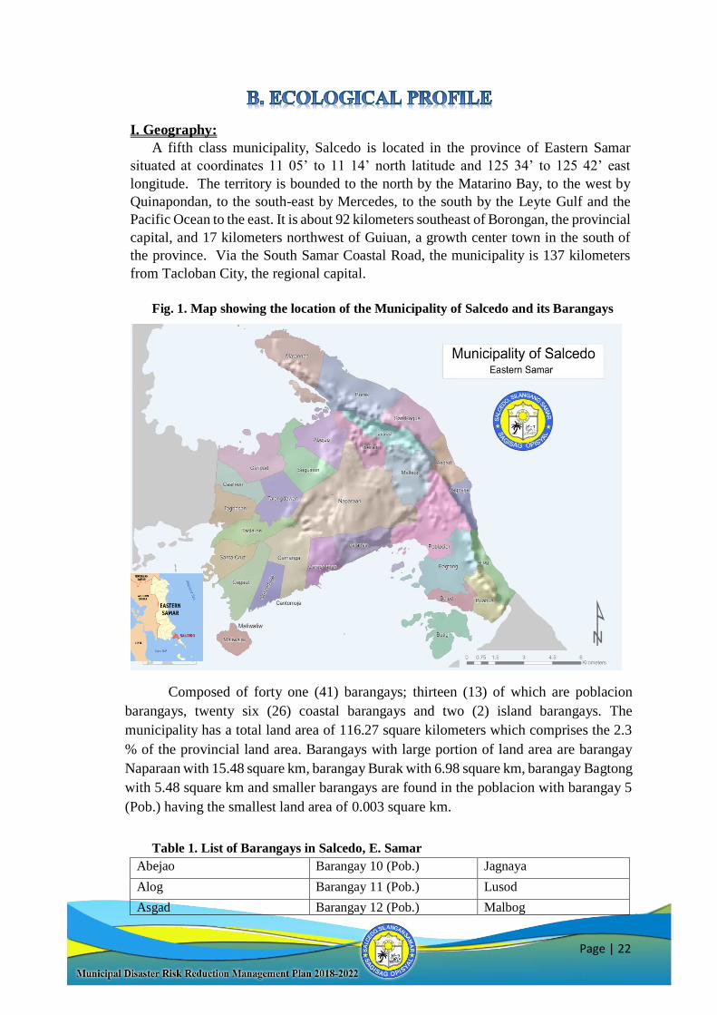
I. Geography:
A fifth class municipality, Salcedo is located in the province of Eastern Samar
situated at coordinates 11 05’ to 11 14’ north latitude and 125 34’ to 125 42’ east
longitude. The territory is bounded to the north by the Matarino Bay, to the west by
Quinapondan, to the south-east by Mercedes, to the south by the Leyte Gulf and the
Pacific Ocean to the east. It is about 92 kilometers southeast of Borongan, the provincial
capital, and 17 kilometers northwest of Guiuan, a growth center town in the south of
the province. Via the South Samar Coastal Road, the municipality is 137 kilometers
from Tacloban City, the regional capital.
Fig. 1. Map showing the location of the Municipality of Salcedo and its Barangays
Composed of forty one (41) barangays; thirteen (13) of which are poblacion
barangays, twenty six (26) coastal barangays and two (2) island barangays. The
municipality has a total land area of 116.27 square kilometers which comprises the 2.3
% of the provincial land area. Barangays with large portion of land area are barangay
Naparaan with 15.48 square km, barangay Burak with 6.98 square km, barangay Bagtong
with 5.48 square km and smaller barangays are found in the poblacion with barangay 5
(Pob.) having the smallest land area of 0.003 square km.
Table 1. List of Barangays in Salcedo, E. Samar
Abejao Barangay 10 (Pob.) Jagnaya
Alog Barangay 11 (Pob.) Lusod
Asgad Barangay 12 (Pob.) Malbog
Page | 23
Bagtong Barangay 13 (Pob.) Maliwaliw
Balud Buabua Matarinao
Barangay 1 (Pob.) Burak Palanas
Barangay 2 (Pob.) Butig Naparaan
Barangay 3 (Pob.) Cagaut Seguinon
Barangay 4 (Pob.) Camanga San Roque
Barangay 5 (Pob.) Cantomoja Santa Cruz
Barangay 6 (Pob.) Carapdapan Taclaon
Barangay 7 (Pob.) Caridad Tagbacan
Barangay 8 (Pob.) Casilion Talangdawan
Barangay 9 (Pob.) Iberan
II. Population and Social Services
POPULATION:
As of 2015 census survey, the municipality registered a total population of 22,5321
with 5,4272 total numbers of households, a population density of 1,277.09 persons per
hectare and age distribution and vulnerable groups as summarized on Table. 2. The
population growth rate between 2000 to 2010 was 1.64, which is below the national
average over the same time frame of 1.9% (NSCB). The poblacion barangays have the
highest population density, while Barangay Malbog has the lowest population density.
Table 2. Population Age Distribution and Vulnerable Groups
Age Male Female Total
Children 0-5 years old 1310 1252 2562
Children 6-11 years old 1527 1445 2972
Children 6-12 years old 1776 1692 3468
Children 12-15 years old 1077 969 2046
Children 13-16 years old 1089 960 2049
Children 10 years old & above 9239 8558 17797
Members of the Labor Force 5365 2608 7973
TOTAL 21,383 17,484 38,867
Vulnerable Groups Male Female Total
Infants (0-11 mos.) 381 381
Underfive (12-59 mos.) 1860 1860
Children (6-12 y/o) 1924 1554 3588
Senior Citizens (60 above)
(OSCA) 2022 2022
Persons with Disabilities 517 517
Pregnant Women - 198 198 (RHU 2014)
Source: CBMS Survey 2015
1 National Statistics Office 2 CBMS Survey 2015

Page | 24
SOCIAL SERVICES:
Housing
The 2015 CBMS Census counted a total of 4,585 housing units and a total of 5,336
households. The data indicate that there are 116.4 households as occupants for every
100 houses. This placed the housing backlog at 751 units due to doubled-up households.
In addition, there are 1,445 displaced units or houses located in danger zones. Table 3
summarizes the total housing backlog for the municipality which is 2,196 units.
Table 3. Housing Backlog, Salcedo
Housing Backlog Total Annual Housing
Requirement
Plan Period
Units due to doubled-up
households
751 83.44 2017-2025
Displaced Units 1,445 160.55 2017-2025
Source: Municipal Shelter Plan. Salcedo, E. Samar.
Part of the Yolanda/Haiyan Rehabilitation Program was the provision of permanent
shelter implemented by international non-government organizations (INGOs) and a
government-housing project. Presently, resettlement housing were being implemented
in barangay Asgad, Jagnaya, Sitio Malobago, Matarinao, Cagaut, Butig, Maliwaliw and
Tagbacan. The housing project of the National Housing Authority (NHA) will be
located in Brgy. Tagbacan and Brgy. Palanas.
Present and future interventions in the housing sector is to keep dwelling units safe
from the hazards of tsunami, storm surge and coastal flooding. Policies on “No
Dwelling Zone” is strictly enforced to relocate informal settlers found on danger areas
particularly in the barangays of Poblacion 2 and 7, Palanas, Cagaut, Cantomoja, Butig
and Maliwaliw on the Leyte Gulf area together with Alog, Jagnaya, Asgad, Burak and
Matarinao on the Pacific area and avoid future build up on these areas.
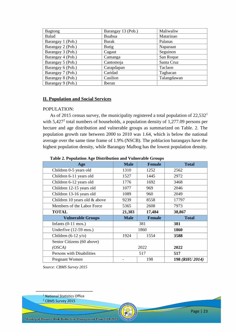
Health Facilities
Health care services is mainly provided by the Rural Health Unit located in
Poblacion Salcedo. Services for Maternal and Child Health is at the center but
community health is given adequate attention too as appropriate for a primary health
care facility. Each barangay has a health station that serves as a health and nutrition
post for the entire barangay population (Fig. 2). (CLUP)
Page | 25
Fig. 2. Salcedo Health Facilities Map
Source: CLUP
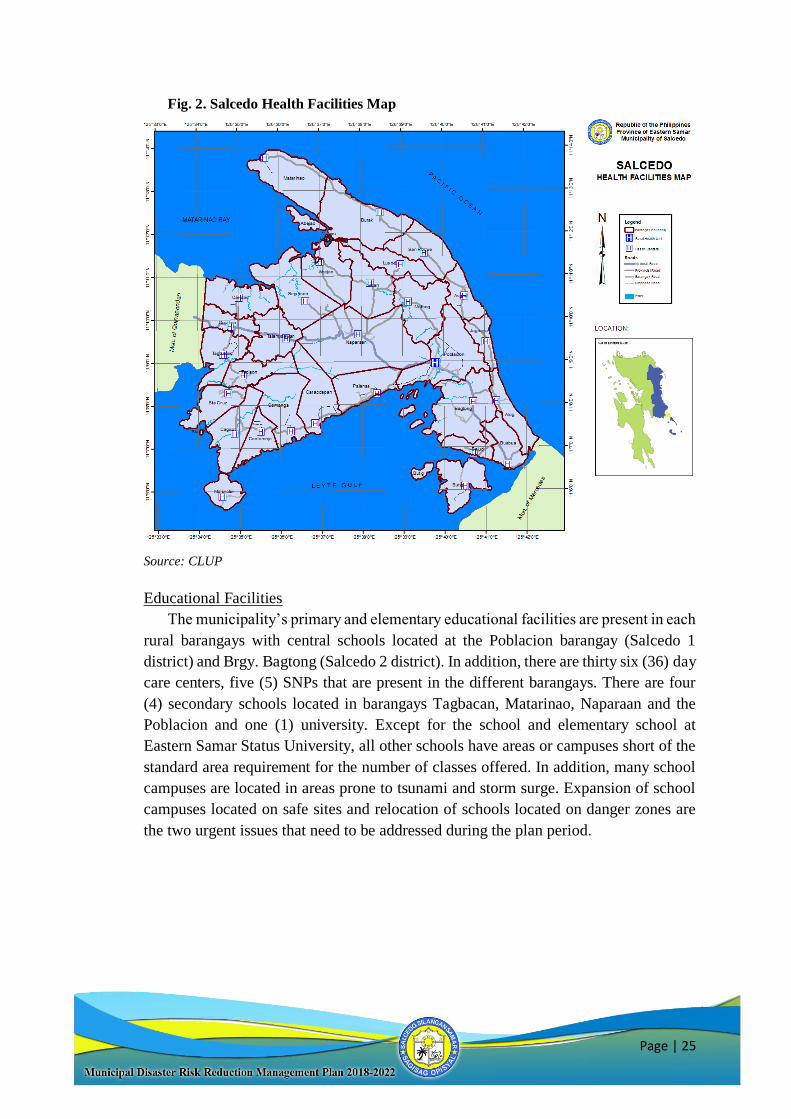
Educational Facilities
The municipality’s primary and elementary educational facilities are present in each
rural barangays with central schools located at the Poblacion barangay (Salcedo 1
district) and Brgy. Bagtong (Salcedo 2 district). In addition, there are thirty six (36) day
care centers, five (5) SNPs that are present in the different barangays. There are four
(4) secondary schools located in barangays Tagbacan, Matarinao, Naparaan and the
Poblacion and one (1) university. Except for the school and elementary school at
Eastern Samar Status University, all other schools have areas or campuses short of the
standard area requirement for the number of classes offered. In addition, many school
campuses are located in areas prone to tsunami and storm surge. Expansion of school
campuses located on safe sites and relocation of schools located on danger zones are
the two urgent issues that need to be addressed during the plan period.
Page | 26
Fig. 3. Salcedo Educational Facilities Map
Source: CLUP
POVERTY INCIDENCE:
The 2015 CBMS census reported that 3,092 or 61 percent of 5,299 households in
the municipality is earning below the poverty line and 44% are earning below the food
threshold. This indicated that majority of the households are unable to meet their basic
food and non-food requirements, including housing. Poblacion 06 had the highest
average monthly income at Php 25,290 followed by Poblacion 08 and 09. On the other
hand, Barangay Seguinon posted the lowest income at Php 2,928. Poblacion 06 also has
the highest expenditure at Php 22,778 with Barangay Tagbacan having the lowest
expenditure at Php 1,511.00.
Page | 27
III. Local Economy
Primary Sectors:
The labor force employed in the primary sectors of agriculture, fishing, forestry,
and mining/quarrying comprise 45.25 percent only of the total employed labor force.
Due to the high cost of farming in the locality and poor soil conditions, a very small
proportion of the primary sector engages in crop farming. Hence, primary sector
workers are largely fisherfolks engaged in near-shore fishing either in the Leyte Gulf
area or the Matarinao Bay. The domestic product of the municipality comes from
fishing with an estimated total of 365 tons per year.
Coconut, rice, corn, rootcrops, fruit trees, legumes and vegetables used to be the
products of Salcedo. Of these, coconut was the dominant crop. Pre-processed into
copra, coconut was sold to large copra traders in Tacloban City or Guiuan for export or
raw materials for local industries. Copra production reached 4,845 metric tons before
Yolanda. Local farmers are trying to get back to the same crops and level of production.
Presently, the municipality is exporting pre-processed cassava to San Miguel Food
Corporation for the feed milling section of the giant company.
The livestock and poultry industry in Salcedo is primarily a home-based activity.
Rural households have greater number of heads to raise with the available space for
raising a few heads of swine and poultry. Upland barangays are seen to raise small
ruminants like goat and sheep. Large ruminants like cattle, carabao and horse are
commonly raised by crop farmers who have access to grazing lands in the central
territories of the municipality.
Fishing industry is an important economic activity for all coastal barangays in
Salcedo. Municipal fishing has slowly progressed but has yet to attain the production
volume before Supertyphoon Yolanda. Thus the bulad-making industry has regained
its strength, exporting processed fish to all over the province and region.
Table 4. Livestock/Poultry Inventory, Municipality of Salcedo. 2015.
Livestock Number No of Brgys Raisng Livestock/Poultry
Carabao 106 17
Cattle 359 27
Goat 170 20
Swine 584 34
Chicken 6,940 41
Source: Office of Municipal Agricultural Services
Secondary Sectors:
Processing of fish, seaweeds, cassava and native delicacies are some of the
significant industrial activities in the municipality. Danggit and other type of bulad are
produced in large volumes in all coastal areas of Salcedo, from Matarinao down to
Alog. On the Leyte Gulf areas, Barangay Carapdapan had practically all households
engaged in danggit production. Fish processing into bulad or danggit is the only venture
that had attained industry level.
Page | 28
Tuba-making is a home-based processing activity engaged in all rural and some
poblacion barangays of Salcedo. The total volume produced supplied 100 percent of
the local demand for the coconut wine. The tuba-making venture however has not
reached industry level due to the individualized production where production and
quality could be controlled.
The production of Amakan or sadyap is a traditional livelihood among upland
dwellers in Talangdawan, Napaaran and Seguinon. The production though is limited by
the narrow resource base coupled with the dwindling of skilled manpower.
Tertiary Sector:
Forty-five percent (45%) of the town’s labor is into tertiary economic activities
commerce and trading (CBMS 2015). Retailers and wholesale traders are distributed
throughout the municipality, but large establishments are concentrated in the poblacion.
Presently, in-bound trading is larger than out-bound trading since the local agriculture
has yet to recover to generate exports like copra, pineapple and marine products from
the ravages of Supertyphoon Yolanda.
Trade and Industry
Most of the local commercial and industrial establishments in the locality are small
enterprises with capitalization below P150,000.00. In 2015, there are 90 registered retail
and wholesale stores, 17 food establishments, 13 transport, storage and communication,
22 financial intermediation, 32 in real estate, renting and business activities. There are
3 extra-territorial organizations and bodies operating in the municipality.
No data is available on the value and volume of production of agricultural produce.
Fish and marine products and pork are the main agricultural output in the municipality.
Some of the cereal and root crop needs are produced locally. Local industries that are
mainly home-based are fish and seaweeds processing and production of native
delicacies.
Tourism
The industry has not taken off despite the presence of spots ideal for ecotourism
development. These include islets, white beaches, caves and wildlife parks and
sanctuaries. Promotion of these spots is necessary to invite investors who can help
generate jobs with various services and industries needed to support the tourism sector.
Labor Force and Employment
According to the 2015 CBMS, the municipality has 12% unemployment rate despite
employment opportunities available in agriculture considering the labor-intensive
nature of such economic activity. Since majority of the barangays in Salcedo are located
in the coastal areas, fishing could also provide so much opportunity for employment.
Post-Yolanda, the construction industry provided the municipality with regular source
of income. The need for speedy post-disaster reconstruction created a huge demand for
Page | 29
construction workers in the Visayas region. In demand were skilled construction
workers like carpenters, welders, masons, contractors.
IV. Infrastructure & Physical Base
TOPOGRAPHY:
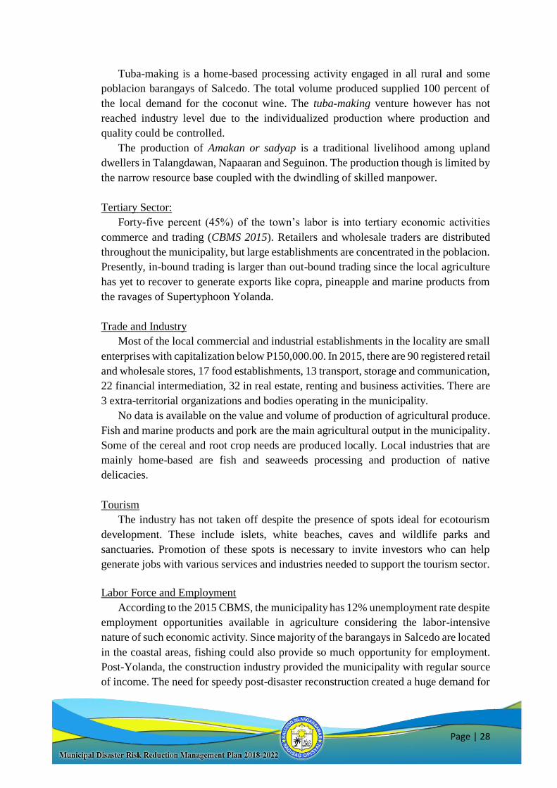
Most of the municipality is characterized by rolling hills with an extensive elevated
range extending southwards. On a larger scale, the mountainous range can be observed
to extend throughout Mercedes and Guiuan including Calicoan Island where its
elevation decreases considerably. Highest points in Barangay Asgad exceed 140 meters
above sea level.
Coastal plain can be found in the southwest (at the foothills of barangays Tagbacan,
Taclaon, Santa Cruz and Cagaut); in the north (at the seafront of Caridad, Seguinon,
and Abejao); in the Poblacion area and Bagtong; and in a vast stretch in the eastern
coast fronting the Philippines Sea (barangays Matarinao, Burak, San Roque, Asgad,
Jagnaya, Alog and Buabua).
Fig. 4. Salcedo Topographic Map
Source: CLUP
Page | 30
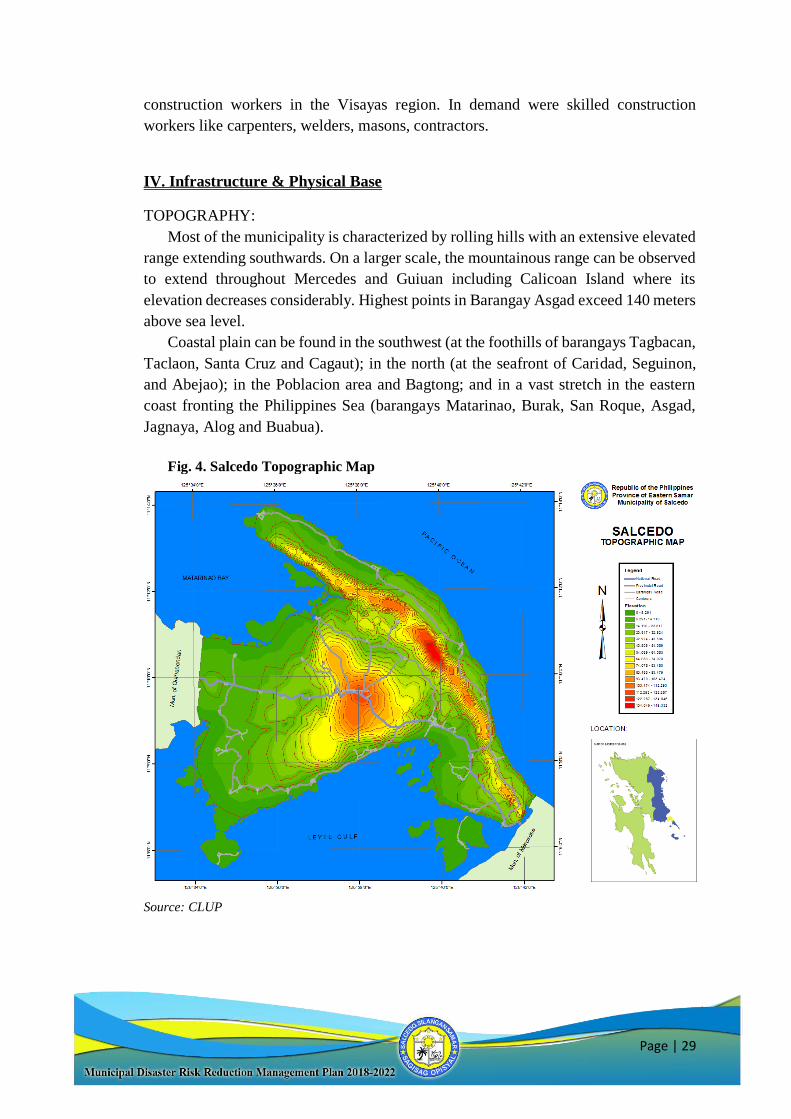
SLOPE:
Most of the municipality is characterized by rolling hills that gradually flatten
towards the coastal plains. Steeper slopes can be found at the mountainside especially
along the facet of the mountainous range that faces the Philippine Sea.
Fifty seven percent of the municipality’s lands are highly farmable with slopes of 8% and
below. Moderately sloping to rolling lands with slope of 9 –18% comprise 2,450 hectares or
22%. Only 2,375 hectares or 21% of lands have slopes over 18%.
Fig. 5. Salcedo Slope Map
Source: CLUP
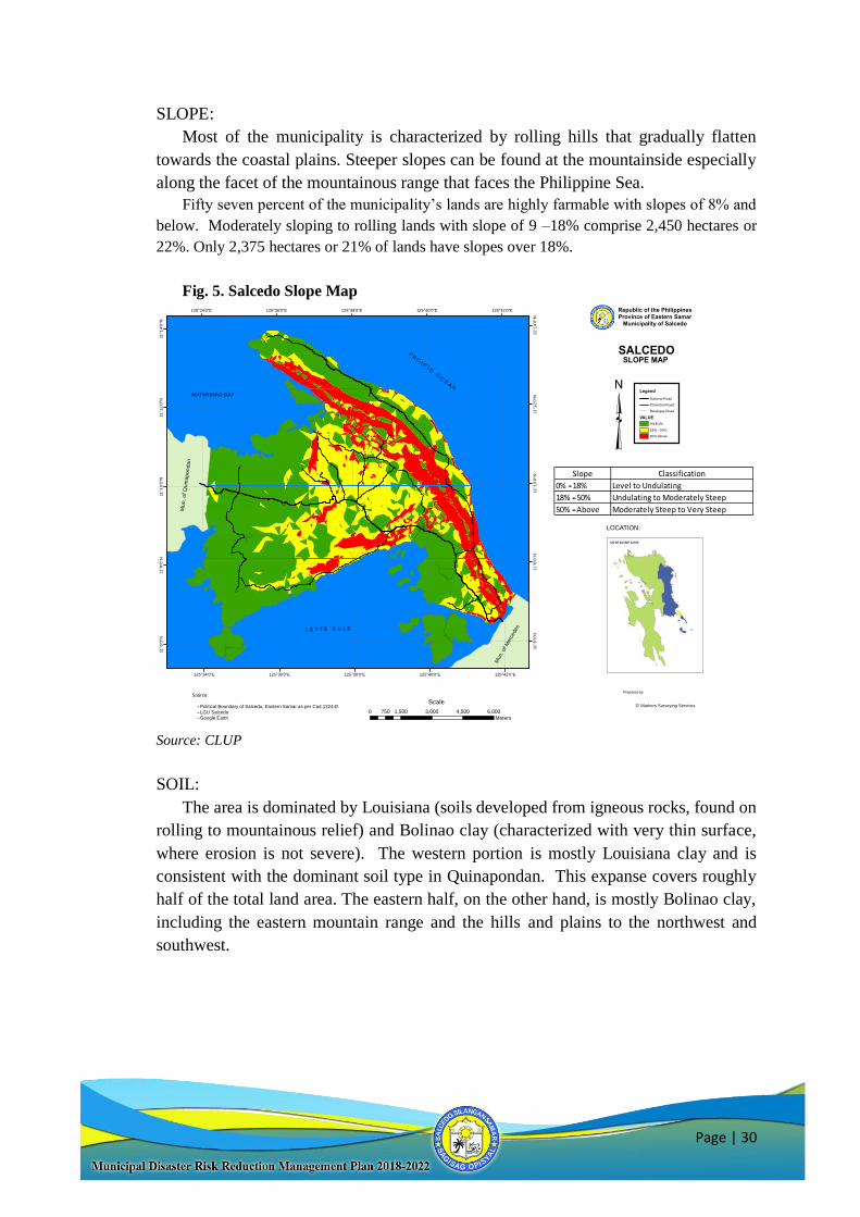
SOIL:
The area is dominated by Louisiana (soils developed from igneous rocks, found on
rolling to mountainous relief) and Bolinao clay (characterized with very thin surface,
where erosion is not severe). The western portion is mostly Louisiana clay and is
consistent with the dominant soil type in Quinapondan. This expanse covers roughly
half of the total land area. The eastern half, on the other hand, is mostly Bolinao clay,
including the eastern mountain range and the hills and plains to the northwest and
southwest.
125°42'0"E
125°42'0"E
125°40'0"E
125°40'0"E
125°38'0"E
125°38'0"E
125°36'0"E
125°36'0"E
125°34'0"E
125°34'0"E
11°1
4'0
"N
11°1
4'0
"N
11°1
2'0
"N
11°1
2'0
"N
11°1
0'0
"N
11°1
0'0
"N
11°8
'0"N
11°8
'0"N
11°6
'0"N
11°6
'0"N
SLOPE MAP
Legend
National Road
Provincial Road
Barangay Road
VALUE
0% -
18 %
18% -
50%
50% Above
Republic of the PhilippinesProvince of Eastern Samar
Municipality of Salcedo
SALCEDO
LOCATION:
Mu
n. of
Qu
inapo
nda
n
Mun. of M
erc
edes
L E Y T E G U L F
P A C I F I C O C E A N
MATARINAO BAY
0 1,500 3,000 4,500 6,000750
Meters
ScaleSource:
- Political Boundary of Salcedo, Eastern Samar as per Cad 1324-D
- LGU Salcedo
- Google Earth
Slope Classification
0% - 18% Level to Undulating
18% - 50% Undulating to Moderately Steep
50% - Above Moderately Steep to Very Steep
D' Markers Surveying Services
Prepared by:
Page | 31
Fig. 6. Salcedo Soil Map
Source: CLUP
INFRASTRUCTURE:
The infrastructure network of Salcedo is one of the best in the province. The
municipality has Level III water system that serves a total of four hundred eighty three
(483) households covering fourteen (14) barangays and the other twenty seven (27)
barangays with Level II water system. All forty one (41) barangay are powered by
ESAMELCO, energizing a total of four thousand five hundred forty six (4,546)
households. Communication system includes the services from Smart Communications
having a municipal wide coverage, Globe Communications present in some barangays
and one FM station (DYBE). Public transport includes buses, PUJ, tricycle, pedicabs
and pump boats.
Naparaan
Burak
Bagtong
Iberan
Malbog
Poblacion
Butig
Seguinon
Abejao
Cagaut
Alog
Matarinao
Camanga
Caridad
Lusod
Palanas
Taclaon
Asgad
Carapdapan
Tagbacan
San Roque
Sta Cruz
Buabua
Talangdawan
Casilion
Balud
Cantomoja
Jagnaya
Maliwaliw
Sta Cruz
125°42'0"E
125°42'0"E
125°40'0"E
125°40'0"E
125°38'0"E
125°38'0"E
125°36'0"E
125°36'0"E
125°34'0"E
125°34'0"E
11°1
4'0
"N
11°1
4'0
"N
11°1
2'0
"N
11°1
2'0
"N
11°1
0'0
"N
11°1
0'0
"N
11°8
'0"N
11°8
'0"N
11°6
'0"N
11°6
'0"N
SOIL MAP
Legend
National Road
Provincial Road
Barangay Road
brgy10
Layer
River
Layer
Bolinao Clay
Luisiana CLay
Hydrosol
Republic of the PhilippinesProvince of Eastern Samar
Municipality of Salcedo
SALCEDO
LOCATION:
Mu
n.
of
Qu
ina
po
nda
n
Mun. of Mercedes
L E Y T E G U L F
P A C I F I C O C E A N
MATARINAO BAY
0 1,600 3,200 4,800 6,400800
Meters
ScaleSource:
- Political Boundary of Salcedo, Eastern Samar as per Cad 1324-D
- LGU Salcedo
- Google EarthD' Markers Surveying Services
Prepared by:
Naparaan
Burak
Bagtong
Iberan
Malbog
Poblacion
Butig
Seguinon
Abejao
Cagaut
Alog
Matarinao
Camanga
Caridad
Lusod
Palanas
Taclaon
Asgad
Carapdapan
Tagbacan
San Roque
Sta Cruz
Buabua
Talangdawan
Casilion
Balud
Cantomoja
Jagnaya
Maliwaliw
Sta Cruz
125°42'0"E
125°42'0"E
125°40'0"E
125°40'0"E
125°38'0"E
125°38'0"E
125°36'0"E
125°36'0"E
125°34'0"E
125°34'0"E
11°1
4'0
"N
11°1
4'0
"N
11°1
2'0
"N
11°1
2'0
"N
11°1
0'0
"N
11°1
0'0
"N
11°8
'0"N
11°8
'0"N
11°6
'0"N
11°6
'0"N
SOIL MAP
Legend
National Road
Provincial Road
Barangay Road
brgy10
Layer
River
Layer
Bolinao Clay
Luisiana CLay
Hydrosol
Republic of the PhilippinesProvince of Eastern Samar
Municipality of Salcedo
SALCEDO
LOCATION:
Mu
n. o
f Q
uin
apo
nda
n
Mun. of Mercedes
L E Y T E G U L F
P A C I F I C O C E A N
MATARINAO BAY
0 1,600 3,200 4,800 6,400800
Meters
ScaleSource:
- Political Boundary of Salcedo, Eastern Samar as per Cad 1324-D
- LGU Salcedo
- Google EarthD' Markers Surveying Services
Prepared by:
Page | 32
V. Environmental Management & Natural Resources
EXISTING LAND USE:
Agricultural lands cover approximately 7,412.57 hectares constituting 65.20% of
the municipality’s total land area. Included are coconut lands, a small area of ricelands,
lands devoted to vegetable and legumes, fruit trees, and other croplands consisting
mainly of rootcrops like cassava.
Open grasslands and brushlands cover approximately 2,025 hectares or 17.81% of
the total. Most of these grasslands are idle and cogon-covered with a negligible area
being used as grazing/pasture lands.
Forests which consist mostly of mangrove and second growth forest have an area
of 1,425 hectares or 12.54% of the total land area. The second- growth forests are
located in the southern portion of the municipality and are within the territorial
jurisdiction of barangays Naparaan, Palanas, Carapdapan, Camanga, and Cantomoja,
while the mangrove forests are visible in almost all coastal barangays of the
municipality. Salcedo used to be a lumber producer but because of denudation caused
mainly by kaingin and uncontrolled logging, the only remaining forests are second-
growth which are also dwindling considerably in numbers. It may be noted that Salcedo
has timberland areas which are considerably bigger than the forestlands. The difference
in land area figures is due to the fact that the timberlands classification is not based on
actual land use but rather on tenurial status. Public lands are generally termed
timberland areas.
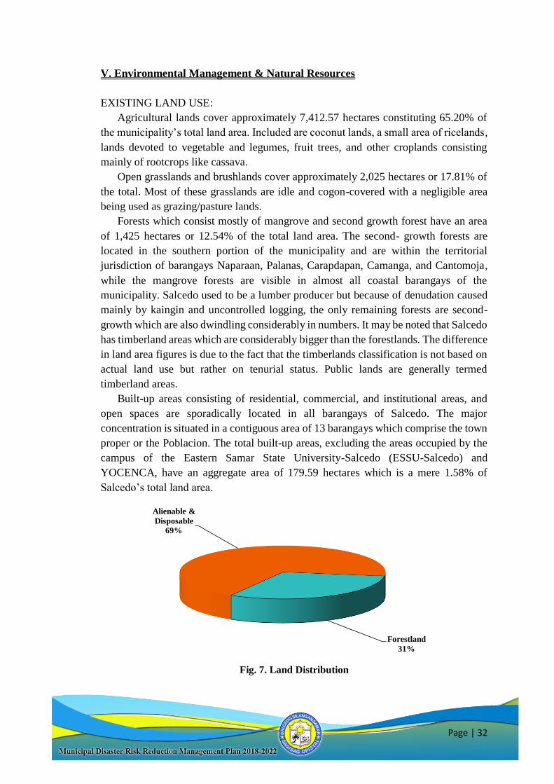
Built-up areas consisting of residential, commercial, and institutional areas, and
open spaces are sporadically located in all barangays of Salcedo. The major
concentration is situated in a contiguous area of 13 barangays which comprise the town
proper or the Poblacion. The total built-up areas, excluding the areas occupied by the
campus of the Eastern Samar State University-Salcedo (ESSU-Salcedo) and
YOCENCA, have an aggregate area of 179.59 hectares which is a mere 1.58% of
Salcedo’s total land area.
Fig. 7. Land Distribution
Alienable &
Disposable
69%
Forestland
31%
Page | 33
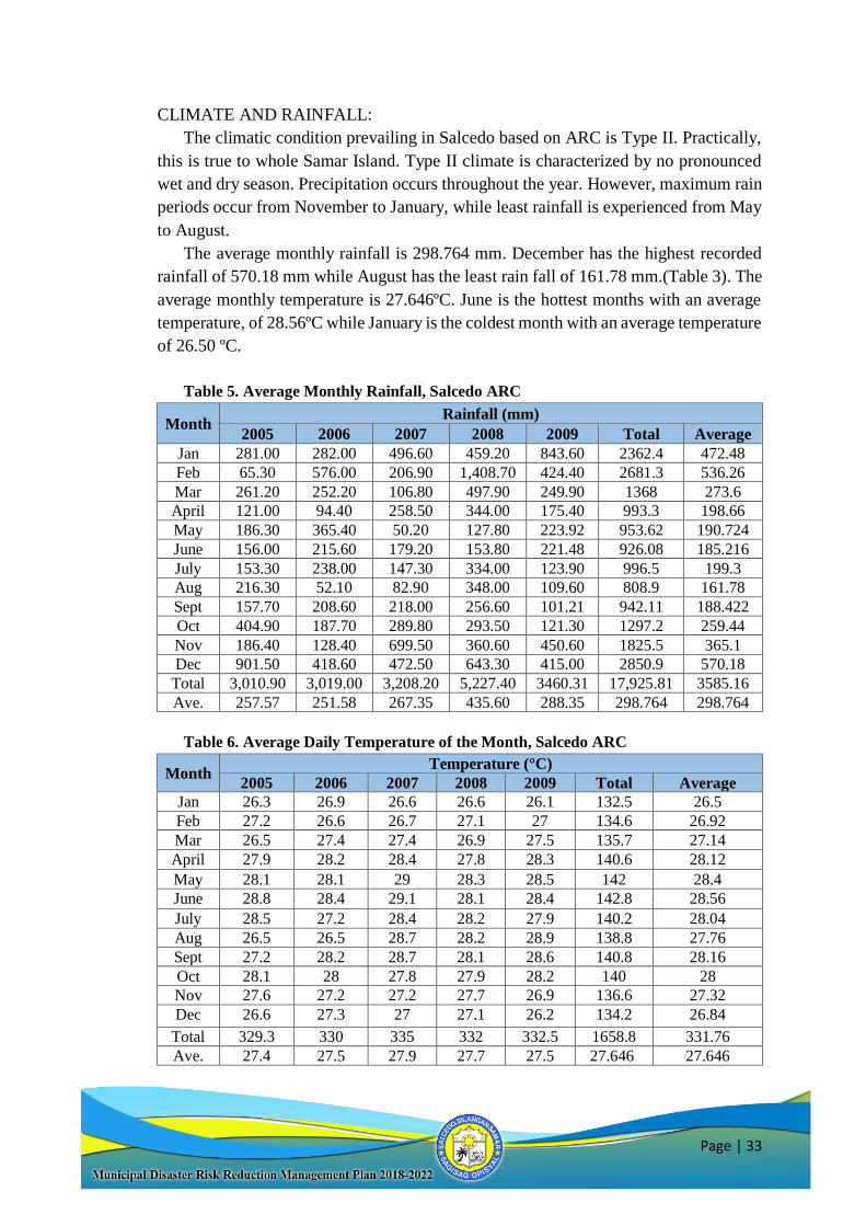
CLIMATE AND RAINFALL:
The climatic condition prevailing in Salcedo based on ARC is Type II. Practically,
this is true to whole Samar Island. Type II climate is characterized by no pronounced
wet and dry season. Precipitation occurs throughout the year. However, maximum rain
periods occur from November to January, while least rainfall is experienced from May
to August.
The average monthly rainfall is 298.764 mm. December has the highest recorded
rainfall of 570.18 mm while August has the least rain fall of 161.78 mm.(Table 3). The
average monthly temperature is 27.646ºC. June is the hottest months with an average
temperature, of 28.56ºC while January is the coldest month with an average temperature
of 26.50 ºC.
Table 5. Average Monthly Rainfall, Salcedo ARC
Month Rainfall (mm)
2005 2006 2007 2008 2009 Total Average
Jan 281.00 282.00 496.60 459.20 843.60 2362.4 472.48
Feb 65.30 576.00 206.90 1,408.70 424.40 2681.3 536.26
Mar 261.20 252.20 106.80 497.90 249.90 1368 273.6
April 121.00 94.40 258.50 344.00 175.40 993.3 198.66
May 186.30 365.40 50.20 127.80 223.92 953.62 190.724
June 156.00 215.60 179.20 153.80 221.48 926.08 185.216
July 153.30 238.00 147.30 334.00 123.90 996.5 199.3
Aug 216.30 52.10 82.90 348.00 109.60 808.9 161.78
Sept 157.70 208.60 218.00 256.60 101.21 942.11 188.422
Oct 404.90 187.70 289.80 293.50 121.30 1297.2 259.44
Nov 186.40 128.40 699.50 360.60 450.60 1825.5 365.1
Dec 901.50 418.60 472.50 643.30 415.00 2850.9 570.18
Total 3,010.90 3,019.00 3,208.20 5,227.40 3460.31 17,925.81 3585.16
Ave. 257.57 251.58 267.35 435.60 288.35 298.764 298.764
Table 6. Average Daily Temperature of the Month, Salcedo ARC
Month Temperature (°C)
2005 2006 2007 2008 2009 Total Average
Jan 26.3 26.9 26.6 26.6 26.1 132.5 26.5
Feb 27.2 26.6 26.7 27.1 27 134.6 26.92
Mar 26.5 27.4 27.4 26.9 27.5 135.7 27.14
April 27.9 28.2 28.4 27.8 28.3 140.6 28.12
May 28.1 28.1 29 28.3 28.5 142 28.4
June 28.8 28.4 29.1 28.1 28.4 142.8 28.56
July 28.5 27.2 28.4 28.2 27.9 140.2 28.04
Aug 26.5 26.5 28.7 28.2 28.9 138.8 27.76
Sept 27.2 28.2 28.7 28.1 28.6 140.8 28.16
Oct 28.1 28 27.8 27.9 28.2 140 28
Nov 27.6 27.2 27.2 27.7 26.9 136.6 27.32
Dec 26.6 27.3 27 27.1 26.2 134.2 26.84
Total 329.3 330 335 332 332.5 1658.8 331.76
Ave. 27.4 27.5 27.9 27.7 27.5 27.646 27.646
Page | 34
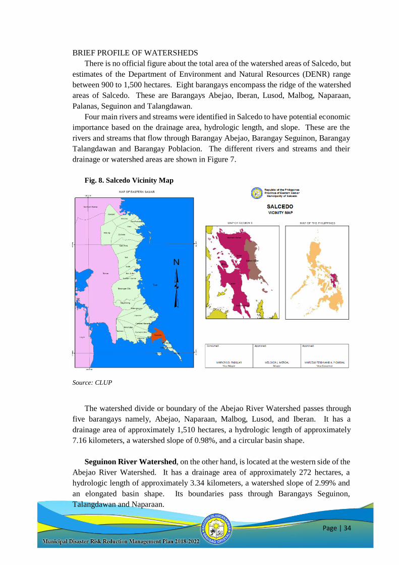
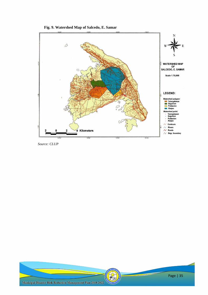
BRIEF PROFILE OF WATERSHEDS
There is no official figure about the total area of the watershed areas of Salcedo, but
estimates of the Department of Environment and Natural Resources (DENR) range
between 900 to 1,500 hectares. Eight barangays encompass the ridge of the watershed
areas of Salcedo. These are Barangays Abejao, Iberan, Lusod, Malbog, Naparaan,
Palanas, Seguinon and Talangdawan.
Four main rivers and streams were identified in Salcedo to have potential economic
importance based on the drainage area, hydrologic length, and slope. These are the
rivers and streams that flow through Barangay Abejao, Barangay Seguinon, Barangay
Talangdawan and Barangay Poblacion. The different rivers and streams and their
drainage or watershed areas are shown in Figure 7.
Fig. 8. Salcedo Vicinity Map
Source: CLUP
The watershed divide or boundary of the Abejao River Watershed passes through
five barangays namely, Abejao, Naparaan, Malbog, Lusod, and Iberan. It has a
drainage area of approximately 1,510 hectares, a hydrologic length of approximately
7.16 kilometers, a watershed slope of 0.98%, and a circular basin shape.
Seguinon River Watershed, on the other hand, is located at the western side of the
Abejao River Watershed. It has a drainage area of approximately 272 hectares, a
hydrologic length of approximately 3.34 kilometers, a watershed slope of 2.99% and
an elongated basin shape. Its boundaries pass through Barangays Seguinon,
Talangdawan and Naparaan.
Page | 35
Fig. 9. Watershed Map of Salcedo, E. Samar
Source: CLUP
Page | 33
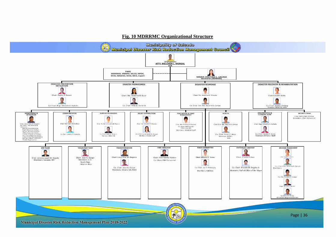
I. LDRRMC
The implementing rules and regulations of RA 10121 provides for the
organization of the local government level of the Disaster Risk Reduction and
Management Council known as the Local Disaster Risk Reduction Management
Council. Executive Order No. 120 Series of 2018, an Executive Order Reorganizing
the Composition of the Existing Expanded Municipal Disaster Risk Reduction and
Management Council (MDRRMC) in the Municipality of Salcedo, Province of Easter
Samar by amending its composition under Section 1 of Executive Order No. 80,
Series of 2017 signed by the Local Chief Executive on the 12th day of September
2018. Under the Executive Branch of the LGU, Section 3 of the EO provides for the
following functions of the MDRRMC:
Approve, monitor and evaluate the implementation of local MDRRM Plan and
annually review, test and develop the plan consistent with other national and local
planning programs;
Ensure the integration of disaster risk reduction and climate change adaptation into
local development plans, programs and budgets as a strategy in sustainable
development and poverty reduction;
Recommend the implementation of forced or pre-emptive evacuation of local
residents, if necessary;
Convene once every three (3) months or as necessary;
The Municipal Disaster Risk Reduction Management Council is composed of the
following:
Chairman: Atty. Melchor L. Mergal LCE
Vice Chairman:
COP Salcedo Municipal Police
Station
Secretariat: Maria Cristina C. Lacasa MDRRMO
Members:
Paz Maria Lourdes M. Padullo MTO
Engr. Gilzosito A. Apilado MEO
Isabel B. Abella MPDC
Felix G. Duran Jr. Mun. Accountant
Luzviminda N. Abrugar MBO
Dra. Ma. Socorro S. Campo MHO
Danilo P. Duran MENRO
Ma. Amelita G. Macasa MSWDO
Fedelindo Tomas F. Boco Mun. Assessor
Juanito S. Omlang OMAS
Amalia M. Omlang GSO Designate
Hon Maricris D. Fabillar Vice Mayor
Page | 34
Specifically, the MDRRMC have the following functions for the Chairman
and the Secretariat;
Functions of the Chairman:
Convene the council as often as necessary to effectively coordinate the local efforts
of disaster preparedness, emergency operations, relief, recovery and rehabilitation
activities;
Call on all local offices, instrumentalities and corporations of the government and the
private sector for assistance of preparing for, reacting to, and recovering from the
effects of disaster, calamities, and local emergencies;
Carry out emergency measures as may be necessary before, during and after the
occurrences of calamity or disaster;
Hon. Charles O. Cabus SB on DRR Committee
Hon. Romualdo G. Estor ABC President
Maria Rowena M. Estor MLGOO
Bibiana A. Torres SB Secretary
Joselito C. Esquierdo MCR/Tourism Officer Designate
Jasmine O. Deguito BAC Secretariat
Freddie D. Degala Rep. Mayor’s Office
Linus M. Deguito Secretary to the Mayor
Jose G. Gaspe HRMO
John Mikael S. Garcia Market Inspector
Dr. Marina S. Apilado ESSU-Salcedo Administrator
Dr. Amada A. Javines Salcedo District I Supervisor
Mrs. Lourdes G. Ecle Salcedo District II Supervisor
Casiano Pedro S. Flores TIC,TNHS
Joel B. del Valle Principal, SVHS
Sarah A. Samparani Principal, MASOF
Ma. Josie A. Contado Principal, SNHS
SFO1 Pablito C. Nadera BFP
Joannes Joseph M. Deguito Representative Private Sector
Felisa R. Castro Representative Women’s
Rodrigo Macawile Representative Transport Group
Crissa Van L. Nepal Representative Youth
Renato T. Lumen Representative PWD
Joselito A. Maragrag Representative Children
Remegio Y. Boco Representative Senior Citizens
Estrella Celedonio Labor Sector / PESO Manager
Aida Loyola PLAN International
Tarcisa Maragrag BHW President
Page | 35
Recommend through the MDRRMC to the Local Sanggunian Bayan the declaration
of a State of Calamity in the area, in accordance with the criteria provided under
NDCC Memorandum Order No. 04 series of 1998;
Initiate the formulation of a local calamity and disaster preparedness plan for
submission and approval by the Local Sanggunian; and
Ensure that the MDRRM Plan be included in the local government unit’s Annual
Investment Plan for appropriations of the projects and programs thereon.
Functions of the Secretariat
Shall initiate and coordinate programs projects and activities of the Council on
disaster management through an integrated multi-sectoral approach;
Coordinate the activities and functions of the various agencies and instrumentalities of
the different sectors, BDRRMCs and Civic organizations to implement the policies set
by the Municipal Disaster Risk Reduction and Management Council relative to
disaster management;
Shall establish coordination and linkages with the BDRRMCs, the different Task
Committees, the concern local offices, instrumentalities, community and the different
sectors relative to disaster preparedness and management; and
In coordination with BDRRMC, shall conduct damage assessments on the area
affected by disaster and shall receive damage reports submitted by the BDRRMC, the
different Task Committees, the concerned local offices and instrumentalities for
consolidation and submission to the Chairman.
Page | 36
Fig. 10 MDRRMC Organizational Structure
Page | 37
II. LDRRM Office
The organization of the LDRRM office is composed of a DRRM officer and
assisted by four (4) staff responsible for:
Administration and Training (1 staff)
Research and Planning (2 staff0
Operations and Warning (1 staff)
The municipal DRRM office shall perform the following functions with
impartiality given the emerging challenges brought by disasters of our times:
Design, program, and coordinate disaster risk reduction and management
activities consistent with the National Council's standards and guidelines;
Facilitate and support risk assessments and contingency planning activities
at the local level;
Consolidate local disaster risk information which includes natural hazards,
vulnerabilities, and climate change risks, and maintain a local risk map;
Organize and conduct training, orientation, and knowledge management
activities on disaster risk reduction and management at the local level;
Operate a multi-hazard early warning system, linked to disaster risk
reduction to provide accurate and timely advice to national or local
emergency response organizations and to the general public, through
diverse mass media, particularly radio, landline communications, and
technologies for communication within rural communities;
Formulate and implement a comprehensive and integrated LDRRMP in
accordance with the national, regional and provincial framework, and
policies on disaster risk reduction in close coordination with the local
development councils (LDCs);
Prepare and submit to the local Sanggunian through the LDRRMC and the
LDC the annual LDRRM Plan and budget, the proposed programming of
the LDRRMF, other dedicated disaster risk reduction and management
resources, and other regular funding source/s and budgetary support of the
LDRRMO/BDRRMC;
Conduct continuous disaster monitoring and mobilize instrumentalities
and entities of the LGUs, CSOs, private groups and organized volunteers,
to utilize their facilities and resources for the protection and preservation
of life and properties during emergencies in accordance with existing
policies and procedures;
Identify, assess and manage the hazards, vulnerabilities and risks that may
occur in their locality;
Disseminate information and raise public awareness about those hazards,
vulnerabilities and risks, their nature, effects, early warning signs and
countermeasures;
Page | 38
Identify and implement cost-effective risk reduction measures/strategies;
Maintain a database of human resource, equipment, directories, and
location of critical infrastructures and their capacities such as hospitals
and evacuation centers;
Develop, strengthen and operationalize mechanisms for partnership or
networking with the private sector, CSOs, and volunteer groups;
Take all necessary steps on a continuing basis to maintain, provide, or
arrange the provision of, or to otherwise make available, suitably-trained
and competent personnel for effective civil defense and disaster risk
reduction and management in its area;
Organize, train, equip and supervise the local emergency response teams
and the ACDVs, ensuring that humanitarian aid workers are equipped with
basic skills to assist mothers to breastfeed;
Respond to and manage the adverse effects of emergencies and carry out
recovery activities in the affected area, ensuring that there is an efficient
mechanism for immediate delivery of food, shelter and medical supplies
for women and children, endeavor to create a special place where
internally-displaced mothers can find help with breastfeeding, feed and
care for their babies and give support to each other;
Within its area, promote and raise public awareness of and compliance
with this Act and legislative provisions relevant to the purpose of this Act;
Serve as the secretariat and executive arm of the LDRRMC;
Coordinate other disaster risk reduction and management activities;
Establish linkage/network with other LGUs for disaster risk reduction and
emergency response purposes;
Recommend through the LDRRMC the enactment of local ordinances
consistent with the requirements of this Act;
Implement policies, approved plans and programs of the LDRRMC
consistent with the policies and guidelines laid down in this Act;
Establish a Municipal Disaster Risk Reduction and Management
Operations Center;
Prepare and submit, through the LDRRMC and the LDC, the report on the
utilization of the LDRRMF and other dedicated disaster risk reduction and
management resources to the local Commission on Audit (COA), copy
furnished the regional director of the OCD and the Local Government
Operations Officer of the DILG; and
Act on other matters that may be authorized by the LDRRMC
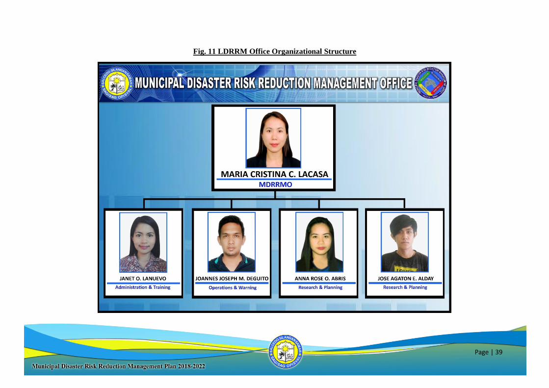
Page | 39
Fig. 11 LDRRM Office Organizational Structure
Page | 40
The need to account the history of disaster in the municipality will help analyse the
disaster trends and their impacts in a systematic manner. With increased understanding
of the disaster trends and their impacts, better prevention, mitigation and preparedness
measures can be planned to reduce the impact of disasters. Using indigenous knowledge
during the PCVA conducted at all forty (40) barangays and the hazards identified in the
existing HEPRR Plan it was possible to identify all potential hazards in the municipality
area of jurisdiction. The following table summarizes all identified hazards.
Table 7. Identified Hazard in the Municipality of Salcedo
Typhoon
Storm Surge
Strong winds
Earthquake
Ground shaking
Tsunami
Earthquake induced Landslide
Liquefaction
Flooding
Rain-induced Landslide
Drought
Waterborne Diseases
Animal Bites
Vaccine-Preventable Diseases
Emerging/Re-emerging Diseases (SARS, H1N1, MERS, etc.)
Vector-borne Diseases (Dengue, Chikungunya)
Food Poisoning
Red Tide
Historical Storm Events
Storm events in Salcedo affect not only all of the identified high risk barangays,
but the whole of the municipality causing damage to crops, houses and infrastructure
from the high winds, heavy rainfall and storm surge. Storm events are experienced on
an annual basis with a frequency of 5-6 per year with 1-2 being destructive, and coincide
with the heavy rainfall periods between September and February.
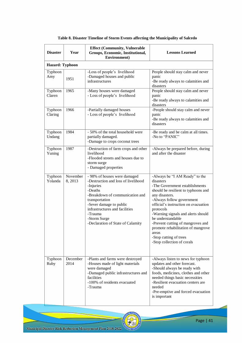
Page | 41
Table 8. Disaster Timeline of Storm Events affecting the Municipality of Salcedo
Disaster Year Effect (Community, Vulnerable
Groups, Economic, Institutional,
Environment)
Lessons Learned
Hazard: Typhoon
Typhoon
Amy
1951
-Loss of people’s livelihood
-Damaged houses and public
infrastructures
People should stay calm and never
panic
-Be ready always to calamities and
disasters
Typhoon
Claren
1965 -Many houses were damaged
- Loss of people’s livelihood
People should stay calm and never
panic
-Be ready always to calamities and
disasters
Typhoon
Claring
1966 -Partially damaged houses
- Loss of people’s livelihood
-People should stay calm and never
panic
-Be ready always to calamities and
disasters
Typhoon
Undang
1984 - 50% of the total household were
partially damaged.
-Damage to crops coconut trees
-Be ready and be calm at all times.
-No to “PANIC”
Typhoon
Yuning
1987 -Destruction of farm crops and other
livelihood
-Flooded streets and houses due to
storm surge
- Damaged properties
-Always be prepared before, during
and after the disaster
Typhoon
Yolanda
November
8, 2013
- 98% of houses were damaged
-Destruction and loss of livelihood
-Injuries
-Deaths
-Breakdown of communication and
transportation
-Sever damage to public
infrastructures and facilities
-Trauma
-Storm Surge
-Declaration of State of Calamity
-Always be “I AM Ready” to the
disasters
-The Government establishments
should be resilient to typhoons and
any disasters.
-Always follow government
official’s instruction on evacuation
protocols
-Warning signals and alerts should
be understandable
-Prevent cutting of mangroves and
promote rehabilitation of mangrove
areas
-Stop cutting of trees
-Stop collection of corals
Typhoon
Ruby
December
2014
-Plants and farms were destroyed
-Houses made of light materials
were damaged
-Damaged public infrastructures and
facilities
-100% of residents evacuated
-Trauma
-Always listen to news for typhoon
updates and other forecast.
-Should always be ready with
foods, medicines, clothes and other
needed things basic necessities
-Resilient evacuation centers are
needed
-Pre-emptive and forced evacuation
is important
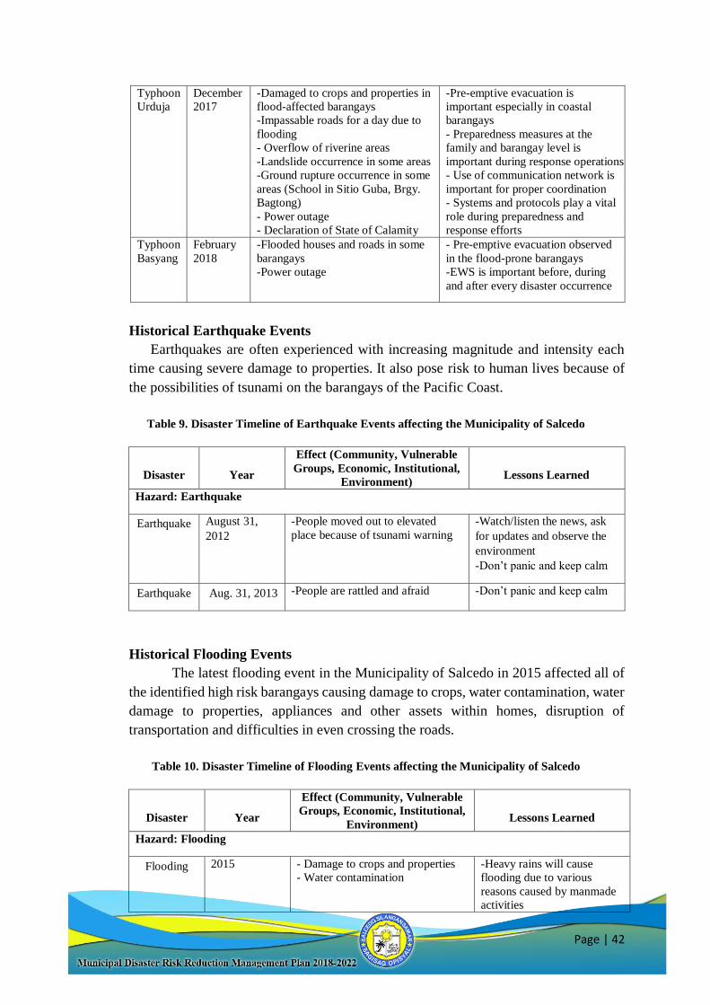
Page | 42
Typhoon
Urduja
December
2017
-Damaged to crops and properties in
flood-affected barangays
-Impassable roads for a day due to
flooding
- Overflow of riverine areas
-Landslide occurrence in some areas
-Ground rupture occurrence in some
areas (School in Sitio Guba, Brgy.
Bagtong)
- Power outage
- Declaration of State of Calamity
-Pre-emptive evacuation is
important especially in coastal
barangays
- Preparedness measures at the
family and barangay level is
important during response operations
- Use of communication network is
important for proper coordination
- Systems and protocols play a vital
role during preparedness and
response efforts
Typhoon
Basyang
February
2018
-Flooded houses and roads in some
barangays
-Power outage
- Pre-emptive evacuation observed
in the flood-prone barangays
-EWS is important before, during
and after every disaster occurrence
Historical Earthquake Events
Earthquakes are often experienced with increasing magnitude and intensity each
time causing severe damage to properties. It also pose risk to human lives because of
the possibilities of tsunami on the barangays of the Pacific Coast.
Table 9. Disaster Timeline of Earthquake Events affecting the Municipality of Salcedo
Disaster
Year
Effect (Community, Vulnerable
Groups, Economic, Institutional,
Environment)
Lessons Learned
Hazard: Earthquake
Earthquake
August 31,
2012
-People moved out to elevated
place because of tsunami warning
-Watch/listen the news, ask
for updates and observe the
environment
-Don’t panic and keep calm
Earthquake Aug. 31, 2013 -People are rattled and afraid -Don’t panic and keep calm
Historical Flooding Events
The latest flooding event in the Municipality of Salcedo in 2015 affected all of
the identified high risk barangays causing damage to crops, water contamination, water
damage to properties, appliances and other assets within homes, disruption of
transportation and difficulties in even crossing the roads.
Table 10. Disaster Timeline of Flooding Events affecting the Municipality of Salcedo
Disaster
Year
Effect (Community, Vulnerable
Groups, Economic, Institutional,
Environment)
Lessons Learned
Hazard: Flooding
Flooding 2015 - Damage to crops and properties
- Water contamination
-Heavy rains will cause
flooding due to various
reasons caused by manmade
activities
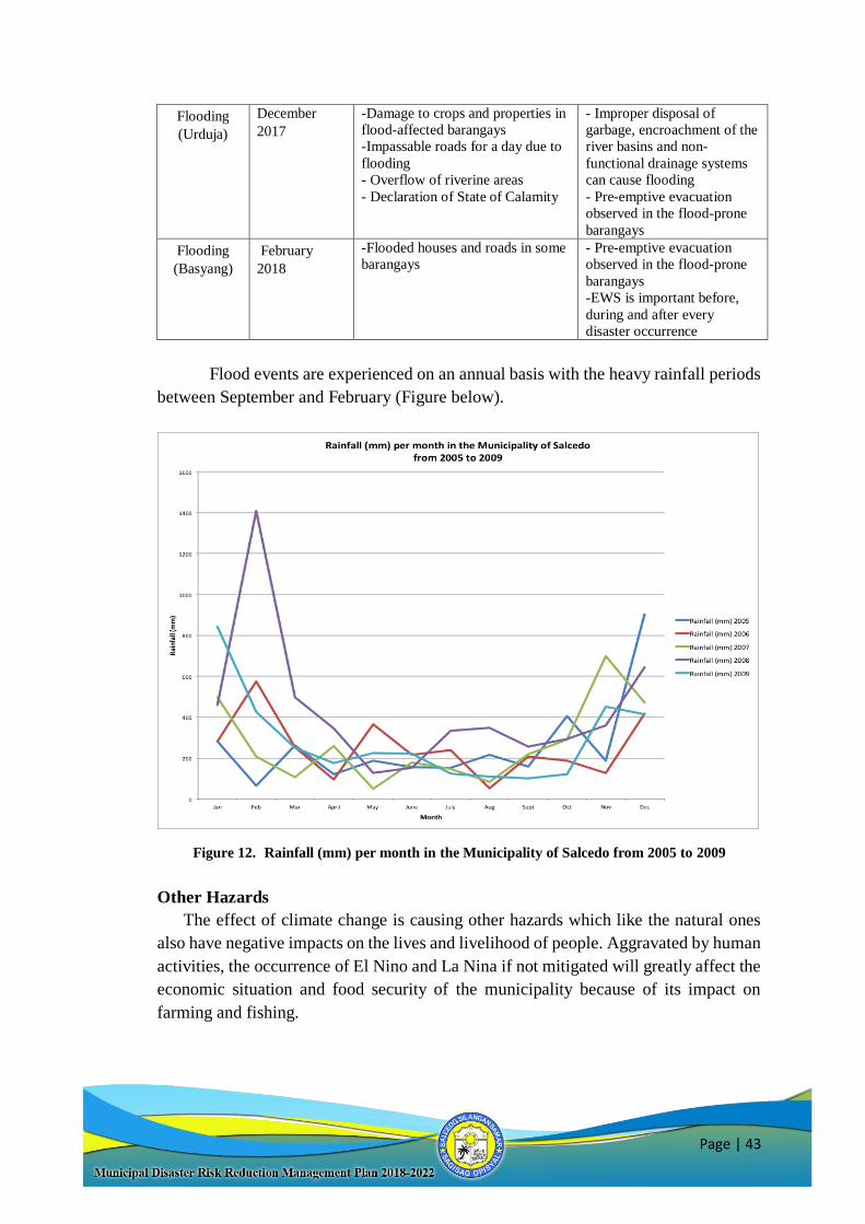
Page | 43
Flooding
(Urduja)
December
2017
-Damage to crops and properties in
flood-affected barangays
-Impassable roads for a day due to
flooding
- Overflow of riverine areas
- Declaration of State of Calamity
- Improper disposal of
garbage, encroachment of the
river basins and non-
functional drainage systems
can cause flooding
- Pre-emptive evacuation
observed in the flood-prone
barangays
Flooding
(Basyang)
February
2018
-Flooded houses and roads in some
barangays
- Pre-emptive evacuation
observed in the flood-prone
barangays
-EWS is important before,
during and after every
disaster occurrence
Flood events are experienced on an annual basis with the heavy rainfall periods
between September and February (Figure below).
Figure 12. Rainfall (mm) per month in the Municipality of Salcedo from 2005 to 2009
Other Hazards
The effect of climate change is causing other hazards which like the natural ones
also have negative impacts on the lives and livelihood of people. Aggravated by human
activities, the occurrence of El Nino and La Nina if not mitigated will greatly affect the
economic situation and food security of the municipality because of its impact on
farming and fishing.
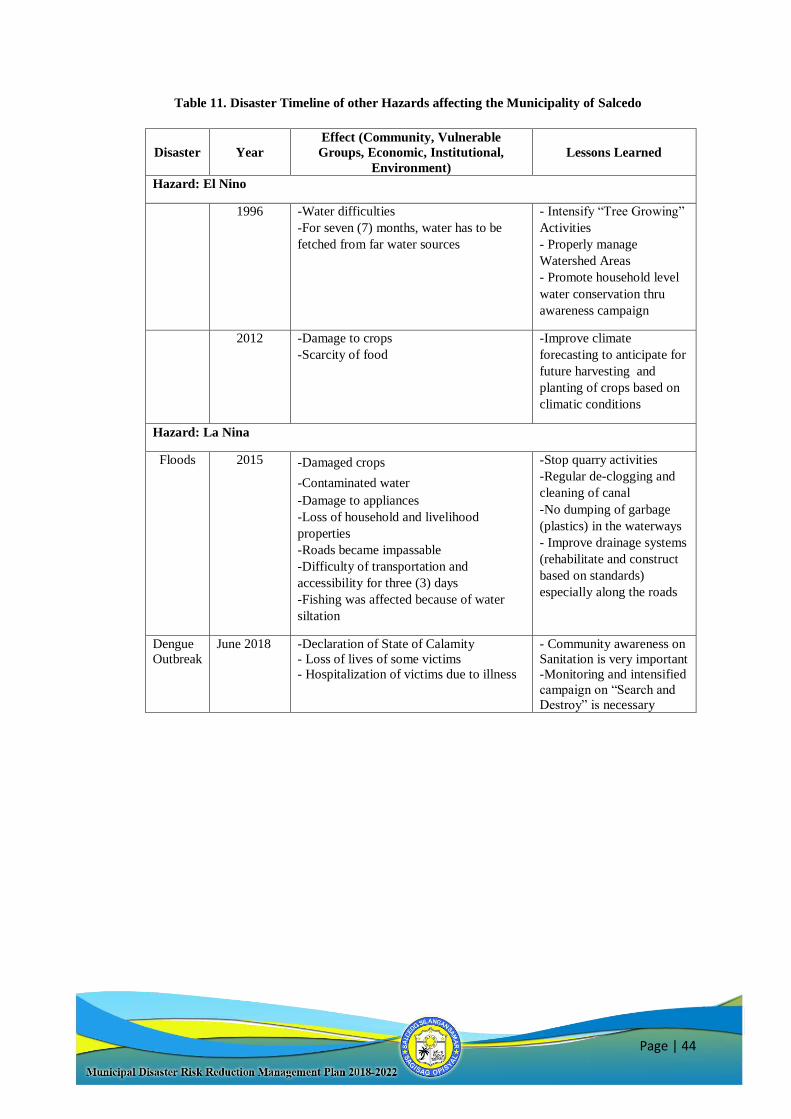
Page | 44
Table 11. Disaster Timeline of other Hazards affecting the Municipality of Salcedo
Disaster Year
Effect (Community, Vulnerable
Groups, Economic, Institutional,
Environment)
Lessons Learned
Hazard: El Nino
1996 -Water difficulties
-For seven (7) months, water has to be
fetched from far water sources
- Intensify “Tree Growing”
Activities
- Properly manage
Watershed Areas
- Promote household level
water conservation thru
awareness campaign
2012 -Damage to crops
-Scarcity of food
-Improve climate
forecasting to anticipate for
future harvesting and
planting of crops based on
climatic conditions
Hazard: La Nina
Floods 2015 -Damaged crops
-Contaminated water
-Damage to appliances
-Loss of household and livelihood
properties
-Roads became impassable
-Difficulty of transportation and
accessibility for three (3) days
-Fishing was affected because of water
siltation
-Stop quarry activities
-Regular de-clogging and
cleaning of canal
-No dumping of garbage
(plastics) in the waterways
- Improve drainage systems
(rehabilitate and construct
based on standards)
especially along the roads
Dengue
Outbreak
June 2018 -Declaration of State of Calamity
- Loss of lives of some victims
- Hospitalization of victims due to illness
- Community awareness on
Sanitation is very important
-Monitoring and intensified
campaign on “Search and
Destroy” is necessary
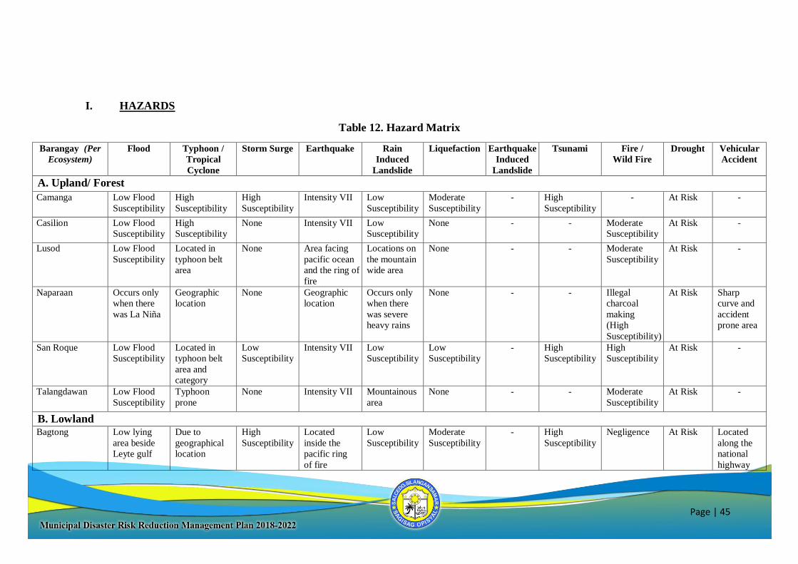
Page | 45
I. HAZARDS
Table 12. Hazard Matrix
Barangay (Per
Ecosystem)
Flood Typhoon /
Tropical
Cyclone
Storm Surge Earthquake Rain
Induced
Landslide
Liquefaction Earthquake
Induced
Landslide
Tsunami Fire /
Wild Fire
Drought Vehicular
Accident
A. Upland/ Forest
Camanga Low Flood
Susceptibility
High
Susceptibility
High
Susceptibility
Intensity VII Low
Susceptibility
Moderate
Susceptibility
- High
Susceptibility
- At Risk -
Casilion Low Flood
Susceptibility
High
Susceptibility
None Intensity VII Low
Susceptibility
None - - Moderate
Susceptibility
At Risk -
Lusod Low Flood
Susceptibility
Located in
typhoon belt
area
None Area facing
pacific ocean
and the ring of
fire
Locations on
the mountain
wide area
None - - Moderate
Susceptibility
At Risk -
Naparaan Occurs only
when there
was La Niña
Geographic
location
None Geographic
location
Occurs only
when there
was severe
heavy rains
None - - Illegal
charcoal
making
(High
Susceptibility)
At Risk Sharp
curve and
accident
prone area
San Roque Low Flood
Susceptibility
Located in
typhoon belt
area and
category
Low
Susceptibility
Intensity VII Low
Susceptibility
Low
Susceptibility
- High
Susceptibility
High
Susceptibility
At Risk -
Talangdawan Low Flood
Susceptibility
Typhoon
prone
None Intensity VII Mountainous
area
None - - Moderate
Susceptibility
At Risk -
B. Lowland
Bagtong Low lying
area beside
Leyte gulf
Due to
geographical
location
High
Susceptibility
Located
inside the
pacific ring
of fire
Low
Susceptibility
Moderate
Susceptibility
- High
Susceptibility
Negligence At Risk Located
along the
national
highway
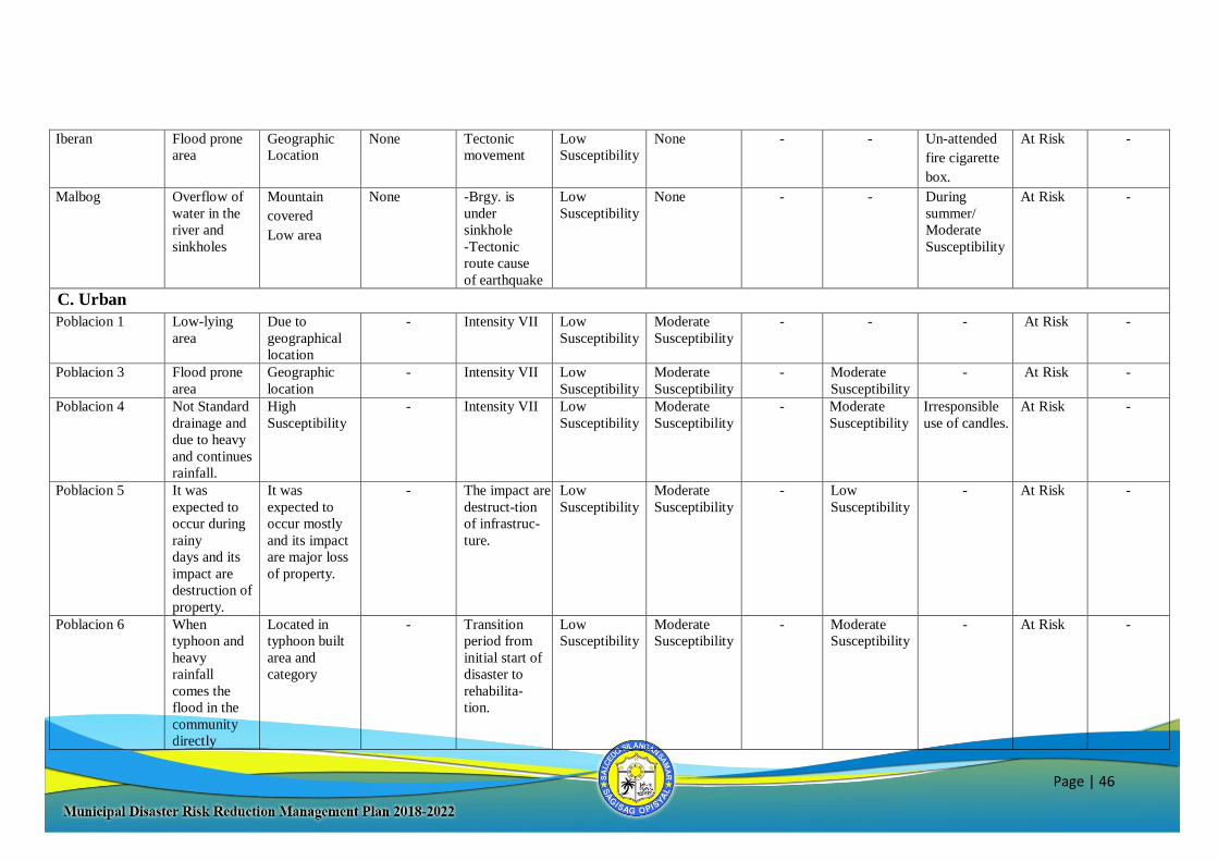
Page | 46
Iberan Flood prone
area
Geographic
Location
None Tectonic
movement
Low
Susceptibility
None - - Un-attended
fire cigarette
box.
At Risk -
Malbog Overflow of
water in the
river and
sinkholes
Mountain
covered
Low area
None -Brgy. is
under
sinkhole
-Tectonic
route cause
of earthquake
Low
Susceptibility
None - - During
summer/
Moderate
Susceptibility
At Risk -
C. Urban
Poblacion 1 Low-lying
area
Due to
geographical
location
- Intensity VII Low
Susceptibility
Moderate
Susceptibility
- - - At Risk -
Poblacion 3 Flood prone
area
Geographic
location
- Intensity VII Low
Susceptibility
Moderate
Susceptibility
- Moderate
Susceptibility
- At Risk -
Poblacion 4 Not Standard
drainage and
due to heavy
and continues
rainfall.
High
Susceptibility
- Intensity VII Low
Susceptibility
Moderate
Susceptibility
- Moderate
Susceptibility
Irresponsible
use of candles.
At Risk -
Poblacion 5 It was
expected to
occur during
rainy
days and its
impact are
destruction of
property.
It was
expected to
occur mostly
and its impact
are major loss
of property.
- The impact are
destruct-tion
of infrastruc-
ture.
Low
Susceptibility
Moderate
Susceptibility
- Low
Susceptibility
- At Risk -
Poblacion 6 When
typhoon and
heavy
rainfall
comes the
flood in the
community
directly
Located in
typhoon built
area and
category
- Transition
period from
initial start of
disaster to
rehabilita-
tion.
Low
Susceptibility
Moderate
Susceptibility
- Moderate
Susceptibility
- At Risk -
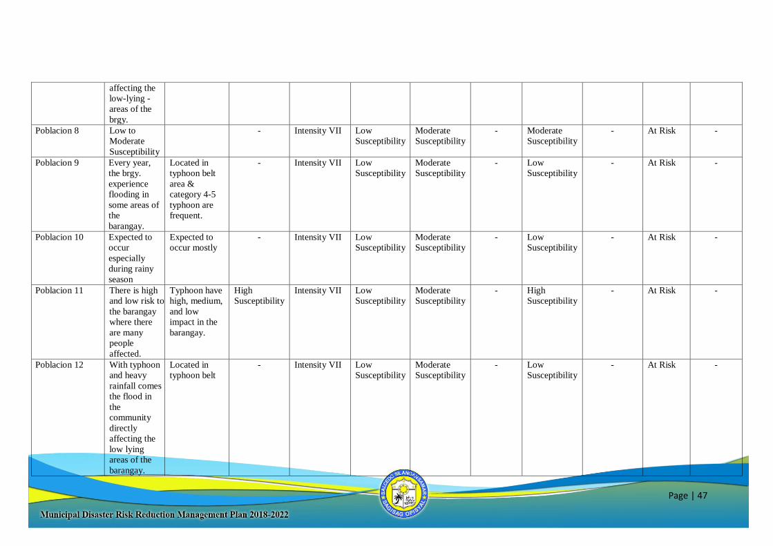
Page | 47
affecting the
low-lying -
areas of the
brgy.
Poblacion 8 Low to
Moderate
Susceptibility
- Intensity VII Low
Susceptibility
Moderate
Susceptibility
- Moderate
Susceptibility
- At Risk -
Poblacion 9
Every year,
the brgy.
experience
flooding in
some areas of
the
barangay.
Located in
typhoon belt
area &
category 4-5
typhoon are
frequent.
-
Intensity VII Low
Susceptibility
Moderate
Susceptibility
- Low
Susceptibility
- At Risk -
Poblacion 10
Expected to
occur
especially
during rainy
season
Expected to
occur mostly
- Intensity VII Low
Susceptibility
Moderate
Susceptibility
- Low
Susceptibility
- At Risk -
Poblacion 11
There is high
and low risk to
the barangay
where there
are many
people
affected.
Typhoon have
high, medium,
and low
impact in the
barangay.
High
Susceptibility
Intensity VII Low
Susceptibility
Moderate
Susceptibility
- High
Susceptibility
- At Risk -
Poblacion 12
With typhoon
and heavy
rainfall comes
the flood in
the
community
directly
affecting the
low lying
areas of the
barangay.
Located in
typhoon belt
- Intensity VII Low
Susceptibility
Moderate
Susceptibility
- Low
Susceptibility
- At Risk -
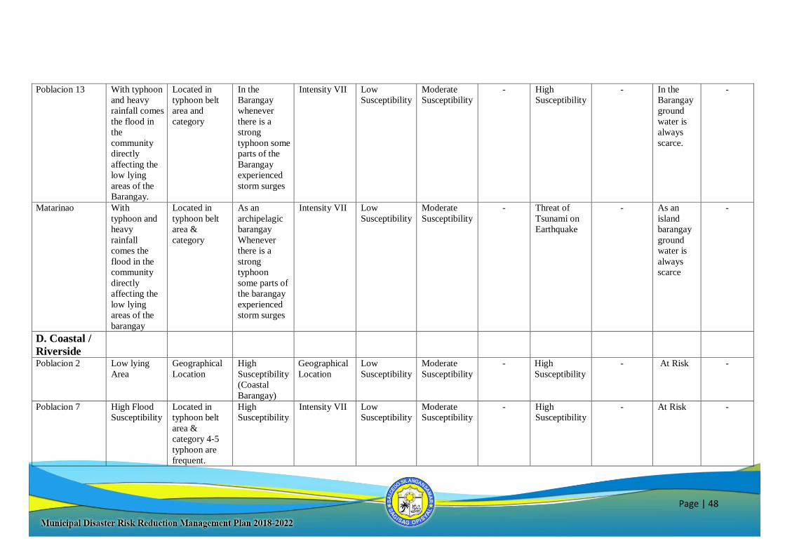
Page | 48
Poblacion 13
With typhoon
and heavy
rainfall comes
the flood in
the
community
directly
affecting the
low lying
areas of the
Barangay.
Located in
typhoon belt
area and
category
In the
Barangay
whenever
there is a
strong
typhoon some
parts of the
Barangay
experienced
storm surges
Intensity VII Low
Susceptibility
Moderate
Susceptibility
- High
Susceptibility
- In the
Barangay
ground
water is
always
scarce.
-
Matarinao With
typhoon and
heavy
rainfall
comes the
flood in the
community
directly
affecting the
low lying
areas of the
barangay
Located in
typhoon belt
area &
category
As an
archipelagic
barangay
Whenever
there is a
strong
typhoon
some parts of
the barangay
experienced
storm surges
Intensity VII Low
Susceptibility
Moderate
Susceptibility
- Threat of
Tsunami on
Earthquake
- As an
island
barangay
ground
water is
always
scarce
-
D. Coastal /
Riverside
Poblacion 2 Low lying
Area
Geographical
Location
High
Susceptibility
(Coastal
Barangay)
Geographical
Location
Low
Susceptibility
Moderate
Susceptibility
- High
Susceptibility
- At Risk -
Poblacion 7 High Flood
Susceptibility
Located in
typhoon belt
area &
category 4-5
typhoon are
frequent.
High
Susceptibility
Intensity VII Low
Susceptibility
Moderate
Susceptibility
- High
Susceptibility
- At Risk -
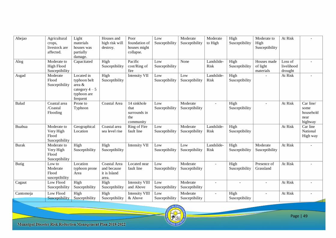
Page | 49
Abejao Agricultural
crops,
livestock are
affected.
Light
materials
houses was
partially
damage.
Houses and
high risk will
destroy.
Poor
foundation of
houses might
collapse.
Low
Susceptibility
Moderate
Susceptibility
Moderate
to High
High
Susceptibility
Moderate to
High
Susceptibility
At Risk -
Alog Moderate to
High Flood
Susceptibility
Capacitated High
Susceptibility
Pacific
cost/Ring of
fire
Low
Susceptibility
None Landslide-
Risk
High
Susceptibility
Houses made
of light
materials
Loss of
livelihood
drought
-
Asgad Moderate
Flood
Susceptibility
Located in
typhoon belt
area &
category 4 – 5
typhoon are
frequent
High
Susceptibility
Intensity VII Low
Susceptibility
Low
Susceptibility
Landslide-
Risk
High
Susceptibility
- At Risk -
Balud Coastal area
/Coastal
Flooding
Prone to
Typhoon
Coastal Area 14 sinkhole
that
surrounds in
the
community
Low
Susceptibility
Moderate
Susceptibility
- High
Susceptibility
- At Risk Car line/
some
household
near
highway
Buabua Moderate to
Very High
Flood
Susceptibility
Geographical
Location
Coastal area
sea level rise
Ring of Fire
fault line
Low
Susceptibility
Moderate
Susceptibility
Landslide-
Risk
High
Susceptibility
At Risk Car line
National
High way
Burak Moderate to
Very High
Flood
Susceptibility
High
Susceptibility
High
Susceptibility
Intensity VII Low
Susceptibility
Low
Susceptibility
Landslide-
Risk
High
Susceptibility
Moderate
Susceptibility
At Risk -
Butig Low to
Moderate
Flood
susceptibility
Location
typhoon prone
Area
Coastal Area
and because
it is Island
area.
Located near
fault line
Low
Susceptibility
Moderate
Susceptibility
- High
Susceptibility
Presence of
Grassland
At Risk -
Cagaut Low Flood
Susceptibility
High
Susceptibility
High
Susceptibility
Intensity VIII
and Above
Low
Susceptibility
Moderate
Susceptibility
- - - At Risk -
Cantomoja Low Flood
Susceptibility
High
Susceptibility
High
Susceptibility
Intensity VIII
& Above
Low
Susceptibility
Moderate
Susceptibility
- High
Susceptibility
- At Risk -
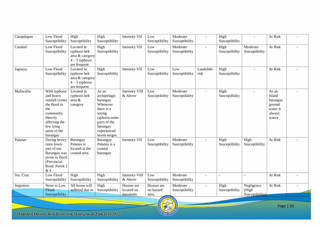
Page | 50
Carapdapan Low Flood
Susceptibility
High
Susceptibility
High
Susceptibility
Intensity VII Low
Susceptibility
Moderate
Susceptibility
- High
Susceptibility
- At Risk -
Caridad Low Flood
Susceptibility
Located in
typhoon belt
area & category
4 – 5 typhoon
are frequent
High
Susceptibility
Intensity VII Low
Susceptibility
Moderate
Susceptibility
- High
Susceptibility
Moderate
Susceptibility
At Risk -
Jagnaya Low Flood
Susceptibility
Located in
typhoon belt
area & category
4 – 5 typhoon
are frequent
High
Susceptibility
Intensity VII Low
Susceptibility
Low
Susceptibility
Landslide-
risk
High
Susceptibility
- At Risk -
Maliwaliw With typhoon
and heavy
rainfall comes
the flood in
the
community
directly
affecting the
low lying
areas of the
barangay
Located in
typhoon belt
area &
category
As an
archipelagic
barangay
Whenever
there is a
strong
typhoon some
parts of the
barangay
experienced
storm surges.
Intensity VIII
& Above
Low
Susceptibility
Moderate
Susceptibility
- High
Susceptibility
- As an
island
barangay
ground
water is
always
scarce
-
Palanas During heavy
rains lower
part of our
Barangay was
prone to flood
(Provincial
Road Purok 1
& 4
Barangay
Palanas is
located at the
coastal area.
Barangay
Palanas is a
coastal
barangay
Intensity VII Low
Susceptibility
Moderate
Susceptibility
- High
Susceptibility
High
Susceptibility
At Risk -
Sta. Cruz Low Flood
Susceptibility
High
Susceptibility
High
Susceptibility
Intensity VIII
& Above
Low
Susceptibility
Moderate
Susceptibility
- - - At Risk -
Seguinon None to Low
Flood
Susceptibility
All house will
suffered due to
High
Susceptibility
Houses are
located on
mountain.
Houses are
on hazard
area.
Moderate
Susceptibility
- High
Susceptibility
Negligence
(High
Susceptibility)
At Risk -
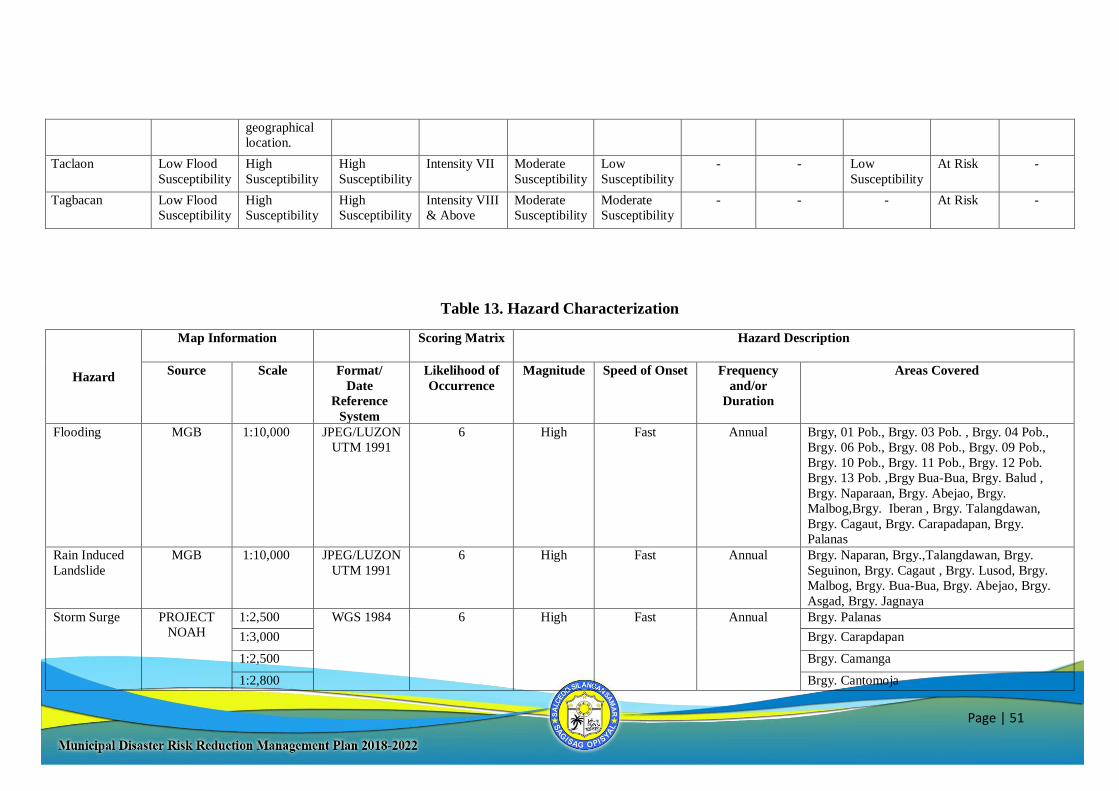
Page | 51
geographical
location.
Taclaon Low Flood
Susceptibility
High
Susceptibility
High
Susceptibility
Intensity VII Moderate
Susceptibility
Low
Susceptibility
- - Low
Susceptibility
At Risk -
Tagbacan Low Flood
Susceptibility
High
Susceptibility
High
Susceptibility
Intensity VIII
& Above
Moderate
Susceptibility
Moderate
Susceptibility
- - - At Risk -
Table 13. Hazard Characterization
Hazard
Map Information Scoring Matrix Hazard Description
Source Scale Format/
Date
Reference
System
Likelihood of
Occurrence
Magnitude Speed of Onset Frequency
and/or
Duration
Areas Covered
Flooding MGB 1:10,000 JPEG/LUZON
UTM 1991
6 High Fast Annual Brgy, 01 Pob., Brgy. 03 Pob. , Brgy. 04 Pob.,
Brgy. 06 Pob., Brgy. 08 Pob., Brgy. 09 Pob.,
Brgy. 10 Pob., Brgy. 11 Pob., Brgy. 12 Pob.
Brgy. 13 Pob. ,Brgy Bua-Bua, Brgy. Balud ,
Brgy. Naparaan, Brgy. Abejao, Brgy.
Malbog,Brgy. Iberan , Brgy. Talangdawan,
Brgy. Cagaut, Brgy. Carapadapan, Brgy.
Palanas
Rain Induced
Landslide
MGB 1:10,000 JPEG/LUZON
UTM 1991
6 High Fast Annual Brgy. Naparan, Brgy.,Talangdawan, Brgy.
Seguinon, Brgy. Cagaut , Brgy. Lusod, Brgy.
Malbog, Brgy. Bua-Bua, Brgy. Abejao, Brgy.
Asgad, Brgy. Jagnaya
Storm Surge PROJECT
NOAH
1:2,500 WGS 1984 6 High Fast Annual Brgy. Palanas
1:3,000 Brgy. Carapdapan
1:2,500 Brgy. Camanga
1:2,800 Brgy. Cantomoja
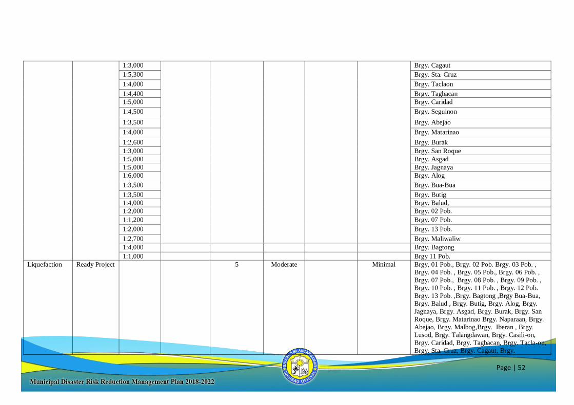
Page | 52
1:3,000 Brgy. Cagaut
1:5,300 Brgy. Sta. Cruz
1:4,000 Brgy. Taclaon
1:4,400 Brgy. Tagbacan
1:5,000 Brgy. Caridad
1:4,500 Brgy. Seguinon
1:3,500 Brgy. Abejao
1:4,000 Brgy. Matarinao
1:2,600 Brgy. Burak
1:3,000 Brgy. San Roque
1:5,000 Brgy. Asgad
1:5,000 Brgy. Jagnaya
1:6,000 Brgy. Alog
1:3,500 Brgy. Bua-Bua
1:3,500 Brgy. Butig
1:4,000 Brgy. Balud,
1:2,000 Brgy. 02 Pob.
1:1,200 Brgy. 07 Pob.
1:2,000 Brgy. 13 Pob.
1:2,700 Brgy. Maliwaliw
1:4,000 Brgy. Bagtong
1:1,000 Brgy 11 Pob.
Liquefaction Ready Project 5 Moderate Minimal Brgy, 01 Pob., Brgy. 02 Pob. Brgy. 03 Pob. ,
Brgy. 04 Pob. , Brgy. 05 Pob., Brgy. 06 Pob. ,
Brgy. 07 Pob., Brgy. 08 Pob. , Brgy. 09 Pob. ,
Brgy. 10 Pob. , Brgy. 11 Pob. , Brgy. 12 Pob.
Brgy. 13 Pob. ,Brgy. Bagtong ,Brgy Bua-Bua,
Brgy. Balud , Brgy. Butig, Brgy. Alog, Brgy.
Jagnaya, Brgy. Asgad, Brgy. Burak, Brgy. San
Roque, Brgy. Matarinao Brgy. Naparaan, Brgy.
Abejao, Brgy. Malbog,Brgy. Iberan , Brgy.
Lusod, Brgy. Talangdawan, Brgy. Casili-on,
Brgy. Caridad, Brgy. Tagbacan, Brgy. Tacla-on,
Brgy. Sta. Cruz, Brgy. Cagaut, Brgy.
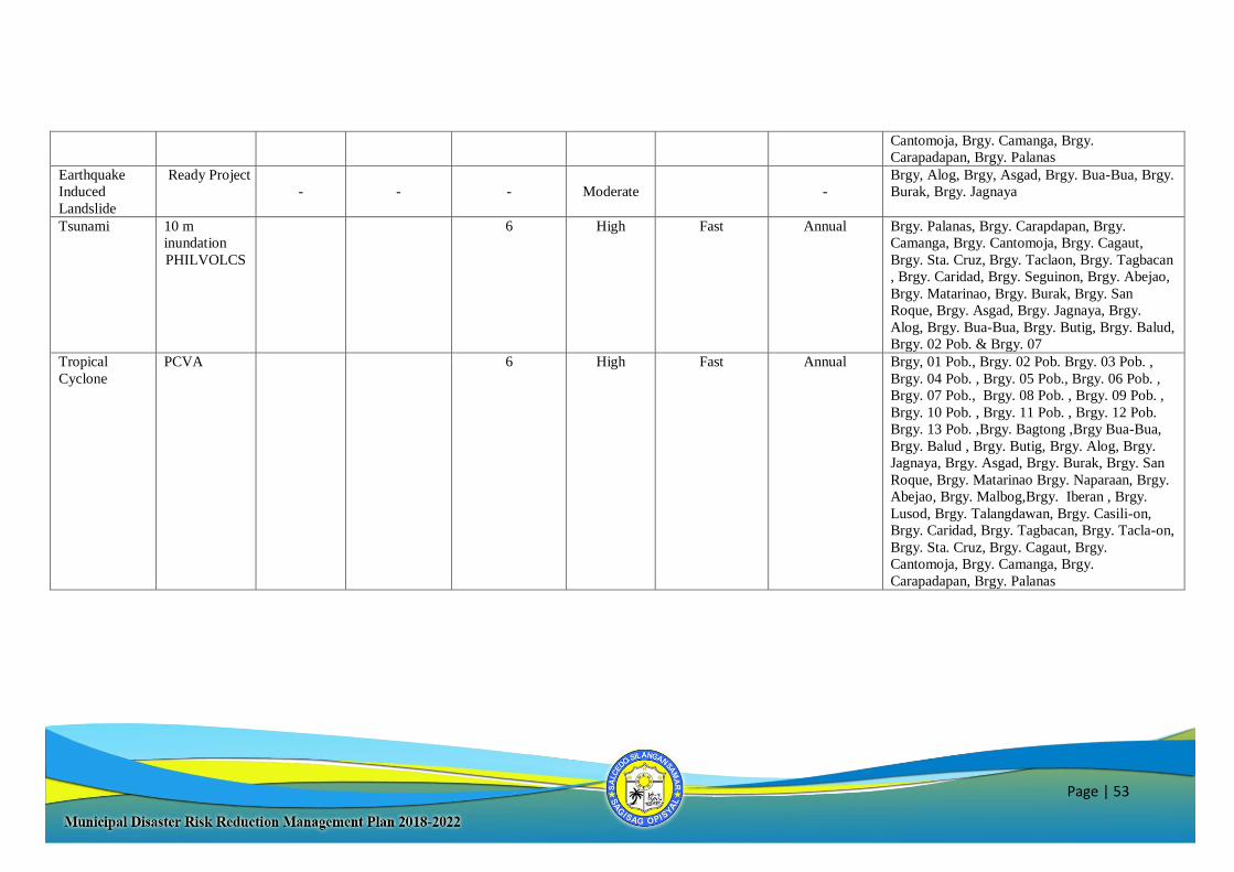
Page | 53
Cantomoja, Brgy. Camanga, Brgy.
Carapadapan, Brgy. Palanas
Earthquake
Induced
Landslide
Ready Project
-
-
-
Moderate
-
Brgy, Alog, Brgy, Asgad, Brgy. Bua-Bua, Brgy.
Burak, Brgy. Jagnaya
Tsunami 10 m
inundation
PHILVOLCS
6 High Fast Annual Brgy. Palanas, Brgy. Carapdapan, Brgy.
Camanga, Brgy. Cantomoja, Brgy. Cagaut,
Brgy. Sta. Cruz, Brgy. Taclaon, Brgy. Tagbacan
, Brgy. Caridad, Brgy. Seguinon, Brgy. Abejao,
Brgy. Matarinao, Brgy. Burak, Brgy. San
Roque, Brgy. Asgad, Brgy. Jagnaya, Brgy.
Alog, Brgy. Bua-Bua, Brgy. Butig, Brgy. Balud,
Brgy. 02 Pob. & Brgy. 07
Tropical
Cyclone
PCVA 6 High
Fast Annual Brgy, 01 Pob., Brgy. 02 Pob. Brgy. 03 Pob. ,
Brgy. 04 Pob. , Brgy. 05 Pob., Brgy. 06 Pob. ,
Brgy. 07 Pob., Brgy. 08 Pob. , Brgy. 09 Pob. ,
Brgy. 10 Pob. , Brgy. 11 Pob. , Brgy. 12 Pob.
Brgy. 13 Pob. ,Brgy. Bagtong ,Brgy Bua-Bua,
Brgy. Balud , Brgy. Butig, Brgy. Alog, Brgy.
Jagnaya, Brgy. Asgad, Brgy. Burak, Brgy. San
Roque, Brgy. Matarinao Brgy. Naparaan, Brgy.
Abejao, Brgy. Malbog,Brgy. Iberan , Brgy.
Lusod, Brgy. Talangdawan, Brgy. Casili-on,
Brgy. Caridad, Brgy. Tagbacan, Brgy. Tacla-on,
Brgy. Sta. Cruz, Brgy. Cagaut, Brgy.
Cantomoja, Brgy. Camanga, Brgy.
Carapadapan, Brgy. Palanas
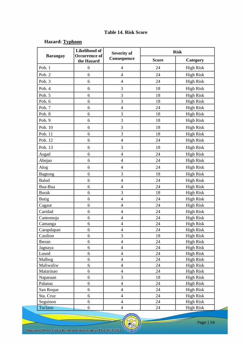
Page | 54
Table 14. Risk Score
Hazard: Typhoon
Barangay
Likelihood of
Occurrence of
the Hazard
Severity of
Consequence
Risk
Score Category
Pob. 1 6 4 24 High Risk
Pob. 2 6 4 24 High Risk
Pob. 3 6 4 24 High Risk
Pob. 4 6 3 18 High Risk
Pob. 5 6 3 18 High Risk
Pob. 6 6 3 18 High Risk
Pob. 7 6 4 24 High Risk
Pob. 8 6 3 18 High Risk
Pob. 9 6 3 18 High Risk
Pob. 10 6 3 18 High Risk
Pob. 11 6 3 18 High Risk
Pob. 12 6 4 24 High Risk
Pob. 13 6 3 18 High Risk
Asgad 6 4 24 High Risk
Abejao 6 4 24 High Risk
Alog 6 4 24 High Risk
Bagtong 6 3 18 High Risk
Balud 6 4 24 High Risk
Bua-Bua 6 4 24 High Risk
Burak 6 3 18 High Risk
Butig 6 4 24 High Risk
Cagaut 6 4 24 High Risk
Caridad 6 4 24 High Risk
Cantomoja 6 4 24 High Risk
Camanga 6 4 24 High Risk
Carapdapan 6 4 24 High Risk
Casilion 6 3 18 High Risk
Iberan 6 4 24 High Risk
Jagnaya 6 4 24 High Risk
Lusod 6 4 24 High Risk
Malbog 6 4 24 High Risk
Maliwaliw 6 4 24 High Risk
Matarinao 6 4 24 High Risk
Naparaan 6 3 18 High Risk
Palanas 6 4 24 High Risk
San Roque 6 4 24 High Risk
Sta. Cruz 6 4 24 High Risk
Seguinon 6 4 24 High Risk
Taclaon 6 4 24 High Risk
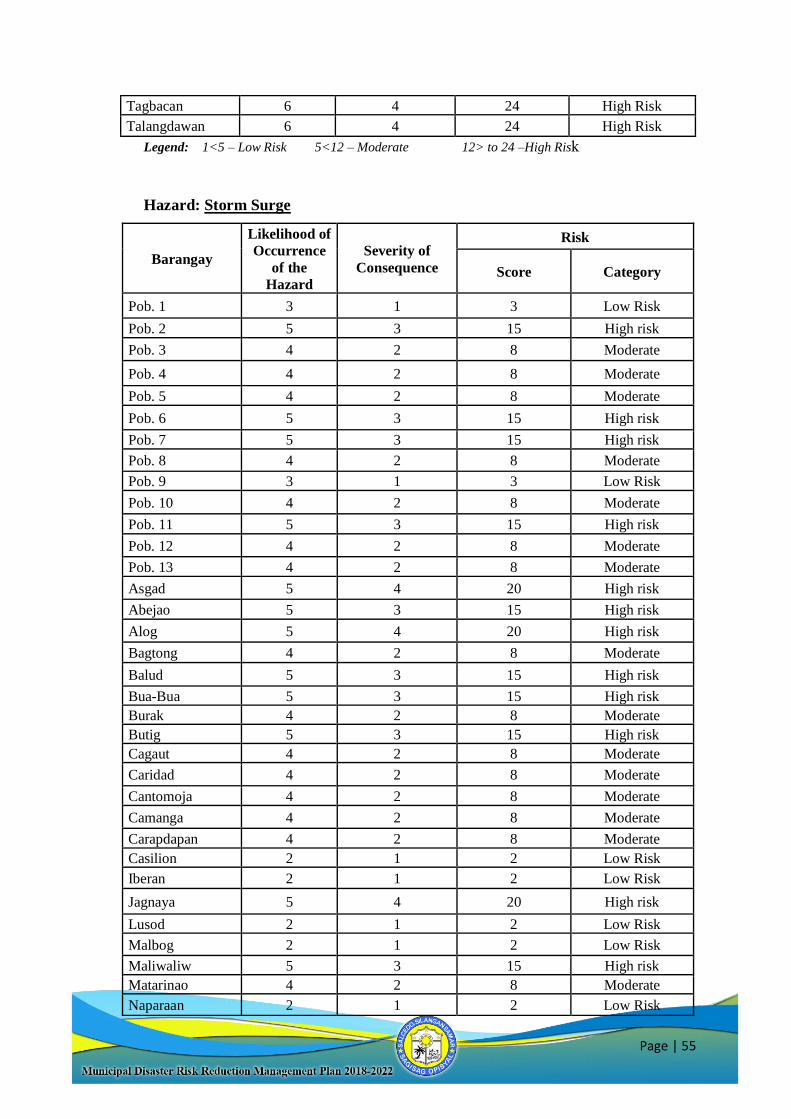
Page | 55
Tagbacan 6 4 24 High Risk
Talangdawan 6 4 24 High Risk
Legend: 1<5 – Low Risk 5<12 – Moderate 12> to 24 –High Risk
Hazard: Storm Surge
Barangay
Likelihood of
Occurrence
of the
Hazard
Severity of
Consequence
Risk
Score Category
Pob. 1 3 1 3 Low Risk
Pob. 2 5 3 15 High risk
Pob. 3 4 2 8 Moderate
Pob. 4 4 2 8 Moderate
Pob. 5 4 2 8 Moderate
Pob. 6 5 3 15 High risk
Pob. 7 5 3 15 High risk
Pob. 8 4 2 8 Moderate
Pob. 9 3 1 3 Low Risk
Pob. 10 4 2 8 Moderate
Pob. 11 5 3 15 High risk
Pob. 12 4 2 8 Moderate
Pob. 13 4 2 8 Moderate
Asgad 5 4 20 High risk
Abejao 5 3 15 High risk
Alog 5 4 20 High risk
Bagtong 4 2 8 Moderate
Balud 5 3 15 High risk
Bua-Bua 5 3 15 High risk
Burak 4 2 8 Moderate
Butig 5 3 15 High risk
Cagaut 4 2 8 Moderate
Caridad 4 2 8 Moderate
Cantomoja 4 2 8 Moderate
Camanga 4 2 8 Moderate
Carapdapan 4 2 8 Moderate
Casilion 2 1 2 Low Risk
Iberan 2 1 2 Low Risk
Jagnaya 5 4 20 High risk
Lusod 2 1 2 Low Risk
Malbog 2 1 2 Low Risk
Maliwaliw 5 3 15 High risk
Matarinao 4 2 8 Moderate
Naparaan 2 1 2 Low Risk
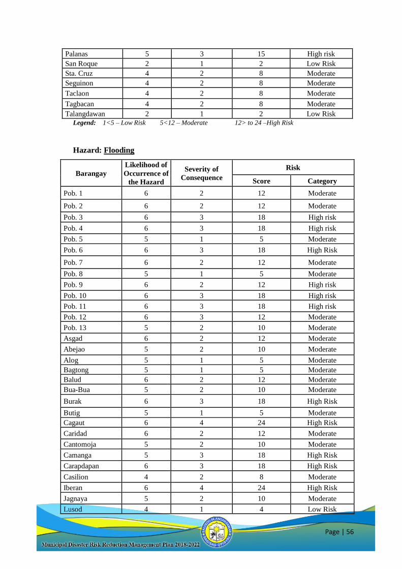
Page | 56
Palanas 5 3 15 High risk
San Roque 2 1 2 Low Risk
Sta. Cruz 4 2 8 Moderate
Seguinon 4 2 8 Moderate
Taclaon 4 2 8 Moderate
Tagbacan 4 2 8 Moderate
Talangdawan 2 1 2 Low Risk
Legend: 1<5 – Low Risk 5<12 – Moderate 12> to 24 –High Risk
Hazard: Flooding
Barangay
Likelihood of
Occurrence of
the Hazard
Severity of
Consequence
Risk
Score Category
Pob. 1 6 2 12 Moderate
Pob. 2 6 2 12 Moderate
Pob. 3 6 3 18 High risk
Pob. 4 6 3 18 High risk
Pob. 5 5 1 5 Moderate
Pob. 6 6 3 18 High Risk
Pob. 7 6 2 12 Moderate
Pob. 8 5 1 5 Moderate
Pob. 9 6 2 12 High risk
Pob. 10 6 3 18 High risk
Pob. 11 6 3 18 High risk
Pob. 12 6 3 12 Moderate
Pob. 13 5 2 10 Moderate
Asgad 6 2 12 Moderate
Abejao 5 2 10 Moderate
Alog 5 1 5 Moderate
Bagtong 5 1 5 Moderate
Balud 6 2 12 Moderate
Bua-Bua 5 2 10 Moderate
Burak 6 3 18 High Risk
Butig 5 1 5 Moderate
Cagaut 6 4 24 High Risk
Caridad 6 2 12 Moderate
Cantomoja 5 2 10 Moderate
Camanga 5 3 18 High Risk
Carapdapan 6 3 18 High Risk
Casilion 4 2 8 Moderate
Iberan 6 4 24 High Risk
Jagnaya 5 2 10 Moderate
Lusod 4 1 4 Low Risk
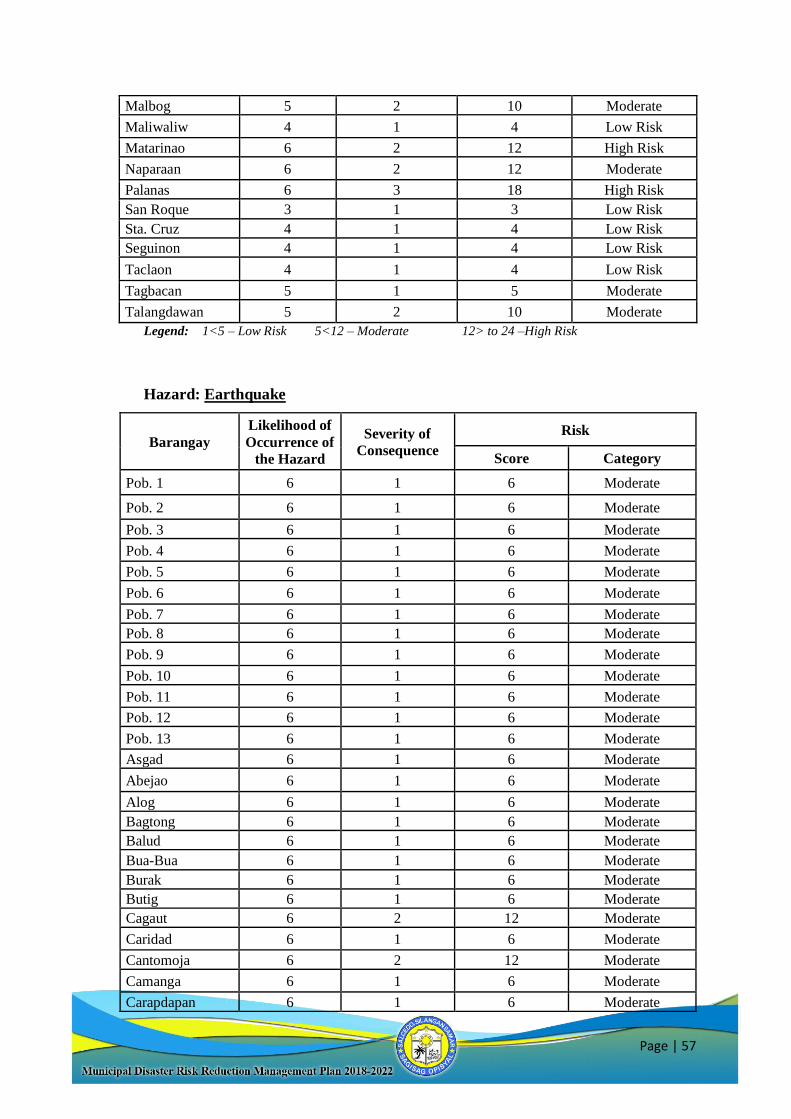
Page | 57
Malbog 5 2 10 Moderate
Maliwaliw 4 1 4 Low Risk
Matarinao 6 2 12 High Risk
Naparaan 6 2 12 Moderate
Palanas 6 3 18 High Risk
San Roque 3 1 3 Low Risk
Sta. Cruz 4 1 4 Low Risk
Seguinon 4 1 4 Low Risk
Taclaon 4 1 4 Low Risk
Tagbacan 5 1 5 Moderate
Talangdawan 5 2 10 Moderate
Legend: 1<5 – Low Risk 5<12 – Moderate 12> to 24 –High Risk
Hazard: Earthquake
Barangay
Likelihood of
Occurrence of
the Hazard
Severity of
Consequence
Risk
Score Category
Pob. 1 6 1 6 Moderate
Pob. 2 6 1 6 Moderate
Pob. 3 6 1 6 Moderate
Pob. 4 6 1 6 Moderate
Pob. 5 6 1 6 Moderate
Pob. 6 6 1 6 Moderate
Pob. 7 6 1 6 Moderate
Pob. 8 6 1 6 Moderate
Pob. 9 6 1 6 Moderate
Pob. 10 6 1 6 Moderate
Pob. 11 6 1 6 Moderate
Pob. 12 6 1 6 Moderate
Pob. 13 6 1 6 Moderate
Asgad 6 1 6 Moderate
Abejao 6 1 6 Moderate
Alog 6 1 6 Moderate
Bagtong 6 1 6 Moderate
Balud 6 1 6 Moderate
Bua-Bua 6 1 6 Moderate
Burak 6 1 6 Moderate
Butig 6 1 6 Moderate
Cagaut 6 2 12 Moderate
Caridad 6 1 6 Moderate
Cantomoja 6 2 12 Moderate
Camanga 6 1 6 Moderate
Carapdapan 6 1 6 Moderate
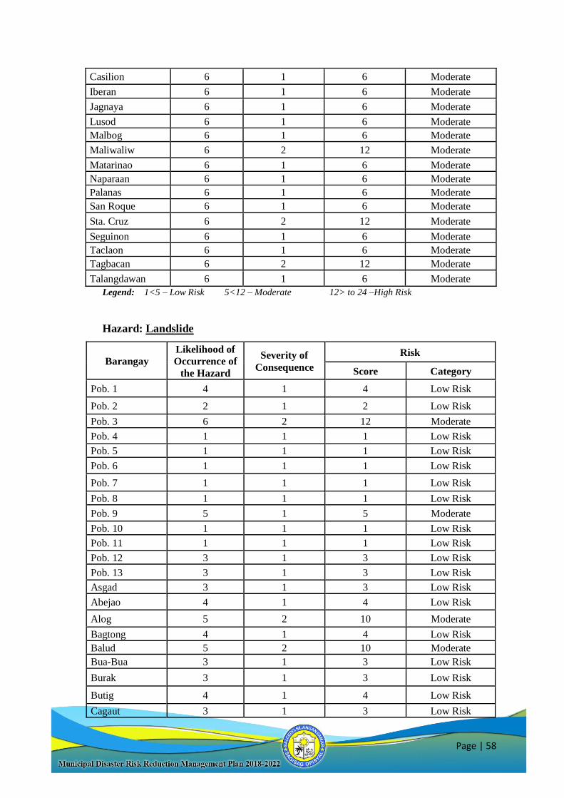
Page | 58
Casilion 6 1 6 Moderate
Iberan 6 1 6 Moderate
Jagnaya 6 1 6 Moderate
Lusod 6 1 6 Moderate
Malbog 6 1 6 Moderate
Maliwaliw 6 2 12 Moderate
Matarinao 6 1 6 Moderate
Naparaan 6 1 6 Moderate
Palanas 6 1 6 Moderate
San Roque 6 1 6 Moderate
Sta. Cruz 6 2 12 Moderate
Seguinon 6 1 6 Moderate
Taclaon 6 1 6 Moderate
Tagbacan 6 2 12 Moderate
Talangdawan 6 1 6 Moderate
Legend: 1<5 – Low Risk 5<12 – Moderate 12> to 24 –High Risk
Hazard: Landslide
Barangay
Likelihood of
Occurrence of
the Hazard
Severity of
Consequence
Risk
Score Category
Pob. 1 4 1 4 Low Risk
Pob. 2 2 1 2 Low Risk
Pob. 3 6 2 12 Moderate
Pob. 4 1 1 1 Low Risk
Pob. 5 1 1 1 Low Risk
Pob. 6 1 1 1 Low Risk
Pob. 7 1 1 1 Low Risk
Pob. 8 1 1 1 Low Risk
Pob. 9 5 1 5 Moderate
Pob. 10 1 1 1 Low Risk
Pob. 11 1 1 1 Low Risk
Pob. 12 3 1 3 Low Risk
Pob. 13 3 1 3 Low Risk
Asgad 3 1 3 Low Risk
Abejao 4 1 4 Low Risk
Alog 5 2 10 Moderate
Bagtong 4 1 4 Low Risk
Balud 5 2 10 Moderate
Bua-Bua 3 1 3 Low Risk
Burak 3 1 3 Low Risk
Butig 4 1 4 Low Risk
Cagaut 3 1 3 Low Risk
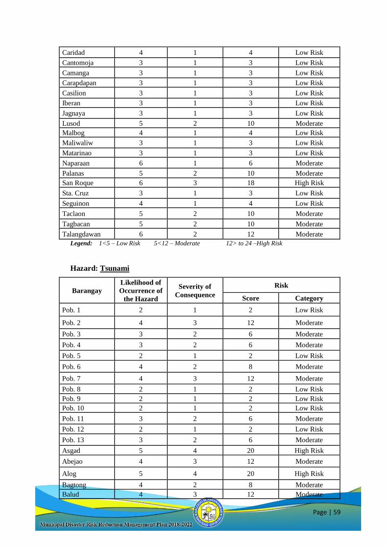
Page | 59
Caridad 4 1 4 Low Risk
Cantomoja 3 1 3 Low Risk
Camanga 3 1 3 Low Risk
Carapdapan 3 1 3 Low Risk
Casilion 3 1 3 Low Risk
Iberan 3 1 3 Low Risk
Jagnaya 3 1 3 Low Risk
Lusod 5 2 10 Moderate
Malbog 4 1 4 Low Risk
Maliwaliw 3 1 3 Low Risk
Matarinao 3 1 3 Low Risk
Naparaan 6 1 6 Moderate
Palanas 5 2 10 Moderate
San Roque 6 3 18 High Risk
Sta. Cruz 3 1 3 Low Risk
Seguinon 4 1 4 Low Risk
Taclaon 5 2 10 Moderate
Tagbacan 5 2 10 Moderate
Talangdawan 6 2 12 Moderate
Legend: 1<5 – Low Risk 5<12 – Moderate 12> to 24 –High Risk
Hazard: Tsunami
Barangay
Likelihood of
Occurrence of
the Hazard
Severity of
Consequence
Risk
Score Category
Pob. 1 2 1 2 Low Risk
Pob. 2 4 3 12 Moderate
Pob. 3 3 2 6 Moderate
Pob. 4 3 2 6 Moderate
Pob. 5 2 1 2 Low Risk
Pob. 6 4 2 8 Moderate
Pob. 7 4 3 12 Moderate
Pob. 8 2 1 2 Low Risk
Pob. 9 2 1 2 Low Risk
Pob. 10 2 1 2 Low Risk
Pob. 11 3 2 6 Moderate
Pob. 12 2 1 2 Low Risk
Pob. 13 3 2 6 Moderate
Asgad 5 4 20 High Risk
Abejao 4 3 12 Moderate
Alog 5 4 20 High Risk
Bagtong 4 2 8 Moderate
Balud 4 3 12 Moderate
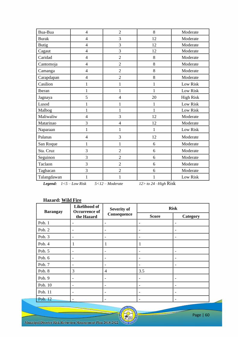
Page | 60
Bua-Bua 4 2 8 Moderate
Burak 4 3 12 Moderate
Butig 4 3 12 Moderate
Cagaut 4 3 12 Moderate
Caridad 4 2 8 Moderate
Cantomoja 4 2 8 Moderate
Camanga 4 2 8 Moderate
Carapdapan 4 2 8 Moderate
Casilion 1 1 1 Low Risk
Iberan 1 1 1 Low Risk
Jagnaya 5 4 20 High Risk
Lusod 1 1 1 Low Risk
Malbog 1 1 1 Low Risk
Maliwaliw 4 3 12 Moderate
Matarinao 3 4 12 Moderate
Naparaan 1 1 1 Low Risk
Palanas 4 3 12 Moderate
San Roque 1 1 6 Moderate
Sta. Cruz 3 2 6 Moderate
Seguinon 3 2 6 Moderate
Taclaon 3 2 6 Moderate
Tagbacan 3 2 6 Moderate
Talangdawan 1 1 1 Low Risk
Legend: 1<5 – Low Risk 5<12 – Moderate 12> to 24 –High Risk
Hazard: Wild Fire
Barangay
Likelihood of
Occurrence of
the Hazard
Severity of
Consequence
Risk
Score Category
Pob. 1 - - - -
Pob. 2 - - - -
Pob. 3 - - - -
Pob. 4 1 1 1
Pob. 5 - - - -
Pob. 6 - - - -
Pob. 7 - - - -
Pob. 8 3 4 3.5
Pob. 9 - - - -
Pob. 10 - - - -
Pob. 11 - - - -
Pob. 12 - - - -
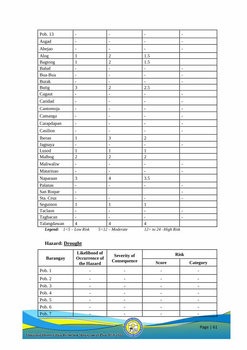
Page | 61
Pob. 13 - - - -
Asgad - - - -
Abejao - - - -
Alog 1 2 1.5
Bagtong 1 2 1.5
Balud - - - -
Bua-Bua - - - -
Burak - - - -
Butig 3 2 2.5
Cagaut - - - -
Caridad - - - -
Cantomoja - - - -
Camanga - - - -
Carapdapan - - - -
Casilion - - - -
Iberan 1 3 2
Jagnaya - - - -
Lusod 1 1 1
Malbog 2 2 2
Maliwaliw - - - -
Matarinao - - - -
Naparaan 3 4 3.5
Palanas - - - -
San Roque - -
Sta. Cruz - - - -
Seguinon 1 1 1
Taclaon - - - -
Tagbacan - - - -
Talangdawan 4 4 4
Legend: 1<5 – Low Risk 5<12 – Moderate 12> to 24 –High Risk
Hazard: Drought
Barangay
Likelihood of
Occurrence of
the Hazard
Severity of
Consequence
Risk
Score Category
Pob. 1 - - - -
Pob. 2 - - - -
Pob. 3 - - - -
Pob. 4 - - - -
Pob. 5 - - - -
Pob. 6 - - - -
Pob. 7 - - - -
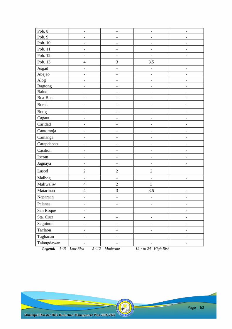
Page | 62
Pob. 8 - - - -
Pob. 9 - - - -
Pob. 10 - - - -
Pob. 11 - - - -
Pob. 12 - - - -
Pob. 13 4 3 3.5
Asgad - - - -
Abejao - - - -
Alog - - - -
Bagtong - - - -
Balud - - - -
Bua-Bua - - - -
Burak - - - -
Butig - - - -
Cagaut - - - -
Caridad - - - -
Cantomoja - - - -
Camanga - - - -
Carapdapan - - - -
Casilion - - - -
Iberan - - - -
Jagnaya - - - -
Lusod 2 2 2
Malbog - - - -
Maliwaliw 4 2 3
Matarinao 4 3 3.5 -
Naparaan - - - -
Palanas - - - -
San Roque - -
Sta. Cruz - - - -
Seguinon - - - -
Taclaon - - - -
Tagbacan - - - -
Talangdawan - - - -
Legend: 1<5 – Low Risk 5<12 – Moderate 12> to 24 –High Risk
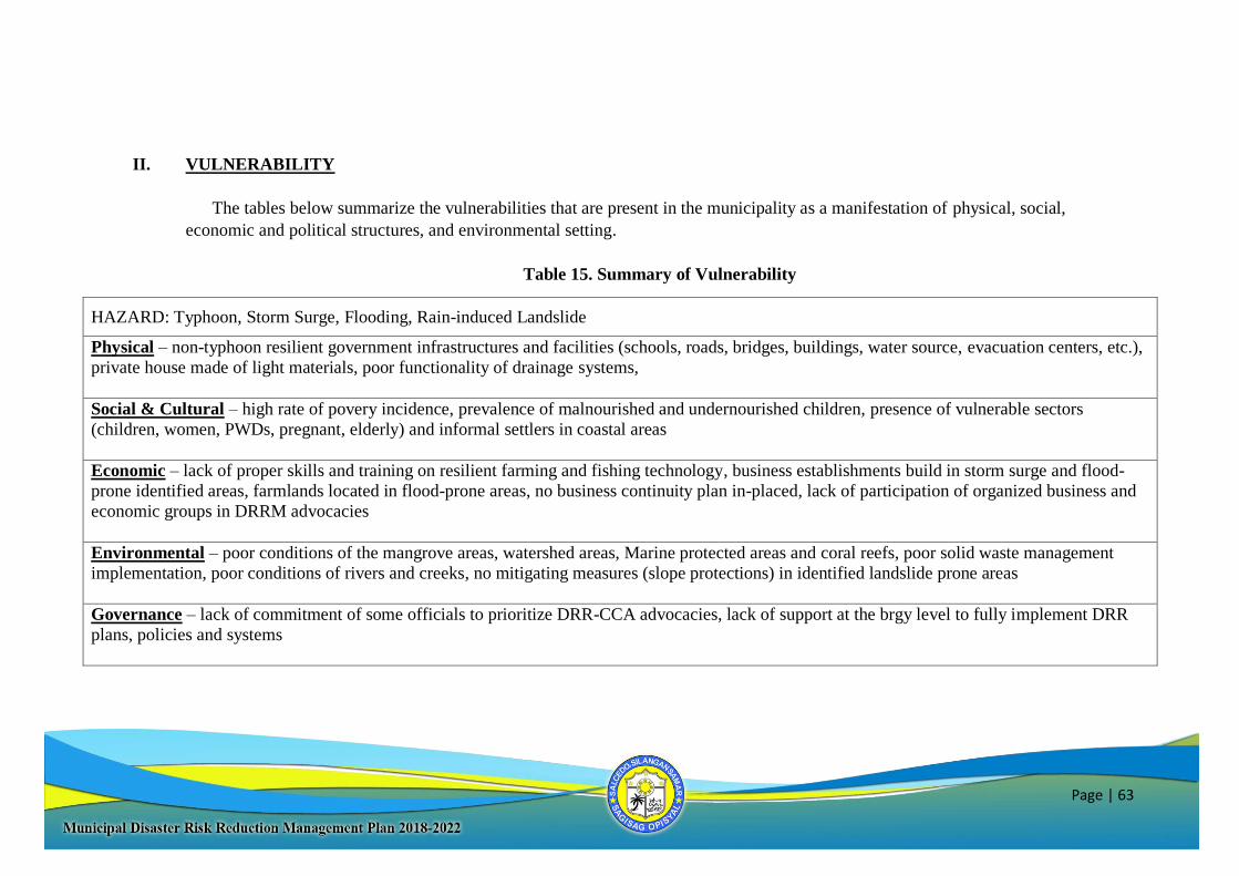
Page | 63
II. VULNERABILITY
The tables below summarize the vulnerabilities that are present in the municipality as a manifestation of physical, social,
economic and political structures, and environmental setting.
Table 15. Summary of Vulnerability
HAZARD: Typhoon, Storm Surge, Flooding, Rain-induced Landslide
Physical – non-typhoon resilient government infrastructures and facilities (schools, roads, bridges, buildings, water source, evacuation centers, etc.),
private house made of light materials, poor functionality of drainage systems,
Social & Cultural – high rate of povery incidence, prevalence of malnourished and undernourished children, presence of vulnerable sectors
(children, women, PWDs, pregnant, elderly) and informal settlers in coastal areas
Economic – lack of proper skills and training on resilient farming and fishing technology, business establishments build in storm surge and flood-
prone identified areas, farmlands located in flood-prone areas, no business continuity plan in-placed, lack of participation of organized business and
economic groups in DRRM advocacies
Environmental – poor conditions of the mangrove areas, watershed areas, Marine protected areas and coral reefs, poor solid waste management
implementation, poor conditions of rivers and creeks, no mitigating measures (slope protections) in identified landslide prone areas
Governance – lack of commitment of some officials to prioritize DRR-CCA advocacies, lack of support at the brgy level to fully implement DRR
plans, policies and systems
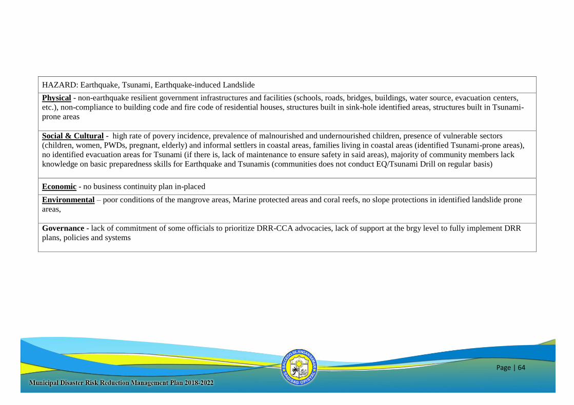
Page | 64
HAZARD: Earthquake, Tsunami, Earthquake-induced Landslide
Physical - non-earthquake resilient government infrastructures and facilities (schools, roads, bridges, buildings, water source, evacuation centers,
etc.), non-compliance to building code and fire code of residential houses, structures built in sink-hole identified areas, structures built in Tsunami-
prone areas
Social & Cultural - high rate of povery incidence, prevalence of malnourished and undernourished children, presence of vulnerable sectors
(children, women, PWDs, pregnant, elderly) and informal settlers in coastal areas, families living in coastal areas (identified Tsunami-prone areas),
no identified evacuation areas for Tsunami (if there is, lack of maintenance to ensure safety in said areas), majority of community members lack
knowledge on basic preparedness skills for Earthquake and Tsunamis (communities does not conduct EQ/Tsunami Drill on regular basis)
Economic - no business continuity plan in-placed
Environmental – poor conditions of the mangrove areas, Marine protected areas and coral reefs, no slope protections in identified landslide prone
areas,
Governance - lack of commitment of some officials to prioritize DRR-CCA advocacies, lack of support at the brgy level to fully implement DRR
plans, policies and systems
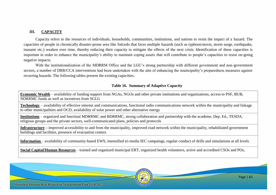
Page | 65
III. CAPACITY
Capacity refers to the resources of individuals, households, communities, institutions, and nations to resist the impact of a hazard. The
capacities of people in chronically disaster-prone area like Salcedo that faces multiple hazards (such as typhoon/storm, storm surge, earthquake,
tsunami etc.) weaken over time, thereby reducing their capacity to mitigate the effects of the next crisis. Identification of these capacities is
important in order to enhance the municipality’s ability to maintain coping assets that will contribute to people’s capacities to resist on-going
negative impacts.
With the institutionalization of the MDRRM Office and the LGU’s strong partnership with different government and non-government
sectors, a number of DRR/CCA interventions had been undertaken with the aim of enhancing the municipality’s preparedness measures against
recurring hazards. The following tables present the existing capacities.
Table 16. Summary of Adaptive Capacity
Economic Wealth – availability of funding support from NGAs, NGOs and other private institutions and organizations, access to PSF, BUB,
NDRRMC funds as well as incentives from SGLG
Technology – availability of effective internet and communications, functional radio communications network within the municipality and linkage
to other municipalities and OCD, availability of solar power and other alternative energy
Institutions – organized and functinal MDRRMC and BDRRMC, strong collaboration and partnership with the academe, Dep. Ed., TESDA,
religious groups and the private sectors, well-communicated plans, policies and protocols
Infrastructure – improved accessibility to and from the municipality, improved road network within the municipality, rehabilitated government
buildings and facilities, presence of evacuation centers
Information – availability of community-based EWS, intensified tri-media IEC campaings, regular conduct of drills and simulations at all levels
Social Capital/Human Resources – trained and organized municipal ERT, organized health volunteers, active and accredited CSOs and POs,
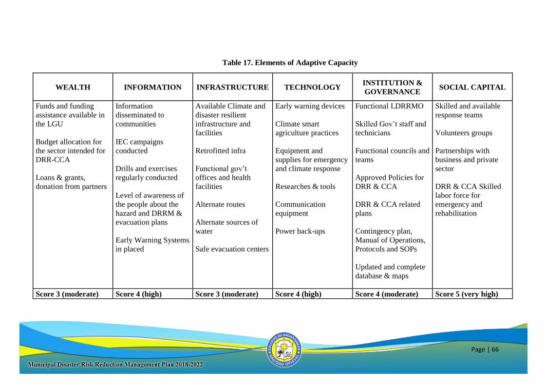
Page | 66
Table 17. Elements of Adaptive Capacity
WEALTH INFORMATION INFRASTRUCTURE TECHNOLOGY INSTITUTION &
GOVERNANCE SOCIAL CAPITAL
Funds and funding
assistance available in
the LGU
Budget allocation for
the sector intended for
DRR-CCA
Loans & grants,
donation from partners
Information
disseminated to
communities
IEC campaigns
conducted
Drills and exercises
regularly conducted
Level of awareness of
the people about the
hazard and DRRM &
evacuation plans
Early Warning Systems
in placed
Available Climate and
disaster resilient
infrastructure and
facilities
Retrofitted infra
Functional gov’t
offices and health
facilities
Alternate routes
Alternate sources of
water
Safe evacuation centers
Early warning devices
Climate smart
agriculture practices
Equipment and
supplies for emergency
and climate response
Researches & tools
Communication
equipment
Power back-ups
Functional LDRRMO
Skilled Gov’t staff and
technicians
Functional councils and
teams
Approved Policies for
DRR & CCA
DRR & CCA related
plans
Contingency plan,
Manual of Operations,
Protocols and SOPs
Updated and complete
database & maps
Skilled and available
response teams
Volunteers groups
Partnerships with
business and private
sector
DRR & CCA Skilled
labor force for
emergency and
rehabilitation
Score 3 (moderate) Score 4 (high) Score 3 (moderate) Score 4 (high) Score 4 (moderate) Score 5 (very high)
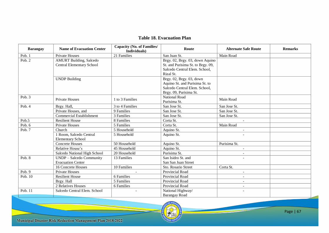
Page | 67
Table 18. Evacuation Plan
Barangay Name of Evacuation Center Capacity (No. of Families/
Individuals) Route Alternate Safe Route Remarks
Pob. 1 Private Houses 21 Families San Juan St. Main Road
Pob. 2 AMURT Building, Salcedo
Central Elementary School
Brgy. 02, Brgy. 03, down Aquino
St. and Purisima St. to Brgy. 09,
Salcedo Central Elem. School,
Rizal St.
UNDP Building Brgy. 02, Brgy. 03, down
Aquino St. and Purisima St. to
Salcedo Central Elem. School,
Brgy. 09, Purisima St.
Pob. 3 Private Houses 1 to 3 Families
National Road
Purisima St. Main Road
Pob. 4 Brgy. Hall, 3 to 4 Families San Jose St. San Jose St.
Private Houses, and 9 Families San Jose St. San Jose St.
Commercial Establishment 3 Families San Jose St. San Jose St.
Pob.5 Resilient House 8 Families Corta St. -
Pob. 6 Private Houses 5 Families Corta St. Main Road
Pob. 7 Church 5 Household Aquino St. -
1 Room, Salcedo Central
Elementary School
5 Household Aquino St. -
Concrete Houses 50 Household Aquino St. Purisima St.
Relative House’s 45 Household Aquino St. -
Salcedo National High School 20 Household Purisima St. -
Pob. 8 UNDP – Salcedo Community
Evacuation Center
13 Families San Isidro St. and
San San Juan Street
-
16 Concrete Houses 10 Families Sto. Rosario Street Corta St.
Pob. 9 Private Houses - Provincial Road -
Pob. 10 Resilient House 6 Families Provincial Road -
Brgy. Hall 5 Families Provincial Road -
2 Relatives Houses 6 Families Provincial Road -
Pob. 11 Salcedo Central Elem. School - National Highway/
Barangay Road
-
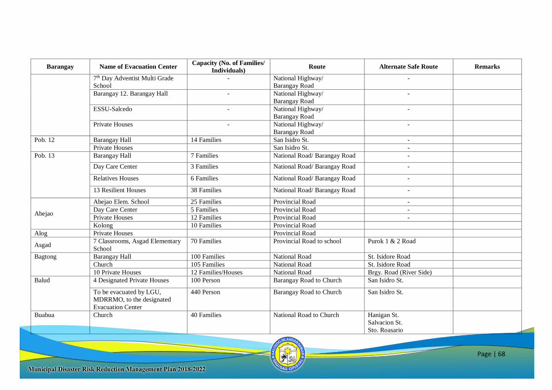
Page | 68
Barangay Name of Evacuation Center Capacity (No. of Families/
Individuals) Route Alternate Safe Route Remarks
7th Day Adventist Multi Grade
School
- National Highway/
Barangay Road
-
Barangay 12. Barangay Hall - National Highway/
Barangay Road
-
ESSU-Salcedo - National Highway/
Barangay Road
-
Private Houses - National Highway/
Barangay Road
-
Pob. 12 Barangay Hall 14 Families San Isidro St. -
Private Houses San Isidro St. -
Pob. 13 Barangay Hall 7 Families National Road/ Barangay Road -
Day Care Center 3 Families National Road/ Barangay Road -
Relatives Houses 6 Families National Road/ Barangay Road -
13 Resilient Houses 38 Families National Road/ Barangay Road -
Abejao
Abejao Elem. School 25 Families Provincial Road -
Day Care Center 5 Families Provincial Road -
Private Houses 12 Families Provincial Road -
Kolong 10 Families Provincial Road
Alog Private Houses Provincial Road
Asgad 7 Classrooms, Asgad Elementary
School
70 Families Provincial Road to school Purok 1 & 2 Road
Bagtong Barangay Hall 100 Families National Road St. Isidore Road
Church 105 Families National Road St. Isidore Road
10 Private Houses 12 Families/Houses National Road Brgy. Road (River Side)
Balud 4 Designated Private Houses 100 Person Barangay Road to Church San Isidro St.
To be evacuated by LGU,
MDRRMO, to the designated
Evacuation Center
440 Person Barangay Road to Church San Isidro St.
Buabua Church 40 Families National Road to Church Hanigan St.
Salvacion St.
Sto. Roasario
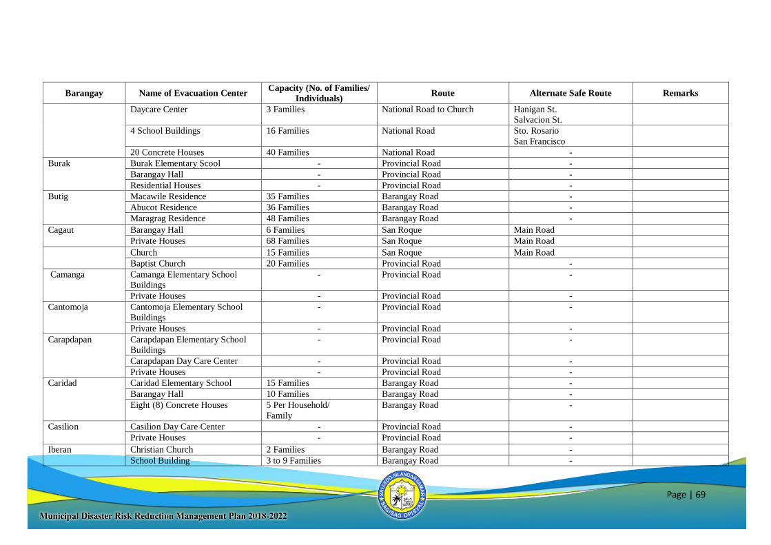
Page | 69
Barangay Name of Evacuation Center Capacity (No. of Families/
Individuals) Route Alternate Safe Route Remarks
Daycare Center 3 Families National Road to Church Hanigan St.
Salvacion St.
4 School Buildings 16 Families National Road Sto. Rosario
San Francisco
20 Concrete Houses 40 Families National Road -
Burak Burak Elementary Scool - Provincial Road -
Barangay Hall - Provincial Road -
Residential Houses - Provincial Road -
Butig Macawile Residence 35 Families Barangay Road -
Abucot Residence 36 Families Barangay Road -
Maragrag Residence 48 Families Barangay Road -
Cagaut Barangay Hall 6 Families San Roque Main Road
Private Houses 68 Families San Roque Main Road
Church 15 Families San Roque Main Road
Baptist Church 20 Families Provincial Road -
Camanga Camanga Elementary School
Buildings
- Provincial Road -
Private Houses - Provincial Road -
Cantomoja Cantomoja Elementary School
Buildings
- Provincial Road -
Private Houses - Provincial Road -
Carapdapan Carapdapan Elementary School
Buildings
- Provincial Road -
Carapdapan Day Care Center - Provincial Road -
Private Houses - Provincial Road -
Caridad Caridad Elementary School 15 Families Barangay Road -
Barangay Hall 10 Families Barangay Road -
Eight (8) Concrete Houses 5 Per Household/
Family
Barangay Road -
Casilion Casilion Day Care Center - Provincial Road -
Private Houses - Provincial Road -
Iberan Christian Church 2 Families Barangay Road -
School Building 3 to 9 Families Barangay Road -
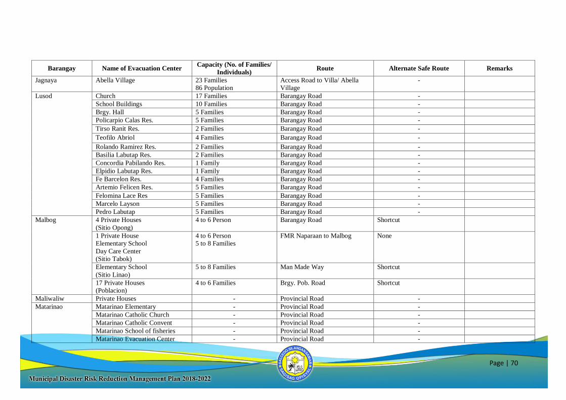
Page | 70
Barangay Name of Evacuation Center Capacity (No. of Families/
Individuals) Route Alternate Safe Route Remarks
Jagnaya Abella Village 23 Families
86 Population
Access Road to Villa/ Abella
Village
-
Lusod Church 17 Families Barangay Road -
School Buildings 10 Families Barangay Road -
Brgy. Hall 5 Families Barangay Road -
Policarpio Calas Res. 5 Families Barangay Road -
Tirso Ranit Res. 2 Families Barangay Road -
Teofilo Abriol 4 Families Barangay Road -
Rolando Ramirez Res. 2 Families Barangay Road -
Basilia Labutap Res. 2 Families Barangay Road -
Concordia Pabilando Res. 1 Family Barangay Road -
Elpidio Labutap Res. 1 Family Barangay Road -
Fe Barcelon Res. 4 Families Barangay Road -
Artemio Felicen Res. 5 Families Barangay Road -
Felomina Lace Res 5 Families Barangay Road -
Marcelo Layson 5 Families Barangay Road -
Pedro Labutap 5 Families Barangay Road -
Malbog 4 Private Houses
(Sitio Opong)
4 to 6 Person Barangay Road Shortcut
1 Private House
Elementary School
Day Care Center
(Sitio Tabok)
4 to 6 Person
5 to 8 Families
FMR Naparaan to Malbog None
Elementary School
(Sitio Linao)
5 to 8 Families Man Made Way Shortcut
17 Private Houses
(Poblacion)
4 to 6 Families Brgy. Pob. Road Shortcut
Maliwaliw Private Houses - Provincial Road -
Matarinao Matarinao Elementary - Provincial Road -
Matarinao Catholic Church - Provincial Road -
Matarinao Catholic Convent - Provincial Road -
Matarinao School of fisheries - Provincial Road -
Matarinao Evacuation Center - Provincial Road -
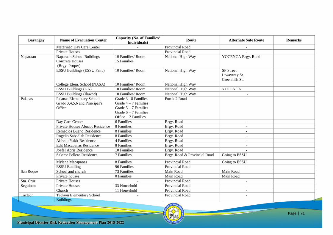
Page | 71
Barangay Name of Evacuation Center Capacity (No. of Families/
Individuals) Route Alternate Safe Route Remarks
Matarinao Day Care Center - Provincial Road -
Private Houses - Provincial Road -
Naparaan Naparaan School Buildings
Concrete Houses
(Brgy. Proper)
10 Families/ Room
15 Families
National High Way YOCENCA Brgy. Road
ESSU Buildings (ESSU Fam.) 10 Families/ Room National High Way SF Street
Liwayway St.
Greenhills St.
College Elem. School (NASA) 10 Families/ Room National High Way
ESSU Buildings (GK) 10 Families/ Room National High Way YOCENCA
ESSU Buildings (Ilawod) 10 Families/ Room National High Way -
Palanas Palanas Elementary School
Grade 3,4,5,6 and Principal’s
Office
Grade 3 - 8 Families
Grade 4 – 7 Families
Grade 5 – 7 Families
Grade 6 – 7 Families
Office – 2 Families
Purok 2 Road -
Day Care Center 6 Families Brgy. Road -
Private Houses Abucot Residence 8 Families Brgy. Road -
Remedios Bueno Residence 8 Families Brgy. Road -
Rogelio Sabadlab Residence 8 Families Brgy. Road -
Alfredo Yakit Residence 4 Families Brgy. Road -
Edit Macapanas Residence 8 Families Brgy. Road -
Joefel Abris Residence 10 Families Brgy. Road -
Salome Pellero Residence 7 Families Brgy. Road & Provincial Road Going to ESSU
Mylene Macapanas 8 Families Provincial Road Going to ESSU
ESSU Buidling 96 Families Provincial Road -
San Roque School and church 73 Families Main Road Main Road
Private houses 8 Families Main Road Main Road
Sta. Cruz Private Houses - Provincial Road -
Seguinon Private Houses 33 Household Provincial Road -
Church 11 Household Provincial Road -
Taclaon Taclaon Elementary School
Buildings
- Provincial Road -
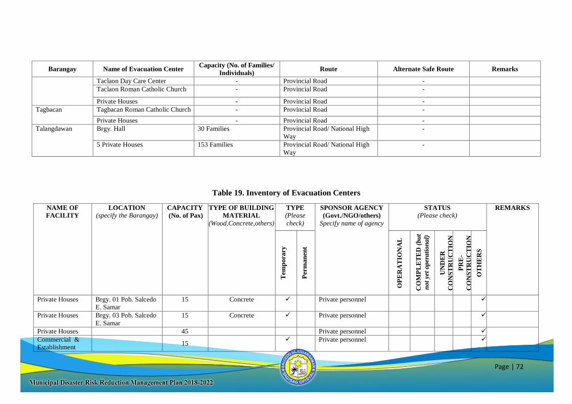
Page | 72
Barangay Name of Evacuation Center Capacity (No. of Families/
Individuals) Route Alternate Safe Route Remarks
Taclaon Day Care Center - Provincial Road -
Taclaon Roman Catholic Church - Provincial Road -
Private Houses - Provincial Road -
Tagbacan Tagbacan Roman Catholic Church - Provincial Road -
Private Houses - Provincial Road -
Talangdawan Brgy. Hall 30 Families Provincial Road/ National High
Way
-
5 Private Houses 153 Families Provincial Road/ National High
Way
-
Table 19. Inventory of Evacuation Centers
NAME OF
FACILITY
LOCATION
(specify the Barangay) CAPACITY
(No. of Pax)
TYPE OF BUILDING
MATERIAL
(Wood,Concrete,others)
TYPE
(Please
check)
SPONSOR AGENCY
(Govt./NGO/others)
Specify name of agency
STATUS
(Please check) REMARKS
Tem
pora
ry
Per
man
ent
OP
ER
AT
ION
AL
CO
MP
LE
TE
D (
bu
t
not
yet
oper
ati
on
al)
UN
DE
R
CO
NS
TR
UC
TIO
N
PR
E-
CO
NS
TR
UC
TIO
N
OT
HE
RS
Private Houses Brgy. 01 Pob. Salcedo
E. Samar
15 Concrete
Private personnel
Private Houses Brgy. 03 Pob. Salcedo
E. Samar
15 Concrete Private personnel
Private Houses 45 Private personnel
Commercial &
Establishment
15
Private personnel
Page | 73
NAME OF
FACILITY
LOCATION
(specify the Barangay) CAPACITY
(No. of Pax)
TYPE OF BUILDING
MATERIAL
(Wood,Concrete,others)
TYPE
(Please
check)
SPONSOR AGENCY
(Govt./NGO/others)
Specify name of agency
STATUS
(Please check) REMARKS
Tem
pora
ry
Per
man
ent
OP
ER
AT
ION
AL
CO
MP
LE
TE
D (
bu
t
not
yet
oper
ati
on
al)
UN
DE
R
CO
NS
TR
UC
TIO
N
PR
E-
CO
NS
TR
UC
TIO
N
OT
HE
RS
Private Houses Brgy. 05 Pob. Salcedo
E. Samar 40 Concrete
Private personnel
Private Houses Brgy. 06 Pob. Salcedo
E. Samar
15 Concrete
Church Brgy. 07 Pob. Salcedo
E. Samar
25 Concrete Parish
1 Rm. Salcedo
Central Elem.
School
25
Concrete Government
Private Houses 475 Concrete Private personnel
Salcedo Nat’l
High School
100 Government
Private Houses 50 Concrete Private Personnel
UNDP
Evacuation Center
Brgy. 09 Pob. Salcedo
E. Samar
- Concrete UNDP
Amurt Building
Salcedo Central
- Concrete AMURT
Private Houses - Concrete Private Personnel
Privates Houses Brgy. 10 Pob. Salcedo
E. Samar
60
Concrete
Private Personnel
Salcedo Central
Elem. School
Brgy. 11 Pob. Salcedo
E. Samar
-
Concrete
Government
Page | 74
NAME OF
FACILITY
LOCATION
(specify the Barangay) CAPACITY
(No. of Pax)
TYPE OF BUILDING
MATERIAL
(Wood,Concrete,others)
TYPE
(Please
check)
SPONSOR AGENCY
(Govt./NGO/others)
Specify name of agency
STATUS
(Please check) REMARKS
Tem
pora
ry
Per
man
ent
OP
ER
AT
ION
AL
CO
MP
LE
TE
D (
bu
t
not
yet
oper
ati
on
al)
UN
DE
R
CO
NS
TR
UC
TIO
N
PR
E-
CO
NS
TR
UC
TIO
N
OT
HE
RS
7th Adventist
Multi-Grade
School/church
-
Concrete
Private Personnel
Private Houses 135 Concrete
(Private Personnel)
-Gaytos, Roberto
-Balibalos, Danny
-Beduya, Marcelo Jr.
-Cadampog, Urbano
-Cagascas, Cesario
-Cagascas, Christopher
-Capara, Gudofredo
-Deguito, Manuel Felix
-Delbirut, Ana
-Lacanaria, Rosita
-Macasil, Gregorio
-Odejerte, Alicia
-Ogatia, Rudolfo
-Sevilla, Victoria
-Abalorio, Ebenezer
-Ludripas, Anastacio
-Ofilan, Timoteo Jr.
-Uy, Pedro Jr.
Private Houses
Brgy. 12 Pob. Salcedo
E. Samar
50 Concrete
-Alday Residence
-Baye Residence
Day Care Center 15 Concrete Government
Page | 75
NAME OF
FACILITY
LOCATION
(specify the Barangay) CAPACITY
(No. of Pax)
TYPE OF BUILDING
MATERIAL
(Wood,Concrete,others)
TYPE
(Please
check)
SPONSOR AGENCY
(Govt./NGO/others)
Specify name of agency
STATUS
(Please check) REMARKS
Tem
pora
ry
Per
man
ent
OP
ER
AT
ION
AL
CO
MP
LE
TE
D (
bu
t
not
yet
oper
ati
on
al)
UN
DE
R
CO
NS
TR
UC
TIO
N
PR
E-
CO
NS
TR
UC
TIO
N
OT
HE
RS
Private Houses 220 Concrete Private Personnel
Abejao Elem.
School
Brgy. Abejao Salcedo
E. Samar
125
Concrete
Government
Day Care Center 25
Concrete Government
Private Houses 60 Concrete
(Private Personnel)
-Pio Catugda
-Diosdado Abris
-Francisco Matiga
1 Toshiba
Building
Brgy. Alog Salcedo E.
Samar
-
-
-
-
Concrete
1 Church Concrete
1 Day Care Center Concrete
Private Houses Concrete
7 Classroom
Asgad Elem.
School
Brgy. Asgad Salcedo
E. Samar
350 Concrete Government
Church 525 Concrete Parish
10 Private Houses 60 Concrete Private personnel
Private Houses
Brgy. Balud Salcedo
E. Samar
500 Concrete Private personnel
Church 200 Concrete Parish
Page | 76
NAME OF
FACILITY
LOCATION
(specify the Barangay) CAPACITY
(No. of Pax)
TYPE OF BUILDING
MATERIAL
(Wood,Concrete,others)
TYPE
(Please
check)
SPONSOR AGENCY
(Govt./NGO/others)
Specify name of agency
STATUS
(Please check) REMARKS
Tem
pora
ry
Per
man
ent
OP
ER
AT
ION
AL
CO
MP
LE
TE
D (
bu
t
not
yet
oper
ati
on
al)
UN
DE
R
CO
NS
TR
UC
TIO
N
PR
E-
CO
NS
TR
UC
TIO
N
OT
HE
RS
Day Care Brgy. Buabua Salcedo
E. Samar
15 Concrete Government
4 School Building 80 Concrete Government
Private Houses 200 Concrete Private personnel
Elementary
School
Brgy. Burak Salcedo
E. Samar
300
Concrete
Government
Private Houses 700 Concrete -Rudencio Abug
-Segundina Lacbayen
-Pedro Ofanda
-Renato Ofanda
-Helarion Ogana
-Francisco Macasusi Sr.
-Narciso Ofanda
-Napoleon Ogana Sr.
-Leolito Padual
-Narciso Pagatpat Jr.
-Benidicto Pelicano
-Facondo Pelicano
-Luis Quirante Jr.
-Vergilio Daiz
-Miguel Cabus
-Francisco Dadulla
-Rosita Lacanaria
- Jose Abugaa
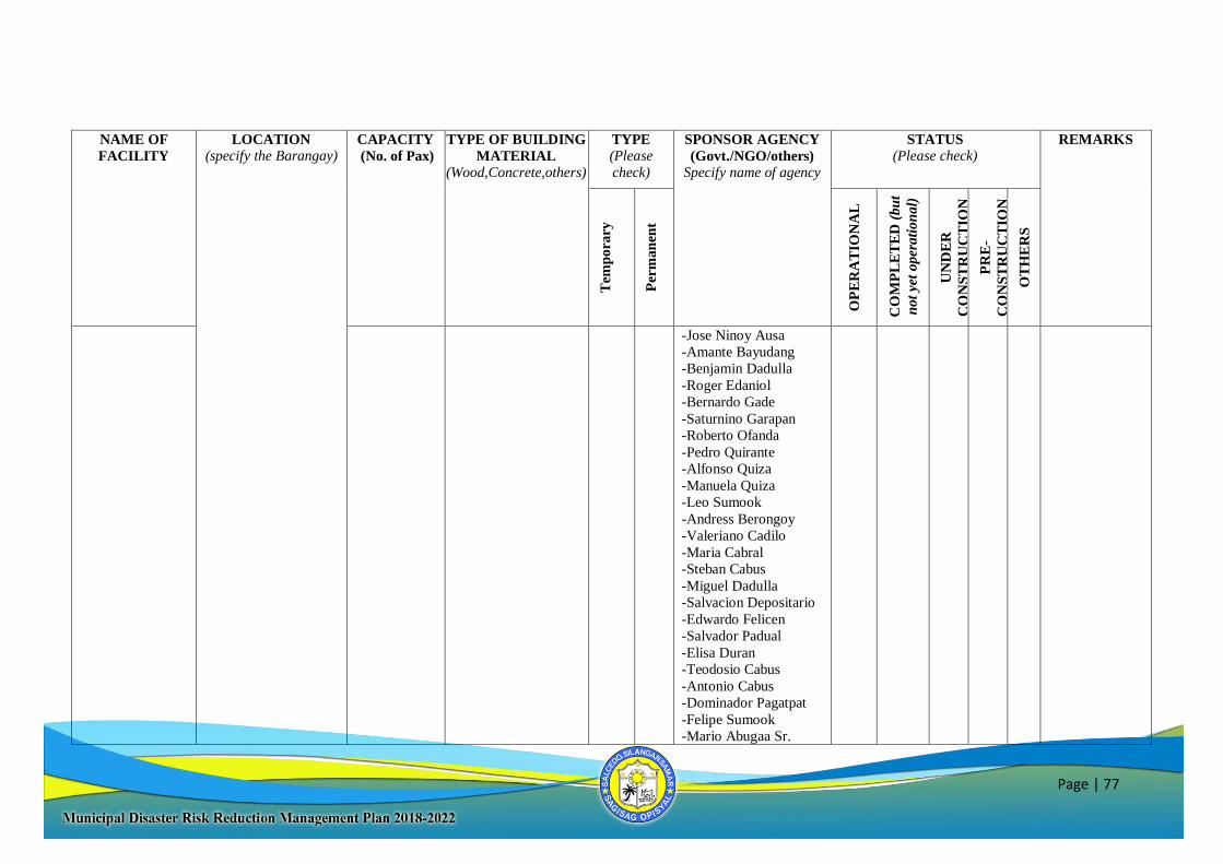
Page | 77
NAME OF
FACILITY
LOCATION
(specify the Barangay) CAPACITY
(No. of Pax)
TYPE OF BUILDING
MATERIAL
(Wood,Concrete,others)
TYPE
(Please
check)
SPONSOR AGENCY
(Govt./NGO/others)
Specify name of agency
STATUS
(Please check) REMARKS
Tem
pora
ry
Per
man
ent
OP
ER
AT
ION
AL
CO
MP
LE
TE
D (
bu
t
not
yet
oper
ati
on
al)
UN
DE
R
CO
NS
TR
UC
TIO
N
PR
E-
CO
NS
TR
UC
TIO
N
OT
HE
RS
-Jose Ninoy Ausa
-Amante Bayudang
-Benjamin Dadulla
-Roger Edaniol
-Bernardo Gade
-Saturnino Garapan
-Roberto Ofanda
-Pedro Quirante
-Alfonso Quiza
-Manuela Quiza
-Leo Sumook
-Andress Berongoy
-Valeriano Cadilo
-Maria Cabral
-Steban Cabus
-Miguel Dadulla
-Salvacion Depositario
-Edwardo Felicen
-Salvador Padual
-Elisa Duran
-Teodosio Cabus
-Antonio Cabus
-Dominador Pagatpat
-Felipe Sumook
-Mario Abugaa Sr.
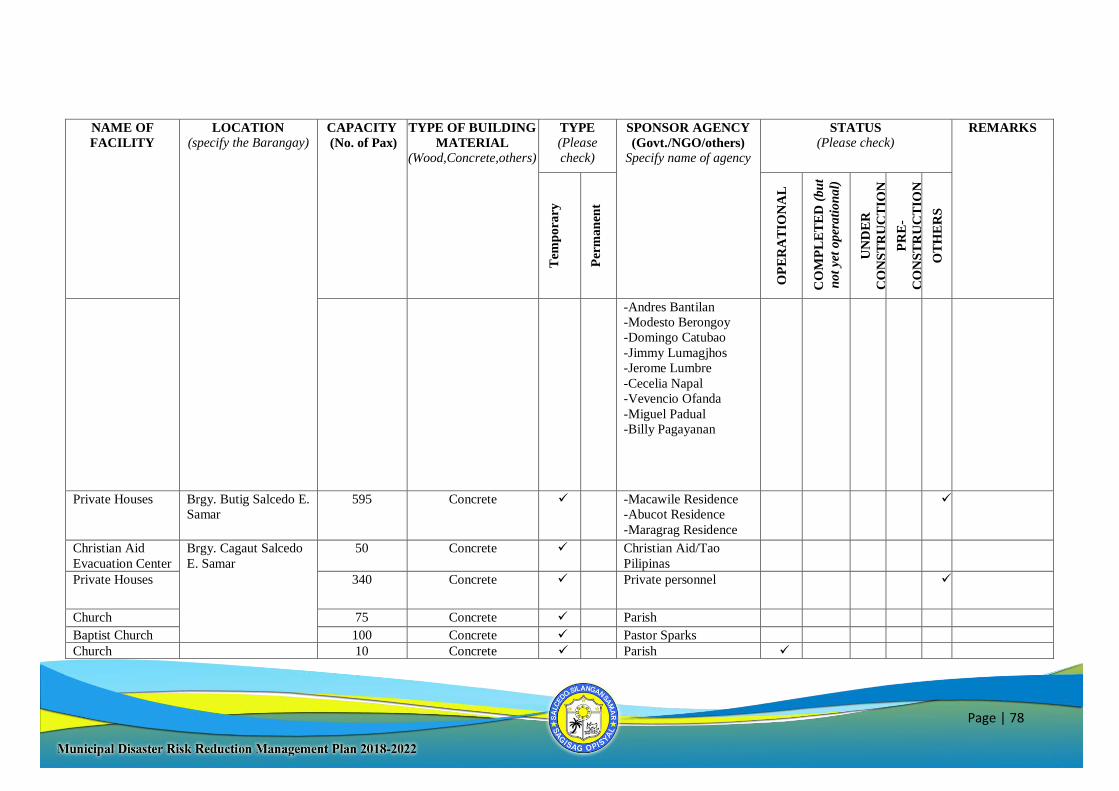
Page | 78
NAME OF
FACILITY
LOCATION
(specify the Barangay) CAPACITY
(No. of Pax)
TYPE OF BUILDING
MATERIAL
(Wood,Concrete,others)
TYPE
(Please
check)
SPONSOR AGENCY
(Govt./NGO/others)
Specify name of agency
STATUS
(Please check) REMARKS
Tem
pora
ry
Per
man
ent
OP
ER
AT
ION
AL
CO
MP
LE
TE
D (
bu
t
not
yet
oper
ati
on
al)
UN
DE
R
CO
NS
TR
UC
TIO
N
PR
E-
CO
NS
TR
UC
TIO
N
OT
HE
RS
-Andres Bantilan
-Modesto Berongoy
-Domingo Catubao
-Jimmy Lumagjhos
-Jerome Lumbre
-Cecelia Napal
-Vevencio Ofanda
-Miguel Padual
-Billy Pagayanan
Private Houses Brgy. Butig Salcedo E.
Samar
595 Concrete -Macawile Residence
-Abucot Residence
-Maragrag Residence
Christian Aid
Evacuation Center
Brgy. Cagaut Salcedo
E. Samar
50 Concrete Christian Aid/Tao
Pilipinas
Private Houses 340
Concrete
Private personnel
Church 75 Concrete Parish
Baptist Church 100 Concrete Pastor Sparks
Church 10 Concrete Parish
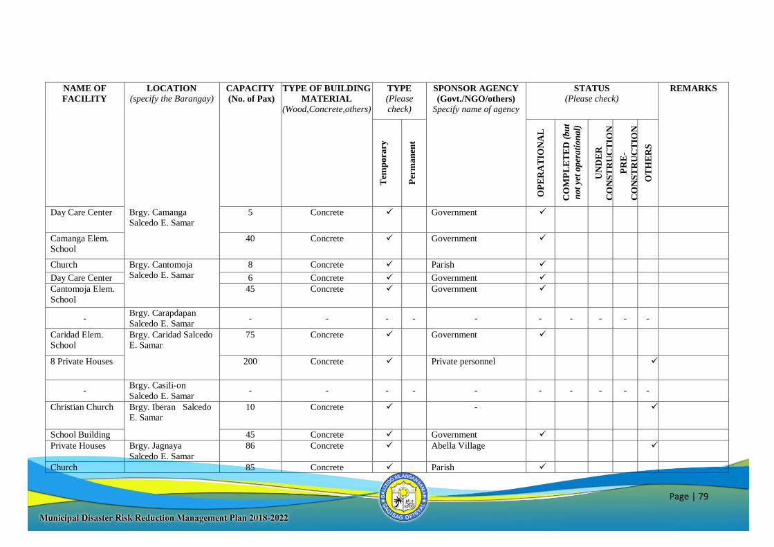
Page | 79
NAME OF
FACILITY
LOCATION
(specify the Barangay) CAPACITY
(No. of Pax)
TYPE OF BUILDING
MATERIAL
(Wood,Concrete,others)
TYPE
(Please
check)
SPONSOR AGENCY
(Govt./NGO/others)
Specify name of agency
STATUS
(Please check) REMARKS
Tem
pora
ry
Per
man
ent
OP
ER
AT
ION
AL
CO
MP
LE
TE
D (
bu
t
not
yet
oper
ati
on
al)
UN
DE
R
CO
NS
TR
UC
TIO
N
PR
E-
CO
NS
TR
UC
TIO
N
OT
HE
RS
Day Care Center Brgy. Camanga
Salcedo E. Samar
5 Concrete Government
Camanga Elem.
School
40 Concrete Government
Church Brgy. Cantomoja
Salcedo E. Samar
8 Concrete Parish
Day Care Center 6 Concrete Government
Cantomoja Elem.
School
45 Concrete Government
- Brgy. Carapdapan
Salcedo E. Samar - - - - - - - - - -
Caridad Elem.
School
Brgy. Caridad Salcedo
E. Samar
75
Concrete
Government
8 Private Houses 200 Concrete Private personnel
- Brgy. Casili-on
Salcedo E. Samar - - - - - - - - - -
Christian Church Brgy. Iberan Salcedo
E. Samar
10
Concrete
-
School Building 45 Concrete Government
Private Houses Brgy. Jagnaya
Salcedo E. Samar
86 Concrete Abella Village
Church 85 Concrete Parish
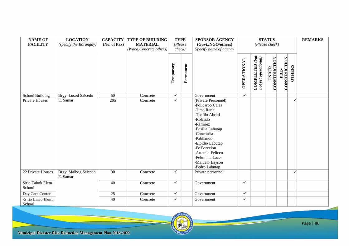
Page | 80
NAME OF
FACILITY
LOCATION
(specify the Barangay) CAPACITY
(No. of Pax)
TYPE OF BUILDING
MATERIAL
(Wood,Concrete,others)
TYPE
(Please
check)
SPONSOR AGENCY
(Govt./NGO/others)
Specify name of agency
STATUS
(Please check) REMARKS
Tem
pora
ry
Per
man
ent
OP
ER
AT
ION
AL
CO
MP
LE
TE
D (
bu
t
not
yet
oper
ati
on
al)
UN
DE
R
CO
NS
TR
UC
TIO
N
PR
E-
CO
NS
TR
UC
TIO
N
OT
HE
RS
School Building Brgy. Lusod Salcedo
E. Samar
50 Concrete Government
Private Houses 205 Concrete (Private Personnel)
-Policarpo Calas
-Tirso Ranit
-Teofilo Abriol
-Rolando
-Ramirez
-Basilia Labutap
-Concordia
-Pabilando
-Elpidio Labutap
-Fe Barcelon
-Artemio Felicen
-Felomina Lace
-Marcelo Layson
-Pedro Labutap
22 Private Houses Brgy. Malbog Salcedo
E. Samar
90
Concrete
Private personnel
Sitio Tabok Elem.
School
40
Concrete
Government
Day Care Center 25 Concrete Government
-Sitio Linao Elem.
School
40
Concrete Government
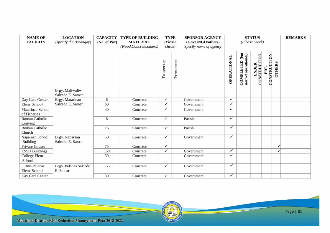
Page | 81
NAME OF
FACILITY
LOCATION
(specify the Barangay) CAPACITY
(No. of Pax)
TYPE OF BUILDING
MATERIAL
(Wood,Concrete,others)
TYPE
(Please
check)
SPONSOR AGENCY
(Govt./NGO/others)
Specify name of agency
STATUS
(Please check) REMARKS
Tem
pora
ry
Per
man
ent
OP
ER
AT
ION
AL
CO
MP
LE
TE
D (
bu
t
not
yet
oper
ati
on
al)
UN
DE
R
CO
NS
TR
UC
TIO
N
PR
E-
CO
NS
TR
UC
TIO
N
OT
HE
RS
Brgy. Maliwaliw
Salcedo E. Samar
Day Care Center Brgy. Matarinao
Salcedo E. Samar
6 Concrete Government
Elem. School 60 Concrete Government
Matarinao School
of Fisheries
40 Concrete
Government
Roman Catholic
Convent
6
Concrete
Parish
Roman Catholic
Church
16
Concrete Parish
Naparaan School
Building
Brgy. Naparaan
Salcedo E. Samar
50
Concrete
Government
Private Houses 75 Concrete
ESSU Buildings 150 Concrete Government
College Elem.
School
50 Concrete Government
5 Rms.Palanas
Elem. School
Brgy. Palanas Salcedo
E. Samar
155
Concrete
Government
Day Care Center 30 Concrete Government
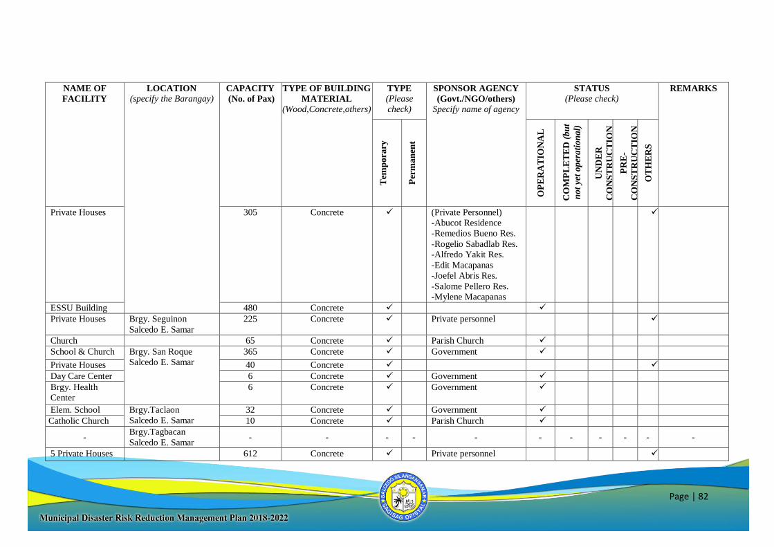
Page | 82
NAME OF
FACILITY
LOCATION
(specify the Barangay) CAPACITY
(No. of Pax)
TYPE OF BUILDING
MATERIAL
(Wood,Concrete,others)
TYPE
(Please
check)
SPONSOR AGENCY
(Govt./NGO/others)
Specify name of agency
STATUS
(Please check) REMARKS
Tem
pora
ry
Per
man
ent
OP
ER
AT
ION
AL
CO
MP
LE
TE
D (
bu
t
not
yet
oper
ati
on
al)
UN
DE
R
CO
NS
TR
UC
TIO
N
PR
E-
CO
NS
TR
UC
TIO
N
OT
HE
RS
Private Houses
305
Concrete
(Private Personnel)
-Abucot Residence
-Remedios Bueno Res.
-Rogelio Sabadlab Res.
-Alfredo Yakit Res.
-Edit Macapanas
-Joefel Abris Res.
-Salome Pellero Res.
-Mylene Macapanas
ESSU Building 480 Concrete
Private Houses
Brgy. Seguinon
Salcedo E. Samar
225
Concrete
Private personnel
Church 65 Concrete Parish Church
School & Church Brgy. San Roque
Salcedo E. Samar
365 Concrete Government
Private Houses 40 Concrete
Day Care Center 6 Concrete Government
Brgy. Health
Center
6 Concrete Government
Elem. School Brgy.Taclaon
Salcedo E. Samar
32 Concrete Government
Catholic Church 10 Concrete Parish Church
- Brgy.Tagbacan
Salcedo E. Samar - - - - - - - - - - -
5 Private Houses 612 Concrete Private personnel
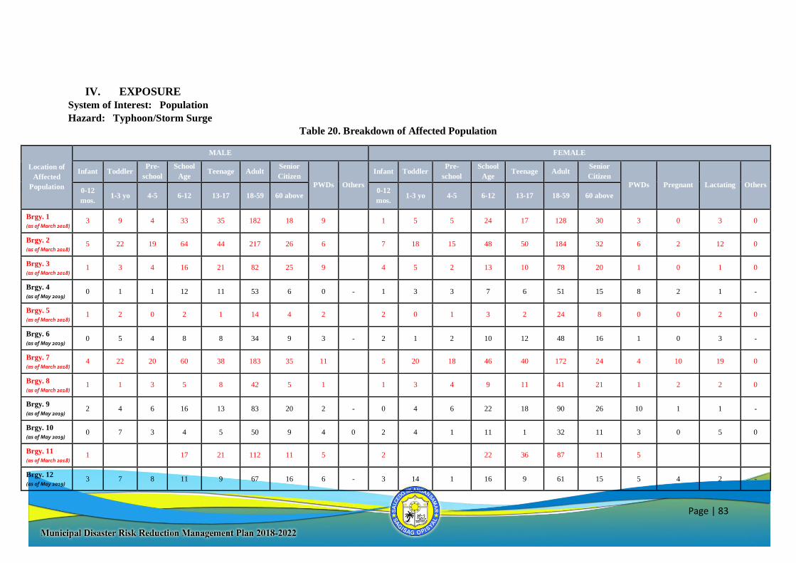
Page | 83
IV. EXPOSURE
System of Interest: Population
Hazard: Typhoon/Storm Surge
Table 20. Breakdown of Affected Population
Location of
Affected
Population
MALE FEMALE
Infant Toddler Pre-
school
School
Age Teenage Adult
Senior
Citizen
PWDs Others
Infant Toddler Pre-
school
School
Age Teenage Adult
Senior
Citizen
PWDs Pregnant Lactating Others 0-12
mos. 1-3 yo 4-5 6-12 13-17 18-59 60 above
0-12
mos. 1-3 yo 4-5 6-12 13-17 18-59 60 above
Brgy. 1
(as of March 2018) 3 9 4 33 35 182 18 9 1 5 5 24 17 128 30 3 0 3 0
Brgy. 2
(as of March 2018) 5 22 19 64 44 217 26 6 7 18 15 48 50 184 32 6 2 12 0
Brgy. 3
(as of March 2018) 1 3 4 16 21 82 25 9 4 5 2 13 10 78 20 1 0 1 0
Brgy. 4
(as of May 2019) 0 1 1 12 11 53 6 0 - 1 3 3 7 6 51 15 8 2 1 -
Brgy. 5
(as of March 2018) 1 2 0 2 1 14 4 2 2 0 1 3 2 24 8 0 0 2 0
Brgy. 6
(as of May 2019) 0 5 4 8 8 34 9 3 - 2 1 2 10 12 48 16 1 0 3 -
Brgy. 7
(as of March 2018) 4 22 20 60 38 183 35 11 5 20 18 46 40 172 24 4 10 19 0
Brgy. 8
(as of March 2018) 1 1 3 5 8 42 5 1 1 3 4 9 11 41 21 1 2 2 0
Brgy. 9
(as of May 2019) 2 4 6 16 13 83 20 2 - 0 4 6 22 18 90 26 10 1 1 -
Brgy. 10
(as of May 2019) 0 7 3 4 5 50 9 4 0 2 4 1 11 1 32 11 3 0 5 0
Brgy. 11
(as of March 2018) 1 17 21 112 11 5 2 22 36 87 11 5
Brgy. 12
(as of May 2019) 3 7 8 11 9 67 16 6 - 3 14 1 16 9 61 15 5 4 2 -
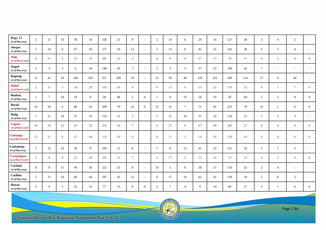
Page | 84
Brgy. 13
(as of May 2019) 5 11 10 38 10 156 21 9 - 3 14 6 29 14 117 30 3 4 5 -
Abejao
(as of May 2019) 3 14 6 47 30 171 53 13 - 2 13 8 42 31 141 38 5 3 4 -
Alog
(as of March 2018) 0 11 3 15 15 80 22 3 4 6 6 27 17 79 17 6 2 4 0
Asgad
(as of May 2019) 5 3 5 6 24 149 45 7 - 2 3 5 37 23 149 43 7 - - -
Bagtong
(as of May 2019) 11 41 36 184 183 557 109 19 - 13 58 40 143 165 508 114 17 9 40 -
Balud
(as of March 2018) 2 11 7 24 29 163 16 4 4 11 6 23 22 174 32 8 1 7 0
Buabua
(as of May 2019) 1 7 19 19 8 29 48 2 0 1 9 14 18 10 50 84 2 5 8 0
Burak
(as of May 2019) 10 10 6 68 62 309 79 21 0 13 15 7 71 61 225 78 15 1 6 0
Butig
(as of May 2019) 7 11 10 37 33 133 51 7 - 7 11 10 37 33 133 51 7 2 3 -
Cagaut
(as of March 2018) 10 33 16 45 35 255 49 7 6 27 9 67 40 295 27 8 4 8 0
Camanga
(as of March 2018) 12
11
6 15 44 155 30 11 8 17 5 14 41 150 25 9 4 6 0
Cantomoja
(as of May 2019) 5 15 14 30 37 106 11 8 - 7 8 12 41 23 111 10 5 1 5 -
Carapdapan
(as of March 2018) 2 8 9 23 29 84 15 7 2 17 5 15 24 73 15 4 3 4 0
Caridad
(as of May 2019) 8 8 11 44 30 121 25 8 - 19 5 8 38 27 110 25 2 4 - -
Casilion
(as of May 2019) 2 15 16 60 44 187 43 12 - 0 17 14 62 41 158 19 2 8 2 -
Iberan
(as of May 2019) 3 9 3 23 12 77 15 9 0 3 7 4 9 14 60 17 3 1 6 0
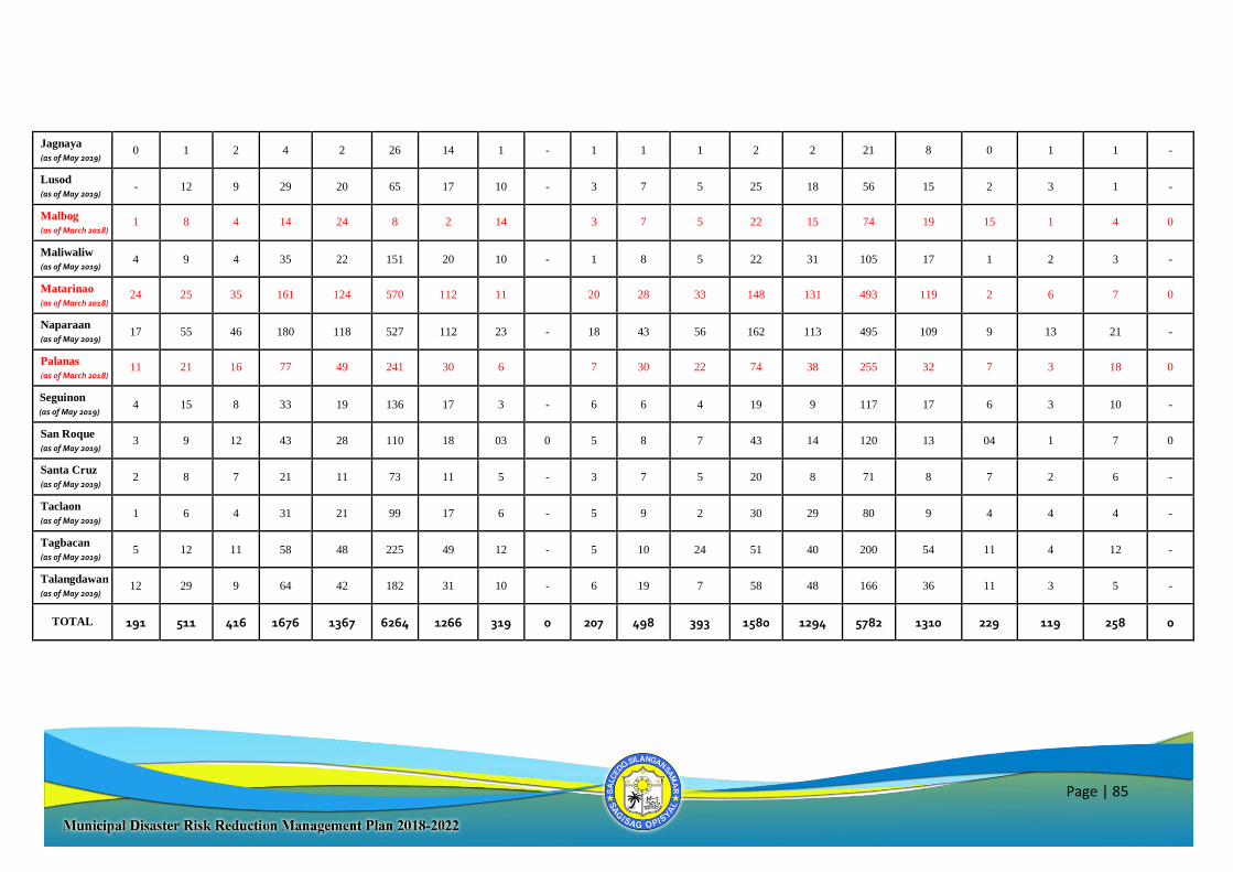
Page | 85
Jagnaya
(as of May 2019) 0 1 2 4 2 26 14 1 - 1 1 1 2 2 21 8 0 1 1 -
Lusod
(as of May 2019) - 12 9 29 20 65 17 10 - 3 7 5 25 18 56 15 2 3 1 -
Malbog
(as of March 2018) 1 8 4 14 24 8 2 14 3 7 5 22 15 74 19 15 1 4 0
Maliwaliw
(as of May 2019) 4 9 4 35 22 151 20 10 - 1 8 5 22 31 105 17 1 2 3 -
Matarinao
(as of March 2018) 24 25 35 161 124 570 112 11 20 28 33 148 131 493 119 2 6 7 0
Naparaan
(as of May 2019) 17 55 46 180 118 527 112 23 - 18 43 56 162 113 495 109 9 13 21 -
Palanas
(as of March 2018) 11 21 16 77 49 241 30 6 7 30 22 74 38 255 32 7 3 18 0
Seguinon
(as of May 2019) 4 15 8 33 19 136 17 3 - 6 6 4 19 9 117 17 6 3 10 -
San Roque
(as of May 2019) 3 9 12 43 28 110 18 03 0 5 8 7 43 14 120 13 04 1 7 0
Santa Cruz
(as of May 2019) 2 8 7 21 11 73 11 5 - 3 7 5 20 8 71 8 7 2 6 -
Taclaon
(as of May 2019) 1 6 4 31 21 99 17 6 - 5 9 2 30 29 80 9 4 4 4 -
Tagbacan
(as of May 2019) 5 12 11 58 48 225 49 12 - 5 10 24 51 40 200 54 11 4 12 -
Talangdawan
(as of May 2019) 12 29 9 64 42 182 31 10 - 6 19 7 58 48 166 36 11 3 5 -
TOTAL 191 511 416 1676 1367 6264 1266 319 0 207 498 393 1580 1294 5782 1310 229 119 258 0
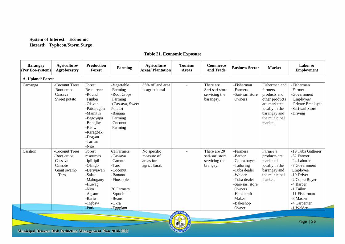
Page | 86
System of Interest: Economic
Hazard: Typhoon/Storm Surge
Table 21. Economic Exposure
Barangay
(Per Eco-system)
Agriculture/
Agroforestry
Production
Forest Farming
Agriculture
Areas/ Plantation
Tourism
Areas
Commerce
and Trade Business Sector Market
Labor &
Employment
A. Upland/ Forest
Camanga -Coconut Trees
-Root crops
Cassava
Sweet potato
Forest
Resources:
-Round
Timber
-Olavan
-Patsaragon
-Mamitin
-Bagoyapa
-Bongliw
-Kisiw
-Karagbak
-Dog-an
-Tarhan
-Nito
-Vegetable
Farming
-Root Crops
Farming
(Cassava, Sweet
Potato)
-Banana
Farming
-Coconut
Farming
35% of land area
is agricultural
- There are
Sari-sari store
servicing the
barangay.
-Fisherman
-Farmers
-Sari-sari store
Owners
Fisherman and
farmers
products and
other products
are marketed
locally in the
barangay and
the municipal
market.
-Fisherman
-Farmer
-Government
Employee/
Private Employee
-Sari-sari Store
-Driving
Casilion -Coconut Trees
-Root crops
Cassava
Camote
Giant swamp
Taro
Forest
resources
-Ipil-ipil
-Olango
-Deriyawan
-Salak
-Mahogany
-Huwag
-Nito
-Agsam
-Bariw
-Tigbaw
-Puti/
61 Farmers
-Cassava
-Camote
-Taro
-Coconut
-Banana
-Pineapple
20 Farmers
-Squash
-Beans
-Okra
-Eggplant
No specific
measure of
areas for
agricultural.
- There are 20
sari-sari store
servicing the
brangay.
-Farmers
-Barber
-Copra buyer
-Tailoring
-Tuba dealer
-Welder
-Tuba dealer
-Sari-sari store
Owners
-Handicraft
Maker
-Bakeshop
Owner
Farmer’s
products are
marketed
locally in the
barangay and
the municipal
market.
-19 Tuba Gatherer
-52 Farmer
-24 Laborer
-7 Government
Employee
-10 Driver
-2 Copra Buyer
-4 Barber
-1 Tailor
-11 Fisherman
-3 Mason
-4 Carpenter
-1 Welder
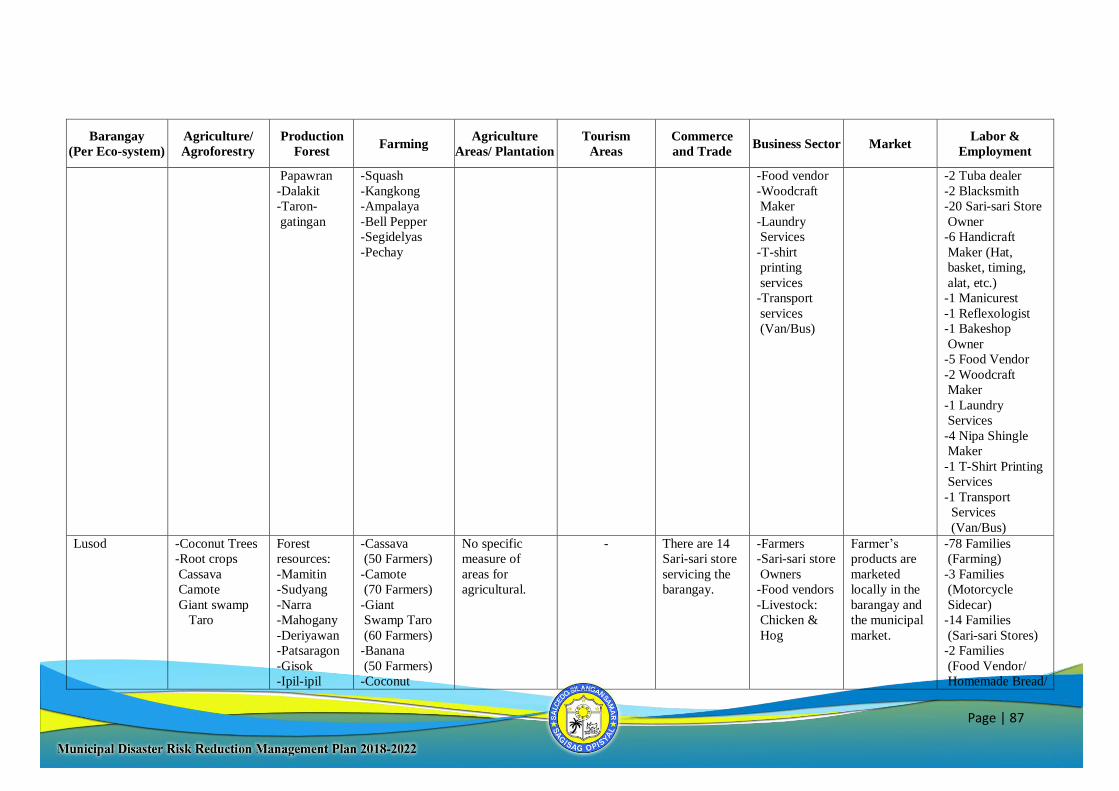
Page | 87
Barangay
(Per Eco-system)
Agriculture/
Agroforestry
Production
Forest Farming
Agriculture
Areas/ Plantation
Tourism
Areas
Commerce
and Trade Business Sector Market
Labor &
Employment
Papawran
-Dalakit
-Taron-
gatingan
-Squash
-Kangkong
-Ampalaya
-Bell Pepper
-Segidelyas
-Pechay
-Food vendor
-Woodcraft
Maker
-Laundry
Services
-T-shirt
printing
services
-Transport
services
(Van/Bus)
-2 Tuba dealer
-2 Blacksmith
-20 Sari-sari Store
Owner
-6 Handicraft
Maker (Hat,
basket, timing,
alat, etc.)
-1 Manicurest
-1 Reflexologist
-1 Bakeshop
Owner
-5 Food Vendor
-2 Woodcraft
Maker
-1 Laundry
Services
-4 Nipa Shingle
Maker
-1 T-Shirt Printing
Services
-1 Transport
Services
(Van/Bus)
Lusod -Coconut Trees
-Root crops
Cassava
Camote
Giant swamp
Taro
Forest
resources:
-Mamitin
-Sudyang
-Narra
-Mahogany
-Deriyawan
-Patsaragon
-Gisok
-Ipil-ipil
-Cassava
(50 Farmers)
-Camote
(70 Farmers)
-Giant
Swamp Taro
(60 Farmers)
-Banana
(50 Farmers)
-Coconut
No specific
measure of
areas for
agricultural.
- There are 14
Sari-sari store
servicing the
barangay.
-Farmers
-Sari-sari store
Owners
-Food vendors
-Livestock:
Chicken &
Hog
Farmer’s
products are
marketed
locally in the
barangay and
the municipal
market.
-78 Families
(Farming)
-3 Families
(Motorcycle
Sidecar)
-14 Families
(Sari-sari Stores)
-2 Families
(Food Vendor/
Homemade Bread/
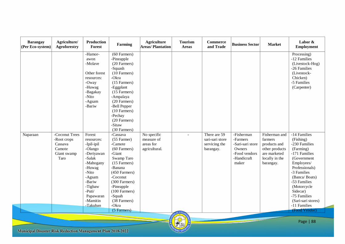
Page | 88
Barangay
(Per Eco-system)
Agriculture/
Agroforestry
Production
Forest Farming
Agriculture
Areas/ Plantation
Tourism
Areas
Commerce
and Trade Business Sector Market
Labor &
Employment
-Hamor-
awon
-Molave
Other forest
resources:
-Oway
-Huwag
-Bagakay
-Nito
-Agsam
-Bariw
(60 Farmers)
-Pineapple
(20 Farmers)
-Squash
(10 Farmers)
-Okra
(15 Farmers)
-Eggplant
(15 Farmers)
-Ampalaya
(20 Farmers)
-Bell Pepper
(10 Farmers)
-Pechay
(20 Farmers)
-Sitaw
(30 Farmers)
Processing)
-12 Families
(Livestock-Hog)
-26 Families
(Livestock-
Chicken)
-5 Families
(Carpenter)
Naparaan -Coconut Trees
-Root crops
Cassava
Camote
Giant swamp
Taro
Forest
resources:
-Ipil-ipil
-Olango
-Deriyawan
-Salak
-Mahogany
-Huwag
-Nito
-Agsam
-Bariw
-Tigbaw
-Puti/
Papawaran
-Mamitin
-Takuban
-Cassava
(55 Farmer)
-Camote
(60 Farmers)
-Giant
Swamp Taro
(15 Farmers)
-Banana
(450 Farmers)
-Coconut
(300 Farmers)
-Pineapple
(100 Farmers)
-Squah
(38 Farmers)
-Okra
(5 Farmers)
No specific
measure of
areas for
agricultural.
- There are 59
sari-sari store
servicing the
barangay.
-Fisherman
-Farmers
-Sari-sari store
Owners
-Food vendors
-Handicraft
maker
Fisherman and
farmers
products and
other products
are marketed
locally in the
barangay.
-14 Families
(Fishing)
-230 Families
(Farming)
-171 Families
(Government
Employees/
Professionals)
-3 Families
(Banca/ Boats)
-53 Families
(Motorcycle
Sidecar)
-75 Families
(Sari-sari stores)
-11 Families
(Food Vendor)
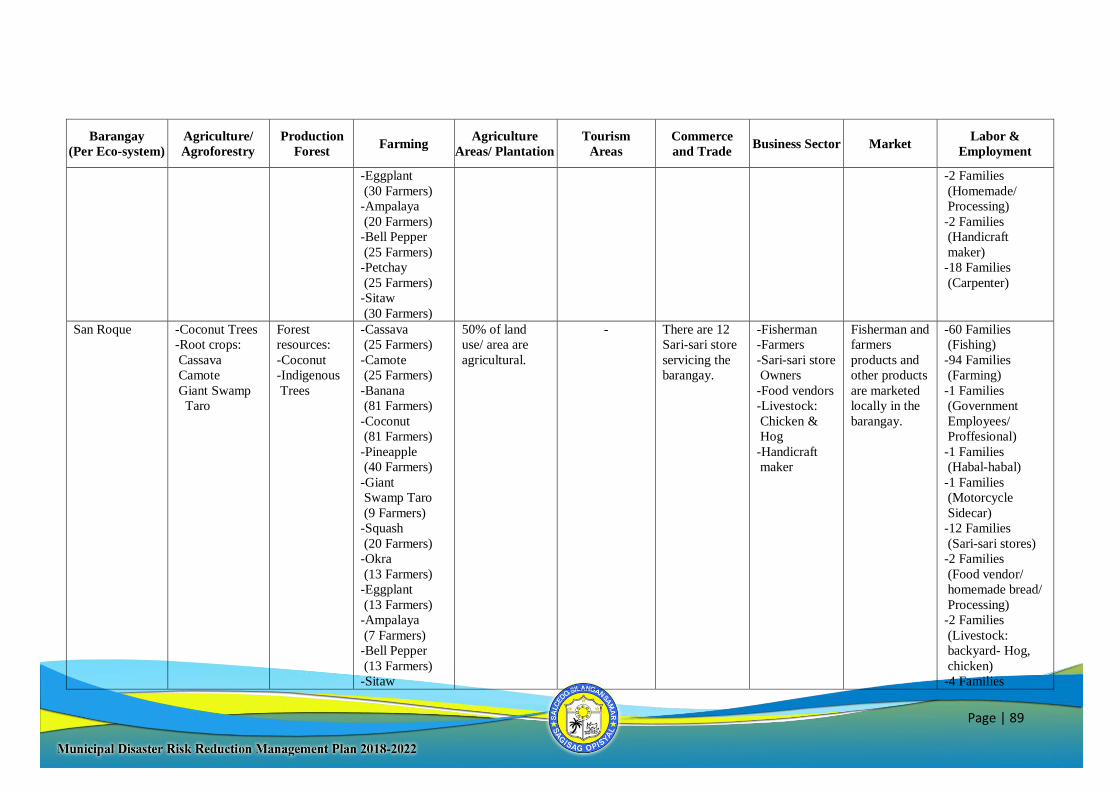
Page | 89
Barangay
(Per Eco-system)
Agriculture/
Agroforestry
Production
Forest Farming
Agriculture
Areas/ Plantation
Tourism
Areas
Commerce
and Trade Business Sector Market
Labor &
Employment
-Eggplant
(30 Farmers)
-Ampalaya
(20 Farmers)
-Bell Pepper
(25 Farmers)
-Petchay
(25 Farmers)
-Sitaw
(30 Farmers)
-2 Families
(Homemade/
Processing)
-2 Families
(Handicraft
maker)
-18 Families
(Carpenter)
San Roque -Coconut Trees
-Root crops:
Cassava
Camote
Giant Swamp
Taro
Forest
resources:
-Coconut
-Indigenous
Trees
-Cassava
(25 Farmers)
-Camote
(25 Farmers)
-Banana
(81 Farmers)
-Coconut
(81 Farmers)
-Pineapple
(40 Farmers)
-Giant
Swamp Taro
(9 Farmers)
-Squash
(20 Farmers)
-Okra
(13 Farmers)
-Eggplant
(13 Farmers)
-Ampalaya
(7 Farmers)
-Bell Pepper
(13 Farmers)
-Sitaw
50% of land
use/ area are
agricultural.
- There are 12
Sari-sari store
servicing the
barangay.
-Fisherman
-Farmers
-Sari-sari store
Owners
-Food vendors
-Livestock:
Chicken &
Hog
-Handicraft
maker
Fisherman and
farmers
products and
other products
are marketed
locally in the
barangay.
-60 Families
(Fishing)
-94 Families
(Farming)
-1 Families
(Government
Employees/
Proffesional)
-1 Families
(Habal-habal)
-1 Families
(Motorcycle
Sidecar)
-12 Families
(Sari-sari stores)
-2 Families
(Food vendor/
homemade bread/
Processing)
-2 Families
(Livestock:
backyard- Hog,
chicken)
-4 Families
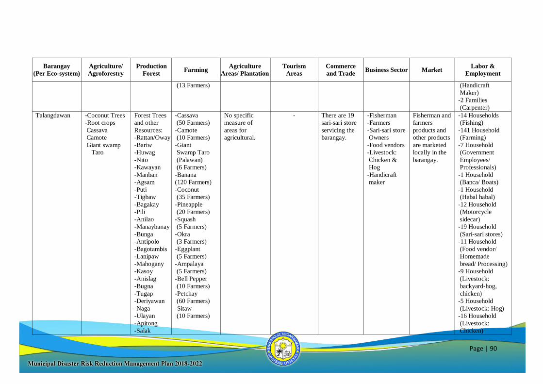
Page | 90
Barangay
(Per Eco-system)
Agriculture/
Agroforestry
Production
Forest Farming
Agriculture
Areas/ Plantation
Tourism
Areas
Commerce
and Trade Business Sector Market
Labor &
Employment
(13 Farmers) (Handicraft
Maker)
-2 Families
(Carpenter)
Talangdawan -Coconut Trees
-Root crops
Cassava
Camote
Giant swamp
Taro
Forest Trees
and other
Resources:
-Rattan/Oway
-Bariw
-Huwag
-Nito
-Kawayan
-Manban
-Agsam
-Puti
-Tigbaw
-Bagakay
-Pili
-Anilao
-Manaybanay
-Bunga
-Antipolo
-Bagotambis
-Lanipaw
-Mahogany
-Kasoy
-Anislag
-Bugna
-Tugap
-Deriyawan
-Naga
-Ulayan
-Apitong
-Salak
-Cassava
(50 Farmers)
-Camote
(10 Farmers)
-Giant
Swamp Taro
(Palawan)
(6 Farmers)
-Banana
(120 Farmers)
-Coconut
(35 Farmers)
-Pineapple
(20 Farmers)
-Squash
(5 Farmers)
-Okra
(3 Farmers)
-Eggplant
(5 Farmers)
-Ampalaya
(5 Farmers)
-Bell Pepper
(10 Farmers)
-Petchay
(60 Farmers)
-Sitaw
(10 Farmers)
No specific
measure of
areas for
agricultural.
- There are 19
sari-sari store
servicing the
barangay.
-Fisherman
-Farmers
-Sari-sari store
Owners
-Food vendors
-Livestock:
Chicken &
Hog
-Handicraft
maker
Fisherman and
farmers
products and
other products
are marketed
locally in the
barangay.
-14 Households
(Fishing)
-141 Household
(Farming)
-7 Household
(Government
Employees/
Professionals)
-1 Household
(Banca/ Boats)
-1 Household
(Habal habal)
-12 Household
(Motorcycle
sidecar)
-19 Household
(Sari-sari stores)
-11 Household
(Food vendor/
Homemade
bread/ Processing)
-9 Household
(Livestock:
backyard-hog,
chicken)
-5 Household
(Livestock: Hog)
-16 Household
(Livestock:
Chicken)
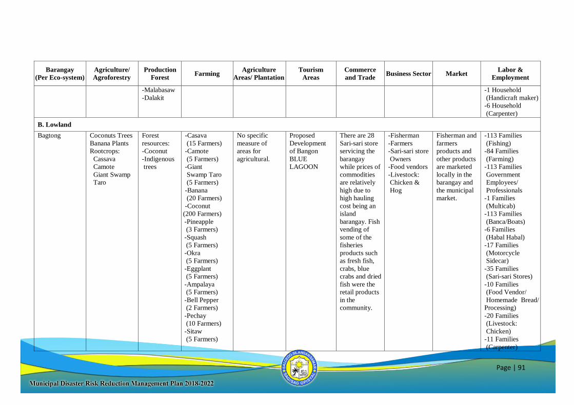
Page | 91
Barangay
(Per Eco-system)
Agriculture/
Agroforestry
Production
Forest Farming
Agriculture
Areas/ Plantation
Tourism
Areas
Commerce
and Trade Business Sector Market
Labor &
Employment
-Malabasaw
-Dalakit
-1 Household
(Handicraft maker)
-6 Household
(Carpenter)
B. Lowland
Bagtong Coconuts Trees
Banana Plants
Rootcrops:
Cassava
Camote
Giant Swamp
Taro
Forest
resources:
-Coconut
-Indigenous
trees
-Casava
(15 Farmers)
-Camote
(5 Farmers)
-Giant
Swamp Taro
(5 Farmers)
-Banana
(20 Farmers)
-Coconut
(200 Farmers)
-Pineapple
(3 Farmers)
-Squash
(5 Farmers)
-Okra
(5 Farmers)
-Eggplant
(5 Farmers)
-Ampalaya
(5 Farmers)
-Bell Pepper
(2 Farmers)
-Pechay
(10 Farmers)
-Sitaw
(5 Farmers)
No specific
measure of
areas for
agricultural.
Proposed
Development
of Bangon
BLUE
LAGOON
There are 28
Sari-sari store
servicing the
barangay
while prices of
commodities
are relatively
high due to
high hauling
cost being an
island
barangay. Fish
vending of
some of the
fisheries
products such
as fresh fish,
crabs, blue
crabs and dried
fish were the
retail products
in the
community.
-Fisherman
-Farmers
-Sari-sari store
Owners
-Food vendors
-Livestock:
Chicken &
Hog
Fisherman and
farmers
products and
other products
are marketed
locally in the
barangay and
the municipal
market.
-113 Families
(Fishing)
-84 Families
(Farming)
-113 Families
Government
Employees/
Professionals
-1 Families
(Multicab)
-113 Families
(Banca/Boats)
-6 Families
(Habal Habal)
-17 Families
(Motorcycle
Sidecar)
-35 Families
(Sari-sari Stores)
-10 Families
(Food Vendor/
Homemade Bread/
Processing)
-20 Families
(Livestock:
Chicken)
-11 Families
(Carpenter)
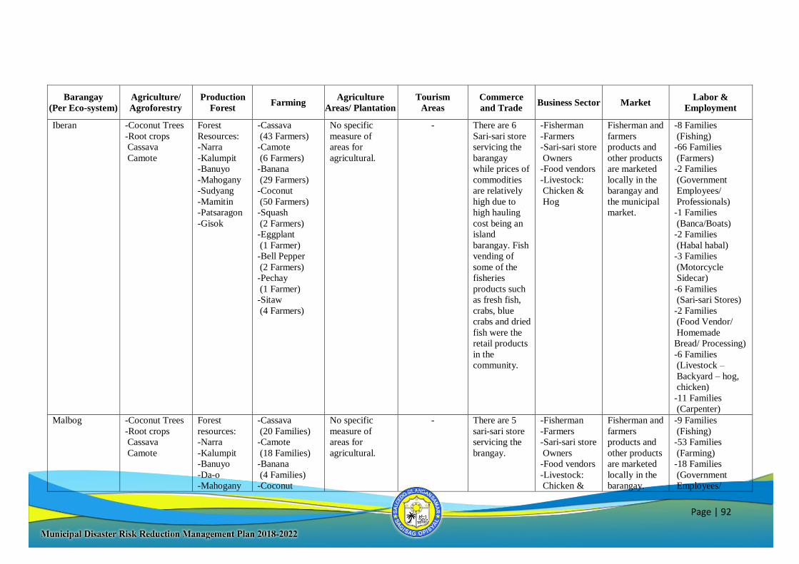
Page | 92
Barangay
(Per Eco-system)
Agriculture/
Agroforestry
Production
Forest Farming
Agriculture
Areas/ Plantation
Tourism
Areas
Commerce
and Trade Business Sector Market
Labor &
Employment
Iberan -Coconut Trees
-Root crops
Cassava
Camote
Forest
Resources:
-Narra
-Kalumpit
-Banuyo
-Mahogany
-Sudyang
-Mamitin
-Patsaragon
-Gisok
-Cassava
(43 Farmers)
-Camote
(6 Farmers)
-Banana
(29 Farmers)
-Coconut
(50 Farmers)
-Squash
(2 Farmers)
-Eggplant
(1 Farmer)
-Bell Pepper
(2 Farmers)
-Pechay
(1 Farmer)
-Sitaw
(4 Farmers)
No specific
measure of
areas for
agricultural.
- There are 6
Sari-sari store
servicing the
barangay
while prices of
commodities
are relatively
high due to
high hauling
cost being an
island
barangay. Fish
vending of
some of the
fisheries
products such
as fresh fish,
crabs, blue
crabs and dried
fish were the
retail products
in the
community.
-Fisherman
-Farmers
-Sari-sari store
Owners
-Food vendors
-Livestock:
Chicken &
Hog
Fisherman and
farmers
products and
other products
are marketed
locally in the
barangay and
the municipal
market.
-8 Families
(Fishing)
-66 Families
(Farmers)
-2 Families
(Government
Employees/
Professionals)
-1 Families
(Banca/Boats)
-2 Families
(Habal habal)
-3 Families
(Motorcycle
Sidecar)
-6 Families
(Sari-sari Stores)
-2 Families
(Food Vendor/
Homemade
Bread/ Processing)
-6 Families
(Livestock –
Backyard – hog,
chicken)
-11 Families
(Carpenter)
Malbog -Coconut Trees
-Root crops
Cassava
Camote
Forest
resources:
-Narra
-Kalumpit
-Banuyo
-Da-o
-Mahogany
-Cassava
(20 Families)
-Camote
(18 Families)
-Banana
(4 Families)
-Coconut
No specific
measure of
areas for
agricultural.
- There are 5
sari-sari store
servicing the
brangay.
-Fisherman
-Farmers
-Sari-sari store
Owners
-Food vendors
-Livestock:
Chicken &
Fisherman and
farmers
products and
other products
are marketed
locally in the
barangay.
-9 Families
(Fishing)
-53 Families
(Farming)
-18 Families
(Government
Employees/
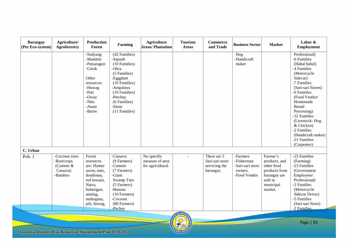
Page | 93
Barangay
(Per Eco-system)
Agriculture/
Agroforestry
Production
Forest Farming
Agriculture
Areas/ Plantation
Tourism
Areas
Commerce
and Trade Business Sector Market
Labor &
Employment
-Sudyang
-Mamitin
-Patsaragon
-Gisok
Other
resources:
-Huwag
-Puti
-Oway
-Nito
-Asam
-Bariw
(42 Families)
-Squash
(10 Families)
-Okra
(5 Families)
-Eggplant
(10 Families)
-Ampalaya
(10 Families)
-Petchay
(6 Families)
-Sitaw
(11 Families)
Hog
-Handicraft
maker
Professional)
-6 Families
(Habal habal)
-4 Families
(Motorcycle
Sidecar)
-7 Families
(Sari-sari Stores)
-6 Families
(Food Vendor/
Homemade
Bread/
Processing)
-32 Families
(Livestock- Hog
& Chicken)
-2 Families
(Handicraft maker)
-21 Families
(Carpenter)
C. Urban
Pob. 1 -Coconut trees
-Rootcrops
(Camote &
Cassava)
-Bamboo
Forest
resources
are: Hamor
awon, nato,
dondonay,
red lawaan,
Narra,
bubutigan,
anislag,
mahogany,
pili, huwag,
-Cassava
(9 Farmers)
-Camote
(7 Farmers)
-Giant
Swamp Taro
(5 Farmers)
-Banana
(10 Farmers)
-Coconut
(80 Farmers)
-Pechay
No specific
measure of area
for agricultural.
- There are 5
Sari-sari store
servicing the
barangay.
-Farmers
-Fisherman
-Sari-sari store
owners.
-Food Vendor
Farmer’s
products, and
other food
products from
barangay are
sold in
municipal
market.
-25 Families
(Farming)
-23 Families
(Government
Employees/
Professional)
-2 Families
(Motorcycle
Sidecar Driver)
-5 Families
(Sari-sari Store)
-2 Families
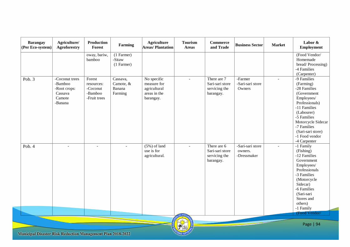
Page | 94
Barangay
(Per Eco-system)
Agriculture/
Agroforestry
Production
Forest Farming
Agriculture
Areas/ Plantation
Tourism
Areas
Commerce
and Trade Business Sector Market
Labor &
Employment
oway, bariw,
bamboo
(1 Farmer)
-Sitaw
(1 Farmer)
(Food Vendor/
Homemade
bread/ Processing)
-4 Families
(Carpenter)
Pob. 3 -Coconut trees
-Bamboo
-Root crops:
Cassava
Camote
-Banana
Forest
resources:
-Coconut
-Bamboo
-Fruit trees
Cassava,
Camote, &
Banana
Farming
No specific
measure for
agricultural
areas in the
barangay.
- There are 7
Sari-sari store
servicing the
barangay.
-Farmer
-Sari-sari store
Owners
- -9 Families
(Farming)
-28 Families
(Government
Employees/
Professionals)
-11 Families
(Labourer)
-5 Families
Motorcycle Sidecar
-7 Families
(Sari-sari store)
-1 Food vendor
-4 Carpenter
Pob. 4 - - - (5%) of land
use is for
agricultural.
- There are 6
Sari-sari store
servicing the
barangay.
-Sari-sari store
owners.
-Dressmaker
- -1 Family
(Fishing)
-12 Families
Government
Employees/
Professionals
-3 Families
(Motorcycle
Sidecar)
-6 Families
(Sari-sari
Stores and
others)
-1 Family
(Food Vendor/
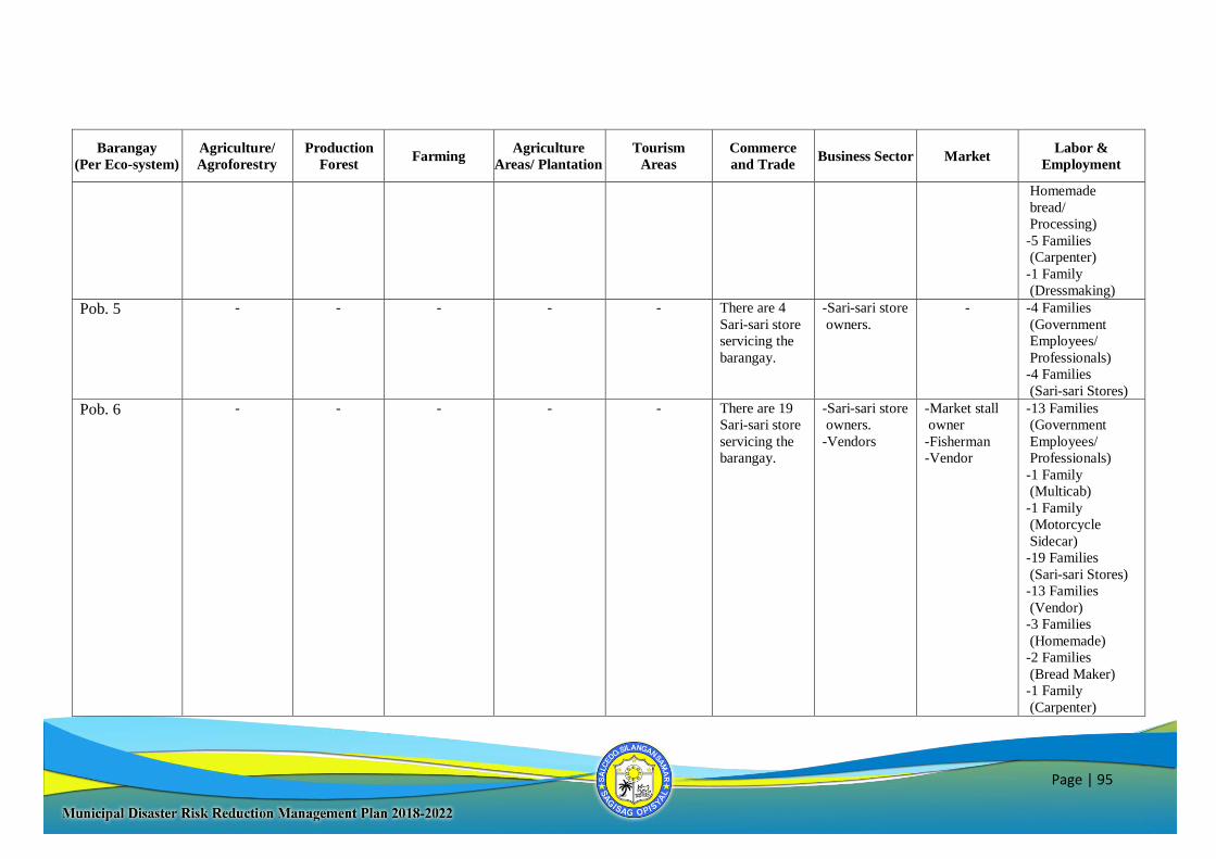
Page | 95
Barangay
(Per Eco-system)
Agriculture/
Agroforestry
Production
Forest Farming
Agriculture
Areas/ Plantation
Tourism
Areas
Commerce
and Trade Business Sector Market
Labor &
Employment
Homemade
bread/
Processing)
-5 Families
(Carpenter)
-1 Family
(Dressmaking)
Pob. 5 - - - - - There are 4
Sari-sari store
servicing the
barangay.
-Sari-sari store
owners.
- -4 Families
(Government
Employees/
Professionals)
-4 Families
(Sari-sari Stores)
Pob. 6 - - - - - There are 19
Sari-sari store
servicing the
barangay.
-Sari-sari store
owners.
-Vendors
-Market stall
owner
-Fisherman
-Vendor
-13 Families
(Government
Employees/
Professionals)
-1 Family
(Multicab)
-1 Family
(Motorcycle
Sidecar)
-19 Families
(Sari-sari Stores)
-13 Families
(Vendor)
-3 Families
(Homemade)
-2 Families
(Bread Maker)
-1 Family
(Carpenter)
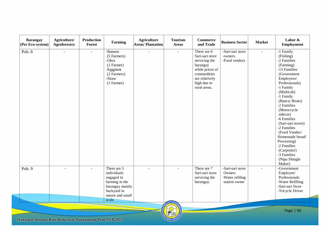
Page | 96
Barangay
(Per Eco-system)
Agriculture/
Agroforestry
Production
Forest Farming
Agriculture
Areas/ Plantation
Tourism
Areas
Commerce
and Trade Business Sector Market
Labor &
Employment
Pob. 8 - - -Banana
(5 Farmers)
-Okra
(1 Farmer)
-Eggplant
(2 Farmers)
-Sitaw
(1 Farmer)
- - There are 6
Sari-sari store
servicing the
barangay
while prices of
commodities
are relatively
high due to
rural areas.
-Sari-sari store
owners.
-Food vendors
- -1 Family
(Fishing)
-2 Families
(Farming)
-13 Families
(Government
Employees/
Professionals)
-1 Family
(Multicab)
-1 Family
(Banca/ Boats)
-2 Families
(Motorcycle
sidecar)
-6 Families
(Sari-sari stores)
-2 Families
(Food Vendor/
Homemade bread/
Processing)
-2 Families
(Carpenter)
-3 Families
(Nipa Shingle
Maker)
Pob. 9 - - There are 5
individuals
engaged in
farming in the
barangay mainly
backyard in
nature and small
scale.
- - There are 7
Sari-sari store
servicing the
barangay.
-Sari-sari store
Owners
-Water refiling
station owner
- -Government
Employee/
Professionals
-Water Refilling
-Sari-sari Store
-Tricycle Driver
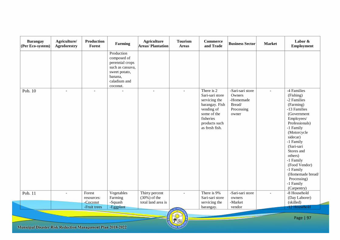
Page | 97
Barangay
(Per Eco-system)
Agriculture/
Agroforestry
Production
Forest Farming
Agriculture
Areas/ Plantation
Tourism
Areas
Commerce
and Trade Business Sector Market
Labor &
Employment
Production
composed of
perennial crops
such as cassava,
sweet potato,
banana,
caladium and
coconut.
Pob. 10 - - - - - There is 2
Sari-sari store
servicing the
barangay. Fish
vending of
some of the
fisheries
products such
as fresh fish.
-Sari-sari store
Owners
-Homemade
Bread/
Processing
owner
- -4 Families
(Fishing)
-2 Families
(Farming)
-13 Families
(Government
Employees/
Professionals)
-1 Family
(Motorcycle
sidecar)
-1 Family
(Sari-sari
Stores and
others)
-1 Family
(Food Vendor)
-1 Family
(Homemade bread/
Processing)
-1 Family
(Carpentry)
Pob. 11 - Forest
resources:
-Coconut
-Fruit trees
Vegetables
Farming
-Squash
-Eggplant
Thirty percent
(30%) of the
total land area is
- There is 9%
Sari-sari store
servicing the
barangay.
-Sari-sari store
owners
-Market
vendor
- -8 Household
(Day Laborer)
(skilled)
-12 Household
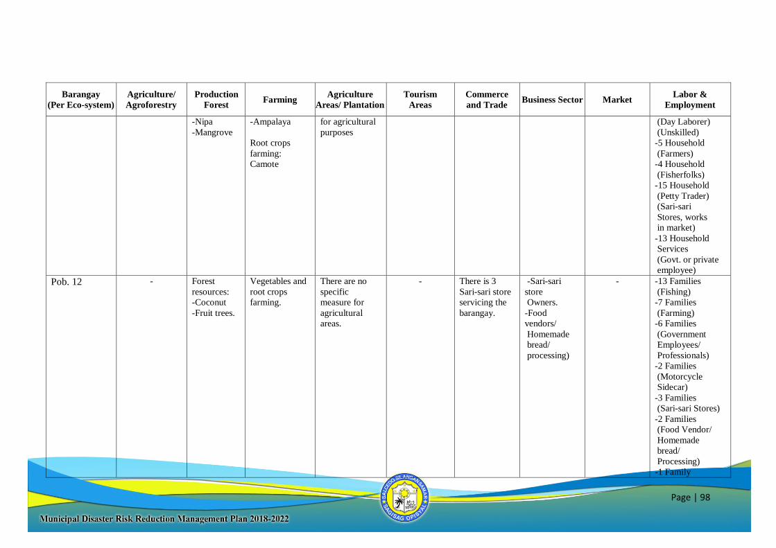
Page | 98
Barangay
(Per Eco-system)
Agriculture/
Agroforestry
Production
Forest Farming
Agriculture
Areas/ Plantation
Tourism
Areas
Commerce
and Trade Business Sector Market
Labor &
Employment
-Nipa
-Mangrove
-Ampalaya
Root crops
farming:
Camote
for agricultural
purposes
(Day Laborer)
(Unskilled)
-5 Household
(Farmers)
-4 Household
(Fisherfolks)
-15 Household
(Petty Trader)
(Sari-sari
Stores, works
in market)
-13 Household
Services
(Govt. or private
employee)
Pob. 12 - Forest
resources:
-Coconut
-Fruit trees.
Vegetables and
root crops
farming.
There are no
specific
measure for
agricultural
areas.
- There is 3
Sari-sari store
servicing the
barangay.
-Sari-sari
store
Owners.
-Food
vendors/
Homemade
bread/
processing)
- -13 Families
(Fishing)
-7 Families
(Farming)
-6 Families
(Government
Employees/
Professionals)
-2 Families
(Motorcycle
Sidecar)
-3 Families
(Sari-sari Stores)
-2 Families
(Food Vendor/
Homemade
bread/
Processing)
-1 Family
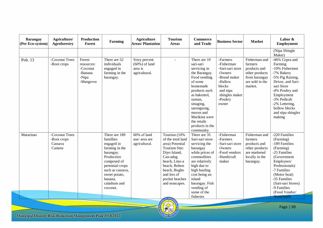
Page | 99
Barangay
(Per Eco-system)
Agriculture/
Agroforestry
Production
Forest Farming
Agriculture
Areas/ Plantation
Tourism
Areas
Commerce
and Trade Business Sector Market
Labor &
Employment
(Nipa Shingle
Maker)
Pob. 13 -Coconut Trees
-Root crops
Forest
resources:
-Coconut
-Banana
-Nipa
-Mangrove
There are 52
individuals
engaged in
farming in the
barangay.
Sixty percent
(60%) of land
area is
agricultural.
- There are 10
sari-sari
servicing in
the Barangay.
Food vending
of some
homemade
products such
as bakentol,
suman,
sinaging,
sarongsong,
moron and
Marikina were
the retails
products in the
community.
-Farmers
-Fisherman
-Sari-sari store
Owners
-Bread maker
-Hallow
blocks
and nipa
shingles maker
-Poultry
owner
Fisherman and
farmers
products and
other products
from barangay
are sold in the
market.
-46% Copra and
Farming
-10% Fishermen
-7% Bakery
-5% Pig Raising,
Driver, and Sari-
sari Store
-4% Poultry and
Employment
-3% Pedicab
-2% Lettering,
hollow blocks
and nipa shingles
making
Matarinao -Coconut Trees
-Root crops
Cassava
Camote
There are 189
famillies
engaged in
farming in the
barangay.
Production
composed of
perennial crops
such as cassava,
sweet potato,
banana,
caladium and
coconut.
60% of land
use/ area are
agricultural.
Tourism (10%
of the total land
area) Potential
Tourism Site:
Diyo Island,
Can-adag
beach, Lino-a
beach, Bobon
beach, Bogho
and lots of
pocket beaches
and seascapes.
There are 35
Sari-sari store
servicing the
barangay
while prices of
commodities
are relatively
high due to
high hauling
cost being an
island
barangay. Fish
vending of
some of the
fisheries
-Fisherman
-Farmers
-Sari-sari store
Owners
-Food vendors
-Handicraft
maker
Fisherman and
farmers
products and
other products
are marketed
locally in the
barangay.
-220 Families
(Farming)
-189 Families
(Farming)
-25 Families
(Government
Employees/
Professionals)
-7 Families
(Motor boat)
-35 Families
(Sari-sari Stores)
-9 Families
(Food Vendor/
Homemade
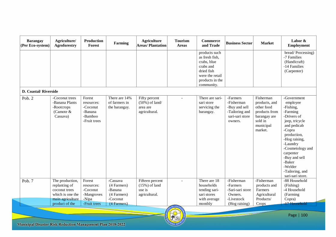
Page | 100
Barangay
(Per Eco-system)
Agriculture/
Agroforestry
Production
Forest Farming
Agriculture
Areas/ Plantation
Tourism
Areas
Commerce
and Trade Business Sector Market
Labor &
Employment
products such
as fresh fish,
crabs, blue
crabs and
dried fish
were the retail
products in the
community.
bread/ Processing)
-7 Families
(Handicraft)
-14 Families
(Carpenter)
D. Coastal/ Riverside
Pob. 2 -Coconut trees
-Banana Plants
-Rootcrops
(Camote &
Cassava)
Forest
resources:
-Coconut
-Banana
-Bamboo
-Fruit trees
There are 14%
of farmers in
the barangay.
Fifty percent
(50%) of land/
area are
agricultural.
- There are sari-
sari store
servicing the
barangay.
-Farmers
-Fisherman
-Buy and sell
-Tailoring and
sari-sari store
owners.
Fisherman
products, and
other food
products from
barangay are
sold in
municipal
market.
-Government
employee
-Fishing,
-Farming
-Drivers of
jeep, tricycle
and pedicab
-Copra
production,
-Hog raising,
-Laundry
-Cosmetology and
carpenter
-Buy and sell
-Baker
-Welder
-Tailoring, and
sari-sari store.
Pob. 7 The production,
replanting of
coconut trees
which is one the
main agriculture
product of the
Forest
resources:
-Coconut
-Mangroves
-Nipa
-Fruit trees
-Cassava
(4 Farmers)
-Banana
(4 Farmers)
-Coconut
(4 Farmers)
Fifteen percent
(15%) of land
use is
agricultural.
- There are 18
households
tending sari-
sari stores
with average
monthly
-Fisherman
-Farmers
-Sari-sari store
Owners.
-Livestock
(Hog raising)
-Fisherman
products and
Farmers
Agricultural
Products/
Crops
-88 Household
(Fishing)
-4 Household
(Farming
Copra)
-17 Household
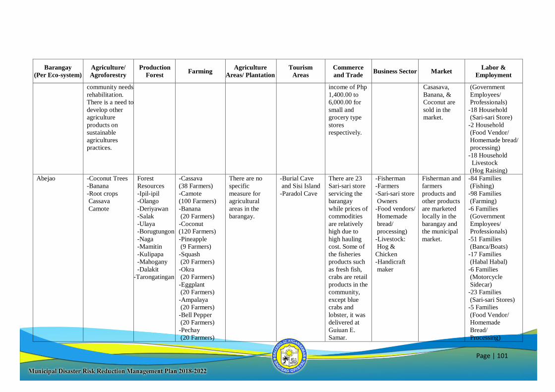
Page | 101
Barangay
(Per Eco-system)
Agriculture/
Agroforestry
Production
Forest Farming
Agriculture
Areas/ Plantation
Tourism
Areas
Commerce
and Trade Business Sector Market
Labor &
Employment
community needs
rehabilitation.
There is a need to
develop other
agriculture
products on
sustainable
agricultures
practices.
income of Php
1,400.00 to
6,000.00 for
small and
grocery type
stores
respectively.
Casasava,
Banana, &
Coconut are
sold in the
market.
(Government
Employees/
Professionals)
-18 Household
(Sari-sari Store)
-2 Household
(Food Vendor/
Homemade bread/
processing)
-18 Household
Livestock
(Hog Raising)
Abejao -Coconut Trees
-Banana
-Root crops
Cassava
Camote
Forest
Resources
-Ipil-ipil
-Olango
-Deriyawan
-Salak
-Ulaya
-Borugtungon
-Naga
-Mamitin
-Kulipapa
-Mahogany
-Dalakit
-Tarongatingan
-Cassava
(38 Farmers)
-Camote
(100 Farmers)
-Banana
(20 Farmers)
-Coconut
(120 Farmers)
-Pineapple
(9 Farmers)
-Squash
(20 Farmers)
-Okra
(20 Farmers)
-Eggplant
(20 Farmers)
-Ampalaya
(20 Farmers)
-Bell Pepper
(20 Farmers)
-Pechay
(20 Farmers)
There are no
specific
measure for
agricultural
areas in the
barangay.
-Burial Cave
and Sisi Island
-Paradol Cave
There are 23
Sari-sari store
servicing the
barangay
while prices of
commodities
are relatively
high due to
high hauling
cost. Some of
the fisheries
products such
as fresh fish,
crabs are retail
products in the
community,
except blue
crabs and
lobster, it was
delivered at
Guiuan E.
Samar.
-Fisherman
-Farmers
-Sari-sari store
Owners
-Food vendors/
Homemade
bread/
processing)
-Livestock:
Hog &
Chicken
-Handicraft
maker
Fisherman and
farmers
products and
other products
are marketed
locally in the
barangay and
the municipal
market.
-84 Families
(Fishing)
-98 Families
(Farming)
-6 Families
(Government
Employees/
Professionals)
-51 Families
(Banca/Boats)
-17 Families
(Habal Habal)
-6 Families
(Motorcycle
Sidecar)
-23 Families
(Sari-sari Stores)
-5 Families
(Food Vendor/
Homemade
Bread/
Processing)
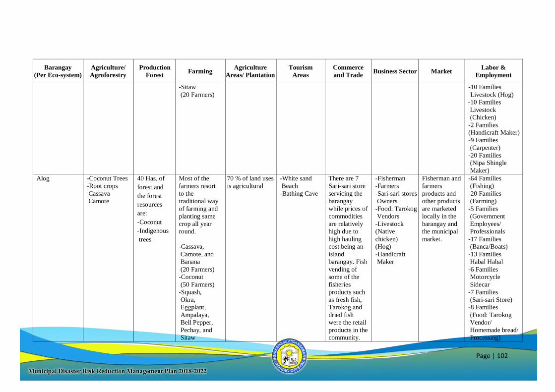
Page | 102
Barangay
(Per Eco-system)
Agriculture/
Agroforestry
Production
Forest Farming
Agriculture
Areas/ Plantation
Tourism
Areas
Commerce
and Trade Business Sector Market
Labor &
Employment
-Sitaw
(20 Farmers)
-10 Families
Livestock (Hog)
-10 Families
Livestock
(Chicken)
-2 Families
(Handicraft Maker)
-9 Families
(Carpenter)
-20 Families
(Nipa Shingle
Maker)
Alog -Coconut Trees
-Root crops
Cassava
Camote
40 Has. of
forest and
the forest
resources
are:
-Coconut
-Indigenous
trees
Most of the
farmers resort
to the
traditional way
of farming and
planting same
crop all year
round.
-Cassava,
Camote, and
Banana
(20 Farmers)
-Coconut
(50 Farmers)
-Squash,
Okra,
Eggplant,
Ampalaya,
Bell Pepper,
Pechay, and
Sitaw
70 % of land uses
is agricultural
-White sand
Beach
-Bathing Cave
There are 7
Sari-sari store
servicing the
barangay
while prices of
commodities
are relatively
high due to
high hauling
cost being an
island
barangay. Fish
vending of
some of the
fisheries
products such
as fresh fish,
Tarokog and
dried fish
were the retail
products in the
community.
-Fisherman
-Farmers
-Sari-sari stores
Owners
-Food: Tarokog
Vendors
-Livestock
(Native
chicken)
(Hog)
-Handicraft
Maker
Fisherman and
farmers
products and
other products
are marketed
locally in the
barangay and
the municipal
market.
-64 Families
(Fishing)
-20 Families
(Farming)
-5 Families
(Government
Employees/
Professionals
-17 Families
(Banca/Boats)
-13 Families
Habal Habal
-6 Families
Motorcycle
Sidecar
-7 Families
(Sari-sari Store)
-8 Families
(Food: Tarokog
Vendor/
Homemade bread/
Processing)
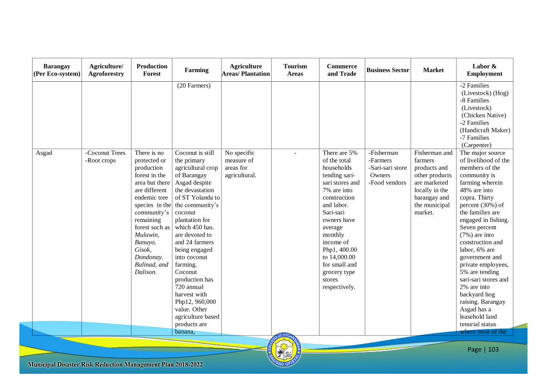
Page | 103
Barangay
(Per Eco-system)
Agriculture/
Agroforestry
Production
Forest Farming
Agriculture
Areas/ Plantation
Tourism
Areas
Commerce
and Trade Business Sector Market
Labor &
Employment
(20 Farmers) -2 Families
(Livestock) (Hog)
-8 Families
(Livestock)
(Chicken Native)
-2 Families
(Handicraft Maker)
-7 Families
(Carpenter)
Asgad -Coconut Trees
-Root crops
There is no
protected or
production
forest in the
area but there
are different
endemic tree
species in the
community’s
remaining
forest such as
Mulawin,
Banuyo,
Gisok,
Dondonay.
Balinad, and
Dalison.
Coconut is still
the primary
agricultural crop
of Barangay
Asgad despite
the devastation
of ST Yolanda to
the community’s
coconut
plantation for
which 450 has.
are devoted to
and 24 farmers
being engaged
into coconut
farming.
Coconut
production has
720 annual
harvest with
Php12, 960,000
value. Other
agriculture based
products are
banana,
No specific
measure of
areas for
agricultural.
- There are 5%
of the total
households
tending sari-
sari stores and
7% are into
construction
and labor.
Sari-sari
owners have
average
monthly
income of
Php1, 400.00
to 14,000.00
for small and
grocery type
stores
respectively.
-Fisherman
-Farmers
-Sari-sari store
Owners
-Food vendors
Fisherman and
farmers
products and
other products
are marketed
locally in the
barangay and
the municipal
market.
The major source
of livelihood of the
members of the
community is
farming wherein
48% are into
copra. Thirty
percent (30%) of
the families are
engaged in fishing.
Seven percent
(7%) are into
construction and
labor, 6% are
government and
private employees,
5% are tending
sari-sari stores and
2% are into
backyard hog
raising. Barangay
Asgad has a
leasehold land
tenurial status
where most of the

Page | 104
Barangay
(Per Eco-system)
Agriculture/
Agroforestry
Production
Forest Farming
Agriculture
Areas/ Plantation
Tourism
Areas
Commerce
and Trade Business Sector Market
Labor &
Employment
vegetables and
root crops like
cassava, camote
and gaway. Root
crops price
ranges from Php
20.00 to Php
30.00 per kilo
and vegetables
are sold at Php
80.00 per kilo.
farmers do not
own the land they
till.
Balud -Coconut Trees
-Root crops
Cassava
Camote
Coconut is the
dominant
product in the
barangay.
Majority of
the family are
engaged in
copra making.
-Cassava
(40 Farmers)
-Camote
(40 Farmers)
-Banana
(40 Farmers)
-Coconut
(75 Farmers)
-Pineapple
(5 Farmers)
-Squash
(30 Farmers)
-Okra
(10 Farmers)
-Eggplant
(10 Farmers)
-Ampalaya
(5 Farmers)
-Pechay
(5 Farmers)
-Sitaw
(30 Farmers)
-Repolyo
No specific
measure of
areas for
agricultural.
- There are 8
Sari-sari store
servicing the
barangay.
-Fisherman
-Farmers
-Sari-sari store
Owners
-Food vendors
-Livestock:
Chicken &
Hog
-Handicraft
maker
Fisherman and
farmers
products and
other products
are marketed
locally in the
barangay and
the municipal
market.
-85 Families
(Fishing)
-40 Families
(Farming)
-4 Families
(Government
Employees/
Professionals)
-3 Families
(Banca/ Boats)
-8 Families
(Motorcycle
Sidecar)
-8 Families
(Sari-sari Stores)
-4 Families
(Food Vendor/
Homemade Bread/
Processing)
-2 Families
(Livestock:
Hog, Chicken)
-4 Families
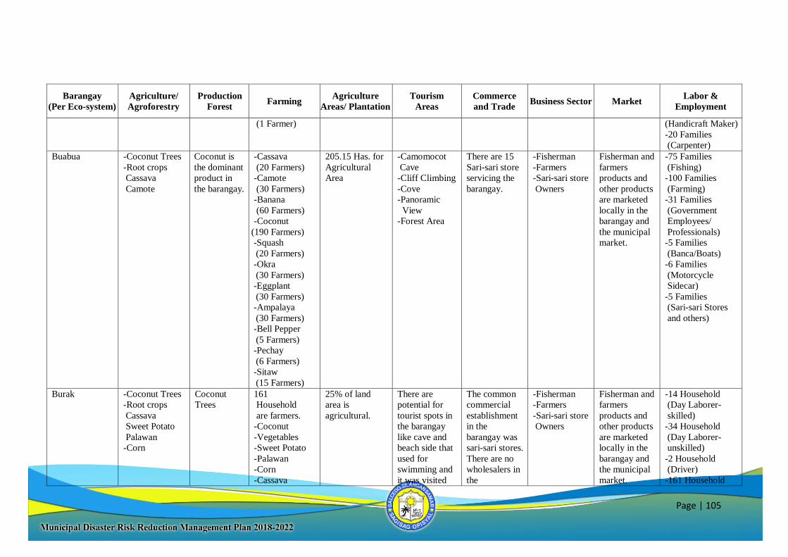
Page | 105
Barangay
(Per Eco-system)
Agriculture/
Agroforestry
Production
Forest Farming
Agriculture
Areas/ Plantation
Tourism
Areas
Commerce
and Trade Business Sector Market
Labor &
Employment
(1 Farmer) (Handicraft Maker)
-20 Families
(Carpenter)
Buabua -Coconut Trees
-Root crops
Cassava
Camote
Coconut is
the dominant
product in
the barangay.
-Cassava
(20 Farmers)
-Camote
(30 Farmers)
-Banana
(60 Farmers)
-Coconut
(190 Farmers)
-Squash
(20 Farmers)
-Okra
(30 Farmers)
-Eggplant
(30 Farmers)
-Ampalaya
(30 Farmers)
-Bell Pepper
(5 Farmers)
-Pechay
(6 Farmers)
-Sitaw
(15 Farmers)
205.15 Has. for
Agricultural
Area
-Camomocot
Cave
-Cliff Climbing
-Cove
-Panoramic
View
-Forest Area
There are 15
Sari-sari store
servicing the
barangay.
-Fisherman
-Farmers
-Sari-sari store
Owners
Fisherman and
farmers
products and
other products
are marketed
locally in the
barangay and
the municipal
market.
-75 Families
(Fishing)
-100 Families
(Farming)
-31 Families
(Government
Employees/
Professionals)
-5 Families
(Banca/Boats)
-6 Families
(Motorcycle
Sidecar)
-5 Families
(Sari-sari Stores
and others)
Burak -Coconut Trees
-Root crops
Cassava
Sweet Potato
Palawan
-Corn
Coconut
Trees
161
Household
are farmers.
-Coconut
-Vegetables
-Sweet Potato
-Palawan
-Corn
-Cassava
25% of land
area is
agricultural.
There are
potential for
tourist spots in
the barangay
like cave and
beach side that
used for
swimming and
it was visited
The common
commercial
establishment
in the
barangay was
sari-sari stores.
There are no
wholesalers in
the
-Fisherman
-Farmers
-Sari-sari store
Owners
Fisherman and
farmers
products and
other products
are marketed
locally in the
barangay and
the municipal
market.
-14 Household
(Day Laborer-
skilled)
-34 Household
(Day Laborer-
unskilled)
-2 Household
(Driver)
-161 Household
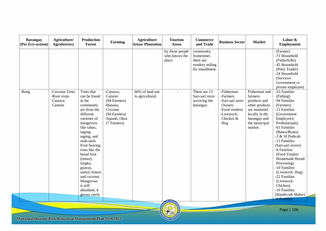
Page | 106
Barangay
(Per Eco-system)
Agriculture/
Agroforestry
Production
Forest Farming
Agriculture
Areas/ Plantation
Tourism
Areas
Commerce
and Trade Business Sector Market
Labor &
Employment
by those people
who knows the
place.
community.
Sometimes
there are
vendors selling
for installment.
(Farmer)
-71 Household
(Fisherfolks)
-45 Household
(Petty Trader)
-24 Household
(Services-
Government or
private employee)
Butig -Coconut Trees
-Root crops
Cassava
Camote
Trees that
can be found
in the
community
are from the
different
varieties of
mangroves
like tabao,
saging-
saging, and
otub-utob.
Fruit bearing
trees like the
bread fruit
(rimas),
langka,
guavas,
santol, lemon
and coconut.
Mangroves
is still
abundant, it
grows vastly
-Cassava,
Camote
(94 Farmers)
-Banana,
Coconut
(94 Farmers)
-Squash, Okra
(7 Farmers)
60% of land use
is agricultural.
- There are 13
Sari-sari store
servicing the
barangay.
-Fisherman
-Farmers
-Sari-sari store
Owners
-Food vendors
-Livestock:
Chicken &
Hog
Fisherman and
farmers
products and
other products
are marketed
locally in the
barangay and
the municipal
market.
-55 Families
(Fishing)
-94 Families
(Farmers)
-11 Families
(Government
Employees/
Professionals)
-61 Families
(Banca/Boats)
-2 & 10 Pedicab
-13 Families
(Sari-sari stores)
-6 Families
(Food Vendor/
Homemade Bread/
Processing)
-10 Families
(Livestock: Hog)
-22 Families
(Livestock:
Chicken)
-10 Families
(Handicraft Maker)
-6 Families
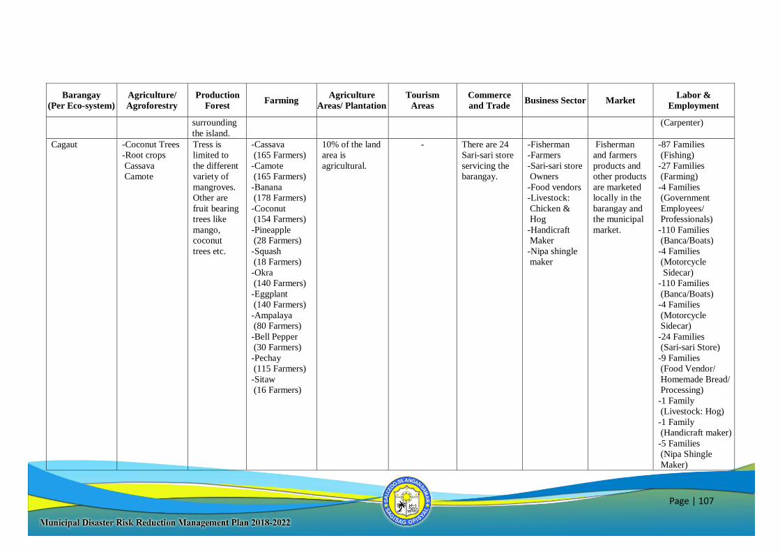
Page | 107
Barangay
(Per Eco-system)
Agriculture/
Agroforestry
Production
Forest Farming
Agriculture
Areas/ Plantation
Tourism
Areas
Commerce
and Trade Business Sector Market
Labor &
Employment
surrounding
the island.
(Carpenter)
Cagaut -Coconut Trees
-Root crops
Cassava
Camote
Tress is
limited to
the different
variety of
mangroves.
Other are
fruit bearing
trees like
mango,
coconut
trees etc.
-Cassava
(165 Farmers)
-Camote
(165 Farmers)
-Banana
(178 Farmers)
-Coconut
(154 Farmers)
-Pineapple
(28 Farmers)
-Squash
(18 Farmers)
-Okra
(140 Farmers)
-Eggplant
(140 Farmers)
-Ampalaya
(80 Farmers)
-Bell Pepper
(30 Farmers)
-Pechay
(115 Farmers)
-Sitaw
(16 Farmers)
10% of the land
area is
agricultural.
- There are 24
Sari-sari store
servicing the
barangay.
-Fisherman
-Farmers
-Sari-sari store
Owners
-Food vendors
-Livestock:
Chicken &
Hog
-Handicraft
Maker
-Nipa shingle
maker
Fisherman
and farmers
products and
other products
are marketed
locally in the
barangay and
the municipal
market.
-87 Families
(Fishing)
-27 Families
(Farming)
-4 Families
(Government
Employees/
Professionals)
-110 Families
(Banca/Boats)
-4 Families
(Motorcycle
Sidecar)
-110 Families
(Banca/Boats)
-4 Families
(Motorcycle
Sidecar)
-24 Families
(Sari-sari Store)
-9 Families
(Food Vendor/
Homemade Bread/
Processing)
-1 Family
(Livestock: Hog)
-1 Family
(Handicraft maker)
-5 Families
(Nipa Shingle
Maker)
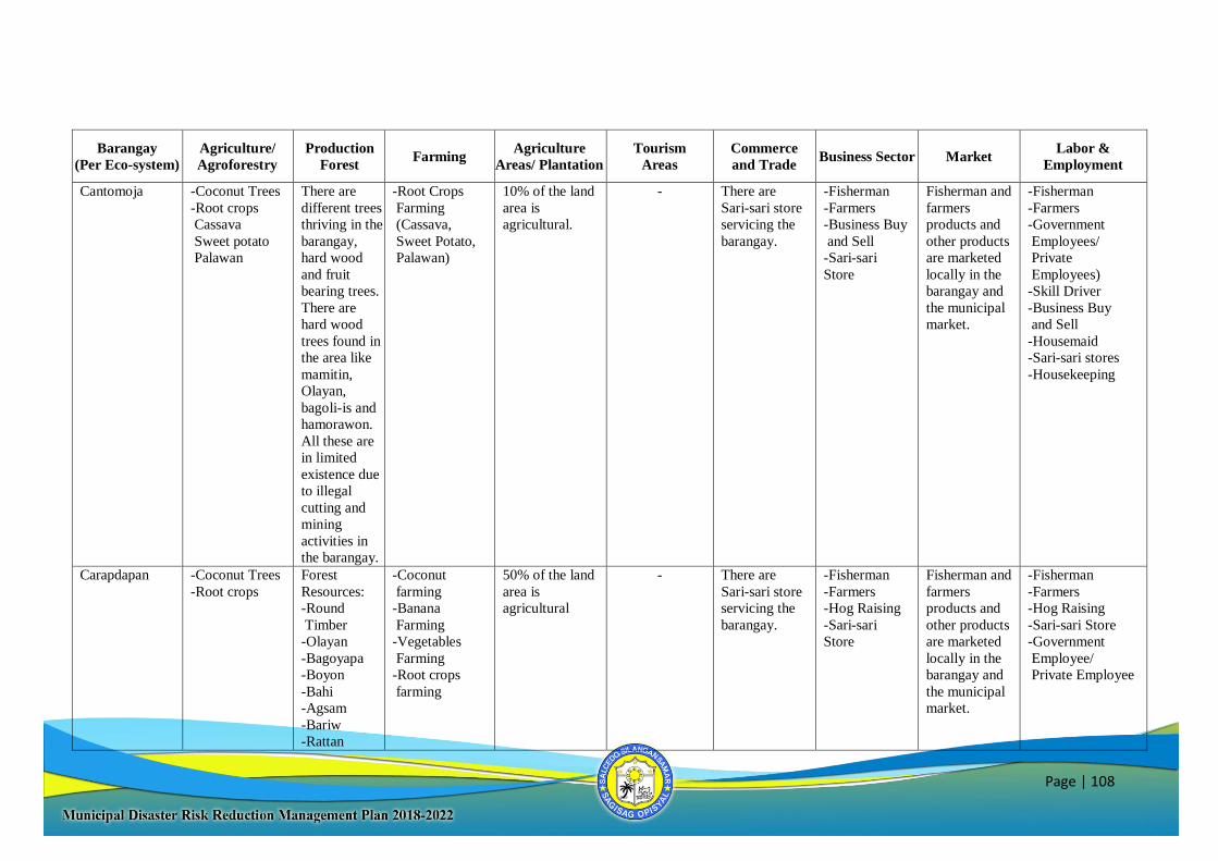
Page | 108
Barangay
(Per Eco-system)
Agriculture/
Agroforestry
Production
Forest Farming
Agriculture
Areas/ Plantation
Tourism
Areas
Commerce
and Trade Business Sector Market
Labor &
Employment
Cantomoja -Coconut Trees
-Root crops
Cassava
Sweet potato
Palawan
There are
different trees
thriving in the
barangay,
hard wood
and fruit
bearing trees.
There are
hard wood
trees found in
the area like
mamitin,
Olayan,
bagoli-is and
hamorawon.
All these are
in limited
existence due
to illegal
cutting and
mining
activities in
the barangay.
-Root Crops
Farming
(Cassava,
Sweet Potato,
Palawan)
10% of the land
area is
agricultural.
- There are
Sari-sari store
servicing the
barangay.
-Fisherman
-Farmers
-Business Buy
and Sell
-Sari-sari
Store
Fisherman and
farmers
products and
other products
are marketed
locally in the
barangay and
the municipal
market.
-Fisherman
-Farmers
-Government
Employees/
Private
Employees)
-Skill Driver
-Business Buy
and Sell
-Housemaid
-Sari-sari stores
-Housekeeping
Carapdapan -Coconut Trees
-Root crops
Forest
Resources:
-Round
Timber
-Olayan
-Bagoyapa
-Boyon
-Bahi
-Agsam
-Bariw
-Rattan
-Coconut
farming
-Banana
Farming
-Vegetables
Farming
-Root crops
farming
50% of the land
area is
agricultural
- There are
Sari-sari store
servicing the
barangay.
-Fisherman
-Farmers
-Hog Raising
-Sari-sari
Store
Fisherman and
farmers
products and
other products
are marketed
locally in the
barangay and
the municipal
market.
-Fisherman
-Farmers
-Hog Raising
-Sari-sari Store
-Government
Employee/
Private Employee
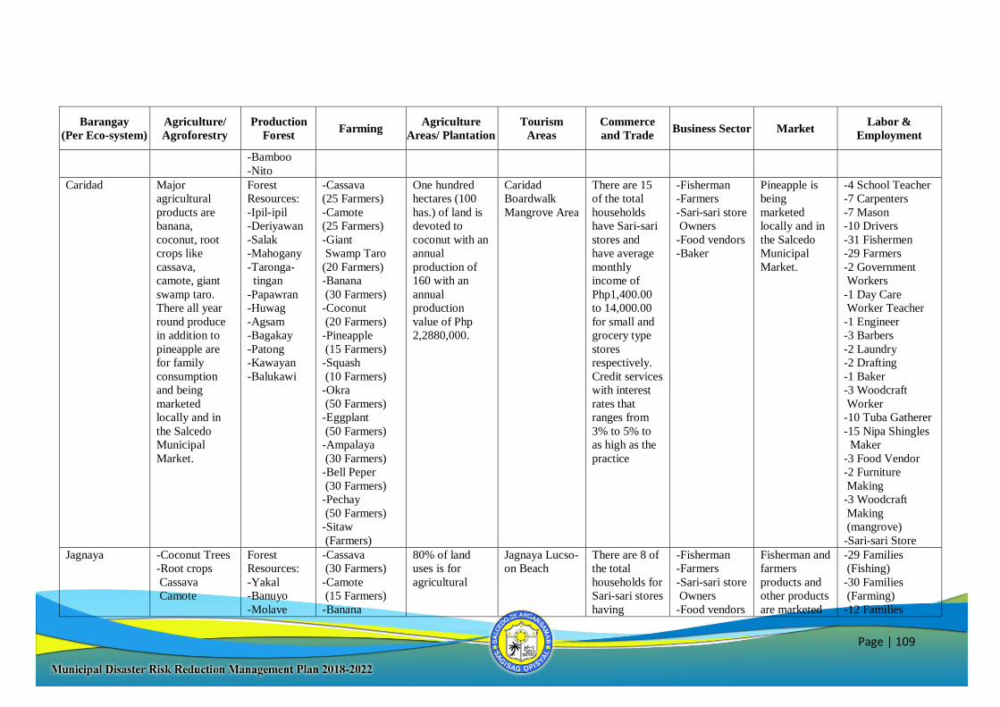
Page | 109
Barangay
(Per Eco-system)
Agriculture/
Agroforestry
Production
Forest Farming
Agriculture
Areas/ Plantation
Tourism
Areas
Commerce
and Trade Business Sector Market
Labor &
Employment
-Bamboo
-Nito
Caridad Major
agricultural
products are
banana,
coconut, root
crops like
cassava,
camote, giant
swamp taro.
There all year
round produce
in addition to
pineapple are
for family
consumption
and being
marketed
locally and in
the Salcedo
Municipal
Market.
Forest
Resources:
-Ipil-ipil
-Deriyawan
-Salak
-Mahogany
-Taronga-
tingan
-Papawran
-Huwag
-Agsam
-Bagakay
-Patong
-Kawayan
-Balukawi
-Cassava
(25 Farmers)
-Camote
(25 Farmers)
-Giant
Swamp Taro
(20 Farmers)
-Banana
(30 Farmers)
-Coconut
(20 Farmers)
-Pineapple
(15 Farmers)
-Squash
(10 Farmers)
-Okra
(50 Farmers)
-Eggplant
(50 Farmers)
-Ampalaya
(30 Farmers)
-Bell Peper
(30 Farmers)
-Pechay
(50 Farmers)
-Sitaw
(Farmers)
One hundred
hectares (100
has.) of land is
devoted to
coconut with an
annual
production of
160 with an
annual
production
value of Php
2,2880,000.
Caridad
Boardwalk
Mangrove Area
There are 15
of the total
households
have Sari-sari
stores and
have average
monthly
income of
Php1,400.00
to 14,000.00
for small and
grocery type
stores
respectively.
Credit services
with interest
rates that
ranges from
3% to 5% to
as high as the
practice
-Fisherman
-Farmers
-Sari-sari store
Owners
-Food vendors
-Baker
Pineapple is
being
marketed
locally and in
the Salcedo
Municipal
Market.
-4 School Teacher
-7 Carpenters
-7 Mason
-10 Drivers
-31 Fishermen
-29 Farmers
-2 Government
Workers
-1 Day Care
Worker Teacher
-1 Engineer
-3 Barbers
-2 Laundry
-2 Drafting
-1 Baker
-3 Woodcraft
Worker
-10 Tuba Gatherer
-15 Nipa Shingles
Maker
-3 Food Vendor
-2 Furniture
Making
-3 Woodcraft
Making
(mangrove)
-Sari-sari Store
Jagnaya -Coconut Trees
-Root crops
Cassava
Camote
Forest
Resources:
-Yakal
-Banuyo
-Molave
-Cassava
(30 Farmers)
-Camote
(15 Farmers)
-Banana
80% of land
uses is for
agricultural
Jagnaya Lucso-
on Beach
There are 8 of
the total
households for
Sari-sari stores
having
-Fisherman
-Farmers
-Sari-sari store
Owners
-Food vendors
Fisherman and
farmers
products and
other products
are marketed
-29 Families
(Fishing)
-30 Families
(Farming)
-12 Families
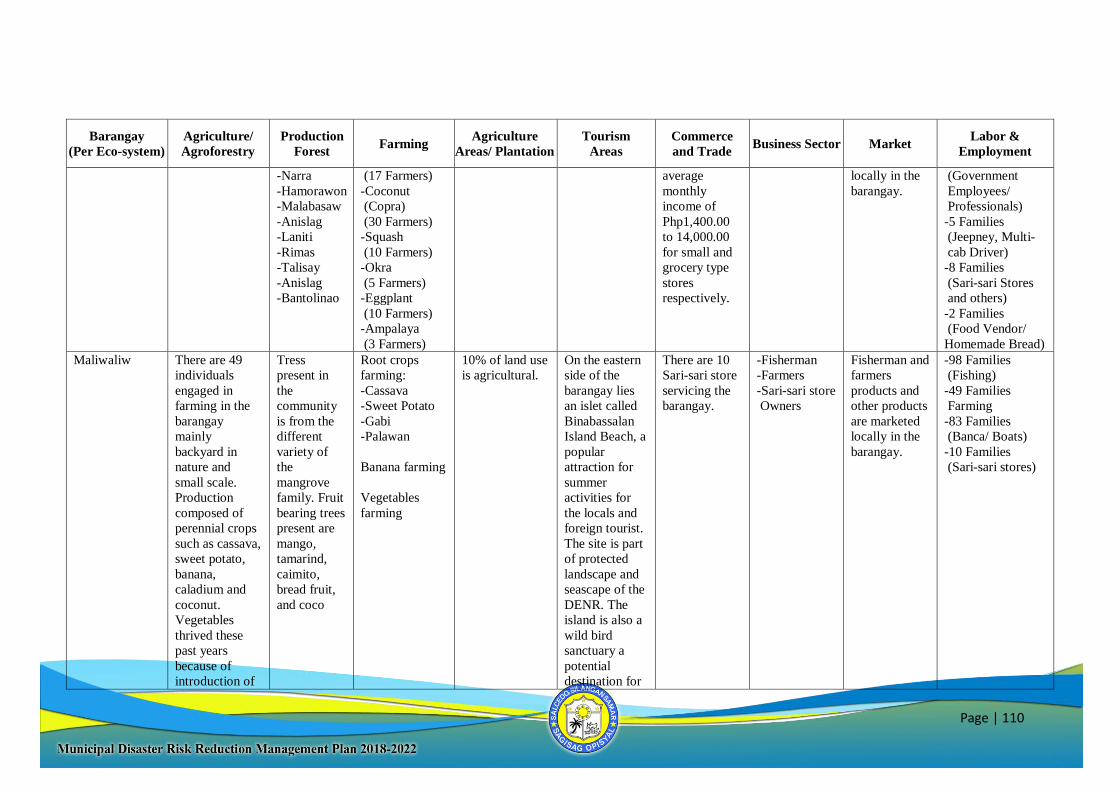
Page | 110
Barangay
(Per Eco-system)
Agriculture/
Agroforestry
Production
Forest Farming
Agriculture
Areas/ Plantation
Tourism
Areas
Commerce
and Trade Business Sector Market
Labor &
Employment
-Narra
-Hamorawon
-Malabasaw
-Anislag
-Laniti
-Rimas
-Talisay
-Anislag
-Bantolinao
(17 Farmers)
-Coconut
(Copra)
(30 Farmers)
-Squash
(10 Farmers)
-Okra
(5 Farmers)
-Eggplant
(10 Farmers)
-Ampalaya
(3 Farmers)
average
monthly
income of
Php1,400.00
to 14,000.00
for small and
grocery type
stores
respectively.
locally in the
barangay.
(Government
Employees/
Professionals)
-5 Families
(Jeepney, Multi-
cab Driver)
-8 Families
(Sari-sari Stores
and others)
-2 Families
(Food Vendor/
Homemade Bread)
Maliwaliw There are 49
individuals
engaged in
farming in the
barangay
mainly
backyard in
nature and
small scale.
Production
composed of
perennial crops
such as cassava,
sweet potato,
banana,
caladium and
coconut.
Vegetables
thrived these
past years
because of
introduction of
Tress
present in
the
community
is from the
different
variety of
the
mangrove
family. Fruit
bearing trees
present are
mango,
tamarind,
caimito,
bread fruit,
and coco
Root crops
farming:
-Cassava
-Sweet Potato
-Gabi
-Palawan
Banana farming
Vegetables
farming
10% of land use
is agricultural.
On the eastern
side of the
barangay lies
an islet called
Binabassalan
Island Beach, a
popular
attraction for
summer
activities for
the locals and
foreign tourist.
The site is part
of protected
landscape and
seascape of the
DENR. The
island is also a
wild bird
sanctuary a
potential
destination for
There are 10
Sari-sari store
servicing the
barangay.
-Fisherman
-Farmers
-Sari-sari store
Owners
Fisherman and
farmers
products and
other products
are marketed
locally in the
barangay.
-98 Families
(Fishing)
-49 Families
Farming
-83 Families
(Banca/ Boats)
-10 Families
(Sari-sari stores)

Page | 111
Barangay
(Per Eco-system)
Agriculture/
Agroforestry
Production
Forest Farming
Agriculture
Areas/ Plantation
Tourism
Areas
Commerce
and Trade Business Sector Market
Labor &
Employment
adoption
technologies
and seed
dispersal
programs of the
government.
enthusiast and
conservationist.
Mud crab
ranching, sea
cucumber
ranching and
bee culture
though an
economic
activities were
also considered
as eco
development
tourism
potential.
Palanas -Coconut trees
-Banana Plants
-Rootcrops
(Camote,
Cassava & giant
swamp taro)
Forest
resources:
Round timber
and other
indigenous
trees.
-Cassava
(40 Famers)
-Camote
(20 Farmers)
-Giant Swamp
Taro
(10 Farmers)
-Banana
(60 Farmers
-Coconut
-30% of Land is
Agricultural
-Cansarigan
Reefs
(2.5 Hectares)
-Water Shade
-35 Sari-sari
Store & Fish
Vending
-Fisher folks
-Farmers
-Sari-sari store
owners.
-Livestock
Business
-Food Vendor/
Homemade
bread
processing
-Agricultural
Products
-Livestock
Products
-Fishery
Activities
Products
-67 Fisher folks
(52 Males and 15
Females)
-268 Farmers
for Agricultural
Production
-30 Families for
Sari-sari Store
Business
-6 Families for
Food Vendor/
Homemade
bread Processing
Business
-Livestock
Business
-Motorcycle
sidecar Driver
-Nipa Shingle
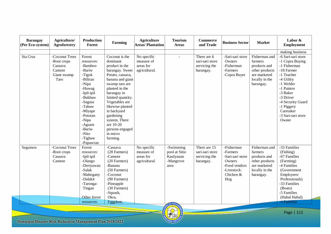
Page | 112
Barangay
(Per Eco-system)
Agriculture/
Agroforestry
Production
Forest Farming
Agriculture
Areas/ Plantation
Tourism
Areas
Commerce
and Trade Business Sector Market
Labor &
Employment
making business
Sta Cruz -Coconut Trees
-Root crops
Cassava
Camote
Giant swamp
Taro
Forest
resources:
-Bamboo
-Bariw
-Tigok
-Biliran
-Nipa
-Huwag
-Ipil-ipil
-Bakhaw
-Sagasa
-Tabaw
-Miyape
-Pototan
-Nipa
-Agsam
-Bariw
-Nito
-Tigbaw
-Papawran
Coconut is the
dominant
product in the
barangay. Sweet
Potato, cassava,
banana and giant
swamp taro are
planted in the
barangay in
limited quantity.
Vegetables are
likewise planted
in backyard
gardening
system. There
are 10-20
persons engaged
in micro
farming.
No specific
measure of
areas for
agricultural.
- There are 6
sari-sari store
servicing the
barangay.
-Sari-sari store
Owners
-Fisherman
-Farmers
-Copra Buyer
Fisherman and
farmers
products and
other products
are marketed
locally in the
barangay.
-6 Sari-sari store
-1 Copra Buying
-1 Fisherman
-18 Farmer
-1 Teacher
-4 Utility
-1 Welder
-1 Paintor
-3 Baker
-3 Driver
-4 Security Guard
-1 Piggery
Caretaker
-3 Sari-sari store
Owner
Seguinon -Coconut Trees
-Root crops
Cassava
Camote
Forest
resources:
-Ipil-ipil
-Olango
-Deriyawan
-Salak
-Mahogany
-Dalakit
-Taronga-
Tingan
Other forest
resources:
-Cassava
(28 Farmers)
-Camote
(20 Farmers)
-Banana
(50 Farmers)
-Coconut
(90 Farmers)
-Pineapple
(30 Farmers)
-Squash,
Okra,
Eggplant,
No specific
measure of
areas for
agricultural.
-Swimming
pool at Sitio
Kaulyanan
-Mangrove
area
There are 15
sari-sari store
servicing the
barangay.
-Fisherman
-Farmers
-Sari-sari store
Owners
-Food vendors
-Livestock:
Chicken &
Hog
Fisherman and
farmers
products and
other products
are marketed
locally in the
barangay.
-33 Families
(Fishing)
-67 Families
(Farming)
-4 Families
(Government
Employees/
Professionals)
-33 Families
(Boats)
-5 Families
(Habal Habal)
-4 Families
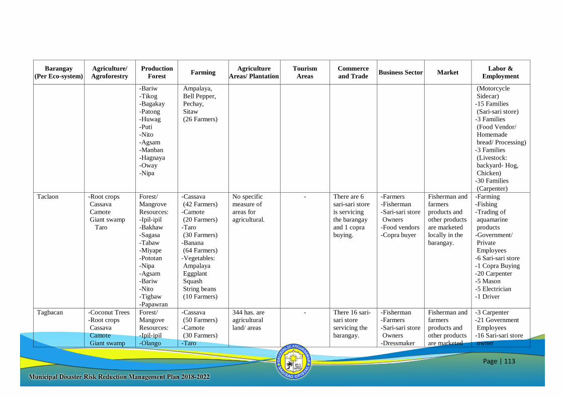
Page | 113
Barangay
(Per Eco-system)
Agriculture/
Agroforestry
Production
Forest Farming
Agriculture
Areas/ Plantation
Tourism
Areas
Commerce
and Trade Business Sector Market
Labor &
Employment
-Bariw
-Tikog
-Bagakay
-Patong
-Huwag
-Puti
-Nito
-Agsam
-Manban
-Hagnaya
-Oway
-Nipa
Ampalaya,
Bell Pepper,
Pechay,
Sitaw
(26 Farmers)
(Motorcycle
Sidecar)
-15 Families
(Sari-sari store)
-3 Families
(Food Vendor/
Homemade
bread/ Processing)
-3 Families
(Livestock:
backyard- Hog,
Chicken)
-30 Families
(Carpenter)
Taclaon -Root crops
Cassava
Camote
Giant swamp
Taro
Forest/
Mangrove
Resources:
-Ipil-ipil
-Bakhaw
-Sagasa
-Tabaw
-Miyape
-Pototan
-Nipa
-Agsam
-Bariw
-Nito
-Tigbaw
-Papawran
-Cassava
(42 Farmers)
-Camote
(20 Farmers)
-Taro
(30 Farmers)
-Banana
(64 Farmers)
-Vegetables:
Ampalaya
Eggplant
Squash
String beans
(10 Farmers)
No specific
measure of
areas for
agricultural.
- There are 6
sari-sari store
is servicing
the barangay
and 1 copra
buying.
-Farmers
-Fisherman
-Sari-sari store
Owners
-Food vendors
-Copra buyer
Fisherman and
farmers
products and
other products
are marketed
locally in the
barangay.
-Farming
-Fishing
-Trading of
aquamarine
products
-Government/
Private
Employees
-6 Sari-sari store
-1 Copra Buying
-20 Carpenter
-5 Mason
-5 Electrician
-1 Driver
Tagbacan -Coconut Trees
-Root crops
Cassava
Camote
Giant swamp
Forest/
Mangove
Resources:
-Ipil-ipil
-Olango
-Cassava
(50 Farmers)
-Camote
(30 Farmers)
-Taro
344 has. are
agricultural
land/ areas
- There 16 sari-
sari store
servicing the
barangay.
-Fisherman
-Farmers
-Sari-sari store
Owners
-Dressmaker
Fisherman and
farmers
products and
other products
are marketed
-3 Carpenter
-21 Government
Employees
-16 Sari-sari store
owner
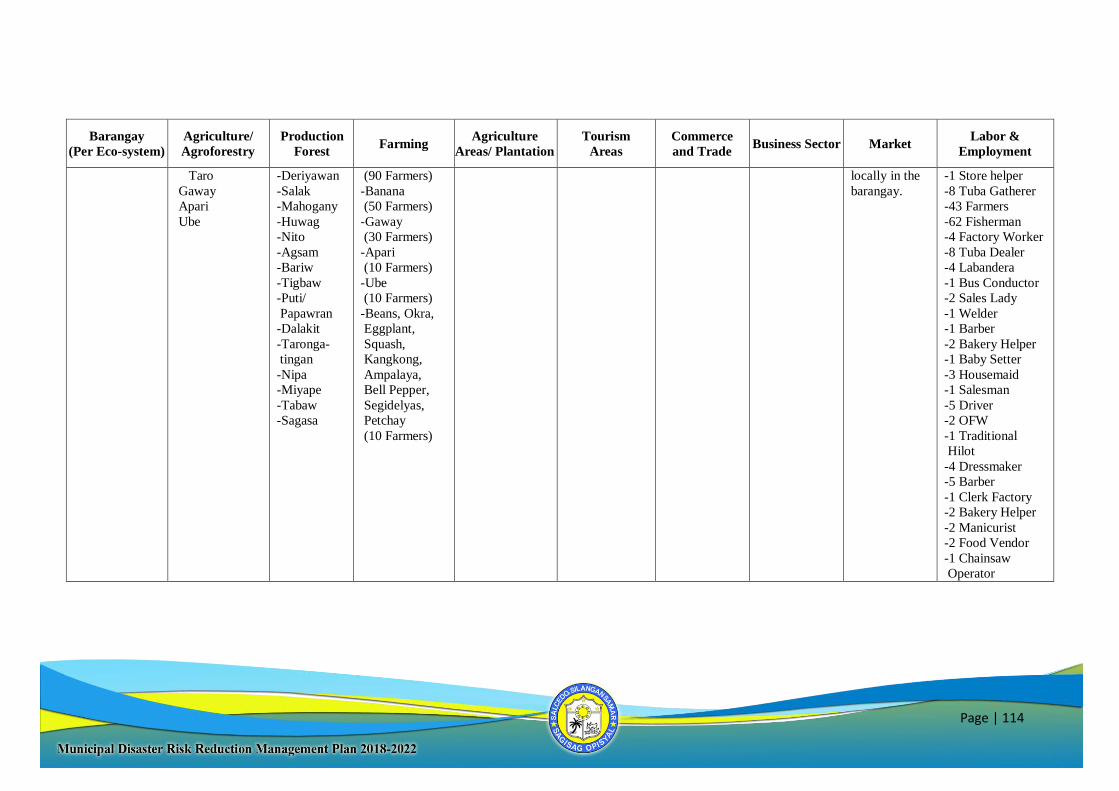
Page | 114
Barangay
(Per Eco-system)
Agriculture/
Agroforestry
Production
Forest Farming
Agriculture
Areas/ Plantation
Tourism
Areas
Commerce
and Trade Business Sector Market
Labor &
Employment
Taro
Gaway
Apari
Ube
-Deriyawan
-Salak
-Mahogany
-Huwag
-Nito
-Agsam
-Bariw
-Tigbaw
-Puti/
Papawran
-Dalakit
-Taronga-
tingan
-Nipa
-Miyape
-Tabaw
-Sagasa
(90 Farmers)
-Banana
(50 Farmers)
-Gaway
(30 Farmers)
-Apari
(10 Farmers)
-Ube
(10 Farmers)
-Beans, Okra,
Eggplant,
Squash,
Kangkong,
Ampalaya,
Bell Pepper,
Segidelyas,
Petchay
(10 Farmers)
locally in the
barangay.
-1 Store helper
-8 Tuba Gatherer
-43 Farmers
-62 Fisherman
-4 Factory Worker
-8 Tuba Dealer
-4 Labandera
-1 Bus Conductor
-2 Sales Lady
-1 Welder
-1 Barber
-2 Bakery Helper
-1 Baby Setter
-3 Housemaid
-1 Salesman
-5 Driver
-2 OFW
-1 Traditional
Hilot
-4 Dressmaker
-5 Barber
-1 Clerk Factory
-2 Bakery Helper
-2 Manicurist
-2 Food Vendor
-1 Chainsaw
Operator
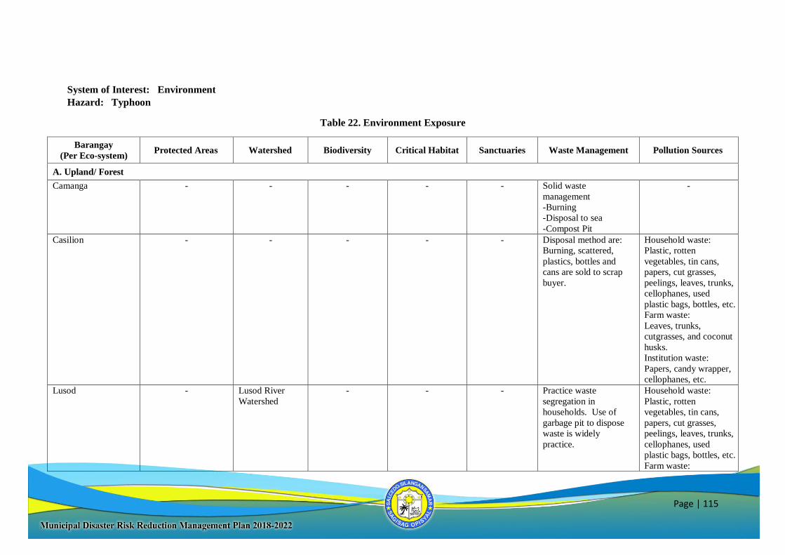
Page | 115
System of Interest: Environment
Hazard: Typhoon
Table 22. Environment Exposure
Barangay
(Per Eco-system) Protected Areas Watershed Biodiversity Critical Habitat Sanctuaries Waste Management Pollution Sources
A. Upland/ Forest
Camanga - - - - - Solid waste
management
-Burning
-Disposal to sea
-Compost Pit
-
Casilion - - - - - Disposal method are:
Burning, scattered,
plastics, bottles and
cans are sold to scrap
buyer.
Household waste:
Plastic, rotten
vegetables, tin cans,
papers, cut grasses,
peelings, leaves, trunks,
cellophanes, used
plastic bags, bottles, etc.
Farm waste:
Leaves, trunks,
cutgrasses, and coconut
husks.
Institution waste:
Papers, candy wrapper,
cellophanes, etc.
Lusod - Lusod River
Watershed
- - - Practice waste
segregation in
households. Use of
garbage pit to dispose
waste is widely
practice.
Household waste:
Plastic, rotten
vegetables, tin cans,
papers, cut grasses,
peelings, leaves, trunks,
cellophanes, used
plastic bags, bottles, etc.
Farm waste:
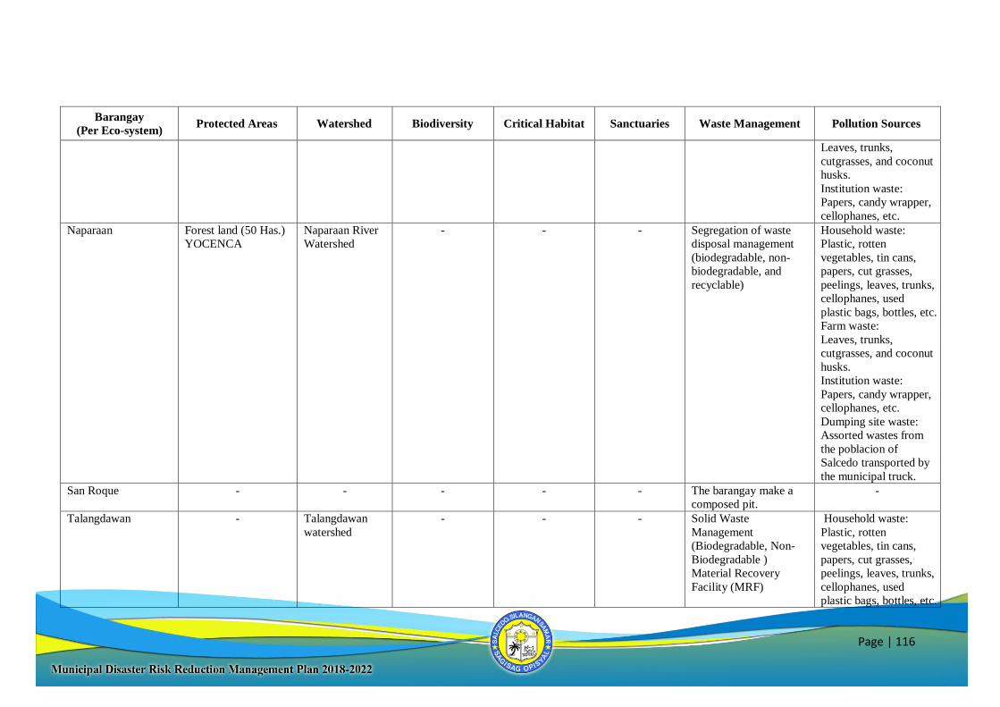
Page | 116
Barangay
(Per Eco-system) Protected Areas Watershed Biodiversity Critical Habitat Sanctuaries Waste Management Pollution Sources
Leaves, trunks,
cutgrasses, and coconut
husks.
Institution waste:
Papers, candy wrapper,
cellophanes, etc.
Naparaan Forest land (50 Has.)
YOCENCA
Naparaan River
Watershed
- - - Segregation of waste
disposal management
(biodegradable, non-
biodegradable, and
recyclable)
Household waste:
Plastic, rotten
vegetables, tin cans,
papers, cut grasses,
peelings, leaves, trunks,
cellophanes, used
plastic bags, bottles, etc.
Farm waste:
Leaves, trunks,
cutgrasses, and coconut
husks.
Institution waste:
Papers, candy wrapper,
cellophanes, etc.
Dumping site waste:
Assorted wastes from
the poblacion of
Salcedo transported by
the municipal truck.
San Roque - - - - - The barangay make a
composed pit.
-
Talangdawan - Talangdawan
watershed
- - - Solid Waste
Management
(Biodegradable, Non-
Biodegradable )
Material Recovery
Facility (MRF)
Household waste:
Plastic, rotten
vegetables, tin cans,
papers, cut grasses,
peelings, leaves, trunks,
cellophanes, used
plastic bags, bottles, etc.
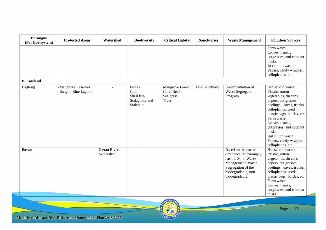
Page | 117
Barangay
(Per Eco-system) Protected Areas Watershed Biodiversity Critical Habitat Sanctuaries Waste Management Pollution Sources
Farm waste:
Leaves, trunks,
cutgrasses, and coconut
husks.
Institution waste:
Papers, candy wrapper,
cellophanes, etc.
B. Lowland
Bagtong -Mangrove Reserves
-Bangon Blue Lagoon
- Fishes
Crab
Shell fish
Stalagmite and
Stalactite
Mangrove Forest
Coral Reef
Sea grass
Trees
Fish Sanctuary Implementation of
Waste Segregation
Program
Household waste:
Plastic, rotten
vegetables, tin cans,
papers, cut grasses,
peelings, leaves, trunks,
cellophanes, used
plastic bags, bottles, etc.
Farm waste:
Leaves, trunks,
cutgrasses, and coconut
husks.
Institution waste:
Papers, candy wrapper,
cellophanes, etc.
Iberan - Iberan River
Watershed
- - - Based on the excess
ordinance the barangay
has the Solid Waste
Management/ Waste
Segregation of the
biodegradable, non-
biodegradable.
Household waste:
Plastic, rotten
vegetables, tin cans,
papers, cut grasses,
peelings, leaves, trunks,
cellophanes, used
plastic bags, bottles, etc.
Farm waste:
Leaves, trunks,
cutgrasses, and coconut
husks.
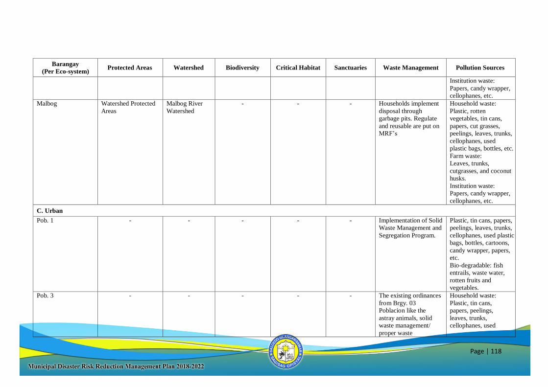
Page | 118
Barangay
(Per Eco-system) Protected Areas Watershed Biodiversity Critical Habitat Sanctuaries Waste Management Pollution Sources
Institution waste:
Papers, candy wrapper,
cellophanes, etc.
Malbog Watershed Protected
Areas
Malbog River
Watershed
- - - Households implement
disposal through
garbage pits. Regulate
and reusable are put on
MRF’s
Household waste:
Plastic, rotten
vegetables, tin cans,
papers, cut grasses,
peelings, leaves, trunks,
cellophanes, used
plastic bags, bottles, etc.
Farm waste:
Leaves, trunks,
cutgrasses, and coconut
husks.
Institution waste:
Papers, candy wrapper,
cellophanes, etc.
C. Urban
Pob. 1 - - - - - Implementation of Solid
Waste Management and
Segregation Program.
Plastic, tin cans, papers,
peelings, leaves, trunks,
cellophanes, used plastic
bags, bottles, cartoons,
candy wrapper, papers,
etc.
Bio-degradable: fish
entrails, waste water,
rotten fruits and
vegetables.
Pob. 3 - - - - - The existing ordinances
from Brgy. 03
Poblacion like the
astray animals, solid
waste management/
proper waste
Household waste:
Plastic, tin cans,
papers, peelings,
leaves, trunks,
cellophanes, used
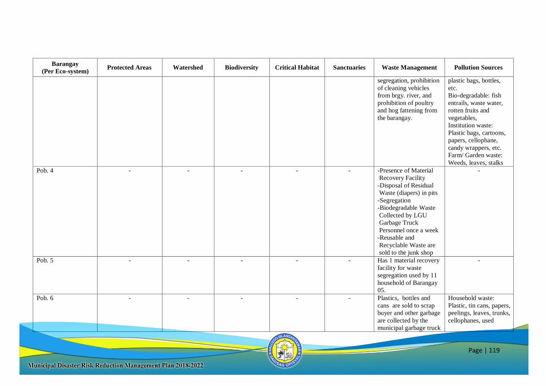
Page | 119
Barangay
(Per Eco-system) Protected Areas Watershed Biodiversity Critical Habitat Sanctuaries Waste Management Pollution Sources
segregation, prohibition
of cleaning vehicles
from brgy. river, and
prohibition of poultry
and hog fattening from
the barangay.
plastic bags, bottles,
etc.
Bio-degradable: fish
entrails, waste water,
rotten fruits and
vegetables,
Institution waste:
Plastic bags, cartoons,
papers, cellophane,
candy wrappers, etc.
Farm/ Garden waste:
Weeds, leaves, stalks
Pob. 4 - - - - - -Presence of Material
Recovery Facility
-Disposal of Residual
Waste (diapers) in pits
-Segregation
-Biodegradable Waste
Collected by LGU
Garbage Truck
Personnel once a week
-Reusable and
Recyclable Waste are
sold to the junk shop
-
Pob. 5 - - - - - Has 1 material recovery
facility for waste
segregation used by 11
household of Barangay
05.
-
Pob. 6 - - - - - Plastics, bottles and
cans are sold to scrap
buyer and other garbage
are collected by the
municipal garbage truck
Household waste:
Plastic, tin cans, papers,
peelings, leaves, trunks,
cellophanes, used
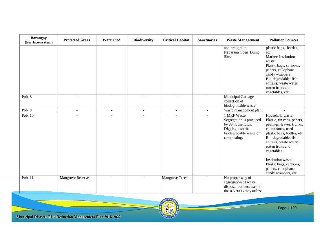
Page | 120
Barangay
(Per Eco-system) Protected Areas Watershed Biodiversity Critical Habitat Sanctuaries Waste Management Pollution Sources
and brought to
Naparaan Open Dump
Site.
plastic bags, bottles,
etc.
Market/ Institution
waste:
Plastic bags, cartoons,
papers, cellophane,
candy wrappers
Bio-degradable: fish
entrails, waste water,
rotten fruits and
vegetables, etc.
Pob. 8 - - - - - Municipal Garbage
collection of
biodegradable waste
-
Pob. 9 - - - - - Waste management plan -
Pob. 10 - - - - - 1 MRF Waste
Segregation is practiced
by 33 households.
Digging also the
biodegradable waste or
composting.
Household waste:
Plastic, tin cans, papers,
peelings, leaves, trunks,
cellophanes, used
plastic bags, bottles, etc.
Bio-degradable: fish
entrails, waste water,
rotten fruits and
vegetables.
Institution waste:
Plastic bags, cartoons,
papers, cellophane,
candy wrappers, etc.
Pob. 11 Mangrove Reserve - - Mangrove Trees - No proper way of
segregation of waste
disposal but because of
the RA 9003 they utilize
-
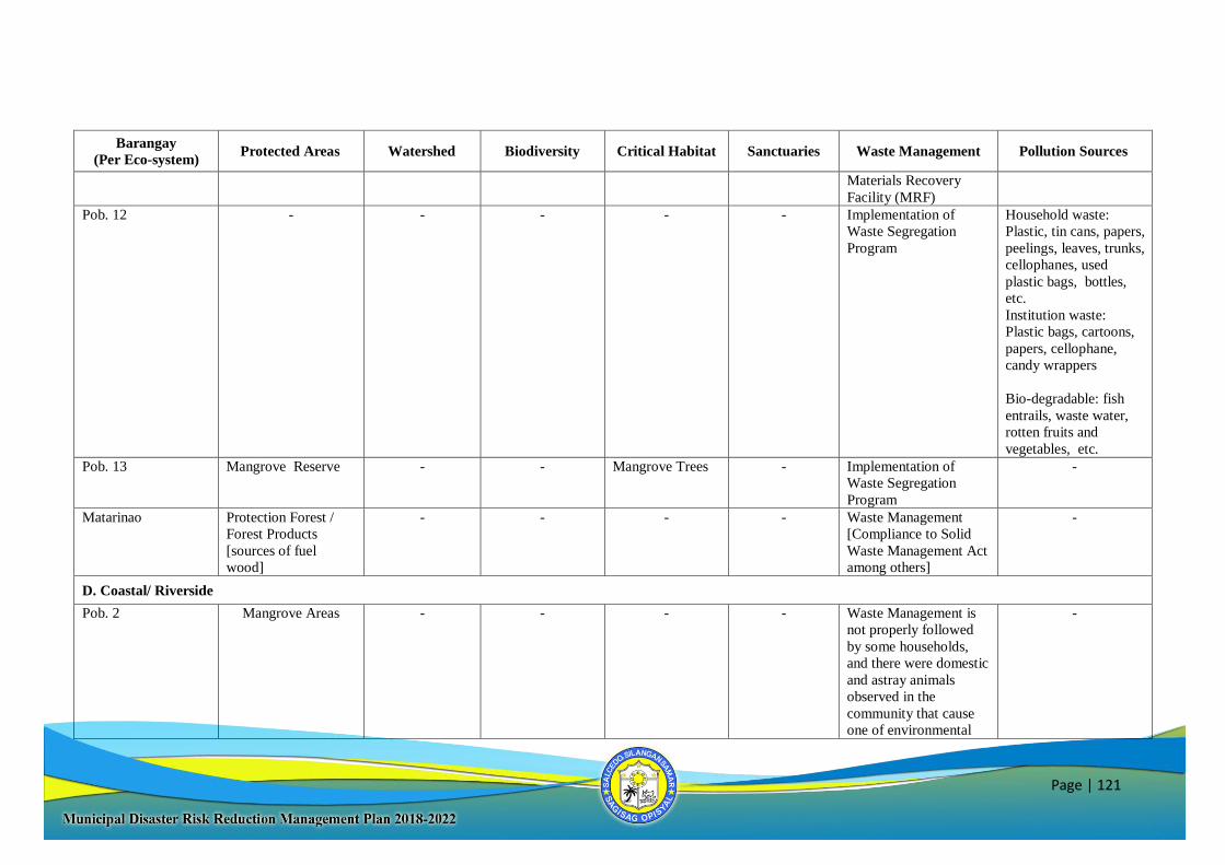
Page | 121
Barangay
(Per Eco-system) Protected Areas Watershed Biodiversity Critical Habitat Sanctuaries Waste Management Pollution Sources
Materials Recovery
Facility (MRF)
Pob. 12 - - - - - Implementation of
Waste Segregation
Program
Household waste:
Plastic, tin cans, papers,
peelings, leaves, trunks,
cellophanes, used
plastic bags, bottles,
etc.
Institution waste:
Plastic bags, cartoons,
papers, cellophane,
candy wrappers
Bio-degradable: fish
entrails, waste water,
rotten fruits and
vegetables, etc.
Pob. 13 Mangrove Reserve - - Mangrove Trees - Implementation of
Waste Segregation
Program
-
Matarinao Protection Forest /
Forest Products
[sources of fuel
wood]
- - - - Waste Management
[Compliance to Solid
Waste Management Act
among others]
-
D. Coastal/ Riverside
Pob. 2 Mangrove Areas - - - - Waste Management is
not properly followed
by some households,
and there were domestic
and astray animals
observed in the
community that cause
one of environmental
-
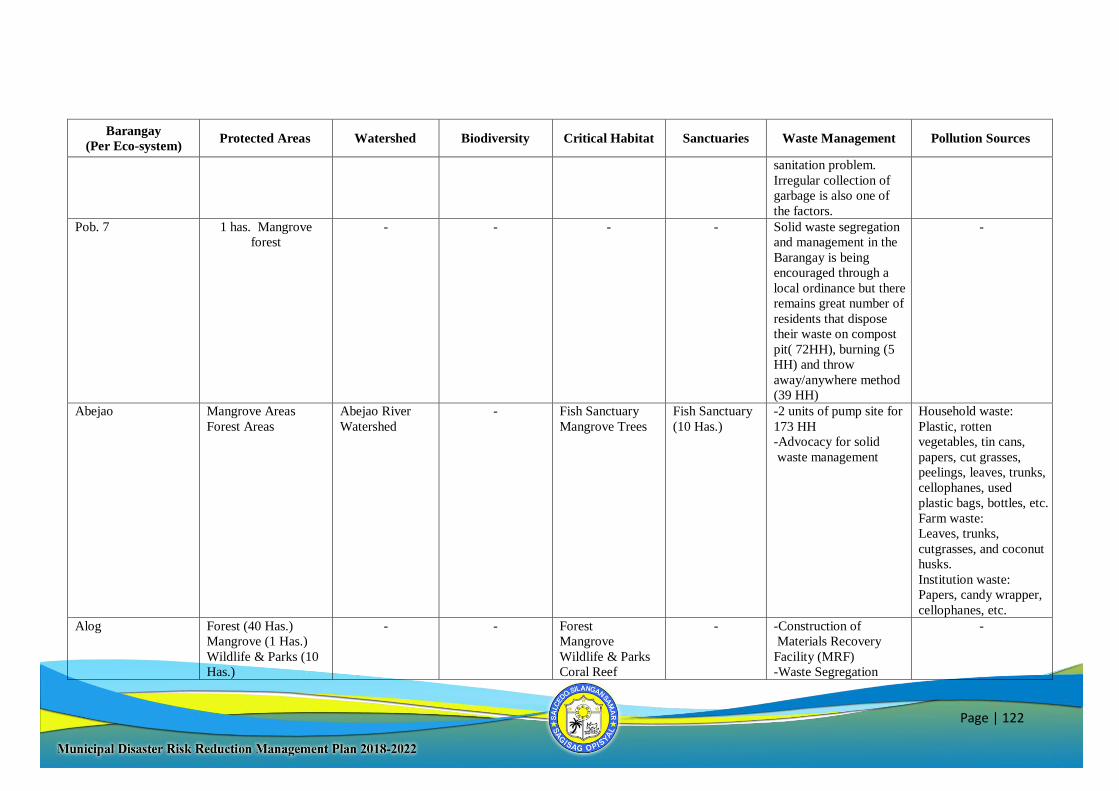
Page | 122
Barangay
(Per Eco-system) Protected Areas Watershed Biodiversity Critical Habitat Sanctuaries Waste Management Pollution Sources
sanitation problem.
Irregular collection of
garbage is also one of
the factors.
Pob. 7 1 has. Mangrove
forest
- - - - Solid waste segregation
and management in the
Barangay is being
encouraged through a
local ordinance but there
remains great number of
residents that dispose
their waste on compost
pit( 72HH), burning (5
HH) and throw
away/anywhere method
(39 HH)
-
Abejao Mangrove Areas
Forest Areas
Abejao River
Watershed
- Fish Sanctuary
Mangrove Trees
Fish Sanctuary
(10 Has.)
-2 units of pump site for
173 HH
-Advocacy for solid
waste management
Household waste:
Plastic, rotten
vegetables, tin cans,
papers, cut grasses,
peelings, leaves, trunks,
cellophanes, used
plastic bags, bottles, etc.
Farm waste:
Leaves, trunks,
cutgrasses, and coconut
husks.
Institution waste:
Papers, candy wrapper,
cellophanes, etc.
Alog Forest (40 Has.)
Mangrove (1 Has.)
Wildlife & Parks (10
Has.)
- - Forest
Mangrove
Wildlife & Parks
Coral Reef
- -Construction of
Materials Recovery
Facility (MRF)
-Waste Segregation
-
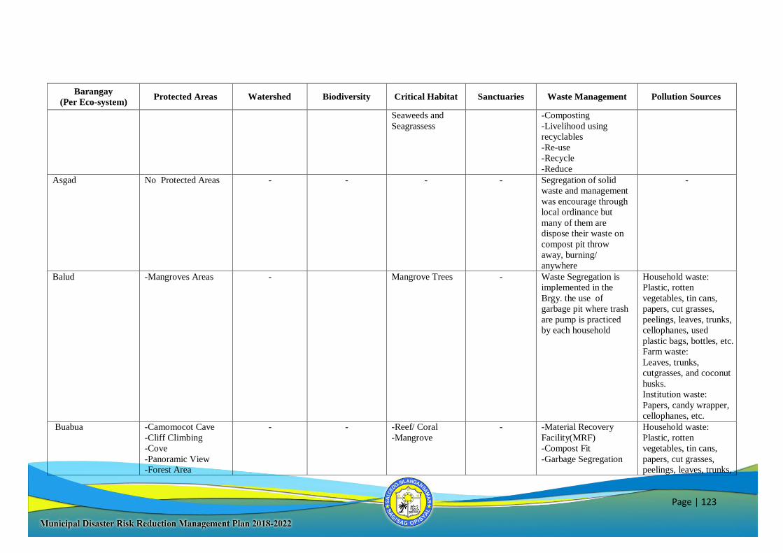
Page | 123
Barangay
(Per Eco-system) Protected Areas Watershed Biodiversity Critical Habitat Sanctuaries Waste Management Pollution Sources
Seaweeds and
Seagrassess
-Composting
-Livelihood using
recyclables
-Re-use
-Recycle
-Reduce
Asgad No Protected Areas - - - - Segregation of solid
waste and management
was encourage through
local ordinance but
many of them are
dispose their waste on
compost pit throw
away, burning/
anywhere
-
Balud -Mangroves Areas - Mangrove Trees - Waste Segregation is
implemented in the
Brgy. the use of
garbage pit where trash
are pump is practiced
by each household
Household waste:
Plastic, rotten
vegetables, tin cans,
papers, cut grasses,
peelings, leaves, trunks,
cellophanes, used
plastic bags, bottles, etc.
Farm waste:
Leaves, trunks,
cutgrasses, and coconut
husks.
Institution waste:
Papers, candy wrapper,
cellophanes, etc.
Buabua -Camomocot Cave
-Cliff Climbing
-Cove
-Panoramic View
-Forest Area
- - -Reef/ Coral
-Mangrove
- -Material Recovery
Facility(MRF)
-Compost Fit
-Garbage Segregation
Household waste:
Plastic, rotten
vegetables, tin cans,
papers, cut grasses,
peelings, leaves, trunks,
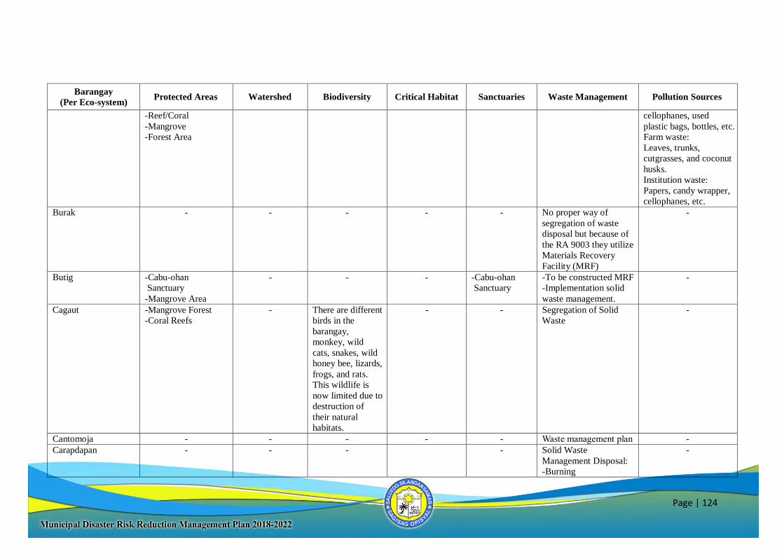
Page | 124
Barangay
(Per Eco-system) Protected Areas Watershed Biodiversity Critical Habitat Sanctuaries Waste Management Pollution Sources
-Reef/Coral
-Mangrove
-Forest Area
cellophanes, used
plastic bags, bottles, etc.
Farm waste:
Leaves, trunks,
cutgrasses, and coconut
husks.
Institution waste:
Papers, candy wrapper,
cellophanes, etc.
Burak - - - - - No proper way of
segregation of waste
disposal but because of
the RA 9003 they utilize
Materials Recovery
Facility (MRF)
-
Butig -Cabu-ohan
Sanctuary
-Mangrove Area
- - - -Cabu-ohan
Sanctuary
-To be constructed MRF
-Implementation solid
waste management.
-
Cagaut -Mangrove Forest
-Coral Reefs
- There are different
birds in the
barangay,
monkey, wild
cats, snakes, wild
honey bee, lizards,
frogs, and rats.
This wildlife is
now limited due to
destruction of
their natural
habitats.
- - Segregation of Solid
Waste
-
Cantomoja - - - - - Waste management plan -
Carapdapan - - - - Solid Waste
Management Disposal:
-Burning
-
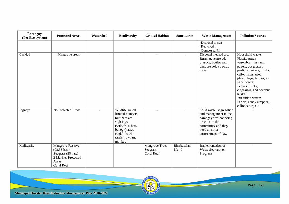
Page | 125
Barangay
(Per Eco-system) Protected Areas Watershed Biodiversity Critical Habitat Sanctuaries Waste Management Pollution Sources
-Disposal to sea
-Recycled
-Composed Pit
Caridad Mangrove areas - - - - Disposal method are:
Burning, scattered,
plastics, bottles and
cans are sold to scrap
buyer.
Household waste:
Plastic, rotten
vegetables, tin cans,
papers, cut grasses,
peelings, leaves, trunks,
cellophanes, used
plastic bags, bottles, etc.
Farm waste:
Leaves, trunks,
cutgrasses, and coconut
husks.
Institution waste:
Papers, candy wrapper,
cellophanes, etc.
Jagnaya No Protected Areas - Wildlife are all
limited numbers
but there are
sightings
(wild/fruit, bats,
banog (native
eagle), hawk,
tarsier, owl and
monkey
- - Solid waste segregation
and management in the
barangay was not being
practice in the
community and they
need an strict
enforcement of law
-
Maliwaliw Mangrove Reserve
(93.33 has.)
Seagrass (20 has.)
2 Marines Protected
Areas
Coral Reef
- - Mangrove Trees
Seagrass
Coral Reef
Binabasalan
Island
Implementation of
Waste Segregation
Program
-
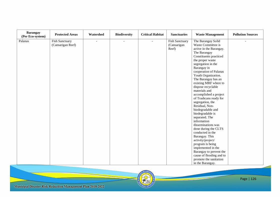
Page | 126
Barangay
(Per Eco-system) Protected Areas Watershed Biodiversity Critical Habitat Sanctuaries Waste Management Pollution Sources
Palanas Fish Sanctuary
(Cansarigan Reef)
- - - Fish Sanctuary
(Cansarigan
Reef)
The Barangay Solid
Waste Committee is
active in the Barangay.
The Barangay
Constituents practiced
the proper waste
segregation in the
Barangay in
cooperation of Palanas
Youth Organization.
The Barangay has an
existing MRF where to
dispose recyclable
materials and
accomplished a project
of Trashcans ready for
segregation, the
Residual, Non-
biodegradable and
biodegradable is
separated. The
information
disseminations was
done during the CLTS
conducted in the
Barangay. This
activity/project/
program is being
implemented in the
Barangay to prevent the
cause of flooding and to
promote the sanitation
in the Barangay.
-
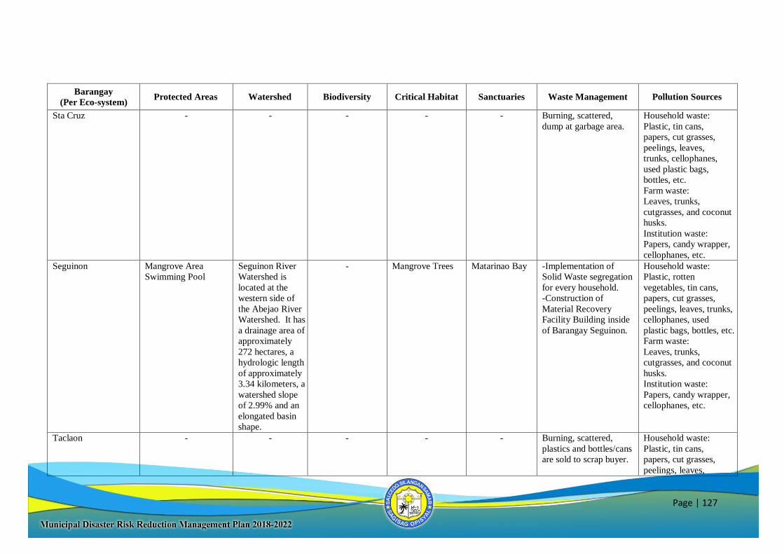
Page | 127
Barangay
(Per Eco-system) Protected Areas Watershed Biodiversity Critical Habitat Sanctuaries Waste Management Pollution Sources
Sta Cruz - - - - - Burning, scattered,
dump at garbage area.
Household waste:
Plastic, tin cans,
papers, cut grasses,
peelings, leaves,
trunks, cellophanes,
used plastic bags,
bottles, etc.
Farm waste:
Leaves, trunks,
cutgrasses, and coconut
husks.
Institution waste:
Papers, candy wrapper,
cellophanes, etc.
Seguinon Mangrove Area
Swimming Pool
Seguinon River
Watershed is
located at the
western side of
the Abejao River
Watershed. It has
a drainage area of
approximately
272 hectares, a
hydrologic length
of approximately
3.34 kilometers, a
watershed slope
of 2.99% and an
elongated basin
shape.
- Mangrove Trees Matarinao Bay -Implementation of
Solid Waste segregation
for every household.
-Construction of
Material Recovery
Facility Building inside
of Barangay Seguinon.
Household waste:
Plastic, rotten
vegetables, tin cans,
papers, cut grasses,
peelings, leaves, trunks,
cellophanes, used
plastic bags, bottles, etc.
Farm waste:
Leaves, trunks,
cutgrasses, and coconut
husks.
Institution waste:
Papers, candy wrapper,
cellophanes, etc.
Taclaon - - - - - Burning, scattered,
plastics and bottles/cans
are sold to scrap buyer.
Household waste:
Plastic, tin cans,
papers, cut grasses,
peelings, leaves,
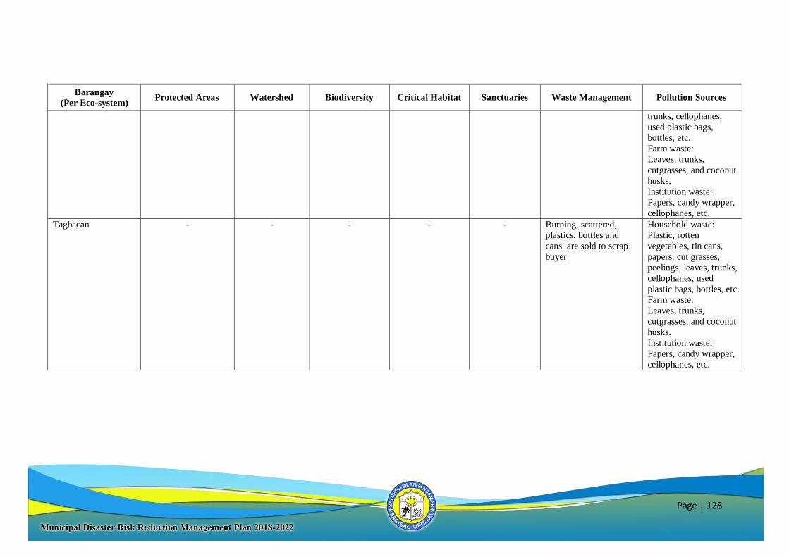
Page | 128
Barangay
(Per Eco-system) Protected Areas Watershed Biodiversity Critical Habitat Sanctuaries Waste Management Pollution Sources
trunks, cellophanes,
used plastic bags,
bottles, etc.
Farm waste:
Leaves, trunks,
cutgrasses, and coconut
husks.
Institution waste:
Papers, candy wrapper,
cellophanes, etc.
Tagbacan - - - - - Burning, scattered,
plastics, bottles and
cans are sold to scrap
buyer
Household waste:
Plastic, rotten
vegetables, tin cans,
papers, cut grasses,
peelings, leaves, trunks,
cellophanes, used
plastic bags, bottles, etc.
Farm waste:
Leaves, trunks,
cutgrasses, and coconut
husks.
Institution waste:
Papers, candy wrapper,
cellophanes, etc.
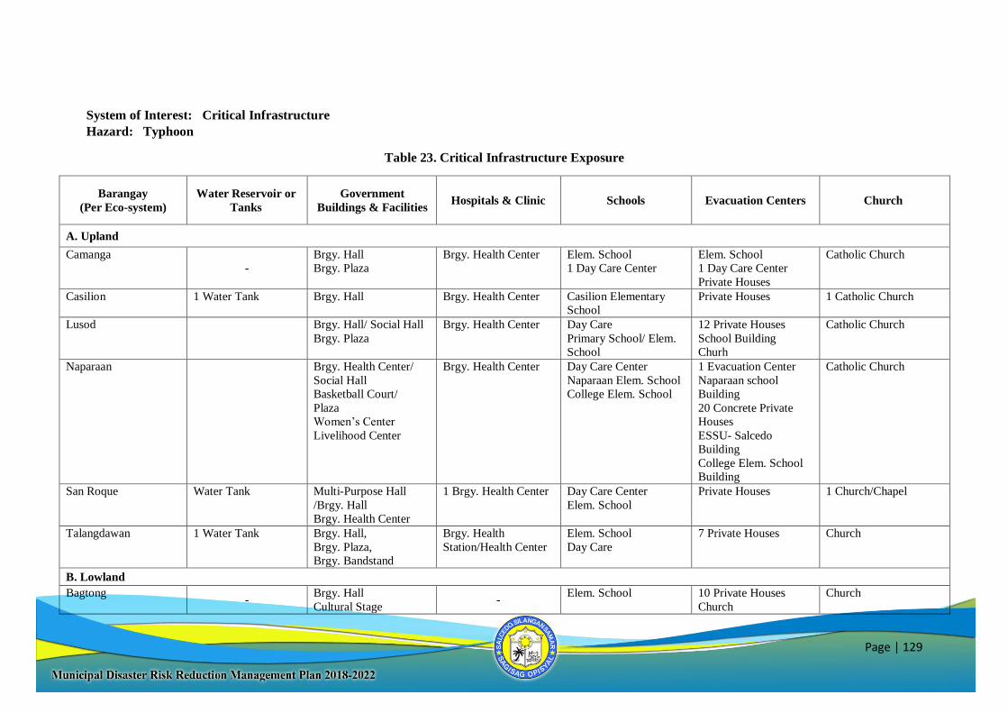
Page | 129
System of Interest: Critical Infrastructure
Hazard: Typhoon
Table 23. Critical Infrastructure Exposure
Barangay
(Per Eco-system)
Water Reservoir or
Tanks
Government
Buildings & Facilities Hospitals & Clinic Schools Evacuation Centers Church
A. Upland
Camanga
-
Brgy. Hall
Brgy. Plaza
Brgy. Health Center Elem. School
1 Day Care Center
Elem. School
1 Day Care Center
Private Houses
Catholic Church
Casilion 1 Water Tank Brgy. Hall
Brgy. Health Center Casilion Elementary
School
Private Houses 1 Catholic Church
Lusod Brgy. Hall/ Social Hall
Brgy. Plaza
Brgy. Health Center Day Care
Primary School/ Elem.
School
12 Private Houses
School Building
Churh
Catholic Church
Naparaan Brgy. Health Center/
Social Hall
Basketball Court/
Plaza
Women’s Center
Livelihood Center
Brgy. Health Center Day Care Center
Naparaan Elem. School
College Elem. School
1 Evacuation Center
Naparaan school
Building
20 Concrete Private
Houses
ESSU- Salcedo
Building
College Elem. School
Building
Catholic Church
San Roque Water Tank Multi-Purpose Hall
/Brgy. Hall
Brgy. Health Center
1 Brgy. Health Center Day Care Center
Elem. School
Private Houses 1 Church/Chapel
Talangdawan 1 Water Tank Brgy. Hall,
Brgy. Plaza,
Brgy. Bandstand
Brgy. Health
Station/Health Center
Elem. School
Day Care
7 Private Houses Church
B. Lowland
Bagtong -
Brgy. Hall
Cultural Stage -
Elem. School
10 Private Houses
Church
Church
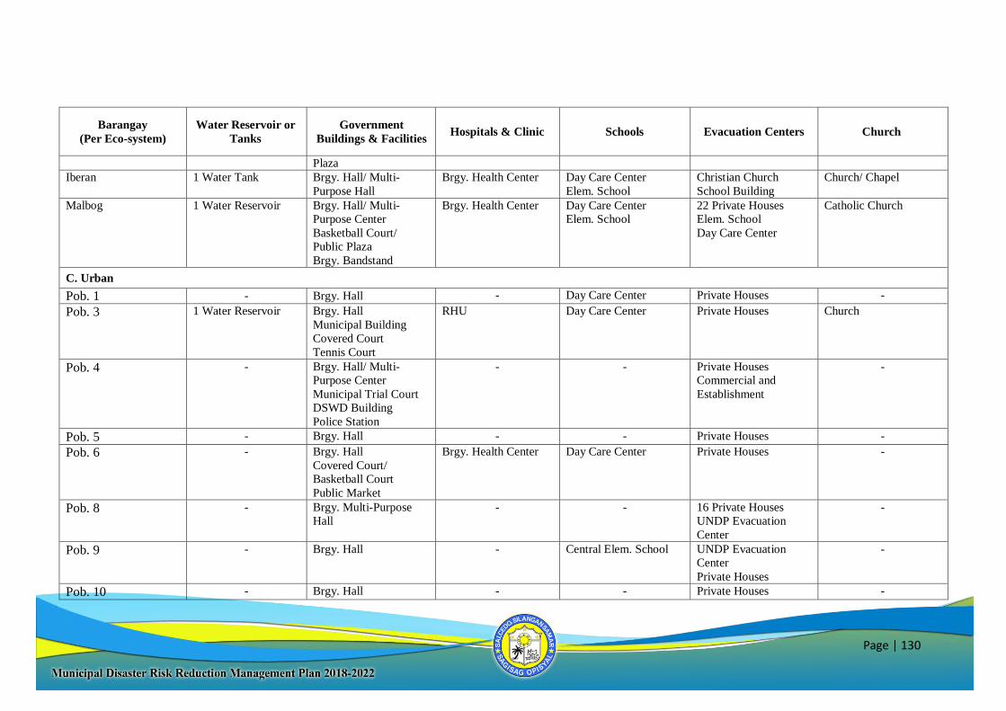
Page | 130
Barangay
(Per Eco-system)
Water Reservoir or
Tanks
Government
Buildings & Facilities Hospitals & Clinic Schools Evacuation Centers Church
Plaza
Iberan 1 Water Tank Brgy. Hall/ Multi-
Purpose Hall
Brgy. Health Center Day Care Center
Elem. School
Christian Church
School Building
Church/ Chapel
Malbog 1 Water Reservoir Brgy. Hall/ Multi-
Purpose Center
Basketball Court/
Public Plaza
Brgy. Bandstand
Brgy. Health Center Day Care Center
Elem. School
22 Private Houses
Elem. School
Day Care Center
Catholic Church
C. Urban
Pob. 1 - Brgy. Hall - Day Care Center Private Houses -
Pob. 3 1 Water Reservoir Brgy. Hall
Municipal Building
Covered Court
Tennis Court
RHU Day Care Center Private Houses Church
Pob. 4 - Brgy. Hall/ Multi-
Purpose Center
Municipal Trial Court
DSWD Building
Police Station
- - Private Houses
Commercial and
Establishment
-
Pob. 5 - Brgy. Hall - - Private Houses -
Pob. 6 - Brgy. Hall
Covered Court/
Basketball Court
Public Market
Brgy. Health Center
Day Care Center Private Houses -
Pob. 8 - Brgy. Multi-Purpose
Hall
- - 16 Private Houses
UNDP Evacuation
Center
-
Pob. 9 - Brgy. Hall - Central Elem. School UNDP Evacuation
Center
Private Houses
-
Pob. 10 - Brgy. Hall - - Private Houses -
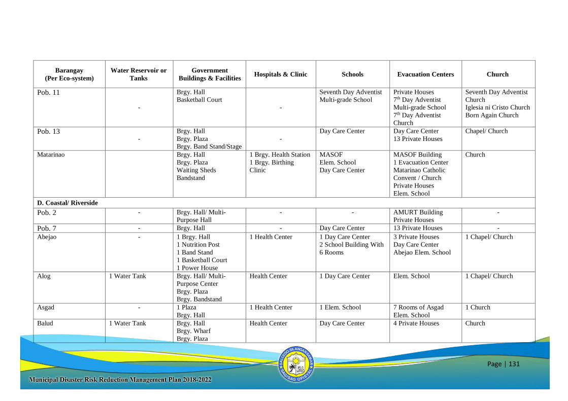
Page | 131
Barangay
(Per Eco-system)
Water Reservoir or
Tanks
Government
Buildings & Facilities Hospitals & Clinic Schools Evacuation Centers Church
Pob. 11
-
Brgy. Hall
Basketball Court
-
Seventh Day Adventist
Multi-grade School
Private Houses
7th Day Adventist
Multi-grade School
7th Day Adventist
Church
Seventh Day Adventist
Church
Iglesia ni Cristo Church
Born Again Church
Pob. 13 -
Brgy. Hall
Brgy. Plaza
Brgy. Band Stand/Stage
-
Day Care Center Day Care Center
13 Private Houses
Chapel/ Church
Matarinao Brgy. Hall
Brgy. Plaza
Waiting Sheds
Bandstand
1 Brgy. Health Station
1 Brgy. Birthing
Clinic
MASOF
Elem. School
Day Care Center
MASOF Building
1 Evacuation Center
Matarinao Catholic
Convent / Church
Private Houses
Elem. School
Church
D. Coastal/ Riverside
Pob. 2 - Brgy. Hall/ Multi-
Purpose Hall
- - AMURT Building
Private Houses
-
Pob. 7 - Brgy. Hall - Day Care Center 13 Private Houses -
Abejao - 1 Brgy. Hall
1 Nutrition Post
1 Band Stand
1 Basketball Court
1 Power House
1 Health Center 1 Day Care Center
2 School Building With
6 Rooms
3 Private Houses
Day Care Center
Abejao Elem. School
1 Chapel/ Church
Alog 1 Water Tank Brgy. Hall/ Multi-
Purpose Center
Brgy. Plaza
Brgy. Bandstand
Health Center 1 Day Care Center Elem. School 1 Chapel/ Church
Asgad - 1 Plaza
Brgy. Hall
1 Health Center 1 Elem. School 7 Rooms of Asgad
Elem. School
1 Church
Balud 1 Water Tank Brgy. Hall
Brgy. Wharf
Brgy. Plaza
Health Center Day Care Center 4 Private Houses
Church
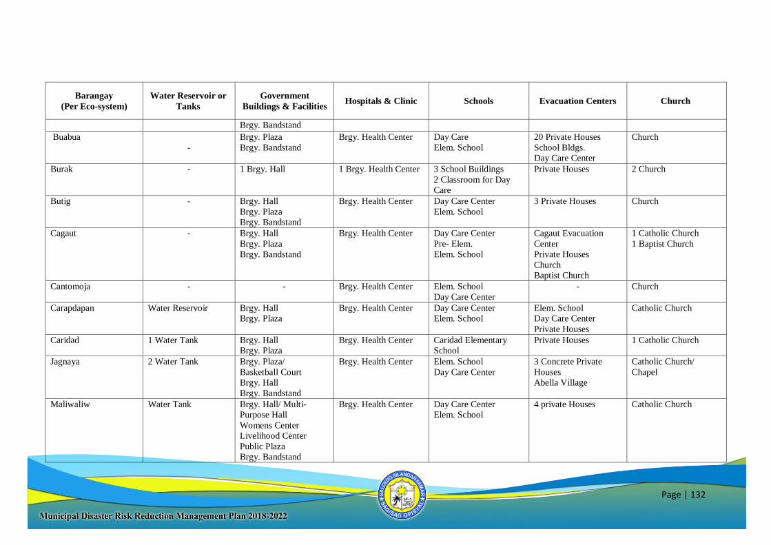
Page | 132
Barangay
(Per Eco-system)
Water Reservoir or
Tanks
Government
Buildings & Facilities Hospitals & Clinic Schools Evacuation Centers Church
Brgy. Bandstand
Buabua
-
Brgy. Plaza
Brgy. Bandstand
Brgy. Health Center
Day Care
Elem. School
20 Private Houses
School Bldgs.
Day Care Center
Church
Burak - 1 Brgy. Hall
1 Brgy. Health Center
3 School Buildings
2 Classroom for Day
Care
Private Houses 2 Church
Butig - Brgy. Hall
Brgy. Plaza
Brgy. Bandstand
Brgy. Health Center Day Care Center
Elem. School
3 Private Houses
Church
Cagaut - Brgy. Hall
Brgy. Plaza
Brgy. Bandstand
Brgy. Health Center Day Care Center
Pre- Elem.
Elem. School
Cagaut Evacuation
Center
Private Houses
Church
Baptist Church
1 Catholic Church
1 Baptist Church
Cantomoja - - Brgy. Health Center Elem. School
Day Care Center
- Church
Carapdapan Water Reservoir Brgy. Hall
Brgy. Plaza
Brgy. Health Center
Day Care Center
Elem. School
Elem. School
Day Care Center
Private Houses
Catholic Church
Caridad 1 Water Tank Brgy. Hall
Brgy. Plaza
Brgy. Health Center Caridad Elementary
School
Private Houses 1 Catholic Church
Jagnaya 2 Water Tank Brgy. Plaza/
Basketball Court
Brgy. Hall
Brgy. Bandstand
Brgy. Health Center Elem. School
Day Care Center
3 Concrete Private
Houses
Abella Village
Catholic Church/
Chapel
Maliwaliw Water Tank Brgy. Hall/ Multi-
Purpose Hall
Womens Center
Livelihood Center
Public Plaza
Brgy. Bandstand
Brgy. Health Center Day Care Center
Elem. School
4 private Houses Catholic Church
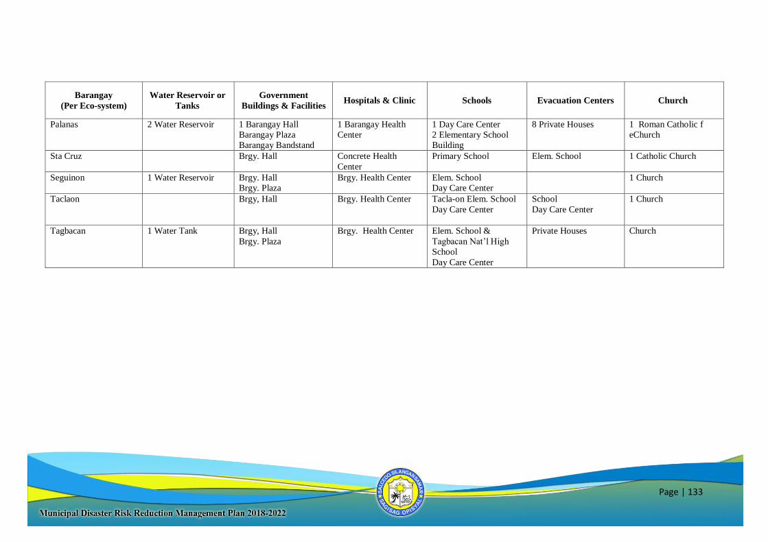
Page | 133
Barangay
(Per Eco-system)
Water Reservoir or
Tanks
Government
Buildings & Facilities Hospitals & Clinic Schools Evacuation Centers Church
Palanas 2 Water Reservoir 1 Barangay Hall
Barangay Plaza
Barangay Bandstand
1 Barangay Health
Center
1 Day Care Center
2 Elementary School
Building
8 Private Houses 1 Roman Catholic f
eChurch
Sta Cruz Brgy. Hall
Concrete Health
Center
Primary School Elem. School 1 Catholic Church
Seguinon 1 Water Reservoir Brgy. Hall
Brgy. Plaza
Brgy. Health Center Elem. School
Day Care Center
1 Church
Taclaon Brgy, Hall
Brgy. Health Center Tacla-on Elem. School
Day Care Center
School
Day Care Center
1 Church
Tagbacan 1 Water Tank Brgy, Hall
Brgy. Plaza
Brgy. Health Center Elem. School &
Tagbacan Nat’l High
School
Day Care Center
Private Houses Church
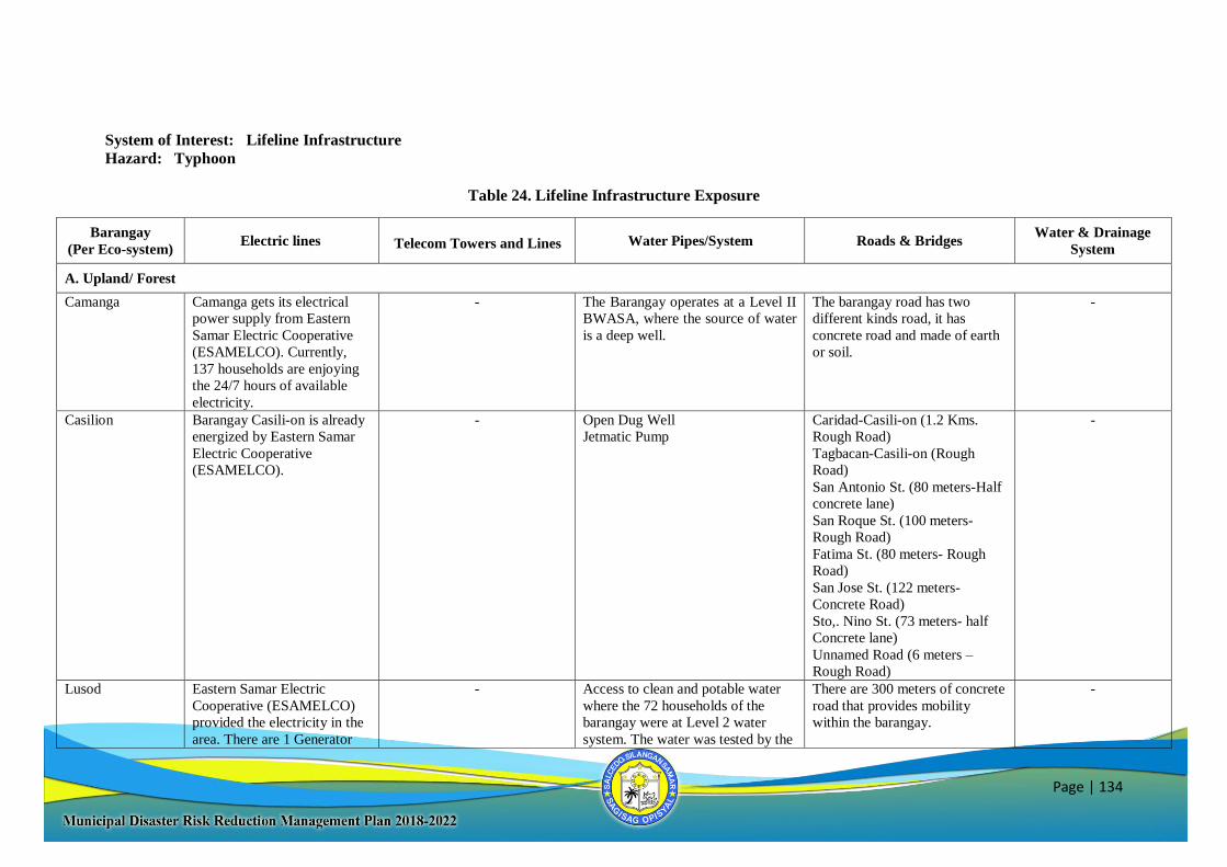
Page | 134
System of Interest: Lifeline Infrastructure
Hazard: Typhoon
Table 24. Lifeline Infrastructure Exposure
Barangay
(Per Eco-system) Electric lines
Telecom Towers and Lines Water Pipes/System Roads & Bridges Water & Drainage
System
A. Upland/ Forest
Camanga Camanga gets its electrical
power supply from Eastern
Samar Electric Cooperative
(ESAMELCO). Currently,
137 households are enjoying
the 24/7 hours of available
electricity.
- The Barangay operates at a Level II
BWASA, where the source of water
is a deep well.
The barangay road has two
different kinds road, it has
concrete road and made of earth
or soil.
-
Casilion Barangay Casili-on is already
energized by Eastern Samar
Electric Cooperative
(ESAMELCO).
- Open Dug Well
Jetmatic Pump
Caridad-Casili-on (1.2 Kms.
Rough Road)
Tagbacan-Casili-on (Rough
Road)
San Antonio St. (80 meters-Half
concrete lane)
San Roque St. (100 meters-
Rough Road)
Fatima St. (80 meters- Rough
Road)
San Jose St. (122 meters-
Concrete Road)
Sto,. Nino St. (73 meters- half
Concrete lane)
Unnamed Road (6 meters –
Rough Road)
-
Lusod Eastern Samar Electric
Cooperative (ESAMELCO)
provided the electricity in the
area. There are 1 Generator
- Access to clean and potable water
where the 72 households of the
barangay were at Level 2 water
system. The water was tested by the
There are 300 meters of concrete
road that provides mobility
within the barangay.
-
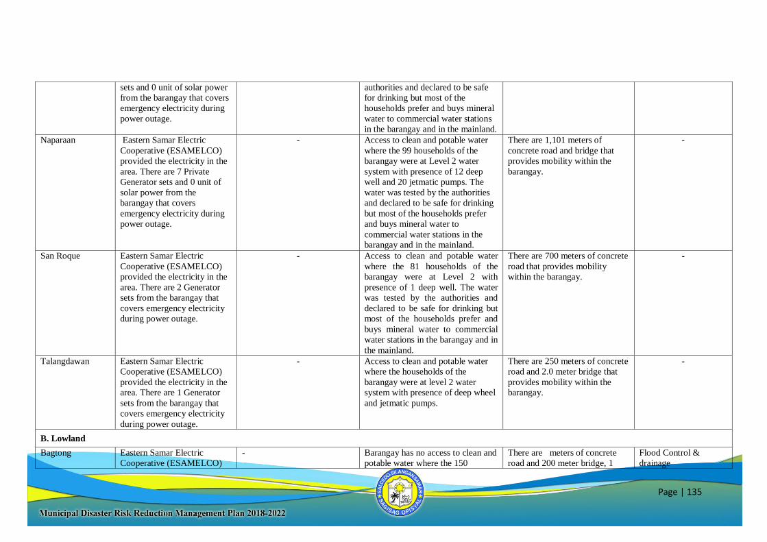
Page | 135
sets and 0 unit of solar power
from the barangay that covers
emergency electricity during
power outage.
authorities and declared to be safe
for drinking but most of the
households prefer and buys mineral
water to commercial water stations
in the barangay and in the mainland.
Naparaan Eastern Samar Electric
Cooperative (ESAMELCO)
provided the electricity in the
area. There are 7 Private
Generator sets and 0 unit of
solar power from the
barangay that covers
emergency electricity during
power outage.
- Access to clean and potable water
where the 99 households of the
barangay were at Level 2 water
system with presence of 12 deep
well and 20 jetmatic pumps. The
water was tested by the authorities
and declared to be safe for drinking
but most of the households prefer
and buys mineral water to
commercial water stations in the
barangay and in the mainland.
There are 1,101 meters of
concrete road and bridge that
provides mobility within the
barangay.
-
San Roque Eastern Samar Electric
Cooperative (ESAMELCO)
provided the electricity in the
area. There are 2 Generator
sets from the barangay that
covers emergency electricity
during power outage.
- Access to clean and potable water
where the 81 households of the
barangay were at Level 2 with
presence of 1 deep well. The water
was tested by the authorities and
declared to be safe for drinking but
most of the households prefer and
buys mineral water to commercial
water stations in the barangay and in
the mainland.
There are 700 meters of concrete
road that provides mobility
within the barangay.
-
Talangdawan Eastern Samar Electric
Cooperative (ESAMELCO)
provided the electricity in the
area. There are 1 Generator
sets from the barangay that
covers emergency electricity
during power outage.
- Access to clean and potable water
where the households of the
barangay were at level 2 water
system with presence of deep wheel
and jetmatic pumps.
There are 250 meters of concrete
road and 2.0 meter bridge that
provides mobility within the
barangay.
-
B. Lowland
Bagtong Eastern Samar Electric
Cooperative (ESAMELCO)
- Barangay has no access to clean and
potable water where the 150
There are meters of concrete
road and 200 meter bridge, 1
Flood Control &
drainage
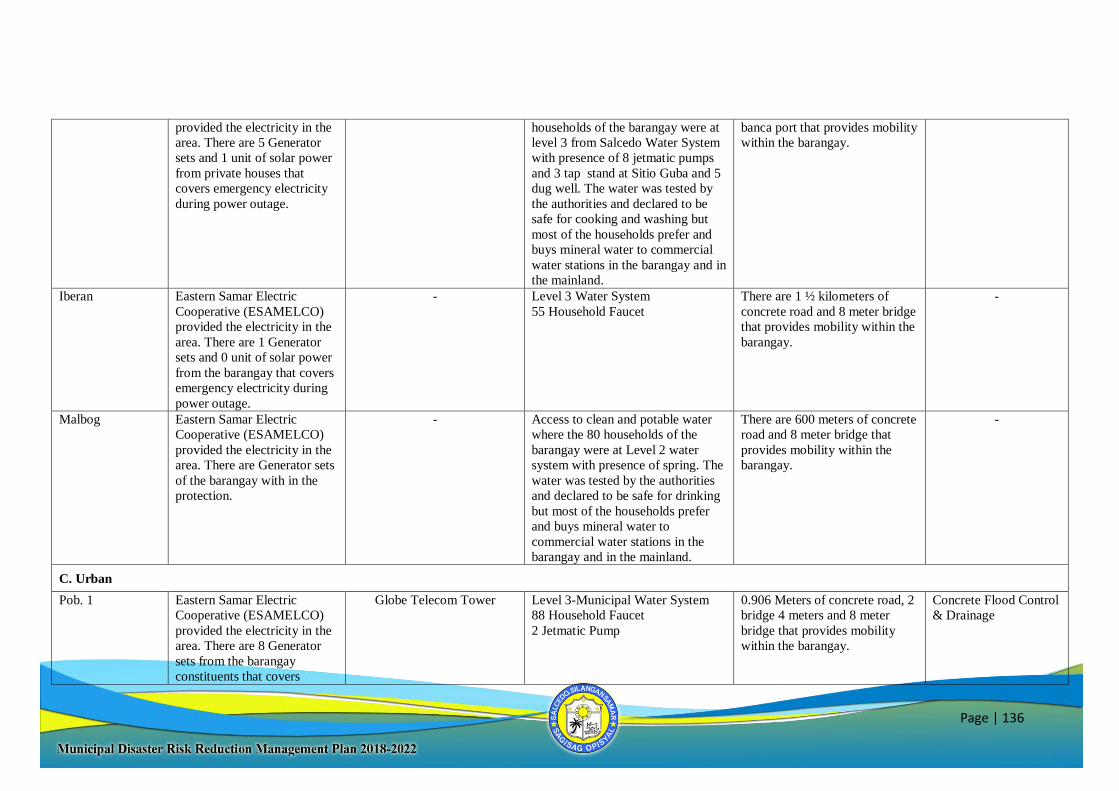
Page | 136
provided the electricity in the
area. There are 5 Generator
sets and 1 unit of solar power
from private houses that
covers emergency electricity
during power outage.
households of the barangay were at
level 3 from Salcedo Water System
with presence of 8 jetmatic pumps
and 3 tap stand at Sitio Guba and 5
dug well. The water was tested by
the authorities and declared to be
safe for cooking and washing but
most of the households prefer and
buys mineral water to commercial
water stations in the barangay and in
the mainland.
banca port that provides mobility
within the barangay.
Iberan Eastern Samar Electric
Cooperative (ESAMELCO)
provided the electricity in the
area. There are 1 Generator
sets and 0 unit of solar power
from the barangay that covers
emergency electricity during
power outage.
- Level 3 Water System
55 Household Faucet
There are 1 ½ kilometers of
concrete road and 8 meter bridge
that provides mobility within the
barangay.
-
Malbog Eastern Samar Electric
Cooperative (ESAMELCO)
provided the electricity in the
area. There are Generator sets
of the barangay with in the
protection.
- Access to clean and potable water
where the 80 households of the
barangay were at Level 2 water
system with presence of spring. The
water was tested by the authorities
and declared to be safe for drinking
but most of the households prefer
and buys mineral water to
commercial water stations in the
barangay and in the mainland.
There are 600 meters of concrete
road and 8 meter bridge that
provides mobility within the
barangay.
-
C. Urban
Pob. 1 Eastern Samar Electric
Cooperative (ESAMELCO)
provided the electricity in the
area. There are 8 Generator
sets from the barangay
constituents that covers
Globe Telecom Tower Level 3-Municipal Water System
88 Household Faucet
2 Jetmatic Pump
0.906 Meters of concrete road, 2
bridge 4 meters and 8 meter
bridge that provides mobility
within the barangay.
Concrete Flood Control
& Drainage
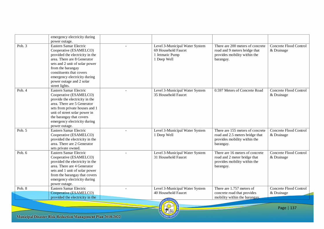
Page | 137
emergency electricity during
power outage.
Pob. 3 Eastern Samar Electric
Cooperative (ESAMELCO)
provided the electricity in the
area. There are 8 Generator
sets and 2 unit of solar power
from the barangay
constituents that covers
emergency electricity during
power outage and 2 solar
street lights.
- Level 3-Municipal Water System
69 Household Faucet
1 Jetmatic Pump
1 Deep Well
There are 200 meters of concrete
road and 9 meters bridge that
provides mobility within the
barangay.
Concrete Flood Control
& Drainage
Pob. 4 Eastern Samar Electric
Cooperative (ESAMELCO)
provide the electricity in the
area. There are 5 Generator
sets from private houses and 1
unit of street solar power in
the barangay that covers
emergency electricity during
power outage.
- Level 3-Municipal Water System
35 Household Faucet
0.597 Meters of Concrete Road Concrete Flood Control
& Drainage
Pob. 5 Eastern Samar Electric
Cooperative (ESAMELCO)
provided the electricity in the
area. There are 2 Generator
sets private owned.
- Level 3-Municipal Water System
1 Deep Well
There are 155 meters of concrete
road and 2.5 meters bridge that
provides mobility within the
barangay.
Concrete Flood Control
& Drainage
Pob. 6 Eastern Samar Electric
Cooperative (ESAMELCO)
provided the electricity in the
area. There are 4 Generator
sets and 1 unit of solar power
from the barangay that covers
emergency electricity during
power outage.
- Level 3-Municipal Water System
31 Household Faucet
There are 16 meters of concrete
road and 2 meter bridge that
provides mobility within the
barangay.
Concrete Flood Control
& Drainage
Pob. 8 Eastern Samar Electric
Cooperative (ESAMELCO)
provided the electricity in the
- Level 3-Municipal Water System
40 Household Faucet
There are 1.757 meters of
concrete road that provides
mobility within the barangay.
Concrete Flood Control
& Drainage
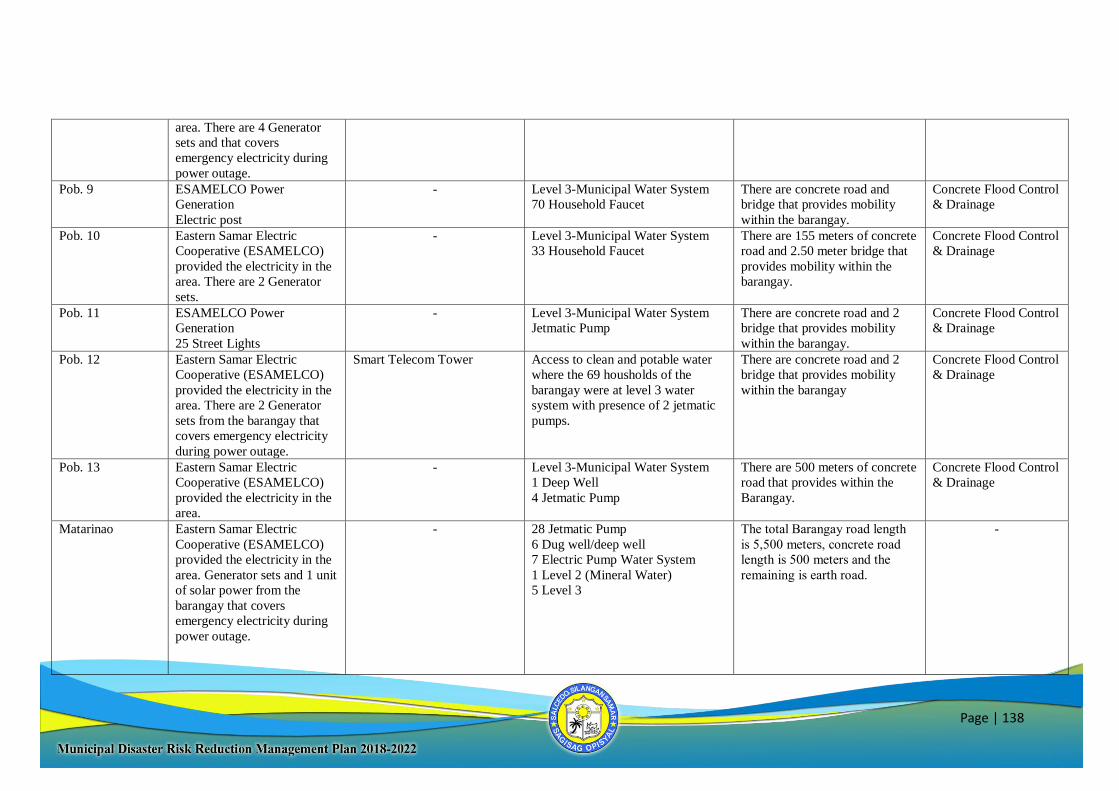
Page | 138
area. There are 4 Generator
sets and that covers
emergency electricity during
power outage.
Pob. 9 ESAMELCO Power
Generation
Electric post
- Level 3-Municipal Water System
70 Household Faucet
There are concrete road and
bridge that provides mobility
within the barangay.
Concrete Flood Control
& Drainage
Pob. 10 Eastern Samar Electric
Cooperative (ESAMELCO)
provided the electricity in the
area. There are 2 Generator
sets.
- Level 3-Municipal Water System
33 Household Faucet
There are 155 meters of concrete
road and 2.50 meter bridge that
provides mobility within the
barangay.
Concrete Flood Control
& Drainage
Pob. 11 ESAMELCO Power
Generation
25 Street Lights
- Level 3-Municipal Water System
Jetmatic Pump
There are concrete road and 2
bridge that provides mobility
within the barangay.
Concrete Flood Control
& Drainage
Pob. 12 Eastern Samar Electric
Cooperative (ESAMELCO)
provided the electricity in the
area. There are 2 Generator
sets from the barangay that
covers emergency electricity
during power outage.
Smart Telecom Tower Access to clean and potable water
where the 69 housholds of the
barangay were at level 3 water
system with presence of 2 jetmatic
pumps.
There are concrete road and 2
bridge that provides mobility
within the barangay
Concrete Flood Control
& Drainage
Pob. 13 Eastern Samar Electric
Cooperative (ESAMELCO)
provided the electricity in the
area.
- Level 3-Municipal Water System
1 Deep Well
4 Jetmatic Pump
There are 500 meters of concrete
road that provides within the
Barangay.
Concrete Flood Control
& Drainage
Matarinao Eastern Samar Electric
Cooperative (ESAMELCO)
provided the electricity in the
area. Generator sets and 1 unit
of solar power from the
barangay that covers
emergency electricity during
power outage.
- 28 Jetmatic Pump
6 Dug well/deep well
7 Electric Pump Water System
1 Level 2 (Mineral Water)
5 Level 3
The total Barangay road length
is 5,500 meters, concrete road
length is 500 meters and the
remaining is earth road.
-
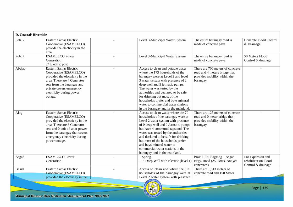
Page | 139
D. Coastal/ Riverside
Pob. 2 Eastern Samar Electric
Cooperative (ESAMELCO)
provide the electricity in the
area.
- Level 3-Municipal Water System
The entire barangay road is
made of concrete pave.
Concrete Flood Control
& Drainage
Pob. 7 ESAMELCO Power
Generation
24 Electric post
- Level 3-Municipal Water System The entire barangay road is
made of concrete pave.
50 Meters Flood
Control & drainage
Abejao Eastern Samar Electric
Cooperative (ESAMELCO)
provided the electricity in the
area. There are 4 Generator
sets from the barangay and
private covers emergency
electricity during power
outage.
- Access to clean and potable water
where the 173 households of the
barangay were at Level 2 and level
3 water system with presence of 2
deep well and 5 jetmatic pumps.
The water was tested by the
authorities and declared to be safe
for drinking but most of the
households prefer and buys mineral
water to commercial water stations
in the barangay and in the mainland.
There are 700 meters of concrete
road and 4 meters bridge that
provides mobility within the
barangay.
-
Alog Eastern Samar Electric
Cooperative (ESAMELCO)
provided the electricity in the
area. There are 3 Generator
sets and 0 unit of solar power
from the barangay that covers
emergency electricity during
power outage.
- Access to clean water where the 70
households of the barangay were at
Level 2 water system with presence
of 0 deep well and 0 Jetmatic pumps
but have 4 communal tapstand. The
water was tested by the authorities
and declared to be safe for drinking
but most of the households prefer
and buys mineral water to
commercial water stations in the
barangay and in the mainland.
There are 125 meters of concrete
road and 0 meter bridge that
provides mobility within the
barangay.
-
Asgad ESAMELCO Power
Generation
- 1 Spring
115 Deep Well with Electric (level 1)
Prov’l. Rd. Bagtong – Asgad
Brgy. Road (250 Mtrs. Not yet
concreted)
For expansion and
rehabilitation Flood
Control & drainage
Balud Eastern Samar Electric
Cooperative (ESAMELCO)
provided the electricity in the
- Access to clean and where the 109
households of the barangay were at
Level 2 water system with presence
There are 1,813 meters of
concrete road and 150 Meter
-
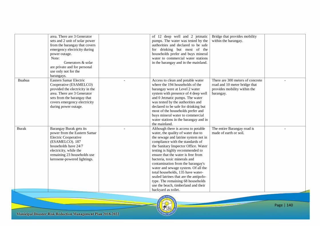
Page | 140
area. There are 3 Generator
sets and 2 unit of solar power
from the barangay that covers
emergency electricity during
power outage.
Note:
Generators & solar
are private and for personal
use only not for the
barangays.
of 12 deep well and 2 jetmatic
pumps. The water was tested by the
authorities and declared to be safe
for drinking but most of the
households prefer and buys mineral
water to commercial water stations
in the barangay and in the mainland.
Bridge that provides mobility
within the barangay.
Buabua Eastern Samar Electric
Cooperative (ESAMELCO)
provided the electricity in the
area. There are 3 Generator
sets from the barangay that
covers emergency electricity
during power outage.
- Access to clean and potable water
where the 194 households of the
barangay were at Level 2 water
system with presence of 4 deep well
and 0 Jetmatic pumps. The water
was tested by the authorities and
declared to be safe for drinking but
most of the households prefer and
buys mineral water to commercial
water stations in the barangay and in
the mainland.
There are 300 meters of concrete
road and 10 meter bridge that
provides mobility within the
barangay.
-
Burak Barangay Burak gets its
power from the Eastern Samar
Electric Cooperative
(ESAMELCO). 187
households have 24/7
electricity, while the
remaining 23 households use
kerosene-powered lightings.
- Although there is access to potable
water, the quality of water due to
the sewage and latrine system not in
compliance with the standards of
the Sanitary Inspector Office. Water
testing is highly recommended to
ensure that the water is free from
bacteria, toxic minerals and
contamination from the barangay's
water and sewage system. Of all the
total households, 135 have water-
sealed latrines that are the antipolo-
type. The remaining 68 households
use the beach, timberland and their
backyard as toilet.
The entire Barangay road is
made of earth or soil.
-
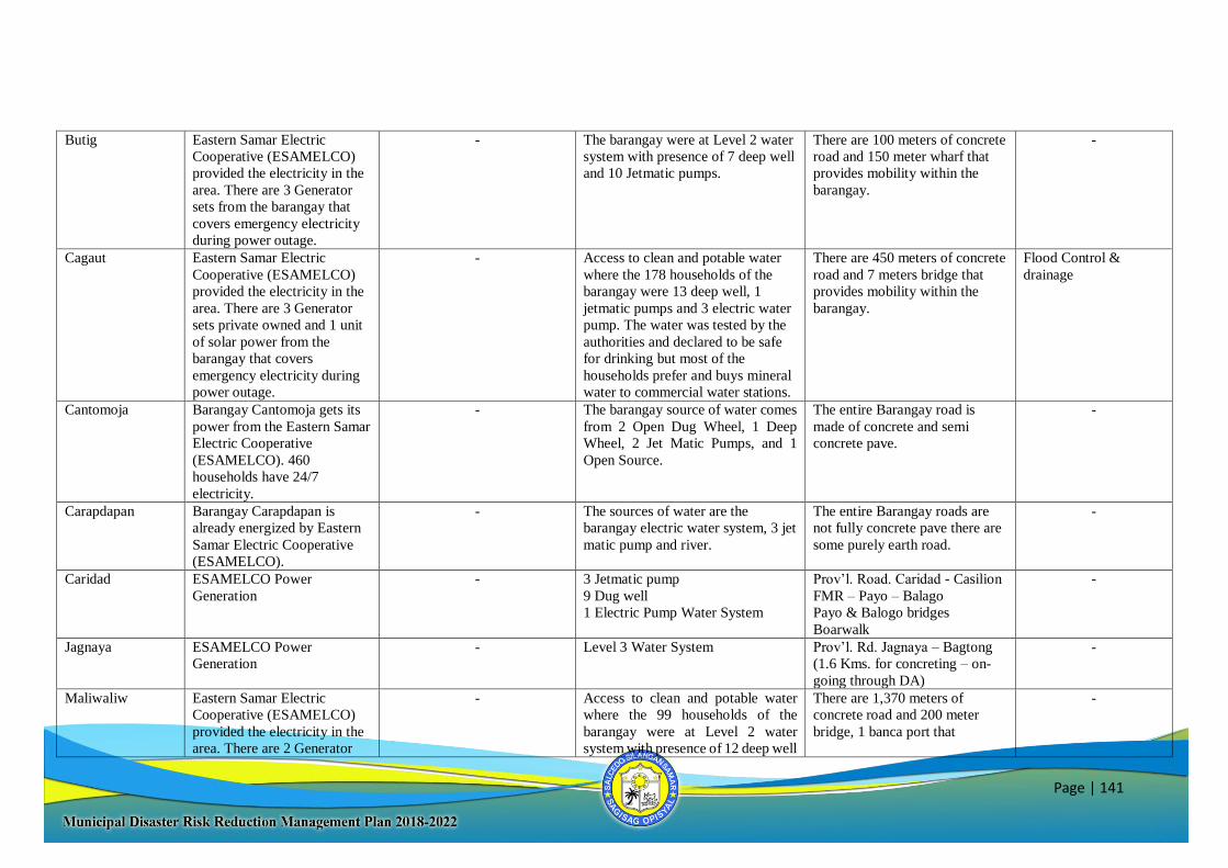
Page | 141
Butig Eastern Samar Electric
Cooperative (ESAMELCO)
provided the electricity in the
area. There are 3 Generator
sets from the barangay that
covers emergency electricity
during power outage.
- The barangay were at Level 2 water
system with presence of 7 deep well
and 10 Jetmatic pumps.
There are 100 meters of concrete
road and 150 meter wharf that
provides mobility within the
barangay.
-
Cagaut Eastern Samar Electric
Cooperative (ESAMELCO)
provided the electricity in the
area. There are 3 Generator
sets private owned and 1 unit
of solar power from the
barangay that covers
emergency electricity during
power outage.
- Access to clean and potable water
where the 178 households of the
barangay were 13 deep well, 1
jetmatic pumps and 3 electric water
pump. The water was tested by the
authorities and declared to be safe
for drinking but most of the
households prefer and buys mineral
water to commercial water stations.
There are 450 meters of concrete
road and 7 meters bridge that
provides mobility within the
barangay.
Flood Control &
drainage
Cantomoja Barangay Cantomoja gets its
power from the Eastern Samar
Electric Cooperative
(ESAMELCO). 460
households have 24/7
electricity.
- The barangay source of water comes
from 2 Open Dug Wheel, 1 Deep
Wheel, 2 Jet Matic Pumps, and 1
Open Source.
The entire Barangay road is
made of concrete and semi
concrete pave.
-
Carapdapan Barangay Carapdapan is
already energized by Eastern
Samar Electric Cooperative
(ESAMELCO).
- The sources of water are the
barangay electric water system, 3 jet
matic pump and river.
The entire Barangay roads are
not fully concrete pave there are
some purely earth road.
-
Caridad ESAMELCO Power
Generation
- 3 Jetmatic pump
9 Dug well
1 Electric Pump Water System
Prov’l. Road. Caridad - Casilion
FMR – Payo – Balago
Payo & Balogo bridges
Boarwalk
-
Jagnaya ESAMELCO Power
Generation
- Level 3 Water System
Prov’l. Rd. Jagnaya – Bagtong
(1.6 Kms. for concreting – on-
going through DA)
-
Maliwaliw Eastern Samar Electric
Cooperative (ESAMELCO)
provided the electricity in the
area. There are 2 Generator
- Access to clean and potable water
where the 99 households of the
barangay were at Level 2 water
system with presence of 12 deep well
There are 1,370 meters of
concrete road and 200 meter
bridge, 1 banca port that
-
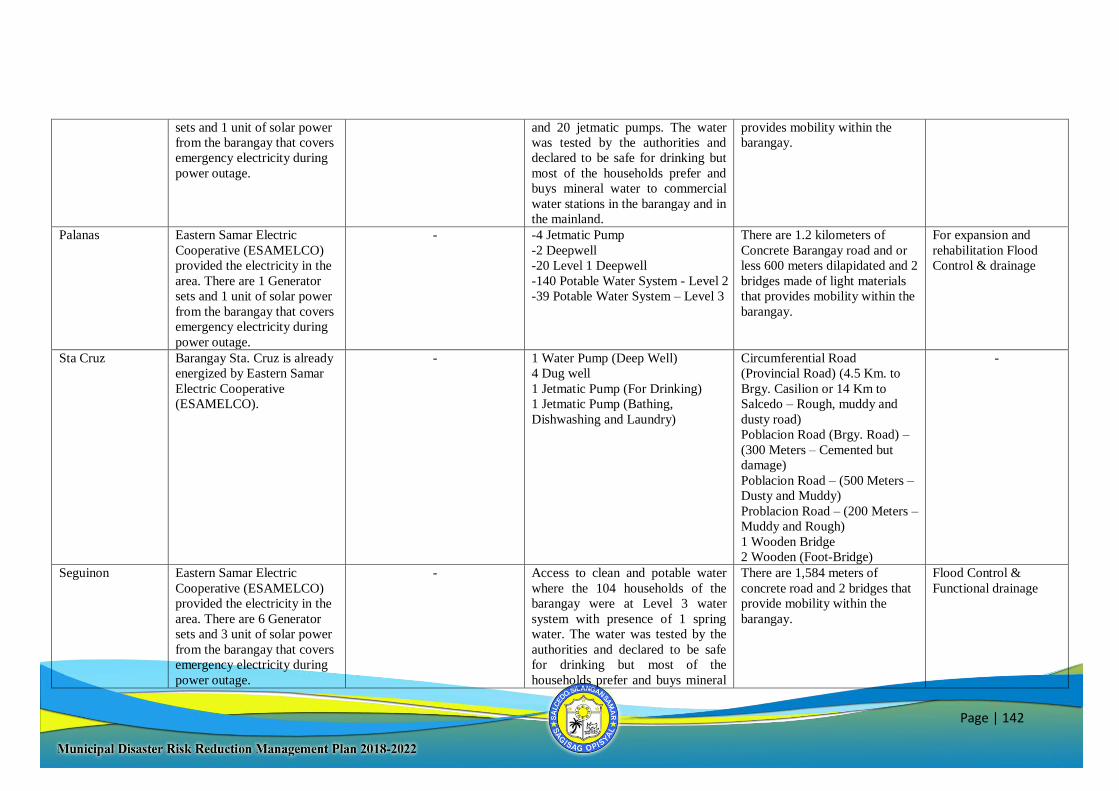
Page | 142
sets and 1 unit of solar power
from the barangay that covers
emergency electricity during
power outage.
and 20 jetmatic pumps. The water
was tested by the authorities and
declared to be safe for drinking but
most of the households prefer and
buys mineral water to commercial
water stations in the barangay and in
the mainland.
provides mobility within the
barangay.
Palanas Eastern Samar Electric
Cooperative (ESAMELCO)
provided the electricity in the
area. There are 1 Generator
sets and 1 unit of solar power
from the barangay that covers
emergency electricity during
power outage.
- -4 Jetmatic Pump
-2 Deepwell
-20 Level 1 Deepwell
-140 Potable Water System - Level 2
-39 Potable Water System – Level 3
There are 1.2 kilometers of
Concrete Barangay road and or
less 600 meters dilapidated and 2
bridges made of light materials
that provides mobility within the
barangay.
For expansion and
rehabilitation Flood
Control & drainage
Sta Cruz Barangay Sta. Cruz is already
energized by Eastern Samar
Electric Cooperative
(ESAMELCO).
- 1 Water Pump (Deep Well)
4 Dug well
1 Jetmatic Pump (For Drinking)
1 Jetmatic Pump (Bathing,
Dishwashing and Laundry)
Circumferential Road
(Provincial Road) (4.5 Km. to
Brgy. Casilion or 14 Km to
Salcedo – Rough, muddy and
dusty road)
Poblacion Road (Brgy. Road) –
(300 Meters – Cemented but
damage)
Poblacion Road – (500 Meters –
Dusty and Muddy)
Problacion Road – (200 Meters –
Muddy and Rough)
1 Wooden Bridge
2 Wooden (Foot-Bridge)
-
Seguinon Eastern Samar Electric
Cooperative (ESAMELCO)
provided the electricity in the
area. There are 6 Generator
sets and 3 unit of solar power
from the barangay that covers
emergency electricity during
power outage.
- Access to clean and potable water
where the 104 households of the
barangay were at Level 3 water
system with presence of 1 spring
water. The water was tested by the
authorities and declared to be safe
for drinking but most of the
households prefer and buys mineral
There are 1,584 meters of
concrete road and 2 bridges that
provide mobility within the
barangay.
Flood Control &
Functional drainage
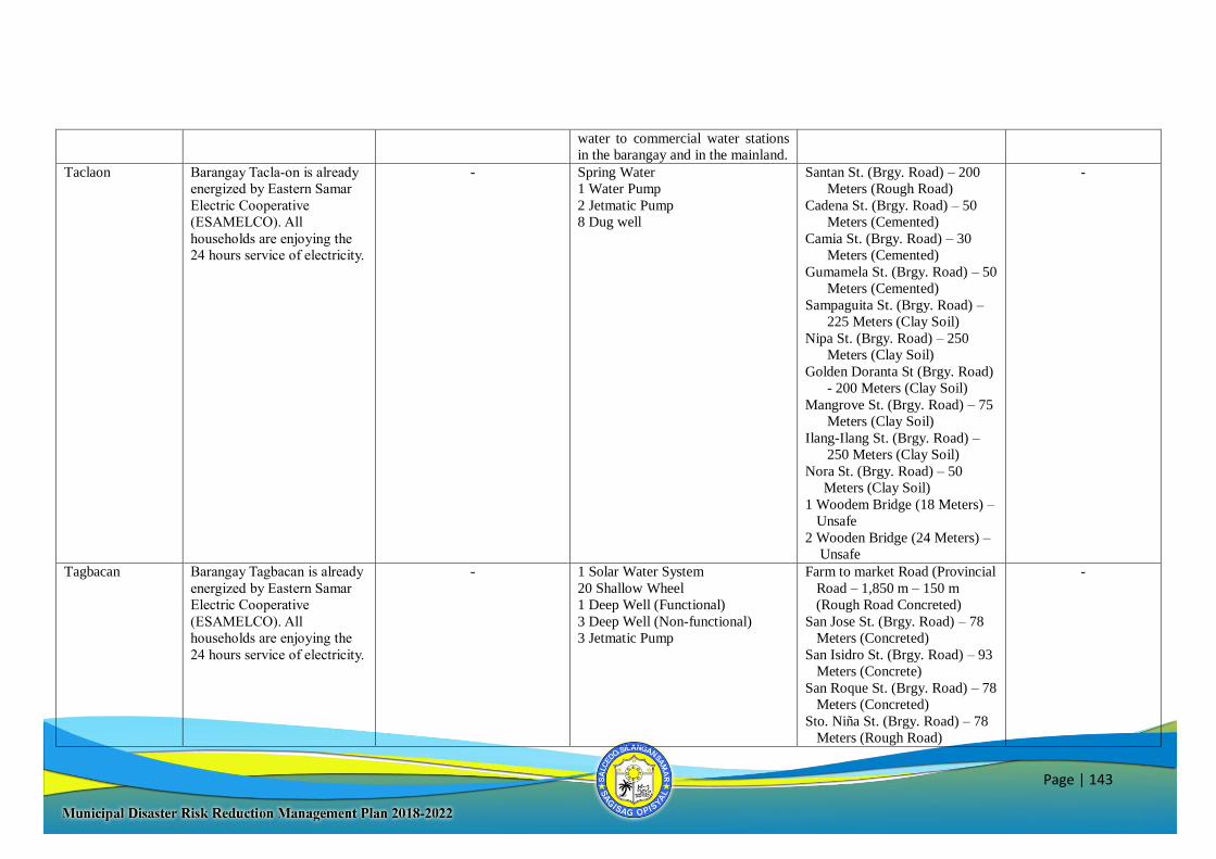
Page | 143
water to commercial water stations
in the barangay and in the mainland.
Taclaon Barangay Tacla-on is already
energized by Eastern Samar
Electric Cooperative
(ESAMELCO). All
households are enjoying the
24 hours service of electricity.
- Spring Water
1 Water Pump
2 Jetmatic Pump
8 Dug well
Santan St. (Brgy. Road) – 200
Meters (Rough Road)
Cadena St. (Brgy. Road) – 50
Meters (Cemented)
Camia St. (Brgy. Road) – 30
Meters (Cemented)
Gumamela St. (Brgy. Road) – 50
Meters (Cemented)
Sampaguita St. (Brgy. Road) –
225 Meters (Clay Soil)
Nipa St. (Brgy. Road) – 250
Meters (Clay Soil)
Golden Doranta St (Brgy. Road)
- 200 Meters (Clay Soil)
Mangrove St. (Brgy. Road) – 75
Meters (Clay Soil)
Ilang-Ilang St. (Brgy. Road) –
250 Meters (Clay Soil)
Nora St. (Brgy. Road) – 50
Meters (Clay Soil)
1 Woodem Bridge (18 Meters) –
Unsafe
2 Wooden Bridge (24 Meters) –
Unsafe
-
Tagbacan Barangay Tagbacan is already
energized by Eastern Samar
Electric Cooperative
(ESAMELCO). All
households are enjoying the
24 hours service of electricity.
- 1 Solar Water System
20 Shallow Wheel
1 Deep Well (Functional)
3 Deep Well (Non-functional)
3 Jetmatic Pump
Farm to market Road (Provincial
Road – 1,850 m – 150 m
(Rough Road Concreted)
San Jose St. (Brgy. Road) – 78
Meters (Concreted)
San Isidro St. (Brgy. Road) – 93
Meters (Concrete)
San Roque St. (Brgy. Road) – 78
Meters (Concreted)
Sto. Niña St. (Brgy. Road) – 78
Meters (Rough Road)
-
Page | 144
Doroongan I (Brgy. Road) – 150
Meters (Rough Road)
Farm to Market Road to IRAYA
(Brgy. Road) – 2,000 Meters
(Rough Road)
Brgy. Road to Public Cemetery
(Brgy. Road) – 775 Meters
(Rough Road)
Doro-ongan II (Brgy. Road) –
150 Meters (Rough Road)
1 Wood Bridge
(8 Meters – Damaged)
2 Wood Bridge
(6 Meters – Damaged)
3 Wood Bridge
(8 Meters – Damaged)
4 Wood Bridge
(2 ½ Meters – Damaged)
5 Wood Bridge
(8 Meters – Damaged)
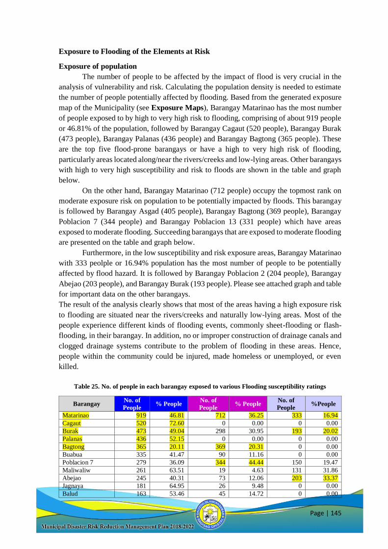
Page | 145
Exposure to Flooding of the Elements at Risk
Exposure of population
The number of people to be affected by the impact of flood is very crucial in the
analysis of vulnerability and risk. Calculating the population density is needed to estimate
the number of people potentially affected by flooding. Based from the generated exposure
map of the Municipality (see Exposure Maps), Barangay Matarinao has the most number
of people exposed to by high to very high risk to flooding, comprising of about 919 people
or 46.81% of the population, followed by Barangay Cagaut (520 people), Barangay Burak
(473 people), Barangay Palanas (436 people) and Barangay Bagtong (365 people). These
are the top five flood-prone barangays or have a high to very high risk of flooding,
particularly areas located along/near the rivers/creeks and low-lying areas. Other barangays
with high to very high susceptibility and risk to floods are shown in the table and graph
below.
On the other hand, Barangay Matarinao (712 people) occupy the topmost rank on
moderate exposure risk on population to be potentially impacted by floods. This barangay
is followed by Barangay Asgad (405 people), Barangay Bagtong (369 people), Barangay
Poblacion 7 (344 people) and Barangay Poblacion 13 (331 people) which have areas
exposed to moderate flooding. Succeeding barangays that are exposed to moderate flooding
are presented on the table and graph below.
Furthermore, in the low susceptibility and risk exposure areas, Barangay Matarinao
with 333 peolple or 16.94% population has the most number of people to be potentially
affected by flood hazard. It is followed by Barangay Poblacion 2 (204 people), Barangay
Abejao (203 people), and Barangay Burak (193 people). Please see attached graph and table
for important data on the other barangays.
The result of the analysis clearly shows that most of the areas having a high exposure risk
to flooding are situated near the rivers/creeks and naturally low-lying areas. Most of the
people experience different kinds of flooding events, commonly sheet-flooding or flash-
flooding, in their barangay. In addition, no or improper construction of drainage canals and
clogged drainage systems contribute to the problem of flooding in these areas. Hence,
people within the community could be injured, made homeless or unemployed, or even
killed.
Table 25. No. of people in each barangay exposed to various Flooding susceptibility ratings
Barangay No. of
People % People
No. of
People % People
No. of
People %People
Matarinao 919 46.81 712 36.25 333 16.94
Cagaut 520 72.60 0 0.00 0 0.00
Burak 473 49.04 298 30.95 193 20.02
Palanas 436 52.15 0 0.00 0 0.00
Bagtong 365 20.11 369 20.31 0 0.00
Buabua 335 41.47 90 11.16 0 0.00
Poblacion 7 279 36.09 344 44.44 150 19.47
Maliwaliw 261 63.51 19 4.63 131 31.86
Abejao 245 40.31 73 12.06 203 33.37
Jagnaya 181 64.95 26 9.48 0 0.00
Balud 163 53.46 45 14.72 0 0.00
Page | 146
Poblacion 2 144 22.79 284 44.91 204 32.30
Tagbacan 111 14.59 37 4.85 0 0.00
Butig 110 27.99 284 72.01 148 37.68
Carapdapan 108 27.88 138 35.44 0 0.00
Camanga 80 13.28 87 14.34 0 0.00
Poblacion 12 64 24.53 132 50.34 0 0.00
Poblacion 11 56 17.75 257 81.64 0 0.00
Poblacion 13 46 10.64 331 76.67 0 0.00
Poblacion 9 42 13.64 221 71.13 42 13.57
Poblacion 10 42 32.08 55 41.71 34 26.21
Asgad 38 8.42 405 88.62 0 0.00
Poblacion 6 34 21.46 77 47.85 49 30.69
Poblacion 1 31 5.49 22 3.98 0 0.00
Taclaon 21 5.94 0 0.00 0 0.00
Sta Cruz 19 7.31 0 0.00 0 0.00
Naparaan 13 0.66 0 0.00 2 0.10
Caridad 8 1.80 0 0.00 0 0.00
Poblacion 8 1 0.31 31 18.37 138 81.32
Alog 0 0.00 315 100.00 0 0.00
Cantomoja 0 0.00 6 1.57 0 0.00
Casili-on 0 0.00 0 0.00 0 0.00
Iberan 0 0.00 65 23.97 197 72.89
Lusod 0 0.00 0 0.00 0 0.00
Malbog 0 0.00 72 23.43 151 49.18
Poblacion 3 0 0.00 200 73.96 71 26.04
Poblacion 4 0 0.00 104 66.08 53 33.92
Poblacion 5 0 0.00 2 4.98 42 95.02
San Roque 0 0.00 0 0.00 0 0.00
Seguinon 0 0.00 0 0.00 0 0.00
Talangdawan 0 0.00 0 0.00 0 0.00
Figure 13. No. of people exposed to various Flooding susceptibility ratings
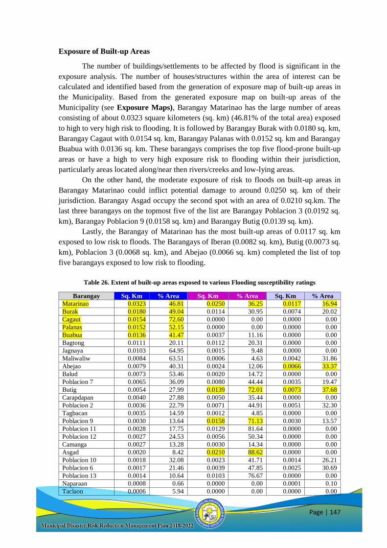
Page | 147
Exposure of Built-up Areas
The number of buildings/settlements to be affected by flood is significant in the
exposure analysis. The number of houses/structures within the area of interest can be
calculated and identified based from the generation of exposure map of built-up areas in
the Municipality. Based from the generated exposure map on built-up areas of the
Municipality (see Exposure Maps), Barangay Matarinao has the large number of areas
consisting of about 0.0323 square kilometers (sq. km) (46.81% of the total area) exposed
to high to very high risk to flooding. It is followed by Barangay Burak with 0.0180 sq. km,
Barangay Cagaut with 0.0154 sq. km, Barangay Palanas with 0.0152 sq. km and Barangay
Buabua with 0.0136 sq. km. These barangays comprises the top five flood-prone built-up
areas or have a high to very high exposure risk to flooding within their jurisdiction,
particularly areas located along/near then rivers/creeks and low-lying areas.
On the other hand, the moderate exposure of risk to floods on built-up areas in
Barangay Matarinao could inflict potential damage to around 0.0250 sq. km of their
jurisdiction. Barangay Asgad occupy the second spot with an area of 0.0210 sq.km. The
last three barangays on the topmost five of the list are Barangay Poblacion 3 (0.0192 sq.
km), Barangay Poblacion 9 (0.0158 sq. km) and Barangay Butig (0.0139 sq. km).
Lastly, the Barangay of Matarinao has the most built-up areas of 0.0117 sq. km
exposed to low risk to floods. The Barangays of Iberan (0.0082 sq. km), Butig (0.0073 sq.
km), Poblacion 3 (0.0068 sq. km), and Abejao (0.0066 sq. km) completed the list of top
five barangays exposed to low risk to flooding.
Table 26. Extent of built-up areas exposed to various Flooding susceptibility ratings
Barangay Sq. Km % Area Sq. Km % Area Sq. Km % Area
Matarinao 0.0323 46.81 0.0250 36.25 0.0117 16.94
Burak 0.0180 49.04 0.0114 30.95 0.0074 20.02
Cagaut 0.0154 72.60 0.0000 0.00 0.0000 0.00
Palanas 0.0152 52.15 0.0000 0.00 0.0000 0.00
Buabua 0.0136 41.47 0.0037 11.16 0.0000 0.00
Bagtong 0.0111 20.11 0.0112 20.31 0.0000 0.00
Jagnaya 0.0103 64.95 0.0015 9.48 0.0000 0.00
Maliwaliw 0.0084 63.51 0.0006 4.63 0.0042 31.86
Abejao 0.0079 40.31 0.0024 12.06 0.0066 33.37
Balud 0.0073 53.46 0.0020 14.72 0.0000 0.00
Poblacion 7 0.0065 36.09 0.0080 44.44 0.0035 19.47
Butig 0.0054 27.99 0.0139 72.01 0.0073 37.68
Carapdapan 0.0040 27.88 0.0050 35.44 0.0000 0.00
Poblacion 2 0.0036 22.79 0.0071 44.91 0.0051 32.30
Tagbacan 0.0035 14.59 0.0012 4.85 0.0000 0.00
Poblacion 9 0.0030 13.64 0.0158 71.13 0.0030 13.57
Poblacion 11 0.0028 17.75 0.0129 81.64 0.0000 0.00
Poblacion 12 0.0027 24.53 0.0056 50.34 0.0000 0.00
Camanga 0.0027 13.28 0.0030 14.34 0.0000 0.00
Asgad 0.0020 8.42 0.0210 88.62 0.0000 0.00
Poblacion 10 0.0018 32.08 0.0023 41.71 0.0014 26.21
Poblacion 6 0.0017 21.46 0.0039 47.85 0.0025 30.69
Poblacion 13 0.0014 10.64 0.0103 76.67 0.0000 0.00
Naparaan 0.0008 0.66 0.0000 0.00 0.0001 0.10
Taclaon 0.0006 5.94 0.0000 0.00 0.0000 0.00
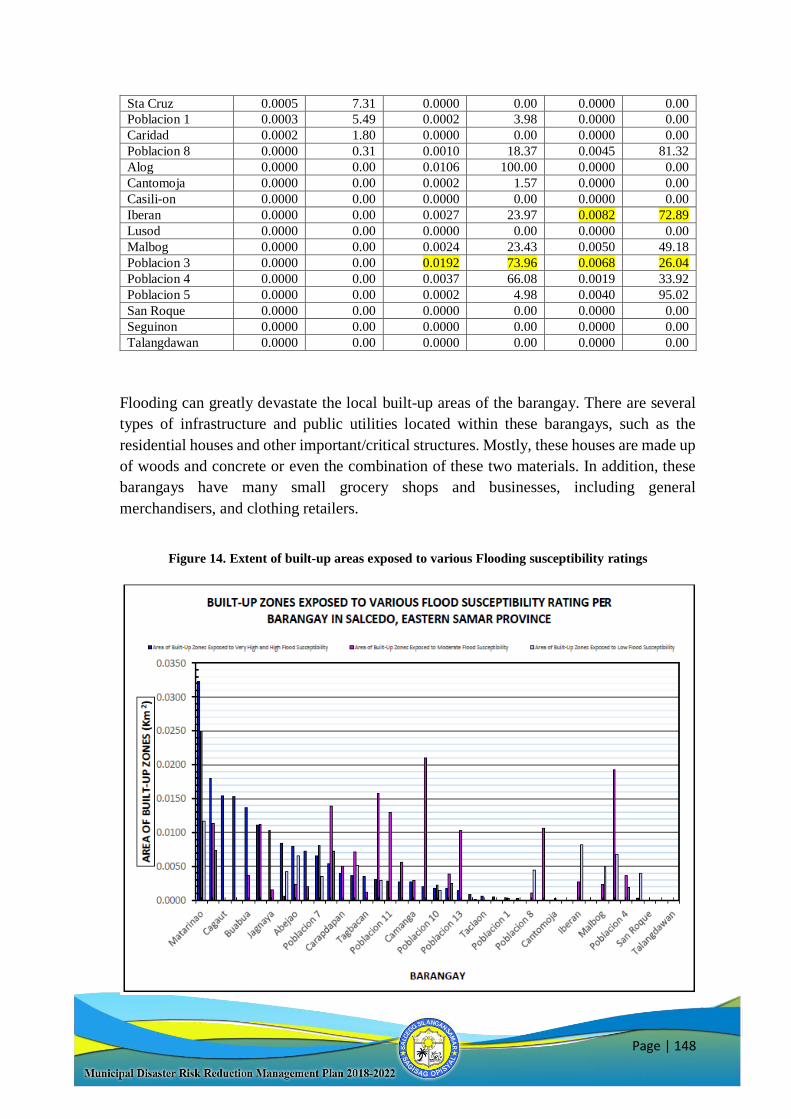
Page | 148
Sta Cruz 0.0005 7.31 0.0000 0.00 0.0000 0.00
Poblacion 1 0.0003 5.49 0.0002 3.98 0.0000 0.00
Caridad 0.0002 1.80 0.0000 0.00 0.0000 0.00
Poblacion 8 0.0000 0.31 0.0010 18.37 0.0045 81.32
Alog 0.0000 0.00 0.0106 100.00 0.0000 0.00
Cantomoja 0.0000 0.00 0.0002 1.57 0.0000 0.00
Casili-on 0.0000 0.00 0.0000 0.00 0.0000 0.00
Iberan 0.0000 0.00 0.0027 23.97 0.0082 72.89
Lusod 0.0000 0.00 0.0000 0.00 0.0000 0.00
Malbog 0.0000 0.00 0.0024 23.43 0.0050 49.18
Poblacion 3 0.0000 0.00 0.0192 73.96 0.0068 26.04
Poblacion 4 0.0000 0.00 0.0037 66.08 0.0019 33.92
Poblacion 5 0.0000 0.00 0.0002 4.98 0.0040 95.02
San Roque 0.0000 0.00 0.0000 0.00 0.0000 0.00
Seguinon 0.0000 0.00 0.0000 0.00 0.0000 0.00
Talangdawan 0.0000 0.00 0.0000 0.00 0.0000 0.00
Flooding can greatly devastate the local built-up areas of the barangay. There are several
types of infrastructure and public utilities located within these barangays, such as the
residential houses and other important/critical structures. Mostly, these houses are made up
of woods and concrete or even the combination of these two materials. In addition, these
barangays have many small grocery shops and businesses, including general
merchandisers, and clothing retailers.
Figure 14. Extent of built-up areas exposed to various Flooding susceptibility ratings
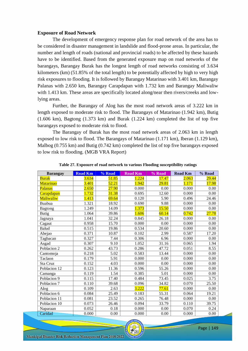
Page | 149
Exposure of Road Network
The development of emergency response plan for road network of the area has to
be considered in disaster management in landslide and flood-prone areas. In particular, the
number and length of roads (national and provincial roads) to be affected by these hazards
have to be identified. Based from the generated exposure map on road networks of the
barangays, Barangay Burak has the longest length of road networks consisting of 3.634
kilometers (km) (51.85% of the total length) to be potentially affected by high to very high
risk exposures to flooding. It is followed by Barangay Matarinao with 3.401 km, Barangay
Palanas with 2.650 km, Barangay Carapdapan with 1.732 km and Barangay Maliwaliw
with 1.413 km. These areas are specifically located along/near then rivers/creeks and low-
lying areas.
Further, the Barangay of Alog has the most road network areas of 3.222 km in
length exposed to moderate risk to flood. The Barangays of Matarinao (1.942 km), Butig
(1.606 km), Bagtong (1.373 km) and Burak (1.224 km) completed the list of top five
barangays exposed to moderate risk to flood.
The Barangay of Burak has the most road network areas of 2.063 km in length
exposed to low risk to flood. The Barangays of Matarinao (1.171 km), Iberan (1.129 km),
Malbog (0.755 km) and Butig (0.742 km) completed the list of top five barangays exposed
to low risk to flooding. (MGB VRA Report)
Table 27. Exposure of road network to various Flooding susceptibility ratings
Barangay Road Km % Road Road Km % Road Road Km % Road
Burak 3.634 51.85 1.224 17.47 2.063 29.44
Matarinao 3.401 52.21 1.942 29.81 1.171 17.98
Palanas 2.650 27.90 0.000 0.00 0.000 0.00
Carapdapan 1.732 31.38 0.695 12.60 0.000 0.00
Maliwaliw 1.413 69.64 0.120 5.90 0.496 24.46
Buabua 1.321 18.92 0.690 9.88 0.000 0.00
Bagtong 1.249 14.09 1.373 15.50 0.000 0.00
Butig 1.064 39.86 1.606 60.14 0.742 27.78
Jagnaya 1.041 32.24 0.845 26.18 0.000 0.00
Cagaut 0.958 15.70 0.000 0.00 0.000 0.00
Balud 0.515 19.86 0.534 20.60 0.000 0.00
Abejao 0.371 10.87 0.102 2.99 0.587 17.20
Tagbacan 0.327 7.44 0.306 6.96 0.000 0.00
Asgad 0.307 9.10 1.052 31.16 0.065 1.94
Poblacion 2 0.262 43.73 0.286 47.72 0.051 8.55
Cantomoja 0.218 5.02 0.583 13.44 0.000 0.00
Taclaon 0.179 5.91 0.000 0.00 0.000 0.00
Sta Cruz 0.152 4.03 0.000 0.00 0.000 0.00
Poblacion 12 0.123 11.36 0.596 55.26 0.000 0.00
Camanga 0.119 1.54 0.385 5.01 0.000 0.00
Poblacion 9 0.115 17.40 0.484 73.45 0.025 3.75
Poblacion 7 0.110 39.68 0.096 34.82 0.070 25.50
Alog 0.109 2.63 3.222 77.61 0.000 0.00
Poblacion 6 0.084 25.49 0.183 55.31 0.064 19.21
Poblacion 11 0.081 23.52 0.265 76.48 0.000 0.00
Poblacion 10 0.073 26.46 0.094 33.79 0.110 39.75
Naparaan 0.052 0.18 0.000 0.00 0.070 0.24
Caridad 0.000 0.00 0.000 0.00 0.000 0.00
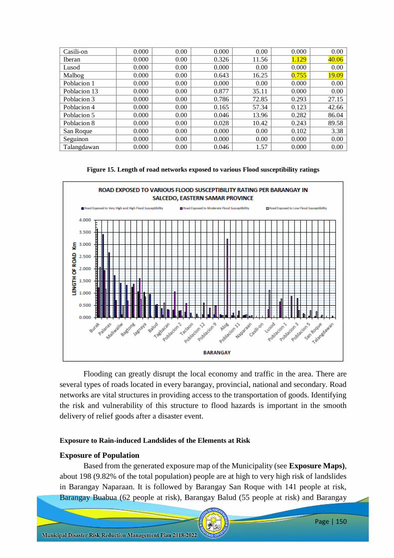
Page | 150
Casili-on 0.000 0.00 0.000 0.00 0.000 0.00
Iberan 0.000 0.00 0.326 11.56 1.129 40.06
Lusod 0.000 0.00 0.000 0.00 0.000 0.00
Malbog 0.000 0.00 0.643 16.25 0.755 19.09
Poblacion 1 0.000 0.00 0.000 0.00 0.000 0.00
Poblacion 13 0.000 0.00 0.877 35.11 0.000 0.00
Poblacion 3 0.000 0.00 0.786 72.85 0.293 27.15
Poblacion 4 0.000 0.00 0.165 57.34 0.123 42.66
Poblacion 5 0.000 0.00 0.046 13.96 0.282 86.04
Poblacion 8 0.000 0.00 0.028 10.42 0.243 89.58
San Roque 0.000 0.00 0.000 0.00 0.102 3.38
Seguinon 0.000 0.00 0.000 0.00 0.000 0.00
Talangdawan 0.000 0.00 0.046 1.57 0.000 0.00
Figure 15. Length of road networks exposed to various Flood susceptibility ratings
Flooding can greatly disrupt the local economy and traffic in the area. There are
several types of roads located in every barangay, provincial, national and secondary. Road
networks are vital structures in providing access to the transportation of goods. Identifying
the risk and vulnerability of this structure to flood hazards is important in the smooth
delivery of relief goods after a disaster event.
Exposure to Rain-induced Landslides of the Elements at Risk
Exposure of Population
Based from the generated exposure map of the Municipality (see Exposure Maps),
about 198 (9.82% of the total population) people are at high to very high risk of landslides
in Barangay Naparaan. It is followed by Barangay San Roque with 141 people at risk,
Barangay Buabua (62 people at risk), Barangay Balud (55 people at risk) and Barangay
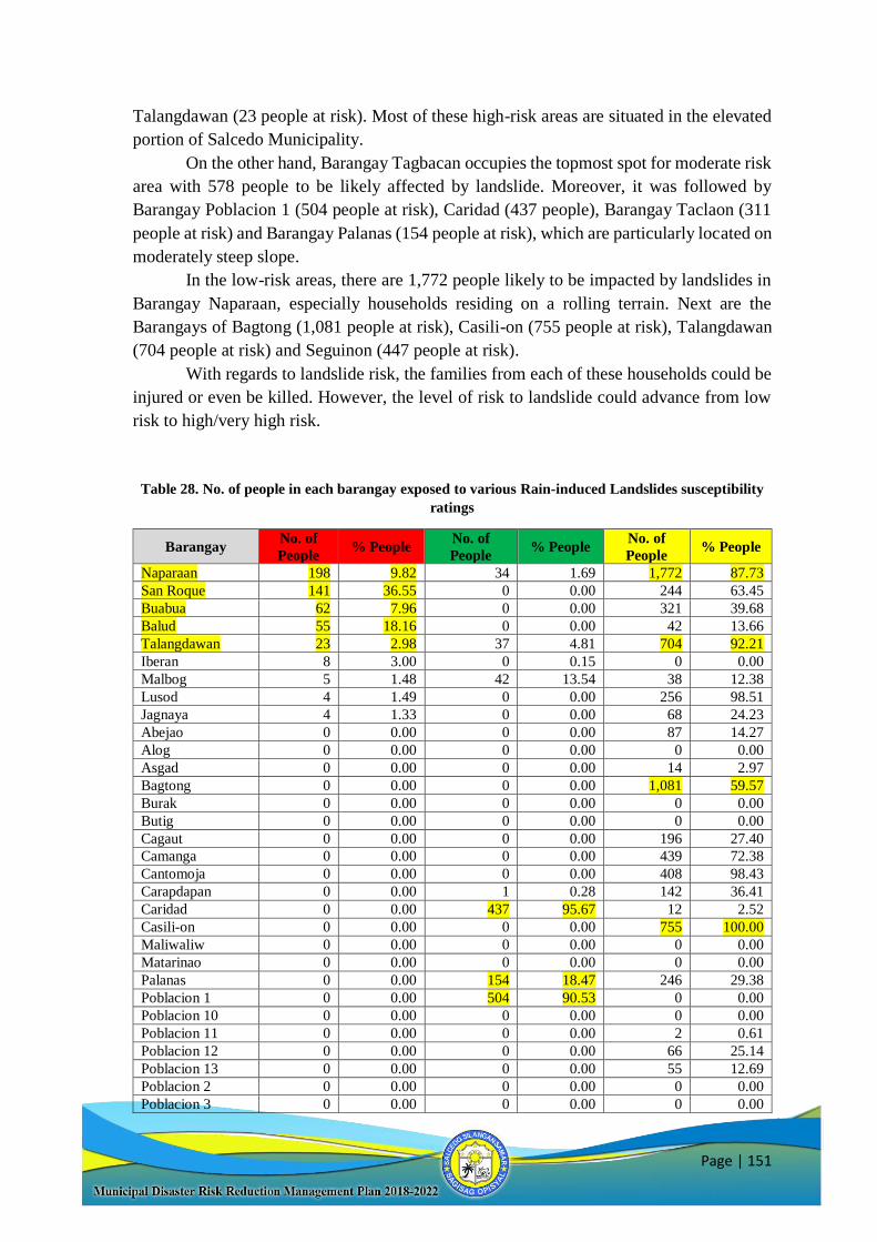
Page | 151
Talangdawan (23 people at risk). Most of these high-risk areas are situated in the elevated
portion of Salcedo Municipality.
On the other hand, Barangay Tagbacan occupies the topmost spot for moderate risk
area with 578 people to be likely affected by landslide. Moreover, it was followed by
Barangay Poblacion 1 (504 people at risk), Caridad (437 people), Barangay Taclaon (311
people at risk) and Barangay Palanas (154 people at risk), which are particularly located on
moderately steep slope.
In the low-risk areas, there are 1,772 people likely to be impacted by landslides in
Barangay Naparaan, especially households residing on a rolling terrain. Next are the
Barangays of Bagtong (1,081 people at risk), Casili-on (755 people at risk), Talangdawan
(704 people at risk) and Seguinon (447 people at risk).
With regards to landslide risk, the families from each of these households could be
injured or even be killed. However, the level of risk to landslide could advance from low
risk to high/very high risk.
Table 28. No. of people in each barangay exposed to various Rain-induced Landslides susceptibility
ratings
Barangay No. of
People % People
No. of
People % People
No. of
People % People
Naparaan 198 9.82 34 1.69 1,772 87.73
San Roque 141 36.55 0 0.00 244 63.45
Buabua 62 7.96 0 0.00 321 39.68
Balud 55 18.16 0 0.00 42 13.66
Talangdawan 23 2.98 37 4.81 704 92.21
Iberan 8 3.00 0 0.15 0 0.00
Malbog 5 1.48 42 13.54 38 12.38
Lusod 4 1.49 0 0.00 256 98.51
Jagnaya 4 1.33 0 0.00 68 24.23
Abejao 0 0.00 0 0.00 87 14.27
Alog 0 0.00 0 0.00 0 0.00
Asgad 0 0.00 0 0.00 14 2.97
Bagtong 0 0.00 0 0.00 1,081 59.57
Burak 0 0.00 0 0.00 0 0.00
Butig 0 0.00 0 0.00 0 0.00
Cagaut 0 0.00 0 0.00 196 27.40
Camanga 0 0.00 0 0.00 439 72.38
Cantomoja 0 0.00 0 0.00 408 98.43
Carapdapan 0 0.00 1 0.28 142 36.41
Caridad 0 0.00 437 95.67 12 2.52
Casili-on 0 0.00 0 0.00 755 100.00
Maliwaliw 0 0.00 0 0.00 0 0.00
Matarinao 0 0.00 0 0.00 0 0.00
Palanas 0 0.00 154 18.47 246 29.38
Poblacion 1 0 0.00 504 90.53 0 0.00
Poblacion 10 0 0.00 0 0.00 0 0.00
Poblacion 11 0 0.00 0 0.00 2 0.61
Poblacion 12 0 0.00 0 0.00 66 25.14
Poblacion 13 0 0.00 0 0.00 55 12.69
Poblacion 2 0 0.00 0 0.00 0 0.00
Poblacion 3 0 0.00 0 0.00 0 0.00
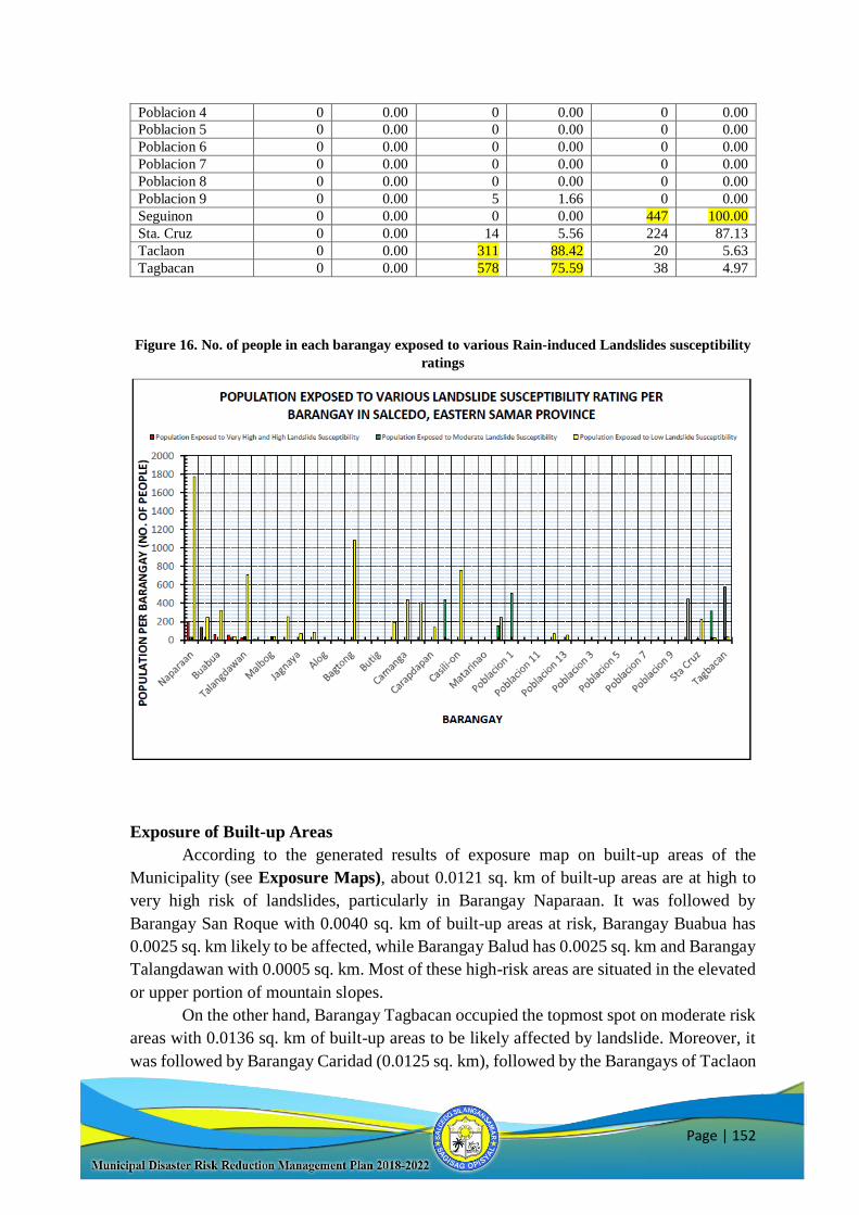
Page | 152
Poblacion 4 0 0.00 0 0.00 0 0.00
Poblacion 5 0 0.00 0 0.00 0 0.00
Poblacion 6 0 0.00 0 0.00 0 0.00
Poblacion 7 0 0.00 0 0.00 0 0.00
Poblacion 8 0 0.00 0 0.00 0 0.00
Poblacion 9 0 0.00 5 1.66 0 0.00
Seguinon 0 0.00 0 0.00 447 100.00
Sta. Cruz 0 0.00 14 5.56 224 87.13
Taclaon 0 0.00 311 88.42 20 5.63
Tagbacan 0 0.00 578 75.59 38 4.97
Figure 16. No. of people in each barangay exposed to various Rain-induced Landslides susceptibility
ratings
Exposure of Built-up Areas
According to the generated results of exposure map on built-up areas of the
Municipality (see Exposure Maps), about 0.0121 sq. km of built-up areas are at high to
very high risk of landslides, particularly in Barangay Naparaan. It was followed by
Barangay San Roque with 0.0040 sq. km of built-up areas at risk, Barangay Buabua has
0.0025 sq. km likely to be affected, while Barangay Balud has 0.0025 sq. km and Barangay
Talangdawan with 0.0005 sq. km. Most of these high-risk areas are situated in the elevated
or upper portion of mountain slopes.
On the other hand, Barangay Tagbacan occupied the topmost spot on moderate risk
areas with 0.0136 sq. km of built-up areas to be likely affected by landslide. Moreover, it
was followed by Barangay Caridad (0.0125 sq. km), followed by the Barangays of Taclaon
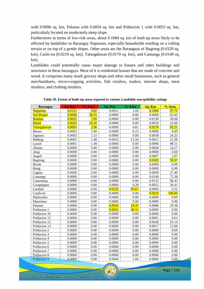
Page | 153
with 0.0096 sq. km, Palanas with 0.0054 sq. km and Poblacion 1 with 0.0053 sq. km,
particularly located on moderately steep slope.
Furthermore in terms of low-risk areas, about 0.1084 sq. km of built-up areas likely to be
affected by landslides in Barangay Naparaan, especially households residing on a rolling
terrain or on top of a gentle slopes. Other areas are the Barangays of Bagtong (0.0329 sq.
km), Casili-on (0.0219 sq. km), Talangdawan (0.0170 sq. km), and Camanga (0.0149 sq.
km).
Landslides could potentially cause major damage to houses and other buildings and
structures in these barangays. Most of it is residential houses that are made of concrete and
wood. It comprises many small grocery shops and other small businesses, such as general
merchandisers, micro-cropping activities, fish retailers, traders, internet shops, meat
retailers, and clothing retailers.
Table 29. Extent of built-up areas exposed to various Landslide susceptibility ratings
Barangay Sq. Km % Area Sq. Km % Area Sq. Km % Area
Naparaan 0.0121 9.82 0.0021 1.69 0.1084 87.73
San Roque 0.0040 36.55 0.0000 0.00 0.0069 63.45
Buabua 0.0025 7.69 0.0000 0.00 0.0130 39.68
Balud 0.0025 18.16 0.0000 0.00 0.0019 13.66
Talangdawan 0.0005 2.98 0.0009 4.81 0.0170 92.21
Iberan 0.0003 3.00 0.0000 0.15 0.0000 0.00
Jagnaya 0.0002 1.33 0.0000 0.00 0.0038 24.23
Malbog 0.0001 1.48 0.0014 13.54 0.0013 12.38
Lusod 0.0001 1.49 0.0000 0.00 0.0090 98.51
Abejao 0.0000 0.00 0.0000 0.00 0.0028 14.27
Alog 0.0000 0.00 0.0000 0.00 0.0000 0.00
Asgad 0.0000 0.00 0.0000 0.00 0.0007 2.97
Bagtong 0.0000 0.00 0.0000 0.00 0.0329 59.57
Burak 0.0000 0.00 0.0000 0.00 0.0000 0.00
Butig 0.0000 0.00 0.0000 0.00 0.0000 0.00
Cagaut 0.0000 0.00 0.0000 0.00 0.0058 27.40
Camanga 0.0000 0.00 0.0000 0.00 0.0149 72.38
Cantomoja 0.0000 0.00 0.0000 0.00 0.0131 98.43
Carapdapan 0.0000 0.00 0.0000 0.28 0.0052 36.41
Caridad 0.0000 0.00 0.0125 95.67 0.0003 2.52
Casili-on 0.0000 0.00 0.0000 0.00 0.0219 100.00
Maliwaliw 0.0000 0.00 0.0000 0.00 0.0000 0.00
Matarinao 0.0000 0.00 0.0000 0.00 0.0000 0.00
Palanas 0.0000 0.00 0.0054 18.47 0.0086 29.38
Poblacion 1 0.0000 0.00 0.0053 90.53 0.0000 0.00
Poblacion 10 0.0000 0.00 0.0000 0.00 0.0000 0.00
Poblacion 11 0.0000 0.00 0.0000 0.00 0.0001 0.61
Poblacion 12 0.0000 0.00 0.0000 0.00 0.0028 25.14
Poblacion 13 0.0000 0.00 0.0000 0.00 0.0017 12.69
Poblacion 2 0.0000 0.00 0.0000 0.00 0.0000 0.00
Poblacion 3 0.0000 0.00 0.0000 0.00 0.0000 0.00
Poblacion 4 0.0000 0.00 0.0000 0.00 0.0000 0.00
Poblacion 5 0.0000 0.00 0.0000 0.00 0.0000 0.00
Poblacion 6 0.0000 0.00 0.0000 0.00 0.0000 0.00
Poblacion 7 0.0000 0.00 0.0000 0.00 0.0000 0.00
Poblacion 8 0.0000 0.00 0.0000 0.00 0.0000 0.00
Poblacion 9 0.0000 0.00 0.0004 1.66 0.0000 0.00
Page | 154
Seguinon 0.0000 0.00 0.0000 0.00 0.0131 100.00
Sta Cruz 0.0000 0.00 0.0004 5.56 0.0059 87.13
Taclaon 0.0000 0.00 0.0096 88.42 0.0006 5.63
Tagbacan 0.0000 0.00 0.0183 75.59 0.0012 4.97
Figure 17. Built-up areas exposed to various Landslide susceptibility ratings
Exposure of road networks
Similar to flood, the development of emergency response plan for the number and
length of road networks (barangay, national and provincial roads) of each barangay should
be given upmost importance in disaster management in landslide prone areas. Based from
the road exposure map generated, the vulnerability and risk of this structure may be derived.
Relative to the two previous exposures, only the top five barangays are obtained
from the results of exposure maps. However, the roads of other barangays have also
significant exposures to landslide hazard. Accordingly, the generated exposure map on road
networks in Barangay Naparaan has the longest length of road networks consisting of 1.848
km (6.28% of the total length) to be potentially affected by high to very high risk exposures
to landslide. It is followed by Barangay Iberan with 1.001 km, Barangay Cagaut with 0.941
km, Barangay Lusod with 0.623 km and Barangay Buabua with 0.445 km. These areas are
specifically located on steep mountain slopes in the area.
Moreover, the Barangay of Taclaon has the most road network areas of 2.467 km
in length exposed to moderate risk landslide. The Barangays of Palanas (2.375 km),
Tagbacan (2.154 km), Malbog (2.064 km) and Naparaan (1.154 km) completed the list of
top five barangays exposed to moderate risk to landslides. These areas are situated on a
moderately steep terrain.
Furthermore, the Barangay of Camanga has the most road network areas of 7.180
km in length exposed to low risk landslide. It is followed by the Barangays of Bagtong
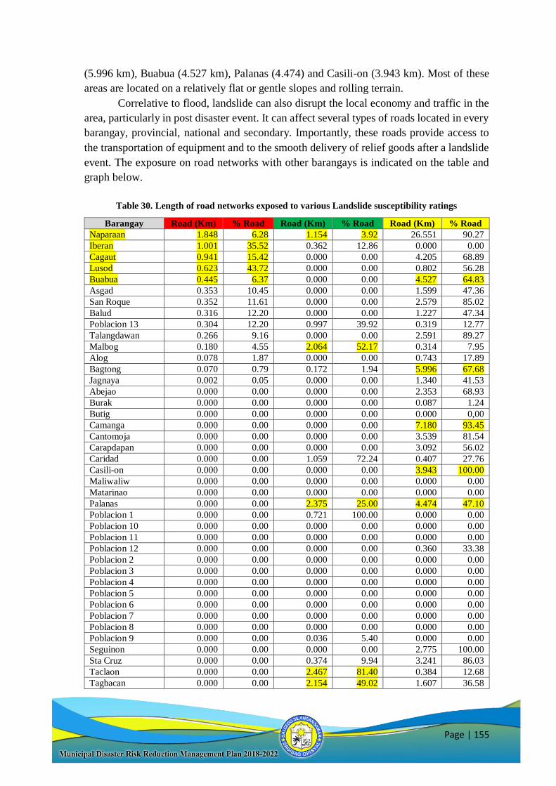
Page | 155
(5.996 km), Buabua (4.527 km), Palanas (4.474) and Casili-on (3.943 km). Most of these
areas are located on a relatively flat or gentle slopes and rolling terrain.
Correlative to flood, landslide can also disrupt the local economy and traffic in the
area, particularly in post disaster event. It can affect several types of roads located in every
barangay, provincial, national and secondary. Importantly, these roads provide access to
the transportation of equipment and to the smooth delivery of relief goods after a landslide
event. The exposure on road networks with other barangays is indicated on the table and
graph below.
Table 30. Length of road networks exposed to various Landslide susceptibility ratings
Barangay Road (Km) % Road Road (Km) % Road Road (Km) % Road
Naparaan 1.848 6.28 1.154 3.92 26.551 90.27
Iberan 1.001 35.52 0.362 12.86 0.000 0.00
Cagaut 0.941 15.42 0.000 0.00 4.205 68.89
Lusod 0.623 43.72 0.000 0.00 0.802 56.28
Buabua 0.445 6.37 0.000 0.00 4.527 64.83
Asgad 0.353 10.45 0.000 0.00 1.599 47.36
San Roque 0.352 11.61 0.000 0.00 2.579 85.02
Balud 0.316 12.20 0.000 0.00 1.227 47.34
Poblacion 13 0.304 12.20 0.997 39.92 0.319 12.77
Talangdawan 0.266 9.16 0.000 0.00 2.591 89.27
Malbog 0.180 4.55 2.064 52.17 0.314 7.95
Alog 0.078 1.87 0.000 0.00 0.743 17.89
Bagtong 0.070 0.79 0.172 1.94 5.996 67.68
Jagnaya 0.002 0.05 0.000 0.00 1.340 41.53
Abejao 0.000 0.00 0.000 0.00 2.353 68.93
Burak 0.000 0.00 0.000 0.00 0.087 1.24
Butig 0.000 0.00 0.000 0.00 0.000 0,00
Camanga 0.000 0.00 0.000 0.00 7.180 93.45
Cantomoja 0.000 0.00 0.000 0.00 3.539 81.54
Carapdapan 0.000 0.00 0.000 0.00 3.092 56.02
Caridad 0.000 0.00 1.059 72.24 0.407 27.76
Casili-on 0.000 0.00 0.000 0.00 3.943 100.00
Maliwaliw 0.000 0.00 0.000 0.00 0.000 0.00
Matarinao 0.000 0.00 0.000 0.00 0.000 0.00
Palanas 0.000 0.00 2.375 25.00 4.474 47.10
Poblacion 1 0.000 0.00 0.721 100.00 0.000 0.00
Poblacion 10 0.000 0.00 0.000 0.00 0.000 0.00
Poblacion 11 0.000 0.00 0.000 0.00 0.000 0.00
Poblacion 12 0.000 0.00 0.000 0.00 0.360 33.38
Poblacion 2 0.000 0.00 0.000 0.00 0.000 0.00
Poblacion 3 0.000 0.00 0.000 0.00 0.000 0.00
Poblacion 4 0.000 0.00 0.000 0.00 0.000 0.00
Poblacion 5 0.000 0.00 0.000 0.00 0.000 0.00
Poblacion 6 0.000 0.00 0.000 0.00 0.000 0.00
Poblacion 7 0.000 0.00 0.000 0.00 0.000 0.00
Poblacion 8 0.000 0.00 0.000 0.00 0.000 0.00
Poblacion 9 0.000 0.00 0.036 5.40 0.000 0.00
Seguinon 0.000 0.00 0.000 0.00 2.775 100.00
Sta Cruz 0.000 0.00 0.374 9.94 3.241 86.03
Taclaon 0.000 0.00 2.467 81.40 0.384 12.68
Tagbacan 0.000 0.00 2.154 49.02 1.607 36.58
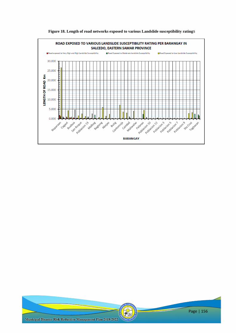
Page | 156
Figure 18. Length of road networks exposed to various Landslide susceptibility ratings
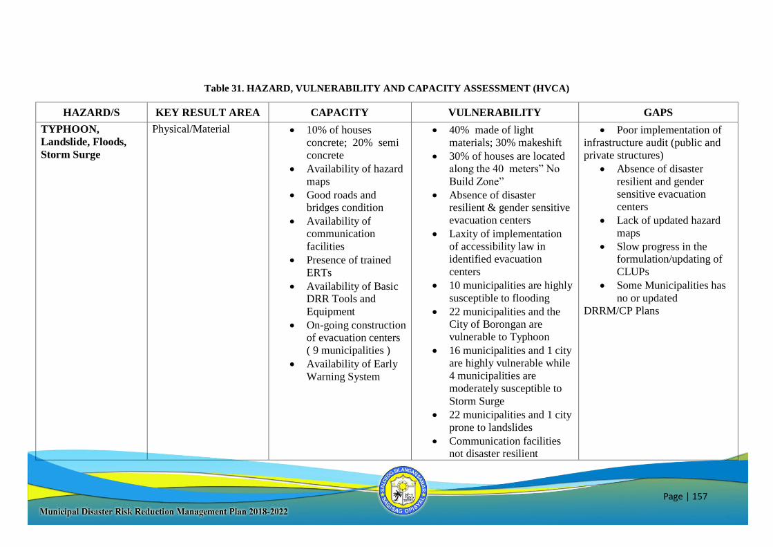
Page | 157
Table 31. HAZARD, VULNERABILITY AND CAPACITY ASSESSMENT (HVCA)
HAZARD/S KEY RESULT AREA CAPACITY VULNERABILITY GAPS
TYPHOON,
Landslide, Floods,
Storm Surge
Physical/Material
10% of houses
concrete; 20% semi
concrete
Availability of hazard maps
Good roads and bridges condition
Availability of communication
facilities
Presence of trained
ERTs
Availability of Basic DRR Tools and
Equipment
On-going construction of evacuation centers
( 9 municipalities )
Availability of Early
Warning System
40% made of light
materials; 30% makeshift
30% of houses are located along the 40 meters” No
Build Zone”
Absence of disaster resilient & gender sensitive
evacuation centers
Laxity of implementation of accessibility law in
identified evacuation
centers
10 municipalities are highly
susceptible to flooding
22 municipalities and the City of Borongan are
vulnerable to Typhoon
16 municipalities and 1 city are highly vulnerable while
4 municipalities are
moderately susceptible to
Storm Surge
22 municipalities and 1 city
prone to landslides
Communication facilities not disaster resilient
Poor implementation of
infrastructure audit (public and
private structures)
Absence of disaster resilient and gender
sensitive evacuation
centers
Lack of updated hazard maps
Slow progress in the formulation/updating of
CLUPs
Some Municipalities has
no or updated
DRRM/CP Plans
Page | 158
Salcedo Exposure and Risk Maps (Source: DEPARTMENT OF ENVIRONMENTAL AND NATURAL RESOURCES – MINES AND GEOSCIENCES BUREAU –
Regional Office No. VIII, Candahug, Palo Leyte)
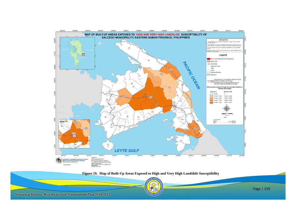
Page | 159
Figure 19. Map of Built-Up Areas Exposed to High and Very High Landslide Susceptibility
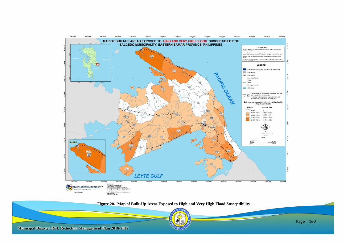
Page | 160
Figure 20. Map of Built-Up Areas Exposed to High and Very High Flood Susceptibility
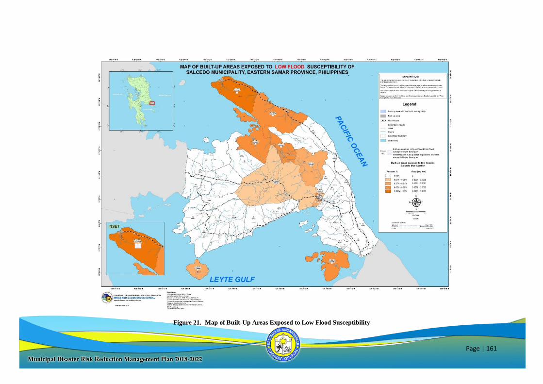
Page | 161
Figure 21. Map of Built-Up Areas Exposed to Low Flood Susceptibility
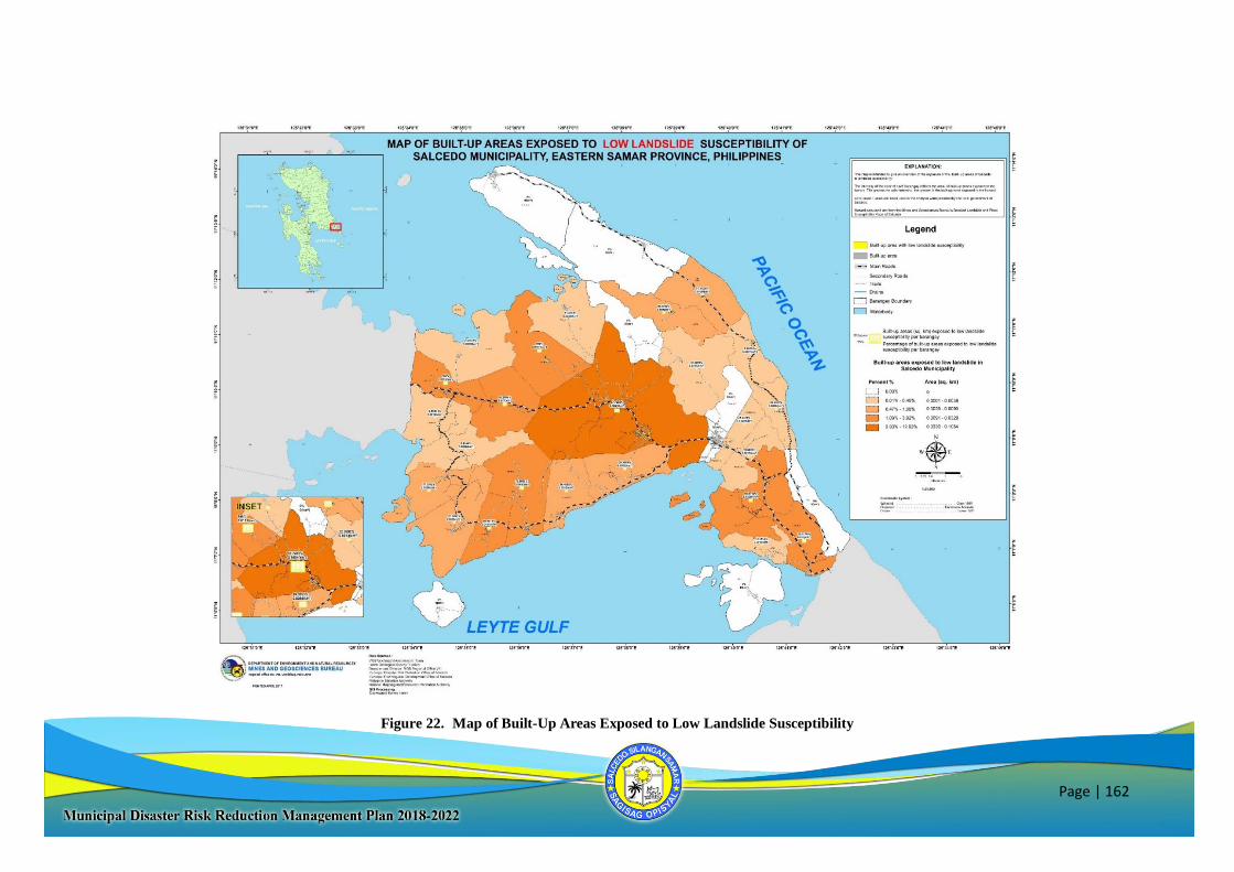
Page | 162
Figure 22. Map of Built-Up Areas Exposed to Low Landslide Susceptibility
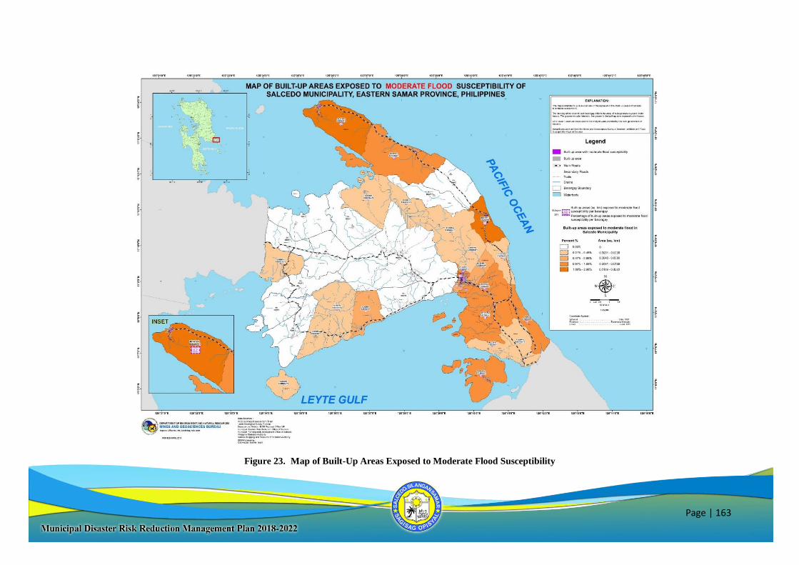
Page | 163
Figure 23. Map of Built-Up Areas Exposed to Moderate Flood Susceptibility
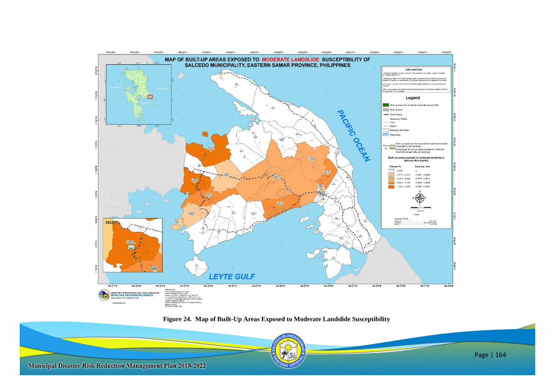
Page | 164
Figure 24. Map of Built-Up Areas Exposed to Moderate Landslide Susceptibility
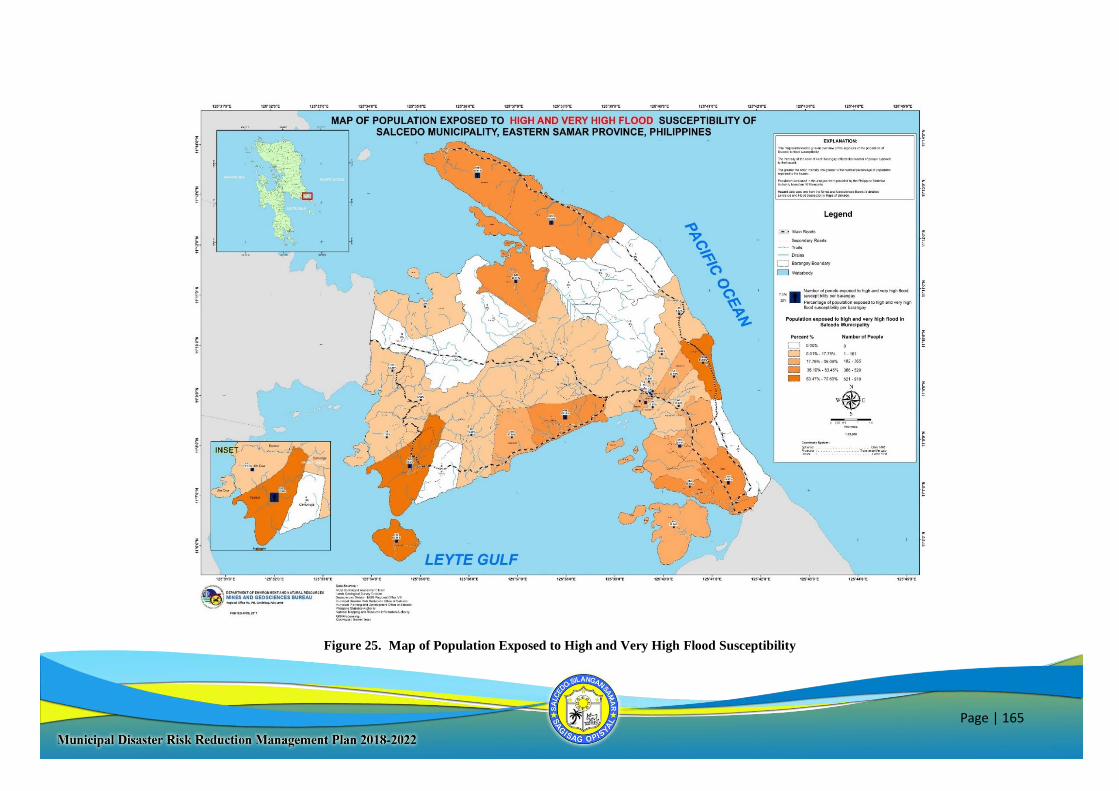
Page | 165
Figure 25. Map of Population Exposed to High and Very High Flood Susceptibility
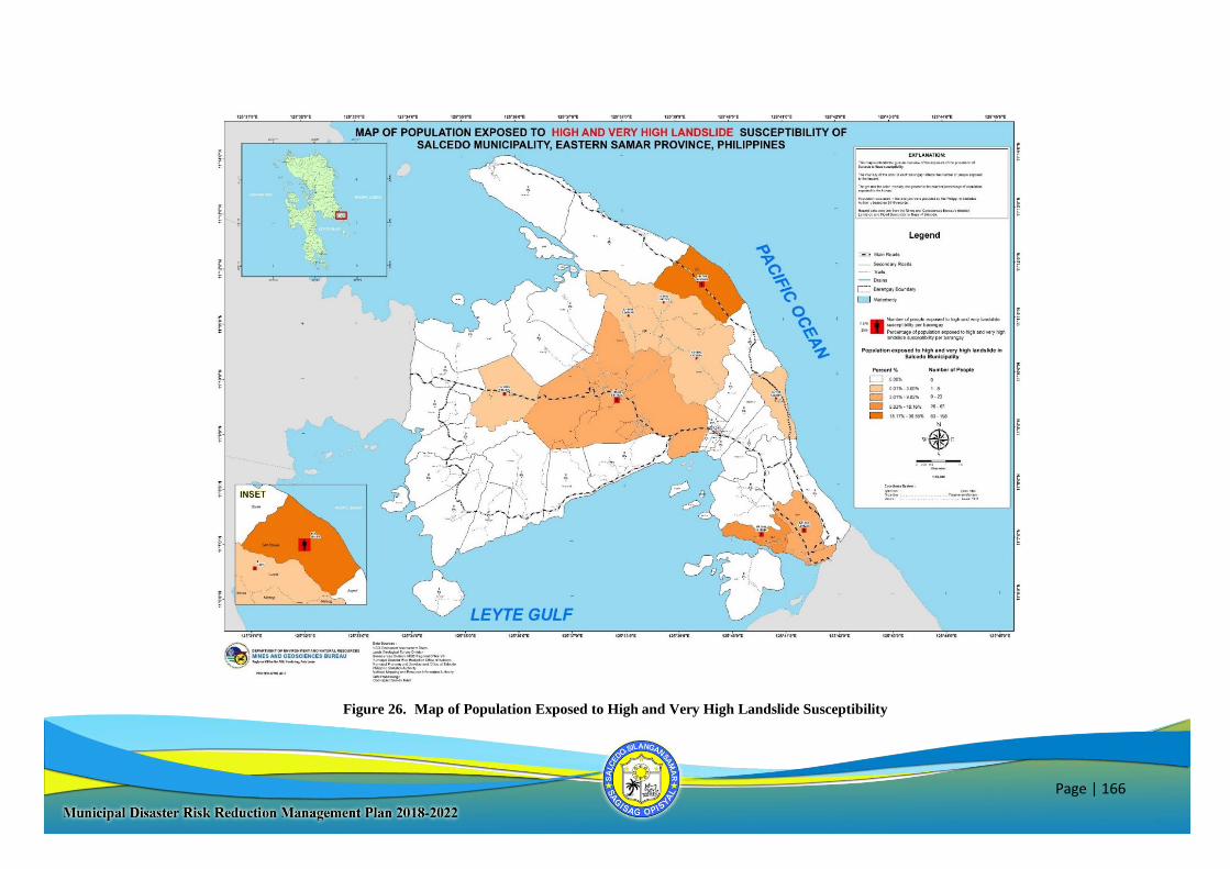
Page | 166
Figure 26. Map of Population Exposed to High and Very High Landslide Susceptibility
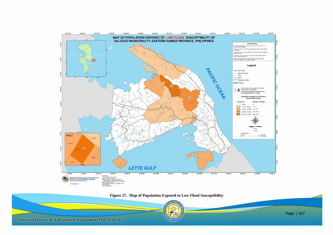
Page | 167
Figure 27. Map of Population Exposed to Low Flood Susceptibility
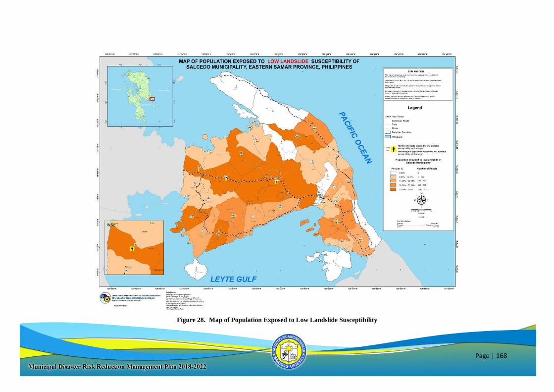
Page | 168
Figure 28. Map of Population Exposed to Low Landslide Susceptibility
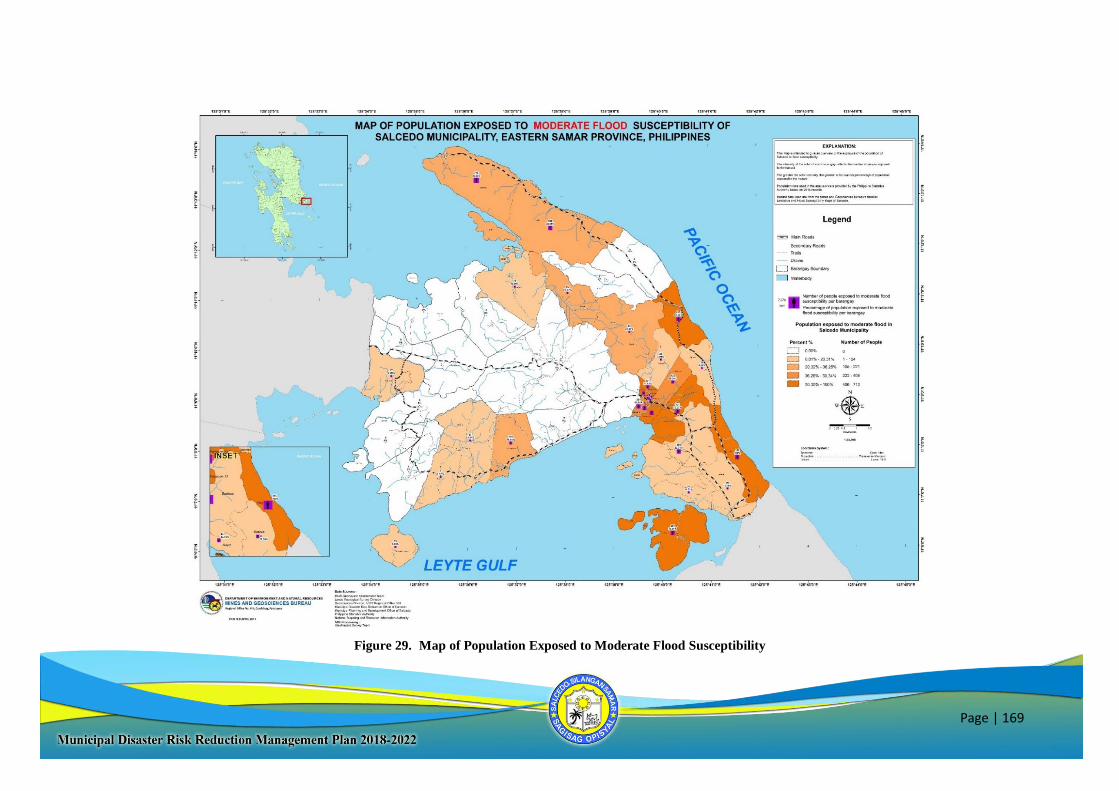
Page | 169
Figure 29. Map of Population Exposed to Moderate Flood Susceptibility
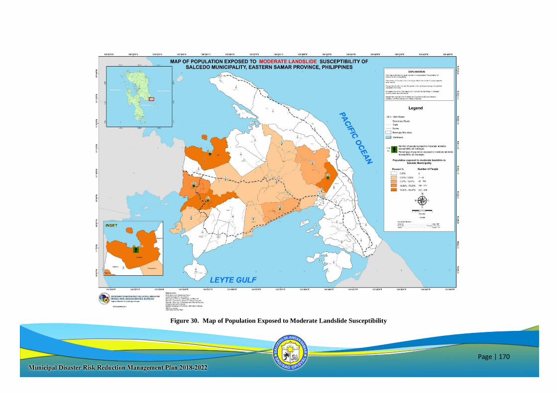
Page | 170
Figure 30. Map of Population Exposed to Moderate Landslide Susceptibility
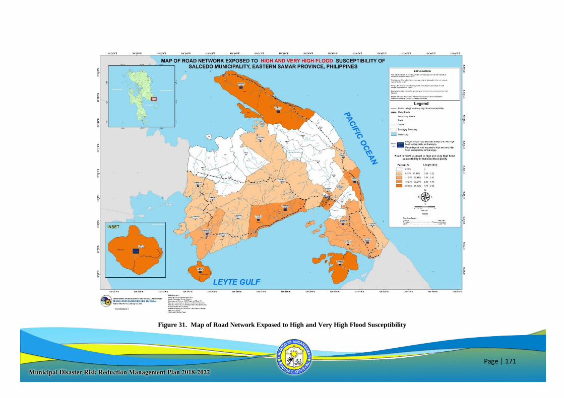
Page | 171
Figure 31. Map of Road Network Exposed to High and Very High Flood Susceptibility
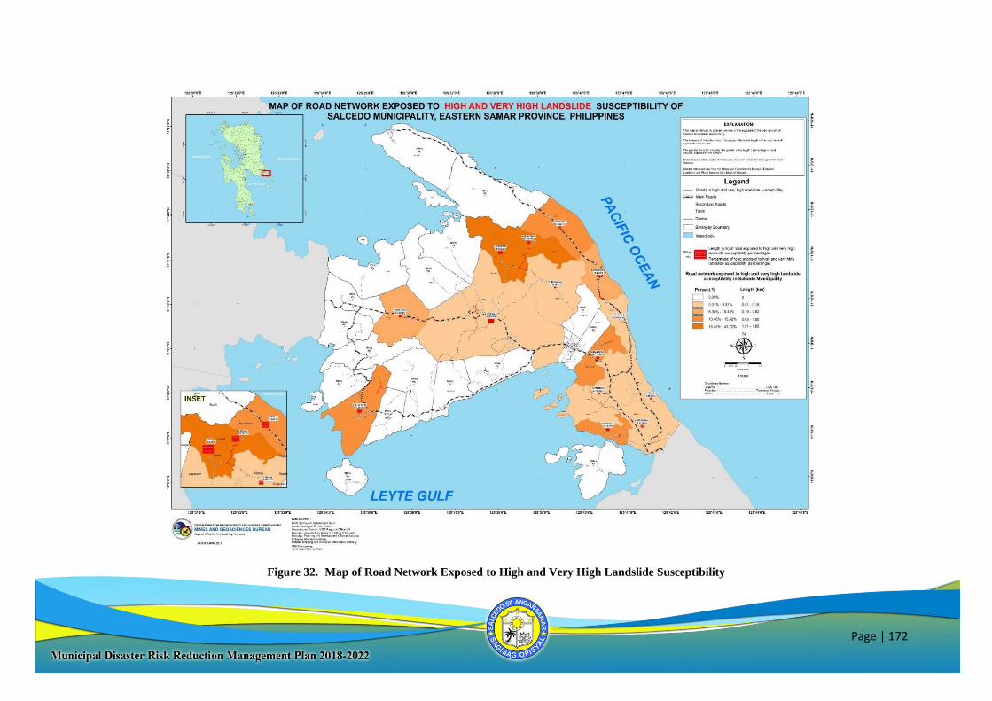
Page | 172
Figure 32. Map of Road Network Exposed to High and Very High Landslide Susceptibility
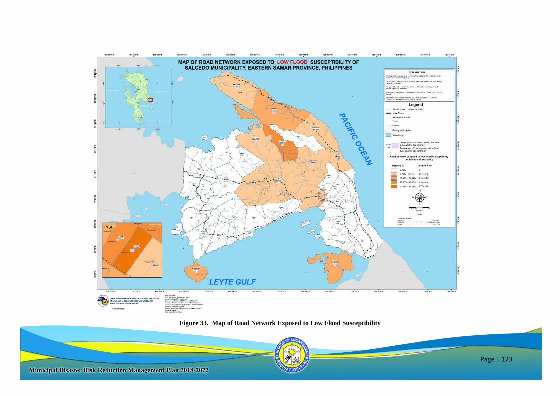
Page | 173
Figure 33. Map of Road Network Exposed to Low Flood Susceptibility
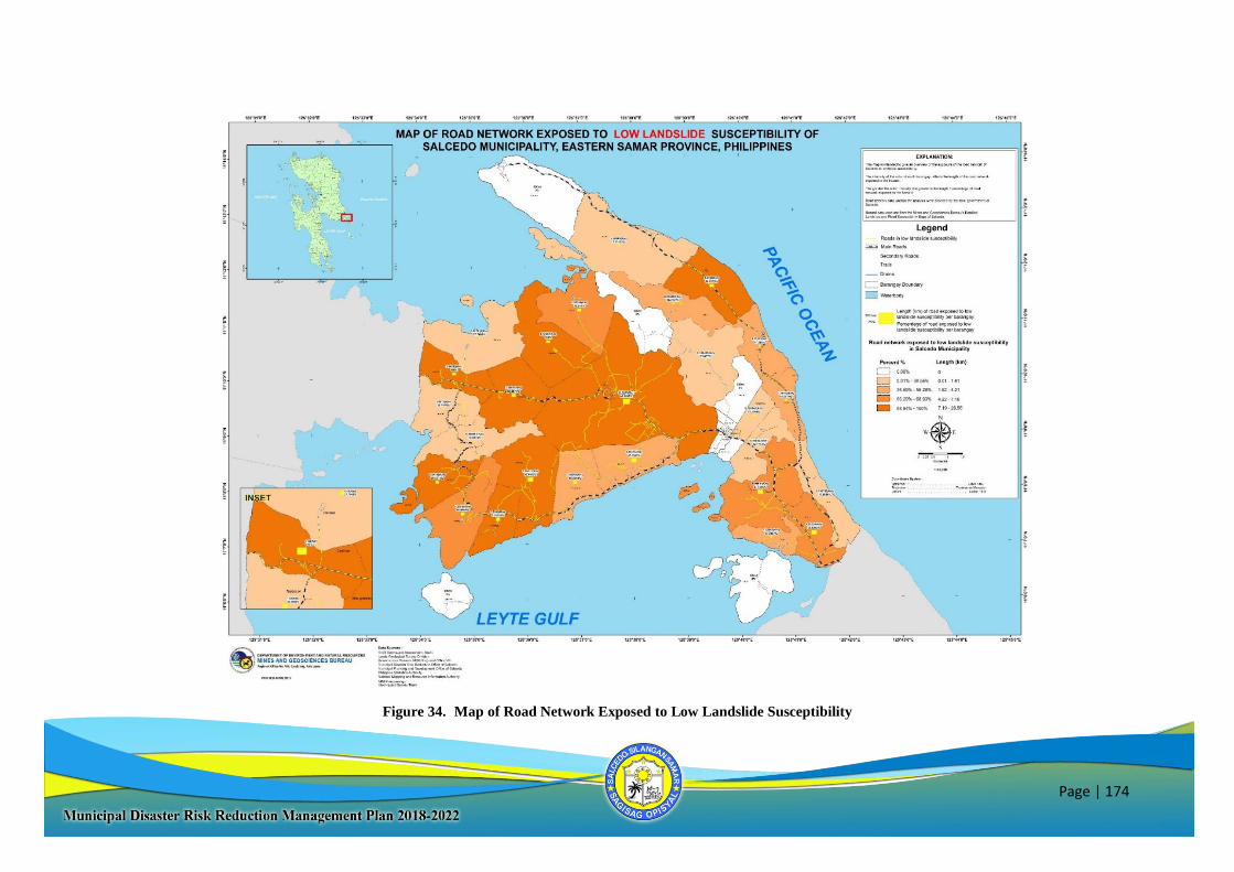
Page | 174
Figure 34. Map of Road Network Exposed to Low Landslide Susceptibility
Page | 175
Figure 35. Map of Road Network Exposed to Moderate Flood Susceptibility
Page | 176
Figure 36. Map of Road Network Exposed to Moderate Landslide Susceptibility
Page | 177
Figure 37. Detailed Landslide and Flood Hazard Map
Page | 178
PREVENTION AND MITIGATION
SWOC AREAS STRENGTH WEAKNESSES OPPORTUNITIES CHALLENGES
MANAGEMENT
- Supportive LCE and active
LGU employees and staff
-Functional MDRRMC
- Lack of LGU regular
manpower to manage all
DRR-CCA programs
- Inadequate staffing; No
permanent position for Solid
Waste Management (SWM)
Officer
- Availability of aligned
national programs in the area
- Capacity building support
from national government and
other partners
- Change of
administration/leadership that
might affect commitment to
the programs
IMPLEMENTATION
- Updated and complementary
LGU plans (DRRMH Plan,
LCCAP, CLUP, CDP, etc.)
- Updated Environmental
policies
- Approved and budget-
allocated DRR-CCA plans
- Inadequate database as
inputs for planning and
mainstreaming DRR-CCA
in some sector (agriculture)
- No personnel trained on
Infrastructure Audit
- Lack of proper training for
staff on SWM
- Availability of NGAs &
NGOs implementing DRR-CCA
programs
- Unfavorable weather
conditions
- Conflict of time among
implementers
- Unavailability of resources
needed for implementation
PARTNERSHIP
BUILDING/
LINKAGING
- Positive collaboration among
departments in implementing
PPAs (complementation of
available manpower and other
available resources as a means
of support)
- Conflict of schedule and
priorities among offices
involved in the
implementation of PPAs
- Strong engagement and
partnership with academe,
NGAs, NGOs, CSOs and POs
- Lack of full commitment of
NGO partners to completely
deliver the outputs of the
programs and projects
conducted/implemented
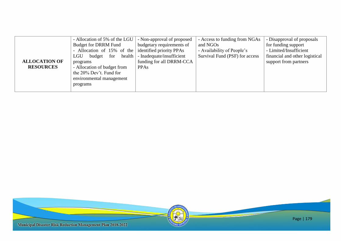
Page | 179
ALLOCATION OF
RESOURCES
- Allocation of 5% of the LGU Budget for DRRM Fund
- Allocation of 15% of the
LGU budget for health
programs
- Allocation of budget from
the 20% Dev’t. Fund for
environmental management
programs
- Non-approval of proposed budgetary requirements of
identified priority PPAs
- Inadequate/insufficient
funding for all DRRM-CCA
PPAs
- Access to funding from NGAs and NGOs
- Availability of People’s
Survival Fund (PSF) for access
- Disapproval of proposals for funding support
- Limited/Insufficient
financial and other logistical
support from partners
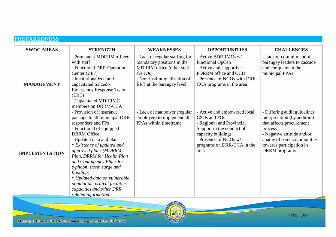
Page | 180
PREPAREDNESS
SWOC AREAS STRENGTH WEAKNESSES OPPORTUNITIES CHALLENGES
MANAGEMENT
- Permanent MDRRM officer
with staff
- Functional DRR Operation
Center (24/7)
- Institutionalized and
capacitated Salcedo
Emergency Response Team
(ERT)
- Capacitated MDRRMC
members on DRRM-CCA
- Lack of regular staffing for
mandatory positions in the
MDRRM office (other staff
are JOs)
- Non-institutionalization of
ERT at the barangay level
- Active BDRRMCs w/
functional OpCen
- Active and supportive
PDRRM office and OCD
- Presence of NGOs with DRR-
CCA programs in the area
- Lack of commitment of
barangay leaders to cascade
and complement the
municipal PPAs
IMPLEMENTATION
- Provision of insurance
package to all municipal DRR
responders and FPs
- Functional of equipped
DRRM Office
- Updated data and plans
* Existence of updated and
approved plans (MDRRM
Plan, DRRM for Health Plan
and Contingency Plans for
typhoon, storm surge and
flooding)
* Updated data on vulnerable
population, critical facilities,
capacities and other DRR
related information
- Lack of manpower (regular
employee) to implement all
PPAs within timeframe
- Active and empowered local
CSOs and POs
- Regional and Provincial
Support in the conduct of
capacity buildings
- Presence of NGOs w/
programs on DRR-CCA in the
area
- Differing audit guidelines
interpretation (by auditors)
that affects procurement
process
- Negative attitude and/or
apathy of some communities
towards participation in
DRRM programs
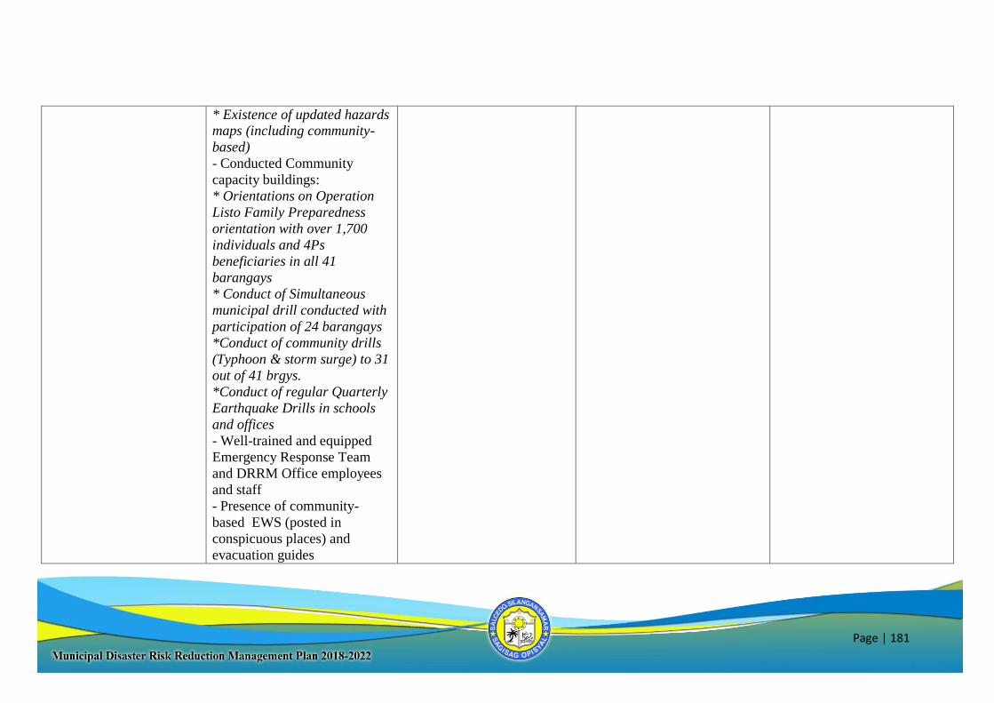
Page | 181
* Existence of updated hazards maps (including community-
based)
- Conducted Community
capacity buildings:
* Orientations on Operation
Listo Family Preparedness
orientation with over 1,700
individuals and 4Ps
beneficiaries in all 41
barangays
* Conduct of Simultaneous
municipal drill conducted with
participation of 24 barangays
*Conduct of community drills
(Typhoon & storm surge) to 31
out of 41 brgys.
*Conduct of regular Quarterly
Earthquake Drills in schools
and offices
- Well-trained and equipped
Emergency Response Team
and DRRM Office employees
and staff
- Presence of community-
based EWS (posted in
conspicuous places) and
evacuation guides
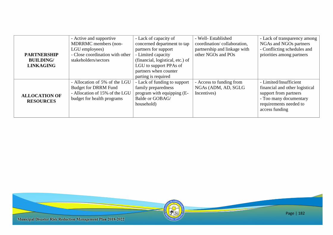
Page | 182
PARTNERSHIP
BUILDING/
LINKAGING
- Active and supportive MDRRMC members (non-
LGU employees)
- Close coordination with other
stakeholders/sectors
- Lack of capacity of concerned department to tap
partners for support
- Limited capacity
(financial, logistical, etc.) of
LGU to support PPAs of
partners when counter
parting is required
- Well- Established coordination/ collaboration,
partnership and linkage with
other NGOs and POs
- Lack of transparency among NGAs and NGOs partners
- Conflicting schedules and
priorities among partners
ALLOCATION OF
RESOURCES
- Allocation of 5% of the LGU
Budget for DRRM Fund
- Allocation of 15% of the LGU
budget for health programs
- Lack of funding to support
family preparedness
program with equipping (E-
Balde or GOBAG/
household)
- Access to funding from
NGAs (ADM, AD, SGLG
Incentives)
- Limited/Insufficient
financial and other logistical
support from partners
- Too many documentary
requirements needed to
access funding
Page | 183
RESPONSE
SWOC AREAS STRENGTH WEAKNESSES OPPORTUNITIES CHALLENGES
MANAGEMENT
- Institutionalized EOC and
ICS
- Available SOPs, community-
based EWS and other response
protocols
- Active LGU officials and
employees
- Trained Health and
Emergency responders on
Disaster and Emergency
Response
- No approved Evacuation
and Camp Management
Plan
- Lack manpower with
proper training on Camp
Management and
Evacuation
- Different level of
commitment on the
members of Teams/Clusters
- Presence of Inter-local Health
Zone
- Available support from regional
and provincial response clusters
- Tendency of other LGUS
to be affected by the same
incident
IMPLEMENTATION
- Availability of updated and
approved Contingency Plan
- Availability of prepositioned
resources for response
operations
- Lack of available
manpower to deliver
services during response
- Lack of disaster-resilient
(ideal) evacuation centers
- Lack of transport (land
and sea) vehicles for
response
- Members of the
Clusters/Teams may also be
affected by disasters
resulting to conflicting
priorities
- Institutionalized and active
Barangay Operations Center
- Availability of memoranda of
agreement (MOA) /
understanding (MOU) with
agencies, organizations and
companies on response related
operations
- Unfavorable weather
conditions that might
impede timely delivery of
services
- Delayed financial
transactions in times of
disasters that may hinder
efficient response
operations
Page | 184
PARTNERSHIP
BUILDING/
LINKAGING
- Existence of memoranda of agreement (MOA) /
understanding (MOU) with
agencies, organizations and
companies on response related
operations
- Lack of capacity of concerned department to
tap partners for support
- Availability of support from agencies at the national, regional
and provincial level that can
augment response operations
- Availability of NGOs and local
CSOs that could
- Lack of transparency among NGAs and NGOs
partners
- Full commitment of
partners on the
agreed/forged MOA/MOU
ALLOCATION OF
RESOURCES
- Allocation of 30% of the 5%
DRRM Fund as QRF
- Allocation of budget from the
15% LGU budget for health
programs for purchase of relief
items and commodities
- Insufficient Calamity
Fund to support the
response plan
-Availability of logistical support
from DSWD, DOH, PDRRMO
and NGO partners
- Unfavorable weather
conditions that might
impede timely delivery of
logistical support
- Delayed financial
transactions in times of
disasters
Page | 185
RECOVERY AND REHABILITATION
SWOC AREAS STRENGTH WEAKNESSES OPPORTUNITIES CHALLENGES
MANAGEMENT
- Presence of trained staff on
the conduct of RDANA &
PDNA
- Availability of LGU
engineers to supervise and
manage rehabilitation projects
- Lack of adequate
personnel trained on
RDANA & PDNA
- Unavailability of trained
PDNA personnel to conduct
the activities
- Lack of manpower at the
MEO
- Personnel from relevant
agencies could be tapped on the
management aspect
- Technical capabilities of
skilled personnel/staff to do
the management and
supervision
IMPLEMENTATION
- Concerned offices have
knowledge of BBB Principle in
the rehabilitation of public infra
& lifelines
- Presence of LGU Engineers
to supervise during
implementation
- Prioritizing counter parting of
KALAHI CIDDS projects in
the area
- Presence of Recovery and
Rehabilitation Plan (integrated
in the CDP)
- Implementation do not
follow based on standards
and specification
- Inadequate technical
person to supervise and
monitor the proper
implementation
- Presence of government infra
support in the rehabilitation and
recovery programs
- Lack of/unavailability of
materials and other
resources to implement
rehabilitation projects
PARTNERSHIP
BUILDING/
LINKAGING
- LGU Membership to the
federation of MDRRMOs in
the province
- Linkage among LGUs within
and outside the province
- Conflict of schedules in
the conduct of RDANA/
PDNA activities
- Lack of commitment of
DRR-CCA partners
- Partnership with Government
agencies, NGOs in funding and
implementing rehabilitation and
recovery programs and projects
- Tendency of some DRR-
CCA partners to prioritize
the PPAs of their respective
agencies
- The need to enhance
convergence of PPAs
among concerned agencies,
Page | 186
NGOs and other stakeholders
ALLOCATION OF
RESOURCES
- With available fund that could be realigned for these purpose
- Fund available thru the 20%
development fund could be
utilized prioritizing
rehabilitation projects
- Too limited funds for rehabilitation and recovery
activities
- Misappropriation of
limited resources
- Lack of capability
(manpower, technical
expertise, etc.) of LGUs to
comply the needed technical
supporting project
documents as requirements
for availing fund
- Existing NGAs, NGOs and Foreign fund sources for
rehabilitation and recovery
- Pooling of fund resources from
Regional and National offices
- Limited/Insufficient financial and other logistical
support from partners
- Too many documentary
requirements needed to
access funding
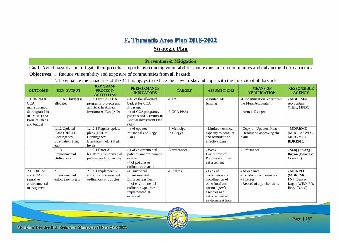
Page | 187
Strategic Plan
Prevention & Mitigation
Goal: Avoid hazards and mitigate their potential impacts by reducing vulnerabilities and exposure of communities and enhancing their capacities
Objectives: 1. Reduce vulnerability and exposure of communities from all hazards
2. To enhance the capacities of the 41 barangays to reduce their own risks and cope with the impacts of all hazards
OUTCOME KEY OUTPUT
PROGRAM/
PROJECT/
ACTIVITIES
PERFORMANCE
INDICATORS TARGET ASSUMPTIONS
MEANS OF
VERIFICATION
RESPONSIBLE
AGENCY
1.1 DRRM & CCA
mainstreamed
& integrated in
the Mun. Devt Policies, plans
and budget
1.1.1 AIP budget is allocated
1.1.1.1 Include CCA programs, projects and
activities in Annual
Investment Plan (AIP)
- % of the allocated budget for CCA
Programs
- # of CCA programs,
projects and activities in Annual Investment Plan
(AIP)
-100%
-5 CCA PPAs
-Limited AIP funding
-Fund utilization report from the Mun. Accountant
- Annual Budget
- MBO (Mun. Accountant
Office, MPDC)
1.1.2 Updated
Plans (DRRM ,
Contingency,
Evacuation Plan, etc)
1.1.2.1 Regular update
plans (DRRM,
Contingency,
Evacuation, etc.) at all levels
- # of updated
Municipal and Brgy.
Plans
-1 Municipal
- 41 Brgys.
- Limited technical
capacity to conduct
and formulate an
effective plan
- Copy of Updated Plans
- Resolution approving the
plans
- MDRRMC
(MHO, MSWDO,
MDRRMO)
BDRRMC
1.1.3 Environmental
Ordinances
1.1.3.1 Enact & legislate environmental
policies and ordinances
- # of environmental policies and ordinances
enacted
-# of policies &
ordinances enacted
-5 ordinances - Weak Environmental
Policies and Law
enforcement
- Ordinances - Sangguniang
Bayan (Barangay
Councils)
2.1 DRRM
and CCA-
sensitive
environmental
management
2.1.1
Environmental
enforcement team
2.1.1.1 Implement &
enforce environmental
ordinances or policies
-# Functional
Environmental
Enforcement Team
-# of environmental
ordinances/policies
implemented & enforced
-10 teams
- Lack of
cooperation and
coordination of
other local and
national gov’t.
agencies and enforcement of
environment laws
- Attendance
- Certificate of Trainings
- Pictures
- Record of apprehensions
- MENRO
(MDRRMO,
PNP, Bantay
Dagat, WEO, PO,
Brgy. Tanod)
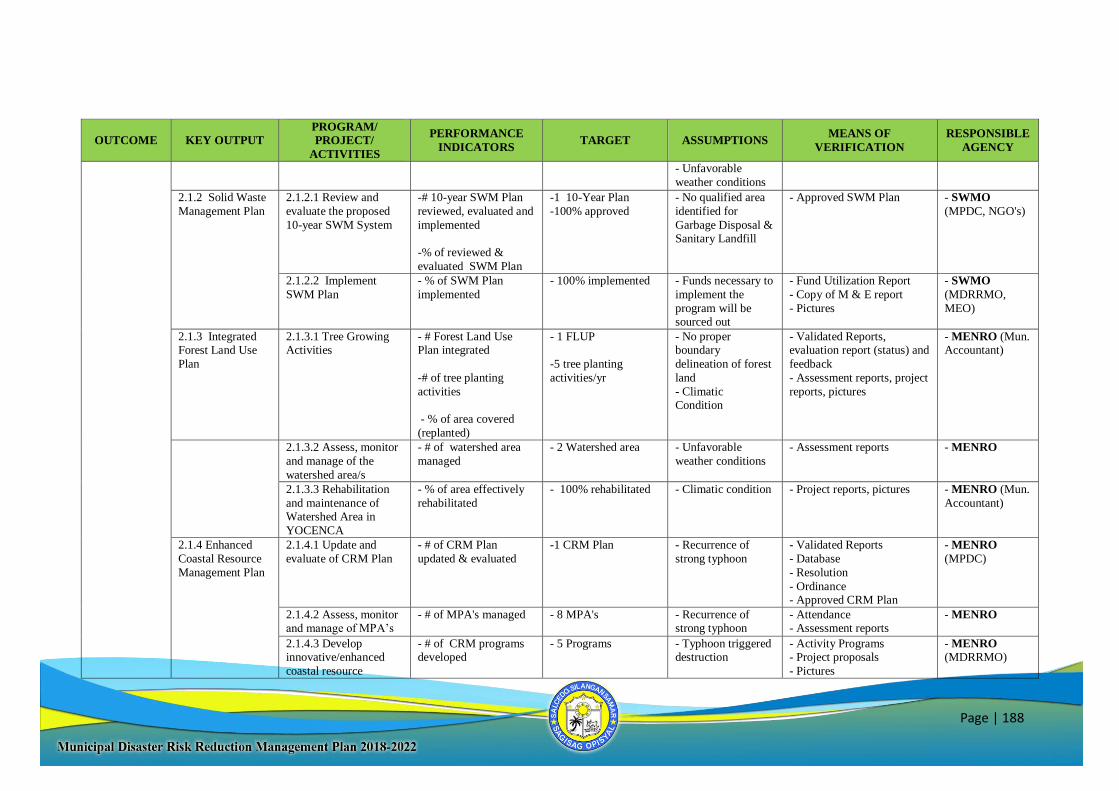
Page | 188
OUTCOME KEY OUTPUT
PROGRAM/
PROJECT/
ACTIVITIES
PERFORMANCE
INDICATORS TARGET ASSUMPTIONS
MEANS OF
VERIFICATION
RESPONSIBLE
AGENCY
- Unfavorable
weather conditions
2.1.2 Solid Waste
Management Plan
2.1.2.1 Review and
evaluate the proposed
10-year SWM System
-# 10-year SWM Plan
reviewed, evaluated and
implemented
-% of reviewed &
evaluated SWM Plan
-1 10-Year Plan
-100% approved
- No qualified area
identified for
Garbage Disposal & Sanitary Landfill
- Approved SWM Plan - SWMO
(MPDC, NGO's)
2.1.2.2 Implement
SWM Plan
- % of SWM Plan
implemented
- 100% implemented - Funds necessary to
implement the
program will be sourced out
- Fund Utilization Report
- Copy of M & E report
- Pictures
- SWMO
(MDRRMO,
MEO)
2.1.3 Integrated Forest Land Use
Plan
2.1.3.1 Tree Growing Activities
- # Forest Land Use Plan integrated
-# of tree planting
activities
- % of area covered
(replanted)
- 1 FLUP
-5 tree planting
activities/yr
- No proper boundary
delineation of forest
land
- Climatic Condition
- Validated Reports, evaluation report (status) and
feedback
- Assessment reports, project
reports, pictures
- MENRO (Mun. Accountant)
2.1.3.2 Assess, monitor
and manage of the
watershed area/s
- # of watershed area
managed
- 2 Watershed area - Unfavorable
weather conditions
- Assessment reports - MENRO
2.1.3.3 Rehabilitation
and maintenance of Watershed Area in
YOCENCA
- % of area effectively
rehabilitated
- 100% rehabilitated - Climatic condition - Project reports, pictures - MENRO (Mun.
Accountant)
2.1.4 Enhanced
Coastal Resource
Management Plan
2.1.4.1 Update and
evaluate of CRM Plan
- # of CRM Plan
updated & evaluated
-1 CRM Plan
- Recurrence of
strong typhoon
- Validated Reports
- Database
- Resolution
- Ordinance - Approved CRM Plan
- MENRO
(MPDC)
2.1.4.2 Assess, monitor and manage of MPA’s
- # of MPA's managed - 8 MPA's - Recurrence of strong typhoon
- Attendance - Assessment reports
- MENRO
2.1.4.3 Develop innovative/enhanced
coastal resource
- # of CRM programs developed
- 5 Programs - Typhoon triggered destruction
- Activity Programs - Project proposals
- Pictures
- MENRO (MDRRMO)
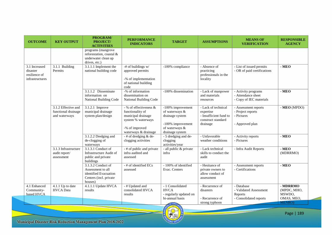
Page | 189
OUTCOME KEY OUTPUT
PROGRAM/
PROJECT/
ACTIVITIES
PERFORMANCE
INDICATORS TARGET ASSUMPTIONS
MEANS OF
VERIFICATION
RESPONSIBLE
AGENCY
programs (mangrove
reforestation, coastal &
underwater clean up drives, etc.)
3.1 Increased disaster
resilience of
infrastructures
3.1.1 Building Permits
3.1.1.1 Implement the national building code
-# of buildings w/ approved permits
-% of implementation
of national building code
-100% compliance - Absence of practicing
professionals in the
locality
- List of issued permits - OR of paid certifications
- MEO
3.1.1.2 Disseminate information on
National Building Code
-% of information dissemination on
National Building Code
-100% dissemination
- Lack of manpower and materials
resources
- Activity programs - Attendance sheet
- Copy of IEC materials
- MEO
3.1.2 Effective and
functional drainage
and waterways
3.1.2.1 Improve
municipal drainage
system plan/design
- % of effectiveness &
functionality of
municipal drainage
system % waterways
-% of improved
waterways & drainage
-100% improvement
of waterways &
drainage system
-100% improvement
of waterways &
drainage system
- Lack of technical
expertise
- Insufficient fund to
construct standard drainage
- Assessment reports
- Project reports
- Pictures
- Approved plan
- MEO (MPDO)
3.1.2.2 Dredging and
de-clogging of
waterways
- # of dredging & de-
clogging activities
- 5 dredging and de-
clogging
activities/year
- Unfavorable
weather conditions
- Activity reports
- Pictures
- MEO
3.1.3 Infrastructure
audit report/ assessment
3.1.3.1 Conduct of
Infrastructure Audit of public and private
buildings
- # of public and private
infra audited and assessed
- all public & private
infra
- Lack technical
skills to conduct the audit
- Infra Audit Reports - MEO
(MDRRMO)
3.1.3.2 Conduct of
Assessment to all
identified Evacuation
Centers (incl. private houses)
- # of identified ECs
assessed
- 100% of identified
Evac. Centers
- Hesitance of
private owners to
allow conduct of
assessment
- Assessment reports
- Certifications - MEO
4.1 Enhanced Community-
based HVCA
4.1.1 Up to date HVCA Data
4.1.1.1 Update HVCA results
- # Updated and consolidated HVCA
results
- 1 Consolidated HVCA
- regularly updated on
bi-annual basis
- Recurrence of disasters
- Recurrence of
strong typhoon
- Database - Validated Assessment
Reports
- Consolidated reports
- MDRRMO (MPDC, MHO,
MSWDO,
OMAS, MEO,
MENRO)
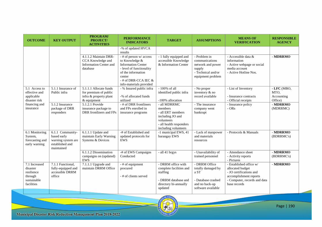
Page | 190
OUTCOME KEY OUTPUT
PROGRAM/
PROJECT/
ACTIVITIES
PERFORMANCE
INDICATORS TARGET ASSUMPTIONS
MEANS OF
VERIFICATION
RESPONSIBLE
AGENCY
-% of updated HVCA
results
4.1.1.2 Maintain DRR-
CCA Knowledge and
Information Center and database
- # of person w/ access
to Knowledge &
Information Center - level of functionality
of the information
center
- # of DRR-CCA IEC & info-materials provided
- 1 fully equipped and
accessible Knowledge
& Information Center
- Problem in
communications
network and power supply
- Technical and/or
equipment problem
- Accessible data &
information
- Active webpage or social media account
- Active Hotline Nos.
- MDRRMO
5.1 Access to effective and
applicable
disaster risk
financing and insurance
5.1.1 Insurance of Public infra
5.1.1.1 Allocate funds for premium of public
infra & property plant
& equipment
- % Insured public infra
-% of allocated funds
utilized
- 100% of all identified public infra
-100% allocation
- No proper inventory & no
record available
- List of Inventory
- Insurance contracts
- Official receipts
- LFC (MBO, MTO,
Accounting
Office)
5.1.2 Insurance
package of DRR
responders
5.1.2.1 Provide
insurance package to
DRR frontliners and FPs
- # of DRR frontliners
and FPs enrolled in
insurance programs
- all MDRRMC
members
- all ERT members including JO and
volunteers
- all health responders
including volunteers
- The insurance
company went
bankrupt
- Insurance policy
- ORs
- MDRRMO
(MDRRMC)
6.1 Monitoring
System, forecasting and
early warning
6.1.1 Community-
based early warning system are
established and
maintained
6.1.1.1 Update and
maintain Early Warning Systems & Devices
-# of Established and
updated protocols for EWS
-1 municipal EWS, 41
barangay EWS
- Lack of manpower
and materials resources
- Protocols & Manuals - MDRRMO
(BDRRMC's)
6.1.1.2 Dissemination
campaigns on (updated)
EWS
-# of EWS Campaigns
Conducted
- all 41 brgys - Unavailability of
trained personnel
- Attendance sheet
- Activity reports
- Pictures
- MDRRMO
(BDRRMC's)
7.1 Increased
disaster resilience
through
sustainable
facilities
7.1.1 Functional,
fully-equipped and accessible DRRM
office
7.1.1.1 Upgrade and
maintain DRRM Office
- # of equipment
procured
- # of clients served
- DRRM office with
complete facilities and staffing
- DRRM database and
directory bi-annually updated
- DRRM Office
totally damaged by a ST
- Database crashed
and no back-up software available
- Established office w/
allocated budget - JO certifications and
accomplishment reports
- Computer, records and data
base records
- MDRRMO
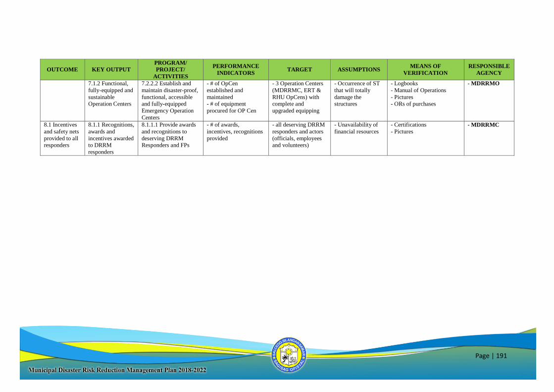
Page | 191
OUTCOME KEY OUTPUT
PROGRAM/
PROJECT/
ACTIVITIES
PERFORMANCE
INDICATORS TARGET ASSUMPTIONS
MEANS OF
VERIFICATION
RESPONSIBLE
AGENCY
7.1.2 Functional,
fully-equipped and
sustainable Operation Centers
7.2.2.2 Establish and
maintain disaster-proof,
functional, accessible and fully-equipped
Emergency Operation
Centers
- # of OpCen
established and
maintained - # of equipment
procured for OP Cen
- 3 Operation Centers
(MDRRMC, ERT &
RHU OpCens) with complete and
upgraded equipping
- Occurrence of ST
that will totally
damage the structures
- Logbooks
- Manual of Operations
- Pictures - ORs of purchases
- MDRRMO
8.1 Incentives
and safety nets
provided to all responders
8.1.1 Recognitions,
awards and
incentives awarded to DRRM
responders
8.1.1.1 Provide awards
and recognitions to
deserving DRRM Responders and FPs
- # of awards,
incentives, recognitions
provided
- all deserving DRRM
responders and actors
(officials, employees and volunteers)
- Unavailability of
financial resources
- Certifications
- Pictures - MDRRMC
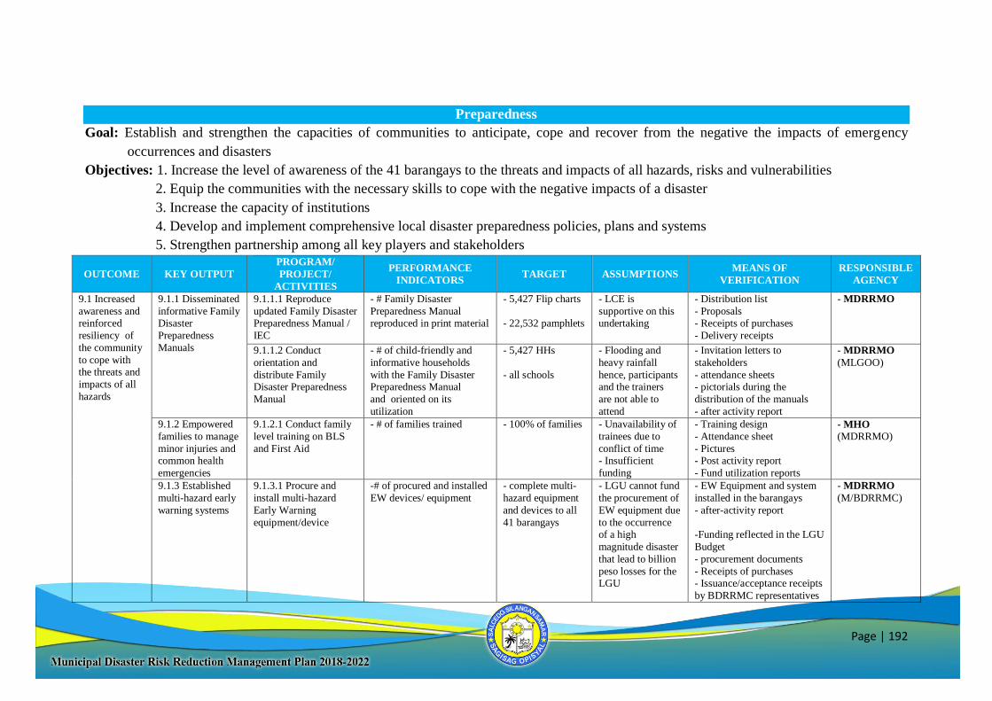
Page | 192
Preparedness
Goal: Establish and strengthen the capacities of communities to anticipate, cope and recover from the negative the impacts of emergency
occurrences and disasters
Objectives: 1. Increase the level of awareness of the 41 barangays to the threats and impacts of all hazards, risks and vulnerabilities
2. Equip the communities with the necessary skills to cope with the negative impacts of a disaster
3. Increase the capacity of institutions
4. Develop and implement comprehensive local disaster preparedness policies, plans and systems
5. Strengthen partnership among all key players and stakeholders
OUTCOME KEY OUTPUT
PROGRAM/
PROJECT/
ACTIVITIES
PERFORMANCE
INDICATORS TARGET ASSUMPTIONS
MEANS OF
VERIFICATION
RESPONSIBLE
AGENCY
9.1 Increased
awareness and
reinforced
resiliency of
the community
to cope with the threats and
impacts of all
hazards
9.1.1 Disseminated
informative Family
Disaster
Preparedness
Manuals
9.1.1.1 Reproduce
updated Family Disaster
Preparedness Manual /
IEC
- # Family Disaster
Preparedness Manual
reproduced in print material
- 5,427 Flip charts
- 22,532 pamphlets
- LCE is
supportive on this
undertaking
- Distribution list
- Proposals
- Receipts of purchases
- Delivery receipts
- MDRRMO
9.1.1.2 Conduct
orientation and
distribute Family Disaster Preparedness
Manual
- # of child-friendly and
informative households
with the Family Disaster Preparedness Manual
and oriented on its
utilization
- 5,427 HHs
- all schools
- Flooding and
heavy rainfall
hence, participants and the trainers
are not able to
attend
- Invitation letters to
stakeholders
- attendance sheets - pictorials during the
distribution of the manuals
- after activity report
- MDRRMO
(MLGOO)
9.1.2 Empowered
families to manage
minor injuries and common health
emergencies
9.1.2.1 Conduct family
level training on BLS
and First Aid
- # of families trained - 100% of families - Unavailability of
trainees due to
conflict of time - Insufficient
funding
- Training design
- Attendance sheet
- Pictures - Post activity report
- Fund utilization reports
- MHO
(MDRRMO)
9.1.3 Established
multi-hazard early
warning systems
9.1.3.1 Procure and
install multi-hazard
Early Warning
equipment/device
-# of procured and installed
EW devices/ equipment
- complete multi-
hazard equipment
and devices to all
41 barangays
- LGU cannot fund
the procurement of
EW equipment due
to the occurrence of a high
magnitude disaster
that lead to billion
peso losses for the LGU
- EW Equipment and system
installed in the barangays
- after-activity report
-Funding reflected in the LGU
Budget
- procurement documents
- Receipts of purchases - Issuance/acceptance receipts
by BDRRMC representatives
- MDRRMO
(M/BDRRMC)
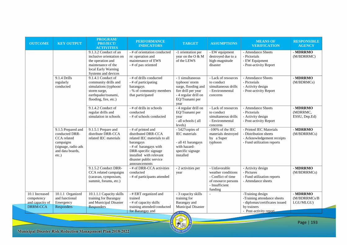
Page | 193
OUTCOME KEY OUTPUT
PROGRAM/
PROJECT/
ACTIVITIES
PERFORMANCE
INDICATORS TARGET ASSUMPTIONS
MEANS OF
VERIFICATION
RESPONSIBLE
AGENCY
9.1.3.2 Conduct of an
inclusive orientation on
the operation and maintenance of the
local Early Warning
Systems and devices
- # of orientation conducted
re: operation and
maintenance of EWS - # of pax oriented
-1 orientation per
year on the O & M
of the LEWS
- EW equipment
destroyed due to a
high-magnitude disaster
- Attendance Sheets
- Pictorials
- EW Equipment - Post-activity Report
- MDRRMO
(M/BDRRMC)
9.1.4 Drills
regularly
conducted
9.1.4.1 Conduct of
community drills and
simulations (typhoon/ storm surge,
earthquake/tsunami,
flooding, fire, etc.)
- # of drills conducted
- # of participating
barangays - % of community members
that participated
- 1 simultaneous
typhoon/ storm
surge, flooding and fire drill per year
- 4 regular drill on
EQ/Tsunami per
year
- Lack of resources
to conduct
simultaneous drills - Environmental
concerns
- Attendance Sheets
- Pictorials
- Activity design - Post-activity Report
- MDRRMO
(M/BDRMCs)
9.1.4.2 Conduct of
regular drills and
simulation in schools
- # of drills in schools
conducted
- # of schools conducted
- 4 regular drill on
EQ/Tsunami per
year
- all schools ( all
levels)
- Lack of resources
to conduct
simultaneous drills
- Environmental
concerns
- Attendance Sheets
- Pictorials
- Activity design
- Post-activity Report
- MDRRMO
(MDRRMC,
ESSU, Dep.Ed)
9.1.5 Prepared and
conducted DRR-
CCA related campaigns
(signage, radio ads
and data boards,
etc.)
9.1.5.1 Prepare and
distribute DRR-CCA
related IEC materials
- # of printed and
distributed DRR-CCA
related IEC materials to all barangays
- # of barangays with
DRR-specific signage
installed with relevant disaster public service
announcements
- 5427copies of
IEC materials
- all 41 barangays
with hazard-
specific signage
installed
-100% of the IEC
materials destroyed
by a Super typhoon
- Printed IEC Materials
- Distribution sheets
- Acknowledgement receipts - Fund utilization reports
- MDRRMO
(M/BDRRMCs)
9.1.5.2 Conduct DRR-
CCA related campaigns
(caravan, symposium,
summit, forums, etc.)
- # of DRR-CCA activities
conducted
- # of participants attended
- 2 activities per
year
- Unfavorable
weather conditions
- Conflict of time
of resource persons - Insufficient
funding
- Activity design
- Pictures
- Fund utilization reports
- Attendance sheets
- MDRRMO
(M/BDRRMCs)
10.1 Increased
competency
and capacity of
DRRM-CCA
10.1.1 Organized
and functional
Emergency
Responders
10.1.1.1 Capacity skills
training for Barangay
and Municipal Disaster
Responders
- # ERT organized and
trained
- # of capacity skills
training attended/conducted for Barangay and
- 3 capacity skills
training for
Barangay and
Municipal Disaster
- -Training design
-Training attendance sheets
- diplomas/certificates issued
by trainers - Post-activity report
- MDRRMO
(M/BDRRMCs/B
LGU/MLGU)
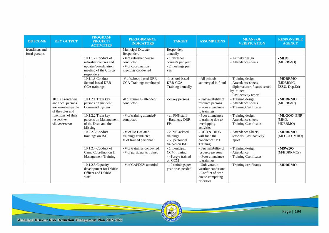
Page | 194
OUTCOME KEY OUTPUT
PROGRAM/
PROJECT/
ACTIVITIES
PERFORMANCE
INDICATORS TARGET ASSUMPTIONS
MEANS OF
VERIFICATION
RESPONSIBLE
AGENCY
frontliners and
focal persons
Municipal Disaster
Responders
Responders
annually
10.1.1.2 Conduct of
refresher courses and
updates/coordination meeting of the Cluster
responders
- # of refresher course
conducted
- # of coordination meetings conducted
- 1 refresher
course/s per year
- 2 meetings per year
- Activity design
- Attendance sheets - MHO
(MDRRMO)
10.1.1.3 Conduct
School-based DRR-
CCA trainings
-# of school-based DRR-
CCA Trainings conducted
-1 school-based
DRR-CCA
Training annually
- All schools
submerged in flood
- Training design
- Attendance sheets
- diplomas/certificates issued
by trainers - Post-activity report
- MDRRMO
(MDRRMC,
ESSU, Dep.Ed)
10.1.2 Frontliners and focal persons
are knowledgeable
of the roles and
functions of their respective
offices/sectors
10.1.2.1 Train key persons on Incident
Command System
-# of trainings attended/ conducted
-50 key persons - Unavailability of resource persons
- Poor attendance
to trainings
- Training design - Attendance sheets
- Training Certificates
- MDRRMO (MDRRMC)
10.1.2.2 Train key
persons on Management
of the Dead and the Missing
- # of training attended/
conducted
- all PNP staff
- Barangay DRR
FPs
- Poor attendance
to training due to
overlapping activities
- Training design
- Attendance sheets
- Training Certificates
- MLGOO, PNP
(MHO,
MDRRMO)
10.2.2.3 Conduct trainings on IMT
- # of IMT-related trainings conducted
# of trained personnel
- 2 IMT-related trainings
- 50 personnel
trained on IMT
- OCD & DILG will fund the
conduct of IMT
Training
- Attendance Sheets, Pictorials, Post-Activity
Report
- MDRRMO
(MLGOO, MHO)
10.1.2.4 Conduct of
Camp Coordination &
Management Training
- # of trainings conducted
- # of participants trained
- 1 municipal
CCM training
- 41brgys trained on CCM
- Unavailability of
resource persons
- Poor attendance to trainings
- Training design
- Attendance
- Training Certificates
- MSWDO
(M/BDRRMCs)
10.1.2.5 Capacity development for DRRM
Officer and DRRM
staff
- # of CAPDEV attended - 10 trainings per year or as needed
- Unfavorable weather conditions
- Conflict of time
due to competing
priorities
- Training certificates - MDRRMO
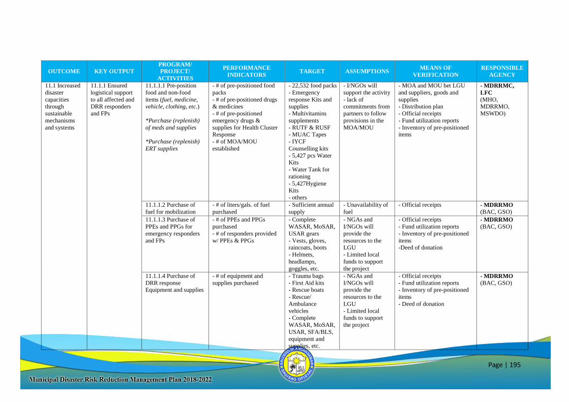
Page | 195
OUTCOME KEY OUTPUT
PROGRAM/
PROJECT/
ACTIVITIES
PERFORMANCE
INDICATORS TARGET ASSUMPTIONS
MEANS OF
VERIFICATION
RESPONSIBLE
AGENCY
11.1 Increased
disaster
capacities through
sustainable
mechanisms
and systems
11.1.1 Ensured
logistical support
to all affected and DRR responders
and FPs
11.1.1.1 Pre-position
food and non-food
items (fuel, medicine, vehicle, clothing, etc.)
*Purchase (replenish)
of meds and supplies
*Purchase (replenish)
ERT supplies
- # of pre-positioned food
packs
- # of pre-positioned drugs & medicines
- # of pre-positioned
emergency drugs &
supplies for Health Cluster Response
- # of MOA/MOU
established
- 22,532 food packs
- Emergency
response Kits and supplies
- Multivitamins
supplements
- RUTF & RUSF - MUAC Tapes
- IYCF
Counselling kits
- 5,427 pcs Water Kits
- Water Tank for
rationing
- 5,427Hygiene
Kits
- others
- I/NGOs will
support the activity
- lack of commitments from
partners to follow
provisions in the
MOA/MOU
- MOA and MOU bet LGU
and suppliers, goods and
supplies - Distribution plan
- Official receipts
- Fund utilization reports
- Inventory of pre-positioned items
- MDRRMC,
LFC
(MHO, MDRRMO,
MSWDO)
11.1.1.2 Purchase of
fuel for mobilization
- # of liters/gals. of fuel
purchased
- Sufficient annual
supply
- Unavailability of
fuel
- Official receipts - MDRRMO
(BAC, GSO)
11.1.1.3 Purchase of
PPEs and PPGs for
emergency responders
and FPs
- # of PPEs and PPGs
purchased
- # of responders provided
w/ PPEs & PPGs
- Complete
WASAR, MoSAR,
USAR gears
- Vests, gloves, raincoats, boots
- Helmets,
headlamps,
goggles, etc.
- NGAs and
I/NGOs will
provide the
resources to the LGU
- Limited local
funds to support
the project
- Official receipts
- Fund utilization reports
- Inventory of pre-positioned
items -Deed of donation
- MDRRMO
(BAC, GSO)
11.1.1.4 Purchase of
DRR response Equipment and supplies
- # of equipment and
supplies purchased
- Trauma bags
- First Aid kits - Rescue boats
- Rescue/
Ambulance
vehicles - Complete
WASAR, MoSAR,
USAR, SFA/BLS,
equipment and supplies, etc.
- NGAs and
I/NGOs will provide the
resources to the
LGU
- Limited local funds to support
the project
- Official receipts
- Fund utilization reports - Inventory of pre-positioned
items
- Deed of donation
- MDRRMO
(BAC, GSO)
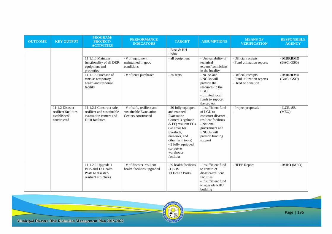
Page | 196
OUTCOME KEY OUTPUT
PROGRAM/
PROJECT/
ACTIVITIES
PERFORMANCE
INDICATORS TARGET ASSUMPTIONS
MEANS OF
VERIFICATION
RESPONSIBLE
AGENCY
- Base & HH
Radio
11.1.1.5 Maintain
functionality of all DRR
equipment and properties
- # of equipment
maintained in good
conditions
- all equipment - Unavailability of
technical
experts/technicians in the locality
- Official receipts
- Fund utilization reports
- MDRRMO
(BAC, GSO)
11.1.1.6 Purchase of tents as temporary
health and response
facility
- # of tents purchased - 25 tents - NGAs and I/NGOs will
provide the
resources to the
LGU - Limited local
funds to support
the project
- Official receipts - Fund utilization reports
- Deed of donation
- MDRRMO (BAC, GSO)
11.1.2 Disaster-
resilient facilities
established/ constructed
11.1.2.1 Construct safe,
resilient and sustainable
evacuation centers and DRR facilities
- # of safe, resilient and
sustainable Evacuation
Centers constructed
- 20 fully equipped
and manned
Evacuation Centers 3 typhoon
& EQ resilient ECs
(w/ areas for
livestock, nurseries, and
other farm tools)
- 2 fully equipped
storage & warehouse
facilities
- Insufficient fund
of LGU to
construct disaster-resilient facilities
- National
government and
I/NGOs will provide funding
support
- Project proposals
-
- LCE, SB
(MEO)
11.1.2.2 Upgrade 1
BHS and 13 Health
Posts to disaster-resilient structures
- # of disaster-resilient
health facilities upgraded
-29 health facilities
-1 BHS
13 Health Posts
- Insufficient fund
to construct
disaster-resilient facilities
- Insufficient fund
to upgrade RHU
building
- HFEP Report - MHO (MEO)
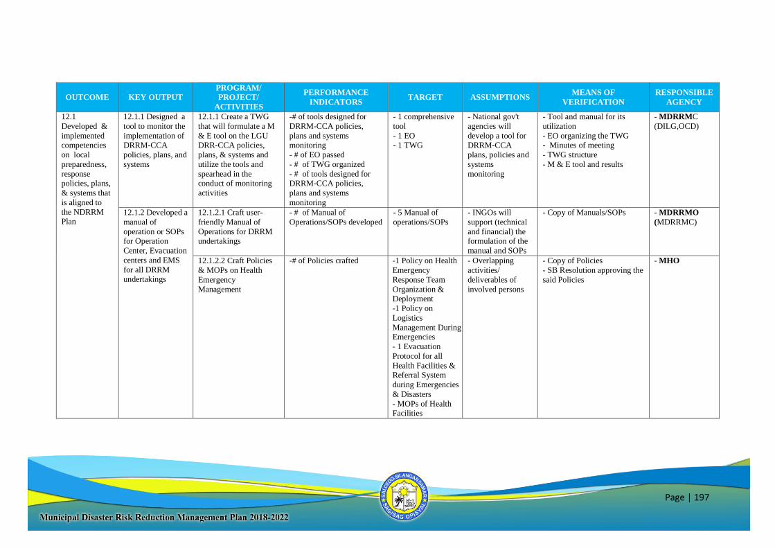
Page | 197
OUTCOME KEY OUTPUT
PROGRAM/
PROJECT/
ACTIVITIES
PERFORMANCE
INDICATORS TARGET ASSUMPTIONS
MEANS OF
VERIFICATION
RESPONSIBLE
AGENCY
12.1
Developed &
implemented competencies
on local
preparedness,
response policies, plans,
& systems that
is aligned to
the NDRRM Plan
12.1.1 Designed a
tool to monitor the
implementation of DRRM-CCA
policies, plans, and
systems
12.1.1 Create a TWG
that will formulate a M
& E tool on the LGU DRR-CCA policies,
plans, & systems and
utilize the tools and
spearhead in the conduct of monitoring
activities
-# of tools designed for
DRRM-CCA policies,
plans and systems monitoring
- # of EO passed
- # of TWG organized
- # of tools designed for DRRM-CCA policies,
plans and systems
monitoring
- 1 comprehensive
tool
- 1 EO - 1 TWG
- National gov't
agencies will
develop a tool for DRRM-CCA
plans, policies and
systems
monitoring
- Tool and manual for its
utilization
- EO organizing the TWG - Minutes of meeting
- TWG structure
- M & E tool and results
- MDRRMC
(DILG,OCD)
12.1.2 Developed a
manual of
operation or SOPs for Operation
Center, Evacuation
centers and EMS
for all DRRM undertakings
12.1.2.1 Craft user-
friendly Manual of
Operations for DRRM undertakings
- # of Manual of
Operations/SOPs developed
- 5 Manual of
operations/SOPs
- INGOs will
support (technical
and financial) the formulation of the
manual and SOPs
- Copy of Manuals/SOPs
- MDRRMO
(MDRRMC)
12.1.2.2 Craft Policies
& MOPs on Health
Emergency
Management
-# of Policies crafted -1 Policy on Health
Emergency
Response Team
Organization & Deployment
-1 Policy on
Logistics
Management During Emergencies
- 1 Evacuation
Protocol for all
Health Facilities & Referral System
during Emergencies
& Disasters
- MOPs of Health Facilities
- Overlapping
activities/
deliverables of
involved persons
- Copy of Policies
- SB Resolution approving the
said Policies
- MHO
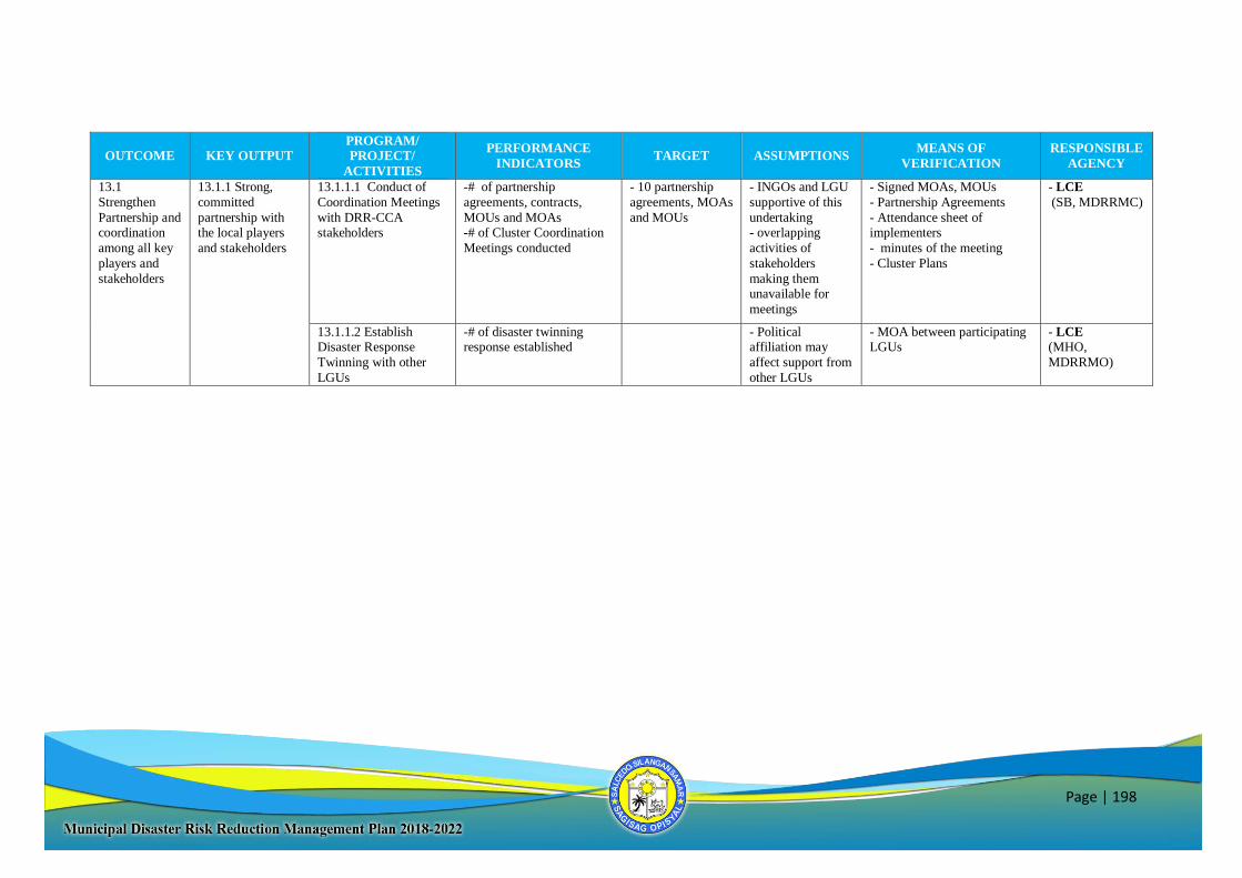
Page | 198
OUTCOME KEY OUTPUT
PROGRAM/
PROJECT/
ACTIVITIES
PERFORMANCE
INDICATORS TARGET ASSUMPTIONS
MEANS OF
VERIFICATION
RESPONSIBLE
AGENCY
13.1
Strengthen
Partnership and coordination
among all key
players and
stakeholders
13.1.1 Strong,
committed
partnership with the local players
and stakeholders
13.1.1.1 Conduct of
Coordination Meetings
with DRR-CCA stakeholders
-# of partnership
agreements, contracts,
MOUs and MOAs -# of Cluster Coordination
Meetings conducted
- 10 partnership
agreements, MOAs
and MOUs
- INGOs and LGU
supportive of this
undertaking - overlapping
activities of
stakeholders
making them unavailable for
meetings
- Signed MOAs, MOUs
- Partnership Agreements
- Attendance sheet of implementers
- minutes of the meeting
- Cluster Plans
- LCE
(SB, MDRRMC)
13.1.1.2 Establish Disaster Response
Twinning with other
LGUs
-# of disaster twinning response established
- Political affiliation may
affect support from
other LGUs
- MOA between participating LGUs
- LCE (MHO,
MDRRMO)
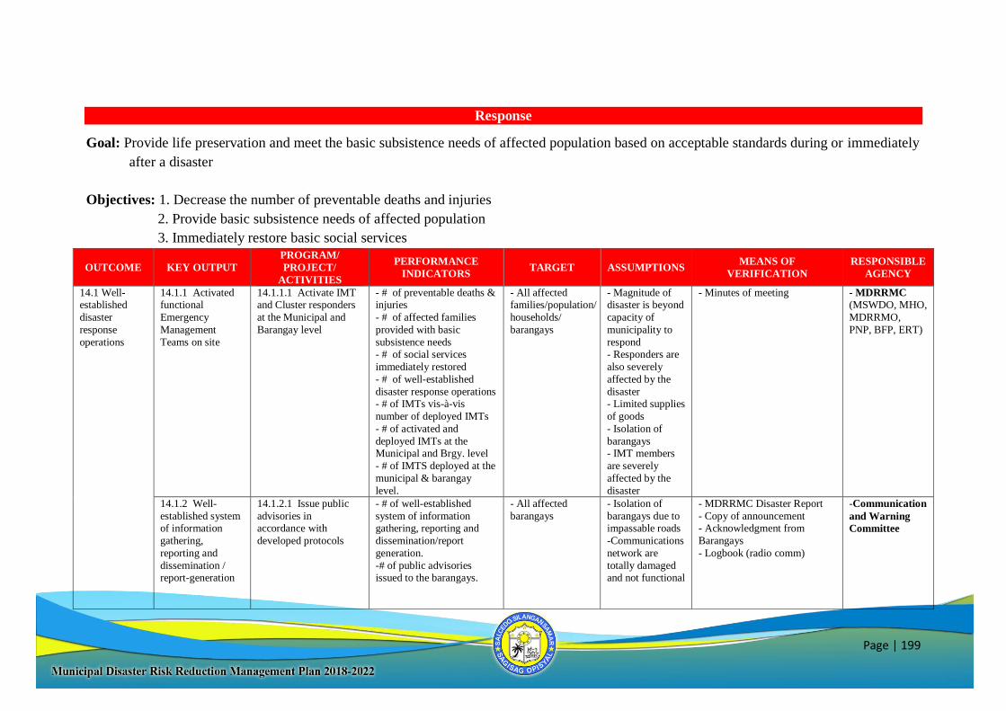
Page | 199
Response
Goal: Provide life preservation and meet the basic subsistence needs of affected population based on acceptable standards during or immediately
after a disaster
Objectives: 1. Decrease the number of preventable deaths and injuries
2. Provide basic subsistence needs of affected population
3. Immediately restore basic social services
OUTCOME KEY OUTPUT
PROGRAM/
PROJECT/
ACTIVITIES
PERFORMANCE
INDICATORS TARGET ASSUMPTIONS
MEANS OF
VERIFICATION
RESPONSIBLE
AGENCY
14.1 Well-established
disaster
response
operations
14.1.1 Activated functional
Emergency
Management
Teams on site
14.1.1.1 Activate IMT and Cluster responders
at the Municipal and
Barangay level
- # of preventable deaths & injuries
- # of affected families
provided with basic
subsistence needs - # of social services
immediately restored
- # of well-established
disaster response operations - # of IMTs vis-à-vis
number of deployed IMTs
- # of activated and
deployed IMTs at the Municipal and Brgy. level
- # of IMTS deployed at the
municipal & barangay
level.
- All affected families/population/
households/
barangays
- Magnitude of disaster is beyond
capacity of
municipality to
respond - Responders are
also severely
affected by the
disaster - Limited supplies
of goods
- Isolation of
barangays - IMT members
are severely
affected by the
disaster
- Minutes of meeting
- MDRRMC
(MSWDO, MHO,
MDRRMO,
PNP, BFP, ERT)
14.1.2 Well-
established system
of information
gathering,
reporting and
dissemination / report-generation
14.1.2.1 Issue public
advisories in
accordance with
developed protocols
- # of well-established
system of information
gathering, reporting and
dissemination/report
generation.
-# of public advisories issued to the barangays.
- All affected
barangays
- Isolation of
barangays due to
impassable roads
-Communications
network are
totally damaged and not functional
- MDRRMC Disaster Report
- Copy of announcement
- Acknowledgment from
Barangays
- Logbook (radio comm)
-Communication
and Warning
Committee
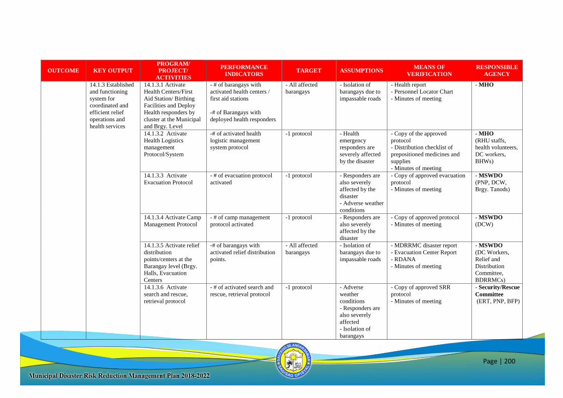
Page | 200
OUTCOME KEY OUTPUT
PROGRAM/
PROJECT/
ACTIVITIES
PERFORMANCE
INDICATORS TARGET ASSUMPTIONS
MEANS OF
VERIFICATION
RESPONSIBLE
AGENCY
14.1.3 Established
and functioning
system for coordinated and
efficient relief
operations and
health services
14.1.3.1 Activate
Health Centers/First
Aid Station/ Birthing Facilities and Deploy
Health responders by
cluster at the Municipal
and Brgy. Level
- # of barangays with
activated health centers /
first aid stations
-# of Barangays with
deployed health responders
- All affected
barangays
- Isolation of
barangays due to
impassable roads
- Health report
- Personnel Locator Chart
- Minutes of meeting
- MHO
14.1.3.2 Activate
Health Logistics management
Protocol/System
-# of activated health
logistic management system protocol
-1 protocol - Health
emergency responders are
severely affected
by the disaster
- Copy of the approved
protocol - Distribution checklist of
prepositioned medicines and
supplies
- Minutes of meeting
- MHO
(RHU staffs, health volunteers,
DC workers,
BHWs)
14.1.3.3 Activate
Evacuation Protocol
- # of evacuation protocol
activated
-1 protocol
- Responders are
also severely
affected by the
disaster
- Adverse weather
conditions
- Copy of approved evacuation
protocol
- Minutes of meeting
- MSWDO
(PNP, DCW,
Brgy. Tanods)
14.1.3.4 Activate Camp
Management Protocol
- # of camp management
protocol activated
-1 protocol
- Responders are
also severely affected by the
disaster
- Copy of approved protocol
- Minutes of meeting
- MSWDO
(DCW)
14.1.3.5 Activate relief
distribution
points/centers at the
Barangay level (Brgy. Halls, Evacuation
Centers
-# of barangays with
activated relief distribution
points.
- All affected
barangays
- Isolation of
barangays due to
impassable roads
- MDRRMC disaster report
- Evacuation Center Report
- RDANA
- Minutes of meeting
- MSWDO
(DC Workers,
Relief and
Distribution Committee,
BDRRMCs)
14.1.3.6 Activate
search and rescue,
retrieval protocol
- # of activated search and
rescue, retrieval protocol
-1 protocol - Adverse
weather
conditions
- Responders are also severely
affected
- Isolation of
barangays
- Copy of approved SRR
protocol
- Minutes of meeting
- Security/Rescue
Committee
(ERT, PNP, BFP)
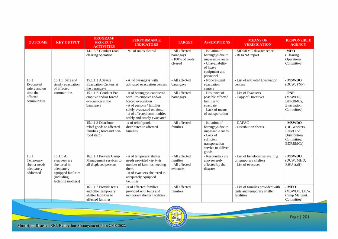
Page | 201
OUTCOME KEY OUTPUT
PROGRAM/
PROJECT/
ACTIVITIES
PERFORMANCE
INDICATORS TARGET ASSUMPTIONS
MEANS OF
VERIFICATION
RESPONSIBLE
AGENCY
14.1.3.7 Conduct road
clearing operation
- % of roads cleared - All affected
barangays
- 100% of roads cleared
- Isolation of
barangays due to
impassable roads - Unavailability
of heavy
equipment and
personnel
- MDRRMC disaster report
- RDANA report
-MEO (Clearing
Operations Committee)
15.1
Evacuated safely and on
time the
affected
communities
15.1.1 Safe and
timely evacuation of affected
communities
15.1.1.1 Activate
Evacuation Centers at the barangays
- # of barangays with
activated evacuation centers
- All affected
barangays
- Non-resilient
evacuation centers
- List of activated Evacuation
centers
- MSWDO
(DCW, PNP)
15.1.1.2 Conduct Pre-emptive and/or forced
evacuation at the
barangays
- # of barangays conducted with Pre-emptive and/or
forced evacuation
- # of persons / families
safely evacuated on-time.
- # of affected communities
safely and timely evacuated
- All affected barangays
- Hesitance of possible affected
families to
evacuate
- Lack of means
of transportation
- List of Evacuees - Copy of Directives
- PNP
(MSWDO,
BDRRMCs,
Evacuation
Committee)
15.1.1.3 Distribute
relief goods to affected families ( food and non-
food item)
-# of relief goods
distributed to affected families
- All affected
families
- Isolation of
barangays due to impassable roads
- Lack of
sufficient
transportation service to deliver
goods
- DAFAC
- Distribution sheets
- MSWDO
(DC Workers, Relief and
Distribution
Committee,
BDRRMCs)
16.1
Temporary
shelter needs
adequately addressed
16.1.1 All
evacuees are
sheltered in
adequately equipped facilities
(including
lactating mothers)
16.1.1.1 Provide Camp
Management services to
all displaced persons
- # of temporary shelter
needs provided vis-à-vis
number of families needing
them. - # of evacuees sheltered in
adequately equipped
facilities
- All affected
families
- All affected
evacuees
- Responders are
also severely
affected by the
disaster
- List of beneficiaries availing
of temporary shelters
- List of evacuees
- MSWDO
(DCW, MHO,
RHU staff)
16.1.1.2 Provide tents
and other temporary shelter facilities to
affected families
-# of affected families
provided with tents and temporary shelter facilities
- All affected
families
- List of families provided with
tents and temporary shelter facilities
- MEO
(MSWDO, DCW, Camp Mangmt.
Committee)
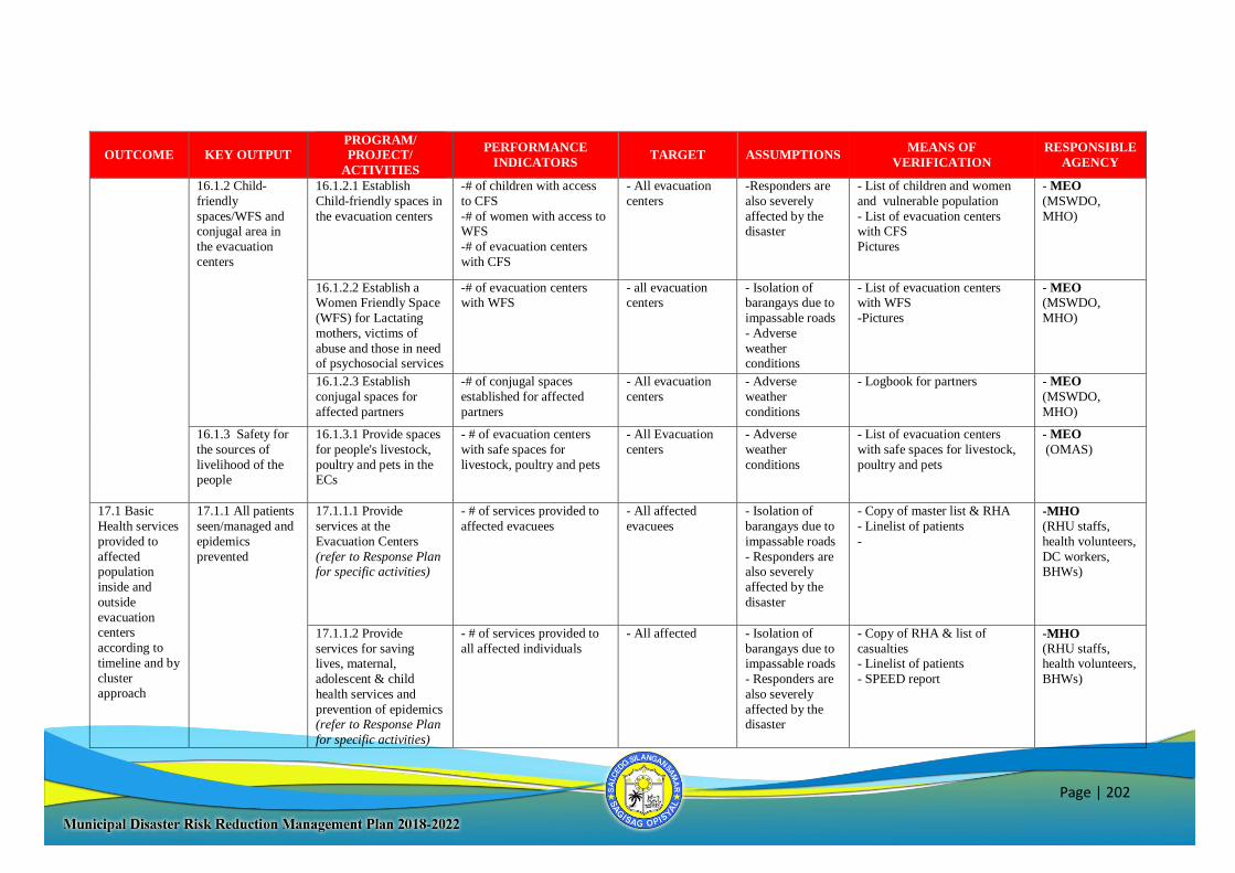
Page | 202
OUTCOME KEY OUTPUT
PROGRAM/
PROJECT/
ACTIVITIES
PERFORMANCE
INDICATORS TARGET ASSUMPTIONS
MEANS OF
VERIFICATION
RESPONSIBLE
AGENCY
16.1.2 Child-
friendly
spaces/WFS and conjugal area in
the evacuation
centers
16.1.2.1 Establish
Child-friendly spaces in
the evacuation centers
-# of children with access
to CFS
-# of women with access to WFS
-# of evacuation centers
with CFS
- All evacuation
centers
-Responders are
also severely
affected by the disaster
- List of children and women
and vulnerable population
- List of evacuation centers with CFS
Pictures
- MEO
(MSWDO,
MHO)
16.1.2.2 Establish a Women Friendly Space
(WFS) for Lactating
mothers, victims of
abuse and those in need of psychosocial services
-# of evacuation centers with WFS
- all evacuation centers
- Isolation of barangays due to
impassable roads
- Adverse
weather conditions
- List of evacuation centers with WFS
-Pictures
- MEO
(MSWDO,
MHO)
16.1.2.3 Establish
conjugal spaces for
affected partners
-# of conjugal spaces
established for affected
partners
- All evacuation
centers
- Adverse
weather
conditions
- Logbook for partners - MEO
(MSWDO,
MHO)
16.1.3 Safety for
the sources of
livelihood of the people
16.1.3.1 Provide spaces
for people's livestock,
poultry and pets in the ECs
- # of evacuation centers
with safe spaces for
livestock, poultry and pets
- All Evacuation
centers
- Adverse
weather
conditions
- List of evacuation centers
with safe spaces for livestock,
poultry and pets
- MEO
(OMAS)
17.1 Basic
Health services
provided to
affected population
inside and
outside
evacuation centers
according to
timeline and by
cluster approach
17.1.1 All patients
seen/managed and
epidemics
prevented
17.1.1.1 Provide
services at the
Evacuation Centers
(refer to Response Plan for specific activities)
- # of services provided to
affected evacuees
- All affected
evacuees
- Isolation of
barangays due to
impassable roads
- Responders are also severely
affected by the
disaster
- Copy of master list & RHA
- Linelist of patients
-
-MHO
(RHU staffs,
health volunteers,
DC workers, BHWs)
17.1.1.2 Provide
services for saving lives, maternal,
adolescent & child
health services and
prevention of epidemics (refer to Response Plan
for specific activities)
- # of services provided to
all affected individuals
- All affected - Isolation of
barangays due to impassable roads
- Responders are
also severely
affected by the disaster
- Copy of RHA & list of
casualties - Linelist of patients
- SPEED report
-MHO
(RHU staffs, health volunteers,
BHWs)
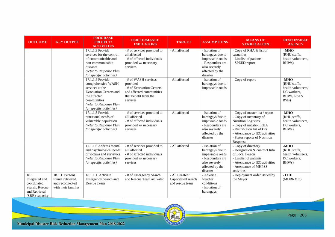
Page | 203
OUTCOME KEY OUTPUT
PROGRAM/
PROJECT/
ACTIVITIES
PERFORMANCE
INDICATORS TARGET ASSUMPTIONS
MEANS OF
VERIFICATION
RESPONSIBLE
AGENCY
17.1.1.3 Provide
services for the control
of communicable and non-communicable
diseases
(refer to Response Plan
for specific activities)
- # of services provided to
all affected
- # of affected individuals provided w/ necessary
services
- All affected - Isolation of
barangays due to
impassable roads - Responders are
also severely
affected by the
disaster
- Copy of RHA & list of
casualties
- Linelist of patients - SPEED report
- MHO
(RHU staffs,
health volunteers, BHWs)
17.1.1.4 Provide
comprehensive WASH services at the
Evacuation Centers and
the affected
communities (refer to Response Plan
for specific activities)
- # of WASH services
provided - # of Evacuation Centers
and affected communities
that benefit from the
services
- All affected - Isolation of
barangays due to impassable roads
- Copy of report -MHO
(RHU staffs, health volunteers,
DC workers,
BHWs, RSI &
BSIs)
17.1.1.5 Provide
nutritional needs of
vulnerable population
(refer to Response Plan for specific activities)
- # of services provided to
all affected
- # of affected individuals
provided w/ necessary services
- All affected - Isolation of
barangays due to
impassable roads
- Responders are also severely
affected by the
disaster
- Copy of master list / report
- Copy of inventory of
Nutrition Logistics
- Copy of nutrition RHA - Distribution list of kits
- Attendance to IEC activities
- Status reports of Nutrition
Response
-MHO
(RHU staffs,
health volunteers,
DC workers, BHWs)
17.1.1.6 Address mental
and psychological needs of victims and survivors
(refer to Response Plan
for specific activities)
- # of services provided to
all affected - # of affected individuals
provided w/ necessary
services
- All affected - Isolation of
barangays due to impassable roads
- Responders are
also severely
affected by the disaster
- Copy of directory
- Designation & contract Info of Focal Person
- Linelist of patients
- Attendance to IEC activities
- Attendance of MHPSS activities
-MHO
(RHU staffs, health volunteers,
DC workers,
BHWs)
18.1 Integrated and
coordinated
Search, Rescue
and Retrieval (SRR) capacity
18.1.1 Persons found, retrieved
and reconnected
with their families
18.1.1.1 Activate Emergency Search and
Rescue Team
- # of Emergency Search and Rescue Team activated
- All Created/ Capacitated search
and rescue team
- Adverse weather
conditions
- Isolation of
barangays
- Deployment order issued by the Mayor
- LCE
(MDRRMO)
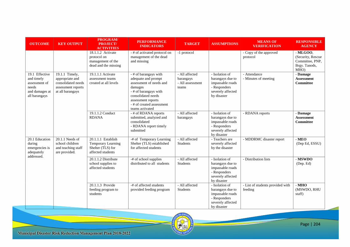
Page | 204
OUTCOME KEY OUTPUT
PROGRAM/
PROJECT/
ACTIVITIES
PERFORMANCE
INDICATORS TARGET ASSUMPTIONS
MEANS OF
VERIFICATION
RESPONSIBLE
AGENCY
18.1.1.2 Activate
protocol on
management of the dead and the missing
- # of activated protocol on
management of the dead
and missing
-1 protocol - Copy of the approved
protocol
- MLGOO,
(Security, Rescue
Committee, PNP, Brgy. Tanods,
MHO)
19.1 Effective
and timely
assessment of
needs and damages at
all barangays
19.1.1 Timely,
appropriate and
consolidated needs
assessment reports at all barangays
19.1.1.1 Activate
assessment teams
created at all levels
- # of barangays with
adequate and prompt
assessment of needs and
damages - # of barangays with
consolidated needs
assessment reports
- # of created assessment teams activated
- All affected
barangays
- All assessment
teams
- Isolation of
barangays due to
impassable roads
- Responders severely affected
by disaster
- Attendance
- Minutes of meeting
- Damage
Assessment
Committee
19.1.1.2 Conduct
RDANA
- # of RDANA reports
submitted, analyzed and
consolidated
- RDANA report timely
submitted
- All affected
barangays
- Isolation of
barangays due to
impassable roads
- Responders
severely affected by disaster
- RDANA reports - Damage
Assessment
Committee
20.1 Education during
emergencies is
adequately
addressed.
20.1.1 Needs of school children
and teaching staff
are provided.
20.1.1.1 Establish Temporary Learning
Shelter (TLS) for
affected students
-# of Temporary Learning Shelter (TLS) established
for affected students
- All affected Students
- Teachers are severely affected
by the disaster
- MDDRMC disaster report - MEO (Dep Ed, ESSU)
20.1.1.2 Distribute
school supplies to
affected students
-# of school supplies
distributed to all students
- All affected
Students
- Isolation of
barangays due to
impassable roads
- Responders severely affected
by disaster
- Distribution lists - MSWDO
(Dep. Ed)
20.1.1.3 Provide
feeding program to
students
-# of affected students
provided feeding program
- All affected
Students
- Isolation of
barangays due to
impassable roads
- Responders severely affected
by disaster
- List of students provided with
feeding
- MHO
(MSWDO, RHU
staff)
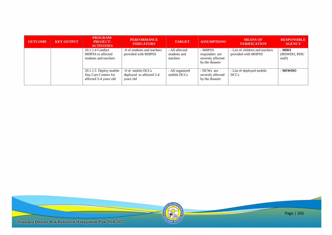
Page | 205
OUTCOME KEY OUTPUT
PROGRAM/
PROJECT/
ACTIVITIES
PERFORMANCE
INDICATORS TARGET ASSUMPTIONS
MEANS OF
VERIFICATION
RESPONSIBLE
AGENCY
20.1.1.4 Conduct
MHPSS to affected
students and teachers
-# of students and teachers
provided with MHPSS
- All affected
students and
teachers
- MHPSS
responders are
severely affected by the disaster
- List of children and teachers
provided with MHPSS
- MHO
(MSWDO, RHU
staff)
20.1.1.5 Deploy mobile
Day Care Centers for
affected 3-4 years old
-# of mobile DCCs
deployed to affected 3-4
years old
- All organized
mobile DCCs
- DCWs are
severely affected
by the disaster
- List of deployed mobile
DCCs
- MSWDO
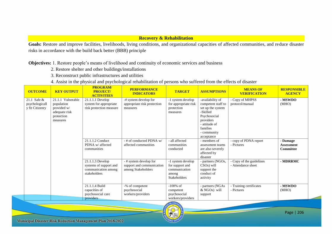
Page | 206
Recovery & Rehabilitation
Goals: Restore and improve facilities, livelihoods, living conditions, and organizational capacities of affected communities, and reduce disaster
risks in accordance with the build back better (BBB) principle
Objectives: 1. Restore people’s means of livelihood and continuity of economic services and business
2. Restore shelter and other buildings/installations
3. Reconstruct public infrastructures and utilities
4. Assist in the physical and psychological rehabilitation of persons who suffered from the effects of disaster
OUTCOME KEY OUTPUT
PROGRAM/
PROJECT/
ACTIVITIES
PERFORMANCE
INDICATORS TARGET ASSUMPTIONS
MEANS OF
VERIFICATION
RESPONSIBLE
AGENCY
21.1 Safe &
psychologicall
y fit Citizenry
21.1.1 Vulnerable
population
provided w/
adequate risk
protection
measures
21.1.1.1 Develop
system for appropriate
risk protection measure
-# system develop for
appropriate risk protection
measures
-1 system develop
for appropriate risk
protection
measures
-availability of
competent staff to
set up the system
-Skilled
Psychosocial
providers - attitude of
families
- community
acceptance
- Copy of MHPSS
protocol/manual - MSWDO (MHO)
21.1.1.2 Conduct
PDNA w/ affected communities
- # of conducted PDNA w/
affected communities
- all affected
communities conducted
- members of
assessment teams are also severely
affected by
disaster
- copy of PDNA report
- Pictures
- Damage
Assessment
Committee
21.1.1.3 Develop
systems of support and
communication among
stakeholders
- # system develop for
support and communication
among Stakeholders
-1 system develop
for support and
communication
among
Stakeholders
- partners (NGOs,
CSOs) will
support the
conduct of
activity
- Copy of the guidelines
- Attendance sheet - MDRRMC
21.1.1.4 Build
capacities of
psychosocial care providers
-% of competent
psychosocial
workers/providers
-100% of
competent
psychosocial workers/providers
- partners (NGAs
& NGOs) will
support
- Training certificates
- Pictures
- MSWDO (MHO)
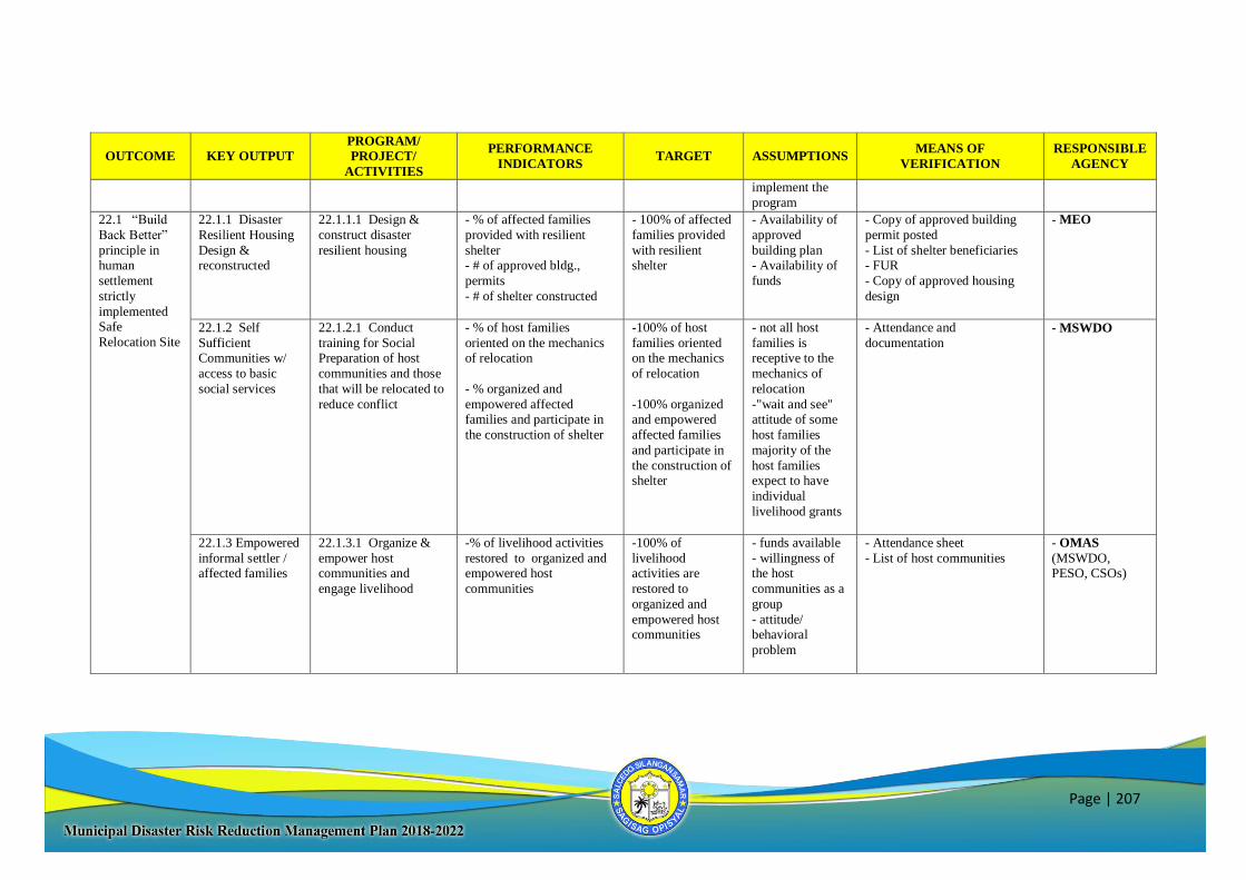
Page | 207
OUTCOME KEY OUTPUT
PROGRAM/
PROJECT/
ACTIVITIES
PERFORMANCE
INDICATORS TARGET ASSUMPTIONS
MEANS OF
VERIFICATION
RESPONSIBLE
AGENCY
implement the
program
22.1 “Build
Back Better”
principle in human
settlement
strictly
implemented Safe
Relocation Site
22.1.1 Disaster
Resilient Housing
Design & reconstructed
22.1.1.1 Design &
construct disaster
resilient housing
- % of affected families
provided with resilient
shelter - # of approved bldg.,
permits
- # of shelter constructed
- 100% of affected
families provided
with resilient shelter
- Availability of
approved
building plan - Availability of
funds
- Copy of approved building
permit posted
- List of shelter beneficiaries - FUR
- Copy of approved housing
design
- MEO
22.1.2 Self
Sufficient Communities w/
access to basic
social services
22.1.2.1 Conduct
training for Social Preparation of host
communities and those
that will be relocated to
reduce conflict
- % of host families
oriented on the mechanics of relocation
- % organized and
empowered affected families and participate in
the construction of shelter
-100% of host
families oriented on the mechanics
of relocation
-100% organized and empowered
affected families
and participate in
the construction of shelter
- not all host
families is receptive to the
mechanics of
relocation
-"wait and see" attitude of some
host families
majority of the
host families expect to have
individual
livelihood grants
- Attendance and
documentation
- MSWDO
22.1.3 Empowered
informal settler / affected families
22.1.3.1 Organize &
empower host communities and
engage livelihood
-% of livelihood activities
restored to organized and empowered host
communities
-100% of
livelihood activities are
restored to
organized and
empowered host communities
- funds available
- willingness of the host
communities as a
group
- attitude/ behavioral
problem
- Attendance sheet
- List of host communities
- OMAS
(MSWDO, PESO, CSOs)
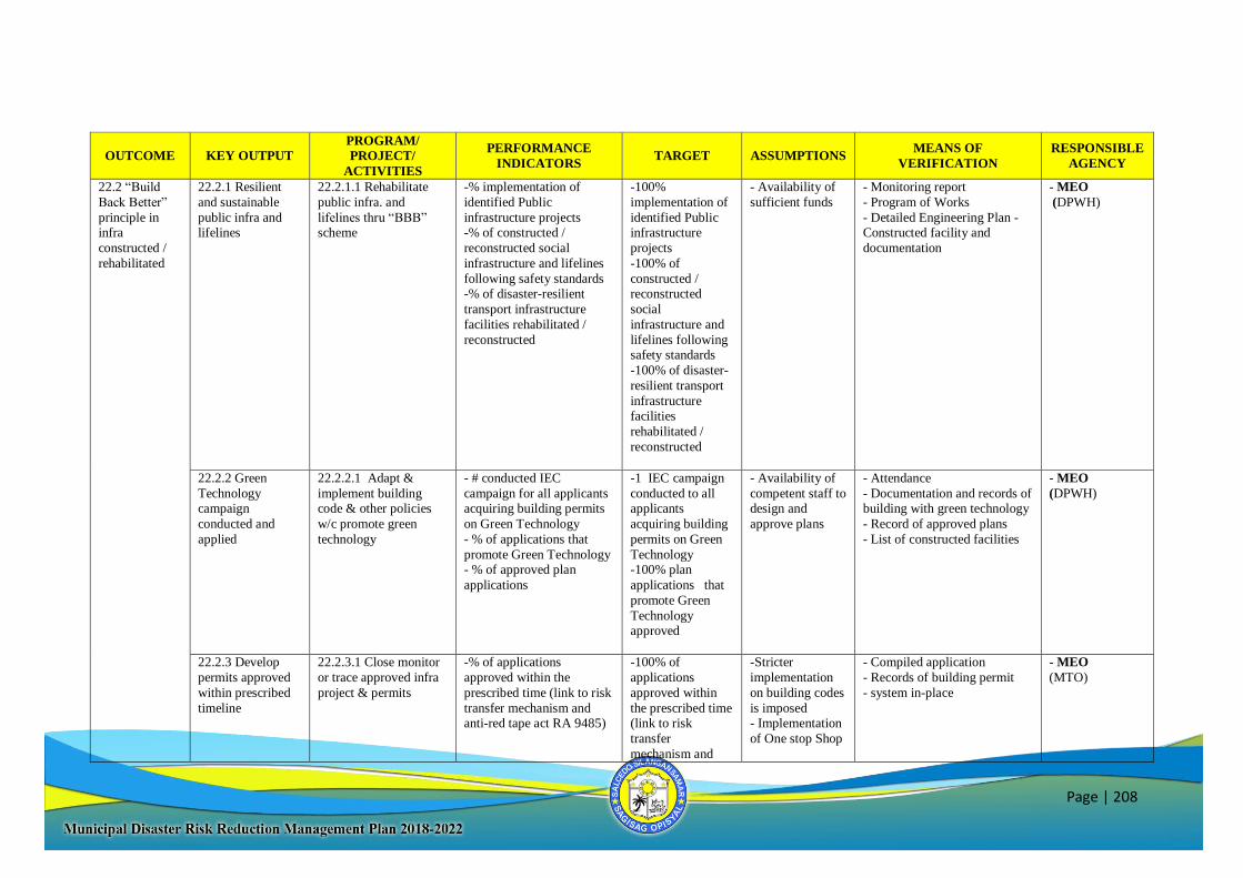
Page | 208
OUTCOME KEY OUTPUT
PROGRAM/
PROJECT/
ACTIVITIES
PERFORMANCE
INDICATORS TARGET ASSUMPTIONS
MEANS OF
VERIFICATION
RESPONSIBLE
AGENCY
22.2 “Build
Back Better”
principle in infra
constructed /
rehabilitated
22.2.1 Resilient
and sustainable
public infra and lifelines
22.2.1.1 Rehabilitate
public infra. and
lifelines thru “BBB” scheme
-% implementation of
identified Public
infrastructure projects -% of constructed /
reconstructed social
infrastructure and lifelines
following safety standards -% of disaster-resilient
transport infrastructure
facilities rehabilitated /
reconstructed
-100%
implementation of
identified Public infrastructure
projects
-100% of
constructed / reconstructed
social
infrastructure and
lifelines following safety standards
-100% of disaster-
resilient transport
infrastructure
facilities
rehabilitated /
reconstructed
- Availability of
sufficient funds
- Monitoring report
- Program of Works
- Detailed Engineering Plan - Constructed facility and
documentation
- MEO
(DPWH)
22.2.2 Green
Technology campaign
conducted and
applied
22.2.2.1 Adapt &
implement building code & other policies
w/c promote green
technology
- # conducted IEC
campaign for all applicants acquiring building permits
on Green Technology
- % of applications that
promote Green Technology - % of approved plan
applications
-1 IEC campaign
conducted to all applicants
acquiring building
permits on Green
Technology -100% plan
applications that
promote Green
Technology approved
- Availability of
competent staff to design and
approve plans
- Attendance
- Documentation and records of building with green technology
- Record of approved plans
- List of constructed facilities
- MEO
(DPWH)
22.2.3 Develop
permits approved
within prescribed
timeline
22.2.3.1 Close monitor
or trace approved infra
project & permits
-% of applications
approved within the
prescribed time (link to risk
transfer mechanism and anti-red tape act RA 9485)
-100% of
applications
approved within
the prescribed time (link to risk
transfer
mechanism and
-Stricter
implementation
on building codes
is imposed - Implementation
of One stop Shop
- Compiled application
- Records of building permit
- system in-place
- MEO
(MTO)
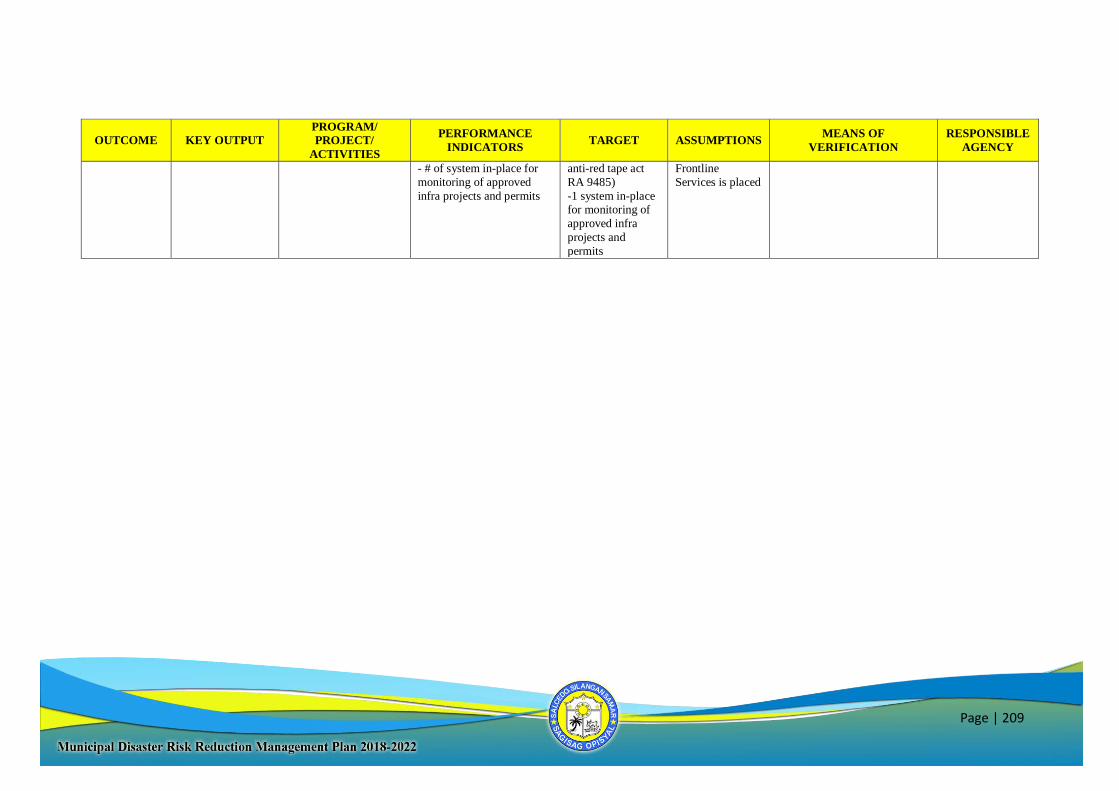
Page | 209
OUTCOME KEY OUTPUT
PROGRAM/
PROJECT/
ACTIVITIES
PERFORMANCE
INDICATORS TARGET ASSUMPTIONS
MEANS OF
VERIFICATION
RESPONSIBLE
AGENCY
- # of system in-place for
monitoring of approved
infra projects and permits
anti-red tape act
RA 9485)
-1 system in-place for monitoring of
approved infra
projects and
permits
Frontline
Services is placed
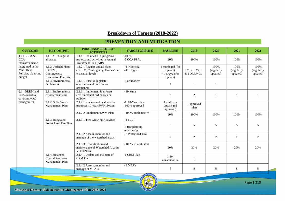
Page | 210
Breakdown of Targets (2018-2022)
PREVENTION AND MITIGATION
OUTCOME KEY OUTPUT PROGRAM/ PROJECT/
ACTIVITIES TARGET 2019-2023 BASELINE 2018 2020 2021 2022
1.1 DRRM &
CCA mainstreamed &
integrated in the
Mun. Devt
Policies, plans and budget
1.1.1 AIP budget is
allocated
1.1.1.1 Include CCA programs,
projects and activities in Annual Investment Plan (AIP)
-100%
-5 CCA PPAs
20%
100%
100%
100%
100%
1.1.2 Updated Plans (DRRM ,
Contingency,
Evacuation Plan, etc)
1.1.2.1 Regular update plans (DRRM, Contingency, Evacuation,
etc.) at all levels
- 1 Municipal - 41 Brgys.
1 municipal (for update)
41 Brgys. (for
update)
1 MDRRMC
41BDRRMCs
100% (regularly
updated)
100% (regularly
updated)
100% (regularly
updated)
1.1.3 Environmental
Ordinances
1.1.3.1 Enact & legislate
environmental policies and
ordinances
-5 ordinances
3 1 1
2.1 DRRM and
CCA-sensitive environmental
management
2.1.1 Environmental
enforcement team
2.1.1.1 Implement & enforce
environmental ordinances or policies
- 10 teams
3 2 1 1 1
2.1.2 Solid Waste Management Plan
2.1.2.1 Review and evaluate the proposed 10-year SWM System
-1 10-Year Plan -100% approved
1 draft (for update and
approval)
1 approved
plan
2.1.2.2 Implement SWM Plan - 100% implemented 20% 100% 100% 100% 100%
2.1.3 Integrated
Forest Land Use Plan
2.1.3.1 Tree Growing Activities
- 1 FLUP
-5 tree planting
activities/yr
3 5 5 5 5
2.1.3.2 Assess, monitor and
manage of the watershed area/s
- 2 Watershed area 2 2 2 2 2
2.1.3.3 Rehabilitation and
maintenance of Watershed Area in
YOCENCA
- 100% rehabilitated
20% 20% 20% 20% 20%
2.1.4 Enhanced
Coastal Resource Management Plan
2.1.4.1 Update and evaluate of
CRM Plan
-1 CRM Plan
1, for
consolidation 1
2.1.4.2 Assess, monitor and manage of MPA’s
- 8 MPA's 8 8 8 8 8
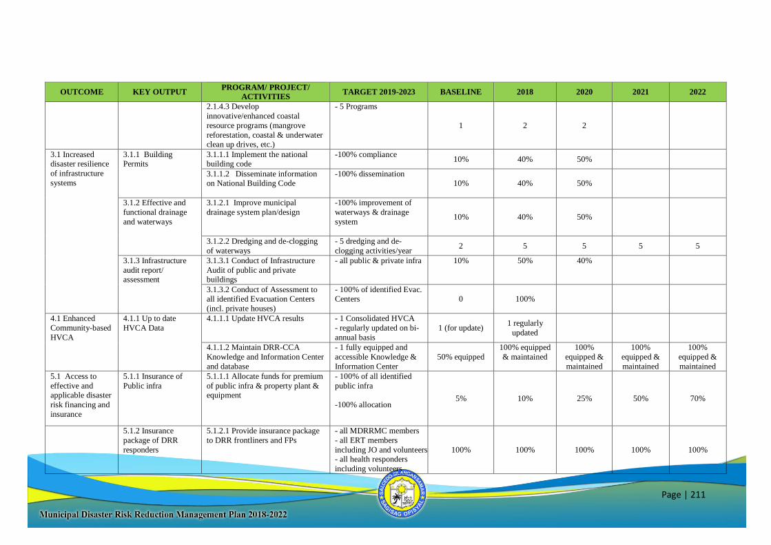
Page | 211
OUTCOME KEY OUTPUT PROGRAM/ PROJECT/
ACTIVITIES TARGET 2019-2023 BASELINE 2018 2020 2021 2022
2.1.4.3 Develop
innovative/enhanced coastal
resource programs (mangrove
reforestation, coastal & underwater clean up drives, etc.)
- 5 Programs
1 2 2
3.1 Increased disaster resilience
of infrastructure
systems
3.1.1 Building Permits
3.1.1.1 Implement the national building code
-100% compliance
10% 40% 50%
3.1.1.2 Disseminate information on National Building Code
-100% dissemination
10% 40% 50%
3.1.2 Effective and
functional drainage
and waterways
3.1.2.1 Improve municipal
drainage system plan/design
-100% improvement of
waterways & drainage
system
10% 40% 50%
3.1.2.2 Dredging and de-clogging
of waterways
- 5 dredging and de-
clogging activities/year 2 5 5 5 5
3.1.3 Infrastructure
audit report/ assessment
3.1.3.1 Conduct of Infrastructure
Audit of public and private buildings
- all public & private infra 10% 50% 40%
3.1.3.2 Conduct of Assessment to all identified Evacuation Centers
(incl. private houses)
- 100% of identified Evac. Centers 0 100%
4.1 Enhanced
Community-based
HVCA
4.1.1 Up to date
HVCA Data
4.1.1.1 Update HVCA results - 1 Consolidated HVCA
- regularly updated on bi-
annual basis
1 (for update) 1 regularly
updated
4.1.1.2 Maintain DRR-CCA
Knowledge and Information Center
and database
- 1 fully equipped and
accessible Knowledge &
Information Center
50% equipped
100% equipped
& maintained
100%
equipped &
maintained
100%
equipped &
maintained
100%
equipped &
maintained
5.1 Access to
effective and applicable disaster
risk financing and
insurance
5.1.1 Insurance of
Public infra
5.1.1.1 Allocate funds for premium
of public infra & property plant & equipment
- 100% of all identified
public infra
-100% allocation 5% 10% 25% 50% 70%
5.1.2 Insurance
package of DRR
responders
5.1.2.1 Provide insurance package
to DRR frontliners and FPs
- all MDRRMC members
- all ERT members
including JO and volunteers - all health responders
including volunteers
100% 100% 100% 100% 100%
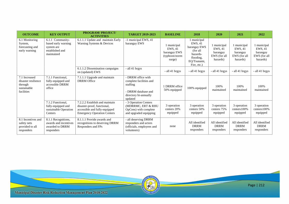
Page | 212
OUTCOME KEY OUTPUT PROGRAM/ PROJECT/
ACTIVITIES TARGET 2019-2023 BASELINE 2018 2020 2021 2022
6.1 Monitoring
System,
forecasting and
early warning
6.1.1 Community-
based early warning
system are
established and maintained
6.1.1.1 Update and maintain Early
Warning Systems & Devices
-1 municipal EWS, 41
barangay EWS
1 municipal
EWS, 41
barangay EWS (typhoon/storm
surge)
1 municipal
EWS, 41
barangay EWS
(for all hazards-
flooding,
EQ/Tsunami,
Fire, etc.)
1 municipal
EWS, 41
barangay EWS (for all
hazards)
1 municipal
EWS, 41
barangay EWS (for all
hazards)
1 municipal
EWS, 41
barangay EWS (for all
hazards)
6.1.1.2 Dissemination campaigns
on (updated) EWS
- all 41 brgys - all 41 brgys - all 41 brgys - all 41 brgys - all 41 brgys - all 41 brgys
7.1 Increased
disaster resilience
through sustainable
facilities
7.1.1 Functional,
fully-equipped and
accessible DRRM office
7.1.1.1 Upgrade and maintain
DRRM Office
- DRRM office with
complete facilities and
staffing
- DRRM database and
directory bi-annually
updated
1 DRRM office 50% equipped
100% equipped 100%
maintained 100%
maintained 100%
maintained
7.1.2 Functional,
fully-equipped and sustainable Operation
Centers
7.2.2.2 Establish and maintain
disaster-proof, functional, accessible and fully-equipped
Emergency Operation Centers
- 3 Operation Centers
(MDRRMC, ERT & RHU OpCens) with complete
and upgraded equipping
3 operation
centers 20%
equipped
3 operation
centers 50%
equipped
3 operation
centers 75%
equipped
3 operation
centers100%
equipped
3 operation
centers100%
equipped
8.1 Incentives and safety nets
provided to all
responders
8.1.1 Recognitions, awards and incentives
awarded to DRRM
responders
8.1.1.1 Provide awards and recognitions to deserving DRRM
Responders and FPs
- all deserving DRRM responders and actors
(officials, employees and
volunteers)
none
All identified
DRRM
responders
All identified
DRRM
responders
All identified
DRRM
responders
All identified
DRRM
responders
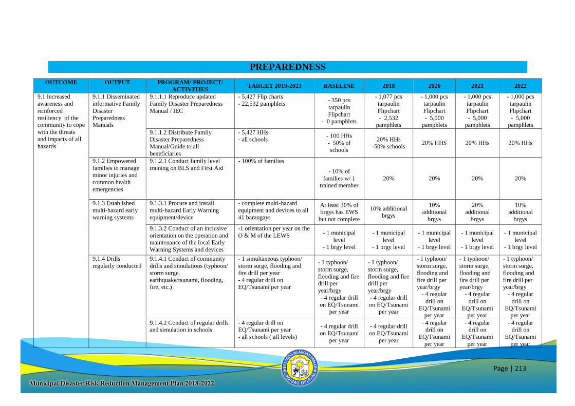
Page | 213
PREPAREDNESS
OUTCOME OUTPUT PROGRAM/ PROJECT/
ACTIVITIES TARGET 2019-2023 BASELINE 2018 2020 2021 2022
9.1 Increased
awareness and
reinforced
resiliency of the community to cope
with the threats
and impacts of all
hazards
9.1.1 Disseminated
informative Family
Disaster
Preparedness Manuals
9.1.1.1 Reproduce updated
Family Disaster Preparedness
Manual / IEC
- 5,427 Flip charts
- 22,532 pamphlets
- 350 pcs
tarpaulin
Flipchart - 0 pamphlets
- 1,077 pcs
tarpaulin
Flipchart
- 2,532 pamphlets
- 1,000 pcs
tarpaulin
Flipchart
- 5,000 pamphlets
- 1,000 pcs
tarpaulin
Flipchart
- 5,000 pamphlets
- 1,000 pcs
tarpaulin
Flipchart
- 5,000 pamphlets
9.1.1.2 Distribute Family Disaster Preparedness
Manual/Guide to all
beneficiaries
- 5,427 HHs - all schools
- 100 HHs
- 50% of
schools
20% HHs
-50% schools 20% HHS 20% HHs 20% HHs
9.1.2 Empowered
families to manage
minor injuries and common health
emergencies
9.1.2.1 Conduct family level
training on BLS and First Aid
- 100% of families
- 10% of
families w/ 1 trained member
20% 20% 20% 20%
9.1.3 Established
multi-hazard early
warning systems
9.1.3.1 Procure and install
multi-hazard Early Warning
equipment/device
- complete multi-hazard
equipment and devices to all
41 barangays
At least 30% of brgys has EWS
but not complete
10% additional brgys
10% additional
brgys
20% additional
brgys
10% additional
brgys
9.1.3.2 Conduct of an inclusive
orientation on the operation and maintenance of the local Early
Warning Systems and devices
-1 orientation per year on the
O & M of the LEWS - 1 municipal
level
- 1 brgy level
- 1 municipal
level
- 1 brgy level
- 1 municipal
level
- 1 brgy level
- 1 municipal
level
- 1 brgy level
- 1 municipal
level
- 1 brgy level
9.1.4 Drills
regularly conducted
9.1.4.1 Conduct of community
drills and simulations (typhoon/
storm surge,
earthquake/tsunami, flooding, fire, etc.)
- 1 simultaneous typhoon/
storm surge, flooding and
fire drill per year
- 4 regular drill on EQ/Tsunami per year
- 1 typhoon/
storm surge,
flooding and fire drill per
year/brgy
- 4 regular drill
on EQ/Tsunami per year
- 1 typhoon/
storm surge,
flooding and fire drill per
year/brgy
- 4 regular drill
on EQ/Tsunami per year
- 1 typhoon/
storm surge,
flooding and
fire drill per year/brgy
- 4 regular
drill on
EQ/Tsunami per year
- 1 typhoon/
storm surge,
flooding and
fire drill per year/brgy
- 4 regular
drill on
EQ/Tsunami per year
- 1 typhoon/
storm surge,
flooding and
fire drill per year/brgy
- 4 regular
drill on
EQ/Tsunami per year
9.1.4.2 Conduct of regular drills and simulation in schools
- 4 regular drill on EQ/Tsunami per year
- all schools ( all levels)
- 4 regular drill
on EQ/Tsunami
per year
- 4 regular drill
on EQ/Tsunami
per year
- 4 regular drill on
EQ/Tsunami
per year
- 4 regular drill on
EQ/Tsunami
per year
- 4 regular drill on
EQ/Tsunami
per year
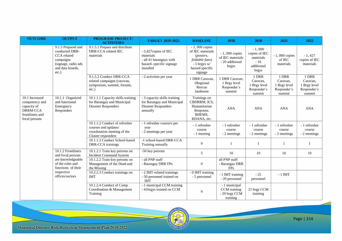
Page | 214
OUTCOME OUTPUT PROGRAM/ PROJECT/
ACTIVITIES TARGET 2019-2023 BASELINE 2018 2020 2021 2022
9.1.5 Prepared and
conducted DRR-
CCA related
campaigns (signage, radio ads
and data boards,
etc.)
9.1.5.1 Prepare and distribute
DRR-CCA related IEC
materials
- 5,427copies of IEC
materials
- all 41 barangays with hazard- specific signage
installed
- 1, 000 copies
of IEC materials
(posters,
foldable fans) - 5 brgys w/
hazard specific
signage
- 1, 000 copies
of IEC materials
- 20 additional brgys
- 1, 000
copies of IEC
materials
- 16 additional
brgys
- 1, 000 copies
of IEC materials
- 1, 427
copies of IEC materials
9.1.5.2 Conduct DRR-CCA
related campaigns (caravan,
symposium, summit, forums, etc.)
- 2 activities per year 1 DRR Caravan,
1Regional
Rescue Jamboree
1 DRR Caravan,
1 Brgy level
Responder’s summit
1 DRR
Caravan,
1 Brgy level Responder’s
summit
1 DRR
Caravan,
1 Brgy level Responder’s
summit
1 DRR
Caravan,
1 Brgy level Responder’s
summit
10.1 Increased
competency and
capacity of
DRRM-CCA
frontliners and
focal persons
10.1.1 Organized
and functional
Emergency
Responders
10.1.1.1 Capacity skills training
for Barangay and Municipal
Disaster Responders
- 3 capacity skills training
for Barangay and Municipal
Disaster Responders
annually
Trainings on
CBDRRM, ICS,
Humanitarian
Response,
BHEMS,
RDANA, etc.
ANA ANA ANA ANA
10.1.1.2 Conduct of refresher
courses and updates/
coordination meeting of the
Cluster responders
- 1 refresher course/s per
year
- 2 meetings per year
- 1 refresher
course
- 1 meeting
- 1 refresher
course
- 2 meetings
- 1 refresher
course
- 2 meetings
- 1 refresher
course
- 2 meetings
- 1 refresher
course
- 2 meetings
10.1.1.3 Conduct School-based
DRR-CCA trainings
-1 school-based DRR-CCA
Training annually 0 1 1 1 1
10.1.2 Frontliners
and focal persons
are knowledgeable
of the roles and functions of their
respective
offices/sectors
10.1.2.1 Train key persons on
Incident Command System
-50 key persons 5 10 10 10 10
10.1.2.2 Train key persons on
Management of the Dead and
the Missing
- all PNP staff
- Barangay DRR FPs 0
all PNP staff
- Barangay DRR
FPs
10.2.2.3 Conduct trainings on
IMT
- 2 IMT-related trainings
- 50 personnel trained on
IMT
- 0 IMT training
- 5 personnel
- 1 IMT training
- 20 personnel
- 25
personnel
- 1 IMT
10.1.2.4 Conduct of Camp
Coordination & Management Training
- 1 municipal CCM training
- 41brgys trained on CCM
0
- 1 municipal
CCM training - 20 brgy CCM
training
21 brgy CCM training
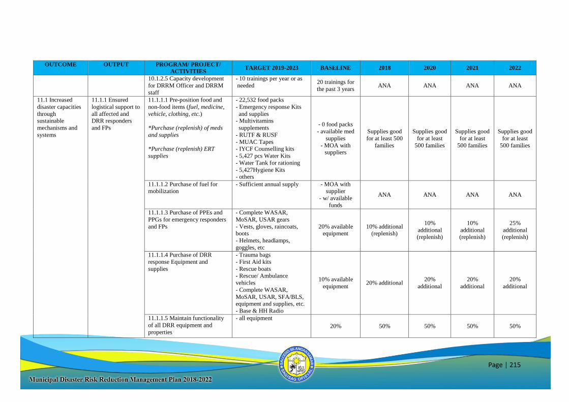
Page | 215
OUTCOME OUTPUT PROGRAM/ PROJECT/
ACTIVITIES TARGET 2019-2023 BASELINE 2018 2020 2021 2022
10.1.2.5 Capacity development
for DRRM Officer and DRRM
staff
- 10 trainings per year or as
needed 20 trainings for
the past 3 years ANA ANA ANA ANA
11.1 Increased
disaster capacities
through sustainable
mechanisms and
systems
11.1.1 Ensured
logistical support to
all affected and DRR responders
and FPs
11.1.1.1 Pre-position food and
non-food items (fuel, medicine,
vehicle, clothing, etc.)
*Purchase (replenish) of meds
and supplies
*Purchase (replenish) ERT
supplies
- 22,532 food packs
- Emergency response Kits
and supplies - Multivitamins
supplements
- RUTF & RUSF
- MUAC Tapes - IYCF Counselling kits
- 5,427 pcs Water Kits
- Water Tank for rationing
- 5,427Hygiene Kits - others
- 0 food packs
- available med
supplies
- MOA with suppliers
Supplies good
for at least 500
families
Supplies good
for at least
500 families
Supplies good
for at least
500 families
Supplies good
for at least
500 families
11.1.1.2 Purchase of fuel for
mobilization
- Sufficient annual supply - MOA with
supplier
- w/ available
funds
ANA ANA ANA ANA
11.1.1.3 Purchase of PPEs and
PPGs for emergency responders
and FPs
- Complete WASAR,
MoSAR, USAR gears
- Vests, gloves, raincoats, boots
- Helmets, headlamps,
goggles, etc
20% available equipment
10% additional (replenish)
10%
additional (replenish)
10%
additional (replenish)
25%
additional (replenish)
11.1.1.4 Purchase of DRR
response Equipment and
supplies
- Trauma bags
- First Aid kits
- Rescue boats - Rescue/ Ambulance
vehicles
- Complete WASAR,
MoSAR, USAR, SFA/BLS, equipment and supplies, etc.
- Base & HH Radio
10% available
equipment 20% additional
20%
additional
20%
additional
20%
additional
11.1.1.5 Maintain functionality
of all DRR equipment and
properties
- all equipment
20% 50% 50% 50% 50%
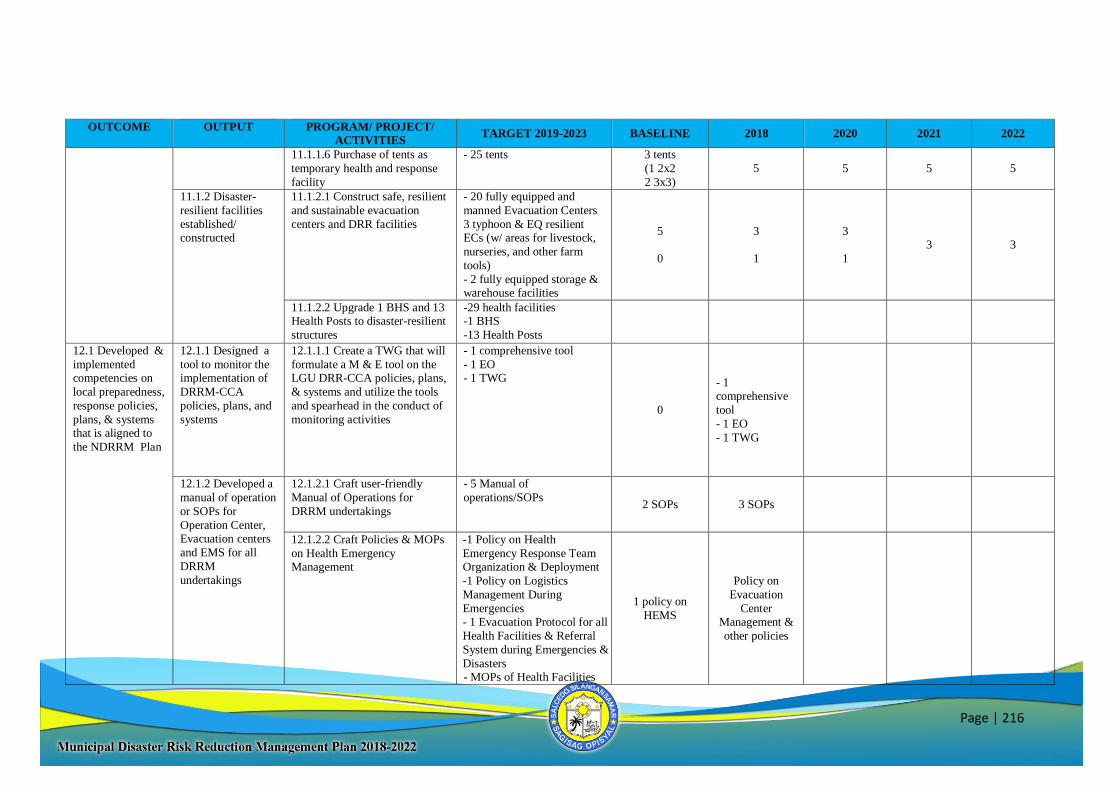
Page | 216
OUTCOME OUTPUT PROGRAM/ PROJECT/
ACTIVITIES TARGET 2019-2023 BASELINE 2018 2020 2021 2022
11.1.1.6 Purchase of tents as
temporary health and response
facility
- 25 tents 3 tents
(1 2x2
2 3x3)
5 5 5 5
11.1.2 Disaster-
resilient facilities
established/ constructed
11.1.2.1 Construct safe, resilient
and sustainable evacuation
centers and DRR facilities
- 20 fully equipped and
manned Evacuation Centers
3 typhoon & EQ resilient ECs (w/ areas for livestock,
nurseries, and other farm
tools)
- 2 fully equipped storage & warehouse facilities
5
0
3
1
3
1
3 3
11.1.2.2 Upgrade 1 BHS and 13 Health Posts to disaster-resilient
structures
-29 health facilities -1 BHS
-13 Health Posts
12.1 Developed &
implemented competencies on
local preparedness,
response policies,
plans, & systems that is aligned to
the NDRRM Plan
12.1.1 Designed a
tool to monitor the implementation of
DRRM-CCA
policies, plans, and
systems
12.1.1.1 Create a TWG that will
formulate a M & E tool on the LGU DRR-CCA policies, plans,
& systems and utilize the tools
and spearhead in the conduct of
monitoring activities
- 1 comprehensive tool
- 1 EO - 1 TWG
0
- 1 comprehensive
tool
- 1 EO
- 1 TWG
12.1.2 Developed a
manual of operation
or SOPs for
Operation Center, Evacuation centers
and EMS for all
DRRM
undertakings
12.1.2.1 Craft user-friendly
Manual of Operations for
DRRM undertakings
- 5 Manual of
operations/SOPs
2 SOPs 3 SOPs
12.1.2.2 Craft Policies & MOPs
on Health Emergency Management
-1 Policy on Health
Emergency Response Team Organization & Deployment
-1 Policy on Logistics
Management During
Emergencies - 1 Evacuation Protocol for all
Health Facilities & Referral
System during Emergencies &
Disasters - MOPs of Health Facilities
1 policy on
HEMS
Policy on
Evacuation
Center Management &
other policies

Page | 217
OUTCOME OUTPUT PROGRAM/ PROJECT/
ACTIVITIES TARGET 2019-2023 BASELINE 2018 2020 2021 2022
13.1 Strengthen
Partnership and
coordination
among all key players and
stakeholders
13.1.1 Strong,
committed
partnership with the
local players and stakeholders
13.1.1.1 Conduct of
Coordination Meetings with
DRR-CCA stakeholders
- 10 partnership agreements,
MOAs and MOUs
6 MOAs with
partners
Additional 4
MOAs
13.1.1.2 Establish Disaster
Response Twinning with other
LGUs
- 1 w/ northern LGU
-1 w/ other LGU w/in the
region - 1 with HUC
0
- 1 w/ northern
LGU
-1 w/ other LGU w/in the region
- 1 with HUC
RESPONSE
OUTCOME KEY OUTPUT PROGRAM/ PROJECT/
ACTIVITIES TARGET 2019-2023 BASELINE 2018 2020 2021 2022
14.1 Well-
established disaster
response operations
14.1.1 Activated
functional
Emergency Management
Teams on site
14.1.1.1 Activate IMT and
Cluster responders at the
Municipal and Barangay level
- All affected
families/population/
households/ barangays
1 municipal
IMT ANA ANA ANA ANA
14.1.2 Well-
established system
of information
gathering, reporting and dissemination /
report-generation
14.1.2.1 Issue public advisories
in accordance with developed
protocols
- All affected barangays
ANA ANA ANA ANA
14.1.3 Established
and functioning
system for
coordinated and efficient relief
operations and
health services
14.1.3.1 Activate Health
Centers/First Aid Station/
Birthing Facilities and Deploy
Health responders by cluster at the Municipal and Brgy. Level
- All affected barangays
-1 protocol ANA ANA ANA ANA
14.1.3.2 Activate Health Logistics management
Protocol/System
-1 protocol
- 1 protocol ANA ANA ANA ANA
14.1.3.3 Activate Evacuation
Protocol
- 1 protocol - 1 protocol ANA ANA ANA ANA
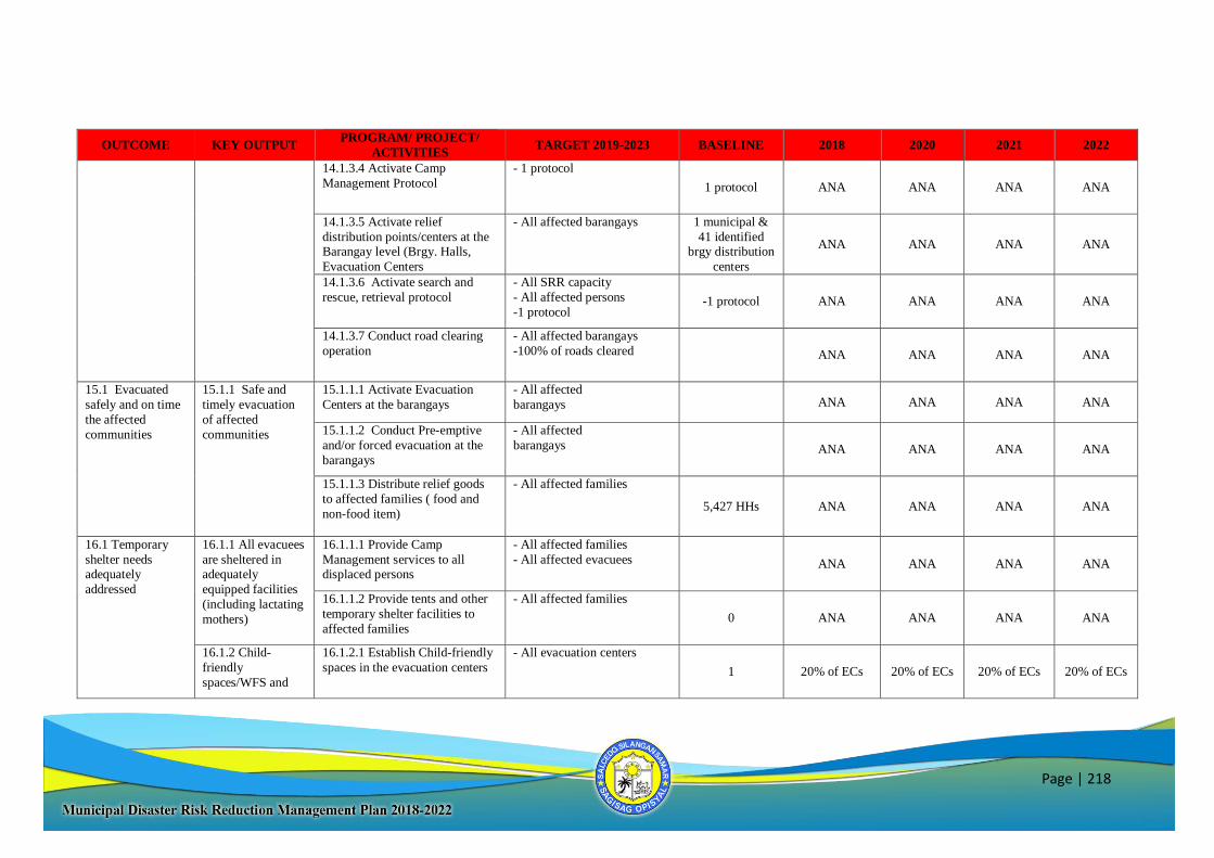
Page | 218
OUTCOME KEY OUTPUT PROGRAM/ PROJECT/
ACTIVITIES TARGET 2019-2023 BASELINE 2018 2020 2021 2022
14.1.3.4 Activate Camp
Management Protocol
- 1 protocol
1 protocol ANA ANA ANA ANA
14.1.3.5 Activate relief
distribution points/centers at the Barangay level (Brgy. Halls,
Evacuation Centers
- All affected barangays 1 municipal &
41 identified brgy distribution
centers
ANA ANA ANA ANA
14.1.3.6 Activate search and
rescue, retrieval protocol
- All SRR capacity
- All affected persons
-1 protocol -1 protocol ANA ANA ANA ANA
14.1.3.7 Conduct road clearing
operation
- All affected barangays
-100% of roads cleared ANA ANA ANA ANA
15.1 Evacuated
safely and on time
the affected
communities
15.1.1 Safe and
timely evacuation
of affected
communities
15.1.1.1 Activate Evacuation
Centers at the barangays
- All affected
barangays ANA ANA ANA ANA
15.1.1.2 Conduct Pre-emptive
and/or forced evacuation at the
barangays
- All affected
barangays ANA ANA ANA ANA
15.1.1.3 Distribute relief goods
to affected families ( food and
non-food item)
- All affected families
5,427 HHs ANA ANA ANA ANA
16.1 Temporary
shelter needs adequately
addressed
16.1.1 All evacuees
are sheltered in adequately
equipped facilities
(including lactating
mothers)
16.1.1.1 Provide Camp
Management services to all displaced persons
- All affected families
- All affected evacuees ANA ANA ANA ANA
16.1.1.2 Provide tents and other
temporary shelter facilities to
affected families
- All affected families
0 ANA ANA ANA ANA
16.1.2 Child-
friendly
spaces/WFS and
16.1.2.1 Establish Child-friendly
spaces in the evacuation centers
- All evacuation centers
1 20% of ECs 20% of ECs 20% of ECs 20% of ECs
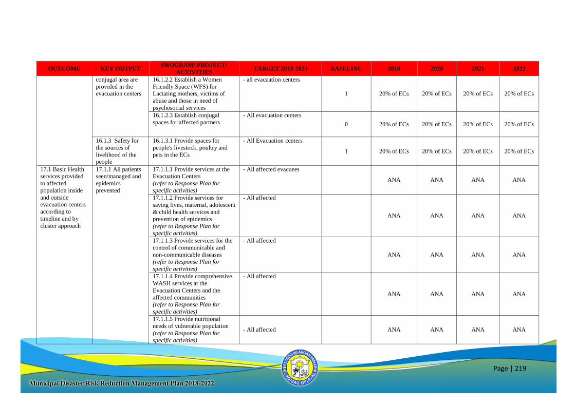
Page | 219
OUTCOME KEY OUTPUT PROGRAM/ PROJECT/
ACTIVITIES TARGET 2019-2023 BASELINE 2018 2020 2021 2022
conjugal area are
provided in the evacuation centers
16.1.2.2 Establish a Women
Friendly Space (WFS) for Lactating mothers, victims of
abuse and those in need of
psychosocial services
- all evacuation centers
1 20% of ECs 20% of ECs 20% of ECs 20% of ECs
16.1.2.3 Establish conjugal
spaces for affected partners
- All evacuation centers
0 20% of ECs 20% of ECs 20% of ECs 20% of ECs
16.1.3 Safety for
the sources of
livelihood of the people
16.1.3.1 Provide spaces for
people's livestock, poultry and
pets in the ECs
- All Evacuation centers
1 20% of ECs 20% of ECs 20% of ECs 20% of ECs
17.1 Basic Health services provided
to affected
population inside
and outside evacuation centers
according to
timeline and by
cluster approach
17.1.1 All patients seen/managed and
epidemics
prevented
17.1.1.1 Provide services at the Evacuation Centers
(refer to Response Plan for
specific activities)
- All affected evacuees
ANA ANA ANA ANA
17.1.1.2 Provide services for
saving lives, maternal, adolescent
& child health services and prevention of epidemics
(refer to Response Plan for
specific activities)
- All affected
ANA ANA ANA ANA
17.1.1.3 Provide services for the
control of communicable and
non-communicable diseases (refer to Response Plan for
specific activities)
- All affected
ANA ANA ANA ANA
17.1.1.4 Provide comprehensive
WASH services at the
Evacuation Centers and the
affected communities (refer to Response Plan for
specific activities)
- All affected
ANA ANA ANA ANA
17.1.1.5 Provide nutritional
needs of vulnerable population
(refer to Response Plan for
specific activities)
- All affected ANA ANA ANA ANA
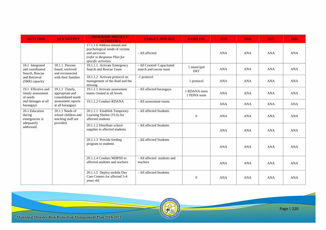
Page | 220
OUTCOME KEY OUTPUT PROGRAM/ PROJECT/
ACTIVITIES TARGET 2019-2023 BASELINE 2018 2020 2021 2022
17.1.1.6 Address mental and
psychological needs of victims and survivors
(refer to Response Plan for
specific activities
- All affected ANA ANA ANA ANA
18.1 Integrated
and coordinated
Search, Rescue and Retrieval
(SRR) capacity
18.1.1 Persons
found, retrieved
and reconnected with their families
18.1.1.1 Activate Emergency
Search and Rescue Team
- All Created/ Capacitated
search and rescue team 1 municipal
ERT ANA ANA ANA ANA
18.1.1.2 Activate protocol on
management of the dead and the
missing
-1 protocol
1 protocol ANA ANA ANA ANA
19.1 Effective and
timely assessment
of needs and damages at all
barangays
19.1.1 Timely,
appropriate and
consolidated needs assessment reports
at all barangays
19.1.1.1 Activate assessment
teams created at all levels
- All affected barangays
1 RDANA team
1 PDNA team ANA ANA ANA ANA
19.1.1.2 Conduct RDANA - All assessment teams ANA ANA ANA ANA
20.1 Education
during
emergencies is adequately
addressed.
20.1.1 Needs of
school children and
teaching staff are provided.
20.1.1.1 Establish Temporary
Learning Shelter (TLS) for
affected students
- All affected Students
0 ANA ANA ANA ANA
20.1.1.2 Distribute school
supplies to affected students
- All affected Students
ANA ANA ANA ANA
20.1.1.3 Provide feeding
program to students
- All affected Students
ANA ANA ANA ANA
20.1.1.4 Conduct MHPSS to affected students and teachers
- All affected students and teachers ANA ANA ANA ANA
20.1.1.5 Deploy mobile Day Care Centers for affected 3-4
years old
- All affected Students
0 ANA ANA ANA ANA
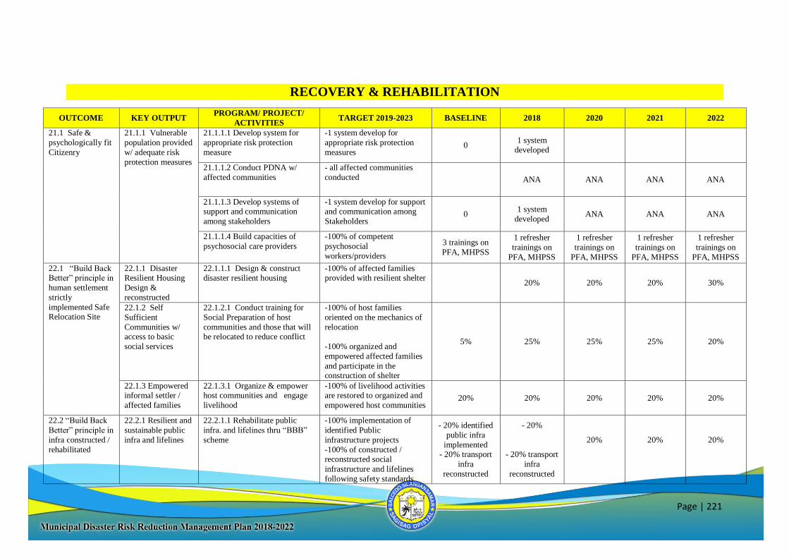
Page | 221
RECOVERY & REHABILITATION
OUTCOME KEY OUTPUT PROGRAM/ PROJECT/
ACTIVITIES TARGET 2019-2023 BASELINE 2018 2020 2021 2022
21.1 Safe &
psychologically fit
Citizenry
21.1.1 Vulnerable
population provided
w/ adequate risk
protection measures
21.1.1.1 Develop system for
appropriate risk protection
measure
-1 system develop for
appropriate risk protection
measures 0
1 system developed
21.1.1.2 Conduct PDNA w/
affected communities
- all affected communities
conducted ANA ANA ANA ANA
21.1.1.3 Develop systems of support and communication
among stakeholders
-1 system develop for support and communication among
Stakeholders 0
1 system
developed ANA ANA ANA
21.1.1.4 Build capacities of
psychosocial care providers
-100% of competent
psychosocial
workers/providers
3 trainings on
PFA, MHPSS
1 refresher
trainings on
PFA, MHPSS
1 refresher
trainings on
PFA, MHPSS
1 refresher
trainings on
PFA, MHPSS
1 refresher
trainings on
PFA, MHPSS
22.1 “Build Back Better” principle in
human settlement
strictly
implemented Safe Relocation Site
22.1.1 Disaster Resilient Housing
Design &
reconstructed
22.1.1.1 Design & construct disaster resilient housing
-100% of affected families provided with resilient shelter
20% 20% 20% 30%
22.1.2 Self
Sufficient
Communities w/ access to basic
social services
22.1.2.1 Conduct training for
Social Preparation of host
communities and those that will be relocated to reduce conflict
-100% of host families
oriented on the mechanics of
relocation
-100% organized and
empowered affected families
and participate in the construction of shelter
5% 25% 25% 25% 20%
22.1.3 Empowered informal settler /
affected families
22.1.3.1 Organize & empower host communities and engage
livelihood
-100% of livelihood activities are restored to organized and
empowered host communities 20% 20% 20% 20% 20%
22.2 “Build Back
Better” principle in
infra constructed /
rehabilitated
22.2.1 Resilient and
sustainable public
infra and lifelines
22.2.1.1 Rehabilitate public
infra. and lifelines thru “BBB”
scheme
-100% implementation of
identified Public
infrastructure projects
-100% of constructed / reconstructed social
infrastructure and lifelines
following safety standards
- 20% identified
public infra
implemented - 20% transport
infra
reconstructed
- 20%
- 20% transport
infra
reconstructed
20%
20%
20%
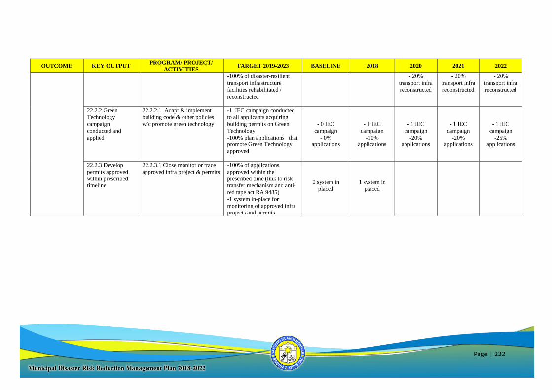
Page | 222
OUTCOME KEY OUTPUT PROGRAM/ PROJECT/
ACTIVITIES TARGET 2019-2023 BASELINE 2018 2020 2021 2022
-100% of disaster-resilient
transport infrastructure
facilities rehabilitated /
reconstructed
- 20%
transport infra
reconstructed
- 20%
transport infra
reconstructed
- 20%
transport infra
reconstructed
22.2.2 Green Technology
campaign
conducted and
applied
22.2.2.1 Adapt & implement building code & other policies
w/c promote green technology
-1 IEC campaign conducted to all applicants acquiring
building permits on Green
Technology
-100% plan applications that promote Green Technology
approved
- 0 IEC
campaign
- 0% applications
- 1 IEC
campaign
-10% applications
- 1 IEC
campaign
-20% applications
- 1 IEC
campaign
-20% applications
- 1 IEC
campaign
-25% applications
22.2.3 Develop
permits approved
within prescribed
timeline
22.2.3.1 Close monitor or trace
approved infra project & permits
-100% of applications
approved within the
prescribed time (link to risk
transfer mechanism and anti-
red tape act RA 9485)
-1 system in-place for
monitoring of approved infra projects and permits
0 system in placed
1 system in placed
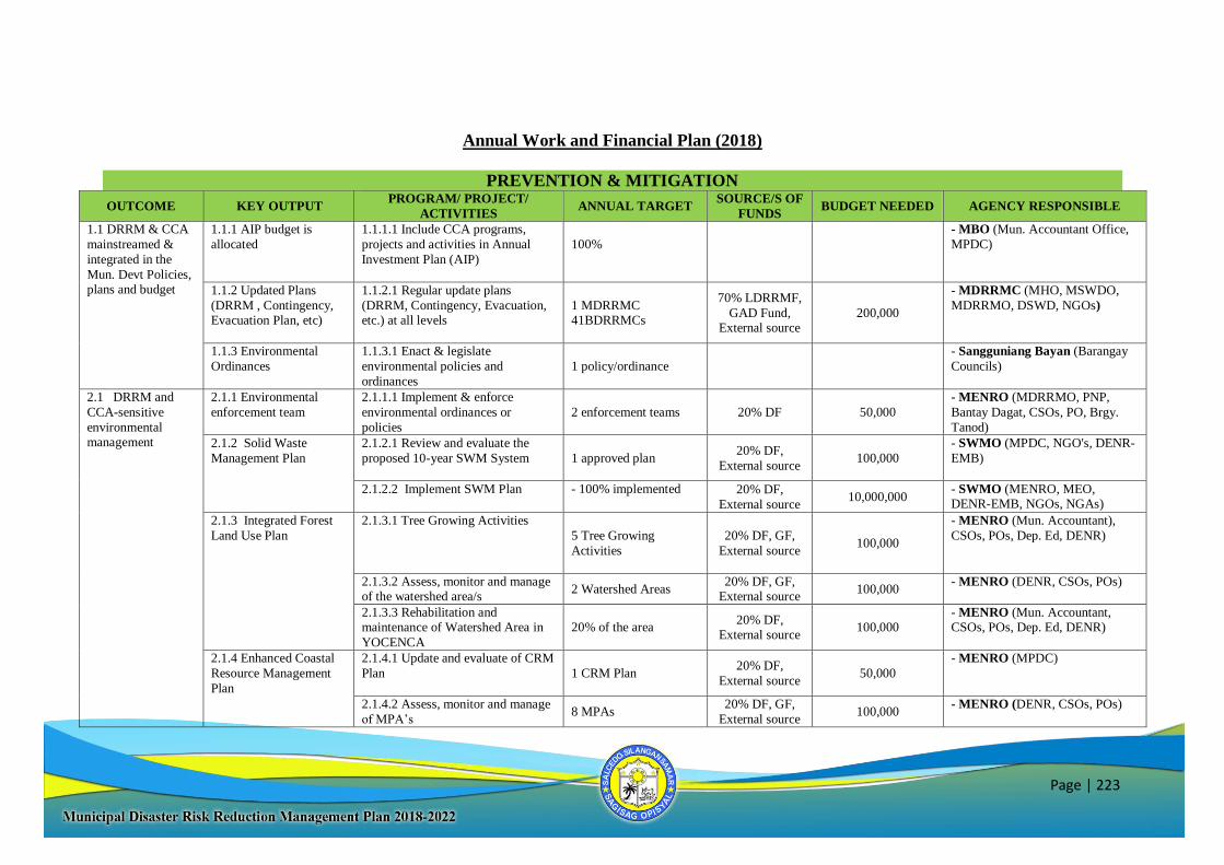
Page | 223
Annual Work and Financial Plan (2018)
PREVENTION & MITIGATION
OUTCOME KEY OUTPUT PROGRAM/ PROJECT/
ACTIVITIES ANNUAL TARGET
SOURCE/S OF
FUNDS BUDGET NEEDED AGENCY RESPONSIBLE
1.1 DRRM & CCA
mainstreamed &
integrated in the
Mun. Devt Policies, plans and budget
1.1.1 AIP budget is
allocated
1.1.1.1 Include CCA programs,
projects and activities in Annual
Investment Plan (AIP)
100%
- MBO (Mun. Accountant Office,
MPDC)
1.1.2 Updated Plans
(DRRM , Contingency, Evacuation Plan, etc)
1.1.2.1 Regular update plans
(DRRM, Contingency, Evacuation, etc.) at all levels
1 MDRRMC 41BDRRMCs
70% LDRRMF,
GAD Fund, External source
200,000
- MDRRMC (MHO, MSWDO,
MDRRMO, DSWD, NGOs)
1.1.3 Environmental
Ordinances
1.1.3.1 Enact & legislate
environmental policies and
ordinances
1 policy/ordinance
- Sangguniang Bayan (Barangay
Councils)
2.1 DRRM and
CCA-sensitive
environmental management
2.1.1 Environmental
enforcement team
2.1.1.1 Implement & enforce
environmental ordinances or
policies
2 enforcement teams 20% DF 50,000
- MENRO (MDRRMO, PNP,
Bantay Dagat, CSOs, PO, Brgy.
Tanod)
2.1.2 Solid Waste
Management Plan
2.1.2.1 Review and evaluate the
proposed 10-year SWM System 1 approved plan 20% DF,
External source 100,000
- SWMO (MPDC, NGO's, DENR-
EMB)
2.1.2.2 Implement SWM Plan - 100% implemented 20% DF,
External source 10,000,000
- SWMO (MENRO, MEO, DENR-EMB, NGOs, NGAs)
2.1.3 Integrated Forest
Land Use Plan
2.1.3.1 Tree Growing Activities 5 Tree Growing
Activities
20% DF, GF,
External source 100,000
- MENRO (Mun. Accountant),
CSOs, POs, Dep. Ed, DENR)
2.1.3.2 Assess, monitor and manage of the watershed area/s
2 Watershed Areas 20% DF, GF,
External source 100,000
- MENRO (DENR, CSOs, POs)
2.1.3.3 Rehabilitation and maintenance of Watershed Area in
YOCENCA
20% of the area 20% DF,
External source 100,000
- MENRO (Mun. Accountant, CSOs, POs, Dep. Ed, DENR)
2.1.4 Enhanced Coastal
Resource Management
Plan
2.1.4.1 Update and evaluate of CRM
Plan
1 CRM Plan 20% DF,
External source 50,000
- MENRO (MPDC)
2.1.4.2 Assess, monitor and manage
of MPA’s 8 MPAs
20% DF, GF,
External source 100,000
- MENRO (DENR, CSOs, POs)
Page | 224
OUTCOME KEY OUTPUT PROGRAM/ PROJECT/
ACTIVITIES ANNUAL TARGET
SOURCE/S OF
FUNDS BUDGET NEEDED AGENCY RESPONSIBLE
2.1.4.3 Develop
innovative/enhanced coastal
resource programs (mangrove
reforestation, coastal & underwater clean up drives, etc.)
2 Programs
20% DF, 70%
LDRRMF, GF,
External source
100,000
- MENRO (DENR, CSOs, POs,
NGAs, NGOs, BLGU)
3.1 Increased disaster resilience of
infrastructure
systems
3.1.1 Building Permits
3.1.1.1 Implement the national building code
40% implementation 70% LDRRMF,
MOOE, GF 10,000
- MEO (NGAs)
3.1.1.2 Disseminate information
on National Building Code 40% implementation
70% LDRRMF,
MOOE, GF 10,000
- MEO
3.1.2 Effective and
functional drainage and
waterways
3.1.2.1 Improve municipal drainage
system plan/design 40% implementation
20% DF, GF,
External source 100,000
- MEO (MPDC, NGAs, NGOs)
3.1.2.2 Dredging and de-clogging of
waterways 5 activities
20% DF, GF,
External source 1,000,000
- MEO (MPDC, NGAs, NGOs)
3.1.3 Infrastructure audit
report/ assessment
3.1.3.1 Conduct of Infrastructure
Audit of public and private
buildings
50% audited 70% LDRRMF 100,000 - MEO (MDRRMO, OCD, DILG)
3.1.3.2 Conduct of Assessment to all
identified Evacuation Centers (incl. private houses)
100% assessed 70% LDRRMF 50,000 - MEO (MDRRMO, DILG)
4.1 Enhanced Community-based
HVCA
4.1.1 Up to date HVCA Data
4.1.1.1 Update HVCA results 1 regularly updated 70% LDRRMF 100,000 - MDRRMO (MPDC, MHO, MSWDO, OMAS, MEO,
MENRO, BDRRMC)
4.1.1.2 Maintain DRR-CCA
Knowledge and Information Center
and database
100% equipped &
maintained
70% LDRRMF 100,000 - MDRRMO (MPDC, MENRO,
OMAS, MHO)
5.1 Access to
effective and
applicable disaster risk financing and
insurance
5.1.1 Insurance of Public
infra
5.1.1.1 Allocate funds for premium
of public infra & property plant &
equipment
10% of Properties
insured
70% LDRRMF,
20% DF
200,000 - LFC (MBO, MTO, Accounting
Office)
5.1.2 Insurance package
of DRR responders
5.1.2.1 Provide insurance package to
DRR frontliners and FPs
100% are provided 70% LDRRMF 50,000 - MDRRMO
(MDRRMC)
6.1 Monitoring
System, forecasting and early warning
6.1.1 Community-based
early warning system are established and
maintained
6.1.1.1 Update and maintain Early
Warning Systems & Devices
1 municipal EWS, 41
barangay EWS (for all hazards- flooding,
EQ/Tsunami, Fire, etc.)
70% LDRRMF 50,000
- MDRRMO (BDRRMC's)
6.1.1.2 Dissemination campaigns on
(updated) EWS - all 41 brgys 70% LDRRMF 100,000 - MDRRMO (BDRRMC's)
Page | 225
OUTCOME KEY OUTPUT PROGRAM/ PROJECT/
ACTIVITIES ANNUAL TARGET
SOURCE/S OF
FUNDS BUDGET NEEDED AGENCY RESPONSIBLE
7.1 Increased
disaster resilience
through sustainable
facilities
7.1.1 Functional, fully-
equipped and accessible
DRRM office
7.1.1.1 Upgrade and maintain
DRRM Office
100% equipped 70% LDRRMF,
GF 100,000
- MDRRMO
7.1.2 Functional, fully-
equipped and sustainable
Operation Centers
7.2.2.2 Establish and maintain
disaster-proof, functional, accessible
and fully-equipped Emergency Operation Centers
3 operation centers 50%
equipped
70% LDRRMF,
20% DF,
External source
1,000,000
- MDRRMO (MHO, PDRRMO,
OCD, DILG)
8.1 Incentives and safety nets provided
to all responders
8.1.1 Recognitions, awards and incentives
awarded to DRRM
responders
8.1.1.1 Provide awards and recognitions to deserving DRRM
Responders and FPs
All identified DRRM responders 70% LDRRMF,
GF 100,000
- MDRRMC
PREPAREDNESS
OUTCOME KEY OUTPUT PROGRAM/ PROJECT/
ACTIVITIES ANNUAL TARGET
SOURCE/S OF
FUNDS BUDGET NEEDED AGENCY RESPONSIBLE
9.1 Increased awareness and
reinforced resiliency
of the community to
cope with the threats and impacts
of all hazards
9.1.1 Disseminated informative Family
Disaster Preparedness
Manuals
9.1.1.1 Reproduce updated Family Disaster Preparedness Manual /
IEC
- 1,077 pcs tarpaulin
Flipchart - 2,532 pamphlets
70% LDRRMF, External source
1,000,000
- MDRRMO (DILG, PDRRMO, NGAs, NGOs)
9.1.1.2 Conduct orientation and
distribute Family Disaster Preparedness Manual
20% HHs -50% schools
70% LDRRMF, External source
100,000
- MDRRMO
(MLGOO, MHO, NGOs)
9.1.2 Empowered families to manage minor injuries
and common health
emergencies
9.1.2.1 Conduct family level training on BLS and First Aid
20% HHs
70% LDRRMF,
GF, External
source
500,000
- MHO (MDRRMO, NGOs)
9.1.3 Established multi-
hazard early warning
systems
9.1.3.1 Procure and install multi-
hazard Early Warning
equipment/device 10% additional brgys
70% LDRRMF,
20% DF, External source
200,000
- MDRRMO
(M/BDRRMC, NGAs, NGOs)
9.1.3.2 Conduct of an inclusive
orientation on the operation and
maintenance of the local Early Warning Systems and devices
- 1 municipal level - 1 brgy level
70% LDRRMF, External source
50,000
- MDRRMO
(M/BDRRMC, NGOs)
Page | 226
OUTCOME KEY OUTPUT PROGRAM/ PROJECT/
ACTIVITIES ANNUAL TARGET
SOURCE/S OF
FUNDS BUDGET NEEDED AGENCY RESPONSIBLE
9.1.4 Drills regularly
conducted
9.1.4.1 Conduct of community
drills and simulations (typhoon/
storm surge, earthquake/tsunami,
flooding, fire, etc.)
- 1 typhoon/ storm surge,
flooding and fire drill per
year/brgy
- 4 regular drill on EQ/Tsunami per year
70% LDRRMF,
External source
500,000
- MDRRMO
(M/BDRRMC, OCD, NGAs,
NGOs, CSOs, POs)
9.1.4.2 Conduct of regular drills and simulation in schools
- 4 regular drill on EQ/Tsunami per year
70% LDRRMF, External source
200,000
- MDRRMO
(MDRRMC, ESSU, Dep.Ed,
NGAs, NGOs, CSOs, POs)
9.1.5 Prepared and
conducted DRR-CCA
related campaigns (signage, radio ads and
data boards, etc.)
9.1.5.1 Prepare and distribute
DRR-CCA related IEC materials
- 1, 000 copies of IEC
materials
- 20 additional brgys
70% LDRRMF,
External source 200,000
- MDRRMO
(M/BDRRMCs, PDRRMO,
NGAs, NGOs)
9.1.5.2 Conduct DRR-CCA related
campaigns (caravan, symposium,
summit, forums, etc.)
1 DRR Caravan,
1 Brgy level Responder’s
summit
70% LDRRMF,
External source 200,000
- MDRRMO
(M/BDRRMCs, OCD, PDRRMO,
NGAs, NGOs, CSO, POs)
10.1 Increased
competency and capacity of DRRM-
CCA frontliners and
focal persons
10.1.1 Organized and
functional Emergency Responders
10.1.1.1 Capacity skills training for
Barangay and Municipal Disaster Responders
As needed
70% LDRRMF,
External source 100,000
- MDRRMO (M/BDRRMCs/
BLGU/MLGU)
10.1.1.2 Conduct of refresher
courses and updates/ coordination
meeting of the Cluster responders
- 1 refresher course - 2 meetings
70% LDRRMF, GF, External
source
100,000
- MHO
(MDRRMO)
10.1.1.3 Conduct School-based
DRR-CCA trainings 1 DRR-CCA Training 70% LDRRMF,
External source 100,000
- MDRRMO (MDRRMC, ESSU,
Dep.Ed)
10.1.2 Frontliners and
focal persons are knowledgeable of the roles
and functions of their
respective offices/sectors
10.1.2.1 Train key persons on
Incident Command System 10 persons trained 70% LDRRMF,
External source 100,000
- MDRRMO (MDRRMC, OCD,
DILG, NGOs)
10.1.2.2 Train key persons on
Management of the Dead and the
Missing
- all PNP staff
- Barangay DRR FPs
70% LDRRMF,
External source 100,000
- MLGOO, PNP (MHO,
MDRRMO, DILG, OCD, NGOs)
10.2.2.3 Conduct trainings on IMT - 1 IMT training
- 20 personnel
70% LDRRMF,
External source 100,000
- MDRRMO
(MLGOO, MHO, OCD, NGOs)
Page | 227
OUTCOME KEY OUTPUT PROGRAM/ PROJECT/
ACTIVITIES ANNUAL TARGET
SOURCE/S OF
FUNDS BUDGET NEEDED AGENCY RESPONSIBLE
10.1.2.4 Conduct of Camp
Coordination & Management
Training
- 1 municipal CCM
training - 20 brgy CCM training
70% LDRRMF,
GAD Fund, External source
300,000
- MSWDO
(M/BDRRMCs, DSWD, DOH,
NGOs)
10.1.2.5 Capacity development for
DRRM Officer and DRRM staff As needed 70% LDRRMF,
External source 100,000
- MDRRMO
11.1 Increased
disaster capacities
through sustainable
mechanisms and systems
11.1.1 Ensured logistical
support to all affected and
DRR responders and FPs
11.1.1.1 Pre-position food and non-
food items (fuel, medicine, vehicle,
clothing, etc.)
*Purchase (replenish) of meds and
supplies
*Purchase (replenish) ERT supplies
Supplies good for at least 500 families
70% LDRRMF, GF, External
source
500,000
- MDRRMC, LFC
(MHO, MDRRMO, MSWDO,
DSWD, DOH, OCD, PDRRMO)
11.1.1.2 Purchase of fuel for mobilization ANA
70% LDRRMF,
GF, External
source
100,000
- MDRRMO (BAC, GSO)
11.1.1.3 Purchase of PPEs and
PPGs for emergency responders
and FPs
10% additional
(replenish)
70% LDRRMF,
External source 200,000
- MDRRMO
(BAC, GSO, PDRRMO, OCD,
NGOs )
11.1.1.4 Purchase of DRR response
Equipment and supplies 20% additional
70% LDRRMF,
20% DF,
External source
600,000 - MDRRMO
(BAC, GSO, PDRRMO, OCD,
NGOs)
11.1.1.5 Maintain functionality of
all DRR equipment and properties 50% 70% LDRRMF, External source
200,00
- MDRRMO
(MEO, BAC, GSO)
11.1.1.6 Purchase of tents as
temporary health and response
facility
5 units
70% LDRRMF,
20% DF
External source
100,000 - MDRRMO
(MEO, BAC, GSO, OCD,
DSWD, DOH)
11.1.2 Disaster-resilient
facilities established/ constructed
11.1.2.1 Construct and maintain
safe, resilient and sustainable evacuation centers and DRR
facilities
- 3 typhoon & EQ
resilient ECs (w/ areas for livestock, nurseries,
and other farm tools)
- Resilient storage
warehouse -
20% DF, GF,
External source 35,000,000
- LCE, SB
(MEO, DILG, NDRRMC, OCD, PDRRMO, DPWH, NGOs)
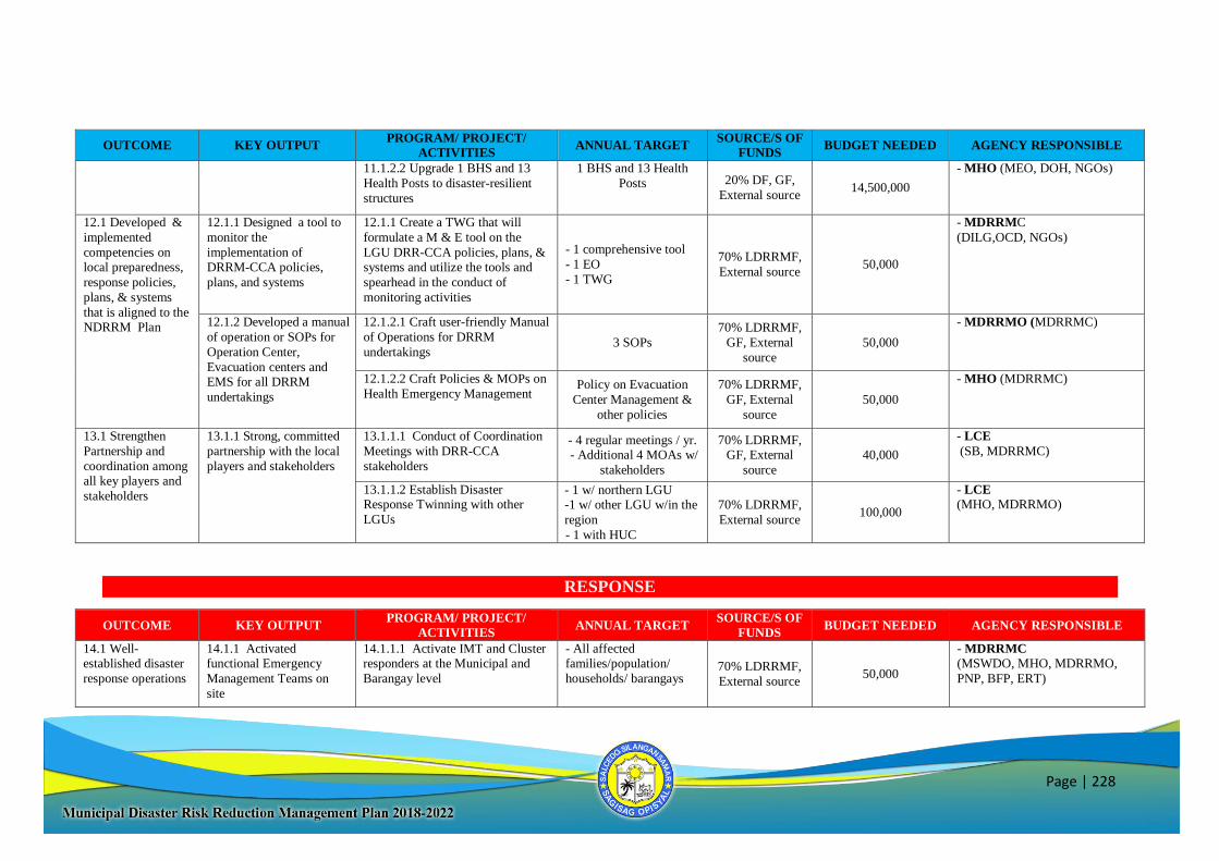
Page | 228
OUTCOME KEY OUTPUT PROGRAM/ PROJECT/
ACTIVITIES ANNUAL TARGET
SOURCE/S OF
FUNDS BUDGET NEEDED AGENCY RESPONSIBLE
11.1.2.2 Upgrade 1 BHS and 13
Health Posts to disaster-resilient
structures
1 BHS and 13 Health
Posts 20% DF, GF,
External source 14,500,000
- MHO (MEO, DOH, NGOs)
12.1 Developed &
implemented
competencies on local preparedness,
response policies,
plans, & systems
that is aligned to the NDRRM Plan
12.1.1 Designed a tool to
monitor the
implementation of DRRM-CCA policies,
plans, and systems
12.1.1 Create a TWG that will
formulate a M & E tool on the
LGU DRR-CCA policies, plans, & systems and utilize the tools and
spearhead in the conduct of
monitoring activities
- 1 comprehensive tool
- 1 EO
- 1 TWG
70% LDRRMF,
External source 50,000
- MDRRMC
(DILG,OCD, NGOs)
12.1.2 Developed a manual
of operation or SOPs for
Operation Center,
Evacuation centers and EMS for all DRRM
undertakings
12.1.2.1 Craft user-friendly Manual
of Operations for DRRM
undertakings 3 SOPs
70% LDRRMF,
GF, External
source
50,000
- MDRRMO (MDRRMC)
12.1.2.2 Craft Policies & MOPs on
Health Emergency Management Policy on Evacuation
Center Management &
other policies
70% LDRRMF,
GF, External
source
50,000
- MHO (MDRRMC)
13.1 Strengthen
Partnership and
coordination among all key players and
stakeholders
13.1.1 Strong, committed
partnership with the local
players and stakeholders
13.1.1.1 Conduct of Coordination
Meetings with DRR-CCA
stakeholders
- 4 regular meetings / yr. - Additional 4 MOAs w/
stakeholders
70% LDRRMF, GF, External
source
40,000
- LCE
(SB, MDRRMC)
13.1.1.2 Establish Disaster Response Twinning with other
LGUs
- 1 w/ northern LGU -1 w/ other LGU w/in the
region
- 1 with HUC
70% LDRRMF,
External source 100,000
- LCE (MHO, MDRRMO)
RESPONSE
OUTCOME KEY OUTPUT PROGRAM/ PROJECT/
ACTIVITIES ANNUAL TARGET
SOURCE/S OF
FUNDS BUDGET NEEDED AGENCY RESPONSIBLE
14.1 Well-established disaster
response operations
14.1.1 Activated functional Emergency
Management Teams on
site
14.1.1.1 Activate IMT and Cluster responders at the Municipal and
Barangay level
- All affected families/population/
households/ barangays
70% LDRRMF,
External source 50,000
- MDRRMC
(MSWDO, MHO, MDRRMO,
PNP, BFP, ERT)
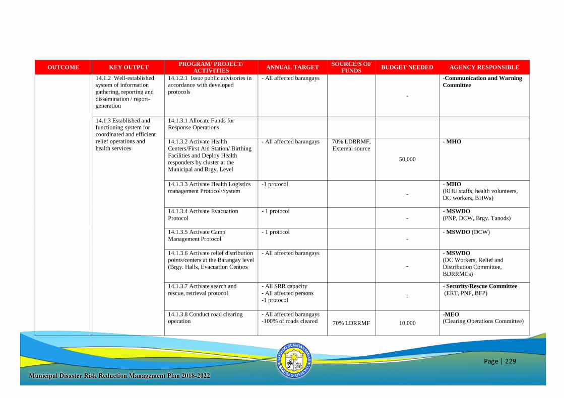
Page | 229
OUTCOME KEY OUTPUT PROGRAM/ PROJECT/
ACTIVITIES ANNUAL TARGET
SOURCE/S OF
FUNDS BUDGET NEEDED AGENCY RESPONSIBLE
14.1.2 Well-established system of information
gathering, reporting and
dissemination / report-generation
14.1.2.1 Issue public advisories in accordance with developed
protocols
- All affected barangays
-
-Communication and Warning
Committee
14.1.3 Established and functioning system for
coordinated and efficient
relief operations and
health services
14.1.3.1 Allocate Funds for Response Operations
14.1.3.2 Activate Health
Centers/First Aid Station/ Birthing
Facilities and Deploy Health responders by cluster at the
Municipal and Brgy. Level
- All affected barangays 70% LDRRMF,
External source
50,000
- MHO
14.1.3.3 Activate Health Logistics management Protocol/System
-1 protocol
-
- MHO
(RHU staffs, health volunteers,
DC workers, BHWs)
14.1.3.4 Activate Evacuation
Protocol
- 1 protocol -
- MSWDO
(PNP, DCW, Brgy. Tanods)
14.1.3.5 Activate Camp
Management Protocol
- 1 protocol
-
- MSWDO (DCW)
14.1.3.6 Activate relief distribution points/centers at the Barangay level
(Brgy. Halls, Evacuation Centers
- All affected barangays
-
- MSWDO
(DC Workers, Relief and
Distribution Committee,
BDRRMCs)
14.1.3.7 Activate search and
rescue, retrieval protocol
- All SRR capacity
- All affected persons
-1 protocol -
- Security/Rescue Committee
(ERT, PNP, BFP)
14.1.3.8 Conduct road clearing operation
- All affected barangays -100% of roads cleared 70% LDRRMF 10,000
-MEO (Clearing Operations Committee)
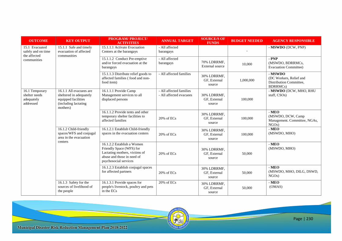
Page | 230
OUTCOME KEY OUTPUT PROGRAM/ PROJECT/
ACTIVITIES ANNUAL TARGET
SOURCE/S OF
FUNDS BUDGET NEEDED AGENCY RESPONSIBLE
15.1 Evacuated safely and on time
the affected
communities
15.1.1 Safe and timely evacuation of affected
communities
15.1.1.1 Activate Evacuation Centers at the barangays
- All affected barangays -
- MSWDO (DCW, PNP)
15.1.1.2 Conduct Pre-emptive
and/or forced evacuation at the
barangays
- All affected
barangays 70% LDRRMF, External source
10,000
- PNP
(MSWDO, BDRRMCs,
Evacuation Committee)
15.1.1.3 Distribute relief goods to
affected families ( food and non-food item)
- All affected families 30% LDRRMF,
GF, External source
1,000,000
- MSWDO
(DC Workers, Relief and Distribution Committee,
BDRRMCs)
16.1 Temporary
shelter needs
adequately
addressed
16.1.1 All evacuees are
sheltered in adequately
equipped facilities
(including lactating mothers)
16.1.1.1 Provide Camp
Management services to all
displaced persons
- All affected families
- All affected evacuees 30% LDRRMF,
GF, External
source
100,000
- MSWDO (DCW, MHO, RHU
staff, CSOs)
16.1.1.2 Provide tents and other temporary shelter facilities to
affected families 20% of ECs
30% LDRRMF, GF, External
source
100,000
- MEO
(MSWDO, DCW, Camp
Management. Committee, NGAs,
NGOs)
16.1.2 Child-friendly
spaces/WFS and conjugal
area in the evacuation centers
16.1.2.1 Establish Child-friendly
spaces in the evacuation centers 20% of ECs 30% LDRRMF,
GF, External
source
100,000
- MEO
(MSWDO, MHO)
16.1.2.2 Establish a Women
Friendly Space (WFS) for Lactating mothers, victims of
abuse and those in need of
psychosocial services
20% of ECs
30% LDRRMF,
GF, External source
50,000
- MEO
(MSWDO, MHO)
16.1.2.3 Establish conjugal spaces for affected partners 20% of ECs
30% LDRRMF,
GF, External
source
50,000
- MEO
(MSWDO, MHO, DILG, DSWD,
NGOs)
16.1.3 Safety for the
sources of livelihood of
the people
16.1.3.1 Provide spaces for
people's livestock, poultry and pets
in the ECs
20% of ECs 30% LDRRMF,
GF, External source
50,000
- MEO
(OMAS)
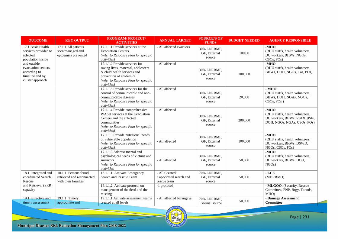
Page | 231
OUTCOME KEY OUTPUT PROGRAM/ PROJECT/
ACTIVITIES ANNUAL TARGET
SOURCE/S OF
FUNDS BUDGET NEEDED AGENCY RESPONSIBLE
17.1 Basic Health services provided to
affected
population inside and outside
evacuation centers
according to
timeline and by cluster approach
17.1.1 All patients seen/managed and
epidemics prevented
17.1.1.1 Provide services at the Evacuation Centers
(refer to Response Plan for specific
activities)
- All affected evacuees 30% LDRRMF,
GF, External
source
100,00
-MHO (RHU staffs, health volunteers,
DC workers, BHWs, NGOs,
CSOs, POs)
17.1.1.2 Provide services for
saving lives, maternal, adolescent & child health services and
prevention of epidemics
(refer to Response Plan for specific
activities)
- All affected
30% LDRRMF, GF, External
source
100,000
-MHO
(RHU staffs, health volunteers, BHWs, DOH, NGOs, Cos, POs)
17.1.1.3 Provide services for the
control of communicable and non-communicable diseases
(refer to Response Plan for specific
activities)
- All affected
30% LDRRMF, GF, External
source
20,000
- MHO
(RHU staffs, health volunteers, BHWs, DOH, NGAs, NGOs,
CSOs, POs )
17.1.1.4 Provide comprehensive
WASH services at the Evacuation
Centers and the affected communities
(refer to Response Plan for specific
activities)
- All affected
30% LDRRMF,
GF, External source
200,000
-MHO
(RHU staffs, health volunteers,
DC workers, BHWs, RSI & BSIs, DOH, NGOs, NGAs, CSOs, POs)
17.1.1.5 Provide nutritional needs
of vulnerable population
(refer to Response Plan for specific activities)
- All affected
30% LDRRMF,
GF, External
source
100,000
-MHO
(RHU staffs, health volunteers,
DC workers, BHWs, DSWD, NGOs, CSOs, POs)
17.1.1.6 Address mental and psychological needs of victims and
survivors
(refer to Response Plan for specific
activities
- All affected
30% LDRRMF,
GF, External
source
50,000
-MHO (RHU staffs, health volunteers,
DC workers, BHWs, DOH,
NGOs)
18.1 Integrated and
coordinated Search, Rescue
and Retrieval (SRR)
capacity
18.1.1 Persons found,
retrieved and reconnected with their families
18.1.1.1 Activate Emergency
Search and Rescue Team
- All Created/
Capacitated search and rescue team
70% LDRRMF,
GF, External source
50,000
- LCE
(MDRRMO)
18.1.1.2 Activate protocol on management of the dead and the
missing
-1 protocol -
- MLGOO, (Security, Rescue Committee, PNP, Brgy. Tanods,
MHO)
19.1 Effective and
timely assessment
19.1.1 Timely,
appropriate and
19.1.1.1 Activate assessment teams
created at all levels
- All affected barangays
70% LDRRMF,
External source 50,000
- Damage Assessment
Committee
Page | 232
OUTCOME KEY OUTPUT PROGRAM/ PROJECT/
ACTIVITIES ANNUAL TARGET
SOURCE/S OF
FUNDS BUDGET NEEDED AGENCY RESPONSIBLE
of needs and damages at all
barangays
consolidated needs assessment reports at all
barangays
19.1.1.2 Conduct RDANA - All assessment teams 30% LDRRMF,
GF, External
source
50,000
- Damage Assessment
Committee
20.1 Education
during emergencies is adequately
addressed.
20.1.1 Needs of school
children and teaching staff are provided.
20.1.1.1 Establish Temporary
Learning Shelter (TLS) for affected students
- All affected Students 30% LDRRMF,
20% DF, GF,
External source
100,000
- MEO
(Dep Ed, ESSU, NGOs)
20.1.1.2 Distribute school supplies to affected students
- All affected Students
30% LDRRMF, GF, External
source
100,000 - MSWDO (Dep. Ed, NGOs)
20.1.1.3 Provide feeding program
to students
- All affected Students
30% LDRRMF,
GF, External
source
100,000 - MSWDO
(DCW, RHU staff, DSWD,
NGOs, CSOs, POs)
20.1.1.4 Conduct MHPSS to
affected students and teachers
- All affected students
and teachers
30% LDRRMF,
GF, External
source
50,000
- MHO (MSWDO, RHU staff,
DOH, PHO, NGOs)
20.1.1.5 Deploy mobile Day Care
Centers for affected 3-4 years old
- All affected Students 30% LDRRMF,
GF, External source
100,000
- MSWDO (DCW, DSWD,
NGOs
RECOVERY & REHABILITATION
OUTCOME KEY OUTPUT PROGRAM/ PROJECT/
ACTIVITIES ANNUAL TARGET
SOURCE/S OF
FUNDS BUDGET NEEDED AGENCY RESPONSIBLE
21.1 Safe &
psychologically fit
Citizenry
21.1.1 Vulnerable
population provided w/
adequate risk protection
measures
21.1.1.1 Develop system for
appropriate risk protection measure
-1 system develop for
appropriate risk
protection measures
30% LDRRMF, GF, External
source
20,000
- MSWDO (MHO, MDRRMC)
21.1.1.2 Conduct PDNA w/
affected communities ANA
30% LDRRMF,
GF, External
source
50,000
- Damage Assessment
Committee (OCD, DILG, PDRRMO)
21.1.1.3 Develop systems of
support and communication among
stakeholders 1 system developed
30% LDRRMF,
GF, External source
20,000
- MDRRMC (CSOs NGOs)
Page | 233
OUTCOME KEY OUTPUT PROGRAM/ PROJECT/
ACTIVITIES ANNUAL TARGET
SOURCE/S OF
FUNDS BUDGET NEEDED AGENCY RESPONSIBLE
21.1.1.4 Build capacities of
psychosocial care providers 1 refresher trainings on
PFA, MHPSS
30% LDRRMF,
GF, External
source
20,000
- MSWDO (MHO, RHU Staff, DOH, NGOs,
CSOs))
22.1 “Build Back
Better” principle in
human settlement
strictly implemented Safe
Relocation Site
22.1.1 Disaster Resilient
Housing Design &
reconstructed
22.1.1.1 Design & construct
disaster resilient housing
20% of needed disaster
resilient housing 20% DF, GF,
External source 100,000,000
- MEO
(MPDC, NDRRMC, NEDA,
DSWD, OCD, DILG, NGAs,
NGOs
22.1.2 Self Sufficient
Communities w/ access to basic social services
22.1.2.1 Conduct training for
Social Preparation of host communities and those that will be
relocated to reduce conflict
25%
30% LDRRMF,
GF, External source
100,000
- MSWDO
(DSWD, NGOs, CSOs, POs)
22.1.3 Empowered
informal settler / affected
families
22.1.3.1 Organize & empower
host communities and engage
livelihood 20%
30% LDRRMF,
GF, External source
50,000
- OMAS
(MSWDO, PESO, NGOs, CSOs,
POs)
22.2 “Build Back
Better” principle in
infra constructed / rehabilitated
22.2.1 Resilient and
sustainable public infra
and lifelines
22.2.1.1 Rehabilitate public infra.
and lifelines thru “BBB” scheme
- 20% identified public
infra implemented
- 20% transport infra
reconstructed
30% LDRRMF,
20% DF, GF, External source
500,000,000
- MEO
(MPDC, NEDA, NDRRMC,
OCD, DILG, DPWH)
22.2.2 Green Technology
campaign conducted and
applied
22.2.2.1 Adapt & implement
building code & other policies w/c
promote green technology
- 1 IEC campaign
-10% applications
70% LDRRMF,
GF, External source
100,000
- MEO
(MPDC, DPWH, NGOs)
22.2.3 Develop permits
approved within
prescribed timeline
22.2.3.1 Close monitor or trace
approved infra project & permits 1 system in placed
GF, External source
20,000
- MEO
(MTO)
Page | 234
5-Year Local Disaster Risk Reduction Management Plan
PREVENTION & MITIGATION
OUTCOME KEY OUTPUT PROGRAMS/PROJECTS/
ACTIVITIES TARGETS
RESPONSIBLE
AGENCY/OFFICE
TIMEFRAME SOURCE OF
FUNDS
INDICATIVE
BUDGET 2018 2020 2021 2022
1.1 DRRM &
CCA mainstreamed &
integrated in the
Mun. Devt
Policies, plans and budget
1.1.1 AIP budget is
allocated
1.1.1.1 Include CCA
programs, projects and activities in Annual
Investment Plan (AIP)
-100%
-5 CCA PPAs
- MBO (Mun.
Accountant Office, MPDC)
√ √ √ √
1.1.2 Updated Plans
(DRRM , Contingency,
Evacuation Plan, etc)
1.1.2.1 Regular update plans
(DRRM, Contingency,
Evacuation, etc.) at all levels
- 1 Municipal
- 41 Brgys.
- MDRRMC (MHO,
MSWDO, MDRRMO,
DSWD, NGOs)
√ √ √ √ 70% LDRRMF,
GAD Fund,
External source
200,000
1.1.3 Environmental
Ordinances
1.1.3.1 Enact & legislate
environmental policies and
ordinances
-5 ordinances - Sangguniang Bayan
(Barangay Councils) √ √
2.1 DRRM and
CCA-sensitive
environmental
management
2.1.1 Environmental
enforcement team
2.1.1.1 Implement & enforce
environmental ordinances or
policies
- 10 teams - MENRO
(MDRRMO, PNP,
Bantay Dagat, CSOs,
PO, Brgy. Tanod)
√ √ √ √
20% DF 50,000
2.1.2 Solid Waste
Management Plan
2.1.2.1 Review and evaluate
the proposed 10-year SWM System
-1 10-Year Plan
-100% approved
- SWMO (MPDC,
NGO's, DENR-EMB) √ √ √ √
20% DF, External source
100,000
2.1.2.2 Implement SWM
Plan
- 100%
implemented
- SWMO (MENRO,
MEO, DENR-EMB,
NGOs, NGAs)
√ √ √ √ 20% DF,
External source 10,000,000
2.1.3 Integrated Forest
Land Use Plan
2.1.3.1 Tree Growing
Activities
- 1 FLUP
-5 tree planting
activities/yr
- MENRO (Mun.
Accountant), CSOs, POs, Dep. Ed, DENR)
√ √ √ √
20% DF, GF,
External source 100,000
2.1.3.2 Assess, monitor and
manage of the watershed
area/s
- 2 Watershed area - MENRO (DENR,
CSOs, POs) √ √ √ √
20% DF, GF,
External source 100,000
Page | 235
OUTCOME KEY OUTPUT PROGRAMS/PROJECTS/
ACTIVITIES TARGETS
RESPONSIBLE
AGENCY/OFFICE
TIMEFRAME SOURCE OF
FUNDS
INDICATIVE
BUDGET 2018 2020 2021 2022
2.1.3.3 Rehabilitation and
maintenance of Watershed Area in YOCENCA
- 100% rehabilitated - MENRO (Mun.
Accountant, CSOs, POs, Dep. Ed, DENR)
√ √ √ √
20% DF, External source
100,000
2.1.4 Enhanced Coastal
Resource Management
Plan
2.1.4.1 Update and evaluate
of CRM Plan
-1 CRM Plan
- MENRO (MPDC) √ 20% DF,
External source 50,000
2.1.4.2 Assess, monitor and
manage of MPA’s
- 8 MPA's - MENRO (DENR,
CSOs, POs) √ √ √ √
20% DF, GF, External source
100,000
2.1.4.3 Develop
innovative/enhanced coastal
resource programs
(mangrove reforestation,
coastal & underwater clean
up drives, etc.)
- 5 Programs - MENRO (DENR,
CSOs, POs, NGAs,
NGOs, BLGU)
√ √ √ √
20% DF, 70%
LDRRMF, GF,
External source
100,000
3.1 Increased
disaster resilience
of infrastructures
3.1.1 Building Permits 3.1.1.1 Implement the
national building code
-100% compliance
- MEO (NGAs) √ √ 70% LDRRMF,
MOOE, GF 10,000
3.1.1.2 Disseminate information on National
Building Code
-100% dissemination
- MEO √ √ 70% LDRRMF,
MOOE, GF 10,000
3.1.2 Effective and
functional drainage and
waterways
3.1.2.1 Improve municipal
drainage system plan/design
-100%
improvement of
waterways & drainage system
- MEO (MPDC, NGAs,
NGOs) √ √
20% DF, GF,
External source 100,000
3.1.2.2 Dredging and de-
clogging of waterways
- 5 dredging and de-
clogging
activities/year
- MEO (MPDC, NGAs,
NGOs)
√ √ √ √ 20% DF, GF,
External source 1,000,000
3.1.3 Infrastructure
audit report/ assessment
3.1.3.1 Conduct of
Infrastructure Audit of public
and private buildings
- all public &
private infra
- MEO (MDRRMO,
OCD, DILG) √ √
70% LDRRMF 100,000
3.1.3.2 Conduct of
Assessment to all identified
- 100% of identified
Evac. Centers
- MEO (MDRRMO,
DILG) √
70% LDRRMF 50,000
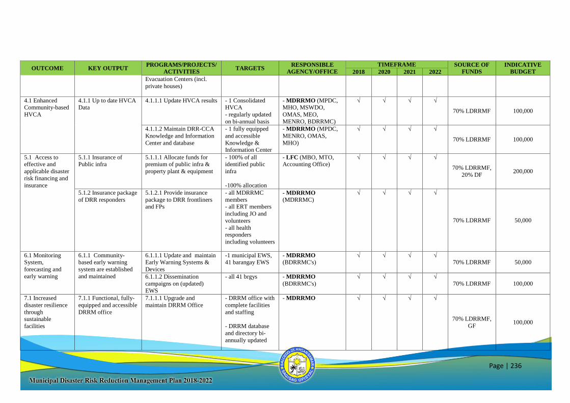
Page | 236
OUTCOME KEY OUTPUT PROGRAMS/PROJECTS/
ACTIVITIES TARGETS
RESPONSIBLE
AGENCY/OFFICE
TIMEFRAME SOURCE OF
FUNDS
INDICATIVE
BUDGET 2018 2020 2021 2022
Evacuation Centers (incl.
private houses)
4.1 Enhanced Community-based
HVCA
4.1.1 Up to date HVCA Data
4.1.1.1 Update HVCA results
- 1 Consolidated HVCA
- regularly updated
on bi-annual basis
- MDRRMO (MPDC, MHO, MSWDO,
OMAS, MEO,
MENRO, BDRRMC)
√ √ √ √
70% LDRRMF 100,000
4.1.1.2 Maintain DRR-CCA
Knowledge and Information
Center and database
- 1 fully equipped
and accessible
Knowledge & Information Center
- MDRRMO (MPDC,
MENRO, OMAS,
MHO)
√ √ √ √
70% LDRRMF 100,000
5.1 Access to effective and
applicable disaster
risk financing and
insurance
5.1.1 Insurance of Public infra
5.1.1.1 Allocate funds for premium of public infra &
property plant & equipment
- 100% of all identified public
infra
-100% allocation
- LFC (MBO, MTO, Accounting Office)
√ √ √ √
70% LDRRMF,
20% DF 200,000
5.1.2 Insurance package
of DRR responders
5.1.2.1 Provide insurance
package to DRR frontliners and FPs
- all MDRRMC
members - all ERT members
including JO and
volunteers
- all health responders
including volunteers
- MDRRMO
(MDRRMC) √ √ √ √
70% LDRRMF 50,000
6.1 Monitoring System,
forecasting and
early warning
6.1.1 Community-based early warning
system are established
and maintained
6.1.1.1 Update and maintain Early Warning Systems &
Devices
-1 municipal EWS, 41 barangay EWS
- MDRRMO (BDRRMC's)
√ √ √ √ 70% LDRRMF 50,000
6.1.1.2 Dissemination
campaigns on (updated)
EWS
- all 41 brgys - MDRRMO
(BDRRMC's) √ √ √ √
70% LDRRMF 100,000
7.1 Increased
disaster resilience
through sustainable
facilities
7.1.1 Functional, fully-
equipped and accessible
DRRM office
7.1.1.1 Upgrade and
maintain DRRM Office
- DRRM office with
complete facilities
and staffing
- DRRM database
and directory bi-
annually updated
- MDRRMO √ √ √ √
70% LDRRMF,
GF 100,000
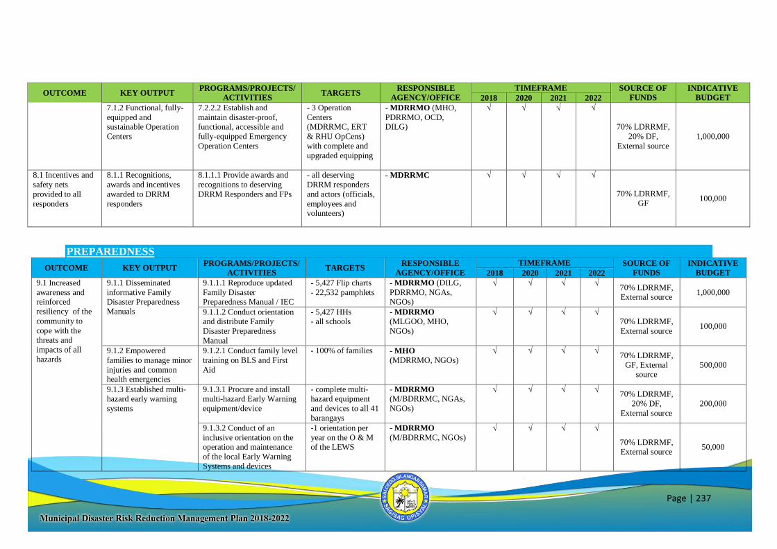
Page | 237
OUTCOME KEY OUTPUT PROGRAMS/PROJECTS/
ACTIVITIES TARGETS
RESPONSIBLE
AGENCY/OFFICE
TIMEFRAME SOURCE OF
FUNDS
INDICATIVE
BUDGET 2018 2020 2021 2022
7.1.2 Functional, fully-
equipped and sustainable Operation
Centers
7.2.2.2 Establish and
maintain disaster-proof, functional, accessible and
fully-equipped Emergency
Operation Centers
- 3 Operation
Centers (MDRRMC, ERT
& RHU OpCens)
with complete and
upgraded equipping
- MDRRMO (MHO,
PDRRMO, OCD, DILG)
√ √ √ √
70% LDRRMF,
20% DF,
External source
1,000,000
8.1 Incentives and
safety nets
provided to all
responders
8.1.1 Recognitions,
awards and incentives
awarded to DRRM
responders
8.1.1.1 Provide awards and
recognitions to deserving
DRRM Responders and FPs
- all deserving
DRRM responders
and actors (officials,
employees and volunteers)
- MDRRMC √ √ √ √
70% LDRRMF,
GF 100,000
PREPAREDNESS
OUTCOME KEY OUTPUT PROGRAMS/PROJECTS/
ACTIVITIES TARGETS
RESPONSIBLE
AGENCY/OFFICE
TIMEFRAME SOURCE OF
FUNDS
INDICATIVE
BUDGET 2018 2020 2021 2022
9.1 Increased
awareness and reinforced
resiliency of the
community to
cope with the threats and
impacts of all
hazards
9.1.1 Disseminated
informative Family Disaster Preparedness
Manuals
9.1.1.1 Reproduce updated
Family Disaster Preparedness Manual / IEC
- 5,427 Flip charts
- 22,532 pamphlets
- MDRRMO (DILG,
PDRRMO, NGAs, NGOs)
√ √ √ √ 70% LDRRMF, External source
1,000,000
9.1.1.2 Conduct orientation and distribute Family
Disaster Preparedness
Manual
- 5,427 HHs - all schools
- MDRRMO
(MLGOO, MHO,
NGOs)
√ √ √ √ 70% LDRRMF,
External source 100,000
9.1.2 Empowered
families to manage minor
injuries and common health emergencies
9.1.2.1 Conduct family level
training on BLS and First
Aid
- 100% of families - MHO
(MDRRMO, NGOs) √ √ √ √
70% LDRRMF,
GF, External source
500,000
9.1.3 Established multi-hazard early warning
systems
9.1.3.1 Procure and install multi-hazard Early Warning
equipment/device
- complete multi-hazard equipment
and devices to all 41
barangays
- MDRRMO (M/BDRRMC, NGAs,
NGOs)
√ √ √ √ 70% LDRRMF,
20% DF,
External source
200,000
9.1.3.2 Conduct of an
inclusive orientation on the operation and maintenance
of the local Early Warning
Systems and devices
-1 orientation per
year on the O & M of the LEWS
- MDRRMO
(M/BDRRMC, NGOs)
√ √ √ √
70% LDRRMF, External source
50,000
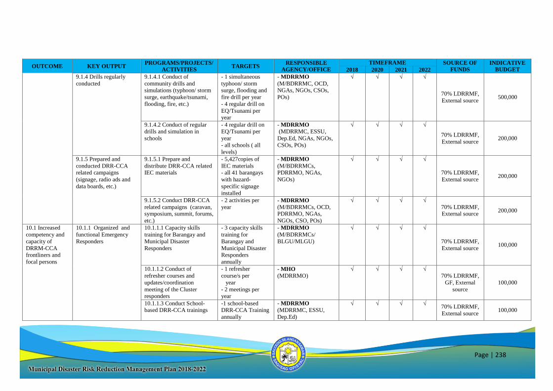
Page | 238
OUTCOME KEY OUTPUT PROGRAMS/PROJECTS/
ACTIVITIES TARGETS
RESPONSIBLE
AGENCY/OFFICE
TIMEFRAME SOURCE OF
FUNDS
INDICATIVE
BUDGET 2018 2020 2021 2022
9.1.4 Drills regularly
conducted
9.1.4.1 Conduct of
community drills and simulations (typhoon/ storm
surge, earthquake/tsunami,
flooding, fire, etc.)
- 1 simultaneous
typhoon/ storm surge, flooding and
fire drill per year
- 4 regular drill on
EQ/Tsunami per year
- MDRRMO
(M/BDRRMC, OCD, NGAs, NGOs, CSOs,
POs)
√ √ √ √
70% LDRRMF,
External source 500,000
9.1.4.2 Conduct of regular drills and simulation in
schools
- 4 regular drill on EQ/Tsunami per
year
- all schools ( all
levels)
- MDRRMO
(MDRRMC, ESSU,
Dep.Ed, NGAs, NGOs,
CSOs, POs)
√ √ √ √
70% LDRRMF,
External source 200,000
9.1.5 Prepared and
conducted DRR-CCA related campaigns
(signage, radio ads and
data boards, etc.)
9.1.5.1 Prepare and
distribute DRR-CCA related IEC materials
- 5,427copies of
IEC materials - all 41 barangays
with hazard-
specific signage
installed
- MDRRMO
(M/BDRRMCs, PDRRMO, NGAs,
NGOs)
√ √ √ √
70% LDRRMF,
External source 200,000
9.1.5.2 Conduct DRR-CCA
related campaigns (caravan, symposium, summit, forums,
etc.)
- 2 activities per
year - MDRRMO
(M/BDRRMCs, OCD, PDRRMO, NGAs,
NGOs, CSO, POs)
√ √ √ √
70% LDRRMF, External source
200,000
10.1 Increased
competency and
capacity of
DRRM-CCA frontliners and
focal persons
10.1.1 Organized and
functional Emergency
Responders
10.1.1.1 Capacity skills
training for Barangay and
Municipal Disaster
Responders
- 3 capacity skills
training for
Barangay and
Municipal Disaster Responders
annually
- MDRRMO
(M/BDRRMCs/
BLGU/MLGU)
√ √ √ √
70% LDRRMF,
External source 100,000
10.1.1.2 Conduct of
refresher courses and
updates/coordination
meeting of the Cluster responders
- 1 refresher
course/s per
year
- 2 meetings per year
- MHO
(MDRRMO) √ √ √ √
70% LDRRMF,
GF, External
source
100,000
10.1.1.3 Conduct School-based DRR-CCA trainings
-1 school-based DRR-CCA Training
annually
- MDRRMO (MDRRMC, ESSU,
Dep.Ed)
√ √ √ √ 70% LDRRMF,
External source 100,000
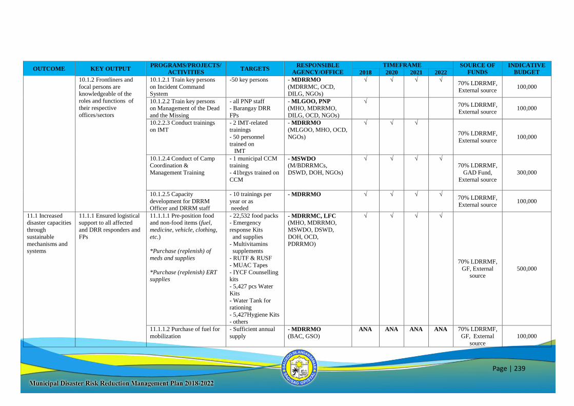
Page | 239
OUTCOME KEY OUTPUT PROGRAMS/PROJECTS/
ACTIVITIES TARGETS
RESPONSIBLE
AGENCY/OFFICE
TIMEFRAME SOURCE OF
FUNDS
INDICATIVE
BUDGET 2018 2020 2021 2022
10.1.2 Frontliners and
focal persons are knowledgeable of the
roles and functions of
their respective
offices/sectors
10.1.2.1 Train key persons
on Incident Command System
-50 key persons - MDRRMO
(MDRRMC, OCD, DILG, NGOs)
√ √ √ √ 70% LDRRMF,
External source 100,000
10.1.2.2 Train key persons on Management of the Dead
and the Missing
- all PNP staff - Barangay DRR
FPs
- MLGOO, PNP (MHO, MDRRMO,
DILG, OCD, NGOs)
√ 70% LDRRMF, External source
100,000
10.2.2.3 Conduct trainings
on IMT
- 2 IMT-related
trainings
- 50 personnel
trained on IMT
- MDRRMO
(MLGOO, MHO, OCD,
NGOs)
√ √ √
70% LDRRMF,
External source 100,000
10.1.2.4 Conduct of Camp Coordination &
Management Training
- 1 municipal CCM training
- 41brgys trained on
CCM
- MSWDO (M/BDRRMCs,
DSWD, DOH, NGOs)
√ √ √ √ 70% LDRRMF,
GAD Fund,
External source
300,000
10.1.2.5 Capacity
development for DRRM Officer and DRRM staff
- 10 trainings per
year or as needed
- MDRRMO √ √ √ √ 70% LDRRMF,
External source 100,000
11.1 Increased disaster capacities
through
sustainable
mechanisms and systems
11.1.1 Ensured logistical support to all affected
and DRR responders and
FPs
11.1.1.1 Pre-position food and non-food items (fuel,
medicine, vehicle, clothing,
etc.)
*Purchase (replenish) of
meds and supplies
*Purchase (replenish) ERT supplies
- 22,532 food packs - Emergency
response Kits
and supplies
- Multivitamins supplements
- RUTF & RUSF
- MUAC Tapes
- IYCF Counselling kits
- 5,427 pcs Water
Kits
- Water Tank for rationing
- 5,427Hygiene Kits
- others
- MDRRMC, LFC (MHO, MDRRMO,
MSWDO, DSWD,
DOH, OCD,
PDRRMO)
√ √ √ √
70% LDRRMF,
GF, External source
500,000
11.1.1.2 Purchase of fuel for
mobilization
- Sufficient annual
supply - MDRRMO
(BAC, GSO) ANA ANA ANA ANA 70% LDRRMF,
GF, External
source
100,000
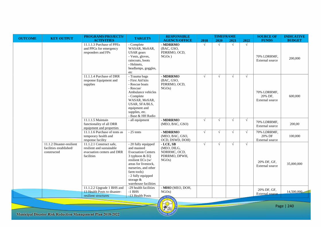
Page | 240
OUTCOME KEY OUTPUT PROGRAMS/PROJECTS/
ACTIVITIES TARGETS
RESPONSIBLE
AGENCY/OFFICE
TIMEFRAME SOURCE OF
FUNDS
INDICATIVE
BUDGET 2018 2020 2021 2022
11.1.1.3 Purchase of PPEs
and PPGs for emergency responders and FPs
- Complete
WASAR, MoSAR, USAR gears
- Vests, gloves,
raincoats, boots
- Helmets, headlamps, goggles,
etc
- MDRRMO
(BAC, GSO, PDRRMO, OCD,
NGOs )
√ √ √ √
70% LDRRMF,
External source 200,000
11.1.1.4 Purchase of DRR
response Equipment and
supplies
- Trauma bags
- First Aid kits
- Rescue boats
- Rescue/ Ambulance vehicles
- Complete
WASAR, MoSAR,
USAR, SFA/BLS,
equipment and
supplies, etc.
- Base & HH Radio
- MDRRMO
(BAC, GSO,
PDRRMO, OCD,
NGOs)
√ √ √ √
70% LDRRMF,
20% DF,
External source
600,000
11.1.1.5 Maintain
functionality of all DRR
equipment and properties
- all equipment - MDRRMO
(MEO, BAC, GSO) √ √ √ √
70% LDRRMF,
External source 200,00
11.1.1.6 Purchase of tents as
temporary health and response facility
- 25 tents - MDRRMO
(MEO, BAC, GSO, OCD, DSWD, DOH)
√ √ √ √ 70% LDRRMF,
20% DF External source
100,000
11.1.2 Disaster-resilient facilities established/
constructed
11.1.2.1 Construct safe, resilient and sustainable
evacuation centers and DRR
facilities
- 20 fully equipped and manned
Evacuation Centers
3 typhoon & EQ
resilient ECs (w/ areas for livestock,
nurseries, and other
farm tools)
- 2 fully equipped storage &
warehouse facilities
- LCE, SB (MEO, DILG,
NDRRMC, OCD,
PDRRMO, DPWH,
NGOs)
√ √ √ √
20% DF, GF,
External source 35,000,000
11.1.2.2 Upgrade 1 BHS and
13 Health Posts to disaster-
resilient structures
-29 health facilities
-1 BHS
-13 Health Posts
- MHO (MEO, DOH,
NGOs)
20% DF, GF,
External source 14,500,000
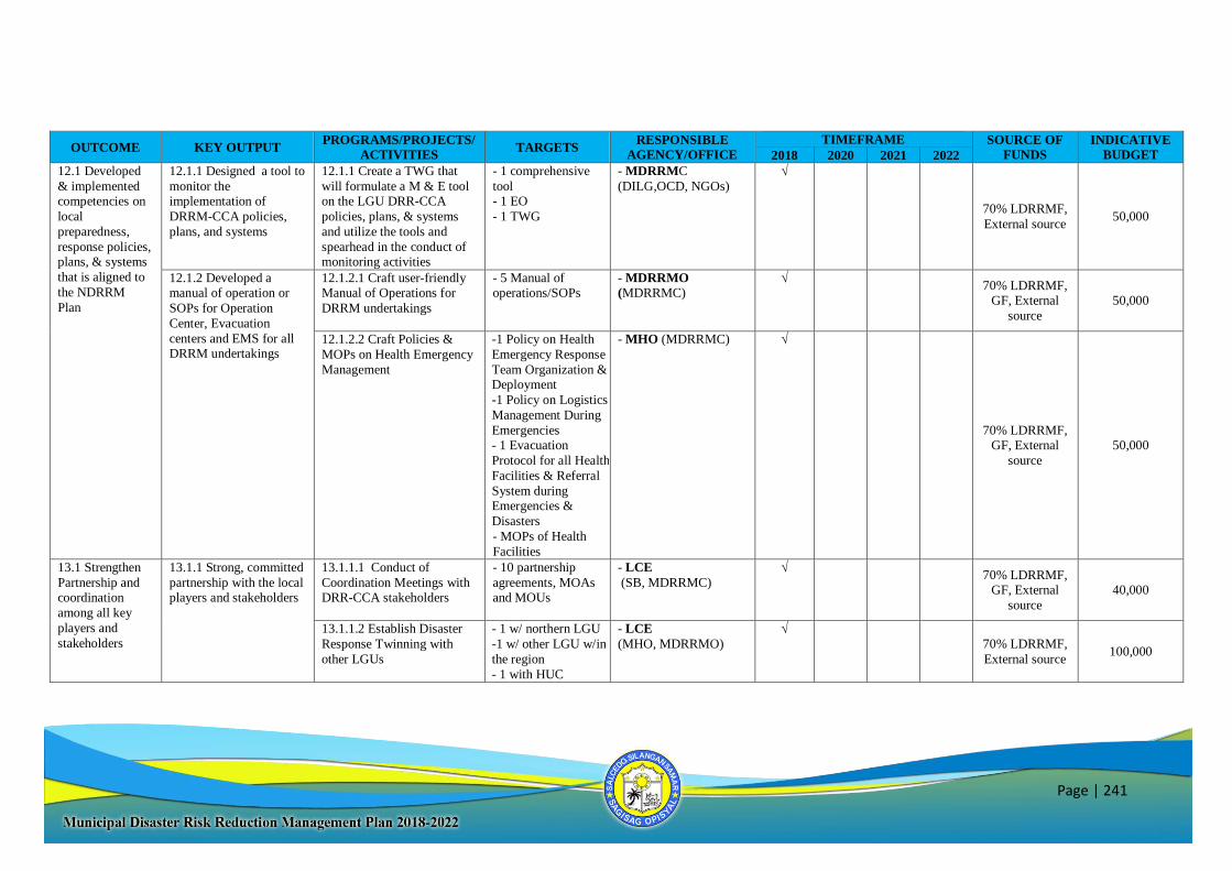
Page | 241
OUTCOME KEY OUTPUT PROGRAMS/PROJECTS/
ACTIVITIES TARGETS
RESPONSIBLE
AGENCY/OFFICE
TIMEFRAME SOURCE OF
FUNDS
INDICATIVE
BUDGET 2018 2020 2021 2022
12.1 Developed
& implemented competencies on
local
preparedness,
response policies, plans, & systems
that is aligned to
the NDRRM
Plan
12.1.1 Designed a tool to
monitor the implementation of
DRRM-CCA policies,
plans, and systems
12.1.1 Create a TWG that
will formulate a M & E tool on the LGU DRR-CCA
policies, plans, & systems
and utilize the tools and
spearhead in the conduct of monitoring activities
- 1 comprehensive
tool - 1 EO
- 1 TWG
- MDRRMC
(DILG,OCD, NGOs)
√
70% LDRRMF,
External source 50,000
12.1.2 Developed a manual of operation or
SOPs for Operation
Center, Evacuation
centers and EMS for all DRRM undertakings
12.1.2.1 Craft user-friendly Manual of Operations for
DRRM undertakings
- 5 Manual of operations/SOPs
- MDRRMO
(MDRRMC) √
70% LDRRMF, GF, External
source
50,000
12.1.2.2 Craft Policies &
MOPs on Health Emergency
Management
-1 Policy on Health
Emergency Response
Team Organization & Deployment
-1 Policy on Logistics
Management During
Emergencies - 1 Evacuation
Protocol for all Health
Facilities & Referral
System during Emergencies &
Disasters
- MOPs of Health
Facilities
- MHO (MDRRMC) √
70% LDRRMF, GF, External
source
50,000
13.1 Strengthen
Partnership and coordination
among all key
players and
stakeholders
13.1.1 Strong, committed
partnership with the local players and stakeholders
13.1.1.1 Conduct of
Coordination Meetings with DRR-CCA stakeholders
- 10 partnership
agreements, MOAs and MOUs
- LCE
(SB, MDRRMC)
√ 70% LDRRMF,
GF, External
source
40,000
13.1.1.2 Establish Disaster
Response Twinning with
other LGUs
- 1 w/ northern LGU
-1 w/ other LGU w/in
the region
- 1 with HUC
- LCE
(MHO, MDRRMO)
√
70% LDRRMF,
External source 100,000
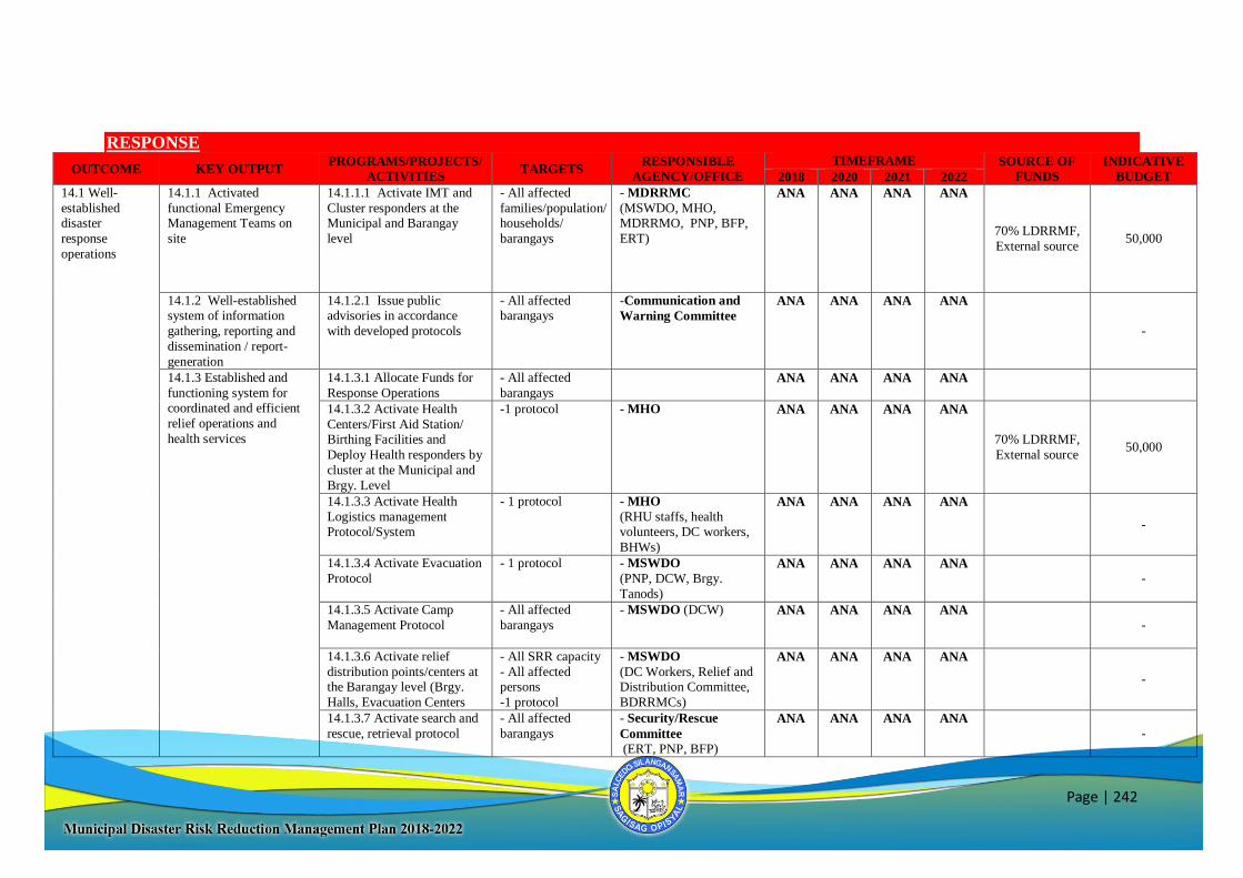
Page | 242
RESPONSE
OUTCOME KEY OUTPUT PROGRAMS/PROJECTS/
ACTIVITIES TARGETS
RESPONSIBLE
AGENCY/OFFICE
TIMEFRAME SOURCE OF
FUNDS
INDICATIVE
BUDGET 2018 2020 2021 2022
14.1 Well-
established disaster
response
operations
14.1.1 Activated
functional Emergency Management Teams on
site
14.1.1.1 Activate IMT and
Cluster responders at the Municipal and Barangay
level
- All affected
families/population/ households/
barangays
- MDRRMC
(MSWDO, MHO, MDRRMO, PNP, BFP,
ERT)
ANA ANA ANA ANA
70% LDRRMF,
External source 50,000
14.1.2 Well-established system of information
gathering, reporting and
dissemination / report-
generation
14.1.2.1 Issue public advisories in accordance
with developed protocols
- All affected barangays
-Communication and
Warning Committee
ANA ANA ANA ANA
-
14.1.3 Established and
functioning system for
coordinated and efficient
relief operations and
health services
14.1.3.1 Allocate Funds for
Response Operations
- All affected
barangays
ANA ANA ANA ANA
14.1.3.2 Activate Health
Centers/First Aid Station/ Birthing Facilities and
Deploy Health responders by
cluster at the Municipal and
Brgy. Level
-1 protocol - MHO ANA ANA ANA ANA
70% LDRRMF,
External source 50,000
14.1.3.3 Activate Health
Logistics management Protocol/System
- 1 protocol - MHO
(RHU staffs, health volunteers, DC workers,
BHWs)
ANA ANA ANA ANA
-
14.1.3.4 Activate Evacuation
Protocol
- 1 protocol - MSWDO
(PNP, DCW, Brgy.
Tanods)
ANA ANA ANA ANA
-
14.1.3.5 Activate Camp
Management Protocol
- All affected
barangays
- MSWDO (DCW)
ANA ANA ANA ANA
-
14.1.3.6 Activate relief
distribution points/centers at the Barangay level (Brgy.
Halls, Evacuation Centers
- All SRR capacity
- All affected persons
-1 protocol
- MSWDO
(DC Workers, Relief and Distribution Committee,
BDRRMCs)
ANA ANA ANA ANA
-
14.1.3.7 Activate search and
rescue, retrieval protocol
- All affected
barangays
- Security/Rescue
Committee
(ERT, PNP, BFP)
ANA ANA ANA ANA
-
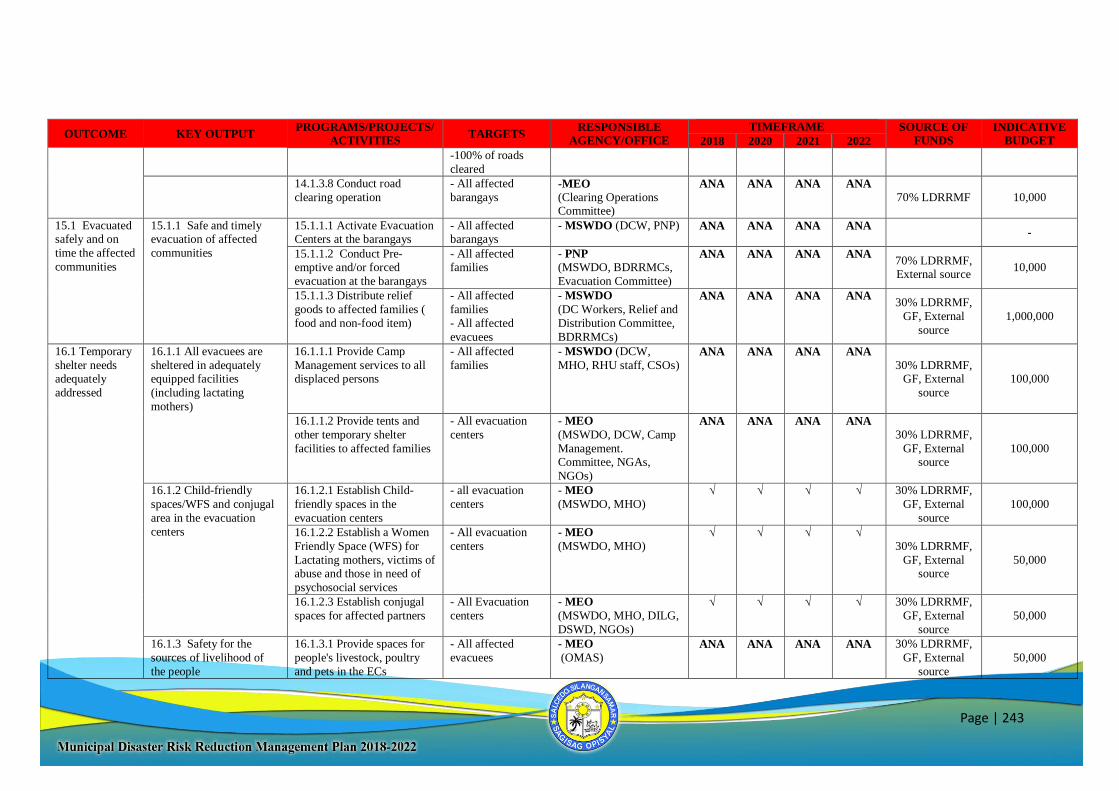
Page | 243
OUTCOME KEY OUTPUT PROGRAMS/PROJECTS/
ACTIVITIES TARGETS
RESPONSIBLE
AGENCY/OFFICE
TIMEFRAME SOURCE OF
FUNDS
INDICATIVE
BUDGET 2018 2020 2021 2022
-100% of roads
cleared
14.1.3.8 Conduct road
clearing operation
- All affected
barangays -MEO (Clearing Operations Committee)
ANA ANA ANA ANA
70% LDRRMF 10,000
15.1 Evacuated safely and on
time the affected
communities
15.1.1 Safe and timely evacuation of affected
communities
15.1.1.1 Activate Evacuation Centers at the barangays
- All affected barangays
- MSWDO (DCW, PNP) ANA ANA ANA ANA -
15.1.1.2 Conduct Pre-emptive and/or forced
evacuation at the barangays
- All affected families
- PNP
(MSWDO, BDRRMCs,
Evacuation Committee)
ANA ANA ANA ANA 70% LDRRMF, External source
10,000
15.1.1.3 Distribute relief
goods to affected families (
food and non-food item)
- All affected
families
- All affected
evacuees
- MSWDO
(DC Workers, Relief and
Distribution Committee,
BDRRMCs)
ANA ANA ANA ANA 30% LDRRMF,
GF, External
source
1,000,000
16.1 Temporary
shelter needs adequately
addressed
16.1.1 All evacuees are
sheltered in adequately equipped facilities
(including lactating
mothers)
16.1.1.1 Provide Camp
Management services to all displaced persons
- All affected
families
- MSWDO (DCW,
MHO, RHU staff, CSOs)
ANA ANA ANA ANA
30% LDRRMF, GF, External
source
100,000
16.1.1.2 Provide tents and
other temporary shelter
facilities to affected families
- All evacuation
centers
- MEO
(MSWDO, DCW, Camp
Management. Committee, NGAs,
NGOs)
ANA ANA ANA ANA
30% LDRRMF,
GF, External source
100,000
16.1.2 Child-friendly
spaces/WFS and conjugal
area in the evacuation
centers
16.1.2.1 Establish Child-
friendly spaces in the
evacuation centers
- all evacuation
centers
- MEO
(MSWDO, MHO) √ √ √ √ 30% LDRRMF,
GF, External
source
100,000
16.1.2.2 Establish a Women
Friendly Space (WFS) for
Lactating mothers, victims of abuse and those in need of
psychosocial services
- All evacuation
centers
- MEO
(MSWDO, MHO) √ √ √ √
30% LDRRMF,
GF, External source
50,000
16.1.2.3 Establish conjugal
spaces for affected partners
- All Evacuation
centers
- MEO
(MSWDO, MHO, DILG,
DSWD, NGOs)
√ √ √ √ 30% LDRRMF,
GF, External
source
50,000
16.1.3 Safety for the
sources of livelihood of
the people
16.1.3.1 Provide spaces for
people's livestock, poultry
and pets in the ECs
- All affected
evacuees
- MEO
(OMAS) ANA ANA ANA ANA 30% LDRRMF,
GF, External
source
50,000
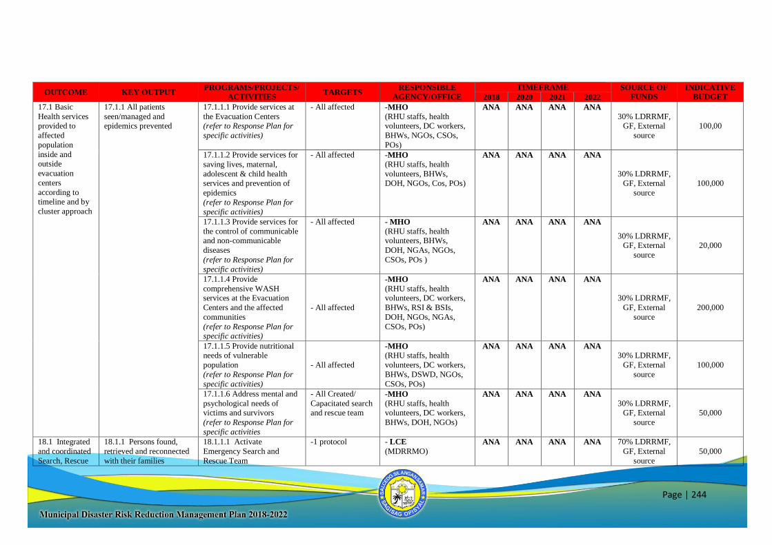
Page | 244
OUTCOME KEY OUTPUT PROGRAMS/PROJECTS/
ACTIVITIES TARGETS
RESPONSIBLE
AGENCY/OFFICE
TIMEFRAME SOURCE OF
FUNDS
INDICATIVE
BUDGET 2018 2020 2021 2022
17.1 Basic
Health services provided to
affected
population
inside and outside
evacuation
centers
according to timeline and by
cluster approach
17.1.1 All patients
seen/managed and epidemics prevented
17.1.1.1 Provide services at
the Evacuation Centers (refer to Response Plan for
specific activities)
- All affected -MHO
(RHU staffs, health volunteers, DC workers,
BHWs, NGOs, CSOs,
POs)
ANA ANA ANA ANA
30% LDRRMF, GF, External
source
100,00
17.1.1.2 Provide services for
saving lives, maternal,
adolescent & child health services and prevention of
epidemics
(refer to Response Plan for
specific activities)
- All affected -MHO
(RHU staffs, health
volunteers, BHWs, DOH, NGOs, Cos, POs)
ANA ANA ANA ANA
30% LDRRMF, GF, External
source
100,000
17.1.1.3 Provide services for
the control of communicable and non-communicable
diseases
(refer to Response Plan for
specific activities)
- All affected - MHO
(RHU staffs, health volunteers, BHWs,
DOH, NGAs, NGOs,
CSOs, POs )
ANA ANA ANA ANA
30% LDRRMF, GF, External
source
20,000
17.1.1.4 Provide
comprehensive WASH services at the Evacuation
Centers and the affected
communities
(refer to Response Plan for specific activities)
- All affected
-MHO
(RHU staffs, health volunteers, DC workers,
BHWs, RSI & BSIs,
DOH, NGOs, NGAs,
CSOs, POs)
ANA ANA ANA ANA
30% LDRRMF,
GF, External
source
200,000
17.1.1.5 Provide nutritional needs of vulnerable
population
(refer to Response Plan for
specific activities)
- All affected
-MHO (RHU staffs, health
volunteers, DC workers,
BHWs, DSWD, NGOs,
CSOs, POs)
ANA ANA ANA ANA 30% LDRRMF,
GF, External
source
100,000
17.1.1.6 Address mental and
psychological needs of victims and survivors
(refer to Response Plan for
specific activities
- All Created/
Capacitated search and rescue team
-MHO
(RHU staffs, health volunteers, DC workers,
BHWs, DOH, NGOs)
ANA ANA ANA ANA
30% LDRRMF, GF, External
source
50,000
18.1 Integrated
and coordinated
Search, Rescue
18.1.1 Persons found,
retrieved and reconnected
with their families
18.1.1.1 Activate
Emergency Search and
Rescue Team
-1 protocol - LCE
(MDRRMO) ANA ANA ANA ANA 70% LDRRMF,
GF, External
source
50,000
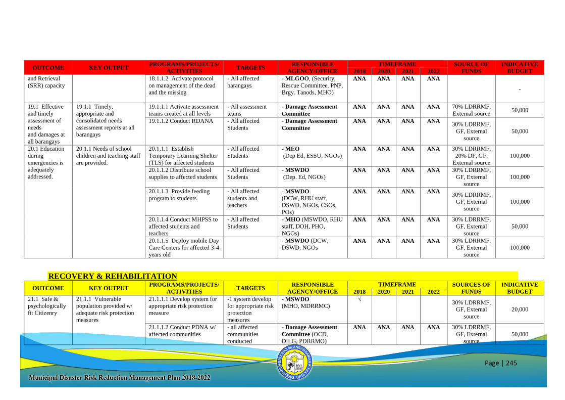
Page | 245
OUTCOME KEY OUTPUT PROGRAMS/PROJECTS/
ACTIVITIES TARGETS
RESPONSIBLE
AGENCY/OFFICE
TIMEFRAME SOURCE OF
FUNDS
INDICATIVE
BUDGET 2018 2020 2021 2022
and Retrieval
(SRR) capacity
18.1.1.2 Activate protocol
on management of the dead and the missing
- All affected
barangays
- MLGOO, (Security,
Rescue Committee, PNP, Brgy. Tanods, MHO)
ANA ANA ANA ANA
-
19.1 Effective
and timely
assessment of
needs and damages at
all barangays
19.1.1 Timely,
appropriate and
consolidated needs
assessment reports at all barangays
19.1.1.1 Activate assessment
teams created at all levels
- All assessment
teams
- Damage Assessment
Committee
ANA ANA ANA ANA 70% LDRRMF,
External source 50,000
19.1.1.2 Conduct RDANA - All affected
Students
- Damage Assessment
Committee
ANA ANA ANA ANA 30% LDRRMF,
GF, External
source
50,000
20.1 Education
during
emergencies is
adequately addressed.
20.1.1 Needs of school
children and teaching staff
are provided.
20.1.1.1 Establish
Temporary Learning Shelter
(TLS) for affected students
- All affected
Students
- MEO
(Dep Ed, ESSU, NGOs)
ANA ANA ANA ANA 30% LDRRMF,
20% DF, GF,
External source
100,000
20.1.1.2 Distribute school
supplies to affected students
- All affected
Students
- MSWDO
(Dep. Ed, NGOs) ANA ANA ANA ANA 30% LDRRMF,
GF, External
source
100,000
20.1.1.3 Provide feeding
program to students
- All affected
students and teachers
- MSWDO
(DCW, RHU staff, DSWD, NGOs, CSOs,
POs)
ANA ANA ANA ANA 30% LDRRMF,
GF, External source
100,000
20.1.1.4 Conduct MHPSS to
affected students and
teachers
- All affected
Students
- MHO (MSWDO, RHU
staff, DOH, PHO,
NGOs)
ANA ANA ANA ANA 30% LDRRMF,
GF, External
source
50,000
20.1.1.5 Deploy mobile Day
Care Centers for affected 3-4
years old
- MSWDO (DCW,
DSWD, NGOs ANA ANA ANA ANA 30% LDRRMF,
GF, External
source
100,000
RECOVERY & REHABILITATION
OUTCOME KEY OUTPUT PROGRAMS/PROJECTS/
ACTIVITIES TARGETS
RESPONSIBLE
AGENCY/OFFICE
TIMEFRAME SOURCES OF
FUNDS
INDICATIVE
BUDGET 2018 2020 2021 2022
21.1 Safe & psychologically
fit Citizenry
21.1.1 Vulnerable population provided w/
adequate risk protection
measures
21.1.1.1 Develop system for appropriate risk protection
measure
-1 system develop for appropriate risk
protection
measures
- MSWDO (MHO, MDRRMC)
√ 30% LDRRMF,
GF, External
source
20,000
21.1.1.2 Conduct PDNA w/
affected communities
- all affected
communities
conducted
- Damage Assessment
Committee (OCD,
DILG, PDRRMO)
ANA ANA ANA ANA 30% LDRRMF,
GF, External
source
50,000
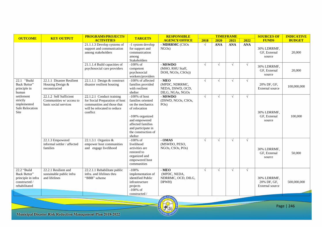
Page | 246
OUTCOME KEY OUTPUT PROGRAMS/PROJECTS/
ACTIVITIES TARGETS
RESPONSIBLE
AGENCY/OFFICE
TIMEFRAME SOURCES OF
FUNDS
INDICATIVE
BUDGET 2018 2020 2021 2022
21.1.1.3 Develop systems of
support and communication among stakeholders
-1 system develop
for support and communication
among
Stakeholders
- MDRRMC (CSOs
NGOs) √ ANA ANA ANA
30% LDRRMF, GF, External
source
20,000
21.1.1.4 Build capacities of
psychosocial care providers
-100% of
competent
psychosocial workers/providers
- MSWDO (MHO, RHU Staff,
DOH, NGOs, CSOs))
√ √ √ √ 30% LDRRMF,
GF, External
source
20,000
22.1 “Build Back Better”
principle in
human
settlement strictly
implemented
Safe Relocation
Site
22.1.1 Disaster Resilient Housing Design &
reconstructed
22.1.1.1 Design & construct disaster resilient housing
-100% of affected families provided
with resilient
shelter
- MEO
(MPDC, NDRRMC,
NEDA, DSWD, OCD,
DILG, NGAs, NGOs
√ √ √ √ 20% DF, GF,
External source 100,000,000
22.1.2 Self Sufficient
Communities w/ access to
basic social services
22.1.2.1 Conduct training
for Social Preparation of host
communities and those that will be relocated to reduce
conflict
-100% of host
families oriented
on the mechanics of relocation
-100% organized
and empowered affected families
and participate in
the construction of
shelter
- MSWDO
(DSWD, NGOs, CSOs,
POs)
√ √ √ √
30% LDRRMF,
GF, External
source
100,000
22.1.3 Empowered
informal settler / affected families
22.1.3.1 Organize &
empower host communities and engage livelihood
-100% of
livelihood activities are
restored to
organized and
empowered host communities
- OMAS
(MSWDO, PESO, NGOs, CSOs, POs)
√ √ √ √
30% LDRRMF,
GF, External source
50,000
22.2 “Build
Back Better”
principle in infra
constructed / rehabilitated
22.2.1 Resilient and
sustainable public infra
and lifelines
22.2.1.1 Rehabilitate public
infra. and lifelines thru
“BBB” scheme
-100%
implementation of
identified Public
infrastructure projects
-100% of
constructed /
- MEO
(MPDC, NEDA,
NDRRMC, OCD, DILG,
DPWH)
√ √ √ √
30% LDRRMF,
20% DF, GF, External source
500,000,000
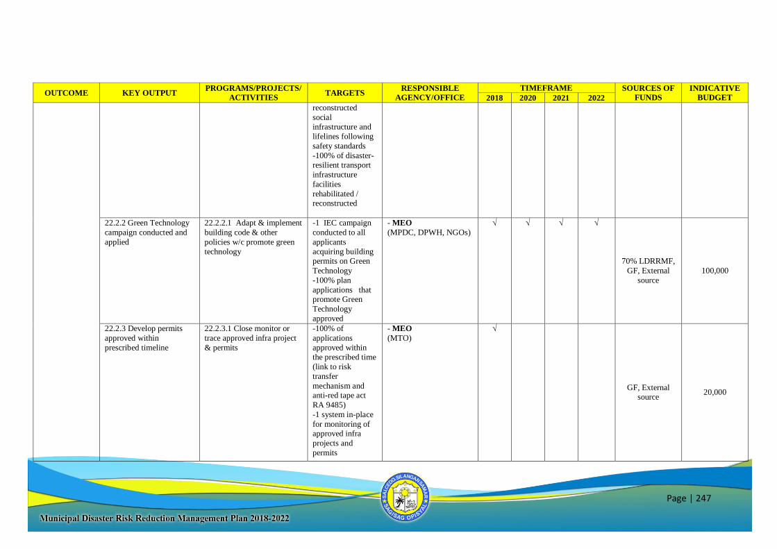
Page | 247
OUTCOME KEY OUTPUT PROGRAMS/PROJECTS/
ACTIVITIES TARGETS
RESPONSIBLE
AGENCY/OFFICE
TIMEFRAME SOURCES OF
FUNDS
INDICATIVE
BUDGET 2018 2020 2021 2022
reconstructed
social infrastructure and
lifelines following
safety standards
-100% of disaster-resilient transport
infrastructure
facilities
rehabilitated / reconstructed
22.2.2 Green Technology
campaign conducted and
applied
22.2.2.1 Adapt & implement
building code & other
policies w/c promote green
technology
-1 IEC campaign
conducted to all
applicants
acquiring building
permits on Green
Technology
-100% plan
applications that promote Green
Technology
approved
- MEO
(MPDC, DPWH, NGOs) √ √ √ √
70% LDRRMF,
GF, External
source
100,000
22.2.3 Develop permits
approved within
prescribed timeline
22.2.3.1 Close monitor or
trace approved infra project
& permits
-100% of
applications
approved within the prescribed time
(link to risk
transfer
mechanism and anti-red tape act
RA 9485)
-1 system in-place
for monitoring of approved infra
projects and
permits
- MEO
(MTO)
√
GF, External source
20,000
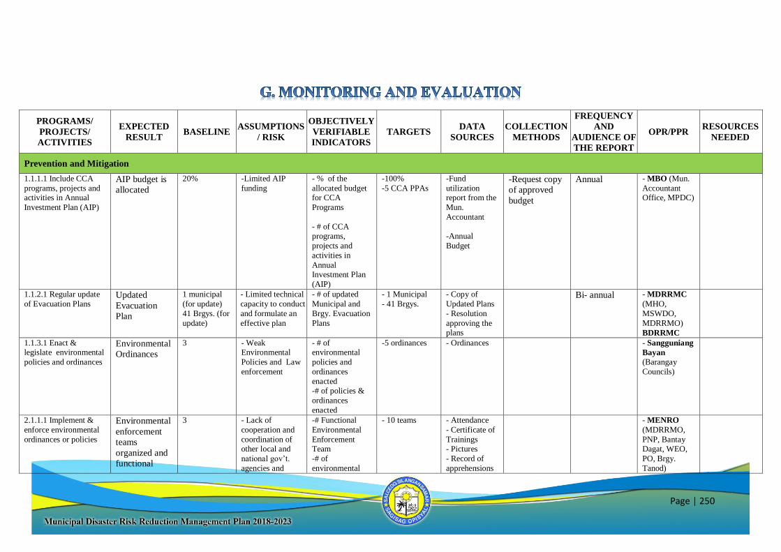
Page | 250
PROGRAMS/
PROJECTS/
ACTIVITIES
EXPECTED
RESULT BASELINE
ASSUMPTIONS
/ RISK
OBJECTIVELY
VERIFIABLE
INDICATORS
TARGETS DATA
SOURCES
COLLECTION
METHODS
FREQUENCY
AND
AUDIENCE OF
THE REPORT
OPR/PPR RESOURCES
NEEDED
Prevention and Mitigation
1.1.1.1 Include CCA
programs, projects and activities in Annual
Investment Plan (AIP)
AIP budget is
allocated
20% -Limited AIP
funding
- % of the
allocated budget for CCA
Programs
- # of CCA programs,
projects and
activities in
Annual Investment Plan
(AIP)
-100%
-5 CCA PPAs -Fund
utilization report from the
Mun.
Accountant
-Annual
Budget
-Request copy
of approved
budget
Annual - MBO (Mun.
Accountant Office, MPDC)
1.1.2.1 Regular update
of Evacuation Plans Updated
Evacuation
Plan
1 municipal
(for update)
41 Brgys. (for
update)
- Limited technical
capacity to conduct
and formulate an
effective plan
- # of updated
Municipal and
Brgy. Evacuation
Plans
- 1 Municipal
- 41 Brgys. - Copy of
Updated Plans
- Resolution
approving the plans
Bi- annual - MDRRMC
(MHO,
MSWDO,
MDRRMO)
BDRRMC
1.1.3.1 Enact & legislate environmental
policies and ordinances
Environmental
Ordinances
3 - Weak Environmental
Policies and Law
enforcement
- # of environmental
policies and
ordinances
enacted -# of policies &
ordinances
enacted
-5 ordinances - Ordinances - Sangguniang
Bayan
(Barangay
Councils)
2.1.1.1 Implement &
enforce environmental
ordinances or policies
Environmental
enforcement
teams
organized and
functional
3
- Lack of
cooperation and
coordination of other local and
national gov’t.
agencies and
-# Functional
Environmental
Enforcement Team
-# of
environmental
- 10 teams
- Attendance
- Certificate of
Trainings - Pictures
- Record of
apprehensions
- MENRO
(MDRRMO,
PNP, Bantay Dagat, WEO,
PO, Brgy.
Tanod)

Page | 251
PROGRAMS/
PROJECTS/
ACTIVITIES
EXPECTED
RESULT BASELINE
ASSUMPTIONS
/ RISK
OBJECTIVELY
VERIFIABLE
INDICATORS
TARGETS DATA
SOURCES
COLLECTION
METHODS
FREQUENCY
AND
AUDIENCE OF
THE REPORT
OPR/PPR RESOURCES
NEEDED
enforcement of
environment laws - Unfavorable
weather conditions
ordinances/
policies implemented &
enforced
2.1.2.1 Review and
evaluate the proposed
10-year SWM System
Solid Waste
Management
Plan reviewed
and approved
1 draft (for
update and
approval)
- No qualified
area identified for
Garbage Disposal
& Sanitary Landfill
-# 10-year SWM
Plan reviewed,
evaluated and
implemented
-% of reviewed &
evaluated SWM
Plan
-1 10-Year Plan
-100%
approved
- Approved
SWM Plan - SWMO
(MPDC,
NGO's)
2.1.2.2 Implement
SWM Plan Budget
allocated and
fully
implemented
plan
20% - Funds necessary
to implement the program will be
sourced out
- % of SWM Plan
implemented - 100%
implemented - Fund
Utilization Report
- Copy of M &
E report
- Pictures
- SWMO
(MDRRMO, MEO)
2.1.3.1 Tree Growing
Activities FLUP
integrated &
implemented
3 - No proper
boundary delineation of
forest land
- Climatic
Condition
- # Forest Land
Use Plan integrated
-# of tree
planting activities
- % of area
covered
(replanted)
- 1 FLUP
-5 tree planting
activities/yr
- Validated
Reports, evaluation
report (status)
and feedback
- Assessment reports, project
reports,
pictures
- MENRO
(Mun. Accountant)
2.1.3.2 Assess, monitor
and manage of the watershed area/s
FLUP
integrated
implemented
2 - Unfavorable
weather conditions - # of watershed
area managed - 2 Watershed
area - Assessment
reports - MENRO
2.1.3.3 Rehabilitation
and maintenance of Watershed Area in
YOCENCA
FLUP
integrated
implemented
20% - Climatic
condition - % of area
effectively rehabilitated
- 100%
rehabilitated - Project
reports, pictures
- MENRO
(Mun. Accountant)
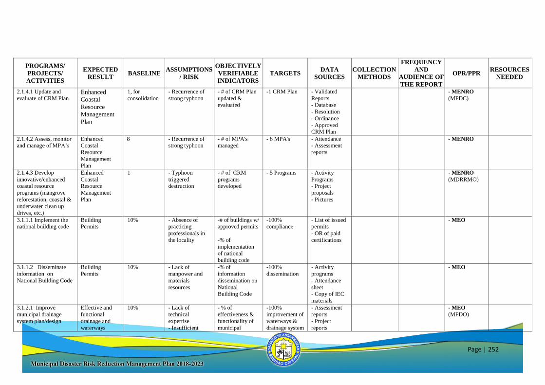
Page | 252
PROGRAMS/
PROJECTS/
ACTIVITIES
EXPECTED
RESULT BASELINE
ASSUMPTIONS
/ RISK
OBJECTIVELY
VERIFIABLE
INDICATORS
TARGETS DATA
SOURCES
COLLECTION
METHODS
FREQUENCY
AND
AUDIENCE OF
THE REPORT
OPR/PPR RESOURCES
NEEDED
2.1.4.1 Update and
evaluate of CRM Plan Enhanced
Coastal
Resource
Management
Plan
1, for
consolidation - Recurrence of
strong typhoon - # of CRM Plan
updated & evaluated
-1 CRM Plan
- Validated
Reports - Database
- Resolution
- Ordinance
- Approved CRM Plan
- MENRO
(MPDC)
2.1.4.2 Assess, monitor and manage of MPA’s
Enhanced Coastal
Resource
Management
Plan
8 - Recurrence of strong typhoon
- # of MPA's managed
- 8 MPA's - Attendance - Assessment
reports
- MENRO
2.1.4.3 Develop
innovative/enhanced coastal resource
programs (mangrove
reforestation, coastal &
underwater clean up drives, etc.)
Enhanced
Coastal Resource
Management
Plan
1 - Typhoon
triggered destruction
- # of CRM
programs developed
- 5 Programs - Activity
Programs - Project
proposals
- Pictures
- MENRO
(MDRRMO)
3.1.1.1 Implement the national building code
Building Permits
10% - Absence of practicing
professionals in
the locality
-# of buildings w/ approved permits
-% of
implementation of national
building code
-100% compliance
- List of issued permits
- OR of paid
certifications
- MEO
3.1.1.2 Disseminate
information on
National Building Code
Building
Permits 10% - Lack of
manpower and
materials
resources
-% of
information
dissemination on
National Building Code
-100%
dissemination
- Activity
programs
- Attendance
sheet - Copy of IEC
materials
- MEO
3.1.2.1 Improve
municipal drainage
system plan/design
Effective and
functional
drainage and
waterways
10% - Lack of
technical
expertise
- Insufficient
- % of
effectiveness &
functionality of
municipal
-100%
improvement of
waterways &
drainage system
- Assessment
reports
- Project
reports
- MEO
(MPDO)
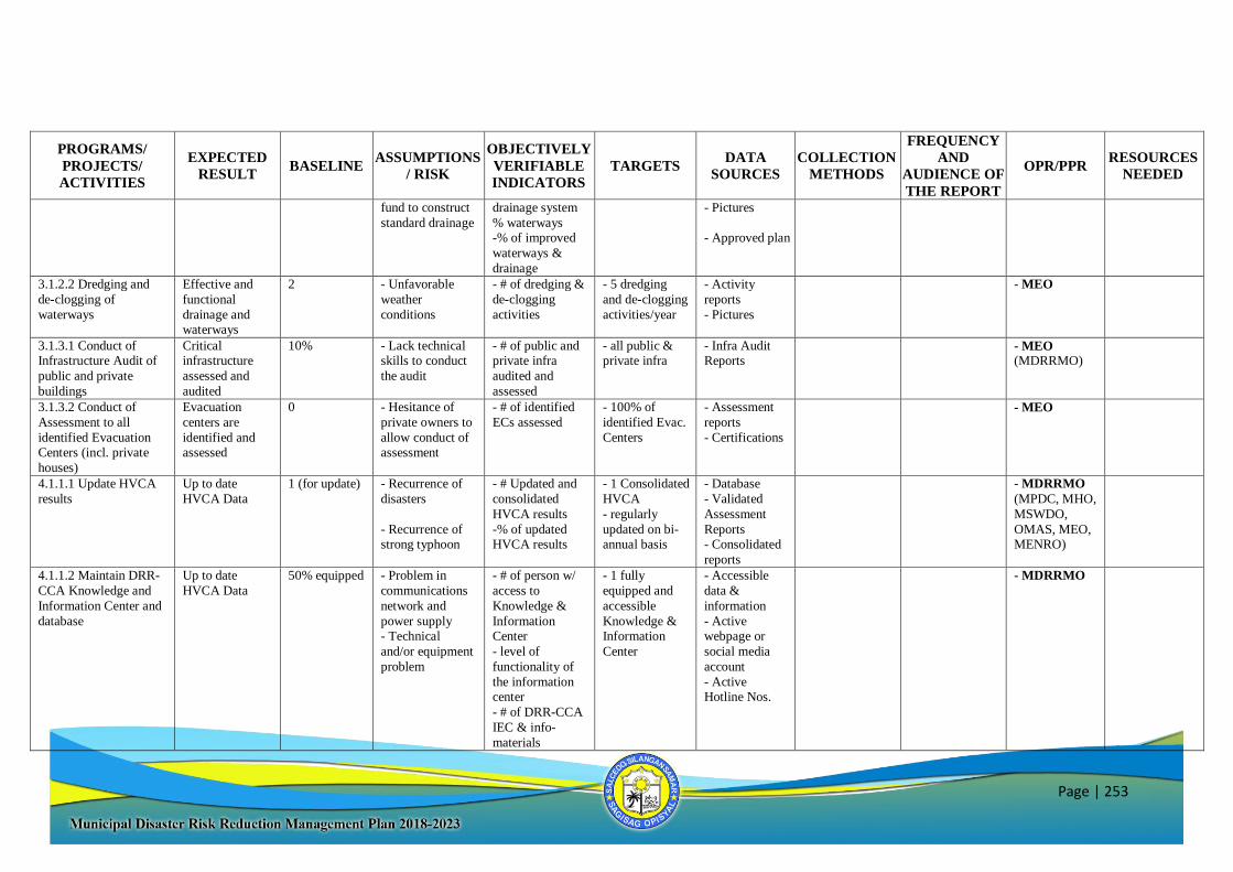
Page | 253
PROGRAMS/
PROJECTS/
ACTIVITIES
EXPECTED
RESULT BASELINE
ASSUMPTIONS
/ RISK
OBJECTIVELY
VERIFIABLE
INDICATORS
TARGETS DATA
SOURCES
COLLECTION
METHODS
FREQUENCY
AND
AUDIENCE OF
THE REPORT
OPR/PPR RESOURCES
NEEDED
fund to construct
standard drainage
drainage system
% waterways -% of improved
waterways &
drainage
- Pictures
- Approved plan
3.1.2.2 Dredging and
de-clogging of
waterways
Effective and
functional
drainage and waterways
2 - Unfavorable
weather
conditions
- # of dredging &
de-clogging
activities
- 5 dredging
and de-clogging
activities/year
- Activity
reports
- Pictures
- MEO
3.1.3.1 Conduct of Infrastructure Audit of
public and private
buildings
Critical infrastructure
assessed and
audited
10% - Lack technical skills to conduct
the audit
- # of public and private infra
audited and
assessed
- all public & private infra
- Infra Audit Reports
- MEO (MDRRMO)
3.1.3.2 Conduct of
Assessment to all
identified Evacuation Centers (incl. private
houses)
Evacuation
centers are
identified and assessed
0 - Hesitance of
private owners to
allow conduct of assessment
- # of identified
ECs assessed
- 100% of
identified Evac.
Centers
- Assessment
reports
- Certifications
- MEO
4.1.1.1 Update HVCA
results
Up to date
HVCA Data
1 (for update) - Recurrence of
disasters
- Recurrence of strong typhoon
- # Updated and
consolidated
HVCA results
-% of updated HVCA results
- 1 Consolidated
HVCA
- regularly
updated on bi-annual basis
- Database
- Validated
Assessment
Reports - Consolidated
reports
- MDRRMO
(MPDC, MHO,
MSWDO,
OMAS, MEO, MENRO)
4.1.1.2 Maintain DRR-
CCA Knowledge and
Information Center and
database
Up to date
HVCA Data
50% equipped - Problem in
communications
network and
power supply
- Technical
and/or equipment
problem
- # of person w/
access to
Knowledge &
Information
Center
- level of
functionality of
the information center
- # of DRR-CCA
IEC & info-
materials
- 1 fully
equipped and
accessible
Knowledge &
Information
Center
- Accessible
data &
information
- Active
webpage or
social media
account
- Active Hotline Nos.
- MDRRMO
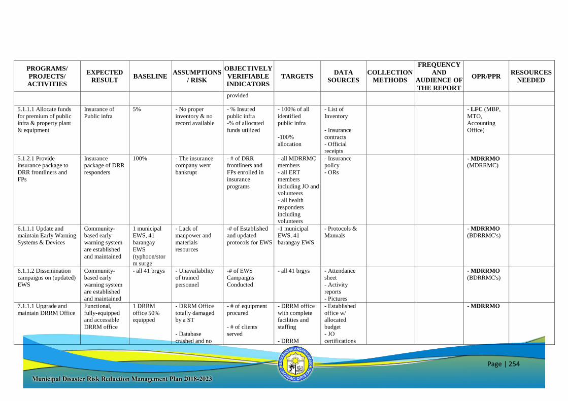
Page | 254
PROGRAMS/
PROJECTS/
ACTIVITIES
EXPECTED
RESULT BASELINE
ASSUMPTIONS
/ RISK
OBJECTIVELY
VERIFIABLE
INDICATORS
TARGETS DATA
SOURCES
COLLECTION
METHODS
FREQUENCY
AND
AUDIENCE OF
THE REPORT
OPR/PPR RESOURCES
NEEDED
provided
5.1.1.1 Allocate funds
for premium of public infra & property plant
& equipment
Insurance of
Public infra
5% - No proper
inventory & no record available
- % Insured
public infra -% of allocated
funds utilized
- 100% of all
identified public infra
-100%
allocation
- List of
Inventory
- Insurance
contracts
- Official receipts
- LFC (MBP,
MTO, Accounting
Office)
5.1.2.1 Provide insurance package to
DRR frontliners and
FPs
Insurance package of DRR
responders
100% - The insurance company went
bankrupt
- # of DRR frontliners and
FPs enrolled in
insurance
programs
- all MDRRMC members
- all ERT
members
including JO and volunteers
- all health
responders
including volunteers
- Insurance policy
- ORs
- MDRRMO (MDRRMC)
6.1.1.1 Update and maintain Early Warning
Systems & Devices
Community-based early
warning system
are established
and maintained
1 municipal EWS, 41
barangay
EWS
(typhoon/storm surge
- Lack of manpower and
materials
resources
-# of Established and updated
protocols for EWS
-1 municipal EWS, 41
barangay EWS
- Protocols & Manuals
- MDRRMO (BDRRMC's)
6.1.1.2 Dissemination campaigns on (updated)
EWS
Community-based early
warning system
are established
and maintained
- all 41 brgys - Unavailability of trained
personnel
-# of EWS Campaigns
Conducted
- all 41 brgys - Attendance sheet
- Activity
reports
- Pictures
- MDRRMO (BDRRMC's)
7.1.1.1 Upgrade and
maintain DRRM Office
Functional,
fully-equipped and accessible
DRRM office
1 DRRM
office 50% equipped
- DRRM Office
totally damaged by a ST
- Database
crashed and no
- # of equipment
procured
- # of clients
served
- DRRM office
with complete facilities and
staffing
- DRRM
- Established
office w/ allocated
budget
- JO
certifications
- MDRRMO
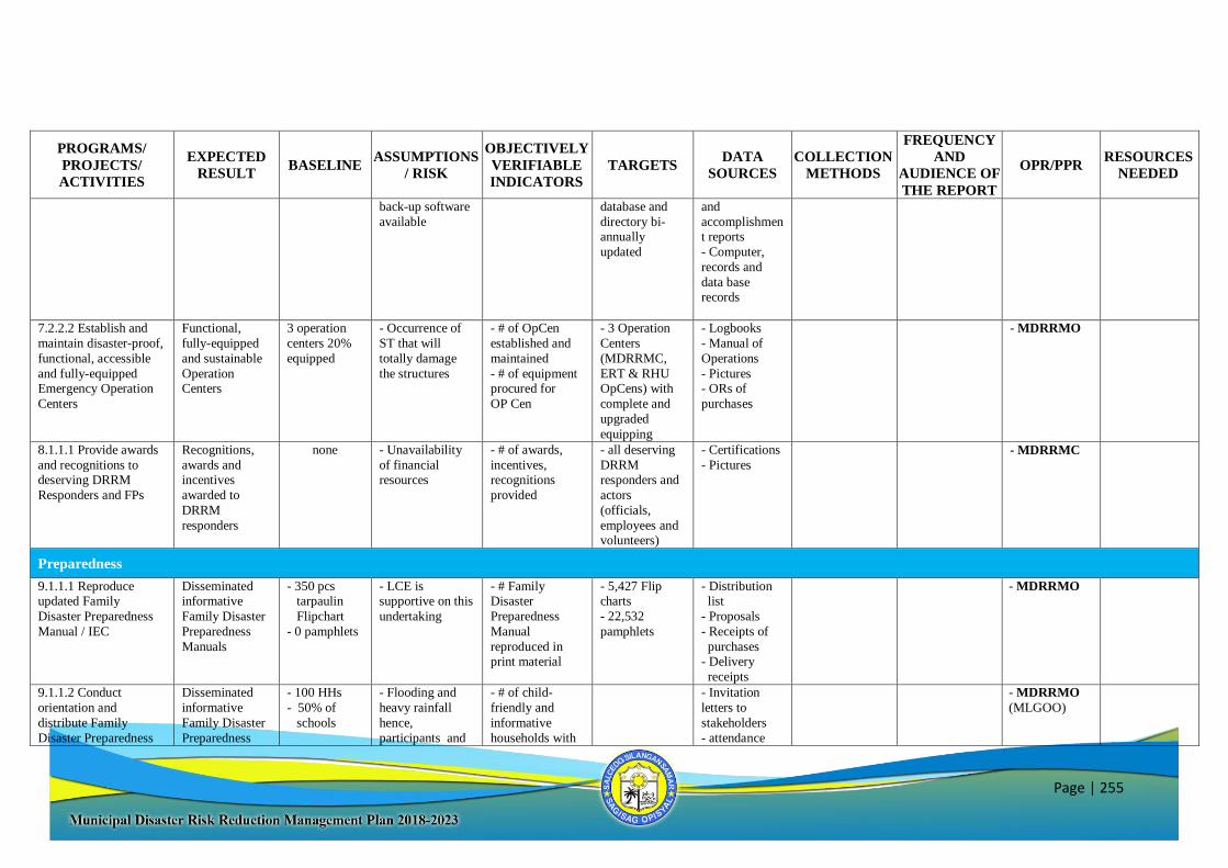
Page | 255
PROGRAMS/
PROJECTS/
ACTIVITIES
EXPECTED
RESULT BASELINE
ASSUMPTIONS
/ RISK
OBJECTIVELY
VERIFIABLE
INDICATORS
TARGETS DATA
SOURCES
COLLECTION
METHODS
FREQUENCY
AND
AUDIENCE OF
THE REPORT
OPR/PPR RESOURCES
NEEDED
back-up software
available
database and
directory bi-annually
updated
and
accomplishment reports
- Computer,
records and
data base records
7.2.2.2 Establish and
maintain disaster-proof,
functional, accessible
and fully-equipped Emergency Operation
Centers
Functional,
fully-equipped
and sustainable
Operation Centers
3 operation
centers 20%
equipped
- Occurrence of
ST that will
totally damage
the structures
- # of OpCen
established and
maintained
- # of equipment procured for
OP Cen
- 3 Operation
Centers
(MDRRMC,
ERT & RHU OpCens) with
complete and
upgraded
equipping
- Logbooks
- Manual of
Operations
- Pictures - ORs of
purchases
- MDRRMO
8.1.1.1 Provide awards
and recognitions to deserving DRRM
Responders and FPs
Recognitions,
awards and incentives
awarded to
DRRM
responders
none - Unavailability
of financial resources
- # of awards,
incentives, recognitions
provided
- all deserving
DRRM responders and
actors
(officials,
employees and volunteers)
- Certifications
- Pictures - MDRRMC
Preparedness
9.1.1.1 Reproduce updated Family
Disaster Preparedness
Manual / IEC
Disseminated informative
Family Disaster
Preparedness
Manuals
- 350 pcs tarpaulin
Flipchart
- 0 pamphlets
- LCE is supportive on this
undertaking
- # Family Disaster
Preparedness
Manual
reproduced in print material
- 5,427 Flip charts
- 22,532
pamphlets
- Distribution list
- Proposals
- Receipts of
purchases - Delivery
receipts
- MDRRMO
9.1.1.2 Conduct
orientation and
distribute Family
Disaster Preparedness
Disseminated
informative
Family Disaster
Preparedness
- 100 HHs
- 50% of
schools
- Flooding and
heavy rainfall
hence,
participants and
- # of child-
friendly and
informative
households with
- Invitation
letters to
stakeholders
- attendance
- MDRRMO
(MLGOO)
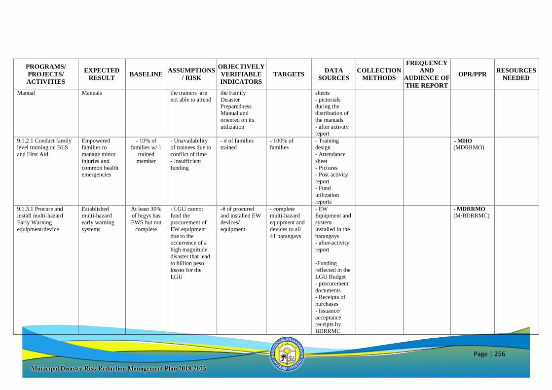
Page | 256
PROGRAMS/
PROJECTS/
ACTIVITIES
EXPECTED
RESULT BASELINE
ASSUMPTIONS
/ RISK
OBJECTIVELY
VERIFIABLE
INDICATORS
TARGETS DATA
SOURCES
COLLECTION
METHODS
FREQUENCY
AND
AUDIENCE OF
THE REPORT
OPR/PPR RESOURCES
NEEDED
Manual Manuals the trainers are
not able to attend the Family
Disaster Preparedness
Manual and
oriented on its
utilization
sheets
- pictorials during the
distribution of
the manuals
- after activity report
9.1.2.1 Conduct family level training on BLS
and First Aid
Empowered families to
manage minor
injuries and
common health emergencies
- 10% of families w/ 1
trained
member
- Unavailability of trainees due to
conflict of time
- Insufficient
funding
- # of families trained
- 100% of families
- Training design
- Attendance
sheet
- Pictures - Post activity
report
- Fund
utilization reports
- MHO (MDRRMO)
9.1.3.1 Procure and install multi-hazard
Early Warning
equipment/device
Established multi-hazard
early warning
systems
At least 30% of brgys has
EWS but not
complete
- LGU cannot fund the
procurement of
EW equipment
due to the occurrence of a
high magnitude
disaster that lead
to billion peso losses for the
LGU
-# of procured and installed EW
devices/
equipment
- complete multi-hazard
equipment and
devices to all
41 barangays
- EW Equipment and
system
installed in the
barangays - after-activity
report
-Funding reflected in the
LGU Budget
- procurement
documents - Receipts of
purchases
- Issuance/
acceptance receipts by
BDRRMC
- MDRRMO (M/BDRRMC)
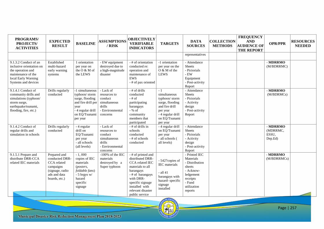
Page | 257
PROGRAMS/
PROJECTS/
ACTIVITIES
EXPECTED
RESULT BASELINE
ASSUMPTIONS
/ RISK
OBJECTIVELY
VERIFIABLE
INDICATORS
TARGETS DATA
SOURCES
COLLECTION
METHODS
FREQUENCY
AND
AUDIENCE OF
THE REPORT
OPR/PPR RESOURCES
NEEDED
representatives
9.1.3.2 Conduct of an
inclusive orientation on the operation and
maintenance of the
local Early Warning
Systems and devices
Established
multi-hazard early warning
systems
1 orientation
per year on the O & M of
the LEWS
- EW equipment
destroyed due to a high-magnitude
disaster
- # of orientation
conducted re: operation and
maintenance of
EWS
- # of pax oriented
-1 orientation
per year on the O & M of the
LEWS
- Attendance
Sheets - Pictorials
- EW
Equipment
- Post-activity Report
- MDRRMO
(M/BDRRMC)
9.1.4.1 Conduct of community drills and
simulations (typhoon/
storm surge,
earthquake/tsunami, flooding, fire, etc.)
Drills regularly conducted
-1 simultaneous typhoon/ storm
surge, flooding
and fire drill per
year - 4 regular drill
on EQ/Tsunami
per year
- Lack of resources to
conduct
simultaneous
drills - Environmental
concerns
- # of drills conducted
- # of
participating
barangays - % of
community
members that
participated
- 1 simultaneous
typhoon/ storm
surge, flooding
and fire drill per year
- 4 regular drill
on EQ/Tsunami
per year
- Attendance Sheets
- Pictorials
- Activity
design - Post-activity
Report
- MDRRMO (M/BDRMCs)
9.1.4.2 Conduct of
regular drills and simulation in schools
Drills regularly
conducted - 4 regular
drill on EQ/Tsunami
per year
- all schools
(all levels)
- Lack of
resources to conduct
simultaneous
drills
- Environmental concerns
- # of drills in
schools conducted
- # of schools
conducted
- 4 regular drill
on EQ/Tsunami per year
- all schools (
all levels)
- Attendance
Sheets - Pictorials
- Activity
design
- Post-activity Report
- MDRRMO
(MDRRMC, ESSU,
Dep.Ed)
9.1.5.1 Prepare and distribute DRR-CCA
related IEC materials
Prepared and conducted DRR-
CCA related
campaigns
(signage, radio ads and data
boards, etc.)
- 1, 000 copies of IEC
materials
(posters,
foldable fans) - 5 brgys w/
hazard
specific
signage
-100% of the IEC materials
destroyed by a
Super typhoon
- # of printed and distributed DRR-
CCA related IEC
materials to all
barangays - # of barangays
with DRR-
specific signage
installed with relevant disaster
public service
- 5427copies of
IEC materials
- all 41
barangays with
hazard- specific
signage installed
- Printed IEC Materials
- Distribution
sheets
- Acknow-ledgement
receipts
- Fund
utilization reports
- MDRRMO (M/BDRRMCs)
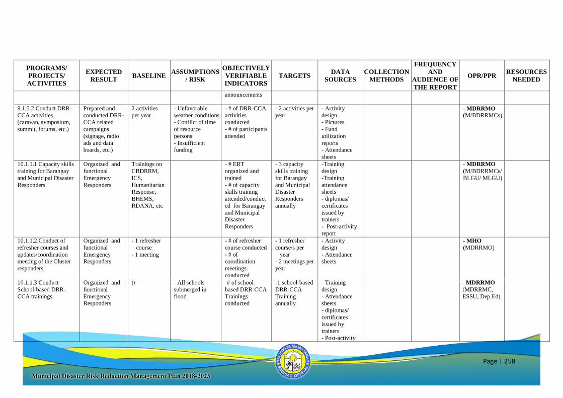
Page | 258
PROGRAMS/
PROJECTS/
ACTIVITIES
EXPECTED
RESULT BASELINE
ASSUMPTIONS
/ RISK
OBJECTIVELY
VERIFIABLE
INDICATORS
TARGETS DATA
SOURCES
COLLECTION
METHODS
FREQUENCY
AND
AUDIENCE OF
THE REPORT
OPR/PPR RESOURCES
NEEDED
announcements
9.1.5.2 Conduct DRR-
CCA activities (caravan, symposium,
summit, forums, etc.)
Prepared and
conducted DRR-CCA related
campaigns
(signage, radio
ads and data boards, etc.)
2 activities
per year - Unfavorable
weather conditions - Conflict of time
of resource
persons
- Insufficient funding
- # of DRR-CCA
activities conducted
- # of participants
attended
- 2 activities per
year - Activity
design - Pictures
- Fund
utilization
reports - Attendance
sheets
- MDRRMO
(M/BDRRMCs)
10.1.1.1 Capacity skills
training for Barangay
and Municipal Disaster
Responders
Organized and
functional
Emergency
Responders
Trainings on
CBDRRM,
ICS,
Humanitarian Response,
BHEMS,
RDANA, etc
- # ERT
organized and
trained
- # of capacity skills training
attended/conduct
ed for Barangay
and Municipal Disaster
Responders
- 3 capacity
skills training
for Barangay
and Municipal Disaster
Responders
annually
-Training
design
-Training
attendance sheets
- diplomas/
certificates
issued by trainers
- Post-activity
report
- MDRRMO
(M/BDRRMCs/
BLGU/ MLGU)
10.1.1.2 Conduct of
refresher courses and
updates/coordination meeting of the Cluster
responders
Organized and
functional
Emergency Responders
- 1 refresher
course
- 1 meeting
- # of refresher
course conducted
- # of coordination
meetings
conducted
- 1 refresher
course/s per
year - 2 meetings per
year
- Activity
design
- Attendance sheets
- MHO
(MDRRMO)
10.1.1.3 Conduct
School-based DRR-
CCA trainings
Organized and
functional
Emergency Responders
0 - All schools
submerged in
flood
-# of school-
based DRR-CCA
Trainings conducted
-1 school-based
DRR-CCA
Training annually
- Training
design
- Attendance sheets
- diplomas/
certificates
issued by trainers
- Post-activity
- MDRRMO
(MDRRMC,
ESSU, Dep.Ed)
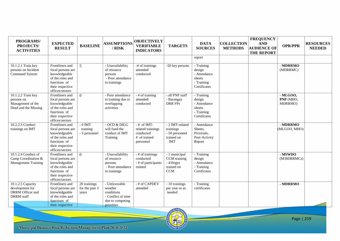
Page | 259
PROGRAMS/
PROJECTS/
ACTIVITIES
EXPECTED
RESULT BASELINE
ASSUMPTIONS
/ RISK
OBJECTIVELY
VERIFIABLE
INDICATORS
TARGETS DATA
SOURCES
COLLECTION
METHODS
FREQUENCY
AND
AUDIENCE OF
THE REPORT
OPR/PPR RESOURCES
NEEDED
report
10.1.2.1 Train key
persons on Incident Command System
Frontliners and
focal persons are knowledgeable
of the roles and
functions of
their respective offices/sectors
5 - Unavailability
of resource persons
- Poor attendance
to trainings
-# of trainings
attended/ conducted
-50 key persons - Training
design - Attendance
sheets
- Training
Certificates
- MDRRMO
(MDRRMC)
10.1.2.2 Train key persons on
Management of the
Dead and the Missing
Frontliners and focal persons are
knowledgeable
of the roles and
functions of their respective
offices/sectors
0 - Poor attendance to training due to
overlapping
activities
- # of training attended/
conducted
- all PNP staff - Barangay
DRR FPs
- Training design
- Attendance
sheets
- Training Certificates
- MLGOO,
PNP (MHO,
MDRRMO)
10.2.2.3 Conduct
trainings on IMT Frontliners and
focal persons are
knowledgeable
of the roles and functions of
their respective
offices/sectors
- 0 IMT
training
- 5 personnel
- OCD & DILG
will fund the
conduct of IMT
Training
- # of IMT-
related trainings
conducted
# of trained personnel
- 2 IMT-related
trainings
- 50 personnel
trained on IMT
- Attendance
Sheets,
Pictorials,
Post-Activity Report
- MDRRMO
(MLGOO, MHO)
10.1.2.4 Conduct of
Camp Coordination &
Management Training
Frontliners and
focal persons are
knowledgeable of the roles and
functions of
their respective
offices/sectors
0 - Unavailability
of resource
persons - Poor attendance
to trainings
- # of trainings
conducted
- # of participants trained
- 1 municipal
CCM training
- 41brgys trained on
CCM
- Training
design
- Attendance - Training
Certificates
- MSWDO
(M/BDRRMCs)
10.1.2.5 Capacity
development for DRRM Officer and
DRRM staff
Frontliners and
focal persons are knowledgeable
of the roles and
functions of
their respective
20 trainings
for the past 3 years
- Unfavorable
weather conditions
- Conflict of time
due to competing
priorities
- # of CAPDEV
attended - 10 trainings
per year or as needed
- Training
certificates - MDRRMO
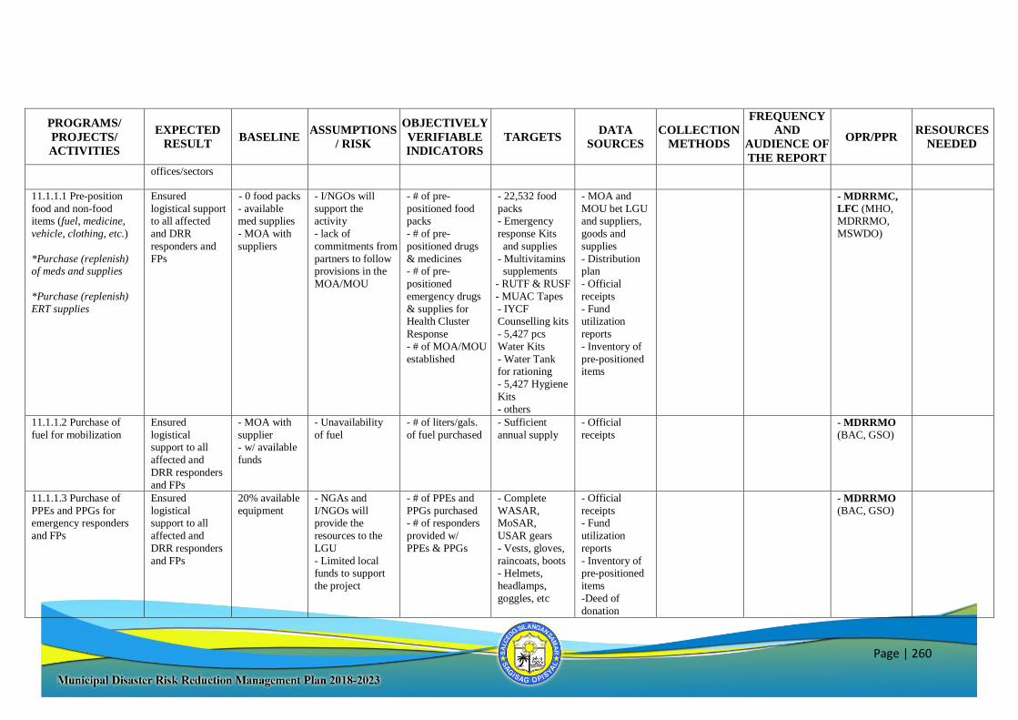
Page | 260
PROGRAMS/
PROJECTS/
ACTIVITIES
EXPECTED
RESULT BASELINE
ASSUMPTIONS
/ RISK
OBJECTIVELY
VERIFIABLE
INDICATORS
TARGETS DATA
SOURCES
COLLECTION
METHODS
FREQUENCY
AND
AUDIENCE OF
THE REPORT
OPR/PPR RESOURCES
NEEDED
offices/sectors
11.1.1.1 Pre-position
food and non-food items (fuel, medicine,
vehicle, clothing, etc.)
*Purchase (replenish) of meds and supplies
*Purchase (replenish)
ERT supplies
Ensured
logistical support to all affected
and DRR
responders and
FPs
- 0 food packs
- available med supplies
- MOA with
suppliers
- I/NGOs will
support the activity
- lack of
commitments from
partners to follow provisions in the
MOA/MOU
- # of pre-
positioned food packs
- # of pre-
positioned drugs
& medicines - # of pre-
positioned
emergency drugs
& supplies for Health Cluster
Response
- # of MOA/MOU
established
- 22,532 food
packs - Emergency
response Kits
and supplies
- Multivitamins supplements
- RUTF & RUSF
- MUAC Tapes
- IYCF Counselling kits
- 5,427 pcs
Water Kits
- Water Tank for rationing
- 5,427 Hygiene
Kits
- others
- MOA and
MOU bet LGU and suppliers,
goods and
supplies
- Distribution plan
- Official
receipts
- Fund utilization
reports
- Inventory of
pre-positioned items
- MDRRMC,
LFC (MHO, MDRRMO,
MSWDO)
11.1.1.2 Purchase of
fuel for mobilization Ensured
logistical support to all
affected and
DRR responders
and FPs
- MOA with
supplier - w/ available
funds
- Unavailability
of fuel - # of liters/gals.
of fuel purchased - Sufficient
annual supply
- Official
receipts - MDRRMO
(BAC, GSO)
11.1.1.3 Purchase of
PPEs and PPGs for emergency responders
and FPs
Ensured
logistical support to all
affected and
DRR responders
and FPs
20% available
equipment - NGAs and
I/NGOs will provide the
resources to the
LGU
- Limited local funds to support
the project
- # of PPEs and
PPGs purchased - # of responders
provided w/
PPEs & PPGs
- Complete
WASAR, MoSAR,
USAR gears
- Vests, gloves,
raincoats, boots - Helmets,
headlamps,
goggles, etc
- Official
receipts - Fund
utilization
reports
- Inventory of pre-positioned
items
-Deed of
donation
- MDRRMO
(BAC, GSO)
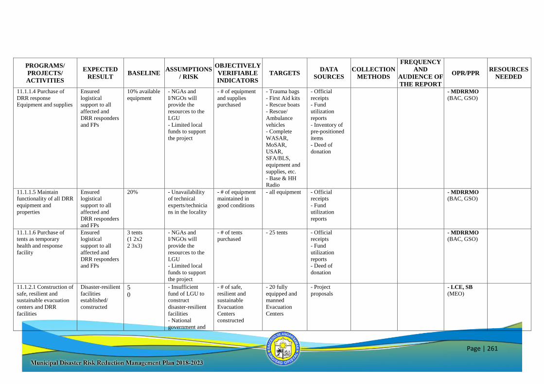
Page | 261
PROGRAMS/
PROJECTS/
ACTIVITIES
EXPECTED
RESULT BASELINE
ASSUMPTIONS
/ RISK
OBJECTIVELY
VERIFIABLE
INDICATORS
TARGETS DATA
SOURCES
COLLECTION
METHODS
FREQUENCY
AND
AUDIENCE OF
THE REPORT
OPR/PPR RESOURCES
NEEDED
11.1.1.4 Purchase of
DRR response Equipment and supplies
Ensured
logistical support to all
affected and
DRR responders
and FPs
10% available
equipment - NGAs and
I/NGOs will provide the
resources to the
LGU
- Limited local funds to support
the project
- # of equipment
and supplies purchased
- Trauma bags
- First Aid kits - Rescue boats
- Rescue/
Ambulance
vehicles - Complete
WASAR,
MoSAR,
USAR, SFA/BLS,
equipment and
supplies, etc.
- Base & HH Radio
- Official
receipts - Fund
utilization
reports
- Inventory of pre-positioned
items
- Deed of
donation
- MDRRMO
(BAC, GSO)
11.1.1.5 Maintain functionality of all DRR
equipment and
properties
Ensured logistical
support to all
affected and
DRR responders and FPs
20% - Unavailability of technical
experts/technicia
ns in the locality
- # of equipment maintained in
good conditions
- all equipment - Official receipts
- Fund
utilization
reports
- MDRRMO (BAC, GSO)
11.1.1.6 Purchase of tents as temporary
health and response
facility
Ensured logistical
support to all
affected and
DRR responders and FPs
3 tents (1 2x2
2 3x3)
- NGAs and I/NGOs will
provide the
resources to the
LGU - Limited local
funds to support
the project
- # of tents purchased
- 25 tents - Official receipts
- Fund
utilization
reports - Deed of
donation
- MDRRMO (BAC, GSO)
11.1.2.1 Construction of
safe, resilient and sustainable evacuation
centers and DRR
facilities
Disaster-resilient
facilities established/
constructed
5
0
- Insufficient
fund of LGU to construct
disaster-resilient
facilities
- National government and
- # of safe,
resilient and sustainable
Evacuation
Centers
constructed
- 20 fully
equipped and manned
Evacuation
Centers
- Project
proposals
- LCE, SB
(MEO)
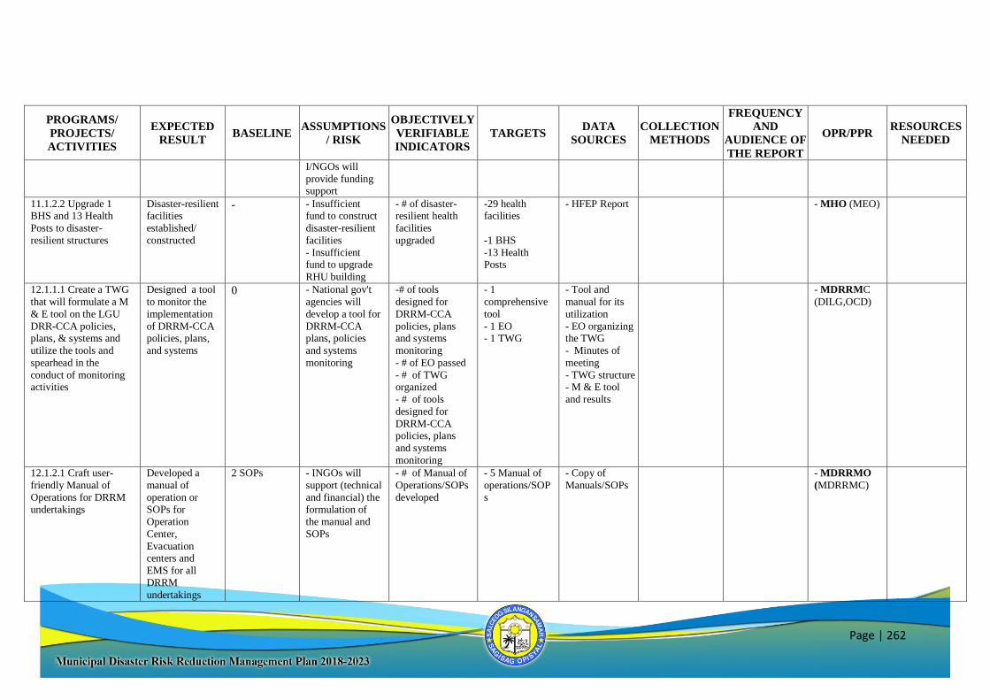
Page | 262
PROGRAMS/
PROJECTS/
ACTIVITIES
EXPECTED
RESULT BASELINE
ASSUMPTIONS
/ RISK
OBJECTIVELY
VERIFIABLE
INDICATORS
TARGETS DATA
SOURCES
COLLECTION
METHODS
FREQUENCY
AND
AUDIENCE OF
THE REPORT
OPR/PPR RESOURCES
NEEDED
I/NGOs will
provide funding support
11.1.2.2 Upgrade 1 BHS and 13 Health
Posts to disaster-
resilient structures
Disaster-resilient facilities
established/
constructed
- - Insufficient fund to construct
disaster-resilient
facilities
- Insufficient fund to upgrade
RHU building
- # of disaster-resilient health
facilities
upgraded
-29 health facilities
-1 BHS
-13 Health Posts
- HFEP Report - MHO (MEO)
12.1.1.1 Create a TWG
that will formulate a M
& E tool on the LGU
DRR-CCA policies, plans, & systems and
utilize the tools and
spearhead in the
conduct of monitoring activities
Designed a tool
to monitor the
implementation
of DRRM-CCA policies, plans,
and systems
0 - National gov't
agencies will
develop a tool for
DRRM-CCA plans, policies
and systems
monitoring
-# of tools
designed for
DRRM-CCA
policies, plans and systems
monitoring
- # of EO passed
- # of TWG organized
- # of tools
designed for
DRRM-CCA policies, plans
and systems
monitoring
- 1
comprehensive
tool
- 1 EO - 1 TWG
- Tool and
manual for its
utilization
- EO organizing the TWG
- Minutes of
meeting
- TWG structure - M & E tool
and results
- MDRRMC
(DILG,OCD)
12.1.2.1 Craft user-
friendly Manual of
Operations for DRRM
undertakings
Developed a
manual of
operation or
SOPs for
Operation
Center,
Evacuation centers and
EMS for all
DRRM
undertakings
2 SOPs - INGOs will
support (technical
and financial) the
formulation of
the manual and
SOPs
- # of Manual of
Operations/SOPs
developed
- 5 Manual of
operations/SOP
s
- Copy of
Manuals/SOPs
- MDRRMO
(MDRRMC)
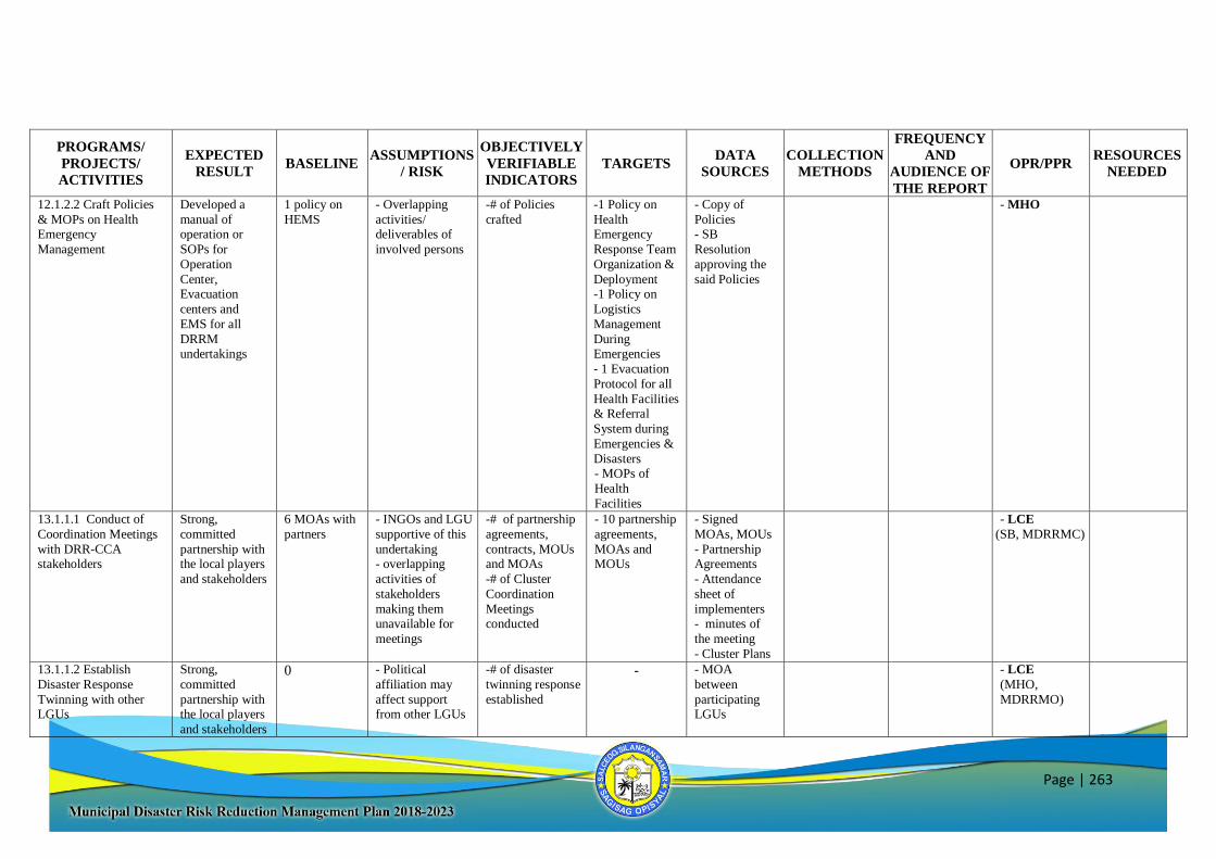
Page | 263
PROGRAMS/
PROJECTS/
ACTIVITIES
EXPECTED
RESULT BASELINE
ASSUMPTIONS
/ RISK
OBJECTIVELY
VERIFIABLE
INDICATORS
TARGETS DATA
SOURCES
COLLECTION
METHODS
FREQUENCY
AND
AUDIENCE OF
THE REPORT
OPR/PPR RESOURCES
NEEDED
12.1.2.2 Craft Policies
& MOPs on Health Emergency
Management
Developed a
manual of operation or
SOPs for
Operation
Center, Evacuation
centers and
EMS for all
DRRM undertakings
1 policy on
HEMS - Overlapping
activities/ deliverables of
involved persons
-# of Policies
crafted -1 Policy on
Health Emergency
Response Team
Organization &
Deployment -1 Policy on
Logistics
Management
During Emergencies
- 1 Evacuation
Protocol for all
Health Facilities & Referral
System during
Emergencies &
Disasters - MOPs of
Health
Facilities
- Copy of
Policies - SB
Resolution
approving the
said Policies
- MHO
13.1.1.1 Conduct of
Coordination Meetings
with DRR-CCA stakeholders
Strong,
committed
partnership with the local players
and stakeholders
6 MOAs with
partners - INGOs and LGU
supportive of this
undertaking - overlapping
activities of
stakeholders
making them unavailable for
meetings
-# of partnership
agreements,
contracts, MOUs and MOAs
-# of Cluster
Coordination
Meetings conducted
- 10 partnership
agreements,
MOAs and MOUs
- Signed
MOAs, MOUs
- Partnership Agreements
- Attendance
sheet of
implementers - minutes of
the meeting
- Cluster Plans
- LCE
(SB, MDRRMC)
13.1.1.2 Establish
Disaster Response
Twinning with other LGUs
Strong,
committed
partnership with the local players
and stakeholders
0 - Political
affiliation may
affect support from other LGUs
-# of disaster
twinning response
established
- - MOA
between
participating LGUs
- LCE
(MHO,
MDRRMO)
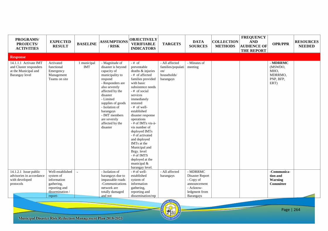
Page | 264
PROGRAMS/
PROJECTS/
ACTIVITIES
EXPECTED
RESULT BASELINE
ASSUMPTIONS
/ RISK
OBJECTIVELY
VERIFIABLE
INDICATORS
TARGETS DATA
SOURCES
COLLECTION
METHODS
FREQUENCY
AND
AUDIENCE OF
THE REPORT
OPR/PPR RESOURCES
NEEDED
Response
14.1.1.1 Activate IMT
and Cluster responders at the Municipal and
Barangay level
Activated
functional Emergency
Management
Teams on site
1 municipal
IMT - Magnitude of
disaster is beyond capacity of
municipality to
respond
- Responders are also severely
affected by the
disaster
- Limited supplies of goods
- Isolation of
barangays
- IMT members are severely
affected by the
disaster
- # of
preventable deaths & injuries
- # of affected
families provided
with basic subsistence needs
- # of social
services
immediately restored
- # of well-
established
disaster response operations
- # of IMTs vis-à-
vis number of
deployed IMTs - # of activated
and deployed
IMTs at the
Municipal and Brgy. level
- # of IMTS
deployed at the
municipal & barangay level.
- All affected
families/population/
households/
barangays
- Minutes of
meeting - MDRRMC
(MSWDO, MHO,
MDRRMO,
PNP, BFP,
ERT)
14.1.2.1 Issue public advisories in accordance
with developed
protocols
Well-established system of
information
gathering,
reporting and dissemination /
report-
- - Isolation of barangays due to
impassable roads
-Communications
network are totally damaged
and not
- # of well-established
system of
information
gathering, reporting and
dissemination/rep
- All affected barangays
- MDRRMC Disaster Report
- Copy of
announcement
- Acknow-ledgment from
Barangays
-Communica-
tion and
Warning
Committee
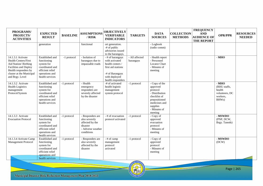
Page | 265
PROGRAMS/
PROJECTS/
ACTIVITIES
EXPECTED
RESULT BASELINE
ASSUMPTIONS
/ RISK
OBJECTIVELY
VERIFIABLE
INDICATORS
TARGETS DATA
SOURCES
COLLECTION
METHODS
FREQUENCY
AND
AUDIENCE OF
THE REPORT
OPR/PPR RESOURCES
NEEDED
generation functional
ort generation.
-# of public advisories issued
to the barangays.
- Logbook
(radio comm)
14.1.3.1 Activate
Health Centers/First
Aid Station/ Birthing
Facilities and Deploy Health responders by
cluster at the Municipal
and Brgy. Level
Established and
functioning
system for
coordinated and efficient relief
operations and
health services
-1 protocol - Isolation of
barangays due to
impassable roads
- # of barangays
with activated
health centers /
first aid stations
-# of Barangays
with deployed
health responders
- All affected
barangays
- Health report
- Personnel
Locator Chart
- Minutes of meeting
- MHO
14.1.3.2 Activate
Health Logistics management
Protocol/System
Established and
functioning system for
coordinated and
efficient relief
operations and health services
-1 protocol - Health
emergency responders are
severely affected
by the disaster
-# of activated
health logistic management
system protocol
-1 protocol - Copy of the
approved protocol
- Distribution
checklist of
prepositioned medicines and
supplies
- Minutes of
meeting
- MHO
(RHU staffs, health
volunteers, DC
workers,
BHWs)
14.1.3.3 Activate
Evacuation Protocol Established and
functioning system for
coordinated and
efficient relief
operations and
health services
-1 protocol - Responders are
also severely affected by the
disaster
- Adverse weather
conditions
- # of evacuation
protocol activated
-1 protocol - Copy of
approved evacuation
protocol
- Minutes of
meeting
- MSWDO
(PNP, DCW, Brgy. Tanods)
14.1.3.4 Activate Camp Management Protocol
Established and functioning
system for
coordinated and
efficient relief operations and
health services
-1 protocol - Responders are also severely
affected by the
disaster
- # of camp management
protocol
activated
-1 protocol - Copy of approved
protocol
- Minutes of
meeting
- MSWDO (DCW)

Page | 266
PROGRAMS/
PROJECTS/
ACTIVITIES
EXPECTED
RESULT BASELINE
ASSUMPTIONS
/ RISK
OBJECTIVELY
VERIFIABLE
INDICATORS
TARGETS DATA
SOURCES
COLLECTION
METHODS
FREQUENCY
AND
AUDIENCE OF
THE REPORT
OPR/PPR RESOURCES
NEEDED
14.1.3.5 Activate relief
distribution points/centers at the
Barangay level (Brgy.
Halls, Evacuation
Centers
Established and
functioning system for
coordinated and
efficient relief
operations and health services
1 municipal & 41 identified
brgy
distribution
centers
- Isolation of
barangays due to impassable roads
-# of barangays
with activated relief distribution
points.
- All affected
barangays - MDRRMC
disaster report - Evacuation
Center Report
- RDANA
- Minutes of meeting
- MSWDO
(DC Workers, Relief and
Distribution
Committee,
BDRRMCs)
14.1.3.6 Activate search and rescue,
retrieval protocol
Established and functioning
system for
coordinated and
efficient relief operations and
health services
-1 protocol - Adverse weather conditions
- Responders are
also severely
affected - Isolation of
barangays
- # of activated search and
rescue, retrieval
protocol
- All SRR capacity
- All affected
persons
-1 protocol
- Copy of approved SRR
protocol
- Minutes of
meeting
- Security/
Rescue
Committee
(ERT, PNP,
BFP)
14.1.3.7 Conduct road
clearing operation Established and
functioning
system for
coordinated and efficient relief
operations and
health services
- - Isolation of
barangays due to
impassable roads
- Unavailability of heavy
equipment and
personnel
- % of roads
cleared - All affected
barangays
-100% of roads
cleared
- MDRRMC
disaster report
- RDANA
report
-MEO (Clearing
Operations
Committee)
15.1.1.1 Activate
Evacuation Centers at
the barangays
Safe and timely
evacuation of
affected communities
- - Non-resilient
evacuation
centers
- # of barangays
with activated
evacuation centers
- All affected
barangays
- List of
activated
Evacuation centers
- MSWDO
(DCW, PNP)
15.1.1.2 Conduct Pre-emptive and/or forced
evacuation at the
barangays
Safe and timely evacuation of
affected
communities
- - Hesitance of possible affected
families to
evacuate
- Lack of means of transportation
- # of barangays conducted with
Pre-emptive
and/or forced
evacuation - # of persons /
families safely
evacuated on-
time. - # of affected
communities
- All affected barangays
- List of Evacuees
- Copy of
Directives
- PNP
(MSWDO,
BDRRMCs,
Evacuation
Committee)
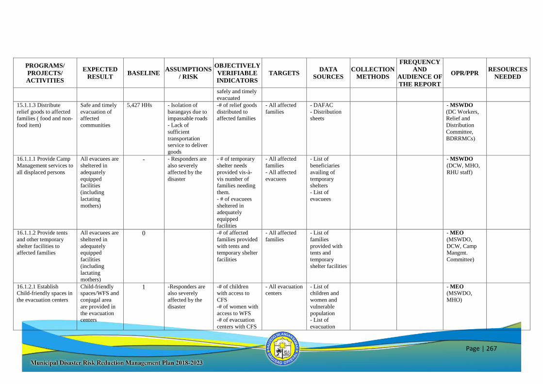
Page | 267
PROGRAMS/
PROJECTS/
ACTIVITIES
EXPECTED
RESULT BASELINE
ASSUMPTIONS
/ RISK
OBJECTIVELY
VERIFIABLE
INDICATORS
TARGETS DATA
SOURCES
COLLECTION
METHODS
FREQUENCY
AND
AUDIENCE OF
THE REPORT
OPR/PPR RESOURCES
NEEDED
safely and timely
evacuated 15.1.1.3 Distribute
relief goods to affected families ( food and non-
food item)
Safe and timely
evacuation of affected
communities
5,427 HHs - Isolation of
barangays due to impassable roads
- Lack of
sufficient
transportation service to deliver
goods
-# of relief goods
distributed to affected families
- All affected
families
- DAFAC
- Distribution sheets
- MSWDO
(DC Workers, Relief and
Distribution
Committee,
BDRRMCs)
16.1.1.1 Provide Camp
Management services to
all displaced persons
All evacuees are
sheltered in
adequately
equipped facilities
(including
lactating
mothers)
- - Responders are
also severely
affected by the
disaster
- # of temporary
shelter needs
provided vis-à-
vis number of families needing
them.
- # of evacuees
sheltered in adequately
equipped
facilities
- All affected
families
- All affected
evacuees
- List of
beneficiaries
availing of
temporary shelters
- List of
evacuees
- MSWDO
(DCW, MHO,
RHU staff)
16.1.1.2 Provide tents
and other temporary
shelter facilities to affected families
All evacuees are
sheltered in
adequately equipped
facilities
(including
lactating
mothers)
0 -# of affected
families provided
with tents and temporary shelter
facilities
- All affected
families - List of
families
provided with tents and
temporary
shelter facilities
- MEO
(MSWDO,
DCW, Camp Mangmt.
Committee)
16.1.2.1 Establish Child-friendly spaces in
the evacuation centers
Child-friendly spaces/WFS and
conjugal area
are provided in
the evacuation centers
1 -Responders are also severely
affected by the
disaster
-# of children with access to
CFS
-# of women with
access to WFS -# of evacuation
centers with CFS
- All evacuation centers
- List of children and
women and
vulnerable
population - List of
evacuation
- MEO
(MSWDO,
MHO)
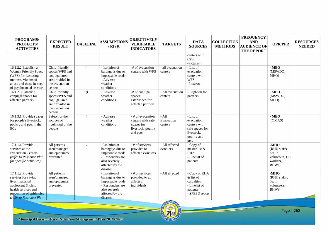
Page | 268
PROGRAMS/
PROJECTS/
ACTIVITIES
EXPECTED
RESULT BASELINE
ASSUMPTIONS
/ RISK
OBJECTIVELY
VERIFIABLE
INDICATORS
TARGETS DATA
SOURCES
COLLECTION
METHODS
FREQUENCY
AND
AUDIENCE OF
THE REPORT
OPR/PPR RESOURCES
NEEDED
centers with
CFS -Pictures
16.1.2.2 Establish a Women Friendly Space
(WFS) for Lactating
mothers, victims of
abuse and those in need of psychosocial services
Child-friendly spaces/WFS and
conjugal area
are provided in
the evacuation centers
1 - Isolation of barangays due to
impassable roads
- Adverse
weather conditions
-# of evacuation centers with WFS
- all evacuation centers
- List of evacuation
centers with
WFS
-Pictures
- MEO
(MSWDO,
MHO)
16.1.2.3 Establish conjugal spaces for
affected partners
Child-friendly spaces/WFS and
conjugal area
are provided in
the evacuation centers
0 - Adverse weather
conditions
-# of conjugal spaces
established for
affected partners
- All evacuation centers
- Logbook for partners
- MEO
(MSWDO,
MHO)
16.1.3.1 Provide spaces for people's livestock,
poultry and pets in the
ECs
Safety for the sources of
livelihood of the
people
1 - Adverse weather
conditions
- # of evacuation centers with safe
spaces for
livestock, poultry
and pets
- All Evacuation
centers
- List of evacuation
centers with
safe spaces for
livestock, poultry and
pets
- MEO
(OMAS)
17.1.1.1 Provide
services at the
Evacuation Centers
(refer to Response Plan for specific activities)
All patients
seen/managed
and epidemics
prevented
- - Isolation of
barangays due to
impassable roads
- Responders are also severely
affected by the
disaster
- # of services
provided to
affected evacuees
- All affected
evacuees - Copy of
master list &
RHA
- Linelist of patients
-MHO
(RHU staffs,
health
volunteers, DC workers,
BHWs)
17.1.1.2 Provide
services for saving
lives, maternal, adolescent & child
health services and
prevention of epidemics
(refer to Response Plan
All patients
seen/managed
and epidemics prevented
- - Isolation of
barangays due to
impassable roads - Responders are
also severely
affected by the
disaster
- # of services
provided to all
affected individuals
- All affected - Copy of RHA
& list of
casualties - Linelist of
patients
- SPEED report
-MHO
(RHU staffs,
health volunteers,
BHWs)
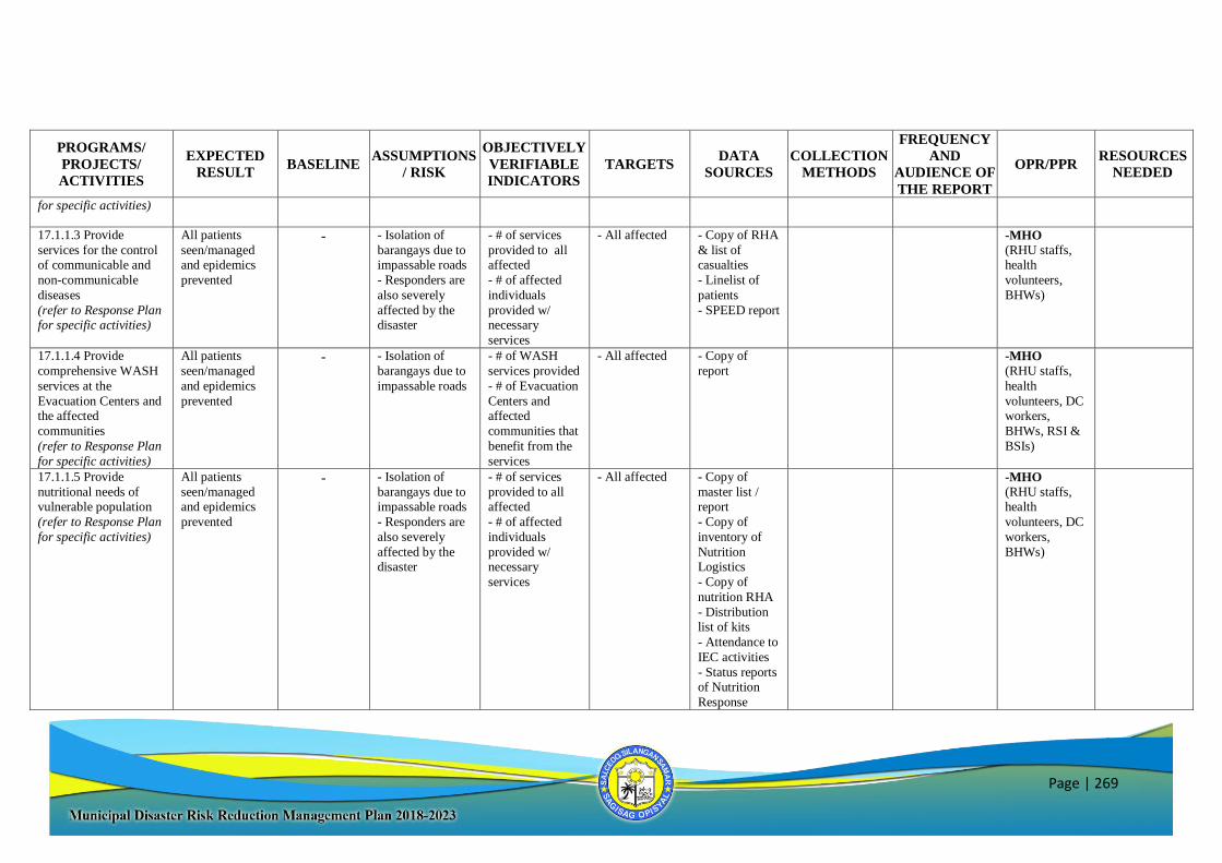
Page | 269
PROGRAMS/
PROJECTS/
ACTIVITIES
EXPECTED
RESULT BASELINE
ASSUMPTIONS
/ RISK
OBJECTIVELY
VERIFIABLE
INDICATORS
TARGETS DATA
SOURCES
COLLECTION
METHODS
FREQUENCY
AND
AUDIENCE OF
THE REPORT
OPR/PPR RESOURCES
NEEDED
for specific activities)
17.1.1.3 Provide
services for the control of communicable and
non-communicable
diseases
(refer to Response Plan for specific activities)
All patients
seen/managed and epidemics
prevented
- - Isolation of
barangays due to impassable roads
- Responders are
also severely
affected by the disaster
- # of services
provided to all affected
- # of affected
individuals
provided w/ necessary
services
- All affected - Copy of RHA
& list of casualties
- Linelist of
patients
- SPEED report
-MHO
(RHU staffs, health
volunteers,
BHWs)
17.1.1.4 Provide
comprehensive WASH
services at the
Evacuation Centers and the affected
communities
(refer to Response Plan
for specific activities)
All patients
seen/managed
and epidemics
prevented
- - Isolation of
barangays due to
impassable roads
- # of WASH
services provided
- # of Evacuation
Centers and affected
communities that
benefit from the
services
- All affected - Copy of
report -MHO
(RHU staffs,
health
volunteers, DC workers,
BHWs, RSI &
BSIs)
17.1.1.5 Provide
nutritional needs of vulnerable population
(refer to Response Plan
for specific activities)
All patients
seen/managed and epidemics
prevented
- - Isolation of
barangays due to impassable roads
- Responders are
also severely
affected by the disaster
- # of services
provided to all affected
- # of affected
individuals
provided w/ necessary
services
- All affected - Copy of
master list / report
- Copy of
inventory of
Nutrition Logistics
- Copy of
nutrition RHA
- Distribution list of kits
- Attendance to
IEC activities
- Status reports of Nutrition
Response
-MHO
(RHU staffs, health
volunteers, DC
workers,
BHWs)
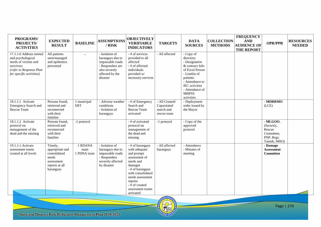
Page | 270
PROGRAMS/
PROJECTS/
ACTIVITIES
EXPECTED
RESULT BASELINE
ASSUMPTIONS
/ RISK
OBJECTIVELY
VERIFIABLE
INDICATORS
TARGETS DATA
SOURCES
COLLECTION
METHODS
FREQUENCY
AND
AUDIENCE OF
THE REPORT
OPR/PPR RESOURCES
NEEDED
17.1.1.6 Address mental
and psychological needs of victims and
survivors
(refer to Response Plan
for specific activities)
All patients
seen/managed and epidemics
prevented
- - Isolation of
barangays due to impassable roads
- Responders are
also severely
affected by the disaster
- # of services
provided to all affected
- # of affected
individuals
provided w/ necessary services
- All affected - Copy of
directory - Designation
& contract Info
of Focal Person
- Linelist of patients
- Attendance to
IEC activities
- Attendance of MHPSS
activities
18.1.1.1 Activate
Emergency Search and
Rescue Team
Persons found,
retrieved and
reconnected
with their families
1 municipal
ERT - Adverse weather
conditions
- Isolation of
barangays
- # of Emergency
Search and
Rescue Team
activated
- All Created/
Capacitated
search and
rescue team
- Deployment
order issued by
the Mayor
- MDRRMO
(LCE)
18.1.1.2 Activate protocol on
management of the
dead and the missing
Persons found, retrieved and
reconnected
with their
families
-1 protocol - # of activated protocol on
management of
the dead and
missing
-1 protocol - Copy of the approved
protocol
- MLGOO, (Security,
Rescue
Committee,
PNP, Brgy. Tanods, MHO)
19.1.1.1 Activate assessment teams
created at all levels
Timely, appropriate and
consolidated
needs
assessment
reports at all
barangays
1 RDANA team
1 PDNA team
- Isolation of barangays due to
impassable roads
- Responders
severely affected
by disaster
- # of barangays with adequate
and prompt
assessment of
needs and
damages
- # of barangays
with consolidated
needs assessment reports
- # of created
assessment teams
activated
- All affected barangays
- Attendance - Minutes of
meeting
- Damage
Assessment
Committee
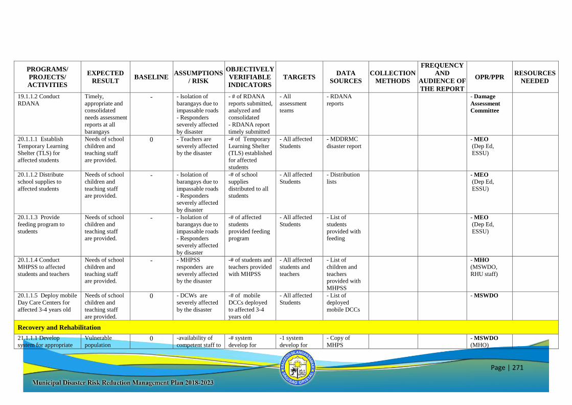
Page | 271
PROGRAMS/
PROJECTS/
ACTIVITIES
EXPECTED
RESULT BASELINE
ASSUMPTIONS
/ RISK
OBJECTIVELY
VERIFIABLE
INDICATORS
TARGETS DATA
SOURCES
COLLECTION
METHODS
FREQUENCY
AND
AUDIENCE OF
THE REPORT
OPR/PPR RESOURCES
NEEDED
19.1.1.2 Conduct
RDANA Timely,
appropriate and consolidated
needs assessment
reports at all
barangays
- - Isolation of
barangays due to impassable roads
- Responders
severely affected
by disaster
- # of RDANA
reports submitted, analyzed and
consolidated
- RDANA report
timely submitted
- All
assessment teams
- RDANA
reports - Damage
Assessment
Committee
20.1.1.1 Establish
Temporary Learning Shelter (TLS) for
affected students
Needs of school
children and teaching staff
are provided.
0 - Teachers are
severely affected by the disaster
-# of Temporary
Learning Shelter (TLS) established
for affected
students
- All affected
Students - MDDRMC
disaster report - MEO
(Dep Ed, ESSU)
20.1.1.2 Distribute
school supplies to
affected students
Needs of school
children and
teaching staff are provided.
- - Isolation of
barangays due to
impassable roads - Responders
severely affected
by disaster
-# of school
supplies
distributed to all students
- All affected
Students
- Distribution
lists - MEO
(Dep Ed,
ESSU)
20.1.1.3 Provide
feeding program to
students
Needs of school
children and
teaching staff are provided.
- - Isolation of
barangays due to
impassable roads - Responders
severely affected
by disaster
-# of affected
students
provided feeding program
- All affected
Students
- List of
students
provided with feeding
- MEO
(Dep Ed,
ESSU)
20.1.1.4 Conduct
MHPSS to affected
students and teachers
Needs of school
children and
teaching staff are provided.
- - MHPSS
responders are
severely affected by the disaster
-# of students and
teachers provided
with MHPSS
- All affected
students and
teachers
- List of
children and
teachers provided with
MHPSS
- MHO
(MSWDO,
RHU staff)
20.1.1.5 Deploy mobile
Day Care Centers for
affected 3-4 years old
Needs of school
children and
teaching staff
are provided.
0 - DCWs are
severely affected
by the disaster
-# of mobile
DCCs deployed
to affected 3-4
years old
- All affected
Students
- List of
deployed
mobile DCCs
- MSWDO
Recovery and Rehabilitation
21.1.1.1 Develop
system for appropriate
Vulnerable
population 0 -availability of
competent staff to
-# system
develop for
-1 system
develop for
- Copy of
MHPS - MSWDO
(MHO)
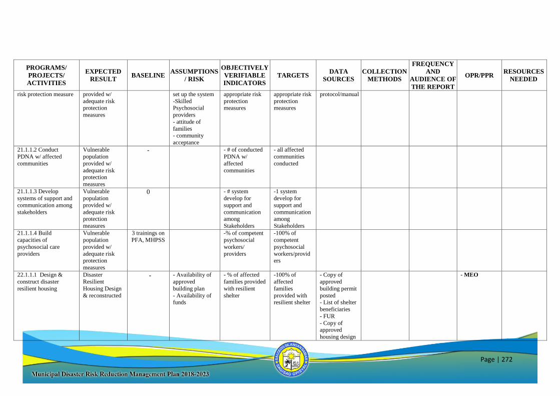
Page | 272
PROGRAMS/
PROJECTS/
ACTIVITIES
EXPECTED
RESULT BASELINE
ASSUMPTIONS
/ RISK
OBJECTIVELY
VERIFIABLE
INDICATORS
TARGETS DATA
SOURCES
COLLECTION
METHODS
FREQUENCY
AND
AUDIENCE OF
THE REPORT
OPR/PPR RESOURCES
NEEDED
risk protection measure provided w/
adequate risk protection
measures
set up the system
-Skilled Psychosocial
providers
- attitude of
families - community
acceptance
appropriate risk
protection measures
appropriate risk
protection measures
protocol/manual
21.1.1.2 Conduct
PDNA w/ affected
communities
Vulnerable
population
provided w/
adequate risk protection
measures
- - # of conducted
PDNA w/
affected
communities
- all affected
communities
conducted
21.1.1.3 Develop
systems of support and
communication among
stakeholders
Vulnerable
population
provided w/
adequate risk protection
measures
0 - # system
develop for
support and
communication among
Stakeholders
-1 system
develop for
support and
communication among
Stakeholders
21.1.1.4 Build
capacities of
psychosocial care
providers
Vulnerable
population
provided w/
adequate risk protection
measures
3 trainings on
PFA, MHPSS -% of competent
psychosocial
workers/
providers
-100% of
competent
psychosocial
workers/providers
22.1.1.1 Design &
construct disaster
resilient housing
Disaster
Resilient
Housing Design
& reconstructed
- - Availability of
approved
building plan
- Availability of funds
- % of affected
families provided
with resilient
shelter
-100% of
affected
families
provided with resilient shelter
- Copy of
approved
building permit
posted - List of shelter
beneficiaries
- FUR
- Copy of approved
housing design
- MEO
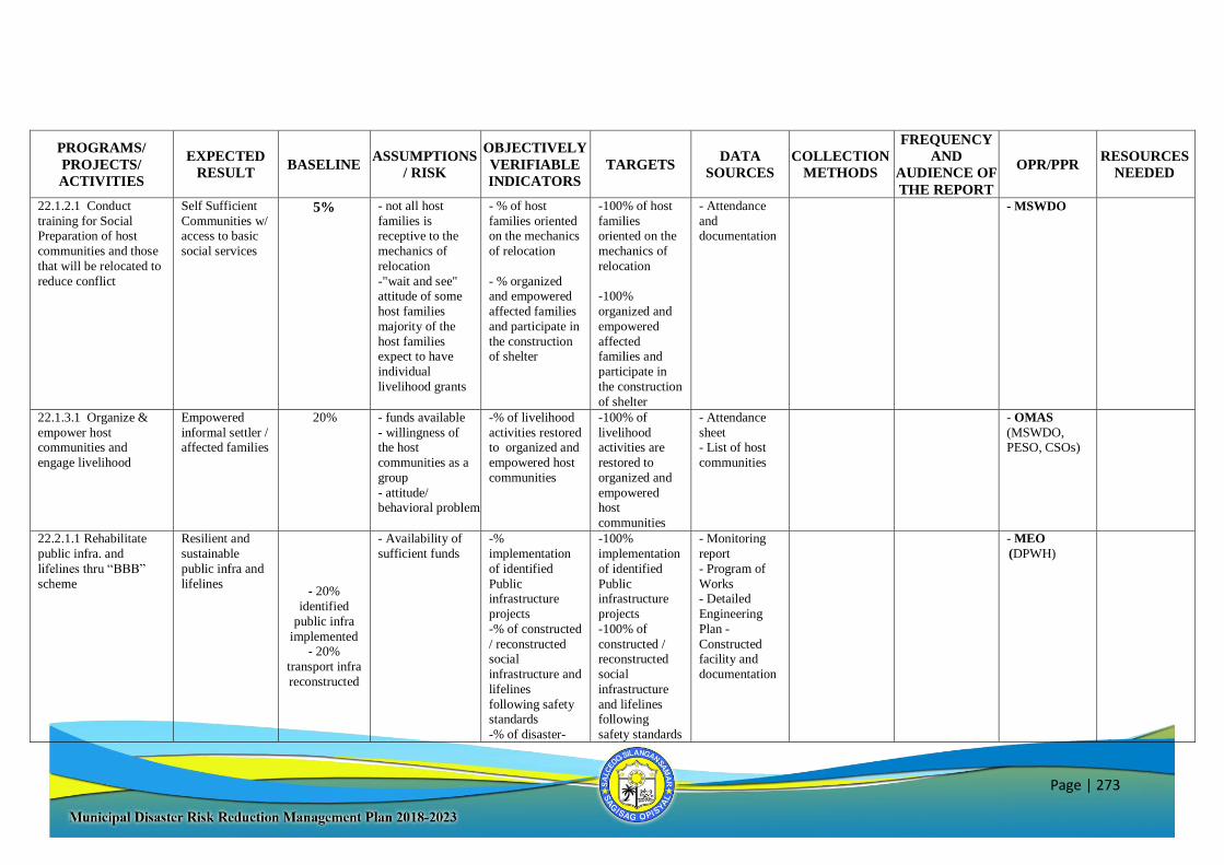
Page | 273
PROGRAMS/
PROJECTS/
ACTIVITIES
EXPECTED
RESULT BASELINE
ASSUMPTIONS
/ RISK
OBJECTIVELY
VERIFIABLE
INDICATORS
TARGETS DATA
SOURCES
COLLECTION
METHODS
FREQUENCY
AND
AUDIENCE OF
THE REPORT
OPR/PPR RESOURCES
NEEDED
22.1.2.1 Conduct
training for Social Preparation of host
communities and those
that will be relocated to
reduce conflict
Self Sufficient
Communities w/ access to basic
social services
5% - not all host
families is receptive to the
mechanics of
relocation
-"wait and see" attitude of some
host families
majority of the
host families expect to have
individual
livelihood grants
- % of host
families oriented on the mechanics
of relocation
- % organized and empowered
affected families
and participate in
the construction of shelter
-100% of host
families oriented on the
mechanics of
relocation
-100%
organized and
empowered
affected families and
participate in
the construction
of shelter
- Attendance
and documentation
- MSWDO
22.1.3.1 Organize &
empower host communities and
engage livelihood
Empowered
informal settler / affected families
20% - funds available
- willingness of the host
communities as a
group
- attitude/ behavioral problem
-% of livelihood
activities restored to organized and
empowered host
communities
-100% of
livelihood activities are
restored to
organized and
empowered host
communities
- Attendance
sheet - List of host
communities
- OMAS
(MSWDO, PESO, CSOs)
22.2.1.1 Rehabilitate
public infra. and
lifelines thru “BBB”
scheme
Resilient and
sustainable
public infra and
lifelines - 20%
identified
public infra
implemented - 20%
transport infra
reconstructed
- Availability of
sufficient funds
-%
implementation
of identified
Public infrastructure
projects
-% of constructed
/ reconstructed social
infrastructure and
lifelines
following safety standards
-% of disaster-
-100%
implementation
of identified
Public infrastructure
projects
-100% of
constructed / reconstructed
social
infrastructure
and lifelines following
safety standards
- Monitoring
report
- Program of
Works - Detailed
Engineering
Plan -
Constructed facility and
documentation
- MEO
(DPWH)
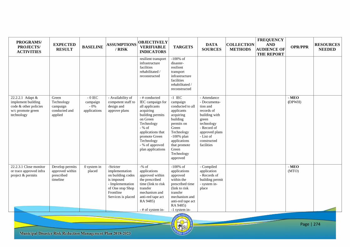
Page | 274
PROGRAMS/
PROJECTS/
ACTIVITIES
EXPECTED
RESULT BASELINE
ASSUMPTIONS
/ RISK
OBJECTIVELY
VERIFIABLE
INDICATORS
TARGETS DATA
SOURCES
COLLECTION
METHODS
FREQUENCY
AND
AUDIENCE OF
THE REPORT
OPR/PPR RESOURCES
NEEDED
resilient transport
infrastructure facilities
rehabilitated /
reconstructed
-100% of
disaster-resilient
transport
infrastructure
facilities rehabilitated /
reconstructed
22.2.2.1 Adapt &
implement building
code & other policies w/c promote green
technology
Green
Technology
campaign conducted and
applied
- 0 IEC
campaign
- 0% applications
- Availability of
competent staff to
design and approve plans
- # conducted
IEC campaign for
all applicants acquiring
building permits
on Green
Technology - % of
applications that
promote Green
Technology - % of approved
plan applications
-1 IEC
campaign
conducted to all applicants
acquiring
building
permits on Green
Technology
-100% plan
applications that promote
Green
Technology
approved
- Attendance
- Documenta-
tion and records of
building with
green
technology - Record of
approved plans
- List of
constructed facilities
- MEO
(DPWH)
22.2.3.1 Close monitor or trace approved infra
project & permits
Develop permits approved within
prescribed
timeline
0 system in placed
-Stricter implementation
on building codes
is imposed
- Implementation of One stop Shop
Frontline
Services is placed
-% of applications
approved within
the prescribed
time (link to risk transfer
mechanism and
anti-red tape act
RA 9485)
- # of system in-
-100% of applications
approved
within the
prescribed time (link to risk
transfer
mechanism and
anti-red tape act RA 9485)
-1 system in-
- Compiled application
- Records of
building permit
- system in-place
- MEO (MTO)
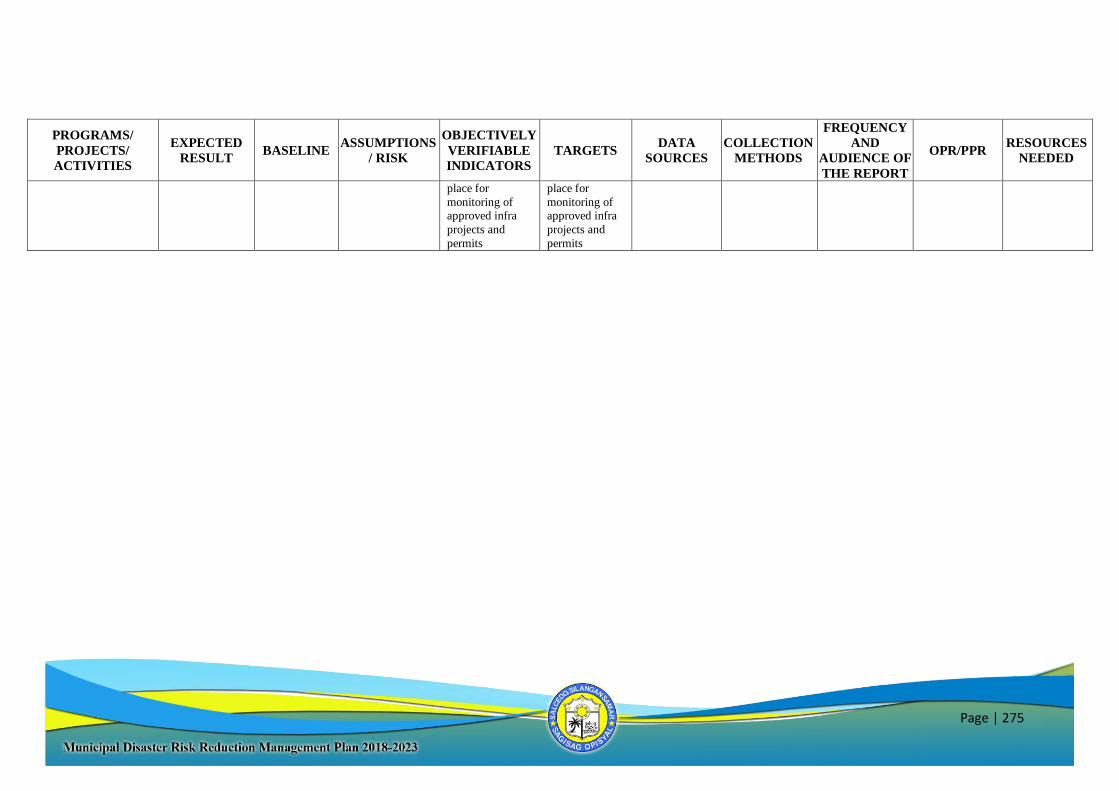
Page | 275
PROGRAMS/
PROJECTS/
ACTIVITIES
EXPECTED
RESULT BASELINE
ASSUMPTIONS
/ RISK
OBJECTIVELY
VERIFIABLE
INDICATORS
TARGETS DATA
SOURCES
COLLECTION
METHODS
FREQUENCY
AND
AUDIENCE OF
THE REPORT
OPR/PPR RESOURCES
NEEDED
place for
monitoring of approved infra
projects and
permits
place for
monitoring of approved infra
projects and
permits
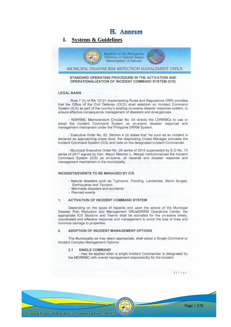
Page | 276
I. Systems & Guidelines
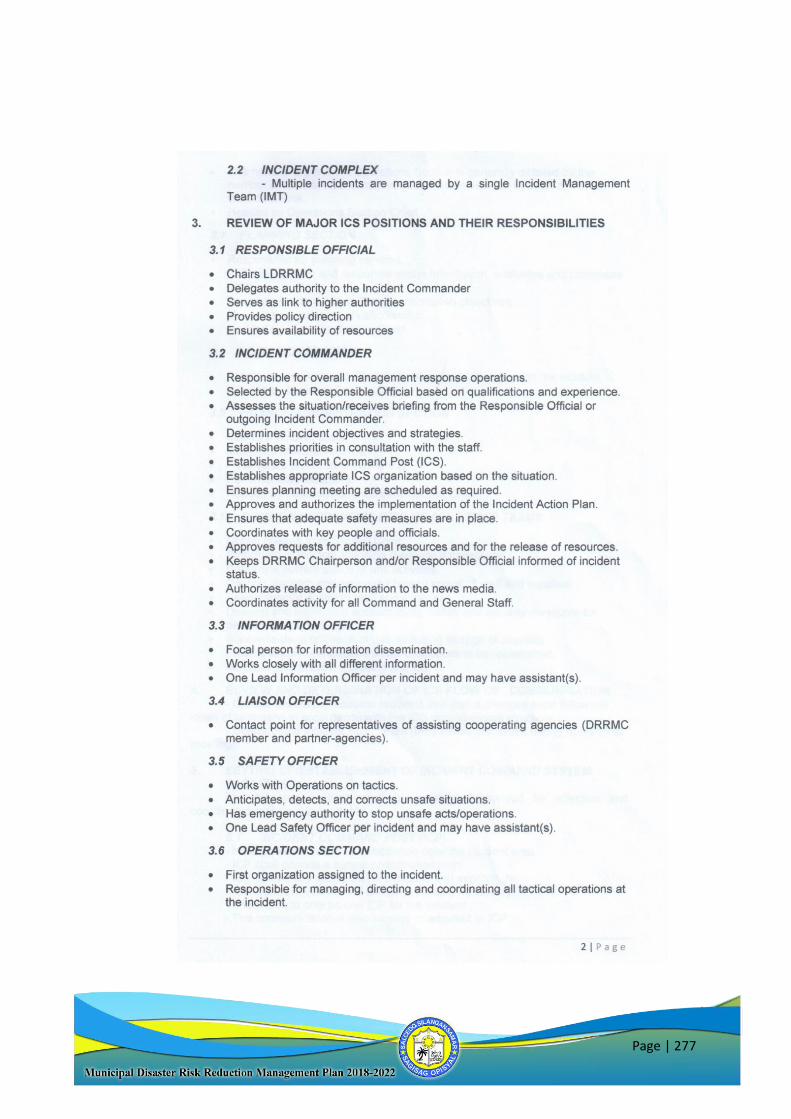
Page | 277
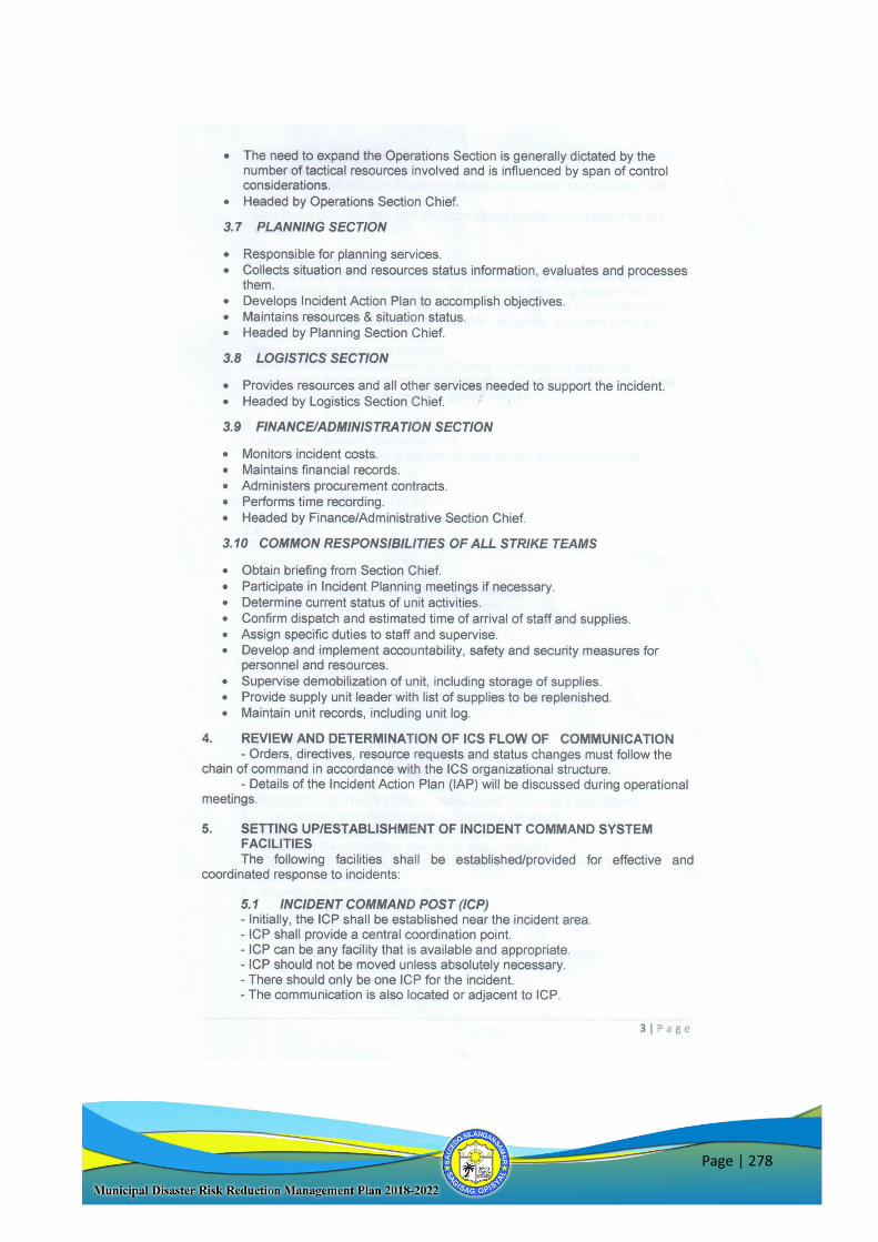
Page | 278
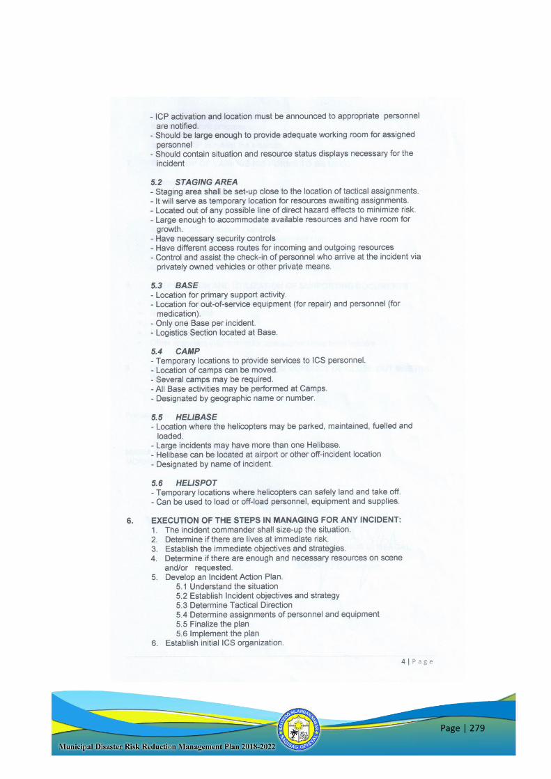
Page | 279
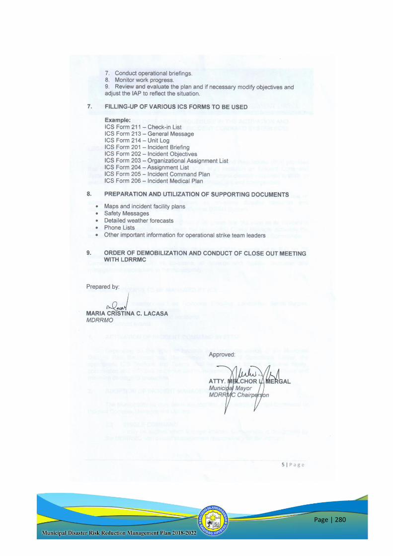
Page | 280

Page | 281

Page | 282
Page | 283
Page | 284
Page | 285
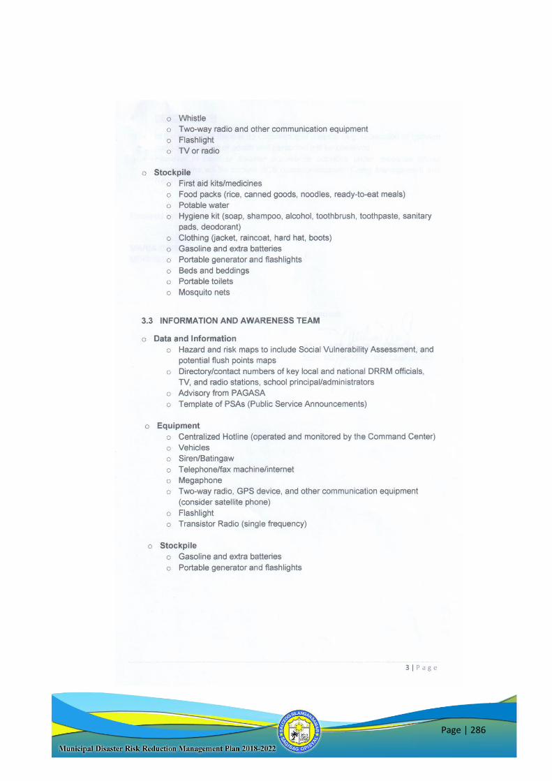
Page | 286
Page | 287
Page | 288
II. DRRM-CCA Related Trainings Conducted
LDRRM Office Training/DRR Activities Conducted
School Based-DRRM Training and Planning
November 21-23, 2018 1st Batch
November 27-29, 2018 2nd Batch
Salcedo Community Evacuation Center Poblacion 9)
Contingency Plan Coaching
(November 19, 2018 – Salcedo Municipal Social Hall)
Municipal Emergency Responders Training
(October 9-14, 2018 - Salcedo Community Evacuation Center Poblacion 9)
Orientation Seminar on Basic Radio Operations
(October 12, 2018 - Salcedo Community Evacuation Center Poblacion 9)
3-Schools Simultaneous Earthquake Drill of Salcedo National High School, Seguinon Elementary
School and Abejao Elementary School
(July 31, 2018)
Conduct 1st Municipal DRRM Caravan
(March 26, 2018 – Salcedo Municipal Civic Center)
Orientation on Community-Based Early Warning Mechanism, Operation Listo Manual, and
SOPs during Disasters/Emergency Response of Local Government Unit Salcedo
(March 8, 2018 – Salcedo Municipal Social Hall)
Earthquake/Tsunami Simultaneous Drill of Matarinao School of Fisheries and Matarinao
Elementary School
(February28, 2018)
Earthquake and Tsunami Table Top Orientation/Drill of Fisheries and Matarinao Elementary
School
(February 27, 2018)
Family Disaster Preparedness Orientation/Planning
(February 20-21, 2018 - Brgy. Asgad Multipurpose Bldg.
February 7-8, 2018 - Municipal Civic Center
Hosting of Regional Rescue Jamboree 2018
(November 13-17, 2017
Brgy. Naparaan, Salcedo, E. Samar)
BDRRM Planning Workshop (update)
(October 25-27, 2017
Salcedo, E. Samar)
Orientation on Emergency and Disaster Preparedness (20th BSP Provincial Jamboree)
(October 20-22, 2017
YOCENCA, Salcedo E. Samar)
Re-echo of Trainings for Emergency Response
(October 20-22, 2017 - Salcedo Community Evacuation Center Poblacion 9)
BDRRM Plan for Health Planning Workshop
(October – November 2017
Salcedo, E. Samar)
Fire Management and Safety Training to Municipal & Brgy. Responders and Tanods
(October 11-12, 2017 - Salcedo Community Evacuation Center Poblacion 9)
Conduct of Community Drills in Brgy. Lusod and Brgy. Malbog
(September 2017)
Page | 289
Orientation on Emergency and Disaster Preparedness to Salcedo ERT
(September 2017)
BDRRM Planning Workshop
(August 3-4, 2017 / Pob. 8, Pob. 6, Pob. 3, Pob. 11, Pob. 1, Pob. 8)
(August 10-11, 2017 / Abejao, Palanas, Seguinon, Abejao)
(August 17-18, 2017 / Cagaut, San Roque, Camanga & Poblacion 11)
- Salcedo Community Evacuation Center Poblacion 9
BDRRM Plan Coaching and Mentoring of all Barangays
(August 10, 2017 - Salcedo Community Evacuation Center Poblacion 9)
Incident Action Planning for 29th Diocesan Pentecost Vigil
(May 29, 2017 - Salcedo Community Evacuation Center Poblacion 9)
Orientation of Basic ICS to other Emergency Responders
(May 19, 2017 - Salcedo Community Evacuation Center Poblacion 9)
Basic Radio Communication Orientation to Brgy. Tanods
(April 18, 2017 - Salcedo Community Evacuation Center Poblacion 9)
Orientation-Workshop on the Utilization of Quality Assessment Tool
(March 20, 2017 - Salcedo Community Evacuation Center Poblacion 9)
Seminar-Workshop on Disaster Preparedness and Zero Waste Management and Disposal
Program
(March 17, 2017 – University Gymnasium, Salcedo Campus, Salcedo E. Samar)
BDRRM Planning Workshop
March 7-8, 2017
March 21-22, 2017
March 23-24, 2017
- Salcedo Community Evacuation Center Poblacion 9)
Family Disaster Preparedness Orientation
(January 18, 2017 / Lusod, Maliwaliw and Butig - Salcedo Community Evacuation Center Poblacion 9)
School Earthquake/Tsunami Drill
(Sep. 26, 2016 – Matarinao School of Fisheries, Matarinao, SES)
Updating and Mentoring Sessions for Barangay DRRM Plans
(Sep. 7-9, 2016 – Salcedo, CEC
Sep. 20-22, 2016 – Caridad, E. Samar / Asgad, E. Samar)
Orientation on the Institutionalization of BDRRMC
(Sep. 20-21, 2016 –- Salcedo Community Evacuation Center Poblacion 9)
3 Batches of Standard First Aid & Basic Life Support Trainings
(Aug. 8-12, 2016 – FTC, Salcedo, E. Samar
Aug. 15-19, 2016 – FTC, Salcedo, E. Samar
Sep. 5-9, 2016 – Salcedo, CEC)
Week-long Activities for Disaster Consciousness Month Celebration
(July 18-22, 2016 – Salcedo, E. Samar)
Barangay DRRM Planning Workshop for Brgy. Maliwaliw
(June 20-21, 2016 – Salcedo Civic Center)
Salcedo Municipal Wide Drill
(March 5, 2016 – Salcedo E. Samar)
Building Capacity to Improve Resilience to Weather and Climate Extremes in the Philippines
(March 3, 2016 –Salcedo Municipal Social Hall)
Standard First Aid Training
(January 23-24, 2016 – Salcedo Municipal Social Hall)
Drill Meeting/Orientation
(January 20, 2016 – Salcedo Municipal Social Hall)
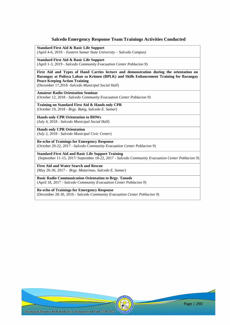
Page | 290
Salcedo Emergency Response Team Trainings Activities Conducted
Standard First Aid & Basic Life Support
(April 4-6, 2019 – Eastern Samar State University – Salcedo Campus)
Standard First Aid & Basic Life Support
(April 1-3, 2019 - Salcedo Community Evacuation Center Poblacion 9)
First Aid and Types of Hand Carries lecture and demonstration during the orientation on
Barangay at Pulisya Laban sa Krimen (BPLK) and Skills Enhancement Training for Barangay
Peace Keeping Action Training
(December 17,2018 -Salcedo Municipal Social Hall)
Amateur Radio Orientation Seminar
(October 12, 2018 - Salcedo Community Evacuation Center Poblacion 9)
Training on Standard First Aid & Hands only CPR
(October 19, 2018 - Brgy. Butig, Salcedo E. Samar)
Hands only CPR Orientation to BHWs
(July 4, 2018 - Salcedo Municipal Social Hall)
Hands only CPR Orientation
(July 2, 2018 - Salcedo Municipal Civic Center)
Re-echo of Trainings for Emergency Response
(October 20-22, 2017 - Salcedo Community Evacuation Center Poblacion 9)
Standard First Aid and Basic Life Support Training
(September 11-15, 2017/ September 18-22, 2017 - Salcedo Community Evacuation Center Poblacion 9)
First Aid and Water Search and Rescue
(May 26-30, 2017 - Brgy. Matarinao, Salcedo E. Samar)
Basic Radio Communication Orientation to Brgy. Tanods
(April 18, 2017 - Salcedo Community Evacuation Center Poblacion 9)
Re-echo of Trainings for Emergency Response
(December 28-30, 2016 - Salcedo Community Evacuation Center Poblacion 9)
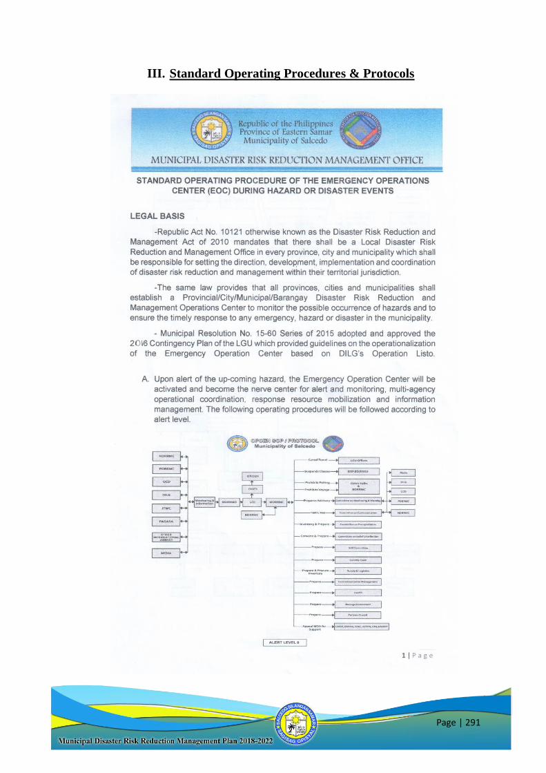
Page | 291
III. Standard Operating Procedures & Protocols
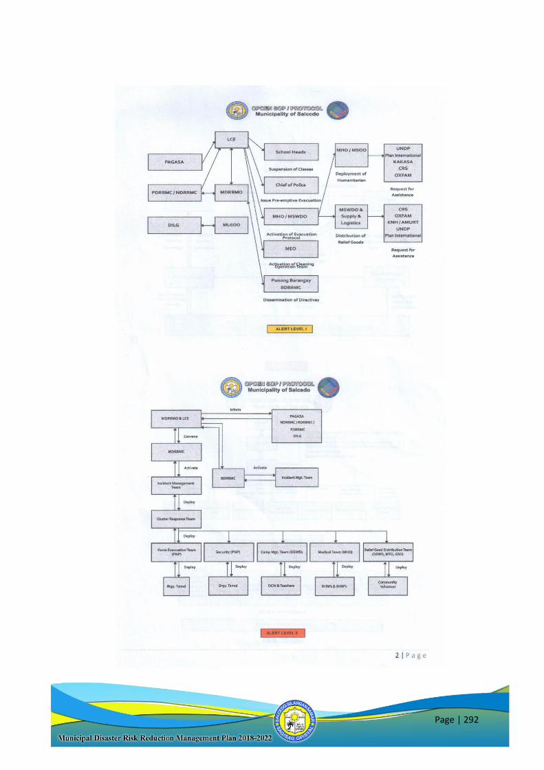
Page | 292
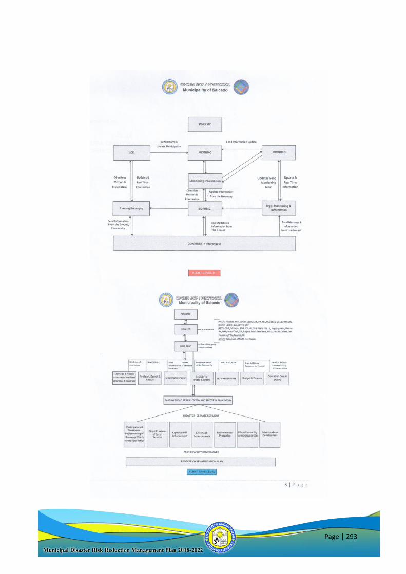
Page | 293
Page | 294
Page | 295
Page | 296
Page | 297
Page | 298
Page | 299
Page | 300
Page | 301
Page | 302
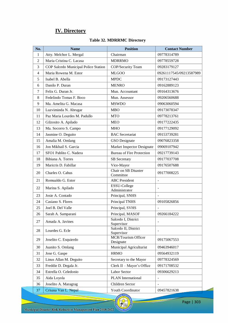
Page | 303
IV. Directory
Table 32. MDRRMC Directory
No. Name Position Contact Number
1 Atty. Melchor L. Mergal Chairman 09778314789
2 Maria Cristina C. Lacasa MDRRMO 09778559728
3 COP Salcedo Municipal Police Station COP/Security Team 09283179127
4 Maria Rowena M. Estor MLGOO 09261117545/09213587989
5 Isabel B. Abella MPDC 09173127443
6 Danilo P. Duran MENRO 09162889123
7 Felix G. Duran Jr. Mun. Accountant 09164313676
8 Fedelindo Tomas F. Boco Mun. Assessor 09206560688
9 Ma. Amelita G. Macasa MSWDO 09063060594
10 Luzviminda N. Abrugar MBO 09173078347
11 Paz Maria Lourdes M. Padullo MTO 09778213761
12 Gilzosito A. Apilado MEO 09177222435
13 Ma. Socorro S. Campo MHO 09177129092
14 Jasmine O. Deguito BAC Secretariat 09153739281
15 Amalia M. Omlang GSO Designate 09076823358
16 Jon Mikhail S. Garcia Market Inspector Designate 09069107942
17 SFO1 Pablito C. Nadera Bureau of Fire Protection 09217739143
18 Bibiana A. Torres SB Secretary 09177037708
19 Maricris D. Fabillar Vice-Mayor 09176507688
20 Charles O. Cabus Chair on SB Disaster
Committee 09177008225
21 Romualdo G. Estor ABC President -
22 Marina S. Apilado ESSU-College
Administrator -
23 Josie A. Contado Principal, SNHS -
24 Casiano S. Flores Principal TNHS 09105826856
25 Joel B. Del Valle Principal, SVHS -
26 Sarah A. Samparani Principal, MASOF 09266184222
27 Amada A. Javines Salcedo I, District
Supervisor -
28 Lourdes G. Ecle Salcedo II, District
Supervisor -
29 Joselito C. Esquierdo MCR/Tourism Officer
Designate 09175067553
30 Juanito S. Omlang Municipal Agriculturist 09463946017
31 Jose G. Gaspe HRMO 09564932119
32 Linus Allan M. Deguito Secretary to the Mayor 09778324569
33 Freddie D. Degala Jr. Clerk II – Mayor’s Office 09171708532
34 Estrella O. Celedonio Labor Sector 09306629213
35 Aida Loyola PLAN International -
36 Joselito A. Maragrag Children Sector -
37 Crisasa Van L. Nepal Youth Coordinator 09457821638

Page | 304
38 Felisa R. Castro KaKaSa/Women’s Sector 09065402633
39 Remegio Y. Boco Senior Citizens Sector 09075473337
40 Renato T. Lumen PWD Sector -
41 Luis A. Bayarong Farmers Sector -
42 Melchor B. Yarzo Fishermen Sector 09303458728
43 Josefina Zamoras Business Sector -
44 Rodrigo Macawile Transportation Sector -
45 Joannes Joseph M. Deguito Private Sector- ERT Team
Leader 09089278874
46 Tarcisia Maragrag BHW President 09097632142
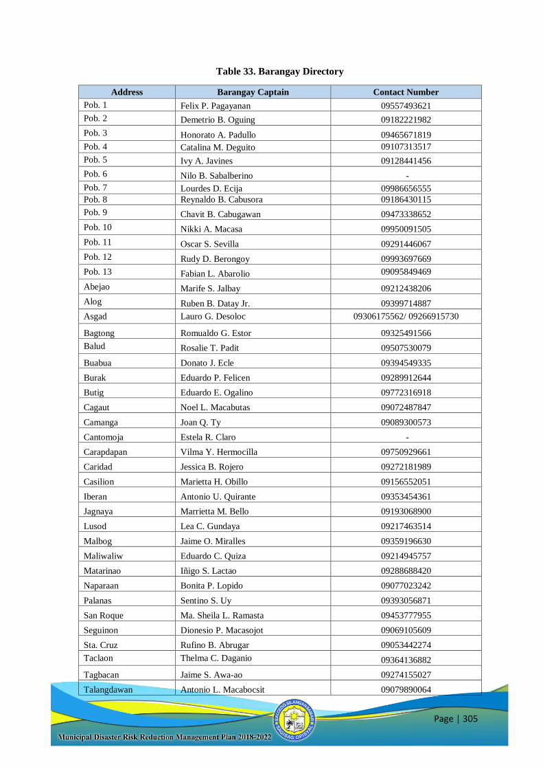
Page | 305
Table 33. Barangay Directory
Address Barangay Captain Contact Number
Pob. 1 Felix P. Pagayanan 09557493621
Pob. 2 Demetrio B. Oguing 09182221982
Pob. 3 Honorato A. Padullo 09465671819
Pob. 4 Catalina M. Deguito 09107313517
Pob. 5 Ivy A. Javines 09128441456
Pob. 6 Nilo B. Sabalberino -
Pob. 7 Lourdes D. Ecija 09986656555
Pob. 8 Reynaldo B. Cabusora 09186430115
Pob. 9 Chavit B. Cabugawan 09473338652
Pob. 10 Nikki A. Macasa 09950091505
Pob. 11 Oscar S. Sevilla 09291446067
Pob. 12 Rudy D. Berongoy 09993697669
Pob. 13 Fabian L. Abarolio 09095849469
Abejao Marife S. Jalbay 09212438206
Alog Ruben B. Datay Jr. 09399714887
Asgad Lauro G. Desoloc 09306175562/ 09266915730
Bagtong Romualdo G. Estor 09325491566
Balud Rosalie T. Padit 09507530079
Buabua Donato J. Ecle 09394549335
Burak Eduardo P. Felicen 09289912644
Butig Eduardo E. Ogalino 09772316918
Cagaut Noel L. Macabutas 09072487847
Camanga Joan Q. Ty 09089300573
Cantomoja Estela R. Claro -
Carapdapan Vilma Y. Hermocilla 09750929661
Caridad Jessica B. Rojero 09272181989
Casilion Marietta H. Obillo 09156552051
Iberan Antonio U. Quirante 09353454361
Jagnaya Marrietta M. Bello 09193068900
Lusod Lea C. Gundaya 09217463514
Malbog Jaime O. Miralles 09359196630
Maliwaliw Eduardo C. Quiza 09214945757
Matarinao Iñigo S. Lactao 09288688420
Naparaan Bonita P. Lopido 09077023242
Palanas Sentino S. Uy 09393056871
San Roque Ma. Sheila L. Ramasta 09453777955
Seguinon Dionesio P. Macasojot 09069105609
Sta. Cruz Rufino B. Abrugar 09053442274
Taclaon Thelma C. Daganio 09364136882
Tagbacan Jaime S. Awa-ao 09274155027
Talangdawan Antonio L. Macabocsit 09079890064
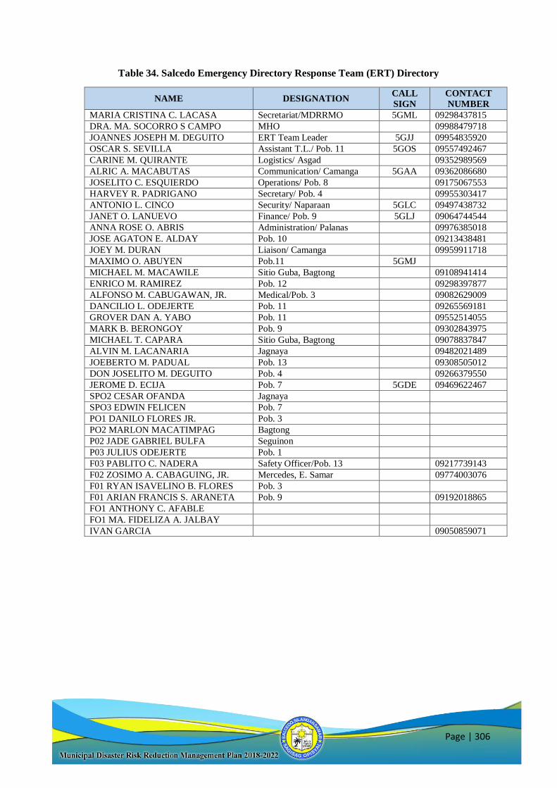
Page | 306
Table 34. Salcedo Emergency Directory Response Team (ERT) Directory
NAME DESIGNATION CALL
SIGN
CONTACT
NUMBER
MARIA CRISTINA C. LACASA Secretariat/MDRRMO 5GML 09298437815
DRA. MA. SOCORRO S CAMPO MHO 09988479718
JOANNES JOSEPH M. DEGUITO ERT Team Leader 5GJJ 09954835920
OSCAR S. SEVILLA Assistant T.L./ Pob. 11 5GOS 09557492467
CARINE M. QUIRANTE Logistics/ Asgad 09352989569
ALRIC A. MACABUTAS Communication/ Camanga 5GAA 09362086680
JOSELITO C. ESQUIERDO Operations/ Pob. 8 09175067553
HARVEY R. PADRIGANO Secretary/ Pob. 4 09955303417
ANTONIO L. CINCO Security/ Naparaan 5GLC 09497438732
JANET O. LANUEVO Finance/ Pob. 9 5GLJ 09064744544
ANNA ROSE O. ABRIS Administration/ Palanas 09976385018
JOSE AGATON E. ALDAY Pob. 10 09213438481
JOEY M. DURAN Liaison/ Camanga 09959911718
MAXIMO O. ABUYEN Pob.11 5GMJ
MICHAEL M. MACAWILE Sitio Guba, Bagtong 09108941414
ENRICO M. RAMIREZ Pob. 12 09298397877
ALFONSO M. CABUGAWAN, JR. Medical/Pob. 3 09082629009
DANCILIO L. ODEJERTE Pob. 11 09265569181
GROVER DAN A. YABO Pob. 11 09552514055
MARK B. BERONGOY Pob. 9 09302843975
MICHAEL T. CAPARA Sitio Guba, Bagtong 09078837847
ALVIN M. LACANARIA Jagnaya 09482021489
JOEBERTO M. PADUAL Pob. 13 09308505012
DON JOSELITO M. DEGUITO Pob. 4 09266379550
JEROME D. ECIJA Pob. 7 5GDE 09469622467
SPO2 CESAR OFANDA Jagnaya
SPO3 EDWIN FELICEN Pob. 7
PO1 DANILO FLORES JR. Pob. 3
PO2 MARLON MACATIMPAG Bagtong
P02 JADE GABRIEL BULFA Seguinon
P03 JULIUS ODEJERTE Pob. 1
F03 PABLITO C. NADERA Safety Officer/Pob. 13 09217739143
F02 ZOSIMO A. CABAGUING, JR. Mercedes, E. Samar 09774003076
F01 RYAN ISAVELINO B. FLORES Pob. 3
F01 ARIAN FRANCIS S. ARANETA Pob. 9 09192018865
FO1 ANTHONY C. AFABLE
FO1 MA. FIDELIZA A. JALBAY
IVAN GARCIA 09050859071
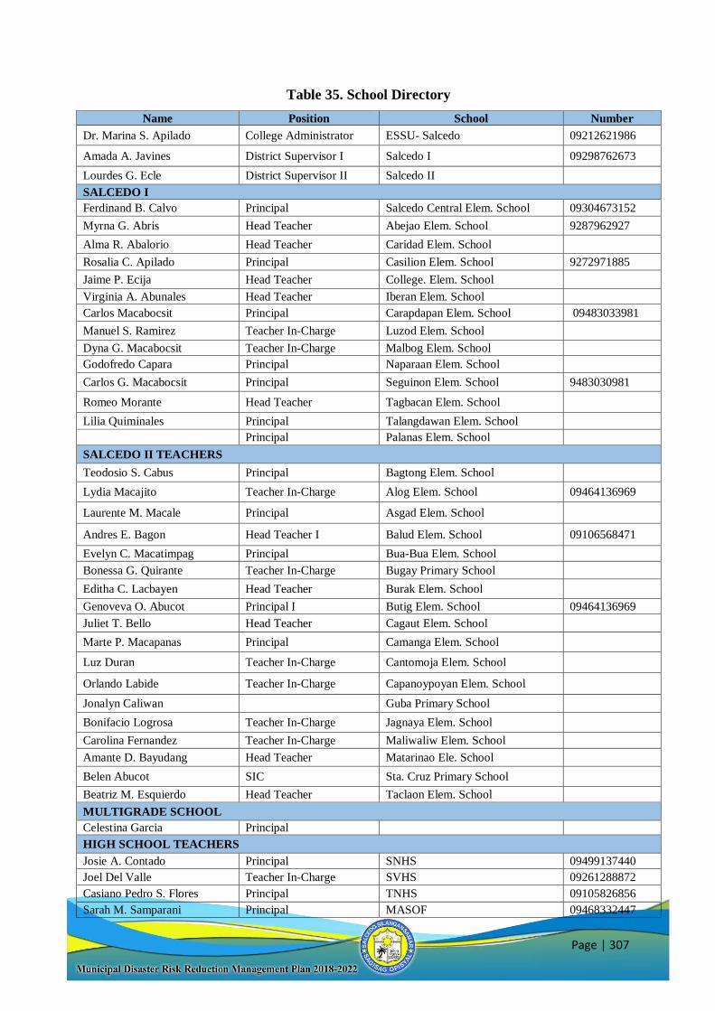
Page | 307
Table 35. School Directory
Name Position School Number
Dr. Marina S. Apilado College Administrator ESSU- Salcedo 09212621986
Amada A. Javines District Supervisor I Salcedo I 09298762673
Lourdes G. Ecle District Supervisor II Salcedo II
SALCEDO I
Ferdinand B. Calvo Principal Salcedo Central Elem. School 09304673152
Myrna G. Abris Head Teacher Abejao Elem. School 9287962927
Alma R. Abalorio Head Teacher Caridad Elem. School
Rosalia C. Apilado Principal Casilion Elem. School 9272971885
Jaime P. Ecija Head Teacher College. Elem. School
Virginia A. Abunales Head Teacher Iberan Elem. School
Carlos Macabocsit Principal Carapdapan Elem. School 09483033981
Manuel S. Ramirez Teacher In-Charge Luzod Elem. School
Dyna G. Macabocsit Teacher In-Charge Malbog Elem. School
Godofredo Capara Principal Naparaan Elem. School
Carlos G. Macabocsit Principal Seguinon Elem. School 9483030981
Romeo Morante Head Teacher Tagbacan Elem. School
Lilia Quiminales Principal Talangdawan Elem. School
Principal Palanas Elem. School
SALCEDO II TEACHERS
Teodosio S. Cabus Principal Bagtong Elem. School
Lydia Macajito Teacher In-Charge Alog Elem. School 09464136969
Laurente M. Macale Principal Asgad Elem. School
Andres E. Bagon Head Teacher I Balud Elem. School 09106568471
Evelyn C. Macatimpag Principal Bua-Bua Elem. School
Bonessa G. Quirante Teacher In-Charge Bugay Primary School
Editha C. Lacbayen Head Teacher Burak Elem. School
Genoveva O. Abucot Principal I Butig Elem. School 09464136969
Juliet T. Bello Head Teacher Cagaut Elem. School
Marte P. Macapanas Principal Camanga Elem. School
Luz Duran Teacher In-Charge Cantomoja Elem. School
Orlando Labide Teacher In-Charge Capanoypoyan Elem. School
Jonalyn Caliwan Guba Primary School
Bonifacio Logrosa Teacher In-Charge Jagnaya Elem. School
Carolina Fernandez Teacher In-Charge Maliwaliw Elem. School
Amante D. Bayudang Head Teacher Matarinao Ele. School
Belen Abucot SIC Sta. Cruz Primary School
Beatriz M. Esquierdo Head Teacher Taclaon Elem. School
MULTIGRADE SCHOOL
Celestina Garcia Principal
HIGH SCHOOL TEACHERS
Josie A. Contado Principal SNHS 09499137440
Joel Del Valle Teacher In-Charge SVHS 09261288872
Casiano Pedro S. Flores Principal TNHS 09105826856
Sarah M. Samparani Principal MASOF 09468332447
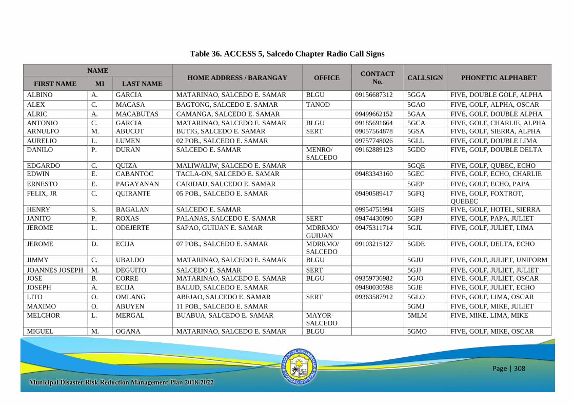
Page | 308
Table 36. ACCESS 5, Salcedo Chapter Radio Call Signs
NAME HOME ADDRESS / BARANGAY OFFICE
CONTACT
No. CALLSIGN PHONETIC ALPHABET
FIRST NAME MI LAST NAME
ALBINO A. GARCIA MATARINAO, SALCEDO E. SAMAR BLGU 09156687312 5GGA FIVE, DOUBLE GOLF, ALPHA
ALEX C. MACASA BAGTONG, SALCEDO E. SAMAR TANOD 5GAO FIVE, GOLF, ALPHA, OSCAR
ALRIC A. MACABUTAS CAMANGA, SALCEDO E. SAMAR 09499662152 5GAA FIVE, GOLF, DOUBLE ALPHA
ANTONIO C. GARCIA MATARINAO, SALCEDO E. SAMAR BLGU 09185691664 5GCA FIVE, GOLF, CHARLIE, ALPHA
ARNULFO M. ABUCOT BUTIG, SALCEDO E. SAMAR SERT 09057564878 5GSA FIVE, GOLF, SIERRA, ALPHA
AURELIO L. LUMEN 02 POB., SALCEDO E. SAMAR 09757748026 5GLL FIVE, GOLF, DOUBLE LIMA
DANILO P. DURAN SALCEDO E. SAMAR MENRO/
SALCEDO
09162889123 5GDD FIVE, GOLF, DOUBLE DELTA
EDGARDO C. QUIZA MALIWALIW, SALCEDO E. SAMAR 5GQE FIVE, GOLF, QUBEC, ECHO
EDWIN E. CABANTOC TACLA-ON, SALCEDO E. SAMAR 09483343160 5GEC FIVE, GOLF, ECHO, CHARLIE
ERNESTO E. PAGAYANAN CARIDAD, SALCEDO E. SAMAR 5GEP FIVE, GOLF, ECHO, PAPA
FELIX, JR C. QUIRANTE 05 POB., SALCEDO E. SAMAR 09490589417 5GFQ FIVE, GOLF, FOXTROT,
QUEBEC
HENRY S. BAGALAN SALCEDO E. SAMAR 09954751994 5GHS FIVE, GOLF, HOTEL, SIERRA
JANITO P. ROXAS PALANAS, SALCEDO E. SAMAR SERT 09474430090 5GPJ FIVE, GOLF, PAPA, JULIET
JEROME L. ODEJERTE SAPAO, GUIUAN E. SAMAR MDRRMO/
GUIUAN
09475311714 5GJL FIVE, GOLF, JULIET, LIMA
JEROME D. ECIJA 07 POB., SALCEDO E. SAMAR MDRRMO/
SALCEDO
09103215127 5GDE FIVE, GOLF, DELTA, ECHO
JIMMY C. UBALDO MATARINAO, SALCEDO E. SAMAR BLGU 5GJU FIVE, GOLF, JULIET, UNIFORM
JOANNES JOSEPH M. DEGUITO SALCEDO E. SAMAR SERT 5GJJ FIVE, GOLF, JULIET, JULIET
JOSE B. CORRE MATARINAO, SALCEDO E. SAMAR BLGU 09359736982 5GJO FIVE, GOLF, JULIET, OSCAR
JOSEPH A. ECIJA BALUD, SALCEDO E. SAMAR 09480030598 5GJE FIVE, GOLF, JULIET, ECHO
LITO O. OMLANG ABEJAO, SALCEDO E. SAMAR SERT 09363587912 5GLO FIVE, GOLF, LIMA, OSCAR
MAXIMO O. ABUYEN 11 POB., SALCEDO E. SAMAR 5GMJ FIVE, GOLF, MIKE, JULIET
MELCHOR L. MERGAL BUABUA, SALCEDO E. SAMAR MAYOR-
SALCEDO
5MLM FIVE, MIKE, LIMA, MIKE
MIGUEL M. OGANA MATARINAO, SALCEDO E. SAMAR BLGU 5GMO FIVE, GOLF, MIKE, OSCAR
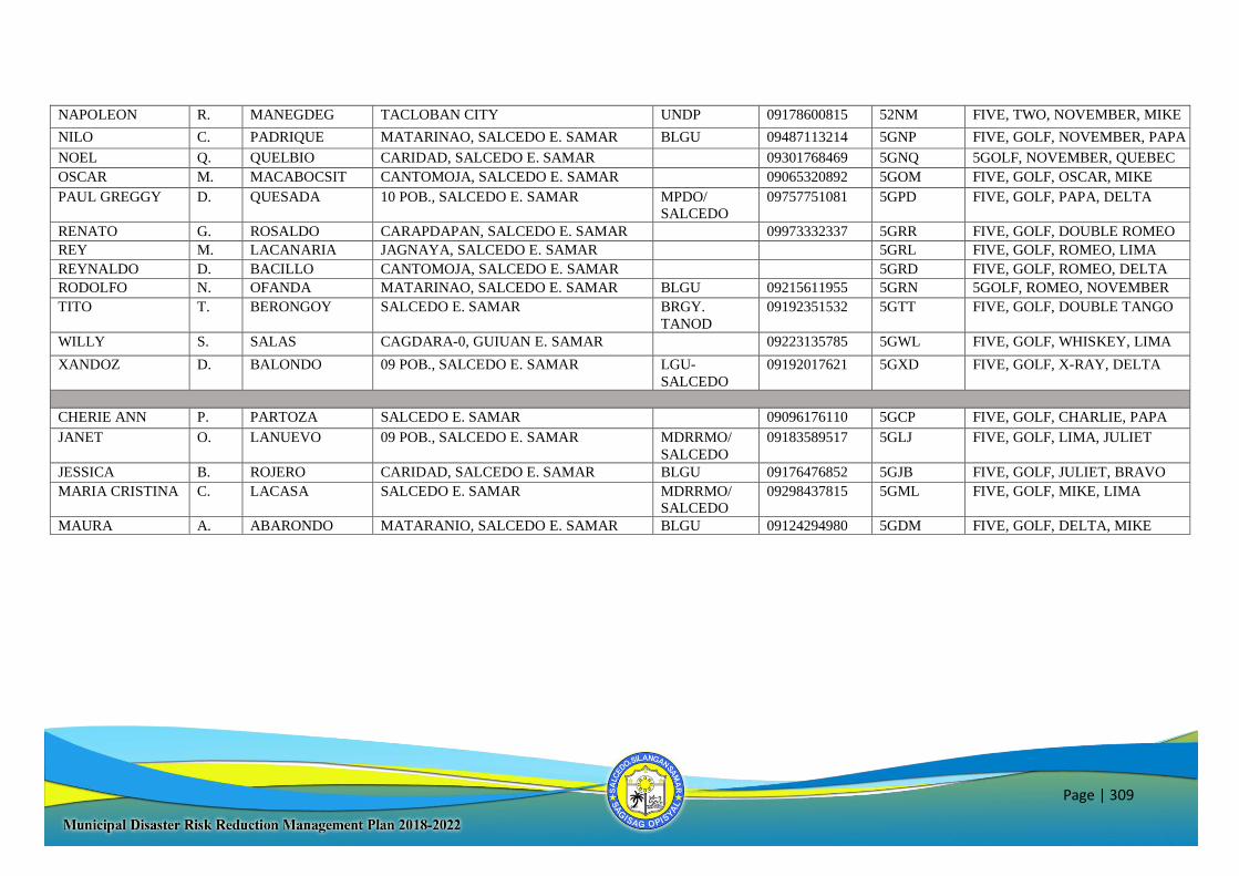
Page | 309
NAPOLEON R. MANEGDEG TACLOBAN CITY UNDP 09178600815 52NM FIVE, TWO, NOVEMBER, MIKE
NILO C. PADRIQUE MATARINAO, SALCEDO E. SAMAR BLGU 09487113214 5GNP FIVE, GOLF, NOVEMBER, PAPA
NOEL Q. QUELBIO CARIDAD, SALCEDO E. SAMAR 09301768469 5GNQ 5GOLF, NOVEMBER, QUEBEC
OSCAR M. MACABOCSIT CANTOMOJA, SALCEDO E. SAMAR 09065320892 5GOM FIVE, GOLF, OSCAR, MIKE
PAUL GREGGY D. QUESADA 10 POB., SALCEDO E. SAMAR MPDO/
SALCEDO
09757751081 5GPD FIVE, GOLF, PAPA, DELTA
RENATO G. ROSALDO CARAPDAPAN, SALCEDO E. SAMAR 09973332337 5GRR FIVE, GOLF, DOUBLE ROMEO
REY M. LACANARIA JAGNAYA, SALCEDO E. SAMAR 5GRL FIVE, GOLF, ROMEO, LIMA
REYNALDO D. BACILLO CANTOMOJA, SALCEDO E. SAMAR 5GRD FIVE, GOLF, ROMEO, DELTA
RODOLFO N. OFANDA MATARINAO, SALCEDO E. SAMAR BLGU 09215611955 5GRN 5GOLF, ROMEO, NOVEMBER
TITO T. BERONGOY SALCEDO E. SAMAR BRGY.
TANOD
09192351532 5GTT FIVE, GOLF, DOUBLE TANGO
WILLY S. SALAS CAGDARA-0, GUIUAN E. SAMAR 09223135785 5GWL FIVE, GOLF, WHISKEY, LIMA
XANDOZ D. BALONDO 09 POB., SALCEDO E. SAMAR LGU-
SALCEDO
09192017621 5GXD FIVE, GOLF, X-RAY, DELTA
CHERIE ANN P. PARTOZA SALCEDO E. SAMAR 09096176110 5GCP FIVE, GOLF, CHARLIE, PAPA
JANET O. LANUEVO 09 POB., SALCEDO E. SAMAR MDRRMO/
SALCEDO
09183589517 5GLJ FIVE, GOLF, LIMA, JULIET
JESSICA B. ROJERO CARIDAD, SALCEDO E. SAMAR BLGU 09176476852 5GJB FIVE, GOLF, JULIET, BRAVO
MARIA CRISTINA C. LACASA SALCEDO E. SAMAR MDRRMO/
SALCEDO
09298437815 5GML FIVE, GOLF, MIKE, LIMA
MAURA A. ABARONDO MATARANIO, SALCEDO E. SAMAR BLGU 09124294980 5GDM FIVE, GOLF, DELTA, MIKE
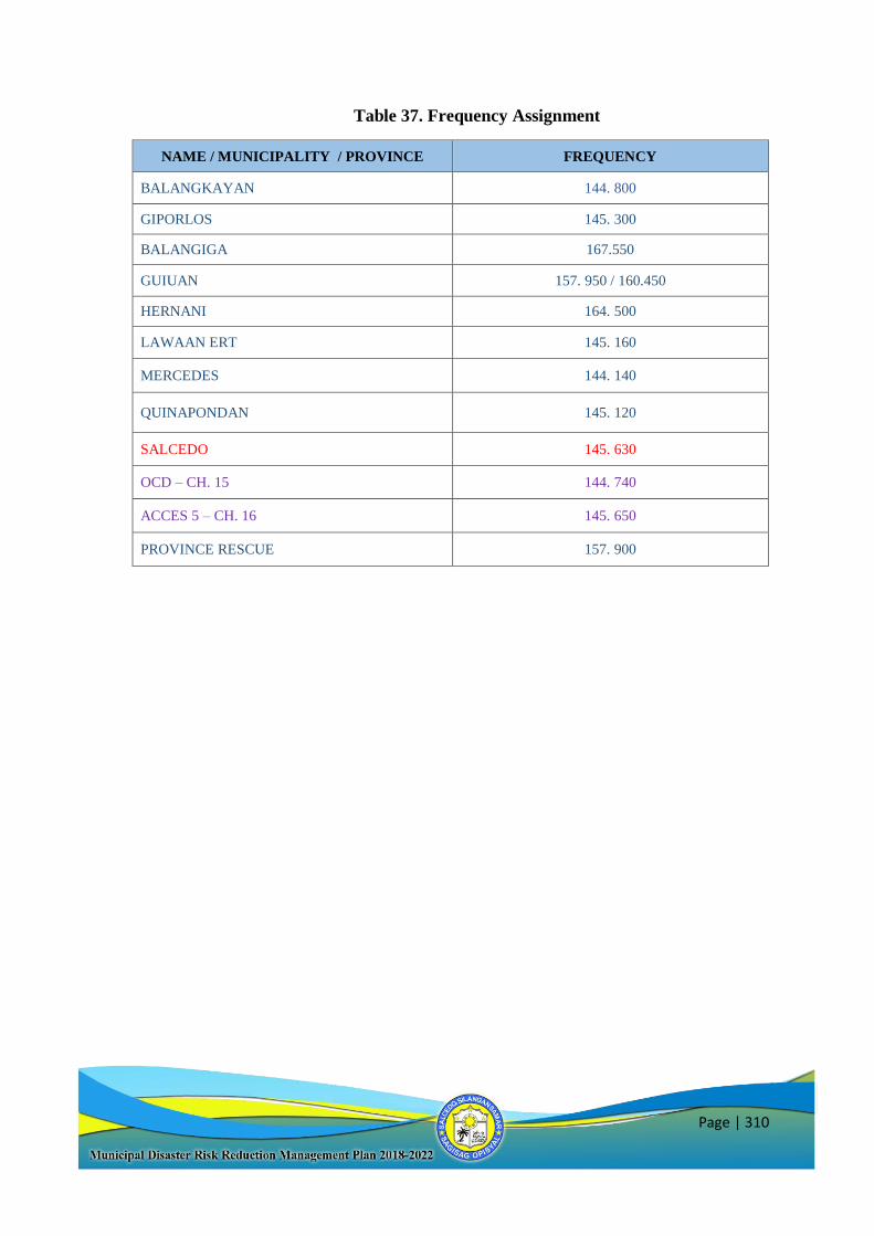
Page | 310
Table 37. Frequency Assignment
NAME / MUNICIPALITY / PROVINCE FREQUENCY
BALANGKAYAN 144. 800
GIPORLOS 145. 300
BALANGIGA 167.550
GUIUAN 157. 950 / 160.450
HERNANI 164. 500
LAWAAN ERT 145. 160
MERCEDES 144. 140
QUINAPONDAN 145. 120
SALCEDO 145. 630
OCD – CH. 15 144. 740
ACCES 5 – CH. 16 145. 650
PROVINCE RESCUE 157. 900
Page | 311
V. Contingency Plan
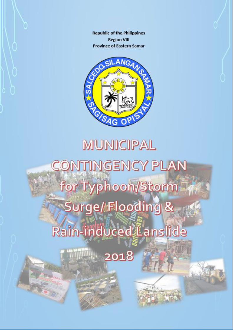
Page | 1
Municipal Contingency Plan for Typhoon, Storm Surge/ Flooding/ Landslide 2018
Table of Contents
CHAPTER 1 - BACKGROUND A. Introduction ---------------------------------------------2 B. Hazard Identification --------------------------------------------11 C. Hazard to Plan for Typhoon, Storm Surge------------------------------12
Flooding, Rain-induced Landslide D. Scenarios --------------------------------------------13 CHAPTER 2 – GOALS and OBJECTIVES
A. Goal --------------------------------------------27 B. Objectives ---------------------------------------------27
CHAPTER 3- COORDINATION, COMMANND AND CONTROL
A. Coordination ---------------------------------------------28 1. Food and Non-food ---------------------------------------------30 2. Emergency Telecommunications -------------------------------------32 3. Search, Rescue & Retrieval --------------------------------------------33 4. Logistics --------------------------------------------36 5. Education --------------------------------------------36 6. Camp Coordination and Management ------------------------------37 7. Health --------------------------------------------38 8. Protection --------------------------------------------40 9. Management of the Dead and the Missing -------------------------41 10. Law and Order --------------------------------------------42 11. Humanitarian Assistance --------------------------------------------43
a. Total Budgetary Requirements ------------------------------92 b. Total Resource Requirements --------------------------------93
B. Command and Control --------------------------------------------97 1. Features of the Emergency Operations Center (EOC) ------------98 2. Feature of Incident Command System (ICS) -----------------------109 3. Interoperability -------------------------------------------110
CHAPTER 4- ACTIVATION, DE-ACTIVATION AND NON-ACTIVATION
A. Activation and De-activation ----------------------------------------111 B. Non-Activation -----------------------------------------112
Annex A: Working Group -----------------------------------------113 Annex B: Gap Identification Matrix -----------------------------------------116 Annex C: Municipality of Salcedo MDRRMC Directory ---------------------117 Annex D: Map of Municipality of Salcedo, E. Samar ------------------------121
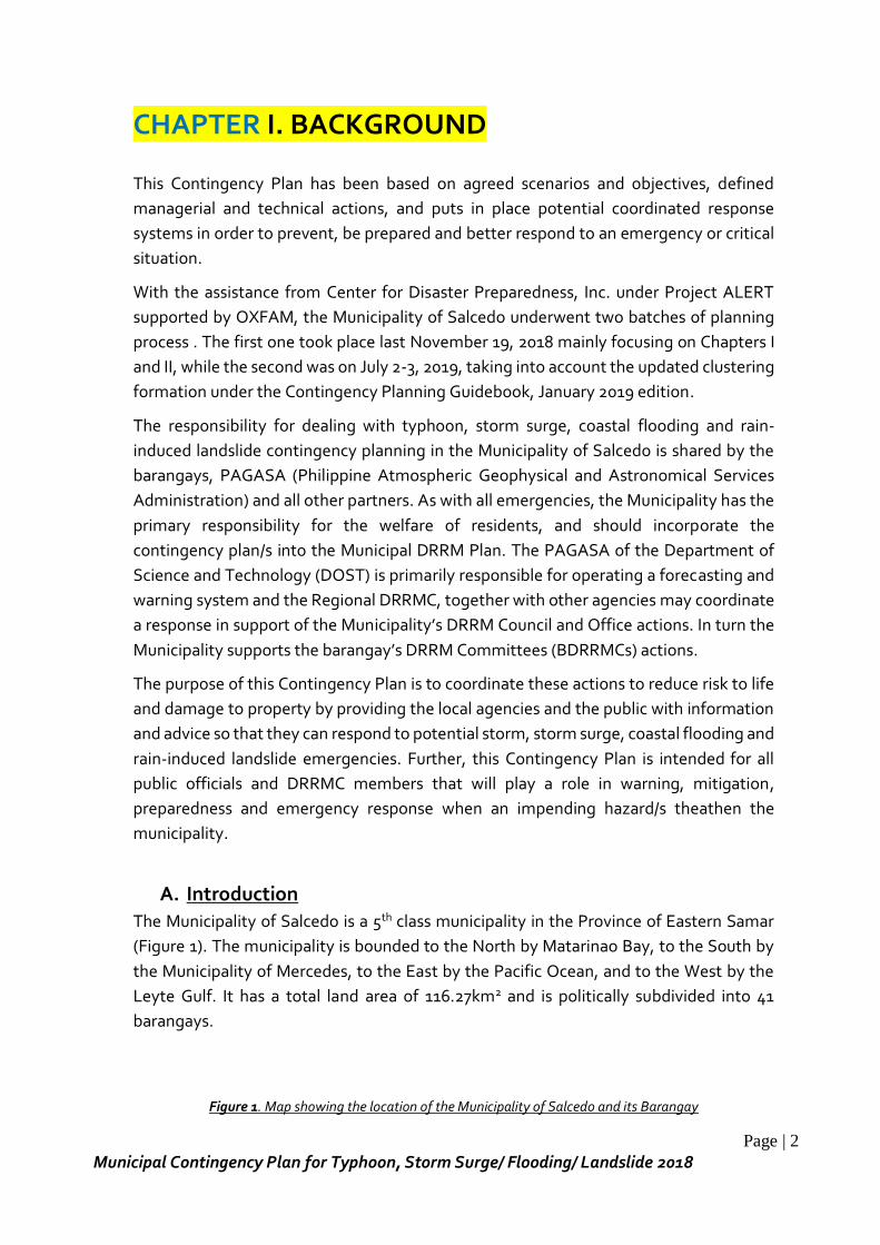
Page | 2
Municipal Contingency Plan for Typhoon, Storm Surge/ Flooding/ Landslide 2018
CHAPTER I. BACKGROUND
This Contingency Plan has been based on agreed scenarios and objectives, defined
managerial and technical actions, and puts in place potential coordinated response
systems in order to prevent, be prepared and better respond to an emergency or critical
situation.
With the assistance from Center for Disaster Preparedness, Inc. under Project ALERT
supported by OXFAM, the Municipality of Salcedo underwent two batches of planning
process . The first one took place last November 19, 2018 mainly focusing on Chapters I
and II, while the second was on July 2-3, 2019, taking into account the updated clustering
formation under the Contingency Planning Guidebook, January 2019 edition.
The responsibility for dealing with typhoon, storm surge, coastal flooding and rain-
induced landslide contingency planning in the Municipality of Salcedo is shared by the
barangays, PAGASA (Philippine Atmospheric Geophysical and Astronomical Services
Administration) and all other partners. As with all emergencies, the Municipality has the
primary responsibility for the welfare of residents, and should incorporate the
contingency plan/s into the Municipal DRRM Plan. The PAGASA of the Department of
Science and Technology (DOST) is primarily responsible for operating a forecasting and
warning system and the Regional DRRMC, together with other agencies may coordinate
a response in support of the Municipality’s DRRM Council and Office actions. In turn the
Municipality supports the barangay’s DRRM Committees (BDRRMCs) actions.
The purpose of this Contingency Plan is to coordinate these actions to reduce risk to life
and damage to property by providing the local agencies and the public with information
and advice so that they can respond to potential storm, storm surge, coastal flooding and
rain-induced landslide emergencies. Further, this Contingency Plan is intended for all
public officials and DRRMC members that will play a role in warning, mitigation,
preparedness and emergency response when an impending hazard/s theathen the
municipality.
A. Introduction
The Municipality of Salcedo is a 5th class municipality in the Province of Eastern Samar
(Figure 1). The municipality is bounded to the North by Matarinao Bay, to the South by
the Municipality of Mercedes, to the East by the Pacific Ocean, and to the West by the
Leyte Gulf. It has a total land area of 116.27km2 and is politically subdivided into 41
barangays.
Figure 1. Map showing the location of the Municipality of Salcedo and its Barangay
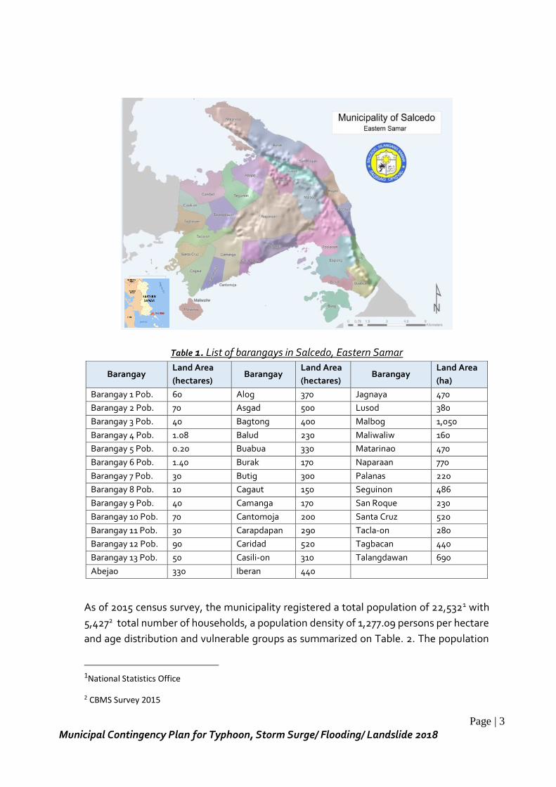
Page | 3
Municipal Contingency Plan for Typhoon, Storm Surge/ Flooding/ Landslide 2018
Table 1. List of barangays in Salcedo, Eastern Samar
Barangay Land Area
(hectares) Barangay
Land Area
(hectares) Barangay
Land Area
(ha)
Barangay 1 Pob. 60 Alog 370 Jagnaya 470
Barangay 2 Pob. 70 Asgad 500 Lusod 380
Barangay 3 Pob. 40 Bagtong 400 Malbog 1,050
Barangay 4 Pob. 1.08 Balud 230 Maliwaliw 160
Barangay 5 Pob. 0.20 Buabua 330 Matarinao 470
Barangay 6 Pob. 1.40 Burak 170 Naparaan 770
Barangay 7 Pob. 30 Butig 300 Palanas 220
Barangay 8 Pob. 10 Cagaut 150 Seguinon 486
Barangay 9 Pob. 40 Camanga 170 San Roque 230
Barangay 10 Pob. 70 Cantomoja 200 Santa Cruz 520
Barangay 11 Pob. 30 Carapdapan 290 Tacla-on 280
Barangay 12 Pob. 90 Caridad 520 Tagbacan 440
Barangay 13 Pob. 50 Casili-on 310 Talangdawan 690
Abejao 330 Iberan 440
As of 2015 census survey, the municipality registered a total population of 22,5321 with
5,4272 total number of households, a population density of 1,277.09 persons per hectare
and age distribution and vulnerable groups as summarized on Table. 2. The population
1National Statistics Office
2 CBMS Survey 2015
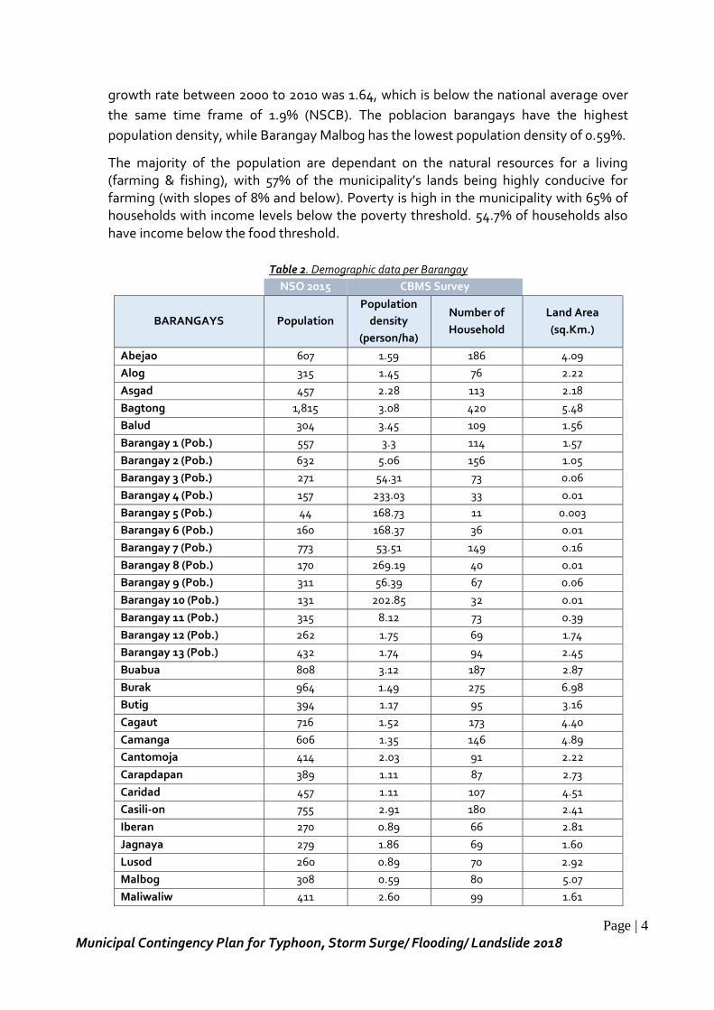
Page | 4
Municipal Contingency Plan for Typhoon, Storm Surge/ Flooding/ Landslide 2018
growth rate between 2000 to 2010 was 1.64, which is below the national average over
the same time frame of 1.9% (NSCB). The poblacion barangays have the highest
population density, while Barangay Malbog has the lowest population density of 0.59%.
The majority of the population are dependant on the natural resources for a living (farming & fishing), with 57% of the municipality’s lands being highly conducive for farming (with slopes of 8% and below). Poverty is high in the municipality with 65% of households with income levels below the poverty threshold. 54.7% of households also have income below the food threshold.
Table 2. Demographic data per Barangay
NSO 2015 CBMS Survey
BARANGAYS Population
Population
density
(person/ha)
Number of
Household
Land Area
(sq.Km.)
Abejao 607 1.59 186 4.09
Alog 315 1.45 76 2.22
Asgad 457 2.28 113 2.18
Bagtong 1,815 3.08 420 5.48
Balud 304 3.45 109 1.56
Barangay 1 (Pob.) 557 3.3 114 1.57
Barangay 2 (Pob.) 632 5.06 156 1.05
Barangay 3 (Pob.) 271 54.31 73 0.06
Barangay 4 (Pob.) 157 233.03 33 0.01
Barangay 5 (Pob.) 44 168.73 11 0.003
Barangay 6 (Pob.) 160 168.37 36 0.01
Barangay 7 (Pob.) 773 53.51 149 0.16
Barangay 8 (Pob.) 170 269.19 40 0.01
Barangay 9 (Pob.) 311 56.39 67 0.06
Barangay 10 (Pob.) 131 202.85 32 0.01
Barangay 11 (Pob.) 315 8.12 73 0.39
Barangay 12 (Pob.) 262 1.75 69 1.74
Barangay 13 (Pob.) 432 1.74 94 2.45
Buabua 808 3.12 187 2.87
Burak 964 1.49 275 6.98
Butig 394 1.17 95 3.16
Cagaut 716 1.52 173 4.40
Camanga 606 1.35 146 4.89
Cantomoja 414 2.03 91 2.22
Carapdapan 389 1.11 87 2.73
Caridad 457 1.11 107 4.51
Casili-on 755 2.91 180 2.41
Iberan 270 0.89 66 2.81
Jagnaya 279 1.86 69 1.60
Lusod 260 0.89 70 2.92
Malbog 308 0.59 80 5.07
Maliwaliw 411 2.60 99 1.61
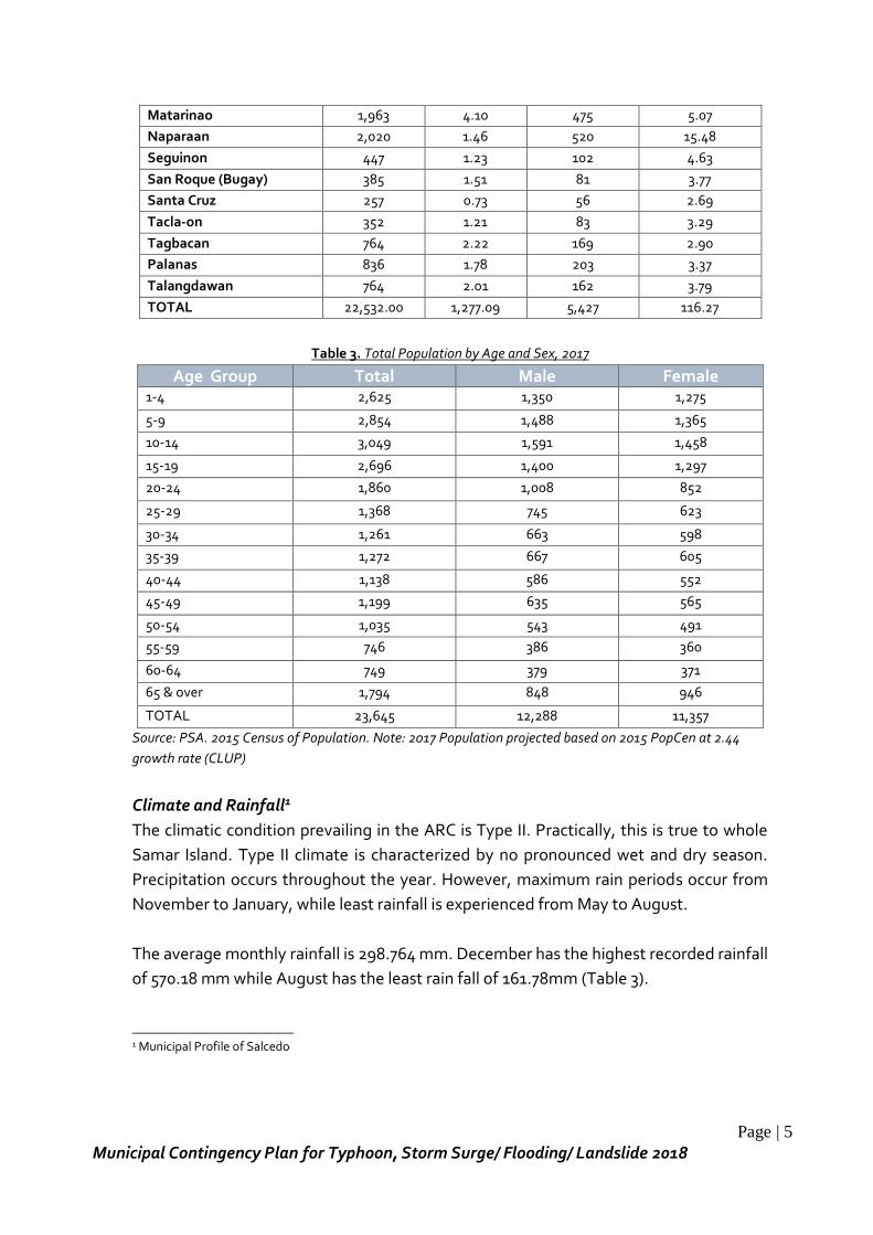
Page | 5
Municipal Contingency Plan for Typhoon, Storm Surge/ Flooding/ Landslide 2018
Matarinao 1,963 4.10 475 5.07
Naparaan 2,020 1.46 520 15.48
Seguinon 447 1.23 102 4.63
San Roque (Bugay) 385 1.51 81 3.77
Santa Cruz 257 0.73 56 2.69
Tacla-on 352 1.21 83 3.29
Tagbacan 764 2.22 169 2.90
Palanas 836 1.78 203 3.37
Talangdawan 764 2.01 162 3.79
TOTAL 22,532.00 1,277.09 5,427 116.27
Table 3. Total Population by Age and Sex, 2017
Age Group Total Male Female 1-4 2,625 1,350 1,275
5-9 2,854 1,488 1,365
10-14 3,049 1,591 1,458
15-19 2,696 1,400 1,297
20-24 1,860 1,008 852
25-29 1,368 745 623
30-34 1,261 663 598
35-39 1,272 667 605
40-44 1,138 586 552
45-49 1,199 635 565
50-54 1,035 543 491
55-59 746 386 360
60-64 749 379 371
65 & over 1,794 848 946
TOTAL 23,645 12,288 11,357
Source: PSA. 2015 Census of Population. Note: 2017 Population projected based on 2015 PopCen at 2.44
growth rate (CLUP)
Climate and Rainfall1
The climatic condition prevailing in the ARC is Type II. Practically, this is true to whole
Samar Island. Type II climate is characterized by no pronounced wet and dry season.
Precipitation occurs throughout the year. However, maximum rain periods occur from
November to January, while least rainfall is experienced from May to August.
The average monthly rainfall is 298.764 mm. December has the highest recorded rainfall
of 570.18 mm while August has the least rain fall of 161.78mm (Table 3).
_________________________ 1 Municipal Profile of Salcedo
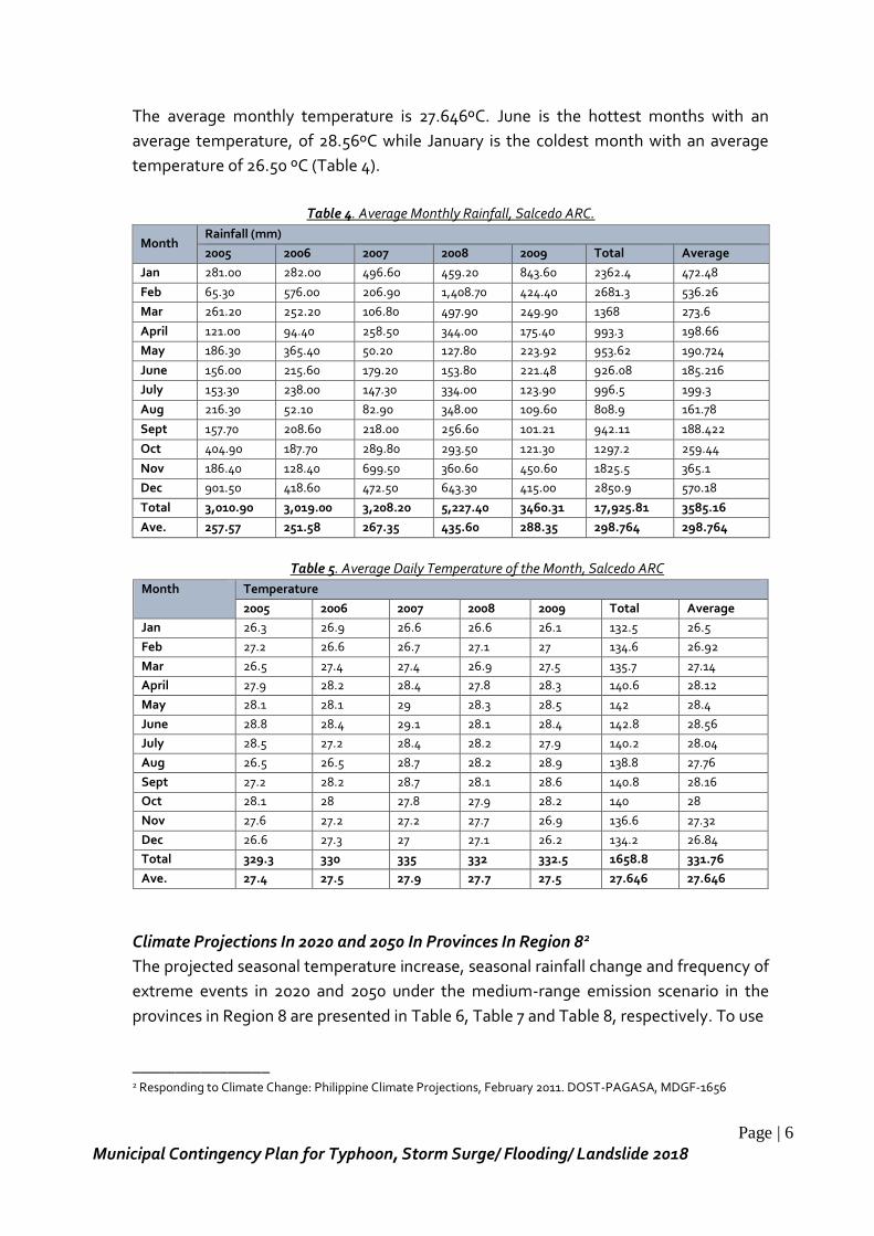
Page | 6
Municipal Contingency Plan for Typhoon, Storm Surge/ Flooding/ Landslide 2018
The average monthly temperature is 27.646ºC. June is the hottest months with an
average temperature, of 28.56ºC while January is the coldest month with an average
temperature of 26.50 ºC (Table 4).
Table 4. Average Monthly Rainfall, Salcedo ARC.
Month Rainfall (mm)
2005 2006 2007 2008 2009 Total Average
Jan 281.00 282.00 496.60 459.20 843.60 2362.4 472.48
Feb 65.30 576.00 206.90 1,408.70 424.40 2681.3 536.26
Mar 261.20 252.20 106.80 497.90 249.90 1368 273.6
April 121.00 94.40 258.50 344.00 175.40 993.3 198.66
May 186.30 365.40 50.20 127.80 223.92 953.62 190.724
June 156.00 215.60 179.20 153.80 221.48 926.08 185.216
July 153.30 238.00 147.30 334.00 123.90 996.5 199.3
Aug 216.30 52.10 82.90 348.00 109.60 808.9 161.78
Sept 157.70 208.60 218.00 256.60 101.21 942.11 188.422
Oct 404.90 187.70 289.80 293.50 121.30 1297.2 259.44
Nov 186.40 128.40 699.50 360.60 450.60 1825.5 365.1
Dec 901.50 418.60 472.50 643.30 415.00 2850.9 570.18
Total 3,010.90 3,019.00 3,208.20 5,227.40 3460.31 17,925.81 3585.16
Ave. 257.57 251.58 267.35 435.60 288.35 298.764 298.764
Table 5. Average Daily Temperature of the Month, Salcedo ARC
Month Temperature
2005 2006 2007 2008 2009 Total Average
Jan 26.3 26.9 26.6 26.6 26.1 132.5 26.5
Feb 27.2 26.6 26.7 27.1 27 134.6 26.92
Mar 26.5 27.4 27.4 26.9 27.5 135.7 27.14
April 27.9 28.2 28.4 27.8 28.3 140.6 28.12
May 28.1 28.1 29 28.3 28.5 142 28.4
June 28.8 28.4 29.1 28.1 28.4 142.8 28.56
July 28.5 27.2 28.4 28.2 27.9 140.2 28.04
Aug 26.5 26.5 28.7 28.2 28.9 138.8 27.76
Sept 27.2 28.2 28.7 28.1 28.6 140.8 28.16
Oct 28.1 28 27.8 27.9 28.2 140 28
Nov 27.6 27.2 27.2 27.7 26.9 136.6 27.32
Dec 26.6 27.3 27 27.1 26.2 134.2 26.84
Total 329.3 330 335 332 332.5 1658.8 331.76
Ave. 27.4 27.5 27.9 27.7 27.5 27.646 27.646
Climate Projections In 2020 and 2050 In Provinces In Region 82
The projected seasonal temperature increase, seasonal rainfall change and frequency of
extreme events in 2020 and 2050 under the medium-range emission scenario in the
provinces in Region 8 are presented in Table 6, Table 7 and Table 8, respectively. To use
________________ 2 Responding to Climate Change: Philippine Climate Projections, February 2011. DOST-PAGASA, MDGF-1656
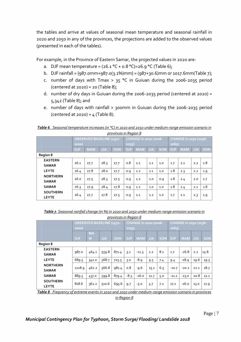
Page | 7
Municipal Contingency Plan for Typhoon, Storm Surge/ Flooding/ Landslide 2018
the tables and arrive at values of seasonal mean temperature and seasonal rainfall in
2020 and 2050 in any of the provinces, the projections are added to the observed values
(presented in each of the tables).
For example, in the Province of Eastern Samar, the projected values in 2020 are:
a. DJF mean temperature = (26.1 °C + 0.8 °C)=26.9 °C (Table 6);
b. DJF rainfall = {987.0mm+987.0(3.1%)mm} = (987+30.6)mm or 1017.6mm(Table 7);
c. number of days with Tmax > 35 °C in Guiuan during the 2006-2035 period
(centered at 2020) = 20 (Table 8);
d. number of dry days in Guiuan during the 2006-2035 period (centered at 2020) =
5,342 (Table 8); and
e. number of days with rainfall > 300mm in Guiuan during the 2006-2035 period
(centered at 2020) = 4 (Table 8).
Table 6 . Seasonal temperature increases (in °C) in 2020 and 2050 under medium-range emission scenario in
provinces in Region 8
OBSERVED BASELINE (1971-
2000)
CHANGE in 2020 (2006-
2035)
CHANGE in 2050 (2036-
2065)
DJF MAM JJA SON DJF MAM JJA SON DJF MAM JJA SON
Region 8
EASTERN
SAMAR 26.1 27.7 28.3 27.7 0.8 1.1 1.1 1.0 1.7 2.1 2.2 1.8
LEYTE 26.4 27.8 28.0 27.7 0.9 1.2 1.1 1.0 1.8 2.3 2.2 1.9
NORTHERN
SAMAR 26.0 27.5 28.3 27.5 0.9 1.2 1.0 0.9 1.8 2.4 2.0 1.7
SAMAR 26.3 27.9 28.4 27.8 0.9 1.2 1.0 1.0 1.8 2.4 2.1 1.8
SOUTHERN
LEYTE 26.4 27.7 27.8 27.5 0.9 1.1 1.2 1.0 1.7 2.1 2.3 1.9
Table 7. Seasonal rainfall change (in %) in 2020 and 2050 under medium-range emission scenario in
provinces in Region 8
OBSERVED BASELINE (1971-
2000)
CHANGE in 2020 (2006-
2035)
CHANGE in 2050 (2036-
2065)
DJF
MA
M JJA SON DJF MAM JJA SON DJF MAM JJA SON
Region 8
EASTERN
SAMAR 987.0 464.1 559.8 871.4 3.1 -11.3 2.2 8.1 1.7 -26.8 2.2 15.8
LEYTE 689.5 342.0 568.7 725.5 3.0 -8.9 9.5 7.4 9.4 -18.9 19.6 19.5
NORTHERN
SAMAR 1128.9 462.2 566.8 981.4 0.8 -9.6 15.1 6.5 -10.7 -20.2 22.1 18.7
SAMAR 889.5 437.0 599.8 879.4 -8.3 -16.0 11.7 5.0 -11.1 -23.0 20.8 21.1
SOUTHERN
LEYTE 818.6 362.2 510.6 695.6 9.7 -5.0 5.7 7.2 17.1 -16.0 13.0 17.9
Table 8 . Frequency of extreme events in 2020 and 2050 under medium-range emission scenario in provinces
in Region 8
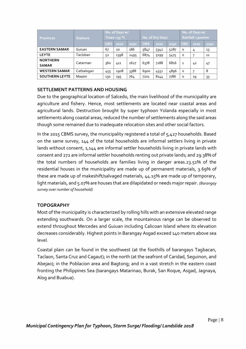
Page | 8
Municipal Contingency Plan for Typhoon, Storm Surge/ Flooding/ Landslide 2018
Provinces Stations
No. of Days w/
Tmax >35 °C No. of Dry Days
No. of Days w/
Rainfall >300mm
OBS 2020 2050 OBS 2020 2050 OBS 2020 2050
EASTERN SAMAR Guiuan 67 20 186 5847 5342 5287 0 4 13
LEYTE Tacloban 52 1398 2495 6874 5199 5475 0 7 11
NORTHERN
SAMAR Catarman 360 411 1627 6378 7288 6816 1 42 47
WESTERN SAMAR Catbalogan 455 1908 3388 6900 4551 4896 0 7 8
SOUTHERN LEYTE Maasin 130 195 764 7201 8144 7786 0 19 33
SETTLEMENT PATTERNS AND HOUSING
Due to the geographical location of Salcedo, the main livelihood of the municipality are
agriculture and fishery. Hence, most settlements are located near coastal areas and
agricultural lands. Destruction brought by super typhoon Yolanda especially in most
settlements along coastal areas, reduced the number of settlements along the said areas
though some remained due to inadequate relocation sites and other social factors.
In the 2015 CBMS survey, the municipality registered a total of 5,427 households. Based
on the same survey, 144 of the total households are informal settlers living in private
lands without consent, 1,144 are informal settler households living in private lands with
consent and 272 are informal settler households renting out private lands; and 29.38% of
the total numbers of households are families living in danger areas.23.51% of the
residential houses in the municipality are made up of permanent materials, 3.69% of
these are made up of makeshift/salvaged materials, 44.15% are made up of temporary,
light materials, and 5.07% are houses that are dilapidated or needs major repair. (Barangay
survey over number of household)
TOPOGRAPHY
Most of the municipality is characterized by rolling hills with an extensive elevated range
extending southwards. On a larger scale, the mountainous range can be observed to
extend throughout Mercedes and Guiuan including Calicoan Island where its elevation
decreases considerably. Highest points in Barangay Asgad exceed 140 meters above sea
level.
Coastal plain can be found in the southwest (at the foothills of barangays Tagbacan,
Taclaon, Santa Cruz and Cagaut); in the north (at the seafront of Caridad, Seguinon, and
Abejao); in the Poblacion area and Bagtong; and in a vast stretch in the eastern coast
fronting the Philippines Sea (barangays Matarinao, Burak, San Roque, Asgad, Jagnaya,
Alog and Buabua).
Page | 9
Municipal Contingency Plan for Typhoon, Storm Surge/ Flooding/ Landslide 2018
SLOPE
Most of the municipality is characterized by rolling hills that gradually flatten towards the
coastal plains. Steeper slopes can be found at the mountainside especially along the facet
of the mountainous range that faces the Philippine Sea.
Fifty seven percent of the municipality’s lands are highly farmable with slopes of 8% and
below. Moderately sloping to rolling lands with slope of 9–18% comprise 2,450 hectares
or 22%. Only 2,375 hectares or 21% of lands have slopes over 18%.
SOIL
The area is dominated by Louisiana (soils developed from igneous rocks, found on rolling
to mountainous relief) and Bolinao clay (characterized with very thin surface, where
erosion is not severe). The western portion is mostly Louisiana clay and is consistent with
the dominant soil type in Quinapondan. This expanse covers roughly half of the total
land area. The eastern half, on the other hand, is mostly Bolinao clay, including the
eastern mountain range and the hills and plains to the northwest and southwest.
SOCIAL SERVICES
Educational Facilities
The municipality’s primary and elementary educational facilities are present in each rural
barangays with central schools located at the Poblacion barangay (Salcedo 1 district) and
Brgy. Bagtong (Salcedo 2 district). In addition, there are thirty six (36) day care centers,
five (5) SNPs that are present in the different barangays. There are four (4) secondary
schools located in barangays Tagbacan, Matarinao, Naparaan and the Poblacion and one
(1) university. Except for the school and elementary school at Eastern Samar Status
University, all other schools have areas or campuses short of the standard area
requirement for the number of classes offered. In addition, many school campuses are
located in areas prone to tsunami and storm surge. Expansion of school campuses
located on safe sites and relocation of schools located on danger zones are the two
urgent issues that need to be addressed during the plan period.
Health Facilities
Health care services is mainly provided by the Rural Health Unit located in Poblacion
Salcedo. Services for Maternal and Child Health is at the center but community health is
given adequate attention too as appropriate for a primary health care facility. Each
barangay has a health station that serves as a health and nutrition post for the entire
barangay population.
Page | 10
Municipal Contingency Plan for Typhoon, Storm Surge/ Flooding/ Landslide 2018
ECONOMIC SECTOR
As an agricultural municipality, farming and fishing are the major source of income
support for the majority of constituents of Salcedo. Some are engaged in small
businesses like sari-sari stores, meat and poultry vending, and fish vending among
others. Over the passage of time, as new technologies began to develop, signs of
industrialization have taken place in the municipality. Now there are more businesses
than before; there are 50 stalls in the market, water refilling stations, gas station,
bakeshops, internet cafes, computer shops, pawnshops and others. The municipality has
also a market day or “tabo” as the locals call it every early Saturday wherein agricultural
produce from different barangays are displayed and sold at one area of the market
consisting mainly of rootcrops and vegetables. Some also sell local delicacies like puto,
suman, moron and other kakanin.
At present, there are already existing fish processing facilities and cassava production
facilities through the efforts of the fisherfolk and farmers organizations though it is not
yet fully marketable, and needs more technical improvement. Some are also engaged in
production of local products (e.g. coconut wine or “tuba” making, amakan weaving, etc.)
but is not recognized widely because these products are not considered quality wise in
terms of export and marketability.
INFRASTRUCTURE
The existence of basic utilities and public transport system is one of the comforts enjoyed
by the Salcedonhons. The municipality has Level III water system that serves a total of
four hundred eighty three (483) households covering fourteen (14) barangays and the
other twenty seven (27) barangays with Level II water system. There are 28 health centers
present in the municipality with the main Rural Health Unit facility situated in the
poblacion area which is also PhilHealth accredited. There are birthing facilities present in
some barangays.
All forty one (41) barangays are powered by ESAMELCO, energizing a total of four
thousand five hundred forty six (4,546) households. Communication system includes the
services from Globe Communications covering some barangays with 4G connectivity,
Smart Communications also present in some barangays and one FM station (BJ FM 89.8).
Radio communications is recently functional with the operationalization of base radios in
15 barangays as stations with two controllers, main control and EC base and a total of 120
portable radios distributed in all coastal and island barangays. Public transport includes
buses, PUJ, tricycle, pedicabs and pump boats.
Presently, Salcedo is traversed by a total of 253.94 kilometers of road network broken
down accordingly by administrative classification as follows: national road (19.0
kilometer), 7.48 percent of the total; provincial roads (37.44 km), 14.74 percent of the

Page | 11
Municipal Contingency Plan for Typhoon, Storm Surge/ Flooding/ Landslide 2018
total; municipal roads (4.33 km), 1.70 percent of the total, and barangay roads (193.17
km), which comprise 76.07 percent of the total road network.
B. Hazard Identification
Results of the different assessments conducted in all forty (40) barangays during the
PCVA and the hazards identified in the existing HEPRR Plan it was possible to identify all
potential hazards in the municipality area of jurisdiction. The following table summarizes
all identified hazards.
CP Form 1: Hazard Identification and Prioritization
Hazard
Probability Impact Average
P+I
2
Rank Rate Remarks Rate Remarks
Typhoon 4
Geographic location; past
experiences such as
Typhoons Yolanda and Ruby 5
Most communities
are exposed to
typhoon hazard;
death toll during STY
Yolanda reached 29
and 800+ injured
4.5 1
Storm surge 3
Geographic location; past
experiences such as
Typhoons Yolanda 5
Most communities
live in coastal areas
(26 coastal brgys & 2
island brgys); deaths
due to storm surge
during STY Yolanda
4 2
Earthquake 3 Geographic location, facing
the Pacific Ocean 4
Close to the
Philippine Trench 3.5 3
Tsunami 2
Geographic location, facing
the Pacific Ocean where
Philippine trench is found 5
11 coastal brgys in
the area, past
experiences on
increase of water
level during
earthquakes
3.5 3
Landslide 2 Identified areas prone to
landslide 3 Communities near
landslide prone area 2.5 4
Flooding 3
Identified areas prone to
flooding
4
Some communities
are prone to coastal
flooding; some
communities are in
flood prone area
3.5 3
As seen in the above probability and impact ratings of the hazards, typhoon ranks as
number 1. Based on historical records, typhoon left most devastation in the lives and
properties of the communities. Some of the devastating typhoons that occurred in the
Municipality from year 1984 to 2014 were Typhoon Undang in 1984, Typhoon Yuning in
1987, Super Typhoon Yolanda in 2013 and Typhoon Ruby in 2014.
Super Typhoon Yolanda, the most devastating hazard that hit the area claimed 29 lives,
estimated 846 plus recorded injuries, a total of 4,871 households with a total of 5,146
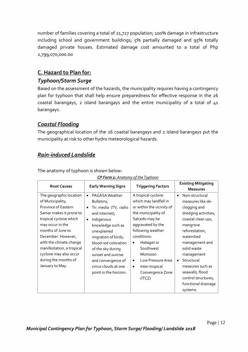
Page | 12
Municipal Contingency Plan for Typhoon, Storm Surge/ Flooding/ Landslide 2018
number of families covering a total of 21,727 population; 100% damage in infrastructure
including school and government buildings; 5% partially damaged and 95% totally
damaged private houses. Estimated damage cost amounted to a total of Php
2,799,070,000.00
C. Hazard to Plan for:
Typhoon/Storm Surge
Based on the assessment of the hazards, the municipality requires having a contingency
plan for typhoon that shall help ensure preparedness for effective response in the 26
coastal barangays, 2 island barangays and the entire municipality of a total of 41
barangays.
Coastal Flooding
The geographical location of the 26 coastal barangays and 2 island barangays put the
municipality at risk to other hydro meteorological hazards.
Rain-induced Landslide
The anatomy of typhoon is shown below:
CP Form 2: Anatomy of the Typhoon
Root Causes Early Warning Signs Triggering Factors Existing Mitigating
Measures
The geographic location
of Municipality,
Province of Eastern
Samar makes it prone to
tropical cyclone which
may occur in the
months of June to
December. However,
with the climate change
manifestation, a tropical
cyclone may also occur
during the months of
January to May.
PAGASA Weather
Bulletins;
Tri media (TV, radio
and internet);
Indigenous
knowledge such as
unexplained
migration of birds;
blood red coloration
of the sky during
sunset and sunrise
and convergence of
cirrus clouds at one
point in the horizon.
A tropical cyclone
which may landfall in
or within the vicinity of
the municipality of
Salcedo may be
aggravated by the
following weather
conditions:
Habagat or
Southwest
Monsoon
Low Pressure Area
Inter-tropical
Convergence Zone
(ITCZ)
Non-structural
measures like de-
clogging and
dredging activities,
coastal clean ups,
mangrove
reforestation,
watershed
management and
solid waste
management
Structural
measures such as
seawalls, flood
control structures,
functional drainage
systems
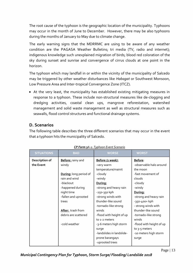
Page | 13
Municipal Contingency Plan for Typhoon, Storm Surge/ Flooding/ Landslide 2018
The root cause of the typhoon is the geographic location of the municipality. Typhoons
may occur in the month of June to December. However, there may be also typhoons
during the months of January to May due to climate change.
The early warning signs that the MDRRMC are using to be aware of any weather
condition are the PAGASA Weather Bulletins; tri media (TV, radio and internet);
indigenous knowledge such unexplained migration of birds; blood red coloration of the
sky during sunset and sunrise and convergence of cirrus clouds at one point in the
horizon.
The typhoon which may landfall in or within the vicinity of the municipality of Salcedo
may be triggered by other weather disturbances like Habagat or Southwest Monsoon,
Low Pressure Area and Inter-tropical Convergence Zone (ITCZ).
At the very least, the municipality has established existing mitigating measures in
response to a typhoon. These include non-structural measures like de-clogging and
dredging activities, coastal clean ups, mangrove reforestation, watershed
management and solid waste management as well as structural measures such as
seawalls, flood control structures and functional drainage systems.
D. Scenarios
The following table describes the three different scenarios that may occur in the event
that a typhoon hits the municipality of Salcedo.
CP Form 3A-1: Typhoon Event Scenario
SITUATIONS BAD WORSE WORST
Description of
the Event
Before: rainy and
windy
During: long period of
rain and wind
-blackout
-happened during
night time
-fallen and uprooted
trees
After: trash from
debris are scattered
-cold weather
Before (1 week):
-very warm
temperature/mainit
-cloudy
-windy
During:
-strong and heavy rain
-250-350 kph
-strong winds with
thunder-like sound
-tornado-like strong
winds
-flood with height of up
to 1-2 meters
-3-6 meters high storm
surge
-landslides in landslide-
prone barangays
-uprooted trees
Before:
-observable halo around
the moon
-fast movement of
clouds
-cloudy
-windy
During:
-strong and heavy rain
-350-400+ kph
- strong winds with
thunder-like sound
-tornado-like strong
winds
-flood with height of up
to 3-5 meters
-10 meters high storm
surge
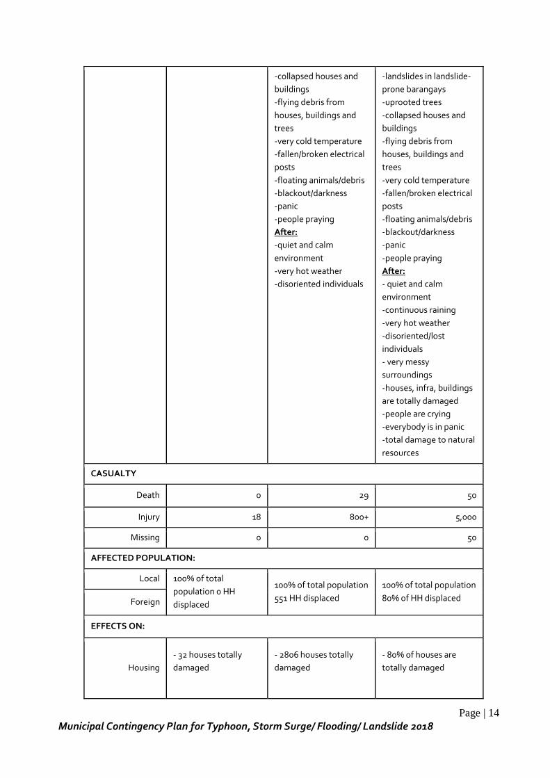
Page | 14
Municipal Contingency Plan for Typhoon, Storm Surge/ Flooding/ Landslide 2018
-collapsed houses and
buildings
-flying debris from
houses, buildings and
trees
-very cold temperature
-fallen/broken electrical
posts
-floating animals/debris
-blackout/darkness
-panic
-people praying
After:
-quiet and calm
environment
-very hot weather
-disoriented individuals
-landslides in landslide-
prone barangays
-uprooted trees
-collapsed houses and
buildings
-flying debris from
houses, buildings and
trees
-very cold temperature
-fallen/broken electrical
posts
-floating animals/debris
-blackout/darkness
-panic
-people praying
After:
- quiet and calm
environment
-continuous raining
-very hot weather
-disoriented/lost
individuals
- very messy
surroundings
-houses, infra, buildings
are totally damaged
-people are crying
-everybody is in panic
-total damage to natural
resources
CASUALTY
Death 0 29 50
Injury 18 800+ 5,000
Missing 0 0 50
AFFECTED POPULATION:
Local 100% of total
population 0 HH
displaced
100% of total population
551 HH displaced
100% of total population
80% of HH displaced Foreign
EFFECTS ON:
Housing
- 32 houses totally
damaged
- 2806 houses totally
damaged
- 80% of houses are
totally damaged
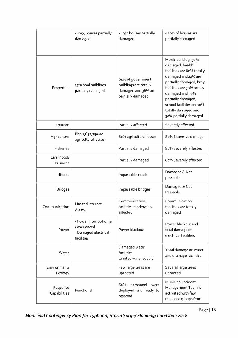
Page | 15
Municipal Contingency Plan for Typhoon, Storm Surge/ Flooding/ Landslide 2018
- 1654 houses partially
damaged
- 1973 houses partially
damaged
- 20% of houses are
partially damaged
Properties 37 school buildings
partially damaged
64% of government
buildings are totally
damaged and 36% are
partially damaged
Municipal bldg. 50%
damaged, health
facilities are 80% totally
damaged and20% are
partially damaged, brgy.
facilities are 70% totally
damaged and 30%
partially damaged,
school facilities are 70%
totally damaged and
30% partially damaged
Tourism Partially affected Severely affected
Agriculture Php 1,692,750.00
agricultural losses 80% agricultural losses 80% Extensive damage
Fisheries Partially damaged 80% Severely affected
Livelihood/
Business Partially damaged 80% Severely affected
Roads Impassable roads Damaged & Not
passable
Bridges Impassable bridges Damaged & Not
Passable
Communication Limited Internet
Access
Communication
facilities moderately
affected
Communication
facilities are totally
damaged
Power
- Power interruption is
experienced
- Damaged electrical
facilities
Power blackout
Power blackout and
total damage of
electrical facilities
Water
Damaged water
facilities
Limited water supply
Total damage on water
and drainage facilities.
Environment/
Ecology
Few large trees are
uprooted
Several large trees
uprooted
Response
Capabilities Functional
60% personnel were
deployed and ready to
respond
Municipal Incident
Management Team is
activated with few
response groups from
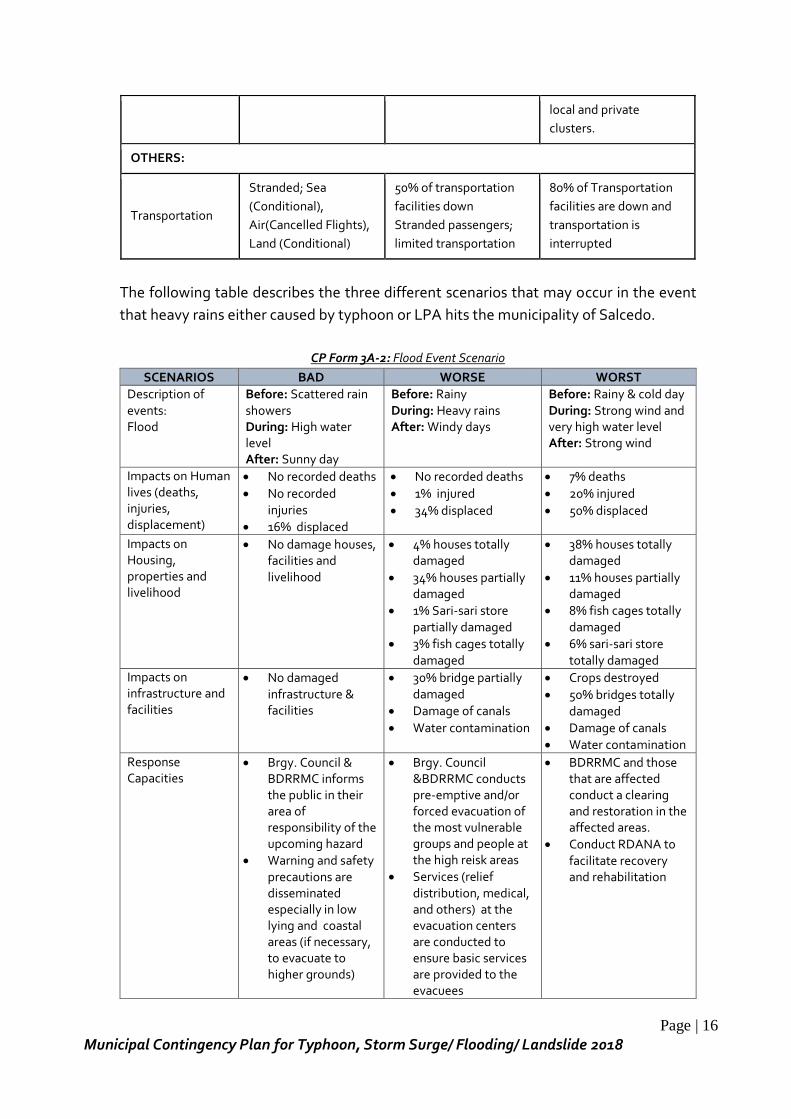
Page | 16
Municipal Contingency Plan for Typhoon, Storm Surge/ Flooding/ Landslide 2018
local and private
clusters.
OTHERS:
Transportation
Stranded; Sea
(Conditional),
Air(Cancelled Flights),
Land (Conditional)
50% of transportation
facilities down
Stranded passengers;
limited transportation
80% of Transportation
facilities are down and
transportation is
interrupted
The following table describes the three different scenarios that may occur in the event
that heavy rains either caused by typhoon or LPA hits the municipality of Salcedo.
CP Form 3A-2: Flood Event Scenario
SCENARIOS BAD WORSE WORST
Description of events: Flood
Before: Scattered rain showers During: High water level After: Sunny day
Before: Rainy During: Heavy rains After: Windy days
Before: Rainy & cold day During: Strong wind and very high water level After: Strong wind
Impacts on Human lives (deaths, injuries, displacement)
No recorded deaths
No recorded injuries
16% displaced
No recorded deaths
1% injured
34% displaced
7% deaths
20% injured
50% displaced
Impacts on Housing, properties and livelihood
No damage houses, facilities and livelihood
4% houses totally damaged
34% houses partially damaged
1% Sari-sari store partially damaged
3% fish cages totally damaged
38% houses totally damaged
11% houses partially damaged
8% fish cages totally damaged
6% sari-sari store totally damaged
Impacts on infrastructure and facilities
No damaged infrastructure & facilities
30% bridge partially damaged
Damage of canals
Water contamination
Crops destroyed
50% bridges totally damaged
Damage of canals
Water contamination
Response Capacities
Brgy. Council & BDRRMC informs the public in their area of responsibility of the upcoming hazard
Warning and safety precautions are disseminated especially in low lying and coastal areas (if necessary, to evacuate to higher grounds)
Brgy. Council &BDRRMC conducts pre-emptive and/or forced evacuation of the most vulnerable groups and people at the high reisk areas
Services (relief distribution, medical, and others) at the evacuation centers are conducted to ensure basic services are provided to the evacuees
BDRRMC and those that are affected conduct a clearing and restoration in the affected areas.
Conduct RDANA to facilitate recovery and rehabilitation
Page | 17
Municipal Contingency Plan for Typhoon, Storm Surge/ Flooding/ Landslide 2018
The municipality will have to prepare for the worst case scenario as described in the
above tables. In this case, a super typhoon shall make a landfall with maximum sustained
winds of greater than 350 kph, possibly triggering the occurrence of 5 meters storm
surge. The typhoon could also lead to the occurrence of flooding and rain-induced
landslides in the identified areas.
A total of 22,347 individuals/5,427 households will be affected, approximately 10% of
which are foreigner. Death toll will reach 50 with 5,000 injured and 50 missing persons.
80% of houses are projected to be totally damaged while 20% will be partially damaged.
Power blackout will be experienced. Communication facilities will be totally damaged.
Transportation will be interrupted and roads and bridges will not be passable. There will
also be damages on water and drainage facilities.
The agricultural land and products will suffer extensive damages. Tourism industry will be
severely affected as well.
Based on the scenario, it is assumed that the priority barangays will be those located
along coastal areas and the two island barangays namely: Barangay Matarinao,
Burak,Asgad, Jagnaya, Alog, Buabua, Bagtong, Balud, Butig, Abejao, Seguinon, Caridad,
Tagbacan, Taclaon, Santa Cruz, Cagaut, Maliwaliw, Cantomoja, Camanga, Carapdapan,
Palanas, Pob. 2, Pob, 7, Pob 11 and Pob 13 ; followed byBarangay Pob 3, Pob 4, Pob 5,
Pob 6, Pob 8, Pob 9, Pob 10, Pob 12, Malbog, Lusod and Iberan which are located along
riverside and low lying areas respectively. Municipal Incident Management Team (IMT)
will have to be activated with few response groups from local and private clusters.
However, more response capabilities will be needed due to the severity of the impact
brought about by the typhoon.
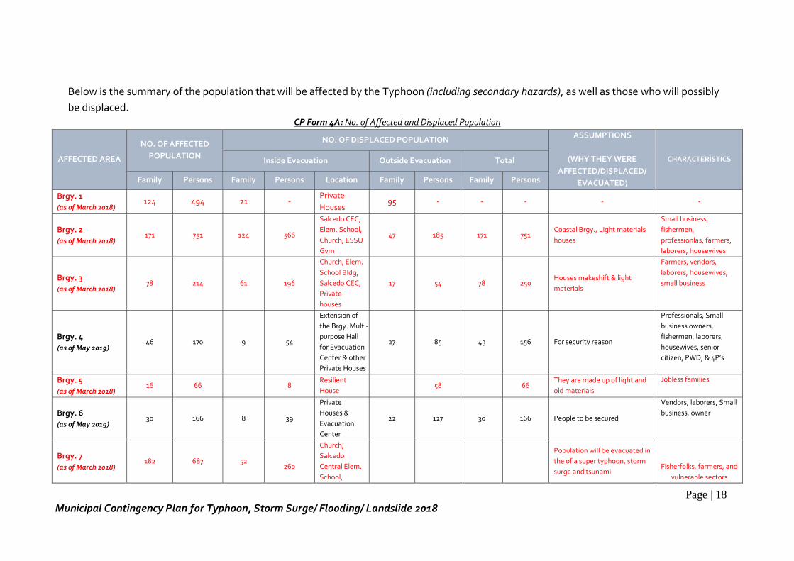
Page | 18
Municipal Contingency Plan for Typhoon, Storm Surge/ Flooding/ Landslide 2018
Below is the summary of the population that will be affected by the Typhoon (including secondary hazards), as well as those who will possibly
be displaced. CP Form 4A: No. of Affected and Displaced Population
AFFECTED AREA
NO. OF AFFECTED
POPULATION
NO. OF DISPLACED POPULATION ASSUMPTIONS
(WHY THEY WERE
AFFECTED/DISPLACED/
EVACUATED)
CHARACTERISTICS Inside Evacuation Outside Evacuation Total
Family Persons Family Persons Location Family Persons Family Persons
Brgy. 1
(as of March 2018) 124 494 21 -
Private
Houses 95 - - - - -
Brgy. 2
(as of March 2018) 171 751 124 566
Salcedo CEC,
Elem. School,
Church, ESSU
Gym
47 185 171 751 Coastal Brgy., Light materials
houses
Small business,
fishermen,
professionlas, farmers,
laborers, housewives
Brgy. 3
(as of March 2018) 78 214 61 196
Church, Elem.
School Bldg,
Salcedo CEC,
Private
houses
17 54 78 250 Houses makeshift & light
materials
Farmers, vendors,
laborers, housewives,
small business
Brgy. 4
(as of May 2019) 46 170 9 54
Extension of
the Brgy. Multi-
purpose Hall
for Evacuation
Center & other
Private Houses
27 85 43 156 For security reason
Professionals, Small
business owners,
fishermen, laborers,
housewives, senior
citizen, PWD, & 4P’s
Brgy. 5
(as of March 2018) 16 66 8
Resilient
House 58 66
They are made up of light and
old materials
Jobless families
Brgy. 6
(as of May 2019) 30 166 8 39
Private
Houses &
Evacuation
Center
22 127 30 166 People to be secured
Vendors, laborers, Small
business, owner
Brgy. 7
(as of March 2018) 182 687 52
260
Church,
Salcedo
Central Elem.
School,
Population will be evacuated in
the of a super typhoon, storm
surge and tsunami
Fisherfolks, farmers, and
vulnerable sectors
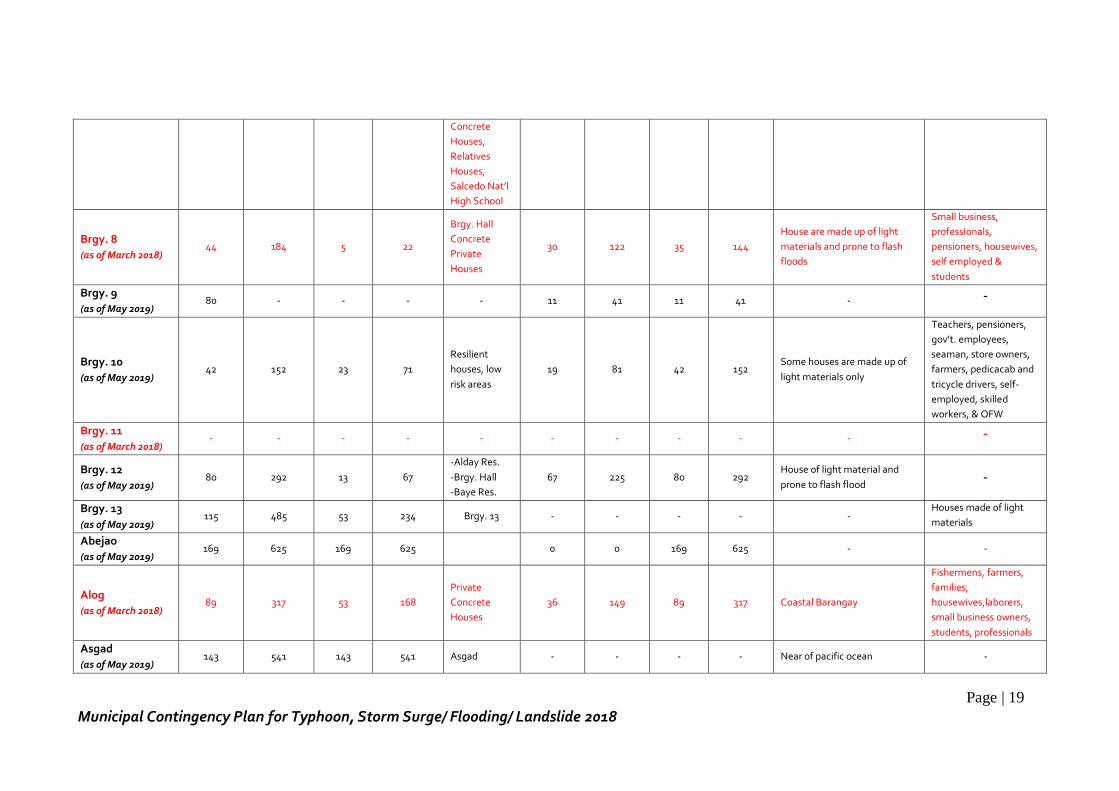
Page | 19
Municipal Contingency Plan for Typhoon, Storm Surge/ Flooding/ Landslide 2018
Concrete
Houses,
Relatives
Houses,
Salcedo Nat’l
High School
Brgy. 8
(as of March 2018) 44 184 5 22
Brgy. Hall
Concrete
Private
Houses
30 122 35 144
House are made up of light
materials and prone to flash
floods
Small business,
professionals,
pensioners, housewives,
self employed &
students
Brgy. 9
(as of May 2019) 80 - - - - 11 41 11 41 - -
Brgy. 10
(as of May 2019) 42 152 23 71
Resilient
houses, low
risk areas
19 81 42 152 Some houses are made up of
light materials only
Teachers, pensioners,
gov’t. employees,
seaman, store owners,
farmers, pedicacab and
tricycle drivers, self-
employed, skilled
workers, & OFW
Brgy. 11
(as of March 2018) - - - - - - - - - - -
Brgy. 12
(as of May 2019) 80 292 13 67
-Alday Res.
-Brgy. Hall
-Baye Res.
67 225 80 292 House of light material and
prone to flash flood -
Brgy. 13
(as of May 2019) 115 485 53 234 Brgy. 13 - - - - -
Houses made of light
materials
Abejao
(as of May 2019) 169 625 169 625 0 0 169 625 - -
Alog
(as of March 2018) 89 317 53 168
Private
Concrete
Houses
36 149 89 317 Coastal Barangay
Fishermens, farmers,
families,
housewives,laborers,
small business owners,
students, professionals
Asgad
(as of May 2019) 143 541 143 541 Asgad - - - - Near of pacific ocean -
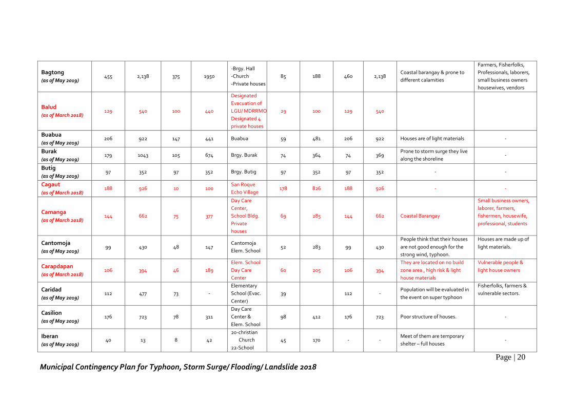
Page | 20
Municipal Contingency Plan for Typhoon, Storm Surge/ Flooding/ Landslide 2018
Bagtong
(as of May 2019) 455 2,138 375 1950
-Brgy. Hall
-Church
-Private houses
85 188 460 2,138 Coastal barangay & prone to
different calamities
Farmers, Fisherfolks,
Professionals, laborers,
small business owners
housewives, vendors
Balud
(as of March 2018) 129 540 100 440
Designated
Evacuation of
LGU/ MDRRMO
Designated 4
private houses
29 100 129 540
Buabua
(as of May 2019) 206 922 147 441 Buabua 59 481 206 922 Houses are of light materials -
Burak
(as of May 2019) 179 1043 105 674 Brgy. Burak 74 364 74 369
Prone to storm surge they live
along the shoreline -
Butig
(as of May 2019) 97 352 97 352 Brgy. Butig 97 352 97 352 - -
Cagaut
(as of March 2018) 188 926 10 100
San Roque
Echo Village 178 826 188 926 - -
Camanga
(as of March 2018) 144 662 75 377
Day Care
Center,
School Bldg.
Private
houses
69 285 144 662 Coastal Barangay
Small business owners,
laborer, farmers,
fishermen, housewife,
professional, students
Cantomoja
(as of May 2019) 99 430 48 147
Cantomoja
Elem. School 52 283 99 430
People think that their houses
are not good enough for the
strong wind, typhoon.
Houses are made up of
light materials.
Carapdapan
(as of March 2018) 106 394 46 189
Elem. School
Day Care
Center
60 205 106 394
They are located on no build
zone area , high risk & light
house materials
Vulnerable people &
light house owners
Caridad
(as of May 2019) 112 477 73 -
Elementary
School (Evac.
Center)
39 112 - Population will be evaluated in
the event on super typhoon
Fisherfolks, farmers &
vulnerable sectors.
Casilion
(as of May 2019) 176 723 78 311
Day Care
Center &
Elem. School
98 412 176 723 Poor structure of houses. -
Iberan
(as of May 2019) 40 13 8 42
20-christian
Church
22-School
45 170 - - Meet of them are temporary
shelter – full houses -
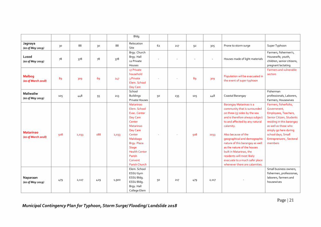
Page | 21
Municipal Contingency Plan for Typhoon, Storm Surge/ Flooding/ Landslide 2018
Bldg.
Jagnaya
(as of May 2019) 30 88 30 88
Relocation
Site 62 217 92 305 Prone to storm surge Super Typhoon
Lusod
(as of May 2019) 78 378 78 378
Brgy. Church
Brgy. Hall
12 Private
Houses
- - - - Houses made of light materials
Farmers, fishermen’s,
Housewife, youth,
children, senior citizens,
pregnant lactating
Malbog
(as of March 2018) 89 309 69 247
17 Private
household
3 Private
Elem. School
Day Care
- - 89 309 Population will be evacuated in
the event of super typhoon
Farmers and vulnerable
sectors
Maliwaliw
(as of May 2019) 105 448 55 213
School
Buildings
Private Houses
50 235 105 448 Coastal Barangay
Fisherman
professionals, Laborers,
Farmers, Housewives
Matarinao
(as of March 2018) 508 2,033 188 2,033
Matarinao
Elem. School
Evac. Center
Day Care
Center
Matarinao
Day Care
Center
Malobago
Brgy. Plaza
Stage
Health Center
Parish
Convent
Parish Church
- - 508 2033
Barangay Matarinao is a
community that is surrounded
on three (3) sides by the sea
and is therefore always subject
to and affected by any natural
calamity.
Also because of the
geographical and demographic
nature of this barangay as well
as the nature of the houses
built in Matarinao, the
residents will most likely
evacuate to a much safer place
whenever there are calamities.
Farmers, fisherfolks,
Government,
Employees, Teachers,
Senior Citizen, Students
residing in this barangay
as well as those who
simply go here during
school days, Small
Entreprenuers , Sectoral
members
Naparaan
(as of May 2019) 479 2,117 429 1,900
Elem. School
ESSU Gym
ESSU Bldg.
ESSU Bldg.
Brgy. Hall
College Elem
50 217 479 2,117 -
Small business owners,
fishermen, professionas,
laborers, farmers and
housewives
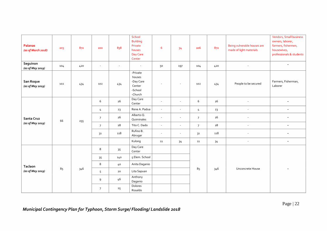
Page | 22
Municipal Contingency Plan for Typhoon, Storm Surge/ Flooding/ Landslide 2018
Palanas
(as of March 2018) 203 872 200 838
School
Building
Private
houses
Day Care
Center
6 34 206 872 Being vulnerable houses are
made of light materials
Vendors, Small business
owners, laborer,
farmers, fishermen,
housewives,
professionals & students
Seguinon
(as of May 2019) 104 420 - - - 50 197 104 420 - -
San Roque
(as of May 2019) 102 434 102 434
-Private
houses
-Day Care
Center
-School
-Church
- - 102 434 People to be secured Farmers, Fisherman,
Laborer
Santa Cruz
(as of May 2019) 66 255
6 26 Day Care
Center - - 6 26 - -
4 23 Rene A. Padua - - 4 23 - -
7 26 Alberto Q.
Quiminales - - 7 26 - -
7 28 Tito C. Dado - - 7 28 - -
31 118 Rufino B.
Abrugar - - 31 118 - -
Kulong 11 34 11 34 - -
Taclaon
(as of May 2019) 85 346
8 35 Day Care
Center
85 346 Unconcrete House -
35 140 5 Elem. School
8 40 Anita Daganio
5 20 Lita Sapuan
9 46 Anthony
Daganio
7 25 Dolores
Rosaldo
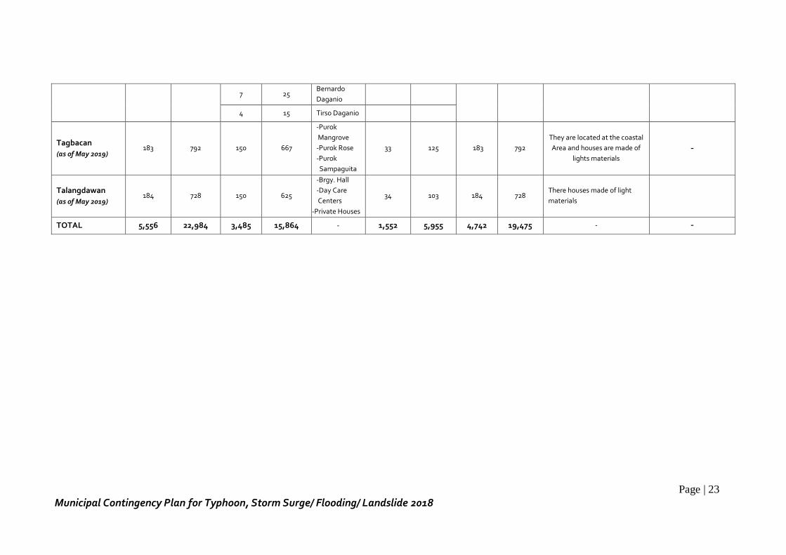
Page | 23
Municipal Contingency Plan for Typhoon, Storm Surge/ Flooding/ Landslide 2018
7 25 Bernardo
Daganio
4 15 Tirso Daganio
Tagbacan
(as of May 2019) 183 792 150 667
-Purok
Mangrove
-Purok Rose
-Purok
Sampaguita
33 125 183 792
They are located at the coastal
Area and houses are made of
lights materials
-
Talangdawan
(as of May 2019) 184 728 150 625
-Brgy. Hall
-Day Care
Centers
-Private Houses
34 103 184 728 There houses made of light
materials
TOTAL 5,556 22,984 3,485 15,864 - 1,552 5,955 4,742 19,475 - -
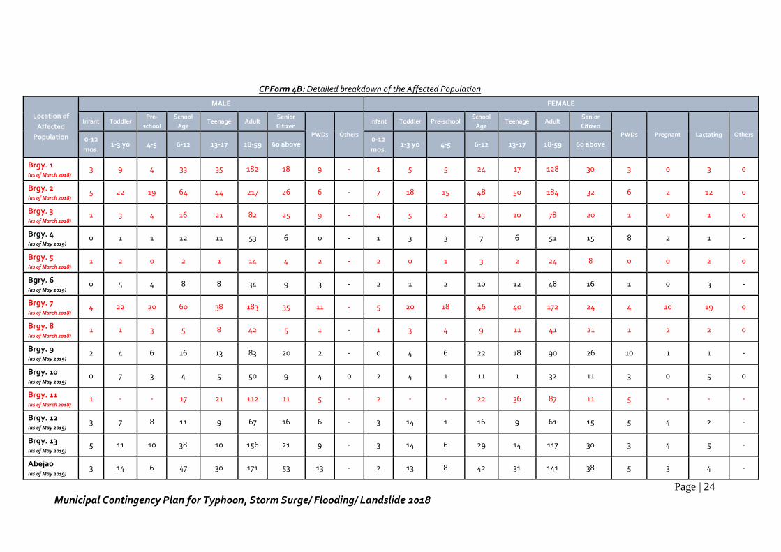
Page | 24
Municipal Contingency Plan for Typhoon, Storm Surge/ Flooding/ Landslide 2018
CPForm 4B: Detailed breakdown of the Affected Population
Location of
Affected
Population
MALE FEMALE
Infant Toddler Pre-
school
School
Age Teenage Adult
Senior
Citizen
PWDs Others
Infant Toddler Pre-school School
Age Teenage Adult
Senior
Citizen
PWDs Pregnant Lactating Others 0-12
mos. 1-3 yo 4-5 6-12 13-17 18-59 60 above
0-12
mos. 1-3 yo 4-5 6-12 13-17 18-59 60 above
Brgy. 1 (as of March 2018)
3 9 4 33 35 182 18 9 - 1 5 5 24 17 128 30 3 0 3 0
Brgy. 2 (as of March 2018) 5 22 19 64 44 217 26 6 - 7 18 15 48 50 184 32 6 2 12 0
Brgy. 3 (as of March 2018) 1 3 4 16 21 82 25 9 - 4 5 2 13 10 78 20 1 0 1 0
Brgy. 4 (as of May 2019) 0 1 1 12 11 53 6 0 - 1 3 3 7 6 51 15 8 2 1 -
Brgy. 5 (as of March 2018) 1 2 0 2 1 14 4 2 - 2 0 1 3 2 24 8 0 0 2 0
Bgry. 6 (as of May 2019) 0 5 4 8 8 34 9 3 - 2 1 2 10 12 48 16 1 0 3 -
Brgy. 7 (as of March 2018)
4 22 20 60 38 183 35 11 - 5 20 18 46 40 172 24 4 10 19 0
Brgy. 8 (as of March 2018)
1 1 3 5 8 42 5 1 - 1 3 4 9 11 41 21 1 2 2 0
Brgy. 9 (as of May 2019)
2 4 6 16 13 83 20 2 - 0 4 6 22 18 90 26 10 1 1 -
Brgy. 10 (as of May 2019)
0 7 3 4 5 50 9 4 0 2 4 1 11 1 32 11 3 0 5 0
Brgy. 11 (as of March 2018)
1 - - 17 21 112 11 5 - 2 - - 22 36 87 11 5 - - -
Brgy. 12 (as of May 2019)
3 7 8 11 9 67 16 6 - 3 14 1 16 9 61 15 5 4 2 -
Brgy. 13 (as of May 2019)
5 11 10 38 10 156 21 9 - 3 14 6 29 14 117 30 3 4 5 -
Abejao (as of May 2019)
3 14 6 47 30 171 53 13 - 2 13 8 42 31 141 38 5 3 4 -
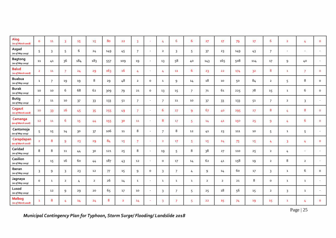
Page | 25
Municipal Contingency Plan for Typhoon, Storm Surge/ Flooding/ Landslide 2018
Alog (as of March 2018)
0 11 3 15 15 80 22 3 - 4 6 6 27 17 79 17 6 2 4 0
Asgad (as of May 2019)
5 3 5 6 24 149 45 7 - 2 3 5 37 23 149 43 7 - - -
Bagtong (as of May 2019)
11 41 36 184 183 557 109 19 - 13 58 40 143 165 508 114 17 9 40 -
Balud (as of March 2018)
2 11 7 24 29 163 16 4 - 4 11 6 23 22 174 32 8 1 7 0
Buabua (as of May 2019)
1 7 19 19 8 29 48 2 0 1 9 14 18 10 50 84 2 5 8 0
Burak (as of May 2019)
10 10 6 68 62 309 79 21 0 13 15 7 71 61 225 78 15 1 6 0
Butig (as of May 2019)
7 11 10 37 33 133 51 7 - 7 11 10 37 33 133 51 7 2 3 -
Cagaut (as of March 2018)
10 33 16 45 35 255 49 7 - 6 27 9 67 40 295 27 8 4 8 0
Camanga (as of March 2018)
12 11 6 15 44 155 30 11 - 8 17 5 14 41 150 25 9 4 6 0
Cantomoja (as of May 2019)
5 15 14 30 37 106 11 8 - 7 8 12 41 23 111 10 5 1 5 -
Carapdapan (as of March 2018)
2 8 9 23 29 84 15 7 - 2 17 5 15 24 73 15 4 3 4 0
Caridad (as of May 2019)
8 8 11 44 30 121 25 8 - 19 5 8 38 27 110 25 2 4 - -
Casilion (as of May 2019)
2 15 16 60 44 187 43 12 - 0 17 14 62 41 158 19 2 8 2 -
Iberan (as of May 2019)
3 9 3 23 12 77 15 9 0 3 7 4 9 14 60 17 3 1 6 0
Jagnaya (as of May 2019)
0 1 2 4 2 26 14 1 - 1 1 1 2 2 21 8 0 1 1 -
Lusod (as of May 2019)
- 12 9 29 20 65 17 10 - 3 7 5 25 18 56 15 2 3 1 -
Malbog (as of March 2018)
1 8 4 14 24 8 2 14 - 3 7 5 22 15 74 19 15 1 4 0
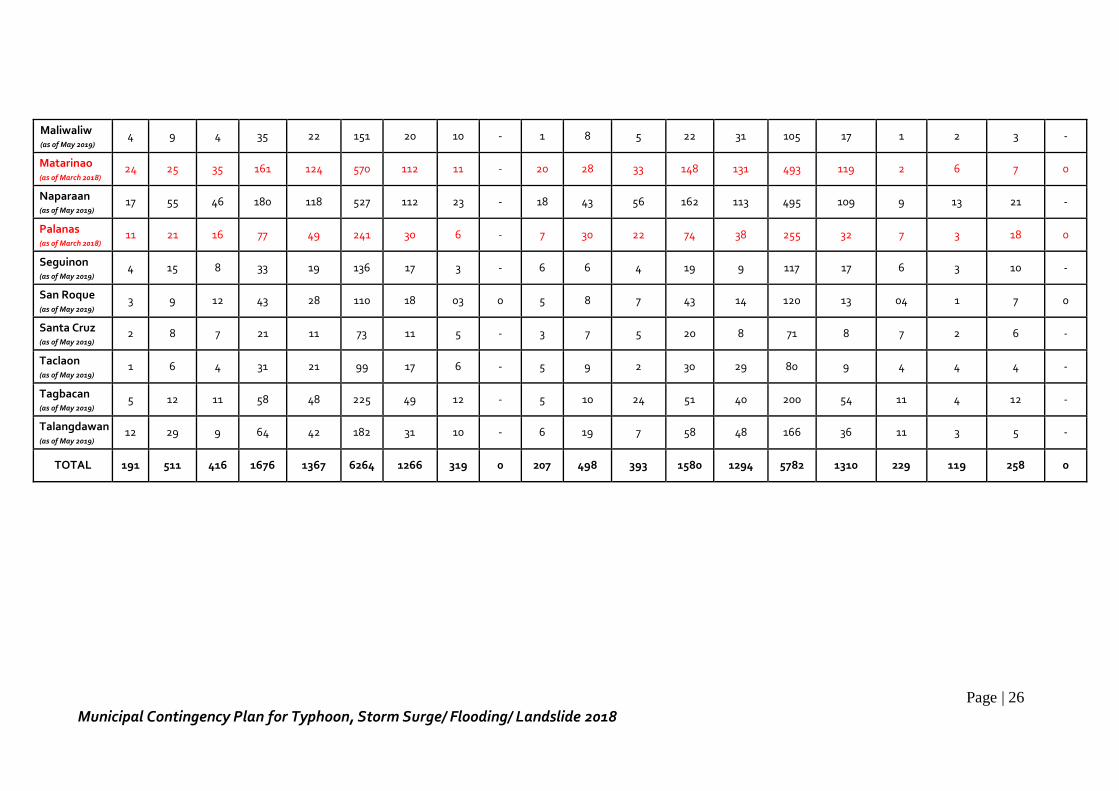
Page | 26
Municipal Contingency Plan for Typhoon, Storm Surge/ Flooding/ Landslide 2018
Maliwaliw (as of May 2019)
4 9 4 35 22 151 20 10 - 1 8 5 22 31 105 17 1 2 3 -
Matarinao (as of March 2018)
24 25 35 161 124 570 112 11 - 20 28 33 148 131 493 119 2 6 7 0
Naparaan (as of May 2019)
17 55 46 180 118 527 112 23 - 18 43 56 162 113 495 109 9 13 21 -
Palanas (as of March 2018)
11 21 16 77 49 241 30 6 - 7 30 22 74 38 255 32 7 3 18 0
Seguinon (as of May 2019)
4 15 8 33 19 136 17 3 - 6 6 4 19 9 117 17 6 3 10 -
San Roque (as of May 2019)
3 9 12 43 28 110 18 03 0 5 8 7 43 14 120 13 04 1 7 0
Santa Cruz (as of May 2019)
2 8 7 21 11 73 11 5 - 3 7 5 20 8 71 8 7 2 6 -
Taclaon (as of May 2019)
1 6 4 31 21 99 17 6 - 5 9 2 30 29 80 9 4 4 4 -
Tagbacan (as of May 2019)
5 12 11 58 48 225 49 12 - 5 10 24 51 40 200 54 11 4 12 -
Talangdawan (as of May 2019)
12 29 9 64 42 182 31 10 - 6 19 7 58 48 166 36 11 3 5 -
TOTAL 191 511 416 1676 1367 6264 1266 319 0 207 498 393 1580 1294 5782 1310 229 119 258 0
Page | 27
Municipal Contingency Plan for Typhoon, Storm Surge/ Flooding/ Landslide 2018
CHAPTER II. GOAL AND OBJECTIVES
A. Goal
The goal of the contingency plan is to provide effective, efficient, timely and well-
coordinated response mechanisms in the event of the occurrence of typhoon, storm sure,
coastal flooding and rain-induced landslide in the municipality. Such mechanisms shall
help to protect lives, properties and the environment, and restore the immediate needs
of the affected communities.
B. General Objectives
The general objectives of the contingency plan are as follows:
1. To determine the immediate tasks required for the response operations during
typhoon, storm surge, coastal flooding and rain-induced landslide;
2. To conduct inventory of resources available among the cluster response groups,
agencies and departments, including the CSOs and volunteer groups;
3. To establish proper coordination through efficient communication and linkage
among MDRRMC member agencies and departments and stakeholders;
4. To provide the immediate and appropriate needs of the affected population of
the municipality; and
5. To reinforce the standards of reporting system set by the NDRRMC.
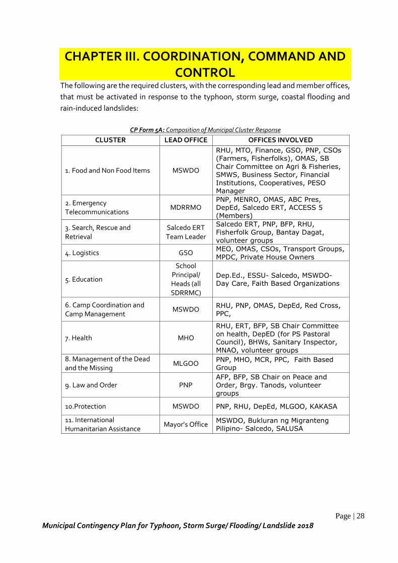
Page | 28
Municipal Contingency Plan for Typhoon, Storm Surge/ Flooding/ Landslide 2018
CHAPTER III. COORDINATION, COMMAND AND CONTROL
The following are the required clusters, with the corresponding lead and member offices,
that must be activated in response to the typhoon, storm surge, coastal flooding and
rain-induced landslides:
CP Form 5A: Composition of Municipal Cluster Response
CLUSTER LEAD OFFICE OFFICES INVOLVED
1. Food and Non Food Items MSWDO
RHU, MTO, Finance, GSO, PNP, CSOs
(Farmers, Fisherfolks), OMAS, SB
Chair Committee on Agri & Fisheries,
SMWS, Business Sector, Financial
Institutions, Cooperatives, PESO Manager
2. Emergency Telecommunications
MDRRMO PNP, MENRO, OMAS, ABC Pres, DepEd, Salcedo ERT, ACCESS 5
(Members)
3. Search, Rescue and Retrieval
Salcedo ERT Team Leader
Salcedo ERT, PNP, BFP, RHU,
Fisherfolk Group, Bantay Dagat,
volunteer groups
4. Logistics GSO MEO, OMAS, CSOs, Transport Groups,
MPDC, Private House Owners
5. Education
School Principal/ Heads (all SDRRMC)
Dep.Ed., ESSU- Salcedo, MSWDO- Day Care, Faith Based Organizations
6. Camp Coordination and Camp Management
MSWDO RHU, PNP, OMAS, DepEd, Red Cross,
PPC,
7. Health MHO
RHU, ERT, BFP, SB Chair Committee
on health, DepED (for PS Pastoral Council), BHWs, Sanitary Inspector,
MNAO, volunteer groups 8. Management of the Dead and the Missing
MLGOO PNP, MHO, MCR, PPC, Faith Based Group
9. Law and Order PNP AFP, BFP, SB Chair on Peace and
Order, Brgy. Tanods, volunteer
groups
10.Protection MSWDO PNP, RHU, DepEd, MLGOO, KAKASA
11. International Humanitarian Assistance
Mayor’s Office MSWDO, Bukluran ng Migranteng Pilipino- Salcedo, SALUSA
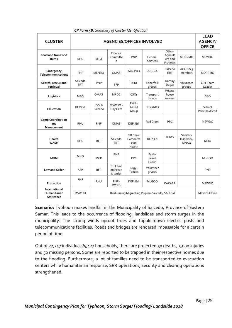
Page | 29
Municipal Contingency Plan for Typhoon, Storm Surge/ Flooding/ Landslide 2018
CP Form 5B: Summary of Cluster Identification
CLUSTER AGENCIES/OFFICES INVOLVED LEAD
AGENCY/ OFFICE
Food and Non Food
Items
RHU
MTO
Finance Committe
e PNP
General Services
SB on Agriculture and
Fisheries
MDRRMO MSWDO
Emergency
Telecommunications
PNP
MENRO
OMAS
ABC Pres DEP. Ed. Salcedo
ERT ACCESS 5 members
MDRRMO
Search, rescue and
retrieval
Salcedo ERT
PNP
BFP RHU
Fisherfolk
groups
Bantay Dagat
Volunteer
groups
ERT Team
Leader
Logistics
MEO
OMAS MPDC CSOs
Transport groups
Private house
owners
GSO
Education
DEP Ed. ESSU-
Salcedo MSWDO -Day Care
Faith-based Group
SDRRMCs
School Principal/Head
Camp Coordination
and Management
RHU
PNP
OMAS
DEP. Ed.
Red Cross PPC MSWDO
Health WASH
RHU
BFP
Salcedo
ERT
SB Chair
Committee on
Health
DEP. Ed BHWs
Sanitary Inspector,
MNAO
MHO
MDM
MHO
MCR PNP
PPC
Faith-based Group
MLGOO
Law and Order AFP BFP SB Chair on Peace & Order
Brgy. Tanods
Volunteer gruops
PNP
Protection
PNP
RHU
PNP-WCPD
DEP. Ed. MLGOO
KAKASA
MSWDO
International Humanitarian
Assistance MSWDO Bukluran ng Migranting Pilipino- Salcedo, SALUSA Mayor’s Office
Scenario: Typhoon makes landfall in the Municipality of Salcedo, Province of Eastern
Samar. This leads to the occurrence of flooding, landslides and storm surges in the
municipality. The strong winds uproot trees and topple down electric posts and
telecommunications facilities. Roads and bridges are rendered impassable for a certain
period of time.
Out of 22,347 individuals/5,427 households, there are projected 50 deaths, 5,000 injuries
and 50 missing persons. Some are reported to be trapped in their respective homes due
to the flooding. Furthermore, a lot of families need to be transported to evacuation
centers while humanitarian response, SRR operations, security and clearing operations
strengthened.
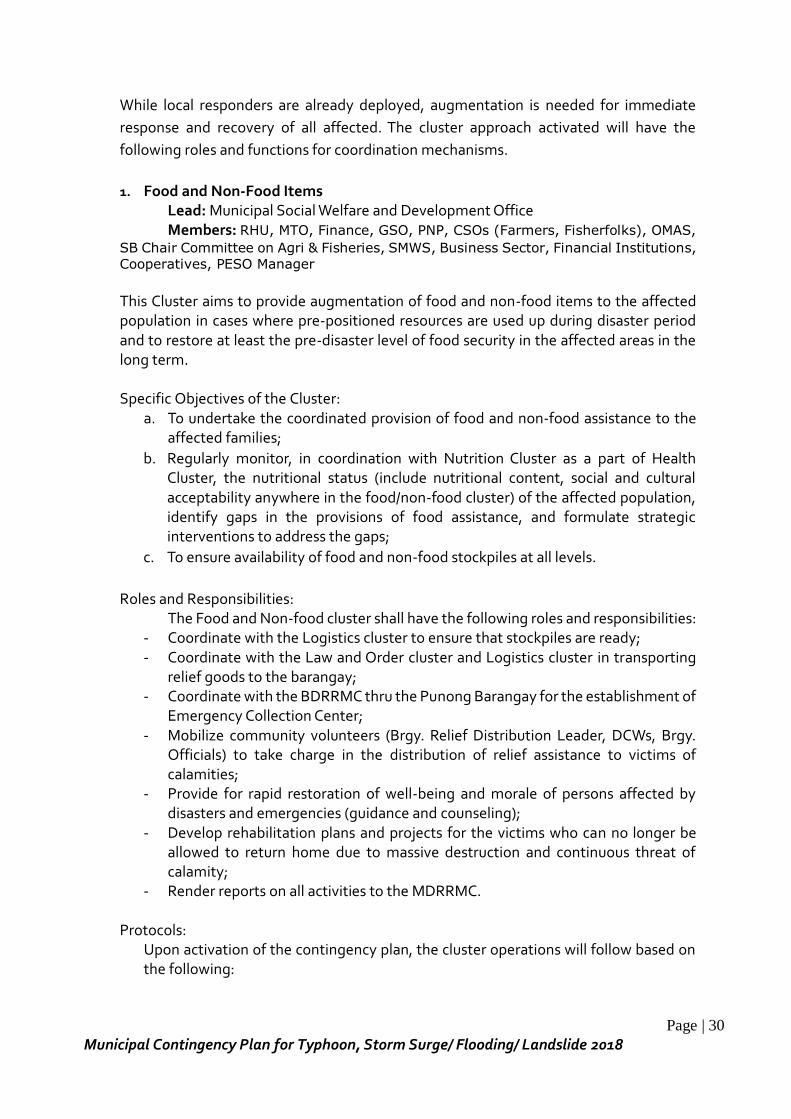
Page | 30
Municipal Contingency Plan for Typhoon, Storm Surge/ Flooding/ Landslide 2018
While local responders are already deployed, augmentation is needed for immediate
response and recovery of all affected. The cluster approach activated will have the
following roles and functions for coordination mechanisms.
1. Food and Non-Food Items
Lead: Municipal Social Welfare and Development Office Members: RHU, MTO, Finance, GSO, PNP, CSOs (Farmers, Fisherfolks), OMAS,
SB Chair Committee on Agri & Fisheries, SMWS, Business Sector, Financial Institutions,
Cooperatives, PESO Manager
This Cluster aims to provide augmentation of food and non-food items to the affected population in cases where pre-positioned resources are used up during disaster period and to restore at least the pre-disaster level of food security in the affected areas in the long term. Specific Objectives of the Cluster:
a. To undertake the coordinated provision of food and non-food assistance to the affected families;
b. Regularly monitor, in coordination with Nutrition Cluster as a part of Health Cluster, the nutritional status (include nutritional content, social and cultural acceptability anywhere in the food/non-food cluster) of the affected population, identify gaps in the provisions of food assistance, and formulate strategic interventions to address the gaps;
c. To ensure availability of food and non-food stockpiles at all levels.
Roles and Responsibilities: The Food and Non-food cluster shall have the following roles and responsibilities:
- Coordinate with the Logistics cluster to ensure that stockpiles are ready; - Coordinate with the Law and Order cluster and Logistics cluster in transporting
relief goods to the barangay; - Coordinate with the BDRRMC thru the Punong Barangay for the establishment of
Emergency Collection Center; - Mobilize community volunteers (Brgy. Relief Distribution Leader, DCWs, Brgy.
Officials) to take charge in the distribution of relief assistance to victims of calamities;
- Provide for rapid restoration of well-being and morale of persons affected by disasters and emergencies (guidance and counseling);
- Develop rehabilitation plans and projects for the victims who can no longer be allowed to return home due to massive destruction and continuous threat of calamity;
- Render reports on all activities to the MDRRMC.
Protocols: Upon activation of the contingency plan, the cluster operations will follow based on the following:
Page | 31
Municipal Contingency Plan for Typhoon, Storm Surge/ Flooding/ Landslide 2018
Pre-Disaster Phase - Activation of Quick Response Team (QRT) as first responders. - Validate all prepositioned resources of the municipality as well as from the
barangay level. - Submit a Status Report on all prepositioned resources to the MDRRMC, PDRRMC
and RDRRMC. During Disaster Phase
- Activate pool of volunteers for stockpiling, monitoring and distribution of food and non-food items.
- Coordinate with internal and external donor donation agencies for their capacities taking into consideration occurring disaster situations.
- Provision of Disaster Assistance Family Access Card (DAFAC) to facilitate on-time, frequency and type of assistance provided to disaster victims.
- 24/7 operation of Disaster Response Operations and Monitoring and Information Center (DROMIC) at Operations Center.
- Continues disaster response monitoring and mobilize instrumentalities and entities of the Barangays, CSOs and private groups and organize volunteers for response.
- Provision of emergency relief (food and non-food items), medical supplies, inside and outside evacuation center.
- Conduct of Rapid Assessment using the DSWD tool to validate information provided by local stakeholders to determine the extent of damage either partially or totally, specifically for food and non-food, for funding requirements.
- Set protocols of information and reporting to account relief activities of all partners, local and international NGOs and media groups.
- Set guidelines when to terminate relief, response and evacuation center management.
- Secure accurate data from the Barangays needed for request of augmentation of assistance and dissemination of report to cluster members/agencies.
Post-Disaster Phase - Participate in the conduct of PDNA together with partner agencies/offices; - Develop a post-distribution monitoring system. Evaluation of the quality,
sufficiency, effectiveness and timeliness of distribution that help to improve the overall distribution system and approach;
- Establish complaint mechanisms, so camp residents can ensure a way to verify entitlements and services. In case of fraud, theft or abuse, camp residents/families must be able to voice their complaints and know that lead and coordinating agencies/offices and service providers will take action;
- Shall provide “Pabaon Package” (provision of food packs) to those who wants to go back to their respective places of origin;
- Shall provide continuing relief assistance when needed.
2. Emergency Telecommunications
Lead: MDRRMO
Page | 32
Municipal Contingency Plan for Typhoon, Storm Surge/ Flooding/ Landslide 2018
Members: PNP, MENRO, OMAS, ABC Pres, DepEd, Salcedo ERT, ACCESS 5
(Members)
Upon activation, the objective of the cluster is to strengthen Information and
Communication Technology (ICT) capacities of the municipality and rapidly disseminate
information concerning imminent disaster threats down to all levels to prepare for,
respond to and recover from the impacts of disasters.
Specifically, the cluster will organize to provide timely, resilient and predictable ICT support to improve:
a. Response and coordination among response organizations; b. Decision-making through timely access to critical information; c. Common operational areas for disaster response; d. Common system standards and operating procedures.
Roles and Responsibilities: The Emergency Telecommunications cluster shall have the following roles and responsibilities:
- Monitor weather conditions and updates using available resources; - Report weather updates to the LCE of the impending disaster threat in the
municipality; - Relay 24-hour weather bulletin and advisory from PAG-ASA; - Disseminate accurate early warning information to all concerned committees to
allow timely action to respond; - Furnish information on updates to responsible persons/agencies; - Assist in the activation of warning system devices; - Establish linkage with other agencies; - Post and updates information advisory thru available social networks (FB, etc.),
website, PAG-ASA, resource agencies; - Establish linkage and communication lines between responsible agencies for
reliable updates; - Provide access and availability of communication facilities to all concerned.
Protocols:
- Upon activation of the contingency plan, all key representatives of the cluster headed by the MDRRMO will have to convene at the EOC to undertake coordination work.
- The emergency telecommunications cluster shall organize the team that will provide a timely, resilient and predictable Information and Communications Technology (ICT) support and services.
Pre-Disaster Phase
- Pre-program all radios to the assigned disaster frequencies on orders. - Deploy communication team to provide technical assistance to radio users and to
maintain serviceability of all issued communication equipment & system.
Page | 33
Municipal Contingency Plan for Typhoon, Storm Surge/ Flooding/ Landslide 2018
- Act as the focal point of the MDRRMC for all radio, voice and data communications-related matters including frequency allocation, communications networks, and mobilization of ICT resources;
- Provide a platform directory services containing the contact information of the different ICT key players;
- Provide ICT services support for other clusters as needed; - Support by sending warning advisories to the MDRRMC, BDRRMCs and other
member agencies; - Collect information regarding the impending disaster and situations of
preparedness by the barangays and related agencies and inform/report them to MDRRMC/PDRRMC/RDRRMC.
- Convey information on warnings/alerts/advisories thru text broadcast, website news facility, and print directed to areas that may likely be affected.
- Conduct scenario based pre-deployment planning meeting in a predefined location.
During Disaster Phase - Provide basic telecommunications coverage around the main operational area for
the Command Center and other responders. - Program all radios or other equipment belonging to individual responders,
organizations and other key players in disaster areas to be provided on best effort basis.
- Install and maintain internal ICT systems between clusters and for public services. - Establish a functional mobile network to be used by the cluster workers in the
operational area. Post Disaster Phase
- Shall provide assistance in communication between disaster stricken areas and BDRRMCs at all levels.
- Maintain communications connectivity (voice and data) between all disaster responders.
- Report information to the public on impacts of disaster and updates of response activities.
- Coordinate assessment activities conducted on the ground. - Receive and consolidate reports.
3. Search, Rescue and Retrieval (SRR) Lead: Salcedo ERT Team Leader Members: Salcedo ERT, PNP, BFP, RHU, Fisherfolk Group, Bantay Dagat,
volunteer groups
This cluster aims to provide support for an effective, timely, organized and systematic search, rescue and retrieval operations to affected areas in all emergencies to further minimize loss of lives and casualties, including the hand-over of casualties to the Health Cluster for proper treatment and management.
Page | 34
Municipal Contingency Plan for Typhoon, Storm Surge/ Flooding/ Landslide 2018
Specific Objectives of the Cluster: a. To ensure the safety and security of the response teams deployed by the SRR
cluster; b. To ensure timely, effective and efficient conduct of SRR operations; c. To facilitate and assist in the retrieval, identification and proper management of
human remains; and d. To account all the responses made by the SRR cluster.
Roles and Responsibilities: The SRR cluster shall have the following roles and responsibilities:
- Organize and train the SRR team/s provided for in the emergency plan; - Assist in the organization and training of Barangay Response and Rescue Teams - Obtain appropriate equipment for search and rescue operations; - Organize and deploy self-sufficient and capable response teams to conduct SRR; - Alert transportation unit and other equipment for deployment - Assemble at pick-up points and staging area; - Conduct evacuation of disaster victims and bring them to pre-designated
evacuation centers and safer and/or higher grounds; - Conduct rescue and recovery operations to the disaster stricken areas in
coordination with other response groups; - Coordinate other response agencies on matters relative to search and rescue
operations; - Provide resource augmentation, to include manpower and equipment, to other
areas as needed; - Consolidate all the activities made by the response teams into one cluster report.
Protocols: Upon activation of the contingency plan, all key representatives of the SRR cluster headed by the Salcedo ERT Team leader will have to convene at the EOC to undertake coordination work.
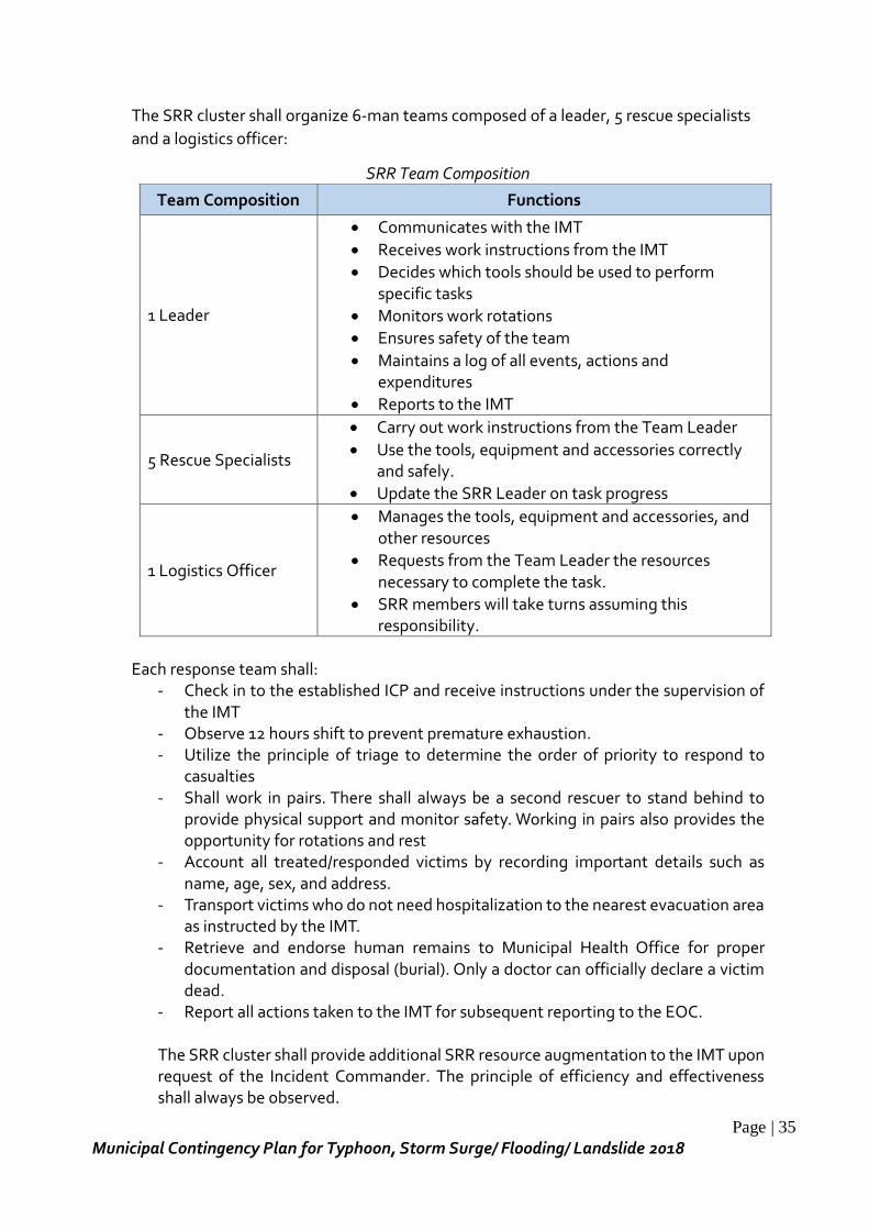
Page | 35
Municipal Contingency Plan for Typhoon, Storm Surge/ Flooding/ Landslide 2018
The SRR cluster shall organize 6-man teams composed of a leader, 5 rescue specialists
and a logistics officer:
SRR Team Composition
Team Composition Functions
1 Leader
Communicates with the IMT
Receives work instructions from the IMT
Decides which tools should be used to perform specific tasks
Monitors work rotations
Ensures safety of the team
Maintains a log of all events, actions and expenditures
Reports to the IMT
5 Rescue Specialists
Carry out work instructions from the Team Leader
Use the tools, equipment and accessories correctly and safely.
Update the SRR Leader on task progress
1 Logistics Officer
Manages the tools, equipment and accessories, and other resources
Requests from the Team Leader the resources necessary to complete the task.
SRR members will take turns assuming this responsibility.
Each response team shall:
- Check in to the established ICP and receive instructions under the supervision of the IMT
- Observe 12 hours shift to prevent premature exhaustion. - Utilize the principle of triage to determine the order of priority to respond to
casualties - Shall work in pairs. There shall always be a second rescuer to stand behind to
provide physical support and monitor safety. Working in pairs also provides the opportunity for rotations and rest
- Account all treated/responded victims by recording important details such as name, age, sex, and address.
- Transport victims who do not need hospitalization to the nearest evacuation area as instructed by the IMT.
- Retrieve and endorse human remains to Municipal Health Office for proper documentation and disposal (burial). Only a doctor can officially declare a victim dead.
- Report all actions taken to the IMT for subsequent reporting to the EOC.
The SRR cluster shall provide additional SRR resource augmentation to the IMT upon request of the Incident Commander. The principle of efficiency and effectiveness shall always be observed.
Page | 36
Municipal Contingency Plan for Typhoon, Storm Surge/ Flooding/ Landslide 2018
Priority shall be given to the very young (0-7 y/o), old (60 y/o above), pregnant, elderly and PWDs. The severely injured with life threatening condition but with a high chance of survival are to be responded first, followed by the less several injured. Next will be the walking wounded and the last will be those with remote survival.
4. Logistics
Lead: GSO
Members: MEO, OMAS, CSOs, Transport Groups, MPDC, Private House Owners
On activation, the Logistics Cluster aims to provide an efficient and effective logistics
coordinating structure that will harmonize the activities of all clusters and encourage
regular info-sharing among all stakeholders and other partners. The Cluster also
formulates, updates, implements and monitors logistical policies, plans, programs and
procedures that will harmonize the activities of each cluster.
The Logistics Cluster thru coordination, monitoring, identification and deployment cover the following:
- transportation (emergency road network, land, sea and air), this includes road clearing and provision of equipment and machines (and its required fuel) to provide the needed access and mobility for all cluster operations,
- warehousing, - inventories (consolidation of resources available among partners and cluster
members), - tracking of deployed items
Roles and Responsibilities
- Deployment of personnel and equipment that will conduct debris-clearing operations on major roads, avenues, pathways and waterways to facilitate immediate and smooth flow and transport of emergency relief goods and assistance;
- Install warning signs on hazardous areas and places damaged by calamities an disasters;
- Conduct immediate repairs of critical government facilities
5. Education Lead: School Principal/Heads (all SDRRMCs) Members: Dep.Ed., ESSU- Salcedo, MSWDO- Day Care, Faith Based Organizations The Education Cluster led by DepEd aims to ensure safety of learners and Dep Ed personnel and provide continued access to quality of education to all affected learner. Specific Objectives of the Cluster:
Page | 37
Municipal Contingency Plan for Typhoon, Storm Surge/ Flooding/ Landslide 2018
a. Conduct impact and needs assessment on affected teaching and non-teaching personnel, learners and educational properties;
b. Provide the required temporary learning spaces, teaching-learning materials to allow for resumption of classes and education service delivery;
c. Coordinate the provision of Psycho-social support and Services to both learners and DepEd personnel;
d. Promote and activate the use of alternative delivery modes of learning in affected areas; and
e. Mobilize resources to facilitate delivery of other relevant assistance to the affected teaching and non-teaching personnel.
6. Camp Coordination and Camp Management Lead: MSWDO
Members: RHU, PNP, OMAS, DepEd, Red Cross, PPC, The CCM Cluster aims to provide assistance and augment all requirements for the management and evacuation of individual’s families affected by disasters.
Specific objectives of the cluster are:
a. To ensure the availability of identified safe, secure and accessible evacuation centers for emergencies and disasters;
b. To ensure that temporary refuge to individual and families potentially at risk or in actual danger are immediately provided;
c. To ensure establishment of sex and age disaggregated data accurate data e.g. listing and profiling of affected families and internally displaced persons (IDPs) in evacuation centers or temporary displacement sites.
d. To ensure that all IDPs in evacuation centers are provided with basic humanitarian needs compliant with SPHERE standards such as, but not limited to food with enough nutritional values), potable water, clothing, family items, hygiene kits and other essential non-food items;
e. To ensure that energy source and communication facilities are in place. f. Ensure that ECs are off limits and have designated areas for pet animals and
livestock. g. Shall continue to seek opportunities for recovery, rehabilitation and
developmental tasks as post response activities are undertaken, in case of prolonged stay.
Roles and Responsibilities:
- Conducts inventory of and identify safe evacuation centers in coordination with the warning, security and engineering committees to accommodate all evacuees;
- Develop evacuation plans; - Conducts inventory of population-at-risk and maintains an updated master list of
the threatened population by type of hazard; - Evacuates vulnerable according sectors according to specific evacuation plan; - Ensures that the non-functional facilities and utilities in the designated safe
Page | 38
Municipal Contingency Plan for Typhoon, Storm Surge/ Flooding/ Landslide 2018
evacuation centers are reported to the MDRRMO and Logistics Clusters for repair and/or reconstruction supports;
- Inspects and prepares safe evacuation centers, classroom keys are turned over to the principal or security guard when warning status on flood and debris flows is raised;
- Administer cleanup of places vacated by evacuees; - The Municipal Agriculturist identifies and designates safe area for livestock
evacuation; - Coordinate with the Medical Team for the provision of medical health services; - Render reports on all its activities to the MDRRMC
7. Health
Lead: MHO
Members: RHU, ERT, BFP, SB Chair Committee on health, DepED (for PS
Pastoral Council), BHWs, Sanitary Inspector, MNAO, volunteer groups
The Health Cluster composed of the quad-cluster aims to provide support for a timely and appropriate public health services to the affected population. It will ensure that effective and predictable health response will be built on health priorities and related best practices.
Specific Objectives of the Cluster:
a. Provide guidance and tools and standards and policies;
b. Conduct trainings and other various capacity building activities;
c. Develop guidelines and infrastructure on surveillance of communicable, non-communicable and emerging diseases;
d. Conduct rapid and comprehensive needs assessments in the affected areas;
e. Establish effective coordination mechanisms specifically on health response activities based on reliable morbidity and mortality information;
f. Advocate the provision of technical assistance, medicines and supplies, and essential equipment in order to support basic health services for the affected population;
g. Build partnerships to promote the integration of cross-cutting issues and implement culture and gender sensitive health services; and
h. Develop systems for planning, social mobilization, advocacy, surveillance, monitoring, evaluation and good reporting mechanisms within the health cluster.
Roles and Responsibilities: Medical Services
- Ensure minimum standard package of health interventions in emergencies, including:
Prevention and management of communicable diseases and childhood illness,
Outbreak detection and response,
Page | 39
Municipal Contingency Plan for Typhoon, Storm Surge/ Flooding/ Landslide 2018
Provision of sexual and reproductive health services,
Injury care, and
Essential health services for non-communicable diseases. WASH Team
- Ensure provision of sufficient water safe for drinking, cooking and personal and domestic hygiene.
- Ensure availability of water containers to collect and store water safely. - Protect water supply from contamination. - Ensure access to safe and adequate latrines/toilet facilities. - Collect data for health reports.
Nutrition in Emergencies Team
- Identify and support vulnerable groups (with greatest nutritional needs and numerous underlying factors that can negatively affect nutritional status).
- Undertake integrated multi-sectoral interventions to support safe and appropriate infant and young child feeding (IYCF).
- Support and promote exclusive breastfeeding for lactating mothers with children aged 0-24 months.
- Provide timely, safe, adequate, and appropriate complementary feeding. - Collect data for health reports.
MHPSS Team
- Enable community members, including marginalized, to strengthen community self-help and social support.
- Ensure that community workers, including RHU staff and volunteers, offer psychological first aid to people in acute distress.
- Ensure there is at least one staff member in each health facility who can manage diverse mental health problems in adults and children.
- Address the rights (safety, basic needs, etc.) of people with mental health problems in institutions.
- Collect data for health reports. Health Information Team
- Ensure that data collection, information sharing and utilization is carried out to support decisions and activities.
- Consolidate data and prepare health emergency reports.
Administration and Logistics - Ensure that the appropriate resources are in the right place at the right time,
through the most efficient means possible. Resources include medicines, supplies, and equipment needed in response.
- Manage donations (medicines, supplies, equipment, cash) from external agencies.
- Ensure cold storage of vaccines through power generation sets, which must be available in case of breakdown of utilities.

Page | 40
Municipal Contingency Plan for Typhoon, Storm Surge/ Flooding/ Landslide 2018
Transportation - Takes charge in the transport of patients to referral facilities - Ensure that ambulances and other emergency transport vehicles are well-
maintained and prepared for emergencies.
8. Protection Lead: MSWDO Members: PNP, RHU, DepEd, MLGOO, KAKASA
The cluster aims to support and enhance the government’s capacity to ensure that protection issues do not arise in emergency situations and to respond and mitigate the effect of any protection issues that do arise.
Specific objectives of the cluster are: a. To ensure timely, appropriate and quality provision of multi-sectoral and survivor-
centered child protection and gender-based violence services in accordance with local, national and international guidelines/standard on child protection and gender-based violence;
b. Establish and maintain appropriate coordination mechanism among all humanitarian actors, including coordination of protection inputs, reports, and humanitarian plan and generation of resources;
c. Ensure that the protection response adequately takes into account the primary responsibility of the government to ensure protection of affected persons, by among others establishing adequate response mechanism and coordination with the national and local authorities;
d. To advocate to all humanitarian clusters, protection, child protection, gender-based violence duty bearers , government, private sectors and Civil Society Organizations to mainstream child protection and gender-based violence in programs, policies and plans;
e. To strengthen partnerships for complementation and coordinated child protection and gender-based violence response though the Regional and Local Inter-Agency Committees on Anti-Trafficking and Violence Against Women and their Children (ICAT-VAWC) and the Local Council for the Protection of Children (LCPC); and
f. To establish common information, monitoring and reporting systems on child protection and gender-based violence, linked to the IDP Protection Cluster (IDPPC).
Roles and Responsibilities: MSWDO
- Coordinate with member agencies/office for activation of response operations; - Establish information systems for measuring emergency Child Protection and
Gender-Based Violence needs in coordination with member agency; - Ensure availability of age/sex disaggregated data of all children, women, lactating
mothers, PWD and elderly inside and outside the evacuation centers in coordination with member agencies/office;
- Ensure the availability of timely and accurate data/reports for information
Page | 41
Municipal Contingency Plan for Typhoon, Storm Surge/ Flooding/ Landslide 2018
dissemination to cluster partners and as basis in provision of augmentation of assistance;
- Coordinate for proper referral to LCAT Desks and/or VAWC desks or other existing women or child protection structures;
- Provide capacity building on Child Protection and Gender-Based Violence in Emergencies including coordination; and
- Develop appropriate programs, strategies as necessary, to address protection and psychosocial needs of affected women and children.
MHO - Provide health, medical and nutritional needs of IDP in the evacuation centers
including psychosocial interventions especially for children in different stages of development, women, PDW and elderly;
- Assist and coordinate with other member agency/office thru the Gender-Based Violence /Child Protection sub-cluster in reporting sexual violence cases; and
- Operationalize the Minimum Initial Services Package for Sexual Reproductive Health in affected areas.
PNP
- Shall monitor and ensure safety, security and protect the affected IDPs to all forms of violence, abuse, neglect and exploitation in coordination with other member agencies/offices. MLGOO
- Shall ensure the organization and functionality of Local Council for the Protection of Child (LCPC).
9. Management of the Dead and Missing
Lead: MLGOO
Members: PNP, MHO, MCR, PPC, Faith Based Group
The MDM Cluster aims to provide policies, standards, guidelines, systems and procedures to institutionalize MDM in all concerned agencies and stakeholders at all levels during emergencies and disasters. Specific Objectives of the Cluster:
a. Provide assistance in the proper identification and disposition of the remains in a sanitary manner with cautions to prevent negative psychological and social impact on the bereaved and the community;
b. Strengthen coordination, collaboration and partnerships among agencies and stakeholders (NGOs, POs) of MDM at all levels; and
c. Establish resource sharing mechanisms among key layers in MDM.
The MDM Cluster will focus on four major activities: - Disaster victim identification - Final Arrangement for the dead
Page | 42
Municipal Contingency Plan for Typhoon, Storm Surge/ Flooding/ Landslide 2018
- Management of the missing persons - Management of the bereaved families
Roles and Responsibilities
10. Law and Order Lead: SMPS COP Members: AFP, BFP, SB Chair on Peace and Order, Brgy. Tanods, volunteer groups The cluster aims to maintain Peace Order and Security during disaster and post-disaster phases in order to execute smooth response activities and protect human lives and properties in and around disaster affected sites. Specific Objectives of the Cluster:
a. Provide security to the Response Clusters operating in the affected area; b. Provide traffic management that will facilitate the speedy movement of people,
goods and equipment to the affected population and responding agencies; and c. Enforce law and order in the communities through the provision of information
on the disaster response operations and the maintenance of community policing to reduce or arrest criminality in the area.
Roles and Responsibilities: - Provide security in the disaster stricken areas in the evacuation centers; - Provide traffic assistance to motorist and maintain road traffic order during
disaster and/or emergencies; - Assist in the monitoring and reporting of disaster events; - Assist in the dissemination of warning to the community on the implementing
and/or existing situation; - Organize security team/s to provide security support services and maintain peace
and order situations in the vulnerable areas and the designated safe evacuation centers;
- Conduct lecture on disaster mitigation and preparedness with PNP elements and barangay tanods;
- Secure critical properties and resources in the threatened areas and recommend appropriate support ordinances or resolutions for enactment by the municipal board;
- Request security assistance from the AFP through the PNP Provincial office when necessary
- Instruct security staff on assignment of duty, - Dispatch security personnel in the evacuation center; - Regularly check-up and maintain good condition of police vehicles; - Coordinate with other teams/agencies in the rescue and evacuation operations; - Assist the MDRRMC and other agencies in the cleanup of debris and restoration
of damages; - Render reports on all its activities to the MDRRMC.
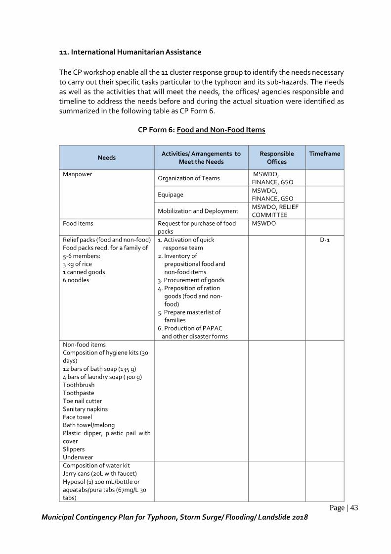
Page | 43
Municipal Contingency Plan for Typhoon, Storm Surge/ Flooding/ Landslide 2018
11. International Humanitarian Assistance
The CP workshop enable all the 11 cluster response group to identify the needs necessary to carry out their specific tasks particular to the typhoon and its sub-hazards. The needs as well as the activities that will meet the needs, the offices/ agencies responsible and timeline to address the needs before and during the actual situation were identified as summarized in the following table as CP Form 6.
CP Form 6: Food and Non-Food Items
Needs Activities/ Arrangements to
Meet the Needs Responsible
Offices Timeframe
Manpower Organization of Teams
MSWDO, FINANCE, GSO
Equipage MSWDO, FINANCE, GSO
Mobilization and Deployment MSWDO, RELIEF COMMITTEE
Food items Request for purchase of food packs
MSWDO
Relief packs (food and non-food) Food packs reqd. for a family of 5-6 members: 3 kg of rice 1 canned goods 6 noodles
1. Activation of quick response team 2. Inventory of prepositional food and non-food items 3. Procurement of goods 4. Preposition of ration goods (food and non- food) 5. Prepare masterlist of families 6. Production of PAPAC and other disaster forms
D-1
Non-food items Composition of hygiene kits (30 days) 12 bars of bath soap (135 g) 4 bars of laundry soap (300 g) Toothbrush Toothpaste Toe nail cutter Sanitary napkins Face towel Bath towel/malong Plastic dipper, plastic pail with cover Slippers Underwear
Composition of water kit Jerry cans (20L with faucet) Hyposol (1) 100 mL/bottle or aquatabs/pura tabs (67mg/L 30 tabs)
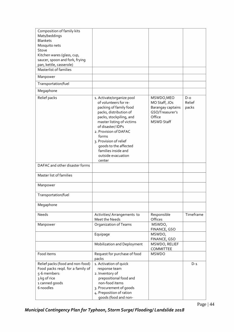
Page | 44
Municipal Contingency Plan for Typhoon, Storm Surge/ Flooding/ Landslide 2018
Composition of family kits Mats/beddings Blankets Mosquito nets Stove Kitchen wares (glass, cup, saucer, spoon and fork, frying pan, kettle, casserole)
Masterlist of families
Manpower
Transportation/fuel
Megaphone
Relief packs 1. Activate/organize pool of volunteers for re- packing of family food packs, distribution of packs, stockpiling, and master listing of victims of disaster/ IDPs 2. Provision of DAFAC forms 3. Provision of relief goods to the affected families inside and outside evacuation center
MSWDO,MEO MO Staff, JOs Barangay captains GSO/Treasurer’s Office MSWD Staff
D-0 Relief packs
DAFAC and other disaster forms
Master list of families
Manpower
Transportation/fuel
Megaphone
Needs Activities/ Arrangements to Meet the Needs
Responsible Offices
Timeframe
Manpower Organization of Teams MSWDO, FINANCE, GSO
Equipage MSWDO, FINANCE, GSO
Mobilization and Deployment MSWDO, RELIEF COMMITTEE
Food items Request for purchase of food packs
MSWDO
Relief packs (food and non-food) Food packs reqd. for a family of 5-6 members: 3 kg of rice 1 canned goods 6 noodles
1. Activation of quick response team 2. Inventory of prepositional food and non-food items 3. Procurement of goods 4. Preposition of ration goods (food and non-
D-1
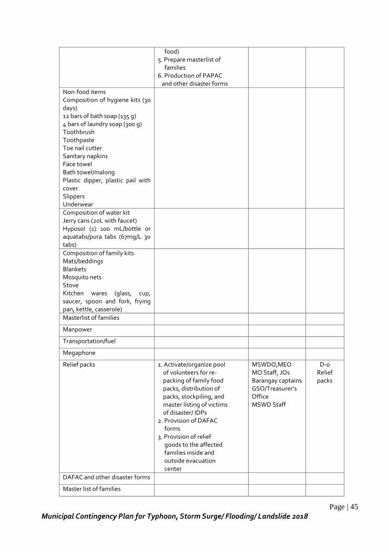
Page | 45
Municipal Contingency Plan for Typhoon, Storm Surge/ Flooding/ Landslide 2018
food) 5. Prepare masterlist of families 6. Production of PAPAC and other disaster forms
Non-food items Composition of hygiene kits (30 days) 12 bars of bath soap (135 g) 4 bars of laundry soap (300 g) Toothbrush Toothpaste Toe nail cutter Sanitary napkins Face towel Bath towel/malong Plastic dipper, plastic pail with cover Slippers Underwear
Composition of water kit Jerry cans (20L with faucet) Hyposol (1) 100 mL/bottle or aquatabs/pura tabs (67mg/L 30 tabs)
Composition of family kits Mats/beddings Blankets Mosquito nets Stove Kitchen wares (glass, cup, saucer, spoon and fork, frying pan, kettle, casserole)
Masterlist of families
Manpower
Transportation/fuel
Megaphone
Relief packs 1. Activate/organize pool of volunteers for re- packing of family food packs, distribution of packs, stockpiling, and master listing of victims of disaster/ IDPs 2. Provision of DAFAC forms 3. Provision of relief goods to the affected families inside and outside evacuation center
MSWDO,MEO MO Staff, JOs Barangay captains GSO/Treasurer’s Office MSWD Staff
D-0 Relief packs
DAFAC and other disaster forms
Master list of families
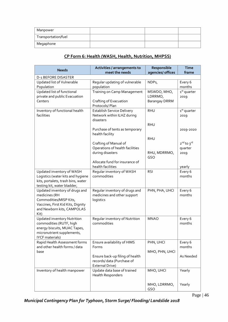
Page | 46
Municipal Contingency Plan for Typhoon, Storm Surge/ Flooding/ Landslide 2018
Manpower
Transportation/fuel
Megaphone
CP Form 6: Health (WASH, Health, Nutrition, MHPSS)
Needs Activities / arrangements to
meet the needs Responsible
agencies/ offices Time frame
D-1 BEFORE DISASTER
Updated list of Vulnerable Population
Regular updating of vulnerable population
NDPs, Every 6 months
Updated list of functional private and public Evacuation Centers
Training on Camp Management Crafting of Evacuation Protocols/ Plan
MSWDO, MHO, LDRRMO, Barangay DRRM
1st quarter 2019
Inventory of functional health facilities
Establish Service Delivery Network within ILHZ during disasters Purchase of tents as temporary health facility Crafting of Manual of Operations of health facilities during disasters Allocate fund for insurance of health facilities
RHU RHU RHU RHU, MDRRMO, GSO
1st quarter 2019 2019-2020 2nd to 3rd quarter 2019 yearly
Updated inventory of WASH Logistics (water kits and hygiene kits, portalets, trash bins, water testing kit, water bladder,
Regular inventory of WASH commodities
RSI Every 6 months
Updated inventory of drugs and medicines (RH Commodities/MISP Kits, Vaccines, First Kid Kits, Dignity and Newborn kits, CAMPOLAS Kit)
Regular inventory of drugs and medicines and other support logistics
PHN, PHA, UHCI
Every 6 months
Updated inventory Nutrition commodities (RUTF, high energy biscuits, MUAC Tapes, micronutrient supplements, IYCF materials)
Regular inventory of Nutrition commodities
MNAO Every 6 months
Rapid Health Assessment forms and other health forms / data base
Ensure availability of HIMS Forms Ensure back-up filing of health records/ data (Purchase of External Drive)
PHN, UHCI MHO, PHN, UHCI
Every 6 months As Needed
Inventory of health manpower Update data base of trained Health Responders
MHO, UHCI MHO, LDRRMO, GSO
Yearly Yearly
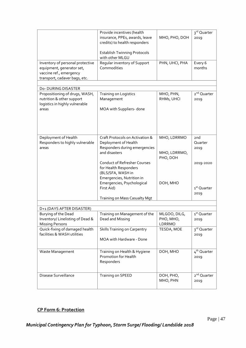
Page | 47
Municipal Contingency Plan for Typhoon, Storm Surge/ Flooding/ Landslide 2018
Provide incentives (health insurance, PPEs, awards, leave credits) to health responders Establish Twinning Protocols with other MLGU
MHO, PHO, DOH
3rd Quarter 2019
Inventory of personal protective equipment, generator set, vaccine ref., emergency transport, cadaver bags, etc.
Regular inventory of Support Commodities
PHN, UHCI, PHA Every 6 months
D0- DURING DISASTER
Propositioning of drugs, WASH, nutrition & other support logistics in highly vulnerable areas
Training on Logistics Management MOA with Suppliers- done
MHO, PHN, RHMs, UHCI
2nd Quarter 2019
Deployment of Health Responders to highly vulnerable areas
Craft Protocols on Activation & Deployment of Health Responders during emergencies and disasters Conduct of Refresher Courses for Health Responders (BLS/SFA, WASH in Emergencies, Nutrition in Emergencies, Psychological First Aid) Training on Mass Casualty Mgt
MHO, LDRRMO MHO, LDRRMO, PHO, DOH DOH, MHO
2nd Quarter 2019 2019-2020 1st Quarter 2019
D+1 (DAYS AFTER DISASTER)
Burying of the Dead Inventory/ Linelisting of Dead & Missing Persons
Training on Management of the Dead and Missing
MLGOO, DILG, PHO, MHO, LDRRMO
1st Quarter 2019
Quick-fixing of damaged health facilities & WASH utilities
Skills Training on Carpentry MOA with Hardware - Done
TESDA, MOE 3rd Quarter 2019
Waste Management Training on Health & Hygiene Promotion for Health Responders
DOH, MHO 4th Quarter 2019
Disease Surveillance Training on SPEED DOH, PHO, MHO, PHN
2nd Quarter 2019
CP Form 6: Protection
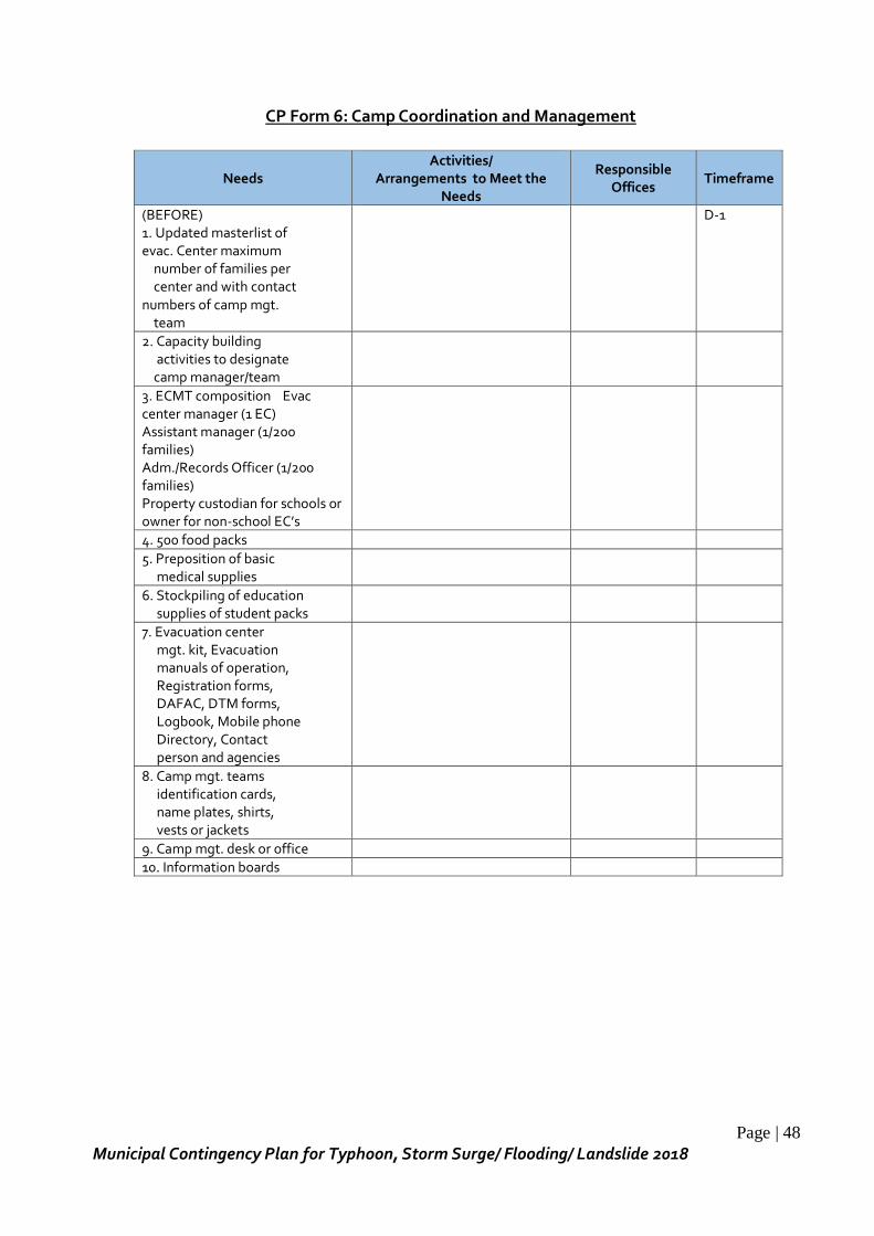
Page | 48
Municipal Contingency Plan for Typhoon, Storm Surge/ Flooding/ Landslide 2018
CP Form 6: Camp Coordination and Management
Needs Activities/
Arrangements to Meet the Needs
Responsible Offices
Timeframe
(BEFORE) 1. Updated masterlist of evac. Center maximum number of families per center and with contact numbers of camp mgt. team
D-1
2. Capacity building activities to designate camp manager/team
3. ECMT composition Evac center manager (1 EC) Assistant manager (1/200 families) Adm./Records Officer (1/200 families) Property custodian for schools or owner for non-school EC’s
4. 500 food packs
5. Preposition of basic medical supplies
6. Stockpiling of education supplies of student packs
7. Evacuation center mgt. kit, Evacuation manuals of operation, Registration forms, DAFAC, DTM forms, Logbook, Mobile phone Directory, Contact person and agencies
8. Camp mgt. teams identification cards, name plates, shirts, vests or jackets
9. Camp mgt. desk or office
10. Information boards
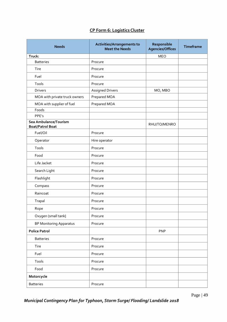
Page | 49
Municipal Contingency Plan for Typhoon, Storm Surge/ Flooding/ Landslide 2018
CP Form 6: Logistics Cluster
Needs Activities/Arrangements to
Meet the Needs Responsible
Agencies/Offices Timeframe
Truck: MEO
Batteries Procure
Tire Procure
Fuel Procure
Tools Procure
Drivers Assigned Drivers MO, MBO
MOA with private truck owners Prepared MOA
MOA with supplier of fuel Prepared MOA
Foods
PPE’s
Sea Ambulance/Tourism Boat/Patrol Boat
RHU/TO/MENRO
Fuel/Oil Procure
Operator Hire operator
Tools Procure
Food Procure
Life Jacket Procure
Search Light Procure
Flashlight Procure
Compass Procure
Raincoat Procure
Trapal Procure
Rope Procure
Oxygen (small tank} Procure
BP Monitoring Apparatus Procure
Police Patrol PNP
Batteries Procure
Tire Procure
Fuel Procure
Tools Procure
Food Procure
Motorcycle
Batteries Procure
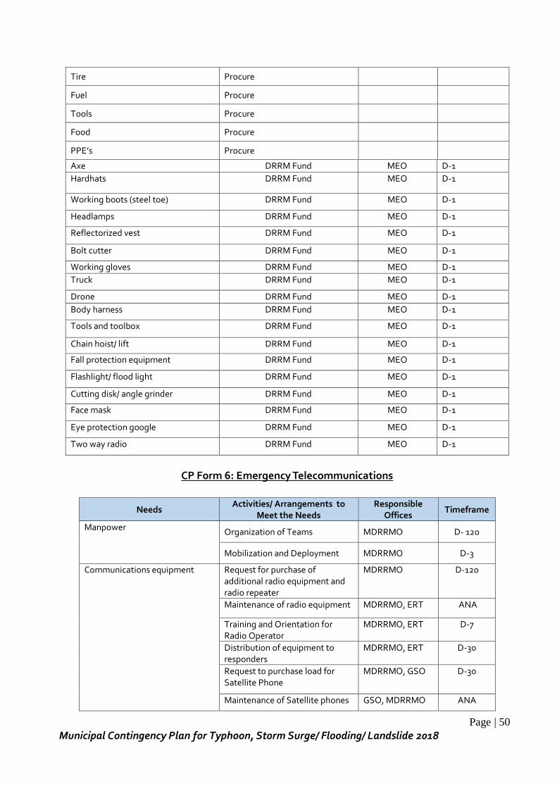
Page | 50
Municipal Contingency Plan for Typhoon, Storm Surge/ Flooding/ Landslide 2018
Tire Procure
Fuel Procure
Tools Procure
Food Procure
PPE’s Procure
Axe DRRM Fund MEO D-1
Hardhats DRRM Fund MEO D-1
Working boots (steel toe) DRRM Fund MEO D-1
Headlamps DRRM Fund MEO D-1
Reflectorized vest DRRM Fund MEO D-1
Bolt cutter DRRM Fund MEO D-1
Working gloves DRRM Fund MEO D-1
Truck DRRM Fund MEO D-1
Drone DRRM Fund MEO D-1
Body harness DRRM Fund MEO D-1
Tools and toolbox DRRM Fund MEO D-1
Chain hoist/ lift DRRM Fund MEO D-1
Fall protection equipment DRRM Fund MEO D-1
Flashlight/ flood light DRRM Fund MEO D-1
Cutting disk/ angle grinder DRRM Fund MEO D-1
Face mask DRRM Fund MEO D-1
Eye protection google DRRM Fund MEO D-1
Two way radio DRRM Fund MEO D-1
CP Form 6: Emergency Telecommunications
Needs Activities/ Arrangements to
Meet the Needs Responsible
Offices Timeframe
Manpower Organization of Teams MDRRMO D- 120
Mobilization and Deployment MDRRMO D-3
Communications equipment
Request for purchase of additional radio equipment and radio repeater
MDRRMO D-120
Maintenance of radio equipment MDRRMO, ERT ANA
Training and Orientation for Radio Operator
MDRRMO, ERT D-7
Distribution of equipment to responders
MDRRMO, ERT D-30
Request to purchase load for Satellite Phone
MDRRMO, GSO D-30
Maintenance of Satellite phones GSO, MDRRMO ANA
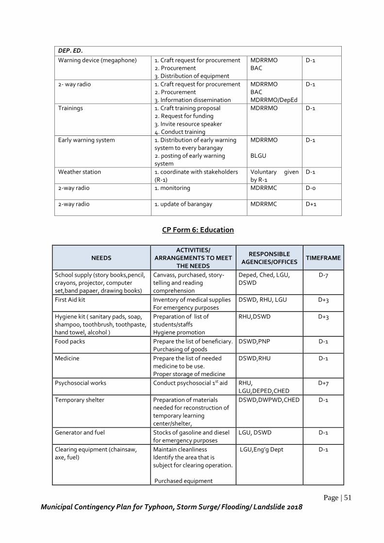
Page | 51
Municipal Contingency Plan for Typhoon, Storm Surge/ Flooding/ Landslide 2018
DEP. ED.
Warning device (megaphone) 1. Craft request for procurement 2. Procurement 3. Distribution of equipment
MDRRMO BAC
D-1
2- way radio 1. Craft request for procurement 2. Procurement 3. Information dissemination
MDRRMO BAC MDRRMO/DepEd
D-1
Trainings 1. Craft training proposal 2. Request for funding 3. Invite resource speaker 4. Conduct training
MDRRMO D-1
Early warning system 1. Distribution of early warning system to every barangay 2. posting of early warning system
MDRRMO BLGU
D-1
Weather station 1. coordinate with stakeholders (R-1)
Voluntary given by R-1
D-1
2-way radio 1. monitoring MDRRMC
D-0
2-way radio 1. update of barangay MDRRMC
D+1
CP Form 6: Education
NEEDS ACTIVITIES/
ARRANGEMENTS TO MEET THE NEEDS
RESPONSIBLE AGENCIES/OFFICES
TIMEFRAME
School supply (story books,pencil, crayons, projector, computer set,band papaer, drawing books)
Canvass, purchased, story-telling and reading comprehension
Deped, Ched, LGU, DSWD
D-7
First Aid kit Inventory of medical supplies For emergency purposes
DSWD, RHU, LGU D+3
Hygiene kit ( sanitary pads, soap, shampoo, toothbrush, toothpaste, hand towel, alcohol )
Preparation of list of students/staffs Hygiene promotion
RHU,DSWD D+3
Food packs Prepare the list of beneficiary. Purchasing of goods
DSWD,PNP D-1
Medicine Prepare the list of needed medicine to be use. Proper storage of medicine
DSWD,RHU D-1
Psychosocial works Conduct psychosocial 1st aid RHU, LGU,DEPED,CHED
D+7
Temporary shelter Preparation of materials needed for reconstruction of temporary learning center/shelter,
DSWD,DWPWD,CHED D-1
Generator and fuel Stocks of gasoline and diesel for emergency purposes
LGU, DSWD D-1
Clearing equipment (chainsaw, axe, fuel)
Maintain cleanliness Identify the area that is subject for clearing operation. Purchased equipment
LGU,Eng’g Dept D-1
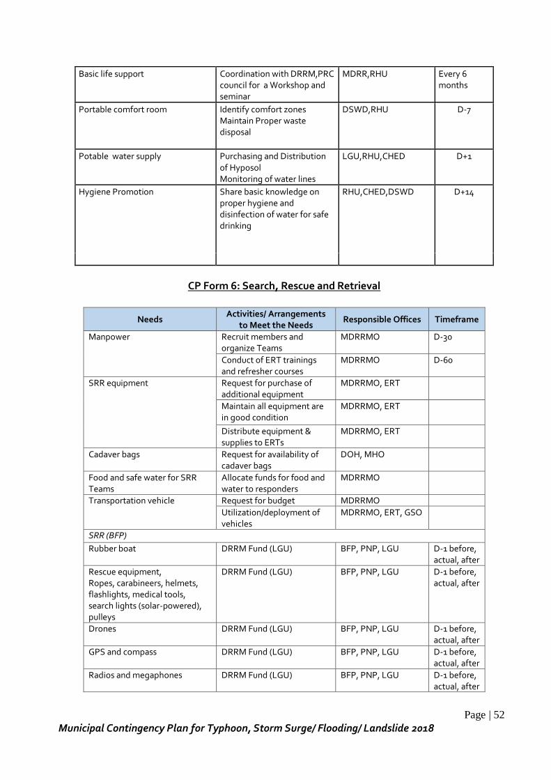
Page | 52
Municipal Contingency Plan for Typhoon, Storm Surge/ Flooding/ Landslide 2018
Basic life support Coordination with DRRM,PRC council for a Workshop and seminar
MDRR,RHU Every 6 months
Portable comfort room Identify comfort zones Maintain Proper waste disposal
DSWD,RHU D-7
Potable water supply Purchasing and Distribution of Hyposol Monitoring of water lines
LGU,RHU,CHED D+1
Hygiene Promotion Share basic knowledge on proper hygiene and disinfection of water for safe drinking
RHU,CHED,DSWD D+14
CP Form 6: Search, Rescue and Retrieval
Needs Activities/ Arrangements
to Meet the Needs Responsible Offices Timeframe
Manpower Recruit members and organize Teams
MDRRMO D-30
Conduct of ERT trainings and refresher courses
MDRRMO D-60
SRR equipment
Request for purchase of additional equipment
MDRRMO, ERT
Maintain all equipment are in good condition
MDRRMO, ERT
Distribute equipment & supplies to ERTs
MDRRMO, ERT
Cadaver bags Request for availability of cadaver bags
DOH, MHO
Food and safe water for SRR Teams
Allocate funds for food and water to responders
MDRRMO
Transportation vehicle Request for budget MDRRMO
Utilization/deployment of vehicles
MDRRMO, ERT, GSO
SRR (BFP)
Rubber boat DRRM Fund (LGU) BFP, PNP, LGU D-1 before, actual, after
Rescue equipment, Ropes, carabineers, helmets, flashlights, medical tools, search lights (solar-powered), pulleys
DRRM Fund (LGU) BFP, PNP, LGU D-1 before, actual, after
Drones DRRM Fund (LGU) BFP, PNP, LGU D-1 before, actual, after
GPS and compass DRRM Fund (LGU) BFP, PNP, LGU D-1 before, actual, after
Radios and megaphones DRRM Fund (LGU) BFP, PNP, LGU D-1 before, actual, after
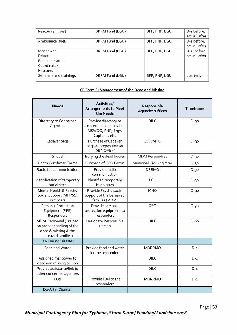
Page | 53
Municipal Contingency Plan for Typhoon, Storm Surge/ Flooding/ Landslide 2018
Rescue van (fuel) DRRM Fund (LGU) BFP, PNP, LGU D-1 before, actual, after
Ambulance (fuel) DRRM Fund (LGU) BFP, PNP, LGU D-1 before, actual, after
Manpower Driver Radio operator Coordinator Rescuers
DRRM Fund (LGU) BFP, PNP, LGU D-1 before, actual, after
Seminars and trainings DRRM Fund (LGU) BFP, PNP, LGU quarterly
CP Form 6: Management of the Dead and Missing
Needs
Activities/ Arrangements to Meet
the Needs
Responsible Agencies/Offices
Timeframe
Directory to Concerned Agencies
Provide directory to concerned agencies like
MSWDO, PNP, Brgy. Captains, etc.
DILG D-90
Cadaver bags Purchase of Cadaver bags & preposition @
DRR Office/
GSO/MHO D-90
Shovel Burying the dead bodies MDM Respondres D-30
Death Certificate Forms Purchase of COD Forms Municipal Civil Registrar D-30
Radio for communication Provide radio communication
DRRMO D-30
Identification of temporary burial sites
Identified temporary burial sites
LGU D-30
Mental Health & Psycho Social Support (MHPSS)
Providers
Provide Psycho social support of the bereaved
families (MDM)
MHO D-90
Personal Protection Equipment (PPE)
Responders
Provide personal protection equipment to
responders
GSO D-30
MDM Personnel (Trained on proper handling of the
dead & missing & the bereaved families)
Designate Responsible Person
DILG D-60
D1- During Disaster
Food and Water Provide food and water for the responders
MDRRMO D-1
Assigned manpower to dead and missing person
DILG D-1
Provide assistance/link to other concerned agencies
DILG D-1
Fuel
Provide Fuel to the responders
MDRRMO D-1
D2-After Disaster
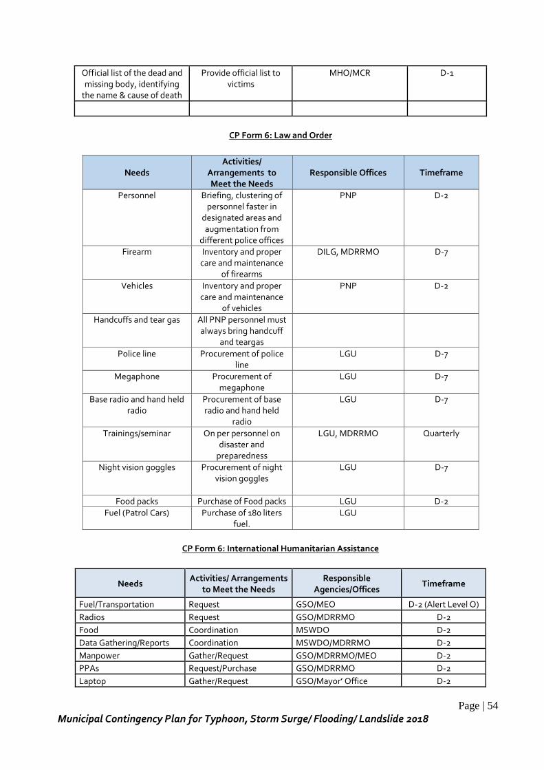
Page | 54
Municipal Contingency Plan for Typhoon, Storm Surge/ Flooding/ Landslide 2018
Official list of the dead and missing body, identifying
the name & cause of death
Provide official list to victims
MHO/MCR D-1
CP Form 6: Law and Order
Needs Activities/
Arrangements to Meet the Needs
Responsible Offices Timeframe
Personnel Briefing, clustering of personnel faster in
designated areas and augmentation from
different police offices
PNP D-2
Firearm Inventory and proper care and maintenance
of firearms
DILG, MDRRMO D-7
Vehicles Inventory and proper care and maintenance
of vehicles
PNP D-2
Handcuffs and tear gas All PNP personnel must always bring handcuff
and teargas
Police line Procurement of police line
LGU
D-7
Megaphone Procurement of megaphone
LGU
D-7
Base radio and hand held radio
Procurement of base radio and hand held
radio
LGU D-7
Trainings/seminar On per personnel on disaster and
preparedness
LGU, MDRRMO Quarterly
Night vision goggles Procurement of night vision goggles
LGU
D-7
Food packs Purchase of Food packs LGU D-2
Fuel (Patrol Cars) Purchase of 180 liters fuel.
LGU
CP Form 6: International Humanitarian Assistance
Needs Activities/ Arrangements
to Meet the Needs Responsible
Agencies/Offices Timeframe
Fuel/Transportation Request GSO/MEO D-2 (Alert Level O)
Radios Request GSO/MDRRMO D-2
Food Coordination MSWDO D-2
Data Gathering/Reports Coordination MSWDO/MDRRMO D-2
Manpower Gather/Request GSO/MDRRMO/MEO D-2
PPAs Request/Purchase GSO/MDRRMO D-2
Laptop Gather/Request GSO/Mayor’ Office D-2

Page | 55
Municipal Contingency Plan for Typhoon, Storm Surge/ Flooding/ Landslide 2018
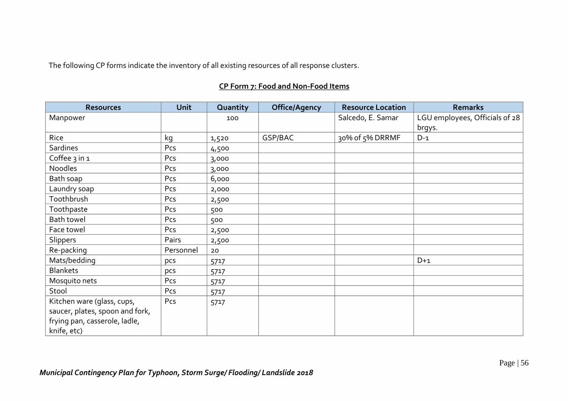
Page | 56
Municipal Contingency Plan for Typhoon, Storm Surge/ Flooding/ Landslide 2018
The following CP forms indicate the inventory of all existing resources of all response clusters.
CP Form 7: Food and Non-Food Items
Resources Unit Quantity Office/Agency Resource Location Remarks
Manpower 100 Salcedo, E. Samar LGU employees, Officials of 28 brgys.
Rice kg 1,520 GSP/BAC 30% of 5% DRRMF D-1 Sardines Pcs 4,500
Coffee 3 in 1 Pcs 3,000
Noodles Pcs 3,000
Bath soap Pcs 6,000
Laundry soap Pcs 2,000
Toothbrush Pcs 2,500
Toothpaste Pcs 500
Bath towel Pcs 500 Face towel Pcs 2,500
Slippers Pairs 2,500
Re-packing Personnel 20
Mats/bedding pcs 5717 D+1 Blankets pcs 5717
Mosquito nets Pcs 5717
Stool Pcs 5717
Kitchen ware (glass, cups, saucer, plates, spoon and fork, frying pan, casserole, ladle, knife, etc)
Pcs 5717
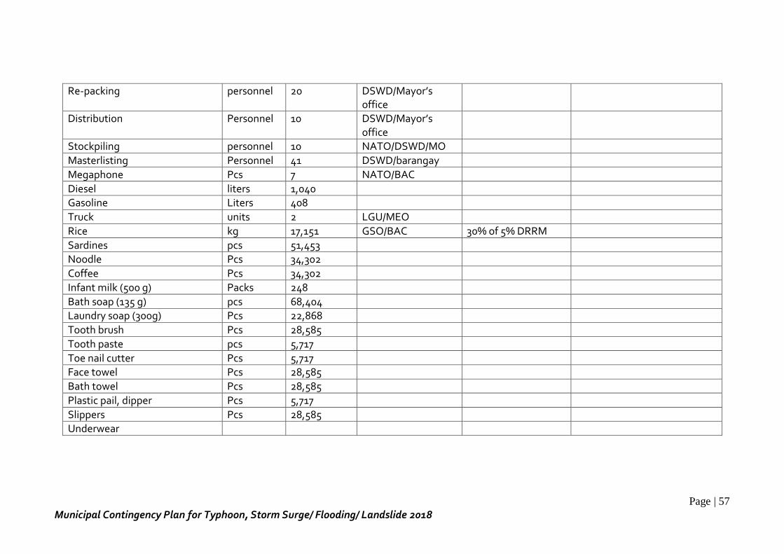
Page | 57
Municipal Contingency Plan for Typhoon, Storm Surge/ Flooding/ Landslide 2018
Re-packing personnel 20 DSWD/Mayor’s office
Distribution Personnel 10 DSWD/Mayor’s office
Stockpiling personnel 10 NATO/DSWD/MO
Masterlisting Personnel 41 DSWD/barangay
Megaphone Pcs 7 NATO/BAC
Diesel liters 1,040 Gasoline Liters 408
Truck units 2 LGU/MEO
Rice kg 17,151 GSO/BAC 30% of 5% DRRM
Sardines pcs 51,453
Noodle Pcs 34,302
Coffee Pcs 34,302
Infant milk (500 g) Packs 248
Bath soap (135 g) pcs 68,404 Laundry soap (300g) Pcs 22,868
Tooth brush Pcs 28,585
Tooth paste pcs 5,717
Toe nail cutter Pcs 5,717 Face towel Pcs 28,585
Bath towel Pcs 28,585
Plastic pail, dipper Pcs 5,717
Slippers Pcs 28,585 Underwear
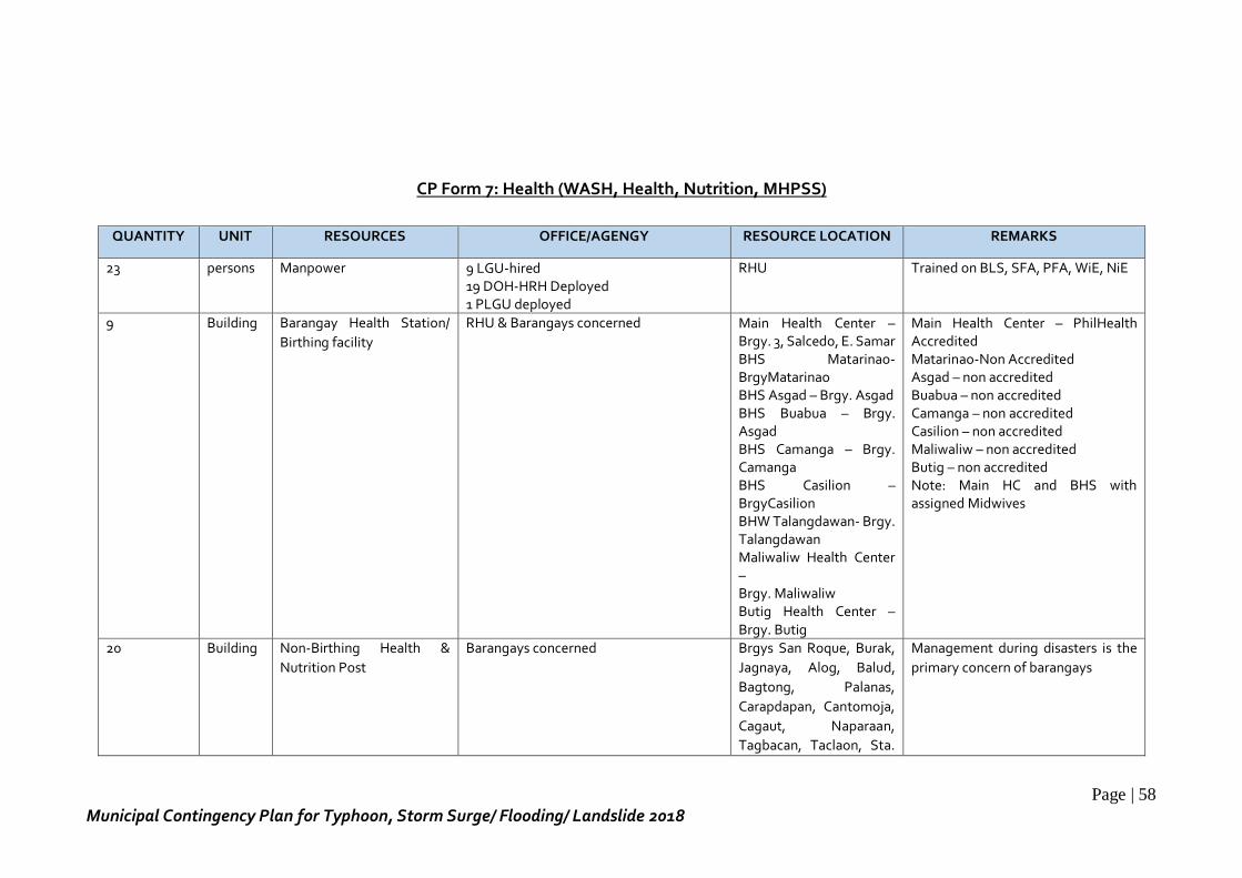
Page | 58
Municipal Contingency Plan for Typhoon, Storm Surge/ Flooding/ Landslide 2018
CP Form 7: Health (WASH, Health, Nutrition, MHPSS)
QUANTITY UNIT RESOURCES OFFICE/AGENGY RESOURCE LOCATION REMARKS
23 persons Manpower 9 LGU-hired 19 DOH-HRH Deployed 1 PLGU deployed
RHU Trained on BLS, SFA, PFA, WiE, NiE
9 Building Barangay Health Station/
Birthing facility
RHU & Barangays concerned Main Health Center – Brgy. 3, Salcedo, E. Samar BHS Matarinao- BrgyMatarinao BHS Asgad – Brgy. Asgad BHS Buabua – Brgy. Asgad BHS Camanga – Brgy. Camanga BHS Casilion – BrgyCasilion BHW Talangdawan- Brgy. Talangdawan Maliwaliw Health Center – Brgy. Maliwaliw Butig Health Center – Brgy. Butig
Main Health Center – PhilHealth Accredited Matarinao-Non Accredited Asgad – non accredited Buabua – non accredited Camanga – non accredited Casilion – non accredited Maliwaliw – non accredited Butig – non accredited Note: Main HC and BHS with assigned Midwives
20 Building Non-Birthing Health &
Nutrition Post
Barangays concerned Brgys San Roque, Burak,
Jagnaya, Alog, Balud,
Bagtong, Palanas,
Carapdapan, Cantomoja,
Cagaut, Naparaan,
Tagbacan, Taclaon, Sta.
Management during disasters is the
primary concern of barangays
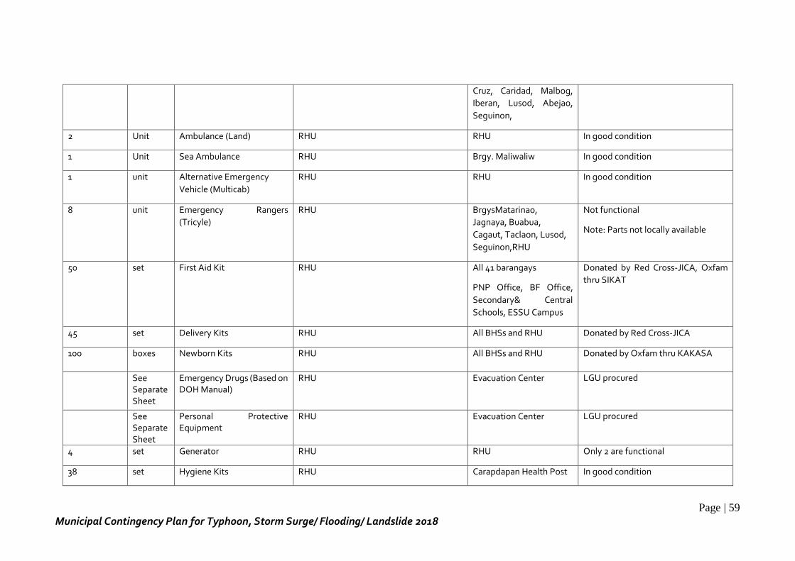
Page | 59
Municipal Contingency Plan for Typhoon, Storm Surge/ Flooding/ Landslide 2018
Cruz, Caridad, Malbog,
Iberan, Lusod, Abejao,
Seguinon,
2 Unit Ambulance (Land) RHU RHU In good condition
1 Unit Sea Ambulance RHU Brgy. Maliwaliw In good condition
1 unit Alternative Emergency
Vehicle (Multicab)
RHU RHU In good condition
8 unit Emergency Rangers
(Tricyle)
RHU BrgysMatarinao,
Jagnaya, Buabua,
Cagaut, Taclaon, Lusod,
Seguinon,RHU
Not functional
Note: Parts not locally available
50 set First Aid Kit RHU All 41 barangays
PNP Office, BF Office,
Secondary& Central
Schools, ESSU Campus
Donated by Red Cross-JICA, Oxfam
thru SIKAT
45 set Delivery Kits RHU All BHSs and RHU Donated by Red Cross-JICA
100 boxes Newborn Kits RHU All BHSs and RHU Donated by Oxfam thru KAKASA
See Separate Sheet
Emergency Drugs (Based on DOH Manual)
RHU Evacuation Center LGU procured
See Separate Sheet
Personal Protective Equipment
RHU Evacuation Center LGU procured
4 set Generator RHU RHU Only 2 are functional
38 set Hygiene Kits RHU Carapdapan Health Post In good condition
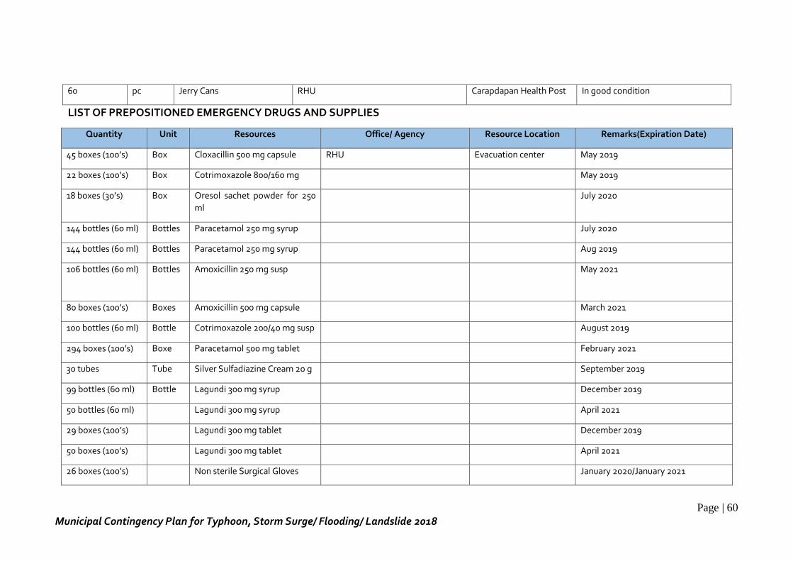
Page | 60
Municipal Contingency Plan for Typhoon, Storm Surge/ Flooding/ Landslide 2018
LIST OF PREPOSITIONED EMERGENCY DRUGS AND SUPPLIES
Quantity Unit Resources Office/ Agency Resource Location Remarks(Expiration Date)
45 boxes (100’s) Box Cloxacillin 500 mg capsule RHU Evacuation center May 2019
22 boxes (100’s) Box Cotrimoxazole 800/160 mg May 2019
18 boxes (30’s) Box Oresol sachet powder for 250
ml
July 2020
144 bottles (60 ml) Bottles Paracetamol 250 mg syrup July 2020
144 bottles (60 ml) Bottles Paracetamol 250 mg syrup Aug 2019
106 bottles (60 ml) Bottles Amoxicillin 250 mg susp May 2021
80 boxes (100’s) Boxes Amoxicillin 500 mg capsule March 2021
100 bottles (60 ml) Bottle Cotrimoxazole 200/40 mg susp August 2019
294 boxes (100’s) Boxe Paracetamol 500 mg tablet February 2021
30 tubes Tube Silver Sulfadiazine Cream 20 g September 2019
99 bottles (60 ml) Bottle Lagundi 300 mg syrup December 2019
50 bottles (60 ml) Lagundi 300 mg syrup April 2021
29 boxes (100’s) Lagundi 300 mg tablet December 2019
50 boxes (100’s) Lagundi 300 mg tablet April 2021
26 boxes (100’s) Non sterile Surgical Gloves January 2020/January 2021
60 pc Jerry Cans RHU Carapdapan Health Post In good condition
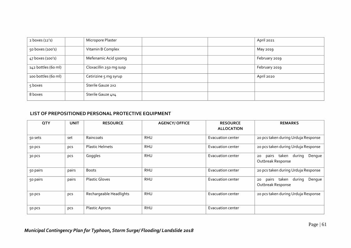
Page | 61
Municipal Contingency Plan for Typhoon, Storm Surge/ Flooding/ Landslide 2018
2 boxes (12’s) Micropore Plaster April 2021
50 boxes (100’s) Vitamin B Complex May 2019
47 boxes (100’s) Mefenamic Acid 500mg February 2019
142 bottles (60 ml) Cloxacillin 250 mg susp February 2019
100 bottles (60 ml) Cetirizine 5 mg syrup April 2020
5 boxes Sterile Gauze 2x2
8 boxes Sterile Gauze 4x4
LIST OF PREPOSITIONED PERSONAL PROTECTIVE EQUIPMENT
QTY UNIT RESOURCE AGENCY/ OFFICE RESOURCE
ALLOCATION
REMARKS
50 sets set Raincoats RHU Evacuation center 20 pcs taken during Urduja Response
50 pcs pcs Plastic Helmets RHU Evacuation center 20 pcs taken during Urduja Response
30 pcs pcs Goggles RHU Evacuation center 20 pairs taken during Dengue
Outbreak Response
50 pairs pairs Boots RHU Evacuation center 20 pcs taken during Urduja Response
50 pairs pairs Plastic Gloves RHU Evacuation center 20 pairs taken during Dengue
Outbreak Response
50 pcs pcs Rechargeable Headlights RHU Evacuation center 20 pcs taken during Urduja Response
50 pcs pcs Plastic Aprons RHU Evacuation center
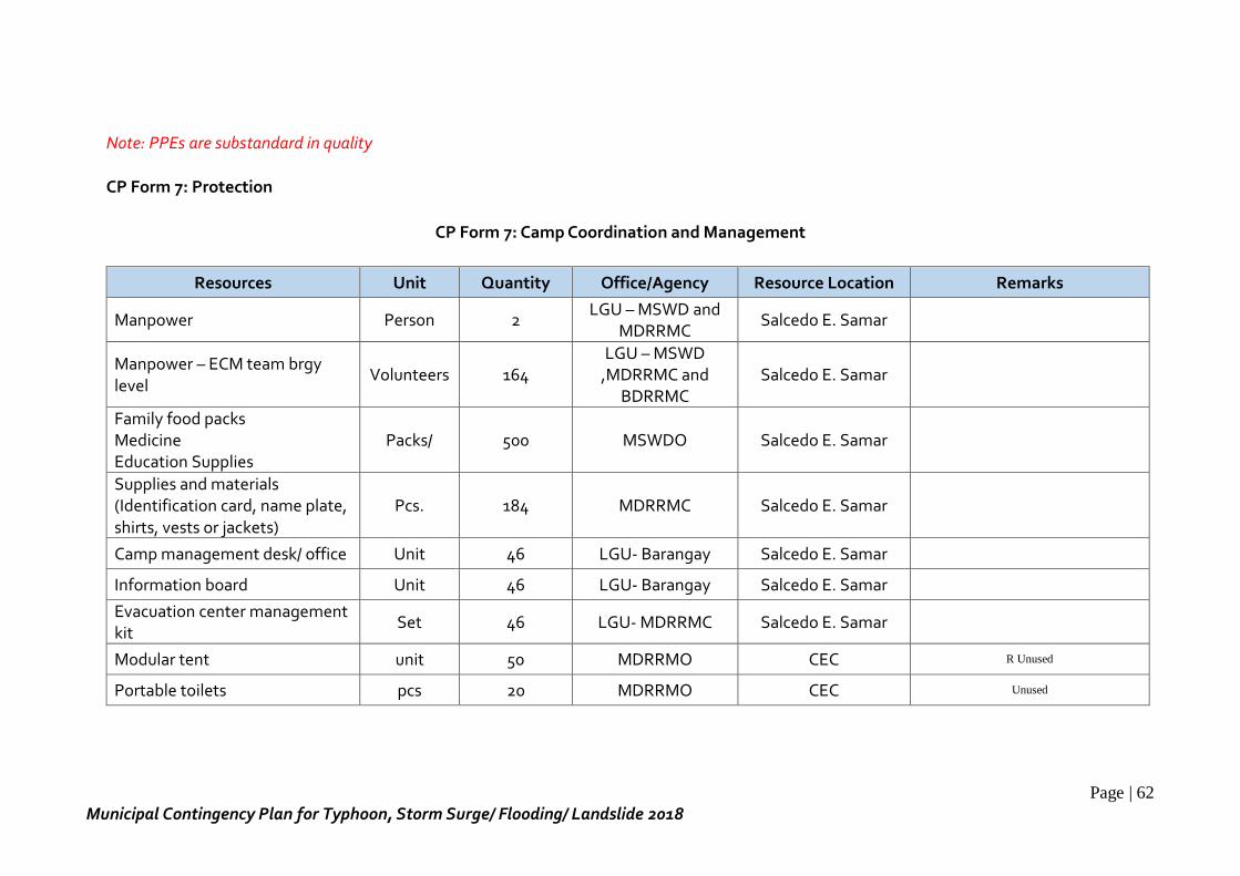
Page | 62
Municipal Contingency Plan for Typhoon, Storm Surge/ Flooding/ Landslide 2018
Note: PPEs are substandard in quality
CP Form 7: Protection
CP Form 7: Camp Coordination and Management
Resources Unit Quantity Office/Agency Resource Location Remarks
Manpower Person 2 LGU – MSWD and
MDRRMC Salcedo E. Samar
Manpower – ECM team brgy level
Volunteers 164 LGU – MSWD
,MDRRMC and BDRRMC
Salcedo E. Samar
Family food packs Medicine Education Supplies
Packs/ 500 MSWDO Salcedo E. Samar
Supplies and materials (Identification card, name plate, shirts, vests or jackets)
Pcs. 184 MDRRMC Salcedo E. Samar
Camp management desk/ office Unit 46 LGU- Barangay Salcedo E. Samar
Information board Unit 46 LGU- Barangay Salcedo E. Samar
Evacuation center management kit
Set 46 LGU- MDRRMC Salcedo E. Samar
Modular tent unit 50 MDRRMO CEC R Unused
Portable toilets pcs 20 MDRRMO CEC Unused
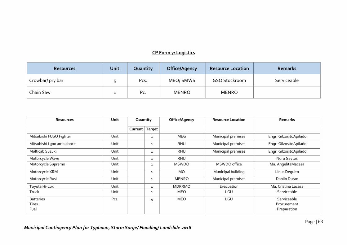
Page | 63
Municipal Contingency Plan for Typhoon, Storm Surge/ Flooding/ Landslide 2018
CP Form 7: Logistics
Resources Unit Quantity Office/Agency Resource Location Remarks
Crowbar/ pry bar 5 Pcs. MEO/ SMWS GSO Stockroom Serviceable
Chain Saw 1 Pc. MENRO MENRO
Resources Unit Quantity Office/Agency Resource Location Remarks
Current Target
Mitsubishi FUSO Fighter Unit 1 MEG Municipal premises Engr. GilzositoApilado
Mitsubishi L300 ambulance Unit 1 RHU Municipal premises Engr. GilzositoApilado
Multicab Suzuki Unit 1 RHU Municipal premises Engr. GilzositoApilado
Motorcycle Wave Unit 1 RHU Nora Gaytos
Motorcycle Supremo Unit 1 MSWDO MSWDO office Ma. AngelitaMacasa
Motorcycle XRM Unit 1 MO Municipal building Linus Deguito
Motorcycle Rusi Unit 1 MENRO Municipal premises Danilo Duran
Toyota Hi-Lux Unit 1 MDRRMO Evacuation Ma. Cristina Lacasa
Truck Unit 1 MEO LGU Serviceable
Batteries Tires Fuel
Pcs. 4 MEO
LGU Serviceable Procurement Preparation
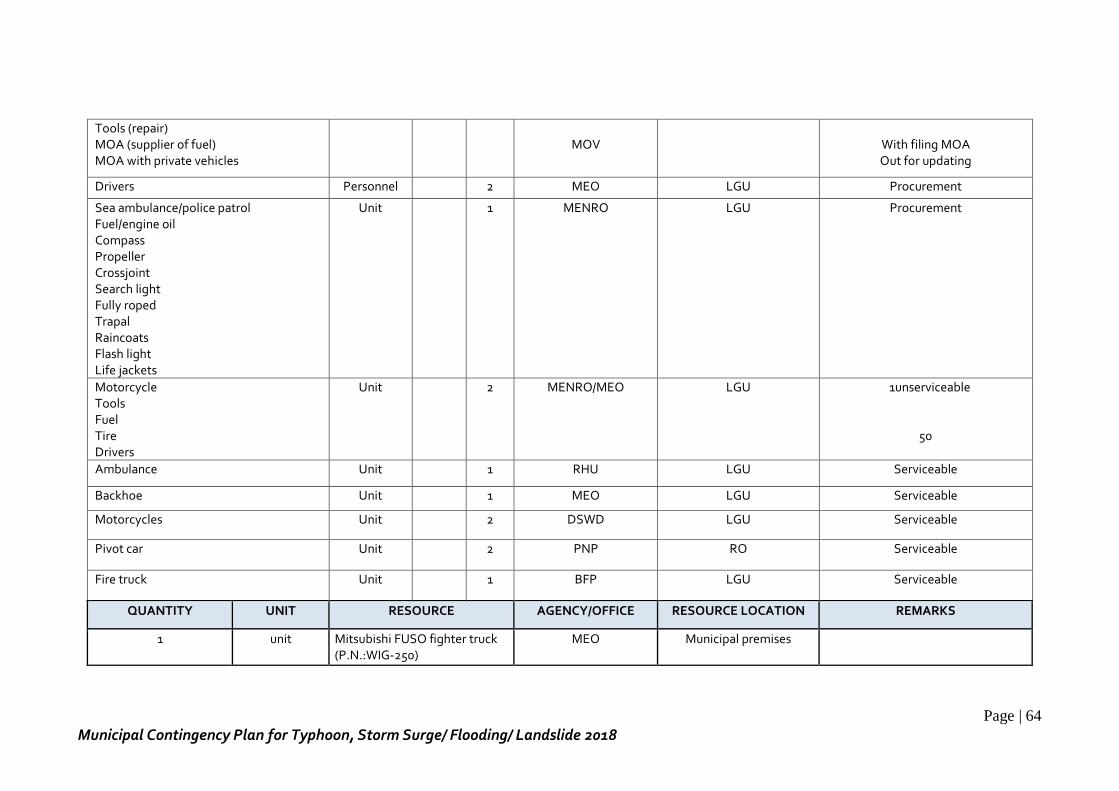
Page | 64
Municipal Contingency Plan for Typhoon, Storm Surge/ Flooding/ Landslide 2018
Tools (repair) MOA (supplier of fuel) MOA with private vehicles
MOV
With filing MOA Out for updating
Drivers Personnel 2 MEO LGU Procurement
Sea ambulance/police patrol Fuel/engine oil Compass Propeller Crossjoint Search light Fully roped Trapal Raincoats Flash light Life jackets
Unit 1 MENRO LGU Procurement
Motorcycle Tools Fuel Tire Drivers
Unit 2 MENRO/MEO LGU 1unserviceable
50
Ambulance Unit 1 RHU LGU Serviceable
Backhoe Unit 1 MEO LGU Serviceable
Motorcycles Unit 2 DSWD LGU Serviceable
Pivot car Unit 2 PNP RO Serviceable
Fire truck Unit 1 BFP LGU Serviceable
QUANTITY UNIT RESOURCE AGENCY/OFFICE RESOURCE LOCATION REMARKS
1 unit Mitsubishi FUSO fighter truck (P.N.:WIG-250)
MEO Municipal premises
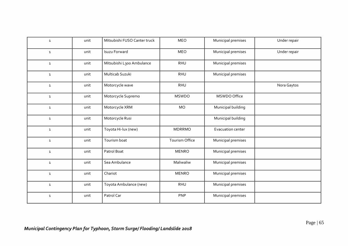
Page | 65
Municipal Contingency Plan for Typhoon, Storm Surge/ Flooding/ Landslide 2018
1 unit Mitsubishi FUSO Canter truck MEO Municipal premises Under repair
1 unit Isuzu Forward MEO Municipal premises Under repair
1 unit Mitsubishi L300 Ambulance RHU Municipal premises
1 unit Multicab Suzuki RHU Municipal premises
1 unit Motorcycle wave RHU Nora Gaytos
1 unit Motorcycle Supremo MSWDO MSWDO Office
1 unit Motorcycle XRM MO Municipal building
1 unit Motorcycle Rusi Municipal building
1 unit Toyota Hi-lux (new) MDRRMO Evacuation center
1 unit Tourism boat Tourism Office Municipal premises
1 unit Patrol Boat MENRO Municipal premises
1 unit Sea Ambulance Maliwaliw Municipal premises
1 unit Chariot MENRO Municipal premises
1 unit Toyota Ambulance (new) RHU Municipal premises
1 unit Patrol Car PNP Municipal premises
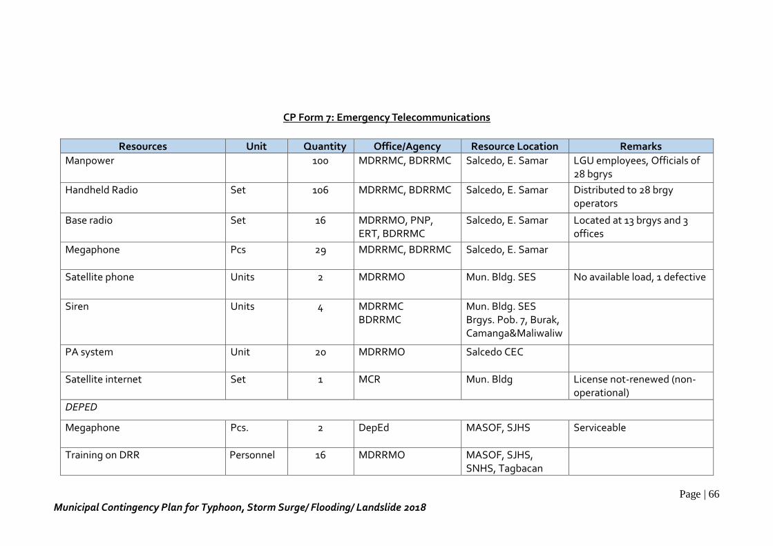
Page | 66
Municipal Contingency Plan for Typhoon, Storm Surge/ Flooding/ Landslide 2018
CP Form 7: Emergency Telecommunications
Resources Unit Quantity Office/Agency Resource Location Remarks
Manpower 100 MDRRMC, BDRRMC Salcedo, E. Samar LGU employees, Officials of 28 bgrys
Handheld Radio Set 106 MDRRMC, BDRRMC Salcedo, E. Samar Distributed to 28 brgy operators
Base radio Set 16 MDRRMO, PNP, ERT, BDRRMC
Salcedo, E. Samar Located at 13 brgys and 3 offices
Megaphone Pcs 29 MDRRMC, BDRRMC Salcedo, E. Samar
Satellite phone Units 2 MDRRMO Mun. Bldg. SES No available load, 1 defective
Siren Units 4 MDRRMC BDRRMC
Mun. Bldg. SES Brgys. Pob. 7, Burak, Camanga&Maliwaliw
PA system Unit 20 MDRRMO Salcedo CEC
Satellite internet Set 1 MCR Mun. Bldg License not-renewed (non-operational)
DEPED
Megaphone Pcs. 2 DepEd MASOF, SJHS
Serviceable
Training on DRR Personnel 16 MDRRMO MASOF, SJHS, SNHS, Tagbacan
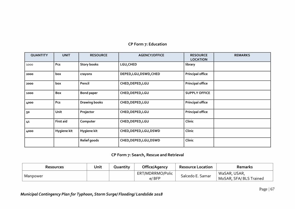
Page | 67
Municipal Contingency Plan for Typhoon, Storm Surge/ Flooding/ Landslide 2018
CP Form 7: Education
QUANTITY UNIT RESOURCE AGENCY/OFFICE RESOURCE LOCATION
REMARKS
1000 Pcs Story books LGU,CHED library
2000 box crayons DEPED,LGU,DSWD,CHED Principal office
2000 box Pencil CHED,DEPED,LGU Principal office
1000 Box Bond paper CHED,DEPED,LGU SUPPLY OFFICE
4000 Pcs Drawing books CHED,DEPED,LGU Principal office
50 Unit Projector CHED,DEPED,LGU Principal office
41 First aid Computer CHED,DEPED,LGU Clinic
4000 Hygiene kit Hygiene kit CHED,DEPED,LGU,DSWD Clinic
Relief goods CHED,DEPED,LGU,DSWD Clinic
CP Form 7: Search, Rescue and Retrieval
Resources Unit Quantity Office/Agency Resource Location Remarks
Manpower ERT/MDRRMO/Polic
e/ BFP Salcedo E. Samar
WaSAR, USAR, MoSAR, SFA/ BLS Trained
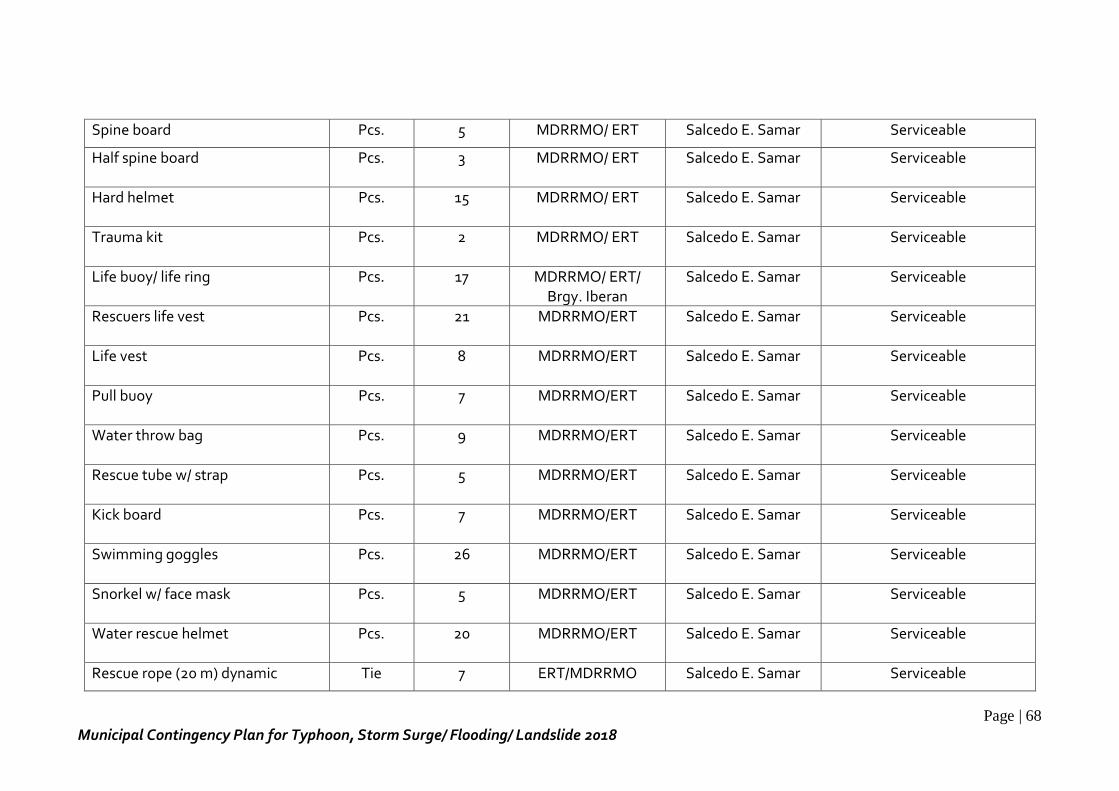
Page | 68
Municipal Contingency Plan for Typhoon, Storm Surge/ Flooding/ Landslide 2018
Spine board Pcs. 5 MDRRMO/ ERT Salcedo E. Samar Serviceable
Half spine board Pcs. 3 MDRRMO/ ERT Salcedo E. Samar Serviceable
Hard helmet Pcs. 15 MDRRMO/ ERT Salcedo E. Samar Serviceable
Trauma kit Pcs. 2 MDRRMO/ ERT Salcedo E. Samar Serviceable
Life buoy/ life ring Pcs. 17 MDRRMO/ ERT/ Brgy. Iberan
Salcedo E. Samar Serviceable
Rescuers life vest Pcs. 21 MDRRMO/ERT Salcedo E. Samar Serviceable
Life vest Pcs. 8 MDRRMO/ERT Salcedo E. Samar Serviceable
Pull buoy Pcs. 7 MDRRMO/ERT Salcedo E. Samar Serviceable
Water throw bag Pcs. 9 MDRRMO/ERT Salcedo E. Samar Serviceable
Rescue tube w/ strap Pcs. 5 MDRRMO/ERT Salcedo E. Samar Serviceable
Kick board Pcs. 7 MDRRMO/ERT Salcedo E. Samar Serviceable
Swimming goggles Pcs. 26 MDRRMO/ERT Salcedo E. Samar Serviceable
Snorkel w/ face mask Pcs. 5 MDRRMO/ERT Salcedo E. Samar Serviceable
Water rescue helmet Pcs. 20 MDRRMO/ERT Salcedo E. Samar Serviceable
Rescue rope (20 m) dynamic Tie 7 ERT/MDRRMO Salcedo E. Samar Serviceable
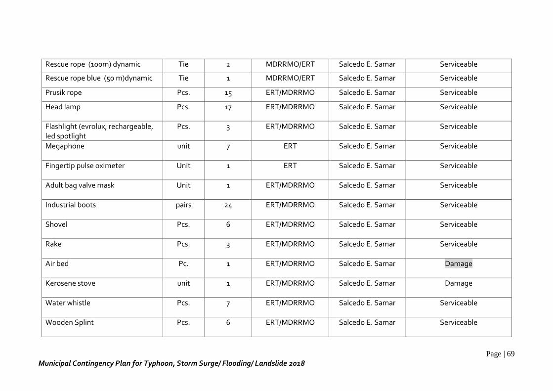
Page | 69
Municipal Contingency Plan for Typhoon, Storm Surge/ Flooding/ Landslide 2018
Rescue rope (100m) dynamic Tie 2 MDRRMO/ERT Salcedo E. Samar Serviceable
Rescue rope blue (50 m)dynamic Tie 1 MDRRMO/ERT Salcedo E. Samar Serviceable
Prusik rope Pcs. 15 ERT/MDRRMO Salcedo E. Samar Serviceable
Head lamp Pcs. 17 ERT/MDRRMO Salcedo E. Samar Serviceable
Flashlight (evrolux, rechargeable, led spotlight
Pcs. 3 ERT/MDRRMO Salcedo E. Samar Serviceable
Megaphone unit 7 ERT Salcedo E. Samar Serviceable
Fingertip pulse oximeter Unit 1 ERT Salcedo E. Samar Serviceable
Adult bag valve mask Unit 1 ERT/MDRRMO Salcedo E. Samar Serviceable
Industrial boots pairs 24 ERT/MDRRMO Salcedo E. Samar Serviceable
Shovel Pcs. 6 ERT/MDRRMO Salcedo E. Samar Serviceable
Rake Pcs. 3 ERT/MDRRMO Salcedo E. Samar Serviceable
Air bed Pc. 1 ERT/MDRRMO Salcedo E. Samar Damage
Kerosene stove unit 1 ERT/MDRRMO Salcedo E. Samar Damage
Water whistle Pcs. 7 ERT/MDRRMO Salcedo E. Samar Serviceable
Wooden Splint Pcs. 6 ERT/MDRRMO Salcedo E. Samar Serviceable
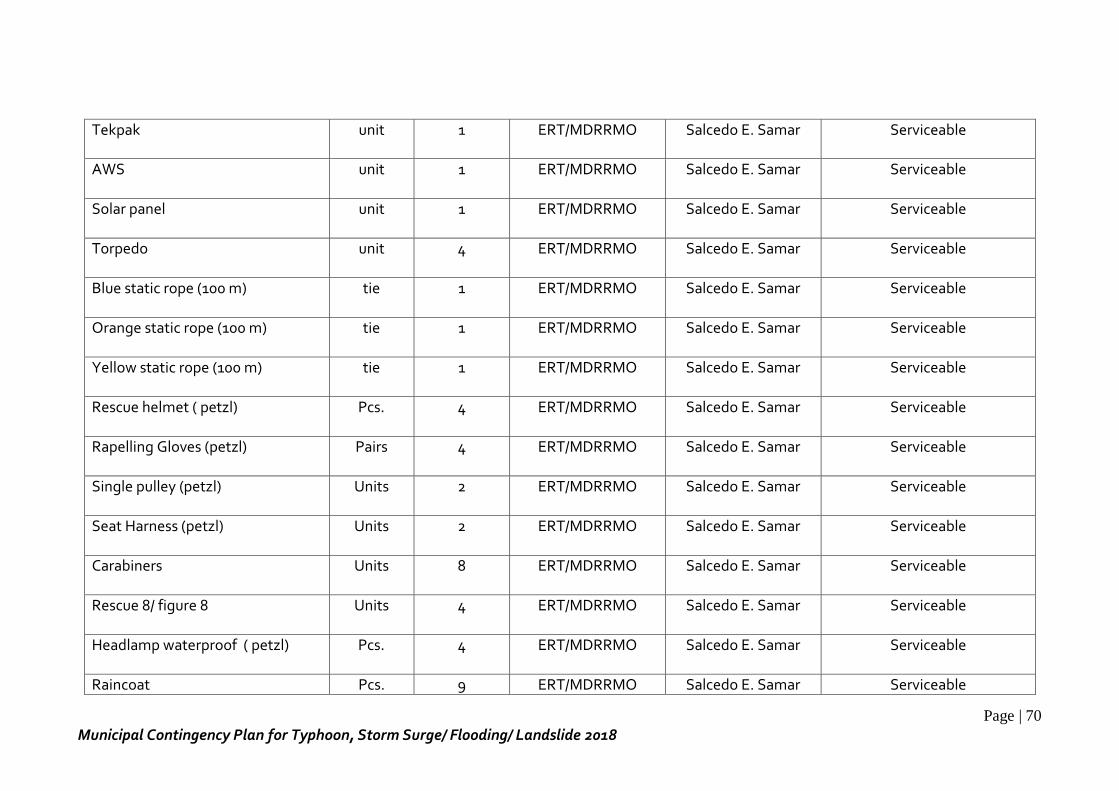
Page | 70
Municipal Contingency Plan for Typhoon, Storm Surge/ Flooding/ Landslide 2018
Tekpak unit 1 ERT/MDRRMO Salcedo E. Samar Serviceable
AWS unit 1 ERT/MDRRMO Salcedo E. Samar Serviceable
Solar panel unit 1 ERT/MDRRMO Salcedo E. Samar Serviceable
Torpedo unit 4 ERT/MDRRMO Salcedo E. Samar Serviceable
Blue static rope (100 m) tie 1 ERT/MDRRMO Salcedo E. Samar Serviceable
Orange static rope (100 m) tie 1 ERT/MDRRMO Salcedo E. Samar Serviceable
Yellow static rope (100 m) tie 1 ERT/MDRRMO Salcedo E. Samar Serviceable
Rescue helmet ( petzl) Pcs. 4 ERT/MDRRMO Salcedo E. Samar Serviceable
Rapelling Gloves (petzl) Pairs 4 ERT/MDRRMO Salcedo E. Samar Serviceable
Single pulley (petzl) Units 2 ERT/MDRRMO Salcedo E. Samar Serviceable
Seat Harness (petzl) Units 2 ERT/MDRRMO Salcedo E. Samar Serviceable
Carabiners Units 8 ERT/MDRRMO Salcedo E. Samar Serviceable
Rescue 8/ figure 8 Units 4 ERT/MDRRMO Salcedo E. Samar Serviceable
Headlamp waterproof ( petzl) Pcs. 4 ERT/MDRRMO Salcedo E. Samar Serviceable
Raincoat Pcs. 9 ERT/MDRRMO Salcedo E. Samar Serviceable

Page | 71
Municipal Contingency Plan for Typhoon, Storm Surge/ Flooding/ Landslide 2018
Tent ( 3x3) Units 2 ERT/MDRRMO Salcedo E. Samar Damage
Tent ( 2x2) blue Unit 1 ERT/MDRRMO Salcedo E. Samar Serviceable
Ladder Unit 1 ERT/MDRRMO Salcedo E. Samar Serviceable
Grinder Unit 1 ERT/MDRRMO Salcedo E. Samar Serviceable
Crowbar Pcs. 3 ERT/MDRRMO Salcedo E. Samar Serviceable
Safety googles Pcs. 25 ERT/MDRRMO Salcedo E. Samar Serviceable
Head lamp (Rechargeable) Pcs. 5 ERT/MDRRMO Salcedo E. Samar Serviceable
Caution tape yellow Pcs. 3 ERT/MDRRMO Salcedo E. Samar Serviceable
Danger tape red Pcs. 3 ERT/MDRRMO Salcedo E. Samar Serviceable
Fire extinguisher Unit 3 MDRRMO/ERT Salcedo E. Samar Serviceable
Hand operated siren Pc. 1 ERT/MDRRMO Salcedo E. Samar Serviceable
Reflectorized vests Pcs. 50 ERT/MDRRMO Salcedo E. Samar Serviceable
Caution/ Danger tape Rolls 10 MDRRMO/ERT Salcedo E. Samar Serviceable
Retractable safety cone Units 4 MDRRMO/ERT Salcedo E. Samar Serviceable
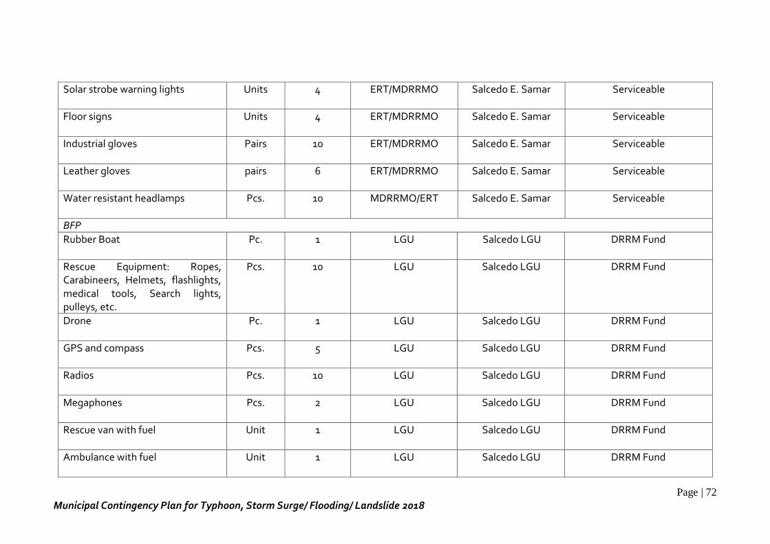
Page | 72
Municipal Contingency Plan for Typhoon, Storm Surge/ Flooding/ Landslide 2018
Solar strobe warning lights Units 4 ERT/MDRRMO Salcedo E. Samar Serviceable
Floor signs Units 4 ERT/MDRRMO Salcedo E. Samar Serviceable
Industrial gloves Pairs 10 ERT/MDRRMO Salcedo E. Samar Serviceable
Leather gloves pairs 6 ERT/MDRRMO Salcedo E. Samar Serviceable
Water resistant headlamps Pcs. 10 MDRRMO/ERT Salcedo E. Samar Serviceable
BFP
Rubber Boat Pc. 1 LGU Salcedo LGU DRRM Fund
Rescue Equipment: Ropes, Carabineers, Helmets, flashlights, medical tools, Search lights, pulleys, etc.
Pcs. 10 LGU Salcedo LGU DRRM Fund
Drone Pc. 1 LGU Salcedo LGU DRRM Fund
GPS and compass Pcs. 5 LGU Salcedo LGU DRRM Fund
Radios Pcs. 10 LGU Salcedo LGU DRRM Fund
Megaphones Pcs. 2 LGU Salcedo LGU DRRM Fund
Rescue van with fuel Unit 1 LGU Salcedo LGU DRRM Fund
Ambulance with fuel Unit 1 LGU Salcedo LGU DRRM Fund
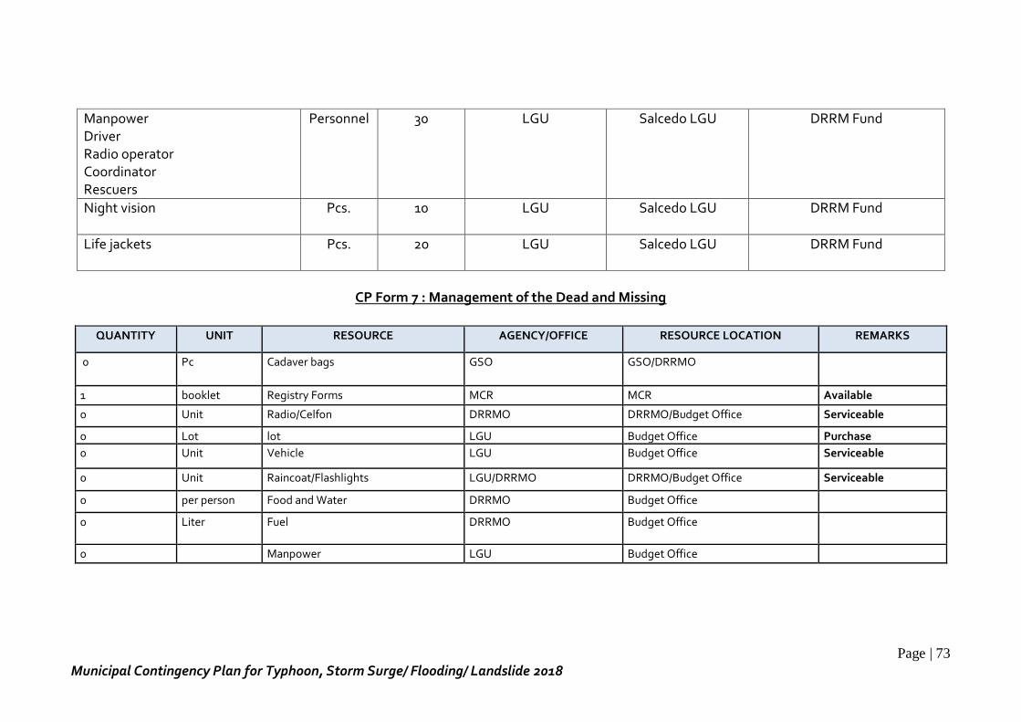
Page | 73
Municipal Contingency Plan for Typhoon, Storm Surge/ Flooding/ Landslide 2018
Manpower Driver Radio operator Coordinator Rescuers
Personnel 30 LGU Salcedo LGU DRRM Fund
Night vision Pcs. 10 LGU Salcedo LGU DRRM Fund
Life jackets Pcs. 20 LGU Salcedo LGU DRRM Fund
CP Form 7 : Management of the Dead and Missing
QUANTITY UNIT RESOURCE AGENCY/OFFICE RESOURCE LOCATION REMARKS
0 Pc Cadaver bags GSO GSO/DRRMO
1 booklet Registry Forms MCR MCR Available
0 Unit Radio/Celfon DRRMO DRRMO/Budget Office Serviceable
0 Lot lot LGU Budget Office Purchase
0 Unit Vehicle LGU Budget Office Serviceable
0 Unit Raincoat/Flashlights LGU/DRRMO DRRMO/Budget Office Serviceable
0 per person Food and Water DRRMO Budget Office
0 Liter Fuel
DRRMO Budget Office
0 Manpower LGU Budget Office
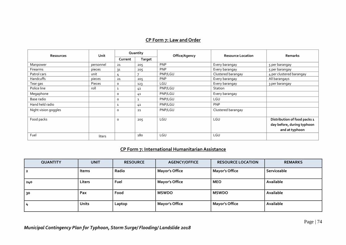
Page | 74
Municipal Contingency Plan for Typhoon, Storm Surge/ Flooding/ Landslide 2018
CP Form 7: Law and Order
Resources Unit Quantity
Office/Agency Resource Location Remarks Current Target
Manpower personnel 21 205 PNP Every barangay 5 per barangay
Firearms pieces 31 205 PNP Every barangay 5 per barangay
Patrol cars unit 4 7 PNP/LGU Clustered barangay 4 per clustered barangay
Handcuffs pieces 21 205 PNP Every barangay All barangays
Tear gas Pieces 0 123 LGU Every barangay 3 per barangay
Police line roll 1 41 PNP/LGU Station
Megaphone 0 41 PNP/LGU Every barangay
Base radio 0 1 PNP/LGU LGU
Hand held radio 1 41 PNP/LGU PNP
Night vision goggles
0 21 PNP/LGU Clustered barangay
Food packs
0 205 LGU LGU Distribution of food packs 1
day before, during typhoon
and at typhoon
Fuel liters 180 LGU LGU
CP Form 7: International Humanitarian Assistance
QUANTITY UNIT RESOURCE AGENCY/OFFICE RESOURCE LOCATION REMARKS
2 Items Radio Mayor’s Office Mayor’s Office Serviceable
240 Liters Fuel Mayor’s Office MEO Available
30 Pax Food MSWDO MSWDO Available
4 Units Laptop Mayor’s Office Mayor’s Office Available
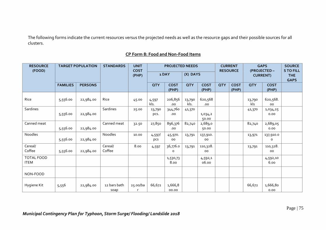
Page | 75
Municipal Contingency Plan for Typhoon, Storm Surge/ Flooding/ Landslide 2018
The following forms indicate the current resources versus the projected needs as well as the resource gaps and their possible sources for all clusters.
CP Form 8: Food and Non-Food Items
RESOURCE (FOOD)
TARGET POPULATION STANDARDS UNIT COST (PHP)
PROJECTED NEEDS CURRENT RESOURCE
GAPS (PROJECTED –
CURRENT)
SOURCES TO FILL
THE GAPS
1 DAY (X) DAYS
FAMILIES PERSONS QTY COST (PHP)
QTY COST (PHP)
QTY COST (PHP)
QTY COST (PHP)
Rice
5,556.00
22,984.00
Rice
45.00
4,597 kls.
206,856
.00
13,790
kls.
620,568
.00
13,790
kls
620,568.
00
Sardines 5,556.00
22,984.00
Sardines 25.00 13,790 pcs.
344,760.00
41,370 1,034,250.00
41,370 1,034,250.00
Canned meat 5,556.00
22,984.00
Canned meat 32.50 27,850 896,376.00
82,740 2,689,050.00
82,740 2,689,050.00
Noodles 5,556.00
22,984.00
Noodles 10.00 4,597/ pcs
45,970.00
13,791 137,910.00
13,971 137,910.00
Cereal/ Coffee
5,556.00
22,984.00
Cereal/ Coffee
8.00 4,597 36,776.00
13,791 110,328.00
13,791 110,328.00
TOTAL FOOD ITEM
1,530,738.00
4,592,106.00
4,592,106.00
NON-FOOD
Hygiene Kit
5,556
22,984.00
12 bars bath
soap
25.00/ba
r
66,672
1,666,800.00
66,672
1,666,80
0.00
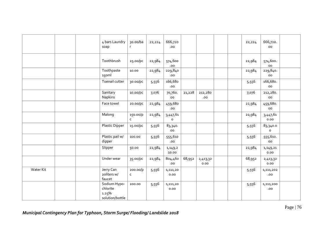
Page | 76
Municipal Contingency Plan for Typhoon, Storm Surge/ Flooding/ Landslide 2018
4 bars Laundry soap
30.00/bar
22,224
666,720
.00
22,224
666,720.
00
Toothbrush
25.00/pc
22,984
574,600
.00
22,984
574,600.
00
Toothpaste 150ml
10.00 22,984 229,840.00
22,984 229,840.00
Toenail cutter 30.00/pc 5,556 166,680.00
5,556 166,680.00
Sanitary Napkins
10.00/pc 7,076 70,760.00
21,228 212,280.00
7,076 212,280.00
Face towel 20.00/pc 22,984 459,680.00
22,984 459,680.00
Malong 150.00/pc
22,984 3,447,610
22,984 3,447,610.00
Plastic Dipper 15.00/pc 5,556 83,340.00
5,556 83,340.00
Plastic pail w/ dipper
100.00 5,556 555,610.00
5,556 555,610.00
Slipper 50.00 22,984 1,149,210.00
22,984 1,149,210.00
Under wear 35.00/pc 22,984 804,460.00
68,952 2,413,320.00
68,952 2,413,320.00
Water Kit Jerry Can 20liters w/ faucet
200.00/pc
5,556 1,111,200.00
5,556 1,111,202.00
Sodium Hypo- chlorite 1.25% solution/bottle
200.00 5,556 1,111,200.00
5,556 1,111,200.00
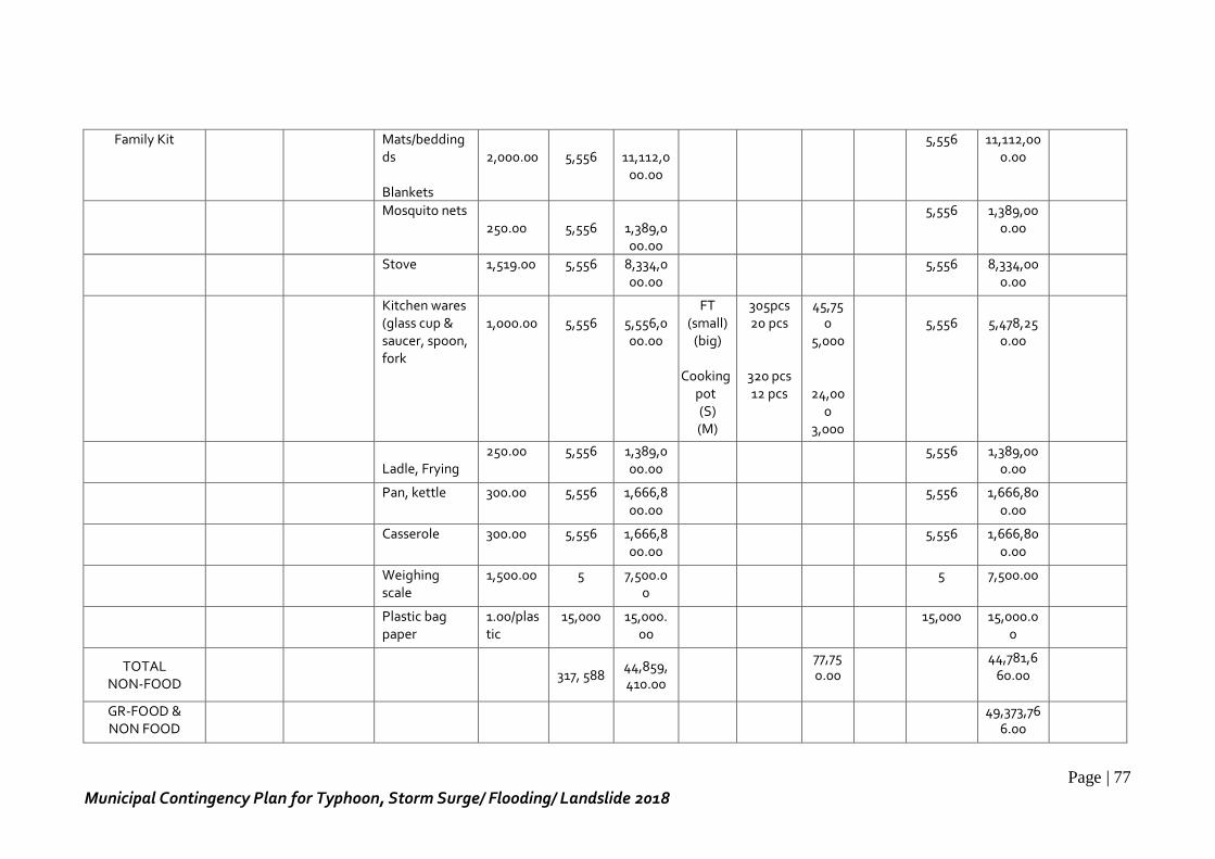
Page | 77
Municipal Contingency Plan for Typhoon, Storm Surge/ Flooding/ Landslide 2018
Family Kit Mats/beddingds Blankets
2,000.00
5,556
11,112,0
00.00
5,556 11,112,000.00
Mosquito nets 250.00
5,556
1,389,000.00
5,556 1,389,000.00
Stove 1,519.00 5,556 8,334,000.00
5,556 8,334,000.00
Kitchen wares (glass cup & saucer, spoon, fork
1,000.00
5,556
5,556,000.00
FT (small)
(big)
Cooking pot (S) (M)
305pcs 20 pcs
320 pcs 12 pcs
45,750
5,000
24,000
3,000
5,556
5,478,25
0.00
Ladle, Frying
250.00 5,556 1,389,000.00
5,556 1,389,000.00
Pan, kettle 300.00 5,556 1,666,800.00
5,556 1,666,800.00
Casserole 300.00 5,556 1,666,800.00
5,556 1,666,800.00
Weighing scale
1,500.00 5 7,500.00
5 7,500.00
Plastic bag paper
1.00/plastic
15,000 15,000.00
15,000 15,000.00
TOTAL NON-FOOD
317, 588
44,859,410.00
77,750.00
44,781,660.00
GR-FOOD & NON FOOD
49,373,766.00
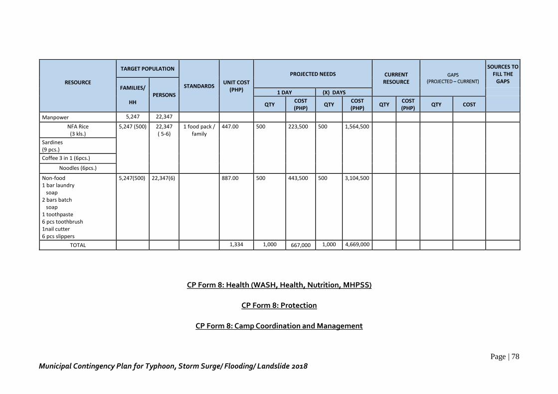
Page | 78
Municipal Contingency Plan for Typhoon, Storm Surge/ Flooding/ Landslide 2018
RESOURCE
TARGET POPULATION
STANDARDS UNIT COST
(PHP)
PROJECTED NEEDS CURRENT RESOURCE
GAPS (PROJECTED – CURRENT)
SOURCES TO FILL THE
GAPS FAMILIES/
HH
PERSONS 1 DAY (X) DAYS
QTY COST (PHP)
QTY COST (PHP)
QTY COST (PHP)
QTY COST
Manpower 5,247 22,347
NFA Rice (3 kls.)
5,247 (500) 22,347 ( 5-6)
1 food pack / family
447.00 500 223,500 500 1,564,500
Sardines (9 pcs.)
Coffee 3 in 1 (6pcs.)
Noodles (6pcs.)
Non-food 1 bar laundry soap 2 bars batch soap 1 toothpaste 6 pcs toothbrush 1nail cutter 6 pcs slippers
5,247(500) 22,347(6) 887.00 500 443,500 500 3,104,500
TOTAL 1,334 1,000 667,000 1,000 4,669,000
CP Form 8: Health (WASH, Health, Nutrition, MHPSS)
CP Form 8: Protection
CP Form 8: Camp Coordination and Management
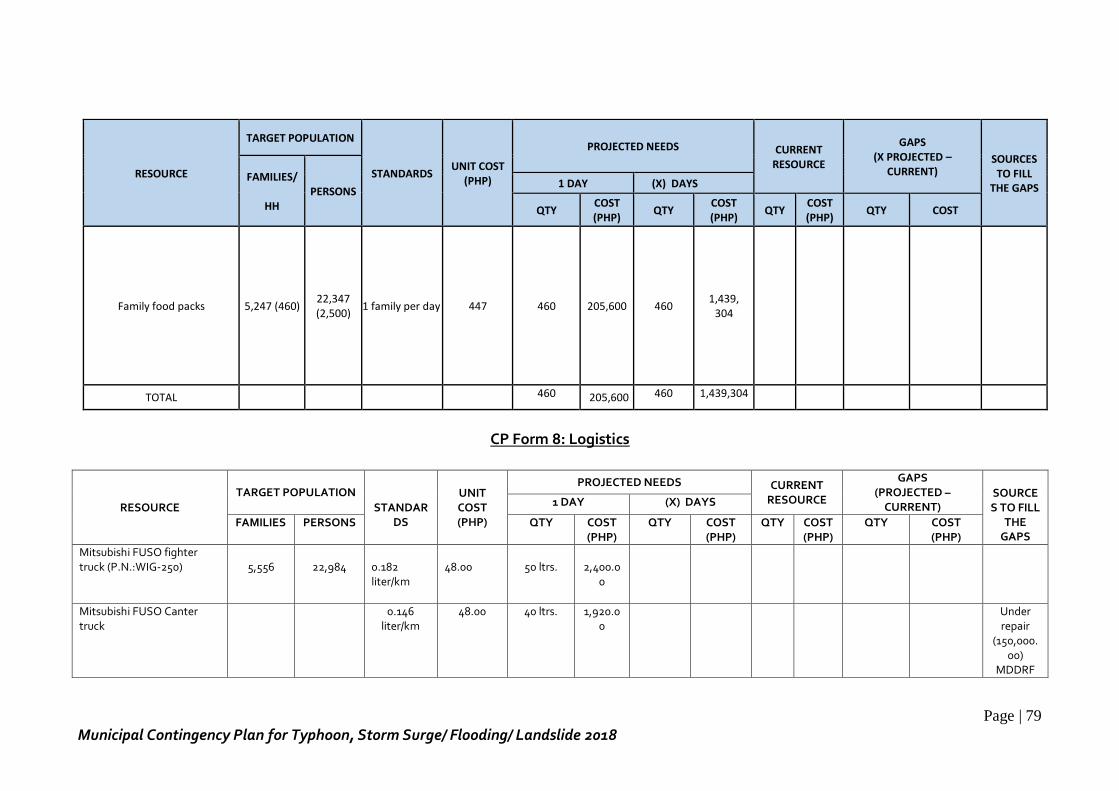
Page | 79
Municipal Contingency Plan for Typhoon, Storm Surge/ Flooding/ Landslide 2018
RESOURCE
TARGET POPULATION
STANDARDS UNIT COST
(PHP)
PROJECTED NEEDS CURRENT RESOURCE
GAPS (X PROJECTED –
CURRENT) SOURCES TO FILL
THE GAPS FAMILIES/
HH
PERSONS 1 DAY (X) DAYS
QTY COST (PHP)
QTY COST (PHP)
QTY COST (PHP)
QTY COST
Family food packs 5,247 (460) 22,347 (2,500)
1 family per day 447 460 205,600 460 1,439,
304
TOTAL 460 205,600 460 1,439,304
CP Form 8: Logistics
RESOURCE
TARGET POPULATION STANDAR
DS
UNIT COST (PHP)
PROJECTED NEEDS CURRENT RESOURCE
GAPS (PROJECTED –
CURRENT)
SOURCES TO FILL
THE GAPS
1 DAY (X) DAYS
FAMILIES PERSONS QTY COST (PHP)
QTY COST (PHP)
QTY COST (PHP)
QTY COST (PHP)
Mitsubishi FUSO fighter truck (P.N.:WIG-250)
5,556
22,984
0.182 liter/km
48.00
50 ltrs.
2,400.0
0
Mitsubishi FUSO Canter truck
0.146 liter/km
48.00 40 ltrs. 1,920.00
Under repair
(150,000.00)
MDDRF
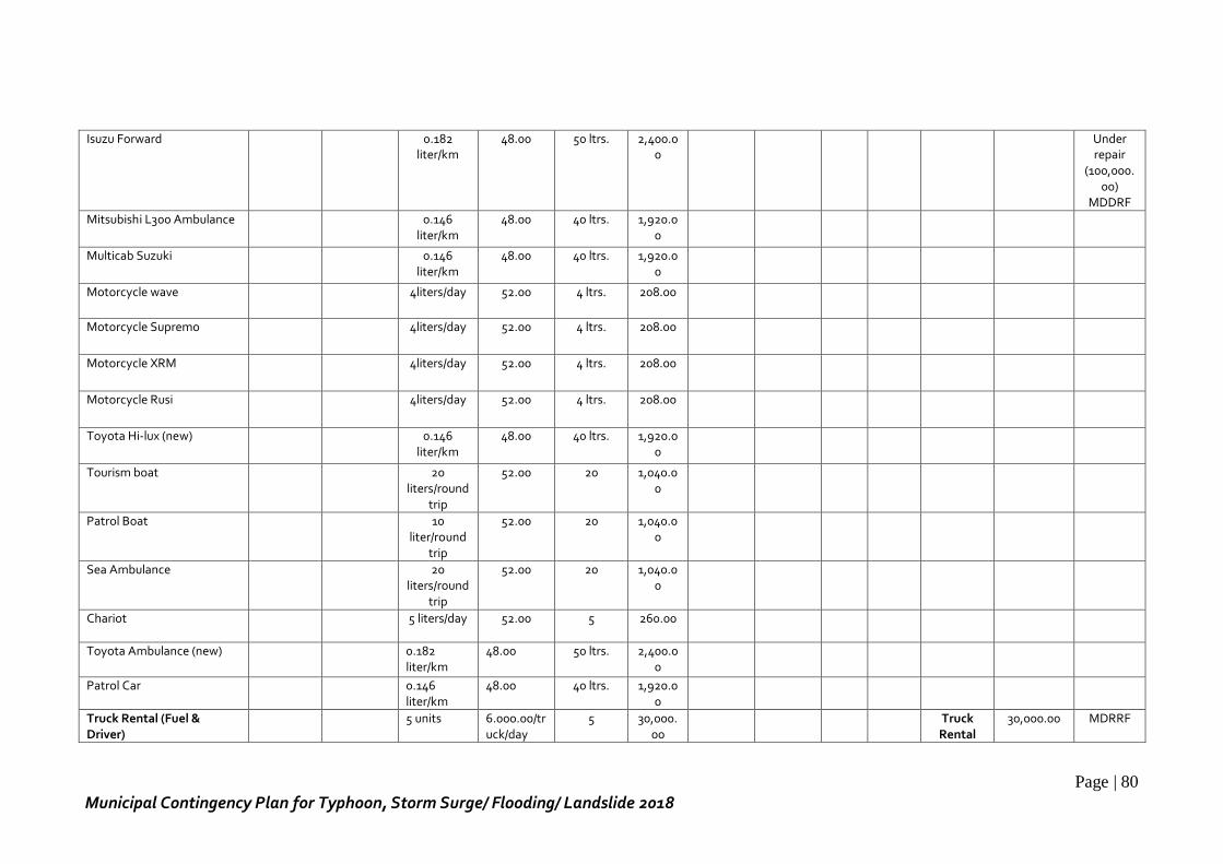
Page | 80
Municipal Contingency Plan for Typhoon, Storm Surge/ Flooding/ Landslide 2018
Isuzu Forward 0.182 liter/km
48.00 50 ltrs. 2,400.00
Under repair
(100,000.00)
MDDRF
Mitsubishi L300 Ambulance 0.146 liter/km
48.00 40 ltrs. 1,920.00
Multicab Suzuki 0.146 liter/km
48.00 40 ltrs. 1,920.00
Motorcycle wave 4liters/day 52.00 4 ltrs. 208.00
Motorcycle Supremo 4liters/day 52.00 4 ltrs. 208.00
Motorcycle XRM 4liters/day 52.00 4 ltrs. 208.00
Motorcycle Rusi 4liters/day 52.00 4 ltrs. 208.00
Toyota Hi-lux (new) 0.146 liter/km
48.00 40 ltrs. 1,920.00
Tourism boat 20 liters/round
trip
52.00 20 1,040.00
Patrol Boat 10 liter/round
trip
52.00 20 1,040.00
Sea Ambulance 20 liters/round
trip
52.00 20 1,040.00
Chariot 5 liters/day 52.00 5 260.00
Toyota Ambulance (new) 0.182 liter/km
48.00 50 ltrs. 2,400.00
Patrol Car 0.146 liter/km
48.00 40 ltrs. 1,920.00
Truck Rental (Fuel & Driver)
5 units 6.000.00/truck/day
5 30,000.00
Truck Rental
30,000.00 MDRRF
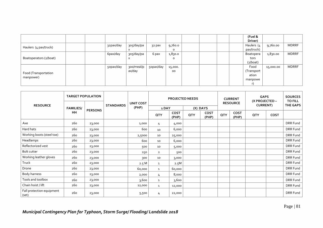
Page | 81
Municipal Contingency Plan for Typhoon, Storm Surge/ Flooding/ Landslide 2018
(Fuel & Driver)
Haulers (4 pax/truck) 32pax/day 305/day/pa
x 32 pax 9,760.0
0
Haulers (4 pax/truck)
9,760.00 MDRRF
Boatoperators (2/boat) 6pax/day 305/day/pa
x 6 pax 1,830.0
0
Boatopera
tors (2/boat)
1,830.00 MDRRF
Food (Transportation manpower)
50pax/day 300/meal/pax/day
50pax/day 15,000.00
Food (Transport
ation manpowe
r)
15,000.00 MDRRF
RESOURCE
TARGET POPULATION
STANDARDS UNIT COST
(PHP)
PROJECTED NEEDS CURRENT RESOURCE
GAPS (X PROJECTED –
CURRENT)
SOURCES TO FILL
THE GAPS FAMILIES/
HH PERSONS
1 DAY (X) DAYS
QTY COST (PHP)
QTY COST (PHP)
QTY COST (PHP)
QTY COST
Axe 260 23,000 1,000 4 4,000 DRR Fund
Hard hats 260 23,000 600 10 6,000 DRR Fund
Working boots (steel toe) 260 23,000 2,5000 10 25,000 DRR Fund
Headlamps 260 23,000 600 10 6,000 DRR Fund
Reflectorized vest 260 23,000 500 10 5,000 DRR Fund
Bolt cutter 260 23,000 250 2 500 DRR Fund
Working leather gloves 260 23,000 300 10 3,000 DRR Fund
Truck 260 23,000 2.5 M 1 2.5M DRR Fund
Drone 260 23,000 60,000 1 60,000 DRR Fund
Body harness 260 23,000 2,000 4 8,000 DRR Fund
Tools and toolbox 260 23,000 3,600 1 3,600 DRR Fund
Chain hoist / lift 260 23,000 12,000 1 12,000 DRR Fund
Fall protection equipment (set)
260 23,000
5,500 4 22,000
DRR Fund
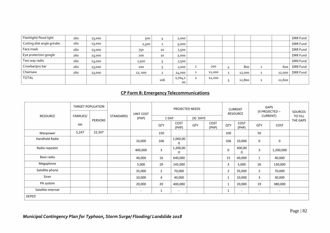
Page | 82
Municipal Contingency Plan for Typhoon, Storm Surge/ Flooding/ Landslide 2018
Flashlight/ flood light 260 23,000 500 4 2,000 DRR Fund
Cutting disk angle grinder 260 23,000 2,500 2 5,000 DRR Fund
Face mask 260 23,000 750 10 7,500 DRR Fund
Eye protection google 260 23,000 200 10 2,000 DRR Fund
Two way radio 260 23,000 1,500 5 7,500 DRR Fund
Crowbar/pry bar 260 23,000 200 5 1,000 1 200 4 800 1 600 DRR Fund
Chainsaw 260 23,000 12, 000 2 24,000 1 12,000 1 12,000 1 12,000 DRR Fund
TOTAL
106
2,704,100
2 12,200 5 12,800 2 12,600
CP Form 8: Emergency Telecommunications
RESOURCE
TARGET POPULATION
STANDARDS UNIT COST
(PHP)
PROJECTED NEEDS CURRENT RESOURCE
GAPS (X PROJECTED –
CURRENT) SOURCES TO FILL
THE GAPS FAMILIES/
HH
PERSONS 1 DAY (X) DAYS
QTY COST (PHP)
QTY COST (PHP)
QTY COST (PHP)
QTY COST
Manpower 5,247 22,347 150 100 50
Handheld Radio 10,000 106
1,060,000
106 10,000 0 0
Radio repeater 400,000 3
1,200,000
0 400,00
0 3 1,200,000
Base radio 40,000 16 640,000 15 40,000 1 40,000
Megaphone 5,000 29 145,000 3 5,000 26 130,000
Satellite phone 35,000 2 70,000 2 35,000 2 70,000
Siren 10,000 4 40,000 1 10,000 3 30,000
PA system 20,000 20 400,000 1 20,000 19 380,000
Satellite internet - 1 - 1 - - -
DEPED
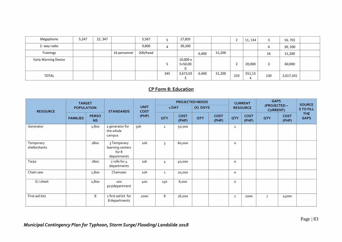
Page | 83
Municipal Contingency Plan for Typhoon, Storm Surge/ Flooding/ Landslide 2018
Megaphone 5,247 22, 347 5,567 5 27,835 2 11, 134 3 16, 701
2- way radio 9,800 4 39,200 4 39, 200
Trainings 16 personnel 200/head 6,400 51,200 16 51,200
Early Warning Device 5
10,000 x 5=50,00
0
2 20,000 3 60,000
TOTAL 345 3,672,03
5 6,400 51,200
233 551,13
4 130 2,017,101
CP Form 8: Education
RESOURCE
TARGET POPULATION
STANDARDS UNIT COST (PHP)
PROJECTED NEEDS CURRENT RESOURCE
GAPS (PROJECTED –
CURRENT)
SOURCES TO FILL
THE GAPS
1 DAY (X) DAYS
FAMILIES PERSO
NS QTY
COST (PHP)
QTY COST (PHP)
QTY COST (PHP)
QTY COST (PHP)
Generator 1,800 1 generator for the whole campus
50k 1 50,000 1
Temporary shelter/tents
1800 3 Temporary learning centers
for 8 departments
20k 3 60,000 0
Tarps 1800 2 rolls for 4 departments
10k 4 40,000 0
Chain saw 1,800 Chainsaw 20k 1 20,000 0
G.I sheet 1,800 100 pcs/department
400 150 6,000 0
First aid kits 8 1 first aid kit for 8 departments
2000 8 16,000 1 2000 7 14000
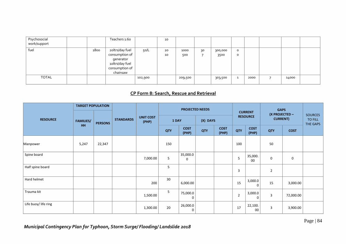
Page | 84
Municipal Contingency Plan for Typhoon, Storm Surge/ Flooding/ Landslide 2018
Psychosocial work/support
Teachers 1:60 10
fuel 1800 20ltrs/day fuel consumption of
generator 10ltrs/day fuel
consumption of chainsaw
50/L
20 10
1000 500
30 7
300,000 3500
0 0
TOTAL 102,900 209,500 303,500 1 2000 7 14000
CP Form 8: Search, Rescue and Retrieval
RESOURCE
TARGET POPULATION
STANDARDS UNIT COST
(PHP)
PROJECTED NEEDS CURRENT
RESOURCE
GAPS (X PROJECTED –
CURRENT) SOURCES TO FILL
THE GAPS FAMILIES/
HH PERSONS
1 DAY (X) DAYS
QTY COST (PHP)
QTY COST (PHP)
QTY COST (PHP)
QTY COST
Manpower 5,247 22,347
150 100 50
Spine board 7,000.00 5
35,000.00
5
35,000.00
0 0
Half spine board
5 3 2
Hard helmet 200
30 6,000.00 15
3,000.00
15 3,000.00
Trauma kit 1,500.00
5 75,000.00
2 3,000.0
0 3 72,000.00
Life buoy/ life ring 1,300.00 20
26,000.00
17 22,100.
00 3 3,900.00
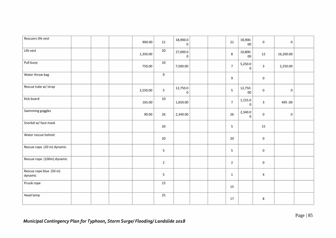
Page | 85
Municipal Contingency Plan for Typhoon, Storm Surge/ Flooding/ Landslide 2018
Rescuers life vest 900.00 21
18,900.00
21 18,900.
00 0 0
Life vest 1,350.00
20 27,000.00
8 10,800.
00 12 16,200.00
Pull buoy 750.00
10 7,500.00 7
5,250.00
3 2,250.00
Water throw bag
9 9 0
Rescue tube w/ strap 2,550.00 5
12,750.00
5 12,750.
00 0 0
Kick board 165.00
10 1,650.00
7
1,155.00
3 495 .00
Swimming goggles 90.00 26 2,340.00
26
2,340.00
0 0
Snorkel w/ face mask 20
5 15
Water rescue helmet 20
20 0
Rescue rope (20 m) dynamic 5
5 0
Rescue rope (100m) dynamic 2
2 0
Rescue rope blue (50 m) dynamic
5
1 4
Prusik rope 15
15
Head lamp 25
17 8
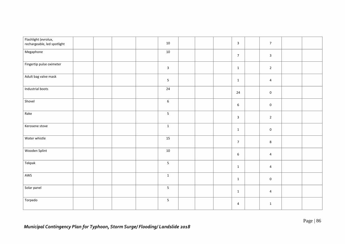
Page | 86
Municipal Contingency Plan for Typhoon, Storm Surge/ Flooding/ Landslide 2018
Flashlight (evrolux, rechargeable, led spotlight
10
3 7
Megaphone 10
7 3
Fingertip pulse oximeter 3
1 2
Adult bag valve mask 5
1 4
Industrial boots 24
24 0
Shovel 6
6 0
Rake 5
3 2
Kerosene stove 1
1 0
Water whistle 15
7 8
Wooden Splint 10
6 4
Tekpak 5
1 4
AWS 1
1 0
Solar panel 5
1 4
Torpedo 5
4 1
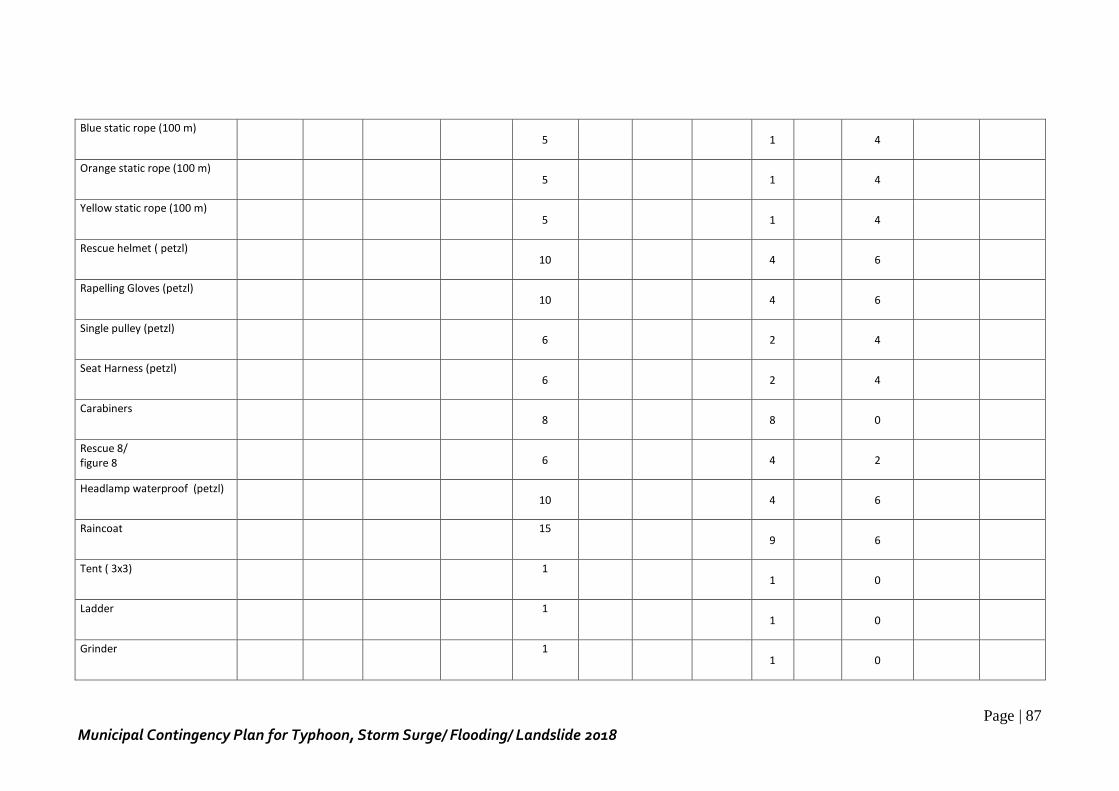
Page | 87
Municipal Contingency Plan for Typhoon, Storm Surge/ Flooding/ Landslide 2018
Blue static rope (100 m) 5
1 4
Orange static rope (100 m) 5
1 4
Yellow static rope (100 m) 5
1 4
Rescue helmet ( petzl) 10
4 6
Rapelling Gloves (petzl) 10
4 6
Single pulley (petzl) 6
2 4
Seat Harness (petzl) 6
2 4
Carabiners 8
8 0
Rescue 8/ figure 8
6
4 2
Headlamp waterproof (petzl) 10
4 6
Raincoat 15
9 6
Tent ( 3x3) 1
1 0
Ladder 1
1 0
Grinder 1
1 0
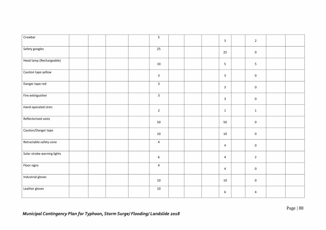
Page | 88
Municipal Contingency Plan for Typhoon, Storm Surge/ Flooding/ Landslide 2018
Crowbar 5
3 2
Safety googles 25
25 0
Head lamp (Rechargeable) 10
5 5
Caution tape yellow 3
3 0
Danger tape red 3
3 0
Fire extinguisher 3
3 0
Hand operated siren 2
1 1
Reflectorized vests 50
50 0
Caution/Danger tape 10
10 0
Retractable safety cone 4
4 0
Solar strobe warning lights 6
4 2
Floor signs 4
4 0
Industrial gloves 10
10 0
Leather gloves 10
6 4
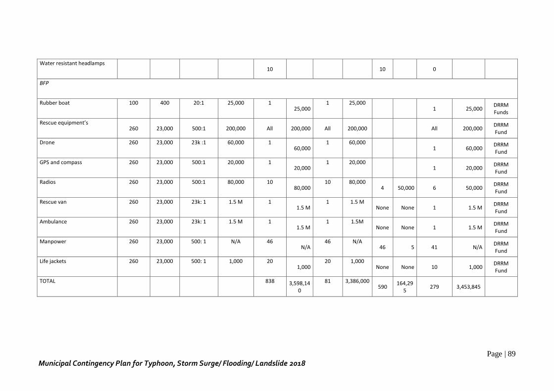
Page | 89
Municipal Contingency Plan for Typhoon, Storm Surge/ Flooding/ Landslide 2018
Water resistant headlamps 10
10 0
BFP
Rubber boat 100 400 20:1 25,000 1 25,000
1 25,000 1 25,000
DRRM Funds
Rescue equipment’s 260 23,000 500:1 200,000 All 200,000 All 200,000 All 200,000
DRRM Fund
Drone 260 23,000 23k :1 60,000 1 60,000
1 60,000 1 60,000
DRRM Fund
GPS and compass 260 23,000 500:1 20,000 1 20,000
1 20,000 1 20,000
DRRM Fund
Radios 260 23,000 500:1 80,000 10 80,000
10 80,000 4 50,000 6 50,000
DRRM Fund
Rescue van 260 23,000 23k: 1 1.5 M 1 1.5 M
1 1.5 M None None 1 1.5 M
DRRM Fund
Ambulance 260 23,000 23k: 1 1.5 M 1 1.5 M
1 1.5M None None 1 1.5 M
DRRM Fund
Manpower 260 23,000 500: 1 N/A 46 N/A
46 N/A 46 5 41 N/A
DRRM Fund
Life jackets 260 23,000 500: 1 1,000 20 1,000
20 1,000 None None 10 1,000
DRRM Fund
TOTAL 838 3,598,140
81 3,386,000 590
164,295
279 3,453,845
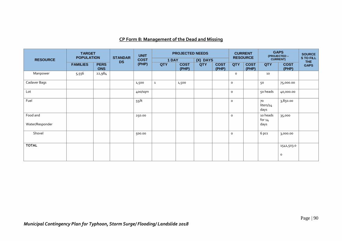
Page | 90
Municipal Contingency Plan for Typhoon, Storm Surge/ Flooding/ Landslide 2018
CP Form 8: Management of the Dead and Missing
RESOURCE
TARGET POPULATION STANDAR
DS
UNIT COST (PHP)
PROJECTED NEEDS CURRENT RESOURCE
GAPS (PROJECTED –
CURRENT)
SOURCES TO FILL
THE GAPS
1 DAY (X) DAYS
FAMILIES PERSONS
QTY COST (PHP)
QTY COST (PHP)
QTY COST (PHP)
QTY COST (PHP)
Manpower 5,556 22,984 0 10
Cadaver Bags 1,500 1 1,500 0 50 75,000.00
Lot 400/sqm 0 50 heads 40,000.00
Fuel 55/lt 0 70 liters/14 days
3,850.00
Food and
Water/Responder
250.00 0 10 heads for 14 days
35,000
Shovel 500.00 0 6 pcs 3,000.00
TOTAL 1541,503.0
0
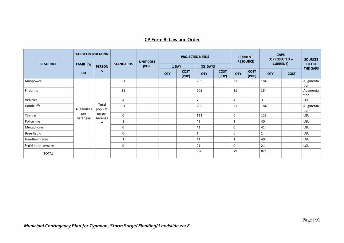
Page | 91
Municipal Contingency Plan for Typhoon, Storm Surge/ Flooding/ Landslide 2018
CP Form 8: Law and Order
RESOURCE
TARGET POPULATION
STANDARDS UNIT COST
(PHP)
PROJECTED NEEDS CURRENT RESOURCE
GAPS (X PROJECTED –
CURRENT) SOURCES TO FILL
THE GAPS FAMILIES/
HH
PERSONS
1 DAY (X) DAYS
QTY COST (PHP)
QTY COST (PHP)
QTY COST (PHP)
QTY COST
Manpower
All families per
barangay
Total population per
barangay
21
205 21
184
Augmentation
Firearms 31
205 31
184
Augmentation
Vehicles 4 7 4 3 LGU
Handcuffs 21
205 21
184
Augmentation
Teargas 0 123 0 123 LGU
Police line 1 41 1 40 LGU
Megaphone 0 41 0 41 LGU
Base Radio 0 1 0 1 LGU
Handheld radio 1 41 1 40 LGU
Night vision goggles 0 21 0 21 LGU
TOTAL
890 79
821
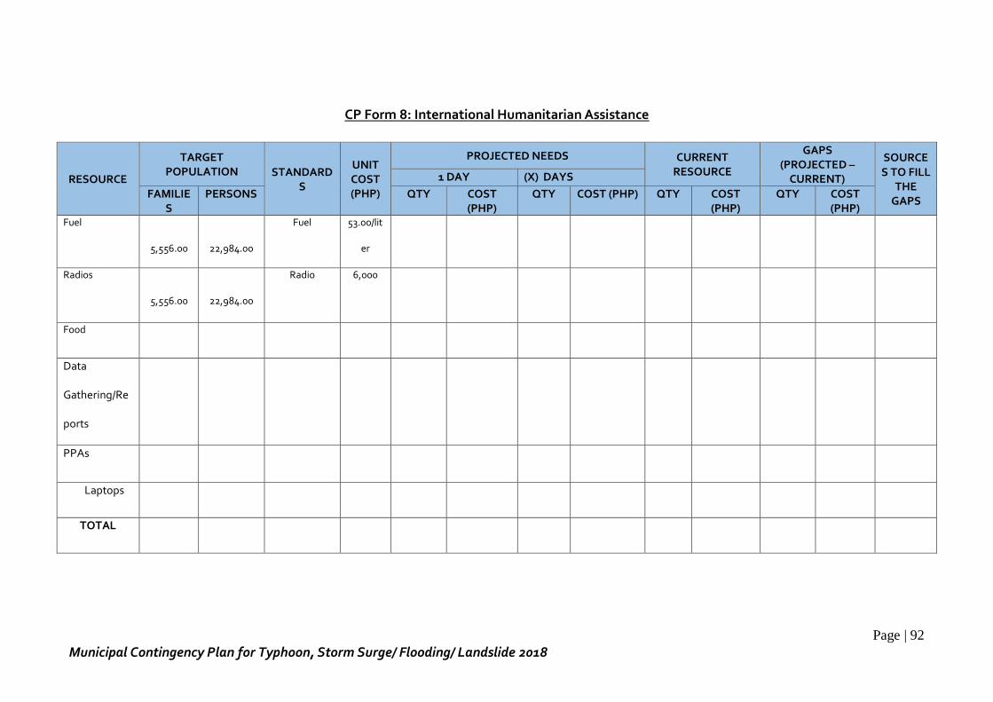
Page | 92
Municipal Contingency Plan for Typhoon, Storm Surge/ Flooding/ Landslide 2018
CP Form 8: International Humanitarian Assistance
RESOURCE
TARGET POPULATION STANDARD
S
UNIT COST (PHP)
PROJECTED NEEDS CURRENT RESOURCE
GAPS (PROJECTED –
CURRENT)
SOURCES TO FILL
THE GAPS
1 DAY (X) DAYS
FAMILIES
PERSONS QTY COST (PHP)
QTY COST (PHP) QTY COST (PHP)
QTY COST (PHP)
Fuel
5,556.00
22,984.00
Fuel 53.00/lit
er
Radios
5,556.00
22,984.00
Radio 6,000
Food
Data
Gathering/Re
ports
PPAs
Laptops
TOTAL
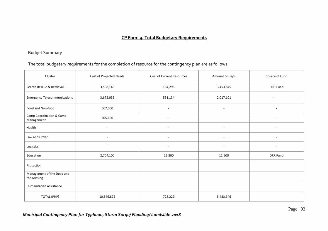
Page | 93
Municipal Contingency Plan for Typhoon, Storm Surge/ Flooding/ Landslide 2018
CP Form 9. Total Budgetary Requirements
Budget Summary The total budgetary requirements for the completion of resource for the contingency plan are as follows:
Cluster Cost of Projected Needs Cost of Current Resources Amount of Gaps Source of Fund
Search Rescue & Retrieval 3,598,140 164,295 3,453,845 DRR Fund
Emergency Telecommunications 3,672,035 551,134 2,017,101 -
Food and Non-food 667,000 - - -
Camp Coordination & Camp Management
205,600 - - -
Health - - - -
Law and Order - - - -
Logistics -
- - -
Education 2,704,100 12,800 12,600 DRR Fund
Protection
Management of the Dead and the Missing
Humanitarian Assistance
TOTAL (PHP) 10,846,875 728,229 5,483,546
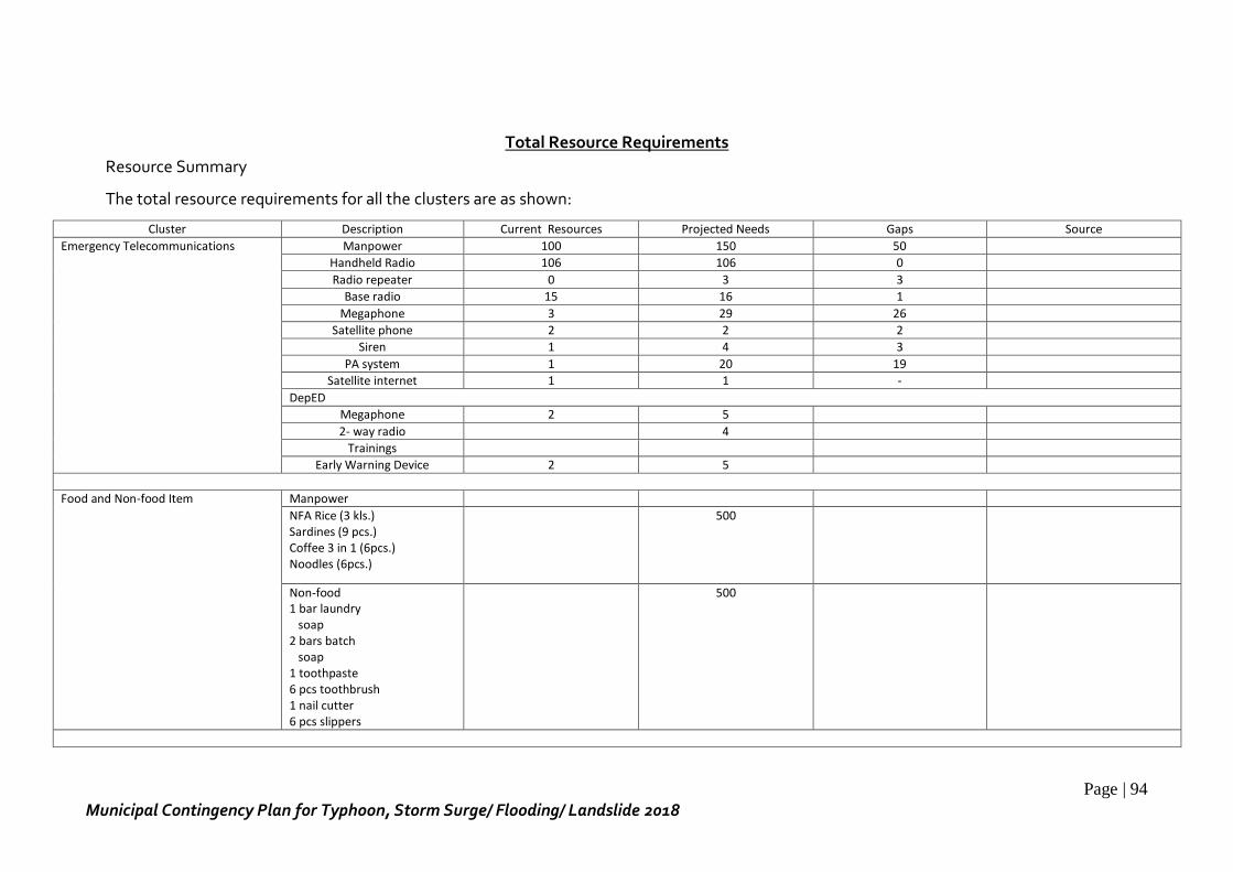
Page | 94
Municipal Contingency Plan for Typhoon, Storm Surge/ Flooding/ Landslide 2018
Total Resource Requirements
Resource Summary
The total resource requirements for all the clusters are as shown:
Cluster Description Current Resources Projected Needs Gaps Source
Emergency Telecommunications
Manpower 100 150 50
Handheld Radio 106 106 0
Radio repeater 0 3 3
Base radio 15 16 1
Megaphone 3 29 26
Satellite phone 2 2 2
Siren 1 4 3
PA system 1 20 19
Satellite internet 1 1 -
DepED
Megaphone 2 5
2- way radio 4
Trainings
Early Warning Device 2 5
Food and Non-food Item Manpower
NFA Rice (3 kls.) Sardines (9 pcs.) Coffee 3 in 1 (6pcs.) Noodles (6pcs.)
500
Non-food 1 bar laundry soap 2 bars batch soap 1 toothpaste 6 pcs toothbrush 1 nail cutter 6 pcs slippers
500
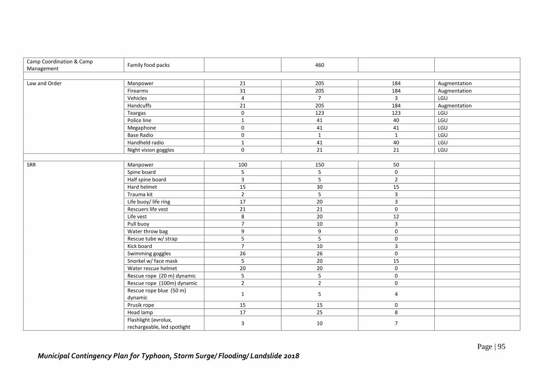
Page | 95
Municipal Contingency Plan for Typhoon, Storm Surge/ Flooding/ Landslide 2018
Camp Coordination & Camp Management
Family food packs 460
Law and Order Manpower 21 205 184 Augmentation
Firearms 31 205 184 Augmentation
Vehicles 4 7 3 LGU
Handcuffs 21 205 184 Augmentation
Teargas 0 123 123 LGU
Police line 1 41 40 LGU
Megaphone 0 41 41 LGU
Base Radio 0 1 1 LGU
Handheld radio 1 41 40 LGU
Night vision goggles 0 21 21 LGU
SRR
Manpower 100 150 50
Spine board 5 5 0
Half spine board 3 5 2
Hard helmet 15 30 15
Trauma kit 2 5 3
Life buoy/ life ring 17 20 3
Rescuers life vest 21 21 0
Life vest 8 20 12
Pull buoy 7 10 3
Water throw bag 9 9 0
Rescue tube w/ strap 5 5 0
Kick board 7 10 3
Swimming goggles 26 26 0
Snorkel w/ face mask 5 20 15
Water rescue helmet 20 20 0
Rescue rope (20 m) dynamic 5 5 0
Rescue rope (100m) dynamic 2 2 0
Rescue rope blue (50 m) dynamic
1 5 4
Prusik rope 15 15 0
Head lamp 17 25 8
Flashlight (evrolux, rechargeable, led spotlight
3 10 7
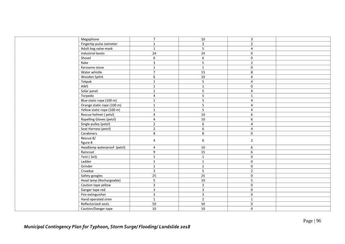
Page | 96
Municipal Contingency Plan for Typhoon, Storm Surge/ Flooding/ Landslide 2018
Megaphone 7 10 3
Fingertip pulse oximeter 1 3 2
Adult bag valve mask 1 5 4
Industrial boots 24 24 0
Shovel 6 6 0
Rake 3 5 2
Kerosene stove 1 1 0
Water whistle 7 15 8
Wooden Splint 6 10 4
Tekpak 1 5 4
AWS 1 1 0
Solar panel 1 5 4
Torpedo 4 5 1
Blue static rope (100 m) 1 5 4
Orange static rope (100 m) 1 5 4
Yellow static rope (100 m) 1 5 4
Rescue helmet ( petzl) 4 10 6
Rapelling Gloves (petzl) 4 10 6
Single pulley (petzl) 2 6 4
Seat Harness (petzl) 2 6 4
Carabiners 8 8 0
Rescue 8/ figure 8
4 6 2
Headlamp waterproof (petzl) 4 10 6
Raincoat 9 15 6
Tent ( 3x3) 1 1 0
Ladder 1 1 0
Grinder 1 1 0
Crowbar 3 5 2
Safety googles 25 25 0
Head lamp (Rechargeable) 5 10 5
Caution tape yellow 3 3 0
Danger tape red 3 3 0
Fire extinguisher 3 3 0
Hand operated siren 1 2 1
Reflectorized vests 50 50 0
Caution/Danger tape 10 10 0
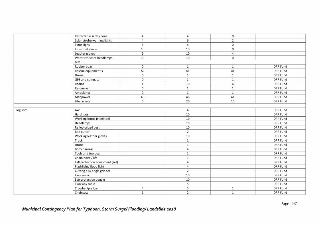
Page | 97
Municipal Contingency Plan for Typhoon, Storm Surge/ Flooding/ Landslide 2018
Retractable safety cone 4 4 0
Solar strobe warning lights 4 6 2
Floor signs 4 4 0
Industrial gloves 10 10 0
Leather gloves 6 10 4
Water resistant headlamps 10 10 0
BFP
Rubber boat 0 1 1 DRR Fund
Rescue equipment’s All All All DRR Fund
Drone 0 1 1 DRR Fund
GPS and compass 0 1 1 DRR Fund
Radios 4 10 6 DRR Fund
Rescue van 0 1 1 DRR Fund
Ambulance 0 1 1 DRR Fund
Manpower 46 46 41 DRR Fund
Life jackets 0 20 10 DRR Fund
Logistics Axe 4 DRR Fund
Hard hats 10 DRR Fund
Working boots (steel toe) 10 DRR Fund
Headlamps 10 DRR Fund
Reflectorized vest 10 DRR Fund
Bolt cutter 2 DRR Fund
Working leather gloves 10 DRR Fund
Truck 1 DRR Fund
Drone 1 DRR Fund
Body harness 4 DRR Fund
Tools and toolbox 1 DRR Fund
Chain hoist / lift 1 DRR Fund
Fall protection equipment (set) 4 DRR Fund
Flashlight/ flood light 4 DRR Fund
Cutting disk angle grinder 2 DRR Fund
Face mask 10 DRR Fund
Eye protection goggle 10 DRR Fund
Two way radio 5 DRR Fund
Crowbar/pry bar 4 5 1 DRR Fund
Chainsaw 1 2 1 DRR Fund
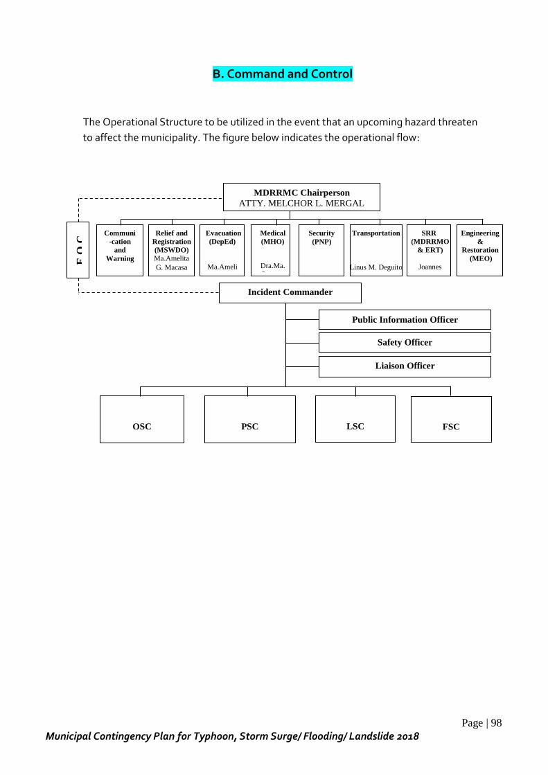
Page | 98
Municipal Contingency Plan for Typhoon, Storm Surge/ Flooding/ Landslide 2018
B. Command and Control
The Operational Structure to be utilized in the event that an upcoming hazard threaten
to affect the municipality. The figure below indicates the operational flow:
Evacuation
(DepEd)
Ma.Ameli
ta G.
Communi
-cation
and
Warning
Medical
(MHO)
Dra.Ma.
Socorro
Security
(PNP)
Transportation
Linus M. Deguito
SRR
(MDRRMO
& ERT)
Joannes
Joseph M.
PSC
Safety Officer
Public Information Officer
OSC
Incident Commander
Liaison Officer
Relief and
Registration
(MSWDO)
Ma.Amelita
G. Macasa
Engineering
&
Restoration
(MEO)
Engr.
LSC
FSC
E O
C
MDRRMC Chairperson
ATTY. MELCHOR L. MERGAL LCE
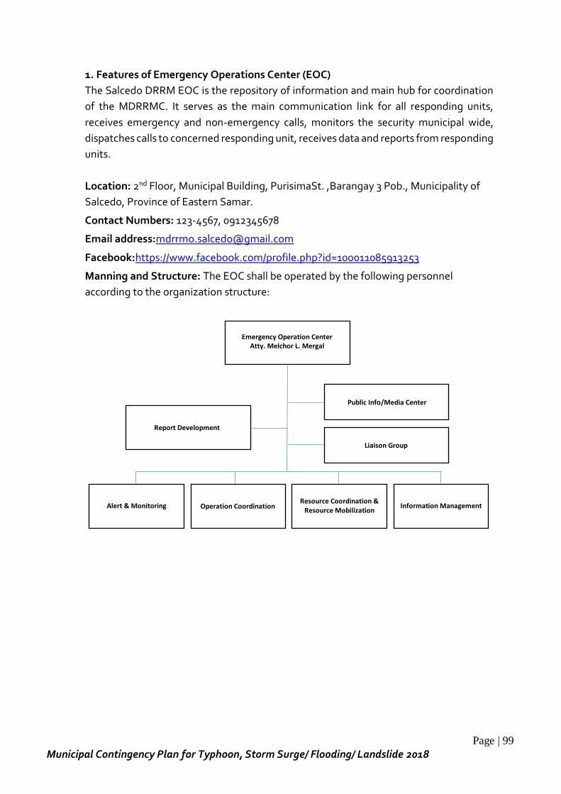
Page | 99
Municipal Contingency Plan for Typhoon, Storm Surge/ Flooding/ Landslide 2018
1. Features of Emergency Operations Center (EOC)
The Salcedo DRRM EOC is the repository of information and main hub for coordination
of the MDRRMC. It serves as the main communication link for all responding units,
receives emergency and non-emergency calls, monitors the security municipal wide,
dispatches calls to concerned responding unit, receives data and reports from responding
units.
Location: 2nd Floor, Municipal Building, PurisimaSt. ,Barangay 3 Pob., Municipality of
Salcedo, Province of Eastern Samar.
Contact Numbers: 123-4567, 0912345678
Email address:[email protected]
Facebook:https://www.facebook.com/profile.php?id=100011085913253
Manning and Structure: The EOC shall be operated by the following personnel
according to the organization structure:
Emergency Operation Center
Atty. Melchor L. Mergal
Report Development
Public Info/Media Center
Liaison Group
Alert & Monitoring
Operation Coordination
Resource Coordination & Resource Mobilization
Information Management
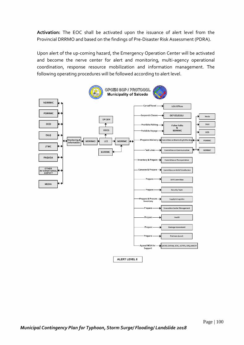
Page | 100
Municipal Contingency Plan for Typhoon, Storm Surge/ Flooding/ Landslide 2018
Activation: The EOC shall be activated upon the issuance of alert level from the
Provincial DRRMO and based on the findings of Pre-Disaster Risk Assessment (PDRA).
Upon alert of the up-coming hazard, the Emergency Operation Center will be activated
and become the nerve center for alert and monitoring, multi-agency operational
coordination, response resource mobilization and information management. The
following operating procedures will be followed according to alert level.
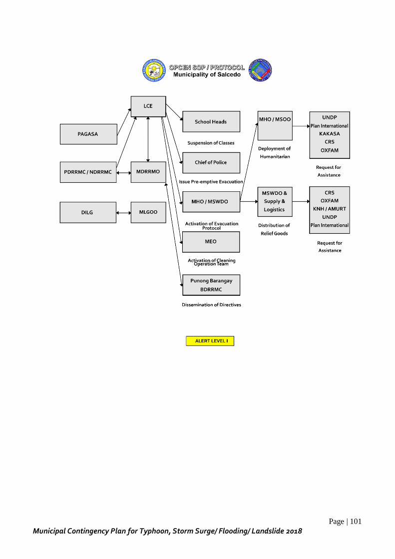
Page | 101
Municipal Contingency Plan for Typhoon, Storm Surge/ Flooding/ Landslide 2018
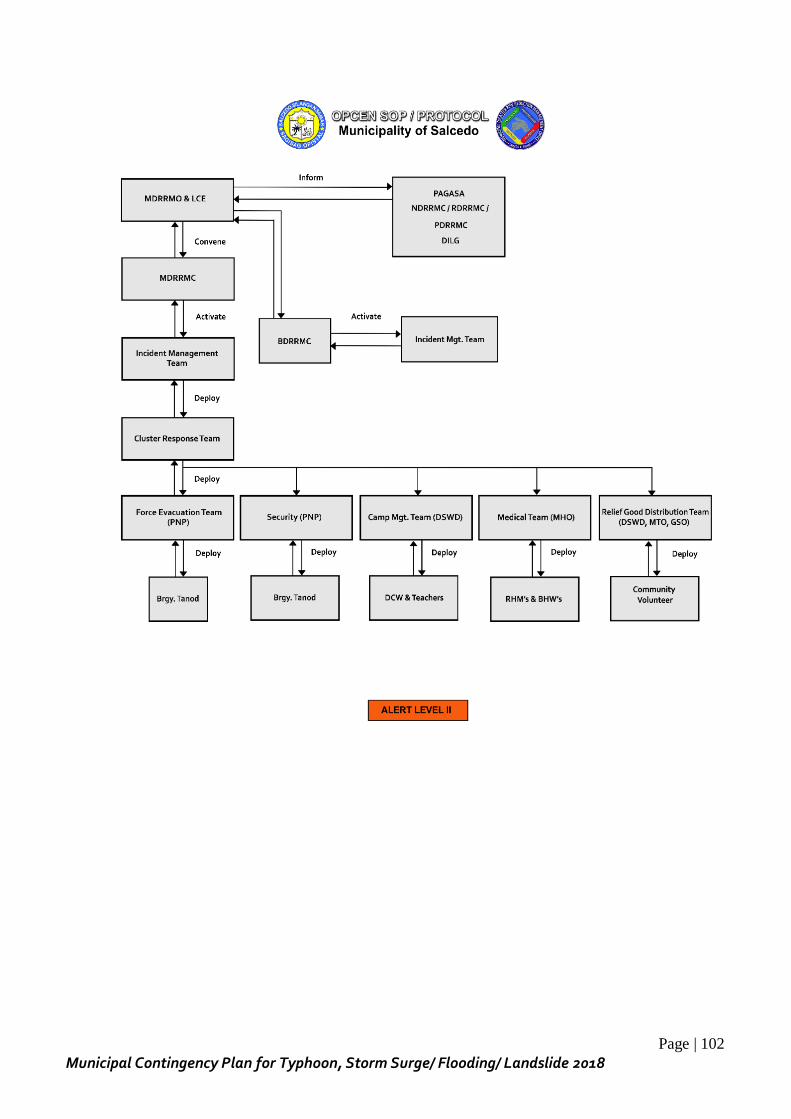
Page | 102
Municipal Contingency Plan for Typhoon, Storm Surge/ Flooding/ Landslide 2018
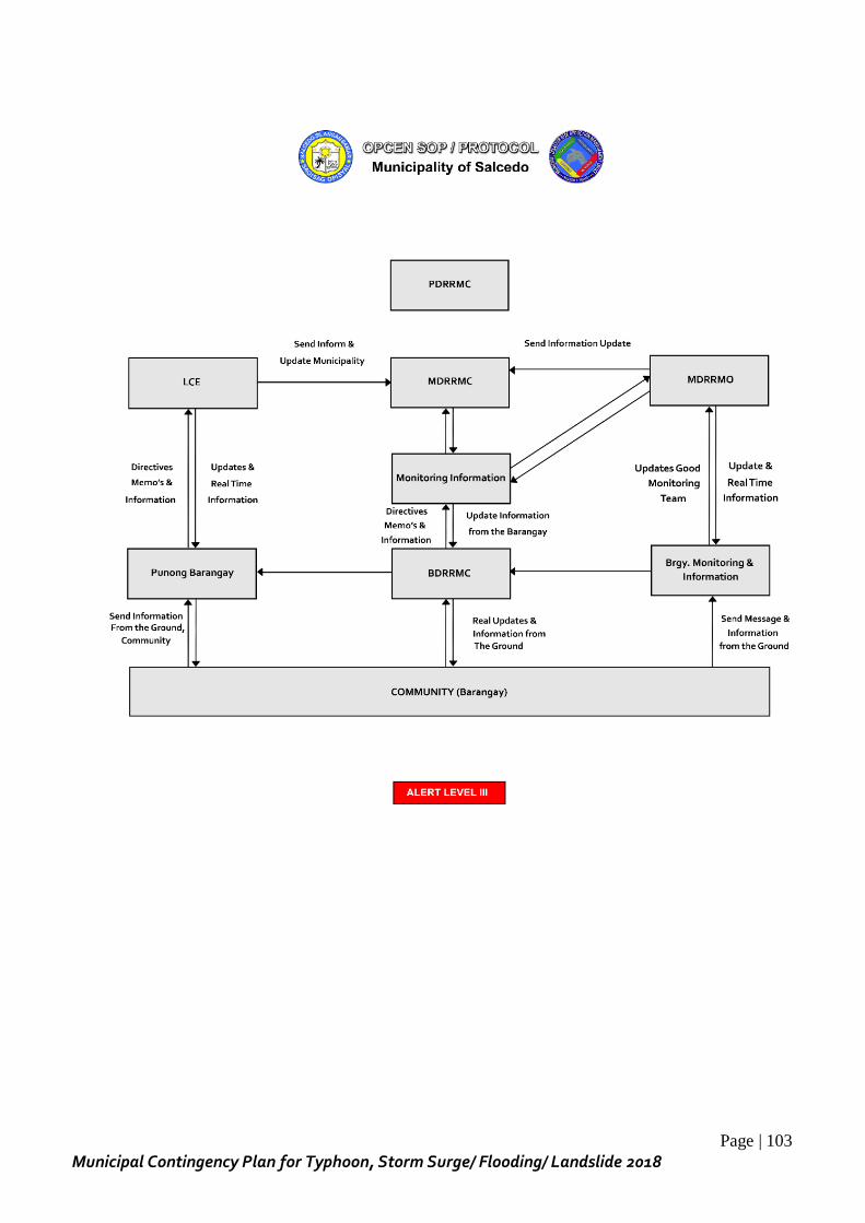
Page | 103
Municipal Contingency Plan for Typhoon, Storm Surge/ Flooding/ Landslide 2018
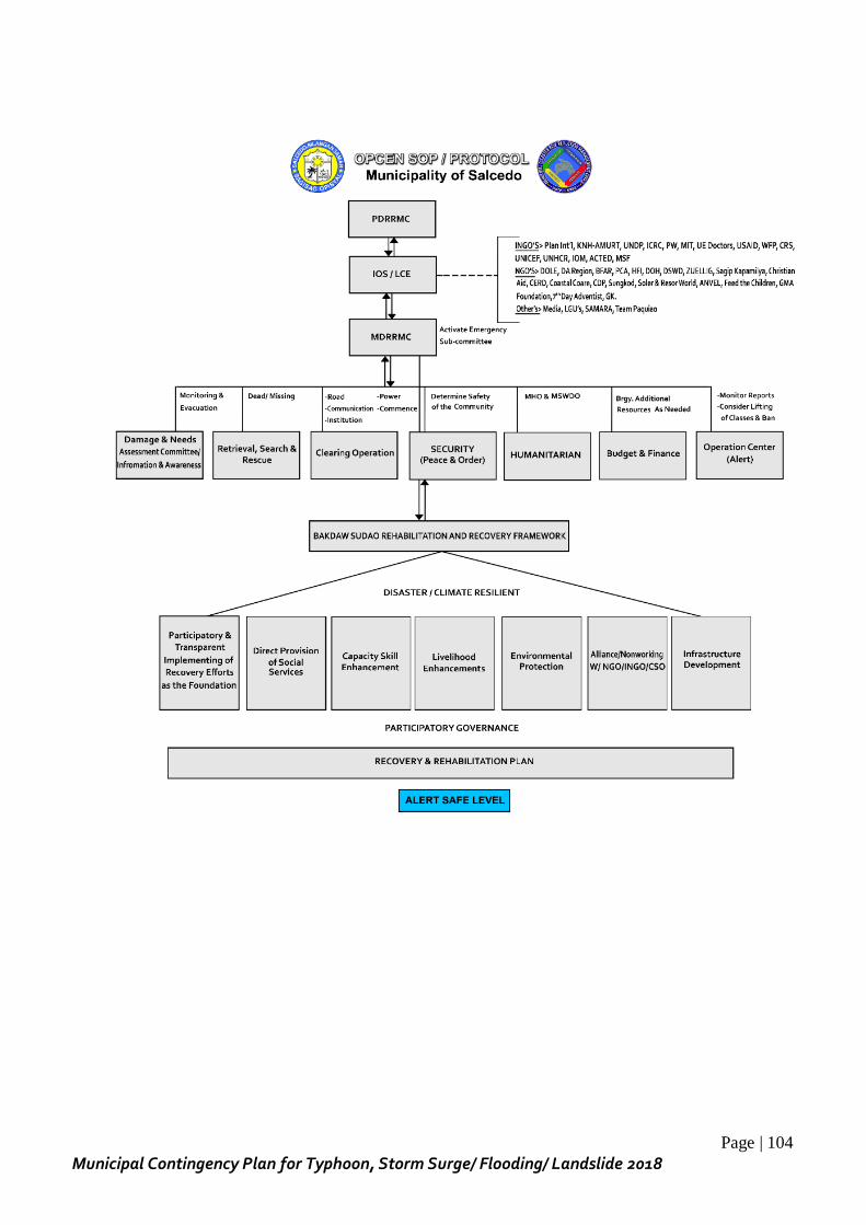
Page | 104
Municipal Contingency Plan for Typhoon, Storm Surge/ Flooding/ Landslide 2018
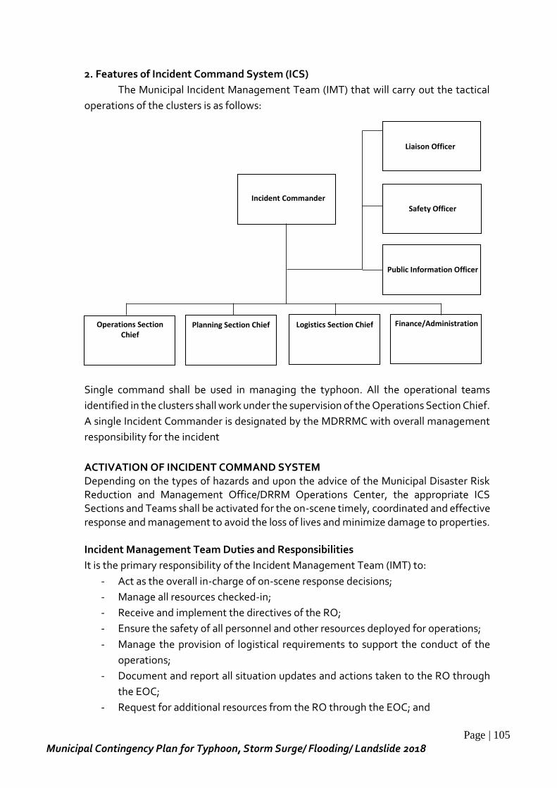
Page | 105
Municipal Contingency Plan for Typhoon, Storm Surge/ Flooding/ Landslide 2018
Incident Commander
Liaison Officer
Safety Officer
Public Information Officer
Operations Section Chief
Planning Section Chief
Logistics Section Chief
Finance/Administration
2. Features of Incident Command System (ICS)
The Municipal Incident Management Team (IMT) that will carry out the tactical
operations of the clusters is as follows:
Single command shall be used in managing the typhoon. All the operational teams
identified in the clusters shall work under the supervision of the Operations Section Chief.
A single Incident Commander is designated by the MDRRMC with overall management
responsibility for the incident
ACTIVATION OF INCIDENT COMMAND SYSTEM Depending on the types of hazards and upon the advice of the Municipal Disaster Risk Reduction and Management Office/DRRM Operations Center, the appropriate ICS Sections and Teams shall be activated for the on-scene timely, coordinated and effective response and management to avoid the loss of lives and minimize damage to properties. Incident Management Team Duties and Responsibilities
It is the primary responsibility of the Incident Management Team (IMT) to:
- Act as the overall in-charge of on-scene response decisions;
- Manage all resources checked-in;
- Receive and implement the directives of the RO;
- Ensure the safety of all personnel and other resources deployed for operations;
- Manage the provision of logistical requirements to support the conduct of the
operations;
- Document and report all situation updates and actions taken to the RO through
the EOC;
- Request for additional resources from the RO through the EOC; and
Page | 106
Municipal Contingency Plan for Typhoon, Storm Surge/ Flooding/ Landslide 2018
- Facilitate the complete process on demobilization of resources.
Qualifications of an IMT Member
- Must come from a government agency/office, local government unit, civil society
organization or private sector, or a private individual with authorization to
operate in the area;
- Preferably must have completed the ICS training requirements and standards set
by the OCD; and
- Must be allowed by the sending agency/ office/ unit/ organization to be deployed
as an IMT member immediately even on short notice from the RO.
Selection of IMT Members
- The RO shall select the IC through Delegation of Authority;
- The IC shall select the appropriate members of the Command and General Staff
to compose the whole IMT; and
- All selected IMT members shall temporarily be relieved from their regular office
duties and responsibilities to perform in full-time the expected functions of their
respective IMT positions.
MAJOR ICS POSITIONS AND THEIR RESPONSIBILITIES
Responsible Official (RO)
Chairs LDRRMC
Delegates authority to the Incident Commander
Serves as link to higher authorities
Provides policy direction
Ensures availability of resources
Incident Commander (IC)
Responsible for overall management response operations.
Selected by the Responsible Official based on qualifications and experience.
Assesses the situation/receives briefing from the Responsible Official or outgoing Incident Commander.
Determines incident objectives and strategies.
Establishes priorities in consultation with the staff.
Establishes Incident Command Post (ICS).
Establishes appropriate ICS organization based on the situation.
Ensures planning meeting are scheduled as required.
Approves and authorizes the implementation of the Incident Action Plan.
Ensures that adequate safety measures are in place.
Coordinates with key people and officials.
Approves requests for additional resources and for the release of resources.
Keeps DRRMC Chairperson and/or Responsible Official informed of incident status.
Authorizes release of information to the news media.
Page | 107
Municipal Contingency Plan for Typhoon, Storm Surge/ Flooding/ Landslide 2018
Coordinates activity for all Command and General Staff.
Information Officer (PIO)
Focal person for information dissemination.
Works closely with all different information.
One Lead Information Officer per incident and may have assistant(s).
Liaison Officer (LIO) Contact point for representatives of assisting cooperating agencies (DRRMC
member and partner-agencies).
Safety Officer (SFO)
Works with Operations on tactics.
Anticipates, detects, and corrects unsafe situations.
Has emergency authority to stop unsafe acts/operations.
One Lead Safety Officer per incident and may have assistant(s).
Operations Section (OS)
First organization assigned to the incident.
Responsible for managing, directing and coordinating all tactical operations at the incident.
The need to expand the Operations Section is generally dictated by the number of tactical resources involved and is influenced by span of control considerations.
Headed by Operations Section Chief.
Planning Section (PS)
Responsible for planning services.
Collects situation and resources status information, evaluates and processes them.
Develops Incident Action Plan to accomplish objectives.
Maintains resources & situation status.
Headed by Planning Section Chief.
Logistics Section (LS)
Provides resources and all other services needed to support the incident.
Headed by Logistics Section Chief.
Finance/Administration Section (F/AS)
Monitors incident costs.
Maintains financial records.
Administers procurement contracts.
Performs time recording.
Headed by Finance/Administrative Section Chief.
COMMON RESPONSIBILITIES OF ALL STRIKE TEAMS
Obtain briefing from Section Chief.
Participate in Incident Planning meetings if necessary.
Determine current status of unit activities.
Confirm dispatch and estimated time of arrival of staff and supplies.
Page | 108
Municipal Contingency Plan for Typhoon, Storm Surge/ Flooding/ Landslide 2018
Assign specific duties to staff and supervise.
Develop and implement accountability, safety and security measures for personnel and resources.
Supervise demobilization of unit, including storage of supplies.
Provide supply unit leader with list of supplies to be replenished.
Maintain unit records, including unit log.
REVIEW AND DETERMINATION OF ICS FLOW OF COMMUNICATION - Orders, directives, resource requests and status changes must follow the chain of
command in accordance with the ICS organizational structure. - Details of the Incident Action Plan (IAP) will be discussed during operational
meetings. SETTING UP/ESTABLISHMENT OF INCIDENT COMMAND SYSTEM FACILITIES The following facilities shall be established/provided for effective and coordinated response to incidents: INCIDENT COMMAND POST (ICP)
- Initially, the ICP shall be established near the incident area. - ICP shall provide a central coordination point. - ICP can be any facility that is available and appropriate. - ICP should not be moved unless absolutely necessary. - There should only be one ICP for the incident. - The communication is also located or adjacent to ICP. - ICP activation and location must be announced to appropriate personnel are
notified. - Should be large enough to provide adequate working room for assigned
personnel - Should contain situation and resource status displays necessary for the incident
STAGING AREA - Staging area shall be set-up close to the location of tactical assignments. - It will serve as temporary location for resources awaiting assignments. - Located out of any possible line of direct hazard effects to minimize risk. - Large enough to accommodate available resources and have room for growth. - Have necessary security controls - Have different access routes for incoming and outgoing resources. - Control and assist the check-in of personnel who arrive at the incident via privately
owned vehicles or other private means.
BASE - Location for primary support activity. - Location for out-of-service equipment (for repair) and personnel (for medication). - Only one Base per incident. - Logistics Section located at Base.
CAMP - Temporary locations to provide services to ICS personnel.

Page | 109
Municipal Contingency Plan for Typhoon, Storm Surge/ Flooding/ Landslide 2018
- Location of camps can be moved. - Several camps may be required. - All Base activities may be performed at Camps. - Designated by geographic name or number.
HELIBASE
- Location where the helicopters may be parked, maintained, fuelled and loaded. - Large incidents may have more than one Helibase. - Helibase can be located at airport or other off-incident location. - Designated by name of incident.
HELISPOT
- Temporary locations where helicopters can safely land and take off. - Can be used to load or off-load personnel, equipment and supplies.
EXECUTION OF THE STEPS IN MANAGING FOR ANY INCIDENT:
1. The incident commander shall size-up the situation. 2. Determine if there are lives at immediate risk. 3. Establish the immediate objectives and strategies. 4. Determine if there are enough and necessary resources on scene and/ or
requested. 5. Develop an Incident Action Plan (IAP).
5.1 Understand the situation 5.2 Establish Incident objectives and strategy 5.3 Determine Tactical Direction 5.4 Determine assignments of personnel and equipment 5.5 Finalize the plan 5.6 Implement the plan
6. Establish initial ICS organization. 7. Conduct operational briefings. 8. Monitor work progress. 9. Review and evaluate the plan and if necessary modify objectives and adjust the
IAP to reflect the situation.
FILLING-UP OF VARIOUS ICS FORMS TO BE USED Example:
ICS Form 211 – Check-in List ICS Form 213 – General Message ICS Form 214 – Unit Log ICS Form 201 – Incident Briefing ICS Form 202 – Incident Objectives ICS Form 203 – Organizational Assignment List ICS Form 204 – Assignment List ICS Form 205 – Incident Command Plan ICS Form 206 – Incident Medical Plan
PREPARATION AND UTILIZATION OF SUPPORTING DOCUMENTS
Page | 110
Municipal Contingency Plan for Typhoon, Storm Surge/ Flooding/ Landslide 2018
Maps and incident facility plans
Safety Messages
Detailed weather forecasts
Phone Lists Other important information for operational strike team leaders
ORDER OF DEMOBILIZATION AND CONDUCT OF CLOSE OUT MEETING WITH LDRRMC
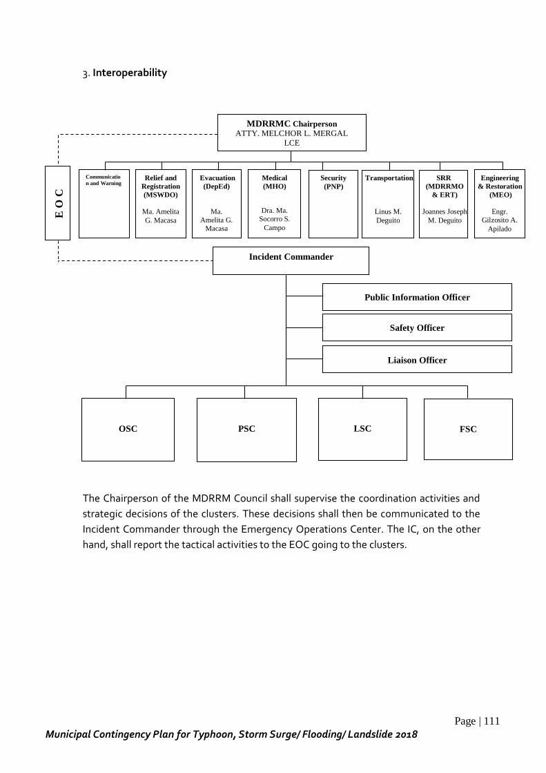
Page | 111
Municipal Contingency Plan for Typhoon, Storm Surge/ Flooding/ Landslide 2018
3. Interoperability
The Chairperson of the MDRRM Council shall supervise the coordination activities and
strategic decisions of the clusters. These decisions shall then be communicated to the
Incident Commander through the Emergency Operations Center. The IC, on the other
hand, shall report the tactical activities to the EOC going to the clusters.
Evacuation
(DepEd)
Ma.
Amelita G.
Macasa
Communicatio
n and Warning
Medical
(MHO)
Dra. Ma.
Socorro S.
Campo
Security
(PNP)
Transportation
Linus M.
Deguito
SRR
(MDRRMO
& ERT)
Joannes Joseph
M. Deguito
PSC
Safety Officer
Public Information Officer
OSC
Incident Commander
Liaison Officer
Relief and
Registration
(MSWDO)
Ma. Amelita
G. Macasa
Engineering
& Restoration
(MEO)
Engr.
Gilzosito A.
Apilado
LSC
FSC
E O
C
MDRRMC Chairperson
ATTY. MELCHOR L. MERGAL
LCE
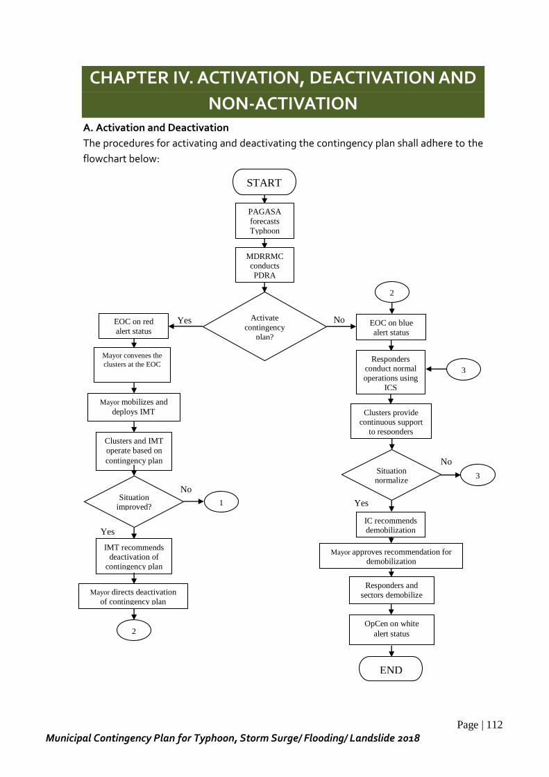
Page | 112
Municipal Contingency Plan for Typhoon, Storm Surge/ Flooding/ Landslide 2018
CHAPTER IV. ACTIVATION, DEACTIVATION AND
NON-ACTIVATION
A. Activation and Deactivation
The procedures for activating and deactivating the contingency plan shall adhere to the
flowchart below:
No
Yes
No
No Yes
Yes
EOC on red
alert status
Activate
contingency
plan?
Mayor convenes the
clusters at the EOC
Mayor mobilizes and
deploys IMT
Clusters and IMT
operate based on
contingency plan
Situation improved?
IMT recommends deactivation of
contingency plan
Mayor directs deactivation
of contingency plan
1
2
PAGASA
forecasts
Typhoon
START
MDRRMC conducts
PDRA
EOC on blue
alert status
2
Responders conduct normal
operations using
ICS
Clusters provide continuous support
to responders
IC recommends demobilization
Mayor approves recommendation for demobilization
Responders and
sectors demobilize
Situation normalize
d?
OpCen on white
alert status
END
3
3
Page | 113
Municipal Contingency Plan for Typhoon, Storm Surge/ Flooding/ Landslide 2018
The contingency plan shall be activated based on the findings of Pre-Disaster Risk
Assessment by the MDRRMC, leading to the activation of the EOC. Chairman of the
MDRRMC shall then convene all the clusters to assess the situation. Afterwards, he shall
officially activate ICS and delegate authority to the IC coming from the Municipal
DRRMO. The IC shall then proceed to organize the IMT and implement tactical activities
based on the strategic decisions of the clusters.
The contingency plan shall be deactivated once the situation has improved and when
heightened alert is no longer required. The recommendation for deactivation shall
emanate from the IC going to the MDRRMC chairman via the EOC. Once deactivated,
operation will still remain until such time that the EOC will be back to “white alert” status.
At this point, the operation is already terminated.
B. Non-Activation
In case that the typhoon will not take place in the months of June to December, the
contingency plan will not be activated. In this case, the plan will be maintained as a
perpetual plan for future use in the event of upcoming typhoons.
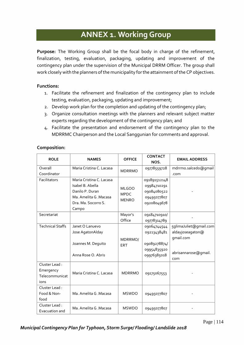
Page | 114
Municipal Contingency Plan for Typhoon, Storm Surge/ Flooding/ Landslide 2018
ANNEX 1. Working Group
Purpose: The Working Group shall be the focal body in charge of the refinement,
finalization, testing, evaluation, packaging, updating and improvement of the
contingency plan under the supervision of the Municipal DRRM Officer. The group shall
work closely with the planners of the municipality for the attainment of the CP objectives.
Functions:
1. Facilitate the refinement and finalization of the contingency plan to include
testing, evaluation, packaging, updating and improvement;
2. Develop work plan for the completion and updating of the contingency plan;
3. Organize consultation meetings with the planners and relevant subject matter
experts regarding the development of the contingency plan; and
4. Facilitate the presentation and endorsement of the contingency plan to the
MDRRMC Chairperson and the Local Sanggunian for comments and approval.
Composition:
ROLE NAMES OFFICE CONTACT
NOS. EMAIL ADDRESS
Overall
Coordinator
Maria Cristina C. Lacasa MDRRMO
09778559728 mdrrmo.salcedo@gmail
.com
Facilitators Maria Cristina C. Lacasa
Isabel B. Abella
Danilo P. Duran
Ma. Amelita G .Macasa
Dra. Ma. Socorro S.
Campo
MLGOO
MPDC
MENRO
091891512148
09984710291
09084080522
09495077807
09208049678
-
Secretariat Mayor’s
Office
09184710910/
09778314789 -
Technical Staffs Janet O Lanuevo
Jose AgatonAlday
Joannes M. Deguito
Anna Rose O. Abris
MDRRMO/
ERT
09064744544
09213438481
09089278874/
09954835920
09976385018
aldayjoseagaton@
gmail.com
abrisannarose@gmail.
com
Cluster Lead :
Emergency
Telecommunicat
ions
Maria Cristina C. Lacasa MDRRMO 09175067553 -
Cluster Lead :
Food & Non-
food
Ma. Amelita G .Macasa MSWDO 09495077807 -
Cluster Lead :
Evacuation and Ma. Amelita G .Macasa MSWDO 09495077807 -
Page | 115
Municipal Contingency Plan for Typhoon, Storm Surge/ Flooding/ Landslide 2018
Camp
Management
Cluster Lead:
Protection Ma. Amelita G .Macasa MSWDO 09495077807
Cluster Lead :
Health
Dra. Ma. Socorro S.
Campo MHO
09208049678 -
Cluster Lead :
Education School Heads
Cluster Lead:
Management of
the Dead and
the Missing
Eugenia Cillo MLGOO
Cluster Lead :
Law and Order PCI Edwin D. Tolibas SMPS 09283179127 -
Cluster Lead :
Humanitarian
Assistance
Linus Allan M. Deguito Admin.
Asst.
09778324569
-
Cluster Lead :
SRR
Joannes Joseph M.
Deguito
Salcedo
ERT
0916704626/
09954835920 -
Cluster Lead :
Logistics Engr. GilsozitoApilado MEO 09195911771 -
Members’ Duties and Responsibilities:
1. Overall Coordinator: in charge of the CP process; monitors the progress of CP;
initiates the conduct of meetings to review, evaluate and update the contingency
plan, as necessary; disseminates updates on the contingency plan to
agencies/offices concerned; leads the conduct of simulation exercises to test the
coherence and integrity of the plan.
2. Facilitator: facilitates CP meetings, workshops and simulation exercises; drives
the CP participants to achieve the target outputs.
3. Secretariat: documents proceedings of the meetings, workshops and simulation
exercises; take charges of the reproduction and distribution of the contingency
plan and other materials to the concerned meeting attendees and workshop
participants.
4. Technical Staffs: write the contents of the actual contingency plan; assimilates
comments, inputs and recommendations gathered during meetings, workshops
and simulation exercises to improve the contingency plan; consolidates the
outputs from the clusters/clusters and integrates them into the overall
contingency plan.
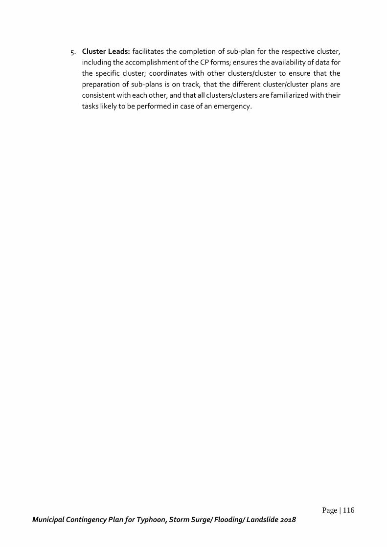
Page | 116
Municipal Contingency Plan for Typhoon, Storm Surge/ Flooding/ Landslide 2018
5. Cluster Leads: facilitates the completion of sub-plan for the respective cluster,
including the accomplishment of the CP forms; ensures the availability of data for
the specific cluster; coordinates with other clusters/cluster to ensure that the
preparation of sub-plans is on track, that the different cluster/cluster plans are
consistent with each other, and that all clusters/clusters are familiarized with their
tasks likely to be performed in case of an emergency.
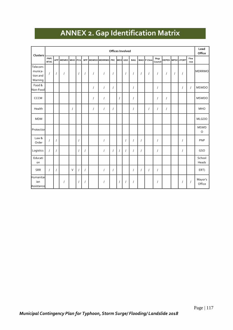
Page | 117
Municipal Contingency Plan for Typhoon, Storm Surge/ Flooding/ Landslide 2018
ANNEX 2. Gap Identification Matrix
Clusters
Offices Involved Lead
Office
PNP/
BTAC AFP MENRO MHO PCG BFP MSWDO MDRRMO PRC MEO GSO BAG MAO P Clinic
Brgy
Council DEPED MPDC J PORT
Fina
-nce
Telecom-
munica-
tion and
Warning
/ / / / / / / / / / / / / / / / MDRRMO
Food &
Non-Food / / / / / / / MSWDO
CCCM / / / / / / MSWDO
Health / / / / / / / / MHO
MDM MLGOO
Protection MSWD
O
Law &
Order / / / / / / / / / PNP
Logistics / / / / / / / / / / / / GSO
Educati
on
School
Heads
SRR / / V / / / / / / / / ERT)
Humanitar
ian
Assistance
/ / / / / / / / / / Mayor’s
Office
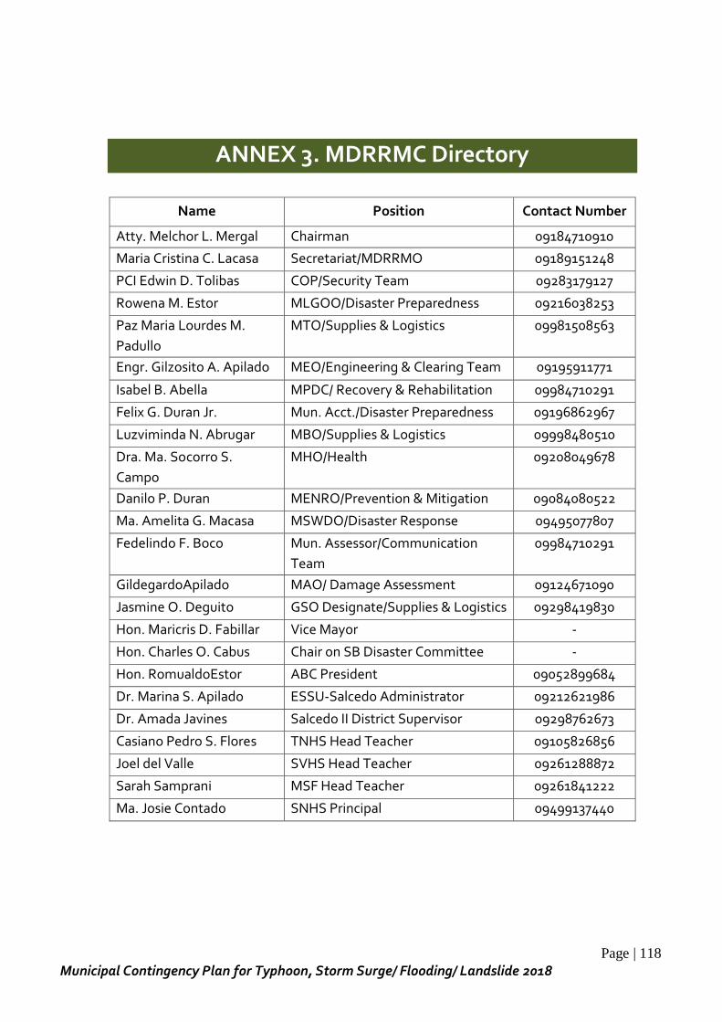
Page | 118
Municipal Contingency Plan for Typhoon, Storm Surge/ Flooding/ Landslide 2018
ANNEX 3. MDRRMC Directory
Name Position Contact Number
Atty. Melchor L. Mergal Chairman 09184710910
Maria Cristina C. Lacasa Secretariat/MDRRMO 09189151248
PCI Edwin D. Tolibas COP/Security Team 09283179127
Rowena M. Estor MLGOO/Disaster Preparedness 09216038253
Paz Maria Lourdes M.
Padullo
MTO/Supplies & Logistics 09981508563
Engr. Gilzosito A. Apilado MEO/Engineering & Clearing Team 09195911771
Isabel B. Abella MPDC/ Recovery & Rehabilitation 09984710291
Felix G. Duran Jr. Mun. Acct./Disaster Preparedness 09196862967
Luzviminda N. Abrugar MBO/Supplies & Logistics 09998480510
Dra. Ma. Socorro S.
Campo
MHO/Health 09208049678
Danilo P. Duran MENRO/Prevention & Mitigation 09084080522
Ma. Amelita G. Macasa MSWDO/Disaster Response 09495077807
Fedelindo F. Boco Mun. Assessor/Communication
Team
09984710291
GildegardoApilado MAO/ Damage Assessment 09124671090
Jasmine O. Deguito GSO Designate/Supplies & Logistics 09298419830
Hon. Maricris D. Fabillar Vice Mayor -
Hon. Charles O. Cabus Chair on SB Disaster Committee -
Hon. RomualdoEstor ABC President 09052899684
Dr. Marina S. Apilado ESSU-Salcedo Administrator 09212621986
Dr. Amada Javines Salcedo II District Supervisor 09298762673
Casiano Pedro S. Flores TNHS Head Teacher 09105826856
Joel del Valle SVHS Head Teacher 09261288872
Sarah Samprani MSF Head Teacher 09261841222
Ma. Josie Contado SNHS Principal 09499137440
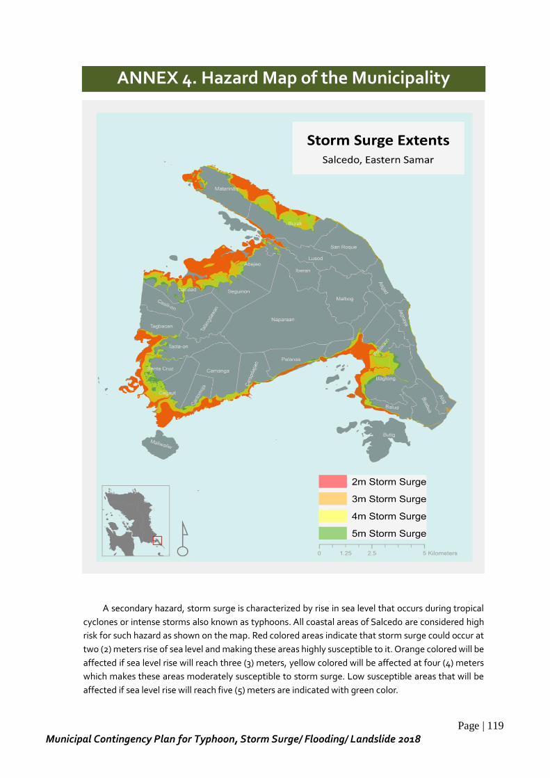
Page | 119
Municipal Contingency Plan for Typhoon, Storm Surge/ Flooding/ Landslide 2018
ANNEX 4. Hazard Map of the Municipality
A secondary hazard, storm surge is characterized by rise in sea level that occurs during tropical
cyclones or intense storms also known as typhoons. All coastal areas of Salcedo are considered high
risk for such hazard as shown on the map. Red colored areas indicate that storm surge could occur at
two (2) meters rise of sea level and making these areas highly susceptible to it. Orange colored will be
affected if sea level rise will reach three (3) meters, yellow colored will be affected at four (4) meters
which makes these areas moderately susceptible to storm surge. Low susceptible areas that will be
affected if sea level rise will reach five (5) meters are indicated with green color.
Page | 120
Municipal Contingency Plan for Typhoon, Storm Surge/ Flooding/ Landslide 2018
Ready Project identified the possibility of flooding occurrences in a 10 year event as well as the
level of susceptibility in the different barangays. With green indicating the areas that are less
susceptible to flooding and yellow as areas that will experience more flooding incident due to its
moderate level of susceptibility.
Page | 121
Municipal Contingency Plan for Typhoon, Storm Surge/ Flooding/ Landslide 2018
Landslide caused by heavy rains especially during monsoon season will
affect most of the areas in varying degree. Red colored areas are highly
susceptible, yellow are considered moderately susceptible, white with possibility
of accumulating landslide debris and green as low susceptible. It is noted that
landslide high risk areas are mountainous and higher grounds.
Page | 122
Municipal Contingency Plan for Typhoon, Storm Surge/ Flooding/ Landslide 2018
Copyright © 2022 FDOKUMEN