Seasonal air temperature variations retrieved from a Geladaindong ice core, Tibetan Plateau
Upload
independentCategory
view
0download
0
ORI GIN AL PA PER
Major Ion Geochemistry of Nam Co Lakeand its Sources, Tibetan Plateau
Qianggong Zhang Æ Shichang Kang Æ Feiyue Wang ÆChaoliu Li Æ Yanwei Xu
Received: 9 August 2006 / Accepted: 9 July 2008 / Published online: 29 July 2008� Springer Science+Business Media B.V. 2008
Abstract The major cations and anions from lake water samples and its sources,
including glacier snow, precipitation, stream, and swamp water in the Nam Co basin,
central Tibetan Plateau, were studied. The concentrations of the major ions varied
significantly in the five environmental matrices. Generally, the mean concentrations of
most ions are in the order of lake water [ swamp water [ stream water [ precipitation [snow. Rock weathering is the dominant process controlling the chemical compositions of
the stream and swamp waters, with carbonate weathering being the primary source of the
dissolved ions. The Nam Co lake water is characterized by high Na+ concentration and
extremely low Ca2+ concentration relative to other ions, resulting from evapoconcentration
and chemical precipitation within the lake. Comparison with the water chemistry of other
lakes over the Tibetan Plateau indicated that Nam Co is located in a transition area between
non-saline lakes and highly saline lakes. The relatively low concentration of total dissolved
solids is possibly due to the abundant inflow of glacial meltwater and relatively high annual
precipitation.
Keywords Nam Co � Tibetan Plateau � Alpine lakes � Major ion geochemistry �Water � Weathering
Q. Zhang � S. Kang (&) � C. Li � Y. XuInstitute of Tibetan Plateau Research, Chinese Academy of Sciences (CAS), Beijing 100085, Chinae-mail: [email protected]
S. KangState Key Laboratory of Cryospheric Sciences, CAS, Lanzhou 730000, China
Q. Zhang � C. Li � Y. XuGraduate University of CAS, Beijing 100049, China
F. WangDepartment of Environment and Geography, University of Manitoba, Winnipeg, Canada MB R3T 2N2
F. WangDepartment of Chemistry, University of Manitoba, Winnipeg, Canada MB R3T 2N2
123
Aquat Geochem (2008) 14:321–336DOI 10.1007/s10498-008-9039-y
1 Introduction
The Tibetan Plateau is the largest and highest plateau in the world, home to the tallest
mountain range, the Himalaya, and the highest mountain, Mount Everest (Qomolangma).
The plateau covers an area of about 2.5 9 106 km2, with an average elevation of over
4,000 m. Formed by tectonic plate collisions in the Cenozoic period, the uplift of the
plateau began at least 50 Myear ago and reached its present altitude 35–15 Myear ago
(Rowley and Currie 2006). The uplift of the plateau has greatly modified global climate
(Kutzbach et al. 1989) and influenced monsoon intensity (Molnar et al. 1993). Climati-
cally, the plateau lies at a critical junction of three climatic systems: the Indian monsoon,
the East Asian Monsoon, and the cold polar airflow from the Siberian high pressure system.
The human population density is sparse, and industrial activities remain minimal across
most of the plateau, making it one of most remote and ‘‘pristine’’ regions in the world.
However, concerns have been raised in recent years over the habitat loss due to excessive
pasturing and unsustainable development, chemical contamination due to long-range
transport of contaminants, and wide-scale systemic changes due to global climate change,
all of which are threatening the unique and fragile alpine ecosystems and Tibetan culture.
As the rooftop of the world, the Tibetan Plateau is the source of many major rivers in
Asia, including the Changjiang (Yangtze River), Huanghe (Yellow River), the Yarlung
Zangbu-Brahmaputra, and the Lancangjiang-Mekong. In addition to those large exorheic
river systems that cut through the plateau, there are also a vast number of endorheic rivers
and streams, most of which are seasonal and supplied by glacial meltwater and summer
precipitation. These endorheic rivers and streams form more than 1,500 alpine lakes in the
basins of the plateau. Whereas much scientific attention has been given to those exorheic
rivers (e.g., Chen et al. 2002, 2005), few studies are available on the water quality and
quantity and their evolution of the alpine lakes of the plateau.
In June 2005, the Nam Co Station for Multisphere Observation and Research (NAMOR)
was established by the Chinese Academy of Sciences in the southeast shore of Nam Co
(Lake Namtso) to thoroughly study the geology, hydrology, chemistry, biology, and
ecology of the largest lake in Tibet. As a pioneer research supported by NAMOR logistic
assistance, Li et al. (2007a) studied the major ionic chemistry of precipitation in this region
and indicated that the geochemistry of atmospheric deposition is mainly influenced by the
regional continental environment. However, studies on Nam Co water quality and related
geochemical processes, though critical for understanding this unique alpine lake system,
are yet absent. Here, we report the first study of the major ion geochemistry of Nam Co and
its source waters. This article is aimed at (a) providing a baseline dataset of major ion
concentrations in a Tibetan lake basin and (b) investigating the geochemical processes that
control the major ion chemistry.
2 Study Area and Methods
2.1 The Nam Co Basin
Nam Co (30�300–560 N, 90�160–91�030 E; 4,718 m a.s.l.) is the largest lake in Tibet, the
second largest saline lake on the Tibetan Plateau, and one of the highest large lakes in the
world (Fig. 1). The lake has a surface area of 1,920 km2 with a maximum depth of 122 m
(Li et al. 2008). Located in the heart of the Tibetan Plateau, Nam Co drains a closed basin
322 Aquat Geochem (2008) 14:321–336
123
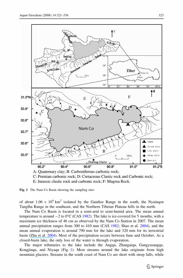
of about 1.06 9 104 km2 isolated by the Gandise Range in the south, the Nyainqen
Tanglha Range in the southeast, and the Northern Tibetan Plateau hills in the north.
The Nam Co Basin is located in a semi-arid to semi-humid area. The mean annual
temperature is around -2 to 0�C (CAS 1982). The lake is ice-covered for 5 months, with a
maximum ice thickness of 46 cm as observed by the Nam Co Station in 2007. The mean
annual precipitation ranges from 300 to 410 mm (CAS 1982; Shao et al. 2004), and the
mean annual evaporation is around 790 mm for the lake and 320 mm for its terrestrial
basin (Zhu et al. 2004). Most of the precipitation occurs between June and October. As a
closed-basin lake, the only loss of the water is through evaporation.
The major tributaries to the lake include the Angqu, Zhangaiqu, Gangyasangqu,
Kongjinqu, and Niyaqu (Fig. 1). Most streams around the lake originate from high
mountain glaciers. Streams in the south coast of Nam Co are short with steep falls, while
Fig. 1 The Nam Co Basin showing the sampling sites
Aquat Geochem (2008) 14:321–336 323
123
streams in the west coast are relatively longer and flow through vast flat areas. The major
supplies of these streams are glacial meltwater and precipitation. Wetlands are distributed
mainly along the stream estuaries in the east and west coasts of the lake (Yuan et al. 2002).
The dominant soil type in the basin is alpine meadow soil. Most of the soils have a
neutral to slightly alkaline pH (7–8) (Li et al. 2008). The basin is covered by alpine sedge
mats consisting mainly of Kobresia pygmaea (Yuan et al. 2002). Geologically, the Nam
Co basin is located on the Lhasa Terrain which was accreted during the Late Jurassic–Early
Cretaceous, pervasively intruded by the Cretaceous–Tertiary Gangdese plutonic belt and
overlain by volcanic rocks of equivalent age (Kapp et al. 2005). The southern and
southeastern basins expose Cretaceous–Tertiary granitoids and orthogenises, Paleozoic to
Cretaceous metasedimentary lithologies consisting of slate, phyllite, metaconglomerate,
metalimestone, Cetaceous red sandstone, mudstone, and conglomerate, and Quaternary
glacial, alluvial fan, fluvial, and lacustrine deposits (Kapp et al. 2005). The northern and
western basins are underlain mainly by limestone, sandstone, quartz, and breccia. Some
isolated broken hills stand close to the northeastern lakeshore; these hills are mainly
composed of limestone, and some of the steeps are wave-eroded and developed into
limestone caves. The bedrock geological setting of the Nam Co basin is shown in Fig. 1.
There are no industrial activities or urban development within the Nam Co basin, except
for some small Tibetan villages. The basin is, however, a popular pasturing area. Degra-
dation and desertification have been reported in the Pelgon County north of the lake due to
natural causes and excess pasturing (Yuan et al. 2002).
2.2 Sampling and Sample Analysis
Stream, swamp, and Nam Co Lake surface water samples were collected in August and
September, 2005, throughout the Nam Co Basin (Fig. 1) for the analysis of major cations
and anions.
A total of 48 precipitation samples were collected on NAMOR during August 2005–
July 2006. A 152-cm deep snow pit was sampled at 5 cm intervals on May 21, 2006 at the
col of the Zhadang glacier (5,800 m a.s.l.), 50 km southwest of the station (Fig. 1). The
major ion chemistry of the precipitation and snow pit samples have been reported and
discussed by Li et al. (2007a), and here, we incorporated the data of mean ionic con-
centrations into this article to impel the discussion. Stream, swamp, and lake surface water
samples were collected in pre-cleaned polyethylene bottles at sites shown in Fig. 1. The
bottles were rinsed three times with sample water. Great caution was taken to minimize
potential contamination during the sampling process.
All the samples were kept frozen and immediately transported to the laboratory of the
Institute of Tibetan Plateau Research, CAS. Upon arrival in the lab, all the samples were
melted at the room temperature and analyzed for major ions. Analysis of major cations
(Ca2+, Mg2+, Na+, K+, and NH4+) was carried out by ion chromatography (IC) using a
Dionex ISC 2000 ion chromatograph, an IonPac CS12A column, 20 mM methanesulfonic
acid (MSA) eluent, and CSRS suppresser. Major anions (Cl-, NO3-, and SO4
2-) were
analyzed by Dionex ISC 2500 ion chromatograph, using an IonPac AS11-HC column,
25 mM KOH eluent, and ASRS suppresser. The detection limits were 1 lg l-1 for all ions
and analytical precision was within 5%. Analysis of field blanks showed that contamina-
tion during the sampling procedure, transportation, and treatment were not significant.
The alkalinity was calculated by the difference between the sum of all the cations and
that of the anions (in equivalents). Since the pH of stream and swamp water are generally
324 Aquat Geochem (2008) 14:321–336
123
lower than 8.8, CO32- can be neglected. However, the pH of lake water (around 9.4) is
highly alkaline (Li et al. 2008), hereby the contribution of CO32- in the alkalinity cannot
be neglected. The concentrations of HCO3- and CO3
2- in lake water are calculated from
the total carbonate concentration based on the following equation:
HCO�3 ¼ CO2�3 þ Hþ; log Ka2 ¼ �10:33
Assuming the pH of all lake samples is 9.4, the HCO3- and CO3
2- should account for
*89.5% and *10.5% of total carbonate (Qian and Ma 2005). The concentration of the
total dissolved solids (TDS) was calculated by summing up all the ions including the
estimated concentration of HCO3- and CO3
2-.
3 Results and Discussion
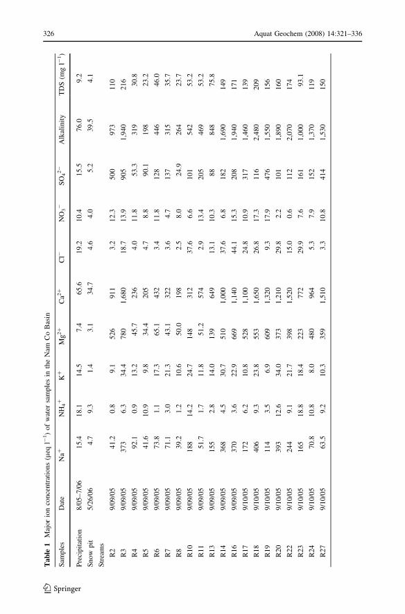
The dissolved ions were present in a wide range of concentrations in the five environmental
matrices (Table 1). In general, the mean concentrations of most ions are in the order of
lake water [ swamp water [ stream water [ precipitation [ snow.
3.1 Chemistry of the Atmospheric Precipitation
The TDS of precipitation and glacier snow in the Nam Co Basin is very low, compared
with that of stream, swamp, and lake waters. The cations are dominated by Ca2+, and
anions by HCO3-. As suggested by Li et al. (2007a), major ion concentrations in pre-
cipitation were higher than those in snow pit samples, due to the relatively higher local
aerosol inputs (Cong et al. 2007). The precipitation chemistry in the Nam Co basin is
mainly influenced by the regional environment, dominated by crustal dust aerosols. Wind
blown lake salt aerosols also affect precipitation chemistry, especially in summer. Sea salt
contribution is the least due to the long distance of transport.
3.2 Stream and Swamp Water
Stream and swamp waters in the Nam Co basin showed similar major ion compositions
(Table 1). On an equivalence basis, Ca2+ and Mg2+ were the dominant cations, accounting
for *86% of total cations in stream water and *87% in swamp water; Ca2+ alone
accounted for 63% and 67% of total cations in stream and swamp water, respectively.
Anions were dominated by HCO3- and SO4
2- which constituted *98% of total anions in
stream water and *97% in swamp water; HCO3- alone accounted for 82% and 91% of
total anions in stream and swamp water, respectively. When pooling stream and swamp
waters together, HCO3- correlated significantly with Ca2+ and Mg2+ (r = 0.95 and 0.84,
respectively), and a close correlation was also found between Ca2+ and Mg2+ (r = 0.81).
The weathering of rock-forming minerals, with a minor contribution from atmospheric
and anthropogenic sources, is the major source of dissolved ions in most aquatic systems
(Stallard and Edmond 1983). Gibbs (1970) suggested that a simple plot of TDS versus the
weight ratio of Na+/(Na+ + Ca2+) could provide information on the relative importance
of three major natural mechanisms controlling surface water chemistry: (1) atmospheric
precipitation; (2) rock weathering, and (3) evaporation and fractional crystallization. The
composition of the swamps and most streams in the Nam Co drainage basin falls in the
rock-weathering domain, suggesting that their chemical compositions are mainly
Aquat Geochem (2008) 14:321–336 325
123
Ta
ble
1M
ajor
ion
con
cen
trat
ion
s(l
eql-
1)
of
wat
ersa
mple
sin
the
Nam
Co
Bas
in
Sam
ple
sD
ate
Na+
NH
4+
K+
Mg
2+
Ca2
+C
l-N
O3
-S
O4
2-
Alk
alin
ity
TD
S(m
gl-
1)
Pre
cipit
atio
n8
/05
–7
/06
15
.41
8.1
14
.57
.46
5.6
19
.21
0.4
15
.57
6.0
9.2
Sn
ow
pit
5/2
6/0
64
.79
.31
.43
.13
4.7
4.6
4.0
5.2
39
.54
.1
Str
eam
s
R2
9/0
9/0
54
1.2
0.8
9.1
52
69
11
3.2
12
.35
00
97
31
10
R3
9/0
9/0
53
73
6.3
34
.47
80
1,6
80
18
.71
3.9
90
51
,94
02
16
R4
9/0
9/0
59
2.1
0.9
13
.24
5.7
23
64
.01
1.8
53
.33
19
30
.8
R5
9/0
9/0
54
1.6
10
.99
.83
4.4
20
54
.78
.89
0.1
19
82
3.2
R6
9/0
9/0
57
3.8
1.1
17
.36
5.1
43
23
.41
1.8
12
84
46
46
.0
R7
9/0
9/0
57
1.1
3.0
21
.34
3.1
32
23
.64
.71
37
31
53
5.7
R8
9/0
9/0
53
9.2
1.2
10
.65
0.0
19
82
.58
.02
4.9
26
42
3.7
R10
9/0
9/0
51
88
14
.22
4.7
14
83
12
37
.66
.61
01
54
25
3.2
R11
9/0
9/0
55
1.7
1.7
11
.85
1.2
57
42
.91
3.4
20
54
69
53
.2
R13
9/0
9/0
51
55
2.8
14
.01
39
64
91
3.1
10
.38
88
48
75
.8
R14
9/0
9/0
53
68
4.5
30
.75
10
1,0
00
37
.66
.81
82
1,6
90
14
9
R16
9/0
9/0
53
70
3.6
22
.96
69
1,1
40
44
.11
5.3
20
81
,94
01
71
R17
9/1
0/0
51
72
6.2
10
.85
28
1,1
00
24
.81
0.9
31
71
,46
01
39
R18
9/1
0/0
54
06
9.3
23
.85
53
1,6
50
26
.81
7.3
11
62
,48
02
09
R19
9/1
0/0
51
14
3.5
6.9
60
91
,320
9.3
17
.94
76
1,5
50
15
6
R20
9/1
0/0
53
93
12
.63
4.0
37
31
,210
29
.82
.21
01
1,8
90
16
0
R22
9/1
0/0
52
44
9.1
21
.73
98
1,5
20
15
.00
.61
12
2,0
70
17
4
R23
9/1
0/0
51
65
18
.81
8.4
22
37
72
29
.97
.61
61
1,0
00
93
.1
R24
9/1
0/0
57
0.8
10
.88
.04
80
96
45
.37
.91
52
1,3
70
11
9
R27
9/1
0/0
56
3.5
9.2
10
.33
59
1,5
10
3.3
10
.84
14
1,5
30
15
0
326 Aquat Geochem (2008) 14:321–336
123
Ta
ble
1co
nti
nu
ed
Sam
ple
sD
ate
Na+
NH
4+
K+
Mg
2+
Ca2
+C
l-N
O3
-S
O4
2-
Alk
alin
ity
TD
S(m
gl-
1)
Sw
amp
s
Z1
9/1
0/0
51
09
16
.77
.81
49
1,2
60
15
.37
.04
4.5
1,4
80
12
3
Z2
9/1
0/0
54
14
14
.41
8.1
56
11
,500
43
.64
6.5
23
42
,18
01
95
Z5
9/1
0/0
51
06
16
.56
.23
72
95
71
5.7
5.6
87
.71
,35
01
14
Nam
Co
L1
9/0
9/0
56
,990
16
.64
73
3,5
10
27
31
,18
02
4.0
2,8
00
7,2
60
78
4
L2
9/0
9/0
56
,760
15
.44
43
3,4
30
34
29
63
3.5
2,4
20
7,6
00
76
9
L4
9/1
0/0
56
,840
17
.04
42
3,8
70
30
19
58
4.0
2,4
00
8,1
10
80
1
L5
9/1
0/0
57
,530
21
.65
33
3,5
20
34
01
,38
02
.33
,300
7,2
60
83
0
L6
9/1
0/0
58
,170
20
.75
79
3,7
70
27
11
,54
03
.23
,680
7,5
90
89
0
L7
9/1
0/0
57
,100
15
.74
86
3,5
40
32
11
,21
05
.73
,120
7,1
30
79
6
L8
9/1
0/0
58
,140
17
.95
24
4,3
70
32
71
,15
02
.12
,900
9,3
30
93
5
L9
9/1
0/0
51
0,1
00
21
.46
72
5,3
40
36
31
,47
03
.03
,660
11
,40
01
,150
L1
09
/10
/05
6,7
00
19
.94
97
3,2
30
21
51
,34
02
.63
,110
6,2
10
73
8
No
tes:
Dat
afo
rp
reci
pit
atio
nan
dsn
ow
pit
are
cite
dfr
om
Li
etal
.(2
00
7a)
.T
he
alkal
init
yw
asca
lcula
ted
from
ach
arge
bal
ance
bet
wee
nal
lth
eoth
erca
tions
and
anio
ns
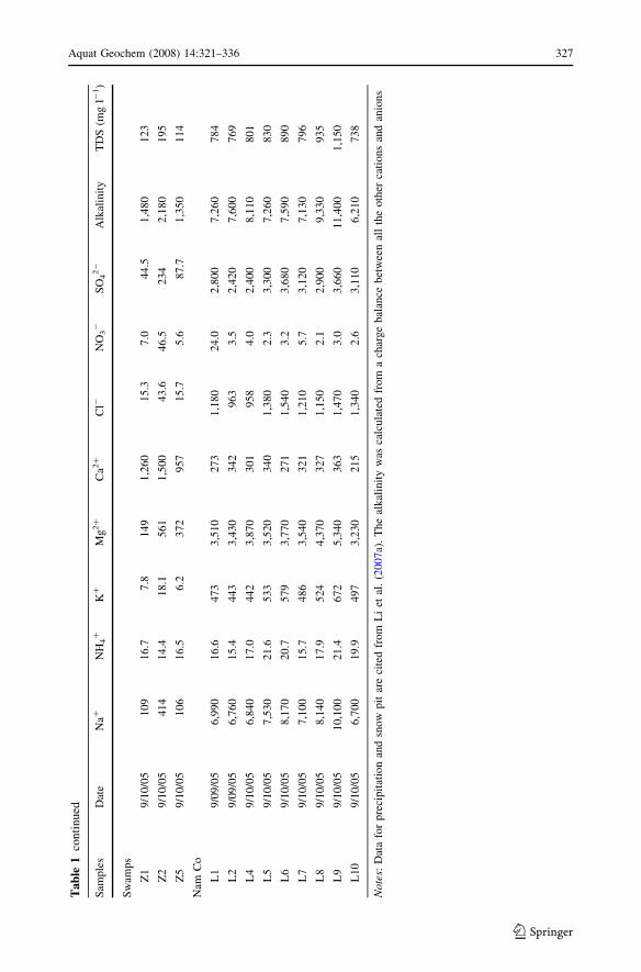
Aquat Geochem (2008) 14:321–336 327
123
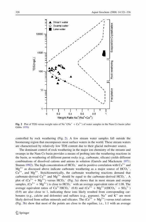
controlled by rock weathering (Fig. 2). A few stream water samples fall outside the
boomerang region that encompasses most surface waters in the world. These stream waters
are characterized by relatively low TDS content due to their glacial meltwater source.
The dominant control of rock weathering in the major ion chemistry of the streams and
swamps in the Nam Co basin provides a means of probing into the weathering reactions in
the basin, as weathering of different parent rocks (e.g., carbonate, silicate) yields different
combinations of dissolved cations and anions in solution (Garrels and Mackenzie 1971;
Stumm 1992). The high concentration of HCO3- and its positive correlation with Ca2+ and
Mg2+ as discussed above indicate carbonate weathering as a major source of HCO3-,
Ca2+, and Mg2+. Stoichiometrically, the carbonate weathering reactions demand that
carbonate-derived Ca2+ and Mg2+ should be equal to the carbonate-derived HCO3-. A
plot of (Ca2+ + Mg2+) versus HCO3- (Fig. 3a) shows that in most stream and swamp
samples, (Ca2+ + Mg2+) is close to HCO3- with an average equivalent ratio of 1.08. The
average equivalent ratios of Ca2+/HCO3- (0.8) and (Ca2+ + Mg2+)/(HCO3
- + SO42-)
(0.9) are also close to 1, indicating these ions likely resulted from corresponding car-
bonates (e.g., calcite and dolomite) and sulfates (e.g., gypsum). Na+ and K+ are most
likely derived from sulfate minerals and silicates. The (Ca2+ + Mg2+) versus total cations
(Fig. 3b) show that most of the points are close to the equiline, i.e., 1:1 with an average
Fig. 2 Plot of TDS versus weight ratio of Na+/(Na+ + Ca2+) of water samples in the Nam Co basin (afterGibbs 1970)
328 Aquat Geochem (2008) 14:321–336
123
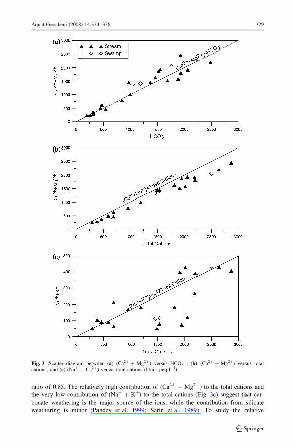
ratio of 0.85. The relatively high contribution of (Ca2+ + Mg2+) to the total cations and
the very low contribution of (Na+ + K+) to the total cations (Fig. 3c) suggest that car-
bonate weathering is the major source of the ions, while the contribution from silicate
weathering is minor (Pandey et al. 1999; Sarin et al. 1989). To study the relative
Fig. 3 Scatter diagram between (a) (Ca2+ + Mg2+) versus HCO3-; (b) (Ca2+ + Mg2+) versus total
cations; and (c) (Na+ + Ca2+) versus total cations (Unit: leq l-1)
Aquat Geochem (2008) 14:321–336 329
123
importance of two major proton-producing reactions—carbonation and sulfide oxidation,
the equivalent ratio of (HCO3-/HCO3
- + SO42-), called the C-ratio (Brown et al. 1996),
is calculated. Generally, a C-ratio of 1.0 would signify carbonic acid weathering involving
pure dissolution and acid hydrolysis, consuming protons come from atmospheric CO2.
Conversely, a ratio of 0.5 would suggest coupled reactions involving the weathering of
carbonates by protons derived from sulfide oxidation. For the stream and swamp waters in
the Nam Co basin, the C-ratio is always higher than 0.6, signifying that carbonic acid
weathering is the major proton producer.
The dominant role of carbonate weathering in controlling chemical composition of
inflow waters is further supported by the wide distribution of carbonate rocks in the Nam
Co basin (Fig. 1).
3.3 Lake Water
The major ion composition of the Nam Co lake water is characterized by HCO3- and
SO42- as the dominant anions, and Na+ and Mg2+ as the dominant cations; Ca2+ was
extremely low compared with other cations. On an equivalence basis, Na+ accounted for
*62% of total cations and HCO3- accounted for *65% of total anions. Furthermore, low
standard deviations of major ion concentrations indicate the lake surface water was mixed
well. The result is in general agreement with the previous survey conducted by Zhao et al.
(2003), which reported that all the soil samples around the lakeshore were carbonate-rich
sandstone and conglomeration.
Dissolved salts in the lake water can be derived from a variety of physical, chemical,
and biological processes in the drainage basin. Three sources have been named by Berner
and Berner (1996) as the possible causes of dissolved salts into the lake waters, which
include (1) sea salts carried by the atmospheric transport and deposited in lakes, (2)
weathering of silicate, carbonate, evaporite, and sulfide minerals in the drainage basin, and
(3) anthropogenic input. As discussed earlier, the contribution of sea salts to ion compo-
sition of precipitation is of least importance due to the long distance transport. This,
together with the very low annual precipitation rate (300–410 mm), suggests that the sea
salts play a negligible role in the ion composition of the Nam Co lake water. Anthropo-
genic impact is also minimal, due to the sparse population and almost non-existent
industrial activities in the area. Additionally, airborne substances and underground water
can also contribute to the ionic load in the lake. Although no data is available, we suspect
their contributions are minor. The geochemical evolution in evaporative lakes without river
outlets is primarily controlled by inflow composition, selective removal processes of
dissolved species, and concentration processes in the lake basin (Yan et al. 2002). Inflow
streams around Nam Co are the major supply of the lake water and thus contribute most of
the ionic load of the lake water. Compared with the stream and swamp waters in the basin,
the Nam Co lake water is characterized by the enrichment of Na+ and depleted in Ca2+.
The enrichment of Na+ in lake water has been observed in many evaporative lakes in
Tibetan Plateau (e.g., Wang and Dou 1998; Yang et al. 2003). The mean annual evapo-
ration in Nam Co basin is approximately 790 mm (Zhu et al. 2004), which is twice the
mean annual precipitation. In addition, the water balance of Nam Co in the last 15 years
was negative as estimated by the records of lake sediment (Mugler et al. 2008). Salinity in
Nam Co lake water has been increasing in the last 200 years and has experienced an
intensive increase since the middle of 1960s, as inferred from the increasing trend of the
lake water conductivity, which is reconstructed based on its relationship with the diatom in
330 Aquat Geochem (2008) 14:321–336
123
the lake sediments. This is mainly due to the significant evaporation resulting in the
negative water balance (Wang et al. 2006). Therefore, we conclude that the enrichment of
Na+ is mainly due to the evapoconcentration. The depletion of Ca2+ is another notable
characteristic of lake water, most likely due to the selective removal processes operating in
the lake (e.g., Banks et al. 2004). Since Nam Co lake water has reached a high pH and
salinity, the mineral precipitation (such as bio-induced Ca-carbonate) would be the most
important selective removal process (Yan et al. 2002). This is supported by the study
carried out by Li et al. (2008), in which carbonates are the major components of the
lacustrine sediments from Nam Co. Additionally, the lake sediment is enriched of
monohydrocalcite, which is linked to an alkaline environment and the presence of bacteria,
algae, diatoms, and ostracodas (Li et al. 2008). The calculation of saturation indices
(1–1.2) of calcite also signify that lake waters are significantly supersaturated with respect
to calcium carbonate, indicating that the HCO3- concentrations are high enough to
facilitate carbonate mineral precipitation. Thus, the depletion of Ca2+ in the lake water is
likely due to its removal by carbonate precipitation and biological activities.
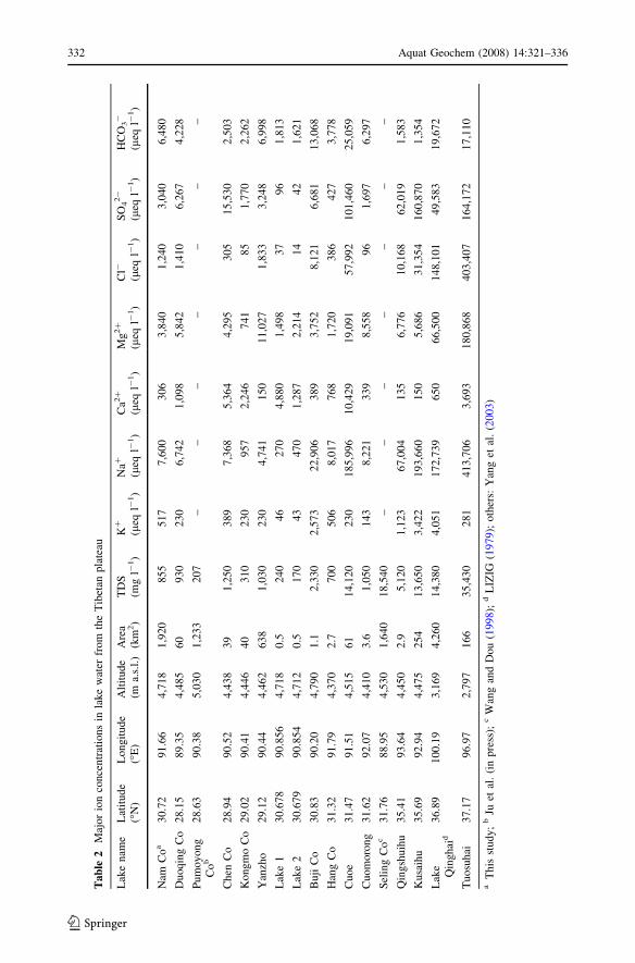
Table 2 compares major ion concentrations between Nam Co and other lakes over the
Tibetan Plateau. Lake Duoqing Co, Pumoyong Co, Chen Co, Kongmo Co, and Yanzho are
located in the southern Tibetan Plateau, Lake 1/2, Buji Co, Hang Co, Cuoe, Cuomorong,
and Seling Co are close to Nam Co, while Lake Qinghai, Qingshuihu, Kusaihu, and
Tuosuhai lie in the northern part of the Tibetan Plateau. TDS in the Nam Co water is low–
intermediate among all the lakes. Generally, lakes with higher TDS have Na+ and Cl- as
the dominant ions, while Ca2+ and SO42- are the major ions in lakes with lower TDS. Ion
composition patterns vary with TDS, while TDS tends to increase with the latitude.
Southern lakes contain mostly fresh water with lower TDS, while northern lakes tend to be
alkaline with higher TDS. It has been recognized (CAS 1982) that on large scale, there is a
climatic pattern transition from warm-wet to cold-dry from the south to the north over the
Tibetan Plateau, mainly resulting from the precipitation gradient induced by the decreasing
influence of the Indian summer monsoon. Thus, lakes exhibit transitions in the order of
fresh water lakes–saline lakes–highly saline lakes (CAS 1984). Nam Co is geographically
located in the transition area between non-saline lakes and highly saline lakes, and
accordingly displays intermediate TDS. Nevertheless, local climatic conditions and envi-
ronment within basins play a significant role on geochemistry of lake water. TDS in Nam
Co is relatively low compared with the nearby lakes. This is possibly due to the abundant
inflow supplies from glacial meltwater (CAS 1984) and relatively high annual
precipitation.
3.4 Ions Evolution in the Nam Co Lake Basin
Ternary diagrams of cations and anions (Fig. 4) were plotted to evaluate the evolution of
solutes from the glacier snow to streams and to lake water in the Nam Co basin.
As shown in Fig. 4, Ca2+ is abundant in the glacier snow, due to the dry deposition of
dust aerosols on the glacier surface, especially during winter and spring (Li et al. 2007a).
Meanwhile, calcium is the major element in the aerosols collected in the glacier area in the
Nam Co basin even during summer season as suggested by Li et al. (2007b). The relative
abundance of TDS experienced a sharp increase during its evolution from the glacier snow
to the stream water (Table 1), due to the release of solutes from the stream beds. This is
understandable because the relative ionic abundance increases rapidly during its evolution
from glacier snow to proglacial water (e.g., Fortner et al. 2005). Besides, streams were
Aquat Geochem (2008) 14:321–336 331
123
Ta
ble
2M
ajo
rio
nco
nce
ntr
atio
ns
inla
ke
wat
erfr
om
the
Tib
etan
pla
teau
Lak
en
ame
Lat
itu
de
(�N
)L
on
git
ud
e(�
E)
Alt
itu
de
(ma.
s.l.
)A
rea
(km
2)
TD
S(m
gl-
1)
K+
(leq
l-1)
Na+
(leq
l-1)
Ca2
+
(leq
l-1)
Mg
2+
(leq
l-1)
Cl-
(leq
l-1)
SO
42-
(leq
l-1)
HC
O3-
(leq
l-1)
Nam
Co
a3
0.7
29
1.6
64
,71
81
,920
85
55
17
7,6
00
30
63
,840
1,2
40
3,0
40
6,4
80
Du
oq
ing
Co
28
.15
89
.35
4,4
85
60
93
02
30
6,7
42
1,0
98
5,8
42
1,4
10
6,2
67
4,2
28
Pu
mo
yo
ng
Co
b2
8.6
39
0.3
85
,03
01
,233
20
7–
––
––
––
Ch
enC
o2
8.9
49
0.5
24
,43
83
91
,250
38
97
,368
5,3
64
4,2
95
30
51
5,5
30
2,5
03
Ko
ng
mo
Co
29
.02
90
.41
4,4
46
40
31
02
30
95
72
,24
67
41
85
1,7
70
2,2
62
Yan
zho
29
.12
90
.44
4,4
62
63
81
,030
23
04
,741
15
01
1,0
27
1,8
33
3,2
48
6,9
98
Lak
e1
30
.67
89
0.8
56
4,7
18
0.5
24
04
62
70
4,8
80
1,4
98
37
96
1,8
13
Lak
e2
30
.67
99
0.8
54
4,7
12
0.5
17
04
34
70
1,2
87
2,2
14
14
42
1,6
21
Bu
jiC
o3
0.8
39
0.2
04
,79
01
.12
,330
2,5
73
22
,90
63
89
3,7
52
8,1
21
6,6
81
13
,06
8
Han
gC
o3
1.3
29
1.7
94
,37
02
.77
00
50
68
,017
76
81
,720
38
64
27
3,7
78
Cu
oe
31
.47
91
.51
4,5
15
61
14
,12
02
30
18
5,9
96
10
,42
91
9,0
91
57
,99
21
01
,46
02
5,0
59
Cu
om
oro
ng
31
.62
92
.07
4,4
10
3.6
1,0
50
14
38
,221
33
98
,558
96
1,6
97
6,2
97
Sel
ing
Co
c3
1.7
68
8.9
54
,53
01
,640
18
,54
0–
––
––
––
Qin
gsh
uih
u3
5.4
19
3.6
44
,45
02
.95
,120
1,1
23
67
,00
41
35
6,7
76
10
,16
86
2,0
19
1,5
83
Ku
saih
u3
5.6
99
2.9
44
,47
52
54
13
,65
03
,42
21
93
,66
01
50
5,6
86
31
,35
41
60
,87
01
,354
Lak
eQ
ingh
aid
36
.89
10
0.1
93
,16
94
,260
14
,38
04
,05
11
72
,73
96
50
66
,50
01
48
,10
14
9,5
83
19
,67
2
Tu
osu
hai
37
.17
96
.97
2,7
97
16
63
5,4
30
28
14
13
,70
63
,69
31
80
,86
84
03
,40
71
64
,17
21
7,1
10
aT
his
stu
dy
;b
Juet
al.
(in
pre
ss);
cW
ang
and
Do
u(1
99
8);
dL
IZIG
(19
79);
oth
ers:
Yan
get
al.
(20
03)
332 Aquat Geochem (2008) 14:321–336
123
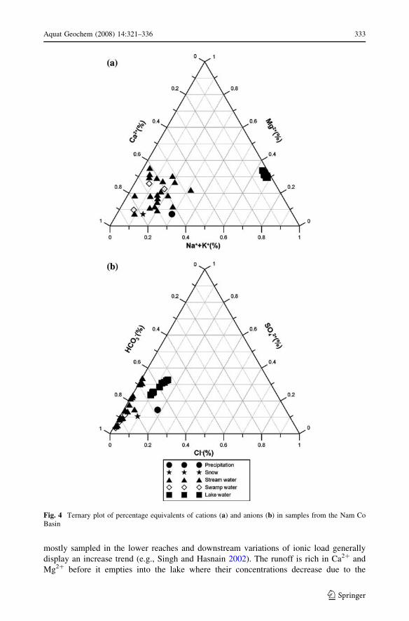
mostly sampled in the lower reaches and downstream variations of ionic load generally
display an increase trend (e.g., Singh and Hasnain 2002). The runoff is rich in Ca2+ and
Mg2+ before it empties into the lake where their concentrations decrease due to the
Fig. 4 Ternary plot of percentage equivalents of cations (a) and anions (b) in samples from the Nam CoBasin
Aquat Geochem (2008) 14:321–336 333
123
chemical precipitation in the lake. On the contrary, Na+ and K+ are relatively low in the
stream water but are the dominant cations in the lake water due to the evapoconcentration
and the Ca2+ removal. The ternary diagram of anions, however, shows relatively little
difference in various waters due to the predominance of HCO3- in all the waters. The
relative abundance of HCO3- increases when the meltwater flows through the bedrocks,
resulting from the rock weathering as discussed earlier. The relative abundance of SO42-
and Cl- increases during the evolution of stream to lake water, signifying the salinity trend
of lake water.
4 Conclusions
This study represents the first effort in establishing a database for the major ion concen-
trations of the Nam Co lake and its sources. The mean concentration of almost all the major
ions in the various environmental matrices is of the order lake water [ swamp
water [ stream water [ precipitation [ glacier snow. The major ion geochemistry of
various water matrices are summarized in Table 3. The geochemistry of the atmospheric
precipitation in the Nam Co area is predominantly influenced by the regional crustal
aerosols. Chemical compositions of stream and swamp waters are controlled by rock
weathering particularly by the weathering of carbonates which is abundant in the basin.
The lake water is characterized by enrichment of Na+ and depletion in Ca2+, due to the
evapoconcentration effect and Ca2+ removal by chemical precipitation and biological
activities.
Acknowledgments We thank Zhiyuan Cong and the staff of NAMOR for their assistance in field logistics.This study was supported by the National Natural Science Foundation of China (40771187), the NationalBasic Research program of China (2005CB422004), the ‘‘Talent Project’’ of the Chinese Academy ofSciences.
References
Banks D, Parnachev VP, Frengstad B, Holden W, Karnachuk OV, Vedernikov AA (2004) The evolution ofalkaline, saline ground- and surface waters in the southern Siberian steppes. Appl Geochem19(12):1905–1926. doi:10.1016/j.apgeochem.2004.05.009
Berner EK, Berner RA (1996) Global environment: water, air, and geochemical cycles. Prentice Hall, NewJersey
Brown GH, Sharp M, Tranter M (1996) Subglacial chemical erosion: seasonal variations in soluteprovenance, Haut Glacier d’Arolla, Valais, Switzerland. In: Collins D (ed) Annals of glaciology,vol 22. Proceedings of the international symposium on glacial erosion and sedimentation. Annals ofglaciology, pp 25–31
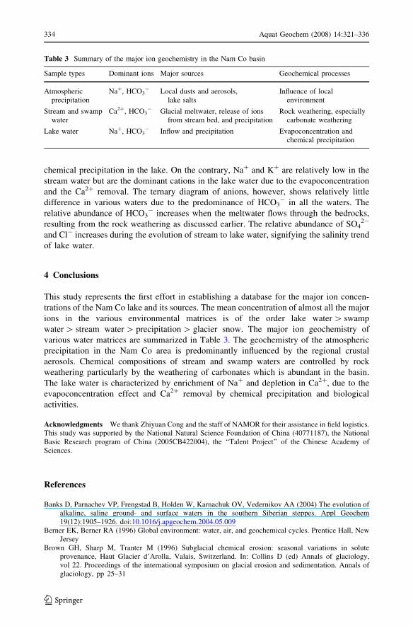
Table 3 Summary of the major ion geochemistry in the Nam Co basin
Sample types Dominant ions Major sources Geochemical processes
Atmosphericprecipitation
Na+, HCO3- Local dusts and aerosols,
lake saltsInfluence of local
environment
Stream and swampwater
Ca2+, HCO3- Glacial meltwater, release of ions
from stream bed, and precipitationRock weathering, especially
carbonate weathering
Lake water Na+, HCO3- Inflow and precipitation Evapoconcentration and
chemical precipitation
334 Aquat Geochem (2008) 14:321–336
123
CAS (1982) Physical geography of Xizang (Tibet). Science Press, BeijingCAS (1984) Rivers and Lakes of Xizang(Tibet). Science Press, BeijingChen JS, Wang FY, Xia XH, Zhang LT (2002) Major element chemistry of the Changjiang (Yangtze River).
Chem Geol 187(3–4):231–255. doi:10.1016/S0009-2541(02)00032-3Chen JS, Wang FY, Meybeck M, He DW, Xia XH, Zhang LT (2005) Spatial and temporal analysis of water
chemistry records (1958-2000) in the Huanghe (Yellow River) basin. Glob Biogeochem Cycles 19(3).doi:10.1029/2004GB002325
Cong ZY, Kang SC, Liu XD, Wang GF (2007) Elemental composition of aerosol in the Nam Co region,Tibetan Plateau, during summer monsoon season. Atmos Environ 41(6):1180–1187. doi:10.1016/j.atmosenv.2006.09.046
Fortner SK, Tranter M, Fountain A, Lyons WB, Welch KA (2005) The geochemistry of supraglacial streamsof Canada Glacier, Taylor Valley (Antarctica), and their evolution into proglacial waters. AquatGeochem 11(4):391–412. doi:10.1007/s10498-004-7373-2
Garrels RM, Mackenzie FT (1971) Evolution of sedimentary rocks. Norton, New YorkGibbs RJ (1970) Mechanisms controlling world water chemistry. Science 170:1088–1090. doi:
10.1126/science.170.3962.1088Ju JT, Zhu LP, Wang Y, Xie MP, Peng P, Zhen XL Wang JB (in press) Preliminary research on compo-
sition, spatial distribution, and environmental significance of water ions in Pumayum Co lake and itscatchment, South Tibet. J Geogr Sci
Kapp JLD, Harrison TM, Kapp P, Grove M, Lovera OM, Lin D (2005) Nyainqentanglha Shan: a windowinto the tectonic, thermal, and geochemical evolution of the Lhasa block, southern Tibet. J GeophysRes Solid Earth 110(B8). doi:10.1029/2004JB003330
Kutzbach JE, Guetter PJ, Ruddiman WF, Prell WL (1989) Sensitivity of climate to late Cenozoic uplift insouthern Asia and the American West: numerical experiments. J Geophys Res 94(D15):18393–18407.doi:10.1029/JD094iD15p18393
Li C, Kang SC, Zhang QG, Kaspari S (2007a) Major ionic composition of precipitation in the Nam Coregion, Central Tibetan Plateau. Atmos Res 85(3–4):351–360. doi:10.1016/j.atmosres.2007.02.006
Li CL, Kang S, Cong ZY (2007b) Elemental composition of aerosols collected in the glacier area on Mt.Nyainqentanglha, Tibetan Plateau, during summer monsoon season. Chin Sci Bull 52(24):3436–3442.doi:10.1007/s11434-007-0445-0
Li CL, Kang SC, Wang XP, Ajmone-Marsan F, Zhang QG (2008) Heavy metals and rare earth elements(REEs) in soil from the Nam Co Basin, Tibetan Plateau. Environ Geol 53:1433–1440. doi:10.1007/s00254-007-0752-4
Li M, Kang S, Zhu L, You Q, Zhang Q, Wang J (2008) Mineralogy and geochemistry of the HoloceneLacustrine sediments in Nam Co, Tibet. Quaternary Int 187(1):105–116. doi:10.1016/j.quaint.2007.12.008
LIZIG (1979) Qinghai Lake monograph of the 1961 expedition. Science Press, BeijingMolnar P, England P, Martinod J (1993) Mantle dynamics, uplift of the Tibetan plateau, and the Indian
monsoon. Rev Geophys 31(4):357–396. doi:10.1029/93RG02030Mugler I, Sachse D, Werner M, Xu B, Wu G, Yao T, Gleixner G (2008) Effect of lake evaporation on dD
values of lacustrine n-alkanes: a comparison of Nam Co (Tibetan Plateau) and Holzmaar (Germany).Org Geochem 39(6):711–729. doi:10.1016/j.orggeochem.2008.02.008
Pandey SK, Singh AK, Hasnain SI (1999) Weathering and geochemical processes controlling soluteacquisition in Ganga headwater-Bhagirathi river, Garhwal Himalaya, India. Aquat Geochem 5(4):357–379. doi:10.1023/A:1009698016548
Qian H, Ma ZY (2005) Hydrogeology and geochemistry. Geological Press, BeijingRowley DB, Currie BS (2006) Palaeo-altimetry of the late Eocene to Miocene Lunpola basin, central Tibet.
Nature 439(7077):677–681. doi:10.1038/nature04506Sarin MM, Krishnaswami S, Dilli K, Somayajulu BLK, Moore WS (1989) Major ion chemistry of the
Ganga-Brahmaputra river system: weathering processes and fluxes to the Bay of Bengal. GeochimCosmochim Acta 53:997–1009. doi:10.1016/0016-7037(89)90205-6
Shao ZG, Meng XG, Zhu DG, Wang J, Yang CB, Han JE et al (2004) Variation of precipitation in Nam Co,Tibet, since the late Pleistocene and its environmental response. J Geom 10(4):337–343 (in Chinese)
Singh AK, Hasnain SI (2002) Aspects of weathering and solute acquisition processes controlling chemistryof sub-Alpine proglacial streams of Garhwal Himalaya, India. Hydrol Process 16(4):835–849. doi:10.1002/hyp.367
Stallard RF, Edmond JM (1983) Geochemistry of the Amazon: the influence of the geology and weatheringenvironment on the dissolved load. J Geophys Res 88:9671–9688. doi:10.1029/JC088iC14p09671
Stumm W (1992) Chemistry of the solid–water interface. Wiley, New YorkWang SM, Dou HS (1998) Directory of lakes in China. Science Press, Beijing
Aquat Geochem (2008) 14:321–336 335
123
Wang R, Yang XD, Zhu LP (2006) Environmental changes of Nam Co, Xizang, during the past 200 years.Quaternary Sci 26(5):791–798 (in Chinese)
Yan JP, Hinderer M, Einsele G (2002) Geochemical evolution of closed-basin lakes: general model andapplication to Lakes Qinghai and Turkana. Sediment Geol 148(1–2):105–122. doi:10.1016/S0037-0738(01)00212-3
Yang XD, Kamenik C, Schmidt R, Wang SM (2003) Diatom-based conductivity and water-level inferencemodels from eastern Tibetan (Qinghai-Xizang) Plateau lakes. J Paleolimnol 30(1):1–19. doi:10.1023/A:1024703012475
Yuan J, Gao JX, Lu XG, Chen KL (2002) Assessment of wetland resources in Lake Nam Co and Countermeasures for conservation and rational use. Resour Sci 24(4):29–34 (in Chinese)
Zhao XT, Zhu DG, Yan FH, Wu ZH, Ma ZB, Mai XS (2003) Climatic change and lake-level variation ofNam Co. Xiang since the last interglacial stage. Quaternary Sci 23:41–52 (in Chinese)
Zhu DG, Meng XG, Zhao XT, Shao ZG, Yang CB, Ma ZB et al (2004) Evolution and climatic change ofNam Co of Tibet and an ancient large lake in the northern Tibetan Plateau since the late Pleistocene.Geol China 31:269–277 (in Chinese)
336 Aquat Geochem (2008) 14:321–336
123
Copyright © 2022 FDOKUMEN