The role of the uplift of the Qinghai-Tibetan Plateau for the evolution of Tibetan biotas

Author's personal copy
Recent climate changes over the Tibetan Plateau and their impacts onenergy and water cycle: A review
Kun Yang a,⁎, Hui Wu a,b, Jun Qin a, Changgui Lin a,b, Wenjun Tang a, Yingying Chen a
a Key Laboratory of Tibetan Environment Changes and Land Surface Processes, Institute of Tibetan Plateau Research, Chinese Academy of Sciences, Beijing 100101, Chinab University of Chinese Academy of Sciences, Beijing 100049, China
a b s t r a c ta r t i c l e i n f o
Article history:Received 18 May 2013Received in revised form 9 November 2013Accepted 2 December 2013Available online 5 December 2013
Keywords:warmingwind stillingsolar dimmingthermal forcingwater cycleBowen ratio
The Tibetan Plateau (TP) exerts strong thermal forcing on the atmosphere over Asian monsoon region and sup-plies water resources to adjacent river basins. Recently, the Plateau experienced evident climate changes, whichhave changed atmospheric and hydrological cycles and thus reshaped the local environment. This studyreviewed recent research progress in the climate changes and explored their impacts on the Plateau energyandwater cycle, based onwhich a conceptualmodel to synthesize these changeswas proposed and urgent issuesto be explored were summarized.The TPhas experienced anoverall surface airwarming andmoistening, solar dimming, andwind stilling since thebeginning of the 1980s. The surface warming depends on elevation and its horizontal pattern is consistent withthe one of the glacier change. Accompanying the warming was air moistening, and both facilitated the trigger ofmore deep-clouds, which resulted in solar dimming. Surface wind speed declined from the 1970s, as a result ofatmospheric circulation adjustment caused by the differential surface warming between the Asian high-latitude and low-latitude.The climate changes had weakened the thermal forcing over the TP. The warming and wind stilling lowered theBowen ratio and led to less surface sensible heating. Atmospheric radiative coolingwas enhanced,mainly by out-going longwave emission from thewarming planetary system and slightly by solar radiation reflection. Both pro-cesses contributed to the thermal forcing weakening over the Plateau. The water cycle was also altered by theclimate changes. The wind stillingmay haveweakenedwater vapor exchange between the Asia monsoon regionand the Plateau and thus led to less precipitation in themonsoon-impacted southern and eastern Plateau, but thewarming enhanced land evaporation. Their overlap resulted in runoff reduction in the southern and eastern Pla-teau regions. By contrast, more convective precipitation over the central TPwas triggered under the warmer andmoister condition and yieldedmore runoff; meanwhile, the solar dimming weakened lake evaporation. The twotogether with enhanced glacier melts contributed to the lake expansion in the central TP.
© 2013 Elsevier B.V. All rights reserved.
1. Introduction
The Tibetan Plateau (TP) is an elevated region in the central Asia andstretches about 1000 km along latitude and 2500 km along longitude(Fig. 1). It is the highest plateau in the world, with an average elevationexceeding 4000 m ASL (above sea level) and an area of about2.5 × 106 km2. Its climate and environment are influenced by bothwesterlies and Asianmonsoon, and, in turn, the Plateaumodifies the cli-mate of the adjacent and remote regions (Zhou et al., 2009). The TP isoften called “Third Pole” and is subjected to strong interactions amongthe atmosphere, hydrosphere, cryosphere, and biosphere. In terms ofregional energy cycles, the Plateau exerts a huge thermal forcing onthe mid-troposphere over the middle-latitude of the Northern
Hemisphere during spring and summer (Flohn, 1957; Ye and Gao,1979). The thermal forcing effectively enhances the Asian summermonsoon and modulates its variability (Yanai et al., 1992; Wu et al.,2012). The surface heating also triggers vigorous deep convectionsover the TP (Yang et al., 2004) that greatly enhance the troposphere–stratosphere exchanges of water vapor and air pollutants (Fu et al.,2006). In addition, this region is the headwater areas of major riversin Asia; particularly, it provides a large portion of water resources foreconomical activities in the oases of Northwest China (Yao et al., 2004).
Over thepast three decades, the Plateau experienced evident climatechanges (Kang et al., 2010), which have changed atmospheric and hy-drological cycles and thus reshaped the local environment. For instance,river discharge and lake levels have responded to the climate changes(Cao et al., 2006; Ye et al., 2007). On the central Plateau, lakes expandedrapidly since themiddle of the 1990s, whichflooded surrounding grass-lands and threatened the local economy and living. Glacier retreat dueto warming was suggested to be the major cause of the expansion ofglacier-fed lakes (Zhu et al., 2010). Thewarming also caused permafrost
Global and Planetary Change 112 (2014) 79–91
⁎ Corresponding author at: Institute of Tibetan Plateau Research, Chinese Academy ofSciences, Bldg 3, Courtyard 16, Lincui Rd, Changyang, Beijing, 100101, China. Tel.: +8610 84097094; fax: +86 10 84097079.
E-mail address: [email protected] (K. Yang).
0921-8181/$ – see front matter © 2013 Elsevier B.V. All rights reserved.http://dx.doi.org/10.1016/j.gloplacha.2013.12.001
Contents lists available at ScienceDirect
Global and Planetary Change
j ourna l homepage: www.e lsev ie r .com/ locate /g lop lacha

Author's personal copy
degradation (Cheng andWu, 2007) and shortened the soil frozen periodby approximately half a month per decade over the period of1988–2007 (Li et al., 2012). Along with the climate changes, surfacepressure over the Plateau increased significantly (Moore, 2012), andsurface heating and atmospheric heating became weakened (Zhuet al., 2007; Duan and Wu, 2008; Yang et al., 2011a, 2011b). Thiswarming and thermal weakening in spring and summer may affectsummer precipitation downstream (Wang et al., 2008; Ding et al.,2009; Liu et al., 2012; Duan et al., 2013). In addition, Immerzeel et al.(2010) projected that the warming may lead to less water resourcesfor the downstream regions in the future. Therefore, the TP climatechanges have become the concerns of both the local and surroundingpeople, and the “Third Pole Environment” program was initiated topool international efforts to understand climate and environmentchanges on the Plateau (Yao et al., 2012a).
In order to understand the processes of the regionalwater and energycycle, several field campaigns have been conducted in the TP since the1990s (Koike et al., 1999) and hydro-meteorological observations werefurther enhanced in recent years (Ma et al., 2008; Xu et al., 2008; Suet al., 2011; Yang et al., 2013). These field activities have advanced ourunderstanding to the land–atmosphere interactions (e.g. Yamada andUyeda, 2006; Ma et al., 2009; Zhang et al., 2012; Ueno et al., 2012), andsupported the development of land surface models (e.g. Yang et al.,2009a; van der Velde et al., 2009; Chen et al., 2010; Gerken et al.,2012) and satellite remote sensing (e.g. Ma et al., 2011; Chen et al.,2013). These model improvements are crucial steps for understandingthe response of water and energy budgets to the climate changes.
In this paper, we first reviewed recent findings in climate changesover the TP. We then focused on the processes and mechanisms howthe water and energy budgets responded to the climate changes, fol-lowing which a conceptual model is proposed to synthesize these cli-mate changes and their impacts, in terms of the relationship betweenlocal warming and regional warming and in terms of the water and en-ergy exchanges. Finally, relevant urgent issues to be clarified wererecommended.
2. Observed climatic changes
The China Meteorological Administration (CMA) provided long-term station data for climate change studies in the TP region. These
stations are sparsely distributed on this region and their operationsstarted in different years and some stationswere not regularly operatedfor some early years. In this review, we mainly addressed the climatechanges over 1984–2006, because this period has not only accumulatedmore surface data for climate studies but also experienced outstandingclimate changes over the TP. In addition, radiation budget data from sat-ellites, as a complement to station data, became available over this peri-od. Nevertheless, the decadal changes in wind speed and solar radiationare complex, so their investigationswere extended to the 1960s and theresults were compared with the case in Mainland China.
Fig. 2 shows an overview of the climate changes over the TP, includ-ing the observed linear trends in annual mean air temperature, air hu-midity, wind speed, and pan evaporation at the individual Plateaustations over 1984–2006. The air temperature and specific humidity in-creased significantly, withmorewarming over the North TPwhilemoremoistening over the South TP (Fig. 2a–b). The overall rapid warmingsince the 1980s was reported in many previous studies (e.g. Liu andChen, 2000; Guo andWang, 2012) and was also qualitatively producedwith satellite data (Salama et al., 2012). Thewind speed significantly de-clined at almost all stations over this period (Fig. 2c), which is consistentwith the prevailing wind stilling occurring over Mainland China sincethe beginning of the 1970s (Xu et al., 2006; Jiang et al., 2010). Mean-while, the pan evaporation dropped, as reported in previous studies(Zhang et al., 2007; Zhang et al., 2009), except at the Northeast TP. De-tails of these trends have been investigated by combining satellite data,reanalysis data, and model simulations in recent studies, and theirmajor results are summarized below.
2.1. Spatial variability of surface temperature change
The environmental changes over the Plateau are mostly associatedwith the rapid surface warming. Understanding the elevation-dependence is crucial for the assessment of glacier/snow dynamics. Ac-cording to station data, Liu and Chen (2000) showed that the warmingwas elevation-dependent. Qin et al. (2009) confirmed the differentialwarming rates between stations above 3000 m ASL (above sea level)and stations below 3000 m ASL and found that their differencewas am-plified since 2000 (0.1 K year−1 in the region between 1000 and3000 mand 0.21 K year−1 in the region above 3000 m). However, littlewas known about the warming status for regions above 5000 m ASL,
Fig. 1. The terrain of the Tibetan Plateau and its surroundings. Major atmospheric circulation systems around the Plateau are shown, with yellow arrows for summer and blue arrows forwinter.
80 K. Yang et al. / Global and Planetary Change 112 (2014) 79–91

Author's personal copy
wheremost glaciers and snow surfaces are located but noCMA station isavailable. Also, the vast western Plateau has very few stations. There-fore, Qin et al. (2009) utilized satellite data to investigate the recenttemperature change over the Plateau.
Qin et al. (2009) evaluated several MODIS monthly products ofnighttime land surface temperature (LST); they found that version 4of MODIS LST data is able to reproduce the station-observed trend,whereas the latest version does not. The observed warming at the indi-vidual CMA stations is not always comparable to the MODIS-derivedone at the collocated pixel, but the latter approaches the former if aver-aged overmulti-sites (~10 stations). This indicates that their differencesin spatial representativeness may be effectively eliminated through thespatial average.
Based on this evaluation, version 4 of theMODIS LST productwas ap-plied to investigate the elevation-dependence of the warming over thePlateau. Fig. 3a shows the warming rate averaged over all pixels withineach 200 m-elevation interval (the value given over each bar representsthe number of MODIS pixels used for averaging the warming rate). Thewarming rate is clearly elevation-dependent: increased from 3000 m to4800 m ASL, then became relatively stable between 5000 m and6200 m ASL, and finally diminished near the highest elevations. Simul-taneously, Liu et al. (2009b) projected the warming over the TibetanPlateau with a general circulation model and found a very similarelevation-dependence pattern. The increasing pattern below 4800 mhas been reported before (Liu and Chen, 2000). The decreasing trendabove 6200 m ASL is a new finding but it is understandable. The landsurfaces in this elevation range protrude into the middle-high tropo-sphere and only occupy a small fraction of the space (as seen by thepixel number in Fig. 3a), so the surface warming over the very high el-evations actually denotes the warming status of the mid-troposphere,which decreases with respect to the increase of elevation. However,the relatively stable warming rate between 5000 m and 6200 m ASLis unexpected in terms of the extrapolation of the station-derivedelevation-dependence. Possibly, the presence of snow or a glacier thatis typical above 5000 m ASL resists further warming through bothreflecting solar radiation by the surface and exhausting energy by ice-melting. Another possibility is that this elevation range is a transitional
zone between the increasing trend in the lower elevation and the de-creasing trend in the higher elevation and thus the warming rate be-comes stable.
The horizontal distribution of surface temperature change derivedfrom the MODIS LST data was shown in Fig. 3b. It is clear that warmingis a dominant phenomenon on the Plateau over recent years. The mostwarming areas are the southeastern TP and East Himalayas, amajor gla-ciated area. Surprisingly, thewest of 80°E, another major glaciated area,exhibited a strong cooling. In response, the glaciers in the southeasternTP and East Himalayas retreat the most rapidly (Yao et al., 2012b),whereas the glaciers in Karakorum and Western Kunlun Mountainswere found fairly stable and even advancing (Scherler et al., 2011; Yaoet al., 2012b).
In short, this study proves the feasibility to detect surface warmingby remote sensing, although the time series used here is too short to de-tect the decadal change of the surface temperature. Along with the im-provement of remote sensing technique and the extension of theobserving period in the future, satellite observations can play an irre-placeable role in climate change studies.
2.2. Wind speed change
Since the beginning of the 1970s, wind speed over China declined(e.g., Xu et al., 2006; Jiang et al., 2010) and it declined more over theTP (Yang et al., 2011c). Several hypotheses have been proposed to ex-plain the wind stilling over China, such as effects of urbanization andair pollution. However, these factors cannot play an important role inweakening wind speed over the Plateau, due to negligible urbanizationand low-level aerosol load over there. Vautard et al. (2010) found thatthe wind stilling actually occurred widely over the Northern Hemi-sphere, and they concluded that the wind stilling can be largely ex-plained by an increase in surface roughness over the past decades.This may explain the contrast trends between surface wind speed andupper-air wind speed occurring over Europe and North America, but itis not applicable to the case over the Plateau, where bare soils andshort grasses are the dominant land types and the surface aerodynamicroughness lengths are generally small (mm–cm). Furthermore, the
Fig. 2. Trends in air temperature, specific humidity, wind speed and pan evaporation over 1984–2006 at the individual CMA stations on the Tibetan Plateau. The solid triangle symbol in-dicates a trend passes the t-test (p b 0.05) and its size indicates the magnitude of the trend. Panel (a–c): modified from Fig. 4 in Yang et al. (2011c).
81K. Yang et al. / Global and Planetary Change 112 (2014) 79–91

Author's personal copy
major part of the Plateau is vegetation-free in wintertime, when windspeed decelerated, too. So, it is unlikely that the TP wind stilling wascaused by an increase in the surface roughness.
Instead, Zhang et al. (2009) showed that inNCEP reanalysis the sum-mertime pressure gradient force over the Plateau declined over thewind stilling period, and they attributed the wind decline to the adjust-ment of atmospheric circulation. Duan andWu (2009) based on numer-ical modeling, further suggested that more warming over the high-latitude of Asia may be responsible for this weakening. To furtherunderstand characteristics of the wind speed change over this region,Lin et al. (2013) analyzed the longer-term variations of wind speedusing both CMA data and IGRA (Integrated Global Radiosonde Archive;Durre et al., 2006) data, in which they not only provided direct evidenceto support the finding by Duan and Wu (2009) but also revealed somenew features, as explained below.
Since 1960, wind speed over China experienced three stages: jumpof wind speed around 1970, a follow-on long-term decline until 2002,and a stable and even recovery trend afterwards. Fig. 4a shows thecase for the TP. The jump of wind speed around 1970 is so outstandingthat onemay suppose that this was a spurious one. Lin et al. (2013) pre-sented a cross-check to justify the jump. A wind speed and ground–airtemperature gradient (Tg − Ta) together determine the sensible heatflux. If sensible heat flux dominates the surface energy budget, a highwind speed usually results in a low value of Tg − Ta, and vice versa.This negative correlation between wind speed and Tg − Ta may beused to judge the reasonability of the wind jump. As in Fig. 4a, duringthe spring (MAM), a season with strong sensible heat flux, there is in-deed a strong negative correlation between the wind speed andTg − Ta. Around 1970, the jump of the wind speed corresponds to a sig-nificant drop of Tg − Ta; afterwards, the steady decrease in wind speed
Fig. 3.Nighttime surface temperature change over 2000–2006 on the Tibetan Plateau. (a) Elevation-dependence of temperature change estimated fromMODIS LST (version 4). The num-ber of pixels within each 200 m elevation interval is given above each bar (after Qin et al., 2009); (b) The spatial variation of MODIS LST change at 0.5 degree grids.
82 K. Yang et al. / Global and Planetary Change 112 (2014) 79–91

Author's personal copy
is in contrast to the increase in Tg − Ta. Becausewind speed, air temper-ature and ground temperature were measured independently, the op-posite changes prove that the jump of the wind speed around 1970and the follow-on wind stilling are very likely.
The jump and decline exhibit neither a diurnal cycle nor a seasonalcycle (not shown), indicating that the wind speed change was con-trolled by processes that have a scale beyond the atmospheric boundarylayer. This can be further substantiated by the coherent changes be-tween the surface wind speed and upper-air wind speed (see detailsin Lin et al.). In addition, another important finding is the elevation-dependence of the wind speed variability over China: the higher the el-evation, the more the wind speed changed. In other words, the decadalvariability of the surface wind speed over the Plateau is larger than theone over the rest of Mainland China. This fact implies that the signal ofwind decline is transferred from the upper-air into the boundarylayer. The wind speed over highlands may earlier respond to atmo-spheric adjustment than the one over lowlands; therefore, the recentrecovery of wind speed over the TP might be a precursor of the overallchange in atmospheric circulation over East Asia.
Lin et al. (2013) presented observed evidence that the wind speedchange over China (including the Plateau) is due to the latitudinal gra-dient of surface warming over Central and East Asia. As shown inFig. 4b, the difference in 500-hPa geopotential height between a lowlatitude belt (20°N to 25°N) and a high latitude belt (45°N to 50°N) inthis region (70°E to 140°E) is highly correlated with the difference insurface temperature between the two belts, with correlation coefficientR = 0.86. As the anomaly of the temperature difference reflects the dif-ferential warming between the two latitude belts, the high correlationin Fig. 4b indicates that the latitudinal gradient of surface warming isan essential factor that first changed the upper-air pressure gradientforce through lifting the geopotential height, then changed the upper-
air wind through geostrophic adjustment, and finally changed the sur-face wind speed through downward momentum transport into theboundary layer. This substantiates the modeling results in Duan andWu (2009). Specifically, during the period of wind stilling, the Siberianregion gotmorewarming than the south of China; during the recent pe-riod of wind speed recovery, the Siberian region receivedmore snowfall(Ghatak et al., 2012) that may have suppressed its rapid warming.
2.3. Solar radiation change
Solar radiation is an important indicator of global climatic changes. Anumber of studies (e.g. Stanhill and Cohen, 2001; Liepert, 2002; Wildet al., 2005) suggested that there was a transition from global dimmingto brightening around the end of the 1980s or beginning of the 1990s.Several radiation studies also stated that China had a similar transition(e.g., Che et al., 2005; Liang and Xia, 2005). Herein, we introduce a re-cent revisit to this issue.
A trend in solar radiation is so small and its estimate is sensitive tomeasurement errors, so quality control to station data is a prerequisitefor the trend analysis (Shi et al., 2008). Tang et al. (2010) presented amethod to control data quality of radiation measurement in China.After excluding spurious data and inaccurate measurements, there re-main only ten radiation stations with long-term reliable records forthe years from 1979 to 2006. Therefore, the radiation stations valid fordetecting the radiation trend over China are very limited.
Alternatively, Tang et al. (2011) combined data at all CMA routinestations and radiation stations to revisit the radiation trend over thewhole China, with a focus on the Plateau region. A widely-validated hy-bridmodel was used to estimate solar radiation from sunshine durationdata and other meteorological measurements at all CMA stations. Themodel was validated in terms of radiation trends against the observed
Fig. 4. (a) Variations of annual mean surface wind speed (U) and ground–air temperature difference (Tg − Ta) over 1961–2006 on the Plateau; (b) Variations of 500-hPa geopotentialheight pressure difference (“HGT”) derived from NCEP reanalysis data and surface temperature difference (“TEMP”) derived from CRU data between a low latitude belt (20°N to 25°N)and a high latitude belt (45°N to 50°N) over 1961–2006 in China (after Lin et al., 2013).
83K. Yang et al. / Global and Planetary Change 112 (2014) 79–91
Author's personal copy
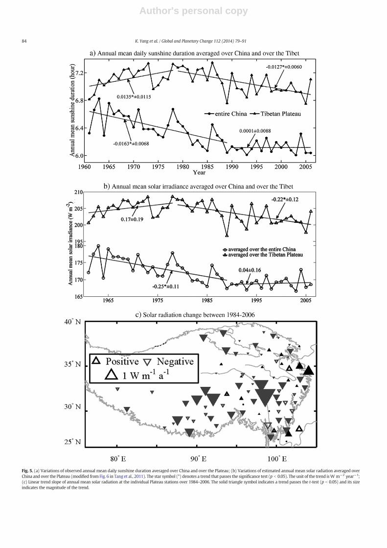
Fig. 5. (a) Variations of observed annual mean daily sunshine duration averaged over China and over the Plateau; (b) Variations of estimated annual mean solar radiation averaged overChina and over the Plateau (modified from Fig. 6 in Tang et al., 2011). The star symbol (*) denotes a trend that passes the significance test (p b 0.05). The unit of the trend isW m−2 year−1;(c) Linear trend slope of annual mean solar radiation at the individual Plateau stations over 1984–2006. The solid triangle symbol indicates a trend passes the t-test (p b 0.05) and its sizeindicates the magnitude of the trend.
84 K. Yang et al. / Global and Planetary Change 112 (2014) 79–91

Author's personal copy
ones from the ten quality-verified stations and the derived ones by anartificial neural network (ANN)-based model at all CMA radiation sta-tions. Finally, the radiation data simulated by the hybrid model wasused to extend the radiation trend analysis to all CMA stations and toa longer period.
Fig. 5a shows the changes of annual mean daily sunshine durationaveraged over all CMA stations in both the TP and Mainland China.The sunshine duration averaged over the Mainland China decreasedsince the 1960s, but it became stable since 1990. The sunshine durationaveraged over the Plateau is greater than the one over Mainland China,due to lower values of air mass, aerosol loads, and humidity over thePlateau. More importantly, the sunshine duration over the TP exhibitsan increasing trend up to the end of the 1970s and a persistent decreas-ing trend afterwards. Clearly, the decadal change in sunshine durationover the TP is different from the one averaged over the whole China.
The variation of solar radiation exhibits a decadal change similar tothe sunshine duration. As shown in Fig. 5b, the solar radiation averagedover all CMA stations has a decreasing trend before the 1990s, but itdoes not show an overall recovery trend since 1990. This result is some-how different from previous studies that stated solar radiation in Chinawas recovering since 1990. In addition, the solar dimming rate before1990 is about 2.5 W m−2 decade−1, which is about half of the values(4–5 W m−2 decade−1) in previous reports. On the Plateau, the aver-aged solar radiation had an increase trend until the end of the 1970sand went down afterwards, indicating a transition from brightening todimming around the end of the 1970s. Therefore, the solar radiationchanges over the last 50 years are quite different between the TP andMainland China. Fig. 5c shows the solar radiation changes at the individ-ual Plateau stations for the period of 1984–2006. It is evident that thedimming occurred at most of the stations over this period. A furtheranalysis shows that the dimming mainly occurred in summer.
Conventionally, a solar radiation trend is explained by aerosol loadsand/or cloud changes. The Plateau region is one of the cleanest regionsin the world and a considerable aerosol loading is not expected. Mean-while, the total cloud cover decreased over the region, which is neitherable to explain the solar dimming. To understand themechanism of thesolar dimming, Yang et al. (2012) analyzed the effects of aerosols, watervapor, and cloud cover. First, the inverse of visibility, a proxy of aerosoloptical depth (AOD) (Wang et al., 2009), observed at CMA stations has adownward trend since 1980. The major aerosol over the TP is dust (Xiaet al., 2011). Along with the wind stilling, dust amount and frequencyshould have decreased and thus AOD decreased, too. This is consistentwith the observed trend in Fig. 6a. Therefore, it is unlikely that aerosolloading can explain the solar dimming. Second, an increase in watervapor amount is highly correlated with the solar dimming (Fig. 6b),but the direct absorption of solar radiation by the vapor (~1 W m−2)is much lower than the observed dimming (~6 W m−2). Third, deepcloud cover (DCC) is highly correlated with the solar radiation at bothannual and decadal scales. DCC can be given by the International Satel-lite Cloud Climatology Project (ISCCP) data or approximately represent-ed by the station-observed low cloud cover (LCC), and Fig. 6c shows thatLCC has an increasing trend, opposite to the decreasing change in solarradiation. Such an opposite correlation can be seen in satellite observa-tions, too. The increase in DCC is caused by the increase in convectiveavailable potential energy (CAPE), which is in turn due to the rapidwarming and moistening over the TP. In summary, it is important forthe radiation trend analysis to discriminate cloud types, in addition tothe often mentioned cloud cover and aerosol changes.
3. Response of energy and water cycles
3.1. Land and atmospheric energy budget
Because of the importance of the Plateau thermal forcing in the con-text of the Asia monsoon, there have been a number of studies since theend of the 1970s to quantify the heat source over the TP and its effect on
various weather and climate events. The total heat source (TH) com-prises of three components, i.e., surface sensible heat (SH), latent heatrelease of condensation (LH), and radiative convergence (RC). Their es-timation was first presented in Ye and Gao (1979) and followed bymany studies (e.g. Chen et al., 1985; Zhao and Chen, 2000).
The surface sensible heat flux is usually calculated according to thebulk heat transfer equation, which needs input of observed windspeed and ground–air temperature difference (Tg − Ta) as well as pa-rameterized heat transfer coefficient CH. Conventionally, CH is eithergiven a constant value (Chen et al., 1985) or simply correlated withme-teorological variables (Chen andWong, 1984). These parameterizationsarewidely applied in the Plateau heating studies. For instance, Duan andWu (2008) used the Chen Scheme and found aweakening trend in sen-sible heat flux. However, near-surface atmospheric stability depends onwind speed and Tg − Ta; with the wind stilling and increase in Tg − Ta,the atmosphere became more unstable and thus CH should have in-creased. So, a CH scheme that does not properly account for the stabilitywould cause vital errors in estimating the trend in sensible heat flux.
Accordingly, Yang et al. (2009b) developed a new scheme to esti-mate the heat flux from CMA station data. The new one disaggregatesCMA station data to hourly to capture the diurnal variations of
Fig. 6. Inter-annual variations of (a) the proxy of AOD (i.e. inverse of visibility) and windspeed, (b) solar radiation and specific humidity, and (c) solar radiation and deep cloudcover (DCC) over 1984–2006. All the values are obtained by averaging over all CMA sta-tions on the Plateau. Panel (b–c): modified from Figs. 3–4 in Yang et al. (2012).
85K. Yang et al. / Global and Planetary Change 112 (2014) 79–91
Author's personal copy
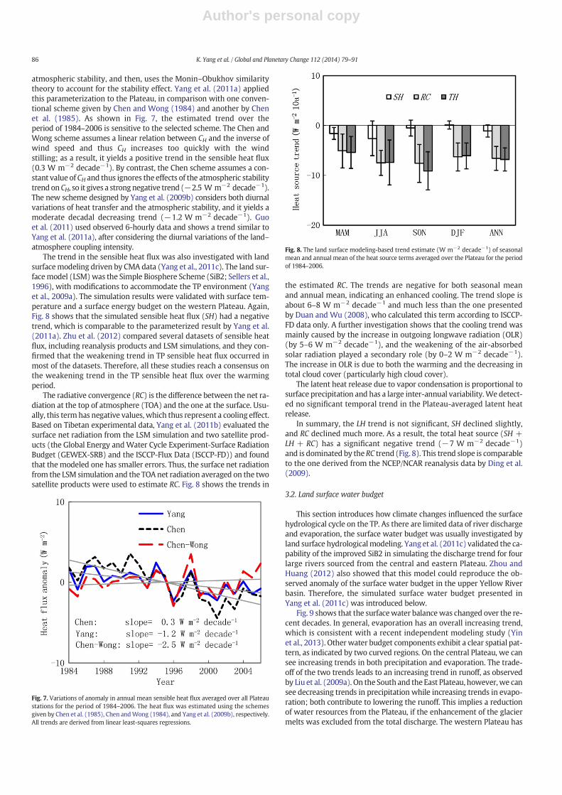
atmospheric stability, and then, uses the Monin–Obukhov similaritytheory to account for the stability effect. Yang et al. (2011a) appliedthis parameterization to the Plateau, in comparison with one conven-tional scheme given by Chen and Wong (1984) and another by Chenet al. (1985). As shown in Fig. 7, the estimated trend over theperiod of 1984–2006 is sensitive to the selected scheme. The Chen andWong scheme assumes a linear relation between CH and the inverse ofwind speed and thus CH increases too quickly with the windstilling; as a result, it yields a positive trend in the sensible heat flux(0.3 W m−2 decade−1). By contrast, the Chen scheme assumes a con-stant value of CH and thus ignores the effects of the atmospheric stabilitytrendonCH, so it gives a strongnegative trend (−2.5 W m−2 decade−1).The new scheme designed by Yang et al. (2009b) considers both diurnalvariations of heat transfer and the atmospheric stability, and it yields amoderate decadal decreasing trend (−1.2 W m−2 decade−1). Guoet al. (2011) used observed 6-hourly data and shows a trend similar toYang et al. (2011a), after considering the diurnal variations of the land–atmosphere coupling intensity.
The trend in the sensible heat flux was also investigated with landsurfacemodeling driven by CMA data (Yang et al., 2011c). The land sur-facemodel (LSM)was the Simple Biosphere Scheme (SiB2; Sellers et al.,1996), with modifications to accommodate the TP environment (Yanget al., 2009a). The simulation results were validated with surface tem-perature and a surface energy budget on the western Plateau. Again,Fig. 8 shows that the simulated sensible heat flux (SH) had a negativetrend, which is comparable to the parameterized result by Yang et al.(2011a). Zhu et al. (2012) compared several datasets of sensible heatflux, including reanalysis products and LSM simulations, and they con-firmed that the weakening trend in TP sensible heat flux occurred inmost of the datasets. Therefore, all these studies reach a consensus onthe weakening trend in the TP sensible heat flux over the warmingperiod.
The radiative convergence (RC) is the difference between the net ra-diation at the top of atmosphere (TOA) and the one at the surface. Usu-ally, this termhas negative values, which thus represent a cooling effect.Based on Tibetan experimental data, Yang et al. (2011b) evaluated thesurface net radiation from the LSM simulation and two satellite prod-ucts (the Global Energy andWater Cycle Experiment-Surface RadiationBudget (GEWEX-SRB) and the ISCCP-Flux Data (ISCCP-FD)) and foundthat themodeled one has smaller errors. Thus, the surface net radiationfrom the LSM simulation and the TOA net radiation averaged on the twosatellite products were used to estimate RC. Fig. 8 shows the trends in
the estimated RC. The trends are negative for both seasonal meanand annual mean, indicating an enhanced cooling. The trend slope isabout 6–8 W m−2 decade−1 and much less than the one presentedby Duan and Wu (2008), who calculated this term according to ISCCP-FD data only. A further investigation shows that the cooling trend wasmainly caused by the increase in outgoing longwave radiation (OLR)(by 5–6 W m−2 decade−1), and the weakening of the air-absorbedsolar radiation played a secondary role (by 0–2 W m−2 decade−1).The increase in OLR is due to both the warming and the decreasing intotal cloud cover (particularly high cloud cover).
The latent heat release due to vapor condensation is proportional tosurface precipitation and has a large inter-annual variability.We detect-ed no significant temporal trend in the Plateau-averaged latent heatrelease.
In summary, the LH trend is not significant, SH declined slightly,and RC declined much more. As a result, the total heat source (SH +LH + RC) has a significant negative trend (−7 W m−2 decade−1)and is dominated by theRC trend (Fig. 8). This trend slope is comparableto the one derived from the NCEP/NCAR reanalysis data by Ding et al.(2009).
3.2. Land surface water budget
This section introduces how climate changes influenced the surfacehydrological cycle on the TP. As there are limited data of river dischargeand evaporation, the surface water budget was usually investigated byland surface hydrologicalmodeling. Yang et al. (2011c) validated the ca-pability of the improved SiB2 in simulating the discharge trend for fourlarge rivers sourced from the central and eastern Plateau. Zhou andHuang (2012) also showed that this model could reproduce the ob-served anomaly of the surface water budget in the upper Yellow Riverbasin. Therefore, the simulated surface water budget presented inYang et al. (2011c) was introduced below.
Fig. 9 shows that the surfacewater balancewas changed over the re-cent decades. In general, evaporation has an overall increasing trend,which is consistent with a recent independent modeling study (Yinet al., 2013). Other water budget components exhibit a clear spatial pat-tern, as indicated by two curved regions. On the central Plateau, we cansee increasing trends in both precipitation and evaporation. The trade-off of the two trends leads to an increasing trend in runoff, as observedby Liu et al. (2009a). On the South and theEast Plateau, however,we cansee decreasing trends in precipitation while increasing trends in evapo-ration; both contribute to lowering the runoff. This implies a reductionof water resources from the Plateau, if the enhancement of the glaciermelts was excluded from the total discharge. The western Plateau has
Fig. 7. Variations of anomaly in annual mean sensible heat flux averaged over all Plateaustations for the period of 1984–2006. The heat flux was estimated using the schemesgiven by Chen et al. (1985), Chen andWong (1984), and Yang et al. (2009b), respectively.All trends are derived from linear least-squares regressions.
Fig. 8. The land surface modeling-based trend estimate (W m−2 decade−1) of seasonalmean and annual mean of the heat source terms averaged over the Plateau for the periodof 1984–2006.
86 K. Yang et al. / Global and Planetary Change 112 (2014) 79–91

Author's personal copy
a small amount of precipitation while strong solar radiation; therefore,the precipitation is almost evaporated and the runoff is negligible.
This spatial pattern of surface water budget corresponds to lake areachanges on the TP. Since themiddle of the 1990s,major lakes in the cen-tral Plateau have expanded, whereas many lakes along themarginal re-gion of the South and East TP have shrank (personal communicationwith Dr. Yanbin Lei). Another analysis (Lei et al., 2013) found that theincreasing runoff simulated by the model could account for the majorpart of the lake expansion in the central Plateau, although enhanced gla-cier melt could be another major contributor to the expansion of somesmall lakes.
In addition to the change in precipitation amount, the change in pre-cipitation spatial distribution may also significantly change the surfacewater budget, as is the case for the upper Yellow River basin on theTP. This basin experienced wet conditions in the 1980s and dry condi-tions in the 1990s. In response, the river discharge had similar changeduring the two periods. Since 2002, the precipitation amount increaseddrastically, but the discharge still kept a low level. This incoherentchange is attributed to the change in the precipitation spatial distribu-tion (Zhou and Huang, 2012). According to CMA observations, the in-crease in precipitation occurred in the arid area of this basin, whereasthe humid area received less precipitation than normal. In the aridarea where water availability controls evaporation, most of the precipi-tation turned into evaporation and the runoff did not increase muchwhenprecipitation increased. In thehumid areawhere energy availabil-ity determines the evaporation, evaporation significantly increased dueto the warming; the overlap of the increase in evaporation and the de-crease in precipitation led to significant reduction in runoff. The increasein basin-averaged evaporation almost canceled out the one in precipita-tion, and thus the discharge did not increased evidently. Therefore, thechange in precipitation spatial distribution changed the relationship be-tween the precipitation, evaporation and runoff.
3.3. Response of heat and evaporation to climate change
The decrease in the pan evaporation on the Plateau is a prevailingphenomenon over the past decades (Fig. 2d). This may be attributedto both solar dimming and wind stilling. Zhang et al. (2009) showed
that the solar dimming played a major role in the pan evaporation re-duction on the South Plateau while the wind stilling was more impor-tant on the North Plateau.
The opposite trends between the simulated land evaporation(Fig. 9b) and the observed pan evaporation (Fig. 2d) may be attributedto a complementary effect (Bouchet, 1963; Brutsaert and Parlange,1998). As shown in Fig. 10, the sum of the simulated actual evaporation(E) and the potential evaporation (EP) is roughly equal to 2Ew (Ew is theevaporation in a wet environment in the absence of advection, i.e. equi-librium evaporation) in wet zones, which is consistent with Bouchet'shypothesis. Nevertheless, the sum is lower than 2Ew in dry zones, indi-cating a deviation from Bouchet's complementary theory. The deviationwas attributed by Zhang et al. (2007) and Yu et al. (2009) to low vaporpressure deficit that may suppress the power of vapor transfer. Notethat the decrease in pan evaporation implies that lake evaporationmay have weakened, due to both solar dimming and wind stilling.This trend is another factor responsible for the lake expansion on thecentral Plateau, in addition to the contribution of increasing runoff andenhanced glacier melts. Nevertheless, further studies are needed toquantify the lake evaporation and its trend.
Fig. 9. Trend slope in annual mean values of observed precipitation, simulated evaporation, runoff and soil moisture at the Plateau CMA stations over 1984–2006 (modified from Fig. 4 inYang et al., 2011c). The solid triangle symbol indicates a trend passing the t-test (p b 0.05) and its size indicates the magnitude of the trend.
Fig. 10.Variations of annual mean evaporation (E) and potential evaporation (Ep) with re-spect to precipitation amount (P) after normalization by the equilibrium evaporation (Ew)at the individual Plateau stations (modified from Fig. 8 in Yang et al. (2011c)).
87K. Yang et al. / Global and Planetary Change 112 (2014) 79–91

Author's personal copy
It is concerned with what caused the decrease in the sensible heatflux and the increase in the land evaporation (i.e., lower Bowen ratio)under the warming environment. Herein, we present a simple theoryto explain the response of Bowen ratio towarming andwind stilling. Ac-cording to the bulk transfer equation:
SH ¼ ρcpCHu Tg−Ta
� �; ð1Þ
lE ¼ ρcpγ
α θð ÞCHu es Tg
� �−rh � es Tað Þ
h i; ð2Þ
where SH is the sensible heat flux, lE is the latent heat flux, ρ is the airdensity, cp is the specific heat capacity at a constant pressure, γ is thepsychometric constant, CH is the bulk coefficient for heat transfer, Tg isthe ground temperature, Ta is the air temperature, es is the vapor pres-sure at saturation, and rh is the air relative humidity. α(θ) is a functionof soil moisture (θ) and it has a value near zero for dry soils and ap-proaches unity for wet soils.
The Bowen ratio is given by
B≡ SHlE
¼ γα θð Þ
Tg−Ta
� �
es Tg
� �−rh � es Tað Þ
h i : ð3Þ
As a first-order approximation, we assume that that α(θ) is time-invariant at a decadal scale. Then, the relative change in Bowen ratio de-pends on the change in the ground temperature and the air tempera-ture, as follows
ΔBB
¼ΔTg−ΔTa
� �
Tg‐Ta
� � −
∂es∂Tg
ΔTg−rh∂es∂Ta
ΔTa
es Tg
� �−rh � es Tað Þ
h iΔTg−ΔTa
� �
Tg‐Ta
� � þ 1
24
35; ð4Þ
whereΔTg is the increase in the ground temperature,ΔTa is the increasein the air temperature, and ΔB is the change of the Bowen ratio afterwarming.
The climatology and trend of meteorological parameters over thePlateau are derived from CMA station data, which gives Tg = 280.9 K,Ta = 276.5 K, rh = 56 %, ΔTg = 1.8 °C and ΔTa = 1.4 °C. Given theseconditions, it can be shown with Eq. (4) that the Bowen ratio decreasesby 6% with respect to warming (indicated by the solid circle in Fig. 11),which indicates that a warming can result in a less sensible heat fluxand more latent heat flux (or evaporation). This qualitatively explainsthe sensible heat flux weakening and evaporation enhancement. If inEq. (4) we consider the contribution of soil moistening (Fig. 9d) to the
lowering of the Bowen ratio, then the theory can explain most of the de-crease in the LSM-simulated Bowen ratio.
The Bowen ratio response to the warming may be modulated bywind speed change. If the wind speed slows down, the efficiency ofthe energy exchange would decrease; accordingly, the ground wouldget warmer (i.e. Tg increases), leading to the decline of the Bowenratio. Over the period between 1970 and 2000, both the warming andwind stilling weakened the Bowen ratio, leading to the decrease in sen-sible heat flux. Since 2000, however, the warming and wind speedingup play contrasting roles in determining the trend in the Bowen ratio,leading to a stable sensible heat flux, as indicated by the parameteriza-tion result with the Yang-scheme in Fig. 7.
In addition, other changes on the TP surfacemay have contributed tothe decadal change of the surface energy partition. The first is the abruptincrease of snow cover in winter and spring since around 1977 (Dinget al., 2009). The snow cover cools the surface through albedo enhance-ment to reduce surface net radiation and through snow melting to ex-haust surface net radiation, leading to lower sensible heat flux. Thesecond is the increase in vegetation density (Zhong et al., 2010). This in-crease may result in more evaporation and less sensible heat flux andthus lower Bowen ratios, as shown in Zuo et al. (2011). The third oneis the increase in soil moisture in the Plateau excluding the monsoon-impacted southern and eastern TP (Fig. 9d). This change also enhancesevaporation and weakens sensible heat flux (Zhang and Zuo, 2011).
4. A conceptual model for the Plateau climatic changes
There are a number of studies on the climatic changes over the Pla-teau, but a general and consistent framework has not been establishedfor the interpretation of all the changes in the Plateau climate system.Herein, we proposed a conceptual model to synthesize these changesand to link these changes with the global warming. This model isshown in Fig. 12.
Wind stilling is a response of the regional circulation to the changesin the latitudinal temperature gradient over the Central and East Asia.Under the background of the global warming, there wasmore warmingover the high-latitude belt than over the low-latitude belt during thepast three decades. As a result of the adjustment of geopotential heightto the change in thermal contrast, the middle-level pressure gradientforce between the low-latitude and the high-latitude declined(Fig. 4b), and therefore, the middle-troposphere wind speed becameweakened (Section 2.2). Due to less momentum transport from free at-mosphere down to the boundary layer, the surfacewind speed declined,too. This situation over the TP and East Asia is different from the caseover Europe and North America, where the surface wind slowed downwhile upper-air wind speeded up and Vautard et al. (2010) attributedtheir contrast changes to the increase in surface roughness lengths.
The wind stilling weakened the energy exchange between the Pla-teau and its surroundings. As the Plateau provides a huge thermal forc-ing to the middle-troposphere during the summer half-year, a weakerenergy exchange would lead to more remaining energy to warm thelocal air over the Plateau. Indeed, we found a correlation coefficient of0.6 between wind speed and air temperature during summers. So wespeculate that the TP warming during the summer half-year is partiallyattributed to the wind speed decline. Other warming causes were alsoproposed in the literature. For instance, Chen et al. (2003) suggestedwith modeling studies that the TP warming is due to the CO2 effects,but Rangwala et al. (2009) argued that the enrichment of surfacewater vapor enhanced the downward longwave radiation and is thusresponsible for the prominentwinterwarming trendover the TP.Mean-while, Zhang and Zhou (2009) found that the total ozone amount overthe TP declined more than the one over other regions along the samelatitudes and thus suggested that the ozone depletion is a possible rea-son for the more warming over the TP. Similarly,Guo andWang (2012)suggested that the most significant warming occurring over the NorthTP may be related to radiative and dynamical heating that are results
Fig. 11. Response of Bowen ratio to surface air warming (ΔTa) according to Eq. (4), givenTg = 280.9 K, Ta = 276.5 K and ΔTg = 1.28ΔTa. The solid circle corresponds to the Pla-teau warming condition (ΔTa = 1.4 °C, ΔTg = 1.8 °C and rh = 56 %).
88 K. Yang et al. / Global and Planetary Change 112 (2014) 79–91

Author's personal copy
of pronounced stratospheric ozone depletion. In a word, it is far fromreaching a consensus to the understanding of the TP rapid warmingand its seasonality, as the energy budget responsible for a regionalwarming is small while influenced by a lot of factors.
The warming and air moistening over the central Plateau upraisedCAPE, which is favorable to triggering stronger clouds and thus causingthe solar dimming (Section 2.3). The rapid planetarywarming led to en-hanced radiative cooling through outgoing longwave emission. Mean-while, the warming and wind stilling lowered the Bowen ratio andthus reduced surface sensible heat flux. Both processes contributed tothe thermal forcing weakening over the Plateau (Section 3.1), whichin turn might contribute to the Asia monsoon weakening.
The warming enhanced land evaporation overall on the Plateau, butthe solar dimming and wind stillingmay result in weaker lake evapora-tion. The monsoon weakening may result in less rainfall over the mon-soon regions (South and East Plateau), whereas thewarmer andmoisteratmosphere on the central Plateaumay trigger more convective precip-itation and enhance water cycle. Accordingly, the climatic change mayreduce runoff on the Plateau source areas of Asian large rivers but en-hance runoff on the central Plateau (Section 3.2). The latter have con-tributed to the lake expansion on the central Plateau.
5. Recommendations for future studies
The TP surfaces experienced an overall rapid warming andmoisten-ing as well as wind stilling and solar dimming over the past three de-cades. These changes further influenced the water and energy cycleover the Plateau: weakened sensible heat flux and lake evaporation, en-hanced radiative cooling and land evaporation, and changes precipita-tion amount and spatial distribution. All the changes may be deemedas different but inter-dependent aspects of a changing regional climatesystem. We proposed a conceptual model that can interpret majorchanges observed in the TP region. Meanwhile, some key processes inthe conceptual model need to be strengthened in future studies, as cur-rent reanalysis datasets are not able to capture some crucial facts (Wang
and Zeng, 2012). For example, thewarming trend over the Plateau is notobserved in NCEP reanalysis data (You et al., 2010), the wind decline isnot observed in ERA-40 and ERA-interim data, the negative trend in theheat source is not seen in the JRA-25. A conceptualmodel is helpful for aconsistent and integrated interpretation of observed climatic changesand for the prediction of the Plateau water and energy cycles from pre-cursor signals of global and regional changes. To reach this goal, we rec-ommend the following outstanding issues to be explored in futurestudies.
First, what determines the spatial pattern of the warming? Thewarming is the most striking phenomenon on the Plateau, but it hasnot been understood why the warming rate over the Plateau is higherthan over the eastern part of China along the same latitude (Zhangand Zhou, 2009). Moreover, the spatial distribution of the warmingrate within the Plateau is important for interpreting the spatial patternof the glacier changes, but what determines the spatially distributedwarming is little known.
Second, is a decadal climatic change occurring over the Plateau andEast Asia? Since the beginning of the 1970s, wind speed declined verymuch over both the Plateau and East Asia. However, Lin et al. (2013)found that the wind speed started to recover over the Plateau since2002. Simultaneously, the sensible heat flux on the Plateau stoppeddropping. These signals are probably the precursor of a decadal climaticchange over the Plateau and East Asia.
Third, what is the trend in the surface radiation budget? Solar dim-ming over the Plateau is evident; both downward and upwardlongwave radiations should have increased due to the warming. How-ever, the trend in net radiation is far from understanding, as it is sensi-tive to the change in surface albedo and surface emissivity in additionto the dimming, warming and moistening. Future studies need to finda reliable way to quantify net radiation and its trend, in order to under-stand the warming. Considering that the nighttime warming rate isgreater than the daytime one, we speculate that the trend in net radia-tionmay have a diurnal variation, large in the nighttime and small in thedaytime.
Fig. 12. A conceptual model for interpreting climatic change and associated water and energy budget changes over the Tibetan Plateau.
89K. Yang et al. / Global and Planetary Change 112 (2014) 79–91

Author's personal copy
Last but not least, where is the source of water vapor over centralTibet? The lake expansion in this region indicates that the water vaporwas transported from outside. In order to understand the hydrologicalcycle and its trend in this region, it is crucial to identify the source regionand the transport processes of the water vapor.
Acknowledgments
This work was supported by Global Change Program of Ministry ofScience and Technology of China (Grant No. 2010CB951703), StrategicPriority Research Program (B) of the Chinese Academy of Sciences(Grant No. XDB03030300), and National Natural Science Foundationof China (Grant No. 41190083).
References
Bouchet, R.J., 1963. Evapotranspiration reélle evapotranspiration potentielle, significationclimatique. Int. Assoc. Hydrol. Sci. Publ. 62, 134–142.
Brutsaert, W., Parlange, M., 1998. Hydrologic cycle explains the evaporation paradox.Nature 396, 30.
Cao, J., Qin, D., Kang, E., Li, Y., 2006. River discharge changes in the Qinghai–Tibet Plateau.Chin. Sci. Bull. 51, 594–600.
Che, H., Shi, G., Zhang, X., Arimoto, R., Zhao, J., Xu, L., Wang, B., Chen, Z., 2005. Analysis of40 years of solar radiation data from China, 1961–2000. Geophys. Res. Lett. 32,L06803. http://dx.doi.org/10.1029/2004GL022322.
Chen, W., Wong, D., 1984. A preliminary study on the computational method of 10-daymean sensible heat and latent heat on the Tibetan plateau. Proceedings of theQinghai–Xizang Plateau Meteorological Experiment (series 2) (in Chinese). SciencePress, Beijing, pp. 35–45.
Chen, L., Reiter, E.R., Feng, Z., 1985. The atmospheric heat source over the Tibetan Plateau:May–August 1979. Mon. Weather Rev. 113, 1771–1790.
Chen, B., Chao, W.C., Liu, X., 2003. Enhanced climatic warming in the Tibetan Plateau dueto doubling CO2: a model study. Clim. Dyn. 20, 401–413.
Chen, Y., Yang, K., Zhou, D., Qin, J., Guo, X., 2010. Improving the Noah land surface modelin arid regions with an appropriate parameterization of the thermal roughnesslength. J. Hydrometeorol. 11, 995–1006.
Chen, X.L., Su, Z., Ma, Y., Yang, K., Wen, J., Zhang, Y., 2013. An improvement of roughnessheight parameterization of the surface energy balance system (SEBS) over the Tibet-an Plateau. J. Appl. Meteorol. Climatol. 52, 607–622.
Cheng, G., Wu, T., 2007. Responses of permafrost to climate change and their environ-mental significance, Qinghai–Tibet Plateau. J. Geophys. Res. 112 (F2), F02S03.
Ding, Y., Sun, Y., Wang, Z., Zhu, Y., Song, Y., 2009. Inter-decadal variation of the summerprecipitation in China and its association with decreasing Asian summer monsoonpart II: possible causes. Int. J. Climatol. 29, 1926–1944.
Duan, A., Wu, G., 2008. Weakening trend in the atmospheric heat source over the TibetanPlateau during recent decades. Part I: observations. J. Clim. 21, 3149–3164.
Duan, A., Wu, G., 2009. Weakening trend in the atmospheric heat source over the TibetanPlateau during recent decades. Part II: connection with climate warming. J. Clim. 22,4197–4212.
Duan, A., Wang, M., Lei, Y., Cui, Y., 2013. Trends in summer rainfall over China associatedwith the Tibetan Plateau sensible heat source during 1980–2008. J. Clim. 26, 261–275.
Durre, I., Vose, R.S., Wuertz, D.B., 2006. Overview of the integrated global radiosonde ar-chive. J. Clim. 19, 53–68.
Flohn, H., 1957. Large-scale aspects of the “summer monsoon” in South and East Asia.J. Meteorol. Soc. Jpn. 35, 180–186.
Fu, R., et al., 2006. Short circuit of water vapor and polluted air to the global stratosphereby convective transport over the Tibetan Plateau. Proc. Natl. Acad. Sci. 103,5664–5669.
Gerken, T., et al., 2012. Turbulent flux modelling with a simple 2-layer soil model and ex-trapolated surface temperature applied at Nam Co Lake basin on the Tibetan Plateau.Hydrol. Earth Syst. Sci. 16, 1095–1110.
Ghatak, D., Deser, C., Frei, A., Gong, G., Phillips, A., Robinson, D.A., Stroeve, J., 2012.Simulated Siberian snow cover response to observed Arctic sea ice loss, 1979–2008.J. Geophys. Res. 117, D23108. http://dx.doi.org/10.1029/2012JD018047.
Guo, D., Wang, H., 2012. The significant climate warming in the northern Tibetan Plateauand its possible causes. Int. J. Climatol. 32, 1775–1781. http://dx.doi.org/10.1002/joc.2388.
Guo, X., Yang, K., Chen, Y., 2011. Weakening sensible heat source over the Tibetan Plateaurevisited: effects of the land–atmosphere thermal coupling. Theor. Appl. Climatol.104, 1–12.
Immerzeel, W.W., van Beek, L.P.H., Bierkens, M.F.P., 2010. Climate change will affect theAsian water towers. Science 328, 1382–1385.
Jiang, Y., Luo, Y., Zhao, Z., Tao, S., 2010. Changes in wind speed over China during1956–2004. Theor. Appl. Climatol. 99, 421–430.
Kang, S., Xu, Y., You,Q., Flügel,W.A., Pepin,N., Yao, T., 2010. Reviewof climate and cryosphericchange in the Tibetan Plateau. Environ. Res. Lett. 5, 015101. http://dx.doi.org/10.1088/1748-9326/5/1/015101.
Koike, T., Yasunari, T., Wang, J., Yao, T., 1999. GAME-Tibet IOP summary report. Proceed-ing of the 1st International Workshop on GAME-Tibet, January 11–13, 1999, Xi'an,China, pp. 1–2.
Lei, Y., Yao, T., Bird, B.W., Yang, K., Zhai, J., Sheng, Y., 2013. Coherent lake growth on thecentral Tibetan Plateau since the 1970s: characterization and attribution. J. Hydrol.483, 61–67.
Li, X., Jin, R., Pan, X., Zhang, T., Guo, J., 2012. Changes in the near-surface soil freeze–thawcycle on the Qinghai–Tibetan Plateau. Int. J. Appl. Earth Obs. Geoinf. 17, 33–42.
Liang, F., Xia, X., 2005. Long-term trends in solar radiation and the associated climatic fac-tors over China for 1961–2000. Ann. Geophys. 23, 2425–2432.
Liepert, B.G., 2002. Observed reductions of surface solar radiation at sites in the United Statesand worldwide from 1961 to 1990. Geophys. Res. Lett. 29, 1421. http://dx.doi.org/10.1029/2002GL014910.
Lin, C., Yang, K., Qin, J., Fu, R., 2013. Observed coherent trends of surface and upper-airwind speed over China since 1960. J. Clim. 26, 2891–2903.
Liu, X., Chen, B., 2000. Climatic warming in the Tibetan Plateau during recent decades. Int.J. Climatol. 20, 1729–1742.
Liu, J., Wang, S., Yu, S., Yang, D., Zhang, L., 2009a. Climate warming and growth of high-elevation inland lakes on the Tibetan Plateau. Glob. Planet. Chang. 67, 209–217.
Liu, X., Cheng, Z., Yan, L., Yin, Z.Y., 2009b. Elevation dependency of recent and future min-imum surface air temperature trends in the Tibetan Plateau and its surroundings.Glob. Planet. Chang. 68, 164–174.
Liu, Y., Wu, G., Hong, J., Dong, B., Duan, A., Bao, Q., Zhou, L., 2012. Revisiting Asian mon-soon formation and change associated with Tibetan Plateau forcing: II. Change.Clim. Dyn. 39, 1183–1195.
Ma, Y., Kang, S., Zhu, L., Xu, B., Tian, L., Yao, T., 2008. Tibetan observation and researchplatform—atmosphere–land interaction over a heterogeneous landscape. Bull. Am.Meteorol. Soc. 89, 1487–1492.
Ma, Y., Wang, Y., Wu, R., Hu, Z., Yang, K., Li, M., Ma, W., Zhong, L., Sun, F., Chen, X., Zhu, Z.,Wang, S., Ishikawa, H., 2009. Recent advances on the study of atmosphere–land inter-action observations on the Tibetan Plateau. Hydrol. Earth Syst. Sci. 13, 1103–1111.
Ma, Y., Zhong, L., Wang, B., Ma, W., Chen, X., Li, M., 2011. Determination of land surfaceheat fluxes over heterogeneous landscape of the Tibetan Plateau by using theMODIS and in-situ data. Atmos. Chem. Phys. 11, 10461–10469.
Moore, G.W.K., 2012. Surface pressure record of Tibetan Plateauwarming since the 1870s.Q. J. R. Meteorol. Soc. 138, 1999–2008.
Qin, J., Yang, K., Liang, S., Guo, X., 2009. The altitudinal dependence of recent rapidwarming over the Tibetan Plateau. Clim. Chang. 97, 321–327.
Rangwala, I., Miller, J.R., Xu,M., 2009.Warming in theTibetan Plateau: possible influences ofthe changes in surface water vapor. Geophys. Res. Lett. 36, L06703. http://dx.doi.org/10.1029/2009GL037245.
Salama,M.S., Van der Velde, R., Zhong, L., Ma, Y., Ofwono,M., Su, Z., 2012. Decadal variationsof land surface temperature anomalies observed over the Tibetan Plateau by the specialsensor microwave imager (SSM/I) from 1987 to 2008. Clim. Chang. 114, 769–781.
Scherler, D., Bookhagen, B., Strecker, M.R., 2011. Spatially variable response of Himalayanglaciers to climate change affected by debris cover. Nat. Geosci. 4, 156–159.
Sellers, P.J., Randall, D.A., Collatz, G.J., Berry, J.A., Field, C.B., Dazlich, D.A., Zhang, C., Collelo,G.D., Bounoua, L., 1996. A revised land surface parameterization (SiB2) for atmo-spheric GCMs, Part I: model formulation. J. Clim. 9, 676–705.
Shi, G., Hayasaka, T., Ohmura, A., Chen, Z., Wang, B., Zhao, J., Che, H., Xu, L., 2008. Dataquality assessment and the long-term trend of ground solar radiation in China.J. Appl. Meteorol. Climatol. 47, 1006–1016.
Stanhill, G., Cohen, S., 2001. Global dimming: a review of the evidence for a widespreadand significant reduction in global radiation with discussion of its probable causesand possible agricultural consequence. Agric. For. Meteorol. 107, 255–278.
Su, Z., et al., 2011. The Tibetan Plateau observatory of plateau scale soil moisture and soiltemperature (Tibet–Obs) for quantifying uncertainties in coarse resolution satelliteand model products. Hydrol. Earth Syst. Sci. 15, 2303–2316.
Tang, W., Yang, K., He, J., Qin, J., 2010. Quality control and estimation of global solar radi-ation in China. Sol. Energy 84, 466–475.
Tang,W., Yang, K., Qin, J., Cheng, C.C.K., He, J., 2011. Solar radiation trend across China in re-cent decades: a revisit with quality-controlled data. Atmos. Chem. Phys. 11, 393–406.
Ueno, K., Sugimoto, S., Tsutsui, H., Taniguchi, K., Hu, Z., Wu, S., 2012. Role of patchy snowcover on the planetary boundary layer structure during late winter observed in thecentral Tibetan Plateau. J. Meteorol. Soc. Jpn. 90C, 145–155.
van der Velde, R., Su, Z., Ek,M., Rodell,M., Ma, Y., 2009. Influence of thermodynamic soil andvegetation parameterizations on the simulation of soil temperature states and surfacefluxes by the Noah LSM over a Tibetan Plateau site. Hydrol. Earth Syst. Sci. 13, 759–777.
Vautard, R., Cattiaux, J., Yiou, P., Thepaut, J.N., Ciais, P., 2010. Northern Hemisphere atmo-spheric stilling partly attributed to an increase in surface roughness. Nat. Geosci. 3,756–761.
Wang, A., Zeng, X., 2012. Evaluation of multireanalysis products with in situ observationsover the Tibetan Plateau. J. Geophys. Res. 117, D05102. http://dx.doi.org/10.1029/2011JD016553.
Wang, B., Bao, Q., Hoskins, B., Wu, G., Liu, Y., 2008. Tibetan Plateau warming and precip-itation changes in East Asia. Geophys. Res. Lett. 35, L14702.
Wang, K., Dickinson, R.E., Liang, S., 2009. Clear sky visibility has decreased over land glob-ally from 1973 to 2007. Science 323, 1468–1470.
Wild, M., Gilgen, H., Roesch, A., 2005. From dimming to brightening: decadal changes insolar radiation at earth's surface. Science 308, 847–850.
Wu, G., Liu, Y., He, B., Bao, Q., Duan, A., Jin, F.F., 2012. Thermal controls on the Asian sum-mer monsoon. Sci. Rep. 2. http://dx.doi.org/10.1038/srep00404.
Xia, X., Zong, X., Cong, Z., Chen, H., Kang, S., Wang, P., 2011. Baseline continental aerosolover the central Tibetan plateau and a case study of aerosol transport from SouthAsia. Atmos. Environ. 45, 7370–7378.
Xu, M., Chang, C.P., Fu, C.B., Qi, Y., Robock, A., Robinson, D., Zhang, H., 2006. Steadydecline of east Asian monsoon winds, 1969–2000: evidence from direct groundmea-surements of wind speed. J. Geophys. Res. 111, D24111. http://dx.doi.org/10.1029/2006JD007337.
90 K. Yang et al. / Global and Planetary Change 112 (2014) 79–91

Author's personal copy
Xu, X., Zhang, R., Koike, T., Lu, C., Shi, X., Zhang, S., Bian, L., Cheng, X., Li, P., Ding, G., 2008. Anew integrated observational system over the Tibetan Plateau. Bull. Am. Meteorol.Soc. 89, 1492–1496.
Yamada, H., Uyeda, H., 2006. Transition of the rainfall characteristics related to the moist-ening of the land surface over the central Tibetan Plateau during the summer of 1998.Mon. Weather Rev. 134, 3230–3247.
Yanai, M., Li, C., Song, Z., 1992. Seasonal heating of the Tibetan Plateau and its effects onthe evolution of the Asian summer monsoon. J. Meteorol. Soc. Jpn. 70, 319–351.
Yang, K., Koike, T., Fujii, H., Tamura, T., Xu, X., Bian, L., Zhou, M., 2004. The daytime evolu-tion of the atmospheric boundary layer and convection over the Tibetan Plateau: ob-servations and simulations. J. Meteorol. Soc. Jpn. 82, 1777–1792.
Yang, K., Chen, Y., Qin, J., 2009a. Some practical notes on the land surface modeling in theTibetan Plateau. Hydrol. Earth Syst. Sci. 13, 687–701.
Yang, K., Qin, J., Guo, X., Zhou, D., Ma, Y., 2009b. Method development for estimating sen-sible heat flux over the Tibetan Plateau from CMA data. J. Appl. Meteorol. Climatol. 48,2474–2486.
Yang, K., Guo, X., Wu, B., 2011a. Recent trends in surface sensible heat flux on the TibetanPlateau. Sci. China Earth Sci. 54, 19–28.
Yang, K., Guo, X., He, J., Qin, J., Koike, T., 2011b. On the climatology and trend of the atmo-spheric heat source over the Tibetan Plateau: an experiments-supported revisit.J. Clim. 24, 1525–1541.
Yang, K., Ye, B., Zhou, D., Wu, B., Foken, T., Qin, J., Zhou, Z., 2011c. Response of hydrologicalcycle to recent climate changes in the Tibetan Plateau. Clim. Chang. 109, 517–534.
Yang, K., Ding, B., Qin, J., Tang, W., Lu, N., Lin, C., 2012. Can aerosol loading explainthe solar dimming over the Tibetan Plateau? Geophys. Res. Lett. 39, L20710.http://dx.doi.org/10.1029/2012GL053733.
Yang, K., Qin, J., Zhao, L., Chen, Y., Tang, W., Han, M., La, Z., Chen, Z., Lv, N., Ding, B., Wu, H.,Lin, C., 2013. A multi-scale soil moisture and freeze–thawmonitoring network on theThird Pole. Bull. Am. Meteorol. Soc. http://dx.doi.org/10.1175/BAMS-D-12-00203.1.
Yao, T., Wang, Y., Liu, S., Pu, J., Shen, Y., Lu, A., 2004. Recent glacial retreat in High Asia inChina and its impact on water resource in Northwest China. Sci. China Ser. D EarthSci. 47, 1065–1075.
Yao, T., et al., 2012a. Third Pole environment (TPE). Environ. Dev. 3, 52–64.Yao, T., et al., 2012b. Different glacier status with atmospheric circulations in Tibetan Pla-
teau and surroundings. Nat. Clim. Chang. 2, 1–5.Ye, D., Gao, Y., 1979. The Meteorology of the Qinghai–Xizang (Tibet) Plateau (in Chinese).
Science Press (278 pp.).Ye, Q., Zhu, L., Zheng, H., Naruse, R., Zhang, X., Kang, S., 2007. Glacier and lake variations in
the Yamzhog Yumco Basin in the last two decades using remote sensing and GIStechnologies. J. Glaciol. 53, 673–676.
Yin, Y., Wu, S., Zhao, D., Zheng, D., Pan, T., 2013. Modeled effects of climate change on ac-tual evapotranspiration in different eco-geographical regions in the Tibetan Plateau.J. Geogr. Sci. 23, 195–207.
You, Q., Kang, S., Pepin, N., Flügel, W.A., Yan, Y., Behrawan, H., Huang, J., 2010. Relationshipbetween temperature trend magnitude, elevation and mean temperature in theTibetan Plateau from homogenized surface stations and reanalysis data. Glob. Planet.Chang. 71, 124–133.
Yu, J., Zhang, Y., Liu, C., 2009. Validity of the Bouchet's complementary relationship at 102observatories across China. Sci. China Ser. D Earth Sci. 52, 708–713.
Zhang, R., Zhou, S., 2009. Air temperature changes over the Tibetan Plateau and other re-gions in the same latitudes and the role of ozone depletion. Acta Meteorol. Sin. 23,290–299.
Zhang, R., Zuo, Z., 2011. Impact of spring soil moisture on surface energy balance andsummer monsoon circulation over East Asia and precipitation in East China. J. Clim.24, 3309–3322.
Zhang, Y., Liu, C., Tang, Y., Yang, Y., 2007. Trends in pan evaporation and reference and ac-tual evapotranspiration across the Tibetan Plateau. J. Geophys. Res. 112, D12110.http://dx.doi.org/10.1029/2006JD008161.
Zhang, X., Ren, Y., Yin, Z., Lin, Z., Zheng, D., 2009. Spatial and temporal variationpatterns of reference evapotranspiration across the Qinghai–Tibetan Plateauduring 1971–2004. J. Geophys. Res. 114, D15105. http://dx.doi.org/10.1029/2009JD011753.
Zhang, R., Xu, X., Koike, T., Ma, Y., Yang, K., 2012. A China–Japan cooperative JICA atmo-spheric observing network over the Tibetan Plateau (JICA/Tibet Project): an over-view. J. Meteorol. Soc. Jpn. 90C, 1–16.
Zhao, P., Chen, L., 2000. Study on climatic features of surface turbulent heat exchange co-efficients and surface thermal sources over the Qinghai–Xizang (Tibetan) Plateau.Acta Meteorol. Sin. 14, 13–29.
Zhong, L., Ma, Y., Salama, M.S., Su, Z., 2010. Assessment of vegetation dynamics and theirresponse to variations in precipitation and temperature in the Tibetan Plateau. Clim.Chang. 103, 519–535.
Zhou, D., Huang, R., 2012. Response of water budget to recent climatic changes in thesource region of the Yellow River. Chin. Sci. Bull. 57, 2155–2162.
Zhou, X., Zhao, P., Chen, J., Chen, L., Li,W., 2009. Impacts of thermodynamic processes overthe Tibetan Plateau on the Northern Hemispheric climate. Sci. China Ser. D Earth Sci.52, 1679–1693.
Zhu, Y.X., Ding, Y.H., Xu, H.G., 2007. The decadal relationship between atmospheric heatsource of winter and spring snow over Tibetan Plateau and rainfall in east China(in Chinese). Acta Meteorologica Sinica 65, 946–958.
Zhu, L., Xie, M., Wu, Y., 2010. Quantitative analysis of lake area variations and the influ-ence factors from 1971 to 2004 in the Nam Co basin of the Tibetan Plateau. Chin.Sci. Bull. 55, 1294–1303.
Zhu, X., Liu, Y., Wu, G., 2012. An assessment of summer sensible heat flux on the TibetanPlateau from eight data sets. Sci. China Earth Sci. 55, 779–786.
Zuo, Z., Zhang, R., Zhao, P., 2011. The relation of vegetation over the Tibetan Plateau torainfall in China during the boreal summer. Clim. Dyn. 36, 1207–1219.
91K. Yang et al. / Global and Planetary Change 112 (2014) 79–91
Copyright © 2022 FDOKUMEN