Liquefaction and fluidization of lacustrine deposits from Lahaul-Spiti and Ladakh Himalaya:...
11
Liquefaction and fluidization of lacustrine deposits from Lahaul-Spiti and Ladakh Himalaya: Geological evidences of paleoseismicity along active fault zone Sandeep Singh ⁎ , Arvind K. Jain Department of Earth Sciences, Indian Institute of Technology Roorkee, Roorkee-247 667, India Abstract Soft-sediment deformational structures are important diagnostic features of paleoseismic studies. These seismites result from local vigorous fluidization and hydroplastic deformation formed during liquefaction as a direct consequence of permanent deformation of ground surface due to earthquakes of large magnitude. The region of eastern Ladakh, Spiti Basin and the upper Sutlej River basin record a concentration of earthquakes in a well defined NE-trending seismic zone sub-parallel to the strike of Leo-Pargil Horst and the Kaurik-Chango Fault Zone. Soft-sediment deformational studies of the fluvial and fluvio-lacustrine sequences near Sumdo village, along Sangla valley of Himachal Pradesh and near Saspol village of Ladakh indicate that the Kaurik-Chango Fault Zone is a seismogenic fault causing liquefaction and fluidization as the consequence of earthquake activity in the past. Thermal Luminescence (TL) date of the deformational structures near the Sumdo village constrains the paleoseismic activities of large magnitude between 90,000 years (third activity) to 26,000 years (last geological evidence) with a recurrence interval of approximately 10,000 years during the Quaternary period. © 2006 Elsevier B.V. All rights reserved. Keywords: Paleoseismicity; Soft-sediment deformation; Himalaya; Liquefaction; Fluidization 1. Introduction The geodynamically active Himalayan orogen pro- vides a classical example of the subduction- and collision- related mountain building processes associated with the ongoing crustal deformation, present-day seismicity of different magnitudes (Fig. 1—for review, see Hodges, 2000; Jain et al., 2002). Seismically active Himalayan orogen has been mainly responsible for four great earthquakes of M >8 (1897 in Assam, 1905 in Kangra, 1934 in Bihar–Nepal and 1950 in Assam) along with a large number of moderate (5.5 ≤ M ≥ 7.0) earthquakes (Fitch, 1970; Chandra, 1978; Molnar, 1984). Chandra (1978), Baronowski et al. (1984) and Ni and Barazanghi (1984) have constrained the focal depths of many moderate earthquakes around 15±3 km between the Main Central Thrust (MCT) and Main Boundary Thrust (MBT), with mainly thrust-mechanism dipping gently towards north at about 15° with slip vectors oriented almost perpendicular to the Himalayan arc (Molnar, 1990). However, the great Himalayan earthquakes occur along sub-horizontal detachment surface extending further south of the zone of moderate earthquakes (Seeber and Armbruster, 1981). They have identified two seismic Sedimentary Geology 196 (2007) 47 – 57 www.elsevier.com/locate/sedgeo ⁎ Corresponding author. Tel.: +91 1332 285559; fax: +91 1332 273560. E-mail address: [email protected] (S. Singh). 0037-0738/$ - see front matter © 2006 Elsevier B.V. All rights reserved. doi:10.1016/j.sedgeo.2006.06.005
-
Upload
independent -
Category
Documents
-
view
3 -
download
0
Transcript of Liquefaction and fluidization of lacustrine deposits from Lahaul-Spiti and Ladakh Himalaya:...

96 (2007) 47–57www.elsevier.com/locate/sedgeo
Sedimentary Geology 1
Liquefaction and fluidization of lacustrine deposits fromLahaul-Spiti and Ladakh Himalaya: Geological evidences
of paleoseismicity along active fault zone
Sandeep Singh ⁎, Arvind K. Jain
Department of Earth Sciences, Indian Institute of Technology Roorkee, Roorkee-247 667, India
Abstract
Soft-sediment deformational structures are important diagnostic features of paleoseismic studies. These seismites result fromlocal vigorous fluidization and hydroplastic deformation formed during liquefaction as a direct consequence of permanentdeformation of ground surface due to earthquakes of large magnitude.
The region of eastern Ladakh, Spiti Basin and the upper Sutlej River basin record a concentration of earthquakes in a welldefined NE-trending seismic zone sub-parallel to the strike of Leo-Pargil Horst and the Kaurik-Chango Fault Zone. Soft-sedimentdeformational studies of the fluvial and fluvio-lacustrine sequences near Sumdo village, along Sangla valley of Himachal Pradeshand near Saspol village of Ladakh indicate that the Kaurik-Chango Fault Zone is a seismogenic fault causing liquefaction andfluidization as the consequence of earthquake activity in the past. Thermal Luminescence (TL) date of the deformational structuresnear the Sumdo village constrains the paleoseismic activities of large magnitude between 90,000 years (third activity) to 26,000years (last geological evidence) with a recurrence interval of approximately 10,000 years during the Quaternary period.© 2006 Elsevier B.V. All rights reserved.
Keywords: Paleoseismicity; Soft-sediment deformation; Himalaya; Liquefaction; Fluidization
1. Introduction
The geodynamically active Himalayan orogen pro-vides a classical example of the subduction- and collision-related mountain building processes associated with theongoing crustal deformation, present-day seismicity ofdifferent magnitudes (Fig. 1—for review, see Hodges,2000; Jain et al., 2002). Seismically active Himalayanorogen has been mainly responsible for four greatearthquakes of M>8 (1897 in Assam, 1905 in Kangra,
⁎ Corresponding author. Tel.: +91 1332 285559; fax: +91 1332273560.
E-mail address: [email protected] (S. Singh).
0037-0738/$ - see front matter © 2006 Elsevier B.V. All rights reserved.doi:10.1016/j.sedgeo.2006.06.005
1934 in Bihar–Nepal and 1950 in Assam) along with alarge number of moderate (5.5≤M≥7.0) earthquakes(Fitch, 1970; Chandra, 1978; Molnar, 1984). Chandra(1978), Baronowski et al. (1984) and Ni and Barazanghi(1984) have constrained the focal depths of manymoderate earthquakes around 15±3 km between theMain Central Thrust (MCT) and Main Boundary Thrust(MBT), with mainly thrust-mechanism dipping gentlytowards north at about 15° with slip vectors orientedalmost perpendicular to the Himalayan arc (Molnar,1990). However, the great Himalayan earthquakes occuralong sub-horizontal detachment surface extendingfurther south of the zone of moderate earthquakes (Seeberand Armbruster, 1981). They have identified two seismic
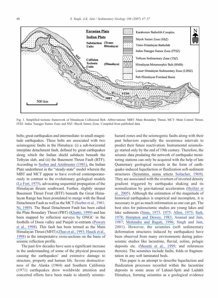
Fig. 1. Simplified tectonic framework of Himalayan Collisional Belt. Abbreviations: MBT–Main Boundary Thrust, MCT–Main Central Thrust,ITSZ–Indus Tsangpo Suture Zone and SSZ–Shyok Suture Zone. Compiled from published data.
48 S. Singh, A.K. Jain / Sedimentary Geology 196 (2007) 47–57
belts; great earthquakes and intermediate- to small-magni-tude earthquakes. These belts are associated with twoseismogenic faults in the Himalaya: (i) a sub-horizontalinterplate detachment fault, defined by great earthquakesalong which the Indian shield subducts beneath theTethyan slab, and (ii) the Basement Thrust Fault (BTF).According to Seeber and Armbruster (1981), the IndianPlate underthrust in the “steady-state” model wherein theMBT and MCT appear to have evolved contemporane-ously in contrast to the evolutionary geological models(Le Fort, 1975), advocating sequential propagation of theHimalayan thrusts southward. Further, slightly steeperBasement Thrust Front (BTF) beneath the Great Hima-layan Range has been postulated to merge with the BasalDetachment Fault as well as theMCT (Seeber et al., 1981;Ni, 1989). The Basal Detachment Fault has been calledthe Plate Boundary Thrust (PBT) (Khattri, 1999) and hasbeen mapped by reflection surveys by ONGC in thefoothills of Doon valley and Punjab re-entrants (Powerset al., 1998). This fault has been termed as the MainHimalayan Thrust (MHT) (Zhao et al., 1993; Hauck et al.,1998) in the interpretative cross-sections on the basis ofseismic reflection profile.
The past few decades have seen a significant increasein the understanding of some of the physical processescausing the earthquakes' and extensive damage tostructure, property and human life. Severe destructive-ness of the Alaska (1964) and Southern California(1971) earthquakes drew worldwide attention andconcerted efforts have been made to identify seismic-
hazard zones and the seismogenic faults along with theirpast behaviors especially the recurrence intervals topredict their future reactivation. Instrumental seismolo-gy started only by the end of 19th century. Therefore, theseismic data predating the network of earthquake moni-toring stations can only be acquired with the help of lateQuaternary geological records in the form of earth-quake-induced liquefaction or fluidization soft-sedimentstructures (Seismites, sensu srticto Seilacher, 1969).They are associated with the overturn of inverted densitygradient triggered by earthquake shaking and itsnormalization by gravitational acceleration (Heifetz etal., 2005). Although the estimation of the magnitude ofhistorical earthquakes is empirical and incomplete, it isnecessary to get as much information as one can get. Thebest sites for paleoseismic studies are young lakes andlake sediments (Sims, 1973, 1975; Allen, 1975; Sieh,1978; Hempton and Dewey, 1983; Ananad and Jain,1987; Mohindra and Bagati, 1996; Singh and Jain,2001). However, the seismites (soft sedimentarydeformation structures induced by earthquakes) havebeen observed from many environments during paleo-seismic studies like lacustrine, fluvial, eoline, pelagicdeposits etc. (Moretti et al., 1999, and referencestherein). The seismites include faults, folds or fragmen-tation in any soft laminated beds.
This paper is an attempt to describe liquefaction andfluidization processes recorded within the lacustrinedeposits in some areas of Lahaul-Spiti and LadakhHimalaya, forming seismites as a geological evidence

49S. Singh, A.K. Jain / Sedimentary Geology 196 (2007) 47–57
of paleoseismicity along the Kaurik-Chango FaultZone.
2. Geological framework
The geology of the Lahaul-Spiti area around theKaurik-Chango Fault Zone has been worked out byHayden (1904), Gansser (1964), Srikantia (1981), Fuchs(1982), Bassi et al. (1983), Bagati (1990) and several otherworkers in detail (Fig. 2). It falls in the Tethyan Sedi-mentary Zone (TSZ) and the metamorphics of the HigherHimalayan Crystallines (HHC) and bounded by VaikritaThrust (Valdiya, 1980) and Martoli Fault (Valdiya, 1976)[equivalent to South Tibetan Detachment System (STDS;Caby et al., 1983; Burg and Chen, 1984; Burchfiel andRoyden, 1985; Burchfiel et al., 1992)]. The TSZ containsmainly sediments, which are relatively continuous fromPrecambrian to Cretaceous and range from 4000 to 12,000m in thickness. The bed rocks are dominated by Pre-cambrian to Cambrian, lower Paleozoic and Permo-Carboniferous successions. Along the Leo-Shalkar-Sumdo-Kaurik track, the Paleozoic succession comprisesfriable and splintery shale, quartzite and limestone. ThePrecambrian–Cambrian sediments (Hilap Formation)consist of more than 1000 m of slate and quartzite withacidic tuffs, marble and carbonaceous bands. ThePaleozoic strata range in age from Ordovician to Permianand are 1335 m thick. However, the Carboniferous isabsent (Hereynian gap). This Paleozoic sequence is dom-inated by sandstone, shale and carbonates with reefs (Bassiet al., 1983). The Mesozoic succession is dominated by830m carbonates (up to Lower Jurassic) followed by 50mSpiti shale. TheCretaceous is represented by >100m thicksandstone (Giumal Sandstone). The northern extremity ofSpiti basin is represented by Tso Morari Crystallines(TMC), with a thrust contact (Steck et al., 1998; Jain et al.,2003; Leech et al., 2005, 2006).
The Higher Himalayan Crystallines (HHC—Vaikritagroup of Sharma, 1977) comprise granitic gneiss, gneissand schists and are exposed at Wangtu, Karcham, Sangla,Kalpa, Spilu and adjoining areas of the Sutlej and Baspavalleys. The Tethyan sediments are exposed in the easternpart of Kinnaur district and extend up to the Baspa valley(Vannay and Grasemann, 1998; Manickavasagam et al.,1999; Kwatra et al., 1999).
The termination of the Spiti syncline with other syn-clines in the area gave rise to the N–S-trending Kaurik-Chango Fault and nearby NNE-trending west-dippingfault of the Leo-Pargil Horst along the Spiti Valley. Theseseries of westerly dipping faults juxtapose the fossilifer-ous Phanerozoic sequence of the Spiti Syncline on thedownthrown side against theHaimanta andVaikrita group
metamorphics of the Precambrian age (Hayden, 1904;Bhargava et al., 1978; Khattri et al., 1978). This Kaurik-Chango Fault is a normal fault and dips towards the westat angles varying between 60° and 80° (Bhargava et al.,1978). This fault and other NNE-trending west-dippingfaults of the Leo-Pargil Horst offset all the earlierstructures (Hayden, 1904; Sharma, 1977) and appear tobe relatively younger features. Major aftershock activityof the Kinnaur earthquake (epicenter–31.94 °N and78.53° E) of January 19, 1975 (Singh et al., 1975;Bhargava et al., 1978; Khattri et al., 1978) appears to beassociated with this fault zone. Many investigators havepublished fault plane solution for the Kinnaur earthquakeMb=6.2 near the India–China border and for its twolargest aftershocks (Molnar and Tapponnier, 1975;Khattriet al., 1978). Although a large component of normalfaulting is evident, some strike–slip faulting cannot beruled out. The earthquake's main shock and aftershockclusters define a NNE–SSW-trending seismic activitiesparalleling Kaurik-Chango Fault (Singh et al., 1975).
3. Paleoseismic structures
3.1. Spiti valley
Fluvial and fluvio-lacustrine sequences from theSumdo village indicate that the Kaurik-Chango FaultZone is an important area of paleoseismic activity in theLahaul-Spiti region resulting from liquefaction andfluidization phenomena in the soft-sediments (Singh andJain, 1992; Mohindra and Bagati, 1996; Jain and Singh,1997; Singh and Jain, 2001). Paleoseismic events arerepresented here by the numerous synsedimentarydeformed structures in the Recent fluvial and fluvio-lacustrine sediments, overlying the Cambrian and Car-boniferous rocks near Sumdo village along the NationalHighway 22 towards Kaurik. The sediments comprisemainly two types of structures, namely, brittle structures(mainly normal faults) and viscoplastic structures (Fig. 3)(with synsedimentary folds, diapiric structures andslumping—for details, see Singh and Jain, 2001). Bothtypes of structures are developed due to liquefaction andfluidization triggered because of seismic activity as theyare overlain and underlain by horizontally laminatedundeformed layers (Fig. 4).
The lithology and sedimentology of deformed sedi-ments as well as geometry of the structures are fossilisedby the upper beds implying that the deposits were re-worked by surfacial and sudden events caused by seismicactivity during each different stratigraphic levels as a resultof episodic earthquake recurrences during the Quaternary(Holocene) period. In general, the terrace sediments are

Fig. 2. (a) Simplified tectonic framework of the NW Himalaya. (1) Eurasian Plate margin–Karakoram Metamorphic Complex (KMC). (2) Indian Plate Subduction Zone–(a) Shyok Suture Zone (SSZ), (b)Ladakh Batholith Complex (LBC), (c) Indus Tsangpo Suture Zone (ITSZ). (3) Himalayan Collision Zone–(a) Tso Morari Crystallines (TMC), (b) Tethyan Sedimentary Zone (TSZ), (c) HimalayanMetamorphic Belt (HMB) of the Proterozoic remobilized basement with the Lesser Himalayan granitoid belt (c1) and Late Cenozoic collisional leucogranite (c2), (d) Lesser Himalayan (LH) Proterozoicsedimentary sequence, (e) Sub-Himalayan (SH) Cenozoic sedimentary foreland. Abbreviations: MBT–Main Boundary Thrust, MCT–Main Central Thrust, JT–Jutogh Thrust, MF–Martoli Fault, ZSZ–Zanskar Shear Zone, KCF–Kaurik-Chango Fault, K–Karchham, KI–Kishtwar, M–Mandi, SA–Sangla, S–Shimla, UK–Uttarkashi, G–Gangotri, DD–Dehradun. Main shock and aftershocks of Kinnaurearthquake, 19 January 1975, are depicted in the form of circle near Kaurik-Chango Fault. (b) Geologic map around Kaurik-Chango Fault Zone (after Hayden, 1904; Bhargava et al., 1978).
50S.
Singh,A.K.Jain
/Sedim
entaryGeology
196(2007)
47–57

Fig. 3. Soft-sediment structures as a result of liquefaction and fluidization phenomenon: (a) hydroplastic injection of fine silty clayey sediment due toeffect of fluidization, (b) change in deformational structures laterally within a deformed layer, (c) sediment sagging of the overlying sediments due tocollapse and instability of hanging wall along with change in sense of movement due to change in curvature of fault, (d) injection of neptunian sand-dykes along the fault surface due to liquefaction.
51S. Singh, A.K. Jain / Sedimentary Geology 196 (2007) 47–57
composed of intercalated silt and fine sand, fine andmedium sand and medium to coarse sand. Silt and finesands are flat-bedded while coarse and medium sands arecross-bedded in nature. The deformed levels are dominantat the interface of fine-grained sand and coarse-grainedsand or mud. The driving mechanism for the formation ofsoft-sedimentary deformational structure is primarily theincreased pore-water pressure associated with liquefactionof saturated cohesionless sediments. The liquefaction dur-ing shaking is caused by cyclic shear stresses generated bythe stress required to initiate liquefaction in the sediments(Obermeier, 1996). The deformed beds generally showfining-upward sequences with penecontemporaneous de-formation caused by triggering of liquefaction due toseismic activity (Kuenen, 1958; Lowe, 1975, 1976; Mills,1983; Nocita, 1988). Although resedimentation takesplace rapidly, the resulting loss of shearing resistanceallows a variety of soft-sedimentary deformational pro-cesses to occur, while the sediment is liquefied.
At places, silty clay material has been hydroplasticallyinjected into the overlying coarser unit forming a complexflame structure with coarsening-upward cycle and thesediments have been injected upward due to effect offluidization (Fig. 3a). These burst through a relativelycoarse-grained layer and can be correlated with the
“bubblegum” structure (Singh and Jain, 1992). This“bubblegum” structure results from a combination of highsedimentation rate with high flow velocity producingmetastable deposits susceptible to fluidization and soft-sediment deformation. The injected material becameoveramplified to form pseudonodules or cycloids andcomplex types of balls similar to the flame type structureof Dzulynski and Walton (1965), and ball-and-pillowstructure of Potter and Pettijohn (1963), or pseudonodulesof Hempton and Dewey (1983). The type of deformationchanges laterally from flame-like recumbent folded stratawith pseudonodules, to a syncline-type slump-like struc-ture through a simple flame structure (Fig. 3b). Thesefoldings can be attributed to fluidization processes leadingto wavy shape which further modified as recumbent fold(Heifetz et al., 2005).
The deformation structures from this locality have beenassociated with seismic events (Fig. 4; Singh and Jain,2001) as they conform to the criteria laid down by Sims(1973, 1975): (1) they occur in a seismically active regionof the Kaurik-Chango Fault Zone, (2) they are restricted tostratigraphic layer separated by undeformed beds, (3) thestructures are correlatable over a large area, (4) the layersare flat-lying, eliminating the influence of slope failure,and (5) the structures are similar to those described by

Fig. 4. Soft-sedimentary (seismites) sequence along with the thermo-luminescence ages (in ka) near Sumdo village along Kaurik-ChangoFault, Himachal Pradesh.
52 S. Singh, A.K. Jain / Sedimentary Geology 196 (2007) 47–57
Hempton and Dewey (1983), Scott and Price (1988) andNocita (1988) and to those produced experimentally byKuenen (1958). Out of these eight deformed layers, fourhave been dated by the Thermal Luminescence (TL)
Fig. 5. Probable extent of the “Sangla Lake” along the Baspa Valley, Himachalstructures.
technique at 90±10.5 ka (layer 3 from the bottom), 61±9.5 ka (layer 5), 37±5.2 ka (layer 6) and 26±4.3 ka (layer8) (Banerjee et al., 1997).
3.2. Baspa valley
Paleoseismic structures as well as possible evidencesof earlier seismic events at Sangla and Kuppa villagealong the Baspa valley in the southernmost extensionof the Kaurik-Chango Fault have also been observed.These include a paleolandslide zone at Kuppa on theBaspa River, possibly formed by a huge earthquake. Thepaleolandslide is a phenomenon frequently observedduring the Himalayan earthquakes. The Kuppa paleo-landslide zone is likely to be approximately of 300 melevation from river bed, though scientific records ofthis lake are presently lacking. Local inquiries revealthat this lake, the Sangla Lake (Fig. 5; Singh and Jain,2001), was an approximately 10-km-long E–W-trend-ing water body with a top level at about 2760 m and adepth of about 260 m. Further, the western block thispaleolake got burst due to down-faulting and caused thecascade in the Baspa River downstream from Kuppa.The Baspa River loses about 250 m within less than1 km of river stretch with a gradient approximately 50°near Kuppa. The sediments of the Sangla paleolakeshow neotectonic structures related to paleoseismicactivity along the Kaurik-Chango Fault Zone. At least 5different stratigraphic levels have been identified
Pradesh. Circular filled dots indicate site of soft-sediment deformational

53S. Singh, A.K. Jain / Sedimentary Geology 196 (2007) 47–57
containing the paleo-seismites. The structures arecharacterized by numerous visco-plastic deformedsequences, which are truncated by near horizontaldeformed layers, superposed by normal faults. A seriesof pronounced listric normal faults, truncated by hori-zontally deposited layers show drag effect with zone ofbreccia, where the overlying sediments are sagged intosynclines due to collapse and instability in hangingwalls. These brecciated layers in collapse structure have
Fig. 6. Normal faults within the soft sediments along Baspa valley near Sanglwith the Kaurik-Chango Fault; (a) a thick fault zone showing drag effect withifault plane, (c) fault plane with presence of fault gauge also show a zone of dacross many stratigraphic layers.
been caused by fluidization and liquefaction of softlaminated bed during turbulence due to seismic activity.The listric normal faults become vertical and changetheir curvature (Fig. 3 c). Though the sense ofdisplacement remains the same (hanging wall movingdown), the fault becomes thrust due to change in dip.Synsedimentary deformation is obvious where theselayers truncate a zone of normal faults. The principalmaximum stress σ1 appears to be nearly vertical, while
a village. Faults are present in different layers showing near parallelismn the soft-sediment, (b) brittle normal fault with sharp contact across theuctile zone due to liquefaction phenomenon, and (d) fault plane cutting

54 S. Singh, A.K. Jain / Sedimentary Geology 196 (2007) 47–57
σ2 follows the intersection between two sets parallelingthe stress orientation of the Kinnaur Earthquake's stressorientation.
Horst and graben structures are also seen at thelocality. One interesting observation at this locality is thenear absence of any fault gauge development along thesurface of these faults. Occasionally, one also observesthe presence of neptunian sand dykes which haveintruded the fault surface due to liquefaction (Fig. 3d).The faults present in different layers show nearparallelism with the Kaurik-Chango Fault, and there-fore, these can be correlated with the paleoseismicactivity along this fault zone (Fig. 6). Occasionally,slickenside on these fault planes is marked by mica andplunges 52° towards N242°.
3.3. Indus Valley
Apart from the structures near Kaurik-Chango Fault,soft-sediment structures from Indus Valley have alsobeen observed near Saspol village in Ladakh. Structuresinclude slumps and convolute laminations leading toformation of isoclinal folds and faults due to liquefac-tion and fluidization process. These structures representearthquake recurrence during the Quaternary as mani-festations of the ongoing tectonic processes.
The analysis of soft-sediment deformation distin-guishes three main groups of soft-sediment structures:folds, faults and breccias. It is important to note that theaction of one specific force during the formation of acertain type of structure may result in different types ofdeformation. For instance, it has been observed thatconvolutions later become ball structures transformedby ruptures. In another case, kink bands progressivelygave rise to kink folds, shear (thrust) planes and finally awide shear zone. At places, a fine-grained layer withinthe core of anticlinal features shows intense mixing anddisturbance and gave rise to salt-dome geometryresulting from liquefaction (i.e., sudden breakdown ofa metastable, loosely packed grain framework). Thesoft-sediment structures show that fluidization and soft-sediment deformation are penecontemporaneous withthe deposition and the “bubblegum structure” has beenresponsible for the deformed strata and oversteepenednature of the surrounding stratification. Here, thedeformation is due to the plastic flow within theconvolute lamination, leading to the formation of salt-dome geometry due to liquefaction and fluidization. Ontop of the convolute laminated bedding, there is fineclayey material with alternate bands of fine-grained sandand mixture of sandy and clayey material and the faultsare also being developed due to compressional forces.
Kinks are also developed whose axial surfaces arereactivated as faults.
4. Discussion
The seismites (soft-sediment deformational struc-tures) observed along Spiti, Baspa and Indus valleys area result of local, vigorous fluidization and hydroplasticdeformation during liquefaction. These deformationstructures can be associated with seismic events of theHimalayan region as they fall well within the criteria laiddown by Sims (1973, 1975) for the development ofseismically induced soft-sediment deformation. Here,the effect of an earthquake causes the displacement of thesoil particles, which makes soil dense, leading to anincrease in pore pressure and a reduction in the effectivenormal stress. As a consequence of increasing porepressure and decrease in effective normal stress, soilovercomes its resistance to move due to stress failureleading to transfer of intergranular stress to the porewater. As a result of stress transfer to the pore water for aperiod of time the soil behaves as a viscous fluid andcauses the process of fluidization. Fluidization occurswhen a fluid flowing vertically through a granularaggregate exerts sufficient drag force on the grains to liftor suspend themmomentarily against the force of gravity(Lowe, 1975). The fluidization takes place almostpenecontemporaneously with sedimentation and thepresence of fluidization implies that the sedimentswere in a liquid state (Nocita, 1988). However,liquefaction is marked by the sudden breakdown of ametastable, loosely packed grain framework, leading thegrain to become temporarily suspended in the pore fluidand settling rapidly through the fluid until a grain-support structure is reestablished. Although resedimen-tation took place rapidly, the resulting loss of shearingresistance allows for a variety of soft-sediment defor-mational process to occur in different stratigraphic levelswhile the sediment is liquefied.
The effect of liquefaction is prominent in saturatedsoils; therefore, the effects are most commonly observednear bodies of water such as river, lakes, bay and oceans.However, fluidization occurs when the drag exerted bymoving pore fluid exceed the effective weight of thegrains; the particles are lifted, the grain frameworkdestroyed, and the sediment strength reduced to zeroand the grains are commonly entrained and can be trans-ported by escaping fluids/water (Lowe, 1975).
The structures observed at theses three localitiesmatch well with the factors influencing liquefaction insediments (Lee and Seed, 1967; Seed, 1968; Seed andIdriss, 1971) like fine-grained sand tend to show a

55S. Singh, A.K. Jain / Sedimentary Geology 196 (2007) 47–57
greater susceptibility to liquefaction than coarse-grainedsand and gravel or fine-grained silt and clay. It has alsobeen observed that the loose sand liquefied more readilythan densely packed sand and the initial confining pres-sure was high due to submergence in the water body.
The observation on these soft-sediment deformationsindicate that the individual layers of sediments have beenliquefied either during deposition as suggested by Kuenen(1958) and Middleton (1967) or developed during post-deposition liquefaction. The structures produced in the softsediments include load structures, convolute laminae,recumbent folds and flame structures, sedimentary dikesand sills, dish and pillar structures, ball-and-pillow struc-tures (Kuenen, 1958;Hess andReading, 1978;Mills, 1983)caused by fluid-escape structure. The clastic dykes presentwithin some of the stratigraphic level are also indicative ofpaleoseismicity and believed to be triggered by earthquakeshocks indicating development of sand-dyke perpendicularto direction of propagation of the seismic waves.
It has also been well documented that the earthquake-induced deformational structures are not only confinedto the soft sediments of Holocene times. However, si-milar structures in sedimentary rocks have also beeninterpreted as related to earthquake-induced liquefactionand collapse during the geological history since the LatePrecambrian (Selley et al., 1963; Allen, 1975; Rascoe,1975; Weaver, 1976; Horowitz, 1982; Mayall, 1983).
5. Summary and conclusions
The apparent success of the paleoseismic study of VanNorman Lake sediments, California by Sims (1973, 1975)makes it worthwhile to attempt similar studies in otheryoung lakes and lake sediments of the Himalaya. Duringthe present investigation, soft-sediment deformationstructures have been identified in 120-m-thick fluviatileand fluvio-lacustrine sediments in Lahaul-Spiti andLadakhHimalaya. These synsedimentary soft-sedimentarystructures are the geological evidences of paleoseismicityand are ofmainly two types: (a) normal fault (mainly brittledeformation) and (b) viscoplastic structures. Both the typesof structures are the result of liquefaction and fluidization.
Near Sumdo village (Spiti Valley) eight (8) de-formed horizons have been identified and are separatedby undeformed horizons. Based on criteria laid downby the earlier workers, these structures can be correlatedwith the past seismic activity in the area. Four deformedlayers have been dated by the TL luminescencetechnique which correspond to 90±10.5 ka (layer 3from the bottom), 61± 9.5 ka (layer 5), 37±5.2 ka(layer 6) and 26±4.3 Ka (layer 8). These datesconstrain the paleoseismic activity (with magnitude
more than 6) between 90,000 years (third activity) and26,000 years (last geological evidence) with a recur-rence interval of approximately 10,000 years.
Along the Baspa valley, which lies at the southern-most extension of the Kaurik-Chango Fault, at leastfive (5) main deformed horizons are present within theSangla Paleolake, which formed due to damming of theBaspa River as a result of a major Kuppa Paleoland-slide. Brittle structures are more prominent in the topthree horizons and the remaining two horizons containboth viscoplastic and brittle phase of deformation. Thepaleostress orientations worked out in different layersof the deformation in the near vicinity of the Kaurik-Chango Fault very well coincide with the present-daystresses. It indicates that the overall stress orientation ofthe region has not changed at least since last 90 ky.
Along the Indus Valley near Saspol in Ladakh soft-sediment structures of seismic origin have also beenidentified within the recent sedimentary deposited.Structures include slumps and convolute laminationswhich are affected by isoclinal folds (kink bands andfold interference patterns) and faults (both normal- andhigh-angle reverse faults as well as thrusts). Thesestructures represent earthquake recurrence during theQuaternary as manifestations of the ongoing tectonicprocesses.
The study of these different localities indicates thatearthquakes of large magnitude occurred along theKaurik-Chango Fault reflected by permanent deforma-tion of ground surface. The estimation of the magnitudeof earthquakes is empirical and incomplete, but at leastthese paleoseismic records provide a rough estimate ofthe timing and magnitude of paleoearthquakes.
Acknowledgement
This paper is a result of DST Sponsored Projectsanctioned to AKJ. We thank Dr. G. D. Gupta,Director, DST for his whole-hearted support andinteraction during our efforts in this endeavor. Discus-sions held with Profs. Ramesh Chander, Harsh Sinvhal,and V. N. Singh of University of Roorkee (now IndianInstitute of Technology, Roorkee) have improved theinsight knowledge about Paleoseismicity are gratefullyacknowledge. Thanks are also due to the localadministration, administration of JP Industries, officialsof Indo-Tibet Border Police, and officials of the PublicWorks Department and Army Personnel for assistanceand help during the field investigations. The authorsalso thank Sunil Bajapi for going through an early draftand anonymous reviewers for improving themanuscript.

56 S. Singh, A.K. Jain / Sedimentary Geology 196 (2007) 47–57
References
Allen, C.R., 1975. Geological criteria for evaluating seismicity.Geological Society of America Bulletin 86, 1041–1057.
Ananad, A., Jain, A.K., 1987. Earthquakes and deformationalstructures (seismites) in Holocene sediments from the Himala-yan-Andaman Arc, India. Tectonophysics 133, 105–120.
Banerjee, D., Singhvi, A.K., Bagati, T.N., Mohindra, R., 1997. Lumi-nescence chronology of seismites in Sumdo (Spiti valley) nearKaurik-Chango Fault, Northwestern Himalaya. Current Science73, 276–281.
Bagati, T.N., 1990. Lithostratigraphy and facies variation in the SpitiBasin (Tethys), Himachal Pradesh, India. Journal of HimalayanGeology 1, 35–47.
Baronowski, J., Armbruster, J., Seeber, L., Molnar, P., 1984. Focaldepths and fault plane solutions of earthquakes and active tectonicsof the Himalayan. Journal of Geophysical Research 89,6918–6928.
Bassi, U.K., Chopra, S., Datta, B.M., 1983. A new Phanerozoic Basinin Kinnaur, Himachal Pradesh. Journal of the Geological Societyof India 24, 281–290.
Bhargava, O.N., Ameta, S.S., Gaur, R.K, Kumar, S., Agrawal, A.N.,Jalote, P.M., Sadhu, M.L., 1978. The Kinnaur (H.P., India)Earthquake of 19 January, 1975: summary of geoseismologicalobservations. Bulletin of Indian Geologists Association 11 (1),39–53.
Burchfiel, B.C., Royden, L.H., 1985. North–South extension withinthe convergent Himalayan region. Geology 13, 679–682.
Burchfiel, B.C., Chen, Zhiliang, Hodges, K.V., Liu, Yuping,Royden, L.H., Deng, Changrong, Xue, Jiene, 1992. TheSouth Tibetan Detachment System, Himalayan Orogen: Exten-sion Contemporaneous with and Parallel to Shortening in aCollisional Mountain Belt. Geololgical Society of AmericaSpecial Paper, vol. 269. 41 pp.
Burg, J.P., Chen, G.M., 1984. Tectonics and structural zonation ofsouthern Tibet. Nature 311, 219–223.
Caby, R., Pecher, A., Le Fort, P., Le, M.C.T., 1983. Himalayan:Nouvelles donnees sur le metamorphisme inverse a la base de laDalle du Tibet. Revue de Geographie Physique et de GeologicDynamigue 24, 89–100.
Chandra, U., 1978. Seismicity, earthquake mechanisms and tectonicsalong the Himalayan mountain range and vicinity. Physics andEarth Planetnetary Interior 16, 109–131.
Dzulynski, S., Walton, E.K., 1965. Sedimentary Features in Flysch andGreywackes. Developments in Sedimentology, vol. 7. Elsevier,Amsterdam. 274 pp.
Fitch, T.J., 1970. Earthquake mechanisms in the Himalaya, Burmeseand Andaman regions an continental tectonics in Central Asia.Journal of Geophysical Research 75, 2699–2709.
Fuchs, G., 1982. The geology of the Pin valley in the Spiti H. P. India.Geol. Jahrb., B-A, vol. 124, pp. 325–362.
Gansser, A., 1964. Geology of the Himalayas. Wiley-Interscience,London. 289 pp.
Hauck, M.L., Nelson, K.D., Brown, L.D., Zhao, W., Ross, A.R., 1998.Crustal structure of the Himalayan orogen at approximately 90°east longitude from Project INDEPTH deep reflection profiles.Tectonics 17, 481–500.
Hayden, H.H., 1904. The geology of Spiti with parts of Bushahr andRupshu. Memoir Geological Survey of India 6, 1–121.
Heifetz, E., Agnon, A., Marco, S., 2005. Soft sediment deformation byKelvin Helmholtz Instability: a case from Dead Sea earthquakes.Earth and Planetary Science Letters 236, 497–504.
Hempton, M.R., Dewey, J.F., 1983. Earthquake induced deformationalstructure in young lacustrine sediments: East Anatolian Fault,Southeast Turkey. Tectonophysics 98, T7–T14.
Hess, R., Reading, H.G., 1978. Subaqueous clastic fissure eruptionand other examples of sedimentary transposition in the lacustrineHorton Bluff Formation (Mississippian), Nova Scotia. CanadaianSpecialist Publications International Associations of Sedimentol-ogists, vol. 2, pp. 241–257.
Hodges, K.V., 2000. Tectonics of the Himalaya and southern Tibetfrom two decades perspectives. Geological Society of AmericaBulletin 112, 324–350.
Horowitz, D.H., 1982. Geometry and origin of large-scale deformationstructures in some ancient wind-blown sand deposits. Sedimen-tology 29, 155–180.
Jain, A.K., Singh, S., 1997. Paleoearthquakes along the Kaurik-Chango Fault Zone, Satluj-Spiti Valleys, Himachal Pradesh, India:Geological Evidence. Extended Abstract of Indo-US Workshop onPaleoseismicity. WIHG, Dehradun, pp. 62–67.
Jain, A.k., Singh, S., Manickavasagam, R.M., 2002. Himalayancollision tectonics, Bhagirathi valley, Garhwal. Gondwana Re-search Group Memoir, vol. 7. 114 pp.
Jain, A.K., Singh, S., Manickavasagam, R.M., Joshi, M., Verma, P.K.,2003. HIMPROBE programme: integrated studies on geology,petrology, geochronology and geophysics of the Trans-Himalayaand Karakoram. Geological Society of India Memoir, vol. 53,pp. 1–56.
Khattri, K.N., 1999. Probabilities of occurrence of great earthquakes inthe Himalaya. Proceedings of Indian Academy of Science (EarthPlanetary Sciences) 108 (2), 87–92.
Khattri, K.N., Rai, K., Jain, A.K., Sinvhal, H., Gaur, V.K., Mithal, R.S.,1978. The Kinnaur earthquake, Himachal Pradesh, India, of 19January 1975. Tectonophysics 49, 1–21.
Kuenen, P.H., 1958. Experiments in geology. Transactions of theGeological Society of Glasgow 23, 1–28.
Kwatra, S.K., Singh, S., Singh, V.P., Sharma, R.K., Rai, B., Kishor, N.,1999. Geochemical and geochronological characteristics of theEarly Palaeozoic Granitoids from Sutlej-Baspa Valley, HimachalHimalaya. In: Jain, A.K., Manickavasagam, R.M. (Eds.), Geody-namics of the NW-Himalaya, Gondwana Research Group Memoir,vol. 6, pp. 145–158.
Lee, K.L., Seed, H.B., 1967. Cyclic stress conditions causingliquefaction of sand. Journal of Soil Mechanism FoundationDivision American Society of Engineers 93, SMI, 47–70.
Leech, M.L., Singh, S., Jain, A.K., Klemperer, S.L., Manickavasagam,R.M., 2005. The onset of India–Asia continental collision: early,steep subduction required by the timing ofUHPmetamorphism in thewestern Himalaya. Earth and Planetary Science Letters 234 (1–2),83–97.
Leech, M.L., Singh, S., Jain, A.K., Klemperer, S.L., Manickavasagam,R.M., 2006. Reply to comment by P.J. O'Brien on: “The onset ofIndia–Asia continental collision: Early, steep subduction requiredby the timing of UHP metamorphism in the western Himalaya” byMary L. Leech, S. Singh, A.K. Jain, Simon L. Klemperer and RM.Manickavasagam, Earth Planetary Science Letters 234 (2005)83–97. Earth Planetary Science Letters 245, 817–820.
Le Fort, P., 1975. Himalayas: the collided range, present knowl-edge of the continental arc. American Journal of Science 275,1–44.
Lowe, D.R., 1975. Water escape structures in coarse-grained sedi-ments. Sedimentology 22, 157–204.
Lowe, D.R., 1976. Subaqueous liquified and fluidized sediments flowand their deposits. Sedimentology 23, 285–308.

57S. Singh, A.K. Jain / Sedimentary Geology 196 (2007) 47–57
Manickavasagam, R.M., Jain, A.K., Singh, S., Asokan, A., 1999.Metamorphic evolution of the NW-Himalaya, India: pressure–temperature data, inverted metamorphism, and exhumation in theKashmir, Himachal, and Garhwal Himalaya. In: Macfarlane, A.,Sorkhabi, R.B., Quade, J. (Eds.), Himalaya and Tibet: MountainRoots to Mountain Tops. Geological Society of America SpecialPaper, vol. 328, pp. 179–198.
Mayall, M.J., 1983. An earthquake origin for synsedimentary defor-mation in late Triassic (Rhaetian) lagoonal sequence, southwestBritain. Geological Magazine 120, 613–622.
Middleton, G.V., 1967. Experiments on density and turbidity currentsII. Deposition of sediment. Candian Journal of Earth Sciences 4,475–505.
Mills, P.C., 1983. Genesis and diagnostic value of soft-sedimentdeformation structures—a review. Sedimentary Geology 35,83–104.
Mohindra, R., Bagati, T.N., 1996. Seismically induced soft sedimentdeformation structures (seismites) around Sumdo in the lower Spitivalley, Tethys Himalaya. Sedimentary Geology 101, 69–83.
Molnar, P., 1984. Structure and tectonics in Himalaya: constraints andimplications of geophysical data. Annual Review of Earth andPlanetary Sciences 12, 489–519.
Molnar, P., 1990. A review of the seismicity and the rates of activeunderthrusting and deformation of the Himalaya. Journal ofHimalayan Geology 1 (2), 131–154.
Molnar, P., Tapponnier, P., 1975. Cenozoic tectonics of Asia: effects ofa continental collision. Science 189, 419–426.
Moretti, M., Alfaro, P., Caselles, O., Canas, J.A., 1999. Modellingseismites with a digital shaking table. Tectonophysics 304, 369–383.
Nocita, B.W., 1988. Soft-sediment deformation (fluid escape) featuresin a coarse-grained pyroclastic surge deposit, north-central NewMexico. Sedimentology 35, 275–285.
Ni, J.F., 1989. Active tectonics of the Himalaya. Proceedings of IndianAcademy of Sciences (Earth Planetary Science) 98 (1), 71–89.
Ni, J., Barazanghi, M., 1984. Seismotectonics of the Himalayancollision zone geometry of the underthrusting Indian plate beneaththe Himalaya. Journal of Geophysical Research 89, 1147–1163.
Obermeier, S.F., 1996. Use of liquefaction-induced features forpaleoseismic analysis—an overview of how seismic liquefactionfeatures can be distinguished from other features and how theirregional distribution and properties of source sediment can be usedto infer the location and strength of Holocene paleo-earthquakes.Engineering Geology 44, 1–76.
Potter, P.E., Pettijohn, F.J., 1963. Palaeocurrents and Basin Analysis.Springer, Berlin. 296 pp.
Powers, P.M., Lillie, R.J., Zamin, Yeats, R.S., 1998. Structure andshortening of the Kangra and Dehra Dun reentrants, sub-Himalaya,India. Bulletin of the Geological Society of America 110, 1010–1027.
Rascoe, B., 1975. Tectonic origin for pre-consolidation deformation inupper Pennysylvanian rocks near Bartlesville, Oklahoma. Bulletin ofthe American Association of Petroleum Geologists 59, 1626–1638.
Scott, B., Price, S., 1988. Earthquake-induced structure in youngsediments. Tectonophysics 147, 165–170.
Seeber, L., Armbruster, J.G., 1981. Great detachment earthquakesalong the Himalayan arc and long term forecasting. EarthquakePrediction: An International Review. American GeophysicalUnion, Washington D.C., pp. 259–277.
Seeber, L., Armbruster, J., Quittmeyer, R., 1981. Seismicity andcontinental collision in the Himalayan arc. In: Gupta, H.K., Delani,E.M. (Eds.), Zagros, Hindu Kush, Himalaya Geodynamic evolution.
Geodynamic Ser, vol. 3. American Geophysical Union, WashingtonD.C., pp. 215–242.
Seed, H.B., 1968. Landslide during earthquakes due to soil liquefaction.Proceeding ofAmericanAssociation of Civil Engineering. Journal ofSoil Mechanics Foundation Division, vol. 94, pp. 1055–1122.
Seed, H.B., Idriss, I.M., 1971. Simplified procedures for evaluatingsoil liquefaction potential. Proceeding of American Association ofCivil Engineering. Journal of Soil Mechanics Foundation Division94, 1249–1273.
Seilacher, A., 1969. Fault-graded beds interpreted as seismites.Sedimentology 13, 155–159.
Selley, R.C., Shearman, D.J., Sutton, J., Watson, J., 1963. Someunderwater disturbance in Torridonian of Skye and Raasay.Geological Magazine 100, 224–243.
Sharma, V.P., 1977. The stratigraphy and structure of parts of the SimlaHimalaya. Memoir Geological Survey of India 106, 488 pp.
Sieh, K.E., 1978. Prehistoric large earthquakes produced by slip on theSanAndreas Fault at Pallet Creek, California. Journal of GeophysicalResearch 83 (B8), 3907–3939.
Sims, J.D., 1973. Earthquake induced structures in sediments of VanNorman Lake, San Fernando, California. Science 182, 161–163.
Sims, J.D., 1975. Determining earthquake recurrence intervals fromdeformational structures in young lacustrine sediments. Tectono-physics 29, 141–152.
Singh, S., Jain, A.K., 1992. Paleoseismic deformational structuresfrom the Holocene lacustrine sediments, Ladakh Himalaya, India.(Abst.). International Geological Congress, Kyoto, Japan.
Singh, S., Jain, A.K., 2001. Paleosiesmicity: geological evidencesalong the Kaurik-Chango Fault Zone and other related areas inLahaul-Spiti and Ladakh Himalaya. In: Varma, O.P. (Ed.),Highlights in Earth Sciences, DST's Special vol. 2, on Seismicity,Indian Geological Congress, pp. 205–225.
Singh, S., Sinha, P., Jain, A.K., Singh, V.N., Srivastava, L.S., 1975.Preliminary report on the January 19, 1975 Kinnaur Earthquake inHimachal Pradesh. Earthquake Engineering Studies 75 (4), 1–32.
Srikantia, S.V., 1981. The lithostratigraphy, sedimentation andstructure of Proterozoic–Phanerozoic formations of Spiti Basin inthe Higher Himalaya of Himachal Pradesh, India. In: Sinha, A.K.(Ed.), Contemporary Geoscientific Research in Himalaya. BishenSingh Mahendra Pal Singh, Dehra Dun, pp. 31–48.
Steck, A., Epard, J.-L., Vannay, J.-C., Hunziker, J., Girard, M.,Morard, A., Robyr, M., 1998. Geological transect across the Tso-Morari and Spiti areas: the nappe structures of the TethyanHimalaya. Eclogae Geologicae Helvetiae 91, 103–121.
Valdiya, K.S., 1976. Himalayan transverse faults and folds and theirparallelism with subsurface structures of north Indian plains.Techtonophysics 32, 353–386.
Valdiya, K.S., 1980. Geology of the Kumuan Lesser Himalaya. WadiaInstitute of Himalayan Geology, Dehra Dun. 291 pp.
Vannay, J.-C., Grasemann, B., 1998. Inverted metamorphism in theHigh Himalaya of Himachal Pradesh (NW India): Phase euilibriaversus thermobarometry. Schweitzerische Mineralogische undPetrolgraphische. Mitteilungen, vol. 8, pp. 107–132.
Weaver, J.D., 1976. Seismically-induced load structures in the basalcoal measures, South Wales. Geological Magazine 113, 535S43.
Zhao, W., Nelsen, K.D., 1993. Deep seismic reflection evidence fromcontinental underthrusting beneath southern Tibet. Nature 366,557–559.