Tectono-Climatic signatures during late Quaternary Period from Upper Spiti Valley, NW Himalaya,...
8
167 Tectono-Climatic signatures during late Quaternary Period from Upper Spiti Valley, NW Himalaya, India BINITA PHARTIYAL 1 *, PRADEEP SRIVASTAVA 2 , ANUPAM SHARMA 1 1 Birbal Sahni Institute of Palaeobotany, 53-University Road, Lucknow-226 007, India 2 Wadia Institute of Himalayan Geology, Dehradun-248 001, India *Email: [email protected] Abstract: Geomorphic features and neotectonic evidences of the upper Spiti valley (31-33° N; 78-70° E) and mineral magnetic proxies of a palaeolake section (Seko-Nasung) in NW Himalayas were studied to generate a tectono-climatic history during the late Quaternary in this region. The OSL chronology brackets the lacustrine sedimentation between 12-8 ka BP and is underlain and overlain by a fluvial phases at Seko-Nasung and Kioto sections. Our results indicate two major tectonic/climatic events at ~12 and ~7 ka BP (OSL ages of the palaeoseismic structures associated with the lacustrine deposits) that were responsible for formation of lake. The mineral magnetic parameters of the Seko-Nasung section were studies and compared to the results of Kioto section previously studied by Sangode & Mazari (2007). The results show that during the late Quaternary, prior to 12 ka fluvial phase dominated the upper part of the Spiti valley, with the enhanced monsoon and land sliding activity around 12 ka the river was blocked and two major lake systems came into existence. Their sedimentary records show several warm and cold climatic phases with 4 warm spells, being prominent (between 11-12 ka; around 10 ka and two minor warm phases between 8.4-9.2 ka BP) which are comparable to the W-1 to W-4 warm spells reported by Sangode & Mazari (2007) in the Kioto palaeolake section. The lakes were terminated at ~7 ka with the recurrence of the tectonic/seismic activity and gave way to a fluvial phase which exists till toady. These lake sediments have been uplifted, eroded and incised by the river and are preserved only as patches today at a considerable height (~10-30 m) above the present day river bed. INTRODUCTION Morphology of the earths surface reflects the interaction of climate, tectonics and denudational processes operating over a wide range of spatial and temporal scales. Tectonic construction, strongly linked with climate and the hydrological regime, is responsible for giving rise to continental mountain topography and evolves with weathering and erosional processes (Isacks et al. 1991). Recent research is focused at integration of historically distinct subjects such as geomorphology, sedimentology, climatology and tectonics which have provided new insights into the rates of denudation, and the factors that control the several dynamic processes involved. In the present study the tectono-climatic history of the upper part of the Spiti river, a tributary of Sutluj river in NW Tethys Himalaya is discussed (Fig. 1) emphasizing on the geomorphology, neotectonic evidences and climatic response of the mineral magnetic proxies in the late Quaternary palaeolake deposits. The Quaternary period has witnessed intense orogenic movements in the Himalaya (Gee 1989), due to several reasons such as reactivation of thrusts/faults producing enormous amount of debris avalanches, slope failures and seismic activity, blocking of drainages and formation of lake (Cronin 1989; Burgisser et al. 1982; Owen 1998; Fort et al. 1989; Bagati and Thakur, 1993; Phartiyal et al. 2005). This may be similar to the recently formed earthquake lakes in China (May 2008) as a result of Sichuan earthquake (http://en.wikipedia.org/wiki/ 2008_Sichuan_ earthquake). The sediment record of such palaeolake basins have been an important source of knowledge of palaeoclimatic change in various parts of the world (Vigliotti et al. 1999; Wang et al. 1999; Williamson et al. 1999; Garzione et al. 2000; Digerfeldt et al. 2000), and Indian Himalayas (Bagati et al. 1996; Kotlia et al. 1997a,b, 1998, Phartiyal et al. 2003, Sangode & Mazari 2007). Spiti valley shows a mature topography with uninterrupted sedimentary cover (outwash plains, alluvial fans, debris cones, fluvial terraces and lake deposits), which holds very good potential to study the Quaternary history, palaeoclimate, climate modeling, neo- tectonics and earth surface processes. The present study focuses on the tectonic and climatic relationship of the palaeolakes that existed in this valley during the late Quaternary period. CLIMATE, GEOLOGY, TECTONIC SETTING Spiti valley is located above the tree line (3000 m asl), between 31-33° N; 78-70°E (Figs. 1&2), with little vegetation restricted to the valley floor. The prevailing climate is cold, semi-arid to arid and the region remains covered with snow for nearly six months. Today the area experiences 50 mm of rainfall and >200 cm of snowfall in the winters. The temperature ranges between -25 o C and 30 o C in the winter and summer respectively. The instrumental data for the past ten years show a marked change in temperature and snowfall patterns, e.g.,1990’s have Himalayan Geology, Vol. 30 (2), 2009, pp.167-174 Printed in India
Transcript of Tectono-Climatic signatures during late Quaternary Period from Upper Spiti Valley, NW Himalaya,...

167
Tectono-Climatic signatures during late Quaternary Period fromUpper Spiti Valley, NW Himalaya, India
BINITA PHARTIYAL1*, PRADEEP SRIVASTAVA2, ANUPAM SHARMA1
1Birbal Sahni Institute of Palaeobotany, 53-University Road, Lucknow-226 007, India2Wadia Institute of Himalayan Geology, Dehradun-248 001, India
*Email: [email protected]
Abstract: Geomorphic features and neotectonic evidences of the upper Spiti valley (31-33° N; 78-70° E) and mineral magneticproxies of a palaeolake section (Seko-Nasung) in NW Himalayas were studied to generate a tectono-climatic history during the lateQuaternary in this region. The OSL chronology brackets the lacustrine sedimentation between 12-8 ka BP and is underlain andoverlain by a fluvial phases at Seko-Nasung and Kioto sections. Our results indicate two major tectonic/climatic events at ~12 and~7 ka BP (OSL ages of the palaeoseismic structures associated with the lacustrine deposits) that were responsible for formationof lake. The mineral magnetic parameters of the Seko-Nasung section were studies and compared to the results of Kioto sectionpreviously studied by Sangode & Mazari (2007). The results show that during the late Quaternary, prior to 12 ka fluvial phasedominated the upper part of the Spiti valley, with the enhanced monsoon and land sliding activity around 12 ka the river wasblocked and two major lake systems came into existence. Their sedimentary records show several warm and cold climatic phaseswith 4 warm spells, being prominent (between 11-12 ka; around 10 ka and two minor warm phases between 8.4-9.2 ka BP) whichare comparable to the W-1 to W-4 warm spells reported by Sangode & Mazari (2007) in the Kioto palaeolake section. The lakeswere terminated at ~7 ka with the recurrence of the tectonic/seismic activity and gave way to a fluvial phase which exists till toady.These lake sediments have been uplifted, eroded and incised by the river and are preserved only as patches today at a considerableheight (~10-30 m) above the present day river bed.
INTRODUCTION
Morphology of the earths surface reflects the interaction ofclimate, tectonics and denudational processes operating overa wide range of spatial and temporal scales. Tectonicconstruction, strongly linked with climate and the hydrologicalregime, is responsible for giving rise to continental mountaintopography and evolves with weathering and erosionalprocesses (Isacks et al. 1991). Recent research is focused atintegration of historically distinct subjects such asgeomorphology, sedimentology, climatology and tectonicswhich have provided new insights into the rates of denudation,and the factors that control the several dynamic processesinvolved. In the present study the tectono-climatic history ofthe upper part of the Spiti river, a tributary of Sutluj river inNW Tethys Himalaya is discussed (Fig. 1) emphasizing on thegeomorphology, neotectonic evidences and climatic responseof the mineral magnetic proxies in the late Quaternarypalaeolake deposits.
The Quaternary period has witnessed intense orogenicmovements in the Himalaya (Gee 1989), due to several reasonssuch as reactivation of thrusts/faults producing enormousamount of debris avalanches, slope failures and seismicactivity, blocking of drainages and formation of lake (Cronin1989; Burgisser et al. 1982; Owen 1998; Fort et al. 1989; Bagatiand Thakur, 1993; Phartiyal et al. 2005). This may be similar tothe recently formed earthquake lakes in China (May 2008) as a
result of Sichuan earthquake (http://en.wikipedia.org/wiki/2008_Sichuan_ earthquake). The sediment record of suchpalaeolake basins have been an important source of knowledgeof palaeoclimatic change in various parts of the world (Vigliottiet al. 1999; Wang et al. 1999; Williamson et al. 1999; Garzioneet al. 2000; Digerfeldt et al. 2000), and Indian Himalayas (Bagatiet al. 1996; Kotlia et al. 1997a,b, 1998, Phartiyal et al. 2003,Sangode & Mazari 2007). Spiti valley shows a maturetopography with uninterrupted sedimentary cover (outwashplains, alluvial fans, debris cones, fluvial terraces and lakedeposits), which holds very good potential to study theQuaternary history, palaeoclimate, climate modeling, neo-tectonics and earth surface processes. The present studyfocuses on the tectonic and climatic relationship of thepalaeolakes that existed in this valley during the late Quaternaryperiod.
CLIMATE, GEOLOGY, TECTONIC SETTING
Spiti valley is located above the tree line (3000 m asl), between31-33° N; 78-70°E (Figs. 1&2), with little vegetation restrictedto the valley floor. The prevailing climate is cold, semi-arid toarid and the region remains covered with snow for nearly sixmonths. Today the area experiences 50 mm of rainfall and >200cm of snowfall in the winters. The temperature ranges between-25oC and 30o C in the winter and summer respectively. Theinstrumental data for the past ten years show a marked changein temperature and snowfall patterns, e.g.,1990’s have
Himalayan Geology, Vol. 30 (2), 2009, pp.167-174 Printed in India

168
part of the Spiti river recording a number of earthquakes (Khatriet al. 1978; Khattri 1999; Ni & Barazangi 1985; Bhargava 1990;Singh & Jain 2007). Phartiyal et al. (2009), have divided thevalley into upper and lower based on the channelcharacteristics and location of the palaeolake deposits.
METHODOLOGY
In this paper we report geomorphological observations andneotectonic signatures (seismites, landslides and othertopographic features) associated with the palaeolakesequences and date some of them by Optically StimulatedLuminescence (OSL) method. Magnetic properties offer anattractive tool to investigate the sedimentary records for climatechange and are widely used to reconstructed the latePleistocene and Holocene climatic variations (Bloemendal etal. 1988; Evan & Heller 1994; Verosub & Roberts 1995; Maher& Thompson 1992, 1999; Wang et al. 1999; Williamson et al.1999; Garzione et al. 2000; Diggrefeldt et al. 2000; Phartiyal etal. 2003; Sangode & Mazari 2007). We used few parametersnamely, low field mass specific susceptibility (χ); AnhystereticRemanent Magnetization (ARM) and frequency dependentsusceptibility (χfd%) in the ~9 m thick Seko-Nasung section(32°09’56’’N; 78°07’07’’E; 3532m asl) to investigate the climaticresponse. To generate a regional picture of climate during thelate Quaternary in the Upper Spiti valley, the palaeoclimaticinferences of the Seko-Nasung section are compared with theKioto lake section (32°26’40’’N; 77°54’06’’E; 3933m asl), whichlies nearly 30 km upstream of Seko-Nasung section (Fig. 2)studied by Sangode & Mazari (2007).
Fluvial and lacustrine deposits in this region are seen athigh levels (~10-30 m) above the present valley floor or aboveriver level (arl). For the collection of samples the surface wasscraped to reduce the possibility of any contamination.Samples from 275 levels were collected by making channeland grooves in the fresh surfaces. The mineral magneticparameters were analyzed at the palaeomagnetic laboratory inWadia Institute of Himalayan Geology, Dehradun. Non-magnetic cubic plastic holders (10 cm3) were used as containers.Measurements for c were done with a dual-frequency MS2Bartington susceptibility meter. The values reported here arethe low frequency measurements (465Hz), AnhystereticRemanent Magnetization (ARM) was imparted bysuperimposing a constant biasing field of 0.1 mT overdemagnetizing cycles of 100mT peak field using Alternatingfield demagnetizer (AFD) of Molspin Ltd., UK and remanencesmeasured in Minispin magnetometer of Molspin Ltd. χfd%were calculated by the formula (χlf-χhf/χlf)100.
experienced temperatures as low as -49 and snow fall >200cmin winters with abnormally high snowfall during 1985-86.
The area has a rugged topography dominated by barrenmountains and contains enormous Quaternary deposits oflacustrine and fluvial origin. Most of the adjoining mountainsare blanketed by huge amount of talus, scree cones, fans andsediments on both sides of the river valleys due to hugedifference in the diurnal temperature, high altitude and frostinduced physical weathering. The rocks are mostly fossilbearing Tethyan sediments exposed in a continuousstratigraphic range from Neoproterozoic to Cretaceous (Fig.1) mostly dominated by limestones. The other rock typesexposed in the region are shales, quartzites, dolomite, and fewpockets of gypsum deposits. The detailed geology of theregion is documented by several workers (Srikantia 1981;Bhargava & Bassi, 1998; Sinha 1989; Steck 1998).
Tectonically the Spiti region lies between the MCT in the
south and the ISZ in the north (Fig. 1 A). The general trend ofSpiti river is NW-SE, more or less parallel to the major thrusts/fault lines (Main Central Thrust (MCT); Indus Suture Zone(ISZ); and Karakoroum Fault (KF)) and other associated faults.However, the abrupt change in the river course as well astopography is controlled by local N and NNE trending faults(Kaurik-Chango (K-C); Leo-Pargil horst etc.) (Molnar & Chen1983). These N-S trending faults have been active all throughthe Quaternary period as is evident from seismites recordedin the sections along K-C fault (Banerrjee et al. 1997; Singh &Jain 2007) and the seismicity for the last 30 years in the eastern
Fig.1. Location map showing major fault lines and geological map ofthe study area along Spiti River.

169
NEOTECTONIC EVIDENCES
The study area dominantly comprises of Tethyan sedimentsshowing a relatively mature topography controlled by N-Strending faults developed faults in an E-W extensional basindue to oblique convergence of Indian plate with Eurasianplate (Ni & Barazangi 1985). Numerous signatures of tectonicactivity in the region are evident, like palaeoseismic structures,hanging channels, fossil river valleys, river terraces landslidesand debris cones (Fig. 2). In the fluvio-lacustrine sedimentsexposed all along the valley, soft sedimentary deformationstructures (seismites) are seen (Banerjee et al. 1997;Singh & Jain 2007). These structures are convolute structures,flame structures, pseudonodules, micro-faults and folds,restricted to a single stratigraphic level bounded byundeformed beds. In the upper part of seismic structures areseen at Hansa village, where the overlying deposits give anOSL age of 7±1 ka and complex seismites at Lingti-Lalungroad give an OSL age of 12±1.9 ka BP (Fig. 2 b). The intensityand recurrence of the deformed beds increases in the lowerand middle valley as compared to the upper parts of the valleyprobably due to close vicinity of the K-C fault and faultsassociated with Leo Pargil horst lying further east of the valleyin the upper Sutluj basin. Interestingly, all the tributaries andrivulets (nala) join the main river at right angles furthersupporting the tectonic control in the area. Recent instrumentalrecords (last five decades) have shown intense seismic activity
in the region (Ni & Barazangi 1985, Khatri 1999; Bhargavaet al. 1978) mainly due to movement along the K-C fault whichhas substantially uplifted the sediments.
LITHOLOGY, CHRONOLOGY AND MINERALMAGNETIC PARAMETERS
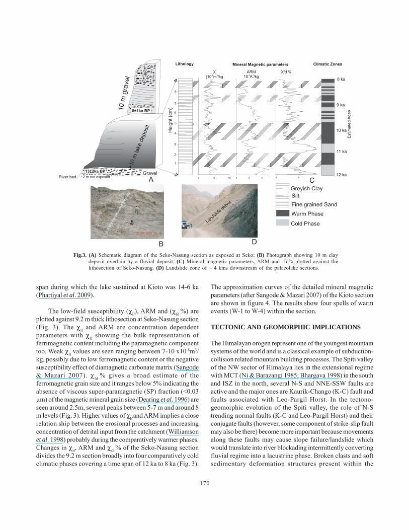
The lacustrine section at Seko-Nasung (32°09’56’’N;78°07’07’’E) is almost uniform with silty beds at 3-4 m levelsand fine sand at the base and at 6.2-7.1 m levels (Fig. 3). Thinlaminations (varve-like) of different colors (grey, yellow buffand blackish) are seen. Silty partings of mm to cm scale areembedded between the clay beds. The base of the section hasgravely sand and gives a OSL chronology of 13±2 ka BP andthe top is overlain by 10 m thick fluvial gravel that gives anage of 8± 1 ka BP. Thus the Seko-Nasung sequence yieldsbracket age of luminescence between 13±2 and 8±1 ka yrs BP(Phartiyal et al. 2009). Several thicker sequences (Atargu,Lingti, Schiling) are seen downstream of the studied sectionand a massive landslide zone (Fig. 3 D) is seen further down,all these perhaps being part of the single large lacustrinesystem which was blocked by this landslide. The Kioto section(32°26’40’’N; 77°54’06’’E), is described in Sangode & Mazari(2007) however the chronology was not well defined. We datedthe base and top of the ~25 m thick sequence and it dated theKioto relict lake section to between 13±1 and 7±1 ka (Fig. 4),and considering the errors we suggest that the maximum time
Fig.2. (a) Fluvial river terraced (~40 m thick) exposed between Kioto and Seko-Nasung villages in a stretch of nearly 20 km. (b) Seismites dated to12 ka exposed at Lingti-Lalung road section; (c) Debris cone blanketing the high angle slopes; (d) River Terraces; (e). Fluvial pedestals withthe braided river in background; (f). Hanging channel.
170
span during which the lake sustained at Kioto was 14-6 ka(Phartiyal et al. 2009).
The low-field susceptibility (χlf), ARM and (χfd %) areplotted against 9.2 m thick lithosection at Seko-Nasung section(Fig. 3). The χlf and ARM are concentration dependentparameters with χlf showing the bulk representation offerrimagnetic content including the paramagnetic componenttoo. Weak χlf values are seen ranging between 7-10 x10-8m3/kg, possibly due to low ferromagnetic content or the negativesusceptibility effect of diamagnetic carbonate matrix (Sangode& Mazari 2007). χfd % gives a broad estimate of theferromagnetic grain size and it ranges below 5% indicating theabsence of viscous super-paramagnetic (SP) fraction (<0.03μm) of the magnetic mineral grain size (Dearing et al. 1996) areseen around 2.5m, several peaks between 5-7 m and around 8m levels (Fig. 3). Higher values of χlf and ARM implies a closerelation ship between the erosional processes and increasingconcentration of detrital input from the catchment (Williamsonet al. 1998) probably during the comparatively warmer phases.Changes in χlf, ARM and χfd % of the Seko-Nasung sectiondivides the 9.2 m section broadly into four comparatively coldclimatic phases covering a time span of 12 ka to 8 ka (Fig. 3).
The approximation curves of the detailed mineral magneticparameters (after Sangode & Mazari 2007) of the Kioto sectionare shown in figure 4. The results show four spells of warmevents (W-1 to W-4) within the section.
TECTONIC AND GEOMORPHIC IMPLICATIONS
The Himalayan orogen represent one of the youngest mountainsystems of the world and is a classical example of subduction-collision related mountain building processes. The Spiti valleyof the NW sector of Himalaya lies in the extensional regimewith MCT (Ni & Barazangi 1985; Bhargava 1998) in the southand ISZ in the north, several N-S and NNE-SSW faults areactive and the major ones are Kaurik-Chango (K-C) fault andfaults associated with Leo-Pargil Horst. In the tectono-geomorphic evolution of the Spiti valley, the role of N-Strending normal faults (K-C and Leo-Pargil Horst) and theirconjugate faults (however, some component of strike-slip faultmay also be there) become more important because movementsalong these faults may cause slope failure/landslide whichwould translate into river blockading intermittently convertingfluvial regime into a lacustrine phase. Broken clasts and softsedimentary deformation structures present within the
Fig.3. (A) Schematic diagram of the Seko-Nasung section as exposed at Seko; (B) Photograph showing 10 m claydeposit overlain by a fluvial deposit; (C) Mineral magnetic parameters, ARM and fd% plotted against thelithosection of Seko-Nasung. (D) Landslide cone of ~ 4 kms downstream of the palaeolake sections.

171
deposits indicate towards seismic activity (Singh & Jain 2007;Phartiyal et al. 2009). Moreover, voluminous amount of screecoming down from the mountains, deep gorges, narrowvalleys, hanging channels, fossil valleys, fluvial terraces andupliftment of the Quaternary sediments are evidences ofneotectonic activity during the Quaternary period. Thedrainage pattern also shows a structural control.
The lithology and sediment architecture of the Spiti valleyis predominantly comprised of Tethyan sediments blanketedmostly in the lower parts by fluvio-lacustrine Quaternarydeposits. The sedimentary/metasedimentary exposed sectionswith basement rocks are 4,000 to 12,000 thick, however, thevalley floor in the upper reaches contain few to tens of metersthick relatively loose Quaternary cover. In this upper part, theriver flows in a braided fashion cutting across its own fandeposit making step like terraces probably oldest at top andcloser to valley wall. The fans are mostly matrix supportedcontaining angular to sub angular clasts of different size withmultiple coarsening as well as fining upward cycles. Thethickness of the debris flow is invariably increasing in thedown fan direction, however, the clast size is reducing probablybecause the high shear friction at the base allowing only finermaterial to flow down. The fluvial sequences are capped bythe lacustrine deposits, preserved only on isolated patchesdue to rapid Quaternary uplift and attendant erosion(Brookfield 1993). Being preserved in patches the sequencesare 30-40 m thick and show varve deposits. Palaeoseismic
activity had been prevalent as is evident from the deformationstructures seen in the Lingti-Lalung road section and at Hansa,Kioto and Seko-Nasung deposits. The chronology of thepalaeoseismic structures studied along the valley indicate twomajor tectonic events around 12 ka and 7 ka BP. The Kiotopalaeolake and Seko-Nasung palaeolake are Holocene lakeswith a time bracket of less that ~12 ka. The Kioto sedimenttoday stands at a considerable height from the present dayriver level ranging from 20-50 m possibly as a combined effectof upliftment as well as river incision. Thus, the Spiti had biglacustrine regimes during the late Quaternary to early Holocenetimes in the Upper valley. The available radio carbon ages(Phartiyal et al. 2009) and estimated ages (Sangode & Mazari2007) are spurious due to the hard water effect (Geyh et al.1998, 1999; Juyal et al., 2004) and therefore for these sectionswe base our observations on the OSL dates of the fluvialsections (Phartiyal et al. 2009) that underlie and overlie thelacustrine profiles.
Two possible reasons may have led to the formation ofthese lakes. These were either formed due to movement alongthe faults (Spiti river fault, K-C Fault) triggering earthquake,leading to river blockage by massive landslides around ~12 kaBP. This phenomena is not geologically uncommon in thisregion and has been reported by several workers from differentparts of Himalayas (Abbott 1849; Becher 1959; Burbank 1983,recent Chinese lakes) with recent examples from China duringthe Sichuan earthquake. The other cause of landslide
Fig.4. (A) Lithosection of fluvio-lacustrine deposit exposed at Kioto (B) Mineral magnetic parameters ofSangode and Mazari, (2007) of the 23m thick clay deposit. (C) Comparison of the climatic zones of theSeko-Nasung section to the Kioto section.

172
generation which blocked the river could be excessiveprecipitation in this otherwise arid zone causing landslideslurry. A recent example was documented in 2002 when heavyrains in this rain shadow zone brought down tons of debrisfrom the mountain slopes as slurry near Kaza village and similarevents are recorded downstream causing breaching at Malingvillage forming temporary lakes. The Spiti valley with lots ofloose sediment cover and being situated in the rain shadowzone, can experience great disaster and havoc to human lifedownstream even if minute levels of monsoons penetrate inthe area causing flash floods. These palaeolakes are linked tothe intensified monsoon phases recorded at 10-4 ka BP(Bookhagen et al. 2005a & b). Today the region experiencesrock falls, tremors, landslides and debris avalanches time andagain as is evident from the information given by the localresidents with cyclonic outbursts, abrupt heavy rainfall yearstrigger these effects. Thus, both tectonics and climate mayhave played a crucial role in the formation of these lakes.
CLIMATIC IMPLICATIONS
The presence of fine clay ranging from tens of meters to morethan 25 m at places is an evidence of the deposition during thelacustrine phase in the Spiti valley. The OSL chronology fromthe base and top of the sequence dated the Kioto relict lakesection to between 13±1 and 7±1 ka, and considering the errors
we suggest that the maximum time span during which the lakewas sustained around Kioto was 14-6 ka. The Seko-Nasungsequence yielded bracketing luminescence between 13±2 and8±1 ka, which, given the associated errors, is comparable tothe Kioto palaeolake sequence (Phartiyal et al. 2009). Fourphases of warm climate are seen between 12-8 ka BP (Fig. 3).The higher mineral magnetic values correspond to the warmerclimatic phase where more input of the detrital material wasthere and more ferrimagnetic rich material was coming to thelake catchment. A comparison of these zones to the Warmphases (W-1 to W-4) marked by Sangode & Mazari (2007),gives a very good picture of correlation. The warm phasesmarked by them perfectly coincide the phases of the studiedsection which lies in almost the same time span. The warmingis seen prior to 11 ka which is followed by a cold phase around11 ka BP, the other broad phases lie at 10 ka. Several minorwarm phases are seen between 8.4-9.2 ka BP. Fig. 5 shows aschematic model and the comparison of the two sections Kiotoand Seko-Nasung, separated by an aerial distance of 30 km.Prior to 12 ka fluvial phase dominated the upper part of theSpiti valley, with the advent of tectonic/seismic activity around12 ka the river was blocked and two major lake systems cameinto existence. Their sedimentary records show several warmand cold climatic phases with 4 being prominent ones (between11-12 ka; around 10 ka and several minor warm phases between8.4-9.2 ka BP). The lakes were terminated at ~7 ka with the
Fig.5. Schematic model of the fluvial-lacustrine phases; tectonic events and climatic phases during13-7 ka BP in the Upper Spiti valley.

173
reoccurrence of the tectonic/seismic activity and gave way toa fluvial phase which exists till toady. These lakes sedimentshave been uplifted, eroded, incised by the river and arepreserved only as patches today at a considerable height(~10-30 m) above the present day river level. As estimatedages are used for the lacustrine phases, we can only give abroad picture until our results are supplemented by otherproxies studies and more chronological constrains within thelacustrine profiles and studies in these direction are ongoing.
Acknowledgments: Our sincere thanks to the Directors, Birbal SahniInstitute of Palaeobotany, Lucknow and Wadia Institute of HimalayanGeology, Dehradun for encouragement and support for carrying outthis study. Comments from reviewers helped in improving themanuscript.
References
Abbott, J. 1849. Report on the cataclysm of the Indus taken from thelips of an eyewitness. Journal of the Asiatic Society of Bengal,XVII, 231-233.
Bagati, T.N., Mazari, R.K., Rajagopalan, G. 1996. Palaeotectonicimplications of Lamayuru lake (Ladakh). Current Science, 71(6),479-482.
Bagati, T.N., Thakur, V.C. 1993. Quaternary basins of Ladakh andLahul-Spiti in north-western Himalaya. Current Science, 64, 898-903.
Baneerjee, D., Singhvi, A.K., Bagati, T.N., Mohindra, R. 1997.Luminescence chronology of seismites in Sumdo (Spiti valley)near Kaurik-Chango Fault, northwestern Himalaya. CurrentScience, 73, 276-281.
Becher, J. 1959. The flooding of the Indus. Letter addressed to R. H.Davis, Sectetary of the Government of the Punjab and itsdependencies. Journal of the Asiatic Society of Bengal, XXVIII,219-228.
Bhargava, O.N., Bassi, U.K. 1998. Geology of Spiti-Kinnaur, HimachalHimalaya. Geological Survey of India Memoirs, 124, 1-210.
Bhargava, O.N. 1990. Holocene tectonics south of the Indus Suture,Lahaul-Ladakh Himalaya, India: a consequence of Indian Platemotion. Tectonophysics, 174, 315-320.
Bhargava, O.N., Ameta, S.S., Gaur, R.K., Kumar, S., Agrawal, A.N.,Jalote, P.M., Sadhu, M.L. 1978. The Kinnaur (H.P. India)earthquake of 19 January 1975: summary of geoseismologicalobservations. Bulletin Indian Geological Association, 11, 39-53.
Bloemendal, J., Lamb, B., King, J.W. 1988. Palaeoenvironmentalimplications of rock magnetic properties of the late Quaternarysediment cores from eastern equatorial Atlantic.Palaeoceanography, 3, 61-87.
Bookhagen, B., Thiede, R., Strecker, M.R. 2005a. Abnormal Monsoonyears and their control on erosion and sediment flux in the high,arid northwestern Himalaya. Earth and Planetary Science Letters,231, 131-146.
Bookhagen, B., Thiede, R.C., Strecker, M.R. 2005b. Late Quaternaryintensified monsoon phases control landscape evolution in theNorthwest Himalaya. Geology, 33, 149–152
Brookfield, M.E. 1993. Quaternary deposits along the Indus SutureZone and evolution of Himalayan rivers. Current Science, 64(11&12), 903-907.
Burbank, D.W. 1983. Multiple episodes of catartropic flooding in thePeshawar basin during the past 700,000 years. Geological Bulletinof the University of Peshawar, 16, 43-49.
Burgisser, H.M., Gansser, A., Pika, J. 1982. Late Glacial lake sedimentsof the Indus valley area, northwestern Himalaya. Eclog. Geol.Helvet., 75(1), 51-63.
Cronin, V.S. 1989. Structural setting of the Skardu intermontane basin,Karakoram Himalaya, Pakistan. Geol. Soc. Amer., (Spl. Papers)232, 183-201.
Dearing, J.A., Dunn, R.J.L., Lees, J.A., Loveland., P.J., Mahaer, B.A.,O’Grady, K. 1996. Frequency dependent measurement ofenvironmental materials. Geophysical Journal International, 124,228-224.
Digerfeldt, G., Olsson, S., Sandgren, P. 2000. Reconstruction of thelake-level changes in the lake Xinias, Central Greece, during thelast 40,000 years. Palaeogeography, Palaeoclimatology,Palaeoecology, 157, 65–82.
Evan, M.E. Heller, F. 1994. Magnetic enhancement and palaeoclimate.Study of a loess/paleosol couplet across the Loess Plateau ofChina, Geophysic Journal International, 117, 257–64.
Fort, M., Burbank, D.W., Freytet, P. 1989. Lacustrine sedimentationin a semi-arid alpine setting: an example from Ladakh,northwestern Himalaya. Quaternary Research, 31, 332-352.
Garzione, N.G., Dettman, D.L., Quade, J., DeCelles, P.G., Butler, R.F.2000. High times on Tibetan plateau: palaeoelevation of theThakhola graben, Nepal. Geology, 28, 339–342.
Gee, E.R. 1989. Overview of geology and structure of the Salt range,with observations on related areas of North Pakistan. Geol. Soc.Amer., (Spl. Papers), 232, 95-112.
Geyh, M.A., Grosjean, M., Núñez, L., Schotterer, U. 1999. RadiocarbonReservoir Effect and the Timing of the Late-Glacial/EarlyHolocene Humid Phase in the Atacama Desert (Northern Chile).Quaternary Research, 52, 143-153.
Geyh, M.A., Schotterer, U., Grosjean, M. 1998. Temporal changes ofthe 14C reservoir effect in lakes. In: Proceedings 16th InternationalRadiocarbon Conference, Groningen: Radiocarbon, 40, 921–931.
Isacks, B. L., Fielding, E. J., Fox, A., Masek, J., Klein, A., Bloom, A.,Jordan, T. 1991. Erosion, Tectonics and Climate History inMountain Belts. Presented at the Science Foundations for theEOS Era: Physical Climate and Hydrology Meeting the AnnualWorkshop in Earth System Science held at the Pennsylvania StateUniversity State College, Pennsylvania.
Juyal, N., Pant, R.K., Basavaiah, N., Yadava, M.G., Saini, N.K., Singhvi,
174
A.K. 2004. Climate and Seismicity in the Higher Central Himalayaduring the last 20 kyr: evidences from Garbyang basin, Uttaranchal,India. Palaeogeography, Palaeoclimatology, Palaeoecology, 213,315–330.
Khattri, K.N. 1999. Probabilities of occurrence of great earthquake inthe Himalaya. Proceedings of Indian Academy of Science: EarthPlanetary Sciences, 108, 87-92.
Khattri, K.N., Rai, K., Jain, A.K., Sinvhal, H., Gaur, V.K., Mithal, R.S.1978. The Kinnaur earthquake, Himachal Pradesh India of 19January, 1975. Tectonophysics, 49, 1-21.
Kotlia, B. S., Schallreuter, I. H., Schallreuter, R., Schwarz, J. 1998. Evolutionof Lamayuru palaeolake in the Trans Himalaya: Palaeoecologicalimplications. Eiszeitalter u. Gegenwart, 48, 177-191.
Kotlia, B.S., Bhalla, M.S., Shah, N., Rajagopalan G. 1997a.Palaeomagnetic results from the Pleistocene-Holocene lakedeposits of Bhimtal and Bhowali (Kumaun Himalaya) andLamayuru (Ladakh Himalaya) with reference to the reversalevents. Journal of Geological Society of India, 51(1), 7-20.
Kotlia, B.S. Shukla, U.K., Bhalla, M.S., Mathur, P.D., Pant, C.C. 1997b.Quaternary fluvio-lacustrine deposits of Lamayuru basin, LadakhHimalaya: Preliminary palaeolake investigations. Geol. Mag.,134 (6), 807-812.
Maher, B.A., Thompson, R. 1999. Quaternary Climates, environmentsand magnetism, University Press, Cambridge, 383p.
Maher, B.A., Thompson, R. 1992. Palaeoclimatic significance of themineral magnetic record of the Chinese loess and paleosols.Quaternary Research, 37, 155–70.
Molnar, P., Chen, W-P.1983. Focal depths and fault plane solutions ofearthquakes under the Tibetan plateau. Journal of GeophysicalResearch, 88, 1180-1196.
Ni, J., Barazangi, M. 1985. Active tectonics of western tethyanHimalaya above the underthrusting Indian plate: the upper Sutlujriver basin as a pull apart structure. In: Kobayashi, K. & Sacks,I.S. (ed.), Structures and Processes in Subduction Zones.Tectonophysics, 112, 277-295.
Owen, L. A. 1998. Timing and style of glaciation in the Himalaya.Himalayan Geology, 19, 39-48.
Phartiyal, B., Appel, E., Blaha, U., Hoffmann, V., Kotlia, B.S. 2003.Palaeoclimatic significance of magnetic properties from LateQuaternary lacustrine sediments at Pithoragarh, Kumaun LesserHimalaya, India. Quaternary International, 108 (2003) 51–62.
Phartiyal, B., Sharma, A., Srivastava, P., Ray, Y. 2009. Chronology ofrelict lake deposits in the Spiti River, NW Trans Himalaya:Implications to Late Pleistocene-Holocene climate-tectonicperturbations. Geomorphology, 108, 264-272.
Phartiyal, B., Sharma, A., Upadhyay, R., Ram-Awatar., Sinha, A.K.2005. Quaternary geology, tectonics and distribution of palaeo-and present fluvio/glacio lacustrine deposits in Ladakh, NW IndianHimalaya----- a study based on field observations. Geomorphology,65, 241-256.
Sangode, S.J., Mazari, R.K. 2007. Mineral magnetic response to climatevariability in the high altitude Kioto palaeolake, Spiti valley,Northwestern Himalaya. Himalayan Geology, 28(2), 1-9.
Singh, S., Jain, A.K. 2007. Liquefaction and fluidization of lacustrinedeposits from Lahaul-Spiti and Ladakh Himalaya: Geologicalevidences of palaeoseismicity along active fault zone. SedimentaryGeology, 196, 47-57.
Sinha, A.K. 1989. Geology of Higher Central Himalaya, John Wileyand Sons, 219p.
Steck, A., Epard, J.L., Vannay, J.C., Hunziker, J., Girard, M., Morard,A., Robry, M., 1998. Geological Transect across the Tso-Morariand Spiti areas: the nappe structures of the tethyan Himalaya.Eclog. Geol. Helvet., 91, 103-121.
Srikantia, S.V. 1981. The lithostratigraphy, sedimentation and structureof Protozoic-Phenerozoic formations of Spiti Basin in the HigherHimalaya of Himachal Pradesh, India. In: Sinha, A.K. (ed.),Contemporary Geoscientific Research in Himalaya. Bishen SinghMehendrapal Singh, Dehra Dun, 31-48.
Verosub, K.L., Roberts, A.P. 1995. Environmental magnetism: past, presentand future. Journal of Geophysical Research, 100, 2175–2192.
Vigliotti, L., Capotondi, L., Torii, M. 1999. Magnetic properties ofsediments deposited in suboxic-anoxic environments:relationshipswith biological and geochemical proxies. In: Tarling, D.H. &Turner, P. (eds), Palaeomagnetism and Diagenesis in Sedimentsvol. 151. Geological Society of London Special Publications,London, 71–83.
Wang, S.M., Hu, S.Y., Appel, E., Ma, X.H., Hoffmann, V., Sun, Z.M.,Yang, X.D., Ma, Y., Pan, H.X. 1999. Incursion of sea-water intoGucheng lake detected by magnetic, biologic and chemical data.Physics and Chemistry of the Earth, 24 (9), 805–809.
Williamson, D., Jackson, M.J., Banerjee, S.K., Marwin, J., Merdaci,O., Thouveny, N., Decobert, M., Gibert-Massault, E., Massault,M., Mazaudier, D., Taieb, M. 1999. Magnetic signatures ofhydrological change in a tropical Maar lake (lake Massoko,Tanzania): preliminary results. Physics and Chemistry of the Earth,24, 799–803.
Williamson, D., Jelinowska, A., Kissel, C., Tucholka, P., Gibert, E.,Gasse, F., Massault, M.,Taieb, M., Van Campo, E., Wieckowski,E. 1998: Mineral magnetic proxies of erosion/oxidation cycles intropical marr-lake sediments (Lake Tritivakely, Madagascar):palaeoenvironmental implications. Earth and Planetary ScienceLetters, 155, 205–19.