Formation of paleovalleys in the Central Himalaya during valley aggradation
14
Formation of paleovalleys in the Central Himalaya during valley aggradation Shipra Chaudhary a, * , U.K. Shukla b , Y.P. Sundriyal a , Pradeep Srivastava c , Poonam Jalal a, 1 a Department of Geology, HNB Garhwal University, Srinagar, Uttarakhand, India b Department of Geology, Banaras Hindu University, Varanasi, Uttar Pradesh, India c Sedimentology Group, Wadia Institute of Himalayan Geology, Dehradun, India article info Article history: Available online 17 January 2015 Keywords: Paleovalley Alaknanda River Quaternary Sedimentary facies Himalaya abstract The formation of paleovalleys in mountainous regions is considered to result from extreme events such as landslides and glacial or landslide lake outburst floods. According to IPCC (2012) the extreme events are rarest of the rare weather/climatic events when the climate/weather variable is significantly above or below the defined threshold value. The present study suggests that paleovalleys can also form during years long periods of valley aggradation. A series of paleovalleys thus formed runs parallel to the present river course. In this study, we suggest that paleovalleys in the Alaknanda valley of the Central Himalaya have formed in two ways: 1) major valley aggradation and 2) local events of landsliding and lake breaching. Most of the paleovalleys in the Alaknanda valley formed during a major valley aggradation phase (between 15 and 8 ka). Paleovalleys formed due to local landsliding also formed around 8 ka. Local landslides were triggered due to high rainfall in lower valley reaches during unstable climatic conditions. Therefore, the formation of paleovalleys both by regional and local mode within 15e8 ka indicates that the valley was receiving excess sediment from upper catchment as well as from lower reaches during this period. This phase of excess sediment supply and valley aggradation coincides well with post glacial climatic amelioration. Therefore the study underlines the role of climate in the time scales of 10 3 years in shaping the landscape of an active mountain like the Himalaya. The role of other landscape changing agencies such as tectonics and erosion is not accounted in the present study. © 2015 Elsevier Ltd and INQUA. All rights reserved. 1. Introduction First generation sequence stratigraphy model suggests that the valley aggradation and degradation is directly related to its base level change (Wilgus et al., 1988). Paleovalleys represent aban- doned or paleo river courses which are important for under- standing both first generation sequence stratigraphy in large alluvial tracts (Boyd et al., 1989) and the geomorphic evolution of mountainous regions (Ouimet et al., 2008). The formation of paleovalleys in the Himalaya are thought to form as a result of increased precipitation conditions, triggering of landslides and enhancing sediment in the river system (Pratt et al., 2002). Paleo- valleys are generally associated with epigenetic gorges. Epigenetic gorges are formed when the river incises bedrock during lateral shifts of its course in response to river blockage or aggradation episodes (Ouimet et al., 2008). This process results in the formation of a preserved valley adjacent to an epigenetic gorge filled with sediments. Sedimentological and chronological analyses of these sediment fills, thus, bear the potential to unravel the climate- tectonic causes of channel reorganization. According to Korup et al. (2006) the geomorphic evolution of high gradient fluvial system on the 10e10 4 y timescale is controlled by large scale landslides that block the river channel and eventually give rise to “bypass gorges” (paleovalleys). The understanding of such features is very limited for the Himalayan fluvial system and published examples from Nepal imply local (landslide) and single cata- strophic (lake breaching) events as overriding causes of their for- mation (Pratt et al., 2002; Pratt-Sitaula et al., 2007). For example, in the Marsyandi River of Nepal, the process of forming an epigenetic gorge incised ~70 m of bedrock at a rate of 13 mm/yr. This gorge formation and river shifting was attributed to a large landslide (Pratt-Sitaula et al., 2007). Therefore, channel reorganization that may be in response to landslides and/or rapid aggradation phases * Corresponding author. Present address: Center for Earth Sciences, Indian Institute of Science, Bangalore 560012, India. E-mail addresses: [email protected], [email protected] (S. Chaudhary). 1 Manipal Centre for Natural Sciences (MCNS), Manipal University, India. Contents lists available at ScienceDirect Quaternary International journal homepage: www.elsevier.com/locate/quaint http://dx.doi.org/10.1016/j.quaint.2014.12.064 1040-6182/© 2015 Elsevier Ltd and INQUA. All rights reserved. Quaternary International 371 (2015) 254e267
Transcript of Formation of paleovalleys in the Central Himalaya during valley aggradation
lable at ScienceDirect
Quaternary International 371 (2015) 254e267
Contents lists avai
Quaternary International
journal homepage: www.elsevier .com/locate/quaint
Formation of paleovalleys in the Central Himalaya during valleyaggradation
Shipra Chaudhary a, *, U.K. Shukla b, Y.P. Sundriyal a, Pradeep Srivastava c, Poonam Jalal a, 1
a Department of Geology, HNB Garhwal University, Srinagar, Uttarakhand, Indiab Department of Geology, Banaras Hindu University, Varanasi, Uttar Pradesh, Indiac Sedimentology Group, Wadia Institute of Himalayan Geology, Dehradun, India
a r t i c l e i n f o
Article history:Available online 17 January 2015
Keywords:PaleovalleyAlaknanda RiverQuaternarySedimentary faciesHimalaya
* Corresponding author. Present address: CenterInstitute of Science, Bangalore 560012, India.
E-mail addresses: [email protected],(S. Chaudhary).
1 Manipal Centre for Natural Sciences (MCNS), Man
http://dx.doi.org/10.1016/j.quaint.2014.12.0641040-6182/© 2015 Elsevier Ltd and INQUA. All rights
a b s t r a c t
The formation of paleovalleys in mountainous regions is considered to result from extreme events suchas landslides and glacial or landslide lake outburst floods. According to IPCC (2012) the extreme eventsare rarest of the rare weather/climatic events when the climate/weather variable is significantly above orbelow the defined threshold value. The present study suggests that paleovalleys can also form duringyears long periods of valley aggradation. A series of paleovalleys thus formed runs parallel to the presentriver course. In this study, we suggest that paleovalleys in the Alaknanda valley of the Central Himalayahave formed in two ways: 1) major valley aggradation and 2) local events of landsliding and lakebreaching. Most of the paleovalleys in the Alaknanda valley formed during a major valley aggradationphase (between 15 and 8 ka). Paleovalleys formed due to local landsliding also formed around 8 ka. Locallandslides were triggered due to high rainfall in lower valley reaches during unstable climatic conditions.Therefore, the formation of paleovalleys both by regional and local mode within 15e8 ka indicates thatthe valley was receiving excess sediment from upper catchment as well as from lower reaches during thisperiod. This phase of excess sediment supply and valley aggradation coincides well with post glacialclimatic amelioration. Therefore the study underlines the role of climate in the time scales of 103 years inshaping the landscape of an active mountain like the Himalaya. The role of other landscape changingagencies such as tectonics and erosion is not accounted in the present study.
© 2015 Elsevier Ltd and INQUA. All rights reserved.
1. Introduction
First generation sequence stratigraphy model suggests that thevalley aggradation and degradation is directly related to its baselevel change (Wilgus et al., 1988). Paleovalleys represent aban-doned or paleo river courses which are important for under-standing both first generation sequence stratigraphy in largealluvial tracts (Boyd et al., 1989) and the geomorphic evolution ofmountainous regions (Ouimet et al., 2008). The formation ofpaleovalleys in the Himalaya are thought to form as a result ofincreased precipitation conditions, triggering of landslides andenhancing sediment in the river system (Pratt et al., 2002). Paleo-valleys are generally associated with epigenetic gorges. Epigeneticgorges are formed when the river incises bedrock during lateral
for Earth Sciences, Indian
ipal University, India.
reserved.
shifts of its course in response to river blockage or aggradationepisodes (Ouimet et al., 2008). This process results in the formationof a preserved valley adjacent to an epigenetic gorge filled withsediments. Sedimentological and chronological analyses of thesesediment fills, thus, bear the potential to unravel the climate-tectonic causes of channel reorganization. According to Korupet al. (2006) the geomorphic evolution of high gradient fluvialsystem on the 10e104 y timescale is controlled by large scalelandslides that block the river channel and eventually give rise to“bypass gorges” (paleovalleys). The understanding of such featuresis very limited for the Himalayan fluvial system and publishedexamples from Nepal imply local (landslide) and single cata-strophic (lake breaching) events as overriding causes of their for-mation (Pratt et al., 2002; Pratt-Sitaula et al., 2007). For example, inthe Marsyandi River of Nepal, the process of forming an epigeneticgorge incised ~70 m of bedrock at a rate of 13 mm/yr. This gorgeformation and river shifting was attributed to a large landslide(Pratt-Sitaula et al., 2007). Therefore, channel reorganization thatmay be in response to landslides and/or rapid aggradation phases
S. Chaudhary et al. / Quaternary International 371 (2015) 254e267 255
may result in some of the fastest rates of observed bedrock erosionand landscape evolution, but these incision rates are not necessarilyequivalent to rates of rock uplift (Pratt et al., 2002; Ouimet et al.,2008).
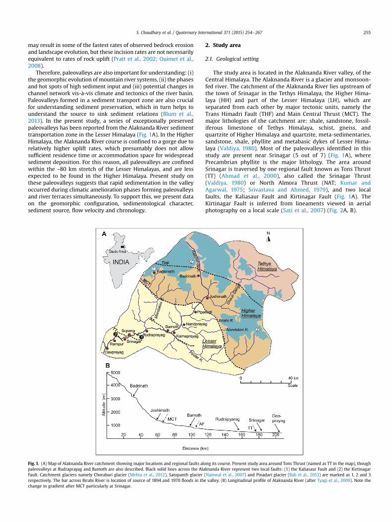
Therefore, paleovalleys are also important for understanding: (i)the geomorphic evolution ofmountain river systems, (ii) the phasesand hot spots of high sediment input and (iii) potential changes inchannel network vis-�a-vis climate and tectonics of the river basin.Paleovalleys formed in a sediment transport zone are also crucialfor understanding sediment preservation, which in turn helps tounderstand the source to sink sediment relations (Blum et al.,2013). In the present study, a series of exceptionally preservedpaleovalleys has been reported from the Alaknanda River sedimenttransportation zone in the Lesser Himalaya (Fig. 1A). In the HigherHimalaya, the Alaknanda River course is confined to a gorge due torelatively higher uplift rates, which presumably does not allowsufficient residence time or accommodation space for widespreadsediment deposition. For this reason, all paleovalleys are confinedwithin the ~80 km stretch of the Lesser Himalayas, and are lessexpected to be found in the Higher Himalaya. Present study onthese paleovalleys suggests that rapid sedimentation in the valleyoccurred during climatic amelioration phases forming paleovalleysand river terraces simultaneously. To support this, we present dataon the geomorphic configuration, sedimentological character,sediment source, flow velocity and chronology.
Fig. 1. (A) Map of Alaknanda River catchment showing major locations and regional faults alpaleovalleys at Rudraprayag and Bamoth are also described. Black solid lines across the AlaFault. Catchment glaciers namely Chorabari glacier (Mehta et al., 2012), Satopanth glacierrespectively. The bar across Birahi River is location of source of 1894 and 1970 floods in thchange in gradient after MCT particularly at Srinagar.
2. Study area
2.1. Geological setting
The study area is located in the Alaknanda River valley, of theCentral Himalaya. The Alaknanda River is a glacier and monsoon-fed river. The catchment of the Alaknanda River lies upstream ofthe town of Srinagar in the Tethys Himalaya, the Higher Hima-laya (HH) and part of the Lesser Himalaya (LH), which areseparated from each other by major tectonic units, namely theTrans Himadri Fault (THF) and Main Central Thrust (MCT). Themajor lithologies of the catchment are: shale, sandstone, fossil-iferous limestone of Tethys Himalaya, schist, gneiss, andquartzite of Higher Himalaya and quartzite, meta-sedimentaries,sandstone, shale, phyllite and metabasic dykes of Lesser Hima-laya (Valdiya, 1980). Most of the paleovalleys identified in thisstudy are present near Srinagar (5 out of 7) (Fig. 1A), wherePrecambrian phyllite is the major lithology. The area aroundSrinagar is traversed by one regional fault known as Tons Thrust(TT) (Ahmad et al., 2000), also called the Srinagar Thrust(Valdiya, 1980) or North Almora Thrust (NAT; Kumar andAgarwal, 1975; Srivastava and Ahmed, 1979), and two localfaults, the Kaliasaur Fault and Kirtinagar Fault (Fig. 1A). TheKirtinagar Fault is inferred from lineaments viewed in aerialphotography on a local scale (Sati et al., 2007) (Fig. 2A, B).
ong its course. Present study area around Tons Thrust (named as TT in the map), thoughknanda River represent two local faults: (1) the Kaliasaur Fault and (2) the Kirtinagar(Nainwal et al., 2007) and Pinadari glacier (Bali et al., 2013) are marked as 1, 2 and 3e valley. (B) Longitudinal profile of Alaknanda River (after Tyagi et al., 2009). Note the

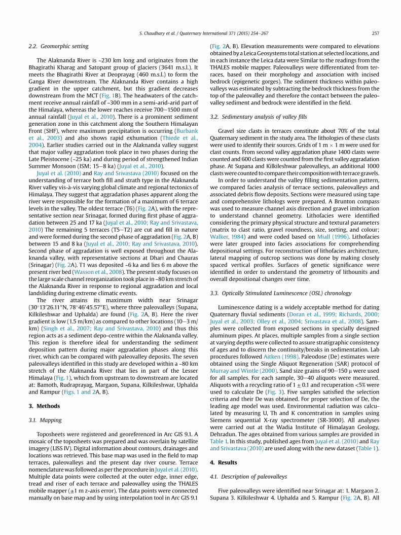
Fig. 2. (A): Detailed map of terraces and paleovalley around Srinagar. The bedrock below the paleovalley is not marked separately, though the whole paleovalley including thebedrock cliff is marked as a single feature (A) terraces and paleovalley between Margaon and Kilkileshwar. Note six levels of terraces at Srinagar (Chauras) and bedrock strath alongthe river. (B): Terraces and paleovalley between Kilkileshwar and Rampur. Note the straight river course after Uphalda and a wide channel bar near Uphalda. The paleovalleyformation at Rampur is a local phenomenon.
S. Chaudhary et al. / Quaternary International 371 (2015) 254e267256
S. Chaudhary et al. / Quaternary International 371 (2015) 254e267 257
2.2. Geomorphic setting
The Alaknanda River is ~230 km long and originates from theBhagirathi Kharag and Satopant group of glaciers (3641 m.s.l.). Itmeets the Bhagirathi River at Deoprayag (460 m.s.l.) to form theGanga River downstream. The Alaknanda River contains a highgradient in the upper catchment, but this gradient decreasesdownstream from the MCT (Fig. 1B). The headwaters of the catch-ment receive annual rainfall of ~300 mm in a semi-arid-arid part ofthe Himalaya, whereas the lower reaches receive 700e1500 mm ofannual rainfall (Juyal et al., 2010). There is a prominent sedimentgeneration zone in this catchment along the Southern HimalayanFront (SHF), where maximum precipitation is occurring (Burbanket al., 2003) and also shows rapid exhumation (Thiede et al.,2004). Earlier studies carried out in the Alaknanda valley suggestthat major valley aggradation took place in two phases during theLate Pleistocene (~25 ka) and during period of strengthened IndianSummer Monsoon (ISM; 15e8 ka) (Juyal et al., 2010).
Juyal et al. (2010) and Ray and Srivastava (2010) focused on theunderstanding of terrace both fill and strath type in the AlaknandaRiver valley vis-�a-vis varying global climate and regional tectonics ofHimalaya. They suggest that aggradation phases apparent along theriver were responsible for the formation of a maximum of 6 terracelevels in the valley. The oldest terrace (T6) (Fig. 2A), with the repre-sentative section near Srinagar, formed during first phase of aggra-dation between 25 and 17 ka (Juyal et al., 2010; Ray and Srivastava,2010) The remaining 5 terraces (T5eT2) are cut and fill in natureandwere formed during the second phase of aggradation (Fig. 2A, B)between 15 and 8 ka (Juyal et al., 2010; Ray and Srivastava, 2010).Second phase of aggradation is well exposed throughout the Ala-knanda valley, with representative sections at Dhari and Chauras(Srinagar) (Fig. 2A). T1 was deposited ~6 ka and lies 6 m above thepresent river bed (Wasson et al., 2008). The present study focuses onthe large scale channel reorganization took place in ~80kmstretch ofthe Alaknanda River in response to regional aggradation and locallandsliding during extreme climatic events.
The river attains its maximum width near Srinagar(30�13026.1100N, 78�46045.5700E), where three paleovalleys (Supana,Kilkileshwar and Uphalda) are found (Fig. 2A, B). Here the rivergradient is low (1.5 m/km) as compared to other locations (10e3m/km) (Singh et al., 2007; Ray and Srivastava, 2010) and thus thisregion acts as a sediment depo-centre within the Alaknanda valley.This region is therefore ideal for understanding the sedimentdeposition pattern during major aggradation phases along thisriver, which can be compared with paleovalley deposits. The sevenpaleovalleys identified in this study are developed within a ~80 kmstretch of the Alaknanda River that lies in part of the LesserHimalaya (Fig. 1), which from upstream to downstream are locatedat: Bamoth, Rudraprayag, Margaon, Supana, Kilkileshwar, Uphaldaand Rampur (Figs. 1 and 2A, B).
3. Methods
3.1. Mapping
Toposheets were registered and georeferenced in Arc GIS 9.1. Amosaic of the toposheets was prepared andwas overlain by satelliteimagery (LISS IV). Digital information about contours, drainages andlocations was retrieved. This base map was used in the field to mapterraces, paleovalleys and the present day river course. Terracenomenclaturewas followedasper theprocedure in Juyal et al. (2010).Multiple data points were collected at the outer edge, inner edge,tread and riser of each terrace and paleovalley using the THALESmobile mapper (±1 m z-axis error). The data points were connectedmanually on base map and by using interpolation tool in Arc GIS 9.1
(Fig. 2A, B). Elevation measurements were compared to elevationsobtainedbyaLeicaGeosystems total stationat selected locations, andin each instance the Leica datawere Similar to the readings from theTHALES mobile mapper. Paleovalleys were differentiated from ter-races, based on their morphology and association with incisedbedrock (epigenetic gorges). The sediment thickness within paleo-valleys was estimated by subtracting the bedrock thickness from thetop of the paleovalley and therefore the contact between the paleo-valley sediment and bedrock were identified in the field.
3.2. Sedimentary analysis of valley fills
Gravel size clasts in terraces constitute about 70% of the totalQuaternary sediment in the study area. The lithologies of these clastswere used to identify their sources. Grids of 1 m � 1 mwere used forclast counts. From second valley aggradation phase 1400 clasts werecounted and 600 clastswere counted from the first valley aggradationphase. At Supana and Kilkileshwar paleovalleys, an additional 1000clastswerecounted tocompare theircompositionwith terracegravels.
In order to understand the valley filling sedimentation pattern,we compared facies analysis of terrace sections, paleovalleys andassociated debris flow deposits. Sections weremeasured using tapeand comprehensive lithologs were prepared. A Brunton compasswas used to measure channel axis direction and gravel imbricationto understand channel geometry. Lithofacies were identifiedconsidering the primary physical structure and textural parameters(matrix to clast ratio, gravel roundness, size, sorting, and colour;Walker, 1984) and were coded based on Miall (1996). Lithofacieswere later grouped into facies associations for comprehendingdepositional settings. For reconstruction of lithofacies architecture,lateral mapping of outcrop sections was done by making closelyspaced vertical profiles. Surfaces of genetic significance wereidentified in order to understand the geometry of lithounits andoverall depositional changes over time.
3.3. Optically Stimulated Luminescence (OSL) chronology
Luminescence dating is a widely acceptable method for datingQuaternary fluvial sediments (Doran et al., 1999; Richards, 2000;Juyal et al., 2003; Olley et al., 2004; Srivastava et al., 2008). Sam-ples were collected from exposed sections in specially designedaluminum pipes. At places, multiple samples from a single sectionat varying depths were collected to assure stratigraphic consistencyof ages and to discern the continuity/breaks in sedimentation. Labprocedures followed Aitken (1998). Paleodose (De) estimates wereobtained using the Single Aliquot Regeneration (SAR) protocol ofMurray andWintle (2000). Sand size grains of 90e150 mwere usedfor all samples. For each sample, 30e40 aliquots were measured.Aliquots with a recycling ratio of 1 ± 0.1 and recuperation <5%wereused to calculate De (Fig. 3). Five samples satisfied the selectioncriteria and their De was obtained. For proper selection of De, theleading age model was used. Environmental radiation was calcu-lated by measuring U, Th and K concentration in samples usingSiemens sequential X-ray spectrometer (SR-3000). All analyseswere carried out at the Wadia Institute of Himalayan Geology,Dehradun. The ages obtained from various samples are provided inTable 1. In this study, published ages from Juyal et al. (2010) and Rayand Srivastava (2010) are used alongwith the new dataset (Table 1).
4. Results
4.1. Description of paleovalleys
Five paleovalleys were identified near Srinagar at: 1. Margaon 2.Supana 3. Kilkileshwar 4. Uphalda and 5. Rampur (Fig. 2A, B). All
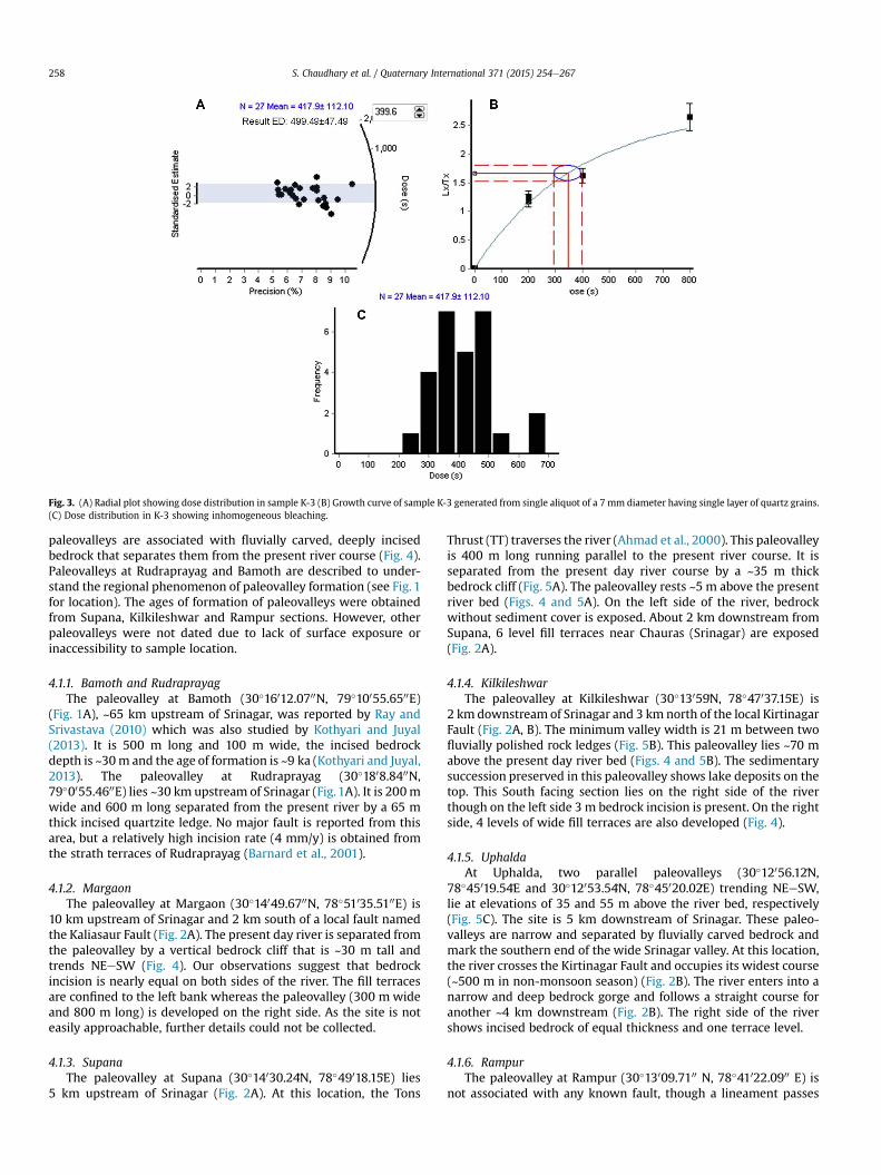
Fig. 3. (A) Radial plot showing dose distribution in sample K-3 (B) Growth curve of sample K-3 generated from single aliquot of a 7 mm diameter having single layer of quartz grains.(C) Dose distribution in K-3 showing inhomogeneous bleaching.
S. Chaudhary et al. / Quaternary International 371 (2015) 254e267258
paleovalleys are associated with fluvially carved, deeply incisedbedrock that separates them from the present river course (Fig. 4).Paleovalleys at Rudraprayag and Bamoth are described to under-stand the regional phenomenon of paleovalley formation (see Fig. 1for location). The ages of formation of paleovalleys were obtainedfrom Supana, Kilkileshwar and Rampur sections. However, otherpaleovalleys were not dated due to lack of surface exposure orinaccessibility to sample location.
4.1.1. Bamoth and RudraprayagThe paleovalley at Bamoth (30�16012.0700N, 79�10055.6500E)
(Fig. 1A), ~65 km upstream of Srinagar, was reported by Ray andSrivastava (2010) which was also studied by Kothyari and Juyal(2013). It is 500 m long and 100 m wide, the incised bedrockdepth is ~30m and the age of formation is ~9 ka (Kothyari and Juyal,2013). The paleovalley at Rudraprayag (30�1808.8400N,79�0055.4600E) lies ~30 km upstream of Srinagar (Fig.1A). It is 200mwide and 600 m long separated from the present river by a 65 mthick incised quartzite ledge. No major fault is reported from thisarea, but a relatively high incision rate (4 mm/y) is obtained fromthe strath terraces of Rudraprayag (Barnard et al., 2001).
4.1.2. MargaonThe paleovalley at Margaon (30�14049.6700N, 78�51035.5100E) is
10 km upstream of Srinagar and 2 km south of a local fault namedthe Kaliasaur Fault (Fig. 2A). The present day river is separated fromthe paleovalley by a vertical bedrock cliff that is ~30 m tall andtrends NEeSW (Fig. 4). Our observations suggest that bedrockincision is nearly equal on both sides of the river. The fill terracesare confined to the left bank whereas the paleovalley (300 m wideand 800 m long) is developed on the right side. As the site is noteasily approachable, further details could not be collected.
4.1.3. SupanaThe paleovalley at Supana (30�14030.24}N, 78�49018.15}E) lies
5 km upstream of Srinagar (Fig. 2A). At this location, the Tons
Thrust (TT) traverses the river (Ahmad et al., 2000). This paleovalleyis 400 m long running parallel to the present river course. It isseparated from the present day river course by a ~35 m thickbedrock cliff (Fig. 5A). The paleovalley rests ~5 m above the presentriver bed (Figs. 4 and 5A). On the left side of the river, bedrockwithout sediment cover is exposed. About 2 km downstream fromSupana, 6 level fill terraces near Chauras (Srinagar) are exposed(Fig. 2A).
4.1.4. KilkileshwarThe paleovalley at Kilkileshwar (30�13059}N, 78�47037.15}E) is
2 km downstream of Srinagar and 3 km north of the local KirtinagarFault (Fig. 2A, B). The minimum valley width is 21 m between twofluvially polished rock ledges (Fig. 5B). This paleovalley lies ~70 mabove the present day river bed (Figs. 4 and 5B). The sedimentarysuccession preserved in this paleovalley shows lake deposits on thetop. This South facing section lies on the right side of the riverthough on the left side 3 m bedrock incision is present. On the rightside, 4 levels of wide fill terraces are also developed (Fig. 4).
4.1.5. UphaldaAt Uphalda, two parallel paleovalleys (30�12056.12}N,
78�45019.54}E and 30�12053.54}N, 78�45020.02}E) trending NEeSW,lie at elevations of 35 and 55 m above the river bed, respectively(Fig. 5C). The site is 5 km downstream of Srinagar. These paleo-valleys are narrow and separated by fluvially carved bedrock andmark the southern end of the wide Srinagar valley. At this location,the river crosses the Kirtinagar Fault and occupies its widest course(~500 m in non-monsoon season) (Fig. 2B). The river enters into anarrow and deep bedrock gorge and follows a straight course foranother ~4 km downstream (Fig. 2B). The right side of the rivershows incised bedrock of equal thickness and one terrace level.
4.1.6. RampurThe paleovalley at Rampur (30�13009.7100 N, 78�41022.0900 E) is
not associated with any known fault, though a lineament passes

Table 1OSL ages obtained for the study area from various sections. Published ages from Ray and Srivastava (2010) and Juyal et al. (2010) are listed to compare sedimentation andpaleovalley formation period. The asterisk mark indicates the age of Khandukhal overbank deposited which is comparable with Supana overbank deposit.
Sediment type S. No. Location Depth fromsurface (m)
U (ppm) Th (ppm) K (%) Equivalentdose (Gy)
Dose rate(Gy/ka)
Leastage (ka)
Age from Chauras (Srinagar) terracesaT6 Terrace (Debris flow) LD-329 Chauras 4.0 5.3 15.3 2.3 111 ± 1 4.3 ± 0.3 26 ± 2bT3 Terrace (channel fill) IT-1 Chauras 32.0 2.6 ± 0.4 4.1 ± 1.5 1.7 ± 0.06 37 ± 1 2.5 ± 0.2 15 ± 1.0bT3 Terrace (channel fill) IT-2 Chauras 14.0 2.7 ± 0.4 5.1 ± 1.5 1.3 ± 0.1 33 ± 1 2.2 ± 0.2 14 ± 1.0*2Terraces (over bank deposit) KK-1 Rampur (Khandukhal) 2.0 3.0 ± 1.1 15.0 ± 3.6 2.8 ± 0.1 35 ± 2 4.2 ± 0.4 8 ± 1Ages from PaleovalleysaChannel fill SN-3/09 Supana 6.0 5.4 8.9 1.1 32 ± 1 2.9 ± 0.2 11 ± 1bChannel fill SnT-5 Supana 10.0 3.3 ± 0.6 10.0 ± 2.0 1.8 ± 0.1 46 ± 1 3.1 ± 0.3 15 ± 1bLake deposit T5/07 Kilkileshwar 2.0 5.8 ± 1.3 6.7 ± 4.4 2.0 ± 0.1 25 ± 1 3.5 ± 0.5 7 ± 1Channel fill KLT-5 Kilkileshwar 5.0 2.8 ± 0.5 5.0 ± 1.0 1.9 ± 0.1 37 ± 2 2.7 ± 0.2 14 ± 2Landslide M-1 Rampur (Margun) 3.0 1.9 13.6 1.9 30 ± 1 3.1 ± 0.2 10 ± 1Channel fill (fines) K-3 Rampur (Dehalchauri) 4.0 2.1 11.3 1.9 40 ± 2 3 ± 0.2 13 ± 1Channel fill K-5 Rampur 3.0 1.8 12.8 1.99 36 ± 4 3.1 ± 0.3 12 ± 2
*2Sample from paleovalley, earlier recognized as over bank deposit in Juyal et al. (2010).a Ray and Srivastava (2010).b Juyal et al. (2010).
Fig. 4. Schematic cross section of paleovalleys. The section width is scaled though thickness is marked by bedrock thickness measured in field. Note that each paleovalley isseparated from present day course by an incised bedrock ledge. At Rampur, the channel did not incised to obtain new course though clogged due to local slope failure and courseshifted completely into the subsidiary channel.
S. Chaudhary et al. / Quaternary International 371 (2015) 254e267 259
through the river (Fig. 2B). The paleovalley is ~500 m wide and~2 km long, and lies parallel to the present river course on left side(Fig. 5D). It contains sediment comparable with terrace deposits ofChauras (Srinagar). The stratigraphy of Rampur paleovalley showsthat a prominent debris flow rest over the gravel sequence (Figs. 4and 5D). 5 m of incised bedrock is exposed along the present dayriver course. On the right side of the valley, ~20m incised bedrock isnoticed. This bedrock is overlain by ~40 m thick terrace deposit(Fig. 2B).
4.2. Lithofacies construction and comparison
The series of paleovalleys along the Alaknanda River withalmost equal thickness of incised bedrock suggests that their for-mation could be simultaneous (Fig. 2A, B). Themajor sedimentationperiods in the Alaknanda valley are known. Thus, to check thepossibility of a regional phenomenon for paleovalley formation, thepaleovalley deposits were compared with the terrace depositsbased on lithofacies. Terraces of the Alaknanda valley are repre-sentative of major valley aggradation phases (section 2.2).
4.2.1. Lithofacies analysis of paleovalleysTo understand the mode of channel abandonment and paleo-
valley formation, the exposed sections of paleovalleys were studiedin sedimentological detail. Facies were broadly grouped as graveland sand facies (Table 2). Common gravel facies observed in pale-ovalleys are Gh, Gp, Gt and Gi. These gravel facies, along with sandfacies (Sh and Sm) make individual sedimentary units delimited bysurfaces of genetic significance (Miall, 1996). Most of the paleo-valleys show similar facies association. In addition, paleovalleys ofKilkileshwar and Rampur show the presence of Gmg facies at thetop, along with the above mentioned facies. Observing all paleo-valleys, the Supana section is considered the type section and iselaborated here for detailed facies analysis. This considerationcomes because of its large dimension (400 m � 30 m) and 3D ex-posures due to quarrying activity. This quarry section is subjectedto both vertical and lateral profiling for architectural elementsanalysis. Architecture elements are group of facies, used to under-stand three dimensional variations in composition and geometry offluvial deposits (Miall, 1985). These architectural elements andfacies units are bounded by surfaces of non-deposition or erosion
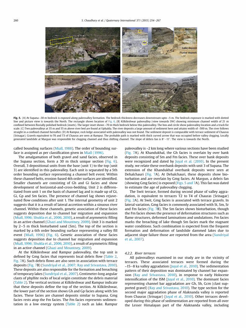
Fig. 5. (A) At Supana ~30 m bedrock is exposed along paleovalley formation. The bedrock thickness decreases downstream upto ~5 m. The bedrock exposure is marked with dottedline and picture view is towards the North. The rectangle shows location of Fig. 6. (B) Kilkileshwar paleovalley (view towards SW) showing minimum channel width of 21 mconfined between fluvially polished bedrock (insets). The larger inset shows ~70 m thick bedrock below this paleovalley. The box and circle show paleovalley location and a truck forscale. (C) Two paleovalleys at 35 m and 55 m above river bed are found at Uphalda. The river deposits a large amount of sediment here and attains width of ~500 m. The river followsstraight in a confined channel hereafter. (D) At Rampur, rock ledge associated with paleovalley was not found. The sediment deposit is comparable with terrace sediment of Chauras(Srinagar). Gravels equivalent to T6 and T3 of Chauras are seen at Rampur. The probable path is marked with thick curved arrow that was occupied before valley clogging. Locallygenerated landslide at Margun was responsible for clogging channel and thus shifting channel. The slope of debris fan is 8�e11�. The view is towards the North.
S. Chaudhary et al. / Quaternary International 371 (2015) 254e267260
called bounding surfaces (Miall, 1988). The order of bounding sur-face is assigned as per classification given in Miall (1996).
The amalgamation of both gravel and sand facies, observed inthe Supana section, form a 30 m thick unique section (Fig. 6).Overall, 3 depositional units from the base (unit 1) to the top (unit3) are identified in this paleovalley. Each unit is separated by a 5thorder bounding surface representing a channel belt event. Withinthese channel belts, erosion-based 4th order surfaces are identified.Smaller channels are consisting of Gh and Gi facies and showdevelopment of horizontal-and-cross-bedding. Unit 2 is differen-tiated from unit 1 on the basis of channel lag and is made up of Gt,Gi, Gp and Sm facies. The presence of channel lag shows rejuve-nated flow conditions after unit 1. The internal geometry of unit 2suggests that it is a result of lateral accretion within a sinuous riverchannel. Within these channels, genetic association of these faciessuggests deposition due to channel bar migration and expansion(Miall, 1996; Shukla et al., 2006, 2010), a result of asymmetric fillingin an active channel (Ghazi and Mountney, 2009). Unit 3 is markedby 2e5 m thick bioturbated sand (Sm). The top of the section ismarked by a 6th order bounding surface representing a valley fillevent (Miall, 1996) (Fig. 6). Genetic association of these faciessuggests deposition due to channel bar migration and expansion(Miall, 1996; Shukla et al., 2006, 2010), a result of asymmetric fillingin an active channel (Ghazi and Mountney, 2009).
At the Kilkileshwar and Rampur paleovalley, the top unit isdefined by Gmg facies that represents local debris flow (Table 2,Fig. 7A). Such debris flows are also seen in association with terracedeposits (Fig. 7B) (Sundriyal et al., 2007; Ray and Srivastava, 2010).These deposits are also responsible for the formation and breachingof temporary lakes (Sundriyal et al., 2007). Centimeter-long angularclasts of phyllite rocks of local origin constitute the debris material(Table 2). The vertical sections at Kilkileshwar and Rampur indicatethat these deposits define the top of the section. At Kilkileshwar,the lower part of the section shows Gh and Gp facies along with Smfacies. These facies are channel deposits similar to Supana. Gmgfacies rests atop the Fm facies. The Fm facies represents sedimen-tation in a low energy system (Table 2) such as lake. Rampur
paleovalley is ~2 km long where various sections have been studied(Fig. 7A). At Khandukhal, the Gh facies is overlain by over bankdeposits consisting of Sm and Fm facies. These over bank depositswere recognized and dated by Juyal et al. (2010). In the presentstudy, we relate these overbank deposits with unit 3 of Supana. Theextension of the Khandukhal overbank deposits were seen atDehalchauri (Fig. 7A). At Dehalchauri, these deposits show bio-turbation and are overlain by Gmg facies. At Margun, a debris fan(showing Gmg facies) is exposed (Figs. 5 and 7A). This fanwas datedto estimate the age of paleovalley clogging.
The Swit terrace, formed during second phase of valley aggra-dation, is equivalent to terraces T2 to T4 of Chauras (Srinagar)(Fig. 2A). At Swit, Gmg facies is associated with terrace gravels. Inlateral variation, Gmg facies is commonly associated with St, Sm, Srand Fm facies (Fig. 7B). The Sm facies shows bioturbation, thoughthe Fm facies shows the presence of deformation structures such asflame structures, deformed laminations and undulations. Fm faciesmarks the breaching of lake though Sm facies mark the stagnantwater conditions. Such combination is expected from the frequentformation and deformation of landslide dammed lakes due toadjacent slope failure those are reported from the area (Sundriyalet al., 2007).
4.2.2. River terracesAll paleovalleys examined in our study are in the vicinity of
terraces. These associated terraces were formed during the~15e8 ka valley aggradation (Juyal et al., 2010). The sedimentationpattern of their deposition was dominated by channel bar expan-sion (Ray and Srivastava, 2010), in response to early Holoceneintensification of the ISM (Juyal et al., 2010). The dominant faciesrepresenting channel bar aggradation are Gh, Sh, Gcm (clast sup-ported gravel) (Ray and Srivastava, 2010). The type section for thesecond major aggradation phase of Alaknanda valley is reportedfrom Chauras (Srinagar) (Juyal et al., 2010). Other terraces devel-oped during this phase of sedimentation are reported from all overthe Lesser Himalayan part of the Alaknanda valley, including
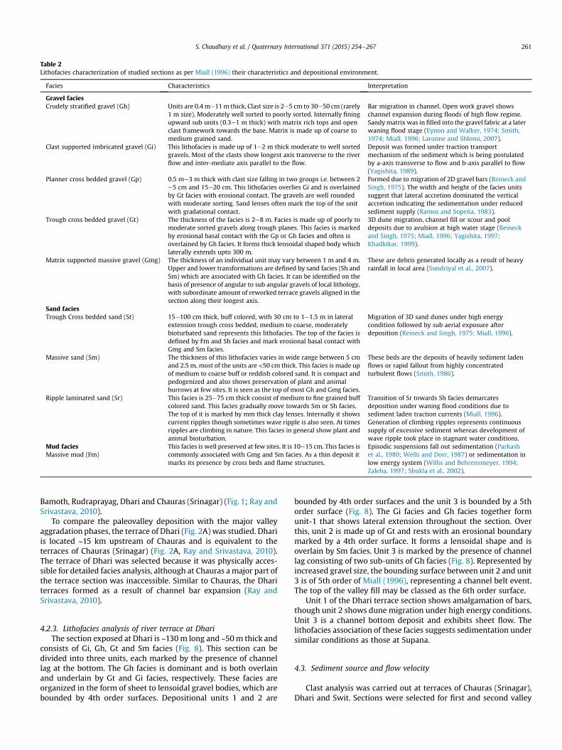
Table 2Lithofacies characterization of studied sections as per Miall (1996) their characteristics and depositional environment.
Facies Characteristics Interpretation
Gravel faciesCrudely stratified gravel (Gh) Units are 0.4 me11m thick, Clast size is 2e5 cm to 30e50 cm (rarely
1 m size). Moderately well sorted to poorly sorted. Internally finingupward sub units (0.3e1 m thick) with matrix rich tops and openclast framework towards the base. Matrix is made up of coarse tomedium grained sand.
Bar migration in channel. Open work gravel showschannel expansion during floods of high flow regime.Sandymatrix was in filled into the gravel fabric at a laterwaning flood stage (Eynon and Walker, 1974; Smith,1974; Miall, 1996; Laronne and Shlomi, 2007).
Clast supported imbricated gravel (Gi) This lithofacies is made up of 1e2 m thick moderate to well sortedgravels. Most of the clasts show longest axis transverse to the riverflow and inter-mediate axis parallel to the flow.
Deposit was formed under traction transportmechanism of the sediment which is being postulatedby a-axis transverse to flow and b-axis parallel to flow(Yagishita, 1989).
Planner cross bedded gravel (Gp) 0.5 me3 m thick with clast size falling in two groups i.e. between 2e5 cm and 15e20 cm. This lithofacies overlies Gi and is overlainedby Gt facies with erosional contact. The gravels are well roundedwith moderate sorting. Sand lenses often mark the top of the unitwith gradational contact.
Formed due to migration of 2D gravel bars (Reineck andSingh, 1975). The width and height of the facies unitssuggest that lateral accretion dominated the verticalaccretion indicating the sedimentation under reducedsediment supply (Ramos and Sope~na, 1983).
Trough cross bedded gravel (Gt) The thickness of the facies is 2e8 m. Facies is made up of poorly tomoderate sorted gravels along trough planes. This facies is markedby erosional basal contact with the Gp or Gh facies and often isoverlained by Gh facies. It forms thick lensoidal shaped body whichlaterally extends upto 300 m.
3D dune migration, channel fill or scour and pooldeposits due to avulsion at high water stage (Reineckand Singh, 1975; Miall, 1996; Yagishita, 1997;Khadkikar, 1999).
Matrix supported massive gravel (Gmg) The thickness of an individual unit may vary between 1 m and 4 m.Upper and lower transformations are defined by sand facies (Sh andSm) which are associated with Gh facies. It can be identified on thebasis of presence of angular to sub angular gravels of local lithology,with subordinate amount of reworked terrace gravels aligned in thesection along their longest axis.
These are debris generated locally as a result of heavyrainfall in local area (Sundriyal et al., 2007).
Sand faciesTrough Cross bedded sand (St) 15e100 cm thick, buff colored, with 30 cm to 1e1.5 m in lateral
extension trough cross bedded, medium to coarse, moderatelybioturbated sand represents this lithofacies. The top of the facies isdefined by Fm and Sh facies and mark erosional basal contact withGmg and Sm facies.
Migration of 3D sand dunes under high energycondition followed by sub aerial exposure afterdeposition (Reineck and Singh, 1975; Miall, 1996).
Massive sand (Sm) The thickness of this lithofacies varies in wide range between 5 cmand 2.5 m, most of the units are <50 cm thick. This facies is made upof medium to coarse buff or reddish colored sand. It is compact andpedogenized and also shows preservation of plant and animalburrows at few sites. It is seen as the top of most Gh and Gmg facies.
These beds are the deposits of heavily sediment ladenflows or rapid fallout from highly concentratedturbulent flows (Smith, 1986).
Ripple laminated sand (Sr) This facies is 25e75 cm thick consist of medium to fine grained buffcolored sand. This facies gradually move towards Sm or Sh facies.The top of it is marked by mm thick clay lenses. Internally it showscurrent ripples though sometimes wave ripple is also seen. At timesripples are climbing in nature. This facies in general show plant andanimal bioturbation.
Transition of Sr towards Sh facies demarcatesdeposition under waning flood conditions due tosediment laden traction currents (Miall, 1996).Generation of climbing ripples represents continuoussupply of excessive sediment whereas development ofwave ripple took place in stagnant water conditions.
Mud faciesMassive mud (Fm)
This facies is well preserved at few sites. It is 10e15 cm. This facies iscommonly associated with Gmg and Sm facies. As a thin deposit itmarks its presence by cross beds and flame structures.
Episodic suspensions fall out sedimentation (Parkashet al., 1980; Wells and Dorr, 1987) or sedimentation inlow energy system (Willis and Behrensmeyer, 1994;Zaleha, 1997; Shukla et al., 2002).
S. Chaudhary et al. / Quaternary International 371 (2015) 254e267 261
Bamoth, Rudraprayag, Dhari and Chauras (Srinagar) (Fig. 1; Ray andSrivastava, 2010).
To compare the paleovalley deposition with the major valleyaggradation phases, the terrace of Dhari (Fig. 2A) was studied. Dhariis located ~15 km upstream of Chauras and is equivalent to theterraces of Chauras (Srinagar) (Fig. 2A, Ray and Srivastava, 2010).The terrace of Dhari was selected because it was physically acces-sible for detailed facies analysis, although at Chauras amajor part ofthe terrace section was inaccessible. Similar to Chauras, the Dhariterraces formed as a result of channel bar expansion (Ray andSrivastava, 2010).
4.2.3. Lithofacies analysis of river terrace at DhariThe section exposed at Dhari is ~130m long and ~50m thick and
consists of Gi, Gh, Gt and Sm facies (Fig. 8). This section can bedivided into three units, each marked by the presence of channellag at the bottom. The Gh facies is dominant and is both overlainand underlain by Gt and Gi facies, respectively. These facies areorganized in the form of sheet to lensoidal gravel bodies, which arebounded by 4th order surfaces. Depositional units 1 and 2 are
bounded by 4th order surfaces and the unit 3 is bounded by a 5thorder surface (Fig. 8). The Gi facies and Gh facies together formunit-1 that shows lateral extension throughout the section. Overthis, unit 2 is made up of Gt and rests with an erosional boundarymarked by a 4th order surface. It forms a lensoidal shape and isoverlain by Sm facies. Unit 3 is marked by the presence of channellag consisting of two sub-units of Gh facies (Fig. 8). Represented byincreased gravel size, the bounding surface between unit 2 and unit3 is of 5th order of Miall (1996), representing a channel belt event.The top of the valley fill may be classed as the 6th order surface.
Unit 1 of the Dhari terrace section shows amalgamation of bars,though unit 2 shows dune migration under high energy conditions.Unit 3 is a channel bottom deposit and exhibits sheet flow. Thelithofacies association of these facies suggests sedimentation undersimilar conditions as those at Supana.
4.3. Sediment source and flow velocity
Clast analysis was carried out at terraces of Chauras (Srinagar),Dhari and Swit. Sections were selected for first and second valley
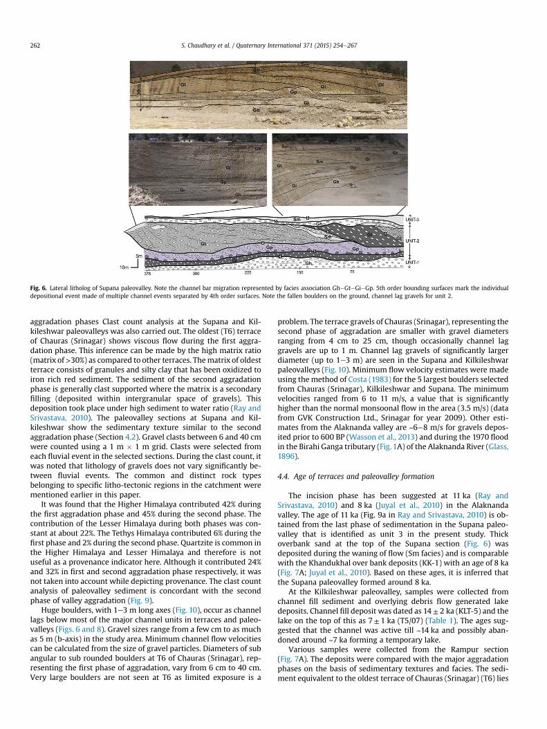
Fig. 6. Lateral litholog of Supana paleovalley. Note the channel bar migration represented by facies association GheGteGieGp. 5th order bounding surfaces mark the individualdepositional event made of multiple channel events separated by 4th order surfaces. Note the fallen boulders on the ground, channel lag gravels for unit 2.
S. Chaudhary et al. / Quaternary International 371 (2015) 254e267262
aggradation phases Clast count analysis at the Supana and Kil-kileshwar paleovalleys was also carried out. The oldest (T6) terraceof Chauras (Srinagar) shows viscous flow during the first aggra-dation phase. This inference can be made by the high matrix ratio(matrix of>30%) as compared to other terraces. Thematrix of oldestterrace consists of granules and silty clay that has been oxidized toiron rich red sediment. The sediment of the second aggradationphase is generally clast supported where the matrix is a secondaryfilling (deposited within intergranular space of gravels). Thisdeposition took place under high sediment to water ratio (Ray andSrivastava, 2010). The paleovalley sections at Supana and Kil-kileshwar show the sedimentary texture similar to the secondaggradation phase (Section 4.2). Gravel clasts between 6 and 40 cmwere counted using a 1 m � 1 m grid. Clasts were selected fromeach fluvial event in the selected sections. During the clast count, itwas noted that lithology of gravels does not vary significantly be-tween fluvial events. The common and distinct rock typesbelonging to specific litho-tectonic regions in the catchment werementioned earlier in this paper.
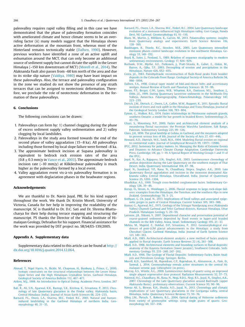
It was found that the Higher Himalaya contributed 42% duringthe first aggradation phase and 45% during the second phase. Thecontribution of the Lesser Himalaya during both phases was con-stant at about 22%. The Tethys Himalaya contributed 6% during thefirst phase and 2% during the second phase. Quartzite is common inthe Higher Himalaya and Lesser Himalaya and therefore is notuseful as a provenance indicator here. Although it contributed 24%and 32% in first and second aggradation phase respectively, it wasnot taken into account while depicting provenance. The clast countanalysis of paleovalley sediment is concordant with the secondphase of valley aggradation (Fig. 9).
Huge boulders, with 1e3 m long axes (Fig. 10), occur as channellags below most of the major channel units in terraces and paleo-valleys (Figs. 6 and 8). Gravel sizes range from a few cm to as muchas 5 m (b-axis) in the study area. Minimum channel flow velocitiescan be calculated from the size of gravel particles. Diameters of subangular to sub rounded boulders at T6 of Chauras (Srinagar), rep-resenting the first phase of aggradation, vary from 6 cm to 40 cm.Very large boulders are not seen at T6 as limited exposure is a
problem. The terrace gravels of Chauras (Srinagar), representing thesecond phase of aggradation are smaller with gravel diametersranging from 4 cm to 25 cm, though occasionally channel laggravels are up to 1 m. Channel lag gravels of significantly largerdiameter (up to 1e3 m) are seen in the Supana and Kilkileshwarpaleovalleys (Fig. 10). Minimum flow velocity estimates were madeusing themethod of Costa (1983) for the 5 largest boulders selectedfrom Chauras (Srinagar), Kilkileshwar and Supana. The minimumvelocities ranged from 6 to 11 m/s, a value that is significantlyhigher than the normal monsoonal flow in the area (3.5 m/s) (datafrom GVK Construction Ltd., Srinagar for year 2009). Other esti-mates from the Alaknanda valley are ~6e8 m/s for gravels depos-ited prior to 600 BP (Wasson et al., 2013) and during the 1970 floodin the Birahi Ganga tributary (Fig. 1A) of the Alaknanda River (Glass,1896).
4.4. Age of terraces and paleovalley formation
The incision phase has been suggested at 11 ka (Ray andSrivastava, 2010) and 8 ka (Juyal et al., 2010) in the Alaknandavalley. The age of 11 ka (Fig. 9a in Ray and Srivastava, 2010) is ob-tained from the last phase of sedimentation in the Supana paleo-valley that is identified as unit 3 in the present study. Thickoverbank sand at the top of the Supana section (Fig. 6) wasdeposited during the waning of flow (Sm facies) and is comparablewith the Khandukhal over bank deposits (KK-1) with an age of 8 ka(Fig. 7A; Juyal et al., 2010). Based on these ages, it is inferred thatthe Supana paleovalley formed around 8 ka.
At the Kilkileshwar paleovalley, samples were collected fromchannel fill sediment and overlying debris flow generated lakedeposits. Channel fill deposit was dated as 14 ± 2 ka (KLT-5) and thelake on the top of this as 7± 1 ka (T5/07) (Table 1). The ages sug-gested that the channel was active till ~14 ka and possibly aban-doned around ~7 ka forming a temporary lake.
Various samples were collected from the Rampur section(Fig. 7A). The deposits were compared with the major aggradationphases on the basis of sedimentary textures and facies. The sedi-ment equivalent to the oldest terrace of Chauras (Srinagar) (T6) lies
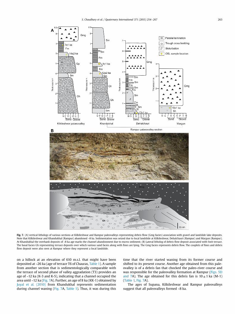
Fig. 7. (A) vertical lithologs of various sections at Kilkileshwar and Rampur paleovalleys representing debris flow (Gmg facies) association with gravel and landslide lake deposits.Note that Kilkileshwar and Khandukhal (Rampur) abandoned ~8 ka. Sedimentation was seized due to local landslide at Kilkileshwar, Dehalchauri (Rampur) and Margun (Rampur).At Khandukhal the overbank deposits of ~8 ka age marks the channel abandonment due to excess sediment. (B) Lateral litholog of debris flow deposit associated with Swit terrace.The basal facies Gh representing terrace deposits over which various sand facies along with fines are lying. The Gmg facies represents debris flow. The couplets of fines and debrisflow deposit were also seen at Rampur where they represent a local landslide.
S. Chaudhary et al. / Quaternary International 371 (2015) 254e267 263
on a hillock at an elevation of 610 m.s.l. that might have beendeposited at ~26 ka (age of terrace T6 of Chauras, Table 1). A samplefrom another section that is sedimentologically comparable withthe terrace of second phase of valley aggradation (T3) provides anage of ~12 ka (K-3 and K-5), indicating that a channel occupied thearea until ~12 ka (Fig. 7A). Further, an age of 8 ka (KK-1) obtained byJuyal et al. (2010) from Khandukhal represents sedimentationduring channel waning (Fig. 7A, Table 1). Thus, it was during this
time that the river started waning from its former course andshifted to its present course. Another age obtained from this pale-ovalley is of a debris fan that chocked the paleo-river course andwas responsible for the paleovalley formation at Rampur (Figs. 5Dand 7A). The age obtained for this debris fan is 10± 1 ka (M-1)(Table 1, Fig. 7A).
The ages of Supana, Kilkileshwar and Rampur paleovalleyssuggest that all paleovalleys formed ~8 ka.
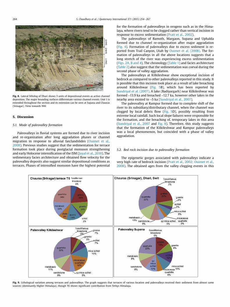
Fig. 8. Lateral litholog of Dhari shows 3 units of depositional events as active channeldeposition. The major bounding surfaces differentiate various channel events. Unit 1 isextended throughout the section and its extension can be seen at Supana and Chauras(Srinagar). View towards NW.
S. Chaudhary et al. / Quaternary International 371 (2015) 254e267264
5. Discussion
5.1. Mode of paleovalley formation
Paleovalleys in fluvial systems are formed due to river incisionand re-organization after long aggradation phases or channelmigration in response to alluvial fan/landslides (Ouimet et al.,2008). Previous studies suggest that the sedimentation for terraceformation took place during postglacial monsoon strengtheningand early Holocene intensification of the ISM (Juyal et al., 2010). Thesedimentary facies architecture and obtained flow velocity for thepaleovalley deposits also suggest similar depositional conditions asterraces. Phases of intensified monsoon have the highest potential
Fig. 9. Lithological variation among terraces and paleovalleys. The graph suggests that tersources (dominantly Higher Himalaya), though T6 shows significant contribution from Teth
for the formation of paleovalleys in orogens such as in the Hima-laya, where rivers tend to be clogged rather than vertical incision inresponse to excess sedimentation (Pratt et al., 2002).
The paleovalleys of Bamoth, Margaon, Supana and Uphaldaformed due to channel re-organization after major aggradation(Fig. 4). Formation of paleovalleys due to excess sediment is re-ported from Trail Canyon, Utah by Ouimet et al. (2008). The for-mation of paleovalleys in all the above locations suggests that along stretch of the river was experiencing excess sedimentation(Figs. 2A, B and 4). The chronology (Table 1) and facies architecture(Table 2) also suggest that the sedimentationwas coeval during thesecond phase of valley aggradation.
The paleovalleys at Kilkileshwar show exceptional incision ofbedrock as compared to other paleovalleys reported in this study. Itis possible that this incision took place as a result of lake breachingaround Kilkileshwar (Fig. 5B), which has been reported bySundriyal et al. (2007). A lake (Badiyargarh) near Kilkileshwar wasformed ~13.9 ka and breached ~12.7 ka, however other lakes in thenearby area existed to ~5 ka (Sundriyal et al., 2007).
The paleovalley at Rampur formed due to complete shift of theriver to its subsidiary/distributary channel, when the channel wasclogged by local debris flow (Fig. 5D), possibly resulting fromextreme local rainfall. Such local slope failures were responsible forthe formation, and the breaching of, temporary lakes in this area(Sundriyal et al., 2007 and Fig. 8). Therefore, this study suggeststhat the formation of the Kilkileshwar and Rampur paleovalleyswas a local phenomenon, but coincided with a phase of valleyaggradation.
5.2. Bed rock incision due to paleovalley formation
The epigenetic gorges associated with paleovalleys indicate avery high rate of bedrock incision (Pratt et al., 2002; Ouimet et al.,2008). The obtained ages from the valley clogging events in this
races of various location and paleovalleys received their sediment from almost sameys Himalaya.

Fig. 10. 1e3 m dimension boulders from Supana (a, b) and Kilkileshwar (c) were used for flow velocity calculations along with boulders at T3 of Srinagar. (d) Deep grooving inbedrock, signature of fluvial erosion, near Supana paleovalley. Fluvially polished bedrock surfaces are seen at Kilkileshwar paleovalley (see Fig. 5B).
S. Chaudhary et al. / Quaternary International 371 (2015) 254e267 265
study appear to represent the fastest known bedrock incision sincethe second phase of valley aggradation.
The age obtained from the topmost paleovalley deposit (lastphase of sedimentation) at Supana, is ~8 ka. This implies bedrockincision of ~5 m over a span of 8 ka occurred at the rate of ~0.8 mm/y (Fig. 5A). The present erosion rate estimated using cosmogenicradionuclide measurement on the quartz of the Alaknanda Riversediments at Srinagar is 0.8 ± 0.3 mm/y (Vance et al., 2003), indi-cating that the rate of erosion in the valley is almost that constant atleast through the Holocene. The bedrock incision rate estimated atKilkileshwar, with the minimum age being 7 ka and bedrockthickness 70 m, is 10 mm/y. Such a high rate of bedrock incision isexpected when it has formed due to local phenomenon such as lakebreaching. Bedrock incision rates in the Ladakh-Karakoram Hima-laya, range between ~0.02 and ~26.0 mm/y for Holocene strathsand 5 mm/y for Pleistocene strath terraces of the Himalaya (Dortchet al., 2011), where post glacial warming and increased riverdischarge is suggested to be an overriding factor.
5.3. Climatic conditions
Climate plays the most important role in sediment generation.The abnormal monsoon seasons generate landslides in the upperreaches of fluvial networks which increases the sediment input inthe river system. A long term period of intensified monsoon phasecan last for 2e5 ka (Bookhagen et al., 2005). Such long phases ofintensified monsoon can change the river morphology.
The facies characteristics of terraces and paleovalleys in andaround Srinagar suggest that sedimentation occurred during such along term intensified monsoonal phases. The presence of clastscomposed of Tethys Himalayan rocks in terraces (Fig. 9) also sug-gests that the sedimentation took place during intensifiedmonsoonal phases when precipitation reached the Trans Himalaya,which is otherwise relatively dry (Bookhagen et al., 2005). Thevelocity of sediment transport (6e11 m/s) during paleovalley for-mation was much higher than the present day monsoonal flow
(3.5 m/s) suggesting that the deposition took place during flood-like conditions. Sediment storage in high gradient rivers is shortlived thus paleovalleys are located where the channel gradient islow (Fig.1B). The evidence of local landsliding and channel cloggingat Rampur (Fig. 5D) suggests that the Alaknanda River wasreceiving extreme precipitation in downstream valleys during thisphase.
Major floods occur because of high transport capacity and steepriver gradients (Howard et al., 1994). Major floods can be generatedduring interglacial periods and phases of valley deglaciation (IPCC,2012). Fluvially carved strath terraces formed in such climaticconditions are reported from the Gori Ganga (Barnard et al., 2004)with sediment generation phases in this valley at ~12e16 ka(Barnard et al., 2004), ~10e8 ka (Nawaz Ali et al., 2013) and 1e2,~4e5, and ~7e8 ka (Barnard et al., 2004). Deglaciation (sedimentgeneration) phases were frequent during the Holocene. The ages(within the error) obtained frompaleovalleys (Table 1) overlapwiththe deglaciation ages in the valley showing a probable linkage be-tween the availability of excess sediment load, rapid valley aggra-dation, and formation of paleovalleys.
Other studies bracket glaciation events. The Pindari glacier(source of Pinder River) expanded at 25 ka, 6 ka and 3 ka (Bali et al.,2013) though Chorabari glacier (source of Mandakini River)advanced at 13 ka, 9 ka, 7 ka and 5 ka (Mehta et al., 2012). Thesource of the Alaknanda River is at Satopanth and BhagirathiKhadak, where glaciers advanced at 12.5 ka and 4.5 ka (Nainwalet al., 2007). These phases are at times overlapped with phases ofdeglaciation.
The asynchronicity of glaciation phases in various tributaryvalleys (Fig. 1A) prevents the construction of a basin-wide frame-work of glaciations or deglaciations phases. Nonetheless, the Early(12e9 ka) and Middle (7e5 ka) Holocene seem to be major phasesof deglaciation that presumably supplied large amounts of sedi-ment down valley.
The role of tectonics in the formation of the studied paleovalleysseems to be subsidiary, because: (i) the formation of each
S. Chaudhary et al. / Quaternary International 371 (2015) 254e267266
paleovalley requires rapid valley filling and in this case we havedemonstrated that the phase of paleovalley formation coincideswith ameliorated climate and hence climate seems to be an over-riding factor (ii) many models suggest that the Himalaya showsactive deformation at the mountain front, whereas most of theHinterland remains tectonically stable (Dalhen, 1990). However,previous workers have identified a zone of an active uplift andexhumation around the MCT, that can only become an additionalsource of sediment supply but cannot dictate the uplift in the LesserHimalaya (~150 km downstream of MCT) (Morell et al., 2014). TheAlaknanda Fault also passes from ~60 km north of the area and dueto its strike slip nature (Valdiya, 1980) may have least impact onthese paleovalleys. Also, the terrace and paleovalley configurationin the zone we studied do not show the presence of any strathterraces that can be assigned to neotectonic deformation. There-fore, we preclude the role of neotectonic deformation in the for-mation of these paleovalleys.
6. Conclusions
The following conclusions can be drawn:
1. Paleovalleys can form by: 1) channel clogging during the phaseof excess sediment supply valley sedimentation and 2) valleyclogging by local landslides.
2. Paleovalleys in the study area formed towards the end of thesecond phase of valley aggradation (15e8 ka). All paleovalleysincluding those formed by local slope failure were formed ~8 ka.
3. The approximate bedrock incision at Supana paleovalley isequivalent to bedrock rock erosion rates of the area(0.8 ± 0.3 mm/y in Vance et al., 2003). The approximate bedrockincision rate (~10 mm/y) at Kilkileshwar paleovalley is muchhigher as the paleovalley formed by a local event.
4. Valley aggradation event vis-�a-vis paleovalley formation is inagreement with deglaciation phases in the headwater regions.
Acknowledgements
We are thankful to Dr. Navin Juyal, PRL for his kind supportthroughout the work. We thank Dr. Kristin Morell, University ofVictoria, Canada for her help in improving the readability of themanuscript. SC is thankful to Dr. D.C. Sati and Dr. Shrema Bhatta-charya for their help during terrace mapping and structuring themanuscript. PS thanks the Director of the Wadia Institute of Hi-malayan Geology, Dehradun for his support. Financial assistance forthe work was provided by DST project no. SR/S4/ES-139/2005.
Appendix A. Supplementary data
Supplementary data related to this article can be found at http://dx.doi.org/10.1016/j.quaint.2014.12.064.
References
Ahmad, T., Nigel Harris, N., Bickle, M., Chapman, H., Bunbury, J., Prince, C., 2000.Isotopic constraints on the structural relationships between the Lesser Hima-layan Series and the High Himalayan Crystalline Series, Garhwal Himalaya.Geological Society of America Bulletin 112, 467e477.
Aitken, M.J., 1998. An Introduction to Optical Dating. Academic Press, London, 267pp.
Bali, R., Ali, S.N., Agarwal, K.K., Rastogi, S.K., Krishna, K., Srivastava, P., 2013. Chro-nology of late Quaternary glaciation in the Pindar valley, Alaknanda basin,Central Himalaya (India). Journal of Asian Earth Sciences 66, 224e233.
Barnard, P.L., Owen, L.A., Sharma, M.C., Finkel, R.C., 2001. Natural and human-induced landsliding in the Garhwal Himalaya of northern India. Geo-morphology 40, 21e35.
Barnard, P.L., Owen, L.A., Sharma, M.C., Finkel, R.C., 2004. Late Quaternary landscapeevolution of a monsoon-influenced high Himalayan valley, Gori Ganga, NandaDevi, NE Garhwal. Geomorphology 61, 91e110.
Blum, M., Martin, J., Milliken, K., Garvin, M., 2013. Palaeovalley systems: insightsfrom Quaternary analogs and experiments. Earth Science Reviews 116,128e169.
Bookhagen, B., Thiede, R.C., Strecker, M.R., 2005. Late Quaternary intensifiedmonsoon phases control landscape evolution in the northwest Himalaya. Ge-ology 33, 149e152.
Boyd, R., Suter, J., Penland, S., 1989. Relation of sequence stratigraphy to modernsedimentary environments. Geology 17, 926e929.
Burbank, D.W., Blythe, A.E., Putkonen, J., Pratt-Sitaula, B., Gabet, E., Oskin, M.,Barros, A., Ojha, T.P., 2003. Decoupling of erosion and precipitation in theHimalayas. Nature 426, 652e655.
Costa, J.E., 1983. Paleohydraulic reconstruction of flash-flood peaks from boulderdeposits in the Colorado Front Range. Geological Society of America Bulletin 94,986e1004.
Dalhen, F.A., 1990. Critical taper model of fold-and-thrust belts and accretionarywedges. Annual Review of Earth and Planetary Sciences 18, 55e99.
Doran, P.T., Berger, G.W., Lyons, W.B., Wharton, R.A., Davisson, M.L., Southon, J.,Dibb, J.E., 1999. Dating Quaternary lacustrine sediments in the McMurdo DryValleys, Antarctica. Palaeogeography, Palaeoclimatology, Palaeoecology 147,223e239.
Dortch, J.M., Dietsch, C., Owen, L.A., Caffee, M.W., Ruppert, K., 2011. Episodic fluvialincision of rivers and rock uplift in the Himalaya and Trans Himalaya. Journal ofthe Geological Society London 168, 783e804.
Eynon, G., Walker, R.G., 1974. Facies relationships in Pleistocene outwash gravels,southern Ontario: a model for bar growth in braided Rivers. Sedimentology 21,43e70.
Ghazi, S., Mountney, N.P., 2009. Facies and architectural element analysis of ameandering fluvial succession: the Permian Warchha Sandstone, Salt Range,Pakistan. Sedimentary Geology 221, 99e126.
Glass, J.H., 1896. The great landslip at Gohna, in Garhwal, and the measures adoptedto prevent serious loss of life. Journal of the Society of Arts 27, 431e446.
Howard, A.D., Dietrich, W.E., Seidl, M.A., 1994. Modeling fluvial erosion on regionalto continental scales. Journal of Geophysical Research 99, 13971e13986.
IPCC, 2012. Summary for policy makers. In: Managing the Risks of Extreme Eventsand Disasters to Advance Climate Change Adaptation. Cambridge UniversityPress, Cambridge, UK, pp. 1e19. A Special Report of Working Groups 1 and 11 ofthe IPCC.
Juyal, N., Kar, A., Rajaguru, S.N., Singhvi, A.K., 2003. Luminescence chronology ofaeolian deposition during the Late Quaternary on the southern margin of TharDesert, India. Quaternary International 104, 87e98.
Juyal, N., Sundriyal, Y.P., Rana, N., Chaudhary, Shipra, Singhvi, A.K., 2010. LateQuaternary fluvial aggradation and incision in the monsoon dominated Ala-knanda valley, Central Himalaya, Uttarakhand, India. Journal of QuaternaryScience 25, 1293e1304.
Khadkikar, A.S., 1999. Trough cross-bedded conglomerate facies. Sedimentary Ge-ology 128, 39e49.
Korup, O., Strom, A., Weidinger, J., 2006. Fluvial response to large rock-slope fail-ures: examples from the Himalayas, the Tienshan, and the southern Alps in newZealand. Geomorphology 78, 3e21.
Kothyari, G. Ch, Juyal, N., 2013. Implications of fossil valleys and associated epige-netic gorges in parts of Central Himalaya. Current Science 105, 383e388.
Kumar, G., Agarwal, N.C., 1975. Geology of the Srinagar Nandprayag area (AlaknandaValley) Chamoli Garhwal and Tehri Garhwal districts, Kumaun Himalaya, UttarPradesh. Himalayan Geology 5, 29e59.
Laronne, J.B., Shlomi, Y., 2007. Depositional character and preservation potential ofcoarse-grained sediments deposited by flood events in hyper-arid braidedchannels in the Rift Valley, Arava, Israel. Sedimentary Geology 195, 21e37.
Mehta, M., Majeed, Z., Dobhal, D.P., Srivastava, P., 2012. Geomorphological evi-dences of post-LGM glacial advancements in the Himalaya: a study fromChorabari Glacier, Garhwal Himalaya, India. Journal of Earth System Science121, 149e163.
Miall, A.D., 1985. Architectural-element analysis: a new method of facies analysisapplied to fluvial deposits. Earth Science Reviews 22 (4), 261e308.
Miall, A.D., 1988. Architectural elements and bounding surfaces in fluvial deposits:anatomy of the Kayenta formation (lower jurassic), Southwest Colorado. Sedi-mentary Geology 55, 233e240, 247e262.
Miall, A.D., 1996. The Geology of Fluvial Deposits: Sedimentary Facies, Basin Anal-ysis and Petroleum Geology. Springer, Berlin.
Morell, K.D., Sandiford, M., Rajendran, C.P., Rajendran, K., Alimanovic, A., Fink, D.,Sanwal, J., 2014. Geomorphology reveals active structures in the central Hi-malayan seismic gap. Lithosphere (in press).
Murray, A.S., Wintle, A.G., 2000. Luminescence dating of quartz using an improvedsingle aliquot regenerative dose protocol. Radiation Measurements 32, 57e73.
Nainwal, H.C., Chaudhary, M., Rana, N., Negi, B.D.S., Negi, R.S., Juyal, N., Singhvi, A.K.,2007. Chronology of the Late Quaternary glaciation around Badrinath (upperAlaknanda Basin): preliminary observations. Current Science 93, 90e96.
Nawaz Ali, S., Biswas, R.H., Shukla, A.D., Juyal, N., 2013. Chronology and climaticimplications of Late Quaternary glaciations in the Goriganga valley, centralHimalaya, India. Quaternary Science Reviews 73, 59e76.
Olley, J.M., Pietsch, T., Roberts, R.G., 2004. Optical dating of Holocene sedimentsfrom variety of geomorphic settings using single grains of quartz. Geo-morphology 60, 337e358.
S. Chaudhary et al. / Quaternary International 371 (2015) 254e267 267
Ouimet, W.B., Whipple, K.X., Crosby, B.T., Johnson, J.P., Schildgen, T.F., 2008.Epigenetic gorges in fluvial landscapes. Earth Surface Processes and Landforms33, 1993e2009.
Parkash, B., Sharma, R.P., Roy, A.K., 1980. The Siwalik Group (Molasse), sedimentsshed by the collision of continental plates. Sedimentary Geology 25,127e159.
Pratt, B., Burbank, D.W., Heimsath, A., Ojha, T.P., 2002. Impulsive alluviation duringearly Holocene strengthened monsoons, central Nepal Himalaya. Geology 30,911e914.
Pratt-Sitaula, B., Garde, M., Burbank, D., Oskin, M., Heimsath, A., Gabet, E., 2007.Bedload-to-suspended load ratio and rapid bedrock incision from Himalayanlandslide-dam lake record. Quaternary Research 68, 111e120.
Ramos, A., Sope~na, A., 1983. Gravel bars in low-sinuosity streams (Permian andTriassic, central Spain). In: Collinson, J.D., Lewin, J. (Eds.), Modern and AncientFluvial Systems. International Association of Sedimentologists Special Publica-tion 6, pp. 301e312.
Ray, Y., Srivastava, P., 2010. Widespread aggradation in the mountainous catchmentof the Alaknanda-Ganga River System: timescales and implications toHinterland-foreland relationships. Quaternary Science Reviews 29, 2238e2260.
Reineck, H.E., Singh, I.B., 1975. Depositional Sedimentary Environments. Springer,Heidelberg.
Richards, B.W.M., 2000. Luminescence dating of Quaternary sediments in theHimalaya and High Asia: a practical guide to its use and limitations for con-straining the timing of glaciations. Quaternary International 65/66, 49e61.
Sati, S.P., Sundriyal, Y.P., Rawat, G.S., 2007. Geomorphic indicators of neotectonicactivity around Srinagar (Alaknanda basin), Uttarakhand. Current Science 92,824e829.
Shukla, U.K., Kotlia, B.S., Mathur, P.D., 2002. Sedimentation pattern in a Trans Hi-malayan Quaternary lake at Lamayuru (Ladakh), India. Sedimentary Geology148, 405e425.
Shukla, U.K., Bachmann, G.H., Beutler, G., Barnasch, J., Franz, M., 2006. Extremelydistal fluvial sandstone within the Playa system of Arnstadt Formation (Norian,Late Triassic), central Germany. Facies 52, 541e554.
Shukla, U.K., Bachmann, G.K., Singh, I.B., 2010. Facies architecture of the StuttgartFormation (Schilfsandstein, Upper Triassic), central Germany, and its compari-son with modern Ganga system, India. Palaeogeography, Palaeoclimatology,Palaeoecology 297, 110e128.
Singh, M., Singh, I.B., Muller, G., 2007. Sediment Characteristics and transportationdynamics of the Ganga River. Geomorphology 86, 144e175.
Smith, N.D., 1974. Sedimentology and bar formation in the Upper Kicking HorseRiver, a braided outwash stream. Journal of Geology 82, 205e223.
Smith, D.G., 1986. Anastomosing River deposits, sedimentation rates and basinsubsidence, Magdelena River, northwestern Columbia, South America. Geology46, 177e196.
Srivastava, R.N., Ahmed, A., 1979. Geology and structure of Alaknanda Valley. Hi-malayan Geology 9, 225e254.
Srivastava, P., Tripathi, J.K., Islam, R., Jaiswal, M.K., 2008. Fashion and phases of LatePleistocene aggradation and incision in Alaknanda River, western Himalaya,India. Quaternary Research 70, 68e80.
Sundriyal, Y.P., Tripathi, J.K., Sati, S.P., Rawat, G.S., Srivastava, P., 2007. Landslide-dammed lakes in the Alaknanda Basin, Lesser Himalaya: causes and implica-tions. Current Science 93, 568e574.
Thiede, R.C., Bookhagen, B., Arrowsmith, R.J., Sobela, E.R., Streckera, M.R., 2004.Climatic control on rapid exhumation along the Southern Himalayan Front.Earth and Planetary Science Letters 222, 791e806.
Tyagi, A.K., Chaudhary, Shipra, Rana, N., Sati, S.P., Juyal, N., 2009. Identifying areas ofdifferential uplift using steepness index in the Alaknanda basin, GarhwalHimalaya, Uttrakhand. Current Science 97, 1473e1477.
Valdiya, K.S., 1980. Geology of Kumaon Lesser Himalaya. Wadia Institute of Hima-layan Geology Publication, 291 pp.
Vance, D., Bickle, M., Ivy-Ochs, S., Kubik, P.W., 2003. Erosion and exhumation in theHimalaya from cosmogenic isotope inventories of River sediments. Earth andPlanetary Science Letters 206, 273e288.
Walker, R.G., 1984. Shelf and shallow marine sands. In: Walker, R.G. (Ed.), FaciesModels, second ed. Geoscience Canada, pp. 141e171. reprint series 1.
Wasson, R.J., Juyal, N., Jaiswal, M., McCulloch, M., Sarin, M.M., Jain, V., Srivastava, P.,Singhvi, A.K., 2008. The mountain-lowland debate: deforestation and sedimenttransport in the upper Ganga catchment. Journal of Environment Management 88,53e61.
Wasson, R.J., Sundriyal, Y.P., Chaudhary, S., Jaiswal, M.K., Morthekai, P., Sati, S.P.,Juyal, N., 2013. A 1000-year history of large floods in the upper Ganga catch-ment, Central Himalaya, India. Quaternary Science Reviews 77, 156e166.
Wells, N.A., Dorr Jr., J.A., 1987. A reconnaissance of sedimentation of the Kosi alluvialfan of India. In: Ethridge, F.G., Flores, R.M., Harvey, M.D. (Eds.), Recent De-velopments in Fluvial Sedimentology. Society of Economic Paleontologists andMineralogists Special Publication 39, pp. 51e61.
Wilgus, C.K., Hastings, B.S., Kendall, C.G.C., Posamentier, H.W., Ross, C.A., VanWagoner, J.C. (Eds.), 1988. Sea-level Changes: an Integrated Approach. SEPMSpecial Publication, 42.
Willis, B.J., Behrensmeyer, A.K., 1994. Architecture of the Miocene overbank depositsin northern Pakistan. Journal of Sedimentary Research 64, 60e67.
Yagishita, K., 1989. Gravel fabric of clast- supported resedimented conglomerate.Sedimentary Facies in Active Plate Margin. TERRAPUB, Tokyo, pp. 33e42.
Yagishita, K., 1997. Paleocurrent and fabric analyses of fluvial conglomerates of thePaleogene Noda Group, northeast Japan. Sedimentary Geology 109, 53e71.
Zaleha, M.J., 1997. Siwalik palaeosols (Miocene, northern Pakistan): genesis andcontrols on their formation. Journal of Sedimentary Research 67, 821e839.