Ladakh becomes separate Division of Jammu Kashmir Tunnel ...

December 2013 Vol.58 Suppl. : 142�155
www.scichina.com csb.scichina.com
Citation: Phartiyal B, Sharma A, Kothrari G C. Damming of River Indus during Late Quaternary in Ladakh Region of Trans-Himalaya, NW India: Implica-
tions to Lake formation-climate and tectonics. Chin Sci Bull (Chin Ver), 2013, 58(Suppl.I): 142–155, doi: 10.1360/tb-2013-suppl008
SCIENCE CHINA PRESS
Damming of River Indus during Late Quaternary in Ladakh Region of Trans-Himalaya, NW India: Implications to Lake formation-climate and tectonics
PHARTIYAL Binita1*, SHARMA Anupam2 & KOTHYARI Girish Ch3 1 Birbal Sahni Institute of Palaeobotany, 53 University Road, Lucknow, UP 226007, India; 2 School of Earth and Environmental Sciences, Central University of Himachal Pradesh, Dharamshala, Himachal Pradesh 176 215, India; 3 Institute of Seismological Research, Gandhinagar, Gujarat 382009, India
*Corresponding author (email: [email protected])
Received April 11, 2013; accepted August 8, 2013
Indus river valley basin in Northwest Indian Himalaya is tectonically unstable, exhibiting a complex topography, landscape relief and varied Quaternary sedimentation. A 422 km transact along the Indus river valley from Nyoma to Batalik in Ladakh (Trans Himalayas) reveals the damming of the river four places and existence of four major palaeolakes in the Late Quaternary Period. The commencement and breeching of the palaeolake sequences and the seismites preserved therein mark of the tectonic pluses in the area but the contribution of climate cannot be ruled out. The major geomorphic landforms are alluvial fans, debris cones, unsorted pedestals, fluvio-lacustrine deposits, scree, talus cone etc. Ubiquitous mass movements and catastrophic land sliding, due to tectonic activity and abnormally high precipitation has transported the material from steep slopes to valley bottoms, was responsible of forming lakes (preserved as thick piles of fine sediment), while the outburst floods redistributed the sediment down valley. Chronologies of two lakes are available which reveal the presence of one during post LGM times around 17000 a BP which breached out prior to Older Dryas indicating of warmer and congenial rainfall and melt water supply between these two globally marked cold episode. Other lake was formed after the Younger Dryas and existed till ~1000 a BP indicative of the Holocene warming responsible for its sustenance.
Late Quaternary, Holocene, Trans Himalaya, Indus, Palaeolake deposits, climate
Horizontal compression of the lithosphere led by a topo-graphic uplift, erosion and sedimentation has been a part of the Himalayan topography ever since the Indian plate collided with the Asian plate. The entire study area is very active because of the knot of the Hindukush, Karakoram and Pamir in the extreme north western side of the Hima-layan mountain chain (Figure 1A). Himalayan orogeny and associated tectonics is a continuous and an ongoing process that has modified the geomorphological setup of the entire area. The north west-south east trending Trans Himalaya is cut by several thrusts in the study area viz., Indus Suture Zone (ISZ), Shyok Suture Zone (SSZ) and Karakorum Fault (KF) (Figure 1) and the continuous northward convergence along these faults/thrusts has re-activated the existed fault lines in the entire length of the mountain chain causing upliftment and reshaping the landscape in the Quaternary period [1�7]. Around the Quaternary period reactivation of thrusts/faults took place [8], producing enormous amount of debris ava-
lanches resulting from slope failures thereby blocking ancient drainage and forming tectonic lakes in the entire length of the Himalaya [1,4,5,9�20]. The lakes sustained for several thousand years due to melt water supply and good monsoons, in comparatively warmer climate regimes. During these warmer periods, the Inter Tropical Conver-gence Zone (ITCZ) was over the area and Indian Summer Monsoon (ISM) and was active leading to higher precipi-tation. Later due to the combined effect of revival of tec-tonic activity and aridity these lakes drained out leaving behind their sedimentary record that correspond to weak southwest airflow, southward shift in ITCZ, reduction in the summer monsoon rainfall and finally the disappear-ance of the lake system. The western disturbances as well as the local monsoon system also may have contributed to the existence of these lake systems.
Our data from the 422 km stretch of the Indus river valley reveals existence of prominent hydrological regimes (valley lakes) which can most likely be attributed to a

143
Figure 1 A, Location map and structural setup of the Himalayan syntaxis; B, Drainage network of the River Indus in the study area showing the ex-tent of the four palaeolakes that existed during Late Quaternary and Holocene.
combination of tectonic movement and climatic variations. Seismites that are formed during or shortly after deposi-tion of horizontal sedimentary layers and are important diagonostic features of palaeoseismic studies [21�25] were used to mark the seismic/tectonic episodes in the area. These structures, linking sediment deformation to seismic shock, play an important role in identifying the distribution and the intensity of past tectonic activity [26]. Various workers recently in the seismically active regions of Himalaya [5,27�30] have reported seismically induced soft sediment deformation structures during the Quater-nary.
The study area comprises the Ladakh region along River Indus between 33.28650°N; 78.8991°E to 34.63855°N; 76.40854°E (Nyoma and Batalik) (Figure 1B). Neotectonic activity in this region is pronounced [4,18] and is evident from the voluminous amount of scree, huge fanglomerates on both side of the valleys, deep gorges, narrow valleys, waterfalls, upliftment of Quaternary sediments, river inci-sion and the recession of glaciers. Rock falls, tremors,
landslides and debris avalanches are common. Therefore this could be a combined effect of neo-tectonics, physical weathering and erosion due to extremes of temperature and no vegetation cover and abrupt climatic events [31,32].
1 Materials and methods
A traverse of 422 km was carried along the River Indus from Nyoma to Batalik. The geomorphic study was based on satellite data, Survey of India (SOI) topographic map and extensive field survey. The heights of fluvial, glacial and lacustrine sections come from toposheets, altimeter and hand-held global positioning systems (GPS) and the thickness was measured using tapes and rods and the data is based on field observation of several outcrops. The Quaternary landform features were physically examined through ground check. We have taken the first (bottom-most) and last (topmost) exposure of palaeolake sections (of considerable lateral as well as vertical extent), as the commencement and the breeching away of the lake and the seismites preserved therein to mark the pulses of tec-
Chin Sci Bull December (2013) Vol.58 Suppl.
144
tonic activity during the Late Quaternary and Holocene times along the valley. The longitudinal profile Indus was generated using ASTER satellite data.
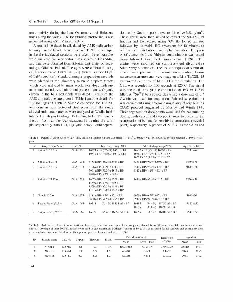
A total of 10 dates in all, dated by AMS radiocarbon technique in the lacustrine sections and TL/OSL technique in the fluvial/glacial sections were taken. Seven samples were analyzed for accelerator mass spectrometer (AMS) and data were obtained from Silesian University of Tech-nology, Gliwice, Poland. The ages were calibrated using calibration curve IntCal04 [33] (www. carbon14.pl/ c14lab/index.htm). Standard sample preparation methods were adapted in the laboratory to make graphite targets which were analyzed by mass accelerator along with pri-mary and secondary standard and process blanks. Organic carbon in the bulk sediments was dated. Details of the AMS chronologies are given in Table 1 and the details for TL/OSL ages in Table 2. Sample collection for TL/OSL was done in light-protected steel pipes from the sandy alluvial units and samples were analyzed at Wadia Insti-tute of Himalayan Geology, Dehradun, India. The quartz fraction from samples was extracted by treating the sam-ple sequentially with HCl, H2O2 and heavy liquid separa-
tion using Sodium polytungstate (density=2.58 g/cm3). These grains were then sieved to extract the 90�150 μm fraction and then etched using 40% HF for 80 minutes followed by 12 mol/L HCl treatment for 40 minutes to remove any contribution from alpha irradiation. The puri-ty of quartz vis-à-vis feldspar contamination was tested using Infrared Stimulated Luminescence (IRSL). The grains were mounted on stainless-steel discs using Silko-Spray silicone oil. The 15�20 aliquots of 9 mm di-ameter were prepared for luminescence reading. Lumi-nescence measurements were made on a Riso TL/OSL-15 system with an array of blue LEDs for stimulation. The OSL was recorded for 100 seconds at 125°C. The signal was recorded through a combination of BG-39+U-340 filter. A 90Sr/90Y beta source delivering a dose rate of 6.7 Gy/min was used for irradiation. Palaeodose estimation was carried out using a 5-point single aliquot regeneration (SAR) protocol suggested by Murray and Wintle [34]. Three regeneration dose points were used for constructing dose growth curves and two points were to check for the recuperation effect and for sensitivity corrections (recycled point), respectively. A preheat of 220°C/10 s for natural and
Table 1 Details of AMS Chronology (bulk sediment organic carbon was dated). The ��13C Source was not measured for the Silesian University sam-ples
SN Sample name/level Lab. No. Calibrated age range 68% Calibrated age range 95% Age 14C (a BP)
1 Spituk 1/ 2.25 m GdA-1231 10723 a BP (32.6%) 10610 a BP 10570 a BP (35.6%) 10447 a BP
10832 a BP (93.1%) 10402 a BP 10361 a BP (0.4%) 10351 a BP 10325 a BP (1.9%) 10291 a BP
10530 ± 60
2 Spituk 2/ 6.20 m GdA-1232 5483 a BP (68.2%) 5363 a BP 5553 a BP (95.4%) 5307 a BP 6460 ± 70
3 Spituk 3/ 9.35 m GdA-1233 5196 a BP (3.6%) 5180 a BP 5061 a BP (59.3%) 4883 a BP 4870 a BP (5.3%) 4849 a BP
5211 a BP (94.2%) 4828 a BP 4815 a BP (1.2%) 4803 a BP
6070 ± 70
4 Spituk 4/ 17.15 m GdA-1234 1607 a BP (17.7%) 1573 a BP 1559 a BP (4.7%) 1549 a BP 1539 a BP (32.3%) 1489 a BP 1481 a BP (13.6%) 1455 a BP
1636 a BP (95.4%) 1422 a BP 3250 ± 50
5 Gupuk/10.2 m GdA-2675 6881 a BP (3.7%) 6871 a BP 6860 a BP (64.5%) 6735 a BP
6929 a BP (0.7%) 6923 a BP 6912 a BP (94.7%) 6670 a BP
5960±50
6 Saspol-Rizong/1.7 m GdA-1965 19315 (95.4%) 18535 cal a BP 19185 (34.4%) 18920 cal a BP 18815 (33.8%) 18590 cal a BP
17520 ± 50
7 Saspol-Rizong/7.5 m GdA-1966 16925 (95.4%) 16650 cal a BP 16855 (68.2%) 16705 cal a BP 15540 ± 50
Table 2 Radioactive element concentrations, dose rate, paleodose and ages of the samples collected from different palaeolake sections and terrace deposits. Average of least 30% paleodoses was used in age estimation. Moisture content of 5%±5% was assumed for all samples and cosmic ray gam-ma contribution was calculated as per the equation given in Prescott and Stephan [36]
SN Sample name Lab. No U (ppm) Th (ppm) K (%) Paleodose (Gray) Dose Rate
(Gy/ka)
Age (ka)
Mean Least (20%) Mean Least
1 Kiyari-1 LD-867 3.1 12.7 1.53 67.9±30.5 38.8±1.6 2.98±0.26 23±10 13±1
2 Nimo-1 LD-861 1.1 5.3 1.5 60±10 44±3 2.1±0.1 29±5 21±2
3 Nimo-2 LD-862 3.2 6.2 1.2 67±10 52±4 2.3±0.2 29±5 23±2

145
regeneration doses was used. The dose growth curves were selected having <10% variation in recycling ratio. The quartz examined shows a typical shine down curve with a linear growth curve [35]. The initial part (2 s of a 100 s exposure) of a typical shine down curve of quartz was used for analysis. The Uranium (238U), Thorium (232Th) and Potassium (K) concentrations were measured by XRF. The Cosmic gamma contribution was calculated following Prescott and Stephan [36] and water concentration was assumed to be 5%±2% by weight.
2 Structural/tectonic setup and river system
Three tectonomorphic zones are seen in this region from South to North [37,38] are ISZ; SSZ and KF (Figure 1). The studied transacts lie in the close vicinity of the ISZ which is one of the most spectacular tectonic zones of the globe in Ladakh Himalaya [39,40] and towards the north are the KF and SSZ (Figuer 1).
The Indus is the longest and most important river, originating in the Tibetan Plateau in the vicinity of Lake Mansarovar, the river follows a course through the state Jammu and Kashmir in India and then enters Pakistan and flows in a southerly direction along the entire length of country, to merge into the Arabian Sea near Karachi. The Indus, geographically the backbone of Ladakh, flows in a NE direction along the ISZ in the study area. It follows a constricted course at places, at others occupies a wide valley and is seen meandering and at places also seen flowing through narrow gorges cutting deep into the country rock. Several palaeo-glacio-fluvio-lacustrine de-posits of varied thicknesses are exposed along the Indus valley (Figure 1B).
3 Palaeolake sequences along the River Indus
A traverse of 422 kms along the River Indus was done from Nyoma (33.28650°N; 78.8991°E; altitude ~4216 m) till Batalik (34.27018°N; 77.03887°E; altitude ~2688 m) and the following palaeolake sequences are reported.
3.1 Nyoma Palaeolake (altitude ~4216 m)
From Nyoma downstream till 9 km before the Mahi Bridge we encounter lake sediments. They cover a wide range and are ~> 2�3 m thick and are exposed on both sides of the river (Figure 2A, B). And 9 km downstream to Nyoma till Mahi village the grayish colored fine clay material is exposed. The thickness reduces downstream. The river is very wide ~5 km and has a low gradient in this area. At Kiyari glacio-fluvial-lacustrine deposits are seen. Buff-colored lacustrine clay, is seen along the river however it is not very thick evident of a short damming phase of the river. Downstream till Kiyari village we do
not see a prominent lacustrine deposits, the river narrows in this portion showing several phases of the angular and rounded sediment piles belonging perhaps to the glacial and the fluvial phases with < 4 m of the lacustrine deposit in the Kiyari section (Figure 2C). Downstream Kiyari upto Leh (Figure 1B) the river flows in a narrow course and fluvial river terraces and glacial deposits are exposed at some places.
3.2 Spituk-Gupuk palaeolake (altitude ~3335 m)
A 24 m thick fluvio-lacustrine deposit is seen at Spituk (34.13246°N; 77.52563°E) on the right bank of the river and has a wide lateral extent till the Gupuk village (34.14093°N; 77.50004°E) downstream (Figure 2D, E; Figure 3). The sediments overlie Ladakh batholith and are exposed on right bank of Indus river (Figures 3, 4A) while Zanskar metasediments are exposed on the left bank of the river. The section was described earlier by Phartiyal et al. [4]. The extent of the palaeolake may have been about 40 km upstream till Karu. Downstream Karu we see a meandering and braided river channel with valley width of 3�5 km; lined by fanglomerates, inhabited by human set-tlements. The Indus enters a gorge after Gupuk village, however in the right bank huge deposits of debris flow and fluvial sediments are seen. Subsequent upliftment, faulting and erosion of the section have left only a part of the original fill. In 2005, Phartiyal et al. [4] described 4 radiocarbon dates on bulk sediments from the section, 33440�1160 a BP at 3.8�3.9 m level; 30980�690 a BP at 9.7�9.8 m; 50790�5370 a BP at 14.0�14.1 m level and 40330�1330 a BP at 23.9�24.0 m levels. The hard water effect in this terrain cannot be ruled out [41] therefore the area was revisited and 4 radiocarbon dates were obtained by Accelerator Mass Spectrometer technique from Silesi-an University of Technology, Poland and the organic car-bon was dated. Figure 3 shows the newly obtained ages and the Age Depth model. With newly available AMS chronology the section is bracketed between ~12000� 1000 ka BP. As the section had intermittent sand beds we rechecked the ages using TL/OSL technique also. For this three samples (SPTL1-at 0.5 m; SPTL4-21.5 and SPTL5 from lower part of sand section) were stimulated using a blue-green light stimulation source from a Riso reader and the detection optics comprised 2×U-340 and BG-39 filters at Physical Research Laboratory, Ahmadabad, India. The samples were dull as far as bleaching was concerned. Out of 100 aliquots that were run for each sample, five ali-quots gave some reading from the basal most sample (SPT1) with an age of 10000 a BP; two from SPTL4 which did not yield any age and from SPTL5 with an age of 27000 a BP (Figure 2D). An OSL age for the strati-graphically topmost sand layer (SPTL6) whose base is

Chin Sci Bull December (2013) Vol.58 Suppl.
146
Figure 2 A, Grayish colored clay deposits (lacustrine) as seen exposed on both left and right banks of the River Indus, 9 km downstream of Nyoma; B, Lacustrine deposits at Nyoma. C–H, Lithologs of the studied sections along the river (locations in Figure 1B).
dated to 27000 a BP gave an age of 36000±4000 a BP (Table 2), from Wadia Institute of Himalayan Geology, Dehradun, India. It is evident from the two dates of the upper sand, which, although presently it is seen at a strati-graphically upper portion but is older than the lacustrine section (Figure 4A) and represents an abandoned channel. The AMS and the OSL chronology of the bottommost
sample give the same age range (~10000 a BP) therefore we consider these ages as correct and to be used in our fur-ther research. The section although located over the Ladakh Batholith with a major contribution in form of buff-colored silty clay (Figure 3E), but also shows contribution from the Zanskar meta-sediments lying also especially around 6500 ka BP, where we see a meter thick bed of angular meta-

147
Figure 3 A, Spituk section (revisited and revised after Phartiyal et al. [4]); B, F, Age-depth model; C�E, Photographs showing, topmost 10 m of sand that caps the Spituk section, different beds of the section with buffcoloured silty clay and dark angular debris sediment.
sediment fragments (Figure 3D). The 9 levels of soft-sediment deformation structures
(S-DL 1 to S-DL 9) are recorded in the Spituk section (Figure 3) [5]. The levels are confined to lower 13 m of the sequence. The upper part of the section does not show seismites and is indicative of calm lacustrine conditions showing thinly laminated massive clay deposits, which are
displaced by high angle faults (Figure 3E) and cut by deep vertical cracks. Seismites are mainly simple convolute structures, pseudonodules of different morphologies con-sisting of isolated masses of coarse to medium sand and are of irregular shape and oriented haphazardly (lenses, spherical, pinch and swell and elongated), flame-like structures, pinch and swell bedding and clay lenses,

Chin Sci Bull December (2013) Vol.58 Suppl.
148
Figure 4 A, Spituk section showing the abandoned channel; B, Gupuk section.
complex structures, folding of clay beds. Some levels have huge lenses, bending, recumbent folding in clay bed, pinch and swell structures and pseudonodules. The details of morphology of seismites is given in Phartiyal and Sharma [5]. The section of the sand unit of 10 m strati-graphically on a higher level to this section is older than this lacustrine sequence (Figures 3C, 4A) and abandoned channel of the River Indus.
At Gupuk also the section is ~25 m thick (Figures 2E, 4B), dated to 5960±50 a BP at 10.2 m level and shows drop stones (Figure 5B) and folded bed clay (Figure 5C) similar to the ones traced in Spituk section [5] and soft sediment deformation levels (Figure 5C, D). The nature of sediment, thickness of the deposit and the similar soft sed-iment deformation features and chronology are evident that Spituk and Gupuk were the part of the same lake system.
Downstream Gupuk the valley is dominated by a dom-inance of fluvial sediments. At Toruthang (34.19388°N; 77.39561°E) a 9 m thick lithalsa deposit of coarse to me-dium sand is seen with gritty sand showing some kind of layering and linear features (Figures 2F, 6A). Unsorted, boulder mounds, wide, almost running parallel to the river but at an elevation are seen which resemble moraine de-posits however striations were not seen in the erratic (Fig-ure 7A, B). These are very unstable, unsorted sandy, peb-bly and cobble matrix and boulders of >1 m thick in
Figure 5 A, Gupuk section—an extension of the Spituk section downstream; B�D, Drop stone (10 cm), folded dark clay layer and soft sediment deformation structures as seen in different levels of the Gupuk section.
149
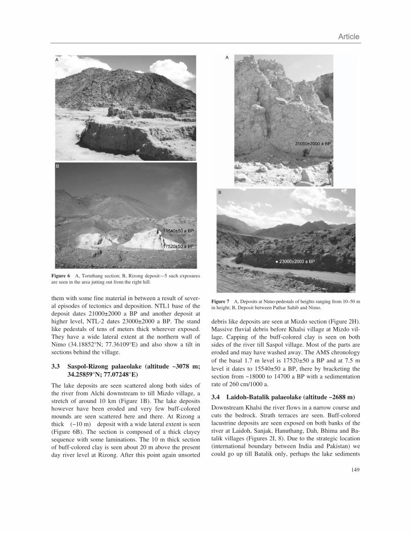
Figure 6 A, Toruthang section; B, Rizong deposit—5 such exposures are seen in the area jutting out from the right hill.
them with some fine material in between a result of sever-al episodes of tectonics and deposition. NTL1 base of the deposit dates 21000±2000 a BP and another deposit at higher level, NTL-2 dates 23000±2000 a BP. The stand like pedestals of tens of meters thick wherever exposed. They have a wide lateral extent at the northern wall of Nimo (34.18852°N; 77.36109°E) and also show a tilt in sections behind the village.
3.3 Saspol-Rizong palaeolake (altitude ~3078 m; 34.25859°N; 77.07248°E)
The lake deposits are seen scattered along both sides of the river from Alchi downstream to till Mizdo village, a stretch of around 10 km (Figure 1B). The lake deposits however have been eroded and very few buff-colored mounds are seen scattered here and there. At Rizong a thick (~10 m) deposit with a wide lateral extent is seen (Figure 6B). The section is composed of a thick clayey sequence with some laminations. The 10 m thick section of buff-colored clay is seen about 20 m above the present day river level at Rizong. After this point again unsorted
Figure 7 A, Deposits at Nimo-pedestals of heights ranging from 10–50 m in height; B, Deposit between Pathar Sahib and Nimo.
debris like deposits are seen at Mizdo section (Figure 2H). Massive fluvial debris before Khalsi village at Mizdo vil-lage. Capping of the buff-colored clay is seen on both sides of the river till Saspol village. Most of the parts are eroded and may have washed away. The AMS chronology of the basal 1.7 m level is 1752 ±50 a BP and at 7.5 m level it dates to 15540±50 a BP, there by bracketing the section from ~18000 to 14700 a BP with a sedimentation rate of 260 cm/1000 a.
3.4 Laidoh-Batalik palaeolake (altitude ~2688 m)
Downstream Khalsi the river flows in a narrow course and cuts the bedrock. Strath terraces are seen. Buff-colored lacustrine deposits are seen exposed on both banks of the river at Laidoh, Sanjak, Hanuthang, Dah, Bhima and Ba-talik villages (Figures 2I, 8). Due to the strategic location (international boundary between India and Pakistan) we could go up till Batalik only, perhaps the lake sediments

Chin Sci Bull December (2013) Vol.58 Suppl.
150
are exposed beyond also. The thickness varies from few meters to tens of meters and in this section two levels of sediments are seen. First level at ~10 m above river level (arl) and the second level at ~40�50 m arl, overlying cliffs of country rock (Figure 8A). This shows two phases of damming of the river Indus in this portion. At Laidoh a 3 m thick section comprises of silty clay with 4 defor-mation levels comprising of convolute structures, pinch and swell structures and pseudonodules (Figure 8B). Some exposures have been covered by the recent debris
Figure 8 Buff-colored lacustrine deposits—A, exposed on both banks of the river near Dah; B, Laidoh; C, lacustrine deposits capped by the recent debris deposits from the catchment; D, near Sanjak village.
(Figure 8C). The section is overlain by 10 m of boulder bed, with well rounder cobbles, pebbles and boulders with a sandy matrix. As Sanjak and Batalik a 10 m thick sec-tion is exposed ~40 m arl on the right and left bank re-spectively (Figure 8D). Presently we do not have an age constrain for these deposits however the samples are un-der study.
4 Discussion and conclusions
The Indus River basin in Indian Himalaya is tectonically very unstable and shows the development of major geo-morphic surfaces-U shape glaciated valleys filled with moraines and fluvially modified debris; spectacular de-velopment of fluvial terraces; presence of remnants of lacustrine sediment within the valley and mostly these sediments are covered by huge debris of later events; wide river valleys and narrow valleys with deep gorges. The Indus River catchment in Indian Himalaya is 25607 km2 and the longitudinal length is 422 km between Nyoma and Batalik (our study area). The longitudinal profile of the present Indus River is concave-up shape indicates a dise-quilibrium state of channel (Figure 9A) [42]. The several sudden breaks in the profile suggest the presence of knick points (Figure 9). The steep slope along the knick points indication differential uplift along channel or a disequilib-rium state of channels due to tectonic and climatic pertur-bation. The heterogeneity due to regional tectonic uplift within the Indus River basin falling in time period ~3000, 10530 and 17520 a BP. Major river incision took place during around 3250 a BP. The rapid incision in the valley may be due to growth of fault bend folding along the ma-jor thrust system. An episode of tectonic activity was re-sponsible of damming the river Indus at four places during the Late Quaternary and Holocene times-Nyoma; Spituk- Gupuk and Saspol-Rizong and Laidoh-Batalik (Figure 1). These palaeolake sediments can be seen today scattered in the valley at places where they could survive the harsh climate and erosion all these years. Both climate and tec-tonics are responsible for the formation of lakes, their ex-istence and their disappearance and good water recharge either due to good monsoons of warm climatic conditions (melting of glaciers) were important for their sustenance. Several evidences of neotectonic activity on the Indus Suture Zone responsible for creating number of lakes have also been reported earlier, e.g., Skardu basin [10,11], Jalipur [12], Khaltse along the Gilgit river [9], in the up-per Indus valley [13] at Lamayuru [14�18], at Spituk- Leh [4,5]. Later these lakes drained out leaving behind their sedimentary record.
Faulting is seen in the sediments in the Leh area and the soft-sediment deformation structure formed during or short after deposition of horizontal sedimentary layers in

151
Figure 9 A, Longtidunial profile of River Indus; B, Schematic model showing the events along the river Indus in the study area with the chronology and their comparison to the ISM records (Sirocko et al. [54]; Gasse et al. [63]; Fontes et al. [62]; Hui et al. [64]; Gupta et al. [73]); Western Disturb-ances records (Wünnemann et al. [6]) Local Summer Monsoon records (Demske et al. [60]) of the Indian subcontinent [6,55,63�65,72]
Quaternary geological records that indicate past seismic activity [22�24,26] are seen in multiple levels in the lake profile. Seeing to the present day landscape we can con-clude that the Indus River had been a host of several lakes formed due to the climato-tectonic perturbations all through the Late Quaternary and Holocene.
The unsorted sedimentary records at Nimo dated 23000 and 21000 a BP are the glacial deposits that were depos-ited during the LGM. There are a number of similar de-posits between Kiyari and Upshi but we do not have a chronology established for those fluvio-glacial sediments. The global LGM events dates ca. 24000–18000 a BP, a
number of other records from the north Himalayan glaci-ers show their maximum positions at 22000–18000 a BP [43] and the LGM in Nepal Himalaya is dated as ca. 25000–18000 a BP [44]. Its peak (ca. 18000 a BP) is marked by cold and dry climate in northeastern Tibetan Plateau [45] and is equivalent to local glacial stage
(Ladakh 2) [46] and Semi-arid western Himalayan-Tibetan
Stage (SWHTS 2E) [47]. The strongest intensity of the northeast monsoon and relatively weak southwest mon- soon intensity representing glacial and arid conditions [48,49] has been recorded from the Arabian Sea between 20000 and 19300 cal. a BP [50]. Further, the upwelling in

Chin Sci Bull December (2013) Vol.58 Suppl.
152
the Arabian Sea was lowest at the time of the LGM around 18000 a BP [51�55].
The initial onset of climate change at the end of the glacial seems to be marked by a period from ca. 17500� 14000 a BP with a lake record at Saspol-Rizong. This deposit shows no signs of tectonic activity as seismites or faulting or tilt of the beds and indicates a warmer period. Other records show that the ISM was greatly enhanced around ca. 15200 a BP [56]; the Kashmir valley witnessed deglaciation at ca. 15000 a BP [57]; in Tso Kar basin, Ladakh Himalaya, a prominent phase of climatic amelio-ration was established at 15800 a BP [58]; the Tibetan Plateau, the post-glacial temperature started to rise around this time [45]. Northwestern China also witnessed climatic amelioration and development of soil between ca. 18000 and 15000 a BP [59]. We do not have sediment record between ~14000 to 10500 a BP in the study region, how-ever the period was a cold period of the Dryas (YD) as recorded in the different other records of the area.
A longer phase of fluvio lacustrine sediment deposition at Spituk-Gupuk from ca. 11000–1000 a BP possibly rep-resents the strengthened southwest monsoon system and marks the transition into the Holocene. This lake was formed after the YD by a blockade downstream possibly triggered by a tectonic activity and existed till ~1000 a BP. The lake sediments are preserved in the northern wall over the Ladakh batholiths. The underlying sand dated to 36000�27000 a BP indicates to an active channel ~5 km north of the river bed today (north of Spituk monastery) (Figure 4A) prior to the LGM. The lake sediments rest on this channel sand. The seismic activities concentrate at ~10000 a BP and 6000 a BP. Two phases ~8000�7000 and 5000�3000 a BP show good lake conditions. Fine laminated sediments of a continuous record are seen, with a coarser frangment of Zanskar metasediments at 6500 a BP. The area was experiencing a good water supply around this period Lateglacial times from melt water, good monsoons and warmer climates. South of our study area, records from the Tsokar lake of the Ladakh region show a considerable summer monsoon moisture supply occurred between ca 11500 and 8600 a BP [6] and maxi-mum monsoon activity between ca. 10900 and 9200 a BP [60]. This is in agreement with the initiation of en-hanced monsoon and onset of humid environment from ca. 11500 a BP onwards in western Tibet and Karako-
ram [61]. In slightly higher latitudes, the Tibetan Plateau experienced the onset of Holocene warming between ca. 10000 and 9400 a BP [45]. In western Tibet, warm/wet conditions, attributed to the monsoon influence were es-tablished at ca. 9600 a BP [62] and a clear cut warm pulse with increase in A/C ratio, ostracod content and TOC is observed between ca. 10000 and 8000 a BP [63]. Bangong Lake had its highest water level around ca. 9600–8700 a BP [64] and moist conditions prevailed until ca. 6200 a BP [48]. Thus most multi-proxy data in a number of Tibetan lakes show a humid pulse from ca. 10000 a BP onwards, indicating improved monsoon circulation, and
aggradation phase due to high monsoon intensity in the
Tethyan Himalayas [65–68]. Other records from the Indi-an subcontinent and surrounding ocean also show a major amplification of the southwest monsoon over the Arabian Sea immediately after the YD around 11500 a BP [52]; a phase of strongest southwest monsoon with brimming Himalayan rivers is reported between ca. 10000 and 7000 a BP [69�71] during which the Ganga–Brahmaputra river system delivered double the present sediment load to the Bengal basin [72]. A general increase in the southwest monsoon from ca. 10000 a BP is closely linked to the be-ginning of agriculture in northwest India [73,74]. The Bay of Bengal also has experienced a prevalent stronger mon-soon since ca. 10000 a BP [75].
The extent of the Nyoma palaeolake was ~10 km till Mahi, as we have no age constrain for this lake nothing can be stated about its chronology. The sections down-stream from Laidoh-Batalik show two phases of lake sedimentation a recent one which is exposed along the present day river level up to 10�20 m and an older one that is seen perched over the cliffs at about 40�50 m level from the river level. As these are valley lakes and once after breaching most of the material eroded and was carried downstream, it is difficult to do a basin morphology re-garding the high stand and low stand periods in the lake history. Only scattered sediments are preserved and they too are under the harsh conditions of the climate of the cold arid conditions and are depleting at the fast rate. To trigger it the abnormal monsoon periods and the cloud bursts cause tens of meters of the section collapse and erode in no time and this way we are losing a very good archive along the Indus river valley in the trans Himalayas in the vicinity of ISZ for palaeo-climatic reconstructions.
Our sincere thanks to Directors, BSIP, Lucknow and ISR, Gandhinagar, for the encouragement and support for carrying out this study. AMS Chronol-ogies were done from Gliwice, Poland and TL(OSL) from Wadia Institute of Himalayan Geology, Dehradun, India and Physical Research Laboratory (PRL), Ahmadabad, India. Thanks to Dr. Navin Juyal for a recheck for chronology at PRL. Wild Life Department, Jammu (J&K) is thanked for permis-to carry out field work in this protected sanctuary area.
1 Owen L A. Terraces, Uplift and Climate, Karakoram mountains Northern Pakistan. Unpublished PhD Dissertation. UK: University of Leicester, 1988
153
2 Wobus C W, Hodges K V, Whipple K X. Has focused denudation sustained active thrusting at the Himalayan topographic front. Geology, 2003, 31: 861–864
3 Hodges K V, Wobus C, Ruhl K, et al. Quaternary deformation river steepening and heavy precipitation at the front of the Higher Himalayan ranges. Earth Planet Sci Lett, 2004, 220: 379– 389
4 Phartiyal B, Sharma A, Upadhyay R, et al. Quaternary geology, tectonics and distribution of palaeo- and present fluvio/glacio lacustrine deposits in Ladakh, NW Indian Himalaya—A study based on field observations. Geomorphology, 2005, 65: 241–256
5 Phartiyal B, Sharma A. Soft-sediment deformation structures in the Late Quaternary sediments of Ladakh: Evidence for multiple phases of seis-mic tremors in the North western Himalayan Region. J Asian Earth Sci, 2009, 34: 761–770
6 Wünnemann B, Demske D, Tarasov P, et al. Hydrological evolution during the last 15 kyr in the Tso Kar lake basin (Ladakh, India), derived from geomorphological, sedimentological and palynological records. Quat Sci Rev, 2010, 29: 1138–1155
7 Dortch J M, Owen L A, Caffee M W, et al. Catastrophic partial drainage of Pangong Tso, northern India and Tibet. Geomorphology, 2011, 125: 109–121
8 Gee E R. Overview of geology and structure of the Salt range, with observations on related areas of North Pakistan. Spec Pap-Geol Soc Am Washington, 1989, 232: 95–112
9 Burgisser H M, Gansser A, Pika J. Late Glacial lake sediments of the Indus valley area, northwestern Himalaya. Ecogal Geol Helv, 1982, 75: 51–63
10 Cronin V S. The Physical and Magnetic Polarity Stratigraphy of the Skardu Basin, Baltistan, Northern Pakistan. Masters thesis. Hanover: Dart-mouth College, 1982
11 Cronin V S. Structural setting of the Skardu intermontane basin, Karakoram Himalaya, Pakistan. Geol Soc Amer, 1989, 232(Suppl): 183–201 12 Shroder J F, Khan S M, Lawrence R D, et al. Chronology and deformation of Quaternary sediments, middle and upper Indus, Pakistan. Geol Soc
Am Bull, 1986, 18: 749 13 Fort M, Burbank D W, Freytet P. Lacustrine sedimentation in a semi-arid alpine setting: An example from Ladakh, northwestern Himalaya. Quat
Res, 1989, 31: 332– 352 14 Sangode S J, Bagati T N. Tectono-climatic signatures in higher Himalayan lakes: A palaeomagnetic rock magnetic approach in the lacustrine
sediments of Lamayuru, Ladakh, India. J Himalayan Geol, 1995, 6: 51–60 15 Bagati T N, Mazari R K, Rajagopalan G. Palaeotectonic implications of Lamayuru Lake (Ladakh). Curr Sci, 1996, 71: 479–482 16 Kotlia B S, Bhalla M S, Sharma C, et al. Palaeoclimatic conditions in the upper Pleistocene and Holocene Bhimtal-Naukuchiatal lake basin in
south-central Kumaun, North India. Palaeogeogr Palaeoclimatol Palaeoecol, 1997, 130: 307– 322 17 Kotlia B S, Bhalla M S, Shah N, et al. Palaeomagnetic results from the Pleistocene-Holocene lake deposits of Bhimtal and Bhowali (Kumaun
Himalaya) and Lamayuru (Ladakh Himalaya) with reference to the reversal events. J Geol Soc India, 1998, 51: 7–20 18 Sangode S J, Mazari R K. Mineral magnetic response to climate variability in the high altitude Kioto palaeolake, Spiti Valley, Northwestern
Himalaya. Himalayan Geol, 2007, 28: 1–9 19 Phartiyal B, Sharma A, Srivastava P, et al. Chronology of relic lake deposits in the Spiti river, NW Trans Himalaya: Implications to Late Pleisto-
cene-Holocene climate-tectonic perturbations, Geomorphology, 2009, 108: 264–272 20 Phartiyal B, Srivastava P Sharma A. Tectono-Climatic signatures during Late Quaternary Period from Upper Spiti Valley, NW Himalaya, India,
Himalayan Geol, 2009, 30: 10–17 21 Sim J D. Earthquake-induced structures in sediments of the Van Norman Lake, San Fernando, California. Science, 1973, 161–163 22 Sim J D. Determining earthquake recurrence interval from deformational structures in young lacustrine sediments. Tectonophysics, 1975, 29:
144–152 23 Sieh K E. Prehistoric large earthquakes produced by slip on the San Andreas Fault at Pallet Creek, California. J Geophys Res, 1978, 83:
3907–3939 24 Scott B, Price S. Earthquake induced structures in young sediments. Tectonophysics, 1988, 147: 165–170 25 McKalpin J P. Palaeosiesmology. London: Academic Press, 1996, 588 26 Allen J R L, Banks N L. An interpretation and analysis of recumbent-folded deformed cross-bedding. Sedimentology, 1972, 19: 257–283 27 Mohindra R, Bagati T N. Seismically induced soft-sediment deformation structures (seismites) around Sumdo in the lower Spiti valley (Tethys
Himalaya). Sediment Geol, 1996, 101: 69�83 28 Upadhyay R. Earthquake-induced soft-sediment deformation in the lower Shyok river valley, northern Ladakh, India. J Asian Ear Sci, 2003, 21:
413–421 29 Kotlia B S, Rawat K S. Soft sediment deformation structures in the Garbyang palaeolake: Evidence for the past shaking events in the Kumaun
Tethys Himalaya. Curr Sci, 2004, 876 : 377–379 30 Singh S, Jain A K. Liquefaction and fluidization of lacustrine deposits from Lahaul-Spiti and Ladakh Himalaya: Geological evidences of palaeo-
seismicity along active fault zone. Sediment Geol, 2007, 196: 47–57 31 Bookhagen B, Thiede R, Strecker M R. Abnormal Monsoon years and their control on erosion and sediment flux in the high, arid northwestern
Himalaya. Earth Planet Sci Lett, 2005, 231: 131–146 32 Bookhagen B, Thiede R C, Strecker M R. Late Quaternary intensified monsoon phases control landscape evolution in the northwest Himalaya.
Geology, 2005, 33: 149–152 33 Reimer P J, Baillie M G L, Bard E, et al. IntCal04 Terrestrial Radiocarbon Age Calibration, 0–26 cal kyr BP. Radiocarbon, 2004, 46: 1029–1059

Chin Sci Bull December (2013) Vol.58 Suppl.
154
34 Murray A S, Wintle A G. Luminescence dating of quartz using an improved single-aliquot regenerative-dose protocol. Radiat Meas, 2000, 32, 57–73
35 Aitken M J. An Introduction to Optical Dating. London: Academic Press, 1998 36 Prescott J R, Stephan L G. The contribution of cosmic radiation to the environmental dose for TL dating. Latitude, altitude and depth dependan-
cies. PACT, 1982, 6: 17�25 37 Thakur V C. Regional framework and geodynamic evolution of the Indus Tsangpo Suture Zone in the Ladakh Himalaya. Trans Royal Soc Edin-
burgh-Earth Sci, 1981, 72: 89–97 38 Sinha A K. The concept of terrane and its application in Himalayan and adjoining regions. In: Sinha A K, Sassi F P, Papanikalao D. eds. Geody-
namic Domains in Alpine Himalayan Tethys, New Delhi: Oxford and IBH Publishing Co. Pvt. Ltd. 1997 39 Frank W, Gansser A, Trommsdorie W. Geological observations in the Ladakh area (Himalayas): A preliminary report. Mineral Petrogr Schweig,
1977, 57: 89–113 40 Ganseer A. The Morphogenic phase of mountain building. In: Hsu K J, ed. Mountain Building Processes. London: Academic Press, 1983, 263:
221–228 41 Phartiyal B, Sharma A, Nautiyal C M. Interpretation of the apparent Ages in the Ladakh and Lahaul Spiti Quaternary Lacustrine Sediments. In:
Singh D S, Chabra N L, eds. Geological Processes and Climate Change. Macmillan Publishers India Ltd., 2011. 105–116 42 Mollin P, Fubelli G. Morphometric evidence of the topographic growth of the Central Apennines. Geografia Fisica e Dinamica Quaternaria, 2005,
28: 47–61 43 Benn D I, Owen L A. The role of the Indian summer monsoon and the midlatitude westerlies in Himalayan glaciation: Review and speculative
discussion. J Geol Soc London, 1998, 155: 353–363 44 Richard B W M, Benn D I, Owen L A, et al. Timing of late Quaternary glaciations south of Mount Everest in the Khumbu Himal, Nepal. Geol
Soc Am Bull, 2001, 112: 1621–1632 45 Yan G, Wang F B, Shi G R, et al. Palynological and stable isotopic study of palaeoenvironmental change on the northeastern Tibetan plateau in
the last 30000 years. Palaeogeogr Palaeoclimatol Palaeoecol, 1999, 153: 147–159 46 Owen L A, Caffee M W, Bovard K R, et al. Terrestrial cosmogenic nuclide surface exposure dating of the oldest glacial successions in the Hima-
layan orogen: Ladakh Range, northern India. Geol Soc Am Bull, 2006, 118: 383–392 47 Dortch J M, Owen L A, Caffee M A. Timing and climatic drivers for glaciation across semi-arid western HimalayanTibetan orogen. Quat Sci Rev,
2013, 78: 188–208 48 Van C E, Cour P, Hang S X. Holocene environmental changes in Bangong Co basin (Western Tibet), Part 2: The pollen record. Palaeogeogr Pal-
aeoclimatol Palaeoecol, 1996, 120: 49–63 49 Sarkar C, Ramesh R, Bhattacharya S K, et al. Oxygen isotope evidence for a stronger winter monsoon current during the last glaciation. Nature,
1990, 343: 549–551 50 Sirocko F, Schonberg D G, Mcintyre A, et al. Teleconnection between subtropical monsoon and high-latitude climates during the last glaciation.
Science, 1996, 272: 526–529 51 Van C E, Duplessy J C, Rossignl S M. Climatic conditions deduced from a 150 kyr oxygen isotope-pollen record from the Arabian Sea. Nature,
1982, 296: 56–59 52 Prell W L, Van C E. Coherent response of Arabian Sea upwelling and pollen transport to late Quaternary monsoonal winds. Nature, 1986, 323:
526–528 53 Prell W L, Kutzbach J E. Monsoon variability over the past 150000 years. J Geophys Res, 1987, 92: 8411–8425 54 Sirocko F, Lange H, Erlenkeuser H. The atmospheric summer circulation and coastal upwelling in the Arabian Sea during the Holocene and the
last glaciation. Quat Res, 1991, 36: 72–93 55 Sirocko F, Sarnthein M, Erlenkeuser H, et al. Century-scale events in monsoonal climate over the past 24000 years. Nature, 1993, 364: 322–324 56 Sinha A, Cannariato K G, Stott L D, et al. Variability of southwest Indian summer monsoon during the Bølling–Ållerød. Geo Soc Am, 2005, 33:
813–816 57 Singh G, Agarwal D P. Radiocarbon evidence for deglaciation in northwestern Himalaya, India. Nature, 1976, 260: 233 58 Bhattacharyya A. Vegetation and climate during the last 30000 years in Ladakh. Palaeogeogr Palaeoclimatol Palaeoecol, 1989, 73: 25–38 59 Feng D Z, Zhai X W, Ma Y Z, et al. Eolian environmental change in the northern Mongolian plateau during the past ~35000 yr. Palaeogeogr Pal-
aeoclimatol Palaeoecol, 2007, 245: 505–517 60 Demske D, Tarasov P E, Wünnemann B, et al. Late glacial and Holocene vegetation, Indian monsoon and westerly circulation dynamics in the
Trans- Himalaya recorded in the pollen profile from high-altitude Tso Kar Lake, Ladakh, NW India. Palaeogeogr Palaeoclimatol Palaeoecol, 2009, 279: 172–185
61 Brown E T, Bendick R, Bourles D L, et al. Early Holocene climatic record in geomorphological features in western Tibet. Palaeogeogr Palaeocli-matol Palaeoecol, 2003, 199: 141–151
62 Fontes J C, Gasse F, Gilbert E. Holocene environmental changes in lake Bangong basin (western Tibet). Part I: Chronology and stable isotopes of carbonates of Holocene lacustrine core. Palaeogeogr Palaeoclimatol Palaeoecol, 1996, 120: 25–47
63 Gasse F, Arnold M, Fontes J C. et al. A 13000-year climate record from western Tibet. Nature, 1991, 353: 742–745 64 Hui F, Gasse F, Huc A, et al. Holocene environmental changes in Bangong Co basin (western Tibet). Part 3: Biogenic remains. Palaeogeogr Pal-
aeoclimatol Palaeoecol, 1996, 120: 65–78

155
65 Fontes J C, Melieres F, Gibert E, et al. Stable isotope and radiocarbon balances of two Tibetan lakes (Sumxi Co, Longmu Co) from 13000 BP Quat Sci Rev, 1993, 12: 875–887
66 Van Campo E, Gasse F. Pollen- and Diatom-inferred climatic and hydrological changes in Sumxi Co Basin (Western Tibet) since 13000 yr BP. Quat Res, 1993, 39: 300–313
67 Srivastava P, Ray Y, Phartiyal B, et al. Late Pleistocene-Holocene Morpho-Sedimentary architecture, Spiti River, AridHigher Himalaya. Int J Earth Sci, 2013, 102: 1967–1984
68 Dortch J M, Owen L A, Haneberg W C, et al. Nature and timing of large landslides in the Himalaya and Transhimalaya of northern India. Quat Sci Rev, 2009, 28: 1037–1054
69 Bryson R A, Swain A M. Holocene variations of monsoon rainfall in Rajasthan. Quat Res, 1981, 16: 135–145 70 Radhakrishna B P. Holocene chronology and Indian prehistory. Memoirs of Geological Society of India, 1999, 42: 17–25 71 Gupta A K, Anderson D M, Pandey D N et al. Adaptation and human migration and evidence of agriculture coincident with change in the Indian
summer monsoon during the Holocene. Curr Sci, 2006, 90: 1082–1090 72 Goodbred J S L, Kuehl S A. Enormous Ganga–Brahmputra sediment discharge during strengthened early Holocene monsoon. Geology, 2000, 28:
1083–1086 73 Gupta A K, Anderson D M and Overpeck J T. Abrupt changes in the Asian southwest monsoon during the Holocene and their links to the North
Atlantic Ocean. Nature, 2003, 421: 354–357 74 Hong Y T, Hong B, Lin Q H, et al. Correlation between Indian Ocean summer monsoon and north Atlantic climatic during the Holocene. Earth
Planet Sci Lett, 2003, 211: 371–380 75 Chauhan O S. Past 20000-year history of Himalaya aridity: Evidence from oxygen isotope records in the Bay of Bengal. Curr Sci, 2003, 84:
90–93
Copyright © 2022 FDOKUMEN