Cambrian Depositional History of the Zanskar Valley Region of the Indian Himalaya: Tectonic...
18
Journal of Sedimentary Research, 2006, v. 76, 364–381 Research Article DOI: 10.2110/jsr.2006.020 CAMBRIAN DEPOSITIONAL HISTORY OF THE ZANSKAR VALLEY REGION OF THE INDIAN HIMALAYA: TECTONIC IMPLICATIONS P.M. MYROW, 1 K.E. SNELL * , 1 N.C. HUGHES, 2 T.S. PAULSEN, 3 N.A. HEIM, 4 AND S.K. PARCHA 5 1 Department of Geology, Colorado College, Colorado Springs, Colorado 80903, U.S.A. 2 Department of Earth Sciences, University of California, Riverside, California 92521, U.S.A. , 3 Department of Geology, University of Wisconsin, Oshkosh, Wisconsin 54901, U.S.A. , 4 Department of Geology, University of Georgia, Athens, Georgia 30602, U.S.A. 5 Wadia Institute of Himalayan Geology, Dehra Dun, Uttranchal 248001, India e-mail: [email protected] ABSTRACT: A well-preserved Cambrian section in the Zanskar Valley of northern India has previously been interpreted to record the transition from a passive to an active tectonic margin related to Cambrian–Ordovician orogenesis. This interpretation has been used to support the tectonostratigraphic interpretation of other successions across the Tethyan Himalaya. Our detailed paleoenvironmental analysis significantly revises the tectonic and depositional history of these Cambrian deposits: no definitive record of impending Cambrian–Ordovician orogenesis is recorded in these late Middle Cambrian rocks. A critical transition from an , 125-m-thick, stromatolite-bearing carbonate deposit, the Karsha Formation, into shale and sandstone of the Kurgiakh Formation, was interpreted to represent tectonically induced drowning of a carbonate platform. Siliciclastic strata of the Kurgiakh Formation were thought to record deep-water flysch deposition in a tectonically active foreland basin next to an arc-trench system. This interpretation was based on sandstone beds with classic Bouma sequences. We show that these event beds in the Kurgiakh instead contain hummocky cross-stratification, quasi-planar lamination, and combined-flow ripple stratification, all of which reflect deposition in shallow-marine, storm-influenced environments. Thus, although the Karsha carbonate platform may have been drowned, it did not culminate in deep-sea flysch deposition, and this in turn eliminates a major line of evidence linking Kurgiakh deposition to the onset of Cambrian–Ordovician orogenesis. Other aspects of Cambrian–Ordovician deposits of northern India also shed doubt on the proposed link between Kurgiakh sedimentation and the Cambrian–Ordovician orogenic event. First, our improved biostratigraphic database suggests that the transition from the Karsha carbonate to the Kurgiakh Formation may have predated the main phase of Cambrian–Ordovician orogenesis, as recorded by overlying Ordovician molasse, by as much as 20–30 My. Second, published data from the Ordovician molasse indicate northward paleocurrents, which are parallel to those recorded by siliciclastic deposits of the Parahio Formation below the Karsha, and thus are at odds with standard models of foreland basin development for the Cambrian–Ordovician event. Our sedimentological analysis of depositional cycles of the Parahio Formation indicates that these strata record storm- influenced environments from offshore marine to shoreface to fluvial settings. This is at odds with previous paleoenvironmental interpretations that ranged from deep-sea flysch to intertidal deposits. Paleocurrent data for marine and fluvial facies of the Parahio Formation in both Zanskar and the Spiti Valley to the south indicate northeast sediment transport. This supports the view that the Parahio and overlying carbonate of the Karsha Formation record the ancient northern passive margin of India during the Cambrian and that these strata may be distal equivalents of the younger Cambrian deposits of the Lesser Himalaya. INTRODUCTION Tectonic models for the Himalaya attempt to explain the formation of basic lithotectonic zones in the Himalaya. Most of these have focused on the structural, igneous, and stratigraphic signature of the Cenozoic collision of India with Asia. However, an understanding of earlier depositional and tectonic events in the Himalaya, including Cambrian– Ordovician orogenesis associated with the amalgamation of Gondwana- land, may be critical for unraveling first-order stratigraphic and structural patterns in the present-day orogen (Garzanti et al. 1986; DeCelles et al. 2000; Gehrels et al. 2003; Myrow et al. 2003). There are three current hypotheses concerning the relationship between Cambrian sedimentary successions of the Tethyan and Lesser Himalaya, two of the three northern Himalayan lithotectonic zones that are separated by high-grade metamorphic rock of the Greater Himalaya: (1) the Lesser and Tethyan Himalaya were part of a continuous passive margin (Searle 1986; Brookfield 1993; Corfield and Searle 2000); (2) the * Present Address: Department of Earth Sciences, University of California, Santa Cruz, California 95064, U.S.A. Copyright E 2006, SEPM (Society for Sedimentary Geology) 1527-1404/06/076-364/$03.00
Transcript of Cambrian Depositional History of the Zanskar Valley Region of the Indian Himalaya: Tectonic...

Journal of Sedimentary Research, 2006, v. 76, 364–381
Research Article
DOI: 10.2110/jsr.2006.020
CAMBRIAN DEPOSITIONAL HISTORY OF THE ZANSKAR VALLEY REGION OF THE INDIAN HIMALAYA:TECTONIC IMPLICATIONS
P.M. MYROW,1 K.E. SNELL*,1 N.C. HUGHES,2 T.S. PAULSEN,3 N.A. HEIM,4 AND S.K. PARCHA5
1Department of Geology, Colorado College, Colorado Springs, Colorado 80903, U.S.A.
, 2Department of Earth Sciences, University of California, Riverside, California 92521, U.S.A.
, 3Department of Geology, University of Wisconsin, Oshkosh, Wisconsin 54901, U.S.A.
, 4Department of Geology, University of Georgia, Athens, Georgia 30602, U.S.A.5Wadia Institute of Himalayan Geology, Dehra Dun, Uttranchal 248001, India
e-mail: [email protected]
ABSTRACT: A well-preserved Cambrian section in the Zanskar Valley of northern India has previously been interpreted torecord the transition from a passive to an active tectonic margin related to Cambrian–Ordovician orogenesis. Thisinterpretation has been used to support the tectonostratigraphic interpretation of other successions across the TethyanHimalaya. Our detailed paleoenvironmental analysis significantly revises the tectonic and depositional history of theseCambrian deposits: no definitive record of impending Cambrian–Ordovician orogenesis is recorded in these late MiddleCambrian rocks.
A critical transition from an , 125-m-thick, stromatolite-bearing carbonate deposit, the Karsha Formation, into shale andsandstone of the Kurgiakh Formation, was interpreted to represent tectonically induced drowning of a carbonate platform.Siliciclastic strata of the Kurgiakh Formation were thought to record deep-water flysch deposition in a tectonically activeforeland basin next to an arc-trench system. This interpretation was based on sandstone beds with classic Bouma sequences. Weshow that these event beds in the Kurgiakh instead contain hummocky cross-stratification, quasi-planar lamination, andcombined-flow ripple stratification, all of which reflect deposition in shallow-marine, storm-influenced environments. Thus,although the Karsha carbonate platform may have been drowned, it did not culminate in deep-sea flysch deposition, and this inturn eliminates a major line of evidence linking Kurgiakh deposition to the onset of Cambrian–Ordovician orogenesis. Otheraspects of Cambrian–Ordovician deposits of northern India also shed doubt on the proposed link between Kurgiakhsedimentation and the Cambrian–Ordovician orogenic event. First, our improved biostratigraphic database suggests that thetransition from the Karsha carbonate to the Kurgiakh Formation may have predated the main phase of Cambrian–Ordovicianorogenesis, as recorded by overlying Ordovician molasse, by as much as 20–30 My. Second, published data from theOrdovician molasse indicate northward paleocurrents, which are parallel to those recorded by siliciclastic deposits of theParahio Formation below the Karsha, and thus are at odds with standard models of foreland basin development for theCambrian–Ordovician event.
Our sedimentological analysis of depositional cycles of the Parahio Formation indicates that these strata record storm-influenced environments from offshore marine to shoreface to fluvial settings. This is at odds with previous paleoenvironmentalinterpretations that ranged from deep-sea flysch to intertidal deposits. Paleocurrent data for marine and fluvial facies of theParahio Formation in both Zanskar and the Spiti Valley to the south indicate northeast sediment transport. This supports theview that the Parahio and overlying carbonate of the Karsha Formation record the ancient northern passive margin of Indiaduring the Cambrian and that these strata may be distal equivalents of the younger Cambrian deposits of the Lesser Himalaya.
INTRODUCTION
Tectonic models for the Himalaya attempt to explain the formation ofbasic lithotectonic zones in the Himalaya. Most of these have focused onthe structural, igneous, and stratigraphic signature of the Cenozoiccollision of India with Asia. However, an understanding of earlierdepositional and tectonic events in the Himalaya, including Cambrian–
Ordovician orogenesis associated with the amalgamation of Gondwana-land, may be critical for unraveling first-order stratigraphic and structuralpatterns in the present-day orogen (Garzanti et al. 1986; DeCelles et al.2000; Gehrels et al. 2003; Myrow et al. 2003).
There are three current hypotheses concerning the relationship betweenCambrian sedimentary successions of the Tethyan and Lesser Himalaya,two of the three northern Himalayan lithotectonic zones that areseparated by high-grade metamorphic rock of the Greater Himalaya:(1) the Lesser and Tethyan Himalaya were part of a continuous passivemargin (Searle 1986; Brookfield 1993; Corfield and Searle 2000); (2) the
* Present Address: Department of Earth Sciences, University of California,
Santa Cruz, California 95064, U.S.A.
Copyright E 2006, SEPM (Society for Sedimentary Geology) 1527-1404/06/076-364/$03.00

Greater and Tethyan Himalaya represent the basement and cover,respectively, of an exotic terrane accreted to India at the Cambrian–Ordovician boundary (DeCelles et al. 2000); and (3) Tethyan HimalayanCambrian rocks formed part of the Indian shield but were deposited in anisolated basin separated by exposed basement of the ‘‘Central CrystallineAxis’’ (Saxena 1971; Aharon et al. 1987). These three models havefundamentally different implications about the Cambrian paleogeogra-phy of the equatorial peri-Gondwana region and the tectonic history ofthe Himalaya. A general biostratigraphic framework has been establish-ed for much of the Himalayan Cambrian (Jell and Hughes 1997; Hughesand Jell 1999; Hughes et al. 2005), but a modern process-orientedsedimentological analysis is required as a test of the Cambrianpaleogeographic problems described above. In this study we presentsuch an analysis for one of the most important and best-preservedCambrian successions in the Himalaya, the Zanskar Valley section inLadakh, northern India (Fig. 1).
The Zanskar region exposes a thick succession of Lower and MiddleCambrian strata of the Parahio Formation. Detailed study of theformation in this region, and in its type section in the Spiti valley ofnorthern India (Fig. 2) (Myrow et al. in press), is critical forreconstruction of relationships between the Lesser and TethyanHimalaya. In addition, Zanskar exposes younger dated Cambriandeposits (Karsha and Kurgiakh formations) than in Spiti and thesemay correlate in part or in whole with the youngest parts of the Cambrianof the Lesser Himalaya. These strata allow a more complete descriptionof depositional history for the Himalayan region at this time. Further,these younger deposits have been interpreted to record a prominent
transition from passive-margin deposition to active foreland-basindeposition during the Late Cambrian to Early Ordovician (Garzanti etal. 1986), associated with final assembly of core Gondwanaland. Thisstudy provides the first detailed paleoenvironmental analyses of theseunits, which is then used to evaluate the current tectonic model forHimalayan Cambrian–Ordovician orogenesis.
STRATIGRAPHY
The Cambrian rocks of Zanskar belong to the Haimanta Group. TheHaimanta Group is a thick succession of sedimentary rocks that overliescrystalline rocks of the Greater Himalaya and terminates at anunconformity that separates Cambrian rocks from Middle Ordovicianand younger deposits (Myrow et al. in press) (Fig. 2). Nanda and Singh(1976) first established a stratigraphic nomenclature for the Cambrian ofthe Zanskar Valley and defined the siliciclastic Phe Formation and thecarbonate-rich Karsha Formation (Fig. 2). Garzanti et al. (1986)recognized the Kurgiakh Formation as a siliclastic unit conformablyoverlying the Karsha Formation and developed a series of memberswithin each of the Phe, Karsha, and Kurgiakh Formations (Fig. 2). Theboundary between the top of the Phe Formation and the base of theKarsha Formation was defined as the first rusty-weathering dolomitebed. In this paper we correlate the Parahio Formation of Spiti Valley(Fig. 2) with the entire Mauling Member of the Karsha Formation andpossibly a small part of the upper Phe. This correlation is established onlithologic and biostratigraphic grounds. The name Parahio Formationhas historical precedence and here is applied to this interval in the
FIG. 1.— Location map of the study area. A)Ladakh district of northern India. B) Close-up ofTsarap Lingti River Valley. C) Topographicclose-up map shows the locations of the fivestratigraphic sections.
CAMBRIAN DEPOSITIONAL HISTORY 365J S R

Zanskar Valley for the first time. The top of the Parahio Formation inZanskar is defined by the base of the thick carbonate of the ThidsiMember of the Karsha Formation (now restricted to only the Thidsi andTeta members).
The Parahio Formation at its type section in Spiti is differentiated fromthe underlying Batal Formation by the presence of carbonate beds, aswell as trace and body fossils. Its base in the sections we studied inZanskar is poorly resolved. The presence of red-weathering dolomitelayers in the upper part of the type section of the Parahio Formation inSpiti was previously used to divide it into two members, but this criterionis of limited value because it is based on a diagenetic pattern that may belocally and/or regionally variable (Myrow et al. in press). In the ParahioValley, limestone beds exist well below the level of the red-weatheringdolomite beds to nearly the base of the formation.
In Zanskar, we place the contact between the Parahio Formation and theunderlying Phe Formation at the first occurrence of trace fossils in thesection, which occurs at the village of Purni as described by Hughes andDroser (1992). This is slightly beneath the first limestone bed in thesuccession, and is less than one hundred meters beneath the base of ourmeasured section of the Parahio Formation. The first occurrence of tracefossils was also used to define the base of the Parahio Formation in Spiti. InZanskar the siliciclastic rocks of the Phe Formation are more highlydeformed than those of the overlying Parahio Formation, much as in Spiti,where the Batal Formation is markedly more deformed than the overlyingParahio Formation. Nanda and Singh (1976) cursorily defined severalmembers of the Phe Formation, but the age of the clastic beds at Phe village(which we assume to be their unspecified type section of the Phe Formation)has yet to be established. It is unclear if these strata have distinctivelithofacies from the Parahio Formation because they are poorly preservedand detailed measured sections are not likely possible in these areas.
The Parahio Formation in Zanskar likely represents a relatively smallpart of the total thickness of the Haimanta Group, which may be up to 11km thick in the Pir Panjal range of Kashmir (Draganits 2000). There, thelower part of the Haimanta Group contains the Manjir Formation,a conglomerate thought to correlate with the glaciogenic BlainiFormation of the Lesser Himalaya (Frank et al. 1995). The intervalbetween the top of the Manjir Formation and the base of the ParahioFormation is estimated to be about 2500 meters thick and representsa mostly late Neoproterozoic succession. The names Phe Formation andBatal Formation (Srikantia et al. 1980) are commonly applied to theserocks. The type section of the Batal Formation is also poorly preserved,but detrital zircon grains (our unpublished data) indicate that some of theBatal Formation is Cambrian in age. Srikantia et al. (1980) applied thenames Batal Formation and Kunzam La Formation to rocks in Zanskar,recognizing similarities between the two regions, but we have rejected theterm Kunzam La Formation elsewhere (Myrow et al. in press).
PREVIOUS WORK
The presence of lower Paleozoic rocks in the Zanskar region wasinferred by Lydekker (1883), who suggested that rocks of this age overliethe metamorphic rocks of the Greater Himalaya. The initial recognitionof Cambrian rocks in Zanskar was based on trilobites illustrated byDungrakoti et al. (1974) and Dungrakoti et al. (1977), and a lithostrati-graphic nomenclature for the region was established by Nanda and Singh(1976) (Fig. 2). These authors did not designate type sections for thelithostratigraphic units or estimate their thicknesses, but they inferredthat the Cambrian history of the Zanskar region commenced with deep-water flysch sedimentation (Phe Formation) followed by shallowing toperitidal conditions in the Karsha Formation. Fuchs (1987) proposed
FIG. 2.— Upper box is a stratigraphicschemes for the Haimanta Group of theZanskar Valley, India. Our stratigraphic re-vision is shown on the right. Lower box showscorrelation between the stratigraphy of theZanskar and Spiti Valley regions. Note cut-outof Kurgiakh and Karsha formations in Spiti.
366 P.M. MYROW ET AL. J S R

a similar interpretation, as did Srikantia et al. (1980, p. 1015) whoconsidered the lower Mauling Member of the Karsha Formation, hereinassigned to the Parahio Formation (Fig. 2), as a deposit of a euxinicflysch basin that shallowed to carbonate shelf deposits of the middle andupper Karsha. Both Srikantia et al. (1980) and Nanda and Singh (1976)correlated orange dolostone beds in the Parahio Formation withequivalent beds in Spiti. Garzanti et al. (1986) considered the ParahioFormation to be dominated by tidal-flat deposits. They considered theKurgiakh Formation to represent a sequence of basinal turbiditesdeveloped above the Karsha Formation as a response to tectonicallyinduced subsidence associated with development of a foreland basin.Other workers (Gaetani et al. 1986) echoed this interpretation.
The dating of the Cambrian of Zanskar has been controversial. Earlyreports of trilobites (Dungrakoti et al. 1974, 1977; Srikantia et al. 1980)did not permit specific identification, and V.J. Gupta (Gupta and Shaw1981, 1985; see Whittington 1986; Hughes and Droser 1992; Jell andHughes 1997) spuriously reported a variety of lower Paleozoic Czechtrilobites as being from the Cambrian of Zanskar. Confirmed reports oflatest Middle Cambrian trilobites and trace fossils have been recordedfrom the Surichun Member of the Kurgiakh Formation from twolocalities (Whittington 1986; Jell and Hughes 1997; Hughes 2002), anda fauna of Middle Cambrian trilobites has been recovered from the upperpart of the Parahio Formation in the Zanskar Valley (Shah et al. 1996;Kumar 1998). The trace fossil Taphrhelminthopsis cf. circularis wasillustrated from the beds attributed to the Tsarap Member of the PheFormation from Purni and interpreted as Lower Cambrian (Hughes andDroser 1992). However, as noted above, these strata are now assigned tothe lower part of the Parahio Formation. Parcha (1998) figured othertrace fossils from the Parahio Formation.
Thickness estimates for the lithostratigraphic units in Zanskar varywidely. Srikantia et al. (1980) estimated the Batal Formation to be1700 m thick and the Kunzam La Formation (5 all strata younger thanBatal; Fig. 2) to be 2900 m thick, with the dolomite-bearing part to beabout 1400 m thick. Garzanti et al. (1986) presented markedly differentestimates, with the Phe Formation about 800 m thick, the KarshaFormation about 800 m thick, and the Kurgiakh Formation over 300 mthick. Fuchs (1987) estimated similar thicknesses for the upper units butthought that the Phe Formation was at least 2000 m thick. Thesedisparate estimates illustrate some of the problems with the Cambrianlithostratigraphy of the Tethyan Himalaya.
LOCATION
The field area is located in the Zanskar Valley, in the District of Ladakh,northern India, State of Jammu and Kashmir (Fig. 1). The valley runsroughly NW–SE and is approximately 150 km to the SE of the town ofKargil, near the India–Pakistan border. Outcrops studied are located nearthe villages of Purni, Kuru, and Tanze in the Tsarap Lingti River Valley.
Three sections of the Parahio Formation were measured near Purni(PU1, PU2, PU3), roughly 1–2 km up the Niri River from the Purni basecamp (Fig. 1). The three Purni sections have the following thicknesses:PU1 5 448.56 m, PU2 5 27.95 m, and PU3 5 602.54 m. The firstsection (PU1) represents the oldest well-preserved strata of the ParahioFormation. There is approximately 100 m of intensely faulted stratabetween PU1 and PU2 and 109.5 m of cover between PU2 and PU3.
The uppermost part of the Parahio Formation, the Thidsi and Tetamembers of the Karsha Formation, as well as the Kurgiakh Formation(Fig. 2), are exposed on the north side of Tsarap Lingti River, across fromthe town of Kuru. At this site, we measured a 37.2 m section through theTeta Member of the Karsha (KU1) and an 162.6 m section throughthe upper Kurgiakh Formation (KU2), the latter of which ends at theregional Cambrian–Ordovician unconformity. Coarse siliciclastic depos-its of the Ordovician Thaple Formation overlie this unconformity.
FACIES ANALYSIS
At each of the five localities in the Tsarap Lingti River Valley, detailedbed-by-bed thickness measurements were made and sedimentary struc-tures were identified and logged. A total of 1279 m were measured anddescribed from all the sections (Fig. 3). Paleocurrent measurements weretaken from many structures in each of the five sections, along withbedding orientations.
FIG. 3.—Stratigraphic section of lowermost Paleozoic strata of Zanskar Valley.Ku 5 Kuru Member. Grain-size scale at base: sh 5 shale, ss 5 fine sandstone,carb 5 carbonate.
CAMBRIAN DEPOSITIONAL HISTORY 367J S R

FIG. 4.— Detailed measured section at location PU3 (Fig. 1). Lithologic scale: sh 5 shale, slt 5 siltstone, vfs 5 very fine sandstone, fs 5 fine sandstone,carb 5 carbonate. Lithofacies described in text are shown to right of column: Sh 5 shale, SSh 5 Silt-streaked shale, ISS 5 Interbedded sandstone and shale,AS 5 Amalgamated sandstone, BS 5 Bioturbated sandstone, TCS 5 Trough cross-bedded sandstone, and OD 5 Orange dolostone. Flooding surfaces (FS),including marine flooding surfaces (MFS) that overlie fluvial cross-bedded sandstone, are shown with horizontal arrows. Thick vertical arrows delineate the stratigraphicdistribution of upward-shoaling cycles.
368 P.M. MYROW ET AL. J S R

Eight lithofacies are defined for the approximately 1300-m-thickParahio Formation. These lithofacies are in many cases arranged intocycles tens of meters thick with repeated stratigraphic patterns, which areshown in a detailed for section PU3 in Figure 4 (see legend in Fig. 5). TheThidsi Member of the Karsha Formation was not measured in detail dueto time constraints. The Teta Member and the overlying KurgiakhFormation both contain several lithofacies similar to those in the ParahioFormation, and we describe them separately using the lithofaciesdescribed below as a framework.
FACIES DESCRIPTIONS
Shale Facies
Description.—This facies is characterized by black to gray shale inbeds up to 60 cm thick. The shale contains laminae of siltstone and very
fine sandstone that constitute up to 20% of the facies. This faciescommonly grades into the silt-streaked shale facies (described below).Medium to thick beds of this facies commonly directly overlie theorange dolostone facies. Lingulid brachiopods occur sparsely on somelaminae.
Interpretation.—The shale, silt-streaked shale, and interbedded sand-stone and shale facies represent a progression of increasing sandstonecontent and bed thickness. These facies contain moderately abundantburrows that indicate deposition in marine water. The low percentage ofsandstone and siltstone in the shale facies implies an environment of verylow energy, well below fair-weather wave base (FWWB). Accumulationof mud took place as a result of suspension deposition. The gray to blackcolor reflects moderate to high organic-carbon content and generally low-oxygen diagenetic conditions (Savrda et al. 1984; Wignall and Myers1988; Myrow 1990).
Silt-Streaked Shale Facies
Description.—This facies consists of gray-green silt-streaked shaleinterbedded with very fine to fine, very thin sandstone beds (Fig. 6).Siltstone and sandstone streaks occur as discontinuous laminae about1 mm thick. Thicker sandstone beds from 1 to 4 cm thick are widelyspaced within the silt-streaked shale, occurring about every 10–20 cm.This facies contains 20 to 50 percent siltstone and sandstone. Ripplecross-stratification and ripple form sets are common in this facies. Rippleform sets are generally symmetrical, and starved ripples are common(Fig. 6A). Burrowed zones up to 6 cm thick are also abundant, andindividual burrow diameters range from 1 to 4 mm thick (Fig. 6B).Disarticulated trilobite sclerites are concentrated along laminae of thisfacies in the uppermost part of the Parahio Formation.
Interpretation.—The occurrence of siltstone streaks and thin sandstonebeds in this shale-rich facies indicates an environment with episodicdeposition of silt by both suspension and traction. The latter is indicatedby the presence of small-scale symmetrical ripples, which reflectoscillatory currents and thus an environment above storm wave base(SWB). The orientations of starved-ripple crests indicate northwest–southeast oriented oscillatory flow. The relatively high percentage ofsiltstone and sandstone in this facies suggests a more proximalenvironment than the shale facies, presumably closer to fair-weatherwave base (cf. Hamblin and Walker 1979).
FIG. 5.— Legend for Figures 4 and 11.
FIG. 6.—Silt-streaked shale facies. A) Dark, brown-weathered shale beds and tan-weathered siltstone beds at 260.42 m in PU1. Note the irregular and starved ripples.B) Burrows in the silt-streaked shale facies at 8.2 m in PU1.
CAMBRIAN DEPOSITIONAL HISTORY 369J S R

Interbedded Sandstone and Shale Facies
Description.—This facies consists of very thin- to medium-beddedsandstone and black to green-gray shale. Very fine to fine sandstone bedsare 1 to 15 cm thick, and the shale beds are 2 to 20 cm thick. Someshale beds have burrows, and they vary in ichnofabric index from 1 to 5(Droser and Bottjer 1986). The sandstone content throughout the sectionvaries from approximately 50 to 80% sandstone (Fig. 7A). The sandstonebeds contain parallel lamination, hummocky cross-stratification (HCS)(Fig. 7B), and ripple cross-stratification (Fig. 7C). Parallel lamination and
HCS are common lower in the beds, and ripple-scale cross-laminationcommonly caps the beds. Ripple form sets are both symmetrical andasymmetrical, the former with wavelengths from 3.5 to 9 cm and crestheights between 0.3 cm and 2 cm. The ripple cross-stratification alsoincludes convex-up laminae and highly rounded ripple crests typical ofcombined-flow ripples (Yokokawa 1995; Myrow et al. 2002) (Fig. 7D).Gutter casts and pot casts occur sporadically in this facies (Fig. 7F). Theelongation directions of the gutter casts indicate erosion by eithernortheast or southwest flow (Fig. 8A). The gutter casts typically haverounded U-shaped bases that are relatively symmetrical in cross section
FIG. 7.— Interbedded sandstone and shale facies. A) Typical outcrop of the facies at , 400 m in PU3. Note layers of shale and thin to medium sandstone beds,Brunton compass for scale. B) Hummocky cross-stratification at 267.63 m in PU3. C) Wave-ripple cross-stratification at 272.17 m in PU3. D) Combined-flow ripplecross-stratification at 48.68 m in PU3. E) Large ball-and-pillow unit at 256.46 m in PU3. F) Excavated pot cast at 91.83 m in PU1. Pencil for scale is 13.5 cm long.
370 P.M. MYROW ET AL. J S R

and are mostly isolated from each other. One exhumed pot cast isa flattened spheroid with dimensions of 14 cm 3 11 cm 3 3 cm and anelongation direction northeast to southwest. The bases of many sandstonebeds in this facies have groove marks, and the tops of some beds havemudcracks. Sandstone fills of mudcracks are typically less than 1 cmthick and in bedding plane view display mildly polygonal to sinuous,spindly patterns. Some of the thicker sandstone beds have ball-and-pillowstructures 5 to 15 cm in diameter (Fig. 7E).
Interpretation.—The interbedded sandstone and shale faciescontains features typical of storm-dominated shelf deposits. Waveripples, combined-flow ripples, gutter casts, pot casts, hummocky crossstratification, and groove marks are all features resulting fromhigher energy, storm-generated, complex oscillatory and combinedflows (Kreisa 1981; Whitaker 1973; Walker 1984; Arnott and Southard1990; Myrow 1992a, 1992b). Vertical stratification sequences withinindividual beds (Myrow and Southard 1991) show evidence for flowdeceleration, such as upper-plane-bed parallel lamination and HCSoverlain by ripple-scale cross-lamination. Interbedded sandstone andshale with such features record deposition between FWWB and SWBalong storm-dominated shorelines, and the shale beds (commonlybioturbated) record periods of quiet water suspension deposition(Dott and Bourgeois 1982; Walker 1984). The few scattered shrinkagecracks in this facies are anomalous and seem to contradict the innershelf interpretation that we propose for this facies. However, thesinuous to spindly geometries of these features are consistent with theirorigin as diastasis (Cowan and James 1992) or synaeresis cracks (White1961).
Amalgamated Sandstone Facies
Description.—This facies is composed of amalgamated very fine- tomedium-grained sandstone beds from 5 to 15 cm thick (12 cm average).These amalgamated beds form bedsets that are up to 50 cm thick andseparated by widely spaced thin (, 1 to 2 cm) shale partings (Fig. 9A, B).Very fine to fine sandstone beds are parallel laminated, quasi-planarlaminated, and hummocky cross-stratified (Fig. 9). Medium sandstonebeds contain only planar lamination. Hummocky cross-stratified andplanar-laminated beds grade vertically into each other throughout thisfacies. Amalgamation surfaces on the tops of hummocky cross-stratifiedbeds show irregular scours, and parting lineation occurs on exposedsurfaces of many planar-laminated beds. Measurements taken fromparting lineations indicate a northeast–southwest trend (Fig. 9B). Stackedball-and-pillow structures up to 65 cm across are common in this facies,and constitute beds up to a few meters thick.
Interpretation.—The planar-laminated, quasi-planar-laminated, andhummocky cross-stratified amalgamated sandstone facies was also
deposited under the influence of strong storm currents. The generalabsence of shale indicates that this facies was deposited above FWWB ina shoreface environment (Hamblin and Walker 1979). Stratification andother depositional structures of shoreface environments produced duringfair-weather conditions are generally destroyed during storms (Dott andBourgeois 1982). Planar lamination indicates deposition under upper-flow-regime plane-bed conditions, potentially ranging from purelyunidirectional flow to purely oscillatory flow (Myrow and Southard1996). Quasi-planar lamination results from deposition under combinedflows just below the upper-plane-bed field (Arnott 1993). Some units withabundant planar lamination might in cases record swash and backswashprocesses typical of the adjacent foreshore environment (e.g., Carter1978).
Bioturbated Sandstone Facies
Description.—This facies is characterized by very fine- to fine-grainedbioturbated sandstone of ichnofabric index 5 (Droser and Bottjer 1986)(Fig. 10A). Beds range from 30 cm up to several meters thick. One 7-m-thick bed exists at 363.39 m of PU3 (Fig. 4). This facies is commonlytransitional to the orange dolostone facies (described later) and is locallyinterbedded with the amalgamated sandstone facies and trough cross-bedded sandstone facies.
Interpretation.—The interbedding of the shoreface deposits ofthe amalgamated sandstone facies with this facies, and the lack ofclay, including remnant shale beds, indicates deposition aboveFWWB also in a shoreface environment. Burrowing organisms rewor-ked deposits that were likely amalgamated beds of sand andthus previously formed internal sedimentary structures such as HCSand parallel lamination were destroyed. It is unclear if intenselyburrowed parts of the shoreface were a long-standing facies belt(i.e., lower shoreface where currents are less intense; Schwartz et al.1997) or if they developed during particular episodes across part orall of the shoreface. Bioturbated sandstone is a common facies ofboth modern shorefaces (Howard and Reineck 1981; Schwartz et al.1997) and ancient shoreface deposits (Carr et al. 2003; Castle et al.2004).
Trough Cross-Bedded Sandstone Facies
Description.—This facies is characterized by medium to thick sets offine- to medium-grained, trough cross-bedded sandstone. The sandstonein this facies weathers brown but is gray to light gray on unweatheredsurfaces. Cross-bed sets are 15 cm to 1.73 m thick, and they occur incosets approximately 1 to 4 m thick (Fig. 10B, C). This facies is locallyinterbedded with the amalgamated sandstone facies. Paleocurrentmeasurements taken from the foresets of the trough cross-beds indicatenorth–directed paleoflow (Fig. 8C).
Interpretation.—The trough cross-bedded sandstone facies is locallyinterbedded with, but generally overlies, the storm-dominated depositsof the amalgamated sandstone facies. A Waltherian interpretation ofthe stratigraphic patterns would suggest that the facies was depositedlandward of the shoreface and beach deposits of the amalgamatedsandstone facies. The scale of the trough cross bedding indicatesformation from migrating dunes that moved under unidirectionalcurrents (Harms et al. 1982). Although there are relatively fewpaleocurrent readings (n 5 8; Fig. 8), a larger number of readings(n 5 25) from trough cross-bedded facies in similar cycles of theParahio Formation from the Spiti Valley yield similarly uniformlynortheast paleocurrents (Myrow et al. in press). The combination of
FIG. 8.— Paleocurrent data on the long axis orientations of A) gutter casts, B)parting lineations, and C) the foreset dip directions of dune-scale cross-bed sets.
CAMBRIAN DEPOSITIONAL HISTORY 371J S R

unimodal paleocurrents, lack of body fossils or trace fossils, anda stratigraphic position above shoreline deposits in shoaling cycles isconsistent with deposition in fluvial environments. The fine to mediumsand grain size, and the lack of lags with large clasts, indicates that theriver moved little coarse-grained sediment at its terminus into the ocean.Fluvial deposits that are dominated by dune-scale cross stratification andlack overbank fines are characteristic of sandy braided streams (Miall1977; Godin 1991).
Orange Dolostone Facies
Description.—This facies is composed of orange-weathered dolomicriteand dolosiltite with minor grainstone beds (Fig. 10D, E). Units of thisfacies are 25 cm to 24.15 m thick and average about 6 m. In the thickerunits, bedding planes are indistinct but typically spaced tens ofcentimeters apart. The facies is extremely uniform in appearance anddisplays few sedimentary structures. It locally contains thin grainstone
FIG. 9.— A) Upper part of a 6.2-m-thick unit of amalgamated HCS facies at 96.59 m in PU1. B) HCS bed with rounded hummock at 95.29 m in PU1. C) Theamalgamated HCS facies at 6.88 m in PU2; hammer for scale. D) Quasi-planar laminated sandstone bed at 36.82 m in PU3. E) Amalgamated parallel-laminatedsandstone bed at 2 m in PU3. Pencil for scale is 13.5 cm long.
372 P.M. MYROW ET AL. J S R

beds, some of which contain intraclasts. Most dolostone beds overliesandstone and sandstone-rich units and are commonly overlain by theblack shale facies. Lingulid brachiopods are locally abundant.
Interpretation.—The dominantly micritic and homogeneous nature ofthe orange dolostone facies implies an environment of relatively low anduniform energy. The pure carbonate lithology and the occurrence of this
facies above thick sandstone units in the cycles of the Parahio indicatea cessation of siliciclastic input, presumably within warm equatorialwaters (cf. James and Kendall 1992). Paleomagnetic data indicate that theTethyan Himalaya, the northern Indian margin at the time, was atequatorial latitude during the Cambrian (Scotese and McKerrow 1990)and would therefore have been amenable to widespread carbonatedeposition in the absence of siliciclastic input. The presence of a few
FIG. 10.—A) Thick unit of the bioturbated sandstone facies at from 315.09 m to 318.36 m in PU3. Notebook is 15 cm long. B) Dune-scale cross-bedding (center) at17.21 m in PU3. C) Trough cross-bed set at 40.27 m in PU3. Pencil is 13.5 cm long. D) Close up of an orange dolostone bed of the carbonate facies at 421.61 m in PU3.E) Orange dolostone bed of the carbonate facies at 22.28 m in PU2. Hammer for scale.
CAMBRIAN DEPOSITIONAL HISTORY 373J S R

grainstone beds in some units of this facies towards the top of PU3indicates some minor variation of the energy level of the environment ofdeposition, but pervasive dolomitization and uniform texture make itimpossible to accurately reconstruct the nature of the carbonateenvironments.
SEDIMENTARY CYCLES
The Parahio Formation has a series of upward-coarsening cycles thatare similar to those identified by Myrow et al. (in press) in the sameformation in the Spiti region. In Zanskar, these are best developed in thePU3 section (Fig. 4). Cycles range in thickness from approximately 12.4to 62.2 m. An idealized cycle has the following succession of facies, frombase to top: shale, silt-streaked shale, interbedded sandstone and shale,amalgamated sandstone or bioturbated sandstone, and trough cross-bedded sandstone. The overall trends developed in these facies transitionsinclude upward decrease in shale, increase in sandstone, and increase insandstone bed thickness. A bed of the orange dolostone facies caps anidealized cycle (Fig. 4, , 60–80 m). These carbonate beds are sharplyoverlain by the shale facies as the idealized cycle repeats.
However, such an idealized cycle rarely exists in its entirety. The basesare commonly not composed of the shale facies, but instead one of thesucceeding facies such as the silt-streaked shale facies, interbeddedsandstone and shale, bioturbated sandstone facies, or amalgamatedsandstone facies (Fig. 4). In other cases, the cycles are not complete at thetop and instead end in the fluvial, trough cross-bedded facies withouta bed of orange dolostone (Fig. 4). The cycles may be even less completeand end in shoreface deposits of the amalgamated sandstone orbioturbated sandstone facies (Fig. 4).
PALEOENVIRONMENTAL INTERPRETATION
The interpretations of lithofacies given above indicate that the ParahioFormation was deposited along a storm-dominated shoreline and shelf, inwhich sediment was fed from a low-gradient sandy braided river system.This interpretation is consistent with that for the Parahio Formation inthe nearby Spiti Valley (Myrow et al. in press). Such interpretations differfrom that of Fuchs (1987), who interpreted the unit as a record of theinfilling of a deep marine flysch basin. Garzanti et al. (1986) and Gaetaniet al. (1986) suggested a shallow marine environment for the formation,but the local presence of mudcracks led them to interpret the MaulingMember (5 Parahio Formation) as a tidal-flat deposit. This isinconsistent with the presence of a wide variety of storm-generatedstructures including HCS, the extreme paucity and ambiguous nature ofthe rare shrinkage cracks that are present, and the stratigraphic patternsand thicknesses of various lithofacies.
Interpretation of Cycles
On the basis of the paleoenvironmental interpretations, grain-sizetrends, and the succession of facies given above, these cycles clearlyrecord repeated long-term shoaling events caused by progradation ofa storm-dominated shoreline. The cycles reflect transitions from quietmud-rich offshore environments to sandy shoreline then fluvial settings.In most cases, shoaling peaked with deposition of shoreface strata, but ina few cases ended with trough cross-bedded fluvial deposits. If the cycleswere eustatically forced, both the scale of the cycles (10–60 m thick) andthe total thickness of Middle Cambrian deposits (1,200–1,300 m) suggestthat these would represent fourth-order depositional cycles (Haq et al.1988). However, the cycles do not form regular stacking patterns—e.g.,progradationally or retrogradationally stacked parasequences (Vail et al.1977). This fact, the presence of abundant ball-and-pillow features, whichreflect high sediment accumulation rates (Lindsay et al. 1984), and thepresence of fluvial deposits at the top of some cycles, all suggest that these
strata were deposited in a large-scale deltaic setting. The facies patternsand the irregular pattern of cycle thickness likely reflect episodes ofshoreline progradation produced in large part by repeated switching ofdeltaic lobes (Penland et al. 1988). This interpretation follows that ofMyrow et al. (in press) for similar cycles in the Parahio Formation in theSpiti region.
In the framework of a deltaic interpretation, the origin of the carbonatefacies, which is linked to the cessation of siliciclastic input, would alsopotentially have been related to avulsion events within the delta. Thetransitions from fluvial sandstone into dolostone represent marineflooding surfaces (Van Wagoner et al. 1988) and the transitions fromdolostone to deep-water shale are also flooding surfaces, but whollymarine and likely of greater magnitude. The presence of the carbonatefacies above marine flooding surfaces and below upward-coarseningshoaling cycles indicates that the carbonate deposits represent thintransgressive systems tract (TST) deposits (Brown and Fisher 1977). Thefact that carbonate beds rest on several different facies indicates that thecarbonate was not a permanent facies belt but developed across floodedshoreface and coastal-plain deposits for a short term in response to thesudden reduction in input of terrigenous sediment. Flooding waspresumably too rapid to allow the carbonate system to keep up withrising relative sea level (cf. Schlager 1981), which in this case was causedby the combination of high regional subsidence, produced at least in partby sediment loading within the delta complex (Coleman et al. 1983), andsudden reductions of sediment supply caused by avulsion. The decrease insediment supply caused by avulsion allowed deposition of carbonate innonturbid water during a short window in which the depositional surfacewould have been in shallow water, prior to resumption of siliciclasticinput and progradation of a successive cycle. During deposition of a deltalobe, sediment supply presumably outstripped subsidence, and thisresulted in shoreline progradation and upward-coarsening cycles.
The cycles described herein differ from those of the Parahio Formationin the Spiti Valley in that cycles in the Zanskar deposits are less welldeveloped, contain fewer fluvial deposits, and generally contain moreshale. These differences reflect variations in depositional setting along thelength of the northern Indian margin at the time. The lower abundance ofthe trough cross-bedded sandstone facies in Zanskar relative to Spitiindicates that progradation did not progress to fluvial conditions asfrequently in Zanskar. One possibility is that the Zanskar section wasgenerally farther from the Tethyan shoreline of northern India relative toSpiti, and so only the most extreme progradational events would haveprogressed to fluvial conditions. This may reflect the fact that Zanskar,located north-northwest of Spiti, may have been in a more seawardposition given that the purported strike of the Tethyan Cambrianpaleoshoreline was generally oriented west-northwest (Brookfield 1993;Myrow et al. in press). Alternatively, the Zanskar Valley could have beenin a region with less fluvial influence (i.e., fewer and smaller distributarychannels). We are currently unable to determine whether the Zanskar andSpiti outcrop areas might record deposition from edge and axial parts ofthe same deltaic complex, respectively, or record two separate riversystems with different levels of fluvial influence.
THIDSI AND TETA MEMBERS OF THE KARSHA FORMATION
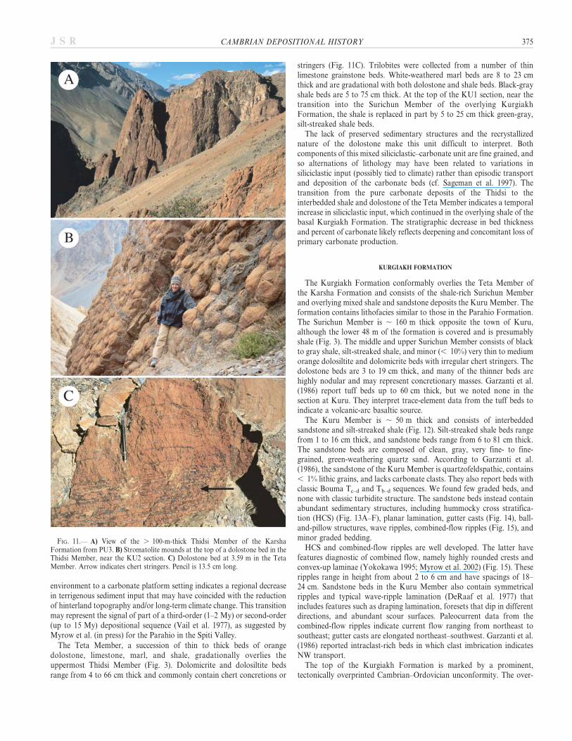
The trend of increasing carbonate content in the upper Parahio For-mation reached its culmination in the Thidsi Member. In every localityexamined, either its lower or upper contact is a fault, so its true thickness isunknown. Preserved thicknesses are on the order of 100 to 125 m (Garzantiet al. 1986). The Thidsi Member is composed almost entirely of orangedolostone (Fig. 11A, see legend in Fig. 5) and records deposition in a clear-water carbonate-platform setting. Sedimentary structures are not wellpreserved in the dolostone, but large stromatolites are present at the baseand top of the member (Fig. 11B). The transition from a deltaic
374 P.M. MYROW ET AL. J S R
environment to a carbonate platform setting indicates a regional decreasein terrigenous sediment input that may have coincided with the reductionof hinterland topography and/or long-term climate change. This transitionmay represent the signal of part of a third-order (1–2 My) or second-order(up to 15 My) depositional sequence (Vail et al. 1977), as suggested byMyrow et al. (in press) for the Parahio in the Spiti Valley.
The Teta Member, a succession of thin to thick beds of orangedolostone, limestone, marl, and shale, gradationally overlies theuppermost Thidsi Member (Fig. 3). Dolomicrite and dolosiltite bedsrange from 4 to 66 cm thick and commonly contain chert concretions or
stringers (Fig. 11C). Trilobites were collected from a number of thinlimestone grainstone beds. White-weathered marl beds are 8 to 23 cmthick and are gradational with both dolostone and shale beds. Black-grayshale beds are 5 to 75 cm thick. At the top of the KU1 section, near thetransition into the Surichun Member of the overlying KurgiakhFormation, the shale is replaced in part by 5 to 25 cm thick green-gray,silt-streaked shale beds.
The lack of preserved sedimentary structures and the recrystallizednature of the dolostone make this unit difficult to interpret. Bothcomponents of this mixed siliciclastic–carbonate unit are fine grained, andso alternations of lithology may have been related to variations insiliciclastic input (possibly tied to climate) rather than episodic transportand deposition of the carbonate beds (cf. Sageman et al. 1997). Thetransition from the pure carbonate deposits of the Thidsi to theinterbedded shale and dolostone of the Teta Member indicates a temporalincrease in siliciclastic input, which continued in the overlying shale of thebasal Kurgiakh Formation. The stratigraphic decrease in bed thicknessand percent of carbonate likely reflects deepening and concomitant loss ofprimary carbonate production.
KURGIAKH FORMATION
The Kurgiakh Formation conformably overlies the Teta Member ofthe Karsha Formation and consists of the shale-rich Surichun Memberand overlying mixed shale and sandstone deposits the Kuru Member. Theformation contains lithofacies similar to those in the Parahio Formation.The Surichun Member is , 160 m thick opposite the town of Kuru,although the lower 48 m of the formation is covered and is presumablyshale (Fig. 3). The middle and upper Surichun Member consists of blackto gray shale, silt-streaked shale, and minor (, 10%) very thin to mediumorange dolosiltite and dolomicrite beds with irregular chert stringers. Thedolostone beds are 3 to 19 cm thick, and many of the thinner beds arehighly nodular and may represent concretionary masses. Garzanti et al.(1986) report tuff beds up to 60 cm thick, but we noted none in thesection at Kuru. They interpret trace-element data from the tuff beds toindicate a volcanic-arc basaltic source.
The Kuru Member is , 50 m thick and consists of interbeddedsandstone and silt-streaked shale (Fig. 12). Silt-streaked shale beds rangefrom 1 to 16 cm thick, and sandstone beds range from 6 to 81 cm thick.The sandstone beds are composed of clean, gray, very fine- to fine-grained, green-weathering quartz sand. According to Garzanti et al.(1986), the sandstone of the Kuru Member is quartzofeldspathic, contains, 1% lithic grains, and lacks carbonate clasts. They also report beds withclassic Bouma Tc–d and Tb–d sequences. We found few graded beds, andnone with classic turbidite structure. The sandstone beds instead containabundant sedimentary structures, including hummocky cross stratifica-tion (HCS) (Fig. 13A–F), planar lamination, gutter casts (Fig. 14), ball-and-pillow structures, wave ripples, combined-flow ripples (Fig. 15), andminor graded bedding.
HCS and combined-flow ripples are well developed. The latter havefeatures diagnostic of combined flow, namely highly rounded crests andconvex-up laminae (Yokokawa 1995; Myrow et al. 2002) (Fig. 15). Theseripples range in height from about 2 to 6 cm and have spacings of 18–24 cm. Sandstone beds in the Kuru Member also contain symmetricalripples and typical wave-ripple lamination (DeRaaf et al. 1977) thatincludes features such as draping lamination, foresets that dip in differentdirections, and abundant scour surfaces. Paleocurrent data from thecombined-flow ripples indicate current flow ranging from northeast tosoutheast; gutter casts are elongated northeast–southwest. Garzanti et al.(1986) reported intraclast-rich beds in which clast imbrication indicatesNW transport.
The top of the Kurgiakh Formation is marked by a prominent,tectonically overprinted Cambrian–Ordovician unconformity. The over-
FIG. 11.— A) View of the . 100-m-thick Thidsi Member of the KarshaFormation from PU3. B) Stromatolite mounds at the top of a dolostone bed in theThidsi Member, near the KU2 section. C) Dolostone bed at 3.59 m in the TetaMember. Arrow indicates chert stringers. Pencil is 13.5 cm long.
CAMBRIAN DEPOSITIONAL HISTORY 375J S R

FIG. 12.— Stratigraphic column of theKurgiakh Formation at the KU2 section.Section covers the upper 2.5 m of theSurichun Member and the entire KuruMember. Lithologic scale: sh 5 shale,slt 5 siltstone, vfs 5 very fine sandstone,fs 5 fine sandstone. See Figure 4 for legendfor symbols.
376 P.M. MYROW ET AL. J S R

lying Ordovician Thaple Formation consists of red conglomerate andsandstone and is comparable to the Thango Formation in the SpitiValley. Petrographic study of the Thaple indicates litharenitic andsublitharenitic compositions. The lithic component is almost entirelysiliciclastic and carbonate sedimentary grains (Garzanti et al. 1986).
Interpretation of the Kurgiakh Formation
The middle and upper parts of the Surichun Member are similarin lithology to the upper part of the underlying Teta Member ofthe Karsha Formation, although they contain less carbonate. Thetransition into the Kuru Member is relatively abrupt and shows
upward coarsening into sandstone-dominated strata. The transitionfrom the shale-rich middle Surichun Member to the Kuru Memberreflects shoaling and progradation to inner-shelf and shoreline environ-ments, as evidenced by abundant storm-generated structures such asHCS, combined-flow ripples, and gutter casts (Kreisa 1981; Myrow1992a, 1992b). The bulk of the Kurgiakh Formation thus recordslong-term shoaling that followed the ‘‘Teta transgression.’’ Maximumflooding of this preceding transgression may have been reached sometime during deposition of the very poorly exposed lower SurichunMember.
Interbedded sandstone and shale deposits of the Kuru Member recorddeposition in the inner shelf, below fair-weather wave base, where mud
FIG. 13.—Hummocky cross stratified (HCS) sandstone in KU2. Pencil is 13.5 cm. A) Doming HCS lamination at 117.31 m. B) HCS at 137.22 m. C) Hummocky cross-stratified top of a 35-cm-thick parallel-laminated bed at 137.22 m. Note subtle low-angle curved erosion surfaces. D) HCS at 138.17 m. E) Small-scale hummock at139.69 m. F) Low-relief, symmetrical hummock at 154.3 m.
CAMBRIAN DEPOSITIONAL HISTORY 377J S R

settles out of suspension between storms (Walker 1984). The base of theKuru consists of over 5 m of sandstone, and sandstone-rich intervals existthroughout the unit. These thick sandstone units, including those withamalgamated and nearly amalgamated HCS beds, represent shorefaceand lower shoreface transition zone environments, respectively (cf. Dottand Bourgeois 1982).
Such an interpretation is at odds with previous views of thedepositional and tectonic setting of this unit. According to Gaetani etal. (1986, p. 447–448), ‘‘the Kurgiakh Formation records the transitionfrom shelf and slope sedimentation in poorly oxygenated waters to non-channelized distal turbidites. The sedimentary evolution thus testifies [to]active tectonic subsidence which largely exceeded sedimentation rates.’’Garzanti et al. (1986) consider the Surichun Member to record an upwardtransition from shelf to slope deposits and the Kuru Member as outer-fan-lobe turbidites and lobe-fringe deposits. They describe the de-positional environment of the Kurgiakh Formation as ‘‘a restricteddeep-water basin in front of an arc-trench system’’ (p. 261).
We agree with both Garzanti et al. (1986) and Gaetani et al. (1986) thatthe Teta Member of the Karsha Formation and the overlying SurichunMember of the Kurgiakh represent drowning of the Karsha carbonateplatform, but this transgression was of limited extent and was followed bysubsequent shoaling to inner-shelf and shoreline settings, not furtherdeepening to slope and submarine-fan environments.
IMPLICATIONS FOR EARLY TECTONIC AND DEPOSITIONAL HISTORY OF THE
NORTHERN INDIAN MARGIN
The Cambrian and Ordovician succession of the Zanskar region ofnorthern India has been interpreted as recording the development ofa foreland basin from a passive margin (Garzanti et al. 1986; Gaetani etal. 1986). This would include flexure and load-induced subsidence,drowning of a platform, development of a trench and deep-water trough,deposition of a turbidite succession, and late-stage collision and sheddingof coarse molasse deposits. This interpretation has been used to supportinterpretations of other successions across the Tethyan Himalaya (e.g.,Gehrels et al. 2003). Our sedimentological reinterpretation of these strataremoves the fundamental premise for such an interpretation and castsconsiderable doubt on the purported genetic link between Kurgiakhsedimentation and the Cambrian–Ordovician orogenic event. First, thepaleoenvironmental analysis of the Kurgiakh is inconsistent withdeposition under extreme tectonic subsidence and development of a deepmarine foreland basin. Second, as Garzanti et al. (1986) themselves pointout, there is no peripheral-bulge unconformity (Beaumont et al. 1988) ontop of the Karsha Formation and the sediment preserved in the Kurgiakh
Formation lacks volcanic lithic fragments that would have been derivedfrom a subduction complex.
Third, age relationships cast doubt on the published tectonic story. Theyoungest Cambrian faunas found below the Cambrian–Ordovicianunconformity in the western Himalaya are found in Kashmir, wheretrilobites of earliest Late Cambrian age were recovered from theTrahagam Formation (Jell 1986; Jell and Hughes 1997). Beds above theboundary in Kashmir contain brachiopods (Reed 1934) that have recentlybeen reinterpreted as no older than early Middle Ordovician age (L.R.M.Cocks, personal communication, 2004), or , 472 Ma (Gradstein et al.2004). No fossils diagnostic of an Early Ordovician age have been foundin the western Himalaya, and the oldest Ordovician fossils in Spiti appearto be no older than Middle Ordovician and no younger than LateOrdovician (L.R.M. Cocks and R.A. Fortey, personal communication,2004). The hiatus associated with the unconformity between the Kurgiakhand the overlying Thaple Formation in Zanskar ranges from earliest LateCambrian (, 500 Ma) to Middle Ordovician (, 472 Ma). In both Spitiand Zanskar, some coarse-grained continental deposits underlie the datedOrdovician strata, but there is nothing to suggest that these deposits areolder than Middle Ordovician. Thus, the basal Ordovician unconformitymight have developed at any time from earliest Late Cambrian to earliestMiddle Ordovician, but most likely developed closer to the age of theoldest molasse deposits of the Tango and Thaple formations. In this case,tectonic uplift and erosion may have occurred roughly 20–30 millionyears after deposition of the Kurgiakh Formation. Thus, deposition ofthe Kurgiakh Formation, as well as the carbonate–siliciclastic transitionat its base, could have significantly predated the Cambrian–Ordovicianorogenic event.
The nature of Cambrian–Ordovician orogenesis is extremely poorlyconstrained due to lack of preserved rocks of this age in any Himalayantectonic zones to the south of the South Tibetan Fault System (STFS),which separates the Tethyan Himalaya from the Greater Himalaya.Garzanti et al. (1986) suggest that uplifted Lesser Himalayan andVindhyan strata could have been the source area for the TethyanOrdovician deposits. Several problems arise from such an interpretation.First, there is little evidence for significant uplift within the LesserHimalaya at this time. Hughes et al. (2005) point out that the uplift anderosion in the Lesser Himalaya occurred some time between the LateCambrian and the Early Permian but that the timing of such an eventwithin this interval is poorly constrained. There are also no structuralfabrics or features yet identified as Cambrian or Ordovician in age in theLesser Himalaya. Second, much of the Ordovician molasse deposits of theTethyan Himalaya are coarse conglomeratic alluvial-fan and proximal
FIG. 14.—A) Gutter cast (arrowed) at 136.56 m in KU2. B) Oblique view of excavated gutter cast with symmetrical rippled top at 136.56 m in KU2. Pencil for scale is13.5 cm.
378 P.M. MYROW ET AL. J S R

fluvial deposits, which generally form adjacent to basin-margin faults.Although palinspastic reconstructions are somewhat ambiguous, theywould not likely be compatible with extremely close juxtaposition ofuplifted Lesser Himalayan or Vindhyan deposits with Tethyan sedimen-tary successions. The available data do not, however, argue againsta Cambrian–Ordovician uplift south of the present-day STFS and thenorthern boundary of the Lesser Himalaya, the Main Central Thrust(MCT). In fact, paleocurrent data in the Ordovician strata of the Tethyanbelt are consistent with this idea. As mentioned earlier, paleocurrentreadings of cross-stratification in the Thaple Formation in Zanskarsuggest eastward and subordinate northwest sediment transport direc-
tions (Garzanti et al. 1986). Paleocurrents from the Ordovician TangoFormation in the Spiti region (Bagati et al. 1991) indicate transport to thenorth and northeast, consistent with the orientation of meter-scale scoursalong its basal unconformity with the Parahio Formation (Myrow et al.in press). The strata in the paleogeographic region that would haverepresented the potential sediment source area for these Ordoviciandeposits are likely lost due to high-grade metamorphism and may now berepresented in large part by Greater Himalayan crystalline rocks. Thus,the nature and existence of uplift in this region will likely remain a sourceof much speculation and debate unless important new structural and/orstratigraphic data become available.
In any case, the tectonic model outlined by Gehrels et al. (2003) isproblematic with regard to the published paleocurrents for the coarse-grained Ordovician molasse deposits. Molassic deposits are typically shedin front of a fold-and-thrust belt, which in this case would be towardsthe south. Wedges of Ordovician molasse in Gehrels et al.’s (2003)reconstruction taper to the south and indicate southern progradation. Wesuggest that the application of standard models of foreland-basindevelopment to Cambrian–Ordovician orogenesis in the Himalayas, suchas those presented by Garzanti et al. (1986) and Gehrels et al. (2003), arepremature and not justified by available data.
CONCLUSIONS
1. The Cambrian Parahio Formation in the Zanskar Valley consists of, 1,300 m of dominantly siliciclastic marine Cambrian deposits.The formation consists of cyclically deposited, storm-influenced,shoaling cycles that record environments that range from offshoremarine to shoreface to fluvial environments. Carbonate beds thatcap these cycles are thin transgressive deposits. These interpreta-tions are at odds with previous paleoenvironmental interpretationsthat ranged from deep-sea flysch to intertidal.
2. Similar cycles exist in the Parahio Formation to the south-southeastat its type section in the Spiti Valley, although facies analysis of theZanskar cycles indicate more distal paleoenvironments than theirequivalents in Spiti. Trilobite and brachiopod faunas from bothlocalities provide the first detailed correlations between these areas.
3. Paleocurrent data for marine and fluvial facies of the ParahioFormation in both Zanskar and Spiti indicate northeast sedimenttransport. This supports the view that the Parahio and overlyingcarbonate of the Karsha Formation record the ancient northernpassive margin of India during the Cambrian. These strata mayrepresent distal equivalents of the younger Cambrian deposits of theLesser Himalaya.
4. The Cambrian succession is capped by the Kurgiakh Formation,a dominantly siliciclastic upward-coarsening unit that is overlain bya regionally extensive unconformity and overlying Ordovicianconglomerate. The Kurgiakh Formation has been thought torepresent a transition from a passive-margin to deep-water flyschdeposition in a tectonically active foreland basin next to an arc-trench system. Purported sandstone turbidite beds with classicBouma sequences are a key to this interpretation. We hereindemonstrate that the Kurgiakh event beds contain well-developedhummocky cross-stratification, quasi-planar lamination, and com-bined-flow ripple stratification, which indicate that they weredeposited in shallow-marine, storm-influenced environments. Al-though subsidence was substantial enough and rapid enough todrown the Karsha carbonate platform, it did not culminate in deep-sea flysch deposition.
5. Several other aspects of Cambrian–Ordovician deposits of northernIndia cast doubt on the proposed link between Kurgiakhsedimentation and the Cambrian–Ordovician orogenic event. First,the age gap between the youngest Cambrian strata and oldest
FIG. 15.—Combined-flow ripples in the Kurgiakh Formation at KU2. In eachpicture, note convex-up ripple structure and the highly rounded crests. Pencil is13.5 cm long. A) Combined-flow ripple at 115.71 m. B) Combined-flow ripple at150.12 m. C) Combined-flow ripple at 153.05 m. Cryptic break below ripplelamination is shown with dotted line.
CAMBRIAN DEPOSITIONAL HISTORY 379J S R

Ordovician strata indicate that the Kurgiakh may have beendeposited as much as 20–30 My prior to the Ordovician conglom-eratic molasse. Second, data from the Ordovician molasse indicatenorthward paleocurrents, which are at odds with models ofstandard foreland-basin development for the Cambrian–Ordovicianevent.
ACKNOWLEDGMENTS
We thank O.N. Bhargava and Eric Draganits for discussions of theTethyan stratigraphy, and associate editor Sanjeev Gupta and an anonymousreviewer for helpful reviews. Field support was provided through the WadiaInstitute of Himalayan Geology. Our Himalayan research is supported byNational Science Foundation grant EAR-9980376 to PMM and EAR-9980426 to NCH, and by National Geographic grant NGS7293-02 to NCH.
REFERENCES
AHARON, P., SCHIDLOWSKI, M., AND SINGH, I.B., 1987, Chronostratigraphic markers inthe end-Precambrian carbon isotope record of the Lesser Himalaya: Nature, v. 327, p.699–702.
ARNOTT, R.W., 1993, Quasi-planar-laminated sandstone beds of the Lower CretaceousBootlegger Member, north-central Montana: evidence of combined-flow sedimenta-tion: Journal of Sedimentary Petrology, v. 63, p. 488–494.
ARNOTT, R.W., AND SOUTHARD, J.B., 1990, Exploratory flow-duct experiments oncombined-flow bed configurations, and some implications for interpreting storm-event stratification: Journal of Sedimentary Petrology, v. 60, p. 211–219.
BAGATI, T.N., KUMAR, R., AND GHOSH, S.K., 1991, Regressive–transgressive sedimen-tation in the Ordovician sequence of the Spiti (Tethys) basin, Himachal Pradesh,India: Sedimentary Geology, v. 73, p. 171–184.
BEAUMONT, C., QUINLAN, G., AND HAMILTON, J., 1988, Orogeny and stratigraphy:Numerical models of the Paleozoic in the eastern interior of North America:Tectonics, v. 7, p. 389–416.
BROOKFIELD, M.E., 1993, The Himalayan passive margin from Precambrian toCretaceous times: Sedimentary Geology, v. 84, p. 1–35.
BROWN, L.F., AND FISHER, W.L., 1977, Seismic–stratigraphic interpretations ofdepositional systems: examples from Brazil rift and pull-apart basins, in Payton,C.E., ed., Seismic Stratigraphy—Applications to Hydrocarbon Exploration: Amer-ican Association of Petroleum Geologists, Memoir 26, p. 213–248.
CARR, I.D., GAWTHORPE, R.L., JACKSON, C.A.L., SHARP, I.R., AND SADEK, A., 2003,Sedimentology and sequence stratigraphy of early syn-rift tidal sediments: the NukhulFormation, Suez Rift, Egypt: Journal of Sedimentary Research, v. 73, p. 407–420.
CARTER, C.H., 1978, A regressive barrier and barrier-protected deposit: depositionalenvironment and geographic setting of the Late Tertiary Cohansey Sand: Journal ofSedimentary Petrology, v. 48, p. 933–950.
CASTLE, J.W., MOLZ, F.J., LU, S., AND DINWIDDIE, C.L., 2004, Sedimentology andfractal-based analysis of permeability data, John Henry Member, Straight CliffsFormation, (Upper Cretaceous), Utah, U.S.A.: Journal of Sedimentary Research,v. 74, p. 270–284.
COLEMAN, J.M., PRIOR, D.B., AND LINDSAY, J.F., 1983, Deltaic influences on shelf edgeinstability processes, in Stanley, D.J., and Moore, F.T., eds., The Shelf break: CriticalInterface on Continental Margins: SEPM, Special Publication 33, p. 121–137.
CORFIELD, R.I., AND SEARLE, M.P., 2000, Crustal shortening estimates across the northIndian continental margin, Ladakh, NW India, in Khan, M.A., Treloar, P.J., Searle,M.P., and Jan, M.Q., eds., Tectonics of the Nanga Parbat Syntaxis and the WesternHimalaya: Geological Society of London, Special Publication 170, p. 395–410.
COWAN, C.A., AND JAMES, N.P., 1992, Diastasis cracks: mechanically generatedsynaeresis-like cracks in Upper Cambrian shallow water oolite and ribbon carbonates:Sedimentology, v. 39, p. 1101–1118.
DECELLES, P.G., GEHRELS, G.E., QUADE, J., LAREAU, B., AND SPURLIN, M., 2000,Tectonic implications of U–Pb zircon ages of the Himalayan Orogenic belt in Nepal:Science, v. 288, p. 497–499.
DERAAF, J.F.M., BOERSMA, J.R., AND VAN GELDER, A., 1977, Wave-generated structuresand sequences from a shallow marine succession, Lower Carboniferous, County Cork,Ireland: Sedimentology, v. 4, p. 1–52.
DOTT, R.H, JR., AND BOURGEOIS, J., 1982, Hummocky stratification: Significance of itsvariable bedding sequences: Geological Society of America, Bulletin, v. 93, p.663–680.
DRAGANITS, E., 2000, The Muth Formation in the Pin Valley (Spiti, N. India):Depositional environment and ichnofauna of a Lower Devonian barrier island system[Ph.D. thesis]: Vienna, University of Vienna, 165 p.
DROSER, M.L., AND BOTTJER, D.J., 1986, A semiquantitative field classification ofichnofabric: Journal of Sedimentary Petrology, v. 56, p. 558–559.
DUNGRAKOTI, B.D., DAS, B.K., AND SINHA, P.K., 1977, Record of additional fossils fromthe formation of Zanskar, Ladakh District, Jammu and Kashmir: Records of theGeological Survey of India, v. 109, p. 161–165.
DUNGRAKOTI, B.D., SINHA, P.K., AND DAS, B.K., 1974, Trilobites from the ZanskarValley, Ladakh District, Jammu and Kashmir State: Indian Minerals, v. 28, p.114–115.
FRANK, W., GRASEMANN, B., GUNTLI, P., AND MILLIER, C., 1995, Geological map of theKishtwar, Chamba, and Kulu region, NW Himalaya, India: Austria, GeologischeBundesanstalt, Jahrbuch, v. 138, p. 299–308.
FUCHS, G., 1987, The Geology of Southern Zanskar (Ladakh)—Evidence for theAutochthony of the Tethys Zone of the Himalaya: Austria, Geologische Bundesan-stalt, Jahrbuch, v. 124, p. 325–359.
GAETANI, M., CASNEDI, R., FOIS, E., GARZANTI, E., JADOUL, F., NICORA, A., AND TINTORI,A., 1986, Stratigraphy of the Tethys Himalaya in Zanskar, Ladakh: Rivista Italiana diPaleontologia e Stratigraphia, v. 48, p. 237–265.
GARZANTI, E., CASNEDI, R., AND JADOUL, F., 1986, Sedimentary Evidence of a Cambro–Ordovician Orogenic Event in the Northwestern Himalaya: Sedimentary Geology,v. 48, p. 237–265.
GEHRELS, G.E., DECELLES, P.G., MARTIN, A., OJHA, T.P., PINHASSI, G., AND UPRETI,B.N., 2003, Initiation of the Himalayan orogen as an early Paleozoic thin-skinnedthrust belt: GSA Today, v. 13, no. 9, p. 4–9.
GODIN, P.D., 1991, Fining-upward cycles in the sandy braided-river deposits of theWestwater Canyon Member (Upper Jurassic), Morrison Formation, New Mexico:Sedimentary Geology, v. 70, p. 61–82.
GRADSTEIN, F.M., AND oTHERS, 2004, A Geologic Time Scale 2004: CambridgeUniversity Press, 589 p.
GUPTA, V.J., AND SHAW, F.C., 1981, Lower Palaeozoic trilobites from Ladakh Himalaya,India: Recent Researches in Geology, v. 8, p. 54–65.
GUPTA, V.J., AND SHAW, F.C., 1985, Lower Palaeozoic trilobites from Zanskar Valley,Ladakh, Himalaya, India: Research Bulletin (Science) of the Panjab University, v. 36,p. 335–344.
HAMBLIN, A., AND WALKER, R.G., 1979, Storm-dominated shallow marine deposits: theFernie–Kootenay (Jurassic) transition, southern Rocky Mountains: Canadian Journalof Earth Sciences, v. 16, p. 1673–1690.
HAQ, B.U., HARDENBOL, J., AND VAIL, P.R., 1988, Mesozoic and Cenozoic chronos-tratigraphy and cycles of sea-level change, in Wilgus, C.K., Hastings, B.S., Kendal,C.G, ST.C., Posamentier, H.W., Ross, C.A., and Van Wagoner, J.C., eds., Sea-levelChanges—An Integrated Approach: SEPM, Special Publication 42, p. 71–108.
HARMS, J.C., SOUTHARD, J.B., AND WALKER, R.G., 1982, Structures and Sequences inClastic Rocks: SEPM, Short Course 9, 249 p.
HOWARD, J.D., AND REINECK, H.E., 1981, Depositional facies of high energy beach tooffshore sequences: Comparison with low energy sequences: American Association ofPetroleum Geologists, Bulletin, v. 65, p. 807–830.
HUGHES, N.C., 2002, Late Middle Cambrian trace fossils from the Lejopyge armatahorizon, Zanskar Valley, India and the use of Precambrian/Cambrian litho-stratigraphy in the Indian subcontinent, in P.N. Wyse Jackson, M.A. Parkes,R. Wood, and D.J. Batten, eds., Studies in Palaeozoic Palaeontology andBiostratigraphy in Honour of Charles Hepworth Holland: Special Papers inPalaeontology, v. 67, p. 135–151.
HUGHES, N.C., AND DROSER, M.L., 1992, Trace fossils from the Phe Formation (LowerCambrian), Zanskar Valley, northwestern India: Queensland Museum, Memoirs,v. 32, p. 139–144.
HUGHES, N.C., AND JELL, P.A., 1999, The biostratigraphy and biogeography ofHimalayan Cambrian trilobites, in Macfarlane, A., Sorkhabi, R.B., and Quade, J.,eds., Himalaya and Tibet: Mountain Roots to Mountain Tops: Geological Society ofAmerica, Special Paper 328, p. 109–116.
HUGHES, N.C., PENG, S.-C., BHARGAVA, O.N., AHULWALIA, A.D., WALIA, S., MYROW,P.M., AND PARCHA, S.K., 2005, Early Tsanglangpuan (late Early Cambrian) trilobitesfrom the Nigali Dhar syncline and the Cambrian biostratigraphy of the Tal Group,Lesser Himalaya, India: Geological Magazine, v. 142, p. 57–80.
JAMES, N.P., AND KENDALL, A.C., 1992, Introduction to carbonate and evaporite faciesmodels, in Walker, R.G., and James, N.P., eds., Facies Models: Response to Sea LevelChange: Geological Association of Canada, p. 265–275.
JELL, P.A., 1986, An early Late Cambrian trilobite faunule from Kashmir: GeologicalMagazine, v. 123, p. 487–492.
JELL, P.A., AND HUGHES, N.C., 1997, Himalayan Cambrian trilobites: Special Papers inPalaeontology, v. 58, p. 1–113.
KREISA, R.D., 1981, Storm-generated sedimentary structures in subtidal marine facieswith examples from Middle and Upper Ordovician of southwestern Virginia: Journalof Sedimentary Petrology, v. 51, p. 823–848.
KUMAR, A., 1998, Record of well preserved trilobites from the Zanskar Valley:Geological Society of India, Journal, v. 51, p. 671–678.
LINDSAY, J.F., PRIOR, D.B., AND COLEMAN, J.M., 1984, Distributary mouthbar development and role of submarine landslides in delta growth, South Pass,Mississippi Delta: American Association of Petroleum Geologists, Bulletin, v. 68, p.1724–174.
LYDEKKER, R., 1883, The geology of Kashmir and Chamba territories and the Britishdistrict of Kangan: Geological Survey of India, Memoirs, v. 22, p. 1–344.
MIALL, A.D., 1977, A review of the braided river depositional environment: Earth-Science Reviews, v. 13, p. 1–62.
MYROW, P.M., 1990, A new graph for understanding colors of mudrocks and shales:Journal of Geological Education, v. 38, p. 16–20.
MYROW, P.M., 1992a, Bypass-zone tempestite facies model and proximality trends foran ancient muddy shoreline and shelf: Journal of Sedimentary Petrology, v. 62, p.99–115.
380 P.M. MYROW ET AL. J S R

MYROW, P.M., 1992b, Pot and gutter casts from the Chapel Island Formation,Southeast Newfoundland: Journal of Sedimentary Petrology, v. 62, p. 992–1007.
MYROW, P.M., AND SOUTHARD, J.B., 1991, Combined-flow model for verticalstratification sequences in shallow marine storm-deposited beds: Journal ofSedimentary Petrology, v. 61, p. 202–210.
MYROW, P.M., AND SOUTHARD, J.B., 1996, Tempestite deposition: Journal ofSedimentary Research, v. 66, p. 875–887.
MYROW, P.M., FISCHER, W., AND GOODGE, J.W., 2002, Wave-modified turbidites:combined-flow shoreline and shelf deposits, Cambrian, Central TransantarcticMountains: Journal of Sedimentary Research, v. 72, p. 641–656.
MYROW, P.M., HUGHES, N.C., PAULSEN, T.S., WILLIAMS, I.S., PARCHA, S.K., THOMPSON,K.R., BOWRING, S.A., PENG, S.-C., AND AHLUWALIA, A.D., 2003, Integratedtectonostratigraphic reconstruction of the Himalaya and implications for its tectonicreconstruction: Earth and Planetary Science Letters, v. 212, p. 433–441.
MYROW, P.W., THOMPSON, K.R., HUGHES, N.C., PAULSEN, T.S., SELL, B.K., AND PARCHA,S.K., in press, Cambrian stratigraphy and depositional history of the northernIndian Himalaya, Spiti Valley, north-central India: Geological Society of America,Bulletin, v. 118.
NANDA, M.N., AND SINGH, M.P., 1976, Stratigraphy and sedimentation of the Zanskararea, Ladakh and adjoining parts of the Lahaul region of Himachal Pradesh:Himalayan Geology, v. 6, p. 365–388.
PARCHA, S.K., 1998, Trace fossils from the Cambrian of Zanskar (Ladakh Himalaya)and their stratigraphic significance: Geological Society of India, Journal, v. 51, p.635–645.
PENLAND, S., BOYD, R., AND SUTER, J.R., 1988, Transgressive depositional systems of theMississippi delta plain: a model for barrier shoreline and shelf sand development:Journal of Sedimentary Petrology, v. 58, p. 932–949.
REED, F.R.C., 1934, Cambrian and Ordovician fossils from Kashmir: PalaeontologiaIndica, v. 21, no. 2, p. 1–38.
SAGEMAN, B.B., RICH, J., ARTHUR, M., BIRCHFIELD, G.E., AND DEAN, W.E., 1997,Evidence for Milankovitch periodicities in Cenomanian–Turonian lithologic andgeochemical cycles, Western Interior U.S.A.: Journal of Sedimentary Research, v. 67,p. 286–301.
SAVRDA, C.E., BOTTJER, D.J., AND GORSLINE, D.S., 1984, Towards development ofcomprehensive euxinic biofacies model: evidence from Santa Monica, San Pedro, andSanta Barbara Basins, California Borderland: American Association of PetroleumGeologists, Bulletin, v. 68, p. 1179–1192.
SAXENA, M.N., 1971, The crystalline axis of the Himalaya, Indian shield and continentaldrift: Tectonophysics, v. 12, p. 433–447.
SCHLAGER, W., 1981, The paradox of drowned reefs and carbonate platforms:Geological Society of America Bulletin, v. 92, p. 197–211.
SCHWARTZ, R.K., COOPER, D.W., AND ETHERIDGE, P.H., 1997, Sedimentologicarchitecture of the shoreface prism, relationship to profile dynamics, and relevanceto engineering concerns: Duck, North Carolina: US Army Corps of Engineers,Technical Report CHL-97-19, Washington, D.C., 93 p.
SCOTESE, C.R., AND MCKERROW, W.S., 1990, Revised world maps and introduction:Palaeozoic Palaeogeography and Biogeography: Geological Society of London,Memoir 12, p. 1–21.
SEARLE, M.P., 1986, Structural evolution and sequence of thrusting in the HighHimalayan, Tibetan–Tethys and Indus suture zones of Zanskar and Ladakh, WesternHimalaya: Journal of Structural Geology, v. 8, p. 923–936.
SHAH, S.K., KUMAR, A., AND SUDAN, C.S., 1996, Agnostid trilobites from the Cambriansequence of Zanskar and their stratigraphic significance: Current Science, v. 71, p.951–954.
SRIKANTIA, S.V., GANESAN, T.M., RAO, P.N., SINHA, P.K., AND TIRKEY, B., 1980,Geology of the Zanskar Area, Ladakh Himalaya: Himalayan Geology, v. 8, p.1009–1033.
VAIL, P.R., MITCHUM, R.M, JR., TODD, R.G., WIDMIER, J.M., THOMPSON, S.III, SANGREE,J.B., BUBB, J.N., AND HATLELID, W.G., 1977, Seismic stratigraphy and global changesof sea level, in Payton, C.E., ed., Seismic Stratigraphy—Applications to HydrocarbonExploration: American Association of Petroleum Geologists Memoir #26, p. 49–212.
VAN WAGONER, J.C., PONSAMENTIER, H.W., MITCHUM, R.M., VAIL, P.R., SARG, J.F.,LOUTIT, T.S., AND HARDENBOL, J., 1988, Overview of the fundamentals ofsequence stratigraphy and key definitions, in Wilgus, C.K., Hastings, B.S., Kendal,C.G, ST.C., Posamentier, H.W., Ross, C.A., and Van Wagoner, J.C., eds., Sea-LevelChanges—An Integrated Approach: SEPM Special Publication No. 42, p. 39–45.
WALKER, R.G., 1984, Shelf and Shallow marine sands, in Walker, R.G., ed., FaciesModels, Second Edition: Geological Association of Canada, p. 141–170.
WHITAKER, J.H.M., 1973, ‘‘Gutter Casts,’’ a new name for scour-and-fill structures: withexamples from the Llandoverian of Ringerike and Malmoya, southern Norway:Norsk Geologisk Tidsskrift, v. 53, p. 403–417.
WHITE, W.A., 1961, Colloid phenomena in sedimentation of argillaceous rocks: Journalof Sedimentary Petrology, v. 31, p. 560–570.
WHITTINGTON, H.B., 1986, Late middle Cambrian trilobites from Zanskar, Ladakh,northern India: Rivista Italiana di Paleontologia e Stratigrafia, v. 92, p. 171–188.
WIGNALL, P.B., AND MYERS, K.J., 1988, Interpreting benthic oxygen levels in mudrocks:A new approach: Geology, v. 16, p. 452–455.
YOKOKAWA, M., 1995, Combined-flow ripples; genetic experiments and applications forgeologic records: Kyushu University, Memoirs, Faculty of Science, Series D, Earthand Planetary Sciences, v. 29, p. 1–38.
Received 12 July 2004; accepted 6 July 2005.
CAMBRIAN DEPOSITIONAL HISTORY 381J S R