Chronology of relict lake deposits in the Spiti River, NW Trans Himalaya: Implications to Late...
9
Chronology of relict lake deposits in the Spiti River, NW Trans Himalaya: Implications to Late Pleistocene–Holocene climate-tectonic perturbations Binita Phartiyal a , Anupam Sharma a , Pradeep Srivastava b, ⁎, Yogesh Ray b a Birbal Sahni Institute of Palaeobotany, 53-University Road, Lucknow-226007, India b Wadia Institute of Himalayan Geology, 33 GMS Road, Dehradun 248001, India abstract article info Article history: Received 30 August 2008 Received in revised form 3 February 2009 Accepted 3 February 2009 Available online 21 February 2009 Keywords: Arid Trans-Himalaya Spiti River Palaeolakes Luminescence dating The Spiti River that drains through the arid Trans-Himalayan region is studied here. The relict deposits exposed along the river provide an opportunity to understand the interaction between the phases of intense monsoon and surface processes occurring in the cold and semi arid to-arid Trans-Himalayan region. Based on geo- morphological observation the valley is broadly divided into the upper and lower Spiti Valley. The braided channel and the relict fluvio-lacustrine deposits rising from the present riverbed characterize the upper valley. The deposits in the lower valley occur on the uplifted bedrock strath and where the channel characteristics are mainly of meandering nature. Conspicuous is the occurrence of significantly thick lacustrine units within the relict sedimentary sequences of Spiti throughout the valley. The broad sedimentary architecture suggests the formation of these palaeolakes due landslide-driven river damming. The Optically Stimulated Luminescence (OSL) dating of quartz derived from the bounding units of the lacustrine deposits suggests that the upper valley preserves the phase of deposition around 14–6 ka and in the lower valley around 50–30 ka. The review of published palaeoclimatic palaeolake chronology of Spiti Valley indicates that the lakes were probably formed during the wetter conditions related to Marine Isotope Stage III and II. The increased precipitation during these phases induced excessive landsliding and formation of dammed lakes along the Spiti River. The older lacustrine phase being preserved on the uplifted bedrock strath in the lower valley indicates late Pleistocene tectonic activity along the Kaurick Chango normal fault. © 2009 Elsevier B.V. All rights reserved. 1. Introduction Collision of the northward drifting Indian plate with Eurasia resulted in the formation of Himalayan mountain systems. Since then the continuous oblique underthrusting of the Indian plate has recorded movements along various fault/thrust systems viz. Indus Suture Zone (ISZ), Karakoram Fault, Main Central Thrust (MCT), Main Boundary Thrust (MBT) and Himalayan Frontal Fault (HFF), that has not only compartmentalized the entire Himalayan system into four tectono-climatic–geomorphic sectors namely Trans-Himalaya, Higher Himalaya, Lesser Himalaya and Outer Himalaya but also modified the precipitation regime globally. The interaction of the varying climate and tectonic evolution of this orogen has been responsible for an enormously increased oceanic sediment budget. Since the rivers in the Himalaya serve as a conduit of sediment erosion and unloading, it is desirable to understand and determine the phases of excessive erosion and sedimentation in the Himalayan River valleys. The Spiti Valley is located above the tree line (3000 m asl), between 31–33°°E; 77–79° S; (Figs. 1 and 2A), with little vegetation restricted to the valley floor. The prevailing climate is cold, semi-arid to arid and the valley remains covered with snow for nearly six months. Because of the orographic barrier in the south the valley remains in a rain shadow zone with respect to the Indian summer monsoon and thus ex- periences ~50 mm of rainfall annually and about 200 cm of snowfall (in the winters). The temperature ranges between -25 °C and 30 °C in winter and summer respectively. The instrumental data of the past ten years show a marked change in temperature and snowfall patterns, e.g.,1990's have experienced temperatures as low as -49 °C and snow fall N 200 cm in winters. It is interesting to note here that during Abnormal Monsoon Years (AMYs), rainfall penetrates ~75 km further north into the valley and causes extensive landslides and erosion (Bookhagen et al., 2005a). The large temperature contrasts and thin vegetation cover increases the vulnerability of landsliding and channel damming in such areas during the excessive rainfall events. Recent research involving cosmogenic radionuclide dating of palaeolandslides in the arid Trans-Himalayan region indicated that 14 of the 16 dated landslides occurred during periods of intensified monsoons (Dortch et al., 2008). The sedimentary sequences exposed along the Spiti River therefore bear a signature of past interactions between climate and surface processes in the cold and arid regions of Himalaya. In the present study we show the phases of lake formation in the Spiti River and its implications for geomorphic evolution of the region. The main emphasis is on the spatial distribution and timing of the Geomorphology 108 (2009) 264–272 ⁎ Corresponding author. Tel.: +91135 2525351, +91 522 2742928. E-mail address: [email protected] (P. Srivastava). 0169-555X/$ – see front matter © 2009 Elsevier B.V. All rights reserved. doi:10.1016/j.geomorph.2009.02.018 Contents lists available at ScienceDirect Geomorphology journal homepage: www.elsevier.com/locate/geomorph
Transcript of Chronology of relict lake deposits in the Spiti River, NW Trans Himalaya: Implications to Late...

Geomorphology 108 (2009) 264–272
Contents lists available at ScienceDirect
Geomorphology
j ourna l homepage: www.e lsev ie r.com/ locate /geomorph
Chronology of relict lake deposits in the Spiti River, NW Trans Himalaya: Implicationsto Late Pleistocene–Holocene climate-tectonic perturbations
Binita Phartiyal a, Anupam Sharma a, Pradeep Srivastava b,⁎, Yogesh Ray b
a Birbal Sahni Institute of Palaeobotany, 53-University Road, Lucknow-226007, Indiab Wadia Institute of Himalayan Geology, 33 GMS Road, Dehradun 248001, India
⁎ Corresponding author. Tel.: +91 135 2525351, +91E-mail address: [email protected] (P. Srivastava).
0169-555X/$ – see front matter © 2009 Elsevier B.V. Adoi:10.1016/j.geomorph.2009.02.018
a b s t r a c t
a r t i c l e i n f oArticle history:
The Spiti River that drains th Received 30 August 2008Received in revised form 3 February 2009Accepted 3 February 2009Available online 21 February 2009Keywords:Arid Trans-HimalayaSpiti RiverPalaeolakesLuminescence dating
rough the arid Trans-Himalayan region is studied here. The relict deposits exposedalong the river provide an opportunity to understand the interaction between the phases of intense monsoonand surface processes occurring in the cold and semi arid to-arid Trans-Himalayan region. Based on geo-morphological observation the valley is broadly divided into the upper and lower Spiti Valley. The braidedchannel and the relict fluvio-lacustrine deposits rising from the present riverbed characterize the upper valley.The deposits in the lower valley occur on the uplifted bedrock strath andwhere the channel characteristics aremainly of meandering nature. Conspicuous is the occurrence of significantly thick lacustrine units within therelict sedimentary sequences of Spiti throughout the valley. The broad sedimentary architecture suggests theformation of these palaeolakes due landslide-driven river damming. The Optically Stimulated Luminescence(OSL) dating of quartz derived from the bounding units of the lacustrine deposits suggests that the upper valleypreserves the phase of deposition around 14–6 ka and in the lower valley around 50–30 ka. The review ofpublished palaeoclimatic palaeolake chronology of Spiti Valley indicates that the lakes were probably formedduring thewetter conditions related toMarine Isotope Stage III and II. The increased precipitation during thesephases induced excessive landsliding and formation of dammed lakes along the Spiti River. The older lacustrinephase being preserved on the uplifted bedrock strath in the lower valley indicates late Pleistocene tectonicactivity along the Kaurick Chango normal fault.
© 2009 Elsevier B.V. All rights reserved.
1. Introduction
Collision of the northward drifting Indian plate with Eurasiaresulted in the formation of Himalayan mountain systems. Sincethen the continuous oblique underthrusting of the Indian plate hasrecorded movements along various fault/thrust systems viz. IndusSuture Zone (ISZ), Karakoram Fault, Main Central Thrust (MCT), MainBoundary Thrust (MBT) and Himalayan Frontal Fault (HFF), that hasnot only compartmentalized the entire Himalayan system into fourtectono-climatic–geomorphic sectors namely Trans-Himalaya, HigherHimalaya, Lesser Himalaya and Outer Himalaya but also modified theprecipitation regime globally. The interaction of the varying climateand tectonic evolution of this orogen has been responsible for anenormously increased oceanic sediment budget. Since the rivers in theHimalaya serve as a conduit of sediment erosion and unloading, it isdesirable to understand and determine the phases of excessive erosionand sedimentation in the Himalayan River valleys.
The Spiti Valley is located above the tree line (3000masl), between31–33°°E; 77–79° S; (Figs.1 and 2A), with little vegetation restricted tothe valley floor. The prevailing climate is cold, semi-arid to arid and the
522 2742928.
ll rights reserved.
valley remains covered with snow for nearly six months. Because ofthe orographic barrier in the south the valley remains in a rain shadowzone with respect to the Indian summer monsoon and thus ex-periences ~50 mm of rainfall annually and about 200 cm of snowfall(in the winters). The temperature ranges between −25 °C and 30 °Cin winter and summer respectively. The instrumental data of the pasttenyears showamarked change in temperature and snowfall patterns,e.g., 1990's have experienced temperatures as low as−49 °C and snowfall N200 cm in winters. It is interesting to note here that duringAbnormal Monsoon Years (AMYs), rainfall penetrates ~75 km furthernorth into the valley and causes extensive landslides and erosion(Bookhagen et al., 2005a). The large temperature contrasts and thinvegetation cover increases the vulnerability of landsliding and channeldamming in such areas during the excessive rainfall events. Recentresearch involving cosmogenic radionuclide dating of palaeolandslidesin the arid Trans-Himalayan region indicated that 14 of the 16 datedlandslides occurred during periods of intensified monsoons (Dortchet al., 2008). The sedimentary sequences exposed along the Spiti Rivertherefore bear a signature of past interactions between climate andsurface processes in the cold and arid regions of Himalaya.
In the present study we show the phases of lake formation in theSpiti River and its implications for geomorphic evolution of the region.The main emphasis is on the spatial distribution and timing of the

Fig.1. (A) Locationmap of the study area showingmajor fault lines. KF is Karakoram Fault, ISZ is Indus Suture Zone, MCT is Main Central Thrust, MBT is Main Boundary Thrust and HFFis Himalayan Frontal Fault. (B) Spiti River valley showing braided river, meandering river, gorge and the distribution of palaeolake deposits in Lower and Upper Spiti River Valley.(C) Photograph from downstream Kioto showing braided character of the channel in the Upper Spiti Valley with the relict deposits rising from the riverbed. The rectangle enclosesthe segment of the Spiti river that in a narrow gorge along the K-C fault.
265B. Phartiyal et al. / Geomorphology 108 (2009) 264–272
lacustrine deposits. The chronology is established using radiocarbondating and Optically Stimulated Luminescence (OSL) dating techni-ques on the bulk sediment. We observed discrepancies in the two setsof ages and the cause for the discordant ages is discussed.
2. Geological background
The geology of the Spiti Valley shows a continuous succession fromNeoproterozoic toCretaceousTethyan sediments andhas been studiedbyseveral workers (Bhargava and Bassi, 1998; Sinha,1989; Srikantia, 1981).The rocks of Palaeozoic successions aremostly splintery shale, sandstone,limestone and metasediments, e.g. quartzites, marble, slate etc (Fig. 2B).TheMesozoic rocksaredominantly limestone (Kioto limestone–Jurassic),shale (Spiti shale-Triassic?) and sandstone (Giumal sandstone–Cretac-eous). The northern extremity of Spiti Valley is represented by TsoMorariCrystallines, dominantly comprised of granitic gneiss, gneiss and schists(Steck et al., 1998; Jain et al., 2003; Leech et al., 2005).
The reviewof the structural elements indicates that theSpiti RiverValleyis located to the SW of the Karakoram Fault System (KFS), in a pull-apartbasin lying between the NW and SE trending right lateral, strike-slipKarakoram Fault System and the high angle faults near the southernboundaryof theTethyanHimalaya(NiandBarazangi,1985;Bhargava,1990).The TethyanHimalaya falls between theMCT in the south and the ISZ in the
north. The N- and NNE-trending K–C fault and faults associated with Leo-Pargil Horst control the active tectonics of the region. The inception offaulting along the K–C fault started after around 2 Ma (Thiede et al., 2004,2006). Kinematic data collected in this normal fault zonedocumentWNW–
ESE dipping fault planes indicating dip-slip normal faulting and E–Wextension through the K–C fault. The late Quaternary lacustrine and fluvialunits in the regionwere uplifted in response to the activity along K–C fault(Bagati and Thakur, 1993; Banerjee et al., 1997; Mohindra and Bagati, 1996;Singh and Jain, 2007). Furthermore, recent seismic data indicates that thisfault is still active, generating major centers of earthquakes in the region(Khatri et al., 1978).
3. Methods
Identification of the palaeolake deposits is based on the lithofaciesassociation consisting of parallel laminated clayey silt alternating withfine sand. In general, the vertical lithostratigraphy consists of basalpoorly sorted boulders identified as landslide blocking the river, fol-lowed bymassive or cross-bedded sand overlain by parallel laminatedclayey silt alternating with fine sand marking the river blockade andformation of a lake. Well-rounded fluvial gravels often cap the lakesequence. We have identified and mapped various such sedimentarysequences. The black colored clayey layer from the lacustrine unit was

Fig. 2. (A) Catchment of the Spiti River valley showing major tributaries. (B) Geological setting as exposed along the Spiti River.
266 B. Phartiyal et al. / Geomorphology 108 (2009) 264–272

267B. Phartiyal et al. / Geomorphology 108 (2009) 264–272
sampled for radiocarbon dating whereas for OSL dating the sampleswere collected from basal fluvial unit or landslide and the topmostfluvial units. This sampling strategy ensures identification of phases oflandsliding and lake formation in the Spiti River valley.
In order to determine the chronological framework of the relict lakedeposits samples were collected for 14C dating fromwithin the clayeybeds of lacustrine units. To bracket the lake forming event, bulk sedi-ments were collected in opaque pipes from the over- and underlyingfluvial of landslide units for OSL dating. For 14C dating, two samples(BS-2736; and BS-2747) collected from the Hansa-Kioto section andthree samples (BS-2727, BS-2733 and BS-2725) collected at Seko-Nasung section were analyzed (Figs. 3 and 4). The carbon content ofthe samples was low therefore inorganic carbon (carbonate) was ofinterest. The samples were hydrolyzed to evolve CO2 using 10% hydro-chloric acid and demineralised water. The addition of acid was re-peated to ensure completion of hydrolysis. The usual purification stepswere not required as carbonates are free from the many impuritiescommon in other sediments. The gas was collected in an evacuatedflask. Silica gel was used to remove moisture. The purified CO2 wascollected at liquid nitrogen temperature in traps in a frozen state and
Fig. 3. (A) Lithosection of palaeolake exposed at Kioto. (B) Field photograph of Kioto palaeolsand present at the bottom is OSL dated. (C) Photograph showing the thick fluvial sand at theHansa showing pinching out of lacustrine unit, where the fluvial strata just above the lake
then transferred to a new trap in desired quantity. In all the samplesreported here, sufficient CO2 resulted from the carbonate fraction andthe need to add dead CO2 was not required.
The purified and redistilled CO2 was made to react with lithium(molten) catalyst in a special stainless steel reaction vessel to obtainlithium carbide and then hydrolyzed to obtain acetylene.Moisturewasremoved and acetylene collected at liquid nitrogen temperature. Thehydrogen was pumped away slowly. The acetylene so obtained wassent to the activated catalyst column (vanadium-activated alumina-silica) for trimerisation to obtain benzene using. Throughout the pres-sure of acetylene was monitored. The column was left overnight atroom temperature. Benzene was released next day by heating thecatalyst. It was later collected at liquid nitrogen temperature in anevacuated ‘finger’ and care was taken to ensure complete collection ofbenzene. The cold finger was isolated, and the benzene was thenallowed tomelt in the presence of air and then put into a vial of knownweight, weighed again and stored in a freezer. It was allowed sufficientcooling time for decay of radon, if any, before counting.
Measurement of radiocarbon was accomplished on the benzeneafter adding a scintillator (butyl-PBD) in a precisely known amount.
ake section, note the presence of landslide debris below the lacustrine deposits. Fluvialexposed at the base of the Kioto section dated to 13±1 ka. (D) Photograph of section atyielded an OSL age of 7±1 ka.

Fig. 4. (A) Schematic sketch of the Seko-Nasung section as exposed at Seko.(B) Photograph showing 10 m clay deposit overlain by a fluvial deposit at Seko-Nasung.
Table 2Radioactive element concentrations, dose rate, paleodose and ages of the samples collectedfrom different palaeolake sections and terrace deposits.
268 B. Phartiyal et al. / Geomorphology 108 (2009) 264–272
The benzene was placed in a teflon vial and placed in the ultra lowlevel Liquid Scintillation Counter (1220 Quantulus TM) which hadsufficient shielding. The counting was continued for 25 cycles toenable good statistics. The radiocarbon dates thus obtained are sub-jected to reservoir and production rate variation corrections. The SQPcorrection was also incorporated. The calibrated ages so obtained arefree from the production rate variations of the past caused by cosmicray variations, modulation or of geographical or reservoir factors.Table 1 gives the ages obtained which have been calibrated using theprogram developed by Stuiver and Reimer, (1993).
For Optically Stimulated Luminescence (OSL) samples were col-lected from sand-rich horizons. The OSL technique relies upon the
Table 1Showing the comparison of 14C chronology on bulk carbonates and optically stimulatedluminescence chronology on the quartz.
Carbon-14 (yrs BP) Optically stimulatedluminescence ages (ka)
Depth Calibrated age (yrs B.P.) Depth Age (Ka)
Hansa-Kioto sectionTopmost clays 31880±650 Top (at Hansa) 7±17.5 m below top 34280±740 Base 13±1
Seko-Nasung sectionBase (0.2 m) 29710±450 Base 13±21.8 m from base 31250±500 Top 8±13.8 m from base 42370±3580
fact that during the process of erosion and transportation, daylightexposure of the minerals constituting the sediments, reduces thegeological luminescence to a near zero/residual value, (Aitken, 1998).On burial, re-accumulation of luminescence occurs due to irradiationfrom ambient radioactivity. Estimation of accumulated luminescenceand the ambient radiation environment provides the age of the sedi-ment burial event. A basic concern in OSL dating of sediments is theextent to which the geological luminescence at time of burial wasreduced. Any error in this would imply an over-estimation of age(Duller, 2008). This in general is tackled by reducing the size of thealiquot and by accounting the least values of palaeodoses in ageestimation (Srivastava et al., 2006, 2008). In Himalaya, a generalproblem of low luminescence sensitivity of quartz grains limits thepossibility of reducing the aliquot size and also the poor photon countsputs constraints on the number of aliquots that can usedmeaningfullyin age estimation (Jaiswal et al., 2008). In the Spiti region, due to acarbonate-dominated geological framework the river sediments alsocontain a significant amount of carbonate, which after acidic pre-treatments leaves a small amount of clean workable quartz. Thereforein the present study, as per availability, we have used 20 aliquots.A mean of at least 30% of ages was used as a caution against poorpre-depositional bleaching, if any. Published records suggest that inthe Himalaya sufficient pre-depositional zeroing during the fluvialtransport of sediment grains occurred (Srivastava and Misra, 2008;Srivastava et al., 2008, 2009). Samples were pre-treated sequentiallyand clean Quartz grains were extracted using the method describedin Aitken (1998). The purity of quartz vis-à-vis feldspar contamina-tion was tested using Infrared Stimulated Luminescence (IRSL).Contaminated samples were re-etched. The grains were mounted onstainless-steel disks using Silko-Spray silicone oil. Twenty aliquotsof 9 mm diameter were prepared for analysis. The low photon countin some samples was the reason to make larger aliquots and it isreasonably assumed that though larger in size, these still approx-imate a small aliquot, given that only a few grains are bright enoughto provide luminescence (Duller, 2008). Luminescence measure-ments were made on a Riso TL/OSL-12 system with a filteredhalogen lamp source for stimulation. The OSL was recorded for 100 sat 125 °C. The detection optics comprised a standard combination ofBG-39+U-340 optical filters mounted on EMI 9635QA photomul-tiplier tube. A 90Sr/90Y beta sourcewasused for irradiation. Palaeodoseestimation was carried out using a 5-point single aliquot regeneration(SAR) protocol of Murray and Wintle (2000). A pre-heat of 220 °C/10 sfor natural and regeneration doses was used and the analysis wasconfined to sampleswith recycling ratio of 1±0.1. The initial 2 s of 100 sof a shine down curve was used for analysis. The uranium (238U),
Sample Location U(ppm)
Th(ppm)
K(%)
Dose rate(Gy/ka)
Palaeodose(Gy)
Age(ka)
Upper Spiti Valley-Hansa-Kioto sectionLD-300 Top 1.4 5.0 1.62 2.3±0.2 16.5±1.2 7±1LD-304 Base 1.8 7.5 1.57 2.6±0.1 32.5±1.1 13±1
Seko-Nasung sectionLD-218 Top 0.6 1.5 1.33 1.7±0.1 14.0±1.7 8±1LD-220 Base 0.8 6.3 1.58 2.3±0.2 29.5±3.2 13±2
Lingti (terraced fluvial deposits)LD-234 Middle 0.3 2.6 0.86 1.3±0.5 14.9±2.3 12±2
Lower Spiti Valley-HurlingLD-214 Top 2.0 6.5 1.78 2.7±0.2 140.3±8.5 51±5
Average of least 30% paleodoses was used in age estimation. Moisture content of 5±5%was assumed for all samples and cosmic ray gamma contribution was calculated as perthe equation given in Prescott and Stephan (1982).
269B. Phartiyal et al. / Geomorphology 108 (2009) 264–272
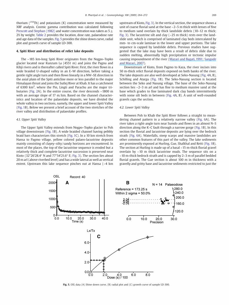
thorium (232Th) and potassium (K) concentration were measured byXRF analysis. Cosmic gamma contribution was calculated followingPrescott and Stephan (1982) and water concentrationwas taken as 5±2% by weight. Table 2 provides the location, dose rate, palaeodose rateand age data of the samples. Fig. 5 provides the shine down curve, radialplot and growth curve of sample LD-300.
4. Spiti River and distribution of relict lake deposits
The ~185 km-long Spiti River originates from the Nogpo–Topkoglacier located near Kunzum La (4551 m) and joins the Pagnu andKibji rivers and is thereafter called Spiti River. First, the river flows in awide braided U-shaped valley in an E–W direction, before taking agentle right angle turn and then flows linearly in a NW–SE direction inthe axial plain of the Spiti anticline more or less parallel to the majorHimalayan thrust and joins the Sutlej River at Khab. It has a catchmentof 6300 km2, where the Pin, Lingti and Parachu are the major tri-butaries (Fig. 2A). In the entire course, the river descends ~1800 mwith an average slope of 17 m/km. Based on the channel character-istics and location of the palaeolake deposits, we have divided thewhole valley in two sections, namely, the upper and lower Spiti Valley(Fig. 1B). Below we present a brief account of the two stretches of theriver valley and distribution of palaeolake profiles.
4.1. Upper Spiti Valley
The Upper Spiti Valley extends from Nogpo–Topko glacier to Pohvillage downstream (Fig. 1B). A wide braided channel having pebblybraid bars characterizes this stretch (Fig. 1C). In a 10 km stretch fromHansa to Pagmo village, yellow colored palaeo-lacustrine depositsmainly consisting of clayey–silty/sandy horizons are encountered. Inmost of the places, the top of the lacustrine sequence is eroded but arelatively thick and complete lacustrine succession is preserved nearKioto (32°26'28.4″ N and 77°54'21.6″ E; Fig. 3). The section lies about20m arl (above riverbed level) and has awide lateral aswell as verticalextent. Upstream this lake sequence pinches out at Hansa (~4 km
Fig. 5. OSL data (A) Shine down curve, (B) radial
upstream of Kioto, Fig. 3). In the vertical section, the sequence shows aunit of coarse fluvial sand at the base ~2–5 m thick with lenses of fineto medium sand overlain by thick landslide debris (10–12 m thick;Fig. 3). The lacustrine silt and clay (~25 m thick) rests over the land-slide unit, which is comprised of laminated clay beds intercalated bymm- to cm-scale laminae in the lower and upper portions. The lakesequence is capped by landslide debris. Previous studies have sug-gested that the lake may have been a result of debris slide due tosudden melting, abnormally high precipitation or tectonic impulsecausing impoundment of the river (Mazari and Bagati, 1991; Sangodeand Mazari, 2007).
Downstream of Kioto, from Pagmo to Kaza, the river incises into50 m-thick relict fluvial deposits exposed on both banks of the river.The lake deposits are also well developed at Seko-Nasung (Fig. 4A, B),Schilling and Atargu (Fig. 1B). The Seko-Nasung section is locatedbetween the Seko and Nasung village. The base of the Seko-Nasungsection lies ~2–3 m arl and has fine to medium massive sand at thebase which grades to fine laminated dark clay bands intermittentlywith some silt beds in between (Fig. 4A, B). A unit of well-roundedgravels caps the section.
4.2. Lower Spiti Valley
Between Poh to Khab the Spiti River follows a straight to mean-dering channel pattern in a relatively narrow valley (Fig. 6A). Theriver takes a right-angle turn near Sumdo and flows in an almost N–Sdirection along the K–C fault through a narrow gorge (Fig. 1B). In thissection the fluvial and lacustrine deposits are lying over the bedrockstrath (Fig. 6A). Waterfalls, steep scarps and massive landslides areother common features of this part of the valley. The lake sedimentsare prominently exposed at Hurling, Gue, Shalkhal and Retti (Fig. 1B).The section at Hurling is made up of a basal ~15 m-thick fluvial graveloverlain by ~10 m thick lacustrine muds. The sequence sits on a~10 m-thick bedrock strath and is capped by 2–3 m of parallel beddedfluvial gravels. The Gue section is about 100 m in thickness with agravelly and gritty base and lacustrine sediments restricted to just the
plot and (C) growth curve of sample LD-300.

Fig. 6. (A) Photograph showing the straight Spiti River channel and associated relictdeposits of ~50 m over the ~40 m bedrock strath at Sumra village in Lower Spiti Valleynear Poh. (B) Top of the lacustrine deposits at Hurling village. Note the age of the lakestrata (scale — the height of the person in the photograph is 167 cm). (C) Seismitesdated to 12 ka exposed at Lingti village.
270 B. Phartiyal et al. / Geomorphology 108 (2009) 264–272
top 20m. The sections at Shalkhal and Retti vary in thickness from ~30to N50 m.
5. Chronology
The topmost clay bed of Kioto section has a radiocarbon age of31880±650 cal. yr BP and the level 7.5 m from the top dates to34,280±740 cal. yr BP (Fig. 3). Varve age estimates from Sangode andMazari, (2007) bracket the lacustrine phase from ~45,000 to 12,800 yrBP, however, no stratigraphy with details on the vertical variations invarve thickness was provided. Three radiocarbon dates for the Seko-Nasung lake section were obtained — the base (0.2 m level) is dated to
29,710±450 cal. yr BP; 1.8 m level dates to 31,250±500 cal. yr BP andthe 3.8 m level is 42,370±3580 cal. yr BP (Fig. 4). These dates show aninverse pattern perhaps because of the contribution of older carbonfrom the carbonate sequences exposed in the catchment. As these lakesoverlie the Kioto limestones of Jurassic age, it is likely that the lakeorganic carbon suffers from the hard water effect (Geyh et al., 1998,1999; Juyal et al., 2004).
The OSL chronology from the base and top of the sequence datedthe Kioto relict lake section to between 13±1 and 7±1 ka, and con-sidering the errors we suggest that the maximum time span duringwhich the lake was sustained at Kioto was 14–6 ka (Fig. 3). The Seko-Nasung sequence yielded bracketing luminescence between 13±2and 8±1 ka (Fig. 4), which, given the associated errors, is comparableto the Kioto palaeolake sequence. In the Lower Spiti Valley, the top ofthe section near Hurling gives an OSL age of 51±5 ka (Fig. 6B)indicating a lacustrine phase ~50 ka in the lower part of the valley.
6. Neotectonic and palaeoseismic evidences
Soft sediment deformation structures (seismites) (Fig. 6C), hang-ing channels, river strath terraces (Fig. 6A), landslides zones, andabrupt shifts in channel pattern (from braided to meandering) arenoticed as evidence of neotectonics in the region. In the fluvio-lacustrine sediments exposed all along the valley, soft sedimentarydeformation structures (seismites) are seen at several levels consistingof convolute structures, flame structures, pseudonodules, micro-faultsand folds, restricted to a single stratigraphic level and bounded byundeformedbeds. In the upper SpityValley, seismic structures are seenat Hansa where the overlying deposits give an OSL age of 7±1 ka. Thethick fluvial section (N100 m) at Sumdo with several levels showingsoft sediment deformation or seismic structures was dated to between80 and 26 ka (Banerjee et al., 1997). The Lower Spiti Valley study areasare also characterized by several indicators of neotectonic activity anduplift- (1) palaeoseismic structures at Retti (Banerjee et al., 1997;Singh and Jain, 2007), (2) Waterfalls, (3) uplifted river terraces andlacustrine deposits, and (4) extensive landslides and debris cones. Thissegment of the river valley is also characterized by several deep andnarrowgorges. The intensityand reoccurrence of deformedbeds in thissector, as comparedwith the Upper Valley, also increases probably dueto close vicinity of the K–C fault and faults associated with Leo Pargilhorst lying further east of the valley in the upper Sutluj basin. Recentinstrumental records over the last five decades also show intenseseismic activity in the region (Ni and Barazangi, 1985; Khatri et al.,1978; Khatri,1999; Bhargavet al.,1978)mainly due tomovement alongthe K–C fault, which has substantially uplifted the sediments.
7. Discussion and conclusion
Spiti River in the semi-arid Trans-Himalayan region receivesannual rainfall ranging from 50–250 mm that increases sharply to800 mm during the Abnormal Monsoon Years (AMYs; see Bookhagenet al., 2005a,b). The modern behavior of Spiti River and similar HigherHimalayan catchments suggests that high intensity episodic rainsduring AMYs leads to excessive erosion, mass wasting and subsequentriver damming and formation of temporary lakes. Therefore a lakerecord in these river valleys may provide a proxy for a phase of highprecipitation in the Trans-Himalayan region. Also the palaeoseismicstructures and geomorphic configurations point towards simulta-neous neotectonic activity in the region. The whole Spiti River wastraversed and mapped for palaeolake deposits where the identifica-tion of palaeolake sequences was based on the sediment character-istics consisting of parallel laminated clayey silt alternating with finesand. The general, the lithostratigraphy consisted of basal poorlysorted boulders interpreted as result of landsliding blocking the river,followed by massive or cross-bedded sand overlain by laminatedclayey silt intercalated with sandy beds marking the river blockade

271B. Phartiyal et al. / Geomorphology 108 (2009) 264–272
and formation of a lake. Well-rounded fluvial gravels often cap thelake sequence. We have identified and mapped many such sedimen-tary sequences. This sequence broadly suggests a series of eventsstarting with a landslide originating from the valley walls followedby river damming and forming of a lake. The topmost fluvial gravelpoints towards the phase when lake was breached and fluvial regimewas re-established.
In the Upper Spiti River valley two thick sections located at Kioto andat Seko-Nasungwere dated using 14C andOSL dating techniques. The 14Ctechnique applied on bulk carbonate derived from the clayey–siltylacustrine facies yielded overestimated ages when compared to agesderived fromOSL technique (Table 1). The OSL chronology suggests thatlacustrine phase existed between 14 and 6 ka. The ~25 m Kioto lakesediments yielded an age of 13±1 ka at the base and 7±1 ka towardsthe topwith a 4.8mm/year (minimum) rate of sedimentation. Similarly,a 9m-thick lake sequenceat Seko-Nasungwasbracketedbetweenb13±2 and N8±1 ka, suggesting a lake lifetime of ~4 ka and with asedimentation rate of 2.3mm/year. The varying sedimentation ratemaybe indicative of the proportionate catchment area of the palaeolake aslandslide driven river blockades may fragment the trunk channel intomore than one catchment of different sizes.
The higher 14C ages may suggest that majority of carbon in the bulksediment is derived from aquatic plants as in lakes that are located in alime-stone catchment, the dissolved bicarbonate containing deadcarbon can get into the aquatic plant organic carbon where and thereis a differential exchange of bicarbonate-derived CO2 and the ambientatmospheric CO2 (Geyh et al., 1998,1999; Juyal et al., 2004). The role ofisotope fractionation can also not be ruled out but it is usually limitedto a few percent while differences seen here are much larger. How-ever, using charcoal from the Schilling and Lingti palaeolake se-quences, ages of 8.7–6.1 cal. ka BP were derived that lie within the agebracket provided by our OSL (see supplementary data of Bookhagenet al., 2005b). This is because charcoal comes from land plants thatwere drawing CO2 from the atmosphere alone (in equilibrium withthe ambient 14C activity) when the plant was alive. Hence, from this14C chronology it can be broadly suggested that in carbonate-dominated country rock, lake terrestrial organic matter is generallyfree of the hard water effect and one should look for such materialwhen dating. In the Lower Spiti valley at Hurling the lake sequencesoverlying the uplifted bedrock straths are OSL dated to 51±5 ka;whilst, a section at Chango yielded a 14C date of ~28 cal. ka BP at the
Fig. 7. Distribution of the palaeolake deposits in Spiti the Upper and Lower Spiti River Valley.climatic ameliorations during Marine Isotope Stage (MIS) 1 and the older (50–30 ka) to the wterrace indicates Late Pleistocene tectonic activity along the K–C fault.
bottom (Bookhagen et al., 2005b). Thus, in this region, the lake-forming phase existed between ~50 and 30 ka.
A reviewof palaeoclimate data of the past 60 ka suggests twomajorphases of intensified monsoon. The period c. 60–28 ka BP, the olderPhase-I, corresponds to wet Marine Isotope Stage-3, and the youngerPhase-II of 12–7 ka BP to Marine Isotope Stage-1 (Prell and Kutzbach,1987; Kotlia et al., 2000; Bookhagen et al., 2005b). The OSL datapresented here and the published monsoon records suggest that lakeexisted at least during two major phases in the Spiti River valley,first around 50–30 ka and then between 14 and 6 ka BP (Fig. 7). Thisindicates a plausible linkage between the formation of these lakesand increased precipitation in the region due to intensified monsoonduring the Late Pleistocene–Holocene. A plausible scenario indicatesthat during the drier climate around the Glacial Phase (prior to 50 kaand prior to 12 ka) when the annual rainfall was below the presentday average, the Spiti valley was hyper arid (rainfall b100 mm/year;Bookhagen et al., 2005a) and the hill slopes were largely devoid ofvegetation. Frost and thaw actions during the extended winters pro-duced massive amount of debris that formed scree slopes and debrisfans on slopes and such conditions continued until the re-strengthen-ing of the monsoon after ~50 ka and 12 ka. The phase of intensifiedmonsoon led to slope failures, massive land sliding and formation ofdammed lakes. The lakes existed until they were silted up with sedi-ment. The lifetime of the lake would depend upon the catchment areathat is feeding the lake.
Formation of lakes due to river blockage by landslides is a pheno-menon that is not uncommon in this region and has been reportedby several workers from different parts of Himalayas (Abbott, 1849;Becher, 1959; Phartiyal et al., 2005,) with recent examples from China.The major causes for landslide-dammed lakes are from excessive pre-cipitation 84% results and earthquakes (84%), from volcanic eruptions(7%) and other causes (9%) (Schuster and Costa, 1986). This was thecase in the year 2004 when the lakes upstream of Parachu overburstand caused intense flooding and great loss of property down-stream ofSutluj river. Therefore excessive precipitation in an otherwise arid zonelike Spiti valley has the potential to produce landslide-dammed lakes.The fluvial sections are associated with the lacustrine phases, both atthe base and at the top, are plausibly indicative of such extremepalaeoenvironment in the Spiti River valley.
Geomorphic studies of the valley showed that river valley profilechanges from U-shaped valley in the upper sections to a narrow V-
Note the two phases of lake formation. The younger phase (14–6 ka) corresponds to theetter conditions prevailed during MIS 2. The preservation of older phase on the uplifted

272 B. Phartiyal et al. / Geomorphology 108 (2009) 264–272
shaped valley when it joins Sutluj river at Khab in the lower part. Thechannel gradient is steeper in the Lower part of the valley with anaverage gradient of 17 m/km. In the Upper valley the fluvio-lacustrinedeposits rise from the riverbed and no bedrock is exposed, and thechannel is braided in character. The Lower valley is characterized by ameandering channel pattern and the river incises the country rocks aswell. This segment is also marked by deep gorges, water falls, fossilvalleys, fluvial bedrock strath terraces and upliftment of the fluvialsediments that provide evidence of neotectonic activity during theLate Pleistocene–Holocene (Banerjee et al., 1997; Singh and Jain,2007). The K–C normal fault passes through the transition zone ofthese channel patterns and therefore it is likely that activity along theK–C fault would have resulted in the uplift and incision of the relictlake deposits in the lower Spiti valley. This uplift-driven deformationled to the formation of a narrow channel with relatively high streampower that possibly prohibited the representation of younger lacus-trine phase in the lower part of the valley.
The lake deposits in the Lower Spiti valley, overlying the elevatedbedrock and are dated to ~30–50 ka, suggests a Late Pleistocenetectonic activity and uplift along the K–C fault. Recent instrumentalrecords over the last five decades show intense seismic activity in theregion (Ni and Barazangi, 1985; Khatri et al., 1978; Bhargav et al., 1978;Khatri, 1999) mainly due to movement along the K–C fault, which hassubstantially uplifted the sediments. The palaeoseismic activity is alsopreserved as seismites at several levels in the fluvial sequences allalong the valley (Banerjee, et al., 1997; Singh and Jain, 2007). Theintensity and reoccurrence of deformed beds increases in the lowerand middle valley as compared to the upper parts of the valley prob-ably due to close vicinity of the K–C fault and faults associated withLeo Pargil horst lying further east of the valley in the upper Sutlujbasin. Palaeoseismic structures dated to ~12 ka in the Lingti–Lalungroad section suggest that the K–C fault, since its inception at ~2 Ma,has been active throughout the Pleistocene–Holocene and duringinstrumental times.
Acknowledgments
Our sincere thanks to the Directors, Birbal Sahni Institute ofPalaeobotany, Lucknow and Wadia Institute of Himalayan Geology,Dehradun for the encouragement and support for carrying out thisstudy. Comments from the two anonymous reviewers helped in im-proving the manuscript.
References
Abbott, J., 1849. Report on the cataclysm of the Indus taken from the lips of an eyewitness.Journal of the Asiatic Society of Bengal XVII, 231–233.
Aitken, M.J., 1998. An Introduction to Optical Dating. Academic Press, London.Bagati, T.N., Thakur, V.C., 1993. Quaternary basins of Ladakh and Lahul-Spiti in north-
western Himalaya. Current Science 64, 898–903.Banerjee, D., Shinghvi, A.K., Bagati, T.N., Mohindra, R., 1997. Luminescence chronology of
seismites in Sumdo (Spiti valley) near Kaurik-Chango Fault, northwestern Himalaya.Current Science 73, 276–281.
Becher, J., 1959. The flooding of the Indus. Letter addressed to R.H. Davis, Secretary of theGovernment of the Punjab and its dependencies. Journal of the Asiatic Society ofBengal XXVIII, 219–228.
Bhargava, O.N., 1990. Holocene tectonics south of the Indus Suture, Lahaul-LadakhHimalaya, India: a consequence of Indian Plate motion. Tectonophysics 174, 315–320.
Bhargava, O.N., Bassi, U.K., 1998. Geology of Spiti-Kinnaur, Himachal Himalaya. GeologicalSurvey of India Memoirs 124, 1–210.
Bhargav, O.N., Ameta, S.S., Gaur, R.K., Kumar, S., Agrawal, A.N., Jalote, P.M., Sadhu,M.L.,1978.TheKinnaur (H.P. India) earthquake of 19 January 1975: summary of geoseismologicalobservations. Bulletin Indian Geological Association 11, 39–53.
Bookhagen, B., Thiede, R., Strecker, M.R., 2005a. Abnormal monsoon years and theircontrol on erosion and sediment flux in the high, arid northwestern Himalaya.Earth and Planetary Science Letters 231, 131–146.
Bookhagen, B., Thiede, R.C., Strecker, M.R., 2005b. Late Quaternary intensified monsoonphases control landscape evolution in the northwest Himalaya. Geology; 33,149–152.
Dortch, J.M., Owen, L.A., Haneberg,W.C., Caffee, M.W., Dietsch, C., Kamp, U., 2008. Natureand timing of large landslides in the Himalaya and Transhimalaya of northern India.Quaternary Science Reviews. doi:10.1016/j.quascirev.2008.05.002.
Duller, G.A.T., 2008. Single-grain optical dating of Quaternary sediments: why aliquotsize matters in luminescence dating. Boreas 37, 589–612.
Geyh, M.A., Schotterer, U., Grosjean, M., 1998. Temporal changes of the 14C reservoireffect in lakes. Proceedings 16th International Radiocarbon Conference, Groningen.Radiocarbon, vol. 40, pp. 921–931.
Geyh,M.A., Grosjean,M., Núñez, L., Schotterer, U.,1999. Radiocarbon reservoir effect andthe timing of the Late-Glacial/Early Holocene humid phase in the Atacama Desert(Northern Chile). Quaternary Research 52, 143–153.
Jain, A.K., Singh, S., Manickavasagam, R.M., Joshi, M., Verma, P.K., 2003. HIMPROBEprogramme: integrated studies on geology, petrology, geochronology and geophysicsof the TransHimalaya and theKarakoraum.MemoirGeological Societyof India53,1–56.
Jaiswal, M.K., Srivastava, P., Tripathi, J.K., Islam, R., 2008. Feasibility of the SAR technique onquartz sand of Terraces of NW Himalaya: a case study from Deoprayag. Geochrono-metria 31, 45–52.
Juyal, N., Pant, R.K., Basavaiah, N., Yadava, M.G., Saini, N.K., Singhvi, A.K., 2004. Climateand Seismicity in theHigher Central Himalaya during the last 20 kyr: evidences fromGarbyang basin, Uttaranchal, India. Palaeogeography, Palaeoclimatology, Palaeoe-cology 213, 315–330.
Khatri, K.N.,1999. Probabilities of occurrenceof great earthquake in theHimalaya. Proceedingsof Indian Academy of Science (Earth Planetary Sciences) 108, 87–92.
Khatri, K.N., Rai, K., Jain, A.K., Sinvhal, H., Gaur, V.K., Mithal, R.S., 1978. The Kinnaurearthquake, Himachal Pradesh India of 19 January, 1975. Tectonophysics 49, 1–21.
Kotlia, B.S., Sharma, C., Bhalla, M.S., Rajagopalan, G., Subrahmanyam, K., Bhattacharyya, A.,Valdiya, K.S., 2000. Palaeoclimatic conditions in the late Pleistocene Wadda Lake,eastern Kumaun Himalaya (India). Palaeogeography, Palaeoclimatology, Palaeoecol-ogy 162, 105–118.
Leech, M.L., Singh, S., Jain, A.K., Klamperer, S.L., Manickavasagam, R.M., 2005. The onset ofIndia–Asia continent collision: early, steep subduction by the timing of UHPmetamorphism in the western Himalaya. Earth Planetary Science Letters 234, 83–97.
Mazari, R.K., Bagati, T.N., 1991. Post-collision graben development in the Spiti valley,Himachal Pradesh. Journal of Himalayan Geology 2, 111–117.
Mohindra, R., Bagati, T.N.,1996. Seismically induced soft-sediment deformation structures(seismites) around Sumdo in the lower Spiti valley (Tethys Himalaya). SedimentaryGeology 101, 69–83.
Murray, A.S., Wintle, A.G., 2000. Luminescence dating of quartz using an improvedsingle aliquot regenerative-dose protocol. Radiation Measurement 32, 57–73.
Ni, J., Barazangi, M., 1985. Active tectonics of western Tethyan Himalaya above theunderthrusting Indian plate: the upper Sutluj river basin as a pull apart structure.In: Kobayashi, K., Sacks, I.S. (Eds.), Structures and Processes in Subduction Zones.Tectonophysics, vol. 112, pp. 277–295.
Phartiyal, B., Sharma, A., Upadhyay, R., Ram-Awatar, Sinha, A.K., 2005. Quaternarygeology, tectonics and distribution of palaeo- and present fluvio/glacio lacustrinedeposits in Ladakh, NW Indian Himalaya — a study based on field observations.Geomorphology 65, 241–256.
Prell, W.L., Kutzbach, J.E., 1987. Monsoon variability over the past 150,000 years. Journalof Geophysical Research 92, 8411–8425.
Prescott, J.R., Stephan, L.G.,1982. The contribution of cosmic radiation to the environmentaldose of thermoluminecencedating: latitude, altitude anddepthdependencies. PACT6,17–25.
Sangode, S.J., Mazari, R.K., 2007. Mineral magnetic response to climate variability in thehigh altitude Kioto palaeolake, Spiti valley, Northwestern Himalaya. HimalayanGeology 28, 1–9.
Schuster, R.L., Costa, J.E., 1986. A perspective on landslide dams. In: Schuster, R.L. (Ed.),Landslide Dams: Processes, Risk, and Mitigation Geotechnical Special Publication 3.American Society of Civil Engineering, New York, pp. 1–20.
Singh, S., Jain, A.K., 2007. Liquefaction and fluidization of lacustrine deposits fromLahaul-Spiti and Ladakh Himalaya: geological evidences of palaeoseismicity alongactive fault zone. Sedimentary Geology 196, 47–57.
Sinha, A.K., 1989. Geology of Higher Central Himalaya. John Wiley and Sons. 219 pp.Steck, A., Epard, J.-L., Vannay, J.-C., Hunziker, J., Girard, M., Morard, A., Robry, M., 1998.
Geological Transect across the Tso-Morari and Spiti areas: the nappe structures ofthe Tethyan Himalaya. Eclogae. Geologicae Helvetiae 91, 103–121.
Srivastava, P., Misra, D.K., 2008. Morpho-sedimentary records of active tectonics at theKameng river exit, NE Himalaya. Geomorphology 96, 187–198.
Srivastava, P., Brook, G.A., Marais, E., Morthekai, P., Singhvi, A.K., 2006. Depositionalenvironment and OSL chronology of Homeb silt deposits, Kuiseb River, Namibia.Quaternary Research, 65, 478–491.
Srivastava, P., Tripathi, J.K., Islam, R., Jaiswal, M.K., 2008. Fashion and phases of LatePleistocene aggradation and incision in Alaknanda River, western Himalaya, India.Quaternary Research 70, 68–80.
Srivastava, P., Bhakuni, S.S., Luirei, K.,Misra, D.K., 2009. Fluvial records from theBrahmaputraRiver exit, NE Himalaya: climate-tectonic interplay during Late Pleistocene–Holocene.Journal of Quaternary Science 24, 175–188.
Srikantia, S.V., 1981. The lithostratigraphy, sedimentation and structure of Protozoic–Phenerozoic formations of Spiti Basin in the Higher Himalaya of Himachal Pradesh,India. In: Sinha, A.K. (Ed.), Contemporary Geoscientific Research In Himalaya.Bishen Singh Mehendrapal Singh, Dehra Dun, pp. 31–48.
Stuiver, M., Reimer, P.J., 1993. Extended 14C data base and revised CALIB 3.0 14C agecalibration program. Radiocarbon 35, 215–230.
Thiede, R., Bookhagen, B., Arrowsmith, J., Sobel, E., Strecker, M.R., 2004. Climatic controlon rapid exhumation along the Southern Himalayan Front. Earth and PlanetaryScience Letters 222, 791–806.
Thiede, R.C., Arrowsmith, J.R., Bookhagen, B., Mc-Williams, M., Sobel, E.R., Strecker, M.R.,2006. Dome formation and extension in the Tethyan Himalaya, Leo Pargil,northwest India. Bulletin Geological Society of America 118, 635–650.