Prolegomena to sediment and flow connectivity in the landscape: A GIS and field numerical assessment
Upload
independentCategory
view
0download
0
Chapter 13Landscape Approaches and GIS for BiodiversityManagement
Stefan Schindler, Kostas Poirazidis, Aristotelis Papageorgiou, DionisiosKalivas, Henrik Von Wehrden, and Vassiliki Kati
13.1 Landscape Approaches for Biodiversity Management
Landscape approaches and geographical information systems (GIS) have been play-ing an increasing role in biogeography and conservation biology over the lastdecade (Gaston, 2000; Foody, 2008; Gillespie, Foody, Rocchini, Giorgi, & Saatchi,2008). Within this period, the number of papers using GIS published in the journalLandscape Ecology has roughly doubled (Anderson, 2008). Especially remote-sensing applications have grown in importance within recent years. Remote sensingnow routinely provides environmental information ranging from global to localscales, and geographical information systems provide, among other applications,necessary interfaces to store, analyse and visualise spatial data; increased com-putational capacities triggered even more such applications. In this chapter, wedemonstrate how the combination of landscape approaches, remote sensing and GISaids conservation and management of biodiversity. We therefore summarise six casestudies from Dadia National Park (Dadia NP), in north-eastern Greece. The studiesaimed at (1) modelling of nesting habitat for a flagship species, (2) evaluation ofland-use change, (3) detecting statistical dimensions and spatial patterns of land-scape structure, (4) testing the performance of landscape metrics as indicators ofbiodiversity, (5) developing a GIS approach for a systematic raptor monitoring, and(6) developing a decision-support system to optimise conservation of biodiversityin managed forests.
13.2 Study Area and GIS Data
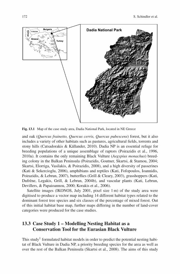
The study area, the Dadia NP, is situated in the Evros prefecture in north-easternGreece (Fig. 13.1). Its extent of about 430 km2 includes two strictly protectedcore areas covering 73.5 km2. The mountainous area (altitudes ranging from 20to 645 m above sea level) is covered by extensive pine (Pinus brutia, P. nigra)
S. Schindler (B)Department of Conservation Biology, Vegetation & Landscape Ecology, University of Vienna,Rennweg 14, A-1030, Vienna, Austriae-mail: [email protected]
171J. Andel et al. (eds.), Landscape Modelling, Urban and Landscape Perspectives 8,DOI 10.1007/978-90-481-3052-8_13, C© Springer Science+Business Media B.V. 2010
172 S. Schindler et al.
Fig. 13.1 Map of the case study area, Dadia National Park, located in NE Greece
and oak (Quercus frainetto, Quercus cerris, Quercus pubescens) forest, but it alsoincludes a variety of other habitats such as pastures, agricultural fields, torrents andstony hills (Catsadorakis & Källander, 2010). Dadia NP is an essential refuge forbreeding populations of a unique assemblage of raptors (Poirazidis et al., 1996,2010a). It contains the only remaining Black Vulture (Aegypius monachus) breed-ing colony in the Balkan Peninsula (Poirazidis, Goutner, Skartsi, & Stamou, 2004;Skartsi, Elorriga, Vasilakis, & Poirazidis, 2008), and a high diversity of passerines(Kati & Sekercioglu, 2006), amphibians and reptiles (Kati, Fofopoulos, Ioannidis,Poirazidis, & Lebrun, 2007), butterflies (Grill & Cleary, 2003), grasshoppers (Kati,Dufrêne, Legakis, Grill, & Lebrun, 2004b), and vascular plants (Kati, Lebrun,Devillers, & Papaioannou, 2000; Korakis et al., 2006).
Satellite images (IKONOS, July 2001, pixel size 1 m) of the study area weredigitised to produce a vector map including 14 different habitat types related to thedominant forest tree species and six classes of the percentage of mixed forest. Outof this initial habitat base map, further maps differing in the number of land-covercategories were produced for the case studies.
13.3 Case Study 1 – Modelling Nesting Habitat as aConservation Tool for the Eurasian Black Vulture
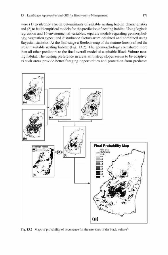
This study1 formulated habitat models in order to predict the potential nesting habi-tat of Black Vulture in Dadia NP, a priority breeding species for the area as well asover the rest of the Balkan Peninsula (Skartsi et al., 2008). The aims of this study
13 Landscape Approaches and GIS for Biodiversity Management 173
were (1) to identify crucial determinants of suitable nesting habitat characteristicsand (2) to build empirical models for the prediction of nesting habitat. Using logisticregression and 16 environmental variables, separate models regarding geomorphol-ogy, vegetation types, and disturbance factors were obtained and combined usingBayesian statistics. At the final stage a Boolean map of the mature forest refined thepresent suitable nesting habitat (Fig. 13.2). The geomorphology contributed morethan all other predictors to the final overall model of a suitable Black Vulture nest-ing habitat. The nesting preference in areas with steep slopes seems to be adaptive,as such areas provide better foraging opportunities and protection from predators
Fig. 13.2 Maps of probability of occurrence for the nest sites of the black vulture3
174 S. Schindler et al.
(Hiraldo & Donázar, 1990; Fargallo, Blanco, & Soto-Largo, 1998; Donázar, Blanco,Hiraldo, Soto-Largo, & Oria, 2002). The results of this study were used to improveBlack Vulture Monitoring, forest management and the zonation of the National Park.
13.4 Case Study 2 – Forest Re-growth Since 1945 in the DadiaForest Nature Reserve
In this study,2 the focus was drawn on the interpretation of aerial photographs andsatellite images in order to identify land-use patterns in Dadia NP for 1945, 1973 and2001, and thus to quantify the land-use changes among these years. The landscapewas classified to the three categories forest, openings, and agricultural land, andthe most obvious change was a dramatic decline in forest openings (Table 13.1),caused mainly by land abandonment and reforestation programs. During a periodof 50 years, the landscape lost part of its characteristic heterogeneity and mosaic-structured character, landscape qualities that are very important for the maintenanceof biodiversity of several groups of organisms (Atauri & De Lucio, 2001; Torras,Gil-Tena, & Saura, 2008).
Table 13.1 Land-use change in Dadia National Park from 1945 to 2001
Land use Zone 1945 1945–1973 1973 1973–2001 2001
[km2] [%] [km2] [%] [km2]
Forest Core area 37.7 +33 50.1 +20 60.2Buffer zone 160.5 +15 183.9 +37 251.2Total area 198.2 +18 234.0 +33 312.6
Openings Core area 33.3 –40 20.1 –50 10.1Buffer zone 119.4 –27 87.0 –67 28.6Total area 152.7 –30 107.1 –64 38.7
Agricultural land Core area 1.9 +43 2.7 –40 1.6Buffer zone 76.4 +12 85.4 –21 67.2Total area 78.3 +13 88.1 –22 69.0
13.5 Case Study 3 – Towards a Core Set of Landscape Metricsfor Biodiversity Assessments: A Case Study from DadiaNational Park
Landscape metrics in the GIS environment can be used to facilitate the investigationof the relation between landscape structure and biodiversity (Hill & Curran, 2003;Honnay, Piessense, & Landuy, 2003). Data reduction analyses have been applied totackle the problem of highly correlated indices (Riitters, Neill, & Hunsaker, 1995;Cushman, McGarigal, & Vell, 2008), but valid landscape predictors for fine-scaleMediterranean forest-mosaics have been missing. In this study,4 we used a widearray of related variables of landscape structure, (1) to investigate correlations and
13 Landscape Approaches and GIS for Biodiversity Management 175
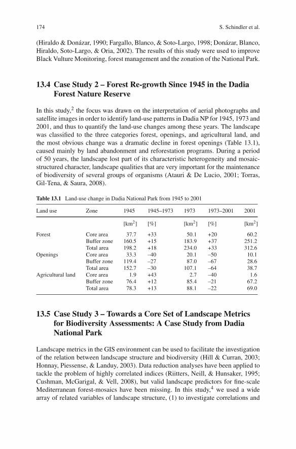
statistical dimensions of landscape structure at landscape and class level, (2) to pro-vide a core set of representative variables, (3) to evaluate the stability of the detecteddimensions across scales, and (4) to describe the characteristic landscape pattern ofDadia NP. Therefore, we produced a map of nine land-cover categories that we con-verted to raster format with a grain of 5 m. We used FRAGSTATS (McGarigal &Marks, 1995) for the computation of the 119 landscape metrics investigated in thestudy and applied correlation analysis and factor analysis, regarding both landscapeand class level metrics in a parallel way. Landscape diversity, edge contrast (a mea-sure related to fragmentation) and area-weighted mean patch shape were stableat landscape level across the three tested scales. The representative set of metricsconsisted of Simpson’s Diversity Index, Mean Edge Contrast Index, and the Area-Weighted Mean Shape Index. The pattern analysis revealed a dispersed pattern forlandscape diversity, with high values in the vicinity of the borders between coreareas and the buffer zone, and a clustered pattern for edge contrast, presenting agradient from the unfragmented core areas to the agricultural land in the east of thereserve (Fig. 13.3).
Fig. 13.3 Pattern of the main dimensions of landscape structure in Dadia National Park. (a)Landscape diversity (Factor 1) and (b) edge contrast (Factor 2)
13.6 Case Study 4 – Testing the Performance of LandscapeMetrics as Indicators for Biodiversity
Since only some empirical studies tested the relations between landscape structureand the species diversity of multiple taxa (Hernández-Stefanoni, 2006; Yamaura,
176 S. Schindler et al.
Amano, & Katoh, 2008), we tried to fill this gap in this case study.5 We anal-ysed the relations of 52 landscape structure variables with overall biodiversityand with species richness of the six taxa woody plants, orchids, orthopterans,amphibians, reptiles and birds. Species data were collected by Kati et al. (2004a),based on standard methods; landscape structure variables were computed for circu-lar areas of five different extents around the sampling plots. For each taxon thespecies richness was modelled with each individual landscape variable at eachscale as the predictor, based on a linear mixed model using the software R (RDevelopment Core Team, 2008). Additionally, we tested the performance of setsof three landscape-structure variables as predictors of species richness, using AICto compare sets composed by different methods such as expert knowledge, severalmethods of ordination (see previous case study or Schindler, Poirazidis, & Wrbka,2008), decision trees, random choice, and optimal sets after testing all possiblecombinations.
In this study, landscape metrics proved to be good indicators of species richnessregarding the taxa woody plants, orthopterans, reptiles and for overall biodiversity.Metrics regarding patch shape, proximity, texture and diversity resulted frequentlyin significant univariate models, while metrics regarding similarity or edge con-trast hardly contributed to significant models. Our results revealed that the scaleaffected the performance of landscape metrics. Woody plants, orthopterans and birdswere better predicted at smaller scales, while reptiles were predicted best at largerscales. Regarding the different methods of composing sets, optimal sets performedalways significantly better than all other methods. The statistical methods performedslightly better than random choice, while the expert knowledge performed slightlyworse than random. The revealed pattern of relations and performances will beuseful to understand landscape structure as driver and indicator of biodiversity,and to improve management decisions in Mediterranean forests and similar mosaiclandscapes.
13.7 Case Study 5 – Development of a Geographic InformationSystem for Territory Analysis of Raptor Species
Dadia National Park is well known for its high diversity of breeding birds of prey,a community in total exceeding 300 territories (Poirazidis et al., 2010a). An inte-grated monitoring plan was implemented by WWF – Greece in 1999, aiming atthe effective conservation of biodiversity and ecological values of the area. In thiscase study6 we describe the development of a GIS approach to estimate the terri-tories of breeding raptors. All raptors within 34 permanent plots were counted andeach plot was censused five times during the breeding seasons 2001–2005. Raptorobservations were labelled in GIS, showing flight trajectories, possible nest sites,the number of synchronously observed individuals, age, sex, and different terri-torial activities under different symbols to enable analyses that consider all theinformation obtained in the field. The progressive analysis per species was based
13 Landscape Approaches and GIS for Biodiversity Management 177
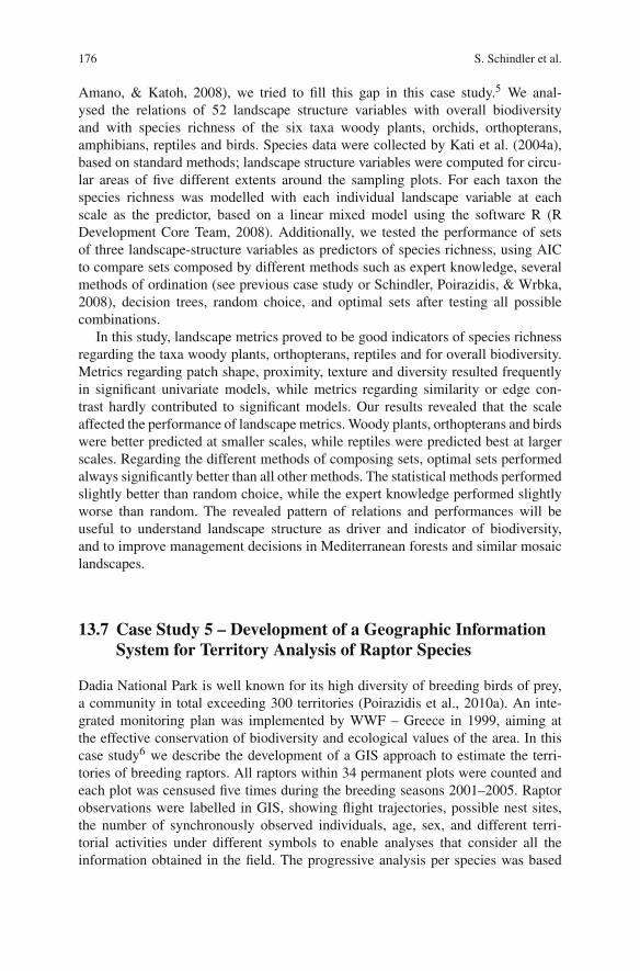
on eight criteria related to territorial behaviour, general observations and biologyof the species as well as to landscape features (Poirazidis et al., 2006, 2010c).Breeding territories were differently classified as confirmed or possible. The GISapproach for estimating raptor territories was particularly effective for strictly ter-ritorial species like most of the eagles, buzzards, hawks, and falcons (Table 13.2).Less territorial species, such as the Egyptian Vulture (Neophron percnopterus) andthe Short-toed Eagle (Circaetus gallicus) demanded a large amount of data to enableprecise territory estimations.
Table 13.2 Summary of the species-specific problems and advantages of the GIS-basedmethodology for the estimation of raptor population sizes at local scale (values are scaled from1 = not any to 6 = very high)
SpeciesProblems withlow territoriality
Problems withsecretiveness orlate arrival
Frequent keyobservations,high accuracy
Total usefulnessGIS method
White-tailed Eagle 4 2 4 4Golden Eagle 1 2 4 6Imperial Eagle 2 5 4 4Lesser spotted Eagle 3 2 5 6Short-toed Eagle 5 1 4 4Booted Eagle 2 3 4 5Egyptian Vulture 6 3 6 5Common Buzzard 2 1 5 6Long-legged Buzzard 2 3 5 6Honey Buzzard 2 5 4 4Black Kite 6 3 2 3Marsh Harrier 5 2 2 3Goshawk 1 4 3 4Levant Sparrowhawk 2 6 3 3Sparrowhawk 2 4 3 4Peregrine Falcon 3 2 5 6Lanner Falcon 2 2 5 6Hobby 1 5 3 4Eurasian Kestrel 1 2 4 6Black Stork 6 1 4 4
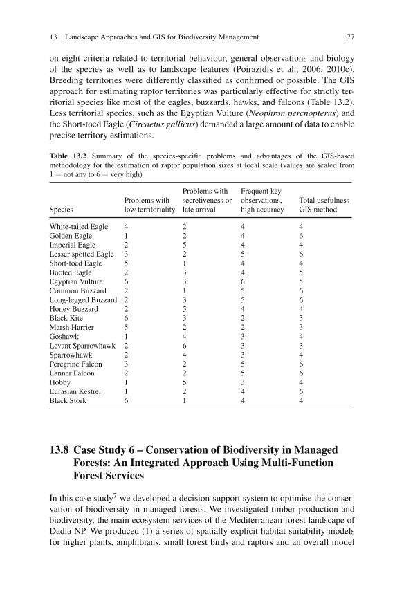
13.8 Case Study 6 – Conservation of Biodiversity in ManagedForests: An Integrated Approach Using Multi-FunctionForest Services
In this case study7 we developed a decision-support system to optimise the conser-vation of biodiversity in managed forests. We investigated timber production andbiodiversity, the main ecosystem services of the Mediterranean forest landscape ofDadia NP. We produced (1) a series of spatially explicit habitat suitability modelsfor higher plants, amphibians, small forest birds and raptors and an overall model
178 S. Schindler et al.
for total local biodiversity, (2) maps related to timber production and (3) threemanagement scenarios and a decision-support system based on a conflict assess-ment. Thus, we were able to establish integrated management concepts, and toassess the effects of different management strategies on the two main ecosystemservices.
Fig. 13.4 Map of Dadia NP after the trade-off scenario considering conservation of biodiversityand timber production
13 Landscape Approaches and GIS for Biodiversity Management 179
Spatial modelling was based on data of several systematic field surveys. Weused 23 eco-geographical variables to derive predictors for species habitat suit-ability, and modelled five taxa as surrogates for the total biodiversity in DadiaNP, namely grasses and shrubs (combined later to “higher plants”), amphibians,small forest birds (mainly Passerines) and raptors. For the three groups of faunawe created species distribution maps, while regarding plant species we used theaccumulated number of plant species as a proxy of biodiversity. For the raptor dataset (Poirazidis et al., 2006) we pooled data from 5 years and plotted the centreof their yearly territories. All the data were converted to a raster grain of 50 ×50 m, and Environmental Niche Factor Analysis (ENFA) was performed within theBIOMAPPER software (version 3.2; Hirzel, Hausser, Chessel, & Perrin, 2002). Thetotal timber standing volume per sub-section was estimated using the official forestservice inventory for the current forest management plan 2006–2016. The relativethematic maps were classified into four bins, (1) unsuitable, (2) marginal, (3) suit-able and (4) optimal regarding habitat suitability, and (1) minimum, (2) medium,(3) large and (4) maximum regarding timber stand volume. We considered fourdifferent forest-management actions at the stand level: management (1) without lim-itations, (2) with temporal restrictions, (3) with temporal and spatial restrictions and(4) focused on the ecological values. Three general management scenarios wereformulated: Conservation, timber production and trade off. A major output wasthe map of the proposed forest-management categories of the trade-off scenario(Fig. 13.4).
13.9 Conclusions and Implications for Biodiversity Management
Landscape approaches involving GIS and integrated statistical approaches provedto be useful to understand the relations of pattern and changes of landscape struc-ture with the present biodiversity and the habitat suitability for different groupsof organisms. This knowledge was essential to establish conservation strategiesfor biodiversity, for instance regarding the maintenance of habitat heterogeneityin both the core and buffer zone of the reserve (Grill & Cleary, 2003; Kati et al.,2004b; Kati and Sekercioglu, 2006), and for the optimisation of other ecosys-tem services such as timber production. Habitat suitability modelling for selectedgroups of organisms to develop management scenarios for managed forests is highlyrecommendable.
Landscape surveillance should be integrated into the ecological monitoring ofkey and indicator species to aid the evaluation of the management effects on bothforest and wildlife. Further research regarding species, taxa and landscape indicatorson a larger scale would be desirable to further extrapolate and validate the mod-els, and enable an even more complete strategy for biodiversity conservation andmanagement.
Acknowledgements We are very grateful to the colleagues and volunteers from WWFGreece/Dadia project who collaborated in the case studies described herein. We thank ChristaRenetzeder for her helpful comments on a previous version of the manuscript.
180 S. Schindler et al.
Notes
1. This and the following case studies draw upon the already published papers. Thus, for eachstudy we indicate the concrete reference. Study 1 emerges from Poirazidis et al. (2004).
2. Triantakonstantis et al. (2006).3. (a) A geomorphological model, (b) a vegetation-type model, (c) a model combining a and b,
(d) a disturbance model, (e) a model combining c and d, (f) a Boolean map of mature forest,and (g) the final map combining e and f.
4. Schindler et al. (2008).5. Schindler et al. (2009).6. Poirazidis et al. (2006, 2009).7. Poirazidis et al. (2008, 2010b).8. The managed forests are categorised into the four management options free forestry, temporal
restrictions, temporal and spatial restrictions, and ecological management.
References
Anderson, B. J. (2008). Research in the journal landscape ecology, 1987–2005. LandscapeEcology, 23(2), 129–134.
Atauri, J. A., & De Lucio, J. V. (2001). The role of landscape structure in species richness distribu-tion of birds, amphibians, reptiles and lepidopterans in Mediterranean landscapes. LandscapeEcology, 16(2), 147–159.
Catsadorakis, G., & Källander, H. (2010). The Dadia – Lefkimi – Soufli forest national park.Greece: Biodiversity, Management and Conservation. WWF Greece, Athens, Greece (in press).
Cushman, S. A., McGarigal, K., & Neel, M. C. (2008). Parsimony in landscape metrics: Strength,universality, and consistency. Ecological Indicators, 8(5), 691–703.
Donázar, J. A., Blanco, G., Hiraldo, F., Soto-Largo, E., & Oria, J. (2002). Effects of forestry andother land-use practices on the conservation of Cinereous Vultures. Ecological Applications,12(5), 1445–1456.
Fargallo, J. A., Blanco, G., & Soto-Largo, E. (1998). Forest management effects on nesting habitatselected by Eurasian Black Vultures Aegypius monachus in central Spain. Journal of RaptorResearch, 32(3), 202–207.
Foody, G. M. (2008). GIS: Biodiversity applications. Progress in Physical Geography, 32(2), 223–235.
Gaston, K. J. (2000). Global patterns in biodiversity. Nature, 405, 220–227.Gillespie, T. W., Foody, G. M., Rocchini, D., Giorgi, A. P., & Saatchi, S. (2008). Measuring and
modeling biodiversity from space. Progress in Physical Geography, 32(2), 203–221.Grill, A., & Cleary, D. F. R. (2003). Diversity pattern in butterfly communities of the Greek nature
reserve Dadia. Biological Conservervation, 114(3), 427–436.Hernández-Stefanoni, J. L. (2006). The role of landscape patterns of habitat types on plant species
diversity of a tropical forest in México. Biodiversity and Conservation, 15(4), 1441–1458.Hill, J. L., & Curran, P. J. (2003). Area, shape and isolation of tropical forest fragments. Effects
on tree species diversity and implications for conservation. Journal of Biogeography, 30(9),1391–1403.
Hiraldo, F., & Donázar, J. A. (1990). Foraging time in the Cinereous Vulture Aegypius monachus:Seasonal and local variations and influence of weather. Bird Study, 37, 128–132.
Hirzel, A. H., Hausser, J., Chessel, D., & Perrin, N. (2002). Ecological-niche factor analysis: Howto compute habitat suitability maps without absence data?. Ecology, 83(7), 2027–2036.
Honnay, O., Piessens, K., & Landuyt, W. V. (2003). Satellite based land use and landscapecomplexity indices as predictors for regional plant species diversity. Landscape and UrbanPlanning, 63(4), 241–250.
13 Landscape Approaches and GIS for Biodiversity Management 181
Kati, V., Lebrun, P., Devillers, P., & Papaioannou, H. (2000). Les orchidées de la réserve de Dadia(Grèce), leurs habitats et leur conservation. Les Naturalistes Belges, 81, 269–282.
Kati, V., Devillers, P., Dufrene, M., Legakis, A., Vokou, D., & Lebrun, P. (2004a). Testing the valueof six taxonomic groups as biodiversity indicators at a local scale. Conservation Biology, 18(3),667–675.
Kati, V., Dufrêne, M., Legakis, A., Grill, A., & Lebrun, P. (2004b). Conservation management forOrthoptera in the Dadia reserve, Greece. Biological Conservation, 115(1), 33–44.
Kati, V., Fofopoulos, J., Ioannidis, Y. H. P., Poirazidis, K., & Lebrun, P. (2007). Diversity, ecolog-ical structure and conservation of herpetofauna in a Mediterranean area (Dadia National Park,Greece). Amphibia-Reptilia, 28(4), 517–529.
Kati, V., & Sekercioglu, C. H. (2006). Diversity, ecological structure, and conservation of thelandbird community of Dadia reserve, Greece. Diversity and Distribution, 12(5), 620–629.
Korakis, G., et al. (2006). Floristic records from Dadia-Lefkimi-Soufli National Park, NE Greece.Flora Mediterranea, 16, 11–32.
McGarigal, K., & Marks, B. (1995). FRAGSTATS: Spatial pattern analysis program for quantifyinglandscape structure, USDA Forest Service General Technical Report PNW-GTR-351, PacificNorthwest Research Station, Portland.
Poirazidis, K., Skartsi, T., Pistolas, K., & Babakas, P. (1996). Nesting habitat of raptors in Dadiareserve, NE Greece. In J. Muntaner & J. Mayol (Eds.), Biología y Conservación de las RapacesMediterraneas, 1994 (Vol. 4, pp. 325–333), Monografías, SEO, Madrid.
Poirazidis, K., et al. (2006). Development of a geographic information system for territory analysisof raptor species (pp. 15–15), Proceedings of the 21st European conference for ESRI users,ESRI, Marathon, Athens.
Poirazidis, K., et al. (2008). Conservation of biodiversity in managed forests: An integratedapproach using multi-function forest services. In J. Chen, S., Liu, R. Lucas, P. Sun, R.Lafortezza, & L. Delp (Eds.), Proceedings of the international conference landscape ecologyand forest management: Challenges and solutions (pp. 142–143). Chengdu: IUFRO LandscapeEcology.
Poirazidis, K., et al. (2010a). Diurnal birds of prey in Dadia-Lefkimi-Soufli National Park:Long-term population trends and habitat preferences. In: G. Catsadorakis, & H. Källander(Eds.), The Dadia-Lefkimi-Soufli Forest National Park, Greece: Biodiversity, management andconservation (pp.151–168). Greece: WWF, Athens.
Poirazidis, K., et al. (2010b). Conservation of biodiversity in managed forests: Developing anadaptive decision support system. In C. Li, R. Lafortezza, & J. Chen (Eds.), Landscape ecologyin forest management and conservation. Challenges and solutions for global change (pp. 103–114). Berlin, Heidelberg, New York: Higher Education Press – Springer.
Poirazidis, K., et al. (2009). Monitoring breeding raptor populations – a proposed methodologyusing repeatable methods and GIS. Avocetta 33 (in press).
Poirazidis, K., Goutner, V., Skartsi, T., & Stamou, G. (2004). Modelling nesting habitat as a con-servation tool for the Eurasian black vulture (Aegypius monachus) in Dadia Nature Reserve,northeastern Greece. Biological Conservation, 118(2), 235–248.
R Development Core Team (2008). R: A Language and Environment for Statistical Computing. RFoundation for Statistical Computing, Vienna, Austria, http://www.R-project.org
Riitters, K. H., Neill, R. V., & Hunsaker, C. T. (1995). A factor analyses of landscape pattern andstructure metrics. Landscape Ecology, 10(1), 23–39.
Schindler, S., Poirazidis, K., & Wrbka, T. (2008). Towards a core set of landscape metrics for bio-diversity assessments: A case study from Dadia National Park, Greece. Ecological Indicators,8(5), 502–514.
Schindler, S., Kati, V., vonWehrden, H., & Wrbka, T. (2009). Landscape metrics as biodiversityindicators for plants, insects and vertebrates at multiple scales. In J. Breuste, M. Kozová, & M.Finka (Eds.), European landscapes in transformation: Challenges for landscape ecology andmanagement (pp. 228–231). European IALE Conference 2009, Salzburg, Austria & Bratislava,Slovakia.

182 S. Schindler et al.
Skartsi, T., Elorriaga, J., Vasilakis, D., & Poirazidis, K. (2008). Population size, breeding rates andconservation status of Eurasian black vulture in the Dadia National Park, Thrace, NE Greece.Journal of Natural History, 42(5–8), 345–353.
Torras, O., Gil-Tena, A., & Saura, S. (2008). How does forest landscape structure explain treespecies richness in a Mediterranean context? Biodiversity and Conservation, 17(5), 1227–1240.
Triantakonstantis, D., Kollias, V., & Kalivas, D. (2006). Forest re-growth since 1945 in the Dadiaforest nature reserve in northern Greece. New Forests, 32(1), 51–69.
Yamaura, Y., Amano, T., & Katoh, K. (2008). Relative importance of the area and shape of patchesto the diversity of multiple taxa. Conservation Biology, 22(6), 1513–1522.
Copyright © 2022 FDOKUMEN