Land Development Strategies - WUR eDepot
242
Strategien der Raumentwicklung: Strukturen, Risiken und Verantwortung Erwin Hepperle | Hans Lenk (eds.) Land Development Strategies: Patterns, Risks, and Responsibilities FACULTÉ EUROPÉENNE DES SCIENCES DU FONCIER EUROPÄISCHE FAKULTÄT FÜR BODENORDNUNG EUROPEAN FACULTY OF LAND USE AND DEVELOPMENT in memoriam Aimé De Leeuw and Paul Trappe
-
Upload
khangminh22 -
Category
Documents
-
view
0 -
download
0
Transcript of Land Development Strategies - WUR eDepot

Strategien der Raumentwicklung: Strukturen, Risiken und Verantwortung
Erwin Hepperle | Hans Lenk (eds.)
Land Development Strategies: Patterns, Risks, and Responsibilities
Die Europäische Fakultät für Bodenordnung FESF wurde 1980 in Straß-burg gegründet und befaßt sich aus multidisziplinärer Sicht mit Aspek-ten des nachhaltigen Umgangs mit Boden, insbesondere in Bezug aufStädtebau, Raumplanung und Umwelt. Die Beiträge in diesem Band (d/e) beschäftigen sich mit Strategien derRaumentwicklung. Es kommen Fachleute u.a. aus den Bereichen Geo-däsie, Rechtswissenschaft, Raumplanung, Philosophie, Ökonomie undPolitikwissenschaft zu Wort. Diese Publikation ist auch als E-Book erhältlich (open access).
The European Faculty of Land Use and Development, founded in 1980in Strasbourg, takes a multidisciplinary approach to sustainable landmanagement, in particular in regard to urban development, spatialplanning and environmental aspects.The contributions to this volume (German/English) discuss strategies ofspatial planning. The experts come from disciplines as diverse as geo-desy, jurisprudence, spatial planning, philosophy, economy and politicalsciences.This book is also available electronically (open access).
FACULTÉ EUROPÉENNE DES SCIENCES DU FONCIER
EUROPÄISCHE FAKULTÄT FÜR BODENORDNUNG
EUROPEAN FACULTY OF LAND USE AND DEVELOPMENT
Stra
tegi
en d
er
Rau
men
twic
klu
ng:
St
rukt
ure
n, R
isik
en
un
d V
eran
twor
tun
g
Lan
d D
evel
opm
ent
Stra
tegi
es:
Patt
ern
s, R
isks
, an
d R
esp
onsi
bili
ties
[email protected] 978-3-7281-3228-4DOI 10.3218/3228-4 in memoriam Aimé De Leeuw and Paul Trappe
3228_Titel_ok:Layout 1 26.01.2009 08:51 Seite 1

Vorwort
Die herausragenden Gründungspersönlichkeiten der Europäischen Fakultät für Boden-ordnung1 waren besonders Prof. Dr. Günther Frohberg und Vizepräsident Prof. Dr. Dr. Robert Weimar – und zumal Prof. Dr. Aimé De Leeuw, der als Verwaltungsdirektor und Doyen jahrzehntelang der Initiator der meisten Aktivitäten blieb, an der Seite des Präsi-denten Frohberg und des Sponsors Dr. jur. Alfred Pikalo, Ehrenpräsident des Europäi-schen Komitees für Bodenrecht (Paris).
In einem wechselvollen Zeitraum der Formierung des neuen Europa ist natürlich die Wahl von Strasbourg als Sitz der Europäischen Fakultät sowie als Sitzungsort der meisten Ta-gungen sehr sinnvoll gewesen, da Strasbourg in gewissem Sinne so etwas wie die ständige Kulturhauptstadt Kontinentaleuropas und kulturelle Brücke zwischen den Mitgliedstaaten ist. Darüber hinaus fanden viele Sitzungen der Fakultät dank der unermüdlichen Initiative – vor allen Dingen De Leeuws – auch in Orten Mittel-, West- und später zunehmend Osteuropas statt. Auf allen diesen Tagungen wurden die satzungsgemäßen Ziele erörtert und in mehr als 20 Bänden der Schriftenreihe Travaux scientifiques de la Faculté Euro-péenne des Sciences du Foncier Strasbourg (Forschungen der Europäischen Fakultät für Bodenordnung/Studies of the European Faculty of Land Use and Development) beim Lang-Verlag, Frankfurt – Bern u.a., veröffentlicht. Hier wurden und werden wesentliche Beiträge zum Problem des europäischen Zusammenwachsens von Seiten der Rechtswis-senschaft (Agrarrecht, z.B. auch zur Europäischen Raumordnungscharta), geleistet – aber auch zu Fragen der Ökologie, der geowissenschaftlichen und ökonomischen sowie sozial-wissenschaftlichen und methodologischen Ansätze, die alle diversen Aspekte der Boden-ordnung, -gestaltung und -verwaltung sowie die historische Entwicklung betreffen.
Wie gesagt, es war besonders Aimé De Leeuw, der jahrzehntelang die Initiative in der Hand hatte und als Professeur à l’Institut des Hautes Etudes de Droit rural et l’Economie agricole (Paris) in Zusammenarbeit mit Vertretern anderer Bereiche auch diese verschie-dene Nationen und Disziplinen übergreifenden Fragen immer wieder zum Gegenstand der Debatten und Veröffentlichungen machte. Er war „Motor“ und „Seele“ der Fakultät, und daher ist ihm ein besonders ehrendes Gedenken aller seinerzeit mitwirkenden und aktiven Mitglieder der Fakultät zugedacht. Nachdem De Leeuw lange Jahre auch der De-
1 Die Fakultät wurde unter dem 1979 entworfenen Statut, das am 3. September 1980 in Kraft trat, von
folgenden Persönlichkeiten gegründet: Prof. G. Frohberg, Prof. Dr. A. De Leeuw, Prof. Dr. Dr. R. Weimar, Dipl. Vw. V. Bielefeld, Dipl. Kfm. W. U. Fischer, Lic. A. Eber, Dipl. jur. priv. R. Kugler – mit Sitz in Stras-bourg und dem offiziellen Titel Faculté Européenne des Sciences du Foncier. Die Fakultät hat die Aufgabe, die Probleme der Bodenordnung und -gestaltung nach interdisziplinären Methoden zu erforschen – insbe-sondere auch solche, welche die urbanen Entwicklungen (l’urbanisme), Boden- und Umweltprobleme (aménagement du territoire et à l’enviroment) betreffen samt der gesellschaftlichen Folgen und rechtlichen Fragen und Kodifizierungen. Außerdem sollte ein Beitrag zur Modernisierung der nationalen Gesetzge-bung in diesem Bereich geleistet werden. Insbesondere sollten durch internationale Symposien und Veröf-fentlichungen die Begegnungen und Konfrontationen der Ideen und Erfahrungen verschiedener relevanter Wissenschaften über diese Themen zum Gegenstand der Studien und Forschungen gemacht werden. Au-ßer der Zusammenarbeit mit den Universitäten steht die Zusammenarbeit mit den betreffenden Lehr- und Forschungsorganisationen nationaler und zumal europäischer Provenienz im Mittelpunkt.
Hepperle, Erwin; Lenk, Hans (Hrsg.): Land Development Strategies, © vdf Hochschulverlag 2009
6 Vorwort
kan der Fakultät gewesen war, wurde er nach dem Dahinscheiden von Prof. Dr. Frohberg und Dr. Alfred Pikalo 1992 zum Präsidenten der Europäischen Fakultät für Bodenord-nung berufen – ein Amt, das er sehr aktiv und engagiert bis 1999 ausübte. Er verstarb leider bereits am 5. Juni 2005.
Prof. Dr. Paul Trappe, Soziologe an der Universität Basel, übernahm in schwieriger Zeit die Nachfolge – sowohl als Initiator und Administrateur sowie als Präsident der Europäi-schen Fakultät für Bodenordnung und hat das Erbe engagiert verwaltet, mehrere weithin geschätzte Studien – die z.B. auch Probleme über den europäischen Raum hinaus betrafen – betreut und zwar mit großem persönlichem Engagement. Leider konnte er diese von ihm sehr geschätzte und der Fakultät zu Gute kommende Arbeit nur recht wenige Jahre ausüben, da ihn plötzlich (2005) der Tod ereilte.
Die Fakultät hatte sich also wiederum neu zu orientieren – sowohl personell als auch an-gesichts der Osterweiterung Europas und aller damit verbundenen bodenwissenschaft-lichen, wirtschaftlichen, stadt-, agrar- und bodenrechtlichen Probleme.
Wir hoffen, dass die Fakultät eingedenk der engagierten persönlichen Vorarbeit der ge-nannten Gründungspersönlichkeiten weiter im Sinne ihrer Statutenziele – nunmehr auf vergrößerter internationaler Basis – erfolgreich weiterarbeiten kann. Der Gedenkband für die Präsidenten De Leeuw und Trappe soll dafür ein Zeichen der Erinnerung sein, aber auch Ausdruck der aktiven Zuwendung zu den neuen Problemen der Bodenforschung und des Bodenrechts in Europa – und darüber hinaus.
Prof. Dr. phil. Dr. h.c. mult. Hans Lenk
Ancien Doyen de la Faculté Européenne des Sciences du Foncier Président de l’Institut International de Philosophie
Mitten in die Vorbereitungen zu diesem Gedenkband traf uns auch noch die Nachricht vom Hinschied unseres langjähriger Generalsekretärs, Dr. Guido Leidig, im Alter von nur 55 Jah-ren. Er konnte seinen Beitrag an die Gedächtnisschrift eben noch fertig stellen. Dr. Leidig war seit 1986 Generalsekretär der Europäischen Fakultät für Bodenordnung. In diesen Zeitraum fallen rund zwanzig Publikationen der Fakultät, für deren Erscheinen er mitverantwortlich war. Als Vorstandsmitglied hat er den Ausbau und den Wandel der Fakultät mitgetragen. Als Autor hat er sich aus theoretischer Optik mit den Voraussetzungen befasst, unter denen der interdis-ziplinäre Dialog stattfindet, und wie sich das auf die Effizienz von normativen Lösungen aus-wirkt. Die Fakultät schuldet ihm für sein gesamtes Wirken großen Dank.
Dr. Erwin Hepperle Président du Conseil d’administration de la Faculté Européenne des Sciences du Foncier
Hepperle, Erwin; Lenk, Hans (Hrsg.): Land Development Strategies, © vdf Hochschulverlag 2009

Inhalt
Hans Lenk Regarding Responsibility for Land Use and Eco-systems. Some Problems of Social Traps ......................................................................................................9
Hans-Gert Braun Die Überschwemmungen der großen Flüsse Indiens – eine Frage des Bodenrechts? ........17
Erwin Hepperle Kyoto und die schweizerische Bodenordnung abgehandelt an der Speicherwirkung des Waldes .......................................................................25
Erich Weiß Das Flurbereinigungsgesetz der Bundesrepublik Deutschland im Lichte der jüngeren Rechtsentwicklung zu Artikel 14 Grundgesetz .................................39
Adri van den Brink From Land Consolidation to Area Development in the Netherlands....................................47
Theo Kötter, Dietmar Weigt, Benedikt Frielinghaus, Sophie Schetke Nachhaltige Siedlungs- und Flächenentwicklung. Inhaltliche und methodische Aspekte der Erfassung und Bewertung....................................61
Peter Ekbäck, Thomas Kalbro The Coase Theorem and Public Decision-Making. Exemplified with the Swedish Joint Facilities Act .....................................................................85
August E. Røsnes Procedures and Regulatory Risks in Developers’ Land Acquisition .......................................95
Hartmut Dieterich Paradigmenwechsel im deutschen Städtebaurecht ...................................................................113
Robert Dixon-Gough The Evolving Influence of State Intervention in Land Management Policies in the United Kingdom – A Case Study from North-West England ...................................119
Reinfried Mansberger, Rob Mahoney, Robin McLaren, Gerhard Muggenhuber Benchmarking as Tool to Improve Land Administration ......................................................131
Gerlind Weber Versuch einer praxisnahen Ordnung empfohlener Bodenschutzinstrumente dargestellt am Beispiel Österreichs .............................................................................................143
Hans Neuhofer Umwidmungsgewinne und Rückstellungsansprüche des Veräußerers bei nachträglicher Zulässigkeit der Bebauung eines Grundstückes.......................................157
Hepperle, Erwin; Lenk, Hans (Hrsg.): Land Development Strategies, © vdf Hochschulverlag 2009

8 Inhalt
Meltem Yilmaz, Ru en Kele Sustainable Urban Development and the Patterns of the Right to Ownership. With Special Reference to Architecture and Urban Planning ................................................161
Guido Leidig Zur Notwendigkeit der Konvergenz von Natur- und Rechtswissenschaft. Konsequenzen für die Evolutionseffizienz des (ökologischen) Rechtssystems – dargestellt anhand von Problemfeldern der Stadtentwicklung und Bauland- mobilisierung ..................................................................................................................................173
Maguelonne Déjeant-Pons The Territorial Dimension of Human Rights and Democracy: The European Landscape Convention ......................................................................................191
Maruška Šubic Kova Availability of Building Land as a Prerequisite for Building Land Development...............205
Nikolai V. Volovich Hat Russland genug Bauland für seine eigene Entwicklung?.................................................217
Hagen Henrÿ Zur Ent-Rechtlichung sozialer Beziehungen. Das Beispiel der Bodenrechts- gesetzgebungen in Afrika südlich der Sahara: 20 Thesen .......................................................221
Hans-Gert Braun Bodenmobilisierung in Entwicklungsländern – das Potenzial der Formalisierung ............231
Autorenverzeichnis........................................................................................................................239
Hepperle, Erwin; Lenk, Hans (Hrsg.): Land Development Strategies, © vdf Hochschulverlag 2009

Hans Lenk
Regarding Responsibility for Land Use and Eco-systems Some Problems of Social Traps
Responsibility is a function of power, impact and knowledge. The more strategically cen-tral one’s position is in terms of power, influence and knowledge, the higher his responsi-bility would be. This is an idea which can be worked out in more detail by using distribu-tive models of graph theory and predistribution assignments of rights and duties according to different levels. (cf., e.g., The Analytic Hierarchy Process by Thomas Saaty (1980), for such a differentiation with respect to levels to employ social values in public decision-makings.)
1. Social Traps, Prisoners’ Dilemma Situations etc. as Pertaining to Land, Soil, and Environment
In economics and social science scholars speak of social traps, the externalities problem, side-effects, social costs, the Prisoners’ Dilemma, and the public goods problem. I would like to illustrate the problem first by using the problem structure of the so-called „Tragedy of the Commons“ (Hardin 1968). This constellation can be understood as a prototype of a social trap. The central question will turn out to be: Who would bear the responsibility for the result of an action and for the respective consequences, which were not intended by anyone beforehand?
According to Hardin every owner of stock in the Sahel zone has an individual and per-fectly legitimate interest in utilizing and exploiting the common grassland, the so-called „commons“, which is indeed a collective good. This individual interest is characterized by striving to have as many stocks as possible, because the greater one’s own stock, the higher is one’s social status. All the owners and society in general, however, have a com-mon interest, a real commonality, namely to avoid overgrazing of the commons. This constellation of individual and common interests would lead to the following dilemma: Because nobody has sufficient individual interest to avoid extensive exploitation of the commons for his own good, everybody will utilize it as extensively as possible; therefore overgrazing of the commons would be the necessary result and consequently in the last analysis the very satisfaction of the individual interest would be barred or ruined, respec-tively. Hardin thinks it necessary to have social, i.e. non-individual mechanisms of control, in order to avoid such a dilemma. Socially enforced cooperation, e.g., would be such a controlling mechanism. He emphasized that such „tragedies of the commons“ would undermine or at least relativize the well-known traditional theorem of „the invisible hand“ after Adam Smith. („The invisible hand“ in terms of the market mechanism according to the opinion of classical and neoclassical economists, would result in a constellation that
Hepperle, Erwin; Lenk, Hans (Hrsg.): Land Development Strategies, © vdf Hochschulverlag 2009

10 Hans Lenk
the consequences (profit or loss, respectively) would be attributed to the responsible agent and that an optimum overall result in terms of an optimal equilibrium and general wealth, i.e. a Pareto optimum would occur.) According to Hardin the rationale maximizing each individual interest does not need, via dynamic market processes, to lead to an optimum result and wealth for all. On the contrary, it may lead to depletion, erosion and pollution etc., of the common land. A similar problem with respect to arable land use also leads to depletion, erosion, and even devastation of arable land in large parts of Africa: only few remaining trees and shrubs are necessarily used and/or consumed to satisfy pressing sur-vival interests of individual families. This consumption leads to further expansion of the desert and to an additional deterioration of sustenance and survival conditions of the whole population etc. (With respect to stock and the above-mentioned traditional conflict between the individual owners’ interests and social needs even the boring of additional wells might even aggravate or escalate the conflict constellation and accelerate the ecologi-cal problems. This might be a well-known unintended side-effect of political and eco-nomical development programmes.)
A similar effect is the clearing and making arable lands out of tropical rain forests, on basically poor soil which might lead to local and regional erosion and depletion of the ecosystem and to a continental or even global change of the climate (cf. the global carbon dioxide problem and the impending glass house effect of overheating the atmosphere).
According to Hardin the problem of environmental pollution turns out to be of analogical or equivalent structure. The commons, a public good in this case, however, are not dimin-ishing or decreasing in size, but instead a negative quality is added, namely through the refuse deposition of different kinds. Again, it is profitable, i.e. cheaper, for the agent to do away with garbage on public soil, e.g., to deposit chemical refuse in the Rhine. The conse-quence of these public measures would be external social costs. Negative external effects which would amount to a burden for the general society can only be avoided or redirected if the taxpayer or everybody pays in money or is suffering in terms of health disadvan-tages, deterioration of quality of life or aesthetic qualities of ecosystems and the landscape. Externalities are the result of producers and consumers’ actions, whenever these actions would be disadvantageous for the environment (think of the one-way bottles as an exam-ple). Therefore, there is also a responsibility of consumers, a co-responsibility with respect to the protection of the environment. On different levels of a scaling phenomenon all members of a society would bear a certain responsibility for an acceptable or good and healthy state of their respective society (Kerber 1988, 243).
Generally speaking the same structure is to be found with many problems of social con-stellations which can be dubbed social trap constellations. It would be profitable for indi-viduals to infringe social rules and norms as long as (almost) all other members are abiding by them. A similar structure is to be found in the so-called Free-Rider Problem and the as-surance problem with respect to providing and maintaining collective and public goods. Both cases lead to social traps. The dilemma of environmental protection on a voluntary basis is an intriguing example of this constellation. The free-rider problem is „A barrier to
Hepperle, Erwin; Lenk, Hans (Hrsg.): Land Development Strategies, © vdf Hochschulverlag 2009
Regarding Responsibility for Land Use and Eco-systems 11
successful collective action or to the production of a public good that arises because all or some individuals attempt to take a free ride on the contribution of others. Non-contributors (would) reason as follows: Either enough others will contribute to achieve the good or they will not, regardless of whether I contribute or not; but if the good is achieved, I will benefit from it even if I don’t contribute. Consequently, since contributing is a cost, I should not contribute“ (Buchanan 1985, 124). The assurance problem is „a barrier to successful collective action or to the production of a public good that arises when all or some individuals decide not to contribute to the good in question because they lack adequate assurance that enough others will contribute“ (ibid.). The provision and maintenance of a collective good is according to Olson (1968) primarily dependent on the magnitude of group membership: The greater a group of participating individuals, the less the chance and opportunity turns out to be for providing and maintaining such a good and the greater is the necessity of compulsion, sanctions etc. with respect to usage and distribution of collective goods. Whereas community norms or morale would still seem satisfactory for reaching a common goal in small groups, this does not apply to large groups. (Buchanan called this phenomenon „the large number dilemma“ (Vanberg 1982, 137).)
The structural problems of social and individual actions, of public goods, and of the commons and social order can easily be illustrated by using the well-known game theoreti-cal model of the so-called Prisoners’ Dilemma (PD). A detailed analysis of the PD struc-ture shows that strategic actions of competing self-interested rational agents lead to a result which turns out to be an unintended social consequence putting all participants on a worse level than a cooperative strategy of abiding by social rules would have obtained. PD-constellations cannot be solved on a pure individualistic level.
The above-mentioned dilemmas are also examples of rationality traps: the individually rational action strategy leads to collective social irrationality undermining the first one. Under certain conditions, individual rationality can be self-destructive.
The second problem of distributing responsibility does not result from collective corpo-rate action by itself, unless many acts under strategic (competitive) conditions, if negative external, synergistic and/or cumulative effects occur. Indeed, „strategic conditions“ means that the final result is dependent on the (relatively independent) action of many individual agents. Synergistic and cumulative effects would only result, if different components have a joint and mutually escalating impact; the individual components might by themselves be (relatively) harmless, i.e. remain under a certain threshold-value, but result in the deteriora-tion or even loss of a highly valued common good (think of the example of the continen-tal European forest „dying“ from pollution by acid rain and erosion).
2. Extended Responsibility and Eco-liability
The distributability problem of responsibility consists in the fact that side-effects cannot be attributed to a single originator and that they usually were/are not or even could not be
Hepperle, Erwin; Lenk, Hans (Hrsg.): Land Development Strategies, © vdf Hochschulverlag 2009

12 Hans Lenk
foreseen or predicted. We have two partial problems here: First the question of participa-tory responsibility with respect to cumulative and synergistic harmful effects and second the question how to responsibly deal with unforeseen or even unpredictable facts or side-effects. The first problem can be called the problem of distributing responsibility under strategic conditions. For instance, is the legal principle of attributing „causality“ and re-sponsibility valid in Japan since the case of the Minamata disease according to which the statistically assessed contribution to the common harm by relevant polluters in the vicinity is ascertained, by law, as the pertaining causality indeed satisfactory? The burden of proof here lies so to speak on the side of the potential originator and the polluter, who has to prove the unharmfulness of his emissions. This reversal of the burden of proof seems to be at least a controllable and operational measure to allow for attribution wherever envi-ronmental damages are in question. In these detriments usually land, water and air use or misuse are combined. They can at least be tendentially forestalled or diminished in a con-trollable way by assigning sanctions. In that respect the Japanese legal principle of attribut-ing causality might foster environmental protection. But there are methodological and legal as well as moral problems connected with such a regulation. First of all, adjacency and the guessing of causality can never be a proof of a causal origin. In addition, the prob-lem is how to attribute distributively the responsibility in the cases of synergistic and cu-mulative damages, particularly those with below-threshold-contributions of individual agents. Another problem is how to distinguish between a descriptive assessment of causal origination and the normative attribution of responsibility, between causal responsibility and liability after Hart (1968). How could one possibly distinguish between the causal impact, the descriptive responsibility, i.e. the descriptive attribution of responsibility, and the respective normative attribution of responsibility for contributions – the amount of which is individually ineffective, below the threshold of harmfulness? And how is one to distribute this kind of responsibility in general? Would it not be meaningful to postulate a normative collective responsibility of all pertinent corporations within the respective re-gion in the sense of a joint liability? This would, however, mean a liability of all relevant corporations for the total damages. The impaired parties could sue for damages, claim in court for compensation and/or indemnification from any presumably participating corpo-ration. Does this make sense, if connected with an overall generalization? This regulation, however, would have the advantage of dispensing with the proof of damage in respect of each singular damaging or aggrieving party – as e.g. a respective norm in German Civil law would prescribe. This kind of regulation would, in some way independent of individual case argumentation, interpret all non-collective agents as quasi one corporative agent being liable in total. The internal distribution and compensation within this quasi-group of cor-porate agents would then be a problem of mutual bargaining of all aggrieving parties.
Notwithstanding these arguments another kind of total liability with respect to product safety and hazards in terms of environmental damages of public goods should be estab-lished. It should be noted that there is a European Community agreement as of 1985 with regard to product liability laws. Causal originators of damages would then/now be liable in the sense of a strict liability in tort, whether or not they are really guilty in terms of intent
Hepperle, Erwin; Lenk, Hans (Hrsg.): Land Development Strategies, © vdf Hochschulverlag 2009

Regarding Responsibility for Land Use and Eco-systems 13
or only negligent. Causal origination would already ascertain descriptive causal action re-sponsibility and with respect to the damage of a good to be protected also normative re-sponsibility for the respective action and its consequences. This form of liability would hopefully be deterrent enough to prevent infringements. If, however, damages would nevertheless occur it would at least not be necessary to prove fault or guiltiness as a pre-supposition of any claim for compensation.
Is man, because of his immense power of technical encroachment and feasibility beyond any primary imagination and control, responsible for much more, so to speak, than he could possibly foresee and literally (intentionally) be normatively responsible for? Should he not take over responsibility for unforeseen or even unforeseeable side-effects of his actions with respect to technological and scientific big science projects? But how could he possibly do that? There is no way of really morally being held responsible for something one does not know or could not know. In the sense of causal responsibility (descriptive origination) one can be held responsible in some sense, if an unintended damage occurs; the question however is, whether one could be held responsible too in a normative-moral sense. The so-called principle of causation, if interpreted in a moral and legal sense, would – at least in tendency – adequately design normative responsibility as well. One would have to answer for, to make good and to be liable for consequences in the sense of being liable to pay compensation etc. The range and power of action seems to have multiplied to such a degree that anticipation cannot follow quickly enough or pursue all the complex ramifications of impacts, consequences and side-effects. This seems to be an intriguing dilemma of responsibility in our systems technological age impregnated by complex sys-tem interactions and dynamic changes easily transgressing linear thinking and traditional causal disciplinary knowledge. In principle this also pertains to eco-systems and their re-spective land bases.
Earlier (1998, 439f), I dubbed the distribution dilemma regarding the using or enjoying a nature resource or eco-system by different users (e.g. fishermen and anglers, hobby sailors, rowers, swimmers, naturalists etc. taking advantage of a lake) „the Naturalists’ Dilemma“. By contradistinction to the PD, this situation can be pragmatically tackled and the prob-lems can be solved by delaminating, dividing and distributing spaces and/or times, cer-tainly e.g., by mutual agreement.
Technology, technological progress and economic-industrial development in combination with the respective damages for land, clean air and water, turn out to be multi-dimensional phenomena, ask for interdisciplinary and complex approaches. The multi-perspectivity is the result of a mutual ongoing interaction between diverse realms and actions of many corporate and individual agents. This is leading to a rather great complexity of individual, collective and corporate contributions, different areas and social background factors. The exponential structure of technological development in terms of range, energy, acceleration, interaction feedback phenomena etc. is a familiar insight of traditional sociology of sci-ence, technology and economic development. This insight is generally true for any multi-ramified and interdisciplinarily interlocked social phenomenon of development.
Hepperle, Erwin; Lenk, Hans (Hrsg.): Land Development Strategies, © vdf Hochschulverlag 2009
14 Hans Lenk
With regard to responsibility in general, it is not only corporations and institutions in eco-nomics and industry which have to bear responsibility, but also the state and its represen-tative decision makers. Corporate responsibility has to be connected with individual re-sponsibilities of the respective representative decision makers. This is true also for big technology projects, particularly if they are run by the state itself. There should be not only a legal, but also a moral balance of powers in terms of checks and controls similar to the traditional distribution of power between legislature, government and jurisdiction.
The upshot of this in terms of moral responsibility might be formulated like this: The extension of individualistic responsibility is to be combined with the development of a socially proportionate co-responsibility, and with the establishment and analytic as well as institutional elaboration of corporate responsibility and a new sensitivity of moral con-science. Types of responsibility have to be analysed in a more differentiated way than hitherto. Only in this way we may be able to cope with the most complex structures of causal networks and the far-ranging consequences of human actions and social impacts. Concepts for a more social orientation of responsibility and conscience should be given most attention. Ethics and moral philosophy have to take these new systemic challenges by technically multiplied possibilities and impacts of action and system networks. An ap-plied ethics of not only collective, but also of strategic and network actions as well as their consequences would seem to be urgently needed indeed.
References and Literature
Buchanan, A. [1985], Ethics, Efficiency, and the Market. Totowa, N.J., Rowman & Allenheld.
French, P.A. [1984], Collective and Corporative Responsibility. New York, Columbia University Press.
Hardin, G. [1968], The Tragedy of the Commons. Science 162: 1243–1248.
Hart, H.L.A. [1968], Punishment and Responsibility. Oxford, Clarendon Press.
Kerber, W. [1988], Sittlich handeln unter dem Zwang ökonomischer Sachzwänge. In: Hesse, H. [ed.], Wirtschaftswissenschaft und Ethik (S. 241–258). Berlin, Duncker & Humblot.
Lenk, H. [1982], Zur Sozialphilosophie der Technik. Frankfurt a.M., Suhrkamp.
Lenk, H. [1983], Verantwortung für die Natur. Allgemeine Zeitschrift für Philosophie 8: 1–18.
Lenk, H. [1998], Konkrete Humanität. Frankfurt a.M., Suhrkamp.
Lenk, H. and Maring, M. [2003], Natur – Umwelt – Ethik. Münster, Lit.
Lenk, H. and Ropohl, G. [eds.] [1987], Technik und Ethik. Stuttgart, Reclam.
Olson, M. [1968], Die Logik des kollektiven Handelns. Tübingen, Mohr.
Hepperle, Erwin; Lenk, Hans (Hrsg.): Land Development Strategies, © vdf Hochschulverlag 2009

Regarding Responsibility for Land Use and Eco-systems 15
Saaty, Th.L. [1980], The Analytic Hierarchy Process, Planning, Priority Setting, Resource Allocation. New York A.O., McGraw-Hill.
Sen, A. [1987], On Ethics and Economics. Oxford, Blackwell.
Vanberg, V. [1982], Markt und Organisation. Tübingen, Mohr.
Hepperle, Erwin; Lenk, Hans (Hrsg.): Land Development Strategies, © vdf Hochschulverlag 2009

Hepperle, Erwin; Lenk, Hans (Hrsg.): Land Development Strategies, © vdf Hochschulverlag 2009

Hans-Gert Braun
Die Überschwemmungen der großen Flüsse Indiens – eine Frage des Bodenrechts?
In diesem Beitrag wird auf Arbeiten zurückgegriffen, die der Verfasser in den achtziger Jahren als ökonomischer Berater eines regionalen Entwicklungsprojektes in den Vorber-gen des Himalaja durchgeführt hat.1
Projektregion waren die Vorberge der über 5.000 m hohen Dhauladhar Range im indi-schen Bundesstaat Himachal Pradesh, ein Gebiet, das etwa 500 km nördlich von Delhi und etwa 100 km nordöstlich von Chandigarh gelegen ist. Diese Region, ein ländliches Gebiet mit damals ca. 35.000 Einwohnern litt unter einem Bündel gravierender Probleme, die in einem integrierten Projektansatz alle zugleich angegangen werden sollten. Der eine Problemkomplex war die Armut der Bergbevölkerung, die Bevölkerungsexplosion und die Zerstörung der Bergwälder. Der andere, damit engstens verbundene Komplex war die extreme Bodenerosion, die maßgeblich für die regelmäßigen Überschwemmungen der großen Flüsse in der indischen Tiefebene verantwortlich ist.
In einem ersten Teil dieses Beitrags werden die Kausalitätsbeziehungen dieser Problem-komplexe herausgearbeitet, in einem zweiten Teil soll geklärt werden, was das Bodenrecht damit zu tun hat.
1. Die Umweltprobleme der Dhauladhar-Region und ihre Ursachen
Das ökologische Hauptproblem der Dhauladhar-Region ist Bodenerosion – natürliche Erosion und von Menschen verursachte.
1.1 Die natürliche Erosion
Wie der gesamte Himalaja ist die Dhauladhar Range ein junges Gebirgsmassiv mit ca. 5.000 m Höhenunterschieden auf weniger als 50 km. Dieses starke Gefälle verursacht eine starke Erosion und folglich trägt das Wasser große Mengen von Erde und Geröll zu Tal – in die Ebenen von Punjab und Haryana. Diese Erosion wird dadurch verstärkt, dass die Niederschläge sich nicht über das Jahr verteilen, sondern – klimabedingt – als Monsun-regen auf die Monate Juli bis September konzentrieren.
1.2 Von Menschen verursachte Erosion
Der Hauptgrund für das starke Anwachsen menschlich verursachter Erosion in der Dhau-ladhar-Region ist das starke Bevölkerungswachstum. In 30 Jahren hat sich die Bevölke-
1 Beck und Braun, 1982.
Hepperle, Erwin; Lenk, Hans (Hrsg.): Land Development Strategies, © vdf Hochschulverlag 2009
18 Hans-Gert Braun
rung verdoppelt. Die Bevölkerungsdichte betrug schon in den 80er Jahren über 100 Ein-wohner pro qkm – und über 200, wenn man die Wald- und Gebirgsregionen abzieht.
Das Bevölkerungswachstum führt zur schrittweisen Entwaldung der Region und dies hat zur Folge, dass die Wälder ihrer Wasserspeicherfunktion nicht mehr voll nachkommen können, so dass das Niederschlagswasser schneller und in größeren Mengen zu Tal fließt. Erdrutsche und andere gravierende Formen von Bodenerosion sind die Folge. Für die Bergregionen bedeutet dies den unwiederbringlichen Verlust an fruchtbarer Erde. Für die Tiefebenen bedeutet die Erosion langfristig eine Anhebung der Flussbette, eine Verbreite-rung oder gar Verlagerung der Flußbette bei Hochwasser, d.h. Überschwemmungen, die jeweils mit großen Schäden verbunden sind.
Drei Schienen sind es, auf denen Bevölkerungswachstum zu Entwaldung und damit zu verstärkter Erosion führt:
Abholzung (Brenn- und Nutzholz),
Viehzucht und
Ackerbau.
1.2.1 Abholzung
Brennholz ist praktisch die einzige Energiequelle für das Kochen und Heizen – Alternati-ven sind für die Bevölkerung armutsbedingt nicht vorhanden. Brennholz macht etwa 60% des Holzbedarfs aus, Nutzholz etwa 40%.
Dabei ist beim Brennholz wie beim Nutzholz eine gravierende Verschwendung zu beob-achten. In den Haushalten werden Lehmöfen (Chulha) benutzt, die ohne Schieber arbei-ten; da die Brennstärke der Öfen nicht reguliert werden kann, wird etwa die Hälfte des Brennholzes vergeudet. Mangels Sägewerken wird das Nutzholz mit Handsägen und Bei-len bearbeitet, so dass große unnötige Abfälle und somit wieder Vergeudung entstehen.
1.2.2 Viehzucht
Die Viehhaltung von Kühen, Schafen und Ziegen trägt wesentlich zur Entwaldung und Erosion in den Bergregionen bei. Die Bergwälder liegen in der Regel an steilen Abhängen. Da sie – als Folge früherer Übernutzung – heute bereits eine zu geringe Baumdichte auf-weisen, kann das Sonnenlicht den Waldboden erreichen; es wächst Gras, das die Bergbau-ern zu nutzen versuchen. Folglich treiben sie ihr Vieh in die Wälder – und zwar ganzjäh-rig. Dabei richten die Tiere gravierende Schäden an.
Die Kühe hinterlassen im Waldboden auf Grund ihres Gewichtes Trittspuren, die den starken Monsunregen Angriffspunkte zur Verstärkung der Erosion bieten. – An dieser Stelle ist ein besonderer Hinweis auf die alten, unproduktiven Kühe erforderlich, die etwa
Hepperle, Erwin; Lenk, Hans (Hrsg.): Land Development Strategies, © vdf Hochschulverlag 2009
Die Überschwemmungen der großen Flüsse Indiens – eine Frage des Bodenrechts? 19
50% des Rindviehbestandes ausmachen. Bedingt durch die hinduistischen Normen kön-nen die alten Kühe nicht geschlachtet werden; sie tragen durch ihr unkontrolliertes Wei-den in den Dörfern wie in den Wäldern ebenfalls zur Erosion bei.
Die Ziegen schaden in besonderer Weise dadurch, dass sie die Grasspitzen, die die Kühe beim Weiden stehen lassen, auch abfressen – was die Erosionsgefährdung der Böden erhöht. Zudem klettern sie auf Bäume und fressen das Blattwerk; die Entlaubung der Bäume verstärkt die Sonneneinstrahlung, fördert den Graswuchs – und damit das Weiden in den Bergwäldern.
Eine weitere Nutzung der Wälder besteht darin, dass die Bauern Futterlaub schlagen. Dies bewirkt eine zusätzliche Ausweitung der Weideflächen in den Wäldern, zugleich eine Aus-trocknung der Böden. Außerdem trägt dies zur Veralterung der Wälder bei, weil kleine Bäume geschlagen werden und damit eine Negativselektion in dem Sinne bewirkt wird, dass die als Futter geeigneten Bäume entlaubt bzw. geschlagen werden, die ungeeigneten aber nicht. Übermäßiges Laubschlagen führt zuweilen zum Absterben der Bäume.
Waldbrände sind eine weitere Ursache der Waldvernichtung. Sie entstehen zum Teil durch Selbstentzündung, eine wichtige Ursache ist aber auch, dass Bergbauern trockenes Gras und Baumnadeln in den Wäldern abbrennen, um auf diese Weise den Grasbewuchs zu fördern; oft geraten solche Feuer außer Kontrolle. Auch dies führt zu einer Veralterung der Wälder, weil die Brände die Sprösslinge vernichten, so dass kein junges Holz nach-wachsen kann.
1.2.3 Ackerbau
Langfristig hat auch die Ausdehnung des Ackerbaus zur Entwaldung der Bergregionen beigetragen. Denn das Bevölkerungswachstum bewirkt, dass die Ackerbauflächen – zu Lasten der Wälder – ausgedehnt werden, um die Bevölkerung ernähren zu können.
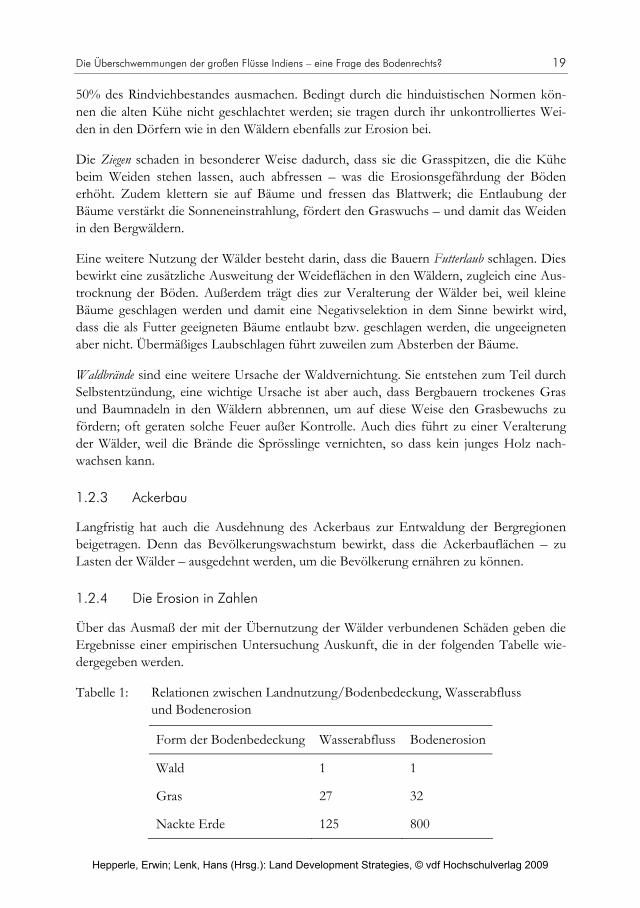
1.2.4 Die Erosion in Zahlen
Über das Ausmaß der mit der Übernutzung der Wälder verbundenen Schäden geben die Ergebnisse einer empirischen Untersuchung Auskunft, die in der folgenden Tabelle wie-dergegeben werden.
Tabelle 1: Relationen zwischen Landnutzung/Bodenbedeckung, Wasserabfluss und Bodenerosion
Form der Bodenbedeckung Wasserabfluss Bodenerosion
Wald 1 1
Gras 27 32
Nackte Erde 125 800
Hepperle, Erwin; Lenk, Hans (Hrsg.): Land Development Strategies, © vdf Hochschulverlag 2009
20 Hans-Gert Braun
Die Tabelle zeigt, dass die Erosionsgefahr im Himalaja bei Grasbewuchs 32 Mal, bei nack-ter Erde 800 Mal so groß ist wie in einem nachhaltig bewirtschafteten Wald (Quelle: Kai-jashta (1970)2 ; Untersuchungen im östlichen Himalaja).
1.3 Zusammenfassung des ersten Teils
Die starke Erosion in den Vorbergen des Himalaja ist teils natürlicher Art, zu einem gro-ßen Teil aber durch Entwaldung bedingt. Die Entwaldung hat ihre Ursache in dem star-ken Bevölkerungswachstum der Region. Dies bewirkt eine übermäßige Nutzung der Wäl-der in Form von Abholzung und Überweidung.
Das ist die sichtbare und deshalb nicht zu leugnende Kausalkette. Daneben gibt es aber noch eine andere, eine unsichtbare, die nunmehr dargelegt werden soll.
2. Die Wälder als Öffentliches Gut
2.1 Öffentliches Gut – die Konsequenzen
Zu Anfang eine Hypothese: „Die Zerstörung der Wälder und der Landschaft durch Ero-sion ist nicht nur eine Folge der Bevölkerungsexplosion; sie ist auch eine Folge der Eigen-tumsverhältnisse, des Bodenrechts.“ Warum?
Die Wälder in der Region sind Staatswald und damit ein Öffentliches Gut. Öffentliches Gut heißt, dass der Staat als Eigentümer des Waldes unbefugte Dritte von der Nutzung de facto nicht ausschließen kann; er kann „das Ausschlussprinzip nicht geltend machen“.
Konkret: Wollte der Staat Unbefugte von der (übermäßigen) Nutzung ausschließen, so müsste er eine „kleine Armee“ von Bewachern aufstellen, die viel zu aufwändig wäre. Dies insbesondere auch, weil es eine Regelung gibt, die die mäßige (nachhaltige) Nutzung der Wälder durch die Bevölkerung erlaubt. Abgestorbene Bäume dürfen gefällt und auch ab-gebrochene Äste dürfen aufgelesen und nach Hause getragen werden.
Jeder darf sich legal in den Staatswäldern aufhalten. Das aber impliziert die Gefahr, dass die Bevölkerung „nachhilft“: Bäume werden angesägt und sterben ab; Äste werden an-gebrochen und werden dürr. Kurzum, die Nutzung der Wälder ist nicht zu kontrollieren.
Eine theoretische Lösung bestünde darin, dass die indische Regierung die Staatswälder privatisiert. Die Wälder würden dann auf die Bevölkerung aufgeteilt, wobei sich die Frage stellt: nach welchem Schlüssel? Aufteilung auf Familien oder einzelne, Aufteilung auf alle Familien oder nur auf alteingesessene (z.B. Familien mit Burger-Recht nach Schweizer Muster)? Schon die Wahl des Schlüssels wäre also ein Politikum.
2 Zitiert nach Rieger, 1975, S. 29.
Hepperle, Erwin; Lenk, Hans (Hrsg.): Land Development Strategies, © vdf Hochschulverlag 2009
Die Überschwemmungen der großen Flüsse Indiens – eine Frage des Bodenrechts? 21
Aber unterstellen wir einmal, die Aufteilung gelänge und jede Familie erhielte eine Wald-parzelle zum Eigentum. Sicher wäre es dann leichter, den Familien bewusst zu machen, dass eine Übernutzung der Wälder die „Zerstörung der eigenen Zukunft“ bedeutet. Und sicherlich wäre es dann auch leichter, die Familien dazu zu bewegen, ihre Wälder zu bewa-chen und zu schützen. Auch auf Allmende-Modelle genossenschaftlicher Waldverwaltung ließe sich zurückgreifen.
Aber es gibt ein unüberwindliches Problem. Die indische Regierung denkt nicht daran, die Staatswälder zu privatisieren. Wo sollte sie auch anfangen und wo aufhören – und zu wel-chem Preis (mit welchem Schenkungsanteil) sollte sie verkaufen? Es ist ein praktisch un-lösbares Politikum.
Also stellen wir die Frage: Warum ist das Problem nicht anders lösbar? Warum muss der Status des öffentlichen Eigentums als Ursache der Entwaldung angesehen werden? Wa-rum ist eine nachhaltige Bewirtschaftung der Wälder bei öffentlichem Eigentum nicht möglich, wenn der Staat keine Bewachungsarmee aufstellt – die sich womöglich auch noch als korrupt erweisen würde?
Wir sind hier mit dem Problem des „band-wagon effect“, dem Problem des „Trittbrett-fahrens“ konfrontiert. Würden z.B. 50% der Bevölkerung einsichtig sein und auf die Nut-zung der Wälder verzichten, so würden die übrigen, uneinsichtigen 50% mit der Nutzung fortfahren, wie bisher. Und siehe da; die Wälder würden sich erholen. Ergebnis: Die Ein-sichtigen würden bestraft, die Uneinsichtigen würden belohnt. Das Problem, das hier vorliegt, besteht darin, dass das Anreizsystem einen „Webfehler“ hat, es gibt die falschen Anreize. Es besteht ein eklatanter Widerspruch zwischen individueller und kollektiver Rationalität.
Die ökonomische Theorie der öffentlichen Güter gibt eine Antwort, wie hier zu verfahren ist. Ein der kollektiven Rationalität entsprechendes Verhalten muss von außen organisiert werden, weil bei keinem Individuum der Nutzen aus dem Schutz des Öffentlichen Gutes so groß ist, dass es die Kosten der Organisation dieses angemessenen Individualverhaltens alleine tragen kann. „Von außen“ hieße, dass z.B. der Staat oder ein Projekt internationaler Entwicklungszusammenarbeit die Organisation übernehmen müsste.
Die Organisation des angemessenen Individualverhaltens muss dann bei der Aufklärung der Bevölkerung über ihr schädliches Verhalten beginnen, die Bevölkerung muss zu sach-gerechtem Verhalten aufgefordert werden, die Bewachung der Wälder muss organisiert werden. Die Bewachung müsste aber aus Kostengründen durch die Bevölkerung selbst erfolgen; dies würde zusätzliche Arbeit bedeuten, die für die arme Bergbevölkerung wohl unzumutbar wäre. Zudem wäre es ein Projekt nach dem Prinzip „der Hund soll einen Berg von Wurst bewachen“; das heißt, die Bewacher wären moralisch überfordert.
An dieser Stelle ist ein kleiner Exkurs angebracht: Denn Indien hat in seiner Historie ein ähnliches nationales Problem auf sehr spektakuläre Weise gelöst. Gemeint ist die „Heilig-sprechung“ der Kühe. Dies ist heute eine Institution, ein Wert an sich. Ursprünglich hatte
Hepperle, Erwin; Lenk, Hans (Hrsg.): Land Development Strategies, © vdf Hochschulverlag 2009

22 Hans-Gert Braun
sie jedoch einen zweckrationalen Kern. Es ging um den unbedingten Erhalt der Kühe in Zeiten von Hungerkatastrophen, insbesondere als Eiweißspender für die nachwachsende Generation. – Aber an eine „Heiligsprechung“ der Wälder Indiens im 21. Jahrhundert ist wohl nicht zu denken.
Zurück zur Argumentationskette, denn es gibt noch ein fundamentales Problem: Wenn die Bergbevölkerung – dank entsprechender Organisation – auf die Übernutzung der Wälder verzichten würde, dann würde sie, um überleben zu können, eine alternative Ener-giequelle und alternative Futterressourcen benötigen, die aber im Status quo nicht existier-ten.
Und ein entsprechender Ersatz ist künftig auch nur denkbar, wenn die Bergbevölkerung „auf andere Weise“ deutliche Einkommenssteigerungen erfährt, die es ermöglichen u.a. andere Brennstoffe zu kaufen und Viehzucht und Ackerbau einzuschränken. – Genau darauf zielte die Projekt-Strategie des Dhauladhar-Projektes ab.
2.2 Die Strategie des Dhauladhar-Projektes
Diese Strategie umfasste ein Bündel von Maßnahmen, insgesamt 74 verschiedene Maß-nahmen-Programme, die hier nur grob skizziert werden sollen:
Aufforstung, Rehabilitation von Wäldern, Verbesserung der Wald- und Holznutzung,
Schutz ökologisch gefährdeter Nicht-Waldgebiete (u.a. durch technische Maßnahmen),
Verbesserung der Nutzung von Brennholz (u.a. Entwicklung und Einführung eines Sparofens) und von Nutzholz (Sägewerk); Schaffung alternativer Energiequellen (So-larenergie, Biogas etc.),
Steigerung der landwirtschaftlichen Produktivität (u.a. Futtermaisproduktion als dritte Ernte, Pflanzung von Futterbäumen auf Brachland),
Steigerung der Produktivität der Viehzucht (u.a. Einkreuzung produktiverer Rinderras-sen, Kastration lokaler Bullen, Haushaltung der Kühe, Errichtung eines Altersheimes für alte Kühe), Kleintierhaltung (u.a. Bienen, Angorakaninchen),
Steigerung der Produktivität und Ausweitung des Obstanbaus (z.B. auf den Zwischen-dämmen der Bewässerungssysteme),
Kleingewerbeförderung (z.B. Honigverarbeitung, Weben etc.),
Reduzierung des Bevölkerungswachstums durch Familienplanung.
All diese Maßnahmen waren nicht erfolgreich realisierbar ohne eine Einbindung der Ge-samtbevölkerung, insbesondere der dörflichen, und nicht ohne eine starke Anhebung des Bildungsniveaus, vor allem auch der weiblichen Bevölkerung. Ebenso kann ein solches
Hepperle, Erwin; Lenk, Hans (Hrsg.): Land Development Strategies, © vdf Hochschulverlag 2009

Die Überschwemmungen der großen Flüsse Indiens – eine Frage des Bodenrechts? 23
Projekt aber nur dann erfolgreich sein, wenn es die volle Unterstützung aller staatlichen und sonstigen Institutionen der Region hat.
Da diese anspruchsvollen Bedingungen bei der Durchführung des Projektes nicht ange-messen erfüllt werden konnten, ist das Projekt – trotz überzeugender Projektkonzeption – gescheitert.3
2.3 Zusammenfassung des zweiten Teils
Die Wälder in der Dhauladhar-Region sind Staatswald und damit Öffentliches Gut, weil der Staat de facto unbefugte Dritte von der Nutzung nicht ausschließen kann. Die Folge ist eine übermäßige Nutzung der Wälder, die langfristig zur Entwaldung und damit zu einer weiteren Verschärfung der Bodenerosion führt. Eine Möglichkeit wäre die Privatisie-rung; sie hätte zur Folge, dass dann die privaten Eigentümer ihre Wälder nicht übernutzen – stattdessen schützen würden. Aber alle anderen gingen ihrer Holzversorgung und Fut-terquellen dann verlustig. Vor allem aber, der indische Staat will prinzipiell seine Wälder nicht privatisieren. Eine andere Möglichkeit wäre, durch „Organisation von außen“ die Bevölkerung – mittels Aufklärung und Beratung – dazu zu bringen, auf die Übernutzung der Wälder zu verzichten. Aber auch hier gilt: Die Bevölkerung hat keine Alternative. Es fehlt an Einkommen, um alternative Energie und Futter auf dem Markt einkaufen zu können.
Die Strategie des Deutsch-indischen Dhauladhar-Projektes zielte deshalb neben der Auf-forstung vor allem darauf ab, der Bevölkerung zu anderen Einkommensquellen zu verhel-fen, um auf die Übernutzung der Wälder verzichten zu können. Die Umsetzung der dafür entwickelten Strategie mit 74 verschiedenen Maßnahmen-Programmen stellte jedoch sehr hohe Anforderungen, die im konkreten Fall dieses Projektes nicht erfüllt werden konnten.
Literatur
Beck, K.V. und Braun, H.G. [1982], Indo-German Integrated Farm Forestry Project Dhauladhar. Manual for the Implementation Phase, Report to the German Agency for Technical Cooperation (GTZ). Munich, ifo – Institute for Economic Research.
Jahnke J. [1987], Mit exponentiellen Lernprozessen gegen exponentielle Verfallsprozesse. Internationales Afrikaforum, 23 (3): 279–296.
Rieger, H.C. [1975], Himalaya Wasser. Literaturanalyse über die Frage der Auswirkungen von Entwaldung, Erosion und sonstigen Störungen im Einzugsgebiet des Ganges und des Brahmaputra. Bericht für den Bundesminister für Wirtschaftliche Zusammenarbeit. Universität Heidelberg, Südasien-Institut.
3 Die Gründe für das Scheitern des Deutsch-indischen Dhauladhar-Projektes schildert detailliert Jens Jahnke
[1987].
Hepperle, Erwin; Lenk, Hans (Hrsg.): Land Development Strategies, © vdf Hochschulverlag 2009

Hepperle, Erwin; Lenk, Hans (Hrsg.): Land Development Strategies, © vdf Hochschulverlag 2009

Erwin Hepperle
Kyoto und die schweizerische Bodenordnung abgehandelt an der Speicherwirkung des Waldes
Multinationale Umweltabkommen wirken sich anlässlich der Überführung in nationales Recht mitunter auch auf die geltende Bodennutzungsordnung aus. Dabei treten charakte-ristische Schwierigkeiten auf. Dies zeigt sich am Beispiel der aktuell anstehenden Umset-zung des Kyoto-Protokolls. In diesem Beitrag soll dargestellt werden, dass und wie sich dieses Abkommen auf die lokale Ausgestaltung der Bodennutzung nach schweizerischem Recht auswirkt. Es kommt zu rechtssystembedingten Konflikten, die es vorausschauend zu beachten gilt. Der Teufel steckt ja dem Sprichwort gemäß im Detail. Interessanterweise sind es gerade diese Details, die zu zusammenhängendem Denken zwingen.
1. Rolle der Landökosysteme im CO2-Stoffwechsel
Weltweit gesehen bilden die Wälder zusammen mit den Ozeanen die größten CO2-Spei-cher der Erde. Klimaschutz auf globaler Ebene heißt deshalb immer auch Schutz der Wälder vor Ausbeutung und Zerstörung.1 Die Art und Weise der Waldnutzung ist der entscheidende Faktor, der darüber bestimmt, ob der Wald im Sinne des Kyoto-Protokolls als Senke oder als Quelle für die Treibhausgase anzusehen ist. Das betrifft vor allem die tropischen Regenwälder mit ihrer riesigen Artenvielfalt und einem sehr schnellen Wachs-tum. Aber auch in der Schweiz wird die größte Senkenleistung durch den Wald erbracht.
Der Umgang mit biologischen Senken und Quellen für Treibhausgase ist für das Abkom-men von großer Bedeutung. Erst ihr Einbezug hat die Ratifizierungsbereitschaft zahlrei-cher Staaten und insbesondere jene Russlands deutlich erhöht. Für die Schweiz aber be-deutet dies, dass der Wald damit einen neuen Stellenwert in Gesellschaft und Politik erhält.
Neben dem Wald ist auch die Landwirtschaft vom Klimaschutzabkommen betroffen. Die schweizerische Landwirtschaft dürfte aber, im Gegensatz zur Waldwirtschaft, insgesamt schon heute eher als Quelle denn als Senke von Treibhausgasen wirken. Für die betriebs-spezifische Treibhausgasbilanz spielen hierbei die Treibhausgase Methan (CH4) und Lach-gas (N2O) eine gewichtige Rolle. Methan stammt vorzugsweise aus der Tierhaltung, wäh-rend Lachgas beispielsweise bei intensiver Stickstoffdüngung auf durchnässten Böden gebildet wird. Insgesamt ist es erheblich aufwändiger, die Emissionen der Landwirtschaft zu ermitteln als jene des Waldes. Außerdem sind solche Erhebungen mit zahlreichen Un-sicherheiten behaftet.2 Die vorliegende Betrachtung konzentriert sich deshalb auf die Aus-wirkungen des Abkommens von Kyoto auf die Waldgesetzgebung.
1 Zum weltweiten Potenzial solcher Maßnahmen vgl. Watson et al., 2000. 2 Näheres dazu bei J. Leifeld, 2003.
Hepperle, Erwin; Lenk, Hans (Hrsg.): Land Development Strategies, © vdf Hochschulverlag 2009

26 Erwin Hepperle
2. Rechenschaftspflicht und Anrechenbarkeit
Mit der Ratifizierung des Kyoto-Protokolls haben sich die Vertragsstaaten dazu verpflich-tet, periodisch Rechenschaft über die Entwicklung ihrer biologischen Senken und Quellen zu erteilen.3 Im Zentrum stehen die „Kohlenstoffvorräte“. Kohlenstoff ist in allen organi-schen Verbindungen enthalten. Durch Verbrennung oder über Abbauprozesse bilden sich Treibhausgase (Kohlendioxid [CO2] oder Methan [CH4]). Solange aber der Kohlenstoff in den Pflanzen oder als organische Substanz im Boden gebunden bleibt, trägt er nichts zur Erderwärmung bei. Die Zu- oder Abnahme der Kohlenstoffvorräte (d.h. des gebundenen Kohlenstoffs) ist Teil der nationalen Treibhausgasbilanz und soll den übrigen Vertragspar-teien gegenüber offen gelegt werden. Die Art und Weise der Erhebung soll nachvollzieh-bar sein. Referenzzeitpunkt für den Ausgangszustand ist das Jahr 1990.
Als Senkenleistung wird nun aber nicht etwa die Leistung der Ökosysteme per se ange-rechnet. Verrechenbar sind nur Entwicklungen, die auf bestimmte Handlungen von Men-schen zurückgeführt werden können. Bezüglich der Anrechnung in der ersten Verpflichtungs-periode – sie dauert von 2008–2012 – wird noch weiter differenziert: Zwingend zu berück-sichtigen sind nach Art. 3.3 des Kyoto-Protokolls in jedem Fall die seit 1990 erfolgten Aufforstungen, Wiederaufforstungen und Entwaldungen (Abb. 1).4
Abbildung 1: Nach Art. 3.35 des Kyoto-Protokolls zu berücksichtigende Nettoänderungen von Treibhausgas-Emissionen
Borkenkäferbefall und Sturmwurf erfolgen ohne menschliches Zutun. Sie gelten nicht als Rodungen im oben genannten Sinne. Ebenso wenig handelt es sich um Rodungen, wenn im Zuge der Waldbewirtschaftung Bäume gefällt werden. Ob eine Fläche als Waldareal gemäß Kyoto-Protokoll gilt, ist weder eine Frage des Gesundheitszustands noch eine solche der Bewirtschaftungsform, sondern eine Frage der Nutzung. Erst die Überführung in eine andere Landnutzungsform macht den Baumschlag zur Rodung. Entscheidend ist
3 Art. 7 des Kyoto-Protokolls in Verbindung mit Art. 4 und 12 des Rahmenübereinkommens.
4 Die Frage, welche Entwicklungen angerechnet werden dürfen, eröffnet Interpretationsspielräume. Man kann sich zum Beispiel auf den Standpunkt stellen, natürlich in ehemalige Weideflächen eingewachsene Bäume seien als eine vom Menschen geförderte Senkenleistung zu betrachten. Dann dürfen sie als Auf-forstung bzw. Wiederaufforstung im Sinne des Kyoto-Protokolls verstanden werden. Man kann aber auch argumentieren, das Einwachsen infolge Vergandung sei ein rein natürlicher Prozess.
5 Artikel 3.3 gilt für alle in Anhang I des Protokolls aufgeführten Vertragsstaaten („entwickelte Länder” und solche, die sich „im Übergang zur Marktwirtschaft befinden“).
Aufforstung seit 1990
Entwaldung seit 1990
soweit dies sich auf die Vorratsveränderungen zwischen 2008 und 2012 auswirkt
Hepperle, Erwin; Lenk, Hans (Hrsg.): Land Development Strategies, © vdf Hochschulverlag 2009

Kyoto und die schweizerische Bodenordnung 27
das weitere Schicksal der betroffenen Parzelle.6 Raumplanerisch gesprochen müsste die Fläche einer anderen Nutzung gewidmet, d.h. umgezont werden. Von dieser Regelung ist in der Schweiz nur ein kleiner Teil der gesamten Waldfläche betroffen.
Es werden – laut Kyoto-Protokoll – zudem nur Veränderungen angerechnet, die sich innerhalb einer Verpflichtungsperiode ereignen. Das bedeutet, dass Rodungen vor 2008 grundsätzlich keinen Einfluss auf die Treibhausgasbilanz haben, wenn das Holz anschlie-ßend aus dem Wald entfernt wurde, und das obschon 1990 als Referenzzeitpunkt gilt. Nur die heute noch nachwirkenden Folgen von Rodungen sind einzubeziehen. Dazu gehört z.B. jener Kohlenstoff, der nach Abholzungen oder Brandrodungen durch biologischen Abbau und Verrotten freigesetzt wird. Die Reduktion der Speicherwirkung ist also nicht etwa jener Verpflichtungsperiode anzurechnen, in der die ausschlaggebende menschliche Handlung erfolgt, sondern es ist maßgeblich, ob tatsächliche Veränderungen der Spei-cherwirkung in der betreffenden Verpflichtungsperiode festgestellt werden. Dasselbe gilt grundsätzlich auch für den im Boden gebundenen Kohlenstoff.7 Dieser wird über Wurzeln und Streuverrottung (Blätter, Nadeln, Rinden, abgebrochenes Holz) in den Boden einge-bracht und im Humus gespeichert. Veränderungen sind aufgrund der prekären Datenlage allerdings nur sehr schwer nachzuweisen.8 Deshalb umfasst die CO2-Bilanz des Schweizer Waldes bis dato nur die lebende Biomasse. An der Aufgabe, auch das Totholz und den Waldboden einzubeziehen, wird noch gearbeitet.9
3. Menschliche Aktivitäten als Auslöser
Die Treibhauswirkung von Rodungen und Aufforstungen ist bereits in der ersten Ver-pflichtungsperiode zwingend zu berücksichtigen. Rodungen und Aufforstungen machen aber nur einen Teil der nach dem Kyoto-Protokoll maßgeblichen Aktivitäten aus. Für andere Handlungen – sie werden in Art. 3.4 des Kyoto-Protokolls aufgezählt – bietet das Abkommen aber eine gewisse Wahlfreiheit. Die Unterzeichnerstaaten können selbst ent-scheiden, ob für sie die entsprechenden Bestimmungen auch für die erste Verpflichtungs-periode gelten sollen. Nach 2012 wird die Unterstellung jedoch zwingend.
Zu diesen bedingt wahlfähigen Aktivitäten gehört die Waldbewirtschaftung („forest mana-gement“). Die Schweiz hat sich für deren Anrechnung entschieden.10 Die Folgen der Be-
6 Die Nutzung kann auch in einem bewussten Unterlassen bestehen. Beim Beispiel aus Fußnote 4 kann in
der Förderung des natürlichen Einwachsens eine mögliche Bewirtschaftungsform und damit ein bewusster menschlicher Akt gesehen werden. Relevant wird dies unter Kyoto allerdings nur, wenn sichergestellt ist, dass die Parzelle auch künftig als Wald genutzt wird.
7 UN-FCCC, 2001, Annex E Ziff. 21.
8 A. Fischlin et al., 2003, S. 36 und 49 f.
9 BAFU, 2008a, S. 59.
10 Initial Report, 2006, S. 15.
Hepperle, Erwin; Lenk, Hans (Hrsg.): Land Development Strategies, © vdf Hochschulverlag 2009

28 Erwin Hepperle
wirtschaftung auf die Bilanz der Biomasse werden auf dem gesamten Waldgebiet erhoben. Dabei ist folgendes zu beachten:
Den Anrechnungsregeln des Kyoto-Protokolls liegt das flächenbezogene Input-Output-Verhältnis zugrunde, soweit es im Sinne einer Waldbewirtschaftung vom Men-schen beeinflusst wird. Wird Holz geerntet (d.h. aus dem Wald weggeführt), dann be-deutet dies für die betreffende Waldfläche eine sofortige Reduktion des CO2-Vorrats. Der Vorgang geht – nach derzeitiger Rechtslage – unmittelbar als „Freisetzung“ in die Rechnung ein und zwar selbst dann, wenn das im Holz gebundene CO2 in der Folge noch für Jahrzehnte gar nicht in die Atmosphäre gelangt, weil dieses z.B. als Bauholz verwendet wird. Es wird nur beachtet, was auf der ausgeschiedenen Fläche passiert, das weitere Schicksal des geernteten Holzes wird ausgeblendet.
Betrachtet wird jede durch die Waldbewirtschaftung bewirkte Veränderung des Koh-lenstoffvorrats. Es spielt keine Rolle, ob es sich um Material von lebenden oder von toten Pflanzen handelt. Werden Bäume aus dem Wald geholt, die durch Stürme gefällt oder von Borkenkäfern befallen wurden, dann geht auch dies in die Rechnung ein. Anders, wenn umgeworfenes Holz im Wald belassen wird und dort verrottet. Hier ist die verbleibende Totholzmasse für die Buchhaltung maßgeblich. Diese verringert sich nur allmählich, entsprechend den biochemischen Abbauprozessen.
4. Leistungen des Schweizer Waldes
Als Senkenleistung einer Waldfläche gilt der innerhalb einer Verrechnungsperiode zusätz-lich gespeicherte Kohlenstoffgehalt, gemessen als Differenz zwischen Beginn und Ende einer Verrechnungsperiode. Der Schweizer Wald hat sowohl flächenmäßig als auch in Bezug auf den darin gespeicherten Holzvorrat seit den neunziger Jahren einen erheblichen Zuwachs erfahren.11 Namentlich im alpinen Raum, wo es sich immer weniger lohnt, er-tragsarme Böden landwirtschaftlich zu nutzen, konnte in den letzten Jahrzehnten ver-mehrt Wald einwachsen.12
Die Speicherwirkung des Wald-Ökosystems ist allerdings immer nur eine Wirkung auf Zeit. Der Wald bildet nur so lange eine Senke, als die darin ablaufenden Prozesse mehr Kohlenstoff binden als ihm durch die Holznutzung wieder entzogen wird. Ohne weitere Vergrößerung der Waldfläche wird sich der Beitrag des Waldes auch in einem optimierten Wald allmählich erschöpfen, es stellt sich ein Gleichgewicht ein. Bezogen auf langfristige Szenarien ist dies im Auge zu behalten. Wo der Wald zur CO2-Quelle wird, geht dies in die nationale Treibhausgasbilanz ein. Kann ein Vertragsstaat seine Reduktionsverpflich-tung deswegen nicht mehr einhalten, so müssen Kompensationsmöglichkeiten gesucht werden.
11 BAFU (Hrsg.), 2008, S. 61.
12 BUWAL und WSL, 2005, S. 10.
Hepperle, Erwin; Lenk, Hans (Hrsg.): Land Development Strategies, © vdf Hochschulverlag 2009

Kyoto und die schweizerische Bodenordnung 29
5. Klimaschutzbedingte Verteilkämpfe
Die dem Kyoto-Protokoll zugrunde liegende Klimarahmenkonvention bezweckt, die Konzentrationen von Treibhausgasen auf einem Niveau zu stabilisieren, auf dem eine gefährliche vom Menschen verursachte Störung des Klimasystems verhindert wird.13 Die Reduktion von stark wirkenden Treibhausgasen ist hierfür ein wichtiger Ansatzpunkt.
Maßnahmen gegen den Verbrauch fossiler Brenn- und Treibstoffe erzeugen große Wider-stände, weil sie tief in die Lebens- und Produktionsgewohnheiten unserer Gesellschaft eingreifen. Interessierte Kreise sahen denn auch im „Joker CO2-Senke Wald“14 primär eine Möglichkeit, die drohende Lenkungsabgabe auf den Verbrauch fossiler Brennstoffe abzu-wenden. Das schweizerische CO2-Gesetz sieht eine solche Lenkungsabgabe als Maßnah-me zur Reduktion des CO2-Ausstoßes vor, die dann zu ergreifen ist, wenn das Reduk-tionsziel nicht durch energie-, verkehrs-, umwelt- und finanzpolitische sowie durch freiwil-lige Maßnahmen erreicht werden kann.15
Das Anrechnen von Senkenleistungen verschiebt nun allerdings diesen generellen ökono-mischen Ansatz auf einen flächenbezogenen. Innerstaatlich wird die nationale Treibhaus-bilanz von Entscheidungen abhängig, welche die Nutzung der einzelnen Parzelle betref-fen. Nutzungsart und -intensität werden wiederum durch jene direkten und indirekten Vorschriften und Anreize gesteuert, die sich aus der Nutzungsordnung ergeben. Damit rückt die bodenrechtliche Ordnung ins Zentrum der Problematik.
Man kann feststellen, dass die Politik kaum bereit ist, der Senkenleistung unbedingte Prio-rität im Nutzungskonflikt einzuräumen. Beispielhaft dazu ist folgende Episode: Am selben Tag, an dem der Ständerat16 den schweizerischen Bundesrat (die Landesregierung) damit beauftragte, eine Gesetzesvorlage zur Anrechnung der Senkenleistungen des Waldes vor-zubereiten, hat er verlangt, den weiteren Kulturlandverlust durch Einwachsen von Wald zu unterbinden. Das geschah auf Empfehlung ein und derselben Kommission. Es sollen also nur solche Leistungen angerechnet werden, die bereits mit der laufenden Bewirtschaf-tung erbracht werden, während zugunsten der Landwirtschaft auf das Generieren von künftigen Senken verzichtet werden soll.
Dabei ist auch zu beachten, dass die Senkenleistung nach den Regeln des Kyoto-Protokolls nur bis zu einer bestimmten, länderspezifisch festgelegten Obergrenze (Cap) angerechnet wird. Man geht davon aus, dass es für die Schweiz ausreicht, die in den letzten Jahrzehnten übliche Nutzung wie bis anhin weiterzuführen, um diese Obergrenze im
13 Art. 2 Rahmenübereinkommen der Vereinten Nationen über Klimaänderungen.
14 Amtl. Bull. SR., 2004, S. 522: Votum Büttiker.
15 Bundesgesetz über die Reduktion der CO2-Emissionen (CO2-Gesetz) vom 8. Oktober 1999, Art. 3 Abs. 2 und Art. 6 ff.
16 Die kleine Kammer des eidgenössischen Parlaments (entspricht in anderen Staaten dem Senat).
Hepperle, Erwin; Lenk, Hans (Hrsg.): Land Development Strategies, © vdf Hochschulverlag 2009

30 Erwin Hepperle
Durchschnitt der kommenden Jahre auszuschöpfen. Die jüngsten Statistiken stellen diesen Optimismus allerdings wieder in Frage. Es zeichnet sich ab, dass dies nicht zwingend so bleiben muss, wenn Sturmschäden in Zukunft zunehmen oder wenn die Rohstoffpreise für Holz weiter anziehen.17 Letzteres weist darauf hin, dass die wirtschaftlichen Folgen der Senkenanrechnung nicht unbeachtet bleiben dürfen.
Geht man davon aus, dass die Anforderungen des Kyoto-Protokolls zu wesentlichen Tei-len über die Speicherwirkung von Wald-Ökosystemen erfüllt werden sollen, so stehen diese Flächen nicht mehr für andere Landnutzungen zur Verfügung. Das gilt weltweit. Andererseits steigt weltweit auch der Nahrungsmittelbedarf. Die Nahrungsmittelproduk-tion ist ihrerseits stark durch die rasant ansteigende Nachfrage nach Biotreibstoffen be-drängt. Der Verteilkampf um die Nutzung des Bodens ist aus dieser Sicht eine Flächen-konkurrenz unter den Bewirtschaftungsarten. Sie wird aus Gründen des Klimaschutzes immer schärfer.
6. Emissionszertifikate und CO2-Abgabe
Die wirtschaftliche Bedeutung der Senkenanrechnung muss auch innerschweizerisch im weiteren Zusammenhang der Klimapolitik gesehen werden. Die bisherige, vor allem auf Eigenverantwortung setzende Politik hat das für das Jahr 2006 postulierte Emissions-reduktionsziel für brennstoffbedingte CO2-Emissionen18 klar verfehlt. Für diesen Fall sieht der in der schweizerischen CO2-Verordnung festgelegte Automatismus vor, dass auf den 1. Januar 2008 die so genannte CO2-Abgabe einzuführen ist. Dies ist zwischenzeitlich geschehen.
Die CO2-Abgabe wird in der Schweiz auf alle fossilen Brennstoffe (wie Heizöl, Erdgas oder Kohle) erhoben, soweit sie energetisch genutzt werden.19 Unternehmen können sich von der Abgabe befreien lassen, wenn sie sich gegenüber dem Bund zu einer Begrenzung ihrer Emissionen verpflichten.20 Der Mechanismus sieht vor, dass die abgabebefreiten Unternehmen Emissionsrechte zugeteilt erhalten, die jährlich entwertet werden. Spart ein Unternehmen in einer Periode mehr Emissionen ein, so kann es die überschüssigen Emis-sionsrechte verkaufen. Erreicht es das vereinbarte Ziel nicht, so kann es über den Zukauf
17 Vgl. die Statistik zum jährlichen Senkeneffekt im Wald in BAFU (Hrsg.), 2008, S. 61. Die anrechenbare
Obergrenze (Cap) liegt für die Schweiz bei 0.5 Megatonnen Kohlenstoff (C) pro Jahr, was einer Einspa-rung von 1.8 Megatonnen CO2-Emissionen entspricht.
18 Art. 3 der Verordnung vom 8. Juni 2007 über die CO2-Abgabe (CO2-Verordnung).
19 Die CO2-Abgabe erfasst allerdings (noch?) nicht die Treibstoffe (Benzin, Diesel). Auf Treibstoffe wird in der Schweiz seit dem 1. Oktober 2005 auf privatwirtschaftlicher Basis der so genannte „Klimarappen“ (1.5 Rp./Liter) erhoben. Mit den Einnahmen werden im In- und Ausland Projekte zur Reduktion der Treibhausgasemissionen finanziert.
20 Hierzu werden mit dem Bund CO2-Begrenzungsziele vereinbart, die sich am technischen Potenzial, an der wirtschaftlichen Tragbarkeit und an den bereits erzielten Einsparungen orientieren. Bis Ende August 2007 sind entsprechende Anträge von rund 1000 Unternehmen eingegangen (BAFU, 2008a).
Hepperle, Erwin; Lenk, Hans (Hrsg.): Land Development Strategies, © vdf Hochschulverlag 2009

Kyoto und die schweizerische Bodenordnung 31
von Gutschriften auf dem nationalen oder internationalen Markt die Lücke kompensieren. Andernfalls muss es die CO2-Abgabe, von der es befreit wurde, einschließlich Zinsen nachzahlen.
Kein Unternehmen hat ein Interesse daran, für Emissionszertifikate mehr zu zahlen als das, was maximal an Kosten für die Rückerstattung der Abgabe anfällt. Der Preis, der im nationalen Emissionshandel für Emissionsgutschriften erzielt werden kann, wird damit durch ebendiese CO2-Abgabe limitiert. Zugleich aber wertet die Arbeitsgruppe „Wald und Holzwirtschaft im Klimaschutz“ des schweizerischen Forstvereins die Anrechnung der Senkenleistung des Waldes nur dann als Chance, „wenn sie im Rahmen eines langfristigen Nutzungskonzeptes und unter Berücksichtigung der Risiken mit einem an den Markt für CO2-Rechte gekoppelten Preis gehandelt werden kann“.21 Das leitet über zur Frage, wem denn überhaupt die Rechte an Senkenleistungen, die durch die Waldbewirtschaftung er-zielt werden, gehören sollen: Dem Staat (in seiner Rolle als Kyoto-Vertragspartner) oder den einzelnen Waldbewirtschaftern (kraft innerstaatlichen Rechts)?22 Die Beschäftigung mit dieser Frage weist auf einige Stolpersteine hin.
7. Stolpersteine der innerstaatlichen Umsetzung
Die Schweiz hat die Art und Weise, ob und falls ja, wie die Senkenleistung einzelnen Waldbewirtschaftern zugerechnet werden soll, noch nicht geregelt. Ein erster (stark einge-schränkter) Anlauf zu einer Regelung ist in der parlamentarischen Beratung gescheitert. Die im Folgenden angeführten Punkte legen aber für die allfällige künftige Ausgestaltung eines innerschweizerischen Anreizsystems eine Lösung nahe, die von der zwischenstaatlich ausgehandelten Lösung nach dem Kyoto-Protokoll abweicht.
7.1 Tücken des Emissionshandels
Ein Hauptproblem des Einbezugs von Senkenleistungen in den Emissionshandel zeigt sich dann, wenn gespeicherter Kohlenstoff, für den zuvor eine Speicherleistung anerkannt und entsprechend zertifiziert wurde, erneut freigesetzt wird. Der Grundkonflikt lässt sich anhand der nachfolgend wiedergegebenen Darstellungen aufzeigen.
Senkenleistungen schwanken von Jahr zu Jahr. Ob und inwieweit eine solche vorliegt, kann erst am Ende der jeweiligen Verrechnungsperiode bestimmt werden (Abb. 2). Inter-national hat sich die Schweiz im Bereich „forest management“ für eine jährliche Abrech-nungsperiode entschieden. Auch für die CO2-Abgabe, wo der Emissionshandel wie aufge-zeigt bereits rechtlich festgelegt wurde, geht man von jährlichen Abrechnungsperioden
21 Arbeitsgruppe „Wald- und Holzwirtschaft im Klimaschutz“, 2005, S. 4.
22 Es wurde auch schon vorgeschlagen eine besondere „Agentur Wald und Holz“ zu schaffen, die für eine nachhaltige und umfassende Waldnutzung verantwortlich zeichnet und mit der Leistungsvereinbarungen abgeschlossen werden können, vgl. Fischlin (2008), S. 264.
Hepperle, Erwin; Lenk, Hans (Hrsg.): Land Development Strategies, © vdf Hochschulverlag 2009

32 Erwin Hepperle
aus. Damit würden sich für die innerstaatlich handelbaren Emissionsgutschriften aus der Wald-Senkenleistung ebenfalls jährliche Verrechnungsperioden anbieten.
Geht nun aber im Laufe der Zeit eine in einer vorangegangenen Verrechnungsperiode ver-kaufte Bindung im Laufe einer späteren Verrechnungsperiode wieder verloren, so muss die Lücke nach der Logik des Emissionshandels mit dem Zukauf von Emissionsrechten gedeckt werden (Abb. 3), und zwar ohne Rücksicht auf das weitere Schicksal des geernte-ten Holzes.
Dies ist unter dem Aspekt der Nachhaltigkeit unter Umständen eine Fehlallokation. Im Schweizer Wald bewegt sich das durchschnittliche Erntealter von Baumbeständen zwi-schen 80 und 200 Jahren. Solche Zeiträume lassen sich ökonomisch mit dem Zeitintervall der Verrechnungsperiode gar nicht vergleichen. Der Anreiz, Baumbestände erst in hohem
Abbildung 3: Rückkauf von Emissionsrechten anlässlich der Holzverwertung
spätere Verrechnungsperiode Beginn Ende
Aus Wald entfernt
Freisetzung abhängig von Verwertungsart
zu kompensierende „Emissionen“
früher verkaufte Emissionsrechte
gesp
eich
erte
r Ko
hlen
stof
f
im Wald gespeicherter Kohlenstoffvorrat
Zeit
Abbildung 2: Zertifizierbare Senkenleistung
Kohlenstoffvorrat zu Beginn der Verrech-nungsperiode ge
spei
cher
ter
Kohl
enst
off
Zeit Verrechnungsperiode
Beginn Ende
Senkenleistung innerhalb der Verrechnungsperiode veräußerbare
Emissionsrechte
Hepperle, Erwin; Lenk, Hans (Hrsg.): Land Development Strategies, © vdf Hochschulverlag 2009

Kyoto und die schweizerische Bodenordnung 33
Alter zu ernten, kommt vorab den Jungwaldbesitzern zu Gute. Diese werden zeitlebens von der Regelung profitieren können. Wer aber bereits in der Vergangenheit Wälder nur sparsam genutzt und heute voll ausgereifte Baumbestände hat, wird für nun anstehende Eingriffe zur Kasse gebeten. Das erzeugt potenziell ein Desinteresse an jeder Form der Waldnutzung, wenn die Mehrkosten nicht überwälzt werden können. Beides ist uner-wünscht:
Waldpflegerische Eingriffe wird man sich zweimal überlegen, man könnte dafür be-straft werden. Zugleich aber stellt gerade der Klimawandel wegen den damit verbun-denen Veränderungen der Standortfaktoren (Temperatur, Wasserhaushalt) erhöhte Anforderungen an die Waldpflege.
Steigt der Preis für den Rohstoff Holz, dann sinken der Anreiz für die Substitution von Erdölheizungen durch Holzfeuerungen und jener für die Substitution von anderen Bau- und Werkstoffen durch Holz. Das ist nicht im Sinne der Nachhaltigkeit.
Auch in Anbetracht des Verursacherprinzips – es ist in der Schweiz von Verfassung wegen zu beachten23 – muss man sich fragen, ob diese Form der Zurechnung der Emissionen richtig ist. Es stellt sich in modifizierter Form das Problem der Abdiskon-tierung.
Es zeigt sich, dass das, was auf einer nationalen, über alle Bestände gemittelten Ebene als richtig empfunden wird, auf der einzelnen Parzelle ganz andere Wirkungen erzeugt. Das System eines parzellenbezogenen Emissionshandels könnte sich kontraproduktiv auf den CO2-Haushalt insgesamt und auf die nachhaltige Waldbewirtschaftung im Besonderen auswirken. Es geht bei der Kohlenstoffspeicherung letztlich um eine Betrachtung von langfristigen Stoffflüssen, für deren Steuerung sich die betriebliche Ebene wenig eignet. Der Forderung, den innerstaatlichen Emissionshandel zumindest von einem langfristigen Nutzungskonzept und der Berücksichtigung der Risiken abhängig zu machen, kann man unter diesem Blickwinkel nur zustimmen.
7.2 Fehlender Einbezug der weiteren Holznutzung
Die maximale Reduktion der CO2-Emissionen durch die Speicherleistung der Wälder wird dann erreicht, wenn das Holz konsequent zuerst stofflich und erst anschließend energe-tisch genutzt wird. Die Holzwirtschaft sucht die Holzernte schon aus Renditegründen nach Möglichkeit in Bauholz zu verarbeiten. Darin bleibt der Kohlenstoff über viele Jahr-zehnte gebunden, er wird also im Beobachtungszeitraum gar nicht freigesetzt, sondern erst über längere Zeit.
Der schweizerische Bundesrat wurde 2006 vom Parlament beauftragt, darauf hinzuwirken, dass verbautes Holz im Sinne der Kyoto-Bestimmungen als CO2-Senke anrechenbar wird,
23 Bundesverfassung der Schweizerischen Eidgenossenschaft Art. 74 Abs. 2.
Hepperle, Erwin; Lenk, Hans (Hrsg.): Land Development Strategies, © vdf Hochschulverlag 2009

34 Erwin Hepperle
und er soll in Anwendung der CO2-Gesetzgebung dafür sorgen, dass verbautes Holz in der CO2-Rechnung der Schweiz bilanzwirksam wird.24 In einem unlängst erschienenen Bericht wird nun die Bedeutung der Holznutzung für die schweizerische Klimaschutzpoli-tik dargelegt.25 Die Effekte der Holznutzung auf die CO2-Emissionen werden quantifiziert und der Senkenwirkung gegenüber gestellt. Man erhofft sich, dass die Untersuchungen dazu beitragen, die Wirkungen der nachhaltigen Holznutzung in differenzierter Form in den internationalen Klimaverhandlungen für die Zeit nach 2012 zu berücksichtigen.
7.3 Nichtbeachten der ökologischen Qualität
Während die schweizerische Waldgesetzgebung die Funktionen, die Wälder erfüllen sollen, breit umschreibt, sind die Qualität und die lebensräumliche Funktion einer Bestockung für die Anwendung des Kyoto-Protokolls irrelevant. Hier interessiert einzig die gesamt-schweizerisch erzielte Speicherwirkung der Wälder. Daraus ergibt sich ein unterschied-liches Verständnis dessen, was unter „Wald“ zu verstehen ist.
Mit der Walddefinition des Kyoto-Protokolls will man vorab die Grenzen festlegen, in-nerhalb derer Vorratsbildung und Verlust international vergleichbar gegeneinander aufge-rechnet werden. Zwar können einige Elemente der Begriffsbestimmung von den Vertrags-staaten in einem relativ weiten Spielraum selbst festgelegt werden. Doch wurden damit nicht alle Probleme bereinigt.
Das betrifft zunächst die Frage, ab welcher Größe eine Bestockung als Wald gelten kann. Die Schweiz hat erklärt, dass sie die Senkenleistung von Flächen ab 625 m2 anrechnen lassen will.26 Nach eidgenössischer Waldgesetzgebung können demgegenüber die Kantone selbst entscheiden, ab welcher Minimalfläche zwischen 200 und 800 m2 eine bestockte Fläche als Wald gelten soll. Die Kantone haben sich teils auf 500 m2 festgelegt, teils auf 600 m2 und teils auf 800 m2. Die sich ergebenden Unterschiede sind allerdings so gering, dass sie die nationale Bilanz nur unwesentlich verändern.
Wesentlich gewichtiger sind die Unterschiede, die sich aus den Schutzzielen der Waldge-setzgebung ergeben. Nach Art. 2 des schweizerischen Waldgesetzes gilt jede Fläche, die mit Waldbäumen oder Waldsträuchern bestockt ist und die Waldfunktionen erfüllen kann, als Wald. Das Bundesgericht hat in Bezug auf diesen bundesrechtlichen Waldbegriff festge-stellt, die kantonalen Festlegungen hätten „in erster Linie die Bedeutung, dass dort, wo sie erreicht werden – außergewöhnliche Verhältnisse vorbehalten –, die Waldqualität zu be-jahen ist; sie werden daher zu Recht auch als Mindestkriterien bezeichnet. Hingegen darf
24 Amtl. Bull. NR, 2006, S. 468, Amtl. Bull. SR, 2004, S. 851: Geschäft Nr. 04.3572 (Motion Hess).
25 Taverna et al., 2007.
26 Die minimale Breite eines solchen Waldbestandes beträgt 25 m. Die minimale Ausdehnung von 625 m2 (=25m x 25 m) ist statistisch bedingt. Das Maß kommt aus der schweizerischen Arealstatistik und ent-spricht der minimalen Flächen der statistisch ausgewiesenen homogen mit Gebüsch, Zwergstrauch-vegetation oder einwachsenden Bäumen überwachsenen Flächen.
Hepperle, Erwin; Lenk, Hans (Hrsg.): Land Development Strategies, © vdf Hochschulverlag 2009

Kyoto und die schweizerische Bodenordnung 35
der Umkehrschluss, wo sie nicht erreicht seien, liege kein Wald vor, nicht ohne weiteres gezogen werden. Ein solcher Schematismus widerspräche dem gesetzlich festgelegten qualitativen Waldbegriff und würde diesen aushöhlen …“.27 Auch Kleingehölze können sehr wichtige Waldfunktionen erfüllen, weshalb sie nach schweizerischem Recht mit ei-nem Rodungsverbot belegt werden. Kleinstwälder können im Biotopverbund28, für den Schutz vor Naturgefahren oder auch für die Erholung eine wichtige Rolle spielen.
Man sollte bei jedem innerschweizerischen Anreizsystem darauf achten, dass keine Flä-chen erster und zweiter Klasse geschaffen werden – solche, deren Senkenleistung handel-bar zertifiziert wird und andere, deren Senkenleistung nichts gilt. In Bezug auf die einzelne Fläche ist es denkbar, wenn nicht zu erwarten, dass ihre dauerhafte Klassifizierung als „Kyoto-Wald“ oder als „Nicht-Kyoto-Wald“ nicht nur Miss- und Unverständnisse zur Folge hätte, sondern auch zu Interessenkonflikten führen würde. Dies zeigt auch ein Blick auf jene Ziele des 2002/2003 neu ausgearbeiteten Waldprogramms, die mit der Waldfläche bzw. den Waldfunktionen verknüpft sind: Im Kontext aller Waldleistungen ist die Bin-dung von CO2 ein Ziel unter anderen und jedenfalls nicht ein prioritäres29; man strebt vielmehr an, den Beitrag des Holzes an die Verbesserung der CO2-Bilanz über die gesamte Wertschöpfungskette mit ökonomischen Anreizen zu honorieren.30
Fazit
Rechtliche Maßnahmen, auf welcher Stufe sie auch immer beschlossen werden, haben nicht nur eindimensionale Effekte. Sie wirken zusätzlich auch auf die Organisationsstruk-turen der Gesellschaft zurück. Der Wunsch, im Klimaschutz einzelbetrieblich wirksame ökonomische Mechanismen zum Tragen zu bringen, zeitigt auf Systemebene unerwartete Konsequenzen. Maßgeblich hierfür ist der Umstand, dass in unserem Beispiel der Begriff Wald innerstaatlich nicht nur die Umschreibung einer Nutzung verkörpert, sondern dass diese Nutzungen auch mit bestimmten Funktionen für die Allgemeinheit verbunden sind. Die stringente Umsetzung des globalen Abkommens auf die kleinräumige Ebene ist im Ergebnis nicht nur wenig effektiv, sie kann der gesamträumlichen Entwicklung sogar schaden.
Den Anliegen des Ressourcenschutzes kann nicht mit einfachen, standardisierten Lösun-gen Genüge getan werden. Verlangt wird vielmehr ein differenziertes Bündel von Maß-nahmen, das auf die Bedürfnisse der unterschiedlichen räumlichen Skalen Rücksicht nimmt. Man darf sich im Vollzug nicht auf jeweils ein einziges Ziel konzentrieren. Es
27 Entscheidungen des Schweizerischen Bundesgerichts (BGE) 122 II 72.
28 Es ist daran zu erinnern, dass die Schweiz beim Schutz der Artenvielfalt einen enormen Nachholbedarf hat. Der Anteil der seltenen, bedrohten oder verschwundenen Tier- und Pflanzenarten gehört zu den höchsten im OECD-Raum (OECD, 2004, S. 31).
29 BUWAL, 2004, S. 36, 102.
30 BUWAL, 2004, S. 34, 47, 51, 108.
Hepperle, Erwin; Lenk, Hans (Hrsg.): Land Development Strategies, © vdf Hochschulverlag 2009

36 Erwin Hepperle
muss immer auch mit „Kollateralschäden“ im Naturhaushalt gerechnet werden. Besondere Sorgfalt ist geboten, wenn mit betrieblich-ökonomischen Anreizen operiert wird. Die Bodennutzung ist im Sinne der Nachhaltigkeit als Ganze trag- und zukunftsfähig auszu-gestalten. Die einzelnen Maßnahmen haben immer auch Nebenwirkungen, sie sind in diesem Sinne aus ganzheitlicher Sicht zu beurteilen.
Das hier vorgebrachte Beispiel soll nicht etwa dazu verleiten, den Einbezug der Speicher-wirkung des Waldes in die Klimaschutzstrategie als einen Nachteil zu betrachten. Es ist aber Vorsicht geboten, wenn für die Verbesserung der nationalen Buchhaltung auch in-nerstaatlich der Zertifikatsweg eingeschlagen wird. Das Instrument ist ursprünglich für Industrieunternehmen gedacht und findet dort auch eine rasche Ausweitung.31 Wegen der bestehenden Unklarheiten und den besonderen Problemen, die der Handel mit biologi-schen Senkenleistungen mit sich bringt, hat man bislang wohlweislich davon abgesehen, auch den Senkenprojekten einen entsprechenden Marktzugang zu gewähren.
Hauptvorteil einer Zertifikatslösung ist der Umstand, dass sie ohne staatliche Beihilfen auskommt. Die überkommenen waldpolitischen Maßnahmen des schweizerischen Forst-rechts tun das nicht. Sie haben sich bis heute aber als erstaunlich weitsichtig erwiesen. Sie haben durchaus das Potenzial, ergänzend zu den anderen Zielsetzungen auch die Klima-schutzaspekte zu integrieren. Dann können im nationalen Recht auch die bewährten alten Begriffe beibehalten werden.
Literatur
Amtl. Bull. NR [2006], Nationalrat, Amtliches Bulletin der Bundesversammlung, 116. Jahrgang. Bern.
Amtl. Bull. SR [2004], Ständerat, Amtliches Bulletin der Bundesversammlung, 114. Jahrgang. Bern.
Arbeitsgruppe „Wald- und Holzwirtschaft im Klimaschutz“ [2005], Anrechnung der CO2-Senken des Schweizer Waldes. Grundlagenpapier und Empfehlungen der AG Wald- und Holzwirtschaft im Klimaschutz. Zürich/Bern, Schweizerischer Forstverein. http://www.wvs.ch/m/mandanten/159/download/co2.pdf (abgerufen am 2.5.2008).
BAFU (Hrsg.) [2008], Jahrbuch Wald und Holz 2007. Umwelt-Wissen Nr. 0807. Bern, Bundesamt für Umwelt (BAFU).
BAFU [2008a], Unternehmen nutzen Flexibilität des CO2-Gesetzes. Medienmitteilung vom 14. 2. 2008. Bern, Bundesamt für Umwelt (BAFU).
31 Vgl. Braun und Rusnok, 2003.
Hepperle, Erwin; Lenk, Hans (Hrsg.): Land Development Strategies, © vdf Hochschulverlag 2009

Kyoto und die schweizerische Bodenordnung 37
Braun, H.-G. und Rusnok D. [2003], Handelbare Zertifikate im Klimaschutz – Relevanz für die Partner-Unternehmungen der DEG. Köln, Deutsche Investitions- und Entwicklungsgesellschaft mbH.
BUWAL (Hrsg.) [2004], Waldprogramm Schweiz (WAP-CH) – Handlungsprogramm 2004-2015, Schriftenreihe Umwelt Nr. 363. Bern, Bundesamt für Umwelt, Wald und Landschaft (BUWAL).
BUWAL und WSL (Hrsg.) [2005], Waldbericht 2005 – Zahlen und Fakten zum Zustand des Schweizer Waldes. Bern und Birmensdorf, Bundesamt für Umwelt, Wald und Landschaft (BUWAL) und Eidg. Forschungsanstalt für Wald, Schnee und Landschaft (WSL).
Dutschke M. and Schlamadinger B. [2003], Practical Issues Concerning Temporary Carbon Credits in the CDM, Hamburgisches Welt-Wirtschafts-Archiv HWWA Discussion Paper 227. Hamburg, Institute of International Economics.
Fischlin, A. [2008], Klimaschutz, das Kyoto-Protokoll und der Schweizer Wald. Schweiz. Z. Forstwes., 159: 258–266.
Fischlin, A., Buchter, B., Matile, L., Ammon, K., Hepperle, E., Leifeld, J. und Fuhrer, J. [2003], Bestandesaufnahme zum Thema Senken in der Schweiz. Systemökologiebericht No. 29. Zürich, Eidgenössische Technische Hochschule Zürich (ETHZ), Departement Umweltwissenschaften.
Initial Report [2006], Switzerland’s Initial Report under Article 7, paragraph 4 of the Kyoto Protocol. Bern, Federal Office for the Environment (FOEN), Department of the Environment, Transport, Energy and Communications.
Leifeld, J., Bassin, S. und Fuhrer, J. [2003], Carbon stocks and carbon sequestration potentials in agricultural soils in Switzerland, Schriftenreihe der FAL 44. Zürich-Reckenholz, Eidgenössische Forschungsanstalt für Agrarökologie und Landbau.
OECD (Hrsg.) [2004], Key Environmental Indicators 2004, Paris, Environment Directorate, Organisation for Economic Development and Co-operation,.
Taverna, R., Hofer, P., Werner, F., Kaufmann, E., Thürig, E. [2007], CO2-Effekte der Schweizer Wald- und Holzwirtschaft. Szenarien zukünftiger Beiträge zum Klimaschutz. Umwelt-Wissen Nr. 0739. Bern, Bundesamt für Umwelt.
UN-FCCC [2001], Land use, land use change and forestry. Decisions of the Conference of Parties 11/CP.7.FCCC/CP/2001/13/Add.1. http://unfccc.int/resource/docs/cop7/13a01.pdf (abgerufen April 2005).
Watson, R.T., Noble, I.R., Bolin, B., Ravindranath, N.H., Verardo, D.J. und Dokken, D.J (Hrsg.) [2000], Land use, land-use change, and forestry. A special report of the Inter-governmental Panel on Climate Change (IPCC). Cambridge, Cambridge University Press.
Hepperle, Erwin; Lenk, Hans (Hrsg.): Land Development Strategies, © vdf Hochschulverlag 2009

Hepperle, Erwin; Lenk, Hans (Hrsg.): Land Development Strategies, © vdf Hochschulverlag 2009

Erich Weiß
Das Flurbereinigungsgesetz der Bundesrepublik Deutschland im Lichte der jüngeren Rechtsentwicklung zu Artikel 14 Grundgesetz
1. Zur Ausgangsanalyse
Der Gesetzgeber musste bei der Inhalts- und Schrankenbestimmung des Grundeigentums einerseits das Grundeigentum Privater nach Artikel 14 Abs. 1 Satz 1 Grundgesetz und andererseits die Sozialpflichtigkeit nach Artikel 14 Abs. 2 Grundgesetz beachten (BVerfGE 25,112 – Nds. Deichgesetz – Beschluss vom 15. 01.1969). Es wird jedoch seit einiger Zeit Kritik daran geäußert, dass sich das natürliche Spannungsfeld zwischen dem Grundeigentum Privater und dem Wohl der Allgemeinheit immer deutlicher zugunsten des Allgemeinwohls, also zu Lasten des Grundeigentums Privater entwickelt habe. Trotz dieses steigenden Allgemeinwohlinteresses dürfe aus dem Grundeigentum nicht fortlau-fend mehr herausgenommen werden, bis man an die äußerste Grenze der Privatnützigkeit gestoßen sei. In dieses Spannungsfeld hat der Bundesgesetzgeber die agrarischen Boden-ordnungsmaßnahmen der Regelflurbereinigung nach den §§ 1,4 und 37 Abs. 1 Flurberei-nigungsgesetz i.d.F. vom 16. März 19761 (FlurbG), der Vereinfachten Flurbereinigung nach § 86 FlurbG, der Beschleunigten Zusammenlegung nach den §§ 91 ff. FlurbG sowie des Freiwilligen Landtausches nach den §§ 103 a ff. FlurbG eingestellt2; entsprechendes gilt selbstverständlich auch für die städtebaulichen Bodenordnungsmaßnahmen (BVerfGE 104,1 – Umlegungsrechtsnatur – Beschluss vom 22.05.2001).
Die Unternehmensflurbereinigung nach den §§ 87 ff. FlurbG wurde in diesem Kontext zweifelsfrei dem Enteignungsvollzug nach Artikel 14 Abs. 3 Grundgesetz zugeordnet (BVerfGE 74,264 – Boxberg – Urteil vom 24.03.1987). Entsprechendes gilt sicher auch für weitere diesbezügliche Schutzgüter.
2. Enteignung oder Inhalts- und Schrankenbestimmung des Grundeigentums
Die heute vom Verfassungsgericht der Bundesrepublik Deutschland vertretene Konzep-tion geht davon aus, dass Enteignungen sowie Inhalts- und Schrankenbestimmungen in einem aliud-Verhältnis zueinander stehen. Danach sind Legal- und Administrativenteig-
1 In der Fassung der Bekanntmachung vom 16. März 1976 (BGBl. I. S. 456), zuletzt geändert durch Gesetz
vom 23. August 1994 (BGBl. I. S. 2187).
2 Weiß, 2003.
Hepperle, Erwin; Lenk, Hans (Hrsg.): Land Development Strategies, © vdf Hochschulverlag 2009

40 Erich Weiß
nungen sowie Inhalts- und Schrankenbestimmungen jeweils eigenständige Rechtsinstitute, die das Grundgesetz deutlich voneinander unterscheidet. Dabei wird dieser Unterschied allein anhand formaler Kriterien getroffen, so dass es keinen Überschneidungsbereich geben kann und die jeweilige Intensität des Eingriffs ohne Belang für die Beurteilung bleibt.
Zur Erinnerung:
Der verfassungsrechtliche Enteignungsbegriff in Deutschland geht auf die preu-ßische Verfassungsurkunde aus dem Jahre 1850 zurück. Sie definierte die Ent-eignung als den Entzug von Grundeigentum durch die Verwaltung zur Übertra-gung des entzogenen Gutes auf ein dem öffentlichen Wohl dienendes Unter-nehmen. Sie wurde in den nachfolgenden Jahrzehnten vom deutschen Reichsge-richt nach und nach ausgestaltet: Dabei wurde die Vorstellung aufgegeben, Ent-eignungsobjekt könne nur das Grundeigentum sein; es wurde die Enteignung di-rekt durch Gesetz ermöglicht; schließlich wurde auch jede sonstige Beeinträch-tigung des Eigentumsrechts, mit der Sache nach Belieben zu verfahren (§ 903 Bürgerliches Gesetzbuch [BGB]), unter die Enteignung subsumiert.
In der Weimarer Verfassung vom Jahre 1919 fehlte noch die Möglichkeit, sich unmittelbar gegen den Entzug des Eigentums zu wehren („Dulde und liquidie-re!“ nach 0. Mayer). Deshalb dehnte das deutsche Reichsgericht den Enteig-nungsbegriff noch weiter aus, um wenigstens den daraus resultierenden wirt-schaftlichen Verlust kompensieren zu können.
Der Bundesgerichtshof, also das höchste Zivilgericht der Bundesrepublik Deutschland (und mit gewissen Unterschieden im Detail auch das Bundesverwaltungsgericht), knüpfte an diese Rechtsentwicklungen an, ohne die zwischenzeitlich veränderte Verfassungslage durch das Grundgesetz vom Jahre 1949 (mit seinem Primärrechtsschutz des Eigentums, dem gesetzgeberischen Ausgestaltungsauftrag von Inhalt und Schranken des Eigentums sowie dem diesbezüglichen Verwerfungsmonopol des Bundesverfassungsgerichts) deutlich wahrzunehmen. Also wurde der Eigentumsschutz nach wie vor über die Entschädigungs-pflichten verwirklicht: Da eine Entschädigung nur bei einer Enteignung zugebilligt werden konnte, wurde die Abgrenzung von Sozialbindung des Eigentums sowie einer Enteignung, also die Schwere des jeweiligen Eingriffs als Entscheidungskriterium angesehen. Wesent-liche Folge dieser Sichtweise war die so genannte »Umschlagtheorie«. Die Sozialbindung des Eigentums, also seine Inhalts- und Schrankenbestimmung, sowie dessen Enteignung waren danach keine grundsätzlich voneinander zu unterscheidenden Sachverhalte, sondern sie unterschieden sich nur durch die jeweilige Intensität der Belastung des Eigentums. Bewegte sich eine Maßnahme nicht mehr in den Grenzen der Sozialpflichtigkeit, weil sie für den Eigentümer zu belastend wirkte, schlug sie in eine Enteignung um; es wurde ent-schädigt.
Damit lag die Entscheidung, was eine Enteignung war und eine Entschädigung zur Folge hatte, nicht mehr allein beim Gesetzgeber (wie im Artikel 14 Grundgesetz vorgesehen), sondern vermehrt bei den Gerichten. Da dieses nun mit den Grundzügen des Verfas-
Hepperle, Erwin; Lenk, Hans (Hrsg.): Land Development Strategies, © vdf Hochschulverlag 2009
Das Flurbereinigungsgesetz im Lichte der jüngeren Rechtsentwicklung zu Art. 14 Grundgesetz 41
sungsrechts im Grundgesetz der Bundesrepublik Deutschland nicht vereinbar war, wurde es mit dem so genannten Nassauskiesungs-Beschluss des Bundesverfassungsgerichts (BVerfGE 58,300), vom 15. 07. 1981 entscheidend geändert.
Entscheidendes Merkmal einer Enteignung ist danach ein einfacher Zugriff auf das (Grund-) Eigentum zur Durchbrechung der bisher bestehenden Eigentumsordnung. Sie setzt einen normativ-abstrakten oder exekutiv-einzelfallbezogenen Rechtsakt der öffent-lichen Gewalt voraus, also eine einseitige, verbindliche, rechtsbegründende Ordnung von Lebenssachverhalten. Maßgebend ist also insoweit die Entzugswirkung; dass damit ein Güterbeschaffungsvorgang zugunsten der öffentlichen Hand verbunden ist, ist dabei kein Wesensmerkmal der Enteignung (BVerfGE 83, 201 [221] – Bergrechtlicher Vorkaufs-rechts-Beschluss vom 09.01.1991).
Demgegenüber ist die Inhalts- und Schrankenbestimmung dadurch gekennzeichnet, dass Inhalt und Schranken des (Grund-)Eigentums generell und abstrakt für die Zukunft be-stimmt werden.
Durch diese Einengung des Enteignungsbegriffs und die Erweiterung der Inhalts- und Schrankenbestimmung, verbunden mit einer Ausgleichspflichtigkeit, ist das oben be-schriebene Grundproblem im Spannungsfeld von Grundeigentum Privater und Allge-meinwohlinteressen jedoch grundsätzlich nicht gelöst, sondern nur verlagert worden – nämlich, wann darf nun eine Inhalts- und Schrankenbestimmung ausgleichslos oder aus-gleichspflichtig ausgestaltet werden?
3. Ausgleichspflichtige Inhalts- und Schrankenbestimmung des Grundeigentums
Als ausgleichspflichtige Inhalts- und Schrankenbestimmung des (Grund-)Eigentums wird ein Institut bezeichnet, bei dem der Gesetzgeber zwar eine generelle Bestimmung von Inhalt und Schranken des (Grund-)Eigentums vornimmt, diese Bestimmung aber derart belastend für einzelne Eigentümer wirkt, dass die Regelung an sich gegen den Verhältnis-mäßigkeitsgrundsatz verstoßen würde. Nur durch die Einräumung eines Ausgleichs, der nicht notwendigerweise ein finanzieller sein muss, wird die Belastung derart gemildert, dass die Regelung insgesamt als verhältnismäßig angesehen werden kann. Wegen des inne-ren Zusammenhanges mit dem Verhältnismäßigkeitsgrundsatz wird diese Ausgleichsform teilweise auch als Verhältnismäßigkeitsausgleich bezeichnet.3
Das Bundesverfassungsgericht hat diese Entwicklung bereits im Pflichtexemplarbeschluss vom 14.07.1981 vorgezeichnet (BVerfGE 58,137) (man vergleiche dazu auch den Nass-auskiesungs-Beschluss von 1981). Der Bundesgerichtshof (BGHZ 102,350 [359]) und das Bundesverwaltungsgericht (BVerwGE 84,361 [367]) erkennen seit einigen Jahren diese ausgleichspflichtige Inhalts- und Schrankenbestimmung ebenfalls an; in den Bereichen
3 Roller, 2001.
Hepperle, Erwin; Lenk, Hans (Hrsg.): Land Development Strategies, © vdf Hochschulverlag 2009

42 Erich Weiß
von Natur- und Landschaftsschutz sowie Denkmalschutz haben sie bereits größere Be-deutung erlangt.
Gleichwohl stellt das Bundesverfassungsgericht klar, dass eine Inhalts- und Schranken-bestimmung des (Grund-)Eigentums durch den Gesetzgeber im Grundsatz durchaus ausgleichslos zulässig ist, die Augleichspflicht in diesem Zusammenhang jedoch ein mög-liches Mittel sein kann, eine ansonsten ausnahmsweise drohende Unverhältnismäßigkeit des Gesetzes zu vermeiden. Damit wird vom Bundesverfassungsgericht aber ausdrücklich und deutlich die Bestandsgarantie des (Grund-)Eigentums vor eine Vermögenswertgaran-tie eingestuft (BVerfGE 79, 174 – Verkehrslärm – Beschluss vom 30.11.1988 oder BVerfGE 100,226 – Direktorenvilla – Beschluss vom 02.03.1999).
Im Zusammenhang mit der Entscheidung des Bundesverfassungsgerichts zum Denkmal-schutz des Landes Rheinland-Pfalz (BVerfGE 100,26 – Direktorenvilla – Beschluss vom 02.03.1999) sind zugleich einige Maßgaben zur Gesetzgebung ausgleichspflichtiger Inhalts- und Schrankenbestimmungen des (Grund-)Eigentums deutlich geworden:4
Danach muss ein diesbezügliches Gesetz Vorkehrungen vorsehen, die eine unverhält-nismäßige Belastung des (Grund-)Eigentümers real vermeiden und die Privatnützigkeit des (Grund-)Eigentums so weit als möglich erhalten (Übergangsregelungen, Ausnah-men, Befreiungen usw.).
Die Verwaltung muss bei der Aktualisierung der (Grund-)Eigentumsbeschränkungen zugleich über den gegebenenfalls erforderlichen Ausgleich zumindest dem Grunde nach entscheiden.
Außerdem ist der (Grund-)Eigentümer, der einen ihn in seinem Grundrecht aus Arti-kel 14 Grundgesetz beeinträchtigenden Verwaltungsakt für unverhältnismäßig hält, gehalten, diesen im Verwaltungsrechtsweg anzufechten.
4. Das Flurbereinigungsgesetz unter diesen Gesichtspunkten
Grundlage vielgestaltiger und vielfältiger fachplanerischer Bodenordnungsmaßnahmen in den ländlichen Gebieten und am Rande städtischer Verflechtungsgebiete ist das Flurberei-nigungsgesetz der Bundesrepublik Deutschland mit seinen rein privatnützig ausgestalteten Instrumenten der Regelflurbereinigung, der Vereinfachten Flurbereinigung, der Beschleu-nigten Zusammenlegung sowie des Freiwilligen Landaustausches, also einer klaren Inhalts- und Schrankenbestimmung des Grundeigentums auf der einen Seite und der fremdnützig ausgestalteten Unternehmensflurbereinigung, also einer klaren Enteignungs- und Ent-schädigungsvorschrift auf der anderen Seite.
4 Rinne, 2000.
Hepperle, Erwin; Lenk, Hans (Hrsg.): Land Development Strategies, © vdf Hochschulverlag 2009
Das Flurbereinigungsgesetz im Lichte der jüngeren Rechtsentwicklung zu Art. 14 Grundgesetz 43
Deutlich erscheinen unter den vorstehend erläuterten Rechtsentwicklungen die Verhält-nisse für die rein privatnützig ausgestalteten Bodenordnungsinstrumentarien, also für die Inhalts- und Schrankenbestimmung des Grundeigentums, so weit in ihnen durch fremde Dritte vorab, das heißt zum Beispiel durch konkrete Fachplanungsvorgaben, keine Land-ausweisungen in bestimmter Lage begehrt und durch einen normativ-abstrakten oder exekutiv-einzelfallbezogenen Rechtsakt, zum Beispiel hinsichtlich Wasser- und Boden-schutz, Natur- und Landschaftsschutz, Denkmalschutz usw., zwingend Entzugswirkungen für bestimmte Grundstückslagen Privater realisiert werden; sonst wären bzw. werden solche Bodenordnungsmaßnahmen gegebenenfalls auch nur teilweise bzw. im Neben-zweck5 fremdnützig zugunsten so genannter Dritter und damit rechtswidrig (man vgl. dazu BVerfGE 74,264 – Boxberg-Urteil vom 24.03.1987). Damit zeigen sich neue Grenzen in der konkreten Anwendung der Vorschriften der §§ 37 Abs. 2 und 40, 86 und 91 ff. FlurbG sowie wegen der Freiwilligkeit bei 103 a ff. FlurbG jedoch mit gewissen Ein-schränkungen.6
Die originären Flurbereinigungsaufgaben nach den Vorschriften des § 37 Abs. 1 und des § 39 FlurbG, gegebenenfalls in Verbindung mit § 40 FlurbG, sowie entsprechend nach den §§ 86, 91 ff. und 103 a ff. FlurbG, die allein aus der Gemeinschaft der Teilnehmer (also Grundeigentümer und Erbbauberechtigten) bzw. des Vorstandes der Teilnehmer-gemeinschaft eines solchen Bodenordnungsverfahrens heraus entwickelt werden, wie zum Beispiel die Neugestaltung von Wegen, Straßen und Gewässern, oder bodenschützende und landschaftsgestaltende Maßnahmen, Maßnahmen der Dorferneuerung sowie entspre-chende Maßnahmen der Landentwicklung, insbesondere Maßnahmen des Umweltschut-zes einschließlich des Naturschutzes und der Landschaftspflege sowie der Gestaltung des Orts- und Landschaftsbildes, sowie die Auflösung diesbezüglicher Landnutzungskonflikte – allgemein: Die so genannten objektiven Interessen der Beteiligten sind danach wohl regelmäßig als privatnützig anzusehen, stellen also eine Konkretisierung der Inhalts- und Schrankenbestimmung des Artikels 14 Abs. 1 Grundgesetz dar; hinreichende Ausgleichs-möglichkeiten für unverhältnismäßige Lastenverteilungen, die aus diesen Aktivitäten resul-tieren, hält das Flurbereinigungsgesetz insbesondere in den Vorschriften der §§ 44 bis 55 und 68 bis 78 FlurbG bereit.
Konkrete Fachplanungen Dritter sind im Allgemeinen fremdnützig. Sie müssen daher offensichtlich zukünftig in aller Regel deutlich abgehoben über Unternehmensflurbereini-gungen nach den §§ 87 ff. FlurbG als Enteignungs- und Entschädigungsvollzug realisiert werden können, wenn sie Landausweisungen in bestimmten Grundstückslagen Privater begehren (man vgl. dazu ebenfalls das Boxberg-Urteil des BVerfG). Dieser Sachverhalt gilt daher nicht mehr nur für große Verkehrsvorhaben des Luft-, Binnenschiffs-, Schienen-
5 Man vergleiche hierzu aber Urt. des OVG Lüneburg vom 05.03.1998.
6 Man vgl. aber Thiemann, 2004.
Hepperle, Erwin; Lenk, Hans (Hrsg.): Land Development Strategies, © vdf Hochschulverlag 2009

44 Erich Weiß
und Straßenverkehrs, sondern auch für die Vorhaben des Wasser- und Bodenschutzes, des Natur- und Landschaftsschutzes, des Denkmalschutzes usw.7,8
Ein besonders schwieriger Sachverhalt ergibt sich dabei noch aus der Vorschrift des § 87 Abs. 4 FlurbG, in dem es heißt:
„Die obere Flurbereinigungsbehörde kann auf Antrag der Enteignungsbehörde anordnen, dass ein (Regel-)Flurbereinigungsverfahren unter Anwendung der §§ 87 bis 89 durchgeführt wird, wenn die Voraussetzungen des Absatzes 1 (die Ent-eignung aus besonderem Anlass ist zulässig) vorliegen; § 5 Abs. 1 und 2 (also die Aufklärung der voraussichtlich Beteiligten sowie die Anhörung und Unterrich-tung der Träger öffentlicher Belange) und § 6 Abs. 2 und 3 (die Bekanntgabe des Flurbereinigungsbeschlusses), sind entsprechend anzuwenden.“
Hierdurch kommt es offensichtlich zu einer vom Bundesgesetzgeber ausdrücklich gewoll-ten Überlagerung von Vorschriften der Inhalts- und Schrankenbestimmung des (Grund-) Eigentums sowie der Enteignung und Entschädigung von (Grund-)Eigentum, die sich in der allgemeinen agrarischen Bodenordnungspraxis der Vergangenheit auch als sehr vor-teilhaft dargestellt haben.9 Gleichwohl muss nun nach der vorstehend erläuterten Rechts-entwicklung für die agierenden Verwaltungen, die betroffenen Bürger und die kontrollie-renden Gerichte (hier speziell der Flurbereinigungsgerichte nach den §§ 138 ff. FlurbG sowie der ordentlichen Gerichte gemäß Verweis in § 88 Nr. 7 FlurbG) im konkreten Ein-zelfall deutlich bleiben bzw. werden, inwieweit letztlich abstrakt nach Artikel 14 Abs. 1 unter Beachtung von Abs. 2 Grundgesetz oder nach Artikel 14 Abs. 3 Grundgesetz ge-handelt wird.
Daraus ergeben sich in dieser agrarischen Bodenordnung für den konkreten Einzelfall eines Beteiligten ganz grundlegende Klarstellungen (aus seinem Nachweis des neuen Be-standes), zum Beispiel:
Welche Grundsätze der Land- bzw. der Geldabfindung erfolgen nach den §§ 44 bis 55 und 68 bis 78 FlurbG (privatnützig)?
Welche Grundsätze der Land- bzw. der Geldausweisung erfolgen in Vollzug der Flächenzuteilung für das Unternehmen nach § 88 Nr. 4 bis 8 FlurbG (fremdnützig)?
Welcher Landabzug erfolgt nach § 47 FlurbG (privatnützig)?
Welche Landaufbringung erfolgt nach § 88 Nr. 4 FlurbG (fremdnützig)?
Welche Festsetzung des Beitragsmaßstabes erfolgt nach § 19 FlurbG (privatnützig)?
7 Weiß,1982.
8 Weiß,1982.
9 Weiß, 1991.
Hepperle, Erwin; Lenk, Hans (Hrsg.): Land Development Strategies, © vdf Hochschulverlag 2009

Das Flurbereinigungsgesetz im Lichte der jüngeren Rechtsentwicklung zu Art. 14 Grundgesetz 45
Welche Geldentschädigungsfestsetzung erfolgt nach § 88 Nr. 4 bis 8 FlurbG (fremd-nützig)?
Aber auch Fragen der Kostenerstattung für den anwaltlichen Beteiligtenbeistand in sol-chen Verfahrenskonstellationen wären grundsätzlich (wohl nach dem Verhältnis von Pri-vatnützigkeit und Fremdnützigkeit der Verfahrensaufgaben) sowie im konkreten Einzelfall nach dem Verhältnis der diesbezüglichen Betroffenheit der Beteiligten zu klären und zu entscheiden sowie gegebenenfalls im Nachweis des alten und des neuen Bestandes nach-zuweisen.
Diese Aufgabenstellungen erscheinen zunächst sehr problematisch, weil kompliziert, sind jedoch bei klaren Problembewältigungen bereits in der Vergangenheit aufgetreten und im allgemeinen auch sehr zufriedenstellend gelöst worden.10 Sie bedingen nur klare und vor-ausschauende Arbeits- und Entscheidungsstrukturen im eigentlichen Planungsprozess der Erarbeitung eines Flurbereinigungsplanes (welche hier im Detail nicht dargestellt werden können); ihre Ergebnisse sollten dann transparent sein und den neuzeitlichen rechtsstaat-lichen Anforderungen entsprechen.
5. Schlussbemerkung
Im Grundsatz offen erscheint in diesem Sachzusammenhang noch die Frage nach der räumlichen, sachlichen und/oder rechtlichen Abgrenzung einer Solidargemeinschaft der Enteignungslasttragenden im Sinne des § 87 FlurbG. Der dort vorhandene Hinweis auf das Herbeiführen eines Einvernehmens mit der landwirtschaftlichen Berufsvertretung nach § 87 Abs. 1 letzter Satz FlurbG kann (bei aller Wertschätzung dieser mitwirkenden Fachvertreter) nicht allein die Gewährleistung einer Grundeigentumssubstanz als Grund- bzw. als Menschenrecht hinreichend gewährleisten. Hier besteht deutlich weiterer Klä-rungsbedarf.
Literatur
Rinne, E. [2000], Bestätigung und Präzisierung der BGH-Rechtsprechung zur aus-gleichspflichtigen Inhaltsbestimmung des Eigentums durch das BVerfG. NVwZ 2003(4): 410.
Roller, C. [2001], Enteignung, ausgleichspflichtige Inhaltsbestimmung und salvatorische Klauseln. NJW 2001: 1003–1009.
Schrödter, H. [1992], Baugesetzbuch – Kommentar zu § 190 (v. Breuer, R.), 5. Auflage. München, Vahlen.
10 Schrödter, 1992; Weiß, 1999.
Hepperle, Erwin; Lenk, Hans (Hrsg.): Land Development Strategies, © vdf Hochschulverlag 2009
46 Erich Weiß
Thiemann, K.-H. [2004], Das Vereinfachte Flurbereinigungsvorhaben zur Landentwick-lung nach § 86 FlurbG – Anwendungsvoraussetzungen und Sondervorschriften. Zeit-schrift für Vermessungswesen (ZfV) 129: 261–265.
Weiß, E. [1982], Flurbereinigung. In: Akademie für Raumforschung und Landesplanung (Hrsg.), Deutscher Planungsatlas, Bd. I; Nordrhein-Westfalen; Lieferung 33. Hannover, Akademie für Raumforschung und Landesplanung.
Weiß, E. [1982], Zur Entwicklung der ländlichen Bodenordnung im Lande Nordrhein-Westfalen. Beiträge der Akademie für Raumforschung und Landesplanung 63. Hannover: Vincentz.
Weiß, E. [1991], Möglichkeiten der Unternehmensflurbereinigung zur Förderung von Fachplanungen. Zeitschrift für Vermessungswesen (ZfV), 1991(10): 420–441.
Weiß, E. [1999], Die städtebauliche Unternehmensflurbereinigung im Lichte der Fach-literatur. Vermessungswesen und Raumordnung 1999(6/7): 372–382.
Weiß, E. [2003], Zur Rechtsnatur der Bodenordnungsmaßnahmen nach dem FlurbG. Recht der Landwirtschaft, 2003(4): 85–88.
Hepperle, Erwin; Lenk, Hans (Hrsg.): Land Development Strategies, © vdf Hochschulverlag 2009

Adri van den Brink
From Land Consolidation to Area Development in the Netherlands
1. Introduction
The development of rural areas through land consolidation and/or land development has a long tradition in many Western European countries. Over the years the relationship of these instruments to spatial planning has been a dynamic one, not seldom leading to stren-uous situations. In the Netherlands land consolidation was for a long time primarily con-cerned with the agricultural development of rural areas, whereas spatial planning was pre-dominantly occupied with urban and infrastructure development. From the 1980s land consolidation (then land development) became a multifunctional instrument for the im-plementation of spatial policies in rural areas. In recent years new roads have been taken through the introduction of so-called area development, which is an integrated approach to spatial policy making and policy implementation at the regional level. In this context the term ‚integrated also means the combination of urban and rural interests and of public and private efforts. This article explores this development from land consolidation to area development in more detail. Special attention is paid to the changing relations between land consolidation and spatial planning, followed by a characterisation of the principles of area development. These principles are illustrated from the Groningen Lake City Project example.
2. Land Consolidation
Land consolidation and/or land development is a widely used instrument of rural plan-ning. It was, or still is, used in almost all the countries of Europe. In Denmark, Sweden and Finland, land consolidation was regulated by law as early as the 18th century. Many other countries followed in the 19th century and yet others in the 20th century (Gamperl 1955, Läpple 1992). The term ‚land consolidation usually refers to an obsolete type of structural agricultural improvement. In essence, the purpose of agricultural land consolida-tion is to reduce the effects of fragmented land holdings by exchanging parcels of land between farmers to create larger and/or better shaped fields and permit more efficient farming practices. This is generally accompanied by the construction or reconstruction of roads and improvements to the water management and, in the past, soil improvement.
Over the years, many millions of hectares have been restructured in this way. After the Second World War land consolidation projects, especially in Western European countries, became a major instrument of government intervention for the modernisation of agricul-ture. Land uses and objectives other than agricultural development, such as nature conser-vation, landscape development and recreational facilities, have assumed an increasingly important role in these projects. The public emphasis on land consolidation boosted
Hepperle, Erwin; Lenk, Hans (Hrsg.): Land Development Strategies, © vdf Hochschulverlag 2009

48 Adri van den Brink
scientific research on numerous aspects, such as soil reclamation, water management, juridical affairs, and social and economic benefits. Also a wide variety of practices emerged, and many professionals were involved in policy formulation and project imple-mentation, mainly working at governmental bodies. International comparison of statutory regulations and innovation of procedures and practices were very common, with professor Aimé De Leeuw being one of the leading experts (see, for example, De Leeuw 1957, 1963, 1969 and 1982).
In the Netherlands, land consolidation (ruilverkaveling) and land development plans invol-ving nearly 1,4 million hectares in approximately 480 projects were implemented in the eighty years from 1924 to 2004. At present, an area of 800,000 hectares is being consoli-dated and 360,000 hectares are in the phase of preparation. The 1950s and 1960s in par-ticular are regarded as the ‚heroic years , when a major reconstruction of the countryside was carried out with the help of land consolidation projects. From the beginning of the 1970s, in response to public pressure, more attention was gradually given to other land uses and ecological values. The movement towards ‚rural land development or ‚compre-hensive land consolidation (landinrichting) followed in the 1990s (Groeneveld 1985, Andela 2000, Buiter and Korsten 2006).
In the 1990s more attention was given to so-called area specific solutions. The growing interest of non-agricultural uses was reflected in the rapidly changing physical appearance of the country. The landscape of towns and cities surrounded by meadows and fields was increasingly assuming metropolitan traits, featuring in particular the integration of highly urbanised, densely built-up centres and open, rural areas of divergent shapes and dimen-sions. Today, the use and appreciation of these rural areas are inextricably linked to the needs of the urban centres. Urban and rural areas have become more integrated. Together, they form one whole, aptly termed the metropolitan landscape (Van den Brink et al. 2006). As it turned out, traditional land consolidation, with its roots in agricultural structural impro-vement, is not well suited to deal with the dynamics of the metropolitan landscape. More-over, private parties, such as developers, have gained greater importance in the implemen-tation of policies for the physical environment. As a result, in recent years more emphasis is laid on what is called area development (gebiedsontwikkeling), as a way of spatial planning on the regional level.
3. Statutory Developments
During the early decades of the 20th century, the Dutch government took the first steps in the field that we now call rural planning as part of the increasing government intervention in agriculture. Initially, this government involvement was very cautious. This was due to a political culture that for a long time clung on to the fundamental belief in an absolute distinction between the state and society. In particular, land consolidation was considered by many to be an inadmissible interference in private property rights. The champions of rural planning came from the liberal middle classes and were frequently representatives of organisations closely allied to the agricultural sector. Their aim was to rationalise agricul-
Hepperle, Erwin; Lenk, Hans (Hrsg.): Land Development Strategies, © vdf Hochschulverlag 2009
From Land Consolidation to Area Development in the Netherlands 49
ture. In the turbulent years, immediately following the First World War, their efforts and a growing awareness coincided with a determination among politicians to make the Nether-lands economically more self-sufficient. Land consolidation was seen as an instrument to support land drainage and agricultural reclamation projects, with the aim of bringing about a general improvement in the conditions of agricultural production in rural areas, and thus raise output.
As a result, a Land Consolidation Act came into force in 1924. This act and the institu-tions associated with it developed into a powerful driver of rural development (Van den Brink and Molema, 2008).
The Land Consolidation Act has been revised several times. Major revisions took place in 1938, 1954, 1985 and 2006, aiming at adjusting the land consolidation instrument to the changing circumstances and preferences in society. In 1938 the relatively high barriers to making applications and decision-making were lowered considerably. The double majority requirement for decision-making on land consolidation plans, for example, was dropped. Plans could now be implemented if a majority of the landowners had voted in favour or if those in favour represented more than half of the land in the area. Also more favourable financing conditions for the costs to be borne by the landowners were introduced. To-gether these amendments were intended to encourage landowners to cooperate, which was felt necessary because until that time the implementation of land consolidation was lagging far behind expectations. The government also made organisational arrangements by establishing an Agricultural Engineering Agency within the Ministry of Agriculture, with the task to support project preparation and implementation.
The war prevented the full use and further development of these new statutory and organ-isational provisions. This changed rapidly after 1945 when rural areas and agriculture be-came the subject of a grand modernisation process. The revision of the Land Consolida-tion Act in 1954 introduced a number of new procedural arrangements for plan imple-mentation. It also introduced a landscape plan that was obligatory in all projects. And finally, the act included an arrangement for the allocation of land to public purposes, such as infrastructure of supra-regional importance (motorways in particular). On the basis of this act, the number of implemented projects increased quickly, which was supported by generous financial grants from the national government and a strong consensus between the government and the agricultural interest organisations. The primary aim of land con-solidation still was the promotion of the interest of agriculture; other interests were only included in the plans as far as they did not restrict the possibilities for agricultural im-provement. Of course designated nature reserves had to be taken into account (‚red line areas ), but these areas remained a kind of islands in a sea of modernising agriculture.
During the 1960s, there was a growing resistance from nature and environmental organisa-tions and other stakeholders against this land consolidation practice which forced the government to set out on a new course. This eventually led to the Land Development Act that replaced the Land Consolidation Act. The new act came into force in 1985. One of
Hepperle, Erwin; Lenk, Hans (Hrsg.): Land Development Strategies, © vdf Hochschulverlag 2009

50 Adri van den Brink
the most important aspects of this new act was that the goal of what was now called land development was to improve the lay-out of rural areas in accordance to the land uses as embodied in spatial planning documents, in particular the provincial regional plan. In other words: land development was seen as an instrument for the implementation of spa-tial policies. This was stressed by the introduction of land development as an instrument for areas that were characterised by agriculture as well as other non-agricultural land uses. For predominantly agricultural areas land consolidation was maintained. The decision on the implementation of a land consolidation project was still made through a vote by the landowners and land users, but in land development projects decision-making was re-served to the provincial government. In the 1990s land development became the domi-nant instrument, which was due to complicated land use problems that had to be solved, to the growing involvement of non-agricultural stakeholders, and to the implementation of the National Ecological Network, for which the decision was made in 1991. Land de-velopment proved to be one of the main instruments for the implementation of this Net-work.
The Land Development Act was in many respects a child of the 1970s, with many detailed regulations about the procedures that had to be followed for plan preparation. At the project level there was hardly room to manoeuvre. The procedures were felt to be too complicated, too lengthy in most cases, and insufficiently flexible. At the same time the provinces more and more insisted on decentralisation of tasks and responsibilities from the national to the provincial level, claiming that they had a closer relation to the land use issues at stake and the people involved, and also referring to their responsibilities for spa-tial planning at the regional level. The debates about decentralisation lasted for more than a decade and resulted in a new governance model for rural areas which came into force on 1 January 2007. In this model, central government restricts itself to setting objectives and providing funds and policy instruments, such as legislation, to achieve these objectives. The provincial authorities have been given a ‚pivotal role in pursuing these objectives by consulting more closely with the public and considering all the interests and aspirations at stake before coming to a decision. The maxim of this model – ‚Decentralised where pos-sible, centralised where necessary – perfectly illustrates the changes that have been set in motion, although national government has been criticised for decentralising responsibili-ties without clearly defining what the tasks of central government are and how they will carry them out (Nota Ruimte 2004, Hajer et al. 2006).
The rules of the game of the new governance model were embodied in the so-called In-vestment Budget for Rural Areas which became part of the new Rural Development Act that replaced the Land Development Act (Van den Brink and Hidding 2006). This act also contains new and simplified regulations for land development (land consolidation disap-peared as a separate instrument), giving more freedom to the provinces for making deci-sions on how to implement national and regional policies for the rural areas. The new governance model also lays at the basis of a revision of the Spatial Planning Act, which gives the provinces more power to steer spatial developments at the regional and local
Hepperle, Erwin; Lenk, Hans (Hrsg.): Land Development Strategies, © vdf Hochschulverlag 2009

From Land Consolidation to Area Development in the Netherlands 51
level by providing them, for example, with the competence to make local land use plans and to expropriate lands (Nota Ruimte 2004).
Both acts can be considered as attempts to strengthen the middle tier of government, comparable with similar developments in several other Western European countries. The acts were accompanied by another change of direction, one that presently receives much attention. In the 1990s, it was felt that traditional ‚admission planning had had his time, and that a more action oriented way of planning, called ‚development planning , was nec-essary in order to deal with the complexities of modern society. An area specific approach, an integration of rural and urban functions, and public-private partnership are at the heart of this new direction in planning practice.
4. Relation to Spatial Planning
A comparison of the history of land consolidation and spatial planning in the Netherlands shows that both were developed during the same period (Van den Brink and Molema 2008). The origins of Dutch spatial planning can be traced back to the Woningwet (Housing Act) of 1901, which contained a provision for the preparation of uitbreidingsplannen (urban development plans, literally ‚extension plans ) with the goal of limiting the undesirable impacts of private building initiatives. Initially, these had little effect, but this changed after 1921 when the scope of these plans was significantly expanded. In 1931 the government further tightened its grip on spatial planning with the introduction of the streekplan (re-gional plan).
The interest in uitbreidingsplannen lies behind the emergence of town planning as an inde-pendent discipline. The planners soon extended their field of operation beyond the boundaries of the built-up area and indeed of the municipality. During the 1920s they displayed a growing interest in nature conservation and attractive landscapes and their recreational significance for urban residents. Pursuing this regional orientation and interest in the qualities of the countryside they found an ally in the nature conservation movement, which was also on the rise during this period. But it proved not so easy to come to a simi-lar understanding with the representatives of agricultural interests. There was considerable mistrust between farmers and nature conservationists, and also between town planners and agricultural engineers. Planners and nature conservationists criticised the one-sided agrotechnical approach to agricultural reclamation and other agricultural engineering works and argued for greater cooperation (Van der Valk 1982, Andela 2000). But to little avail. Nevertheless, in 1936 a new member was appointed to the central commission that was charged with the ‚overall direction of the land consolidation programme. This new member represented nature conservation interests. However, his proposal to use the new Land Consolidation Act, then in preparation, not just for agricultural improvement but also for nature conservation and house building came to nothing (Buiter and Korsten 2006).
Although by 1938 the rural areas had been brought, to a significant extent, within the sphere of municipal planning, the Land Consolidation Act which came into force in that
Hepperle, Erwin; Lenk, Hans (Hrsg.): Land Development Strategies, © vdf Hochschulverlag 2009

52 Adri van den Brink
year was based on the assumption that the adoption of urban development plans under the Housing Act would be limited to extensions of the existing built-up area. Urban devel-opment plans were considered to be a town planning instrument which excluded agricul-tural measures such as land consolidation (Ruilverkaveling en stedebouw 1949). This cre-ated a dichotomy which not only led to problems in practice, but more importantly it created the conditions for the development of two distinct fields of activity. The two fields proceeded to develop along separate lines after the war, when departmental alliances were formed between agriculture and rural planning and between housing and urban planning (Wetenschappelijke Raad voor het Regeringsbeleid 1998). In the post-war years the agri-cultural engineers concentrated entirely on increasing food production and then on reduc-ing costs in agriculture. In turn, the urban planners lost their regional orientation and con-centrated on relieving the post-war housing shortage and on housing the growing, largely urban population.
Nevertheless, the regulations concerning urban development plans did not return in the Land Consolidation Act of 1954. This implicated that in principal lands within the built-up area of a municipality or within an urban development plan could be part of a land consol-idation project. But the aim of land consolidation remained strictly agricultural. A proposal to extend the promotion of agricultural interests to other public, i.e. non-agricultural, in-terests, was rejected by the Minister of Agriculture in parliament. Even the new possibility to allocate lands for public purposes was a restricted one, and only applicable when it was in consonance with the agricultural aim of land consolidation. Therefore, as De Leeuw (1957) rightly concluded, the term ‚promotion had to be understood as to meet as much as possible the disadvantages done to agriculture by spatial planning decision-making. This remained the central objective in the next decades. Agriculture needed to be ‚protected against the consequences of spatial planning. Not in the sense that agriculture was not willing to give up lands for expanding cities and infrastructure, but in the sense that spatial planning should indicate and preserve areas that on the long run were to stay in agricul-tural use (De Leeuw 1982). These areas were to be developed optimally for agriculture through land consolidation.
Of course spatial planning never satisfied this condition. As a consequence opposite inter-ests had to be balanced at the project level through cooperation and deliberation between agricultural and non-agricultural actors (Herweijer 1967). The agricultural aim of the Land Consolidation Act, its powerful institutional organisation, and the massive public invest-ments in agricultural modernisation increasingly resulted in conflicts with nature and envi-ronmental organisations. In the 1970s it became clear that agricultural land consolidation was on the wrong track and had to be adapted to the broader societal claims on the rural areas. The growing public discontent about the negative consequences of agricultural modernisation also played its part. Examples of these consequences are, besides the loss of nature and landscape, the contamination of soils and water through excessive manuring and large food surpluses that had to be stored at high public costs.
In 1965 the Spatial Planning Act came into force. This Act introduced a system of plan-ning documents consisting of strategic spatial plans at the national level, a regional plan at
Hepperle, Erwin; Lenk, Hans (Hrsg.): Land Development Strategies, © vdf Hochschulverlag 2009
From Land Consolidation to Area Development in the Netherlands 53
the provincial level and land use plans at the municipal level. Of these plans only the mu-nicipal land use plans are binding on citizens. On the basis of this act the relation between land consolidation and spatial planning gradually developed into one that was called a two-track system (Greve 1981, Witsen 1988). The two tracks were spatial planning on the one hand and land consolidation on the other, each with its own procedure. These procedures were followed independently, but on specific moments they were coupled. In particular the provincial regional plan developed into a plan with which the land consolidation plan had to be coordinated. But in this period land consolidation still was a combination of balancing land use interests, mainly from the agricultural perspective, and land use devel-opment. As a result coordination also included adaptation of regional plans as well as municipal land use plans to land consolidation plans. An example of this two-track system is the publication by the ministers of Agriculture and Spatial Planning of a structural scheme for land development (Structuurschema voor de landinrichting 1981). This scheme not only contained the principles of the national land development policy, but it also provided insight into the spatial aspects of this policy. As such it was part of both the spatial planning system and the sectoral policy implementation system for the rural areas.
It is obvious that this situation was a rather vague one and eventually not tenable. The Land Development Act defined land development as a multifunctional instrument for the development of rural areas on the basis of the functions as balanced and embodied within the framework of spatial planning. In particular the provincial regional plan was the piv-otal plan that from then on provided the policy directives for the application of land de-velopment. Instead of coupling two independent procedures, land development now be-came subordinate to spatial planning, as was stated in a document on land development in the 1990s, published by the Minister of Agriculture (Landinrichting in de jaren negentig 1993). This was reinforced by the growing provincial responsibility for decision-making on land development plans during the 1990s. The new Rural Development Act of 2006 was in many respects the clear conclusion of this continuous change of responsibilities and system revisions.
5. The principles of area development
Area development originates from area specific approaches to policy making and policy implementation that emerged in the 1990s. It was felt necessary that general policies had to be detailed at the supra-local and regional level, and that this had to be done in close cooperation with market parties and representatives of the civil society. A strong impetus came from an influential report of the National Scientific Council which introduced devel-opment planning as a preferential alternative to admission planning (Wetenschappelijke Raad voor het Regeringsbeleid 1998). Whereas admission planning represents the classical hierarchical coordination system from the national to the municipal level that mainly limits developments instead of promoting them, the concept of development planning was con-sidered as a new way of improving the implementation of spatial policies. Of course, this is not an or/or contradistinction, rather an and/and continuum. Development does not put admission planning aside; admission planning is a necessary basis for development
Hepperle, Erwin; Lenk, Hans (Hrsg.): Land Development Strategies, © vdf Hochschulverlag 2009
54 Adri van den Brink
planning (Needham, 2004). Moreover, the classical hierarchical coordination system is maintained, be it that the responsibility for the implementation of national policies has been delegated from the central to the provincial level.
Development planning is based on coalitions between public and private parties and on innovative financial arrangements. It makes use of urban-rural relations, instead of focus-ing on rural and urban areas separately. It is also about public-private partnership, i.e. creating alignments between land use functions, interests, disciplines and financial arran-gements. In other words, it is a co-production between public and private actors, interest organisations, advisors, designers and users. There is a ‚readiness for battle and, by level-ling administrative and sectoral borders, a focus on speed and results. Permanent commu-nication, debate and dialogue form a very important part of the process.
One of the most striking aspects of development planning is the emphasis that it has put on public land policy, but this emphasis has a broader focus than in the previous decades. Traditionally, the government plays an important part on the land market, influencing it by formulating all kinds of policies and buying land. But the government is no longer the only party pursuing certain developments, as private parties have become increasingly active on the market. Both public land agencies and private developers act strategically in the sense that they try to obtain rights to land in anticipation of possible zoning plans. They take stakes in the land market to safeguard their interests in advance of development. A grow-ing number of actors thus cause rising land prices. As a consequence, risk bearing in-vestments in land by public parties have become a cornerstone of this shift to develop-ment planning and its underlying change in political priorities. This engagement in more active land policy originates from the perception that, simply stated, when there is a profit to be made in converting land use from ‚green (i.e. agricultural) into ‚red (i.e. housing), this profit can be applied to finance green developments, such as creating open spaces, nature conservation, improving the rural quality of life, etc. This principle is generally called red-for-green (Evers et al. 2003). In practice it means that governments acquire lands where such land use conversions take place and develop these lands themselves or participate on the basis of the capital they represent in public-private partnerships.
In recent years, the number of projects that are based on the principles of development planning, public-private partnership in particular, is rapidly growing (Van Rooy et al. 2006). Some of these projects are quite successful, others face difficulties that in many cases have to do with actors feeling strange with this new approach to policy implementa-tion or not following the ‚rules of the game . One such rule is that public-private partner-ship is not a panacea for all kinds of development problems. In particular the scope of a project must be determined carefully in order to avoid unrealistic expectations. For example, applying the red-for-green principle demands a close and clear relation between the green and red parts of a project. A second rule, therefore, is that parties should make clear arrangements at the start of the process about the extent to which costs and benefits can be balanced, and, in combination with this, about the public policy programme that should be paid from the proceeds of the red development. On the other hand, contracting
Hepperle, Erwin; Lenk, Hans (Hrsg.): Land Development Strategies, © vdf Hochschulverlag 2009

From Land Consolidation to Area Development in the Netherlands 55
and juridical aspects should not dominate the partnership, which is, after all, aimed at doing things together. This also means that, as a third rule, parties must invest in learning to know and trust each other. Trust is an important coordination mechanism, often based on personal relations and previous experiences. It can be developed and even managed by organising informal meetings, by visiting each others organisation, and by openly talking about such aspects as ambitions, dreams and business culture (Deloitte et al. 2008, De Zeeuw 2007, Van Ark 2005).
An example of area development through public-private partnership as a new approach to spatial planning and the implementation of spatial policies is the Groningen Lake City Project which is explained in the next section.
6. The Groningen Lake City Project
The Groningen Lake City Project (Meerstad Groningen) is a project on the eastern side of the city of Groningen in the North of the Netherlands. It incorporates the construction of a new housing estate in a single integrated plan with open space development and the improvement of the water management. It involves 10,000 dwellings for 22,000 inhabi-tants, approx. 140 hectares of commercial premises, a lake covering 650 hectares for rec-reational purposes and for coping with excess rainwater, and landscape and nature devel-opment in an area covering a total of 4,000 hectares of which 1,700 hectares will stay in agricultural use. The 2300 hectares of houses, commercial premises, water and nature is almost as large as the city of Groningen. In this area seventeen different ‚living landscapes will be created, each with its own character. They will consist of single family houses, apartment buildings, social housing, houses located at the water front, etc. The average lot size will be 450 square meter, which is almost twice as large as in other housing projects in and around the city of Groningen.
Until recently, urban and rural developments in metropolitan areas have been planned ‚back to back by both the ‚red and ‚green planning domains, with separate flows of mon-ey. Profits from urban development ended up in the pockets of private investors and the government was trying to guide this development in the landscape with little available money. In addition, agricultural land prices around cities are booming. Only a small part of the price is determined by the agricultural value of land. The driving force in these areas is land as a speculative investment. That is the reason why farmers can sit and wait until a big buyer comes along and they are no longer willing to sell land at low prices for green pur-poses.
In Groningen public actors realized that combining strengths with the private sector could pay off and solve the problem of speculation. Making the assumption that a green sur-rounding results in a surplus value of houses leads to the question: why not use this sur-plus value for promoting the surroundings? Therefore public bodies started negotiations to create a public-private partnership. It took two years to investigate the financial and legal feasibility of a joint exploitation, including extensive public consultations. It resulted
Hepperle, Erwin; Lenk, Hans (Hrsg.): Land Development Strategies, © vdf Hochschulverlag 2009

56 Adri van den Brink
in a joint venture and a Master Plan in 2005. Most of the land in the project area is now used for agricultural purposes (see Figure 1). Figure 2 shows a 3D geo-visualisation of the future situation based on the Master Plan.
Figure 1: Topographical map of the project area, present situation. Source: Land Registry
Figure 2: A 3D geo-visualisation of the future situation. Source: Dienst Landelijk Gebied
Hepperle, Erwin; Lenk, Hans (Hrsg.): Land Development Strategies, © vdf Hochschulverlag 2009

From Land Consolidation to Area Development in the Netherlands 57
The joint venture is a public-private land and property company that was established by a consortium consisting of the municipalities of Groningen and Slochteren, the province of Groningen, the Ministry of Agriculture, Nature and Food Quality and four real estate developers. The company took over the lands still in the hands of the consortium part-ners. This was effectuated at one fixed unit price to create a neutral playing ground for the partners in their joint search of the best project plan. A ‚neutral playing ground means that the land is sold to the company independent of the future function of the land, i.e. prices differences between red and green functions are not taken into account. The com-pany is responsible for preparing the land for construction, including the excavation of the lake and the green-space development. The costs of this operation will be covered by land grants made to project developers who will then finance the construction of houses in the area at their own risk. Any profit made by the company will be ploughed back into the area. Land reallocation is projected for the part of the project area that will stay in agricul-tural use.
Total investments for converting the land into building plots are estimated at EUR 800 million in present prices. This amount is without the investments needed for the house construction; these investments are estimated to be EUR 2 billion in present prices. The project duration time is expected to be 25 years. The first phase of the project will start in 2008. In 2010 the first houses will be delivered.
The advantage of the construction that has been chosen for the implementation of the Groningen Lake City Project is a better integration of spatial functions, because the plans are developed detached from the initial property boundaries. One of the disadvantages is the financial risk of investing at an early stage in realizing green or blue (water) functions that can only be compensated in a later stage by a surplus value of the houses. There is no guarantee that developers will be able to realize such a surplus value. This is of particular interest, since the arrangement is made that for each hectare of red one hectare of green and blue (water) should be developed. Nevertheless, it goes without saying that participa-tion in a project of this scope entails major risks for the parties involved. These risks relate to the financial severity of the intended land development, the realisation of the integrated objects, the effect the market has, and the way co-operation is organised. A risk analysis and agreements on hedging obvious risks are, therefore, essential aspects of this form of planning and policy realisation. See the following website for more information on this project: http://www.meerstad.eu.
7. Summary
As the preceding sections show land consolidation and spatial planning have for a long time been autonomous processes, each with its own statutory and procedural arrange-ments. They represented separate domains. Land consolidation was an instrument for rural (i.e. agricultural) development, whereas spatial planning was predominantly restricted to urban development. Gradually both domains merged, mainly due to the growing social interest in a multifunctional approach of the rural areas. In the 1980s land consolidation
Hepperle, Erwin; Lenk, Hans (Hrsg.): Land Development Strategies, © vdf Hochschulverlag 2009
58 Adri van den Brink
(from then on land development) became subordinate to spatial planning. In this relation spatial planning provided an integrated framework for allocating and balancing land use functions and land development provided an integrated framework for developing these functions. But land development remained rural, be it that the concept of ‚rurality was broadened to other land uses than agriculture. In particular the implementation of the National Ecological Network became an important task for land development. Finally, the emergence of the metropolitan landscape and area specific approaches have given the impulse to a further integration of both domains. In this process the character of land consolidation and land development (range of activities, governance structure, procedural arrangements, etc.) has changed fundamentally, as has the coordination with spatial plan-ning. Today policy making and policy implementation are highly intertwined. This has taken the form of area development in which cooperation between public en private ac-tors plays an important role. The case of the Groningen Lake City Project shows that area development involves a totally new approach in that residential areas and countryside are being developed in mutual cohesion. Such projects are getting more common now, open-ing a new era of planning and development of the physical environment.
References
Andela, G. [2000], Kneedbaar landschap, kneedbaar volk: De heroïsche jaren van de ruilverkavelingen in Nederland. Bussum, Uitgeverij Thoth.
Buiter, H. and Korsten, J. [2006], Land in aanleg: De Dienst Landelijk Gebied en de inrichting van het platteland. Zutphen, Walburg Pers.
De Leeuw, A. [1957], De agrarische ruilverkaveling, middel om de bodemversnippering te verhelpen. Een vergelijkende studie (Frankrijk, Nederland en België). Antwerpen, De Sikkel.
De Leeuw, A. [1963], Certains aspects de l’amélioration des structures agraires en république fédérale d’Allemagne. Bruxelles, C.E.E. Commission.
De Leeuw, A. [1969], Untersuchung über Möglichkeiten zur Vereinfachung und Beschleunigung bestimmter Flurbereinigungs-Verwaltungsmassnahmen. Hausmitteilungen über Landwirtschaft Nr. 38. Brussel, Kommission der Europäischen Gemeinschaften.
De Leeuw, A. [1982], Ontwikkelingen in West-Europa op het gebied van de landinrichting. Geodesia 6: 204–207.
Deloitte Real Estate Advisory – in cooperation with several public and private organisations [2008], Alleen ga je sneller, samen kom je verder. De toekomst van publiek-private samenwerking bij gebiedsontwikkeling. Utrecht.
De Zeeuw, F. [2007], De engel uit het marmer, Reflecties op gebiedsontwikkeling. Delft, Technische Universiteit Delft.
Hepperle, Erwin; Lenk, Hans (Hrsg.): Land Development Strategies, © vdf Hochschulverlag 2009

From Land Consolidation to Area Development in the Netherlands 59
Evers, F.W.R., Beckers Th.A.M. and Winsemius, P. [2003], Rood voor groen, Van filosofie naar resultaat. Tilburg, Globus/AM NV.
Gamperl, H. [1955], Die Flurbereinigung im westlichen Europa. München, Bayerischer Landwirtschaftsverlag.
Greve, N.H.A. [1981], Van ruilverkaveling tot landinrichting. In: Van Lier, H.N. (ed.), Een bont patroon, Vijfendertig jaar cultuurtechniek (pp. 32–61). Wageningen, Centrum voor Landbouwpublicaties en Landbouwdocumentatie.
Groeneveld, J. [1985], Veranderend Nederland: Een halve eeuw ontwikkelingen op het platteland. Maastricht, Natuur en Techniek.
Hajer, M., Sijmons, D. and Feddes, F. [Eds.] [2006], Een plan dat werkt, Ontwerp en politiek in de regionale planvorming. Rotterdam, NAi Uitgevers.
Herweijer, S. [1967], Het platteland en de ruimtelijke ordening. Den Haag, Kern en keur kaderreeks Nr. 55.
Landinrichting in de jaren negentig [1993], Tweede Kamer, zitting 1992–1993, 23239, nrs. 1–2.
Läpple, E.C. [1992], Flurbereinigung in Europa. Münster-Hiltrup, Landwirtschaftsverlag GmbH.
Needham, D.B. [2003], Onmisbare toelatingsplanologie. Stedenbouw en Ruimtelijke Ordening 2: 10–13.
Nota Ruimte, Ruimte voor ontwikkeling [2004], Den Haag, Sdu.
Ruilverkaveling en stedebouw [1949], Bestuurswetenschappen 3: 154–157.
Structuurschema voor de landinrichting [1981], Tweede Kamer, zitting 1980–1981, 16600, nrs. 1–2.
Van Ark, R. [2005], Planning, contract en commitment. Naar een relationeel perspectief op gebiedscontracten in de ruimtelijke planning. PhD thesis Wageningen Universiteit, Wageningen.
Van den Brink, A., Van der Valk, A. and Van Dijk, T. [2006], Planning and the challenges of the metropolitan landscape: Innovation in the Netherlands. International Planning Studies 3–4: 147–165.
Van den Brink, A. and Hidding, M. [2006], Gebiedsgericht beleid. In: Hidding, M., Planning voor stad en land (pp. 179–208). Bussum, Coutinho.
Van den Brink, A. and Molema, M. [2008], The origins of Dutch rural planning, A study of the early history of land consolidation in the Netherlands. Planning Perspectives (in press).
Van der Valk, A. [1982], Planologie en natuurbescherming in historisch perspectief. Den Haag, NIROV.
Van Rooy, P., Van Luin, A. and Dil, E. [2006], Nederland boven water: praktijkboek gebiedsontwikkeling. Gouda, Habiforum.
Hepperle, Erwin; Lenk, Hans (Hrsg.): Land Development Strategies, © vdf Hochschulverlag 2009

60 Adri van den Brink
Wetenschappelijke Raad voor het Regeringsbeleid [1998], Ruimtelijke ontwikkelingspolitiek. ’s-Gravenhage, Sdu.
Witsen, J. [1988], De betekenis van de ruimtelijke ordening voor de landinrichting. Cultuurtechnisch Tijdschrift (special edition): 6–13.
Hepperle, Erwin; Lenk, Hans (Hrsg.): Land Development Strategies, © vdf Hochschulverlag 2009

Theo Kötter, Dietmar Weigt, Benedikt Frielinghaus, Sophie Schetke
Nachhaltige Siedlungs- und Flächenentwicklung Inhaltliche und methodische Aspekte der Erfassung und Bewertung
Abstract
During the last years urban expansion and the development of settlement areas have been the driving forces of an enormous land consumption, the usage of natural resources and the loss of ecosystem services. Facing a land consumption of 114 ha/d between 2002 and 2005 the German government has implemented a qualitative development goal for a re-duced use of 30 ha/d. To realise this urban planners have to focus on an inbounded and concentrated settlement development characterised by additional densification of built-up areas and land recycling of brownfields. The current trends of outbounded settlement development and an increasing urban sprawl have to be stopped for the sake of a sustain-able settlement development.
Against this background the paper presents a multicriteria indicator matrix covering the three dimensions of sustainability supporting a zoning-plan-based analysis and assessment of current and prospective spatial developments. After a short introduction focussing on the German policy strategies for reduced land consumption the second part of the paper discusses the concrete contribution of the project FIN.30 towards sustainable urban de-velopment discussing an approach of „intelligent land use“. The third part is divided into a discussion and presentation of the needs and requirements of sustainability indicators in general as well as a presentation of the main points of the three dimensions of sustainabil-ity being operationalised by categories and criteria within the project FIN.30. The expert- and planning-oriented development of an indicator matrix covering the three dimensions of sustainability is part of the research project FIN.30 of the University of Bonn in coop-eration with the cities Essen, Erftstadt and Euskirchen in North Rhine-Westfalia.
1. Einleitung
Eines der größten Nachhaltigkeitsdefizite der Siedlungsentwicklung schlägt sich im Phä-nomen der fortgesetzten Suburbanisierung nieder. Die ökologischen, sozialen und öko-nomischen Folgen wachsender Siedlungs- und Verkehrsflächen bei abnehmender Sied-lungsdichte sind bereits vielfach thematisiert worden (Siedentop 2006, Apel, 2005). Wäh-rend bei allen anderen Umweltschutzgütern die Ressourceneffizienz inzwischen wesentlich gesteigert werden konnte, sind diesbezügliche signifikante Erfolge bei der Fläche trotz aller politischen Verlautbarungen und raumplanerischen Ansätze nicht zu erkennen. Dabei kommt gerade der Fläche als Standort für die menschlichen Grundfunktionen Wohnen, Arbeiten, Versorgung und Erholung sowie als Boden mit vielfachen Funktionen für den Naturhaushalt eine zentrale Bedeutung zu. Wegen der grundsätzlichen Unvermehrbarkeit der Fläche vermindert die anhaltende Freirauminanspruchnahme für Siedlungs- und Ver-
Hepperle, Erwin; Lenk, Hans (Hrsg.): Land Development Strategies, © vdf Hochschulverlag 2009

62 Theo Kötter, Dietmar Weigt, Benedikt Frielinghaus, Sophie Schetke
kehrszwecke nicht nur deren ökologische Funktion erheblich, sondern schränkt auch die künftigen Entwicklungschancen unter sozialen und ökonomischen Gesichtspunkten dra-matisch ein.
Die Verminderung der Flächeninanspruchnahme und die Initiierung eines nachhaltigen Flächenmanagements sind daher zentrale Aufgaben der Nachhaltigkeitspolitik in Deutsch-land. Insofern fordert die Nachhaltigkeitsstrategie der Bundesregierung, einerseits die Flächeninanspruchnahme durch neue Siedlungs- und Verkehrsflächen zu vermindern (quantitatives Flächensparziel) und andererseits auf eine qualitative Verbesserung der Flächennutzung für Siedlungs- und Verkehrszwecke hinzuwirken (qualitatives Flächen-sparziel), insbesondere die Innenentwicklung zu stärken.
Für die beiden postulierten Ziele, nämlich die tägliche Umwidmungsrate für neue Sied-lungs- und Verkehrszwecke, von derzeit rund 114 ha (Statistisches Bundesamt, 2006) bis zum Jahr 2020 auf 30 ha zu reduzieren (Rat für nachhaltige Entwicklung, 2004, S. 3f.) und der Innenentwicklung künftig Vorrang vor Außenentwicklungen zu geben (Verhältnis 3 : 1) (Bundesregierung, 2004, S. 209) fehlt es indessen noch an fundierten methodischen Ansätzen und wirkungsvollen planerischen Instrumenten.
Vor diesem Hintergrund hat das Bundesministerium für Bildung und Forschung (BMBF) den Forschungsschwerpunkt „Forschung für die Reduzierung der Flächeninanspruch-nahme und ein nachhaltiges Flächenmanagement (REFINA)“ initiiert, in dem interdiszi-plinäre Planungs- und Managementkonzepte für die Verminderung der Flächeninan-spruchnahme und ein nachhaltiges Flächenmanagement entwickelt und umgesetzt werden sollen (www.refina-info.de). Die Fördermaßnahme REFINA gliedert sich in drei themati-sche Schwerpunktbereiche.
I. Beispielhafte Modellkonzepte eines innovativen Flächenmanagements für ausge-wählte Regionen unter unterschiedlichen Entwicklungsbedingungen,
II. Analysen, Methoden, und Bewertungsansätze für ein nachhaltiges Flächenmana-gement und Flächenrecycling sowie
III. Entwicklung neuer Informations- und Kommunikationsstrukturen.
Wesentliches Ziel von REFINA ist die Entwicklung und Erprobung innovativer Strate-gien für die Verminderung der Flächeninanspruchnahme und ein nachhaltiges Flächen-management.
Hier setzt das vom Bundesministerium für Bildung und Forschung (BMBF) geförderte Forschungsvorhaben „Flächen Intelligent Nutzen“ FIN.30 (www.fin30.uni-bonn.de) an, das dazu beitragen soll, dass die Kommunen ihre künftige Siedlungsentwicklung an den Anforderungen des Nachhaltigkeitsprinzips ausrichten, ihre Steuerungsfähigkeit zurück-gewinnen und trotz finanzieller Engpässe bei der Baulandbereitstellung handlungsfähig bleiben (Kötter und Weigt, 2006, S. 49).
Hepperle, Erwin; Lenk, Hans (Hrsg.): Land Development Strategies, © vdf Hochschulverlag 2009
Nachhaltige Siedlungs- und Flächenentwicklung 63
Zur Operationalisierung des Nachhaltigkeitsbegriffs sollen ein Bewertungsrahmen für eine nachhaltige Flächennutzung sowie ein marktorientiertes ökonomisches Umlageverfahren zur Finanzierung der Innenentwicklung erarbeitet werden. Ersteres soll Gegenstand des vorliegenden Beitrags sein.
Mit Hilfe eines Indikatorensystems werden die drei Dimensionen (Ökologie, Soziales und Ökonomie) abgebildet und zur Bewertung vorhandener und zur Exploration neuer Wohnbaulandpotenziale auf der Ebene des Flächennutzungsplanes herangezogen. Der folgende Beitrag weist zwei Schwerpunkte auf. Zum einen wird im Folgenden der konkre-te Beitrag des Forschungsprojekts FIN.30 zu einer nachhaltigen Siedlungsentwicklung dargestellt. Dieser erarbeitet den Ansatz einer intelligenten Flächennutzung. Besonderes Augenmerk wird hierbei auf die Beanspruchung von Bodenfunktionen und die daran geknüpften Fragen einer intelligenten Flächennutzung gelegt. So werden hierbei u.a. die Implementierung ökologisch- und sozialverträglicher Dichtemaße der Flächeninanspruch-nahme und der optimalen sowie effizienten Nutzung dieser Ressource diskutiert. Darauf aufbauend wird der Bogen gespannt hin zu einem im Gegensatz zu bestehenden Nachhal-tigkeitsindikatorensystemen qualitativen, multidimensionalen Bewertungsansatz. Es wer-den sowohl die konkreten Anforderungen an ein solches Bewertungssystem diskutiert als auch die im Projekt FIN.30 zur Anwendung kommende Matrix bis auf die Stufe der Be-wertungskriterien dargestellt
2. Flächen intelligent nutzen – Dichte als treibende Kraft der Nutzungseffizienz und der Ressourcenschonung?
Eine intelligente Flächennutzung setzt an drei fundamentalen und nicht substituierbaren Potenzialen des Bodens an: Boden erfüllt zunächst als natürliche Ressource unverzicht-bare Funktionen im Ökosystem. Darüber hinaus dient der Boden als Fläche städtebauli-cher Funktionen und übernimmt wichtige Standortaufgaben z.B. für Wohnen, Arbeiten, Versorgung, Erholung etc. und hat diesbezüglich vor allem soziale Aufgaben zu überneh-men (Davy, 2005, S. 117–224). Schließlich ist der Boden als Standort nicht nur ein klassi-scher Produktionsfaktor, sondern hat sich darüber hinaus längst zu einem sehr knappen Wirtschaftsgut entwickelt.
Soll nun die Flächeninanspruchnahme trotz offensichtlich anhaltend hohem Bedarf an Flächen für städtebauliche Nutzungen reduziert werden, so stellt sich zwangsläufig die Frage nach der städtebaulich tragbaren, sozial verträglichen und ökologisch vertretbaren Dichte für bestehende und für künftige Bauflächen. Erst wenn hierauf eine zufrieden stellende Antwort gefunden ist, kann ein rationales Ziel für die Verringerung der Frei-rauminanspruchnahme formuliert werden. Es bedarf daher einer intensiven Diskussion des Dichtebegriffs, die bisher im Zusammenhang mit dem Flächensparen als Pendant zur Dispersion der Siedlungsentwicklung soweit ersichtlich kaum geführt wird (Dosch, 2002, S. 31–45). Nach Spiegel (2000, S. 39–47) sind dabei die materielle (bauliche) Dichte, die Einwohner- oder Erwerbspersonendichte (Nutzungsdichte) sowie die soziale Dichte (als Kennzeichen der Intensität zwischenmenschlicher Kommunikation und Interaktion) zu
Hepperle, Erwin; Lenk, Hans (Hrsg.): Land Development Strategies, © vdf Hochschulverlag 2009
64 Theo Kötter, Dietmar Weigt, Benedikt Frielinghaus, Sophie Schetke
unterscheiden. Die Tatsache, dass die Formulierung idealer Dichtewerte, die zudem einen optimalen Ausgleich zwischen allen drei Bereichen herstellen, bislang nicht gelungen ist, hängt wohl mit den qualitativen Aspekten städtebaulicher Dichte zusammen, die sich einer objektiven Bewertung entziehen.
Zunächst ist festzustellen, dass eine höhere bauliche Dichte wegen abnehmender Haus-haltsgrößen und steigendem individuellen Wohnflächenbedarf keineswegs zu einer höhe-ren Nutzungsdichte oder sozialen Dichte führt, also gewissermaßen zu mehr Urbanität. Je nach Zielgruppe erweisen sich gerade im Wohnungsbau unterschiedliche bauliche Dichten als notwendig: Während etwa verdichtete innenstadtnahe Quartiere von jungen Berufein-steigern und Karrierestartern, älteren Personengruppen in Ein- bis Zweipersonenhaus-halten sowie offensichtlich wieder von Haushalten des gehobenen Mittelstands nachge-fragt werden, nimmt die Eignung für das familien- und kindergerechte Wohnen mit zu-nehmender Dichte ab (Krau, 2000, S. 38–39). Die individuellen Standortkriterien aus der Sicht der Bewohner hängen indessen jeweils von der Qualität der städtebaulichen und architektonischen Entwurfsarbeit ab und können nur im Einzelfall ausgelotet werden. Dabei spielen wohl neben den materiellen Aspekten der Umfeldqualität wie Umfang, Nutzbarkeit und Zugänglichkeit von Grün- und Freiflächen im Wohnumfeld sowie die Erreichbarkeit von Infrastruktur die immateriellen Aspekte wie das unmittelbare soziale Umfeld und die Qualität des urbanen Umfeldes eine immer wichtigere Rolle.
Bei ökonomischer Betrachtung lassen sich kaum Obergrenzen, wohl aber Mindestwerte der Verdichtung im Hinblick auf eine effiziente Infrastrukturherstellung und -nutzung ableiten. Dieser Aspekt spielt gerade unter Schrumpfungsbedingungen eine wesentliche Rolle. Einen aktuellen Überblick hierzu bieten Schiller/Siedentop (2005, S. 83–92). Aller-dings ist auch hier eine Differenzierung geboten: Für die Wirtschaftlichkeit der techni-schen Erschließung ist die bauliche Dichte maßgeblich (Gassner, 1972)1, für die Aus-lastung eines möglichst differenzierten sozialen Infrastrukturangebotes indessen die Ein-wohnerdichte (Albers, 1964, S. 44–48). Hinzu kommt im zweiten Fall der dynamische Einfluss, denn der quantitative und qualitative Bedarf an Infrastruktur hängt stark von der sozio-ökonomischen Struktur der Bevölkerung ab, insbesondere von deren Altersaufbau und -entwicklung. Undifferenzierte Bewohnerdichten sind daher kaum aussagefähig, viel-mehr müssten die Nutzungszyklen der Einrichtungen mit altersgruppenbezogenen Dich-tewerten korreliert werden (Cording, 2007, S. 42f.).2
Schließlich stellt sich auch aus ökologischer Sicht die Frage nach der optimalen Dichte: Bei welcher Dichte wird die größte Effizienz der natürlichen Ressourcen „Boden“ er-reicht? Mit dem häufig undifferenziert vorgetragenen Argument, eine stärkere städtebau-liche Verdichtung diene dem Boden- und Freiraumschutz, lassen sich lediglich Mindest-
1 Vgl. bereits Gassner, der u.a. 1972 darauf hinweist, dass sich gerade bei einer Erhöhung der GFZ über
0,2–0,3 die höchsten Kosteneinsparungen bei der technischen Infrastruktur erzielen lassen, während ab etwa GFZ 0,8 die Einsparpotenziale wieder erheblich abnehmen.
2 Angesichts dieser Problematik hält Cording (2007) eine GFZ von 0,8 als untere Grenze für zweckmäßig.
Hepperle, Erwin; Lenk, Hans (Hrsg.): Land Development Strategies, © vdf Hochschulverlag 2009

Nachhaltige Siedlungs- und Flächenentwicklung 65
dichten einfordern, nicht hingegen hohe Dichten begründen, denn es besteht ebenso wie bei der Infrastruktur kein linearer Zusammenhang zwischen zunehmender Dichte einer-seits und Freiraumerhaltung andererseits und auch hier nimmt die Ressourceneffizienz mit zunehmender Dichte ab (Göderitz et al., 1957).
Zusammenfassend zielt eine intelligente Flächennutzung auf eine optimale Inwertsetzung der drei wesensbestimmenden ökologischen, sozialen und ökonomischen Potenziale des Bodens. Weder eine Verkürzung auf das aktuelle Ziel des quantitativen Flächensparens noch auf die Forderung nach einem quantitativen Dichtewert im Städtebau wird diesem Anspruch gerecht.3 Vielmehr müssen eine Verringerung der Umwidmungsrate für Sied-lungs- und Verkehrszwecke und eine Verbesserung der Qualität der Flächennutzung gleichzeitig angestrebt werden. Vor diesem Hintergrund ergeben sich auch neue Heraus-forderungen für die Bodenpolitik, um ihre klassischen Aufgaben der Allokation und Dis-tribution unter diesen neuen gesellschaftspolitischen Gesichtspunkten zu bewältigen.
Mit dem nachfolgenden Bewertungsansatz soll ein Instrument für die Planungspraxis entwickelt werden, dass den Begriff „intelligente Flächennutzung“ operationalisiert und Hilfestellung bei der Auswahl von Wohnbaulandpotenzialen im Rahmen der Flächennut-zungsplanung bietet. Hierbei wird der Schwerpunkt auf die Betrachtung der Nutzungsqua-lität, beispielsweise die Nutzung vorhandener Infrastruktureinrichtungen bzw. die redu-zierte Inanspruchnahme besonders schützenswerter Ressourcen (z.B. hochwertige Böden, Grünverbünde, Auengebiete), gelegt. An den Bewertungsrahmen werden folgende Anfor-derungen gestellt: Es sollen alle genannten Dimensionen der Nachhaltigkeit abgebildet (mehrdimensionaler Ansatz), ihre jeweiligen Teilaspekte möglichst vollständig erfasst (multikriterieller Ansatz) und seine Anwendung zur besseren Nachvollziehbarkeit der Ergebnisse mehrstufig ermöglicht werden (sequentieller Ansatz). Die methodischen Über-legungen zur Identifizierung der Kriterien einer intelligenten Flächennutzung werden im Folgenden dargelegt.
3. Indikatoranwendung in der Nachhaltigkeitsforschung und die Anforderungen an Nachhaltigkeitsindikatoren
Die Konzipierung eines Bewertungsrahmens und die daran gebundene Indikatorauswahl im Kontext der nachhaltigen Raumentwicklung erweisen sich per se als relativ undeut-liches und schwer greifbares Unterfangen. Aktuell existiert eine Vielzahl von „Nachhaltig-keitsindikatorensystemen“ mit unterschiedlicher inhaltlicher Schwerpunktsetzung, räum-licher Bezugsskala und Untersuchungsraum (Gehrlein, 2003, S. 208; für eine umfangreiche Zusammenfassung aktueller Indikatorensysteme siehe Heiland et al., 2003, S. 5 ff. bzw. Hartmuth et al., 2004, S. 20; Wolter, 2001, S. 41). Diese Vielfalt ist zugleich Fluch und Segen, bietet sie doch eine Fülle an Informationen und vorhandenen Bewertungskriterien
3 Bereits das Baugesetzbuch fordert daher eine quantitative und eine qualitative Bewertung der Flächennut-
zung: „Mit Grund und Boden soll sparsam und schonend umgegangen werden“ vgl. § 1a Abs. 2 BauGB.
Hepperle, Erwin; Lenk, Hans (Hrsg.): Land Development Strategies, © vdf Hochschulverlag 2009
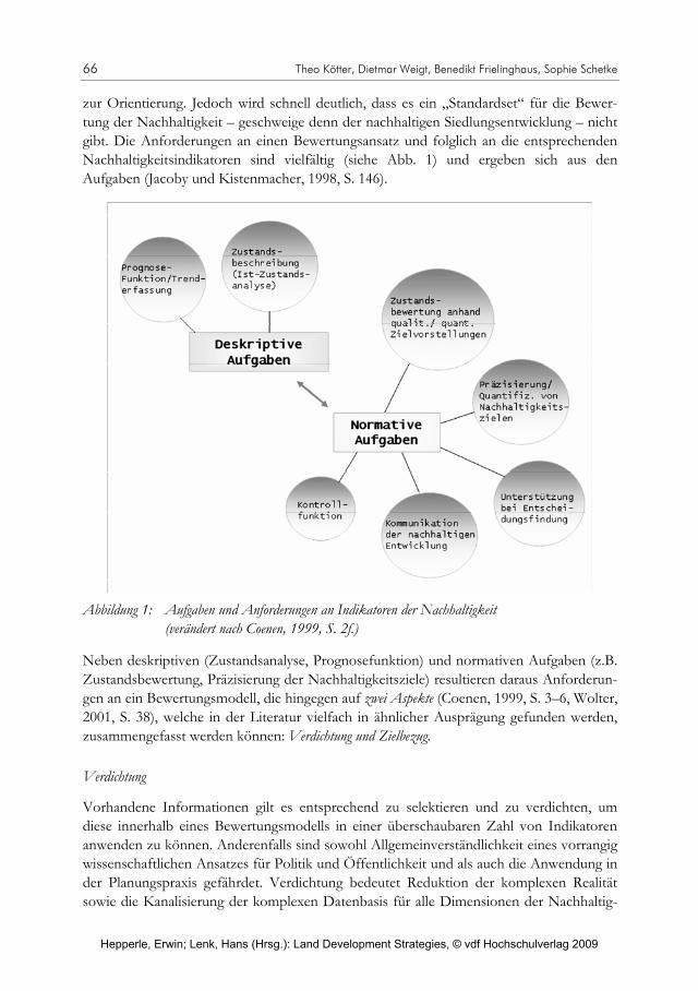
66 Theo Kötter, Dietmar Weigt, Benedikt Frielinghaus, Sophie Schetke
zur Orientierung. Jedoch wird schnell deutlich, dass es ein „Standardset“ für die Bewer-tung der Nachhaltigkeit – geschweige denn der nachhaltigen Siedlungsentwicklung – nicht gibt. Die Anforderungen an einen Bewertungsansatz und folglich an die entsprechenden Nachhaltigkeitsindikatoren sind vielfältig (siehe Abb. 1) und ergeben sich aus den Aufgaben (Jacoby und Kistenmacher, 1998, S. 146).
Abbildung 1: Aufgaben und Anforderungen an Indikatoren der Nachhaltigkeit (verändert nach Coenen, 1999, S. 2f.)
Neben deskriptiven (Zustandsanalyse, Prognosefunktion) und normativen Aufgaben (z.B. Zustandsbewertung, Präzisierung der Nachhaltigkeitsziele) resultieren daraus Anforderun-gen an ein Bewertungsmodell, die hingegen auf zwei Aspekte (Coenen, 1999, S. 3–6, Wolter, 2001, S. 38), welche in der Literatur vielfach in ähnlicher Ausprägung gefunden werden, zusammengefasst werden können: Verdichtung und Zielbezug.
Verdichtung
Vorhandene Informationen gilt es entsprechend zu selektieren und zu verdichten, um diese innerhalb eines Bewertungsmodells in einer überschaubaren Zahl von Indikatoren anwenden zu können. Anderenfalls sind sowohl Allgemeinverständlichkeit eines vorrangig wissenschaftlichen Ansatzes für Politik und Öffentlichkeit und als auch die Anwendung in der Planungspraxis gefährdet. Verdichtung bedeutet Reduktion der komplexen Realität sowie die Kanalisierung der komplexen Datenbasis für alle Dimensionen der Nachhaltig-
Hepperle, Erwin; Lenk, Hans (Hrsg.): Land Development Strategies, © vdf Hochschulverlag 2009
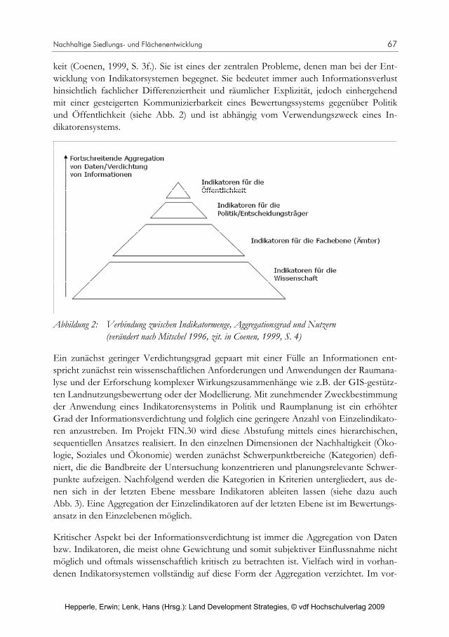
Nachhaltige Siedlungs- und Flächenentwicklung 67
keit (Coenen, 1999, S. 3f.). Sie ist eines der zentralen Probleme, denen man bei der Ent-wicklung von Indikatorsystemen begegnet. Sie bedeutet immer auch Informationsverlust hinsichtlich fachlicher Differenziertheit und räumlicher Explizität, jedoch einhergehend mit einer gesteigerten Kommunizierbarkeit eines Bewertungssystems gegenüber Politik und Öffentlichkeit (siehe Abb. 2) und ist abhängig vom Verwendungszweck eines In-dikatorensystems.
Abbildung 2: Verbindung zwischen Indikatormenge, Aggregationsgrad und Nutzern (verändert nach Mitschel 1996, zit. in Coenen, 1999, S. 4)
Ein zunächst geringer Verdichtungsgrad gepaart mit einer Fülle an Informationen ent-spricht zunächst rein wissenschaftlichen Anforderungen und Anwendungen der Raumana-lyse und der Erforschung komplexer Wirkungszusammenhänge wie z.B. der GIS-gestütz-ten Landnutzungsbewertung oder der Modellierung. Mit zunehmender Zweckbestimmung der Anwendung eines Indikatorensystems in Politik und Raumplanung ist ein erhöhter Grad der Informationsverdichtung und folglich eine geringere Anzahl von Einzelindikato-ren anzustreben. Im Projekt FIN.30 wird diese Abstufung mittels eines hierarchischen, sequentiellen Ansatzes realisiert. In den einzelnen Dimensionen der Nachhaltigkeit (Öko-logie, Soziales und Ökonomie) werden zunächst Schwerpunktbereiche (Kategorien) defi-niert, die die Bandbreite der Untersuchung konzentrieren und planungsrelevante Schwer-punkte aufzeigen. Nachfolgend werden die Kategorien in Kriterien untergliedert, aus de-nen sich in der letzten Ebene messbare Indikatoren ableiten lassen (siehe dazu auch Abb. 3). Eine Aggregation der Einzelindikatoren auf der letzten Ebene ist im Bewertungs-ansatz in den Einzelebenen möglich.
Kritischer Aspekt bei der Informationsverdichtung ist immer die Aggregation von Daten bzw. Indikatoren, die meist ohne Gewichtung und somit subjektiver Einflussnahme nicht möglich und oftmals wissenschaftlich kritisch zu betrachten ist. Vielfach wird in vorhan-denen Indikatorsystemen vollständig auf diese Form der Aggregation verzichtet. Im vor-
Hepperle, Erwin; Lenk, Hans (Hrsg.): Land Development Strategies, © vdf Hochschulverlag 2009

68 Theo Kötter, Dietmar Weigt, Benedikt Frielinghaus, Sophie Schetke
Abbildung 3: Beispiel des sequentiellen Aufbaus des Bewertungsrahmens FIN.30 mit gestufter Aggregationsmöglichkeit
liegenden Bewertungsmodell von FIN.30 wird dieser Kritikpunkt insofern umgangen, als dass nicht angestrebt wird, eine Gewichtung aus wissenschaftlicher Sicht durchzuführen. Vielmehr wird diese Verantwortung und Entscheidungsfreiheit an die kommunalen Ak-teure weitergegeben. Mittels der Programmierung einer Benutzeroberfläche erhalten die Anwender des Bewertungsrahmens hierbei durch Eingabe der Indikatorausprägungen sowie der Indikatorengewichte die Gelegenheit, eine eigenständige Flächenbewertung durchzuführen (siehe Abschnitt „Gesamtbewertung“). Auch eine gestufte Informations-verdichtung mittels Indikatoraggregation bis hin zur Gesamtaggregation aller drei Dimen-sionen wird hiermit ermöglicht.
Meist erfolgt eine Beschränkung innerhalb mehrdimensionaler Bewertungssysteme auf eine überschaubare Anzahl von Schlüssel- oder Leitindikatoren, die repräsentativ für ein breiteres Themenfeld sind, was eine Erklärungsmöglichkeit für die große Amplitude der Indikatoranzahl in derartigen Systemen ist (Coenen, 2000, S. 8–10, Nijkamp und Ouwer-sloot, 1998, S. 6). Jedoch darf hierbei nicht vergessen werden, dass allein die Indikatorwahl ein subjektives Steuern der Bewertung darstellt. Aus diesem Grund erfolgt die Ableitung planungsrelevanter Indikatoren im Projekt FIN.30 im Rahmen von Workshops experten-gestützt durch die Vertreter der Projektkommunen. Der Spagat zwischen möglicher wissenschaftlicher Herleitung von Indikatoren, die die Belange der Nachhaltigkeit ver-meintlich umfassend abbilden, und dem, was für die Planungspraxis nötig ist, tritt zu-nehmend zu Tage.
Zielbezug
Der Aspekt des Zielbezuges gilt der Präzisierung eines direkten Bezuges zu sowohl quanti-tativen als auch qualitativen Zielvorstellungen und Leitbildern zur nachhaltigen Entwick-
Hepperle, Erwin; Lenk, Hans (Hrsg.): Land Development Strategies, © vdf Hochschulverlag 2009
Nachhaltige Siedlungs- und Flächenentwicklung 69
lung einer Kommune oder einer Gesellschaft. Diese Herausforderung stellt ein vorherr-schendes Problem aktueller Bewertungsansätze dar und es wird zu erörtern sein, wie sich das Projekt FIN.30 dieser Aufgabe stellen kann. Im Rahmen der Nachhaltigkeitsdiskus-sion wird gerade Indikatoren auf kommunaler Ebene ein großes Potenzial zur Konkretisie-rung des Begriffs der nachhaltigen Siedlungsentwicklung sowie hinsichtlich der Erfolgs-kontrolle beigemessen (Gehrlein, 2003, S. 208). Wie in Abb.1 dargestellt, besitzen Nach-haltigkeitsindikatoren hinsichtlich ihrer Auswahl sowie ihrer Bewertung anhand von Refe-renzwerten auch eine normative Wirkung, die sie als Instrumente zur Überprüfung und zum Monitoring des Entwicklungsverlaufs der Siedlungsentwicklung prädestiniert (Coe-nen, 1999, S. 2). Allein der Begriff der Nachhaltigkeit bietet jedoch noch keine klare Vor-stellung hinsichtlich inhaltlich-fachlicher Schwerpunkte eines Bewertungssystems und lässt per se noch keine eindeutige Formulierung eines Bewertungsansatzes zu. In diesem Fall bietet das eingangs erwähnte quantitative 30-ha Flächensparziel der Bundesregierung, welches die Reduzierung einer täglichen Umwidmungsrate in Siedlungs- und Verkehrs-fläche von aktuell 114 auf 30 ha bis zum Jahr 2020 anstrebt, einen konkreten, allerdings nur quantitativen Zielbezug hinsichtlich einer nachhaltigen Raumentwicklung.
Davon ausgehend ist die weitere räumliche sowie inhaltliche Konkretisierung und Fokus-sierung des Bewertungsrahmens notwendig, um die beschriebenen normativen Funktio-nen der Indikatoren zu erfüllen, indem beispielsweise ein Wechsel der Betrachtung von der nationalen oder regionalen auf die kommunale Ebene vollzogen wird, um deutlich den lokalen Erfordernissen einer nachhaltigen Siedlungsentwicklung gerecht zu werden und somit den Schritt hin zu einem direkteren Zielbezug zu vollziehen. Um eine differenzierte Beurteilung des Nachhaltigkeitsstatus einer Gemeinde zu ermöglichen, ist es anzuraten, die Indikatoren, soweit es geht, auf die Ortsteilebene herunterzubrechen (Hartmuth et al., 2004, S. 4). Nach Heiland et al. lässt vielfach die Konzeption von Nachhaltigkeitsindikato-rensystemen noch zu oft Spezifika der beabsichtigten Systemfunktionen als auch die der beteiligten Akteure auf kommunaler Ebene vermissen (z.B. Evaluierungs- oder Kontroll-funktion) (Heiland et al., 2003, S. 25; Hartmuth et al., 2004, S. 20). Meist dominieren An-sätze, die einen kommunikativen Charakter aufweisen und/oder die Transparenz erhöhen wollen (Gehrlein, 2003, S. 207). Zu klären ist deshalb an dieser Stelle, was das Bewer-tungsmodell innerhalb der kommunalen Planungspraxis leisten soll und was kommunale Akteure von ihm erwarten. Die oft kritisierte Anschlussfähigkeit an kommunale Steue-rungsinstrumente (vgl. Heiland et al. 2003, S. 16) ist vielfach noch nicht ausgereift, so dass sinnvolle wissenschaftliche Ansätze zur nachhaltigen Siedlungsentwicklung und Ressour-censchonung aufgrund struktureller Probleme nicht umgesetzt werden, sondern oft im Sande verlaufen. Diesen Hemmnissen kann durch eine intensive Akteursbeteiligung im Rahmen der Indikatorauswahl (entsprechend lokalen Erfordernissen), die eine Kommuni-zierbarkeit und Praktikabilität der Indikatoren positiv beeinflusst, sowie durch die individu-elle Gewichtung der Indikatoren innerhalb eines Bewertungsverfahrens begegnet werden.
Daran schließt das Projekt FIN.30 an und verfolgt daher einen praxisorientierten und anwendungsbezogenen Forschungsansatz, um diesen Sachverhalten konsequent und pro-zessorientiert zu begegnen. Die Zusammenarbeit mit drei Partnerkommunen in der Ent-
Hepperle, Erwin; Lenk, Hans (Hrsg.): Land Development Strategies, © vdf Hochschulverlag 2009

70 Theo Kötter, Dietmar Weigt, Benedikt Frielinghaus, Sophie Schetke
wicklung eines Indikatorsystems ermöglicht einen direkten Einblick in konkrete Planungs-schwerpunkte und individuelle Problemstellungen. Des Weiteren beschränkt sich das Bewertungsverfahren von FIN.30 ausschließlich auf die Bewertung des Bereichs Wohn-baulandentwicklung als maßgeblichen treibenden Faktor der Flächeninanspruchnahme im Außenbereich der Kommunen (www.umweltdaten.de 2007). Vierteljährlich stattfindende Workshops mit Vertretern der Partnerkommunen stellen den zunächst wissenschaftlich hergeleiteten Bewertungsansatz hinsichtlich der Wohnbaulandbewertung mit Blick auf alle drei Dimensionen der Nachhaltigkeit auf den Prüfstand. Sowohl die Identifikation der kommunalen Entscheidungsträger mit den definierten Indikatoren als auch die praktische Abschätzung des Arbeitsaufwandes und daraus resultierend die Möglichkeiten der Imple-mentation sowie die Akzeptanz in der kommunalen Raumplanung werden hierbei geprüft.
Gerade das Einbeziehen der Akteure in den Prozess der Operationalisierung des Begriffs Nachhaltigkeit und die Konzipierung eines Bewertungsinstruments sowie die anschließen-de akteursspezifische Gewichtung sind unerlässlich, damit derartige wissenschaftliche Konzeptionen tatsächliche Anwendung finden. Ein konzeptionell wichtiger Ansatz ist jedoch die direkte Aufnahme von Inhalten und Indikatoren des planungsrechtlichen Instrumentariums in das Bewertungsverfahren und die Identifizierung systematischer Schnittstellen zu kommunalen Planungen und entsprechenden Instrumenten. Anknüp-fungspunkte des Bewertungsansatzes von FIN. 30 sind vor allem im Bereich der Umwelt-fachplanungen und der Bauleitplanung (Umweltverträglichkeitsprüfung, naturschutzrecht-liche Eingriffregelung) zu sehen. Weitere Synergieeffekte ergeben sich aus der Implemen-tation von methodischen Ansätzen und Kriterien der Ermittlung des Wohnbaulandpoten-zials einer Gemeinde (Schnell-Screening), welche bei der Vorbereitung eines Aufstellungs-verfahrens für den Flächennutzungsplan ohnehin zur Anwendung kommen. Es gilt, diese vielfältigen Verknüpfungen und Synergieeffekte aufzudecken, um den oftmals vorgetrage-nen kommunalen Bedenken des Mehraufwandes für ein Nachhaltigkeitsindikatorensystem zu begegnen. Zudem fördert eine Übernahme der bereits bekannten Termini (z.B. Erheb-lichkeit des Eingriffs, Erhaltung von Schutzgebieten, Bodenschutz) aus der Landschafts-bewertung die politische Kommunikation, das Verständnis und letztlich die Akzeptanz in der Planungspraxis.
Des Weiteren ist die Orientierung an örtlichen Zielvorgaben wie z.B. städtebaulichen und landschaftsgestalterischen Entwicklungszielen sowie die Verfügbarkeit von lokalen Ver-gleichs- und Referenzwerten der Indikatoren ein wichtiger Baustein innerhalb der Kon-struktion eines normativen und lokalspezifischen Bewertungsmodells. Nur die Orientie-rung an lokalen Entwicklungszielen ermöglicht ein konkretes Steuerungs- und Kontroll-system. Schließlich hat das Schlagwort „nachhaltige und flächensparende Siedlungsent-wicklung“ für Klein- bzw. Mittelstädte eine ganz andere sowohl inhaltliche als auch prakti-sche Bedeutung und Schwerpunktsetzung als für eine hoch verdichtete Großstadt (z.B. Essen). Die Notwendigkeit, nicht nur die Art und den Inhalt der Nachhaltigkeitsindikato-ren den lokalen Erfordernissen und Leitbildern anzupassen, sondern auch die der Bewer-tung zugrunde liegenden Normen, werden hier deutlich. Erst dann kann von einem kon-
Hepperle, Erwin; Lenk, Hans (Hrsg.): Land Development Strategies, © vdf Hochschulverlag 2009

Nachhaltige Siedlungs- und Flächenentwicklung 71
Tabelle 1: Materielle und technische Anforderungen sowie Aufgaben von Indikatoren-systemen (ergänzt nach Heiland et al., 2003, S. 25–36; Nijkamp und Ou-wersloot, ohne Jahr, S. 6; Korczak, 2002, S. 4; Wolter, 2001, S. 33–40; Brückner, 2001, S. 18)
kreten Zielbezug und der Eignung eines Bewertungsrahmens als Werkzeug für die Stand-ortanalyse, die Entscheidungsfindung und des Monitorings gesprochen werden.
3.1 Kriterien bei der Indikatorauswahl und der Aufstellung eines multikriteriellen Bewertungsrahmens
Bei der Konzeption eines Bewertungsrahmens zur Ermittlung von geeigneten Wohnbau-landpotenzialen für eine nachhaltige Siedlungsentwicklung werden zahlreiche Anforderun-gen an die Indikatoren deutlich, die dieses Ziel abbilden sollen. Diese Anforderungen bestimmen maßgeblich die Anwendbarkeit, Transparenz und Kommunizierbarkeit eines solchen Ansatzes (in reduzierter Ausführung siehe Tab. 1). Zum einen prägen materielle Einflüsse wie z.B. die Datenverfügbarkeit wesentlich die Wahl der Indikatoren. Neben
Materielle Anforderungen Technische Anforderungen Aufgaben von Indikatoren Vollständigkeit - Leitbild der Nachhaltigkeit muss
in allen Dimensionen umfassend und verständlich erfasst werden
Datenverfügbarkeit - Bestimmt Charakteristik des
Indikators (qualitativ/quantitativ bzw. räumlich-explizit oder verteilungsfrei)
- Beeinflusst inhaltliche Schwerpunktsetzung des Bewertungsverfahrens
Analysefunktion - Ableitung signifikanter
Indikatoren aus Systemanalyse > Erkennung von komplexen Zusammenhängen
- Trendanalysen
Handlungsbezug - Relevanz für die anwendenden
Kommunen (individuelle Problemlagen und Handlungsmöglichkeiten) beachten
Datenqualität - Bestimmen Charakteristik
und Aussagekraft des Bewertungssystems
Kommunikations- und Informationsfunktion - Vereinfachung komplexer
Zusammenhänge - Darstellung relevanter Elemente
und Zusammenhänge - Partizipativer Ansatz
(Expertenbeteiligung) Aussagekraft/ lokaler Leitbildbezug - Reduzierung des
Abstraktionsgrades von Indikatoren/Steigerung eines direkten Flächenbezugs
Datenkompatibilität - Ermöglichung des horizontalen
und vertikalen Indikatorvergleichs > Vergleich mit übergeordneten Raumeinheiten sowie Vergleich der Untersuchungsgebiete untereinander
Steuerungs, Warn- und Entscheidungsfunktion - Steuerung des Planungsprozesses
durch Bewertung der nachhaltigen Entwicklung anhand von Referenzwerten
Nachvollziehbarkeit, Allgemeinverständlichkeit, Anschaulichkeit - Steigerung der
Kommunizierbarkeit/ Implementation in die Planungspraxis
Monitoringfunktion - Soll-Ist-Vergleich - Abbildung der nachhaltigen
Raumentwicklung und Sensibilisierung der Entscheidungsträger
Inhaltliche Kompatibilität - Berücksichtigung bereits
angewendeter Indikatorensysteme („von anderen lernen“)
Hepperle, Erwin; Lenk, Hans (Hrsg.): Land Development Strategies, © vdf Hochschulverlag 2009

72 Theo Kötter, Dietmar Weigt, Benedikt Frielinghaus, Sophie Schetke
einer möglichst vollständigen Abbildung der Dimensionen der Nachhaltigkeit sind der Handlungsbezug und damit die Praktikabilität des Bewertungsrahmens für die späteren Anwender (Kommunen/kommunale Entscheidungsträger) von noch grösserer Wichtig-keit. Die Nachvollziehbarkeit eines solchen Systems ist ein wichtiger Schritt in Richtung einer gesteigerten Kommunizierbarkeit/Verständlichkeit und wird gefolgt von der Identi-fikation von Schnittstellen zu vorhandenen wissenschaftlichen und besonders kommuna-len Bewertungsansätzen („Von anderen lernen“). Der Transfer eines wissenschaftlich konsistenten und repräsentativen Indikatorenkonstrukts hin zu einem anwendbaren und entscheidungs- und politisch relevanten sowie akzeptierten Bewertungsrahmen für die kommunale Planung ist ein überaus wichtiger Bestandteil der Konzeption und bedarf der aktiven Akteursbeteiligung und -beratung von der Konzeption bis hin zur tatsächlichen Flächenbewertung (siehe Abschnitt „Zielbezug“). Neben diesen sehr materiellen stehen praktisch-technische Anforderungen. Diese entscheiden (meist) über die Charakteristik einzelner Indikatoren (qualitativ/quantitativ) und ihren räumlichen Bezug und beeinflus-sen hinsichtlich Datenqualität und -verfügbarkeit die inhaltliche Schwerpunktsetzung des Bewertungsrahmens, obgleich dies einem wissenschaftlich konsistenten Ansatz zuwider-läuft.
Die genannten Anforderungen münden letztlich in vier Schwerpunktaufgaben, die Indika-toren per se und ein Bewertungsmodell als Gesamtheit zu erfüllen haben:
Ableitung und somit die Operationalisierung komplexer Systemzusammenhänge, um eine breite Verständlichkeit und Kommunizierbarkeit der angewählten Indikatoren zu ermöglichen (Analysefunktion).
Reduktion von Komplexität und von Information, um folglich ein näherungsweises Abbild der Realität zu schaffen (Kommunikations- und Informationsfunktion).
Steuerungs-, Warn- und Entscheidungsfunktion: Schon innerhalb des Planungsprozes-ses kann mittels geeigneter Indikatoren eine nachhaltige Raumentwicklung teilweise ge-steuert werden. Planungsalternativen können in Anlehnung an einen Bewertungsrah-men beurteilt werden.
Monitoringfunktion: Ein Soll/Ist-Vergleich der unterschiedlichen Planungsszenarien ermöglicht ein Monitoring der Siedlungsentwicklung mittels konkreter Nachhaltigkeits-indikatoren.4
Komplexe Sachverhalte werden an Hand weniger Kenn- bzw. Referenzwerte und deren Veränderungen dargestellt, so dass aktuelle bzw. zukünftige Änderungen eines Systems erkannt und beurteilt werden können (Entscheidung, Controlling, Monitoring). Mit Hilfe
4 Zur sinnvollen Erfüllung der Monitoringfunktion ermöglicht die Implementation von Verlaufsdaten im
Rahmen einer Trendanalyse sowohl eine dynamische Bewertung der Siedlungsentwicklung als auch die Ableitung individueller Referenzwerte zur Bewertung der Indikatoren. Leider liegen derartige Daten vielfach nicht vor, so dass künftige Planungsszenarien zur Entscheidungsfindung herangezogen werden müssen.
Hepperle, Erwin; Lenk, Hans (Hrsg.): Land Development Strategies, © vdf Hochschulverlag 2009

Nachhaltige Siedlungs- und Flächenentwicklung 73
geeigneter Indikatoren sollen die Aspekte der nachhaltigen Wohnbaulandentwicklung konkretisiert und messbar gemacht werden. Die Indikatorausprägungen der Ausgangs- und Zielsituation werden miteinander verglichen und nach Möglichkeit an einem Refe-renzwert gemessen (Flacke, 2003, S. 68; Nijkamp und Ouwersloot, 1998, S. 4). Im vorlie-genden Fall ist dies die Operationalisierung der Systemzusammenhänge und treibenden Kräfte („driving forces“) innerhalb der Siedlungsentwicklung mit dem Ziel, ein Analyse-, Entscheidungs- und Monitoringsystem zu entwickeln, das einen wesentlichen Beitrag zu einer flächensparenden Siedlungsentwicklung leistet.
3.2 Schwerpunkte der Dimensionen – Der Bewertungsrahmen des Projekts FIN.30
Die Bewertung von potentiellen Wohnbauflächen wird mit Hilfe eines multidimensionalen Bewertungsrahmens durchgeführt. Der Bewertungsrahmen von FIN.30 umfasst die drei Dimensionen der Nachhaltigkeit (siehe Abb. 4) und zeigt einen hierarchischen Aufbau, der eine gestufte Indikatorenaggregation entsprechend unterschiedlicher Akteure und ihren Anforderungen zulässt (siehe Abb. 3).
So fokussiert die Dimension „Ökologie“ unter dem Aspekt der Umweltverträglichkeit vor allem auf die entsprechenden umweltbezogenen Restriktionen, die einer Wohnbauland-ausweisung gegenüberstehen („Schutz“), und ist an die Umweltschutzgüter des vorhande-nen rechtlichen Instrumentariums der Umweltprüfung in der Bauleitplanung angelehnt. Die Dimension „Soziales“ ist enger mit einem weitgehenden Bewertungsansatz und der Eignung einer Fläche als Wohnbauland verbunden und betrachtet das Schutzgut „Mensch“ mit seinem Anspruch an ein angenehmes Wohnumfeld. Die Dimension „Öko-nomie“ betrachtet zusammenfassend, was auf Basis einer objektiven Kostenkalkulation letztlich als empfehlenswert gilt. Der Bewertungsrahmen dient insofern dazu, ein Ranking der zu entwickelnden potentiellen Wohnbauflächen innerhalb einer Kommune zu erstellen und kann als Schnittstelle zur Kommunalpolitik und zu kommunalen Entscheidungs-trägern („Umsetzbarkeit“) fungieren.
Dimension Ökologie
Die Erheblichkeit eines Eingriffs durch Wohnbauflächenerweiterungen wird durch fünf Kategorien operationalisiert (s. Abb. 3). Als erstes werden in der Kategorie „Flächennut-zung“ Aspekte der städtebaulichen Dichte und der Siedlungsstruktur mit Blick auf eine erstrebenswerte, kompakte Siedlungsentwicklung analysiert. Die Kategorie „Grünausstat-tung/ökologische Flächenleistung“ fokussiert auf die Qualität urbanen Grüns, charakteri-siert durch entsprechende Ökosystemleistungen (Grundwasserneubildung, Bündelung von Schadstoffen, Darstellung von Habitaten), die durch neue Wohnbebauung evtl. erheblich reduziert werden. Der Aspekt der „Ressourcenschonung“ zielt im Sinne des 30-ha-Flächensparziels auf die Betrachtung des Flächenkreislaufs sowie eine kritische Bewertung zusätzlicher Bodenversiegelung in den Kommunen ab. Die Kategorie „Stadtklima“ ist im Bereich der Einflussnahme neuer Wohnbebauung auf die Lebensqualität hinsichtlich der
Hepperle, Erwin; Lenk, Hans (Hrsg.): Land Development Strategies, © vdf Hochschulverlag 2009

74 Theo Kötter, Dietmar Weigt, Benedikt Frielinghaus, Sophie Schetke
Beeinflussung stadtklimatischer Gegebenheiten (Kaltluftleitbahnen, Ventilationsbahnen) angesiedelt. Die Kategorie „Risikopotential“ betrachtet die Vulnerabilität von Siedlungs-strukturen gegenüber äusseren Umwelteinflüssen (wie z.B. die Gefährdung durch Hoch-wasserereignisse bzw. die verminderte Baugrundqualität aufgrund anstehenden Grundwas-sers) und die Notwendigkeit der Implementierung dieser Faktoren in die Vorabwertung neuer Bauflächen.
Abbildung 4: Matrix zur Bewertung von Wohnbaulandpotentialen. Die weiterführenden und zur Operationalisierung notwendigen Indikatoren sind aus Gründen der Übersichtlichkeit nicht aufgeführt
Hepperle, Erwin; Lenk, Hans (Hrsg.): Land Development Strategies, © vdf Hochschulverlag 2009

Nachhaltige Siedlungs- und Flächenentwicklung 75
Neben den genannten inhaltlichen Schwerpunkten existieren richtungweisende strukturelle Aspekte, die die Operationalisierung der Dimension „Ökologie“ durch geeignete Indikato-ren bestimmen. Die zur Verfügung stehenden Datengrundlagen einerseits sowie die be-reits angesprochene Akzeptanz bei den kommunalen Entscheidungsträgern andererseits stellen pragmatische, aber auch essentielle Auswahlkriterien bei der Indikatorzusammen-stellung dar. Zur Steigerung der Kommunizierbarkeit und Verwendbarkeit des Bewer-tungsrahmens ist eine Einbindung des bestehenden und bekannten planungsrechtlichen Instrumentatriums in die Planungspraxis anzustreben. Aufgrund dessen werden Indikato-ren, die in den vertrauten Instrumenten wie der Umweltprüfung bereits Anwendung fin-den, modifiziert oder auch teilweise unverändert in das Indikatorset übernommen. Den-noch ist es nicht erstrebenswert, das bestehende Instrumentarium gänzlich zu überneh-men, sondern es soll dem Anwender bewusst gemacht werden, dass ohnehin notwendige Arbeiten bzw. Prüfungen des bestehenden rechtlichen Instrumentariums im neuen Bewer-tungsrahmen aufgegriffen werden und entsprechende Verfahrensschritte, beispielsweise das „Screening“, adaptiert und durch leicht verständliche und kalkulierbare Indikatoren inhaltlich erweitert werden können. Es gilt an dieser Stelle, deutliche Parallelen und Syner-gien herauszuarbeiten. Neben der so gesteigerten Akzeptanz und Kommunizierbarkeit ermöglicht diese Vorgehensweise zusätzlich, vorliegende amtliche Daten der Städte, Land-kreise, Landesämter (Landesvermessungsamt, Geologischer Dienst) zu nutzen bzw. sie mittels GIS entsprechend weiterzuverarbeiten. Hierbei handelt es sich vor allem um Daten der Schutzgebiete, Landschaftspläne, Bodenkarten, Luftbilder sowie Auszüge aus der automatisierten Liegenschaftskarte.
Dimension Soziales
Die Operationalisierung der Dimension „Soziales“ bezieht sich auf die Eignung eines potentiellen Wohnbaustandortes und wesentliche objektive Aspekte der „Lebensqualität“, die massgeblich durch die Erreichbarkeit entsprechender Erholungsräume und sozialer Dienstleistungen bedingt sind (Schetke und Haase, 2008). Diese Faktoren werden in den Kategorien „Versorgungsgerechtigkeit“ und „Attraktivität des Wohnumfeldes“ aufgegrif-fen (s. Abb. 3). Kategorie „Vorsorgungsgerechtigkeit“ fokussiert auf die Schwerpunkte der adäquaten „Versorgung mit Wohnfläche“ sowie eine an städtebaulichen Standards gemes-sene, vertretbare Erreichbarkeit öffentlicher Versorgungseinrichtungen. In Bezug auf das Kriterium „Wohnraumversorgung“ gilt es in der Folge Auswirkungen zusätzlicher Aus-weisung von Wohnfläche hinsichtlich der Effekte (beispielsweise Verbesserung des Wohnraumangebotes) quantitativ zu betrachten sowie qualitativ zu berücksichtigen, in-wieweit zusätzlicher Wohnraum in den jeweiligen Bereichen marktgerecht bzw. marktgän-gig ist sowie in Anbetracht einer angestrebten Wohndichte und sozialen Zusammenset-zung der Bevölkerung als nachhaltig bewertet werden kann. Die Versorgung mit bzw. die Erreichbarkeit von Einrichtungen der sozialen Infrastruktur trägt weiterhin erheblich zur Wohnzufriedenheit der Bevölkerung sowie zur Marktgängigkeit potentieller Wohnbau-flächen bei. Entsprechende Defizite schmälern folglich nicht nur die Wohnzufriedenheit,
Hepperle, Erwin; Lenk, Hans (Hrsg.): Land Development Strategies, © vdf Hochschulverlag 2009
76 Theo Kötter, Dietmar Weigt, Benedikt Frielinghaus, Sophie Schetke
sondern wirken sich auch im Bereich der Ökonomie bei Behebung dieser Defizite in we-sentlich erhöhten Infrastrukturkosten aus.
In der Kategorie „Attraktivität des Wohnumfeldes“ werden, im Anschluss an die vorher-gehende Analyse der Wohnraum- und Infrastrukturversorgung, insbesondere die Erreich-barkeit von Erholungsräumen im näheren und weiteren Wohnumfeld (Schöning und Bor-chard, 1992, S. 85) sowie Aspekte der Lagegunst einer Wohnbaufläche hinsichtlich lokal-klimatischer Charakteristika (klimatische Regulation, Lärm- und Schadstoffbelastung) als wesentliche Determinanten der Wohnumfeldqualität betrachtet (Brückner, 2001, S. 18).
Die Anwendung von normativen Vergleichswerten im Rahmen einer GIS-gestützten Er-reichbarkeitsanalyse bietet die Möglichkeit, standortspezifische Vor- und Nachteile für beide Kategorien zu identifizieren. Weiterhin lassen sich durch die Einhaltung von Er-reichbarkeitsreferenzwerten bei einer strategischen Ausweisung neuer Wohnbauflächen die Auslastungsgrade bestehender Einrichtungen stützen und die Erfordernisse zusätz-licher Infrastruktur durch Neuausweisung vermeiden. Vor dem Hintergrund der demo-graphischen Entwicklung gewinnt dieser Aspekt, auch aus sozioökonomischen Gründen, zunehmend an Bedeutung.
Dimension Ökonomie
Neben der ökologischen Vertretbarkeit und sozialen Verträglichkeit spielt die ökonomi-sche Tragfähigkeit und damit Realisierbarkeit in Zeiten knapper kommunaler Haushalte eine wichtige Rolle. Es steht also bei dieser Dimension nicht die wirtschaftliche Entwick-lung einer Stadt oder Gemeinde im Fokus, sondern die Kosten- und Einnahmeeffekte bestimmter Flächennutzungen. Da der Bewertungsrahmen zur Entscheidungsfindung auf der Ebene des Flächennutzungsplanes angesiedelt ist, werden die ökonomischen Betrach-tungen des Kalkulationsmodells dynamisch auf einen Zeitraum von 15 Jahren (Planungs-horizont eines Flächennutzungsplanes) bezogen. Erfasst werden dadurch sowohl projekt-bezogene als auch kommunalwirtschaftliche Effekte, die eine dynamische Betrachtung notwendig machen. Die Kalkulation setzt plausible Annahmen und Szenarien z.B. hin-sichtlich der Bebauungsstruktur und des zeitlichen Ablaufs voraus. Grundlage bilden em-pirisch abgeleitete Orientierungswerte für Baudichten und Erschließungskosten. Die mit der Klassifizierung einhergehenden Unsicherheiten sind für die grundsätzliche Entschei-dungsfindung akzeptabel, denn die standortspezifischen Kosten und Einnahmen und damit die jeweiligen ökonomischen Siedlungsstandortvor- und -nachteile werden signifi-kant herausgestellt.
Für die Auswahl der bei der Kalkulation angesetzten Kostenbereiche ist die Entschei-dungsrelevanz ein zentrales Kriterium, denn die Ergebnisse sollen rationale Entschei-dungsgrundlagen für den Planungsprozess liefern. Lediglich die mit dem Standort korre-lierten Kosten und Einnahmen einer neuen Wohnbaufläche werden daher erfasst, die standortinvarianten Positionen bleiben außer Betracht. Nicht erfasst werden demnach zum einen externe Kosten, da sie sich nicht eindeutig einem speziellen Baugebiet zuord-
Hepperle, Erwin; Lenk, Hans (Hrsg.): Land Development Strategies, © vdf Hochschulverlag 2009
Nachhaltige Siedlungs- und Flächenentwicklung 77
nen lassen, und zum anderen Opportunitätskosten oder sog. „Schattenpreise“ (d.h. ent-gangener Nutzen bei alternativer oder nicht realisierter Nutzung). Das Ergebnis ist u.a. eine „ökonomische Rangliste“ für potentielle Wohnbauflächen, differenziert nach Bau-strukturen und damit Zielgruppen innerhalb einer Kommune. Transparenz und Nachvoll-ziehbarkeit der Kalkulationsergebnisse lassen sich bei dieser Vorgehensweise optimieren.
Von erheblicher Entscheidungsrelevanz sind neben den projektbezogenen gesamten Ent-wicklungs- und Herstellungskosten vor allem auch die langfristigen kommunalwirtschaft-lichen Folgekosten für die Unterhaltung der Infrastruktur neuer Wohnbauflächen sowie auch die Möglichkeiten der Kostenabwälzung auf die Planungsbegünstigten, also das Refi-nanzierungspotenzial (s. Abb. 4). Eine kurzfristige Kalkulation der Kosten erfasst zu-nächst lediglich die projektorientierten Vorbereitungs- und Durchführungskosten, Zwi-schenfinanzierungskosten, Kosten der technischen und sozialen Infrastruktur und Aus-gleichsmaßnahmen. Dabei sind die kostenrelevanten äußeren und inneren Eigenschaften einer potentiellen Wohnbaufläche zu identifizieren. So wirken sich naturgemäß die räumli-che Lage des Standortes vor allem bei der äußeren Anbindung an das bestehende Netz der technischen Infrastruktur aus, während Bodenart und Hangneigung die Baukosten der inneren und äußeren Erschließung erheblich beeinflussen. Die Ausdehnung der bestehen-den Netze der leitungsgebundenen Infrastruktur führt zu gravierenden Mehrkosten für erstmalige Herstellung und Unterhaltung.
Die Kosten von langfristiger Unterhaltung, Pflege und Betrieb dieser Einrichtungen und Anlagen werden zwar meist zunächst von der Kommune getragen, letztlich erfolgt indes-sen eine Kostentragung über Abgaben oder Steuern durch die Nutzer bzw. die Einwohner einer Gemeinde. Da die Höhe dieser Kosten pro Einwohner wesentlich von der Lage, der Bebauungsstruktur und Netzlänge sowie der Nutzerdichte abhängen, hat die Kommune eine grundlegende Verantwortung, diese durch eine sorgfältige Standortwahl der neuen Wohnbauflächen, deren städtebauliche Konzeption und geschlossene Verwirklichung zu optimieren.
Auf der Einnahmenseite werden bei der Kalkulation die Refinanzierungspotenziale ermit-telt, die sich an der Nettobodenwertsteigerung orientieren müssen und mit dem jeweiligen Baulandmodell korrelieren (Stelling, 2005). Deshalb ist es für das Ergebnis der Kalkulation sehr bedeutsam, dass unterschiedliche Entwicklungsstrategien berücksichtigt werden kön-nen, die zu abweichenden Einnahmesituationen aufgrund ihrer wirtschaftlichen Effekte bei sonst gleichen Rahmenbedingungen und Planungsvorgaben führen. Mit Hilfe des Kalkulationsansatzes lassen sich daher neue Wohnbauflächen hinsichtlich Standortwahl, städtebaulicher Konzeption und Baulandmodell optimieren.
Gesamtbewertung
Wie vorangehend erläutert, wird im Rahmen der Wohnbaulandbewertung von FIN.30 ein gestufter Bewertungsansatz verfolgt, der einerseits eine sequentielle Informationsverdich-tung bzw. Indikatoraggregation zulässt und andererseits durch die Programmierung einer
Hepperle, Erwin; Lenk, Hans (Hrsg.): Land Development Strategies, © vdf Hochschulverlag 2009

78 Theo Kötter, Dietmar Weigt, Benedikt Frielinghaus, Sophie Schetke
Benutzeroberfläche zur eigenständigen Bewertung (siehe Abb. 5) eine individuelle Indika-torgewichtung innerhalb der Gesamtbewertung erlaubt. Somit werden sowohl Akzeptanz der Flächenbewertung seitens der Akteure als auch die vielfach kritisierte Anschlussfähig-keit von Indikatorensystemen an die kommunale Praxis erhöht. Politische und planungs-spezifische Schwerpunkte kommen hierbei innerhalb der nachhaltigen Baulandbewertung zum Tragen.
Weiterer Schwerpunkt neben der Zusammenführung von Indikatoren und unterschied-lichen Dimensionen zu einer Gesamtaussage ist der Transfer (siehe Abb. 6) unterschied-licher Indikatorenskalen in den Dimensionen (ordinal-, nominal-, intervallskaliert), die unweigerlich aus unterschiedlichen Datengrundlagen und Bewertungsalgorithmen in den einzelnen Dimensionen resultieren. Hierbei wird ein Transfer der unterschiedlichen Skalen und Indikatorarten (qualitativ, quantitativ, semi-quantitativ) in eine einheitliche dreistufige Rangskala ermöglicht und eine integrative Bewertung quantitativer und qualitativer Indika-toren praktikabel.
4. Zusammenfassung
Im vorliegenden Beitrag werden die Forschungsansätze und Hypothesen des Projekts FIN.30 innerhalb der Förderinitiative REFINA vor dem Hintergrund einer nachhaltigen und ressourcenschonenden Siedlungsentwicklung diskutiert und dargestellt. Der eingangs
Abbildung 5: Ablauf des Kalkulationsmodells FIN.30
Hepperle, Erwin; Lenk, Hans (Hrsg.): Land Development Strategies, © vdf Hochschulverlag 2009

Nachhaltige Siedlungs- und Flächenentwicklung 79
Abbildung 6: Prototyp der programmierten Oberfläche zur selbstständigen Flächenbewertung (Beispiel Ökologie)
Abbildung 7: Aggregation unterschiedlicher Skalen in der Bewertung
Hepperle, Erwin; Lenk, Hans (Hrsg.): Land Development Strategies, © vdf Hochschulverlag 2009

80 Theo Kötter, Dietmar Weigt, Benedikt Frielinghaus, Sophie Schetke
geführten Diskussion über Potenziale der Ressource Boden, der Darstellung verschiedener Dimensionen der Dichte sowie der Erörterung, was unter einer intelligenten Flächennut-zung verstanden werden sollte, folgt in einem zweiten Schwerpunkt die Diskussion der Anforderungen an Nachhaltigkeitsindikatorensysteme, die vielfach den Spagat zwischen wissenschaftlicher Konsistenz und praktischer Anwendbarkeit bewältigen müssen. Eine überblicksartige Darstellung der Indikatormatrix zur Bewertung von Wohnbaulandpoten-zialen des Projekts FIN.30, eine expertengestützte Indikatorauswahl sowie die Möglichkeit der individuellen Gewichtung sowie der Transfer unterschiedlicher Indikatorskalen zu einer Gesamtbewertung schließen den Beitrag ab.
Die Diskussion über den vorrangigen Schutz der Ressource Boden und des Dichtebe-griffs, der sich auf alle Dimensionen der Nachhaltigkeit ausdehnt, sowie die abschließende Darstellung der Indikatorenmatrix zur Bewertung und Exploration von Wohnbaulandpo-tenzialen zeigen, dass für eine konkrete Umsetzung einer flächensparenden Siedlungsent-wicklung ein alleiniges quantitatives Flächensparziel nicht genügt. Vielmehr müssen ver-stärkte Ansätze über das „Wie“ der Umsetzung geführt werden. Die eingangs diskutierten Dichtebegriffe einer intelligenten Flächennutzung werden im aufgeführten Bewertungs-rahmen aufgegriffen und durch weitere qualitative Bewertungskriterien ergänzt. So wird beispielsweise in der Dimension Ökologie die materielle Dichte durch die Betrachtung kritischer Versiegelungsgrade sowie die Implementation von räumlichen Dichtemaßen aufgegriffen und durch eine qualitative Betrachtung der potenziell in Anspruch genomme-nen Schutzgüter ergänzt. Die aufgeführte Nutzungsdichte wird in den Dimensionen Sozia-les und Ökonomie aufgriffen, in denen zum einen kritische Entfernungen zu bestehender Infrastruktur und zum anderen die notwendige Mantelbevölkerung für eine effektive Aus-lastung bewertet werden. Eine konkrete Ableitung der Indikatoren für die einzelnen Di-mensionen ist als nächster Arbeitsschritt vorgesehen.
Der Bewertungsrahmen des Forschungsprojekts FIN.30 soll insgesamt nicht nur eine maßvolle und für die Inanspruchnahme von Ressourcen – insbesondere der Ressource Boden – adäquate Dichte fördern, sondern zugleich auch durch eine qualitative Betrach-tung der in Anspruch genommenen Ressourcen und Schutzgüter die Transparenz und Rationalität der kommunalen Entscheidungsprozesse für eine ressourcenschonende Sied-lungsentwicklung erhöhen. Des Weiteren soll gerade dieser qualitative Ansatz wissen-schaftlich orientierte Nachhaltigkeitsforschung und praxisorientiertes Flächensparen in Einklang bringen.
Literatur
Albers, G. [1964], Wohndichte und Geschossflächenzahl. Stadtbauwelt, 1964(1): 44–48.
Brückner, C. [2001], Indikatoren einer nachhaltigen Raumentwicklung in Nordrhein-Westfalen. In: Institut für Landes- und Stadtentwicklungsforschung des Landes NRW
Hepperle, Erwin; Lenk, Hans (Hrsg.): Land Development Strategies, © vdf Hochschulverlag 2009

Nachhaltige Siedlungs- und Flächenentwicklung 81
(Hrsg.), Nachhaltigkeitsindikatoren – Wegweiser für eine räumliche Entwicklung in Nordrhein-Westfalen. ILS-Schriften 175 (pp. 9–93). Dortmund, Institut für Landes- und Stadtentwicklungsforschung des Landes NRW.
Bundesamt für Bauwesen und Raumordnung (BBR) (Hrsg.) [2004], Städte der Zukunft. Kompass für den Weg zur Stadt der Zukunft. Bonn, Bundesamt für Bauwesen und Raumordnung.
Bundesregierung [2004], Perspektiven für Deutschland. Unsere Strategie für eine nachhaltige Entwicklung. Fortschrittsbericht 2004. Berlin, Presse- und Informationsamt der Bundesregierung.
Coenen, R. [1999], Untersuchung zu einem integrativen Konzept nachhaltiger Entwicklung. Bestandsaufnahmen, Problemanalysen, Weiterentwicklung. Projekt der Helmholtz-Gesellschaft Deutscher Forschungszentren, Abschlussbericht Band 4 Teil 1. Karlsruhe, Institut für Technikfolgenabschätzung und Systemanalyse.
Cording, E. [2007], Dichte und Wohnen. PlanerIn, Heft 1/2007: 42–43.
Davy, B. [2005], Bodenpolitik. In: Akademie für Raumforschung und Landesplanung (Hrsg.), Handwörterbuch der Raumordnung (S. 117–124). Hannover, Verlag der ARL.
Dosch, F. [2002], Auf dem Weg zu einer nachhaltigen Flächennutzung. Informationen zur Raumentwicklung Heft 1, 2/2002: 31–45.
ECOPLAN [2000], Siedlungsentwicklung und Infrastrukturkosten. Bern: Bundesamt für Raumentwicklung Schweiz (ARE), S. 12 ff., www.are.admin.ch/are/de/.
Gassner, E. [1972], Aufschließung städtebaulicher Entwicklungsflächen. Schriftenreihe des deutschen Städtebundes, Heft 17. Göttingen, Otto Schwartz.
Gehrlein, U. [2003], Gestaltungskriterien für kommunale Nachhaltigkeitsindikatoren-systeme. UVP-Report 17 (5): 207–211.
Gehrlein, U. [2003a], Umweltindikatoren für eine zukunftsfähige Entwicklung: Einordnung und Verwendungsmöglichkeiten. Beitrag zur Fachveranstaltung der Hessischen Landesanstalt für Umwelt und Geologie am 09.10.2003.
Göderitz, J., Rainer, R. und Hoffmann; H. [1957], Die gegliederte und aufgelockerte Stadt. Tübingen, Wasmuth.
Gutsche, J.-M. [2004], Verkehrserzeugende Wirkungen des kommunalen Finanzsystems. Forum Öffentliche Finanzen 9. Hamburg, Analytica.
Hartmuth, G. , Huber, K. und Rink, D. [2004], Nachhaltige Entwicklung im lokalen Kontext – Schritte zur Entwicklung eines kommunalen Nachhaltigkeits-Indikatoren-system. UFZ-Diskussionspapiere 6/2004. Leipzig, UFZ-Umweltforschungszentrum.
Heiland, S., Tischer, M., Döring, T. Pahl, T. und Jessel, B. [2003], Indikatoren zur Zielkonkretisierung und Erfolgskontrolle im Rahmen der lokalen Agenda 21. Berlin, Umweltbundesamt.
Hepperle, Erwin; Lenk, Hans (Hrsg.): Land Development Strategies, © vdf Hochschulverlag 2009
82 Theo Kötter, Dietmar Weigt, Benedikt Frielinghaus, Sophie Schetke
Jacoby, G. und Kistenmacher H. [1998], Bewertungs- und Entscheidungsmethoden. In: Akademie für Raumforschung und Landesplanung (Hrsg.), Methoden und Instrumente räumlicher Planung (S. 146–168). Hannover, Verlag der ARL.
Korczak, D. [2002], Nachhaltigkeitsindikatoren-Systeme im Vergleich. München, Institut für Grundlagen- und Programmforschung (www.gp-forschungsgruppe.com/de/pdf/ak_nachh.pdf).
Kötter, T. und Weigt, D. [2006], Flächen intelligent nutzen – ein marktwirtschaftlicher Ansatz für ein nachhaltiges Flächenmanagement. fub 2/2006: 49–56.
Kötter, T. [2002], Städtebauliche Kalkulationen als Aufgabe des projektorientierten Flächenmanagements. fub 3/2002: 143–151.
Krau, I. [2000], Urbane und bauliche Dichte im Kontext der Stadtregion. PlanerIn, 4/2000: 38–39.
Nijkamp, P. und Ouwersloot, H. [1998], A Decision Support system for regional sustainable development: The flag model. Amsterdam, Free University.
Rat für Nachhaltige Entwicklung [2004], Mehr Wert für die Fläche: Das „Ziel-30-ha“ für die Nachhaltigkeit in Stadt und Land. Empfehlungen an die Bundesregierung. Berlin, Rat für Nachhaltige Entwicklung.
Schetke, S. und Haase, D. [2008], Multicriteria assessment of socio-environmental aspects in shrinking cities. Experiences from eastern Germany. In: Environmental Impact Assessment Reviews (accepted, doi:10.1016/j.eiar.2007.09.004).
Schiller, G. und Siedentop, S. [2005], Infrastrukturfolgekosten der Siedlungsentwicklung unter Schrumpfungsbedingungen. DISP 160: 83–92.
Schöning, G. und Borchard, K. [1992], Städtebau im Übergang zum 21. Jahrhundert. Stuttgart, Krämer.
Siedentop, S. et al. [2006], Infrastrukturkostenrechnung in der Regionalplanung – Leitfaden zur Abschätzung der Folgekosten alternativer Bevölkerungs- und Siedlungs-szenarien für soziale und technische Infrastruktur. Werkstatt Praxis 43. Bonn, Bundesamt für Bauwesen und Raumordnung.
Spiegel, E. [2000], Dichte. In: H. Häußermann (Hrsg), Großstadt. Soziologische Stichworte (S. 39–47). Opladen, Leske + Budrich.
Statistisches Bundesamt (Hrsg.) [2006], Zunahme der Siedlungs- und Verkehrsfläche: 114 ha/Tag. Pressemitteilung Nr. 492 vom 23.11.2006. Wiesbaden, Statistisches Bundesamt.
Stelling, S. [2005], Wirtschaftlichkeit kommunaler Baulandstrategien. Städtebauliche Kalkulation und Finanzierung kommunaler Infrastruktur im Prozess der Baulandbereit-stellung. Beiträge zu Städtebau und Bodenordnung 29. Universität Bonn, Institut für Städtebau, Bodenordnung und Kulturtechnik.
Wolter, O. [2001], Monitoring und Controlling nachhaltiger Raumentwicklung mittels Indikatoren; Nachdiplomarbeit Studiengang Raumplanung. ETH Zürich, Institut für Orts-, Regional- und Landesplanung.
Hepperle, Erwin; Lenk, Hans (Hrsg.): Land Development Strategies, © vdf Hochschulverlag 2009

Nachhaltige Siedlungs- und Flächenentwicklung 83
Websites:
http://www.umweltdaten.de/publikationen/fpdf-l/3244.pdf (Juli 2007)
http://www.vsl.tu-harburg.de (Dezember 2006)
http://www.geoscience-online.de (Januar 2007)
www.refina-info.de (August 2007)
www.fin30.uni-bonn.de (August 2007)
http://www.wohnregion-bonn.de/rak (Januar 2007)
Hepperle, Erwin; Lenk, Hans (Hrsg.): Land Development Strategies, © vdf Hochschulverlag 2009

Hepperle, Erwin; Lenk, Hans (Hrsg.): Land Development Strategies, © vdf Hochschulverlag 2009

Peter Ekbäck, Thomas Kalbro
The Coase Theorem and Public Decision-Making Exemplified with the Swedish Joint Facilities Act
1. Introduction
Economist and Nobel laureate Ronald Coase is the originator of the Coase theorem, which, briefly, states that, subject to certain conditions, negotiated settlements are always efficient or profitable.
Swedish property law has many provisions based on the principle of property owners primarily endeavouring to reach agreements. In cases where no agreement is reached, the matter is resolved by official decision instead.
The present article analyses the implications of the Coase theorem in the light of decisions under Sweden’s Joint Facilities Act and a case decided recently.
2. The Coase Theorem
When Coase (1960) wrote his article The Problem of Social Cost, his purpose was to present an alternative to the paradigm of external effects prevailing in welfare economics, meaning activities creating changes in welfare – costs or benefits – for others than the party con-ducting the activity, without any market transactions occurring between the parties them-selves. Road traffic causing disturbance to the surroundings is a classic instance of a nega-tive external effect.
To cut a long story short, the core of the Coase theorem can be stated as follows:1
In a world of zero transaction costs, the allocation of resources will be efficient, and invariant with respect to legal rules of liability, income effects aside (Zerbe, 1980, p. 84).
In other words, when the rights in a certain resource are clearly defined, privatised and transferable, the parties will, of their own accord, conclude agreements concerning the economically efficient solution, regardless of who is the rights-holder to begin with.
1 Formulations of the Coase theorem are legion (cf. Cooter and Ulen, 1988, p. 105, and Eggertsson,
1990, p. 19). A point worth noting is that these various attempts at summarising the theorem – like the launch of the epithet „theorem” itself (Stiegler, 1966) – do not emanate from Coase himself.
Hepperle, Erwin; Lenk, Hans (Hrsg.): Land Development Strategies, © vdf Hochschulverlag 2009
86 Peter Ekbäck, Thomas Kalbro
But, as the above definition makes clear, the Coase theorem rests on two important re-strictions, namely the absence of transaction costs2 and budget restrictions.3 We shall be return-ing to these restrictions in section 5.
3. The Joint Facilities Act
The Swedish Joint Facilities Act (anläggningslagen) governs the design and management of facilities common to two or more property units.
There are today more than 70,000 joint facilities (gemensamhetsanläggningar) in Sweden, and some 3,000 new ones are formed annually (Ekbäck 2007, p. 25). Most joint facilities are concerned with common roads, but many joint facilities include aquifers, sewerage infiltration, green spaces within detailed development plans, parking facilities and play grounds (Björklund and Wedman, 2004).
The costs entailed by a joint facility are distributed according to participatory shares. For the construction costs each property unit receives a participatory share, determined according to the „benefit“ of the facility to the property unit. Participatory shares are also deter-mined with regard to the running costs of the facility. A participatory share of this kind is determined according to what is reasonable, having regard above all to the extent to which the property unit is expected to use the facility. If appropriate, it may be prescribed that the costs are primarily to be apportioned to the levying of charges for the use of the facil-ity. The grounds for computing such charges are determined in the cadastral procedure.
3.1 Conditions for the Establishment of a Joint Facility
There are certain conditions, designed to protect the interests of individual property own-ers, which have to be met before a joint facility can be established. Among other things, these conditions limit the amount of coercion permissible, e.g. regarding connection or the grant of land against a property owner’s wishes.4
The conditions include a special rule on the location and construction of a joint facility (Sec-tion 8):
2 When individuals have to meet and negotiate an agreement, time and other resources are consumed in
organising the meeting itself, obtaining information and supporting documentation, formulating propos-als, negotiating, concluding an agreement and subsequently ensuring that the agreement is put into effect. All these costs are transaction costs. For an overview of the so-called theory of transaction costs, see Wil-liamson and Masten (1995).
3 If the initial apportionment of rights can be improved through renegotiation, there is a risk of the „right-less” party being simply unable to afford the acquisition of rights. And this inefficient allocation of re-sources persists! See Kreps (1990) for a formalised review of budget restrictions.
4 A joint facility may not be established for a property unit other than that for which it is of „substantial importance” to have a share in the facility (Section 5), and then may be established only if the economic or other benefits of the facility outweigh the cost and inconvenience which the facility entails (Section 6).
Hepperle, Erwin; Lenk, Hans (Hrsg.): Land Development Strategies, © vdf Hochschulverlag 2009

The Coase Theorem and Public Decision-Making 87
Section 8. A joint facility shall be located and constructed in such a way that the purpose of the facility is achieved with a minimum of encroachment and incon-venience without unreasonable expense.
It follows from this condition that, in situations where there are other options for the location and construction of a joint facility, the cost of the different alternatives must be compared with the encroachment and inconvenience which they entail.
In many situations this provision is inapplicable, due to the absence of alternative solu-tions. But for the location, for example, of private roads outside detailed development plans, there are normally alternative routes available, which may call for a reassessment.
3.2 Duty to Surrender Land/Space
In order for the establishment of a joint facility to be feasible, there must be land and space for it. This point is covered by Section 12.
Section 12. Land or other space for a joint facility may be taken in a property unit which is to take part in the facility or from another property unit if this does not entail exceptional detriment to the property unit. The space taken, however, may not exceed what is needed according to the property units which can be connected as provided in Section 5.
Land or space, then, may be utilised in a property, on condition that „exceptional detri-ment“ is not caused to the property and that the facility is of „substantial importance“ (according to Section 5).
Compensation must be paid for the grant of land. For private roads in the countryside, the compensation shall be decided as „profit-sharing“.5
3.3 The Cadastral Authority – Cadastral Procedure
Establishment of joint facilities is decided by the Cadastral Authority (lantmäterimyndigheten).
The Cadastral Authority has to decide, among other things, whether the joint facility is permissible under the conditions of the Joint Facilities Act, alternative locations for the joint facility, economic consequences and compensation of landowners (Section 21). The possibilities of agreements being reached must be investigated, and where such possibili-ties exist the Cadastral Authority must actively endeavour to persuade the parties to act on them (cf. SOU 1963:68, p. 121).
5 The Act lays down that the seller is to be compensated for the reduction of market value. But in addition,
when fixing the compensation, „reasonable allowance” shall also be made for the value of the land to the buyer. The travaux préparatoires of the Act, state that the compensation should correspond to the price that could have been expected if it had been a normal voluntary transaction. See e.g. Kalbro (2005).
Hepperle, Erwin; Lenk, Hans (Hrsg.): Land Development Strategies, © vdf Hochschulverlag 2009

88 Peter Ekbäck, Thomas Kalbro
If there is no impediment to the establishment of a joint facility, the Cadastral Authority must issue a Facility Order (anläggningsbeslut), setting forth, among other things, the pur-pose, location and nature of the facility, the participating properties and their participatory shares, and the land/space granted for the facility (Section 24).
The decision can be appealed in the Land Court (fastighetsdomstol), the Court of Appeal (hovrätt) and, finally, the Supreme Court (Högsta domstolen).
4. Judicial Decision – Location of a Private Road
This court case concerned the location of a joint facility for road purposes under Section 8 of the Joint Facilities Act, i.e. „with a minimum of encroachment and inconvenience and without unnecessary expense.“
The situation as such is interesting, since it is probably a common occurrence in practice. Roads are the most frequent purpose of joint facilities, and most of Sweden’s road net-work is made up of private roads.
The Joint Facility – Logdalen ga:1
The case in question concerned the joint facility Logdalen ga:1, an exit road for 13 proper-ties. The joint facility had been established in 1985 in connection with the subdivision of a number of properties for secondary-home development, but it did not include the whole of the exit road to a public road.
In 2003, therefore, participants in the joint facility applied for the extension of Logdalen ga:1 to include the whole of the exit road. This road crossed the forecourt of the agricultural property Karlstorp 2:1 and ran close to a dwell-ing house; see figure 1.
The owner of Karlstorp 2:1 requested that a new exit road be constructed southeast of the farm, with a new public road connection (alternative D). The other participants requested instead that the existing road should be used (alternative A).
The Cadastral Authority took the view that the substantial cost of rerouting the road – somewhat tentatively estimated at EUR 27,000 or more – argued in favour of the existing route, i.e. Alternative A.
The Land Court noted that the cost of Alternative A was hard to estimate, but, in view of the benefits which a rerouting would entail to all properties using the road – including the elimination of inconvenience to Karlstorp 2:1 – the additional cost entailed by Alternative D was nonetheless deemed acceptable.
Hepperle, Erwin; Lenk, Hans (Hrsg.): Land Development Strategies, © vdf Hochschulverlag 2009

The Coase Theorem and Public Decision-Making 89
Figure 1: Alternative locations A, D and E for Logdalen ga:1
In the Court of Appeal the appellants requested that the joint facility in the first instance be established as per Alternative A. In the second instance they requested that adjudication should not be confined to Alternative D but should also include an Alternative E (see figure 1). The owner of Karlstorp 2:1 objected to Alternative E because it would disrupt current livestock farming on the property.
The appeal court began by considering which of the three alternatives A, D and E would occasion least encroachment and inconvenience. The court found it clear that Alternative D entailed least disturbance, because according to that alternative the road would be sited well clear of settlement and would not have any appreciable impact on activities at the farm.
Next it was considered whether the cost of the alternative chosen was unreasonable. In this connection the appeal court observed:
„Karlstorp 2:1 is a conveniently situated and attractive small agricultural and forestry property. The location of the road, viewed in relation both to housing and outbuildings and to the location of arable and pasture land, implies a sub-stantial difference in the value of the property respectively with and without an exit road. There is also uncertainty regarding the difference in value, but the Court of Appeal judges the difference in value, on the whole, to offset the road construction costs and the encroachment money attaching to Alternative D. From this point of view, then, the cost of Alternative D cannot be termed unrea-sonable.
It can further be noted that the cost of Alternative D will be borne by the prop-erties which are to participate in the joint facility. The cost per property, based on the parties’ costing estimates, will be of the order of SEK 20,000–40,000 [EUR 2,000-4,000]. In relation to the market values of the property units con-cerned, the Court of Appeal can only consider this a moderate amount. To the
Hepperle, Erwin; Lenk, Hans (Hrsg.): Land Development Strategies, © vdf Hochschulverlag 2009

90 Peter Ekbäck, Thomas Kalbro
owner of Karlstorp 2:1, however, Alternative A implies a far greater sacrifice, even though he will to a certain extent be compensated through the award of en-croachment money.“
The appeal court found, accordingly, that Alternative D could be realised without unrea-sonable expense, and the rights were awarded to the owner of the land. We may further note the following dictum of the appeal court regarding the construction of „unreasonable costs“:
„The number of properties which are to bear the costs etc. and the magnitude of the costs in relation to the value of the properties may also have a bearing on the assessment of what is reasonable or oppressive.“
5 A Model of Public Decision-Making in Situations of Uncertainty
5.1 Some Remarks on the Previous Case
In the case which has now been described, the circle of properties was relatively limited, involving only 14 participants, one of whom was to grant land for the road. Exit by an existing road caused disturbances and inconvenience to the landowner, but these could be reduced or eliminated by re-routing the exit road, which instead would mean additional construction costs to the 13 other property owners.
Returning to the Coase theorem, the road should be given the location where the cost – disturbances with Alternative A, construction cost with Alternative D – would be as little as possible.
The location can then be decided in two different ways:
The Cadastral Authority (or the court) decides the issue.
The parties negotiate and conclude an agreement forming the basis of a deci-sion.
In order for location by public examination to be efficient, the decision-making body must be able, with sufficient certainty, to value inconveniences and costs which the different alternatives entail. When the authority „knows“ which alternative is efficient, no negotiations are need-ed. One can imagine this happening in open-and-shut cases.
The legal issue of Logdalen ga:1, by contrast, is distinguished by a great deal of uncertainty surrounding the costing estimates, as regards both encroachment and construction.
Turning instead to the prospects of the parties to the dispute being able to negotiate and conclude efficient agreements, the Coase theorem tells us that the rights in the issue must be made clear. If the parties disagree as to whether the initial rights are vested in the landowner or
Hepperle, Erwin; Lenk, Hans (Hrsg.): Land Development Strategies, © vdf Hochschulverlag 2009
The Coase Theorem and Public Decision-Making 91
the road provider, then obviously a negotiated solution will be hard to achieve. Thus the clarification and apportionment of rights is an important part of the public examination.
Another prerequisite is for the transaction costs not to be so high as to preclude negotiated solutions. In Logdalen ga:1, the number of participants in the road provision enterprise was relatively small, and so the problems of co-ordination which can be expected in larger groups were probably avoidable.
As mentioned earlier, budget restrictions can constitute a third impediment to negotiated solutions. Say each individual in the case under consideration has EUR 3,000 to spend for the purpose and there are 13 properties in need of an exit road. This means the landowner where the existing road passes having EUR 3,000 at the same time as the participants in the prospective joint facility between them have EUR 39,000.
If the participants in the joint facility are granted the right of using the existing road, a situation may arise in which the landowner simply cannot afford to negotiate an agreement for re-routing the road in a more efficient direction. In case of doubt, the rights should then be vested in the landowner, as indeed was the outcome of this court case. In particu-lar we may note that the appeal court’s rationale is clearly compatible with these arguments concerning budget restrictions – judgement as to whether a particular alternative entails unreasonable costs may hinge on the number of properties by which the costs are to be borne.
5.2 Coasean Bargains and Public Decision-Making
In the light of the appeal court case, one can imagine an idealised model of the way in which official examination of the location of the road should be structured, so as to make the greatest possible use of potential negotiated solutions, thereby enhancing the efficiency of the decisions.
This argument is subjected to the following preconditions:
The uncertainty attaching to the input data for decision-making is so great that the authority does not „know“ which alternative is efficient.
No public interests are affected by the alternative locations and designs which can come into question.
The Authority Helps to Engineer an Agreement
If an agreement can be reached before the facility is decided on, then of course so much the better, because the decision will be efficient, materially speaking, and legal costs will be avoided.
Hepperle, Erwin; Lenk, Hans (Hrsg.): Land Development Strategies, © vdf Hochschulverlag 2009

92 Peter Ekbäck, Thomas Kalbro
This being so, it may help if the authority „signals“ that the rights are likely to be allotted to the landowner, who in the case quoted above was the financially „weaker party“. Action of this kind facilitates further negotiations in two respects. Firstly, it shows who possesses – or is going to possess – the rights. And secondly, the situation is avoided of budget re-strictions precluding the achievement of efficient agreements.
Negotiated settlements are probably reached in the great majority of cases where the Joint Facilities Act applies. No data are at present available concerning the extent to which facil-ity orders are made unsupported by an agreement, but knowledge from other contexts – agreements on land acquisition and compensation generally – suggests that fewer than 10 per cent of all joint facilities are established coercively (SOU 2007:29).
The Authority Decides Without Any Underlying Agreement
If no agreement is reached, an authority or court of law must decide the location issue. When great uncertainty attaches to the input data for decision-making, the main rule should be to vest the rights in the landowner. In practice, of course, a balance has to be struck between the scantiness of the information and the direction it points in.
The principle that the rights should be allotted to the landowner is to be seen as a prepara-tion for a possible appeal, with scope for settlement out of court. Admittedly, the climate of negotiation between landowners and participants in joint facilities may very often be infected when the dispute has been appealed in a court of law. These deadlocks are re-duced by changes of ownership and other factors, unless a new – sub-optimal – road has already been built.
6. Concluding Remarks
The pursuit of Coasean negotiated solutions in connection with public decision-making is desirable for several reasons. Not only do decisions of this kind result in economically efficient allocations, the possibility of the parties involved themselves participating in and influencing the process has a very important bearing on the legitimacy of the outcome (cf. Lind and Tyler, 1988).
Summing up the account which has now been given, there are three possible types of impediment to the parties in a land use dispute successfully negotiating an efficient agree-ment in accordance with the Coase theorem.
Firstly, the rights may be unclear, which puts difficulties in the way of negotiated solu-tions. The allocation of rights is clarified by means of public examination and decision-making, thus facilitating negotiations for the transfer or grant of the rights. Secondly, heavy transaction costs may impede or even preclude agreements, in which case the final allocation will have to be made by a public authority or a court of law.
Hepperle, Erwin; Lenk, Hans (Hrsg.): Land Development Strategies, © vdf Hochschulverlag 2009

The Coase Theorem and Public Decision-Making 93
Thirdly, budget restrictions may impede efficient agreements, even when other precondi-tions are favourable. The negative impact of budget restrictions can be reduced by the public body apportioning the rights in such a way that they are initially acquired by the weaker party.
From these points of departure, a number of premises were formulated as to how public decision-making in situations of uncertainty could be designed with a view to facilitating negotiated solutions. The ideas were instanced with a court case concerning the location of a private road under Section 8 of the Joint Facilities Act.
Efficiency would benefit if the ideas underlying the model could be applied to practical decision-making situations. It could then serve as a rule of procedure in situations where there is uncertainty regarding the efficient allocation, at the same time as only private inter-ests are affected and the transaction costs are not prohibitive.
On these conditions, a rule of procedure of this kind could also be applicable to the loca-tion and design of joint facilities other than roads, e.g. landing stages, wells etc. Needless to say, the model should also be serviceable in similar decision-making situations under other enactments, e.g. alternative reallotment procedures, utility easement grants, or op-portunities for private individuals to conclude agreements concerning detailed develop-ment plan provisions or measures subject to building permission, with only a limited circle of private interests affected.
References
Björklund, M and Wedman, A. [2004], Gemensamhetsanläggningar. Basfakta 1990–2003. Examensarbete nr EX-04-122. Fastighetsvetenskap. Stockholm, Kungl. Tekniska Högskolan.
Coase, R. H. [1960], The Problem of Social Cost. Journal of Law and Economics, 3(2) (October 1960): 1–44.
Cooter, R. D. and Ulen, T. S. [1988], Law and Economics. London, UK; Harper Collins Publishers.
Eggertsson, T. [1990], Economic behavior and institutions. Cambridge, UK, Cambridge University Press.
Ekbäck, P. [2007], Fastighetssamverkan för utförande, drift och förvaltning av gemensamma anläggningar. Särskilt om anläggningslagen och lagen om förvaltning av samfälligheter. Rapport 4:101. Avd. för fastighetsvetenskap. Stockholm, Kungl. Tekniska Högskolan.
Kalbro, T. [2005], Compulsory Purchase and Restrictions on Land Use: Principles of Compensation in Swedish Law. In: Urban Land Management Articles. Report from the Section for Real Estate Planning and Land Law. Stockholm, Kungl. Tekniska Högskolan.
Hepperle, Erwin; Lenk, Hans (Hrsg.): Land Development Strategies, © vdf Hochschulverlag 2009

94 Peter Ekbäck, Thomas Kalbro
Kreps, D. M. [1990], A course in microeconomic theory. New York, NY, Harvester Wheatsheaf.
Lind, E. A. and Tyler, T. R. [1988], The Social Psychology of Procedural Justice. New York, NY, Plenum Press.
Proposition (Bill to the Parliament) 1973:160, Anläggningslag. [Joint Facilities Act].
SOU (Swedish Offiicial Inquiries) 1963:68, Fastighetsbildning. [Real Property Formation].
SOU (Swedish Official Inquiries) 2007:29, Hur tillämpas expropriationslagens ersättningsbestämmelser? [Expropriation and Application of Compensation Rules].
Stiegler, G. J. [1966], The Theory of Price. 3 ed. New York, NY, Macmillan.
Williamson, O. E. and Masten, S. E. (eds.) [1995], Transaction Cost Economics. Volume 1: Theory and Concepts. International Library of Critical Writings in Economics. Aldershot, UK, Edward Elgar Publishing Ltd.
Zerbe, R. O. Jr. [1980], The Problem of Social Cost in Retrospect. Research in Law and Economics 2: 83–102.
Hepperle, Erwin; Lenk, Hans (Hrsg.): Land Development Strategies, © vdf Hochschulverlag 2009

August E. Røsnes
Procedures and Regulatory Risks in Developers’ Land Acquisition
Norwegian developers are heavily involved in acquiring land for urban development. This paper focuses on developers’ procedures in acquiring land for development under the assumption that they aim to reduce or minimise the risk levels that result from govern-mental control systems. Several land search strategies are explored, and two forms of ac-quisition are discussed: immediate purchases and optional purchases. The findings indicate that developers very much depend on their own experiences and networks when searching for land available for urban development. Public sources of information in the localities seem to be less interesting to developers. Option agreements are frequently used for the final acquisition agreement and are more common than immediate purchase. The prefer-ence for optional purchase is explained by developers’ aversion to regulatory risk, in par-ticular risk related to the authorities subjecting the purchase of land to concession re-quirements (concessioning) and their control of planning and development.
1. Background
The purpose of this paper is to shed light on private developers’ acquisition of land for urban development in Norway. It concentrates on acquisition procedures and contractual mechanisms designed to avoid risk from the public regulations relating to land purchase, planning and development control.
Throughout the post-WWII years national policies as well as their professional underpin-nings recommended proactive planning and land acquisition as public strategies for local-level intervention. The immediate arguments were to achieve planning control of urban development patterns as well as to supply affordable land for housing and industrial needs (Aase, 1963; Johnsen, 1970; Johnsen et al., 1978). There is conclusive evidence that land management practices for urban development in the fastest-growing regions were largely based on these policies at that time (Aase, 1967; Rolfsen, 1984; Kvarv, 1986).
The municipalities, which are in charge of local planning, have an essential role in the compulsory acquisition of building sites. In the course of deregulations towards an in-dividualised market system within the housing sector in the early 1980s a shift gradually emerged, but supposedly due to a composite pattern of factors. Over the last decades, Norwegian municipalities have then become more passive in terms of initiating new plans and with regard to providing land sites for planned projects (Planlovutvalget, 2001; Predelli et al., 2002; Steinsholt, 2005). Private developers have progressively obtained a more active role in land acquisition for urban developments.
Hepperle, Erwin; Lenk, Hans (Hrsg.): Land Development Strategies, © vdf Hochschulverlag 2009

96 August E. Røsnes
The previous national planning doctrine based on governmental regulation and public land ownership as cornerstones of urban development policies has tended to be replaced by governmental regulations as the single mechanism for guiding urban development. This change has largely led to a transfer of responsibility for land acquisition to players in the building and land development sector. One consequence is that risks rooted in land acqui-sition have to a greater extent been transferred from municipalities to players in the build-ing sector. These changes are closely linked to the organisation of land markets and insti-tutional mechanisms that divide mandates and responsibilities between local authorities and initiators of building activities.
When it comes to urban development the Norwegian land market is largely dominated by primary players, i.e. the seller is the initial owner (farmer etc.) and the buyer is the immedi-ate transformer (developer etc.) of land for particular use. An intermediate level of com-panies specialising in land acquisition in order to supply the market with suitable building sites has so far been almost non-existent. Consequently, the developers themselves have had to extend their responsibilities to land acquisition, involving themselves in activities ranging from the search for suitable sites to actually concluding the purchases.
Unlike in cases of land acquisition by the municipality, the developer regularly acts on behalf of customers seeking particular locations for their future floor space. The developer has no formal means of forcing the owner to sell the plot, compared to the municipality, which is empowered by eminent domain to convince the owner to sell land or to expro-priate it right away. Also, there are certain legal constraints on land purchases. However, there are some similarities between municipal and private players: like the municipality, the planning system gives anybody, including the developer, the right, to initiate development plan proposals for possible public approval. This right was confirmed in the first unitary [Norwegian] Building Act of 1924.
But the developers have no guarantee that a final approval will be in line with the concep-tualised plan proposal and within the wanted time limits. The Norwegian planning system, although considered to be a regulatory system offering the parties a high degree of cer-tainty, also involves extensive use of discretionary judgments. As in similar Continental European and USA systems this is in order to accommodate the project’s needs for change and flexibility during the implementation stage (Booth, 1996). If the local authori-ties consent to the proposal, higher level planning authorities are mandated to intervene. Regional planning authorities (the County Municipality), the decentralised state authority (the County Governor) as well as the central state authorities are all given legal opportuni-ties to get involved in local planning matters. Should a plan proposal be refused or changed in a way that will force the developer to withdraw from the project, acquisition costs as well as site investments are lost, at least until a new development situation for the actual site should materialise. Given the threat of such uncertainties, how does the devel-oper confront the risks involved in the land acquisition phase? The municipality’s role in this process is of particular interest, since the municipalities continue to be owners of land available for urban development.
Hepperle, Erwin; Lenk, Hans (Hrsg.): Land Development Strategies, © vdf Hochschulverlag 2009

Procedures and Regulatory Risks in Developers’ Land Acquisition 97
The municipality, as administrative-political entity, could also regard extended responsibili-ties in land acquisition and planning for developers as an advantage. Costs connected to land acquisition and the preparation of development plans as well as political risks deriving from involvement in municipal purchases and land management once purchased can be avoided. Such mutual advantages to some extent explain why private developers are gain-ing room in Norwegian planning and land management while the local authorities are increasingly withdrawing to a minimum of local planning and development control poli-cies. But within a system of democratic rule, private initiatives in land markets and plan-ning will have to accommodate interests of the locality. In their struggle to meet the needs of local interests, local planning authorities have to follow mandates and apply statutory rules and regulations for land management and planning. Different kinds of regulatory instruments may be necessary for formulating future development projects to current local policies. What kind of uncertainties does the use of these instruments create for the devel-opers and how can they respond to meet the risk levels?
These two lines of inquiry are discussed under the two following headlines below; site search and contracting, regulation and risks.
The paper is based on a study that methodologically utilise information from three differ-ent sources. Twelve urban development companies were included in the study through structured interviews providing data on private developers’ acquisition of land over a five-year period, including search procedures, contracting and their contacts with the munici-palities during this acquisition process (Biørn, 2007). The companies included were chosen according to size, i.e. production capacity, and accessibility for the researchers, and not selected through statistical procedures. This part of the empirical input contains data from most of the country since a majority of the companies are engaged in national widespread activities. Most companies, however, come from the biggest and fastest growing region, i.e. the capital of Oslo and the metropolitan area surrounding it. In order to enhance the depth and reliability of this information from developer companies, two external connec-tions were established; one to a selection of five municipalities where land purchase and planning had taken place, and another one to a group of six experts. The municipal study was organised as open interviews undertaken to verify how municipal responsibilities such as land ownership, dissemination of public information and planning were followed up during developers’ land acquisition and project planning. The role of the latter group was to consider in structured interviews the reliability of the information provided by the companies and comment directly whether the judgements concluded by the developers appeared to be reasonable or not.
2. Site Search and Contracting
For developers, land acquisition starts with the search for a suitable development site and ends with closing of the purchase, or, in some cases, with the transfer of property rights to buyers of the produced property advertised for sale. Some kind of a search for potential building lots is necessary in all development projects, but normally without any large fi-
Hepperle, Erwin; Lenk, Hans (Hrsg.): Land Development Strategies, © vdf Hochschulverlag 2009

98 August E. Røsnes
nancial obligations for the developer. The purchase, however, usually marks more serious obligations. The developer will therefore consider alternative mechanisms for the transfer of property rights in order to develop the land, depending on the attitudes of contracting parties and other factors that may affect the developer’s risk level.
2.1 Sites and Options
It is up to the developer to decide how and when the search for suitable building sites should start. For developers operating outside their local, familiar markets, this can be a tedious and costly process. The identification of an attractive site zoned for suitable devel-opments only forms a small part of this task. Within the same area and at the same time the developer will have to find landowners willing to sell or at least transfer the property rights for development of the land.
When searching for possible development sites, the developer can use four types of sources. Land information from each source partially overlaps with one another and can accordingly be combined and compared. In normal situations use of maps and site inspec-tions are obligatory in this search for land.
In most cases, developers rely on their own experience and social and professional net-works in their search for available sites. All searches for land commence with the gathering of information, and the developers’ own expertise and network is the only kind of infor-mation that can replace the three other sources, provided that an attractive and available site is found. But this more or less self-made land information system contains several modes of gathering and updating information. Within the biggest and most professional companies there are special departments whose only task is to acquire land for develop-ment. Structuring and storing the outcomes of previous searches for available land is an essential part of this work. In the smaller companies such formalisation and upgrading of internal systems for land acquisition seems to be rather unusual, but even in these compa-nies there are individuals with the sole responsibility of searching for available lots. How-ever, they lack the capacity to create structured information systems or databases for fu-ture use. The internal information remains so to speak within the memory of the respon-sible persons and their immediate networks.
Another possibility for the developer is to contact local real estate agents. The immediate purpose is to get into a bidding position for land properties for sale, or to make the agent aware of a possible client in case he or she should be assigned the sale of properties within the area of interest. Another alternative is to assign the agent the task of acquiring land. The latter possibility will normally imply that the developer will leave the property search to the agent. Although the developers regularly approach real estate agents in their search for land, they rarely assign them any work in connection with potential deals, particularly if the search should include public advertising. Only one third out of twelve companies had ever publicly approached landowners with a view to making a deal. This rather reluctant attitude to publishing information locally about their interest in acquiring land for devel-
Hepperle, Erwin; Lenk, Hans (Hrsg.): Land Development Strategies, © vdf Hochschulverlag 2009

Procedures and Regulatory Risks in Developers’ Land Acquisition 99
opment, even among the biggest and most professional companies, supports the assump-tion that private land acquisition is primarily an indigenous part of the companies’ busi-ness strategies. In consequence, information about where the search for land is concen-trated and requirements connected to the characteristics of the site are kept secret in as far as possible until the matter needs to be sanctioned by the authorities. This stance towards the dissemination of internal information is also to some extent reflected in the way the developers deal with public bodies in this part of the acquisition process.
A third possibility for the developers is to commence their search in official registers. The most important part of these registers is the Norwegian land information system. This system consists of three separate sub-units, which record different types of information: land rights, addresses and buildings. This system is being continuously updated based on input from local land management, planning and building authorities. The bodies (subject to the local authorities) are responsible for providing available information upon request. Although some of this information is considered legal, valid and reliable, only one third of the developers asked used this registry regularly in their search for available sites. Since the access cost to this information is quite low, this unwillingness on the part of developers to make use of this source of information may be explained by the low quality of the data (relative to the developers’ needs) or the manner in which the information system oper-ates. The first explanation supported through the interview of the expert group implies that the data may be less relevant for the developers or not reliable enough for specific purposes; alternatively, such data may be gathered more easily by other means, such as the company’s expertise and network, as well as semi-obligatory activities such as site inspec-tions. The other explanation implies that the managing agencies are not active enough in promoting the potential of the land information system as an easy accessible instrument in land acquisition. Municipal entities providing this information are mostly acting upon requests. The average developer may simply not be aware of the potential of or familiar with the use of this kind of information.
Finally, the developer can contact the municipality (either in its role as property owner or as planning authority) and ask for information on municipally owned available land and the regulatory status of the locality in general. Given the municipalities’ tradition of poli-cies for public provision of land for development, cooperation with municipal authorities could be potentially rewarding for both parties, as it could enable the developer to acquire land, and permit the local planning authority to steer when and how urban development should take place (Johnsen et al., 1978). When the developer decides to build on the site, the company will have to make contact with the municipality in order to ascertain the site’s regulatory status as regards zoning and permitting. Meetings with the municipality are in other words a necessary part of the development process and should therefore, one might assume, be set up as early as possible. Nevertheless it has emerged that the munici-pality is not the developers’ first choice of contact. Developers put off contact with mu-nicipalities both in connection with obtaining information on available land and in con-nection with meetings about the regulatory status of actual sites. Moreover, developers contact the municipal authorities fairly late in the acquisition process, usually after they
Hepperle, Erwin; Lenk, Hans (Hrsg.): Land Development Strategies, © vdf Hochschulverlag 2009

100 August E. Røsnes
have exhausted all options in their own networks. As for obtaining available land, devel-opers do not normally see municipalities as supportive parties. This finding is confirmed by the inquiry towards the five municipalities. Only one out of these five actively used available property to provide land for new urban developments. The remaining munici-palities used their property as a „land bank“ to meet purely public municipal needs for schools, kindergartens, etc. Developers increasingly found other sources for information about the sites’ regulatory status, particularly municipal web-publications of policies and plans. Meetings with the municipality only became urgent when the developers required assistance in interpreting these regulations, i.e. usually when the developer was about to start planning or projecting the actual project.
2.2 Immediate or Optional Purchase
After finding an attractive site belonging to an owner interested in selling, in which ways will this purchase be concluded, knowing that the developer faces a number of uncertain-ties in connection with the impending processes? Some kinds of risks may last until the project is completed, while others will disappear during the planning and implementation stages (Miller and Lessard, 2001). For instance regulatory risks related to planning and permits will vanish once plans are approved and permits granted. For managing of such time dependent risks at this stage there are only two options. The purchase can be con-cluded immediately, giving the developer full ownership of the lot including the owner’s right to develop the property (Todnem, 2006). This solution normally obliges the devel-oper to carry most of the risk, both financial risk and risks resulting from governmental regulations.
Instead, the developer and the landowner may consider optional purchase a more suitable alternative. An option in this case is normally understood as a right and not a duty for both the developer and the landowner to decide whether to purchase or sell when certain predictable uncertainties in the future are resolved (Falkanger, 1993; Opdal, 2007). An optional purchase agreement gives the developer the right of disposal of the lot for devel-opment purposes until the conditions for concluding the purchase and developing the lot are met. Such agreements contain the terms on which the developer can prepare for future developments and the rights of the land owner in this regard, including the price for the option. In urban areas the current price level of land developed for building purposes (connection to infrastructure networks, site preparation, etc.) should not be expected low-er than 200 Euros per sq. m. For undeveloped land in un-built areas the price level is nor-mally within a range of 10–40 Euros per sq. m. In both cases a variety of factors will be affecting the price, like centrality, accessibility, contamination, land use, potential densities, etc. Usually at the signing of an option agreement the owner is rewarded a sign-on-fee according to a negotiated amount, which is a part of the total price (Norsk eiendomskom-petanse, 2007).
Compared to immediate purchase, an option agreement is a flexible instrument that gives the parties ample opportunity for risk-sharing as well as the possibility of avoiding the
Hepperle, Erwin; Lenk, Hans (Hrsg.): Land Development Strategies, © vdf Hochschulverlag 2009

Procedures and Regulatory Risks in Developers’ Land Acquisition 101
problem of external uncertainties. This freedom of choice for both parties also creates a multitude of contractual variants when it comes to terms of cooperation between develop-ers and landowners, risk sharing, forms of payment, time, i.e. the option period etc. The principal differences regarding tasks and time line between the two forms of concluding a purchase of land property for development are illustrated in figure 1a and b. Immediate purchase implies that the developer is the actual owner when the company starts the pre-paration of development plan for approval or the application for building permits. The risk of rejection is bigger in such cases compared to in optional purchase situations, where the final transfer of property rights takes place after the authorities have approved the project.
How do the different risk levels affect the developers and the sellers when deciding on land purchases? Almost all developers included in the inquiry had extensive experience with option agreements, although some of the companies were fairly small and only had limited experience with these kinds of contracts. Companies that had used this form of purchase stated that they estimated that between 25 and 95 per cent of their total land purchases during the last five years had been optional ones. The majority of developers recorded that they had used optional purchases in more than 50 percent of all land pur-chases for development. In cases where optional purchases had been used, we may assume that both parties preferred this approach, or that none of them believed an immediate purchase to be advantageous. A majority of the developers stated that, other things being equal, they always preferred optional purchase, and all developers said they would always enter into negotiations for optional agreements if this was what the landowner wanted.
Possibility studies, Search for available sites, identification of alternatives, suitability studies,
negotiations for immediate purchase planning, projecting, preparation for public handling
Publi
c app
rova
l of
the de
velop
ment
proje
ct
Imme
diate
purc
hase
1 a: Immediate purchase
Timeline of activities
Entra
nce o
f opti
on a
nd
the rig
ht to
prep
are f
or
deve
lopme
nt
Search for available sites, identification of alternatives, suitability studies,
negotiations for optional purchase
Possibility studies,
planning, projecting, preparation for public handling
Publi
c app
rova
l of
the de
velop
men
t pr
oject
Revie
wing
of op
tion
agre
emen
t, re
cons
idera
tions
Timeline of activities
1 b: Optional purchase
Concluding of option, purchase
Figure 1a, b: Differences in timing and contracting between immediate and optional purchase of devel-opment property
Hepperle, Erwin; Lenk, Hans (Hrsg.): Land Development Strategies, © vdf Hochschulverlag 2009
102 August E. Røsnes
This does not mean that developers necessarily wish to share risks (and hence potential revenues) with the landowners, rather as confirmed by the expert group, it is their atten-tiveness to the preferences of the seller that explains their willingness to enter into op-tional agreements. Only one third of the developers were willing to reduce risks and reve-nues in order to obtain optional agreements. There are no examples of purchases from municipal or state-owned landowners carried out through an option agreement. Normally when municipalities allocate their land to general development they follow the traditional procedure of preparing and adopting a development plan for the desired development, and then contracting developers to implement the project (Johnsen, 1970).
Developers’ preference for optional purchase is obviously based on risk aversion. Com-pared to immediate purchases, option agreements diminish the entrance cost for land and make it possible to distribute total land cost over a longer period of time. However, less than one fifth of the developers state that the reason they prefer optional purchases are the substantially lower entrance costs. This can be explained by the fact that land costs seldom exceed 15 per cent of total building costs (Todnem, 2006). Transaction costs gen-erated through public handling of the project and conversely potential revenues created during negotiations with the authorities about utilisation of land and design of buildings are more important. More than 50 per cent of developers in the inquiry explained their preference for option agreements with wanting to be prepared for any eventualities result-ing from the decisions of the planning authorities.
For the developer the risks engendered by the obligatory process of public planning con-trol raises the questions of certainty, affecting the developer’s ability to precalculate likely outcomes; approval, which may be conditional upon certain terms, and the danger of the application being rejected. The developers therefore have to make up their mind about possible uncertainties ex ante, during the land acquisition phase, but before conclusion of the purchase and conceptualisation of the project. At this stage information on the plan-ning authorities’ probable stance on the project proposal is the only way in which devel-opers can prepare themselves for the local authorities’ response.
2.3 Purchase Strategies and Regulatory Certainty
The most important information can be found in the locality itself; in the urban manage-ment situation and the regulatory status of the land where the developer is about to ac-quire lots for development. This information can be explored via existing plans and formal sources accessible to the public, such as archives containing records of previous develop-ment plans and licensed permits. Combined with the company’s own expertise in this area (based on experience), the developer can access these sources to investigate the planning authorities’ current practices regarding approvals and rejections of planning proposals and applications for building permits. Since the planning system is subject to legally binding regulations, the planning authorities are in principle obliged to handle equivalent planning proposals and building applications in the same way, providing they are for areas of the same regulatory status. Once the developer has established the level of uncertainty in as
Hepperle, Erwin; Lenk, Hans (Hrsg.): Land Development Strategies, © vdf Hochschulverlag 2009

Procedures and Regulatory Risks in Developers’ Land Acquisition 103
far as possible through this kind of research, this knowledge can then be used when con-sidering how the purchase should be concluded.
It is easier for developers to achieve a degree of regulatory certainty regarding their pro-jects in areas that are in the process of construction and development. Frequent influx of project proposals for consideration by the authorities provide the developer with updated information of what the planning authorities consider acceptable or not, any planning level considered. The data indicates that, other things being equal, most of the immediate pur-chases are found in the fastest-growing areas hosting extensive building activities. In built-up areas where there are few or no development projects ongoing, or without updated policies and regulations for future developments, optional purchases are more frequent. However, these choices are also influenced by the areas’ regulatory status and the develop-ers’ acquisition strategy.
Option agreements are the absolutely dominant mode of land purchase outside areas zoned for building purposes, although some of these areas are situated in the vicinity of or even within quite fast-growing localities. The expected profit on a project based on suc-cessful conversion from un-zoned areas to building sites is generally considered higher than in areas zoned for building purposes, normally because the land is substantially cheaper. If the land in the local plan (the land use part of the municipal master plan) is designated for non-building purposes, usually meaning agricultural, natural and recrea-tional uses, a possible deal between the developer and the landowner is likely to result in an option agreement. From a strategic point of view, this is understandable if the devel-oper wishes to avoid regulatory risks under the condition that they may in the close future obtain an approval for the project. However, this will require rezoning of the site for built-up land use.
For the developer, attempts to convert areas designated for non-building purposes to building purposes are usually a risky enterprise. The local, regional as well as state authori-ties will have repeated opportunities to intervene. Moreover, the process is time-consuming. Conversely, the developer can wait for an opportunity to emerge during the revision of the existing local plan. This may be an attractive alternative since the municipal planning authorities are obliged to reconsider their local land use plans once every four years (election period) for necessary updates, cf. the [Norwegian] Planning and Building Act1 (PBA) section 20-1, paragraph five. This gives the developers time to try to persuade the planning authorities, i.e. the politicians, to extend the delineation of the areas zoned for building purposes in order to include the acquired sites to their advantage.
Nonetheless, the developer’s choice of whether to launch a development plan proposal for official consideration right away or to convince politicians of an advantageous re-zoning in the next electoral period or even later, is strongly influenced by the developer’s land acquisition strategy. Some of the developers, particularly the largest and most profes-
1 The [Norwegian] Planning and Building Act of June 14, 1985 No. 77.
Hepperle, Erwin; Lenk, Hans (Hrsg.): Land Development Strategies, © vdf Hochschulverlag 2009
104 August E. Røsnes
sional ones, obviously acquire land outside building zoned areas for purposes other than meeting immediate building demand. An important indicator is the option term: the lon-ger the term, the more complex are the reasons behind the acquisition of this particular piece of land. In some of these acquisitions the option period is significantly longer than is common; between fifteen and twenty years, which is five or six times longer than in most option agreements. However, regardless of the developers’ land acquisition strategies, governmental regulations, and in particular the regulatory status of the actual sites, con-tinue to be decisive for how the land purchase is organised. Which public regulations re-present the main uncertainties for the developer?
3. Regulations and Risks
In acquiring land the developer is particularly concerned with three categories of regula-tions. However, the only rules and regulations relating to transfer of land ownership itself relate to real property concessions. All other regulations are embedded in the planning system, in the mechanisms for planning and development control, and in the authorities’ right to set conditions and require obligations for the implementation of the project.
3.1 Concession of Land Acquisition
Sale and purchase of real property in Norway is regulated according to public concession rules.2 The objectives of concession regulations relating to land acquisition, as stated in the Concessions Act (CA), are rooted in policies for the protection of natural resources, the environment, the settlement system, and also for the provision of land for development. For a developer aiming to acquire land for developments, these regulations can affect the acquisition of property in three different ways: the definition of acquisition, the impact of the regulatory status and the size of the area to be acquired.
The critical question is what is meant by purchase, or what kinds of property right transac-tions are equated with acquisition. An important requirement here is that the acquisition agreement does not take away the owner’s right to dispose of the property or his benefits from using the property, cf. CA section 3. An option agreement for land development normally confirms the owner’s right to use the land in the traditional way during the op-tion period. Since the owner has the right to resign and renege on the sale option, a con-cession is not required, at least not before the purchase is concluded. In consequence, option agreements offer the developer certain general advantages, allowing the developer to avoid uncertainties in connection with subsequently obtaining the necessary concession and transaction costs incurred by the concession application.
The rules linking the regulatory status of land to concession requirements are assumed to be of equal importance. Open areas zoned as building areas in the local plan, or in a devel-
2 The [Norwegian] Concession Act of November 28, 2003 No. 98.
Hepperle, Erwin; Lenk, Hans (Hrsg.): Land Development Strategies, © vdf Hochschulverlag 2009

Procedures and Regulatory Risks in Developers’ Land Acquisition 105
opment plan zoned for other land uses than agriculture are not subject to concessions. The same applies for un-built lots of the same regulatory status where the subdivision of land has been undertaken and approved by the local planning authorities, cf. CA section 4, subsection 3 and 2 respectively. However, in both scenarios the exception from conces-sions is conditional on the developer not violating or changing the zoned use of the land in relation to the existing plan. This implies that the developer will normally either have to accept the regulatory status of the existing plan or initiate a development plan for possible changes in order to avoid the concession requirements.
To some extent concession requirements are regulated according to the size of the prop-erty to be acquired. Un-built lots up to two decares subdivided according to legal proce-dures are not subject to concessions. This also applies to properties with buildings of less than ten hectares comprising less than two hectares of cultivated land, cf. CA section 4, subsection 1 and 4. Subdivision of un-built land for development usually takes place in connection with planning. Un-built lots, exceeding the two-decare limit and subdivided for building purposes, are therefore regularly found within areas zoned for building purposes. Properties with buildings exceeding the size limit are mostly connected to agriculture and forestry. If such properties exceed ten hectares and does not meet the zoning require-ments, this size limit can determine the developer’s possibilities of acquiring land without concession. But option agreements can reduce the developer’s risks in acquiring the prop-erty for development in these cases too, assuming that the planning authorities will accept conversion of the area to building purposes.
3.2 Uncertainties in Planning and Development Control
For the developer, risks generated by the planning system are created in two different ways. One set of risks is defined more or less absolutely by the planning authorities who prepare and adopt overall and detailed plans, as well as acting as the licensing authorities for building permits, cf. figure 2. The existing regulations for planning control contain rules about land utilisation, and in some situations (particularly connected to detailed plans) obligations and provisions for consecutive ordering of the development. Only the conceptualisation of the application for building permits is left for the developer, cf. alter-native a) in figure 2. Should the permit application harmonise with the development plan or other regulatory grounds for granting permission, the authority is in principle obliged to issue a permit. In the event of deviations from the development plan, the authorities may discuss the terms on which a license may be issued; delays may occur, and the application may be rejected, cf. figure 2. In spite of such uncertainties for the developer, this usually represents the lowest risk level in connection with obtaining a project permit. In this situa-tion the developer has accepted the current zoning regulations as binding for the building application, albeit allowing for deviations from the planning provisions. These deviations are usually minor, but may be significant in some cases if dispensations from the plan are granted.
Hepperle, Erwin; Lenk, Hans (Hrsg.): Land Development Strategies, © vdf Hochschulverlag 2009

106 August E. Røsnes
The alternative to government-initiated development plans is the right of any citizen to initiate development plans, cf. figure 2. This right to initiate is supported by the planning authority’s duty to consider the plan proposal, cf. PBA section 30, paragraph one and two. Such proposals may be rejected, approved, or approved conditional on certain changes being carried out, providing the proposal complies with statutory formal requirements, cf. PBA section 27-1, subsection one, paragraph one. When the plan is adopted it replaces previously adopted plans (be they detailed or overall), provided that no exceptions are listed, cf. PBA section 20-6, paragraph three. The case can then be processed and the application for the building permit considered, thus clearing away further uncertainties, which are largely determined by discrepancies between the development plan and the building application, cf. alternative b) in figure 2.
The developers who acquire land have gradually acquired a dominant position in initiating and preparing development plans. This type of plan is the most common plan for creating the regulatory basis for building permit application. Besides, such plans are required for development projects of a certain size, and in areas where the planning authority decides, cf. PBA section 23, subsection one. The proportion of externally-initiated development plans, including those initiated by developers, has risen, as documented in 2001 (Planlo-vutvalget) and in subsequent studies (Røsnes, 2005). In general developers prefer to initi-ate and draw up plans for their own development projects as confirmed by the expert group. This gives them an ideal opportunity to tailor the development plan, including the regulations, for the project for which they will later have to submit building permit appli-cation. The average developers will therefore prefer a planning system that allows them the right to initiate development plans to a system with a public planning monopoly, as outlined by Psilander (2004). Anyhow, initiation of development plans that deviate criti-cally from the existing regulatory status by and large increases the risk, either for rejection
Figure 2: Levels of risk engendered by planning and development control
Hepperle, Erwin; Lenk, Hans (Hrsg.): Land Development Strategies, © vdf Hochschulverlag 2009
Procedures and Regulatory Risks in Developers’ Land Acquisition 107
or for approvals that will require changes to the project that are unacceptable for the de-veloper.
Regardless of how development plans are initiated and drawn up, the content of plans decided by the planning authority also creates uncertainties for the developer. Land uses and the density of the built-up areas are particularly important for the projects’ financial result. However, developers by and large seem able to have an understanding of the im-pact of land utilization on the outcome of the project. Uncertainties deriving from the planning authorities planning control mechanisms are largely a consequence of the author-ities’ requirements for consecutive ordering of the implementation of the project and implementation obligations.
3.3 Consecutive Ordering and Obligations
The purpose of regulations for consecutive ordering and obligations are similar, namely to safeguard that developments have the required access to territorial public services such as roads, mains, kindergartens, schools etc. Consecutive ordering regulations are directed towards the provision of these services according to sequences of implementation. Obliga-tions on the other hand are connected specifically to the project according to individual agreements. Such agreements are either government-led constructs or contractual arrange-ments between planning authorities, or the municipalities as property owners, and devel-opers.
Provisions for consecutive ordering can be connected to overall land-use plans as well as detailed plans, cf. PBA section 20-4, subsection six, litra b, and section 26, paragraph one. They are used in areas where the extension of infrastructure and the establishment of new facilities for public services are necessary, or in areas where the authorities, whether mu-nicipal planning or state sectoral, decide to upgrade the existing services. Since these pro-visions are attached to plans that in principle should constitute a valid regulatory basis for any project, the developer has limited or no possibilities of affecting how these regulations are formulated. This applies particularly to overall and detailed plans initiated and drawn up by the planning authorities. Provisions for consecutive ordering are formulated to improve the quality of the plan and can not be used to regulate responsibilities during the implementation, be they the municipality’s or the developer’s (Miljøverndepartementet et al., 2001:65). This means that they can not be used for the purpose of exacting private contributions for the provision of public services. Interpretations of what is necessary for project implementation as well as responsibilities in this connection create uncertainties for the developer. In addition the provision of contributions in kind does not automati-cally secure reimbursement from competing developers who will have free access to these territorial services like roads, mains etc. through projects to be implemented in the same area later on. Moreover if modifications of the regulations are necessary for the developer, preparations for a new plan or changes in the existing one are needed. In both cases the authorities are obliged to process the matters in detail, cf. PBA section 28, subsection one. These uncertainties create risks that the developers are usually keen to avoid. All of the
Hepperle, Erwin; Lenk, Hans (Hrsg.): Land Development Strategies, © vdf Hochschulverlag 2009
108 August E. Røsnes
developers and the expert group in the study underline that provisions for consecutive ordering are the greatest risk-generating factor among the regulatory risk factors. In view of that, these regulations are the main cause for the choice of option agreements for ac-quiring land.
Although use and content of obligations can be decided through provisions of consecutive ordering, negotiations between the planning authorities and the developer are necessary before conclusions can be reached on the content. The negotiating parties will allocate rights and duties during the implementation of the project. For the developer, obligations defined by the planning authority are usually more onerous than agreements concluded with the municipality as property owner, because costs necessitated by the search for avail-able land as well as preparation and handling of a development plan can be avoided in these cases. Uncertainties engendered by obligations are primarily connected to the nego-tiation of government-led agreements, when tailoring the rights and duties of the develop-er to the regulations of development, and especially in those situations where the develop-er has already bought the land.
The study was based on the developers’ experiences before the special rules on the use of authority led agreements in planning came into force in 2006, cf. PBA, Ch. XI-A and subordinate legislation.3 Before this, such agreements were directly based on contractual law with legal possibilities for the planning authority to exact private contributions for services that could extend beyond the legality of the Planning and Building Act as well as other legislations regulating the public authorities’ financial obligations for the provision of public services. Planning authorities were therefore tempted to require contributions that could exceed legal limits according to planning law along with other legislation, and in any case exceed what developers could accept. As a result developers were opposed to this use of development agreements (Røsnes, 2000). Surprisingly, in this study the developers found the planning authorities’ right to exact obligations less problematic than the use of provisions for consecutive ordering. The most likely explanation according to the expert group is that development agreements are a more flexible instrument for exacting private contributions if amendments or changes to the obligations are required during the imple-mentation of the project. Obligations can be modified through renegotiation of the devel-opment agreement between the parties, provided that changes to the plan are not neces-sary.
However, developers consider both instruments as the most risk-generating factors that affect the ways land is acquired for developments. If the developers expect unacceptable contributions to public services, either exacted through provisions of consecutive ordering or development agreements, they will, other things being equal prefer the optional pur-chase of land. Interviews among the experts indicate also that risks generated through these regulatory instruments for providing territorial services are the main explanation
3 FOR 2006-04-20 nr. 453, the [Norwegian] Planning and Building Act: Forskrift om forbud mot vilkår om
sosial infrastruktur i utbyggingsavtaler.
Hepperle, Erwin; Lenk, Hans (Hrsg.): Land Development Strategies, © vdf Hochschulverlag 2009
Procedures and Regulatory Risks in Developers’ Land Acquisition 109
behind developers’ preference for initiating and drawing up development plans. This pro-vides them with opportunities to negotiate regulations and tailor a plan that will constitute the regulatory basis for obtaining a permit for the project in question.
4. Conclusion
In recent years Norwegian authorities have taken a more reactive stance towards the ac-quisition of land for urban developments. In consequence, land acquisition has gradually been left to the building sector. In this situation the developers have to decide how and where to search for available land resources and how to conclude the purchase of building sites. Under these circumstances the institutional connections between developers and municipalities are crucial in the acquisition of land and to the developers’ wish to avoid risks engendered through regulations relating to purchase of land, planning and develop-ment control.
Developers primarily use their own experiences and networks in their search for available sites for urban development. Real estate agents are widely used as information sources, but rarely as active agents in advertising for land. Unexpectedly, neither municipalities nor public registers are the developers’ primary sources in their search for land information. Without pro-active policies for acquiring land, municipalities prefer to devote their own land to municipal building needs, and not to general development objectives in the local-ity. Only a minority of the municipalities asked actively organise information about avail-able municipal land for development. Developers appear to be unable to replace informal information based on experience and network with official information recorded in public registers. Publicly available official records are then usually used to compare or validate data found elsewhere.
When it comes to the purchase of land there are two options; it can be concluded immedi-ately or the developer and the landowner can sign an option agreement for a possible finalisation of the purchase later on. In a majority of the transactions the latter is pre-ferred. Generally the extensive use of optional purchase is connected to risks, either en-gendered by uncertainties in the financial markets for the developer or by the lack of cer-tainty in public regulations. Only a minority of the developers prefer optional purchase in order to meet the challenges of the financial markets. The main cause appears to be the composite regulatory risks originating from uncertainties in the public control system either in connection with the selling and buying of land or for achieving official approval for the implementation of the project. For the developer the former is a minor obstacle. Option agreements for a possible purchase are not necessarily subject to concession re-quirements. In practice, the regulatory status of the actual land area decides whether con-cessions are required or not. Since the planning system acknowledges the right to initiate development plans that can be submitted for public approval, developers have the oppor-tunity to prepare for a change in the regulatory status of the site that is not subject to con-cession. At the same time the developer can formulate the plan and the building permit application so as to achieve public consent for the implementation of the project, first
Hepperle, Erwin; Lenk, Hans (Hrsg.): Land Development Strategies, © vdf Hochschulverlag 2009
110 August E. Røsnes
indicated by approval of the plan and then by the licensing of building permits. Although the developer will be in a position to gain a degree of certainty regarding the authorities’ decisions, different kinds of regulations create inescapable uncertainties about the final outcome. Without exceptions the most severe risks for the developers are related to the formulation of provisions of consecutive ordering. However, obligations decided upon through development agreements also create uncertainties that most of the developers find difficult. Developers’ preference for optional purchase is primarily explained by these two kinds of regulations.
The combination of optional purchase and the right to initiate development plans for potential building sites reduces the developers’ uncertainty due to planning and develop-ment control. In addition, the combination enables the developers to influence public planning decisions and even to transform unwanted planning control to lower risk levels. Optional purchase is chiefly used in areas zoned for non-building purposes or without any zoning at all. In part depending on the option period, the developers will be in a position to argue for planning changes that in a long-term perspective and with manageable levels of regulatory risks may substantially increase revenue from the project. This way of choos-ing where and when to build has obviously a certain impact on planning and development control practices, which may in the long run affect the urban development patterns and the physical environment in general.
References
Aase, A. [1963], Kommunal tomtepolitikk. Referat fra rundebordskonferanse, pp. 148–151 i: Kursus, by- og regionplanlegging. Trondheim: NTH, Institutt for by- og regionplanlegging.
Aase, A. (Ed.) [1968], Kommunal tomtepolitikk. Trondheim: NTH, Institutt for by- og regionplanlegging.
Biørn, J. [2007], Opsjonsavtaler i utbyggingen – privat grunnerverv som forutsetning for eiendomsutvikling i lys av kommunal regulering. Ås, MA-thesis, UMB, ILP.
Booth, P. [1996], Controlling development. Certainty and discretion in Europe, the USA and Hong Kong. London, UCL Press.
Falkanger, T. [1993], Tingsrett. Oslo, Universitetsforlaget.
Johnsen, Y. [1970], Planlegging. Hvordan planlegger vi arealbruk og utbygging? Oslo, Kommunal- og arbeidsdepartementet.
Johnsen, Y., Bergersen, Ø., Bergsgaard, U. and Gustavsen, Ø. [1978], Samfunnsplanlegging. Generalplan, regionplan. Oslo, Universitetsforlaget.
Kvarv, S. [1986], Vedtakene om utbygging av drabantbyer i Oslo og det ideologiske og pragmatiske grunnlaget for disse vedtakene. Oslo, UiO, Geografisk institutt, hovedfagsoppgave.
Hepperle, Erwin; Lenk, Hans (Hrsg.): Land Development Strategies, © vdf Hochschulverlag 2009

Procedures and Regulatory Risks in Developers’ Land Acquisition 111
Miljøverndepartementet, Kommunal- og regionaldepartementet og Landbruksdepartementet [2001], Virkemidler for bedre arealutnyttelse i byer og tettsteder. Oslo, SFT.
Miller, R. and Lessard, D. [2001], Understanding and managing risks in large engineering projects. International Journal of Project Management 19: 437–443.
Norsk eiendomskompetanse (org.)[2007] Bruk av opsjonsavtaler ved eiendomsutvikling. Oslo, konferanse 29.03.
Opdal, E. [2007], Eurojuris informerer. http://www.jusstorget.no/article.asp?Key=1&FagKey=21&ArtKey=173 (05.02.)
Planlovutvalget [2001], Bedre kommunal og regional planlegging etter plan- og bygningsloven, Første delutredning. Oslo, Miljøverndepartementet.
Predelli, L., Hansen, T., Nordahl, B. and Strand, A. [1998], Kommunal boligpolitikk – variasjoner og konsekvenser. Oslo, NIBR/Byggforsk-Samarbeidsrapport.
Psilander, K. [2004], Hur små byggherrar lyckas. Arbets- och förhållningssätt. Stockholm: KTHs Bostadsproject, Rapport nr. 29.
Rolfsen, E. [1984], Drabantbyen planlegges. St. Halvard, 62: 264–271.
Røsnes, A. [2000], Kommunale utbyggingsavtaler – virkemiddel i planlegging og utbygging. Plan, No. 6: 42–50.
Røsnes, A. [2005], Kommunenes bruk av utbyggingsavtaler. Kart og Plan, 65: 146–157.
Steinsholt, H. [2005], Grunnerverv i kommuner. Kart og Plan, 65: 158–167.
Todnem, O. [2006], Opsjonsavtaler ved eiendomsutvikling, foredrag Norsk eiendomskompetanse, Oslo, 20.04.
Hepperle, Erwin; Lenk, Hans (Hrsg.): Land Development Strategies, © vdf Hochschulverlag 2009

Hepperle, Erwin; Lenk, Hans (Hrsg.): Land Development Strategies, © vdf Hochschulverlag 2009
Hartmut Dieterich
Paradigmenwechsel im deutschen Städtebaurecht1
1. Einleitung
In Deutschland stehen 100’000e Wohnungen leer. Ein Gang durch viele Städte zeigt auch in den Hauptgeschäftsstraßen leere Läden, für die dringend Mieter gesucht werden. Es gibt Fachleute, die meinen es müsse gar kein neues Bauland entwickelt werden, schon gar nicht auf bisher landwirtschaftlich genutzten Flächen. Die Entwicklung der Baulandpreise legt aber andere Überlegungen nahe; die deutschen Durchschnittspreise sind von 1997 bis 2006 um über 80% gestiegen (von 65 €/m² auf 120 €/m²).2 Die Ansprüche haben sich geändert. Bauland ist immer noch gefragt. Manche halten die relativ geringe Bautätigkeit im Wohnungsbau für problematisch. Eine Gesellschaft, die nicht mehr neu baut, nicht mehr gestalten will, ist dabei, sich zu verabschieden und sich aufzugeben.
Auch die Wege der Baulandproduktion haben sich geändert. Seit der Erfindung des Vor-haben- und Erschließungsplans im Baurecht der DDR kurz vor der Wiedervereinigung, dessen Übernahme ins allgemeine deutsche Baurecht und die offizielle Anerkennung städ-tebaulicher Verträge im BauGB, ist die frühere hoheitliche Angebotsplanung zu Gunsten von Baulandentwicklung durch städtebauliche Verträge deutlich in den Hintergrund getre-ten. Es wird nachfrageorientiert geplant. Bestimmten Bauherren wird maßgeschneidertes Baurecht verliehen – nicht umsonst, sondern gegen die Übernahme von Kosten und ande-ren Leistungen.
2. Städtebauliche Verträge, freiwillige und vereinbarte amtliche Umlegungen
Besonders in Süddeutschland ist schon immer viel mit der Baulandumlegung gearbeitet worden, bei der bisher nach Lage, Form und Größe für eine bauliche (oder andere) Nut-zung nicht geeignete Grundstücke so neu geordnet werden, dass sie zweckmäßig nutzbar sind, wobei die nötigen Erschließungsflächen allen Beteiligten gleichmäßig abgezogen werden und die durch die Umlegung entstehenden Vorteile auszugleichen sind. Vielerorts werden heute Umlegungen mit der Gemeinde freiwillig, vertraglich vereinbart, wobei meist Leistungen der Beteiligten ausgehandelt werden, die den gesetzlich vorgesehenen Vorteilsausgleich übersteigen. Es ist nicht ungewöhnlich, dass die Grundstücke um 50% verkleinert werden und dass erhebliche Teile der Wertsteigerungen des Bodens auf die
1 Überarbeitete Fassung eines Vortrags beim 35. Symposium der Europ. Fak. für Bodenordnung in Linz,
Juni 2007.
2 Quelle: Institut für Städtebau, Wohnungswirtschaft und Bausparwesen e.V. Berlin, zit. nach GuG aktuell, 4/2007, S. 28.
Hepperle, Erwin; Lenk, Hans (Hrsg.): Land Development Strategies, © vdf Hochschulverlag 2009
114 Hartmut Dieterich
Gemeinde überführt werden. In München soll nach einem Stadtratsbeschluss den Eigen-tümern 1/3 der Wertsteigerung verbleiben! Das ist für Gemeinden und Eigentümer der Königsweg zum Bauland. Viele Gemeinden wären sonst finanziell gar nicht in der Lage, Bauland zu erschließen, während den Eigentümern wenigstens in Hochpreisgebieten durchaus noch Vorteile verbleiben.
Meist gibt es in den Gemeinden, in denen so gearbeitet wird, nur noch neues Planungs-recht, wenn die Eigentümer mit entsprechenden Bedingungen einverstanden sind. Des-halb wird auch vom Verkauf des Planungsrechts gesprochen. Das gilt erst recht in Städten, wo die Aufstellung eines Bebauungsplanes davon abhängig gemacht wird, dass die Eigen-tümer 25 bis 50% ihrer Fläche der Stadt abgeben, ohne dass eine Bodenordnung durch-geführt würde.
Dabei wird wirkungsvoll gearbeitet und der Mangel des Bodenrechts, dass sich nämlich die Eigentümer an den Kosten der Wertsteigerung nicht beteiligen – oder nichts abgeben – müssen, auf lokaler Ebene ausgeglichen. Das gilt auch bei vielen Vorhaben- und Er-schließungsplänen.
Besonders interessant ist auch das Beispiel der Hamburger Hafencity: Das größte Baulandentwicklungsvorhaben in Deutschland wird derzeit in Hamburg abge-wickelt. Die neue Hafencity Hamburg ist ein riesiges Flächenrecyclingprojekt, vergleichbar mit den Docklands in London. 155 ha Gelände für hafennahes Gewerbe wurden funk-tionslos. Die Nachfrage nach Bauland, das von der City zu Fuß zu erreichen ist, ist groß – für Wohnen, für Dienstleistungen, für kulturelle Zwecke, so groß, dass eine stadteigene GmbH gar nicht so schnell planen und die begehrten Grundstücke vertraglich weiter-geben kann, wie es gefordert wird. Stück für Stück wird das Gelände mit strengen planeri-schen und Bauauflagen verkauft, so dass der Stadt für die Entwicklung keine besonderen Kosten entstehen. Verzögerungen gibt es praktisch nicht. Hamburg erhält für nicht mehr nutzbares Hafengelände neue Stadtteile höchster Qualität. Die Bürgerschaft interessiert sich für das Vorhaben und spendet nicht nur brav, sondern großzügig für ein neues Opernhaus am Wasser.
Neben diesem mangelndes Bodenrecht ersetzendem Vorgehen vieler Gemeinden gibt es aber auch vertragliche Gestaltungen, die der Allgemeinheit eher weniger zu Gute kommen als den privaten Partnern der Gemeinden. Geld scheint nur eine untergeordnete Rolle zu spielen, wenn Problemen ausgewichen und Arbeit vermieden werden kann.
Dazu zwei Beispiele:
Eine Stadt stellt einen Bebauungsplan für ein Krankenhaus (ca. 20 ha) auf, das eine privat-rechtlich organisierte Gesellschaft, die von der Stadt und dem Landkreis gegründet wurde, betreiben soll. Es wird geduldet, dass ein Immobilienentwickler sich von allen Eigentü-mern in dem Gebiet, auch von Gemeinderäten und vom städtischen Liegenschaftsamt eine Kaufoption für ihre Grundstücke für 30 €/m² einräumen lässt. Der Entwickler geht
Hepperle, Erwin; Lenk, Hans (Hrsg.): Land Development Strategies, © vdf Hochschulverlag 2009

Paradigmenwechsel im deutschen Städtebaurecht 115
mit seinen Optionsverträgen zu der Krankenhausgesellschaft und bietet alle Krankenhaus-grundstücke für 50 €/m² an. Obwohl die Grundstücke zum Preis von allenfalls begünstig-tem Agrarland (max. 4,50 €/m²) hätten enteignet werden können, wird das Angebot ange-nommen. Die Grundstücke mit dem von der Stadt geschaffenen Planungsrecht werden 9 Mio. € teurer erworben als nötig. Der Gewinn des Entwicklers beträgt 4 Mio. €. Alle sind mit der effizienten vertraglichen Abwicklung der Angelegenheit höchst zufrieden – bis auf die Eigentümer der längeren Zufahrtsstraße zum Krankenhaus, mit denen keine Options-verträge geschlossen wurden und denen für ihre Grundstücke tatsächlich nur 4,50 € gebo-ten werden.
Nahe am Zentrum einer Mittelstadt liegt ein Fabrikgelände, auf dem die Produktion auf-gegeben werden soll. Der Betrieb soll an den Stadtrand verlagert werden. Um auch mit Fördermitteln flexibel arbeiten zu können, wird ein vereinfachtes Sanierungsverfahren eingeleitet, in dem keine Ausgleichsbeträge erhoben werden. Das Industriegrundstück, Wert max. 120 €/m², wird neu überplant und zwar für großflächigen Einzelhandel. Es wird von einer Immobiliengesellschaft erworben, nachdem diese versprochen hat, die Betriebsverlagerung mit öffentlichen Fördergeldern durchzuführen. Die Wertsteigerung, die die Immobiliengesellschaft nicht bezahlen muss, beträgt mindestens 100 €/m². Die Stadt verzichtet, um Arbeit zu sparen, auf den Ausgleich der Sanierungsvorteile.
Überall wird mit städtebaulichen Verträgen gearbeitet, teils in anerkennenswerter Weise zur Steigerung des Gemeinwohls, teils aber auch anders. Manchmal geht die Ökonomisie-rung der Stadtplanung in eine wenig akzeptable Kommerzialisierung über. Die verschiede-nen Tendenzen werden sich hoffentlich mit Hilfe der Rechtsprechung so entwickeln, dass weder das Gemeinwohl, noch der Bürger zu kurz kommt bzw. überfordert wird. So hat das BVerwG kürzlich die Abwälzung von Personal- und Verwaltungskosten bei der Pla-nung beschränkt auf Maßnahmen der Gemeinde, die diese nach § 4b BauGB auf private Dritte hätte übertragen können.3
Während die Stellung der amtlichen Bodenordnung durch das Europarechtsanpassungs-gesetz Bau (vom 24. Juni 2004, BGBl.I S. 1359) gestärkt wurde, indem einzelne erleich-ternde Änderungen ins Gesetz eingefügt wurden und insbesondere das wenig verwendete Grenzregelungsverfahren zur vereinfachten Umlegung weiterentwickelt wurde, gab der Bundestag gleichzeitig den Auftrag zu prüfen, ob die Aufgaben der Umlegung nicht stär-ker privatisiert werden könnten. Das Bundesministerium für Verkehr, Bau und Stadtent-wicklung hat diese Frage zwar im Hinblick auf die vielfältigen Möglichkeiten der freiwilli-gen, privaten Bodenordnung, die schon jetzt genutzt werden4, verneint. Die Tendenz des Gesetzgebers, möglichst viel privat (-rechtlich) zu gestalten, zeigte sich aber deutlich.
3 BVerwG, Urteil vom 25.11.2005 – 4 C 15.04
http://www.bundesverwaltungsgericht.de/media/archive/5642.pdf.
4 Siehe den Bericht des BMVBS zur Privatisierung der Bodenordnung vom Januar 2007.
Hepperle, Erwin; Lenk, Hans (Hrsg.): Land Development Strategies, © vdf Hochschulverlag 2009

116 Hartmut Dieterich
3. Neue Abschöpfungsregel bei der Stadtsanierung
Seit 1971 werden in Deutschland innerstädtische Gebiete durch formelle Sanierungsver-fahren aufgewertet. Oft werden dadurch neue Baumöglichkeiten geschaffen. Wertsteige-rungen von Grundstücken in Sanierungsgebieten werden zur Finanzierung der Sanierung abgeschöpft. Das wurde oft als störend empfunden. In einem vereinfachten Verfahren war die Abschöpfung der Wertsteigerungen nicht mehr zwingend.
Der Gesetzgeber hat den Spieß jedoch umgedreht. Der seit 2007 geltende § 152 Abs. 2a BauGB macht es den Gemeinden möglich, bei geringen Wertsteigerungen durch die Sa-nierung die Abschöpfung nicht an der Wertsteigerung der Grundstücke auszurichten, sondern die Hälfte der aufgewendeten Kosten für Verbesserung und Erweiterung von Erschließungsanlagen zu berechnen.5 Sanierungsleistungen werden also ohne Rücksicht auf ihre Werthaltigkeit gleichsam „zwangsweise verkauft“. Wie jeder Unternehmer sollen die Städte auf ihre Kosten kommen können, auch wenn die Leistungen nicht bestellt und nicht wertwirksam waren. Auch das ist ein Paradigmenwechsel. Während eigentlich die Abschöpfung von Wertsteigerungen, zu denen der Eigentümer nichts beigetragen hat, im Vordergrund steht, steht jetzt die Kostenerstattung deutlich daneben. Auch bei der Sanie-rung wird öffentliches Engagement für ein Gebiet nicht mehr unter dem Gesichtspunkt des Wertes gesehen, den öffentliche Maßnahmen haben, sondern unter dem Blickwinkel der Kosten, die zu ersetzen sind. Ist die Gemeinde wirklich – nur – ein Unternehmen, das, wenn es an Werte denkt, sich nur am shareholder-value orientieren soll? Finanziell mag die neue Regelung – trotz der verwaltungsmäßigen Schwierigkeiten – für die Gemeinden inte-ressant sein. Aber es verwundert zu sehen, dass der Gesetzgeber, der im Städtebaurecht sonst überall auf vertragliche Leistungen und private Initiative setzt, an dieser Stelle mehr hoheitliches Handeln empfiehlt.
4. Dem Bürger wird erschwert, sich zu wehren
Nach § 212 BauGB können die Landesregierungen durch Rechtsverordnung bestimmen, dass Verwaltungsakte in Enteignungs- und Umlegungssachen gerichtlich erst angefochten werden können, wenn ihre Rechtmäßigkeit und Zweckmäßigkeit in einem Vorverfahren (Widerspruchsverfahren) nachgeprüft worden sind. In den letzten Jahren haben verschie-dene Länder, auch z.B. Baden-Württemberg und Nordrhein-Westfalen, dieses Vorverfah-ren in der Umlegung abgeschafft. Es kostet jetzt gleich richtig Geld, sich zu wehren, ob-wohl überall viele Widersprüche von den Widerspruchsstellen gütlich erledigt werden konnten.
Als Gegengewicht zum verwaltungsmäßig oft komplizierten Planaufstellungsverfahren ist der Gesetzgeber dazu übergegangen, manche formellen Verstöße für unbeachtlich zu erklären (§§ 214, 214 BauGB). Diese Sachverhalte wurden bei den beiden letzten Novellie-
5 Positiv dazu Stemmler und Hohrmann, 2007; kritisch Schmidt, 2007.
Hepperle, Erwin; Lenk, Hans (Hrsg.): Land Development Strategies, © vdf Hochschulverlag 2009
Paradigmenwechsel im deutschen Städtebaurecht 117
rungen des BauGB noch erweitert. Einzelheiten müssen nicht genannt werden. Damit nicht genug: die Frist zur Geltendmachung von Verstößen wurde von zwei Jahren auf ein Jahr verkürzt. Und parallel dazu wurde für Normenkontrollverfahren bestimmt, dass ein Normenkontrollantrag unzulässig ist, wenn nur geltend gemacht wird, was im Rahmen der öffentlichen Auslegung oder bei der Beteiligung der betroffenen Öffentlichkeit nicht oder verspätet vorgebracht wurde, aber hätte geltend gemacht werden können.
Der durchschnittliche Eigentümer nimmt aber Nachteile nicht wahr, wenn sie entstehen, sondern erst wenn sie schon eingetreten sind. Nur wer eine funktionierende Rechtsabtei-lung hinter sich hat, kann diesen Regeln noch gerecht werden. Noch mehr als bisher schon gilt, dass der einfache Bürger immer im Mittelpunkt – und deshalb immer im Wege steht.
Fazit
Die neue Arbeitsweise mit Verträgen und mit eher weniger hoheitlichem Zwang, aber strengen Vorschriften für den Rechtsschutz, erweist sich als effizient, oft auch als effektiv. Aber die Planung erscheint gelegentlich als Handelsobjekt. Werte und Wertsteigerungen stehen nicht mehr im Mittelpunkt, sondern die Kosten, die abgedeckt oder wenigstens minimiert werden müssen. Das Städtebaurecht folgt dem Zug der Zeit.
Literatur
GuG aktuell [4/2007], Internetseiten der Zeitschrift Grundstücksmarkt und Grund-stückswert, Zeitschrift für Immobilienwirtschaft, Bodenpolitik und Wertermittlung (GuG) Heft 4, 2007.
Schmidt J. [2007], Das neue vereinfachte Verfahren zur Ermittlung der Ausgleichsbeträge nach § 154 Abs. 2 a (neu) BauGB Novelle 2006, GuG 18: 83–86.
Stemmler, J. und Hohrmann, J.F. [2007], Novellierung des Ausgleichsbetragsrechts. Zu den Änderungen des Ausgleichsbetragsrechts durch die BauGB-Novelle 2007. GuG 18: 196–203.
Hepperle, Erwin; Lenk, Hans (Hrsg.): Land Development Strategies, © vdf Hochschulverlag 2009

Hepperle, Erwin; Lenk, Hans (Hrsg.): Land Development Strategies, © vdf Hochschulverlag 2009

Robert Dixon-Gough
The Evolving Influence of State Intervention in Land Management Policies in the United Kingdom A Case Study from North-West England
„The role of the State and the individual, particularly in aspects relating to land, are inexorably intertwined. The State provides the legislation … it is the in-dividual who physically shapes the characteristics of the landscape“ (Dixon-Gough, 2006, p. 1)
N.B. Throughout this text, the reader is recommended to relate the names and locations to Google Earth, which provides a far superior illustration of the landscape than could be achieved through countless maps and illustrations.
1. Introduction
The area that forms the basis for this case study is situated within the present county of Cumbria but more specifically, the area that comprised the former Barony of Furness, a region too poor to have any settlements recorded in the Domesday Survey. An examina-tion of this region, to the north of Morecambe Bay and situated between Kendal to the east and the coast to the west, will see that the area was effectively detached from the remainder of the north-west of England by the Bay and the drainage system draining southwards into it through the major lakes of Coniston Water and Windermere. As a re-sult, the impoverished region enjoyed a long period of comparative isolation enlivened by periods of inter-border wars and skirmishes with the equally impoverished border Scots. Partly as a result of these conflicts, a form of land tenure, unique to the regions, referred to as ‚customary tenure’ developed that gave the tenants rights that made them effectively freeholders, which emphasised to an even greater extent the cultural differences between this region and those to the east and south.
The land use and land management practices of the area have evolved in three, distinctly different phases. Firstly, there was a long period of some 400 years in which land owner-ship and land tenure remained virtually unchanged allowing both land use and land man-agement to evolve slowly and organically, without any external influence. The second period came with desire of the land owners and their tenants to embrace to perceived advantages of the Enclosure movement in order to secure their land and communal rights. This period coincided with more than a century of change, which started with the Napo-leonic Wars, witnessed the influence of the industrial and agrarian revolution together with the transport revolution, and the changes brought about by the tourist industry. By the end of this second period, the communication, settlement and industrial structure had
Hepperle, Erwin; Lenk, Hans (Hrsg.): Land Development Strategies, © vdf Hochschulverlag 2009

120 Robert Dixon-Gough
been established. This phase brought about the end of independence of the region and a greater reliance upon national policies at all levels. The third phase began effectively with the First World War in 1914, when the social and economic fabric of society of society, particularly a society based upon a largely agrarian economy, changed dramatically. This final phase brought about radical changes in land use and land management practices but, more importantly, it introduced increasing levels of state intervention in land management practices in particular. By the latter part of the twentieth century, the role of the state had effectively been superseded by the policies of the European Commission and the Euro-pean Union, thus making those decisions even more remote from the specific characteris-tics of the area. Thus, in less than a century, land use and land management practices had been transformed from the individual landowner or tenant to a system that is effectively controlled either by the state or by the European Union, and in such a manner the respon-sibility of acts and actions have been detached from the landscape. These, in turn, would have had implications upon the runoff through the study area and it is this relationship between runoff and evolving land use and land management practices that this chapter will examine.
2. The Period of Customary Tenure
The evolution of the Lakeland landscape as it is known today, is closely linked to that of the farming communities and, indeed, of the farming families themselves. Many of the Lakeland farms have been the homes of essentially independent owner-occupiers, the class of yeoman farmers. These were families who owned the land and the buildings they occu-pied and who were secure in their holdings (Marshall, 1971, p. 34). This security was meant that both the farm and its buildings were maintained in the knowledge that they would be handed down through the family. This was permitted according to Lakeland manorial customs, especially in the central and southern parts of the regions where the occupant was legally a manorial ‚tenant , and the land treated as his own. Such land as ‚customary estate and messuage could be inherited. The inheritor would still owe custom-ary rents and fines to the lord of the manor, but these were fixed and known in advance. The manorial regulations were known as ‚customs and the occupiers as ‚customary ten-ants (Marshall, 1971, p. 34). There were also two types of dales community based upon obligation or activity, those of economic and administrative importance. The first type of settlement pattern was based upon the economic obligations and the earliest activity would have been the clearance of the ground from rocks, etc. As permanent communities developed during the Middle Ages, the good land (whether for ploughing or hay) would have been very limited and thus such land was shared as ‚town land or open fields, con-taining plough land and dividing verges of meadow. The users would have collectively controlled the use of such land. During this period, most farms acquired a limited area of plough land. In the Lakeland region, there was no rigid system of crop rotation since oats were the main crop and could be sown in spring. After harvesting, the animals could be turned out onto the town fields to manure them. Each field could either be cultivated separately or divided, and strips or parcels within a field did not have to be equally shared (Marshall, 1971, p. 52).
Hepperle, Erwin; Lenk, Hans (Hrsg.): Land Development Strategies, © vdf Hochschulverlag 2009

The Evolving Influence of State Intervention in Land Management Policies in the United Kingdom 121
Such a system permitted some degree of individual enterprise, which suited small, de-tached hamlets or family groups – especially those involved in animal husbandry since the arable patches were available for grazing stock for virtually half the year on the residue of the harvest and the autumn grass. Grazing the town field and common land needed to be controlled, as did the maintenance of fences, ditches, boundaries, peat mosses and even the cutting of bracken. This was normally organised by the manorial court, which became the administrative work connected with the farming or economic obligations. An example may be given in the case of the Brownes of Troutbeck, a family with long roots in the area and which maintained good records of its dealings with the Manorial Courts, inheritance and the resolution of disputes (Parsons, 1993; 2002). These records, held at the Cumbria Record Office at Kendal, provide a valuable insight into the inter-relationship between land tenure, land use and land management practices.
In common with most communities in the region, Troutbeck during the sixteenth century was a close knit community anxious to exclude outsiders and run its own affairs, despite its theoretical subordination to the manorial court at Windermere. The twelve jurymen not only reported to the manorial court but also took a leading part in meetings with the in-habitants of Troutbeck, which could be attended by all tenants. This system of communal farming (Parsons, 1993) gave all tenants a choice to participate in its supervision and to bring about necessary changes. Disputes were settled by arbitration and in 1583 an at-tempt was made by the inhabitants to facilitate some degree of economic equality. For example, in 1574, 38 of the 56 tenants had similar holdings, one of five catells (i.e., the right to pasture 5 cattle or an equivalent number of sheep, for which they paid an annual rent of 6 shillings and 8 pence). Any economic advancement tended to be held in check by part-ible inheritance.
By the mid-sixteenth century, the Brownes of Townend had acquired a substantial holding and at his death in 1558, George Browne held 20 catells, despite having sold 5 in 1537. This holding was divided according to the principles of partible inheritance between two sons Thomas and Christopher, who each inherited 10 catells, although Thomas’ inheritance also included Townend and Linefitt mills. Throughout the seventeenth century, the family’s prosperity was improved through the holding being bequeathed intact and through the acquisition of more land. In the early 1600s, the family constructed a weir above Linefitt mill to increase the flow of water for grinding, which impeded the movement of trout and salmon to Windermere. This resulted in the family being called to the Court of the Ex-chequer (the manorial lord being James I). This was successfully contested by the Brownes with the sympathy of their neighbours since the king was attempting to alter the favour-able nature of their tenure.
By the eighteenth century, the strength of customary tenure in Cumbria was unique in England, with two-thirds of its manors being made up of ‚Customary tenants of Inheritance descendable from Ancestor to heir According to Ancient Custom . The validity of this form of ten-ure had resisted change by the region’s larger landowners, through over 150 years of case law which supported the validity of customary tenure (Searle, 1986). The size of customary
Hepperle, Erwin; Lenk, Hans (Hrsg.): Land Development Strategies, © vdf Hochschulverlag 2009

122 Robert Dixon-Gough
holding was small, many of the farms being less than 20 acres (8 ha), with an average herd size of between eight and ten cattle, and with small flocks of about 50 sheep (Marshall, 1973). This led to a subsistence level of farming that became viable through users-rights across the regions common lands, which depended on a system of regulations to balance between customary sanctions and collective privileges. These still favoured the customary tenant at the beginning of the eighteenth century since access to summer grazing permit-ted the tenants to raise basic subsistence crops and fodder, to carry the livestock through the winter. The manorial courts controlled these privileges and rights by imposing collec-tive sanctions against those who had broken the customary regulations. However, by the eighteenth century, the manorial courts were effectively representative organisations of the tenants, administered by juries composed of elected tenants. Therefore, any disputes con-cerning customary tenure were brought to the court by tenants and resolved, often through arbitration, by an elected jury of tenants (Searle, 1993). Landownership in Cum-bria was more widespread across a wide sector of classes. In an average Cumbrian Manor or parish, approximately 30 percent or more land was held by customary tenants (Searle, 1995). The position of the tenants was much stronger than in other parts of the country insomuch as it had its origin in border tenant rights with entry fines, rents, and obligations being owed by the tenants to the lords of the Manor who, in return, granted the tenants absolute rights to either transmit the property to their heirs or sell it on the open market. It was this form of tenure, together with the high proportion of land held in customary tenure that prevented the lords of the Manor from capitalising on agricultural improve-ments.
2.1 Economic Consolidation
The decline of the yeomen or customary tenant came from a range of reasons towards the end of the nineteenth century. Agricultural prices were one factor and to maintain income, small estates were over-cropped leading to a marked reduction in vegetation cover. A second factor was the reduction in the availability of by-employment which, as late as 1800 still provided a vital source of income to the Cumbrian yeoman – mainly through weaving but also in the small industries such as mining and quarrying. Much of this was lost to factory production and by the mid-1830s the textile factories of Kendal and Ulverston had not only superseded the cottage industries but had provided full-time employment to those migrating from rural areas. The social and industrial development of the study area was, at the early part of the nineteenth century, largely unchanged from the situation that had existed since the medieval period. (Searle, 1986; 1993, and Winchester, 1987; 2000a; 2000b) discuss the systems of land tenure in the rural areas, in which the manorial system, with customary tenants (statesmen) given the rights to sell or pass their land down from one generation to another. The advantageous nature of such tenancy agreements was recognised and it was not until the early part of the nineteenth century when cattle herders from Ireland and Scotland, transporting their livestock to the industrial centres, over-whelmed the common grazing lands of the tenants, that they themselves petitioned for the land to be enclosed, in some cases over 100 years after Parliamentary Enclosure had taken
Hepperle, Erwin; Lenk, Hans (Hrsg.): Land Development Strategies, © vdf Hochschulverlag 2009

The Evolving Influence of State Intervention in Land Management Policies in the United Kingdom 123
place in many other parts of England and Wales (Whyte, 2000). Thus, there was little op-position to enclosure when the lords of the manor sought consent, both landowner and tenant being mutually supportive for radically different motives. From the perspective of the lords of the manor, enclosure was a mechanism that allowed them to detach the commons from customary tenure that had, for over 150 years through the manorial courts, kept the rents at low levels. With enclosure, the customary tenants became free-holders but, in so doing, lost their customary use of the commons – most of which were allocated to the lords of the manor. However, the advantage to the tenants lay in the po-tential to participate in a commercial livestock market without being constrained by a collapsing manorial court and the ensuing debasement of their use-rights (Searle, 1993).
3. Parliamentary Enclosure
Prior to formal enclosure it had always been possible for groups of land owners to enter an agreement whereby land could be consolidated, enclosed, and redistributed in logically-arranged parcels. Enclosure of land through a legal Act and Award was a more formal process that was expensive – because it necessitated lawyers, but it also called for the ap-pointment of an Enclosure Commissioner who was normally a local land agent or sur-veyor who had no conflict of interest in the scheme. Why, therefore, if provision had existed for land to be enclosed was it necessary to involve the formal process of Parlia-mentary Enclosure, and why did it gain such national popularity? The main overriding advantage is that it was formally binding upon all landowners in the area of the Act and Award and the processes involved not only the enclosure of the land but improvements to the land (through drainage) and infrastructure, such as the construction of drains, roads, and bridges. It was also an intervention through the State aimed at improving the land to increase both its yield and access.
There are a number of reasons why the Parliamentary Enclosure movement gained impe-tus across England in general and the study area in particular. Firstly, a growing urban population coupled with the industrial revolution created a market for increased agricul-tural production, and secondly, reduced transportation costs increased the competitive nature of farming and opened up hitherto unexplored markets. This period also coincided with the Napoleonic Wars and, in particular, the increased costs of cereal products, which not only encouraged land owners to grow cereal crops on former pasture land that, in turn, effectively squeezed meat production into the previously little or less intensively used upland areas. The upland enclosures of the study area tended to occur in the later stages of the movement, during the nineteenth century for two reasons: the value of the land was relatively low; and the problems of enclosing it and improving it were high. As a result, such schemes, for any particular region, tended to lag behind open field and lowland ones (Chapman, 1987, pp. 32–35). Prior to the formal enclosure of the commons and wastes, little land improvement, other than improving the drainage in the low-lying arable fields, had been attempted and the process simply carved the former manorial wastes into new property units.
Hepperle, Erwin; Lenk, Hans (Hrsg.): Land Development Strategies, © vdf Hochschulverlag 2009
124 Robert Dixon-Gough
Parliamentary enclosure of waste was a major factor in landscape change during the eigh-teenth and nineteenth centuries in Cumbria. Across the study area, the land involved in enclosure was evenly spread amongst lowland common pasture, heathlands, wetlands, and upland waste. By the late eighteenth century, Cumbria had the largest proportion of unen-closed, unpopulated upland waste of any region in England (Williams, 1970, p. 58). Added to this, one of the social, as distinct from physical, effects of enclosure was its association with a period of social unrest and was considered by Marshall (1958) as being the catalyst for the rural depopulation that subsequently occurred, for example, in Cartmel. However, this period is also associated with a slow trend towards the amalgamation of some farms, changing patterns of rural industries, and urban migration to southern Lancashire and the northeast (Whyte, 2003, p. 91) and might be considered to be part of the general move-ment of people associated with and linked to the industrial revolution and be considered as a social and economic consequence that would have taken place with or without enclo-sure.
3.1 Economic Consequences
One of the major economic consequences of enclosure in the study area came with the availability of land that could be sub-divided for commercial purposes, either for the ex-tension of towns (as in the case of Grange-over-Sands and Windermere) or for the con-struction of individual houses. This phenomenon was linked, in part, to the growth of the tourist industry in the area which coincided both with the Parliamentary Enclosure of the region and the start of the industrial revolution – particularly in the north west of England and the North Ridings of Yorkshire. Those with rights on commons which adjoined the settlements of Bowness and Windermere used enclosure to allow plots of land to be sold off for the construction of villas and mansions for well-to-do incomers. The higher ground above the east side of Windermere, which was enclosed in 1822, provided a num-ber of ideal viewpoints for such houses. The businessmen who built villas along the east-ern shoreline of Windermere and around Grange-over-Sands had, to a large extent, made their money in commerce, finance, or industry, rather than on the land. They had little interest in large land holdings, preferring small parcels upon which they could build their ‚trophy homes, which gave them access to a strata of gentrification composed of those with similar outlooks.
Another potential use for enclosed land was afforestation. This was undertaken on a large scale in parts of the Lake District, notably on the west side of Windermere and at Gum-mers How at the south end of the lake. The conversion of land from common pasture to individual ownership also permitted the landowners a wide range of options, including large slate quarries at the head of Longsleddale (Whyte, 2003, p. 86). A further benefit that had significant economic benefits to the area come with the improvement of transport by turning frequently impassable local tracks into good all-weather roads. The public and private roads laid out by surveyors of highways acting for the enclosure commissioners facilitated the import of lime for agricultural improvement and the marketing of produce, as well as improving communications between neighbouring communities.
Hepperle, Erwin; Lenk, Hans (Hrsg.): Land Development Strategies, © vdf Hochschulverlag 2009

The Evolving Influence of State Intervention in Land Management Policies in the United Kingdom 125
4. The Twentieth Century and Two World Wars
Since the end of the Second World War, the most important influence on the agrarian landscape has been the new social environment that has determined the policies and ac-tions of engineers, agronomists, and politicians. In addition, there is an evolving relation-ship between agriculture and conservation that dates from 1949 when the first official bodies (the National Parks Commission and the Nature Conservancy) were appointed with powers conferred under the National Parks and Access to the Countryside Act. This was preceded in 1930 by the passing of the Land Drainage Act, which had practical signifi-cance for land drainage and the landscape.
Since 1945, food production has been encouraged and subsidised by the government and latterly by the EEC. The basis of the post-war settlement for British farmers was estab-lished in the Agricultural Act of 1947, which guaranteed prices for some main products, including cattle, sheep and milk. The 1956 Review of this Act gave priority to the devel-opment of livestock to increase the supply of meat to the home market, although the guaranteed price for sheep was reduced in 1959 as a result of complaints from Common-wealth suppliers that the UK was spoiling the market. Subsequently, a White Paper of 1965, The Development of Agriculture, proposed special support for hill and upland farmers based upon livestock headage payments, which were placed on a long-term basis and in-creased from 1967.
Agriculture in the region continues to experience periods of radical change and restructur-ing in response shifts in the priorities of farming policy. Until the mid-1980s, the policy emphasis was firmly grounded in the philosophy of the war-time Scott Report (1942), which was concerned with increasing food production at all costs. This policy regime had a profound impact on the geography of post-war agriculture, dramatically altering basic land-use patterns across the country. Agricultural policies of successive governments (both UK and EU) have been a major cause of the countryside being overexploited by intensive farming. However, since 1980 there has been a progressive shift towards more sustainable and environmentally friendly forms of agriculture, and the protection of the environment has become embedded within the CAP The lasting legacy of such policies have been the changes to the landscape resulted in the objectives of specific policies, such as increased specialisation and increased intensity of land use.
The effect of such policies upon the study area will be evaluated below, particularly in the context of increased livestock production and its implications upon changes to the quality of land in the headwaters of the River Kent and, for example, in Great Langdale. Until recently, ‚land use was regarded as a single function: in rural areas of England and Wales it simply meant ‚farming , or in some upland areas, ‚forestry . There is now a growing recog-nition of that the multiple uses of land and farming and forestry must compete with other functions. In that practically all rural land lies within a catchment area, conflict have al-most inevitably arisen as modern agriculture has affected pollution and sediment levels. Farming has become steadily more intensive as farmers have met the demands of succes-
Hepperle, Erwin; Lenk, Hans (Hrsg.): Land Development Strategies, © vdf Hochschulverlag 2009

126 Robert Dixon-Gough
sive government policies, simultaneously having seen their levels of subsidies (and in-comes) fall dramatically, whilst maintaining their roles as stewards of the countryside. At the same time, there has been increased interest in the rural environment from many sec-tions of the general public: some demand better access, others have an interest in nature conservation, while for many farmland simply provides a pleasant backdrop for a drive through the countryside. This transition from intensive forms of agriculture, particularly in the increase in the number of sheep per hectare encouraged by payments based upon headage, has led to reappraisal of the role of farming in areas such as the Lake District National Park. Agriculture, land, and woodland management are still major land uses in the Lake District and both local and external impacts can have pronounced implications upon working practices (CCC, 2000). In addition, changes in political strategies such as the introduction of the Common Agricultural Policy in the 1980’s had a great effect upon farming practices, which had implication to the agrarian landscape. DEFRA, the Govern-ment body with responsibility for addressing rural issues, also introduced a number of land-based or agri-environment schemes which encouraged good practice with farmers, such as the Countryside Stewardship Scheme, Farm Woodland Premium Scheme, Organic Farming Scheme, the reform of Less Favoured Areas, and the Woodland Grant Scheme (Winter et al., 1998; CCC, 2000). Such initiatives which alter farming practice and encour-age lowland farming as opposed to upland farming will impact on the landscape. For example a reduction in the intensity of upland farming will allow natural regeneration of moorland and native tree species, which could both alter the appearance of the landscape and also influence access.
Although increased numbers of sheep have created problems in the catchment of the River Kent, and to a lesser extent in the River Leven catchment, the founding of the For-estry Commission in 1919 to grow export substitute softwoods made some impact upon the landscape in the Leven catchment. 1945 brought a further boost to afforestation, when tax incentives were given to encourage the planting of trees. Prior to the Second World War, most planting was by hand and the sensitivity of the land to erosion, largely unchanged. Most post-war planting has been in large blocks on gently sloping peat moors and following the introduction of large machinery used to plough drainage ditches down the slope of the land leading to watercourses, the sensitivity of the landscape to erosion has been significantly increased. Erosion was severe for many years until the ditches be-came vegetated, although even then the sediment loads in the streams significantly higher than they had prior to afforestation.
Agricultural policy changes, particularly those directed at reducing food production and the restocking the region following the foot and mouth epidemic will result in wide-scale changes in the rural landscape (Cumbria County Council, 2002). Many changes will take the form of modifications to areas and their land cover, where the overall population of sheep has been culled and restocking has been at a much reduced level. Other implications of changing agricultural practices includes the change from pastoral to arable farming, and the release of farm land for rural and peri-urban development, both of which have severe implications upon runoff into the water catchment. Many of these policies, although nom-
Hepperle, Erwin; Lenk, Hans (Hrsg.): Land Development Strategies, © vdf Hochschulverlag 2009

The Evolving Influence of State Intervention in Land Management Policies in the United Kingdom 127
inally under the planning processes of local government, are the result of ‚directions from central government. A wide range of other factors, such as existing land use, land and property prices, soil quality, aesthetic appeal, hydrology, pollution, and wildlife interests are all potential determinants of the location and nature of changes in land cover.
5. Summary
Throughout the past two hundred years, the level of state intervention has gradually in-creased, the greatest rate of increase being based upon national and international events and interventions with a very limited degree of change controlled at a local level. It can be seen above that the twentieth century was one of increasing state or governmental inter-vention, largely as a result of two World Wars and the threat of a lack of food supplies that made Britain more independent from imported food. Furthermore, the post-wars period also witnessed the increasing role of the state in land use and land management through a wide range of Acts, whilst changes in land ownership patterns through the ac-quisition of land by the National Trust and Forestry Commission meant that responsibility was increasingly being taken from the land user.
The twentieth century began with the increasing role of government in agriculture. Faced with the situation of a blockade, and given that the majority of basic food supplies were imported from the Empire, the UK was faced with the prospect of increasing food pro-duction – particularly that of cereal crops. In this respect, the study area was not signifi-cantly effected although the grasslands of the coastal areas, particularly in the lower Kent valley and the reclaimed land were turned from fattening livestock to cereal production, which meant that although meat production was of secondary importance, it was simply moved further up the valleys and onto the lower fells.
The effects of government control over land use and land management policies from 1940 were far more severe than had been experienced during the First World War and the levels of subsidies and increased livestock numbers on the fells started a detrimental spiral in land management practices that led to over-grazing and land degradation. This process continued after the War, following the recommendations of the Scott Report and hill farmers were given financial encouragement to increase livestock numbers. Ironically, this came during a period when the National Parks Commission and the Nature Conservancy were appointed with powers conferred under the National Parks and Access to the Coun-tryside Act, albeit with the acceptance that farming was an essential activity of upland areas. This financial support continued, with minor modifications, until the UK joined the EEC, when the farming community gained access to the funding of the CAP, based upon headage. By the 1980s, the sheep population of the study area was at its highest and rec-ognition was growing of the detrimental effect of over-grazing upon the quality of the land and the nature of runoff and erosion from the upper reaches of the catchments.
Hepperle, Erwin; Lenk, Hans (Hrsg.): Land Development Strategies, © vdf Hochschulverlag 2009

128 Robert Dixon-Gough
References
Chapman, J. [1987], The extent and nature of Parliamentary enclosure. Agricultural History Review, 35: 25–35.
Cumbria County Council [2000], Planning Cumbria. Cumbria and Lake District Joint Structure Plan 2001–2016, Technical Paper 5 Landscape Character. Carlisle, Cumbria County Council.
Cumbria County Council. [2002], Cumbria Foot and Mouth Disease Inquiry Report. Carlisle, Cumbria County Council.
Dixon-Gough, R.W. [2006], Introduction. In: Dixon-Gough, R.W. and Bloch, P., The Role of the State and Individual in Sustainable Land Management (pp. 1–5). Aldershot, Ashgate Publishing.
Marshall, J.D. [1971], Old Lakeland: Some Cumbrian Social History. Newton Abbot, David and Charles.
Marshall, J.D. [1973], The domestic economy of the Lakeland yeoman, 1660–1749. Transactions of the Cumberland and Westmorland Antiquarian and Archaeological Society, 3rd Series, LXXXIII: 198–215.
Parsons, M.A. [1993], Pasture farming in Troutbeck, Westmorland, 1550–1750. Transactions of the Cumberland and Westmorland Antiquarian and Archaeological Society, 2nd Series, XCIII: 115–130.
Parsons, M.A. [2002], The Brownes of Townend and the townships of Troutbeck. Transactions of the Cumberland and Westmorland Antiquarian and Archaeological Society, 3rd Series, II: 171–182.
Searle, C.E. [1986], Custom, class conflict and agrarian capitalism: the Cumbrian customary economy in the eighteenth century. Past and Present, 110: 106–133.
Searle, C.E. [1993], Customary tenants and the enclosure of the Cumbrian commons. Northern History, XXIX: 126–153.
Searle, C.E. [1995], Cumbria’s parliamentary enclosure movement: a comparative case study in rural quiescence. Transactions of the Cumberland and Westmorland Antiquarian and Archaeological Society, 2nd Series, XCV: 247–269.
Whyte, I.D. [2000], Patterns of parliamentary enclosure of estates in Cumbria: a case study from north Westmorland. Landscape History, 22: 77–89.
Whyte, I.D. [2003], Transforming Fell and Valley. Landscape and Parliamentary Enclosure in North West England. University of Lancashire, Centre for North-West Regional Studies.
Winchester, A.J.L. [1987], Landscape and Society in Medieval Cumbria. Edinburgh, John Donald Publishers Ltd.
Winchester, A.J.L. [1988], The farming landscape. In: Rollinson, W. (ed.), The Lake District Landscape Heritage (pp. 76–100). Newton Abbot, David & Charles.
Hepperle, Erwin; Lenk, Hans (Hrsg.): Land Development Strategies, © vdf Hochschulverlag 2009

The Evolving Influence of State Intervention in Land Management Policies in the United Kingdom 129
Winchester, A.J.L. [2000a], The Harvest of the Hills. Rural Life in Northern England and the Scottish Borders, 1400–1700. Edinburgh, University Press.
Winchester, A.J.L. [2000b], Hill farming landscapes of medieval northern England. In: Hooke, D. (ed.), Landscape: the richest historical record (pp. 76–84). Birmingham, Society for Landscape Studies, Supplementary Series 1.
Winter, M., Gaskell, P. and Short, C. [1998], Upland Landscapes and the 1992 CAP reforms, Landscape Research, 23: 273–288.
Hepperle, Erwin; Lenk, Hans (Hrsg.): Land Development Strategies, © vdf Hochschulverlag 2009

Hepperle, Erwin; Lenk, Hans (Hrsg.): Land Development Strategies, © vdf Hochschulverlag 2009

Reinfried Mansberger, Rob Mahoney, Robin McLaren, Gerhard Muggenhuber
Benchmarking as Tool to Improve Land Administration
Abstract
Public administration is pushing the introduction of management methods well-proven in private enterprises. One of these methods – benchmarking – is presented in this paper. This management-tool enables an improvement of productivity by comparing similar processes within similar organised working entities. After the definition of benchmarking and the description of its most relevant components, a proposal for the realisation of this technique Crib from the Best at land administration offices is outlined.
Zusammenfassung
Zur Steigerung der Effizienz werden in der öffentlichen Verwaltung verstärkt in der Pri-vatwirtschaft bewährte Management-Methoden eingesetzt. Eine davon – Benchmarking – wird in diesem Beitrag vorgestellt. Dieses Management-Werkzeug ermöglicht eine Steige-rung der Produktivität anhand des Vergleichs gleichartiger Prozesse zwischen ähnlich organisierten Arbeitseinheiten. Im Beitrag wird nach einer Definition von Benchmarking und der Beschreibung von dessen wichtigsten Komponenten ein Vorschlag für die Reali-sierung dieser Technik des Abkupferns von den Besten in Landadministrations-Ämtern skizziert.
1. Introduction
Within the last decades many European governments introduced a new management phi-losophy into their public administration, called New Public Management.
New Public management is a broad and very complex term used to describe the wave of public sector reforms … The main hypothesis in the NPM-reform wave is that more market orientation in the public sector will lead to greater cost-efficiency for governments, without having negative side effects on other objec-tives and considerations. (WikiPedia, 2008)
Public institutions started to use management and business models of the private sector. New Public Management was changing the public administration to an efficiency-driven and customer-orientated institution. Tools like project management, management by ob-jectives, cost accounting and quality management were introduced in various public bodies to achieve a more efficient administration by performance-orientated services (bmBWK, 2001) or even with the aim to provide cost neutral public services. New Public Manage-ment also required a higher personal responsibility of staff members and a higher flexibil-ity of public servants.
Hepperle, Erwin; Lenk, Hans (Hrsg.): Land Development Strategies, © vdf Hochschulverlag 2009

132 Reinfried Mansberger, Rob Mahoney, Robin McLaren, Gerhard Muggenhuber
Benchmarking is one useful tool of New Public Management to improve the efficiency of public administration. The term Benchmarking most commonly is used to compare the performance of an organisation against other external organisations. By getting knowledge on Best Practice of other institutions the benchmarking process helps an organisation to improve and to optimize its business processes, its services, and/or its products.
The authors were involved in several international projects for the implementation of New Public Management methods in land administration institutions. The publication is a result of their experiences focused on the topic of Internal Benchmarking and Process Bench-marking.
2. Benchmarking
2.1 What is Benchmarking?
Benchmarking is defined in several ways by different authors (Steudler, 2004). The follow-ing one is given by Robert C. Camp, the founder of the benchmarking methodology (Camp, 1989, cit. in Steudler, 2004):
Benchmarking is the search for industry best practices that lead to superior per-formance.
As many organisations and institutions are adapting the definition of benchmarking to their own strategies and objectives various descriptions of this term are published in litera-ture and on the Internet. The following one is well-fitting to the framework of public administration:
Benchmarking is the practice of qualitative and quantitative metrics (indicators) against which the success of an organisation can be measured … Identifying best practices or lessons learned are common by-products of benchmarking (SIMS, 2005).
The focus of benchmarking lies in the identification of Best Practice by measuring and com-paring products, processes and methods of similar organisations or working units with the objective to outline weaknesses and to realise improvements of the performance within the enterprise or institution. The whole benchmarking process can be seen as a cycle proc-ess (see Figure 1).
Benchmarking can be applied in various ways dependent on the objectives to be achieved. Therefore benchmarking is characterized in different ways. So benchmarking can be clas-sified by investigated activities, e.g. Strategic Benchmarking (considering core competen-cies or the development of new products and services), Process Benchmarking (focusing on the improvement of specific critical processes and operations), or by investigated insti-tutions, e.g. Internal Benchmarking (comparing units within the same organisation), Ex-
Hepperle, Erwin; Lenk, Hans (Hrsg.): Land Development Strategies, © vdf Hochschulverlag 2009
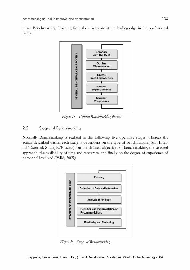
Benchmarking as Tool to Improve Land Administration 133
ternal Benchmarking (learning from those who are at the leading edge in the professional field).
Figure 1: General Benchmarking Process
2.2 Stages of Benchmarking
Normally Benchmarking is realised in the following five operative stages, whereas the action described within each stage is dependent on the type of benchmarking (e.g. Inter-nal/External; Strategic/Process), on the defined objectives of benchmarking, the selected approach, the availability of time and resources, and finally on the degree of experience of personnel involved (PSBS, 2005):
Figure 2: Stages of Benchmarking
Hepperle, Erwin; Lenk, Hans (Hrsg.): Land Development Strategies, © vdf Hochschulverlag 2009

134 Reinfried Mansberger, Rob Mahoney, Robin McLaren, Gerhard Muggenhuber
During the first stage – the planning phase – objectives of benchmarking and processes to be investigated will be defined. Only these processes should be selected which are compa-rable and where potential for improvement is evident. The acquisition of data and infor-mation describing the performance of processes is the second part of benchmarking. The method of data collection must be agreed and the indicators for measuring the perform-ance must be defined. Afterwards the collected data (performance indicators) of all in-volved benchmarking partners are compared. The gaps in performance between the inves-tigated organisations have to be identified and the reasons for differences have to be ana-lysed. In the fourth stage recommendations to improve the processes are outlined and implemented considering the given environment of the organisational unit. The evaluation of the benchmarking process undertaken and the results of the improvements against objectives and success criteria plus overall efficiency and effectiveness are undertaken during the final stage, the Monitoring Stage. The lessons learnt are subsequently docu-mented. However, the benchmarking progress is not finalized with the Monitoring Stage. Periodically the whole benchmark is to be re-considered and the process repeated.
2.3 Performance Indicators
Benchmarking is based on performance indicators. Measures reflect the performance of the organisation with regard to their efficiency and effectiveness and allow the comparison of products, processes and methods within similar organisations. These so-called perform-ance indicators are characterised by the measurement category, the dimension of the measurement category and by additional information (e.g. time and site of measurement) (Jung, 2002).
There are different types of performance indicators: Process Indicators are directly ob-served indicators of processes or process components, whereas financial indicators only can be indirectly associated with the operational work of staff.
Performance indicators have to provide maximum evidence on processes of an institution by minimising the resources for data acquisition and data analysis. So the definition of performance indicators is a crucial issue. Performance indicators with high significance have to be acquired with an appropriate quality in proper time intervals (Jung, 2002).
3. Benchmarking in Land Administration
In most of the European countries land administration (cadastre and land registry) is or-ganised in a hierarchical system. Controlled by a national public agency the operative work of land administration is done in local branch offices (cadastral offices, land register offices, land offices). As most of the processes in land administration (e.g. subdivision of land, land registry tasks) are similar in all branch offices, benchmarking can be used to identify offices with Good or even Best Practice and to transfer the knowledge of these offices to all the others.
Hepperle, Erwin; Lenk, Hans (Hrsg.): Land Development Strategies, © vdf Hochschulverlag 2009

Benchmarking as Tool to Improve Land Administration 135
For designing a benchmarking system in the land administration offices the issues outlined in the next chapters have to be considered. Due to the limited length of the article the focus of the paper is given to the benchmarking of processes and to the extraction of quantitative performance indicators. Aspects of customer satisfaction and employee-orientation – both crucial quality criteria for a modern land administration – will not be covered. Some results of a benchmarking study for the Hungarian land administration are presented.
3.1 Which Working Entities Can Be Benchmarked?
The smallest working unit at a land office is the individual staff member. Activities of each member of staff at the land offices can be recorded. If the tasks staff members are similar, the workload of the individual persons can be compared.
Normally business processes at the land offices require the cooperation of several staff members within departments. If a business process (e.g. ownership change of a parcel) is benchmarked, the working entity for this process includes all the persons involved.
In general a department is an organisational structure of land office. Within one depart-ment all activities can be aggregated (classified to specific business processes) and used for comparing the workload with same departments at other land offices.
For specific business processes (e.g. subdivision of land) several departments of a land office have to contribute with operational work. If the benchmarking system is based on business processes the working entity must be adapted to this entity.
If the performance of all the land offices within a country will be compared, the workload of each office has to be aggregated and the benchmarking process is based on the whole land office as working unit.
During the designing stage of the benchmarking process the degree of comparability of working entities has to be estimated. Within the structure of the Hungarian land admini-stration the working entities „department“ and „land office“ were the units with the high-est level of comparability and therefore they are predestined for the benchmarking proc-ess.
3.2 What Are Key Processes in a Land Administration Office?
In general the business processes of the land offices are congruent to the applications of customers, e.g. registration of property right, data supply for customers, division of par-cels. Therefore the benchmarking should be based on these types of activities.
For each specific application one or more persons or one or more departments can be involved into the operational work. Dependent on the organisational levels involved and on the working units defined for the benchmarking, the business processes are broken
Hepperle, Erwin; Lenk, Hans (Hrsg.): Land Development Strategies, © vdf Hochschulverlag 2009

136 Reinfried Mansberger, Rob Mahoney, Robin McLaren, Gerhard Muggenhuber
down into sub-processes. The possibility of existing gaps between the different sub-processes – often caused by statutory periods – must be considered in the benchmarking process.
Benchmarking can be undertaken in a statistical manner by selecting significant key proc-esses. Frequency, resource input and duration can be used as selection criteria. The highest impact of increasing the performance of the land offices can be achieved by improving the performance of those business processes with the highest frequency, with the longest duration and finally with the highest amount of resources. Table 1 shows an example for the estimation of above outlined selection criteria for business processes.
Table 1: Business Processes (Land Registry) at Hungarian District Land Offices (estimated by heads of land offices)
Business Process Frequency Duration Resources
Registration/cancellation of mortgage HIGH MEDIUM MEDIUM
Registration of property right, inheritance HIGH MEDIUM MEDIUM
Requiring data HIGH SHORT LOW
Representing buildings/constructions, land survey LOW MEDIUM MEDIUM
Creating a condominium and registration of the property rights MEDIUM LONG HIGH
Expropriation LOW LONG HIGH
Changing of addresses MEDIUM SHORT LOW
Figure 3: Business processes and sub-processes
Hepperle, Erwin; Lenk, Hans (Hrsg.): Land Development Strategies, © vdf Hochschulverlag 2009

Benchmarking as Tool to Improve Land Administration 137
3.3 What Are Proper Indicators for Comparing Performance in Land Administration Offices?
Performance indicators can be identified in various levels and dimensions:
The benchmarking process can be applied for different levels of working units as outlined in Chapter 3.1. Another dimension is the type of investigated process as discussed in the former chapter: Sub-Process, Process, and Business Process.
Indicators can give information on the absolute performance of a working unit or relative to a predefined target. Actual performance indicators also can be compared with a previ-ous one indicating the changes. Therefore the following levels can be used for bench-marking: Absolute Valuation – Relative Valuation to Target Values – Relative Valuation to Own Performance (compared to performance of a previous date).
Another dimension of performance indicators is the time. Investigations can be under-taken to a single process or to the aggregation of processes operated during a time period. For processes that are not perfectly homogeneous, the aggregation normally gives more significant information on the performance of working units due to averaging effects.
Dependent on the process type, on the working units, on the time period for the investi-gations, and on the type of indicators a huge number of performance indicators can be defined. Table 2 shows some of the possible indicators for operational work at land of-fices whereas Table 3 outlines performance indicators suitable for non-operational proc-esses within land administration offices.
Table 2: Potential performance indicators for operational processes
Amount of a specific Process Type (PT) per Working Unit (WU) during a specific Time Period (TP) for specific Indicator Type (IT); e.g. Absolute amount of copies of ownership sheets per person and per year
Percentage of settled (pending/backlog/developed later) applications to total amount of applications (PT, WU, TP, IT)
Average input of resources for specific PT (TP, IT)
Average processing time for specific PT (IT)
Cost of a specific process (TP, IT)
Revenue of a specific process
Amount of appeals/successful appeals (PT, WU, TP, IT)
Percentage of appeals/successful appeals to total amount of applications (PT, WU, TP, IT)
Hepperle, Erwin; Lenk, Hans (Hrsg.): Land Development Strategies, © vdf Hochschulverlag 2009

138 Reinfried Mansberger, Rob Mahoney, Robin McLaren, Gerhard Muggenhuber
Table 3: Potential performance indicators for supporting processes
Percentage of absence on sick leave
Percentage of absence due to continuing education
Uptime of IT-components
Percentage „operational staff“ to „management & support staff“
Percentage equipment of LO to amount of applications
3.4 How to realise benchmarking?
Benefits of benchmarking process are the finding of gaps between similar processes as well as the improvement of key processes by copying from the best. But benchmarking is also a useful tool to provide working units with feedback on their individual performance.
Based on the draft design of the general benchmarking process presented in Figure 1 and Figure 2 a more detailed concept for the realisation of the core process within a bench-marking system according to the concept of internal benchmarking and process bench-marking is outlined in Figure 4.
Figure 4: Flowchart of a proposed benchmarking process
Performance indicators are assessed for key processes and subsequently compared with target values gained by averaging specific performance indicators (calculation of mean values) or defined by the upper hierarchical level of the investigated working unit. If the
Hepperle, Erwin; Lenk, Hans (Hrsg.): Land Development Strategies, © vdf Hochschulverlag 2009

Benchmarking as Tool to Improve Land Administration 139
acquired performance indicators of a working unit are within the predefined tolerance of the target values the working unit will get feedback about the achievement of the required performance.
If the acquired performance indicators of a working unit are out of the tolerances the following two scenarios are proposed:
Scenario 1 – Performance better than predefined targets: The key processes will be ana-lysed in more details to explore the reasons for the good performance. In addition if the quality in projects of services and products is achieved, the findings of good performance will be used for a Good Practice Guideline. Some kind of rewarding (incentives) should be introduced.
Scenario 2 – Performance worse than predefined targets: The working processes of the unit will be analysed in more details to find the reasons for the non-performance. In cases where the poor performance is caused by the working unit, appropriate consequences must be set for all individuals involved.
The benchmarking process can be implemented as a stand-alone solution or it can be integrated to an existing organizational management system at land administration organi-sations. e.g., the Balanced Score Card method (Horvath et partners, 2004) enables the input of individual performance indicators as well as the definition of individual targets for each of relevant land administration processes and therefore the benchmarking process can be integrated to this method.
5. Conclusions
Benchmarking is a proper tool to improve the efficiency of land administration services. Good Practice can be derived by comparing similar business processes (or sub-processes) operated in different branch land offices. Due to the tendency to establish a European Land Information Service (EULIS)1 and to the similarity of land administration processes in many countries it is recommended to consider also an external benchmarking process (comparing with land administration offices of other countries).
The planning phase in benchmarking is an important issue. The definition of working units and key processes to be compared as well as the specification of significant perform-ance parameters has an essential impact to the acceptance of the benchmarking system by the staff members. In addition the selection of few but proper benchmarking components helps to save administrative and financial resources. National or international experts should be involved during the implementation stage.
1 with the aim to provide an easy worldwide access to European land and property information based on a
harmonised internet portal (Gustavson, Drewniak 2007)
Hepperle, Erwin; Lenk, Hans (Hrsg.): Land Development Strategies, © vdf Hochschulverlag 2009
140 Reinfried Mansberger, Rob Mahoney, Robin McLaren, Gerhard Muggenhuber
When organisations initially implement a benchmarking process they often tend to create very complicated models with a huge amount of Key Performance Indicators (KPIs). This is a wrong approach. They should keep the model very simple with few significant per-formance indicators and increase – if necessary – the complexity over time.
Processes or services compared over time need to be stable. But in modern land admini-stration the business changes and also the government requirements change. So it is dan-gerous to compare performance based on the same indicators year on year – if changes have occurred in the underlying business processes in this area. The dynamic environment has to be considered in a continuously adapted benchmarking process – hence the need to keep it simple.
In many European land administration organisations modern management tools had been implemented within the last decade. This cultural change in the approach of improving the performance of land administration services needs some transition time for the implemen-tation. During this phase benchmarking has to be seen as a proper possibility to motivate staff members for improving their performance by getting advices for new approaches from others.
Acknowledgment
Some results outlined in this paper are gained in an EU Twinning Light Project „Improv-ing the Sustainability of the Hungarian Land Registration System“ (HU03IB/AG/02-TL). Thanks to both partners of the project, the Department of Land Administration and Geoinformation (DLAG) of the Hungarian Ministry of Agriculture and Rural Develop-ment as Beneficiary and the Austrian Center for the Promotion of Legal Competence in Eastern Europe and Central Asia (CLC) as the Contractor.
References
bmBWK [2001], Bericht an den Ministerrat betreffend „Volle Rechtsfähigkeit der Univer-sitäten – Politische Eckpunkte für ein Gesetz zur Universitätsautonomie“. August 2001.
Camp, R.C. [1989], Benchmarking: The Search for Industry Best Practices that Lead to Superior Performance. ISBN 0-87389-058-2. ASQC Quality Press.
Gustavson, S., and Drewniak, A. [2007], EULIS-European Land Information Service, Proceedings of the FIG Working Week 2007, Hong Kong, China. 13–17 May 2007. http://www.fig.net/pub/fig2007/papers/ts_6g/ts06g_03_gustafsson_drewniak_1364.pdf Last access: May 2008.
Hórvath and Partners (Hrsg.) [2004], Balanced Scorecard umsetzen. Schäffer-Poeschel Verlag Stuttgart. ISBN 3-7910-2268-7. 2004.
Hepperle, Erwin; Lenk, Hans (Hrsg.): Land Development Strategies, © vdf Hochschulverlag 2009

Benchmarking as Tool to Improve Land Administration 141
Jung, B. [2002], Prozessmanagement in der Praxis. TÜV-Verlag GmbH. TÜV. Rhein-land/Berlin-Brandenburg. ISBN 3-7281-2839-2. Köln 2002.
PSBS [2005], The Public Sector Benchmarking Service. London. Homepage. http://www.benchmarking.gov.uk/about_bench
SIMS [2005], School of Information Management and Systems, University of California, Berkeley. Homepage. http://www.sims.berkeley.edu/courses/is213/s99/Projects/P9/web_site/glossary.htm. February 2005.
Steudler D. [2004], A Framework for the Evaluation of Land Administration Systems. PhD Thesis. Department of Geomatics. The University of Melbourne. Australia. 2004.
WikiPedia [2008], http://en.wikipedia.org/wiki/New_Public_Management. Last access: May 2008.
Hepperle, Erwin; Lenk, Hans (Hrsg.): Land Development Strategies, © vdf Hochschulverlag 2009

Hepperle, Erwin; Lenk, Hans (Hrsg.): Land Development Strategies, © vdf Hochschulverlag 2009

Gerlind Weber
Versuch einer praxisnahen Ordnung empfohlener Bodenschutzinstrumente dargestellt am Beispiel Österreichs
1. Einleitung
Die Notwendigkeit, die mittlerweile sehr umfangreiche Sammlung von Empfehlungen, die zu einer Effektuierung des Bodenschutzes beitragen könnten, zu strukturieren, erkannte die Autorin während eines Gesprächs mit einem politischen Entscheidungsträger, der Orientierung in diesem „Dschungel an Verbesserungsvorschlägen“ suchte. Im Zuge dieses Meinungsaustausches wurde der Autorin klar, dass es vor allem einer praxistauglichen Erklärung von drei Kernaussagen der Wissenschaft zum gegenständlichen Themenkom-plex bedarf:
erstens: warum es im Bodenschutz nicht die umfassende Patentlösung geben kann (um die aber oft in der parteipolitischen Auseinandersetzung erbittert gerungen wird);
zweitens: warum nur eine größere Anzahl an Einzelmaßnahmen prinzipiell den An-spruch einer drastischen Reduktion des Bodenverbrauchs für Siedlungs- und Ver-kehrszwecke gemeinsam herbeiführen wird können und
drittens: warum es nicht ausreichen kann diese einzelnen Maßnahmen beziehungslos nebeneinander zu stellen, sondern ein effektiver Bodenschutz nur durch eine „zielfüh-rende Gesamtstrategie“ (UBA, 2007) – wie immer diese im Detail ausgestaltet ist – ge-währleistet werden kann.
Nachfolgende Ausführungen sind dementsprechend als Versuch zu interpretieren, die mittlerweile auf über 70 Einzelmaßnahmen angewachsene Liste empfohlener Interventio-nen im Dienste des Bodenschutzes für die Praxis im deutschsprachigen Raum so aufzube-reiten, dass für diese die drei seitens der Wissenschaft erhobenen Ansprüche nachvoll-ziehbar werden. Dies ist als eine Grundvoraussetzung dafür zu werten, dass die derzeit zweifellos noch immer bestehende tiefe Kluft überhaupt überwunden werden kann zwi-schen einerseits den Forderungen der Wissenschaft den Bodenschutz zu effektuieren und anderseits den geringen Ambitionen der Entscheidungsträger, diesem Drängen tatsächlich Gehör zu schenken.
Diesen thematischen Brückenschlag zwischen Wissenschaft und Praxis wählte die Autorin bewusst, um den verstorbenen Präsidenten, den Herren Aimé De Leeuw und Paul Trappe, in ihrem Wirken um die Europäische Fakultät für Bodenordnung gerecht zu werden. Lag doch beiden Herren gleichermaßen daran, die FESF als Dialogforum zwischen jenen, die
Hepperle, Erwin; Lenk, Hans (Hrsg.): Land Development Strategies, © vdf Hochschulverlag 2009

144 Gerlind Weber
sich auf konzeptioneller Ebene mit den Fragen der Bodenordnung auseinandersetzen und jenen, denen es um einschlägige Verbesserungen in der praktischen Anwendung geht, auszurichten. Den beiden Altpräsidenten seien die nachfolgenden Überlegungen – die hier primär aus österreichischer Perspektive angestellt werden – in Anerkennung ihres ver-dienstvollen Einsatzes für den von der breiten Öffentlichkeit noch notorisch unterschätz-ten Themenbereich „Bodenpolitik“ post hum gewidmet.
2. Ordnungsschemata
2.1 Interventionsebenen
Um die Komplexität des Themas „quantitativer Bodenschutz“ für die Praxis besser er-schließen zu können, empfiehlt sich nach Meinung der Autorin, gedanklich an der soge-nannten „Baulandtreppe“ anzuknüpfen. Dieses Denkmodell veranschaulicht die unter-schiedlichen „Reifestadien“ von Bauland. Unter ihrer Zuhilfenahme können jedem „Treppenabsatz“ prioritäre Bodenschutzprobleme zugeordnet werden, die jeweils spezifi-scher Interventionen bedürfen, um gelöst zu werden.
Mittels der Baulandtreppe lässt sich also gut veranschaulichen, dass es für das Bodenprob-lem keine vermeintliche „Universallösung“ geben kann, weil mit nur einer Maßnahme – wie noch zu zeigen sein wird – nicht sechs unterschiedliche Themenkomplexe erfasst und beantwortet werden können.
2.2 Instrumententypen
Um dem öffentlichen Interesse an einer drastischen Reduktion des Bodenverbrauchs tatsächlich zum Durchbruch verhelfen zu können, müssen aufgrund der Vielzahl der An-
Hepperle, Erwin; Lenk, Hans (Hrsg.): Land Development Strategies, © vdf Hochschulverlag 2009

Versuch einer praxisnahen Ordnung empfohlener Bodenschutzinstrumente 145
sprüche, die auf das „nicht erneuerbare, nicht vermehrbare, ökologisch sensible und kaum regenerierbare Naturgut Boden“ treffen (Forum Nachhaltiges Österreich, 2005), das zu-dem zentrale Funktionen in Wirtschaft und Gesellschaft innehat, müssen buchstäblich „alle Register gezogen werden“, um die große Zahl relevanter Akteure insgesamt zu einem zielkonformen Handeln zu bewegen. So gilt es zum einen die Mehrheit der politischen Entscheidungsträger vom Bodensparen zu überzeugen und das wird nur der Fall sein können, wenn sich nicht die öffentliche Meinung gegen eine solche Vorgangsweise stellt. Es sind zum anderen der Verwaltung seitens der Politik die entsprechenden Instrumente zur Entscheidungsvorbereitung bereit zu stellen, sowie ihr „der Rücken“ im Dienste der praktischen Umsetzung der Zielerreichung zu stärken. Nicht zuletzt ist den Liegenschafts-eigentümern respektive den potenziellen Liegenschaftsverwertern zu signalisieren, dass sie prinzipiell ihre Nutzungsabsichten dem Gemeinwohlinteresse an einer haushälterischen Bodennutzung unterordnen müssen. Die Lösungssuche für all diese Ansprüche wird dabei dadurch erschwert, als letztere in Wirklichkeit nicht isoliert nebeneinander stehen, sondern in einem dichten chaotischen Beziehungsgeflecht, teils konform gehend, teils konfligie-rend in einander verwoben sind und fortdauernd schleichend ihr Beziehungsmuster ver-ändern.
Aus der Komplexität dieser Interrelationen lässt sich ableiten, dass prinzipiell auf allen Interventionsebenen und mit unterschiedlichen Mitteln Lösungsbeiträge zu suchen und auch zu finden sind. Grundsätzlich stehen dafür formelle oder informelle Wege, mittels derer Anreize (Stimuli und Sanktionen) oder Anordnungen (Ge- und Verbote) getroffen werden können, zur Verfügung.
Bei den Lösungen geht es, umgangssprachlich ausgedrückt, also darum, der Öffentlichkeit und den relevanten Akteuren die Augen für die Notwendigkeit des Bodensparens zu öff-nen und sie mit Hilfe von „Zuckerbrot und Peitsche“ auf dieses Ziel hinzulenken. Wissen-schaftlich ausgedrückt heißt dies, folgende Ansprüche mittels nach genannter Instrumen-tentypen zu verfolgen:
A) Bewusstsein schaffen durch Informations- und Bildungsinstrumente
B) Marktkräfte stimulieren durch monetäre Instrumente (finanzielle Anreize und Sanktio-nen) und
C) Schranken setzen durch ordnungspolitische Instrumente (Ge- und Verbote).
Die große Herausforderung besteht aber letztlich darin, nicht nur neue Einzelmaßnahmen zu fordern oder auch zu entwickeln, sondern die einzelnen bereits entwickelten Instru-mente strategisch so aufeinander abzustimmen, dass sich dadurch „maßgeschneiderte“ bodenpolitische „Maßnahmenketten“ quasi im Baukastensystem bilden lassen.
Mit Hilfe der hier entwickelten Ordnungsschemata, wird nun versucht, einfache und daher auch für Kreise, die sich nicht fortgesetzt mit bodenpolitischen Fragen beschäftigen, nachvollziehbare Pfade durch den „Dschungel an Verbesserungsvorschlägen“ zu ziehen.
Hepperle, Erwin; Lenk, Hans (Hrsg.): Land Development Strategies, © vdf Hochschulverlag 2009
146 Gerlind Weber
3. Ordnung der Bodenschutzinstrumente
3.1 Grünland
In der Bodenpolitik werden mit „Grünland“ als der untersten Stufe der imaginären Bau-landtreppe jene Flächen deklariert, die innerhalb einer absehbaren Zeitspanne (z.B. 10 Jahre) nicht der Bebauung zugeführt werden sollen. Das Problem des Grünlandes ist bis heute, dass es aus der Perspektive der Grundeigentümer sowie der Entscheidungsträger oft bloß den Status einer „ruhenden Baulandreserve“ innehat, auf die ihrer Meinung nach beliebig zugegriffen werden kann. Diese Haltung wurde bisher auch durch die schlechte landwirtschaftliche Ertragslage und daher durch den im Vergleich zu Bauland in der Regel sehr geringen Verkaufswert von Grünland angetrieben.
3.1.2 Instrumente
Es wurde schon an anderer Stelle erwähnt, dass derzeit über 70 Instrumente in Österreich in Diskussion stehen, wo von jedem ein Beitrag zur Lösung des Bodenproblems erhofft wird. Hier all diese Verbesserungsvorschläge anzuführen, würde den Rahmen dieses Bei-trages sprengen und zu Lasten seiner Lesbarkeit gehen. Da es der Autorin bloß um eine Demonstration der möglichen Bandbreite der Instrumente geht, sollen jedem Instrumen-tentyp nur maximal drei illustrative Beispiele zugeordnet werden.
A) Informations- und Bildungsinstrumente
Wesensgemäß sind die Informations- und Bildungsinstrumente immer informelle Instru-mente. Mit ihnen soll das Bewusstsein für die Vorteile eines konsequenten Grünland-schutzes in der Öffentlichkeit verankert werden. Als Beispiele, wie dies geschehen kann, sind hier zu nennen:
gezielte Öffentlichkeitsarbeit zu den Zusammenhängen von quantitativem Boden-schutz und den großen Zeitfragen wie „biogener Wende“, Verkehrsverminderung, Energiewende, sparsamer Finanzmitteleinsatz und Klimaschutz;
Schaffung eines Wahrnehmungs- und Wertebewusstseins über die offene Kulturland-schaft (z.B. über die Schulen, Erwachsenenbildungseinrichtungen);
Deklaratorisches Unterschutzstellen der stadtnahen Grünsysteme (z.B. Grünlanddekla-ration, Biosphärenpark).
B) Monetäre Instrumente
Monetäre Instrumente wollen die Marktkräfte dahingehend wirken lassen, dass ein ver-schwenderischer Umgang mit dem Boden finanzielle Nachteile respektive ein bodenscho-nendes Verhalten finanzielle Vorteile nach sich zieht. Mit diesen Instrumenten kann ver-
Hepperle, Erwin; Lenk, Hans (Hrsg.): Land Development Strategies, © vdf Hochschulverlag 2009

Versuch einer praxisnahen Ordnung empfohlener Bodenschutzinstrumente 147
sucht werden, entweder das Verhalten der planenden Gemeinde oder das Verhalten Priva-ter in die gewünschte Richtung zu lenken. Als Anreiz bzw. Sanktionsmodelle können beispielhaft angeführt werden:
Erhöhte Zuweisungen aus dem Finanzausgleich für Gemeinden, die einen geringen jährlichen Pro-Kopf-Einwohnerverbrauch an Grünland für Siedlungs- und Verkehrs-zwecke nachweisen können;
Gewährung eines Stadtbonus (z.B. in Nordrhein-Westfalen von 20.000,– €), wenn Wohnraum innerhalb des Stadtgebietes geschaffen wird;
Einführung des Planwertausgleichs, bei dem die Planungswertgewinne von mobilisier-tem Bauland zum Großteil abgeschöpft werden, um diese an jene Grundeigentümer (teilweise) zu verteilen, die durch Grünlandwidmungen Planungswertverluste hinneh-men müssen.
C) Ordnungspolitische Instrumente
Die ordnungspolitischen Instrumente zielen vor allem darauf ab, die nach wie vor zu leichtfertige Umwidmungspraxis in den Gemeinden – trotz existierender enormer Bau-landüberhänge – zu unterbinden, wie:
Selbstbindung des Gemeinderates an ein längerfristiges Umwidmungsmoratorium;
Vorgabe von verbindlichen Baulandreduktionszielen für einen bestimmten Zeitraum (z.B. 5 Jahre) seitens der überörtlichen Planungsbehörde, um sukzessive die übergro-ßen Baulandreserven abzubauen;
Übernahme der Eingriffsregelung nach §§ 18 bis 21 Deutsches Bundesnaturschutz Gesetz, wonach erhebliche Eingriffe in den Naturhaushalt, wie die Neuversiegelung von Boden, oder der Verlust der natürlichen Bodenfruchtbarkeit adäquat ausgeglichen oder durch Ersatzmaßnahmen (z.B. durch Entsiegelung) zu ersetzen sind.
3.2 Bauerwartungsland
Mit Bauerwartungsland wird hier jenes Grünland bezeichnet, für das aus fachlichen Grün-den die berechtigte oder ungerechtfertigte Hoffnung auf Umwidmung in Bauland inner-halb absehbarer Zeit besteht (etwa binnen 10 Jahren). Das Bauerwartungsland ist in der politischen Auseinandersetzung wesensgemäß die eigentliche „Kampfzone“ zwischen Baulandausweisung und Grünlanderhaltung.
Hier stehen im Dienste des Bodensparens vor allem der Schutz vor überbordenden Um-widmungen und das Unterbinden der aktiven Bodenspekulation (d.h. der Ankauf von Grünland in bewusster Erwartung seiner baldigen Umwidmung in Bauland) im Vorder-grund.
Hepperle, Erwin; Lenk, Hans (Hrsg.): Land Development Strategies, © vdf Hochschulverlag 2009

148 Gerlind Weber
A) Informations- und Bildungsinstrumente
Die Aufklärungsarbeit zielt in diesem Kontext darauf ab, vor allem den Entscheidungs-trägern die ökonomischen, ökologischen und sozialen Folgen einer steten Ausdehnung des Siedlungsraumes ins Bewusstsein zu führen. In Fachkreisen wird den Gemeindevertre-tern diesbezüglich ein hohes Maß an Unwissenheit vorgeworfen, sodass die Stimmen nicht verstummen, die überhaupt eine Kompetenzverschiebung der Flächenwidmung von der kommunalen Selbstverwaltung auf eine staatliche Planungsebene fordern. Davon ver-spricht man sich mehr Distanz zu den Intervenienten, mehr Problemeinsicht und so einen achtsameren Umgang mit dem Boden.
Bewusstseinsbildende Maßnahmen können sein:
der vorauseilende Nachweis der Gemeinde an die Aufsichtsbehörde hinsichtlich der Folgekosten für die Erschließung, die die Umwidmung bestimmter Flächen nach sich ziehen wird („Erschließungskostennachweis“);
die Einführung eines „Mindestversorgungsnachweises“ hinsichtlich der Gewährleis-tung von ÖV-Anbindung und Nahversorgung auf kurzem Wege;
verpflichtende Computersimulationen, die die hinkünftige Bebauung des zur Umwid-mung anstehenden Gebietes visualisieren.
B) Monetäre Instrumente
Wesensgemäß werden in dieser „Kampfzone“ um einen effektiven Grünlandschutz auch weitreichende Grundsatzforderungen an die Umorganisation der öffentlichen Finanz-regime gestellt. So orten Experten die Ursache für die Neigung allzu großer Baulandaus-weisungen auch in der einseitigen Orientierung der kommunalen Finanzierungssysteme an der Zahl der Einwohner (Finanzausgleich zwischen den Gebietskörperschaften) und Be-schäftigten (Kommunalsteuer). Der dadurch ausgelöste Wachstumszwang und Konkur-renzdruck unter den Gemeinden um Neubürger und Betriebsansiedlungen bedinge die überbordenden Baulandausweisungen „auf der grünen Wiese“. Hier komme das Planungs-recht nicht gegen die fehlenden und falschen Anreize der Steuer- und Subventionspolitik an.
Dementsprechend wird in diesem Zusammenhang beispielsweise gefordert:
Gewährung von „Rückwidmungsprämien“ jenen Gemeinden, die ihre übergroßen, die Zersiedelung antreibenden Baulandreserven reduzieren;
Gewährung einer markant höheren Wohnbauförderung für Bauvorhaben in Innerorts-lagen bzw. Stadtzentren;
Prüfung der Sinnhaftigkeit der Etablierung eines sogenannten Flächenzertifikatshan-dels: Danach werden den Gemeinden degressiv sinkende Umwidmungsrechte von Sei-
Hepperle, Erwin; Lenk, Hans (Hrsg.): Land Development Strategies, © vdf Hochschulverlag 2009

Versuch einer praxisnahen Ordnung empfohlener Bodenschutzinstrumente 149
ten des Staates zugeteilt. Geht der Umwidmungsbedarf einer Gemeinde über das zuge-teilte Kontingent hinaus, hat sie zusätzliche Umwidmungsrechte auf einer einzurich-tenden Baulandbörse zu erwerben. Beanspruchen Gemeinden das nach Einwohnerzahl zugewiesene Kontingent nicht oder nicht zur Gänze innerhalb des dafür vorgesehenen zeitlichen Planungshorizonts, haben sie das Recht, die eingesparten Umwidmungsrech-te an der Baulandbörse zu veräußern und den Erlös für sich zu lukrieren.
C) Ordnungspolitische Instrumente
Neben den Marktkräften müssen auch die hoheitlichen Rechte der Behörden im Kampf gegen die Zersiedelung gestärkt werden. Diesem Ziel können etwa dienen:
eine bessere Verschränkung zwischen dem landwirtschaftlichen Grundverkehrsrecht und dem Raumplanungsrecht, wodurch Spekulationsabsichten unterbunden werden sollten;
Entwicklung geeigneter Methoden, um verstärkt die Bodenqualität in Widmungsent-scheidungen einfließen zu lassen (= Verknüpfung von quantitativem und qualitativem Bodenschutz);
Unterwerfung sämtlicher Baulandumwidmungen von Grünland in Bauland der Strate-gischen Umweltprüfung ab einer bestimmten Größenordnung (z.B. 2000 m²).
3.3 Gewidmetes, aber noch unerschlossenes Bauland
Gewidmetes Bauland ist, auch wenn es noch unerschlossen ist, deshalb bei den Grund-eigentümern so begehrt, weil sich allein aufgrund der Änderung der Flächenwidmung der Verkehrswert der Liegenschaft um ein Vielfaches gegenüber seinem Grünlandwert erhöht. Es ist naheliegend, dass die Entscheidungsträger besonders auf kommunaler Ebene einem großen Druck ausgesetzt sind, möglichst viel Bauland zu widmen, zumal der damit ver-bundene Mehrwert zur Gänze den solcherart Begünstigten zusteht.
Die Herausforderungen, die sich in besonderer Weise auf diesem „Treppenabsatz der Baulandtreppe“ stellen, sind der Schutz vor passiver Spekulation, das Streben nach mone-tären Ausgleichsmechanismen und die Gewährleistung einer zügigen Erschließung des Baulandes durch die öffentliche Hand.
A) Informations- und Bildungsinstrumente
Die Öffentlichkeitsarbeit zu den Herausforderungen dieser Planungsstufe soll darauf ab-zielen, die Allgemeinheit dafür zu sensibilisieren, dass derzeit das Planungsrecht in Öster-reich insbesondere folgende Verzerrungen produziert, was zudem den Raubbau an Grund und Boden begünstigt:
Hepperle, Erwin; Lenk, Hans (Hrsg.): Land Development Strategies, © vdf Hochschulverlag 2009

150 Gerlind Weber
den privaten Vermögenswertgewinnen durch den Widmungsakt zu Bauland stehen keine adäquaten Verpflichtungen derer gegenüber, die diese Vorteile für sich lukrieren können, wie etwa ein fristgerechtes plankonformes Bauverhalten;
Vermögensgewinne werden privatisiert, die kostenintensive Erschließung von Bauland trägt aber zum überwiegenden Teil die Öffentlichkeit;
Es findet kein angemessener Ausgleich zwischen „Planungsgewinnern“ (Baulandeig-nern) und „Planungsverlieren“ (Grünlandeignern) statt.
B) Monetäre Instrumente
Die monetären Instrumente intendieren dementsprechend, die angeführten Inbalancen abzubauen. Dazu werden etwa folgende Maßnahmen als zielführend eingeschätzt:
Anhebung der steuerlichen Bemessungsgrundlage für gewidmetes Bauland, Orientie-rung am Verkehrswert;
Einführung einer „Baulandwidmungsumlage“ für Gemeinden, wenn diese von ihrem Recht Gebrauch machen, Grünland in Bauland umzuwidmen;
keine Vergabe von Wohnbauförderung bei Neubau von Einfamilienhäusern in (unter-versorgter) Streulage.
C) Ordnungspolitische Instrumente
Die ordnungspolitischen Instrumente zielen darauf ab, den Abbau des Baulandüberhangs einerseits zu erleichtern und anderseits die zügige Erschließung der tatsächlich erforder-lichen und geeigneten Baulandflächen zu erwirken. Diese Effekte erhofft man sich durch:
Befristung der Baulandumwidmung per Gesetz, um damit der passiven Bodenspekula-tion entgegenwirken zu können;
Junktimierung der Flächenwidmungsplanung mit einem verbindlichen Zeitplan für die Durchführung der Erschließung und der Realisierung der Bebauung. (In Südtirol betragen diese Zeitspannen je nach Größe des in Rede stehenden Gebietes zwischen 3 und 9 Jahren).
Befristung möglicher Entschädigungsforderungen bei Rückwidmungen von Bauland in Grünland.
3.4 Unbebautes, aber erschlossenes Bauland
Viel Bauland existiert in Österreich insofern „nur auf dem Papier“, das heißt nur im Flä-chenwidmungsplan, als es entgegen dem gesetzlichen Auftrag seitens der öffentlichen
Hepperle, Erwin; Lenk, Hans (Hrsg.): Land Development Strategies, © vdf Hochschulverlag 2009

Versuch einer praxisnahen Ordnung empfohlener Bodenschutzinstrumente 151
Hand oft eine lange Zeit hinweg nie erschlossen wurde. Zusätzlich gibt es aber auch viele Baulandflächen, die zwar mit Straße, Wasser, Strom und Abwasseranschluss versorgt sind, aber dennoch seit Jahrzehnten nie bebaut wurden. Diese sogenannten „Baulandbrachen“ gelten als große volkswirtschaftliche Belastung, da ihre vorhandene hohe Erschließungs-qualität nicht adäquat genutzt wird und stattdessen periphere Lagen zusätzlich ans Versor-gungsnetz angebunden werden müssen, um dennoch die Nachfrage nach Bauland befrie-digen zu können.
Die Herausforderungen, die auf dieser Stufe einer Lösung zugeführt werden müssen, sind die der zügigen Mobilisierung des baureifen Baulandes sowie die rasche Überwälzung der Erschließungskosten auf die solcherart Begünstigten.
A) Informations- und Bildungsinstrumente
Das Bild in der öffentlichen Auseinandersetzung bedarf insofern einer Korrektur seitens der Raumplaner, als oft der Eindruck vermittelt wird, dass das Bodenschutzproblem aus-schließlich in der Verteidigung „der grünen Wiese“ gegen eine potenzielle Bebauung be-steht. In vielen Fällen liegt die Lösung aber scheinbar paradoxerweise in der Sicherstellung einer zügigen planadäquaten Bebauung von noch unbebauten Flächen, um weitere Um-widmungen in raumplanerischen Ungunstlagen zu verhindern. Daher:
Nutzung aller Dialogmöglichkeiten zwischen der Raumplanung und den stark ökolo-gisch argumentierenden Fachdisziplinen wie Landschaftsplanung, Naturschutz und Ökologie, um diese Seite des Bodenschutzes für sie nachvollziehbar zu machen.
B) Monetäre Instrumente
Die monetären Instrumente zielen darauf ab, die Bebauung schon erschlossenen Baulan-des zu begünstigen und jene in noch unerschlossenen Lagen möglichst zu unterbinden. Dies erhofft man sich beispielsweise durch:
Einhebung der lagebedingten „wahren“ Kosten der Erschließung von den Verursa-chern zum Zeitpunkt der Widmung;
Einhebung einer „Neuerschließungsabgabe“ von Bauherren und Investoren, um das Bauen „auf der noch unerschlossenen grünen Wiese“ unattraktiver im Vergleich zu den schon erschlossenen Lagen zu machen.
Abschöpfung eines Teiles des erschließungsbedingten Mehrwertes von Liegenschaften an die öffentliche Hand, um damit die Infrastruktur zu refinanzieren;
C) Ordnungspolitische Instrumente
Die Zielsetzungen, die für die monetären Instrumente gelten, sind auch durch ordnungs-politische Interventionen zu unterstützen wie beispielsweise durch:
Hepperle, Erwin; Lenk, Hans (Hrsg.): Land Development Strategies, © vdf Hochschulverlag 2009
152 Gerlind Weber
Gesetzliche Junktimierung der Erschließung eines bereits gewidmeten Baugebiets mit einer „Realisierungsverpflichtung“, d.h. z.B. mit einer öffentlich-rechtlichen Erklärung, indem sich der jeweils Begünstigte verpflichtet, die Liegenschaft fristgerecht (d.h. in-nerhalb von 10 Jahren) ihrer widmungsgemäßen Verwendung tatsächlich zuzuführen;
Junktimierung der Erlassung eines Bebauungsplanes (mit dem ja bodenschonendes Bauen verbindlich angeordnet werden kann) mit einer Realisierungsverpflichtung;
Vergabe von Baurechten.
3.5 Bebautes Bauland
Ein zentrales Handicap der Raumplanung im Bemühen um mehr Bodenschutz ist, dass ihr Denken und dementsprechend auch ihre Instrumente am sogenannten „Bestandsschutz“ festgemacht sind. Das heißt, dass sie den Siedlungsbestand als gegeben hinnimmt und sich nur auf die Organisation der Außenentwicklung, d.h. auf die bauliche Umnutzung von in der Regel landwirtschaftlich genutzten Flächen konzentriert. Dementsprechend wird ihre gegenwärtige Konzeption zu wenig dem Umstand gerecht, dass die mittlerweile stark angewachsenen ehemaligen „Neubaugebiete“ gerade vor dem Hintergrund ihrer Alterung und der tief greifenden Änderungen der Rahmenbedingungen in Hinkunft einer erhöhten Aufmerksamkeit bedürfen.
In dem hier diskutierten Zusammenhang können die anstehenden Modifikationen zuguns-ten des Innenbereichs mit folgenden Fragen umschrieben werden: Wie können Unternut-zungen und Leerstände vermieden, Nachverdichtungen gefördert und klimaschützende Maßnahmen im Siedlungsbestand begünstigt werden?
A) Informations- und Bildungsinstrumente
Die Bewusstseinsbildung sollte in diesem Zusammenhang zur Aufklärung beitragen, dass etwa die stark steigenden Energiepreise und die Erderwärmung einen energiesparenden und klimaschonenden Lebensstil bedingen und dass dies mit einer IV-orientierten Außen-entwicklung, die zudem mit einem hohen Bodenverbrauch einhergeht, in einem grund-sätzlichen Widerspruch steht. Es muss das Bewusstsein dafür geschaffen werden, dass ein zukunftsverträglicher Lebensstil eng mit der Bevorzugung innerstädtischer oder innerört-licher Lagen verbunden ist. Dazu können beitragen:
Anlegen von Baulückenkatastern, in denen „unbebaute, nur geringfügig bebaute, falsch genutzte Gründstücke oder übergroße Grundstücke verzeichnet sind, um die Bevölke-rung hierfür zu sensibilisieren und möglichst viele innerstädtische Baulücken zu schlie-ßen“ (Beispiel: Baulückenkataster der Stadt Mühlheim an der Ruhr).
Konzentration des sogenannten „experimentellen Städtebaus“ auf die Aufwertung der bereits bebauten Gebiete wie z.B. „Klimaschonung durch autofreies Wohnen“.
Hepperle, Erwin; Lenk, Hans (Hrsg.): Land Development Strategies, © vdf Hochschulverlag 2009
Versuch einer praxisnahen Ordnung empfohlener Bodenschutzinstrumente 153
B) Monetäre Instrumente
Parallel zur Aufklärung der Bevölkerung sind auch radikale Umschichtungen bei der Wohnbauförderung zugunsten der Modernisierung von Althausgebieten vorzunehmen. Gehen derzeit in Österreich die 2,2 Mrd. € pro Jahr noch zu 80% in den Neubau, so ist dieses Verhältnis krass zugunsten des Umbaues zu verschieben. Daher lauten hier die zentralen Forderungen:
Umschichtung der Wohnbauförderung vom Neubau an der Siedlungsperipherie auf die Sanierung des Altbestandes in Innenlagen, Förderung von Nachverdichtungen und Wohnumfeldverbesserungen innerhalb schon bebauter Gebiete;
Förderung einer klimafreundlichen Freiraumgestaltung wie Ausschüttung von Geldern für Entsiegelungen, Baumpflanzungen, Dach- und Fassadenbegrünungen etc.
C) Ordnungspolitische Instrumente
Die ordnungspolitischen Maßnahmen müssen, wesensgemäß von „der grünen Wiese“ hin auf den Siedlungsbestand gelenkt werden. Beispielhaft sind dabei folgende Instrumente in Diskussion:
verpflichtende Einführung von sogenannten „Innenentwicklungsplänen“, mittels derer die Aufwertung von bereits bebauten Gebieten im oben besprochenen Sinn planerisch vorbereitet und koordiniert werden;
verbindliche Vorschreibung von CO2-Reduktionszielen von Seiten des Staates, die auch über Maßnahmen der örtlichen Raumplanung zu erreichen sind;
verbindliche Kompensation jeder Neuversiegelung durch Entsiegelung aliquoter Flä-chen in Innenlagen.
3.6 Brachgefallenes bebautes Bauland
Mittelfristig muss es das Ziel sein, im Dienste von Klimaschutz, effizientem Energieein-satz und der Aufwertung des Bodens als Rohstoffquelle den neu aufkommenden Bedarf an Gebäuden und technischer Infrastruktur bevorzugt aus dem Bestand abzudecken. Fer-ner deuten regionalökonomische und demographische Schrumpfungstendenzen, aber auch die Ausdehnung von Gefahrenbereichen infolge des Klimawandels darauf hin, dass sogar ein „geordneter Rückzug“ aus Teilen des Siedlungsraumes eine mögliche zukünftige Planungsaufgabe sein wird.
Die Fragen, die sich mit diesem obersten Treppenabsatz der imaginären Baulandtreppe verbinden, sind demnach: Wie kann brachgefallene Bebauung in den Flächenkreislauf rückgeführt werden und wie ist mit Extremstandorten zu verfahren?
Hepperle, Erwin; Lenk, Hans (Hrsg.): Land Development Strategies, © vdf Hochschulverlag 2009

154 Gerlind Weber
A) Informations- und Bildungsinstrumente
Die Bewusstseinsbildung sollte dahingehend betrieben werden, dass die Öffentlichkeit Schrumpfung und Rückbau nicht als Abstieg wahrnimmt, sondern als Teilschritte in die „richtige Richtung“, wo unter dem Leitbild der nachhaltigen Entwicklung ein „Weniger ist Mehr“ als Weg aus der Wachstumsfalle gesehen wird. Denn eine permanente Ausdehnung des Siedlungsraumes ist weder ein realistisches noch ein wünschenswertes Leitbild. Die Öffentlichkeit ist aber auch dahingehend zu sensibilisieren, dass gerade vor den abseh-baren Bevölkerungsverschiebungen nicht noch heute „die Brachen von morgen“ errichtet werden dürfen.
Dem Flächenrecycling dienen unmittelbar folgende Maßnahmen:
Erstellung von Brachflächenkatastern, wo nicht genutzte bzw. unternutzte Brach-flächen samt möglichen Altlasten systematisch erfasst und über das Internet für die Nachnutzung vermarktet werden;
Förderung von Modellvorhaben für Energieeffizienz und klimaschonendem und -angepasstem Bauen auf großflächigen Brachen wie Bahn-, Industrie- und Kasernen-arealen.
B) Monetäre Instrumente
Die monetären Instrumente sollen durch Anreize die Wiederverwertung von leerstehen-den Objekten in raumplanerischen Gunstlagen fördern, entsprechend dem Grundsatz „Nachnutzung geht vor Nichtnutzung“, in Ungunstlagen gilt hingegen „Nichtnutzung geht vor Nachnutzung“:
Errichtung eines „Altlastensanierungfonds“ zur Absicherung der finanziellen Restrisi-ken von Investoren auf Altlastenverdachtsflächen;
Errichtung eines Fonds, der dazu dienen soll, langfristig volkswirtschaftlich zu kost-spielige respektive zu gefährdete Extremstandorte abzusiedeln und die Wiederansied-lung in Gunstlagen zu unterstützen;
Begründung von Leerstandsmanagements auf kleinregionaler Ebene und in größeren Städten, die neben Vermittlungstätigkeiten auch finanzielle Anreize zur Wiedernutzung von leerstehenden Objekten gewähren können.
C) Ordnungspolitische Instrumente
Die ordnungspolitischen Instrumente fokussieren stärker als bisher auf planhaftes Vorge-hen bei unternutztem oder ungenutztem Baubestand, nicht zuletzt um den Baulanddruck von der „grünen Wiese“ auf bereits erschlossene und versiegelte Innerortslagen umzulen-ken.
Hepperle, Erwin; Lenk, Hans (Hrsg.): Land Development Strategies, © vdf Hochschulverlag 2009

Versuch einer praxisnahen Ordnung empfohlener Bodenschutzinstrumente 155
Im Einzelnen empfehlen sich folgende Maßnahmen:
Etablierung eines Instrumentariums analog zur „Städtebaulichen Sanierungsmaßnah-me“ (§136 BauGB) nach bundesdeutschem Vorbild;
Herausbildung eines adäquaten Planungsinstrumentariums für den „geordneten Rück-bau“ als neue Planungsaufgabe.
4. Entwicklung einer Gesamtstrategie
Anhand der Baulandtreppe sollte bisher in die Argumentation Verständnis dafür geschaf-fen werden, dass es unterschiedliche Reifestadien des Baulandes gibt, die mit verschiede-nen bodenpolitischen Herausforderungen verbunden sind, wobei aus systemischen Grün-den immer mehrere Lösungen für jede Herausforderung existiert. Darin ist die Begrün-dung dafür zu sehen, warum es mittlerweile eine sehr große Zahl an Lösungsvorschlägen gibt und immer neue hinzukommen.
Bisher wurde hier zugunsten der Übersichtlichkeit jeder Treppenabsatz einer isolierten Betrachtung unterzogen. In Wirklichkeit durchläuft jedoch jedes Grundstück entweder als Option, wenn es Grünland bleiben soll, oder in der Realität, wenn es bebaut ist oder be-baut werden soll, all diese Stadien. Daraus ergibt sich die Begründung für die Forderung, dass es nicht genügt, die Einzelmaßnahmen beziehungslos nebeneinander zu stellen, son-dern, dass nur eine „zielführende Gesamtstrategie“ (UBA, 2007) Fortschritte für den Bo-denschutz bringen kann. So kann das Denkmodell der Baulandtreppe auch die Erklärung dafür liefern, dass die einzelnen bodenpolitischen Maßnahmen, die zu der geforderten Gesamtstrategie zusammengefügt werden sollen, für jeden „Treppenabsatz“ zumindest einen Lösungsbeitrag anbieten sollten. Wobei die wahre politische Herausforderung dann darin besteht, die richtige Balance zwischen den staatlichen Eingriffen und den Marktkräf-ten zu wählen, um die angestrebte drastische Reduktion des Bodenverbrauchs auch tat-sächlich erwirken zu können. Was hier als „ausgewogen“ und „zielführend“ einzuschätzen ist wird auch stark vom öffentlichen Bewusstsein geprägt und so darf der Einsatz von Informations- und Bildungsinstrumenten bei der Effektuierung des Bodenschutzes nicht unterschätzt werden. – So wurde auch dieser Beitrag in der Hoffnung verfasst, einige Klarstellungen, die diesem Anliegen förderlich sind, leisten zu können.
Literatur
Bund für Umwelt- und Naturschutz Deutschland (BUND) et al.: (2006): Aktiv für Land-schaft und Gemeinde! Leitfaden für eine nachhaltige Siedlungsentwicklung. Berlin: Eigen-verlag.
Doubek C., Zanetti G. (1999): Siedlungsstruktur und öffentliche Haushalte. ÖROK-Schriftenreihe Nr. 143. Wien.
Hepperle, Erwin; Lenk, Hans (Hrsg.): Land Development Strategies, © vdf Hochschulverlag 2009

156 Gerlind Weber
Forum Nachhaltiges Österreich (2005): Nicht-nachhaltige Trends in Österreich: Qualitati-ve Lebensraumveränderung durch Flächenverbrauch. Wien: Eigenverlag.
Lexer W. (2004): Zerschnitten, versiegelt, verbaut? – Flächenverbrauch und Zersiedelung versus nachhaltige Siedlungsentwicklung. In: BMLFUW (Hrsg.): Tagungsband „grünstadt-grau". Fachtagung zur Stadtökologie. 21.–22. Oktober 2004, Wien, Österreich. S. 35–45.
Rat für nachhaltige Entwicklung – Berlin (2007): Erfolgsfaktoren zur Reduzierung des Flächenverbrauchs in Deutschland. Evaluation der Ratsempfehlungen „Mehr Wert für die Fläche: Das Ziel 30 ha“. Berlin: Eigenverlag.
TAB – Büro für Technikfolgen-Abschätzung beim Deutschen Bundestag (2004): Brief Nr. 27. Berlin.
UBA – Umweltbundesamt (2004): Umweltsituation in Österreich – Siebenter Umweltkon-trollbericht. Wien.
UBA – Umweltbundesamt (2007): Umweltsituation in Österreich – Achter Umweltkon-trollbericht. Wien.
Umweltbundesamt - Berlin (2007): Raumbezogene Umweltplanung – Reduzierung der Flächenanspruchnahme http://www.umweltbundesamt.de/rup/flaechen/grund.htm
Zollinger, Franz (2005): Handelbare Flächenzertifikate und die Schweizer Raumplanung. DISP Nr. 160/2005, S. 67–74
Hepperle, Erwin; Lenk, Hans (Hrsg.): Land Development Strategies, © vdf Hochschulverlag 2009

Hans Neuhofer
Umwidmungsgewinne und Rückstellungs-ansprüche des Veräußerers bei nachträglicher Zulässigkeit der Bebauung eines Grundstückes
1. Die Kaufpreiswirkung der Grundstückswidmung – Planwertausgleich?
Es bedarf keines besonderen Nachweises dafür, dass die Widmung von Grundstücken im Flächenwidmungs- oder Bebauungsplan für bestimmte Nutzungen einen wesentlichen Einfluss auf die Höhe des Grundpreises hat. Für die als Bauland gewidmeten Grundstücke steigt der Grundpreis, für die als Grünland gewidmeten Grundstücke fällt der Grundpreis. Es gibt Widmungsgewinner und Widmungsverlierer. Alle bisherigen Bemühungen, einen gerechten Planwertausgleich zu erzielen, waren – mit Ausnahme von Sonderfällen – nicht erfolgreich.1 Überdies ist die verfassungsrechtliche Zulässigkeit des Planwertausgleichs im Hinblick auf die Grundrechte des Eigentumsschutzes (Art 5 Staatsgrundgesetz 1867 – StGG, RGBl 142/1867 idgF) und des Gleichheitssatzes (Art 2 StGG und Art 7 Bundes-Verfassungsgesetz – B-VG, BGBl 1/1930 idgF) umstritten.2
2. Der Schutz des Veräußerers eines unbebauten Grundstückes bei nachträglicher Zulässigkeit der Bebauung
In den 50er- und 60-er Jahren des vorangegangenen Jahrhunderts wurden in mehreren Gemeinden Oberösterreichs als Grünland gewidmete Grundstücke großflächig zu einem relativ niedrigen Grünflächenpreis gekauft, in späterer Folge als Bauland (Gewerbe- und Industriegebiete) gewidmet und für Betriebsbaugebiete genutzt oder zu einem wesentlich erhöhten Baulandpreis für diesen Nutzungszweck verkauft. In den Beratungen zum ersten Raumordnungsgesetz in Oberösterreich wurde diese Vorgangsweise diskutiert und kriti-siert. Nach dem Ausschussbericht (AB) zum Oberösterreichischen Raumordnungsgesetz – Oö. ROG3 sollte eine gesetzliche Regelung gefunden werden, die „in sachlich gebotener Weise die gerechtfertigten Interessen betroffener Eigentümer von Grundstücken, die ein Grundstück im Vertrauen auf die Wirkung eines Flächenwidmungsplanes bzw. Bebau-ungsplanes, der die Bebaubarkeit des Grundstückes ausschließt, veräußern“ berücksichtigt
1 Fröhler und Oberndorfer, 1977, mit weiteren Hinweisen.
2 Pernthaler, 1978, S. 327 ff. mit weiteren Hinweisen.
3 Bericht des Ausschusses für Straßen und sonstige öffentliche Bauten im Einvernehmen mit dem Ausschuss für volkswirtschaftliche Angelegenheiten betreffend das Oö. Raumordnungsgesetz, Beilage 285/1972 zum Kurzschriftlichen Bericht des Oö. Landtages, XX. Gesetzgebungsperiode. – Der Ausschuss berichtet sehr knapp und neutral über die starken Interessensgegensätze bei den Beratungen des Gesetzentwurfes, an denen der Verfasser dieser Beitrages teilgenommen hat.
Hepperle, Erwin; Lenk, Hans (Hrsg.): Land Development Strategies, © vdf Hochschulverlag 2009

158 Hans Neuhofer
werden. Die diesbezügliche gesetzliche Regelung erfolgte in § 25 (5) Oö. ROG, LGBl 18/1972, die sich an dem zivilrechtlichen Institut der Verkürzung über die Hälfte des wahren Wertes (§ 934 ABGB) orientiert. Diese gesetzliche Regelung des § 25 (5) Oö. ROG im Jahre 1972 ist im Wesentlichen bis heute gleich geblieben und findet sich nun-mehr in § 38 (6) Oö. ROG 1994, LGBl 114/1993. Gleichartige Regelungen finden sich auch in anderen Raumordnungsgesetzen der österreichischen Bundesländer. Die nachfol-genden Darlegungen beziehen sich auf die Regelung in Oberösterreich in § 38 (6) Oö. ROG 1994, gelten im Grundsätzlichen aber auch für die gleichartigen Regelungen in Raumordnungsgesetzen anderer österreichischer Bundesländer.
3. Voraussetzungen des Rechtes auf Vertragsauflösung und Herstellung des vorigen Zustandes
Unter den (vielen) Voraussetzungen des § 38 (6) Oö. ROG 1994 kann der Veräußerer eines Grundstückes, das nach einem Flächenwidmungs- oder Bebauungsplan unbebaubar war, bei nachträglicher Zulässigkeit der Bebauung bei Gericht die Aufhebung des Vertra-ges und die Herstellung des vorigen Zustandes fordern, wenn der vereinbarte Kaufpreis nicht die Hälfte des angemessenen Kaufpreises erreicht.
Es soll nun versucht werden, die Anspruchsvoraussetzungen für die Vertragsaufhebung wegen nachträglicher Bebaubarkeit eines Grundstückes nach § 38 (6) Oö. ROG 1994, LGBl 114/1993, möglichst anschaulich darzustellen:
Wesentliche Voraussetzung für den Anspruch des Veräußerers ist, dass er das betref-fende Grundstück im Vertrauen auf die Rechtswirkung eines Flächenwidmungs- oder Bebauungsplanes über den Ausschluss der Bebaubarkeit verkauft hat und
das betreffende Grundstück aufgrund einer nachträglichen Änderung oder Neuerlas-sung eines Flächenwidmungsplanes oder Bebauungsplanes innerhalb von 10 Jahren nach der Veräußerung bebaut werden darf und
der vereinbarte Kaufpreis nicht die Hälfte des Kaufpreises erreicht, der angemessen gewesen wäre und
der Erwerber des betreffenden Grundstückes innerhalb der 10-jährigen Frist (nach der Veräußerung an den Erwerber) wieder veräußert oder eine Bewilligung für die Errich-tung eines Baues auf diesem Grundstück rechtskräftig erteilt wird und
dieser Rechtsanspruch auf Aufhebung des Vertrages innerhalb eines Jahres nach der Wiederveräußerung oder nach der Rechtskraft des Baubewilligungsbescheides geltend gemacht wird.
Hepperle, Erwin; Lenk, Hans (Hrsg.): Land Development Strategies, © vdf Hochschulverlag 2009

Umwidmungsgewinne und Rückstellungsansprüche des Veräußerers 159
4. Eine Weiterveräußerung des Grundstückes schließt den Anspruch des Verkäufers auf Vertragsaufhebung und Herstellung des vorigen Zustandes nicht aus
Der Zweck des § 38 (6) Oö. ROG 1994 liegt augenscheinlich darin, die gerechtfertigten Interessen betroffener Grundeigentümer von Grundflächen, die ein Grundstück im Ver-trauen auf die Wirkung eines die Bebaubarkeit ausschließenden Flächenwidmungsplanes veräußerten, zu berücksichtigen. Würde eine Weiterveräußerung des Grundstückes durch den Käufer des betreffenden Grundstückes die Anwendbarkeit des § 38 (6) Oö. ROG 1994 ausschließen, würde dieser Zweck der genannten Norm ganz eindeutig vereitelt.4 Die sachenrechtliche ex-tunc-Wirkung der Vertragsaufhebung entspricht der bisherigen Judi-katur des Obersten Gerichtshofes zu § 934 ABGB, die dem § 38 (6) Oö. ROG 1994 ver-gleichbar ist.5
5. Abwendung des Rechtes des Veräußerers auf Aufhebung des Vertrages und Herstellung des vorigen Zustandes durch Zahlung des angemessenen Kaufpreises
Der Erwerber des Grundstückes, dessen Bebauung aufgrund des Flächenwidmungs- oder Bebauungsplanes unzulässig war, kann die Aufhebung des Vertrages nur dadurch abwen-den, dass er dem Veräußerer den Unterschied zwischen dem vereinbarten Kaufpreis und jenem Kaufpreis erstattet, der angemessen gewesen wäre, wenn die Bebauung des Grund-stückes schon im Zeitpunkt der Veräußerung möglich gewesen wäre. Die Erstattung des Differenzbetrages zwischen dem vereinbarten Kaufpreis und angemessenen Kaufpreis setzt voraus, dass der Erwerber des (unbebaubaren) Grundstückes diesen Differenzbetrag zahlt oder gerichtlich hinterlegt.6
Die Bestimmung des 38 (6) Oö. ROG 1994 räumt dem Käufer des Grundstückes eine Option ein, die Vertragsaufhebung durch Leistung des Differenzbetrages zwischen dem vereinbarten Kaufpreis und dem angemessen Kaufpreis abzuwenden; die Behauptung und Beweislast für die Erbringung des Differenzbetrages obliegt dem Käufer des Grundstü-ckes, argumentiert der Oberste Gerichtshof in der Entscheidung vom 19. 12. 2006, 10 Ob 77/06f.
4 OGH v 19. 12. 2006, 10 Ob 77/06f unter dem Hinweis der Unzulässigkeit von Umgehungsgeschäften,
um ungünstigen Rechtsfolgen auszuweichen; auf eine spezielle Umgehungsabsicht kommt es nicht an. Hiezu verweist der Oberster Gerichtshof (OGH) auf seine bisherige Rechtsprechung zu 3 Ob 552/91 = SZ 64/66 und im Näheren auf Tamussino, 1990, S. 61 ff.
5 OGH zu § 934 ABGB in den Entscheidungen zu 2 Ob 522/95 = JBl 1998, 41 und 2 Ob 325/98 = JBl 1999, 537.
6 OGH v 19. 12. 2006, 10 Ob 77/06f unter Hinweis auf die bisherige Rechtsprechung des OGH zu 7 Ob 578/94 = SZ 67/170.
Hepperle, Erwin; Lenk, Hans (Hrsg.): Land Development Strategies, © vdf Hochschulverlag 2009

160 Hans Neuhofer
6. Verfassungskonforme Regelung der Vertragsaufhebung bei nachträglicher Zulässigkeit der Bebauung eines Grundstückes
Die Einräumung des Rechtes, an den Verkäufer eines Grundstückes, dessen Bebauung aufgrund eines Flächenwidmungs- oder Bebauungsplanes unzulässig war, bei nachträgli-cher Zulässigkeit der Bebauung des Grundstückes, die Aufhebung des Vertrages und die Herstellung des vorigen Zustandes nach § 38 (6) Oö. ROG 1994 zu fordern, ist eine An-gelegenheit des Zivilrechts, die nach Art 10 (1) Z 6 B-VG in die Kompetenz des Bundes fällt. Nach Art 15 (9) B-VG sind die Länder im Bereich ihrer Gesetzgebungszuständigkeit berechtigt, die zur Regelung des Gegenstandes erforderlichen Bestimmungen auch auf dem Gebiet des Straf- und Zivilrechts zu treffen. Von dieser Gesetzgebungskompetenz hat der Oö. Landesgesetzgeber verfassungskonform in § 38 (6) Oö. ROG 1994 Gebrauch gemacht. Diese Bestimmung steht „in einem ganz engen und untrennbaren Zusammen-halt mit der den Ländern zukommenden Regelungsbefugnis im Bereich der Raumordnung und bewirke auch keine ungerechtfertigte Privilegierung des Veräußerers bzw. Diskrimi-nierung des Erwerbers“.7
Literatur
Fröhler, L. und Oberndorfer, P. [1977], Der Planwertausgleich als Instrument der Boden-ordnung. Kommunale Forschung in Österreich 27. Wien, Jugend und Volk.
Mayer, H. [2007], Das österreichische Bundes-Verfassungsrecht. Kurzkommentar, 4. Aufl. Wien, Manz.
Pernthaler, P. [1978], Raumordnung und Verfassung, Band 2: Raumordnung, Demokrati-scher Prozeß und Rechtsschutz. Schriftenreihe der Österreichischen Gesellschaft für Raumforschung und Raumplanung, Bd 19, Wien/New York, Springer-Verlag.
Tamussino, P. [1990], Die Umgehung von Gesetzes- und Vertragsnormen. Österreichi-sche rechtswissenschaftliche Studien 5. Wien, Manz.
7 OGH v 19. 12. 2006, 10 Ob 77/06f mit dem Hinweis auf die Entscheidung des OHG zu 1 Ob 238/98a
= RIS Justiz RS 1100879 zur inhaltsgleichen Bestimmung des § 34 (9) Steiermärkisches Raumordnungs-gesetz. – Vgl hiezu auch die Kommentierung des Art 15 (9) B-VG in Mayer, 2007, 149f. (IX) mit den ein-schlägigen Judikatur- und Literaturhinweisen.
Hepperle, Erwin; Lenk, Hans (Hrsg.): Land Development Strategies, © vdf Hochschulverlag 2009
Meltem Yilmaz, Ru en Kele
Sustainable Urban Development and the Patterns of the Right to Ownership With Special Reference to Architecture and Urban Planning
1. Introduction
Rapid population growth, rural to urban migration and accelerated urbanization are the major factors contributing to price increases in urban land. Either planned or spontaneous urban growth causes growing demand for increasing number of social and technical urban public services and infrastructure, and consequently fosters the demand for more urban land. Finally, urban development plans, if effectively implemented, create both positive and negative externalities, which, in turn, pave the way for price changes. All of these constitute more or less objective reasons for land price increases.
On the other hand, holders or purchasers of vacant urban or agricultural land in the sur-roundings of metropolitan areas are greatly encouraged by the expectations for future price increases to hold on to land in the hope of realizing disproportionately high profits. Speculation in urban land occurs extensively in developing countries where few alternative and safe investment opportunities are available. Most of the time, skyrocketing inflation rates play an important role in forcing the owners of capital to invest in undeveloped land. They do so, because investment in land, yields, on the average, a fairly high rate of return. Inflated land prices through speculation can be viewed as the subjective element in land transactions. Although speculation seems to be rational choice from the standpoint of the short-term interests of individual investors, it is definitely not so from a broader perspec-tive, which is the general or public interest. 1) First, land speculation contributes to further distortion of already uneven income distribution by causing the enrichment of the rich and the impoverishment of the poor. Unearned income received as a result of land speculation gives way to social disturbances in the society. 2) Second, it results in the concentration of scarce investment resources on real estate transactions, which can not be considered eco-nomically productive in a developing economy. As pointed out by Erich Weede, „The fundamental problem in rent seeking societies is that economic actors and groups invest too many resources on capturing rents and too little on productive activities. While rent seeking is obviously harmful to growth and prosperity, there is no reason to expect it to contribute to equity and equality“.1 Finally, land speculation makes the implementation of land use plans almost impossible, by encouraging haphazard and uncontrolled growth and by creating pressures towards frequent amendments to the plans in order to maximize the benefits of speculators. If not checked, this results in the fact that in developing countries
1 Weede, 1990.
Hepperle, Erwin; Lenk, Hans (Hrsg.): Land Development Strategies, © vdf Hochschulverlag 2009

162 Meltem Yilmaz, Ru en Kele
urban growth, in general, is not guided by city development plans, but it is followed ret-roactively to legalize the „faits-accomplies“. All of these are made possible by the abuse of private ownership rights in land. Why this phenomenon is so important for orderly devel-opment and planned urban growth in the society? It is a well-known fact that the demand for urban land is greatly increased by the necessity of settling human populations on the land. Consequently, the value of land is steadily increased by the acceleration of urbaniza-tion. In other words, in raidly urbanizing societies, an increase of demand for urban land is expected.
On the other hand, land is a natural resource and one of the most valuable production factors. Its amount can not be increased. In other words, land can not be reproduced. It is also immovable. Planning activities of local and central authorities directly influence the use and the value of the land since physical planning is primarily concerned with future land use. Land use is the interaction between land rights and land management.2 They increase the value of the land, but not the amount of the landed property itself. It is due to these characteristics that the land provides a kind of monopolistic privilege to its holders.
2. The Right to Ownership in Land
It is clear that nature is constructed in a way that, it is impossible to create more land. Land is a finite resource, as rightly observed by Chistopher P. Mooney, and all it contains can never be expanded.3 The concept of ownership has been the single source of absolute rent and land speculation throughout the history. Since Justianus, the right of ownership was conceived as a right to dispose and exploit the real property in the most absolute way. However, adverse consequences of contemporary urbanization and distortions between the facts and the ideals together with the imperfections in the market, have made it neces-sary to redefine the right of ownership, by indicating clearly its limits and making it to meet the needs of the state and society better. Therefore, since the end of the 19th cen-tury, all progresses concerning the right of ownership have been realized in the direction of increasing restrictions of the owner privileges under the name of general interest.
The major difference between the traditional conceptions of ownership represented by Aristotle, Saint Basil, Saint-Thomas and Jean Jacques Rousseau and the contemporary scholars like Léon Duguit, is that the first group justified the private ownership for its origin (family, dot, stability of the patrimony, etc.) and the services it provides, while the latter emphasized its social functions. The trend from Aristotle to Duguit signifies a pro-gress from individualism towards a system more or less socialized, where public interest is in balance with private concerns, if not totally superior to it. In other words, in the con-temporary approach to land ownership right, the interests of the society are given priority over those of the individuals. Such a change in ideology requires at the same time a
2 United Nations Economic Commission for Europe, 1996, p. 41.
3 Mooney, 1992, pp. 33–34.
Hepperle, Erwin; Lenk, Hans (Hrsg.): Land Development Strategies, © vdf Hochschulverlag 2009

Sustainable Urban Development and the Patterns of the Right to Ownership 163
strengthening of the right of the owner through compensation, and a gradual change in the attitudes and mentality of both the individual and state, concerning the scope, func-tions and the limits of the right of the ownership.4
This reformulated concept of ownership is perfectly reflected in the report of the Experts Committee on Compensation and Betterment (called Uthwhatt Report),5 in the United Kingdom, which emphasized that „Ownership of land involves duties to the community. It may involve complete surrender of the land to the state (in case of expropriation) or it may involve submission to a limitation of the rights of the user of the land without sur-render of ownership or possession being required“. As noted above, changes in the per-ceptions of the private ownership right concept have been reflected in most of the con-temporary constitutions. The basic assumption underlying the change of attitude towards private ownership right was reinforced by the experiences of developing countries, which clearly indicated that unlike the predictions of Adam Smith, everyone pursuing his own interest does not end up with maximization of the public interest. It is highly debatable to accept the idea that in a free society, the free use of ownership rights makes individuals more autonomous, and particularly more responsible.6 This is one of the reasons why the private ownership was regarded as a theft, namely an immoral and illegal phenomenon.7
One must keep in mind that the social function is an ideology characterizing a complex of norms that form a positive system, but it is not a positive right. If the state only regulates land use and does not achieve control of urban and suburban land tenure, it can not stop land speculation, which is a distorting factor in the land market.
3. Impact of Globalization
Worldwide globalization, liberalization and privatization on one hand, and the progress in human rights and civil liberties on the other have also strengthened the bases of individ-ualism as in other fields. Therefore, it has become almost common nowadays to assume that private ownership must be the guiding principle in free market societies and the pub-lic ownership must be relied upon, only exceptionally. Some contemporary scholars went even further, by referring to Aristotle, arguing that „man attributes the greatest concern to what belongs to him, and he is inclined to neglect what is a shared property to him“.8 However, they do not fail to distinguish between two different kinds of behaviour in using the property rights, namely an ownership right based on personal enjoyment and need
4 Kele , 1992.
5 Uthwhatt Report [1942].
6 Kele , 2004.
7 Souvorova and Romanov, 1986.
8 Ost, 1995, pp.130–131.
Hepperle, Erwin; Lenk, Hans (Hrsg.): Land Development Strategies, © vdf Hochschulverlag 2009

164 Meltem Yilmaz, Ru en Kele
(related more to a concept of civic responsibility) and speculative motives (associated with the freedom enterprise).9
4. Safeguards for the Public Interest
Numerous options of public policy are available in order to strike a reasonably fair balance between the interests of individual landowners and the long-term interests of the society. Some of these policies aim to restrict the use of urban land and its subdivision through legal instruments such as zoning, optional subdivision control, expropriation, mandatory subdivision (Umlegung, remembrement obligatoire)10 while others usually rely on such instruments to capture and to distribute the value increases in urban land occurring as a result of the implementation of decisions of urban development plans.11 Within the con-text of developing economies, it has been pointed out that private tenure systems are in-tended to ensure the most intense and efficient use of land and are favored by the societies that place priority on the rights of individuals. On the other hand, societies that place a great deal of emphasis on communal interests reflect this in the forms of tenure which are officially recognized. It is clear that globalization has tended to reinforce statutory tenure systems based on Western preoccupations with the rights of the individuals. Those unable to meet the terms and conditions imposed by commercial land markets offering individual land titles are therefore forced into various non-formal solutions. The widespread exis-tence of various non-statutory tenure systems is partly a response to the failure of statu-tory and customary tenure systems to meet the needs of lower-income groups, which invariably represent the majority of increasing urban population.12
5. The Experiences of Some Turkish Cities
As one of the developing countries struggling, over the last half century, with the problem of illegal building and squatting, Turkey adopted certain policy tools to overcome the disadvantages of both absolute public ownership and absolute private tenure systems in urban land. These innovative urban transformation schemes have been designed and im-plemented in some neighborhoods in Ankara first, and then the government attempted to enact appropriate legislation to expand its sphere of implementation elsewhere.
One of such experiences has been initiated in the Çankaya District of the City of Ankara, in the valley called Orange Flower (Portakal Çiçe i) during the 1990’s.13 The initiators, namely the mayor of the city, argued that it could serve as a model for similar experiments
9 Ost, 1995, p. 67.
10 Mattsson, 2004; De Wolff, 2004.
11 Comby et Renard, 1996, p. 76–113; Kele and Geray, 1999, pp. 63–83.
12 Payne, 2002, pp. 5–7.
13 Elker, 2004.
Hepperle, Erwin; Lenk, Hans (Hrsg.): Land Development Strategies, © vdf Hochschulverlag 2009
Sustainable Urban Development and the Patterns of the Right to Ownership 165
elsewhere. The aim of the project was to transform the physical, social and economic structure of this valley, which was essentially a squatter settlement, by changing the owner-ship pattern in the community through a participatory method. Of course, the fundamen-tal question was to persuade the squatters to leave the site in order to make the settlement subject to orderly develop according to a redevelopment plan. This would require the collaboration and cooperation of several stakeholders, such as the city administration itself, the squatters, the title holding landowners and the entrepreneur to be in charge of the implementation of the redevelopment plan and the realization of construction activi-ties.
At the beginning, before the occupation, the largest part of the territory was publicly owned, composed of green spaces and areas suitable for residential settlement. However, as a result of the decisions taken by the city council in the past, the lands in the commu-nity have been converted into other uses than the original ones. The former ownership pattern has been fragmented into smaller pieces and consequently the efforts of the city council to establish green and open spaces through a new plan also failed because the city, deprived of adequate financial resources, could not realize the required expropriation. Payment of the compensation in advance in accordance with the current market value was practically the biggest obstacle before the municipality.14
The fundamental philosophy of the project was to ensure sharing the value increases in land as a result of planned activities of the local authority, among the stakeholders without paying an indemnity as in regular expropriations.15 In other words, the municipality has opted to capture the land it needed not by paying the stakeholders their compensation in cash, but by providing the squatters an increased amount of „rent“. As noted above, carry-ing out this transformation project, required to ensure the cooperation between the mu-nicipality, landowners in the neighborhood, the squatters and the entrepreneur as the major stakeholders. They have been organized under the umbrella of a joint-stock com-pany. The project focused its attention on consolidating the fragmented ownership pattern in the community, to formulate its management and implementation policies and to search for financial means for its realization.
Expectations of the foregoing stakeholders varied slightly, although all of them were con-ceived with having the chance to live in a modern urban environment. For the administra-tion, the major goal was to realize the project without allocating additional resources and without paying compensation. Owners of squatter houses were mainly concerned with having the title-deed of shelters equipped with adequate infrastructure. On the other hand, what was important for the owners of the occupied lands was to be remunerated by the current value to be obtained in exchange of the development rights.
14 Kele and Geray, 1999, p. 81.
15 Göksu, 2004.
Hepperle, Erwin; Lenk, Hans (Hrsg.): Land Development Strategies, © vdf Hochschulverlag 2009

166 Meltem Yilmaz, Ru en Kele
The whole project was based on consensus building. While only 52 percent of the land was in municipal ownership before the beginning of the project, this figure increased to 80 percent as a result of the implementation of the project through consensus among inter-ested parties. Land consolidation was made possible by non-conventional methods, offer-ing to individuals several alternatives such as exchange, building agreement or purchase. As a result, some of the stockholders have had the chance of obtaining a plot in another district of Ankara in exchange of their parcel in the project area. Some of them were given a share out of the value increase to be realized in the Valley, and finally the lands of a third group have been purchased by the company.
The biggest success was of course to come to an agreement with the owners of the squat-ter houses in the project field. As a result of such an agreement, some of them received land parcels with completed infrastructure elsewhere in the city of Ankara. To some other groups, an opportunity was provided to benefit financially from the remains of their de-molished squatter houses (gecekondus). The most significant feature of this experiment is the sharing of the value increases between the landowners and the squatters and also the municipality. Thus, the city was able to carry out a clearance project without facing serious financial difficulties. As such, it can be considered as a new approach to what is called as urban renewal, urban renovation, urban revitalization, urban rehabilitation, urban trans-formation or urban regeneration.
6. The New Law Project on Urban Transformation
The government has recently prepared a law project on Urban Transformation to make the implementation of similar projects in other cities possible. Not only the areas occupied by illegally built houses but also parts of the cities where buildings are prone to serious risks of natural disaster, together with buildings constructed with no attention to the re-quirements of science and techniques, will be subjected to planned transformation by the initiative of the municipalities. One article of the law project (art.13) empowers municipali-ties to carry out a sort of obligatory subdivision power in those areas in order to realize the construction of such public uses as schools, hospitals, nurseries, office buildings and the like, and to receive a portion as much as 10 percent of the lands in private ownership to be subjected to obligatory subdivision (Umlegung) under the name of „public participation share“. Normally, City Planning Law (art.18) permits the receipt of a „public participation share“ for such public purposes as much as 40 percent by the city without compensation.
This law project reflects almost the same philosophy that shaped the formulation of about a dozen squatter laws that have been put into force during the last half century. As such, it seems to be a law pardoning illegal buildings. Its difference lies in the fact that the owner-ship tends to create concern not on the urban land but on the buildings thereon. This can be regarded as a positive step deviating from a long time practice favoring primarily the interests of illegal builders of the squatter houses.
Hepperle, Erwin; Lenk, Hans (Hrsg.): Land Development Strategies, © vdf Hochschulverlag 2009
Sustainable Urban Development and the Patterns of the Right to Ownership 167
Secondly, it seems to make it possible to regularize and to legalize the existing practice of urban transformation. However, it is difficult to see how it will be possible to separate the ownership of the land parcels from that of buildings in view of the restrictive provisions of the Turkish Civil Law. Thirdly, the introduction of a planned approach to urban trans-formation is undoubtedly a positive step. However, the fact that implementation will take place in accordance with the City Planning Law already in force, suggests some doubts. Finally, urban transformation can not and should not be regarded as a question of laws and regulations alone. The fundamental question is of an economic nature. Much will depend upon the attitudes of the governments, the extent to which they are ready to real-ize such projects and whether they will be willing to enable the illegal builder to get a share out of the increased urban land values materialized as a result of the actions and invest-ments of public authorities. Social justice may dictate that total incremental value in the land be captured by public authorities for present and future generations’ benefit.
7. Sustainability Considerations
Perhaps the most critical problem is to see whether or not private ownership in land is more suitable for ensuring sustainable development than the public ownership. Since the role of the private ownership in social and economic life is no longer questionable it be-comes more rational to set necessary standards and to introduce appropriate regulations to establish and guide sustainable development. The latter has been defined by the Brundtland Report16, as the kind of development that meets the present needs without compromising the ability of the future generations to meet their own needs. The concept has been further emphasized during the Rio Summit on Environment in 1992 and on Johannesburg in 2002. According to this highly propagated principle, humanity has to revise its patterns of living, including the use of land property, so as to ensure a sustainable development. Applied research carried out in many parts of the world has come up with the finding that unless necessary measures are taken in this respect, some parts of the ecosystem would considerably be harmed.17
Living in rapidly growing cities causes to search for the ways that people can build today with the resources available. Architecture does not end with the foundations of the struc-tures and outer walls. But the complete design of the building together with infrastructure, urban planning, interior and landscape futures, products and systems design are essential parts of sustainable development.18
In most cities of the world over 80 percent of urbanization consists of dwellings. There-fore, in the field of housing design, the significance of natural environment becomes of utmost importance. The house in the modern world is being regarded as a consumer
16 United Nations, World Commission on Environment and Development, 1987.
17 Y lmaz, 1998.
18 Y lmaz and Kele , 2004.
Hepperle, Erwin; Lenk, Hans (Hrsg.): Land Development Strategies, © vdf Hochschulverlag 2009
168 Meltem Yilmaz, Ru en Kele
good, a neutral product like a box, like a car, or a television set. So is the urban land which is essentially a non-reproducible natural resource. Since the very concept of sustainable development is most certainly concerned about excessive use of finite resources and effi-cient management of the ecosystem, it must aim to ensure that human patterns of living are based on the carrying capacity of nature.
Within this context, sustainable housing design must be the primary goal of practitioners. Sustainable housing design is the kind of design which respects the laws of the nature, taking into consideration scarcity of natural resources, and embracing human, cultural and historical distinctions. It requires a fundamental change in mind and values towards de-creased consumption levels and increased environmental awareness. Housing seems to act as a container of changing circumstances, where individuals and groups play an important role in the creation of their habitats, and at the same time, it provides opportunities for long-term flexibility and adaptability. In other words, the housing fabric must be capable of sustaining changes and be based on long-term user requirements.
Many factors account for the shift towards a more human and contextual design ap-proach. A brief look at each would illuminate better, the basic argument of this paper. First of all, energy is the precondition of any civilization. At present most of the environ-mental problems result from the incredibly increased demand for fossil fuels. Buildings consume more than half of the energy used worldwide. A change in mind towards a real sustainability dictate that architects should design buildings that generate their own clean and renewable energy. For instance, the usage of photovoltaic panels on the buildings generate power to buildings from the sunlight. Solar energy may replace fossil fuels not only for heating but lighting as well.
Architecture must be responsive to the characteristics of the climate. As a fizzed state construction architecture has to contend with the dynamics of people, of the sun and the climate. Within its „fixity“ adaptive ecological attributes can be given to architecture by design. The natural forces that exist in terms of radiation, wind and gravity can be used to find form in the architecture so that architecture is not only about art but it is actually about a physical response to its environment. Environmental impact of building materials in sustainability is also important. Raw material sources, production and transport to the building site, installation and use, and finally disposal or reuse should be questioned and evaluated prior to making the most appropriate selection. Materials that are safe, effective, inexpensive and even beneficial for human and environmental health have to be selected.
Settlement and land use are other important considerations in sustainable development.19 Today, it hardly happens that human beings have the opportunity to settle on a virgin land. For a truly sustainable environment, there is a need to maximize the exchange be-tween services whilst minimizing the amount of daily trips. Therefore, the links to public
19 United Nations, World Commission on Environment and Development, 1987, pp. 235–258.
Hepperle, Erwin; Lenk, Hans (Hrsg.): Land Development Strategies, © vdf Hochschulverlag 2009

Sustainable Urban Development and the Patterns of the Right to Ownership 169
transport, strategies to pedestrian-friendly, mixed-use, and livable communities have to be developed. The greater the self-sufficiency of site and architecture that can be originated and realized by planning and design, the less the harm to environment would be. In brief, land use characteristics of a housing scheme, such as location, size, type, density and pat-tern of housing are significant in terms of environmental consequences.
Another component of sustainability is identification. Man is not born in isolation, but as part of a structured totality. Man has a world from the beginning, a world which simply exists, identification. Identification means to gain a world through the understanding of existing environment. Identification is never separated from daily life and is always related to human actions. The creation of „a sense of place“ is an important factor in achieving identity in urban settlements. Considering the identity theme, the neighborhood strength-ens the bonds among its residents and between themselves and their environment. These are sustainability considerations that will always be valid regardless of the nature of owner-ship in urban land.
A final element to be touched upon in this respect is the landscape. Natural and land-scaped open spaces are for the use, benefit and enjoyment of the entire community. When deliberately designed for safety, comfort and beauty, neighborhood squares, parks, play-grounds and other green spaces become places of community activity as well as neighbor-hood identity. Economy should not be allowed to use the nature as a sink of waste. Every intervention in environment through urban development and architecture has to be real-ized in harmony with nature.20 Nature is efficient and effective by design, essentially pro-ducing no waste. Architecture and urban planning based on environmental preservation are the only option for maintaining quality of life and preserving deterioration of the envi-ronment.
8. Concluding Remarks
Right to ownership in land is one of the economic and social rights recognized to human being since birth. It took quite a long time to abandon the idea that the land in its natural state was belonging to God. However, as different from its conception in the 19th cen-tury, it is now widely accepted that the right to ownership in land, like other properties subjected to private ownership, can be restricted by considerations of public interest. And no one could use his private right of land ownership in contravention of the general inter-ests of the society. Despite the fact that since the last quarter of the 20th century wide-spread privatization efforts in the world undermined considerably the importance of the above mentioned restrictions, still necessary safeguards are needed in order to ensure sustainability in urban development, housing design, architecture and environmental pro-tection. Globalization both creates the conditions in which natural and environmental values become gradually more subjected to degradation and also the opportunities to
20 Y lmaz and Kele , 2004.
Hepperle, Erwin; Lenk, Hans (Hrsg.): Land Development Strategies, © vdf Hochschulverlag 2009

170 Meltem Yilmaz, Ru en Kele
overcome the difficulties facing us. Within this framework one can safely assume that without questioning the nature of ownership institution, new techniques can be developed in order to reach a just and fair reconciliation between the interests of both public and private stakeholders.
Short Bibliography
Comby, J. and Renard, V. [1996], Les Politiques Foncieres. Paris, Presses Universitaires de France.
De Wolff, H. [2004], Urban Land Readustment: Establishing Joint Ownership as a Tool for Urban Regeneration in the Netherlands. In: Henry, H. and Kele , R. (eds.), Old and New Land Tenure Rights in their Cultural Context, 32nd International Symp osium, Faculty of Land Use and Development (pp. 110–124). Bern, Peter Lang.
Dommen, E. (ed.) [1993], Fair Principles for Sustainable Development. London, Edward Elgar.
Elker, C. [2004], Kent Merkezlerinin Dönü ümünde Kullan labilecek Yöntemler (Methods to be Used in Transformation of Urban Centers). Eastern Mediterranean University, International Gazima usa Symposium. In: Mediterranean Triology: Momentum, Metamorphosis, Manifesto (pp. 86–94). Gazima usa, Eastern Mediterranean University.
Göksu, A.F. [2004], Kentsel Dönü üm Projelelrinde Yenilikçi Ak mlar (Innovative Approaches in Urban Transformation Projects). TMMOB ehir Planc lar Odas , Kentsel Dönü üm Sempozyumu, (Symposium on Urban Transformation). In: Mediterranean Triology: Momentum, Metamorphosis, Manifesto (pp.270–279). Gazima usa, Eastern Mediterranean University.
Kele , R. [1992], Law and Morality as Guarantees Against Land Speculation in a Developing Economy. In: Turkish Yearbook of Human Rights, Vol.14 (pp.151–163). Ankara, Public Administration for Turkey and the Middle East.
Kele , R. [2004], The Culture of Squatting, Land Rights and the Realities of Globalization. In: Henrÿ, H. and Kele , R. (eds.), Old and New Land Tenure Rights in Their Cultural Context, 32nd International Symposium, European Faculty of Land Use and Development (pp.125–133). Bern, Peter Lang.
Kele , R. and Geray, C. [1999], Cahit Emre and Ay egül Mengi, Kentsel Toprak Rant n n Kamuya Kazand r lmas (Thed Transfer of Incremental Values to the Public). Ankara, Türkkent.
Mattsson, H. [2004], Towards Three Dimensional Properties in Sweeden. In: Henrÿ, H. and Kele , R. (eds.), Old and New Land Tenure Rights in Their Cultural Context, 32nd International Symposium, European Faculty of Land Use and Development (pp.79–91). Bern, Peter Lang.
Hepperle, Erwin; Lenk, Hans (Hrsg.): Land Development Strategies, © vdf Hochschulverlag 2009

Sustainable Urban Development and the Patterns of the Right to Ownership 171
Mooney, C.P. [1992], Property Rights and the Environment. In: Hart, R.E. (ed.), Ethics and the Environment (pp. 29–43). New York, NY, University Press of America.
Okerke, C. [2008], Global Justice and Neoliberal Environmental Governance: Ethics, Sustainable Development and International Cooperation. London, Routledge.
Ost, F. [1995], La Nature Hors La Loi: L’Ecologie a L’Epreuve du Droit. Paris, Editions de la Découverte.
Payne, G. (ed.) [2002], Land, Rights and Innovations: Improving Tenure Security and the Urban Poor. London, ITDG Publishing.
Souvorava, M. and Romanov, B. [1986], Qu’est-ce que la Propriété ? Moscow, ABC, Editions du Progrés.
United Nations, Economic Commission for Europe [1996], Land Administration Guidelines. New York and Geneva, UNECE.
United Nations, World Commission on Environment and Development [1987], Our Common Future. Oxford, Oxford University Press.
Uthwhatt Report [1942], Report of the Experts Committee on Compensation and Betterment (Cmnd 6386). London, HMSO.
Weede, E. [1990], Rent-Seeking or Dependency as Explanations of Why Poor People Stay Poor. In: Elbrow, M. and King, E. (eds.), Globalization, Knowledge and Society (pp. 173–192). Beverly Hills, Sage.
Yearley, S. [1996], Sociology, Environmentalism, Globalization. London, Sage.
Y lmaz, M. and Kele , R. [2004], Sustainable Housing Design and Natural Environment. Paper presented to the International Conference on City and the Nature, World Society for Ekistics and the University of Toronto, Toronto, 19–29 June 2004. Ekistics, Vol.71: 424–432.
Y lmaz, M. [1998], Mülkiyet Hakk n n Do al ve Kentsel Çevreye Etkileri (Impact of the Right of Ownership on Urban and Natural Environment: The Case Study of Mogan and Eymir Lakes). Unpublished Ph.D. Dissertation. Ankara University, The Institute of Social Sciences, Ankara.
Hepperle, Erwin; Lenk, Hans (Hrsg.): Land Development Strategies, © vdf Hochschulverlag 2009

Hepperle, Erwin; Lenk, Hans (Hrsg.): Land Development Strategies, © vdf Hochschulverlag 2009
Guido Leidig
Zur Notwendigkeit der Konvergenz von Natur- und Rechtswissenschaft Konsequenzen für die Evolutionseffizienz des (ökologischen) Rechtssystems – dargestellt anhand von Problemfeldern der Stadtentwicklung und Baulandmobilisierung
1. Einleitung
Neuorientierungen im wissenschaftlichen Weltbild einerseits sowie fundamentale Verän-derungen in der Gesellschaft andererseits sind dafür verantwortlich, dass sich das Rechts-system und die Rechtstheorie diesen Tatsachen stellen müssen. Der geänderte erkenntnis-theoretische Rahmen hat dazu geführt, neue Denkmuster anderer Wissenschaften in die Rechtstheorie einzuführen. Hierzu zählen in erster Linie Denkmodelle aus den Naturwis-senschaften:1 Chaostheorie, Komplexitätstheorie, Emergenztheorie sowie Begriffe und Theorien, die primär der Biologie entstammen wie: Selbstorganisation, Autopoiese, Selbstreferentialität, Systemtheorie der Evolution2 und Resonanz.3
Das Rechtssystem ist von einer Umwelt umgeben, die sich durch die Zunahme an Dyna-mik und Komplexität, Dynaxität genannt, charakterisieren lässt. Die Evolution des ökolo-gischen Rechtssystems ist jedoch nur dann möglich und zielführend, wenn man die Er-kenntnisse dieser anderen Fachdisziplinen kennt, nutzt und integriert.
War man bislang der Ansicht, dass die durch das Rechtssystem zu regulierenden Umwelt-systeme und deren Verhaltensmuster prognostizierbar wären, zumindest in einem be-stimmten Korridor, so muss man jetzt erkennen, dass dies ein Trugschluss war und ist. Daraus folgt, dass sich die interdisziplinäre Fortentwicklung des Rechtssystems, soll sie effizient und effektiv sein,4 also nicht die Realität ignoriert, an diesen Gegebenheiten aus-zurichten hat. Dies gilt umso mehr, wenn man sich mit den ökologischen Aspekten des Rechtssystems befasst, da man es hier mit einem multidimensionalen/-faktoriellen Ver-
1 Vgl. Leidig 2008 passim; ders. 2000, S. 59 ff.; 1999, S. 77 ff.; 1995, passim; 1997, S. 127 ff.; Weimar
und Leidig 2002, passim mit weiteren Nachweisen; Wenzel 2000, passim; zur „Künstlichen Intelligenz“ siehe in diesem Kontext zusammenfassend Kippenhan 2001. Zur Theorie autopoietischer Systeme siehe Choe 2005, S. 23 ff., 107 ff.
2 Hierzu siehe Riedl 1987, S. 4 ff. zitiert nach Withauer 2000, S. 120 ff.
3 Vgl. Weimar und Leidig 2002, passim; weiterführend Leidig 2008, passim; ders. 1999, S. 77 ff. sowie Bosselmann 1998, S. 28; Withauer 2000, S. 114 ff. Zu dem Problem, warum Gesellschaften überleben oder untergehen, insbes. unter ökologischen Aspekten, siehe Diamond 2005, passim mit weiteren Nach-weisen und Beispielen.
4 Vgl. Leidig 2002, S. 361 ff. sowie zur Effizienz Leidig 1984, S. 182 ff.; ders. 1986, S. 231 ff.; ders. 1986a, S. 15 ff.; ders. 1988, S. 73 ff.; ders. 2005, passim.
Hepperle, Erwin; Lenk, Hans (Hrsg.): Land Development Strategies, © vdf Hochschulverlag 2009
174 Guido Leidig
netzungs-/Schnittstellenphänomen zu tun hat – so z.B. auch, um nur zwei Beispiele zu nennen, im Hinblick auf die Stadtentwicklung und die Baulandmobilisierung.
Der Gesetzgeber ist oft von den Folgen der getroffenen gesetzgeberischen Entscheidun-gen überrascht – sofern diese nicht billigend in Kauf genommen wurden. Die Konsequen-zen sind vielfach für den Bürger unerwartet und nicht erwünscht. Der klassische Ansatz in der Entscheidungstheorie bzw. Rechtstheorie erklärt dies mit nicht verfügbaren Informa-tionen über exogene Umweltfaktoren. Es gibt jedoch auch gesetzgeberische Entschei-dungssituationen, deren Ungewissheit endogen, d.h. in der Dynaxität des Entscheidungs-feldes begründet, ist. Da gesetzgebungsdeterminierende Modelle essentielle Eigenschaften von Dynaxität und Irreduzibilität unbeachtet lassen und somit die fehlende Information, Ungewissheit, zur Unwissenheit transformiert wird, ist es notwendig, andere Modelle heranzuziehen, um sowohl exogene als auch endogene Dynaxität zu reduzieren.
2. Evolutives Kernproblem und Rechtssystem
Das Kernproblem der Evolution des ökologischen Rechtssystems ist darin zu sehen, was man Dynaxität nennt in Verbindung mit strukturaler Irreduzibilität der Systemumwelten, von einem hohen Abstraktionsniveau als betrachtet. Die Aufgabe des ökologischen Rechtssystems besteht nun darin, Dynaxität unter Kontrolle zu bringen – und dies unter der Bedingung, dass die überwiegende Mehrzahl der Verhaltensmuster von Umwelt-systemen nicht prognostizierbar ist. Dies potenziert die Schwierigkeiten in Bezug auf eine konstruktive Problemlösung. Bislang funktionsfähige Instrumente und Methoden gilt es deshalb kritisch zu prüfen – und, falls als obsolet evaluiert, durch innovative Instrumente zu ersetzen. Hilfreiche – aber nur auf der theoretischen Ebene – kann hier das von Ashby5 formulierte Gesetz der erforderlichen Varietät sein. Ashby postuliert, dass ein System (z.B. die ökologische Umwelt, deren Schutz) mit einer gegebenen Komplexität (Dynaxität) nur mittels eines ebenso komplexen (dynaxitären) Systems kontrollierbar ist. Oder mit anderen Worten: Nur Varietät kann Varietät absorbieren.
Deshalb ist es erforderlich, und dies ist die Zielsetzung dieses Beitrags, aufzuzeigen, wie komplex die Umweltsysteme sind und welche Schlussfolgerungen man daraus ableiten muss – verdeutlicht an zwei Regelungsfeldern. Nur wenn dies transparent ist, besteht die Möglichkeit, wenn auch in einem ersten Schritt primär auf der theoretischen Ebene, Lö-sungsmöglichkeiten und neue Denkmodelle zu entwickeln, die den problembezogenen Zugangswinkel erweitern, sei es auch, dass der Gültigkeitshorizont bestehender Instru-mente, Theorien o.ä. dadurch verkürzt wird.
Bislang wurde von der These ausgegangen, dass komplexe Problemstellungen auf kompli-zierte reduzierbar seien, die man dann durch ein striktes, rationales, analytisches Vorgehen mittels des Rechtssystems lösen kann. Dieses Denkmodell dürfte überholt sein. Denn: Die
5 Ashby 1970, S. 206 ff.
Hepperle, Erwin; Lenk, Hans (Hrsg.): Land Development Strategies, © vdf Hochschulverlag 2009
Zur Notwendigkeit der Konvergenz von Natur- und Rechtswissenschaft 175
Dynaxität steigt permanent an – in allen Umweltsystemen. Fraglich ist ferner, ob man dynaxitäre Problemformationen durch bestimmte Mechanismen auf eine komplizierte reduzieren kann. Es gilt zu fragen, ob durch einen solchen Reduktionsprozess nicht der Problemkern verändern wird.
3. Rechtsrelevante Informationsbeschaffung im Spannungsfeld von Dynaxität und Irreduzibilität
3.1 Theoretische Grundlagen und Erkenntnishorizonterweiterung
Interessant ist in diesem Kontext insbesondere die Analyse von sog. „Dynaxitäts-Phäno-menen“, die in verschiedenen – z.B. ökologischen/ökonomischen – Systemen zu be-obachten sind. Steigende Dynaxität – also der simultane Anstieg von Dynamik und Kom-plexität – führt vielfach – auch im Hinblick auf die Umweltnutzung und -zerstörung – dazu, dass man bestimmte Problemfelder nicht identifizieren kann, die Problemursachen nicht erkennbar sind und es deshalb an Orientierungspunkten fehlt. Die zunehmende Entstehung von Dynaxität dürfte – z.B. auch innerhalb des Rechtssystems – multifakto-riell verursacht sein. Soll etwa das Umweltrecht dazu beitragen, die natürlichen Ressourcen zu schützen, dürfen derartige Dynaxität-Phänomene nicht unberücksichtigt bleiben. Aus diesem Grund ist es erforderlich, Erkenntnisse anderer Wissenschaften, z.B. die der Kom-plexitätstheorie, zu integrieren. Denn: Dynaxität führt ohne das Ergreifen von vorsorgen-den Maßnahmen in chaotische Zustände, deren Beherrschung problematisch sein dürfte.
Der Gesetzgeber bewegt sich – Beispiel: Umweltrecht – im Hinblick auf die Information über die Struktur und Entwicklung von Umweltsystemen in einem Spannungsfeld zwi-schen Informationsentropie und -negentropie. In der Informationstheorie bezeichnet Entropie den Grad der Unwissenheit über den Inhalt einer Nachricht – hier: Unwissenheit des Gesetzgebers über die Vorgänge in der Systemumwelt. Das Gegenteil von Entropie ist Negentropie, im physikalischen Sinne wird unter diesem Begriff „Ordnung“ verstanden; im Rahmen der Informationstheorie „Information“.
Die Qualität von ökologischen Gesetzen determiniert mithin zu einem nicht unwesent-lichen Teil die Negentropie.6 Die Rechtswissenschaft – ebenso wie die gesamte wissen-schaftliche Forschung – hat in vielen Fällen die Zielsetzung, aus gebundenen Informa-tionen freie zu extrahieren, um so einen Beitrag zur Evolution – hier: des Rechtssystems – zu leisten. Im Hinblick auf die Beschaffung von Informationen – seitens des Gesetzgebers – über die zu gestaltenden (Umwelt-)Systeme ist zu beachten, ob man es vielfach mit „struktural irreduziblen“ Systemen7 zu tun hat. Im Unterschied zu Prognosemöglichkeiten bei „deterministisch chaotischen“ Systemen, die endlich und approximativ sind und die
6 Zu den Begriffen „Entropie“ und „Negentropie“ siehe grundlegend Shannon 1948, S. 379 ff., S. 623 ff.;
Shannon und Weaver 1949, passim.
7 Weiterführend hierzu Hedrich 1991, S. 497 ff.; ders. 1990, passim; Bohnen 1994, S. 292 ff.
Hepperle, Erwin; Lenk, Hans (Hrsg.): Land Development Strategies, © vdf Hochschulverlag 2009

176 Guido Leidig
Zukunftsentwicklung partiell und näherungsweise vorhersagbar ist, jedoch nicht vollstän-dig und exakt berechnen lässt, ist dies bei struktural irreduziblen Systemen nicht möglich, irgendwie geartete Aussagen über die Systemzukunft zu machen, die über den nächsten direkt folgenden Schritt in der Entwicklung des diskreten Prozesses hinausgeht, da der-artige Systeme schneller Informationen umsetzen, als irgendeine Simulation oder System-berechnung dies realisieren könnte. Eine solche Simulation ist immer einen Schritt hinter der Entwicklung des struktural irreduziblen Systems.
Tritt solche strukturale Irreduzibilität auf, führt dies zu enormen Informationsbeschaf-fungsproblemen. Eine solche epistemische Unzugänglichkeit grundsätzlicher Natur bei bestimmten komplexen Systemen würde die fundierte Beschaffung von freien Informa-tionen signifikant limitieren. So ist z.B. im Hinblick auf Eingriffe zum Schutz der natür-lichen Umwelt, bspw. durch das Umweltrecht, die zentrale Frage vorab zu klären, wenn möglich, ob die Informationen über die komplexen Systeme resp. Wechselwirkungen komprimierbar oder struktural irreduzibel sind. Nur dann, wenn erste Fallkonfiguration vorliegt, sind Entwicklungen grundsätzlich simulier- und prognostizierbar.
Die Welt – als letztes und größtes System – entzieht sich einer abgrenzenden Bestimmung nach systemtheoretischem Muster,8 doch lässt sich von ihr unter dem Leitgedanken der Dynaxität Zugang zu allen Systemen gewinnen. Die dem Menschen zum Überleben in einer chaotischen Vielfalt aufgegebene Reduktion von Dynaxität wird durch „Sinn“ als dem Auswahlkriterium aus einer Vielfalt von Möglichkeiten und damit als Steuerungsin-stanz geleistet. Die Geschichte der modernen Zivilisationen kennzeichnet eine Zunahme von Dynaxität, deren Bewältigung durch wachsende innere Differenzierung der Systeme geleistet wird.
Diese beiden beschriebenen Faktizitäten – Dynaxität und Irreduzibilität – bedeuten für die Rechtswissenschaft, Rechtstheorie die Aufgabe des Paradigmas von relativ statischen Rahmenbedingungen, d.h. es wurde von der These ausgegangen, Ursache und Wirkung stünden in einem konstanten und über die Zeiträume hinweg weitgehend stabilen Zu-sammenhang. Dynaxität und Irreduzibilität verlangen jedoch, dass über Theorieansätze wie Chaos-, Komplexitäts- und Emergenztheorie, um nur einige zu nennen, ein innovati-ver Zugang zu den Fragenkomplexen sich dynaxitär verändernder Systeme gesucht wird. Nur so ist es möglich, die Evolution des Rechtssystems für die Erfordernisse der Zukunft in die richtigen Bahnen zu lenken. Ansonsten besteht die große Gefahr, dass das ökologi-sche im Besonderen und das ganze Rechtssystem im Allgemeinen in eine „evolutive“ Sackgasse einmünden.
Um dies zu verhindern, ist es notwendig, dass verschiedene Systeme miteinander in Bezie-hung treten, um Systemveränderungen zu bewirken bzw. Informationen auszutauschen. Hierzu ist Resonanz notwendig. Bei ausreichender Resonanz wird nicht nur Kommunika-
8 Vgl. Lenk 2000, S. 1008.
Hepperle, Erwin; Lenk, Hans (Hrsg.): Land Development Strategies, © vdf Hochschulverlag 2009
Zur Notwendigkeit der Konvergenz von Natur- und Rechtswissenschaft 177
tion, sondern auch Veränderung des eigenen Systems möglich.9 Diese Frage gilt es als Ausblick in den Grundfacetten zu erörtern.
3.2 Ausgewählte Problemszenarien
3.2.1 Problemfelder zukünftiger Stadtentwicklung
Die vorangegangen Darlegungen, primär theoretischer Natur bzgl. der strukturalen Irre-duzibilität von Systemen, lassen sich am Beispiel der Entwicklung von Städten in den nächsten Jahrzehnten problembezogen illuminieren. Stadtentwicklung/-strukturen kann man als einen Reflex auf Strukturen resp. Strukturveränderungen in anderen Systemen verstehen. Aber beginnen soll die Verdeutlichung mit einem „zukunftsbezogenen Rück-blick“. Im Jahr 1951 publizierte der Science-Fiction-Autor Asimov10 seine „Foundations-Trilogie“, in der er den Untergang des Stadtplaneten „Trantor“ beschreibt. Die gesamte Landmasse des Planeten, 75 Millionen Quadratmeilen, war eine einzige Stadt geworden, die nur noch bedingt in Bezug auf ökologische, soziale sowie ökonomische Prozesse steu-erbar war. Diese Vision beginnt heute Realität anzunehmen. Der Sog der City ist unauf-haltsam.11 Die gewaltige Migration in die Stadt überrollt die Planer und das Rechtssystem. Mega-Citys entstehen, die nicht mehr steuerbar sind; die Menschheit bewegt sich auf den Kollaps urbaner Systeme zu. Dhaka z.B., die Hauptstadt von Bangladesch, wird 2015 nach Tokio die zweitgrößte Stadt der Welt sein – mit 22 Millionen Einwohnern. Die Stadtent-wicklung in der Zukunft dürfte durch eine Gleichzeitigkeit von einerseits zentrifugalen und andererseits zentripetalen Kräftefeldern in Verbindung mit einer Diversität von Ar-beits-/Lebenssystemen determiniert sein. Darüber hinaus gilt es zu beachten, dass die postmoderne Entwicklung gesellschaftlicher Systeme durch eine generelle Prozessbe-schleunigung gekennzeichnet ist. Die Stadtplanungstheorie und die damit verbundenen Rechtsmaterien haben diesen Wandel bislang in nur unzureichendem Umfang erkannt. Das Denken in dynaxitären Prozessstrukturen ist sowohl in den Raumwissenschaften als auch der Rechtswissenschaft noch weitgehend unterentwickelt.
Die Entwicklungen innerhalb entstehender urbaner Megasysteme sind wohl kaum noch steuerbar – sowohl im Hinblick auf ökologische, ökonomische als auch soziale Prozesse.
9 Vgl. Bosselmann 1998, S. 29.
10 Asimov 2001, passim Themen des Umweltschutzes, z.B. der exzessiven Nutzung endlicher Ressourcen in Verbindung mit einer globalen Erderwärmung, wenn sie denn überhaupt primär anthropogener Natur ist (siehe dazu insbes. Hsü 2000; ferner Grothmann 2005), und der urbanen Überbevölkerung wurden bereits in einem US-amerikanischen Film aus dem Jahr 1973, Soylent Green (Jahr 2022. Die überleben wollen), dargestellt. New York ist mit 40 Millionen Menschen hoffnungslos überbevölkert. Es mangelt an elementaren Ressourcen wie Wasser, Nahrung und Wohnraum; hierzu siehe ausführlich Zirnstein 2006, S. 135 ff. Derzeit werden eine Vielzahl von Katastrophenszenarien (zum Katastrophenbegriff bzw. Katastro-phen-/Kataklysmentheorie siehe Ehrenberg 2006, S. 1 ff., 7 ff. mit weiteren Nachweisen). Zur historischen Aspekten der Stadtplanung siehe zusammenfassend Segal 1982; Felz 1983 mit weiteren Nachweisen; Boockmann 1994; Pitz 1991; Schmieder 2005; Golvin 2005.
11 Vgl. Steinberger 2005, S. 13; Matzig 2005, S. 13; ergänzend siehe auch Lendi 1994, S. 105 ff.
Hepperle, Erwin; Lenk, Hans (Hrsg.): Land Development Strategies, © vdf Hochschulverlag 2009

178 Guido Leidig
Viele Urbanisten, so auch Davis in „Planet of Slums“, befürchten eine nicht steuerbare Abwärtsspirale in die Armut und die damit verbundenen Nebenwirkungen. Auch für Mili-tärexperten ist der urbane Kollaps wahrscheinlich – beschrieben von Norton in „Feral Cities“ (Wilde Städte). Derartige Städte seien die schwierigste Herausforderung für die internationale Sicherheit im kommenden Jahrhundert.12 Als Zwischenfazit kann man konstatieren: Die Stadtplanung/-entwicklung ist mit einer Vielzahl von sich z.T. stark differenzierenden Systemen konfrontiert, die jedoch nicht nur interaktiv miteinander ver-bunden sind, sondern zwischen denen auch Penetrationsprozesse ablaufen. Dies hat zur Folge, dass sich der Informationsbedarf für Steuerungs- und Gestaltungsmaßnahmen exponentiell erhöht. Darüber hinaus dürfte es schwierig sein, die Systemveränderungen mittels herkömmlicher Methoden valide zu prognostizieren – insbesondere deshalb, weil die Mehrzahl der ablaufenden Prozesse irreduzibler Natur sein dürfte. Eine hohe Progno-sequalität ist jedoch erforderlich, sollen Gestaltungs-/Steuerungsaktivitäten effizient, effek-tiv und nachhaltig sein.
3.2.2 Problemfelder zukünftiger Baulandentwicklung/-mobilisierung
Ein weiteres in diesem Kontext bedeutsames Problemfeld komplexer Natur ist das der Baulandentwicklung resp. -mobilisierung.13 Die Bedeutung des Umweltmediums Boden einerseits und die Faktorenpluralität, die selbiges beeinflussen, ist groß. Man ist hier, aus Sicht der Planung, mit einem Dynaxitäts-Problemfeld konfrontiert. Es gibt wohl kaum einen vergleichbaren Bereich, in dem das komplexe und dynamische Beziehungsgeflecht zwischen verschiedenen Systemen – ökologischen, ökonomischen, sozialen – so ausge-prägt ist wie auf dem Bodenmarkt. Will der Gesetzgeber hier steuernd eingreifen, muss er über entsprechende Informationen verfügen – er muss wissen, wie die Einzelsysteme strukturiert sind und in welcher Art und Weise diese reagieren resp. kommunizieren. Dar-über hinaus muss der Gesetzgeber, bspw. im Hinblick auf eine anstehende Novellierung, die komplexen und dynamischen Wirkungsvernetzungen kennen – nur dann ist er in der Lage, dass bestehende Rechtssystem in diesem Segment evolutiv und effizient fortzuent-wickeln. Denn: Der Bodenmarkt steht in einem unmittelbaren gesellschaftlichen und ge-sellschaftspolitisch bedeutsamen Kontext. Dabei spielen sich dynaxitäre Wirkungszusam-menhänge zwischen den verschiedenen Systemen und den Akteuren in diesen ab.
Insbesondere sind für die Gesellschaft insgesamt als auch für den einzelnen Bürger die Strukturen und Entwicklungen auf den regionalen und sachlichen Teilmärkten von zen-traler Bedeutung. Sie beeinflussen unmittelbar Art und Umfang der existenziell grund-legenden Wohnraumversorgung. Zugleich haben sie erhebliche Auswirkungen für die
12 Vgl. Davis 2004, S. 5 ff.; Norton 2003, passim.
13 Zum Folgenden insbes. Markstein 2004, passim mit weiteren Nachweisen sowie ergänzend Markowski 1991; Spannowsky und Mitschang (Hrsg.), 2002. Im Rahmen der Baulandmobilisierung hat man es viel-fach mit Entscheidungen in Konfliktsituationen zu tun; hier siehe auch Weimar 2006, passim. Derzeit ist es möglich, bestimmte raumplanerische Maßnahmen mittels Virtual-Reality zu simulieren; dazu siehe bereits Leidig 1993, S. 223 ff.; ders. 1999a, S. 43 ff. mit weiteren Nachweisen.
Hepperle, Erwin; Lenk, Hans (Hrsg.): Land Development Strategies, © vdf Hochschulverlag 2009

Zur Notwendigkeit der Konvergenz von Natur- und Rechtswissenschaft 179
Eigentums- und Vermögensbildung. Umgekehrt ist festzuhalten, dass alle ökonomischen und außerökonomischen Faktoren, welche die längerfristige Entwicklung der Gesamtwirt-schaft eines Gesellschaftssystems bestimmen, im Prinzip auch für den Bau- und Woh-nungsmarkt von Bedeutung sind. Auch diese Darlegungen belegen, dass die Evolutions-effizienz, z.B. Bezug nehmend auf die Novellierung eines Baugesetzbuches, entscheidend von den Informationen über die tangierten Systeme einerseits und deren Interaktivität andererseits determiniert wird. Finden diese Aspekte keine Beachtung, besteht die Gefahr, dass die Gesetzgebung defizitärer Natur ist.
Eine weitere Problemfacette in diesem Zusammenhang sind die Globalisierungstendenzen und die Öffnung nationaler Märkte – insbesondere in der Europäischen Union. Die Glo-balisierung berührt nicht nur allein ökonomische Systeme, sondern umfassend auch ande-re: Ökologie, Kultur, Technologie, Forschung.
Von der Globalisierung sind die Länder, ihre Städte sowie die ländlichen Gebiete betrof-fen. Verbunden mit immer knapperen öffentlichen Mitteln, führt die Globalisierung und Europäisierung zu steigenden Standortkonkurrenzen zwischen den Ländern, sowie inner-halb der Länder zwischen städtischen und ländlichen Bereichen einerseits und andererseits zwischen den jeweiligen urbanen oder ruralen Gebieten untereinander.
Dies führt zu einer Zunahme von konkurrierenden Nutzungsansprüchen von Staat, Wirt-schaft, Kommunen und Bürgern an Grund und Boden. Des Weiteren steht das Boden-problem im Zusammenhang mit den folgenden Erscheinungen: Verstädterung und Land-flucht, regionale und sektorale ökonomische Strukturprobleme, Konzentration und Ent-persönlichung des Eigentums, Wohnungsknappheit (Ansteigen der Mietzinse und gestei-gerte Wohnflächenansprüche), Verschlechterung der Umweltqualität, Inflation (Flucht in die Sachwerte) und zunehmende Abhängigkeit von weltwirtschaftlichen Daten und Fak-ten. Teils sind die erwähnten Entwicklungen Folgen, teils Ursachen des sog. Bodenprob-lems und es ist wohl kaum möglich, diese dynaxitären Zusammenhänge in toto zu erfas-sen.
In Bezug auf die Baulandmobilisierung ist ferner die Nichtvermehrbarkeit des Bodens zu erwähnen. Dieses Charakteristikum wird häufig in den Mittelpunkt der Diskussion gestellt. Dieser Nichtvermehrbarkeit stehen die zunehmend konkurrierenden Nutzungsansprüche unserer heutigen Gesellschaftssysteme gegenüber. Der Boden hat immer verschiedene Funktionen zu erfüllen, welche unter dem Einfluss wirtschaftlicher, ökologischer und gesellschaftlicher Kräfte einem Wandel unterworfen sind.
Ein weiteres bedeutendes Charakteristikum des Bodens ist seine Immobilität, seine räum-liche Fixiertheit. Dieses Medium ist nicht wie viele andere Güter beliebig transportierbar, sondern nur an einer bestimmten Stelle verfügbar. Aus dieser Eigenschaft folgt zunächst die grundsätzliche Heterogenität des Bodenmarktes.
Jedes einzelne Grundstück unterscheidet sich von anderen sowohl durch seine individuelle Lage, Neigung, Exposition, Ausstattungsqualität, seine Umgebung, Verkehrsanbindung als
Hepperle, Erwin; Lenk, Hans (Hrsg.): Land Development Strategies, © vdf Hochschulverlag 2009

180 Guido Leidig
auch durch andere Eigenschaften. Es ist sozusagen „einmalig“. Obwohl die Grundstücke unterschiedlich sind, können sie derselben Nutzung unterworfen werden. Dadurch wird indirekt, d.h. über die Nutzung, Homogenität und damit Konkurrenz hergestellt. Der Bodenmarkt verfällt somit in Teilmärkte mit vergleichbaren Grundstücken analoger Nut-zungsart. Anzumerken ist, dass Marktsegmente aber auch nach Lage, Bodenqualität, Be-bauung, Widmung etc. gebildet werden.
Eine weitere Eigenschaft des Umweltmediums Boden ist seine (prinzipielle) unendliche Lebensdauer. Zusammen mit der grundsätzlichen Knappheit, der Immobilität und der Tatsache, dass jede wirtschaftliche Aktivität die Ressource Boden benötigt, trägt diese Tatsache dazu bei, dass Boden ein wichtiges Vermögens(anlage-)gut und ein Spekulations-gegenstand ist.
All diese Eigenschaften des Bodens führen dazu, dass auf dem Bodenmarkt andere Regeln und Gesetze gelten als dies auf anderen Märkten der Fall sein dürfte. Durch die vielen Einzel- und Teilmärkte kommt es zu keiner Markttransparenz, weshalb der Bodenmarkt einen klassischen, unvollkommenen Markt darstellt. Eine effiziente marktwirtschaftliche Preisbildung ist deswegen kaum möglich. Daneben bleibt für die zukunftsfähige Entwick-lung eines Landes und deren Kommunen der Grund und Boden ein Engpass. Die Res-source „Fläche“ ist begrenzt und knapp. Vor diesem Hintergrund sowie den Aspekten der Nachhaltigkeit und der zunehmend divergierenden Nutzungsansprüche gilt es, den Grund und Boden möglichst sparsam zu verwenden und Eigentumskonflikte zu lösen.
Diese überblickartigen Ausführungen haben gezeigt, in welchen multifaktoriell vernetzten Relevanzkegel die Baulandmobilisierung/-entwicklung und die damit einhergehenden Rechtsmaterien eingebunden sind.
In Deutschland, Österreich und der Schweiz ist die Situation auf dem Baulandmarkt ähn-lich. Es handelt sich um ein komplexes Gefüge, das von verschiedenen Faktoren beein-flusst wird. Primär sind dies die gesetzlichen Reglungen. Die Aktivitäten auf dem Bau-landmarkt werden jedoch nicht nur durch das Planungs- und Baurecht beeinflusst, son-dern auch durch das Mietrecht, das Landwirtschaftsrecht, das bäuerliche Bodenrecht, das Erbrecht, das Umweltrecht, das Verkehrsrecht; nicht zu vergessen das Abgaben- und Steuerrecht sowie weitere Gesetze und Verordnungen. Daneben sind auch Konjunktur- und Strukturpolitik relevant. Das wirtschaftliche Geschehen ist mitentscheidend. Die politischen, sozialen und ökologischen Entwicklungen schlagen ebenfalls auf das Gesche-hen auf dem Baulandmarkt durch. Außerdem ist die Entscheidung, ob das rechtlich und planerisch verfügbare Land auch tatsächlich genutzt wird, mehr denn je eine ökonomische Fragestellung in Bezug auf die Investitionsbereitschaft. Diese ist abhängig vom Kapital-markt, von der Börsenlage, von der konjunkturellen Situation und der Flexibilität des Mietrechts. Auf die Verfügungs- und Nutzungsrechte am Boden nehmen auch Bestim-mungen des Privatrechts Einfluss. Dies gilt in allen o.g. Ländern gleichermaßen. Im Rah-men dieses Überblicks konnte nicht das ganze Gefüge dargestellt werden, sondern ledig-lich die bedeutendsten Komponenten, die damit verbundenen informatorischen Probleme des Gesetzgebers.
Hepperle, Erwin; Lenk, Hans (Hrsg.): Land Development Strategies, © vdf Hochschulverlag 2009
Zur Notwendigkeit der Konvergenz von Natur- und Rechtswissenschaft 181
Deutlich wurde jedoch, dass die Baulandmobilisierung/-entwicklung nicht nur mit einer Vielzahl von Systemen vernetzt ist, sondern in vielfältiger Weise auch mit verschiedenen Rechtsmaterien verknüpft und verbunden ist, sodass Lösungen in einem holistischen Denkansatz anzustreben sind. Dies ist aber nur dann möglich, wenn, worauf eingangs hingewiesen wurde, Erkenntnisse anderer Disziplinen, bspw. die der Naturwissenschaften, Beachtung finden.
Diese kurzen Ausführungen zur Stadtentwicklung und Baulandmobilisierung verdeutli-chen, dass die strukturale Irreduzibilität für das Rechtssystem, hier z.B. das (ökologische) Stadtplanungsrecht bzw. Baurecht, zunehmend konkrete Konturen annimmt. Deshalb ist es notwendig, dass Theorie und Praxis eine gemeinsame Identifikationsfläche finden, um konstruktiv an der Problemlösung zu arbeiten. Die richtige Diagnose ist der erste Schritt. Und diese lautet: Anerkennung der zunehmenden Irreduzibilität von Systemen. Aber gibt es eine Kommunikation zwischen diesen Systemen – und bejahendenfalls: Wie könnte diese sich vollziehen? Im Hinblick auf die Steuerbarkeit von Systemen ist diese Frage von Relevanz. Denn ohne Kommunikation sind eine effiziente Steuerung einerseits sowie der Transfer von Informationen andererseits kaum möglich. Nur wenn man die Mechanismen der Systemkommunikation kennt, besteht die Möglichkeit, entsprechende Aktivitäten einzuleiten.
4. Ausblick: Systemkommunikation mittels Resonanz – der nächste Forschungsschritt?
Natur-/Rechts- und Gesellschaftssysteme können als schwingende Systeme unter geeigne-ten Bedingungen miteinander in Resonanz treten (Resonanzfelder).14 Resonanz ermöglicht Ganzheit. Dieser Befund gilt für alle schwingenden Systeme: Für geregeltes organisches Wachstum, für die Evolution, für die Wechselwirkung zwischen Personen und Gesell-schaften. Auf diese Weise lassen sich Umwelt/Natur, Gesellschaft und ökologisches Recht als soziales Zusammenspiel ihrer schwingenden Teile beschreiben: als ein Zusammenhang von Sozialresonanz. Resonanz ist das, was die Welt im Innersten zusammenhält. Alles, von den kleinsten Bausteinen der Materie bis zu den Weiten des Universums – und damit auch die Gesellschaft und die rechtlichen Beziehungen der Menschen untereinander und zum Staat – steht in Wechselwirkung, die sich als Resonanz i.S.v. aufeinander abgestimm-
14 Vgl. Weimar und Leidig 2002, S. 54 ff. Im Hinblick auf die Beweislage einer solchen Aussage kann man
sich auf das von Gödel entwickelte Unvollständigkeitstheorem – mutatis mutandis – beziehen; vgl. dazu du Sautoy 2004, S. 225. Gödel wies nach, dass man in Systemen, wie z.B. der Arithmetik, aber auch über-tragbar auf andere Systemwelten, nicht alle Aussagen formal beweisen oder widerlegen kann; vgl. Gödel 1931, S. 173 ff. sowie Baeumle-Courth 2004, S. 12. „Das Gödelsche Unvollständigkeitstheorem bezog sich seinerzeit eigentlich auf diskrete Kalküle der elementaren Arithmetik, betrifft jedoch in weitaus stärke-rem Maße alle komplexen Systeme der formalen Axiomatik, da es für diese zeigt, dass letztlich auch die Stufenlogik grundsätzlich nicht vollständig formalisierbar sein kann. In jedem formalen System kann stets zumindest eine Ausgangssequenz generiert werden, deren Komplexität die des jeweiligen Systems übertrifft und die daher in diesem nicht mit Hilfe eines Algorithmus berechnet werden kann. Konsequent zu Ende gedacht, läuft diese Tatsache auf die Erkenntnis hinaus, dass jedes formale System nur aus der Perspektive eines übergeordneten, axiomatisch komplexen Systems umfassend beschrieben – d.h. definiert und damit kontrolliert – werden kann.“ Wenzel 2000, S. 105.
Hepperle, Erwin; Lenk, Hans (Hrsg.): Land Development Strategies, © vdf Hochschulverlag 2009

182 Guido Leidig
ten Schwingungen auffassen und beschreiben lässt. Systeme lassen sich als Überlagerun-gen von Schwingungen auffassen, die in Resonanz stehen. Solche sich überlagernden Schwingungen oder Zyklen können eine dynaxitäre, nicht ohne Weiteres durchschaubare Schwingungsform oder Struktur haben.
Unter dem aus der Wellenmechanik sowie der Quantentheorie15 stammenden Begriff der Resonanz16 versteht man allgemein das starke Mitschwingen von Systemen, stimuliert durch relativ schwache äußere Kräftefelder. Voraussetzung für die Resonanz, die Übertra-gung und/oder Intensivierung von Energie zwischen zwei Systemen, ist eine gleiche oder ähnliche Eigenfrequenz. Resonanz, bspw. in der Physik bis auf der Ebene der Elementar-teilchen beobachtbar,17 lässt sich vorsichtig auch in den Rechts-, Sozial- und Umweltwis-senschaften etablieren.18 Denn alle höheren Strukturen sind „zusammengesetzt“. Zusam-mengesetzt – so hätte man früher gesagt – aus Elementen, aus Substrukturen: Zusammen-gesetzt aus Zeitkreisen,19 aus Schwingungen. Die Elemente, die Subsysteme sind ihrerseits schwingende Systeme mit Eigenzeiten, und das Ganze ist vernetzt durch Resonanz, die den „Zusammenhalt“ ermöglicht.
Die Resonanz kann aber auf verschiedene Weise gestört sein oder gestört werden. Einer-seits kann sie vielfach unterbrochen werden, indem die Schwingung gebremst, gestoppt, gedämpft wird bis zum vollständigen Stillstand; andererseits dadurch, dass von außen eine störende Frequenz mit einer neuen Resonanz eingreift: Es funkt gewissermaßen etwas dazwischen. Und schließlich ist es möglich, dass Schwingungen innerhalb eines Systems sich so sehr synchronisieren, so stark in Gleichtakt kommen, dass ihre Amplituden sich gegenseitig hochschaukeln und so stark werden, dass sie das ganze System zum Bersten und Zerplatzen bringen.
Eine solche Resonanzkatastrophe kann durch einen äußeren Anlass ausgelöst werden und katastrophale Folgen haben. Vorstellungen über Ablaufsweisen dieser Art lassen sich auch auf soziale Systeme beziehen und damit u.a. auch auf Rechtssysteme anwenden.20 Zu prü-fen ist in diesem Zusammenhang, ob man diesen Ansatz nicht in Bezug auf die Kommu-nikation zwischen verschiedenen Systemen zu einer „Allgemeinen System-Sozialresonanz-
15 Dazu siehe Selleri 1983, passim; Baumann und Soxl 1987, passim.
16 Resonanz ist ein Übertragungsmechanismus aufgrund des Homogenitätsgrades miteinander vernetzter Systeme resp. von direkt benachbarten Systemelementen innerhalb eines Systems. Resonanz setzt voraus, dass gleichartige Systemzonen existieren und eine Verbindung (zum Austausch) zwischen diesen besteht. Im Hinblick auf die Analyse der Begriffsbildung, hier: Resonanz, kann man zwischen zwei Ansätzen diffe-renzieren: der Abstraktionstheorie (hierzu gehören: klassische Definitionstheorie, Wittgensteins Familien-ähnlichkeitsthese) und der Konkretionstheorie (Verankern: Aufzählung der Konkreta oder Gegenstände (definitio ex partibus); Prototypentheorie; Kausaltheorie).
17 Vgl. Beyer 2001, S. 4 f.
18 Zum Ansatz einer allgemeinen Resonanztheorie vgl. Cramer 1998, passim.
19 Dazu siehe auch Weimar und Leidig 2002, S. 49 ff.
20 Vgl. Weimar und Leidig 2002, S. 53 ff.
Hepperle, Erwin; Lenk, Hans (Hrsg.): Land Development Strategies, © vdf Hochschulverlag 2009

Zur Notwendigkeit der Konvergenz von Natur- und Rechtswissenschaft 183
Theorie“ erweitern resp. diesbezüglich modifizieren kann. Wäre der Versuch erfolgreich, eine solche Theorie zu konzipieren, würde sich das Möglichkeitsspektrum zur Beschaf-fung von Informationen, um das Rechtssystem im Hinblick auf die Zukunftsherausforde-rungen konstruktiv fortzuentwickeln, exponentiell verbessern.
Sheldrake21 spricht z.B. von „Morphischer Resonanz“ und meint damit ein von Raum und Zeit unabhängiges Resonanzphänomen, welches die Formbildung und das Verhalten (vor allem das Lernen) von Organismen durch vorangegangene Formbildungen und Verhal-tensweisen von Vorgängern derselben Spezies beeinflusst. Die Prägung erfolgt dabei durch Form und Verhalten früher lebender Organismen derselben Spezies über eine di-rekte raumzeitliche Verbindung. Entwickelt eine kritische Anzahl von Mitgliedern einer Spezies eine bestimmte Eigenschaft oder erlernt bestimmte Verhaltensmuster, werden diese automatisch von den anderen Mitgliedern dieser Gattung übernommen, auch wenn es – im konventionellen Sinn – keine Kontaktpunkte zwischen diesen gibt.
Morphische Resonanz ist umso spezifischer und wirksamer, je ähnlicher die in Resonanz stehenden Muster sind. Interessant ist in diesem Kontext die Klärung der Frage, ob sich dieser Ansatz auch auf Systeme in der natürlichen und anthropogenen Umwelt übertragen lässt – nicht nur, was die „Lernfähigkeit“ dieser Systeme (z.B. die eines „Rechtssystems“) angeht, sondern auch im Hinblick auf die Kommunikation zwischen verschiedenen Sys-temen, die ja auch Lernprozesse initiieren kann. Verschiedene Systeme könnten dann mittels „morphischer Felder“ kommunikativ interagieren. Felder sind – allgemein formu-liert – nichtmaterielle Einflusszonen physikalischer Größen. Sie besitzen sowohl einen räumlichen als auch temporalen Charakter.
Die hypothetischen Eigenschaften morphischer Felder sind nach Sheldrake:
Sie sind selbstorganisierende Ganzheiten; sie besitzen sowohl einen räumlichen als auch einen zeitlichen Aspekt und organisieren räumlichzeitliche Muster von rhythmi-scher Aktivität.
Sie führen das durch Anziehung unter ihrem Einfluss stehende System zu bestimmten Formen und Aktivitätsmustern hin, deren Entstehen sie organisieren und deren Stabili-tät sie aufrechterhalten – die End- oder Zielpunkte, auf die die Entwicklung unter dem Einfluss der morphischen Felder zusteuert, werden Attraktoren genannt.
Sie verflechten und koordinieren die morphischen Einheiten oder Holons, die in ihnen liegen, und auch diese sind wiederum Ganzheiten mit eigenen morphischen Feldern, wobei die morphischen Felder verschiedener Grade oder Ebenen ineinander ver-schachtelt sind, und eine Holarchie bilden.
Sie sind Wahrscheinlichkeitsstrukturen, und ihr organisierender Einfluss besitzt Wahr-scheinlichkeitscharakter.
21 Sheldrake 1991, passim.
Hepperle, Erwin; Lenk, Hans (Hrsg.): Land Development Strategies, © vdf Hochschulverlag 2009
184 Guido Leidig
Sie enthalten ein Gedächtnis, das durch Eigenresonanz einer morphischen Einheit mit ihrer eigenen Vergangenheit und durch Resonanz mit den morphischen Feldern aller früherer Systeme ähnlicher Art gegeben ist, wobei dieses Gedächtnis kumulativ ist und je häufiger ein bestimmtes Aktivitätsmuster sich wiederholt, desto mehr wird es zur Gewohnheit oder zum Habitus.
Thom22 hat mathematische Modelle von morphogenetischen Feldern konzipiert, in denen die Endpunkte, auf die hin Systeme sich entwickeln, als Attraktoren definiert werden. In der Dynamik stellen Attraktoren die Grenze dar, zu denen dynamische Systeme hingezo-gen werden. Man hätte es dann mit einer „Morphischen-System-Sozialresonanz-Theorie“ zu tun. Informationen oder Handlungsmuster zwischen Systemen könnten dann mittels einer „Morphischen Sozialresonanz“ übertragbar sein.
Eine zentrale Frage ist, ob es sich um Systeme der gleichen Art handeln muss oder ob dieser Prozess auch zwischen heterogenen Systemen stattfinden kann. Sheldrake23 unter-stellt, dass, je größer die Systemaffinität ist, desto dominanter auch der Einfluss der in seinem Sinne definierten morphischen Resonanz ist. „Morphische Felder“ erinnern dabei an den Begriff „Meme“ (Gedanken, die aus dem biologischen Blickwinkel für Wissensme-dien („Memom“) eine analoge Rolle spielen wie „Gene“ für das „Genom“). Dawkins24 prägte diesen Begriff und spricht vom Memom als Informationsbestand einzelner Ideen bzw. Meme.
Nach der zutreffenden Ansicht von Bosselmann25 bedient sich die Rechtstheorie heute verstärkt systemtheoretischer Ansätze – aber auch solcher der Komplexitäts-/Chaos-theorie etc.26 Der entscheidende Gedanke ist nun, bezogen auf das Problemfeld „Verbes-serung der Evolutionseffizienz des Rechtssystems“, dass Systemveränderungen nur dann auftreten können, wenn das System – hier: Rechtssystem – interne Strukturmerkmale aufweist, die dazu in der Lage sind, es in Resonanz mit seiner Umwelt zu bringen. Bei genügender Resonanz wird nicht nur Kommunikation, sondern auch Veränderung des eigenen Systems möglich.
5. Zusammenfassung
Die vorangegangenen Darlegungen haben folgendes verdeutlicht:
Die Evolution des Rechtssystems, insbesondere in seiner ökologischen Dimension, ist aufgrund von signifikanten Veränderungen in den Systemumwelten problematisch.
22 Thom 1975, passim.
23 Zum Ansatz von Sheldrake vgl. Dürr (Hrsg.) 1999, passim.
24 Dawkins 1976, passim.
25 Bosselmann 1998, S. 28.
26 Vgl. Leidig 2002a, S. 431 ff.; ders. 2002b, S. 153 ff.; ders. 2002c, S. 121 ff.
Hepperle, Erwin; Lenk, Hans (Hrsg.): Land Development Strategies, © vdf Hochschulverlag 2009

Zur Notwendigkeit der Konvergenz von Natur- und Rechtswissenschaft 185
Sollen Evolutionsprobleme vermieden werden, gilt es die Erkenntnisse anderer Diszi-plinen konstruktiv zu integrieren.
Die zentralen Determinanten, die auf die Evolution des Rechtssystems einwirken, sind: Dynaxität und strukturale Irreduzibilität der Systemumwelten.
Die Kommunikation zwischen Systemen ist sinnvoll und notwendig, um Lerneffekte zu erzielen. Eine derartige Kommunikation kann mittels einer Sozialresonanz erzeugt werden.
Wie diese Resonanz wirkt ist in vielen Facetten noch eine zentrale Forschungsaufgabe der Zukunft. Es gibt jedoch erste Erklärungsmodelle, die es innovativ weiterzuent-wickeln gilt. Gelingt dies, dürfte sich der Erkenntnis- und Erklärungshorizont signifi-kant erweitern.
In welchem Umfang diese Aspekte in der Rechtstheorie Akzeptanz und Anwendung fin-den, hängt von den Präferenzstrukturen der Forschungsgemeinschaft ab. Bosselmann27 konstatiert, dass das zugrundeliegende ganzheitliche Denken, bezogen auf systemische Ansätze, in gewissem Umfang schon verändernde Wirkungen gezeigt hat. Unabhängig davon ist jedoch zu erwarten, dass der Druck, der von der Dynaxität und Irreduzibilität auf die Evolution des (ökologischen) Rechtssystems ausgehen wird, so hoch sein dürfte, dass man sich diesen Erkenntnissen und Theorien nicht verschließen kann – es sein denn, unter billigender und fahrlässiger Inkaufnahme, Gesetze zu produzieren, die jenseits aller Realität sind: z.B. Umweltgesetze, Baurecht etc., die weder effizient noch effektiv sind.28 Dies gilt aber nicht nur für ökologische Rechtsmaterien, sondern auch in Bezug auf alle anderen des Rechtssystems.
Die hier vorgeschlagene multidisziplinäre Vorgehensweise zur Verbesserung der Effizienz der Evolution des Rechtssystems, insbesondere im Hinblick auf rechtsökologische Gestal-tungsfelder, ist begründet in der Problemstruktur der betrachteten Phänomene: Irreduzibi-lität und Dynaxität. Ferner in der Absicht, möglichst einen ganzheitlichen Erklärungsan-satz zu finden. Die hierbei auftretenden vielschichtigen und vernetzten Fragen können nicht von einer Disziplin alleine beantwortet werden. Dies wird besonders deutlich in Bezug auf die Kommunikation von Systemen mittels Resonanz. Schließlich sei darauf hingewiesen, dass es in der Rechtswissenschaft/Rechtstheorie noch keine fundierte Theo-rie zur Steuerung komplexer Systeme gibt – insbesondere wenn es sich um Systeme han-delt, die durch Dynaxität und strukturale Irreduzibilität charakterisiert sind. Und dies dürf-ten in der Realität die Mehrheit der Systeme sein. Neuere Ansätze, wie einleitend erwähnt,
27 Bosselmann 1998, S. 23 ff.
28 Die im Hinblick auf die Umweltnutzung/-zerstörung in Anspruch genommenen Begründungsstrategien, die sich auch auf die Effizienz und Effektivität von Umweltgesetzen in praxi auswirken, sind durch ein externes Oszillieren zwischen zwei Polen gekennzeichnet: „Einerseits wird argumentiert, dass wir ‚um der Natur wil-len’ so oder so zu handeln hätten, andererseits, dass auch das Handeln gegenüber der Natur allein im Rückgriff auf menschliche Werte und Normen bestimmt werden könne.“ Schäfer 1999, S. 13.
Hepperle, Erwin; Lenk, Hans (Hrsg.): Land Development Strategies, © vdf Hochschulverlag 2009
186 Guido Leidig
ermöglichen dem Rechtssystem einen rational-logischen Zugang zu diesem Problemfeld und leisten somit einen wesentlichen Beitrag zur Erhöhung der Evolutionseffizienz.29 Denn: In Anlehnung an Sören Kierkegaard stehen alle Probleme im Raum der „Gleichzei-tigkeit“.30 Diese Ansätze bzw. Modelle31 dienen dazu, die theoretische Erkenntnismatrix signifikant zu verbessern.32
Literatur
Alan, Y. [2005], Integrative Modellierung kooperativer Informationssysteme. Diss. Universität Duisburg-Essen. Essen, Campus Essen.
Ashby, W.R. [1970], An Introduction to Cybernetics, 5. Aufl. London, Chapman and Hall.
Asimov, I. [2001], Die Foundation-Trilogie. München, Heyne.
Baeumle-Courth, P. [2004], Approximation, Reduktion und Regelextraktion: Semantikbeschreibung für Neuronale Netze. Diss. Universität Münster. Münster.
Baumann, K. und Soxl, R.U. [1987], Die Deutungen der Quantentheorie, 3. Aufl. Braunschweig, Vieweg.
Beyer, T. [2001], Resonante und nichtresonante Effekte in reaktiven Elektronenstößen mit CF3Cl-Molekülen. Diss. Universität Bonn. Bonn. http://www.thch.uni-bonn.de/tc/people/beyer.thomas/publications/PhDthesis/ beyer,thomas.diss.pdf (03.06.2002).
Bohnen, A. [1994], Die Systemtheorie und das Dogma der Irreduzibilität des Sozialen. Zeitschrift für Soziologie 23: 292–305.
Boockmann, H. [1994], Die Stadt im späten Mittelalter, 3. Aufl. München, Beck.
Bosselmann, K. [1998], Ökologische Grundrechte. Baden-Baden, Nomos.
Choe, H. [2005], Zu einer gemäßigten Perspektive des Konstruktivismus. Diss. Freie Universität Berlin. Berlin.
Cramer, F. [1998], Symphonie des Lebendigen. Versuch einer allgemeinen Resonanztheorie. Frankfurt a. M, Insel.
29 Dabei gilt es zwischen zwei Erkenntnisebene zu differenzieren: Einzelnes kann man erklärend erkennen,
das Ganze muss man jedoch deutend erkennen; dazu siehe Esser 2002, S. 42.
30 Zitiert nach Esser 2002, S. 16.
31 Zum Modellbegriff siehe Peters 1998, S. 15 ff. mit weiteren Nachweisen; Alan 2005, S. 44 ff.
32 So findet bspw. die Chaostheorie Anwendung in der Medizin; siehe statt vieler Wehle 2002, S. 3 ff. oder in der Keltologie; dazu Karl 2004, S. 11 f. „Chaosforschung fängt dort an, wo wohlbekannte (Natur-) Gesetze in einem komplexen System in Wechselwirkung treten und, obwohl das System einem regelhaften und determinierten Verhalten folgt, aufgrund der Komplexität eine Vorhersage mit den bisherigen Theorien nicht mehr gelingt.“ Gaiser 2004, S. 104. Diese Aussage trifft in den Grundzügen auch auf die zentralen Problemfelder der zukunftsbezogenen Stadtplanung bzw. Baulandmobilisierung zu. Zur Chaostheorie und Rechtswissenschaft siehe insbes. Leidig 2008.
Hepperle, Erwin; Lenk, Hans (Hrsg.): Land Development Strategies, © vdf Hochschulverlag 2009

Zur Notwendigkeit der Konvergenz von Natur- und Rechtswissenschaft 187
Davis, M. [2004], Planet of Slums. Urban Involution and the Informal Proletariat. New Left Review 26: 5–34.
Dawkins, R. [1976], The Selfish Gene. New York, Oxford University Press.
Diamond, J. [2005], Kollaps. Warum Gesellschaften überleben oder untergehen. Frankfurt a. M., Fischer.
Dürr, H.-P. und Gottwald, F.-T. (Hrsg.) [1999], Rupert Sheldrake in der Diskussion, München, Scherz.
Ehrenberg, F. [2006], Internationale Katastrophenhilfe. Diss. Universität Osnabrück. Osnabrück.
Esser, W.G. [2002], Philosophische Gottsuche. Von der Antike bis heute. München, Kösel.
Felz, A. [1983], Babylons Töchter. Stadtbau zwischen Vergangenheit und Zukunft. Berlin, Neues Leben.
Gaiser, A.C. [2002], Das Potential und Design von Universaltheorien. Diss. Universität München. München.
Gödel, K. [1931], Über formal unentscheidbare Sätze der Principia Mathematica und verwandter Systeme. Monatshefte für Mathematik und Physik 38: 173–198.
Golvin, J.-C. [2005], Metropolen der Antike. Stuttgart, Theiss.
Grothmann, T. [2005], Klimawandel, Wetterextreme und private Schadensprävention. Diss. Universität Magdeburg. Magdeburg.
Hedrich, R. [1990], Komplexe und fundamentale Strukturen. Mannheim, B.I.-Wissenschaftsverlag.
Hedrich, R. [1991], Strukturale Irreduzibilität bei komplexen Systemen. In: Kuhn, W. (Hrsg.), Didaktik der Physik – Vorträge – Physikertagung 1990. Gießen, Deutsche Physikalische Gesellschaft, Fachausschuss Didaktik der Physik.
Hsü, K.J. [2000], Klima macht Geschichte. Zürich, Orell Füssli.
Karl, R. [2004], Altkeltische Sozialstrukturen anhand archäologischer, historischer, sprachlicher und literarischer Quellen, Habilitationsschrift. Wien und Bangor/Gwynedd.
Kippenhan, J. [2001], Künstliche Intelligenz und die Rationalität gesellschaftlichen Handelns. Diss. TU Aachen. Aachen.
Leidig, G. [1984], Umweltrecht und Evaluationsforschung. Umwelt- und Planungsrecht 4: 182 ff.
Leidig, G. [1986], Gesetzgebung und Effizienz. In: Tammelo, I. und Mock, E. (Hrsg.), Rechtstheorie und Gesetzgebung. Frankfurt a. M., Lang.
Leidig, G. [1986a], Effizienz der Umweltgesetzgebung. In: Krawietz, W. und Weimar, R. (Hrsg.), Die Ordnung des Bodens im Fortschritt der Wissenschaften, Frankfurt a. M., Lang.
Hepperle, Erwin; Lenk, Hans (Hrsg.): Land Development Strategies, © vdf Hochschulverlag 2009

188 Guido Leidig
Leidig, G. [1988], Effizienzevaluation von Umweltgesetzen. In: López Calera, N.M. und Seele, W. (Hrsg.), Politisches System und Bodenordnung. Frankfurt a. M., Lang.
Leidig, G. [1993], Expertensystembasierte Bodenschutzpolitik. In: De Leeuw, A. und Priemus, H. (Hrsg.), Bodenpolitik und Infrastruktur. Frankfurt a. M., Lang.
Leidig, G. [1995], Chaosforschung und Umweltschutz. Soziologisches Seminar der Universität Basel, Basel.
Leidig, G. [1997], Rechtsökologische Forschung und Chaostheorie. Zeitschrift für öffentliches Recht 52: 127–146.
Leidig, G. [1999], Chaostheorie und Zukunftsherausforderungen. In: Bosshardt, C. (Hrsg.), Problembereiche interdisziplinärer Forschung. Bern, Lang.
Leidig, G. [1999a], Ecological land development and multidisciplinary research. In: Dixon-Gough, R.W. (Hrsg.), Land Reform and Sustainable Development. Aldershot, Ashgate.
Leidig, G. [2000], Natural Environment, Natural Law and Natural Sciences. Vera Lex, New Series 1: 59–72.
Leidig, G. [2002], Wissenschaftsevolution und Multidisziplinarität. In: Jäggi, V., Mäder, U., Windisch, K. (Hrsg.), Entwicklung, Recht, Sozialer Wandel. Festschrift für Paul Trappe zum 70. Geburtstag. Bern, Lang.
Leidig, G. [2002a], Raumplanung im Spannungsfeld von Emergenz, Imergenz und Komplexität. In Weiß, E. und Zangger, T. (Hrsg.), Aufgaben der Regionen im Hinblick auf Raumplanung, Bodenrecht und Umweltschutz. Bern, Lang.
Leidig, G. [2002b], Raumplanung und Naturwissenschaften. Dargestellt am Beispiel von Emergenz- und Komplexitätstheorie. In: Gesellschaft für Regionalforschung (Hrsg.), Seminarberichte der Gesellschaft für Regionalforschung 45. Heidelberg, GfR.
Leidig, G. [2002c], Komplexe Systeme und Unternehmensführung. Naturwissenschaften ante portas Betriebswirtschaftslehre. In: Leidig, G. und Mayer, T. (Hrsg.), Betriebs-wirtschaft und Mediengesellschaft im Wandel. Festschrift für Diethelm Schmidt und Lorenz Rottland. Wiesbaden, Bundesverb. Druck und Medien.
Leidig, G. [2005], Effizienz als Gestaltungsprinzip des Umweltrechts. In: Zavadskas, E.K. (Hrsg.), 33e Symposium International FESF Strasbourg – Neuere Entwicklungen im Umweltschutz. Bern, Lang.
Leidig, G. [2008], Effizientes Umweltrecht durch Multidisziplinforschung. Frankfurt a. M., Lang.
Lendi, M. [1994], Politik – Gespräch mit der Gegenwart. Zürich, vdf.
Lenk, K. [2000], Methodenfragen der politischen Theorie. In: Lieber, H.J. (Hrsg.), Politische Theorien von der Antike bis zur Gegenwart. Wiesbaden, Fourier.
Markowski, U. [1991], Die Baulandumlegung als Mittel der Raumplanung. Diss. Universität Innsbruck. Innsbruck.
Hepperle, Erwin; Lenk, Hans (Hrsg.): Land Development Strategies, © vdf Hochschulverlag 2009

Zur Notwendigkeit der Konvergenz von Natur- und Rechtswissenschaft 189
Markstein, M. [2004], Instrumente und Strategien zur Baulandentwicklung und Baulandmobilisierung in Deutschland, Österreich und der Schweiz. Diss. TU München. München.
Matzig, G. [2005], Stadt der Angst. Süddeutsche Zeitung, Nr. 39: 13.
Norton, R.J. [2003], Feral Cities – The New Strategic Environment. Naval War College Review 56: 97–106.
Peters, W. [1998], Zur Theorie der Modellierung von Natur und Umwelt. Diss. TU Berlin. Berlin.
Pitz, E. [1991], Europäisches Städtewesen und Bürgertum, Darmstadt, Wissenschaftliche Buchgesellschaft.
Riedl, R. [1987], Die Systemtheorie der Evolution. In: Schmidt, F. (Hrsg.), Neodarwinistische oder kybernetische Evolution? Heidelberg, Universitätsdruckerei.
du Sautoy, M. [2004], Die Musik der Primzahlen. München, Beck.
Schäfer, L. [1999], Das Bacon-Projekt. Frankfurt a. M., Suhrkamp.
Schmieder, F. [2005], Die mittelalterliche Stadt. Darmstadt, Wissenschaftliche Buchgesellschaft.
Segal, A. [1982], Stadtplanung im Altertum. Zürich, Benziger.
Selleri, F. [1983], Die Debatte um die Quantentheorie. Wiesbaden, Vieweg.
Shannon, C.E. [1948], A mathematical theory of communication. Bell System Technical Journal 27: 379–423, 623–656.
Shannon, C.E. und Weaver, W. [1949], The Mathematical Theory of Communication. Urbana, University of Illinois Press.
Sheldrake, R. [1991], Das Gedächtnis der Natur, 5. Aufl. Bern, Scherz.
Spannowsky, W. und Mitschang, S. (Hrsg.) [2002], Fach- und Rechtsprobleme der Nachverdichtung und Baulandmobilisierung. Köln, Heymanns.
Steinberger, P. [2005], Ausweg Himmel. Mega-Citys, Schurkenstädte, Slum im Sturm: Die Menschheit steuert auf den Kollaps der urbanen Zentren zu. Süddeutsche Zeitung, Nr. 39: 13.
Thom, R. [1975], Structural Stability and Morphogenesis. Reading/Mass., Springer New York.
Wehle, C. [2002], Chaostheoretischer Ansatz zur Analyse von EEGs von Kindern mit fokaler Epilepsie. Diss. Universität Jena. Jena.
Weimar, R. [2006], Konflikt und Entscheidung, Diss. Universität Heidelberg, Heidelberg.
Weimar, R. und Leidig, G. [2002], Evolution, Kultur und Rechtssystem. Frankfurt a. M., Lang.
Hepperle, Erwin; Lenk, Hans (Hrsg.): Land Development Strategies, © vdf Hochschulverlag 2009
190 Guido Leidig
Wenzel, H. [2000], Subjekt, Information und System. Zur Ätiologie von Prozessen der Transformation sozialer Wahrnehmung in formale Symbolik. Diss. TU Darmstadt, Darmstadt.
Withauer, K.F. [2000], Fitness der Unternehmung. Wiesbaden, Gabler.
Zirnstein, C. [2006], Zwischen Fakt und Fiktion. Die politische Utopie im Film, Diss. Universität München. München, Utz.
Hepperle, Erwin; Lenk, Hans (Hrsg.): Land Development Strategies, © vdf Hochschulverlag 2009

Maguelonne Déjeant-Pons
The Territorial Dimension of Human Rights and Democracy: The European Landscape Convention
„The landscape ...
... has an important public interest role in the cultural, ecological, environmental and social fields, and constitutes a resource favourable to economic activity and whose protection, manage-ment and planning can contribute to job creation;
... contributes to the formation of local cultures and ... is a basic component of the European na-tural and cultural heritage, contributing to human well-being and consolidation of the European identity;
... is an important part of the quality of life for people everywhere: in urban areas and in the countryside, in degraded areas as well as in areas of high quality, in areas recognised as being of outstanding beauty as well as everyday areas;
... is a key element of individual and social well-being and ... its protection, management and planning entails rights and responsibilities for everyone.“
Preamble to the European Landscape Convention, Florence, 20 October 2000
The main objectives of the Council of Europe are to promote democracy, human rights and the rule of law and to seek common solutions to the main problems of European society today. The Organisation is active in environment protection and in promoting sustainable development in line with the Recommendation Rec (2002) 1 of the Committee of Ministers of the Council of Europe to Members States on the Guiding Principles for sustainable spatial development of the European continent (GPSSDEC), previously adopted by the Council of Europe Conference of Ministers responsible for spa-tial/regional planning (CEMAT).1 The aim is to meet the economic and social require-ments by the territory and bring it into harmony with its ecological and cultural functions and therefore contribute to long-term, large-scale and balanced spatial development. These seek to protect Europeans’ life, quality of life and well-being taking into account landscape, natural and cultural values.2
The European Landscape Convention was adopted in Florence (Italy) on 20 October 2000 and came into force on 1 March 2004. The aim was to promote European landscape protection, management and planning and organising European co-operation in this area.
1 See: http://www.coe.int/CEMAT
2 Concerning the cultural heritage, see also the other conventions of the Council of Europe: Convention for the Protection of the Architectural Heritage of Europe (Granada, 3 October 1985), European Convention on the Protection of the Archaeological Heritage (London, 6 May 1969) (revised, Valletta, 16 January 1992) and Framework Convention on the Value of Cultural Heritage for society (Faro, 20 October 2005).
Hepperle, Erwin; Lenk, Hans (Hrsg.): Land Development Strategies, © vdf Hochschulverlag 2009

192 Maguelonne Déjeant-Pons
The Convention is the first international treaty to be exclusively concerned with all aspects of European landscape. It applies to the entire territory of the Parties and covers natural, rural, urban and peri-urban areas. It concerns landscapes that might be considered out-standing as well as everyday or blighted landscapes.
The Convention came into force on 1 March 2004. As 20 April 2008, 29 out of 47 mem-ber states of the Council of Europe had ratified the Convention: Armenia, Belgium, Bul-garia, Croatia, Cyprus, Czech Republic, Denmark, Finland, France, Hungary, Ireland, Italy, Latvia, Lithuania, Luxembourg, Moldova, Netherlands, Norway, Poland, Portugal, Roma-nia, San Marino, Slovak Republic, Slovenia, Spain, „the former Yugoslav Republic of Ma-cedonia“, Turkey, Ukraine, United Kingdom. Six states had signed but not ratified it: Azerbaijan, Greece, Malta, Serbia, Sweden and Switzerland.
1. Presentation of the European Landscape Convention
The member states of the Council of Europe signatory declared their concern to the Eu-ropean Landscape Convention, to achieve sustainable development based on a balanced and harmonious relationship between social needs, economic activity and the en-vironment. Therefore the Convention represents the first international treaty devoted to sustainable development. The cultural dimension is also included.
1.1 Origins of the Convention
On the basis of an initial draft prepared by the Congress of Local and Regional Authori-ties of Europe, in 1999 the Committee of Ministers decided to set up a selected group of experts responsible for drafting a European Landscape Convention, under the aegis of the Cultural Heritage Committee (CCPAT) and the Committee for the activities of the Coun-cil of Europe in the field of biological and landscape diversity (CO-DBP). Following the work of this group of experts, in which the principal governmental and non-governmental international organisations participated, the Committee of Ministers adopted the final text of the Convention on 19 July 2000. The Convention was opened for signature in Flor-ence, Italy on 20 October 2000 in the context of the Council of Europe Campaign „Europe, a common heritage“.
1.2 Why a Convention on Landscape?
As an essential factor of individual and communal well-being and an important part of people’s quality of life, landscape contributes to human fulfillment and consolidation of the European identity. It also has an important public interest role in the cultural, ecologi-cal, environmental and social fields, and constitutes a resource favorable to economic activity, particularly tourism.
The advances in production techniques in agriculture, forestry, industry and mining, to-gether with the practices followed in town and country planning, transport, networks,
Hepperle, Erwin; Lenk, Hans (Hrsg.): Land Development Strategies, © vdf Hochschulverlag 2009
The Territorial Dimension of Human Rights and Democracy: The European Landscape Convention 193
tourism and recreation, and more generally the global economic changes, have in very many cases led to degradation, debasement or transformation of landscapes.
While each citizen must of course contribute to preserving the quality of the landscape, it is the responsibility of the public authorities to define the general framework in which this quality can be secured. The Convention thus lays down the general legal principles, which should guide the adoption of national and communal landscape policies and the estab-lishment of international co-operation in this field.
1.3 The Objectives and Specificity of the Convention
The aim of the Convention is to respond to the public’s wish to enjoy high quality land-scapes. Its purpose is therefore to further the protection, management and planning of European landscapes, and to organise European co-operation in this field.
The scope of the Convention is very extensive: it applies to the entire territory of the Par-ties and relates to natural, urban and peri-urban areas, whether on land, water or sea. It therefore concerns not just remarkable landscapes, but also ordinary everyday landscapes and degraded areas. Landscape is recognised irrespective of its exceptional value, since all forms of landscape are crucial to the quality of the citizens’ environment and deserve to be considered in landscape policies. Many rural and urban fringe areas in particular are un-dergoing far-reaching transformations and must receive closer attention from the authori-ties and the public.
Given the breadth of scope, the active role of the citizens regarding perception and evalu-ation of landscapes is an essential point of the Convention. Awareness-raising is thus a key issue, so that the citizens participate in the decision-making process, which affects the landscape dimension of the territory where they reside.
1.4 Definitions
Terms used in the Convention are defined to ensure that they are interpreted in the same way:
„Landscape“ means an area, as perceived by people, whose character is the result of the action and interaction of natural and/or human factors;
„Landscape policy“ means an expression by the competent public authorities of gen-eral principles, strategies and guidelines that permit the taking of specific measures aimed at the protection, management and planning of landscapes;
„Landscape quality objective“ means, for a specific landscape, the formulation by the competent public authorities of the aspirations of the public with regard to the land-scape features of their surroundings;
Hepperle, Erwin; Lenk, Hans (Hrsg.): Land Development Strategies, © vdf Hochschulverlag 2009

194 Maguelonne Déjeant-Pons
„Landscape protection“ means action to conserve and maintain the significant or char-acteristic features of a landscape, justified by the landscape’s heritage value derived from its natural configuration and/or human activity;
„Landscape management“ means action, from a perspective of sustainable develop-ment, to ensure the regular upkeep of a landscape, to guide and harmonise changes, which are brought about by social, economic and environmental processes;
„Landscape planning“ means strong forward-looking action to enhance, restore or create landscapes.
1.5 Undertakings of the Contracting Parties
1.5.1 National Measures
In accepting the principles and aims of the Convention, the Contracting Parties undertake to protect, manage and/or plan their landscapes by adopting a whole series of general and specific measures on a national level, holding on to the subsidiary principle. In this con-text, they undertake to encourage the participation of the public and of local and regional authorities in the decision-making processes that affect the landscape dimension of their territory.
The Contracting Parties undertake to implement four general measures at the national level:
legal recognition of landscape as constituting an essential component of the setting for people’s lives, as reflecting the diversity of their common cultural and natural heritage and as the foundation of their identity;
establishment and implementation of policies to protect, manage and plan landscapes;
procedures for the general public participation, local and regional authorities and other parties interested in the formulation and implementation of landscape policies;
integrating landscape into regional and town planning policies, cultural, environmental, agricultural, social and economic policies, and any other policies, which may have di-rect or indirect impact on the landscape.
The Contracting Parties further undertake to implement five specific measures on a na-tional level:
awareness-raising: improving appreciation by civil society, private organisations and public authorities regarding the value, function and transformation of landscapes;
training and education: providing training for specialists in landscape appraisal and landscape operations, multidisciplinary training programs on landscape policy, protec-
Hepperle, Erwin; Lenk, Hans (Hrsg.): Land Development Strategies, © vdf Hochschulverlag 2009

The Territorial Dimension of Human Rights and Democracy: The European Landscape Convention 195
tion, management and planning, aimed for professionals in the private and public sec-tor, for interested associations, and school and university courses, which, in the rele-vant subject areas, cover landscape-related values and questions of landscape protec-tion, management and planning;
identification and evaluation: mobilising those concerned in order to reach a better knowledge of landscape, guiding the work of landscape identification and evaluation through exchange of experience and methods between the Parties at a European level;
setting landscape quality objectives: defining quality objectives for the landscapes, which have been identified and evaluated, after consulting the public;
implementation of landscape polices: introducing policy instruments for the protec-tion, management and/or planning of landscapes.
1.5.2 International Measures: European Co-operation
The Contracting Parties also undertake to co-operate at an international level in catering for the landscape dimension in international policies and programmes, and to recommend, as appropriate, the inclusion of landscape considerations in them. They accordingly under-take to co-operate in respect of technical and scientific assistance and exchange of land-scape specialists for training and information and to exchange information on all questions covered by the Convention.
Transfrontier landscapes are covered by a specific provision: the Contracting Parties un-dertake to encourage transfrontier co-operation at local and regional levels and, wherever necessary, to prepare and implement joint landscape programmes.
1.5.3 Council of Europe Landscape Award
The Convention intends to give a „Council of Europe Landscape Award“. It will recog-nise a policy implemented or measures to be taken by local and regional authorities or non-governmental organisations to protect, manage and/or plan their landscape which have proved to be effective in the long term and can thus serve as an example for other authorities in Europe. Thus, it contributes to the stimulation of those working on a local level and to the encouragement and recognition of exemplary landscape management.
2. Implementation of the European Landscape Convention
The Convention provides that existing competent committees of experts set up under Article 17 of the Statute of the Council of Europe shall be designated by the Committee of Ministers of the Council of Europe to be responsible for monitoring its implementa-tion. It also provides that, following each meeting of the committees of experts, the Secre-tary General of the Council of Europe shall transmit a report on the work carried out and
Hepperle, Erwin; Lenk, Hans (Hrsg.): Land Development Strategies, © vdf Hochschulverlag 2009

196 Maguelonne Déjeant-Pons
on the operation of the Convention to the Committee of Ministers and the relevant com-mittees shall propose the criteria to the Committee of Ministers for conferring, and the rules governing, the Landscape Award of the Council of Europe.
On 19 July 2000, when the European Landscape Convention was adopted, the Ministers’ Deputies „[…] instructed the Committee for the activities of the Council of Europe in the field of biological and landscape diversity (CO-DBP) and the Cultural Heritage Committee (CDPAT) to monitor the implementation of the European Landscape Convention“ (CM/Del/Dec(2000)718, 718th meeting).
The Declaration of the Second Conference of Contracting and Signatory States to the European Landscape Convention adopted in Strasbourg on 29 November 2002, of which the Committee of Ministers took note on 28 May 2003, also asked the Committee of Min-isters to associate the Committee of Senior Officials of the European Conference of Min-isters responsible for Regional Planning (CEMAT) in the work of the committees of ex-perts responsible under Article 10 for monitoring implementation of the Convention.
On 30 January 2008, the Committee of Ministers adopted the terms of reference of a new Steering Committee for Cultural Heritage and Landscape (CDPATEP), which is now responsible for dealing with natural and cultural heritage issues. It has the task of monitor-ing the following Conventions on the cultural heritage and the landscape:
the European Convention on the Protection of the Archaeological Heritage and the European Convention on the Protection of the Archaeological Heritage (revised);
the Convention for the Protection of the Architectural Heritage of Europe;
the European Landscape Convention.
Following the European Landscape Convention, the terms of reference provide that the CDPATEP shall also take into account the work of the periodic Council of Europe con-ferences on the European Landscape Convention and other works by appropriate experts.
The work done to implement the European Landscape Convention is aimed at:
monitoring implementation of the Convention;
fostering European co-operation;
raising awareness of the importance of landscape in relation to the Council of Europe’s core objectives, landscape being considered as people’s living environment from the angle of sustainable spatial development and an issue for democratic debate.
Hepperle, Erwin; Lenk, Hans (Hrsg.): Land Development Strategies, © vdf Hochschulverlag 2009

The Territorial Dimension of Human Rights and Democracy: The European Landscape Convention 197
2.1 Measures Taken Since the Convention Was Drafted to Be Implemented and Promoted
2.1.1 Recommendation CM/Rec(2008)3 of the Committee of Ministers to Member States on the Guidelines for the Implementation of the European Landscape Convention
Recommendation CM/Rec(2008)3 of the Committee of Ministers to member states on the guidelines for the implementation of the European Landscape Convention was adop-ted by the Committee of Ministers on 6 February 2008 at the 1017th meeting of the Min-isters’ Deputies. The recommendation, which contains a series of theoretical, methodo-logical and practical guidelines, is intended for parties to the Convention which wish to draw up and implement a national landscape policy based on the Convention. It also in-cludes two appendices entitled:
Examples of instruments used to implement the European Landscape Convention;
Suggested text for the practical implementation of the European Landscape Conven-tion at national level.
Appendix 1 to the recommendation may be supplemented by the experiences of parties to the Convention on their own territories, which will provide practical and methodological lessons. It is proposed that each party contribute to the set up of a database to appear on the website of the Council of Europe’s European Landscape Convention, which would be a „toolbox“ to help provide mutual technical and scientific assistance, as provided in Arti-cle 8 of the Convention.
2.1.2 Summary Descriptive Notes on the Landscape Policies Pursued in Council of Europe Member States
A document entitled „Summary descriptive notes on the landscape policies pursued in Council of Europe member states“, giving the key facts concerning the landscape of the various Council of Europe member states, has been produced and the information in the notes has been analysed.
An updated version of the notes was presented at the Council of Europe Conference on the European Landscape Convention held in Strasbourg on 22 and 23 March 2007.
The descriptive notes are due to be updated regularly.
2.1.3 National Seminars on the European Landscape Convention
Intended for states which have or have not yet ratified the Convention, the national semi-nars on the European Landscape Convention help generate debate on the subject of land-scape.
Hepperle, Erwin; Lenk, Hans (Hrsg.): Land Development Strategies, © vdf Hochschulverlag 2009

198 Maguelonne Déjeant-Pons
Five national seminars on the European Landscape Convention have been held to date, with declarations or conclusions adopted at the end of each:
Seminar on „Spatial planning and landscape“, Yerevan, Armenia, 23–24 October 2003;
Seminar on „Spatial planning and landscape“, Moscow, Russian Federation, 26–27 April 2004;
Seminar on „Sustainable spatial development and the European Landscape Conven-tion“, Tulcea, Romania, 6–7 May 2004;
Seminar on „The contribution of Albania to the implementation of the European Landscape Convention“, Tirana, Albania, 15–16 December 2005;
Seminar on „Landscape“, Andorra la Vella, Principality of Andorra, 4–5 June 2007.
Other seminars may also be held.
2.2 Promotion of European Co-operation
The European Landscape Convention provides that the contracting parties undertake to co-operate internationally at European level in the consideration of the landscape dimen-sion of international policies and programmes. The Council of Europe organises this co-operation through the Conferences on the European Landscape Convention and Work-shop meetings for the implementation of the European Landscape Convention.
2.2.1 The Council of Europe Conferences on the European Landscape Convention
Several Conferences on the European Landscape Convention have already been held. They are attended by representatives of the parties and signatories and representatives of the three Council of Europe bodies – the Committee of Ministers, the Parliamentary As-sembly and the Congress of Local and Regional Authorities of Europe. Representatives of Council of Europe member states, which are not yet parties or signatories and various international governmental and non-governmental organisations, also attend as observers.
Two Conferences of the Contracting and Signatory States to the European Landscape Convention were held at the Council of Europe in Strasbourg on 22 and 23 November 2001 and on 28 and 29 November 2002. In particular, they served to:
promote the signature and/or ratification of the Convention so that it could swiftly enter into force;
provide legal assistance for the signatory states and Council of Europe member states invited to sign the Convention;
Hepperle, Erwin; Lenk, Hans (Hrsg.): Land Development Strategies, © vdf Hochschulverlag 2009

The Territorial Dimension of Human Rights and Democracy: The European Landscape Convention 199
pave the way for the actual implementation of the Convention following its entry into force.
Following the entry into force of the European Landscape Convention on 1 March 2004, a conference to mark the event and a joint meeting of the Steering Committee for Cultural Heritage (CDPAT) and the Committee for the activities of the Council of Europe in the field of Biological and Landscape Diversity (CO-DBP) were held in Strasbourg on 17 and 18 June 2004.
A further Council of Europe Conference on the European Landscape Convention was held in Strasbourg on 22 and 23 March 2007. Final conclusions concerning the „Guide-lines for the implementation of the European Landscape Convention“ and the „Rules governing the Landscape Award of the Council of Europe“ were adopted.
It is planned that the next conference will be held in 2009.
2.2.2 Meetings of the Workshops for the Implementation of the European Landscape Convention
Organised by the Council of Europe on a regular basis since 2002, the meetings of the Workshops for the implementation of the European Landscape Convention take a de-tailed look at the implementation of the Convention. Special emphasis is given to the experiences of the state, hosting the meeting. These meetings are a genuine forum for sharing practice and ideas and also provide an opportunity to present new concepts and achievements in connection with the Convention.
Six meetings of the Council of Europe Workshops for the implementation of the Euro-pean Landscape Convention have been held so far:
23–24 May 2002, Strasbourg: „Landscape policies: contribution to the well-being of European citizens and to sustainable development (social, economic, cultural and eco-logical approaches) (Preamble to the Convention); Landscape identification, evaluation and quality objectives, using cultural and natural resources (Article 6 of the Conven-tion); Awareness-raising, training and education (Article 6 of the Convention); Innova-tive tools for the protection, management and planning of landscape (Article 5 of the Convention)“;
27–28 November 2003, Strasbourg: „Integration of landscapes in international policies and programmes (Article 7 of the Convention) and transfrontier landscapes (Article 9 of the Convention); Landscapes and individual and social well-being (Preamble to the Convention); Spatial planning and landscape (Article 5 of the Convention)“;
16–17 June 2005, Cork (Ireland): „Landscapes for urban, suburban and peri-urban areas“ (Article 5(d) of the Convention);
Hepperle, Erwin; Lenk, Hans (Hrsg.): Land Development Strategies, © vdf Hochschulverlag 2009
200 Maguelonne Déjeant-Pons
11–12 May 2006, Ljubljana (Slovenia): „Landscape and society“ (Preamble to the Con-vention);
28–29 September 2006, Girona (Spain): „Landscape quality objectives: from theory to practice“ (Article 6 C, D, E of the Convention);
20–21 September 2007, Sibiu (Romania): „Landscape and rural heritage“, in the con-text of the Year „Sibiu, European Capital of Culture“ (Article 5(d) of the Convention).
The seventh meeting of the Council of Europe Workshops for the implementation of the European Landscape Convention will be held in Piestany, Slovakia, on 24 and 25 April 2008 on the subject of „Landscape in development policies and governance: towards inte-grated spatial planning“ (Articles 4 and 5(d) of the Convention).
The proceedings of the workshops are regularly published in the Council of Europe’s Spatial Planning and Landscape series.
2.3 Awareness-raising and Information
2.3.1 Council of Europe Landscape Award
The Convention (Article 11) provides for a Council of Europe Landscape Award. In par-ticular, it states that, on proposals from the committees of experts supervising the imple-mentation of the Convention, the Committee of Ministers shall define and publish the criteria for conferring the Landscape Award, adopt the relevant rules and confer the award. The Committee of Ministers adopted Resolution CM/Res(2008)3 on the rules governing the Landscape Award of the Council of Europe on 20 February 2008. The award will be launched in 2008 and conferred for the first time in 2009.
The Landscape Award of the Council of Europe may be conferred on local and regional authorities or groups thereof which have instituted, as part of the landscape policy of a party to the Convention, a policy or measures to protect, manage and/or plan their land-scape, which have proved lastingly effective and can thus serve as an example to other local and regional authorities in Europe. The distinction may also be conferred on non-governmental organisations having made particularly remarkable contributions to land-scape protection, management or planning.
2.3.2 European Landscape Convention Website
The Convention website (http://www.coe.int/EuropeanLandscapeConvention (English) and http://www.coe.int/Conventioneuropeennedupaysage (French)) is currently being redesigned and should include the following:
Presentation of the European Landscape Convention;
Hepperle, Erwin; Lenk, Hans (Hrsg.): Land Development Strategies, © vdf Hochschulverlag 2009

The Territorial Dimension of Human Rights and Democracy: The European Landscape Convention 201
State of signatures and ratifications of the European Landscape Convention;
Implementation of the European Landscape Convention (before and since its entry into force);
Meetings of the Workshops for the implementation of the European Landscape Con-vention;
National Seminars on the European Landscape Convention;
Reference texts on landscape;
National policies;
Network of partners of the European Landscape Convention;
Landscape calendar;
Publications;
Contacts.
The site will also offer access to the database provided for in Recommenda-tion CM/Rec(2008)3 of the Committee of Ministers to member states on the guidelines for the implementation of the European Landscape Convention.
2.3.3 Reports and Information Documents
Reports by Council of Europe experts are submitted to the relevant committees of experts for the purpose of monitoring implementation of the provisions of the Convention.
To date, reports have been produced on the following subjects:
Landscape policies: contribution to the well-being of European citizens and to sustain-able development (social, economic, cultural and ecological approaches) (Preamble to the Convention);
Landscape identification, evaluation and quality objectives, using cultural and natural resources (Article 6 of the Convention);
Awareness-raising, training and education (Article 6 of the Convention);
Innovative tools for the protection, management and planning of landscape (Article 5 of the Convention);
Landscape, towns and suburban and peri-urban areas;
Hepperle, Erwin; Lenk, Hans (Hrsg.): Land Development Strategies, © vdf Hochschulverlag 2009

202 Maguelonne Déjeant-Pons
Landscape and transport infrastructures: roads;
Landscape and education (under preparation).
Several information documents and four issues of the Council of Europe’s Naturopa magazine have been devoted to landscape and the European Landscape Convention.
„Landscapes: the setting for our future lives“, Naturopa, No 86, 1998.
„The European Landscape Convention“, Naturopa, No 98, 2002.
„Landscape through literature“, Naturopa/Culturopa, No 103, 2005 (special issue, European Landscape Convention). This issue brought together texts and pictures from the 46 Council of Europe member states to show that landscape has always had a key spiritual part to play in the lives of individuals everywhere.
„Vernacular rural housing: heritage in the landscape“, No 1, 2008.
The magazine has been renamed as Futuropa, for a new vision of landscape and territory to high-light the cross-sectoral nature of the themes more clearly.
A future issue may focus on landscape and transfrontier co-operation.
Conclusion
The Action Plan adopted by the Heads of states and government of the member states of the Council of Europe on 17 May 2005 in Warsaw at the Third Summit of the Council of Europe states include a section to the promotion of sustainable development and states: „We are committed to improving the quality of life for citizens. The Council of Europe shall therefore, on the basis of the existing instruments, further develop and support inte-grated policies in the fields of environment, landscape, spatial planning and prevention and management of natural disasters, in a sustainable development perspective“.
The European Landscape Convention represents an important contribution to the imple-mentation of the Council of Europe’s objectives, namely to promote democracy, human rights and the rule of law and to seek common solutions to the main problems of Euro-pean society today.3 By taking into account landscape qualities, the Council of Europe seeks to protect Europeans’ quality of life and individual and collective well-being.
References
Council of Europe [2006], Landscape and sustainable development: challenges of the European Landscape Convention. Strasbourg, Council of Europe Publishing.
3 Déjeant-Pons and Pallemaerts, 2002; Council of Europe, 2006.
Hepperle, Erwin; Lenk, Hans (Hrsg.): Land Development Strategies, © vdf Hochschulverlag 2009
The Territorial Dimension of Human Rights and Democracy: The European Landscape Convention 203
Déjeant-Pons, M. and Pallemaerts, M. [2002], Humans Rights and the Environment. Strasbourg, Council of Europe Publishing.
European Landscape Convention. Florence October 20 2000. European Treaty Series – No. 176. http://conventions.coe.int/Treaty/en/Treaties/Word/176.doc (full text). http://www.coe.int/t/dg4/cultureheritage/conventions/landscape/florence_en.asp? (general webpage).
Recommendation CM/Rec [2008}3 of the Committee of Ministers to member states on the guidelines for the implementation of the European Landscape Convention (Adopted by the Committee of Ministers on 6 February 2008 at the 1017th meeting of the Ministers’ Deputies). http://wcd.coe.int//ViewDoc.jsp?Ref=CM/Rec(2008)3&Language=lanEnglish&Ver= original&BackColorInternet=9999CC&BackColorIntranet=FFBB55&BackColorLogged= FFAC75.
Resolution on the rules governing the Landscape Award of the Council of Europe (Adopted by the Committee of Ministers on 20 February 2008 at the 1018th meeting of the Ministers’ Deputies). http://wcd.coe.int//ViewDoc.jsp?Ref=CM/Res(2008)3&Language=lanEnglish&Ver= original&BackColorInternet=9999CC&BackColorIntranet=FFBB55&BackColorLogged= FFAC75.
For more information:
http://www.coe.int/CEMAT
http://www.coe.int/CEMAT/fr
http://www.coe.int/EuropeanLandscapeConvention
http://www.coe.int/Conventioneuropeennedupaysage
http://www.coe.int/naturopa
http://www.coe.int/naturopa/fr
Hepperle, Erwin; Lenk, Hans (Hrsg.): Land Development Strategies, © vdf Hochschulverlag 2009

Hepperle, Erwin; Lenk, Hans (Hrsg.): Land Development Strategies, © vdf Hochschulverlag 2009

Maruška Šubic Kova
Availability of Building Land as a Prerequisite for Building Land Development
1. Introduction
Land policy instruments in a country are directly connected to the relationship between the role of private property and the use of governmental means to attain certain aims. However, the implementation of land policy per se and its effectiveness are not connected to a major number, but to a sufficient number of adequate land policy instruments.
A relatively great demand for building land in the Republic of Slovenia in the past decade resulted not from the demographic growth of the population, but as a consequence of the modified socioeconomic situation in the beginning of the 1990s. Precedence of state-owned property over private property between 1945–1991 enabled the rather simple ways of developing land acquisition and simultaneously the rather rigorous encroachment upon private property (Šubic Kova , 1997).
The constitution of the Republic of Slovenia of 1991 (Ul RS 33/1991) established the equality of private property on land. Every citizen of the Republic of Slovenia has a right to private property and inheritance. Private property protection includes the freedom of acquiring private property, existence of private property, the right to alienation, and confi-dence in the rights acquired. Under the new property law, the so-called land issue (Wei , 1998) of how to acquire building land in time, on a certain location, and at an appropriate price, was the most important one. The constitutionally guaranteed private property and equality of public and private property have incapacitated any rigorous encroachment upon private property. Therefore, the (cumulative) need for building land is increasing, and thereby the demand which, given the availability of land, leads to the relatively high land prices in the Republic of Slovenia (Šubic Kova , 2003).
The legislation in the field of land policy in the Republic of Slovenia slowly followed the above- changes (Šubic Kova , 2004a), mostly due to an inertia of land policy from the past socialist period. The new land policy instruments were newly defined for the first time in the Building Land Act of 1997 (UL RS 44/1997) and later in the Spatial Management Act (UL RS 110/2002). The land policy instruments defined in the above Acts are essentially different from the preceding ones, but are either not implemented or inappropriately im-plemented in practice. Despite the fact that building land in sufficient quantities is defined in the spatial acts, such land cannot be used for construction. On this basis, we pose the working hypothesis that, due to a lack of professional bases in defining the designated land use in spatial acts, inappropriate or deficiently defined land policy instruments, and non-
Hepperle, Erwin; Lenk, Hans (Hrsg.): Land Development Strategies, © vdf Hochschulverlag 2009

206 Maruška Šubic Kova
transparent land market in the Republic of Slovenia sufficient land surfaces cannot be developed for construction.
Generally speaking, the spatial patterns of social and economic interactions within the physical space have become increasingly complex. Therefore, several European countries are preparing proposals for changes in the governance model, spatial planning, new plan-ning instruments and new approaches to finance and implementation (Spaans, 2006). The Republic of Slovenia is as well preparing a new law on spatial planning actions in order to implement an active land policy.
This chapter firstly analyses the definition of targeted land use in the spatial acts, the meth-ods of building land acquisition in the public and private interests in the Republic of Slo-venia, based on currently applicable legislation, and the effectiveness of implementation in practice. Thereafter, the term „available building land“ is defined by analysing when the land which is in the spatial management plan defined as building land, may in fact be avail-able for construction. Taking a survey as basis, the intentions of landowners are analysed and, in particular, their preparedness to sell building land. Finally, based on the findings, the proposals of land policy model improvement in the Republic of Slovenia are pre-sented.
2. Spatial Planning and Definition of Building Land
In 2002, the Spatial Management Act (UL RS 110/2002) was passed, laying down new rules as regards the system of spatial acts and their contents, introducing new and newly formulated instruments of land acquisition for construction, a new role of the municipality in spatial management, and consideration of private property as one of the essential con-stitutional categories. As a new Spatial Planning Act (Ul RS 33/2007) passed in 2007: this Act had hardly been put into practice.
The newly passed Spatial Planning Act does not lay down the required professional bases for the processing and adaptation of the different needs and interests of development with the public benefits, for the formation of criteria relevant to the providing of rational use of space in relation to the sustainable spatial development, and for the transparent adherence to the principle of prevalence of the public interest over private interest. The Act includes a general provision only in Article 10; that spatial acts shall be based on professional find-ings as to the characteristics and capacity of space, and be prepared in accordance with the professional spatial planning methods and quality urban, architectural and landscape plan-ning. Thus, in preparing and adopting spatial acts at local level, the deficient professional basis will pose a greater problem than the disputable national orientations. The latest pro-fessional basis, called the analysis of development possibilities, and the latest medium-term plans were namely prepared and adopted in 1985.
In the period up to 1991, i.e. in the former socialist system, the spatial planners defined, based on the then constitutionally guaranteed superiority of state-owned over private
Hepperle, Erwin; Lenk, Hans (Hrsg.): Land Development Strategies, © vdf Hochschulverlag 2009

Availability of Building Land as a Prerequisite for Building Land Mobilisation 207
property, in the then medium-term plans an „optional“ scope of unbuilt building land, taking no account of the real necessities (Filip i , 2004) (Klari , 2004). Under the condi-tions of the constitutionally guaranteed private property (Constitution of the Republic of Slovenia, UL RS 33/1991), the determination of the required scope of unbuilt building land and its targeted use within the spatial planning process has been more and more im-portant. Land status, targeted land use and other limitations at construction are defining the physical and financial characteristics (including liabilities for the proprietor) of the land.
It is interesting that the Governing Coalition substantiated the need for passing a new law in 2007, by „The preceding Act of 2002 promotes the unlawful appropriation of space: it allows concessions to pressures exerted by capital on the one hand, giving investors a hard time in realising their investment targets on the other hand. Under such circumstances, spatial planning provides a technical and administrative support to the appropriation of space, giving no opportunity of adjusting the different interests in space.“ (EVA: 2007-2511–0031)
Land status, including the targeted land use and other limitations at construction, affects the decision-making of a rational investor/entrepreneur regarding the construction. In-vestor/entrepreneur will decide to construct on certain land at certain risk only if he can attain certain yield, and/or investor/entrepreneur will decide on the best land use, i.e. the possible land use which is authorised, reasonable, physically doable, and acceptable from the urban point of view, financially feasible, and brings the highest yield and/or predis-poses the highest land value. A consequence of the non-aligned public and private inter-ests in the spatial planning process in the Republic of Slovenia in determining the targeted land use and the spatial implementing conditions is that certain localities of unbuilt build-ing land are rather uninteresting for investors/entrepreneurs, and/or that the invest-ors/entrepreneurs require the planning acts to be amended.
As a result of this inability to develop a sufficient range of land for construction, the new Spatial Planning Act now regulates the relations between the public and private interests. Fundamental principles stipulated in the Act include also the principle of prevalence of public interest/benefit in spatial planning: „The competent national and municipal au-thorities shall adjust the appropriation of space by taking into account the public and pri-vate interests and carefully considering them against each other, in which a proven public interest/benefit should prevail over public interests.“ Thus, the general definition of the relationship between the public and private interests may lead to superiority of public over private property, known in the past socialist system and causing rigorous encroachment upon private property.
The preceding Spatial Management Act (UL RS 110/2002) still regulates the area of land policy and land policy instruments. Taking into account the principle of prevalence of public interest over private interests in particular, one will expect a new concept of land policy to be designed and regulated in a specific law in the near future.
Hepperle, Erwin; Lenk, Hans (Hrsg.): Land Development Strategies, © vdf Hochschulverlag 2009

208 Maruška Šubic Kova
3. Building Land Acquisitions in the Public Interest
The study of land regulation laws indicates that in many countries it is considered neces-sary to develop land regulation statues which make it possible to disentangle private and public land use planning (Linke, 1996). The Constitution of the Republic of Slovenia con-siders that the property right of natural and legal persons is not unlimited and the law provides the methods of property acquisition and usufruct so as to safeguard its eco-nomic, social and ecological functions (Constitution, Article 67). This Article of the Con-stitution permits or rather imposes on the legislator the need to define the substance of property and, thereby, to set limitations to the freedom of property acquisition. Neverthe-less, the legal limitation of property right on real estate is subject to the principle of pro-portionality. The legislator may limit property right on real estate only for the purposes of the economic, ecological or social goals, where such a limitation is inevitable in order to achieve these goals, and where the limitation is in proportion to the goal achieved.
In general, land policy instruments should contribute to the implementation of what has been planned. In the first place, they serve for the optimum land use, and in the second place only, for the socially impartial division of property right on land and for the yield of land (Seele, 1988). Spatial Management Act (UL RS 110/2002) introduces some land pol-icy instruments, as follows: the pre-emptive right of the municipality; expropriation and limitation of property right; introduction of land reallocation and measures at renovation; and temporary measures to protect spatial management. These instruments are intended to promote public interest, which is defined in a much narrower sense than in the past socialist socioeconomic system.
Despite the newly defined land policy instruments, the Ministry of Environment and Spa-tial Planning of the Republic of Slovenia (EVA: 2007-2511–0031) finds that the aforemen-tioned land policy instruments are ineffective, do not enable the rapid implementation of spatial acts, and protects insufficiently the rights of private persons in these procedures. As regards the implementation of pre-emptive right, expropriation and land reallocation, we found the following non-compliances, which are substantially affecting land development for construction.
As a result of an analysis of ordinances on the pre-emptive rights of municipalities, it was shown that the municipalities defined the rather extensive areas as areas under pre-emptive right as „just in case“, and very often, the entire municipality. Such extensive definition of areas, where pre-emptive right may be exercised, is contrary to the purpose and concrete provisions of the Act.
In 2002 in Slovenia, after a 70-year period, the (administrative) building land reallocation was reinstituted. By the end of May 2007, not a single case of completed administrative building land reallocation was recorded. Only 15–20 cases of contractual building land reallocations were executed. The main reasons for an unsuccessful introduction of build-ing land reallocations are particularly in an over-rigid definition of the land reallocation
Hepperle, Erwin; Lenk, Hans (Hrsg.): Land Development Strategies, © vdf Hochschulverlag 2009
Availability of Building Land as a Prerequisite for Building Land Mobilisation 209
areas, inadequately defined financing of the procedure by the municipality as well as land-owners, inappropriately defined incentive for land reallocation (67% of landowners are in favour of the incentive, and the others are stalling by applying legal means), poorly regu-lated material law and parallel preparation of the building plan and land reallocation plan, which is, as practice has shown, the cause for mistrust on the side of the persons involved in the land reallocation.
Building land reallocation is one of the flexible and less risky land policy instruments (Koetter, 2001), which may be applied for the different purposes. One of the more rele-vant factors, which do not get much attention at the moment but may affect the success of building land reallocation execution, is the appropriate land valuation within the land reallocation procedure, and in particular, the transparent calculation of advantages for investor and for the municipality. We presume that the non-transparent valuation and calculation will prove as the decisive factors for a successful implementation of the great-est public-private partnership project in Ljubljana, called Partnestvo Šmartinska (Šmartin-ska Partnership), where in an approximately 230 hectare degraded area, the urban renova-tion is to take place. In this instance, the land reallocation cannot be avoided. In addition, in cases of renovating degraded areas, one other deficiency of the existing legal regulations will need to be abolished, i.e. the non-institutionalisation of the renovation mechanisms.
Expropriation is in fact the last resort at encroachment upon private property, which is nevertheless more and more frequently used in particular in land acquisition for highway construction. In the particular case, where the State paid to landowners in the Puconci-Hodoš-national border railway corridor of 24,58 km in length much more than the market price, only three expropriation procedures from among 909 landowners were instituted (Kastelic, 2003). In the case of highway construction in a section thereof in the Dolenjska region, where the ratio is unfavourable, there are relatively more expropriation procedures, and approximately 200 cases within a similar distance of highway construction. Moreover, the investors frequently define their proceedings as urgent, and therefore, expropriations are conducted within the shortened procedures, and all the rights of the persons affected by the expropriation proceedings are frequently not taken into consideration.
It may be concluded from all the above, that the existing land policy instruments do not contribute to building land development in the public interest in Slovenia. The existing execution of the pre-emptive right poses a hindrance to the free trade in land. Building land reallocation has, in this rather short period of existence not won any particular trust of the citizens. Thus, many pieces of building land remain unbuilt. Expropriation, which should be the last resort in the democratic society, remains a significant land acquisition instrument for construction in the public interest, and for this reason, land acquisition procedures are still relatively lengthy.
It is often disregarded, as Spaans (2006) had already pointed out, that the land policy in-struments should promote an equitable distribution of profits and costs between the vari-ous actors. There could be the cooperation of private landowners in the specification of
Hepperle, Erwin; Lenk, Hans (Hrsg.): Land Development Strategies, © vdf Hochschulverlag 2009
210 Maruška Šubic Kova
plans and finance via planning obligations. Within a coordinated plan or project envelope, instrument should be available to target reluctant landowners who profit from the invest-ments of others (free riders). Certain flexibility should be available in the array of instru-ments from which the government could choose according to the specific situation.
4. Building Land Availability in the Private Interests
As regards the trade in land, an important piece of information is the availability of land on the market, and in the long run: How many pieces of land in the spatial plans are des-tined for construction? When are these pieces of land likely to be available for construc-tion?
The definition of pieces of land as such in spatial plans is in fact a necessary but not a sufficient condition for the actual construction on the defined land. Building land avail-ability is defined also by building land development, land price, and willingness of land-owner to permit construction on the land or to sell it (Šubic Kova , 2004a). Construction can commence sooner on the developed land, which the owner is prepared to sell at an appropriate price or where he is prepared to commence construction in the near future, than on other pieces of land, failing to comply with these conditions.
4.1 Building Land Surfaces in the Municipality Spatial Acts
At present in Slovenia there are no data of land or its availability for construction avail-able. We have shown in a case study on a sample of five municipalities (Šubic Kova , 2004b, c) that by a combination of the existing digitalised data and questionnaires, the surface of land and its availability for construction may be estimated very accurately. As the procedure is rather lengthy, we prepared the first estimation of surfaces permitting construction by help of a questionnaire, which we submitted to the e-mail addresses of 193 municipalities in Slovenia. It was completed by 121 or 63% out of all the municipali-ties, covering some more than a half of the entire surface of the Republic of Slovenia. The results were as follows:
In their spatial plans, most municipalities (66,54%) earmarked sufficient land dedicated to housing construction or non-housing construction. This has been supported by other, more detailed research studies (Klari , 2004) (Filip i , 2004) (Arta , 2003).
Most important reasons for the (early) disposal of building land include the insufficient funds available for the installation of the communal infrastructure (2,06) (numbers in parentheses mean an average of the grades) and unwillingness of landowners to com-mence construction or to sell land to investors into construction (2,06). There follow problems in adopting spatial implementing acts (2,33), and too high land prices (2,85). Denationalisation ranges last among the reasons (3,34).
Hepperle, Erwin; Lenk, Hans (Hrsg.): Land Development Strategies, © vdf Hochschulverlag 2009
Availability of Building Land as a Prerequisite for Building Land Mobilisation 211
The law does not require the local communities to gather data on the surface and availabil-ity of unbuilt building land. In our opinion, municipalities will need to set up such records in order to actively manage land policy. Real estate market transparency is indispensable for the implementation of land policy, and thereby, for building land development for construction. In this respect, land prices and willingness of owners to sell land or to com-mence construction have an important role at building land availability.
4.2 Willingness of Owner to Sell Land or Construct
The question is how to stimulate a landowner to sell land. One of the frequently applied land policy instruments is to increase taxes on unbuilt building land, although the results of several research studies (Ochoa, Schechinger, 2007) (Song, Zenou, 2005) show that it is one of the most frequent arguments against imposing charges on land development, and those charges will be transferred to the consumer through higher prices. However, land economics theory tells us that charges will be capitalized in the price of land, and therefore will be absorbed by the landowner. This happens because of the relative inelasticity in the supply of land which is well-located, has infrastructure, and is available for development. The relative scarcity of such land allows the landowner to collect the highest bid price, usually taking all of the payment capacity from the demand side, whether from the devel-oper or the final user of the land.
Nevertheless, also the Republic of Slovenia enabled the municipalities by the Building Construction Act (UL RS 110/2002) to impose higher taxes on unbuilt building land. In addition, the State imposed this tax in the circumstances, where the scope of unbuilt build-ing land in the spatial acts is overrated. Klari (2004) namely found that, in the light of the need for land in the Ko evje municipality, the scope of unbuilt building land in the spatial act sufficed for approximately 126 years. This means in other words that the last owner of unbuilt building land, where construction will take place in 126 years time, will pay in theory (as his/her life expectancy is not that long) a higher tax within the entire period, which is naturally absurd.
The State has therefore failed to examine the introduction of this land policy instrument, and even more so the synergy effects of the instrument, along with others, and therefore in practice many anomalies occur. In addition, the municipalities collect this tax on sur-faces which do not comply with the required criteria for the subject under taxation (see for instance the Decision by the Constitutional Court, No. U–I–271/04), landowners change the designation of their land, whereby they negatively impact the development of land for construction, and there occurs the so-called urban sprawl. Song and Zenou (2005) identify according to their theoretical model the key relationship between property tax and urban sprawl. In particular, if urban sprawl is considered to be „harmful“ for the welfare of the society, then local governments should increase the property tax. If that cannot be applied on account of the modified land designation, as the higher tax refers to a certain land type only, which must comply with the required criteria, such land remains unbuilt and con-tributes to the occurrence of urban sprawl.
Hepperle, Erwin; Lenk, Hans (Hrsg.): Land Development Strategies, © vdf Hochschulverlag 2009

212 Maruška Šubic Kova
Based on the above it may be found that the legislator in introducing a new land policy instrument fails to analyse the impact of every particular instrument, and of all the instru-ments, on the attainment of the land policy targets that are aimed at, in our case, the land development for construction. In particular, the legislator fails to lay down the transparent procedures, or to ascertain the real costs, or to set up the appropriate databases. Similar conclusions are detailed by Lungo and Ramos (2003) in their article.
Despite a defined sufficient scope of land for construction in the spatial act, there remains open an important issue of willingness of owners to sell land or to commence construc-tion. In the Republic of Slovenia, such extensive analysis has not been conducted yet. A first trial was performed on a small sample in 2004
To analyse the willingness of owners to sell land or to commence construction (Šubic Kova , 2004b), a questionnaire, completed by 63 landowners within the area of several building plans, was prepared. Results show as follows:
71% of landowners have acquired land by inheritance or gift, and only 29% of land-owners by purchase. Whilst the first landowner group does not have a fully formed short-term intention, landowners in the second group rather precisely know why they purchased the land in question.
29% of landowners intended at land acquisition or purchasing to keep the dedication of land as agricultural land, 19% of landowners intended to construct for their own purposes, the further 19% of landowners intended to keep the land as green plot, and as much as 16% of landowners had no intentions at all concerning the land (other per-centages are negligible and therefore not presented here. The same applies hereinafter).
In the coming five years, 83% of landowners do not intend to commence construc-tion, and only 17% of landowners do intend to commence construction.
41% of landowners intend to sell the land, and 59% of landowners do not intend to sell the land, where 50% of these latter landowners intend to keep the land for poster-ity, 18% of landowners deem it a safe investment, and 11% of landowners would like to keep the existing dedication of land.
This analysis shows the traditional attachment of Slovenians to land which, in their opin-ion, has „psychological value“ in addition to the economic one. Most landowners included in the survey have acquired land by inheritance or gift and therefore it is only natural that many wish to keep its dedication as agricultural land and do not intend to sell it or com-mence construction. Most landowners included in the survey are keeping the land for posterity and think that investing into land is a safe investment.
All of the above applies to a sample of land that had been taken into consideration.
Hepperle, Erwin; Lenk, Hans (Hrsg.): Land Development Strategies, © vdf Hochschulverlag 2009

Availability of Building Land as a Prerequisite for Building Land Mobilisation 213
In order to implement active land policy, we would need to permanently monitor the developments in the market of unbuilt building land on the basis of an unbuilt building land cadastre, which would be supplemented with the required land availability data, in-cluding the relevant analyses of this market. The first steps in real estate market analysis were made in 2007. The Ministry of Environmental Protection and Spatial Planning of the Republic of Slovenia, namely, the Geodetic Administration of the Republic of Slovenia, conducted the first analysis of building land prices in the entire territory of the Republic of Slovenia.
5 Conclusion
In the past decade in Slovenia, essential changes in the concept of private property have occurred, amendments to legislation on property right limitations have been instituted, most attention has been focused on the setting up of real estate records so as to provide for the legal security of the trade in real estate, and deficient consideration has been dedi-cated to the landowner and his intentions, considering the traditional attachment of Slovenians to land.
This paper presents the Slovenian case study and has given an overview of the current changes towards a development of urban land, regardless of current requirements in soci-ety and economy. The hypothesis is hereby confirmed that due to a lack of professional bases in defining the designated land use in spatial acts, inappropriate or deficiently de-fined land policy instruments, and non-transparent land market in the Republic of Slove-nia sufficient land surfaces cannot be developed for construction.
Spatial planning in Slovenia should change the orientation from development control to pro-active planning, with much more flexibility and the new governance approach so as to move from the „more central government to a government at a distance“. Specific atten-tion should be paid to drafting of the appropriate professional bases, which should be the result of interdisciplinary work. Land policy instruments should fully reflect the constitu-tionally guaranteed private property. In applying the land policy instruments, every par-ticular procedure should be conducted subtly, taking into account the fact that a land-owner is an equal partner in the proceeding. In addition the private and the public land policy instruments require the integral rather than individual approach.
References
Filip i , M. [2004], Analiza zalog stavbnih zemljiš , njihove komunalne opremljenosti in cen v ob ini Sežana, Analysis of the Building Land Funds, Infrastructural Equipment and Prices in the Municipality of Sežana. Ljubljana, Faculty of Civil and Geodetic Engineering, University of Ljubljana.
Hepperle, Erwin; Lenk, Hans (Hrsg.): Land Development Strategies, © vdf Hochschulverlag 2009

214 Maruška Šubic Kova
Kastelic, A. [2003], Analiza pridobivanja in vrednotenja nepremi nin za potrebe gradnje železniške proge Puconci – Hodoš – državna meja, Analysis of Real Estate Acquisition and Valuation for the Puconci – Hodoš – State Border Railway Construction. Ljubljana, Faculty of Civil and Geodetic Engineering, University of Ljubljana.
Kastelic, T. [2003], Ocena razpoložljive zaloge zemljiš za gradnjo v ob ini Grosuplje na dan 31.3.2003, Appraisal of Available Fund for Construction Purposes in the Municipality of Grosuplje. Ljubljana, Faculty of Civil and Geodetic Engineering, University of Ljubljana.
Klari , D. [2004], Ocena potreb in razpoložljivih zemljiš za gradnjo kot podlaga za oblikovanje ukrepov zemljiške politike v ob ini Ko evje in ob ini Ribnica, Appraisal of Civilian Necessities and Available Land Fund for Construction Purposes as Bases for Modelling Land Policy Measures in the Municipality of Ko evje and the Municipality of Ribnica. Ljubljana, Faculty of Civil and Geodetic Engineering, University of Ljubljana.
Kötter, T. [2001], Flächenmanagement – zum Theoriediskussion. Flächenmanagement und Bodenordnung Heft 4/2001: 145–166.
Linke, H. J. [1996], Zur Harmonisierung der Grundstücksneuordnungsinstrumentarien, Grundlagen und Konzept eines allgemeingültigen Bodenordnungsgesetzes. Beiträge zu Städtebau und Bodenordnung 19. Bonn, Schriftreihe des Institutes für Städtebau, Bodenordnung und Kulturtechnik der Universität Bonn.
Lungo, M. and Ramos, N. [2003], Land Regulation in Latin America, Lincoln Institute of Land Policy Research Report (LP03ML1). Cambridge, MA, Lincoln Institute of Land Policy.
Republika Slovenija, Ministrstvo za okolje in prostor, Republic of Slovenia, Ministry of the Environment and Spatial Planning [2007], Predlog zakona o prostorskih ukrepih za izvajanje aktivne zemljiške politike in o celoviti prenovi naselij, Draft Act on Spatial Measures for Active Land Policy Implementation and for a complete Renovation of Settlements. Poro evalec, EVA: 2007-2511–0001.
Odlo itev Ustavnega sodiš a, Decision by the Constitutional Court, No. U–I–271/04 http://odlocitve.us-rs.si/usrs/us-odl.nsf/o/ 92DA54CD550DDA6AC125724C002D87BD
Ochoa, O.B. and Schechinger, C.M. [2007], Impacts of regulations on Undeveloped Land Prices. Land Lines, October 2007. Cambridge, MA, Lincoln Institute of Land Policy.
Seele, W. [1988], Elemente und Probleme der städtischen Bodenpolitik. In: López-Calera N. and Seele W., Politisches System und Bodenordnung. Forschungen der Europäische Fakultät für Bodenordnung, Straßburg, Band 6 (pp. 193–223). Frankfurt am Main, Lang.
Song, Y. and Zenou, Y. [2005], Property Tax and Urban Sprawl. Theory and Implications for U.S. Cities. Cambridge, MA, Lincoln Institute of Land Policy.
Spaans, M. [2006], Recent changes in the Dutch planning system: Towards a New Governance Model? The Town Planning Review, 77 (2): 127–146.
Hepperle, Erwin; Lenk, Hans (Hrsg.): Land Development Strategies, © vdf Hochschulverlag 2009
Availability of Building Land as a Prerequisite for Building Land Mobilisation 215
Šubic Kova , M. [2004a], Imam denar – iš em gradbeno parcelo!, I have got money – I am looking for building land to purchase!. In: Gajšek, M. (Ed.). Prostorska dokumentacija in EU skladi : zbornik referatov (pp. 103–112.). Ljubljana, Town and Spatial Planning Association of Slovenia.
Šubic Kova , M. [2004b], Analiza trga stavbnih zemljiš in razpoložljivih zalog stavbnih zemljiš , Analysis of Building Land Market and Available Building Land Funds. Ljubljana, University of Ljubljana, Faculty of Civil and Geodetic Engineering.
Šubic Kova , M. [2004c], Mednarodna primerjalna analiza cen zemljiš in analiza regionalnih nepremi ninskih trgov v Sloveniji, International Comparative Analysis of Land Prices and Analysis of Regional Real Estate Markets in Slovenia. In: Škraba, B. (Ed.), Ob vstopu Slovenije v Evropsko unijo. Simpozij Družba, prostor, graditev, 19.5. 2004, Ljubljana. (pp. 59–62). Ljubljana, Slovenian Chamber of Engineers.
Šubic Kova , M. [2005], Quo vadis, cene (stavbnih) zemljiš v Sloveniji?, Quo Vadis, Building Land Prices in Slovenia?. In: Kožar, A. (Ed.). Slovenian Real Estate Market and Property Management, 16th Traditional RE Conference, Portorož, November 17–18, 2005 (pp. 66–72). Ljubljana, Chamber of Commerce and Industry of Slovenia.
Wei , E. [1998], Die allgemeine Bodenfrage – eine immer aktuelle Aufgabenstellung unserer gesellschaftspolitischen Entwicklungsmöglichkeiten. Vermessungswesen und Raumordnung, 1998 (7): 321–335.
Zakon o prostorskem na rtovanju, Spatial Planning Act, UL RS št. 33/2007.
Zakon o stavbnih zemljiš ih, Building Land Act, UL RS št.44/1997.
Zakon o urejanju prostora, Spatial Management Act, UL SRS št.18/1984.
Zodrow, G. [2006], Who Pays the Property Tax? Land Lines Article, Volume 18, Number 2. Cambridge, MA, Lincoln Institute of Land Policy.
Hepperle, Erwin; Lenk, Hans (Hrsg.): Land Development Strategies, © vdf Hochschulverlag 2009

Hepperle, Erwin; Lenk, Hans (Hrsg.): Land Development Strategies, © vdf Hochschulverlag 2009

Nikolai V. Volovich
Hat Russland genug Bauland für seine eigene Entwicklung?
Diese Fragestellung ist für ein Land mit einem Territorium von ca. 17 Mio. km2 und einer sinkenden Bevölkerung (jährlich ca. 500.000) überraschend. Wenn wir aber an die be-grenzte Zahl von Städten denken, auf die sich das Wirtschaftswachstum konzentriert, sieht man die Probleme anders. Insgesamt beanspruchen Städte und andere Siedlungen nur 1% des russischen Territoriums. Die Hälfte der Bevölkerung wohnt in 168 Städten mit mehr als 100.000 Einwohnern, 20% wohnen in 13 Städten mit mehr als 1 Mio. Einwohnern. Und diese Städte bekommen immer mehr Zuzug aus dem In- und Ausland. Allein die Stadt Moskau – sie produziert 20% des BIP – wies in letzten 15 Jahren ein Wachstum von 20% auf. Sie zählt heute 12 Mio. Einwohner; dazu kommen viele illegale Migranten. Durchschnittlich belegt jeder Bürger eine Wohnfläche von nur 23 m2, darüber hinaus brauchen ca. 30% der Wohnungen dringend eine Renovierung.
In allen Großstädten ist die Zahl der unbebauten Flächen gering, während die Änderun-gen der Wirtschafts- und Sozialstrukturen die Nachfrage nach Bauland in die Höhe trei-ben. Parallel zur schnellen Entwicklung seit 1999 (jährlich 7% BIP-Wachstum) zeigt die Baubranche in den letzten Jahren ein Wachstum von ca. 15%. Im Ergebnis wirkt sich das wie folgt aus: Während das Angebot der Büro-Klasse A–B in Moskau von 1,5 Mio. m2 im Jahr 1999 auf geplante 9 Mio. m2 im Jahr 2008 anstieg, sind auch die Preise 5–6mal teurer geworden. Obschon die Fläche der Neuwohnungen zugenommen hat, ist die Zahl der Familien, die sich aus ihren Eigenmitteln oder mit Hilfe einer Hypothek eine bessere Wohnung leisten können, seit 2000 um 30% zurückgegangen, und dies obwohl in den letzten Jahren die Einkommen der Bevölkerung um 8–10% jährlich angestiegen sind und die Bankzinsen für Hypotheken fast auf die Hälfte abgesenkt wurden.
Die Immobilienpreise sind die wichtigste Ursache für die Verschärfungen im Missverhält-nis zwischen Angebot und Nachfrage nach Bauland. Im Jahr 2006 sind die Preise für Wohnimmobilien in allen Großstädten um 40–80% angestiegen. In Frühling 2007 lagen die durchschnittlichen Preise für Appartements in Moskau (resale prime residential pro-perty market) bei 19.000 US$ pro m2 (Quelle: Knight Frank Research). Die durchschnitt-lichen Preise für einfache Appartements liegen deutlich über 4.000 US$ pro m2. Wichtigster Kostenfaktor sind die Bodenpreise. Nach Informationen der Firma Strabag (die teilweise russischen Unternehmen gehört) belaufen sich die Baukosten in Moskau auf 800–1100 US$ pro m2; die Hauseigentümer verkaufen solche Wohnungen aber für 9.000–11.000 US$ pro m2.
Im Vergleich zu anderen Ländern, wo fast alle Grundstücke privaten Eigentümern gehö-ren, besitzt der Russische Staat bis heute viel mehr Flächen – bebaute (besonders Konver-sionsflächen) und unbebaute – als er benötigt. Deshalb richtet der Staat die Gesetzgebung
Hepperle, Erwin; Lenk, Hans (Hrsg.): Land Development Strategies, © vdf Hochschulverlag 2009

218 Nikolai V. Volovich
darauf aus, die nicht benötigten Grundstucke an Bauherren zu vergeben. Fast alle diese Grundstücke, insbesonders jene für den Wohnungsbau, sind seit Oktober 2005 frei auszu-schreiben. Damit wird das alte Sowjetsystem der Baulandbereitstellung durch individuelle Entscheidung der Bürgermeister, das zu einer riesigen Korruption geführt hat, abgelöst. Die Ausschreibung nennt auch die Frist, innerhalb derer das Grundstück zu bebauen ist.
Es besteht aber immer auch die Gefahr, dass solche Grundstücke zu reinen Spekulations-zwecken gekauft werden. In Novosibirsk wurden zum Beispiel von 2006 bis Juni 2007 ca. 170 ha Bauland verkauft (die Hälfte davon in 2007). Nach unseren Informationen wurden in dieser Stadt 6–9 Monate später große Parzellen zum vierfachen Preis an ausländische oder Moskauer Investoren verkauft. Geringe Einkommensteuern (13%) und Gewinnsteu-ern für Firmen (24%), sowie der Wegfall von Schenkungssteuer und Erbschaftssteuer schöpfen nur wenig von diesen privat erzielten Mehrwerten ab. Auch die sehr geringen Katastersteuern, die auf dem reinen Bodenwert erhoben werden, werden es nach in libera-len Regierungskreisen verbreiteter Ansicht nicht ermöglichen, die Bodenrente der ganzen Gesellschaft zugute kommen zu lassen.
In der heutigen Situation – der Staat hat keine Staatsschulden (<10% BIP), riesige Gold und Devisenreserven (Juni 2007: mehr als 400 Mrd. US$, allein von Januar bis Mai 2007 betrug der Zuwachs 100 Mrd. US$) und dazu einen gut gefüllten Staatsstabilisationsfond (Juni 2007 ca. 140 Mrd. US$, was ausreicht um 3 Jahre zu überleben, wenn der Ölpreis unter 35 US$ pro Barrel fallen sollte) – hat das Mittel der Mehrwertabschöpfung zur Be-seitigung der sozialen Rechtsungleichheit für die Regierung einen geringen politischen Stellenwert. Angesichts der Möglichkeit, neues Bauland beim Staat oder den Gemeinde preiswert wieder zu erwerben, bremsen diese Ungleichheiten aber das Interesse der Groß-grundbesitzer, die Grundstücke schnell zu bebauen, sondern führen zu reinen Spekulatio-nen. Administrativer Druck auf die Grundbesitzer, die meistens selbst Politiker sind, bringt nichts.
Nach den schnellen Privatisierungen in letzten 15 Jahren ist aber die Beschleunigung der privaten Investitionen in die Bebauung von privaten Grundstücken die wichtigste Mög-lichkeit, die Baulandbereitstellung zu vergrößern, denn die Mehrheit des Baulandes gehört direkt oder indirekt Privatpersonen.
Es hat eine gewisse Zeit gedauert, bevor die Gesetzgebung zum Planungs- und Bebau-ungsrecht ein neues Planungssystem skizziert hat. Aus den Baugesetzbuch-Novellen seit 2007 ergibt sich nun folgender Ablauf:
1. Der strategische Generalplan der Stadtentwicklung. Er ist vergleichbar mit dem Flächennutzungsplan in Deutschland.
2. Der Zonierungsbeschluss der Gemeinden bezeichnet die Art und das Maß der Bebauungsmöglichkeiten, die Geschossflächenzahl, die Mindest- und die Höchst-größe für Grundstücke usw. Ab 2010 wird die Bereitstellung der Staats- oder Mu-
Hepperle, Erwin; Lenk, Hans (Hrsg.): Land Development Strategies, © vdf Hochschulverlag 2009

Hat Russland genug Bauland für seine eigene Entwicklung? 219
nizipalgrundstücke für die Bebauung unmöglich sein, wenn in den Gemeinden kei-ne Zonierungsbeschlüsse vorliegen. Ausgenommen sind jene Grundstücke, für die keine Zonierungspflicht besteht.
3. Der Bebauungsplan betrifft die konkrete Grenzlegung der Grundstücke und die Flächenausnutzung der Flurstücke. Ab 2008 wird es unmöglich sein, ein Bauprojekt ohne Generalplan zu errichten, außer wenn private Anträge vorliegen oder die Grenzlegungen bereits bebaute Territorien betreffen.
4. Erforderlich ist ein Bauprojekt mit Erschließungsmaßnahmen, einschließlich Grunduntersuchungen und Architekturprojekt (mit einigen Ausnahmen, z.B. Ein-familienhäuser).
5. Während der Projektierung ist für größere Projekte eine Staatsexpertise (öffentliche Prüfung) durchzuführen. Eine solche ist nicht erforderlich für Einfamilienhäuser, Mehrfamilienhäuser mit max. 3 Stockwerken, Objekte mit Flächen bis 1500 m2 usw.
6. Die Baugenehmigung erfolgt üblicherweise durch die Gemeinde.
Trotzdem ist der Umstand, dass die Bauherren mit mindestens 50% jährlichem Gewinn rechnen können, wobei es kaum Mittel gibt, die Bereitstellung der Grundstücke wirklich zu kontrollieren, nicht leicht zu beseitigen.
Derzeit ist die Beschleunigung der Bereitstellung der privaten Grundstücke nur mit staat-lichen Zuschüssen möglich. In der gegebenen Situation, wo die Leute Grundstücke haupt-sächlich als Sachwertanlage ansehen, wird der Staat bauliche Investitionen mit allen Mit-teln, besonders mit Geld, unterstützen. Die bei der Bevölkerung populären Maßnahmen gegen die Spekulation werden dagegen als kontraproduktiv angesehen und nicht einführt Es wird aber später, wenn die Globalisierung noch weiter fortschreitet, nicht leichter sein, eine Lösung für dieses Problem zu finden.
Wir müssen konstatieren, dass die russischen Businessmen die Marktgesetze gut studiert haben und in der Praxis alle neuen Möglichkeiten zu ihren eigenen Gunsten nutzen. Lei-der geben sie gleichzeitig die negativen Effekte, wie steigende Immobilienpreise, ökologi-sche und städtebaulich Probleme an die folgenden Generationen weiter.
Hepperle, Erwin; Lenk, Hans (Hrsg.): Land Development Strategies, © vdf Hochschulverlag 2009

Hepperle, Erwin; Lenk, Hans (Hrsg.): Land Development Strategies, © vdf Hochschulverlag 2009

Hagen Henrÿ
Zur Ent-Rechtlichung sozialer Beziehungen Das Beispiel der Bodenrechtsgesetzgebungen in Afrika südlich der Sahara: 20 Thesen1
1. Wiederholt2 hatte ich das Privileg vor der Europäischen Fakultät für Bodenordnung die Aufmerksamkeit auf folgenden Umstand zu lenken: Was im Bereich der Bodenrechts-gesetzgebung in der westlichen3 Welt geschieht, findet sich ohne große Verzögerung in Afrika südlich der Sahara ein.
2. Die Gründe dafür sind mannigfach und mannigfaltig. Sie sind hier nicht zu verhan-deln.
3. Hinsichtlich der Gesetzgebungsverfahren in Afrika südlich der Sahara bedeutet dies seit Beginn der Kolonialzeit die Übertragung westlicher Modelle.
4. In der Substanz bedeutet dies
die Einführung grundbuchgesicherter Individualeigentumsrechte an in Katastern er-fassten Grundstücken
den Zugriff des Staates auf allen so nicht erfassten Grund und Boden und dessen Zu-teilung mittels Nutzungsrechten an natürliche oder an juristische Personen und
seit einigen Jahren die Angleichung des rechtlichen Status von Grund und Boden an jenen (anderer) natürlicher Ressourcen.
5. Nach über 100 Jahren derartiger Rechtspolitik ist nur ca. 1% der außerstädtischen Gebiete in Afrika südlich der Sahara effektiv so geregelt. Weitere potentiell dem west-lichen Recht unterfallende Flächen schrumpfen durch die Vermehrung und Ausweitung der Naturparks zu Umweltschutzzwecken.4
6. Die Gründe für die weitgehende Unwirksamkeit des westlichen Bodenrechts sind in erster Linie darin zu suchen, dass die diesem Recht zugrundeliegenden kulturellen Postula-te radikal anders5 sind als jene, nach denen die Mehrheiten der Bevölkerungen der afrika-
1 Es handelt sich um die nur unwesentlich veränderte Fassung eines Beitrages zur Tagung der Europäischen
Fakultät für Bodenordnung in Strasbourg 2005.
2 Vgl. Henrÿ, 2003; ders., 2005b.
3 „Westlich“ im kulturellen Sinne.
4 Nachweise finden sich in den in Fußnote 2 genannten Artikeln.
5 „anders“/„other“/„autre“/„otro“ im Gegensatz zu „verschieden“/„different“/„différent“/„diferente“.
Hepperle, Erwin; Lenk, Hans (Hrsg.): Land Development Strategies, © vdf Hochschulverlag 2009

222 Hagen Henrÿ
nischen Staaten bzw. nach denen die meisten afrikanischen Völker leben.6 Haeringer7 bezeichnete bereits vor fast drei Jahrzehnten das durch die weitgehende Unwirksamkeit der Gesetzesreformen ermöglichte lex- und forum-shopping8 und die durch die Lähmung der regenerierenden Kräfte des gewohnten Rechts gekennzeichnete, gewaltgeladene Rechtsleere als das Problem Afrikas südlich der Sahara schlechthin. Es unterhält perma-nente wirtschaftliche, soziale, psychologische und sozialpsychologische Krisen.9
7. Seit der Entlassung der Kolonien in Afrika südlich der Sahara in die Unabhängigkeiten ist dieser Mißstand, wenn überhaupt, dann als Ausdruck mangelnder, zumindest mangel-hafter Ausprägung eines Nationalgefühls innerhalb der von den Kolonialmächten den afrikanischen Ländern vorgegebenen Grenzen erklärt worden. Anders ausgedrückt: Die politisch zum Teil sehr unterschiedlich geordneten Ethnien in Afrika südlich der Sahara bilden weiterhin den Referenzrahmen für individuelle und kollektive Identifikationen, folglich auch die Grenzen des Rechts. Fast nirgendwo in Afrika südlich der Sahara verläuft dieser Rahmen entlang den Staatsgrenzen. Selbst alarmierende Ereignisse, Bürgerkrieg im Sudan seit 1956, Genozide in Burundi und in Ruanda, die staatliche Existenz bedrohenden Krisen in Zaïre (und seinem Nachfolgerstaat, der Demokratischen Republik Kongo), Äthiopien, Somalia, Liberia, Guinea Conakry, Elfenbeinküste und anderswo, reich(t)en nicht aus um andere Erklärungen zu erwägen.
8. Folgerichtig war und ist erklärtes Ziel der als Rechtsreformen getarnten Gesetzesüber-tragungen neben der Förderung von (wirtschaftlicher) Entwicklung auch jeweils die Nation-bildung. Kaum je wird aufgedeckt, dass es den unabhängigen afrikanischen Regierungen zuvörderst nicht um diese Ziele gehen konnte und kann, sondern um Staatenbildung. Von wenigen Gebieten abgesehen, war zum Zeitpunkt der Entlassung der Kolonien in die Unabhängigkeiten keines der drei klassischen Elemente, die der Anerkennung als Staat vorausgesetzt sind,10 gegeben. Auch ist es den afrikanischen Regierungen bisher nicht
6 Der erst vor kurzem wieder aufgeflammte Streit um Ländereien in Westkenia ist dafür bezeichnend.
Vgl. „Kenyas Landkonflikte schwelen weiter.“ Neue Zürcher Zeitung, 20.3.2008, S. 5.
7 Haeringer, 1982, S. 85.
8 Lex-shopping bedeutet das „Herauspicken“ günstiger Rechtsnormen in rechtspluralistischen Verhältnissen ohne effektive Kollisionsnormregelung; forum-shopping das Entsprechende hinsichtlich der Auswahl des Gerichtsstandes.
9 Henrÿ, 1999. Frantz Fanon hat aufgrund seiner klinischen Praxis immer wieder vor allem auf die beiden zuletzt genannten Aspekte verwiesen (Fanon, 1952; ders. 1961). Er wird durch die von seiner Mitarbeiterin und Kollegin jüngst verfasste Biografie darin noch einmal bestätigt. Vgl. Cherki, 2002. Zur Konstituierung einer neuen Identität unter dem Eindruck kolonialer und post- bzw. neokolonialer Traumata lesenswert: Vega, 2003. Diese Krise ist auch unter den nach Europa eingewanderten, vor allem jugendlichen Afrikanern festzu-stellen. Vgl. dazu den Bericht von Borloo, 2004. Die Übertragung bodenrechtlicher Ideen allein würde diese Krisen nicht bewirken. Sie ist aber im Zusam-menhang eines komplexen Systems von Übertragungen westlicher Rechts- und Lebensmuster zu sehen. Vgl. dazu Abarchi, 2003; Chimni, 2004; Henrÿ, 2004, insbesondere D.III.2. Siehe auch Doornbos, 2003.
10 Staatsvolk, Staatsgebiet und effektive Staatsgewalt.
Hepperle, Erwin; Lenk, Hans (Hrsg.): Land Development Strategies, © vdf Hochschulverlag 2009

Zur Ent-Rechtlichung sozialer Beziehungen 223
gelungen, diese Elemente nachträglich zu schaffen. Dieser Umstand steckt hinter dem Ausdruck, es handle sich bei diesen Ländern um „weak states“. Mehr noch: Die politische Ordnung der meisten Länder in Afrika südlich der Sahara kann nicht als Staat bezeichnet werden.11
9. Hier interessiert das Element „Staatsgebiet“. Die afrikanischen „Staaten“ südlich der Sahara sind weiterhin nur zentrale Verwaltungen.12 Relais zwischen diesen Verwaltungen und der von ihnen zusammengefassten Ethnien, die den Staat organisieren könnten, fehlen insbesondere deswegen, weil die Ordnungsform des Staates und die der Ethnien nicht harmonieren.13 Daher der wiederholte Versuch der afrikanischen Regierungen, auf den Grund und Boden innerhalb der völkerrechtlich anerkannten Grenzen ihrer Länder mit-tels nationaler Bodenrechtsgesetzgebungen zuzugreifen. Dabei ist die Übernahme west-lichen (Boden)Rechts der Preis für die internationale Unterstützung, welche die interne strukturelle Schwäche ausgleichen soll. Im Allgemeinen können die afrikanischen Regie-rungen jedoch ihre Existenz nicht mit dem durch sie von außen übernommenen und nur verwalteten Recht abstützen. Sie instrumentalisieren daher dieses Recht zur Schaffung ihrer Staaten, wissend dass dieses Recht nur beschränkt effektiv ist und sein kann. Dieser in den afrikanischen Ländern herrschende Kultur- und damit Rechtspluralismus verhin-dert die Staatwerdung. Auf letztere gerichtete Anstrengungen müssten auf eine den Rechtspluralismus zur Entwicklung nutzende Politik gelenkt werden.
10. Die interne strukturelle Schwäche der afrikanischen Staaten macht sie zu leichter Beute für internationale Rechtsangleicher. Paradoxerweise bringt diese globale Angleichungs-dynamik auch die Verbreitung der Menschenrechtsidee der kulturellen Vielfalt (Menschen-recht auf Entwicklung) mit sich. Sofern dadurch länderinterne kulturelle Vielfalt Anerken-nung findet, kann dies zu einer Verminderung von Spannungen führen. Zugleich bewirkt die Anerkennung anderer kultureller Muster als jene, die diese Dynamik antreiben, zu neuen Widersprüchen, denn im Rahmen der menschenrechtsorientierten Entwicklungszu-sammenarbeit steht Rechtsstaatlichkeit als Element der Institutionenbildung an hervor-ragender Stelle und diese setzt den nach dem Gewaltenteilungsprinzip verfassten Staat voraus. Dieser ist in Afrika südlich der Sahara aber eben meist nicht gegeben.
11. In dem Moment, wo sich auch dank der internationalen Zusammenarbeit Ansätze zu mehr Rechtsstaatlichkeit zeigen, wie z.B. im südlichen Afrika oder in Äthiopien14, wird der Kreislauf von Teilhabe am Gesetzgebungsprozess und Unterwerfung unter das so gesetzte Recht, bei gleichzeitigem Verbot an die Exekutive, außerhalb des so gesetzten Rahmens zu
11 Vgl. Englebert, 1997; Henrÿ, 1988, S. 131 ff.. Siehe auch Young, 2004.
12 Siehe Granger, 1979, S. 77 und 113; Ly, 1981, S. 29 ff.; Schaeffer, 1986, S. 46.
13 Vgl. Henrÿ, 1981. Diese Ordnungsformendisharmonie wird, soweit ersichtlich, in der Literatur kaum berücksichtigt.
14 Äußerst kritisch, was Äthiopien betrifft, Selassie, 2003.
Hepperle, Erwin; Lenk, Hans (Hrsg.): Land Development Strategies, © vdf Hochschulverlag 2009

224 Hagen Henrÿ
handeln – wie ihn das Rechtsstaatprinzip bezeichnet – durch den rapiden Verlust staat-licher Souveränität hinsichtlich der Rechtsetzung15 unterbrochen, und zwar nicht nur in Afrika. Für die afrikanischen Länder wiegt dies besonders schwer, da sie nicht in der Lage sind, an sie betreffenden, weittragenden Wirtschaftsentscheidungen mitzuwirken.16
12. Staatliche Souveränität hinsichtlich der Rechtsetzung schwindet weniger weil grund-legende Entwicklungsprobleme Staatsgrenzen überschreiten, sondern weil sich die Recht-setzungsmechanismen radikal verändern bzw. bereits verändert haben, da Zeit und Raum als Regenerationsbedingungen des Rechts an Bedeutung verlieren.17
13. Ent-Rechtlichung bildet die eine Seite eines die heutige Rechtsentwicklung im Allge-meinen kennzeichnenden Paradoxons. Die andere Seite ist schon seit längerem18 von einer Ver-Rechtlichung aller sozialen Beziehungen und Bindungen gekennzeichnet.19
Im folgenden wird nur auf zwei massgebliche Ursachen der Ent-Rechtlichung eingegan-gen: Die Entgrenzungs- und Enträumlichungsprozesse.20
14. Nehmen wir als Ausgangspunkt den durch Gewaltenteilung gekennzeichneten europä-ischen Staat, so kann man die Verschiebungen der tatsächlichen Rechtsetzungsgewalt von Parlamenten zu den durchführenden Gewalten als Voraussetzung für Entgrenzungspro-zesse interpretieren, die in der immer weiter fortschreitenden Verlagerung der Rechtset-zungsgewalt zu den Exekutivgewalten regionaler, supra-21 und internationaler Einrichtun-gen ihren Ausdruck finden. So entsteht immer mehr Recht Staatsgrenzen übergreifend, ohne Staat und ohne vox populi.22 Es entstehen entgrenzte Rechtsordnungen.
An den weltweiten Debatten um Menschenrechte und Umweltschutz, in die auch zuneh-mend das Bodenrecht einbezogen wird, lässt sich dies am klarsten ablesen. Zur Illustration
15 Zum Verlust der Ordnungsfunktion des Staates, insbesondere was die Gewährleistung eines Rechts-
rahmens anbelangt, vgl. van Crefeld, 1999.
16 Vgl. dazu wie sogenannte Entwicklungszusammenarbeit demokratische Ansätze im Keim erstickt, Mkandawire, 2004, S. 381. Ähnlich wie hier van Creveld, 1999.
17 Dies ist Teil des allgemeinen Verlustes von Raumvorstellung, zu dessen Illustration es kein signifikanteres Beispiel gibt als die Ersetzung des Festtelefons durch das Mobiltelefon. Die Verknüpfung der Stimmen der Gesprächsteilnehmer mit einem bestimmten Ort, wie sie das Festtelefon erlaubte, entfällt.
18 Vgl. dazu Henrÿ, 2005a, ab Fußnote 97. Von Kant war diese Verrechtlichung vorausgesagt worden. Theodor Geiger hat diesen Gedanken weiter-geführt. Siehe auch Arnaud, 1998, S. 33; Ghai, 1991; Jain, 2002, S. 25; Seidman and Seidman, 1996, S. 1; Valticos, 1996, S. 394.
19 Vgl. dazu näher Henrÿ, 2008, S. 186.
20 Weitere Aspekte sind: Ent-Rechtlichung als Folge von Entperiodisierungs- und Entzeitlichungsprozessen und Ver-Rechtlichung durch Vergrenzungs- und Verräumlichungs-, sowie durch Periodisierungs- und Ver-zeitlichungsprozesse infolge von Vermassung, Vereinsamung und Anonymisierung. Vgl. dazu Henrÿ, 2007.
21 Z.B. Europäische Union und Gemeinschaft Unabhängiger Staaten.
22 Bonacker, 2003, S. 122; Chimni, 2004, insbesondere S. 17 ff.
Hepperle, Erwin; Lenk, Hans (Hrsg.): Land Development Strategies, © vdf Hochschulverlag 2009

Zur Ent-Rechtlichung sozialer Beziehungen 225
sei auf eine in der Zürcher Zeitung23 berichtete Ausstellung im Sommer 2004 in Freiburg (Schweiz) verwiesen, welche die Besucher mit einer Welt„karte“ konfrontierte, auf der zwar Länder- und Gebietsnamen sowie die Namen der Sitzorte von internationalen Ein-richtungen in gewohnter Weise eingezeichnet waren, auf der aber jegliche Grenzziehungen fehlten. Damit sollte auf die Auflösung des Zusammenhangs von Ordnungen und Staats-grenzen aufmerksam gemacht werden. Dieses Beispiel ähnelt in verblüffender Weise der Karte der Ethnien Afrikas, die Paul Trappe 2004 den Mitgliedern der Europäischen Fakul-tät für Bodenordnung präsentierte.24
15. Neben der Verschiebung der tatsächlichen öffentlichen Rechtsetzungsgewalt ist die Schaffung von Regeln (insbesondere Standards) durch Schiedsgerichte, durch die Quasi-rechtsprechung von internationalen Sonderorganisationen wie der Welthandelsorganisa-tion, sowie durch weltweit agierende Gruppierungen, transnationale (Medien)Unternehmen und NGOs (deren Organisationsmodell zunehmend von großen Wirtschaftsunternehmen nachgeahmt wird) zu nennen. Als Beispiel sei der International Accounting Standards Board erwähnt, ein privates Gremium, das Buchprüfungsstandards festlegt und an dessen Vorschläge sich auch inter- und supranationale Organisationen gebunden fühlen.25
So tritt an die Stelle von durch demokratische Prozesse erreichte Ergebnisse das Sagen organisierter Interessengruppen.26
16. Darüber hinaus ist eine Verlagerung des Schwergewichtes der Produktionsprozesse, von Gütern und Dienstleistungen zur erhebliche Kapitalmengen erfordernden Produktion von exklusiv verwertbarem Wissen (Patente), zu beobachten.27
Kapital eignet örtliche Ungebundenheit; der Faktor Zeit spielt bei seinem Transfer keine Rolle. Staatliche Kontrolle dieser Industrie ist mangels Räumlichkeit nicht möglich.28 Staat-liches Bodenrecht als Teil der Staatlichkeit, als Mittel der Kontrolle der Wirtschaft29 macht hier keinen Sinn.
23 Vgl. Neue Zürcher Zeitung, 7/8.8.2004, S. 38.
24 Trappe, 2004, S. 249.
25 Der Autor verbindet mit diesem Hinweis keinerlei Bewertung der inhaltlichen Arbeit des International Accounting Standards Board.
26 Vgl. Henrÿ, 2005b; Hofmann, 2004.
27 So werden z.B. 40% des weltweiten Saatgutbedarfs von 10 Unternehmen gedeckt, von denen neun ihren Sitz in den Industrieländern haben und das 10. in Mexiko registriert ist. So Sánchez Ron, 2004.
28 Siehe dazu Henrÿ, 2008, um Fußnote 39.
29 Spätestens seit Hobbes sollte der Staat über unanfechtbare Macht in wirtschaftlichen, sozialen und kultu-rellen Dingen verfügen. Vgl. zum Souveränitätsverlust auf diesen Gebieten Flory, 1977, S. 44 mit weiteren Nachweisen; Koizumi, 1991 und Vidal-Beneyto, 2004, der insbesondere auch darauf hinweist, dass mit diesem Machtzerfall des Staates auch jener interstaatlicher Organisationen einhergeht, wie z.B. der Machtzerfall der Vereinten Nationen.
Hepperle, Erwin; Lenk, Hans (Hrsg.): Land Development Strategies, © vdf Hochschulverlag 2009
226 Hagen Henrÿ
17. Mit dem Wegfall der historischen und geographischen Abstände entfallen auch die für den bisherigen Begriff des Rechts entscheidenden Identifikationsmuster und -räume. Hier zeigt sich eine auffallende Ähnlichkeit der Rechtsübertragungen in kulturfremde Gebiete mit den genannten neuen Rechtsetzungsmechanismen.
18. Prozesse der Entgrenzung und Enträumlichung sind ein weltweites Phänomen. Für Afrika südlich der Sahara wirken sie jedoch in besonderer Weise: Der Verlust staatlicher Souveränität hinsichtlich der Rechtsetzung hat wohl zur Folge, dass die Möglichkeit nicht-staatlichen Rechts und damit rechtlicher Diversität verbessert wird. Gleichzeitig verfestigt dieser Verlust wirtschaftliche und politische Ungleichgewichte der dennoch fortbestehen-den Staaten,30 während man bis in die 70er Jahre des 20. Jahrhunderts noch hoffen durfte durch die Schaffung einer neuen Weltwirtschaftsordnung diese Ungleichgewichte aus-zugleichen und damit die internationalen Rechtsetzungsmechanismen zu demokratisieren.
19. Die Befürworter der neuen Rechtsetzungsmechanismen geben vor, es handele sich um dia-kulturelle Phänomene. In Wahrheit bedeuten sie aber für viele Länder, insbesondere die Länder Afrikas südlich der Sahara, ein Auswechseln einer dysfunktionalen Rechtsord-nung gegen eine andere, denn das Problem des Aufeinandertreffens kulturunterschiedlich geprägter Rechte auf ihren Gebieten bleibt.
20. Angeblich31 haben inzwischen einige Hochschulen diese Ent-Rechtlichung zu ihrem Programm erhoben. Mögen sie ob des Sinnverlustes des (National)Staates die von ihm wahrgenommene Regelungsfunktion nicht für überholt halten. Das Zivilisierungspro-gramm durch Recht ist durch neue, der veränderten Lage gemäße, demokratisch legiti-mierte Rechtsetzungsverfahren fortzuführen.32
Literatur
Abarchi, D. [2003], Problématique des réformes législatives en Afrique: le mimétisme juridique comme méthode de construction du Droit. Recueil Penant, vol. 113, issue 842: 88–105.
Arnaud, A.-J. [1998], Entre modernité et mondialisation. Cinq leçons d’histoire de la philosophie du droit et de l’État. Paris: Librairie Générale de Droit et de Jurisprudence.
Bonacker, T. [2003], Inklusion und Integration durch Menschenrechte. Zeitschrift für Rechtssoziologie 24: 121–149.
30 Ähnlich Chimni, 2004, S. 25.
31 Vgl. Hofmann, 2004, und Kaube, 2004.
32 Lesenswert dazu: Kohler und Marti, 2003. Vgl.auch Chimni, 2004, S. 30 ff. und Koizumi, 1991.
Hepperle, Erwin; Lenk, Hans (Hrsg.): Land Development Strategies, © vdf Hochschulverlag 2009

Zur Ent-Rechtlichung sozialer Beziehungen 227
Borloo, J.-P. [2004], Quand des bandes africaines s’affrontent en ville. Le Soir, 29.10.2004: 6.
Cherki, A. [2002], Frantz Fanon. Ein Porträt. Hamburg, Nautilus.
Chimni, B.S. [2004], International Institutions Today: An Imperial Global State in the Making. European Journal of International Law 15 (1): 1–37.
Doornbos, M. [2003], „Good Governance“: The Metamorphosis of a Policy Metaphor. Journal of International Affairs 57 (1): 3–17.
Englebert, P. [1997], The contemporary African state: neither African nor state. Feature Review. Third World Quarterly 18: 767–775.
Fanon, F. [1952], Peau noire, masques blancs. Paris, Editions du Seuil.
Fanon, F. [1961], Les damnés de la terre. Paris, Maspero.
Flory, M. [1977], Droit international du développement. Paris, Presses Universitaires de France.
Ghai, Y. [1991], The Role of Law in the Transition of Societies: The African Experience. Journal of African Law 35: 8–20.
Granger, R. [1979], La tradition en tant que limite aux réformes du droit. Revue internationale de droit comparé 31: 37–125.
Haeringer, P. [1982], Une approche pragmatique des situations foncières. In: É. LeBris, É. LeRoy et F. Leimdorfer (éds.), Enjeux fonciers en Afrique noire (pp. 84 ff.). Paris, ORSTOM et Karthala.
Henrÿ, H. [1981], „Afrikanisches“ Recht? Zeitschrift für Rechtsvergleichung 22: 242–258.
Henrÿ, H. [1988], Political Order in Subsaharan Africa – the European View of African States at Stake. Kansainoikeus. ius gentium 5: 131–161.
Henrÿ, H. [1999], Rechtspluralismus in Afrika. Und nun? In: C. Bosshardt (Ed.), Social Strategies. Monographien zur Soziologie und Gesellschaftspolitik. Monographs on Sociology and Social Policy Vol. 29 (pp. 169–195). Bern, Peter Lang.
Henrÿ, H. [2003], Législation foncière en Afrique noire. Passé, présent et future. In: H. Henrÿ and R. Kele (eds.), Social Strategies. Monographien zur Soziologie und Gesellschaftspolitik. Monographs on Sociology and Social Policy, Vol. 38 (pp. 165–182). Bern u.a., Peter Lang.
Henrÿ, H. [2004], Kulturfremdes Recht erkennen. Ein Beitrag zur Methodenlehre der Rechtsvergleichung. Forum Iuris, Veröffentlichungen der Rechtswissenschaftlichen Fakultät der Universität Helsinki. Helsinki, Hakapaino.
Henrÿ, H. [2005a], Co-operative Credit Societies Act, India, 1904. A Model for Development Lawyers? In: H.-H. Münkner (Ed.), 100 Years Co-operative Credit Societies Act, India 1904. A worldwide applied model of co-operative legislation (pp. 135–163). Marburg, Marburg Consult für Selbsthilfeförderung.
Hepperle, Erwin; Lenk, Hans (Hrsg.): Land Development Strategies, © vdf Hochschulverlag 2009

228 Hagen Henrÿ
Henrÿ, H. [2005b], From Land Legislation to Participatory Forms of Preserving Nature in Sub-Saharan Africa. New Approaches or Old Ones? In: E. K. Zavadskas (Ed.), Social Strategies. Monographien zur Soziologie und Gesellschaftspolitik. Monographs on Sociology and Social Policy, Vol. 40 (pp. 379–392). Bern u.a., Peter Lang.
Henrÿ, H. [2007], On Similarities and Differences in Thinking: A German Lawyer in Finland. In: J. Husa, K. Nuotio and H. Pihlajamäki (Eds.), Nordic Law – Between Tradition and Dynamism (pp. 65–74). Antwerp – Oxford, Intersentia.
Henrÿ, H. [2008], Where is law in development? The International Labour Organizaton, cooperative law, sustainable development and Corporate Social Responsibility. In: International Institute for Labour Strudies (Ed.), Governance, International Law & Corporate Social Responsibility. Research Series 116 (pp. 179–190). Geneva, ILO Publications, International Labour Office.
Hofmann, G. [2004], Ein Mann für die Elite. Der Politologe Michael Zürn ist Direktor der neu gegründeten Hertie School of Governance. Die Zeit, 22.4.2004: 18.
Jain, D. [2002], Rights and Development: The UN’s role in global governance. Development 45 (3): 24–27.
Kaube, J. [2004], Keiner schlafe. Jeder regiere: Wozu eine „Hertie School of Governance“? Frankfurter Allgemeine Zeitung, 24.4.2004: 33.
Kohler, G. und Marti, A. (Hrsg.) [2003], Konturen der neuen Welt(un)ordnung. Berlin und New York, Walter de Gruyter.
Koizumi, T. [1991], Cultural Diffusion, Economic Integration and the Sovereignty of the Nation-state. In: P. Sack, C.P. Wellman and M. Yasaki (Hrsg.), Monismus oder Pluralismus der Rechtskulturen? (pp. 313 ff.) Berlin, Dunker & Humblot.
Ly, B. [1981], Afrikas Jugend paßt sich der neuen Zeit an. UNESCO Kurier Nr.10/1981: 28 ff.
Mkandawire, T. [2004], Werdegang einer Idee (good governance). E + Z – Zeitschrift für Entwicklung und Zusammenarbeit 10/2004: 380–381.
Sánchez Ron, J.M., Supervivencia o suicido. Hacia el futuro de la humanidad. El País, Babelia, 26.6.2004: 12.
Schaeffer, E. [1986], Du droit économique d’inspiration française dans les États d’Afrique noire francophone. In: B.-O. Bryde und F. Kübler (Hrsg.), Die Rolle des Rechts im Entwicklungsprozeß (pp. 37 ff.). Frankfurt a.M., Alfred Metzner.
Seidman, A. and Seidman R. B. [1996], Drafting Legislation for Development: Lessons from a Chinese Project. The American Journal of Comparative Law 44: 1–44.
Selassie, A. G. [2003], Ethnic Federalism: Its Promise and Pitfalls for Africa. The Yale Journal of International Law 28: 51–107.
Trappe, P. [2004], Wassernutzung in Gesellschaften Afrikas südlich der Sahara – Schwerpunkt der Entwicklungs-Politik? In: H. Henrÿ and R. Kele (Eds.), Social
Hepperle, Erwin; Lenk, Hans (Hrsg.): Land Development Strategies, © vdf Hochschulverlag 2009

Zur Ent-Rechtlichung sozialer Beziehungen 229
Strategies. Monographien zur Soziologie und Gesellschaftspolitik. Monographs on Sociology and Social Policy, Vol. 38 (pp. 205 ff.). Bern u.a., Peter Lang.
Valticos, N. [1996], Fifty years of standard setting activities by the International Labour Organisation. International Labour Review 135: 393–414.
van Creveld, M. [1999], Aufstieg und Untergang des Staates. München, Gerling Akademie Verlag.
Vega, M.J. [2003], Imperios de papel, Barcelona, Crítica.
Vidal-Beneyto, J. [2004], Caos y gobernación del mundo. El País, 18.9.2004: 14.
Young, C. [2004], The End of the Post-colonial State in Africa? Reflections on Changing African Political Dynamics. African Affairs 103: 23–49.
Hepperle, Erwin; Lenk, Hans (Hrsg.): Land Development Strategies, © vdf Hochschulverlag 2009

Hepperle, Erwin; Lenk, Hans (Hrsg.): Land Development Strategies, © vdf Hochschulverlag 2009

Hans-Gert Braun
Bodenmobilisierung in Entwicklungsländern – das Potenzial der Formalisierung1
In Industrieländern wie Österreich oder Deutschland ist die Verfügbarmachung von Bau-land ein wohl geordneter Prozess, bei dem der Staat die Federführung hat. Er erstellt Be-bauungspläne, die die mögliche Ausdehnung von Wohn- und Gewerbegebieten sowie von Infrastruktureinrichtungen genau festlegen. In vielen Entwicklungsländern ist das aber deutlich anders; der Staat kommt dort diesen Aufgaben nicht nach: Es besteht Staatsver-sagen. Das heißt, der Staat ist nicht in der Lage oder nicht Willens, Wohn- und Gewerbe-gebiete bzw. nicht bebaubare Gebiete verbindlich festzulegen und die Einhaltung solcher Festlegungen administrativ durchzusetzen. Die Folge ist „wilde Besiedlung“.
1. Migration und informeller Sektor
Da alle Entwicklungsländer in den vergangenen Jahrzehnten eine massive Landflucht zu verzeichnen hatten, waren alle Städte mit diesem Problem der wilden Besiedlung konfron-tiert. In der Presse begegnet man diesem Phänomen, wenn von den „favelas“ in Brasilien, den „slums“ in Nairobi/Kenia oder den „townships“ in Südafrika die Rede ist.
Die Migranten kamen (und kommen) zwar auf der Basis gründlicher Nutzen-/Kosten-Abwägungen in die Städte, sie stießen aber in aller Regel auf eine starke Ablehnung der alteingesessenen Bevölkerung. Daraus ergaben sich gravierende Probleme für die Migran-ten:
keine Unterstützung durch die staatlichen Behörden,
keine legale Integration (Registrierung mit Adresse etc.),
keine Beschäftigung,
kein Wohnraum, kein Bauland.
Die Migranten wurden somit – mangels staatlicher Unterstützung – in die Informalität, die Illegalität getrieben. Hierzu betont Hernando de Soto, auf dessen empirische Arbeiten2 (über sein Heimatland Peru und andere Entwicklungsländer) sich der Verfasser hier stützt: „Diese Illegalität hat … nichts zu tun mit jenen grundlegend anti- oder asozialen Zielen
1 Vortrag auf dem 35. Internationalen Symposium der Europäischen Fakultät für Bodenordnung am 21./22.
Juni 2007 in Linz an der Donau mit dem Generalthema „Verfügbarkeit von Bauland – Bodenmobilisie-rung“.
2 de Soto, 1992; ders. 2002.
Hepperle, Erwin; Lenk, Hans (Hrsg.): Land Development Strategies, © vdf Hochschulverlag 2009

232 Hans-Gert Braun
wie beispielsweise des Drogenhandels, von Raub, Entführungen usw. Im Gegenteil: Die Informellen bedienen sich illegaler Mittel, um zentrale Anliegen jeglicher demokratischen Rechtsordnung zu verwirklichen, z.B. um ein Haus zu bauen, Dienstleistungen zu erbrin-gen, ein Unternehmen zu gründen …“. Um das Phänomen mit einigen Zahlen für die Hauptstadt Perus zu unterlegen: Von 1940 bis 1980 wuchs die bebaute Bodenfläche Limas um 1.200 Prozent – hauptsächlich in der Informalität. 1980 hatte Lima knapp 4 Mio. Ein-wohner, heute sind es doppelt so viele; und auch diese Verdoppelung fand hauptsächlich in der Informalität statt.
Dabei erfolgt die Errichtung informeller Siedlungen ziemlich genau umgekehrt zur formel-len Vorgehensweise: „Die Informellen besetzen zuerst das Gelände, danach werden die Grundstücke bebaut, sodann erschlossen, und erst am Schluss erlangen sie die Besitzrech-te am Grundstück.“3 – „hoffentlich“, so muss hinzugefügt werden. De Soto betont, dass er bei seinen Untersuchungen nie einen Hinweis zur Bestätigung des weit verbreiteten Vorwurfs gefunden habe, dass das Leben in den informellen Siedlungen ungeordnet oder anarchisch ablaufen könnte. „Ganz im Gegenteil entdeckten wir mit der Zeit ein differen-ziertes System von extralegalen Regeln, welche bis zu einem gewissen Grad die Beziehun-gen der Informellen untereinander festlegen, das Fehlen des Rechtsschutzes ausgleichen und die Stabilität und Sicherheit der erworbenen Rechte in zunehmendem Maße zu si-chern imstande ist. Wir nennen dieses Regelsystem die „extralegalen Normen“. Sie beru-hen im wesentlichen auf dem Gewohnheitsrecht der Informellen und enthalten Bestand-teile des formellen Rechts in dem Maß, in dem sie den Informellen tauglich erscheinen.“4
2. Invasionen
Die wichtigste Form der informellen Landnahme ist die „Invasion“, die in zwei Formen erfolgt – als „schleichende“ oder als „gewaltsame Invasion“. Die schleichende Invasion erfolgt meist in der Weise, dass ein Großgrundbesitzer seinen Landarbeitern oder Päch-tern erlaubt, eine Hütte auf minderwertigem Land zu errichten, weil er von der wohnli-chen Nähe seiner Beschäftigten profitiert. Mit der Zeit stoßen aber immer mehr Personen zur Siedlung hinzu – auch solche, die zu dem Eigentümer gar keine Beziehung haben. Spätestens in der dritten Generation betrachten die dort Lebenden ihr Wohngrundstück als ihr Eigentum.
Bei „gewaltsamen Invasionen“ gibt es keine Beziehung zwischen Besitzern und Besetzern. Deshalb müssen sie auch überraschend und gewaltsam erfolgen. Und deshalb bedürfen sie auch einer sehr sorgfältigen Planung. Diese umfasst die folgenden Schritte.
Zunächst bildet sich eine Kerngruppe mit gemeinsamem familiärem oder nachbarlichem Hintergrund. Sie plant die Invasion in geheimen Sitzungen – eventuell unter Einschaltung
3 de Soto, 1992, S. 48.
4 de Soto, 1992, S. 50.
Hepperle, Erwin; Lenk, Hans (Hrsg.): Land Development Strategies, © vdf Hochschulverlag 2009

Bodenmobilisierung in Entwicklungsländern 233
professioneller Hilfe von Gewerkschaftern, Politikern oder technischen Fachleuten. Sehr wichtig ist die Evaluierung alternativer Terrains – nach geographischen Gesichtspunkten, aber auch nach Eigentumsverhältnissen. Über 90 Prozent aller gewaltsamen Invasionen erfolgen auf Staatsland – vor allem Ödland.
Nachdem das Gelände bestimmt ist, bemüht sich die Kerngruppe um potentielle Interes-senten. Denn eine gewaltsame Invasion bedarf einer „kritischen Masse“, das heißt einer Mindestpersonenzahl. Sie muss groß genug sein, um nach erfolgter Invasion eventuelle Angriffe der Polizei oder eine „Konterinvasion“ rivalisierender Interessentengruppen abwehren zu können.
Es folgt die Erstellung eines Bebauungsplanes: Die Parzellen für die Siedler werden festge-legt, aber auch die für Infrastruktureinrichtungen (Wege, Schulen, Gesundheitszentren, Kirchen, Geschäfte, Sport- und Parkanlagen, öffentliche Verwaltung etc.) Ebenso werden die künftigen Invasoren registriert und ihre Kostenbeiträge für die Infrastruktureinrich-tungen werden errechnet.
Nach Abschluss der Vorbereitungen erfolgt die Invasion – meist nachts oder im Morgen-grauen und vorzugsweise an einem öffentlichen Feiertag, weil dann die Polizei nicht gleich verfügbar ist. Als „kritische Masse“ gelten mindestens 100 Siedler, aber gewaltsame Inva-sionen mit 40.000 Siedlern wurden auch schon beobachtet. Als erstes hissen die Siedler (so in Peru) die Nationalflagge in großer Zahl, um zu verdeutlichen, dass sie keine kriminellen, sondern patriotische Intentionen haben. Mit Kreidepulver werden sogleich die Parzellen – gemäß der Planung – markiert. Die Frauen säubern die Grundstücke und errichten mit Bastmatten igluartige Hütten, so dass in kürzester Zeit ein erster großer Schritt der Besied-lung getan ist. Eine Volksküche wird errichtet, die die Siedler in den ersten Tagen versorgt. Eine Kinderkrippe betreut die Kleinkinder, damit die Eltern ihre Wohnungen errichten können. Informelle Busunternehmer werden gebeten, die neue Siedlung sogleich an die bestehenden Buslinien anzuschließen. Fliegende Händler treten auf. Baumaterialhändler beliefern die Siedler.
Zugleich wird eine Ordnungstruppe etabliert, die Polizeifunktionen im Rahmen der Selbstverwaltung übernimmt, aber auch die Funktionen einer bewaffneten Verteidigungs-truppe, die mit Steinen, Macheten, Hacken und anderen Hieb- und Stichwaffen die Ver-teidigung der Siedlung übernimmt.
Teil der Verteidigungsstrategie ist auch, dass Siedlungen häufig den Namen des Staatsprä-sidenten oder dessen Ehefrau tragen.
Taucht die Polizei dann auf und droht, die Invasoren anzugreifen, so setzen sich die Müt-ter und Kleinkinder in die erste Reihe. Dabei hofft man, dass die Polizei es – erfahrungs-gemäß – nicht wagen wird, wehrlose Frauen und Kleinkinder mit Waffen anzugreifen.
Hepperle, Erwin; Lenk, Hans (Hrsg.): Land Development Strategies, © vdf Hochschulverlag 2009

234 Hans-Gert Braun
3. Anmerkungen zur Methode gewaltsamer Invasionen
Zunächst einmal: Die Darstellung der Methode „gewaltsame Invasion“ war Deskription – nicht Rechtfertigung. Gewaltsame Invasionen sind illegale Akte. Aber, vielleicht gibt es ja doch ein paar Entlastungsargumente. Deshalb auch die Feststellung: Gewaltsame Invasio-nen sind in Entwicklungsländern nicht mehr nur vereinzelte Ausnahmen, nein: sie sind inzwischen dominierende Vorgehensweise. Sie sind die Realität.
Bei unserem römisch-europäischen Rechtsverständnis sträuben sich da die Haare. Wir können und wollen gewaltsame Invasionen nicht als rechtens denken. Aber unser hehres Rechtsverständnis gilt bzw. galt ja nicht immer zu 100,0 Prozent. Zumindest in Deutsch-land gab es Ausnahmen aus sozialen Gründen. Das deutsche Recht kannte bis 1975 das Institut des „Mundraubes“5, der straffrei war. Als Kölner möchte der Verfasser auch daran erinnern, dass der Kölner Erzbischof, Kardinal Frings, in den Nachkriegsjahren die Be-völkerung öffentlich zum Mundraub aufrief; die Kölner nennen den Mundraub deshalb auch „Fringssen“.
Was die Invasoren tun, ist also, formell gesehen, illegal. Aber es ist die Antwort darauf, dass der Staat sich weigert, zumindest es nicht schafft, den Migranten Bauland zur Verfü-gung zu stellen. Diese Unfähigkeit des Staates ist, wiederum rein formell gesehen, absolut legal. Die Frage ist aber, ob diese formelle Legalität auch gesellschaftliche Legitimation hat. Liegt ihr wirklich ein gesellschaftlicher Wille zugrunde? Hätte sie in einem Referen-dum noch Bestand?
Auch muss die historische Situation hinterfragt werden, in der die heutigen Großgrundbe-sitzer zu ihrem Land gekommen sind. Entsprach deren Landerwerb ebenfalls dem hohen politisch-rechtlichen Standard eines heutigen Landerwerbs in Österreich, der Schweiz oder Deutschland? Es sei daran erinnert, dass in Zeiten politischer Umbrüche der Land- und Vermögenserwerb, politisch-rechtlich gesehen, zuweilen mehr als holprig vonstatten geht, wie z.B. die große Zahl von Milliardären einerseits und von sehr armen Menschen ande-rerseits in Russland heute vermuten lässt. Das war in den Entwicklungsländern in Zeiten von Umbrüchen nicht anders.
In seinem zweiten bedeutenden Buch, „The Mystery of Capital“, hat Hernando de Soto gezeigt, wie im „Wilden Westen“ der USA Landnahmen erfolgten. Im Bergbau wurde die Methode der Absteckung von „Claims“ entwickelt, bei der die Goldgräber ihre Claimrech-te untereinander vereinbarten, einander zusicherten, und dann gemeinschaftlich mit Waf-fengewalt gegen Dritte verteidigten. In der Landwirtschaft wurde analog ein extralegales Landerwerbsrecht entwickelt, das die so genannten „Tomahawk Rights“, die „Cottage Rights“ und die „Corn Rights“ umfasste. Wer ein Waldgebiet durch Baummarkierung (mit
5 Mundraub = Entwendung von Nahrungs- oder Genussmitteln oder von anderen Gegenständen des
hauswirtschaflichen Gebrauchs in geringer Menge oder von geringem Wert zum alsbaldigen Ge- oder Verbrauch.
Hepperle, Erwin; Lenk, Hans (Hrsg.): Land Development Strategies, © vdf Hochschulverlag 2009

Bodenmobilisierung in Entwicklungsländern 235
dem Tomahawk) absteckte, wer auf einem Stück Land eine Hütte errichtete oder wer auf einem Landstück Getreide anbaute, der erwarb im extralegalen Rechtssystem der Siedler ein Eigentumsrecht, das er verkaufen, verpachten und beleihen konnte. Über 200 Jahre lang hat der Rechtsstreit – extralegales Recht versus legales Recht – in den USA gedauert, bis der amerikanische Kongress das extralegale Bergrecht (1872) und das extralegale Land-erwerbsrecht (1862 mit dem Homestead Act) zum formellen Recht der USA erhob.6
Auf diese Rechtsentwicklung der USA rekurriert de Soto. Angesichts der schrumpfenden sozialen Relevanz des formalen Eigentumsrechts in Ländern wie Peru verlangt de Soto die Integration des extralegalen Rechts und damit der extralegalen Besitzrechte in das formale Recht.
4. Das Potenzial der Formalisierung
De Soto zeigt aber zugleich, welche volkswirtschaftlichen Nachteile der rechtliche status quo hat und welche Vorteile mit einer Formalisierung des informellen Landbesitzes bzw. Immobilienvermögens in Entwicklungsländern verbunden wären. De Soto bezeichnet den informellen Land- bzw. Immobilienbesitz als „totes Kapital“. Es ist totes Kapital, weil ein Haus zwar als Wohnung genutzt werden kann („primäre Nutzung“), daneben aber nicht, wie in den Staaten des Westens, als Kapital („sekundäre Nutzung“). Mangels Formalisie-rung kann eine informelle Immobilie weder wertgerecht verkauft noch als hypothekarische Sicherheit beliehen werden. Und da das Grundstück nicht grundbuchamtlich registriert ist, verfügt es bzw. die darauf lebenden Personen nicht einmal über eine Adresse. Der infor-melle Eigentümer wird in der Regel nicht mit Infrastrukturleistungen (Wasser, Strom etc.) beliefert, er hat kein Bankkonto und keine Versicherungen. Seine Kinder gehen nicht zur Schule und er kann nur an Wahlen teilnehmen, wenn er sich vorher in ein Wahlregister eintragen lässt; eine Wahlbenachrichtigung bekommt er – mangels Adresse – nicht. Die Formalisierung ermöglicht somit auch noch diese „tertiäre Nutzung“.
De Soto hat also herausgearbeitet, dass ein Grundstück neben der primären Nutzung (Wohnhaus, landwirtschaftliche Betätigung) eine sekundäre Nutzung als Kapital und die tertiäre Nutzung qua Wohnsitz, qua Adresse ermöglicht. Dabei ist hervorzuheben, dass die sekundäre Nutzung als Kapital die primäre Nutzung als Wohngrund oder landwirt-schaftlich genutztes Land in keiner Weise einschränkt. Die Beleihung macht dem Eigen-tümer aber Kapital verfügbar, das dieser für produktive Investitionen nutzen kann.
De Soto hat den Wert des informellen Immobilienvermögens (bewertet zu Herstellungs-kosten) für vier Entwicklungsländer ermittelt und kommt dabei auf eindrucksvolle Werte: 7
6 de Soto, 2002, S. 168.
7 de Soto, 2002, S. 44 ff.
Hepperle, Erwin; Lenk, Hans (Hrsg.): Land Development Strategies, © vdf Hochschulverlag 2009

236 Hans-Gert Braun
Haiti: 5,2 Mrd. USD Peru : 74 Mrd. USD Philippinen: 133 Mrd. USD Ägypten: 240 Mrd. USD
Nach Beobachtungen de Sotos steigt der Wert informellen Vermögens nach Formalisie-rung in 10 Jahren auf etwa das Zehnfache. Eine Formalisierung auch nur eines Teiles des informellen Immobilienvermögens würde also uno actu ein riesiges Kapitalvermögen kreieren – vornehmlich in den Händen der ärmeren Bevölkerungsschichten.
De Soto zeichnet somit ein neues Bild und eine neue Perspektive der Armen in Entwick-lungsländern. Natürlich leugnet er nicht, dass es in Peru wie überall in der Dritten Welt sehr viele ganz Arme gibt. Jedoch, das Gros der Armen hat Besitz, informellen Besitz: ein Stück Land, eine Hütte, vielleicht ein kleines Haus. Wenn dieses bisher „tote Kapital“ qua Formalisierung nutzbar gemacht werden könnte, so könnte dies nicht nur für die Verbes-serung der Wohnsituation, sondern auch als ein Hebel zur Armutsbekämpfung und zur Dynamisierung der wirtschaftlichen Entwicklung in Entwicklungsländern insgesamt ge-nutzt werden.8 Dies besagt der Titel seines Buches: „The Mystery of Capital“. Es kommt also nach Auffassung de Sotos nicht darauf an, dass qua Entwicklungshilfe große finan-zielle Mittel in Entwicklungsländer kanalisiert werden. Viel wichtiger ist die Belebung des dort vorhandenen „toten Kapitals“ durch Formalisierung informeller Immobilienvermö-gen.
Literatur
de Soto, H. [1992], Marktwirtschaft von unten. (Titel des Originals: „El Otro Sendero“). Zürich u. Köln, Orell Füssli.
de Soto, H. [2002], Freiheit für das Kapital. (Titel des Originals: „The Mystery of Capital“). Berlin, Rowohlt Berlin.
8 Dabei ist zu bedenken, dass die Formalisierung und Belebung des „toten Kapitals“ der Armen von intensi-
ver Beratung begleitet werden sollte. Denn die dadurch begünstigten Armen haben in der Regel keine Vor-stellung davon, dass Kredite eines Schuldendienstes bedürfen und dass dieser pünktlich zu leisten ist, weil sonst die Gefahr einer Vollstreckung in die Sicherheit, das heißt in das „Familienvermögen“ besteht.
Hepperle, Erwin; Lenk, Hans (Hrsg.): Land Development Strategies, © vdf Hochschulverlag 2009

Hepperle, Erwin; Lenk, Hans (Hrsg.): Land Development Strategies, © vdf Hochschulverlag 2009

Hepperle, Erwin; Lenk, Hans (Hrsg.): Land Development Strategies, © vdf Hochschulverlag 2009
Autorenverzeichnis
BRAUN, HANS-GERT, Prof. Dr. phil. , Institut für Volkswirtschaftslehre und Recht, Universität Stuttgart; ehem. Direktor der Deutschen Investitions- und Entwicklungs-gesellschaft mbH, Köln, D.
DÉJEANT-PONS MAGUELONNE, Dr. iur., Chercheur associée au centre du droit de l’environnement, Université Robert Schuman; Head of the Cultural Heritage, Landscape and Spatial Planning Division, Directorate of Culture and Cultural and Natural Heritage, Council of Europe, Strasbourg, F.
DIETERICH, HARTMUT, Prof. Dr. iur., Vermessungswesen und Bodenordnung, Universität Dortmund, D.
DIXON-GOUGH, ROBERT, Sen. Lect., Land Management Research Unit, School of Computing and Technology, University of East London, UK.
EKBÄCK, PETER, Dr., Universitetslektor, Division of Real Estate Planning and Land Law, Royal Institute of Technology (KTH), Stockholm, S.
FRIELINGHAUS, BENEDIKT, dipl. Ing., Professur für Städtebau und Bodenordnung, Institut für Geodäsie und Geoinformation, Universität Bonn, D.
HENRŸ, HAGEN, Adj. Prof. Dr. iur., Faculty of Law, University of Helsinki FI; Coop Branch Chief International Labour Organization, Geneva, CH.
HEPPERLE, ERWIN, Dr. iur. MNatSc, Sen. Scientist, Soil Protection Group, Institute of Terrestrial Ecosystems, ETH Zürich, CH; Präsident der Europäischen Fakultät für Bodenordnung, Strasbourg, F.
KALBRO, THOMAS, Prof. Dr. Division of Real Estate Planning and Land Law, Royal Institute of Technology (KTH), Stockholm, S.
KELE , RU EN, Prof. Dr. rer. pol., Faculty of Political Science, Ankara University, TR.
KÖTTER, THEO, Univ-Prof. Dr.-ing., Professur für Städtebau und Bodenordnung, Institut für Geodäsie und Geoinformation, Universität Bonn, D.
LEIDIG, GUIDO, Dr. rer. pol., ehem. Generalsekretär und Mitglied des Verwaltungsrats der Europäischen Fakultät für Bodenordnung, verstorben am 25.7.2008.
LENK, HANS, Prof. Dr. phil. Dr. h. c. mult., Institut für Philosophie, Universität Karlsruhe, D; Präsident der Weltakademie für Philosophie, Paris.
MAHONEY, ROB, External Collaborator at the Birkbeck University of London, Geographic Information Science; Independent GIS Consultant, Principal of MahGeO London, UK.
MANSBERGER, REINFRIED, Ass.Prof. Dipl.-Ing. Dr., Institute of Surveying, Remote Sensing and Land Information, Department of Landscape, Spatial and Infrastructure Sciences, BOKU-University of Natural Resources and Applied Life Sciences, Vienna, A.
Hepperle, Erwin; Lenk, Hans (Hrsg.): Land Development Strategies, © vdf Hochschulverlag 2009
240 Autorenverzeichnis
MCLAREN, ROBIN, Independent Management Consultant, Director Know Edge Ltd. Consortium, Edinburgh, UK.
MUGGENHUBER, GERHARD, dipl. Ing., Bundesamt für Eich- und Vermessungswesen BEV, Abt. internationale Angelegenheiten, Wien, A.
NEUHOFER, HANS, Univ.-Prof. Hofrat Dr. iur., Universität Wien; Direktor iR des Oberösterreichischen Gemeindebundes, A.
RØSNES, AUGUST E., Prof. Dr. Sc., Department of Landscape Architecture and Spatial Planning, Norwegian University of Life Sciences, N.
SCHETKE, SOPHIE, dipl. Geogr., Professur für Städtebau und Bodenordnung, Institut für Geodäsie und Geoinformation, Universität Bonn, D.
ŠUBIC KOVA , MARUŠKA, Prof. Dr. Dipl.-ing., Faculty of Civil Engineering and Geodesy, University of Ljubljana, SLO.
VAN DEN BRINK, ADRI, Prof. Dr. Ir., Land Use Planning Group, Wageningen University; Senior Strategist Government Service for Land and Water Use (Dienst Landelijk Gebied), Utrecht, NL.
VOLOVICH, NIKOLAI V., Prof. Dr., Finance Academy under the Government of the Russian Federation, Property Appraisal and Administration. Moscow, RUS.
WEBER, GERLIND, O. Univ.-Prof. Dr. Dipl.-Ing., Institut für Raumplanung und ländliche Neuordnung, Universität für Bodenkultur (BOKU), Wien, A.
WEIGT, DIETMAR, Verm.-Ass. dipl.-Ing., Professur für Städtebau und Bodenordnung, Institut für Geodäsie und Geoinformation, Universität Bonn; Geschäftsführer Institut für Baulandconsulting und Stadtumbau, Bonn, D.
WEIß, ERICH, Prof. Dr.-Ing. Dr. h. c. mult., Institut für Geodäsie und Geoinformation, Universität Bonn, D.
YILMAZ, MELTEM, Assoc. Prof. Dr. Sc., Faculty of Fine Arts, Hacettepe University, Ankara, TR.
Hepperle, Erwin; Lenk, Hans (Hrsg.): Land Development Strategies, © vdf Hochschulverlag 2009

Strategien der Raumentwicklung: Strukturen, Risiken und Verantwortung
Erwin Hepperle | Hans Lenk (eds.)
Land Development Strategies: Patterns, Risks, and Responsibilities
Die Europäische Fakultät für Bodenordnung FESF wurde 1980 in Straß-burg gegründet und befaßt sich aus multidisziplinärer Sicht mit Aspek-ten des nachhaltigen Umgangs mit Boden, insbesondere in Bezug aufStädtebau, Raumplanung und Umwelt. Die Beiträge in diesem Band (d/e) beschäftigen sich mit Strategien derRaumentwicklung. Es kommen Fachleute u.a. aus den Bereichen Geo-däsie, Rechtswissenschaft, Raumplanung, Philosophie, Ökonomie undPolitikwissenschaft zu Wort. Diese Publikation ist auch als E-Book erhältlich (open access).
The European Faculty of Land Use and Development, founded in 1980in Strasbourg, takes a multidisciplinary approach to sustainable landmanagement, in particular in regard to urban development, spatialplanning and environmental aspects.The contributions to this volume (German/English) discuss strategies ofspatial planning. The experts come from disciplines as diverse as geo-desy, jurisprudence, spatial planning, philosophy, economy and politicalsciences.This book is also available electronically (open access).
FACULTÉ EUROPÉENNE DES SCIENCES DU FONCIER
EUROPÄISCHE FAKULTÄT FÜR BODENORDNUNG
EUROPEAN FACULTY OF LAND USE AND DEVELOPMENT
Stra
tegi
en d
er
Rau
men
twic
klu
ng:
St
rukt
ure
n, R
isik
en
un
d V
eran
twor
tun
g
Lan
d D
evel
opm
ent
Stra
tegi
es:
Patt
ern
s, R
isks
, an
d R
esp
onsi
bili
ties
[email protected] 978-3-7281-3228-4DOI 10.3218/3228-4 in memoriam Aimé De Leeuw and Paul Trappe
3228_Titel_ok:Layout 1 26.01.2009 08:51 Seite 1