Lagrangian Diagnostics of Tropical Deep Convection and Its Effect upon Upper-Tropospheric Humidity
16
Lagrangian Diagnostics of Tropical Deep Convection and Its Effect upon Upper-Tropospheric Humidity ÁKOS HORVÁTH AND BRIAN J. SODEN Rosenstiel School of Marine and Atmospheric Science, University of Miami, Miami, Florida (Manuscript received 21 November 2006, in final form 19 July 2007) ABSTRACT This study combines geostationary water vapor imagery with optical cloud property retrievals and mi- crowave sea surface observations in order to investigate, in a Lagrangian framework, (i) the importance of cirrus anvil sublimation on tropical upper-tropospheric humidity and (ii) the sea surface temperature dependence of deep convective development. Although an Eulerian analysis shows a strong spatial corre- lation of 0.8 between monthly mean cirrus ice water path and upper-tropospheric humidity, the Lagrangian analysis indicates no causal link between these quantities. The maximum upper-tropospheric humidity occurs 5 h after peak convection, closely synchronized with the maximum cirrus ice water path, and lagging behind it by no more than 1.0 h. Considering that the characteristic e-folding decay time of cirrus ice water is determined to be 4 h, this short time lag does not allow for significant sublimative moistening. Furthermore, a tendency analysis reveals that cirrus decay and growth, in terms of both cloud cover and integrated ice content, is accompanied by the drying and moistening of the upper troposphere, respectively, a result opposite that expected if cirrus ice were a primary water vapor source. In addition, it is found that an 2°C rise in sea surface temperature results in a measurable increase in the frequency, spatial extent, and water content of deep convective cores. The larger storms over warmer oceans are also associated with slightly larger anvils than their counterparts over colder oceans; however, anvil area per unit cumulus area, that is, cirrus detrainment efficiency, decreases as SST increases. 1. Introduction Water vapor is arguably the most important green- house gas; therefore, a thorough understanding of its global distribution is essential for making credible cli- mate change projections. Despite its small concentra- tions, upper-tropospheric water vapor is particularly important in determining climate sensitivity to increas- ing CO 2 due to its radiative effects (Shine and Sinha 1991). The dependence of the upper-tropospheric va- por budget on tropical deep convection (DC) has been recognized at least since the study of Gray et al. (1975). Their finding that humidity in the tropics is generally high under convective conditions has later been con- firmed by satellite studies. For example, Soden and Fu (1995) have found a strong positive relationship be- tween the frequency of tropical deep convection and upper-tropospheric humidity (UTH) over a wide range of spatial and temporal scales. Udelhofen and Hart- mann (1995) have also demonstrated that UTH in- creases linearly with the amount of tropical upper-level clouds, but rapidly decreases with distance from cloud edge. More recently, Su et al. (2006) have observed strong positive correlations between annual means of UTH and tropical cirrus ice water content. The existence of such apparently strong spatial rela- tionships has led some investigators to conclude that the evaporation–sublimation of cloud condensate, par- ticularly of cirrus ice, plays a significant role in moist- ening the tropical upper troposphere (Soden 1998; Su et al. 2006). Other diagnostic studies, however, have argued that the amount of cirrus ice is too small for substantial sublimative moistening (Luo and Rossow 2004; John and Soden 2006); hence, the upper-tropo- spheric vapor budget is, instead, more likely to be in- fluenced by dynamical mechanisms responsible for the formation and maintenance of cirrus anvils (CAs; Soden 2004). Modeling studies are also divided over the relative importance of various mechanisms influencing the tropical vapor budget. Sun and Lindzen (1993) have Corresponding author address: Dr. Ákos Horváth, Rosenstiel School of Marine and Atmospheric Science, University of Miami, 4600 Rickenbacker Causeway, Miami, FL 33149-1031. E-mail: [email protected] 1MARCH 2008 HORVÁTH AND SODEN 1013 DOI: 10.1175/2007JCLI1786.1 © 2008 American Meteorological Society JCLI1786
Transcript of Lagrangian Diagnostics of Tropical Deep Convection and Its Effect upon Upper-Tropospheric Humidity
Lagrangian Diagnostics of Tropical Deep Convection and Its Effect uponUpper-Tropospheric Humidity
ÁKOS HORVÁTH AND BRIAN J. SODEN
Rosenstiel School of Marine and Atmospheric Science, University of Miami, Miami, Florida
(Manuscript received 21 November 2006, in final form 19 July 2007)
ABSTRACT
This study combines geostationary water vapor imagery with optical cloud property retrievals and mi-crowave sea surface observations in order to investigate, in a Lagrangian framework, (i) the importance ofcirrus anvil sublimation on tropical upper-tropospheric humidity and (ii) the sea surface temperaturedependence of deep convective development. Although an Eulerian analysis shows a strong spatial corre-lation of �0.8 between monthly mean cirrus ice water path and upper-tropospheric humidity, theLagrangian analysis indicates no causal link between these quantities. The maximum upper-tropospherichumidity occurs �5 h after peak convection, closely synchronized with the maximum cirrus ice water path,and lagging behind it by no more than 1.0 h. Considering that the characteristic e-folding decay time ofcirrus ice water is determined to be �4 h, this short time lag does not allow for significant sublimativemoistening. Furthermore, a tendency analysis reveals that cirrus decay and growth, in terms of both cloudcover and integrated ice content, is accompanied by the drying and moistening of the upper troposphere,respectively, a result opposite that expected if cirrus ice were a primary water vapor source. In addition, itis found that an �2°C rise in sea surface temperature results in a measurable increase in the frequency,spatial extent, and water content of deep convective cores. The larger storms over warmer oceans are alsoassociated with slightly larger anvils than their counterparts over colder oceans; however, anvil area per unitcumulus area, that is, cirrus detrainment efficiency, decreases as SST increases.
1. Introduction
Water vapor is arguably the most important green-house gas; therefore, a thorough understanding of itsglobal distribution is essential for making credible cli-mate change projections. Despite its small concentra-tions, upper-tropospheric water vapor is particularlyimportant in determining climate sensitivity to increas-ing CO2 due to its radiative effects (Shine and Sinha1991). The dependence of the upper-tropospheric va-por budget on tropical deep convection (DC) has beenrecognized at least since the study of Gray et al. (1975).Their finding that humidity in the tropics is generallyhigh under convective conditions has later been con-firmed by satellite studies. For example, Soden and Fu(1995) have found a strong positive relationship be-tween the frequency of tropical deep convection andupper-tropospheric humidity (UTH) over a wide range
of spatial and temporal scales. Udelhofen and Hart-mann (1995) have also demonstrated that UTH in-creases linearly with the amount of tropical upper-levelclouds, but rapidly decreases with distance from cloudedge. More recently, Su et al. (2006) have observedstrong positive correlations between annual means ofUTH and tropical cirrus ice water content.
The existence of such apparently strong spatial rela-tionships has led some investigators to conclude thatthe evaporation–sublimation of cloud condensate, par-ticularly of cirrus ice, plays a significant role in moist-ening the tropical upper troposphere (Soden 1998; Suet al. 2006). Other diagnostic studies, however, haveargued that the amount of cirrus ice is too small forsubstantial sublimative moistening (Luo and Rossow2004; John and Soden 2006); hence, the upper-tropo-spheric vapor budget is, instead, more likely to be in-fluenced by dynamical mechanisms responsible for theformation and maintenance of cirrus anvils (CAs;Soden 2004).
Modeling studies are also divided over the relativeimportance of various mechanisms influencing thetropical vapor budget. Sun and Lindzen (1993) have
Corresponding author address: Dr. Ákos Horváth, RosenstielSchool of Marine and Atmospheric Science, University of Miami,4600 Rickenbacker Causeway, Miami, FL 33149-1031.E-mail: [email protected]
1 MARCH 2008 H O R V Á T H A N D S O D E N 1013
DOI: 10.1175/2007JCLI1786.1
© 2008 American Meteorological Society
JCLI1786
developed a conceptual model for tropical convection,concluding that the evaporation of hydrometeorspumped into the upper troposphere by deep convectivetowers is the chief moisture source for the large-scalesubsiding flow. They have specifically ruled out detrain-ment of saturated air as a significant process in main-taining the observed humidity distribution. In the ra-diative–convective model of Rennó et al. (1994), theequilibrium climate also strongly depends on theamount of cloud condensate available for evaporativemoistening, which in turn is determined by the precipi-tation efficiency of clouds. Finally, a recent modelingstudy by Folkins and Martin (2005) indicates that thedominant source of water vapor to most of the tropicaltroposphere is evaporative moistening, which only di-minishes in importance at elevations close to the tropo-pause.
Other investigators dispute the above findings. Forexample, Sherwood (1999) has concluded that upper-tropospheric moistening by cloud sublimation is small,proposing instead the redistribution of vapor fromother parts of the atmosphere toward cloudy regions bya “pumping” mechanism arising from the local radia-tive effects of cirrus clouds. This interpretation lendssupport to results obtained from simulations and tra-jectory analysis that tropical UTH distributions can beexplained simply on the basis of advection without in-clusion of hydrometeor evaporation and ice–liquid wa-ter transport (Salathé and Hartmann 1997; Dessler andSherwood 2000). Consequently, the concept of large-scale control has been introduced, which postulates thatthe subtropical and tropical moisture fields are gov-erned primarily by large-scale processes, such as thethree-dimensional wind field (Pierrehumbert and Roca1998).
The relationship between tropical deep convectionand UTH is further complicated by potential cloudfeedback mechanisms accompanying a predicted in-crease in sea surface temperature (SST). The two mostcontroversial studies both suggest a negative cloudfeedback, although through significantly different pro-cesses. The “thermostat hypothesis” proposes an in-crease in the amount of deep convective cirrus anvilswith SST (Ramanathan and Collins 1991). Reflectivecirrus clouds reduce the solar radiation reaching thesurface, thereby regulating the surface temperature.Conversely, the “iris hypothesis” speculates that in-creasing SST is accompanied by a decrease in detrainedcirrus clouds resulting from enhanced precipitation ef-ficiency in cumulus towers (Lindzen et al. 2001). Thediminishing cirrus cover then allows more outgoinglongwave radiation to escape into space, thus providinga negative feedback to regulate SST.
The outcome of the debate about processes and feed-backs required to determine tropical humidity distribu-tions has far-reaching consequences. If a detailed rep-resentation of cloud microphysics is necessary in globalclimate models (GCMs), then climate change estimatesfrom current models employing simplified moist phys-ics might be highly inaccurate. However, if mechanismssuch as hydrometeor evaporation and the thermostat–iris effect were proven to be of secondary importance,existing climate predictions could be accepted withhigher confidence.
Motivated by the controversies outlined above, thispaper evaluates the life cycle of tropical convective sys-tems from a Lagrangian perspective by combining geo-stationary satellite imagery with cirrus cloud propertyretrievals and high-resolution microwave SSTs. Specifi-cally, the detrainment of cirrus ice water in tropicaldeep convection, the impact of its subsequent sublima-tion on UTH, and the sensitivity of convective life cycleto SST are investigated.
2. Data
a. Brightness temperatures and upper-tropospherichumidity
This study uses 6.7-�m water vapor (T6.7) and 11-�mwindow channel (T11) brightness temperatures from thegeostationary Multifunctional Transport Satellite 1R(MTSAT-1R) from January 2006. Data have been pro-vided by the Atmospheric Radiation Measurement(ARM) program, which archives hourly observations at5-km resolution in the tropical western Pacific (TWP)domain (40°S–30°N, 80°E–160°W).
The water vapor channel is used for humidity retriev-als and trajectory calculations, while the window chan-nel is used for segmenting cloudy pixels into DC andCA. The actual quantity retrieved from clear-sky watervapor brightness temperature is the weighting func-tion–averaged relative humidity corresponding to adeep, cloud-free layer roughly between 500 and 200 mb.Hereafter this parameter is given with respect to ice,and is referred to as UTH. Based upon simplified ra-diative transfer calculations, Soden and Bretherton(1993) derived the following analytic expression to re-late clear-sky T6.7 to UTH:
ln�UTHp0
cos� � � a � bT6.7, �1�
where � is the satellite view zenith angle, p0 is a clima-tological base pressure, and a � 34.35 and b � �0.126are empirical coefficients derived specifically for theMTSAT-1R water vapor channel. In comparison to Ra-
1014 J O U R N A L O F C L I M A T E VOLUME 21
man lidar retrievals, UTH computed by (1) has a moistbias and rms difference both less than 10% (Soden et al.2004). Moreover, as shown by Soden (1998), the spatialand temporal variations of UTH, which are the focus ofthis paper, are very robust and insensitive to small er-rors in the accuracy of the UTH retrieval.
b. Cloud properties
The corresponding cloud optical properties havebeen obtained from the Visible Infrared Solar–InfraredSplit Window Technique (VISST; Minnis et al. 1995).Here, version 1 of the pixel-level, 8-km-resolutioncloud ice water path (IWP), cloud-top pressure, cloudphase, and cloud mask products are used over theVISST TWP domain (20°S–10°N, 120°–180°E).
The accuracy of these optical retrievals, particularlyof ice water path, is hard to establish. Analysis of mi-crowave and optical cloud water path retrievals by Hor-váth and Davies (2007) has found large biases and rmsdifferences, and weak correlations between the twotechniques for mixed-phase, precipitating clouds. Acomparison between VISST and a satellite–surface–microwave hybrid algorithm has shown that VISSTIWP is biased high by �30% for ice-over-water cloudsystems (Huang et al. 2005). More recently, Dong et al.(2008) have compared VISST with ARM measure-ments in overcast stratus conditions and concluded thatVISST can provide accurate water path retrievals dur-ing daytime; however, its skill is generally degradedduring nighttime because split-window signals are ef-fectively lost for thicker clouds.
In our analysis night retrievals do appear noisier;nevertheless, they yield the same mean results as dayretrievals, hence, we only present combined day-plus-night results in section 4. In sum, absolute values ofVISST IWP retrievals should not be blindly trusted;however, they should still convey useful informationabout the relative time evolution of ice condensate.
c. Microwave optimally interpolated sea surfacetemperatures
Our global sea surface temperature dataset has beenprovided by Remote Sensing Systems (RSS). This par-ticular product is based on microwave observationswhose through-cloud capability make them superior totraditional SST data derived from infrared measure-ments in cloud-free regions only. Here, we use version2 of the daily, 0.25°(�25 km)-resolution optimally in-terpolated SST product blending measurements fromTropical Rainfall Measuring Mission (TRMM) Micro-wave Imager (TMI) and Advanced Microwave Scan-ning Radiometer (AMSR) Earth Observing System
(EOS) (AMSR-E). The RSS retrieval technique is amultistage linear regression algorithm that considersthe effect of diurnal warming and “normalizes” all SSTsto a daily minimum value, defined to occur at approxi-mately 0800 LT (Wentz and Meissner 2000; Gente-mann et al. 2003). The estimated rms accuracy of theretrieved SSTs is 0.5 K.
3. Methodology
To study the life cycle of tropical deep convection, asynergistic Lagrangian database has been created inwhich the frame of reference moves with the develop-ing cloud systems. This is achieved by tracking watervapor features in consecutive 6.7-�m satellite imagesand compositing the resulting trajectories with the vari-ous datasets discussed in section 2. The end product isa large set of synchronized cloud trajectories collectedover a 1-month period, describing the time evolution ofupper-tropospheric humidity, cirrus ice water path, seasurface temperature, and anvil and deep convectivecloud cover. The relevant aspects of the methodologyare provided below in some detail.
a. Lagrangian tracking
Starting from an initial image at time t � , the pro-cedure selects “target” boxes the size of a typical GCMgrid cell (51 51 pixels or �255 255 km2) and tracksthem on the next (t � � 1 h) or the previous (t � �1 h) image. Only sufficiently large cloud patterns withat least 10% deep convective cloud cover (defined insection 3b) are considered. For each target box a “des-tination” box yielding the highest spatial cross-corre-lation and passing a self-symmetry test is then deter-mined. Finally, using the destination box as the newtarget box, the same procedure is repeated to construct24-h trajectories forward and backward in time. Toavoid multiple instances of the same cloud trajectory inour dataset, targets are selected from images at 0000,0600, 1200, and 1800 UTC only.
The water vapor radiance patterns being tracked aregenerally confined to a narrow range of altitudes (ap-proximately 200–350 mb) corresponding to the upper-tropospheric layer flow, but the exact height and thick-ness of the layer depend upon the nature of the target(Schmetz et al. 1995). This study focuses on patternscontaining significant cloud cover, which tend to followthe motion of the cloud top.
b. Subdivision into deep convection and cirrusanvil
In each tracking image, pixels labeled as ice-toppedclouds by VISST are classified as either a DC core or
1 MARCH 2008 H O R V Á T H A N D S O D E N 1015

CA following the methodology of Fu et al. (1990). Spe-cifically, the following three distinct cloud clusters areidentified in a two-dimensional histogram of T11 bright-ness temperatures and local noontime visible reflec-tance: (i) a cold and bright one corresponding mainly todeep convective cores, (ii) a moderately cold, dimmer,and more diffuse one corresponding typically to cirrusanvil clouds, and (iii) a warm and dark one comprisingmostly of small, low-level clouds. Respective T11 andreflectance thresholds of 215 and 260 K, and 0.6 and 0.4isolate these clusters quite well.
To sample the full range of diurnal variability, thefinal classification employs T11 measurements alone,because they are available both day and night. There-fore, we define deep convective cloud cover (DCC) andcirrus anvil cloud cover (CAC) as the percentage ofpixels in a tracking box with T11 � 215 K and 215 K �T11 � 260 K, respectively. This brightness temperature-only cloud classification still separates cloud clustersfairly well and independent of SST despite a slight in-crease/decrease in cloud-top height/temperature overwarmer oceans. It is found that our cloud classificationresults in a monthly mean DC amount of 6.2% in theTWP domain for January 2006, which is in good agree-ment with the 20-yr January mean International Satel-lite Cloud Climatology Project (ISCCP) DC amount of6.3% � 1.1%.
It is emphasized that because of the continuous varia-tion of brightness temperature, there is no ideal thresh-old to perfectly separate DC and CA clouds. Fortu-nately, the distribution statistics of deep convective sys-tems are relatively insensitive to the precise value of theT11 threshold within a reasonable range (Mapes andHouze 1993). It is also noted that split-window-corrected effective temperatures would more accurate-ly identify the thinnest cirrus clouds than uncorrectedbrightness temperatures. However, the error in CAarea introduced by semitransparency effects is typicallyless than 5%; therefore, the missed thin cirrus contrib-utes little to the overall water budget (Machado andRossow 1993).
A more important limitation is that in a fixed-sizeddomain more DCC necessarily implies less area avail-able for CAC. In other words, as deep convection fillsthe tracking box its cirrus anvil increasingly falls outsidethe box, leading to a spurious negative correlation be-tween instantaneous DCC and CAC as noted by DelGenio et al. (2005). Simply expanding the domainwould not eliminate this artifact because it may mistak-enly include high clouds that are not associated with thetargeted convection. Instead, we perform region-growing calculations that determine only those cirrusclouds in the full image that have a direct path of con-
nectivity to the originally targeted DC, similarly toMachado et al. (1998). Given a starting location and arange of values for which to search, the algorithm findsall cells within the T11 array that are within the specifiedrange and have some path of connectivity through thesecells to the starting location. (Cloud cells are consid-ered adjacent and connected when they share either acommon edge or corner.)
Region-growing calculations are crucial when inves-tigating the SST dependence of cirrus detrainment ef-ficiency because this requires determining the absoluteareas of CA and DC segments of arbitrary sizes andshapes. In section 4, plots labeled the “region-growingmethod” represent such computations with results ex-pressed as cloud area (km2) rather than cloud fraction.In contrast, the effect of ice sublimation on UTH can bebest evaluated with gridded data; hence, we keep thefixed-box analysis in this case.
c. Tracking-box-mean IWP and UTH
The tracking-box-mean cirrus anvil IWP and UTHare calculated for each time step within a trajectory.Note that the whole-box average IWP, rather then thein-cloud average IWP, is the proper measure of thetotal condensate mass available for sublimation in eachtracking box. The mean UTH is estimated strictly fromclear pixels and only for domains with less than 95%cloud cover, due to strong cloud attenuation effects inthe water vapor channel. Pixels are classified as cloudcontaminated when (T11 � T6.7) � 25 K (Soden 1998,2004).
d. Identification and synchronization of individualdeep convective events
Although each trajectory is started from a particulardeep convective target, transitions from one cloud toanother are possible with cross-correlation tracking.Therefore, every trajectory has to be tested for multipledeep convective events by analyzing the time evolutionof DCC as illustrated in Fig. 1a by the solid line. Here,the cross marks the DCC in the initial target box at timet � 0, while t 0 and t � 0 correspond to the forwardand backward trajectory segments, respectively. Asshown, four distinct DC events can be identified in thisparticular trajectory, represented by the black, red,green, and blue segments. Such DC events are thensynchronized by resetting the time of their DCCmax tot � 0.
Individual DC events can be easily identified in theCAC evolution as well (dashed line). Interestingly,for a given cloud system the maximum CAC lags be-hind the maximum DCC by a few hours. This thenfinally brings us to introduce some terminology that
1016 J O U R N A L O F C L I M A T E VOLUME 21
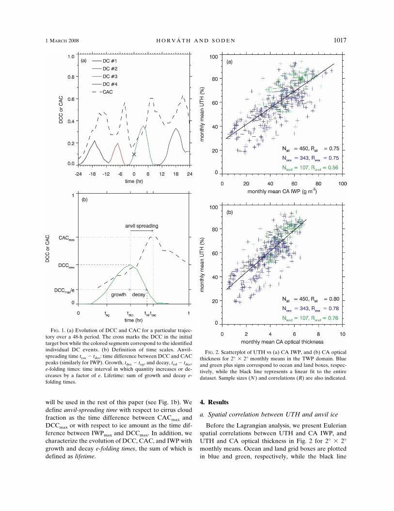
will be used in the rest of this paper (see Fig. 1b). Wedefine anvil-spreading time with respect to cirrus cloudfraction as the time difference between CACmax andDCCmax or with respect to ice amount as the time dif-ference between IWPmax and DCCmax. In addition, wecharacterize the evolution of DCC, CAC, and IWP withgrowth and decay e-folding times, the sum of which isdefined as lifetime.
4. Results
a. Spatial correlation between UTH and anvil ice
Before the Lagrangian analysis, we present Eulerianspatial correlations between UTH and CA IWP, andUTH and CA optical thickness in Fig. 2 for 2° 2°monthly means. Ocean and land grid boxes are plottedin blue and green, respectively, while the black line
FIG. 1. (a) Evolution of DCC and CAC for a particular trajec-tory over a 48-h period. The cross marks the DCC in the initialtarget box while the colored segments correspond to the identifiedindividual DC events. (b) Definition of time scales. Anvil-spreading time tcac � tdcc: time difference between DCC and CACpeaks (similarly for IWP). Growth, tdcc � teg, and decay, ted � tdcc,e-folding times: time interval in which quantity increases or de-creases by a factor of e. Lifetime: sum of growth and decay e-folding times.
FIG. 2. Scatterplot of UTH vs (a) CA IWP, and (b) CA opticalthickness for 2° 2° monthly means in the TWP domain. Blueand green plus signs correspond to ocean and land boxes, respec-tively, while the black line represents a linear fit to the entiredataset. Sample sizes (N ) and correlations (R) are also indicated.
1 MARCH 2008 H O R V Á T H A N D S O D E N 1017
Fig 1 live 4/C Fig 2 live 4/C
represents a linear fit to the entire dataset. Note thatCA IWPs and optical thicknesses over land are at thehigher end of the distribution and have a narrowerrange compared to oceanic values. (The same is true forDC ice content as well.) This finding is consistent withZipser et al. (2006), who observed the strongest stormsoccurring preferentially over land.
Clearly, UTH shows a strong positive correlationwith both measures of anvil Ci amount. When UTH isplotted against ice water path (Fig. 2a), the correlationis significantly lower over land (Rland � 0.56) than overocean (Rsea � 0.75); however, when it is plotted againstcloud optical thickness (Fig. 2b), the discrepancy be-tween land and ocean correlations disappears. Becauseice water path is proportional to the product of cloudoptical thickness and ice crystal effective radius, theseresults point to potentially larger retrieval uncertaintiesin ice crystal size over land. This finding is consistentwith Dong et al. (2008), who also observed reducedcorrelations between ground-based and VISST effec-tive radius estimates at the ARM SGP site. Thus, thelooser relationship between UTH and CA IWP overland is likely an artifact rather than a real signal.
As previously discussed, similarly strong correlationsbetween deep convection and upper-tropospheric wa-ter vapor have been found in other observational stud-ies as well. In addition, global climate models are alsocapable of reproducing this spatial relationship asshown by John and Soden (2006). Such apparentlystrong correlations have led some authors to concludethat sublimation of detrained ice can be a significantsource of UTH (Soden 1998; Su et al. 2006). However,in the remainder of this paper we will attempt to showthat while deep convection and local UTH are indeedconnected, sublimative moistening does not play an im-portant role in modulating the upper-tropospheric va-por budget, at least when averages in a deep layer be-tween 500 and 200 mb are considered.
b. Mean trajectories for January 2006
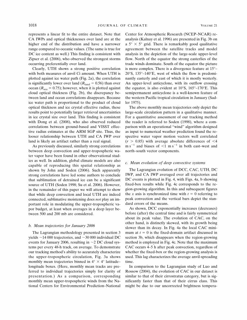
The Lagrangian methodology presented in section 3yields �14 000 trajectories, and �30 000 individual DCevents for January 2006, resulting in �2 DC cloud sys-tems per every 48-h track, on average. To demonstrateour tracking method’s ability to accurately characterizethe upper-tropospheric circulation, Fig. 3a showsmonthly mean trajectories binned in 4° 4° latitude–longitude boxes. (Here, monthly mean tracks are pre-ferred to individual trajectories simply for clarity ofpresentation.) As a comparison, correspondingmonthly mean upper-tropospheric winds from the Na-tional Centers for Environmental Prediction–National
Center for Atmospheric Research (NCEP–NCAR) re-analysis (Kalnay et al. 1996) are presented in Fig. 3b ona 5° 5° grid. There is remarkably good qualitativeagreement between the satellite tracks and modelanalysis in the depiction of the large-scale upper-levelflow. North of the equator the strong easterlies of thetrade winds dominate. South of the equator the pictureis more complex. There is a divergence feature at 15°–20°S, 135°–140°E, west of which the flow is predomi-nantly easterly and east of which it is mostly westerly.An upper-level anticyclone, with its outflow crossingthe equator, is also evident at 10°S, 165°–170°E. Thissemipermanent anticyclone is a well-known feature ofthe western Pacific tropical circulation in January (Sad-ler 1975).
The above monthly mean trajectories only depict thelarge-scale circulation pattern in a qualitative manner.For a quantitative assessment of our tracking methodthe reader is referred to Soden (1998), where a com-parison with an operational “wind” algorithm designedas input to numerical weather prediction found the re-spective water vapor motion vectors well correlated(r 0.85) with average absolute differences of �4m s�1 and biases of �1 m s�1 in both east–west andnorth–south vector components.
c. Mean evolution of deep convective systems
The Lagrangian evolution of DCC, CAC, UTH, DCIWP, and CA IWP averaged over all trajectories andDC events is plotted in Fig. 4, with Figs. 4a, b showingfixed-box results while Fig. 4c corresponds to the re-gion-growing algorithm. In this and subsequent figuresthe x axis is synchronized time with t � 0 referring topeak convection and the vertical bars depict the stan-dard errors of the means.
As shown, DCC exponentially increases (decreases)before (after) the central time and is fairly symmetricalabout its peak value. The evolution of CAC, on theother hand, is distinctly skewed, with its growth beingslower than its decay. In Fig. 4a the local CAC mini-mum at t � 0 is the fixed-domain artifact discussed insection 3b, which disappears when the region-growingmethod is employed in Fig. 4c. Note that the maximumCAC occurs 4–5 h after peak convection, regardless ofwhether the fixed-box or the region-growing analysis isused. This lag characterizes the average anvil-spreadingtime.
In comparison to the Lagrangian study of Luo andRossow (2004), the evolution of CAC in our dataset issimilar to that of their cirrostratus category, but is sig-nificantly faster than that of their cirrus class. Thismight be due to our uncorrected brightness tempera-
1018 J O U R N A L O F C L I M A T E VOLUME 21
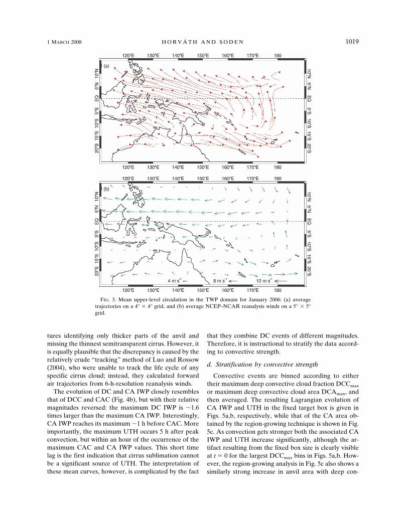
tures identifying only thicker parts of the anvil andmissing the thinnest semitransparent cirrus. However, itis equally plausible that the discrepancy is caused by therelatively crude “tracking” method of Luo and Rossow(2004), who were unable to track the life cycle of anyspecific cirrus cloud; instead, they calculated forwardair trajectories from 6-h-resolution reanalysis winds.
The evolution of DC and CA IWP closely resemblesthat of DCC and CAC (Fig. 4b), but with their relativemagnitudes reversed: the maximum DC IWP is �1.6times larger than the maximum CA IWP. Interestingly,CA IWP reaches its maximum �1 h before CAC. Moreimportantly, the maximum UTH occurs 5 h after peakconvection, but within an hour of the occurrence of themaximum CAC and CA IWP values. This short timelag is the first indication that cirrus sublimation cannotbe a significant source of UTH. The interpretation ofthese mean curves, however, is complicated by the fact
that they combine DC events of different magnitudes.Therefore, it is instructional to stratify the data accord-ing to convective strength.
d. Stratification by convective strength
Convective events are binned according to eithertheir maximum deep convective cloud fraction DCCmax
or maximum deep convective cloud area DCAmax, andthen averaged. The resulting Lagrangian evolution ofCA IWP and UTH in the fixed target box is given inFigs. 5a,b, respectively, while that of the CA area ob-tained by the region-growing technique is shown in Fig.5c. As convection gets stronger both the associated CAIWP and UTH increase significantly, although the ar-tifact resulting from the fixed box size is clearly visibleat t � 0 for the largest DCCmax bins in Figs. 5a,b. How-ever, the region-growing analysis in Fig. 5c also shows asimilarly strong increase in anvil area with deep con-
FIG. 3. Mean upper-level circulation in the TWP domain for January 2006: (a) averagetrajectories on a 4° 4° grid, and (b) average NCEP–NCAR reanalysis winds on a 5° 5°grid.
1 MARCH 2008 H O R V Á T H A N D S O D E N 1019
Fig 3 live 4/C
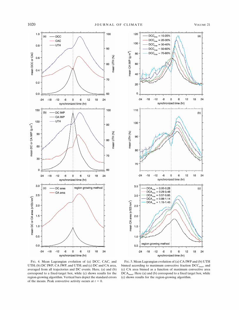
FIG. 4. Mean Lagrangian evolution of (a) DCC, CAC, andUTH; (b) DC IWP, CA IWP, and UTH; and (c) DC and CA area,averaged from all trajectories and DC events. Here, (a) and (b)correspond to a fixed-target box, while (c) shows results for theregion-growing algorithm. Vertical bars depict the standard errorsof the means. Peak convective activity occurs at t � 0.
FIG. 5. Mean Lagrangian evolution of (a) CA IWP and (b) UTHbinned according to maximum convective fraction DCCmax, and(c) CA area binned as a function of maximum convective areaDCAmax. Here (a) and (b) correspond to a fixed target box, while(c) shows results for the region-growing algorithm.
1020 J O U R N A L O F C L I M A T E VOLUME 21
Fig 4 live 4/C Fig 5 live 4/C
vective area confirming the robustness of the fixed-boxresults.
Importantly, there is a marked difference betweenthe time evolution of CA area and IWP and that ofUTH. Anvil area and IWP peak systematically later forlarger convective clouds, with the spreading time in-creasing from 1–2 h for the weakest to 5–6 h for thestrongest systems. The lag in UTH, on the other hand,does not show a similar dependence on convectivestrength because it is always 4–5 h. Consequently, thetime difference between the peak values of CA IWPand UTH is typically no more than 1–2 h.
If anvil ice were an important source of UTH, onewould expect the time delay in the UTH peak to showa similar dependence on the size of convection. In ad-dition, the lag between the UTH and CA IWP curvesshould also be large enough to allow the sublimation ofconsiderable amounts of ice condensate. The resultsabove indicate the contrary. A caveat: the analysis thusfar has been based on the mean evolution of quantities.However, calculating time constants from averagedfields does not generally yield the correct average val-ues of those time constants. Therefore, it is a moremeaningful exercise to determine the anvil-spreadingtimes, e-folding times, and lifetimes for each DC eventseparately and then perform the averaging. This analy-sis is given in the next section.
e. Average anvil-spreading and e-folding times
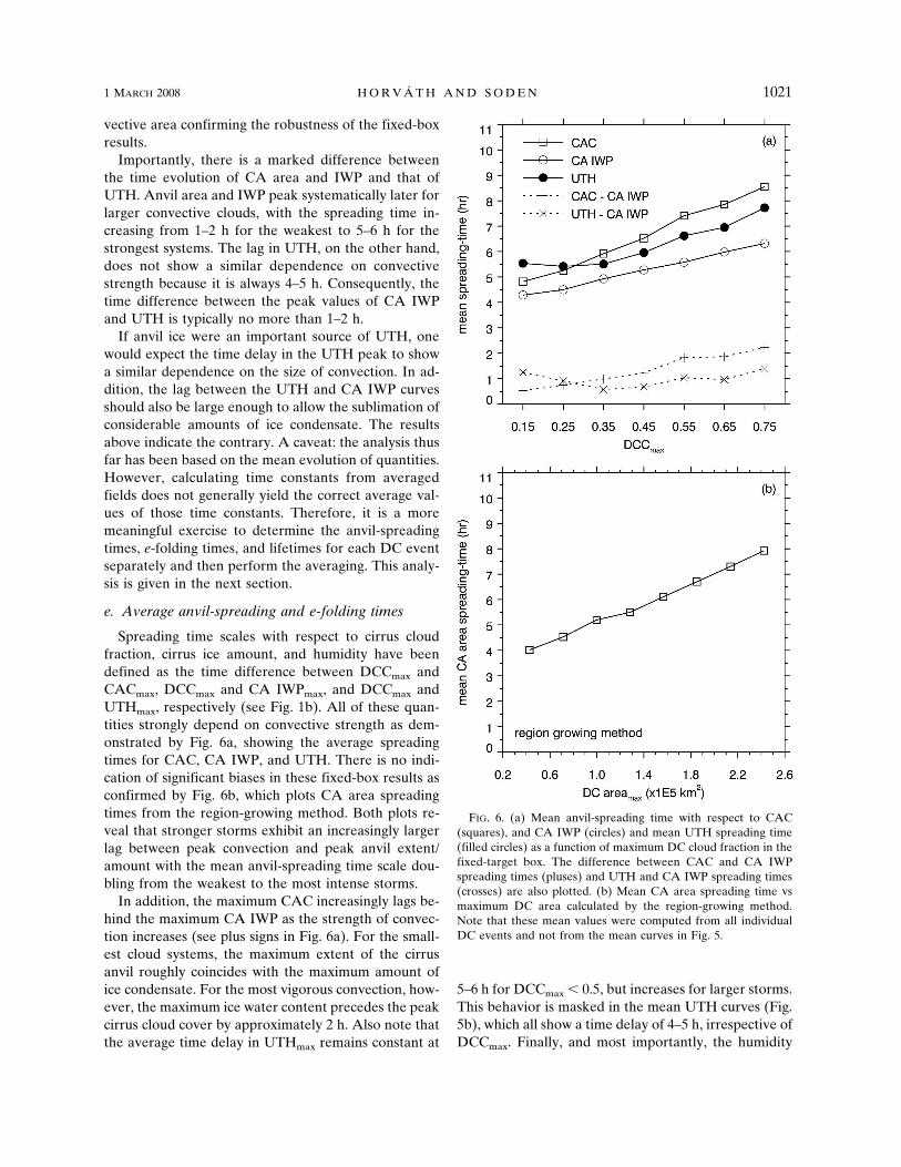
Spreading time scales with respect to cirrus cloudfraction, cirrus ice amount, and humidity have beendefined as the time difference between DCCmax andCACmax, DCCmax and CA IWPmax, and DCCmax andUTHmax, respectively (see Fig. 1b). All of these quan-tities strongly depend on convective strength as dem-onstrated by Fig. 6a, showing the average spreadingtimes for CAC, CA IWP, and UTH. There is no indi-cation of significant biases in these fixed-box results asconfirmed by Fig. 6b, which plots CA area spreadingtimes from the region-growing method. Both plots re-veal that stronger storms exhibit an increasingly largerlag between peak convection and peak anvil extent/amount with the mean anvil-spreading time scale dou-bling from the weakest to the most intense storms.
In addition, the maximum CAC increasingly lags be-hind the maximum CA IWP as the strength of convec-tion increases (see plus signs in Fig. 6a). For the small-est cloud systems, the maximum extent of the cirrusanvil roughly coincides with the maximum amount ofice condensate. For the most vigorous convection, how-ever, the maximum ice water content precedes the peakcirrus cloud cover by approximately 2 h. Also note thatthe average time delay in UTHmax remains constant at
5–6 h for DCCmax � 0.5, but increases for larger storms.This behavior is masked in the mean UTH curves (Fig.5b), which all show a time delay of 4–5 h, irrespective ofDCCmax. Finally, and most importantly, the humidity
FIG. 6. (a) Mean anvil-spreading time with respect to CAC(squares), and CA IWP (circles) and mean UTH spreading time(filled circles) as a function of maximum DC cloud fraction in thefixed-target box. The difference between CAC and CA IWPspreading times (pluses) and UTH and CA IWP spreading times(crosses) are also plotted. (b) Mean CA area spreading time vsmaximum DC area calculated by the region-growing method.Note that these mean values were computed from all individualDC events and not from the mean curves in Fig. 5.
1 MARCH 2008 H O R V Á T H A N D S O D E N 1021
maximum occurs typically within 1.0 h of the maximumice water content, regardless of convective strength (seecrosses in Fig. 6a). This time interval seems too small toallow for significant sublimative moistening. However,what exactly is the temporal scale of cirrus dissipationin these cloud systems?
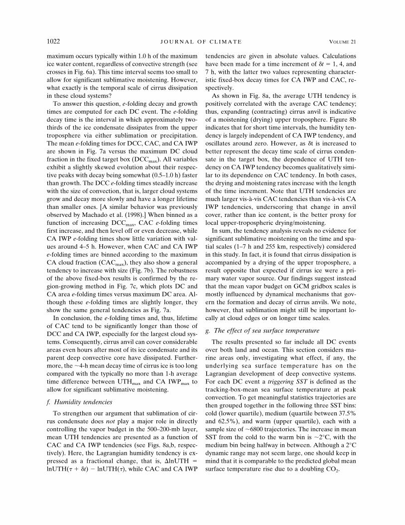
To answer this question, e-folding decay and growthtimes are computed for each DC event. The e-foldingdecay time is the interval in which approximately two-thirds of the ice condensate dissipates from the uppertroposphere via either sublimation or precipitation.The mean e-folding times for DCC, CAC, and CA IWPare shown in Fig. 7a versus the maximum DC cloudfraction in the fixed target box (DCCmax). All variablesexhibit a slightly skewed evolution about their respec-tive peaks with decay being somewhat (0.5–1.0 h) fasterthan growth. The DCC e-folding times steadily increasewith the size of convection, that is, larger cloud systemsgrow and decay more slowly and have a longer lifetimethan smaller ones. [A similar behavior was previouslyobserved by Machado et al. (1998).] When binned as afunction of increasing DCCmax, CAC e-folding timesfirst increase, and then level off or even decrease, whileCA IWP e-folding times show little variation with val-ues around 4–5 h. However, when CAC and CA IWPe-folding times are binned according to the maximumCA cloud fraction (CACmax), they also show a generaltendency to increase with size (Fig. 7b). The robustnessof the above fixed-box results is confirmed by the re-gion-growing method in Fig. 7c, which plots DC andCA area e-folding times versus maximum DC area. Al-though these e-folding times are slightly longer, theyshow the same general tendencies as Fig. 7a.
In conclusion, the e-folding times and, thus, lifetimeof CAC tend to be significantly longer than those ofDCC and CA IWP, especially for the largest cloud sys-tems. Consequently, cirrus anvil can cover considerableareas even hours after most of its ice condensate and itsparent deep convective core have dissipated. Further-more, the �4-h mean decay time of cirrus ice is too longcompared with the typically no more than 1-h averagetime difference between UTHmax and CA IWPmax toallow for significant sublimative moistening.
f. Humidity tendencies
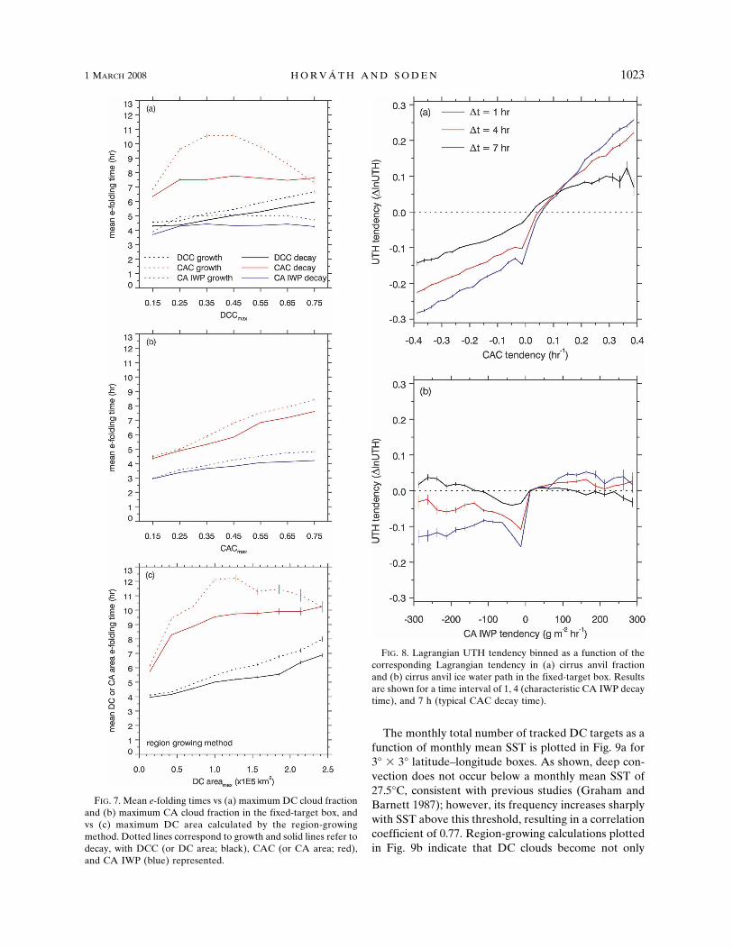
To strengthen our argument that sublimation of cir-rus condensate does not play a major role in directlycontrolling the vapor budget in the 500–200-mb layer,mean UTH tendencies are presented as a function ofCAC and CA IWP tendencies (see Figs. 8a,b, respec-tively). Here, the Lagrangian humidity tendency is ex-pressed as a fractional change, that is, �lnUTH �lnUTH( � �t) � lnUTH(), while CAC and CA IWP
tendencies are given in absolute values. Calculationshave been made for a time increment of �t � 1, 4, and7 h, with the latter two values representing character-istic fixed-box decay times for CA IWP and CAC, re-spectively.
As shown in Fig. 8a, the average UTH tendency ispositively correlated with the average CAC tendency;thus, expanding (contracting) cirrus anvil is indicativeof a moistening (drying) upper troposphere. Figure 8bindicates that for short time intervals, the humidity ten-dency is largely independent of CA IWP tendency, andoscillates around zero. However, as �t is increased tobetter represent the decay time scale of cirrus conden-sate in the target box, the dependence of UTH ten-dency on CA IWP tendency becomes qualitatively simi-lar to its dependence on CAC tendency. In both cases,the drying and moistening rates increase with the lengthof the time increment. Note that UTH tendencies aremuch larger vis-à-vis CAC tendencies than vis-à-vis CAIWP tendencies, underscoring that change in anvilcover, rather than ice content, is the better proxy forlocal upper-tropospheric drying/moistening.
In sum, the tendency analysis reveals no evidence forsignificant sublimative moistening on the time and spa-tial scales (1–7 h and 255 km, respectively) consideredin this study. In fact, it is found that cirrus dissipation isaccompanied by a drying of the upper troposphere, aresult opposite that expected if cirrus ice were a pri-mary water vapor source. Our findings suggest insteadthat the mean vapor budget on GCM gridbox scales ismostly influenced by dynamical mechanisms that gov-ern the formation and decay of cirrus anvils. We note,however, that sublimation might still be important lo-cally at cloud edges or on longer time scales.
g. The effect of sea surface temperature
The results presented so far include all DC eventsover both land and ocean. This section considers ma-rine areas only, investigating what effect, if any, theunderlying sea surface temperature has on theLagrangian development of deep convective systems.For each DC event a triggering SST is defined as thetracking-box-mean sea surface temperature at peakconvection. To get meaningful statistics trajectories arethen grouped together in the following three SST bins:cold (lower quartile), medium (quartile between 37.5%and 62.5%), and warm (upper quartile), each with asample size of �6800 trajectories. The increase in meanSST from the cold to the warm bin is �2°C, with themedium bin being halfway in between. Although a 2°Cdynamic range may not seem large, one should keep inmind that it is comparable to the predicted global meansurface temperature rise due to a doubling CO2.
1022 J O U R N A L O F C L I M A T E VOLUME 21
The monthly total number of tracked DC targets as afunction of monthly mean SST is plotted in Fig. 9a for3° 3° latitude–longitude boxes. As shown, deep con-vection does not occur below a monthly mean SST of27.5°C, consistent with previous studies (Graham andBarnett 1987); however, its frequency increases sharplywith SST above this threshold, resulting in a correlationcoefficient of 0.77. Region-growing calculations plottedin Fig. 9b indicate that DC clouds become not only
FIG. 7. Mean e-folding times vs (a) maximum DC cloud fractionand (b) maximum CA cloud fraction in the fixed-target box, andvs (c) maximum DC area calculated by the region-growingmethod. Dotted lines correspond to growth and solid lines refer todecay, with DCC (or DC area; black), CAC (or CA area; red),and CA IWP (blue) represented.
FIG. 8. Lagrangian UTH tendency binned as a function of thecorresponding Lagrangian tendency in (a) cirrus anvil fractionand (b) cirrus anvil ice water path in the fixed-target box. Resultsare shown for a time interval of 1, 4 (characteristic CA IWP decaytime), and 7 h (typical CAC decay time).
1 MARCH 2008 H O R V Á T H A N D S O D E N 1023
Fig 7 live 4/C Fig 8 live 4/C
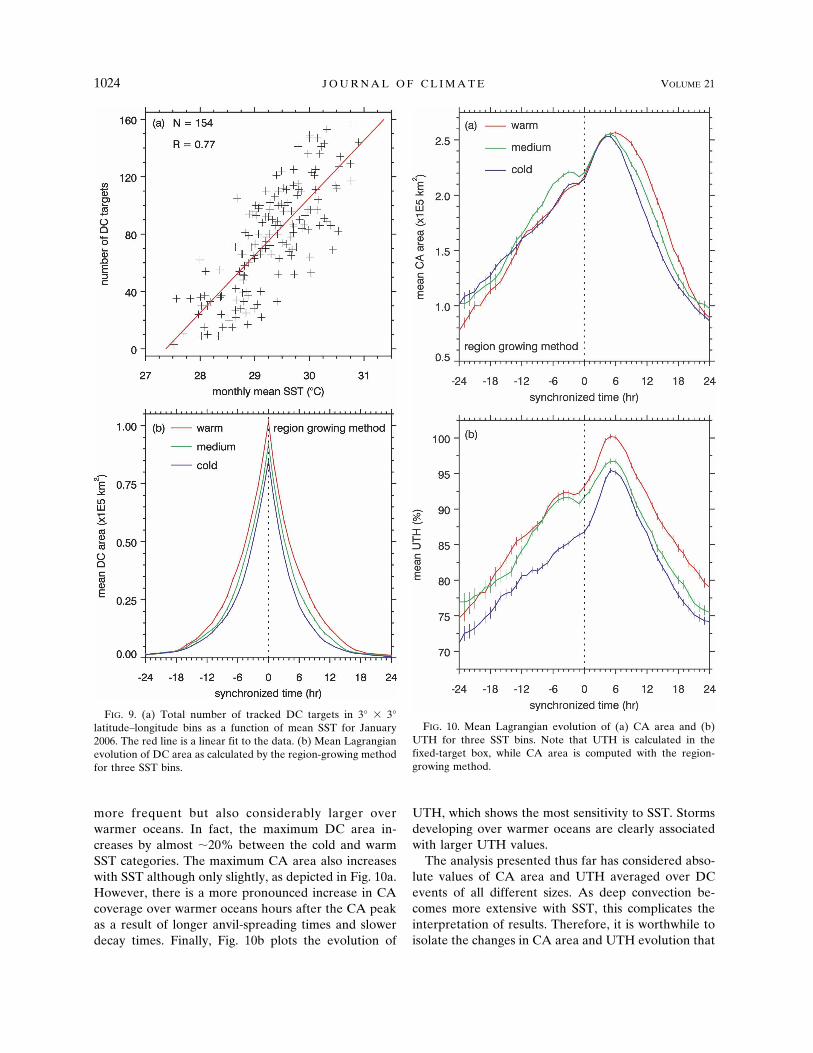
more frequent but also considerably larger overwarmer oceans. In fact, the maximum DC area in-creases by almost �20% between the cold and warmSST categories. The maximum CA area also increaseswith SST although only slightly, as depicted in Fig. 10a.However, there is a more pronounced increase in CAcoverage over warmer oceans hours after the CA peakas a result of longer anvil-spreading times and slowerdecay times. Finally, Fig. 10b plots the evolution of
UTH, which shows the most sensitivity to SST. Stormsdeveloping over warmer oceans are clearly associatedwith larger UTH values.
The analysis presented thus far has considered abso-lute values of CA area and UTH averaged over DCevents of all different sizes. As deep convection be-comes more extensive with SST, this complicates theinterpretation of results. Therefore, it is worthwhile toisolate the changes in CA area and UTH evolution that
FIG. 9. (a) Total number of tracked DC targets in 3° 3°latitude–longitude bins as a function of mean SST for January2006. The red line is a linear fit to the data. (b) Mean Lagrangianevolution of DC area as calculated by the region-growing methodfor three SST bins.
FIG. 10. Mean Lagrangian evolution of (a) CA area and (b)UTH for three SST bins. Note that UTH is calculated in thefixed-target box, while CA area is computed with the region-growing method.
1024 J O U R N A L O F C L I M A T E VOLUME 21
Fig 9 live 4/C Fig 10 live 4/C
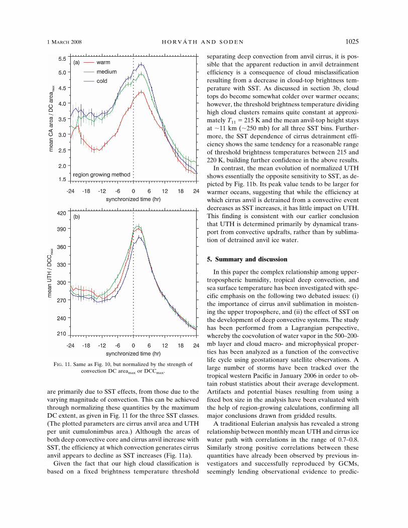
are primarily due to SST effects, from those due to thevarying magnitude of convection. This can be achievedthrough normalizing these quantities by the maximumDC extent, as given in Fig. 11 for the three SST classes.(The plotted parameters are cirrus anvil area and UTHper unit cumulonimbus area.) Although the areas ofboth deep convective core and cirrus anvil increase withSST, the efficiency at which convection generates cirrusanvil appears to decline as SST increases (Fig. 11a).
Given the fact that our high cloud classification isbased on a fixed brightness temperature threshold
separating deep convection from anvil cirrus, it is pos-sible that the apparent reduction in anvil detrainmentefficiency is a consequence of cloud misclassificationresulting from a decrease in cloud-top brightness tem-perature with SST. As discussed in section 3b, cloudtops do become somewhat colder over warmer oceans;however, the threshold brightness temperature dividinghigh cloud clusters remains quite constant at approxi-mately T11 � 215 K and the mean anvil-top height staysat �11 km (�250 mb) for all three SST bins. Further-more, the SST dependence of cirrus detrainment effi-ciency shows the same tendency for a reasonable rangeof threshold brightness temperatures between 215 and220 K, building further confidence in the above results.
In contrast, the mean evolution of normalized UTHshows essentially the opposite sensitivity to SST, as de-picted by Fig. 11b. Its peak value tends to be larger forwarmer oceans, suggesting that while the efficiency atwhich cirrus anvil is detrained from a convective eventdecreases as SST increases, it has little impact on UTH.This finding is consistent with our earlier conclusionthat UTH is determined primarily by dynamical trans-port from convective updrafts, rather than by sublima-tion of detrained anvil ice water.
5. Summary and discussion
In this paper the complex relationship among upper-tropospheric humidity, tropical deep convection, andsea surface temperature has been investigated with spe-cific emphasis on the following two debated issues: (i)the importance of cirrus anvil sublimation in moisten-ing the upper troposphere, and (ii) the effect of SST onthe development of deep convective systems. The studyhas been performed from a Lagrangian perspective,whereby the coevolution of water vapor in the 500–200-mb layer and cloud macro- and microphysical proper-ties has been analyzed as a function of the convectivelife cycle using geostationary satellite observations. Alarge number of storms have been tracked over thetropical western Pacific in January 2006 in order to ob-tain robust statistics about their average development.Artifacts and potential biases resulting from using afixed box size in the analysis have been evaluated withthe help of region-growing calculations, confirming allmajor conclusions drawn from gridded results.
A traditional Eulerian analysis has revealed a strongrelationship between monthly mean UTH and cirrus icewater path with correlations in the range of 0.7–0.8.Similarly strong positive correlations between thesequantities have already been observed by previous in-vestigators and successfully reproduced by GCMs,seemingly lending observational evidence to predic-
FIG. 11. Same as Fig. 10, but normalized by the strength ofconvection DC areamax or DCCmax.
1 MARCH 2008 H O R V Á T H A N D S O D E N 1025
Fig 11 live 4/C
tions by one-dimensional models of tropical convec-tion, where the distribution of upper-troposphericmoisture is very sensitive to the sublimation of cloudcondensate. The Lagrangian analysis, however, haspainted a different picture. The mean evolution aver-aged from all deep convective events has indicated thatUTH reaches its maximum �5 h after peak convection,while cirrus anvil cover and ice water amount peak at�0.5 h and �1 h prior to that, respectively. The shorttime lag between the mean UTH and ice water pathdevelopment provides the first indication that cirruscondensate cannot be the source of the elevated hu-midity.
A further stratification of the results has shown thatthe time lag between peak convection and both peakanvil area and cirrus ice amount steadily increases withstorm size. Simultaneously, the time difference betweenmaximum anvil area and maximum cirrus ice amountalso increases, with the latter occurring first. However,UTH is tightly synchronized with cirrus ice water pathlagging behind it by no more than 1.0 h, irrespective ofthe strength of convection. Considering that the char-acteristic decay time of cirrus ice condensate has beenfound to be �4 h, this short time interval cannot allowfor significant sublimative moistening.
A further piece of evidence has been obtained byanalyzing UTH tendencies against tendencies in cirrusanvil cover and cirrus ice amount. A strong positivecorrelation has been found between UTH and cirruscover tendencies, confirming earlier results by Soden(2004). The UTH tendencies, however, have been gen-erally much smaller when binned against ice water pathtendencies, and either have oscillated around zero orhave been positively correlated with ice water path ten-dencies, depending on the length of the tendency timeincrement. Contrary to what one would expect if cirrusice were a primary water vapor source, these resultshave shown that cirrus decay (in terms of both cloudcover and integrated ice content) is accompanied by adrying of the upper troposphere, while cirrus growth isindicative of increasing UTH.
Taken together, the above findings add to the grow-ing body of evidence strongly suggesting that sublima-tion of cirrus anvil condensate does not play a signifi-cant role in modulating the vapor budget of the 500–200-mb upper-tropospheric layer. The elevatedhumidity levels observed a few hours after peak con-vection seem instead linked to vertical transport pro-cesses responsible for convective detrainment of watervapor and the formation and maintenance of cirrus an-vils.
The effect of sea surface temperature on Lagrangiancloud evolution has also been investigated with the help
of newly available high spatial and temporal resolutionmicrowave SSTs. Deep convective trajectories havebeen sorted into cold, medium, and warm categoriesbased on their triggering SSTs, with a �2°C mean tem-perature difference between the two extreme bins. Ithas been found that a rise in SST of such magnituderesults in a measurable increase in the frequency, spa-tial extent, and water content of deep convective cores.These larger storms over warmer oceans are associatedwith cirrus anvils whose maximum extent is also slightlylarger and whose decay time is somewhat slower thantheir counterparts over colder oceans. However, nor-malization by the strength of convection has shown thatanvil area per unit cumulus area, that is, cirrus detrain-ment efficiency, actually decreases as SST increases.Finally, both the mean UTH and its detrainment ratehave generally increased with SST.
It is noted that a qualitatively similar sea surface tem-perature dependence of cirrus anvil detrainment effi-ciency has been observed by Lindzen et al. (2001). Theyhave found that, when large areas of the tropics areconsidered, there is a strong inverse relation betweennormalized anvil cloud fraction and the underlyingmean SST, and they interpreted the result as reducedcirrus outflow caused by an increase in deep convectiveprecipitation efficiency over warmer oceans. Combin-ing this area effect with a particular set of assumptionson the mean radiative properties of high-level clouds,Lindzen et al. (2001) then proposed a strong negative“iris” feedback that may operate to minimize globalwarming due to a doubling of CO2. However, all as-pects of the iris mechanism have been questioned in theliterature. For example, Lin et al. (2002) have foundsignificantly larger cloud albedos and longwave fluxesin state-of-the-art satellite measurements than those as-sumed by Lindzen et al. (2001), resulting in a weakpositive feedback instead of a strong negative feedback.Furthermore, Hartmann and Michelsen (2002) havepointed out that the observed relationship betweencloud-weighted SST and normalized anvil fraction re-sults from changes in cloud amount over colder SSTs,which is far removed from tropical deep convectionwhose anvil clouds Lindzen et al. (2001) have hypoth-esized are modulated by small SST variations.
Our study does not endorse the iris feedback; it sim-ply notes an apparent decrease in anvil detrainmentefficiency with SST in our analysis. Unfortunately, theemployed infrared data are not suitable for studyingchanges in convective precipitation efficiency, whichhave been proposed as the cause of the area effect.However, one can still point out that while Hartmannand Michelsen’s (2002) explanation is plausible whencloud fractions and cloud-weighted SSTs are calculated
1026 J O U R N A L O F C L I M A T E VOLUME 21

for large geographical areas, it cannot explain thepresent results obtained by tracking individual convec-tive events of relatively small sizes.
The most recent investigations of the area effect re-main divided. On the one hand, the study by Rapp et al.(2005) combining TRMM precipitation radar data withinfrared imagery has found no significant correlationsbetween SST and deep convective cloud size normal-ized by rainfall amount, providing further evidenceagainst iris. On the other hand, the multisatellite studyof Spencer et al. (2007) is supportive of iris and suggestsan increase in rainfall efficiency as the tropospherewarms.
Our findings also indicate an area effect. Althoughwe have eliminated gridding (fixed box) artifacts, wecannot rule out the possibility that this result is due tothe combination of a fixed-temperature threshold andhigher–colder cloud tops over warmer oceans. In fact, arecent paper by Kubar et al. (2007) analyzing coinci-dent optical cloud retrievals and microwave precipita-tion rates seems to provide some indirect evidence tothat effect. They have found nearly identical deep con-vective cloud amounts, but more anvil clouds per unitof precipitation in the warmer west Pacific than in thecolder east Pacific, suggesting an anti-iris effect. It re-mains to be seen, however, if the same SST dependenceholds true when the analysis is restricted to the westPacific, as in our case. In addition, the Kubar et al.(2007) study is limited by a cloud classification alsoemploying fixed thresholds (on optical thickness) andmicrowave retrievals that assume a specific analyticalrelationship between rain rate and cloud water amount/optical thickness (Wentz and Meissner 2000).
Ultimately, all passive imagery–based cloud classifi-cations suffer from errors introduced by thresholdingcontinuous distributions of cloud-top parameters. Ac-tive sensors can provide cloud vertical cross sectionsand might be better suited to identify the anvil andconvective parts of tropical cloud systems. Therefore, fur-ther studies using the new A-Train dataset (Stephens etal. 2002) are needed for the definitive treatment of thesubject.
Acknowledgments. MTSAT-1R imagery has beenobtained from the ARM External Data Center (XDC)at Brookhaven National Laboratory, while derivedcloud products have been provided by Dr. Patrick Min-nis of the National Aeronautics and Space Administra-tion (NASA) Langley Cloud and Radiation ResearchGroup. Microwave OI SST data have been produced byRemote Sensing Systems (RSS), sponsored by the Na-tional Oceanographic Partnership Program (NOPP),the NASA Earth Science Physical Oceanography Pro-
gram, and the NASA REASoN DISCOVER Project.(Data are available at http://www.remss.com.) TheNCEP reanalysis-derived data have been provided bythe NOAA/OAR/ESRL PSD, in Boulder, Colorado,from their Web site (online at http://www.cdc.noaa.gov). The work presented in this paper has been sup-ported by grants from the Department of Energy’sARM and NASA’s Modeling, Analysis, and Prediction(MAP) programs. We thank Richard Wagener of ARMXDC, Michele Nordeen of Analytical Services & Ma-terials, Inc., and Chelle Gentemann of RSS for theirhelp in understanding the various datasets, and CynthiaJ. Archerd for her invaluable editorial assistance. Thecomments and suggestions of two anonymous reviewersgreatly enhanced the quality of the paper.
REFERENCES
Del Genio, A. D., W. Kovari, M.-S. Yao, and J. Jonas, 2005: Cu-mulus microphysics and climate sensitivity. J. Climate, 18,2376–2387.
Dessler, A. E., and S. C. Sherwood, 2000: Simulations of tropicalupper tropospheric humidity. J. Geophys. Res., 105, 20 155–20 163.
Dong, X., P. Minnis, B. Xi, S. Sun-Mack, and Y. Chen, 2008:Comparison of CERES-MODIS stratus cloud propertieswith ground-based measurements at the DOE ARM South-ern Great Plains site. J. Geophys. Res., 113, D03204,doi:10.1029/2007JD008438.
Folkins, I., and R. V. Martin, 2005: The vertical structure of tropi-cal convection and its impact on the budgets of water vaporand ozone. J. Atmos. Sci., 62, 1560–1573.
Fu, R., A. D. Del Genio, and W. B. Rossow, 1990: Behavior ofdeep convective clouds in the tropical Pacific deduced fromISCCP radiances. J. Climate, 3, 1129–1152.
Gentemann, C., C. J. Donlon, A. Stuart-Menteth, and F. J. Wentz,2003: Diurnal signals in satellite sea surface tempera-ture measurements. Geophys. Res. Lett., 30, 1140,doi:10.102912002GL016291.
Graham, N. E., and T. P. Barnett, 1987: Sea surface temperature,surface wind divergence, and convection over tropicaloceans. Science, 238, 657–659.
Gray, W. M., E. Ruprecht, and R. Phelps, 1975: Relative humidityin tropical weather systems. Mon. Wea. Rev., 103, 685–690.
Hartmann, D. L., and M. L. Michelsen, 2002: No evidence for iris.Bull. Amer. Meteor. Soc., 83, 249–254.
Horváth, Á., and R. Davies, 2007: Comparison of microwave andoptical cloud water path estimates from TMI, MODIS, andMISR. J. Geophys. Res., 112, D01202, doi:10.1029/2006JD007101.
Huang, J.-P., P. Minnis, B. Lin, Y. Yi, M. M. Khaiyer, R. F. Ar-duini, A. Fan, and G. G. Mace, 2005: Advanced retrievals ofmultilayered cloud properties using multispectral measure-ments. J. Geophys. Res., 110, D15S18, doi:10.1029/2004JD005101.
John, V. O., and B. J. Soden, 2006: Does convectively-detrainedcloud ice enhance water vapor feedback? Geophys. Res. Lett.,33, L20701, doi:10.1029/2006GL027260.
Kalnay, E., and Coauthors, 1996: The NCEP/NCAR 40-Year Re-analysis Project. Bull. Amer. Meteor. Soc., 77, 437–471.
Kubar, T. L., D. L. Hartmann, and R. Wood, 2007: Radiative and
1 MARCH 2008 H O R V Á T H A N D S O D E N 1027

convective driving of tropical high clouds. J. Climate, 20,5510–5526.
Lin, B., B. A. Wielicki, L. H. Chambers, Y. Hu, and K.-M. Xu,2002: The iris hypothesis: A negative or positive cloud feed-back? J. Climate, 15, 3–7.
Lindzen, R. S., M.-D. Chou, and A. Y. Hou, 2001: Does the earthhave an adaptive infrared iris? Bull. Amer. Meteor. Soc., 82,417–432.
Luo, Z., and W. B. Rossow, 2004: Characterizing tropical cirruslife cycle, evolution, and interaction with upper-troposphericwater vapor using Lagrangian trajectory analysis of satelliteobservations. J. Climate, 17, 4541–4563.
Machado, L. A. T., and W. B. Rossow, 1993: Structural charac-teristics and radiative properties of tropical cloud clusters.Mon. Wea. Rev., 121, 3234–3260.
——, ——, R. L. Guedes, and A. W. Walker, 1998: Life cyclevariations of mesoscale convective systems over the Ameri-cas. Mon. Wea. Rev., 126, 1630–1654.
Mapes, B. E., and R. A. Houze Jr., 1993: Cloud clusters and su-perclusters over the oceanic warm pool. Mon. Wea. Rev., 121,1398–1415.
Minnis, P., and Coauthors, 1995: Cloud optical property retrieval(subsystem 4.3). Clouds and the Earth’s Radiant Energy Sys-tem (CERES) algorithm theoretical basis document. VolumeIII: Cloud analyses and radiance inversions (subsystem 4),NASA Rep. 1376, 135–176.
Pierrehumbert, R. T., and R. Roca, 1998: Evidence for control ofAtlantic subtropical humidity by large scale advection. Geo-phys. Res. Lett., 25, 4537–4540.
Ramanathan, V., and W. Collins, 1991: Thermodynamic regula-tion of ocean warming by cirrus clouds deduced from obser-vations of the 1987 El Niño. Nature, 351, 27–32.
Rapp, A. D., C. Kummerow, W. Berg, and B. Griffith, 2005: Anevaluation of the proposed mechanism of the adaptive infra-red iris hypothesis using TRMM VIRS and PR measure-ments. J. Climate, 18, 4185–4194.
Rennó, N. O., K. A. Emanuel, and P. H. Stone, 1994: Radiative-convective model with an explicit hydrologic cycle. 1. Formu-lation and sensitivity to model parameters. J. Geophys. Res.,99, 14 429–14 441.
Sadler, J. C., 1975: The Upper Tropospheric Circulation over theGlobal Tropics. Department of Meteorology, Atlas UHMET75-05, University of Hawaii at Manoa, Honolulu, HI, 35 pp.[Available online at http://www.soest.hawaii.edu/Library/Sadler.html.]
Salathé, E. P., and D. L. Hartmann, 1997: A trajectory analysis oftropical upper-tropospheric moisture and convection. J. Cli-mate, 10, 2533–2547.
Schmetz, J., C. Geijo, W. P. Menzel, K. Strabala, L. van de Berg,K. Holmund, and S. Tjemkes, 1995: Satellite observations of
upper tropospheric relative humidity, clouds, and wind fielddivergence. Beitr. Phys. Atmos., 68, 345–357.
Sherwood, S. C., 1999: On moistening of the tropical troposphereby cirrus clouds. J. Geophys. Res., 104, 11 949–11 960.
Shine, K. P., and A. Sinha, 1991: Sensitivity of the earth’s climateto height-dependent changes in the water vapour mixing ra-tio. Nature, 354, 382–384.
Soden, B. J., 1998: Tracking upper tropospheric water vapor ra-diances: A satellite perspective. J. Geophys. Res., 103, 17 069–17 081.
——, 2004: The impact of tropical convection and cirrus on uppertropospheric humidity: A Lagrangian analysis of satellitemeasurements. Geophys. Res. Lett., 31, L20104, doi:10.1029/2004GL020980.
——, and F. P. Bretherton, 1993: Upper tropospheric relative hu-midity from the 6.7 �m channel: Method and climatology forJuly 1987. J. Geophys. Res., 98, 16 669–16 688.
——, and R. Fu, 1995: A satellite analysis of deep convection,upper-tropospheric humidity, and the greenhouse effect. J.Climate, 8, 2333–2351.
——, D. D. Turner, B. M. Lesht, and L. M. Miloshevich, 2004: Ananalysis of satellite, radiosonde, and lidar observations of up-per tropospheric water vapor from the Atmospheric Radia-tion Measurement Program. J. Geophys. Res., 109, D04105,doi:10.1029/2003JD003828.
Spencer, R. W., W. D. Braswell, J. R. Christy, and J. Hnilo, 2007:Cloud and radiation budget changes associated with tropicalintraseasonal oscillations. Geophys. Res. Lett., 34, L15707,doi:10.1029/2007GL029698.
Stephens, G. L., and Coauthors, 2002: The Cloudsat mission andthe A-train: A new dimension of space-based observations ofclouds and precipitation. Bull. Amer. Meteor. Soc., 83, 1771–1790.
Su, H., W. G. Read, J. H. Jiang, J. W. Waters, D. L. Wu, and E. J.Fetzer, 2006: Enhanced positive water vapor feedback asso-ciated with tropical deep convection: New evidence fromAura MLS. Geophys. Res. Lett., 33, L05709, doi:10.1029/2005GL025505.
Sun, D.-Z., and R. S. Lindzen, 1993: Distribution of tropical tro-pospheric water vapor. J. Atmos. Sci., 50, 1643–1660.
Udelhofen, P. M., and D. L. Hartmann, 1995: Influence of tropicalcloud systems on the relative humidity in the upper tropo-sphere. J. Geophys. Res., 100, 7423–7440.
Wentz, F. J., and T. Meissner, 2000: AMSR Ocean Algorithm(ATBD), version 2. RSS Tech. Rep. 121599A, 66 pp. [Availableonline at http://www.remss.com/papers/amsr/AMSR_Ocean_Algorithm_Version_2.pdf.]
Zipser, E. J., D. J. Cecil, C. Liu, S. W. Nesbitt, and D. P. Yorty,2006: Where are the most intense thunderstorms on earth?Bull. Amer. Meteor. Soc., 87, 1057–1071.
1028 J O U R N A L O F C L I M A T E VOLUME 21