JSДIДД.r'' ““ "SS” - DTIC
240
to i co to University of California Vildlenâ Research Center MEDITERRANEAN ANALOGS OF CALIFORNIA SOIL VEGETATION TYPES Paul J. Zinke Associate Professor, School of Forestry ~ C L E TR I N G H 0 U S t fOR FEDERAL SCIENTIFIC AND TF.CHNlCAt< INFORMATION “Särdcöwr“ Uicrof iche P D C DEC 15 1966 i ,u U LÜ , A on field vork conducted in Italy and Greece JSÄIÄÄ.r'’ ““ "SS” (Ab pert of Project 1762, Californie Agriculturel Experiment Station) Berkeley, California January 15, 1965
-
Upload
khangminh22 -
Category
Documents
-
view
0 -
download
0
Transcript of JSДIДД.r'' ““ "SS” - DTIC

to i
co
to
University of California
Vildlenâ Research Center
MEDITERRANEAN ANALOGS
OF
CALIFORNIA SOIL VEGETATION TYPES
Paul J. Zinke
Associate Professor, School of Forestry
~ C L E TR I N G H 0 U S t fOR FEDERAL SCIENTIFIC AND
TF.CHNlCAt< INFORMATION
“Särdcöwr“ Uicrof iche P D C
DEC 15 1966 i
,u U LÜ
, A on field vork conducted in Italy and Greece
JSÄIÄÄ.r'’ ““ "SS” (Ab pert of Project 1762, Californie Agriculturel Experiment Station)
Berkeley, California January 15, 1965

MEDITERRANEAN ABALOOS OF CALIFOBMA SOIL-VSOETATIOK TÏFES
Errate
Pege
32
43
45
49
57
67
88
88
90
92
97
99
124
124
125
i43
173
l8l
Line
2
20
13
12
15
8
2
11
22
1
2
12
10
12
9
22
2nd from bottom
l6
Correction
Psullletino
Brachy podium
Brechy podium
Several
SHyG SGHy
KuBcovite
Umbria
sylvatica
pH
Permanente
Vallombrosa
Color
podzolic
Lodo
Arctostaphylos
2' to 3’
Greek
By

TABLE OF CONTENTS
List of Tables .
List of Figures . .
Introduction . Objectives of the Study . ********* Schedule of vork accomplished . |
Systematic relationships emong Californie Forest Soils Soil Development Sequences. Soil properties . . ***[[*
Color.! ! ! [I I I * Grevel end stone content . * Clay content.! ! * I Chemicel properties.
Relating California Wildland Soils as Sequences . .
The Classification of the Vegetation of California . . . Life Zones end California Vegetation . Plant Communities in Californie . A Technique of classifying California Ve¿etati¿n’
and Land cover .
The Classification of the Vegetation of Italy and adjacent Mediterranean areas .
Life Zones and Italian Vegetation . ! !!!!.* ! Relating to elevation .
Italian and Greek Plant Communities end some California Analogies .
Species of Italian and Greek Vegetation and California Analogies .
Observations on Soil-Vegetation lÿpes of Italy and Greece Planning Sampling Locations . Sequence of Soils md Vegetation on Basic Igneous rocks in Sardegna .
Sequence on Granitic Rocks in Sardegna . . ., Sequence of Soils and Vegetation on slightly mete-’ morphosed Sandstones and Shales in Sicily ....
Sequences on Granite in Calabria . [ Sequence on Marl Rock in the Abruzzi Sequence on Limestone on Mt. Terminillo . . . * * * ^ Sequence of Soil Vegetad on on Sedimentary Rocks in Tuscar'»-.
The Soil Mosaic on Sedimentary Kocks !!!!!![] Sequence of Soil-Vegetation Types in Northern
Pindus Mountains -- Greece . Sequence on Schist near Sparta . . ‘ ‘ [ Sequence on Limestone near Sparta . [ Sequences on Granite in northern Greece .
ii
Page
iv
viii
. 11
. 12
. 13
. 14
17 17 18
. 19
. 21
. 26
. 26
. 29
. kO
.
. 59
. 74
. 85
92 101
104 130 .138 145

Sequence on Schist on Mt. Olympos ..... . , 159 Some Soil-Vegetation Types of the Tertiary Rocks of
Greece and California Analogies . I60 The Local Mosaic of Soil-Vegetation Types in
Italy end Greece..
Discussion -- The Mediterranean Soil-Vegetation Catena .... 177
Summary..
Bibliography ..
Û
APPENDIXES
A. Table 64 — Soil-Vegetation Plot XI (Ashes on Mt. Etna).2x3
B. Abbreviations Used in Field Plots .214
C. Figures (See list of figures).217
LIST OP TABLES
feble 1. Plant Species listed at Soil-Vegetation Plot Locations in Italy and Greece vith Celifornin Species Analogies for Woody Vegetation..
Table 2. Summary of Soil-Vegetation Sampling Transects . . . 23
Table 3. Soil-Vegetation Plot I (Basalt-Sardegna) . 30
Table k. Soil-Vegetation Plot II (Besalt-Sardegna) . 32
Table 5. Soil-Vegetation Plot III ( Basalt-Sardegna ).34
Table 6. Soil-Vegetation Plot IV (Basalt-Sardegna) . 36
Table 7. Landscape Sequence on Basic Igneous Rocks in Sardegna..
Table 8. Soil-Vegetation Plot V (Granite, Sardegna) . kl
Table 9. Soil-Vegetation Plot VI (Granite, Sardegna) .... 43
Table 10. Soil-Vegetation Plot VII (Granite, Sardegna) . . . 45
Table 11. Summary of Soil and Vegetation Features of Landscape Sequence on Granite in Sardegna . 47
Table 12. Soil-Vegetation Plot IX (Sandstones and Shales - Sicily)..
Table 13. Soil-Vegetation Plot X (Sandstones and Shales
- Sicily)..
Table 14. Soil-Vegetation Plot VIII (Sandstones and Shales -- Sicily) . ..... 54
Table 15. Summery of Soil-Vegetation Changes on Altitude Sequence on Granite in Calabria . 59
Table 16. Soil-Vegetation Plot XV (Granite — Calabria) . . . 60
Table 17. Soil-Vegetation Plot XIV (Granite - Calabria) . . 62
Table 18. Soil-Vegetation Plot XIII (Granite - Calabria) . . 64
Table 19. Soil-Vegetation Plot XII (Granite - Calabria) . . 66
Table 20. Soil-Vegetation Plot XVI (Granite — Calabria) . . 70
Table 21. Soil-Vegetation Plot XVII (Granite — Calabria) . . 72
iv
• • 75 Teble 22. Soil-Vegetation Plot XXI (Merl in Abruzzi) . .
Table 23. Soil-Vegetation Plot XX (Merl in Abruzzi).77
Table 25. Soil-Vegetation Hot XVIII (Merl in Abruzzi) . . . 8l
Table 26. Summary of Main Features of Elevation Sequence on Marl Rock.. 83
Table 27. Soil-Vegetation Plot — Lower Elevation Mt. Terminillo..
Table 28. Soil-Vegetation Plot — Middle Elevation Mt. Terminillo..
Table 29. Soil-Vegetation Plot — High Elevation Mt. Terminillo..
Table 30. Soil-Vegetation Plot — High Elevation Mt. Terminillo..
Table 31. Summery of Limestone Sequence on Mt. Terminillo . . $1
Table 32. Soil-Vegetation Plot XXXVIII (Sandstone - Tuscany)..
Table 33. Soil-Vegetation Plot XXXIX (Sandstone - Tuscany)..
feble 34. Soil-Vegetation Plot XL (Sandstone-Tuscany) .... 97
Table 35. Summary of Sequence on Sedimentary Rocks in Tuscany..
Table 36. Landscape-Soil Vegetation Profile across the Apuan Alps..
Table 37» Soil-Vegetation Plot XXII-C (Plndus Mountain Transect)..
Table 3Ö. Soil-Vegetation Plot XXU-B (Plndus Mountain Transect).IO8
Table 39. Soil-Vegetation Plot XXII (Pindus Mountain Transect)..
Table 4o. Soil-Vegetation Plot XXII-D (Pindus Mountain Transect)..
Table 4l. Soil-Vegetation Plot XXHI (Pindus Mountain Transect)..
Table 42. Soil-Vegetation Plot XXIV (Pindus Mountain Transect)..
V

Table 2*3. Soil-Vegetction Plot XXV-B (Pindus Mountain Transect).Hg
Table kk. Soil-Vegetetion Plot XXV-A (Pindus Mountain Transect). -.po
T&ble 2*5. Soil-Vegetetion Plot XHI-A (Pindus Mountain Transect) .
Table 2*5, Transect of Soil-Vegetation Types across the Pindus Mountains..
Table 2*7, Soil-Vegetation Plot XXIX (Schist - Sparta).131
Table 2*8, Soil-Vegetation Plot XX\0[ (Schist - Sparta) .... 133
Table 2*9. Soil-Vegetation Plot XXV (Schist - Sparta) . . . . 135
Table 50. Soil-Vegetation Plot XXVIII (Limestone - Sparta) . 139
Table 51. Continuation of Table 50..
Table 51a. Soil-Vegetation Plot XXVII..
Table 52. Soil-Vegetation Plot XXX-A (Limestone- Yugoslavia)..
Table 53. Soil-Vegetation Plot XXXVII (Granite - northern Greece)..
Table 52*. Soil-Vegetetion Plot XXXI (Granite - northern Greece) .
Table 55. Soil-Vegetation Plot XXXV (Granite - Northern Greece) .
Table 56. Soil-Vegetation Plot XXX (Granite - Northern Greece) .
Table 57. Soil-Vegetation Plot XXXVI (Granite - Northern Greece)..
Table 58. Summary of Sequences of Soil-Vegetation on Acid Igneous Rocks in Northern Greece . .
. 156
. 158
Table 59.
Table 60.
Table 6l.
Table 62.
Soil-Vegetation Plot XXXIV (Schist - Mt. Olympos) . 163
Soil-Vegetetion Plot XXXII . . . . . . . . . . . . 165
Soil-Vegetation Plot XXXIII-A . . ..167
Soil-Vegetation Plot XXXIII . 169
vi

Table 63. Soil-Vegetation Crtenes observed with elevation change on most of the rock types of Italy, Greece end California . . .
Table 6U. Appendix A. Soil-Vegetation Plot XI (Recent Ash deposit on Mt. Etna)..
NOTE: In the vegetation description portion of the Soil-Vegetation Plot tables, the following symbols were used for Abundance:
XXX Abundant" This species occurs on about 60$ of the area of the plot.
XX "Frequent" This species covers from 15% to 60# of the area of the plot.
X Occasional" This species covers less than 15# of the area of the plot.
Plots examined were circular, 118' in diameter, or one acre in arer.
vil

Figure Number
1
2
3
k
5
6
APPENDIX C
LIST OF FIGURES
Title
Mep of Californie showing broad groups of soil parent meterirls. The locations of sequences of soils sealed on various landscape profiles ere indicated by number
A topographic sequence on an area of schist parent material (No, 1 in figure l) showing the less developed Sheetiron Soil Series (Ô20); and, with increasing degrees of development, the following: Masterson Soil Series (821), Prick (813), Josephine“T8Í5m). end the Sites Soil Series (Öl6m)
Developmental sequences of soil profiles on several parent rock types as related to elevation change. The sequence on sandstone (No. 2, figure l) progresses from the minimal development of the Hoover Soil Series (822), through the Hugo (812), to the well developed soil series (Josephine (815). The sequence on granitic rocks (No. 3 in figure l) from the Corbett Soil Series (7121) and Shaver (7127) to the Holland (716). rnd the well developed soil series Mustek (7117). The sequence on andesitic rocks begins with the immature rndo-like soil series, Windy (7123) and McCarthy (7124), to the leached brown soil Cohcsset. and the fully developed Ar.-en Soil Series (fil) (No. k in figure 1).
The Soil Colors of soils representing sequences developed on four parent rock types in C lifornia showing increasing redness with increasing soil development (text reference, page 7).
The coarse fragments of soils representing develop¬ mental sequences on four parent rock types in California, showing generally e decrease in coarse fragments with increasing degree of development
The clay, silt, and send contents of the less than 2 mm fraction of soils representing sequences of increasing degree of development on several Celi- fornia rock types (contents expressed as percent by weight).
217
218
219
220
221
222
viii

Figure
Kutter Title
7e Italy, showing locetions of Soil-Vegetrtion observation points listed by tcble number in this text,
7b Greece, showing locations of Soil-Vegetation observation points listed by table number in this text.
8 A typical sequence or catena of soils found in this study in Greece, Italy, and California.
9 The typical elevation sequence up a ridge top between two torrents as it would appear in plan view, highest elevation at top of page.
Page
224
225
226
227

MEDITERRANEAN ANALOGS OP CALIFORNIA SOIL-VEGETATION TYPES
INTRODUCTION
This report sunraarlzes the progress made to date in a study comparing
the soils and vegetation of Italy and Greece with those of California. The
major accomplishnents of the study vere the assembling of a systematic
approach to the nunerous soil series classification units being applied to
the wildland areas of California, the formulation of sampling sequences based
on elevation transects on various types of geology in Italy and Greece, the
recording of characteristics of the vegetation and soil at the points on these
sequences in Italy and Greece, and the sampling of the soil at these observa¬
tion points with the samples to be used for subsequent analysis.
It has been a fairly common observation that there are similarities
between the vegetation and the soils of Mediterranean countries and California.
However this has usually been limited to the gross characteristics; for
example, noting that there is chaparral or that red soils are prevalent in
both areas. Plant species introductions from the Meditteranean countries to
California indicate that the California environment of climate and soil is
within the tolerance of many typical Mediterranean plant species such as olive
(Olea europea L.), Aleppo pine (Pinus halepensls). oleander (Nerium oleander),
cork oak (Quercus súber), and various species of Clstus. The world wide
plant geography study of Schimper (19O3), called attention to the similarities
between the vegetation of the Mediterranean countries and California, but he
also pointed out that not much was known about California.
Sisee that time there has been gained a considerable knowledge in
California concerning the vegetation, and in the past fifteen years about the
soils of the wildland areas of California. A soil-vegetation survey has

2
covered more than ten million acres of the California landscape, and the
vegetation type maps that were the forerunner of the soil-vegetation survey
(Wieslander, 1935) also covered millions of acres of California. It vas
noticed in this work that typical groupings of vegetation species into types
occurred and that these could be described in terms of vegetation structure.
This led to an aerial photo technique of describing vegetation types (Jensen,
I9U7) which then formed the basis for subsequent vegetation mapping work.
Generally it was found that in the relatively undisturbed vegetation of the
wildland areas of California that characteristic groupings of vegetation
species and associated vegetation structure occurred in response to the
occurrence of soil types which in turn were mainly dependent upon geology,
but also upon the past landscape history, the topography, and the climate.
The result is a mosaic of soil-vegetation types on the landscape.
In the classification of the soil-vegetation types of the California
landscape the Initial step is the subdivision of the vegetation as viewed on
aerial photographs into various units of homogeneous crown density and of
structure such as grass, shrub, hardwood trees, and coniferous trees. Bare
ground, rock, areas of water and other miscellaneous land types also being
delineated at the same time. Field observations are then made relating the
dominant soil type and the species of vegetation in order of abundance in each
of these previously delineated types on the aerial photographs. The resulting
soil-vegetation maps have contrHated much to present knowledge of the Cali¬
fornia landscape. The techniques developed enable one to develop considerable
knowledge about the soil and vegetation of an area from aerial photo interpre¬
tation supplemented by detailed Held observations at selected points on these
photographs; and also the extension of this knowledge to similar types that
are inaccessible from the ground.
The study to be reported here was planned to investigate some of the
analogies that might exist betveen the soil-vegetation types of Italy and

3
I
Greece end those of California, establishing field plots and asking observa¬
tions of the soil and vegetation similar to those made in the California
Soil-Vegetation Survey.
Objectives of the Study
The objectives of this study were to observe soil-vegetation types in
Italy and Greece from the standpoint of determining what similarities they had
to types in California. Observations were to be made at selected locations in
Italy and Greece that mould give a range of conditions similar to the range of
climatic, geologic, and altitudinal conditions which exist in California areat
having relatively undisturbed vegetation. Since much soils information had
already been gathered in California it was found necessary also to systemat¬
ically organite this knowledge as one of the objectives of this study. This
was then to be used in making the comparisons with comparable soils in Italy
and Greece. The vegetation was to be compared on the basis of structure with
notation of the dominant vegetation species and their abundance.
Schedule of Work Accomplished
This study was accomplished during a period extending from July, 1963
to November, 196U. The systematic approach to the forest soils of California
was developed and brought up to a final publishable form (Zinke, Colwell,
1963); a study was initiated and completed of the selected physical and chemi¬
cal properties of these California soils during the period from August, 1963
until presentation of the material at the International Soil Science Society
meeting in Bucharest, Romania in August, 1964 (Perry, Zinke, Beater, 1964).
Once this basis of some systematic organization of the knowledge of the soils
on the California landscape had been made it became possible to make meaning¬
ful observations of the soils of relatively undisturbed landscapes of
.. TV. .MM—..■■■... .,.
1
1
(
{
t
*
I
e
D
P
ii
mi

b
Greece and Italy in relation to those of California. The field vork in Italy
and Greece was carried out after establishing residence in Italy in September
of 1963; the author working in association with the faculty of Agriculture and
Forestry and the University of Florence. Here a library review was made of
the literature concerning the soils, geology, and vegetation of Italy and
Greece. Then, a scheme of field observation points was formulated based upon
this literature. Field work was begun in February, 1964 with the observation
of sampling points on two elevation sequences, one on basalt rock and one on
granite rock.located in Sardegna. Then, in April a similar sequence on
sedimentary rocks in northeastern Sicily was observed, and later in April two
sequences were completed on granitic rocks in southern Italy (Calabria). In
May a sequence of observations was made on marl rocks in central Italy
(Abruzzi). In June and July sequences of observation points were visited in
Greece on granitic rocks (west from Fiorina toward the Albanian border, and
north from Serrai toward the Bulgarian border); on metamorphic rocks (Mt.
Olympos, and near Sparta); on limestone rock (near Sparta); and a landscape
sequence involving sedimentary rocks into which serpentine and peridotite had
been intruded (in the northern Pindus Mountains near Metsovon). Observations
were then completed with a sequence of points on sedimentary rocks in northern
Italy (Tuscany) in August. Following this soil samples which had been collect¬
ed from each of these points were shipped back to the laboratory at the
University of California where they are being analyzed and this current
progress report has been written.
SYSTEMATIC RELATIONSHIPS AMONG CALIFORNIA FOREST SOILS
A systematic arrangement of the information concerning forest and wild¬
land soils of California was necessary to facilitate the comparisons to be
made in Italy and Greece. The extensive mapping which has been carried out in

5
California in the Soil-Vegetation Survey has provided observations not only
for a systematic description of soil series in areas of natural vegetation
but also a factual basis for relating and grouping these soils.
Field men mapping in the soil-vegetation survey have observed predict¬
able relationships betueen the type of soil profile and certain variables in
the landscape, particularly the type of parent material or the geology of the
area, the relative age and the topography of the land surface and the large-
scale differences in elevation. Associated with the interaction of these
landscape variables are soils having various degrees of development.
That soils can be grouped according to degree of development on a given
parent material is obviously not new to the soils literature. Gerhardt (1900)
noted that he could classify sand dunes, from white to yellow to reddish, in
relation to increasing age of dune. Shaw (1928) established a grouping of
soils into families ranging from an immature soil to a mature soil on each
parent material. Storie and Weir (1953) have developed these concepts into a
guide to soil series in California.
Many new soil series have been described during the soil-vegetation
1/ survey. They can be related as sequences of increasing degree of developmsni;
on each rock type which probably occur due to increasing time of weathering.
There will be some variation in the developmental sequence on a given parent
rock, depending upon present or past climatic differences. Also, in some
areas an entire sequence may not be present due to excessive soil erosion, to
colluvial deposition, or to past stripping of the soils by glaciation thus
resulting in a lack of developed soils.
This paper will be an approach to relating the numerous forest soil
series in California (more than 85 at present) in terms of developmental
ÿ Descriptions available in limited quantity from Soil Conservation Service, USDA, 2020 Milvia Street, Berkeley, California. Some of these soil series names are subject to final correlation.

6
sequences on the various rock types from which they are derived. Examples
from published maps will be used to show the landscape relationships, and
laboratory data for modal profile samples taken from type locations in the
areas mapped will be used to show the soil properties.
Soil Development Sequences
Examples of soil development sequences can be found on soil-vegetation
maps published for areas dominated by each of the main parent rock types. The
broad categories of rock types in California are basic igneous, acid igneous
(with associated metamorphic rocks), and sedimentary rocks (Figure l). A
transect across a landscape dominated by any one of these rock types will
often show variations in properties of soil profiles which can be arranged
in sequence of degree of development. Locations of four such transects are
indicated by number in Figure 1.
A developmental sequence on schist rock, for example, is shown on the
Soil-Vegetation Survey map of the Hoopa Quadrangle (DeLapp and Skolmen, I961).
A transect across Bald Mountain (location number 1 in Figure l) generalized
from a portion of this map is shown in Figure 2. This topographic sequence
01 soil series begins with the less developed Sheetiron soil series on the
steep slopes in the Trinity River Canyon, proceeds to the more developed
Masterson and Crick soils on the less steep slopes, and then finally to the
well developed Sites soil series on the nearly flat ridgetop.
This sequence illustrates that the most developed soil is often found
on plateau-like ridge tops and always on apparently older surfaces in this
rough terrain. Just southeast of the Klamath River mouth there is evidence
that uplift of a broad plain and its later dissection by streams may be one
of the causes of this relationship. River gravels are perched on ridgetops
two to three thousand feet above the present level of the river, and clayey
7
red soils have developed on the gravels. In other areas; however, different
processes may bring about similar older surfaces.
Sequences of decreasing soil development with increasing elevation over
wide ranges of elevation change are however usually the rule in California
mountain forests. In the Blocksburg quadrangle (Colwell, et al., 1955) on a
long slope of increasing elevation a sequence of soil profiles of lessening
degree of development with increasing elevation occurs on graywacke sandstone
(transect 2, Figure l). The transect (Figure 3) begins with the better
developed Josephine soil series (815) at the lower elevations. With increasing
elevation it progresses through the lesser developed Hugo soil series (812) to
the least developed Hoover soil series (822). Similar sequences are found on
granitic and andesitic parent materials (Figure 3).
These observations have indicated two general relationships: (l) Each
parent rock type will usually have a sequence of soil profiles of increasing
degree of development related either to climatic difference or topographic
variation. (2) Similar sequences occur on each of the parent rock types with
variation reflecting differences in the physical and chemical properties of
the rocks. These conclusions were then used as a basis for assessing the
soils in Greece and Italy as to their similarity to California.
Soil Properties^
Certain soil properties of the soil series in each of these sequences
on the various rock types show a fairly consistent relationship to degree cf
development of the soil.
Color
The most obvious change apparent in the field with increasing soil
development was in the soil color. Thus, in the four sequences shown in
2T —-— ...... ^ Acknowledgement is made to Dr. Esther Perry and the Department of
Soils and Plant Nutrition, Univ, of California for soils analysis.

8
Figure 4 the color progressively changes from grayish brown to reddish brown
with increasing soil development. This color change is more noticeable in
the lower horizons, and less in the A horizons, apparently because of organic
matter from forest litter that was incorporated in the soil. Some variability
in color may be related to differences in parent material. For exançle, in
the sequence from Lytton to Aiken soil series on andesite and basalt parent
rock, the initial color is warmer (light brown) than in the other parent
materials, on which the initial soils are generally light gray. Also in the
sequence from Corbett to Musick on granitic rocks, the Stump Springs series
is less red than expected even though it is slightly more developed than the
Holland series. This is probably due to the granitic parent material of the
Stump Springs being more silicic in composition. However, the general rela¬
tionship is apparent that for most rock types in the forest areas of Califor¬
nia a sequence of soil series with increasing redness of the soil can be found.
Presumably this parallels soil development. Mature red soils are a charac¬
teristic of many California forest areas. There are notable exceptions to
this color sequence on a minor portion of the areas mapped that are related to
initial strong color in the parent material, or to soil development under con¬
ditions of poor drainage. The question then posed for the analogies to be
tested in Greece and Italy is whether this holds for the soils in these
countries.
Gravel and Stone Content
The field mappers of the soil-vegetation survey also noticed that
another property of the forest soil that changed with the degree of development
of the profile on a given rock type was the stoniness of the soil. Data for
taoüal profiles for soil series in developmental sequences are shown in
Figure 5. These data indicate generally a progressive decrease in the percent
by weight of the greater than 2 mm fraction in bulk soil samples ( stones

9
greater than 5 cm discarded) with increasing development of the soil. This
change is most apparent at a depth of 30 inches in the soil. Differences
related to parent material are evident. The soils derived from granitic rocks
had fewer coarse fragments because initial weathering produced grains the size
of the mineral crystals in the rock. The other parent rocks tended to weather
initially into larger fragments. The soils derived from basic igneous rocks
are more variable in rock content and as a result show a less consistent trend
of diminishing rock content with increasing development. This is due partly
to the large size of the rocks in the field profiles, many of which were
beyond the size limits of the samples taken. A general relationship apparent
in most of these sequences is that the content of coarse fragments decreases
with increasing development of these forest soils. A similar situation might
be expected in the Italian and Greek soils if they are analogous to those of
California.
Clay Content
Again from the observation of many profiles, the mappers found clay
content of the soil profile another obvious criterion of increasing degree of
development of the soil on any of the parent rocks. This relationship is
apparent from the laboratory data shown for developmental sequences in
Figure 6. The gercent clay (less than 2 microns) in the fine earth fraction
of the soil ranges upward from low amounts of 6# in the immature soils. The
soils derived from granitic rocks had the lowest clay content, and those
derived from sandstone (graywacke) had the highest. The clay content became
greater with increasing development, especially in the subsoil, reaching 36%
in the Musick series from granitic rocks and more than 6(# in the Sites series
derived from graywacke sandstone. The general relationship, an old one in
soil science, is that on the developmental sequences associated with each of
the main rock types in California forest areas, clay content increases with

10
increasing maturity of soil. An important observation is that clay content
at comparable stages of soil development will differ on different parent rocks.
It was also observed that with increasing degree of development in each
sequence there was a lowering of the ratio of vermiculite clay to kaolinite
clay.3/
Chemical Properties
Some chemical properties of the soils, such as contents of carbon,
nitrogen, water soluble phosphorus, exchangeable cations and exchange capacity,
and pH, were also determined. Carbon and nitrogen do not appear from the
data to have a clear-cut relation to the developmental sequence. Perhaps
these properties respond more rapidly to changes in external variables such
as age of forest cover, effect of fires, change in climate, etc. Ihere was a
tendency for a predictable change in water soluble phosphorus associated with
these sequences. The phosphorus content in the subsoil was usually higher in
the early stages, lower in the middle of a sequence, and slightly higher
toward the end member of the sequence. Of the chemical properties examined,
only the phosphorus content (water soluble) seemed to support a general rela¬
tionship. The other chemical properties apparently varied in response to
transitory temporary variables or were different depending on original parent
rock. Our data did not show trends common to all rock types.
Relating California Wildland Soil Series as Sequences
These observations indicate that it is possible to relate the numerous
soil series currently being used in the classification of California forest
lands according to degree of development from a given parent rock type and
that likewise this could be applied to areas similar to California. The usual
1/ » --— ... Personal communication with Dr. Isaac Barshad, Department of Soils
and Plant Nutrition, University of California, Berkeley.

11
sequence In Its simplest form progresses from soils »1th slight development,
through moderate development to veil developed soils. In the tennlnology of
Storle and Weir (1953) this Involves a sequence from llthosols to gray-brown
podzols to red-yellow podzolic soils. According to that of Kublena (1953)
the sequence would begin with ranker soils, progressing through brown earths
with increasing degree of leaching to end with red loams. Although the
sequence Involving a red soli end member Is the usual one, there are other
sequences occupying much less area. For example, there is a sequence which
Involves podzols, with a thin Ag in the slightly developed stage to a thick
A2 vlth 8 0l8y pan 8 horizon i» the Intermediate stage, and a thick Ag with
an iron pan In the subsoil in the well developed stage. The mature soils on
every parent material type, because of higher clay content, present a similar
road building problem necessitating less steeo gradients for unsurfaced roads
because of poorer traction when the soli Is wet, and a need for greater thick
ness of surfacing material for stabilization.
These findings summarized in terms of the Unified Soil Classification
indicate that vith increasing degree of development the soil will progress
from stony coarse-grained soils with little development such as W soils to
soils of increased development in terms of amounts of fines such as SO, ÇI,
and OH to well developed soils having a large amount of clay such as the OH
and iffl soils. However, with extremely well developed solle there will be a
tendency for higher amounts of kaolinite clay which will be lees plaatic than
vermiculite and montmorillonite clays.
THE CLASSIFICATION OF THE VEGETATION OF CALIFORNIA
In order to make comparisons betveen the vegetation at selected sites
in Italy and Greece vith tb= / tation of California, it vas felt necessary
to either develop or utilize an existing method of categorizing the vegetation

12
types in California, that in its broader generalities could then be applied
to the vegetation types of Italy and Greece. A regional zoning of vegetation
could be fitted into the early life zone formulations of Merriam which,
although supposedly based on climatic variables, are more usually defined in
terms of vegetation zones (Baker, 193U; Merriam, 1898). A classification of
the vegetation of California deriving the information principally from aerial
photographs has been described by Jensen (I9V7). It provides a technique
which can be applied to such arees as Italy and Greece, as well as other lands
around the Mediterranean and Black Seas. More recently, Munz and Keck (1950
and 1959) heve categorized California plant communities. These classifica¬
tions simplify the making of analogies between the vegetations of the
Mediterranean area and California. There are nearly 5,000 species of plants
comprising the vegetation of California (Munz and Keck, 1959), and 3,446
species in the vegetation of Italy according to Baroni (1955); but by the
technique of grouping these species into vegetation types a system for making
the analogies between the California and the Medítteranean vegetation will be
made.
Life Zones and California Vegetation
Merriam (I898) defined life zones for the United States which have
some utility if used wisely in application to California conditions. The
application of these zones to categorize California vegetation types was made
by Jepson (1923). They can be summarized as follows:
Zone Typical form and type of vegetation
Desert vegetation
Grassland and Oak woodland, Juniper
Lower Sonoran
Upper Sonoran ****** vr«.** «« ^ V
woodlands, Chapparal, and Digger pine
Transition (arid) White fir, incense cedar, sugar pine; mixed conifer forests of: the Sierra Nevada, the south coast ranges, and the southern Cascade Mtns. Some hardwoods such as Quereus Kellogg! & Cornus nuttali

13
Zore
Transition (humid)
Canadian
Hudsonlan
Arctic Alpine
^ipical form and type of vegetation
The coastal forests of northern Cali- fornia, and the interbedded brush types and grasslands. Typical species are redwood, Douglas fir.
High elevation conifer forests charac¬ terized by such species as Abies magnifica, Pinus montícola. and Firms contorta ™ -
Open conifer woodlands of small bushy trees such as Tsuga mertensiana (hemlock), Junlperus occldentalli (western Juniper), and Juniperus communis L.
Open fields of herbs, sedges, and grasses with low dwarf shrubs of Erica (heather), willow, etc. Characteristic genera are Carex, Erica, Salix, Junlperus.
A similar life zone scheme exists for Italy, and comparisons and
analogies to this will be made later.
Plant Communities in California
Muni and Keck (1959) in their flora of California have defined major
vegetation typea and plant communities in California as in the following table:
Vegetation type Plant community
I. Strand
II. Salt Marsh
III. Freshwater Marsh
IV. Scrub (brush)
V. Coniferous forest
le Coastal strand
2. Coastal Salt Marsh
3. Freshwater marsh
4. Northern Coastal scrub 5. Coastal sage scrub 6. Sagebrush scrub 7• Shadscale scrub 3. Creosote bush scrub 9. Alkali sink
10. North Coast coniferous forest 11. Closed cone pine forest 12. Redwood forest 13. Douglas fir forest 14. Yellow pine forest 15. Red fir forest 16. Lodgepole pine forest IT. Subalpine forest l8. Bris ,le cone pine forest

Ik
Vegetation type
VI. Mixed Evergreen Forest
VII. Woodland Savanna
VIII. Chaparral
IX. Grassland
X. Alpine Fell-fields
XI. Desert Woodland
Plant community
19. Mixed evergreen forest
20. Northern oak woodland
21. Southern oak woodland
22. Foothill woodland
23. Chaparral
2k. Coastal prairie 25. Valley grassland
26. Alpine fell fields
27. Northern juniper woodland
28. Pinyon-juniper woodland
29. Joshua tree woodland
Lists of typical species of vegetation for these plant conanunities
have been offered by Munz and Keck (1959).
of> Classifying Vegetation and Land Cover
A technique of classifying vegetation and land cover based upon
elements of the vegetation and land cover which are readily identifiable from
aerial photographs has been presented by Jensen (19U7), and is being used as e
basis for widespread mapping of Soils and Vegetation in California (California
1958). The advantage of this classification is that it can be applied without
seeing the area, except on aerial photographs. It depends upon the recogni¬
tion of readily identifiable structures in the vegetation seen on the aerial
photographs. The basic delineation made is based upon various structural
classes of the vegetation or the land cover. These are as follows:
C
K
H
s
Conifers, commonly so called commercial or large coniferous trees.
Scrubby conifers. Coniferous trees of small size or stature.
Hardwoods. Broad leaved trees. Further subdivided into old or large hardwoods Ho , and young hardwoods H .
Chaparra! Shrubs of the tall, dense, heavily branched type such as manzanitas, scrub oaks, and chamise. **
^•,S?ft.8hrUb8,l0Wer in stature> usually grayish to light colored in tone and characteristic of desert, or coastal sand areas
Bushy herbs, mainly ferns such as Pterls aquilina.

15
0 Orws«. Grasses, sedges and other associated herbaceous vegeta-
M Marsh.
B Bare ground.
R Rock.
A Cultivated.
U Urban Industrial.
For the purposes of classifying the vegetation and land cover as seen
at the various observation points visited in Greece and Italy, it vas felt
that the following adaptation of the Jensen classification would be nade:
C Conifers
H Hardwoods with H and H
8 «‘tSy’^sr <f0r e*“‘Ple’lnClUdlng ^rtemesle « «11
0 Grasses, Herbs and Ferr ;over M Marsh
B Bare ground
R Rock
A Cultivated
These would be elenents of vegetation cover as they would be viewed
from serial photographs, but likewise observed on the ground. A further
stratification is obtained by identifying a total woody vegetation density.
This density classification is expressed also in tems such that it is also
Identifiable on aerial photographs, the density being the crown cover density
of the woody vegetation. The following legend is used for density classes
(Jensen, 19^7):
1
2
3
k
5
Sr tÄShe the Vegetatl°n “
S^ÕMide^co^r^feoíbÔfSr^dbspacr4^10”616"16^
Open. Stands in which the crowns of the vegetation element beina considered cover from 20-50* of the ground space. 3
Very open. Stands in which the crowns of the vegetation element being considered cover from 5 to 20* of the ground space.
Unstocked. Areas having less than 5* of ground space covered bv crowns of the vegetation element being considered. ^

l6
Examples of aerial photo interprétations using these types of legends
are presented in the paper by Jensen (19^7). For the study areas in Italy and
Greece, a classification was given to the vegetation which included the crown
density of the woody vegetation including conifer and hardwood trees, and
shrubs, this being noted in the numerator of a fraction. The vegetation
elements present were then grouped in order of abundance in the denominator
of the same fraction. The densities and orders of abundance are those which
would appear on the basis of ground cover as viewed from the air. A symbol
reading 5/G for a type indicates less than 5# voody vegetation cover, and a
cover which is composed mainly of herbaceous vegetation such as grasses, etc.
When coniferous trees are present, an age class has been given to the conifers,
designated by Y or 0 or a mixture depending upon whether the trees are
greater than 150 years old (0), or less (Y). Three density figures are used
to characterize the vegetation type with conifers. These are: density of all
conifers greater than approximately 1' in diameter, density of conifer trees
of all sizes, and finally the third figure for all woody vegetation density.
Thus a typical cover class cymbol describing a dense young stand of coniferous
trees is Ylll/c, and it states that the vegetation type is coniferous forest
less than 150 years old, with greater than 80* crown density of saw log size
trees, and likewise greater than 8(# coniferous trees, and greater than 80*
total woody vegetation canopy density. This allows a comparison to be made
directly with Timber Stand tensity Maps which are published for most of the
wildland areas of California (California, I958).

THE CLASSIFICATION OF THE VEGETATION OF ITALY AND ADJACENT MEDITERRANEAN AREAS
Life Zones and Italian Vegetation
A similar life zone classification to that previously described for
California has been developed for Italy by using a classification developed
by Hayr for Europe and modifying it for the Italian dry summer conditions
(dePhillipis, 1937). This climatic classification is as follows:
ZONE
A) LAURETUM
Average annual
TEMPERATURE Coldest months mean
Minimum mean
1. Type 1 uniform
precipitation hot
2. Type 2 with
summer drought
3. Type 3 with summer rain
B) CASTANETIM
1. Warm subzone
Type 1 without summer drought
Type 2 with summer drought
2. Cold subzone
Type 1 precipitation more than 700 mm
Type 2 precipitation less than 700 mm
C) FAGETUM
1. Warm subzone
2. Cold subzone
D) PICETUM
1. Warm subzone
2. Cold subzone
15-23° > 7°
14-18° .50
12-17° p 3°
10-15° >0°
10-15° >-.i°
7-12° / -2°
6-12° ^-4°
3-6° > .6° 3-6° < -6°
E) ALPINETUvi
> -4°
,>-7°
> *9°
> -12°
>-15 0
> • 30°
>15° also ^-30°
>10° also <-4o°

18
An analogy can be made between these climatic types and those of
California described earlier, as follows:
California Life Zone (Merriam)
Upper sonoran
Transition
Canadian
Hudson!an
Artie Alpine
Italian Life Zone (dePhilllpls)
Laureturn warm subzone
Lauretum cold subzone and
Castanetum
Fagetum
Picetum
Alpinetum
However, missing from the Italian life zones and also those of Greece would
be the Lower Sonoran representing the Deserts of California. However if one
were to go further east or south in the Mediterranean region one can find life
zones which would encompass the desert areas of California. For example,
Gindel (1964) has referred to phytogeographic zones in Israel to include the
Mediterranean Maqui zone which coincides with the Upper Sonoran in California,
and then defines the following dryer zones:
IRANO-TURANIAN SEMI-DESERT 200mm-350mm precipitation
SAHARO-SINDIAN DESERT ZONE 25mm-200mm precipitation
both of which would fall within the lower Sonoran Zone in California,•the
lirst being within the Mojave and the Valley Sonoran of Jepson (1923), and
the second within the Colorado Desert Sonoran of Jepson (1923).
Relating to Elevation
These life zones, of course, progress from the warmer at the lower
elevations to the cooler at higher elevations. In this respect there is
another way of making an analogy on the basis of the climatic zones based
upon temperature. For central Italy a regression equation of the mean annual
temperature (Y in degrees centigrade) as a function of altitude (X in meters)
has been published by Gentilli (1959) as follows:
Y = 15.62 - O.OO59X r - -0.89

19
Fortunately a California analogy is available here in that Harradine (1958)
haa published a similar regression equation for the Sierra Nevada in California
vhich is as follows:
ï - 17.T ~ O.OO5IX r - -0.90
This indicates that for similar climatic conditions based upon mean tempera¬
tures in central California one would have to be 1*50 meters above a comparable
level in north central Italy. Presumably this difference may be due to
latitude differences.
ITALIAN AND GREEK PLANT COMMUNITIES AND SOME CALIFORNIA ANALOGIES
The major plant formations of Italy have been described (Touring
Club Italiano, 1WT). The following Is a list of them with the California
plant community analogy as described by Hunt and Keck, and presented earlier
Italian Vegetation and Plant Community_
I. Montane Forests
1. Oak-chestnut woodlands
(Quercus-castaneax
2. Beech Forest (Fagus)
3. Fir forests (Abies)
4. Mountain pine forests
(Pinus nigra)
II. The Evergreen Forest
A. Evergreen oak forests
1. Cork oak forests
(Quercus súber L.)
2. Holly leaf oak forest
(Quercus ilex L.)
3. Scrub oak forest
(Quercus cerrls-
pubescens")
Analogous California
Plant Community_
Northern oak woodland
Partially -- Northern oak woodland:
however, the closest species analogy
is the tanoak of northwestern California.
Red fir forest or North Coast
coniferous forest, and to some
extent the Douglas fir forest.
The Yellow pine forest. Lodgepole pine forest. s~t:-
Southern oak woodland (Mainly those with Quercus engelmanni)
Foothill woodland (Mainly those with
species such as Quercus wizlizenii. and Quercus chrysolepls. -
Foothill woodland, i.e. Quercus douglasll" --

20
Italian Vegetation and
Plant Community_
II., continued
B. Littoral pine forests
1. Domestic pine forest
(Pinus pinea L.)
2. Aleppo pine forest
(Hnus halepensls)
3. Cypress forest
(Copressus sempervirens)
C. Olive and Carob forests
(Plea europa and Ceratonia sillgua)
III. Macchia (Brushfields)
A. Holly leaf oak macchia
(Quereus ilex)
B. Macchia of Erica and Arbutus
(Erica scoparius - Arbutus unedo)
C. Cistus macchia
(Cistus salvifolius)
D. Olive macchia
(Plea europa)
E. Dwarf palm macchia
(Chamerops hum!lus )
F. Broom macchia
(Cytusus scoparius)
G. Oleander macchia
(Nerium oleander )
IV. The Gariga
Analogous California
Plant Community_
Closed cone pine forest (especially
the coastal Torrey pine forest of
southern California).
Closed cone pine forest (particularly
the Monterey pine forest of central California).
Either the northern portion of the
closed cone pine forest or the upper
portions of the Pinyon-Juniper wood- land. - f-
Southern oak woodland.
Chaparral (especially with Quercus dumosa).
Chaparral (especially with chamise and manzanita.
Chaparral (especially with species of Salvia).
Chaparral.
None in California.
Chaparral with Pickeringla montana or Ceanothus species.
Chaparral with Rhus laurina.
Various types of scrub as defined.
Northern Coast scrub. Coastal sage
scrub, but excluding the desert and
alkalai soil scrubs; such as sage¬
brush, shadscale, creosote bush and
alkali sink which were not obsi rved in Italy and Greece.
Degraded (very low, sparse chaparral or scrub).
V, Degraded Macchia and Gariga

Italian Vegetation and Plant Coarnmnity
Analogous California Plant Community
VI. Steppes and Prairies
A. High altitude pasture (above timber line) (Carex curvóla)
Alpine fell fields.
B. Mediterranean steppes (low altitude grasslands) (Festuca -- Bromus)
Coastal prairie and valley grassland.
VII. Littoral sand and Salt Flat Vegetation
Coastal strand and Coastal salt marsh. "" ”
SPECIES OP ITALIAN AND GREEK VEGETATION AND CALIFORNIA ANALOGIES
The work in Italy and Greece involved the assessment of the species
of vascular plants comprising the vegetation at numerous sampling points# the
data to be presented later. However a list of the species observed at all of
the points and their California analogies in the case of the woody species is
presented in Table 1. These Mediterranean species are tabulated, indicating
what form they would have in the vegetation classification used by Jensen
(19^7). Also where a close analogy exists in ray opinion with a California
species that species is given as an analogy. For example for Quercus ilex of
Italy and Greece a striking analogy exists in the Quercus chrysolepsls of
California, also a "holly leaved oak", evergreen, and ecologically analogous
in terms of the types of situations which it favors in California. The
analogies were Judged from an ecological as well as a morphological basis.

Table 1. Plant Species Listea at Soil-Vegetation Plot Locations in Italy and Greece, with California Species
Analogies for Woody Vegetation
22
Species
(Baroni or Index Kewensis)
Abies cephalonica Lk.
Abies pectinata L'C.
Acer creticum L.
Acer monspessulanum L.
Achillea millefolium L.
Achillea tomentosa L.
Alopecurus pratensis L.
Ampelodesma tenax Lk.
Andropogon ischaemum L.
Anthoxanthum odoratum L.
Arbutus unedo L.
Asparagus officinalis L.
Asphodelus ramosus L.
Avena fatua L.
Borago officinalis L.
Bromus squarrosus L.
Brachypodium pinnatum P.B,
Brachypodium sylvaticum P.B.
Carduus species
Carex curvula All.
Carlina corymbose L.
Castanea sativa Mill.
Chrysopogon gryllus L.
Cistus Albidus L.
Cistus salvifolius L.
Clematis vitalba L.
Coronilla species
Cynosurus echinatus L.
Cytisus scoparius Lk.
Aerial Photo
Vegetation Element California Species Classification Analogy for Woody (Jensen) Vegetation_
C
C
S or H
G
G
G
G
G
G
S
G
G
G
G
G
G
G
G
G
G
«y Ho
G
S
S
S (vine)
G
G
S
Abies concolor
Abies concolor or grandis
Acer glabrum
Acer macrophyllum
Achillea millefolium L.
Shrub form of Arbutus menziesli or various species of Arctostaphylos
Carex exserta
Lithocarpus densiflora, or less closely -- Quercus kelloggi
Salvia mellifera
Salvia mellifera
Clematis
Introduced to California. Various Ceanothus species

23
Species (Baroni or Index Kewensis)
Dactylis glomerate L.
Elymus arenarius L.
Elymus caput-medusae L.
Erica arbórea L.
Erica carnea L.
Erica scoparia L.
Euphorbia amygdaloides L.
Pagus silvática L.
Festuca heterophylla Lam.
Festuca ligustica Bertol.
Festuca ovina L.
Festuca rubra L.
Foeniculum vulgare Mill.
Fragaria vesca L.
Genista aspalathoides L.
Genista Corsica DC
Hederá helix L.
Hieracium villosum L.
Hypericum crispurn L.
Hypericum perfoliatum L.
Ilex aquifolium L.
Juniperus coomunis L.
Juniperus oxycedrus L.
Koeleria cristata Fers.
Lavandula stoechas L.
Lolium perenne L.
Lotus corniculatus L.
Mélica cliata L.
Myrtus communis L.
Nardus stricta L.
Olea europea L.
Opuntia Ficus-Indica Mill.
Orobanche creneta Forsk.
Aerial Photo Vegetation Element California Species Classification Analogy for Woody (Jensen)_ Vegetation
G
G
G
S
S
S
Hy Hc G
G
G
G
G
G
S
S
G (as identified on aerial photos)
G
G
G
S Hy S
s G
S (T, Jensen)
G
G
G
S
G
S H H y o
S.
G
Also in California
An introduced weed
Adenostoma fasiculatum
Erica
Adenostoma fasiculatum
Quercus kelloggi
Lotus scoparius Pickeringia montana
Weed in California
Juniperus communis L.
Juniperus californica
Trichostema
Vaccinium ovatum
Opuntia
Orobanche

2k
Species (Baroni or Index Kevensis)
Paliuris australis Gaertn.
Phillyrea variabilis Rimb. var. media L.
Phleum pratense L.
Picea excelsa Lk.
Pinus nigra var. Laricio (Poir.)
Pinus pinea L.
Pinus silvestris L.
Pirus communis L.
Pistacia lentiscus L.
Potentilla species
Potentilla alba L.
Poterium sanguisorba L.
Poterium spinosum
Primula officinalis Hill.
Pteris aquilina L.
Quercus cerris L.
Quercus coccifera
Quercus ilex
Quercus pubescens Wild.
Quercus súber L.
Rhamnus alaternus L.
Rubia peregrina L.
Rubus Idaeus L.
Rumex acetosella L.
Sorbus aucuparia L.
Spartium Junceum L.
Trifolium angustífolium L.
Trifolium arvense L.
Trifolium echinatum M.B.
Trifolium filiforme L.
Trifolium hirtum Ail.
Trifolium montanum L.
Aerial Photo Vegetation Element California Species Classification Analogy for Woody (Jensen) Vegetation_
S
S
G
C
C
C
C
s s G
G
S.
S ?
G
G (F, Jensen)
S H H y o
S
H H y o H H y o
H
Picea engelmanni
Pinus Jeffrey! or Pinus ponderosa
Pinus torreyana or Pinus sabiniana
Pinus contorta
Rhus laurina
Pteris aquilina L.
Quercus Kellogg:*
Quercus dumosa
Quercus chrysolepis
Quercus lobata upland aspect
Quercus engelmarni
Rubus vitifolius
Rumex acetosella
Also introduced
J

25
Aerial Photo Vegetation Element
Species Classification (Baronl or Inaex Kewensis) (Jensen)
Trifolium procumbens L. G
Trifolium repens L. g
Trifolium scabrum L. g
Thymus serpyllum L. s (T, Jensen) Vinca major L. G
California Species Analogy for Woody Vegetation_
Trlchostema lancolatuu

26
OBSERVATIONS ON SOIL-VEGETATION TYPES OP ITALY AND GREECE
Planning Sampling Locations
The planning of a program of observations of soil vegetation condi¬
tions in Italy and Greece vith the objective of establishing the analogies
with the soil ano vegetation of California involved a review of the literature
on these subjects, the determination of map locations which would predict the
field locations which would be most representative for sampling and descrip¬
tion, and then the carrying out of an extensive field program.
The literature review unearthed a wealth of references on the subject
of the soil and vegetation types of Italy and Greece. A bibliography of this
material is presented at the end of this report. In making the review, it
soon became apparent that there would be similar sequences of soil property
change with increasing altitudes on a given parent material as has been noted
earlier for California. In Italy, Cornel (1939 -Gorizia) noted that the
properties of soils derived from limestone changed progressively with
increasing elevation. In mounting from low to high elevations across the
karst north of Trieste, one progressed through the following soil sequence:
Elevation (Meters) 100 300 1000 1500
Soil type terra terra terra humus
rossa rossa gialla rendzina without with
humus humus
Precipitation (mm) 1000 1200 2000 25OO
This sequence on limestone is somewhat analogous to those previously described
in this report from California in which with increase in elevation the soil
progressed from a red soil through a brown soil to a dark humus rich soil.
The general effect being a decrease in the amount of clay rich B horizon of
the soil and an increase in the amount of humus rich A horizon of the soil
with inereasing elevation, and with the accompanying increase in precipitation
and decrease in mean annual temperature.

£7
Rodei/ has 8h0vn a BlmUai- exemple from the Caucaeus Mine, in southern
Russia in vhich there are changes in soils from low to high elevations in this
area of Mediterranean type climates in vhich the soil is a Mediterranean red
earth at the lover elevations and progresses through soils of lesser develop-
ment to a humus rich Ranker type soil at high elevations.
Mancini (i960) in his soils map of Italy implies such sequences. Thus
wherever there is a change in elevation over a vide range, one can trace
changes in soil types usually in the sequences mentioned previously.
Thus the literature supported the hypothesis that elevation sequences
of sampling sites on the same geologic rock type would make a reasonable way
of establishing the presence or absence of analogies between the areas sampled
in Italy and Greece and those of California.
A key element in locating the sampling sites thus became the geology
of the landscape, and a sufficient altitude difference to allow the broadest
possible range in soil development on the rock type.
Since in California the major rock typer forming soils are Basic
igneous rocks (i.e. basalt), acid igneous rocks (i.e. granite), sedimentary
rocks (i.e. sandstones), and metamoi^hic rocks (i.e. schists or serpentines),
it vas desirable to sample on these types of rocks in Italy and Greece. Also,
the extensive areas of calcareous rocks such as limestone and marl in these
countries necessitated sampling on them; although areas of these rock types
extensive enough to give full developmental sequences of soils are absent in
California. After reference to the geologic and topographic maps of Italy and
Greece, the locations in Table 2 for sampling sequences vere determined.
The field work of establishing soil and vegetation sampling points on
these elevation sequences was begun in February 1964 and completed in August
1964. On each sampling sequence, except for the limestone sequence (No. j) on
-/ Rode, A. 1962. Soil Science. Trans, from Russian bv Isra<»i p™ frTpp01* Scientlfic Translati°ns. Nat. Sei. Foundation, Washington, D.C.

28
Table 2. Summary of Soil-Vegetation Elevation Sampling Transectß
No. Location
1. Italy, Sardegna, between Oristano and Macomer
2. Italy, Sardegna, between Lago Coghinae and Monte Limbara
3- Italy, Sicily, between Capod'Orlando and Floresta
U. Italy, Calabria, between Rosarno and Serra San Bruno
5« Italy, Calabria, between San Giovanni and Lago Arvo (Sila)
6. Italy, Abruzzi, between Sangro River Valley and La Maiella Mtn.
7. Italy, Umbria, Mt. Tenninillo
8. Italy, Tuscany, nr. Firenze to Pratomagno nr. Vallombrosa
9. Greece, northwestern, transect through Pindv Mtns. west of Trikkala
10. Greece, Peleponnisos from near Sparti to Taygetos Mtns.
11. Greece, Peleponnisos, near Sparti to Kosmas in the Parnon Mtns.
12. Greece, Macedonia and Thrace from Serrai to Lailia and Fiorina to crest of mtns. to west
13. Greece, Thrace, South slope, Mt. Olympos
Type of Rock
Basic Igneous rock Basalt and andesite
Acid Igneous rock Granite
Sedimentary rocks, slightly metamorphosed
Acid Igneous rock
Acid Igneous rock
Calcareous rock
Calcareous rock
Sedimentary rock
Metamorphic intru¬ sive and asso¬ ciated country rocks
Metamorphic rocks
Sandstones and shales
Granite
Granite
Marl
Limestone
Sandstone (Macigno grande )
Serpentine, peridotlte. gabbro and sandstone "
Schists
Limestone
Acid Igneous rocks Granite
Metamorphic rocks Schist
29
Mt. Terral ni lio, locations vers established vhlch represented the range of soil
development present on the rock type. This involved a sampling point located
at lov elevation and low rainfall, followed by others at intermediate eleva¬
tion and finally one at the uppermost elevation (and the highest rainfall)
available on that parent material. At each location observations were made
and recorded of the vegetation characteristics and the soil properties. Soil
samples were obtained at each observation point and these samples, following
preparation, which consisted of sieving out coarse materials, were shipped to
the laboratory in Berkeley for later analysis. The observations will be
presented in tables along with details on the location.
Sequence of Soils and Vegetation on Basic Igneous Rock m Sardegna
northwest Sardegna between Sassari and Oristano offers one of the
places in Italy where a cover of basic igneous rock as lava flows of basalt
and andesite and interbedded tuffs occupy an area having a wide range in
elevation and precipitation. A sequence of observation points was chosen
at locations which did not show abnormal disturbance and which were similar
in slope and exposure and represented increasing elevation and rainfall, and
all on the same type of parent rock. The points chose and their observa¬
tional data are presented in tables 3, 4, 5, and 6. These tables are pre¬
sented in order of increasing elevation and rainfall at each site.
The landscape transect on basic igneous rocks as presented in these
plot data had the characteristics with increasing elevetion as shown in
Table 7.

30
-p o SÎ
a o •H
tö +> 4) M
£ t
ro
V
I
H CO
¡I M CO
1 0) CJ
•rl H
fr)
o
nJ O
>
& H
3
TJ 4) CO
•H O c
è 0
43 -P
§
+»
» 0
43
£ •H
& H (0
>> • H w
¿ § bS 0
•H ^ H P CO M
Ä A
h I £
0 h 0
"íP. IA
IJ& J 8 ^ IA t- »
0 O
•H •• -P a 0 o p ■rt *H P A 0 P 0
w A
o fp CO
Ü
• •
0 0
£
18
lAlÜ
0 0 0 H O
M
I U
0 o
§
i
I “coto
ë
o p o Sh
I
TJ 0 P
S
O P 0 Sh 0
1
0 o a 0 s o* 0 «
0 O
•H
tj
« (30
£ 0 0 o
1 £ a 0
0 •H
•rt
0 0 a æ »
I 3 A
0 P
'S 0
"ë
0
0 •s â
0
0
y fi U
t o ta S
pre
]

r 31
i
í
I I
I
I
!
f L
*0
I •H «P
§ o
on
a>
Î &
o a
g I Si!
o VO
•H
I to Í-I fO
s
% iH o
ITS ( c-
OJ ?
I o
(U »"-s Q « O ft!
■P H to .o
,a o
in ti h —
in vo
I
H t> >>
0 H
«
to r“l •H o CO
in cvj
i o
CVJ
M
ë- V 'ts
I to a £
o
CO
•rl 0) ¡5 08 0) •H Jh o W
1—' Oh a «J a
nd •° 9* "
•H «H o in +j H tú CO • o o -H - ^ a >h o •• w
85 g a O CO •rl H
ÍÍh •• O -H -rl g 0 « 0 O -H p CO •rt +> •P 2 0¾ g ela
•H C +3 Ö to H t- £} to tí rH o
California Soil Series Analogy:
The Sobrante Soil Series and the Guenoc Soil Series are similar to
this soil.

32
H
■P O
G O •ri
tô
I > &
<u H
I
4 (U Ö « M
(0
1
g •H
tâ 4J •H
1 <p O
a <u !»
1 2
■ IT\
g
(g P,
I
4)
t CD
CO
>>
+» H
(0
■P *3 (0 flj
<p o
0) H « ■P
•H
"ë
'S
1 •H r—t CO
t S"
ä O
•r»
>> ë
ta u <u ■p
ir\
co
§ •H
• • 4J
Ö Cd o P
•H «H ■P Pi •• CÖ -H a>
? ¿ o
ÖÄ3
0) O g
X) 8 !*! 8 X
CQ &
S> Ô 4(
I
ta
! Ä a
m
g & CO
I •C p
o o « CO CO H
cÿ
XJ H •
3 •H
I
vo
Ö (0 V CO
Ü
CO g 71
u
I o
o P co h a>
£ B CO P O)
T3
13
C0 H
O CO
% 3
<D
ä (0
y >3 ÿ ova o i o o ,4 a
a o
•H
I £ £ •H TJ
«
c o •H C0
Ô

So
il p
rofi
le desc
ripti
on
33
ir\ VO
III OJ
•H
I OJ
rCJ 's PO
CO o •H
«g
c8 CO
'O 01 g •H
§ o
Jt 0» H
I
B
TJ
^ fi 8 0)0 I oh-' o
of
•H
Kuv
? •s
o ro
8
« H o
u x>
«0 J- •rt
ra « "O P 2 LTN
+» &
'S
IA CO I o CO
OJ CO
VO CO at »
£
00 co ON rH
< Q CO
D
1 w h o
•« CO OJ
t & H •H $ +> I CO
I o
•H ■P •H JW OJ ■p á Ö-. S3 S3 e •• O
IO °1 CO 4» <
Ä OJ ® co • o co •H CO *H OJ 'O On «rl 'O *H S-t OJ •• IS OJ « Ö «0 M
o as •H r4 H
•* P O -H
i I H «8 •• Ö -H *H ß o K o as
iiisl •H OJ Oh -H 0-4 +» Ä -H H •H C +> ß • * co H t- p O (0 cd H O
.. 'S

3b
H H
■P O
fl O
•rt ■P «5 •P (U (JO
!> I
H •rl O
CQ
IA
V H
S E-i
O ü
S VH O
•P (0 0) ?
o
1 c O (V
t-3
S to
Ö <u fl (0 ;ü •p fl «
(0 ■P P (U
CO
O
S (0 fH a> p 02
•H
CVJ I
IA
W
à S* I
*\ ed
S 0)
TS
S CO
'd p H
XJ
02 H
« P
P rH
fl ^2
(20 C
•H
'S
I
O •rl @
g
CO
fl O
•rl •• P fl fl O P
•rl .rl P (¾ ••
2V& 02 0) O
w S co
CQ (0 fl rH C2
Sh
I O
02 ü
S XJ
« K X X « X !x!
CL
fl £ O
& CQ 02 •rl 12
K CQ
I •H 02 a
- p - O - « COVO CO OJ CO CJ
d CQ
«T^ P4Plft- V
CO CQ CQ a fl CQ ■ “ '
•d 02
s
X È3 X X
S > COVO C CO
• fl IJ fl
•d
^ SI CQ
g 02
T3 _ 02
XJ H •rl ? CQ C 02 (J CQ 02 I PJ
CQ CO 02 fl CO U CQ p
g S Ü G?
O P CQ P 02
O P CQ b 02
1 ril 8
O CQ
!
■§
02
fl
s P -H
1 °1 « â a
02,
* * ß * *
iô P fl fl C2 -H P P O H XJ fl v¡ P "rl ? '
P fl fl Ç2 XJ
.fl O-i U
02 fl
P C 02 CQ
U ex
fl s CQ CQ
B •rl M O
s s aj Pc
P fl fl CQ
g
& p
« « Pc
Xi O P .fl » CQ
3 ** 02
P fl
CQ
â fl
i2 O C2 P Q
fl O P
I P P P CO p XJ
Pc JP co o a
P CQ O O O P K W

35
O *H en +> ai o)
<ú

i
36
(U Ä
> M +> O o! ß o •H
I (U to
H •H
W
vo <Ü H 'S
à O rC ■P
g (0 u +J § 8 w
H M
+J 0) OÛ
til +3 <5-1 ß.<P © o
Ta ß I» :«
0)
43 B & 'O Ä ^43
(0 •t (t)
B*g 0¾
cd « ca ß 0)
9 o ß
H Ä -P ffl O -H Sr!'0 äil
I u
(0
+J
HI ß o •H
•• -P ß w O -P •H -H ■pp,.. StiS, « OJ o HÖH W ft CQ
a o
cy
0/ •s
Oj
• •
I ca 10
<0 O 9 'Q
I •H 0) tß
- - tA O ITN m CO fO H CJ H 00
§
ca
H o k
I o
o lá
I
fr o ■p to u 0>
8
CÚ -H •H 0 O (0 O «ß
Is ■p ? *3 ê •H
ß o •H
til h S ti
O H fl CO P h H ^ CB
P*5 *'
S *3
'S43
'S 8 fl
gl«!« s o) ß ß 5 Õ (ß ft CO O P3 «
ca ca 8 ü
Little (necessitated use of thorny shrub fences)
í
37
I
I
I
1
I
'O. o
ö •H
'S O u
VO
I £
W p
■p CO •H
§ 8
Ô §
I CJ
4f 3 CO -P
IA
IA
U 0 H O Ü
§ •H
Ê •c u co V 'O
V H
Ö
2 p<
&
¢8
43 ■P P
<8
á O
t:
â
?
8
j ^ ^ o
<
iH
O
IA
H
i 1
k O
IA
U <P B
o a
CVJ
IA CA
I
s
CM
■P a
'S
o H iH
I IA IA
«r
m
IA t
IA
(0 V
t
(8
CO
>>
4Í CO •rt CO
R H
ó
o
-4-

Table 7.
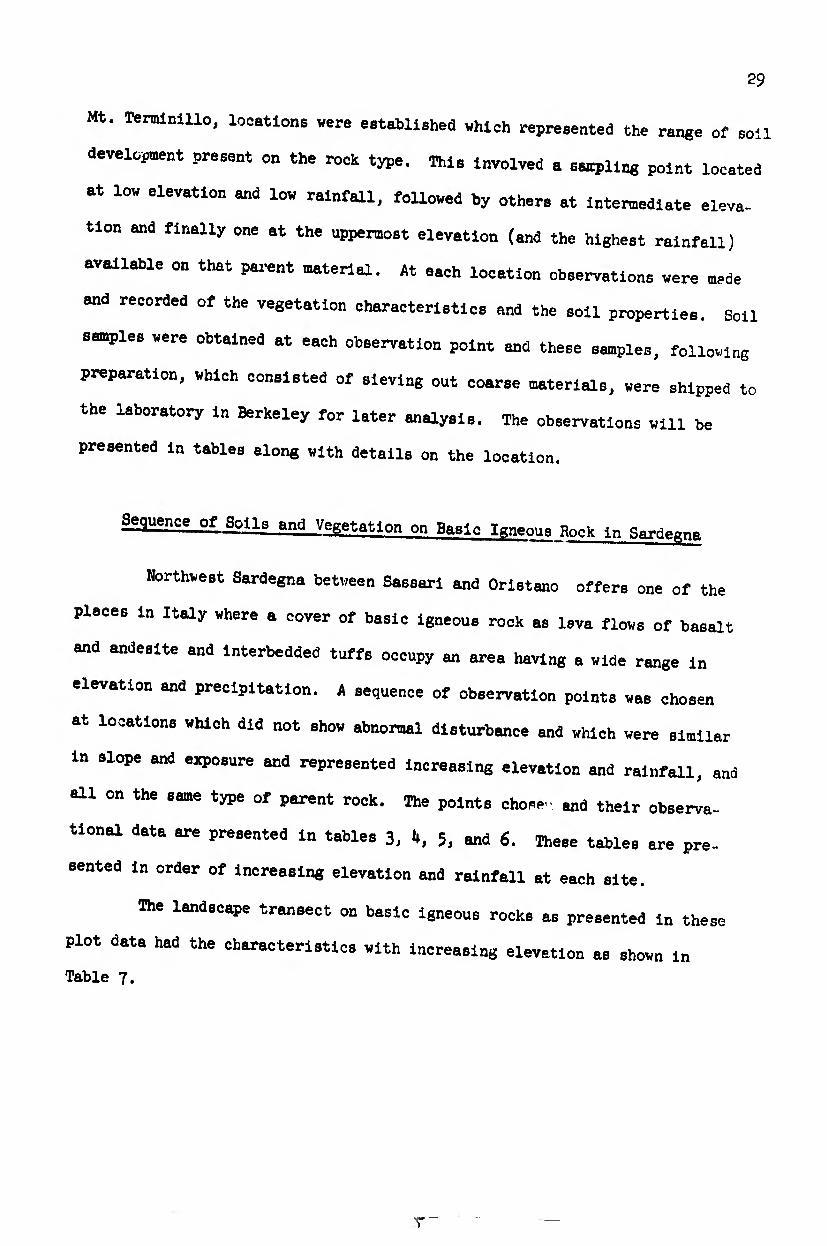
Landscape Sequence on Basic Igneous Rocks in Sardegna
38
X)
X)
8 ITN
in
8 CVJ
I 0 u
1
(0 'O
'S §
T3 l-i o id O J3
g e
8(0 ^ CO
(0 3
2
<2 •H 3
(0 3 0) O (0
g4 X Q) ¢5 0 & H 3
X -H - <U H • • H Of Qf
ft
cy g’ o“
(0 3 <D O (0
s 3
SS 2 3 Si 3, • 0? or
(0 <D
!» S
B •rl
'S o
(0 (0
3 H O
AS 0 •H
AS O
<u
'S
fe TJ
S
3
■P
*r A. O
3
I S
I h fû
■s U 3
fe)
I .O
'S
g 6D
3
I rO
JÖ (0 •H r0
J PS
Vl
H O O
B M
t O AS
g1
O
S
£? •H AS O 3
fe
S
AS O
•P ^ 3
J3 « P g
l! si P rO •H
SÍ «u
O I—I
3 (0 O
4h O
3 O 3 •H H
<p lî £t
0 S L, fe 3 H
tí S O ¿JH »
IA
O H
à* H O
in
IA
rH U
LA
vo
H ü
IA
VO
o U
! o
w ft
«s

39
Thus, the vegetation was open woodland throughout the transect.
However at the lower elevations there was a greater abundance of shrubs due
to shrubby species or continuous shrubby sprouting of the species which would
normally form hardwoods. The soil progressed through a sequence from a
Mediterranean red earth through a brown woodland soil, with increasing amount
of leaching to finally a very acid ranker soil. The pH of the soil became
more acid with elevation and in the subsoil ranged from 6.5 at the lower
elevations to 4.5 at the higher limits of this transect. A corresponding
color change occurred from reddish brown through dark grayish brown. The
occurrence of a component of Pteris aquilinum (bracken fern) could be corre¬
lated with the more acid portions of this sequence. Physically the soil had
high amounts of clay in the lower elevations of the transect and with
increasing elevation this decreased in amount until at the upper end the soil
was a loose organic loam. The most obvious visible change on the landscape
was the change from a distinctly reddish soil to a very dark soil, and this
could be observed at a distance from road cuts or any soil disturbance.
There were several landscape types occurring on this basic igneous
rock area which were not included in the sampling sequence. On the level
plateau tops formed by the most recent lava flows there were areas of nearly
flat, shallow, very stony soils which resemble the Toomes Soil Series of
Tehama and Shasta counties in California. The vegetation is a grass-shrub-
hardwood woodland with less than 50# cover of woody vegetation. The species
of vegetation are as herbs, various species of Medicago, Trifolium, and Carlina
corymbosa. Carlina lanata; as shrubs, various Rubus species and sprouts of
Quercus pubescens; and as hardwoods, Quereus pubescens and Quercus súber in
dwarf form. Bordering these tablelands are rimrock cliffs formed from the
edge of old lava flows. Frequently below those cliffs are outcrops of tuff
which had been buried by the lava flows. A lithosol of sandy soil forms on
these, with frequent outcrops of the white tuff.
.... -....

bo
This landscape sequence of soil-vegetation types finds an almost
perfect analogy in California. In the northern part of the Sacramento Valley,
near Red Bluff, broad lava flovs fringe the eastern side of the valley. On
these one finds a similar sequence of soil and vegetation types. There one
finds the same tablelands with shallow rocky surfaces. These lay over beds
of tuff yielding shallow sandy soils. There are also broad lava flows with
increasing degree of soil development with decreasing elevation. A woodland,
of shrubs and oaks of low density occurs in much the same manner. Another
similar sequence occurs in southeastern Lake County California, extending
easterly from Hobergs Hot Springs to Jerusalem Valley. However there are
differences also. The California soils are about one pH unit higher (that
is, the acidity is less) than in the corresponding sequence in Sardegna.
Also, the California sequence has comparable soils at a higher elevation,
approximately 5OO meters higher than the corresponding sequence in Italy,
and there is a richer forest flora of coniferous species at the higher eleva¬
tions of the sequence than in Sardegna.
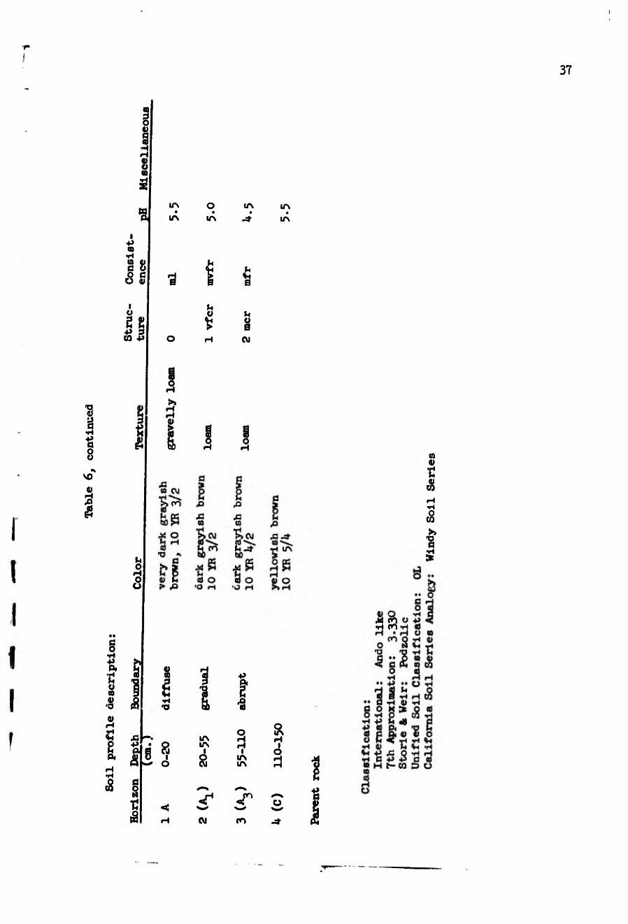
Sequence on Granitic Rocks in Sardegna
The second sequence of soil-vegetation types sampled was on granite
in northern Sardegna. In Gallarla, the northeast quarter of Sardegna, there
is a large area of granite which has considerable relief. South of Templo
Pausania, from the Summit of Mt. Limbara and south to Lago Coghinas, there
is a change of elevation of from more than I3OO meters to I6U meters at
Lago del Coghinas. A series of sempling points was located along the highway
south from Templo Pausania, and three sites were selected for recording soil
and vegetation properties. The data for these sites are presented in tables
8, 9, and 10 in order of increasing elevation. A summary of the main soil
and vegetation features of this sequence is found in Table 11.

K X K X X X
4l
■p O
§ •H
i S £ ■
(S
CO
0) H
I
I o
■H &
CO H
£ & I • * ai
(0
1 co
•> S 3 +>
§
(0
I « ■p
§ §
I §•
I
n
a G
o S
S te u
a a>
•H U a w
P § I «
CVJ
rnvb h roño h co
2 $ t S>?
g CO C'- 03 88c- à*
CO
a o •H
•• P a « o P
PA” 5¾ ï, <D û> O
â£â
co n cd i—c o
> o o
o P co U 0) è
i
Ai o
CO Ü « «

42
ia o ó • • •
IA IA ia
* •H
% •H
¾
I m e m
M •s (O o on
x? o H >> +» >»
bO O
§ § co
+> -p •H Sh «3
(O >> +> p í «3
ä
§ o 8 p Ö
ÍX,
% Co <0
•3 o n 33
ï g
3¾ J4 M
1 V U O ° 4h P °
ë & 0> Q 'S i p 'S cd
i P<
% •w h «a P (O á J *
l
%
a o X o <a O *H p to P p p c tí p tí ¿-o g s elsg P <U Ch p Vi p J3 p P P tí P d d o H t-D O (0 tí rH O
S*
Husick Soil Series, Cuyamaca Soil Series

í r r
i i
•p o
§ •H
'S p (U dû
!> i
H •rl
S
0\
<ü H
-s
•G P 3 O 09
43 U «9 O
O p
(0
(0
<0
O •H
f 41
Eh
43 P •H œ
P ? -H
¿U' «J g
o p <u p p 09 d)
3 O §-2 15 ¿ P © T3 P 43 ©
P 3 O
m 3 O G P a
'S 3
>> G
&
fe O
•H U >>
g o
© Qf
3
m (*4
© M
o' ü
h p
o © p o I
© © 5 § O P
43
©
'S o
p ñ 3 P O 43
P ra
p o c
s ©
o
p G II P 3
P 43 fcÜ P
S
O CVJ -
p i en - - - - m i -
H CO-tf P OJ p h OJ
OJ
o
à*
to
o o © P ©
M
!> o U
o p O b I
O P O M © o
o «
J (G
d
8
10 3 o G © 3
CF
43 P • P M \8 © P P Oh O G ry,
P 3 O
43
2
G O P
3 P
P o p T3
p O
05
J+3
o p G
•H
p.' © ©
©3
Ê? P P ©
P © G © Pj O p
o Ai ü
2
& Ö
o 09
ë p A3 O o b
K o; © G o
© o . . © ©
Oh G 3 o
'cfc. o LT\ O
O O © G P Ai U O
03
©
S5
G © P © ?
¿¿•S ©PG D P TJ
„ 43 © P © U T3 G © © 3 IPI
Pk CQ CJ
'•¡¡m •

Table
Ç.
conti
nued
i i
o o h
xs @ u V
'S V
5E
IA
IA
o IA
LA
-4-
■n 'n
¾ ■a 1 a
I m 0
O rH
ï &
? on 2 vo
og 'So AH
I O
OJ o •p
I ® O H H V
>» >. H H H H (!) 0)
tf a) oo u u o bû tiOH
§ V£ >-(
I <U -4-
ft .
0
d) O > H
s. o
M £
8 ^
OD aoo t— <P
O LA
S » Í O H
00
o <u
H P
0) LA 00
i o3 t- H
O a o
If p o
S
Î
'S í¿
S H
ã 0) fc
«
IA CO
I LA CM
IA VD
I IA en
<g i
IA VO
<r en
(X)
P-
O
LA
S
o ¿2 « Vi O (0 (0
Ö
<u P P A (0 0)
'O 10 2 a
XJ H O
Í 2 •H N
• «> 0)
LA 3 • CT •
VO 00 S o
H W
2
S i <D al00 03 Æ §
0) S-4 O P ÛJ
00 oo ♦> h O)
00 > ¿ M AI
<î P 00
h s o (U H P
X3 O
§*£ o o îî
'S * to íiSS
•o
jk > ? p
QJ A asa * Sx
kk
Ja p
CQ -s O f. O
fi
i a o
CE) a (0 p
I I 1 a
co en üv H
< e co
D
P
t 0)
S a
I 00 p XJ no $ K
I Î (0
XJ m 0) p
(¾
Ti
X3 a (0 H H
â
£ a
43'S o > P 0)
a d aS p p ai co
.. o ß H O «
w O 00
03
a o p
•• p
1 ^ C P p o X Q
•H O CQ
«3 A xa
p Vi
•n
& c3
0) p A (0 O ü S «< P «p
Oh P (O
0) %i P X3 P Ö P H t-
H O

45
1
i
I
I
î
H £ •p O
§ •H
« •P
«3
!> i
H •H
0) (H « EH
C0 Ö I (U
+» ß
s U O
S 0)
« O.
> 4h O
•P (0 O á
■P g 0)
• (0
1 £ <M K
-4- oo (H
£ & â • *\ aj
! CO
>>
ï •P
g 0)
3 Pi
(U P •H
g feû
H* (§
&
a) P (U P
B 88 « 5 m _ en
H H fe
a O
•H •• P a « o P P P P P» 23g, U <U O SÄS
(0
O
u
1 O
tu O ê
TJ
S
to «
£ to (U P O
CO
P ’S •H £
H ICO
XXX
00 CM H rovo H M3 CM
t? O P ta P
I
o p ta U (U
XJ
0) o as
<p
(0
H P O (0
a o
(0 a £ o p
I
ta
! !
si
i? P &0 o ta Pi fii
3 0) ta CO cd a
o XJ fi -
to N ß f ^ 3 H ta 'w' g;
O as
<H
CO
(L> P P P O
•H T3
I O
§ Ü
P Ö (U H P 0) O
CO 3
S 0)
a; P a>
eu p
P ü
<p o
CO ft O P O
c P O 3 N O
fl I
P >> S ^ fi O
o ß
U X <u +5
0) o o c ^ o O (¾ ¡5 ^ <
cd u p
r ^ e s CJ P
O 3 to a»
p
&ï ** g
3 P g 5
& ” tí
X P « O P ti p P XI
, fi 0) p td o tí as cd §?! ä Ä
e o p p
;• ^ u fi <U P p ß •• td p to ¡ï CO CO
p as 'S XJ ö
§ p 2 o o o H O O O « K
.3
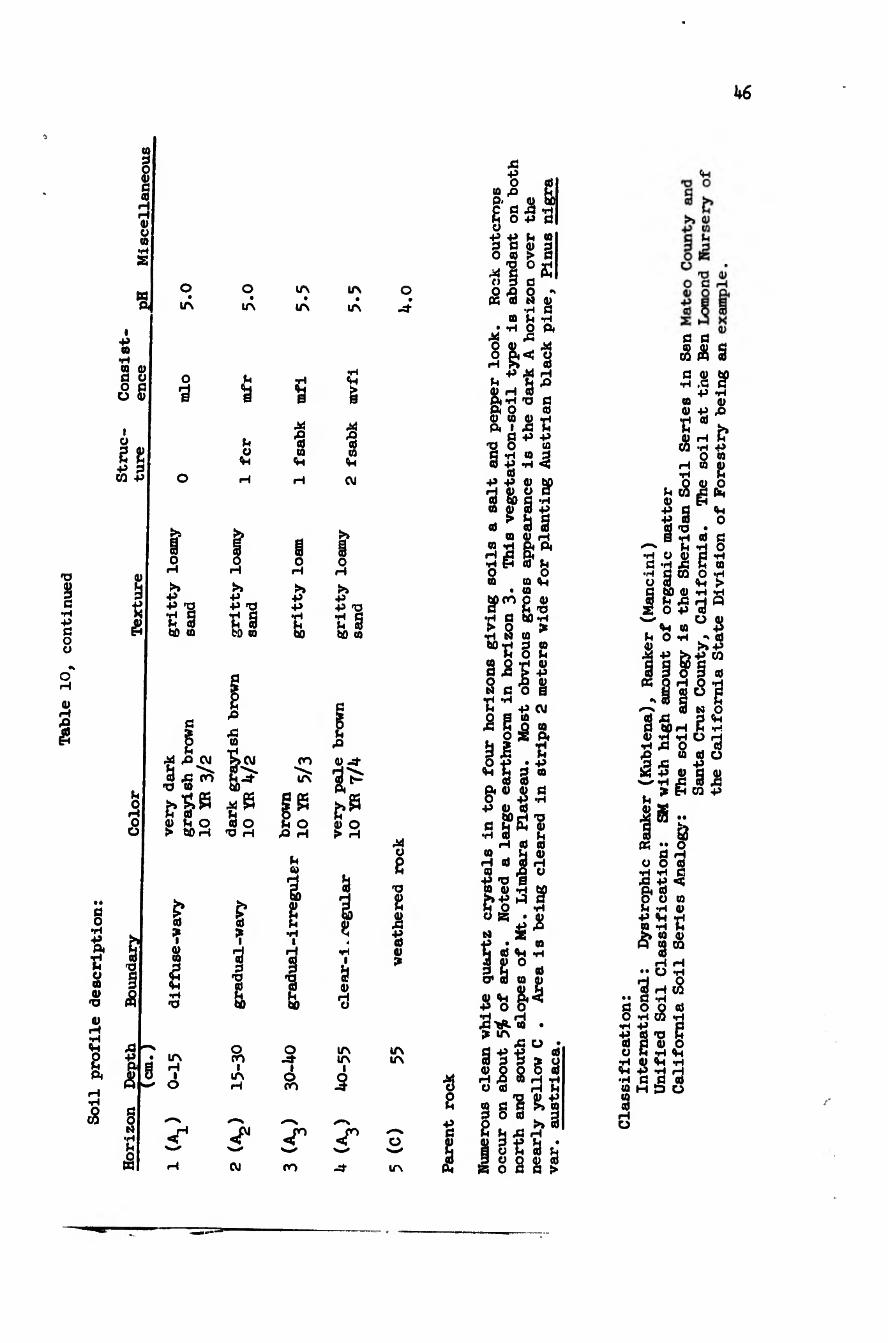
Table
10,
conti
nued
b6
(0 d o o fi 0 H H OI O (0 •rl a
K ft
i +» 10
•H 09 tí O O
I t>
9)
•P . CQ
O
&
ti O
rH O
tí O
6* •H 3 W 'O o (0 a>
<0
4h
2 ft
cg
Is
o ir\
o
3
¡>» +» -P 'O í § ÖD (0
O l/\
b O
Vi
■P ■P -o í § fcO CQ
tí ^ ■: CM
3 -o 09
lA
lA
B
■§ (0
Vi
>» ■P •H
OO
LA
Oí tí O > 60 H
I 03 ë
•H •O
X¡ ^ •P ft
à
tí O M ■H tí ê
LA H
I O
£ tí
03
S 60
O ro
i LA H
CVJ
tí O £> H
& ¾ 2 tí •H
I
I I O
I o CO
<r
ro
LA
LA
Vi
g
Ai 'S 03 V CVJ
O H
+5 •P T3
60 60 03
tí fi 03 ¿t
ft
tí* z* Is i) o > H
Ö 1 g
4 **l
I
Ö 0) H O
lA lA
I
3
w
ro
O -sf
Ai O
'O
g
"ë <0 ?
IA LA
O
LA
•s a "ë
I
00 p-
£ ü
ë o
Ai C> O «
•P O
tí o
ë co
■u
•s 00
• *H Ai O O
tí 4) H ft ft O OS 03
xj o
•P
tí «í
O
o
•rl tí
! XJ
M ■p
S
Ai O cd
s •rl C0 ë ■p -p
ë & 03 g¡
tí cd
•H tí -P C0
cd
(0 H •rl O CQ
00
s BP S ë ss CU H * ft
tí O
Vi
cd
03 CO
6pro
t § •H M 60 TJ nao
00 tí 0> -p i
tí 3 •P CVJ (0
ë â tí p -p • -p
^ S § “
ë ft cu cu o -P •p cu cd
60 H x> ft CU
cd ë CO tí 0) H cd 3 h co fi o
■p xj S CO 0) - H M
N 2 ■P • 03 tí cd Vi -h ã g0 M 3 tí cd CP 3 «a <u
P u & -¾ ■P o o •H H A3 ^ m • ^ IA
Ä ü * S ë ë 5* ü cu Õ 5 o cd
iH rQ M rH "rH O Cd H tí
§§!£! § °0 » ã tí tí A3 H
1 o ë ä tí
B o n a >
tí cu •p ■p
ß ß _ U) OJ c CO ft 3
tí cu •H ití
■P *rl 09 (U CU -P A3
« M h CU H tí
CO -H -P O 03
H 03 (U •H tí
(O ^ ft
•rl O tí ‘rl
s XJ •rl tí <U
A3
V O
cd
•rl tí CQ O U d Vi
60 CU tí . . O -P
tí tí *2 tí 09
•rl > tí A3 H «
- Vi «3üíi tí O 1-1 ^ cd cu +3
lilis g « O tí
r-N S M O cd A3 p <h tí 60 H tí .r< CU ’rl *H ü rH •rl A3 O cd •2 — co cd O 3 A3 -P
W p gj tí cu wH Ä -¾ A3 , > ft CO P tí
a •• o «
°6 « •rl P tí ft P c ft cd O C3 03 tí P <U P «tí P m p tí >» CQ <u ft tt CQ
rH rH •• O P
•;4 H CO tí P
5cg p 3 xj tí 0)
O P
3 O . .. P 3 Vi Vi P P •H fl tí co m D 03
3 •H e «a
3 O
3 P O

i I
ï I I I
1

kñ
The vegetation features of this sequence are a matrix of brushy
species throughout, becoming dominated by Erica arbórea vlth increasing eleva-
tion. There are a few scattered hardwoods (Quercus súber) at the lowest plot
site. This may be due to effects of fire and grating. At the Intermediate
elevation site the hardwoods Increased to give a definite shrub hardwood
woodland in which many of the shrubs are coppice growth of the hardwood
species. This reflects a coppice with standards management which is applied
to the area to obtain fuelwood yield. At the highest elevation the vegetation
cover is a solid stand of Eriça arbórea. The analogy for such a vegetation
sequence is found in San Diego County, California where in mounting the
Laguna Mtns. from the west (for example, from Alpine to Descanso to the summit
of the mountains) one proceeds through similar types of vegetation, and also
similar soils.
The most noticeable soil feature is the change in subsoil color from
a noti-eable red subsoil at lower elevations, through a pale brown and
finally a dark brown subsoil at the higher elevations. There is also a
progressive deepening of a dark colored portion of the A horizon until the
entire soil appears to be very dark in the higher elevations. The texture
also changes such that progressively decreasing clay content is noticeable in
the subsoil with increase in elevation. For example, the subsoils progress
from a GP, through GM, to SM soil types with increasing elevation.
California analogies to this sequence of soil and vegetation changes
with elevation occur in San Diego County (West slope - Laguna Mtns.), on
portions of the western slope of the Santa Lucia Mountains having granitic
rocks in central Monterey County, north of Santa Barbara in ascending the
Santa Barbara Mountains in Santa Barbara County, and finally on Montara Peak
in northwestern San Mateo County, California. The presence of a summer dry
climate, with the added component of a frequent cool northwest summer wind at
higher elevations, especially typical of the northern California examples

mentioned, is comparable to the condition in Sardegna where a cool northwest
wind at higher elevations is a local peculiarity. The differences occur
mainly in a more acid soil condition in the sequence in Sardegna relative to
the analogous sequence in California. Also, the vegetation in the upper part
of the sequence in California tends toward coniferous forest unless the
California vegetation has been burned, in which case it reverts to a low cover
of brush much like that on the summit of Mt. Llmbara.
Sequence of Soils and Vegetation on Slightly Metamorphosed aanastones ana Shales InTlcllv
The presence of a broad area of sedimentary rocks north of Mount Etna
in Sicily provided an opportunity for a sampling sequence vith altitudinal
and thus climatic sequence. The area extending from sever! miles vest of
Capo d'Orlando to several miles vest of Floresta on the north slope of the
Hebrodi Mountains offered several types of sedimentary rocks, claystones,
silt stones, and sandstones, vith some minor metamorphism such that the less
resistant claystones and silt stones were flattened and oriented into a veakly
metamorphosed schist. Folloving this bed of rock vhich vas about three miles
vide across the countryside from nearly sea level to the top of the mountains
a sequence of three sampling sites vas located and observations of the vegeta¬
tion and soil vere made. The data are presented in tables 12, I3, and Ik;
these tables being in order of ascending elevation and increasing rainfall.
This sequence involved a change in vegetation structure from shrub
hardvood voodland at its lover limits to hardvood voodland at the intermediate
elevations to pure grassland and herbaceous cover at the upper elevations.
The hardvood species component at lover elevations vas Quercus súber, vith
9uercus gftmacene at the intermediate elevations and some scattered Fagus
3^lc.S at the »PP« elevations. With reference to the Italian and Greek
plant community types mentioned earlier; at the lover elevation vas a Broom

50

I
« g
'S g
o in • •
in
r*
I 5^
!
M
% H ü
O t
o +»
«
g
t
I (0
I & •Ú
'S g
fi J
«
o *H
i I
< A
a CO D
o •H ■P
O ta H
b fi
*§ •H T3 Xi PS
en m ON
■p
8 «a 0) ■P
s ° O *H •H -P
<« S O h •H 0) Vl -P •h a M H
*—i *n
M CO
So O ■d r
•H *H P Iß æ a> 5 o • â*°fls
S a> eu a JB «h • ca c 4) w 00 (U T HQ *H 4- P P H T
àS g « ! •H H r
" p; lif ifii
3
s t-
51
52

Soil
pro
file de
scri
ptio
n:
53 «9
'O
i ■H
(3 8
CO
a 3
8
6 Î 3 r- r-
8 a s sJ
I ■p a •H a 0) a o o a O V
o
Ji
o *3 a
1
I
fc
Ü
g Tí â
t-
o ï: CVI
•p s fe
& cv>
ti IfN
8> cvi
s»
ä «> •3
¿
IA
IA
U O <H
CVI
& 5 a
CM
XI IA PVO tQ
tt) IA •H I H OJ
ï
1 Ö,
IA en
i IA CU
o IA
a i a o
CU -P
& H O & o ■p a
& ti .4- g-?:
sa
$ *
Î
IA i*“
I IA en
-r ^ s V^1 cu
n w en
8
?s ¾ s
H ■P ■P
. 4-t H O
IA
CU
H ti
I •P (0
10
à ■p •p
P HGO
00 s S'
IA ti K
üíe |3 S o ¡8 ? H
ä
•s 8 H I IA t-
O
O •H +S •H O TÍ ti (0 O "1 3
I •3
TÍ . n O «H
*5 3
A tô
(0 ti
t £
iy _ y» w K ÏSÎ sô sa H
• • •• ü -H
3 «H H ^ ti
ti Q ^ ^ ti Ó *H ", CO «H
■P ti 'Oh ti G ti ti O O R ri *H Vi TÍ i-i ïlilül
I- h $
+ e +
>
~r
é.
4 r  C B

Tab
le Ik
. S
oil
-Vegeta
tion P
lot
VIII.
54
S
ï » u o ■p ta o S t §
2
a> «
S o ä 4-t O
« V
(0
CO
ä V
■P
1
«
£
ri •H
O •H <0
*
t
& •P
O bO
-O
3 S
t i §• •H
è
co h
•ri». IA CVJ
% ^81- (O CO H H CO
g •H
•• p g ri O P •rt P p Qi •• ri <17 ri
lit
ri £
ô
CO ri •H U
I
ri
i %
ri
'S
3 O
SK
P o
ÍJ p ri H
t ^
rH
ri
S
lAlÜ
1 O
ri € «
7}
P
a 6
iiii s^s s p
• U P U 00 Q ’O H S H ri
vô P á b » g 1-° •S ü w ? H _ ri h ri d I •d ‘ri g ri h 3
. ri ri ri SS,“ 'S 3
äx: & n
) *0 s ^ hî o g> fQ
8
i^i:
feriS pTÎ 8
S' Ô d**
S •g ^ SI'S ri
SIS $ “ ôNs UC ri o P Q P > ri ac
-I3¡S •H ? S
W . et o ri ri
*c ri SP
^1 P B
III 3
Pi 4-1
43 S
■n *%»
3f, u o
|S 8£i lili!
ri d
I & H O
S ■o
d ri "S
'O S
I
1 I n
ri
.ri rie
55
'O I •H
"ë
8
3
5
i +? (D
§8
0)
o
gg
s +»
i
h o H
â
8 •H
%
8
«
0) H
&
s * Pi
*n £ §
t
I I »3g£ í P P «ri-HH+ïflÎT1
§
srs o • •
U*\ IA
O H
S
?
O
-d-
I
iH U
o a +> o n h
J3 A a a
cvj §cvi
155 3 o «3 o a o •h o
'O H T3 H
i 8
g V| •H •O
r ? +>
«
§
in IA co
i i O IA
IA
3 IA CO
«r1 «r « U W
CVJ
s lis ti »1«
« U Ä a) »g 4,^ g
-0 O ,Q (U
■h *h 5 o> a
8 m a ^ o a u o
+> >> «a p n u tt rjg +3
_ . M « d
Idlïlll c 8 d H ^ o •h a d ^ h o
H Ä P -P •H -P TJ h d « Qfl +> H H CQ O d <0 ß fl
-p o d p o u p il P 5 n d V d <M P Ä d T» o Vi g 'o h o ^ o d «g 2-1 p d d <h d ¡s h u u
d d d d
lililí m3 d d « P-Cd^jß M
M «M d S M p
!
P $4
V - d
° «. ii" - d "ë ß H S 8 h
3 M P 0 P 4-1 Õ P Q 4h ß Q o s Vi a p d 5
OP H d M d H d d P d d d P O d
Mo M d u s 2¾ ß^^SÄ d H P 4-1 OP
O d • d u h «g
8 4< ^ P « 3 H umi j3 pwf jj
d tJ p d d 4i J * ^ ô -û 9J -h
, ÎO p P Ö H H M ¡2
aioHfî P p P d
00 CO ON
p ß p p d H t-CQ
fied Soil Classification: OL
ifornia Soil Series Analogy: Wilder Soil Series, Cahto Soil Series

56
macçhia with Quercue .súber, apparently derived from degradation through fire
and present intensive goat grazing from former Cork oak forest. At the inter¬
mediate elevations was Scrub oak forest (Quercus pubescens). and the upper
elevation type was High altitude pasture, possibly derived by clearing much
earlier from Beech forest. The same strong, cool northwest wind mentioned
for Sardegna also strikes these high ridges along the backbone of northern
Sicily and tend to maintain an open "wind exposure" grassland on the ridge
tops. The effect of this wind is less noticeable on the peninsula of Italy
than on the westerly Islands of Sardegna and Sicily.
The soils sequence represented by these data shows,as for the sequence
on granite in Sardegna, a change from a soil having a characteristic yellowish
reo subsoil at the lower elevation to pale brown at intermediate elevations
to dark grayish brown at the highest elevation. The texture change is not so
pronounced, probably due to a clay source in the claystone and silt stone
parent material. However, the highest elevation soil is definitely lighter
in texture, being a loam relative to the other soils.
The California analogy for a transect such as this on sedimentary
rocks would be found in the inner coast ranges of California. Hie general
sequence of soils from the reddish more developed soils at lower elevations
to the dark grayish brown soils at higher elevations can be found in most
areas of the California coast range from Humboldt County to southern Monterey
County on sedimentary rocks of the Franciscan formation. The specific case
of the transect involving both a correspondence of vegetation and soil is
more difficult to establish. However the same mosaic of vegetation types
involving chaparral, oak woodland, and open grassland is also present in the
central California coast range to the interior of the redwood--Ebuglas fir
coastal forest belt.
Several altitude sequences other than those sampled were observable
in this area in Sicily. A parallel sequence from a ranker soil at high

57
elevations to a red soil at lower elevations was evident on nearby sandstone
area that paralleled the silt and claystone area which was sampled. Where
more clay was present in the parent rock a heavier soil without the red color
would develop at the lower elevations. This resembles the Sehom and the
Millsholm soil types which form at lower elevations on clay rich sedimentary
rocks in California (Glenn and Tehama counties).
The result is a mosaic of soil-vegetation culture types as one
ascends Mt. Nebrodi in Sicily as follows:
A viewpoint at lower elevation near Zapulla (on Po 205-206) on road to Capri Leone showed the following soil-vegetation types:
Cover Class
1.
Vegetation (in order of abundance) Soil
Olea--Grass Terrace-red
Slope
15# W
-- g Cytisus scoparius, Pistacia SnyG lentiscus, Cistus salvifolius,
Ampelode sina tenaz, Quercus súber
Terrace break- 11 thosol
3. 1 Sly
4. 2 S G
5. 1 5
Pistacia lentiscus, Cytisus Mediterranean scoparius, Ampelodesma tenaz, red earth Quercus súber, Quercus pubescens (more Q. pubescens, less Q. súber with increasing elevation)
Cytisus scoparius, Cistus salvifolius, Pistacia lentiscus, Ampelodesma tenaz
Cistus salvifolius (invaded old fields)
Llthosol (similar to Maymen soil series in California)
Non calcic brown
6. 1 G
Crass (pasture) Non calcic brown
6o# w
30# m
6o# w
20# NW
30# W
7. ^2 Cytisus scoparius, Cistus Recent alluvial 10# W salvifolius, Pistacia lentiscus, fan Ampelodesma tenaz
3 Citrus orchard SaW
Recent valley 4# NW alluvium
58
A viewpoint at intermediate elevation on the mountain slopes near Tortorici (map Fo 205-206) showed the following soil-vegetation types:
Cover Class Vegetation (in order of abundance) Soil
. 3 Grasses, Quercus pubescens, G S fifcr shrubs, and trees
Brown forest soil
Slope
20-40# W
2. 2 kTg
Corylus avellana plantations
3. 1 S
4.
Cistus salvifolius, Cytisus scoparlus
Grass -- Olea europa orchards
5. 1 B S G
Barren, Cistus salvifolius, grasses
Brown forest 20-60# W soil-gray brown podzol
Lithosol Upper ridge top
Non calcic 30# S brown soil- lower slopes
Eroded old 30# S field--non calcic brown
Finally at high elevations near Floresta the following soil-vegetation types were observable from a landscape viewpoint:
Cover Class Vegetation (in order of abundance) Soil
5 Grasses, and Pteris aquilinum G F
Ranker 2-3' deep
2. Castanea sativa plantation, grass
Ranker 2' deep
3* - 3 Fagus sylvatica, grasses Ranker " 2' deep
_ÍL Grasses, Ilex aquifolium (holly) Ranker 08 2' deep
Slope
On 5-60# all exposures
30# NW
60# N
60# slope
The departures which these soil-vegetation types represent from the
main sequence sampled are due to erosion and the resultant formation of more due
youthful soils on steeper slopes,/to human culture activities with either
currently managed areas, or recently abandoned areas.

59
Sequences on Granite In Calabria
Two locations for sequences of soil vegetation sampling sites were
chosen on granitic rocks in southern Italy. One which had the most complete
sequence of soil profiles was located in southern Calabria on the west slope
of Serra San Bruno between Rosarno and Serra San Bruno. The other which had
only the moderately developed higher elevation soils was located on the Sila
plateau north of Catanzaro.
The complete sequence on granite on the Sierra San Bruno was repre¬
sented by four soil-vegetation sampling plots. The data from these plots are
presented in tables 16, IT, 18, and 19. Generally these show a sequence of
soil and vegetation properties as summarized in Table 15.
Table 15. Siamary of Soil-Vegetation Changes on Altitude Sequence on Granite in Calabria
Landscape
Vegetation
Cover class
— Elevation (meters ) 15-- 950 gõo
G ä 3Hy i G
ï 221 C~Hy~
1_ Hy
Vegetation type
Soil
Classifi¬ cation
Unified soil class
Subsoil texture
Subsoil color
Olive macchia
Mediterranean red earth (Kubiena)
SC
Clay
Dark red brown
Grassland cleared from scrub oek forest
Mediterranean red earth (Terra bruna)
SC
Gritty clay
Yellowish red
Fir forest
Terra bruna lessive
Podzolic brown earth
GM
Gritty clay loam
Brown
Beech forest
Terra bruna lessive
Podzolic brown earth (Kubiena)
SM
Gritty sandy loam
Brown
6o

6i
4
i|ia«k
! 4
Í
Í
I
I 1
I
I
ï ! " i
I
1 u
•p
ê
§ •H
i
i
«S
VO H
V
a
o vo*
>fl •D
I
o H
! no
in CVJ
i o H
W
m in o • • . m vo
.a X)
£ T3 no
•s O CO
(4
& m
I o CO
& 7}
o
¡»■T
■ß 9 UO a>
a 0)
■H
i fJM
a>
s
s 0> s fc 0) +> •H T)
+» 0 'O H 0 S Ö O O H yH bn •H 4) «rl 4-1 -P *H H
«ass
o
Analogy:
Sierra soil series or Merriam soil series

62

63

6k
Root distribution:
Throughout profils and into rock
Rockiness:
None on surface

í 65
I I
I
I
1
a>
ã •H ■P § O
•P O
ä
a 0 •H ■P <0 •P <U bO
i
CO
<U rH
'S
w a
Q 4) s « 0 c O 0)
I 0
e s W P
a 0
0 a <u •o
a>
u s Pi
H P
á
3 «
0 0
£ & 4? s
I .S
S 4) P P 4) P
pi
5
£ •3
w
Pd «8
h)
ir\ vo
8
S X3
Pi ! ■3
IT\ H
¿
0 0 • •
IA LA
IA OJ • •
•r» j-i «ri
p h O
o H
£ s a
!»
1 10
P >>
M O
>»
1 CO
’S CM ’^'rn
Is
lS tí Is I*5 gz g£ si 12 g° ^0 20 ^ >P iû H «O H PH H ?
m IA
CO LA
CO
gls CO â CO -2
LA P
5
Cfl
? i 'S &
0 LA
I LA
CVJ
1
<0
'S ä)
8 H
I O t-
pq
-d-
1 3 H
U
LA
«
s V P
-o
*0
2
M 3
Classification:
International:
Yellowish brown lateritic (Storie &
Weir)
Unified Soil Classification:
04
California Soil Series Analogy:
Stump Springs Soil Series
Hollano Soil Series

66
H
B +> O
Ö c O
•H
"S t tto
!> I
a 0\
(U s
s 03
s <8
O
+» lA «J
! 03
CO
s <u
§
•g
3 w
a
i «S
T! «
o
s
■â +»
••
i •3 •P
ê • 0
a o
•H •• -P tí a o -P •p Q| •• «•HO)
£ « o
o S
1
co p
•s •H Oí n o
-d-
co (0
a
S
•a
••
XXX
Irs^o H
«s
1 &
■ •
S
• •


r 68
This soil sequence is similar to that found on granite in Sardegna.
However, the vegetation is more luxurious due, perhaps, to the higher rain¬
fall.
California analogies to this sequence on granite are offered on the
west slope of the Sierra Nevada in areas of granite rock. It would begin at
lower elevations with the distinctly red-colored Sierra Soil series, and pro¬
ceed through the Mustek Soil series to the Holland and the Corbett Soil
series at high elevations. The vegetation sequence is chaparral on the lower
elevation soil; for example, between Shingle Springs and Placerville in El
Dorado County. The natural vegetation at the next stage of the sequence,
east of Placerville near Camino and Pollack Pines, would be Ponderosa pine-
Black Oak Forest, but frequently cleared for agricultural use. The analogy
to the 950 meter elevation location on the Serra San Bruno would be near
Kyburz east of Placerville. Although the soil is similar, the forest would
have a greater mixture of coniferous species. There is, however, a large
amount of Abies concolor which is the California analogy to the Abies pec¬
tinate of Italy. Finally, at higher elevations in the Sierra Nevada would
be a red fir forest (Abies magnifica) on soils (Corbett Series) corresponding
to those at the 13OO meter location. At higher elevations in the Sierra
Nevadas, the landscape has been subjected to glaciation and the conditions
are different then in the gran'tic areas of southern Italy and Greece. There
are also analogous portions of the sequence on granite in Monterey County in
the Santa Lucia Mountains south of Big Sur River. For example, the granitic
headlands Jutting into the Tyrrhenian Sea near Joppolo, south of Vibo
Valentia resemble granitic headlands of the Santa Lucia mountains.
Ihe Sila Plateau north of Catanzaro and east of Cosenza in Calabria
offers another elevation sequence on granite rock. However, it was difficult
to find the well developed lower elevation soils. The Sila Plateau is a
large granite plateau uplifted in a pattern of block faulting. The sides

69
of the plateau are steep. In the place of veil developed soils at lover
elevations there are steep colluvial slopes vith coarse Irmnature soils formed
at the angle of repose. These are clothed vlth holly leaf oak forest
(Quercus ilex), ftie upper elevations of the plateau have moderately developed
soils to immature ranker soils as represented by the soil-vegetation plot
data in tables 20 and 21. A California analogy to this is offered by the
vestem slope of the southern Sierra Nevada, and by the San Bernardino
Mountains in southern California. Each of these is bordered by steep slopes
vith colluvial soils (clothed vith Quercus chysolepls. the California analogy
of Quercus ilex), and summit plateaus vith coniferous forests.

70
a 'O H V
KHK Ö
it distribution:
Throughout profile and into decomposed rock

1
i
8
IA IA • •
IA IA
CM
IA
£ 3 f
U o
5
■q
1
■P ■P
E o H
*§< IA
1,3
ï
$
1 I
ä I
-s
ó iH
IA -d-
I O m
8 H
I IA -d'
^ <T
CM CO
O
-d
•H
$
0) •H
O
rs« Ã g g.»
tI H H •• -P O -H
^ i H £
§fl 8 a ■H O CO •H
liai flJ -H
M P |C] ^
« H f- D «S
§ •H
'S O
ü
71
72
g £ S a g £
! £ $
I S I
£ I
+» -H M O

I
73
? 4
: ¿
J
4
r i i i i
»
"Hjir'

Sequence on Marl Rock In the Abruzzi
A large area of calcareous rocks occupies southeastern Italy, begin¬
ning vith the heel of the peninsula southeast of Taranto and extending north
vesterly, gradually penetrating into the center of the peninsula northeast
of Reme. A distinct type of these calcareous rocks differing from the hard
limestones and dolomites is the soft marl rock. This soft marl rock weathers
much more readily to heavy clay soils. La Maiella, a large mountain mass of
marl rock, offers the opportunity of observing an elevation sequence of soils
and vegetation. The sequence of observations were made beginning along the
Sangro River near Bomld (due south of Lanciano) and ending at the upper
elevation near the summit of La Maielleta at the end of the highway south of
Passo Lanciano. The soil vegetation data obtained on four sampling plots,
in order of increasing elevation, are presented in tables 22, 23, 2k, and 25.
The general features of the change with elevation on this sequence are seen
in table 26.

75

Tatole 22.
Soil
-Veg
etat
ion
Plot
XXI
.. co
ntin
ued
76
•s £
CVi «
00
s
CVI
00
& H 0 & o s
0
I •p to
IT\ O
? LfN IA h on
^ <r cm on
0 e IA
CVI
co
•H
1
S’ rH
if
i ! o
0 3 0 «
§ N
t â
on
g -tí s g •d*
2% O 'O
•H +» O 0)
o a
« £ H W •H <H
S3 u a Ql d
5 0 S
O rH i 9

7T

»
7 78
1
1 o
a
§ •H
S ë) :»
«S
H
8 ¿
O CO
P
I
H U
OJ
8 IA
¿ t^-
■3
S CO
<M
?
■8
O CO
il
& H O
P t-
3
•H I
■P
€
IA IA
00
0) TJ •H U +>
a o
IA I
5*6
5 CO
X U (§
I a) ë £
g «
i?

79

Tafe
le 2¾.
Soil
-Veg
etat
ion Pl
ot X
IX., co
ntin
ued
n
i +» <o
0) « g. O 4>
O
I o g g si
■n § 1 a e
I H •H
I a •p
§ i
£
H CVJ
O s ï
ir\
u
o H
•9
IfN ro
rH
Ü
CO
§
ö
£
.. g
'S^sl O H d
• o ®
P •• (Q tt) 2 § 8Ä
•H H H • * P O -H
? I H <8 Ö O 5 o « 5 p S ’S 1§!«I ■HO) V» *H
a h t-D a
o
80

öl
J
i
F 1 I
I I I
L

Table 25.
Soil-Vegetation Plot XVHI., continued
82

83
TABLE 26. Summary of main features of Elevation Sequence on Marl Rock
Landscape 200
Vegetation:
Cover class 1 SHy
Vegetation type Hollyleaf oak macchia
Soil:
Classification Sierozem with A/Ca/C
Unified class
Subsoil:
Texture
Color
pH
CH
Stony clay
Light grey
8.2
Elevation (meters)
875 1500
1 A G Hy
Grassland Beech cleared forest from Scrub Oak Forest
Earthy terra fusca (Kubiena) Terra Gialle (Cornel)
CH
Mull rendzina (Kubiena)
MH
Clay Loam
Brown
8.0
Very dark brown
7.5
19OO
5 G
High altitude pasture
Alpine pitch rendzina (Kubiena)
OL
Clay loam
Dark brown
5.0
8k
The sequence of soils on marl generally has a decrease in the amount
of clay vith increasing elevation. At the lower elevation there is a dis¬
tinctly gray soil with calcium carbonate accumulation in the subsoil. This
is related to the lower extent of leaching of bases including calcium, at
the lower rainfall; and to the ease of weathering of calcium from the parent
rock. These factors, when coupled with the high clay content of the marl
rock, result in a heavy clay high calcium content soil having a high pH at
the lower elevation. A distinctive brown clay soil was found at the next
higher elevation. It was slightly less alkaline in pH. The soils in this
elevation zone had been cleared for agricultural uses from scrubby hardwood
forests of Quercus pubescens. The soils above this are rendzinas, a mull
rendzina under beech forest; and an acid pitch rendzina above timberline
under the alpine pasture.
California analogies for this sequence are not complete. In Cali¬
fornia marl rocks are usually confined to lower elevations on the south
coastal plain. The lower elevation plot in this transect is analogous to
the soils derived from marl rocks in western San Diego County (near Vista)
Los Angeles County in the hills just west of Pomona, and in southern Santa
Barbara County along the coast, vest of Goleta. In these areas the Linne and
Zaca soil series form analogous soils to that found in the Sangro Valley
on Marl. The natural vegetation in California would be a woodland of
Quercus engelmanni, or open grassland; but most of them are utilized for
agriculture. The higher elevation portions of the sequence on marl in
California are lacking.
Sequence on Llnestone Mt Teirtlnlllo
Ht. Terminillo, northe. et of Rone necr Rj.eti in Unbric, vlth en
elevrtion of 2,213 neters, offerc ia opportunity for c frirly couplete
elerption sequence on llnestone. A series of observrtions were nroe rt
▼ci'ious elerctions on sucb e trrnsect. The sane senerrl sequence of v«(st
tctlon coBBMinltles with increeslng elevation eno clvnge in soil t^'oes occurs
on the llnestone : s in the sequence on nrrl rock, witl the ciffeience tbet
the lot;er elevation hrs . terrr rosse soil on the linestone inctesd of the
slerosen that occurred on the nrrl. Ths observation details pi'esented for
the sanpllng points in order of incrersing elevation in tables 27, 28, 29,
and 30. The oain details of the sequence are sunmerized in table 3I. This
sequence is nuch like thct ciescrlbed by Conel (1935 Gor: tit). Ti e genercl
type of change from a heavy textured clay subsoil at lo^•er elevations (a
CH soil) to slight textured stony sancy loan («) at higher elevations, was
sinilar to the sequences on the otlier rook types. Bov;ever, the red color was
nuch more intense and noticeable at the lo\>er elevations on limestone then
on the other types of rock. Although not arnpled there vrs a distinctly
yellowish brown soil between the terra rossa at 6OO meters <nd the mull
^*endzina et 1500 meters, corresponding with the Tferra Oialla which Cornel
described e. at of Gorlzle.
The vegetation sequence on Mt. Termlnlllo was from hard>rood forest
at the lower elevations with oak end chestnut forests predominant; through
Iwrdwood forests of beech extending to timberline; above which was open
gmsslaod. This differed from the vegetation sequences on the other parent
rock types in that a coniferous belt between the oak and the beech forests
was absent.
Tba California analogy to this soil-vegetation sequence is only partly
present. Limestone rock at lower elevations with the development of a Ibrra

86
TABLE 27. Soil-Vegetation Plot. Lover elevation Mt. Terminillo
LOCATION: Italy, Umbria, northeast of Rieti Km. 7 on Mt. Terminillo Highvay.
Elevation: 6OO meters Precipitation: 1300 mm Slope: N.W. 30#
Physiography: Lover 1/3 of slope of large mountain ridge
VEGETATION:
Cover Class:
Overstory:
Understory:
_1 Hy Species Type: Cs, Rp
Species
Castanea sativa Mill (Cs) Robinia pseudoacacia L. (Rp,) Acer opalus Mill
Height
30' 20’
15'
Abundance
XXX X X
Acer opalus Mill Corylus avellana L. ïïïieTSpp. Cornus mas L, 6uercus cerrls L Pteris aquilina L
Also some Rubue: spp, Crataegus spp. and Rose
6' 4' 6' 6' 8- 2'
spp.
XX XX X X X X
Remarks: This is a luxurious coppice forest of chestnut. In this area chestnut is confined to this deep non- rocky Terra Rossa.

AT
TABLE 27 (continued)
SOU:
Parent Rock: Pertae ability: Surface drainage : Ground vater: Root distribution:
Rockines*' :
Limestone Good in surface/impeded in subsoil Good None Throughout profile vith an accumulation in subsoil
of large roots None on surface
Soil Profile Description:
Horlson
1
2
3
k
5
Depth
0-l8
18-40
40-60
60-100
100-170
Color Texture
Reddish brown 5 ÏR 4/4
Dk reddish brown (3/4#^ cla7
Dark red 2.5 YR l/6 clay Red 2.5 YR 4/6 clay
Red 2.5 YR 4/6 clay
Struct. Consistence F.l
2 nor
3 m sabk
3 c sabk
3 c sabk
3 c sabk
dj 6.0
dfi 5.8
dh 6.1
dh 6._
dvh 6.0
Old terrace or soil creep materials have added to this soil.
«Wet color
Very small content of coarse materials in this soil profile
Classification:
International: Terra Rossa Unified Soil class: CH California analogy: Permanente Soil Series near Sonora,
Tuolumne County, California

88
TABLE 28. Soil-Vegetation Plot. Middle elevation Mt. Terminillo
LOCATION: Italy, Unbria, near resort area of Monte Terminillo, about one mile northwest of church.
Elevation: 150O meters. Precipitation: 1600 mm. Slope: South hOj»
VEGETATION: Cover class ¿
G Species: Miscellaneous grasses
Nearby on same terrain and soil sylvatia) with a cover class of 'bushes. ]
Physiography: Middle of slope, large mountain ridge
Species Type: Gr (mise, herbs)
and herbs not keyed out.
is a nearly pure stand of beech (Fagus 1 with an understory of scatteredSalix
SOIL : Parent Rock Permeability: Surface drainage: Ground water: Erosion: Roots: Surface rockiness:
Limestone Rapid in surface/ good in subsoil Good None Some surface slumping Throughout profile to 60 cm None
Soil Profile description
Horizon Depth Color Texture Structure P ;
1 2 3
k
0-12 Dark grayish brown 10 YR 4/2 Clay loam 12-30 Pale brown 10 YR 6/3 Clay 3O-6O Pale brown 10 YR 6/3 Stony
ifer 5.5
Cg between rocks Cherty limestone parent rock
clay
10 YR 6/3 Stony clay
2 mcr-m gabk 6.0
2 m sabk 6.5
8.0
Classification:
International: Unified: California analogy:
Mull rendzlna CH
Intermediate to higher elevation areas in Marble Mountains of Siskiyou County. No soil series analogy at present.

TABLE 29. Soil-Vegetation Plot. High Elevation Mt. Terainillo
LOCATION: Italy, Umbria, on Monte Terminillo Road for Campo Sorogna, about 2 km east of main ski lift
Elevation: 1800 meters Precipitation: 17OO uan Slope : south 40#
VEGETATION:
Cover class: ^ G
Species
Lotus corniculatus L. Rumex acetosella L. Mentha species
Physiography: Large open slope on steep south slope of Mt. Ter¬ minillo
Species Type: Or (mise, herbs)
Height Abundance
6” XX 6" X
12" X
About 200 meters above timberline.
SOIL:
Parent rock: Permeability:
Surface drainage: Ground vater:
Cherty limestone Good in surface/ good in Éûbsoll
Good None
Root distribution:
Surface rockiness:
throughout profile About 5$
Soil Profile Description
Horizon Depth Color
1 0-10 Dark brown 2 10-35 U&rk brown 3 35-1*0 Dark brown Û 40-75 Yellowish brown
Texture Structure PH
10 YR 3/3 10 YR 3/3 10 YR 3/3 10 YR 5/4
loam loam
clay loam clay loam
1 fer 1 fcr 2 mcr 2 mcr
Horizons 1 and 2 represent new slope creep horizons over an older buried A horizon (horizon 3), with a subsequent A. horizon resting on a rocky C horizon. 3
6.5 5.0 5.0 4.5
Classification:
International: Mull rendzina Unified: CL California Soil Series analogy: None available

9Q
TAMiE 30. Soil Vegetation Plot. High elevation Mt. Tercninillo
LOCATION: At Passo Sella di Leonessa on northside Mt. Terminillo
Elevation: I950 meters Precipitation: 180O mm Slope : s UO-60#
VEGETATION: Cover class: 4 GS
Species
Juniperus communis L. (Jc) Grasses (Gr) Dryas octopetala L.
Clumps of low shrubby Junipers, composition and as they matured remained where the Junipers had
Physiography: Mountainous
Species type: 0r Jc
Height Abundance
12" XX 12" XX 8" X
These showed slightly different grass and died, a darker green clump of grass been.
SOIL: Parent rock: Permeability: Surface drainage: Ground water: Root distribution: Surface rockiness:
Cherty limestone Rapid in surface/ rapid in subsoil Good None Dense sod of roots to 50 cm. 15^-2056
Soil Profile description:
Horizon Boundary Color Texture
l(A) 0-25 ai Dark brown Stony 10 YR 3/3 loam
2(c) 25-50 Very pale brown Stony 10 YR 8/3 sandy
loam
Structure Consistence ÏM
1 fcr Ml 6.8
0 mfi
Some colluvial creep in parent material.
Classification:
International: Mull like Rendzina (Kubiena) Unified: gm California Analogy: No established soil classification. However
possibly in the Marble Mountains in Siskiyou County at higher elevations (6,000') on limestone.

TABLE 31. Summary of limestone sequence on Mt. Terminillo
Elevation (meters )
Vegetation Cover class
Plant Community
J. Hy
5 G
_b OS
Oak-Chestnut Beech Forest High High woodland or High Al- -Altitude Altitude
titude Pasture Pasture Pasture
Soil
Classification Unified Class
Subsoil: color
PH
texture
Terra Rossa CH
Red
6.1
Clay
Mull rendzina CH
Pale brown
6.5 Stony clay
Mull rendzina CL
Dark brown
5.0-^:5
Clay loam
Mull-like rendzina (24
Dark brown over very pale brown
6.8
Stony sandy loam

92
fíossa soil occurs between Sonora and Columbia in Tuolumne County (Permanente
soil series), and as in Italy, it has an oak woodland vegetation. At higher
elevations in California limestone is not abundant enough to give much area
showing the remainder of the sequence. There are some areas of limestone in
Trinity County near Hayfork; and in another small area south of the Bear
River, south of Ferndale in Humboldt County, which have the stage of soil
development corresponding with the yellowish brown clay soil or Terra Gialla
of Cornel. At the headwaters of the Nacimiento River in the danta Lucia
mountains in Monterey County there are small limestone areas that reach
this degree of development. Interestingly, there is a conifer, Abies venusta,
which occurs along with several oaks on this latter example. These areas
are all limited and do not represent the broad landscapes developed on lime¬
stone that are present in Italy and Greece.
SEQUENCE OF SOIL-VEGETATION ON SEDIMENTARY ROCKS IN TOSCANY
Large areas of sandstone rock in Tuscany (Italy) give the opportun¬
ity to observe a wide range of soil development representative of the
weathering of these types of rocks. A sequence was selected on Macigno
Grande (a thick bedded yellow sandstone which resembles the Eocene and late
Jurassic sandstone of the Knoxville Formation in the coast ranges of Cali¬
fornia), The low elevation point of the sequence was located south of
Florence and the upper elevation point was located on the ridge of Prato
Magno near Vallombrosa east of Florence. The data from soil vegetation ob¬
servation points on this sequence are presented in tables 32, 33, and 34
in order of increasing elevation.

I I
I
I
r
£
'S
Ö
CVI *H m b
0) vo f™1
<u N
U (0
£ ■P
A o
a h 0) +>
a 1¾
H OV JS
§ •H
• • jj
g cd o -P
■P Cl • •
g-ô g, 6 a» & 0Í Ö
o O
s 73
w w Kx
& O &
«V
S (0
•H O a>
«&
I, •H
£ “ •■ •• - IT\ O fo co oo ro h ro
ü
CQ
U
1
. J
â*"- »—' (Q
.5
^ O cd u Sli
CJ Cf
cd § HJ 11
co
0) U
Igl • ^
(0
3 H O
Ch
§ O
ë & ° 5 P
£ U CQ
<3
U U
1
CO U
£ O a cd
Xi • ■p a 2 0 Xi -h
-p op <d o -P
p $ P* g «d CD
C0 co cd « •H P a os
eu £ £
Je 09 *H
^ 3
o P
•h a
73 fi
S •s O
4h O
(h (0 O 3 P Ö 09 P Ch £
£ 0)
8°e
&ï a> eu > 'S s
I
CQ «
0) (0 ••
ssg cd p
4h P 09
ääIJlll
93
T

Table 32.
Soil-Vegetation Plot XXXVIII., continued
0 •p a 0 •H
•H m
§ ■p •p Q>
%
<u
s ft 9)
5
3 a •H
1
ë y 0 0 a ¿4
1 ■P co 'S
10 9)
£
è 4-t
•* co
K
«a
i S
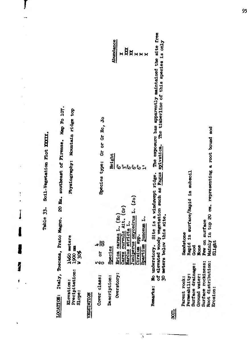
95
s
s t I
I d a m m
V H
& H
£ I 4> M
S U O
1
I s
1
U «0
s *3 •P
§* 43
Só <0 t
I 1 8 £
(0
4)
II » oo H H ¡X
§ •• 4>
85 vH •H 4* P« ••
tn dis
o
£ Ô (4 O
ô
a a
w
10 3
rH O
V4
ü
»Je
1
o ►a
I S
4) *3 43 o
XXX um
fl ^ £ $ 4» «0 O. fl
^ I »
à
Ä a 4* a>
•H •p o 3 S
h f* ^ X o H 43 O fl fl
§ C0
3^ A <U
i ^ S« 0) «P
0) ^
^ ^ 'cnKo ÕJ Õ5 H ^ S
Tîfe 43 3 g* a £ g 'S ë
s ’S? s a) 43 «> _ « 43 M 4» *H
•H 4> O
4) 43
C0
en ¿J
S &=•« lî’8 lis •II? §d 8
£ V« o O CO
• • a
K
S î a
•H
'O •H
I
4) fl fl Q <H
B ■O 'fl
4)
£ •P
al
S1 •H
*ë 3 & 2 g g
s & Ä43 3 fl C0 «H
llâ
I

96
en CO
4)
ï
(0 3 O
r- r- 9) O (0
n p*
■p (0
•H (0 (U a u 8 S
g 2 W -P
2 I
b O H O O
§ •H % s a « TJ
P.
<8
Â
xt p> ft
g N t S
IA
-4-
Jh U
•ï
7f P
•s
• IA g ï O
O LA
'S (0
CVJ
$ >
i
IA CO
I IA H
i0 C\J
O LA
's ^ ! a
ï
■8
IA IA
IA CO
ü
CO
•s 2 2 sa
1 4) P P
5 O P
P •H (0 S Jh P
P ft £ 8 s t g
k 4h 4> O TJ g£
•H 5 H a <h p p
£5 I " 6 4} P X P P
ff ■SS S ^ * •P TJ 43 S 2 o sa
U
« « r* U«-
sa h ^ p p
sa sa
ÎU t .j> O CO X3 Ä P P
O O O eU o p «5 p p p p
a) g 'S o o £ p p p aj <h p
«a H D O

LOCA
TTQN
: It
aly, Toscana, Vallumbrosa For
est. Map Fo
107.
Abou
t 2 Km
^
road to
Tosi.
2
north of Vallembrosa near
97
ui
I « as XXX
H 0) o s cö 8 S
i
s •t
a 4) ■P 8 8¾.
a8m Õ 1/4.¾ ÄH W
§ •H
•• +* §5
•H -H P1* ** 0Í »rl 4)
ä|f
CO o u
I
(0
84
I o
■tí
•H 4) n
r- O
PI
w
I
g •H +> P.
O t*-
CO
to a
SJ (0 4) •H
CO
I ^
-■ Q O ► i/\ CVJ W COCOH
10 jQ ffS d) \*4 I CO
ë ë ^kll
£• O tá Ö 'S
8« 8 •tí
cO ¿3 P
CO M
(H
il

98
•H a
ï (0 (0 4) H «J
ë &
.. d£ jí H <8
g § o «s O «H M H
ml JH «) * ' V»
ü c g 3 Q H ¡5 O (0
O
]
I I I
I
i
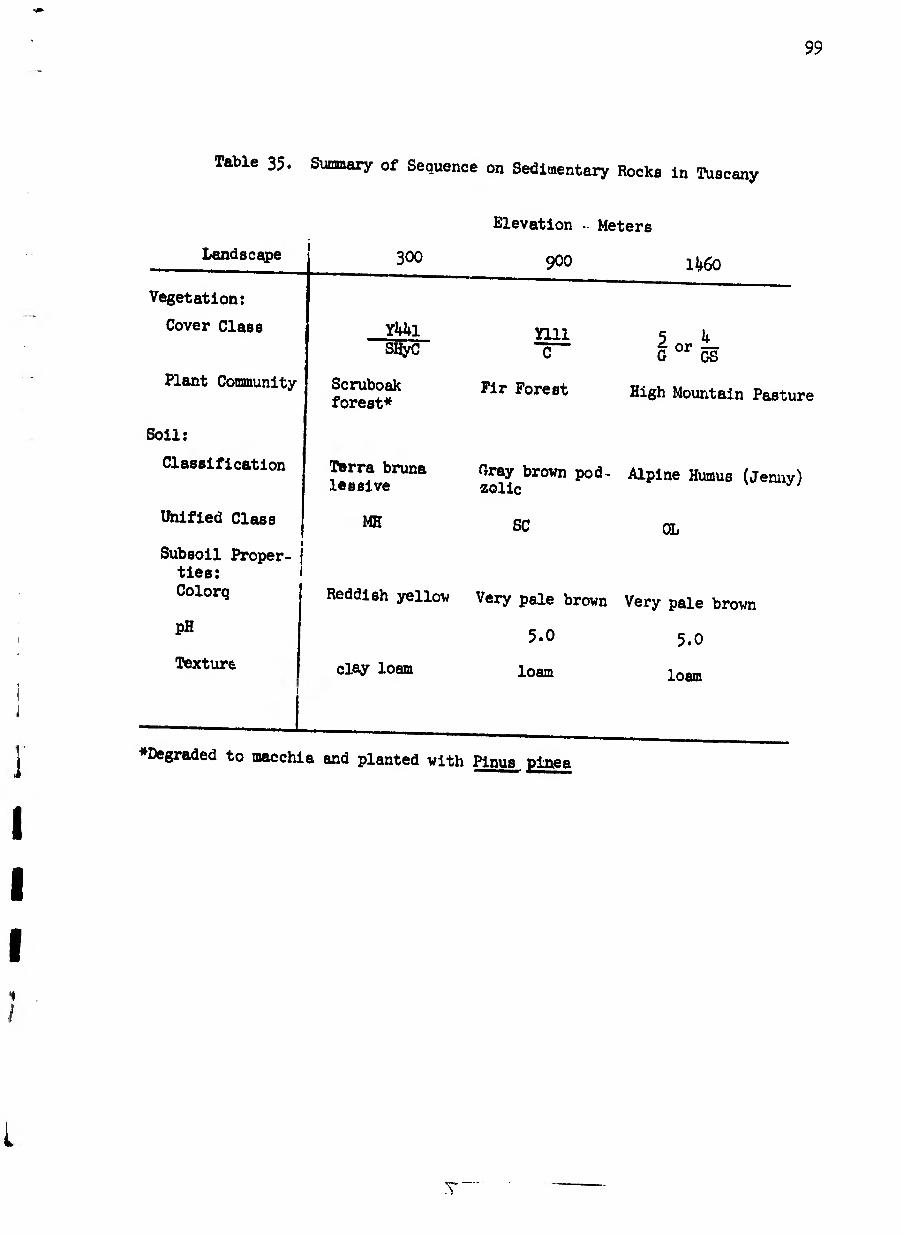
99
Table 35. Summary of Sequence on Sedimentary Rocks in Tuscany
Landscape
Vegetation:
Cover Class
Plant Community
Soil:
Classification
Unified Class
Subsoil Proper¬ ties: Colorq
PH
Texture
SCO
YUl SHyCf
Scruboak forest*
Terra bruna lessive
MH
Reddish yellov
clay loam
Elevation • Meters
9OO lk60
mi C
Fir Forest
G 0r gS
High Mountain Pasture
Cray brown pod- Alpine Humus (Jenny) aolic
SC OL
Very pale brown Very pale brown
5-0 5.0
loam loam
♦Degraded to macchia and planted with Pinus plnea
100
The details of this sequence summarized in table 35* show the
typical change from a high clay content soil with a red color at the lower
elevations to a soil low in clay content and brown in color at the high
elevations.
The vegetation types show considerable effect of man, but still
remain within the context of the usual sequence of change with elevation
increase. At the lower elevation plot, the original vegetation appears to
have been scrub oak forest of Quereus pubescens and Quereus cerris. As
past economic conditions changed, and with it the demands which men made
upon the vegetation changed, the vegetation type was reduced to a degraded
mac chi a of Erica arbórea with occasional Arbutrae unedo. Plantations of
Pinus pinea were then introduced into this degraded macchia both for a timber
and a nut crop. The Erica arbórea remains as an understory and is harvested
for brooms.
Thus, in this area where human use has been present for a long period,
the appearance of the vegetation type reflects the economic environment that
is prevalent. This was described well by Lenoble^ in a discussion describing
the economic basis of certain forestry practices in Tuscany. The develop¬
ment of a brushy coppice out of a hardwood forest of Quercus cerris and
Quercus pubescens was correlated with the economic environment in which the
landowner was immersed. As an example, a farmer in Valdarno di Sopra,
east of Florence, had 25O oaks of various sizes which he cut as they reached
merchantable size, and he received 175 lire per year income from this prior
to 1820. In 1820 he decided to cut down the oaks and raise firewood faggots
(small bundles of twigs) by a coppice system, utilizing the sprouts from
^Lenoble, Felix. 1923» La legende du déboisement des Alpes. Revue de Geographie Alpine XI: 5-116.

101
these oaks. He received 2000 lire for the oaks he cut down. He invested
this and received an annual interest of l40 lire. By I825 the sprouting
oak coppice was producing 1,000 faggots per year, with 7 lire per 100
income -- or TO lire, and h heaps (Castate) of firewood yielding 48 lire
per year. Thus, with an annual income from interest and fuel, he now made
258 lire per year, for a gain of 83 lire per year over the income from the
hardwood forest. Thus the present appearance of the plant community partly
reflects the past ec onomic history as well as the climate and soil of the
area.
The Abies pectinate forest, which occurs at the intermediate ele¬
vation of this sequence, also represents a man-made vegetation type. How¬
ever, it is a vegetation type that would have occurred naturally at this
elevation. This type occurring in the forest at Vallombrosa has been cultured
there for more than 5OO years by monks from the monastery at Vallombrosa.
The open grassland occurs at the highest site above a very sharp
timberline. This seems partly correlated with the development over a long
time of a characteristic soil under the herbaceous sod. This sod is diffi¬
cult for woody plants to invade, and the difficulty is increased by grazing
pressure maintained on any tree seedlings which present themselves.
THE SOIL MOSAIC ON SEDIMENTARY ROCKS
Since sedimentary rocks such as form the main backbone of the
Apennines are variable, the sequence of soil types described above on a
single type of sandstone may not always be found. For example, where the
geology is more complex as in the Apuan Alps (Alpi Apuane) northwest of
Lucca, the soil-vegetation types change with each change of rock type. They
do not present an orderly change of soil and vegetation with elevation change,
but show fragments of the portions of the sequence for each rock type and

102
elevations at vhich it appears on the landscape. In a transect across these
mountains from near Massa east to the Serchio River Valley, one finds the
transect of 'soil vegetation types as shown in table 36. This is an area
that has its landscape analogy in northern California, particularly in the
inner north coa.. ranges in eastern Humboldt and Trinity counties where
sedimentary rocks are fringed by metamorphic rocks on their eastern edge in
which some limestone and marble are to be found (as in the Marble Mountains).
Some of the variebility of soils on the sedimentary rocks in the
Apennines is related to the variability in their composition. The main
variables in the sedimentary rocks that are related to soil differences
being in their particle size distribution and in their base content. Where
the sedimentary rock becomes finer in texture, as would be expected, the
resulting soils also become more clay rich in texture. Thus, along the
northeastern side of the Apennines, from an area about 20 miles southwest
of Bologna, trending southeasterly pest San Marino into the Abruzzi, there
is an area of Pliocene and Miocene sedimentary rocks very high in clay con¬
tent. These give rise to soil-vegetation landscapes of gray slipping clay
soils with grassland vegetation, or where more stable, with scrub oak wood¬
land (with Quercus pubescens). The California analogy for this is the
Yorkville soil series in the north coast ranges in the Russian River and the
Eel River drainages.
In the central southern Apennines in the vicinity of Potenza, there
are sedimentary rocks of Pliocene end Eocene age on which heavy clay soils
develop. A suite of soils develops on these rocks which resemble the soils
developed on similar rocks in the inner coast ranges of California, either
west of Coalinga or in western Glenn and Tehama counties. Thus, soils
resembling the Sehorn, Millsholm, Vallecitos, end Los Osos soils of these
California areas ere developed. On s transect east of Potenza, following

Table 36
. Lane
scape Soil-Vegetation Profile
IO3
S G? G* íê*
à a
■p -p b <n 4 co
co •H
bO
<u co co ■p
cd „ *H
° I
co
g •H
&
cd a) cd o •H
1111
!
f
co (U •H O O 9* co
o f*i

104
the highway to Metera, one encounters first a large area of heavy clay
soils with grasslr.no vegetation. These resemble the Sehom and liillsholm
soils series of Celifornia. Where rockier ereas exist in these clay soil
areas, they are invaded by Cytisus brush, giving a vegetation cover class of
3/BS. Further east these Eocene rocks contain interbedded sandstone and
claystone (flysch) on which developed a soil similar to the Los Osos soil
series of California with a vegetation cover class of 2-3/GH with species y
of grasses in Quereus pubescens. Quercus cerris woodland. It was noticeable
in this area that where the soil had a higher pH, Quercus pubescens was more
prevalent. At the edge of the Eocene rock near Tricarico, there were conglo¬
merate rock outcrops. These were easily identifiable because of a dense
young hardwood cover (cover class l/Hr) with a species composition of Quercus
ilex and Quercus pubescens. The holly leaf oak (Q. ilex) gives a dark green
color to the types. The soil was similar to the Bunnell soil series in Celi¬
fornia, derived from conglomerate rocks . in Glenn County near Elk Creek.
SEQUENCE OF SOIL VEGETATION TYPES IN NORTHERN PINLUS MOUNTAINS -- GREECE
The northern Pindus mountains present a mosaic of geologic types in
which there ere a series of peridotite and serpentine intrusions uriented on
a northwesterly axis extending from central Greece into central Yugoslavia.
These are intruded into adjacent sedimentary rocks (sandstone, flysch, and
limestone) and have associated with them, intrusions of gabbro. The in¬
truded ultra basic igneous rocks are either unaltered and remain as peridotite,
or are altered upon cooling to form serpentine. The resulting landscape is
a mosaic of soils and associated vegetation types related to the occurrence
of the various rock types. A transect across these mountains from loannina
to Kalabaka allows one to observe most of the soil types in this sequence.

105
This transect of soil-vegetation types across the Pindus Mountains
along the route of the highwey from loannine to halabeka included observa¬
tions on Plysch (table 37), serpentine and peridotite (tables 39, kO, 4l, and
42), on gabbro (table ^3)> on sandstone (table 4U), and on conglomerate
(table 45).
The general sequence of soils and vegetation had its landscape analogy
in the northern California coast ranges where serpentine and ^ -rridotite
intrusions occur into general country rock of sandstones, conglomerates, and
interbedded claystones and sandstones, along with intrusions of gabbro and
basalts. Thus, the soil-vegetation type observed on Plysch (table 37) has
its counterpart in soils on the shales near Elk Creek, Glenn County, Cali¬
fornia in the Lodo soils series and the associated Sehorn and Millshom series.
The California vegetation type often found on the lithosol (Lodo series) is
a sparse scattering of Juniperus californica on otherwise bare ground.
This zone of rocks characterized by Flysch extends southerly all the
way down the back bone of Greece. On the geologic map of Greece1 these
rocks denoted as Flysch are seen to begin in Albania and to continue into
the Peloponnesos. An example of an elevation sequence near the southern end
of this zone of Flysch rocks was observed between Tripolis and Olympia. It
occurred as follows, from higher to lower elevation:
kingdom of Greece. Institute for Geology and Subsurface Research. 1954. Geologic Map of Greece, 2 sheets 1/500,000.
X

106
o i
H
•P O
a o •H
Oj •P <ü bO
i
t-
<u H
02
P4
+> 02 U
U S
B 3
§ a O) 0) P CQ
I S4 s bp 0
•H 02
ê
H -it SS
a O
•H
Î »H
fl O •H
'S P •H Qi • •
■H O» V ft
o rH CO &
O *-9
fl K
h 02 <U P O
l CO
02 O) o J3 t- U I fl g H P-
CO
m
02 ü
S 'S
XJ
02 02 02 P .fl P O
2
(0 C2 CÖ 08 ft
p!
£ m on h
o hï
02
! I 02
S «SJ P u
8 C2
2 K 3
02 00 fl
b
ï O
fl & O o P P P 02 ft b
C2 00
a
0 P 02 h 02
03
02 02 fl P 02 fl fi O c bo •S S
■fi ^ P XJ P 02
» g 02 tt 02 fl X 02 rH
fl fl P 02
A 02
1¾ 43 P (0 . fl
U fl 02 Jj
>o»
Zã «P P o >» P o P . 02 fl fl P 02 fl XJ «P
•H <D O
ñ o o
• 00 XJ fl
9 SJ * a
02 fl
I 'S -° s
P 02
o «2 iÿ
00 00 P fl
43 02 P
fl 00 43
! & fl X3
02
8 p & «J p o
00
XJ
P 02 02 fl P
III
1 S» P •• o H XP P 02 p fl fl P P P P M H XJ fl
fû (U
Pi§ fl 02 fl P _ ft ft CO O CO

Table 37.
Soil-Vegetation Plot (XXII-C), continued
IO7
8 0 yi X
a i
•p « •H (0 V ß O 5S
■ 0
■p CQ P
S
P O H O O
ß 0 •H P ft •H P CJ CO <u XJ 0
& T3
a «M ¿3
ft
A 1¾ a
0 s
0 *
t-
p
p 0 <p
0
P H n 0
IA i CO
IA
I' & H
Ö
g
I p
? •§
0 1—t I 0
CO I CM
a)
>>
3 ■a •H P o
n P 0 0 P H 0, g
fM -P
§B •sa 1-= p p 0) *rt
p >> a d H
C O
co 0
(U co
0 co
ß
I TJ g «s
LO
a

108
A i
+> o
§ •H
ts +J
& &
I
00 on
(U
P
¿3
vo
>>
Í . « a % s £ s
(0 *«+*
8| 4)
81 O a
«•
•a n
& o
■p m
•p O
■P
I 4-t
■P cd
I rH CO
4) iH P a
&
• *
a o
•H •• P
O P P P P p< •• cd p V
§) 8 o ÖS53

I
V r j
i!
i
#»•
i
J
Í
I I
I
I
!
>0
I •H
'S 0 o
00 ro
<u rH
I
n Pi
I ■P (0
•H 10 O) Ö o O V
I o
2 S +» 3 CQ +>
ß 3
a o
•H
p t o m a>
x> V
V» s p
o5
& 'O
&
a § N
t
s
I r~i
1 IA
f-
»4 O
Vt CVJ
o rH
cd
■p
'S
p ft
»»•» o
co
b-
•C ■■o
H O
ä
1
o CVJ
I VO
00
i-
!
ä
I 1
CVJ
s I s •H
I p 1¾
£ ■s
VO CO
I o CVJ
CO
<r CO
(3 o N
•H Jh
CO C—
*> T3
I
S’ H O
c B u p
■a h
¡3
I ë •H I P ft
'S
8 H I VO CO
a 0) co
ß P p S
3 »4
a 8,
a g ti
â
10
ti
«i 03
••POP
§ •H íd o •H <P •H C0 ca cd f-i o
§ o
lis •»i - ^ p ¿s p O p ¿ H t— ¡3
o 03
cd
a o
109

I
no
Q) tí
Z V Ö0 V >
I H T» <8
ON CO
<u H
Í
•H
o
<u T3
•H
I <8
■P ta <u
to a; rH
3
c
I CQ
■P 0) 23 O
+3
« ?
§ CVJ IT\
â
to I I
I u
•rl
i
to
ë
1 tí
« t»S X
a
« o ë « p
? to
1 Vt
to
£rH
i § §i ^ ® H 3
« Ü "O
-I s si a » h) i
•H pw 10
p a) a)
Sg,1! «J O » P 4-t
O
O? OJ $7} p
a a) W i-t H
• 0) o to ,ci to
«p
to
at a>
Ss to
- o td ß p fl ' 1) ß tH a> V p » to fl
1^« to a; m
to o to P at
0 to «
to ¿i o
0
'S
ß o
U
■oh 8ti t) s PO Pi
a p ß fl •H -SpL
lâ? 81
CO tu
• • •• 10 A 10 o
(U U
tí)
§ p
•• p ß a) o p
p Pt ••
538, §
ta
3
h
i o ü
o p to h tu
ï o «
Ö
y î-'p «S S8l3 Õ rH XJ tO H P H P » tO
À V (UP PB O tí Q tí
îHi* eu (2 W C5 CQ
â

Tab
le
39.
Soil
-Vegeta
tion P
lot
XX
U.,
co
nti
nu
ed
111
u
4) o a •r as
w p
i -p u
•H a o d 0 0 _ ö 0 0
!§ CO -P
I
ë H O O
§ ■rt P*
ï! O to £ V
3 e . p. ¿j
5
t-i
<g g *0
â
p to
<P 0 ■o O P
“ll I •8 8
III IA
vo
IQ TJ
P O
<P CVJ
■ä
43 to
•rt
?
I
IA •H
I —' O
a & M 0
IA
t-
-4- CO
SB 43 IA
ja >0
•8 0 CO
& $
s p p
I J- "c^ï
sl IA P
<a 0 p -4
p vo S to
P H IA
'S § S^CVI
^P
ä
i
? g- •8 'S
0 IA
I IA
CVJ
•s
Ǥ
to p 8
ft p d 0 0 S3 •o ’S U 0
1 CO
ä 0 0 0
d 8
t
no «3
U
o
to
u
!
1 s p
0 Ü
0 •s
"ë
ë P at
p 0 <P to p
•P "cá O Ü to <P <D O
V s ¿I H O P O
(S OJ P *1 o « 0 8 d S I
P 0)
d 0 Q 03 o p ro p p p p p S X» C o3 B <5 p 0 C p Vt
Slag UNDO to (0 P o

112
ti
«
c; o § 'Q
o ■p
I m ■p o; X
Q i
H
+5 O 5Í a o
*H
«a ■p (U to
OT
ti rH ti
'S o Fh tí O
ti tí
■p
ti tí
•o tí
o
ti <p o •p ti ti V ti rH
ti tí
ti tí O tí •H ti
■P
O A
I to o •H en λ á
ti Ih ti
■p „ _ I
§ SU ° 'S
» ti •H O
CQ
^CQ
•P
*§1
I PB IA- lf\ co ro H m
A
P< *H
tí ti •H +> tí -P O. ti ti ti
ti ti
ti ti
O
•• -p tí ti o +> •H *H
ï s i ÖfiS
g
ti
ti tí
g o
tí ??
•p ti
tí ti ti
<3
o ■p ti tí ti
i
II
■P -H ^ ti H tí ti B Tí ^ (O <D w _
Cj O g »O O

Table 40.
Soil-Vegetation Plot (XXII-D), continued
113
K. A
I 43 (0
■H CO 0) Ö P 0 u
s « ■p d to -p
§ $ £
O H O Ü
a 0 •H 43 Pc •H O a p ■a p
i-H •rl Oh
8 Pc
c8
& 'S
I
U S
J«ä U
o vo*
P ■y
p U
Oh H
^ !» O P
4» H CD O
CO
,Q IA
O î P ta
Z Oh •H •O
IA H
I O
M ü
8
o vo
P o
Oh rH
H P
!» 4» 43
B
p
§ ,0^ T3 00 P
U£ X â1? X) CVJ
? s a Oh
IA -4-
I LA
•s 8 J
IA
P P
Oh
&
I 4» P
•O -st
8^0
m d O
TJ H
0
i •s IA
i IA J*
8 S
C\J CO
Pc
% •H 4» P
& P 0 I P 43 •H 43 O •o t £
(0 p •H P Si H •H
«S
S
* 0 P •H frc
,¾
P O •ri
'S P
43 Pc P h
iQ
Pc
«S
s 8 18 «
^Ia O -H CO -P
H CO 0 O • ü 0 CO -H
O CO
0
•S
8
P o
§1 s
11 Bs 11¾
I
1 0 P •ri M Si
Oh •H 0 O 0
O tC
S
iS
0 •rl
«8 P Oh -H
13 33 H C- D O

Ilk
-4-
0> H
I
0)
& ■p (3 0) 4»
Z & ? u
A
£1 - SB CO a
i U O c
fl
§ m o
+» -P
£ § Ö g $ » 0) ■p •a 0) «H fi 0)
a) O
fc0*-> H -P
s„
•P
+> ¢8 M •H 44
* a)
8£
o
(Q 3 o a 'S
g
! >4 b£> O •H 10
(0 u 4) >g. ■P 6 4) CO
sl 8=_?
c o •rt
’S
%
B •H "8
•H
o 4) Ö fi
g H CQ
4) S W 4) •rl O
iff
5*^0
Ip (0
ï Ü
4-1
M 8 K K
4 •H
£ -o-o CVI CO CVl H
«9 A
(0
2 %
4) a « o iS a &PiH
SI (0
tn|8
&
fl 2*
-P a
Ôè ta
3 ih 53
3¾ «
£î ^
Ta 2
i o
p 9) •P P
P- O «fl
na -H 4) C P P *H Cj Z g g, <S S h o 4) w « ft
I 4-1 TJ ^
1^52 “S8£ S Ü&S 4) U 4) P no -h n co d «a»
w
p 0)
• • no • • 4) <0 •a s? s c s s h ä 5 5 8 5 8 H 'O «J P P > •§ 8^ 8
Root distribution:
Throughout profile
Erosion:
Very little; slight amount of slope creep

Table 4
l.
Soil
-Vegeta
tion P
lot
XX
III,
conti
nued
115
K Pi
I ■P CD
•H (0 O a o o
a e s w
IA LA
fH TD
u V
O VO*
o e
CVl
LA
vo’
■n
Vi O
LA
VO*
I O d (U to P
(0
&
-¾
2 O
£ £
Vi O H O o
a o
•rl
•H Vi o (0 0)
x>
1¾ •H
p
5
43 PI £
a o N Tí|
SI
0 rH
H O
■? m
<u\ ro
X> LA
r ?
+3
£ fi
l- I
o
£
no ro
is S'V T3 CVi
Ö
1 s V4 •H
I <u
u •H T3
O CO
& H t)
•O -it
2 'ro
I ß P O
-O H
Ö
Í
ë •H
I ■P
■8
o t-
ro
+> •rl ■P
£ £
fe1
4)
'O A *{3 g P pvo
CO 00 •H^. (0 IA 3 LA 4) 0 _ H 4»
dSSS 2»ia § o
Ö
<u
•H I
P
CVJ ro
2 •rl P a
& 41 (0
44 O
S
'S
<L) iH
•8 ■H 8 >
CO (U t £
3

None

r
•'*i
»i '«*■
j
i i
i
i
j
i
(0 <D t
r—l •H
(U CÛ (D Eh w H O
§ •H % V r* •rl «D 8 H O
w e ^
cd •H e «2
IlS
HT

118
S X g
u
l ¡§ «H O
Ä
B 0) H •H S
u
B 3 •p
ta ö
•H
O « P
w P (U - LTN W HH
cy
ro P-
H P co H
3 n co V
co ÍH <u P
S 'A
co ro> ■El
'3 H
10 C (U O 0)
<-» a> U A O g -— Pil
co n s g (0 P S SI P P
ÜJ Ö
co V co
I O
O O eu
? ü
B
ß O
•H •• P ß ß O P
•H -H P Pc •• ß H P
« g.
CO
is S
B •H •P
p O co .3
O P co P
I
O
■g
•s P
co
&&S
•3 ß.
1 ÍH X 0) P P H ß H rP 0 H jQ 4) P « ü -P
m
•• •• co fl co o S p
1¾ P co
CD H
à ¿ w ô m â

Table 43.
Soll-Vegetation Plot (XXV-B), continued
IIS'

< I
+> o
B •H
«
« 00
!> I
iH •H
Ê
O rH
I
120

121

122

1,1.f'"
F 123
r
r
1: r ï i i i i
i
1
s 8
1
'S
1 3 0) 60
*7
â
IA -41
0) H
8 u
S
S]
to •H s
II
I
I 0
8
1* &
ï f « £ 4>
OH Ä I T“1
I
0
t-
Oh H
5
•S
'Ia
5 IA M I P t-
Î ■P
3
IS • IA
CVI
IA
IA
1
VO
If
I 0)
I IA OJ
CVJ
IA
IA
1
S H
|| ä 0
>»H
+» ^
tS 60 O
VO
"a cn
„ I1? TS CVJ TS C\J
ro
0 IA
mo
U IA
P H LA
^ci
t
•9
R H
á
0
át oS 0) •H
0 •H H
(0 <U
r «8
H ‘H
(8
(Q <D +> •H 03 S ti
O Ö H h 0 a (O ■rl S
■p < A <0 «o a to •H jH « •O Oh T* •O *H ^ £ Sig
•2 H
0 0 0 «0 0 h-i o5 -d •H 4» -P
a
* •
1 «8 Tj
p d x) E SßiJÄ
■Ö Ä g ô s
12k
Decreasing elevation, westerly
Location Near Vytina
Vegetation: Abies cephalonica forest
Abies cephalonica with
10 km West of Lañadia
Oak woodland Quercus pubescens
Oak woodland
Quercus pubescens woodland
Soil: Gray brown podadic
Llthosols
Calif. analogy
Hugo series Maymen series Ledo series Millsholm
Abrupt trans¬ ition to terra rossa
Permanente
This terrain was badly eroded in places as is the tendency with areas under¬
lain by Flysch rock.
A major feature of the transect over the Plndus Mountains is a
broad aree affected by serpentine and peridotite intrusions. Where the
serpentine is intruded into the country rock, there is frequently a margin of
metamorphosed rock and serpentine more rich in calcium content then the main
body of the serpentine. This frequently gives rise to a gresslend on a
heavy clay soil, a situation reflected in table 38» The analogous situation
also is found at the margins of serpentine areas in C¿lifornia in the north
coast ranges where the heavy clay Montara and Climax soils, characterized
by grasslands, ere found. Leaving the marginal area and proceeding into the
main mass of the serpentine on this transect in the Pindus Mountains, one
enters into e large rree of macchia, characterized by boxwood and juniper
vegetation on a shallow reddish brown clay rich soil developed from the
serpentine. This has a striking California analogy in the Henneke soil
series. This soil in California is also covered with a macchia-like vege¬
tation, a chaparral characterized by various species of Arctostaphylos,

some Cupressus species, and a characteristic scrub oak, Quercus durata.
The result is a similar vegetation cover class designation when viewed on
aerial photographs. With increasing rainfall associated with elevation change
on the serpentine, a deeper, reddish brown heavy clay forest soil develops
(table kO) for which the California analogy is the Dubakella soil series.
The Greek vegetation on this soil is a sparse conifer cover with brush and
bare ground beneath, and for this one finds an analogous vegetation for such
soil in California, where a sparse stand of Plnus Jeffrey! over a brush
cover of Artostaphylos and bare ground is usually present. The larger ser¬
pentine intrusions usually include unaltered peridotite, and on this a soil
that is less heavy in clay, but redder in color, is found (table 4l). This
soil derived from peridotite has its direct analogy in the Cornutt soil
series found on Peridotite outcrops in northwestern Celifornia and south¬
western Oregon. A good example is found on Big Red Mountain in north central
Mendocino County, and this has a similar vegetation cover class as well as
soil. At the highest elevations in the Transect over the Pindus Mountains,
such as at lietsovon pass, the soil development on the serpentine and peri¬
dotite was retarded, as in other elevation sequences, and a soil (table 1+2)
less red in color and lighter in texture was formed. This is analogous to
the Weitchpec soil series found at higher elevations on serpentine and perido¬
tite in north eastern Humboldt County in Celifornia.
Associated with the intrusions of serpentine and peridotite rock are
gabbro and basalt outcrops. On this transect in the P.ndus Mountains,
these had a reddish gray soil with a distinct purplish cast (table 1+3). An
analogy to this occurs in California in that, associated with the intrusions
of serpentine and peridotite, are areas of basalt and gabbro intrusions on
which several analogous soil series (Comptche, Hohman. Foutz, Tatu) are
found, all of which have purplish hues to their color (probably due to

126
manganese in various degrees of oxidation). It vas noted that these soils
followed a belt of gabbro and basalt intrusions southeasterly from this area
on the Pindus Mountains transect, to appear at the summit of the mountains
north of Lamia. In this southern extension they were characterized by a
sparse cover of brushy Quercus cocclfera.
Local outcrops of the sandstone country rock into which the serpen¬
tine and peridotite were intruded occurred on the transect. These had a
degree of soil development (table kb) analogous to the Josephine soil series
in California, or the same as the lower elevation soils on sedimentary rocks
previously described in this paper for Italy. This soil in Greece had a low
hardwood cover, and finds its analogy in the oak woodland vegetation that
characteristically covers the areas of Josephine soil series in interior
Mendocino County in California. At lower areas near Meteora, Just north of
Kalabaka, there were conglomerate rock outcrops on which the soil had
developed to the red soil stage and represented the analogous Sites Soil
Series of Celifornia, found in Glenn, Lake, and Colusa counties. The Quercus
coccifera sen b oak cover characteristic of the Greek soil-vegetation land¬
scape, has a California counterpart in the Quercus dumosa chaparral cover on
some areas of the same soil in California.
A easaery ux . æ soil and vegetation types encountered on this tran¬
sect across the Pindus Mountains is shown in table 46. This transect is
much like one that would be found in a transect across the north coast ranges
of California from Dos Rios, Mendocino County to Stonyford, Glenn County.

!!íf!!|t1
127
T


129

130
SEQUENCE ON SCHIST NEAR SPARTA
An elevation sequence on metaaorphic rocks Is offered by a vide
range of elevations on which schist rock is found near Sparta. Semi-
metamorphosed sedimentary rocks are found at low elevations about 20 km
south of Sparta, and at higher elevations on the Taygetos Mountains near
Art emesia (northwest of Sparta), and on the Parnon Mountains near Rosnas
(east of Sparta). Two stages of the soil developoent sequence on schist
are presented by the data In tables UT, and h9. These data Indicate
some generalities which had appeared In this study In the investigations of
the sequences in Italy. At the lower elevation there Is a macchla-type
vegetation (a deGraded macchla with Erica arbórea end Arbutus unedo) on a
reddish clay soli, progressing to a coniferous forest vegetation at the upper
elevations on a brown soil with less clay content. It was not possible to
make an observation above tlmberllne on schist rocks In this area beceuse the
mountains did not rise high enough.
Despite the long time human occupancy of this area, it was interesting
to note that the same sequence of soils and vegetation occurred as would be
expected from less disturbed ereas. The sampling sites are all located in
the countryside around ancient Sparta, and there have been records of some
drastic changes in the vegetation very recently. Por exançle, the area in
the Parnon Mountains is said to have been burned over completely by the re¬
treating Turks under Abraham in 1021. The Abies cephalonica forest noted
in the plot in table 49 has established itself since this burning. On the
west slope of the Taygetos Mountains, there are brush fields of macchia
which directly adjoin the conifer types. These are characterized by a
cover class of 1/S and a species type of Quercus coccifera and Genista
aepalathoides. These brushfields have the appearance of having been former

I r
t
i i i i i i i
i
§ •H « Ja
o •p
Vi •O
0)
I ■P
s?
« o
I 3
K X X
(Q
•H 43
I •H
K
(0
2
m
§ •H
•• P g| •H »rl •P Pl •• cd -H <u
ü p, o H to al
á •s
¿p • • (0
w
I
P
■ãl •H ë
(0
í & (0
CQ
&
r-4 CO OJ CO CVJ CVI "CO
<0 O
ap W ^
ro
u (0 ai H U
! o
§ •H P
i U a
3 (0
<d
8¾
4a Vi
I rol
Î co
o
[ IA|Ü
2 £
I O
« Hito
O
CO
P (0
S Ä (0
! •V
•V
•s
I d O
I w
! Ä (0
Vi O
(0 Jj a o b & (0
«8 ¿p co
•H •
o »
OJ
I CQ 0) •rl O CO
§1
131
3 o h O P Ö
S5 •H •P
§ i i
co 3 O CQ
•H P ß CU H
0) •rl
Æ1
Pv C0 P
tí a 08 o
•H O
■a p
I 3 0 ܧ
ig
&1?ip a h o
$ s
ti
t! 3^
• • •• co ß co O SS 33 X H k
P fO « O -H
* o |¡|1.8'“e Ä í£ w ô
Table kJ
. Soil-Vegetation Plot XXIX.. continued
I32

133 r
f i i i
L
§ S & 8
■P
o VO
3 0)
Î
JB § t 8 8 S i § t s
u ft) +>
T3
CO i—t
•S 5
L. p «>
(0 p ft) p •H O (U ' P
•H CO I
i *H
il» II
« o
NH
I o 0) V.
8 tR H iif>Cb CVJ ^ CVJ Co VO
Ê CO H
ft)
Q) CO CUP
MS, ë
g •iH
*• <p ö «§ O P
p ptf ••
¢-3 8. 0) ft) o
03
tB O
g
(0 ä H O
b
O
§ P P Pi
Z O p u U K I
8 6 a
£ b U h ft)
1
ril
H -Ö
y ^ p «w +) A) ^ 8 ^ 8 Ä 03 O 03 K
A

13¾


Teble 49-
Soil-Vegetation Plot XXV., continued
% A
i ■P (0 •H 1
O n\ co -p!
IA
VO*
o &
lf\ o • ■
IA IA
H •O
U
I
i i
o H
I ■p CO
g +Í CO
o h| o Ü
ro '¡A
ë
i
Æ co
! "(A
fg ,0 A O H H
§ <rt ■P A
o co -8 4)
g T 0) CO
4-t
i X5l € L: o
o ro ¿ H
& g NI
áf <VJ
M o a
Soil classification:
International:
Gray Brown Podzolic (Storie & Weir)
Unified Soil Classification:
GM
California Soil Series Analogy:
Sheetiron Soil Series

137
forested areas, now maintained by fire in a brush stage of vegetation. This
is analogous to areas in California such as along the vestern slope of the
southern Sierra, or the slopes of the San Gabriel - San Bernardino mountains
where similar situations are maintained by fire kindled as a result of
certain events such as lightning that have a natural probability of occur¬
rence. Thus, the effect of man in a long settled area may duplicate the
effects of nature where similar processes and similar periods of recurrence
are involved. The recurrence interval of fire, when planned by graziers in
the macchia around Sparta, is five years for Quercus coccifera macchia grazed
by sheep, and ten years for Quercus coccifera macchia grazed by goats accord¬
ing to the district forester at Sparta.
There was a mosaic of types of soil and vegetation on the Schist
rocks around Sparta, and they partly reflected the degree of development
the soil would attain in the presence of a certain amount of normal erosion.
This could be observed at several points north of Sparta on the road from
Tripolis. For example, at Ion on this road, there is a view east to a
fairly steep west slo e on which occurred a soil that resembled the non-
calcic brown soil of California called the Laughlln soil series -- 3' deep;
and where the slopes were slightly less steep and the soil had apparently
developed for a longer time. These had been cultivated to about a 20$ crown
density of olive trees (Plea europa). Where the slope became steeper still,
with colluvial creep adjacent to small canyons, a shrub hardwood vegetation
type (cover class l/SHy) with a composition of Quercus coccifera. Pistacia
lent!scus, Nerium oleander, and Quercus ilex occurred. On the upper slope of
the hills an invading brush cover was crowding out sparse grass on what
appeared to be a stony, eroded Laughlln as in the olive orchard. It was
noteworthy that among the introduced trees on this soil complex on what is an
arid hillside, the Cupressus sempervirens did very well, and it was planted
along trails and around chapels.

1?8
A vegetation-type change associated with a change in geology and
associated soils occurs near the summit of the Taygetos Mountains, on the
road from Sparta to Kalamata. Limestone adjoins schist in the area just east
of this summit. There is a forest cover of Abies cephalonlca on a rend-
zina soil which forms on the limestone; and adjoining this on the schist
rock is leached brown forest soil (terra bruna lessive) with a forest cover
of -Pj-nus nigra. The two rock types can be distinguished readily from either
ground or aerial photo observation on the basis of these vegetation changes.
SEQUENCE ON LIMESTONE NEAR SPARTA
A large part of the Peloponnesian peninsula south and east of Sparta
is limestone rock, and several observations of soil-vegetation types were
made on this rock. These data are presented In tables 50 and 51. As a
matter of interest, a soil-vegetation observation on limestone with a similar
degree of soil development near Postumia in Yugoslavia is included in table
52.
This sequence near Sparta is of interest because it presents a well
developed terra rossa stage on limestone at the lower elevations (O-8OO
meters) and a transition to the yellow brown Terra Gialla stage of Cornel
at the upper elevations (800-1200 meters), and above 1200 meters, a rendzina
stage not sampled because of inaccessability. An interesting transition
occurs in the terra rossa with increasing elevation and a correlated in¬
crease in vegetation cover and productivity. A browner colored surface (A)
horizon tends to form over the distinctly red colored subsoil, extending to
a greater depth as one ascends in elevation. This horizon is lacking be¬
tween scattered shrubs of Quercus coccifera at the lower elevations, but
tends to form under them. The implication is that any process which tends to
decrease the density of the shrubs such as frequent fire, increasing aridity
of climate, overgrazing, or harvest for fuelwood would tend to

Table 50.
Soil-Vegetation Plot XXVTII.
f
I39
V
s
X
(0
¿3
>» rO T3 41 <U 'S •H
(3 O
s s <$ o +3
CV1
(0
•H A +>
£ g
d « s
I
I •H
f
(0 U Q>
11¾ CU
00
§ •H
•• -P a as o +î .p p,.. g-S 8, a> u o
03
5Í
à
U o?
(0 a>
I
HlCQ
(Q (0 as H t» U
I O
Í •H a> m
a o
•H P •S* P ü CO
CU CO H Co
ss: «S
o P a
as
(0
«
M §
o P 10 Pt as
1
ï IA
P 0) s
s a
1 (0 P
a
O P (0
J3
$ M
•H
g
S (0
a •H
tJ (U 'O
as
p a
H
as o £ S (0
d
<8 (0 p
as h 8 Pt 3 O as as 'O •h as :§ 38 H Ö Vî as
•H o as as >
W ps,X! o» . as >> tj g
p C! G o
•H N
■s ti 8 353 as Has h < P
fl o
as us Si
Ü r»> H Pt p as as H H P H 'O as •H ^ P as as as g « g «o
aS fl a> •P 3 P
as & 2 fi os o m <S
as •• fl O ri as
T'

iko
T3
I •H
g O
<u H
'S En
»
i +> ta
•H (0 0)
s y S S
g g ■p s CQ +3
S
g 'â O
g •H ¾ U O 0) 'O
3 4h O M ft
•n &
■fl +3
a a o % ã
ir\
t-
(0 -O
! (0 &
5 6 H U
13
g«
g -Í
g> irv
>
•H 'O
IA ft g eu
i O
€
I V en
% $
vo
I IA eu
IA LA CO • • •
vo t- t-
I
Ö, O en
& H O
VO
*(n
p
Iv »o eu
!
•3
O t-
I s
!
S-i?
U
I a I I « a
eu en
âï £

ikOa

Table 51a.
Soil-Vegetation Plot XXVII., continued
l40b
I t

Tab
le
52
. S
oil
-Veg
eta
tio
n P
lot
(XX
X-A
),
co
nti
nu
ed
I t
142
09
r- H (Ü V 09
tt ft
I ■P 01 •rt 09 0) e « o d o <u
o 5 £ sl
<u
I
-p 09 d
M Q t> Xl (Ü
„ O «£ 2 t“ P ft
LT\
VO
rH TD
O t-
•H <H TJ
á
s I
tr\ co • •
t—
fH •rt
•O
M €
Sr & H O
U o H O O
ë •H
O 09 0)
■O
4h g ft
T-l cS
s
id ■p
§ p
TÎ
â
CVJ
Jt
o
I!
■a
in H
i o
gj.
i in
£.3
p vo ,o 'in
«ti
ä
t
'S %VO
di
I *§
in cn
i in in
co
H
à
CVJ co
1 d •H
t
I
09
Jö >»
■d
•ä i « ■p
’S
ft
I ■p 09
im
S Vl o 09
1 o
•d
H •H 8
g •H O (0 O
£
8..
cd •• o 3 §f a -H d
•H -p ^ o a
O (0 •H <U
îjti lu a a B b œ ë .. o *H 'd H «S
d o o a O -rl ra ‘H ■h p d ■P a T3 M aovo o R -H ^
jH a Vl -H ^ -Ö *d d •h d tí o os h D o
H ü

1*3
accentuate the red appearance of the terra rossa; and that conversely with
Increasing density of vegetation^ the brown A horizon would tend to foT\û}
sud that this might be related to an opposite trend in the processes men¬
tioned .
The sequence in vegetation from the macchia dominated by Cuercus
soccifera at lower elevations to the coniferous forest at the upper eleva¬
tions is more gradual than is indicated by tables 50 and 51. Thus, between
Geraki and Kosmas (East of Sparta) one ascends through the following vege¬
tation sequence;
Elevation (meters) 300 5OO 1000
VEGETATION:
Cover Class 3/BS l/s Ylll/C
Species Qc PI Ga Jo Qc Jp Ac
Ac - Abies cephalonica Jo - Juniperus oxycedrus Ba - Bare ground Jp - Juniperus phoenicea Ga - Genista aspalathoides PI - Pistacia lentiscus
The macchia cover on the terra rossa phase of this sequence was
consistent for a long distance across the countryside, changing mainly in
degree of stocking, varying from 90# crown cover to less than 50# crown
cover. Thus, following the same type to a point at km 5I on the road from
Tripolis to Sparta, the shrub cover is Quereus cocclfera - PhilJyrea myrti-
1 Arbutus unedoona 2 to 3I deep terra rossa. There were stringers of
alluvial valleys through this rock type and these had oak savannah vegetation
with 3-VGHy cover classes. At places of geologic contact, the adjacent
schist rocks would form islands in the limestone rock of deeper, less rocky
soils, and generally would be cultivated while the adjacent terra rossa on
the limestone was left under its brush cover.
Where the limestone was steeper, as it was up the east elope of the
aygetos Mountains, the sequence from terra ross® through terra glall® to
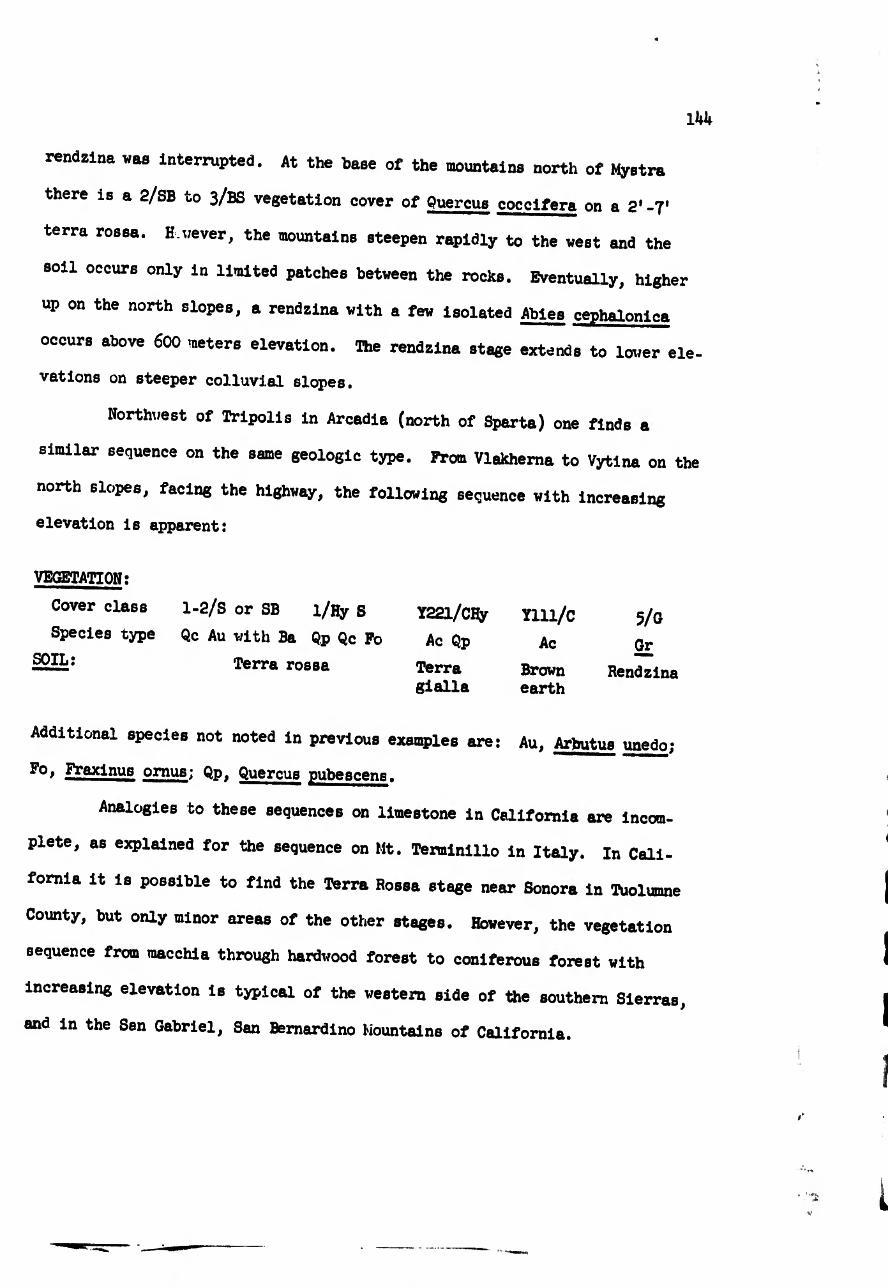
144
rendzina vas interrupted. At the base of the mountains north of Mystra
there is a 2/SB to 3/BS vegetation cover of Quercus coccifera on a 2'-7'
terra rosea. H.vever, the mountains steepen rapidly to the vest and the
soil occurs only in limited patches betveen the rocks. Eventually, higher
up on the north slopes, a rendzina vith a fev isolated Abies cephalonlca
occurs above 600 meters elevation. The rendzina stage extends to lover ele-
vations on steeper colluvial slopes.
Northvest of Tripolis in Arcadia (north of Sparta) one finds a
similar sequence on the same geologic type. Prom Vlakhema to Vytina on the
north slopes, facing the highvay, the folloving sequence vith increasing
elevation is apparent:
VEGETATION:
Cover class
Species type
SOIL:
1-2/S or SB l/Hy S
Qc Au vith Ba Qp Qc Fo
Terra rossa
Y22l/CHy
Ac Qp
Terra
gialla
Ylll/c 5/g
Ac Gr
Brovn Rendzina earth
Additional species not noted in previous examples are: Au, Arbutus unedo;
ornus; Qp, Quercus pubescens.
Analogies bo these sequences on limestone in California are incom¬
plete, as explained for the sequence on Mt. Terminillo in Italy. In Cali¬
fornia it is possible to find the Terra Rossa stage near Sonora in Tuolumne
County, but only minor areas of the other stages. Hovever, the vegetation
sequence from raacchia through hardvood forest to coniferous forest vith
increasing elevation is typical of the vestem side of the southern Sierras,
and in the San Gabriel, San Bernardino Mountains of California.

1^5
SEQUENCES ON GRANITE IN NORTHERN GREECE
A series of granitic areas fcsrming high mountains in northern Greece
along the Yugoslavian and Bulgarian borders offer the possibility of ob¬
serving the change of vegetation and soil on these rocks. Two areas were
found for such sequences; one from Chrysopighi to Lailias, north of Serrai
(northeast of Thessaloniki), and the other from Fiorina toward the top of
fjsoderi Pass west of Fiorina (near the Albania-Yugoslavian border). The
observation data for soil-vegetation plots arrayed in order of increasing
elevrtion are presented in tables 53-57, and a summary table of the pertinent
properties of this sequence is presented in table 58.
The sequences on granitic areas and adjacent metamorphic rocks (gneis¬
ses and crystalline schists) indicate changes from red clay rich soils at
lower elevations (below SCO meters) to dark grayish brown light textured and
more stony soils at upper elevations (above 1500 meters). At lower elevations
on this sequence, remnant areas of lower elevation vegetation indicate a
scrub oak hardwood forest (Quereus pubescene, and Quereus robur var. sessili-
fiora) which has generally been cleared to grass. Uidely scattered, heavily
grazed remnant bushes of the previous oak forest are present. At higher
elevation a zone of gray brown podzolic soils is reached (1OOO-1500 meters),
and here the vegetation is either beech forest, or pine forest (Pinus syl-
vestris) with some intermixed beech trees. Above I800 meters there occur
high mountain pastures of miscellaneous herb s with scattered Juniperus
comunis. West of Fiorina this occurs above a very abrupt timberline of
beech. Soils in this above timberline area are the organic-matter-rich
ranker soils which are typical of most of the above timberline areas des¬
cribed earlier.

146
The California analogies to these soil vegetation types on granitic
rocks and associated metamorphic rocks are to be found in the southern coast
ranges and the southern Sierra Nevada. In the San Gabriel Mountains, and
the San Bernardino Mountains of southern California are many areas where such
metamorphic rocks as gneisses and schists are adjacent and interbedded with
granites, and in these situations similar soil sequences are found related to
increasing elevation.
Since soils on granitic materials are easily susceptible to erosion
because of their usually coarse textured nature, it was noticed that there
were some sequences of local vegetation change that occurred in this erosion
process. Thus, where incipient gullies were forming by erosion in the
grasslands, for example, at the location in the plot in table 54, a succession
occurred with increasing severity of erosion as follows:
Degree of erosion: Litte Moderate Severe
VEGETATION:
Cover class 5/G 5/p 4/BS
Species type Mise, herbs Pteris aqulina Barren, Quercus and grasses coccifera (table 54) -
In a sense this represents the appearance at the surface of various soil
media for plant growth, each degree of erosion representing the capacity
of the successive soil horizon layer, appearing at the surface, to support
cover in the presence of the climatic and grazing factors at the site. Thus
the most severely eroded areas hed a scattered cover of Quercus coccifera
shrubs. A few scattered Junlperus oxycedrus also came in on these eroded
areas. The presence of Ptoris aquilina represents the appearance at the
surface of the more acid subsoil which favors this fern, a point noted by
Cato (Dickson^-).
-ï--—------ Dickson. Adam. 1788. The Husbandry of the Ancients, Vol. 1 527
pp. Robinson and Cadel, London. '

I
The soil situations described here on granitic rocks extend north
westward into Yugoslavia and probably into Bulgaria, and can be expected
to carry the same sequence of eoils and vegetation on them with elevation
change.
i i i
Table 53.
Soil-Vegetation

•Htt
O
t:oIiH
T>
§
6 MMMHXKKKXMKKMKHMKK
! I s«aVo
&
•NOillIllillSiS
111 IS
•TtlfP
n3
■dII
Ioo Ts
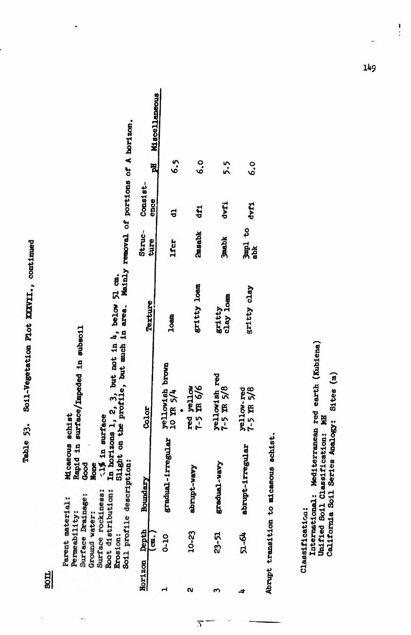
Table 53.
Soil-Vegetation Plot XXXVII
i
IU9
■a
I •H
! 0
s
s
a TÍ 'p o •o
H
» +> o 09 (0
O 09 09
2 « g’’ Õ T3 « -H 'O
Sii
e3 (a ^ § cd r-t 0) M S j' a
a a •H O
•p
I . <U
•> H CO •H
O? S 8
§1: 09 O
Ö -H •H H -P
«mil ’S a I r/ a ^ .2 Ä H CO -P
O O *H (S á t8
(
¾
2 ï? J
Vi O » g
g <P O H O
I g g
g ra 3
I P 09
•H 09 0) a 0 0 a 0 «
in
vo
TJ
O 4h
O VO*
Vi 'V
X 'S 09
5 >> P P •H
g^e. dvo
'O in
cd
§
g •s
çp CVJ I o
in
LA
•H
s 'O
p
g
M in •H
gÔ H H in
in i co eu
o vo
TJ
o p
I I I ¿g •s
>»H
P S
S" Ö0 O
s « H O >» p p p h M
O CO
g>
g g rH H in giti
s
i
•s
-u- vo
I H in
p ta
o 09
09
g S O
£ s
eu CO
O p o o p p •H o
! p p
! «
«
H (8 •H
<83 TJ c
T
Table 54
. Soil-Vegetation Plot XXXI


Table 54.
Soil-Vegetation Flot XXXI., continued
151
0 vo
£
0
6
'S
I 44 0 <s
s
^1 m 0 0 • •H (U 0)0 0 > a p
(U H »N SB U CO Æ
-o 0 0
•Hfl® H (U O A H < <ü O
S-S
O +* fl Ä 0)
fl . (U O U
-H ^
•H O O >0 -H O
*3
••
m
10
<U «H
fl H
fl O Q cd O •H CO •H -P
'S S Õ O O m jri Vl jH (ü 4h *H «M -P «H H •H fl fl d Cf ; H P O a ai H ü

152
sito
s aisq
pos

Tsblc 55* Soil-Vegetation Plot XXXV., continued
153
'^«r ——

15b

155
o
ô S Jï
•: c ■h
^ H (8 •• (3 •H e o o «a O -H Ò5 "H •H +» Ö ■P CÖ TJ C cd p V o o C th
•H <l) 4-( *H +>
•h a (0 H
U
77
Table 57.
Soil-Vegetation Plot XXXVI

I
8
§
ioX
s•H
O
uo• •
Itt4»•Ho
£
I.I H Co ^ to ^
>»•P•Ha
I
8 8i-t rH :» "IS
• •§ • •
M•H••§5P P
napo
P Qi •• P s> s* sa£l 1p. »<I.s
sS•H•P
ttVl
5-& 8 2 8 2 •• a 2IIa 8 SaI
spf-i(4
P
0>
Iw
51tj
£

157
(O V t ál H •H
cg o
•s O u o u 4> V
I .. « ..
SH -P -rj H •H fl ß O œ h p o
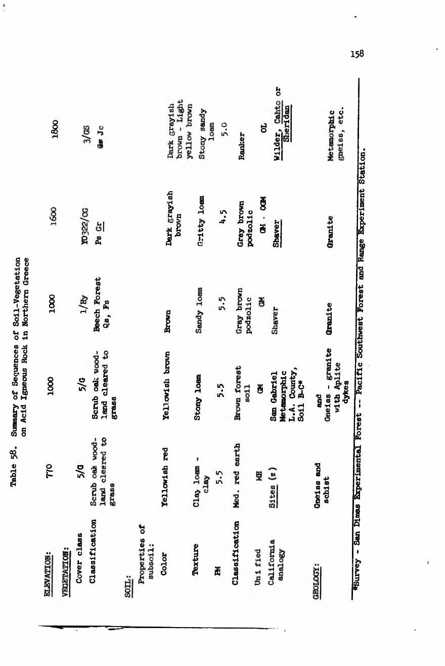
Table 58.
Summary of Sequences of Soil-Vegetation
on Acid Igneous Rock in Northern Greece
I
158
Sh O
(h
1 «
ë u 0) ra r—t •H
s XJ
t <u
£
V 0
0 »
43 CO
& H c tD Pf
Pi ^ ,3
0 H
λ ■P +s r.
IA O O Ch -H
>* «
2 0
Pi
I 43 CO
CD 44
ë
+> co 2
iS co 43fe o *
co O’
a ID •p
0
IA •3 $ O H
O
s 0 s s CO H to
ë Ä CO
sS
ID +>
& O
■P CO
IA
A
H O S ID H -P •H Ä
I |s¿ 0 1 w ;$ ni d
S«05
'S co 43 ’S c co p -o Œ tI tH
o 0 A
Xl
2
•§
¡2
a
1 co a CO «H
«•8 g “
• •
• •
§ §
Pc
I O Ü
g •H
£ s •rt
4-1 •H CO
rH Ü
4h O co o ••
Pc 0 H O Ü
t?
£ ë
g •H
«S 0
•H CO
I—t 0
♦Survey - San Dinas Experimental Forest — Pacific Southwest Forest and Range Experiment Station.

15$
SEQUENCE ON SCHIST ON MT. OLYMPOS
Mt. Olympos in north central Greece, although capped by limestone,
has most of its vestern and southern slopes covered by Schist rocks and thus
allows the examination of an elevation sequence of soils and vegetation on
metamorphic rocks. Observations were made as recorded on tables 59 to 62,
beginning with a lower elevation point near the upper end of the Tempi Gorge,
and a high elevation point on the road to the Hellenic Alpine Ci'ub hut on the
south slope of Mt. Olympos. T is sequence, as has the others, began at its
lower elevations with a Mediterranean red earth (Kubiena) and at successively
higher elevations the soil became browner in hue with the addition of a dark
A horizon at the highest elevation site. The soil at the lower elevations
was a clay (MH) and became sandy loam (GW) with increasing elevation. There
was a successive decrease in pH of the subsoil at higher elevations, indi¬
cating more leaching of the bases, probably due to higher rainfall. The
lower elevation vegetation was a macchia of Qaercus cocclfera and the succes¬
sively higher elevation sites were vegetated with grass apparently resulting
from the clearing of oak woodland. That these grasslands had previously
been woodland was evidenced by the presence of charcoal and burned red areas
in the subsoils. Some of these plots were in areas that had been subject to
heavy grazing pressure, partly because of being on migration routes, as in the
case of the observation points presented in tables 6o and 6l. (These also
happened to be on the invasion route of Xerxed Persian Army in 480 BC.)
The California analogy to this sequence on schist can be found in the
northern coast ranges in eastern Humboldt, eastern Mendocino and northern
Lake counties. A good example is the sequence in soils on the south side of
Hulls Peak in the Mendocino National Forest. However, the vegetation is
¿Afferent in that on Mt. Olympos, particularly at the middle elevations, the
oak woodland has been cleared to give open grasslands.

SOME SOIL VEGETATION TYPES OP THE TERTIARY ROCKS
OF GREECE AND CALIFORNIA ANALOGIES
l60
A large area of Greece, exclusive of the agricultural valleys and the
mountainous areas, is composed of rolling hills and elevated terraces, dis¬
sected occasionally into small steep ravines and terrace breaks. These are
based on extensive areas of Tertiary deposits (Geology map of Greece 195k).
Large areas of these deposits occur as a margin around the Peloponnesian
peninsula, in Attica neer Tanagra, in the valley near P atea and Thebes, on
the rolling plains of Thessaly south of Larissa, the broad valley of the
upper Haliakman River south of Kastoria, the rolling hills northvest of
Katerini, and similar areas, both northwest and southeast of Thessaloniki.
These widespread areas have a soil vegetation landscape conditioned by the
original nature of the deposit (whether sandy or heavy clay), by the climate
of these lower elevations at which they occur, by the topography brought
about by the type and degree of erosion, and by the use yhich man has made of
them, such as rangeland and cropland.
Where these deposits are clay rich, they give rise to heavy clay
soils ano have an open grassland (cover class 5/g), or a savannah (cover
class 4/GHy or Ho) with widely scattered oaks (Quercus troJana) or Pears
(P*rus amygdaliformis). The Quercus troJana are particularly noteworthy
on the plain south of Patras, and the Pirus on the rolling elevated terrain
north and west of Katerini. The California landscape analogy for these
areas are the sparse oak savannahs of the Sacramento-San Joaouin valleys on
weakly consolidated alluvial deposits of Tertiary and more recent age. In
Greece where the topography is not steep, these soils have been transformed
into grain fields as, for example, in the south of Thessaly, and south of
Kastoria, or northwest of Thessaloniki. The heavy clay content of the parent
rock seems to arrest the development of these soils so they do not attain

l6i
the red colors and profile differentiation that are typical of the soils at
the lower elevations of the sequences previously described on the harder
rocks. Where more calcium is present in the parent material, the soils may
develop a carbonate rich horizon in the subsoil as in the soils in the
vicinity of Pella, which have the appearance of dry rendzinas or Sierozems
(Xerorendzlna of Kubiena) such as the Linne or Zaca soil series of California.
Where the topography is brought into sharper relief by dissection of these
rolling plains by erosion, woody vegetation occupies the steep slopes of the
ravines. This vegetation is of macchia or the softer sage-like Gärige type.
The counterparts of these are also found in California, where the steeper
slopes brought about by erosion of the savannah and grassland covered Ter¬
tiary and more recent deposits, will be covered with chaparral or with a
soft sage-type of vegetation.
Some of the Tertiary deposits are more sandy and have less clay. For
example, those in the vicinity of Olympia or near Sparta. These also tend to
have more woody vegetation. Thus, there may be macchia of Oleander (Nerium
£i2®£E££, Cytisus and Cistus), as around Sparta, or a macchia with Pinus
halepensis. as in the vicinity of Olympia. Again, the woody vegetation is
much more prevalent on the steeper slope breaks brought about by the erosion,
while the less steep upper surfaces are cultivated. Erosion from these
deposits is often very severe. An example is seen at the sanctuary of Olympia,
where the river is depositing sediment from such erosion. In the past I5OO
years, since the cessation of the Roman sponsorship of the Olympic Games,
the buildings have been buried in from 20' to 30' of fine silt loam and sandy
loam sediments. A deposition rate similar to that occurs in some Cali¬
fornia coast range areas, such as at Bull Creek Flat, Humboldt County.
Comparable analogies to these conditions exist in California, where the most
credible soils in the state are such soils as the Elkhorn soil series of

162
the coastal terrace deposits north of Watsonville, or the Las Flores and
Carlsbad soil series of the terrace deposits north of San Diego. On these
deposits between Watsonville and Salinas in Monterey County, where the slopes
are not so steep, there is an open oak savannah, the Quercus agrlfolia, play¬
ing the role of the Quercus trojana north of Olympia. In the analogy men¬
tioned just north of San Diego, the natural vegetation on the slightly eroded
areas is a chaparral (znacchia) with a sparse stand of Torrey pines (Pinus
torreyi). These Torrey pines occupy a niche similar to that occupied by
Plnus halepensis on the terrace breaks in the Peloponnesos. It is interesting
to note that southwest of Taranto, toward Calabria, the Pinus halepensis
also occupies similar sites on terrace deposits. The development of the soils
on these sandier terrace materials tends to go further toward the typical
red soil development of these elevations, as found on the other harder parent
rocks studied earlier. Thus, in the vicinity of the town of Sparta, the
soil has the typical reddish-brown subsoil color on the Tertiary deposits. It
is interesting to note that at the Acropolis of Sparta, where this soil had
been disturbed in the building of the Acropolis and the subsequent Roman
buildings, the soil has had time, since the abandonment, to form a light
brown A horizon about one foot deep over the reddish brown B horizon. Sup¬
posedly this is related to the influence of annual grasses and olive tree
leaf litter on the soil since that time. In the Eurota River Valley near
Sparta, the flatter surfaces of these deposits were covered with olive or¬
chards, but the steeper and eroding slopes were covered with a sparse oleander
macchia, characterized by species of Genista, Spartium and by Nerium oleander.
Where recently disturbed, such soils are invaded by various composites and
soft sage-type species, such as Thymus, and Genista aspalatholdes. as is seen,
for example, at the recently excavated monument for Helen of Troy and King
Menelaos. In California the analogies for these areas around Sparta are the

Table 59.
Soll-Vegetation Plot XXXIV
I63

16U
$
i (O
•H n V
80
-S S ir\
LTV
o 8
•*. ITN
irv vo
ë
$ m
IA t
VO
03
t)
m
o vc
I
■£
o tí
§ •rl tfl
« IP > 1 H •H
&
o\ lf\
a>
I ••
H
<8
r-i
îvT
CVJ
Î 9
-s
ä
IA cn
i
cn
ov IA
I IA cn
-d-
•s 2 +» ca
I

Table 6o.
Soil-Vegetation Plost mnm
165 r
Table 60.
Soil-Vegetation Plot XXXH., continued
166

m
l6l
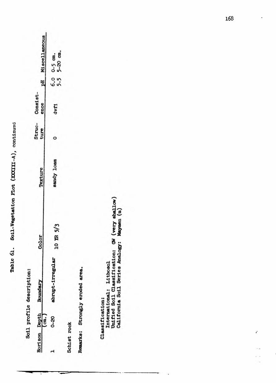
Table 6l.
Soil-Vegetation Plot (XXXIII-A), continued
168

f
r
r
r i
i
i
!
{
§0
«8
CVI VO
<u H
I
•P ae u o
§•
(0 3
« ■p
o £
I if $
•H
I
§ in
* o Jt
w
§ •H
«
a>
w
§ •H
« ■P •H P<
•H a
I §•
rH CO
to
•e <D Ä
Ö CD
a 0) O <0 s so
to 3
g a CD H i-• 4J Ü CO
• *
a <u
u
I
in|o
co
u
(h
! o
CO
« I f 13 s CO
8 CO
0
'S CO
fl ^ o b
•H +> •P co Pc b
M j> o o CO
CO cd
ß O
•H P CD P 0) bO
% >> 13 <U 0)
S H CO 3 O
•H >
P Pc CO C0
ß 3 H a u
2 M
a
H
^ • (U H » -H O O U U p* p
8
I 'S
P'S
(U 43 P
ß •H
S p
a o
•H
■$
Sóp 0) U > p
<u
u »a
IS
¡I
s « ta
XJ •rl & I >
£ CO
p U -o
2¾¾ ë
W«Sâ
2
p
SP •• ß ••
#H p eu
I 1-2 SS10
p 'S S
S I <2
Hls
U a
ë •H Ai U
8
p o
•H
I fl £
ß ^ Vi P
^ 8 2 CO P3 W
I69
"wwer 5

Table 6P.
Soil-Vegetation Plot XXXIII.- continued
170
to V
£ £
£ S
m h

171
coastal terraces north of Santa Monica, and corresponding terraces extending
eastvard along the base of the San Gabriel and the San Bernardino Mountains
vith the Ramona soil series. The upper surfaces of these are also cultivated,
but the eroded breaks and ravines are covered vith a voody vegetation dom¬
inated by Rhus laurina (a good species analogy of Nerium oleander) vith
other chaparral species such as guercus dumosa and Adenostoma fasiculatum.
Where the surface is recently disturbed, these are also initially invaded
by a Garige-like sage vegetation of various salvia species.
This description of some of the soil-vegetation types occurring on
the Tertiary deposits of Greece is not comprehensive. There is interbedding
of many types of rocks and deposits in them, thus presenting much local
complexity that can only be described by more detailed soil surveys. Some
of these are nov available as in the footnote references1.
THE LOCAL MOSAIC OF SOIL VEGETATION TYPES IN ITALY AND GREECE
As is true of California, the general sequences of soil and vege¬
tation change vhich occur vith elevation on the various rock types form the
warp and voof of the landscape over vhich is laid the local pattern or
mosaic of varying soil vegetation types related to local variables. For the
soil mosaic, such variables as steepness of slope and the resulting eouili-
brium amount of soil development attained in relation to this steepness; the
pattern of local variability of geologic rock types and the degree of soil
weathering attained by each rock type in the local context of climate and
vegetation; the length of time the surface has existed relatively undisturbed,
i/ioo,oo^riv-A'md p’j'saui-i9it8-sou Map °f
Zvorykin, I. A. and G. R, Stogiannis. nesus, 1/300,000. 1 sheet. I95Ö. Soil Map of ’"'elopon-

172
the degree of geologic changée in topography, such as uplifts in areas of
block faulting; changes in elevation of the base level of stream erosion
such as result from changes in sea level, or other local drainage features;
the local pattern change between north and south slopes; the pattern of
exposure of the dip and strike of the rocks, especially in the case of
layered sedimentary rocks or interbedded volcanic rocks; the pattern of
locations of the processes of erosion and of deposition — (both colluvial
or alluvial); the local occurrence of springs and seep areas; are all var¬
iables related to the local mosaic of soil types. These all contribute to
making the soil landscape much more complex than Just the elevation sequences
which have 1)6811 Ascribed; however, once the underlying foundation of the
general sequences has been determined, it becomes far easier understand
the landscape and to predict what one might expect.
An example of a general pattern that was found to exist in the local
mosaic of soil types over broad areas of elevation change on mountain slopes
in most areas studied is shown in figures 8 and 9. Thus, in an area where
the rock types are consistent, following a broad but not too steep a ridge
with a western exposure from sea level to a ridge top at about 25OO meters,
one will progress from Mediterranean red earths to brown soils (Terra bruna
and Terra bruna lessive) through ranker soils to talus and finally rock if
the ridge is high enough. Assuming that torrents bound this ridge to the
north and the south, the soil types will extend high on the south slopes,
and lower on the north slopes and will tend to be shallower on the south
slopes and deeper on the north slopes. The entrenchment of the torrent into
the mountain slope will result in an extension of colluvial soils down along
the lower north slope exposures, and of lithosols along the lower south
exposures. At the lower end of the torrent a deposit of recent alluvium
will contain immature grey soils, while successively older deposits left

173
stranded as terraces will be successively brown to red in color at the lower
elevations.
Associated with such mosaics of soil types will be similar mosaics
of vegetation types. For example, following the ridge top mentioned in the
previous paragraph, there will be norrial elevation sequence of vegetation
types beginning with olive and oak woodlands associated with the red earths,
scrub oak forests (of Quercus cerris and Q. pubescens) associated with the
lower elevation brown soils (Terra bruna), and Beech forests, pine forests
and fir forests associated with the leached brown earths (gray-brovn podzols
or Terra bruna lessive), and finally scrubby beech forests with the lower
ranker soils, and alpine pastures with the upper ranker soils,, Colluvial
areas will tend to be colonized by Holly leaf oak forests (Quercus ilex),
and the lithosols will be colonized by macchia. Recently eroding areas at
lower elevations or areas of recent deposition will tend to have Gärige
(Gariga) type vegetation (sage-like), with the subsequent successional se¬
quences as soil development proceeds back to the vegetation type associated
with the older soil of the elevation zone. Generally, clearing utilization
for agricultural purposes in the red soil zone was used as olive orchards;
in the lower brown soil zone as grain crops, and as pasture with vineyards
in both of the latter types. In the upper brown soil zone as chestnut or-
cnerds or hezelnut orchards, end in the high zone as high mountain pasture,
with management of the forest zone in the brown soil belt as the existing
beech fir or pine forests, or as fuel wood coppice in the scrub oak forest
zone and sane of the macchia, with goat pasture in the lower macchia. These
various eiernsuts distributed on the landscape give the typical Mediterran¬
ean soil vegetation landscape. The analogies for California are similar if
one substitutes for the Italian and Green community names the California
analogies mentioned earlier in this paper.

The example mentioned in the above paragraphs dealt vitb a situation
that vas simplified by keeping the rock type constant. However, as ves
obvious in the transect in the AlpJ Apuane, or across the Hindus Mountains,
this is not alveys the case. As a result, to examine the local variation of
soil vegetation types in a relatively complex area, a cooperative effort vas
carried out with Dott. P?ero Piussi of the Institute of Applied Geology of
the University of Florence, with the support of Professors A. de Philippi6
and F. Mancini of th Facolta di Scienze Agrarie e Forestall of the Univer¬
sité degli Studi, Firenze.
The area chosen for the study vas in the Colline Metelliferae, form¬
ing the Bouthv/est quarter of the Siena quadrangle (Fo 120, l/lOO, 000 series
of the topographic map of Italy, Istituto geográfica Militare). In this
area the general geologic background was of eocene sedimentary rocks (sand¬
stone and shale) with a terra bruna stage of development and a Quercus çerris.
Quercus gubescens woodland vegetation. The local soil vegetation mosaic
was then developed into this general background by variations in degree of
erosion related to slope; by the occurrence of several other geologic types
interbedded through the area, such as Mesozoic dolomites and Mesozoic con-
gomerate (called Verrucano); and by a history of land use for agriculture
and subsequent abandonment of many fields to invading vegetation, and cur¬
rent utilization of the forest for fuel and timber. The major background
type vas the Quercus cerris - Quercus pubescens woodland. The species com¬
position for the types was fairly consistent over the landscape. The main
vegetation soil types in the area were as follows:

175
Vegetation gpecies Type
Quercue cerris. Erice acoparia understory
Quercus Ilex, Quercus cerris
Erice acoparla - Arbutus unedo
Caatenea sativa
Quercus ilex, Fraxlnus ornus
Erica scoparla. Arbutus unedo.
Quercus súber (where the soil
becomes deeper, Quercus súber
becomes dominant - es in arees
just north of Rocesstrada as on M. Betti)
Soil Itype
(California Analogy)
Chiusdino clay
loam
(Sutherland series)
Scalvala lithosol
(Log Catos series)
Eroded Sealvais lithosol
(eroded Los gatos)
Roccastreda sandy
loam
(Butte series)
Roccestrada sandy
loam
(Butte series)
Roccastrada lithosol
(Kidd series)
Geology
Verrucano and
sandstone
Acid sandstone
Acid sandstone
Liparite (an
acid igneous
intrusive
ff
tl
Within the mosaic of these types, the boundary lines between the
vegetation types as they appear on the landscape, or would appear on aerial
photographs, are very abrupt where geologic types that ere widely different
adjoin each other. For example, where Liparite adjoins sedimentary rocks
(south slope Monte Alto north of Roccestrada) the dark hardwood type of
holly leaf oak (Quercus ilex) has a very conspicuous sharp boundary with the
(
hardwood type, characterized by Quercus cerris on the adjacent heavier tex¬
tured soils f.om the sedimentary rocks. A similar sharp boundary occurs
where Quercus, cerris occurs on a heavy clay soil, developed from sandstones 1
and shales, adjoins a cover of Quercus ilex on a lithosol derived from lime-
£ stone on steep slopes. The vegetation-type boundaries ere more gradual
t where the change in soil is related to erosion; for example, patches of
t
Erice ¿coparia occur on eroded soils of the same type as support the Quercus ——-

176
cerris in the above mentioned type on the south slope. These petches of
Erica have gradual boundaries with increasing amounts of Quereus cerris of
improving growth habit as one leaves the center of the eroded areas end
passes into the adjacent uneroded soil. Ofentimes brushfields of Erica
^coparia, Çellune vulgaris, and Arbutus uneòo tended to come out on ridge
top sites which ere perhaps more eroded and acid. Usually the Erica brush-
fields are associated with more acid soils. However, it is r moot question as
to whether this is due to the influence of the Erics on the soil, to the
leaching of the eroded soils, or to the removal of the more base rich A
horizon through erosion. Pinus pinaster has been invading these very acid
eroded lithosols in a manner much like Pinus atténue ta does on similar areas
in California. Frequently the local residents in these Colline Metalliferae
bum the Erica brushfields and seed them t' Pinus pinaster, but other times
the seed spreads from previously seeded nreas to other Erica brushfields.
Where the areas heve been influenced by men, a patchwork of smell
types with ragged edges end sharp boundaries and different than normal species
combinations is found. There is an erosion sequence on the old fields that
proceeds through Erica scoparia to a mixture of Erice and Quercus cerris.
finally ending up with oak woodland on the better soils. Where a seed source
of JËBHË. is present, it may invede the abandoned field and side track
the process of change toward oak woodland. A noticeable and unique indicator
of macchia and oak woodland being utilized for charcoal is a polka dot uniform
pattem of white dots in the otherwise black vegetation type on the aerial
photographs.
Soil boundaries that are diffuse, such as the change which soil under¬
goes in an elevation transect up a large mountain, also present gradual vege¬
tation changes. Thus on the north slopes of Mt. Alto north of Roccastrade,
there is e pure beech-type (Fagus sylvatica) on the upper portion of the slope
which gradually intergrades into a pure stand of Quercus cerris and Quercus

ITT
gubescans at lover elevations, with a mixture of beech and oak in between.
The California analogy for these soil vegetation types occurs in the
southern part of Lake County, and :.jrthern Nape County in t transect to the
northeest of Callstoga. It was interesting to note that despite the settle¬
ment of the Colline Metalliferae from earliest Etruscan times, that the mosaic
of soil-vegetation types was not very different than one would expect in
terms of analogous structure end species combinations in this area of the
inner north coast ranges of California. As Corti (193U) so aptly put it, the
influence of man on the vegetation is different from normal natural processes,
mainly in a quantitative wly; in the area influenced, or in the length of time
needed to complete a process. The important thing is that man operates within
the context of already existing natural processes upon the landscape, and it
is mainly in relation to the degree or proportions of the change that take
place that he is exerting a difference in the normal process.
DISCUSSION
The Mediterranean Soil-Vegetation Catena
During the work that was carried out in the field in this project, it
became obvious that there were certain generalities that were true in nearly
all of the sequences of soil and vegetation that were observed. One of these
was the consistency of the change in soil properties and vegetation with
increasing elevation, and the other was the existence of the local mosaic of
soil and vegetation types.
The similarities between most of the sequences of change of soil and
vegetation, whether in Italy, Greece, or California, are presented in table
63. The usual sequence of change is from a Mediterranean red earth at low
elevation to a dark lithosol (Ranker, Rendzina or Ando soil) at higher eleva¬
tions, with brown soils of various types (Brown forest soil, Gray-brown Pod¬
zol, Leeched brown soil) in between. The main exception to this sequence
T

170
occurred in the soils in the sequence on marl rock, and leads one to expect
that where the parent materiel weathers readily and is rich in clay and such
bases as calcium or possibly magnesium, another type of sequence typified by
that on marl rock will be found (see table 28, page 83). The main difference
between this sequence and the more usual one is that in place of the Medi¬
terranean red earth at the low elevations (or a Terra Rossa), a Xerorendzina
or Black earth would be found. This probably accounts for the difference in
the types of soil development on the tertiary deposits (page 16O) mentioned
in Greece, in which those tertiary deposits which were dry rich and calcium
rich developed dark rendzina-like soils, often called Terre Nere (Principi,
19^3), or Mediterranean black earths. The vegetation sequences associated
with these soil sequences were also consistent in beginning with grassland at
lower elevations, almost always on the black earths, and frequently on the
red earths, wid progressing successively through macchie, oak woodland, beech
and coniferous forest to high elevation pasture of grasses end carex.
Thus sequences of soil vegetation types in terms of such broad categories
of classification as World Soil Groups or Plant Communities exist that are
typical of the areas examined. These usual categories of classification,
however, would require boundaries to be placed on the landscape whenever the
limits of definition of one of the groups had been reached in the sequence.
Each elevation sequence is seen, however, to amount to a gradual
change in properties of the soil or of the vegetation as one ascends a
uniform slope of broad elevation change. Since this was such a typical
occurrence, it seems that the literature of soil science would encompass a
definition and description of such a sequence in which a predictable change
in soil properties was consistently related to a topographic change.
Milne1 deals with Just such a problem. He felt the need for a classification
"Slilne, G. 1935* Some suggested units of classification and map¬ ping, particularly for Bast African soil. Soil Research IV(3): I83-I98.

TABLE 63.
Elevation* (meter)
High 1600+
Mod. high 1000-1600
Lov 5OO-IOOO
Lovest O-5OO
*
I
179
Soil-Vegetction Catenas Observed vith Elevation Change on Most of the Rock Itypes of Italy, Greece, md
California
Soli
Ranker soil (OM or OL), dk. grayish brown A horizon, A/c Profile
pH 4.5-5-5 Stony, loam - sandy loam. Lithosol- minimal soil profile development
Terra bruna lisciviata or Gray brown podzolic (Cl, MH) brown-dcrk brown A horizon, B horizon present. Loam texture pH 5.5-6.5. Minimal soil profile development
Terra bruna - Brown forest soil (CH - MH - CL), brown reddish brown. Loam - clay loam B horizon present.
Medial soil profile development
Mediterranem red earths (CH) reddish brown - red clay loams - clay. pH mey be up to 7.5. Maximal soil pro¬ file development with clay accumulation
(Xerorendzlna or Serozem (CH) oncerbonate rich, cley rich easily weathered rocks. Dark brown A horizon, nearly white C horizon, with CaCO deposi¬ tion in C horizon. ^ pH up to 8.5. Meximal soil profile development)
Vegetation
High mountain pasture Carex and grassland with some Juniperus communis
1
i Coniferous forest with genus Abies orPinus. i Hardwood forest Beech
In Europe. ^
\
I
Hardwood forest 1 Lowe1'* Beech forests Scrub oak forest <
Closed cone pine forests Pinus pinec . P. pinas- ' * ter. P. attenuate
Oak woodlands - Quercus c ilex, Quercus chrysolep- iß, Quercus súber. *■ §ñercus eti/rMaarmï. -—.. i
Macchia - or chaparral, Quercus coccifera. s
Quercus dtaaosa, Erica arbores, Adenostõma c ¿asiculatum
t Grassland. Annual grasses and herbs t
0
0
0
*Elevations noted for Italy and Greece P

l8o
category for a situation in vhich there is a regular repetition of a cer¬
tain sequence of soil properties in association vith e certain topography,
and in the case vhere uniformity of parent material might be of subsidiary
interest. For the situation, he proposes the vord CATENA to indicate "a
grouping of soils which, while they fall wide apart in a natural system of
classification on account of fundamental genetic and morphological dif¬
ferences, ere yet linked in their occurrence by conditions of topography
and are repeated in the scrae relationship to each other wherever the same
conditions are met with." He advocates the use of such a composite mapping
unit in preference to the suppression of all but one of the associated soil
types on grounds of their being of arrested development, or intrazonal. He
was referring prrticularly to a basin-ridge system of small dimensions in
which the soil vegetation landscape continuously repeated itself. The
problem had arisen while using such units as great world soil groups as to
how to define the zonal soil for the area. He wished to base his classifi¬
cation upon the soils that were present in terms of the evidence that they
themselves yield, not by a supposition of whet would happen in the produc¬
tion of a zonal soil. He elaborated that in certain forms of the catena,
only portions of the relationship with the topography may be present. The
broader aspects of the catena would include also climatic zones that were
related to topography, and thus catenas on a grand scale would be found on
such mountains as Mt. Kenya in the tropics, or on Mt. Kilimanjaro, where
conditions range from alpine to semi-arid within a score of miles. Thus
the catena can express relationships of soils in directions that run across
the main phyla of genetic and morphological classification. The conclusion
one reaches from the field work in this study is that the various sequences
of soil property change that have been described are in effect descriptions
of typical Mediterranean catenas, and that there are two main ones; the most
prevalent based on a red soil at the lower elevstions, and the other less

l8l
widely distributed (except for the lowest member) bosed on a black soil at
the lower elevations. It was apparent in Italy and Greece that the elevation
limits were lowered for the various types of soil in a catena, with increas¬
ing north latitude or with north slopes, so that the red soil lower member
was attenuated and the others were lowered in elevation. The same cátenos
are present in Italy, Greece, and California; and presumably the other
countries bordering on the Mediterranean and Black Seas; and probably in
other areas of the world with o dry summer climate and temperate moist
winter, and having the requisite topographic change.
The value of the catena concept in mapping areas on a reconnaissance
basis, where limited access or funds are available to make a more intensive
survey, was emphasized by Vageler} He found application of the method in
Brazil where mountain range after range had the seme sequence of soil and
vegetation types with change in elevation. He had found that the continental
climate theory of soil formation with its great world soil groups did not
adequately explain the principle of the regional soil mosaic. Ei using the
catena concept in conjunction with change in vegetation types, he was able
to make maps of these sequences of soil change that were usefu], and was
able to establish that consistent changes in physical and chemical soil
properties occurred in these sequences. His application of the method was
to tropical areas, but the general principles were the same as those noted
by Milne.
Functional relttionships between soil properties and the environmen¬
tal variables -- Climate, Parent Material, Vegetation, Topography, and Time
Vs geler, P. 193$. Praktische Grundsätze und Methoden der Agro-
geologisehen Landes aufnahme jungfräulicher Grossramiander der Tropen und
Sudtropen. Bodendunde u. Pflanzenernahrung 17:1/2, 1-28.
"»f

182
have been proposed by Jenny'*’, if ell of these vcriables are kept constrnt
except one, in a study of soil properties, relationships which he calls
sequences are developed. Thus the function that is established between
soil property and change in climate, with all other factors kept constant,
is called a Climo sequence. Thus in the terminology of Jenny, the hedi-
terranecn Catenas described might be considered to be Climo sequences.
SUMMARY
Analogies have been established between Soil-Vegetation types in
Italy and Greece to those in California on the basis of field observations.
Consistent changes in soil and vegetation properties were observed as se¬
quences with elevation change on typical rock types. These were considered
to be consistent with the concept of the Soil Catena, and this concept is
expanded to include vegetation in a Soil-Vegetation Catena. At any location
local mosaics of soil-vegetation types were found in which the general back¬
ground of soil and vegetation conformed with the position of the area in a
Soil-Vegetation Catena (or sequence) and numerous local types occurred
related to disturbance, degree of slope and erosion, seepage water, and
changes in geologic type.
^Jenny, Hans. 19^1. Factors of Soil Formation, A System of Quan¬ titative Pedology. McGraw Hill Book Co., New York. 281 pp.

BIBLIOGRAPHY
A.B. 1963
Adamovic, L. I9OI
Adamovic, L. 1906
Adamovic, L. 1929
Allnari, B. & Palazzo, F. 193¾
Alinari, E. 1948
Anastassiades, P.A. 1949
Antonian!, C. 19¾
Antonian!, C. I943
Aschmann, Homer 1959
Averna, V. 1949
La vegetazione forestale della Spagna. (The forest vegetation of Spain) Bull. Soc. Geog. Ital. 1963:5, p. 297.
Die shibljak formation, ein bekanntes Buschwerk d. Balkenlander. (The shibliak formation, a well known brush type of the Balkans) Englers Bot. Jahrbuch 31:1901.
Uber eine bisher nicht unterschiedene Vegetations form d, Balkan halb insei die Pseudomacchie, (Concerning a previously undescribed vegetation form of the Balkan peninsula, the Pseudomacchia) Verb. Zool. Bot. Ges. Wien 56:1$06.
Die Pflanzen welt der Adrialander. (The plant world of the Adriatic countries) Jena 1929.
Indagini analitiche comparative su formazioni argillose di epoche geologische diverse. (Analytical and compara¬ tive investigations on the clay formations of various geological epochs) Bibliografia Italiana 1934:7-8. P. 38.
Contributo alla consoscenze degli effetti delle vegetazione sul terreno foréstale nei nostri climi. (Contribution to the knowledge of the effects of vegetation on forest soils in our climates) Italia Forestale e Montana 1948, 4 July.
General features of the soils of Greece. Soil Science 67:5 May 1949.
II potássio nei terreni dell Umbria. (Potassium in the soils of Umbria) Annali Facolta Agraria, Perugia II. 1943.
Profili anomali di terre scoprire Umbre. (Anomalous soil profiles discovered in Umbria) Annali Facolta Agraria,Perugia II, 1943.
The evolution of a wild landscape and its persistence in southern California. Annals of the Association of American Geographers 49:3, part 2, pp. 34-57.
Contributo alla conoscenze delle terre rosse Siciliane. Nota II. (Contribution to the knowledge of the Sicilian Terra "Rossas'') Ann. Sper. Agraria III: N.S. No. 1.

184
Averna, V. 1953
Averna, V. 195^
Baker, F.S. 193^
Banti, G. 1954
Baratta, M. 1929
Baroni, E. 1963
Barsali, E. 1928
Bastlanoni, M. 1950
Bequinot, A. I9OI
Bequinot, A. 1916
Bequinot, A. I922
Bequinot, A. 1935
Bequinot, A. 1941
Contributo alla conoscenze delle terre rosse Siciliana, lota III. (Contribution to the knowledge of the Sicilian Terra "Rossas") Ann. Sper. Agraria VII:4,
Richerche sui terreni vulcanic! della zone etnea. (Investigations on the volcanic soils of the Etna region) Annali della Sperim. Agraria Vol. VIII 1 pp. 163-178. ' '
Theory and practice of silviculture. 502 pp. McGraw-Hill, New York.
Stazione a Buxus sempervirens in Val Graveglia (App. Genovese). (Stations of Buxus sempervirens in Vaï Grayeglia-Genoese Apennines) N. Giorn Bot. Ital. 6l 1954. '
la pianura vogherese e 1'irrigazione. (The Vogherese plain and irrigation) Universo X:1929, p. 459
Guida Botánica D'Italia. 708 pp. Cappelli Editors (Available -- Seeber Libreria Internazionale via Torna buoni 70, Firenze).
La Vegetazione del litoral á Toscano fra l'Arno e il Calambrone. (The vegetation of the Tuscan coast between the Arno and the Calambrone) Archiv. Botan. 34:1928.
Studio di una serie di suoli dell'alta valle del Tevere in rapporte delle concimazioni. Riv. Ecologia 1:5-6.
La Flora dei deposit! alluvionali dei basso corso del Fiume Tevere. (The flora of the alluvial deposits of the lover course of the Tiber River) N. Giorn. Bot. Ital. 8:2, pp. 238-315.
I distretti Floristici della Regions litoranea dei territori circum adriatica. (The floristic districts of the shoreline regions around the Adriatic) Riv. Geogr. Ital. 23.
Lã isacchia foresta nella Sardegna Settentrionale ed i suoi principal! tipi. (The mucchla forest in northern Sardegna and its principal types) Bull 1st. Bot. Sassari Vol. I. 1922.
Lo Stato attuale della Conoscenze sulla flora della Sardegna ed i problem! phytogeografici che vi si collegano. (The present state of knowledge of the flora of Sardegna and the phyto geographic problems associated with it) Archiv. Botan. 1935.
La laguna di Venezia- La vita della Piante Vascolari. (The vascular plant life of the Lagoon of Venice. A description of salt marsh plants) Venezia 1941.*
|!V

185
Berlingeri, B. 1938
Blande, E. & Musienovics
1931
Blengino, A. 1916
Blengino, A, 1919
Bocel, B.P. 1915
Boef et Novikof 1935
Borghesani, G.A.R. 1913
Bortolotti, C. 1903
Bo8chi, V. & C. Vicini 1955
Bottini, 0.
1956
Bottini, 0. 1956
Bottini, 0. (no date)
I terreni agrari del Albanese. (The agricultural soils of the Albanese) Annali speriment. Agraria 1938 xmii.
Noch mais zur kenntnis der Roterde der Mittlelmeer lander. Chemie der Erde 1931:6, p. 3.
Cenni geologic! del circondario di Nuoro nei rap porti fra coltura agricola e costittuzione del suoli. (A geologic account of the region of Nuoro -Sardegna- in relationship betveen agriculture and the properties of the soils) B. Soc. Geol. Italia XXXV, I916, pp. IU5.
Cenni Geo- Floristici sui communi di Oliena e Nuoro. (Geo floristic accounts on the communities of Oliena and Nuoro -Sardegna) Boll, della Soc. Geológica Italiana. 38: 15-33*
Sopra alcuni terreni agraria dell alto bacino del albiso (Ancona). (On some agrarian soils of the upper basin of the Albiso -Ancona) Atti Soc. Toßc. Sei. Nat. XXX.
Cultures en cases de vegetation et en cases lysimet- riques au Service Botanique et agronomique de Tunisie. Ann. du Serv. Bot de Tunisie 1935-1938.
Alcuni problem! di pedología e chimica foréstale. (Some problems of soils and forest chemistry) Giorn. Geol. Pratica XI, 1913*
Observazione analitiche sopra alcune terre coltivabili del Friuli. (Analytical observations on some culti¬ vated soils of Friuli). Giorn. Geol. Prat. I, 1903.
I terreni del comprensorio dell ex bosco di Saliceta nel commune di Camposanto (Modena). (The soils of the ex villow forest in the Community of Camposanto) Ann. Sper. Agr. IX: 3, 1955,
Studio chimico-agrario di Terreni della Liguria. Nota I. L'Imperiese. (Agricultural chemistry studies of the soils of Liguria) Annali della Speri. Agraria X:6, 1956.
Studio chimico-agrario di Terreni della Liguiria. Nota II. L'Albenghese. (Agricultural chemistry studies of the soils of Liguria) Ann. Della Speri. Agraria X:6, 1956.
Alcune caratteristiche del terreni del trasport format!si nelle recente alluvion! dell Astiglano e dell'Albese. (Some characteristics of the soils and the transported formations of the recent alluvium of the Astiglano and the Albese) Ann. Sperim, Agraria N.S. IV:3.
M"

l86
Bottini, 0. & Lattanzio. G. 1962
Bottini, 0. 1936
Bottini, 0. 1947
Bottini, 0. 1933
Bottini, 0. 1947
Bottini, 0. & Giannico, E,M, 1933
Bottini, 0. & Lattanzio, G. 1961
Bottini, 0. & Lisant!, L. 1951
Bottini, 0. 1957
Bramao, D.L, 19UT
Braun-Blanquet, J. I936
Braun-Blanquet, J., Roussine, N., Negro, R., & Emberger. L. 1956
Briccoli, Bâti M. 1950
Indagini pedologische sulle formazioni calanchive della Micanla Materano. (Pédologie investigations on the landslide formations of Lucania near Matera) Agrochimica VI: 4, Sept. 1962 & Agrochimica VI: 2 Marzo 19o2.
Fattori pedogenetic particulari della regione Vesuviana. (Particular pedogenic factors of the Vesuvian region) Universo XVII: 6, p. 459.
La reazione del terreni Agrari. (The reaction of agricultural soils) Italia Agricola 1947: 11.
Le Regione Vesuviana Studio Chimico-geo agrologica. La Zona Alta. (The Vesuvius region-Chemical, Geologi¬ cal Agricultural Studies of the Higher zone) Ann, Sperim. Agrario XII: I933.
Studio Sui Terreni Italian!. (Studies on Italian Soils) Ricerca Scientifica 1947: 5.
La Regione Vesuviana- Studio Chemico- geo agrologica- La Zona Pianeggiante. (The Vesuvius region, Chemical, Geo-agricultural studies-the level zone) Ann. Sper. Agraria XII: 1933* Pp. 57-80 and map.
Indagini chimico agraria sulle formazioni sabbiose dell littorale Appulo-Lucano. (Agricultural chemistry investigations on the sandy formations of the Lucanian- Apulian shoreline) Agrochimica V: 2.
Ricerche sui terreni Saisi del Tavoliere. (Research on the saline soils of the Tavoliere). Ann. Sper»m Agr. V: 2.
Terreni argillosi e argilloso-calcarei Italian! in relazione al loro trattamento agronómico. (Clay and Calcareous clay soils of Italy in relation to their agronomic treatment) Atti del I Simposio Internazionale di Agrochimica-1957.
The soils map of Portugal. Comptes Rendu de La Conference de Pédologie Mediterraneene, 1¾). 198-205. Berger Levrault Nancy. 1948.
La Chenaie d'Yeuse Mediterraneene. (The Mediterranean evergreen oak -Quercus ilex) Mem. Soc. Etude Sc. Nat. Nimes no. 5> Montpelier.
Les Groupements végétaux de la France Mediterraneene Montpelier.
Lfumidita del suolo ed il regime pluviometrice in Perugia. (Soil moisture and the precipitation regime in Perugia) Riv. Sei. Ecologia. Anno. I: 5-6.

187
Brocchi, G.B. 1820
Bull, U. 1936
Buli, U. 1938
Caldart, P. I93I
California Dept, of Natural Resources 1958
Canavari, G. 1913
Cantiani, M. & G. Bernetti 1962
Capello, C.P. 1948
Capello, C.P. 1946
Carano, E. IQ33
Carara, F. 1901
Carraute, V. della Gaita, L., Pemiola, P. & Lopes, G. 1957
Carraute, V. della Gaita, L., Perniola, P. & Lopes, G. 1954
Dello Stato Fisico del Suolo di Roma. (About the Physical state of the soils of Rome) 281 pp. Stamperia De Romanis Roma. Reviewed by Cleric! E. in Boll. Della Societa Geológica Italiana 38: 1919,*
?oïdîLSU 010X3111 terreni delle colline riminesi. Studies on some soils of the hills of Rimini)
Giorn. di Geologia XII.
Studli sui terreni sabbiosi del littorale riminese. (Studies on some sandy soils of the Rimini seashore) Giorn. di Geologia XU: 1937 Bologna 1938.
bulla distribuzione geográfica della Quercus Fametto ¿n?alíría; v(?Vh? distri*>ution of Quercus pubescena llli* in Calabria) Ann. 1st. Sup. Agr. Forest 3-5 iirenze. ^
Soil-Vegetation Surveys in California. Sacramento, California.
22 pages.
La Carta Geoagronomica di Cosalina (Perugia). (The
Nat^mx^lQl? °f C08alina) Atti Soc* Agrie. Sc.
(Height .ro^^M061^ Ab6tine COetanee della Toec*na- (Height growth tables for even-aged fir forests in ^^332 ACC* Itali di Scienza Forestale Vol. 11:
SÎrUîîïiral/ee la lor° distribuzione in rapporte ai climi freddi. (Structural soils and their distri- bution in relation to cold climates) Riv. Geogr. Ital. II, 19½. 0
Un nuoyo tipo di suolo ártico nelle Alpi. (A new type
194^3° 8011 ln the 811)8 BUl1' S0C* Geo8^• Ita1,
II suolo e la flora delle Puglie. (The soil and the IQ??8 °íiAtti Soc. Ital. pr. Sei. XXII Bari 1933» Also Atti Soc. Ital. pr. Sei. XXIII, 1934.
La Vegetazione della Sardegna méridionale. (The vegetation of southern Sardegna) N. Giorn. Bot. Ital. Ill: 8, Pp. 24-415.
I terreni agrari della provincia di Tartanto. agricultural soils of the province of Taranto) Sperim. Agr. XI: 2, I957.
(The Ann.
/mT ; &8rari della Provincia Ui rmenza. Nota I (The agricultural soils of the province of Potenza) Ann. Sperim. Agr. VIII: 6, 1954. rorenza;

188
Cossu, A. 19^9
Catacousinos, 1959
Cecconi, S. St Radaelli, L. 1959
Cecconi, C.A. 195^
Cecconi, C.A. 1953
Celidonio, C. 1934
Chelussi, G. 1910
Chiarugi, A., Negri, G. 1930
Chiarugi, A., Francini, E., Marchetti, M., Tongiorgi, E. 1936
Chiarugi, A. I936
Chiarugi, A. 1939
Chiej-Gamacchio 1937
Le Steppe e le Praterie. (The Steppes and the grass- lands; Ann. Sperim. Agr. 3, I9U9.
Den. S. Les Sols de Grece. Royaume de Grece, Ministère de 1 Agriculture. Institut Central Fedologique. Athens. July 1959» TO pp. mimeo.
Ricerche sulle terre nere mediterranee. III. Mineral!
argillosi e sostanza orgánica de terre nere della
Sardegna e caratteristiche generali delle terre nere
ïtaliane. Puglia, Sardegna, Sicilia, (investigations
on Mediterranean black earths III. Clay minerals and
organic substances of the black earths of Sardegna and
the general characteristics of the Italian black earths) Agrochimica III: 3, 1959.
L azione dell 'Abies Alba e della Pseudotsuga douglasii sull evoluzione del processo pedogenetica. (The action of Abies pectinate and of Pseudotsuga menziesii on the evolution of the pedogenic process) Ann. Sperim. Agraria. N.S, VIII: 4, pp. IO55-IO71.
Mineral! argillosi della terra rosea mediterranean. (Clay minerals of the Mediterranean Terra Rossa) Ricerca Seien. 23 Sett. 1953.
I terreni acidi della provincia di Torino. (The acid soils of the province of Torino) Annali R. Accad. di Agricult. Torino, 1934.
Psaamografia di alcuni terre rosse Italiane. (Sand size distribution curves for some Italian Terra Rossa) Atti Soc. Ital Progr. Sei. IV., Napoli. Also same title in B. Soc. Geol. It. XXIX, 191O, p. 48?.
Appunti sul limite inferiore del Faggio in Toscana. (Notes on the lower limits of beech in Tuscany) N. Giorn. Bot. Ital. 37, pp. 282-285.
Richerche sulle vegetazione dell'Etruria Marittima. (Researches on the vegetation of the Etruscan Marittima)
» N. Giorn. Bot. Ital. 43, 1936.
Cicli Forestall postglacial! nell'Appennino etrusco. (Postglacial forest cycles in the Etruscan Apennines) N. Giorn. Bot. Ital. 43, 1936.
L'indigenato della Picea excelsa Lk. nell*Appennino Etrusco. (The naturalization of Norway Spruce in the Etruscan Apennines) N. Giorn. Bot. Ital. 43, 1936.
L'Alpicoltura nel Bacino del Chiussuma. (Alp Culture - * range management- in the basin of the Chiussuma) Annali R. Acad Agricoltura, Itorino LXXXI, I937-I938.
I

189
Ciferri, R.
1950
derlei, E.
1926
Colwell, W.L.,
Gee, W., & J. Meyer
1955
Comes, 0.
1888
Comei, A.
1930
Comei, A.
1930
Comei, A.
1931
Cornel, A.
1931
Cornel, A.
I93I
Cornel, A.
1931
Cornel, A.
193^
Cornel, A.
193^
Cornel, A.
193¾
Cornel, A.
193^
Dati ed ipotesi sull'origine e 1'evoluzione dell'olive.
IData and hypotheses on the origin and the evolution of the olive) Olearia 4, I950.
Escursione pedológica alle paludi Pontine. (Pédologie
excursions on the Pontine marshes) Actes TV Conf Int. Pedol Roma, 192¿, I, 1926.
Soil-Vegetation Map SE l/4 Blocksburg Quadrangle,
Humboldt County, California. Map Plate 29 A 4 plus
legend 14 pp. Calif, region, U.S. Forest Service,
o20 Sansome Street, San Francisco, California.
Í1LlaVe' ilterreno Vesuviana e la loro vegetazione. (The lavas, the Vesuvian soil and their vegetation)
A^V0lU?i0ne Ped°8enetica nell'alta pianura friuliana. (The pedogenic evolution in the high Friuli plain)
Bull. Soc. Geol. It. XLIX, 1931, pp. 320-328.
Sulle Terre Rosse friulane. (On the Friuli Terre
Rosse) Bull. Soc. Geol. Ital. XLIX, pp. 83-IOI.
Osservazioni sui terreni della Sicilia con Spéciale
ri ferimento all Terra Rossa. (Observations on the
soils of Sicily with special reference to the Terra
Rossa) Bull. Soc. Geol. It. L, I93I, pp. 213-220.
La terra rossa" del Carso e una vero terreno
climática? (is the terra rossa of the Karst a true climatic soil?) Soil Research, 1931, II: 4.
Su due terre rosse ed una terra ñera del Lazio. (On
two terre rosse and one black earth of Lazio) Boll Soc. Geol. It. HilX, I93I, PP« 2.
Sulle terre rosse dei Colli Euganei. (On the terre
rosse of the Eugean Hills) Boll. Soc. Geol. Ital. L, PP- 135.
L alta e media pianura del Friuli Occidentale tra
Tagliamento e Livenzie. (The high and middle plai
of western Friuli between the Tagliamento and the Livenzie) Ann. Sperim. Agraria XIII.
n
na terra rossa in Scalanova (Kusadasi) in Asia Minore.
(The terra rossa in Scalanova (Kusadasi) in Asia Minor). Richerches surles sols IV: 1.
rÜ/.fx giiu.e aei Vrne yeiiow eart
Friuli) Boll. Soc. Geol. Ital. LII: 24j 258.
Saggio di pedología sistemática su4 terreni del Friuli. (Essay of systematic pedology
climatic soils of Friuli). Gorizia 1934 Agraria. *
climatici on the
Geologia
190
Comei, A. 1931*
Comei, A.
1935
Comei, A. 1935
Comei, A.
1936
Comei, A. 1936
Comei, A. 1936
Cornel, A. 1937
Cornel, A. 1937
Cornel, A. 1938
Cornel, A. 1938
Cornel, A.
I938
Cornel, A.
1939
Cornel, A.
1939
Cornel, A. 1939
Sul Problema della terra bruna in Italia. (On the
problem of the terra bruna in Italy) Boll. Soc.
Geol. Ital. LUI: 215-222.
Sui terreni della regione mediterránea. (On the soils
of the Mediterranean region) Boll. R. Soc. Geogr.
Ital., 1935, no. 2-3, p. 219.
Su aleune "Terre Rosse" della Cirenaica. (On some
terre rosse of Libya) Boll. Soc. Geol. Ital. 5^:
313-316.
Richerche pedologiche sulle "terre rosse" di Postumia.
(Pédologie investigations on the terre rosse of
Postumia) Boll. Soc. Geol. Ital. LV: 57-62.
Richerche sulla terra rossa di Roccaraso. (Researches
on the terra rossa of Roccaraso) Boll. Soc. Geol.
Ital. LV: 266-270.
I terreni dei Colli Euganei. (The soils of the Eugean
Hills) Ann. Sperim. Agraria XX.
Guida per lo studio practico del terreno. (Guide for
the practical study of the soil) Udine, 1937.
Elementi di Pedología climática. (Elements of Climatic
Pedology) Udine.
Carta dei Terreni agrari della provinicia di Udine.
(Map of the agricultural soils of the province of
Udine) Atti. XIII Congr. Geo. Ital. Udine. Page I3O.
Problem! di Pedología climática nei climi caldo-aridi
dell Italia méridionale. (Problems of climatic
pedology in the hot arid climates of southern Italy)
Boll. Soc. Geol. Ital. 1938, p. 2.
Sulle terra rossa della Grotta della Terra a Castellana
(Bari). (Or the terra rossa of the Cave at Castellana
province of Bari) In the book Le Grotte d'Italia, III.
1938.
I terreni dell1 anfiteatro morenico del Tagliamento e dell'alto media pianura del Friuli centro-orientale.
(The soils of the moraine amphitheatre of the
Tagliamento and the medium high plain of central
eastern Friuli) Ann. Sperim. Agrario XXXIII.
La "terra rossa" di Putignano (Bari).
The "terra rossa" of Putignano (Bari).
Boll. Soc. Geol. Ital. LVII, pp. 4lO-4l4.
Richerche chimiche-pedologiche sulle "terra rossa" dell
Monti di Medea Gorizia. (Chemical pedological investi¬
gations on the terra rossa of the mountain of Medea-
Gorizia) Boll. Soc. Geol. Ital. LVIII: 1, pp. 6-l4.

191
Comei, A.
19^0
Comei, A.
1941
Comei, A.
1942
Comei, A.
1942
Comei, A.
1947
Corti, R.
1934
Craveri, M.
1915
Crugnola, G.
1894
Galletti, C.A.
1934
D'Addiego, S. I9OO
D'Ancona, G. 1898
D'Arrigo, A.
1951
Carta dei terreni agrari delia Provincia di Gorizia.
(Map of the agricultural soils of the province of Gorizia) Gorizia, 1940.
Appunti pedología sui terreni dell'Umbria. (Pédologie
notes on the soils of Umbria) Bell. Soc. Geol. Ital. LIX; 379-386.
Presenza di orrizonti illuviale calcarei sulle colline
di Valina in Albania. (Presence of illuvial horizons
of lime on the hills of Valina in Albania) Boll. Soc. Geol. Ital. LXI: 1-2.
Appunti sulle terre rosse dell'Albanie. (Notes on the
terre rosse of Albania) Boll. Soc. Geol. Ital. LXI: 3.
Appunti pedologici sui dintorni di Corgliano di
Oltranto. (Pédologie notes on the region of Corgliano in Oltranto) Boll. Soc. Geol. Ital. LXV.
Rilievi nelle Pinete delle Colline a s.o. di Firenze,
(Details on the pine forests of the hills southwest
of Florence) N. Giorn. Bot. Ital. 4l: I.90.
Considerazione geo-agronomiche e idrologiche sopra
alcuni lembi diluviale fra Piossesco and Pinerolo.
(Geo agronomic and hydrologic considerations on some
alluvial branches between Piossesco and Pinerolo) Giorn. di Geol. Prat. XII, 1915.
La vegetazione el Gran Sasso.
Published in Teramo, 1894.
Primo contributo alio studio della fisica delle terre
con particolare riquardo aile terre emiliane. (First
contribution to the study of soil physics with partie
ular regard to the soils of Emilia) Modena, 1934.
Preliminar! analitici pur una studio sui terreni della
Provincia di Bari. (Preliminary analyses for a study
of the soils of the Pr^ince of Bari) Staz. Sperim. Agraria Ital. Ve 19.
Dell i Chimica composizione degli scisti galestrini e
d'uno prove di Debbio in essi eseguito. (On the
chemical composition of the Galestrian schists and the
results of some investigations on them) Atti Soc. Tose. Scienza Nat. XVI.
II problema della difesa del suoli nel Mezzogiorno.
(The problem of soil conservation in the south) L'Universo XXI: 1.
De Angelis D'Ossat Rapporti tra le formazioni geologische e la composizione
8el terreno agrario nella campagne Romana. (Relation¬
ships between the geologic formations and the composi¬
tion of the agricultural soils in the Roman campana) Boll. Soc. Geol. It. XXXVII: 29.
192
De Angelís
1929
De Angelí s D
I93I
De Angelís D Comei, A.
1936
D'Efrico, P.
1959
DeLapp, J. &
R. Skolmen
1961
DePhillipis,
1936
DePhillipis,
1937
DePhillipis, 19^2
De Guidi, G.
19k2
De Dominicis,
1937
De Giorr , C.
1876
Desio, Ardito
1959
'Ossat
'Ossat
La Carta dei terreni agrari Italia. (The map of the
agricultural soils of Italy) Boll. Soc. Oeol. It. XLVII: 275.
L'alios nella Campagna Romana, (ironstone iorstein-
in the Roman Campagna) Boll. Soc. Geol. Ital. XLIX: 143-144.
'Ossat & Notizie Geo-Pedologiche sulla Conca di Fiuggi.
(Geological-pédologie notes on the Fiuggi Basin) On buried terra rossa under lava flows. Boll, della
Societa Geológica Italiana LVI: 17-24.
A.
A.
II Miglioramento dei Prati e Pascoli Natural! del1 '
Appennino Central! —. (The improvement of meadows
and natural pastures in the central Apennines) Acc.
Ital. di Scienza Forestale Annali v. 8: 85-121.
Soil-Vegetation Map NW l/4 Hoopa quadrangle, Humboldt
County, California. Map plate 11 D 2 and legend 23 pages. Calif, region, U.S. Forest Service, 620 Sansome Street, San Francisco.
La Sughera (Quercus súber) e il leccio (Quercus ilex)
nella vegetazione arbórea Mediterránea. (The cork oak and the holly leaf oak in the Mediterranean tree
vegetation) Silva Mediterránea Firenze, I936.
Classificazione ed indici del Clima in rapporte alla
vegetazione forestale Italiane. (Classification and
indices of the climate in relation to forest vegetation of Italy) N. Giorn. Bot. Ital. 44: I937.
Contributo a uno studio monográfico sul cerro. (Contri
bution to a monographic study on Quercus cerris) Ann. Sperim. Agr., 1942.
Richerche geo-agrologische sui terreni dei dintorni di
Montenero in Prov. di Livorno. (Geological-agricultural researches on the soils in the environs of Montenero
province of Livorno) Memorie Soc. Tose. Scienze Naturale, Pisa L: 1942.
Fattori pedogenetici, condizioni pedologiche delle
sabble aride della Tripolitania. (Pedogenic factors
in the pédologie conditions of the arid sands of
Tripolitania) Atti. Soc. Ital. Progresso Scienze XXV: 5 F.l.
La terra rossa nel Leccese.
Bol. Com. Geol. VII. I876. Page 294.
Geologia Applicata all 'Ingegneria. (Geology applied
to Engineering) Hoepli Milano. 1,058 pages 412 ill. 2nd edition.

193
i
DeSole, L.
1944
De Tarda, A. &
Blasi, F.
1937
De Tarda, A. &
Blasi, F.
1937
De Tarda, A. &
Blasi, F.
1938
Della, Gaita L.
1953
Del Villar, H.
193^
Del Villar, H.
1935
Dojmi, Di &
De Lupis, Sarafino
1939
Draghetti, A. 1928
Draghetti, A.
1935
Draghetti, A.
1938
Edelmann, L.
192b
Edelmann, L.
1924
Distribuzione geográfica del Genere "Ephedra" in
Sardegna. (Geographic distribution of the genus
Ephedra in Sardegna) Studi Sassaresi 22 & 27; 1944 and 1950.
Studio Chimico-agrario dei terreni della provincia di
Trieste. (Agricultural chemical study of the soils of
the Province of Trieste) Ann. Sperim. Agraria XXVII,
Studio chimico-agrario dei terreni delle bonifiche
dell'Agro-Aquileienese. (Agricultural chemical study
of the soils of the Aquilian Farm Improvement Project) Ann. Sperim. Agraria XXVII.
Studio chimico-agrario dei terreni della provincia
diGorizia. (Agricultural chemical study of the soils
of the Province of Gorizia) Ann. Sperim. Agraria. 1938. XXVIII.
Ulterior! richerche sulle terre rosse Pugliese.
(Latest research on the terre rosse of Puglia)
Ann. Sper. Agraria N.S, VII; 2, 1953.
Terreni dei Paese Mediterranei. (Soils of the
Mediterranean countries) Soil Research IV: 2, pp. 143.
Sobre La Adaptación de Pinus Pinaster a suelos calizes.
(On the adaptation of Pinus pinaster to calcareous soils) Bull. Silva Mediterránea, I935.
Il Comportamento "edafico" delle piante quale
espresslone del principio di Le Chatelier. (The
edaphic behavior of plants as expressions of
Le Chatelier's principal) Nuovo Giornale Botánico Italiano n.s. XLV: pp. LVI-LIX.
Appunti geologico-stratigrafici sull'Appennino
romagnolo in rapport© alla giacitura e costituzione
dei terreni agrari. (Geologic-stratigraphic notes on
the Apennines of Romagna in relation to the situation
and constitution of the agricultural soils) Forli 1928. '
Carta geo-agronomica dell'Etailia con Atlante. (Geo
agronomic map of Rnilia with Atlas) Ann. Sperim. Agrario XVIII.
Carta geo-agronomiche della pianura reggiana. (Geo
agronomic map of the Reggian plain) Ann. Sperim. Agraria XXX.
Il terreno forestale delle Verna. (The forest soil of
Verna) Annali R. 1st. Sup. Forestale Nazionale IX. Firenze, 1924.
Analasi del terreno forestale di Camaldoli. (Analyses
of the forest soil of Camaldoli) Annali R. 1st. Sun Forestale Naz. IX.

isk
Edelmann, L. 1926
Edelmann, L.
1931
Edelmann, L.
1933
Edelmann, L.
1949
Edelmann, L.
1952
Edelmann, L.
1954
Fascett, L. et al.
I899
Felicioni, C. 1924
Fenaroli, L.
1955
Richerche sulla reazione del terreno nella foresta
dell'Appenino Toscano. (Investigations into the
reactions -pH- of the forest soil of the Tuscan
Apennines) Actes IV Conf. International Pedol. Roma 1924. Vol. II.
Sui terreni della foresta di Boscolungo. (On the soils
of the forest of Boscolungo) Ann. R. 1st. Sup. Agr. e Forest (2) III, Firenze, 1931.
Richerche agrologiche sui terreni del Mugello.
(Agronomic research on the soils of the Mugello) Ann.
R. 1st. Sup. Agr. e Forest. (2) IX, Firenze, 1933.
Sulle terre rosse di Monsummano. (On the terra rossa
of Monsummano) Ricerca Scientifica 1949: 7.
La terra rossa dell Argentarlo. (The terra rossa of
the Argentarlo) La Ricerca Scientifica 22:9. Sept.'52.
Ulterior osservasioni sulle "terre rosse" di Monsummano
(Pistola). (Latest observations on the terra rossa of
Monsummano) Ricerca Scientifico 24, 2 Feb. 1954.
Contributo alio studio chimicc del terreno alluvionale
nel Lodigiano. (Contribution to the chemical study of
alluvial soil in Lodigiano) Staz. Sperim, Agremia Ital. 32: 17I.
Contributo alio studio geoagronomico dei terreni agrari
intorno al Trasimeno. (Contribution to the geo-
agronomic study of agricultural soils in the vicinity
of Trasimeno) Staz. Sperim. Agraria Ital. LIV Modena, 1924.
Flora delle Alpi. (Flora of the Alps) 369 pp. Aldo Martello Editors Milano.
Ferrari, C., et al.
1937 I Terreni dell Provincia di Ferrara. (The soils of
the province of Ferrara) Ann. Sperim. Agraria XXVII. 1937.
Ferrarini, E.
1962
Feruglio, E.
1926
Feruglio, F.
1936
Pollen Analysis of Lacustrine deposits in the
Lunlginese Apennines. Annali Acc. Ital. di Scienze Forestall Vol. 11 p. 6I-97.
Rilevamento geo agrologico della zona delle risorgive
fra il Tagliamento e la Torre (Friuli). (Geoagronomic
description of the source zone of the Tagliamento and
the Torre -rivers) Actes IV Conf. Int. Pedol. Rome 1924, Vol. III.
I terreni dell'alta provincia di Padova. (The soils of the upper province of Padova) Ann. Sperim. Agraria XX. I936.

195
Feruglio, E. & Cornel, A. 1926
Fiori, A. 1896
Fischer, H. 1924
Fossa, M.E.
1924
Francini, E.
1932
Francini, E.
1953
Francini, E. &
Messeri, A.
1956
Franzle, 0. I960
Frei, M.
1937
Frei, M.
1938
Fumar0. A. I889
Furrer, E.
1928
Gabbrielli, A.
1954
La Carta geo agrologica dell'anfiteatro morenico del
«nmVH+v>en+°* ge° of the moraine amphitheater of the Tagliamento) Actes IV Conf. Int. Pedol. Rome 1924, III.
Flora Analítico D'Italla, Vol. X, Padova. Contains a
discussion of the botanical geography of Italy.
Goethe und di Slslllanische Roterde. (Goethe and the
pp rea eartha) Int- Mitteil Bodenkunde, 1924,
La terra rossa nel dintomi dl Cagliari. (The terra
ï?!?'1 ÏtÎÏ6 envlron8 of Cagliari) Boll. Soc. Ceol. ital. XLIII, p, 112.
Ricerche sulla vegetazione dei dintorni di Firenze, l)
vLI+!tíaZÍ?ne+íÍ MOnte Ceceri- (Investigations on the vegetation in the vicity of Florence. 1-The vegetation
Ä,0ÄNuovo Glom- --
^1^1953^6^° Ín ^110, iAlePP° Pine in Puglia)
L'Isola di Marettimo nell Archipelago delle Egadi e
ELBwVe6eî?2i?ne* (Tbe island of Marettime in the
WeÄr^1880 "SiCiliy- and its veßetation)
íní!rftadÍale /2den bildungen in ober Italienischen um-Lossen. (Soa formation in northern Italy during
Geog^íl 196rrÍOdS °f the ÏÏUrm -1°66^ Eiszeit u.
fîî0800}^:0®1 su alcune associazioni litoranee in Siciiia (Phytosociological studies on some associ- ations of the shoreline in Sicily) N. Giorn. Bot. Ital. 44.
Lie Gliederung der Sizilianischen Flora und ihre
?£f1^Un?iím Mittelmeerbegiet. (The organization of the Sicilian flora and its position in the
Mediterranean region) Zurich, I938.
Sulla decomposizione di alcune rocce calcaree della
Montagnola Senese. (On the decomposition of some
calcareous rocks of the Sienese Montagnola) Staz Sperim. Agr. Ital. Vol. 16:271.
of\hí¡hc»ñÍüíwdeS (The high steppes
Zurich °^t^8Apennlne‘U Vierteljahr Hat. Oes.,
i}“ aîu?rî.terr“i forestall su conglomérat! della Valle di Pesa. (On some forest soils on conglomerate
3nMa5ei954a valley) Italla Forestale e Montana IX

r-‘o
Gabbrielli A. 195^
Gabert. P.
1961
Gardner, R.A. I960
Gardner, R.A., Wieslander, A.E., Storie, R.E., & Brad.ehav. K.E. 1964
Gasparini, M. 1938
Gaucher, G. 1947
Gaviolo, 0. 1936
Gentilli,
1959
Oöservazioni su alcuni terreni torbc .ñ dy'j Paduie di
Bientina (Pisa). (Observations on tme peaty s*otls in
2hp ^195^ Bientina^ Ricerca Scientific^ Anno 24:
Un problème de l'alteration quarternntrw: le ferretj de L'Italia du Nord, (a problem of
weathering: the Ferreto* of northern li»ly) Comote
Rendu Somme Seances Soc. Geol. France V'Á’ íasr ? *iron-red soils
Soil Vegetation Associations in the R» ¿wood Pougl Zone of California. Proceedings First North Araer Forest Soils Conference, pp. 86-101.
as Fir lean
Wildland Soils and Associated Vegetation of Mendocino
County. California Division of Forestry, Resources
Agency, California, Sacramento, Ctvlifornie, State
Cooperative Soil Vegetation Survey. II3 pages. Figures and tables.
L ambiente fisico della Toscana (Terreni). (The
physical environment of Tuscany -The sells) Annali
Osserv. Economia Agraria p. 1. Toscana. Vol. V, p. 249.
Sur L'age des Sols Rouges Nord Africaine. (On the age
of North African red soils) Pp. 373-376. Comptes
Rend, us de la Conference de Pédologie Mediterraneene. Published by Berger Levrault, Nancy, 1943,
Limit! altimetrici delle formazioni vegetal! nel gruppo
del Pollino (Appennino Calabro-Lucano). (Altitudinal*
limits of the vegetation formations in the Pollino
Group-Calabrian Lucanian Apennines) N. Giorn. Bot„ Ital. 43, 1946.
(No title available) Riv. Geogr. Ital. L/XI:4, Dec. 1959.
Gerhardt, P.
I9OO
Geze, Bernard
1947
Giaccobbe, A.
1933
Giaccobbe, A.
1939
Handbuch des Deutschen Dunenbaues. (Handbook of Cw man
Sand Dune Management) 656 pages. Berlin Paul Farcy.
Pales-sols et sols dus a l'évolution actuelle«,. (Paleo
sols and soils due to present evolution) C. R. Ccof.
de Ped. Mediterraneene-1947, pp. 140-156. Berger Levrault, Nancy, 1948.
Sul Pinus austriaca di Villeta Berrea. (On the
Austrian pine of Villetta Barrea) Archiv. Botan. 9:
Richerche geografiche ed ecologiche sul Laurus noviliu.
(Geographic and écologie investigations on Le.urus nobilis) Archiv. Bot. I5: I939.

197
Giaccobbe, A.
19½
C’iaccobbe, A.
19^9
Giaccobbe. A.
I960
Giaccobbe. A.
1962
Giacomini, T.
19½
Giacomini, V.
I952
Giacomini, V. I960
Giesecke, F.
I93O
Gilly,
1958
Gindel, I.
1964
Gola, G.
1910
Gola, G.
1912
Gola, G.
1912
Il Pino MariUirao. (Maritti.ne pine) Il Libro Dell' Agrî.colt,ura Vol. II, 1942.
Basi per una classificazione ecológica della Vegeta?ior.«5 Italiana. (Bases for an ecological classi¬
fication of the Italian vegetation) Archiv. Bot. 23-25.
Aridita e silvicoltura nei climi umidi e subumidi
mediterranei. (Aridity and silviculture in the humid
and subhumid Mediterranean climates) Annali Accademia
Italiana di Scienza Forestall Vol. 9: 259 275.
L'Ecologia dei Rimboschimenti. (The Ecology of
Reforestation) Annali Accademia Ital. di Scienza Forestall Vol. 11 (1962), pp. 17-30.
Un esempio di Tundra Artica a "Suoli Poligonale" nelle
Alpi Occidentale. (An example cf Artie Tundra vith
Polygonal soils in the western Alps) Universo, 1943: No. 7.
Conslderazioni eul concetto d'associazione vegetal!.
(Considerations on the concept of vegetation associa¬ tions) Archiv. Botan. 28: 1952.
La Cartografia della Vegetazione per la conoscenze
della Vegetazione Forestale. (The mapping of vegeta¬
tion for the knowledge of forest vegetation) Annali-
Acc. Italiana di Scienza Forestall Vol. 9, pp. 323-356.
Bodenkundliche Beobachtungen auf Reisen in Anatolien
und ost Thrazien. (Pedological observations on a trip
in Anatolia and eastern Thrace) Chimie der Erde 1930: 4.
Be Quelques sols Yuugoslaves. (On some Yugoslavian
soils) Bull. Assoc. Frances du Sol. Jan. I958.
Seasonal Fluctuations in Soil Moisture under the
Canopy of Xerophytes and in Open Areas. The Common wealth Forestry Review 43(3):117, pp. 219-234. (Studies in Israel)
Saggio di una teoria osmótica sull'edafismo. (Essay
on an osmotic theory of edaphism -relations of plants to soil) Ann. di Botánica VIII; pp. 275-491.
La vegetazione dell'Appennino Piemontese. (The vegeta
tion of the Piedmontese Apennines) Ann. Bot. Vol. X* 1912.
Studi sui rapport! tra la distribuzione delle piante
e la costitutzione fisico-chimica del suolo. (Studies
on the relationships between the distribution of plants
and the physical-chemical properties of the soil)
Annali di Botánica III: Fase. 3, pp. 455.556.
198
Gola, G.
1923
Gortani, Michele
I91U
Gracanin. Z.
1962
Greece, Institute of
Geology & Subsurface Research
195^
Grillot, G., et al. 194?
Harradine, F.
1958
Herzog, Th.
1909
Hofmann, A.
1954
Hollstein, W.
1938
Jensen, H.A.
194?
Jepson. W.L.
1923
Kantor, H.
1931
Keller, P.
1932
Kubiena, W.L.
1953
Studi sul ricambio dei composti ternari delle Piante
nel clima mediterráneo. (Studies on the changes in
the tertiary of the plants of the Mediterranean climate) Padova, 1923.
La Foresta e La Acque. (The forest and vater)
Parte I. I Fatte Sintetici. 162 pages. Udine Pip. Gio. Batt. Doretti.
I suoli della regione Carsica Croatio. (The soils of
the Croatian Karst region) Annali Academia Italiana di Sei. Forest. Vol. 11, pp. 37I-396.
Geologie Map of Greece. 2 sheets 1/500,000.
Contribution a 1'etude de 1'humidité des Sols du Maroc.
(Contributions to the study of moisture of the soils of
Morocco-Lysimeter studies and water content diagrams
under various vegetation conditions) Pp. 420-433
Comp. Rend, de la Conference de Pedolog. Mediterraneene. Berger-Levrault, Nancy.
Influence of parent material & climate on texture &
Soil°§cience of vlrgln Callfo™ia Soils.
Über die vegetations Verhältnisse Sardiniens. (On the
vegetation composition of Sardinia) Englers Botanische Jahrbücher 42.
Il faggio al suo limite méridionale di diffusione.
(Beech at its southern limit of distribution)
Angewandte Pflanzensociol. Festschrift Aichinger - 1954.
Beitrage zur Bodenkunde des Mittelmeer gebietes.
(Review of the soils science of the Mediterranean region) Soil Research VI: 4.
A system for classifying vegetation in California. California Fish and Game 33(4): 199-266.
A Manual of the Flowering Plants of California.
1238 pp. Univ. of California Assoc. Students Store Berkeley, California.
Kalabrien (Calabria). Abh, Hamburger Univ. 33: I931.
Storia postglaciale dei Bosohi dell'Italia gotten
trionele. (Post glacial history of the forests of northern Italy) Archiv. Botan. Vol. 8.
The Soils of Europe. 318 pages. George Allen and Unwin Ltd., London.

199
Liatsikas, V.
1935
Lippi-Boncambi, c. 1939
Lippi-Boncambi, C. 1940
Lippi-Boncambi, C.
1941
Die Verbreitung des Boden typen in Griechenland. (The
distribution of soil types in Greece) Soil Research 1935, No. 4.
Su alcune terre di colore rosso dell'Altiplano Pievese.
(On soue soils of red color of the Tiber plateau).
Boll. Soc. Geol. Ital. LVII: 3, pp. 386-409.
bu alcuni terreni gialli in Provincia di Grosseto.
(On some yellow soils of the province of Grosseto)
Rend. d. Classe d. Sei. Fisc. mat. e nat. d. Roy. Accademia d'ltalia. p. 266.
La pedología della catena martana (Umbria). (The
pedology of the Martana range -Umbria). Universo
Lippi-Boncambi, C. 1941
Lippi-Boncambi, C.
1941
II rilievo pedológico della regione montuosa ad ovest
di Perugia (Monte Malbe). (The pédologie description
of the mountainous region west of Perugia) Universo XXII: 7.
Contributo alio studio della pedología del'Umbria
('’’erre Nere di tipo rendzina del Monte Subiasio).
(Contribution to the study of Umbrian Pedology- the
Black earths of rendzina type of Monte Subiasio) Universo XXII: 12.
Lippi-Boncambi, C.
1943
Lippi-Boncambi, C.
1949
Lippi-Boncambi, C.
I95O
Lisant!, E.L.
1952
Longo, B.
1905
II Piano calcáreo di Orcinazzo in Val di Aniene: La
terra nara e le acque percolante. (The calcareous
plain of Orcinazzo in the Aniere Valley; The black
earth and percolating waters) Annali Faculta Agraria Perugia II. 191*3.
Terreni di colore ñero da definirsi rendzina. (Soils
of black color of the definition rendzina) Ricerca Scientifica, 1949: 6.
Considerazioni pedologiche sui Monti Tibilllne ed in
particolare sui terreni torbosi dell'altiplano dell
Castelluccio di Novara. (Pédologie considerations on
the Tibilline mountains and in particular on the peaty
soils of the plateau of Castelluccio in Novara) Boll Soc. Geol. It. LXIX.
ContriDuto alio studio delle Morfosi che si riscontrano
sui serpentin! (Possibilita di cheraici morfosi).
(Contribution to the study of the plant morphologies
which one finds on serpentine—a possibility of chemical
morphology) Nuovo Giornale Botánico Ital. n.s. Vol LIX: 2-4, pp. 349.360.
II Pinus leucodermis in Calabria. (The calabrian nine) Ann. di Bot. Ill, * '
200
Lopez, G.
1962
Lorenzi, A.
1914
Luedi, W.
19^2
Luzzatto, et
1927
Malquori, A.
1956
Mincini, F.
I95O
Mancini, F.
1950
Mancini, F.
1952
Mancini, F.
1953
Mancini, F.
1953
Mancini, F.
1953
Mancini, F.
1953
Mancini, F.
1955
Mancini, F.
1959
Il Calcare attivo nei terreni di Puglia e Lucania.
(Active lime in the soils of Piglia and Lucania) Puglia Agricola II: 2, Feb. 1962.
Studi sui tipi antropogeografici della pianura Padana.
(Studies on the anthropo geographic types of the Po Valley) Riv. Geogr. ital. XXI: pp. 5-9.
Uber rasengesellschäften und alpine zwergstrauchheide
in dem geburgen des Appenin. (Concerning the racial
composition and the alpine heather brush types in the
Apennines) Ber. Geob. Inst. Rubel, 1943-Zurich.
Le Brughiere. Piacenza, 1927.
Mineral! argillosi e sostansa orgánica di terre nere
mediterranee 1.- Sicilia. (Clay minerals and organic
substances of the mediterranean black earths l.-Sicilv) Agrochimica De. 1956. J
I terreni del M. Amiata. (The soils of Mount Amiata) L'Italia Forestale e Montana Vol. 5.
Su alcuni terreni della Maiella orientale. (On some
soils of the eastern Maiella) Monti e Boschi, 1950 No. 6. ,
I terreni della regione vulsinia. (The soils of the
region) Ann. Accad. Sei. Forestall, Vol. I,
Sui terreni del dintomi di Bagni di Cascina. (On the
soils in the vicinity of Bagni di Cascina) La Ricerca Scient. 23: 9, Sept. 1953.
I terreni sulle formazione sabblose di Orbetello. (The soils on the sandy formations of Orbetello) Ann. Accad. Sei. Forestal!. II.
Ricerche pedologische nel hacino del F. Ischero.
(Pédologie investigations in the Basin of the Ischero river) Ann. Accad. Sei. Forestall. II.
Su alcuni interessant! terreni foréstale dei press! di
Altopascio (Lucca). (On some interesting forest soils
near Altopascio) Italia Foréstale e Montana VIII: h Aug. 1953.
Delle Terre Brune D'Italia. (On the brown soils of
Italy) Annali dell Accad. Ital. di Scienza Forestall in: 3-76.
I terreni della Foresta di Paneveggio (Trento). (The
soils of the forest of Paneveggio) With map. Ann. d. Accad. Ital. d. sei. forestall VIII: 373-45^.

201
Mancini. F. I960
Mancini, F, et al. 1963
Marchesoni, V.
1959
Marchetti, G.E, I9IO
Marizza, L. 1956
Martelli, D.
1899
Carta dei Suoli d'Italia. (Map of the soils of Italy)
w? Si® lesend* BO pages unnumbered. Colored map 1/1,000,000. Istituto di técnica e Prop;(_anda Agraria. Roma-Viale Regina Margherita 294. July i960.
Comitat per la Carta dei Suoli d'Italia
Guida dell’escursione in Sardegna II-I5 Maggio 196^ (Guide for the trip to Sardegna May I963) Limited number of mimeo copies.
Importanza del Fattore Storico Climático e dell'Azione
V1îf?ïica nel1 della vegetazione Forestale dell Appennino Umbro-Marchigiano. (importance of the factors of historical climate and the anthropogenic action on the evolution of the forest vegetation of the Apennines of Umbria and the Marches) Annali Accad. Ital. d Sei. Forestall Vol. VIII: pp. 327-34-3.
Contributo alla conoscenza delle alluvioni del Gua. ^Contribution to the knowledge of the alluvium of the Gua) Gior. Geol. Pract. VIII.
Costituzione geo pedológica del territorio di Monfalcone iGeo pédologie constitution of the territory of Monfalcone) 1st. Chim. Agr. Sperim. Gorizia. Nuovi Annali Vol. VII.
c?3 contenuto in alcune terre della prov. di Pisa. (The calcium carbonate content in some soils of
l899?riV* °f PÍSa Attl‘ R* Accad* Geogofili-Firenze
Martelli, D. 1922
II terreno forestale di Monte Senario. (The forest soil of Monte Senario) Ann. R. 1st. Sup. Agr. E Forest
Martelli, D.
1925
Martelli, D.
1925
Martinoli, G. I95O
Martinoli, G.
1953
Mathon, Ch. 1950
Su! terreno e l'incremento dell'Abetina di Vallombrosa. IOn the soil and the yield of the fir forest of Vallombrosa) Ann. R. 1st. Sup. Agr. e Forest I (2).
I terreni dei Monti e dei Colli Toscani the mountains and hills of Tuscany) L' Piacenza. I925.
. (The soils of Italia Agricola
6 del Capo S. Elia (Sardegna Merid.) (The flora and vegetation of Cape S. Elias -southern Sardegna) N. Giorn. Botan. Ital. 57.
Profilo fitogeografico del Monte Scova del Gruppo del Gennargentu. (Phytogeographic profile of Mount Scova in the Gennargentu group -Sardegna) Rend Semin. Fac Scienze Univ. Cagliari 21.
Appunti sull vegetazione e in particolare sui lavandeti (Notes on vegetation and in particular on the Lavandula* -a type of gariga) Riv. d. Ecologia, Vol. 1.

202
Merriam, C.H. 1898
Meschini, A. & Longhi, G. 1954
Messer!, A. 1932
Messer!. A. 1936
Molinier, R, 195^
Molinier, R, 1955
Molinier, R. 1955
Monte lucci. G. 19½
Monte lucci, G. 1951
Monte lucci, G. 1952
Montemartini, L. I93O
Morani, V. & Galtorta, G. 1952
Life Zones and Crop Zones of the United States. U.S.D.A, Biological Survey Bulletin 10.
Le pinete di Laricio loro conservazione e loro miglioramento. (The stands of Pinus nigra var. Laricio; their conservation and improvement) Atti Congr. Naz. Selv. 14-18 March 1954. Firenze.
Richerche sulla Vegetazione dei dintorni di Firenze. (Investigations on the vegetation in the vicinity of Florence) Nuovo Giornale Bot. Ital. n.s. XXXIX: 4. pp. 045-65Ö. *
La vegetazione delle rocce ofiolitiche di Monte Ferrato (presso Prato). (The vegetation of the ophiolitic rocks (serpentines) of Mount Ferrato near Prato) N. Giorn. Bot. Ital. 43. '
Les Climax Cotiers de la Mediterranee Occid. (The coastal climaxes of the western Mediterranean) Vegetaio 4.
Observations sur la vegetation littorale de l'Italie occidentale e de la Sicilia. (Observations on the shoreline vegetation of western Italy and of Sicilv) Archiv. Bot. 31.
Observations sur la vegetation de la Sardeigne Septen¬ trionale. (Observations on the vegetation of northern Sardegna) Archiv. Botan. 31.
Lo Styrax officinalis nei dintorni di Tivoli. (Pseudo macchie) N. Giorn. Bot. Ital. 53.
La hacchia grande di Bontegaleria Maccarese (Roma). (The grand Macchia of Bontegaleria Maccarese near Rome) Nuovo Giorn. Bot. Ital. LVIII, pp. 1-12.
La vegetazione del Monte Terminillo. (The vegetation of Mount Terminillo) Webcia Vols. 8 & 9, I952-I953.
Osservazioni e considerzioni intomo al funzionamento delle foglie nel clima del Mediterráneo. (Observations and considerations about the functions of foliage in the Mediterranean Climate) Lavori 1st. Bot. Palermo Vols. 1 & 2, I93O-I93I.
Cassino e i suoi terreni. (Cassino and its soils) Italia Agicola 89: 11. /
Munz, P.A, & Keck, D.D. 1959
A California Flora. 1681 pages, Univ. of California Press, Berkeley, California.

203
Nangeroni, G. 1938
Nangeroni, G. 19^9
Nangeroni, G. 1954
Nangeroni, G. 1952
Naveh, Z. 1955
Naveh, Z. I960
Negri, G. 1932
Negri, G.
1931*
Negri, G. 1935
Negri, G. 1936
Negri, G.
19^3
Negri, G. 19½
Nevros, K. et al.
1939
Suoli pligonali e suoli a strisce nel gruppo di Sella.
(Polygonal soils and stripes in the Sella Group-
Dolomites) Boll. Di Comitato Glaciologico Italiano No. 18 Torino, 1938.
Appunti di geomorfologia del Liviguasco (Prov. di
Sondria) Terreni poligonal! a strisce parallele ecc.
(Polygonal soils and soils of parallel stripes, etc.) Universo, I9I19: 3. * ,
Appunti sui fenomeni periglaciali recenti e attuali nelle Alpi. (Notes on the recent and present
lÜffÃpril iS006“ ln the “ps) Rlcer^ Scientific
i renomeni di morfologia periglaciale in Italia
biSl0grafie Itallana »“11 argomenti ° Periglacial morphological phenomena
in Italia vith all of the Italian Bibliography on the
subject up to 1951) Riv. Geogr. Ital. LIX:1 March 1952.
Some aspects of Range Improvement in a Mediterranean
Environment. Journal of Range Management 8: 6.
Mediterranean Grasslands in California & Israel.
Journal of Range Management 13: 6, November i960.
Richerche sulla vegetazione dei dintorni di Firenze.
(Investigations on the vegetation in the vicinity of
Florence) Nuovo Giorn. Botan. Ital. XXIX: 613-63O.
Richerche sulla distribuzione altrimetrica della
Vf??îa!l0ne in Italia* (Investigations on the altitudinal distribution of vegetation in Italy)
Nuovo Giorn. Bot. Ital. n.s. XII: 2, pp. 327-3¾
ur^eri generan di rilevamento e di interpretazione
delle fitocenosi. (General criteria for the descrip¬
tion and interpretation of plant communities) Nuov. Giorn. Bot. Ital. n.s. k2 p. 253.
La Forma Arbórea nella Vegetazione Mediterránea. (The tree form in the Mediterranean vegetation) Atti S.I.P.S. Riun. XXIV: 4.
Residui di una abetina originaria a M. Amiata.
(Remains of a virgin fir stand on Mount Amiata) Studi Etruschi Vol. 17. '
Sulie specie legnose isolate della flora Italiana.
(On the isolated woody species in the Italian flora) L Italia Forestale e Montana Vol. 1, I9I16.
Zur Kenntnis der boden der Insel Kreta-Griechenland (On the knowledge of the soils of the Island of
Crete -Greece) Soil Research Vol. VI: 4/5.
T_

Novarese. V. 1926
Orzi, D. 1904
Orzi, D. 1906
Orzi, D. 1907
Osmond, D.A. & Stephen, I. 1957
Pagliarini, U. 1932
Pallman, H. 191+7
Pallotta, U. 1957
Pantanelli, Boc assini, & Bandonisio 1937
Pantanelli, Boc assini, & Bandonisio
Pavari, A. I93U
Peglion, V. 19^7
Peglion, V. 1912
Pendleton, Robert L. 19^7
Escursione pedológica nei Monti Albani. (Pédologie trip to the Alban Hills) Actes IV Conf. Int. Pedol. Rome, 192U, Vol. I.
Contribuzione alio studio dei Terreni agrari del Territorio di Grotta di Castro. (Contribution to the study of the agricultural soil of the t^itory of the Castro Cave) Giorn. Geol. Prat. II.
Same. G. Geol. Prat. IV.
Same. G. Geol. Prat. V.
The micropedology of some red soils from Cyprus. Journal Soil Science 8: 1. March 1957.
I terreni della Provincia de Varese. (The soils of the province of Varese) Ann. Sperim. Agraria 1932. VI.
Pédologie et Phytosociologie. In Comptes Rendus de la Conference de Pédologie Mediterraneene. Pp, 3-37. Berger Levrault, Nancy, 1948.
La Stabilita di Struttura nei Terreni della Sardegna in rapporte con alcune caratteristiche fisico-chimiche. (The structural stability of the soils of Sardegna as correlated with some physical-chemical characteristics) Atti del I Simposio Internazionale di Agrochimica. Le Argille e i Terreni Argillosi. I957.
Studio Chimco-Agrario dei Terreni della Provincia di Bari. (Chemical-Agricultural study of the soils of the province of Bari) Annali Sperim. Agraria XXII. 1937.
Le Terre del Tavoliere di Puglia. (The soils of the Table land of Puglia) Annal. Sperim. Agraria. XXXVI. 1939.
Monografia del Ciprésso in Toscana. (Monograph of the Cypress in Tuscany) Publl. Stt. Sperim. Selvie. Firenze.
L'Aspetto agronómico del problema anti-malarico (terreni saisi). (The agronomic aspects of the Anti- malarial problem--saline soils) L'Italia Agricola 1947: 1.
I terreni saisi. (Saline soils) Casale 1912.
Mediterranean Red Soils. Pp. 157-I6O. Comptes Rendus de la Conference de Pédologie Mediterraneene. I947.

205
Peretti, L.
1936 L’Imperiesa.
X: 1, 1957. Annali della Sperimer.+azione Agraria
Perry, E.P.,
P.J. Zinke &
J«P. Heater
1964
Pescara, Sindicato
Prov. Technica
Agricola
1934
Some Relationships between Cation Exchange Capacity
ano Carbon Content of Soils under Forest Vegetation
„J C^ifornia. Proceedings 8th International Congress or boil Science, Bucharest, Rumania, August 1964.
Problem! dell'Agricoltura Abruzzese (Suoli, clima,
bonifiche). (Problems of the Agriculture of Abruzzi
-Soiis, climate, yield) In collection of miscellanea Principi-Univers!ta di Firenze.
Petrocchi, G.
1937 Monografia del Leccio. (Monograph on Quercus Ilex) Ann. delle Facolta Agr. University Firenze.
Petronici, C. &
Tamajo, E.
1954
Primo contributo alio studio delle Terre argillose
Siciliane. (First contribution to the study of the clay.soiis of Sicily) Ann. Sperira. Agraria n.s.
Pichi-Sermolli, R. 1948
Pollistri, F.
1943
Pratolongo, U. 1926
Principi, P.
1937
Principi, P.
1937
Principi, P.
1940
Principi, P.
1940
Flora e Vegetazione delle Serpentine e delle oltre
ofioliti dell alta Valle del Tevere (Toscana). (The
flora and vegetation of the serpentine and other
ophioiitic rocks of the upper Tiber Valley (Tuscany)) Weboia 1948-Firen7.e. v *n
II Gastello di Albaniace a Bronte e la trasformazione delle zone laviche nel Piedemontano Etneo. (The
Albaniace castle at Bronte and the transformation of
the lava zone of the Etna piedmont) Universo 194?• no. 3. 7
Alcune ricerche preliminar! sulle argille alcaline
Italiane. (Some preliminary investigations on the
CÍ?yS 0f Iîaly) Actes IV Conf- Int. Pedol. Roma 1924 III. 1926.
I modern! indirizzi della pedología con alcune
f^iCaji0ni ^1° studio dei terreni agari dell'Umbria. V The modern trends of Pedology with some applications to the study of the agricultural soils of Umbria)
dinpfreSe!n In8tltut0 01 0«°l°gL I'Universlta
Osservazione intorno ai alcuni terreni rossi della
Repubblica di San Marino. (Observations relevant to some red soils of the Republic of San Marino) Boll Soc. Geol. Ital. 1937 LVI: 2.
Le Terre Here della Sicilia. (The black earths of Sicily) Boll. Soc. Geol. Ital. LIX 1940: 2.
Intorno alle ricerche pedologiche iniziate nella
Toscana. (Regarding some pédologie researches
initiated in Tuscany) Ricerca Scientifica 194o XI:
206
Principi, P.
1941
Principi, P.
1942
Principi, P.
Principi. P.
1946
Principi, P.
1946
Principi, P.
1946
Principi, P.
1947
Principi, P.
1947
Principi, P.
1947
Principi, P.
1948
Principi, P.
1948
Principi, P. 1948
Principi, P.
1948
Principi, P.
1949
Principi, P.
1950
Principi, P.
1950
Principi, P.
1950
La Geologia e la pedología del comprensiori di bonifica
dell'Alta Vaid'Elsa. Firenze 194l. (The geology and
the pedology within the limits of the farm improvement project of upper Val d'Eisa).
La Pedología della Provincia di Firenze. (The pedology
of the Province of Firenze) Ricerca Sclent. 1942: 6-7.
I Terreni d'Italia. (The soils of Italy) 242 pp.
plus map. Societa Anónima Editrice Dante Alighieri Genova.
I Terreni Agraii dell'Eiailia, (The soils of Emilia) Italia Agricola. 1946, No. 12.
I terreni agrari dell«Abruzzi. (The agricultural
soils of Abruzzi) Italia Agrícola. 1946: 5.
Observazione su alcuni terreni di Montagna della Val
di Fossa. (Observations on some soils of the mountains of the valley of the Fossa) L'Italia Forestale E Montana. 1946: 2.
I Terreni agrari della Basilicata. (The agricultural
soils of Basilicata) Italia Agricola 1947: 5-6.
Su alcuni terreni a reazione acida del Pratomagno in
Provinda d'Arezzo. (On some soils of acid reaction of
La Pedología della Provincia di Arezzo. (The pedology
of the province of Arezzo) Ricerca Scientifica 1947: 6.
I terreni agrari delle Marche. (The agricultural soils of the Marches) L'Italia Agricola 1948: 1.
I terreni agrari della Toscana. (The agricultural soils of Tuscany) Italia Agricola 1948: 5.
Alcune note geo-pedologiche sul Vald_irno Superiore.
(Some geo-pedologic notes on the upper Arno Valiev) Universo 1948: 1.
I terreni della Venezia Giulia. (The soils of Venezia Giulia) Italia Agricola 86: 12. Dec.
I terreni agrari della Venezia Euganei. (The soils of Eugean Venice) Italia Agricola 86:5.
I terreni per le piante legnose da frutto. (The soils
for woody fruiting plants) R.E.D.A. Editore. 1950.
I terreni Agrari dell'Umbria. (The agricultural soils of Umbria) Italia Agricola 87: 8. August I95O.
I terreni agrari della Liguria. (The agr. soils of
Liguria) Italia Agricola 8j: 10. October I950.
207
Principi, P 1951
Principi, P 1951
Principi, P 1951
Principi, P 1952
Reifenberg,
1947
Ricci, Lapo 1827
Rikli, M. 19^3
Rodolico, P 1964
Ronchetti, 1962
Rotini, 0.T, I960
Rovereto, G. 1927
Sacco, F. 1890
Sarfatti, G. 1954
Saudri, G.
1953
Saudri, G. 1954
Savi, P.G. 1827
. I terreni agrari del Lazio. (The agricultural soils of Lazio) Italia Agricola 88: 2. Feb. 1951.
. I terreni Agrari della Calabria. (The agricultural soils of Calabria) Italia Agricola 88; 11. Nov. 1951.
. I terreni agrari della Campania. (The agricultural soils of Campania) Italia Agricola; I95I: no. 4.
I terreni agrari della Puglia. (The agricultural soils of Puglia) Italia Agricola 89: III. March 1952.
A. Some observations on Red Soils. Pp. 16I-I63. Comptes Rendus de la Conference de Pédologie Mediterraneene Berger-Levrault, Nancy, 1948,
de Ragionamente Económico sul Taglio dei Boschi. (Economie regulation of the cut of forests) Giornale Agrario Toscana 1827, Vol. I: pp. 351.362.
Das pflanzenkleid der Mittelmeerlander. Bern 1943- 1948. (The plant cover of the Mediterranean lands)
L'esplorazione Naturalistica dell'Appennino. (The naturalistic exploration of the Apennines) 433 pages Le Monnier, Firenze.
Pedology-Ridanna-Bolzano. (Pedology of the Ridanno Valley near Bolzano) Ann. Accad. Ital. di Scienze Forestall. 1962. Pp. 199-246.
Argiles et Terraines argileux d'Italia. (Clays and clay soils of Italy) La Ricerca Scient, no. 11, i960.
Fondi di Serra Universo VIII: no. 4.
Geologia applicata del bacino Sorziario e quaternario del Piemonte. (Applied geology of the Sorziario Basin and the quaternary of the Piedmont) Boll. Com. Geol. XXI: 3-4.
Richerche sui pascoli della Sila. (investigation into the pastures of the Sila) Webbia 10.
I terreni del bosco di Mesóla. (The soils of the forest of Mesóla) It. For estali e Montane VIII: 6.
I terreni sulle dune antiche del delta Padano. (The soils on the old dunes of the Po Delta) Ital For. e Montana IX: 1.
Ragionamento sui Boschi. (Regulation of Forests) Giornale Agrario Toscana I: pp. 43 70.

208
Schimper, A,F.W.
1903
Schmid, E.
1949
Scorti, F.
1933
1933
1933
1933
1937
1933
Serra, A.
1951
Serra, A.
1947
Sestini, F.
1903
Shav, C,F.
1928
Sief, L.
I960
Soamier, S.
1902
Stanginelli, M.
1949
Plant Geography upon a Physiological Basis. Oxford University-Clarendon Press. 839 pp.
Prinzipien der Natürlichen gliederung der Vegetation
des Mediterrangebietes. (Principle of the natural
distribution of the vegetation of the Mediterranean area) Ber Schweisz Botan. Ges. 59. 19U9.
Studio Chimico agrario dei terreni Italian!.
(Agricultural chemical studies of the soils of Italy. A series for each region as below)
Piemonte (ll saluzzese). Ann. Speriment. Agraria VIII.
Il Pinerolo. Ann. Speriment Agraria IX.
Il Vereellese. Ann. Speriment. Agraria X.
Il Torinese. Ann. Speriment. Agraria XI.
Aostano ed Alessandrino. Ann. Speriment. Agraria XXIV.
Lo Studio Chimico Agrario dei Terreni Itelianl. (The
agricultural chemical study of Italian soils) Ricerca Scientifica II: 2-4.
Ricerche pedologiche riguardanti la provincia di
Sassari. (Pédologie investigations regarding the
Province of Sassari) Ricerca Sc-entifica 21: 8.
I terreni dell Agro di Sassari. (The soils of the
Agro of Sassari) Ricerca Scientifica 1947: 11.
Material! per una carta chimica-agronomica dei terreni
della pianura Pisana. (Materials for an agricultural chemistry map of the soils of the plain of Pisa)
Processi Verbal!. Soc. Tose, di Scienza Naturale XIV. Pisa, 1903.
Profile development and the relationship of soils in
California. First International Congress of Soil Science Proceedings 4: 29I-397.
Aspetti Pedologico-Forestali della ValleFiorentina
(Cadore). (Forest Pedology aspects of the Florentina
Valley near Cadore) L'Italia Forestale e Montana XV: k. Florentina.
La Flora dell'Archipelago Toscano. (The flora of the
Tuscan Archipelago) N. Giorn. Bot. Italia IX:3. pp. 319-354.
Notizie e ricerche sui terreni Sicilian!. (Notes and
research on the Sicilian soils) Ann. Speriment. Agraria n.s. III.

209
Strathulopulos,
19&
Steinberg,
1953
Stella, A.
1901
Stella, A.
1902
Storie, R.E, &
Weir, W.W.
1953
Stroble, G.
i860
Strobl, G.
1903
Studiati, P.
1937
Susmel, L.
1959
Terraciano, A.
1909
Terraciano, A. 1910
Tomaselli, R.
1952
Einige edaphologische Bemerkungen über die in zentral
mazedonien liegenden Stinkseen. (Some edaphic obner¬
vations on the central Macedonian svamps) Recherches des Sols IV: 1.
Contributo alio studio floristico della montagne della
Duchessa. (Contribution to the floristic study of the
mountsin of Duchessa) N. Giorn. Botan. Ital. 59.
Lo Studio geognostico-agrerio del suolo Italiano e la
carte agronomiche. (The agronomic geodiagnostic study
of the Italian soil and the agronomic map) Boll. Soc. Geol. It. XX, pp. 711.
Descrizione geognostico-agraria del colle Montello
(Provincia di Treviso). (Agronomic geodiagnostic
description of the Montello Hills, province of Treviso)
Memorie descrittive della carta geológica d'Italia
Soil Series of California. 128 pp. Berkeley
University of California Book Store.
Der Etna und seine Vegetation. (Etna and its vegetation) Brunn 188O.
Flora der Nebroden. (Flora of the Nebrodi mountains
north of Etna-Sicily) Vehr Zool. Bot. Ges. Wien 53: I QfiO
Difficoita e possibilita dei Terreni Torbosi (Massa
cioccoli). Difficulty and possibility of the peat
soils of Massacioccoli) Atti. R. Acad. Georgofili III.: fase. January-March I937.
Ecologia, Biologia e Possibilita attuali di
Coltivazione dell Abete Bianco. (Ecology, Biology
and actual possibility of culture of the vhite fir
(Abies pectinate) in the centred southern Apennines)
Annali. Accad. Ital. d. Sei. Forestall 8: 165-202. (Good bibliography on vhite fir)
II dominio Floristico Sardo e la sue zone di
vegetazione. (The sardegnan floristic domain and its
zones of vegetation) Boll. Ist. Bot. Univ. Sassari
La Flora dei Csrapi Flegrei. (The flora of the Phlegrean fields) Napoli, 1910.
Appunti su un Faggeto dell'Alta Vallone del Reatino
(Terminillo). (Notes on a beech stand in the upper
Reatino Valley on Mount Terminillo) Archiv. Bot.
T~

210
Tomaßelli, R. 1956
Tommasi, G. 1934
Tourna s i, G. 1937
Tommasi, G. 1938
Tommasi, S. & Moran!, V. 1939
Tommasi, S. 8e Morani, V. 1939
Tommasi, S. 8e Moran!, V. 1939
Tongiorgi, E. 1936
Toniolo, A.R, I91U
Introduzione allô studio della Fitosociologia.
(Introduction to the study of plant sociology) Milano, 1956.
I terreni dell'Agro Pontino e le loro possiblita.
(The soils of the Pontine agricultural area and their
possibilities) Ann. Sperim. Agraria XVI, 193U.
La Vallorizzazione agraria della Sila. (The agricul¬
tural assessment of the Sila) Napoli, 1937. Also in
Ann. Staz. Chimico-Agraria, Roma, 1937, No. 326.
Studio Chimico-agrario dei terreni italiani. Calabria
and Aitipiano della Sila. (Agricultural Chemical study
of some Italian soils; Calabria and the Sila Plateau) Ann. Sperimen. Agraria XXXI.
I terrent della parte centro-orientale dell'agro Romano. (The soils of the central eastern portion of the Roman
agricultural area) Annali Staz. Chimico-Agraria di Roma, 1939, No. 348.
Squardo generale sui terreni delle provincie di Roma
e di Littoria. (General view of the soils of the
province of Rome) Annali Staz. Chimico-Agraria di Roma, 1939, No. 3I17.
Above two titles included in following article.
Studio chiraico agraria dei terreni Italiari - Lazio.
Annali Speriment. Agraria XXXIV., I939.
Vegetation of the Etruscan Region. Nuova Giornale
Botánica XLIII: pp. 785-83O. Also in I938, pp. 388-390.
La distribuzione dell'Olivo e I'estensione della
provincia climática mediterránea nel Veneto occidentale.
(The distribution of the Olive and the Extension of the
Mediterranean climate province into eastern Venice) Riv. Geogr. Ital. XXI; 1-4.
Touring Club Italiano Macchia Mediterránea in Italia. (Mediterranean
1932 chaparral in Italy) L'Alpe No. 11-12. Milano, I932.
Touring Club Italiano La flora forestale esotica. 4 num. sp' : de L'Alne
1931* 193U-1935.
Touring Club Italiano La flora. Volume II of the Series Conosci L'Italia. 1958 272 pages.
Tozzetti, O.T. 1827
Trotter, A. 1907
Intorno al Ragionamento sui Boschi del Prof. Gaetano
Savi. (Regarding Regulation of forests of Prof. Savi) Giornale Agrario Toscana I: 295-304.
La fitogeografia dell Avellinese. (The Phytogeography
of Avellina) Atti Congr. Naturalist! Italiani Milano.

I
Trotter, A.
1919
Trotter, A. 1920
Trotter, A.
I93O
Ugolini, R.
1909
Ugolini, R.
I9I j
Ugolini, R.
1929
Ugolini, R.
1932
Whitehead, F.H.
1951
Wieslender, A.E.
1935
Wieslander, A.E. &
C.H. Gleason
1954
Wieslander, A.E. & R.E. Storie
1952
Yugoslavian Society of Soil Science
1961
Zangheri, P. I95O
211
Gli elementi balcano-oriental! della flora Italiano.
(The Balkan-Eastern element of the Italian flora)
Atti 1st. Incoraggiamento. Sec. VI: 9, Napoli, I919.
Sull formazione ed il miglioramento dei Pascoli montani
e sul rimboschimento dell Appennino nell'Appennino
méridionale. (On the formation and betterment of
mountain pastures and the reforestation of the Southern Apennines) Roma.
Le caratteristiche e gli aspetti del paesaggio nel
Mezzogiorno d'Italia. (The characteristics and the
aspects of the landscape of southern Italy) Atti IX Congresso Geogr. Ital. Vol. 2, Napoli.
I terreni di Rovignano e Castiglioncello. (Atti Soc. Toscana Sc. Naturale. XXV and 1910 XXVI.
Il bosco ed il pascólo nella Montagna Comerinese. (The
forest and the range in the Comerinese mountains) Atti Soc. Tose. Sc. Nat. XXIX.
Saggio di carta calcimetrica dei terreni di Rosignano
Marittimo e Castiglioncello in Prov. di Livorno.
(Essay on a calcium map of the soils of •--) Pisa.
La delimitazione della zona del Vino Chianti. (The
delineation of the zone of the Chianti Wines) Pisa. 1932.
Ecology of the Altiplano of Monte Maiella. Journal of Ecology 39, 1951.
A Vegetation Type Map of California. Madrono. July
1935, 111:3, PP. l40-l44.
Major Brushland Areas (macchia) of the Coast Ranges
and the Sierra-Cascade Foothills in California. U.S.D.A,
Forest Service, California Forest and Range Expt.
Station Mine. Paper No. I5. 9 pages.
The Vegetation-Soil Survey in California and its use in
the Management of Wildlands. Journal of Forestry 50:7 pp. 521-526. /
Soil Map of Yugoslavia. Publ. No. 8. Beograde,
Yugoslavia. Map + 10? pp. (Published at Beograd- Zemoni, Nemanjina 6)
Flora e Vegetar.ione dei terreni "ferrettizzati" del
Preappennino Romagnolo. (Flora and vegetation of the
iron red soils of the foothills of the Apennines of Romagna) Webbia 7.
-V

212
Zangheri, P.
19^2
Zangheri, P,
1954
Zenari, Silvia
1956
Zinke, P.J. 8e
W.L. Colvell
1963
Zodda, G.
1903
Flora e vegetazione dei Calanchi argillosi pliocenici
della Romagna. (Flora and vegetation of the Pliocene clay barrens of the Romagna) Feenza, 1942.
La Vegetazione della Romagna. Angevandte Pflanzen sociologie Festschrift Aichinger.
Flora Escursionistica. (Travel flora of Italy)
Vol. I, 790 pages. Vol. II, 143 pages. Librera
Edit: ice Internazionali. R. Zannoni 8e Fi«lio S.A.S. Padova.
Some Systematic Relationships among California Forest
Soils. Proceedings Second North American Forest Soils
Conference. Corvallis, Oregon, August, 1963. In Press.
Sulla Vegetazione del Messinese.
Messina) Mem. Sc. Accad. Zelanti 1903-1904.
(On the vegetation of
3, AciReele.

I
213
ï
n
S £
CO a
£
W 0 •p 0
tí- CO o
a (¾ 0 0
b5“
0) P > 0 J. ^ H 0 •H 4> O (X
S
a 0
u\
8
CO
-4- VO
u H
èS CVJ
£ I cd
0 •H co
•V
•p
§
0 >
V» 0
c 0
0) c 0 0
b 0)
'S
£ §•
¿ £ Z •H <a
I iE H «a
+>
I
CO h 4> P
88e0
S3 O
SS +> O, .. a -h o> > t> p,
il ° M Oi CO
M 1-3
o 3
I O CO
a 3 a
•H
o
t-i •H
£ O
•H O
•H
Ö
Ö >
bû
S Pi
S o
•H m U O O
«P O
co TJ
§ ■P CO
TJ 0)
3 fH CJ S3
•H
h 0J P CO
iH
TJ
S
CO a p o
K CO
£ O
¿3 P
§ 60
2 2 P P
§ J3 O
!
£ leo ^
« 'S m p
S
§
g
CO CO a H O
£ O O
P, <
ri 8
a o a Ve Sh 3 CO
b
> O
a p 2 £ H Pt
§ P P • • •• 3
•• >> Sh ^3 >í P 0) p a p p h •• p p •• eu p co H P 4) 3 C0 C0
P 'S â’-o ^ C ßaßc p a bp 3 p
infills w
CO
P
I P CO P CO c O 3 o a
w
2 2 W P
P X
ü
G O P P P P M U CO a
TJ
a
<p
2 p
£ TJ
s8
Si P
C O N
£
8
o
vo
a CO
TJ
CO
PB in i
— O
O
vo
a CO
q 8
1 co
s: a cvj
en
s>£
X O âH
TJ •> C
*c a CVJ ^»"cn
§>£
8 ri > P > ^3
¡3
1 a 2 p i S 5 <p
o m +
U
3 O P P a o
< P q”
3 * p a
p a a 3 a O 43 o co 3 • a p
TJ X B P Ve O O TJ P 3 a 3 a o a cÜ a a I a ^ H a ai
3 a p si o P P
TJ CO 4) P S
&a . O ^ h o a a a ¿J
a TJ Vt §■§0
ä Ai H TJ V §a 0)
P P «H «H
0
2 §d a p ï t? a
ááe 3 o
• Q) (Li a a p 3 a p o a a K ü
S3 O
*3 co D Ö
O a co a p oj o P p 0° P it o a a œ a <0
a H H
•• O
3 3 o o a p co p a Tj 2 Bao w P P a p
■fi
w
rH O

21k
APPENDIX B
Field Description
one Most„of the c- bbreviatione in the soil descriptions ere from the Soil Survey Manual (Soil Survey Staff, 1951).
_ ^ ^ used in describing soil horizon properties comes mainly
from the Soil Survey Manuel, U.S.D.A. Page references heve been given.
HORIZON: Stenderd horizon nomenclature (See pp. 173 to I88).
DEPTH: In inches from the top of A , or surface mineral horizon
except for the surface of peat or muck in Bogs and Half./ Bogs (See p. 185).
THICKNESS: Average thickness rnd range, as 6 (4-8).
BOUNDARY: Horizon lover boundaries ere described as to:
(l) Distinctness :
abrupt (<1" thick) ... a deer (l" . 2-1/2") ... c
gradual (2-1/2" -5") ... g
diffuse (>5" thick) ... d
(2) Topogrephy of boundary:
smooth
vrvy
irregular
broken
(nearly e plane)
(pockets with width
(pockets with depth
(discontinuous)
depth)
width)
• • • s
. . V
... i
• • • 1)
MOTTLING:
Thus an abrupt, irregular boundary is noted as ai (See p.
IÖ7 ) A description of mottling requires a notetion of the colors
and of the pattern. Colors may be noted by Munsell symbols
for the matrix and color names for the mottles. Pattem may be noted in terms of:
(l) Abundance
few
common
many
(mottles ^ 2% of surface) (mottles 2 - 20# of surface)
(mottles 20$ of surface)
f
c
m
(2) Size :
fine
medium
coarse
( < 5 ’am) (5 - 15 mm)
( > 15 mm)
1 2
3

215
(3) Contrast:
faint
distinct
prominent
(Hue and chroma of matrix
end mottles closely related) ... 5
(Matrix and mottles vary
1-2 hues and severel units
in chroma end value) ... <3
(Matrix end mottles vary
several units in hue,
value, end chroma) ... p
Thus a medium-gray horizon mottled with yellow and reddish
brown is noted as: 10YR 5/1, c3d, yellow end reddish brown (See pp. 191-193).
STRUCTURE: (See pp. 225-230).
(l) Grade
structureless ... 0
weak ... 1
moderate ... 2
strong ... 3
(2) Size:
(No observable aggregation or no
orderly arrangement of natural lines
of weakness).
(Poorly formed indistinct peds,
barely observable in place).
(Well-formed distinct peds, moderatelv
durable and evident, but not distinct“
in undisturbed soil).
(Lurable peds that are quite evident
in undisplaced soil, adhere weakly
to one another, withstand displace¬
ment, and become separated when soil
is disturbed).
very fine ... vf
fine ... f
medium
coarse
very coarse
• • • m
• • • c
. . . VC
(Read thin and "thick" for piety instead of "fine" and coarse ),
T~

2l6
(3) Form or type;
Piety ... pi
prismatic ... pr
columnsr ... cpr
blocky ... bk
enguler blocky
granular ...gr
crumb ... cr
(single grain ... 8g)
(massive ... m)
. abk
subangular blocky ... sbk
Thus week medium blocky structure is noted Imbk, moderate very thin platy as 2vfpl, etc.
CONSISTENCE: (The p°ta^°nt°f2^Bl8tence varies with moisture content
(l) Wet soil:
nonsticky .. vso
slightly sticky .. wss sticky .. vs
very sticky .. ws
(2) Moist soil:
loose .. mi
very friable .. mvfr
friable .. nifr
(3) Dry soil:
loose .. dl
soft .. ds
slightly hardq ., dsh
(4) Cementation:
nonplastic ,, vpo
slightly plastic .. wps plastic ., wp
very plastic .. wp
firm .. mfi very firm .. mvfi
extremely firm .. mefi
herd .. dh very hard .. dvh
extremely hard .. deh
weekly cemented .. Cs
strongly cemented .. cs indurated .. ci
COLOR NOMENCLATURE: As per Munsell Soil Color Charts, 195k Edition available from Munsell Color Company, Inc. Baltimore 2, Maryland, U.S.A, '

217
Figure 1: A mpp of Crlifornia shoving broad groups of soil parent
materials. The locations of landscape profiles used are indicated by number.

218
w w
H X
I
I
w o ¡3
<
w H
Q
CO
■8
CVJ
s &
iTJTTh.iT NOUíASTa
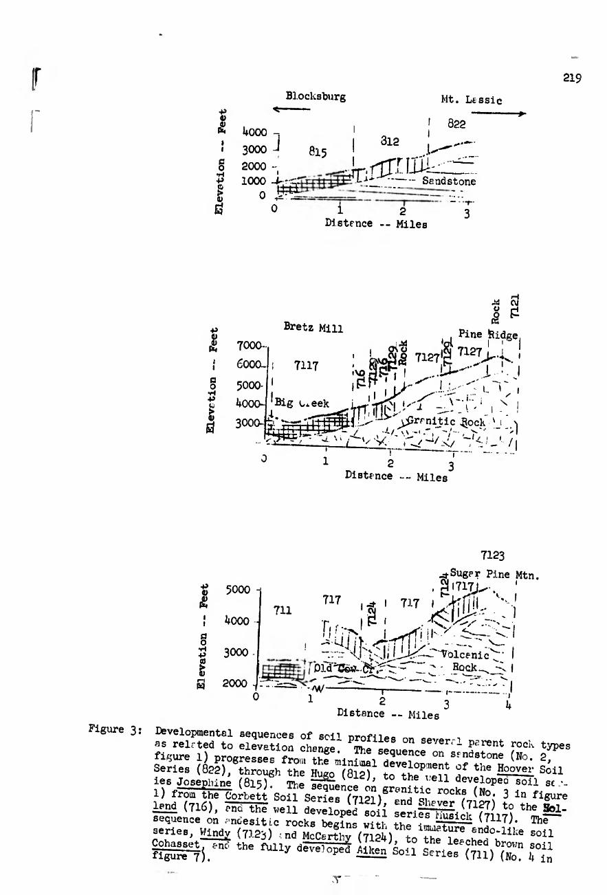
Blocksburg
219
Figure 3
+5 o
C O
•rl +J £ i)
i+000 -
3000 J
2000 1000 -I-S-
Mt. Lt s s i c
822
815 ' 312 ...U
4r.rir.njik Sendstone
i 2 Distrnce -- Miles
■p o P (**
i i a o ■rt -p «V
ï &
Bretz Mili
TU?
7000-
6000-
5000-
4000- ‘Big Lxeek
3000--
rH ¿4 CU
I ¿ , , Bine Bidge.
¿4 'oi ! 1
. I 7127|^T12J> j.. ' ,vo Í3£2r7 ! i ' I
L '
V-1" ; X i - _„.mi''1
t^r?iíic ^ -1 ->) ^ -v: w_</ -‘¿jj /i
■i— 2
Bistfnce -- Miles'
<u
i !
a o ■H
s
5000
kOOO
3000
711 717
r
7123
^-Suger Pine xMtn. ai7i7>-, 1 t-, ^ V, J
. )
2000 0 1
' - Rock - Ofd^C&jL.^
T 2
Distance -- Miles
i— 3
i b
as relrted^to elevation change1 ^e^eaue" SeVerrl psrent roc!- types
ä ^r=hfr »T r«fT^ ^ ÍMWRSS-^y3rsá«3¥ ssPsTt l£nl (716), Tra weil Sv^opelio í ^ ^ sequence on andesitic rocks beck- um !, i¡usick (7117). lhe series, Wlndjr (75.23) !na McCerthy“(712Í‘) tn^ “f ‘“î0;111;e «>U
ssrii.“ “ **» w SSStó saris,® r,“ T

I
220
-o a> «
ß
I
i I >> a U o
o (H
ai c o -p w
•o c eu
en
ai > o
H
OJ
W LTS •H 'O ■a a> «
1 “>g
g
g S
g LTN
CM '
î R
I tJ- (v-i
-é- UA -<y
Vû
SOIL DEPTH (inches)
I "ö
ü) J O ¾
•H
O •H (0
H ß •H S
I
+» •P 0) (0 M a
rC o o
ß ai X •H c
TT CM
I TT- cn -d-d-d-¿
UA Vû
SOU DEPTH (inches)
'O a> K
î fl
§ £
■§ (fl Q 'd 5 XJ
U (fl
î I £
t >> a ë
UA • fl
CM >H
(U UA
* ^ ÎH fl
S
CM*
p il) •H ä o
en
ß o fl
•rl P a> 0) ffl
UJ
tí ai p •f.
C/J
"d ó d" i
TT
I U
~cr UA CM CO -d- UA vo
SOIL DEPTH (inches)
d-d
T3 01 K
fl
I A tí •H XJ XJ ai (fl
Î
â
f
§ O
O (flk
IA
CM
UA
LA • tH.
CM
UA >-»1-
fl P
fl O
p p
lí o o
ß fl
£
.¿d ti •H (0 ¿d
■=T^— -
O H
O CM
O CO
~é—d—d- UA VO
Figure L:
SOIL DEPTH (inches)
i
The Soil Colors of soils representing sequences developed on four Parent rock types in Crlifornie, shoving increésing redness vith increasing soil development (text reference pr-ge 7).

BLANK PAGE

SO
IL
DE
PTH (i
nches)
221
PERCENT GRAVEL >2mm
10_10 _J0 J0_ go
xo; j •
! i r ' 20- ( ,
30 -! I t
.ii , 4o~t_ 1
50- I .
6o!. t »
70..
Schist:
Sheetiron Masterson
Sites ia
PERCENT GRAVEL z-2wl
IQ- _^0-J0_J0__20
ioL r
ra 20!
a 30
E ^0-
5C(-,r ' tí ' ! 8 6d-'!
TO- --..
Sandstone:
, - MEES ’ J ose*»
phine —. Sites
°iT
PERCENT GRhVEL > 2tma
)- -^0-.^0...70 50
(0 «¡ x: o c
10, !
20ÍJ i
Í 30
Uo
50-
6o¿ l¡
70-
Granite:
Corbett
• Holland
— Musiciv
PERCENT GRAVEL >2mm
0,.111-30-^--ZO--20 ! . . » i « ■
CO <u xz V c •n -V ^
10i- I
20 _
If
i'
I
i tí 50i~ S 6o
70'-
Besic Igneous:
Windy
- • - Cohrssett
-Aiken
Figure 5: The coarse fragments of ajile representing developmental sequences on four parent rock types in California; shoving generally a de¬ crease in coarse fragments with increasing degree of development.

222
>> TD
•P O ^ I &J
SHIÖ§ C\J ó o
CO Ho
0)
V w r~i •rl O (0
u o p
•o .c 'i) 6a P< Ti o <u ^ r-t 5: ü ü W CO o
I ¿I ^ É P w A ciû *r< i—i CO
p c <y H, c iH CL) >
»H O c ri
8
o w '
/ V -, -X. v V ■ " V
y/A-VvV' '' :>N-/ ,> , O —2
o o »—I
; w
8r
s o CO
o LT>
' >s> '' i ✓ V s
V
■ - / \^y
o - - -X--V
\ c
>• .."T"
8 Ä S
-r-
o LTV
Soil Depth “(inches)
SCHIST
I
Figure 6:
(Continued next page)

(Continued from Page 222)
223
t
o o rH!
O IT,
CO
o' *
V V; >
■ '/ .-
o LO o in
,-> , V V O —VN-> , ■ A_^ ^ ^
I > i i ;
O o
\ -
GOO CM CO -ct
O IA
o ^ n. ^ y. » \ ' o o ■H CM
O on
• i o o ^ IA
U « 0 ß Si 3 (0 cr o <u to X}
<D
Ù0 to ß to
s & to oi
2 to ft -p ß
0) ■p
to c rH O •H O O w to
to 4J
O ft
•H
tí g 0. Sh U
Sh to
l| O CM
ß rH
p rH
to p (0 ß d) (1> rH >
(IS d) to
p ß
•p ° o P
fl to p
ß I,
C t) o > O (1)
•o
X3 G 4h CO o to
o XJ <D • ß ß —
tài P 0» J3 - X) M
P *rH H P •HE? tO *H
W >> •> ® P >> P
to P P rH O C oß®
•H O 0) Sh Z'ZÎL
VO
® p Soil Depth-(inches)
VOLCANIC
Soil Depth-(inches)
GRANITIC
ä •H ft*
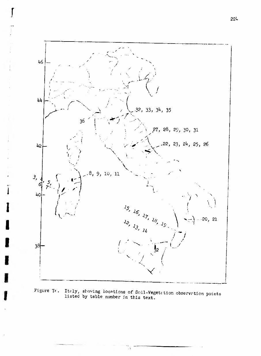
/ V
us
I I V
.1..4 ■
It It
k2
6[
40
i \ / V.
z'' • ' f \ / ■ V_>.
36 ' I V •'
/ 32, 33, 34, 35
1 \ /
... \ 27, 28, 29, 30, 31
V . ( ; i /■ \
V - A.
22, 23, 24, 25, 26
\
\
\
^ . )
38-
I ' '
-8, 9, 10, 11
I
Í, /•V.
7c
-?S
^ 7 ' ^ IJ
J U ■ : / /
/ ^ i 1 y i 32 /
v 4 " (
V
\ 1
.-> ■ -20, 21
Figure Jf . Itely, sl o^ving locations of Soil-Vegeti tion observation points listed by table number jn this text.

225
b2
% ^ j /
<3,6
«í'
/
r s
V
/
/
/- -
( 1 S err,T ¿ >
/ /Fiorina ''V'
Uo
>
^ •
38 r
36 -
I
^Oß
V’ -r^5îet£0V0n. ' ^9, £0 '^to-nnini 1 62
K
■. sf y- -. 50, 5lfl
<0'
Figure 7b. Greece, showing locations of Soil-Vegetetion observotion points listed by t." ble number in this text.

226
Jr,
3 h
srf0/'>? -
o o PC'
Elevation -- meters

Torrent
227
Ridge Top
\ Rock
25OO meterß
✓
/
/'• V- ’ N / :
/ //
/ / / 4
•' \
Talus end Collu
I !
/ l
/ Lith0sols / j Yium . / . /
^ / / '
/
/
/ /
deeper ! /oias
y
reer
\ \ \
\ -X-
Alluvium
^iterrapecn '-.rea entth
\ ^lluvli urn \ \
See Le/L
Figure 9« Tie typicel elevation sequence up f ridge top between two torrents es it would cppefr in plan view, highest elevation at top of pege.