ISLANDS TOURISM IN MAKASSAR: AN ASSESSMENT ON INFRASTRUCTURES OF LAELAE, BARRANG LOMPO, AND SAMALONA
16
Slamet Trisutomo “Assessment on Makassar Islands Ecotourism: Cases of Laelae, Barrang Lompo and Samalona Islands” ISLANDS TOURISM IN MAKASSAR: AN ASSESSMENT ON INFRASTRUCTURES OF LAELAE, BARRANG LOMPO, AND SAMALONA Slamet Trisutomo 1) , 1) Urban and Regional Planning, Hasanudin University, email: [email protected] Abstract Tourism plays very important role in alleviating local economy development. Makassar as a coastal city has beaches and Spermonde islands, a potential capital for developing marine tourism. Various articles and research report that many island-based tourism remains left behind due to lack of adequate infrastructures. This study aims to assess the availability and adequacy of island tourism infrastructures of the three islands of Spermonde group i.e. Laelae, Barrang Lompo and Samalona, and what type of infrastructures must be provided immediately to attract tourist to visit the islands. The assessment was done by tourists who were being in the each island; they were selected accidentally. The questionnaire as assessment instrument was applied to assess and to score the availability of 25 kinds of infrastructures. The findings show that the three islands were very attractive as island tourism destination; however, the availability of infrastructures was in poor condition. FGD of stakeholders suggest to identify and proposes many kinds of infrastructures to build soon in order to attract more tourist to visit. Keywords: islands infrastructure, Laelae-Barrang Lompo-Samalona, Makassar island tourism I. Introduction I.1. Background of Study Indonesia is the largest archipelago in the world, which has more than 18,110 islands with a coastline of 108,000 km. Referring to the Convention on the Law of the Sea (UNCLOS) of 1982, Indonesia has sovereignty over the territorial waters of an area of 3.2 million km2 consisting of archipelagic waters covering an area of 2.9 million km2 and territorial sea area of 0.3 million km2. In addition, Indonesia also has the exclusive right to exploit marine resources and interests related area of 2.7 km2 in the waters of the Exclusive Economic Zone (EEZ) which up to 200 miles from the baselines (Tuwo: 2011; Rais: 2004; Dahuri: 2004; Setiawan: 2012) International Conferences on 15 th SENVAR (Sustainable Environmental Architecture) and 2 nd AVAN (Asian Vernacular Architecture Network), Department of Architecture, Faculty of Engineering, Hasanuddin University, Makassar, November 14-15, 2014 Page | 1
Transcript of ISLANDS TOURISM IN MAKASSAR: AN ASSESSMENT ON INFRASTRUCTURES OF LAELAE, BARRANG LOMPO, AND SAMALONA

Slamet Trisutomo “Assessment on Makassar Islands Ecotourism:
Cases of Laelae, Barrang Lompo and Samalona Islands”
ISLANDS TOURISM IN MAKASSAR: AN ASSESSMENT ON INFRASTRUCTURES OF LAELAE, BARRANG LOMPO, AND SAMALONA
Slamet Trisutomo1),
1) Urban and Regional Planning, Hasanudin University, email: [email protected]
Abstract Tourism plays very important role in alleviating local economydevelopment. Makassar as a coastal city has beaches and Spermondeislands, a potential capital for developing marine tourism. Variousarticles and research report that many island-based tourism remainsleft behind due to lack of adequate infrastructures. This study aimsto assess the availability and adequacy of island tourisminfrastructures of the three islands of Spermonde group i.e.Laelae, Barrang Lompo and Samalona, and what type of infrastructuresmust be provided immediately to attract tourist to visit theislands. The assessment was done by tourists who were being in theeach island; they were selected accidentally. The questionnaire asassessment instrument was applied to assess and to score theavailability of 25 kinds of infrastructures. The findings show thatthe three islands were very attractive as island tourismdestination; however, the availability of infrastructures was inpoor condition. FGD of stakeholders suggest to identify and proposesmany kinds of infrastructures to build soon in order to attract moretourist to visit.
Keywords: islands infrastructure, Laelae-Barrang Lompo-Samalona,Makassar island tourism
I. Introduction
I.1. Background of StudyIndonesia is the largest archipelago in the world, which has more
than 18,110 islands with a coastline of 108,000 km. Referring to theConvention on the Law of the Sea (UNCLOS) of 1982, Indonesia hassovereignty over the territorial waters of an area of 3.2 million km2consisting of archipelagic waters covering an area of 2.9 million km2and territorial sea area of 0.3 million km2. In addition, Indonesiaalso has the exclusive right to exploit marine resources and interestsrelated area of 2.7 km2 in the waters of the Exclusive Economic Zone(EEZ) which up to 200 miles from the baselines (Tuwo: 2011; Rais:2004; Dahuri: 2004; Setiawan: 2012)
International Conferences on 15th SENVAR (Sustainable Environmental Architecture) and 2nd AVAN (Asian Vernacular ArchitectureNetwork), Department of Architecture, Faculty of Engineering, Hasanuddin University, Makassar, November 14-15, 2014
P a g e | 1
Slamet Trisutomo“Assessment on Makassar Islands Ecotourism:
Cases of Laelae, Barrang Lompo and Samalona Islands”
Makassar with a population of nearly 1.5 million people plays arole as the National Development Center (Pusat Kegiatan National) accordingto Law 26/2007 on Spatial Planning. Based on Government Regulation55/2012 on Mamminasata, Makassar also has been decreed a the growthcenter of Mamminasata metropolitan, a conurbation of four regenciesnamely Makassar, Sungguminasa, Maros, and Takalar. Consequently, thishas accelerated the development of the Makassar city, which isrecently more concentrated on the coastal area. Considering islands,coastal, and waters area are vulnerable environment (Sari: 2008;Tahir: 2009), therefore a careful attention to the development in theisland tourism must be paid.
Marine tourism sector is the most efficient in the marineeconomic development. It might be implemented through the use ofobjects and attractions optimally. Various objects and attractionsthat can be used are natural attractions at the beach, the diversityof flora and fauna (biodiversity) as marine parks, natural tourism(ecotourism), business tourism, cultural tourism, and sports tourism.Having beautiful and attractive coastal and islands, they will bringenormous immediate impact to the income of local communities and localgovernments. Kusumastoto (2007) states that marine tourism is hugepotential in Indonesia compromise of length of beaches and a number ofislands as well as a tropical climate, those are suitable for marinetourism.
As a waterfront city, Makassar has 35 km length of coastlinesfrom Barombong on the south side to Biringkanaya in the north side.While in the waters area, Makassar has Spermonde islands, a cluster ofislands that consists of 11 of islands. These natural resources arevery potential that can be developed to become a island tourism.
Yoeti (1985) distinguishes between facilities and infrastructure.According to him, tourism infrastructure is all the facilities thatallow to live and tourism facilities can be developed that can providethe best service for the very diverse needs of travelers. Yoeti statesthat infrastructure is a component that supports the facility ofactivities. In the context of tourism, infrastructures means soft andhard components; soft component such as agencies, tour operator andmanagement, while the hard component infrastructure such as equipmentand physical facilities. However, Yoeti still insists thatinfrastructure into basic functioning of the means. From thedescription it seems he distinguishes infrastructure into two groups:physical infrastructure and nonphysical. More over tourisminfrastructure is physical, such as roads, buildings, water, andelectricity.
International Conference on the 15th SENVAR (Sustainable Environmental Architecture) and the 2nd AVAN (Asian VernacularArchitecture Network , Department of Architecture, Faculty of Engineering, Hasanuddin University, Makassar, November 14-15,2014P a g e | 2

Slamet Trisutomo “Assessment on Makassar Islands Ecotourism:
Cases of Laelae, Barrang Lompo and Samalona Islands”
Ecotourism. The term is derived from the words ecosystem andtourism. It is ecosystem-based tour or tours (Moscardo, 1998; Mas,2009; Kusmatoto, 2007). Often, it is called green tourism, naturalattractions, green tourism or sustainable tourism. As the principle orpillars of sustainable development, ecotourism is a tour based on thebalance between the elements of ecosystem sustainability, socialwelfare, and economic development. In the context of this study,ecotourism is tourism activities those based on the balance of human,economic, and environment.
It is a fact that ecotourism in developing countries arecurrently undeveloped. It believed, this inability growing caused by alack of infrastructure of the island (Hay, 2006; Kim, 1996; Moscardo,2001; Hadwen, 2003). For this reason, this research interested inconducting investigation how far the level of ecotourism maritimeinfrastructure in main islands in the cluster of Spermonde of Makassarand what the infrastructures are need to accelerate the ecotourism.
I.2. Research Problems This research is address to assess the availability of
infrastructures in three islands i.e. Laelae, Barrang Lompo, andSamalona. The detail formulation of the research problems are:
(1) How are the availability of existing infrastructures ineach of these islands?
(2) Based on the existing infrastructures, how tourists assessthe infrastructure availability in these islands?
(3) When realizing the availability of the infrastructuresbased on the ideas of stakeholders, what kind infrastructureswill be proposed and be built soon in order to attract morevisitors to visit.
I.3. Scope and Limit of StudySpermonde Islands is a cluster of islands consists of 11 islands.
This study was an assessment of the three islands, the most frequentlyvisited by tourists, ie. Laelae, Barrang Lompo, and Samalona. Thisresearch focused on the availability infrastructures, but excluded thequality of the infrastructures.
II. Literature Review
Tourism. Gunawan (2007) compares several definitions of tourism.Law 9/90 of Tourism sais that tourism is everything related to travelincluding business objects and attractions, businesses and othertourist facilities in the field. WTO stated that tourism comprises theactivity of persons traveling to and staying in places outside theirInternational Conferences on 15th SENVAR (Sustainable Environmental Architecture) and 2nd AVAN (Asian Vernacular ArchitectureNetwork), Department of Architecture, Faculty of Engineering, Hasanuddin University, Makassar, November 14-15, 2014
P a g e | 3

Slamet Trisutomo“Assessment on Makassar Islands Ecotourism:
Cases of Laelae, Barrang Lompo and Samalona Islands”
usual environment for not more than one consecutive year for leisure,business and other purposes. BPS formulates tourism is a travelingactivity of the departed to return to his or her residence, into atourist attraction, and the length of stay is more than 24 hours butless than 6 months, which is not the purpose of getting a living fromthe places visited and not a routine trip. From some of thesedefinitions, Gunawan concluded that tourism is an activity for a placeto stay for leisure within a certain time.
Island ecotourism. Diamantis (2009), Kay (1999), Hay (2006), Ding(1995) write about ecotourism. It is said that the term ecotourismevolved since the late 80s in response to the reaction to the use ofelements of ecological sustainability principles by touristactivities. Activity-based recreation natural elements appear togetherwith increased awareness of the impact of tourism on the environment.Realizing that mass tourism activities allegedly positive impact onthe economy and has a negative impact on the conservation of nature.
Ecotourism: to see, to do, to buy. Yoeti (2008) suggests that inorder to tourists interested in the sights, the objects should qualifysomething to see, something to do, and something to buy. To see,tourist activities there should be an object of interest to be seen.In the context of island tours, an object that can be seen forexamples enjoy panoramic, waves, white sand, sunset or sunrise, seenunderwater biota. To do is active tourism activities, such as diving,see the coral reefs, fishing, surfing, boating, fishing and doingactivities together local communities. To buy means tourists whileseeing and doing things activity, is expected to buy something, suchas souvenirs or food. The conclusion from the principle, to see, to doand to buy in the context of this study is tourism activities shouldprovide the infrastructure to do in order to see and to buy as toprovide the level of satisfaction for tourists.
Some researchers have done some preliminary studies that focus onisland tourism. A study titled Coastal Area Development Planning inthe Context of Integrated Economic Zones of Makassar, which wassponsored by Bappeda Makassar was done in 2011. This multidisciplinaryresearch includes experts in spatial planning, marine sociologist,economic regional development, infrastructure experts, and marineecologist. The study aims to develop a multi-sector economic activityplanning and plotting where they are located in Makassar area. One ofthe conclusion was the need to more intensive development of tourismby utilizing the natural potential of coastal and islands (BappedakotMakassar, 2011).
Trisutomo (2012) conducted a visual assessment on tourism alongthe coast of Makassar. Generally, visual assessment is focused on theInternational Conference on the 15th SENVAR (Sustainable Environmental Architecture) and the 2nd AVAN (Asian VernacularArchitecture Network , Department of Architecture, Faculty of Engineering, Hasanuddin University, Makassar, November 14-15,2014P a g e | 4

Slamet Trisutomo “Assessment on Makassar Islands Ecotourism:
Cases of Laelae, Barrang Lompo and Samalona Islands”
panorama from mainland to water area. Conversely, this research wasdone to assess the object from water side to mainland. A group ofstakeholders were cruising to assess the 10 interesting objects alongthe waterfront of Makassar. Using questionnaires, there are 3 of the10 objects that qualify as a tourist attraction namely Tanjungbayang,Losari public space, and Paotere traditional port.
Infrastructure. Mascardo (2001) and Mas (2009) write theinfrastructure and tourist facilities in the topic of Evaluation ofTourist Facilities, with the objects in the Great Barrier Reefpontoon, and evaluating the water tourist facilities. Theinfrastructures cover the amount of space and shade facilities, rangeavailability, access to water, cleanliness, the number of places tosit, equipment for snorkeling and diving, lunch facilities, underwaterobservatory, facility safety, capacity of the pontoon.
Meanwhile, Mas (2009) in his article entitled Tourism Planning inSaronde in Gorontalo, suggests that tourist infrastructure meansroads, electricity, waste management, drainage, andtelecommunications. Kay and Alder (1999) also support the opinion ofMas that the infrastructure and tourist facility primarily related totransportation, dock, accommodation, roads, water supply, electricity,and waste management.
Still on infrastructure, Dahuri (2004), Blackman (2004), Timothy(1995), Hadwen (2003), Fagence (1997) and Darmawan (2005), also statethat maritime tourism infrastructure must provide and includetransportation from departure and destination points in the island,water utilization facilities such as boating, bathing, diving, andsnorkeling. They also consider the need for rescue, and island coastalecosystems such as mangroves, protective embankment or otherconstruction.
Based from previous arguments, it can be deduced that the islandecotourism infrastructure facilities must be available to serve thetourists activities. Infrastructure components can be grouped intothree namely transport infrastructure as a means of access to theisland, water infrastructure, and the infrastructure on the island.
Scoring as method of assessment. As a research method based onassessment or judgment by the respondents, scoring method has beenwidely applied in various studies. Morison (2003), Blackman (2004),Noussia (1998), and Ciftci (2010), they have applied the scoringmethod in their research. Debate arises because scoring will be verysubjective and highly dependent background of evaluators or assessors.Another thing generated scoring will provide a complete picture ofvarious subjectivities. Given the success depends tourist travelerratings themselves, then use the scoring method of assessment can beconsidered as an approach to meet the demands of the users orInternational Conferences on 15th SENVAR (Sustainable Environmental Architecture) and 2nd AVAN (Asian Vernacular ArchitectureNetwork), Department of Architecture, Faculty of Engineering, Hasanuddin University, Makassar, November 14-15, 2014
P a g e | 5

Slamet Trisutomo“Assessment on Makassar Islands Ecotourism:
Cases of Laelae, Barrang Lompo and Samalona Islands”
consumers. In this study, scoring on all the details of the type ofisland eco-tourism infrastructure were done by applying the modelLikert interval scale of 0 to 5. Scores of 0 is given if theinfrastructure is not available on the island. When it is available,scores will range from 1 (very poor), 2 (poor), 3 (pretty), 4 (good),and 5 (excellent).
Referring to the previous references, this research has focusedon the availability and sufficiency of 25 kinds infrastructures asseen in Table 4. The infrastructures might be categorized into 3groups. Group transportation infrastructures to the islands (4 kinds)were jetty or dock, waiting space in the dock, crossing bridge, andspeed boat. Group infrastructures in the islands (14 kinds) i.e.pedestrian, information board, park or green area, restaurant orcoffee shop, gazebo (a shaded place for sitting), bench for sitting,space for fishing, cottage, clean water supply, electrical supply,cellular signal, security post, health facilities, and public toilet.Group waters area infrastructure (7 kinds) i.e. snorkeling facilitiesand equipment, diving equipment, baywatch, saving equipment,breakwater, cleanliness of water, and shower.
III. Research Method
The design of this study is descriptive qualitative andquantitative method. It was focused on three islands i.e. Laelae,Barranglompo, and Samalona islands. From visitors who were being inthe islands, 63 visitors were selected in Laelae, 46 visitors inBarrang Lompo, and 31 visitors in Samalona; totally 140 visitors wereselected from three islands. Scoring was ranging from 0 to 5; score 0means the infrastructure was not available while score 5 means theinfrastructure was available and in excellent condition. Usingquestionnaires, than visitors scored the availability of theinfrastructures. Collected data than were analyzed to obtain thedescriptive statistic, maximum, minimum, and mean. To identify therequired infrastructures to be built sooner in order to attract morevisitors, this research applied FGD of stakeholders .
IV. Research Findings
IV.1. Overview the Objects of ResearchMakassar is the fifth largest city in eastern part of Indonesia.
With a population of 1.4 million, it has mainland area of 177.55 km2.In waters areas, Makassar has a cluster of names Spermonde, consistsof 11 inhabited islands. Those are Laelae, Samalona, Barrang Caddi,International Conference on the 15th SENVAR (Sustainable Environmental Architecture) and the 2nd AVAN (Asian VernacularArchitecture Network , Department of Architecture, Faculty of Engineering, Hasanuddin University, Makassar, November 14-15,2014P a g e | 6

Slamet Trisutomo “Assessment on Makassar Islands Ecotourism:
Cases of Laelae, Barrang Lompo and Samalona Islands”
Barrang Lompo, Kodingareng Keke, Kodingareng Lompo, Bonetambung,Lumulumu, Langkai, Lanjukang. Figure 1 shows the map of Makassarcoastal area where the three islands were studied. Figure 2 Laelaeisland, Figure 3 Barranglompo island and, Figure 4 is Samalona island.
Laelae island, the closest island in term of distance frommainland among the three, now inhabited by 307 households consists of1,485 persons which 748 were men and 737 were women. Barrang Lompoisland, the largest island of Spermonde cluster, was inhabited by 3563persons consists of 1709 men and 1854 women; Samalaona, the smallestone among the three, inhabited by 82 persons. To describe the threeislands in detail, following are the physical data:
Table 1. Description of Laelae, Barrang Lompo, and Samalona Islands
Islands Area Coordinate Positions Distance* Times**
1 Laelae 11,6 ha
WL 119o23’30’’ and LS 5o08’24’’
1,2 km 15 mnts
2 BarrangLompo
19,2 ha
WL 119o19’48’’ and LS 5o02’48’’
12,77 km 90 mnts
3 Samalona 2,3 ha
WL 119o20’36,2’’ and LS 05o07’30,4’’ 6,8 km 90 mnts
*from coastal of mainland (km)** estimate times (minutes) to travel by speed boat from Makassar downtown to each island (minutes)
International Conferences on 15th SENVAR (Sustainable Environmental Architecture) and 2nd AVAN (Asian Vernacular ArchitectureNetwork), Department of Architecture, Faculty of Engineering, Hasanuddin University, Makassar, November 14-15, 2014
P a g e | 7

Slamet Trisutomo“Assessment on Makassar Islands Ecotourism:
Cases of Laelae, Barrang Lompo and Samalona Islands”
Figure 1. Map of Makassar Coastal Area Figure 2. Laelae IslandSource: Google Earth (2013) Source: survey 2013
Figure 3. Map of Barrang Lompo and its facilitiesFigure 4. Laelae Island and its facilities
Source: survey (2013) Source: survey (2013)
IV.2. Visitors as AssessorsIn this research, assessment on the availability and sufficiency
of existing infrastructures in three islands were done by visitors.They were found and selected accidentally Following table describesthe proportion of selected respondents who acted as the assessors toscore the infrastructures:Table 2. Characteristics of Respondents as AssessorsNo Description Number and % respondents
1Position when respondents were interviewed
Laelae island: 63 (45%); Barranglompo island 46 (32.9%); Samalona island 31 (22.1%); Total 140 respondents
2 Age Laelae island: young 4 (6.3%); adult 58 (92.1%); senior 1 (1.6%)Barrang Lompo island: young 7 (15.2%); adult 38 (82.6%); senior 1 (2.2%)
International Conference on the 15th SENVAR (Sustainable Environmental Architecture) and the 2nd AVAN (Asian VernacularArchitecture Network , Department of Architecture, Faculty of Engineering, Hasanuddin University, Makassar, November 14-15,2014P a g e | 8

Slamet Trisutomo “Assessment on Makassar Islands Ecotourism:
Cases of Laelae, Barrang Lompo and Samalona Islands”
No Description Number and % respondentsSamalona island: young 1 (3.2%); adult 29 (93.5%); senior 1 (3.2%)
3 Sex
Laelae island: men 18 (28.6%); women 45 (71.4%)Barrang Lompo island: men 13 (28.3%); Women (33 (71.7%)Samalona island: men 13 (41.9%); women 18 (58.1%)
4 Education
Laelae island: high school 62 (98.4%); graduate 1 (1.6%)Barranglompo island: high school 24 (52.2%); graduate 22 (47.8%)Samalona island: high school 23 (74.2%); graduate (25.8%)
5 Occupation relatedto tourism
Laelae island: related to 0 (0%); not related to 63 (100%)Barranglompo island: related to 7 (15.2%); not related to 39 (84.8%)Samalona island: related to 1 (3.2%); not related to 30 (96.8%)
6 Frekuensi Kunjungan
Laelae island: first time visit 11 (17.5%);not first time visit (82.5%)Barranglompo island: first time visit 24 (52.2%); not first time visit 22 (47.8%)Samalona island: fisrt time visit 6 (19.4%); not first time visit 25 (80.6%)
7 Duration of visit in the island
Laelae island: 2 jam 27 (42.9%); > 2 jam 36(57.1%)Barranglompo island: 2 jam 24 (52.2%); >2 jam 22 (47.8%)Samalona island: 2 jam 10 (43.6%); >2 jam 21 (67.7%)
8 Overnight stay
Laelae island: yes 25 (39.7%); no 38 (60.3%)Barranglompo island: yes 22 (47.8%); no 24 (52.2%)Samalona island: yes 19 (61.3%); no12 (38.7%)
9 Interesting area Laelae island: water area 7 (11.1%); beach 56 (88.9%)Barranglompo island: water area 26 (56.5%);beach 20 (43.5%)
International Conferences on 15th SENVAR (Sustainable Environmental Architecture) and 2nd AVAN (Asian Vernacular ArchitectureNetwork), Department of Architecture, Faculty of Engineering, Hasanuddin University, Makassar, November 14-15, 2014
P a g e | 9

Slamet Trisutomo“Assessment on Makassar Islands Ecotourism:
Cases of Laelae, Barrang Lompo and Samalona Islands”
No Description Number and % respondentsSamalona island: water area 17 (54.8%); beach 14 (45.2%)
Source: survey 2013
IV.3. Availability of InfrastructureAvailability ecotourism on the island were measured by 27 types
of infrastructure, divided into three groups. Group infrastructuresrelated to transportation, comprising four kind i.e. speed boat ascarrier from and to islands destionation, the pier, a bridge from thepier to the area. Infrastructure in the island group includes 14 typesi.e. pedestrians, information boards, parks, restaurants / cafes,gazebo, bench by the beach, fishing, lodge accommodation, clean water,electricity, cellular signaling, security stations, health facilities,and public toilets. Infrastructure in the water area includes seventypes of facilities snorkeling i.e. diving facilities, baywatch,safety equipment, construction of coastal protection, clean water, andshower.
The availability of infrastructures in each island are shown inthe following table:Table 3. List of Infrastructure Availability in the Islands
Types ofInfrastructures
IslandsLaelae Barrang Lompo Samalona
1 For accessing toisland destinations: 4 types
All infrastructures are available
All infrastructures are available
All infrastructuresare available
2 Infrastructures inside the islands: 14 types
Not available:information board, park, benches, cottages, public toilet
Not available:park, restaurant, gazebopublic toilet
Not available: pedestrian, park, beach security post, public toilet
3 Infrastructures for sport and recreation in the water area: 7 types
Not available:security guard, shower
Not available:diving facilities, bay watch , live fest, shower
Not available; bay watch, livefest, shower
Source: survey 2012
IV.4. Scoring Assessment ResultsResults assessment by visitors on the condition and availability
of infrastructure were shown in Tables 4, 5, and 6. Table 4 describesInternational Conference on the 15th SENVAR (Sustainable Environmental Architecture) and the 2nd AVAN (Asian VernacularArchitecture Network , Department of Architecture, Faculty of Engineering, Hasanuddin University, Makassar, November 14-15,2014P a g e | 10

Slamet Trisutomo “Assessment on Makassar Islands Ecotourism:
Cases of Laelae, Barrang Lompo and Samalona Islands”
the average score of transportation infrastructures that servevisitors from downtown of Makassar to the islands. Table 5 shows theaverage score of infrastructures in the island. Table 6 shows theavarage score of infrastructure that are required when visitorswimming, bathing, snorkling and diving. Almost all scores are verylow, proving that the infrastructure is very poor. Score ranges from 1(very poor) – 5 (excellent), while score 0 means the kind ofinfrastructure is not available.
Table 4. Average score of infrastructures for transportation Types ofInfrastructures
Laelae BarrangLompo
Samalona
1 Jetty /dock 2.9 3.2 1.62 Waiting space 2.7 3.3 1.53 Bridge connector 2.5 1.8 0.54 Speed boat 2.8 3.1 3.3
Mean of scores 2.73 2.85 1.73
Table 5. Score of infrastructures inside the islandsTypes ofInfrastructures
Laelae Barranglompo
Samalona
1 Pedestrian 1.9 3.3 02 Inforamation board 0 1.1 1.93 Park/ open space 0 0 04 Restaurant, cafe 1.7 0 2.75 Gasebo 3.2 0 3.36 Bech 0 1.5 2.87 Fishing platform 2.4 0 1.98 Cottages,
accomofation 0 2.7 3.7
9 Clean water 2.3 3.1 2.110 Electrical supply 2.5 2.6 2.211 Cellular signals 3.0 3.4 2.812 Securuty post 0.7 1.9 013 Health facilities 2.6 3.6 014 Public toilets 0 0 2.1
Mean of the score 1.45 1.66 1.82Note: 0 means the infrastructure not availableSource: survey 2013Table 6. Score of Infrastructurrs for Recreation and SportJenis Infrastruktur Laelae Barranglom
po Samalona
1 Snorklingfacilities
0.4 1.5 3.1
International Conferences on 15th SENVAR (Sustainable Environmental Architecture) and 2nd AVAN (Asian Vernacular ArchitectureNetwork), Department of Architecture, Faculty of Engineering, Hasanuddin University, Makassar, November 14-15, 2014
P a g e | 11

Slamet Trisutomo“Assessment on Makassar Islands Ecotourism:
Cases of Laelae, Barrang Lompo and Samalona Islands”
2 Diving facilities 0.1 0 2.63 Baywatch 0 0 04 Guard security 0.2 0 05 Breakwater 2.9 2.3 0.96 Cleanlines 2.0 2.4 3.07 Shower 0 0 0
Mean Score 0.8 0.89 1.37Mean score in each
island1.66 1.88 1.64
Source: survey 2013
IV.5. Quantitative Analysis In case Laelae island infrastructures, from 25 types of
infrastructure, the average score was only 1.66 out of a scale of 1-5.The highest value is gazebo (= 3.2) which means it was sufficient forvisitors to enjoy the panorama while sitting. The lowest score (=0.1)was diving facilities. The average score for transportationinfrastructure was 2.73, the infrastructure in island was 1.45, andscores for sports facilities at beach was 0.8. The total mean scorefor Laelae island only 1.66, which means the very poor. There were 7kinds of infrastructure not available, i.e. information board, park,bench, cottages, and public toilets, baywatch, and shower.
For Barang Lompo island, the highest score is the infrastructureof health facilities (= 3.6); others that have high scores (>3) weredock arrival (= 3.2), waiting space at the dock (= 3.3), speed boat(3.1), pedestrian (3.3), clean water supply (3.1), mobile phone signal(= 3.4), healt facilities (3.6). There were 8 kinds infrastructure notavailable i.e. park, restaurant/coffee, gazebo, platform for fishing,public toilet, baywatch, saving facilities, and shower. Total averagescore for this island is 1.88 mean that the overall condition of theinfrastructures is veri poor.
For Samalona island, the highest score (= 3.7) is theavailability cottages (cottages), while the lowest is the crossingbridge (0.5). Other infrastructure that has score higher than 3 werespeed boat (3.3), gazebo (3.3); others were snorkeling equipments(3.1) and cleanliness of water area (3). Infrastructures that notavailable in Samalona are park, security post, healt facilities,baywatch, saving facilities, and shower. Total average score forSamalona island was 1.64.
Overall, the infrastructure of three islands were very poorcondition (less than <3). Comparing the availability and sufficiencyof infrastructure among the three islands, Barrang Lompo was thehighest one (1.88), while Laelae was 1.66) and Samalona 1.64.International Conference on the 15th SENVAR (Sustainable Environmental Architecture) and the 2nd AVAN (Asian VernacularArchitecture Network , Department of Architecture, Faculty of Engineering, Hasanuddin University, Makassar, November 14-15,2014P a g e | 12
Slamet Trisutomo “Assessment on Makassar Islands Ecotourism:
Cases of Laelae, Barrang Lompo and Samalona Islands”
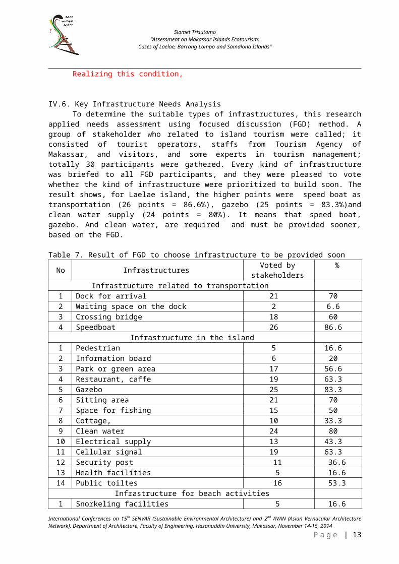
Realizing this condition,
IV.6. Key Infrastructure Needs Analysis To determine the suitable types of infrastructures, this research
applied needs assessment using focused discussion (FGD) method. Agroup of stakeholder who related to island tourism were called; itconsisted of tourist operators, staffs from Tourism Agency ofMakassar, and visitors, and some experts in tourism management;totally 30 participants were gathered. Every kind of infrastructurewas briefed to all FGD participants, and they were pleased to votewhether the kind of infrastructure were prioritized to build soon. Theresult shows, for Laelae island, the higher points were speed boat astransportation (26 points = 86.6%), gazebo (25 points = 83.3%)andclean water supply (24 points = 80%). It means that speed boat,gazebo. And clean water, are required and must be provided sooner,based on the FGD.
Table 7. Result of FGD to choose infrastructure to be provided soon
No Infrastructures Voted bystakeholders
%
Infrastructure related to transportation1 Dock for arrival 21 702 Waiting space on the dock 2 6.63 Crossing bridge 18 604 Speedboat 26 86.6
Infrastructure in the island1 Pedestrian 5 16.62 Information board 6 203 Park or green area 17 56.64 Restaurant, caffe 19 63.35 Gazebo 25 83.36 Sitting area 21 707 Space for fishing 15 508 Cottage, 10 33.39 Clean water 24 8010 Electrical supply 13 43.311 Cellular signal 19 63.312 Security post 11 36.613 Health facilities 5 16.614 Public toiltes 16 53.3
Infrastructure for beach activities1 Snorkeling facilities 5 16.6
International Conferences on 15th SENVAR (Sustainable Environmental Architecture) and 2nd AVAN (Asian Vernacular ArchitectureNetwork), Department of Architecture, Faculty of Engineering, Hasanuddin University, Makassar, November 14-15, 2014
P a g e | 13
Slamet Trisutomo“Assessment on Makassar Islands Ecotourism:
Cases of Laelae, Barrang Lompo and Samalona Islands”
2 Diving facilities 6 203 Baywatch 14 46.64 Save equipment 12 405 Break water 4 13.36 Cleanliness 22 73.37 Shower 15 50
Source: FGD October 2013
V. CONCLUSION
This study aims to (1) describe the potential and condition ofinfrastructure on the islands Laelae, Barranglompo, and Samalona, (2)to evaluate the availability of infrastructures, and (3) to determinethe needs and desires of tourists infrastructures based on theirassessment. Conclusion results of the study are:
(1) Besides as fishermen settlements, Laelae, Barranglompo, andSamalona islands now also becoming attractive islands tourist destination in Makassar. Due to the limitations of infrastructures especially the accommodation, residents also offer their home as accommodations for visitors.
(2) Availability of infrastructures. In terms of availability of 25 infrastructures, Barrang Lompo is better than the two others, although the quality remains in very poor condition, based on the assessment by visitors.
(3) Stakeholders consist of visitors, tourism operators, and staffs of Tourism Agency, using FGD method, together they have identified and formulated many infrastructures that required to be built soon in order to attract more visitors to visit. Relatedto transportation, comfortable and save speed boat and bridge that links dock – island, are required; related to infrastructureinside the island, gazebo and electrical power are very important; in terms of facilities on waters area, cleanliness of waters and save guard are needed soon.
REFERENCES
Bappedakot Makassar. 2011. Pengembangan Kawasan Pesisir dalam RangkaPerencanaan Kawasan Ekonomi Terpadu Kota Makassar. Laporan PenelitianAPBD 2011. Beppedakot, Makassar
International Conference on the 15th SENVAR (Sustainable Environmental Architecture) and the 2nd AVAN (Asian VernacularArchitecture Network , Department of Architecture, Faculty of Engineering, Hasanuddin University, Makassar, November 14-15,2014P a g e | 14

Slamet Trisutomo “Assessment on Makassar Islands Ecotourism:
Cases of Laelae, Barrang Lompo and Samalona Islands”
Blackman, Anna dkk. 2004. Factors Contributing to successful TourismDevelopment in Peripheral Regions. The Journal of Tourism Studies Vol. 15, No.1, May ’04.
Carter, R.W. (Bill) dkk. 1999. A. Rapid Appraisal Methodology forEnvironmental Auditing. The Journal of Tourism Studies Vol. 10, No. 2, Dec ’99.
Chase, G.L. and McKee, D.L. 2003. The Economic Impact of CruiseTourism on Jamaica. in the Journal of Tourism Studies, pp. 16-22, Vol. 14, No.2.
Ciftci, Cigdem Ciftci. 2010. A Visual Assessment for Land Use Analysisat the Coastal Area of Beysehir Lake. BALWOIS 2010 - Ohrid,Republic of Macedonia - 25, 29 May 2010
Dahuri, Rokhmin dkk. 2004. Pengelolaan Sumber Daya Wilayah Pesisir dan LautanSecara Terpadu. Pradnya Paramita. Jakarta
Ding, Peiyi. 1995. Environmental Audits: An Emerging Concept inSuistainable
Tourism Development. The Journal of Tourism Studies Vol. 6, No. 2, Dec. ’95.Diamantis, Dimitrios dkk. 1999. The Links Between Sustainable Tourism
and Ecotourism: A definitional and operational perspective. TheJournal of Tourism Studies Vol. 10, No. 2, Dec ’99.
Dredge, Dianne dkk. 1992. A Methodology for the Integration of Tourismin Town Planning. The Journal of Tourism Studies Vol. 3, No. 1, May ’92.
Fagence, Michael. 1997. Ecotourism and Pacific Island Countries: TheFirst Generation of Strategies. The Journal of Tourism Studies Vol. 8, No. 2,Dec. ’97.
Gunawan, Myra P. 2007. Leassure, Rekreasi, Pariwisata dalam BerbagaiDimensi Metropolitan. Dalam Jurnal Perencanaan Wilayah dan Kota Vol. 18 No. 1April 2007 hal. 49-64.
Hay Pete. 2006. A Phenomenology of Islands. Islands Studies Journal, Vol. 1, No.1, 2006, pp. 19-42.
Klee, Gary A. 1999. The Coastal Environment. Prentice Hall. LondonKim Sung-Gwi. 1996. Overview of Coastal and Marine Tourism in Korea.
The Journal of Tourism Studies Vol. 7, No 2, Dec. ’96.Morrison, Alastair M. 2003. Comparative Profiles of Travellers on
Cruises and Land-Based Resort Vacations. The Journal Of Tourism StudiesVol. 14, No. 1, May ’03.
Moscardo, Gianna. 2001. Visitor Evaluations of Built TouristFacilities: Pontoons on the Great Barrier Reef. The Journal of TourismStudies Vol. 12, No. 1, May ’01.
Noussia, Antonio. 1998. Framing Experience: Visual Interpretation andSpace Open Air Museums. The Journal of Tourism Studies Vol. 9, No. 2, Dec ’98.
Hadwen, Wade L dkk. 2003. The Significance and Management Implicationsof Perched Dune Lakes as Swimming and Recreation Sites on FraserIsland, Australia. The Journal of Tourism Studies Vol. 14, No. 2, Dec ’03.
Kim, S.G. and Kim, Y.J.E. 1996. Overview of Coastal and Marine Tourismin Korea. in the Journal of Tourism Studies, pp. 46-53, Vol. 7, No. 2.
International Conferences on 15th SENVAR (Sustainable Environmental Architecture) and 2nd AVAN (Asian Vernacular ArchitectureNetwork), Department of Architecture, Faculty of Engineering, Hasanuddin University, Makassar, November 14-15, 2014
P a g e | 15
Slamet Trisutomo“Assessment on Makassar Islands Ecotourism:
Cases of Laelae, Barrang Lompo and Samalona Islands”
Mas, Sitti Rokhina. 2009. Perencanaan Obyek Wisata Saronde sebagaiTujuan di Kabupaten Gorontalo. Jurna Inovasi Vol 6/4 DEsember 2009.
Moscardo, G. 1998. Interpretation and Sustainable Tourism: Fuctions,Examples and Principles. in the Journal of Tourism Studies, pp. 2-13, Vol. 9, No. 1.
Moscardo, G. et al. 1996. Tourist Perspectives on Cruising:Multidimensional Scaling Analyses of Cruising and Other HolidayTypes. in the Journal of Tourism Studies, pp. 54-63, Vol. 7, No.2.
Rais, Jacub dkk. 2004. Menata Ruang Laut Terpadu. Pradnya Paramita.JakartaSari, Suzanna Ratih; and Darwawan, Edy. 2008. Coastal Area of Ujungnegoro
Batang Regency. In Journal of Coastal Development, pp. 43-51 Vol. 9 No. 1 Oktober 2008Setiawan, Johan. 2012. Kepariwisataan Alam dan Perubahan Iklim Studi
Kasus di Taman Nasional Tanjung Putting Kalimantan Tengah. JurnalNasional Pariwisata Vol. 4 No 1, April 2012 (iv-x).
Tahir, A. et al. 2009. Indeks Kerentanan Pulau-Pulau Kecil: KasusPulau Barang Lompo-Makasar. in Ilmu Kelautan, pp. 8-13, Vol. 14 (4).
Timothy, Dallen J dkk. 1995. Tourist Accomodation in An Asian JistoricCity. The Journal of Tourism Studies Vol. 6, No. 2, Dec ‘95
Tuwo, Ambo. 2011. Pengelolaan Ekowisata Pesisir dan Laut. BrilianInternasional. Surabaya
Wan, Yim Kim Penny. 2011. Sustainability of Tourism Developmentin Macao. International Journal of Tourism Research Vol. 15 pp 52-65, Yoeti, Oka A. 2008. Perencanaan dan Pengembangan Pariwisata. PT. Prajna Paramita, Jakarta.
International Conference on the 15th SENVAR (Sustainable Environmental Architecture) and the 2nd AVAN (Asian VernacularArchitecture Network , Department of Architecture, Faculty of Engineering, Hasanuddin University, Makassar, November 14-15,2014P a g e | 16