IODP New Ventures in Exploring Scientific Targets (INVEST)
160
-
Upload
khangminh22 -
Category
Documents
-
view
0 -
download
0
Transcript of IODP New Ventures in Exploring Scientific Targets (INVEST)


INVEST REPORT IODP New Ventures in Exploring Scientific Targets (INVEST) − Defining The New Goals of an International Drilling Program
Scientific Planning Conference
University of Bremen, Germany
22 – 25 September 2009
Steering Committee Members
Wolfgang Bach (Co-chair) – University of Bremen, Germany
Christina Ravelo (Co-chair) – University of California Santa Cruz, USA
Jan Behrmann – IfM/GEOMAR Kiel, Germany
Gilbert Camoin – CNRS, Aix-en-Provence, France
Robert Duncan – Oregon State University, USA
Katrina Edwards – University of Southern California, USA
Sean Gulick – The University of Texas at Austin, USA
Fumio Inagaki – JAMSTEC, Japan
Heiko Pälike – National Oceanography Centre Southampton, UK
Ryuji Tada – University of Tokyo, Japan
INVEST websites http://www.marum.de/iodp-invest.html and
http://iodp.org/weblinks/Featured-Publications-HOME-PAGE/INVEST/
Published online June, 2010
Citation Ravelo, C., Bach, W., Behrmann, J., Camoin, G., Duncan, R., Edwards, K.,
Gulick, S., Inagaki, F., Palike, H. and Tada, R., 2010. INVEST Report: IODP New Ventures in Exploring Scientific Targets (INVEST) – Defining The New
Goals of an International Drilling Program. Scientific Planning Conference at Bremen, 2009, 22-25 September, 160 pp., http://iodp.org/weblinks/
Featured-Publications-HOME-PAGE/INVEST
Publishing Denise Kulhanek (editing) and Renata Szarek (layout)
Cover modified Frank Schmieder‘s INVEST poster with William Crawford‘s
front cover photo and Itsuki Suto‘s back cover photo from INVEST
meeting
Meeting Sponsors
TABLE OF CONTENTS
Executive Summary ............................................................................................ 5 1 Introduction................................................................................................ 18 2 Climate Change Impacts ............................................................................. 22 2.1 Extreme Events ..................................................................................................... 22
2.1.1 Cryosphere dynamics ...................................................................................... 24
2.1.2 Ecosystems response and feedback .................................................................. 26
2.1.3 Tropical hydrology, monsoon, and ENSO variability ............................................. 27
2.1.4 Causes of past climatic extremes and rapid change ............................................ 28
2.2 Ice-Sheet Stability, Sea-Level Change, and Shoreline Retreat .............................. 29
2.2.1 Records, processes, and effects of sea-level change............................................ 29
2.2.2 Interglacial periods ......................................................................................... 32
2.2.3 Glacial periods ............................................................................................... 33
2.3 Hydrological Cycle ................................................................................................ 35
2.3.1 The Intertropical Convergence Zone ................................................................. 36
2.3.2 Monsoons ...................................................................................................... 37
2.3.3 Mid-latitude storm tracks ................................................................................. 37
2.4 Science Strategies ................................................................................................ 38
2.4.1 Transect concept ............................................................................................ 38
2.4.2 Land-sea linkages ........................................................................................... 39
2.4.3 Model − observation integration ....................................................................... 40
2.4.4 Ultrahigh-resolution records ............................................................................. 43
2.4.5 Site characterization ....................................................................................... 46
3 The Lithospheric Membrane − The Key Interface and Processing Zone ...... 47 3.1 Core-Mantle-Crust ................................................................................................ 50
3.1.1 Core and mantle dynamics .............................................................................. 50
3.1.2 Crustal accretion ............................................................................................ 52
3.1.3 Intraplate and massive volcanic activity ............................................................ 54
3.2 Crust-Ocean-Atmosphere...................................................................................... 54
3.2.1 Crust-ocean exchange ..................................................................................... 54
3.2.2 Plate aging − ridge to trench ........................................................................... 55
3.3 Ocean-Floor Resources ......................................................................................... 57
3.3.1 Mineral carbonation and CO2 sequestration in the oceanic lithosphere ................... 57
3.3.2 Subseafloor resources ..................................................................................... 58
3.4 Basement Biosphere and Hydrology ..................................................................... 60
3.5 Plate Boundary Initiation, Subduction Zones, and Volcanic Arcs .......................... 61
3.5.1 Initiation of plate boundaries ........................................................................... 61
3.5.2 Subduction zones and volcanic arcs .................................................................. 63
3.6 Science Strategies ................................................................................................ 65
3.6.1 Transect concept ............................................................................................ 65
3.6.2 Land-sea linkages ........................................................................................... 65
3.6.3 Model − observation integration ....................................................................... 66
3.6.4 Drilling observatories ...................................................................................... 66
3.6.5 Site characterization ....................................................................................... 67
4 Co-Evolution of Life and the Planet ............................................................. 68 4.1 Activity of Life on the Planet ................................................................................. 69
4.2 Extent of Life on Earth .......................................................................................... 72
4.2.1 Paleoecosystems − biodiversity and biogeography .............................................. 72
4.2.2 The deep subsurface biosphere – biogeography and dispersal .............................. 73
4.3 Limits of Life in the Deep Subseafloor Biosphere .................................................. 74
4.4 Evolution and Survival of Life on Earth ................................................................. 76
4.4.1 Buried alive ................................................................................................... 76
4.4.2 Evolution of life in the face of extreme events and other environmental forcings .... 78
4.5 Science Strategies ................................................................................................ 79

4.5.1 Archiving samples for microbiological and biogeochemical analyses ...................... 79
4.5.2 Arrays of environments ................................................................................... 79
4.5.3 Model observations to extrapolate data ............................................................. 80
4.5.4 High-resolution sampling and analyses for microbiology and biogeochemistry ........ 81
4.5.5 Drilling observatories ...................................................................................... 81
4.5.6 Site characterization ....................................................................................... 82
5 Earth-Human-Earth Interactions ................................................................. 83 5.1 Geohazards – Characterizing Hazards ................................................................... 83
5.1.1 Earthquakes .................................................................................................. 83
5.1.2 Submarine slides ............................................................................................ 86
5.1.3 Gas-hydrate (clathrate) instability? ................................................................... 88
5.2 Exploring the Future: Anticipating the Transition to a High pCO2 World ................ 89
5.2.1 Climate sensitivity .......................................................................................... 89
5.2.2 Ocean acidification .......................................................................................... 94
5.2.3 Rapid sea-level change ..................................................................................100
6 Cross-Disciplinary Research Frontiers....................................................... 105 6.1 Extreme Events ................................................................................................... 105
6.1.1 Impact events ...............................................................................................105
6.1.2 Catastrophic volcanism ..................................................................................108
6.2 Hominin Evolution .............................................................................................. 114
6.2.1 Key events and environmental hypotheses of human origins ...............................115
6.2.2 African paleoclimate history ............................................................................117
6.2.3 East African river systems as archives of regional climate variability ....................119
6.3 Climate–Tectonics Linkages and Feedbacks ........................................................ 121
6.3.1 Major hypotheses and questions ......................................................................122
6.3.2 Need for new drilling ......................................................................................124
6.3.3 Implementation strategies and platform needs ..................................................124
6.3.4 Integration with other scientific programs and industries ....................................125
6.3.5 Social relevance and outreach .........................................................................125
7 Technological Needs and Development ..................................................... 126 7.1 Analytical Capabilities ......................................................................................... 126
7.2 Sampling Improvements ..................................................................................... 127
7.3 Shipboard Facilities ............................................................................................ 128
7.4 Platform and Drilling Capabilities ....................................................................... 129
8 Outreach, Education, and Branding ........................................................... 132 8.1 Background ........................................................................................................ 132
8.1.1 Outreach vs. education/educational outreach ....................................................132
8.1.2 Review of education and outreach during IODP .................................................132
8.2 Developing a Broad Vision .................................................................................. 134
8.2.1 Branding ......................................................................................................134
8.2.2 Raising the profile of the IODP successor program .............................................135
8.2.3 Education and educational outreach .................................................................135
8.2.4 The role of NEW tools/media in education and outreach .....................................136
8.3 Dedicated Education and Outreach Workshop for IODP Successor Program ....... 136
9 Recommendations for the New Program ................................................... 138 9.1 Program Architecture – Guiding Principles ......................................................... 138
9.1.1 The role of scientists ......................................................................................138
9.1.2 The role of management ................................................................................138
9.1.3 Missions versus smaller projects ......................................................................138
9.1.4 The need for flexibility and long-term planning ..................................................139
9.2 Science Advisory Structure ................................................................................. 139
9.2.1 Guiding principles ..........................................................................................139
9.2.2 Site Survey Panel in a new ocean drilling program .............................................140
References ..................................................................................................... 142 Acronyms and Abbreviations .......................................................................... 158

5 Executive Summary
Executive Summary
Introduction
The IODP New Ventures in Exploring Scientific Targets (INVEST) conference, an
international meeting to define the scientific goals and required technology for a new
ocean drilling program, was held at the University of Bremen on 22–25 September 2009.
Based on the large attendance and vigorous engagement of scientists in the discussion
of new science/technology ideas, INVEST was extremely successful. Initially 400
participants were expected, but the INVEST steering and organization committees were
thrilled to see a much larger number of scientists flock to Bremen to demonstrate their
support and enthusiasm for the continuation of an international scientific ocean drilling
program. In all, 584 participants, including sixty-four students, from twenty-one nations
and >200 institutions and agencies attended the INVEST conference. Contributions to
INVEST included 103 submitted white papers that were posted on the INVEST webpage
(http://www.marum.de/iodp-invest.html), and breakout discussions in fifty working
groups that focused on a range of topics during the course of the conference. In
addition, students and early career scientists, as well as national funding agency
managers and platform providers, presented a total of eighty-six posters. Interspersed
with the working group and plenary sessions were twelve keynote lectures, chosen to
highlight overarching themes and new directions in research and technology.
The conference was sponsored by the Integrated Ocean Drilling Program
Management International (IODP-MI), the Deutsche Forschungsgemeinschaft (DFG) and
the MARUM research center. Using input from national workshops that took place in the
year prior to the INVEST conference and that provided initial ideas for scientific
directions and themes, the INVEST working group sessions were organized within six
conference themes: (1) Co-evolution of Life and Planet, (2) Earth‘s Interior, Crust and
Surface Interactions, (3) Climate Change – Records of the Past, Lessons for the Future,
(4) Earth System Dynamics, Reservoirs and Fluxes, (5) Earth-Human-Earth Interactions,
and (6) Science Implementation.
Each meeting attendee was given the opportunity to participate in three working
groups: one within conference themes one through three, one within conference themes
four and five, and one within conference theme six. Up to eighteen working groups met
in parallel sessions. All working groups within one conference theme met to report to
each other the results of the individual working group discussions. The conference theme
co-chairs then met with the working group chairs and scribes to prepare a plenary
presentation of the conference theme.
The steering committee, with the help of some conference session chairs, used
the working group notes and plenary session presentation materials to write the INVEST
conference report. The main chapters of the report are ―Climate Change Impacts‖, ―The
Lithospheric Membrane – The Key Interface and Processing Zone‖, ―Co-evolution of Life
and the Planet‖, and ―Earth-Human-Earth Interactions‖. In addition, several Cross-
disciplinary Research Frontiers were identified as being important new ocean drilling
themes and were highlighted in a separate section of the report. Implementation and
outreach aspects are summarized in the chapters ―Technology Needs and Developments‖

6 INVEST Report
and ―Outreach, Education, and Branding‖. ―Recommendations for the New Ocean Drilling
Program‖ is the final chapter of the INVEST report and pertains to what the community
considers desirable program architecture and science advisory structure. A brief synopsis
of each of these chapters is presented below. More details on the INVEST meeting
structure, white papers and background material can be found at the INVEST website
(http://www.marum.de/iodp-invest.html).
Climate Change Impacts
Earth‘s climate results from complex interactions among Earth system
components, including the atmosphere, hydrosphere, cryosphere, lithosphere, and
biosphere. Variations in these systems over short and long timescales, including the way
material cycles among them (e.g., carbon cycle, hydrological cycle), result in changes to
Earth‘s climate. Understanding how climate has changed in the past and how it will
change in the future requires understanding of how the Earth system behaves over a
range of conditions. Instrumental records, collected over the last century or so, are
insufficient by themselves to study long-term climate change. On the other hand, ocean
drilling of sediments and corals provides a unique opportunity to acquire the high-
resolution records of past change needed to examine and understand the baseline of
natural climate variability against which current climate change can be compared. These
records will also allow study of the behavior of the Earth system during different climate
states and major climate transitions throughout the Cenozoic, as well as the origin of
and mechanisms that lead to abrupt, seasonal- to millennial-scale climate changes.
Fundamental climate change questions that can be addressed by ocean drilling
are outlined throughout the INVEST report. This section on ―Climate Change Impacts‖
focuses on scientific questions that, when answered, will underpin our understanding of
climate change. It explores the behavior of the climate during abrupt and extreme
events, the stability of ice sheets and their relationship to sea level and coastal/shoreline
processes, and the impact of regional and global climate on the hydrological cycle. In the
―Earth-Human-Earth Interactions‖ section, climate change questions are framed in
anticipation of future conditions associated with increasing levels of atmospheric carbon
dioxide. Climate change questions related to tectonics and hominin evolution are
explored in the ―Cross-disciplinary Research Frontiers‖ section.
Ocean drilling can provide unprecedented insight into climatic and oceanic
processes through investigation of past rapid and extreme climate events (see Fig. 2.6 in
section 2.4.4). These globally significant events represent major deviations from the
natural variability of Earth‘s climate. Extreme events originate from perturbations in a
specific component of the Earth system and typically propagate through complicated
feedbacks across some or all components, allowing interconnected processes to be
examined and understood. Extreme and rapid events stand out in noisy sediment-
derived proxy records and are thus easy to quantify. This allows investigation of dynamic
system behavior, such as tipping points and thresholds. Ocean drilling remains the only
means to reconstruct, at medium to high temporal resolution, the global climate
evolution of the Earth system throughout the Cenozoic. Large amplitude perturbations
often mark epoch boundaries and provide one of the main avenues to investigate large-
scale events, including those that involve extreme climates, ecosystem turnover, and
biodiversity evolution. Drilling is also the only means to study how rapid climate
phenomena that occur on seasonal to millennial timescales, such as the El Niño Southern

7 Executive Summary
Oscillation (ENSO) or Dansgaard-Oeschger (D-O) cycles, behave under different
boundary conditions.
Only ocean drilling can provide the geologic perspective necessary to understand
ice-sheet dynamics and the resulting impacts to sea level and shorelines. Over the past
100 m.y., sea-level change reflects global climate evolution from a time characterized by
ephemeral Antarctic ice sheets (100 Ma to 33 Ma), to a time when large ice sheets
occurred primarily in Antarctica (33 Ma to 2.5 Ma), and finally to a world with large
Antarctic and Northern Hemisphere ice sheets (2.5 Ma to present). Over the last ~800
kyr, the cyclic growth and decay of continental ice sheets induced rapid sea-level change
with maximum amplitudes of 120–140 m at intervals of ~100 kyr. Ice volume
fluctuations can be inferred from eustatic sea-level curves deciphered through
comparison of regional sea-level records from various latitudes and tectonic settings. For
example, observations from sites distal to glaciated regions (i.e., the ‗far field‘) are less
affected by isostatic deformation and therefore better suited to constrain glacial eustasy,
whereas sea-level data from sites proximal to former ice sheets (i.e., the ‗near field‘)
provide information on local ice-sheet dynamics.
Understanding the processes that control changes in the hydrologic cycle is one of
the most pressing issues in climate-change research because changes in precipitation
and evaporation impact the salinity/density distribution in the surface ocean, ecosystems
on land, floods, aridification, water resources, and climate-vegetation feedbacks. A
comprehensive examination of climatic controls on the hydrologic cycle requires the
study of long-term trends and variability over a range of climatic states. In fact, even
small global temperature changes impact the energy balance in tropical regions,
resulting in changes in evaporation and storm and hurricane activity. In the mid-
latitudes, changes in atmospheric thermal gradients can impact atmospheric circulation,
the location of storm tracks, and the intensity of storms. There is an urgent need to
understand controls on the Intertropical Convergence Zone (ITCZ), climate oscillation
modes and their behavior during different mean climate states, wind-driven upper ocean
circulation and its coupling to atmospheric forcing, monsoon dynamics, and the
relationship between precipitation patterns, density stratification, and biogeochemical
processes, to name a few. Future ocean drilling is absolutely necessary to obtain the
records needed to constrain past changes in surface ocean conditions associated with
major changes in large-scale atmospheric circulation. This must be complemented by
continental climate reconstructions obtained from drilling sediments on continental
margins and on land. Finally, ocean drilling studies focused on the hydrologic cycle
should be used to validate regional climate models used to predict climate change and
its associated impact on water resources.
The Lithospheric Membrane – The Key Interface and Processing Zone
Our tectonically active planet evolves by chemical and physical changes from the
core and mantle, through the lithosphere, to the ocean and atmosphere. Flow of material
and energy among these reservoirs drives both gradual changes in the Earth‘s structure
and composition, as well as extremely rapid volcanic events that impact Earth‘s
environment. The lithosphere is the major interface between the solid interior of the
Earth and the exterior hydrosphere/atmosphere/biosphere (see Fig. 3.3 in section
3.2.2). Quantifying the fluxes mediated by the lithospheric processing zone is crucial for

8 INVEST Report
understanding the state and evolution of our planet, and ocean drilling provides a key
tool in this endeavor.
From direct sampling we can examine the fundamental steady-state processes of
ocean crust accretion, plate aging, and recycling, as well as intermittent events such as
eruptions of large igneous provinces (LIPs) and rifting of continents. These processes
affect the presence and state of resources that society depends upon—including sources
of energy, fresh water, and nutrients—but they also create deleterious effects on society
through earthquakes, tsunamis, and volcanic eruptions.
It is timely to stress that many of the things to be learned about the ‗lithospheric
membrane‘ of the Earth are of great societal relevance. Understanding initiation of plate
boundaries and evolution of plates is fundamental to learning how the Earth works and
how the continents we live upon were formed and evolve. Plate boundary formation and
related volcanism have impacted past climate and may yield information about agents of
climate change. Rifted continental margins host major hydrocarbon reservoirs that are
an essential energy resource. Subduction zone hydration-dehydration cycling affects
earthquakes and volcanic hazards. Hydrothermal systems form polymetallic sulfide
deposits of potential economic interest and also host microorganisms that may be useful
for bioengineering. Finally, the ocean crust provides vast opportunities for CO2 capture
and storage.
Understanding hydrothermal transfers of heat and mass between the lithosphere
and hydrosphere/atmosphere on a global scale has been identified as a high-priority
overarching research question. Seawater circulation facilitates microbial growth within
the ocean floor and is critical to the transport and distribution of microorganisms;
however, the size, activity, and connectivity of the intracrustal oceanic biosphere and its
influence on global geochemical and biogeochemical cycles are unknown. Investigation
of the coupling between hydrogeological, geochemical, thermal, mechanical, and
biological processes and their relationship to the architecture and physical nature of
oceanic lithosphere is essential. Of primary importance is addressing the nature of the
Mohorovičić discontinuity (Moho), a first-order geophysical interface within our planet,
which is uncertain in slow-spreading mid-ocean ridge environments. It could be an
igneous boundary or a serpentinization front—a difference with profound consequences
for the chemical and rheological properties of the lithosphere. As much as one-quarter of
the seafloor exposed at slow-spreading mid-ocean ridges is a heterogeneous assemblage
of peridotite and gabbroic lithologies, which is hydrothermally more reactive and
undergoes greater changes in physical properties than layered basaltic crust. To
understand ocean-crust composition, structure, and evolution, it is essential to drill a
complete crustal section across the Moho and into the shallow mantle at a fast-spreading
ridge. Complete sampling is also necessary to provide in situ confirmation of geophysical
imaging of the ocean crust.
When oceanic lithosphere is recycled during subduction and plate collision,
sediments may be scraped off and ocean crust can be accreted to a continent or island
arc. Deep in subduction zones, dehydration reactions and melting of subducting
sediments and occasionally the upper crust produce continental or oceanic volcanic arcs.
Both of these processes can effectively transfer crustal material, fluids, and volatiles
from the geologically transient oceanic lithosphere to more permanent continental crust.
Ocean drilling is a critical tool necessary to investigate the relative roles of these
processes and the magnitudes of element fluxes. Of crucial importance in determination

9 Executive Summary
of input fluxes are reliable estimates of the chemical and mineralogical state of the
subducting ocean crust. Additionally, subduction zones produce some of the most
significant geologic hazards to society including the highest magnitude earthquakes, the
greatest tsunamis, and the most explosive eruptions.
Formation, hydrothermal alteration, and subduction of ocean crust generate
secular chemical and physical changes throughout the crust and mantle, as well as in the
ocean-atmosphere system. Large igneous provinces and hot spot trails are profound
examples of massive mantle-crust exchanges and how these vary in time and space. At
intermittent intervals, the emplacement of oceanic plateaus and formation of volcanic
rifted margins produce significant chemical effects in the ocean and atmosphere.
Particularly intense periods of volcanic activity appear to correlate with long-term
changes in geodynamic behavior, which could involve interactions between the core and
the deep mantle.
Many questions still need to be answered for us to better understand the Earth
system. To address these we need to quantify fluxes and interplay within the mantle-
crust-ocean system (physical, chemical, and biological) and monitor fault-driven
processes. We also need to obtain a better understanding of the components of a
subduction zone system that control seismic behavior, which in turn affects the level of
hazard posed by the plate boundary. Ocean drilling will continue to significantly
contribute to our understanding of these processes.
Co-Evolution of Life and the Planet
Scientific ocean drilling is poised to offer transformative advances to disciplines
within the life sciences and provide insight into how life operates and interacts with Earth
processes at and below the seafloor, both today and in the past. In particular, the study
of paleoenvironmental controls on marine paleoecosystems through the Cenozoic and of
extant life in rock and sediments can best be studied through ocean drilling.
Exploration of deeply seated microbial populations has revealed active, extant
populations of microbes down to 1.6 km depth. These sedimentary and crustal habitats
are vast in scale, physically and chemically diverse, and together represent the largest
biome on Earth. A major challenge in the study of subseafloor life is the need to develop
a more comprehensive understanding of the microbes that live there. Future research
should reveal the biodiversity of the deep biosphere (see Fig. 4.1 in section 4.1), as well
as the degree to which it is connected to surface biomes. Metagenomics, observatories,
and other emerging technologies will play a significant role in the advancement of our
understanding of the function and form of extant life in the subsurface. Advances in our
knowledge of subsurface life from past ocean drilling have principally arisen as
opportunistic ventures, where a microbiologist would sail on an expedition focused on
other scientific objectives. This has resulted in a significantly skewed data set. This view
can be changed in the future by utilizing both opportunistic and targeted drilling
expeditions for deep biosphere research. A legacy sampling program would also fill
critical gaps and lead to a more comprehensive understanding of the largest biome on
Earth.
New approaches and dedicated expeditions will also reveal the physiological
function and activity of the deep biosphere and provide a quantitative first order
understanding of the rates and magnitude of the biogeochemical processes that occur

10 INVEST Report
there. How these processes impact elemental cycles of carbon, nitrogen, iron, sulfur,
etc., are generally not known. This presents an enormous challenge to understanding, at
a very basic level, the global implications of the presence of deep ecosystems. Does this
biosphere impact Earth processes such as energy and carbon cycling, and can a better
understanding of its function help solve global redox and carbon budgets? To meet these
challenges new drilling and sampling are required to obtain high-quality fresh samples
critical for microbiological and biogeochemical study. Research on the deep subseafloor
biosphere has the potential to address urgent questions about energy creation, climate
change, and the nature of evolution of life on Earth over geologic time.
Important emerging fields within paleontology are the study of systems ecology
and biotic response to major environmental forcing (such as climate change). Drilling is
needed to better understand how ecosystems influence and respond to their
environment on different timescales in order to predict how populations will respond to
present and future global change. High temporal resolution records across
paleogeographic gradients and through time can thus be used to study the processes
that generate and destroy biodiversity.
Earth-Human-Earth Interactions
Geohazards: A top priority for the new drilling program should be the study of geologic
hazards. Geology touches society directly through earthquakes, tsunamis, and
landslides, and drilling can provide key constraints. Ocean drilling can be combined with
other onshore and offshore national and international geohazards programs to provide
knowledge for hazard assessment and mitigation of earthquakes and tsunamis that have
the potential to directly impact the majority of the world‘s population, as well as for
submarine slides that are of great concern to subsea and coastal infrastructure.
Research over the past decade indicates that old models of only two types of
failure, stick-slip and creep, are incorrect. Slow-slip events, very low frequency
earthquakes, and tsunami earthquakes are part of the stress-strain cycle (see Fig. 5.1 in
section 5.1.1), and with the recent Haiti earthquake (moment magnitude (Mw) 7.0) there
is recognition that even modest events can potentially cause a devastating loss of life.
Specific queries for a drilling-based study of earthquake geohazards include the
following. What is the nature of large-slip zones in earthquakes? What controls the size
of earthquakes? Are very large destructive earthquakes governed by the same processes
as small earthquakes? What are the characteristics of the earthquake repeat cycle? What
causes tsunami earthquakes? What controls the range of tsunami efficiency generated
by different earthquakes? Are earthquakes on different types of faults (e.g., subduction
megathrusts vs. plate-boundary strike-slip faults) fundamentally the same or different?
To answer these questions requires drilling using a range of platforms, sampling, and
logging strategies, integration with observatories and modeling, and collaboration with
onshore studies.
Submarine landslides occur at a wide range of scales and settings. They often
comprise distinctive mass-transport deposits recognized on the seafloor or in seismic
reflection profiles. Small-scale submarine landslides are relatively frequent. They have
displaced oil rigs, damaged pipelines, broken deep-sea communication cables, and
devastated segments of coastline. Large- and small-slide events along coastal zones also
create local, destructive tsunamis. A variety of triggers have been implicated in the
initiation of submarine landslides, including earthquakes, sea-level change, and gas

11 Executive Summary
hydrates. There are important questions for examining this geohazard. How safe is the
ocean floor? What causes and triggers submarine landslides? What are the frequencies
and magnitudes? Is there a size-frequency relationship to submarine landslides? What is
the relationship between climate change and submarine landslides? What is the
tsunamigenic potential of past and future slides? Can and do gas hydrates cause seafloor
instabilities? Can submarine slides cause significant hydrate dissociation? To study these
processes requires drilling into past slides and into slide-prone areas to examine
rheologic, hydrologic, lithologic, and geotechnical controls on slope stability through
sampling, logging, and monitoring.
Exploring the Future, Anticipating the Transition to a High pCO2 World: Increasing
atmospheric carbon dioxide content (pCO2) is the main driving force for projected future
climate change. One of the primary goals of climate-change research is to quantify the
Earth‘s equilibrium climate sensitivity, which is a measure of the climate-system
response to sustained radiative forcing caused by changes in atmospheric greenhouse
gas contents. Although it is defined as the equilibrium global average surface warming
following a doubling of CO2 and greenhouse gas equivalent concentrations, a broader
definition would include the sensitivity of the entire Earth system to feedback processes
that operate over a wide range of timescales. Phenomena that affect these processes
include the carbon cycle, cloud cover, albedo, glacial processes, deep-ocean circulation,
weathering, and acidification. Climate sensitivity may be non-linear (feedbacks affected
by feedbacks), may differ regionally (such as at high latitudes where sea-ice albedo and
other feedbacks may amplify climate change), and may affect the characteristics of
climate variability (e.g., the response of climate to perturbations or external forcing in a
warm-climate compared to a cold-climate state).
Ocean drilling can deliver unique data necessary to quantify climate sensitivity in
the past (see Fig. 5.3 in section 5.2.1) and contribute to understanding the feedback
processes that need to be included for successful modeling of this topic of great societal
relevance. Ocean sediments contain records of past temperatures, ocean chemistry, and
pCO2 from a wide range of boundary conditions and timescales inaccessible by modern,
historical, or ice-core records. In particular, continuous high-fidelity records from times
with pCO2 levels higher than today are only obtainable through drilling ocean sediments
deposited during warm intervals of the past. As such, ocean drilling provides the means
to answer some of the key questions related to the quantification of climate sensitivity.
Increasing atmospheric CO2 levels will not only cause climate to change, but will
also lead to ocean acidification, known as ―the other CO2 problem‖. Acidification will
affect biocalcification, oceanic ecosystems, and carbon-cycle feedbacks. But, in the face
of increasing pCO2, carbon-cycle feedbacks are as uncertain as the climatic response.
Ocean drilling has already played a major role in framing the current concern about
ocean acidification. Although ice-core records indicate that atmospheric pCO2 changes
have only varied within a very narrow range during the past ~800,000 years, archives
from times of significantly higher pCO2 can only be obtained through ocean drilling.
These records provide the means to answer some key questions about the acidification
process and the timescales over which the ocean is buffered. Ocean drilling will deliver
key records of lysocline shoaling, atmospheric pCO2, carbonate ion concentrations, and
biotic responses to changes in ocean acidity in order to quantify the feedbacks and
enhance predictions of ocean acidification and its impacts. As such, ocean drilling can
make a substantial and unique contribution to this field of immediate societal relevance.

12 INVEST Report
Another urgent avenue of climate-change research is the study of factors that
impact rates and amplitudes of sea-level change. The response of ice sheets (and thus
sea level) to climate change is difficult to constrain because of the complexity, size, and
relatively slow response of ice sheets. Since instrumental records of sea level extend
back only about 150 years, refinement of predictions of sea-level rise clearly rely on past
high-resolution records of the rates and magnitude of rapid sea-level change.
During glacial-interglacial transitions known as terminations, ice volume
decreased and temperatures, greenhouse gas concentrations, and sea level (magnitude
>100 m) increased abruptly. Those periods are therefore regarded as potential
analogues for future rapid sea-level rise and coeval abrupt climate change. The
reconstruction of rates and magnitudes of sea-level rise during several terminations may
help to model ice-sheet dynamics, clarify the mechanisms and sources of catastrophic
ice-sheet collapse, understand suborbital climate variability, and determine the timing
and volume of meltwater release under varying thermal regimes during deglaciations. In
addition, gaining a much better understanding of the dynamics and sensitivity of
Greenland, West Antarctic, and East Antarctic ice sheets to climate change during past
warm periods is only attainable through ocean drilling, and is critically important to
validating and improving ice-sheet and climate models used to predict future sea-level
changes.
Cross-Disciplinary Research Frontiers
Extreme Events: Earth history, on the human and the geologic timescales, is punctuated
by extreme events. Increasingly, we have discovered that intermittent, abrupt
departures from stable, steady-state conditions can have major impacts on the Earth‘s
environment, the evolution of life, and global biogeochemical cycles. The study of
extreme events links many high priority science goals, crosses several broad themes,
and will answer fundamental questions about evolutionary processes, and thresholds in
the Earth system that, if passed, lead to dramatic ecosystem responses. For example,
the processes that dictate changes in biodiversity, the oceanographic and climatic drivers
of ecosystem assembly and change, speciation, and extinction can be studied through
drilling of extreme events such as mass extinctions and hyperthermals. Bolide impacts
and episodes of catastrophic volcanism are examples of abrupt perturbations that have
left geologic records whose study will address these issues.
Future drilling can play a vital role in improving our understanding of impacts and
their role in Earth‘s history, particularly through comparison of impacts that caused mass
extinction events (e.g., the 65.5 Ma Chicxulub impact) to other large impacts that only
caused minor perturbations (e.g., the 35 Ma Chesapeake Bay impact). Identifying the
critical factors that lead to global environmental devastation (e.g., the energy of impact,
the chemistry of the target rocks, additional environmental stresses, or the vulnerability
of life at the time of impact) is possible through ocean drilling of the impact structures
and the sediments containing critical fossil and environmental-proxy evidence.
A fundamental process within the solid Earth is intermittent whole-mantle
overturn that results in periods of eruption of LIPs (see Fig. 6.8 in section 6.1.2), high
seafloor spreading and associated arc collisions, and sea-level highstands. This mode
was last prominent during the Cretaceous to early Tertiary Periods (135–55 Ma) when
extraordinary eruption rates produced large igneous systems on both continents and in
ocean basins. The rate, volume, and duration of these events need to be constrained to

13 Executive Summary
understand the geodynamic mechanisms for their origin and their potential
environmental impacts, including mass extinctions, rapid global warming, ocean
acidification, and oceanic anoxic events. LIPs are extreme mantle-melting and volcanic
events that can be studied to answer questions about geodynamic models whose critical
distinctions are magma flux through time, geochemical variability, and internal
architecture—all of which are best addressed by drilling to obtain direct volcanic samples
and far-field, high-resolution marine sedimentary sections.
Hominin Evolution: Scientific ocean drilling can transform our understanding of how
African climate change affected early human evolution. Key evolutionary events occurred
near 3.0–2.5 Ma and 2.0–1.5 Ma that effectively shaped the characteristics that define
us as human: bipedalism, exceptionally large brains, and the construction of increasingly
sophisticated stone tools. Environmental hypotheses for early human evolution suggest
that changing African climate altered the ecological composition of a landscape, which
led to specific faunal adaptation or speciation pressures that resulted in genetic selection
and innovation. Where hypotheses differ is in the proposed role of climate change in
natural selection. The Savannah Hypothesis states that the evolution of African
mammalian fauna, including early hominins, was primarily linked to the progressive
expansion of more open grassland conditions. The Turnover Pulse Hypothesis is a variant
of this idea that focuses on bursts of biotic change initiated by progressive shifts toward
greater African aridity at approximately 2.8 Ma and 1.8 Ma. The Variability Selection
Hypothesis suggests that changes in the amplitudes of orbitally controlled African
climate variability, linked to the eccentricity modulation of precessional monsoonal
cycles, may have been an important genetic selection criterion. To test these
hypotheses, fundamental questions concerning the timing, nature, and causes of African
climate variability must be answered. Drilling targets are margin sediments that reflect
the subtropical African geographic domain where hominin fossils are found, including
South Africa, Tanzania, Kenya, and Ethiopia. Ocean drilling to obtain records from these
regions will likely revolutionize our understanding of the timing and causes of African
climate changes and allow us to test the hypothesized role of past climate changes in
shaping the course of human evolution.
Climate-Tectonic Linkages and Feedbacks: Climate and plate tectonics are two forces
that shape the Earth in concert; examining the interplay between climatic and tectonic
processes will advance our understanding of both. Fundamental questions regarding
tectonic-climate linkages can be answered by ocean drilling in conjunction with
continental studies. Future studies should focus on how the changing configuration and
topography/bathymetry of the continents and oceans influence ocean and atmospheric
circulations and biogeochemical cycles, as well as how orogens respond to significant
climate shifts such as the onset of Northern Hemisphere glaciation, the Mid-Pleistocene
Transition, and the development of the Indian monsoon. Other avenues of research
should investigate how tectonics influences discharge of freshwater, nutrients, and
sediment from the continents to the ocean and how these affect the biota and
biogeochemical cycles on continental margins and in marginal seas. The potential impact
of small rivers, groundwater, and aeolian transport on global freshwater, nutrient, and
sediment budgets also needs to be quantified. Future ocean drilling should focus on
capturing a complementary array of continental margin and fan records, including Arctic
and Antarctic deposystems; exhumation history; terrestrial climate/vegetation changes;
sediment, nutrients, and carbon budgets; and freshwater discharges for the areas of the
Earth with the highest fluxes. Such a strategy will undoubtedly advance our

14 INVEST Report
understanding of the feedbacks between tectonics and climate and their combined
influences on the Earth‘s surface.
Technological Needs and Development
To achieve novel scientific ocean drilling objectives will depend on improved
drilling capabilities such as enhancing depth penetration, improving core recovery and
quality, coring in high-temperature and high-pressure environments, coring in shallow
water margins, coral reefs, and sea-ice covered regions (e.g., such as with the planned
Research Icebreaker Aurora Borealis), and preventing magnetic, chemical, and
microbiological contaminations. Overall, the next phase of the scientific drilling program
will require significant and even more coordinated engineering efforts.
One of the most significant technological requirements is the measurement of the
intrinsic and/or ephemeral properties of cores and boreholes. In situ measurements of
redox state, chemical compositions, physical parameters, pH, and microbial populations
and their activities are absolutely necessary. Newly developed (or improved) logging
sensor tools, in situ sampling/monitoring devices, and in situ microbial colonization
systems will be needed to achieve multidisciplinary scientific objectives through borehole
observatories and experiments. Real-time hydrocarbon gas monitoring systems that
include stable isotope measurements should also be deployed in platform laboratories.
Novel and/or improved analytical technologies for quick, high-resolution measurements
of temperature-, redox-, and oxygen-sensitive chemical and microbiological components
must be developed for use on recently acquired cores, since exploration of high-
temperature hydrothermal systems and the deep, hot biosphere has great potential to
increase our understanding of the co-evolution of life and the planet. In addition,
onboard measurements of physical, chemical, and biological properties of cores are
extremely useful for real-time decisions necessary to meet drilling goals.
The development of a high-pressure- (and -temperature) coring system is
required for various geochemical and biological reactions because the pressure limit of
the currently available high-pressure-coring system is up to 25 MPa, which is not enough
for high-pressure gas fields or deep coring (>2500 meters below the sea surface).
Furthermore, once core under high pressure and temperature reaches the surface, an
onboard high-pressure core transfer system equipped with multiple (micro-) sensors,
gas and fluid extraction ports, tracer injection systems, and a mini-core sub-sampling
system is needed.
Subseafloor microbes proliferate in narrow niches and vary over local fluid-flow
pathways used to transport energy and nutrients, hence high-resolution microbiological
sampling is necessary. We need to develop onboard sub-sampling strategies for quick
identification of microbially interesting zones and high-resolution sampling capabilities
while monitoring and minimizing contamination. Furthermore, the non-destructive
identification of core quality and structures (through X-ray CT scanning) is a high priority
for future microbiology/biogeochemistry-dedicated drilling expeditions. For high-
throughput and high-resolution onboard analyses, computer automated systems, such
as the auto-extractor and the automated cell-counting microscope system using
fluorescent image analysis, should be deployed.
Penetration through a complete ocean crust section, the so-called project
‗Mohole‘, will require advances in drilling capabilities that include riser drilling capability

15 Executive Summary
in 4000 m or more water depth, deep penetration and recovery of crustal rocks of all
lithologies, and borehole and drill bit cooling technology for high temperature (>250˚C)
environments. Technological issues include improvement of riser-pipe quality and casing
strings, the blowout preventer, and the mud-circulation/recovery system. The newly
developed Riserless Mud Recovery (RMR) system has great potential for use in various
environments in future drilling, especially for borehole controls (i.e., stability and
cooling). Combining the dual-gradient technology with RMR enables environmentally
friendly drilling (i.e., clean without mud-pollutants to seawater) access to deeper
environments and areas previously not drillable by riserless drilling. The RMR technology
is directly applicable to all Integrated Ocean Drilling Program (IODP) platforms.
Improving core recovery and quality is the fundamental challenge for all drilling
environments. Core recovery and quality depend on factors such as depth, temperature,
fluid pressure, and lithology, as well as the design and performance of drilling and coring
tools. In previous drilling experiences, poor core recovery has plagued (1) chert and/or
shales, (2) sand and gravel layers, (3) hydrothermal deposits, (4) rubble basalts and
sheeted dyke complexes, and (5) fault and fracture zones. Anticipated improvements
include more accurate compensation of drill bit motion, torque, and type of cutting shoe,
and operational technologies such as a feedback system of real-time drilling parameters.
Other strategies, such as cuttings and side-wall coring, will increase sampling of
unrecovered intervals. Borehole management (i.e., stability) requires cuttings removal
and compensation of lithostatic and pumping pressures in both riser and riserless drilling
modes. In addition, large diameter pipes may provide more opportunities to conduct
various geophysical measurements such as pore pressures and resistivity.
Monitoring while drilling using downhole logging tools has greatly expanded our
understanding of in situ pressure and stress conditions in the borehole. The use of
logging tools during drilling or in Circulation Obviation Retrofit Kit (CORK) boreholes is
likely to expand in the new drilling program. Multiple-hole experiments are
recommended, including injection tests and cross-borehole communication studies.
Broadband and high-sensitivity sensors such as fiber-optic seismo-sensors combined
with continuous data recovery should be developed and installed in active subseafloor
environments. To study in situ conditions of high-temperature and/or high-pressure
environments, the durability of logging systems to high temperature and pressure must
be improved. Development of new slim-line multi-logging tools and borehole equipment
is needed for all platforms. Current shipboard computational and dissemination
capabilities should be more effectively integrated between software programs, database
mining, and accessibility and be easily interfaced among the multiple drilling platforms
and core repositories.
Outreach, Education, and Branding
Outreach refers to activities that target the general public and funding agencies.
Education and educational outreach are aimed at students in primary, secondary,
undergraduate, and graduate school realms. Continued coordination through IODP-MI or
its successor organization is essential to achieve the best results in the arena of public
outreach. A successful branding campaign will be vital to ensure ongoing public
recognition of the scientific discoveries and technological achievements of scientific
ocean drilling.

16 INVEST Report
Branding the science and accomplishments of ocean drilling should elucidate the
linkages to broader objectives or themes, and not necessarily focus on individual
expeditions. As visual impression is the key for branding, web sites across the program
must have a common layout to promote the impression of a truly integrated program to
the scientific community and the public, and to facilitate access to information. A series
of bold, clear key messages should be an important element in any branding campaign.
For example, the main messages of the drilling program should emphasize the following.
The program investigates a dynamic Earth; it is a changing, not static, planet.
Basic science is always valuable to society.
Scientific ocean drilling is particularly relevant to society, providing knowledge about
geohazards and climate change.
Scientific ocean drilling is on the edge of the science frontier. By exploring Earth
through scientific ocean drilling, we make novel and fundamental discoveries.
Outreach and education are vital in raising the profile of the future drilling
program. The program needs to employ a full-time science ‗translator‘ (scientist or
science educator with requisite skills) that can effectively communicate drilling science to
non-scientists. Because many ocean drilling scientists are also geoscience educators,
there should be mechanisms for them to be closely involved in framing the science to be
easily accessible to students and the general public. Consideration should be given to
expanding successful current programs to include all international partners and to serve
all audiences (undergraduates, graduates, faculty, young scientists, science teachers,
etc.). Specific recommendations are (1) the development and dissemination of an
archive of basic images documenting the history and goals of the drilling program; (2)
admitting science educators, in addition to school teachers, on expeditions; (3) providing
communications training for younger scientists on board; (4) offering early career
workshops sponsored by the new ocean drilling program; and (5) developing a
mentoring plan for young career scientists who go to sea on expeditions and site survey
cruises. Generally, the ocean drilling program should make greater use of Google Ocean
and GeoMapApp to provide the public with images and video for education and outreach.
Finally, in planning the new drilling program, there should be a workshop dedicated to
formulating a plan that employs innovative cutting-edge methods of science education,
communication, and outreach.
Recommendations for the New Program
Scientific planning in the new ocean drilling program should be driven from the
‗bottom up‘, with scientists playing key roles in defining specific scientific short- and
long-term goals and in advising and working directly with management, ship operators,
and engineering development to execute the drilling program. The direct involvement of
world-class students and scientists will keep the international ocean drilling program
fresh and focused on emerging transformative topics that define the frontiers of life and
earth sciences. As such, a strong science advisory structure should be a central
component of the new program architecture. Furthermore, transformative science is
often born from cross-disciplinary perspectives, and the drilling program must have
multiple mechanisms to proactively engage scientists and students from disciplines
outside of the traditional drilling community, from both academia and industry.

17 Executive Summary
Because of the complex nature of an international drilling program with multiple
operators and stakeholders, effective management should focus on fostering stronger
international partnerships, well-integrated collaborations with other large geosciences
programs, effective fundraising, and creative and efficient coordination amongst the
national offices and implementation/ship operators. By working with the science advisory
committees and scientific community, management should facilitate the formulation of
visionary and innovative scientific goals through the life of the program.
Meeting the scientific goals of the drilling program will require flexibility. Multi-
expedition, long-term missions will be required to achieve these ambitious goals. At the
same time, many of the highest impact ocean drilling projects may be unanticipated
and/or concise and focused. Thus, there must be mechanisms by which the new ocean
drilling program can quickly respond to, nurture, and execute brilliant new ideas
(identified through a peer-review system) that require ocean drilling. To implement the
projects necessary to achieve transformative science will require a new ocean drilling
program architecture that, by design, will have the flexibility to react quickly to new
opportunities, but also to make decisive commitments to long-term complex, technically
challenging projects.

18 INVEST Report
1 Introduction
The INVEST conference, an international meeting to define the scientific goals
and technology needed for a new ocean drilling program, was held at the University of
Bremen between the 22nd and the 25th of September 2009. Based on the large
attendance and vigorous engagement of scientists in the discussion of new
science/technology ideas, INVEST was extremely successful. Initially 400 participants
were expected, but the INVEST steering and organization committees were thrilled to
see a much larger number of scientists flock to Bremen to demonstrate their support and
enthusiasm for the continuation of an
international scientific ocean drilling program.
In all, 584 participants, including 64
students, from 21 nations and >200
institutions and agencies attended the
INVEST conference. Contributions to INVEST
included 103 submitted white papers that are
posted on the INVEST webpage
(http://www.marum.de/iodp-invest.html),
and breakout discussions in 50 working
groups that focused on a range of topics
during the course of the conference. In
addition, students and early career scientists,
as well as national funding agency managers
and platform providers, presented a total of
86 posters. Interspersed with the working
group and plenary sessions were 12 keynote
lectures, chosen to highlight overarching
themes and new research directions.
The conference was sponsored by the
Integrated Ocean Drilling Program
Management International (IODP-MI), the
Deutsche Forschungsgemeinschaft (DFG) and
MARUM research center. The National
Program Offices supported travel for many
participants.
Keynote lectures
Vincent Courtillot – Ocean Drilling: A 21st Century Endeavor to Understand the Earth
System
Hans Christian Larsen – Future Program Planning Process and Facilities
Terry Plank – Down and Back Again: Cycles and Growth at Convergent Margins
Jim Zachos – The Potential and Promise of Studies of Past Warm Worlds
Dave Hodell – Paleoclimate Opportunities to Constrain Abrupt and Rapid Climate Change
Nation Participants
Australia 7
Belgium 3
Brazil 1
Canada 6
China 24
Denmark 6
France 44
Germany 110
Italy 4
Japan 109
Korea, Rep. of 12
Netherlands 6
New Zealand 1
Norway 10
Portugal 3
Russian Federation 1
Spain 7
Sweden 3
Switzerland 7
United Kingdom 53
USA 167
Total 584
19 1. Introduction
Kiyoshi Suyehiro – Ocean Borehole Observatories: Scanning and Sounding the Earth in
Motion
Tori Hoehler – The View from Space: What Ocean Drilling can Tell us About Habitability,
Life's Limits, and the Possibilities for Life Beyond Earth
Andrew Fisher – Achievements and Challenges in Subseafloor Hydrogeology during
Scientific Ocean Drilling
Bo Barker Jørgensen – Microbial Life in the Deep Seabed – The Starving Majority
Naohiko Ohkouchi – Future Directions in Probing Global Biogeochemical Cycles
Peter Kelemen – Future IODP Studies of CO2 Capture and Storage: Focused Research
and Synergies with other Science Goals
Jeff Kiehl – Paleoceanography: Providing Critical Knowledge to Improve Climate Model
Predictions
Greg Myers – Engineering to Support Transformative Science in Ocean Drilling
Working group sessions
The working group sessions were organized within six conference themes. Each
meeting attendee was given the opportunity to participate in three working groups: one
within conference themes one through three (days 1 and 2), one within conference
themes four and five (days 2 and 3), and one within conference theme six (day 3). Up to
18 working groups met in parallel sessions. All working groups within one conference
theme met to report to each other the results of the working group discussions. The
conference theme co-chairs then met with the working group chairs and scribes to
prepare a plenary presentation of the conference theme.
List of conference themes (CT) and working groups (WG) with the names of chairs
and scribes in brackets
CT1: Co-evolution of Life and Planet (Rick Colwell, Richard Norris)
WG1.1: Extent and habitability of subseafloor life and the biosphere (Steven D'Hondt,
Jennifer Biddle)
WG1.2: Biogeochemical function, activity, and ecological roles of subseafloor life (Wiebke
Ziebis, Timothy Ferdelman)
WG1.3: Limits and evolution of life on Earth and beyond (Ken Takai, Eric Gaidos)
WG1.4: Extreme environmental events and punctuated evolution (Mitchell Schulte, Ellen
Martin)
WG1.5: Paleo-ecosystems: biodiversity and biogeography (Andy Purvis/Paul Pearson,
Mark Leckie)
WG1.6: Co-evolution of ocean chemistry and the surface/subsurface biospheres (Rachel
James, Richard Murray)
CT2: Earth’s Interior, Crust, and Surface Interactions (Donna Blackman, Susumu Umino)
WG2.1: Behavior of the geodynamo (Toshitsugu Yamazaki, Joseph Stoner)
WG2.2: Mantle flow and interactions with the lithosphere (Nicholas Arndt, Kaj Hoernle)
WG2.3: Variability in ocean crust composition and structure (Chris MacLeod, Barbara
John)

20 INVEST Report
WG2.4: Plate aging: ridge to trench (Robert Harris, Geoff Wheat)
WG2.5: Subduction zones and volcanic arcs (Lisa McNeill, Eli Silver)
WG2.6: Initiation of plate boundaries (Dale Sawyer, Gianreto Manatschal)
CT3: Climate Change – Records of the Past, Lessons for the Future (Yusuke Yokoyama,
Alan Mix)
WG3.1: Extreme and/or rapid climatic events (Junichiro Kuroda, Terrence Quinn)
WG3.2: High latitude regions and stability of ice sheets (Carlota Escutia, Rüdiger Stein)
WG3.3: Rates and amplitudes of sea-level change (Jody Webster, Peter Clift)
WG3.4: Ocean-atmosphere circulation dynamics (Michael Schulz, Matthew Huber)
WG3.5: From Greenhouse to Icehouse worlds (Henk Brinkhuis, Mitchell Malone)
WG3.6: Sensitivity of the climate system (Jeffrey Kiehl, Mitch Lyle)
CT4: Earth System Dynamics, Reservoirs, and Fluxes (Damon Teagle, Peter Clift)
WG4.1: Ocean-crust-mantle cycles (Richard Arculus, Pat Castillo)
WG4.2: Controls and feedbacks on hydrocarbon storage and emissions (Ian MacDonald,
Evan Solomon)
WG4.3: Carbon cycle and redox budget (Klaus Wallmann, Peggy Delaney)
WG4.4: Fluid-flow, heat-flow, and hydrothermal systems (Andrew Fisher, Marvin Lilley)
WG4.5: Continent-ocean fluxes, weathering processes, and linkages (Hongbo Zheng,
Liviu Giosan)
WG4.6: (Bio)geochemical element cycles (Nao Ohkouchi, Jan Amend)
WG4.7: Tectonic-climate interactions (John Jaeger, Gabriele Ünzelmann-Neben)
CT5: Earth-Human-Earth Interactions (Pinxian Wang, Achim Kopf)
WG5.1: Geohazards: earthquakes (Shuichi Kodaira, Harold Tobin)
WG5.2: Geohazards: submarine landslides and mass movements (Angelo Camerlenghi,
Sebastian Krastel)
WG5.3: Geohazards: volcanic eruptions and bolide impacts (Julia Morgan, Joanna
Morgan)
WG5.4: Ocean acidification: past and future (Hodaka Kawahata, Ellen Thomas)
WG5.5: Subseafloor resources (Tetsuro Urabe, Bramley Murton)
WG5.6: CO2 sequestration (Margot Godard, Peter Kelemen)
WG5.7: Improving sea-level change predictions (Gregory Mountain, Craig Fulthorpe)
WG5.8: Climate, human evolution, and civilization (Peter deMenocal, Stefan Mulitza)
WG5.9: Ultrahigh-resolution records to improve climate change prediction (Terrence
Quinn, Robert Dunbar)
CT6: Science Implementation (James Cowen, Susan Humphris, Clive Neal)
WG6.1: Observatories (Earl Davis, Craig Moyer/Peter Girguis, Robert Harris)
21 1. Introduction
WG6.2: Subseafloor laboratories and experiments (Beth Orcutt, Adam Klaus/Elizabeth
Screaton, Dave Smith)
WG6.3: Platform, drilling, and logging tools: needs and opportunities (Hiroshi Asanuma,
Alberto Malinverno/Peter Flemings, Yasuhiro Yamada)
WG6.4: Site characterization and integration with the borehole (Gail Christeson, Chun-
Feng Li/Nobukazu Seama, Nathan Bangs)
WG6.5: Analytical needs and development (Yuki Morono, Mike Lovell/Clive Neal, Steven
D‘Hondt)
WG6.6: Balancing long-term projects and single expeditions (Keir Becker, Jim
Mori/Kiyoshi Suyehiro)
WG6.7: Program management options to optimize integration (Ulrich Harms, Gabriel
Filippelli/Masaru Kono, Timothy Byrne)
WG6.8: Develop broad vision for outreach, branding, and education (Katherine Ellins,
Mark Leckie/Tatsuhiko Sakamoto, Kristen St. John)
Steering Committee
The INVEST steering committee was charged with organizing the INVEST
meeting, selecting keynote speakers, defining working group sessions and leaders, and
writing the INVEST meeting report.
Sponsors:
University of Bremen
Meeting host: Gerold Wefer
MARUM – Center for Marine Environmental Sciences,
University of Bremen, Germany
IODP-MI
Contact: Hans Christian Larsen
Vice President of Science Planning
Head, IODP-MI Sapporo Office, Japan
22 INVEST Report
2 Climate Change Impacts
2.1 Extreme Events
This section reports INVEST findings
about ‗extreme events‘ in the context of
Earth system, climatic, and biological events.
A working definition might be that extreme
events represent a significant and rare
deviation from natural variability on the
timescale under consideration, and are of a
global scale or impact. Using this definition,
such extreme events depend on the
geographical scale and the temporal resolution over which the general continuum is
sampled. Several recent workshops have identified detailed, urgent research questions
of societal relevance that provide context to this problem (Stein and Coakley, 2009;
DeSantis et al., 2009; Thurow et al., 2009; Anderson et al., 2009, Henderson et al.,
2009) (Fig. 2.1).
The significance of extreme events arises from our curiosity about what extremes
are possible; these define general climate and Earth system variability for different
timescales (represented by instrumental, historical, and geological records; Mitchell,
1976). Perhaps more importantly they enhance modeling studies to help us gain a better
understanding of how Earth system components react to large amplitude perturbations.
Extreme event-related perturbations might originate in a specific component of the Earth
system (e.g., atmosphere, ice sheets, carbon cycle, volcanism, hydrological cycle,
biosphere), but typically propagate through complicated feedback systems across some
or all components, allowing us to gain a better understanding of these system
interconnections. Extreme and rapid events also allow the investigation of dynamic
system behavior, such as tipping points and thresholds (deConto et al., 2008; Lenton et
al., 2008). In addition, these events stand out from noisy sediment-derived proxy time
series and are thus easier to quantify. From an ecosystem perspective, large amplitude
perturbations often mark epoch boundaries (e.g., the Permian/Triassic boundary, the
Cretaceous/Paleogene (K/Pg) boundary (formerly K/T), the Paleocene/Eocene Thermal
Maximum (PETM), the Eocene/Oligocene climatic transition), and provide one of the
primary means to investigate large-scale ecosystem turnover and biodiversity evolution.
Ocean drilling has been the only means to reconstruct, at medium- to high-
temporal resolution, the climate evolution of the Earth system throughout the Cenozoic
and beyond. One such proxy-derived record is the compilation of oxygen- and carbon-
isotope records that demonstrate the long-term temperature and ice-volume evolution
during the past 66 m.y. (Zachos et al., 2001, 2008). This remarkable success story of
documenting global background climate and climatic extremes resulted from over 43
ocean drilling expeditions.
“Locating potential future
tipping points requires some
use of predictive models, in
combination with paleodata
and/or historical data.”
Lenton et al. (2008)

23 2. Climate Change Impacts
Figure 2.1 Summary of extreme and rapid climatic events during the Mesozoic and Cenozoic and associated INVEST white papers. The oxygen isotope curve in the lower graph is from Zachos et al., 2001. OAE = oceanic anoxic event; K/T = Cretaceous/Tertiary boundary; PETM = Paleocene/Eocene thermal maximum; EECO = early Eocene climatic optimum; Oi-1= Oligocene isotope excursion 1; Mi-1 = Miocene isotope excursion 1; LO = late Oligocene; MMCO = middle Miocene climatic optimum; MPT = mid-Pleistocene transition.
Individual studies have generated high-resolution records of extreme events,
documenting a rapid shift in oxygen-isotope values of benthic and planktonic
foraminifera across the PETM (Thomas et al., 2002; Zachos et al., 2007), at a transient
warning event in the late stages of the Eocene Greenhouse (Bohaty et al., 2009), across
the onset of major Antarctic glaciation at the Eocene/Oligocene boundary (Coxall et al.,
2005; DeConto et al., 2008), and across the Earth‘s final transition into the Icehouse
world during a middle Miocene global cooling (Holbourn et al., 2005). Oxygen isotope
shifts have also documented the onset of Heinrich events before the last glaciation
(Hodell et al., 2008), demonstrated the possibility of permanent El Niño-like states
during the Pliocene (Wara et al., 2005), and allowed a global compilation of climate
proxy data for the past ~5 Ma (Lisiecki and Raymo, 2005). More recent climatic events
and their relationship and frequency with respect to climatic boundary conditions and
global mean temperatures are additional high-priority targets for this research, including
the Younger Dryas (YD), the possible manifestation of Dansgaard-Oeschger (D-O) cycles
in the Southern Hemisphere, and El-Niño Southern Oscillation (ENSO) and El-Niño
behavior during warm climates.
During INVEST, key aspects of extreme and rapid climatic events discussed
included cryosphere dynamics, ecosystem response and feedbacks, tropical climate
dynamics of rapid/extreme climate events and ENSO, causes of extreme or rapid climate

24 INVEST Report
events, as well as model-data interactions within these fields. The following key
questions were identified during the meeting, and in the preparatory workshops and
white papers.
2.1.1 Cryosphere dynamics
Major extreme climatic shifts occurred during the Cenozoic (Zachos et al., 2001),
including dramatic reorganization, waxing, and waning of the West and East Antarctic ice
sheets. Major questions that need to be answered by ocean drilling and through links to
other polar research initiatives include:
What is the contribution of continental ice to the rate and magnitude of sea-level
changes both in the past and projected into the future? Will sectors of marine-based
ice sheets experience ‗runaway collapse‘ as climate warms? Can ocean drilling
provide constraints on past rates of this process? Models hypothesize unpredictable
and rapid deglaciation of marine-terminating ice sheets as they retreat into deep
basins below sea level. Ice equivalent to three meters of sea level within the West
Antarctic ice sheet (WAIS) is potentially susceptible to ‗runaway retreat‘ capable of
producing sea-level rise of 1-3 m per century. A numerical ice-sheet modeling
approach calibrated with drill-core evidence of past WAIS collapses is required to
address this issue.
How did paleo ice sheets respond when Earth‘s atmosphere had 400 ppm CO2? The
early Pliocene Epoch represents the last time Earth‘s climate was as warm as it will
be in the next century. It is an important geological analogue for the initial stages of
global warming, when atmospheric pCO2 was known to be 400 ppm and other
climatic boundary conditions were similar. The Antarctic Geological Drilling (ANDRILL)
1B record suggests ice-sheet variability in the western Ross Sea was not directly
influenced by West Antarctic ice, but has provided some critical insights suggesting a
dynamic WAIS collapsing during past warmer-than-present interglacials (Naish et al.,
2009). This record needs to be confirmed with a more WAIS-proximal record.
How did ice sheets respond the last time Earth‘s atmosphere contained 600-1000
ppm CO2? The Oligocene Epoch is characterized by dynamic ice sheets on both East
and West Antarctica (Naish et al., 2008; Zachos et al., 2001; Pälike et al., 2006)
when atmospheric pCO2 was between 600 and 1000 ppm. We know the ice sheets
form when pCO2 concentrations are below 2-3 times pre-industrial levels (DeConto
and Pollard, 2003); however, removing significant terrestrial sectors of the East
Antarctic ice sheet (EAIS) may require significantly more greenhouse gas induced
warming (DeConto et al., 2008). The hysteresis and history of this response needs to
be evaluated using spatial coring coverage around Antarctica, complementing the
drilling on Wilkes Land (IODP Expedition 318, Jan./Feb. 2010).
What did a ‗Greenhouse Earth‘ look like in the polar regions? Can Antarctica sustain
any ice sheets when the atmospheric CO2 concentration is above 1000 ppm?
Can ice-volume and sea-level records be reconciled with far-field deep ocean oxygen-
isotope and temperature proxy records? How much of EAIS is vulnerable to marine
melting? The Eocene-Oligocene climate transition in Antarctica is poorly known from
proximal geological evidence, yet models (DeConto and Pollard, 2003) and far-field
paleoceanographic proxy data (Liu et al., 2009) suggest that the Earth cooled by 3-
4˚C and the first large permanent ice sheets formed on Antarctica when atmospheric

25 2. Climate Change Impacts
pCO2 concentrations dropped to about 1000 ppm during a cooling trend in the late
Eocene. Recent studies calibrating the ice-volume/sea-level component (Coxall et al.,
2005; DeConto et al., 2008) of the Cenozoic oxygen-isotope record require the
existence of 20% more polar ice on Antarctica and/or the northern hemisphere
continents during major glacials than is considered possible by both models (DeConto
et al., 2008) and geological evidence (Naish et al., 2008). Drilling in the Ross Sea
would address these questions. In addition, ocean drilling in the Indian Ocean is
required to generate proximal records of the East Antarctic Ice Sheet during past
extreme events.
Southern Ocean drilling will enable us to delineate behavior of several major climate
cycles and climate shifts such as YD/Antarctic Cold Reversal (ACR), D-O cycles, the
mid-Brunhes climate shift, late Miocene cooling, major Antarctic glaciation around
the Oligocene/Miocene boundary and first ice sheet inception around the
Eocene/Oligocene boundary.
Did the dramatic millennial-scale D-O climate cycles of the Northern Hemisphere
manifest themselves in the Southern Hemisphere? If so, what was the amplitude of
the response, and was the Southern Hemisphere in-phase or out-of-phase with the
D-O cycles?
To meet the cryosphere dynamics objectives, new results from the ANDRILL
Program (Naish et al. 2009; Pollard and DeConto, 2009) provide an important example
of how paleoclimate records integrated with climate and ice-sheet modeling can help
constrain future change. The ANDRILL-1B drill core reflects an unstable WAIS during the
Pliocene (5-2 Ma ago); a time when Earth‘s average surface temperature was 3-4˚C
warmer than present and oceans around Antarctica were 5˚C warmer – driving global
sea-level changes of up to 7 m above present. The size of these ice-volume changes was
a surprise and causes concern as they occurred when atmospheric CO2 levels were no
higher than ~400 ppm, only slightly higher than present day levels. Other research
findings include a recently reported study of the Greenhouse world of ~50 Ma ago that
implies a higher ‗climate sensitivity‘ than currently accepted (Huber, 2008), suggesting
additional positive feedbacks (climate amplifiers), perhaps pre-conditioned by CO2 levels.
Moreover, our knowledge of Antarctic ice-sheet behavior in a high-CO2 world (2-4 times
pre-industrial levels, which may be reached by 2100), still remains one of the greatest
uncertainties. This is important as atmospheric CO2 reconstructions from microfossils for
the past 100 m.y. (Pagani et al., 2005) and global climate models show CO2 as the
major influence on Antarctic ice-sheet stability (DeConto and Pollard, 2003). There is
also an immediate need to recover Antarctic geological records beyond the age-range of
ice cores and the current ANDRILL projects. These records need to extend back to 30-50
Ma ago when Earth‘s atmospheric CO2 was 2 to 4 times higher than present – the high
end of the Intergovernmental Panel on Climate Change (IPCC) projections for 2100. It is
imperative to obtain sediment cores from the Indian sector of the Southern Ocean,
which is a sensitive recorder of EAIS variability. Other specific requirements include:
Integrated inner-outer shelf to slope-rise-abyssal plain drilling transects are required
across key sectors of the Antarctic margin using different platforms (IODP, the
International Continental Scientific Drilling Program (ICDP), ANDRILL, Shallow
Drilling on the Antarctic Continental Margin (SHALDRIL), the Meeresboden-Bohrgerät
(MeBo)).

26 INVEST Report
Better knowledge about sub-ice-shelf basins that trap Neogene sediments are
needed to identify drill sites that can complement the new ANDRILL records and that
can be used to validate and test hypotheses explored by models.
These drill sites should be coupled with multi-disciplinary marine-process studies
(e.g., biological ecosystem-scale, physical oceanography, sea ice, etc.) and non-
marine studies (subglacial drainage and hydrology).
Ocean drilling should strive for high recovery of fine-grained, soft sediment (biogenic
and fine-grained terrigenous) alternating with overcompacted glacial diamicts that
preserve records of glacial advances and retreats in water depths up to 1500 m –
which may require a riser system, mud recirculation system for riserless drilling, a
seafloor wireline drill system, or a combination of these approaches.
The highest research priorities for the next decade were identified by Stein and
Coakley (2009), DeSantis et al. (2009) and Thurow et al. (2009). In the Arctic Ocean,
despite the success of IODP Expedition 302 – Arctic Coring Expedition (ACEX), major
questions related to the climate history of the Arctic Ocean and its long- and short-term
variability during Mesozoic-Cenozoic times cannot be answered from the ACEX record
due to the poor core recovery and, especially, a major mid-Cenozoic hiatus. This hiatus
spans the critical interval when prominent changes in global climate took place during
the transition from the early Cenozoic Greenhouse world to the late Cenozoic Icehouse
world. Nevertheless, the success of ACEX has certainly opened the door for further
scientific drilling in the Arctic Ocean during the next decade, and the 2008 Bremerhaven
workshop report provides details of specific Arctic targets that have already fed into the
current proposal system. The ACEX results will frame the next round of questions to be
answered from new drill holes to be taken by a series of drilling legs during the next
decade and beyond. In the Antarctic, DeSantis et al. (2009) and INVEST identified a list
of priorities that include urgent drilling in the Indian sector of the Southern Ocean and
proximal to Antarctica, as well as integration with ANDRILL, SHALDRIL and other efforts.
2.1.2 Ecosystems response and feedback
Extreme environmental events and punctuated evolution can be defined as
geologically rare intervals of rapid environmental and/or biotic change that have a global
significance. Ocean drilling provides unique datasets of past biotic change that allow an
ecosystem approach to be applied in order to evaluate biotic response to large
environmental perturbations. Important events include the Cretaceous oceanic anoxic
events (OAEs) and large igneous provinces (LIPs), the K/Pg boundary impact and
Deccan Traps, Paleocene-Eocene hyperthermal events (e.g., PETM) and the North
Atlantic volcanic province, the Eocene-Oligocene transition, and intervals of anomalous
cosmic dust input. Not all biotic evolutionary events are associated with extreme
environmental conditions. For instance, important evolutionary steps also occur during
intervals of environmental stability (Jurassic/Cretaceous (Jr/K) boundary, early Aptian
OAE1a (Ontong Java Plateau (OJP)), Aptian/Albian boundary, late Albian, Campanian).
Important questions include:
How do biota respond to rapid events? How do ecosystems function during extreme
conditions, how do they recover, and how do they survive transient conditions? Why
are recoveries different? Why do biotic systems recover from some events, whereas
other events lead to thresholds and a new equilibrium? Can the rate of change be too

27 2. Climate Change Impacts
great for the system to adjust? Is there a role for genetic memory?
What is the role of environmental change in biotic evolution? Why do different
organisms respond differently to rapid environmental change? For instance,
planktonic vs. benthic, carbonate vs. siliceous, primary producers vs. zooplankton
during the K/Pg boundary crisis? Moreover, some originations occur under stable
conditions rather than extreme events. During OAEs organisms start to change well
before the major record of environmental change (thresholds). What is the trigger for
changes during stable environments?
Is there a kill curve for impact events that cause significant biotic changes (e.g.,
K/Pg vs. Eocene)? Comparing consequences of other large impact events, does the
biosphere respond?
What is the sequence of ecosystem events during repeated or cyclical changes
(glacial-interglacial, D-O cycles, Bond cycles, Heinrich events)? What are the dynamic
relationships between different organisms under varying conditions?
2.1.3 Tropical hydrology, monsoon, and ENSO variability
Nearly four billion people rely on the regular return of the monsoon (Clift et al.,
2008) in Asia.
Will an increase in greenhouse gas concentrations disrupt this regular monsoonal
cycle?
Past warm climates such as Pleistocene interglacials, the PETM and
hyperthermals, and other Neogene hothouses might provide insight into future high CO2
climates and monsoon behavior.
The basic need for water and food to sustain populations means that predicting
extrema of the hydrological cycle (e.g., droughts, floods, and cyclones) and their impact
on water supplies and agricultural sustainability during climate change are pressing
concerns. Extremes in the hydrological cycle occur regionally, are a feature even of the
last 10 kyr of stable warm climate, and have changed civilizations (deMenocal, 2001).
The IPCC Fourth Assessment Report (AR4) states that ―substantial uncertainty remains
in trends of hydrological variables because of large regional differences, gaps in spatial
coverage and temporal limitations in the data (Huntington, 2006)‖, and that ―Tropical
cyclones, hurricanes and typhoons exhibit large variability from year to year and
limitations in the quality of data compromise evaluations of trends.‖
Ocean drilling, together with ICDP lake drilling, can contribute to collecting the
ultrahigh climate records required to assess the sensitivity of ENSO and monsoon
processes to changes in climatic boundary conditions. Records of Pleistocene glacial
periods and prior warm periods are needed to understand the mechanisms of monsoon
variability and ENSO. Archives with sufficient resolution to capture extreme events (e.g.,
stalagmites, rapidly accumulating sediments) are reaching sufficient maturity to allow
assessment of relationships between storm events and climate state.
Was past ENSO and El-Niño behavior different during warm climates?
The weak ENSO variability of the early to mid Holocene (6-9 kyr ago) recorded in
tropical corals (Tudhope et al., 2001) and other paleoclimate records suggest that ENSO
is sensitive to modest variations in seasonality caused by changes in Earth‘s orbit.

28 INVEST Report
Efforts to understand the ability of ENSO to weaken in this way have examined a number
of different hypotheses and models and helped to understand the behavior of ENSO in
altered boundary conditions.
The so-called mid-Pliocene ‗permanent‘ ENSO state (Bonham et al., 2009), more
accurately described as a mean warming of the east Pacific relative to the west, has
motivated theoretical and modeling studies (Fedorov et al., 2006), which need to be
linked to actual observations of ENSO behavior from ocean drilling (Davies et al., 2009).
2.1.4 Causes of past climatic extremes and rapid change
The climate system can respond abruptly to what appear to be gradual changes
in forcing (e.g., orbital, greenhouse gases, global temperature). This phenomenon is
consistent with the notion of thresholds or tipping points in the climate system (Lenton
et al., 2008) that might be related to physical feedbacks involving ice sheets, ocean
circulation, or geochemical feedbacks from surficial carbon reservoirs. Several extreme
climatic shifts have been identified, partly by ocean drilling, over the last few years,
which can provide insights into a better understanding of the causes of past climatic
extremes and rapid changes. One such example is the PETM (Zachos et al., 2005).
Urgent research hypotheses that can be addressed by ocean drilling include:
One proposed positive feedback associated with the PETM is the dissociation of
methane hydrates. These hydrates might have been concentrated in the Arctic Ocean
with gradual warming initiating decomposition at depth. Modeling suggests that the
hydrates in this region alone would have contained as much as 1500 Gt C.
With rapid warming of the high-latitude ocean, the thermohaline circulation slowed
considerably, thereby slowing the uptake of carbon by the ocean. Slow diffusion of
heat eventually restored thermohaline circulation.
Onset of the PETM was caused by the volcanically driven degassing of carbon rich
sediments in the North Atlantic associated with the plume driven unzipping of the rift
zone.
For the Eocene/Oligocene climatic transition from Greenhouse to Icehouse
(deConto et al., 2008), a specific hypothesis to be tested by ocean drilling is:
Gradual cooling of Antarctica crossed a threshold initiating rapid ice-sheet expansion
around the Eocene/Oligocene boundary. Models suggest that the pCO2 threshold lies
at 700 to 800 ppm for rapid expansion of ice sheets. Ice-albedo feedbacks contribute
to the rapid expansion.
Additional extreme events that have important unanswered questions include the
YD event and Cretaceous OAEs. Several theories have been proposed to explain the
rapid onset of carbon burial that defines OAE2 (Caribbean volcanism, circulation
changes, gateway opening, orbital changes, greenhouse climate, or some combination of
all of these), but none yet suitably explain the breadth of the event. It appears that
other basins may hold some of the keys to understanding OAE2.
Is the YD a unique event or an ‗extreme‘ Heinrich event? Do we see other similar
events in previous terminations? If not, then is this a resolution issue or different
deglacial processes?

29 2. Climate Change Impacts
The theories that are used to explain the origin of the YD (e.g., orbital control,
freshening in the North Atlantic) do not suitably explain the breadth of climatic
change.
The most important question remains: What caused OAE2? How does the marine
biogeochemical system respond to major, rapid redox perturbations?
What is the paleoceanographic record of OAE events outside the North Atlantic
(South Atlantic, Indian, or Pacific Oceans)?
2.2 Ice-Sheet Stability, Sea-Level Change, and Shoreline Retreat
2.2.1 Records, processes, and effects of sea-level change
One of the most societally-relevant objectives within the earth sciences is to
understand the history and impact of global sea-level (eustatic) fluctuations at different
timescales. Sea-level fluctuations result from changes in the volume of water in the
ocean or the volume of ocean basins as a consequence of the complex spatial and
temporal interplay of a spectrum of intertwined forcing processes. Reconstructions of the
magnitude and timing of sea-level movements can therefore provide clues to the
complex interactions between the cryosphere, the oceans, the atmosphere, and the
lithosphere that drive global climate change (Fulthrope et al., 2008).
Over the past 100 m.y., sea-level change reflects global climate evolution from a
time characterized by ephemeral Antarctic ice sheets (100 Ma to 33 Ma), to a time when
large ice sheets occurred primarily in Antarctica (33 Ma to 2.5 Ma), and finally to a world
with large Antarctic and Northern Hemisphere ice sheets (2.5 Ma to present) (Miller et
al., 2005a) (Fig. 2.2). Over the last 2.5 m.y., the structure of the sea-level curve shows
greater high-frequency fluctuations than does the insolation index. The lack of an overall
correlation indicates that, in addition to summer insolation at 65˚N, other parameters
have influenced global climate. By the time ice sheets became long-term features of the
Northern Hemisphere landscape, reaching the continental shelves and becoming
unstable, the subtle interplay between Milankovitch cycles, ice-sheet dynamics, and
shifts in ocean circulation had begun to drive the climate system (Lambeck, 2004).
Eustatic changes on the 104 to 106 year scales are controlled primarily by the cyclic
growth and decay of continental ice sheets. Over the past ~800 kyr, major rapid eustatic
changes occurred at intervals of ~100 kyr with maximum amplitudes of 120–140 m (Fig.
2.3), and involved changes in ice volume of 50–60 million km3; lesser cycles of a few
tens of thousands of years and shorter duration are superimposed on these. Sea-level
fluctuations during the last glacial cycle, from about 130 kyr to present, have responded
to the dominant oscillations in insolation, with periodicities of ~40 kyr and ~20 kyr, but
the relative amplitudes and phase relationships show no consistent match.
The evolution of high-latitude global ice volumes, as inferred from observations of
far-field sea-level change, serves as a fundamental constraint on climate models for the
last 3 m.y. (Lambeck et al., 2002a). Although the correlation between ice and ocean
volumes is incontrovertible, the causal link is commonly obscured. Local effects change
the position of the sea surface relative to the land and impose additional signals that

30 INVEST Report
overprint the record of global sea level. Apart from tectonic movements, they include a
variety of processes resulting from ice-sheet unloading and the redistribution of water
masses between ice sheets and the global ocean: glacio-hydro-isostatic adjustments, the
changing gravitational potential of the ice sheets, and equatorial ocean-siphoning
effects. The resultant relative sea-level change is therefore a function not only of the
change in ice volume but also of the planet‘s rheology. A number of attempts have been
Figure 2.2 Global sea level (light blue) for the interval 7 Ma to 100 Ma derived by backstripping data. Revised backstripped sea-level curve (plotted in brown) is based on 7 new wells and new age and paleoenvironmental data for the 5 holes used to derive the light blue curve(Kominz et al., 2008). Global sea level (purple) for the interval 0 Ma to 7 Ma derived from a benthic foraminifer δ18O synthesis from 0 to 100 Ma (red) (Miller et al., 2005a). The Miller et al.
(2005a) backstripped sea-level curve was smoothed with a 21-point Gaussian convolution filter (black). The pink box at ̀11 Ma is a sea-level estimate derived from the Marion Plateau (John et al., 2004). Light green boxes indicate times of spreading rate increases on various ocean ridges (Cande and Kent, 1992). The dark green box indicates the opening of the Norwegian-Greenland Sea and concomitant extrusion of basalts (modified from Browning et al., 2008).

31 2. Climate Change Impacts
Figure 2.3 A Pleistocene stack of 57 globally distributed 18O records (from Lisiecki and Raymo, 2005).
made to model both global hydro-isostatic adjustments and equatorial ocean siphoning
(e.g., Lambeck et al., 2002a; Milne et al., 2002; Peltier, 2002) to simulate the
lithospheric response to specific deglaciation histories and predict the general shape of
local sea-level curves; however, aspects of these models remain controversial and
significant deviations between model predictions and coral-based sea-level records have
been noted in several regions (e.g., Bassett et al., 2005). New records are therefore
needed to constrain and validate rheologic models of the mantle that predict the Earth‘s
response to surface loads.
The discrepancies between ice-sheet models and far-field sea-level records must
be tested to improve our ability to model past ice-sheet behavior and dynamics and
enhance predictions of future changes. Central to this aim is the requirement to obtain
accurate records of sea-level change on a regional scale, at various latitudes, in different
tectonic settings, and at variable distances from former glaciated regions. Observations
from sites distal to glaciated regions (i.e., the ‗far-field‘) are less affected by isostatic
deformation and therefore better suited to constrain glacial eustasy. In contrast, sea-
level data from sites proximal to former ice sheets (i.e., the ‗near field‘) provide
information on local ice sheet dynamics.
Quantitative studies of sea-level change and ice-sheet fluctuations coupled to
global climate variability have not been undertaken so far. The range and rate of
temporal and spatial variability of various ice sheets (e.g., ice extent, ice volume and
contribution to global sea level, thermal conditions) and the sensitivity of various parts
of the cryosphere to changes in Earth‘s climate (e.g., atmospheric greenhouse gas
concentrations, sea-surface and land temperatures, orbital cycles) are poorly
constrained, and thus the causes of the climate fluctuations that repeatedly built up and
destroyed ice sheets remain unclear. In particular, the timing and magnitude of past
rapid ice-sheet collapses need to be documented and the driving mechanisms clarified.
Ice-sheet responses for different climate backgrounds remain uncertain due to the
difficulties of establishing reliable geophysical ice models that take into account the basal
conditions of the ice sheets. The behavior of individual ice sheets needs to be
investigated, including the thermal characteristics of Antarctic ice sheets during past

32 INVEST Report
warmer-than-present climates and the response of the Antarctic ice sheets to orbital
forcing.
Past eustatic variations can be estimated from shoreline markers, reefs and
atolls, oxygen isotopes (18O), and the flooding history of continental margins and
cratons. Oxygen-isotope values provide a proxy for glacioeustasy but the relationship
between 18O and sea-level fluctuations is more complex than sometimes assumed due
to uncertainties regarding the effects of temperature, diagenesis, and evaporation-
precipitation processes on calcite 18O values. Tropical coral reefs are unique recorders of
sea level and environmental changes and can provide unparalleled records of the timing
and magnitude of Quaternary sea-level change by dating the ‗fossil sunshine‘ (i.e.,
shallow dwelling corals). They are therefore of pivotal importance to resolving the rates
of millennial-scale eustatic changes, clarifying the mechanisms that drive glacial-
interglacial cycles, and constraining geophysical models.
Because the magnitude of Pleistocene sea-level change was in the 120-130 m
range, the relevant reef and sediment archives are mostly stored on modern fore-reef
slopes and can therefore be investigated only by drilling. Direct, accurate, and high-
resolution observations of coral reef-based Pleistocene and Holocene sea levels exist
only for the last glacial cycle (from about 130 kyr ago to present) and are limited mainly
to two snapshots: the period following the Last Glacial Maximum (LGM) and the last
interglacial period, approximately 125 kyr ago. Existing coral-reef records are too limited
to constrain accurately the Pleistocene sea-level fluctuations and therefore new drilling is
necessary. Furthermore, most of the existing records concern uplifted and presently
emerged parts of reefs and reef terraces in active subduction zones where vertical
tectonic movements may be large and often discontinuous, implying that apparent sea-
level records may be biased by variations in the rates of uplift. Hence, there is a clear
need to obtain sea-level records in tectonically stable regions or in areas where vertical
movements are slow and/or regular. The reconstruction of the evolution of high-latitude
global ice volumes will primarily rely on far-field sea-level change during interglacial and
glacial periods. Glacial terminations, which are critical to understanding ice-sheet
dynamics and to determining the timing and volume of meltwater released during
deglaciation events, are discussed in section 5.2.3.
2.2.2 Interglacial periods
Interglacial intervals account for less than 10% of the Pleistocene, and thus could
be regarded as anomalies within the norm of glacial cycles, which display a classic
sawtooth pattern of abrupt beginnings that gradually moderate towards interglacial
conditions. Some valuable sea-level records have been obtained only on the last
interglacial (Marine Isotope Stage (MIS) 5), whereas the existing records of older
interglacial periods consist of a few isolated points corresponding approximately to
relative highstands. Detailed studies of last interglacial reefs from Papua New Guinea
and Barbados have demonstrated the occurrence of sea-level oscillations typified by
periods of reef growth separated by relative low stands during Substages 5b and 5d.
They point to a rapid transition from interglacial to cold conditions, with global ice
volumes increasing to about 30% of the additional ice at the time of the LGM and with
equally rapid decreases and re-growth of the ice (Lambeck, 2004). The transition to
Substage 5d, for example, suggests that ice volumes of as much as 20x106 km3 can

33 2. Climate Change Impacts
form in less than 10,000 years. This questions the stability of the Pleistocene interglacial
periods, and this needs to be investigated in detail.
Other than for the last interglacial, it has not yet been possible to define with
precision the timing of the onset and termination of interglacial periods or to establish in
detail the phase relationship(s) between Milankovitch forcing, sea level, and oxygen-
isotope signals for the same interval. Each interglacial is unique, and as such none can
be used as a perfect analogue for the continued evolution of the present interglacial or
for future climate change. Thus, it remains impossible to say with certainty whether
there was more or less ice globally than today during any of the past interglacials and
whether the behavior of the Greenland and West Antarctic ice sheets differed from
interglacial to interglacial, especially during MIS 5e (Thompson and Goldstein, 2005), 11
(Droxler et al., 2003), and 31 (Scherer et al., 2008). One possible strategy is to
compare all late Quaternary interglacials to generate a model for end-member states
(Ruddiman, 2005). Although it is natural to focus on recent interglacials because of the
similarities in non-anthropogenic forcing, much can be learned from the study of older
but more extreme warm intervals in Earth‘s history. For example, determining how sea
level varied in response to past intervals of global warming and elevated CO2 levels
(e.g., mid-Pliocene warmth (Draut et al., 2003; Naish et al., 2008; Raymo et al., 2009),
the MMCO, the early Eocene (Zachos et al., 2001), and the Late Cretaceous (Abreu et
al., 1998; Miller et al., 2005a, 2005b; Bornemann et al., 2008)) might provide a
baseline for evaluation of the eustatic and societal impacts of future climate trends.
Extracting the eustatic signal on these longer timescales will involve drilling on widely
separated margins to demonstrate global synchrony, and will need to represent multiple
timeframes and depositional settings, including carbonate (e.g., atolls and guyots),
siliciclastic, and mixed systems. This signal will need to be deciphered from a variety of
interacting processes, including vertical tectonism, sediment type and rate of supply,
ocean currents, physiography, isostasy, and compaction.
2.2.3 Glacial periods
Lambeck (2004) estimated that during the LGM, the ice sheets contained about
55x106 km3 more ice than today and that sea level was raised by approximately 120 to
130 m during the subsequent deglaciation phase. Furthermore, sedimentological
evidence has provided some rough estimates of sea levels during major glacials
preceding interglacials, suggesting that global ice volumes during successive glacial
maxima have been of similar magnitude to that of the LGM; however, the elevation of
sea-level lowstands (that reflect total ice volume) and the timing and nature of coeval
climate changes are (somewhat surprisingly) poorly constrained for the LGM in
particular, but also MIS 6. There is therefore a crucial need to document accurately the
timing and magnitude of maximum sea-level lowstands during the major glacial periods
in order to constrain the phase relationship between temperature change and ice-sheet
response (Yokoyama et al., 2000; Kawamura et al., 2007). In addition, the record of
rapid millennial to centennial sea-level oscillations during glacial periods may reveal the
degree of sensitivity of sea-level changes to variations in temperature.
The cold period of MIS 3, during which sea level was 60 to 90 m lower than
present, was characterized by rapid oscillations in sea level, implying that ice-volume
responses to fluctuations in climate were rapid and substantial, thus questioning what

34 INVEST Report
controls the sea level on millennial timescales (Fig. 2.4). The timing of the highstands at
intervals of 6,000–7,000 yr between 30 and 60 ka BP recorded by reef growth at Huon
Peninsula coincide with variations in ice-rafted debris (IRD) deposition noted in both the
North and South Atlantic Oceans (i.e., Heinrich events); in turn, the ages of the Huon
terraces provide absolute timing for Heinrich Events and can be used as a calibration for
ice-core data. The relevant sea-level rises were seemingly caused by the collapse of up
to 20% of the mass of the Laurentide ice sheet during or at the end of cold periods
(Yokoyama et al., 2001; Chappell, 2002; Lambeck et al., 2002a) but also suggest the
involvement of the Antarctic ice sheet. Similar studies must be extended to glacial
periods prior to the last glacial cycle as ice-core records from Antarctica reveal persistent
millennial-scale fluctuations in climate.
Figure 2.4 Comparison of MIS 3 sea-level oscillations and Atlantic sediment records. (A) Sea-level curve for MIS 3 coral terraces from Huon Peninsula, Papua New Guinea. Upper and lower bounds
are shown. (B) Neogloboquadrina
pachyderma (sinistral) abundances from the North Atlantic core V23-81 (Bond, et al., 1993) plotted on the same calendar timescale. The original radiocarbon ages (Lund, and Mix, 1998; Bond, et al., 1993) from the depths in the core marked by (+) have been converted to calendar ages. The extent of major Heinrich events identified in the
North Atlantic cores, corresponding to cold periods, are within the color bands. The arrows identify the mean timing of Heinrich events (Chapman et al., 2000). (C) IRD from two South Atlantic cores TTN057-21 and TN057-13/1094 (Kanfoush et al., 2000). Within the uncertainties of the calendar age determinations, the South Atlantic IRD peaks correspond to the cold events in the North Atlantic (figure from Lambeck et al., 2002a).

35 2. Climate Change Impacts
2.3 Hydrological Cycle
Understanding the processes that control changes in the hydrological cycle is one
of the most pressing issues in climate-change research because changes in precipitation
and evaporation impact the salinity/density distribution in the surface ocean, ecosystems
on land, floods, aridification, water resources, and climate-vegetation feedbacks.
Although discussed in the context of extreme events (see section 2.1.4), a
comprehensive examination of the climatic controls on the hydrological cycle requires
the study of long-term trends and variability over a range of climatic states. In fact,
even small global temperature changes impact the energy balance in tropical regions,
resulting in changes in evaporation and storm and hurricane activity. In the mid-
latitudes, changes in the atmospheric thermal gradients can impact atmospheric
circulation, the location of storm tracks, and the intensity of storms. For example, recent
global trends in surface humidity (Willett et al., 2007), precipitation rates including an
intensified hydrological cycle with more rainfall in tropical and temperate regions and
lower rainfall in the subtropics (Zhang et al., 2007), and changes in large-scale
atmospheric circulation, specifically the widening of Hadley circulation (Johanson and Fu,
2009), have been attributed to anthropogenic influences. In addition, trends in extreme
events (storms and hurricanes) have also been observed (Trenberth and Fasullo, 2008)
and modeled for future global warming scenarios (Emanuel et al., 2008).
The current generation of climate
models needs to be improved to more
accurately predict changes in the
hydrological cycle. For example, both the
prediction of changes in horizontal
temperature gradients (Gastineau et al.,
2009; Karnauskas et al., 2009) and the
treatment of tropical atmospheric convection
(O‘Gorman and Schneider, 2009) have a
large impact on the ability of models to
accurately predict changes in the
hydrological cycle and regional precipitation patterns, and need improvement. As such,
records of past climate and oceanic changes provide the necessary data to validate
climate-change models and to provide the needed context of natural variability,
particularly for changes that occur on decadal or longer timescales. For example, in a
study of megadrought in North America, Cook et al. (2010) make a strong argument for
the use of paleoclimate data to understand the global context of North American
megadroughts in order to better predict future changes. This is true at all timescales. In
fact, paleoceanographic and paleoclimatic studies using older drilled ocean sediments,
from times when Earth‘s climate was different than today, provide the only opportunity
we have to study the processes that control precipitation across a large dynamic range
of conditions.
There was not an INVEST working group that focused explicitly on the
hydrological cycle; however, because of the strong impact of precipitation on the
environment and its habitability (e.g., water resources, floods, etc.), and thus the urgent
need to develop a deeper understanding of the factors that control regional precipitation,
many of the climate-related INVEST working groups emphasized the need to study the
“Testing models with
paleoclimatic data is important,
as not all aspects of climate
models can be tested against
instrumental climate data.”
IPCC (2007; Ch. 6)

36 INVEST Report
hydrological cycle. Specifically, discussion in many working groups emphasized the need
to understand controls on the Intertropical Convergence Zone (ITCZ), to study climate
oscillation modes and their behavior during different mean climate states, to focus on
wind-driven upper ocean circulation and its coupling to atmospheric forcing, to
understand the relationship between precipitation patterns, density stratification, and
biogeochemical processes, to examine past changes in monsoons, among other topics.
Pressing questions that can only be answered by studying geological archives of past
climate change are focused on three large-scale climatic features that influence
continental patterns of precipitation.
2.3.1 The Intertropical Convergence Zone
What controls the position of the ITCZ? The ITCZ, the tropical zone of deep
atmospheric convection and rainfall, is highly variable in character and seasonal behavior
in each ocean basin. While the seasonal migration of the ITCZ is dictated to a large
extent by seasonal change in the temperature gradient between low and high latitudes,
its location, variability, and intensity is also strongly controlled by other processes whose
importance varies depending on ocean dynamics and land-sea distribution. In the Indian
Ocean, land-sea interactions have a dominant control on monsoons, which strongly
influence the seasonal position of the ITCZ. In the Atlantic Ocean, the position of the
ITCZ is influenced by both oceanic processes and land-sea temperature contrasts,
whereas in the Pacific Ocean, the position of the ITCZ is dominantly controlled by global
and regional tropical sea-surface temperature spatial patterns. Contrasting the behavior
of the ITCZ in different ocean basins during periods with different global boundary
conditions can shed light on the importance of global versus regional processes on the
tropical hydrological cycle. In addition, the detailed examination of how the position of
the ITCZ in one region varies through time as solar heating, greenhouse gas forcing, and
global climate changed in the past can provide time series of hydrological changes
needed in order to apply statistical tools to deconvolve multiple mechanistic sources of
variability.
Studies of the response of the ITCZ to climate conditions during periods of
warmth relative to today are particularly critical for making predictions of changes in
precipitation patterns when the hydrological cycle is enhanced during globally warm
periods. The strategies for studies of the ITCZ involve drilling north-south transects of
sites to trace north-south shifts in the ITCZ; however, to gain insight into the
mechanisms of changes in the ITCZ, drilling must also focus on key locations (which may
be remote) where changes in temperature could have a profound influence on the
position and intensity of the ITCZ. To devise such a drilling strategy would involve a
detailed planning group with deep knowledge of tropical climate models and theory who
could help define locations and predict the amplitude of change that would be diagnostic
of each mechanism of change. The strategic planning would also involve geologists and
geophysicists with expertise in tropical sediment distributions, possible drilling targets,
and the newest methods and techniques for determining past changes in tropical
precipitation and temperature patterns of the sea surface and on land.

37 2. Climate Change Impacts
2.3.2 Monsoons
What controls the strength the monsoons, and therefore seasonal rainfall in low-
latitude continental regions? Monsoon strength is strongly dependent on subtle
differences in ocean and continental temperatures and/or the land-sea temperature
contrasts. As there is a plethora of climatic and oceanic processes that can cause
changes in land and sea temperatures, an examination of the major controlling factors of
monsoon strength requires a comprehensive approach that would start with
reconstructions of rainfall strength and sea-surface temperatures, but would also need to
include strategies for using changes in spatial patterns of multiple oceanic variables to
identify underlying ocean dynamical causes. In addition, there are clearly orographic
influences on the monsoon, such that the evolution of continental mountains must play a
role in the large-scale development and establishment of the modern-day monsoon
system.
As with studies of tropical rainfall changes associated with variations in the ITCZ,
investigating the causes of changes in the monsoon requires an examination of past time
periods with climate forcings different than today. To make major advances, sediment
records from continental margins where sediments of continental origin contain needed
information regarding changes in precipitation, run-off, and continental climate need to
be collected. Strategies for studying the evolution of Asian, Indian, and African
monsoons should be designed by multi-disciplinary detailed planning groups with
knowledge of monsoon climate dynamics, continental mountain tectonics, river basin and
geomorphological evolution, continental margin, slope, and river delta sedimentological
processes, and technological and analytical advances in reconstructing continental
climate, sea-surface salinity and precipitation-evaporation balances.
2.3.3 Mid-latitude storm tracks
What controls the strength and position of mid-latitude storm tracks? Climate
models predict that with warmer climate due to greenhouse gas forcing, extratropical
rainfall including extreme events should increase and storm tracks should move
poleward as the Hadley Cell expands. In addition, this enhancement in the hydrological
cycle includes intensification and poleward expansion of subtropical arid desert zones.
Changes in large-scale extratropical precipitation–evaporation patterns are linked to
warmer sea-surface temperatures and concomitant increases in water-vapor content of
the atmosphere, but they are also strongly controlled by changes in the low–high
latitude temperature gradient. As such, the regional processes that determine the
sensitivity of temperature changes to radiative forcing play a big role in controlling the
intensity and position of mid-latitude storm tracks.
Past changes in the spatial extent of climate zones can be detected using geologic
proxies; thus, the geological perspective that is provided by ocean drilling is one of the
most powerful ways to test model predictions of the mechanisms that control Hadley Cell
dimensions and associated precipitation patterns. Regional geological studies can be
further applied to studying the interdependence between regional climate and large-
scale global precipitation patterns. As with geological studies of the tropical hydrological
cycle (ITCZ and monsoon), studies of extra-tropical climate change need to be
approached with a drilling strategy that integrates climate system model predictions with
knowledge of the best localities on continental margins to find continuous sections with

38 INVEST Report
well-preserved fossils of continental and oceanic origin. The biggest challenge will be to
find locations and analytical strategies to extract information about seasonal or extreme
precipitation events; however, even information on how climate zone boundaries evolve
over longer timescales will provide valuable insight into the behavior of, and fidelity of
models of, the hydrological cycle.
2.4 Science Strategies
2.4.1 Transect concept
New ocean drilling is required because it is the only way to obtain past records of
large amplitude extreme and rapid climatic events that are required to fully understand
and model the climate system on long-term and societally relevant timescales. All of the
specific problems listed above require spatial data coverage to allow for a comprehensive
approach whereby data and models supplement each other and advance both
model/theory development and future data collection strategies. In addition, high
temporal resolution is needed to investigate climate behavior on shorter timescales
relevant to societal needs over the next few hundred years, both from recent climatic
shifts, as well as climate extremes in the Cenozoic and Cretaceous. Most importantly,
coordinated latitudinal and depth transects could be designed to meet multiple scientific
objectives. To answer most high priority climate change questions defined at the INVEST
meeting requires an array of drill sites to capture basin-wide or global-scale changes in
water-mass distributions, to monitor shifts in climate and oceanographic fronts, and to
integrate land-to-sea environmental changes across continental margins. A
comprehensive strategy to obtain transects of sites that could be drilled as either
focused expeditions or as sets of single sites drilled during ship transits is needed. More
than ever, because of the emphasis on deciphering continental climate change and
continental ice-sheet fluctuations, there is a need for targeting riverine and glaciomarine
sediments found at continental margins.
Examples of specific transects identified as important to examine:
Southern Ocean – southwest Atlantic ocean-atmosphere dynamics (carbon cycle,
ocean-atmosphere gas exchange, nutrient distribution, multidecadal variability).
ITCZ, Hadley and Walker cell dynamics, ENSO, western Pacific Warm Pool
(meridional/zonal transects in the equatorial Pacific, Atlantic, and Indian Oceans;
sediments + corals).
Hydrological cycle in semi-arid regions (deltaic sequences and continental-margin
sequences; e.g., off East Africa).
Monsoon variability (deltaic sequences and continental-margin sequences; platform
carbonates), achievable through Mission Monsoon.
Sea level studies (offshore, shallow-to-deep, and onshore drilling transects involving
global retrieval of cores representing multiple timeframes and various tectonic (e.g.,
active vs. passive margins) and depositional settings, including siliciclastic, carbonate
and mixed systems on both icehouse and greenhouse targets). There is a clear need
to obtain a global coverage of sea-level records in different settings worldwide on
widely separated margins to deconvolute tectonic and isostatic processes, and to

39 2. Climate Change Impacts
demonstrate global synchroneity. The proven strategy of drilling transects of proximal
to distal sites must be expanded by incorporating shore-parallel transects. This will
provide new understanding about how sediment depocenters shift during
transgression, which is of direct relevance to the stability of barrier islands and
preservation of the coastline during the coming century.
The IODP consultation in preparation for INVEST (CHART report, 2009) identified
the urgent need to conduct the strategic collection of high-resolution data in a
geographically distributed fashion, following the Geochemical Ocean Sections Study
(GEOSECS) approach (‗PALEOSECS‘), to provide a spatially distributed baseline for past
climatic changes.
2.4.2 Land-sea linkages
To understand the Earth system and its evolution, information on not only the
oceanic but also on the terrestrial component of paleoclimatic reconstruction is
necessary, and the results should be integrated and synthesized to achieve a
comprehensive view of Earth system dynamics. Although reconstruction of terrestrial
paleoclimatic changes using marine cores has been conducted in previous phases of
scientific ocean drilling, neither specific emphasis was put nor were systematic attempts
made to promote research on land-sea linkages. In the new phase of IODP, the land-sea
linkage gathers increasing attention of the community, and continental margins are
becoming the most important and promising target area for scientific ocean drilling.
Thus, strategy for integration of land-sea drilling should be made.
From a scientific view point, cooperation with terrestrial paleoclimate and tectonic
communities is necessary and coordination and integration with terrestrial drilling
programs such as ICDP are essential to maximize ocean drilling results and create
breakthroughs. In both IODP and the Ocean Drilling Program (ODP), such efforts were
made. Among them, one of the most successful examples was a series of Antarctic
drilling campaigns initially motivated by coordination with the Antarctic Stratigraphy
(ANTSTRAT) group. In this example, the ANTSTRAT group made a presentation of their
idea of a long-term drilling campaign in the marginal areas surrounding the Antarctic
continent. Afterwards, a detailed planning group was formed and a series of drilling
proposals (4 or 5 in total) were submitted. In this case, the terrestrial part of the
research was conducted in parallel as an individual subcomponent of ANTSTRAT. There
are also several other drilling proposals that try to coordinate IODP with ICDP, such as
Chicxulub drilling and East China Sea drilling; however, such efforts were made by an
individual proponent or a small proponents group and very little support and/or service
was provided by IODP other than organizing a workshop or DPG.
To effectively promote research on land-sea interaction and linkage, we need to
establish a new system that supports coordination and integration between IODP and
ICDP (or other terrestrial drilling projects). A new system should allow for the proposal
of drilling both on land and under the sea within one proposal, or at least under one
umbrella proposal. With the ICDP, proponents have to also help raise substantial funding
for continental drilling. Such a requirement makes it difficult to promote land-sea
integration of drilling, so a new system is desired that would provide support to
proponents to more easily obtain funds for the continental drilling component of the
overarching project.
40 INVEST Report
Drilling continental margins may also require riser drilling and consequently good
coverage of seismic data (preferably 3-D seismic) is desirable. Thus, close coordination
and cooperation with industries (especially the oil industry) and local governments
should be promoted from a logistical point of view.
Furthermore, Antarctic ice-core records now extend back to 0.8 Ma and will very
soon reach to 1 Ma or even older. Antarctic ice cores also have their own orbitally-tuned
chronology, and correlation of their CH4 record with millennial-scale Asian summer
monsoon variability preserved in Chinese stalagmites seems promising. Thus, high-
resolution correlation between land and sea and examination of phase relationships
between marine proxy records and the records of atmospheric CO2, CH4, and other gas
concentrations will become possible very soon. It will be fruitful and important to
promote communication and collaboration between paleoceanographic, ice core, and
stalagmite communities.
2.4.3 Model – observation integration
Paleoclimate data obtained by ocean drilling are indispensable for reducing the
uncertainty of current climate models used to predict climate over the next few centuries
(IPCC Report: Solomon et al., 2007), and are thus of extreme societal relevance. The
significance and importance of ocean drilling to improve models of past and future
climate lies in the generation of datasets from different past boundary conditions that
can challenge and improve existing climate models (see sections 2.1, 5.2.1 and 5.2.3),
which can then use the data to better understand how Earth system components react to
large amplitude perturbations. In addition, paleoclimate data provide estimates of
underlying climate variability on multiple timescales ranging from annual through
millions of years.
The INVEST meeting highlighted a number of specific recommendations for the
future integration of modeling and observational components, including the necessity for
integrated latitudinal and land-ocean transects, targeted time slices for data-model
comparison, and the recovery of exceptionally preserved carbonate material for climate
proxy application, for example from a Tanzania land-ocean transect (Pearson et al.,
2009).
Climate models currently used to predict future conditions can be evaluated and
tested by their ability to reconstruct past climatic conditions. One simple approach
involves forward modeling of climate under relevant changes in estimated boundary
conditions and comparison of the output with paleoclimatic observations, such as proxy
records of past temperatures and pCO2. INVEST discussions highlighted the difficulty of
using paleoclimate data to provide quantification of past ocean circulation, windfield, and
changes in the hydrological cycle, in contrast to more established temperature and sea-
level reconstructions. When significant mismatches occur, this might indicate structural
error in the model (missing or incorrect processes), poor parameterization in the model,
errors in the data (or their interpretation), or a mis-specification of the appropriate
experiment. When applied to a specific aspect of the climate system this approach can
be used to assess the relative robustness of future predictions from different models. For
instance, an ice-sheet model that fails to reasonably predict past Greenland ice volumes
is not likely to predict future conditions on Greenland. A more statistical approach to
quantify the uncertainty in future climate change predictions is to assess those

41 2. Climate Change Impacts
predictions in the form of probability distribution functions. This technique involves the
production of an ensemble of possible model predictions of the future, often by varying
uncertain parameters in the model that control the strength of physical, biological, and
chemical feedbacks.
Multiple overarching themes were identified where observation-modeling
integration is likely to play a major role over the next decade: (1) using ocean drilling
and other paleoclimate data to reduce uncertainties for IPCC climate models and
predictions; (2) using ocean drilling data to improve modeling of ocean-atmosphere
circulation dynamics; (3) using ocean drilling data to provide test scenarios for Earth
system models under extreme boundary conditions; and (4) using ocean drilling data to
improve the understanding of the global carbon cycle.
There are a number of key uncertainties in the current modeling of climate that
need urgent integration with paleoclimate data to reduce the uncertainty boundaries of
future predictions (Solomon et al., 2007; Henderson et al., 2009; Huntingford et al.,
2009). Henderson et al. (2009) summarized the key IPCC uncertainties where
paleoclimate data are able to reduce model errors and where paleoclimate data have
contributed:
Paleoclimate archives show coherent regional changes in precipitation in different
climate boundary conditions, including many regions where models disagree widely
about precipitation change.
Dated marine terraces provide clear evidence that sea level was 4-6 m higher than
today at the last interglacial under conditions slightly warmer than today, and recent
data have suggested the rate at which sea level can rise to this height from modern
levels (Rohling et al., 2008).
Diverse paleoclimate records have demonstrated the existence of large and rapid
switches in Atlantic overturning, and the climate response to these switches on
hemispheric and even global climate.
Corals and other paleoclimate records have demonstrated the sensitivity of ENSO to
modest changes in boundary conditions during orbital change (Pleistocene) and
warming (Pliocene).
Arctic temperatures have been quantified for many times in the past, demonstrating
extreme polar warmth during the Cretaceous, Eocene, etc. and the conditions during
the last interglacial that led to significant melting of Greenland.
Past records of variations and perturbations of the global carbon cycle provide
estimates of climate sensitivity that are quite different to those estimated by the
IPCC.
Other emerging and important themes in climate model-data integration that
need further verification include: an ice-free Arctic Ocean and interactions with adjacent
continents, changes in meridional and zonal gradients in tropical sea-surface
temperatures (SST), the unexpected amplitude of interdecadal-to-centennial scale
climate variability in ‗warm‘ climates, and the sensitivity of the tropical rainbelt to high-
latitude forcing. All of these topics require testing of the robustness of climate
projections and the underlying assumptions. This will complement ongoing work of new
proxy development, particularly for the climate and hydrological cycle, and the inclusion
of ‗proxies‘ in inverse modeling approaches. Currently, the spatial and temporal

42 INVEST Report
coverage of paleo datasets is often too sparse to fully constrain probabilistic inverse
modeling approaches.
The following specific approaches were suggested during INVEST:
Snapshot equilibrium simulation (atmosphere/ocean/biosphere general circulation
model) is very accurate for 6 ka (mid-Holocene), 21 ka (LGM), 115 ka (last
interglacial), and 3 Ma (Pliocene). Comparison between these model results and well-
dated climatic records from the continent, ocean, and ice will provide critical insights
into climate dynamics. Sites proposed during an ultrahigh-resolution ocean drilling
workshop would contribute towards these aims (Thurow et al., 2009).
A transient experiment of several tens of kyr with a simpler model (Earth system
Model of Intermediate Complexity coupled with ice model) can be used to investigate
climate variability (such as D-O/Heinrich events compared with marine temperature
reconstruction). The proposed ‗Shackleton sites‘ off the Portuguese margin would
contribute significant datasets to this enterprise (Hodell and Abrantes, 2009).
A global mapping approach with the analysis of widely distributed records and their
integration into an Earth system modeling study to identify teleconnections around
the globe. This will foster interactions and collaborations with other research
communities (ICDP, International Marine Past Global Change Study (IMAGES), etc.).
Past ocean acidification and carbon cycle extrema provide the possibility to reduce
uncertainty within the climate sensitivity parameter (see section 5.2.2). Recent work
(Panchuk et al., 2008; Zeebe et al., 2009) has shown the opportunities and
challenges provided by direct model-data comparison, including the lack of any pre-
PETM constraints of the carbonate compensation depth (CCD) in the Pacific (Fig.
2.5).
Past extreme glaciation and de-glaciation events offer the opportunity to link coupled
climate models with observations (deConto et al., 2008; deSantis et al., 2009;
Merico et al., 2008), and require additional targeted drilling data from around high-
latitude regions.
The Arctic polar regions (Stein et al., 2009) and the Antarctic Peninsula (deSantis
et al., 2009) have been among the fastest warming regions of the globe in recent
decades, and the IPCC projects the high northern latitudes to show the most warming in
the next century. As a result, sea ice is projected to shrink in both polar regions, and an
ice-free Arctic in late summer is projected by many models by the end of the 21st
Century or even sooner. Warmer polar regions may also impact the extent of permafrost
and marine hydrates in these areas. This has implications not only for climate feedbacks
and ecosystems, but also in the economic and geopolitical sphere. Recent studies (Bijl et
al., 2009) have shown that past climates might have experienced latitudinal temperature
gradients very different from those of today during episodes of warm climates. These
data need to be collected to test whether climate models are able to re-create these
climatic states.

43 2. Climate Change Impacts
Figure 2.5 Forward modeling of carbon cycle perturbations by comparison of paleo datasets that represent past evolution of the CCD vs. modeled carbonate sediment concentration from Earth system models of intermediate complexity from Panchuk et al. (2008). White circles indicate unknown CaCO3 wt%, whereas filled circles represent known CaCO3 wt% values according to the scale at right.
2.4.4 Ultrahigh-resolution records
One of the great successes of ocean drilling has been the continuous increase in
the available temporal resolution of sediment core generated climatic proxy data
throughout the life times of the Deep Sea Drilling Project (DSDP), ODP, and IODP.
Scientific drilling on land and at sea has played a key role in advancing our knowledge of
climate change, for example by helping to demonstrate the effects of orbital variations
on climate, by revealing evidence for extreme warm events in the past, by establishing
the timing of Antarctic ice growth, and by providing insights into the hydrologic balance
of lake systems around the world (Thurow et al., 2009). A recent workshop identified
key sediment sections that are available for generating societally relevant high-
resolution records with a wide geographical distribution (Thurow et al., 2009; Fig. 2.6);
however, despite some long records in the oceans (e.g., Santa Barbara Basin: Behl and
Kennett, 1996; Hendy and Kennett, 2000; Cariaco Basin : Peterson et al., 2000; Hughen
et al., 2004) and on land (Scholz et al., 2007; Hodell et al., 2008), high-resolution
records generated by scientific coring and drilling is currently limited in both number and
global coverage (Voelker, 2002; Clement and Peterson, 2008). Several studies have now
shown the possibility to decipher short timescale climate variability by comparing
sediment-derived records with ice-core records (Tzedakis et al., 2009). In addition, the
synchronization of high-resolution records has recently undergone significant
advancements through the application of ultrahigh-resolution correlations of relative
magnetic paleo-intensities determined from sediment cores (IODP Expeditions 303/306:
Channell et al., 2004). This method provides a significant new opportunity to fully exploit
high- and ultrahigh-resolution records and provides the backbone for new drilling
proposals of high societal relevance (e.g., drilling near the West Antarctic ice sheet).
With the aim to better predict the likely manifestation of future climate change, it
is critical to better understand the causes and consequences of rapid
environmental/climate change at various timescales (annual, interannual, multi-decadal,
centennial, millennial, Mitchell, 1976), including societally relevant ultrahigh-resolution,

44 INVEST Report
Figure 2.6 Compilation of potential drilling sites proposed by workshop participants to address the scientific themes ‗Warm intervals through time‘, ‗Ocean-continent interactions‘, ‗Biogeochemical cycles‘, ‗Ecosystem change‘, and ‗Climate Modes‘; from Thurow et al., (2009). Site numbers are linked to information that can be found in Appendix 1 at http://high-resolution.icdp-online.org.
approaching those of instrumental records. Well-dated, well-calibrated sedimentary
records (e.g., sediments including varved marine and lacustrine muds, corals, ice cores,
speleothems), with sub-annual to centennial resolution spanning different time intervals,
provide an unparalleled opportunity to explore past natural climate variability by
revealing the details and complexities of the climate system (e.g., better definition of the
climate norm and anomalies), and constraining rates and magnitudes of change.
Central to these aims is the acquisition of ultrahigh-resolution and multi-proxy
records following a number of specific approaches:
A time slice approach whereby expanded sections and very high accumulation rate
sites, including non-traditional sedimentary deposits (e.g., drift deposits, fjord and
semi-enclosed basin deposits, shelf deposits proximal to river systems, rapidly
subsiding coral reefs) from key stratigraphic intervals are targeted. The IMAGES
program and subsequent work identified regions in the Indo-Pacific Warm Pool with
very high accumulation rates, some in excess of 100 cm kyr-1, whereas additional
natural synergies exist with lake records generated through ICDP (Thurow et al.,
2009).
Use ocean drilling to extend those records that have been demonstrated to be
correlateable to high-resolution ice-core records throughout the Quaternary and
beyond (Hodell and Abrantes, 2009). Few marine sediment cores have played such a
pivotal role in paleoclimate research as those recovered from the Portuguese margin
(referred to as the ‗Shackleton sites‘ by Hodell and Abrantes, 2009). These cores
preserve a high-fidelity record of millennial–scale climate variability for the last
several glacial cycles and can be readily correlated to Greenland ice cores. Alley

45 2. Climate Change Impacts
(2003) suggested that paleoceanographers should consider following the ice core
community‘s lead and organize a research effort to ―generate a few internationally
coordinated, multiply replicated, multiparameter, high time resolution-type sections
of oceanic change.‖ These types of records were identified by IPCC community
members as a crucial component of data-model integration. There is wide interest
and support within the paleoceanographic community in seeing the Shackleton sites
drilled. At a recent IODP-ICDP workshop (Thurow et al., 2009), the Shackleton sites
were identified as a key target for future IODP drilling to obtain marine sediment
analogues to the polar ice cores, and this effort resulted in a European Science
Foundation funded workshop on drilling the Iberian Margin held in November 2009 in
Lisbon, Portugal.
The IODP consultation in preparation for INVEST (CHART report, 2009) identified the
urgent need to conduct the strategic collection of high-resolution data in a
geographically distributed fashion, following the GEOSECS approach (‗PALEOSECS‘).
For several ‗extreme‘ and large amplitude events throughout the Cenozoic, ultrahigh-
resolution records are required to fully decipher the complex interplay of climate
system components (see sections 5.2.1, 5.2.2, 6.1, 6.2 and 6.3). Of specific interest
is the paleo-latitudinal gradient of SST (Bijl et al., 2009; Fig. 2.7)
Figure 2.7 Early and Middle Eocene latitudinal SST gradients compared to modern values. SST gradients during the Eocene are much lower for latitudes south of 60˚S and N than today, and challenge existing climate models (Huber, 2008), from Bijl et al. (2009).
High-resolution and ultrahigh-resolution records can address aspects regarding
the causes and consequences of past climate variability, including the nature and origin
of abrupt climate change at various timescales, thus providing the opportunity for
immediate engagement with the modeling community. The causes of climate variability
in the multi-decadal band is currently a key topic in climate prediction and accessible to
the high resolution drilling/coring community. Those records are of prime importance to
investigate past variability and potential teleconnections of the most important elements
of the modern climate system, such as the ENSO, monsoons, the North Atlantic
Oscillation, the Pacific Decadal Oscillation, the Arctic Oscillation, and the Southern

46 INVEST Report
Annular Mode under different boundary conditions. High- to ultrahigh-resolution records
can also address specific questions such as the timing and magnitude of ice-sheet
change, impact of meltwater pulses in the oceans, changes in vertical mixing rates, and
the variability of the bipolar seesaw during glacial and interglacial intervals.
High- to ultrahigh-resolution records of sedimentary archives deposited during
previous warm intervals (e.g., Early Holocene, Eemian, mid-Pliocene, MMCO, Eocene)
over the widest possible geographical range may potentially document the Earth‘s
hydrologic, atmospheric, and oceanic responses to past extreme warm events, including
the potential occurrence of a seasonal sea-ice cycle, ocean productivity, and ENSO and
monsoon variability.
2.4.5 Site characterization
Site survey cruises were raised as a critical tool for indentifying ultrahigh-
resolution deposits that straddle critical climatic boundaries or fall within times of rapid
climate change. Prospecting for these deposits requires an integration between the
marine geophysical and paleoceanographic communities in order to identify the best
opportunities for integration between seismic mapping with the ability to image the 3-D
geometry of these deposits and ocean drilling to sample the identified optimal locations.
Only through this integration can the best samples be gathered and analyzed using the
range of existing and new proxies for studying paleoclimate.

47 3. The Lithospheric Membrane…
3 The Lithospheric Membrane − The Key
Interface and Processing Zone
Our tectonically active planet evolves by chemical and physical changes from the
core and mantle, through the lithosphere, to the ocean and atmosphere. Flow of material
and energy among these reservoirs drives both gradual changes in the Earth‘s structure
and composition, as well as extremely rapid volcanism and other events that impact
Earth‘s environment. Quantifying the fluxes between the major Earth reservoirs is crucial
for understanding the state and evolution of our planet. The lithosphere is the major
interface between the solid interior of the Earth and the exterior
hydrosphere/atmosphere/biosphere. Ocean drilling provides a key tool for probing this
processing zone of mass and energy flow. From direct sampling we can understand the
fundamental, steady-state processes of ocean crust accretion, plate aging and recycling,
and intermittent events such as eruptions of LIPs and rifting of continents.
Ocean drilling has played, and needs
to continue to play, a central role in
answering fundamental questions about solid
Earth composition, structure, and processes.
Examples include such basic discoveries as
the confirmation of plate tectonics, the
recognition that long-lived mantle plumes
may not be stationary, that portions of
subducted slabs are recycled through the
deep mantle and return to the surface after
billions of years, and that the long-term
behavior of the magnetic field is linked to the
thermal regime of the deep mantle.
Many questions still need to be
answered for us to better understand the
Earth system. To address these we need to quantify fluxes and interplay within the
mantle-crust-ocean system (physical, chemical, and biological) and monitor fault-driven
processes. We also need to obtain a better understanding of the components of a
subduction zone system that control seismic behavior, which in turn affects the level of
hazard posed by the plate boundary. Ocean drilling will continue to significantly
contribute to our understanding of these processes.
Topics discussed at INVEST considered processes in all three solid Earth layers.
Furthermore, it was noted by several working groups that the ocean lithosphere provides
resources in the form of hydrocarbons, metals, biodiversity, and pore space for CO2
storage. The principal results of these working group discussions are summarized in this
section, with focus on: (1) core-mantle-crust interactions, (2) crust-ocean-atmosphere
interactions, (3) ocean-floor resources, (4) basement biosphere and hydrology, and (5)
plate boundary initiation, subduction zones, and volcanic arcs.
“The ocean lithosphere is the
principal process zone for
interplay between the deep
Earth and our planet’s surface
envelopes, and hosts key
environments for fundamental
magmatic, thermal, hydrologic,
and biological exchanges in the
Earth system”.
Melting, Magma, Fluids, Life Workshop
Report (2009)

48 INVEST Report
Prior to INVEST, three international workshops – ―Scientific Drilling of Large
Igneous Provinces‖ (Coleraine, Northern Ireland, 23-25 July 2007), ―Melting, Magma,
Fluids and Life – Challenges for the Next Generation of Scientific Ocean Drilling into the
Oceanic Lithosphere‖ (Southampton, UK, 27-29 July 2009), and ―Scientific Ocean Drilling
of Mid-Ocean Ridge and Ridge-Flank Settings‖ (Austin, USA, 27-28 August 2009) – were
held to discuss the role of ocean drilling in examining oceanic lithosphere processes
within the Earth system. The reports of these workshops provide details that go much
beyond what is summarized here.
The intense interest in lithosphere research through ocean drilling is reflected in
the number (~50%) of white papers submitted for INVEST. As defined in the INVEST
working groups and white papers, several overarching questions, cross-disciplinary
frontiers in lithosphere research, and new directions for a future drilling program
common to all subthemes are:
Ocean-Lithosphere
Understanding the hydrothermal transfers of heat and mass between the
lithosphere and hydrosphere/atmosphere on a global scale has been identified as high-
priority overarching research question. Answering it requires making full use of synergies
in the investigation of the coupling between hydrogeological, geochemical, thermal,
mechanical, and biological processes and their relation to the architecture and physical
nature of lithosphere below the ocean. Of primary importance is addressing the nature of
the Mohorovičić discontinuity (Moho), a first-order geophysical interface within our
planet whose origin is uncertain in slow-spreading mid-ocean ridge environments. It
could be an igneous boundary or a serpentinization front – a difference with profound
consequences for the chemical and rheological properties of the lithosphere.
The temporal and spatial scales of seawater circulation and coupled transport
processes need to be explored to establish the nature, distribution, and significance of
fluid exchange with the seafloor (sediments, volcanic crust, and upper mantle).
Seawater circulation facilitates microbial growth within the ocean floor and is critical to
the transport and distribution of microorganisms. Yet, the size, activity, and connectivity
of the intracrustal oceanic biosphere are unknown, as is their influence on global
geochemical and biogeochemical cycles.
The recent recognition of the extent of heterogeneity within slow-spreading
lithosphere raises several new questions and provides exciting opportunities. As much as
one-quarter of the seafloor exposed at slow-spreading mid-ocean ridges is a
heterogeneous assemblage of peridotite and gabbroic lithologies. In hydrothermal
processes, this heterogeneous crust is more reactive and the changes in physical
properties are much more drastic than in layered crust. We do not know how this
difference affects tectonic, geochemical, and geomicrobiological processes and what the
consequences are for global lithosphere-ocean exchange fluxes.
Geodynamics
Ocean basins themselves are not permanent features. They open and close over
intervals of 100s of millions of years, which may be related to timescales of heating of
the core-mantle thermal boundary layer (D‖) and episodic triggering of ‗superplume‘
events with mantle overturn. The most recent of these began with the breakup of
Pangaea, which resulted in the opening of the Atlantic, the closing of the Tethys, and the

49 3. The Lithospheric Membrane…
shrinking of the Pacific basins. Research questions that need to be addressed include:
How do continents rift to form a new ocean? How does subduction begin within an
existing ocean basin? Are the locations of new plate boundaries largely controlled by pre-
existing geologic features or by external forces (e.g., extreme volcanic events)? How do
fault systems form and evolve during plate boundary initiation? What controls the
temporal and spatial role of volcanic and mechanical processes during rifting and
formation of a new ocean? How does continental rifting transition to steady-state
seafloor spreading?
Subduction
Oceanic lithosphere is formed at mid-ocean ridge spreading centers and evolves
over millions of years through interaction with the asthenosphere and hydrosphere;
however, its lifetime is limited to ~200 m.y., after which the oceanic lithosphere is
partially recycled during subduction and plate collision. This process is not wholly
destructive, as subduction often includes offscraping of sediments and some ocean crust
and their subsequent accretion to a continent or island arc. Interaction with
asthenospheric mantle also results in melting of subducting sediments and sometimes
upper crust to produce continental or oceanic volcanic arcs. Both of these processes can
effectively transfer crustal material, fluids, and volatiles from the geologically transient
oceanic lithosphere to continental or island arc crust that may remain permanently
within the lithosphere. Additionally, subduction zones produce perhaps the most
significant geological hazards to society including the highest magnitude earthquakes,
the greatest transoceanic and local tsunamis, and the most explosive volcanic eruptions.
Solid Earth cycles
Formation, hydrothermal alteration, and subduction of ocean crust generate
secular chemical and physical changes throughout the lithosphere and mantle, as well as
in the ocean-atmosphere system. The genesis of two main lithospheric constructs
involves deeply recycled components: arc systems and LIPs/hotspot trails. Ocean drilling
in arc systems (including forearc, arc, and backarc) is critical for understanding
seismicity in subduction zones and determining input versus output mass balances. Of
crucial importance in determination of input fluxes are reliable estimates of the chemical
and mineralogical state of the subducting ocean crust. Hence, a primary rationale for
drilling ocean crust remains in understanding ocean-crust and mantle-crust exchanges
and their variability in time and location. At brief, intermittent intervals in intraplate
settings, extremely large ocean-crust and mantle-crust fluxes produced significant
chemical effects in the ocean and atmosphere through the emplacement of oceanic
plateaus and volcanic rifted margins. LIPs and hotspots are manifestations of temporal
and spatial variations in mantle upwelling intensity. Particularly intense periods of LIP
activity appear to correlate with long-term changes in geodynamo behavior, which could
involve interaction between the core and the deep mantle. Chemical components in LIP
and hotspot magmas appear to provide samples of ancient recycled lithosphere.
Variability in the direction and intensity of the geomagnetic field provide age models for
environmental records and unexplored opportunities for high-resolution paleoclimate
research. This example highlights the synergies between geodynamics, geochemistry,
tectonics, and paleoclimate that should become a cornerstone of the new drilling
program.

50 INVEST Report
Linkages, big picture
Many lithospheric processes are common to a range of geotectonic settings (mid-
ocean ridges, intraplate volcanoes, rifted continental margins, subduction zones). These
include deep (mantle flow, recycling, melting, melt segregation), intermediate
(magmatic versus tectonic accretion, structure, composition of lithosphere), and shallow
(seawater circulation, weathering, microbial colonization) processes. The geotectonic
diversity is reflected in variable physical, geochemical, and biological processes found in
these different tectonic settings. These processes likely influence and are influenced by
the resulting biological systems that develop, but the nature of these ecosystems and
geobiological processes are largely unknown. Some principal perturbations (e.g., volatile
flux) propagate through the system and lead to pronounced differences, for instance in
the microbial community composition below the seafloor. The new drilling program
should focus on examining these linkages and thus provide an understanding of the
underlying processes. These insights will lead to both increased accuracy of exchange-
flux estimates for the modern Earth and improved ability to examine gradual and
punctuated variations throughout Earth history. Additionally, serpentinization was
identified as a process of global importance operating in all major plate boundaries and
playing a key role in ridge and subduction zone tectonics, Earth‘s geochemical cycles,
and the deep biosphere, and yet it is a little understood process worthy of investigation.
Relevance
The questions centered on initiation of plate boundaries and evolution of plates
are fundamental to understanding how the Earth works and how the continents we live
upon were formed and evolve. Many of the things to be learned from systems and
processes making up the ‗lithospheric membrane‘ of the Earth are of great societal
relevance. Subduction zone hydration-dehydration cycling affects earthquakes and
volcanic hazards. During initiation of plate boundaries, volcanism has impacted past
climate, and may yield information about agents of climate change. Hydrothermal
systems form polymetallic sulfide deposits of potential economic interest, and also host
microorganisms that may be exploitable in bioengineering. The ocean crust provides vast
opportunities for CO2 capture and storage, with areas of exposed mantle being
particularly reactive and suitable for long-term storage of CO2 in carbonates. Finally,
rifted continental margins host major hydrocarbon reservoirs, which are an essential
energy resource.
3.1 Core-Mantle-Crust
3.1.1 Core and mantle dynamics
The interior dynamics of our planet are expressed in temporal and spatial
variability of the geomagnetic field, which is produced by convective motion in the outer
core (geodynamo). It is important to better understand the nature and extent of
geomagnetic field variations to assess true polar wander and long-term changes in the
structure and intensity of the field. Why does the field reverse at irregular intervals?
What are excursions? What is the true distribution of excursions and subchrons, and
their relationship to secular variation? Developing magnetic stratigraphic tools useful for

51 3. The Lithospheric Membrane…
correlation within polarity chrons will be important for providing chronology for
paleoclimate research that is independent of the environmental record (e.g., oxygen
isotopes). Understanding the interactions between the geomagnetic field and climate is
an emerging area of research that should be addressed in the new drilling program.
Paleomagnetic studies carry potential for synergies between geodynamics, tectonics,
magmatism, paleoclimate, and geographical reconstructions that have not yet been fully
utilized.
The deep mantle communicates with the surface of the planet in two fundamental
modes, driven by the energy of radioactive decay (Fig. 3.1). In the first mode, steady-
state convection of primarily the upper mantle results in the plate tectonic cycle of ocean
basins opening, aging, and closing. Numerical models based on tomographic images of
seismically fast (cooler) and slow (warmer) regions of the mantle, together with plate
reconstructions, are producing ever-refined predictions of mantle flow, which can be
tested with anisotropy measurements and chemical tracers.
Figure 3.1 Schematic cross-section of Earth depicting upper mantle convection (upwelling at spreading centers and downwelling at subduction zones) and lower mantle convection (upwelling of LIPs and hotspots and deep penetration of subducting lithosphere). Transient LIPs are believed to originate from a thermal boundary boundary near the core-mantle boundary (D‖) or from thermal or mechanical boundary layers at the upper mantle-lower mantle transition (410 and 660km) (Farnetani and Samuel, 2005). From Coffin et al. (2006).
In the second mode, intermittent whole-mantle overturn results in periods of LIP
eruption, faster-than-usual seafloor spreading and arc collisions, and sea-level
highstands (Fig. 3.2). Strong evidence is accumulating that the second mode, last
prominent in the Cretaceous to early Tertiary Periods (135-55 Ma), produced igneous
systems that were constructed on both continents and in ocean basins at extraordinary
eruption rates. This period nearly coincides with the long Cretaceous normal magnetic
polarity, implying a possible connection between geomagnetic field behavior and deep-
mantle thermal regime. The major hotspots appear to begin with LIP magmatism, but
reconciling the melt volumes, eruption rates, and source compositions of the two

52 INVEST Report
manifestations of mantle plume activity is a challenge for dynamic modeling. Critical
questions about LIP volcanism are: How rapid? What volumes? What total duration?
What chemical exchange? These questions have huge implications for geodynamic
mechanisms for their origin and for potential environmental impacts, including mass
extinctions, rapid global warming, ocean acidification, and ocean anoxic events (see
section 6.1).
Figure 3.2 Temporal correlations among geomagnetic field polarity, crustal production rates, LIP construction, seawater strontium (Sr) evolution, sea level, climate, black shales, and mass extinctions. From Coffin and Eldholm (1994).
3.1.2 Crustal accretion
Two-thirds of the surface of the planet is continually renewed in the ocean basins
through an ongoing process of upward flow of the mantle, partial melting, and
emplacement of hot rocks as new seafloor. This relentless movement of material and
energy from the mantle to the ocean and atmosphere is regulated through exchange of
heat and chemical elements between the deep sea and new ocean crust. Cooling of new
ocean crust through conduction of heat and convective circulation of seawater leads to
thicker and denser lithosphere that ultimately sinks back into the mantle. Ocean crust

53 3. The Lithospheric Membrane…
creation, aging, and recycling is the foundation of the plate tectonic cycle that is unique
to Earth among known planets. It is central to any understanding of the integrated Earth
system, and in particular to the sources, sinks, and pathways of heat and chemical
transfer between the solid Earth, oceans, atmosphere, and biosphere.
Major uncertainties about the creation of new ocean crust include the long-
sought, but unattained goal of understanding the nature of the primary seismic
discontinuity between ocean crust and the mantle, the Moho. Previously thought to be
the boundary between rocks above formed from mantle melts (the crust) and rocks
below from which melts are extracted (the residual mantle), it is now viewed as possibly
an alteration boundary formed by fluids penetrating through the crust into the
uppermost mantle (Blackman et al., 2009). Seafloor accretion rates range from 1 to 20
cm yr-1; however, the structure (including Moho) and internal composition of seafloor
formed at slow and fast-spreading ridges do not appear to be the same (Dick et al.,
2003; Cannat et al., 2006). Do differences related to spreading rates result in variable
heat and chemical fluxes and hydrothermal circulation? What is the bulk composition of
the ocean crust? Recent evidence from oceanic gabbros reveals that significant reactions
occur between mantle melts and lower crustal rocks, which cast doubt on long-
established ideas about mantle melting (Lissenberg and Dick, 2008). To answer these
questions, it is essential to penetrate a complete crustal section across the Moho and
into the shallow mantle at a fast-spreading ridge, coupled with shallow targeted drilling
and in situ experiments elsewhere. Such a complete sampling is also necessary to
provide in situ confirmation of geophysical imaging of much greater volumes of crust
formed at fast-spreading ridges, and also to enable us to test limits concerning the
greatest depth that biological ecosystems can exist in igneous ocean crust.
Twelve white paper submissions expressed strong interest in obtaining full crustal
penetration and recovery of uppermost mantle material. Some of these cited ‗Mohole‘ as
one of a broader set of interests and several portrayed this objective as their main focus.
Contextual studies are a crucial part of the Moho project, as excellent geophysical
characterization and understanding of regional Moho structure is essential. This requires
ground-truthing of geophysical data by geological sampling. It was acknowledged that
there are several major scientific milestones that will be achieved by Mohole drilling: (1)
investigating the nature of the Moho and upper mantle properties (composition,
structure); (2) determining the structure and composition of ocean crust at a magma-
rich spreading center, in particular the crust-mantle and intracrustal transition zones; (3)
testing rival models of ocean crust accretion and cooling; and (4) assessing the extent of
hydrothermal interaction on a full lithospheric scale.
Drilling is required to determine plate rheology and structure in crust formed at
slow-spreading ridges, as well as the extent of seawater penetration into the lithosphere
and the significance of serpentinization for geochemical fluxes. Although some of these
goals can be achieved by taking advantage of tectonically exposed crustal sections,
many of the first-order objectives will require technical development of riser drilling
capability to 5-6 km crustal penetration in high-temperature conditions. Full penetration
of crust through the Moho and into the uppermost mantle requires long-term
commitment and special capabilities of drilling and logging technology (ultra-deep
penetration, high temperatures, deep water); engineering to prepare the D/V Chikyu for
these objectives has begun.

54 INVEST Report
3.1.3 Intraplate and massive volcanic activity
While the vast majority of volcanic activity and mantle-crust interaction over
most of Earth history have occurred as a result of plate tectonics (i.e., crustal accretion
and subduction), there are significant steady-state volcanic systems that develop in the
interiors of plates or cross plate boundaries (hotspot tracks), and erupt intermittent,
massive volumes of lava over geologically brief periods (i.e., LIPs). Arguably, plate
tectonics reveals how the shallow mantle operates, whereas hotspots and LIPs tell us
more about deep mantle composition and dynamics. Drilling along prominent hotspot
tracks (e.g., Hawaiian-Emperor, Walvis Ridge) offers information about: (1) the drift of
plumes in mantle flow; (2) the factors that control magma flux in plumes; and (3) the
origin, continuity, and heterogeneity of plume sources (e.g., recycled slabs, primitive
mantle).
For submarine LIPs, the highest priority is to better understand the likely
geodynamic conditions for mantle melting and lithospheric interaction through
quantifying the composition and duration of magmatic events, thereby deriving a record
of melting and magma flux with time. The most successful drilling implementation is
thought to be through an array of ‗off-LIP‘ high-resolution, contemporaneous
sedimentary sections that record the environmental impact of submarine volcanic
activity through several geochemical proxies (e.g., paleontologic, isotopic, trace metal,
biomarker; see cross-cutting theme section 6.1). Direct sampling of a LIP is also
important to establish igneous compositions for modeling of mantle sources and melting,
geochemical fingerprinting for environmental impacts, and discovering internal structure
and response of the lithosphere to loading and extension. Given their enormous lateral
extent and thickness, the best drilling strategy for maximizing sampling of internal
structure and composition is proposed to be a transect of offset sites along a rifted
margin, where a compositional range of rock types can be assured from surface
sampling (e.g., Manihiki Plateau).
3.2 Crust-Ocean-Atmosphere
3.2.1 Crust-ocean exchange
Thermal and chemical exchange between the solid earth and oceans, facilitated
by hydrothermal fluids, is an important driver of global geochemical and biogeochemical
cycles. We need to understand the processes that influence the vigor and extent of
hydrothermal exchange. Pursuing this goal requires not only full penetration of a
complete crustal section across the Moho and into the shallow mantle at a fast-spreading
ridge, but also must be coupled with shallow targeted drilling and in situ experiments
elsewhere. Specifically, how are coupled hydrogeological, geochemical, thermal,
mechanical, and biological processes linked to the architecture and physical nature of
lithosphere below the ocean? Important questions remain about the spatial and temporal
scales of hydrothermal fluid movement and the advection of heat and materials. What
processes influence the intensity of hydrothermal exchanges in a range of environments
and can we develop predictive models for different tectonic/geologic settings? To what
degree are hydrological regimes and microbial communities connected in the
subseafloor? Recent research has highlighted strong linkages between microbial activity
55 3. The Lithospheric Membrane…
and hydrothermal fluid-flow (Perner et al., 2009), but the controls on microbial growth,
diversity, distribution, survival, and evolution remain poorly understood. All oceanic
environments need to be considered from arcs to major ocean basins, ridge crests to the
ancient flanks, sediment, basaltic, and serpentine-hosted systems, and important but
hitherto unquantified hydrological systems operating on continental margins, ocean
islands, and plateaus.
Many questions about axial zone processes can be addressed by the integration
of drilling, monitoring, and sampling programs. We lack crucial information on the
permeability structure of zero-age crust, although recent progress from seismic
monitoring provides unprecedented details of hydrothermal flow patterns (Tolstoy et al.,
2008). Ocean drilling offers unparalleled opportunities for examining the controls of fluid
pathways and the spatial and temporal variations in permeability and fluid-flow. The
hydrogeology of axial hydrothermal systems greatly affects the biological systems that
thrive in the ridge environment. We have little knowledge of how microbiological activity
in the subseafloor varies spatially and temporally within axial hydrothermal systems.
How is fluid-flow related to biota dispersal and the connectivity of microbial
communities? What are the limiting factors (temperature, availability of chemical energy
and/or nutrients) for subseafloor life in these environments?
Tackling these questions requires exploratory drilling and sampling, active
experiments where environments are perturbed, and measurements, experiments, and
sampling from long-term observatories. Although ocean drilling has established
innovative approaches to investigate these systems, late stage scheduling decisions
often make long-term planning challenging. For drilling crust in axial zones, the hard
rock reentry system (HRRS) offers the ability to install casing with reentry capability on
sediment-free and sloped seafloor. The HRRS establishes a hole for casing without coring
and is a critical tool for hole initiation for deep drilling and borehole observatories.
Sampling shallow crust in axial zones is perhaps best accomplished by the deployment of
seabed drill rigs, of which several types are available with capabilities of coring down to
100-150 m subseafloor in 2000-4000 m water depth.
3.2.2 Plate aging − ridge to trench
In regard to the evolution of ocean lithosphere from ridge to trench (Fig. 3.3), we
have so far been unable to determine the relative roles of spreading rates, lithospheric
architecture, faulting, basement relief, and sedimentation; how do these processes
influence patterns and vigor of fluid-flow? How does the crust – and the microbial
communities it harbors – transition from the high-temperature axial region to the lower
temperature flanks and beyond? How much are the rates of advective heat transport,
fluid-flow, microbiological activity, and seafloor alteration changed as a function of plate
aging? How does the evolution of oceanic lithosphere influence the dynamics of
subduction processes? Systematic transect drilling in crust of different ages, spreading
rates, and hydrological state is required to answer these questions, which are critical for
developing a comprehensive and accurate picture of mass and heat exchange, present
and past.

56 INVEST Report
Figure 3.3 Diagram showing the predicted changes in crustal properties during aging (from Teagle et al., 2009). (A) Parameters that may influence the intensity and style of hydrothermal circulation through the ridge flanks, such as faults, seamounts, basement topography and impermeable sediments. Arrows indicate heat (red) and fluid (blue) flow. (B) The difference between the average measured conductive heat flow and that predicted from conductive cooling plate models. The calculated global hydrothermal heat flow decreases to zero, on average, by 65 Ma. At this age the crust is typically assumed to be ‗sealed‘ to hydrothermal circulation. (C) How parameters such as basement topography and sediment thickness affect fluid-flow, chemical exchange, and microbe abundance in the crust during the aging process remain undetermined. The hydrological, physical, chemical, and biological evolution of hydrothermal circulation through the ridge flank could be investigated across a ridge flank. (D) The controls on the intensity and style of hydrothermal circulation could be investigated by the measurement of multiple parameters such as porosity, permeability, and alteration mineralogy.
Ultramafic seafloor (20–25% areal extent along slow-spreading ridges) is highly
reactive and its presence has profound consequences for plate-scale rheology, crustal
composition, and architecture, and implies geochemical and biogeochemical exchanges
of global significance (Cannat et al., 2009). Serpentinites are a major source of water in
subduction zones and they play a prominent role in the hydrological cycle (Rüpke et al.,
2004). Moreover, study of the serpentinization process itself has taken on notable

57 3. The Lithospheric Membrane…
importance within the ocean lithosphere community with emphases on biogeochemical
processes that are inherent where seawater encounters peridotite. Carbonation reactions
(Andreani et al., 2009; Kelemen and Matter, 2008) represent a critical and poorly
constrained aspect of this and could become an additional focus area that has until very
recently not received much attention.
A top priority for understanding crustal aging is a drilling transect of holes
through the upper (~600 m) ocean crust along a ‗flow line‘ within the Pacific basin.
Ideally, the transect will be tied to a complete crustal section through the Moho at the
young end and a trench-parallel array of sites to document the inventory and variability
of material entering the subduction zone at the old end. Studies across a broad,
representative range of sites will examine the relationships between hydrothermal
circulation, permeability, geochemical alteration, hydrological systematics, and microbial
communities as a function of crustal age, as well as enable the development of cross-
hole experiments for longer term experimental constraints on biological and hydrological
properties of the ocean crust.
3.3 Ocean-Floor Resources
3.3.1 Mineral carbonation and CO2 sequestration in the oceanic lithosphere
The ocean crust is a natural sink for CO2 (Alt and Teagle, 1999) and during
hydrothermal alteration and weathering it releases Ca and Si, which increase the
production of carbonate and biomass in the oceans and hence play a role in the carbon
cycle. A new fundamental question is: How does natural mineral carbonation in
previously little-studied lithologies such as mantle peridotite affect the global carbon
cycle? Natural carbonation of peridotite could be an important sink for carbon from the
ocean into subduction zones. Ocean drilling programs have played no role as yet in the
study of natural mineral carbonation processes and conditions in the ocean crust. Yet,
much of what we wish to know about natural mineral carbonation systems can be
achieved via ocean drilling. Learning about mineral carbonation from natural analogues
can take place within IODP expeditions even if their primary objectives lie elsewhere.
The study of the deeper parts of active hydrothermal systems, particularly those where
rapid, ongoing peridotite carbonation has been demonstrated, should be given a high
priority. These include mid-ocean ridge systems (e.g., Lost City, Rainbow), carbonated
peridotite basement at rifted continental margins, oceanic lithosphere altered during the
aging process, and carbonated peridotite in serpentine seamounts in western Pacific
fore-arc settings. Of exceptional interest is sampling of actively forming, large (>1 m)
bodies of fully carbonated peridotite (listwanites) in near-seafloor peridotites, because
full carbonation is the goal of enhanced, in situ mineral carbonation processes and it is
vital to understand the combination of pressure, temperature, mechanical properties,
and fluid composition that lead to this outcome in natural systems.
In studying natural mineral carbonation in these environments, we need to
characterize relevant mineral carbonation reactions (reactants, products, temperature,
pressure, fluid composition). Theoretical and experimental work along these lines has
just started (Andreani et al., 2009; Kelemen and Matter, 2008), but we also need to

58 INVEST Report
determine mineral carbonation rates in ocean lithosphere by relating carbonate
abundance to age in drill cores (e.g., Alt and Teagle, 1999). Additionally, we need to
understand the controls of oxygen fugacity buffers, pH, and the presence of chemical or
biological catalysts on those rates. Finally, we need to determine fluid-flow rates and
multi-scale porosity and permeability characteristics in the ocean crust.
There are many advantages to subseafloor geological capture and storage of CO2,
including the safe release of saline pore fluids displaced by CO2 injection. Mineral
carbonation is important for long-term storage of CO2 during injection of the gas into
pore space in sediments, but is the least well understood component of the overall
process. We have much to learn from natural systems about favored geochemical and
geomechanical pathways for mineral carbonation. Identifying and studying natural
environments where rates of carbonation are increased will be critical in the evaluation
of promising methods of in situ mineral carbonation. Ocean drilling can provide ‗proof of
concept‘ for these options, which may be complementary to, or even preferable to,
injection of supercritical CO2 into pore space in sedimentary rocks. Questions to be
addressed include: What are the fundamental mechanisms of mineral carbonation in
natural systems and how can they be utilized to design systems for enhanced, in situ
CO2 sequestration? What are the conditions of pressure, temperature, fluid composition,
rock composition, and physical properties that maximize the rate of mineral carbonation
processes in different environments proposed for geological CO2 sequestration? How will
changes to the natural system (increasing pCO2, increasing fluid-flow rates) affect the
natural system?
3.3.2 Subseafloor resources
CO2 sequestration within pore spaces and reactive lithologies represents only one
subseafloor resource exploitable for human society. Apart from hydrocarbons (including
gas hydrates, which are more extensively covered in section 5.1.3), polymetallic sulfide
mineralizations constitute a potentially important type of subseafloor resource. Others
include geothermal energy and genetic resources (e.g., enzymes from thermophilic
microorganisms).
Gas hydrates
The largest fraction of hydrocarbons on Earth is stored in gas hydrates, but many
details of the global distribution and abundance of gas hydrates have yet to be
elucidated. What are the controls on gas hydrate localization and concentration?
Progress on this front depends on our ability to determine the nature of bottom-
simulating seismic reflectors (BSRs) as indicators of gas hydrate occurrences.
Furthermore, the source of the carbon in gas hydrates and the rate at which these
deposits form is relatively poorly understood. In terms of assessing the exploitability of
gas-hydrate deposits, it is crucial to study the effect of mining of gas hydrates on
continental slope stability.
Conventional oil and gas
Large hydrocarbon deposits form in rifted continental margin settings. It is
uncertain to what extent igneous activity affects the maturation of conventional oil and
gas deposits. Non-volcanic rifted margins constitute very favorable conditions for

59 3. The Lithospheric Membrane…
hydrocarbon formation, both in terms of their structure and thermal states. The
basement underlying hydrocarbon-bearing sedimentary sequences is often inaccessible,
but slow- and ultraslow-spreading ridges may be a good analogue that can be utilized by
developing synergies between the hydrocarbon and lithosphere research communities.
Deep-seafloor volcanogenic-hosted massive sulfide deposits
From a research perspective, submarine massive sulfide accumulations have long
been of interest because it is believed they represent modern analogues for
volcanogenic-hosted massive sulfide (VMS) deposits on land, including many world-class
copper and gold deposits. From studies of active seafloor hydrothermal systems, much
can be learned about the formation of VMS deposits. Drilling is critical to examine the
structure, thermal profiles, source rocks, fluid pathways, reaction/precipitation
processes, and the controls on sulfide composition and abundance. Questions revolving
around subseafloor sulfide mineralizations and their potential use as a metal resource
include the following: What are the size and magnitude of massive sulfide accumulations
and how can we detect them remotely and ground-truth them directly? Can massive
sulfide accumulations form without creating a seafloor expression of high-temperature
fluid upflow? What is the influence of the underlying volcanic crust/sediment composition
and magma degassing processes on sulfide composition (base metal content)? What
controls the sub-surface pathways of fluids and their precipitation/reaction products?
What is the source of the reduced sulfur and how does it vary along the hydrothermal
upflow path? What are the rates of formation of seafloor sulfide accumulations? What are
the mechanisms for focusing, precipitating, and preserving seafloor and subseafloor
sulfides? What is the role of biomediation in the formation and enrichment of metals in
seafloor and subseafloor sulfide?
Further questions relate to specific settings. For instance, what is the heat source
for ultramafic-hosted sulfide mineralizations and hydrothermal systems? Is it mafic
intrusions or serpentinization? Are volcanic rifted margin sequences, including their
intrusive bodies and their mineralization, analogues for other LIPs?
Sustainability issues need to be considered when entertaining thoughts about
seabed mining of metal sulfides. How fragile are the seabed and sub-seabed
ecosystems? What is the comparative environmental footprint of seabed mining
compared with land-based mining?
Bio-prospecting
A key question related to bio-prospecting of the subseafloor biosphere is whether
it is feasible and desirable. In any case, researching the biological involvement in
massive sulfide formation and base metal concentration both at the seafloor and in the
subseafloor should be considered a high priority. Of special interest in this regard are
microbes, which can catalyze the dissolution or precipitation/immobilization of various
elements and thereby mediate the extraction or recovery of desired metals and
metaloids.
Sub-seafloor geothermal energy
While the thermal power output from ridges and arcs is immense (several
Terawatts), a critical question is whether subseafloor geothermal energy resources are a

60 INVEST Report
viable future energy resource. A related question is over what time frames focused and
potentially usable geothermal resources on ridges are sustainable.
Drilling is critical for ground-truthing geophysical methods of detecting
subseafloor resources. Drilling is also required to access deeper portions of the seafloor
beneath zones of mineralization. Moreover, drilling is the only means of assessing the
thermal and permeability structure of the seafloor into and beneath zones of
hydrocarbon or metal accumulations.
3.4 Basement Biosphere and Hydrology
To date, many exciting discoveries have been made about the nature of the deep
microbial biosphere in marine sediments. In comparison, there is relatively little
information about the nature, extent, and activity of microorganisms living in volcanic
oceanic crust (see Edwards et al., 2005). Seawater circulates through the porous and
permeable upper oceanic crust, carrying seawater and microbes into the subseafloor
where they may take up residence in the deep crustal biosphere. The potential for the
oceanic deep biosphere to influence global biogeochemical processes scales with the size
of the subseafloor as a habitat. Oceans cover over 70% of the Earth‘s surface, and 70%
of the rock underlying the ocean represents an actively flowing aquifer system — the
largest on Earth. Fluid-flow in the oceanic aquifer mediates elemental exchange between
crust and seawater, and consequently affects global ocean chemistry. Because of the
size and hydrodynamics of this potential biome, crustal life may have a profound
influence on global chemical cycles and, as a consequence, the physical and chemical
evolution of the crust and ocean. Microbial populations seek out high thermal and
chemical gradients. Temporal variations in the geometry and nature of hydrothermal
recharge and discharge are expected to determine the diversity of ecosystems. The
subseafloor oceanic aquifer processing zone represents a realm where biochemical
reactions, evolutionary processes, and elemental cycling and exchange occur with
globally significant ramifications. Hence, it is imperative that the scientific community
develops a more complete understanding of life in ocean crust.
Our understanding of the biosphere harbored in hard-rock settings is hampered
by the difficulty in accessing high-quality, uncontaminated samples. For example,
brecciated rubble zones in basaltic basement are rarely recovered, yet are of very high
value for studies of indigenous microbial communities. Hence, in the next phase of ocean
drilling, researchers must develop appropriate tools for studying this unique habitat.
Recent engineering and methodological advancements make now a particularly
opportunistic time to do so (see section 6.4).
61 3. The Lithospheric Membrane…
3.5 Plate Boundary Initiation, Subduction Zones, and Volcanic Arcs
3.5.1 Initiation of plate boundaries
Since the advent of the plate tectonic theory one of the foremost questions has
been: How do plate boundaries initiate? Current understanding of plate tectonics has
shed light on how some plate boundaries formed. Examples include new transform
boundaries formed through triple junction migration and plate rifting caused by mantle
plumes; however, in many cases the current understanding is based on extrapolation of
limited data, from case studies focused on specific processes, to formulate broader
hypotheses and models. Some cases are especially problematic due to the question of
how the first boundary formed; for instance some models for subduction initiation
require a neighboring subduction zone to propagate subduction into a new boundary, so
how did the first subduction zone form?
There is a need to investigate how both divergent and convergent boundaries
form, as well as how one boundary type evolves into another. Divergent plate boundary
initiation includes both rifting of a continent to form a new ocean basin and new
divergence in a back arc. Multiple models exist for convergent boundary formation,
including a subduction zone that steps out or propagates from an existing subduction
system, possibly through a reversal of subduction direction (Stern, 2004; Gurnis et al.,
2004); initiation of a new subduction zone along a passive margin (Niu et al., 2003); or
forced initiation along a fracture zone (Hall et al., 2003; Gurnis et al., 2004).
Spontaneous subduction at passive margins has yet to be demonstrated by geodynamic
modeling or data, and yet the lack of any oceanic crust older than ~200 Ma seems to
require some mechanism by which passive margins can become the nexus for a new
subduction zone.
Given these considerations about fundamental processes creating plate
boundaries there are several unifying, overarching questions. Are the locations of new
plate boundaries largely controlled by pre-existing features? Are new plate boundaries
generated largely by external forcing processes (magma, 3-D boundary propagation, or
something else)? Formation of a plate boundary requires breaking a plate, yet
fundamentally lithospheric plates are strong, leading to what has been known as the
Strength Paradox. Thus, mechanisms to thermally weaken a plate have been suggested
(Buck, 1991), whereas other suggest rifting takes advantage of pre-existing weaknesses
(Dunbar and Sawyer, 1988; Gueydan et al., 2008). How fast must a new plate boundary
form in order to succeed? Alternative mechanisms have been proposed that rely upon
strain rate to provide the necessary weakening (Kusznir and Park, 1987). How do fault
systems form and evolve during plate boundary initiation? How do local plate boundary
initiation and plate reorganization affect plate configurations and motions globally? How
do plate boundary tectonic processes affect intracrustal microbial communities (e.g., by
hydrogen production)?
An additional series of questions were asked about the earliest stages of
convergent plate boundary initiation. What is the sequence and timing of magmas
reaching the surface after subduction initiation? How do the early magmas build the
foundation for the arc platform? What is the role of early arc crust in forming new

62 INVEST Report
continental crust? What is the relationship between initiation of subduction boundaries
and global plate reorganizations? Subduction zones are particularly vital to consider in
this context as it is generally accepted that the dominant tectonic force is slab pull, and
thus the addition of another slab-pull force in the global tectonic framework should have
far-reaching implications.
There are additional questions that specifically pertain to divergent boundaries
that can allow for testing of existing and competing models for formation of rifts and
oceans. What controls the temporal and 3-D spatial role of volcanic and mechanical
processes during rifting and formation of a new ocean? How is continental lithosphere
thinned during rifting? What controls the transition from rifting to steady-state seafloor
spreading? How does magma interact with sediment, the hydrosphere, and the
atmosphere? What are the consequences of serpentinization of large areas of exhumed
mantle at hyper-extended margins?
Specific locations were suggested for study of plate boundary initiation. For
subduction initiation, the Izu-Bonin-Marianas Arc and the Aleutian Arc were highlighted
for the purpose of investigating the magmatic/volcanic products from the earliest phases
of subduction. Continental rifting examples discussed included the northeast Atlantic
margin (magma-dominated rifting), the Gulf of Corinth (ongoing rifting),
Iberia/Newfoundland (hyper-extended rifting), and the Marmara Sea (ongoing rifting).
These questions are clearly first order and global, but how can ocean drilling
help? Ocean drilling is the only way to attach ages and rates to these processes. Drilling
will also obtain sediment and rock samples for study of lithology, pressure and
temperature conditions, and rheology, and can be used to calibrate seismic and other
geologic data in the region. Testing of existing models and generation of new calibrated,
ground-truthed models can only be done through drilling. To date, there has been little
or no drilling to explore early arc crust or zones in an early stage of rifting. There have
also been no drilling expeditions specifically targeting initiation of subduction or the
evolution of a plate boundary from one type to another.
The questions centered on initiation and evolution of plate boundaries are
societally relevant due to both the geohazards associated with convergent and transform
boundaries and the linkage between tectonics and global climate. Learning about
subduction systems may provide useful information for mitigation of hazards posed by
earthquakes, tsunamis, and volcanoes. Initiation of plate boundaries is associated with
plate reorganizations and often new volcanism. Both have impacted past climate and
may yield information about agents of climate change. Plate reorganization ultimately
modifies the distribution of landmasses and hence the movement of water masses; thus,
understanding the feedbacks between plate boundary initiation and reorganization can
aid in determining global ocean circulation and its impact on climate. Volcanic processes
at new plate boundaries may release large volumes of greenhouse gases. Rifted margins
are a major source of hydrocarbon fuels. It is certain that during the period from 2013 to
2023 and beyond, these sources of energy will be essential.
Research strategies require excellent site characterization using 2-D grids and
sometimes 3-D seismic reflection profiling. Good velocity control using ocean bottom
seismometers may be important for deeper targets. Drilled samples including oriented
cores, samples useful for age dating, and in situ stress measurements will help aid study
of subduction initiation. To examine early products of subduction at a volcanic arc, deep
63 3. The Lithospheric Membrane…
drilling may be required (using Chikyu) for some sites, but shallow offset drilling can
accomplish many objectives. Rifted margins need deeper penetration requiring either a
longer riser for the Chikyu or a riserless mud delivery system. These goals will require a
mix of short- and long-term projects with inherent flexibility should unexpected results
necessitate a change in strategy.
Interactions with other programs that would be beneficial include US MARGINS,
INTERMARGINS, ICDP, and the energy industry. Rifted margins are a major source of
hydrocarbon fuels. Understanding their origin and occurrence with respect to
temperature-depth paths and structures in developing ocean basins i of interest to
potential partners in the energy industry. Outreach opportunities include the concept of
the birth of continental crust (e.g., Bonin Islands) and the issue of rifted margins as a
source for future energy.
3.5.2 Subduction zones and volcanic arcs
In the new drilling program, we envision studying subduction zones and volcanic
arcs holistically within the context of the Earth‘s processing zone to answer some
fundamental questions of interest to the fields of plate tectonics, geo- and atmospheric
chemistry, and geohazards. Four themes concerning the combined subduction-volcanic
arc system are: (1) arc growth and growth of continents, (2) forearc structure and
evolution, (3) fluxes, fluids, and volatiles, and (4) controls on earthquake processes at
subduction zones. The latter is reported on in section 5.1.
Arc growth, mass fluxes, and links to growth of the continents
Volcanic arcs are a direct product of subduction and important for assembly of
continents, as recorders of past subduction, and for their hazard potential (Kay, 1985).
One set of key questions about arcs is centered on their formation and growth (Jicha et
al., 2006; Nikolaeva et al., 2008). Does steady state or episodic growth dominate arc
production? How and over what timescales does arc production vary? What controls the
across- and along-arc variation in arc crust, arc magma, and mantle wedge composition
and structure? How do subduction inputs control these variations? How does arc growth
contribute to the growth of continents? Which processes can transform arcs into parts of
continents?
The rate of arc crustal growth is a fundamental parameter towards which arc
research should be directed within the new program and in allied programs. This topic
requires acquiring samples through upper arc crust, determining crustal thickness, and
developing an understanding of middle arc crust composition and formation.
Additionally, the role of serpentine in transferring fluids from the subducting plate to the
overriding plate and how it influences arc growth are unknown. To study these
processes, we need to drill an early/young arc to understand growth and evolution.
Examining the history of crustal growth from arc initiation through extinction requires
transects as crustal growth is not uniform and may vary through time and along arc.
There are clear connections among subduction inputs, magma production, and
arc heterogeneity but these processes need to be studied in detail. Subduction inputs
and volcanic/arc output therefore need to be researched in concert both along-strike and
across-strike. Drilling strategies to address these arc questions should include a
combination of shallow drilling transects and a deep hole for crustal sampling targeting

64 INVEST Report
age and chemical composition. Shallow transects should be devised for along- and
across-arc variation in crustal composition and volatile emissions. Integration of the
geophysical images and models with drilling data should allow for quantitative estimates
of the variability. Technological challenges to be overcome for these goals include the
ability to drill and log at high temperatures.
Forearc structure and evolution
Beyond studies of the earthquake cycle in subduction zones, there are numerous
key questions regarding the forearc structure and evolution of active continental margins
(Kukowski and Oncken, 2006; Clift et al., 2009; Scholl and von Huene, 2009). What are
the mechanisms and products of tectonic erosion (in contrast to accretion)? What factors
control this process, at what rates does it occur, and over what timescales? What occurs
when a seamount subducts? How do forearc basins in accretionary or erosive active
margins develop? Is their formation related to deformation, rheology, or basal taper
changes? How do the mechanisms of stability that produce forearc basins relate to or
contribute to growth of continents and arc magmatic processes? What are the links
between the forearc, arc, and backarc?
Scientific drilling is the only method that can access and sample the submarine
forearc. To help understand the process of tectonic erosion, drilling can provide forearc
slope paleobathymetry, lithologies, and rheology of non-accretionary forearcs; however,
to examine basal erosion mechanisms deeper drilling is required. To study forearc
basins, basin sediments can be used to determine the timing of events and may give
clues about the evolution of the forearc (Gulick and Meltzer, 2002; Gulick et al., 2002;
Melnick and Echtler, 2006). Shallow sub-basin sampling or drilling near the flanks of
basins may provide tests of varying basin formation mechanisms. For both forearc
structure and basin studies, along-strike transects could highlight lateral variations and
elucidate how subducting plate characteristics influence arc development. Site
characterization is critical for site selection and knowledge of the structural framework
will allow results at the borehole to be interpolated between boreholes and correlated
regionally.
Fluxes, fluids, and volatiles
Considering the forearc to backarc as a continuous system requires investigating
fluxes of mass, fluids, and volatiles through the lithosphere. A number of key questions
were highlighted at INVEST. What is the hydrogeology of the subducting plate and the
role of faults within this system? What are the rates and distribution of fluid-flow within
the subduction system? What is the significance or role of serpentine in different parts of
the subduction system and what is its contribution to the hydrogeology of the system
and earthquake generation process? What is the role of hydrothermal systems in arc
volcanic systems and what are their contributions to the biosphere and mineralization
(significant resources)? How do diagenetic and metamorphic processes evolve within the
subduction system? What is the effective stress distribution (pore pressure, stress
magnitude) in space and time? What is the feedback to other systems, e.g., ocean,
atmosphere, biosphere, mantle?
In previous drilling efforts these processes have been largely studied in singular
settings such as in the context of sediment accretion and dewatering in the forearc or in
magma generation within the arc. In the new program we plan to examine these fluxes

65 3. The Lithospheric Membrane…
and the critical processes that control them through the entire system. To accomplish
these goals and answer these questions with drilling is likely to require either new
transects across the system, or non-standard drilling implementation allowing these
processes to be investigated in differing settings across multiple drilling expeditions.
Arc research has very strong linkages to other programs; thus, focus for the new
phase of ocean drilling can build on the US MARGINS program ―The Subduction Factory―,
EarthScope, previous ODP/IODP results, seafloor networks and observatories, as well as
geophysical data and terrestrial studies. Drilling in forearc environments provides
linkages with major existing and planned geophysical datasets, as well as with the
numerical modeling community studying margin development and the importance of the
subduction erosion process. There is a clear need to combine evidence from land
investigations with ocean drilling in arcs. For instance land/sea combined investigations
could allow study of the chemistry of volcanism through time including studying
lithologies that fingerprint arc initiation, linkages between modern arcs and ophiolite
formation, and ash stratigraphy to help establish temporal records and bridge significant
stratigraphic gaps in the record of the lavas.
3.6 Science Strategies
3.6.1 Transect concept
For many of the highest priority science objectives regarding the solid Earth
(mantle, lithosphere, crust), heterogeneities in composition, structure, material
properties, and evolution with time require arrays or transects of drilling sites to capture
three-dimensional and four-dimensional variability. These may be modest penetration
sites coupled with deep penetration holes, as in the current NanTroSEIZE program, or
long transects of modest penetration holes along a crustal flowline to assess aspects of
plate aging. Other examples include:
Arc-parallel transect of sites on the down-going plate to assess variability in slab
inputs to the subduction zone ‗factory‘;
Offset drilling transects of sites to assess variability in ocean crust (particularly that
formed at slow-spreading ridges) and ocean plateaus through sampling of composite
sections exposed in tectonic windows;
Cross-hole experiments to determine hydrogeological behavior of the ocean crust;
Arrays of marine sedimentary sections to examine near- and far-field environmental
effects of ocean plateau (LIP) construction; and
Transects of sites along hotspot lineaments to discover the temporal and spatial scale
of mantle source heterogeneities delivered from the deep mantle by plumes.
3.6.2 Land-sea linkages
Processes within the ‗lithospheric membrane‘ by definition cross the boundary
between land and sea. Ocean drilling has traditionally focused exclusively on the deep-
sea or continental shelf record of these processes and in general on the marine
processes themselves; however to fully understand the interactions between the mantle,

66 INVEST Report
crust, ocean, and atmosphere we need to integrate the records of these processes from
terrestrial deposits, shallow water and marginal basin sites, continental shelf records,
and deep-sea depocenters. These transects from land to sea can be integrated through
provenance studies, use of proxies, and thermo-chronology, calibrated with a suite of
dating techniques, and mapped using onshore-offshore geophysical methods. Some
major research programs now exist that are attempting to cross the shoreline and the
new drilling program should integrate with these research endeavors to gain the most
complete picture of lithospheric processes and fluxes from mantle to oceanic and
continental crust, from crust to atmosphere, and then by erosion from continental crust
and basins into the marine environment.
3.6.3 Model − observation integration
Our understanding of crustal growth and cooling is hampered by a near complete
lack of direct evidence for the mechanisms of lower crustal accretion. Competing, but
untested, conceptual models of crustal accretion have very different predictions for the
extent and nature of hydrothermal circulation and for heat and chemical flux (Kelemen
et al., 1997; Maclennan et al., 2005). These models provide robust predictions that can
be tested by deep drilling of intact lower crust or rare tectonic windows. Sampling of in
situ shallow mantle and an associated lower crustal cumulate section would lead to
major paradigm shifts in planetary geochemical models. Similarly, we do not yet
understand the controls on seawater penetration into the lithosphere and its importance
for melt emplacement, plate rheology, and lithospheric architecture. In situ sections of
lower crust are needed to determine the penetration depth and flux of seawater in the
lower ocean crust and assess its role in crustal cooling.
In terms of crustal evolution, we need tighter constraints on the interrelationships
among hydrology, geochemistry, and microbiology. Detailed and comprehensive
combined studies involving observatory components are critical for understanding how
the transport of heat and solutes are coupled. The development of coupled models of
heat and reactive mass transport require a firm knowledge of the rates of geochemical
reactions, which is currently missing. Better constraints on the timing of hydrothermal
alteration and veining processes and their relation to changes in the hydrological state of
the crust are dearly needed.
3.6.4 Drilling observatories
INVEST discussions prominently focused on the use of subseafloor borehole
observatories (Circulation Obviation Retrofit Kits (CORKs)) as a means of accessing
crustal fluids and microbiological samples, and reducing the extent of contamination
associated with drilling, coring, and other operations. CORKs may be used, for example,
to test specific hypotheses regarding the role of microbes in ocean crust alteration,
serpentinization, hydrocarbon generation, elemental cycling, and VMS deposition and
reworking. These processes can now be studied quantitatively, enabling the possibility
that future ocean drilling can further integrate data that is generated by observing
stations into predictive models; for example, by developing coupled hydrological,
reactive transport, and bioenergetic modeling approaches to understand processes in the
lithosphere (see also section 4.5.5).

67 3. The Lithospheric Membrane…
Similarly, mineral carbonation and CO2 sequestration can be tackled only by an
approach that includes active experimentation that will require alternative platforms for
characterization of shallow water test and long-term storage sites, as well as use of the
complete arsenal of hydrogeological tools, including CORKs, packer tests, push-pull
tests, etc. (see Fisher et al., 2005). It will be necessary to develop better tools to
measure/monitor the chemistry of fluids (pH, alkalinity, conductivity, high temperature
gas content, speciation) and sample biological material in boreholes. In addition, older
data (especially pH measurements) could be examined to develop understanding of, and
correct for, systematic bias in measurements. There is also a need for passive seismic
experiments and other long-term geophysical and geochemical monitoring, including
microgravity, detailed bathymetry, fluid chemistry, EM, etc. Though this is standard
practice in the oil and gas industry, we are not aware of any past ODP or IODP
hydrofracture experiments, and we think that this may require moderate technical
modifications and specialized safety measures. Similarly, in large-scale field tests, it will
probably be desirable to inject CO2 at 100 to 300 bars. Again, this is standard industry
practice but to our knowledge is unprecedented in ODP and IODP, and will require new
techniques including specialized safety procedures and perhaps supplemental ships.
3.6.5 Site characterization
Seismic reflection and refraction data are both vital tools for examining the
‗lithospheric membrane‘. To understand the processes happening locally, regionally, and
globally requires mapping of deformed and undeformed strata, identifying faults, directly
imaging fluids in these faults or strata, measuring the velocities of sediments and crust,
and placing every sample site into a 3-D regional context. Goals for the new program
involving sampling, logging, experimenting with the seafloor, and monitoring all
necessitate geophysical site characterization. Discussions need to be raised as to how to
plan for and fund integrated international studies requiring site characterization and
drilling to answer the most compelling solid Earth questions.

68 INVEST Report
4 Co-Evolution of Life and the Planet
Scientific ocean drilling has historically yielded some of the most transformative
advances in the Earth sciences, cross-cutting many of its disciplines and providing
fundamental advances to our knowledge of how the Earth works. Today, ocean drilling is
poised to offer these same transformative advances to disciplines within the life sciences
and to provide insight into how life operates and interacts with Earth‘s processes at and
below the seafloor – both today and in the distant past.
INVEST attendees addressed the co-evolution of life and planet in six thematic
breakouts sessions: (1) Extent and habitability of subseafloor life and the biosphere; (2)
Biogeochemical function, activity, and ecological roles of subseafloor life; (3) Limits and
evolution of life on Earth and beyond; (4) Extreme environmental events and punctuated
evolution; (5) Paleo-ecosystems: biodiversity and biogeography; (6) Co-evolution of
ocean chemistry and the surface/subsurface biospheres. Many of the topics discussed in
these breakouts were further addressed in other breakouts at INVEST, indicating how
interwoven the life sciences are now with most other major scientific topics being
addressed in ocean drilling.
Approximately one-third of the submitted white papers had a major focus on
topics that revolved around the co-evolution of life and the planet. Many of these white
papers addressed issues relating to technology; either microbiological or molecular
technologies for advancing our analytical abilities or technologies for experimentation in
microbiology and geochemistry associated with microbiological and biogeochemical
observatories through boreholes. At the heart of topics relating to the co-evolution of life
and the planet is the juxtaposition of modern life processes operating within sediments
and rock in the deep biosphere and records of past life recorded in deeply buried
sedimentary sequences.
Deep subseafloor biosphere studies seek to answer questions that range in nature
from exploratory and census-level to the most complex and fundamental in the Earth
and life sciences. Deep subseafloor habitats are vast in scale — it is estimated that one-
tenth to one-third of the Earth‘s biomass is harbored in the marine subsurface (Whitman
et al., 1998; Parkes et al., 2000; Lipp et al., 2008; D‘Hondt et al., 2009) — and are
physically and chemically diverse. Energy and carbon cycling in the deep subseafloor
biosphere are potentially important issues in solving global redox and carbon budgets;
however, quantification of the magnitude and activity of this dark biosphere and its
organic versus inorganic energy and carbon sources is difficult owing to a dearth of data
concerning the nature of these deep ecosystems.
Fundamental questions that have far reaching consequences for life on Earth and
beyond include: What is the nature and extent of life on Earth? What are the physio-
chemical limits and the constraints of life on Earth? How metabolically active is the deep
subseafloor biosphere and what are the most important redox processes? Are there
exotic metabolic processes occurring? How are microbes dispersed in the deep
subseafloor biosphere? How does life evolve in deeply buried geological deposits beneath
the ocean floor? These questions are diverse and demand interdisciplinary research
approaches in microbiology, molecular biology, geology, geochemistry, engineering,

69 4. Co-Evolution of Life and the Planet
hydrology, and more. Research on the deep subseafloor biosphere has the potential to
impact major current questions about energy creation, climate change, and the very
nature of evolution of life on Earth.
Study of past life on Earth is concerned with emerging themes such as systems
ecology and our understanding of the biotic response to major environmental forcing
such as climate change and geologic events. What are the critical terrestrial-marine
connections across shelf-basin transects at continental margins? How do ecosystems
influence and respond to their environment on different timescales, including critical
extreme events in Earth history? To understand past biotic ecosystems and their
responses to environmental change, it is critical to evaluate ecosystems fully within their
paleogeographic context. Processes of evolution can be revealed by analysis of high-
resolution records of speciation and extinction and can reveal information about
processes that generate and destroy biodiversity.
These topics and considerations can be considered along four major themes
concerning extant and past life on the planet: activity, extent, limits, and evolution.
4.1 Activity of Life on the Planet
Understanding of the activity of life on Earth relates principally to revealing the
role that extant microbiological ecosystems in the deep biosphere play in major
biogeochemical cycles. Subseafloor microbial processes exert fundamental influence on
the biogeochemistry of the ocean and atmosphere. For example, sulfate reduction
coupled to metal sulfide (e.g., pyrite) precipitation in sediments is a major sink of sulfate
from the world ocean and potentially a significant source of ocean alkalinity on geological
timescales (ka to Ma). Oxidation of organic carbon is a major source of dissolved
inorganic carbon (DIC) to the ocean. Because the geographic distribution of organic
carbon degradation, sulfate reduction, and sulfide precipitation is poorly quantified, the
global effect of these coupled processes is not well known. As another example, water-
rock weathering reactions in the ocean crust impose significant negative feedback on
atmospheric CO2, accounting for ~30% of the silicate drawdown globally. Microbes are
known to promote these reactions in the laboratory and at the seafloor, but the degree
to which they influence these processes in situ in the subseafloor remains unknown.
Despite our awareness at a rudimentary level that microbes exert fundamental
influence on globally relevant processes, the extent of the subsurface biosphere, its
influence on global biogeochemical cycles, and the relative importance of abiotic versus
biotic processes remain unquantified and poorly understood. In most hard-rock oceanic
environments, there are only very limited observations in many frontiers (e.g., very
young crust, peridotites, convergent margins). The biogeochemical cycles of carbon,
nitrogen, other redox-sensitive elements, and many standard and non-traditional tracers
of chemical and biological exchange and activity remain poorly quantified because of a
lack of measurement apparatus and appropriate sampling. Rates of transport (advection
versus diffusion) and the nature of exchanges remain unclear. It is now widely
recognized that there is a blurring of the boundaries between inorganic and organic
chemical and biological processes and this has wide ranging influences on the maturation
of organic matter, the transport of trace elements by organic ligands, microbial diversity,

70 INVEST Report
and population stabilities. Establishing the frontiers of life in both sedimentary and
lithospheric environments and the ecological roles that microbes play in biogeochemical
cycles is paramount. The nature of this research requires careful sampling and storage
protocols and the development of new methods to identify the biogeochemical agents
operating.
The carbon cycle with its related redox budgets is a particularly important
biogeochemical cycle operating in the Earth system; however, the linkages between the
cycles of many important elements (e.g., C and S, P and N) are poorly understood. Even
the burial and maturation of organic carbon remain poorly quantified beyond the benthic
boundary layer and earliest diagenesis. This precludes understanding and modeling of
the deep subseafloor carbon cycle and quantification of rates of exchange with the
oceans, hindering our understanding of nutrient and metal cycles and secular Earth‘s
processes such as the rise of atmospheric oxygen. Related issues include the processes,
budgets, and kinetics of organic matter degradation and the geophysical and
geochemical constraints of methanogenesis and gas hydrate formation. Recent
recognition of the importance of microbial activity in these processes exemplifies the
need for further research. Key objectives include the quantification of organic matter
turnover at different depth levels (0-10 m, 10-100 m, 100-1000 m) in both common and
frontier environments to assess the fluxes of solids and solutes at these levels. The
details of the chemical reactions and microbial processes controlling sedimentary
turnover of organic carbon and the redox budget need to be understood and quantified.
The paradigm of the global carbon cycle, distilled to its most simplistic form,
involves the net balance between photosynthesis (water column primary production),
subseafloor microbial activities, and what escapes this efficient cycle via export from the
upper ocean to deep subseafloor environments. As a first-order bookkeeping approach,
this paradigm works well for establishing mass balances; however, the apparent success
of such simplifications does not establish their adequacy as the magnitude and
consequences of a viable and active deep subseafloor biosphere have not been
considered. For example, estimates based on a few types of respiration rates suggest
the occurrence of significant cycling of carbon in the subseafloor, but the balance
between production and respiration is poorly constrained for solid implications to be
inferred. The global redox state of the near Earth‘s surface (i.e., atmosphere, oceans,
and upper lithosphere) is also considered to be unbalanced; however, processes in the
deep subseafloor biosphere, such as ocean crust alteration, remain largely unknown,
with consequences for the evolution of both the near surface (atmosphere) and deep
Earth (upper mantle).
Pore water chemical profiles in sediments of low productivity regions in the Pacific
suggest a range of diffusive, advective, and diagenetic influences, including evidence for
upward fluid seepage, sea-water intrusion, and flow along basaltic aquifers. The upward
flux of electron acceptors may invoke a paradigm shift in our understanding of sediment
biogeochemistry. For example, do autotrophic pathways play a much greater role in the
generation of energy and biomass than is currently recognized? How open or closed are
these ecosystems? We do not understand the basic plumbing of the subseafloor ocean or
the mass transport processes that impact microbial communities and biogeochemical
processes. Since most subseafloor microbial components are phylogenetically distinct
from physiologically known isolates (Fig. 4.1), novel biogeochemical processes and
metabolic pathways may also exist in the deep biosphere.

71 4. Co-Evolution of Life and the Planet
Figure 4.1 Phylogenetic tree of Archaea and Bacteria based on 16S rRNA gene sequences (from Inagaki, 2010). The red and blue branches represent archaeal and bacterial phyla, respectively, and include sequences frequently detected from the deep subseafloor biosphere.
Although some important elemental fluxes have been measured in a few areas of
the oceans, we still lack global coverage even at the level of sampling and making
measurements across a suite of core reference sites. There is pronounced variability in
space and time that needs to be captured. The relationship between extant microbial
ecosystems and past oceanic or geological processes has not yet been addressed in
previous studies from scientific drilling. For example: How does the modern and/or past
deep subseafloor biosphere vary with glacial-interglacial and lithological changes? Are
there changes in past ocean chemistry that drive current microbial populations? What is
the coupling between extant microbial communities and past sedimentary events such as
Cretaceous black shales? Without information on the extent, limits, and biogeochemical
processes occurring in the deep subseafloor biosphere, conceptual models cannot be
developed and expanded holistically to quantitative models. This is critically necessary to
develop true predictions about the consequence of biogeochemical activity in the deep

72 INVEST Report
subseafloor biosphere and the role microbes play in global sulfur, carbon, iron, and other
biogeochemical cycles.
During the INVEST meeting, it was also noted that the potential influence of the
deep subseafloor biosphere, which may play a role in global biogeochemical processes, is
one of the most provocative concepts in ocean drilling today; this is a topic that should
be exploited for education, outreach, and ocean literacy campaigns in the next ocean
drilling program.
4.2 Extent of Life on Earth
Discussions relating to the extent of life on Earth were considered for both extant
subseafloor ecosystems and paleoecosystems. Here we address these discussions
separately but note that groups also discussed that the linkages between the extant
biosphere and paleoecosystems are largely unknown and have not previously been
addressed in scientific ocean drilling. There are large and unaddressed questions
regarding ecology in the past and microbial life in the present as they relate to the
carbon and nutrient cycles and microbial biogeography.
4.2.1 Paleoecosystems − biodiversity and biogeography
Major hypotheses relating to paleoecosystems present challenging topics that
need to be addressed in the next phase of scientific ocean drilling. Of timely topical
relevance is the issue of resolving the planetary-scale biotic response to global change –
both in terms of biogeography and biodiversity. It remains unclear what climate
feedbacks should be used in concert with other geochemical proxies to address issues of
biodiversity and biogeography as they relate to global change. The biotic feedbacks that
may affect climate are poorly constrained; what types of data are needed and what are
the proxies? Model systems must be developed in order to understand how organisms
respond to global change. Furthermore, developing an understanding of the biotic
response to global climate change will provide new insights to the nature and dimensions
of climate forcing and the response of the biosphere. This will have important societal
consequences that should be actively promoted in the new scientific ocean drilling
program.
In addition to studying paleoecosystems in the context of climate change, other
environmental factors can be examined and revealed through ocean drilling. Responses
to tectonics-driven events such as the development of gateways, circulation changes,
etc., need all be examined in the context of extinction and radiation of paleoecosystems.
Fossils recovered from deep-sea sections are typically abundant and diverse,
providing an exceptionally complete record that is unparalleled from any other
environment (e.g., terrestrial realm). Ultra-high-resolution sampling is needed for all
timescales to study processes and response of ecosystems to environmental change.
Despite the potential for exceptionally complete records, the spatial distribution of
paleoecosystems recovered by ocean drilling is incomplete and patchy. Complete records
are lacking in many key regions, among specific taxal groups, as well as specific time
intervals (e.g., the early Paleocene biosiliceous record).

73 4. Co-Evolution of Life and the Planet
4.2.2 The deep subsurface biosphere – biogeography and dispersal
We are now aware that there is a deep subseafloor biosphere — intra-terrestrial
microbial life that represents a significant biomass in sediments and rock below the
ocean floor. The biogeography of microbes and how they are transported and dispersed
in the deep subseafloor biosphere remain intriguing problems that speak to the most
fundamental questions in microbiology, e.g., the Baas-Becking hypothesis that
“Everything is everywhere, but, the environment selects” (Bass-Becking, 1934).
Tremendous volumes of seawater infiltrate the ocean crust where it outcrops at
the seafloor; hence, seawater is likely a source of inoculums ‗seeding‘ subseafloor
biomes. The transport time for fluid to travel through different crustal aquifers varies
enormously, as do the physical and chemical conditions of these fluids and any
microbiological components they carry. Deep-sea sediments remain in exchange with
seawater via the overlying water column and deep crustal aquifers. Questions that need
to be addressed include: What microbes take seed and why? What are the most
significant physical and chemical controls for adaptation to different environmental
regimes? How similar or different are the seawater-driven crustal and sedimentary
ecosystems from indigenous deep subseafloor ecosystems? It is hypothesized that
geochemical and physical conditions will shape the patterns of archaeal and bacterial
diversity (Inagaki et al., 2006; Parkes et al., 2005), but too few sites have been
examined to resolve this major question. Drilling objectives that get at questions of
biogeography in the deep subseafloor biosphere should be a cornerstone component of
the new scientific drilling program.
Although we recognize the pervasiveness of fluid-flow on a global basis, on a
more regional scale (e.g., within a biome) the degree of hydrological connectivity and
hydrothermal vigor is poorly constrained. This fundamentally limits our ability to
understand mechanisms of dispersal and patterns of biogeography in the subsurface.
Hence, the future scientific drilling program must develop coherent interdisciplinary
projects in which hydrological studies are conducted in concert with microbiological and
biogeochemical experiments, such as the expedition currently being planned at Juan de
Fuca that includes borehole observatories for multidisciplinary purposes.
Deep-biosphere studies in future scientific ocean drilling also need to address
microbial taxa that have thus far nearly wholly been ignored – viruses and microbial
eukaryotes. To address the question of the extent of life and the nature of biomes, it is
critical that we consider all microbial life comprehensively and not exclude taxa that like
in the other environments (e.g., water column), play critical roles in the diversity of
extant ecosystems and subseafloor food webs. As noted above, we do not yet know the
extent of de novo synthesis of cellular matter in the deep subseafloor biosphere via
chemosynthesis, but we also do not understand the other end member in this process –
the recycling of cellular matter for maintenance and/or growth of living microbial
components. Also, it is currently unknown how viruses or other molecular interactions
contribute to lateral gene transfer and subsequent functional mutations in the deep
subseafloor biosphere. Studies of viruses and protists will gain insights on these
processes.
Integrative and cross-comparative studies at multiple sites are critically needed
to understand biogeography and transport of microbes in the deep biosphere as these
fundamentally vary with the environmental setting. For example, comparisons between

74 INVEST Report
deeply buried sediment communities that are in similar carbon/nutrient regimes or
comparisons between ocean crust and overlying sedimentary biomes are necessary. The
new scientific drilling program should encourage cross-comparisons so that critical global
and regional issues relating to biogeography and dispersal in the deep subseafloor
biosphere can be resolved.
4.3 Limits of Life in the Deep Subseafloor Biosphere
During the INVEST meeting, ‗extreme life‘ was discussed from both the
paleoecological and the extant life perspective. On the paleoecological front, extreme
events were considered for their role in driving ecosystem responses and records. As
these responses were discussed mainly from an evolutionary perspective they will be
discussed in the next section. For extant life, the extremes of life were considered in
terms of how current extreme geophysical and geochemical constraints impact the
physiological state of life and how they limit microbial habitat and activity in the deep
biosphere.
The fundamental factors that limit the existence and diversity of life within
seafloor sediments and ocean crust are poorly explored, both theoretically or via drilling.
High temperature is commonly thought to be a critical limitation in many areas, although
the impact of temperature on the distribution of life is likely to be convolved with other
factors such as depth (pressure), energy-yielding chemical reactions, and fluid-flow,
which have not been explored. For example, survival at high temperatures may depend
on the capacity of organisms to repair the damage caused by thermal and radical
degradations of cellular components. Thus, it may be possible for microbes to
temporarily exist or survive in nutrient- and energy-rich conditions, even at
temperatures exceeding the limit of cell growth. Most sedimentary subseafloor
environments exhibit relatively low thermal gradients (~30˚C per km); hence, defining
the boundary between abiotic and biotic realms will require sensitive and objective
technology able to detect subtle changes in biomass and activity. The highest
temperature recorded for cell growth is 122˚C at 20 MPa (Takai et al., 2008), which is
exceeded at shallow depths in certain sediment-covered ridge flank hydrothermal
circulation systems, such as at the Juan de Fuca, Okinawa Trough, and Guaymas Basin.
Drilling along a temperature gradient in deeply buried, organic-rich sediments, where
the availability of organic carbon and nitrogen should not be a crucial limiting factor, will
enable us to answer questions relating to the thermal limits of active life forms in the
future scientific drilling program.
In terms of the balance and constraints of nutrients and energy in the deep
subseafloor biosphere, availability of electron donors may more positively limit the
microbial population and metabolic activities than electron acceptors. In sediments,
buried organic matter produced during photosynthesis in the surface ocean is the
primary source of electron donors for microbial respiration (D‘Hondt et al., 2002; 2004;
Lipp et al., 2008). For example, in the South Pacific Gyre, where the burial rate of
organic matter is two orders of magnitude lower than in other regions that have
previously been explored for life in subseafloor sediments, analyses of shallow cores
revealed that only 103–104 cells cm-3 are present in the sediments. The net rate of

75 4. Co-Evolution of Life and the Planet
respiration is one to three orders of magnitude lower than rates at previously explored
sites, even though there are electron acceptors (such as dissolved oxygen and nitrate)
present in the porewater (D‘Hondt et al., 2009) (Fig. 4.2). If the low concentration of
bio-available organic matter as a carbon source and/or electron donor ultimately sets
one of the limits for microbial population and activity in marine subsurface sediments,
metabolically active cells may be absent or nearly absent in deeper sediments. If
hydrogen production via radiolysis of porewater can sustain a certain population in such
organic-poor deep habitats, the conceivable metabolic pathways will be either
chemolithoautotrophic or mixo-trophic. Different unknown factors are likely to define the
ultimate limitation to life in the subseafloor biosphere. In the young (approximately <10
Ma) crustal biosphere, chemical reactions between reduced ocean crust and oxidants in
seawater-derived circulation fluids are considered to supply energy (e.g., H2, reduced
iron) and carbon (CO2) substrates to sustain chemolithoautotrohpic microbial community
(Bach and Edwards, 2003); hence, sources of metabolic energy may not be a crucial
limiting factor in subseafloor crustal environments. On the other hand, it remains to be
determined if all upper ocean crust at temperatures below ~120˚C can harbor
metabolically active microbial communities based on the constraint of crustal age and
fluid circulation. To address this globally significant fundamental issue, it is critically
necessary to span nearly the entire age range of ocean crustal environments in the
future scientific drilling program.
Figure 4.2 Cell abundance in subseafloor sediments (D‘Hondt et al., 2009). Data marked by open circles and triangles are derived from sediments in the South Pacific Gyre where surface photosynthetic production is significantly low. Data marked by black circles are from acridine orange direct count (AODC) by Parkes et al. (2000; 2005).
In addition to field observations, unraveling the limitations on growth and
existence in the subseafloor will require contributions from both in situ and shore-based
laboratory experiments combined with theoretical approaches (e.g., thermodynamic
calculation). The experimental and theoretical studies of chemical reaction rates and
microbial energy requirements will provide constraints on the balance between supply
and demand of sustainable energy in subseafloor environments. Questions about the
role of pH, pressure, and physical parameters on limiting deep subseafloor life may

76 INVEST Report
similarly be augmented in this way. The new scientific drilling program should encourage
the development of new insights into the defining drivers that affect the spatial
distribution of active and surviving life forms in the subseafloor, which will significantly
expand our knowledge of the extent of biogeochemical consequences for our planet and
the evolution of life.
4.4 Evolution and Survival of Life on Earth
4.4.1 Buried alive
The subseafloor as a habitat presents challenges to life that are distinct from
most other known environments on Earth. This raises questions of how microbes survive
in the face of these challenges and what evolutionary forces are at work in the deep
subseafloor biosphere.
The question of persistence of life from the perspective of metabolic processes
and growth can be distilled to the concept of survival at the edge of bioenergetics and
redox processes (Hoehler, 2004; Price and Sowers, 2004) (Fig. 4.3). The metabolic rates
proposed for subsurface microbes (pmol cm-3 day-1) are up to nine orders of magnitude
below respiration rates observed in microbial cultures (mmol cm-3 day-1) and in
environmental microbes in surface sediments (mmol cm-3 day-1), and are the challenge
of our current understanding of the functioning of life (i.e., having enough energy to
maintain charge potential across a cell membrane). Observations of living cells with
intact polar membrane lipids lead to the inference that subseafloor sedimentary
microbes must persist at extremely low rates of activity per cell. Additionally, previous
culture-independent molecular studies have shown that the subseafloor hosts extremely
unique microbial communities that are distinct from surface habitats (Inagaki et al.,
2006; Biddle et al., 2008). Why are these microbial components so prevalent in the
subsurface? Are there distinct adaptations that are common to the subseafloor
biosphere?
Questions regarding evolution and the interplay between paleoecological biotic
responses and extant microbiological ecosystem properties should be addressed in the
next phase of scientific ocean drilling. For example, as siliceous plankton evolved were
there parallel changes in subseafloor microbial communities? Since most subsurface
microbes are recalcitrant to cultivation, answers to questions about their adaptation,
evolution, and survival need to be answered through improved molecular and
biogeochemical analyses. Genetic-based studies of the deep subseafloor biosphere to
date have used targeted polymerase-chain reaction (PCR) based approaches to examine
phylogenetic genes and, on occasion, 16S ribosomal ribonucleic acid (rRNA) gene
sequencing and analysis have been performed. More rarely, PCR-based approaches for
looking at functional genes encoding for important biogeochemical processes
(methanogenesis, sulfate reduction, etc.) have been targeted; however, research
concerning questions about survival and evolution in the subseafloor has not yet
emerged among the core foci in subseafloor biosphere studies, nor have research
approaches that take a broader-scale view of the genetic content of microbes buried
beneath the seafloor.

77 4. Co-Evolution of Life and the Planet
Figure 4.3 Carbon-metabolic rates of microbes as a function of temperature in various natural ecosystems. Points in the top group, labeled ‗growth‘ and these labeled with letters A to K in the middle and bottom groups are specifically keyed in Price and Sowers, 2004. Lines at the bottom are extrapolated from rates of racemization of aspartic acid (solid line) and rates of DNA depurination (dashed line), both measured at high temperature. Plots E1, E2, E3 represent the anaerobic respiration rates of bacteria in marine sediments from the Peru Margin (from Parkes et al., 1990).Plot I represents in situ assessment of the metabolic activity of sulfate reducers and methanogens in marine sediments down to several hundred meters below sea floor (from D‘Hondt et al., 2002), showing the generally extremely low activities that maintain life function. Figure from Price and Sowers, 2004.
Through future explorations by scientific ocean drilling, the need to compare and
contrast different sites through examining the total gene content of the deep subseafloor
biosphere using metagenomics-based approaches should be achieved. The term
‗metagenomics‘ includes a variety of whole-genome approaches such as shot-gun
sequencing, vector-based library tools, whole-genome amplifications, and other
specialized methods. Deep-biosphere studies in the new drilling program should embrace
new cutting-edge technologies for gaining insights into the functional context for
phylogenetically identified microbial components.
Our first glimpse at using metagenomics in the deep subseafloor biosphere
illustrates its potential power to answer evolutionary questions (Biddle et al., 2008). As
part of the initial census of life in subseafloor sediments, it has emerged that cell
abundances generally decrease logarithmically with depth (Parkes et al., 1994; 2000)
(Fig. 4.2). A consequence of this decrease is that with depth, microbes become
increasingly isolated from each other owing to the fact that chemical exchange in
sediments is dictated by diffusion, which operates slowly over long distances. Hence, we
may hypothesize that an evolutionary consequence of this increasing isolation may be
the loss of genes for functions such as chemotaxis and quorum sensing, which may not
be needed as cells become isolated. Indeed, metagenomics surveys of sediments from
the Peru Margin do show that genes for chemotaxis decrease with depth (Biddle et al.,
2008), hinting that further metagenomics surveys and cross-comparisons may yield
exciting new insights about microbial evolution on Earth. These metagenomic trends
need to be compared with other sites and in distinct biomes. For example, in the crust,
where microbes exist in cracks, pores, and crevices through which seawater flows

78 INVEST Report
vigorously, there is less systematic isolation with depth. Comparisons across the range
of crustal and sedimentary habitats may illuminate evolutionary trends that are a
consequence of the increasing isolation of microbial cells. Are there systematic changes
in gene content as a function of depth or distance from a spreading center? Are similar
trends revealed in other oligotrophic sedimentary regimes? Are there significant
differences in the ability for viruses and predators to attack between oligotrophic and
carbon-rich sediments?
4.4.2 Evolution of life in the face of extreme events and other environmental forcings
Extreme environmental events and punctuated evolution can be defined as
geologically rare intervals of rapid and transient environmental and/or biotic change that
have a global significance. Discussions at INVEST focused on understanding the
(paleo)ecosystems, the biotic response, and consequences of these events. Also
considered was the correlation between marine and terrestrial ecosystems during these
events.
Extreme events over Earth‘s history provide important reservoirs of information
about ecosystem response to rapid environmental change. For example, the Cretaceous
OAEs and LIPs, K/Pg boundary impact and Deccan Traps, Paleocene-Eocene
hyperthermal events (e.g., PETM), the North Atlantic volcanic province, the Eocene-
Oligocene transition, and intervals of anomalous cosmic dust input (two spikes:E-O
transition, Miocene). As not all biotic events (evolutionary events) are associated with
extreme environmental conditions, some important evolutionary steps are thought to
have occurred during intervals of environmental stability (Jr-K boundary, early Aptian
OAE1a (OJP), Aptian-Albian).
How biota responds to episodic events, how ecosystems function during extreme
conditions, how they recover, and how they survive transient conditional changes are
open and important questions to address in the next scientific ocean drilling program.
Why are recoveries different between different regimes and between different events?
How do biotic systems recover from some events and adapt to the post-event
environment, whereas other events lead to thresholds and a new equilibrium? Can the
rate of change be too great for the system to adjust? Is there a role for genetic and/or
functional records in the modern biota?
The role of environmental change in biotic evolution remains an important open
question. Resolution of this question may yield insights relevant to understanding and
anticipating biotic responses to current rapid climate change. For example, why do
different organisms respond differently to rapid environmental change? For example,
planktonic vs. benthic, carbonate vs. siliceous, and primary producers vs. zooplankton
exhibited fundamental differences in response during the K/Pg boundary crisis.
Moreover, some originations occur under stable conditions rather than extreme events.
During OAEs organisms start to change well before the major record of environmental
change (thresholds). What is the trigger for changes during stable environments?
Impact events should also be examined as a cause for significant biotic
compositional change. Is there a kill curve for these events (e.g., K/Pg vs. Eocene)?
These studies should be compared with other large impact events in order to understand
how the surface and subsurface biospheres responded. LIPs are also of major interest

79 4. Co-Evolution of Life and the Planet
and need to be studied for any direct evidence for related environmental stress reflected
in biota (e.g., by CO2 + SOx release, warming or cooling, effects on ocean chemistry
such as poisoning by trace metals). Are there thresholds leading to evolutionary
response and what are the ecological-evolutionary feedbacks?
4.5 Science Strategies
4.5.1 Archiving samples for microbiological and biogeochemical analyses
Having a reservoir of archived samples for microbiological and biogeochemical
studies, so called ‗bio-archives‘, represents tremendous value to the scientific
community, especially for global biomass and molecular surveys at various
oceanographic conditions and depths, as intensively discussed during the INVEST
meeting. During the more than half century of scientific ocean drilling, most core
samples have been stored at room temperature or 4˚C in an open storage room without
regard to possible contamination and alteration. Long-term storage under these
conditions causes significant contamination through growth of microbes and also
damages the small amounts of fragile biomolecules in the cores. Over the years there
has been a number of task forces formed to make recommendations to IODP concerning
sampling and archival of microbiological material (D‘Hondt et al., 2007). Recently a
technique using a diamond-tip band saw system was developed that enables sub-
sampling of requested frozen core material without melting (Masui et al., 2009). As a
result of the rapid technological and analytical developments in the life sciences, the
INVEST participants again reiterate the recommendations for taking bio-archive samples
for this community. The implementation of task force recommendations has yet to be
fully realized, although deep-frozen (<–80˚C) storage of whole round core and/or sub-
core samples taken by 30 cc tip-cut sterilized syringes now occurs. INVEST participants
highly recommended that deep-frozen bio-archiving is not enough and that storage
under multiple conditions for different analytical uses, such as paraformaldehyde-fixed
slurries for microscopic molecular analyses (e.g., FISH) and anaerobic fresh sediments
stored at 4˚C for activity analyses (e.g., advanced tracer experiments, enzymatic
activity), is necessary for the future scientific ocean drilling program. To implement
collection of bio-archive samples it is recommended that at minimum a staff scientist
with appropriate background and training be onboard all expeditions to take and
preserve bio-archive samples under appropriate conditions. Furthermore, the core
repositories should have the curatorial and storage capacity for these bio-archives.
4.5.2 Arrays of environments
Individual expeditions will contribute to the important deep biosphere objectives
of the drilling program; however, nearly all major questions will require multiple
expeditions to fully address. For example, does the deep biosphere have connectivity in
terms of population, activity, diversity, and metabolic function? If there is a thermal limit
to life, does it vary with other parameters such as depth (pressure) or energy
constraints?

80 INVEST Report
In general we need to cover a far more diverse range of deep subsurface
environments that embody the wide range of temperature, pressure, geochemical, and
geological conditions found at the ocean floor. Previous microbiology-dedicated (or –
integrated) drilling expeditions have almost entirely focused on continental margins, with
the Eastern Equatorial Pacific sites drilled during Leg 201 being the notable exception.
We need more transects across oceanic provinces that cover the ranges of conditions to
study the limits of life (e.g., ‗biocline‘).
To address habitability in igneous ocean crust and the overlying sediment as a
function of temperature, crustal age, and hydrological regime requires transects be
drilled on ridge flanks and accretionary wedges that span different ages and
geological/hydrological regimes. Such systems would also enable us to answer questions
regarding the connectivity or isolation of biomes along a transect.
Transects that further address the issue of energy availability will be important in
the new drilling program. For example, examining the diversity and activity of microbial
life across the shelf environment from estuaries to the deep sea would specifically
address major changes in energy sources along such a transect. This would also add to
the little knowledge we now have about the deep subseafloor biosphere. We need
sufficient numbers of sites to be able to confidently determine ‗average‘ rates of global
biogeochemical processes. Transects or areas that should be drilled in the future ocean
drilling program are:
Shelf-to-basin biodiversity and productivity transects; terrestrial-marine communities
High deposition rates (e.g., ancient drifts, continental margins)
4.5.3 Model observations to extrapolate data
Estimation of microbial biomass and metabolic activity in sediments and the
underlying basement and their role in global biogeochemical cycles will heavily rely on
combining observations (e.g., in situ rate measurements) and modeling. Geochemical
thermodynamics calculations can provide estimates of the free energies available for a
large range of metabolic reactions. These calculations can be used to look for specific
metabolic pathways in different environments. Estimates of free energy for catabolism
(energy-yielding metabolism) can also be used to estimate the amount of biomass that
may be supported by different redox reactions known to proceed at exceedingly low
rates unless they are enzymatically catalized. This can be achieved either by using a
free-energy dissipation approach (i.e., empirical relations between energy availability
and carbon fixation, which is primarily a function of the nature of the carbon source and
electron donor) or by tying it directly to the energy requirements for ATP production or
overall biosynthesis (anabolism).
Further development of this modeling approach critically relies on the availability
of in situ measurements of the activity of critical chemical species (e.g., acetate,
dihydrogen), rates of catabolic reactions, and rates of carbon fixation. Such combined
measurements are most likely to be achieved in instrumented boreholes, which offer
additional opportunities summarized in section 4.5.5.

81 4. Co-Evolution of Life and the Planet
4.5.4 High-resolution sampling and analyses for microbiology and biogeochemistry
Previous microbiological and biogeochemical studies demonstrate that subseafloor
microbes proliferate in narrow niches at geological or geochemical interfaces such as
volcanic ash layers (Inagaki et al., 2003) or sulfate-methane transition zones (Parkes et
al., 2005; Sørensen and Teske 2006), suggesting that high-resolution sampling is
necessary to capture potential active microbial habitats within small niches in the
recovered core samples. During the INVEST meeting, it was intensively argued that
ultrahigh-resolution analysis is essential to better understand past climate and sea-level
change, as well as correlation among paleontological records. Paleo- and modern
ecosystems within the subseafloor biosphere were also a major focus of discussion.
During previous and current IODP expeditions, most microbiological samples were taken
as whole round core (WRC) without splitting; therefore, the sedimentological,
paleontological, and lithological characteristics of the samples have been largely
dismissed. If subseafloor microbial communities are very sensitive to local paths of fluid-
flow that transport available energy and nutrients, the nature of subseafloor microbial
habitat and activity distribution may be complex. Hence, high-resolution sampling for
microbiological and biogeochemical analyses of fine-scale microhabitats will be required
in the future scientific ocean drilling program. Indeed, non-destructive X-ray CT-scans of
sediment cores on Chikyu revealed that lithological and mineralogical features such as
micro-faults and pyrite formation are more complicated than previously expected based
on visual inspections or multi-sensor core logger (MSCL) data, suggesting that modern
or past microbial communities may inhabit these microhabitats and contribute to mineral
diagenesis and/or biogeochemical reactions. High-resolution microbiological sampling is
also of great benefit for capturing subseafloor life within micro-fractures and veins in
crustal rocks. Recent progress in molecular and isotopic technologies enables study of
microbial diversity and function at single-cell levels (Biddle et al., 2006; Behrens et al.,
2008; Musat et al., 2008), for which only a small volume of sample is required. To
analyze microhabitats through high-resolution sampling, technological improvements
and effective onboard sampling strategies combined with non-destructive scanning tools
are highly recommended for the future scientific ocean drilling program.
4.5.5 Drilling observatories
The use of CORK observatories for study of the deep biosphere represents a
powerful and only recently exploited means of studying microorganisms in situ within the
deep biosphere. Of fundamental importance to understanding the deep biosphere is
studying microorganisms in their native state. Pioneered as part of Expedition 301 on
the Juan de Fuca, the use and development of increasingly sophisticated technological
for CORK observatories for study of hard rock hosted microbial communities in their
native state is on the rise and is planned for many new drilling expeditions. This will
continue in the future and provide transformative advances as part of the new drilling
program. Importantly, CORK observatory technologies are constantly and rapidly
changing, and have not yet come to realize their full potential – for example, as a tool
for biogeochemical activity assays. The advancement of CORK and experimental
technologies requires appropriate resources (including time and labor) allocated for
hardware and instrumentation development. New methods also need significant time and
82 INVEST Report
investment to develop. For example, biogeochemical activity assays have not been
conducted in hard-rock environments. CORK observatories could potentially fill this gap
in our analytical abilities, but methods would need to be developed and would involve
significant pre-cruise preparation for an expedition. The effective use of CORK
observatories for accomplishing deep biosphere drilling goals involves significant lead
time and preparation for method development, infrastructure and instrumentation
development, and coordination between disparate disciplinary groups. This represents a
departure from the normal mode of IODP post-cruise scientific analysis operations and
should be a major effort in the new drilling program.
It was also noted that observatories are not yet fully used for study of
microbiological communities in sedimentary environments. Active experimentation in
sedimentary systems represents a major untapped area of exciting new research that
could be used for studying biogeochemical processes in-situ in sedimentary
environments similar to how they are now used for microbiological hard-rock studies. For
example, a few CORK boreholes in sedimentary environments (e.g., the south Chamorro
serpentine seamount in the Mariana forearc, fault-associated borehole in the Nankai
Trough accretionary prism) will enable more microbiological and biogeochemical studies.
In addition, the riser-drilling system will permit drilling of high-pressure hydrocarbon
sources beneath BSRs or evaporite-salt layers; these regions have been impossible to
drill using a non-riser system because of safety issues. Boreholes in these high gas/fluid-
flux environments will be highly useful for microbiological and biogeochemical studies.
These should be developed as a new frontier within the next scientific drilling program.
4.5.6 Site characterization
Site characterization typically takes the form of mapping, seismic surveys, and
perhaps heat-flow measurements. To study very deep environments using riser drilling
by Chikyu, detailed three-dimensional seismic surveys are highly recommended.
Furthermore, to deploy riser pipe and the blowout preventer (BOP), the drill site must be
tested for strength and cleared of potential safety hazards. In microbiology-motivated
programs, site surveys also need to include pre-drilling and/or seafloor surveys using
remotely operated vehicles (ROVs) for initial characterization of the microbial community
and hydrological regime (e.g., seawater recharge and discharge zones) associated with
the site of interest. This can be accomplished through geochemical and biological
analyses of fluids and sediment cores obtained by gravity coring, push coring, or multi-
coring. These data provide critical information about the sediment-water interface and
microbial community, which enables interpretation of the biomes in a broader context.
Increasingly large, multidisciplinary groups are assembling to conduct site
surveys in a truly comprehensive fashion, yet they face challenges in raising support due
to the high program costs and the long lead time (pre-deep drilling) that make the
justifications within national funding agencies challenging. The next drilling program
needs to consider these challenges to investigators and consider alternate means of
supporting site characterization expeditions.

83 5. Earth-Human-Earth Interactions
5 Earth-Human-Earth Interactions
Mankind and civilizations have always been threatened by geological hazards.
Some are invariably linked to the oceans and to physical processes that act on the ocean
floor and within the oceanic lithosphere. These hazards, namely earthquakes and
submarine slope failures, are natural and their incidence is based on self-organized
criticality of mechanical systems and processes within the Earth. Earthquakes,
submarine slope failures, and tsunamis pose a major threat to coastal communities that
are home to over sixty percent of mankind and also the location of a large proportion of
major industrial installations, increasingly including offshore installations. Economic and
population growth will increase the vulnerability of societies to these natural hazards. It
is thus imperative that geoscientists adopt integrated approaches in order to: (1) better
understand earthquake generation as a deep-Earth process; (2) investigate the causes,
mechanics, consequences, and future likelihood of submarine slope failure; and (3)
elucidate the consequences of these dynamics for tsunamis and other continental margin
geohazards.
With population growth and ever increasing need for raw materials and energy,
humans have fundamentally changed the interaction a biological species can have with
the Earth system. Greenhouse gas concentrations in the atmosphere are increasing at a
rate that might be without precedent in geological history and are about to become a
major driver of changes in a multitude of surface processes on land, in the oceanic water
column, and in the oceanic subseafloor environment worldwide. Among the most
dramatic consequences are ocean acidification, the global rise in sea level, changes in
the hydrological cycle, and the imminent release of large quantities of methane currently
bound in gas hydrates on land and below the ocean floor. Scientific ocean drilling will
play a key role in elucidating ecosystem response to such changes by using newly
developed proxies. The approach will be 4-D reconstructions of past and more recent
global changes by investigating geo-spatial transects with ultrahigh-resolution age
control at human timescales. It is thought that a limited number of strategically chosen
drill hole datasets can be used to calibrate numerical models and the results from
modeling are in turn capable of constraining the optimum sites for drilling.
5.1 Geohazards – Characterizing Hazards
5.1.1 Earthquakes
Based on discussions at INVEST, a top priority for the new drilling program should
be an earthquake and tsunami hazards program; this program can be combined with
other onshore and offshore earthquake projects to provide key knowledge for hazard
assessment and mitigation of earthquakes and tsunamis that have the potential to
directly impact the majority of the world‘s population. To achieve this goal we need to
understand the nature of seismogenic and tsunamigenic faults and their dynamic
behavior. The past decade has shown the scientific community that old models of only
two types of failure, stick-slip and creep, are incorrect. We now recognize slow-slip

84 INVEST Report
events, very low frequency earthquakes, and tsunami earthquakes that all are a part of
the stress-strain cycle (Fig. 5.1) (Rogers and Dragert, 2003; Obara et al., 2004).
The breakout group on Earthquake geohazards identified five major themes and
unanswered questions for hazard assessment and mitigation of earthquakes and
tsunamis:
What is the nature of large-slip zones in earthquakes?
In order to study the nature of large-slip zones in earthquakes, drilling is required
to contrast the physical properties of fault zones in slip versus non-slip regions. These
need to be compared at the same pressure-temperature condition. Investigating slow-
slip/tremor regions may provide key information for understanding fault properties that
control slip.
Strategies for examining these societally relevant processes include sampling and
in situ access to faults, geodetic instrumentation, and rapid-response drilling. Geodetic
studies of fault zones should be a strategic combination of downhole monitoring and
seafloor to land-based networks. Rapid-response drilling should target an earthquake-
rupture zone within a few years of the event to examine temperature at the slip zone (if
accessible) and transients such as seismic velocity, chemistry, and post-seismic
deformation. These strategies require a mix of deep (at or close to a large slip zone) and
Figure 5.1 Locations of brittle fast-slip (seismogenic) and slow-slip zones: (A) Vertical strike-slip fault; (B) Subduction-zone. The new paradigm in earthquakes includes not only classically understood locked zones that break in fast slip producing earthquakes and adjacent creeping zones that nearly continuously deform without generating earthquakes, but also faults with episodic slow-slip zones that produce tremors. Additionally some subduction zones generate tsunami earthquakes that produce inordinately large tsunamis compared to the size of the earthquake (from Kanamori, 2008)

85 5. Earth-Human-Earth Interactions
shallow boreholes and, to capture the range of deformation and the hazards
implications, a major seafloor/land observatory program (Fig. 5.2). The breakout
participants suggested the strategy of combining the new drilling program‘s geohazards
and observatory efforts with other major programs and facilities such as EarthScope, the
Dense Oceanfloor Network System for Earthquakes and Tsunamis (DONET), Neptune,
and the European Seas Observatory Network (ESONET).
What controls the size of earthquakes? Are very large destructive earthquakes
governed by the same processes as small earthquakes?
The related questions of what controls the size of an earthquake and whether
large, destructive events are governed by the same processes as smaller events are vital
to examine when considering human and financial risk. The breakout participants
suggested that drilling is required to study these processes through three types of
observatories/subseafloor experiments. The most provocative of these is to directly
attempt to trigger a moment magnitude (Mw) 5-6 earthquake in an oceanic transform
(which lies well away from any populations and would have a limited maximum size)
using water injection. An allied strategy at the experiment site as well as at active
earthquake zones is to assemble surface and subsurface geodetic experiments to
monitor stress distribution and strain accumulation and release. These observatories and
borehole seismometers and tiltmeters could aid in 4D monitoring of fault properties.
These experiments require downhole pressure control from a riser or Riserless Mud
Recovery (RMR) system, observatories in and around the borehole, and a strong link to
the non-marine earthquake (geodetic and seismologic) community and ongoing
experiments.
What are the characteristics of the earthquake repeat cycle?
Hazard assessment for earthquakes is governed by the likelihood of an event of
damaging magnitude to happen in a given location. To consider this applied question, we
must research the Earth processes that control the characteristics of the earthquake
repeat cycle. This can be determined best by examining event stratigraphy of past
earthquakes through turbidities, drowned marshes, corals, or slope/forearc basins. By
diagnosing earthquake-driven events we can examine whether the cycle is regular or
irregular, whether there are longer repeat cycle timescales for Mw 9+ events, and the
role of segments. A
suggested strategy is to
span a wide area with
shallow holes across a
segment boundary of a
major slip zone, which
requires riserless drilling for
multiple shallow cores.
Figure 5.2 Artists rendition of a seafloor observatory to study plate deformation and geohazards (from Kaneda et al., 2009)

86 INVEST Report
What controls the range of tsunami efficiency generated by different earthquakes?
What causes tsunami earthquakes?
Tsunamis are one of the most obvious and damaging effects of submarine
earthquakes and have resulted in great loss of life from a natural hazard in modern
history. Understanding controls on the range of tsunami efficiency generated by different
earthquakes in different settings and the cause of so-called tsunami earthquakes is a
first-rate science problem. To solve this we need to drill to: 1) study deformation
characteristics of shallow, tsunamigenic fault zones; 2) determine rheologic properties of
margin sediments overlying fault zone rupture areas; and 3) examine how fault zones
and tsunamigenic-source regions behave during interseismic periods and whether elastic
strain can accumulate in shallow regions. Strategies include sampling and logging
tsunamigenic fault zones and the overlying and surrounding lithologies and borehole
monitoring to examine deformation behavior in the interseismic (or post-seismic) period.
These goals require mostly riserless drilling and multiple cored and logged holes of
moderate depth; a strong link with the tsunami modeling community is vital.
Are earthquakes on different types of faults (e.g., subduction megathrusts vs. plate-
boundary strike-slip faults) fundamentally the same or different?
Damaging earthquakes are not limited to subduction zones alone. Therefore the
breakout group suggested the new program should also target drilling in either strike-
slip faults or normal faults that can be compared with the long history of ODP and IODP
drilling into subduction thrusts as well as to onshore fault drilling studies. Strategies to
study these include sampling, collecting in situ measurements, and geodetic and seismic
monitoring. Drilling should span a wide area with shallow holes to study the stratigraphic
record of seismic/tsunami events and long-term fault processes. This theme would
benefit from a mix of deep and shallow boreholes and an integrated land-sea
observatory program.
The breakout group concluded their discussion by highlighting the major research
priorities for the first five years of scientific ocean drilling in the new program. These
include: (1) tying deeper holes to offshore networks that are being developed as part of
Themes 1 and 2; (2) capturing a range of slip events with observatory boreholes in
keeping with Themes 1, 2, and 4; (3) drilling targeted deep hole(s) for understanding
the nature of large-slip and non-slip zones (Theme 1); (4) drilling multiple shallow
targets to reveal longer records of the earthquake cycle (Theme 3) and to elucidate
tsunamigenic processes (Theme 4); (5) drilling different types of faults besides
subduction thrusts (Theme 5); and (6) conducting a triggered earthquake experiment at
an oceanic transform fault if feasible.
5.1.2 Submarine slides
Submarine landslides occur at a wide range of scales and settings. They often
comprise distinctive mass transport deposits recognized on the seafloor or in seismic
reflection profiles. Small-scale submarine landslides are relatively frequent. They have
displaced oil rigs, damaged pipelines, broken deep-sea communication cables, and
devastated segments of coastline. Both large and small slide events along coastal zones
can create local, destructive tsunamis. In addition to documented past damage, future
submarine landslides threaten vital parts of the highly connected and developed modern

87 5. Earth-Human-Earth Interactions
civilization by loss of communications (internet) and pollution from damaged offshore
hydrocarbon production facilities.
A range of conditions and triggers has been implicated in the initiation of
submarine landslides (Masson et al., 2006). Earthquake-generated landslides are well
known, resulting in a tsunami threat much larger than that predicted for the earthquake.
In a recent example more than 1,600 people lost their lives in 1998 when the Mw 7.0
Sissano earthquake in Papua New Guinea triggered a massive submarine landslide,
generating a tsunami that inundated the coastline (Heinrich et al., 2000). The largest
submarine landslides, however, have occurred on aseismic passive continental margins.
The Storegga slide that occurred about 8,100 years ago on the Norwegian margin is
probably the best-known example, with 90,000 km2 of disrupted continental slope and
evidence for tsunami inundations in Norway, Iceland, and the British Isles (Bugge et al.,
1987). The cause of this and other slides on passive margins is much debated.
Hypothesized triggers include local fluid overpressures, groundwater seepage forces, and
storm-induced wave action. Changes in sea level or seawater temperatures may also
cause slope failure through gas-hydrate dissociation or dissolution, which can release
free gas to the atmosphere. This process fits into the more general ‗Clathrate Gun
Hypothesis‘, relating the release of methane from gas hydrates to global climate change
(Kennett et al., 2000).
The major hypotheses and unanswered questions of global relevance in
connection with submarine slides are:
How safe is the ocean floor?
What causes and triggers submarine landslides?
What are the frequencies and magnitudes of submarine landslides? Is there a size-
frequency relationship to submarine landslides?
What is the relationship between climate change and submarine landslides?
What is the tsunamigenic potential of past and future slides?
To date, there are no known examples of medium- to large-sized submarine mass
movements where the geometry, in situ stresses, and pressures have been
characterized prior to, during, and after failure. Thus, it is still unclear how and why
failures initiate where and when they do, and what governs their subsequent flow
behaviors. While forensic work on past slides is essential, a ground-breaking strategy for
drilling submarine slides would have to include drilling into sediment sequences in areas
of known slide potential that are about to fail, especially to drill, sample, and monitor
proto-slide planes. If drill holes and in situ measurements are collected inside and
outside of the landslide body, along with surveys and seabed characterization, then
geotechnical parameters, their lateral variability, and slope failure potential can be
constrained. Maybe the most important variable is pore fluid pressure and its gradients,
as lithostatic-level pore pressures can be reached locally by lateral fluid-flow and transfer
of pore pressures in a regime of lithostatic load decreasing downslope on a continental
margin. Regarding the importance of earthquakes as a trigger, there may be seismically
induced increases in pore fluid pressure within slope sediments; these sediment masses
are locally accelerated and tilted, and oversteepened surfaces ultimately drive failure.
Although the mechanisms that relate earthquakes and slope failure are conceptually
understood, drilling is necessary to measure sediment properties to understand how they
will respond to strong ground motions.

88 INVEST Report
The justification for drilling submarine slides is simple and compelling: study
cannot occur without direct sampling. Initially also data obtained in situ are of prime
importance, especially cone penetration tests, strength measurements, stress
measurements, pore-pressure measurements, and high-resolution logging while drilling
(LWD). Drilling proposals must address examples of mega-slides after high-resolution
site characterization, but also small- to medium-sized slides, as it is small slides on steep
slopes located nearshore that might carry the highest tsunami risk. At a later stage
development of drilling programs into a borehole-based monitoring approach is
necessary. Boreholes in slide-prone areas are to be instrumented with piezometers,
inclinometers, sensors for fluid composition, temperature sensors, and acoustic sensors.
There are a multitude of potential interactions with other science programs and
with industry including ICDP for the study of integrated shoreline-crossing structures,
the European Multidisciplinary Seafloor Observatory (EMSO), Global Monitoring for
Environment and Security (GMES), ESONET, or other cabled seabed observatory
programs such as NEPTUNE or DONET. With increasing hydrocarbon exploration and
exploitation of the lower parts of continental slopes, interaction with industry would be
on issues regarding the safety of pipelines, seafloor cables for communication and
power, and seafloor-based production installations. Understanding submarine slides is of
very high societal relevance because of the impact of deep-sea processes on coastal
areas. Most tsunami early warning systems do not work in the case of landslide-
triggered tsunamis. A yet unexplored issue is the potential impact of methane from
destabilized gas hydrates on the global climate after large submarine sliding events.
5.1.3 Gas-hydrate (clathrate) instability?
Gas hydrates occur in sediments on most continental margins. The formation
processes, stability, distribution, and response to climate change of submarine gas
hydrates all remain poorly understood and there is a pressing need for quantification.
BSRs in seismic sections are commonly associated with gas hydrates and help with
mapping of the regional extent of gas hydrates; however, such regional geophysical
features cannot be confidently used to estimate gas-hydrate resources without
associated drilling. Although the P-T phase diagram is well established by experimental
data, the extent and stability of gas hydrates on continental slopes and their anticipated
response to the documented warming of oceanic bottom waters is not understood.
Irrespective of whether this relates to changes at the end of the recent glacial cycle or to
even more recent changes, the possibility of destabilization of large regions of
continental margin sediments with associated tsunami hazard is a serious concern.
The slow leakage of deep source methane-bearing fluids at mud volcanoes and
cold vents supports microbial and macrofaunal communities, and rising fluids provide
windows for the investigation of deep diagenetic and metamorphic processes at active
and passive margins. Importantly, methane is a potent greenhouse gas and catastrophic
release of very large quantities of methane due to the destabilization of gas hydrates on
continental margins has greatly impacted past climate and would further exacerbate
current warming trends associated with anthropogenic fossil-fuel consumption. In Arctic
regions, where changing climate is particularly evident in the warming of deep and
intermediate waters and in the melting of permafrost, natural methane-gas emissions
are expected to increase dramatically as methane hydrates change phase both in the

89 5. Earth-Human-Earth Interactions
subseafloor and on the continent. Flooding of low-lying land as a consequence of sea-
level rise would result in a very rapid and significant temperature change leading to the
melting of permafrost and potentially the release of methane and other gases presently
trapped beneath the impermeable permafrost. An integrated investigation of the stability
of permafrost at the Arctic continental margin to the response of deepwater gas hydrates
on the associated continental shelf would form an excellent opportunity to collaboratively
link IODP and ICDP in a field of investigation of great societal relevance.
5.2 Exploring the Future: Anticipating the Transition to a High pCO2 World
5.2.1 Climate sensitivity
The term ‗equilibrium climate sensitivity’ originates from the climate modeling
community and is described in the IPCC 4th assessment report (Core Writing Team For
the AR4 Synthesis Report, 2007) as a measure of the climate system response to
sustained radiative forcing. It is defined as the equilibrium global average surface
warming following a doubling of CO2 and greenhouse gas equivalent concentrations. The
AR4 provides an assessment that ―climate
sensitivity is likely to be in the range of 2
to 4.5˚C with a best estimate of about
3˚C, and is very unlikely to be less than
1.5˚C. Values substantially higher than
4.5˚C cannot be excluded, but agreement
of models with observations is not as good
for those values‖. In the current context,
climate sensitivity is more extensive than
this narrow definition and crucially includes
feedback processes that may operate on a
wide range of timescales, including
phenomena such as carbon-cycle feedbacks, cloud cover, albedo, glacial processes,
weathering, and acidification. Climate sensitivity may also be non-linear (feedbacks
affected by feedbacks) and most likely depends on the state of the climate system (cold
versus warm mean state). Climate sensitivity may also affect the characteristics of
climate variability, for example the response to orbital forcing in a warm-climate
compared to a cold-climate state.
AR4 states that, ―Models differ considerably in their estimates of the strength of
the different feedbacks in the climate system‖ and that ―The magnitude of future carbon
cycle feedbacks is still poorly determined‖. The main uncertainties highlighted in AR4
include: (1) incomplete understanding of the impacts of changes in ocean circulation on
ocean CO2 uptake; (2) the response of marine biota to ocean acidification (see section
5.2.2); (3) the role and response time of terrestrial vegetation feedbacks; and (4) our
knowledge of the global methane cycle. Recent modeling studies show that uncertainty
in carbon-cycle feedbacks are as significant as physical uncertainties in controlling the
future increase of atmospheric CO2 (Huntingford et al., 2009), thus allowing ocean
drilling to make a major contribution to this debate.
“Recent modeling studies show
that uncertainty in carbon cycle
feedbacks are as significant as
physical uncertainties in
controlling the future increase of
atmospheric CO2.”
Huntingford et al., 2009

90 INVEST Report
Increasing atmospheric CO2 is the main driving force for future projected climate
change. The rate of this increase is dependent on the addition of carbon to the
atmosphere, but also on a range of feedbacks within the carbon cycle. Such feedbacks
play a significant role in regional climate change through their influence on ecosystems,
albedo, and water budgets. Understanding these biogeochemical feedbacks in the carbon
cycle is thus fundamental to the prediction of future climate change. Important aspects
of this cycle operate on timescales that make paleoclimate a powerful tool for better
quantification (Henderson et al., 2009).
It is one of the major strengths of ocean drilling that it can deliver unique data
necessary to quantify climate sensitivity in the past and contribute to understanding of
the feedback processes that need to be
included for successful modeling of this
topic of great societal relevance. This is
possible because paleo proxy data can
deliver estimates of both temperature and
ocean chemistry, including pCO2, from a
wide range of different past boundary
conditions and over a whole range of
timescales inaccessible by modern,
historical, or ice-core records.
Ocean drilling has played a major
role in framing the current focus on past
atmospheric CO2 concentrations and temperature, allowing modelers to complement the
knowledge gained from ice cores. Continuous, high-fidelity records from times with
higher pCO2 levels are only obtainable through drilling ocean sediments deposited during
warm intervals of the past. As such, ocean drilling provides the means to answer some
of the key questions related to the quantification of climate sensitivity. Ocean drilling
only recently provided some of the key records of atmospheric pCO2 concentrations
throughout the Cenozoic (Palmer and Pearson, 2000; Pagani et al., 2005; Pearson et al.,
2009) and temperature estimates from the deep-sea record (Zachos et al., 2001; 2008).
Early Cenozoic climate has received considerable attention because the response of
climate to a broad range of high atmospheric values of pCO2 can be examined from time
periods relevant for future climate in the next few hundred years (Figs 5.3 and 5.4). The
major hypothesis to be addressed by ocean drilling is: Ocean drilling can provide
otherwise inaccessible high-resolution paleoclimate records on a multitude of timescales
that provide information on the coupling between global temperatures and greenhouse
gas concentrations, and also provide insights into the feedback processes that will allow
a reduction in uncertainty of climate sensitivity and climate feedbacks for future climate
predictions.
Throughout the history of ocean drilling (and paleoceanography as a
consequence) there has been a co-evolution of proxy methodologies, obtaining improved
and extended records, and framing new fundamental research questions. Ocean drilling
has allowed us to demonstrate that paleoclimate data from Cenozoic and older time
slices provide records of the global carbon cycle and global temperatures.
“The PETM either resulted from
an enormous input of CO2 that
currently defies a mechanistic
explanation, or climate sensitivity
to CO2 was extremely high.”
Pagani, 2006

91 5. Earth-Human-Earth Interactions
Figure 5.3 Schematic diagram showing the potential of the geological record to constrain climate sensitivity estimates across a range of pCO2 values. Ocean drilling will provide observations of global temperature change as a function of atmospheric pCO2 for past climates that can be compared to future predictions (Jim Zachos, INVEST meeting personal communication); red numbers indicate calendar years now and in the future, whereas the black indicates ages in the past. For progressively higher pCO2, possible geological analogues are found further and further back in time.
These data can provide answers to a number of key questions necessary to make
progress with modeling future climate change, including:
How have atmospheric CO2 levels and temperatures varied through time? What is the
relationship between atmospheric CO2 levels, ocean chemistry (e.g., pH), depth of
the CCD, and temperatures in various oceans and climate states?
For past changes in the carbon cycle, what were the rates of pCO2 increase,
temperature increase, and Earth system recovery, as compared to present and future
rates?
During past warming and cooling events, what was the partitioning between direct
radiative forcing and feedback components to global temperature change (Zeebe et
al., 2009; Pagani et al., 2006)?
How has climate sensitivity changed in the past?
Are there pCO2 thresholds in the climate system (cryosphere, ocean
physical/chemical state)? What are the thresholds for different past time periods
(deConto et al., 2008)?
How does the meridional temperature gradient depend on pCO2? What are the
implications for poleward heat transport?
What are the properties of the hydrological cycle during warmer climate regimes? To
what extent does it feedback on the climate state?
How are transient climate states affected by climate sensitivity?
Has Earth‘s system become more sensitive in the Neogene?
What is the temporal evolution of pCO2 (with higher accuracy)?
How can we use orbital forcing to better understand climate feedbacks and
variability? Why is there a change in response after 1 Ma?

92 INVEST Report
Figure 5.4 Estimate of climate sensitivity for PETM (from Pagani et al., 2006). This figure demonstrates the approach to determining climate sensitivitiy from paleoclimate data. Note that it does not consider potential initial warming pre-dating the PETM.
What were past methane levels?
What role do boundary conditions play in determining Earth‘s climate (e.g.,
paleogeography, topography)?
New ocean drilling is required because it is the only way to obtain past records of
large-amplitude climatic events that are necessary to fully understand and constrain
climate sensitivity. Specific aspects of these requirements are given here.
Proxy methods to determine past pCO2, pH, and carbonate-ion concentration
have dramatically developed or improved in the last few years, allowing a more strategic
reconstruction of past conditions. One exciting prospect is our ability to fully reconstruct
past ocean carbon chemistry based on a new carbonate-ion proxy (B/Ca) and the
dramatic improvement of our ability to measure 11B as a pH proxy through new
measurement techniques (see section 5.2).
In addition, very recently a new ‗clumped isotope‘ proxy has been added to the
paleoclimate toolbox that will allow direct determination of sea-water temperatures and
thus complete the requirements for a detailed reconstruction of past climate sensitivities.
Proportions of 13C–18O bonds in carbonate minerals are sensitive to their growth
temperatures, independent of bulk isotopic composition. Thus, ‗clumped isotope‘ analysis
of ancient carbonates can be used as a quantitative paleothermometer that requires no
assumptions about the 18O of waters from which carbonates grew (Eiler, 2007; Came et
al., 2007). This proxy complements existing temperature, ice-volume, and carbonate-ion
proxies (18O, alkenones, Mg/Ca), but currently requires a very large quantity of
carbonate for measurement, thus necessitating additional coring of high-quality and

93 5. Earth-Human-Earth Interactions
high-resolution cores. One further new temperature proxy developed during the past few
years has been the TEX86 temperature proxy, based on the relative abundance of long-
chain lipids from Crenarchaeota that appear to be ubiquitous in present and past oceans
and have been shown to contain a paleotemperature signal (Kim et al., 2008). Although
this proxy is being refined, initial applications of it have provided challenges for the
climate modeling community, for example through the suggestion that during the PETM
Arctic temperatures exceeded 20˚C (Sluijs et al., 2006; Bijl et al., 2009).
Previous drilling has demonstrated the need for more complete and global
coverage to fully understand the coupled global carbon cycle, allowing us to more
strategically select drill sites (Panchuk et al., 2008). One important requirement for
additional drilling is to constrain the Pacific CCD prior to the PETM (Zeebe et al., 2009).
Existing cores provide only partial information necessary for climate sensitivity
reconstructions, for many periods such as the early Pliocene. There is a need for
latitudinal transects covering other warm climate intervals and continued funding is
required to process existing cores for new proxies. In addition, there is an expressed
need to obtain sediment cores from thermally immature, expanded sections that are
stratigraphically complete. Ideally, these would be from clay-rich horizons with good
carbonate, silica, and organic matter preservation (Pearson et al., 2009).
For the Miocene time interval, a much higher temporal resolution is required to
address this problem. Needs include new drill sites located along latitudinal and depth
gradients, as well as continent-ocean transects. Such improved geographic and depth
coverage is necessary to constrain the location and latitudinal variation of the CCD and
deep circulation and overturning in various oceans in detail so these data can be used in
carbon-cycle models.
New drilling is needed specifically in shelf and marginal-sea regions when there is
a requirement for clay-rich sediments that contain better preserved carbonates, organic
fossils, and biomarkers (Pearson et al., 2009). These records will be complimentary to
deep-ocean transects, as they are likely to be less complete, but will allow geochemical
analyses that necessitate better preserved material.
The highest research priorities identified to address climate sensitivity and future
predictions of climate are the use of chemical, isotope, and biotic proxies to reconstruct
atmospheric pCO2 levels and temperatures over the Cretaceous and Cenozoic, as well as
the range, mechanism, and rates of past carbonate saturation states of the oceans.
The highest priority research objectives are then to:
narrow the uncertainty and improve temporal resolution of paleo–pCO2 and
paleotemperatures.
address how climate sensitivity and variability depend on the mean state and
temporal variation of the climate system (Greenhouse vs. Warmhouse vs. Icehouse
worlds).
establish the spatial response of the climate system, especially temperature and
changes to the hydrological cycle, requiring latitudinal and land-ocean transects.
Once long-term proxy records have been obtained it becomes possible to
determine feedback systems, processes, and times necessary to switch the climate
system between states. These high-priority research questions will then allow the

94 INVEST Report
climate community to achieve the societally relevant goal to understand how climate
feedback processes operate.
Scientific strategies required to determine and understand climate sensitivity
include three main steps. As a first priority, the timescales of interest need to be
identified and then continuous records need to be obtained across these timescales.
Possible target intervals include times of rapid and large-amplitude climate-state
reorganizations such as the EECO (Zachos et al., 2001), the MECO (Bohaty et al., 2009),
the Eocene/Oligocene boundary (Coxall et al., 2005; Liu et al., 2009; Pearson et al.,
2009), the Oligocene/Miocene boundary (Pälike et al., 2006), and the Neogene (Pagani
et al., 2009).
Identified target time slices should then determine drill site selection, with the
requirement that the material to be cored allows the application of multiple proxies (both
carbonate and organic-carbon based). This will probably require drilling near margins
and in areas with high sedimentation rates. Over a ten-year period, it could be possible
to conduct a latitudinal transect, following the GEOSECS approach (‗PALEOSECS‘)
identified in the CHART report (2009).
Platform needs are dictated by the desirability to determine long-term pole-to-
equator thermal gradients for specific time slices. One important missing piece is to
recover the missing time intervals from the ACEX (IODP Expedition 302, Moran et al.,
2006).
A new approach will also be required to fully exploit the opportunities offered by
collaborating with international partner organizations. Interaction with ICDP is requested
to connect continental processes with the oceans. Closer and more frequent interaction
with the modeling community is required to develop synergies and expand observations
globally. Interaction with the ice-modeling community is needed to fully appreciate
glacial stream flows. More collaboration with physical oceanographers is required to
comprehend the potential impact of ocean circulation pattern changes on climate
sensitivity. Furthermore, ANDRILL and SHALDRIL expertise and data will form a natural
link to fully exploit the breadth of data required to tackle this problem of extreme
societal relevance.
5.2.2 Ocean acidification
Numerous efforts are currently underway to investigate the dramatic modern-day
increase in atmospheric pCO2 and to decipher its impact on global and local temperature,
sea level, and the hydrological cycle. Yet, increasing atmospheric CO2 levels will not only
cause global warming but also ocean acidification through carbonate-ion concentration
changes and decreasing pH (Caldeira and Wickett, 2003; Zeebe et al., 2008). Known as
―the other CO2 problem‖ (Doney et al., 2009), lower oceanic pH values (Fig. 5.5) will
affect biocalcification and thus the productivity of oceanic biocalcifiers. It will also impact
upon both oceanic carbon-cycle feedbacks and ecosystems. Indeed, the impacts of
ocean acidification are additional to, and may exacerbate the effects of, climate change
(Royal Society Policy Document, 2005; Anderson et al., 2009).

95 5. Earth-Human-Earth Interactions
The basic principles of this process
are clear, but we do not know how much
CO2 can be absorbed by the oceans, where
and how it spreads, or how fast it is
neutralized. Over a range of timescales,
from hours to hundreds of thousands of
years, these chemical changes influence
the climate via the CO2 that remains in the
atmosphere and also affect the oceanic
biota. In turn, there is the possibility of a
direct feedback of ocean acidification on the carbon cycle. The main uncertainties
highlighted in the IPCC 4th assessment report (Solomon et al., 2007) include: (1) an
incomplete understanding of organic carbon production; (2) the impacts of changes in
ocean circulation on ocean CO2 uptake; (3) the response of marine biota to ocean
acidification; (4) the role and response time of terrestrial vegetation feedbacks; and (5)
our knowledge of the global methane cycle. Recent modeling studies show that
uncertainty in carbon-cycle feedbacks are as significant as physical uncertainties in
controlling the future increase of atmospheric pCO2 (Huntingford et al., 2009).
Ocean drilling has played a major role in framing the current concern about ocean
acidification. While ice-core records indicate that atmospheric pCO2 changes have only
varied within a very narrow range during the past ~800,000 years (Siegenthaler et al.,
2005; Zeebe and Caldeira, 2008), archives from times of much more elevated pCO2,
Figure 5.5 Time series of atmospheric CO2 at Mauna Loa (in parts per million volume, ppmv) (red),
surface ocean pH (cyan), and seawater pCO2 (µatm) (tan) at Ocean Station ALOHA in the subtropical North Pacific Ocean (from Doney et al., 2009). Note that the increase in oceanic CO2 over the past 17 years is consistent with the atmospheric increase within the statistical limits of the measurements. Geochemical Ocean Section Study (GEOSECS) data are from a station near Station ALOHA collected in 1973 (data from Takahashi et al., 1980).
“Ocean acidification is a
predictable consequence of rising
atmospheric pCO2 and does not
suffer from uncertainties
associated with climate change
forecasts.” Doney et al. (2009)

96 INVEST Report
obtained through ocean drilling, provide the
means to answer some of the key questions
that relate to quantification of the acidification
process.
Ocean drilling only very recently
provided key records of lysocline shoaling (Fig.
5.6), atmospheric pCO2 concentrations, and
carbonate-ion concentrations from the PETM
(Zachos et al., 2005) and from a de-
acidification event near the Eocene/Oligocene
boundary (Merico et al., 2008). Ocean drilling has also allowed the determination of how
biota reacted to changes in carbonate-ion concentrations in the past (Gibbs et al., 2006).
―The other CO2 problem‖ was recognized only recently and thus featured only
peripherally in the IODP Initial Science Plan. Ocean drilling can make a substantial and
unique contribution to this field of immediate societal relevance and exploit some key
new advances in recently developed proxies and our understanding of where to collect
new records.
Figure 5.6 Example of a depth transect approach to constrain extreme changes of the CCD during the PETM (from Zachos et al., 2005). Digital core photos and weight % CaCO3 content plotted versus meters composite depth (mcd) across the PETM interval at ODP Holes 1262A, 1263C/D, 1265A, 1266C, and 1267B on Walvis Ridge. Records are plotted from left to right in order of increasing water depth.
“Reducing uncertainty of
atmospheric pCO2 predictions
for 2300 is not an option for
Ocean Drilling, it is a societal
obligation.”
James C. Zachos, INVEST 2009
97 5. Earth-Human-Earth Interactions
The major hypothesis to be addressed by ocean drilling is: Increasing
atmospheric CO2 levels will not only cause global warming but also ocean acidification,
i.e., decreasing pH (―The Other CO2 Problem‖). Decreased oceanic pH values will affect
biocalcification, thus productivity of oceanic biocalcifiers, and affect both the oceanic
carbon cycle and ecosystems. The basic principles of this process are clear, but we do
not know how much CO2 can be absorbed by the oceans, where and how it spreads, and
how fast is it neutralized. Over a range of timescales (from hours to hundreds of
thousands of years) these chemical changes will influence the climate via the CO2 that
remains in the atmosphere and also affect the oceanic biota.
Ocean drilling has allowed us to demonstrate that records of ocean-acidification
state can provide key answers to questions such as: How fast is fossil fuel (or added
carbonic acid) neutralized? What is the effect of CaCO3 buffering on oceanic carbonate-
ion saturation and in turn atmospheric pCO2 (Walker and Kasting, 1992; Millero, 2007)?
The large number of feedback components that connect the global carbon cycle,
atmospheric pCO2, temperature, dissolved oceanic , and pH need to be
constrained by present-day measurements and data from the geological archive in order
to advance prediction of the timing and amplitude of future changes. Records of past
large-scale and rapid ocean acidification events are only obtainable through ocean
drilling and link directly to other high priority research themes (see section 5.2.1).
Specific questions to be answered by strategically planned ocean drilling initiatives
include:
How have atmospheric CO2 levels varied through time?
What is the relationship between atmospheric CO2 levels, ocean chemistry (e.g.,
surface ocean pH), depth of the CCD in various oceans, overturning and circulation,
and climate?
What has the biotic response (including evolution/extinction and changes in
physiology/ecology, biocalcification, and dominant phytoplankton group) and
feedback been during acidification events throughout the Cretaceous and Cenozoic?
For past ocean acidification events, what were the rates of pCO2 increase, pH change,
and Earth system recovery, as compared to present and future rates?
What are the atmospheric chemistry feedbacks and how might gas emissions of N2O,
CH4, and DMS to the atmosphere change as ocean pH decreases?
What are the impacts of high pCO2 and rates of change in pCO2 levels on
calcification, respiration, primary production, settlement of particulate organic and
carbonate matter, and remineralization in the water column?
New ocean drilling is required because it is the only way to obtain past records of
large amplitude ocean acidification events that are necessary to fully understand and
model this problem. Specific aspects of these requirements are given here.
Proxy methods to determine past pCO2, pH, and carbonate-ion concentration
have dramatically developed or improved in the last few years, allowing a more strategic
reconstruction of past conditions. B/Ca ratios have been established as a proxy for
carbonate-ion concentrations (Yu et al., 2008), whereas a new measurement protocol
using multi-collector inductively coupled plasma mass spectrometry (MC-ICPMS)
overcomes many of the problems that plague traditional 11B measurement approaches
for the 11B pH proxy. Combining these two proxies allows a complete reconstruction of
][ 2
3
CO

98 INVEST Report
the carbonate system (including pCO2) without recourse to further assumptions. These
techniques can now be applied to existing and new ocean drilling records of past ocean-
acidification and de-acidification events and complement existing proxy records for
atmospheric pCO2 (Pagani et al., 2005).
Paleo-records generated from material uniquely recovered by ocean drilling have
resulted in a more complete interaction with the modeling community, which allows us
to select drill sites of the highest priority and directly incorporate carbon-cycle data into
new advanced models (Panchuk et al., 2008). One important requirement for additional
drilling is to constrain the Pacific CCD prior to the PETM (Zeebe et al., 2009).
Previous drilling has demonstrated the need for more complete and global
coverage to fully understand the coupled global carbon cycle, allowing us to more
strategically select drill sites (Zeebe et al., 2009). A requirement to address this problem
includes new drill sites located along latitudinal and depth gradients as well as continent-
ocean transects. Such improved geographic and depth coverage is necessary to
constrain the location and latitudinal variation of the CCD and deep circulation and
overturning in various oceans in detail so that these data can be used in carbon cycle
models.
New drilling is needed specifically in shelf and marginal sea regions where we
may obtain clay-rich sediments that contain better preserved carbonates, organic fossils,
and biomarkers (Pearson et al., 2009). These records will be complimentary to deep-
ocean transects, as they are likely to be less complete, but will allow geochemical
analyses that require better preserved material.
Ocean acidification research has only developed in the past few years. Our new
understanding of the magnitude and timescales of changes that are involved in
understanding and modeling this problem allow us to target specific areas of research
related to ocean acidification. For instance, how ocean acidification leads to biotic
changes and adaptations might be studied by drilling the high-latitude oceans. This line
of research may also locate areas of past deep-water formation, which is directly
influenced by surface changes in carbonate-ion concentration. One of the areas where
ocean drilling is the only means to establish past variations in ocean acidification is by
providing the material needed to reconstruct short- and long-term regional variations of
the lysocline and CCD. In order to achieve this, a geographically distributed database of
carbonate measurements from sediment cores is required, covering time slices of known
and yet to be found major events of carbonate ion variations.
Ocean drilling is thus in a unique position to address several aspects of ocean
acidification that are of direct societal relevance. It will assist in understanding past
episodes of high atmospheric pCO2 levels, document the reliability of climate models in
reconstructing global environments, and provide policy makers with reconstructions of
past ecosystem responses and feedback. Ocean drilling will increase our current
understanding of the global carbon cycle and specifically how reduced pH will change the
amount of atmospheric CO2 absorbed by the oceans. This research will be able to
address the reduction and possible regional cessation of calcification by organisms in
acidified oceans, which would strongly affect ecosystem regulation and the flow of
organic material to the seafloor. Ocean acidification can decrease the diversity of marine
organisms; this might include the disappearance of planktonic calcifying organisms such
as coccolithophores from the high-latitude oceans, It will also have a strong impact on

99 5. Earth-Human-Earth Interactions
reef-building organisms. Understanding this process has extreme relevance for
worldwide fishing and tourist industries. In addition, a reduction of coccolithophore
blooms has the potential to change global albedo, enhance global warming, and
decrease long-term carbon sequestration.
The highest research priorities identified to address ocean acidification and future
predictions of this process are: (1) the use of chemical, isotope, and biotic proxies to
reconstruct atmospheric pCO2 levels over the Cretaceous and Cenozoic and (2) ascertain
the range, mechanisms, and rates of past acidification and carbonate-saturation states
of the oceans.
In order to achieve these priorities, the required core material needs to be
obtained through ocean drilling in strategic locations. When this is accomplished, the
development of new and improvement of existing seawater chemistry proxies can be
applied. These include:
The stable isotope ratio of boron (11B) incorporated into carbonate and aragonite
skeletons, including corals, planktonic foraminifers, and benthic foraminifers is
sensitive to seawater pH.
The stable carbon isotope ratio of biologically produced particulate organic carbon is
influenced by the concentration of dissolved carbon dioxide . This proxy is
useful in surface environments and is further constrained by the measurement of
compound-specific fractions of organic carbon such as alkenones.
The incorporation of various trace metals (including Cd, Zn, B, U, Mg) into skeletal
calcite and aragonite has been associated with the carbonate-ion concentration
and/or saturation state at the seafloor.
Calcium isotopes as a proxy for the oceanic carbonate cycle.
Various biotic proxies for acidification: the morphology of skeletons of biocalcifying
organisms may be affected by acidification (e.g., dwarfism, deformed specimens,
mass of shells). Other proxies may include accumulation rates or species composition
of assemblages. To develop and calibrate biotic proxies we need to: (1) cooperate or
participate in studies aimed at determining the calcification response to elevated CO2
in benthic and planktonic calcifying groups; (2) determine mechanisms of
calcification within different calcifying groups; (3) evaluate the interactive effects of
multiple variables that affect calcification and dissolution; and (4) interpret the
results of laboratory experiments in terms of the natural environment, including
understanding of diurnal and seasonal cycles of the carbonate system on coral reefs.
Once long-term proxy records have been obtained it becomes possible to
determine the feedback systems, processes, and lengths of time necessary to restore
the system to ‗normal‘ conditions after ocean acidification (e.g., terrestrial weathering).
We can define variability in the long-term records (millions of years) and compare that
variability with superimposed ‗transient events‘ on timescales of thousands to hundreds
of thousands of years. It is of prime importance to cooperate with climate and Earth-
system modelers who can help in defining key locations (paleogeography, depth) for
drilling. These might include equatorial upwelling regions, the Southern Ocean, the high-
latitude Arctic, and shelf regions.
aq
CO2
2
3CO

100 INVEST Report
Scientific strategies required to achieve a leap in our understanding of ocean
acidification necessitate a number of different approaches and target areas for drilling. In
general, much improved global coverage, depth, and age distributions are required to
provide meaningful constraints for the carbon cycle and climate-modeling community.
Specific suggestions for target areas include: (1) depth transects, including continental
shelves and margins to obtain clay-rich sequences with excellent carbonate preservation,
organic microfossils, and biomarkers, as demonstrated by shore-based coring in
Tanzania (Pearson et al., 2009); (2) end-member environments for an initial evaluation
of biotic and chemical changes, including cold oceans at high latitudes, warm oceans in
the tropics, shallow water (corals), and upwelling areas; and (3) Pacific Ocean
Cretaceous records from guyots, providing the ability to obtain carbonate sediments and
acidification indicators from different paleo water depths, even on very old crust that
would otherwise be in too deep water or too deeply buried.
Target projects in order of geological age include the Cretaceous OAEs as
acidification events. The Cretaceous Period experienced intervals of increased organic
carbon burial that must be linked to extreme changes in ocean carbon chemistry during
these times. These large-amplitude events could be of similar amplitude to the PETM
events (Jenkyns, 2003) and provide data points for acidification in an extreme
Greenhouse world. The Paleocene-Eocene transition and multiple hyperthermal
acidification events of the Paleogene have recently come to the focus of research
(Lourens et al., 2005) and require further drilling to build a global database of regional
oceanic changes:
The Cenozoic trend of declining pCO2-levels and cooling.
Plio-Pleistocene glacial/interglacial dissolution cycles (e.g., MIS 11).
Late Quaternary to Recent, with pCO2 fluctuations over a smaller range (coral drilling,
specifically coral reef drilling).
Research topics on carbonate dissolution and other issues related to ocean
acidification require global-scale datasets for each time slice in order to analyze the
degree of undersaturation of carbonate, deep-ocean circulation, and evolution of the
biosphere. Single coring expeditions would be insufficient; therefore, one or more
workshops may be needed to evaluate how to coordinate a series of expeditions
(latitudinal, land-sea, depth transects) and also target sites of opportunity. Such
workshop(s) would serve a combination of paleoceanographic purposes (e.g.,
greenhouse climate, Greenhouse-Icehouse transition, rapid and extreme events). Ocean
drilling will be able to draw on significant interactions with dedicated ocean acidification
research efforts, including the Ocean Acidification Network, the European Project on
Ocean Acidification (EPOCA), the International Ocean Carbon Coordination Project
(IOCCP), the Integrated Marine Biogeochemistry and Ecosystem Research (IMBER), the
US Ocean Carbon and Biogeochemistry Program (OCB) ocean acidification
subcommittee, the International Geosphere-Biosphere Programme (IGBP), as well as
directed national ocean acidification research efforts in the US, EU, and Japan.
5.2.3 Rapid sea-level change
The impact of future dramatic sea-level rise related to global warming is likely to
be experienced directly or indirectly by a large part of the world's population, over one-
third of which live within 100 km of a coastline. One-tenth of the global population and

101 5. Earth-Human-Earth Interactions
13% of the world's urban population live in the low elevation coastal zone (≤10 m above
sea level), which covers only 2% of the world‘s land area (McGranahan et al., 2007).
Predictions regarding the stability and habitability of the shoreline, where sea level
intersects dry land, and on the changes affecting coastal ecosystems, groundwater
resources, and nutrient cycling from land to sea therefore have enormous societal
importance in the coming decades; however, predictions of future sea-level rise are
poorly constrained.
The flooding record is not a direct measure of eustatic change because variations
in subsidence and sediment supply and the mantle response to altered sediment and
water loads during sea-level change also influence shoreline location. Reconstruction of
global mean sea level since 1870 based on tide gauge records indicates a 20th century
rate of sea-level rise of 1.7 ± 0.3 mm yr−1 and a significant acceleration of sea-level rise
of 0.013 ± 0.006 mm yr−1 (Church and White, 2006), in part due to anthropogenic
influences. Satellite measurements are limited to the past ten years and have
demonstrated that rates of sea-level rise have increased since 1993 to 3.3 ± 0.4 mm
yr−1 (Cazenave and Nerem, 2004). In some of the most heavily populated areas (e.g.,
the US Atlantic seaboard) relative sea-level rise exceeds 4 mm yr−1 (Psuty and Collins,
1996) due to combined effects of eustasy and subsidence; large deltas are especially
vulnerable to relative sea-level rise, often with large population densities. Remote-
sensing data suggest that ice sheets currently contribute little to sea-level rise, which is
mostly due to thermal expansion of the oceans (Church et al., 2001) and the melting of
land-locked ice. How much and when this rate will change during the next century is not
well constrained due to the poor knowledge of ice-sheet dynamics and behavior of the
climate system during steadily warming conditions. Best estimates given by the most
recent IPCC Report are that sea level could rise by as much as 50 cm in the next 100
years (IPCC, 2007); however, the uncertainties in these sea-level projections are large
as ice-sheet dynamics are poorly understood and have not been included explicitly in the
IPCC reports. Accordingly, dynamical instabilities in response to climate warming may
cause faster ice-mass loss (Cazenave, 2006) involving either or both of the Greenland
and Antarctic ice sheets (Gregory et al., 2004; Hu et al., 2009), but it is not known
whether this has happened previously within the warmest intervals of the late
Quaternary. In particular, the WAIS, which is currently held in place by grounded ice,
may be disrupted due to increased buoyancy as sea level rises from the melting of
northern hemisphere ice sheets. The current estimates of future sea-level rise are within
the high end of the IPCC estimates, with a sea-level rise of 80 cm, and perhaps >1 m,
by 2100 (Rahmstorf et al., 2007). While the predicted rates are gradual on a human
timescale, the geological record shows that they can increase dramatically (e.g., >2 m in
a century; Fairbanks, 1989; Bard et al., 1990); in addition, the retreat of shorelines can
be erratic and rapid even under conditions of moderate global sea-level rise.
Because the instrumental record of sea-level change extends back only about 150
years (Revelle, et al., 1990), the refinement of predictions for sea-level rise over the
coming decades and centuries and the assessment of anthropogenic influence, clearly
rely on past high- to ultrahigh-resolution records of rates and magnitudes of rapid sea-
level change. There is a clear need to improve our knowledge of the Earth‘s response to
rapid sea-level rise over short timescales and to provide expectations for the locations
and impact of changes for the rest of the 21st century. Central to this aim is
understanding how the Earth system has operated on short timescales during past
abrupt climate changes and under past conditions of extreme climate forcing, especially

102 INVEST Report
when atmospheric CO2 levels and global temperatures were comparable with those
projected for 2100. The clearest, most direct records of sea-level change over the time
intervals required are found in shallow water. Existing drill cores in this setting are too
limited in geologic time, tectonic history, and proximity to the shoreline to be useful and
new drilling is necessary. Coral reefs can be considered accurate recorders of high-
resolution sea-level change as corals live in a sufficiently narrow or specific depth range
to be useful as absolute sea-level indicators and can be precisely dated by radiometric
methods. High sedimentation rate siliciclastic margins provide another appropriate
system for gauging shoreline response to rising sea level, with drill site locations adapted
to the style of sediment distribution of that particular margin, i.e., with respect to tide-,
river-, or storm-dominated delta systems. New shallow-water records will provide the
opportunity to document the impact of rapid sea-level rise and coeval abrupt
environmental changes on the architecture of sedimentary sequences, sedimentary
processes, and groundwater flows in the coastal zone during a time of shoreline
transgression, as well as the response of the relevant coastal ecosystems at various
timescales. The resilience of ecosystems to sea-level and climate changes at timescales
relevant to humans is of critical importance in the face of projected warming.
During the glacial-interglacial transitions known as terminations, ice volume
decreased and sea level (magnitude > 100 m), temperatures, and greenhouse gas
concentrations increased abruptly (Petit et al., 1999; Lambeck et al., 2002a).
Terminations are therefore regarded as potential analogues for future rapid sea-level rise
and coeval abrupt climatic and environmental changes. Central to this aim is the
evaluation of relative contributions of Northern and Southern Hemisphere ice to past and
future sea-level changes in terms of rate and magnitude. Since key parameters such as
ice volume, sea level, and temperature changes are closely related to each other, the
precise reconstruction of sea level is critical to understanding ice-sheet dynamics and
suborbital climate variability during terminations and determining the timing and volume
of meltwater release under varying thermal regimes during deglaciations.
The reconstruction of rates and magnitudes of sea-level rise during several
terminations may help in modeling ice-sheet dynamics and in understanding the role of
high-latitude summer insolation in the Northern or Southern Hemisphere as a trigger for
deglaciation processes. Moreover, it is of prime importance to constrain the dramatic
changes in freshwater fluxes to the oceans brought by meltwater pulses, which disturb
general thermohaline circulation and hence global climate, during the abrupt melting
phases of glacial ice sheets. The termination of the last glacial period, designated
Termination I (TI), is thought to have been characterized by two episodes of accelerated
sea-level rise known as meltwater pulses (MWPs) 1A and 1B (dated to 13.8 and 11.3 ka
respectively), amounting to as much as 20 m of sea-level rise in less than a century
(Fairbanks, 1989; Bard et al., 1990) (Fig. 5.7). Such events are thought to coincide with
catastrophic ice sheet collapses whose mechanisms and sources are still poorly
constrained. The proposed involvement of the Antarctic ice sheet as a key trigger for
climatic events that led the Earth system out of the previous glacial period (Weaver et
al., 2003) still needs to be confirmed (Bassett et al., 2005). The far-field sea-level record
is a powerful constraint for testing a range of plausible ice sources responsible for the
MWPs and the relationship of those pulses to global climate. This raises the question of
the influence of different mean climatic states on the probability of catastrophic collapse
and the rates and amplitudes of associated eustatic rise; however, the timing and
amplitude of the MWP events are still debated.

103 5. Earth-Human-Earth Interactions
Figure 5.7 Changes in global ice volume from the time of the LGM to present. The figure shows ice-volume equivalent sea level for the past 20 kyr based on isostatically adjusted sea-level data from different localities (Yokoyama et al., 2000; Fairbanks, 1989; Bard et al., 1990;1996; Hanebuth et al., 2000). Because of spatial variability of the sea-level response to the glacial and water loading, sea-level
observations from different localities should not be combined into a single sea-level curve unless the isostatic effects can be shown to be similar. The ice-volume equivalent sea-level function used here corresponds to the observed sea levels corrected for these effects (Lambeck et al., 2002b). It relates to the change in total ice volume with respect to the present, of continent-based ice and any ice grounded on the shelves. With one exception, the results indicate an ice volume at the LGM that was ~55x106 km3 greater than at present (Milne et al., 2002; Lambeck et al., 2002b). The error bars (not shown) are typically 0.1–0.15 kyr in calendar years and 5 m or less in position. MWP-1A refers to the timing of the meltwater pulse at ~14 kyr ago. At the YD (~12 kyr ago), sea-level rise may have momentarily halted (from Lambeck et al., 2002a).
Furthermore, the existence of the MWP-1B has remained controversial (Bard et al.,
1996; Bassett et al., 2005). This is especially due to the limited availability of coral reef
sequences encompassing terminations, most of which are eroded or were deposited
below present sea level; new drilling is therefore necessary. Coral reef-based sea-level
records from sites distant from former ice sheets (‗far-field‘ sites) that are less affected
by isostatic deformation are crucially needed to verify the occurrence of those events
and to constrain the timing and amplitude of the glacial meltwater signal. Outcomes
from empirical sea-level evidence can indeed constrain global-climate models and a
sophisticated computational climate model; a coupled general atmosphere-ocean GCM
can, in principle, predict Greenland and Antarctic ice sheet behavior in a globally
warming climate.
The course, timing, and magnitude of sea-level changes during older terminations
have yet to be reconstructed in detail and can be resolved only by drilling. In particular,
the period leading out of the penultimate glacial maximum and into the last interglacial
(Termination II; TII) remains poorly constrained. U-series dates recovered from
Pleistocene coral reef sequences from Tahiti have demonstrated that the timing of the
start of the relevant deglaciation processes is shown to be near coincident with a
minimum in Northern Hemisphere insolation (Thomas et al., 2009) (Fig. 5.8).
Sea level during this maximum is thought to have been about the same as during
the LGM, but the timing has not been established quantitatively. Several studies have
suggested that, despite the apparent similarities in climate records between the last two
terminations, TII may not have consisted of a monotonic sea-level rise. This termination

104 INVEST Report
might have included an interlude of significant sea-level fall (Esat et al., 1999; Siddall et
al., 2006; Thomas et al., 2009) that occurred during the transition from glacial to
interglacial conditions, at a time when there was a seemingly monotonous rise in
temperature and CO2 as recorded by ice cores. This event may have thus consisted of a
YD-like climate oscillation, although there is a contradiction between different records
whether this was larger or smaller in magnitude than the YD itself (Cannariato and
Kennett, 2005); furthermore, the YD event was apparently not associated with a sea-
level drop. It remains to be answered if this phenomenon was unique to TII or if it
occurred in older terminations. Additionally, causes of sea-level reversal events during
TII and older terminations, if they exist, are yet to be determined.
Figure 5.8 The timing of the penultimate deglaciation, illustrated with the data of Bintanja et al., 2005 (in green) with the chronology adjusted (+4500 years) and the Red Sea record of Siddall et al., 2006 (in dark blue), adjusted by +2500 years. The Dome Fuji ice core δ18O (Kawamura et al., 2007) and North Atlantic bottom water δ18O (Cheng et al., 2006) records are shown for comparison in gray and purple, respectively. Local summer insolation is shown for 65˚N (light blue) and 65˚S (red) (Laskar et al., 2004). The gray dashed vertical lines are the timing constraints of the deglaciation. Note that deglaciation must start when Northern Hemisphere insolation is at or close to a minimum. Figure from Thomas et al., 2009.

105 6. Cross-Disciplinary Research Frontiers
6 Cross-Disciplinary Research Frontiers
6.1 Extreme Events
Earth history, both on the human timescale and on the geologic timescale, is
punctuated by extreme events. Increasingly, we have discovered these intermittent,
abrupt departures from stable, steady-state conditions can have major impacts on the
Earth‘s environment, the evolution of life, and global biogeochemical cycles. The rock
record of these extreme Earth events can be read through ocean drilling. As inhabitants
of the Earth we care about these extreme events both for setting the stage that we now
live on as well as for the potential of future paradigm changing events that may either
benefit or limit us as a species. Two types of extreme events with the potential to
change societies or even eliminate species are impacts by comets or asteroids and
volcanic eruptions.
6.1.1 Impact events
Comets and asteroids have regularly hit the Earth throughout its history and have
been invoked as mechanisms for bringing water and life to Earth, forming the Moon, and
causing extinction events, including the K/Pg mass extinction (Fig. 6.1). Despite their
importance, our understanding of impact processes and their effects remains relatively
poorly constrained. Scientific ocean drilling has played a significant role in improving our
understanding of these events (e.g., the K/Pg boundary impact and its global effects).
Future drilling can play a vital role in improving our understanding of impacts and
their role in Earth‘s history. One key objective is to study the only example of an impact-
caused mass extinction event known so far; specifically why the Chicxulub impact had
such a catastrophic effect on life, whereas other large impacts, such as the 35 Ma
Chesapeake Bay impact, caused only a minor lasting record. Are the critical factors for
global environmental devastation the energy of impact, the chemistry of the target
rocks, multiple environmental stresses, and/or the vulnerability of life at the time of
impact? Chicxulub is the largest known impact since the Cambrian explosion; the only
other impacts of similar size are approximately two billion years old. The Chicxulub
impact occurred on a continental shelf and the release of gases from the carbonate-
evaporite sediments may have been particularly lethal. In addition, some biologists
suggest that mass extinctions occur when life is particularly vulnerable to
environmental/ecological change and unable to adapt. To further examine these issues,
the new phase of scientific ocean drilling should target Chicxulub and other specific
impact craters and also sample sites known to be expanded sections across key global
events, such as the Permian/Triassic boundary. Where impact is a potential cause of
extinctions, increased use of key isotopic tracers (e.g., Os) may help to support or refute
a large impact origin for an event.
Future drilling can also play a role in understanding how impacts affected
microbial life on Earth. Insofar as microorganisms ultimately depend upon elements
released from rocks as a result of geochemical cycles in suitable habitats, then these

106 INVEST Report
energetic and perturbing events would be expected to play a significant role in the
emergence of microbial life (Cockell et al., 2002). Most of the microbiota on Earth
resides in the subsurface; thus, a complete understanding of the effects of impacts on
life means that different impact craters must be drilled and the effects of impact on the
microbiota examined.
Even the impact of relatively small asteroids or comets can have disastrous
consequences for our civilization. There is a one in 10,000 chance that a large asteroid
or comet two km in diameter (corresponding to a crater of about 25-50 km in diameter)
may collide with the Earth during the next century, severely disrupting the ecosphere
and annihilating a large percentage of the Earth's population. Understanding of impact
structures, their formation processes, and their consequences should be of interest not
only to Earth and planetary scientists, but also to society in general. Hazardous impact
effects are dependent on the energy and site of impact. A large-sized impact will have a
global effect as material is ejected at high velocity. These ejecta then spread around the
world temporarily blocking out sunlight and causing rapid cooling. The environmental
effects will be more severe if the target rocks are volatile-rich and large volumes of
climatically active gases are released on impact – as is postulated for the Chicxulub
impact (Pierazzo et al., 2003).
Figure 6.1 K/Pg boundary mass extinction event and its clear correlation to the Chicxulub impact. Many (>60%) Cretaceous species experienced mass extinction at the boundary (A), whereas successive blooms of opportunistic species (B) and radiation of new species (C) occurred in the Early Paleogene. V-PDB - Vienna Pee Dee Belemnite; wt % - weight %; ppb - parts per billion. The mass extinction coincides with a major perturbation of the global carbon cycle as indicated by a negative δ13C anomaly (D), a major drop of carbonate sedimentation in the marine realm (E), and the enrichment of PGEs in Chicxulub ejecta deposits (F). Composite stratigraphic column of the formations of the main Deccan Trap flood basalt province showing their cumulative thickness and estimated basalt volumes (G). Figure
from Schulte et al., 2010.

107 6. Cross-Disciplinary Research Frontiers
Impacts in the ocean will cause tsunamis, whereas impacts on the continents and
continental shelves will cause landslides (which can trigger tsunamis) during crater
formation. They may also generate earthquakes that induce landslides and gravity flows,
as occurred around the Gulf of Mexico and Atlantic margins following the Chicxulub
impact. Even much smaller events are a severe local hazard; for example, the Tunguska
explosion ~100 years ago in Siberia caused high-speed winds, which would have been
catastrophic if the impact site had been near a populous city. In general, the hazardous
effects will be greatest close to the impact (Collins et al., 2005). Impacts arrive at
velocities of >11 km s-1, which generate shock waves in the atmosphere that cause
high-velocity winds. On impact, rapid compression and heating cause the target rocks to
be vaporized and melted and material is ejected at high velocity in a vapor plume, which
can cause fires.
Almost 70% of the Earth is covered by ocean. Impacts into the water generate
intensive surface waves, which transform into tsunamis in shallow water (Ward and
Asphaug, 2003; Wünnemann et al., 2007). The number of people affected by a tsunami
depends upon how far the beaching wave rises in elevation (the run-up) and how far the
waves surge inland (the run-in). Both values are defined by initial conditions (i.e.,
projectile size and oceanic depth), but also by the sea-bottom and coastline topography.
On average, one near-Earth asteroid (Fig. 6.2) will survive atmospheric transit and strike
somewhere into Earth‘s oceans every 5,880 years. In a mean generic scenario, the
tsunami from the impact would affect 1.1 million people and destroy $110B of
infrastructure. A generic impact of a 400-m diameter asteroid like 2004MN4 would
destroy $400B of infrastructure. For comparison, the estimated infrastructure loss due to
the December 2004 Sumatra tsunami was $10B (Chesley and Ward, 2006).
Key questions that can be answered by drilling include: What are the size,
frequency, and geographic distribution of bolide impacts and any associated tsunamis?
What are the short- and long-term effects on global climate and ecosystems from
impacts of various sizes and into various target rocks (e.g., impact-induced ‗winter‘ and
‗summer‘, changes to atmospheric chemistry)? Why do some large impacts cause
extinctions, whereas others do not? Can the resulting climate record in the wake of an
impact be detected in the stratigraphic record? This line of inquiry has clear ties to
paleoceanographic studies. How do regional ecosystems respond to major events? What
is the time frame for recovery after an impact? What magnitude of event causes
irrevocable change and why? What is the production and distribution of impact material
during the cratering process, from the proximal to distal setting (and worldwide)? What
are the physical-chemical processes resulting in excavation and dispersal (e.g., role and
type of lithology, presence/absence of water)?
Obtaining the data necessary to answer these questions can be accomplished by
drilling transects across craters and through basin-wide to global-scale examinations of
key time intervals. Goals would be to obtain basin-wide to global event stratigraphy;
identify the source, timing, and geographic distribution of deposits; and document
biosphere and stratigraphic changes in the marine record. Ocean drilling is uniquely
suited due to the better-preserved sediment record in submarine environments, which
are unaffected by subaerial erosion. Examination of proxies in the paleo-record for
significant changes in climatically active gases and aerosols that induce climate change
and potentially mass extinctions, evidence of impact-induced winter and summer, and
potential suggestions for destruction of the ozone layer are all important targets for
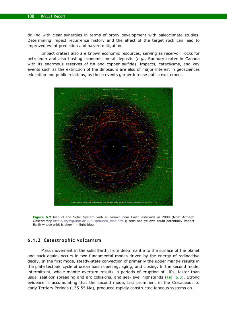
108 INVEST Report
drilling with clear synergies in terms of proxy development with paleoclimate studies.
Determining impact recurrence history and the effect of the target rock can lead to
improved event prediction and hazard mitigation.
Impact craters also are known economic resources, serving as reservoir rocks for
petroleum and also hosting economic metal deposits (e.g., Sudbury crater in Canada
with its enormous reserves of tin and copper sulfide). Impacts, cataclysms, and key
events such as the extinction of the dinosaurs are also of major interest in geosciences
education and public relations, as these events garner intense public excitement.
Figure 6.2 Map of the Solar System with all known near Earth asteroids in 2008 (from Armagh Observatory http://szyzyg.arm.ac.uk/~spm/neo_map.html); reds and yellows could potentially impact Earth whose orbit is shown in light blue.
6.1.2 Catastrophic volcanism
Mass movement in the solid Earth, from deep mantle to the surface of the planet
and back again, occurs in two fundamental modes driven by the energy of radioactive
decay. In the first mode, steady-state convection of primarily the upper mantle results in
the plate tectonic cycle of ocean basin opening, aging, and closing. In the second mode,
intermittent, whole-mantle overturn results in periods of eruption of LIPs, faster than
usual seafloor spreading and arc collisions, and sea-level highstands (Fig. 6.3). Strong
evidence is accumulating that the second mode, last prominent in the Cretaceous to
early Tertiary Periods (135-55 Ma), produced rapidly constructed igneous systems on

109 6. Cross-Disciplinary Research Frontiers
Figure 6.3 Cartoon view of whole-mantle convection, with emphasis on the intermittent, mantle-overturn style of mass and energy transfer from the deep mantle to the surface. The apparently extreme rates of magma production and eruption of Mg-rich lava compositions during LIP events (continental flood basalts, volcanic rifted margins, ocean plateaus) require delivery of enormous volumes of super-hot mantle to the base of the lithosphere, pictured here as a ‗superplume‘. Source components are possibly primitive deep mantle plus recycled slab material (ocean crust and sediments) from ancient subduction zones. Heat from the core may be partially responsible for the generation of a warm, buoyant layer at the base of the mantle (D‖) from which superplumes rise. Models suggest that this layer thickens gradually until buoyancy overcomes viscosity, spawning a period of superplume activity, such as during the Cretaceous-early Tertiary Periods. Rapid upper mantle melting and eruption through the lithosphere produces a LIP that releases volatiles into the atmosphere (continental) or degasses and exchanges hydrothermally with seawater (oceanic), leading to rapid environmental change (from Neal et al., 2008).
both continents and in ocean basins at extraordinary eruption rates. How rapid? What
volumes? What total duration? What chemical exchange? These are critical questions
that have huge implications for geodynamic mechanisms for their origin and for their
potential environmental impacts, such as mass extinctions, rapid global warming, ocean
acidification, and OAEs.
Continental LIPs (e.g., Deccan, Karoo, Siberia) are generally more accessible than
submarine plateaus and volcanic rifted margins, but original volumes are difficult to
estimate due to erosion and environmental effects are often conjectural given
incomplete records. However, volumes of individual eruptions as large as 103 to 104 km3
can be calculated from the mapped distribution of lava flows. Modern improvements in
radiometric dating (40Ar-39Ar and U-Pb zircon) have shown generally short durations of
peak volcanic activity (<1 m.y.) that correlate with periods of rapid environmental
change and biodiversity turnover (mass extinctions; Fig. 6.4). Recent measurement of

110 INVEST Report
paleo-secular variation in Deccan lava flows implies that single, large eruptions may
have occurred over as little as decades (Chenet et al., 2009). Such enormous rates of
magma production and volcanism are unknown in steady-state, plate boundary sites of
magmagenesis and require geodynamic models that produce rapid mantle melting over
large regions. The consequences for atmosphere, ocean, and biosphere impacts increase
directly with eruption rates.
Figure 6.4 Estimated LIP volumes and their ages within the Cretaceous-early Tertiary interval of superplume generation. Individual LIPs are believed to have erupted rapidly, although timescales of peak activity and total duration are largely unknown. Three of the most extreme global environmental changes in the oceans occurred during OAEs 1a and 2 and the PETM, contemporaneous with three of the largest volume LIPs (N. Ohkouchi INVEST presentation modified from Eldholm and Coffin (2000)).
We know much less about the timing and physical characteristics of oceanic LIPs,
but it is clear from estimated volumes that these are easily the largest igneous events in
Earth history. Several ocean plateaus (e.g., Ontong Java, Manihiki, and Hikurangi (Fig.
6.5) and Caribbean) are 20-40 million km3. Emplacement of these plateaus appears to
correlate with abrupt periods of global changes in ocean chemistry (OAEs 1a and 2 and
the PETM). Evidence linking the submarine volcanic eruptions with these major changes
in ocean chemistry and biology includes large accumulations of trace metals (Snow et
al., 2005) and isotopic excursions (Kuroda et al., 2007; MacLeod et al., 2008; Turgeon
and Creaser, 2008) that are consistent with an ocean plateau source (Fig. 6.6).
Discovering the full eruptive history of such enormous features presents several
major challenges. The ocean crustal sections of lava flows and sills that make up the
plateaus are 15-30 km thick, which is too much to penetrate by drilling. Portions of a
complete volcanic history might be accessed in a condensed section at the ‗feather-edge‘
of the plateau margin, but it is more likely that initial eruptive products are buried
beneath the center of each plateau and only the very largest flows reach the edges.

111 6. Cross-Disciplinary Research Frontiers
Figure 6.5 The largest known LIP now lies in the SW Pacific, as the Ontong Java, Manihiki, and Hikurangi Plateaus (outlined in red) that were separated by spreading ridges active in the Late Cretaceous. The southern margin of the Manihiki Plateau is faulted and may offer access to the inner architecture of the plateau through offset drilling (K, Hoernle, personal communication). Abyssal hill seafloor fabric (white lines), fracture zones (coarse dashed green lines), triple junction traces (fine dashed green lines), zigzag rift boundary (fine dashed red line), trenches (black lines with barbs on the upper plate), and sutures (dashed black lines) are shown. Black numbers label drill sites (DSDP, ODP). Magnetic lineations are color-coded and labeled 34 and M0-M29. Figure from Taylor, 2006.
An alternate approach to determining the full eruptive history of oceanic LIPs and
the resulting environmental responses is to drill and recover marine sediments in an
array of proximal and distal sites (Fig. 6.7). High-resolution, orbitally tuned sections can
provide the time frame for recording volcanic activity using isotopic ‗fingerprints‘ for
degassing and hydrothermal activity (Fig. 6.6). Trace metal abundances can indicate
periods of peak activity and distance from the source. Drilling at the LIP itself is still
needed to: (1) use lava flow compositions to constrain geodynamic models of mantle
melting (source, depth, temperature, degree of partial melting, interaction with pre-
existing lithosphere) and (2) confirm that degassing and hydrothermal activity were
responsible for the signals measured in contemporaneous sedimentary sections.
A cross-cutting initiative
An extreme-events initiative links many high priority science goals across several
broad themes (Fig. 6.8) and would answer fundamental questions about evolutionary
processes, ecosystem responses to global change, and tipping points, including: How
have ecosystems and biota responded to critical events in Earth history? What do past
ocean acidification events imply for response to future global change? What ecosystem
assembly rules are revealed by recovery from mass extinctions and hyperthermals?
What are the processes that generate and destroy biodiversity? What are the
oceanographic and climatic drivers of ecological assembly, speciation, and extinction?
One of the highest priorities of this theme is an improved understanding of the
effects of a perturbation (impacts, LIPs, global anoxia, thermal extremes) on biota.

112 INVEST Report
Figure 6.6 Seawater 187Os/188Os isotopic excursion for bulk marine sediment from two sites that record OAE2 (Demerara Rise, ODP Site 1260 (left) and Furlo, N Italy (right)). The long-term seawater Os-isotopic composition (187Os/188Os = 0.6) is determined by a balance between continental input (187Os/188Os = 1.4) and mantle input (187Os/188Os = 0.12). Both locations show an abrupt drop from the long-term average composition to mantle values just before OAE2 commencement, continuing through and rising toward the end of OAE2. This indicates a large additional mantle input to the oceans, coincident with OAE2, and consistent with the Caribbean LIP construction (from Turgeon and Creaser, 2008).
LIPs can be studied as extreme mantle melting and volcanic events to answer
questions about geodynamic models whose critical distinctions are magma flux through
time, geochemical variability, and internal architecture, all of which are best answered
by drilling to obtain direct samples and far-field, high-resolution marine sedimentary
sections. LIPs are also relevant to understanding Earth‘s resources since many of the
most productive petroleum-bearing sedimentary formations were deposited during OAEs
when large volumes of marine organic matter were buried (e.g., La Luna Formation
(Colombia/Venezuela) during OAE2).

113 6. Cross-Disciplinary Research Frontiers
Finally, LIPs need to be studied as potential causes of extreme events and rapid
climate change. Examples are the study of abrupt warming (PETM) and cooling events,
changes in ocean chemistry (OAEs) and ecosystem response, and integration with
improved climate models to gain better understanding of likely futures as we head into a
high pCO2 world.
Figure 6.7 Plate reconstruction for the Late Cretaceous, showing generalized surface ocean circulation (above) and the location of five marine sedimentary sections (below) that record anomalously high abundances of trace metals at OAE2 (Cenomanian/Turonian boundary, 93 Ma), contemporaneous with initial volcanic activity that constructed the Caribbean Plateau (from Snow, 2003). New drilling sites to the west of the Caribbean Plateau, in the central Pacific, should provide the best record of total duration and peak production of volcanic activity through isotopic excursions (Nd, Pb, and Os) and trace metals released during submarine eruptions.

114 INVEST Report
Figure 6.8 Proposed interconnections between reservoirs and fluxes within the Earth system during extreme volcanic events (from N. Ohkouchi, INVEST meeting personal communication). The emplacement of LIPs, an expression of the Earth's interior behavior, could explain episodes of enhanced greenhouse gas input to the atmosphere and subsequent climatic and ocean circulation changes that led to OAEs. OAEs are extreme oceanic events that resulted in biological impacts and markedly enhanced organic carbon burial.
6.2 Hominin Evolution
Scientific ocean drilling can transform our understanding of the role of past
African climate changes on early human evolution. Current hypotheses of human origins
suggest that late Neogene changes in northeast African climate influenced the evolution
of human ancestral lineages, leading to the emergence of traits that are uniquely
human: bipedality, exceptionally large brains, and the construction of increasingly
sophisticated stone tools.
The basic premise of these hypotheses is that large-scale shifts in climate alter
the ecological composition of a landscape which, in turn, presents specific faunal
adaptation or speciation pressures leading to genetic selection and innovation. Emerging
fossil faunal and paleoclimate data broadly support this idea but fundamental questions
remain concerning the timing, nature, and causes of African climate variability and for
defining the imprint of climate change on the fossil record of faunal evolution. ―The field
of paleoanthropology is on the brink of novel ideas and datasets concerning the how and
why of hominin evolution. Tremendous advances in the environmental sciences are
forcing these developments to occur‖ (Potts, 1998).
The rationale supporting a major drilling initiative to understand the role of past
climate change in human evolution is compelling. There are presently very few ocean
drilling sites off East Africa, where the majority of hominin fossils are found, and none of
these are suitable for comprehensive paleoclimate research. While some DSDP sites
drilled over thirty years ago in the Gulf of Aden have been useful for low-resolution
paleoclimate records (Feakins, 2006), these were rotary drilled and have significant

115 6. Cross-Disciplinary Research Frontiers
recovery gaps and disturbed intervals. No shallow (carbonate-bearing) sites exist along
the entire east coast of Africa, nor are any sites available near the mouths of major river
systems draining the East African interior. Most of our current understanding of East
African paleoclimate changes comes from marine records of aeolian dust export from
sites off subtropical west and northeast Africa (deMenocal, 2004) and it can be
reasonably argued that these records are distal from the fossil localities themselves.
Ocean drilling has a unique opportunity to contribute observations to test the
hypothesized role of past climate changes in shaping the course of human evolution.
Terrestrial paleoclimate records from East African fossil localities or from lake basin
drilling programs are either too short or stratigraphically incomplete. Ocean drilling of
specific, previously-undrilled sedimentary packages described below provides the best
opportunities for constraining the timing, nature, and causes of paleoclimatic change in
this geographic region where our ancestors evolved.
6.2.1 Key events and environmental hypotheses of human origins
Bursts of evolutionary activity and behavioral changes punctuate the fossil record
of early human evolution (Fig. 6.9). Although the fossil record is still incomplete, two
time windows encompass key evolutionary events near 3.0–2.5 Ma and 2.0–1.5 Ma that
effectively shaped the characteristics that define us as human (see summary in Potts,
2006). Impressively, these same time windows also include dramatic changes in other
African mammalian taxa such as bovids and rodents (Vrba, 1995).
Between 3.0–2.5 Ma at least two new hominin lineages emerged (Paranthropus
and early Homo genera) from an ancestral lineage that itself became extinct at this time
(Australopithecus afarensis); this interval also marks the first appearance of stone tools
(Semaw et al., 2003) (Fig. 6.9). Members of the Paranthropus lineage are distinctive for
their robust, massive frames, large and broad post-canine (molar) dentition, specialized
chewing adaptations (sagittal crest), and intermediate cranial volumes. The
Paranthropus lineage first appeared at ~2.7 Ma (Fig. 6.9). The fossil record of African
bovids (antelope family) indicates evidence for exceptional faunal first and last
appearances near this time, roughly synchronous with the appearance of specialized
arid-adapted grazers (Vrba, 1995; Bobe and Behrensmeyer, 2004; Bobe et al., 2002).
The earliest record of stone tools, at ~2.6 Ma, is from Gona, Ethiopia (Oldowan industry)
(Semaw et al., 2003).
By 1.8–1.6 Ma, Homo habilis became extinct and its immediate successor and our
more direct ancestor, H. erectus, first occurs in the fossil record near 1.8 Ma (Kimbel,
1995). Homo erectus may have migrated to southeast Asia as early as 1.9–1.8 Ma
(Swisher et al., 1994). Near 1.7 Ma, South African (Reed, 1997) and East African bovid
assemblages shifted toward further absolute increases in the abundance of arid-adapted
species (Vrba, 1995). Earliest occurrences of the more sophisticated Acheulean tool kit
(bifacial blades and hand axes) occurred near 1.7–1.6 Ma (Ambrose, 2001; Clark et al.,
1994) (Fig. 6.9).
Environmental hypotheses of early human evolution share the view that changing
African environmental conditions over the late Neogene selected for the morphological
and behavioral characteristics that make us human. Where hypotheses differ is in the
proposed role of climate change in natural selection. The Savannah Hypothesis is
perhaps the best known of the habitat-specific hypotheses of African faunal evolution

116 INVEST Report
(Bartholomew and Birdsell, 1953; Dart, 1925; Klein, 1989; Wolpoff, 1980). Current
interpretations of the Savannah Hypothesis state that the evolution of African
mammalian fauna, including early hominins, was primarily linked to the progressive
expansion of more open grassland conditions. The Turnover Pulse Hypothesis is a recent
variant of this idea and posits that focused bursts of biotic change (quantified in terms of
first and/or last appearance datum clustering) were initiated by progressive shifts toward
greater African aridity that occurred roughly near 2.8 Ma and 1.8 Ma (Vrba, 1985,
1995). The Variability Selection hypothesis accommodates one of the more obvious yet
also curious features of the fossil record (Potts, 1998). Fossil hominin and other mammal
lineages typically persisted over long durations (105 to 106 year) yet they are preserved
within sediment sequences recording rapid, orbital scale (103 to 104 year) climate
oscillations (deMenocal, 1995; Dupont and Leroy, 1995; Feibel et al., 1989). This view
suggests that changes in the amplitudes of orbital African climate variability, linked to
the eccentricity modulation of precessional monsoonal cycles, may have been an
important genetic selection criterion. A fundamental limitation to testing these
hypotheses has been the lack of suitably detailed, well-dated, and multi-proxy
reconstructions of African climate variability to constrain the basic paleoclimate history of
the region. How and why did African climate change?
Figure 6.9 Summary figure from Feakins et al. (2005). A) Interval means and (1) standard deviation
of C30 n-alkanoic acid 13C for intervals >40 k.y. in duration (filled circles) and for intervals <40 k.y. induration (open circles, dashed lines). B) Soil carbonate 13C from Turkana Basin (northern Kenya);
means and (1) standard deviations from individual stratigraphic layers (from sources in Feakins et al.,
2005). C) Phylogeny of major hominin lineages throughout Pliocene-Pleistocene (from sources in deMenocal, 2004).
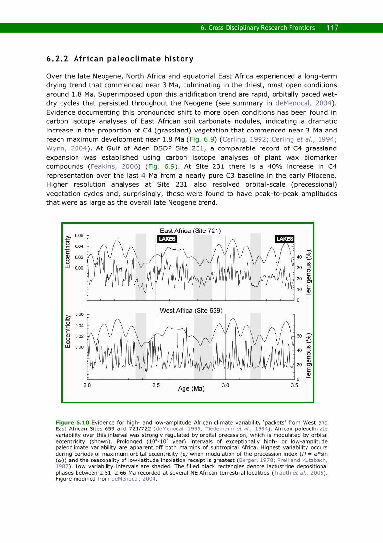
117 6. Cross-Disciplinary Research Frontiers
6.2.2 African paleoclimate history
Over the late Neogene, North Africa and equatorial East Africa experienced a long-term
drying trend that commenced near 3 Ma, culminating in the driest, most open conditions
around 1.8 Ma. Superimposed upon this aridification trend are rapid, orbitally paced wet-
dry cycles that persisted throughout the Neogene (see summary in deMenocal, 2004).
Evidence documenting this pronounced shift to more open conditions has been found in
carbon isotope analyses of East African soil carbonate nodules, indicating a dramatic
increase in the proportion of C4 (grassland) vegetation that commenced near 3 Ma and
reach maximum development near 1.8 Ma (Fig. 6.9) (Cerling, 1992; Cerling et al., 1994;
Wynn, 2004). At Gulf of Aden DSDP Site 231, a comparable record of C4 grassland
expansion was established using carbon isotope analyses of plant wax biomarker
compounds (Feakins, 2006) (Fig. 6.9). At Site 231 there is a 40% increase in C4
representation over the last 4 Ma from a nearly pure C3 baseline in the early Pliocene.
Higher resolution analyses at Site 231 also resolved orbital-scale (precessional)
vegetation cycles and, surprisingly, these were found to have peak-to-peak amplitudes
that were as large as the overall late Neogene trend.
Figure 6.10 Evidence for high- and low-amplitude African climate variability ‗packets‘ from West and East African Sites 659 and 721/722 (deMenocal, 1995; Tiedemann et al., 1994). African paleoclimate variability over this interval was strongly regulated by orbital precession, which is modulated by orbital eccentricity (shown). Prolonged (104-105 year) intervals of exceptionally high- or low-amplitude paleoclimate variability are apparent off both margins of subtropical Africa. Highest variability occurs during periods of maximum orbital eccentricity (e) when modulation of the precession index (Π = e*sin (ω)) and the seasonality of low-latitude insolation receipt is greatest (Berger, 1978; Prell and Kutzbach, 1987). Low variability intervals are shaded. The filled black rectangles denote lactustrine depositional phases between 2.51–2.66 Ma recorded at several NE African terrestrial localities (Trauth et al., 2005). Figure modified from deMenocal, 2004.

118 INVEST Report
African paleoclimate history also includes persistent orbitally paced wet-dry
climate cycles throughout the Neogene linked to orbital precession regulation of African
monsoonal rainfall intensity. The Mediterranean sapropel record is one of the most
compelling examples of orbital climate control. Ocean drilling in the eastern
Mediterranean and careful fieldwork on older, uplifted sediments in southern Italy have
documented the strong eccentricity and precessional response of sapropel deposition
related to episodes of enhanced Nile River outflow linked to orbital monsoon forcing.
These same precessional climate cycles are also detected in aeolian dust records from
ODP sites off East and West Africa (Clemens et al., 1996; deMenocal, 1995; Tiedemann
et al., 1994). These eccentricity-modulated variability ‗packets‘ represent 104-105-year
intervals of exceptionally high- or low-amplitude paleoclimatic variability. Some of the
largest amplitude packets are associated with widespread deposition of deep lake
diatomite facies in East African Rift basins (Trauth et al., 2005) (Fig. 6.10).
Ocean drilling can significantly contribute to dating the fossil record of human
evolution. Dates for most fossil material are obtained by either direct radiometric dating
Figure 6.11 Volcanic ash shard abundances at DSDP Site 231 (modified from Feakins et al., 2007). Areas of known volcanic activity during the Pliocene and Pleistocene are identified with asterisks. Approximately 15-20 tephra layers are identified for the Pliocene-Pleistocene interval. Continuous scrape-sampling provides a complete downcore sedimentary record throughout the last 4Ma where sediments were available (solid); gaps in the sediment recovery indicate areas where no data on tephrostratigraphy are available (recovery was about 70%), so many tephra layers were probably not sampled.

119 6. Cross-Disciplinary Research Frontiers
or indirect stratigraphic dating of fossil material intercalated between datable volcanic
tuff deposits. Since the East African Rift region has been volcanically active for much of
the late Neogene, the rift basins have been periodically blanketed with tephra from
hundreds of discrete volcanic eruptions. A relatively small number of these tuffs have
sufficiently large/abundant phenocrysts for direct (40/30Ar) dating and the majority of ash
layers serve as marker beds with approximate (interpolated) ages. These same ash
layers are found and indentified geochemically in marine sediments offshore of East
Africa (Fig. 6.11). Here they can be dated directly using the orbitally tuned oxygen
isotope stratigraphy. This has been demonstrated for some ash layers preserved in
Arabian Sea and Gulf of Aden sediments (deMenocal and Brown, 1999; Feakins et al.,
2007), but a larger, all-Africa integration of tephra stratigraphy with the marine oxygen
isotope stratigraphy awaits new core material.
6.2.3 East African river systems as archives of regional climate variability
To constrain African paleoenvironmental changes during the late Neogene will
require the recovery of sediments that specifically address the timing and signatures of
African climate change over the subtropical African geographic domain where hominin
fossils are found, including South Africa, Tanzania, Kenya, and Ethiopia. Ocean drilling
targets would need to be prioritized by their anticipated scientific contribution to the
primary question of whether climate change impacted African faunal evolution. This
section addresses the most valuable drilling targets – sites that, if drilled, would reshape
our understanding of the timing and causes of African climate changes over the period of
major African faunal evolutionary changes.
Jubba, Rufiji, Limpopo, Orange, and Zambezi distal fan drilling
Among the most promising new opportunities for reconstructing past changes in
African climate are sediment packages accumulating near the mouths of rivers draining
large sectors of subtropical and tropical Africa (Fig. 6.12). Hemipelagic sediments
accumulating near the mouths of rivers draining interior East and South Africa (Jubba,
Rufiji, Limpopo, Zambezi, and Orange Rivers) would provide promising opportunities for
understanding both terrestrial paleoclimate and regional paleoceanographic variability
over the Neogene. Smaller river systems in Kenya (Galana and Tana) and Tanzania
(Rufiji) were likely much larger and more active systems in the past when African
monsoonal rainfall was stronger, based on lithologic evidence of much larger and deeper
East African lake systems (Garcin et al., 2009; Trauth et al., 2005).
The largest of these East African drainage basins are, from north to south (Fig.
6.12), the Jubba (800,000 km2), Rufiji (175,000 km2), Limpopo (415,000 km2), and
Zambezi Rivers (1,400,000 km2). The Jubba drainage basin spans roughly one-third of
the national area of Kenya, Somalia, and Ethiopia and captures summer monsoonal
rainfall, principally off the Ethiopian highlands. The Rufiji drainage basin is the smallest
of the three and is confined to eastern Tanzania. The Zambezi drainage basin is the
largest of the three (the fourth largest river in Africa) and the drainage basin includes
much of Zambia, Malawi, and Zimbabwe. Significantly, the Zambezi drainage basin also
includes Lake Malawi, so lacustrine sequences drilled there may be directly compared to
offshore drilled sequences of the Zambezi distal fan.

120 INVEST Report
Figure 6.12 African drainage basins (modified from Africa Earth Observatory Network Database http://www.aeon.uct.ac.za).
Africa‘s largest drainage basins,
such as the Nile, Niger, and
Congo, each drain several
millions of square kilometers and
thus represent large areal
integrators of regional climate
change. Smaller drainage basins
of East Africa, such as the
Ganane, Rufiji, Zambezi, and
Orange rivers, drain terrains
containing known hominin fossil
localities.
The sediments accumulating in
the modest deltaic systems
formed by these rivers are
comprised of proximal and distal fan deposits. Proximal fan sediments are commonly
complicated by turbidites and intermittent sedimentation, whereas distal fans provide
more continuous, high accumulation rate, hemipelagic depositional environments. Distal
fan sediments are comprised of marine biogenic components (microfossils and marine
organic carbon) as well as terrestrial lithogenic (riverine clays and silts) and organic
(terrestrial organic matter and biomarkers) sediments. Oxygen isotope analyses of
marine foraminifera can be used to constrain an orbital (104 year) chronology. The
terrestrial organic fraction can be exploited to yield an impressive diversity of proxies
that monitor the paleoclimatic, paleohydrological, and paleovegetational history of the
specific drainage basin.
Analyses of the terrestrial organic fractions in distal fan environments have
presented new opportunities for reconstructing African vegetation and hydrologic
changes. River-borne terrestrial organic matter is comprised of a broad spectrum of
compounds, or biomarkers, which can be used to record basin-scale changes in regional
climate, vegetation, and hydrological balance. For example, a recent study of a sediment
core off the Congo fan documented large changes in Congo Basin mean annual
temperature using terrestrial biomarkers that record river runoff (Branched and
Isoprenoid Tetraether (BIT) index) and soil temperatures (Methylation of Branched
Tetraethers (MBT) index), as well as the D composition of plant wax biomarker to
document changes in regional humidity changes (Weijers et al., 2007). Another related
study from this same area used 13C analyses of plant wax biomarkers (n-alkanes) to
document glacial-interglacial changes in the relative proportion of C3-C4 vegetation in
the Congo Basin. These are examples of the approaches that could be applied to East
African nearshore sediments recovered under this drilling mission.

121 6. Cross-Disciplinary Research Frontiers
Gulf of Aden drilling
The Gulf of Aden is the most proximal ocean basin to hominin fossil localities in
Ethiopia, Kenya, and Tanzania and several previous studies on older DSDP material have
demonstrated the utility of these sediments for addressing this problem. Several cruises
lead by French, Japanese, and American scientists have acquired single- and
multichannel seismic lines for the region to identify drill sites. Piston cores obtained at
these drill sites indicate high accumulation rates (5-10 cm k.y.-1) at these localities.
Unfortunately drilling in this region is likely to be challenging given the geopolitical
tensions of the Gulf of Aden region.
Together, drilling these regions (the Gulf of Aden and the distal fan deposits from
the Jubba, Rufiji, and Zambezi Rivers) would fundamentally reshape our understanding
of the timing and causes of African climate changes over the period of major African
faunal evolutionary changes.
6.3 Climate–Tectonics Linkages and Feedbacks
Tectonics-climate linkages and feedbacks is a long-standing research theme that
has attracted geoscientists‘ attention, especially those interested in Earth system
dynamics. Traditional hypotheses on tectonics-climate interactions generally consider
tectonic impacts on climate either through topographic and/or bathymetric changes or
through chemical and/or biological processes that control the concentration of
atmospheric CO2. Bathymetric change such as opening of oceanic gateways can
fundamentally alter global ocean circulation and therefore climate (Smith and Pickering,
2003). Uplift of mountain ranges can in turn perturb atmospheric circulation and also
affect climate (Zhiseng et al., 2001). General circulation models can evaluate the effects
of changing topography/bathymetry on climate through changes in atmospheric and
ocean circulation, the hydrological cycle, and the radiation budget if appropriate
boundary conditions are provided. Today, significant research programs in continental
dynamics are instead focusing on how climate, through focused erosion, can directly
affect tectonics (Berger et al., 2008; Huntington et al., 2006; Tomkin and Roe, 2007).
Within the theme of how tectonics influences climate, the timing and extent of
topographic and/or bathymetric changes in key areas are still poorly constrained
because of insufficient data; large uncertainty still exists around the important boundary
condition of atmospheric CO2 concentration and how it changes through time. Within the
climate influencing tectonics theme, breakthroughs have been made by correlating
exhumation rate changes in mountain ranges onshore with known changes in climate.
The missing elements are examining the erosional products of these climate-controlled
tectonic events in the offshore and equivalent dating resolution.
One way in which tectonics impacts the climate system is through control of
atmospheric CO2 concentrations by silicate chemical weathering and burial of organic
carbon. It is well known that silicate weathering, especially weathering of Mg and Ca
silicates, is considered an important process to draw down atmospheric CO2 (Kump et
al., 2000). Temperature and precipitation are considered two major parameters that
control the rate of chemical weathering. Both temperature and precipitation are
considered strongly dependent on atmospheric CO2 concentration; their control on

122 INVEST Report
chemical weathering rates has been regarded as a strong negative feedback to stabilize
atmospheric CO2 (Walker feedback) (Walker et al., 1981); however, the effect of
tectonic uplift on atmospheric CO2 through enhancement of physical weathering and
erosion is not well evaluated. The other process through which tectonics affects
atmospheric CO2 is the burial of organic carbon. Tectonics influences organic carbon
burial through two mechanisms: (1) enhancing delivery of nutrients such as P and Si
through accelerated chemical weathering and (2) enhancing burial efficiency of organic
carbon by increasing sedimentation rates on continental margins (Raymo and Ruddiman,
1992; France-Lanord and Derry, 1997). The influence of tectonics on organic carbon
burial and its impact on atmospheric CO2 have never been fully evaluated because of
insufficient data coverage of sediment composition (including P and organic carbon
contents) and land-ocean sediment-flux budgets. As a result, the impact on regional and
global climate of tectonically driven changes of continent-ocean configuration, increases
or reductions in topography/bathymetry, and drawdown of atmospheric CO2 caused by
silicate weathering and organic carbon burial has not been evaluated quantitatively.
What is the relative importance of these processes and how does this importance change
through geologic time as the Earth enters different climate states?
Ways in which climate can impact tectonics is gathering increasing attention and
has become the primary focus for tectonics-climate interplay research. Erosion can be
enhanced in key areas, such as on the windward side of orogens, either through focused
precipitation increasing river discharge or through development/intensification of
temperate glaciers (Tomkin and Roe, 2007). Focused precipitation caused by intensified
monsoon or mountain glacier development or intensification caused by global cooling can
enhance erosion and preferentially unroof an orogen on the windward side (Huntington
et al., 2006; Berger et al., 2008). Rocks underneath the locus of erosion will be
exhumed in these compressional settings and the uplifted rock will be subjected to
further erosion, which will induce further uplift. These systems can develop a positive
feedback loop governed by strain rate resulting in crustal aneurysms and significant
development of relief; many of the highest mountain zones on Earth appear to be the
result of these positive feedback loops. Thus, focused precipitation and/or glacial activity
and consequent erosion will cause focused exhumation and uplift. Focused exhumation
may further induce deformation and erosion/deposition in the surrounding area resulting
in significant mass flux from the orogen source to depositional sinks. Additionally, there
is evidence that both zones of high exhumation as well as regions with significant
sediment burial can result in changes to deformation rate and even fault locations
(Berger et al., 2008). Quantitative evaluation of this process is still insufficient and the
significance of this positive feedback is poorly understood primarily due to a need to
match the depositional history with exhumation history at sufficient resolution.
6.3.1 Major hypotheses and questions
Climatic Super Cycle
It is conceptually well established that the Earth experienced warm greenhouse
climate and cool icehouse climate alternately over 100 m.y. timescales (Veevers, 1990)
and that such long-term climate cycles (the Climatic Super Cycle) are probably related to
the so-called Wilson Cycle at least during the Phanerozoic (but more likely since the
Proterozoic). However, the relative roles of changing plate configuration and

123 6. Cross-Disciplinary Research Frontiers
topography/bathymetry of the continents and oceans versus changing concentrations of
greenhouse gases, especially CO2, are poorly understood. Also underconstrained is the
relative importance of degassing, chemical erosion, and organic carbon burial on
controlling atmospheric CO2 and whether their relative importance changes during the
course of a Wilson Cycle. A fundamental problem in Earth system science is to
understand what the role of changing configuration and relief of the continents and
oceans is on global climate. Can tectonic reconfigurations drive climate in predictable
directions, such as cooling the planet during the assembly stage of supercontinents and
heating the planet during subsequent breakup? How important is the role of tectonics on
atmospheric CO2 concentration through geologic time?
Climate-driven erosion and tectonics
Recent hypotheses regarding mechanisms for how climate influences tectonics
are erosion-based; thus, the new drilling program is in a unique position to test the
prevailing hypotheses through drilling eroded products in offshore depocenters. In the
southeast Asian Himalayas, increased precipitation on the windward side of the orogen
due to monsoon intensification has been proposed to have enhanced exhumation,
especially where major river systems drain the orogen. The unroofed sediments are
ultimately deposited in the Indus and Bengal Fans in the northern Indian Ocean. In the
St. Elias Mountains in Alaska, the mid-Pleistocene Transition (where glacial-interglacial
cyclicity changed from 40 kyr to 100 kyr) is proposed to have intensified erosion
associated with glacial advance-retreat cycles, resulting in an order of magnitude
increase in exhumation and a shifting locus of fault activity onshore and offshore. In
contrast, the onset of Northern Hemisphere glaciation did not appear to have produced a
significant change in mountain building. These are examples of cases where there are
climate drivers proposed for tectonic responses and where testing these hypotheses
requires dating the eroded products deposited offshore. Other orogens such as the
Andes, Alps, Zagros, and New Zealand all have been the focus of modeling efforts
examining these processes but with few studies of the depositional record.
In order to test both the ideas of the Climatic Super Cycle and climate-driven
erosion building mountains we require ground-truth to test key mechanisms, which
should be a top-priority theme of the new program. Fundamental questions regarding
these tectonics-climate linkages include:
How does changing configuration and topography/bathymetry of the continents and
oceans influence ocean and atmospheric circulations and biogeochemical cycles?
How do orogens respond to significant climate shifts such as the onset of Northern
Hemisphere glaciation, the mid-Pleistocene Transition, and the development of the
Indian monsoon?
How do freshwater, nutrient, and sediment discharge from continents to oceans
influence biota and biogeochemical cycles in continental margins and marginal seas?
How does tectonics affect physical and chemical weathering and delivery of nutrients
to the ocean (through enhancement of erosion)?
How has freshwater, nutrient, and sediment delivery to the ocean changed through
time and space (spatial pattern and budget changes with time)?
How large are the roles of small rivers, groundwater, and aeolian transport on global
freshwater, nutrient, and sediment budgets?

124 INVEST Report
How do continental-margin strata record the history of continents such as
exhumation, erosion, climate, vegetation, and topography?
6.3.2 Need for new drilling
In order to test hypotheses and answer the questions described above, global
coverage (in time and space) of sedimentary basins, especially in continental margins
and terrestrial depocenters, is necessary. Thus far global coverage of key sedimentary
basins (especially in Arctic and Antarctic areas) is insufficient and focused studies in
depocenters (often deep-sea fans) associated with key mountain ranges do not exist. In
this regard, new drilling is strongly desired on continental margins, in marginal seas, and
in deep-sea fans. Continental drilling of key intra-continental basins and coordination
and integration with continental margin drilling are also highly important. Recent
advances in drilling technology make it possible to recover sandy continental-margin
strata, which will allow us to constrain sediment, nutrient, and carbon budgets much
better than previously, and advances in biogeochemistry allow us to better estimate
temporal changes in terrestrial climate and vegetation. For the next drilling program,
capturing a complementary array of continental margin and fan records of exhumation
and terrestrial climate/vegetation history, sediment, nutrient, and carbon budgets, and
freshwater discharges for the highest flux areas will make great strides towards
understanding the feedbacks between tectonics and climate.
6.3.3 Implementation strategies and platform needs
In order to achieve the scientific goals related to this theme, the following
strategies and technological developments are desired:
Obtain seismic images for understanding sediment architecture development in
continental margins and adjacent fans and good spatial site coverage for sediment,
nutrient, and carbon budget calculations.
Attain high and continuous recovery of unconsolidated sediments such as terrigenous
records contained in submarine fan deposits.
Invent new proxies for evaluation of weathering intensity, exhumation rate,
provenance, continental climate, and vegetation.
Further develop non-destructive and rapid core-scanning techniques for organic
geochemistry and cyclostratigraphy.
Coordinate and integrate with continental drilling.
Integrate with modeling studies on landscape development, sediment budgets and
fluxes, and climate to develop and test hypotheses.
Organize drilling arrays to evaluate paleo-bathymetry and its changes through time.
To effectively conduct the above listed strategies, coordination of all kinds of
platforms such as non-riser, riser, mission-specific platform (MSP), and continental
drilling will be important. A long-term comprehensive project aiming to capture a
complementary array of continental basin/fan records of exhumation and terrestrial
climate/vegetation history, sediment, nutrient, and carbon budgets, and freshwater
discharge is strongly desired through coordination of individual expeditions. These
expeditions will likely each be focused on specific climate-tectonics linkages but together

125 6. Cross-Disciplinary Research Frontiers
can build this array of data on continent-ocean fluxes and tectonics-climate feedbacks
over geologic time.
6.3.4 Integration with other scientific programs and industries
Involvement and cooperation with terrestrial research projects and integration
with ICDP and ANDRILL are necessary to obtain proximal sedimentary records of tectonic
and climatic events and complete sediment, nutrient, and carbon budgets, and also to
understand fluvial and glacial reorganization. Also important are involvement and
cooperation with commercial industries (especially the oil industry) and local
governments to obtain seismic data, core and cuttings, and other information from
continental margins of scientific interest. Involvement and cooperation with biologists
and biogeochemists are also desirable to investigate ecological interactions in marginal
areas and the potentially unique deep biosphere in organic-rich fans and across the
terrestrial/marine boundary. Cooperation with geodynamic and climate modelers is also
critical for testing mechanisms for interactions. Dating onshore sediments needs to be
mated with offshore dating, which will require involvement of thermochronologists,
paleomagnetists, paleooceanographers, and biostratigraphers.
6.3.5 Social relevance and outreach
Because drilling for tectonics-climate interactions focuses on continental margins,
marginal seas, deep-sea fans, and integration with continental drilling, the results are
expected to hold information highly relevant to the society in many respects. For
example, in some cases the recovered sedimentary strata will preserve high-resolution
geohazard records of earthquakes and tsunamis in seismogenically active margins and
floods and droughts in monsoon areas. Additionally, public interest is peaked when
convincing cases can be made for systems interacting in surprising ways, such as the
concept of ‗climate moving mountains‘. Information on sediment input and its relation to
the migration of coastlines will be useful for maintaining the location of the shore in
highly populated areas, whereas information on the ecosystem response to nutrient
input will be useful for protection of coastal marine ecosystems. The high sedimentation
rates in these regions also provide records of paleoclimate and human impact useful for
a number of the goals of the new program. Knowledge about factors controlling chemical
weathering and organic carbon burial will be useful for developing methods for CO2
sequestration. All of these topics can be used for outreach and raising the public‘s
interest.

126 INVEST Report
7 Technological Needs and Development
To study the least-explored subseafloor realms, technological development of
platforms and drilling is essential. As discussed during the INVEST meeting, some future
drilling explorations to meet new scientific objectives depend on improved drilling
capabilities such as enhancing depth penetration, improving core recovery and quality,
coring in high-temperature and high-pressure environments, coring in shallow-water
margins, coral reefs, and sea-ice covered regions (e.g., such as with the planned the
Research Icebreaker Aurora Borealis), and preventing magnetic, chemical, and
microbiological contaminations. Overall, the next phase of the scientific drilling program
will require a significant and even more coordinated engineering effort.
7.1 Analytical Capabilities
Vast efforts in technological developments during previous scientific drilling
programs have successfully enabled tremendous scientific discoveries in the frontier
research field of subseafloor environments. During the INVEST meeting, a number of
new scientific concepts and ideas were proposed for future scientific drilling. To achieve
these fundamentally important and unsolved scientific objectives, analytical capabilities
should be continuously improved or developed in the future drilling program. One of the
most significant technological requirements discussed is how we can measure the
intrinsic and/or ephemeral properties inherent to core materials. The in situ analysis
tools involve redox states, chemical compositions, physical parameters, pH, and
microbial populations and their activities. For example, newly developed (or improved)
logging sensor tools, in situ sampling/monitor devices, and in situ microbial colonization
systems will be highly valued for multidisciplinary scientific objectives through borehole
observatories and experiments. A real-time hydrocarbon gas monitoring system
including stable isotope measurements should also be deployed in platform laboratories.
Using fresh cores, novel and/or improved analytical technologies for quick and high-
resolution measurements of temperature- and redox-/oxygen-sensitive chemical and
microbiological components must be developed for the new scientific drilling program,
since explorations of high-temperature hydrothermal systems and the deep, hot
biosphere have great potential for understanding co-evolution of life and the planet.
Onboard measurements of interface properties related to physical, chemical, and
biological events are extremely useful for rapid decisions necessary for subsequent
onboard core-flow and additional drilling. Some strategies for multiple analytical
measurements on the same core should be developed, with the advantages of intimate
association of core properties.

127 7. Technological Needs and Development
7.2 Sampling Improvements
To analyze in situ characteristics of subseafloor environments, the development
of a pressure- (and temperature-) keeping coring system is required by many research
communities within scientific ocean drilling. There was consensus among INVEST
participants that in situ pressure and temperature are significant controlling factors for
various geochemical and biological reactions. The pressure limit of currently available
high-pressure-coring systems (e.g., PCATS or FPC by GeoTek Ltd.) is up to 25 MPa,
which is not enough for high-pressure gaseous fields or deep coring at a target depth
greater than 2500 m below the sea surface; hence, the system must be improved for
more high-pressure environments and be adaptable to all platform drilling facilities. In
addition, it is important to construct an onboard high-pressure core transfer system
equipped with an X-ray computed tomography (X-CT) scan device, multiple (micro-)
sensors, gas and fluid extraction ports, biogeochemical and microbiological tracer
injection systems, and a mini-core sub-sampling system like the DeepIsoBUG system
(Parkes et al., 2009) (Fig. 7.1). This will allow cross-disciplinary in situ measurements
and active experiments for the new scientific drilling program.
Quality assurance and quality control (QA/QC) are necessary to accurately
characterize physical, geochemical, and biological properties in the recovered cores. For
example, a non-magnetic core barrel (and the oriented cores) will allow deeper coring
and collection of reliable magnetic data. To define the extent of subseafloor microbial
populations, activity, and metabolic functions, uncontaminated ‗clean‘ coring and sub-
sampling technology is required.
Figure 7.1 Schematic figure of a microbiological high-pressure core transfer system, designated as the DeepIsoBUG system (Parkes et al., 2009).

128 INVEST Report
The circulation ‗mud‘ for riser drilling should be simultaneously analyzed with core
samples as the experimental control, because some microbes may grow in the stored
‗mud‘ and contaminate the core samples (Masui et al., 2008). Additional ways to clean
and monitor and minimize contamination of sub-sampling equipment should be
considered.Previous microbiological and biogeochemical studies have demonstrated that
subseafloor microbes proliferate in narrow niches at geologic or geochemical interfaces
such as volcanic ash layers (Inagaki et al., 2003) and sulfate-methane transition zones
(Parkes et al., 2005; Sørensen and Teske 2006). If subseafloor microbial communities
are very sensitive to local paths of fluid-flow that transport available energy and
nutrients, the population and activity distribution may be more complicated; hence,
high-resolution sampling is necessary to capture the small niches for subseafloor life.
During the INVEST meeting, it was intensively discussed that ultrahigh-resolution
analysis is very important especially for better understanding of past climate and sea-
level records. Describing the paleo- and modern ecosystems within the subseafloor
biosphere is also recognized as a significant scientific objective in the future drilling
program. During ODP and IODP expeditions, most microbiological samples were taken as
5- to 10-cm length WRC; therefore, the sedimentological, paleontological, and
lithological characteristics of WRC samples have been largely dismissed and co-relations
remain elusive. To analyze microhabitats with high-resolution depth sampling, shore-
based technological improvements and effective onboard sub-sampling strategies for
quick locus identification must be developed.
7.3 Shipboard Facilities
Current shipboard computational and dissemination capabilities should be more
effectively integrated between software programs, database mining, and accessibility.
Ideally, it should be interfaced with multiple drilling platforms and databases in core
repositories.
Previous IODP expeditions (Expeditions 314, 315, 316, and 322) demonstrated
that X-CT scanning is highly valuable as it provides a complete three-dimensional core
image non-destructively. Examining the CT-image reveals important geological and
sedimentological information prior to core splitting and sub-sampling for geochemical
and microbiological analyses. The CT-scanned image analysis also provides three-
dimensional elemental distribution (e.g., pyrite accumulation in non-visible
microfractures) and structural characteristics (e.g., vain/fracture angle). The non-
destructive identification of core quality and structures will be highly valuable to future
microbiology/biogeochemistry-dedicated drilling expeditions because lithological and
mineralogical characteristics are highly co-related to microbial habitat and activity. Given
those discussions, INVEST participants highly recommended that an X-CT scanning
device be deployed on all platforms. To study large numbers of high-resolution images,
high-speed computational capabilities must be available. For high-pressure cores, CT-
scannable core liners made of materials such as carbon glass fiber or aluminum are
recommended.
To achieve high throughput and high-resolution analyses onboard, INVEST
participants recommended use of computer-driven automated systems. For example, an
auto-extractor should be deployed onboard for organic geochemistry analyses with

129 7. Technological Needs and Development
efficient measurement and analytical tools. Recently, an automated cell-counting
microscope system using fluorescent image analysis was developed (Morono et al.,
2009) (Fig. 7.2). The new computer-based cell-counting system should be equipped with
an automated slide-loader system, which will reduce the working time of shipboard
participants and produce objective and high-resolution microbial population data.
To share scientific information as quickly and efficiently as possible, a
computational high throughput and high-resolution analytical scheme is essential and
multiple measurement strategies and techniques should be developed in the future
scientific drilling program.
Figure 7.2 Computer image-based cell detection and enumeration. Using SYBR Green I fluorescent dye, non-biological backgrounds (i.e., SYBR-SPAM: SYBR Green I-stainable particulate matter) produce longer fluorescent wavelengths than the cellular DNA. (A) Cell-derived fluorescent signals can be retrieved from the forest of backgrounds by processing fluorescent microscopic images obtained with green (528nm) and orange (617nm) binary filters. (B) Green fluorescent microscopic image of a sediment sample from Site C0006 (IODP Exp. 316). (C) The processed image provides signals derived only from subseafloor microorganisms. Bars represent 10 µm. Figures modified from Morono et al., 2009.
7.4 Platform and Drilling Capabilities
During over a half-century of scientific drilling one of the important, enthusiasm-
inspiring, but yet-to-be accomplished scientific objectives is the deep drilling of Earth‘s
interior, as proposed as the project ‗Mohole‘. Currently, deep drilling targeting the
asperity zone is proposed. Today, these deep-drilling projects involve more
interdisciplinary scientific objectives than when originally proposed (e.g., water-rock
interactions at different depths/conditions may produce some nutrient and energy
substrates for subseafloor life within the upper lithosphere). To achieve these cross-
disciplinary deep-drilling explorations in the future scientific drilling program,
technological development is essential. Necessary drilling capabilities include (but are
not limited to): (1) deep-water riser drilling capability down to 4000 m or more; (2)
deep-penetration depth beneath the basement; and (3) borehole and drill bit cooling
technology for high temperature (>250˚C) environments. To solve these technological
issues for deep drilling, improvement of riser-pipe quality, casing strings, the BOP, and
the mud-circulation/recovery system are particularly important. The newly developed
RMR system has great potential for various purposes in future drilling, especially for
borehole controls (i.e. stability and cooling) and lowering cost. Combining the dual
gradient technology with RMR, the drilling system enables environmentally friendly (i.e.,
clean without mud pollutants to seawater) access to deeper environments and other

130 INVEST Report
areas previously not drillable by riser-less drilling. The RMR technology is directly
applicable to all IODP platforms for the suitable target depth range (Fig. 7.3).
Improving core recovery and quality (e.g., fewer disturbances) is a fundamental
technological challenge. The degree of core recovery and quality depends on various
factors such as depth, lithology, physical properties, and coring tools. During previous
drilling explorations, low or no core recovery has been observed in: (1) chert and/or
shales, (2) sand and gravel layers, (3) hydrothermal deposits, (4) rubble basalts and
sheeted dyke complexes, and (5) fault and fracture zones; unfortunately most of these
environments were scientifically important to the expeditions. To solve this problem,
more accurate compensation for drill bit motion, torque, and type of cutting shoe is
required and use of a feedback system for real-time drilling parameters should be
considered. The improvement of coring systems and other drilling and/or sampling
systems (e.g., cuttings and side-wall coring) will increase core recovery rates and
improve scientific information obtained from coring gaps. These and other options should
be considered for specific scientific requirements, such as drilling at sediment-thick ice-
sheet interfaces. Borehole management, particularly in terms of stability, is also very
important. Cuttings removal and compensation of lithostatic and pumping pressures
Figure 7.3 Diagrammatic figure of platform properties equipped with riserless-, RMR, and riser-drilling systems (from Greg Myers, IODP-MI)

131 7. Technological Needs and Development
should be improved in both riser and riser-less drilling. In addition, large-diameter pipes
may provide opportunities to conduct various geophysical analyses (e.g., pore pressures
and resistivity) and reduce the probability of microbial and geochemical contamination of
the core from drilling fluids.
Monitoring while drilling (MWD) using downhole logging tools (e.g., Davis-
Villinger Temperature-Pressure Probe (DVTPP)) has greatly expanded our understanding
of in situ pressure and stress conditions in the borehole. The use of logging tools during
drilling or in CORK boreholes is highly applicable for various new drilling opportunities as
well as in previously-drilled boreholes. During the INVEST meeting, large-scale logging
programs within multiple holes are recommended for the future scientific drilling
program, including technological developments related to injection tests, slug tests, and
cross-borehole pressure studies, as proposed by the International Ocean Network (ION)
(see section 6.4). Broadband and high-sensitivity sensors such as fiber-optical seismo-
sensors combined with the continuous data recovery system should be developed and
installed in active subseafloor environments (e.g., basement crust near the ridge). To
study in situ conditions of high-temperature and/or high-pressure environments, the
durability of logging systems regarding temperature and pressure must be improved.
Development of new slim-line multi-logging tools and borehole equipment (e.g., wide
range of environmental parameters, three-dimensional seismo-sensors and networks,
microbiological/biogeochemical experimental kits) is highly recommended for application
to all platforms and drilling opportunities in the future scientific drilling program.

132 INVEST Report
8 Outreach, Education, and Branding
8.1 Background
8.1.1 Outreach vs. education/educational outreach
INVEST participants agreed upon definitions for outreach and education to
facilitate discussion. Outreach refers to activities that target the general public and
funding agencies. Education and educational outreach are aimed at school children,
university students, and graduate students. Formal education programs involve some
type of assessment designed to measure the impact of the education program on the
target audience. Educational outreach activities do not typically have a rigorous
evaluation component designed to measure the impact on the target audience.
8.1.2 Review of education and outreach during IODP
In February 2003, IODP-MI convened an international workshop to provide
guidance on approaches to education and outreach for the new program. The workshop
report contained many recommendations, all of which were implemented by IODP-MI.
Key among these were the recommendations that: (1) IODP-MI would oversee branding
by establishing a web presence, logo, templates for IODP correspondence and media
releases, and uniform protocols for interaction with the public and funding agencies; (2)
IODP-MI and the Implementing Organizations (IOs) would collaborate on media relations
with IODP-MI taking the lead in issuing news releases; and (3) IODP-MI would support
the IOs and/or partner advisory consortia (e.g., JAMSTEC, Japan Drilling Earth Science
Consortium (J-DESC), US Advisory Committee for Scientific Ocean Drilling (USAC)) in
conducting public outreach by coordinating activities such as exhibit booths at scientific
meetings, town hall meetings, port calls, etc. The workshop report also recommended
that IODP-MI hire a high-level individual with media relations experience to oversee
public outreach and branding and that a task force comprising IO and partner advisory
consortia staff tasked with outreach be established in order to facilitate collaboration on
public outreach. The workshop report further recommended that education activities be
handled in a different way than media relations and public outreach, with each IO and/or
partner advisory consortia (e.g., JAMSTEC, J-DESC, USAC) responsible for funding and
overseeing its own educational activities in support of ocean drilling. This
recommendation was based on concerns that difficulties with language, customs,
education standards, differing needs, etc. would make it difficult and expensive to
implement uniform education programs in all partner countries.
IODP-MI hired a director of media relations and public outreach and created an
Outreach Task Force at the start of the program in 2003 in response to
recommendations contained in the February 2003 IODP Education and Outreach
Workshop Report. The Task Force comprises those individuals at the IOs and partner
consortia who are responsible for public outreach, especially media relations. IODP-MI
coordinated the IODP Outreach Task Force from 2003 through August 2009. During this

133 8. Outreach, Education, and Branding
period, the Outreach Task Force communicated monthly via telephone conference calls
and an internal newsletter. Their activities focused on media relations, websites, videos,
exhibit booths, town hall meetings, and port-call activities. With time, as successful
education and educational outreach activities carried out by the IOs and/or partner
consortia emerged and gained recognition, limited collaboration across IODP occurred
and some education staff were integrated into the Outreach Task Force.
Recent highlights from the Outreach Task Force:
Media coverage of New Jersey Shallow Shelf MSP expedition.
ABC news special/National Geographic.
European Consortium for Ocean Research Drilling (ECORD) Bremen Summer School,
J-DESC core schools, Urbino Summer School for Paleoclimatology.
School of Rock (SOR) (limited collaboration).
Sand for students.
IODP exhibit at Japanese National Museum of Natural Science and weekly ship-to-
shore video conference from JOIDES Resolution (JR) to museum audience with
museum educator (collaboration between Japanese and US Implementing
Organization (USIO)).
National Science Foundation (NSF) Course Curriculum and Laboratory Improvement
(CCLI) program ―Building Core Knowledge – Reconstructing Earth History‖ (individual
US Principal Investigators, Leckie and St. John).
Education berth on the JR established.
Members of the IODP Outreach Task Force feel strongly that continued
coordination through IODP-MI is essential to achieve the best results in the arena of
public outreach. They point to the vital role that IODP-MI has played in prioritizing and
guiding the Outreach Task Force on public outreach activities to pursue.
IODP education activities have been carried out by the IOs and/or partner
advisory consortia (e.g., JAMSTEC, J-DESC, USAC) without support form IODP-MI. In
order to accommodate countries/regions with different languages, customs, and
education standards, these education efforts have been customized for specific target
audiences. The most successful education programs worthy of mention in this document
are: (1) the ECORD Summer School with thirty PhD students (2 weeks), Urbino Summer
School, and J-DESC Core School, all of which serve graduate, undergraduate, and young
career scientists; (2) Deep Earth Academy SOR carried out by USAC for US science
teachers (there is limited collaboration among IODP partners); and (3) JAMSTEC‘s Sand
for Students program for secondary school students and their teachers.
Currently, IODP-related education efforts are mainly informal (i.e., without
rigorous assessment); formal education efforts with a strong assessment attached to
measure outcomes and impact are lacking. Individual researchers have sought and
received outside funding for high-impact education projects based on IODP science, but
the outcomes of these projects are not captured by the program and thus do not become
part of the IODP legacy.
134 INVEST Report
8.2 Developing a Broad Vision
8.2.1 Branding
As the IODP competes with other geoscience programs for renewal, a successful
branding campaign will be vital to ensure ongoing public recognition of its scientific
discoveries and the technological achievements of scientific ocean drilling.
Public awareness of scientific ocean drilling is not very high. Participants identified
several strategies to improve branding including the use of a simple and colorful tag line1
that captures the imagination of the public and which will take precedence over the
changing name of the program. ―IODP‖ and ―Integrated Ocean Drilling Program‖ do not
resonate with the public. Visual impression is key for branding. Participants felt that
websites across the program must have a common layout (look and feel) to promote the
impression of a truly integrated program to the scientific community and the public and
to facilitate access to information. Diverse types of materials should be used to convey
an understanding of scientific ocean drilling, how it is done, and the key questions that
are being investigated. The science and accomplishments of IODP and its successor
program should be linked to broader objectives (themes) and not necessarily solely to
expeditions. One idea that emerged was that of a traveling interactive exhibition that
would move around to different partner countries. The idea of offering workshops to the
media in an effort to engage them and educate them about scientific ocean drilling
science was also discussed.
A series of bold, clear key messages should be an important element in any
branding campaign. Many of these key messages are contained in this report as answers
to the questions addressed by each working group. In addition, the interesting science
associated with each expedition provides opportunities to promote key messages. Once
the main science goals have been articulated in a planning document, IODP outreach
professionals can help craft these public messages, making sure that they are
customized for specific target audiences and delivered in formats appropriate for
different audiences. Two examples to illustrate this point are: (1) providing a printed
quarterly report to people who appreciate printed literature and (2) offering workshops
to disseminate best practices for education and outreach.
Participants provided examples of kernels of main messages:
The program investigates a dynamic earth. That Earth is changing – not a static
planet.
Be like the National Aeronautics and Space Administration (NASA)! Relevant to
society; convey the notion that basic science is always valuable to society.
Scientific ocean drilling is relevant to society, providing knowledge about
geohazards and climate change.
Scientific ocean drilling is on the edge of the science frontier. We are exploring the
Earth thorough scientific ocean drilling, which shows us things we haven‘t seen
before.
1 The catchy tag line ‗Crossing the Shoreline‘ was suggested at a recent MARGINS planning meeting.

135 8. Outreach, Education, and Branding
8.2.2 Raising the profile of the IODP successor program
Outreach and education are important endeavors that will help to raise the profile
of the IODP successor program. Although the two are treated separately in the current
program, this need not be the case as education and outreach are highly complementary
endeavors; however, additional funds are required for outreach and education to truly
make an impact on public awareness. At present, only a few percent of IODP-MI‘s and
the USIO‘s total budget is allocated for education and public outreach. The USIO
allocates about ~1-2% of their budget for education and educational outreach.
Participants suggested that funding for education and outreach should be where the
science is implemented, but emphasized that is was also important to maintain and
education and outreach budget for centrally based funding.
Participants felt that assessment of the program and education and outreach
activities should be ongoing. Measuring and publicizing the return on investment made in
education and outreach (e.g., numbers of participants in summer schools, workshop
attendees, web-based catalogue of important news stories, etc.) would help raise the
profile of the new program, as would documents and products that synthesize IODP
accomplishments (e.g., Greatest Hits). An IODP coffee table book of the history of
scientific ocean drilling (40+ years of DSDP, ODP, IODP) would also help raise the profile
of scientific ocean drilling.
Participants recommended the creation of a full-time position for a science
‗translator‘ (scientist or scientist educator with requisite skills) in the IODP-MI office with
the goal of translating science for non-scientists. Among his/her responsibilities, this
person would write short summaries for the general public after the completion of each
drilling expedition.
8.2.3 Education and educational outreach
IODP scientists‘ personal involvement in education and outreach is tied most
closely to education because many scientists are also educators. During the breakout
session, a clear call for IODP to become more involved in education emerged. This is in
contrast to the call for outreach (with minimal education) during the beginning stages of
the program. Participants acknowledged the success of the SOR, ECORD Summer
School, J-DESC Core School, and JAMSTEC‘s Sand for Students. Consideration should be
given to expanding successful programs to include all IODP partners and adapting the
SOR to serve other audiences (e.g., undergraduates, faculty, young scientists) in
addition to science teachers. Participants agreed that the ECORD Summer School, which
has run three times to cover Climate, Biosphere, and Geodynamics of Ocean Ridges,
would be a good candidate to pilot as an IODP-wide education program at the
international level. Scientists and PhD students who have participated in the ECORD
summer school have expressed that it has been a very rewarding experience. The
implementation or expansion of formal education programs, such as the ECORD Summer
School, would need increased funding. The importance of incorporating assessment that
would be modeled after successful strategies and best practices in other education and
outreach programs was discussed. Assessment is required in any NSF-funded education
proposal.

136 INVEST Report
Participants also discussed ways in which scientists could engage in collaboration
with IODP outreach specialists. Many suggestions were put forward, including: (1) the
development of an archive of basic images documenting the history of IODP that
scientists could use when giving talks on their science; (2) sailing scientist educators, in
addition to K-12 educators, on expeditions; (3) providing communications training for
younger scientists who sail; (4) offering early career workshops sponsored by IODP and
modeled after the successful US Marine Geophysics Workshop for Early Career
Scientists; and (5) developing a mentoring plan for young career scientists who sail on
expeditions and site survey cruises.
The success of the education program calls for more emphasis on education in
the IODP structure in a formal (and informal) way. An education and outreach
representative should be included on panels within the science advisory structure to
ensure that education and outreach receive appropriate consideration in the science
planning.
8.2.4 The role of NEW tools/media in education and outreach
Opportunities exist to publicize IODP and its successor program by taking
advantage of the new ways in which people communicate (e.g., Twitter) and by using
social networking websites such as Facebook, as well as posting regularly to credible
science blogs. Twitter streams from ships provide easy access and connection with
undergraduate audiences. YouTube offers the opportunity to post video clips with
light/catchy, simple messages. Unfortunately, none of these online resources (Facebook,
Youtube) or approaches will be successful without branding, as name recognition is
necessary for the public to know where to find online scientific ocean drilling information
and resources.
There are also opportunities for IODP scientists to make targeted entries to online
resources such as new Encyclopedia of the Earth (http://www.eoearth.org/) and
Wikipedia about the program and its scientific achievements. IODP could also make
greater use of Google Ocean and GeoMapApp to provide the public with images and
video for education and outreach.
Webcasts and video from the ships are a powerful and effective way of reaching
out to museum and school audiences and can result in media coverage by local TV and
radio stations. A limited number of ship-to-shore events have occurred from the JOIDES
Resolution, but continuation would require a full-time position.
8.3 Dedicated Education and Outreach Workshop for IODP Successor Program
Finally, participants recommended a workshop dedicated to planning education
and outreach for the IODP successor program. In the short term, IODP could jumpstart
education and outreach planning for a new program by convening a small workshop that
would be held in conjunction with the upcoming March 2010 IODP Task Force meeting.
In addition to the current education and outreach staff, external experts on best
practices and scientists would be invited. This workshop would also offer the opportunity

137 8. Outreach, Education, and Branding
to showcase best practices in IODP education and outreach from the US, Europe, and
Japan. In the longer term, IODP could host a workshop dedicated to planning education
and outreach for the IODP successor program; however, questions about who should
attend, how many, where, and when (coincident with science planning or immediately
after science plan is developed) were not resolved.

138 INVEST Report
9 Recommendations for the New Program
9.1 Program Architecture – Guiding Principles
9.1.1 The role of scientists
Scientific planning and execution in the new ocean drilling program, as in ODP
and IODP, should be driven from the ‗bottom up‘, with scientists playing key roles in
proposing specific expeditions and drilling targets, in defining short- and long-term
goals, and in advising and working directly with management and ship operators to
execute the drilling program. The direct involvement of world-class students and
scientists is what will keep the international ocean drilling program fresh and focused on
emerging transformative topics that define the frontier of biogeosciences.
The drilling program should rely on scientists to infuse new scientific ideas into
the program, work closely with engineering development, provide critical review and
assessment of proposed and completed scientific objectives, and train, mentor, and
inspire the next generation of scientists. Transformative science is often born from
cross-disciplinary perspectives and the drilling program must have multiple mechanisms
to proactively engage scientists and students from other disciplines outside of the
traditional drilling community, including observationalists, theorists, and those in
academia and industry.
9.1.2 The role of management
The program needs effective management who will provide visionary leadership
to foster stronger international partnerships, well-integrated collaborations with other
large geosciences programs, effective fundraising, and creative and efficient coordination
amongst the national offices and implementation/ship operators. Management, as the
face of the ocean drilling organization, should have expertise in communication,
fundraising, and development. They should be charged with working with the science
advisory committees to ensure that milestones are met and that the program can nimbly
adjust to changes in resource availability and respond to opportunities to advance the
development and implementation of new technologies.
INVEST meeting participants did not reach a consensus on how management
should be structured, or even how strong it should be relative to the ship operators or
national programs, but they emphasized the need for inventive and forward-thinking
leaders who would seek and solidify ties with other programs and funding sources and
work effectively with science advisory groups and ship operators.
9.1.3 Missions versus smaller projects
There was general support for ‗mission-like‘ multi-expedition, long-term projects
to achieve the ambitious goals of the new drilling program. Many of the grand challenges
that were defined, as described in this report, cannot be achieved by single two-month

139 9. Recommendations for the New Program
expeditions. For the new program to tackle several of these grand challenges will require
a commitment of resources and INVEST participants were supportive of the idea that the
new ocean drilling program provide the leadership, planning, and resources required to
achieve ‗big science‘.
At the same time, it was recognized that many of the highest impact ocean
drilling projects in the past were unanticipated and/or concise and focused ideas. Thus,
there MUST be mechanisms by which the new ocean drilling program can quickly
respond to, nurture, and execute any brilliant new ideas that require ocean drilling.
For all projects, regardless of size or scope, INVEST participants wholeheartedly
emphasized the need for a rigorous peer-review system that could select amongst the
best ideas presented by individual or groups of scientists. Once the best scientific
projects are selected, the program needs to be committed, proactive, and efficient about
executing the project. This will require savvy management that can work well with the
science advisory structure and the ship operators.
9.1.4 The need for flexibility and long-term planning
To meet the scientific goals of the drilling program will require flexibility.
Expeditions will vary from traditional two-month legs to multi-leg ‗missions‘ focused on
achieving long-term objectives. In addition, the program needs to be structured in a way
that allows global arrays of sites to be drilled over time. For example, a north-south
array of sites could be drilled a few at a time during transits between expeditions.
Operations and expedition scheduling must be flexible in order to maximize the efficient
use of resources to achieve the diverse objectives of the program.
Many of the transformative scientific discoveries of the ocean drilling program in
the past have been through application of cutting-edge technology and this is sure to be
the case in the future. Complex operations that employ innovative technology absolutely
require long lead time to raise funds, to perform necessary engineering development,
and, in some cases, to coordinate with third-party providers and other science programs.
This can only happen if there is a long-term commitment of resources and support to
these types of complex, and often expensive, projects.
In summary, INVEST participants emphasized that to implement the drilling
projects necessary to achieve transformative science will require a new ocean drilling
program architecture that, by design, will have the flexibility to react quickly to new
opportunities, but also to make decisive commitments to long-term complex projects.
9.2 Science Advisory Structure
9.2.1 Guiding principles
There was not extensive discussion about the details of the design of a new
science advisory structure, but there was consensus that there should be serious
consideration given to designing a new science advisory structure that would optimally
support the important characteristics of a new program. The science advisory structure
should provide:

140 INVEST Report
Flexibility to nurture both small and large projects with efficiency. This may involve a
complex system of science evaluation committees with more focused tasks, a more
proactive role of science advisory committees working directly with drilling proposal
proponents, and better defined criteria for determining highest priority projects.
Ability to make decisions with enough lead time to plan and execute complex and/or
expensive projects.
Ability to react to a changing funding climate and to capitalize on opportunities to
work with industry or other science programs.
Ingenuity to promote the continued infusion of innovative scientific ideas and
technological advances into the ocean drilling program.
9.2.2 Site Survey Panel in a new ocean drilling program
Specific discussion regarding geophysical site characterization lead to some
recommendations that apply directly to the design of a site survey panel in the new
ocean drilling program. Geophysical site characterization is an integral part of scientific
ocean drilling. Geophysical images show the drilling target, place the
cores/logs/observatories within a 2-D to 3-D geologic context, and allow assessment of
environmental and safety issues. Integration of seismic data with drilling data allows
scientific analyses and interpretation to be expanded beyond the borehole and between
boreholes, thus often providing fundamental contributions to the scientific goals of the
drilling expedition. At INVEST, the importance of site surveys and geologic/geophysical
site characterization was raised in many of the thematic sessions. In addition, issues of
site survey evaluation within the science advisory structure and tools that would
enhance integration of site survey and borehole data were discussed in a breakout
session.
Two primary results arose from the site survey breakout session. The first was
that direct interaction between proponents and site survey panel watchdogs from the
initial proposal stage through full site characterization would be beneficial in two
important ways: (1) it would allow proponents to adequately plan for additional site
surveys and (2) it would highlight ways to optimize science goals of a given drilling
project. The breakout participants suggested that at some point in the review process
this interaction could involve proponents presenting site survey packages to the site
survey panel, similar to how proponents in the current program present to the
environmental protection and safety panel. The second result of the breakout group was
the agreement that site survey data should be integrated into the science program of an
expedition as fully as possible. In order to achieve this goal suggestions included: (1)
seeking ways to foster more direct linkages between proposals for site surveys and
proposals for drilling; (2) sailing shipboard science party members with experience in
seismic data routinely on drilling expeditions (through geophysicist or logging positions);
(3) expanded use of technologies designed to allow integration with seismic data; and
(4) potentially considering programmatic funding for major site survey endeavors such
as 3-D acquisition in order to maximize the scientific results from drilling. Specific
downhole, shipboard, and logging tools thought important for seismic integration
include: (1) a formation micro-scanner for mapping of bedding planes, fractures, faults,
foliations, and other formation structures and dip determination; (2) whole-core X-CT
scans (rapid acquisition of X-ray images without destruction of samples); (3) logging-

141 9. Recommendations for the New Program
while-drilling, wireline logging, and checkshots/vertical seismic profiles (VSPs) to be able
to correlate travel time in the seismic data directly with depth in the borehole; (4)
hyperspectral logging (infrared radiation spectra of the core) to complement the X-CT
scan; (5) velocity measurements at in situ pressures; (6) downhole magnetic logging on
hard rock legs to aid in cases of poor recovery; (7) oriented cores; and (8) using
cuttings for physical property studies in riser or RMR legs where possible. The breakout
group also agreed in certain instances where drilling targets are shallow and
uncomplicated geologically that it may be suitable for extremely limited use of the
JOIDES Resolution for seismic surveys, such as acquiring single-channel/low-fold profiles
in a remote geographic region.

142 INVEST Report
References
Abreu, V.S., Hardenbol, J., Haddad, G., Baum, G.R., Droxler, A.W., Vail, P.R., 1998. Oxygen
isotope synthesis: A Cretaceous Ice-House? In: Graciansky, P.-C., Hardenbol, J., Jacquin,
T. and Vail P.R. (Eds.). Mesozoic and Cenozoic Sequence stratigraphy of the European
basins. SEPM Spec. Pub., 60: 75–80.
Alley, R.B., 2003. Raising Paleoceanography. Paleoceanography, 18 (4): 1085,
doi:10.1029/2003PA000942.
Alt, J.C. and Teagle, D.A.H., 1999. The uptake of carbon during alteration of ocean crust.
Geochimica et Cosmochimica Acta, 63: 1527–1535, doi:10.1016/S0016-7037(99)00123-
4.
Ambrose, S.H., 2001. Paleolithic technology and Human evolution. Science, 291: 1748–1753,
doi:10.1126/science.1059487.
Anderson, D., et al., 2009. The role of scientific ocean drilling in understanding ocean
acidification. INVEST White Paper, 10 pp.,
http://www.marum.de/Binaries/Binary42196/Anderson TWG OceanAcidification.pdf
Andreani, M., Luquot, L., Gouze, P., Godard, M., Hoise, E., Gibert, B., 2009. Experimental
study of carbon sequestration reactions controlled by the percolation of CO2-rich brine
through peridotites. Environmental Science & Technology, 23: 1226–1231,
doi:10.1021/es8018429.
Bach, W. and Edwards, K.J., 2003. Iron and sulfide oxidation within the basaltic ocean crust:
Implications for chemolithoautotrophic microbial biomass production. Geochimica et
Cosmochimica Acta, 67 (20): 3871–3887, doi:10.1016/S0016-7037(03)00304-1.
Bard, E., Hamelin, B., Fairbanks, R.G., 1990. U-Th ages obtained by mass spectrometry in
corals from Barbados: Sea-level during the past 130,000 years. Nature, 346: 456–458,
doi:10.1038/346456a0.
Bard, E., Hamelin, B., Arnold, M., Montaggioni, L.F., Cabioch, G., Faure, G., Rougerie, F.,
1996. Deglacial sea level record from Tahiti corals and the timing of global meltwater
discharge. Nature, 382: 241–244, doi:10.1038/382241a0.
Bartholomew, G.A. and Birdsell, J.B., 1953. Ecology and the Protohominids. American
Anthropologist, 55: 481–498, doi:10.1525/aa.1953.55.4.02a00030.
Bass-Becking, L.G.M., 1934. Geobiologie of Inleiding Tot Milieukunde. W.P. van Stockum and
Zoon N.V., The Hague, The Netherlands.
Bassett, S.E., Milne, G.A., Mitrovica, J.X., Clark, P.U., 2005. Ice Sheet and Solid Earth
Influences on Far-Field Sea-Level Histories. Science, 309: 925–928,
doi:10.1126/science.1111575.
Behl, R.J. and Kennett, J.P., 1996. Brief interstadial events in the Santa Barbara Basin, NE
Pacific, during the past 60 kyr. Nature, 379: 243–246, doi:10.1038/379243a0.
Behrens, S., Lösekann, T., Pett-Ridge, J., Weber, P.K., Ng, W.O., Stevenson, B.S., Hutcheon,
I.D., Relman, D.A., Spormann, A.M., 2008. Linking microbial phylogeny to metabolic
activity at the single-cell level by using enhanced element labeling-catalyzed reporter
deposition fluorescence in situ hybridization (EL-FISH) and NanoSIMS. Applied and
Environmental Microbiology, 74 (10): 3143–50, doi:10.1128/AEM.00191-08.
Berger, A.L., 1978. Long-term variations of daily insolation and Quaternary climatic changes.
Journal of the Atmospheric Sciences, 35: 2362–2367, doi:10.1175/1520-
0469(1978)035<2362:LTVODI>2.0.CO;2.
Berger, A., Gulick, S., Spotila, J., Jaeger, J., Chapman, J., Lowe, L., Pavlis, T., Ridgway, K.,
Willems, W., 2008. Tectonic response in a glaciated orogenic wedge to late Cenozoic
climate change. Nature Geoscience, 1: 793-799, doi:10.1038/ngeo334.

143 References
Biddle, J.F., Lipp,J.S., Lever, M.A., Lloyd, K.G., Sørensen, K.B., Anderson, R., Fredricks, H.F.,
Elvert, M., Kelly, T.J., Schrag, D.P., Sogin, M.L., Brenchley, J.E., Teske, A., House, Ch.H.,
Hinrichs,K.U., 2006. Heterotrophic Archaea dominate sedimentary subsurface
ecosystems off Peru. Proceedings of the National Academy of Science of the USA, 103
(10): 3846–51, doi:10.1073/pnas.0600035103.
Biddle, J.F., Fitz-Gibbon, S., Schuster,S.C., Brenchley, J.E., House, Ch.H., 2008.
Metagenomic signatures of the Peru Margin subseafloor biosphere show a genetically
distinct environment. Proceedings of the National Academy of Science of the USA, 105
(30): 10583–8, doi:10.1073/pnas.0709942105.
Bijl, P., Schouten, S., Sluijs, A., Reichart, G.J., Zachos, J.C., Brinkhuis, H., 2009. Early
Palaeogene temperature evolution of the southwest Pacific Ocean. Nature, 461 (7265):
776–779, doi:10.1038/nature08399.
Bintanja, R., van de Wal, R.S.W. Oerlemans, J., 2005. Modelled atmospheric temperatures
and global sea levels over the past million years. Nature, 437, 125–128,
doi:10.1038/nature03975.
Blackman, D.K., Canales, P., Harding, A., 2009. Geophysical signatures of oceanic core
complexes. Geophysical Journal International, 178: 593–613, doi:10.1111/j.1365-
246X.2009.04184.x.
Bobe, R. and Behrensmeyer, A.K., 2004. The expansion of grassland ecosystems in Africa in
relation to mammalial evolution and the origin of the genus Homo. Palaeogeography,
Palaeoclimatology, Palaeoecology, 207: 399–420, doi:10.1016/S0031-0182(04)00049-5.
Bobe, R., Behrensmeyer, A.K., Chapman, R.E., 2002. Faunal change, environmental
variability and late Pliocene hominin evolution. Journal of Human Evolution, 42: 475–
497, doi:10.1006/jhev.2001.0535.
Bohaty, S.M., Zachos, J.C., Florindo, F., Delaney, M.L., 2009. Coupled greenhouse warming
and deep-sea acidification in the middle Eocene. Paleoceanography, 24: PA2207,
doi:10.1029/2008PA001676.
Bond, G., Broecker, W., Johnsen, S., McManus, J., Labeyrie, L., Jouzel, J., Bonani, G., 1993.
Correlations between climate records from North Atlantic sediments and Greenland ice.
Nature, 365: 143–147, doi:10.1038/365143a0.
Bonham, S.G., Haywood, A.M., Lunt, D.J., Collins, M., Salzmann, U., 2009. El Niño-Southern
Oscillation, Pliocene climate and equifinality. Philosophical Transaction of the Royal
Society of London, Ser. B, 367: 127–156, doi:10.1098/rsta.2008.0212.
Bornemann, A., Norris, R.D., Friedrich, O., Beckmann, B., Schouten, S., Damsté, J.S.S.,
Vogel, J., Hofmann, P., Wagner, T., 2008. Isotopic Evidence for Glaciation During the
Cretaceous Supergreenhouse. Science, 319: 189–192, doi:10.1126/science.1148777.
Browning, J.V., Miller, K.G., Sugarman, P.J., Kominz, M.A., McLaughlin, P.P. Kulpecz, A.A.,
Feigenson, M.D., 2008. 100 Myr record of sequences, sedimentary facies and sea level
changes from Ocean Drilling Program onshore coreholes, US Mid-Atlantic coastal plain.
Basin Research, 20: 227–248, doi:10.1111/j.1365-2117.2008.00360.x.
Buck, W.R., 1991. Modes of continental lithosphere extension. Journal of Geophysical
Research, 96: 20161–20178, doi:10.1029/91JB01485.
Bugge, T., Befring, S., Belderson, R.H., Eidvin, T., Jansen, E., Kenyon, N.H., Holtedahl, H.,
Sejrup, H.P., 1987. A giant three-stage submarine slide off Norway. Geo-Marine Letters,
7: 191–198, doi:10.1007/BF02242771.
Caldeira, K. and Wickett, M.E., 2003. Anthropogenic carbon and ocean pH. Nature, 425
(6956): 365, doi:10.1038/425365a.
Came, R.E., Eiler, J.M., Veizer, J., Azmy, K., Brand, U., Weidman, C.R., 2007. Coupling of
surface temperatures and atmospheric CO2 concentrations during the Paleozoic era.
Nature, 449: 198–202, doi:10.1038/nature06085.
Cande, S.C. and Kent, D.V., 1992. A new geomagnetic polarity time scale for the Late
Cretaceous and Cenozoic. Journal of Geophysical Research, 97: 13917–13951,
doi:10.1029/92JB01202.

144 INVEST Report
Cannat, M., Sauter, D., Mendel, V., Ruellan, E., Okino, K., Escartin, J., Combier, V., Baala,
M., 2006. Modes of seafloor generation at a melt-poor ultraslow-spreading ridge.
Geology, 34: 605–608, doi:10.1130/G22486.1.
Cannat, M., Manatschal, G., Sauter, D., Péron-Pinvidic, G., 2009. Assessing the conditions of
continental breakup at magma-poor rifted margins: What can we learn from slow
spreading mid-ocean ridges? Comptes Rendus Geosciences, 341 (5): 406–427,
doi:10.1016/j.crte.2009.01.005.
Cannariato, K.G. and Kennett, J.P., 2005. Structure of the penultimate deglaciation along the
California margin and implications for Milankovitch theory. Geology, 33(2): 157–160,
doi:10.1130/G21065.1.
Cazenave, A., 2006. How fast are the ice sheets melting? Science, 314: 1250–1252,
doi:10.1126/science.1133325.
Cazenave, A. and Nerem, R.S., 2004. Present-day sea level change: Observations and
causes. Reviews of Geophysics, 42: RG3001, doi:10.1029/2003RG000139.
Cerling, T.E., 1992. Development of grasslands and savannas in East Africa during the
Neogene. Palaeogeography, Palaeoclimatology, Palaeoecology, 97: 241–247,
doi:10.1016/0031-0182(92)90211-M.
Cerling, T.E., Quade, J., Wang, Y., 1994. Expansion and emergence of C4 plants. Nature,
371: 112–113, doi:10.1038/371112a0.
Channell, J.E.T., Sato, T., Kanamatsu, T., Stein, R., Malone, M.J., and the Expedition 303/306
Project Team, 2004. North Atlantic climate. IODP Scientific Prospectus, 303/306.
doi:10.2204/iodp.sp.303306.2004.
Chapman, M.R., Shackleton, N.J., Duplessey, J.-C., 2000. Sea surface temperature variability
during the last glacial-interglacial cycle assessing the magnitude and pattern of climate
change in the North Atlantic. Palaeogeography, Palaeoclimatology, Palaeoecology, 157:
1–25, doi:10.1016/S0031-0182(99)00168-6.
Chappell, J., 2002. Sea level forced ice breakouts in the last Glacial cycle: new results from
coral terraces. Quaternary Science Reviews, 21: 1229–1240, doi:10.1016/S0277-
3791(01)00141-X.
CHART report, 2009. Charting the Future Course of Scientific Ocean Drilling. INVEST
workshop report, Ocean Leadership 2009, http://www.oceanleadership.org/files/-
CHART Report.pdf
Chenet, A.-L., Courtillot, V., Fluteau, F., Gerard, M., Quidelleur, X., Khadri, S.F.R., Subbarao,
K.V. and Thordarson, T., 2009. Determination of rapid Deccan eruptions across the
Cretaceous-Tertiary boundary using paleomagnetic secular variation: 2. Constraints from
analysis of eight new sections and synthesis for a 3500-m-thick composite section.
Journal of Geophysical Research, 114: B06103, doi:10.1029/2008JB005644.
Cheng, H., Edwards, R.L., Wang, Y., Kong, X., Ming, Y., Kelly, M.J., Wang, X., Gallup, Ch.D.,
Liu, W., 2006. A penultimate glacial monsoon record from Hulu Cave and two-phase
glacial terminations. Geology, 34: 217–220, doi:10.1130/G22289.1.
Chesley, S.R. and Ward, S.N., 2006. A Quantitative Assessment of the Human and Economic
Hazard from Impact-generated Tsunami. Natural Hazards, 38, 355–374,
doi:10.1007/s11069-005-1921-y.
Church, J.A. and White, N.J., 2006. A 20th century acceleration in global sea-level rise.
Geophysical Research Letters, 33: L01602, doi:10.1029/2005GL024826.
Church, J.A., Gregory, J.M., Haybrechts, P., Kuhn, M., Lambeck, K., Nhuan, M.T., Qin, D.,
Woodworth, P.L., 2001. Changes in sea level. In: J.T. Houghton, Y. Ding, D.J. Griggs, M.
Noquer, P.J. van der Linden, X. Dai, K. Maskell, C.A. Johnson (Eds.). Climate Change
2001: The Scientific Basis. Cambridge University Press, Cambridge: 639–693.
Clark, J.D., de Heinzelin, J., Schick, K.D., Hart, W.K., White, T.D., WoldeGabrield, G., Walter,
R.C., Suwa, G., Asfaw, B., Vrba, E. and Selassie, Y.H., 1994. African Homo erectus: Old
radiometric ages and young Oldowan assemblages in the Middle Awash Valley, Ethiopia.
Science, 264: 1907–1910, doi:10.1126/science.8009220.

145 References
Clemens, S.C., Murray, D.W., Prell, W.L., 1996. Nonstationary phase of the Plio-Pleistocene
Asian Monsoon. Science, 274: 943–948, doi:10.1126/science.274.5289.943.
Clement, A.C. and Peterson, L.C., 2008. Mechanisms of abrupt climate change of the last
glacial period. Reviews of Geophysics, 46 (4): RG4002, doi:10.1029/2006RG000204.
Clift, P., Hemming, S., Huber, M., Huh, Y., Prell, W., Rea, D., Sakai, H., Tada, R., Zheng, H.
and guests, 2008. Asian Monsoon and Cenozoic Tectonic History: Report of the Detailed
Planning Group, May 2008, http://www.iodp.org/dpg/
Clift, P.D., Schouten, H., Vannucchi. P., 2009. Arc-continent collisions, sediment recycling
and the maintenance of the continental crust. Geological Society, London, Special
Publications, 318 (1): 75–103.
Cockell, C.S., Lee, P., Osinski, G.R., Horneck, G., Broady, P., 2002. Impact-induced microbial
endolithic habitats. Meteoritics and Planetary Science, 37: 1287–1298,
doi:10.1111/j.1945-5100.2002.tb01029.x.
Coffin, M.F. and Eldholm, O., 1994. Large igneous provinces: crustal structure, dimensions,
and external consequences. Reviews of Geophysics, 32: 1–36, doi:10.1029/93RG02508.
Coffin, M.F., Duncan, R.A., Eldholm, O., Fitton, J.G., Frey, F.A., Larsen, H.C., Mahoney, J.J.,
Saunders, A.D., Schlich, R., Wallace, P.J., 2006. Large igneous provinces and scientific
ocean drilling: Status Quo and a look ahead. Oceanography, 19: 150–160.
Collins, G.S., Melosh H.J., Marcus R.A., 2005. Earth impact effects program: a web-based
computer program for calculating the regional environmental consequences of a
meteoroid impact on Earth. Meteoritics and Planetary Science, 40: 817–840,
doi:10.1111/j.1945-5100.2005.tb00157.x.
Cook, E.R., Seager, R., Heim Jr., R.R., Vose, R.S., Herweijer, C., Woodhouse, C., 2010.
Megadrougts in North America: placing IPCC projections of hydroclimatic change in a
long-term paleoclimate context. Journal of Quaternary Science, 25 (1): 48–61,
doi:10.1002/jqs.1303.
Core Writing Team For the AR4 Synthesis Report, 2007. Contribution of Working Groups I, II
and III to the Fourth Assessment Report of the Intergovernmental Panel on Climate
Change. Pachauri, R.K. and Reisinger, A. (Eds.), IPCC, Geneva, Switzerland., 104 pp,
http://www.ipcc.ch/publications_and_data/publications_ipcc_
fourth assessment report synthesis report.htm.
Coxall, H.K., Wilson, P.A., Palike, H., Lear, C.H. and Backman, J., 2005. Rapid stepwise onset
of Antarctic glaciation and deeper calcite compensation in the Pacific Ocean. Nature, 433
(7021): 53–57, doi: 10.1038/nature03135.
Dart, R.A., 1925. Australopithecus africanus: The man ape of South Africa. Nature, 115:
195–199.
Davies, A., Kemp, A.E.S, Pike, J., 2009. Late Cretaceous seasonal variability from the Arctic.
Nature, 460: 254–258, doi:10.1038/nature08141.
DeConto, R.M. and Pollard, D., 2003. Rapid Cenozoic glaciation of Antarctica induced by
declining atmospheric CO2. Nature, 421 (6920): 245–249, doi:10.1038/nature01290.
DeConto, R.M., Pollard, D., Wilson, P., Pälike, H., Lear, C. and Pagani, M., 2008. Thresholds
for Cenozoic bipolar glaciation. Nature, 455: 653–656, doi:10.1038/nature07337.
D‘Hondt et al., 2004. Distributions of microbial activities in deep subseafloor sediments.
Science, 306 (5705): 2216–21, doi:10.1126/science.1101155.
D‘Hondt, S., Rutherford, S., Spivack, A.J., 2002. Metabolic activity of subsurface life in deep-
sea sediments. Science, 295 (5562): 2067–70, doi:10.1126/science.1064878.
D‘Hondt, S., Inagkai, F., Ferdelman, T., Jørgensen, B.B., Kato, K., Kemp, P., Sobecky, P.,
Sogin, M. and Takai, K., 2007. Exploring subseafloor life with the Integrated Ocean
Drilling Program. Scientific Drilling, 5: 26–27, doi:10.2204/iodp.sd.5.03.2007.
D‘Hondt, S., Spivack, A.J., Pockalny, R., Ferdelman, T.G., Fischer, J.P., Kallmeyer J., Abrams,
L.J., Smith, D.C., Graham, D., Hasiuk, F., Schrum, H., Stancin, A.M., 2009. Subseafloor
sedimentary life in the South Pacific Gyre. Proceedings of the National Academy of
Science of the USA, 106: 11651–11656.
146 INVEST Report
deMenocal, P.B., 1995. Plio-Pleistocene African climate. Science, 270: 53–59,
doi:10.1126/science.270.5233.53.
deMenocal, P.B., 2001. Cultural responses to climate change during the late Holocene.
Science, 292: 667-673, doi:10.1126/science.1059827.
deMenocal, P.B., 2004. African climate change and faunal evolution during the Pliocene–
Pleistocene. Earth and Planetary Science Letters, 220: 3–24, doi:10.1016/S0012-
821X(04)00003-2.
deMenocal, P.B. and Brown, F.H., 1999. Pliocene tephra correlations between East African
hominid localities, the Gulf of Aden, and the Arabian Sea. In: J. Agusti, L. Rook, and P.
Andrews (Eds). Hominid Evolution and Climatic Change in Europe. Cambridge Univ.
Press: 23–54.
DeSantis, L., Levy, R., Naish, T., Rack, F., DeConto, R., Escutia, C., 2009. Proposal for future
Antarctic Margin Paleoclimate Scientific Drilling under the IODP. INVEST White Paper,
http://www.marum.de/Binaries/Binary43033/DeSantis ACE–ANTARCTIC.pdf.
Dick, H.J.B., Lin, J., Schouten, H., 2003. An ultraslow-spreading class of ocean ridge. Nature,
426: 405–412, doi:10.1038/nature02128.
Doney, S.C., Fabry, V.J., Feely, R.A., Kleypas, J.A., 2009. Ocean Acidification: The Other CO2
Problem. Annual Review of Marine Science, 1: 169–192,
doi:10.1146/annurev.marine.010908.163834.
Draut, A.E., Raymo, M.E., McManus, J.F. and Oppo, D.W., 2003. Climate stability during the
Pliocene warm period. Paleoceanography 18 (4): 1078, doi:10.1029/2003PA000889.
Droxler, A., Poore, R. and Burckle, L., 2003. Earth's Climate and Orbital Eccentricity: The
Marine Isotope Stage 11 Question. Geophysical Monograph Series, 137: 240.
Dunbar, J.A. and Sawyer, D.S., 1988. Continental rifting at pre-existing lithospheric
weaknesses. Nature, 333: 450–452, doi: 10.1038/333450a0.
Dupont, L.M. and Leroy, S.A.G., 1995. Steps toward drier climatic conditions in northwestern
Africa during the Upper Pliocene. In: E. Vrba, G. Denton, L. Burckle and T. Partridge
(Eds.). Paleoclimate and Evolution With Emphasis on Human Origins. Yale University
Press, New Haven: 289–298.
Edwards, K.J., Bach, W., McCollom T.M., 2005. Geomicrobiology in Oceanography: Mineral-
Microbe Interactions in the Deep-Sea. Trends in Microbiology, 13 (9): 449–456.
Eiler, J.M., 2007. ―Clumped-isotope‖ geochemistry — The study of naturally-occurring,
multiply-substituted isotopologues. Earth and Planetary Science Letters, 262: 309–327,
doi:10.1016/j.epsl.2007.08.020.
Eldholm, O. and Coffin, M.F., 2000. Large Igneous Provinces and plate tectonics. In:
Richards, M.A. Gordon, R.G. and van der Hilst, R.D. (Eds). The History and Dynamics of
Global Plate Motions. AGU Geophysical Monograph, 121: 309-326.
Emanuel, K., Sundararajan, R. and Williams, J., 2008. Hurricanes and global warming:
Results from Downscaling IPCC AR4 Simulations. Bulletin American Meteorological
Society, 89 (3): 347–367, doi:10.1175/BAMS-89-3-347.
Esat, T.M., McCulloch, M.T., Chappell, J., Pillans, B., Omura, A., 1999. Rapid Fluctuations in
Sea Level Recorded at Huon Peninsula During the Penultimate Deglaciation. Science,
283, 491: 197–201, doi:10.1126/science.283.5399.197.
Fairbanks, R.G., 1989. 17,000-year glacio-eustatic sea level record: influence of glacial
melting rates on the Younger Dryas event and deep-ocean circulation. Nature, 342: 637–
642, doi:10.1038/342637a0.
Farnetani, C.G., Samuel, H., 2005. Beyond the thermal plume paradigm. Geophysical
Research Letters, 32: L07311, doi:10.1029/2005GL022360.
Feakins, S., 2006. Northeast African Environmental Variability during the Late Neogene.
Unpublished Ph.D. thesis, Columbia University.
147 References
Feakins, S., Brown, F.H. and deMenocal, P.B., 2007. Plio-Pleistocene microtephra in DSDP
Site 231, Gulf of Aden. Journal of African Earth Sciences, 48: 341–352,
doi:10.1016/j.jafrearsci.2007.05.004.
Feakins, S., deMenocal P., Eglinton, T., 2005. Biomarker records of Late Neogene changes in
East African vegetation. Geology, 33: 977–980, doi:10.1130/G21814.1.
Fedorov, A.V., Dekens, P.S., McCarthy, M., Ravelo, A.C., deMenocal, P.B., Barreiro, M.,
Pacanowski, R.C., Philander., S.G., 2006. The Pliocene paradox (mechanisms for a
permanent El Niño). Science, 312: 1485–1489, doi:10.1126/science.1122666.
Feibel, C.S., Brown, F.H., McDougall, I., 1989. Stratigraphic context of fossil hominids from
the Omo Group deposits: Northern Turkana Basin, Kenya and Ethiopia. Amer. American
Journal of Physical Anthropology, 78: 595–622.
Fisher, A.T., Urabe, T., Klaus, A., Wheat, C.G., Becker, K., Davis, E.E., Jannasch, H., Hulme,
S., Nielsen, M., Schroeder, D., Dixon, R., Pettigrew, T., Macdonald, R., Meldrum, R., Fisk,
M., Cowen, J., Bach, W., Edwards, K., Expedition 301 Science Party, 2005. IODP
Expedition 301 installs three borehole crustal observatories, prepares for three-
dimensional, cross-hole experiments in the northeastern Pacific Ocean. Scientific Drilling,
1: 6–11, doi:10.2204/iodp.sd.1.01.2005.
France-Lanord, C. and Derry, L.A., 1997. Organic carbon burial forcing of the carbon cycle
from Himalayan erosion. Nature, 390: 65–67, doi:10.1038/36324.
Fulthorpe, C.S., Miller, K.G., Droxler, A., Hesselbo, S., Camoin, G., Kominz, M., 2008. Drilling
to Decipher Long-Term Sea-Level Changes and Effects. Scientific Drilling, 6: 19–28,
doi:10.2204/iodp.sd.6.02.2008.
Garcin, Y., Junginger, A., Melnick, D., Olago, D.O., Strecker, M.R., Trauth, M.H., 2009. Late
Pleistocene-Holocene rise and collapse of Lake Suguta, northern Kenya Rift. Quaternary
Science Reviews, 28: 911–925, doi:10.1016/j.quascirev.2008.12.006.
Gastineau, G., Li, L. and Le Treut, H., 2009. The Hadley and Walker circulation changes in
global warming conditions described by idealized atmospheric simulations. Journal of
Climate, 22: 3993–4013, doi:10.1175/2009JCLI2794.1.
Gibbs, S.J., Bown, P.R., Sessa, J.A., Bralower, T.J., Wilson, P.A., 2006. Nannoplankton
Extinction and Origination across the Paleocene-Eocene Thermal Maximum. Science, 314
(5806): 1770–1773, doi:10.1126/science.1133902.
Gregory, J.M., Huybrechts, P., Raper, S.C.B., 2004. Climatology: threatened loss of the
Greenland ice sheet. Nature, 428: 616, doi:10.1038/428616a.
Gueydan, F., Morency, C., Brun, J.-P., 2008. Continental rifting as a function of lithospheric
mantle strength. Tectonophysics, 460: 83–93, doi:10.1016/j.tecto.2008.08.012.
Gulick, S.P.S. and Meltzer, A.S., 2002. Effect of the northward migrating Mendocino triple
junction on the Eel River forearc basin, California: Structural Evolution. GSA Bulletin, 114
(12): 1505–1519.
Gulick, S.P.S., Meltzer, A.S. and Clarke, S.H.,Jr., 2002. Effect of the northward migrating
Mendocino triple junction on the Eel River forearc basin, California: Stratigraphic
Development. GSA Bulletin, 114 (2): 178–191.
Gurnis, M., Hall, C., Lavier, L., 2004. Evolving force balance during incipient subduction.
Geochemistry Geophysics Geosystems, 5: Q07001, doi:10.1029/2003GC000681.
Hall, C.E., Gurnis, M., Sdrolias, M., Lavier, L.L., Müller, R.D., 2003. Catastrophic initiation of
subduction following forced convergence across fracture zones. Earth and Planetary
Science Letters, 212: 15–30, doi:10.1016/S0012-821X(03)00242-5.
Hanebuth, T., Stattegger, K., Grootes, P.M., 2000. Rapid flooding of the Sunda Shelf: a late-
glacial sea-level record. Science, 288: 1033–1035, doi:10.1126/science.288.5468.1033.
Heinrich, P., Piatanesi, A., Okal, E., Hebert, H., 2000. Near-field modeling of the July 17,
1998 tsunami in Papua New Guinea. Geophysical Research Letters, 27: 3037-3040.
Henderson, G., Collins, M., Hall, I., Lockwood, M., Pälike, H., Rickaby, R., Schmidt, G.,
Turney, C., Wolff, E., 2009. Improving future climate prediction using Paleoclimate data.

148 INVEST Report
A community White Paper for consideration by the NERC, UK: 28 pp.,
http://eprints.soton.ac.uk/69326/
Hendy, I.L. and Kennett, J.P., 2000. Dansgaard-Oeschger cycles and the California Current
system: Planktonic foraminiferal response to rapid climate change in Santa Barbara
Basin, Ocean Drilling Program Hole 893A. Palaeogeography, 15 (1): 30–42,
doi:10.1029/1999PA000413.
Hodell, D.A. and Abrantes, F., 2009. Drilling the ―Shackleton sites‖ on the Portuguese Margin
as a Quaternary Marine Reference Section. INVEST White Paper,
http://www.marum.de/Binaries/BinaryXXXXX/Hodell ShackletonSites.pdf
Hodell, D.A., Anselmetti, F.S., Ariztegui, D., Brenner, M., Curtis, J.H., Gilli, A., Grzesik, D.A.,
Guilderson, T.J., Muller, A.D., Bush, M.B., Correa-Metrio, A., Escobar, J., Kutterolf, S.,
2008. An 85-ka record of climate change in lowland Central America. Quaternary Science
Reviews, 27: 1152–1165, doi:10.1016/j.quascirev.2008.02.008.
Hoehler, T., 2004. Biological energy requirements as quantitative boundary conditions for life
in the subsurface. Geobiology, 2: 205–215, doi:10.1111/j.1472-4677.2004.00033.x.
Holbourn, A., Kuhnt, W., Schulz, M., Erlenkeuser, H., 2005. Impacts of orbital forcing and
atmospheric carbon dioxide on Miocene ice-sheet expansion. Nature, 438 (7067): 483–
487, doi:10.1038/nature04123.
Hu, A., Meehl, G., Han, W., Yin, J., 2009. Transient response of the MOC and climate to
potential melting of the Greenland Ice Sheet in the 21st century. Geophysical Research
Letters, 36: L10707, doi:10.1029/2009GL037998.
Huber, M., 2008. Climate Change: A Hotter Greenhouse. Science, 321: 353–354,
doi:10.1126/science.1161170.
Hughen, K., Lehman, S., Southon, J., Overpeck, J., Marchal, O., Herring, C., Turnbull, J.,
2004. 14C activity and global carbon cycle changes over the past 50,000 years. Science,
303: 202–207, doi:10.1126/science.1090300.
Huntingford, C., Lowe J.A., Booth B.B.B., et al. 2009. Contributions of carbon cycle
uncertainty to future climate projection spread. Tellus B, 61: 355–360,
doi:0.1111/j.1600-0889.2009.00414.x
Huntington, K.W., Blythe, A.E., Hodges, K.V., 2006. Climate change and Late Pliocene
acceleration of erosion in the Himalaya. Earth and Planetary Science Letters, 252: 107–
118, doi:10.1016/j.epsl.2006.09.031.
Inagaki, F., Nunoura, T., Nakagawa, S., Teske, A., Lever, M., Lauer, A., Suzuki, M., Takai, K.,
Delwiche, M., Colwell, F.S., Nealson, K.H., Horikoshi, K., D‘Hondt, S., Jørgensen, B.B.,
2006. Biogeographical distribution and diversity of microbes in methane hydrate-bearing
deep marine sediments on the Pacific Ocean Margin. Proceedings of the National
Academy of Science of the USA, 103 (8): 2815–20, doi:10.1073/pnas.0511033103.
Inagaki, F., Suzuki, M., Takai, K., Oida, H., Sakamoto, T., Aoki, K., Nealson, K.H., Horikoshi,
K., 2003. Microbial communities associated with geological horizons in coastal
subseafloor sediments from the Sea of Okhotsk. Applied and Environmental Microbiology,
69 (12): 7224–35, doi:10.1128/AEM.69.12.7224-7235.2003.
Inagaki, F., 2010. Deep subseafloor microbial communities. In: Encyclopedia of Life Sciences,
John Wiley & Sons, Ltd., Chichester. doi:10.1002/9780470015902.a0021894.
Intergovernmental Panel on Climate Change, 2007. Climate Change 2007 – Synthesis Report.
Summary for Policymakers, http://www.ipcc.ch/pdf/assessment-
report/ar4/syr/ar4 syr spm.pdf.
Jenkyns, H.C., 2003. Evidence for rapid climate change in the Mesozoic-Palaeogene
greenhouse world. Philosophical Transaction of the Royal Society of London, Ser. A, 361
(1810): 1885–1916, doi:10.1098/rsta.2003.1240.
Jicha, B.R., Scholl, D.W., Singer, B.S., Yogodzinski, G.M., Kay, S.M., 2006. Revised age of
Aleutian Island Arc formation implies high rate of magma production. Geology, 34: 661–
664, doi:10.1130/G22433.1.
149 References
Johanson, C.M. and Fu, Q., 2009. Hadley Cell Widening: Model Simulations versus
Observations. Journal of Climate, 22: 2713–2725, doi:10.1175/2008JCLI2620.1.
John, C.M., Karner, G.D., Mutti, M., 2004. δ18O and Marion Plateau backstripping: combining
two approaches to constrain late middle Miocene eustatic amplitude. Geology, 32: 829–
832. doi:10.1130/G20580.1
Kanamori, H., 2008. Earthquake physics and real-time seismology. Nature, 451: 271–273,
doi:10.1038/nature06585.
Kaneda, Y., Kawaguchi, K., Araki, E., Matsumoto, H., Nakamura, T., Kamiya, S., Ariyoshi, K.,
Baba, T., Ohori, M., Hori, T., 2009. Dense Ocean floor Network for Earthquakes and
Tsunamis (DONET) -Development and Data application for the mega thrust earthquakes
around the Nankai trough. Eos Trans. AGU, 90 (52), Fall Meet. Suppl., Abstract S53A–
1453.
Kanfoush, S.L., Hodell, D.A., Charles, CH.D., Guilderson, T.P., Mortyn, P.G., Ninnemann,
U.S., 2000. Millennial-scale instability of the Antarctic ice sheet during the last glaciation.
Science, 288: 1815–1818, doi:10.1126/science.288.5472.1815.
Karnauskas, K.B., Seager, R., Kaplan, A., Kushnir, Y., Cane, M.A., 2009. Observed
strengthening of the zonal sea surface temperature gradient across the Equatorial Pacific
Ocean. Journal of Climate, 22: 4316–4321, doi:10.1175/2009JCLI2936.1.
Kawamura, K., Parrenin, F., Lisiecki, L., Uemura, R., Vimeux, F., Severinghaus, J.P., Hutterli,
M.A., Nakazawa, T., Aoki, S., Jouzel, J., Raymo, M.E., Matsumoto, K., Nakata, H.,
Motoyama, H., Fujita, S., Goto-Azuma, K., Fujii, Y., Watanabe, O., 2007. Northern
Hemisphere forcing of climatic cycles in Antarctica over the past 360,000 years. Nature,
448: 912–917, doi:10.1038/nature06015.
Kay, R.W., 1985. Island arc processes relevant to crustal and mantle evolution.
Tectonophysics, 112: 1–15, doi:10.1016/0040-1951(85)90169-6.
Kelemen, P.B., Hirth, G., Shimizu, N., Spiegelman, M., Dick, H.J.B., 1997. A review of melt
migration processes in the adiabatically upwelling mantle beneath oceanic spreading
ridges. Philosophical Transaction of the Royal Society of London, Ser. A 355: 283–318.
Kelemen, P.B. and Matter, J., 2008. In situ carbonation of peridotite for CO2 storage.
Proceedings of the National Academy of Science of the USA, 105: 17295–17300,
doi:10.1073/pnas.0805794105.
Kennett, J.P., Cannariato, K.G., Hendy, I.L., Behl, R.J., 2000. Carbon Isotopic Evidence for
Methane Hydrate Instability During Quaternary Interstadials. Science, 288: 128–133,
doi:10.1126/science.288.5463.128.
Kim, J.H., Schouten, S., Hopmans, E.C., Donner, B., Damste, J.S.S., 2008. Global sediment
core-top calibration of the TEX86 paleothermometer in the ocean. Geochimica et
Cosmochimica Acta, 72 (4): 1154–1173, doi:10.1016/j.gca.2007.12.010.
Kimbel, W., 1995. Hominid speciation and Pliocene climatic change. In: E. Vrba, G. Denton,
L. Burckle, and T. Partridge (Eds.). Paleoclimate and Evolution with Emphasis on Human
Origins. Yale Univ. Press, New Haven: 425–437.
Klein, R., 1989. The Human Career. Univ. Chicago Press, Chicago: 1024 pp.
Kominz, M.A., Browning, J.V., Miller, K.G., Sugarman, P.J., Mizintserva, S., Scotese, C.R.,
2008. Late Cretaceous to Miocene sea-level estimates from the New Jersey and Delaware
coastal plain coreholes: an error analysis. Basin Research, 20: 211–226,
doi:10.1111/j.1365-2117.2008.00354.x.
Kukowski, N. and Oncken, O., 2006. Subduction Erosion – the Normal mode of fore-arc
material transfer along the Chilean margin? In: Oncken, O.; Chong, G.; Franz, G.; Giese,
P.; Götze, H.-J.; Ramos, V.; Strecker, M.; Wigger, P. (Eds.). Frontiers in Earth Sciences,
The Andes – Active Subduction Orogeny. Springer Berlin, Heidelberg: 217-236,
doi:10/1007/978-3-540-48684-8_10.
Kump, L.R., Brantley, S.L., Arthur, M.A., 2000. Chemical weathering, atmospheric CO2, and
Climate. Annual Reviews of Earth and Planetary Sciences, 28: 611–617,
doi:10.1146/annurev.earth.28.1.611.

150 INVEST Report
Kuroda, J., Ogawa, N., Tanimizu, M., Coffin, M.F., Tokuyama, H., Kitazato, H., Ohkouchi, N.,
2007. Contemporaneous massive subaerial volcanism and late Cretaceous oceanic anoxic
event 2. Earth and Planetary Science Letters, 256: 211–223,
doi:10.1016/j.epsl.2007.01.027.
Kusznir, N.J. and R.G. Park, 1987. The extensional strength of the continental lithosphere: its
dependence on geothermal gradient, and crustal composition and thickness. In: M.P.
Coward, J.F. Dewey and P.L. Hancock, (Eds.). Continental Extensional Tectonics, Spec.
Pub. Geol. Soc., 28: 35–52.
Lambeck, K., 2004. Sea-level change through the last glacial cycle: geophysical, glaciological
and palaeogeographic consequences. Comptes Rendus Geoscience, 336: 677–689,
doi:10.1016/j.crte.2003.12.017.
Lambeck, K., Esat, T.M., Potter, E.-K., 2002a. Links between climate and sea levels for the
past three million years. Nature, 419: 199–206, doi:10.1038/nature01089.
Lambeck, K., Yokoyama, Y., Purcell, A., 2002b. Into and out of the Last Glacial Maximum:
sea-level change during oxygen isotope stages 3 and 2. Quaternary Science Reviews,
21: 343–360, doi:10.1016/S0277-3791(01)00071-3.
Laskar, J., Robutel, P., Joutel, F., Gastineau, M., Correia, A.C.M., Levrard, B., 2004. A long-
term numerical solution for the insolation quantities of the Earth. Astronomy and
Astrophysics, 428: 261–285, doi:10.1051/0004-6361:20041335.
Lenton, T.M., Held, H., Kriegler, E., Hall, J.W., Lucht, W., Rahmstorf, S., Schellnhuber, H.J.,
2008. Tipping elements in the Earth‘s climate system. Proceedings of the National
Academy of Science of the USA, 105 (6): 1786–1793, doi:10.1073/pnas.0705414105.
Lipp, J.S., Morono, Y., Inagaki, F., Hinrichs, K-U., 2008. Significant contribution of Archaea to
extant biomass in marine subsurface sediments. Nature, 454: 991–4,
doi:10.1038/nature07174.
Lisiecki, L.E. and Raymo, M.E., 2005. A Pliocene-Pleistocene stack of 57 globally distributed
benthic δ18O records. Paleoceanography, 20: PA1003, doi:10.1029/2004PA001071.
Lissenberg, C.J. and Dick, H.J.B., 2008. Melt-rock reaction in the lower oceanic crust and its
implications for the genesis of mid-ocean ridge basalt. Earth and Planetary Science
Letters, 271: 311–325, doi:10.1016/j.epsl.2008.04.023.
Liu, Z.H., Pagani, M., Zinniker, D., DeConto, R., Huber, M., Brinkhuis, H., Shah, S.R., Leckie,
R.M., Pearson, A., 2009. Global cooling during the Eocene-Oligocene Climate Transition.
Science, 323 (5918): 1187–1190, doi: 10.1126/science.1166368.
Lourens, L., Sluijs, A., Kroon, D., Zachos, J.C., Thomas, E., Röhl, U., Bowles, J., Raffi, I.,
2005. Astronomical pacing of late Palaeocene to early Eocene global warming events.
Nature, 435: 1083–1087, doi:10.1038/nature03814.
Lund, D.C. and Mix, A.C., 1998. Millennial-scale deep water oscillations: reflections of the
North Atlantic in the deep Pacific from 10 to 60 ka. Paleoceanography, 13: 10–19,
doi:10.1029/97PA02984.
Maclennan, J., Hulme, T., Singh, S.C., 2005. Cooling of the lower oceanic crust. Geology, 33
(5): 357–360, doi:10.1130/G21207.1.
MacLeod, K.G., Martin, E.E., Blair, S.W., 2008. Nd isotopic excursion across Cretaceous ocean
anoxic event 2 (Cenomanian-Turonian) in the tropical North Atlantic. Geology, 36 (10):
811–814, doi:10.1130/G24999A.1.
Masson, D.G., Harbitz, C.B., Wynn, R.B., Pedersen, G., Løvholt, F., 2006. Submarine
landslides: processes, triggers and hazard prediction. Philosophical Transaction of the
Royal Society of London, Ser. A, 364 (1845): 2009–2039, doi:10.1098/rsta.2006.1810.
Masui, N., Morono, Y., Inagaki, F., 2008. Microbiological assessment of circulation mud fluids
during the first operation of riser drilling by the deep-earth research vessel Chikyu.
Geomicrobiology Journal, 25: 274–282, doi:10.1080/01490450802258154.
Masui, N., Morono, Y., Inagaki, F., 2009. Bio-archive core storage and subsampling procedure
for subseafloor molecular biological research. Scientific Drilling, 8: 35–37,
doi:10.2204/iodp.sd.8.05.2009.

151 References
McGranahan, G., Balk, D., Anderson, B., 2007. The rising tide: assessing the risks of climate
change and human settlements in low elevation coastal zones. Environment and
Urbanization, 19: 17–37, doi:10.1177/0956247807076960.
Melnick, D. and Echtler, H., 2006. Inversion of forearc basins in south-central Chile caused by
rapid glacial age trench fill. Geology, 34 (9): 709–712, doi:10.1130/G22440.1.
Merico, A., Tyrrell, T., Wilson, P.A., 2008. Eocene/Oligocene ocean de-acidification linked to
Antarctic glaciation by sea-level fall. Nature, 452: 979–982, doi:10.1038/nature06853.
Miller, K.G., Kominz, M.A., Browning, J.V., Wright, J.D., Mountain, G.S., Katz, M.E.,
Sugarman, P.J., Cramer, B.S., Christie-Blick, N., Pekar, S.F., 2005a. The Phanerozoic
record of global sea-level change. Science, 310: 1293–1298,
doi:10.1126/science.1116412.
Miller, K.G., Wright, J.D., Browning, J.V., 2005b. Visions of ice sheets in a greenhouse world.
In: Paytan, A. and De La Rocha, C. (Eds.). Ocean Chemistry Throughout the
Phanerozoic. Marine Geology, Special Issue, 217: 215–231,
doi:10.1016/j.margeo.2005.02.007.
Millero, F., 2007. The marine inorganic carbon cycle. Chemical Reviews, 107: 308–341,
doi:10.1021/cr0503557.
Milne, G.A., Mitrovica, J.X., Schrag, D.P., 2002. Estimating past continental ice volume from
sea-level data. Quaternary Science Reviews, 21: 361–376, doi:10.1016/S0277-
3791(01)00108-1.
Mitchell, J.M., Jr., 1976. An overview of climatic variability and its causal Mechanisms.
Quaternary Research, 6: 481–493, doi:10.1016/0033-5894(76)90021-1.
Moran, K., Backman, J., Brinkhuis, H., Clemens, S.C., Cronin, T., Dickens, G.R., Eynaud, F.,
Gattacceca, J., Jakobsson, M., Jordan, R.W., et al., 2006. The Cenozoic
palaeoenvironment of the Arctic Ocean. Nature, 441: 601–605,
doi:10.1038/nature04800.
Morono, Y., Terada, T., Masui, N., Inagaki, F., 2009. Discriminative detection and
enumeration of microbial life in marine subsurface sediments. The ISME Journal, 3: 503–
511, doi:10.1038/ismej.2009.1.
Musat, N., Halm, H., Winterholler, B., Hoppe, P., Peduzzi, S., Hillion, F., Horreard, F., Amann,
R., Jørgensen, B.B., Kuypers, M.M.M., 2008. A single-cell view on the ecophysiology of
anaerobic phototrophic bacteria. Proceedings of the National Academy of Science of the
USA, 105 (46): 17861–6, doi:10.1073/pnas.0809329105.
Naish, T., Powell, R., Levy, R., Wilson, G., Scherer, R., Talarico, F., Krissek, L., Niessen, F.,
Pompilio, M., Wilson, T., et al., 2009. Obliquity-paced Pliocene West Antarctic ice sheet
oscillations. Nature, 458: 322–328, doi:10.1038/nature07867.
Naish, T.R., Wilson, G.S., Dunbar, G., Barrett, P., G.S., 2008. Constraining the amplitude of
late Oligocene bathymetric changes in western Ross Sea during orbitally- induced
oscillations in the East Antarctic Ice Sheet: (2) Implications for global glacio-eustasy.
Palaeogeography, Palaeoclimatology, Palaeoecology, 260: 66–76,
doi:10.1016/j.palaeo.2007.08.021.
Neal, C.R., Coffin, M.F., Arndt, N.T., Duncan, R.A., Eldholm, O., Erba, E., Fitton, C.J.G, Ingle,
S.P., Ohkouchi, N., Rampino, M.R., Reichow, M.K., Self, S. and Tatsumi, Y., 2008.
Investigating large igneous province formation and associated paleoenvironmental
events: A white paper for scientific drilling. Scientific Drilling, 6, doi:
10.2204/iodp.sd.6.01.2008.
Nikolaeva, K., Gerya, T.V., Connolly, J.A.D., 2008. Numerical modelling of crustal growth in
intraoceanic volcanic arcs. Physics of the Earth and Planteary Interiors, 171: 336–356,
doi:10.1016/j.pepi.2008.06.026.
Niu, Y., O'Hara, M.J., Pearce, J.A., 2003. Initiation of subduction zones as a consequence of
lateral compositional buoyancy contrast within the lithosphere: a petrological
perspective. Journal of Petrology, 44: 851–866, doi:10.1093/petrology/44.5.851.

152 INVEST Report
Obara, K., Hirose, H. Yamamizu, F., Kasahara, K., 2004. Episodic slow slip events
accompanied by non-volcanic tremors in southwest Japan subduction zone. Geophysical
Research Letters, 31: L23602, doi:10.1029/2004GL020848.
O‘Gorman, P.A. and Schneider, T., 2009. The physical basis for increases in precipitation
extremes in simulations of 21st-century climate change. Proceedings of the National
Academy of Science of the USA, 106: 14773–7, doi:10.1073/pnas.0907610106.
Pagani, M., Caldeira, K., Archer, D., Zachos, J.C., 2006. Atmosphere: An Ancient Carbon
Mystery. Science, 314: 1556–57, doi: 10.1126/science.1136110.
Pagani, M., Caldeira, K., Berner, R., Beerling, D.J., 2009. The role of terrestrial plants in
limiting atmospheric CO2 decline over the past 24 million years. Nature, 460: 85–89,
doi:10.1038/nature08133.
Pagani, M., Zachos, J., Freeman, K. H., Tipple, B., Bohaty, S., 2005. Marked decline in
atmospheric carbon dioxide concentrations during the Paleogene. Science, 309: 600–
603, doi:10.1126/science.1110063.
Pälike, H., Norris, R.D., Herrle, J.O., Wilson, P.A., Coxall, H.K., Lear, C.H., Shackleton, N.J.,
Tripati, A.K., Wade, B.S., 2006. The heartbeat of the Oligocene climate system. Science,
314 (5807): 1894–1898, doi:10.1126/science.1133822.
Palmer, M.R. and Pearson, P.N., 2000. Atmospheric carbon dioxide concentrations over the
past 60 million years. Nature, 406: 695–699, doi:10.1038/35021000.
Panchuk, K., Ridgwell, A., Kump, L.R., 2008. Sedimentary response to Paleocene-Eocene
Thermal Maximum carbon release: A model-data comparison. Geology, 36 (4): 315–318,
doi:10.1130/G24474A.1.
Parkes, R.J., Cragg, B.A., Bale, S.J., Getlifff, J.M., Goodman, K., Rochelle, P.A., Fry, J.C.,
Weightman, A.J., Harvey, S.M., 1994. Deep bacterial biosphere in Pacific Ocean
sediments. Nature, 371: 410–413, doi:10.1038/371410a0.
Parkes, R.J., Cragg, B.A., Fry, J.C., Herbert, R.A., Wimpenny, J.W.T., 1990. Bacterial biomass
and activity in deep sediment layers from the Peru margin. Philosophical Transaction of
the Royal Society of London, Ser. A, 331: 139–153.
Parkes, R.J., Cragg, B.A., Wellsbury, P., 2000. Recent studies on bacterial populations and
processes in subseafloor sediments: A review. Hydrogeology Journal, 8: 11–28,
doi:10.1007/PL00010971.
Parkes, R.J., Sellek, G., Webster, G., Martin, D., Andreas, E., Weightman, A.J., Sass, H.,
2009. Culturable prokaryotic diversity of deep, gas hydrate sediments: first use of a
continuous high-pressure, anaerobic enrichment and isolation system for subseafloor
sediments (DeepIsoBUG). Environmental Microbiology, 11: 3140–3153,
doi:10.1111/j.1462-2920.2009.02018.x.
Parkes, R.J., Webster, G., Cragg, B.A., Weightman, A.J., Newberry, C.J., Ferdelman, T.G.,
Kallmeyer, J., Jørgensen, B.B., Aiello, I.W., Fry, J.C., 2005. Deep sub-seafloor
prokaryotes stimulated at interfaces over geological time. Nature, 436: 390–394,
doi:10.1038/nature03796.
Pearson, P.N., Foster, G.L., Wade, B.S., 2009. Atmospheric carbon dioxide through the
Eocene–Oligocene climate transition. Nature, 461: 1110–13, doi:10.1038/nature08447.
Peltier, W.R., 2002. On eustatic sea level history: Last Glacial Maximum to Holocene.
Quaternary Science Reviews, 21: 377–396, doi:10.1016/S0277-3791(01)00084-1.
Perner, M., Bach, W., Hentscher, M., Koschinsky, A., Garbe-Schönberg, D., Strauss, H.,
Streit, W.R., 2009. Short-term microbial and physico-chemical variability in low-
temperature hydrothermal fluids near 5˚S on the Mid-Atlantic Ridge. Environmental
Microbiology, 11: 2526–2540, doi:10.1111/j.1462-2920.2009.01978.x.
Peterson, L.C., Haug, G.H., Hughen, K.A., Röhl, U., 2000. Rapid changes in the hydrologic
cycle of the tropical Atlantic during the last glacial. Science, 290: 1947–1951,
doi:10.1126/science.290.5498.1947.
Petit, J.R., Jouzel, J., Raynaud, D., Barkov, N.I., Barnola, J.M., Basile, I., Bender, M.,
Chappellaz, J., Davis, M., Delayque, G., Delmotte, M., Kotlyakov, M., Legrand, M.,

153 References
Lipenkov, V.Y., Loriys, C., Pepin, L., Ritz,. C., Saltzman, E., Stievenard, M., 1999.
Climate and atmospheric history of the past 420,000 years from the Vostok ice core,
Antarctica. Nature, 399: 429–436, doi:10.1038/20859.
Pierazzo, E., Hahmann, A.N., Sloan, L.C., 2003. Chicxulub and Climate: Effects of
Stratospheric Injections of Impact-Produced S-bearing Gases. Astrobiology, 3: 99–118,
doi:10.1089/153110703321632453.
Pollard, D. and De Conto, R., 2009. Modelling West Antarctic ice sheet growth and collapse
through the past five million years. Nature, 458: 329–332, doi:10.1038/nature07809.
Potts, R., 1998. Environmental Hypotheses of Hominin Evolution. Yearbook of Physical
Anthropology, 41: 93–136, doi:10.1002/(SICI)1096-8644(1998)107:27+<93: :AID-
AJPA5>3.0.CO;2-X.
Potts, R., 2006. Environmental Hypotheses of Pliocene Human Evolution. In: R. Bobe, Z.
Alemseged, and A.K. Behrensmeyer (Eds.), Hominin Environments in the East African
Pliocene: an Assessment of the Faunal Evidence. Kluwer, New York.
Prell, W.L. and Kutzbach, J.E., 1987. Monsoon variability over the past 150,000 years.
Journal of Geophysical Research, 92: 8411–8425, doi:10.1029/JD092iD07p08411.
Price, P.B. and Sowers, T., 2004. Temperature dependence of metabolic rates for microbial
growth, maintenance, and survival. Proceedings of the National Academy of Science of
the USA, 101: 4631–4636, doi:10.1073/pnas.0400522101.
Psuty, N.P. and Collins, D., 1996. Sea-level rise: A white paper on the measurements of sea-
level rise in New Jersey and a perspective on the implications for management. Coastal
Hazard Management Report, Office of Land and Water Planning, New Jersey Department
of Environmental Protection.
Rahmstorf, S., Cazenave, A., Church, J.A., Hansen J.E., Keeling, R.F., Parker, D.E.,
Somerville, R.C.J., 2007. Recent Climate Observations Compared to Projections. Science,
316: 709, doi:10.1126/science.1136843.
Raymo, M.E. and Ruddiman, W.F., 1992. Tectonic forcing of late Cenozoic climate. Nature,
359: 117-122, doi:10.1038/359117a0.
Raymo, M.E., Hearty, P., De Conto, R., O‘Leary, M., Dowsett, H.J., Robinson, M.M., Mitrovica,
J.X, 2009. PLIOMAX: Pliocene maximum sea level project. PAGES News, 17: 58–59.
Reed, K.E., 1997. Early hominid evolution and ecological change through the African Plio-
Pleistocene. Journal of Human Evolution, 32: 289–322, doi:10.1006/jhev.1996.0106.
Revelle, R.R. and Geophysics Study Committee, 1990. Sea-Level Change. Studies in
Geophysics. National Academy Press, Washington, DC: 256 pp.
Rogers, G. and Dragert, H., 2003. Episodic Tremor and Slip on the Cascadia Subduction
Zone: The Chatter of Silent Slip. Science, 300: 1942–43, doi:10.1126/science.1084783.
Rohling, E.J., Grant, K., Hemleben, C., Siddall, M., Hoogakker, B.A.A., Bolshaw, M., Kucera,
M., 2008. High rates of sea-level rise during the last interglacial period. Nature
Geoscience, 1, 38–42, doi:10.1038/ngeo.2007.28.
Royal Society, 2005. Ocean acidification due to increasing carbon dioxide, Policy Document
12/05, http://www.royalsoc.ac.uk/Ocean-acidification-due-to-increasing-atmospheric-
carbon-dioxide/.
Ruddiman, W.F., 2005. Cold climate during the closest Stage 11 analog to recent millennia.
Quaternary Science Reviews, 24: 1111–1121, doi:10.1016/j.quascirev.2004.10.012.
Rüpke, L.H., Phipps Morgan, J., Hort, M., Connolly, J.A.D., 2004. Serpentine and the
subduction zone water cycle. Earth and Planetary Science Letters, 223: 17–34,
doi:10.1016/j.epsl.2004.04.018.
Scherer, R.P., Bohaty, S.M., Dunbar, R.B., Esper, O., Flores, J.A., Gersonde, R., Harwood,
D.M., Roberts, A.P., Taviani, M., 2008. Antarctic records of precession-paced insolation-
driven warming during early Pleistocene Marine Isotope Stage 31. Geophysical Research
Letters, 35: L03505, doi:10.1029/2007GL032254.

154 INVEST Report
Scholl, D.W. and von Huene, R., 2009. Implications of estimated magmatic additions and
recycling losses at the subduction zones of accretionary (non-collisional) and collisional
(suturing) orogens. Geological Society, London, Special Publications, 318 (1): 105–125.
Scholz, C.A., Johnson, T.C., Cohen, A.S., King, J.W., Peck, J., Overpeck, J.T., Talbot, M.R.,
Brown, E.T., Kalindekafe, L., Amoako, P.Y.O, Lyons, R.P, Shanahan, T.M., Castaneda,
I.S., Heil, C.W., Forman, S.L., McHargue, L.R., Beuning, K.R., Gomez, J., Pierson, J.,
2007. East African megadroughts between 135-75 kyr ago and bearing on early-modern
human origins. Proceedings of the National Academy of Sciences, 104: 16416–16421.
Schulte, P., Alegret, L., Arenillas, I., Arz, J.A., Barton, P.J., Bown, P.R., Bralower, T.J.,
Christeson, G.L., Claeys, P., Cockell, C.S., Collins, G.S., Deutsch, A., Goldin, T.J., Goto,
K., Grajales-Nishimura, J.M., Grieve, R.A.F., Gulick, S.P.S., Johnson, K.R., Kiessling, W.,
Koeberl, C., Kring, D.A., MacLeod, K.G., Matsui, T., Melosh, J., Montanari, A., Morgan,
J.V., Neal, C.R., Nichols, D.J., Norris, R.D., Pierazzo, E., Ravizza, G., Rebolledo-Vieyra,
M., Reimold, W.U., Robin, E., Salge, T., Speijer, R.P., Sweet, A.R., Urrutia-Fucugauchi,
J., Vajda, V., Whalen, M.T., Willumsen, P.S., 2010. The Chicxulub asteroid impact and
mass extinction at the Cretaceous-Paleogene boundary. Science, 327: 1214-1218,
doi:10.1126/science.1177265.
Semaw, S., Rogers, M.J., Quade, J., Renne, P.R., Butler, R.F., Dominguez-Rodrigo, M., Stout,
D., Hart, W.S., Pickering, T., Simpson, S.W., 2003. 2.6-Million-year-old stone tools and
associated bones from OGS-6 and OGS-7, Gona, Afar, Ethiopia. Journal of Human
Evolution, 45: 169–177, doi:10.1016/S0047-2484(03)00093-9.
Siddall, M., Bard, E., Rohling, E.J., Hemleben, C., 2006. Sea-level reversal during
Termination II. Geology, 34 (10), 817–820, doi:10.1130/G22705.1.
Siegenthaler, U., Stocker, T.F., Monnin, E., Luthi, D., Schwander, J., Stauffer, B., Raynaud,
D., Barnola, J-M., Fischer, H., Masson-Delmotte, V., Jouzel, J., 2005. Stable Carbon
Cycle-Climate Relationship During the Late Pleistocene. Science, 310: 1313–1317, doi:
10.1126/science.1120130.
Sluijs, A., Schouten, S., Pagani, M., Woltering, M., Brinkhuis, H., Sinninghe Damsté, J.S.,
Dickens, G.R., Huber, M., Reichart, G-J., Stein, R., et al., 2006. Subtropical arctic ocean
temperatures during the Palaeocene/Eocene thermal maximum. Nature, 441: 610–613,
doi:10.1038/nature04668.
Snow, L.J., 2003. Hydrothermal Links Between Ocean Plateau Formation and Global Anoxia at
the Cenomanian-Turonian Boundary. M.S. Thesis, Oregon State University, 213 pp.
Snow, L.J., Duncan, R.A., Bralower, T. J., 2005. Trace element abundances in the Rock
Canyon Anticline, Pueblo, Colorado, marine sedimentary section and their relationship to
Caribbean plateau construction and ocean anoxic event 2. Paleoceanography, 20:
PA3005, doi:10.1029/2004PA001093.
Solomon, S., Qin, D., Manning, M., Alley, R.B., Berntsen, T., Bindoff, N.L., Chen, Z.,
Chidthaisong, A., Gregory, J.M., Hegerl, G.C., et al., 2007: Technical Summary. In:
Solomon, S., D. Qin, M. Manning, Z. Chen, M. Marquis, K.B. Averyt, M. Tignor and H.L.
Miller (Eds.), Climate Change 2007: The Physical Science Basis. Contribution of Working
Group I to the Fourth Assessment Report of the Intergovernmental Panel on Climate
Change. Cambridge University Press, Cambridge, United Kingdom and New York, NY,
USA.
Sørensen, K.B. and Teske, A., 2006. Stratified communities of active Archaea in deep marine
subsurface sediments. Applied and Environmental Microbiology, 72 (7): 4596–603,
doi:10.1128/AEM.00562-06.
Smith, A.G. and Pickering, K.T., 2003. Oceanic gateways as a critical factor to initiate
icehouse Earth. Journal of the Geological Society, 160: 337–340, doi:10.1144/0016-
764902-115.
Stein, R., Hefter, J. Grützner, J. Voelker, A., Naafs, B.D.A., 2009. Variability of surface water
characteristics and Heinrich‐like events in the Pleistocene midlatitude North Atlantic
Ocean: Biomarker and XRD records from IODP Site U1313 (MIS 16–9),
Paleoceanography, 24: PA2203, doi:10.1029/2008PA001639.

155 References
Stein, R. and Coakley, B., 2009. Scientific Drilling in the Arctic Ocean: A challenge for the
next decades. INVEST White Paper and workshop report,
http://www.marum.de/Binaries/Binary42266/Stein ArcticOcean.pdf
Stern, R.J., 2004. Subduction initiation: spontaneous and induced. Earth and Planetary
Science Letters, 226: 275–292, doi:10.1016/j.epsl.2004.08.007.
Swisher, C.C., Curtis, G.H., Jacob, T., Getty, A.G., Suprijo, A., Widiasmoro, 1994. Age of
earliest known hominids in Java, Indonesia. Science, 263: 1118–1121,
doi:10.1126/science.8108729.
Takahashi, T., Broecker, W.S., Bainbridge, A.E., Weiss, R.F., 1980. Carbonate chemistry of
the Atlantic, Pacific, and Indian Oceans: The results of the GEOSECS expeditions, 1972–
1978. National Science Foundation. Washington D.C.: 212.
Takai, K., Nakamura, K., Toki, T., Tsunogai, U., Miyazaki, M., Miyazaki, J., Hirayama, H.,
Nakagawa, S., Nunoura, T., Horikoshi, K., 2008. Cell proliferation at 122ºC and
isotopically heavy CH4 production by a hyperthermophilic methanogen under high-
pressure cultivation. Proceedings of the National Academy of Science of the USA, 105:
10949–10954, doi:10.1073/pnas.0712334105.
Taylor, B., 2006. The single largest oceanic plateau: Ontong Java–Manihiki–Hikurangi. Earth
and Planetary Science Letters, 241: 372–380, doi:10.1016/j.epsl.2005.11.049.
Teagle, D., Ildefonse, B., Blackman, D., Edwards, K., Bach, W., Abe, N., Coggon, R., Dick, H.,
2009. Melting, Magma, Fluids, Life: challenges for the next generation of scientific ocean
drilling into the oceanic litosphere, Workshop Report. National Oceanographic Center,
Southampton, 27-29 July 2009: 85 pp.
Thomas, A.L., Henderson, G., Deschamps, P., Yoyoyama, Y., Mason, A.J., Bard, E., Hamelin,
B., Durand, N., Camoin, G., 2009. Penultimate Deglacial Sea-Level Timing from
Uranium/Thorium Dating of Tahitian Corals. Science, 324: 1186–1189,
doi:10.1126/science.1168754.
Thomas, D.J., Zachos, J.C., Bralower, T.J., Thomas, E., Bohaty, S., 2002. Warming the fuel
for the fire: Evidence for the thermal dissociation of methane hydrate during the
Paleocene-Eocene thermal maximum. Geology, 30 (12): 1067–1070, doi:10.1130/0091-
7613(2002)030<1067:WTFFTF>2.0.CO;2.
Thompson, W.G. and Goldstein, S.L., 2005. Open-System Coral Ages Reveal Persistent
Suborbital Sea-Level Cycles. Science, 308: 401–404, doi:10.1126/science.1104035.
Thurow, J., Peterson, L.C., Harms, U., Hodell, D.A., Cheshire, H., Brumsack H.J., Irino, T.,
Schulz, M., Masson-Delmotte, V., Tada, R., 2009. Acquiring High to Ultra-High Resolution
Geological Records of Past Climate Change by Scientific Drilling. Scientific Drilling, 8: 46-
56, doi:10.2204/iodp.sd.8.08.2009.
Tiedemann, R., Sarnthein, M., Shackleton, N.J., 1994. Astronomic timescale for the Pliocene
Atlantic δ 18O and dust flux records of ODP Site 659. Paleoceanography, 9: 619–638,
doi:10.1029/94PA00208.
Tomkin, J.H. and Roe, G.H., 2007. Climate and tectonic controls on glaciated critical-taper
orogens. Earth and Planetary Science Letters, 262: 385–397,
doi:10.1016/j.epsl.2007.07.040.
Trauth, M.H., Maslin, M.A., Deino, A., Strecker, M.R., 2005. Late Cenozoic Moisture History of
East Africa. Science, 309: 2051–53, doi:10.1126/science.1112964.
Trenberth, K.E. and Fasullo, J., 2008. Energy budgets of Atlantic hurricanes and changes
from 1970. Geochemistry, Geophysics, Geosystems, 9: Q09V08,
doi:10.1029/2007GC001847.
Tudhope, A.W., Chilcott, C.P., McCulloch, M.T., Cook, E.R., Chappell, J., Ellam, R.M., Lea,
D.W., Lough, J.M., Shimmield, G.B., 2001. Variability in the El Niño-Southern Oscillation
Through a Glacial-Interglacial Cycle. Science, 291: 1511–1517,
doi:10.1126/science.1057969.
Turgeon, S.C. and Creaser, R.A., 2008. Cretaceous oceanic anoxic event 2 triggered by a
massive magmatic episode. Nature, 454: 323–326, doi:10.1038/nature07076.

156 INVEST Report
Tzedakis, P.C., Pälike, H., Roucoux, K.H., de Abreu, L., 2009. Atmospheric methane,
southern European vegetation and low-mid latitude links on orbital and millennial
timescales. Earth and Planetary Science Letters, 277: 307–317,
doi:10.1016/j.epsl.2008.10.027.
Veevers, J.J., 1990. Tectonic-climatic supercycle in the billion-year plate-tectonic eon:
Permian Pangean icehouse alternates with Cretaceous dispersed-continents greenhouse.
Sedimentary Geology, 68: 1-16, doi:10.1016/0037-0738(90)90116-B.
Voelker, A.H.L., 2002. Global distribution of centennial-scale records for marine isotope stage
(MIS) 3: A database. Quaternary Science Reviews, 21: 1185–1212, doi:10.1016/S0277-
3791(01)00139-1.
Vrba, E.S., 1985. Ecological and adaptive changes associated with early hominid evolution.
In: E. Delson (Ed.) Ancestors: The Hard Evidence. A.R. Liss, New York, NY: 63–71.
Vrba, E.S., 1995. The fossil record of African antelopes (Mammalia, Bovidae) in relation to
human evolution and paleoclimate. In: E. Vrba, G. Denton, L. Burckle, and T. Partridge
(Eds.) Paleoclimate and Evolution With Emphasis on Human Origins. Yale Univ. Press,
New Haven: 385–424.
Walker, J.C.G., Hays, P.B., Kasting, J.F., 1981. A negative feedback mechanism for the long-
term stabilization of Earth‘s surface temperature. Journal of Geophysical Research, 86:
9776–9782, doi:10.1029/JC086iC10p09776.
Walker, J.C.G. and Kasting, J.F., 1992. Effects of fuel and forest conservation on future levels
of atmospheric carbon dioxide. Global and Planetary Change, 5: 151–189,
doi:10.1016/0921-8181(92)90009-Y.
Wara, M., Ravelo, A.C., Delaney, M.L., 2005. Permanent El Niño-like conditions during the
Pliocene warm period. Science, 309: 758–761, doi:10.1126/science.1112596.
Ward, S.N. and Asphaug, E., 2003. Asteroid impact tsunami of 2880 March 16. Geophysical
Journal International, 153: F6–F10, doi:10.1046/j.1365-246X.2003.01944.x.
Weaver, A.J., Saenko, O.A., Clark, P.U., Mitrovica, J.X., 2003. Meltwater pulse-1A from
Antarctica as a trigger of the Bölling-Alleröd warm interval. Science, 299: 1709–1713,
doi:10.1126/science.1081002.
Weijers, J.W.H., Schefuß, E., Schouten, S., Sinninghe Damsté, J.S., 2007. Coupled Thermal
and Hydrological Evolution of Tropical Africa over the Last Deglaciation. Science, 315,
1701–1704, doi:10.1126/science.1138131.
Whitman, W.B., Coleman, D.C., Wiebe, W.J., 1998. Prokaryotes: the unseen majority.
Proceedings of the National Academy of Sciences of the USA, 95 (12): 6578–83,
doi:10.1073/pnas.95.12.6578.
Willet, K.M., Gillett, N.P., Jones, P.D., Thorne, P.W., 2007. Attribution of observed surface
humidity changes to human influence. Nature, 449: 710–712, doi:10.1038/nature06207.
Wolpoff, M.H., 1980. Paleoanthropology. Knopf, New York: 379 pp.
Wünnemann, K., Weiss, R., Hofmann, K., 2007. Characteristics of oceanic impact induced
large water waves – reevaluation of the tsunami hazard. Meteoritics and Planetary
Science, 42: 1893–1903, doi:10.1111/j.1945-5100.2007.tb00548.x.
Wynn, J.G., 2004. Influence of Plio-Pleistocene aridification on human evolution: Evidence
from paleosols of the Turkana Basin, Kenya. American Journal of Physical Anthropology,
123: 106–118, doi:10.1002/ajpa.10317.
Yokoyama, Y., Esat, T.M., Lambeck, K., 2001. Coupled climate and sea-level changes
deduced from Huon Peninsular coral terraces of the last ice age. Earth and Planetary
Science Letters, 193: 579–587, doi:10.1016/S0012-821X(01)00515-5.
Yokoyama, Y., Lambeck, K., De Dekker, P., Johnston, P., Fifield, L.K., 2000. Timing of the
Last Glacial Maximum from observed sea-level minima, Nature, 406: 713–716,
doi:10.1038/35021035.
Yu, J.M., Elderfield, H., Piotrowski, A., 2008. Seawater carbonate ion-δ13C systematics and
application to glacial–interglacial North Atlantic Ocean circulation. Earth and Planetary
Science Letters, 271: 209–220, doi:10.1016/j.epsl.2008.04.010.

157 References
Zachos, J., Pagani, M., Sloan, L., Thomas, E., Billups, K., 2001. Trends, rhythms, and
aberrations in global climate 65 Ma to Present. Science, 292: 686–693,
doi:10.1126/science.1059412.
Zachos, J.C., Röhl, U., Schellenberg, S.A., Sluijs, A., Hodell, D.A., Kelly, D.C., Thomas, E.,
Nicolo, E.M., Raffi, I., Lourens, L.J., McCarren, H., Kroon, D., 2005. Rapid Acidification of
the Ocean During the Paleocene-Eocene Thermal Maximum. Science, 308: 1611–1615,
doi:10.1126/science.1109004.
Zachos, J.C., Dickens, G.R., Zeebe, R.E., 2008. An early Cenozoic perspective on greenhouse
warming and carbon-cycle dynamics. Nature, 451: 279–283, doi:10.1038/nature06588.
Zachos, J.C., Bohaty, S.M., John, C.M., McCarren, H., Kelly, D.C., Nielsen, T., 2007. The
Paleocene-Eocene Carbon Isotope Excursion: Constraints from Individual Shell Planktonic
Foraminifer Records. Philosophical Transaction of the Royal Society of London, Ser. A,
365: 1829–1842, doi:10.1098/rsta.2007.2045.
Zeebe, R.E. and Caldeira, K., 2008. Close mass balance of long-term carbon fluxes from ice-
core CO2 and ocean chemistry records. Nature Geoscience, 1: 312–315,
doi:10.1038/ngeo185.
Zeebe, R.E., Zachos, J.C., Caldeira, K, Tyrrell, T., 2008. Oceans: Carbon Emissions and
Acidification. Science, 321: 51–52, doi:10.1126/science.1159124.
Zeebe, R.E., Zachos, J.C., Dickens, G.R., 2009. Carbon dioxide forcing alone insufficient to
explain Palaeocene-Eocene Thermal Maximum warming. Nature Geoscience, 2: 576–580,
doi:10.1038/ngeo578.
Zhang, X., Zwiers, F.W., Hegerl, G.C., Lambert, F.H., Gillett, N.P., Solomon, S., Stott, P.A.,
Nozawa, T., 2007. Detection of human influence on twentieth-century precipitation
trends. Nature, 448: 461–465, doi:10.1038/nature06025.
Zhisheng, A., Kutzbach, J.E., Prell, W.L., Porter, S.C., 2001. Evolution of Asian monsoons and
phased uplift of the Himalaya-Tibetan plateau since Late Miocene times. Nature, 411:
62–66, doi:10.1038/35075035.

158 INVEST Report
Acronyms and Abbreviations
ACEX Arctic Coring Expedition
ACR Antarctic cold reversal
ANDRILL Antarctic Geological Drilling
ANTSTRAT Antarctic Stratigraphy
AODC Acridine orange direct count
AR4 Fourth Assessment Report (of the IPCC)
BIT Branched and Isoprenoid Tetraether
BOP Blowout preventer
BSR Bottom-simulating seismic reflector
CCD Carbonate compensation depth
CCLI Course Curriculum and Laboratory Improvement
CNRS
CORK Circulation Obviation Retrofit Kit
CT Conference theme
DFG Deutsche Forschungsgemeinshaft
DIC Dissolved inorganic carbon
D-O Dansgaard-Oeschger
DONET Dense Oceanfloor Network System for Earthquakes and Tsunamis
DSDP Deep Sea Drilling Project
DVTPP Davis-Villinger Temperature-Pressure Probe
EAIS East Antarctic ice sheet
ECORD European Consortium for Ocean Research Drilling
EECO Early Eocene climatic optimum
EMSO European Multidisciplinary Seafloor Observatory
ENSO El-Niño Southern Oscillation
EPOCA European Project on Ocean Acidification
ESONET European Seas Observatory Network
FPC Fugro Pressure Core
GCM General circulation model
GEOSECS Geochemical Ocean Sections Study
GMES Global Monitoring for Environment and Security
Gt C Gigaton carbon
HRRS Hard rock reentry system
ICDP International Continental Scientific Drilling Program
IfM/GEOMAR Leibniz-Institut für Meereswissenschaften, University of Kiel
IGBP International Geosphere-Biosphere Programme
IMAGES International Marine Past Global Change Study
IMBER Integrated Marine Biogeochemistry and Ecosystem Research
INVEST IODP New Ventures in Exploring Scientific Targets
IO Implementing Organization
IOCCP International Ocean Carbon Coordination Project
IODP Integrated Ocean Drilling Program
IODP-MI Integrated Ocean Drilling Program-Management International, Inc.
ION International Ocean Network
IPCC Intergovernmental Panel on Climate Change
IRD Ice-rafted debris
ITCZ Intertropical Convergence Zone

159 Acronyms and Abbreviations
JAMSTEC Japan Agency for Marine-Earth Science and Technology
J-DESC Japan Drilling Earth Science Consortium
JR JOIDES Resolution
Jr/K Jurassic/Cretaceous
K/Pg Cretaceous/Paleogene (formerly K/T - Cretaceous/Tertiary)
KTB Cretaceous/Tertiary boundary
LGM Last Glacial Maximum
LIP Large igneous province
LO Late Oligocene (warming)
LWD Logging while drilling
MBT Methylation of Branched Tetraethers
mcd meters composite depth
MC-ICPMS Multi-collector inductively coupled plasma mass spectrometry
MeBo Meeresboden-Bohrgerät (German for ―seafloor drill rig‖)
MIS Marine Isotope Stage
MMCO Middle Miocene climatic optimum
Moho Mohorovičić discontinuity
MPT Mid-Pleistocene transition
MSCL Multi-sensor core logger
MSP Mission-specific platform
Mw Moment magnitude
MWD Monitoring while drilling
MWP Meltwater pulse
NASA National Aeronautics and Space Administration
NSF National Science Foundation
OAE Oceanic anoxic event
OCB US Ocean Carbon and Biogeochemistry Program
ODP Ocean Drilling Program
OJP Ontong Java Plateau
PCATS Pressure Core Analysis and Transfer System
PCR Polymerase-chain reaction
PETM Paleocene/Eocene Thermal Maximum
Pg C Petagrams (1015) of Carbon
QA/QC Quality assurance and quality control
ROV Remotely operated vehicle
RMR Riserless Mud Recovery
rRNA Ribosomal ribonucleic acid
SHALDRIL Shallow Drilling on the Antarctic Continental Margin
SOR School of Rock
SST sea-surface temperature
T Termination
USAC United States Advisory Committee for Scientific Ocean Drilling
USIO United States Implementing Organization
VMS Volcanogenic-hosted massive sulfide
VSP Vertical seismic profile
WAIS West Antarctic ice sheet
WG Working group
WRC Whole round core
X-ray CT X-ray computed tomography
YD Younger Dryas