EIS Flood Protection Measures for Central Railway Line - JICA
Upload
independentCategory
view
0download
0
Integration of heuristic knowledge with analyticaltools for the selection of flood damage reductionmeasures
Sajjad Ahmad and Slobodan P. Simonovic
Abstract: Heuristic knowledge has been integrated with analytical tools to support decision making for flood manage-ment. Development of an expert system called Intelligent Flood Management System for the selection of appropriateflood damage reduction measures for a given area is described. The selection of flood damage reduction measures isbased on hydraulic, hydrological, geotechnical, environmental, and economic factors related to the river system and thearea to be protected from floods. The knowledge base of the Intelligent Flood Management System is generic and canbe used to identify a suitable flood management option for any area. The model base of the Intelligent Flood Manage-ment System consists of the hydraulic analysis package HEC-RAS, the flood damage analysis program HEC-FDA, anda model for economic analysis. The graphical user interface is developed for effective communication with the system.The developed system has been implemented to identify appropriate flood damage reduction options for the town ofSte. Agathe in Manitoba, Canada using data from 1997 flood in the Red River Basin.
Key words: flood control, flood management, structural measures, heuristic knowledge, decision support systems, expertsystems.
Résumé: Des connaissances heuristiques ont été intégrées avec des outils analytiques afin d’aider à la prise de déci-sions pour la gestion des crues. Le développement d’un système expert appelé « Intelligent Flood Management System(IFMS) » (système intelligent de gestion des crues) pour la sélection de mesures appropriées de réduction de domma-ges dues aux crues sur une région donnée est décrit. La sélection de mesures de réduction de dommages dues auxcrues est basée sur des facteurs hydrauliques, hydrologiques, géotechniques, environnementaux et économiques reliés ausystème de la rivière et à la région qui doit être protégée des crues. La base de connaissances du IFMS est génériqueet peut être employée pour identifier une option appropriée quelle que soit la région. Le bloc de modélisation com-prend l’ensemble d’analyse hydraulique HEC-RAS, le programme d’analyse des dommages dues aux crues HEC-FDAet un modèle pour analyses économiques. L’interface graphique usager est développé pour permettre une communcationefficace avec le système. Le système développé a été appliqué pour identifier les options appropriées de reduction desdommages dues aux crues pour le village de Ste-Agathe au Manitoba, Canada, en utilisant les donnés de la crue dubassin de la rivière Rouge en 1997.
Mots clés: contrôle des crues, gestion des crues, mesures structurales, connaissances heuristiques, systèmes d’aide à ladécision, systèmes expert.
[Traduit par la Rédaction] Ahmad and Simonovic 221
Introduction
The complexity involved in selecting a flood managementoption most suitable for a given area is enormous. Any com-prehensive system for the selection of flood management op-tions requires simultaneous consideration of technological,hydraulic, hydrological, geotechnical, environmental, andeconomic factors. Economic analysis plays an important rolein formulating plans for flood management (Wurbs 1996).Moreover, implementation of any selected flood manage-ment measure involves serious social implications. Thebackground information required for flood management workis characterized by a broad range of disciplines and is sub-ject to a variable degree of resolution and uncertainty. Theflood management process, therefore, requires a strong ele-ment of human expertise and judgement in addition to themore formal, scientifically based, analytical knowledge. Thevariety of aspects to be considered for selection and thecomplexity of the selection process can easily overwhelm a
Can. J. Civ. Eng.28: 208–221 (2001) © 2001 NRC Canada
208
DOI: 10.1139/cjce-28-2-208
Received March 27, 2000. Revised manuscript acceptedSeptember 11, 2000. Published on the NRC Research PressWeb site at http://cjce.nrc.ca on March 21, 2001.
S. Ahmad.1,2 Department of Civil and GeologicalEngineering, The University of Manitoba, Winnipeg, MBR3T 5V6, Canada.S.P. Simonovic.2 Natural Resources Institute and Departmentof Civil and Geological Engineering, The University ofManitoba, Winnipeg, MB R3T 2N2, Canada.
Written discussion of this article is welcomed and will bereceived by the Editor until August 31, 2001.
1Corresponding author (e-mail: [email protected]).2Present address: Department of Civil and EnvironmentalEngineering, University of Western Ontario, London, ONN6A 5B9, Canada.

novice in the field. Typically, simulation models are used toanalyze flood management options; however, they can notincorporate heuristic, subjective, and judgmental informa-tion, which is also needed for the selection of flood manage-ment options. Expert systems can handle heuristic knowledgeand are capable of reproducing the expert’s decision processof solving the complex problems within a confined problemdomain. Considerable advantages can be realized by com-bining analytical tools (simulation) with an expert system(heuristic knowledge). Integration of heuristic knowledgewith analytical modelling provides a powerful tool for formu-lating a problem, performing “what if” analysis and choosingthe appropriate flood damage reduction measure for a givenarea.
The main strength of the integrated approach lies with theconcept of expert systems. An expert system allows the cap-ture and formalization of the knowledge of a human expertwithin a computer program, so that the program can draw in-ferences from the data with which it is presented and thenrecommend a course of action. Traditional computer pro-grams are composed of interrelated procedures where the se-quential execution of the algorithms is explicitly controlledand efficiency is achieved by optimizing the iterative pro-cess. In contrast, expert systems are rule-based programswith independent IF–THEN statements and the developmentof the rules is based on the heuristic knowledge (rule-of-thumb) of the problem domain. Expert systems are datadriven (it is the data that determines the action and not theprocedure) and have the ability to efficiently use symbolicdata (nonnumeric) and explain to the end-user how the infer-ence procedure arrived at a conclusion. The use of heuristicknowledge, the inference procedure, incorporation of sym-bolic data, and the ability to explain how the system deriveda conclusion, are the main strengths of expert systems.
The discipline of water resources planning and manage-ment involves procedures developed from theory and actualpractice thus a considerable amount of knowledge exists in aheuristic form. Numerous subjective decisions and, there-fore, linguistic variables are involved in the problem domainof flood management. The necessity to utilize the valuableheuristic knowledge leads to the idea of integration of heu-ristic knowledge (expert systems) with analytical tools.
The integration of heuristic knowledge with analytical toolshas been suggested for a variety of tasks in the field of waterresource planning and management; ranging from design,planning, management, and operations. Some important ap-plications are briefly described in this section. León et al.(2000) have developed a hybrid expert system for water net-work management. Mohammadabad and Riordan (2000)have reported an advisory system for the feasibility study ofsmall hydropower plants. Arumugam and Mohan (1997)coupled knowledge derived from field experts with an opti-mization model to aid the operation of a tank (small-scalereservoir) irrigation system in south India. Chang et al.(1996) developed an expert system for daily drought moni-toring. DeGagne et al. (1996) have discussed a decision sup-port system for the analysis and use of stage–discharge ratingcurves. Shepherd and Ortolano (1996) have described an ex-pert system for water supply system operations. Simonovic(1996a, b) discussed the structure of a decision support sys-tem for sustainable management of water resources and dem-
onstrated the applicability of the proposed system with twocase studies. Simonovic and Bender (1996) developed a col-laborative planning-support system. The system focusses onfish habitat issues relating to a hydropower developmentproject. Marsi and Moore (1995) integrated design theory,expert methodology, and information processing technologyfor disaster planning analysis. They used the developed sys-tem to evaluate the costs and benefits of the Los Angelesearthquake damage mitigation strategies. Bender andSimonovic (1994) developed a rule-based decision-supportsystem for long-range stream flow forecasting. Evans et al.(1993) combined the rule-based reasoning with spatial datarepresentation and analysis to develop an expert geographicinformation system. An expert geographic information sys-tem for long-term regional water resources planning is re-ported by McKinney et al. (1993). Raman et al. (1992) usedan expert system and linear programming model to developa decision support system for crop planning during droughts.Simonovic (1992) describes an expert system for reservoirmanagement and operations. Davis et al. (1991) developed aprototype decision support system for analyzing the impactof catchment policies. Engel and Beasley (1991) developedan expert system for dam site selection. Simonovic andSavic (1989) presented an intelligent decision support sys-tem for reservoir management and operations. Palmer (1987)developed an expert system for drought management plan-ning.
The Intelligent Flood Management System (IFMS) pre-sented in this paper selects the suitable flood damage reduc-tion option for a given area. The modelling and analysisapproach presented here combines hydrologic and economicsimulation models with heuristic knowledge. The hydrologicand economic simulation modelling approach is based onconventional methods. Combining the simulation modelswith heuristic knowledge is the more innovative aspect ofthe methodology presented here. The Red River Basin inCanada has been used as a case study. The paper is dividedinto four sections. The first section covers the introduction.The selection process of flood management measures, alongwith details on the modelling tools, used in this study is pre-sented in the second section. The third section discusses thearchitecture of the system and details on knowledge repre-sentation. Finally, in the fourth section an application of thedeveloped system to the case study area is presented. Theconclusions emanating from the study are also presented inthe fourth section of the paper.
Selection of flood management measures
Floodplains provide advantageous locations for urban andagricultural development. Unfortunately, the same rivers thatattract development periodically overflow their banks caus-ing loss of life and property. Flood management is a broadspectrum of water resources activities aimed at reducing thepotentially harmful impact of floods on people, the environ-ment, and the economy of the region. A variety of structuraland nonstructural measures can be implemented to reduceflood damages; however, complete control of floods or pre-vention of all damage is seldom economically feasible. Thuseconomic analysis plays an important role in formulatingand selecting plans for reducing flood damages.
© 2001 NRC Canada
Ahmad and Simonovic 209
The selection process of suitable flood management op-tion for a given area starts with the review of available infor-mation and data related to the river system and area to beprotected from floods. Based on preliminary information,feasibility of different flood management options is evalu-ated. Feasibility studies for engineering projects depend onan understanding of the various components of the problem,a broad knowledge of techniques yielding possible solutions,the constraints related to these solutions and their signifi-cance. An experienced professional with knowledge of floodmanagement domain and using available data and (or) infor-mation may discard some flood management options with-out going into detailed analysis. For example, a reservoir isnot a practical option when floodplains are very flat and nostorage space is available. Similarly, construction of a dykeis not the preferred option in an area where the soil type isclay. Going through a similar process, different flood man-agement options are analyzed one by one based on the avail-able information and the heuristic knowledge. Finally, one ortwo potential flood management options are selected for de-tailed analysis using modelling tools. The detailed analysiscovers technical and economic evaluation of the selectedflood management options thus, leading towards the final se-lection of flood management measures. The heuristic knowl-edge and local expertise play an important role in theselection of flood management options. Local knowledgeabout the river system and floodplains is very valuable.
Tools used in the selection process
The integrated approach presented in this paper makes useof an expert system shell for knowledge coding andinferencing and employs modelling tools HEC-RAS (UnitedStates Army Corps of Engineers 1998a) and HEC-FDA(United States Army Corps of Engineers 1998b) for hydrau-lic and flood damage analysis, respectively. The followingsection will discuss details on theoretical basis of tools usedfor hydraulic modelling, economic analysis, and heuristicknowledge presentation.
Hydraulic modellingThe tool used for hydraulic analysis of flood management
option is HEC-RAS. This program is developed for the sim-ulation of one-dimensional steady flow based on theManning equation. The model calculates water surface pro-files (elevations) and flow velocities in a river from givengeometry, discharge data, and boundary conditions. Data re-quired to set-up the model include: schematic presentationof the river reach; cross section data; length of the channeluntil next cross section; length along the left and the rightbank; coordinates for the left and the right bank; Manning’sn values for banks and the main channel; and contractionand expansion coefficients. The basic computational proce-dure is based on the solution of the one-dimensional energyequation. Energy losses are evaluated by friction andcontraction–expansion (coefficient multiplied by the changein velocity head). The momentum equation is utilized in sit-uations where the water surface profile is rapidly varied (hy-draulic jumps, hydraulics of bridges, and river confluence).The model uses the standard step method for calculation of wa-
ter surface profiles and can handle subcritical, supercritical,and mixed flows. The model can analyze flood managementplans involving flow diversion, channel modification (dredg-ing), and dykes. The most important output of the model issurface water profiles. First, surface water profiles for “with-out project conditions” are generated. Then by introducingdifferent flood management options into the model, for exam-ple, diversion, dredging, and dykes, the modified surface wa-ter profiles are obtained. The surface water profiles are themain input to the flood damage analysis program.
Flood damage analysisThe HEC-FDA is used to estimate the benefits (reduction
in damages) derived from the implementation of selectedflood management plans. For the calculation of flood dam-ages, as a first step, flood management plans to be analyzedby the model are identified. A plan consists of one, or more,flood damage reduction measures and may involve severalstreams and damage reaches. A plan starts with the baseyear of implementation and exists over an analysis period,normally fifty years. The without project condition is alwaysthe first plan against which all subsequent plans are com-pared. Damage reaches are spatial floodplain areas used todefine data for plan evaluations, and to aggregate structure,and other potential flood damage information by the flood-ing stage.
A water surface profile is the water surface stage along astream length associated with discharge values of a hypo-thetical or observed flood event. In HEC-FDA, a water sur-face profile data must consist of eight flood events. Eachwater surface profile has stream stations, invert elevations,and discharge–stage values. The probabilities of each profileare used to generate exceedance probability functions at in-dex locations normally associated with water surface profilecross-sectional stations. The default set of eight water sur-face profiles are for the 0.50, 0.20, 0.10, 0.04, 0.02, 0.01,0.004, and 0.002 exceedance probability flood events. Thewater surface profile data is imported from HEC-RAS. Anexceedance probability function can be specified as eitheranalytical (discharge–exceedance probability) if it can be fit-ted by a Log Pearson Type III distribution, or graphical (dis-charge or stage-exceedance probability).
For calculation of flood damages either general depth-damage functions (McBean 1988) are directly provided orthe program computes an aggregated stage-damage functionby damage category at the index station using structure in-ventories. The program requires the uncertainty of depth-percent damage functions, first floor levels, structure andcontent values to be defined, and a complete set (eight pro-files) of water surface profiles to be available. The computa-tion for damage is based on the residual damage associatedwith a specific exceedance probability event. Performancetargets are essentially the zero damage stage. The flooddamage associated with a plan is calculated in average an-nual equivalent terms. The procedures discount the expectedannual damage stream to the beginning of the period of anal-ysis or the base year. Future year damage values are linearlyinterpreted between the base and most likely future yearconditions and are assumed to be constant from the mostlikely future year to the end of the analysis period. The ex-
© 2001 NRC Canada
210 Can. J. Civ. Eng. Vol. 28, 2001
pected annual damage for each year in the analysis period iscomputed, discounted back to present value, and annualizedto get the equivalent value over the analysis period (projectlife). The HEC-FDA also calculates reduced annual dam-ages, that is, benefits of implementing a flood managementoption that are used for benefit-cost analysis.
Heuristic knowledge representationAn expert system shell (Cimflex Teknowledge Corpora-
tion 1991) has been used to code the expert knowledge anddevelop an inference mechanism. The shell provides a rule-based programming language environment integrated withboth procedural and object oriented language support. Themain strengths of the integrated system developed includeboth backward and forward chaining, pattern matching,backtracking, recursion, iteration, certainty factors, symboliclist processing, value checking, and explanation. Extendedcapabilities include meta-facts, meta-propositions, proce-dural control methods, and retraction. Powerful object-oriented features like classes, instances, slots, and methodswith inheritance and message passing, round out the knowl-edge representation. The syntax representation of rules isvery close to natural language and any ASCII based text edi-tor can be used for writing the knowledge base. In the fol-lowing section the architecture of the flood managementsystem developed for this study is discussed.
Intelligent Flood Management System
The Intelligent Flood Management System (IFMS) is aninteractive consultation program that, through dialogue withthe user and by consulting the knowledge base and analyti-cal models, determines the suitable flood damage reduction
measure for a given area. The problem domain is focussedon the flood management options. An expert system that iscapable of formulating the problem and selecting appropri-ate options requires knowledge about the flood managementproblem domain, flood management options, hydrological–hydraulic modelling, and economic analysis. The knowledgesystem is built from facts, rules, procedures, and objects thatrelate to flood management issues. The inference engine per-forms the reasoning process and assists in solving a problemby drawing conclusions based on perceived facts. This isachieved by using knowledge stored in the knowledge baseand comparing it with input from the user. This way a largenumber of possible conclusions are narrowed to select theappropriate measure.
Architecture of the Intelligent FloodManagement System
The architecture of IFMS consists of four main components:(1) graphical user interface; (2) model base; (3) knowledgebase; and (4) inference engine. The communication betweenthese components is shown in Fig. 1. The graphical user in-terface (GUI) allows interaction between the system anduser providing transparency to the model and its functions.In an interactive session using the GUI the user enters infor-mation about the river system and the area to be protectedfrom floods. Results are also communicated to the userthrough the GUI. Built-in help facilities and menu-drivencommands are the features that make the GUI user-friendly.An explanation facility has also been provided to the userthrough interface that explains why a particular question hasbeen asked or a certain recommendation has been made. Themodel base consists of three models: (1) river analysis
© 2001 NRC Canada
Ahmad and Simonovic 211
Fig. 1. Architecture of the Intelligent Flood Management System.
model; (2) flood damage analysis model; and (3) economicanalysis model. The river analysis model simulates the flowin the river and floodplains. The most important output gen-erated by the river analysis model is surface water profilesthat are used as input to flood damage analysis program. Theflood damage analysis model estimates the reduction indamages (benefits) as a result of implementing a flood man-agement plan. The economic analysis model performs bene-fit cost analysis for the selected flood management option.The knowledge base contains the knowledge specific to theflood management domain. The heuristic knowledge, that is,knowledge developed through experience is collectedthrough a series of interviews with experts in the field offlood management. The acquired expert knowledge is codedin the form of rules using the IF–THEN construct. The infer-ence engine is the heart of the IFMS. The user, through theGUI, enters known facts about the river system and the areato be protected from floods in the knowledge base. Follow-ing its control strategy, the inference mechanism locates thepotentially applicable rules, those whose condition portion ismatched by the facts in the context, selects one of theserules and fires it, that is, causes its action to be executed.The result of any action is to add to, or modify some aspectof the context; thus, new rules become candidates to befired, and a cycle of matching and firing is repeated in an in-finite loop until a goal is satisfied or there are no more rulesremaining to be fired.
Consultation process
The user can start the consultation process by activatingthe expert system from the user interface (Fig. 2). Throughan interactive process, the IFMS asks the user a series ofquestions. Questions are related to hydraulic, hydrological,topographic, geotechnical, and environmental aspects of theriver system, and the area to be protected from floods. Theexpected question response varies from a simple yes or no,
to multiple choices, or entering values. The user has an op-tion to provide a confidence factor on a scale from 0 to 100with all, or some, of the answers. The default value for aconfidence factor is 100. The flow diagram of the completeconsultation process is shown in Fig. 3. The flood manage-ment options considered by the IFMS are (1) levees and (or)dykes; (2) floodwall; (3) diversion (floodway); (4) retentionbasin and (or) controlled flooding; (5) dam and (or) reser-voir; (6) dredging or increasing the hydraulic capacity of thechannel; and (7) relocation of the town. The term diversionand floodway are used synonymously in this paper. Once allthe information required to make a preliminary selection iscompiled, through interaction with the user, the IFMS con-sults the knowledge base to recommend a single, or a com-bination of flood management options to protect the areaunder consideration from flooding. Following the initial rec-ommendation of the flood management option, a detailedanalysis of the recommended option is required to make a fi-nal selection. Detailed analyses using simulation tools pro-vide answers to some important questions, like the extent towhich the selected option would be able to protect the areafrom floods, and the dimensions of the required flood con-trol structures. The information on dimensions of the floodcontrol structure helps in calculating the construction costfor that option. The flood damage analysis package HEC-FDA calculates the reduction in the damages (benefits)resulting from the implementation of a selected flood man-agement plan. The final recommendation on the flood man-agement option is based on the benefit cost analysis carriedout using the economic analysis model.
Detailed analysis starts with the river analysis programHEC-RAS that can be activated through the graphical userinterface (GUI) of the IFMS. The user needs to establish theriver system by providing the data on river cross-sections,length of each river reach, and Manning’s roughness coeffi-cient. Rating curves, discharge series, and boundary condi-tions (either water levels or discharges) are also required.This completes the data files for the basic plan, which is al-ways the without project situation. Then depending upon therecommended flood management measure, a separate planhas to be identified for each flood management scenario. Forthis study the flood management options of dykes, floodway,dredging, and a combination of floodway and dykes havebeen established in the HEC-RAS. As an output the HEC-RAS provides eight water surface profiles for a range offloods of different return periods. These water surface pro-files are used as input to the flood damage analysis programHEC-FDA. The user needs to provide information on thenumber and category of structures in the area to be consid-ered for flood protection, the monetary value of structures,and their contents. The level of the basement and the firstfloor along with a relationship between the depth of waterand damages is also required. As an output, the HEC-FDAprovides the reduced flood damages resulting from imple-menting a flood management plan. The reduced flood dam-ages calculation is based on the comparison between thewith and without project situation. With information on re-duced damages (benefits) from HEC-FDA, and physical de-tails (dimensions, capacity) of the flood control structurefrom HEC-RAS, the user consults the IFMS again. Now, theIFMS performs a benefit cost analysis and makes a final rec-
© 2001 NRC Canada
212 Can. J. Civ. Eng. Vol. 28, 2001
Fig. 2. Graphical user interface of the Intelligent Flood Manage-ment System.
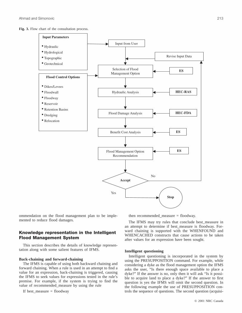
ommendation on the flood management plan to be imple-mented to reduce flood damages.
Knowledge representation in the IntelligentFlood Management System
This section describes the details of knowledge represen-tation along with some salient features of IFMS.
Back-chaining and forward-chainingThe IFMS is capable of using both backward chaining and
forward chaining. When a rule is used in an attempt to find avalue for an expression, back-chaining is triggered, causingthe IFMS to seek values for expressions tested in the rule’spremise. For example, if the system is trying to find thevalue of recommended_measure by using the rule
If best_measure = floodway
then recommended_measure = floodway.
The IFMS may try rules that conclude best_measure inan attempt to determine if best_measure is floodway. For-ward chaining is supported with the WHENFOUND andWHENCACHED constructs that cause actions to be takenafter values for an expression have been sought.
Intelligent questioningIntelligent questioning is incorporated in the system by
using the PRESUPPOSITION command. For example, whileconsidering a dyke as the flood management option the IFMSasks the user, “Is there enough space available to place adyke?” If the answer is no, only then it will ask “Is it possi-ble to acquire land to place a dyke?” If the answer to firstquestion is yes the IFMS will omit the second question. Inthe following example the use of PRESUPPOSITION con-trols the sequence of questions. The second question (acquisi-
© 2001 NRC Canada
Ahmad and Simonovic 213
Fig. 3. Flow chart of the consultation process.
tion) will only be fired when the answer to the first question(distance-to-river) is no.
question(distance-to-river) = “From inspection of the pro-ject area, is there enough space available for placing adyke between river and area to be protected from flood?”legalvals(distance-to-river) = [yes,no].presupposition(acquisition) = distance-to-river = no.question(acquisition) = “From inspection of the projectarea, considering number of structures close to river bank,is it possible to acquire land to place a dyke between riverand area to be protected from floods?”legalvals(acquisition) = [yes,no].
With each question one fact related to the problem underconsideration is analyzed and information is stored in cachememory. Next time when the system tries to match that factwith the left hand side of any rule it will have ready-to-useinformation about the fact. The point is that the system willnot have to ask the same question more than once. TheIFMS has 78 separate parameters for collection of specificfacts to reach the system goals. The number of questions(parameters) prompted by the IFMS to the end-user during aconsultation process are dependent upon the path employedby the system to reach its goals, that is, not all questions areasked in every consultation.
Acceptable value of answersThe IFMS may ask the user for the value of an expression
it is seeking, if it encounters a question meta-fact in theknowledge base. Additional meta-facts specify the accept-able values for the expression. Acceptable values are pre-sented to the user in a menu or as an enumerated listfollowing the question. Expressions are declared to be “inte-ger” or “number” (real) and a range is specified. The IFMSis capable of accepting yes or no answers, multiple choices,integers, and real numbers.
The response to some questions posed to the users by theknowledge system is restricted. This includes specifying aquestion as single-valued or multi-valued (i.e., whether ornot the answer should be limited to a single definite answer),and specifying acceptable values or ranges for answers. Inaddition, unknown and (or) certainty factors are allowed ordisallowed for input. In the following example only a realnumber is allowed as an answer:
presupposition(channel-width) = selected-option = flood-way.question(channel-width) = “What is the bottom width ofthe floodway channel in metres? Please enter value in theform of real number.”legalvals(channel-width) = real.
or
question(foundation) = “Based on geotechnical informa-tion, how would you describe the strata underlying the topsoil?”legalvals(foundation) = [hard-rock,soft-rock,sand-or-silt,clay].
In this example the user is restricted to make a selection outof the four given options that is, hard-rock, soft-rock, sand-or-silt, and clay.
RulesThe rules are the storage of heuristic knowledge and they
affect the way parameter values are inferred and ultimatelydetermine the system goal(s). The rules use IF statementsfollowed by the THEN statement, to inference a conclusionbased upon parameter data. Some rules calculate a specificvalue based on input from the end-user. Rules are also usedto derive new facts based on specified conditions. The prem-ise of a rule specifies the conditions under which a new factcan be concluded. Symbolic, as well as numeric, compari-sons or tests are combined with standard Boolean operatorsto form the rule premise. Also, basic arithmetic functions areused in the premise of a rule.
This rule provides a definition of “between”:
if EXPRESSION = VALUE andVALUE > = LOWER_BOUND andVALUE < UPPER_BOUND
then between(EXPRESSION, LOWER_BOUND, UPPER_BOUND).
In some cases, the order of the rule is very important forguiding the application of knowledge.
Certainty factorsA certainty factor (CF) makes it possible to represent un-
certain knowledge in the IFMS. Certainty factors are enteredwith user-input. The inference engine automatically dealswith certainty factors, combining the certainty of input data,rule premise clauses, and rule conclusions, as well as accu-mulating the certainty of the same conclusion made by dif-ferent rules. The use of certainty factors allows the IFMS toreach realistic conclusions when presented with incomplete,uncertain, or even conflicting data or knowledge.
GoalsMore than one goal can be specified for the back-chaining
search. The initial search will be performed to satisfy thefirst goal and then each subsequent goal will be satisfied inorder. This gives knowledge engineers maximum flexibilityin developing search strategies.
goal = [recommended-measure,next_step].
In this example first goal determines the appropriate floodmanagement measure (recommended-measure) and secondgoal asks user what to do next, quit or another consultation.In case of another consultation it re-initializes the system.
FactsFacts are used in knowledge base to represent information
that is known statically about the domain. Facts may also bestored in cache files that can be loaded on demand.
Pattern-matchingPattern-matching variables are employed in rules and facts
to make them more general and powerful, combining into asingle fact that would otherwise require a number of rules orfacts.
Symbolic expressionsSymbolic expressions take on values (e.g., height of dyke,
construction_cost), can be tested in rules, tested or manipu-lated in procedures, or given static values via facts. When
© 2001 NRC Canada
214 Can. J. Civ. Eng. Vol. 28, 2001
the value of a symbolic expression is needed, the inferenceengine, guided by the knowledge base, may obtain the valuefrom a fact, by using rules, by asking the user, and (or) bycalling an external routine.
User friendlinessThe IFMS is equipped with an explanation and trace facil-
ity. Basic level explanations are automatically generated bythe IFMS to elaborate why a particular question is beingasked. This explanation is based on the rule or procedurethat caused the question to be asked. The trace facility canbe used to display events as a consultation is run. The exactsequence of goals sought, rules invoked, facts or proceduresused, instances created, and conclusions made by systemduring a consultation can be traced.
Logic of inference engine
In this section the logic and reasoning used by an expert(as captured in the knowledge base) to select a particularflood management option has been described. The heuristicknowledge (knowledge developed through experience) wascollected from experts in the Water Resources Branch ofManitoba Department of Conservation through series of in-terviews. In addition to domain knowledge obtained fromexperts some rules were formulated from published informa-tion. The knowledge and logic were captured in the IFMSusing the IF–THEN structure of rules. A brief description isgiven for criteria expressed by experts for selection of eachflood management option.
DykesAn important requirement for considering dykes as a
flood management option is that either there should be spaceavailable, between the area to be protected from floods andthe river bank, to site a dyke or it should be feasible to ac-quire the land. It is not feasible to construct a dyke if the soiltype in the vicinity is clay or if the foundation is clay.
FloodwallLevees and (or) dykes and floodwalls have been consid-
ered as two separate flood management options. Generally,dykes cover two or more sides of an area to be protectedfrom floods. A floodwall, on the other hand, is along thebank of the river providing a barrier between the river andthe area to be protected from floods. It is not feasible to con-struct a floodwall if either the soil type in the area, or thefoundation, is clay. A floodwall is also not recommended,due to environmental considerations, if there are wetlands ormarshes in the area, as they will dry out without naturalfloods. To consider a floodwall either there should be roomavailable, between the area to be protected from flood andthe riverbank, to place a floodwall or it should be feasible toacquire the land. There should also be a place available toplug in the floodwall at both ends like natural high ground,road, hill, etc. If there is a place to plug in the floodwall onsides and there are none or few wetlands or marshes in thearea then a floodwall is preferred over a dyke.
Floodway (diversion)A floodway is not an option for a small town or if only
few houses are to be protected from floods. To consider afloodway either there should be no endangered animal spe-cies in the watershed area, or the corridor of movement forthese species should not be interrupted by construction ofthe floodway. Excavation should be easily possible, that is,there should be no bedrock within the excavation depth offloodway. Another important factor is that either thereshould be a natural water body to dispose the diverted water,or there should be enough gradient available to drop the wa-ter back into the river without causing a serious backwatereffect.
Retention basinThe willingness of farmers to allow their land to be flooded
is very important for controlled flooding option. Water-logging (high ground water levels) should not be severe inthe area. There should be no historic site of importance or itshould be possible to protect the site from damages causedby controlled flooding by constructing a dyke around it orby using some other measures.
Dam and (or) reservoirThese are not an option for small towns unless the project
can be economically justified by considering additional useslike hydropower generation, water supply, recreation, etc.They are not feasible in river environments where high sedi-mentation is an issue. Water-logging should not be severe inthe area. Either there should be no endangered animal spe-cies in the watershed area or their corridor of movementshould not be interrupted by construction of a reservoir. Agood foundation must be available (e.g., rock, sand, or silt).The geology should not be permeable. There should be nowetlands in the area. Land use should not be forest, espe-cially rain forest. There should be no historic site of impor-tance, or it should be possible to protect the site fromdamage by constructing a dyke around it. There should beno endangered aquatic habitat in the river system. Most im-portant of all there should be a suitable site available tobuild a reservoir.
DredgingThis is not an option for small towns or if there are only
few houses to be protected from floods. It should not be con-sidered if the majority of the watershed is bare land as sur-face runoff will bring lots of sediments. Water-loggingshould not be severe, as additional capacity would be lostdue to increased groundwater flow into the river. The riverpath should be stable. Dredging is not an option if the sedi-mentation problem is severe in the river. The additional ca-pacity of the river required to accommodate damagingfloods should preferably be equal to or less than 50% of theexisting river capacity. There should be no endangeredaquatic habitat in the river system.
Relocation of townThis option should be considered only if it is a small town
or there are only few houses in the area to be protected fromfloods, if damaging floods are frequent, if damages are highand all other options are not economically justified.
© 2001 NRC Canada
Ahmad and Simonovic 215
Illustrative case study
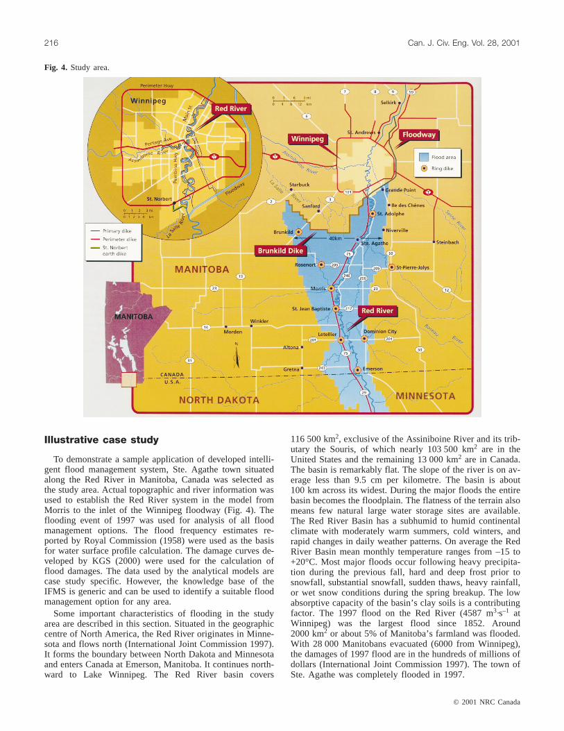
To demonstrate a sample application of developed intelli-gent flood management system, Ste. Agathe town situatedalong the Red River in Manitoba, Canada was selected asthe study area. Actual topographic and river information wasused to establish the Red River system in the model fromMorris to the inlet of the Winnipeg floodway (Fig. 4). Theflooding event of 1997 was used for analysis of all floodmanagement options. The flood frequency estimates re-ported by Royal Commission (1958) were used as the basisfor water surface profile calculation. The damage curves de-veloped by KGS (2000) were used for the calculation offlood damages. The data used by the analytical models arecase study specific. However, the knowledge base of theIFMS is generic and can be used to identify a suitable floodmanagement option for any area.
Some important characteristics of flooding in the studyarea are described in this section. Situated in the geographiccentre of North America, the Red River originates in Minne-sota and flows north (International Joint Commission 1997).It forms the boundary between North Dakota and Minnesotaand enters Canada at Emerson, Manitoba. It continues north-ward to Lake Winnipeg. The Red River basin covers
116 500 km2, exclusive of the Assiniboine River and its trib-utary the Souris, of which nearly 103 500 km2 are in theUnited States and the remaining 13 000 km2 are in Canada.The basin is remarkably flat. The slope of the river is on av-erage less than 9.5 cm per kilometre. The basin is about100 km across its widest. During the major floods the entirebasin becomes the floodplain. The flatness of the terrain alsomeans few natural large water storage sites are available.The Red River Basin has a subhumid to humid continentalclimate with moderately warm summers, cold winters, andrapid changes in daily weather patterns. On average the RedRiver Basin mean monthly temperature ranges from –15 to+20°C. Most major floods occur following heavy precipita-tion during the previous fall, hard and deep frost prior tosnowfall, substantial snowfall, sudden thaws, heavy rainfall,or wet snow conditions during the spring breakup. The lowabsorptive capacity of the basin’s clay soils is a contributingfactor. The 1997 flood on the Red River (4587 m3·s–1 atWinnipeg) was the largest flood since 1852. Around2000 km2 or about 5% of Manitoba’s farmland was flooded.With 28 000 Manitobans evacuated (6000 from Winnipeg),the damages of 1997 flood are in the hundreds of millions ofdollars (International Joint Commission 1997). The town ofSte. Agathe was completely flooded in 1997.
© 2001 NRC Canada
216 Can. J. Civ. Eng. Vol. 28, 2001
Fig. 4. Study area.

Sample consultation with the IntelligentFlood Management System
A sample consultation with the IFMS is listed in this sec-tion. First the questions are given, which IFMS will ask dur-ing consultation, followed by list of possible answers tochoose from (Fig. 5). The answers in bold are the ones se-lected for this sample consultation. A number next to se-lected answer shows the confidence factor for that particularanswer.
Which option best describes the proximity of the area tobe protected from floods?
(a) Along major river (100) ; (b) coastal area; (c) alongmultiple streams
What climatic factors are mainly responsible for flooding?(a) Snow melt; (b) rainfall; (c) combination (80)How do you categorize the size of area to be considered
for flood protection?(a) Large city; (b) medium size city; (c) small town (100);
(d) few housesTo have an estimate of what volume of flood we are deal-
ing with, Choose a range of flood discharges that best de-scribes the maximum recorded historic flood in the area?Values are in cubic metres per second.
(a) More than 5000; (b) 2000–5000 (90); (c)1000–2000;(d) less than 1000
How do you describe the frequency of floods causingdamages in the area? Make a choice based on return period.
(a) One in hundred; (b) one in fifty (60); (c) one intwenty; (d) one in ten; (e) more frequent
How do you describe the topography of study area?(a) Flat (100); (b) hilly; (c) moderate slope
Where the area considered for flood protection is locatedwith respect to river?
(a) Close (100); (b) farHow would you describe the changes in river course and
(or) path?(a) Stable (80); (b) changes frequentlyHow would you describe the river-channel cross-section?(a) Unstable; (b) stable uniform; (c) stable nonuniform
(70)What is the predominant soil type in the area considered
for flood protection?(a) Silt loam; (b) sand loam; (c) clay loam (75)Based on geotechnical information, how would you de-
scribe the strata underlying the top soil?(a) Hard rock; (b) soft rock; (c) sand or silt (70); (d) clayHow would you describe the floods based on response
time of catchment?(a) Flash floods; (b) slow floods (65)How would you describe the level of study area with re-
spect to existing riverbanks?(a) Lower; (b) same level (100); (c) higherFrom inspection of the project area, is there enough space
available for placing a dyke between river and area to beprotected from flood?
(a) Yes (90); (b) noAre there wetlands, marshlands or swamps in the water-
shed?(a) Yes a lot; (b) some; (c) not at all (95)From inspection of the project area, are there suitable ob-
jects (e.g., roads, high ground, hills) available to plug inboth ends of floodwall?
(a) Yes; (b) no (100)
© 2001 NRC Canada
Ahmad and Simonovic 217
Fig. 5. User consultation with the system.

From inspection of the project area, considering numberof structures close to river bank, would it be possible to ac-quire those buildings to place a dyke between river and areato be protected from floods?
(a) yes (90); (b) noBased on geotechnical information, considering the strata
underlying the topsoil, is there a chance to encounter rockformation within excavation depth for floodway?
(a) Yes; (b) no (90)Is there a large natural water body (reservoir, lake) avail-
able nearby, with a capacity to absorb floodwater?(a) Yes; (b) no (100)From inspection of the project area, is there enough slope
difference available to drop the water from floodway backinto the river without causing serious backwater effect?
(a) Yes (100); (b) noAre there any endangered animal or bird species in the
project area?(a) Yes; (b) no (95)How would you describe the sedimentation process (silt-
ing and (or) scouring) in the River?(a) Heavy; (b) medium; (c) slight (70)To what extent is water logging, that is, ground water
within the root zone, a problem in the watershed?(a) Severe; (b) moderate; (c) nil (95)From inspection of the project area, Is there a route avail-
able for the floodway, without building excessive infrastruc-ture components like bridges, etc.?
(a) Yes (90); (b) noIs there any rare aquatic habitat (fish, etc.) in the river sys-
tem?(a) Yes; (b) no (95)
Is there any important historic site located in the area thatwill be affected by the project?
(a) Yes; (b) no (100)What is the climate category of the watershed?(a) Subarctic (60); (b) marine westcoast; (c) humid sub-
tropical; (d) Mediterranean; (e) rain forest; (f) desertChoose a range of discharges that best represent the safe
carrying capacity of river. Values are in cubic metres persecond.
(a) More than 5000;(b) 2000–5000 (75); (c) 1000–2000;(d) less than 1000
Considering the historic maximum-recorded flood andsafe carrying capacity of river make a selection that best de-scribes the additional capacity of river required to accommo-date floods. Values are in percentage of existing capacity.
(a) More than 100;(b) 50–100 (85); (c) 25–50; (d) less-than 25
What is the geology of the area?(a) Permeable;(b) semi-permeable (80); (c) impermeableWhat is the land use and vegetation cover in the area con-
sidered for flood protection?(a) Bare ground; (b) crop land (90); (c) grass land;
(d) forest coverHow do you rate the farmers’ willingness to allow their
land to be flooded (used as retention basin)? Use a scale ofzero to ten where 10 is total acceptance and 0 is completeresistance?
2 (70)Following the interactive session with the user the IFMS
consults the knowledge base and makes preliminary recom-mendations.• Build a Levee and (or) dyke CF (84%)• Build a Floodway CF (60%)
© 2001 NRC Canada
218 Can. J. Civ. Eng. Vol. 28, 2001
Fig. 6. Analyzing the floodway option in the HEC-RAS.
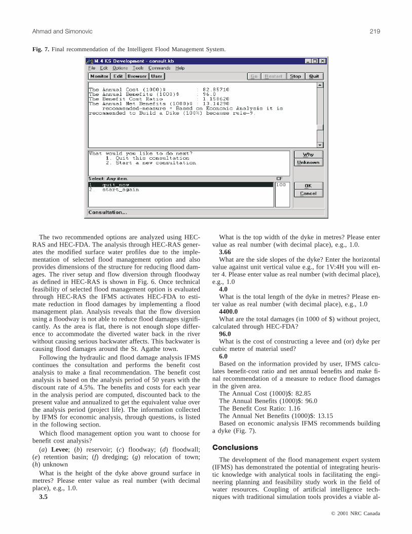
The two recommended options are analyzed using HEC-RAS and HEC-FDA. The analysis through HEC-RAS gener-ates the modified surface water profiles due to the imple-mentation of selected flood management option and alsoprovides dimensions of the structure for reducing flood dam-ages. The river setup and flow diversion through floodwayas defined in HEC-RAS is shown in Fig. 6. Once technicalfeasibility of selected flood management option is evaluatedthrough HEC-RAS the IFMS activates HEC-FDA to esti-mate reduction in flood damages by implementing a floodmanagement plan. Analysis reveals that the flow diversionusing a floodway is not able to reduce flood damages signifi-cantly. As the area is flat, there is not enough slope differ-ence to accommodate the diverted water back in the riverwithout causing serious backwater affects. This backwater iscausing flood damages around the St. Agathe town.
Following the hydraulic and flood damage analysis IFMScontinues the consultation and performs the benefit costanalysis to make a final recommendation. The benefit costanalysis is based on the analysis period of 50 years with thediscount rate of 4.5%. The benefits and costs for each yearin the analysis period are computed, discounted back to thepresent value and annualized to get the equivalent value overthe analysis period (project life). The information collectedby IFMS for economic analysis, through questions, is listedin the following section.
Which flood management option you want to choose forbenefit cost analysis?
(a) Levee; (b) reservoir; (c) floodway; (d) floodwall;(e) retention basin; (f) dredging; (g) relocation of town;(h) unknown
What is the height of the dyke above ground surface inmetres? Please enter value as real number (with decimalplace), e.g., 1.0.
3.5
What is the top width of the dyke in metres? Please entervalue as real number (with decimal place), e.g., 1.0.
3.66What are the side slopes of the dyke? Enter the horizontal
value against unit vertical value e.g., for 1V:4H you will en-ter 4. Please enter value as real number (with decimal place),e.g., 1.0
4.0What is the total length of the dyke in metres? Please en-
ter value as real number (with decimal place), e.g., 1.04400.0What are the total damages (in 1000 of $) without project,
calculated through HEC-FDA?96.0What is the cost of constructing a levee and (or) dyke per
cubic metre of material used?6.0Based on the information provided by user, IFMS calcu-
lates benefit-cost ratio and net annual benefits and make fi-nal recommendation of a measure to reduce flood damagesin the given area.
The Annual Cost (1000)$: 82.85The Annual Benefits (1000)$: 96.0The Benefit Cost Ratio: 1.16The Annual Net Benefits (1000)$: 13.15Based on economic analysis IFMS recommends building
a dyke (Fig. 7).
Conclusions
The development of the flood management expert system(IFMS) has demonstrated the potential of integrating heuris-tic knowledge with analytical tools in facilitating the engi-neering planning and feasibility study work in the field ofwater resources. Coupling of artificial intelligence tech-niques with traditional simulation tools provides a viable al-
© 2001 NRC Canada
Ahmad and Simonovic 219
Fig. 7. Final recommendation of the Intelligent Flood Management System.
ternative to deal with complex issues involved in selectionof flood management option. The system is not only valu-able as a training tool for “entry level” professionals, but canalso act as an advisor to a decision maker with less exposureto flood management issues. It captures valuable expertise inthe area of flood management and also allows for easy dis-semination of that expertise to less experienced profession-als. The codification of expertise has been done to ensurethat, as new technology and knowledge in flood manage-ment options become available, they can easily be incorpo-rated into the existing system. The salient benefits ofIntelligent Flood Management System presented in this pa-per are:• it captures and disseminates the valuable expertise in
flood management area.• it minimizes the time it takes to select the flood manage-
ment option.• it allows for the end-user the flexibility to try different cri-
teria easily and efficiently (what-if analysis).• the system is valuable as a training tool for entry-level
professionals.• it augments the experienced professionals as an interactive
problem-solving and advisory system.Environmental concerns related to different flood damage
reduction measures have been addressed implicitly in themodel. For example, the choice of a measure is influencedby the presence of aquatic life, endangered species, historicsites, wetlands, rain forest, etc, however, there are some en-vironmental aspects that are not addressed in the currentmodel for example impacts on river morphology, etc. Thesedimentation process and river morphology may be consid-ered by adding an appropriate modelling tool in the modelbase of the IFMS. Similarly, for benefit cost analysis, dam-ages are calculated for infrastructure and buildings only. Thecost of lost income due to flooding is not considered for theanalysis; however, the model structure is flexible and moredetails can be added for analysis, if additional information isavailable.
Based on the performance of this system, the domain offlood management appears appropriate for the use of expertsystem technology. This project has also demonstrated thatthe model base (hydraulic analysis tool) is a very importantpart of the Intelligent Flood Management System. Currentlywork is in progress to integrate expert system with more so-phisticated hydraulic and geographical analysis tools (two-dimensional hydrodynamic model and GIS) that will furtherincrease benefits to the professionals dealing with floodmanagement issues in complex topographic environments.
Acknowledgments
This work was made possible by an operating grant fromthe Natural Sciences and Engineering Research Council ofCanada (NSERC). The authors would like to thank the Wa-ter Resource Branch, Manitoba Department of Conservation,for providing the necessary data and expertise.
References
Arumugam N., and Mohan, S. 1997. Integrated decision supportsystem for tank irrigation system operation. Journal of WaterResources Planning and Management,123(5): 266–273.
Bender, M., Simonovic, S.P. 1994. Decision-support system forlong-range stream flow forecasting. Journal of Computing inCivil Engineering,8(1): 20–34.
Chang, T. J., Kleopa, X. A., and Teoh, C. B. 1996. Development ofan expert system for daily drought monitoring. Journal of Com-puting in Civil Engineering,10(1): 20–24.
Cimflex Teknowledge Corporation. 1991. M.4 User Guide.Cimflex Teknowledge Corporation, Calif.
Davis, J.R., Nanninga, P.M., John Biggins, and Laut, P. 1991. Proto-type decision support system for analyzing impact of catchmentpolicies. Journal of Water Resources Planning and Management,117(4): 399–414.
DeGagne, M.P., Douglas, G.G., Hudson, H.R., and Simonovic, S.P.1996. A decision support system for the analysis and use ofstage—discharge rating curves. Journal of Hydrology,184(3–4):225–241.
Engel, B.A., and Beasley, D.B. 1991. DSS: dam site selector expertsystem for education. Journal of Irrigation and Drainage Engi-neering,117(5): 774–782.
Evans, T.A., Djokic, D., and Maidment, D.R. 1993. Developmentand application of expert geographic information system. Jour-nal of Computing in Civil Engineering,7(3): 339–353.
International Joint Commission. 1997. Red river flooding, shortterm measures: interim report of the International Red River Ba-sin Task Force to the International Joint Commission, Ottawa.International Joint Commission, Washington, D.C.
KGS (Kontzamanis Graumann Smith Macmillan Inc.). 2000. Redriver basin stage damage curves update and preparation of flooddamage maps: report submitted to International Joint Commis-sion, Ottawa. International Joint Commission, Washington, D.C.
León, C., Martín, S., Elena, J. M., and Luque, J. 2000. EXPLORE-hybrid expert system for water networks management. Journalof Water Resources Planning and Management,126(2): 65–74.
Masri, A., and Moore, J. E. 1995. Integrated planning informationsystems: disaster planning analysis. Journal of Urban Planningand Development,121(1): 19–39.
McKinney, D.C., Maidment, D.R., and Tanriverdi, M. 1993. Expertgeographic information system for Texas water planning. Journalof Water Resources Planning and Management,119(2): 170–183.
McBean, E.A., Gorrie, J., Fortin, M., Ding, J., and Moulton, R.1988. Flood depth-damage curves by interview survey. Journal ofWater Resources Planning and Management,114(6): 613–634.
Mohammadabad, S. H., and Riordan, D. 2000. Small hydropoweradvisor: application and user perspective. Journal of Energy En-gineering,126(2): 83–93.
Palmer, R.N. 1987. Expert system for drought management plan-ning. Journal of Computing in Civil Engineering,1(4): 284–297.
Raman, H., Mohan, S., and Rangacharya, N. C. V. 1992. Decisionsupport system for crop planning during droughts. Journal of Ir-rigation and Drainage Engineering,118(2): 229–241.
Royal Commission 1958. Report of the royal commission on floodcost benefit. Winnipeg, Man.
Shepherd, A., and Ortolano, L. 1996. Water-supply system opera-tions: critiquing expert-system approach. Journal of Water Re-sources Planning and Management,122(5): 348–355.
Simonovic, S.P., and Savic, D.A. 1989. Intelligent decision supportand reservoir management and operations. Journal of Computingin Civil Engineering,3(4): 367–385.
Simonovic, S. P. 1992. Reservoir systems analysis: closing gap be-tween theory and practice. Journal of Water Resources Planningand Management,118(3): 262–280.
Simonovic, S.P. 1996a. Decision support systems for sustainablemanagement of water resources, 1. general principles. Water In-ternational,21(4): 223–232.
© 2001 NRC Canada
220 Can. J. Civ. Eng. Vol. 28, 2001

© 2001 NRC Canada
Ahmad and Simonovic 221
Simonovic, S.P. 1996b. Decision support systems for sustainablemanagement of water resources, 2. case studies. Water Interna-tional, 21(4): 233–244.
Simonovic, S.P., and Bender, M.J. 1996. Collaborative planning-support system: an approach for determining evaluation criteria.Journal of Hydrology,177(3–4): 237–251.
United States Army Corps of Engineers. 1998a. HEC-RAS: riveranalysis system, Reference Manual, CPD-69, Hydrologic Engi-neering Center, Davis, Calif.
United States Army Corps of Engineers. 1998b. HEC-FDA: flooddamage reduction analysis, User’s Manual, CPD-72, HydrologicEngineering Center, Davis, Calif.
Wurbs, R.A. 1996. Optimal sizing of flood damage reduction mea-sures based on economic efficiency. International Journal of Wa-ter Resources Development,12(1): 5–16.

Copyright © 2022 FDOKUMEN