
INSPIRE data specification on - Guidelines
370
INSPIRE Infrastructure for Spatial Information in Europe D2.8.III.3 Data Specification on SOIL – Draft Guidelines Title D2.8.III.3 INSPIRE Data Specification on SOIL – Draft Guidelines Creator INSPIRE Thematic Working Group SOIL Date 2012-04-20 Subject INSPIRE Data Specification for the spatial data theme SOIL Publisher INSPIRE Thematic Working Group SOIL Type Text Description This document describes the INSPIRE Data Specification for the spatial data theme SOIL Contributor Members of the INSPIRE Thematic Working Group SOIL Format Portable Document Format (pdf) Source Rights Restricted to TWG members, DT DS and CT Identifier D2.8.III.3_v3.0rc Language En Relation Directive 2007/2/EC of the European Parliament and of the Council of 14 March 2007 establishing an Infrastructure for Spatial Information in the European Community (INSPIRE) Coverage Project duration
-
Upload
khangminh22 -
Category
Documents
-
view
2 -
download
0
Transcript of INSPIRE data specification on - Guidelines

INSPIRE Infrastructure for Spatial Information in Europe
D2.8.III.3 Data Specification on SOIL – Draft Guidelines
Title D2.8.III.3 INSPIRE Data Specification on SOIL – Draft Guidelines
Creator INSPIRE Thematic Working Group SOIL
Date 2012-04-20
Subject INSPIRE Data Specification for the spatial data theme SOIL
Publisher INSPIRE Thematic Working Group SOIL
Type Text
Description This document describes the INSPIRE Data Specification for the spatial data theme SOIL
Contributor Members of the INSPIRE Thematic Working Group SOIL
Format Portable Document Format (pdf)
Source
Rights Restricted to TWG members, DT DS and CT
Identifier D2.8.III.3_v3.0rc
Language En
Relation Directive 2007/2/EC of the European Parliament and of the Council of 14 March 2007 establishing an Infrastructure for Spatial Information in the European Community (INSPIRE)
Coverage Project duration

INSPIRE Reference: D2.8.III.3_v3.0rc
TWG-SO Data Specification on SOIL 2012-04-20 Page II
Change Log Based on a review of the model and received comments on V 2.0 the following main changes were made to reach V 3.0:
- The model was simplified and restructured in such a way that data suppliers can get a quicker overview which information is needed. The changes appeared mostly in structuring the model and extension.
- In addition to the model one application schema was developed as a Use Case (Annex C) showing how data on a subject may be used in the model. The Use Case, covering contamination is generic, and is not dedicated to a specific use case, so it will better fit to practice
- All information from the Use Cases is removed from the text from the main part of the report. The description of the 15 Use Cases from Annex B of version 2.0 are maintained and updated.
- Contamination was changed into a dedicated use case and it shows how data on contamination can be used in the model. Polluting elements are treated as chemical elements on the same level as for example nutrients.
- For Soil Derived Information one example is described how the model can be used in a more concrete use case (Annex D).
- The INSPIRE O&M package changed considerable from 2.0 onwards. We kept the basic O&M pattern and beside the Observation object itself applied the Process object and the ObservableProperty dataType is defined in this package.
- The SoilSample object was removed from the model since is rarely used as a persistent object. Instead the profile element can act as a replacement.
- A generic data type for all parameterTypes of the different classes was introduced for more clarity
- Coverage was implemented for rectified grids serving Soil Derived Information. - The model for naming soil types in WRB was reviewed and updated. - From the comments it was clear that the term Soil Complex could cause misunderstanding for a
group of data suppliers. An inventory on the used terminology was fulfilled among European soil experts. Based on the inventory the term Soil Body is now used instead of soil complex.
- Soil derived information is central for the use of soil data in society. The model was on this point improved.
- In close co-operation with TWG Geology code lists were made (EventProcess, EventEnvironment and LithologyTerm) which are applicable in both domains.
- The core attributes for the feature types ProfileElement and SoilProfile were evaluated in detail and revised. Decided was that only these attributes important for adopted EU regulations should be included.
- All definitions and descriptions are reviewed and if needed corrected.

INSPIRE Reference: D2.8.III.3_v3.0rc
TWG-SO Data Specification on SOIL 2012-04-20 Page III
Foreword How to read the document? This document describes the “INSPIRE data specification on SOIL – Guidelines” version 3.0rc as developed by the Thematic Working Group (TWG) TWG-Soil using both natural and a conceptual schema language. The data specification is based on a common template used for all data specifications and has been harmonised using the experience from the development of the Annex I data specifications. This document provides guidelines for the implementation of the provisions laid down in the draft Implementing Rule for spatial data sets and services of the INSPIRE Directive. This document includes two executive summaries that provide a quick overview of the INSPIRE data specification process in general, and the content of the data specification on SOIL in particular. We highly recommend that managers, decision makers, and all those new to the INSPIRE process and/or information modelling should read these executive summaries first. The UML diagrams (in Chapter 5) offer a rapid way to see the main elements of the specifications and their relationships. The definition of the spatial object types, attributes, and relationships are included in the Feature Catalogue (also in Chapter 5). People having thematic expertise but not familiar with UML can fully understand the content of the data model focusing on the Feature Catalogue. Users might also find the Feature Catalogue especially useful to check if it contains the data necessary for the applications that they run. The technical details are expected to be of prime interest to those organisations that are/will be responsible for implementing INSPIRE within the field of SOIL. The technical provisions and the underlying concepts are often illustrated by examples. Smaller examples are within the text of the specification, while longer explanatory examples and descriptions of selected use cases are attached in the annexes. In order to distinguish the INSPIRE spatial data themes from the spatial object types, the INSPIRE spatial data themes are written in italics.
The document will be publicly available as a ‘non-paper’. It does not represent an official position of the European Commission, and as such cannot be invoked in the context of legal procedures.
Legal Notice Neither the European Commission nor any person acting on behalf of the Commission is responsible for the use which might be made of this publication.

INSPIRE Reference: D2.8.III.3_v3.0rc
TWG-SO Data Specification on SOIL 2012-04-20 Page IV
Interoperability of Spatial Data Sets and Services – General Executive Summary The challenges regarding the lack of availability, quality, organisation, accessibility, and sharing of spatial information are common to a large number of policies and activities and are experienced across the various levels of public authority in Europe. In order to solve these problems it is necessary to take measures of coordination between the users and providers of spatial information. The Directive 2007/2/EC of the European Parliament and of the Council adopted on 14 March 2007 aims at establishing an Infrastructure for Spatial Information in the European Community (INSPIRE) for environmental policies, or policies and activities that have an impact on the environment. INSPIRE will be based on the infrastructures for spatial information that are created and maintained by the Member States. To support the establishment of a European infrastructure, Implementing Rules addressing the following components of the infrastructure are being specified: metadata, interoperability of spatial data themes (as described in Annexes I, II, III of the Directive) and spatial data services, network services and technologies, data and service sharing, and monitoring and reporting procedures. INSPIRE does not require collection of new data. However, after the period specified in the Directive
1
Member States have to make their data available according to the Implementing Rules. Interoperability in INSPIRE means the possibility to combine spatial data and services from different sources across the European Community in a consistent way without involving specific efforts of humans or machines. It is important to note that “interoperability” is understood as providing access to spatial data sets through network services, typically via Internet. Interoperability may be achieved by either changing (harmonising) and storing existing data sets or transforming them via services for publication in the INSPIRE infrastructure. It is expected that users will spend less time and efforts on understanding and integrating data when they build their applications based on data delivered within INSPIRE. In order to benefit from the endeavours of international standardisation bodies and organisations established under international law their standards and technical means have been utilised and referenced, whenever possible. To facilitate the implementation of INSPIRE, it is important that all stakeholders have the opportunity to participate in specification and development. For this reason, the Commission has put in place a consensus building process involving data users, and providers together with representatives of industry, research and government. These stakeholders, organised through Spatial Data Interest Communities (SDIC) and Legally Mandated Organisations (LMO)
2, have provided reference materials,
participated in the user requirement and technical3 surveys, proposed experts for the Data
Specification Drafting Team4 and Thematic Working Groups
5 and participated in the public stakeholder
1 For all 34 Annex I,II and III data themes: within two years of the adoption of the corresponding
Implementing Rules for newly collected and extensively restructured data and within 5 years for other data in electronic format still in use 2 The current status of registered SDICs/LMOs is available via INSPIRE website:
http://inspire.jrc.ec.europa.eu/index.cfm/pageid/42 3 Surveys on unique identifiers and usage of the elements of the spatial and temporal schema,
4 The Data Specification Drafting Team has been composed of experts from Austria, Belgium, Czech
Republic, France, Germany, Greece, Italy, Netherlands, Norway, Poland, Switzerland, UK, and the European Environmental Agency 5 The Thematic Working Groups of Annex II and III themes have been composed of experts from
Austria, Belgium, Bulgaria, Czech Republic, Denmark, Finland, France, Germany, Hungary, Ireland, Italy, Latvia, Netherlands, Norway, Poland, Romania, Slovakia, Spain, Sweden, Switzerland, Turkey, UK, the European Commission, and the European Environmental Agency

INSPIRE Reference: D2.8.III.3_v3.0rc
TWG-SO Data Specification on SOIL 2012-04-20 Page V
consultations on draft versions of the data specifications. These consultations covered expert reviews as well as feasibility and fitness-for-purpose testing of the data specifications
6.
This open and participatory approach was successfully used during the development of the data specification on Annex I data themes as well as during the preparation of the Implementing Rule on Interoperability of Spatial Data Sets and Services
7 for Annex I spatial data themes.,
The development framework elaborated by the Data Specification Drafting Team aims at keeping the data specifications of the different themes coherent. It summarises the methodology to be used for the data specifications and provides a coherent set of requirements and recommendations to achieve interoperability. The pillars of the framework are five technical documents:
The Definition of Annex Themes and Scope8 describes in greater detail the spatial data
themes defined in the Directive, and thus provides a sound starting point for the thematic aspects of the data specification development.
The Generic Conceptual Model9 defines the elements necessary for interoperability and
data harmonisation including cross-theme issues. It specifies requirements and recommendations with regard to data specification elements of common use, like the spatial and temporal schema, unique identifier management, object referencing, a generic network model, some common code lists, etc. Those requirements of the Generic Conceptual Model that are directly implementable will be included in the Implementing Rule on Interoperability of Spatial Data Sets and Services.
The Methodology for the Development of Data Specifications10
defines a repeatable methodology. It describes how to arrive from user requirements to a data specification through a number of steps including use-case development, initial specification development and analysis of analogies and gaps for further specification refinement.
The “Guidelines for the Encoding of Spatial Data”11
defines how geographic information can be encoded to enable transfer processes between the systems of the data providers in the Member States. Even though it does not specify a mandatory encoding rule it sets GML (ISO 19136) as the default encoding for INSPIRE.
The “Guidelines for the use of Observations & Measurements and Sensor Web Enablement-related standards in INSPIRE Annex II and III data specification development” provides guidelines on how the “Observations and Measurements” standard (ISO 19156) is to be used within INSPIRE.
The structure of the data specifications is based on the “ISO 19131 Geographic information - Data product specifications” standard. They include the technical documentation of the application schema, the spatial object types with their properties, and other specifics of the spatial data themes using natural language as well as a formal conceptual schema language
12.
A consolidated model repository, feature concept dictionary, and glossary are being maintained to support the consistent specification development and potential further reuse of specification elements. The consolidated model consists of the harmonised models of the relevant standards from the ISO
6 For Annex II+III, the consultation phase lasted from 20 June to 21 October 2011.
7 Commission Regulation (EU) No 1089/2010 implementing Directive 2007/2/EC of the European
Parliament and of the Council as regards interoperability of spatial data sets and services, published in the Official Journal of the European Union on 8
th of December 2010.
8 http://inspire.jrc.ec.europa.eu/reports/ImplementingRules/DataSpecifications/D2.3_Definition_of_Ann
ex_Themes_and_scope_v3.0.pdf 9 http://inspire.jrc.ec.europa.eu/reports/ImplementingRules/DataSpecifications/D2.5_v3.3.pdf
10 http://inspire.jrc.ec.europa.eu/reports/ImplementingRules/DataSpecifications/D2.6_v3.0.pdf
11 http://inspire.jrc.ec.europa.eu/reports/ImplementingRules/DataSpecifications/D2.7_v3.2.pdf
12 UML – Unified Modelling Language

INSPIRE Reference: D2.8.III.3_v3.0rc
TWG-SO Data Specification on SOIL 2012-04-20 Page VI
19100 series, the INSPIRE Generic Conceptual Model, and the application schemas13
developed for each spatial data theme. The multilingual INSPIRE Feature Concept Dictionary contains the definition and description of the INSPIRE themes together with the definition of the spatial object types present in the specification. The INSPIRE Glossary defines all the terms (beyond the spatial object types) necessary for understanding the INSPIRE documentation including the terminology of other components (metadata, network services, data sharing, and monitoring). By listing a number of requirements and making the necessary recommendations, the data specifications enable full system interoperability across the Member States, within the scope of the application areas targeted by the Directive. Once finalised (version 3.0), the data specifications are published as technical guidelines and provide the basis for the content of the Implementing Rule on Interoperability of Spatial Data Sets and Services
14. The content of the Implementing Rule is extracted
from the data specifications keeping in mind short- and medium-term feasibility as well as cost-benefit considerations. The requirements included in the Implementing Rule will be legally binding for the Member States according to the timeline specified in the INSPIRE Directive. In addition to providing a basis for the interoperability of spatial data in INSPIRE, the data specification development framework and the thematic data specifications can be reused in other environments at local, regional, national and global level contributing to improvements in the coherence and interoperability of data in spatial data infrastructures.
13
Conceptual models related to specific areas (e.g. INSPIRE themes) 14
In the case of the Annex II+III data specifications, the extracted requirements will be used to formulate an amendment to the existing Implementing Rule.

INSPIRE Reference: D2.8.III.3_v3.0rc
TWG-SO Data Specification on SOIL 2012-04-20 Page VII
SOIL – Executive Summary Soil is indirectly involved in several EU Directives. These Directives are considered while compiling the Data specification. Based on the definition, the scope for the soil theme covers:
a) Soil inventories, providing one-off assessments of soil conditions and/or soil properties at certain locations and at a specific point in time, and allow soil monitoring, providing a series of assessments showing how soil conditions and/or properties change over time.
b) Soil mapping, providing a spatial presentation of the properties linked to the soils, including soil types; typically, soil maps are derived with the help of data available in soil inventories. Also other soil related information derived from soil properties, possibly in combination with non-soil data are within the scope.
The INSPIRE methodology was used (D2.6). The input from the Member States was used, resulting in 15 Use Cases covering Agro- Environmental Indicators, Soil Derived Information, Contaminated sites and Soil Monitoring (Annex B). Based on these Use cases, together with the expert knowledge present in the TWG, the model was build and validated. The comments from the Member State consultation and the testing were used to improve the model. The model contains a core of objects and attributes that are considered to be essential to act as a basis for further INSPIRE legislation. It presents an infrastructure along which data on soil can be exchanged. In addition to the model one application schema was developed as a Use Case (Annex C), following a generic approach, showing how the model can be extended to include also data on soil contamination. Annex D shows how the model can be extended for a soil derived theme in a more concrete use case. The soil parameters relevant for some approved EU Directives are included in the model in the feature types SoilProfile and ProfileElement. The data specification is based, as far as possible, on existing standards. Apart from general ISO19xxx standards used in relation to geographical information, use was made of the standards ISO/CD 28258 (Committee Draft/Soil Quality). As soil contains many observed and measured data an attempt was made to integrate elements of the standards ISO 19156:2011 Observation and Measurements and ISO 19123:2007 Coverage. To enhance interoperability the model promotes the use of the soil classification scheme WRB (World Reference Base on Soil resources) and the FAO horizon notation scheme. The use of other currently used (local, regional, national) classification systems is also provided for. Concerning the maintenance of the proposed vocabularies the European Soil Data Centre of the European Commission – Joint Research Centre agreed to develop and maintain the technical and scientific aspects related to this choice.
INSPIRE Reference: D2.8.III.3_v3.0rc
TWG-SO Data Specification on SOIL 2012-04-20 Page VIII
Acknowledgements Many individuals and organisations have contributed to the development of these Guidelines. The Thematic Working Group SOIL (TWG-SO) included: Arnold Arnoldussen (TWG Facilitator), Stijn Keijers (TWG Editor), Christine Le Bas, Jandirk Bulens (TWG co-editor), Edoardo Costantini, Einar Eberhardt, Patrick Engels, Marc van Liedekerke, Stephan Marahrens, Milan Sanka, Ainara Senar, Kees Versluijs, Robert Tomas (European Commission contact point). Other contributors to the INSPIRE data specifications are the Drafting Team Data Specifications, the JRC data specifications team and the INSPIRE stakeholders - Spatial Data Interested Communities (SDICs) or Legally Mandated Organisations (LMOs). Contact information Vanda Nunes de Lima European Commission Joint Research Centre Institute for Environment and Sustainability Spatial Data Infrastructures Unit TP262, Via Fermi 2749 I-21027 Ispra (VA) ITALY E-mail: [email protected] Tel.: +39-0332-7865052 Fax: +39-0332-7866325 http://ies.jrc.ec.europa.eu/ http://ec.europa.eu/dgs/jrc/ http://inspire.jrc.ec.europa.eu/

INSPIRE Reference: D2.8.III.3_v3.0rc
TWG-SO Data Specification on SOIL 2012-04-20 Page IX
Table of contents
1 Scope .............................................................................................................................................. 1
2 Overview ......................................................................................................................................... 1
2.1 Name ......................................................................................................................................... 1 2.2 Informal description ................................................................................................................... 1 2.3 Normative References .............................................................................................................. 8 2.4 Terms and definitions ................................................................................................................ 9 2.5 Symbols and abbreviations ....................................................................................................... 9 2.6 Notation of requirements and recommendations .................................................................... 10 2.7 Conformance ........................................................................................................................... 11
3 Specification scopes ..................................................................................................................... 11
4 Identification information ............................................................................................................... 11
5 Data content and structure ........................................................................................................... 11
5.1 Basic notions ........................................................................................................................... 12 5.1.1 Stereotypes ...................................................................................................................... 12 5.1.2 Placeholder and candidate types..................................................................................... 13 5.1.3 Voidable characteristics ................................................................................................... 14 5.1.4 Enumerations ................................................................................................................... 14 5.1.5 Code lists ......................................................................................................................... 15 5.1.6 Coverages ........................................................................................................................ 17
5.2 Application schema Soil Model ............................................................................................... 18 5.2.1 Description ....................................................................................................................... 18 5.2.2 Feature catalogue ............................................................................................................ 28 5.2.3 INSPIRE-governed code lists .......................................................................................... 71 5.2.4 Externally governed code lists ....................................................................................... 159
6 Reference systems ..................................................................................................................... 160
6.1 Coordinate reference systems .............................................................................................. 160 6.1.1 Datum ............................................................................................................................ 160 6.1.2 Coordinate reference systems ....................................................................................... 160 6.1.3 Display ........................................................................................................................... 161 6.1.4 Identifiers for coordinate reference systems .................................................................. 161
6.2 Temporal reference system .................................................................................................. 162 6.3 Theme-specific requirements and recommendations on reference systems ....................... 162
7 Data quality ................................................................................................................................. 162
7.1 Data quality elements............................................................................................................ 163 7.1.1 Completeness – Omission ............................................................................................. 163 7.1.2 Logical consistency – Conceptual consistency ............................................................. 164 7.1.3 Logical consistency – Domain consistency ................................................................... 165
7.2 Minimum data quality requirements ...................................................................................... 165 7.3 Recommendation on data quality ......................................................................................... 166
8 Dataset-level metadata ............................................................................................................... 166
8.1 Common metadata elements ................................................................................................ 167 8.1.1 Coordinate Reference System ....................................................................................... 168 8.1.2 Temporal Reference System ......................................................................................... 169 8.1.3 Encoding ........................................................................................................................ 170 8.1.4 Character Encoding ....................................................................................................... 171 8.1.5 Data Quality – Logical Consistency – Topological Consistency .................................... 171
8.2 Metadata elements for reporting data quality ....................................................................... 171 8.3 Theme-specific metadata elements ...................................................................................... 173

INSPIRE Reference: D2.8.III.3_v3.0rc
TWG-SO Data Specification on SOIL 2012-04-20 Page X
8.3.1 Maintenance Information ............................................................................................... 173 8.4 Guidelines on using metadata elements defined in Regulation 1205/2008/EC ................... 174
8.4.1 Conformity ...................................................................................................................... 174 8.4.2 Lineage .......................................................................................................................... 175 8.4.3 Temporal reference ....................................................................................................... 175
9 Delivery ....................................................................................................................................... 176
9.1 Delivery medium ................................................................................................................... 176 9.2 Options for delivering coverage data .................................................................................... 176 9.3 Encodings ............................................................................................................................. 178
9.3.1 Required Encoding(s) .................................................................................................... 178 9.3.2 Alternative Encoding(s) .................................................................................................. 179
10 Data Capture ............................................................................................................................... 182
11 Portrayal ...................................................................................................................................... 182
11.1 Layers to be provided by INSPIRE view services ............................................................. 183 11.1.1 Layers organisation .................................................................................................... 183
11.2 Styles to be supported by INSPIRE view services ............................................................ 183 11.2.1 Styles for the layer SO.SoilBody ................................................................................ 183 11.2.2 Styles for the layer SO.ObservedSoilProfile .............................................................. 184 11.2.3 Styles for the layer SO.SoilSite .................................................................................. 184
11.3 Other recommended styles ............................................................................................... 185 11.3.1 Styles for the layer SO.SoilBody ................................................................................ 185
Bibliography ......................................................................................................................................... 187
Annex A (normative) Abstract Test Suite ........................................................................................... 189
Annex B (informative)Use cases ......................................................................................................... 190
B.1 Agri-Environmental Indicator – Soil Erosion ......................................................................... 192 Detailed structured description of the Use Case ........................................................................ 193 Mapping of this Use Case with the INSPIRE soil model of DS3.0 ............................................. 195
B.2 Agri-Environmental Indicator – Soil Quality .......................................................................... 197 Mapping of this Use Case with the INSPIRE soil model of DS3.0 ............................................. 201
B.3 Progress in management of Contaminated sites (CSI 015) indicator ................................... 206 Narrative explanation of the use case ........................................................................................ 206 Detailed structured description of the Use Case ........................................................................ 206 Mapping of this Use Case with the INSPIRE soil model of DS3.0 ............................................. 206
B.4 Land Irrigation Suitability for Navarre (Spain) ....................................................................... 207 Mapping of the soil dataset with the INSPIRE Soil model of DS3.0 ........................................... 212
B.5 Development of methodologies for soil salinity surveillance in the middle Ebro basin (Spain) 213
Mapping of the soil dataset with the INSPIRE Soil model of DS3.0. .......................................... 221 B.6 MARS project ........................................................................................................................ 222
Mapping this Use Case with the INSPIRE soil model of DS3.0 ................................................. 225 B.7 Restrictions for agricultural use based on mineral, the N-, and P-saturation in the soil and (shallow) ground water ..................................................................................................................... 227 B.8 Calculation threshold trace elements .................................................................................... 232
Mapping of this Use Case with the INSPIRE soil model of DS3.0 ............................................. 234 B.9 Use of Soil Scape Viewer ..................................................................................................... 235
Narrative explanation of the use case ........................................................................................ 235 Detailed structured description of the Use Case ........................................................................ 236 Mapping of this Use Case with the INSPIRE soil model of DS3.0 ............................................. 237
B.10 Establishment Less Favoured Areas (France) .................................................................. 238 Mapping of this Use Case with the INSPIRE soil model of DS3.0 ............................................. 240
B.11 Contaminated Land Register Austria ................................................................................ 242 Mapping of the Use Case ‘Contaminated land register Austria’ with the INSPIRE soil model of DS3.0 .......................................................................................................................................... 247
INSPIRE Reference: D2.8.III.3_v3.0rc
TWG-SO Data Specification on SOIL 2012-04-20 Page XI
B.12 Risk for drinking water wells by contamination ................................................................. 249 Mapping of this Use Case ‘Risk for drinking water wells by contamination’ with the INSPIRE soil model of DS3.0 ........................................................................................................................... 251
B.13 Ecological risk of soil contamination.................................................................................. 252 Mapping of the Use Case ‘Ecological risk of soil contamination’ with the INSPIRE soil model of DS3.0 .......................................................................................................................................... 257
B.14 Contamination in relation to property ................................................................................ 258 Mapping of the Use Case ‘Contamination in relation to property’ with the INSPIRE soil model of DS3.0 .......................................................................................................................................... 261
B.15 State of soil in Europe ....................................................................................................... 263 Mapping of the Use Case ‘State of soil in Europe’ with the INSPIRE soil model of DS3.0 ........ 265
Annex C (informative) Overview contaminated sites as a possible extension of the Inspire data model Soil to be used on a voluntary basis .................................................................................................... 267
11.4 Feature catalogue ............................................................................................................. 274 11.4.1 Spatial object types .................................................................................................... 275 11.4.2 Data types .................................................................................................................. 279 11.4.3 Code lists .................................................................................................................... 281 11.4.4 Imported types (informative) ...................................................................................... 284
11.5 Codelists ............................................................................................................................ 287 11.5.2 Externally governed code lists ................................................................................... 333
Annex D (informative) Use case soil derived information ................................................................... 334
Annex E (normative) Encoding rules for TIFF and JPEG 2000 file formats ........................................ 340
E.1 Introduction ........................................................................................................................... 340 E.2 TIFF format ........................................................................................................................... 340
E.2.1 Format overview ............................................................................................................ 340 E.2.2 INSPIRE TIFF profile for grid coverage data ................................................................. 340 E.2.3 Mapping between TIFF and GML data structures ......................................................... 343 E.2.4 Theme-specific requirements and recommendations.................................................... 348
E.3 JPEG 2000 format................................................................................................................. 348 E.3.1 Format overview ............................................................................................................ 348 E.3.2 JPEG 2000 profile for INSPIRE SOIL data .................................................................... 349 E.3.3 Mapping between JPEG 2000 and GML data structures .............................................. 353 E.3.4 Theme-specific requirements and recommendations.................................................... 359
INSPIRE Reference: D2.8.III.3_v3.0rc
TWG-SO Data Specification on SOIL 2012-04-20 Page 1
1 Scope This document specifies a harmonised data specification for the spatial data theme SOIL as defined in Annex III of the INSPIRE Directive. This data specification provides the basis for the drafting of Implementing Rules according to Article 7 (1) of the INSPIRE Directive [Directive 2007/2/EC]. The entire data specification will be published as implementation guidelines accompanying these Implementing Rules.
2 Overview
2.1 Name INSPIRE data specification for the theme Soil
2.2 Informal description Definition: Soils and subsoil characterised according to depth, texture, structure and content of particles and organic material, stoniness, erosion, where appropriate mean slope and anticipated water storage capacity. [Directive 2007/2/EC] Description: For the purpose of the data specifications in this document, soil is the upper part of the earth’s crust, formed by mineral particles, organic matter, water, air and living organisms. It is the interface between earth, air and water which hosts most of the biosphere. Soil is a non-renewable resource at the human scale, which is important for many parts of society. In many places in the world, soil degradation is a serious process threatening that soil can fulfil its functions in the future. In the climate change debate, soil is becoming important in relation to climate change mitigation and adaptation. Soil degradation may result in soils that no longer can fulfil services like food production, or being so contaminated that they form a threat for human and/or ecological health. Soil is subject to a series of threats as recognized in the EU Soil Thematic Strategy (COM(2006)231 final): erosion, organic matter decline, contamination, salinisation, sodification, compaction, soil biodiversity loss, sealing, landslides and flooding. Also soil acidification is generally considered to be a problem in humid areas. Information on soils is crucial to make fundamental decisions and to protect the soil against degradation processes. The need for soil information can vary from improvement of agricultural and forestry production, prevention of environment damage due to human activities, or to getting to know the location and extent of sites with high concentrations of harmful substances. There is a high demand for soil

INSPIRE Reference: D2.8.III.3_v3.0rc
TWG-SO Data Specification on SOIL 2012-04-20 Page 2
information in relation to carbon sequestration (climate change), the prevention of soil degradation, improvement of agricultural production (e.g. food and bio-energy crops) and for the mitigation of desertification in areas with arid and semi-arid climatic conditions. In order to provide meaningful use and to share and exchange information in the field of soil, part of the world of soil (seen as a Universe of Discourse (UoD)) is to be modelled. The soil UoD is defined and limited by the problems that need to be solved and the solutions that are to be provided through the use of soil information. The kind of soil information is suggested by Use Cases (preferably underpinned by Legislation) that have been identified by the TWG-SO based on input from INSPIRE stakeholders and by the expertise available in the expert group. The following use cases are identified and described in Annex B
Agri-Environmental Indicators: - Use Case Environmental Indicator Soil Erosion - Use Case Environmental Indicator Soil Quality - Use Case Environmental Indicator Contaminated Sites
Thematic maps derived from soil information - Land irrigation suitability in Navarra (Spain) - Development of methodologies for soil salinity surveillance in the middle Ebro
basin (Spain) - Monitoring Agricultural ResourceS (MARS) project - Restrictions for N and P in agriculture - Calculation threshold trace elements - Use of Soil Scape Viewer - Establishment Less Favoured Areas (France)
Contaminated sites - Contaminated Land Register Austria - Use Case drinking water and soil contamination - Use Case Ecology and contamination - Use Case Property and contamination
Soil Monitoring - Use Case state of soil in Europe

INSPIRE Reference: D2.8.III.3_v3.0rc
TWG-SO Data Specification on SOIL 2012-04-20 Page 3
To show the relevance of known European legislation related to soil, the Use Cases were cross-checked with the legislation at hand; where there is a common interest or overlap on data used, it is indicated in the following table:
Use
Ca
ses
Ag
ri-E
nvir
on
men
tal In
dic
ato
rs:
- U
se C
ase E
nvironm
enta
l In
dic
ato
r S
oil
Ero
sio
n
- U
se C
ase E
nvironm
enta
l In
dic
ato
r S
oil
Qualit
y
- U
se C
ase E
nvironm
enta
l In
dic
ato
r C
onta
min
ate
d S
ites
Th
em
ati
c m
ap
s
- L
and irr
igatio
n s
uitabili
ty in N
avarr
a (
Spain
)
- D
evelo
pm
ent
of m
eth
odolo
gie
s f
or
soil
salin
ity
surv
eill
ance in
the m
iddle
Ebro
basin
(S
pain
)
- y
ield
fore
castin
g w
ithin
the M
AR
S p
roje
ct
- R
estr
ictio
ns f
or
N a
nd P
in a
griculture
- C
alc
ula
tio
n thre
shold
tra
ce e
lem
ents
- U
se o
f S
oil
Scape V
iew
er
- E
sta
blis
hm
ent
Less F
avoure
d A
reas (
Fra
nce)
Co
nta
min
ate
d s
ites
- C
onta
min
ate
d L
and R
egis
ter
Austr
ia
- U
se C
ase d
rinkin
g w
ate
r and s
oil
conta
min
atio
n
- U
se C
ase E
colo
gy a
nd c
onta
min
atio
n
- U
se C
ase P
ropert
y a
nd c
onta
min
atio
n
So
il M
on
ito
rin
g
- U
se C
ase s
tate
of soil
in E
uro
pe
Directives
CAP. Council regulation (EC) No 1782/2003 of 29 September 2003 establishing common rules for direct support schemes under the common agricultural policy.
● ●
Council Directive 91/676/EEC of 12 December 1991 concerning the protection of waters against pollution caused by nitrates form agricultural sources.
●
Directive 200/60/EC of the European Parliament and of the council of 23 October 2000 establishing a framework for Community action in the field of water policy.
● ● ●
Directive 2009/28/EC of the European Parliament and of the Council. Energy from renewable resources.
●
Directive 86/278/EC of the European Parliament and of the Council. Sewage Sludge Directive.
●
Directive 1999/31/EC of the European Parliament and of the Council of 26 April 1999 on the landfill and waste.
● ● ●
Still under discussion: Less Favoured Areas (LFA) Intermediate areas. This regulation is aimed at better targeting of natural handicap payments COM (2009) 161. (regulation not adopted yet)
●
Proposed Soil framework Directive (state of the proposal is pending) ● ● ● ● ●
Note that none of the directives is considered as a use case in itself. Based on the mentioned Use Cases and on the TWG-SO expertise, the following relevant and general uses for soil information were identified:
- For using the spatial distribution of soils and their properties, data that allow the creation of maps (at various scales) on the distribution of soil types and soil properties are needed. Such data are based on data taken from soil profiles, soil observations and soil samples (taken on soil sites at soil plots), which in combination with human expertise and/or automated procedures can be interpreted such that physical real world areas, which

INSPIRE Reference: D2.8.III.3_v3.0rc
TWG-SO Data Specification on SOIL 2012-04-20 Page 4
show certain soil characteristics, can be delineated, depending on the scale considered, and named here as soil bodies. Hence structuring soil data and the possibility for mapping them are included.
- Over time, important soil characteristics (e.g. content of organic carbon, soil acidity, etc.) may vary, and it can be required to follow these changes over time. Hence real world ‘soil monitoring’ is taken into consideration.
- In the context of the EU Soil Thematic Strategy, soil contamination is considered as one of the major threats to soil, at the local scale (contaminated sites); at large area scale (diffuse soil contamination, usually low level and dispersed by deposition from air, by groundwater or by agricultural practices) and at the level of brownfields (regions with many contaminated sites and usually combined with diffuse contamination). An attempt is made to include a generic approach towards some aspects of soil contamination.
The INSPIRE themes Soil and Geology show some overlap regarding the real world objects they describe, but often see them under different perspectives (Figure 1). For the soil domain, rock is the parent material of any soil development, and as such geogenic layers are included in soil datasets. Nonetheless, rock types and their genesis can be named in the same way as in the domain of geology. Hence, the codelists to characterize lithology, processes and process environments have been agreed upon by the INSPIRE Thematic Working Groups Geology and Soil. As the superficial layers in which soils develop are not considered in geological datasets throughout, the spatial data from both domains do not necessarily overlap, but kind of complete one another.

INSPIRE Reference: D2.8.III.3_v3.0rc
TWG-SO Data Specification on SOIL 2012-04-20 Page 5
Figure 1: The field of Pedology seen in relation to the field of Geology.
On the basis of the previous considerations, the soil theme includes the following phenomena (either in the physical world or conceptualized world):
- soil profiles - soil sites, soil plots - soil bodies (delineated areas on the earth’s surface determined on the basis of certain
soil characteristics) - soil characteristics (parameters) that change over time (possibly allowing soil
monitoring)
Considering these soil related phenomena, an object model is constructed in the form of a UML class diagram. Information exchange structured according to this model, originating from different providers, will be structurally interoperable and provide a possible way for meaningful exchange of soil information. A model was developed consisting of a core of objects, their interrelations and attributes; they are considered to be essential; this model is the basis for further INSPIRE legislation. However, as exemplified by some of the described Use Cases, the objects of the model do not fully allow for the implementation of certain uses and purposes. The need for modelling of soil data beyond this model is accommodated by the possibility of creating extensions to it. In this document, the implementation of a kind of extension is demonstrated for a Use Case on soil contamination. In the following, the structuring of the elements and concepts of the soil domain as model-objects and attributes is described. It should be noted that many elements of the European Soil Geographical Data Base and other international initiatives related to the standardization and exchange of soil data have been taken into account. The names given to the objects, attributes and associations are as neutral as possible i.e. not deliberately taken from existing, specific nomenclature.
Figure 2: Soil profile layer and horizon located in a soil plot.

INSPIRE Reference: D2.8.III.3_v3.0rc
TWG-SO Data Specification on SOIL 2012-04-20 Page 6
Soil Profiles The real world concept “soil profile” (SoilProfile class in the model) (illustrated by Figure 2) can be defined as a cross-section of the soil from the surface down to and including the beginning of the fresh material unmodified by pedogenesis, consisting of various more or less horizontally oriented features formed by pedogenic processes called horizons. Any real world soil profile, considered as a whole, can be characterized by a number of properties, such as: its soil type according to a soil classification scheme, its water capacity available for plants, coarse fragment cover, the presence of a water table, etc. Soil horizons within a profile possess biological, physical and chemical characteristics which differ from the horizons above and beneath and are distinguished principally by texture, colour, structure, chemical composition, and their biomass. The chemical properties may include concentrations in the solid, water and air phases, mobility and soil adsorption capacities. A profile can additionally be described with layers (instead of being described with horizons) which do not necessarily correspond with pedo-genetically formed horizons. Such layers can be fixed depths intervals of sampling, top- and subsoil, or geogenic layers. Layers and horizons are considered both as profile elements in the model as they are both horizontal subdivisions of the soil profile. The real world concept “observed soil profile” (ObservedSoilProfile object in the model) represents a soil profile physically located in a soil plot (or exposed with a boring), described in the field, possibly sampled and analysed in the laboratory. An observed soil profile refers to a real world location (specified by an associated soil plot).
Figure 3: Soil profiles, soil bodies.
A “derived soil profile” (DerivedSoilProfile object in the model) is a soil profile that cannot be located in a soil plot. It corresponds to the spatial extent of a soil type that has been observed in one or several observed soil profiles. The derived soil profile has property values that could be derived (e.g. averaged) from the values of the corresponding properties of one or more observed

INSPIRE Reference: D2.8.III.3_v3.0rc
TWG-SO Data Specification on SOIL 2012-04-20 Page 7
soil profiles. The derived soil profile can be characterized by the same properties as those of the observed soil profiles, but it is understood that the values for these properties have been derived or determined by expert judgment or calculation. A derived soil profile can be seen as a characterisation of a Soil Typological Unit (STU), or Series, as recognized in the European Soil Geographical Database and other soil databases at national or regional levels. A derived soil profile is not necessarily linked to observed soil profiles, in which case it represents a hypothetical soil profile. Soil delineated areas To delineate spatially an area that is characterized by a set of such derived soil profiles, the model introduces the construct of “soil body” (SoilBody object in the model) which represents an association (or other types of spatial interlinkages of various soil types) of soils that are found together in the area. Soils forming the soil body are described using derived soil profiles. The soil body can be represented by one or more derived soil profiles, giving an impression of the properties of the soil body as a whole. This is modelled by linking derived soil profiles to the soil body, indicating their area share, expressed in percentages or percentage ranges (see Figure 3). Note that the exact location of each kind of soil type within the soil body is unknown; only the area (geometry) of the soil body is known and also how much of this area is covered by each of the soil types (described as derived soil profiles) in that area. For instance, a soil body could consist of one dominant soil (as described by a derived soil profile) and of other soils (described by other derived soil profiles) having characteristics different from the dominant one. The label of a soil body allows a description of it, which may be useful for building legends. A soil body can be interpreted as a Soil Mapping Unit (SMU) as recognized in the European Soil Geographical Data Base and other soil databases at national or regional levels. In the context of the model, a SoilDerivedObject object is defined as a spatial object representing a soil related property which value could, for instance, be derived from values of soil properties of related observed soil profiles and/or related soil bodies (and thus soil derived profiles). A value completely independent of observed soil profiles and soil bodies could be possible as well. In practice, the derivation of values for the SoilDerivedObject objects could be done from information stored in observed soil profiles and/or soil bodies, or it could also be done from such information in combination with external data. An example of the former could be the calculation of pH or soil organic matter content in the topsoil, based on data found in a set of observed soil profiles. An example of the latter could be the derivation of certain soil related properties (for example soil erosion risk) for which calibrated models are to be used which not only extract and elaborate information from observed soil profiles and/or soil bodies, but also require data that are external to the soil Model (e.g. meteorological and land cover data). In Annex D an example is given how the model can be extended for a more concrete use case (soil organic carbon content and soil organic carbon stock), both as a coverage and as a vector. Soil Site and Soil Plot A soil site (SoilSite object in the model) is considered as a) the surrounding of a soil profile, and/or b) the larger piece of land that is directly linked to and described by all soil investigations on one or more spots, called soil plots. A “soil plot” (SoilPlot object in the model) is the location of a specific soil investigation (e.g. of a trial pit). Because for many soil investigations the studied soil is destroyed, the soil site provides also the object to which the results of repeated investigations are related and handled as if they were obtained from the very same place. The purpose of the investigation can be of a general nature (e.g. a reconnaissance whereby soil profiles are taken for a general soil characterization) or specific (e.g. a reconnaissance whereby samples are taken to investigate potentially contaminated land); this information can be crucial for data evaluation to identify bias in the selection of sites. A soil plot within a soil site is of a certain type (borehole, trial pit, sample) and located by coordinates and/or the name of that location. Soil characteristics that change over time

INSPIRE Reference: D2.8.III.3_v3.0rc
TWG-SO Data Specification on SOIL 2012-04-20 Page 8
There are no explicit constructs foreseen related to soil monitoring. Monitoring, considered as the repeated observation of one or more soil characteristics over time, can be implemented through the use of the various time/date attributes of the objects of the model. Soil Contamination There are no explicit constructs for soil contamination data in the Model. Contamination is implicitly included by the possibility of specifying contamination parameters for sites, profiles and profile elements. The contaminants are treated here like chemical elements. There are also no explicit constructs included in the model for contaminated sites. Extending the model with elements that relate to contaminated sites would be subject to the adoption of European legislation that requires and justifies such inclusion. For the moment, as an example how the model could be extended to deal with soil contaminated sites and site management, a generic Use Case on “Soil – Contamination” is provided in Annex C. Nevertheless, some heavy metal elements are part of a codelist for profile element parameter because they are cited by the directive 86/278/EC as elements to be analysed in agricultural parcels before the application of sewage sludge. Note on soil sampling In the context of soils two different meanings can be seen for “sample”: On the one hand, the notion of “soil sample”, considered as a physical part of the soil for which one or more properties are determined. This notion is not withheld as an explicit construct in the Model. On the other hand, “sample” is considered to be the location where soil material is taken at a specific depth or between a range of depths without doing any soil profile description. “Sample”, together with trial pit and borehole, is a type of soil plot. The latter is the concept described in the model.
2.3 Normative References [Directive 2007/2/EC] Directive 2007/2/EC of the European Parliament and of the Council of 14
March 2007 establishing an Infrastructure for Spatial Information in the European Community (INSPIRE)
[ISO 19107] EN ISO 19107:2005, Geographic Information – Spatial Schema [ISO 19108] EN ISO 19108:2005, Geographic Information – Temporal Schema [ISO 19108-c] ISO 19108:2002/Cor 1:2006, Geographic Information – Temporal Schema,
Technical Corrigendum 1 [ISO 19111] EN ISO 19111:2007 Geographic information - Spatial referencing by coordinates
(ISO 19111:2007) [ISO 19113] EN ISO 19113:2005, Geographic Information – Quality principles [ISO 19115] EN ISO 19115:2005, Geographic information – Metadata (ISO 19115:2003) [ISO 19118] EN ISO 19118:2006, Geographic information – Encoding (ISO 19118:2005) [ISO 19123] EN ISO 19123:2007, Geographic Information – Schema for coverage geometry and
functions [ISO 19135] EN ISO 19135:2007 Geographic information – Procedures for item registration (ISO
19135:2005)

INSPIRE Reference: D2.8.III.3_v3.0rc
TWG-SO Data Specification on SOIL 2012-04-20 Page 9
[ISO 19138] ISO/TS 19138:2006, Geographic Information – Data quality measures [ISO 19139] ISO/TS 19139:2007, Geographic information – Metadata – XML schema
implementation [OGC 06-103r3] Implementation Specification for Geographic Information - Simple feature
access – Part 1: Common Architecture v1.2.0 NOTE This is an updated version of "EN ISO 19125-1:2006, Geographic information – Simple feature access – Part 1: Common architecture". A revision of the EN ISO standard has been proposed. [Regulation 1205/2008/EC] Regulation 1205/2008/EC implementing Directive 2007/2/EC of the
European Parliament and of the Council as regards metadata ISO 19156: 2011. Geographic Information – Observation and Measurements. [ISO 19157] ISO/DIS 19157, Geographical information – Data quality.
2.4 Terms and definitions General terms and definitions helpful for understanding the INSPIRE data specification documents are defined in the INSPIRE Glossary
15.
2.5 Symbols and abbreviations <acronym/abbreviation> <explanation> CAP Common Agricultural Policy CGMS Crop Growth Monitoring System CORINE Coordination of Information on the Environment DG AGRI Directorate – General for Agriculture and Rural Development DG ENV Directorate – General for Environment DIS ISO Draft international standard DTM Digital Terrain Model EC European Commission EEA European Environmental Agency EIONET European Environment Information and Observation Network EMISS Electromagnetic induction sensing systems ESBN European Soil Bureau Network ESDaC European Soil Data Center ETRS89 European Terrestrial Reference System 1989 ETSSP European Thematic Strategy for Soil Protection
15
The INSPIRE Glossary is available from http://inspire-registry.jrc.ec.europa.eu/registers/GLOSSARY

INSPIRE Reference: D2.8.III.3_v3.0rc
TWG-SO Data Specification on SOIL 2012-04-20 Page 10
EU European Union FAO Food and Agricultural Organisation GCM Global Circulation Model GIS Geographical Information System GML Geography Mark-up Language GS Soil eContentplus project: “Assessment and strategic development of INSPIRE compliant
Geodata Services for European Soil data INSPIRE Infrastructure for Spatial Information in Europe IRENA Indicator reporting on the integration of environmental concerns into agricultural policy ISO International Organization for Standardization ITRS International Terrestrial Reference System IUSS International Union for Soil Associations JRC Joint Research Centre LFA Less Favoured Areas LMO Legally Mandated Organisation MARS Monitoring Agricultural ResourceS MCYFS Crop Yield Forecasting System NDVI Normalised Difference Vegetation Index NUTS Nomenclature of Units for Territorial Statistics OM Organic Matter PTF Pedo Transfer Function RDBMS Relational Database Management System RMQS Réseau de Mesures de la Qualité des Sols RUSLE Revised Universal Soil Loss Equation SCU Soil Cartographic Unit SDIC Spatial Data Interest Community SFD Proposed Soil Frame Work Directive SGDBE Soil Geographical Data Base for Europe SLD Second level domain SMU Soil Mapping Unit SRTM Shuttle Radar Topography Mission STU Soil Typological Unit TWG Thematic Working Group (INSPIRE) TWG SO Thematic Working Group Soil (INSPIRE) OCL Object Constraint Language O&M Observations & Measurements UML Unified Modelling Language UN United Nations URI Uniform Resource Identifier URL Uniform Resource Locator USBR United States Bureau for Reclamation USDA United States Department for Agriculture UTC Universal Time Coordinated WFD Water Frame Work Directive WRB World Reference Base for Soil Resources XML eXtensible Markup Language
2.6 Notation of requirements and recommendations To make it easier to identify the mandatory requirements and the recommendations for spatial data sets in the text, they are highlighted and numbered.

INSPIRE Reference: D2.8.III.3_v3.0rc
TWG-SO Data Specification on SOIL 2012-04-20 Page 11
IR Requirement X Requirements that are reflected in the Implementing Rule on interoperability of spatial data sets and services are shown using this
style.
TG Requirement X Requirements that are not reflected in the Implementing Rule on interoperability of spatial data sets and services are shown using this style.
Recommendation X Recommendations are shown using this style.
2.7 Conformance
TG Requirement 1 Any dataset claiming conformance with this INSPIRE data specification shall pass the requirements described in the abstract test suite presented in Annex A.
3 Specification scopes This data specification does not distinguish different specification scopes, but just considers one general scope. NOTE For more information on specification scopes, see [ISO 19131:2007], clause 8 and Annex D.
4 Identification information NOTE Since the content of this chapter was redundant with the overview description (section 2) and executive summary, it has been decided that this chapter will be removed in v3.0.
5 Data content and structure This data specification defines the following application schemas:
The Soil application schema contains the essential elements of a data model that allows the exchange of geo-referenced soil data.

INSPIRE Reference: D2.8.III.3_v3.0rc
TWG-SO Data Specification on SOIL 2012-04-20 Page 12
IR Requirement 1 Spatial data sets related to the theme SOIL shall be made available using the spatial object types and data types specified in the following application schema(s): Soil
These spatial object types and data types shall comply with the
definitions and constraints and include the attributes and association
roles defined in this section.
Recommendation 1 The reason for a void value should be provided where possible using a listed value from the VoidValueReason code list to indicate the reason for the missing value.
NOTE The application schema specifies requirements on the properties of each spatial object including its multiplicity, domain of valid values, constraints, etc. All properties have to be reported, if the relevant information is part of the data set. Most properties may be reported as “void”, if the data set does not include relevant information. See the Generic Conceptual Model [DS-D2.5] for more details. In addition to the application schemas listed in IR Requirement 1, additional application schemas have been defined for the theme SOIL. These additional application schemas typically address requirements from specific (groups of) use cases and/or may be used to provide additional information. They are included in this specification in order to improve interoperability also for these additional aspects.
Recommendation 2 Additional and/or use case-specific information related to the theme SOIL should be made available using the spatial object types and data types specified in the following application schema(s):
These spatial object types and data types should comply with the
definitions and constraints and include the attributes and association roles defined in this section.
5.1 Basic notions This section explains some of the basic notions used in the INSPIRE application schemas. These explanations are based on the GCM [DS-D2.5].
5.1.1 Stereotypes In the application schemas in this sections several stereotypes are used that have been defined as part of a UML profile for use in INSPIRE [DS-D2.5]. These are explained in Table 1 below.
Table 1 – Stereotypes (adapted from [DS-D2.5])
Stereotype Model element
Description
applicationSchema Package An INSPIRE application schema according to ISO 19109 and the Generic Conceptual Model.
leaf Package
A package that is not an application schema and contains no packages.
featureType Class A spatial object type.

INSPIRE Reference: D2.8.III.3_v3.0rc
TWG-SO Data Specification on SOIL 2012-04-20 Page 13
placeholder Class A class that acts as a placeholder for a class, typically a spatial object type, that will be specified in the future as part of another spatial data theme. The class should at least have a definition, but may otherwise have a preliminary or no specification (see section 5.1.2).
type Class A conceptual, abstract type that is not a spatial object type.
dataType Class A structured data type without identity.
union Class A structured data type without identity where exactly one of the properties of the type is present in any instance.
enumeration Class A fixed list of valid identifiers of named literal values. Attributes of an enumerated type may only take values from this list.
codeList Class A code list.
import Dependency The model elements of the supplier package are imported.
voidable Attribute, association role
A voidable attribute or association role (see section 5.1.3).
lifeCycleInfo Attribute, association role
If in an application schema a property is considered to be part of the life-cycle information of a spatial object type, the property shall receive this stereotype.
version Association role
If in an application schema an association role ends at a spatial object type, this stereotype denotes that the value of the property is meant to be a specific version of the spatial object, not the spatial object in general.
5.1.2 Placeholder and candidate types Some of the INSPIRE Annex I data specifications (which were developed previously to the Annex II+III data specifications) refer to types that were considered to thematically belong and which were expected to be fully specified in Annex II or III spatial data themes. Two kinds of such types were distinguished:
Placeholder types were created as placeholders for types (typically spatial object types) that were to be specified as part of a future spatial data theme, but which was already used as a value type of an attribute or association role in this data specification. Placeholder types received the stereotype «placeholder» and were placed in the application schema package of the future spatial data theme where they thematically belong. For each placeholder, a definition was specified based on the requirements of the Annex I theme. The Annex II+III TWGs were required to take into account these definitions in the specification work of the Annex II or III theme. If necessary, the attributes or association roles in the Annex I data specification(s) that have a placeholder as a value type shall be updated.
Candidate types were types (typically spatial object types) for which already a preliminary specification was given in the Annex I data specification. Candidate types did not receive a specific stereotype and were placed in the application schema package of the future spatial data theme where they thematically belong. For each candidate type, a definition and attributes and association roles were specified based on the requirements of the Annex I theme. The Annex II+III TWGs were required to take into account these specifications in the specification work of the Annex II or III theme. If the type could not be incorporated in the Annex II or III data specification according to its preliminary specification, it should be moved into the application schema of the Annex I theme where it had first been specified. In this case, the attributes or association roles in

INSPIRE Reference: D2.8.III.3_v3.0rc
TWG-SO Data Specification on SOIL 2012-04-20 Page 14
the Annex I data specification(s) that have the type as a value type shall be updated if necessary.
NOTE Once the Annex II+III data specifications have been finalised by the TWGs (version 3.0), all placeholders and candidate types should have been removed. In some cases, this may require one or several of the Annex I data specifications (and the Implementing Rule on interoperability of spatial data sets and services) to be updated.
5.1.3 Voidable characteristics
If a characteristic of a spatial object is not present in the spatial data set, but may be present or applicable in the real world, the property shall receive this stereotype. If and only if a property receives this stereotype, the value of void may be used as a value of the property. A void value shall imply that no corresponding value is contained in the spatial data set maintained by the data provider or no corresponding value can be derived from existing values at reasonable costs, even though the characteristic may be present or applicable in the real world. It is possible to qualify a value of void in the data with a reason using the VoidValueReason type. The VoidValueReason type is a code list, which includes the following pre-defined values:
Unpopulated: The characteristic is not part of the dataset maintained by the data provider. However, the characteristic may exist in the real world. For example when the “elevation of the water body above the sea level” has not been included in a dataset containing lake spatial objects, then the reason for a void value of this property would be ‘Unpopulated’. The characteristic receives this value for all objects in the spatial data set.
Unknown: The correct value for the specific spatial object is not known to, and not computable by the data provider. However, a correct value may exist. For example when the “elevation of the water body above the sea level” of a certain lake has not been measured, then the reason for a void value of this property would be ‘Unknown’. This value is applied on an object-by-object basis in a spatial data set.
NOTE It is expected that additional reasons will be identified in the future, in particular to support reasons / special values in coverage ranges. The «voidable» stereotype does not give any information on whether or not a characteristic exists in the real world. This is expressed using the multiplicity:
If a characteristic may or may not exist in the real world, its minimum cardinality shall be defined as 0. For example, if an Address may or may not have a house number, the multiplicity of the corresponding property shall be 0..1.
If at least one value for a certain characteristic exists in the real world, the minimum cardinality shall be defined as 1. For example, if an Administrative Unit always has at least one name, the multiplicity of the corresponding property shall be 1..*.
In both cases, the «voidable» stereotype can be applied. A value (the real value or void) only needs to be made available for properties that have a minimum cardinality of 1.
5.1.4 Enumerations Enumerations are modelled as classes in the application schemas. Their values are modelled as attributes of the enumeration class using the following modelling style:
No initial value, but only the attribute name part, is used.
The attribute name conforms to the rules for attributes names, i.e. is a lowerCamelCase name. Exceptions are words that consist of all uppercase letters (acronyms).

INSPIRE Reference: D2.8.III.3_v3.0rc
TWG-SO Data Specification on SOIL 2012-04-20 Page 15
IR Requirement 2 Attributes of spatial object types or data types whose type is an
enumeration shall only take values included in the enumeration.
5.1.5 Code lists Code lists are modelled as classes in the application schemas. Their values, however, are managed outside of the application schema.
5.1.5.1. Obligation For each attribute that has a code list as its value, a tagged value called “obligation” is specified to define the level of obligation to use values from the list. The tagged value can take the following values:
IR means that only the values defined by the code list shall be used for the attribute. This obligation is also included in the Implementing Rule on interoperability of spatial data and services.
TG means that only the values defined by the code list should be used for the attribute. This obligation is not included in the Implementing Rule on interoperability of spatial data and services.
IR Requirement 3 Attributes of spatial object types or data types whose type is a code list with an “obligation” value of “IR” shall only take values that are valid
according to the code list’s specification.
Recommendation 3 Attributes of spatial object types or data types whose type is a code list with an “obligation” value of “TG” should only take values that are valid according to the code list’s specification.
5.1.5.2. Governance The following two types of code lists are distinguished in INSPIRE:
Code lists that are governed by INSPIRE (INSPIRE-governed code lists). These code lists will be managed centrally in the INSPIRE code list register, which is managed and governed by the INSPIRE expert group on maintenance and implementation. Change requests to these code lists (e.g. to add, deprecate or supersede values) are processed and decided upon using the maintenance workflows defined by the INSPIRE expert group.
INSPIRE-governed code lists will be made available in the INSPIRE code list register at http://inspire.ec.europa.eu/codeList/<CodeListName>. They will be available in SKOS/RDF, XML and HTML. The maintenance will follow the procedures defined in ISO 19135. This means that the only allowed changes to a code list are the addition, deprecation or supersession of values, i.e. no value will ever be deleted, but only receive different statuses (valid, deprecated, superseded). Identifiers for values of INSPIRE-governed code lists are constructed using the pattern http://inspire.ec.europa.eu/codeList/<CodeListName>/<value>.
Code lists that are governed by an organisation outside of INSPIRE (externally governed code lists). These code lists are managed by an organisation outside of INSPIRE, e.g. the World Meteorological Organization (WMO) or the World Health Organization (WHO). Change requests to these code lists follow the maintenance workflows defined by the

INSPIRE Reference: D2.8.III.3_v3.0rc
TWG-SO Data Specification on SOIL 2012-04-20 Page 16
maintaining organisations. Note that in some cases, no such workflows may be formally defined. The tables describing externally governed code lists in this section contain the following columns:
The Governance column describes the external organisation that is responsible for maintaining the code list.
If the code list is versioned, the Version column specifies which version of the code list shall be used in INSPIRE. The version can be specified using a version number or the publication date of a version. The specification can also refer to the “latest available version”.
The Availability column specifies from where the values of the externally governed code list are available, through a URL for code lists that are available online, or a citation for code lists that are only available offline.
In the Formats column the formats are listed, in which a code list is available. These can be machine-readable (e.g. SKOS/RDF, XML) or human-readable (e.g. HTML, PDF).
In some cases, for INSPIRE only a subset of an externally governed code list is relevant. The subset is specified using the Subset column.
For encoding values of externally governed code lists, rules have to be specified for generating URI identifiers and labels for code list values. These are specified in a separate table.
5.1.5.3. Vocabulary For each code list, a tagged value called “vocabulary” is specified to define a URI identifying the values of the code list. For INSPIRE-governed code lists and externally governed code lists that do not have a persistent identifier, the URI is constructed following the pattern http://inspire.ec.europa.eu/codeList/<UpperCamelCaseName>. If the value is missing or empty, this indicates an empty code list. If no sub-classes are defined for this empty code list, this means that any code list may be used that meets the given definition. An empty code list may also be used as a super-class for a number of specific code lists whose values may be used to specify the attribute value. If the sub-classes specified in the model represent all valid extensions to the empty code list, the subtyping relationship is qualified with the standard UML constraint "{complete,disjoint}".
5.1.5.4. Extensibility For each code list, a tagged value called “extensibility” is specified to define which additional values (other than those explicitly specified) are allowed as valid values of the code list. The tagged value can take the following values:
none means that only the values explicitly specified shall / should16
be used for the attribute.
narrower means that only the values explicitly specified or values narrower than the specified values shall / should be used for the attribute.
any means that, in addition to the values explicitly specified, any other value may be used. NOTE The “extensibility” tagged value does not affect the possibility to update the code list values following the formal maintenance procedure. For example, even for code lists, for which
16
It depends on the level of the “obligation” tagged value on the attribute, whether this is a requirement or recommendation.

INSPIRE Reference: D2.8.III.3_v3.0rc
TWG-SO Data Specification on SOIL 2012-04-20 Page 17
the “extensibility” is set to none, it is still possible to add values following the maintenance procedure of the code list. As a result of this update, the code list may include additional valid values, and these additional may be used for attributes having the code list as a type.
5.1.6 Coverages Coverage functions are used to describe characteristics of real-world phenomena that vary over space and/or time. Typical examples are temperature, elevation, precipitation, imagery. A coverage contains a set of such values, each associated with one of the elements in a spatial, temporal or spatio-temporal domain. Typical spatial domains are point sets (e.g. sensor locations), curve sets (e.g. contour lines), grids (e.g. orthoimages, elevation models), etc. In INSPIRE application schemas, coverage functions are defined as properties of spatial object types where the type of the property value is a realisation of one of the types specified in ISO 19123. To improve alignment with coverage standards on the implementation level (e.g. ISO 19136 and the OGC Web Coverage Service) and to improve the cross-theme harmonisation on the use of coverages in INSPIRE, an application schema for coverage types is included in the Generic Conceptual Model in 9.9.4. This application schema contains the following coverage types:
RectifiedGridCoverage: coverage whose domain consists of a rectified grid – a grid for which there is an affine transformation between the grid coordinates and the coordinates of a coordinate reference system (see Figure 4, left).
ReferenceableGridCoverage: coverage whose domain consists of a referenceable grid – a grid associated with a transformation that can be used to convert grid coordinate values to values of coordinates referenced to a coordinate reference system (see Figure 4, right).
MultiTimeInstantCoverage: coverage providing a representation of the time instant/value pairs, i.e. time series (see Figure 5).
Where possible, only these coverage types (or a subtype thereof) are used in INSPIRE application schemas.
(Source: ISO 19136:2007) (Source: GML 3.3.0)
Figure 4 – Examples of a rectified grid (left) and a referenceable grid (right)

INSPIRE Reference: D2.8.III.3_v3.0rc
TWG-SO Data Specification on SOIL 2012-04-20 Page 18
Figure 5 – Example of a MultiTimeSeriesCoverage (a time series)
5.2 Application schema Soil Model
5.2.1 Description
The Soil Model described in this chapter contains the essential elements of a data model that allows the exchange of geo-referenced soil data. The model is described in UML, which is then used as a base for the generation of XML Schema Definition (or .xsd) files, which in turn define the XML format that is to be used for the actual exchange of data.
5.2.1.1. Narrative description The major spatial objects that can be distinguished in the Soil Model are:
SoilProfile (including Observed and Derived Soil Profiles) ProfileElement (including SoilLayer and SoilHorizon) SoilBody SoilDerivedObject SoilThemeCoverage and SoilThemeDescriptiveCoverage SoilSite SoilPlot
Their meaning and relationships are explained in the following paragraphs. All objects are presented in Figure 6 – UML class diagram: Soil: Overview. The used data types are illustrated in Figure 7 – UML class diagram: Soil: Datatypes and codelists in Figure 8 – UML class diagram: Soil: Codeslist. The relation to Observations and Measurements is illustrated in Figure 9 – UML class diagram: Soil: O&M. 5.2.1.1.1. Soil Profile, Layer and Horizon The concepts of “observed soil profile” and “derived soil profile” are represented through the classes ObservedSoilProfile and DerivedSoilProfile that are subtypes of the (abstract) class SoilProfile.

INSPIRE Reference: D2.8.III.3_v3.0rc
TWG-SO Data Specification on SOIL 2012-04-20 Page 19
An observed soil profile represents a geo-referenced soil profile, described in the field, possibly sampled and analyzed in the laboratory. A derived soil profile is a non-point-located soil profile with property values that are derived (e.g. averaged) from the values of the corresponding properties of one or more observed soil profiles. Even if such a connection to an observed soil profile exists, it is not mandatory to provide it (nor its data) together with the derived soil profile. Eventually, a derived soil profile could also be a standalone non-geo-referenced soil profile, not associated to an observed soil profile and with property values that are e.g. assessed by expert knowledge. Any soil profile can be characterized as a whole by a number of properties, of which the following are included in the model: its soil type according to the WRB soil classification scheme (WRBSoilName) and/or any (one or more) other soil classification scheme (otherSoilName), and zero or more other parameters (soilProfileParameter). The soilProfileParameter consists of the specification which property it describes – a codelist PhenomenonTypeValue is provided for that which can be extended by the data provider when needed – and the value of the parameter by using the ObservableProperty type. It holds the value, possibly a numeric value, a range of numeric values or a character string (text) value and includes a unit of measure if needed.To promote interoperability and when possible, it is recommended to use WRB as a classification scheme. On top of the optional inspireID, any soil profile can also be identified by a localIdentifier, which is a character string that allows tagging of the profile object with any information that relates the object to the originating data source of the data provider. Note that the WRBSoilName is of type WRBSoilNameType that allows to give WRBSoilName a value according to the WRB structure defined for the WRB2006 or later versions. The reference to the WRB version which is actually used is encoded through the values taken from the WRB related codelists (WRBReferenceSoilGroupValue, WRBQualifierValue, WRBSpecifierValue and WRBQualifierPlaceValue). If a SoilProfile is to be characterized by earlier versions of WRB (e.g. 1998), the otherSoilName attribute should be used. Any instance of an ObservedSoilProfile is associated to exactly one instance of a soilPlot (see further) from which the soilPlotLocation attribute indicates the position (i.e. where it is located on the earth's surface) and for which the soil data provide valid information. Any soil profile, whether observed or derived, can be described by horizons and layers. Each horizon and layer can have a number of properties. In the model, layers and horizons are represented by the classes SoiLayer and SoilHorizon which are both subtypes of the (abstract) class ProfileElement. The (abstract) SoilProfile can consist of one or more ProfileElements. A horizon or layer is at least characterized by an upper depth and a lower depth, indicating the top and the bottom depth of the horizon or layer from the surface; the attribute in the (abstract) ProfileElement class that indicates the depths of a horizon or layer is profileElementDepthRange. The properties of horizons and layers are modelled through the presence of one or more profileElementParameters, which are parameters which names are selected from a codelist ProfileElementParameterNameValue; note that this codelist can be extended by the data provider when needed. The only exception is the attribute particleSizeFraction that serves to hold particle size distribution information of the profile element. A horizon is further specified by a horizon name according to the FAO horizon notation scheme (FAOHorizonNotation) and/or any (zero or more) other horizon notation schemes (otherHorizonNotation). A horizon corresponds to a horizontal subdivision of the soil based on pedogenic processes. A layer corresponds to a horizontal subdivision of the soil based on other criteria than pedogenic processes. The way of defining a layer is specified by a layer type name that indicates the kind of layer considered: topsoil, subsoil, depthInterval or geogenic; this is modelled through the layerType attribute in the SoilLayer class. Topsoil and subsoil are complementary concepts used

INSPIRE Reference: D2.8.III.3_v3.0rc
TWG-SO Data Specification on SOIL 2012-04-20 Page 20
to address pedogenic process domains of the soil irrespective of a horizon description. Depth intervals are often used for chemical characterisation of the soil state and relate often to sampling depths. If the SoilLayer is of the type geogenic, it is described in terms of its non-pedogenic origin and can additionally be described by the following attributes: layerRockType (which gives petrographic or lithologic information on the rock type the layer is made of) and three attributes with reference to layer genesis (layerGenesisProcess, layerGenesisEnvironment, layerGenesisProcessState). Except for layerGenesisProcessState, the involved codelists originate from the INSPIRE Data Specifications for Geology. Each attribute soilProfileParameter refers to a data type soilProfileParameterType; each type is described by a soilProfileParameterDescription (of the type ObservableProperty from O&M), providing the base phenomenon name and the unit of measure, and by a value through the soilProfileParameterValue. The name of the parameter is selected from a codelist SoilProfileParameterNameValue; note that this codelist can be extended by the data provider when needed. A soilProfileParameterValue can be a range of values (parameterRange), a single numeric value (numericValue) or a string (e.g. ‘good’ or ‘very high’) giving a qualitative value (qualitativeValue). The information about the type of the soilProfileParameterValue is given by the soilParameterValueType. Note that the ObservableProperty type covers the parameter name and the unit of measure of the given values. The attributes ProfileElementParameter are of the type ProfileElementParameterType, which can be explained along the same lines as the soilProfileParameterType. Note that the values in the codelists SoilProfileParameterNameValue and ProfileElementParameterNameValue in this version of the model correspond to requirements concerning soil property data in some European legislation. Note that, since the parameters soilProfileParameter, ProfileElementParameter and soilDerivedObjectParameter (see below) are linked (through the O&M framework) to OM_Observation, which in turn is associated to INSPIRE_OM_Process, it is possible to provide additional information on the process that led to observation values. For example, if soil pH is measured in a salt solution, the kind and concentration of the salt solution as well as the solution to soil proportion and the type of device used can be stated. 5.2.1.1.2. SoilBody To delineate geographically areas with a soil cover that can be characterized by a set of derived soil profiles, the model introduces the construct of the SoilBody class. It represents an association (or other types of spatial linkages of various soil types) of derived soil profiles that represent the soils found together in the area of the SoilBody. The area is specified by the geometry attribute of the SoilBody. The presence of one or more kinds of soils in the SoilBody is modelled with the association class DerivedProfilePresenceInSoilBody, which allows to indicate which derived soil profiles are used to describe the soils of the SoilBody, and to which extent (expressed as a couple of area share percentages). The couple of percentages gives the flexibility to give a range of percentages to express uncertainty on the presence of any soil type. If only one percentage value is to be used, lower and upper boundaries of the couple of percentages should have identical values. Because of this flexibility with ranges of percentages, it is allowed that the sum of all percentage upper boundaries for the derived soil profiles in one soil body is greater than 100%. However, there is the constraint that the sum of all percentage lower boundaries for the derived soil profiles in one soil body is lower than or equal to 100%. As an example, a SoilBody could consist of one dominant soil (as described by a derived soil profile) and of other soils (described by other derived soil profiles) having characteristics different

INSPIRE Reference: D2.8.III.3_v3.0rc
TWG-SO Data Specification on SOIL 2012-04-20 Page 21
from the dominant one. A derived soil profile can be used to characterize more than one SoilBody. The soilBodyLabel attribute of the SoilBody allows a description of the SoilBody, which may be useful for building legends. The soilBodyLabel contributes to the explanation of a mapping unit of a map, whereas in the metadata linked to the dataset to which the object belongs, a reference should be given to documentation that further explains the labelling of the soil bodies. Note that although the geometry (polygon areas) of the SoilBody is known and also how much area within it is covered by each of the soils in the area, expressed as a range of percentages, the exact location and spatial pattern of each kind of soils within the SoilBody is not defined. 5.2.1.1.3. SoilDerivedObject
In the context of the model, a SoilDerivedObject is defined as a spatial object (e.g. a point, line, polygon) representing a soil-related property (soilDerivedObjectParameter) which value can be (but does not have to be) derived from a) values of soil properties of related observed soil profiles and/or related soil bodies, and/or b) any other data or information intern or extern to the model (for example: instances of other SoilDerivedObjects (intern); landcover/climate data (extern)). A collection of such SoilDerivedObjects constitutes a soil thematic map, and is to be regarded as a dataset. The metadata linked to such a dataset provides the details on how the values for the attributes of the SoilDerivedObjects have been calculated. The geometry attribute of the SoilDerivedObject specifies type and location of the geographical object (e.g. a polygon or a point); the soilDerivedObjectParameter attribute is of the type soilDerivedObjectParameterType and holds a name, units of measure and a value that is valid for the geometry, and can be explained in the same way as the soilProfileParameterType. The name of the parameter is selected from a codelist SoilDerivedObjectParameterNameValue; note that this codelist can be extended by the data provider when needed. At SoilDerivedObject object level, the value for the soilDerivedObjectParameter can be accompanied by zero or more values that provide supplementary information to it. This information is given in zero or more soilDerivedObjectDescriptiveParameter attributes which values are of the type NamedValue. The class NamedValue provides for a generic soft-typed parameter value. NamedValue supports two attributes: name (datatype: GenericName) that indicates the meaning of the named value, and value (datatype: Any) that provides the value. The type Any should be substituted by a suitable concrete type, e.g. Measure. One example of the use of the soilDerivedObjectDescriptiveParameter attribute is for the construction of so-called “purity maps”. When one wants to construct a SoilDerivedObject with as geometry a polygon P and with a SoilDerivedObjectParameter attribute that contains a value indicating a soil property A (e.g. WaterDrainageClass), based on values for that same property that are found in the DerivedSoilProfile-s associated to a SoilBody covering the same polygon, one could select the value for WaterDrainageClass for the DerivedSoilProfile that is dominant. This is an interpretation of the data and when depicting A as a value in polygon P, the viewer should know that this value is not “pure” and that an amount of information is lost through interpretation. The “purity” of the value A in the SoilDerivedObjectParameter attribute could be indicated in the SoilDerivedObject with a soilDerivedObjectDescriptiveParameter with name purity and a value between 0 and 100, computed from the proportions of the DerivedSoilProfiles composing the SoilBody. Because the multiplicity of the associations between the SoilDerivedObject and the SoilBody and ObservedSoilProfile is “0..*” (i.e. zero to many), the SoilDerivedObject class also accommodates

INSPIRE Reference: D2.8.III.3_v3.0rc
TWG-SO Data Specification on SOIL 2012-04-20 Page 22
for so-called “soil thematic maps” in which the spatial information on a soil property is not related to any of the soil objects in the model. Note that the set of name values in the codelist SoilDerivedObjectParameterNameValue in this version of the model corresponds to the union of name values of the codelists SoilProfileParameterNameValue and ProfileElementParameterNameValue, which in turn correspond to requirements concerning soil property data in some European legislation. A collection of SoilDerivedObjects that may consist of points, lines and/or polygons, is not meant for the exchange of soil thematic data as raster datasets. This feature is implemented with the SoilThemeCoverage class. 5.2.1.1.4. SoilThemeCoverage, SoilThemeDescriptiveCoverage The specific purpose of the SoilThemeCoverage class is to provide a structure for the interchange of soil thematic maps as continuous phenomena. The geometry is represented as a coverage which is defined as a “feature that acts as a function to return values from its range for any direct position within its spatial, temporal or spatiotemporal domain”. For soil this commonly is a rectified grid. The attribute soilThemeParameter is of the datatype SoilThemeParameterType that consists of a soilThemeParameterName (to be taken from the codelist SoilDerivedObjectParameterNameValue, e.g. organicCarbonContent) and a unit of measure (f.e. cm). Note that the code list SoilDerivedObjectParameterNameValue can be extended by the data provider when needed. The values of the gridcells are covered by the rangeSet constraint “rangeSetValuesAreOfTypeSoilParameterValueType” which means that the values can be of the kind: RangeType, Real or CharacterString depending on the theme that is represented. Since it may be useful to associate to a coverage other coverages of which the cell values are supplementary information to the corresponding grid cells of the coverage itself, the SoilThemeCoverage class has an association to another coverage, the SoilThemeDescriptiveCoverage. The SoilThemeDescriptiveCoverage has the same spatial and domain extent as the associated SoilThemeCoverage. The attribute soilThemeDescriptiveParameter is of the datatype SoilThemeDescriptiveParameterType that consists of a soilThemeDescriptiveParameterName (characterstring, e.g. purity) and a unit of measure (f.e. cm). The soilThemeDescriptiveParameter gives supplementary information on the grid cell values of the associated coverage, often it concern qualitative information. An example would be the provision of “purity maps” in relation to for instance soil texture maps (see under 5.2.1.1.3 SoilDerivedObject). 5.2.1.1.5. SoilSite, SoilPlot A “soil site” is considered as a wider geographical area, i.e. the larger piece of land where soil investigation takes place in one or more spots, called soil plots. A site represents often just the geographically not strictly defined environment of the plots; thus, the geometry attribute of the soil site can be a surface or a point location. In soil survey and general soil monitoring, all soil information gathered on one site is handled as if it would have been collected at the very same location, which is impossible in the strict sense in the real world whenever soil investigation is destructive. The purpose of this investigation can be general (e.g. taking soil profiles for a general soil characterization) or specific (e.g. sampling to investigate potentially contaminated land). The soil plot object is included in the model to provide the type and location of the associated observed soil profile. A soil plot within a soil site is of a certain type (borehole, sample, trial pit) and located by a geographical point and/or the name of a location.

INSPIRE Reference: D2.8.III.3_v3.0rc
TWG-SO Data Specification on SOIL 2012-04-20 Page 23
To a soil plot, one observed soil profile must be associated. A soil site is represented in the model with the SoilSite class. Its soilInvestigationPurpose attribute indicates the purpose of investigation: general (generalSurvey) or specific (specificSurvey). This kind of information can be crucial for data evaluation to identify bias in the selection of sites. A soil plot is represented in the model with the SoilPlot class. A SoilSite comprises one or more SoilPlot-s. A soil plot is of a certain type (soilPlotType), and its location is indicated by the attribute soilPlotLocation which can take the form of either a specific X,Y-location or a description of the location using text or an identifier. 5.2.1.1.6. Note on Observations
Open issue 1: The final use of the O&M ISO 19156 standard specialized for INPSIRE in D2.9 (Guidelines for the use of Observations & Measurements and Sensor Web Enablement-related standards in INSPIRE Annex II and III data specification development) for soil observations and measurements is still debated. As a consequence of the cross harmonization effort – using the same approach for all INSPIRE themes to generic O&M classes - there is currently a difference in the Draft of the IR – soil part between the way the O&M classes are linked to soil spatial object types to the solution modeled and described in this following section.
For the data specifications of soil, the Observations & Measurements standard (O & M) is used. The Observations & Measurements standard defines a domain-independent conceptual model for the representation of (spatiotemporal) measurement and other observation data. ISO 19156 defines an application schema as a conceptual schema for data required by one or more applications. O & M can be used as a generic means to deal with measurements and other observations in a standardized way. From that standard, OM_Observation is used in the soil model; from the INSPIRE O&M package, the INSPIRE_OM_Process and the data type ObservableProperty are used in the soil model. This means that for each observation the phenomenonTime and resultTime are always used and additional properties may be used. The resultTime for soil is usually the same time as the PhenomenonTime unless the analysis is not carried out in the field. For the process information, at least a name and a responsible party have to be provided. Additionally, other properties that refer to online or offline documentation can be used. When needed, process parameters can be provided. For instance, for the soil profile parameter with the name carbonStock, which is placed in the basePhenomenon attribute of the ObservableProperty type, the processParameter attribute of the INSPIRE_OM_Process class (that is linked to the ObservableProperty) could hold a value that indicates the depth to which this carbonStock value pertains. In the model, all the information related to the observation is considered to be the evidence of the value of the property belonging to the feature of interest (i.e. the relevant soil object). This evidence is associated to the feature of interest. In the soil application schema, this is associated to either soilProfile, ProfileElement, or SoilSite as being the “feature of interest”.
5.2.1.2. UML Overview

INSPIRE Reference: D2.8.III.3_v3.0rc
TWG-SO Data Specification on SOIL 2012-04-20 Page 24
Figure 6 – UML class diagram: Soil: Overview

INSPIRE Reference: D2.8.III.3_v3.0rc
TWG-SO Data Specification on SOIL 2012-04-20 Page 25
Figure 7 – UML class diagram: Soil: Datatypes

INSPIRE Reference: D2.8.III.3_v3.0rc
TWG-SO Data Specification on SOIL 2012-04-20 Page 26
Figure 8 – UML class diagram: Soil: Codeslist

INSPIRE Reference: D2.8.III.3_v3.0rc
TWG-SO Data Specification on SOIL 2012-04-20 Page 27
Figure 9 – UML class diagram: Soil: O&M
5.2.1.3. Consistency between spatial data sets

INSPIRE Reference: D2.8.III.3_v3.0rc
TWG-SO Data Specification on SOIL 2012-04-20 Page 28
5.2.1.4. Identifier management
5.2.1.5. Geometry representation
IR Requirement 4 The value domain of spatial properties used in this specification shall be restricted to the Simple Feature spatial schema as defined by EN ISO
19125-1.
NOTE The specification restricts the spatial schema to 0-, 1-, 2-, and 2.5-dimensional geometries where all curve interpolations are linear. NOTE The topological relations of two spatial objects based on their specific geometry and topology properties can in principle be investigated by invoking the operations of the types defined in ISO 19107 (or the methods specified in EN ISO 19125-1).
5.2.1.6. Temporality representation The application schema(s) use(s) the derived attributes "beginLifespanVersion" and "endLifespanVersion" to record the lifespan of a spatial object. The attributes "beginLifespanVersion" specifies the date and time at which this version of the spatial object was inserted or changed in the spatial data set. The attribute "endLifespanVersion" specifies the date and time at which this version of the spatial object was superseded or retired in the spatial data set. NOTE 1 The attributes specify the beginning of the lifespan of the version in the spatial data set itself, which is different from the temporal characteristics of the real-world phenomenon described by the spatial object. This lifespan information, if available, supports mainly two requirements: First, knowledge about the spatial data set content at a specific time; second, knowledge about changes to a data set in a specific time frame. The lifespan information should be as detailed as in the data set (i.e., if the lifespan information in the data set includes seconds, the seconds should be represented in data published in INSPIRE) and include time zone information. NOTE 2 Changes to the attribute "endLifespanVersion" does not trigger a change in the attribute "beginLifespanVersion".
Recommendation 4 If life-cycle information is not maintained as part of the spatial data set, all spatial objects belonging to this data set should provide a void value with a reason of "unpopulated".
5.2.2 Feature catalogue
Feature catalogue metadata
Feature catalogue name INSPIRE feature catalogue Soil
Scope Soil
Version number 2.9

INSPIRE Reference: D2.8.III.3_v3.0rc
TWG-SO Data Specification on SOIL 2012-04-20 Page 29
Version date 2012-04-20
Definition source INSPIRE data specification Soil
Types defined in the feature catalogue
Type Package Stereotypes Section
DerivedProfilePresenceInSoilBody Soil 5.2.2.2.1
DerivedSoilProfile Soil «featureType» 5.2.2.1.1
FAOHorizonMasterValue Soil «codeList» 5.2.2.3.1
FAOHorizonNotationType Soil «dataType» 5.2.2.2.2
FAOHorizonSubordinateValue Soil «codeList» 5.2.2.3.2
FAOPrimeValue Soil «codeList» 5.2.2.3.3
LayerGenesisProcessStateValue Soil «codeList» 5.2.2.3.4
LayerTypeValue Soil «codeList» 5.2.2.3.5
ObservedSoilProfile Soil «featureType» 5.2.2.1.2
OtherHorizonNotationType Soil «dataType» 5.2.2.2.3
OtherSoilNameType Soil «dataType» 5.2.2.2.4
ParticleSizeFractionType Soil «dataType» 5.2.2.2.5
ProfileElement Soil «featureType» 5.2.2.1.3
ProfileElementParameterNameValue Soil «codeList» 5.2.2.3.6
ProfileElementParameterType Soil «dataType» 5.2.2.2.6
RangeType Soil «dataType» 5.2.2.2.7
SoilBody Soil «featureType» 5.2.2.1.4
SoilDerivedObject Soil «featureType» 5.2.2.1.5
SoilDerivedObjectParameterNameValue Soil «codeList» 5.2.2.3.7
SoilDerivedObjectParameterType Soil «dataType» 5.2.2.2.8
SoilHorizon Soil «featureType» 5.2.2.1.6
SoilInvestigationPurposeValue Soil «codeList» 5.2.2.3.8
SoilLayer Soil «featureType» 5.2.2.1.7
SoilParameterValueType Soil «union» 5.2.2.2.9
SoilPlot Soil «featureType» 5.2.2.1.8
SoilPlotTypeValue Soil «codeList» 5.2.2.3.9
SoilProfile Soil «featureType» 5.2.2.1.9
SoilProfileParameterNameValue Soil «codeList» 5.2.2.3.10
SoilProfileParameterType Soil «dataType» 5.2.2.2.10
SoilSite Soil «featureType» 5.2.2.1.10
SoilSiteParameterNameValue Soil «codeList» 5.2.2.3.11
SoilSiteParameterType Soil «dataType» 5.2.2.2.11
SoilThemeCoverage Soil «featureType» 5.2.2.1.11
SoilThemeDescriptiveCoverage Soil «featureType» 5.2.2.1.12
SoilThemeDescriptiveParameterType Soil «dataType» 5.2.2.2.12
SoilThemeParameterType Soil «dataType» 5.2.2.2.13
WRBQualifierGroupType Soil «dataType» 5.2.2.2.14
WRBQualifierPlaceValue Soil «codeList» 5.2.2.3.12
WRBQualifierValue Soil «codeList» 5.2.2.3.13
WRBReferenceSoilGroupValue Soil «codeList» 5.2.2.3.14

INSPIRE Reference: D2.8.III.3_v3.0rc
TWG-SO Data Specification on SOIL 2012-04-20 Page 30
Type Package Stereotypes Section
WRBSoilNameType Soil «dataType» 5.2.2.2.15
WRBSpecifierValue Soil «codeList» 5.2.2.3.15
5.2.2.1. Spatial object types
5.2.2.1.1. DerivedSoilProfile
DerivedSoilProfile
Name: derived soil profile Subtype of: SoilProfile Definition: non-point-located soil profile that serves as a reference profile for a specific
soil type in a certain geographical area. Description: The characteristics of a derived soil profile are mostly derived (e.g.
averaged) from one or several observed profiles of the same soil type in the area of interest, or are designed with expert knowledge about the same kind of landscape. NOTE 1 The derived soil profile represents the average or typical profile that characterizes the so called soil typological unit, soil series.
Status: Proposed Stereotypes: «featureType» Identifier: null
Association role: isDerivedFrom
Value type: ObservedSoilProfile Definition: link to an observed soil profile from which this profile has been derived. Description: A derived soil profile can be derived from one to many observed soil
profiles. If no observed profiles are provided or have been used to produce the derivedSoilProfile, this association can be left empty.
Multiplicity: 0..* Stereotypes: «voidable»
5.2.2.1.2. ObservedSoilProfile
ObservedSoilProfile
Name: observed soil profile Subtype of: SoilProfile Definition: a representation of a soil profile found on a specific location which is
described based on observations in a trial pit or with a borehole. Description: The observed soil profile corresponds to a set of data taken directly from a
georeferenced soil profile, described in the field, and often sampled and analyzed in the laboratory.
Status: Proposed Stereotypes: «featureType» Identifier: null
Association role: location
Value type: SoilPlot Definition: the location of an observed profile is the soilplot. Multiplicity: 1
5.2.2.1.3. ProfileElement
ProfileElement (abstract)
Name: profile element

INSPIRE Reference: D2.8.III.3_v3.0rc
TWG-SO Data Specification on SOIL 2012-04-20 Page 31
ProfileElement (abstract)
Definition: abstract feature type grouping layers and horizons for functional/operational aims. Profile element may be considered as a horizontal feature that is parallel to the earth surface and that is part of the profile.
Description: Profile element is the general term for both horizons and layers. Status: Proposed Stereotypes: «featureType» Identifier: null
Attribute: inspireId
Name inspire Id Value type: Identifier Definition: External object identifier of the profile element. Description: NOTE An external object identifier is a unique object identifier published by
the responsible body, which may be used by external applications to reference the spatial object. The identifier is an identifier of the spatial object, not an identifier of the real-world phenomenon.
Multiplicity: 0..1
Attribute: particleSizeFraction
Name particle size fraction Value type: ParticleSizeFractionType Definition: Mineral part of the soil, fractioned on the basis of size (diameter), limits of
the particles. Indicates how soil particles are fractionized. Description: The grain (or particle) size distribution characterizes the soil mineral
material, based on the share of each equivalent diameter class of the individual particles. SOURCE NRCS Natural Resources Conservation Service, Soil survey laboratory information manual, Soil survey investigation report n.45 version 1.0 May 1995 pag. 11
Multiplicity: 1..* Stereotypes: «voidable»
Attribute: profileElementDepthRange
Name profile element depth range Value type: RangeType Definition: Upper and lower depth of the profile element (layer or horizon) measured
from the surface (0 cm) of a soil profile (in cm).

INSPIRE Reference: D2.8.III.3_v3.0rc
TWG-SO Data Specification on SOIL 2012-04-20 Page 32
ProfileElement (abstract)
Description: Depth range consists of the average upper and lower depth of appearance of the profile element from the surface. NOTE Most soil boundaries are zones of transition rather than sharp lines of division. The average depth of the upper boundaries and the average depth of the lower boundaries of each profile element are given in centimetres, measured from the surface (including organic and mineral covers) of the soil downwards, i.e. all depth values are positive numbers. EXAMPLE H horizon 0-5 cm, A horizon 5-30 cm, B horizon 30-80 cm NOTE Following rules should be taken into account
lowerValue and upperValue: should be positive values,
upperValue is the depth from the top of the element (e.g. 20)
lowerValue is the depth of the bottom of the element (e.g. 40)
if only upperValue is indicated: it is assumed that the lowerValue is unknown; this is only possible for the deepest layer or horizon of a profile.
if only lowerValue is indicated: it is assumed that the upperValue equals 0, and thus the range is between 0 and the lowerValue value
Multiplicity: 1
Attribute: beginLifespanVersion
Name begin lifespan version Value type: DateTime Definition: Date and time at which this version of the spatial object was inserted or
changed in the spatial data set. Multiplicity: 1 Stereotypes: «lifeCycleInfo,voidable»
Attribute: endLifespanVersion
Name end lifespan version Value type: DateTime Definition: Date and time at which this version of the spatial object was superseded or
retired in the spatial data set. Multiplicity: 0..1 Stereotypes: «lifeCycleInfo,voidable»
Attribute: profileElementParameter
Name profile element parameter Value type: ProfileElementParameterType

INSPIRE Reference: D2.8.III.3_v3.0rc
TWG-SO Data Specification on SOIL 2012-04-20 Page 33
ProfileElement (abstract)
Definition: Any property that is observed to characterize the ProfileElement (layer or horizon).
Description: The ProfileElementParameter is defined as an Observable Property (which consists of a base phenomenon and if needed a Unit of Measure) and the resulting value observed for that property (which can be of the following types: real, range or characterstring). EXAMPLE1 profileElementParameter: the base phenomenon is "organicCarbonContent" with "%" as Unit of Measure and the observed value is: lowerValue "10"; uppervalue "18" (range of percentages). EXAMPLE2 profileElementParameter: the base phenomenon is "colour" (no Unit of Measure) and the observed value is "brown" (characterstring).
Multiplicity: 0..* Stereotypes: «voidable»
Association role: isPartOf
Value type: SoilProfile Definition: link to the soil profile which the profile element constitutes. Multiplicity: 1
5.2.2.1.4. SoilBody
SoilBody
Name: soil body Definition: Part of the soil cover that is delineated and that is homogeneous with regard
to certain soil properties and/or spatial patterns. Description: The soils present in the soil body are characterized by one or more derived
soil profiles that are found together in the area specified by the “geometry” attribute of the SoilBody. NOTE 1 If several derived soil profiles are used to describe the soil body, the spatial distribution of the soil they describe within the soil body is not defined, but their presence is indicated by a range percentage of area. The underlying reason behind the fact of not delineating the different soils within a soil body is the target scale of the map or spatial dataset. This means that geographical accuracy and preciseness of soil characterization depend on and vary with the target scale, i.e. the soil body can be delineated differently among scales. NOTE 2 The concept of soil body is a correlate of the concept soil mapping unit, and the soils of a soilbody might form e.g. a soil association, a soil complex, etc.
Status: Proposed Stereotypes: «featureType» Identifier: null
Attribute: inspireId
Name inspire Id Value type: Identifier Definition: External object identifier of the soil body.

INSPIRE Reference: D2.8.III.3_v3.0rc
TWG-SO Data Specification on SOIL 2012-04-20 Page 34
SoilBody
Description: NOTE An external object identifier is a unique object identifier published by the responsible body, which may be used by external applications to reference the spatial object. The identifier is an identifier of the spatial object, not an identifier of the real-world phenomenon.
Multiplicity: 0..1
Attribute: geometry
Name geometry Value type: GM_MultiSurface Definition: The geometry defining the boundary of the Soil Body. Multiplicity: 1
Attribute: soilBodyLabel
Name soil body label Value type: CharacterString Definition: Label to identify the soil body according to the specified reference
framework (metadata). Description: NOTE in traditional soil maps, this is the identifier for the explanatory text of
the mapping unit of the legend. Multiplicity: 1 Stereotypes: «voidable»
Attribute: beginLifespanVersion
Name begin lifespan version Value type: DateTime Definition: Date and time at which this version of the spatial object was inserted or
changed in the spatial data set. Multiplicity: 1 Stereotypes: «lifeCycleInfo,voidable»
Attribute: endLifespanVersion
Name end lifespan version Value type: DateTime Definition: Date and time at which this version of the spatial object was superseded or
retired in the spatial data set. Multiplicity: 0..1 Stereotypes: «lifeCycleInfo,voidable»
Association role: isDescribedBy [the association has additional attributes - see association class DerivedProfilePresenceInSoilBody]
Value type: DerivedSoilProfile Definition: Link to a derived soil profile that characterizes the soil body, possibly in
combination with other derived soil profiles. Description: This association constitutes the link to those derived soil profiles that inform
about the internal structure and properties of the soil body. Multiplicity: 1..* Stereotypes: «voidable»
5.2.2.1.5. SoilDerivedObject
SoilDerivedObject
Name: soil derived object

INSPIRE Reference: D2.8.III.3_v3.0rc
TWG-SO Data Specification on SOIL 2012-04-20 Page 35
SoilDerivedObject
Definition: Feature class for spatial objects representing a soil-related property derived from one or more soil (and possibly other) properties.
Description: NOTE Soil thematic maps can be derived directly from the involved soil database (organic matter content, pH, texture, etc.) or they can be derived by using pedotransfer functions or pedotransfer rules (e.g. plant available water in the rooting depth). Derivation can be simple extraction from a single data field, or a complex combination of different kind of data and application of e.g. mathematical or expert knowledge-based procedures.
Status: Proposed Stereotypes: «featureType» Identifier: null
Attribute: geometry
Name geometry Value type: GM_Object Definition: the geometry defining the soil derived object. Description: A spatial representation of soil information becomes spatially explicit by
delineating areas with similar values according to the soil (or other) property that is represented.
Multiplicity: 1
Attribute: inspireId
Name inspire Id Value type: Identifier Definition: External object identifier of the SoilDerivedObject. Description: NOTE An external object identifier is a unique object identifier published by
the responsible body, which may be used by external applications to reference the spatial object. The identifier is an identifier of the spatial object, not an identifier of the real-world phenomenon.
Multiplicity: 0..1
Attribute: soilDerivedObjectParameter
Name soil derived object parameter Value type: SoilDerivedObjectParameterType Definition: A soil-related property (soil theme) that is assigned to the soil derived object
using the referred method. Description: EXAMPLE Land irrigation suitability, pH in the topsoil, etc Multiplicity: 1
Attribute: soilDerivedObjectDescriptiveParameter
Name soil derived object description parameter Value type: NamedValue Definition: if provided this parameter gives necessary descriptive information on the
soil-related property (soilDerivedObjectParameter) in order to interprete the values of the soil-related property in a correct way.
Description: EXAMPLE if the soilDerivedObjectParameter is depicting the water drainage class (derived from the dominant derivedSoilProfile appearing in the soilBody i.e. the value of drainageclass is not pure), the soilDerivedObjectDescriptiveParameter can reflect the purity (value between 0 and 100) of the waterdrainageclass.
Multiplicity: 0..*

INSPIRE Reference: D2.8.III.3_v3.0rc
TWG-SO Data Specification on SOIL 2012-04-20 Page 36
SoilDerivedObject
Association role: isBasedOnSoilDerivedObject
Value type: SoilDerivedObject Definition: Link to a soil derived object which properties the derived value is based on. Description: A soil derived object can be created based on the properties of one or more
other soil derived objects. If this information shall not be included or does not apply, the association can be empty.
Multiplicity: 0..* Stereotypes: «voidable»
Association role: isBasedOnObservedSoilProfile
Value type: ObservedSoilProfile Definition: Link to an observed soil profile which properties the derived value is based
on. Description: A soil derived object can be created based on the soil properties of one or
more observed soil profiles. If this information shall not be included or does not apply, the association can be empty.
Multiplicity: 0..* Stereotypes: «voidable»
Association role: isBasedOnSoilBody
Value type: SoilBody Definition: Link to a soil body which properties the derived value is based on. Description: A soil derived object can be created based on the soil properties of one or
more soil bodies. If this information shall not be included or does not apply, the association can be empty.
Multiplicity: 0..* Stereotypes: «voidable»
5.2.2.1.6. SoilHorizon
SoilHorizon
Name: soil horizon Subtype of: ProfileElement Definition: Domain of a soil with a certain vertical extension, more or less parallel to the
surface and homogeneous for most morphological and analytical characteristics, developed in a parent material layer through pedogenic processes or made up of in-situ sedimented organic residues of up-growing plants (peat).
Description: SOURCE ISO/WD 28258, modified NOTE Horizons may be part of a layer.
Status: Proposed Stereotypes: «featureType» Identifier: null
Attribute: FAOHorizonNotation
Name FAO horizon notation Value type: FAOHorizonNotationType Definition: naming of a horizon according to the FAO classification system.

INSPIRE Reference: D2.8.III.3_v3.0rc
TWG-SO Data Specification on SOIL 2012-04-20 Page 37
SoilHorizon
Description: The FAO horizon notation is a code system characterizing horizons regarding the dominant soil forming processes that have been active during the horizon formation. This code summarizes many observations of the soil description and gives an impression about the genetic processes that have formed the soil under observation. NOTE The horizon notation is a combination of several letter, number and symbols. SOURCE Guidelines for Soil description. FAO, 2006 EXAMPLE Bw: meaning B horizon with a development of colour and/or structure.
Multiplicity: 1 Stereotypes: «voidable»
Attribute: otherHorizonNotation
Name other horizon notation Value type: OtherHorizonNotationType Definition: naming of a horizon according to a specific classification system other than
FAO. Description: A code system characterizing horizons regarding the dominant soil forming
processes that have been active during the horizon formation. This code summarizes many observations of the soil description and gives information about the genetic processes that have formed the soil under observation.
Multiplicity: 0..* Stereotypes: «voidable»
5.2.2.1.7. SoilLayer
SoilLayer
Name: Soil layer Subtype of: ProfileElement Definition: Domain of a soil with a certain vertical extension developed through non-
pedogenic processes, displaying an unconformity to possibly over- or underlying adjacent domains, or a grouping of soil horizons or other sub-domains with a special purpose.

INSPIRE Reference: D2.8.III.3_v3.0rc
TWG-SO Data Specification on SOIL 2012-04-20 Page 38
SoilLayer
Description: NOTE1 Different kinds of layer concepts are covered by this definition. EXAMPLE 1 Geogenic layers: These are domains, resulting from e.g. sedimentation (as non-pedogenic) processes, that display an unconformity to possibly over- or underlying adjacent domains. EXAMPLE 2 Topsoil and Subsoil: These can be domains that group different soil horizon types (e.g. A vs. B horizons), or a special case of fixed depths with only two depth ranges (e.g. 0-15 cm: topsoil and, 15-75 cm: subsoil). EXAMPLE 3 Depth intervals: They are often used in soil monitoring, sampling of contaminated sites and in modelling and include: (i) depth increments (also called fixed depths) that are often used for sampling, e.g. 0-30cm, 30-60cm, and so on, (ii) a single depth range in which a soil sample (”specimen”) is taken and for which the analytical result is valid, and (iii) soil slicing, that is, profile segmentation according to a specified vector, for instance, either regularly spaced intervals (1cm), or a user-defined vector of segment boundaries (i.e. 0-10, 10-25, 25-50, 50-100). Slicing is used in modelling to generate continuous depth functions for soil properties. EXAMPLE 4: In the framework of soils deeply modified by human activity, artificial layers may be due to different kinds of deposits (concrete, bricks, …). SOURCE WD ISO28258, modified
Status: Proposed Stereotypes: «featureType» Identifier: null
Attribute: layerType
Name layer type Value type: LayerTypeValue Definition: assignation of a layer according to the concept that fits its kind. Description: EXAMPLE Topsoil: meaning the upper part of the natural mineral soil that is
generally dark coloured and has a higher content of organic matter and nutrients when compared to the mineral horizons below.
Multiplicity: 1 Obligation: Implementing Rule (requirement)
Attribute: layerRockType
Name layer rock type Value type: LithologyTerm Definition: type of the material in which the layer developped. Description: simplified list of terms to “classify” geologic units Multiplicity: 0..* Stereotypes: «voidable» Obligation: Implementing Rule (requirement)
Attribute: layerGenesisProcess
Name layer genesis process Value type: EventProcessTerm Definition: last non-pedogenic process (geologic or anthropogenic) that coined the
material composition and internal structure of the layer.

INSPIRE Reference: D2.8.III.3_v3.0rc
TWG-SO Data Specification on SOIL 2012-04-20 Page 39
SoilLayer
Multiplicity: 0..1 Stereotypes: «voidable» Obligation: Implementing Rule (requirement)
Attribute: layerGenesisEnvironment
Name layer genesis environment Value type: EventEnvironmentTerm Definition: setting in which the last non-pedogenic process (geologic or anthropogenic)
that coined the material composition and internal structure of the layer took place.
Description: The material in which a soil develops is influenced by the environmental situation in which the processes of its formation took place, e.g. sedimentation from water results in quite differently structured layers when it has been deposited in running water than in a lake.
Multiplicity: 0..1 Stereotypes: «voidable» Obligation: Implementing Rule (requirement)
Attribute: layerGenesisProcessState
Name layer genesis process state Value type: LayerGenesisProcessStateValue Definition: indication whether the process specified in layerGenesisProcess is ongoing
or seized in the past. Description: Process state gives an idea whether current non-pedogenic processes
affect the soil or not. E.g. on current floodplains, input of sediments during seasonal flooding events is received, with comparatively young soil development in it, while in older fluvial sediments that are no longer under a regime of seasonal or irregular flooding, soil development might be more advanced.
Multiplicity: 0..1 Stereotypes: «voidable» Obligation: Implementing Rule (requirement)
Constraint: geogenicConstraint
Natural language:
The attributes layerGenesisProcess, layerGenesisEnvironment, layerGenesisProcessState and layerRockType are only needed when layerType is of the value 'geogenic'
OCL: inv: self.layerType = LayerTypeValue::geogenic implies (self.layerGenisisEnvironment.isNotEmpty() and self.layerGenisisProcess.isNotEmpty() and self.layerRockType.isNotEmpty() and layerGenesisProcessState.isNotEmpty())
5.2.2.1.8. SoilPlot
SoilPlot
Name: soil plot Definition: spot where a specific soil investigation is carried out.

INSPIRE Reference: D2.8.III.3_v3.0rc
TWG-SO Data Specification on SOIL 2012-04-20 Page 40
SoilPlot
Description: NOTE 1: For observed soil profiles, a spot location has to be defined. It is the place on which the observation is made. The profile is an observation made on the plot. NOTE 2: All types of plots only provide locality, but no soil information itself. EXAMPLE A borehole is the location where you gather the information to abstract a profile information from. SOURCE GS Soil
Status: Proposed Stereotypes: «featureType» Identifier: null
Attribute: inspireId
Name inspire Id Value type: Identifier Definition: External object identifier of the soil plot. Description: NOTE An external object identifier is a unique object identifier published by
the responsible body, which may be used by external applications to reference the spatial object. The identifier is an identifier of the spatial object, not an identifier of the real-world phenomenon.
Multiplicity: 0..1
Attribute: soilPlotLocation
Name soil plot location Value type: Location Definition: a reference to a location on the earth; it can be a point location identified by
coordinates or a description of the location using text or an identifier. Description: EXAMPLE reference to a place name, municipality or reference to an exact
X,Y location Multiplicity: 1
Attribute: soilPlotType
Name soil plot type Value type: SoilPlotTypeValue Definition: gives information on what kind of plot the observation of the soil is made on. Description: NOTE Trial pits, boreholes or samples can be seen as types of soil plots. Multiplicity: 1 Obligation: Implementing Rule (requirement)
Attribute: beginLifespanVersion
Name begin lifespan version Value type: DateTime Definition: Date and time at which this version of the spatial object was inserted or
changed in the spatial data set. Multiplicity: 1 Stereotypes: «lifeCycleInfo,voidable»
Attribute: endLifespanVersion
Name end lifespan version Value type: DateTime

INSPIRE Reference: D2.8.III.3_v3.0rc
TWG-SO Data Specification on SOIL 2012-04-20 Page 41
SoilPlot
Definition: Date and time at which this version of the spatial object was superseded or retired in the spatial data set.
Multiplicity: 0..1 Stereotypes: «lifeCycleInfo,voidable»
Association role: locatedOn
Value type: SoilSite Definition: link to the soil site on which the soil plot is located or to which the soil plot is
belonging. Description: a soil plot (location of a soil observation) is located on maximum 1 soil site. Multiplicity: 0..1 Stereotypes: «voidable»
Association role: observedProfile
Value type: ObservedSoilProfile Definition: Link to the observed soil profile for which the soil plot provides location
information. Description: the soil plot is the location at which the profile has been observed. Multiplicity: 1 Stereotypes: «voidable»
5.2.2.1.9. SoilProfile
SoilProfile (abstract)
Name: soil profile Definition: description of the soil that is characterized by a vertical succession of profile
elements. Description: NOTE The soil profile is abstracted from observations in a trial pit or a
boring, or derived from expert knowledge using other soil profiles. Status: Proposed Stereotypes: «featureType» Identifier: null
Attribute: inspireId
Name inspire Id Value type: Identifier Definition: External object identifier of the soil profile. Description: NOTE An external object identifier is a unique object identifier published by
the responsible body, which may be used by external applications to reference the spatial object. The identifier is an identifier of the spatial object, not an identifier of the real-world phenomenon.
Multiplicity: 0..1
Attribute: WRBSoilName
Name WRB soil name Value type: WRBSoilNameType Definition: identification of the soil profile according to the WRB classification scheme
(versions after 2006). Description: NOTE The structure of the WRBSoilNameType was based on the WRB
classification scheme of 2006. EXAMPLE Lixic Vertic Ferralsol (Ferric, Rhodic); WRB version 2006 (update 2007) or 2010.

INSPIRE Reference: D2.8.III.3_v3.0rc
TWG-SO Data Specification on SOIL 2012-04-20 Page 42
SoilProfile (abstract)
Multiplicity: 1 Stereotypes: «voidable»
Attribute: otherSoilName
Name other soil name Value type: OtherSoilNameType Definition: Identification of the soil profile according to a specific classification scheme
other than WRB versions after 2006. Multiplicity: 0..* Stereotypes: «voidable»
Attribute: localIdentifier
Name local identifier Value type: CharacterString Definition: unique identifier of the soil profile given by the data provider of the dataset. Multiplicity: 0..1 Stereotypes: «voidable»
Attribute: beginLifespanVersion
Name begin lifespan version Value type: DateTime Definition: Date and time at which this version of the spatial object was inserted or
changed in the spatial data set. Multiplicity: 1 Stereotypes: «lifeCycleInfo,voidable»
Attribute: endLifespanVersion
Name end lifespan version Value type: DateTime Definition: Date and time at which this version of the spatial object was superseded or
retired in the spatial data set. Multiplicity: 0..1 Stereotypes: «lifeCycleInfo,voidable»
Attribute: soilProfileParameter
Name soil profile parameter Value type: SoilProfileParameterType Definition: any property that is observed to characterize the soilProfile. Description: The soilProfileParameter is defined as an Observable Property (which
consists of a base phenomenon and if needed a Unit of Measure) and the resulting value observed for that property (which can be of the following types: real, range or characterString). EXAMPLE1 soilProfileParameter: the base phenomenon is "potentialRootDepth" with "cm" as Unit of Measure and the observed value is "60" (real).
Multiplicity: 0..* Stereotypes: «voidable»
Attribute: validFrom
Name valid from

INSPIRE Reference: D2.8.III.3_v3.0rc
TWG-SO Data Specification on SOIL 2012-04-20 Page 43
SoilProfile (abstract)
Value type: DateTime Definition: The time when the phenomenon started to exist in the real world. Multiplicity: 1 Stereotypes: «voidable»
Attribute: validTo
Name valid to Value type: DateTime Definition: The time from which the phenomenon no longer exists in the real world. Multiplicity: 0..1 Stereotypes: «voidable»
Association role: isDescribedBy
Value type: ProfileElement Definition: a soil profile is described by its building blocks alias the profile elements. Description: A profile element is always part of a soil profile. Multiplicity: 1..* Stereotypes: «voidable»
5.2.2.1.10. SoilSite
SoilSite
Name: soil site Definition: area within a larger survey, study or monitored area, where a specific soil
investigation is carried out.

INSPIRE Reference: D2.8.III.3_v3.0rc
TWG-SO Data Specification on SOIL 2012-04-20 Page 44
SoilSite
Description: Site provides the object to describe: a.) the surroundings of the plot and/or b.) the larger piece of land that is directly linked to and described by all soil investigations on its one or more spots (SoilPlots). It thus provides the object to which soil data of different kind (or the same kind, but at different points in time, e.g. in soil monitoring) obtained on different plots is related as if it would have been collected at the very same place. This allows for: 1. combination of data that cannot be obtained on the very same place EXAMPLE: a soil pit and investigations on earthworm abundance cannot be done in the same place, but possibly some metres apart from each other. Nonetheless shall the results of both investigations be combined to inform about the soil state. or 2. comparison of soil condition after some time has elapsed. EXAMPLE: Organic carbon stock has been investigated using data from two monitoring periods that had to be conducted on spatially slightly separated places because the sampling is destructive. Nonetheless are the results of both periods regarded as giving an idea how organic carbon stock has changed over the years at the same place. The site is also the object to state the date and time information on validity, etc. The soil site might have delineation, but can be located with a centre or reference point location only. Delineated soil sites - possibly in the form of cadastral parcels - are especially used in the inventory of contaminated areas. NOTE Any plot can be linked to one specific site only, but several plots to one site. SOURCE GS Soil, modified
Status: Proposed Stereotypes: «featureType» Identifier: null
Attribute: inspireId
Name inspire Id Value type: Identifier Definition: External object identifier of the soil site. Description: NOTE An external object identifier is a unique object identifier published by
the responsible body, which may be used by external applications to reference the spatial object. The identifier is an identifier of the spatial object, not an identifier of the real-world phenomenon.
Multiplicity: 0..1
Attribute: geometry
Name geometry Value type: GM_Object Definition: The geometry defining the soil site.

INSPIRE Reference: D2.8.III.3_v3.0rc
TWG-SO Data Specification on SOIL 2012-04-20 Page 45
SoilSite
Description: This can be a polygon defining an area in which the survey was conducted, but it can also be a point location which is used as reference point according to which the soil plots are determined.
Multiplicity: 1
Attribute: soilInvestigationPurpose
Name soil investigation purpose Value type: SoilInvestigationPurposeValue Definition: indicates why a survey was conducted. Description: For soil two main purposes are identified to carry out soil surveys. One is to
classify the soil as a result of soil forming processes and the other one is to investigate possible contamination as a result of contaminating activities. This information gives the data user an idea about possible bias in the selection of the site and therefore representativeness of the data that were obtained for a special purpose.
Multiplicity: 1 Obligation: Implementing Rule (requirement)
Attribute: beginLifespanVersion
Name begin lifespan version Value type: DateTime Definition: Date and time at which this version of the spatial object was inserted or
changed in the spatial data set. Multiplicity: 1 Stereotypes: «lifeCycleInfo,voidable»
Attribute: endLifespanVersion
Name end lifespan version Value type: DateTime Definition: Date and time at which this version of the spatial object was superseded or
retired in the spatial data set. Multiplicity: 0..1 Stereotypes: «lifeCycleInfo,voidable»
Attribute: validFrom
Name valid from Value type: DateTime Definition: The time when the phenomenon started to exist in the real world. Multiplicity: 1 Stereotypes: «voidable»
Attribute: validTo
Name valid to Value type: DateTime Definition: The time from which the phenomenon no longer exists in the real world. Multiplicity: 0..1 Stereotypes: «voidable»
Attribute: soilSiteParameter
Name soil site parameter Value type: SoilSiteParameterType
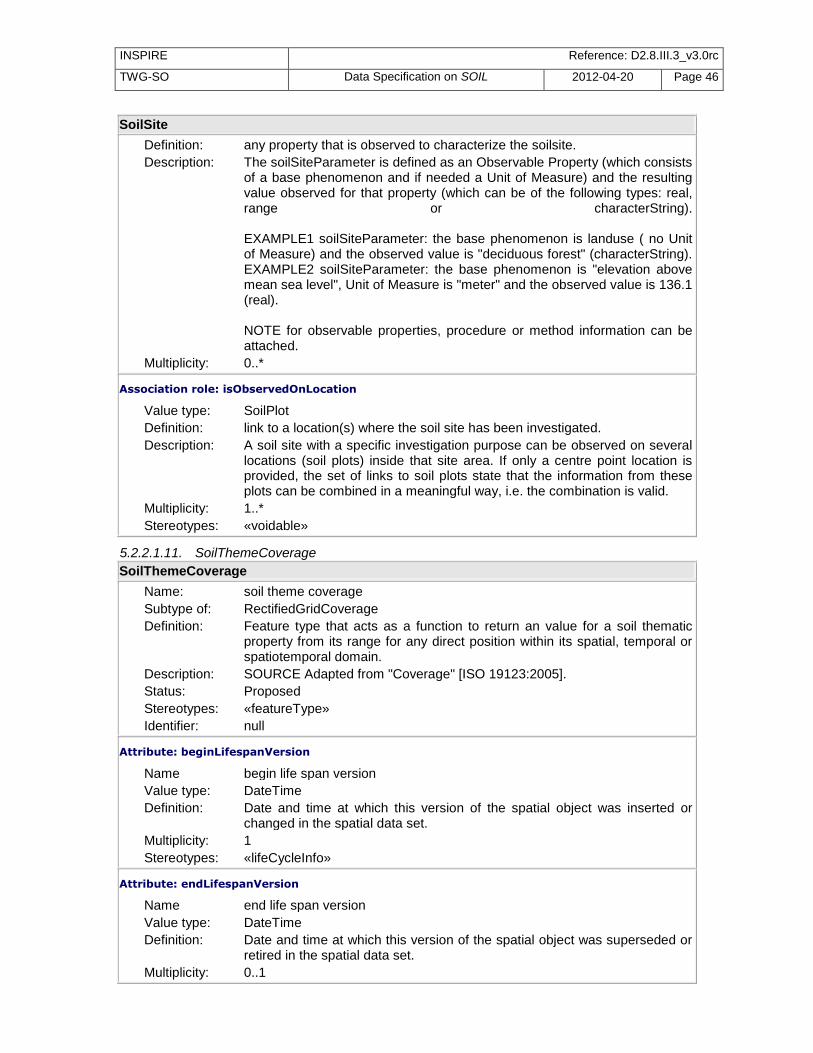
INSPIRE Reference: D2.8.III.3_v3.0rc
TWG-SO Data Specification on SOIL 2012-04-20 Page 46
SoilSite
Definition: any property that is observed to characterize the soilsite. Description: The soilSiteParameter is defined as an Observable Property (which consists
of a base phenomenon and if needed a Unit of Measure) and the resulting value observed for that property (which can be of the following types: real, range or characterString). EXAMPLE1 soilSiteParameter: the base phenomenon is landuse ( no Unit of Measure) and the observed value is "deciduous forest" (characterString). EXAMPLE2 soilSiteParameter: the base phenomenon is "elevation above mean sea level", Unit of Measure is "meter" and the observed value is 136.1 (real). NOTE for observable properties, procedure or method information can be attached.
Multiplicity: 0..*
Association role: isObservedOnLocation
Value type: SoilPlot Definition: link to a location(s) where the soil site has been investigated. Description: A soil site with a specific investigation purpose can be observed on several
locations (soil plots) inside that site area. If only a centre point location is provided, the set of links to soil plots state that the information from these plots can be combined in a meaningful way, i.e. the combination is valid.
Multiplicity: 1..* Stereotypes: «voidable»
5.2.2.1.11. SoilThemeCoverage
SoilThemeCoverage
Name: soil theme coverage Subtype of: RectifiedGridCoverage Definition: Feature type that acts as a function to return an value for a soil thematic
property from its range for any direct position within its spatial, temporal or spatiotemporal domain.
Description: SOURCE Adapted from "Coverage" [ISO 19123:2005]. Status: Proposed Stereotypes: «featureType» Identifier: null
Attribute: beginLifespanVersion
Name begin life span version Value type: DateTime Definition: Date and time at which this version of the spatial object was inserted or
changed in the spatial data set. Multiplicity: 1 Stereotypes: «lifeCycleInfo»
Attribute: endLifespanVersion
Name end life span version Value type: DateTime Definition: Date and time at which this version of the spatial object was superseded or
retired in the spatial data set. Multiplicity: 0..1

INSPIRE Reference: D2.8.III.3_v3.0rc
TWG-SO Data Specification on SOIL 2012-04-20 Page 47
SoilThemeCoverage
Stereotypes: «lifeCycleInfo»
Attribute: domainExtent
Name Domain extent. Value type: EX_Extent Definition: The attribute domainExtent shall contain the extent of the spatiotemporal
domain of the coverage. The data type EX_Extent, is defined in ISO 19103. Extents may be specified in both space and time.
Description: SOURCE Adapted from [ISO 19123:2005]. Multiplicity: 1..*
Attribute: validTimeFrom
Name valid time from Value type: Date Definition: The ValidTime specifies the time window for which measurements have
been captured to calculate the thematic soil property relevant for that period. The start time defines when the period began.
Multiplicity: 1 Stereotypes: «voidable»
Attribute: validTimeTo
Name valid time to Value type: Date Definition: The ValidTime specifies the time window for which measurements have
been captured to calculate the thematic soil property relevant for that period. The end time defines when the period stopped.
Multiplicity: 0..1 Stereotypes: «voidable»
Attribute: soilThemeParameter
Name soil theme parameter Value type: SoilThemeParameterType Definition: A soil-related property (soil theme) that is represented by this coverage. Description: EXAMPLE Land irrigation suitability, pH in the topsoil, etc Multiplicity: 1
Association role: isDescribedBy
Value type: SoilThemeDescriptiveCoverage Definition: this association allows for a certain SoilThemeCoverage to have a related
Coverage which does not have a meaning without the base coverage. Description: EXAMPLE a coverage of the pH of the topsoil is associated with a coverage
with exactly the same extent and domain reporting on the level of confidence of the pH values of the base coverage.
Multiplicity: 0..* Stereotypes: «voidable»
Constraint: rangeSetValuesAreOfTypeSoilParameterValueType
Natural language:
rangeSet values are of type SoilParameterValueType
OCL: inv: rangeSet.forAll(oclIsKindOf(SoilParameterValueType))

INSPIRE Reference: D2.8.III.3_v3.0rc
TWG-SO Data Specification on SOIL 2012-04-20 Page 48
5.2.2.1.12. SoilThemeDescriptiveCoverage
SoilThemeDescriptiveCoverage
Name: soil theme descriptive coverage Subtype of: RectifiedGridCoverage Definition: Feature type that acts as a function to return extra information on the values
of a soil thematic property from its range for any direct position within its spatial, temporal or spatiotemporal domain.
Description: This coverage can only exist in relation to a base coverage SoilThemeCoverage, it has the same domain and spatial extent as the base coverage. And it gives extra information on the values of the base coverages SOURCE Adapted from "Coverage" [ISO 19123:2005]. EXAMPLE coverage indicating the confidence level of the pH values reported in the associated SoilThemeCoverage.
Status: Proposed Stereotypes: «featureType» Identifier: null
Attribute: beginLifespanVersion
Name begin life span version Value type: DateTime Definition: Date and time at which this version of the spatial object was inserted or
changed in the spatial data set. Multiplicity: 1 Stereotypes: «lifeCycleInfo»
Attribute: endLifespanVersion
Name end life span version Value type: DateTime Definition: Date and time at which this version of the spatial object was superseded or
retired in the spatial data set. Multiplicity: 0..1 Stereotypes: «lifeCycleInfo»
Attribute: domainExtent
Name Domain extent. Value type: EX_Extent Definition: The attribute domainExtent shall contain the extent of the spatiotemporal
domain of the coverage. The data type EX_Extent, is defined in ISO 19103. Extents may be specified in both space and time.
Description: SOURCE Adapted from [ISO 19123:2005]. Multiplicity: 1..*
Attribute: soilThemeDescriptiveParameter
Name soil theme descriptive parameter Value type: SoilThemeDescriptiveParameterType Definition: a descriptive property for the soil-related property (soil theme) that is
represented by its associated SoilThemeCoverage. Description: EXAMPLE confidence level for each value in the SoilThemeCoverage (pH
in the topsoil) Multiplicity: 1
Association role: isDescribing

INSPIRE Reference: D2.8.III.3_v3.0rc
TWG-SO Data Specification on SOIL 2012-04-20 Page 49
SoilThemeDescriptiveCoverage
Value type: SoilThemeCoverage Definition: this association allows for a certain SoilThemeCoverage to have a related
Coverage which does not have a meaning without the base coverage. Description: EXAMPLE a coverage of the pH of the topsoil is associated with a coverage
with exactly the same extent and domain reporting on the level of confidence of the pH values of the base coverage.
Multiplicity: 1 Stereotypes: «voidable»
Constraint: rangeSetValuesAreOfTypeSoilParameterValueType
Natural language:
rangeSet values are of type SoilParameterValueType
OCL: inv: rangeSet.forAll(oclIsKindOf(SoilParameterValueType))
5.2.2.2. Data types
5.2.2.2.1. DerivedProfilePresenceInSoilBody
DerivedProfilePresenceInSoilBody (association class)
Name: derived profile presence in soil body Definition: indicates the percentages (lower and upper boundary) that the derived
profile takes part in the Soil body. Description: NOTE 1 A soil body is characterized by one or more derived soil profiles in
a defined geographic area. When the soil body is characterized by more than one derived profiles, the distribution area of these derived soil profiles is not spatially defined, but their presence is indicated by a range of percentages. NOTE 2 The sum of lower boundary parts should not exceed 100%. NOTE 3 If not a range, but a specific percentage is used then the lower and upper boundaries are equal.
Status: Proposed Identifier: null
Attribute: derivedProfilePercentageRange
Name derived profile percentage range. Value type: RangeType Definition: Interval that defines the minimum and maximum percentage of the area of
the soil body represented by a specific derived soil profile. Multiplicity: 1 Stereotypes: «voidable»
5.2.2.2.2. FAOHorizonNotationType
FAOHorizonNotationType
Name: FAO horizon notation type Definition: Classification of a horizon according to FAO classification system.

INSPIRE Reference: D2.8.III.3_v3.0rc
TWG-SO Data Specification on SOIL 2012-04-20 Page 50
FAOHorizonNotationType
Description: A code system that denotes horizons in which the same dominant soil forming processes has been active similarly. This code summarizes many observations of the soil description and gives an impression about the genetic processes that have formed the soil under observation. NOTE The horizon notation according to FAO is a combination of several symbols: · A number that gives information about discontinuities, i.e. the number of the material in which the soil has formed, counted up from the soil surface, but not for the first material. · One or two capital letters that designate the type of master horizon (or transitional horizon), possibly separated by a slash · Lower case letters that designate subordinate characteristics of the horizon. · A number that designates horizontal subdivisions of otherwise similarly denoted horizon parts · A prime that enables to distinguish two horizons that have the same naming, but formed in different cycles of pedogenesis. EXAMPLE 2B' tg1 SOURCE 1 Guidelines for Soil description. FAO, 2006
Status: Proposed Stereotypes: «dataType» Identifier: null
Attribute: FAOHorizonDiscontinuity
Name FAO horizon discontinuity Value type: Integer Definition: number used to indicate a discontinuity in the horizon notation.

INSPIRE Reference: D2.8.III.3_v3.0rc
TWG-SO Data Specification on SOIL 2012-04-20 Page 51
FAOHorizonNotationType
Description: In mineral soils, Arabic numerals are used as prefixes to indicate discontinuities. Wherever needed, they are used preceding A, E, B, C and R. They are not used with I and W, although these symbols clearly indicate a discontinuity. These prefixes are distinct from Arabic numerals used as suffixes to denote vertical subdivisions. A discontinuity is a significant change in particle-size distribution or mineralogy that indicates a difference in the material from which the horizons formed or a significant difference in age or both, unless that difference in age is indicated by the suffix b. Symbols to identify discontinuities are used only when they will contribute substantially to the reader’s understanding of relationships among horizons. The stratification common in soils formed in alluvium is not designated as discontinuities unless particle-size distribution differs markedly from layer to layer even though genetic horizons have formed in the contrasting layers. Where a soil has formed entirely in one kind of material, a prefix is omitted from the symbol; the whole profile is material 1. Similarly, the uppermost material in a profile having two or more contrasting materials is understood to be material 1, but the number is omitted. Numbering starts with the second layer of contrasting material, which is designated 2. Underlying contrasting layers are numbered consecutively. SOURCE: Food and Agriculture Organization of the United Nations (2006): Guidelines for soil description. Prepared by Reinhold Jahn, Hans-Peter Blume, V. B. Asio, Otto Spargaaren and Peter Schad. 4th, rev. ed. Rome: FAO. NOTE a discontinuity is a boundary between two geogenic layers.
Multiplicity: 0..1
Attribute: FAOHorizonMaster
Name FAO horizon master Value type: FAOHorizonMasterValue Definition: symbol of the master part of the horizon notation. Description: SOURCE Guidelines for soil description (4th ed.) FAO 2006 p. 67 Multiplicity: 1 Obligation: Implementing Rule (requirement)
Attribute: FAOPrime
Name FAO prime Value type: FAOPrimeValue Definition: A prime and double prime may be used to connotate master horizon symbol
of the lower of two respectively three horizons having identical Arabic-numeral prefixes and letter combinations.

INSPIRE Reference: D2.8.III.3_v3.0rc
TWG-SO Data Specification on SOIL 2012-04-20 Page 52
FAOHorizonNotationType
Description: Identical designations may be appropriate for two or more horizons or layers separated by at least one horizon or layer of a different kind in the same pedon. The sequence A-E-Bt-E-Btx-C is an example - the soil has two E horizons. To make communication easier, a prime is used with the master horizon symbol of the lower of two horizons having identical letter designations: A-E-Bt-E’-Btx-C.The prime is applied to the capital letter designation, and any lower case symbol follows it: B’t. The prime is not used unless all letters of the designations of two different layers are identical. Prime can be used for both minerals or organic soils. SOURCE: Food and Agriculture Organization of the United Nations (2006): Guidelines for soil description. Prepared by Reinhold Jahn, Hans-Peter Blume, V. B. Asio, Otto Spargaaren and Peter Schad. 4th, rev. ed. Rome: FAO.
Multiplicity: 1 Obligation: Implementing Rule (requirement)
Attribute: FAOHorizonSubordinate
Name horizon subordinate Value type: FAOHorizonSubordinateValue Definition: Designations of subordinate distinctions and features within the master
horizons and layers are based on profile characteristics observable in the field and are applied during the description of the soil at the site.
Description: Lower case letters are used as suffixes to designate specific kinds of master horizons and layers, and other features. SOURCE Guidelines for soil description (4th ed.) FAO 2006, table 85
Multiplicity: 0..* Obligation: Implementing Rule (requirement)
Attribute: FAOHorizonVertical
Name horizon vertical Value type: Integer Definition: Order number of the vertical subdivision in the horizon notation. Description: The number is used to designate the horizontal subdivision of a horizon
identified by a single set of letter symbol on the basis of structure, texture, colour, etc. The number 1 is used to designate the upper part of the horizon. The number 2 the part of the horizon situated below, etc. If there is no horizontal subdivision made, no number is given. NOTE the use of the word vertical is misleading in FAO 2006, because the horizons are separated in two or several horizontal subdomains. Vertical denotes the order in vertical direction.
Multiplicity: 0..1
Attribute: isOriginalClassification
Name is original classification Value type: Boolean Definition: Boolean value to indicate whether the FAO horizon notation was the original
notation to describe the horizon.

INSPIRE Reference: D2.8.III.3_v3.0rc
TWG-SO Data Specification on SOIL 2012-04-20 Page 53
FAOHorizonNotationType
Description: This is to indicate whether the horizon notation has been determined in the field (or for derived profiles during the original derivation), or has been adapted, changed or assigned on the basis of the original horizon description later. This might be relevant data quality information.
Multiplicity: 1
5.2.2.2.3. OtherHorizonNotationType
OtherHorizonNotationType
Name: other horizon notation type Definition: classification of a horizon according to a specific classification system other
than FAO 2006. Description: A code system denoting horizons in which the same dominant soil forming
processes have been active in the same way. This code summarizes many observations of the soil description and gives an impression about the genetic processes that have formed the soil under observation.
Status: Proposed Stereotypes: «dataType» Identifier: null
Attribute: horizonNotation
Name horizon notation Value type: CharacterString Definition: notation characterizing the soil horizon according to a specified
classification system other than FAO 2006. Description: NOTE This is also called horizon designation value, horizon designation or
horizon symbol. EXAMPLE “ss” connotes slickensides in Soil taxonomy (FAO uses “I” for this). The notation in several classification systems can be the same as well: “Ap” is a A horizon which has been ploughed (according German Bodenkundliche Kartieranleitung, 5th ed).
Multiplicity: 1
Attribute: soilDescriptionReference
Name soil description reference Value type: DocumentCitation Definition: reference to a soil profile description guideline (other than FAO 2006) in
which the system of horizon designation is defined. Multiplicity: 1
Attribute: isOriginalClassification
Name is original classification Value type: Boolean Definition: Boolean value to indicate whether the specified horizon notation system
was the original notation system to describe the horizon. Description: This is to indicate whether the horizon notation has been determined in the
field (or for derived soil profiles during the original derivation), or has been adapted, changed or assigned on the basis of the original horizon description later. This might be relevant for data quality information.
Multiplicity: 1

INSPIRE Reference: D2.8.III.3_v3.0rc
TWG-SO Data Specification on SOIL 2012-04-20 Page 54
5.2.2.2.4. OtherSoilNameType
OtherSoilNameType
Name: other soil name type Definition: Identification of the soil profile according to a specific classification scheme
other than WRB versions after 2006. Description: EXAMPLE Fluventic Haploxerept, according to Soil Taxonomy (USDA
2006). Status: Proposed Stereotypes: «dataType» Identifier: null
Attribute: soilName
Name soil name Value type: CharacterString Definition: Name of the soil profile according to a specific classification scheme other
than WRB versions after 2006 Description: EXAMPLE Fluventic Haploxerept, according to Soil Taxonomy (USDA
2006). Multiplicity: 1
Attribute: soilClassificationScheme
Name soil classification scheme Value type: DocumentCitation Definition: reference to the soil classification system which is used to classify the soil. Description: EXAMPLE Soil Taxonomy (USDA 2006) Multiplicity: 1
Attribute: isOriginalClassification
Name is original classification Value type: Boolean Definition: Boolean value to indicate whether the specified classification scheme was
the original classification scheme to describe the profile. Description: This is to indicate whether the soil assignation has been determined in the
field (or for - derived soil profiles during the original derivation process), or has been adapted, changed or re-assigned on the basis of the original soil description or assignation later. This might be relevant for data quality information.
Multiplicity: 1
5.2.2.2.5. ParticleSizeFractionType
ParticleSizeFractionType
Name: particle size fraction type Definition: Mineral part of the soil, fractioned on the basis of size (diameter), limits of
the particles. It is the fine earth fraction. That is, the portion of the soil that passes through a 2 mm diameter sieve opening.
Description: The grain (or particle) size distribution characterizes the soil mineral material, based on the share of each equivalent diameter class of the individual particles. SOURCE1 NRCS Natural Resources Conservation Service, Soil survey laboratory information manual, Soil survey investigation report n.45 version 1.0 May 1995 pag. 11 SOURCE2 GLOSSARY OF SOIL SCIENCE TERMS
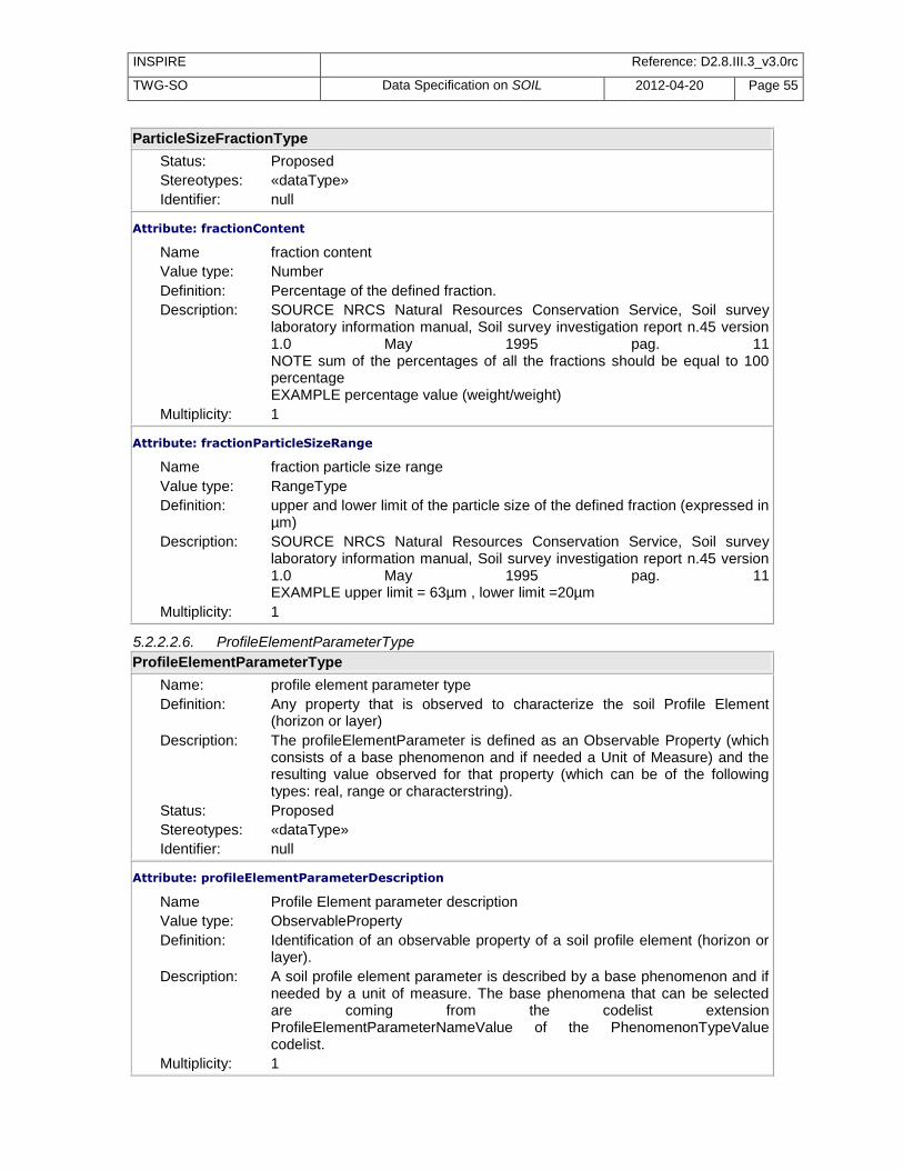
INSPIRE Reference: D2.8.III.3_v3.0rc
TWG-SO Data Specification on SOIL 2012-04-20 Page 55
ParticleSizeFractionType
Status: Proposed Stereotypes: «dataType» Identifier: null
Attribute: fractionContent
Name fraction content Value type: Number Definition: Percentage of the defined fraction. Description: SOURCE NRCS Natural Resources Conservation Service, Soil survey
laboratory information manual, Soil survey investigation report n.45 version 1.0 May 1995 pag. 11 NOTE sum of the percentages of all the fractions should be equal to 100 percentage EXAMPLE percentage value (weight/weight)
Multiplicity: 1
Attribute: fractionParticleSizeRange
Name fraction particle size range Value type: RangeType Definition: upper and lower limit of the particle size of the defined fraction (expressed in
µm) Description: SOURCE NRCS Natural Resources Conservation Service, Soil survey
laboratory information manual, Soil survey investigation report n.45 version 1.0 May 1995 pag. 11 EXAMPLE upper limit = 63µm , lower limit =20µm
Multiplicity: 1
5.2.2.2.6. ProfileElementParameterType
ProfileElementParameterType
Name: profile element parameter type Definition: Any property that is observed to characterize the soil Profile Element
(horizon or layer) Description: The profileElementParameter is defined as an Observable Property (which
consists of a base phenomenon and if needed a Unit of Measure) and the resulting value observed for that property (which can be of the following types: real, range or characterstring).
Status: Proposed Stereotypes: «dataType» Identifier: null
Attribute: profileElementParameterDescription
Name Profile Element parameter description Value type: ObservableProperty Definition: Identification of an observable property of a soil profile element (horizon or
layer). Description: A soil profile element parameter is described by a base phenomenon and if
needed by a unit of measure. The base phenomena that can be selected are coming from the codelist extension ProfileElementParameterNameValue of the PhenomenonTypeValue codelist.
Multiplicity: 1

INSPIRE Reference: D2.8.III.3_v3.0rc
TWG-SO Data Specification on SOIL 2012-04-20 Page 56
ProfileElementParameterType
Attribute: profileElementParameterValue
Name profile element parameter value Value type: SoilParameterValueType Definition: The value that is assigned to the soil profile element parameter during the
observation process. Description: NOTE The value can be of the type characterString or measure or range Multiplicity: 1
5.2.2.2.7. RangeType
RangeType
Name: range type Definition: a range value using upper and lower bounds. Status: Proposed Stereotypes: «dataType» Identifier: null
Attribute: upperValue
Name upper value Value type: Real Definition: value defining the upper limit of a specific property. Multiplicity: 0..1
Attribute: lowerValue
Name lower value Value type: Real Definition: value defining the lower limit of a specific property. Multiplicity: 0..1
Attribute: uom
Name unit of measure Value type: UnitOfMeasure Definition: unit of measure used for the values in the range. Multiplicity: 0..1
Constraint: intervalConstraint
Natural language:
at least one of the values should not be empty
OCL: inv: self.upperValue.isEmpty() implies self.lowerValue.notEmpty() and self.lowerValue.isEmpty() implies self.self.upperValue.notEmpty()
5.2.2.2.8. SoilDerivedObjectParameterType
SoilDerivedObjectParameterType
Name: soil derived object parameter type Definition: a soil related property (soil theme) that is assigned to the soil derived object
using the referred method. Description: The soilDerivedParameter is defined as an Observable Property (which
consists of a base phenomenon and if needed a Unit of Measure) and the resulting value observed for that property (which can be of the following types: real, range or characterstring). EXAMPLE Land irrigation suitability, pH in the topsoil, etc

INSPIRE Reference: D2.8.III.3_v3.0rc
TWG-SO Data Specification on SOIL 2012-04-20 Page 57
SoilDerivedObjectParameterType
Status: Proposed Stereotypes: «dataType» Identifier: null
Attribute: soilDerivedObjectParameterDescription
Name soil derived object parameter description Value type: ObservableProperty Definition: Identification of an soil related thematic property. Description: A soil derived parameter is described by a base phenomenon and if needed
by a unit of measure. The base phenomena that can be selected are coming from the codelist extension SoilDerivedObjectParameterNameValue of the PhenomenonTypeValue codelist.
Multiplicity: 1
Attribute: soilDerivedObjectParameterValue
Name soil derived object parameter value Value type: SoilParameterValueType Definition: The value that is assigned to the soil derived object parameter during a
derivation process. Description: NOTE The value can be of the type characterstring or measure or range. Multiplicity: 1
5.2.2.2.9. SoilParameterValueType
SoilParameterValueType
Name: soil parameter value type Definition: It is a construct to hold the resulting value of an soil observable property. Description: The choice is limited to one of the included possible types. Status: Proposed Stereotypes: «union» Identifier: null
Attribute: parameterRange
Name parameter range Value type: RangeType Definition: range of values to store the result of a soil property. Multiplicity: 1
Attribute: numericValue
Name numeric value Value type: Real Definition: numeric value (real) to store the result of a soil property. Multiplicity: 1
Attribute: qualitativeValue
Name qualitative value Value type: CharacterString Definition: a characterstring to store the result of a qualitative soil property. Multiplicity: 1
5.2.2.2.10. SoilProfileParameterType
SoilProfileParameterType

INSPIRE Reference: D2.8.III.3_v3.0rc
TWG-SO Data Specification on SOIL 2012-04-20 Page 58
SoilProfileParameterType
Name: soil profile parameter type Definition: Any property that is observed to characterize the soilProfile Description: The soilProfileParameter is defined as an Observable Property (which
consists of a base phenomenon and if needed a Unit of Measure) and the resulting value observed for that property (which can be of the following types: real, range or characterstring). EXAMPLE1 soilProfileParameter: the base phenomenon is "potentialRootDepth" with "cm" as Unit of Measure and the observed value is "60" (real).
Status: Proposed Stereotypes: «dataType» Identifier: null
Attribute: soilProfileParameterDescription
Name soil profile parameter description Value type: ObservableProperty Definition: Identification of an observable property of a soil profile. Description: A soil profile parameter is described by a base phenomenon and if needed
by a unit of measure. The base phenomena that can be selected are coming from the codelist extension SoilProfileParameterNameValue of the PhenomenonTypeValue codelist.
Multiplicity: 1
Attribute: soilProfileParameterValue
Name soil profile parameter value Value type: SoilParameterValueType Definition: The value that is assigned to the soil profile parameter during the
observation process. Description: NOTE The value can be of the type CharacterString or Measure or Range Multiplicity: 1
5.2.2.2.11. SoilSiteParameterType
SoilSiteParameterType
Name: soil site parameter type Definition: Any property that is observed to characterize the soil site Description: The soilSIteParameter is defined as an Observable Property (which consists
of a base phenomenon and if needed a Unit of Measure) and the resulting value observed for that property (which can be of the following types: real, range or characterstring). EXAMPLE1 soilSiteParameter: the base phenomenon is landuse ( no Unit of Measure) and the observed value is "deciduous forest" (characterstring). EXAMPLE2 soilSiteParameter: the base phenomenon is "elevation above mean sealevel", Unit of Measure is "meter" and the observed value is 136,1 (real).
Status: Proposed Stereotypes: «dataType» Identifier: null
Attribute: soilSiteParameterDescription
Name soil site parameter description

INSPIRE Reference: D2.8.III.3_v3.0rc
TWG-SO Data Specification on SOIL 2012-04-20 Page 59
SoilSiteParameterType
Value type: ObservableProperty Definition: Identification of an observable property of a soil site. Description: A soil site parameter is described by a base phenomenon and if needed by
a unit of measure. The base phenomena that can be selected are coming from the codelist extension SoilSiteParameterNameValue of the PhenomenonTypeValue codelist.
Multiplicity: 1
Attribute: soilSiteParameterValue
Name soil site parameter value Value type: SoilParameterValueType Definition: The value that is assigned to the soil site parameter during the observation
process. Description: NOTE The value can be of the type characterstring or measure or range
type. Multiplicity: 1
5.2.2.2.12. SoilThemeDescriptiveParameterType
SoilThemeDescriptiveParameterType
Name: soil theme descriptive parameter type Definition: datatype providing a descriptive property for the soil-related property (soil
theme) that is represented by its associated SoilThemeCoverage. Description: this datatype exists of a name and if needed a unit of measurement.
EXAMPLE confidence level for each value in the SoilThemeCoverage (pH in the topsoil)
Status: Proposed Stereotypes: «dataType» Identifier: null
Attribute: soilThemeDescriptiveParameterName
Name soil theme descriptive parameter name Value type: CharacterString Definition: Name of the parameter to provide extra information on the values of the
related SoilThemeCoverage. Description: EXAMPLE soilThemeDescriptiveParameterName = confidence level.
SoilThemeCoverage = coverage representing the pH of the topsoil Multiplicity: 1
Attribute: uom
Name unit of measure Value type: UnitOfMeasure Definition: the unit of measure that is used to express the
soilThemeDescriptiveParameter. Multiplicity: 0..1
5.2.2.2.13. SoilThemeParameterType
SoilThemeParameterType
Name: soil theme parameter type

INSPIRE Reference: D2.8.III.3_v3.0rc
TWG-SO Data Specification on SOIL 2012-04-20 Page 60
SoilThemeParameterType
Definition: A soil-related property (soil theme) that is represented by this coverage. It is composed of a parameter name coming from a codelist SoilDerivedObjectParameterNameValue and a Unit of Measure used for expressing that parameter.
Description: EXAMPLE Land irrigation suitability, pH in the topsoil, etc Status: Proposed Stereotypes: «dataType» Identifier: null
Attribute: soilThemeParameterName
Name soil theme parameter name Value type: SoilDerivedObjectParameterNameValue Definition: name of the parameter represented by the soilThemeCoverage, it should
come out of the codelist SoilDerivedObjectParameterNameValue. Multiplicity: 1 Obligation: Technical Guidance (recommendation)
Attribute: uom
Name unit of measure Value type: UnitOfMeasure Definition: the unit of measure that is used to express the soilThemeParameter. Description: EXAMPLE cm to express the soilThemeParameter "depth of the B-horizon" Multiplicity: 0..1
5.2.2.2.14. WRBQualifierGroupType
WRBQualifierGroupType
Name: WRB qualifier group type Definition: datatype to define the a group of a qualifier and its possible specifier(s), its
place and position with regard to the WRBReferenceSoilGroup it belongs to. Status: Proposed Stereotypes: «dataType» Identifier: null
Attribute: qualifierPlace
Name qualifier place Value type: WRBQualifierPlaceValue Definition: attribute to indicate the placement of the Qualifier with regard to the WRB
reference soil group (RSG). The placement can be in front of the RSG i.e. 'prefix' or it can be behind the RSG i.e. 'suffix'.
Multiplicity: 1 Obligation: Implementing Rule (requirement)
Attribute: qualifierPosition
Name qualifier position Value type: Integer Definition: number to indicate the position of a qualifier with regard to the WRB
reference soil group (RSG) it belongs to and with regard to its placement to that (RSG) i.e. as a prefix or a suffix.

INSPIRE Reference: D2.8.III.3_v3.0rc
TWG-SO Data Specification on SOIL 2012-04-20 Page 61
WRBQualifierGroupType
Description: If there are one or more prefix qualifiers: one of the qualifiers is in position 1, the other qualifiers are in position 2, 3, etc.; position 1 is the position closest to the RSG; position 2 is the position second closest to the RSG; etc If there are one or more suffix qualifiers: one of the qualifiers is in position 1, the other qualifiers are in position 2, 3, etc.; position 1 is the position closest to the RSG; position 2 is the position second closest to the RSG; etc
Multiplicity: 1
Attribute: WRBqualifier
Name WRB qualifier Value type: WRBQualifierValue Definition: name element of WRB, 2nd level of classification Description: SOURCE WRB 2006, update 2007 Multiplicity: 1 Obligation: Implementing Rule (requirement)
Attribute: WRBspecifier
Name WRB specifier Value type: WRBSpecifierValue Definition: code that indicates the degree of expression of a qualifier or the depth
range ot which the qualifier applies. Description: Specifiers may be used to indicate depth of occurrence, or to express the
intensity of soil characteristics. EXAMPLE Buried layers can be indicated by the specifier “Thapto”. NOTE 1 The specifier code is always added after the qualifier code. Exceptions are defined in the qualifier list of WRB. NOTE 2 Some specifiers can be combined with each other for one qualifier. SOURCE World reference base for soil resources 2006, update 2007.
Multiplicity: 0..2 Obligation: Implementing Rule (requirement)
5.2.2.2.15. WRBSoilNameType
WRBSoilNameType
Name: WRB soil name type Definition: identification of the soil profile according to the WRB classification scheme,
versions after 2006. Description: NOTE The structure of the WRBSoilNameType was based on the WRB
classification scheme of 2006. EXAMPLE Lixic Vertic Ferralsol (Ferric, Rhodic), WRB 2006, update 2007.
Status: Proposed Stereotypes: «dataType» Identifier: null
Attribute: WRBQualifierGroup
Name WRB qualifier group Value type: WRBQualifierGroupType Definition: datatype to define the a group of a qualifier and its possible specifier(s), its
place and position with regard to the WRBReferenceSoilGroup it belongs to. Multiplicity: 0..*

INSPIRE Reference: D2.8.III.3_v3.0rc
TWG-SO Data Specification on SOIL 2012-04-20 Page 62
WRBSoilNameType
Attribute: WRBReferenceSoilGroup
Name WRB reference soilgroup (RSG) Value type: WRBReferenceSoilGroupValue Definition: first level of classification of the World Reference Base for Soil Resources. Description: Reference Soil Groups are distinguished by the presence (or absence) of
specific diagnostic horizons, properties and/or materials. NOTE The WRB soil classification system comprises 32 different RSGs. SOURCE World reference base for soil resources 2006. EXAMPLE Podzol
Multiplicity: 1 Obligation: Implementing Rule (requirement)
Attribute: isOriginalClassification
Name is original classification Value type: Boolean Definition: Boolean value to indicate whether the WRB classification system was the
original classification system to describe the soil profile. Description: This is to indicate whether the soil assignation according to WRB has been
determined in the field (or for - derived - profiles during the original derivation process), or has been adapted, changed or re-assigned on the basis of the original soil description or assignation later. This might be relevant data quality information.
Multiplicity: 1
Association role: over
Value type: WRBSoilNameType Definition: An association to indicate that in the WRB classification a soil profile covers
another developed, older soil. Multiplicity: 0..1
5.2.2.3. Code lists
5.2.2.3.1. FAOHorizonMasterValue
FAOHorizonMasterValue
Name: FAO horizon master value Definition: codelist of the master part of the horizon designation. Description: SOURCE Guidelines for soil description (4th ed.) FAO 2006 p. 67 Status: Proposed Stereotypes: «codeList» Extensibility: none Identifier: http://inspire.ec.europa.eu/codeList/FAOHorizonMasterValue
5.2.2.3.2. FAOHorizonSubordinateValue
FAOHorizonSubordinateValue
Name: FAO horizon subordinate value Definition: List of designations of subordinate distinctions and features within the
master horizons and layers are based on profile characteristics observable in the field and are applied during the description of the soil at the site.
Description: Lower case letters are used as suffixes to designate specific kinds of master horizons and layers, and other features. SOURCE Guidelines for soil description (4th ed.) FAO 2006, table 85

INSPIRE Reference: D2.8.III.3_v3.0rc
TWG-SO Data Specification on SOIL 2012-04-20 Page 63
FAOHorizonSubordinateValue
Status: Proposed Stereotypes: «codeList» Extensibility: none Identifier: http://inspire.ec.europa.eu/codeList/FAOHorizonSubordinateValue
5.2.2.3.3. FAOPrimeValue
FAOPrimeValue
Name: FAO prime value Definition: A prime and double prime may be used to connotate master horizon symbol
of the lower of two respectively three horizons having identical Arabic-numeral prefixes and letter combinations.
Description: Identical designations may be appropriate for two or more horizons or layers separated by at least one horizon or layer of a more different kind in the same pedon. The sequence A-E-Bt-E-Btx-C is an example - the soil has two E horizons. To make communication easier, a prime is used with the master horizon symbol of the lower of two horizons having identical letter designations: A-E-Bt-E’-Btx-C. The prime is applied to the capital letter designation, and any lower case symbol follows it: B’t. The prime is not used unless all letters of the designations of two different layers are identical. Prime can be used for both minerals and organic soils. SOURCE: Food and Agriculture Organization of the United Nations (2006): Guidelines for soil description. Prepared by Reinhold Jahn, Hans-Peter Blume, V. B. Asio, Otto Spargaaren and Peter Schad. 4th, rev. ed. Rome: FAO.
Status: Proposed Stereotypes: «codeList» Extensibility: none Identifier: http://inspire.ec.europa.eu/codeList/FAOPrimeValue
5.2.2.3.4. LayerGenesisProcessStateValue
LayerGenesisProcessStateValue
Name: layer genesis process state value Definition: indication whether the process specified in layerGenesisProcess is ongoing
or seized in the past. Description: Process state gives an idea whether current non-pedogenic processes
affect the soil or not. E.g. on current floodplains, input of sediments during seasonal flooding events is received, with comparatively young soil development in it, while in older fluvial sediments that are no longer under a regime of seasonal or irregular flooding, soil development might be more advanced.
Status: Proposed Stereotypes: «codeList» Extensibility: none Identifier: http://inspire.ec.europa.eu/codeList/LayerGenesisProcessStateValue
5.2.2.3.5. LayerTypeValue
LayerTypeValue
Name: layer type value Definition: classification of a layer according to the concept that fits the purpose.

INSPIRE Reference: D2.8.III.3_v3.0rc
TWG-SO Data Specification on SOIL 2012-04-20 Page 64
LayerTypeValue
Description: EXAMPLE Topsoil: meaning the upper part of the natural soil that is generally dark coloured and has a higher content of organic matter and nutrients when compared to the (mineral ) horizons below excluding the humus layer.
Status: Proposed Stereotypes: «codeList» Extensibility: none Identifier: http://inspire-registry.jrc.ec.europa.eu/clr/LayerTypeValue
5.2.2.3.6. ProfileElementParameterNameValue
ProfileElementParameterNameValue
Name: profile element parameter name value Subtype of: PhenomenonTypeValue Definition: list of properties that can be observed to characterize the profile element. Description: Basically these parameters can be divided in several major groups like:
Chemical parameters observed to characterize the profile element.
Physical parameters observed to characterize the profile element.
Biological parameters observed to characterize the profile element.
...
Status: Proposed Stereotypes: «codeList» Extensibility: any Identifier: http://inspire.ec.europa.eu/codeList/ProfileElementParameterNameValue
5.2.2.3.7. SoilDerivedObjectParameterNameValue
SoilDerivedObjectParameterNameValue
Name: soil derived object parameter name value Subtype of: PhenomenonTypeValue Definition: list of soil related properties that can be derived from soil and other data. Description: Basically these parameters can be divided in several major groups like:
Chemical parameters that can be derived from other soil data.
Physical parameters that can be derived from other soil data.
Biological parameters that can be derived from other soil data.
...
Status: Proposed

INSPIRE Reference: D2.8.III.3_v3.0rc
TWG-SO Data Specification on SOIL 2012-04-20 Page 65
SoilDerivedObjectParameterNameValue
Stereotypes: «codeList» Extensibility: any Identifier: http://inspire.ec.europa.eu/codeList/SoilDerivedObjectParameterNameValue
5.2.2.3.8. SoilInvestigationPurposeValue
SoilInvestigationPurposeValue
Name: soil investigation purpose value Definition: List of possible values why a survey was conducted. Description: For Soil two main purposes are identified to carry out soil surveys. One is to
classify the soil as a result of soil forming processes and the other one is to investigate possible contamination as a result of contaminating activities. This information gives the data user an idea about possible bias in the selection of the site and therefore representativeness of the data that were obtained for a special purpose.
Status: Proposed Stereotypes: «codeList» Extensibility: none Identifier: http://inspire.ec.europa.eu/codeList/SoilInvestigationPurposeValue
5.2.2.3.9. SoilPlotTypeValue
SoilPlotTypeValue
Name: soil plot type Definition: list of possible values that give information on what kind of plot the
observation of the soil is made. Description: NOTE Trial pits, boreholes or samples can be seen as types of soil plots. Status: Proposed Stereotypes: «codeList» Extensibility: none Identifier: http://inspire.ec.europa.eu/codeList/SoilPlotTypeValue
5.2.2.3.10. SoilProfileParameterNameValue
SoilProfileParameterNameValue
Name: soil profile parameter name value Subtype of: PhenomenonTypeValue Definition: list of properties that can be observed to characterize the soil profile. Description: Basically these parameters can be divided in several major groups like:
Chemical parameters observed to characterize the soil profile.
Physical parameters observed to characterize the soil profile.
Biological parameters observed to characterize the soil profile.
...
Status: Proposed Stereotypes: «codeList» Extensibility: any

INSPIRE Reference: D2.8.III.3_v3.0rc
TWG-SO Data Specification on SOIL 2012-04-20 Page 66
SoilProfileParameterNameValue
Identifier: http://inspire.ec.europa.eu/codeList/SoilProfileParameterNameValue
5.2.2.3.11. SoilSiteParameterNameValue
SoilSiteParameterNameValue
Name: soil site parameter name value Subtype of: PhenomenonTypeValue Definition: list of properties that can be observed to characterize the soil site. Description: Basically these parameters can be divided in several major groups like:
Chemical parameters observed to characterize the soilsite.
Physical parameters observed to characterize the soilsite.
Biological parameters observed to characterize the soilsite.
...
Status: Proposed Stereotypes: «codeList» Extensibility: any Identifier: http://inspire.ec.europa.eu/codeList/SoilSiteParameterNameValue
5.2.2.3.12. WRBQualifierPlaceValue
WRBQualifierPlaceValue
Name: WRB Qualifier place value Definition: list of values to indicate the placement of the Qualifier with regard to the
WRB reference soil group (RSG). The placement can be in front of the RSG i.e. 'prefix' or it can be behind the RSG i.e. 'suffix'.
Status: Proposed Stereotypes: «codeList» Extensibility: none Identifier: http://inspire.ec.europa.eu/codeList/WRBQualifierPlaceValue
5.2.2.3.13. WRBQualifierValue
WRBQualifierValue
Name: WRB qualifiers Definition: list of possible qualifiers (i.e. prefix and suffix qualifiers of the World
Reference Base for Soil Resources). Description: SOURCE World reference base for soil resources 2006 (update 2007) or
2010. NOTE WRB restricts the use of qualifiers in different ways for the 32 reference soil groups.
Status: Proposed Stereotypes: «codeList» Extensibility: none Identifier: http://inspire.ec.europa.eu/codeList/WRBQualifierValue

INSPIRE Reference: D2.8.III.3_v3.0rc
TWG-SO Data Specification on SOIL 2012-04-20 Page 67
5.2.2.3.14. WRBReferenceSoilGroupValue
WRBReferenceSoilGroupValue
Name: WRB reference soil group (RSG) Definition: list of possible reference soil groups (i.e. first level of classification of the
World Reference Base for Soil Resources). Description: Reference Soil Groups are distinguished by the presence (or absence) of
specific diagnostic horizons, properties and/or materials. NOTE The WRB soil classification system comprises 32 different RSGs. SOURCE World reference base for soil resources 2006 (update 2007) or 2010.
Status: Proposed Stereotypes: «codeList» Extensibility: none Identifier: http://inspire.ec.europa.eu/codeList/WRBReferenceSoilGroupValue
5.2.2.3.15. WRBSpecifierValue
WRBSpecifierValue
Name: WRB specifiers Definition: list of possible specifiers. Description: SOURCE World reference base for soil resources 2006 (update 2007) or
2010. Specifiers are name elements in WRB restricting the meaning of qualifiers.
Status: Proposed Stereotypes: «codeList» Extensibility: none Identifier: http://inspire.ec.europa.eu/codeList/WRBSpecifierValue
5.2.2.4. Imported types (informative)
This section lists definitions for feature types, data types and enumerations and code lists that are defined in other application schemas. The section is purely informative and should help the reader understand the feature catalogue presented in the previous sections. For the normative documentation of these types, see the given references.
5.2.2.4.1. Boolean
Boolean
Package: INSPIRE Consolidated UML Model::Foundation Schemas::ISO TC211::ISO 19103:2005 Schema Language::Basic Types::Primitive::Truth [Include reference to the document that includes the package, e.g. INSPIRE data specification, ISO standard or the GCM]
5.2.2.4.2. CharacterString
CharacterString
Package: INSPIRE Consolidated UML Model::Foundation Schemas::ISO TC211::ISO 19103:2005 Schema Language::Basic Types::Primitive::Text [Include reference to the document that includes the package, e.g. INSPIRE data specification, ISO standard or the GCM]
5.2.2.4.3. Date
Date
Package: INSPIRE Consolidated UML Model::Foundation Schemas::ISO TC211::ISO 19103:2005 Schema Language::Basic Types::Primitive::Date and Time [Include reference to the document that includes the package, e.g. INSPIRE data specification, ISO standard or the GCM]

INSPIRE Reference: D2.8.III.3_v3.0rc
TWG-SO Data Specification on SOIL 2012-04-20 Page 68
5.2.2.4.4. DateTime
DateTime
Package: INSPIRE Consolidated UML Model::Foundation Schemas::ISO TC211::ISO 19103:2005 Schema Language::Basic Types::Primitive::Date and Time [Include reference to the document that includes the package, e.g. INSPIRE data specification, ISO standard or the GCM]
5.2.2.4.5. DocumentCitation
DocumentCitation
Package: INSPIRE Consolidated UML Model::Generic Conceptual Model::Base Types::Base Types 2 [Include reference to the document that includes the package, e.g. INSPIRE data specification, ISO standard or the GCM]
Definition: Citation to unambiguously reference a document.
5.2.2.4.6. EX_Extent
EX_Extent
Package: INSPIRE Consolidated UML Model::Foundation Schemas::ISO TC211::ISO 19115:2006 Metadata (Corrigendum)::Extent information [Include reference to the document that includes the package, e.g. INSPIRE data specification, ISO standard or the GCM]
5.2.2.4.7. EventEnvironmentTerm
EventEnvironmentTerm
Package: INSPIRE Consolidated UML Model::Themes::Annex II::Geology::GeologyMain::GeologyCore [Include reference to the document that includes the package, e.g. INSPIRE data specification, ISO standard or the GCM]
Definition: A codelist of terms for the Geologic Environments within which Geologic Events take place.
5.2.2.4.8. EventProcessTerm
EventProcessTerm
Package: INSPIRE Consolidated UML Model::Themes::Annex II::Geology::GeologyMain::GeologyCore [Include reference to the document that includes the package, e.g. INSPIRE data specification, ISO standard or the GCM]
Definition: A codelist of terms specifying the process or processes that occurred during an event.
Description: EXAMPLE: deposition, extrusion, intrusion, cooling.
5.2.2.4.9. GM_MultiSurface
GM_MultiSurface
Package: INSPIRE Consolidated UML Model::Foundation Schemas::ISO TC211::ISO 19107:2003 Spatial Schema:: Geometry::Geometric aggregates [Include reference to the document that includes the package, e.g. INSPIRE data specification, ISO standard or the GCM]
5.2.2.4.10. GM_Object
GM_Object (abstract)
Package: INSPIRE Consolidated UML Model::Foundation Schemas::ISO TC211::ISO 19107:2003 Spatial Schema:: Geometry::Geometry root [Include reference to the document that includes the package, e.g. INSPIRE data specification, ISO standard or the GCM]

INSPIRE Reference: D2.8.III.3_v3.0rc
TWG-SO Data Specification on SOIL 2012-04-20 Page 69
5.2.2.4.11. Identifier
Identifier
Package: INSPIRE Consolidated UML Model::Generic Conceptual Model::Base Types::Base Types [Include reference to the document that includes the package, e.g. INSPIRE data specification, ISO standard or the GCM]
Definition: External unique object identifier published by the responsible body, which may be used by external applications to reference the spatial object.
Description: NOTE1 External object identifiers are distinct from thematic object identifiers. NOTE 2 The voidable version identifier attribute is not part of the unique identifier of a spatial object and may be used to distinguish two versions of the same spatial object. NOTE 3 The unique identifier will not change during the life-time of a spatial object.
5.2.2.4.12. Integer
Integer
Package: INSPIRE Consolidated UML Model::Foundation Schemas::ISO TC211::ISO 19103:2005 Schema Language::Basic Types::Primitive::Numerics [Include reference to the document that includes the package, e.g. INSPIRE data specification, ISO standard or the GCM]
5.2.2.4.13. LithologyTerm
LithologyTerm
Package: INSPIRE Consolidated UML Model::Themes::Annex II::Geology::GeologyMain::GeologyCore [Include reference to the document that includes the package, e.g. INSPIRE data specification, ISO standard or the GCM]
Definition: A codelist of terms describing the lithology. Description: EXAMPLE: granite, sandstone, schist.
5.2.2.4.14. Location
Location (abstract)
Package: INSPIRE Consolidated UML Model::Foundation Schemas::ISO TC211::ISO 19156 Observations and Measurements::ISO 19156:2011 Observations and Measurements::Sampling Features::specimen [Include reference to the document that includes the package, e.g. INSPIRE data specification, ISO standard or the GCM]
5.2.2.4.15. NamedValue
NamedValue
Package: INSPIRE Consolidated UML Model::Foundation Schemas::ISO TC211::ISO 19156 Observations and Measurements::ISO 19156:2011 Observations and Measurements::Observation schema::observation [Include reference to the document that includes the package, e.g. INSPIRE data specification, ISO standard or the GCM]
5.2.2.4.16. Number
Number (abstract)

INSPIRE Reference: D2.8.III.3_v3.0rc
TWG-SO Data Specification on SOIL 2012-04-20 Page 70
Number (abstract)
Package: INSPIRE Consolidated UML Model::Foundation Schemas::ISO TC211::ISO 19103:2005 Schema Language::Basic Types::Primitive::Numerics [Include reference to the document that includes the package, e.g. INSPIRE data specification, ISO standard or the GCM]
5.2.2.4.17. ObservableProperty
ObservableProperty
Package: INSPIRE Consolidated UML Model::Generic Conceptual Model::Base Models::Observations::Observable Properties [Include reference to the document that includes the package, e.g. INSPIRE data specification, ISO standard or the GCM]
Definition: Represents a single observable property e.g. 'temperature'. Description: The Observable Property represents a single observable property e.g.
'temperature'. It may have associations to additional constraints or measures that make it more complex e.g. 'daily mean temperature'.
5.2.2.4.18. PhenomenonTypeValue
PhenomenonTypeValue
Package: INSPIRE Consolidated UML Model::Generic Conceptual Model::Base Models::Observations::Observable Properties [Include reference to the document that includes the package, e.g. INSPIRE data specification, ISO standard or the GCM]
Definition: A codelist of phenomena (e.g. temperature, windspeed) Description: A codelist of phenomena. This codelist itself is an empty placeholder and
should be extended and specified for any thematic domain.
5.2.2.4.19. Real
Real
Package: INSPIRE Consolidated UML Model::Foundation Schemas::ISO TC211::ISO 19103:2005 Schema Language::Basic Types::Primitive::Numerics [Include reference to the document that includes the package, e.g. INSPIRE data specification, ISO standard or the GCM]
5.2.2.4.20. RectifiedGridCoverage
RectifiedGridCoverage
Package: INSPIRE Consolidated UML Model::Generic Conceptual Model::Base Models::Coverages::Coverages (Domain and Range) [Include reference to the document that includes the package, e.g. INSPIRE data specification, ISO standard or the GCM]
Definition: coverage whose domain consists of a rectified grid Description: A rectified grid is a grid for which there is an affine transformation between
the grid coordinates and the coordinates of a coordinate reference system. NOTE This type can be used for both discrete and continuous coverages.
5.2.2.4.21. UnitOfMeasure
UnitOfMeasure (abstract)
Package: INSPIRE Consolidated UML Model::Foundation Schemas::ISO TC211::ISO 19103:2005 Schema Language::Basic Types::Derived::Units of Measure [Include reference to the document that includes the package, e.g. INSPIRE data specification, ISO standard or the GCM]

INSPIRE Reference: D2.8.III.3_v3.0rc
TWG-SO Data Specification on SOIL 2012-04-20 Page 71
5.2.3 INSPIRE-governed code lists The INSPIRE-defined code lists included in this application schema include the values specified in the tables in this section. These values are defined according to “Guidelines for soil description”, FOOD AND AGRICULTURE ORGANIZATION OF THE UNITED NATIONS; Rome, 2006 (ISBN 92-5-105521-1).
5.2.3.1. Values of code list FAOHorizonMasterValue
Value Name Definition Description Parent value
A A horizon Mineral horizon formed at the surface or below an O horizon, in which all or much of the original structure of the parent material has been obliterated and characterized by one or more of the following : • An accumulation of humified organic matter intimately mixed with the mineral fraction and not displaying properties characteristic of E or B horizons; • Properties resulting from cultivation, pasturing, or similar kinds of disturbance; • A morphology that is different from the underlying B or C horizon, resulting from processes related to its surface position.
AB AB horizon Transitional horizon dominated by properties of a A horizon but having subordinate properties of a B horizon.
Two capital letter symbols are used, such as AB, EB, BE and BC. The master horizon symbol that is given first designates the kind of horizon whose properties dominate the transitional horizon. EXAMPLE : an AB horizon has characteristics of both an overlying A horizon and an

INSPIRE Reference: D2.8.III.3_v3.0rc
TWG-SO Data Specification on SOIL 2012-04-20 Page 72
underlying B horizon, but it is more like the A than like the B. NOTE 1 : In some cases, a horizon can be designated as transitional even if one of the master horizons to which it is apparently transitional is not present. A BE horizon may be recognized in a truncated soil if its properties are similar to those of a BE horizon in a soil in which the overlying E horizon has not been removed by erosion. An AB or a BA horizon may be recognized where bedrock underlies the transitional horizon. A BC horizon may be recognized even if no underlying C horizon is present; it is transitional to assumed parent material. A CR horizon can be used for weathered bedrock that can be dug with a spade although roots cannot penetrate except along fracture planes. NOTE 2 : The I, L and W symbols are not used in transitional horizon designations.
B B horizon Horizon formed below an A, E, H or O horizon, and in which the dominant features are the obliteration of all or much of the original structure of the parent material, together with one or

INSPIRE Reference: D2.8.III.3_v3.0rc
TWG-SO Data Specification on SOIL 2012-04-20 Page 73
a combination of the following : • Illuvial concentration of silicate clay, iron, aluminium, humus, carbonates, gypsum, silica or some combination of these; • Evidence of removal of carbonates; • Residual concentration of sesquioxides; • Coatings of sesquioxides that make the horizon conspicuously lower in value, higher in chroma, or redder in hue than overlying and underlying horizons without apparent illuviation of iron; • Alteration that forms silicate clay or liberates oxides or both, and that forms a granular, blocky, or prismatic structure if volume changes accompany changes in moisture content; • Brittle consistence. :All kinds of B horizons are, or were originally, subsurface horizons. Included as B horizons are layers of illuvial concentration of carbonates, gypsum, or silica that are the result of pedogenetic processes (these horizons may or may not be cemented) and brittle horizons that have other evidence of alteration, such as prismatic structure or illuvial accumulation of clay.
B/C B/C horizon horizon in which distinct, dominating
two capital letter symbols are used,

INSPIRE Reference: D2.8.III.3_v3.0rc
TWG-SO Data Specification on SOIL 2012-04-20 Page 74
parts have recognizable properties of a B horizon and other parts have recognizable properties of a C horizon
but the two capital letters are separated by a slash (/), such as E/B, B/E, B/C and C/R. The master horizon symbol that is given first designates the kind of horizon whose properties dominate the transitional horizon. Commonly, most of the individual parts of one of the components are surrounded by the other. NOTE : The I, L and W symbols are not used in transitional horizon designations.
B/E B/E horizon horizon in which distinct, dominating parts have recognizable properties of a B horizon and other parts have recognizable properties of an E horizon
two capital letter symbols are used, but the two capital letters are separated by a slash (/), such as E/B, B/E, B/C and C/R. The master horizon symbol that is given first designates the kind of horizon whose properties dominate the transitional horizon. Commonly, most of the individual parts of one of the components are surrounded by the other. NOTE : The I, L and W symbols are not used in transitional horizon designations.
BA BA horizon Transitional horizon dominated by properties of a B horizon but having subordinate properties of an A horizon.
Two capital letter symbols are used, such as AB, EB, BE and BC. The master horizon symbol that is given first designates the kind of horizon whose properties dominate the transitional horizon. EXAMPLE : an AB horizon has characteristics of
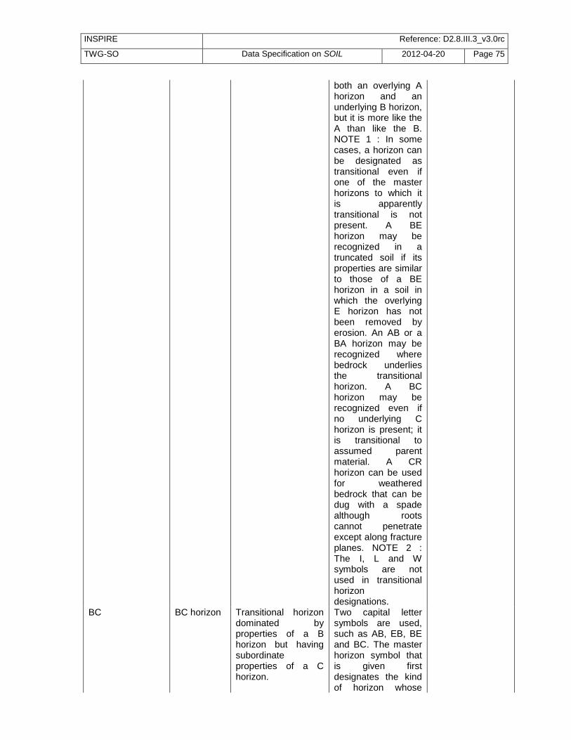
INSPIRE Reference: D2.8.III.3_v3.0rc
TWG-SO Data Specification on SOIL 2012-04-20 Page 75
both an overlying A horizon and an underlying B horizon, but it is more like the A than like the B. NOTE 1 : In some cases, a horizon can be designated as transitional even if one of the master horizons to which it is apparently transitional is not present. A BE horizon may be recognized in a truncated soil if its properties are similar to those of a BE horizon in a soil in which the overlying E horizon has not been removed by erosion. An AB or a BA horizon may be recognized where bedrock underlies the transitional horizon. A BC horizon may be recognized even if no underlying C horizon is present; it is transitional to assumed parent material. A CR horizon can be used for weathered bedrock that can be dug with a spade although roots cannot penetrate except along fracture planes. NOTE 2 : The I, L and W symbols are not used in transitional horizon designations.
BC BC horizon Transitional horizon dominated by properties of a B horizon but having subordinate properties of a C horizon.
Two capital letter symbols are used, such as AB, EB, BE and BC. The master horizon symbol that is given first designates the kind of horizon whose

INSPIRE Reference: D2.8.III.3_v3.0rc
TWG-SO Data Specification on SOIL 2012-04-20 Page 76
properties dominate the transitional horizon. EXAMPLE : an AB horizon has characteristics of both an overlying A horizon and an underlying B horizon, but it is more like the A than like the B. NOTE 1 : In some cases, a horizon can be designated as transitional even if one of the master horizons to which it is apparently transitional is not present. A BE horizon may be recognized in a truncated soil if its properties are similar to those of a BE horizon in a soil in which the overlying E horizon has not been removed by erosion. An AB or a BA horizon may be recognized where bedrock underlies the transitional horizon. A BC horizon may be recognized even if no underlying C horizon is present; it is transitional to assumed parent material. A CR horizon can be used for weathered bedrock that can be dug with a spade although roots cannot penetrate except along fracture planes. NOTE 2 : The I, L and W symbols are not used in transitional horizon designations.
BE BE horizon Transitional horizon dominated by properties of a B
Two capital letter symbols are used, such as AB, EB, BE

INSPIRE Reference: D2.8.III.3_v3.0rc
TWG-SO Data Specification on SOIL 2012-04-20 Page 77
horizon but having subordinate properties of an E horizon.
and BC. The master horizon symbol that is given first designates the kind of horizon whose properties dominate the transitional horizon. EXAMPLE : an AB horizon has characteristics of both an overlying A horizon and an underlying B horizon, but it is more like the A than like the B. NOTE 1 : In some cases, a horizon can be designated as transitional even if one of the master horizons to which it is apparently transitional is not present. A BE horizon may be recognized in a truncated soil if its properties are similar to those of a BE horizon in a soil in which the overlying E horizon has not been removed by erosion. An AB or a BA horizon may be recognized where bedrock underlies the transitional horizon. A BC horizon may be recognized even if no underlying C horizon is present; it is transitional to assumed parent material. A CR horizon can be used for weathered bedrock or soft bedrock that can be dug with a spade although roots cannot penetrate except along fracture planes (paralithic contact). NOTE 2 : The I, L and W

INSPIRE Reference: D2.8.III.3_v3.0rc
TWG-SO Data Specification on SOIL 2012-04-20 Page 78
symbols are not used in transitional horizon designations.
C C horizon Horizon, excluding hard bedrock, that is little affected by pedogenetic processes and lacks properties of H, O, A, E, or B horizon.
The material of C layers may be either like or unlike that from which the soil is presumed to have formed. C horizons may have been modified even if there is no evidence of pedogenesis. NOTE : Plant roots can penetrate C horizons that provide an important growing medium.
C/R C/R horizon horizon in which distinct, dominating parts have recognizable properties of a C horizon and other parts have recognizable properties of an R horizon
two capital letter symbols are used, but the two capital letters are separated by a slash (/), such as E/B, B/E, B/C and C/R. The master horizon symbol that is given first designates the kind of horizon whose properties dominate the transitional horizon. Commonly, most of the individual parts of one of the components are surrounded by the other. NOTE : The I, L and W symbols are not used in transitional horizon designations.
CR CR horizon Transitional horizon dominated by properties of a C horizon but having subordinate properties of an R horizon.
Two capital letter symbols are used, such as AB, EB, BE and BC. The master horizon symbol that is given first designates the kind of horizon whose properties dominate the transitional horizon. EXAMPLE : an AB horizon has characteristics of both an overlying A horizon and an

INSPIRE Reference: D2.8.III.3_v3.0rc
TWG-SO Data Specification on SOIL 2012-04-20 Page 79
underlying B horizon, but it is more like the A than like the B. NOTE 1 : In some cases, a horizon can be designated as transitional even if one of the master horizons to which it is apparently transitional is not present. A BE horizon may be recognized in a truncated soil if its properties are similar to those of a BE horizon in a soil in which the overlying E horizon has not been removed by erosion. An AB or a BA horizon may be recognized where bedrock underlies the transitional horizon. A BC horizon may be recognized even if no underlying C horizon is present; it is transitional to assumed parent material. A CR horizon can be used for weathered bedrock that can be dug with a spade although roots cannot penetrate except along fracture planes (paralithic materials). NOTE 2 : The I, L and W symbols are not used in transitional horizon designations.
E E horizon Mineral horizon in which the main feature is the loss of silicate clay, iron, aluminium, or some combination of these, leaving a concentration of silts and sands, and in

INSPIRE Reference: D2.8.III.3_v3.0rc
TWG-SO Data Specification on SOIL 2012-04-20 Page 80
which all or much of the original structure of the parent material has been obliterated.
E/B E/B horizon horizon in which distinct, dominating parts have recognizable properties of an E horizon and other parts have recognizable properties of a B horizon
two capital letter symbols are used, but the two capital letters are separated by a slash (/), such as E/B, B/E, B/C and C/R. The master horizon symbol that is given first designates the kind of horizon whose properties dominate the transitional horizon. Commonly, most of the individual parts of one of the components are surrounded by the other. NOTE : The I, L and W symbols are not used in transitional horizon designations.
EB EB horizon Transitional horizon dominated by properties of an E horizon but having subordinate properties of a B horizon.
Two capital letter symbols are used, such as AB, EB, BE and BC. The master horizon symbol that is given first designates the kind of horizon whose properties dominate the transitional horizon. EXAMPLE : an AB horizon has characteristics of both an overlying A horizon and an underlying B horizon, but it is more like the A than like the B. NOTE 1 : In some cases, a horizon can be designated as transitional even if one of the master horizons to which it is apparently transitional is not present. A BE horizon may be recognized in a

INSPIRE Reference: D2.8.III.3_v3.0rc
TWG-SO Data Specification on SOIL 2012-04-20 Page 81
truncated soil if its properties are similar to those of a BE horizon in a soil in which the overlying E horizon has not been removed by erosion. An AB or a BA horizon may be recognized where bedrock underlies the transitional horizon. A BC horizon may be recognized even if no underlying C horizon is present; it is transitional to assumed parent material. A CR horizon can be used for weathered bedrock that can be dug with a spade although roots cannot penetrate except along fracture planes. NOTE 2 : The I, L and W symbols are not used in transitional horizon designations.
H H horizon horizon dominated by organic material, formed from accumulations of undecomposed or partially decomposed organic material at the soil surface (which may be under water).
NOTE : All H horizons are saturated with water for prolonged periods or were once saturated but are now drained artificially. An H horizon may be on top of mineral soils or at any depth beneath the surface if it is buried.
I I layer Ice lenses and wedges that contain at least 75% ice (by volume) and that distinctly separate organic or mineral layers in the soil.
In areas affected by permafrost, ice bodies may form lenses of wedges that separate entire soil layers. Where such ice concentrations occur within the depth of soil description, they can be designated

INSPIRE Reference: D2.8.III.3_v3.0rc
TWG-SO Data Specification on SOIL 2012-04-20 Page 82
as I layer. The I symbol is not used in transitional horizon designations.
L L layer These are sediments deposited in a body of water (subaqueous) composed of both organic and inorganic materials, also known as limnic material.
L layers include coprogenous earth or sedimentary peat (mostly organic), diatomaceous earth (mostly siliceous), and marl (mostly calcareous). The L symbol is not used in transitional horizon designations. DEFINITION Limnic material is either : 1. deposited by precipitation or through action of aquatic organisms, such as algae or diatoms; 2. derived from underwater and floating aquatic plants and subsequently modified by aquatic animals SOURCE : USDA Soil Survey Staff, 2003
O O horizon horizon dominated by organic material, consisting of undecomposed or partially decomposed litter (such as leaves, needles, twigs, moss, and lichens) that has accumulated on the surface.
it may be on top of either mineral or organic soil. It is not saturated with water for prolonged periods. The mineral fraction of such material is only a small percentage of the volume of the material and is generally much less than half of the weight.
R R layer hard bedrock underlying the soil.
W W layer water layers in soils or water submerging soils, either permanently or cyclic within the time frame of 24 hours.
Some organic soils float on water. In such cases, the W symbol may be used at the end of the soil description to indicate the floating character. In other cases, shallow water

INSPIRE Reference: D2.8.III.3_v3.0rc
TWG-SO Data Specification on SOIL 2012-04-20 Page 83
(i.e. water not deeper than 1 m) may cover the soil permanently, as in the case of shallow lakes, or cyclic, as in tidal flats. The symbol W is then used to indicate the depth of submergence at the start of the horizon or layer sequence. The occurrence of tidal water can be indicated by (W).
(W) (W) layer water layers in soils or water submerging soils, either permanently or cyclic within the time frame of 24 hours, with occurrence of tidal water.
Some organic soils float on water. In such cases, the W symbol may be used at the end of the soil description to indicate the floating character. In other cases, shallow water (i.e. water not deeper than 1 m) may cover the soil permanently, as in the case of shallow lakes, or cyclic, as in tidal flats. The symbol W is then used to indicate the depth of submergence at the start of the horizon or layer sequence. The occurrence of tidal water can be indicated by (W).
5.2.3.2. Values of code list FAOHorizonSubordinateValue
Value Name Definition Description Parent value
@ @ evidence of cryoturbation (no restriction).
irregular or broken boundaries, sorted rock fragments (patterned ground), or organic matter in the lower boundary between the active layer and permafrost layer. The suffix is always used last, e.g. Hi@
@

INSPIRE Reference: D2.8.III.3_v3.0rc
TWG-SO Data Specification on SOIL 2012-04-20 Page 84
a a highly decomposed organic material, used in case of H and O horizons.
Used with H and O horizons only, to indicate the state of decomposition of the organic material. Highly decomposed organic material has less than one-sixth (by volume) visible plant remains.
a
b b buried genetic horizon, used in case of mineral horizons, not cryoturbated.
Used in mineral soils to indicate identifiable buried horizons with major genetic features that were formed before burial. Genetic horizons may or may not have formed in the overlying materials, which may be either like or unlike the assumed parent materials of the buried soil. The symbol is not used in organic soils or to separate an organic layer from a mineral layer, in cryoturbated soils, or with C horizons.
b
c c 1. concretions or nodules, used in case of mineral horizons. 2. coprogenous earth, used in case of an L horizon.
1. In mineral soil, it indicates a significant accumulation of concretions or nodules. The nature and consistence of the nodules is specified by other suffixes and in the horizon description. 2. With limnic material L, it denotes coprogenous earth, i.e. organic materials deposited under water and dominated by faecal material from aquatic animals.
c
d d 1. dense horizon (physically root-restrictive), used in case of mineral horizons, not used in
1. Used in mineral soils to indicate a layer of relatively unaltered, mostly earthy material that
d

INSPIRE Reference: D2.8.III.3_v3.0rc
TWG-SO Data Specification on SOIL 2012-04-20 Page 85
combination with m and x. 2. diatomaceous earth, used in case of an L horizon.
is non-cemented, but that has such bulk density or internal organization that roots cannot enter except in cracks; the symbol is not used in combination with the symbols m (cementation) and x (fragipan). 2. In combination with limnic material L, it is used to indicate diatomaceous earth, i.e. materials deposited under water and dominated by the siliceous remains of diatoms.
e e moderately decomposed organic material used in case of H and O horizons.
Used with H and O horizons only, to indicate the state of decomposition of the organic material. Moderately decomposed organic material has between one-sixth and twothirds (by volume) visible plant remains.
e
f f frozen soil, not used in combination with I and R horizons.
Designates horizons or layers that contain permanent ice or are perennially colder than 0 °C. It is not used for seasonally frozen layers or for bedrock layers (R). If needed, “dry frozen soil” layers may be labelled (f).
f
(f) (f) dry frozen soil, not used in combination with I and R horizons.
Designates horizons or layers that contain permanent ice or are perennially colder than 0 °C. It is not used for seasonally frozen layers or for bedrock layers (R). If needed, “dry frozen soil” layers may be labelled (f).
(f)

INSPIRE Reference: D2.8.III.3_v3.0rc
TWG-SO Data Specification on SOIL 2012-04-20 Page 86
g g stagnic conditions (no restrictions).
Designates horizons in which a distinct pattern of mottling occurs that reflects alternating conditions of oxidation and reduction of sesquioxides, caused by seasonal surface waterlogging. If aggregates are present, the interiors of the aggregates show oxidizing colours and the surface parts reducing colours.
g
h h accumulation of organic matter in case of mineral horizons.
Designates the accumulation of organic matter in mineral horizons. The accumulation may occur in surface horizons, or in subsurface horizons through illuviation.
h
i i 1. slickensides in case of mineral horizons. 2. slightly decomposed organic material in case of H and O horizons.
1. Denotes in mineral soils the occurrence of slickensides, i.e. oblique shear faces 20–60 º of horizontal owing to the shrink–swell action of clay; wedge-shaped peds and seasonal surface cracks are commonly present. 2. In organic soils and used in combination with H or O horizons, it indicates the state of decomposition of the organic material; slightly decomposed organic material has in more than two-thirds (by volume) visible plant remains.
i
j j jarosite accumulation (no restriction).
Indicates the presence of jarosite mottles, coatings or hypodermic coatings.
j

INSPIRE Reference: D2.8.III.3_v3.0rc
TWG-SO Data Specification on SOIL 2012-04-20 Page 87
k k accumulation of pedogenetic carbonates (no restriction).
Indicates an accumulation of alkaline earth carbonates, commonly calcium carbonate.
k
l l capillary fringe mottling (gleying) (no restriction).
Indicates mottling caused by ascending groundwater. If aggregates are present, the interiors of the aggregates show reducing colours and the surface parts oxidizing colours.
l
m m 1. strong cementation or induration (pedogenetic, massive) used in case of mineral horizons. 2. marl used in case of an L horizon.
1. Indicates in mineral soils continuous or nearly continuous cementation, and is used only for horizons that are more than 90 percent cemented, although they may be fractured. The layer is root restrictive and roots do not enter except along fracture planes. The single predominant or codominant cementing agent may be indicated using defined letter suffices single or in pairs. If the horizon is cemented by carbonates km is used; by silica, qm; by iron, sm; by gypsum, ym; by both lime and silica, kqm; and by salts more soluble than gypsum, zm. 2. In combination with limnic material it is used to indicate marl, i.e. materials deposited under water and dominated by a mixture of clay and calcium carbonate; typically
m

INSPIRE Reference: D2.8.III.3_v3.0rc
TWG-SO Data Specification on SOIL 2012-04-20 Page 88
grey in colour.
n n pedogenetic accumulation of exchangeable sodium (no restriction).
Indicates an accumulation of exchangeable sodium.
n
o o residual accumulation of sesquioxides (pedogenetic) (no restriction).
Indicates residual accumulation of sesquioxides. It differs from the use of symbol s, which indicates illuvial accumulation of organic matter and sesquioxide complexes.
o
p p ploughing or other human disturbance (no restriction, used for E, B or C as Ap).
Indicates disturbance of the surface layer by ploughing or other tillage practices. A disturbed organic horizon is designated Op or Hp. A disturbed mineral horizon, even though clearly once an E, B or C, is designated Ap.
p
q q accumulation of pedogenetic silica (no restriction).
Indicates an accumulation of secondary silica. If silica cements the layer and cementation is continuous or nearly continuous, qm is used.
q
r r strong reduction (no restriction).
Indicates presence of iron in reduced state. If r is used with B, pedogenetic change in addition to reduction is implied; if no other change has taken place, the horizon is designated Cr.
r
s s illuvial accumulation of sesquioxides used in case of B horizons.
Used with B to indicate the accumulation of illuvial, amorphous, dispersible organic matter-sesquioxide complexes if the
s

INSPIRE Reference: D2.8.III.3_v3.0rc
TWG-SO Data Specification on SOIL 2012-04-20 Page 89
value and chroma of the horizon are more than 3. The symbol is also used in combination with h as Bhs if both the organic matter and sesquioxides components are significant and both value and chroma are about 3 or less.
t t illuvial accumulation of clay used in case of B and C horizons.
Used with B or C to indicate an accumulation of silicate clay that either has formed in the horizon or has been moved into it by illuviation, or both. At least some part should show evidence of clay accumulation in the form of coatings on ped surfaces or in pores, as lamellae, or as bridges between mineral grains.
t
u u urban and other man-made materials used in case of H, O, A, E, B and C horizons.
Used to indicate the dominant presence of human-made materials, including technogenic ones. The symbol can be used in combination with H, O, A, E, B and C.
u
v v occurrence of plinthite (no restriction).
Indicates the presence of iron-rich, humus-poor material that is firm or very firm when moist and that hardens irreversibly when exposed to the atmosphere. When hardened, it is no longer called plinthite but a hardpan, ironstone, a petroferric or a skeletic phase. In that case, v is used in combination with m.
v

INSPIRE Reference: D2.8.III.3_v3.0rc
TWG-SO Data Specification on SOIL 2012-04-20 Page 90
w w development of colour or structure in B horizons.
Used with B only to indicate development of colour or structure, or both. It is not used to indicate a transitional horizon.
w
x x fragipan characteristics (no restriction).
Used to indicate genetically developed firmness, brittleness or high bulk density. These features are characteristic of fragipans, but some horizons designated x do not have all the properties of a fragipan.
x
y y pedogenetic accumulation of gypsum (no restriction).
Indicates an accumulation of gypsum.
y
z z pedogenetic accumulation of salts more soluble than gypsum (no restriction).
Indicates an accumulation of salts more soluble than gypsum.
z
5.2.3.3. Values of code list FAOPrimeValue
Value Name Definition Description Parent value
' first discontinuity with prime symbol
A prime may be used to connotate the second master horizon symbol of the lower of two horizons having identical Arabic-numeral prefixes and letter combinations
Identical designations may be appropriate for two or more horizons or layers separated by at least one horizon or layer of a more different kind in the same pedon. The sequence A-E-Bt-E-Btx-C is an example – the soil has two E horizons. To make communication easier, a prime is used with the master horizon symbol of the lower of two horizons having identical letter designations: A-E-Bt-E’-Btx-C.The prime is applied to the capital letter designation, and any

INSPIRE Reference: D2.8.III.3_v3.0rc
TWG-SO Data Specification on SOIL 2012-04-20 Page 91
lower case symbol follows it: B’t. The prime is not used unless all letters of the designations of two different layers are identical. Prime can be used for both minerals or organic soils.
'' second discontinuity with double prime symbol
A double prime may be used to connotate the third master horizon symbol of the lower of three horizons having identical Arabic-numeral prefixes and letter combinations
Rarely, three layers have identical letter symbols; a double prime can be used: E’’.
5.2.3.4. Values of code list WRBQualifierPlaceValue
Value Name Definition Description Parent value
prefix prefix first system of qualifiers for RSG
prefix qualifiers comprise those that are typically associated with the RSG (in order of their importance) and the intergrades to other RSGs (in order of the key). Prefix names are always put before RSG name.
suffix suffix second system of qualifiers for RSG
other qualifiers that are not typically associated with an RSG and that do not link to other RSGs. This group reflects characteristics such as color, base status and other chemical or physical properties.
5.2.3.5. Values of code list WRBQualifierValue
Value Name Definition Description Parent value
abruptic Abruptic having an abrupt textural change within 100 cm of the soil surface.
SOURCE WRB 2006, update 2007
aceric Aceric having a pH (1:1 in water) between 3.5 and 5 and jarosite
SOURCE WRB 2006, update 2007

INSPIRE Reference: D2.8.III.3_v3.0rc
TWG-SO Data Specification on SOIL 2012-04-20 Page 92
mottles in some layer within 100 cm of the soil surface (in Solonchaks only).
acric Acric having an argic horizon that has a CEC (by 1 M NH4OAc) of less than 24 cmolc kg-1 clay in some part to a maximum depth of 50 cm below its upper limit, either starting within 100 cm of the soil surface or within 200 cm of the soil surface if the argic horizon is overlain by loamy sand or coarser textures throughout, and having a base saturation (by 1 M NH4OAc) of less than 50 percent in the major part between 50 and 100 cm from the soil surface.
SOURCE WRB 2006, update 2007
acroxic Acroxic having less than 2 cmolc kg-1 fine earth exchangeable bases plus 1 M KCl exchangeable Al3+ in one or more layers with a combined thickness of 30 cm or more within 100 cm of the soil surface (in Andosols only).
SOURCE WRB 2006, update 2007
albic Albic having an albic horizon starting within 100 cm of the soil surface.
The albic horizon (from Latin albus, white) is a light-coloured subsurface horizon from which clay and free iron oxides have been removed, or in which the oxides have been segregated to the extent that the colour of the horizon is determined by the colour of the sand and silt particles

INSPIRE Reference: D2.8.III.3_v3.0rc
TWG-SO Data Specification on SOIL 2012-04-20 Page 93
rather than by coatings on these particles. SOURCE WRB 2006, update 2007
alcalic Alcalic having a pH (1:1 in water) of 8.5 or more throughout within 50 cm of the soil surface or to continuous rock or a cemented or indurated layer, whichever is shallower.
SOURCE WRB 2006, update 2007
alic Alic having an argic horizon that has a CEC (by 1 M NH4OAc) of 24 cmolc kg-1 clay or more throughout or to a depth of 50 cm below its upper limit, whichever is shallower, either starting within 100 cm of the soil surface or within 200 cm of the soil surface if the argic horizon is overlain by loamy sand or coarser textures throughout, and having a base saturation (by 1 M NH4OAc) of less than 50 percent in the major part between 50 and 100 cm from the soil surface.
SOURCE WRB 2006, update 2007
aluandic Aluandic having one or more layers, cumulatively 15 cm or more thick, with andic properties and an acid oxalate (pH 3) extractable silica content of less than 0.6 percent, and an Alpy51/Aloxof 0.5 or more, within 100 cm of the soil surface (in Andosols only).
SOURCE WRB 2006, update 2007

INSPIRE Reference: D2.8.III.3_v3.0rc
TWG-SO Data Specification on SOIL 2012-04-20 Page 94
alumic Alumic having an Al saturation (effective) of 50 percent or more in some layer between 50 and 100 cm from the soil surface.
SOURCE WRB 2006, update 2007
andic Andic having within 100 cm of the soil surface one or more layers with andic or vitric properties with a combined thickness of 30 cm or more (in Cambisols 15 cm or more), of which 15 cm or more (in Cambisols 7.5 cm or more) have andic properties.
The andic horizon (from Japanese An, dark, and Do, soil) is a horizon resulting from moderate weathering of mainly pyroclastic deposits. SOURCE WRB 2006, update 2007
anthraquic Anthraquic having an anthraquic horizon.
An anthraquic horizon is a Anthropedogenic horizons (from Gr. anthropos, human, and L. aqua, water) comprises a puddled layer and a plough pan. Characteristically, the plough pan has a platy structure. SOURCE WRB 2006, update 2007
anthric Anthric having an anthric horizon.
SOURCE WRB 2006, update 2007
anthrotoxic Anthrotoxic having in some layer within 50 cm of the soil surface sufficiently high and persistent concentrations of organic or inorganic substances to markedly affect the health of humans who come in regular contact with the soil.
SOURCE WRB 2006, update 2007
arenic Arenic having a texture of loamy fine sand or coarser in a layer, 30 cm or more thick, within 100 cm of the soil surface.
SOURCE WRB 2006, update 2007

INSPIRE Reference: D2.8.III.3_v3.0rc
TWG-SO Data Specification on SOIL 2012-04-20 Page 95
areninovic Areninovic having above the soil that is classified at the RSG level, a layer with recent sediments (new material), 5 cm or more and less than 50 cm thick, which has a texture of loamy fine sand or coarser in its major part.
SOURCE WRB 2006, update 2007
aric Aric having only remnants of diagnostic horizons – disturbed by deep ploughing.
SOURCE WRB 2006, update 2007
aridic Aridic having aridic properties without a takyric or yermic horizon.
SOURCE WRB 2006, update 2007
arzic Arzic having sulphate-rich groundwater in some layer within 50 cm of the soil surface during some time in most years and containing 15 percent or more gypsum averaged over a depth of 100 cm from the soil surface or to continuous rock or a cemented or indurated layer, whichever is shallower (in Gypsisols only).
SOURCE WRB 2006, update 2007
brunic Brunic having a layer, 15 cm or more thick, which meets criteria 2–4 of the cambic horizon but fails criterion 1 and does not form part of an albic horizon, starting within 50 cm of the soil surface.
SOURCE WRB 2006, update 2007
calcaric Calcaric having calcaric material between 20 and 50 cm from the soil surface or between 20 cm and continuous rock or a cemented or indurated layer,
SOURCE WRB 2006, update 2007

INSPIRE Reference: D2.8.III.3_v3.0rc
TWG-SO Data Specification on SOIL 2012-04-20 Page 96
whichever is shallower.
calcic Calcic having a calcic horizon or concentrations of secondary carbonates starting within 100 cm of the soil surface.
The calcic horizon (from L. calx, lime) is a horizon in which secondary calcium carbonate (CaCO3) has accumulated either in a diffuse form (calcium carbonate present only in the form of fine particles of 1 mm or less, dispersed in the matrix) or as discon
cambic Cambic having a cambic horizon, which does not form part of an albic horizon, starting within 50 cm of the soil surface.
The cambic horizon (from L. cambiare, to change) is a subsurface horizon showing evidence of alteration relative to the underlying horizons. SOURCE WRB 2006, update 2007
carbic Carbic having a spodic horizon that does not turn redder on ignition throughout (in Podzols only).
SOURCE WRB 2006, update 2007
carbonatic Carbonatic having a salic horizon with a soil solution (1:1 in water) with a pH of 8.5 or more and [HCO3-] > [SO42-] >> [Cl-] (in Solonchaks only).
SOURCE WRB 2006, update 2007
chloridic Chloridic having a salic horizon with a soil solution (1:1 in water) with [Cl-] >> [SO42-] > [HCO3-] (in Solonchaks only).
SOURCE WRB 2006, update 2007
chromic Chromic having within 150 cm of the soil surface a subsurface layer, 30 cm or more thick, that has a Munsell hue redder than 7.5 YR or that has both, a hue of 7.5 YR and a chroma, moist, of
SOURCE WRB 2006, update 2007

INSPIRE Reference: D2.8.III.3_v3.0rc
TWG-SO Data Specification on SOIL 2012-04-20 Page 97
more than 4.
clayic Clayic having a texture of clay in a layer, 30 cm or more thick, within 100 cm of the soil surface.
SOURCE WRB 2006, update 2007
clayinovic Clayinovic having above the soil that is classified at the RSG level, a layer with recent sediments (new material), 5 cm or more and less than 50 cm thick, which has a texture of clay in its major part.
SOURCE WRB 2006, update 2007
colluvic Colluvic having colluvic material, 20 cm or more thick, created by human-induced lateral movement.
SOURCE WRB 2006, update 2007
cryic Cryic having a cryic horizon starting within 100 cm of the soil surface or having a cryic horizon starting within 200 cm of the soil surface with evidence of cryoturbation in some layer within 100 cm of the soil surface.
The cryic horizon (from Gr. kryos, cold, ice) is a perennially frozen soil horizon in mineral or organic soil materials.SOURCE WRB 2006, update 2007
cutanic Cutanic having clay coatings in some parts of an argic horizon either starting within 100 cm of the soil surface or within 200 cm of the soil surface if the argic horizon is overlain by loamy sand or coarser textures throughout.
SOURCE WRB 2006, update 2007
densic Densic having natural or artificial compaction within 50 cm of the soil surface to the extent that roots cannot penetrate.
SOURCE WRB 2006, update 2007
drainic Drainic having a histic horizon that is drained artificially
SOURCE WRB 2006, update 2007

INSPIRE Reference: D2.8.III.3_v3.0rc
TWG-SO Data Specification on SOIL 2012-04-20 Page 98
starting within 40 cm of the soil surface.
duric Duric having a duric horizon starting within 100 cm of the soil surface.
The duric horizon (from L. durum, hard) is a subsurface horizon showing weakly cemented to indurated nodules cemented by silica (SiO2), presumably in the form of opal and microcrystalline forms of silica ("durinodes"). SOURCE WRB 2006, update 2007
dystric Dystric having a base saturation (by 1 M NH4OAc) of less than 50 percent in the major part between 20 and 100 cm from the soil surface or between 20 cm and continuous rock or a cemented or indurated layer, or in a layer, 5 cm or more thick, directly above continuous rock, if the continuous rock starts within 25 cm of the soil surface.
SOURCE WRB 2006, update 2007
ecotoxic Ecotoxic having in some layer within 50 cm of the soil surface sufficiently high and persistent concentrations of organic or inorganic substances to markedly affect soil ecology, in particular the populations of the mesofauna.
SOURCE WRB 2006, update 2007
ekranic Ekranic having technic hard rock starting within 5 cm of the soil surface and covering 95 percent or more of the horizontal extent of the soil (in Technosols only).
SOURCE WRB 2006, update 2007

INSPIRE Reference: D2.8.III.3_v3.0rc
TWG-SO Data Specification on SOIL 2012-04-20 Page 99
endoarenic Endoarenic having a texture of loamy fine sand or coarser in a layer, 30 cm or more thick, between 50 and 100 cm from the soil surface.
SOURCE WRB 2006, update 2007
endoclayic Endoclayic having a texture of clay in a layer, 30 cm or more thick, within 50 and 100 cm of the soil surface.
SOURCE WRB 2006, update 2007
endoduric Endoduric having a duric horizon starting between 50 and 100 cm from the soil surface.
SOURCE WRB 2006, update 2007
endodystric Endodystric having a base saturation (by 1 M NH4OAc) of less than 50 percent throughout between 50 and 100 cm from the soil surface.
SOURCE WRB 2006, update 2007
endoeutric Endoeutric having a base saturation (by 1 M NH4OAc) of 50 percent or more throughout between 50 and 100 cm from the soil surface.^
SOURCE WRB 2006, update 2007
endofluvic Endofluvic having fluvic material in a layer, 25 cm or more thick, between 50 and 100 cm from the soil surface.
SOURCE WRB 2006, update 2007
endogleyic Endogleyic having between 50 and 100 cm from the mineral soil surface a layer, 25 cm or more thick, that has reducing conditions in some parts and a gleyic colour pattern throughout.
SOURCE WRB 2006, update 2007
endoleptic Endoleptic having continuous rock starting between 50 and 100 cm from the soil surface.
SOURCE WRB 2006, update 2007
endopetric Endopetric having a strongly cemented or indurated layer starting between 50
SOURCE WRB 2006, update 2007
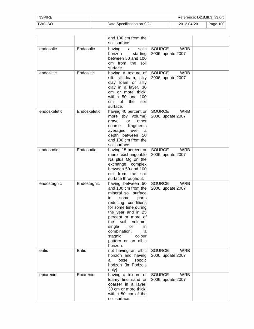
INSPIRE Reference: D2.8.III.3_v3.0rc
TWG-SO Data Specification on SOIL 2012-04-20 Page 100
and 100 cm from the soil surface.
endosalic Endosalic having a salic horizon starting between 50 and 100 cm from the soil surface.
SOURCE WRB 2006, update 2007
endosiltic Endosiltic having a texture of silt, silt loam, silty clay loam or silty clay in a layer, 30 cm or more thick, within 50 and 100 cm of the soil surface.
SOURCE WRB 2006, update 2007
endoskeletic Endoskeletic having 40 percent or more (by volume) gravel or other coarse fragments averaged over a depth between 50 and 100 cm from the soil surface.
SOURCE WRB 2006, update 2007
endosodic Endosodic having 15 percent or more exchangeable Na plus Mg on the exchange complex between 50 and 100 cm from the soil surface throughout.
SOURCE WRB 2006, update 2007
endostagnic Endostagnic having between 50 and 100 cm from the mineral soil surface in some parts reducing conditions for some time during the year and in 25 percent or more of the soil volume, single or in combination, a stagnic colour pattern or an albic horizon.
SOURCE WRB 2006, update 2007
entic Entic not having an albic horizon and having a loose spodic horizon (in Podzols only).
SOURCE WRB 2006, update 2007
epiarenic Epiarenic having a texture of loamy fine sand or coarser in a layer, 30 cm or more thick, within 50 cm of the soil surface.
SOURCE WRB 2006, update 2007

INSPIRE Reference: D2.8.III.3_v3.0rc
TWG-SO Data Specification on SOIL 2012-04-20 Page 101
epiclayic Epiclayic having a texture of clay in a layer, 30 cm or more thick, within 50 cm of the soil surface.
SOURCE WRB 2006, update 2007
epidystric Epidystric having a base saturation (by 1 M NH4OAc) of less than 50 percent throughout between 20 and 50 cm from the soil surface.
SOURCE WRB 2006, update 2007
epieutric Epieutric having a base saturation (by 1 M NH4OAc) of 50 percent or more throughout between 20 and 50 cm from the soil surface.
SOURCE WRB 2006, update 2007
epigleyic Epigleyic having within 50 cm of the mineral soil surface a layer, 25 cm or more thick, that has reducing conditions in some parts and a gleyic colour pattern throughout.
SOURCE WRB 2006, update 2007
epileptic Epileptic having continuous rock starting within 50 cm of the soil surface.
SOURCE WRB 2006, update 2007
epipetric Epipetric having a strongly cemented or indurated layer starting within 50 cm of the soil surface.
SOURCE WRB 2006, update 2007
episalic Episalic having a salic horizon starting within 50 cm of the soil surface.
SOURCE WRB 2006, update 2007
episiltic Episiltic having a texture of silt, silt loam, silty clay loam or silty clay in a layer, 30 cm or more thick, within 50 cm of the soil surface.
SOURCE WRB 2006, update 2007
episkeletic Episkeletic having 40 percent or more (by volume) gravel or other coarse fragments averaged over a depth of 50 cm from the soil surface.
SOURCE WRB 2006, update 2007
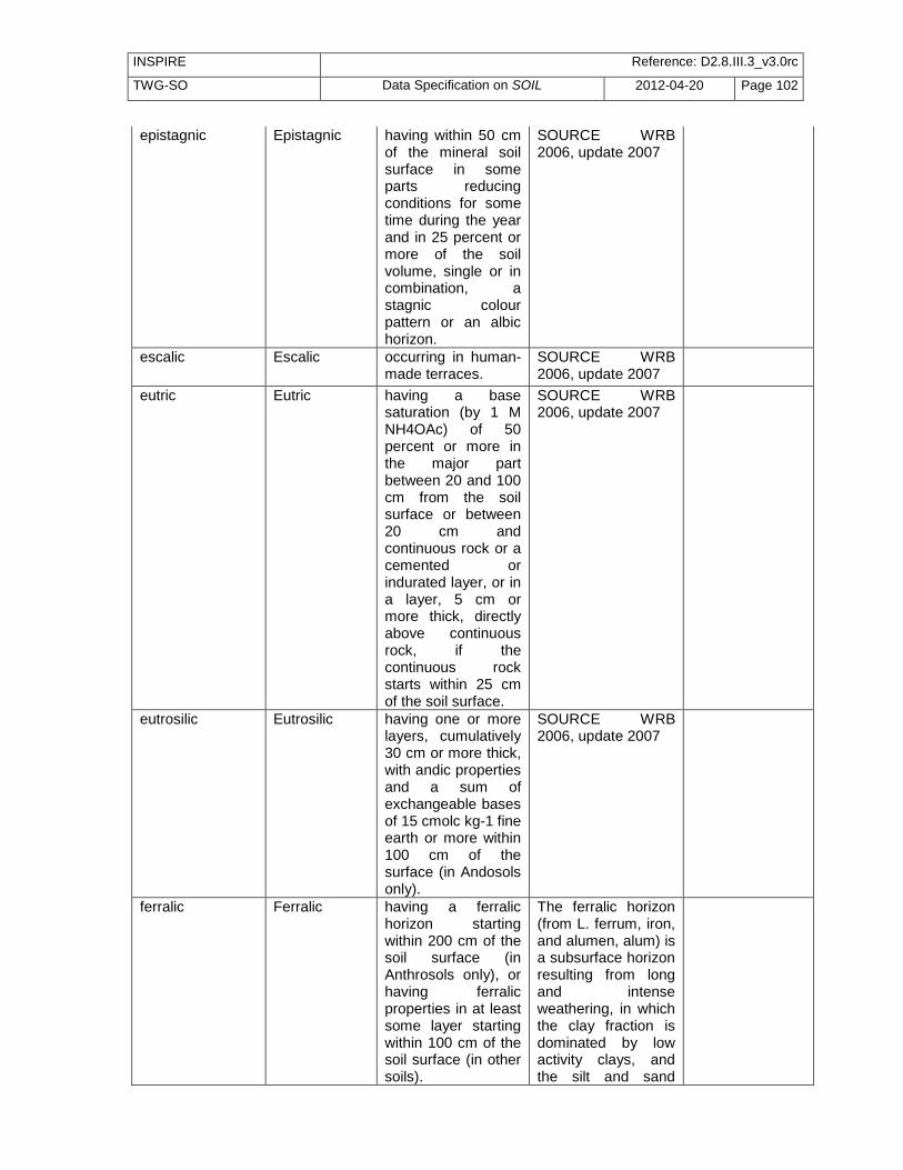
INSPIRE Reference: D2.8.III.3_v3.0rc
TWG-SO Data Specification on SOIL 2012-04-20 Page 102
epistagnic Epistagnic having within 50 cm of the mineral soil surface in some parts reducing conditions for some time during the year and in 25 percent or more of the soil volume, single or in combination, a stagnic colour pattern or an albic horizon.
SOURCE WRB 2006, update 2007
escalic Escalic occurring in human-made terraces.
SOURCE WRB 2006, update 2007
eutric Eutric having a base saturation (by 1 M NH4OAc) of 50 percent or more in the major part between 20 and 100 cm from the soil surface or between 20 cm and continuous rock or a cemented or indurated layer, or in a layer, 5 cm or more thick, directly above continuous rock, if the continuous rock starts within 25 cm of the soil surface.
SOURCE WRB 2006, update 2007
eutrosilic Eutrosilic having one or more layers, cumulatively 30 cm or more thick, with andic properties and a sum of exchangeable bases of 15 cmolc kg-1 fine earth or more within 100 cm of the surface (in Andosols only).
SOURCE WRB 2006, update 2007
ferralic Ferralic having a ferralic horizon starting within 200 cm of the soil surface (in Anthrosols only), or having ferralic properties in at least some layer starting within 100 cm of the soil surface (in other soils).
The ferralic horizon (from L. ferrum, iron, and alumen, alum) is a subsurface horizon resulting from long and intense weathering, in which the clay fraction is dominated by low activity clays, and the silt and sand
INSPIRE Reference: D2.8.III.3_v3.0rc
TWG-SO Data Specification on SOIL 2012-04-20 Page 103
fractions by highly resistant minerals,
ferric Ferric having a ferric horizon starting within 100 cm of the soil surface.
The ferric horizon (from L. ferrum, iron) is a horizon in which segregation of iron has taken place to such an extent that large mottles or concretions have formed and the inter-mottle/inter-concretionary matrix is largely depleted of iron. SOURCE WRB 200
fibric Fibric having, after rubbing, two-thirds or more (by volume) of the organic material consisting of recognizable plant tissue within 100 cm of the soil surface (in Histosols only).
SOURCE WRB 2006, update 2007
floatic Floatic having organic material floating on water (in Histosols only).
SOURCE WRB 2006, update 2007
fluvic Fluvic having fluvic material in a layer, 25 cm or more thick, within 100 cm of the soil surface.
Fluvic material (from Latin fluvius, river) refers to fluviatile, marine and lacustrine sediments that receive fresh material at regular intervals or have received it in the recent past. SOURCE WRB 2006, update 2007
folic Folic having a folic horizon starting within 40 cm of the soil surface.
The folic horizon (from L. folium, leaf) is a surface horizon, or a subsurface horizon occurring at shallow depth, which consists of well-aerated organic soil material. SOURCE WRB 2006, update 2007
fractipetric Fractipetric having a strongly cemented or indurated horizon consisting of
SOURCE WRB 2006, update 2007

INSPIRE Reference: D2.8.III.3_v3.0rc
TWG-SO Data Specification on SOIL 2012-04-20 Page 104
fractured or broken clods with an average horizontal length of less than 10 cm, starting within 100 cm of the soil surface.
fractiplinthic Fractiplinthic having a petroplinthic horizon consisting of fractured or broken clods with an average horizontal length of less than 10 cm, starting within 100 cm of the soil surface.
SOURCE WRB 2006, update 2007
fragic Fragic having a fragic horizon starting within 100 cm of the soil surface.
The fragic horizon (from Latin frangere, to break) is a natural non-cemented subsurface horizon with pedality and a porosity pattern such that roots and percolating water penetrate the soil only along interped faces and streaks. The natural character excludes plough pans and surface traffic pans. SOURCE WRB 2006, update 2007
fulvic Fulvic having a fulvic horizon starting within 30 cm of the soil surface.
The fulvic horizon (from Latin fulvus, dark yellow) is a thick, dark-coloured horizon at or near to the surface that is typically associated with short-range-order minerals (commonly allophane) or with organo-aluminium complexes.It has a low bulk density and contains highly humified organic matter that shows a lower ratio of humic acids to fulvic acids compared with the melanic horizon. SOURCE WRB

INSPIRE Reference: D2.8.III.3_v3.0rc
TWG-SO Data Specification on SOIL 2012-04-20 Page 105
2006, update 2007
garbic Garbic having a layer, 20 cm or more thick within 100 cm of the soil surface, with 20 percent or more (by volume, by weighted average) artefacts containing 35 percent or more (by volume) organic waste materials (in Technosols only).
SOURCE WRB 2006, update 2007
gelic Gelic having a layer with a soil temperature of 0 °C or less for two or more consecutive years starting within 200 cm of the soil surface.
SOURCE WRB 2006, update 2007
gelistagnic Gelistagnic having temporary water saturation at the soil surface caused by a frozen subsoil.
SOURCE WRB 2006, update 2007
geric Geric having geric properties in some layer within 100 cm of the soil surface.
SOURCE WRB 2006, update 2007
gibbsic Gibbsic having a layer, 30 cm or more thick, containing 25 percent or more gibbsite in the fine earth fraction starting within 100 cm of the soil surface.
SOURCE WRB 2006, update 2007
glacic Glacic having a layer, 30 cm or more thick, containing 75 percent (by volume) or more ice starting within 100 cm of the soil surface.
SOURCE WRB 2006, update 2007
gleyic Gleyic having within 100 cm of the mineral soil surface a layer, 25 cm or more thick, that has reducing conditions in some parts and a gleyic colour pattern throughout.
SOURCE WRB 2006, update 2007

INSPIRE Reference: D2.8.III.3_v3.0rc
TWG-SO Data Specification on SOIL 2012-04-20 Page 106
glossalbic Glossalbic showing tonguing of an albic into an argic or natric horizon.
SOURCE WRB 2006, update 2007
glossic Glossic showing tonguing of a mollic or umbric horizon into an underlying layer.
SOURCE WRB 2006, update 2007
greyic Greyic having Munsell colours with a chroma of 3 or less when moist, a value of 3 or less when moist and 5 or less when dry and uncoated silt and sand grains on structural faces within 5 cm of the mineral soil surface.
SOURCE WRB 2006, update 2007
grumic Grumic having a soil surface layer with a thickness of 3 cm or more with a strong structure finer than very coarse granular (in Vertisols only).
SOURCE WRB 2006, update 2007
gypsic Gypsic having a gypsic horizon starting within 100 cm of the soil surface.
The gypsic horizon (from Greek gypsos) is a commonly non-cemented horizon containing secondary accumulations of gypsum (CaSO4.2H2O) in various forms. SOURCE WRB 2006, update 2007
gypsiric Gypsiric having gypsiric material between 20 and 50 cm from the soil surface or between 20 cm and continuous rock or a cemented or indurated layer, whichever is shallower.
SOURCE WRB 2006, update 2007
haplic Haplic having a typical expression of certain features (typical in the sense that there is no further or meaningful characterization) and only used if
SOURCE WRB 2006, update 2007

INSPIRE Reference: D2.8.III.3_v3.0rc
TWG-SO Data Specification on SOIL 2012-04-20 Page 107
none of the preceding qualifiers applies.
hemic Hemic having, after rubbing, between two-thirds and one-sixth (by volume) of the organic material consisting of recognizable plant tissue within 100 cm from the soil surface (in Histosols only).
SOURCE WRB 2006, update 2007
histic Histic having a histic horizon starting within 40 cm of the soil surface.
The histic horizon (from Greek histos, tissue) is a surface horizon, or a subsurface horizon occurring at shallow depth, that consists of poorly aerated organic material. SOURCE WRB 2006, update 2007
hortic Hortic having a hortic horizon.
A hortic horizon (from Latin hortus, garden) is a human-induced mineral surface horizon that results from deep cultivation, intensive fertilization and/or long-continued application of human and animal wastes and other organic residues (e.g. manures, kitc
humic Humic having the following organic carbon contents in the fine earth fraction as a weighted average: in Ferralsols and Nitisols, 1.4 percent or more to a depth of 100 cm from the mineral soil surface; in Leptosols to which the Hyperskeletic qualifier applies, 2 percent or more to a depth of 25 cm from the mineral soil surface; in other soils, 1 percent or
SOURCE WRB 2006, update 2007

INSPIRE Reference: D2.8.III.3_v3.0rc
TWG-SO Data Specification on SOIL 2012-04-20 Page 108
more to a depth of 50 cm from the mineral soil surface.
hydragric Hydragric having an anthraquic horizon and an underlying hydragric horizon, the latter starting within 100 cm of the soil surface.
SOURCE WRB 2006, update 2007
hydric Hydric having within 100 cm of the soil surface one or more layers with a combined thickness of 35 cm or more, which have a water retention at 1 500 kPa (in undried samples) of 100 percent or more (in Andosols only).
SOURCE WRB 2006, update 2007
hydrophobic Hydrophobic water-repellent, i.e. water stands on a dry soil for the duration of 60 seconds or more (in Arenosols only).
SOURCE WRB 2006, update 2007
hyperalbic Hyperalbic having an albic horizon starting within 50 cm of the soil surface and having its lower boundary at a depth of 100 cm or more from the soil surface.
SOURCE WRB 2006, update 2007
hyperalic Hyperalic having an argic horizon, either starting within 100 cm of the soil surface or within 200 cm of the soil surface if the argic horizon is overlain by loamy sand or coarser textures throughout, that has a silt to clay ratio of less than 0.6 and an Al saturation (effective) of 50 percent or more, throughout or to a depth of 50 cm below its upper limit, whichever is
SOURCE WRB 2006, update 2007

INSPIRE Reference: D2.8.III.3_v3.0rc
TWG-SO Data Specification on SOIL 2012-04-20 Page 109
shallower (in Alisols only).
hypercalcic Hypercalcic having a calcic horizon with 50 percent or more (by mass) calcium carbonate equivalent and starting within 100 cm of the soil surface (in Calcisols only).
SOURCE WRB 2006, update 2007
hyperduric Hyperduric having a duric horizon with 50 percent or more (by volume) durinodes or fragments of a broken-up petroduric horizon starting within 100 cm of the soil surface.
SOURCE WRB 2006, update 2007
hyperdystric Hyperdystric having a base saturation (by 1 M NH4OAc) of less than 50 percent throughout between 20 and 100 cm from the soil surface, and less than 20 percent in some layer within 100 cm of the soil surface.
SOURCE WRB 2006, update 2007
hypereutric Hypereutric having a base saturation (by 1 M NH4OAc) of 50 percent or more throughout between 20 and 100 cm from the soil surface and 80 percent or more in some layer within 100 cm of the soil surface.
SOURCE WRB 2006, update 2007
hyperferralic Hyperferralic having ferralic properties and a CEC55 (by 1 M NH4OAc) of less than 16 cmolc kg-1 clay in at least some layer starting within 100 cm of the soil surface.
SOURCE WRB 2006, update 2007
hyperferric Hyperferric having a ferric horizon with 40 percent or more of the volume discrete
SOURCE WRB 2006, update 2007

INSPIRE Reference: D2.8.III.3_v3.0rc
TWG-SO Data Specification on SOIL 2012-04-20 Page 110
reddish to blackish nodules starting within 100 cm of the soil surface.
hypergypsic Hypergypsic having a gypsic horizon with 50 percent or more (by mass) gypsum and starting within 100 cm of the soil surface (in Gypsisols only).
SOURCE WRB 2006, update 2007
hyperhumic Hyperhumic having an organic carbon content of 5 percent or more as a weighted average in the fine earth fraction to a depth of 50 cm from the mineral soil surface.
SOURCE WRB 2006, update 2007
hyperochric Hyperochric having a mineral topsoil layer, 5 cm or more thick, with a Munsell value, dry, of 5.5 or more that turns darker on moistening, an organic carbon content of less than 0.4 percent, a platy structure in 50 percent or more of the volume, and a surface crust.
SOURCE WRB 2006, update 2007
hypersalic Hypersalic having an ECe of 30 dS m-1 or more at 25 °C in some layer within 100 cm of the soil surface.
SOURCE WRB 2006, update 2007
hyperskeletic Hyperskeletic containing less than 20 percent (by volume) fine earth averaged over a depth of 75 cm from the soil surface or to continuous rock, whichever is shallower.
SOURCE WRB 2006, update 2007
hyperthionic Hyperthionic having a thionic horizon starting within 100 cm of the soil surface and having a pH (1:1 in water) less than 3.5.
SOURCE WRB 2006, update 2007
hypocalcic Hypocalcic having a calcic horizon with a
SOURCE WRB 2006, update 2007

INSPIRE Reference: D2.8.III.3_v3.0rc
TWG-SO Data Specification on SOIL 2012-04-20 Page 111
calcium carbonate equivalent content in the fine earth fraction of less than 25 percent and starting within 100 cm of the soil surface (in Calcisols only).
hypoferralic Hypoferralic having in a layer, 30 cm or more thick, starting within 100 cm of the soil surface a CEC (by 1 M NH4OAc) of less than 4 cmolc kg-1 fine earth and a Munsell chroma, moist, of 5 or more or a hue redder than 10 YR (in Arenosols only).
SOURCE WRB 2006, update 2007
hypogypsic Hypogypsic having a gypsic horizon with a gypsum content in the fine earth fraction of less than 25 percent and starting within 100 cm of the soil surface (in Gypsisols only).
SOURCE WRB 2006, update 2007
hypoluvic Hypoluvic having an absolute clay increase of 3 percent or more within 100 cm of the soil surface (in Arenosols only).
SOURCE WRB 2006, update 2007
hyposalic Hyposalic having an ECe of 4 dS m-1 or more at 25 °C in some layer within 100 cm of the soil surface.
SOURCE WRB 2006, update 2007
hyposodic Hyposodic having 6 percent or more exchangeable Na on the exchange complex in a layer, 20 cm or more thick, within 100 cm of the soil surface.
SOURCE WRB 2006, update 2007
irragric Irragric having an irragric horizon.
The irragric horizon (from Latin irrigare, to irrigate, and ager, field) is a human-induced mineral surface horizon that

INSPIRE Reference: D2.8.III.3_v3.0rc
TWG-SO Data Specification on SOIL 2012-04-20 Page 112
builds up gradually through continuous application of irrigation water with substantial amounts of sediments, and which may include fe
lamellic Lamellic having clay lamellae with a combined thickness of 15 cm or more within 100 cm of the soil surface.
SOURCE WRB 2006, update 2007
laxic Laxic having a bulk density of less than 0.9 kg dm-3, in a mineral soil layer, 20 cm or more thick, starting within 75 cm of the soil surface.
SOURCE WRB 2006, update 2007
leptic Leptic having continuous rock starting within 100 cm of the soil surface.
SOURCE WRB 2006, update 2007
lignic Lignic having inclusions of intact wood fragments, which make up one-quarter or more of the soil volume, within 50 cm of the soil surface (in Histosols only).
SOURCE WRB 2006, update 2007
limnic Limnic having limnic material, cumulatively 10 cm or more thick, within 50 cm of the soil surface.
SOURCE WRB 2006, update 2007
linic Linic having a continuous, very slowly permeable to impermeable constructed geomembrane of any thickness starting within 100 cm of the soil surface.
SOURCE WRB 2006, update 2007
lithic Lithic having continuous rock starting within 10 cm of the soil surface (in Leptosols only).
SOURCE WRB 2006, update 2007
lixic Lixic having an argic horizon that has a
SOURCE WRB 2006, update 2007

INSPIRE Reference: D2.8.III.3_v3.0rc
TWG-SO Data Specification on SOIL 2012-04-20 Page 113
CEC (by 1 M NH4OAc) of less than 24 cmolc kg-1 clay in some part to a maximum depth of 50 cm below its upper limit, either starting within 100 cm of the soil surface or within 200 cm of the soil surface if the argic horizon is overlain by loamy sand or coarser textures throughout, and having a base saturation (by 1 M NH4OAc) of 50 percent or more in the major part between 50 and 100 cm from the soil surface.
luvic Luvic having an argic horizon that has a CEC (by 1 M NH4OAc) of 24 cmolc kg-1 clay or more throughout or to a depth of 50 cm below its upper limit, whichever is shallower, either starting within 100 cm of the soil surface or within 200 cm of the soil surface if the argic horizon is overlain by loamy sand or coarser textures throughout, and having a base saturation (by 1 M NH4OAc) of 50 percent or more in the major part between 50 and 100 cm from the soil surface.
SOURCE WRB 2006, update 2007
magnesic Magnesic having an exchangeable Ca to Mg ratio of less than 1 in the major part within 100 cm of the soil surface or to
SOURCE WRB 2006, update 2007
INSPIRE Reference: D2.8.III.3_v3.0rc
TWG-SO Data Specification on SOIL 2012-04-20 Page 114
continuous rock or a cemented or indurated layer, whichever is shallower.
manganiferric Manganiferric having a ferric horizon starting within 100 cm of the soil surface in which half or more of the nodules or mottles are black.
SOURCE WRB 2006, update 2007
mazic Mazic massive and hard to very hard in the upper 20 cm of the soil (in Vertisols only).
SOURCE WRB 2006, update 2007
melanic Melanic having a melanic horizon starting within 30 cm of the soil surface (in Andosols only).
The melanic horizon (from Greek melas, black) is a thick, black horizon at or near the surface, which is typically associated with short-range-order minerals (commonly allophane) or with organo-aluminium complexes. It has a low bulk density and contains h
mesotrophic Mesotrophic having a base saturation (by 1 M NH4OAc) of less than 75 percent at a depth of 20 cm from the soil surface (in Vertisols only).
SOURCE WRB 2006, update 2007
mollic Mollic having a mollic horizon.
The mollic horizon (from Latin mollis, soft) is a thick, well-structured, dark-coloured surface horizon with a high base saturation and a moderate to high content of organic matter. SOURCE WRB 2006, update 2007
molliglossic Molliglossic showing tonguing of a mollic horizon into an underlying layer.
SOURCE WRB 2006, update 2007
natric Natric having a natric horizon starting within 100 cm of the
The natric horizon (from Arabic natroon, salt) is a

INSPIRE Reference: D2.8.III.3_v3.0rc
TWG-SO Data Specification on SOIL 2012-04-20 Page 115
soil surface. dense subsurface horizon with distinct higher clay content than the overlying horizon or horizons. It has a high content in exchangeable Na and/or Mg. SOURCE WRB 2006, update 2007
nitic Nitic having a nitic horizon starting within 100 cm of the soil surface.
The nitic horizon (from Latin nitidus, shiny) is a clay-rich subsurface horizon. It has moderately to strongly developed polyhedric structure breaking to flat-edged or nutty elements with many shiny ped faces, which cannot or can only partially be attribu
novic Novic having above the soil that is classified at the RSG level, a layer with recent sediments (new material), 5 cm or more and less than 50 cm thick.
SOURCE WRB 2006, update 2007
nudiargic Nudiargic having an argic horizon starting at the mineral soil surface.
SOURCE WRB 2006, update 2007
nudilithic Nudilithic having continuous rock at the soil surface (in Leptosols only).
SOURCE WRB 2006, update 2007
nudiyermic Nudiyermic having a yermic horizon without a desert pavement.
SOURCE WRB 2006, update 2007
ombric Ombric having a histic horizon saturated predominantly with rainwater starting within 40 cm of the soil surface (in Histosols only).
SOURCE WRB 2006, update 2007
ornithic Ornithic having a layer 15 cm or more thick with ornithogenic material starting within 50 cm of the soil surface.
SOURCE WRB 2006, update 2007

INSPIRE Reference: D2.8.III.3_v3.0rc
TWG-SO Data Specification on SOIL 2012-04-20 Page 116
orthodystric Orthodystric having a base saturation (by 1 M NH4OAc) of less than 50 percent throughout between 20 and 100 cm from the soil surface.
SOURCE WRB 2006, update 2007
orthoeutric Orthoeutric having a base saturation (by 1 M NH4OAc) of 50 percent or more throughout between 20 and 100 cm from the soil surface.
SOURCE WRB 2006, update 2007
orthothionic Orthothionic having a thionic horizon starting within 100 cm of the soil surface and having a pH (1:1 in water) between 3.5 and 4.0.
SOURCE WRB 2006, update 2007
ortsteinic Ortsteinic having a cemented spodic horizon (ortstein) (in Podzols only).
SOURCE WRB 2006, update 2007
oxyaquic Oxyaquic saturated with oxygen-rich water during a period of 20 or more consecutive days and not having a gleyic or stagnic colour pattern in some layer within 100 cm of the soil surface.
SOURCE WRB 2006, update 2007
pachic Pachic having a mollic or umbric horizon 50 cm or more thick.
SOURCE WRB 2006, update 2007
pellic Pellic having in the upper 30 cm of the soil a Munsell value, moist, of 3.5 or less and a chroma, moist, of 1.5 or less (in Vertisols only).
SOURCE WRB 2006, update 2007
petric Petric having a strongly cemented or indurated layer starting within 100 cm of the soil surface.
SOURCE WRB 2006, update 2007
petrocalcic Petrocalcic having a petrocalcic horizon starting within 100 cm of the soil surface.
A petrocalcic horizon (from Greek petros, rock, and Latin calx, lime) is an indurated calcic horizon that is

INSPIRE Reference: D2.8.III.3_v3.0rc
TWG-SO Data Specification on SOIL 2012-04-20 Page 117
cemented by calcium carbonate and, in places, by calcium and some magnesium carbonate. It is either massive or platy in nature, and extremely hard
petroduric Petroduric having a petroduric horizon starting within 100 cm of the soil surface.
A petroduric horizon (from Greek petros, rock, and Latin durus, hard), also known as duripan or dorbank (South Africa), is a subsurface horizon, usually reddish or reddish brown in colour, that is cemented mainly by secondary silica (SiO2, presumably opal
petrogleyic Petrogleyic having a layer, 10 cm or more thick, with an oximorphic colour pattern, 15 percent or more (by volume) of which is cemented (bog iron), within 100 cm of the soil surface.
SOURCE WRB 2006, update 2007
petrogypsic Petrogypsic having a petrogypsic horizon starting within 100 cm of the soil surface.
A petrogypsic horizon (from Greek petros, rock, and gypsos) is a cemented horizon containing secondary accumulations of gypsum (CaSO4.2H2O). SOURCE WRB 2006, update 2007
petroplinthic Petroplinthic having a petroplinthic horizon starting within 100 cm of the soil surface.
A petroplinthic horizon (from Greek petros, rock, and plinthos, brick) is a continuous, fractured or broken layer of indurated material, in which Fe (and in cases also Mn) is an important cement and in which organic matter is either

INSPIRE Reference: D2.8.III.3_v3.0rc
TWG-SO Data Specification on SOIL 2012-04-20 Page 118
absent or present only
petrosalic Petrosalic having, within 100 cm of the soil surface, a layer, 10 cm or more thick, which is cemented by salts more soluble than gypsum.
SOURCE WRB 2006, update 2007
phytotoxic Phytotoxic having in some layer within 50 cm of the soil surface sufficiently high or low concentrations of ions other than Al, Fe, Na, Ca and Mg, to markedly affect plant growth.
SOURCE WRB 2006, update 2007
pisocalcic Pisocalcic having only concentrations of secondary carbonates starting within 100 cm of the soil surface.
SOURCE WRB 2006, update 2007
pisoplinthic Pisoplinthic having a pisoplinthic horizon starting within 100 cm of the soil surface.
A pisoplinthic horizon (from Latin pisum, pea, and Greek plinthos, brick) contains nodules that are strongly cemented to indurated with Fe (and in some cases also with Mn). SOURCE WRB 2006, update 2007
placic Placic having, within 100 cm of the soil surface, an iron pan, between 1 and 25 mm thick, that is continuously cemented by a combination of organic matter, Fe and/or Al.
SOURCE WRB 2006, update 2007
plaggic Plaggic having a plaggic horizon.
A plaggic horizon (from Dutch plag, sod) is a black or brown human-induced mineral surface horizon that has been produced by long-continued manuring. In

INSPIRE Reference: D2.8.III.3_v3.0rc
TWG-SO Data Specification on SOIL 2012-04-20 Page 119
medieval times, sod and other materials were commonly used for bedding livestock and the manure was sp
plinthic Plinthic having a plinthic horizon starting within 100 cm of the soil surface.
A plinthic horizon (from Greek plinthos, brick) is a subsurface horizon that consists of an Fe-rich (in some cases also Mn-rich), humus-poor mixture of kaolinitic clay (and other products of strong weathering, such as gibbsite) with quartz and other const
posic Posic having a zero or positive charge (pHKCl - pHwater ≥ 0, both in 1:1 solution) in a layer, 30 cm or more thick, starting within 100 cm of the soil surface (in Plinthosols and Ferralsols only).
SOURCE WRB 2006, update 2007
profondic Profondic having an argic horizon in which the clay content does not decrease by 20 percent or more (relative) from its maximum within 150 cm of the soil surface.
SOURCE WRB 2006, update 2007
protic Protic showing no soil horizon development (in Arenosols only).
SOURCE WRB 2006, update 2007
protothionic Protothionic having a layer with sulphidic material, 15 cm or more thick, starting within 100 cm of the soil surface.
SOURCE WRB 2006, update 2007
puffic Puffic having a crust pushed up by salt crystals (in Solonchaks only).
SOURCE WRB 2006, update 2007
reductaquic Reductaquic saturated with water during the thawing
SOURCE WRB 2006, update 2007

INSPIRE Reference: D2.8.III.3_v3.0rc
TWG-SO Data Specification on SOIL 2012-04-20 Page 120
period and having at some time of the year reducing conditions above a cryic horizon and within 100 cm of the soil surface (in Cryosols only).
reductic Reductic having reducing conditions in 25 percent or more of the soil volume within 100 cm of the soil surface caused by gaseous emissions, e.g. methane or carbon dioxide (in Technosols only).
SOURCE WRB 2006, update 2007
regic Regic not having buried horizons (in Anthrosols only).
SOURCE WRB 2006, update 2007
rendzic Rendzic having a mollic horizon that contains or immediately overlies calcaric materials or calcareous rock containing 40 percent or more calcium carbonate equivalent.
SOURCE WRB 2006, update 2007
rheic Rheic having a histic horizon saturated predominantly with groundwater or flowing surface water starting within 40 cm of the soil surface (in Histosols only).
SOURCE WRB 2006, update 2007
rhodic Rhodic having within 150 cm of the soil surface a subsurface layer, 30 cm or more thick, with a Munsell hue of 2.5 YR or redder, a value, moist, of less than 3.5 and a value, dry, no more than one unit higher than the moist value.
SOURCE WRB 2006, update 2007
rubic Rubic having within 100 cm of the soil surface a
SOURCE WRB 2006, update 2007

INSPIRE Reference: D2.8.III.3_v3.0rc
TWG-SO Data Specification on SOIL 2012-04-20 Page 121
subsurface layer, 30 cm or more thick, with a Munsell hue redder than 10 YR or a chroma, moist, of 5 or more (in Arenosols only).
ruptic Ruptic having a lithological discontinuity within 100 cm of the soil surface.
SOURCE WRB 2006, update 2007
rustic Rustic having a spodic horizon in which the ratio of the percentage of acid oxalate (pH3) extractable Fe to the percentage of organic carbon is 6 or more throughout (in Podzols only).
SOURCE WRB 2006, update 2007
salic Salic having a salic horizon starting within 100 cm of the soil surface.
The salic horizon (from Latin sal, salt) is a surface or shallow subsurface horizon that contains a secondary enrichment of readily soluble salts, i.e. salts more soluble than gypsum (CaSO4.2H2O; log Ks = -4.85 at 25 °C). S
sapric Sapric having, after rubbing, less than one-sixth (by volume) of the organic material consisting of recognizable plant tissue within 100 cm of the soil surface (in Histosols only).
SOURCE WRB 2006, update 2007
silandic Silandic having one or more layers, cumulatively 15 cm or more thick, with andic properties and an acid oxalate (pH 3) extractable silica (Siox) content of 0.6 percent or more, or an Alpy to Alox ratio of less than 0.5 within 100 cm of the soil surface (in Andosols
SOURCE WRB 2006, update 2007

INSPIRE Reference: D2.8.III.3_v3.0rc
TWG-SO Data Specification on SOIL 2012-04-20 Page 122
only).
siltic Siltic having a texture of silt, silt loam, silty clay loam or silty clay in a layer, 30 cm or more thick, within 100 cm of the soil surface.
SOURCE WRB 2006, update 2007
siltinovic Siltinovic having above the soil that is classified at the RSG level, a layer with recent sediments (new material), 5 cm or more and less than 50 cm thick, which has a texture of silt, silt loam, silty clay loam or silty clay in its major part.
SOURCE WRB 2006, update 2007
skeletic Skeletic having 40 percent or more (by volume) gravel or other coarse fragments averaged over a depth of 100 cm from the soil surface or to continuous rock or a cemented or indurated layer, whichever is shallower.
SOURCE WRB 2006, update 2007
sodic Sodic having 15 percent or more exchangeable Na plus Mg on the exchange complex within 50 cm of the soil surface throughout.
SOURCE WRB 2006, update 2007
solodic Solodic having a layer, 15 cm or more thick within 100 cm of the soil surface, with the columnar or prismatic structure of the natric horizon, but lacking its sodium saturation requirements.
SOURCE WRB 2006, update 2007
sombric Sombric having a sombric horizon starting within 150 cm of the soil surface.
A sombric horizon (from French sombre, dark) is a dark-coloured subsurface horizon containing illuvial
INSPIRE Reference: D2.8.III.3_v3.0rc
TWG-SO Data Specification on SOIL 2012-04-20 Page 123
humus that is neither associated with Al nor dispersed by Na. SOURCE WRB 2006, update 2007
spodic Spodic having a spodic horizon starting within 200 cm of the mineral soil surface.
The spodic horizon (from Greek spodos, wood ash) is a subsurface horizon that contains illuvial amorphous substances composed of organic matter and Al, or of illuvial Fe. The illuvial materials are characterized by a high pH-dependent charge, a relatively
spolic Spolic having a layer, 20 cm or more thick within 100 cm of the soil surface, with 20 percent or more (by volume, by weighted average) artefacts containing 35 percent or more (by volume) of industrial waste (mine spoil, dredgings, rubble, etc.) (in Technosols only).
SOURCE WRB 2006, update 2007
stagnic Stagnic having within 100 cm of the mineral soil surface in some parts reducing conditions for some time during the year and in 25 percent or more of the soil volume, single or in combination, a stagnic colour pattern or an albic horizon.
SOURCE WRB 2006, update 2007
subaquatic Subaquatic being permanently submerged under water not deeper than 200 cm (in Fluvisols only).
SOURCE WRB 2006, update 2007
sulphatic Sulphatic having a salic horizon with a soil solution (1:1 in water) with [SO42-] >> [HCO3-] > [Cl-] (in Solonchaks
SOURCE WRB 2006, update 2007

INSPIRE Reference: D2.8.III.3_v3.0rc
TWG-SO Data Specification on SOIL 2012-04-20 Page 124
only).
takyric Takyric having a takyric horizon.
A takyric horizon (from Turkic languages takyr, barren land) is a heavy-textured surface horizon comprising a surface crust and a platy structured lower part. It occurs under arid conditions in periodically flooded soils. SOURCE
technic Technic having 10 percent or more (by volume, by weighted average) artefacts in the upper 100 cm from the soil surface or to continuous rock or a cemented or indurated layer, whichever is shallower.
SOURCE WRB 2006, update 2007
tephric Tephric having tephric material to a depth of 30 cm or more from the soil surface or to continuous rock, whichever is shallower.
SOURCE WRB 2006, update 2007
terric Terric having a terric horizon.
A terric horizon (from Latin terra, earth) is a human-induced mineral surface horizon that develops through addition of earthy manures, compost, beach sands or mud over a long period of time. It builds up gradually and may contain stones, randomly sorted
thaptaluandic Thaptaluandic having one or more buried layers, cumulatively 15 cm or more thick, with andic properties and an acid oxalate (pH 3) extractable silica content of less than
SOURCE WRB 2006, update 2007

INSPIRE Reference: D2.8.III.3_v3.0rc
TWG-SO Data Specification on SOIL 2012-04-20 Page 125
0.6 percent, or an Alpy/Alox of 0.5 or more, within 100 cm of the soil surface.
thaptandic Thaptandic having within 100 cm of the soil surface one or more buried layers with andic or vitric properties with a combined thickness of 30 cm or more (in Cambisols 15 cm or more), of which 15 cm or more (in Cambisols 7.5 cm or more) have andic properties.
SOURCE WRB 2006, update 2007
thaptofolic Thaptofolic having a buried folic horizon starting between 40 and 100 cm from the soil surface.
SOURCE WRB 2006, update 2007
thaptohistic Thaptohistic having a buried histic horizon starting between 40 and 100 cm from the soil surface.
SOURCE WRB 2006, update 2007
thaptosilandic Thaptosilandic having one or more buried layers, cumulatively 15 cm or more thick, with andic properties and an acid oxalate (pH 3) extractable silica (Siox) content of 0.6 percent or more, or an Alpy to Alox ratio of less than 0.5 within 100 cm of the soil surface.
SOURCE WRB 2006, update 2007
thaptovitric Thaptovitric having within 100 cm of the soil surface one or more buried layers with andic or vitric properties with a combined thickness of 30 cm or more (in Cambisols: 15 cm or more), of which 15 cm or more (in Cambisols 7.5 cm or more) have vitric properties.
SOURCE WRB 2006, update 2007

INSPIRE Reference: D2.8.III.3_v3.0rc
TWG-SO Data Specification on SOIL 2012-04-20 Page 126
thionic Thionic having a thionic horizon or a layer with sulphidic material, 15 cm or more thick, starting within 100 cm of the soil surface.
The thionic horizon (from Greek theion, sulphur) is an extremely acid subsurface horizon in which sulphuric acid is formed through oxidation of sulphides. Sulphidic material (from English sulphide) is a waterlogged deposit containing S, mostly in the form
thixotropic Thixotropic having in some layer within 50 cm of the soil surface material that changes, under pressure or by rubbing, from a plastic solid into a liquefied stage and back into the solid condition.
SOURCE WRB 2006, update 2007
tidalic Tidalic being flooded by tidewater but not covered by water at mean low tide.
SOURCE WRB 2006, update 2007
toxic Toxic having in some layer within 50 cm of the soil surface toxic concentrations of organic or inorganic substances other than ions of Al, Fe, Na, Ca and Mg.
SOURCE WRB 2006, update 2007
transportic Transportic having at the surface a layer, 30 cm or more thick, with solid or liquid material that has been moved from a source area outside the immediate vicinity of the soil by intentional human activity, usually with the aid of machinery, and without substantial reworking or displacement by natural forces.
SOURCE WRB 2006, update 2007
turbic Turbic having cryoturbation features (mixed material, disrupted soil horizons,
SOURCE WRB 2006, update 2007

INSPIRE Reference: D2.8.III.3_v3.0rc
TWG-SO Data Specification on SOIL 2012-04-20 Page 127
involutions, organic intrusions, frost heave, separation of coarse from fine materials, cracks or patterned ground) at the soil surface or above a cryic horizon and within 100 cm of the soil surface.
umbric Umbric having an umbric horizon.
The umbric horizon (from Latin umbra, shade) is a thick, dark-coloured surface horizon with a low base saturation and a moderate to high content of organic matter. SOURCE WRB 2006, update 2007
umbriglossic Umbriglossic showing tonguing of an umbric horizon into an underlying layer.
SOURCE WRB 2006, update 2007
urbic Urbic having a layer, 20 cm or more thick within 100 cm of the soil surface, with 20 percent or more (by volume, by weighted average) artefacts containing 35 percent or more (by volume) of rubble and refuse of human settlements (in Technosols only).
SOURCE WRB 2006, update 2007
vermic Vermic having 50 percent or more (by volume, by weighted average) of worm holes, casts, or filled animal burrows in the upper 100 cm of the soil or to continuous rock or a cemented or indurated layer, whichever is shallower.
SOURCE WRB 2006, update 2007
vertic Vertic having a vertic horizon or vertic properties starting within 100 cm of the
The vertic horizon (from Latin vertere, to turn) is a clayey subsurface horizon

INSPIRE Reference: D2.8.III.3_v3.0rc
TWG-SO Data Specification on SOIL 2012-04-20 Page 128
soil surface. that, as a result of shrinking and swelling, has slickensides and wedge-shaped structural aggregates. SOURCE WRB 2006, update 2007
vetic Vetic having an ECEC (sum of exchangeable bases plus exchangeable acidity in 1 M KCl) of less than 6 cmolc kg-1 clay in some subsurface layer within 100 cm of the soil surface.
SOURCE WRB 2006, update 2007
vitric Vitric having within 100 cm of the soil surface one or more layers with andic or vitric properties with a combined thickness of 30 cm or more (in Cambisols: 15 cm or more), of which 15 cm or more (in Cambisols 7.5 cm or more) have vitric properties.
SOURCE WRB 2006, update 2007
voronic Voronic having a voronic horizon (in Chernozems only).
The voronic horizon (from Russian voronoj, black) is a special type of mollic horizon. It is a deep, well-structured, blackish surface horizon with a high base saturation, a high content of organic matter and a high biological activity.
xanthic Xanthic having a ferralic horizon that has in a subhorizon, 30 cm or more thick within 150 cm of the soil surface, a Munsell hue of 7.5 YR or yellower and a value, moist, of 4 or more and a chroma, moist, of 5 or more.
SOURCE WRB 2006, update 2007

INSPIRE Reference: D2.8.III.3_v3.0rc
TWG-SO Data Specification on SOIL 2012-04-20 Page 129
yermic Yermic having a yermic horizon, including a desert pavement.
The yermic horizon (from Spanish yermo, desert) is a surface horizon that usually, but not always, consists of surface accumulations of rock fragments (desert pavement) embedded in a loamy vesicular layer that may be covered by a thin aeolian sand or loes
zootoxic Zootoxic having in some layer within 50 cm of the soil surface sufficiently high and persistent concentrations of organic or inorganic substances to markedly affect the health of animals, including humans, that ingest plants grown on these soils.
SOURCE WRB 2006, update 2007
5.2.3.6. Values of code list WRBReferenceSoilGroupValue
Value Name Definition Description Parent value
acrisol Acrisols Soil having an argic horizon, CECclay <24 and BS < 50%.
Soils with a clay-enriched subsoil with low base status and low-activity clay
albeluvisol Albeluvisols Soil having an argic horizon and albeluvic tonguin.
Soils with a clay-enriched subsoil with albeluvic tonguing
alisol Alisols Soil having an argic horizon with CECclay >24 and BS < 50%.
Soils with a clay-enriched subsoil with low base status and high-activity clay
andosol Andosols Soil having an andic or vitric horizon.
Soils set by Fe/Al chemistry with allophanes or Al-humus complexes
anthrosol Anthrosols Soils profoundly modified through long-term human activities.
Soils with strong human influence and with long and intensive agricultural use
arenosol Arenosols Soil having a coarse texture up to >100 cm depth.
Relatively young sandy soils or sandy soils with little or no profile development

INSPIRE Reference: D2.8.III.3_v3.0rc
TWG-SO Data Specification on SOIL 2012-04-20 Page 130
calcisol Calcisols Soil having a calcic or petrocalcic horizon.
Soil with accumulation of calcium carbonate and no accumulation of more soluble salts or non-saline substances
cambisol Cambisols Soil having a cambic horizon.
Moderately developed soils in relatively young soils or soils with little or no profile development
chernozem Chernozems Soil having a chernic or blackish mollic horizon.
Soils with accumulation of organic matter, high base status and black mollic horizon
cryosol Cryosols Soil having a cryic horizon.
Soils ice-affected by permafrost
durisol Durisols Soil having a duric or petroduric horizon.
Soils with accumulation of silica and no accumulation of more soluble salts or non-saline substances
ferralsol Ferralsols Soil having a ferralic horizon.
Soils set by Fe/Al chemistry with dominance of kaolinite and sesquioxides
fluvisol Fluvisols Soil having a fluvic materials.
Relatively young soils in floodplains or in tidal marshes
gleysol Gleysols Soil having a gleyic properties.
Groundwater affected soils
gypsisol Gypsisols Soil having a gypsic or petrogypsic horizon.
Soils with accumulation of gypsum and no accumulation of more soluble salts or non-saline substances
histosol Histosols Soil having organic matter >40 cm depth.
Soils with thick organic layers
kastanozem Kastanozems Soil having a brownish mollic horizon and secondary CaCO3.
Soils with accumulation of organic matter, high base status and brown mollic horizon
leptosol Leptosols Shallow soils, <=25 cm deep
Shallow or extremely gravelly soils

INSPIRE Reference: D2.8.III.3_v3.0rc
TWG-SO Data Specification on SOIL 2012-04-20 Page 131
lixisol Lixisols Soil having an argic horizon and CECclay <24.
Soils with a clay-enriched subsoil with wigh base status and low-activity clay
luvisol Luvisols Soil having an argic horizon and CECclay >24.
Soils with a clay-enriched subsoil with wigh base status and high-activity clay
nitisol Nitisols Soil having a nitic horizon.
Soils set by Fe/Al chemistry with low-activity clay, P fixation and strongly structured.
phaeozem Phaeozems Soil having a mollic horizon.
Soils with accumulation of organic matter, high base status, and any mollic horizon
planosol Planosols Soil having reducing condition and pedogenetic abrupt textural change.
Soils with stagnating water and abrupt textural discontinuity
plinthosol Plinthosols Soil having plinthite or petroplinthite.
Soils set by Fe/Al chemistry with accumulation of Fe under hydromorphic conditions
podzol Podzols Soil having a spodic horizon.
Soils set by Fe/Al chemistry with cheluviation and chilluviation
regosol Regosols Soil without a diagnostic horizon
Relatively young soils with no significant profile development
solonchak Solonchaks Soil having a salic horizon.
Soils influenced by water salt enrichment upon evaporation
solonetz Solonetzs Soil having a natric horizon.
Alkaline soils with a natric horizon
stagnosol Stagnosols Soil having reducing condition.
Soils with stagnating water with moderate textural or structural discontinuity
technosol Technosols Soil having a human artefacts.
Soils with strong human influence containing many artefacts
umbrisol Umbrisols Soil having an umbric horizon.
Relatively young soils or soils with little or no profile development with an acidic dark topsoil
vertisol Vertisols Soil having a vertic horizon.
Soils influenced by alternating wet-dry

INSPIRE Reference: D2.8.III.3_v3.0rc
TWG-SO Data Specification on SOIL 2012-04-20 Page 132
conditions and rich in swelling clays
5.2.3.7. Values of code list WRBSpecifierValue
Value Name Definition Description Parent value
bathy Bathy Horizon, property or material starting between 100 and 200 cm from the soil surface
Specifiers indicating depth of occurrence: somewhere within 100 and 200 cm of the soil surface
cumuli Cumuli Having a repetitive accumulation of material of 50 cm or more at the soil surface
Specifiers indicating the intensity of the characteristic
endo Endo Horizon, property or material starting between 50 and 100 cm from the soil surface
Specifiers indicating depth of occurrence: somewhere within 50 and 100 cm of the soil surface
epi Epi Horizon, property or material starting within 50 cm of the soil surface
Specifiers indicating depth of occurrence: somewhere within 50 cm of the soil surface
hyper Hyper Having a strong expression of certain features
Specifiers indicating the intensity of the characteristic
hypo Hypo Having a weak expression of certain features
Specifiers indicating the intensity of the characteristic
ortho Ortho Having a typical expression of certain features
Specifiers indicating the intensity of the characteristic
para Para Having a resemblance to certain features
Specifiers indicating the intensity of the characteristic
proto Proto Indicating a precondition or an early stage of development of certain features
Specifiers indicating the intensity of the characteristic
thapto Thapto Having a buried horizon within 100 cm of the surface
Specifiers indicating depth of occurrence. The buried horizon but also buried soil are recognized with thapto specifier and –ic added to the buried soil’s RSG name. example: Haplic Umbrisols (Arenic),
5.2.3.8. Values of code list LayerTypeValue
INSPIRE Reference: D2.8.III.3_v3.0rc
TWG-SO Data Specification on SOIL 2012-04-20 Page 133
Value Name Definition Description Parent value
depthInterval depth interval
fixed depth range where soil is described and/or samples are taken.
They are often used in soil monitoring, sampling of contaminated sites and in modelling, and include: • upper and lower limits of a soil horizon, or of a functional set of horizons • depth increments (also called fixed depths), that are often used for sampling, e.g. 0-30cm, 30-60cm, and so on, • a single depth range in which a soil sample is taken and for which the analytical result is valid, and • soil slicing, that is, profile segmentation according to a specified vector, for instance, either regularly spaced intervals (1cm), or a user-defined vector of segment boundaries (i.e. 0-10, 10-25, 25-50, 50-100). Slicing is used in modelling to generate continuous depth functions for soil properties.
geogenic geogenic domain resulting from e.g. sedimentation (as non-pedogenic) processes, that display an unconformity to possible over- or underlying adjacent domains.
subSoil subsoil natural soil material below the topsoil and overlying the unweathered parent material.
SOURCE ISO 11074 NOTE The subsoil can be: (i) a grouping of one to several horizons underlying the horizons with recent humus accumulation

INSPIRE Reference: D2.8.III.3_v3.0rc
TWG-SO Data Specification on SOIL 2012-04-20 Page 134
from humifying biomass or (ii) a domain of a soil with a specific vertical extension starting well below the soil surface (e.g. 15-75 cm).
topSoil topsoil upper part of a natural soil that is generally dark coloured and has a higher content of organic matter and nutrients when compared to the (mineral ) horizons below excluding the humus layer.
NOTE 1 For arable lands, topsoil refers to the ploughed soil depth; for grasslands, it is the soil layer with high root content. NOTE 2 The topsoil can be: (i) a grouping of one to several A horizons or (ii) a domain of a soil with a specific vertical extension starting from the surface (e.g. 0-15 cm). NOTE 3 In most soil description guidelines, the topsoil is composed of all A horizons occurring in a soil profile.
5.2.3.9. Values of code list LayerGenesisProcessStateValue
Value Name Definition Description Parent value
ongoing On-going the process has started in the past is still active
Synonym: current
terminated terminated the process is no longer active
5.2.3.10. Values of code list ProfileElementParameterNameValue
Value Name Definition Description Parent value
chemicalParameter chemical parameter
chemical parameters observed to characterize the profile element
physicalParameter physical parameter
physical parameters observed to characterize the profile element
biologicalParameter biological parameter
biological parameters observed to characterize the

INSPIRE Reference: D2.8.III.3_v3.0rc
TWG-SO Data Specification on SOIL 2012-04-20 Page 135
profile element
organicCarbonContent organic carbon content
portion of the soil measured as carbon in organic forms, excluding dissolved (DOC: Dissolved Organic Carbon) and living macro fauna, expressed in a range of percentages.
SOURCE 1 ISO 11074:2005 NOTE 1 Organic carbon content can serve as an indirect determination of organic matter through the use of an approximate correction factor. The “Van Bemmelen factor” of 1.724 has been used for many years and is based on the assumption that organic matter contains 58 percent organic carbon. The literature indicates that the proportion of organic C in soil organic matter for a range of soils is highly variable. Any constant factor that is selected is only an approximation. The ecuation for the estimation of the organic matter according to this factor is the following one: OM (%) = 1.724 x OC (%) SOURCE 2 NRCS Natural Resources Conservation Service, Soil survey laboratory information manual, Soil survey investigation report n.45 version 2.0 February 2011 pag. 247 NOTE 2 The soil
chemicalParameter

INSPIRE Reference: D2.8.III.3_v3.0rc
TWG-SO Data Specification on SOIL 2012-04-20 Page 136
organic carbon content is a parameter to be taken into account for meeting the (i) Council regulation (EC) No 1782/2003 (Common Agricultural Policy), (ii) Agri-environmental indicators that track the integration of environmental concerns into CAP at EU, national and regional levels, (iii) Directive 2009/28/EC of the European Parliament and of the Council (energy from renewable resources)
nitrogenContent nitrogen content
total nitrogen content in the soil, including both the organic and inorganic forms.
NOTE 1 Nitrogen is one of the most important plant nutrients and forms some of the most mobile compounds in the soil-crop system, and as such, is commonly related to water-quality problems. Total N includes both organic and inorganic forms. SOURCE Soil survey laboratory methods manual version 4.0. Soil Survey Investigations Report No. 42. USDA, USA. NOTE 2 The nitrogen content is a parameter to be taken into account for meeting the (i) Council Directive 91/676/EEC of 12 December 1991
chemicalParameter

INSPIRE Reference: D2.8.III.3_v3.0rc
TWG-SO Data Specification on SOIL 2012-04-20 Page 137
concerning the protection of waters against pollution caused by nitrates form agricultural sources
pHValue pH value pH value of the profile element
pH is the negative logarithm to the base of 10 of H-ion activity (i.e. apparent or effective concentration of H-ion in solution). It represents the the intensity factor (index) of soil acidity. SOURCE Soil Survey Laboratory Information Manual.Soil Survey Investigations Report No.45. Version 2. February 2011. United States Department of Agriculture, Natural Resources Conservation Service, National Soil Survey Center, Lincoln, Nebraska, USA. 530 pages. NOTE: the pH of the soil is potentiometrically measured in the supernatant suspension of a soil/liquid mixture. This liquid can be made using several reagents (KCl, CaCl2, H2O, NaF). The reagent used must be given in the process parameter linked to the observable property as well as its concentration
Chemical parameter

INSPIRE Reference: D2.8.III.3_v3.0rc
TWG-SO Data Specification on SOIL 2012-04-20 Page 138
and the ratio used between soil and liquid.
cadmiumContent cadmium content
cadmium content of the profile element
NOTE: the Directive 86/278/EEC of 12 June 1986 on the protection of the environment, and in particular of the soil, when sewage sludge is used in agriculture, indicated that cadmium analysis must be performed on soil before spreading of sewage sludge. In this framework, the analysis must be carried out following strong acid digestion and the reference method of analysis must be that of atomic absorption spectrometry. Nevertheless, for other requirements, other type of analysis can be made using other reagents. Thus, the type of reagent used for the analysis must be given in the process parameter linked to the observable property.
Chemical parameter
chromiumContent chromium content
chromium content of the profile element
NOTE: the Directive 86/278/EEC of 12 June 1986 on the protection of the environment, and in particular of the soil, when sewage sludge is used in agriculture, indicated that chromium analysis must be performed
Chemical parameter

INSPIRE Reference: D2.8.III.3_v3.0rc
TWG-SO Data Specification on SOIL 2012-04-20 Page 139
on soil before spreading of sewage sludge. In this framework, the analysis must be carried out following strong acid digestion and the reference method of analysis must be that of atomic absorption spectrometry. Nevertheless, for other requirements, other type of analysis can be made using other reagents. Thus, the type of reagent used for the analysis must be given in the process parameter linked to the observable property.
copperContent copper content
copper content of the profile element
NOTE: the Directive 86/278/EEC of 12 June 1986 on the protection of the environment, and in particular of the soil, when sewage sludge is used in agriculture, indicated that copper analysis must be performed on soil before spreading of sewage sludge. In this framework, the analysis must be carried out following strong acid digestion and the reference method of analysis must be that of atomic absorption spectrometry. Nevertheless, for other requirements,
Chemical parameter

INSPIRE Reference: D2.8.III.3_v3.0rc
TWG-SO Data Specification on SOIL 2012-04-20 Page 140
other type of analysis can be made using other reagents. Thus, the type of reagent used for the analysis must be given in the process parameter linked to the observable property.
leadContent lead content
lead content of the profile element
NOTE: the Directive 86/278/EEC of 12 June 1986 on the protection of the environment, and in particular of the soil, when sewage sludge is used in agriculture, indicated that lead analysis must be performed on soil before spreading of sewage sludge. In this framework, the analysis must be carried out following strong acid digestion and the reference method of analysis must be that of atomic absorption spectrometry. Nevertheless, for other requirements, other type of analysis can be made using other reagents. Thus, the type of reagent used for the analysis must be given in the process parameter linked to the observable property.
Chemical parameter
mercuryContent mercury content
mercury content of the profile element
NOTE: the Directive 86/278/EEC of 12 June 1986 on the protection of the
Chemical parameter

INSPIRE Reference: D2.8.III.3_v3.0rc
TWG-SO Data Specification on SOIL 2012-04-20 Page 141
environment, and in particular of the soil, when sewage sludge is used in agriculture, indicated that mercury analysis must be performed on soil before spreading of sewage sludge. In this framework, the analysis must be carried out following strong acid digestion and the reference method of analysis must be that of atomic absorption spectrometry. Nevertheless, for other requirements, other type of analysis can be made using other reagents. Thus, the type of reagent used for the analysis must be given in the process parameter linked to the observable property.
nickelContent nickel content
nickel content of the profile element
NOTE: the Directive 86/278/EEC of 12 June 1986 on the protection of the environment, and in particular of the soil, when sewage sludge is used in agriculture, indicated that nickel analysis must be performed on soil before spreading of sewage sludge. In this framework, the analysis must be carried out following strong acid digestion and
Chemical parameter

INSPIRE Reference: D2.8.III.3_v3.0rc
TWG-SO Data Specification on SOIL 2012-04-20 Page 142
the reference method of analysis must be that of atomic absorption spectrometry. Nevertheless, for other requirements, other type of analysis can be made using other reagents. Thus, the type of reagent used for the analysis must be given in the process parameter linked to the observable property.
5.2.3.11. Values of code list SoilProfileParameterNameValue
Value Name Definition Description Parent value
chemicalParameter chemical parameter
chemical parameters observed to characterize the soil profile
physicalParameter physical parameter
physical parameters observed to characterize the soil profile
biologicalParameter biological parameter
biological parameters observed to characterize the soil profile
potentialRootDepth potential root depth
potential depth of the soil profile where roots develop (in cm).
This depth must take in account the presence of obstacle to roots. An obstacle can be: • a toxic layer resulting from low pH values and associated high concentrations of Al and heavy metals, or a high salt content, etc.; • a layer with few oxygen available for plant roots resulting from the
physicalParameter

INSPIRE Reference: D2.8.III.3_v3.0rc
TWG-SO Data Specification on SOIL 2012-04-20 Page 143
presence of permanent or a perched water table, or the presence of a decomposing peat layer, etc; • a layer forming a mechanical obstacle like a hard rock, a petrocalcic horizon, etc.; • an impermeable layer such as a fragipan, an iron pan, clay layers in sediments or as result of pedogenesis. NOTE The potential root depth is a parameter to be taken into account for meeting the (i) Agri-environmental indicators that track the integration of environmental concerns into CAP at EU, national and regional levels
availableWaterCapacity available water capacity
amount of water that a soil can store that is usable by plants, based on the potential root depth.
the amount of water that a soil can store that is available for use by plants. It is the water held between field capacity and the wilting point adjusted downward for rock fragments and for salts in solution. DEFINITION Field capacity: maximum water content expressed in percent (mass fraction or volume fraction), that an unsaturated soil
physicalParameter

INSPIRE Reference: D2.8.III.3_v3.0rc
TWG-SO Data Specification on SOIL 2012-04-20 Page 144
can retain against gravity under undisturbed soil conditions (conventionally stated as the water content 2 to 3 days after full saturation with water). DEFINITION Wilting point: water content of the soil below which the plants are not able to uptake water with their root system. SOURCE ISO 11074 NOTE The water available capacity is a parameter to be taken into account for meeting the (i) Directive 2009/28/EC of the European Parliament and of the Council (energy from renewable resources)
carbonStock carbon stock
The total mass of carbon in soil for a given depth.
NOTE The carbon stock is a parameter to be taken into account for meeting the (i) Directive 2009/28/EC of the European Parliament and of the Council (Energy from renewable resources)
chemicalParameters
waterDrainage water drainage
Natural water drainage class of the soil profile
The natural water drainage class refers to the frequency and duration of wet periods under conditions similar to those under which the soil developed.
physicalParameter

INSPIRE Reference: D2.8.III.3_v3.0rc
TWG-SO Data Specification on SOIL 2012-04-20 Page 145
Alteration of the water regime by man, either through drainage or irrigation, is not a consideration unless the alterations have significantly changed the morphology of the soil. SOURCE: USDA, Soil Survey Manual. NOTE The water drainage is a parameter to be taken into account for meeting the (i) Council Directive 91/676/EEC of 12 December 1991 concerning the protection of waters against pollution caused by nitrates form agricultural sources, (ii) Directive 2009/28/EC of the European Parliament and of the Council (energy from renewable resources)
5.2.3.12. Values of code list SoilDerivedObjectParameterNameValue
Value Name Definition Description Parent value
chemicalParameter chemical parameter
chemical parameters that can be derived from other soil data
physicalParameter physical parameter
physical parameters that can be derived from other soil data
biologicalParameter biological parameter
biological parameters that can be derived from other soil data

INSPIRE Reference: D2.8.III.3_v3.0rc
TWG-SO Data Specification on SOIL 2012-04-20 Page 146
potentialRootDepth potential root depth
potential depth of the soil profile where roots develop (in cm).
This depth must take in account the presence of obstacle to roots. An obstacle can be: • a toxic layer resulting from low pH values and associated high concentrations of Al and heavy metals, or a high salt content, etc.; • a layer with few oxygen available for plant roots resulting from the presence of permanent or a perched water table, or the presence of a decomposing peat layer, etc; • a layer forming a mechanical obstacle like a hard rock, a petrocalcic horizon, etc.; • an impermeable layer such as a fragipan, an iron pan, clay layers in sediments or as result of pedogenesis. NOTE The potential root depth is a parameter to be taken into account for meeting the (i) Agri-environmental indicators that track the integration of environmental concerns into CAP at EU, national and regional levels
physicalParameter
availableWaterCapacity available water capacity
amount of water that a soil can store that is usable by plants,
the amount of water that a soil can store that is available for use
physicalParameter

INSPIRE Reference: D2.8.III.3_v3.0rc
TWG-SO Data Specification on SOIL 2012-04-20 Page 147
based on the potential root depth.
by plants. It is the water held between field capacity and the wilting point adjusted downward for rock fragments and for salts in solution. DEFINITION Field capacity: maximum water content expressed in percent (mass fraction or volume fraction), that an unsaturated soil can retain against gravity under undisturbed soil conditions (conventionally stated as the water content 2 to 3 days after full saturation with water). DEFINITION Wilting point: water content of the soil below which the plants are not able to uptake water with their root system. SOURCE ISO 11074 NOTE The water available capacity is a parameter to be taken into account for meeting the (i) Directive 2009/28/EC of the European Parliament and of the Council (energy from renewable resources)
carbonStock carbon stock
The total mass of carbon in soil for a given depth.
NOTE The carbon stock is a parameter to be taken into account for meeting the (i) Directive
chemicalParameters

INSPIRE Reference: D2.8.III.3_v3.0rc
TWG-SO Data Specification on SOIL 2012-04-20 Page 148
2009/28/EC of the European Parliament and of the Council (Energy from renewable resources)
waterDrainage water drainage
Natural water drainage class of the soil profile
The natural water drainage class refers to the frequency and duration of wet periods under conditions similar to those under which the soil developed. Alteration of the water regime by man, either through drainage or irrigation, is not a consideration unless the alterations have significantly changed the morphology of the soil. SOURCE: USDA, Soil Survey Manual. NOTE The water drainage is a parameter to be taken into account for meeting the (i) Council Directive 91/676/EEC of 12 December 1991 concerning the protection of waters against pollution caused by nitrates form agricultural sources, (ii) Directive 2009/28/EC of the European Parliament and of the Council (energy from renewable resources)
physicalParameter

INSPIRE Reference: D2.8.III.3_v3.0rc
TWG-SO Data Specification on SOIL 2012-04-20 Page 149
organicCarbonContent organic carbon content
portion of the soil measured as carbon in organic forms, excluding dissolved (DOC: Dissolved Organic Carbon) and living macro fauna, expressed in a range of percentages.
SOURCE 1 ISO 11074:2005 NOTE 1 Organic carbon content can serve as an indirect determination of organic matter through the use of an approximate correction factor. The “Van Bemmelen factor” of 1.724 has been used for many years and is based on the assumption that organic matter contains 58 percent organic carbon. The literature indicates that the proportion of organic C in soil organic matter for a range of soils is highly variable. Any constant factor that is selected is only an approximation. The ecuation for the estimation of the organic matter according to this factor is the following one: OM (%) = 1.724 x OC (%) SOURCE 2 NRCS Natural Resources Conservation Service Soil survey laboratory information manual Soil survey investigation report n.45 version 2.0 February 2011 pag. 247 NOTE 2 The soil organic carbon
chemicalParameter

INSPIRE Reference: D2.8.III.3_v3.0rc
TWG-SO Data Specification on SOIL 2012-04-20 Page 150
content is a parameter to be taken into account for meeting the (i) Council regulation (EC) No 1782/2003 (Common Agricultural Policy), (ii) Agri-environmental indicators that track the integration of environmental concerns into CAP at EU, national and regional levels, (iii) Directive 2009/28/EC of the European Parliament and of the Council (energy from renewable resources)
nitrogenContent nitrogen content
total nitrogen content in the soil, including both the organic and inorganic forms.
NOTE 1 Nitrogen is one of the most important plant nutrients and forms some of the most mobile compounds in the soil-crop system, and as such, is commonly related to water-quality problems. Total N includes both organic and inorganic forms. SOURCE Soil survey laboratory methods manual version 4.0. Soil Survey Investigations Report No. 42. USDA, USA. NOTE 2 The nitrogen content is a parameter to be taken into account for meeting the (i) Council Directive 91/676/EEC of 12
chemicalParameter

INSPIRE Reference: D2.8.III.3_v3.0rc
TWG-SO Data Specification on SOIL 2012-04-20 Page 151
December 1991 concerning the protection of waters against pollution caused by nitrates form agricultural sources
pHValue pH value pH value of the soil derived object
pH is the negative logarithm to the base of 10 of H-ion activity (i.e. apparent or effective concentration of H-ion in solution). It represents the the intensity factor (index) of soil acidity. SOURCE Soil Survey Laboratory Information Manual.Soil Survey Investigations Report No.45. Version 2. February 2011. United States Department of Agriculture, Natural Resources Conservation Service, National Soil Survey Center, Lincoln, Nebraska, USA. 530 pages. NOTE: the pH of the soil is potentiometrically measured in the supernatant suspension of a soil/liquid mixture. This liquid can be made using several reagents (KCl, CaCl2, H2O, NaF). The reagent used must be given in the process parameter linked to the observable property as well as
Chemical parameter

INSPIRE Reference: D2.8.III.3_v3.0rc
TWG-SO Data Specification on SOIL 2012-04-20 Page 152
its concentration and the ratio used between soil and liquid. NOTE: Generally, the soil derived object will give the value of pH for a certain depth interval, layer or horizon that must be precised using the SoilDerivedObjectDescriptiveParameter.
cadmiumContent cadmium content
cadmium content of the soil derived object
NOTE: the Directive 86/278/EEC of 12 June 1986 on the protection of the environment, and in particular of the soil, when sewage sludge is used in agriculture, indicated that cadmium analysis must be performed on soil before spreading of sewage sludge. In this framework, the analysis must be carried out following strong acid digestion and the reference method of analysis must be that of atomic absorption spectrometry. Nevertheless, for other requirements, other type of analysis can be made using other reagents. Thus, the type of reagent used for the analysis must be given in the process parameter linked to the observable property.
Chemical parameter

INSPIRE Reference: D2.8.III.3_v3.0rc
TWG-SO Data Specification on SOIL 2012-04-20 Page 153
NOTE: Generally, the soil derived object will give the value of cadmium content for a certain depth interval, layer or horizon that must be precised using the SoilDerivedObjectDescriptiveParameter.
chromiumContent chromium content
chromium content of the soil derived object
NOTE: the Directive 86/278/EEC of 12 June 1986 on the protection of the environment, and in particular of the soil, when sewage sludge is used in agriculture, indicated that chromium analysis must be performed on soil before spreading of sewage sludge. In this framework, the analysis must be carried out following strong acid digestion and the reference method of analysis must be that of atomic absorption spectrometry. Nevertheless, for other requirements, other type of analysis can be made using other reagents. Thus, the type of reagent used for the analysis must be given in the process parameter linked to the observable property. NOTE: Generally, the soil derived object will give the
Chemical parameter

INSPIRE Reference: D2.8.III.3_v3.0rc
TWG-SO Data Specification on SOIL 2012-04-20 Page 154
value of chromium content for a certain depth interval, layer or horizon that must be precised using the SoilDerivedObjectDescriptiveParameter.
copperContent copper content
copper content of the soil derived object
NOTE: the Directive 86/278/EEC of 12 June 1986 on the protection of the environment, and in particular of the soil, when sewage sludge is used in agriculture, indicated that copper analysis must be performed on soil before spreading of sewage sludge. In this framework, the analysis must be carried out following strong acid digestion and the reference method of analysis must be that of atomic absorption spectrometry. Nevertheless, for other requirements, other type of analysis can be made using other reagents. Thus, the type of reagent used for the analysis must be given in the process parameter linked to the observable property. NOTE: Generally, the soil derived object will give the value of copper content for a certain depth
Chemical parameter

INSPIRE Reference: D2.8.III.3_v3.0rc
TWG-SO Data Specification on SOIL 2012-04-20 Page 155
interval, layer or horizon that must be precised using the SoilDerivedObjectDescriptiveParameter.
leadContent lead content
lead content of the soil derived object
NOTE: the Directive 86/278/EEC of 12 June 1986 on the protection of the environment, and in particular of the soil, when sewage sludge is used in agriculture, indicated that lead analysis must be performed on soil before spreading of sewage sludge. In this framework, the analysis must be carried out following strong acid digestion and the reference method of analysis must be that of atomic absorption spectrometry. Nevertheless, for other requirements, other type of analysis can be made using other reagents. Thus, the type of reagent used for the analysis must be given in the process parameter linked to the observable property. NOTE: Generally, the soil derived object will give the value of lead content for a certain depth interval, layer or horizon that must be precised using the
Chemical parameter

INSPIRE Reference: D2.8.III.3_v3.0rc
TWG-SO Data Specification on SOIL 2012-04-20 Page 156
SoilDerivedObjectDescriptiveParameter.
mercuryContent mercury content
mercury content of the soil derived object
NOTE: the Directive 86/278/EEC of 12 June 1986 on the protection of the environment, and in particular of the soil, when sewage sludge is used in agriculture, indicated that mercury analysis must be performed on soil before spreading of sewage sludge. In this framework, the analysis must be carried out following strong acid digestion and the reference method of analysis must be that of atomic absorption spectrometry. Nevertheless, for other requirements, other type of analysis can be made using other reagents. Thus, the type of reagent used for the analysis must be given in the process parameter linked to the observable property. NOTE: Generally, the soil derived object will give the value of mercury content for a certain depth interval, layer or horizon that must be precised using the SoilDerivedObjectDescriptiveParameter.
Chemical parameter

INSPIRE Reference: D2.8.III.3_v3.0rc
TWG-SO Data Specification on SOIL 2012-04-20 Page 157
nickelContent nickel content
nickel content of the soil derived object
NOTE: the Directive 86/278/EEC of 12 June 1986 on the protection of the environment, and in particular of the soil, when sewage sludge is used in agriculture, indicated that nickel analysis must be performed on soil before spreading of sewage sludge. In this framework, the analysis must be carried out following strong acid digestion and the reference method of analysis must be that of atomic absorption spectrometry. Nevertheless, for other requirements, other type of analysis can be made using other reagents. Thus, the type of reagent used for the analysis must be given in the process parameter linked to the observable property. NOTE: Generally, the soil derived object will give the value of nickel content for a certain depth interval, layer or horizon that must be precised using the SoilDerivedObjectDescriptiveParameter.
Chemical parameter
zincContent zinc content
zinc content of the soil derived object
NOTE: the Directive 86/278/EEC of 12
Chemical parameter

INSPIRE Reference: D2.8.III.3_v3.0rc
TWG-SO Data Specification on SOIL 2012-04-20 Page 158
June 1986 on the protection of the environment, and in particular of the soil, when sewage sludge is used in agriculture, indicated that zinc analysis must be performed on soil before spreading of sewage sludge. In this framework, the analysis must be carried out following strong acid digestion and the reference method of analysis must be that of atomic absorption spectrometry. Nevertheless, for other requirements, other type of analysis can be made using other reagents. Thus, the type of reagent used for the analysis must be given in the process parameter linked to the observable property. NOTE: Generally, the soil derived object will give the value of zinc content for a certain depth interval, layer or horizon that must be precised using the SoilDerivedObjectDescriptiveParameter.
5.2.3.13. Values of code list SoilSiteParameterNameValue
Value Name Definition Description Parent value
chemicalParameter chemical parameter
chemical parameters observed to

INSPIRE Reference: D2.8.III.3_v3.0rc
TWG-SO Data Specification on SOIL 2012-04-20 Page 159
characterize the soilsite
physicalParameter physical parameter
physical parameters observed to characterize the soilsite
biologicalParameter biological parameter
biological parameters observed to characterize the soilsite
5.2.3.14. Values of code list SoilInvestigationPurposeValue
Value Name Definition Description Parent value
generalSurvey general survey
soil characterisation with unbiased selection of investigation location.
EXAMPLE Soil characterisation for soil mapping, which involves identifying different soil types.
specificSurvey specific survey
investigation of soil properties at locations biased by a specific purpose.
EXAMPLE investigation on potentially contaminated location
5.2.3.15. Values of code list SoilPlotTypeValue
Value Name Definition Description Parent value
borehole borehole penetration into the sub-surface with removal of soil/rock material by using e. g. a hollow tube-shaped tool, in order to make a profile description and possibly sampling and/or field tests.
NOTE 1 generally, it is a vertical penetra-tion. NOTE 2 boring and bore are syno-nyms. SOURCE adapted from ISO 11074
sample sample location where soil material is removed as a soil sample without doing any soil profile description.
EXAMPLE Location from the LUCAS survey SOURCE adopted from ISO/DIS 28258
trialPit trial pit excavation or other exposi-tion of the soil prepared to carry out profile de-scriptions, and possibly sampling and/or field tests.
NOTE synonyms: test pit, trench, soil pit SOURCE adapted from ISO 11074
5.2.4 Externally governed code lists

INSPIRE Reference: D2.8.III.3_v3.0rc
TWG-SO Data Specification on SOIL 2012-04-20 Page 160
The externally governed code lists included in this application schema are specified in the tables in this section.
5.2.4.1. Governance, availability and constraints
Code list Governance Version Availability Formats Subset
5.2.4.2. Rules for code list values
Code list Identifiers Identifier examples Labels
6 Reference systems
6.1 Coordinate reference systems
6.1.1 Datum
IR Requirement 5 For the coordinate reference systems used for making available the INSPIRE spatial data sets, the datum shall be the datum of the European Terrestrial Reference System 1989 (ETRS89) in areas within its geographical scope, and the datum of the International Terrestrial Reference System (ITRS) or other geodetic coordinate reference systems compliant with ITRS in areas that are outside the geographical scope of ETRS89. Compliant with the ITRS means that the system definition is based on the definition of the ITRS and there is a well-established and described relationship between both systems, according
to EN ISO 19111.
6.1.2 Coordinate reference systems

INSPIRE Reference: D2.8.III.3_v3.0rc
TWG-SO Data Specification on SOIL 2012-04-20 Page 161
IR Requirement 6 INSPIRE spatial data sets shall be made available using one of the three-dimensional, two-dimensional or compound coordinate reference systems specified in the list below.
Other coordinate reference systems than those listed below may only be
used for regions outside of continental Europe. The geodetic codes and parameters for these coordinate reference systems shall be documented, and an identifier shall be created, according to EN ISO 19111 and ISO
19127.
1. Three-dimensional Coordinate Reference Systems
– Three-dimensional Cartesian coordinates – Three-dimensional geodetic coordinates (latitude, longitude and ellipsoidal height), using
the parameters of the GRS80 ellipsoid
2. Two-dimensional Coordinate Reference Systems – Two-dimensional geodetic coordinates, using the parameters of the GRS80 ellipsoid – Plane coordinates using the Lambert Azimuthal Equal Area projection and the parameters
of the GRS80 ellipsoid – Plane coordinates using the Lambert Conformal Conic projection and the parameters of
the GRS80 ellipsoid – Plane coordinates using the Transverse Mercator projection and the parameters of the
GRS80 ellipsoid 3. Compound Coordinate Reference Systems
– For the horizontal component of the compound coordinate reference system, one of the two-dimensional coordinate reference systems specified above shall be used.
– For the vertical component on land, the European Vertical Reference System (EVRS) shall be used to express gravity-related heights within its geographical scope.
– Other vertical reference systems related to the Earth gravity field shall be used to express gravity-related heights in areas that are outside the geographical scope of EVRS. The geodetic codes and parameters for these vertical reference systems shall be documented and an identifier shall be created, according to EN ISO 19111 and ISO 19127.
– For the vertical component in the free atmosphere, barometric pressure, converted to height using ISO 2533:1975 International Standard Atmosphere shall be used.
6.1.3 Display
IR Requirement 7 For the display of the INSPIRE spatial data sets with the View Service specified in D003152/02 Draft Commission Regulation implementing Directive 2007/2/EC of the European Parliament and of the Council as regards Network Services, at least the two dimensional geodetic
coordinate system shall be made available.
6.1.4 Identifiers for coordinate reference systems

INSPIRE Reference: D2.8.III.3_v3.0rc
TWG-SO Data Specification on SOIL 2012-04-20 Page 162
IR Requirement 8 For referring to the non-compound coordinate reference systems listed in this Section, the identifiers listed below shall be used.
For referring to a compound coordinate reference system, an identifier
composed of the identifier of the horizontal component, followed by a slash (/), followed by the identifier of the vertical component, shall be
used.
- ETRS89-XYZ for Cartesian coordinates in ETRS89 - ETRS89-GRS80h for three-dimensional geodetic coordinates in ETRS89 on the GRS80
ellipsoid - ETRS89-GRS80 for two-dimensional geodetic coordinates in ETRS89 on the GRS80 - EVRS for height in EVRS - LAT for depth of the sea floor, where there is an appreciable tidal range - MSL for depth of the sea floor, in marine areas without an appreciable tidal range, in open
oceans and effectively in waters that are deeper than 200m - ISA for pressure coordinate in the free atmosphere - PFO for Pressure coordinate in the free ocean - ETRS89-LAEA for ETRS89 coordinates projected into plane coordinates by the Lambert
Azimuthal Equal Area projection - ETRS89-LCC for ETRS89 coordinates projected into plane coordinates by the Lambert
Conformal Conic projection - ETRS89-TMzn for ETRS89 coordinates projected into plane coordinates by the Transverse
Mercator projection
6.2 Temporal reference system
IR Requirement 9 The Gregorian calendar shall be used for as a reference system for date values, and the Universal Time Coordinated (UTC) or the local time including the time zone as an offset from UTC shall be used as a
reference system for time values.
6.3 Theme-specific requirements and recommendations on reference systems
There are no theme-specific requirements or recommendations on reference systems.
7 Data quality This chapter includes a description of the data quality elements and sub-elements as well as the corresponding data quality measures that should be used to evaluate and document data quality for data sets related to the spatial data theme SOIL (section 7.1). It may also define requirements or recommendations about the targeted data quality results applicable for data sets related to the spatial data theme SOIL (sections 7.2 and 7.3).

INSPIRE Reference: D2.8.III.3_v3.0rc
TWG-SO Data Specification on SOIL 2012-04-20 Page 163
In particular, the data quality elements, sub-elements and measures specified in section 7.1 should be used for
evaluating and documenting data quality properties and constraints of spatial objects, where such properties or constraints are defined as part of the application schema(s) (see section 5);
evaluating and documenting data quality metadata elements of spatial data sets (see section 8); and/or
specifying requirements or recommendations about the targeted data quality results applicable for data sets related to the spatial data theme SOIL (see sections 7.2 and 7.3).
The descriptions of the elements and measures are based on Annex D of ISO/DIS 19157 Geographic information – Data quality.
7.1 Data quality elements Table 2 lists all data quality elements and sub-elements that are being used in this specification. Data quality information can be evaluated at level of spatial object, spatial object type, dataset or dataset series. The level at which the evaluation is performed is given in the “Evaluation Scope” column. The measures to be used for each of the listed data quality sub-elements are defined in the following sub-sections.
Table 2 – Data quality elements used in the spatial data theme SOIL
Section Data quality element
Data quality sub-element
Definition Evaluation Scope
7.1.1 Completeness Omission data absent from the dataset, as described by the scope
spatial object
7.1.2 Logical consistency
Conceptual consistency
adherence to rules of the conceptual schema
spatial object
7.1.3 Logical consistency
Domain consistency
adherence of values to the value domains
spatial object
Recommendation 5 Where it is impossible to express the evaluation of a data quality element in a quantitative way, the evaluation of the element should be expressed with a textual statement as a data quality descriptive result.
7.1.1 Completeness – Omission
Recommendation 6 Omission should be evaluated and documented using rate of missing items as specified in the table below.

INSPIRE Reference: D2.8.III.3_v3.0rc
TWG-SO Data Specification on SOIL 2012-04-20 Page 164
Name Rate of missing items
Alternative name -
Data quality element Completeness
Data quality sub-element Omission
Data quality basic measure Error rate
Definition Number of missing items in the dataset in relation to the number of items that should have been present
Description 1) Number of soil profiles without a WRB soil name as
specified using the WRBSoilName parameter, divided by the number of soil profiles in the data set, as percentage.
2) Number of soil profiles in which not all soil horizons have a FAO horizon notation as specified using the FAOHorizonNotation parameter, divided by the number of soil profiles in the data set, as percentage.
Evaluation scope spatial object: Soil profile, parameters WRBSoilName, FAOHorizonNotation of soil horizons assigned to the soil profile
Reporting scope data set data set series
Parameter -
Data quality value type Real (percentage)
Data quality value structure Single value
Source reference ISO/DIS 19157 Geographic information – Data quality
Example The data set contains 23 observed soil profiles. For 22 of them, a WRB name is provided. So the value for the rate of missing items is 1/23 multiplied by 100 percent, i.e. 4.35 %.
Measure identifier 7 (ISO/DIS 19157:2012)
7.1.2 Logical consistency – Conceptual consistency
Recommendation 7 Conceptual consistency should be evaluated and documented using non-compliance rate with respect to the rules of the conceptual schema as specified in the table below.
Name Non-compliance rate with respect to the rules of the conceptual schema
Alternative name
Data quality element Logical consistency
Data quality sub-element Conceptual consistency
Data quality basic measure Error rate
Definition Number of items in the dataset that are not compliant with the rules of the conceptual schema in relation to the total number of these items supposed to be in the dataset.
Description Number of spatial objects in the data set that are structurally not in line with the conceptual schema, divided by the total number of spatial objects in the data set, as percentage.
INSPIRE Reference: D2.8.III.3_v3.0rc
TWG-SO Data Specification on SOIL 2012-04-20 Page 165
Evaluation scope spatial object
Reporting scope data set data set series
Parameter -
Data quality value type Real (percentage)
Data quality value structure Single value
Source reference ISO/DIS 19157 Geographic information – Data quality
Example 3.2 %
Measure identifier 12 (ISO/DIS 19157:2012)
7.1.3 Logical consistency – Domain consistency
Recommendation 8 Domain consistency should be evaluated and documented using value domain non-conformance rate as specified in the table below.
Name Value domain non-conformance rate
Alternative name
Data quality element Logical consistency
Data quality sub-element Domain consistency
Data quality basic measure Error rate
Definition Number of items in the dataset that are not in conformance with their value domain in relation to the total number of items.
Description Number of parameter values in the data set of parameters for which codelists are defined that are not listed in the respectivecodelist, divided by the total number of parameter values of parameters for which codelists are defined in the data set, as percentage.
Evaluation scope spatial object
Reporting scope data set data set series
Parameter -
Data quality value type Real (percentage)
Data quality value structure Single value
Source reference ISO/DIS 19157 Geographic information – Data quality
Example 3 %
Measure identifier 18 (ISO/DIS 19157:2012)
7.2 Minimum data quality requirements No minimum data quality requirements are defined for the spatial data theme SOIL.

INSPIRE Reference: D2.8.III.3_v3.0rc
TWG-SO Data Specification on SOIL 2012-04-20 Page 166
7.3 Recommendation on data quality No minimum data quality recommendations are defined.
Recommendation 9 For the data quality elements listed in Error! Reference source not found., all data sets related to the spatial data theme SOIL should meet the specified target results.
Table 3 – Recommended minimum data quality results for spatial data theme SOIL
Section Data quality element and sub-element
Measure name(s)
Target result(s) Condition
7.1.1 Completeness – Omission Rate of missing items
Max. 5 %
7.1.2 Logical consistency – Conceptual consistency
Non-compliance rate with respect to the rules of the conceptual schema
Max. 5 %
7.1.3 Logical consistency – Domain consistency
Value domain non-conformance rate
Max. 5 %
8 Dataset-level metadata This section specifies dataset-level metadata elements, which should be used for documenting metadata for a complete dataset or dataset series. NOTE Metadata can also be reported for each individual spatial object (spatial object-level metadata). Spatial object-level metadata is fully described in the application schema(s) (section 5). For some dataset-level metadata elements, in particular those for reporting data quality and maintenance, a more specific scope can be specified. This allows the definition of metadata at sub-dataset level, e.g. separately for each spatial object type. When using ISO 19115/19157/19139 to encode the metadata, the following rules should be followed:
The scope element (of type DQ_Scope) of the DQ_DataQuality subtype should be used to encode the reporting scope. NOTE The reporting scope can be different from the evaluation scope (see section 7).
Only the following values should be used for the level element of DQ_Scope: Series, Dataset, featureType. NOTE The value featureType is used to denote spatial object type.
If the level is featureType the levelDescription/MDScopeDescription/features element (of type Set< GF_FeatureType>) shall be used to list the feature type names.

INSPIRE Reference: D2.8.III.3_v3.0rc
TWG-SO Data Specification on SOIL 2012-04-20 Page 167
Mandatory or conditional metadata elements are specified in Section 8.1. Optional metadata elements are specified in Section 8. The tables describing the metadata elements contain the following information:
The first column provides a reference to a more detailed description.
The second column specifies the name of the metadata element.
The third column specifies the multiplicity.
The fourth column specifies the condition, under which the given element becomes mandatory (only for Table 4 and Table 5).
8.1 Common metadata elements
IR Requirement 10 The metadata describing a spatial data set or a spatial data set series related to the theme SOIL shall comprise the metadata elements required by Regulation 1205/2008/EC (implementing Directive 2007/2/EC of the European Parliament and of the Council as regards metadata) for spatial datasets and spatial dataset series (Table 4) as well
as the metadata elements specified in Table 5.
Table 4 – Metadata for spatial datasets and spatial dataset series specified in Regulation 1205/2008/EC (implementing Directive 2007/2/EC of the European Parliament and of the Council as regards metadata)
Metadata Regulation Section
Metadata element Multiplicity Condition
1.1 Resource title 1
1.2 Resource abstract 1
1.3 Resource type 1
1.4 Resource locator 0..* Mandatory if a URL is available to obtain more information on the resource, and/or access related services.
1.5 Unique resource identifier 1..*
1.7 Resource language 0..* Mandatory if the resource includes textual information.
2.1 Topic category 1..*
3 Keyword 1..*
4.1 Geographic bounding box 1..*
5 Temporal reference 1..*
6.1 Lineage 1

INSPIRE Reference: D2.8.III.3_v3.0rc
TWG-SO Data Specification on SOIL 2012-04-20 Page 168
6.2 Spatial resolution 0..* Mandatory for data sets and data set series if an equivalent scale or a resolution distance can be specified.
7 Conformity 1..*
8.1 Conditions for access and use
1..*
8.2 Limitations on public access
1..*
9 Responsible organisation 1..*
10.1 Metadata point of contact 1..*
10.2 Metadata date 1
10.3 Metadata language 1
Table 5 – Mandatory and conditional common metadata elements
INSPIRE Data Specification SOIL Section
Metadata element Multiplicity Condition
8.1.1 Coordinate Reference System
1
8.1.2 Temporal Reference System
0..* Mandatory, if the spatial data set or one of its feature types contains temporal information that does not refer to the Gregorian Calendar or the Coordinated Universal Time.
8.1.3 Encoding 1..*
8.1.4 Character Encoding 0..* Mandatory, if an encoding is used that is not based on UTF-8.
8.1.5
Data Quality – Logical Consistency – Topological Consistency
0..* Mandatory, if the data set includes types from the Generic Network Model and does not assure centreline topology (connectivity of centrelines) for the network.
8.1.1 Coordinate Reference System
Metadata element name Coordinate Reference System
Definition Description of the coordinate reference system used in the dataset.
ISO 19115 number and name 13. referenceSystemInfo
ISO/TS 19139 path referenceSystemInfo
INSPIRE obligation / condition mandatory
INSPIRE multiplicity 1

INSPIRE Reference: D2.8.III.3_v3.0rc
TWG-SO Data Specification on SOIL 2012-04-20 Page 169
Data type(and ISO 19115 no.) 186. MD_ReferenceSystem
Domain
To identify the reference system, the referenceSystemIdentifier (RS_Identifier) shall be provided. NOTE More specific instructions, in particular on pre-defined values for filling the referenceSystemIdentifier attribute should be agreed among Member States during the implementation phase to support interoperability.
Implementing instructions
Example referenceSystemIdentifier: code: ETRS_89 codeSpace: INSPIRE RS registry
Example XML encoding
<gmd:referenceSystemInfo> <gmd:MD_ReferenceSystem> <gmd:referenceSystemIdentifier> <gmd:RS_Identifier> <gmd:code> <gco:CharacterString>ETRS89 </gco:CharacterString> </gmd:code> <gmd:codeSpace> <gco:CharacterString>INSPIRE RS registry</gco:CharacterString> </gmd:codeSpace> </gmd:RS_Identifier> </gmd:referenceSystemIdentifier> </gmd:MD_ReferenceSystem> </gmd:referenceSystemInfo>
Comments
8.1.2 Temporal Reference System
Metadata element name Temporal Reference System
Definition Description of the temporal reference systems used in the dataset.
ISO 19115 number and name 13. referenceSystemInfo
ISO/TS 19139 path referenceSystemInfo
INSPIRE obligation / condition Mandatory, if the spatial data set or one of its feature types contains temporal information that does not refer to the Gregorian Calendar or the Coordinated Universal Time.
INSPIRE multiplicity 0..*
Data type(and ISO 19115 no.) 186. MD_ReferenceSystem
Domain
No specific type is defined in ISO 19115 for temporal reference systems. Thus, the generic MD_ReferenceSystem element and its reference SystemIdentifier (RS_Identifier) property shall be provided. NOTE More specific instructions, in particular on pre-defined values for filling the referenceSystemIdentifier attribute should be agreed among Member States during the implementation phase to support interoperability.
Implementing instructions
Example referenceSystemIdentifier: code: GregorianCalendar codeSpace: INSPIRE RS registry

INSPIRE Reference: D2.8.III.3_v3.0rc
TWG-SO Data Specification on SOIL 2012-04-20 Page 170
Example XML encoding
<gmd:referenceSystemInfo> <gmd:MD_ReferenceSystem> <gmd:referenceSystemIdentifier> <gmd:RS_Identifier> <gmd:code> <gco:CharacterString>GregorianCalendar</gco:CharacterString> </gmd:code> <gmd:codeSpace> <gco:CharacterString>INSPIRE RS registry</gco:CharacterString> </gmd:codeSpace> </gmd:RS_Identifier> </gmd:referenceSystemIdentifier> </gmd:MD_ReferenceSystem> </gmd:referenceSystemInfo>
Comments
8.1.3 Encoding
Metadata element name Encoding
Definition Description of the computer language construct that specifies the representation of data objects in a record, file, message, storage device or transmission channel
ISO 19115 number and name 271. distributionFormat
ISO/TS 19139 path distributionInfo/MD_Distribution/distributionFormat
INSPIRE obligation / condition mandatory
INSPIRE multiplicity 1
Data type (and ISO 19115 no.) 284. MD_Format
Domain See B.2.10.4. The property values (name, version, specification) specified in section 9 shall be used to document the default and alternative encodings.
Implementing instructions
Example
name: SOIL GML application schema version: version 3.0rc, GML, version 3.2.1 specification: D2.8.III.3 Data Specification on SOIL – Draft Guidelines
Example XML encoding
<gmd:MD_Format> <gmd:name> <gco:CharacterString> SOIL GML application schema </gco:CharacterString> </gmd:name> <gmd:version> <gco:CharacterString>3.0rc, GML, version 3.2.1</gco:CharacterString> </gmd:version> <gmd:specification> <gco:CharacterString>D2.8.III.3 Data Specification on SOIL – Draft Guidelines</gco:CharacterString> </gmd:specification> </gmd:MD_Format>
Comments

INSPIRE Reference: D2.8.III.3_v3.0rc
TWG-SO Data Specification on SOIL 2012-04-20 Page 171
8.1.4 Character Encoding
Metadata element name Character Encoding
Definition The character encoding used in the data set.
ISO 19115 number and name
ISO/TS 19139 path
INSPIRE obligation / condition Mandatory, if an encoding is used that is not based on UTF-8.
INSPIRE multiplicity 0..*
Data type (and ISO 19115 no.)
Domain
Implementing instructions
Example -
Example XML encoding
<gmd:characterSet> <gmd:MD_CharacterSetCode codeListValue="8859part2" codeList="http://standards.iso.org/ittf/PubliclyAvailableStandards/ISO_19139_Schemas/resources/Codelist/ML_gmxCodelists.xml#CharacterSetCode">8859-2</gmd:MD_CharacterSetCode> </gmd:characterSet>
Comments
8.1.5 Data Quality – Logical Consistency – Topological Consistency
Metadata element name Data Quality – Logical Consistency – Topological Consistency
Definition Correctness of the explicitly encoded topological characteristics of the dataset as described by the scope
INSPIRE obligation / condition Mandatory, if the data set includes types from the Generic Network Model and does not assure centreline topology (connectivity of centrelines) for the network.
INSPIRE multiplicity 0..*
Comments
See clauses on topological consistency in section 7 for detailed information. This metadata element is mandatory if connectivity is not assured for network centrelines in the dataset. In this case the Connectivity tolerance parameter – as described in section 7 – must be provided in order to ensure automatic and unambiguous creation of centreline topology in post-process.
NOTE See section 8.2 for further instructions on how to implement metadata elements for reporting data quality.
8.2 Metadata elements for reporting data quality
Recommendation 10 For reporting the results of the data quality evaluation, the data quality elements, sub-elements and (for quantitative evaluation) measures defined in chapter 7 should be used.

INSPIRE Reference: D2.8.III.3_v3.0rc
TWG-SO Data Specification on SOIL 2012-04-20 Page 172
The scope for reporting may be different from the scope for evaluating data quality (see section 7). If data quality is reported at the data set or spatial object type level, the results are usually derived or aggregated.
Recommendation 11 The metadata elements specified in the following tables should be used to report the results of the data quality evaluation. At least the information included in the row “Implementation instructions” should be provided.
The first table applies to reporting quantitative results (using the element DQ_QuantitativeResult), while the second table applies to reporting non-quantitative results (using the element DQ_DescriptiveResult). NOTE These tables may need to be updated once the XML schemas for ISO 19157 have been finalised.
Metadata element name See chapter 7
Definition See chapter 7
ISO/DIS 19157 number and name 3. report
ISO/TS 19139 path dataQualityInfo/*/report
INSPIRE obligation / condition optional
INSPIRE multiplicity 0..*
Data type (and ISO/DIS 19157 no.)
Corresponding DQ_xxx subelement from ISO/DIS 19157, e.g. 12. DQ_CompletenessCommission
Domain
Lines 7-9 from ISO/DIS 19157 7. DQ_MeasureReference (C.2.1.3) 8. DQ_EvaluationMethod (C.2.1.4.) 9. DQ_Result (C2.1.5.)
Implementing instructions
39. nameOfMeasure NOTE This should be the name as defined in Chapter 7. 42. evaluationMethodType 43. evaluationMethodDescription NOTE If the reported data quality results are derived or aggregated (i.e. the scope levels for evaluation and reporting are different), the derivation or aggregation should also be specified using this property. 46. dateTime NOTE This should be data or range of dates on which the data quality measure was applied. 63. DQ_QuantitativeResult / 64. value NOTE The DQ_Result type should be DQ_QuantitativeResult and the value(s) represent(s) the application of the data quality measure (39.) using the specified evaluation method (42-43.)
Example See Table E.12 — Reporting commission as metadata (ISO/DIS 19157)
Example XML encoding
Metadata element name See chapter 7

INSPIRE Reference: D2.8.III.3_v3.0rc
TWG-SO Data Specification on SOIL 2012-04-20 Page 173
Definition See chapter 7
ISO/DIS 19157 number and name 3. report
ISO/TS 19139 path dataQualityInfo/*/report
INSPIRE obligation / condition optional
INSPIRE multiplicity 0..*
Data type (and ISO/DIS 19157 no.)
Corresponding DQ_xxx subelement from ISO/DIS 19157, e.g. 12. DQ_CompletenessCommission
Domain Line 9 from ISO/DIS 19157 9. DQ_Result (C2.1.5.)
Implementing instructions
67. DQ_DescripitveResult / 68. statement NOTE The DQ_Result type should be DQ_DescriptiveResult and in the statement (68.) the evaluation of the selected DQ sub-element should be expressed in a narrative way.
Example See Table E.15 — Reporting descriptive result as metadata (ISO/DIS 19157)
Example XML encoding
Open issue 2: For reporting compliance with minimum data quality requirements and recommendations specified in section 7, the INSPIRE conformity metadata element should be used. However, since this issue is part of the larger discussion on the Abstract Test Suite and the definition of conformance classes for the data specification, detailed instructions on how to provide metadata on compliance with minimum data quality requirements and recommendations will only be provided for v3.0.
8.3 Theme-specific metadata elements No mandatory theme-specific metadata elements are defined for this theme.
Recommendation 12 The metadata describing a spatial data set or a spatial data set series related to the theme SOIL should comprise the theme-specific
metadata elements specified in Table 6.
Table 6 – Optional theme-specific metadata elements for the theme SOIL
Section Metadata element Multiplicity
8.3.1 Maintenance Information 0..1
Omission 0..1
Conceptual consistency 0..1
Domain consistency 0..1
8.3.1 Maintenance Information

INSPIRE Reference: D2.8.III.3_v3.0rc
TWG-SO Data Specification on SOIL 2012-04-20 Page 174
Metadata element name Maintenance information
Definition Information about the scope and frequency of updating
ISO 19115 number and name 30. resourceMaintenance
ISO/TS 19139 path identificationInfo/MD_Identification/resourceMaintenance
INSPIRE obligation / condition optional
INSPIRE multiplicity 0..1
Data type(and ISO 19115 no.) 142. MD_MaintenanceInformation
Domain
This is a complex type (lines 143-148 from ISO 19115). At least the following elements should be used (the multiplicity according to ISO 19115 is shown in parentheses):
maintenanceAndUpdateFrequency [1]: frequency with which changes and additions are made to the resource after the initial resource is completed / domain value: MD_MaintenanceFrequencyCode:
updateScope [0..*]: scope of data to which maintenance is applied / domain value: MD_ScopeCode
maintenanceNote [0..*]: information regarding specific requirements for maintaining the resource / domain value: free text
Implementing instructions
Example
Example XML encoding
Comments
8.4 Guidelines on using metadata elements defined in Regulation 1205/2008/EC
8.4.1 Conformity
The Conformity metadata element defined in Regulation 1205/2008/EC allows to report the conformance with the Implementing Rule for interoperability of spatial data sets and services or another specification. The degree of conformity of the dataset can be Conformant (if the dataset is fully conformant with the cited specification), Not Conformant (if the dataset does not conform to the cited specification) or Not evaluated (if the conformance has not been evaluated).
Recommendation 13 The Conformity metadata element should be used to report conceptual consistency with this INSPIRE data specification. The value of Conformant should be used for the Degree element only if the dataset passes all the requirements described in the abstract test suite presented in Annex A. The Specification element should be given as follows:
- title: “INSPIRE Data Specification on <Theme Name> – Draft Guidelines”
- date: - dateType: publication - date: 2012-04-20
Open issue 3: Conformance testing is still an open issue under discussion.

INSPIRE Reference: D2.8.III.3_v3.0rc
TWG-SO Data Specification on SOIL 2012-04-20 Page 175
Instructions on conformance testing and a common abstract test suite (including detailed instructions on how to test specific requirements) will be added at a later stage. This may also lead to an update of the recommendations on how to fill the conformity metadata element.
8.4.2 Lineage
Recommendation 14 Following the ISO 19113 Quality principles, if a data provider has a procedure for quality validation of their spatial data sets then the data quality elements listed in the Chapters 7 and 8 should be used. If not, the Lineage metadata element (defined in Regulation 1205/2008/EC)
should be used to describe the overall quality of a spatial data set.
According to Regulation 1205/2008/EC, lineage “is a statement on process history and/or overall quality of the spatial data set. Where appropriate it may include a statement whether the data set has been validated or quality assured, whether it is the official version (if multiple versions exist), and whether it has legal validity. The value domain of this metadata element is free text”. The Metadata Technical Guidelines based on EN ISO 19115 and EN ISO 19119 specify that the statement sub-element of LI_Lineage (EN ISO 19115) should be used to implement the lineage metadata element.
Recommendation 15 To describe the transformation steps and related source data, it is recommended to use the following sub-elements of LI_Lineage:
- For the description of the transformation process of the local to the common INSPIRE data structures, the LI_ProcessStep sub-element should be used.
- For the description of the source data the LI_Source sub-element should be used.
NOTE 1 This recommendation is based on the conclusions of the INSPIRE Data Quality Working Group to avoid overloading of the overall lineage statement element with information on the transformation steps and related source data. NOTE 2 In order to improve the interoperability, domain templates and instructions for filling these free text elements (descriptions) may be specified in an Annex of this data specification.
Open issue 4: The suggested use of the LI_Lineage sub-elements needs to be discussed as part of the maintenance of the INSPIRE metadata Technical Guidelines.
8.4.3 Temporal reference
According to Regulation 1205/2008/EC, at least one of the following temporal reference metadata elements shall be provided: temporal extent, date of publication, date of last revision, date of creation. If feasible, the date of the last revision of a spatial data set should be reported using the Date of last revision metadata element.

INSPIRE Reference: D2.8.III.3_v3.0rc
TWG-SO Data Specification on SOIL 2012-04-20 Page 176
9 Delivery
9.1 Delivery medium
TG Requirement 2 Data conformant to this INSPIRE data specification shall be made available through an INSPIRE network service.
TG Requirement 3 All information that is required by a calling application to be able to retrieve the data through the used network service shall be made available in accordance with the requirements defined in the Implementing Rules on Network Services.
EXAMPLE 1 Through the Get Spatial Objects function, a download service can either download a pre-defined data set or pre-defined part of a data set (non-direct access download service), or give direct access to the spatial objects contained in the data set, and download selections of spatial objects based upon a query (direct access download service). To execute such a request, some of the following information might be required:
the list of spatial object types and/or predefined data sets that are offered by the download service (to be provided through the Get Download Service Metadata operation),
and the query capabilities section advertising the types of predicates that may be used to form a query expression (to be provided through the Get Download Service Metadata operation, where applicable),
a description of spatial object types offered by a download service instance (to be proviced through the Describe Spatial Object Types operation).
EXAMPLE 2 Through the Transform function, a transformation service carries out data content transformations from native data forms to the INSPIRE-compliant form and vice versa. If this operation is directly called by an application to transform source data (e.g. obtained through a download service) that is not yet conformant with this data specification, the following parameters are required: Input data (mandatory). The data set to be transformed.
Source model (mandatory, if cannot be determined from the input data). The model in which the input data is provided.
Target model (mandatory). The model in which the results are expected.
Model mapping (mandatory, unless a default exists). Detailed description of how the transformation is to be carried out.
9.2 Options for delivering coverage data For coverages, this section specifies encodings separately for the domain and range of the coverage. There are several options for packaging the domain and range encoding when delivering coverage data through a download service, as discussed below. Multipart representation For performance reasons, binary file formats are usually preferred to text-based formats such as XML for storing large amounts of coverage data. However, they cannot directly constitute an alternative to pure GML, since their own data structure might often not support all the ISO 19123 elements used to describe coverages in the conceptual model. The OGC standard GML Application Schema for coverages [OGC 09-146r2] offers a format encoding which combines these two approaches. The first part consists of a GML document

INSPIRE Reference: D2.8.III.3_v3.0rc
TWG-SO Data Specification on SOIL 2012-04-20 Page 177
representing all coverage components except the range set, which is contained in the second part in some other encoding format such as ‘well known’ binary formats’. Some information in the second part may be redundant with the GML content of the first part. In this case, consistency must be necessarily ensured, for example by defining a GML mapping of the additional encoding format. The advantage of this multipart representation is that coverage constituents are not handled individually but as a whole. This is not really the case with GML which also allows the encoding of the value side of the coverage in external binary files, but via references to remote locations.
TG Requirement 4 Coverage data encoded as multipart messages shall comply with the multipart representation conformance class defined in GML Application Schema for Coverages [OGC 09-146r2].
NOTE The GML Application Schema for Coverages establishes a one-to-one relationship between coverages and multipart document instances.
Example
To be added at a later stage. Reference to an external file The range set can be encoded within the XML structure as an external binary file using the gml:File ele-ment. This has the benefit of efficiently storing the range set data within an external file that is of a well known format type, for example TIFF or GeoTIFF. This method of encoding is of most use for the storage of large files.
Example
To be added at a later stage. Encoding the range inline This option encodes the range set data within the XML inline. This is encoded as a DataBlock element. This encoding provides much greater visibility for the range set values, however, this comes at the cost of reduced efficiency. This method of encoding would therefore only be suitable for small datasets.
Example
To be added at a later stage. Encoding the domain inside a JPEG 2000 file This option consists in packaging all the components of one or several coverages, including the domain expressed in GML, in a single JPEG 2000 file. It is based on the OGC standard GML in JPEG 2000 for Geographic Imagery [OGC 05-047r2], also known as GMLJP2, which specifies how to use GML within the XML boxes of JPEG 2000 files.
TG Requirement 1 Coverage data encoded in standalone JPEG 2000 files shall comply with the OGC standard GML in JPEG 2000 for Geographic Imagery [OGC 05-047r2].

INSPIRE Reference: D2.8.III.3_v3.0rc
TWG-SO Data Specification on SOIL 2012-04-20 Page 178
TG Requirement 1 implies that all the encoding rules presented in GMLJP2 shall be strictly followed for including GML within JPEG 2000 data files correctly. For the sake of harmonization, the encoding rules adopted for the multipart message encoding should also apply to the GMLJP2 encoding.
Recommendation 16 The encoding of coverage components in GMLJP2 within a JPEG 2000 file should conform to the rules specified in <reference to Annex or (later) D2.7>.
Example
To be added at a later stage.
9.3 Encodings
9.3.1 Required Encoding(s)
TG Requirement 2 Data related to the theme SOIL shall be made available in at least the encoding(s) specified in this section for the relevant application schema(s).
If more than one encoding is specified for an application schema, data
shall be made available in at least one of these encodings.
9.3.1.1. Required encoding(s) for application schema Soil (vector elements) Name: Soil GML Application Schema Version: version 3.0, GML, version 3.2.1 Specification: D2.8.III.3 Data Specification on SOIL – Draft Guidelines Character set: UTF-8 The xml schema document is available from http://inspire.ec.europa.eu/schemas/so/3.0/soil.xsd.
9.3.1.2. Required encoding(s) for application schema Soil (coverage elements) Name: Soil GML Application Schema Version: version 3.0, GML, version 3.2.1 Specification: D2.8.III.3 Data Specification on SOIL – Draft Guidelines Character set: UTF-8 The xml schema document is available from http://inspire.ec.europa.eu/schemas/so /3.0/Soil.xsd. Name: GML Application Schema for Coverages (for the coverage domain) Version: version 1.0.0 Specification: OGC GML Application Schema – Coverages [OGC 09-146r2] Character set: UTF-8 The xml schema documents are available from http://schemas.opengis.net/gmlcov/1.0/. Name: TIFF (for the coverage range)

INSPIRE Reference: D2.8.III.3_v3.0rc
TWG-SO Data Specification on SOIL 2012-04-20 Page 179
Version: version 6.0 Specification: ADOBE TIFF Revision 6.0 Character set: UTF-8 NOTE The Geographic Tagged Image File Format (GeoTiff), associates geo-referencing information with TIFF imagery and gridded data by supplying metadata as TIFF tags. Since it fully complies with the TIFF 6.0 specifications, it may be implemented in place of TIFF format to meet this requirement.
TG Requirement 3 The range information contained in the format used for encoding the coverage range also include information about the coverage domain, this information shall be consistent with the information encoded using the GML Application Schema for Coverages.
9.3.1.2.1. Encoding rules used Introducing encoding formats other than GML for representing coverage elements requires the definition of encoding rules to map the SOIL application schema to the resulting specific data structure unambiguously.
Recommendation 17 The encoding of coverage components in the file formats specified above should conform to the rules specified in Annex E.
NOTE The GeoTiff format, as a specific extension of the Baseline TIFF Format, is also affected by this recommendation.
9.3.1.2.2. Specific mappings from UML classes to GML/XML Schema types and elements In addition to the mappings between conceptual UML classes and the associated GML object element, XML Schema type and GML property type provided in Table D.2 of ISO 19136 (GML), the mappings included in have been used to generate the GML application schema.
Table 7. Mappings between conceptual UML classes and the associated GML object elements, XML Schema types and GML property types
UML class GML object element GML type GML property type
RectifiedGridCoverage
gmlcov:RectifiedGridCoverage
gmlcov:AbstractDiscreteCoverageType n/a
9.3.2 Alternative Encoding(s)
Recommendation 18 It is recommended that also the encodings specified in this section be provided for the relevant application schemas.
9.3.2.1. Alternative encoding(s) for application schema Soil (coverage elements) Name: Soil GML Application Schema

INSPIRE Reference: D2.8.III.3_v3.0rc
TWG-SO Data Specification on SOIL 2012-04-20 Page 180
Version: version 3.0, GML, version 3.2.1 Specification: D2.8.III.3 Data Specification on SOIL – Draft Guidelines Character set: UTF-8 The xml schema document is available from http://inspire.ec.europa.eu/schemas/so/3.0/Soil.xsd. Name: GML Application Schema for Coverages (for the coverage domain and range) Version: version 1.0.0 Specification: OGC GML Application Schema – Coverages [OGC 09-146r2] Character set: UTF-8 The xml schema documents are available from http://schemas.opengis.net/gmlcov/1.0/. NOTE The GML Application Schema – Coverages is to be used to encode both the domain and the range of the coverage.
EXAMPLE The following is a complete RectifiedGridCoverage instance (taken from
[OGC 09-146r2]). <?xml version="1.0" encoding="UTF-8" ?> <gmlcov:RectifiedGridCoverage xmlns="http://www.w3.org/2001/XMLSchema" xmlns:xsi="http://www.w3.org/2001/XMLSchema-instance" xmlns:xlink="http://www.w3.org/1999/xlink" xmlns:gmlcov=”http://www.opengis.net/gmlcov/1.0” xmlns:gml=”http://www.opengis.net/gml/3.2” xsi:schemaLocation= ”http://www.opengis.net/gmlcov/1.0 http://schemas.opengis.net/gmlcov/1.0/gmlcovAll.xsd" gml:id="C001"> <gml:boundedBy> <gml:Envelope srsName="http://www.opengis.net/def/crs/EPSG/0/4326" axisLabels="Lat Long" uomLabels="deg deg" srsDimension="2"> <gml:lowerCorner>1 1</gml:lowerCorner> <gml:upperCorner>3 3</gml:upperCorner> </gml:Envelope> </gml:boundedBy> <gml:domainSet> <gml:RectifiedGrid gml:id="RG001_C001" srsName="http://www.opengis.net/def/crs/EPSG/0/4326" axisLabels="Lat Long" uomLabels="deg deg" dimension="2"> <gml:limits> <gml:GridEnvelope> <gml:low>0 0</gml:low> <gml:high>9999 9999</gml:high> </gml:GridEnvelope> </gml:limits> <gml:axisLabels>Lat Long</gml:axisLabels> <gml:origin> <gml:Point gml:id="P001_C001" srsName="http://www.opengis.net/def/crs/EPSG/0/4326"> <gml:pos>99. 99.9</gml:pos> </gml:Point> </gml:origin> <gml:offsetVector>1 0</gml:offsetVector> <gml:offsetVector>0 1</gml:offsetVector> </gml:RectifiedGrid>

INSPIRE Reference: D2.8.III.3_v3.0rc
TWG-SO Data Specification on SOIL 2012-04-20 Page 181
</gml:domainSet> <rangeType> <swe:DataRecord> <swe:field name="white"> <swe:Quantity definition="http://opengis.net/def/property/OGC/0/Radiance"> <gml:description>Panchromatic</gml:description> <gml:name>White</gml:name> <swe:nilValues> <swe:nilValue reason="http://www.opengis.net/def/nil/OGC/0/BelowDetectionRange"> 0 </swe:nilValue> <swe:nilValue reason="http://www.opengis.net/def/nil/OGC/0/AboveDetectionRange"> 255 </swe:nilValue> </swe:nilValues> <swe:uom code="W/cm2"/> <swe:constraint> <swe:AllowedValues> <swe:interval>0 255</swe:interval> <swe:significantFigures>3</swe:significantFigures> </swe:AllowedValues> </swe:constraint> </swe:Quantity> </swe:field> </swe:DataRecord> </rangeType> <gml:coverageFunction> <gml:GridFunction> <gml:sequenceRule axisOrder="+1 +2">Linear</gml:sequenceRule> <gml:startPoint>0 0</gml:startPoint> </gml:GridFunction> </gml:coverageFunction> <gml:rangeSet> <DataBlock> <rangeParameters/> <tupleList> 1 2 3 4 5 6 7 8 9 10 11 12 13 14 15 </tupleList> </DataBlock> </gml:rangeSet> </gmlcov:RectifiedGridCoverage>
9.3.2.1.1. Encoding rules used Introducing encoding formats other than GML for representing coverage elements requires the definition of encoding rules to map the SOIL application schema to the resulting specific data structure unambiguously.
Recommendation 19 The encoding of coverage components in the file formats specified above should conform to the rules specified in D2.7.

INSPIRE Reference: D2.8.III.3_v3.0rc
TWG-SO Data Specification on SOIL 2012-04-20 Page 182
9.3.2.1.2. Specific mappings from UML classes to GML/XML Schema types and elements In addition to the mappings between conceptual UML classes and the associated GML object element, XML Schema type and GML property type provided in Table D.2 of ISO 19136 (GML), the mappings included in have been used to generate the GML application schema.
Table 8. Mappings between conceptual UML classes and the associated GML object elements, XML Schema types and GML property types
UML class GML object element GML type GML property type
RectifiedGridCoverage
gmlcov:RectifiedGridCoverage
gmlcov:AbstractDiscreteCoverageType n/a
10 Data Capture There is no specific guidance required with respect to data capture. Member States may capture Soil data using their own processes and according to their own specifications and requirements, provided they can perform the necessary transformations to provide INSPIRE-compliant Soil data to fulfil INSPIRE Directive obligations.
11 Portrayal This clause defines the rules for layers and styles to be used for portrayal of the spatial object types defined for this theme. In section 11.1, the types of layers are defined that are to be used for the portrayal of the spatial object types defined in this specification. A view service may offer several layers of the same type, one for each dataset that it offers on a specific topic. Section 0 specifies the styles that shall be supported by INSPIRE view services for each of these layer types. In section 11.3, further styles can be specified that represent examples of styles typically used in a thematic domain. It is recommended that also these styles should be supported by INSPIRE view services, where applicable. Where XML fragments are used in these sections, the following namespace prefixes apply:
sld="http://www.opengis.net/sld" (WMS/SLD 1.1)
se="http://www.opengis.net/se" (SE 1.1)
ogc="http://www.opengis.net/ogc" (FE 1.1)

INSPIRE Reference: D2.8.III.3_v3.0rc
TWG-SO Data Specification on SOIL 2012-04-20 Page 183
IR Requirement 11 If an INSPIRE view service supports the portrayal of data related to the theme SOIL, it shall provide layers of the types specified in this section.
TG Requirement 4 If an INSPIRE view network service supports the portrayal of spatial data sets corresponding to the spatial data theme SOIL, it shall support the styles specified in section 0.
If no user-defined style is specified in a portrayal request for a specific
layer to an INSPIRE view service, the default style specified in section 0 for that layer shall be used.
Recommendation 20 In addition to the styles defined in section 0, it is recommended that, where applicable, INSPIRE view services also support the styles defined in section 11.3.
11.1 Layers to be provided by INSPIRE view services
Layer Name Layer Title Spatial object type(s)
Keywords
SO.SoilBody Soils SoilBody soil body
SO.ObservedSoilProfile Observed Soil Profile
ObservedSoilProfile, SoilPlot
soil plot, soil plot location, bore hole, boring, bore hole location, soil profile, profile, soil profile location, trial pit, trial pit location, soil pit
SO.SoilSite Soil Site SoilSite soil Site
11.1.1 Layers organisation There is no specific organisation of layers.
11.2 Styles to be supported by INSPIRE view services
11.2.1 Styles for the layer SO.SoilBody
Style Name SO.SoilBody.Default
Default Style Yes
Style Title Soil Body Default Style
Style Abstract This style is for visualising the boundaries of soil bodies (polygon geometry) using a solid black outline with a stroke width of 1 pixel. Each polygon can be labelled with a value that links it unambiguously to its soilBodyLabel (e.g. the value of the soilBodyLabel itself); the label should be in black colour using a halo to be readable on dark solid fills and only appears at a certain level of detail centred on the polygon centroid with a size of 10 pt. The same label should appear in the legend with the soilBodyLabel text. This style can be used when overlaying this layer on light coloured backgrounds.

INSPIRE Reference: D2.8.III.3_v3.0rc
TWG-SO Data Specification on SOIL 2012-04-20 Page 184
Symbology
Open issue 5: The SLD still has to be created
Minimum & maximum scales
No scale limits
11.2.2 Styles for the layer SO.ObservedSoilProfile
Style Name SO.SoilObservedProfile.Default
Default Style Yes
Style Title Observed Soil Profile Default Style
Style Abstract This style is for visualising the location associated to instances of the ObservedSoilProfile object, provided that the soilPlotLocation attribute of the associated SoilPlot object is expressed in (X,Y) coordinates. Depending on the value of the attribute soilPlotType, the object is to be displayed differently: a solid red circle when the value is borehole, a solid blue circle when the value is trialPit, a solid green circle when the value is sample.
Symbology
Open issue 6: The SLD still has to be created
Minimum & maximum scales
No scale limits
11.2.3 Styles for the layer SO.SoilSite
Style Name SO.SoilSite.Default
Default Style Yes
Style Title Soil Site Default Style
Style Abstract This style is for visualising the boundaries of soil sites (polygon geometry) using a solid blue outline with a stroke width of 1 pixel.
Symbology
Open issue 7: The SLD still has to be created
Minimum & No scale limits

INSPIRE Reference: D2.8.III.3_v3.0rc
TWG-SO Data Specification on SOIL 2012-04-20 Page 185
maximum scales
11.3 Other recommended styles
11.3.1 Styles for the layer SO.SoilBody
Style Name SO.SoilBody.WRB
Style Title Soil Body WRB style
Style Abstract
In the data specifications for SOIL, any instance of the SoilBody object ‘is described by’ one or more instances of the DerivedSoilProfile object. If the WRBSoilName attribute of these instances hold valid values (i.e. values of the type WRBSoilNameType), one could derive (through an algorithm) a WRB Reference Soil Group value to be associated with the instance of the SoilBody object. The style SO.SoilBody.WRB is for filling the polygons defined by the geometry attribute with a colour associated with the computed WRB Reference Soil Group. This SO.SoilBody.WRB style additionally outlines the polygons as defined in the SO.SoilBody.Default style. There is one colour defined for each of the 32 WRB Reference Soil Groups (RSG):
WRB RSG Code
WRB RSG Name
Colour RGB code
Colour HEX code
AC Acrisol (247, 152, 4) #F79804
AB Albeluvisol (254, 194, 194) #FEC2C2
AL Alisol (255, 255, 190) #FFFFBE
AN Andosol (254, 0, 0) #FE0000
AT Anthrosol (207, 152, 4) #CF9804
AR Arenosol (245, 212, 161) #F5D4A1
CL Calcisol (254, 244, 0) #FEF400
CM Cambisol (254, 190, 0) #FEBE00
CH Chernozem (145, 77, 53) #914D35
CR Cryosol (75, 61, 172) #4B3DAC
DU Durisol (239, 228, 190) #EFE4BE
FR Ferralsol (255, 135, 33) #FF8721
FL Fluvisol (0, 254, 253) #00FEFD
GL Gleysol (128, 131, 217) #8083D9
GY Gypsisol (254, 246, 164) #FEF6A4
HS Histosol (112, 107, 102) #706B66
KS Kastanozem (202, 147, 127) #CA937F
LP Leptosol (209, 209, 209) #D1D1D1
LX Lixisol (255, 190, 190) #FFBEBE
LV Luvisol (250, 132, 132) #FA8484

INSPIRE Reference: D2.8.III.3_v3.0rc
TWG-SO Data Specification on SOIL 2012-04-20 Page 186
NT Nitisol (255, 167, 127) #FFA77F
PH Phaeozem (189, 100, 70) #BD6446
PL Planosol (247, 125, 58) #F77D3A
PT Plinthosol (115, 0, 0) #730000
PZ Podzol (12, 217, 0) #0CD900
RG Regosol (254, 227, 164) #FEE3A4
SC Solonchak (254, 0, 250) #FE00FA
SN Solonetz (249, 194, 254) #F9C2FE
ST Stagnosols (64, 192, 233) #40C0E9
TC Technosols (145, 0, 157) #91009D
UM Umbrisol (115, 142, 127) #738E7F
VR Vertisol (197, 0, 255) #C500FF
Symbology
Open issue 8: The style has to be transformed to a proper SLD
Minimum & maximum scales
No scale limits
Style Name SO.SoilBody.Alternative
Default Style Yes
Style Title Soil Body Alternative Style
Style Abstract This style is for visualising the boundaries of soil bodies (polygon geometry) using a solid yellow outline with a stroke width of 1 pixel. Each polygon can be labelled with a value that links it unambiguously to its soilBodyLabel (e.g. the value of the soilBodyLabel itself); the label should be in yellow colour using a halo to be readable on dark solid fills and only appears at a certain level of detail centred on the polygon centroid with a size of 10 pt. The same label should appear in the legend with the soilBodyLabel text. This style can be used when overlaying this layer on dark coloured backgrounds.
Symbology
Open issue 9: The SLD still has to be created
Minimum & maximum scales
No scale limits

INSPIRE Reference: D2.8.III.3_v3.0rc
TWG-SO Data Specification on SOIL 2012-04-20 Page 187
Bibliography [DS-D2.3] INSPIRE DS-D2.3, Definition of Annex Themes and Scope, v3.0,
http://inspire.jrc.ec.europa.eu/reports/ImplementingRules/DataSpecifications/D2.3_Definition_of_Annex_Themes_and_scope_v3.0.pdf
[DS-D2.5] INSPIRE DS-D2.5, Generic Conceptual Model, v3.3,
http://inspire.jrc.ec.europa.eu/documents/Data_Specifications/D2.5_v3_3.pdf [DS-D2.6] INSPIRE DS-D2.6, Methodology for the development of data specifications, v3.0,
http://inspire.jrc.ec.europa.eu/reports/ImplementingRules/DataSpecifications/D2.6_v3.0.pdf
[DS-D2.7] INSPIRE DS-D2.7, Guidelines for the encoding of spatial data, v3.2,
http://inspire.jrc.ec.europa.eu/documents/Data_Specifications/D2.7_v3.2.pdf ISO 11074: 2005 – Soil Quality – Vocabulary ISO 15903: 2002 Soil Quality - Format for recording soil and site information ISO 14688-1:2002 Geotechnical investigation and testing – Identification and classification of soil
– Part 1: Identification and description ISO 14688-2:2004 Geotechnical investigation and testing – Identification and classification of soil
– Part 2: Principles for a classification ISO CD 28258 Soil Quality – Digital exchange of soil-related data [ISO 19101] EN ISO 19101:2005 Geographic information – Reference model (ISO 19101:2002) [ISO 19103] ISO/TS 19103:2005, Geographic information – Conceptual schema language [ISO 19107] EN ISO 19107:2005, Geographic information – Spatial schema (ISO 19107:2003) [ISO 19108] EN ISO 19108:2005 Geographic information - Temporal schema (ISO 19108:2002) [ISO 19111] EN ISO 19111:2007 Geographic information - Spatial referencing by coordinates
(ISO 19111:2007) [ISO 19115] EN ISO 19115:2005, Geographic information – Metadata (ISO 19115:2003) [ISO 19118] EN ISO 19118:2006, Geographic information – Encoding (ISO 19118:2005) [ISO 19135] EN ISO 19135:2007 Geographic information – Procedures for item registration (ISO
19135:2005) [ISO 19139] ISO/TS 19139:2007, Geographic information – Metadata – XML schema
implementation [ISO 19157] ISO/DIS 19157, Geographical information – Data quality. [OGC 06-103r3] Implementation Specification for Geographic Information - Simple feature
access – Part 1: Common Architecture v1.2.0

INSPIRE Reference: D2.8.III.3_v3.0rc
TWG-SO Data Specification on SOIL 2012-04-20 Page 188

INSPIRE Reference: D2.8.III.3_v3.0rc
TWG-SO Data Specification on SOIL 2012-04-20 Page 189
Annex A (normative)
Abstract Test Suite
Any dataset conforming to this INSPIRE data specification shall meet all requirements specified in this document.
Open issue 10: Conformance testing is still an open issue under discussion. Instructions on conformance testing and a common abstract test suite (including detailed instructions on how to test specific requirements) will be added at a later stage.

INSPIRE Reference: D2.8.III.3_v3.0rc
TWG-SO Data Specification on SOIL 2012-04-20 Page 190
Annex B (informative)Use cases
This Annex describes the Use Cases for the INSPIRE Soil theme and associated data specification. During the participative process many stakeholders contributed with Use Cases and User Requirements. During the development of the Data Specification a selection of Use cases were worked out in detail to develop and check the model. In total 15 Use Cases were studied which covered the following fields:
- Agri-Environmental Indicators: 3 - Thematic maps:
o National legislation 1 o European use 1 o National/regional/local use 5
- Contaminated sites o National legislation 4
- Soil Monitoring o National/regional/local use 1
They cover the categories EU legislation, National legislation, use at European level and use at National level. For most fields only a very few categories were present – mostly only use at National level. The following Use cases were described:
Agri-Environmental Indicators: - Use Case Environmental Indicator Soil Erosion - Use Case Environmental Indicator Soil Quality - Progress in management of Contaminated sites (CSI015) indicator.
Thematic maps - Land irrigation suitability in Navarra (Spain) - Development of methodologies for soil salinity surveillance in the middle Ebro basin
(Spain) - MARS project - Restrictions for agricultural use based on mineral, the N-, and P saturation in the soil
and (shallow) ground water. - Calculation threshold trace elements - Use of Soil Scape Viewer - Establishment Less Favoured Areas (France)
Contaminated sites - Contaminated Land Register Austria - Use Case drinking water and soil contamination - Use Case Ecology and contamination - Use Case Property and contamination
Soil Monitoring - Use Case state of soil in Europe
The following table gives the relation of the Use Cases and the relevant legislation at the appropriate level:

INSPIRE Reference: D2.8.III.3_v3.0rc
TWG-SO Data Specification on SOIL 2012-04-20 Page 191
Use
Ca
ses
Ag
ri-E
nvir
on
men
tal In
dic
ato
rs:
- U
se C
ase E
nvironm
enta
l In
dic
ato
r S
oil
Ero
sio
n
- U
se C
ase E
nvironm
enta
l In
dic
ato
r S
oil
Qualit
y
- U
se C
ase E
nvironm
enta
l In
dic
ato
r C
onta
min
ate
d S
ites
Th
em
ati
c m
ap
s
- L
and irr
igatio
n s
uitabili
ty in N
avarr
a (
Spain
)
- D
evelo
pm
ent
of m
eth
odolo
gie
s f
or
soil
salin
ity s
urv
eill
ance in
the
mid
dle
Ebro
basin
(S
pain
)
- y
ield
fore
castin
g w
ithin
the M
AR
S p
roje
ct
- R
estr
ictio
ns f
or
N a
nd P
in a
griculture
- C
alc
ula
tio
n thre
shold
tra
ce e
lem
ents
- U
se o
f S
oil
Scape V
iew
er
- E
sta
blis
hm
ent
Less F
avoure
d A
reas (
Fra
nce)
Co
nta
min
ate
d s
ites
- C
onta
min
ate
d L
and R
egis
ter
Austr
ia
- U
se C
ase d
rinkin
g w
ate
r and s
oil
conta
min
atio
n
- U
se C
ase E
colo
gy a
nd c
onta
min
atio
n
- U
se C
ase P
ropert
y a
nd c
onta
min
atio
n
So
il M
on
ito
rin
g
- U
se C
ase s
tate
of soil
in E
uro
pe
Directives
CAP. Council regulation (EC) No 1782/2003 of 29 September 2003 establishing common rules for direct support schemes under the common agricultural policy.
● ●
Council Directive 91/676/EEC of 12 December 1991 concerning the protection of waters against pollution caused by nitrates form agricultural sources.
●
Directive 200/60/EC of the European Parliament and of the council of 23 October 2000 establishing a framework for Community action in the field of water policy.
● ● ●
Directive 2009/28/EC of the European Parliament and of the Council. Energy from renewable resources.
●
Directive 86/278/EC of the European Parliament and of the Council. Sludge Directive.
●
Directive 1999/31/EC of the European Parliament and of the Council of 26 April 1999 on the landfill and waste.
● ● ●
Still under discussion: Less Favoured Areas (LFA) Intermediate areas. This regulation is aimed at better targeting of natural handicap payments COM (2009) 161. (Regulation not adopted yet).
●
Proposed Soil Framework Directive (State of the proposal is still pending)
● ● ● ● ●

INSPIRE Reference: D2.8.III.3_v3.0rc
TWG-SO Data Specification on SOIL 2012-04-20 Page 192
B.1 Agri-Environmental Indicator – Soil Erosion
The European Council requested the Commission to report on the integration of environmental dimensions into Community sectoral policies. As a contribution to meeting this requirement for the agricultural sector, a list of agri-environmental indicators was initially developed with two Commission Communications in 2000 and 2001. To improve, develop and compile at the appropriate geographical level the indicators identified then, the IRENA (Indicator Reporting on the integration of Environmental concerns into Agricultural policy) project was launched. It was a collaborative effort between the Directorate-General for Agriculture and Rural Development (DG AGRI), the Directorate-General for Environment (DG ENV), Eurostat, the Joint Research Centre (JRC) and the European Environment Agency (EEA) which was responsible for the co-ordination. The results of the IRENA operation were as a set of 42 indicators and sub-indicators and their 40 fact sheets for EU-15. Following up the IRENA project, the Commission adopted the final list of 28 indicators in a Communication of 2006 (“Development of agri-environmental indicators for monitoring the integration of environmental concerns into the common agricultural policy”). The approach outlined in this Communication was endorsed by the Council. Important to note is that the Communication says:” … In this respect, the full involvement and commitment of the Member States, which are ultimately responsible for data collection, is necessary.” The same five partner institutions have agreed to develop and maintain this system of agri-environmental indicators and laid down the basis for cooperation in a Memorandum of Understanding.(see http://epp.eurostat.ec.europa.eu/portal/page/portal/agri_environmental_indicators/introduction/history_partners) The indicators are currently under development by the five partners which make proposals that are then commented and approved by Member States in consultation meetings. In a sub-sequent operational phase, Eurostat will be responsible for the collection of the data from Member States. How this will happen and at which level of detail (in the NUTS) still has to be decided. One of the indicators is “soil erosion”, defined as annual soil erosion risk by water. The model proposed by JRC for the computation of this indicator is RUSLE. This is not consolidated yet. RUSLE stands for Revised Universal Soil Loss Equation and, with a widespread acceptance, has become a major soil conservation planning tool in many countries in the world. RUSLE and USLE can be expressed as follows A = R * K * L * S * C * P Where A = estimated average soil loss in tons per acre per year R = rainfall-runoff erosivity factor K = soil erodibility factor L = slope length factor S = slope steepness factor C = cover-management factor P = support practice factor

INSPIRE Reference: D2.8.III.3_v3.0rc
TWG-SO Data Specification on SOIL 2012-04-20 Page 193
Detailed structured description of the Use Case Use Case Description
Name Agri-Environmental Indicator Soil Erosion
Priority High
Description Member States will need to provide soil erosion data to Eurostat, according to the RUSLE model
Legal foundation(s) Council conclusions (2006)
Commission Communication (2006)
Commission Communication (2001)
Commission Communication (2000)
Eurostat has the legal mandate to collect data from the Member States
Pre-condition Availability of data that is required for computation of the indicators
Flow of Events - Basic Path
Step 1 Member State collects the data that are needed to compute the soil erosion indicator
Step 2 Member State computes indicator
Step 3 Member State sends indicator to Eurostat
Step 4 Eurostat verifies and validates the data; Eurostat creates European indicator map
Post-condition Not applicable
Actors
End-users - Member State - European Institutions - Citizen - Professional (Agri-environmental business) - Scientists
Information provider(s)
Member State local and national organizations
Information processors(s)/Brokers
Member State authorities responsible for the computation of the index
Information Source Output From Member States: Maps at NUTS-x level or raster format that show the distribution and value of the indicator. From Eurostat: Maps integrating all Member State indicator maps.
Description
Thematic scope Soil

INSPIRE Reference: D2.8.III.3_v3.0rc
TWG-SO Data Specification on SOIL 2012-04-20 Page 194
Use Case Description
Base datasets Base datasets are maps at NUTS-x level or rasters, that show the indicator
Data provider Member States to Eurostat; Eurostat to citizen
Scale, resolution NUTS-x level; in order to come to NUTS level aggregation, one can envisage various scales (e.g. 1:250,000) and resolutions (e.g. 1 km)
Documentation - Legislation (see above) - Web site (see above) - Memorandum of Understanding (not public)
External reference See web site
Information Source Input Data that allow the application of the approved model for the computation of the sub-indicators and the main indicator
Description
Thematic scope Soil, land cover/use, climate, geomorphology
Base dataset(s) To compute the indicators, the following information is needed:
- climatic data (preferably with fine time-resolution): rainfall (as erosivity factor); temperature (sometimes)
- soil texture (e.g. as %clay, %silt, %sand) and possibly also soil structure and permeability (e.g. as class values indicated in the USDA Soil Survey Manual 1951 (depending on the formulas used)) ,OM (e.g. as volume %)). It all depends on the formula’s used; there are many.
- soil texture (e.g. as %clay, %silt, %sand) and possibly also soil structure and permeability (e.g. as class values indicated in the USDA Soil Survey Manual 1951 (depending on the formulas used)) ,OM (e.g. as volume %)). It all depends on the formula’s used; there are many.
- geomorphology (slope, slope length) - landcover data
As vector maps or as rasters (100m)
Data provider(s) - climatic data should come from the national weather services; - soil data from the national organizations holding the soil data - geomorphology could come from SRTM or better. - CORINE at 100m for Landcover data
Scale, resolution Preferably at a resolution of 100m
Documentation March 2011: the proposed model will be finished and commented by Member States; then, the full documentation on the model will be ready.
External reference none

INSPIRE Reference: D2.8.III.3_v3.0rc
TWG-SO Data Specification on SOIL 2012-04-20 Page 195
Mapping of this Use Case with the INSPIRE soil model of DS3.0
INPUT DATA This quite general Use Case relies on the following soil input data:
- Soil texture (as %clay, %silt, %sand) - soil structure (expressed as a combination of class and type) - soil permeability (e.g. in Darcy) - soil organic matter (e.g. in %)
Since this use case is about ‘soil erosion’ modelled with RUSLE, it is assumed that these soil data need to be known for a limited depth of the soil (topsoil).
The required data input format could be point/vector maps or raster maps. In case of point or vector maps, the input data should be provided through datasets that are collections of the objects SoilDerivedObject; the latter may or may not take into consideration data coming from possibly associated objects ObservedSoilProfile and/or SoilBody and/or other SoilDerivedObject-s. Each input dataset is a composition of SoilDerivedObjects and is documented in its associated metadata, that includes a title, abstract and would point to the documentation on how the computation for the input data has been accomplished, eventually relying on data coming from observed soil profiles and/or soil bodies. Each SoilDerivedObject carries a geometry (could be a point or a polygon) and carries a soilDerivedObjectParameter attribute that stores in essence the name of the parameter (a value from the SoilDerivedObjectParameterNameValue codelist), a unit of measure and a value of the type SoilParameterValueType. The latter type includes single numerical values, ranges of numerical values, and qualitative values. For the considered soil input data: name, unit of measure and value would be:
- soil_texture_clay, percentage, numeric value or parameterRange - soil_texture_silt, percentage, numeric value or parameterRange - soil_texture_sand, percentage, numeric value or parameterRange - soil_strucure_class, no unit of measure, qualitative value (character string) - soil_structure_type, no unit of measure, qualitative value (character string) - soil_permeability, Darcy, numeric value or parameterRange - soil_organic_matter, percentage, numeric value or parameterRange
Note that in order to give the name of the parameter as a value from the SoilDerivedObjectParameterNameValue codelist, the codelist should be extended by the user. In the model, this is possible since the codelist’s extensibility is ‘Any’. Note that the soilDerivedObjectDescriptiveParameter attribute of the SoilDerivedObject could be used to store supplementary information concerning the soilDerivedObjectParameter at hand, which then in turn could be used for the calculation of the output data. An example of such supplementary information could be the soil depth range for which the value of the soilDerivedObjectParameter is valid. In case of raster input maps:. The input data take the form of SoilThemeCoverage’s, which allows the storage of raster data. The attribute soilThemeParameter is of the datatype SoilThemeParameterType that consists of a soilThemeParameterName (to be taken from the codelist

INSPIRE Reference: D2.8.III.3_v3.0rc
TWG-SO Data Specification on SOIL 2012-04-20 Page 196
SoilDerivedObjectParameterNameValue and a unit of measure. The type of the values are covered by the rangeSet constraint “rangeSetValuesAreOfTypeSoilParameterValueType” which means that the values can be of the kind: RangeType, Real or CharacterString depending on the theme that is represented (similar as above). Unlike the SoilDerivedObject’s (where an input dataset could be specified by indicating its contributing data), the input coverages are in essence standalone, although in theory they can be associated to other coverages through the themeRelatedCoverage association; the latter however serves another scope and should not be used for that purpose. For each parameter, name unit of measure and value are similar to the ones defined above for the soil derived object. As for the collections of SoilDerivedObject the raster maps are documented in its associated metadata. OUTPUT DATA
This Use Case produces as output data “soil erosion” which can be expressed in tonnes per ha and per year. The output format could be point, vector maps or raster maps. In case of point or vector maps, the output data should be provided through a collection of objects SoilDerivedObject; the latter may or may not take into consideration data coming from possibly associated objects ObservedSoilProfile and/or SoilBody, although in this Use Case, the SoilDerivedObject should be based on data that are in other SoilDerivedObject-s, like the input data defined above As for the input datasets, the metadata associated to the collection of SoilDerivedObjects (dataset) is documented in its associated metadata that includes a title, abstract and would point to the documentation on how the computation for the output data has been accomplished. Each SoilDerivedObject in the collection carries a geometry (could be a point or a polygon) and carries a soilDerivedObjectParameter, which for the considered soil erosion data stores name, unit of measure and value, which would be: (soil_erosion; t/ha/year; numeric value or parameterRange). Alternatively, if a qualitative indication is desired, the unit of measure should be empty and the value should be a character string. Similar remarks as for the input data concerning extension of the SoilDerivedObjectParameterNameValue codelist and the use of the soilDerivedObjectDescriptiveParameter attribute hold. In case of an output raster map: The output data take the form of a SoilThemeCoverage, which allows the storage of raster data. (the same discussion as above for input data holds).

INSPIRE Reference: D2.8.III.3_v3.0rc
TWG-SO Data Specification on SOIL 2012-04-20 Page 197
B.2 Agri-Environmental Indicator – Soil Quality The European Council requested the Commission to report on the integration of environmental dimensions into Community sectoral policies. As a contribution to meeting this requirement for the agricultural sector, a list of agri-environmental indicators was initially developed with two Commission Communications in 2000 and 2001. To improve, develop and compile at the appropriate geographical level the indicators identified then, the IRENA (Indicator Reporting on the integration of Environmental concerns into Agricultural policy) project was launched. It was a collaborative effort between the Directorate-General for Agriculture and Rural Development (DG AGRI), the Directorate-General for Environment (DG ENV), Eurostat, the Joint Research Centre (JRC) and the European Environment Agency (EEA) which was responsible for the co-ordination. The results of the IRENA operation were as a set of 42 indicators and sub-indicators and their 40 fact sheets for EU-15. Following up the IRENA project, the Commission adopted the final list of 28 indicators in a Communication of 2006 (“Development of agri-environmental indicators for monitoring the integration of environmental concerns into the common agricultural policy”). The approach outlined in this Communication was endorsed by the Council. Important to note is that the Communication says:” … In this respect, the full involvement and commitment of the Member States, which are ultimately responsible for data collection, is necessary.” The same five partner institutions have agreed to develop and maintain this system of agri-environmental indicators and laid down the basis for cooperation in a Memorandum of Understanding. (see http://epp.eurostat.ec.europa.eu/portal/page/portal/agri_environmental_indicators/introduction/history_partners) The indicators are currently under development by the five partners which make proposals that are then commented and approved by Member States in consultation meetings. In a sub-sequent operational phase, Eurostat will be responsible for the collection of the data from Member States. How this will happen and at which level of detail (in the NUTS) still has to be decided. The proposed indicator “soil quality” provides an account of the ability of soil to provide agri-environmental services through its capacities to perform its functions and respond to external influences. In the agri-environmental context, soil quality describes:
- the capacity of soil to biomass production - the input-need to attain optimal productivity - the soil response to climatic variability - carbon storage; filtering; buffering capacity
The main indicator is ‘agri-environmental soil quality index’, derived from four supporting indicators:
- productivity index - fertilizer response rate - production stability index

INSPIRE Reference: D2.8.III.3_v3.0rc
TWG-SO Data Specification on SOIL 2012-04-20 Page 198
- soil environmental quality index
INSPIRE Reference: D2.8.III.3_v3.0rc
TWG-SO Data Specification on SOIL 2012-04-20 Page 199
Use Case Description
Name Agri-Environmental Indicator Soil Quality
Priority High
Description Member States will need to provide soil quality data to Eurostat, according to the model which is currently under development
Legal foundation(s)
Council conclusions (2006)
Commission Communication (2006)
Commission Communication (2001)
Commission Communication (2000)
Eurostat has the legal mandate to collect data from the Member States
Pre-condition Availability of data that is required for computation of the indicators
Flow of Events - Basic Path
Step 1 Member State collects the data that are needed to compute the soil quality indicator
Step 2 Member State computes sub-indicator and main indicator
Step 3 Member State sends sub-indicator and indicator to Eurostat
Step 4 Eurostat verifies and validates the data; Eurostat creates European indicator map
Post-condition Not applicable
Actors
End-users - Member State - European Institutions - Citizen - Professional (Agri-environmental business) - Scientists
Information provider(s)
Member State local and national organizations
Information processors(s)/Brokers
Member State authorities responsible for the computation of the index
Information Source Output From Member States: Maps at NUTS-x level that show the distribution and value of the indicator. From Eurostat: Maps integrating all Member State indicator maps.
Description
Thematic scope Soil
Base datasets Base datasets are maps at NUTS-x level or rasters that show

INSPIRE Reference: D2.8.III.3_v3.0rc
TWG-SO Data Specification on SOIL 2012-04-20 Page 200
Use Case Description
- main indicator - sub-indicators
Data provider Member States to Eurostat; Eurostat to citizen
Scale, resolution NUTS-x level; in order to come to NUTS level aggregation, one can envisage various scales (e.g. 1:250,000) and resolutions (e.g. 1 km)
Documentation - Legislation (see above) - Web site (see above) - Memorandum of Understanding (not public)
External reference
See web site
Information Source Input Data that allow the application of the approved model for the computation of the sub-indicators and the main indicator
Description
Thematic scope soil, climate data, land cover/ land use
Base dataset(s) To compute the indicators, the following information is needed:
- climatic zone data - possibly temperature data - soil type (WRB), - available water capacity, - rooting depth, - depth to impermeable layer, - texture, - water regime - possibly soil OM/OC data - probably Landcover/landuse
(see Table 1: PTR-based information need of AGRI-ENVIRONMENTAL SOIL QUALITY calculations p. 203 for more details) As vector maps or as rasters.
Data provider(s) - climatic zone data provided by European Commission; temperature data to be provided by national weather services
- soil datasets to be provided at national level - CORINE for Landcover/landuse
Scale, resolution Depending on the final model and the selected NUTS-x level or selected raster resolution. (e.g. 1km)
Documentation March 2011: the proposed model will be finished and commented by Member States; then, the full documentation on the model will be ready.
External reference
none

INSPIRE Reference: D2.8.III.3_v3.0rc
TWG-SO Data Specification on SOIL 2012-04-20 Page 201
Mapping of this Use Case with the INSPIRE soil model of DS3.0 INPUT DATA This quite general Use Case relies on the following soil input data:
- soil type (WRB) (as a character string expressing the WRB classification) - available water capacity (e.g. as percentage or as a depth (cm)) - rooting depth (e.g. as cm) - depth to impermeable layer (e.g. as cm) - texture (%clay, %sand, %silt) - water regime (class: e.g. “Wet within 40 cm depth for over 11 months”) - soil OM (e.g. in g/kg or percentage) - soil OC (e.g. in %)
Since this use case is about ‘soil quality’, it is assumed that these soil data need to be known for a limited depth of the soil (topsoil).
The required data input format could be point/vector maps or raster maps. In case of point or vector maps, the input data should be provided through datasets that are collections of the objects SoilDerivedObject; the latter may or may not take into consideration data coming from possibly associated objects ObservedSoilProfile and/or SoilBody and/or other SoilDerivedObject-s. Each input dataset is a composition of SoilDerivedObjects and is documented in its associated metadata, that includes a title, abstract and would point to the documentation on how the computation for the input data has been accomplished, eventually relying on data coming from observed soil profiles and/or soil bodies. Each SoilDerivedObject carries a geometry (could be a point or a polygon) and carries a soilDerivedObjectParameter attribute that stores in essence the name of the parameter (a value from the SoilDerivedObjectParameterNameValue codelist), a unit of measure and a value of the type SoilParameterValueType. The latter type includes single numerical values, ranges of numerical values, and qualitative values. For the considered soil input data: name, unit of measure and value would be:
- soil_type, no unit of measure, qualitative value (character string) - available_water_capacity, percentage, numeric value or parameterRange - rooting_depth, percentage, numeric value or parameterRange - depth_to_impermeable layer, percentage, numeric value or parameterRange - soil_texture_clay, percentage, numeric value or parameterRange - soil_texture_silt, percentage, numeric value or parameterRange - soil_texture_sand, percentage, numeric value or parameterRange - water_regime, no unit of measure, qualitative value (character string) - soil_organic_matter, percentage, numeric value or parameterRange - soil_organic_carbon, percentage, numeric value or parameterRange
Note that in order to give the name of the parameter as a value from the SoilDerivedObjectParameterNameValue codelist, the codelist should be extended by the user. In the model, this is possible since the codelist’s extensibility is ‘Any’. Note that the soilDerivedObjectDescriptiveParameter attribute of the SoilDerivedObject could be used to store supplementary information concerning the soilDerivedObjectParameter at hand, which then in turn could be used for the calculation of the output data. An example of such

INSPIRE Reference: D2.8.III.3_v3.0rc
TWG-SO Data Specification on SOIL 2012-04-20 Page 202
supplementary information could be the soil depth range for which the value of the soilDerivedObjectParameter is valid. In case of raster input maps: The input data take the form of SoilThemeCoverage’s, which allows the storage of raster data. The attribute soilThemeParameter is of the datatype SoilThemeParameterType that consists of a soilThemeParameterName (to be taken from the codelist SoilDerivedObjectParameterNameValue and a unit of measure. The type of the values are covered by the rangeSet constraint “rangeSetValuesAreOfTypeSoilParameterValueType” which means that the values can be of the kind: RangeType, Real or CharacterString depending on the theme that is represented (similar as above). Unlike the SoilDerivedObject’s (where an input dataset could be specified by indicating its contributing data), the input coverages are in essence standalone, although in theory they can be associated to other coverages through the themeRelatedCoverage association; the latter however serves another scope and should not be used for that purpose. For each parameter, name unit of measure and value are similar to the ones defined above for the soil derived object. As for the collections of SoilDerivedObject, the raster maps are documented in its associated metadata. OUTPUT DATA
This Use Case produces as output data “soil quality” which can be expressed as an index (e.g. between 0 to 10) In case of point or vector maps, the output data should be provided through a collection of objects SoilDerivedObject; the latter may or may not take into consideration data coming from possibly associated objects ObservedSoilProfile and/or SoilBody, although in this Use Case, the SoilDerivedObject should be based on data that are in other SoilDerivedObject-s, like the input data defined above As for the input datasets, the metadata associated to the collection of SoilDerivedObjects (dataset) is documented in its associated metadata that includes a title, abstract and would point to the documentation on how the computation for the output data has been accomplished. Each SoilDerivedObject in the collection carries a geometry (could be a point or a polygon) and carries a soilDerivedObjectParameter, which for the considered soil quality data stores name, unit of measure and value, which would be: (soil_quality; (empty unit of measure because unit-less); numeric value or parameterRange). Similar remarks as for the input data concerning extension of the SoilDerivedObjectParameterNameValue codelist and the use of the soilDerivedObjectDescriptiveParameter attribute hold. In case of an output raster map: The output data take the form of a SoilThemeCoverage, which allows the storage of raster data. (the same discussion as above for input data holds).

INSPIRE Reference: D2.8.III.3_v3.0rc
TWG-SO Data Specification on SOIL 2012-04-20 Page 203
Table 1: PTR-based information need of AGRI-ENVIRONMENTAL SOIL QUALITY calculations
(note that parts of this scheme are still under testing and development – see bottom)
No.
Input data field (code) in SGDBE Input attributes Directly required for evaluation*
1 2 3 4a 4b 4c 4d
1 Topsoil textural class TEXT_SRF_DOM - + +
2 Subsoil textural class TEXT_SUB_DOM - +
3 Dominant land use USE_DOM - +
4 Dominant parent material PAR_MAT_DOM -
5 Soil code (subunit level) FAO (1985) FAO85 - + + +
6 Soil code (subunit level) WRB (1998) WRB98 - +
7 Dominant limitation to agricultural use AGLIM1 -
8 Depth class of impermeable layer IL - +
9 Maximum rooting depth of soil profile ROO -
10 Dominant annual average soil water regime
WR
11 Accumulated mean precipitation PREC_AV ?
12 pH PH ? ?
+
13 Accumulated mean temperature ATC From MARS dataset
14 Regrouped climatic areas CLIM_AR From BGR (Bodenregionenkarte der EU)
+
15 Elevation above see level ELE ? +
16 Slope class - SRTM based DEM +
17 Slope aspect - SRTM based DEM +
18 Phase PHASE = AGLIM1
AGLIM1 = 2, 3, 4, 5, 6, 7, or 8
19 Depth to rock DR FAO85 PAR_MAT_DOM PHASE
20 Topsoil structure STR_TOP USE_DOM FAO85
21 Topsoil packing density PD_TOP STR_TOP TEXT_SRF_DOM

INSPIRE Reference: D2.8.III.3_v3.0rc
TWG-SO Data Specification on SOIL 2012-04-20 Page 204
USE_DOM
22 Soil Profile differentiation DIFF FAO85
23 Profile mineralogy MIN FAO85
24 Topsoil mineralogy MIN_TOP FAO85 MIN
+
25 Subsoil mineralogy MIN_SUB FAO85 MIN
+
26 Topsoil organic carbon content (0-25cm)
OC_TOP FAO85 TEXT_SRF_DOM USE_DOM ATC
+ +
27 Topsoil cation exchange capacity CEC_TOP DIFF MIN OC_TOP TEXT_SRF_DOM
+ +
28 Subsoil cation exchange capacity CEC_SUB MIN_SUB TEXT_SUB_DOM
+
29 Soil Hydrologic Group
HYDGRP IL TEXT_SRF_DOM TEXT_SUB_DOM
+
30 Topsoil available water capacity AWC_TOP TEXT_SRF_DOM PD_TOP
+
31 Topsoil easily available water capacity EAWC_TOP TEXT_SRF_DOM PD_TOP
32 Subsoil available water capacity AWC_SUB TEXT_SRF_DOM PD_TOP DR
+
33 Productivity of soil PROD_PSQ +
* The indicated property is used for the calculation of the following functions:
1 Productivity index (under testing and validation) 2 Fertilizer response rate (under testing and validation) 3 Production stability index (to be developed) 4 Soil environmental quality index (under development)
4a substances filtering 4b substances transforming 4c biodiversity 4d carbon pool

INSPIRE Reference: D2.8.III.3_v3.0rc
TWG-SO Data Specification on SOIL 2012-04-20 Page 205

INSPIRE Reference: D2.8.III.3_v3.0rc
TWG-SO Data Specification on SOIL 2012-04-20 Page 206
B.3 Progress in management of Contaminated sites (CSI 015) indicator
Narrative explanation of the use case
For many years, the EEA has been active in the development of indicators in relation to ‘contaminated sites’. The term 'contaminated site' refers to a well-delimited area where the presence of soil contamination has been confirmed. After many meetings and discussions with representatives from Member States, one possible indicator was defined and agreed upon: “Progress in management of contaminated sites (CSI 015)”. Although it is related to soil, the indicator does not require soil data as such. More details can be found on: http://www.eea.europa.eu/data-and-maps/indicators/progress-in-management-of-contaminated-sites
In 2008, the responsibility for data collection related to this indicator from Member States, passed from EEA to JRC.
Detailed structured description of the Use Case For the TWG Soil, the EEA Indicator CSI015 “Progress in the Management of Contaminated Sites” was investigated as a candidate for a Use Case. As this indicator does not use actual contaminated sites data, but only statistical data in association with the number and status of contaminated site and with the progress in cleaning-up contaminated sites in a country, the TWG decided not to retain it in the list of suitable Use Cases.
Mapping of this Use Case with the INSPIRE soil model of DS3.0 This Use Case does not use actual contaminated sites data, therefore can not be mapped to the INSPIRE soil model DS3.0

INSPIRE Reference: D2.8.III.3_v3.0rc
TWG-SO Data Specification on SOIL 2012-04-20 Page 207
B.4 Land Irrigation Suitability for Navarre (Spain) This Use Case explains the system followed in Navarre (Spain) for establishing the land irrigation suitability maps at a scale of 1:25.000. Irrigation projects generally involve costly inputs and improvements, such as engineering works, irrigation and drainage networks, land clearing and levelling, and others. The estimation of the irrigation capacity of the land is basic for the development plans of a region, taking into account that the irrigated lands are the most productive ones, especially in the arid and semi-arid regions. The essential parameters to consider in an irrigation suitability assessment are: climate, soil, drainage, hydrology, topography, vegetation, as well as, economic, social and political reasons. Therefore, a multidisciplinary team is needed for a regional irrigation project plan. One of these actors in Navarre is the Department of Rural Development and Environment of the Government of Navarre, who is in charge, together with Tracasa, of the elaboration of the land irrigation suitability map from a soil point of view. This team decided to employ an adapted version of the USBR (United States Reclamation Bureau) land classification system. This system recognizes 7 land classes:
- Class 1: Arable lands, suitable for irrigated farming, without use limitations. - Class 2: Arable lands, suitable for irrigated farming, with slight limitations. - Class 3: Arable lands, suitable for irrigated farming, with moderate limitations. - Class 4: Arable lands, suitable for a fixed irrigated farming and employing special irrigation
systems, with high limitations. - Class 5: A class requiring special reports to establish whether it is suitable or not for irrigation. - Class 6: Arable lands, non-suitable for irrigated farming or non-arable lands. - Class IU: Non-productive lands.
Subclasses indicate the reason for the land being downgraded to a lower class. These deficiencies are related to soil, topography and/or farm drainage:
- Soil: effective depth and texture, carbonate content, stoniness, sodicity and salinity, in the superficial horizon and/or control section.
- Topography: slope. - Drainage: ground water table depth and impermeable layer depth.
Soil cartographic units are reclassified according to the parameters above mentioned as it is shown in Figure 1. Afterwards, this information is intersected with the land cover and slope map (Figure 2) and the product is the “Land irrigation suitability map” at a scale of 1:25.000. For these automated GIS processes a suite of applications (Geobide) have been specifically designed in Tracasa. The “Land irrigation suitability map” is made at a scale of 1:25.000, therefore, and depending on the case, for further and more detailed information, additional works should be carried out.

INSPIRE Reference: D2.8.III.3_v3.0rc
TWG-SO Data Specification on SOIL 2012-04-20 Page 208
Figure 1: Reclassification of Soil Cartographic Units according to soil parameters, topography and drainage.
Low er depth
of the Control
Section
Texture of the
Superficial
Horizon
TOPOGRAPHY
Effective
depth
Mean
carbonate
content
Coarse
fragmentsSodicity
Electric
conductivity
CEe
SlopeGround w ater
table depth
Impermeable
layer depth
(cm) (%) (%) (SAR) (ds/m) (%) (cm) (cm)
<2 >150
<4 >125
<2
<4 >150
2-5 >125
4-10
<2
<4 >100
2-5 >75
4-10
<2
<4 >150
5-10 >125
10-20
<2
<4 >50
5-10 >50
10-20
<2
<4 >150
10-20 >125
20-25
<2
<4 >25
10-20 >25
20-25
>20 <25
>25 <25
Cla
sses a
nd S
ubcla
sses
Parametres
and limits
2
3
SOIL
<26 <16
<14
<10
Texture of
the
Superficial
Horizon
<50
<456 1, 2 or 3 <25 >50 >26 >16
<8
>210
>45
4s
1, 2 or 3 >25 >65
4st
4sd
4std
<50
>210
3st
3sd
>150
3std
3s
>50 <65 <25
>210
>210
2st
2sd
>180
2std
<14 <4
2s
>75
Texture of the Control Section:
-Other soil
-Sandy soils
The most limiting factor of the
Superficial Horizon or Control Section
DRAINAGE
1 1 >100 <35 <5 <14 <2

INSPIRE Reference: D2.8.III.3_v3.0rc
TWG-SO Data Specification on SOIL 2012-04-20 Page 209
Figure 2: Schema of the GIS geoprocessing in Geobide.
Use Case Description Name Land irrigation suitability in Navarre (Spain).
Priority Medium
Description Land irrigation suitability maps in Navarre (1:25.000) are elaborated following the methodology proposed by the USBR (Unites States Bureau of Reclamation), but adapted to the specific conditions of Navarre (Spain). The objective is to classify the land according to soil properties, topography, drainage and land cover. From the reclassification of this information and its intersection in GIS land irrigation suitability maps are obtained. These maps are elaborated employing a suite of applications specifically designed for that purpose (Geobide) and are finally published in a viewer.
Legal Foundation No legal base.
Pre-condition None.
Actors
End-users Governmental bodies and public institutions, farmers, collective irrigation organisations…
Information provider(s)
Tracasa, Government of Navarre.
Information processors(s)/Brokers
Tracasa, Government of Navarre.
Flow of Events – Basic Path
Step 1 A soil map of a certain area is elaborated: field work, photointerpretation and map edition processes are made.

INSPIRE Reference: D2.8.III.3_v3.0rc
TWG-SO Data Specification on SOIL 2012-04-20 Page 210
Use Case Description Step 2 The soil mapping units (SMU) are reclassified according to soil, topography and
drainage properties. Soil: effective depth and texture, carbonate content, stoniness, sodicity and salinity, in the superficial horizon and/or control section (the most limiting factor between both the superficial horizon and control section is the one taken into account). Topography: slope. Drainage: ground water table depth and impermeable layer depth. The methodology used for this reclassification is an adaptation for Navarre based on the one proposed by the USBR. This reclassification is automatically done by an own application, which takes into account, from all the surveys done in each Soil Cartographic Unit for a studied area, all these parameters above mentioned.
Step 3 A slope map based on the DTM25 is elaborated according to 7 range values.
Step 4 The reclassified soil map and slope map are intersected in GIS using the application Geobide.
Step 5 The land cover map is reclassified according to 3 uses: forestry, arable land and non-productive land.
Step 6 The reclassified land cover map is intersected in GIS with the soil-slope cross-map (Geobide).
Step 7 The land irrigation suitability classes and subclasses’ map is obtained. Its mapping units contain information about their limiting factor (soil, topography and/or drainage).
Step 8 After getting into groups the previous subclasses into classes, the land irrigation suitability classes’ map is obtained. The legend of this product is the following one (no information on the limiting factor is reflected): Class 1: Arable lands, suitable for irrigated farming, without use limitations. Class 2: Arable lands, suitable for irrigated farming, with slight limitations. Class 3: Arable lands, suitable for irrigated farming, with moderate limitations. Class 4: Arable lands, suitable for a fixed irrigated farming and employing special irrigation systems, with high limitations. Class 5: A class that requires special reports to establish whether it is suitable or not for irrigation. Class 6: Arable lands, non-suitable for irrigated farming or non-arable lands. Class IU: Non-productive lands.
Step 9 These 2 maps are published in the VisorSITNA viewer (this viewer is available for governmental bodies and public institutions).
Information source Input : Soil map of Navarre
Description The map contains soil information of the municipalities of Navarre (1:25.000) (whole region not mapped yet).
Dataset(s) The soil map of Navarre and its related soil data base are needed to obtain land irrigation maps. Specifically, the following parameters of the soil data base are used:
- Texture in the superficial horizon (simplification of the texture triangle: % clay, % silt and % sand)
- Effective depth (cm) - Mean carbonate content (%), coarse fragment content (%), sodicity (SAR)
and electric conductivity of the soil saturate extract (dS/m), in the superficial horizon and/or control section.
Data provider Tracasa, Government of Navarre.
Geographic scope
Regional (Navarre, Spain).
Thematic scope Soil
Scale, resolution Polygonal data source, at a scale of 1:25.000.
Delivery n/a
Documentation Public. Soil maps (VisorSITNA viewer) and reports (in paper and/or CD, available at the Government of Navarre and Tracasa).

INSPIRE Reference: D2.8.III.3_v3.0rc
TWG-SO Data Specification on SOIL 2012-04-20 Page 211
Use Case Description
Information source Input: Land cover map of Navarre
Description This land cover map covers the whole region of Navarre (Spain) at a scale of 1:25.000.
Dataset(s) Land cover map of Navarre and its related database.
Data provider Tracasa, Government of Navarre.
Geographic scope
Regional (Navarre, Spain).
Thematic scope Soil, land cover, land use.
Scale, resolution Polygonal data source, at a scale of 1:25.000.
Delivery n/a
Documentation The land cover map is available at IDENA (http://idena.navarra.es) and in the VisorSITNA viewer.
Information source Input: DTM25 of Spain
Description The Digital Terrain Model based on a grid of 25 m covers the whole national territory of Spain and it’s obtained from the National Topographic Map 1:25.000 (MTN25).
Dataset(s) DTM25
Data provider Instituto Geográfico Nacional (IGN).
Geographic scope
National (Spain).
Thematic scope Soil, geographical grid system and elevation.
Scale, resolution Raster data source, with a resolution of 25 metres.
Delivery n/a
Documentation n/a
Information source Output: Land irrigation suitability classes’ and subclasses’ map
Description The map classifies the land in up to 16 different subclasses and specifies whether the limitation to set up an irrigation project is related to the soil itself, drainage or topography.
Dataset(s) Land irrigation classes and subclasses’ map 1:25.000 and its related dataset.
Data provider Tracasa, Government of Navarre.
Geographic scope
Regional (Navarre, Spain)
Thematic scope Soil, agricultural facilities and area management zones.
Scale, resolution Polygonal data source, at a scale of 1:25.000
Delivery n/a
Documentation Public. Land irrigation maps (VisorSITNA viewer) and reports (in paper and/or CD, available at the Government of Navarre and Tracasa).
Information source Output: Land irrigation suitability classes’ map
Description This map classifies the terrain in up to 7 different irrigation suitability classes, but it doesn’t specify the limitations of each class.
Dataset(s) Land irrigation suitability classes’ map (1:25.000) and its related data base.
Data provider Tracasa, Government of Navarre.
Geographic scope
Regional (Navarre, Spain)
Thematic scope Soil, agricultural facilities and area management zones.
Scale, resolution Polygonal data source, at a scale of 1:25.000.
Delivery n/a
Documentation Public. Land irrigation maps (VisorSITNA viewer) and reports (in paper and/or CD, available at the Government of Navarre and Tracasa).

INSPIRE Reference: D2.8.III.3_v3.0rc
TWG-SO Data Specification on SOIL 2012-04-20 Page 212
Mapping of the soil dataset with the INSPIRE Soil model of DS3.0 Input dataset: Soil Map of Navarre and its database
Soil dataset Corresponding objects in the Inspire-Soil model
Soil Cartographic Unit SoilBody
Superficial Horizon SoilProfile: ProfileElement: SoilLayer: LayerType: LayerTypeValue: topsoil
Control Section SoilProfile: ProfileElement: SoilLayer: LayerType: LayerTypeValue: subsoil
Effective depth SoilProfile: SoilProfileParameter: SoilProfileParameterType: SoilProfileParameterNameValue: potentialRootDepth
Mean carbonate content SoilProfile: ProfileElement: ProfileElementParameter: ProfileElementParameterType: ProfileElementParameterNameValue: organicCarbonContent
Texture SoilProfile: ProfileElement: ParticleSizeFraction: ParticleSizeFractionType
Stoniness/coarse fraction content SoilProfile: ProfileElement: ProfileElementParameter: ProfileElementParameterType: ProfileElementParameterNameValue
Sodicity (SAR) SoilProfile: ProfileElement: ProfileElementParameter: ProfileElementParameterType: ProfileElementParameterNameValue
Electric conductivity of the soil saturation extract
SoilProfile: ProfileElement: ProfileElementParameter: ProfileElementParameterType: ProfileElementParameterNameValue
Output dataset: Land Irrigation suitability classes’ and subclasses’ map
Soil dataset Corresponding objects in the Inspire-Soil model
Land irrigation suitability class soilDerivedObject
Land irrigation suitability class and subclass soilDerivedObject

INSPIRE Reference: D2.8.III.3_v3.0rc
TWG-SO Data Specification on SOIL 2012-04-20 Page 213
B.5 Development of methodologies for soil salinity surveillance in the middle Ebro basin (Spain)
Subtitle: Development and validation of methodologies based on territorial information systems (remote sensing, GIS, and electromagnetic sensing systems) for identification, prospection and surveillance of salt-affected areas in the middle Ebro basin using information derived from soil maps as ground truth.
The European Commission proposed a framework and common objectives to prevent soil degradation, preserve soil functions and remediate degraded soil (European Thematic Strategy for Soil Protection
17
(ETSSP). Under this proposal, risk areas and polluted sites must be identified and provision should be made to remediate degraded soil.
The measures included in the proposal for a Soil Framework Directive18
(SFD) include obligatory identification by Member States of areas at risk of erosion, organic matter decline, compaction, salinization and landslides, or where the degradation process is already underway. Member States must set objectives and adopt programs of measures to reduce these risks and to address the effects they have.
This Strategy suggests the need to protect the soil, among others, from soil salinization or the accumulation of soluble salts in the soil at such levels that reduces soil’s physical-chemical quality, crop yields and the environmental quality (salinization of surface- and ground-waters).
This use case is part of a Spanish research project (RTA2008-00083-C02-00) under development (2009-2011), entitled “Soil salinity prospection in the middle Ebro basin and design of its spatial-temporal surveillance through territorial information technologies”. It is a coordinated project with two subprojects, one in Navarra (RTA2008-00083-C02-01; whose main research is Mª Esperanza Amezketa), and another one in Aragón (RTA2008-00083-C02-02; whose main research is Mª Auxiliadora Casterad).
This research project is tackling the more relevant aspects of the ETSSP with respect to soil salinization, with the objective of researching and establishing methodologies for soil salinity survey and appropriate systems for its spatial-temporal surveillance. The study considers, for pre-selected study areas in the middle Ebro basin (Navarra and Aragón), the analysis of the spatial distribution of soil salinity and of the geomorphologic and hydro-geologic factors and processes determining of its development, as well as the design of their spatial-temporal surveillance through territorial information technologies (classical soil prospection, electromagnetic induction sensors associated to global positioning systems-MGES, remote sensing, and geographic information systems). The methodologies are being contrasted, evaluated and adapted to the natural and agrarian landscape. The information that will be generated will contribute to better soil management and soil uses and territory planning, and to the systematizing of soil protection policies required by the current ETSSP and the future SFD.
This project is financially supported by the INIA (Instituto Nacional de Investigación Agraria y Alimentaria, RTA2008-00083-C02-00), the Department of Environment and Rural Development of the Government of Navarra (RTA2008-00083-C02-01), the Ministry of Science and Innovation (Spain) and the European Social Fund (SubProgramme Torres Quevedo, PTQ-08-03-07315).
This use case shows three examples included in this research project.
17
Commission Communication of 22 September 2006 entitled "European Thematic Strategy for Soil Protection (ETSSP)"
[COM(2006) 231 final - Not published in the Official Journal].
18
Proposal for a European Parliament and Council Directive of 22 September 2006 setting out a framework for soil protection and
amending Council Directive 2004/35/EC. (SDF)
INSPIRE Reference: D2.8.III.3_v3.0rc
TWG-SO Data Specification on SOIL 2012-04-20 Page 214
Use Case Description
Name Methodologies for soil salinity surveillance in the middle Ebro basin (Spain): Development and validation of methodologies based on territorial information systems (remote sensing, GIS, and electromagnetic sensing systems) for identification, prospection and surveillance of salt-affected areas in the middle Ebro basin (Spain) using information derived from soil maps as ground truth.
Priority High
Description This use case shows three examples of usage of soil map information for the objective of researching methodologies for soil salinity prospection and its spatial-temporal surveillance:
1. Using soil map information (soil taxonomic and geomorphic units) for stratifying the territory for ultimately directing the regional soil salinity survey and calibration with electromagnetic induction sensing systems (EMISS).
2. Using soil map information (soil salinity map at regional scale) as ground truth for validating a GIS methodology for identification of areas susceptible for salt-accumulation (primary salinization) from (1) information derived from Digital Terrain Models (DTM) and (2) additional layers of information which can influence soil salinity.
3. Using soil map information (soil salinity map at regional scale, and detailed soil salinity maps obtained with EMISS) as ground truth for validating a methodology based on remote sensing for (i) identifying and mapping persistent problematic areas from the agricultural point of view and (ii) optimizing the selection of areas for soil salinity prospection and/or monitoring.
Legal Foundation No legal base (yet). The Soil Framework Directive is not approved. However, the European Soil Thematic Strategy for Soil Protection already recommends the development of information like this.
Commission Communication of 22 September 2006 entitled "European Thematic Strategy for Soil Protection" [COM (2006) 231 final - Not published in the Official Journal].
Proposal for a European Parliament and Council Directive of 22 September 2006 setting out a framework for soil protection and amending Council Directive 2004/35/EC.
Pre-condition Soil Framework Directive has to be approved by the EU.
Actors
End-users Governmental bodies and public institutions at regional and/or national level, soil researchers, farmers, collective irrigation organisations, etc.
Information provider(s)
Government of Navarra, Tracasa, Government of Aragón, Centro de Investigación y Tecnología Agroalimentaria de Aragón (CITA)
Information processors(s)/Brokers
Tracasa, CITA-Aragón

INSPIRE Reference: D2.8.III.3_v3.0rc
TWG-SO Data Specification on SOIL 2012-04-20 Page 215
Example 1:
Using soil map information for stratifying the territory for directing the regional soil salinity survey and calibration with electromagnetic induction sensing
systems (EMISS)
This work was done as a pilot study for a very few selected soil cartographic units, in a small study area
Electromagnetic sensors’ readings are influenced by the physical and chemical properties of soils. A way for tackling the high variability of those properties is stratifying EMISS prospection and soil sampling as a function of soil-types.
Flow of Events – Basic Path
Step 1 Use of soil maps to characterize the high variability of soil physical-chemical properties at regional level, to identify soil-types and to stratify the territory.
Use the soil cartographic units (SCU) to direct the soil salinity survey with EMISS (SCU incorporate taxonomic, geomorphic and geologic soil information).
Step 2 Selection of some of the most susceptible SCU for presenting salinity problems (according to geographic position, geologic materials, etc) for EMISS prospection and calibration.
Prospection of soil cartographic units (SCU) with EMISS when soil water content is close to field capacity (a few days after some rains or irrigation events).
Step 3 Calibration of the sensor (EMISS) to convert the apparent soil electrical conductivity (ECa) into ECe values.
- Selection of a reduced number of sampling points at each SCU, covering the full range of EMISS readings
- Soil sampling at different depths increments
- Soil analysis: Soil parameters to be analyzed in laboratory: - Electrical conductivity of the soil saturation extract (ECe) - Soil water content during prospection (%)
- Soil texture (soil saturation percentage, SP)
Step 4 Obtaining calibration equations at each selected SCU for assigning soil salinity phases to the EMISS readings:
Four soil salinity classes can be established according to the maximum ECe measured in the soil profiles:
- Non-saline zones (NS, ECe 4 < dS m-1
)
- Slightly saline zones (SS, 4 ECe 8 dS m-1
)
- Moderately saline zones (MS, 8 < CEe < 16 dS m-1
)
- Strongly saline zones (StS, ECe ≥ 16 dS m-1
)
Step 5 Assigning soil salinity phases to EMISS readings for selected SCU: EMISS readings (ECa) must be converted into soil salinity classes according to the calibration equation and to the threshold ECa values equivalent to ECe values of 4, 8 and 16 dS m
-1.
Post-condition
Information source Input : Soil maps at 1:25.000
Description The map contains soil information for the pilot areas at a scale of 1:25.000.
Dataset(s) Information employed: - Soil cartographic units (SCU), which incorporate information about soil taxonomy, geomorphic units and geologic materials
Data provider Government of Navarra, Tracasa,
Geographic Regional

INSPIRE Reference: D2.8.III.3_v3.0rc
TWG-SO Data Specification on SOIL 2012-04-20 Page 216
scope
Thematic scope Soil
Scale, resolution Polygonal data source, at a scale of 1:25.000.
Delivery n/a
Documentation Public. Soil maps (VisorSITNA viewer) and reports (in paper and/or CD, available at the Government of Navarra and Tracasa).
External reference
n/a
Information source Output: Map of salt-affected areas Description The map has information about soil salinity phases
Dataset(s) Map of salt-affected areas and its related database.
Data provider Government of Navarra, Tracasa,
Geographic scope
Regional, very small pilot areas
Thematic scope Soil
Scale, resolution Polygonal data source, at a scale of 1:25.000
Delivery n/a
Documentation n/a
External reference
n/a
Information source Output: Sensor calibration equations
Description Calibration equations for the studied soil cartographic units (SCU)
Dataset(s)
Geographic scope
Local, one for each SCU.
Data provider Tracasa,
Thematic scope Soil
Scale, resolution n/a
Delivery n/a
Documentation n/a
External reference
n/a

INSPIRE Reference: D2.8.III.3_v3.0rc
TWG-SO Data Specification on SOIL 2012-04-20 Page 217
Example 2:
Using soil map information as ground truth for validating a GIS methodology for identification of areas susceptible for salt-accumulation (primary salinization)
Flow of Events – Basic Path
Step 1 Selection of pilot study areas
Step 2 Obtaining several layers/maps from digital elevation model: slope, curvature, plan curvature, wetness index, etc
Step 3 Intersection of several information in a GIS project for the pilot areas: information derived from DTM (slope, curvature, plan curvature, wetness index, etc), geomorphologic units, parental material,
Step 4 Validation of the methodology based on GIS by employing soil map information (soil salinity maps) as ground truth.
Post-condition
Information source Input : Soil map at 1:25.000
Description The map contains soil information of the pilot areas at a scale of 1:25.000.
Dataset(s) Information employed:
- Soil salinity map derived from the soil map
- Soil geomorphologic units derived from the soil map
- Parental material (aluvial material, etc) derived from the soil map
Data provider Government of Navarra, Tracasa.
Geographic scope
Regional
Thematic scope Soil
Scale, resolution Polygonal data source, at a scale of 1:25.000.
Delivery n/a
Documentation Public. Soil maps (VisorSITNA viewer) and reports (in paper and/or CD, available at the Government of Navarra and Tracasa).
External reference
n/a
Information source Input: Digital Terrain Model (DTM)
Description DTM of 5x5 m
Dataset(s) Maps derived from DTM: maps of slope, curvature, profile curvature, plain curvature, wetness index etc., 25m x 25m
Data provider Tracasa.
Geographic scope
Small pilot areas (few thousands of hectares) in Navarra (Spain)
Thematic scope
Scale, resolution DTM (5m x 5m), maps derived from DTM (25 x 25m)
Delivery n/a
Documentation
Information source Output: Map of risk for presenting salinity accumulation
(primary salinization) Description Maps with two classes (low and medium/high) of risk for presenting salt
accumulation (primary salinization).

INSPIRE Reference: D2.8.III.3_v3.0rc
TWG-SO Data Specification on SOIL 2012-04-20 Page 218
This information could be used to help reducing areas that do not need to be prospected/monitored for soil salinity. These maps, complemented with other maps or information (e.g. derived from remote sensing), could be used for optimizing areas for salinity prospection and monitoring.
Dataset(s) Map of risk for presenting salinity accumulation and its related database.
Data provider Tracasa.
Geographic scope
Regional, small pilot areas in Navarra (Spain)
Thematic scope Soil.
Scale, resolution
Delivery n/a
Documentation n/a
External reference
n/a
Information source Output: Methodology for assessing the risk for soil salinity
accumulation (primary salinization) Description GIS based methodology to be used for complementing other methodologies,
such as remote sensing, in order to optimize the selection of areas for soil salinity prospection and/or monitoring.
Dataset(s)
Geographic scope
Data provider Tracasa,
Thematic scope Soil
Scale, resolution n/a
Delivery n/a
Documentation n/a
External reference
n/a

INSPIRE Reference: D2.8.III.3_v3.0rc
TWG-SO Data Specification on SOIL 2012-04-20 Page 219
Example 3:
Using soil map information as ground truth for validating a methodology based on remote sensing for (i) identifying and mapping problematic areas from the
agricultural point of view and (ii) optimizing the selection of areas for soil salinity prospection and/or monitoring.
Localizing by remote sensing areas with persistent agricultural problems (over several years) can help to discriminate salt-affected areas as well as to optimize the selection of areas for soil salinity prospection and/or monitoring.
Flow of Events – Basic Path
Step 1 Selection of pilot areas for the study.
Step 2 Calculation of NDVI from Landsat images for the pilot areas over the time.
Step 3 Identification of persistently problematic areas from the agricultural point of view, using the NDVI information.
Repetition of the methodology for several years and analysis of the persistence of the problems: Identification of areas with persistent low productivity over the years.
Step 4 Validation of the methodology based on remote sensing by employing soil map information (soil salinity map derived from soil maps at regional scale, and detailed soil salinity maps obtained with EMISS) as ground truth.
Post-condition
Information source Input : Soil maps at 1:25.000
Description The map contains information about the salt-affected areas in the pilot areas at a scale of 1:25.000.
Dataset(s) The map of the salt-affected areas has information about four soil salinity classes established from the maximum electrical conductivity of the soil saturation extract (ECe, dS/m) measured in the soil profiles: The four soil salinity classes are:
- Non-saline zones (NS, ECe 4 < dS m-1
)
- Slightly saline zones (SS, 4 ECe 8 dS m-1
)
- Moderately saline zones (MS, 8 < CEe < 16 dS m-1
)
- Strongly saline zones (StS, ECe ≥ 16 dS m-1
)
Data provider Government of Navarra, Tracasa, Government of Aragón, Centro de Investigación y Tecnología Agroalimentaria de Aragón (CITA).
Geographic scope
Pilot study areas in Navarra and Aragón (Spain)
Thematic scope Soil, agriculture
Scale, resolution Polygonal data source, at a scale of 1:25.000.
Delivery n/a
Documentation Navarra: Public. Soil maps (VisorSITNA viewer) and reports (in paper and/or CD, available at the Government of Navarra and Tracasa).
Aragón: Reports (in paper and/or CD), available at the Government of Aragón and CITA
External reference
n/a
Information source Input: Other maps
Description

INSPIRE Reference: D2.8.III.3_v3.0rc
TWG-SO Data Specification on SOIL 2012-04-20 Page 220
Dataset(s) - Cadastre 1:5.000
- SIGPAC (Land cover) 1:5.000
- Maps of soil crops established from remote sensing (Landsat, at resolution of 30m x 30m), declarations of farmers and inspections in the field.
Data provider Government of Navarra, Tracasa, Government of Aragón, CITA
Geographic scope
Pilot areas in Navarra and Aragon (Spain)
Thematic scope Soil, land cover, land use, cadastre
Scale, resolution Polygonal data source, the scale depends on the layer
Delivery n/a
Documentation In Navarra, the land cover map and the cadastre are available at IDENA (http://idena.navarra.es) and in the VisorSITNA viewer.
In Aragón: Sistema de Información Territorial de Aragón (SITAR; http://sitar.aragon.es/); Centro de Documentación e Información Territorial de Aragón, Government of Aragón,
Information source Input: Remote sensing images
Description Landsat images for different dates within a year.
The same information (Landsat images for different dates within a year) for several years.
Dataset(s)
Data provider Government of Navarra, Tracasa, Government of Aragón, CITA
Geographic scope
Pilot study areas in Navarra and Aragón (Spain)
Thematic scope
Scale, resolution 30m x 30m
Delivery n/a
Documentation n/a
External reference
n/a
Information source Output: Maps of areas with persistent agricultural problems (low productivity)
Description Raster maps (25 m x 25m) of areas that have persistent problems from the agricultural point of view (low productivity), which can be seen as areas with possible problems of soil salinity. These maps, combined with other information, could be used for optimizing areas for salinity prospection and monitoring.
Dataset(s)
Geographic scope
Pilot study areas in Navarra and Aragón (Spain)
Data provider Government of Navarra, Tracasa, Government of Aragón, CITA
Thematic scope Soil, agriculture
Scale, resolution Regional, raster maps 25m x 25m
Delivery n/a
Documentation n/a
External reference
n/a

INSPIRE Reference: D2.8.III.3_v3.0rc
TWG-SO Data Specification on SOIL 2012-04-20 Page 221
Information source Output: Methodology for identifying salt-affected areas
Description Methodology based on spectral indices derived from remote sensing and combined with GIS technology for identifying salt-affected or potentially salt-affected areas, using information derived from the soil maps for their validation.
Dataset(s)
Geographic scope
Pilot study areas in Navarra and Aragón (Spain)
Data provider Government of Navarra, Tracasa, Government of Aragón, CITA
Thematic scope Soil, agriculture
Scale, resolution n/a
Delivery n/a
Documentation n/a
External reference
n/a
Mapping of the soil dataset with the INSPIRE Soil model of DS3.0. Input dataset: Soil Maps of the middle Ebro basin and its database
Soil dataset Corresponding objects in the Inspire-Soil model
Soil Cartographic Unit soilBody
Sampling point soilPlot
Sampling at different depth increments SoilProfile: ProfileElement: SoilLayer: LyerType: LayerTypeValue: depthInterval
Electrical conductivity of the soil saturation extract (ECe)
SoilProfile: ProfileElement: ProfileElementParameter: ProfileElementParameterType: ProfileElementParameterNameValue
Soil water content SoilProfile: ProfileElement: ProfileElementParameter: ProfileElementParameterType: ProfileElementParameterNameValue
Texture SoilProfile: ProfileElement: ParticleSizeFraction: ParticleSizeFractionType
Apparent electric conductivity (ECa) SoilProfile: SoilProfileParameter: SoilProfileParameterType: SoilProfileParameterNameValue
Soil Taxonomy classification SoilProfile: DerivedSoilProfile: otherSoilName
Output dataset: Map of salt affected areas, map of risk for presenting salinity accumulation, maps of persistent agricultural problems
Soil dataset Corresponding objects in the Inspire-Soil model
Salinity phase soilDerivedObject
Risk for presenting salt accumulation soilDerivedObject
Persistent agricultural problems soilDerivedObject
INSPIRE Reference: D2.8.III.3_v3.0rc
TWG-SO Data Specification on SOIL 2012-04-20 Page 222
B.6 MARS project Yield forecasting within the MARS project For the implementation of the Common Agricultural Policy, the European Commission needs timely information on the agricultural production to be expected in the current season. This is a main concern of the MARS-project (Monitoring Agricultural ResourceS). A Crop Yield Forecasting System (MCYFS) has been developed. It is managed by the Joint Research Centre (JRC) of the European Union (EU) in Ispra, Italy. The aim of the MARS crop yield forecasting system is to provide accurate and timely crop yield forecasts and crop production biomass for the union territory and other strategic areas of the world. The rationale behind the crop forecasts at EU level is based on the lack of timely information to take rapid decision on CAP instruments during the year. A Crop Forecasting System has been developed and operationally run since 1992 in order to provide timely crop production forecasts at European level. This system is able to monitor crop vegetation growth (cereal, oil seed crops, protein crops, sugar beet, potatoes, pastures, rice) and include the short-term effects of meteorological events on crop productions and to provide yearly yield forecasts on European crops. This system is made by remote sensing and meteorological observations, agro-meteorological modelling (Crop Growth Monitoring System (CGMS), MARS Model Library) and statistical analysis tools. We focus in this use-case on crop growth monitoring system (CGMS) as it is the system where soil data are used. The Crop Growth Monitoring System developed by MARS Project provides the European Commission (DG Agriculture) with objective, timely and quantitative yield forecasts at regional and national scale. CGMS monitors crops development in Europe, driven by meteorological conditions modified by soil characteristics and crop parameters. This mechanistic approach describes crop cycle (i.e. biomass, storage organ …) in combination with phenological development from sowing to maturity on a daily time scale. The main characteristic of CGMS lies in its spatialisation component, integrating interpolated meteorological data, soils and crops parameters, through elementary mapping units used for simulation in the crop model. The core of the system is based on 2 deterministic crop models, WOFOST and LINGRA. GIS tools are used to prepare data and to produce results maps. Input and output are stored in a RDBMS. Statistical procedures are used to forecast quantitative crops yield. In summary, CGMS consists of three main parts (Figure 3): 1. Interpolation of meteorological data to a square grid 2. Simulation of the crop growth 3. Statistical evaluation of the results

INSPIRE Reference: D2.8.III.3_v3.0rc
TWG-SO Data Specification on SOIL 2012-04-20 Page 223
Figure 3: Levels in the Crop Growth Monitoring System

INSPIRE Reference: D2.8.III.3_v3.0rc
TWG-SO Data Specification on SOIL 2012-04-20 Page 224
Use Case Description Name Crop Growth Monitoring System
Priority high
Description CGMS provides the European Commission (DG Agriculture) with objective, timely and quantitative yield forecasts at regional and national scale.
Legal foundation(s) no legal base but is part of activities of the DG Agriculture around the CAP
Pre-condition
Flow of Events - Basic Path
Step 1 Gathering of meteorological data, quality control of the data and interpolation on a 50 km by 50 km grid
Step 2 determination of the parameters of the crop model: soils, crops and definition of simulation units
Step 3 crop simulation using data from step 1 and 2 with the crop model (three crop models are used following the crops)
Step 4 analysis of historical statistical yield data and correction of the indicators of crop simulation to define yield forecast
Step 5 realisation of maps and bulletins for end-users
Post-condition
Actors
End-users DG Agriculture
+ any third parties for some data and tools that are freely downloadable
Information provider(s)
Meteorology authorities, ESBN for the soil DB
Information processors(s)/Brokers
JRC
Information Source Input
Description meteorological daily data: rainfall, temperature, global radiation, wind speed, etc.
Soil information issued from SGDBE
crop data: location at regional level, sowing date, harvest date, crop yield at regional level
administrative units
Thematic scope Soil, Agricultural Facilities, administrative units
Base datasets Soil map: The soil data are used in the system in two ways: - estimation of soil parameters for the crop model: for each STU of
SGDBE there is estimation of depth of the soil, water retention at saturation, field capacity and wilting point using PTF. This needs the derived soil profile with its FAO soil name, parent material, depth to textural change, depth of an obstacle to roots, agricultural limitations, topsoil and subsoil texture.
- definition of simulation units: this needs: (1) soil body area and soil body (with list of derived soil profiles and percentage of area) to overlay with administrative units and meteorological grid (2) derived soil profile with its FAO soil name and agricultural limitations, depth of an obstacle to roots, depth to impermeable layer, texture, water regime to define crop suitability. If the unit is estimated to be unsuitable for a given crop, then the unit is not used for crop simulation.
meteorological data: used as input for crop simulation and to
INSPIRE Reference: D2.8.III.3_v3.0rc
TWG-SO Data Specification on SOIL 2012-04-20 Page 225
determine climate suitability for crops
administrative units
statistical data on yield
grid for interpolation of meteorological data
crop parameters and crop calendar obtained through expert knowledge
Data provider Soil: ESBN Yield: Eurostat Meteo: Meteorological authorities
Scale, resolution Europe
Documentation web site
reports
External reference
Information Source Output
Description meteorological maps for alarm crop maps yield estimates (maps and tables: publication of a periodic bulletin)
Thematic scope Agricultural Facilities Climate
Base dataset(s) interpolated daily meteorological data
crop yield estimate
several outputs from the model
Data provider(s) JRC
Scale, resolution Europe
Documentation web site of Mars project bulletins reports
External reference
Mapping this Use Case with the INSPIRE soil model of DS3.0 Input dataset: Soil Geographical Data Base of Eurasia (SGDBE)
Soil dataset Corresponding objects in the Inspire-Soil model Soil Typological Unit (STU) derivedSoilProfile STU attribute: FAO soil name derivedSoilProfile:otherSoilName STU attribute: parent material soilLayer:layerType:geogenic
soilLayer:layerRockType (with transformation) STU attribute: depth to textural change derivedSoilProfile:soilProfileParameter (extension)
STU attribute: depth of an obstacle to roots derivedSoilProfile:soilProfileParameter:potentialRootDepth STU attribute: agricultural limitation derivedSoilProfile:soilProfileParameter (extension) STU attribute: topsoil texture soilLayer:layerType:topsoil
profileElementParameter (extension) STU attribute: subsoil texture soilLayer:layerType:subsoil
profileElementParameter (extension) STU attribute: depth to impermeable layer derivedSoilProfile:soilProfileParameter (extension) STU attribute: water regime derivedSoilProfile:soilProfileParameter:waterDrainage
Soil association (SMU) soilBody list of STUs within a soil association derivedProfilePresenceInSoilBody Output dataset: soil data estimated from the SGDBE
Soil dataset Corresponding objects in the Inspire-Soil model
Soil Typological Unit (STU) derivedSoilProfile list of horizons with their depth soilHorizon:profileElementDepthRange for each horizon: water content at saturation soilHorizon:profileElementParameter (extension)

INSPIRE Reference: D2.8.III.3_v3.0rc
TWG-SO Data Specification on SOIL 2012-04-20 Page 226
for each horizon: water content at field capacity soilHorizon:profileElementParameter (extension) for each horizon: water content at wilting point soilHorizon:profileElementParameter (extension) STU attributes: crop suitability derivedSoilProfile:soilProfileParameter
(extension)

INSPIRE Reference: D2.8.III.3_v3.0rc
TWG-SO Data Specification on SOIL 2012-04-20 Page 227
B.7 Restrictions for agricultural use based on mineral, the N-, and P-saturation in the soil and (shallow) ground water For agricultural use of land it is important to know, based on soil classification and soil analysis, what limitations do exist based on the leaching of N and P into the ground water. In the WFD there are thresholds indicating the maximum values allowed. Secondly it is important to know the vulnerability for contamination of the ground water by minerals (N,P) due to agricultural practices in relation to the soil present at that location. The questions in this use case are
What is the vulnerability of leaching of NP due to the values for the relevant properties in the soil?
What is the maximum level for fertilizer application used by the farmers? The outcome of this use case is usually a map based on the results of the calculation of the mineral usage, saturation and loss (Model). The model uses in NL are ANIMO and Waterpas
ANIMO Prediction of Nitrogen and Phosphorus leaching to groundwater and surface waters [http://www.animo.wur.nl/Documents/Report%20983.pdf]
Waterpas Effects of water management on agriculture [http://meetings.copernicus.org/www.cosis.net/abstracts/EGU2007/02561/EGU2007-J-02561.pdf]
The map shows where restriction zones and limitations are present. This is used for policy, monitoring and enforcing of nature conservation areas and water protection zones
To illustrate the specific situation we describe the following on the local scale. NP application is dispersed on the soil (the fertilising process of the farmer); part of the minerals are tied to organic matter, part is tied to soil minerals, part is taken up by the crop during the growing season. Not all minerals are consumed by the crop, the loss is accumulates in the soil. This accumulation continues until the capacity of the soil is reached. The excess is leached to the deeper out of reach of the roots of the crop and is lost into deeper ground water or is drained via the surface water system. The Nitrogen can also be denitrificated which is vaporized in to the air (NO2). In the WFD the threshold for Nitrate is 25 milligrams/ litre (in the ground water) at a depth of 2 meter. Note: similar use case can be defined for other applicants (crop protection chemicals) Leaching is determined for nitrate by the pF, the ground water table and the amount of carbon in the soil. For Phosphate by the pH (most important), Fe, Al. (Ferro-aluminium complex) Error! Objects cannot be created from editing field codes.
Figure 4: schematic representation
Use Case Description Name Restrictions for agriculture use based on the N- and P-saturation in the soil and
(shallow) ground water
Priority medium
Description For agricultural use of land it is important to know, based on soil classification and soil analysis, what limitations do exist based on the leaching of N and P into the ground water. In the WFD there are thresholds indicating the maximum values allowed. Secondly it is important to know the vulnerability for contamination of the ground water by minerals (N,P) due to agricultural practices in relation to the soil present at that location Note: similar use case can be defined for other applicants (crop protection chemicals)
Legal foundation(s) WFD, Nature2000, National regulations for Ground water protection zones for drinking water.
Pre-condition Measurements and observations on soil and ground and surface water (monitoring programme for the WFD)

INSPIRE Reference: D2.8.III.3_v3.0rc
TWG-SO Data Specification on SOIL 2012-04-20 Page 228
Use Case Description
Flow of Events - Basic Path
Step 1 Determine Soil type and absorption capacity for minerals (analysis results based on soil properties)
Step 2 Compute the mineral usage, saturation and loss (Model)
Step 3 Represent the model results usual in a map
Step 4 (potential) Use results in EU/National protect areas for Nature (compare monitoring programme)
Step 5 Use results for licensing agricultural use and enforcing legal regulations in NP use.(e.g. in NL the Sand, Peat and Clay map)
Post-condition Improved soil and ground water quality and sustainable use of agricultural resources
Actors
End-users Authorities EU-level --. JRC; national Min of Agriculture, Water, Environment; regional water authorities
Farmers
Nature conservation bodies
Information provider(s)
Public, Soil Bureau, Water Authorities
Information processors(s)/Brokers
Private and public data collection companies, Laboratories, consultancy companies
Information Source Input
<list what the input of the use case will be. If more information sources are produced list each source separately>
Description Soil information on Soiltype, Mineral composition, pH Organic Matter, Groundwater levels as an example see annex “table 6” for the detailed soil input data for the Nutrient model ANIMO
Fertilizer practices (historic and current)*
Land cover
Agricultural parcels and practice
Thematic scope Soil, Agricultural Facilities, geology, hydrology, land cover
Base datasets Soil map
ground water level (classes)
Soil and water (ground and surface) sample analysis
Water monitoring networks (WFD)
Data provider Soil bureaus Water authorities Environmental agencies WFD monitoring authorities
Scale, resolution Regional (10.000 and up)
Documentation WFD (water quality only)
Denitrification model reports
External reference Dutch reference for producing the Sand, Clay Peat map (LNV-loket)
Information Source Output
<list what the output of the use case will be. If more information sources are needed list each source separately>
Description Output will represent , usually in a map where restriction zones and limitations are present
Thematic scope hydrology (Soil, Agricultural Facilities)
Base dataset(s) Water protection zones with limitations/restrictions NP application
Dutch reference for producing the Sand, Clay Peat map (alterra)
Data provider(s) Ministries, regional and local government

INSPIRE Reference: D2.8.III.3_v3.0rc
TWG-SO Data Specification on SOIL 2012-04-20 Page 229
Use Case Description Scale, resolution Regional (10.000 and up)
Documentation References available in the member states (NL: Sand, Clay, Peat map report, and regional water management plans) and the NL regulation on mineral use in agriculture (meststoffenwet)
External reference (LNV-loket)
*) The danger of leaching is very much related to historic land use (farmers spreading too much fertilizer/manure) and soil type characteristics. Consequences of historic land use show in the results of the farmer samples (used for fertilizing advices). These elements can not available in central databases. So you are fully dependent on:
1. Statistical data on the use of fertilizers/manure in a region. 2. soil data (soil map with underlying soil type characteristics) 3. results from regional water monitoring systems showing excesses in the concentrations of NP

INSPIRE Reference: D2.8.III.3_v3.0rc
TWG-SO Data Specification on SOIL 2012-04-20 Page 230
Table 6 The input file SOIL.INP: soil chemical and soil physical data Description of variable Unit Range R DT Mnemonic
Label for specification of geometry data - >profil: * C8 LABEL Number of soil horizons for which data are provided (should correspond with file SWATRE.UNF or WATBAL.UNF)
- [1 ... MANH] * I NUHO
Thickness of the virtual reservoir where fertilizer additions are leached from proportional to the cumulative precipitation since the fertilization event
m [0.0 ... 0.2] * R HETOP
Thickness of compartment on top of the soil surface (in case of ponding)
m [0.0 ... 10.0] - R HE(0)
Fraction of surface runoff passing the surface reservoir and flowing either to surface waters or to the first soil layer
- [0.0 ... 1.0] * R LEFRRV
Fraction of runoff passed through the surface reservoir that passes the first soil layer
- [0.0 ... 1.0] - R LEFRSO
Depth of the initial root zone m [0.0 ... ] * R RODP
Label for specification of temperature data - >tempar: * C8 LABEL
Frequency of annual temperature wave rad d-1
[0.015 ... 0.02] * R FQTE
Thermal diffusivity m2 d
-1 [0.01 ... 0.1] - R TESMCF
Amplitude of annual sine wave oC [0.0 ... 30.0] * R APTE
Average annual temperature at soil surface oC [-30.0 ... 30.0] - R AVTE
Phase shift of temperature wave rad [0.0 ... 6.28] - R PHSH
This label only if soil temperatures are not provided by the result of the hydrological model
Label for first specification of diffusion and soil physical data
- >sophy1: * C8 LABEL
Array with constant in oxygen diffusion relation per horizon in air filled part of the soil according to:
2)(1p
air
soil fractiongaspD
D
- [0.0 ... 10.0] * R PMDF1HN, PMDF2HN
(NUHO)
Array with saturated conductivity per horizon m d
-1 [0.0 ... 10.0] * R
CDSAHN
(NUHO) Array with dry bulk density per horizon kg m
-3 [0.001 ... 2700.0] * R
RHBDHO
(NUHO) Array with C/N-ratio per horizon - [5.0 ... 60.0] * R
CNRATIOHO
(NUHO) Array with temp. response coefficient for organic transformations and nitrification per horizon
J mol-1
[0.0 ... 100000.0]
* R ACRDTEHO
(NUHO)
Array with temp. response coefficient for transformation of dissolved organic matter (Arrhenius) per horizon
J mol-1
[0.0 ... 100000.0]
- R ACRDTEDISHO (NUHO)
Reduction factor for decomposition rate of soil organic matter (humus) in subsoil
- [0.0 ... 1.0] * R RDFADCHU
Label for second specification of soil physical data - >sophy2: * C8 LABEL Switch to select distribution of evapotranspiration flux
- [0 ... 1] * I EVROSE
EVROSE=0: uniform root extraction EVROSE=1: root extraction decreases linear with depth
Switch to select kind of input of soil physical variables NUPF-SCPF
- [0 ... 1] * I OPTPFHN
OPTPFHN=0: values are provided for two zones (root zone and subsoil) OPTPFHN=1: values are provided for each soil horizon (only relevant for regional SIMGRO applications)
This label only if IWA=1

INSPIRE Reference: D2.8.III.3_v3.0rc
TWG-SO Data Specification on SOIL 2012-04-20 Page 231
Table 6 The input file SOIL.INP: soil chemical and soil physical data Description of variable Unit Range R DT Mnemonic
If OPTPFHN = 0: K = 2 If OPTPFHN = 1: K = NUHO
Array with number of data-pairs the moisture retention curve is described with of horizon HN for every K
- [3 ... 100] * I NUPF(K)
Array with volume moisture fractions of horizon HN for every NUPF(K)
m3 m
-3 [0.0 ... 1.0] * R
MOFRPF
(NUPF(K))
Array with suction values of pF-curve of horizon HN for every NUPF(K)
cm [0.0 ... 1.0E+7] * R SCPF(NUPF(K))
Capillary height: distance between root zone and groundwater level if capillary rise flux equals 0.1 mm d
-1 under steady state conditions
m [0.1 ... 3.0] * R HECZ Only if OPTPFHN 1≠
Label for specification of soil chemical data - >sochem: * C8 LABEL Array with pH-H2O per horizon - [3.0 ... 9.0] * R PHHO(NUHO) Array with NH4-N sorption coefficient per horizon m
3 kg
-1 [0.0 ... 0.05] * R
SOCFNHHO
(NUHO)
Label for specification of soil chemical data for phosphorus
- >soalfe: * C8 LABEL
Switch for type of input concerning Al and Fe input - [0 ... 2] * I OPTALFE
OTPALFE = 0 no values for Al and Fe are given in Soil.Inp file (Values should be specified in the file Chempar.inp) (Not optional) OTPALFE = 1 Sum of Al and Fe per horizon is specified OTPALFE = 2 Both Al and Fe per horizon are specified
This label only if IPO=1
Array with Al+Fe-content of horizons 1-NUHO mmol kg-1
[5.0 ... 1000.0] - R ALFEHO
(NUHO)
Only if OPTALFE=1
Array with Al-content of horizons 1-NUHO mmol kg
-1 [5.0 ... 500.0] - R
ALHO
(NUHO)
Array with Fe-content of horizons 1-NUHO mmol kg-1
[5.0 ... 500.0] - R FEHO(NUHO)
Only if OPTALFE=2
Label for specification of macro pore data - >MPdscf: * C8 LABEL
(Not operational in ANIMO version 4.0!)
Diffusion coefficient for NH4-N m2 d
-1 [0.0 ... 0.1] * R DSCFNH
Diffusion coefficient for NO3-N m2 d
-1 [0.0 ... 0.1] - R DSCFNI
Diffusion coefficient for dissolved organic matter m2 d
-1 [0.0 ... 0.1] - R DSCFDIOR
This label only if ioptMP=1
Diffusion coefficient for PO4-P m2 d
-1 [0.0 ... 0.1] - R DSCFPO
Only if IPO=1
Label for specification of sandy soil - >nisand: * C8 LABEL
Array with switch for indicator of sand per horizon - [0 ... 1] * I Flsand(NUHO) 0: no sandy soil horizon 1: sandy soil horizon
Use this label if distinction has to be made between sandy and not sandy soils concerning critical value of the moisture response of denitrification. See label ’>sonic2:’ in MATERIAL.INP. Only to be used in the framework of a STONE model application.
This label only if ioptAE=1

INSPIRE Reference: D2.8.III.3_v3.0rc
TWG-SO Data Specification on SOIL 2012-04-20 Page 232
B.8 Calculation threshold trace elements Estimation of regional trace elements threshold for anomalous values detection in France To determine if a site is polluted or not with trace elements, it is needed to compare the analytical results obtained on samples from the site to the background values of trace elements in the region. Trace elements naturally vary following the soil type and the parent material. In France, the ministry of environment is in charge of polluted sites. It asks Inra to calculate threshold values using the data from the French soil monitoring network. The threshold values are estimated for 0-30 cm and for 30-50 cm layers on a 16 km by 16 km grid for the following trace elements: Cd total + extractible, Co total, Cr total, Cu total + extractible, Mo total, Ni total + extractible, Pb total + extractible, Th total, Zn total + extractible. For each point of the grid, the estimation is based on the measured values of the 10 neighbouring points within a distance of 50 km for 0-30 cm and 30-50 cm respectively, and the calculation of the third quartile + 3x(interquartile range). The Figure 5 below shows an example from the web site giving the Cd total threshold for 0-30 cm.
Figure 5
INSPIRE Reference: D2.8.III.3_v3.0rc
TWG-SO Data Specification on SOIL 2012-04-20 Page 233
Use Case Description Name regional trace elements threshold for anomalous values detection
Priority high
Description The aim is to furnish to public, values of reference at regional level for trace elements in topsoil and subsoil
Legal foundation(s) no legal base but is part of activities around polluted sites legislation
Pre-condition
Flow of Events - Basic Path
Step 1 Determining for each trace element and for 0-30 cm and 30-50 cm layers respectively, the list of 10 neighbouring points within 50 km having analytical values for each point of the grid.
Step 2 calculation of statistical data (third quartile + 3x(interquartile range)) at each point of the grid. No calculation is made if there is less than 10 points available.
Step 3
Step 4
Step 5
Post-condition
Actors
End-users Public authorities
societies dealing with polluted sites
general public
Information provider(s)
GIS Sol (Inra is in charge of collecting and storing the data for the GIS Sol)
Information processors(s)/Brokers
Inra
Information Source Input
Description soil monitoring network RMQS
Thematic scope Soil
Base datasets soil monitoring network RMQS DB: - soil profile - observation location - for 0-30 cm layer and 30-50 cm layer the analytical value for each
trace element.
Data provider Inra
Scale, resolution France, 16 km x 16 km
Documentation RMQS manual
article on the methodology
External reference
Information Source Output
Description threshold value for trace element per grid cell for 0-30 cm and 30-50 cm
Thematic scope soil
Base dataset(s) Indiquasol
Data provider(s) Inra
Scale, resolution France, 16 km x 16 km
Documentation web site
External reference

INSPIRE Reference: D2.8.III.3_v3.0rc
TWG-SO Data Specification on SOIL 2012-04-20 Page 234
Mapping of this Use Case with the INSPIRE soil model of DS3.0 Input dataset: French soil monitoring network RMQS
Soil dataset Corresponding objects in the Inspire-Soil model
soil profile observedSoilProfile
observation location It is the “real” coordinates of the sampling area
soilPlot soilPlotType: borehole
0-30 cm layers soilLayer layerType:depthInterval profileElementDepthRange:0-30 cm
30-50 cm layers soilLayer layerType:depthInterval profileElementDepthRange:30-50 cm
analytical value for each layer of trace elements (Cd,Cr, Cu,Ni, Pb, Zn)
profileElementParameter:CadmiumContent profileElementParameter:ChromiumContent profileElementParameter:CopperContent profileElementParameter:NickelContent profileElementParameter:LeadContent profileElementParameter:ZincContent For total content : processParameter: HF-HClO4 for extractible content: processParameter: EDTA
analytical value for each layer of trace elements (Co,Mo, Th)
profileElementParameter (extension)
the cell which the observation is linked to It is the “theoretical” point of observation which corresponds to the centre of the cell
soilSite
Output dataset: soil data estimated on a grid 16 km x 16 km
Soil dataset Corresponding objects in the Inspire-Soil model
grid cell soilDerivedObject
threshold value for trace element per grid cell (Cd,Cr, Cu,Ni, Pb, Zn) for 0-30 cm
soilDerivedObject:soilDerivedObjectParameter: CadmiumContent For total content : processParameter: HF-HClO4 for extractible content: processParameter: EDTA soilDerivedObjectDescriptiveParameter: 0-30 cm
threshold value for trace element per grid cell (Co,Mo, Th) for 0-30 cm
soilDerivedObject:soilDerivedObjectParameter (extension) For total content : processParameter: HF-HClO4 for extractible content: processParameter: EDTA soilDerivedObjectDescriptiveParameter: 0-30 cm
threshold value for trace element per grid cell (Cd,Cr, Cu,Ni, Pb, Zn) for 30-50 cm
soilDerivedObject:soilDerivedObjectParameter: CadmiumContent For total content : processParameter: HF-HClO4 for extractible content: processParameter: EDTA soilDerivedObjectDescriptiveParameter: 30-50 cm
threshold value for trace element per grid cell (Co,Mo, Th) for 30-50 cm
soilDerivedObject:soilDerivedObjectParameter (extension) For total content : processParameter: HF-HClO4 for extractible content: processParameter: EDTA soilDerivedObjectDescriptiveParameter: 30-50 cm

INSPIRE Reference: D2.8.III.3_v3.0rc
TWG-SO Data Specification on SOIL 2012-04-20 Page 235
B.9 Use of Soil Scape Viewer
Narrative explanation of the use case The Soilscapes Viewer (see Figure 6 below) allows users to view and map the soils of England and Wales, searching by U.K. postcode or co-ordinates to see the general conditions at any point. An interactive legend allows users to click on a feature represented in the map and learn more about that soil type including drainage, texture, land cover, habitats, and fertility.
Figure 6: screenshot of the soil scape viewer
Soilscapes is a 1:250,000 scale, simplified soils dataset covering England and Wales. It was created from the far more detailed National Soil Map (NATMAP Vector) held by NSRI at Cranfield University, with the purpose of communicating effectively a general understanding of the variations which occur between soil types, and how soils affect the environment and landscape of the two countries. Soilscapes Viewer is a simple web-application that gives web-access to the Soilscapes data The Soilscapes dataset is also available separately to lease as one of the NSRI soil data products. The web map displays the soil characteristics for the “soil type” (one of only 27) at the specified location (soil texture, drainage status, soil fertility, commonly associated habitat and land cover) and a statistical presentation how common the soils at the location are when compared to the national stock of soils of England and Wales.Tools are provided to allow the user to navigate around the map, to change the scale of view, to pan the view, to query the information at a given specified point and finally to produce printed output. Soilscapes is not intended as a means for supporting detailed assessments, such as land planning applications or site investigations. For such applications, Cranfield has a parallel service termed Soils Site Reporter that provides a comprehensive report of all the soils data held by NSRI for specific locations, and it is this report that is designed for use in support of more localized interests.

INSPIRE Reference: D2.8.III.3_v3.0rc
TWG-SO Data Specification on SOIL 2012-04-20 Page 236
Detailed structured description of the Use Case
Use Case Description
Name Soilscapes Viewer
Priority Low
Description The WebMapping tool allows non-expert users to access simplified soil’s information
Legal foundation(s) none
Pre-condition The thematic information and educational material are available.
Flow of Events - Basic Path
Step 1 The user access to the webpage.
Step 2 The user accepts the Cranfield’s terms and conditions.
Step 3 The user selects an area of interest by zooming or by selecting a postcode.
Step 4 The user identifies one of the 27 Soilscapes units on a specified location.
Post-condition The system provides information about drainage, fertility, texture, etc. for the specified location
Actors
End-users General public
Information provider(s) NSRI Cranfield University
Information processors(s)/Brokers None (automatic interpretation of database)
Information Source Output
Description Web based soil map and information
Thematic scope Soil characteristics
Base datasets Interpreted map of the Soilscapes dataset
Data provider NSRI Cranfield University
Scale, resolution Maps derived from Soilscapes dataset at 1:250,000
Documentation on website http://www.landis.org.uk/services/soilscapes.cfm
External reference See web site
Information Source Input
Description In essence, there is only one dataset that serves as input to the Soilscapes Viewer: the Soilscapes dataset
Thematic scope Soil (generalized data)
Base dataset(s) Soilscapes dataset at 1:250,000
Data provider(s) NSRI Cranfield University

INSPIRE Reference: D2.8.III.3_v3.0rc
TWG-SO Data Specification on SOIL 2012-04-20 Page 237
Scale, resolution Scale is 1:250,000
Documentation on website http://www.landis.org.uk/services/soilscapes.cfm
External reference See web site
Mapping of this Use Case with the INSPIRE soil model of DS3.0 This Use Case is not detailed enough in order to make a one-to-one mapping between the INSPIRE model and the described input- and output data.

INSPIRE Reference: D2.8.III.3_v3.0rc
TWG-SO Data Specification on SOIL 2012-04-20 Page 238
B.10 Establishment Less Favoured Areas (France) Test of biophysical criteria for determining Less Favoured Areas in France The aid to farmers in Less Favoured Areas (LFA) provides a mechanism for maintaining the countryside in areas where agricultural production or activity is more difficult because of natural handicaps (e.g. difficult climatic conditions, steep slopes, or low soil productivity). Due to the handicap to farming in these areas, there is a significant risk of agricultural land abandonment and thus a possibility of loss of biodiversity, desertification, forest fires and the loss of highly valuable rural landscape. To mitigate these risks, the Less Favoured Areas (LFA) help maintaining appropriate farming systems for preserving landscapes and habitats ranging from wetlands to dry meadows and mountain pastures. In many areas, this is also an important part of the cultural heritage and of the overall attractiveness of rural areas. Following a report of the European Court of Auditors (in 2003) challenging the LFA scheme, the Commission departments launched the LFA review exercise. Meanwhile, a panel of soil, climate and land evaluation experts, co-ordinated by the Joint Research Centre, Institute for Environment and Sustainability of Ispra, was tasked to elaborate a scientific approach which could support the delimitation of agricultural areas with natural handicaps. The expert panel identified a number of soil, terrain and climate biophysical criteria indicating, at a certain threshold value, severe limitations for standard European agriculture. The suggested criteria went through a wide ranging consultation (LFA expert group of the representatives of European Research Institutes and of the National Authorities, technical bilateral meetings between the Commission departments and the Member States) and were presented in a Communication [COM(2009)161: 'Towards a better targeting of the aid to farmers in areas with natural handicaps'] in April 2009. In order to provide a solid basis for elaborating the required legislative proposal and to fully involve Member States in the delimitation process, the Communication asks Member States to simulate the application, on their territory, with their data, of the biophysical criteria listed in the Communication and to produce maps of the areas that would result under such simulations. In France, the test of the biophysical criteria listed in the Communication was undertaken by Inra through the request of the French ministry of agriculture. This test was realized on 6 “Departement” where a soil data base at a scale of 1:250,000 was available and where there are handicaps to agriculture due to soil conditions.
INSPIRE Reference: D2.8.III.3_v3.0rc
TWG-SO Data Specification on SOIL 2012-04-20 Page 239
Use Case Description Name Test of biophysical criteria for determining Less Favoured Areas in France
Priority high
Description The aim is to test the biophysical criteria proposed by the Commission, especially feasibility of the zoning considering available data in France
Legal foundation(s) revision of the LFA zoning
Pre-condition
Flow of Events - Basic Path
Step 1 Calculation of the different criteria for each STU (derived soil profile). The criteria are: - drainage - texture and stoniness: stoniness, organic soils, heavy clay soils, sandy
soils, vertic soils - rooting depth - chemical properties: salinity, sodicity, gypsum The Table 2 below details the attributes of the soil DB used for estimating the different criteria
Step 2 Overlay of the SMU (soil body) with the municipalities
Step 3 calculation of area of each STU within the municipality using the list of STU within a SMU and its percentage of area
Step 4 calculation of the area of the municipalities constrained by each criteria
Step 5
Post-condition
Actors
End-users Ministry of agriculture
European Commission
Information provider(s)
GIS Sol (Inra is in charge of collecting and storing the data for the GIS Sol)
Information processors(s)/Brokers
Inra
Information Source Input
Description soil survey data base at the “Departement” level
Thematic scope Soil
Base datasets Soil survey DB (see Table 2): - derived soil profile (STU) + attributes - soil horizons + attributes - Soil bodies (SMU + list of STUs and percentage of area)
Data provider Inra
Scale, resolution 1:250 000
Documentation Donesol dictionary
External reference
Information Source Output
Description zoning of municipalities having a certain area constrained for each criteria
Thematic scope soil
Base dataset(s) list of municipalities with the area constrained for each criteria + maps
Data provider(s) Inra
Scale, resolution municipalities level
Documentation
External reference

INSPIRE Reference: D2.8.III.3_v3.0rc
TWG-SO Data Specification on SOIL 2012-04-20 Page 240
Table 2: list of soil criteria proposed by the Commission and list of attributes used in the Soil DB to calculate them:
Criteria Definition Attributes describing STU used for its estimation
drainage poorly drained soils (definition of Soil survey staff of USDA)
Soil name (Referentiel Pédologique, French classification) Depth to a gleyed horizon Depth to a pseudogley horizon Abundance of redoximorphic features (mottles, concretions) of horizons
sandy soils
average texture on rooting depth: unsorted, medium and coarse sand or coarse loamy sand (FAO definition)
clay, silt and sand content of horizons depth of appearance and thickness of horizons depth to and type of discontinuities
heavy clay soils
average texture on rooting depth: heavy clay (FAO definition)
clay, silt and sand content of horizons depth of appearance and thickness of horizons depth to and type of discontinuities
organic soils
more than 30% of OM on over 40 cm within 0-80 cm
Organic carbon or organic matter content of horizons depth of appearance and thickness of horizons
stoniness more than 15% of coarse fragment within the topsoil
abundance of coarse fragment for the topsoil horizon
vertic soils soils with vertic properties (WRB definition)
soil name name of horizons depth of appearance and thickness of horizons
rooting depth
< 30 cm depth of appearance and thickness of horizons depth to and type of discontinuities
salinity > 4 dS/m soil name salinity of the horizon
sodicity > 6 ESP soil name sodicity of the horizon
gypsum content
> 15% soil name
Mapping of this Use Case with the INSPIRE soil model of DS3.0 Input dataset: soil DB at 1:250,000 scale for each Department (they have all the same structure)
Soil dataset Corresponding objects in the Inspire-Soil model
Soil Typological Unit (STU) derivedSoilProfile STU attribute: soil name in Référentiel Pédologique
derivedSoilProfile:otherSoilName
STU attribute: drainage class soilProfileParameter (extension) STU attribute: depth to a gleyed horizon, depth to a pseudo gley horizon, depth and type of discontinuities
soilProfileParameter (extension)
Layers of the STU with name, depth soilHorizon otherHorizonNotation profileElementDepthRange
attributes for the layers: modal values for organic carbon content
profileElementParameter:organicCarbonContent
other attributes for the layers: modal values for stoniness, salinity, sodicity, mottling etc.
profileElementParameter (extension)
attributes for the layers: modal values for clay particleSizeFraction

INSPIRE Reference: D2.8.III.3_v3.0rc
TWG-SO Data Specification on SOIL 2012-04-20 Page 241
content, silt content, sand content NB: As it is modal values, the sum of fractions can be different from 100%. Often, only two fractions are available.
Soil mapping Units soilBody list of STUs within a SMU derivedProfilePresenceInSoilBody Output dataset: constraint at the municipality’s level
Soil dataset Corresponding objects in the Inspire-Soil model
municipalities soilDerivedObject drainage constraint soilDerivedObject:soilDerivedObjectParameter
(extension) texture and stoniness constraint soilDerivedObject:soilDerivedObjectParameter
(extension) rooting depth constraint soilDerivedObject:soilDerivedObjectParameter
(extension) chemical properties constraint soilDerivedObject:soilDerivedObjectParameter
(extension) soil constraint soilDerivedObject:soilDerivedObjectParameter
(extension)

INSPIRE Reference: D2.8.III.3_v3.0rc
TWG-SO Data Specification on SOIL 2012-04-20 Page 242
B.11 Contaminated Land Register Austria Introduction The Austrian contaminated land register (Verdachtsflächenkataster) contains information on historical landfills and sites of historical polluting activities. The register is made up from the information received from the local authorities. The process of registration is continuing. Registration of a received report only follows if the supplied information is considered sufficient. Inclusion in the register does not confirm actual risks, this should follow from investigations. The information if a property is on the register is publicly available on basis of the land register identification number (Grundstücksabfrage online). Purpose Purpose of the system seems to be:
- supporting the national policy on soil quality by building up insight into the extent of the problem of local soil pollution and
- to assist the planning and process of land rehabilitation by monitoring the progress and workload of investigations and remediations.
- to give information to the public, (i.e. land users and potential land buyers) to sites with possible risks
Current status The report VERDACHTSFLÄCHENKATASTER UND ALTLASTENATLAS (Granzin, Valtl, Umweltbundesamt, Wien 2010) gives an overview of the current content of the register, geographical distribution, land use of sites, type of polluting activities and the main polluting substances and is available on http://www.umweltbundesamt.at/fileadmin/site/publikationen/REP0259.pdf The website mentions currently 58 000 registered sites, 2000 potential contaminated sites to be investigated in more detail to decide on the need of remediation and 152 contaminated sites yet known to be cleaned or protected, The state of remediation is: about 100 sites with remediation in progress and 100 sites with completed remediation. The data in the system can be dived in: a) Potential contaminated sites register (in land register) b) Surveys (after confirmed suspicion) c) Contaminated sites atlas of Austria d) Cleaning and protection measures Comparable systems Examples of comparable systems in the EU are
the German inventory LABO/ ALA (Bund/Länder Arbeitsgemeinschaft Bodenschutz, Ständiger Ausschuss Altlasten) and
the Netherlands LDB inventory (Landsdekkend Beeld Bodemverontreiniging / Bodemloket /Globis).
General Overview of data in the system a) potentially contaminated sites register (in land register) Overview of data on potentially contaminated sites in the system
land register identification number
description of the potential assumed deposits
excavation material
demolition waste
garbage
industrial waste
hazardous waste

INSPIRE Reference: D2.8.III.3_v3.0rc
TWG-SO Data Specification on SOIL 2012-04-20 Page 243
Description of the industrial and commercial activities
12 different branches
description of the natural environment
description of the vulnerable environment
groundwater
air
surface water
soil
description of the administrative data (calendar date of adoption)
classification in risk areas (four classes) Discussion: It is a point of discussion to have potentially contaminated sites included in any EU Regulations and inventories. When doing so a general guideline for comparability is essential. But as the polluting activities may differ from country to country this can be expected to be difficult. The inventory can be broad or narrow. As an example: in the Netherlands the choice was made for an extensive list of potentially contaminated sites. After ongoing investigations many categories were skipped because for those categories there appeared to be very little sequence in soil investigations leading to the need of cleaning or protection. The type of deposits seems to be a good indicator, but may also be part of a description of the polluting activities. The description of the natural environment is probably related to ecological risks. In relation to human risks the current and planned land use is of more importance. In the Netherlands a much more extensive list is used, consisting of several hundred branches of polluting activities (following European NACE-codes, but sometimes splitting up because of historical variations in the processes and consequentially the situation of pollution). This item coincides with the possible contaminated soil site and all related attributes in the model on soil contamination of the TGW Soil. b) Surveys (after confirmed suspicion) Overview of data in the system: a) first survey
completed
in progress b) detailed survey
completed
in progress Discussion: Dates of survey seem not to be included as well as final conclusions. The tiered approach may help to prevent a large investigation expenditure on sites of less importance. The quality standards of the investigations are important because of the high costs of cleaning. Is the investigation sufficient in relation to cleaning and protection measures (including sufficient data on the size of the contaminated area, pollutants, pollutant levels and soil types) or only sufficient to know it is contamination or not. This item coincides with the investigation state in the model on soil contamination of the TGW Soil. c) contaminated sites atlas - Austria Overview of data on contaminated sites in the system:
name
land register identification number
kind of contaminated site (“old deposit, old-site”)
kind of deposits
garbage
urban repository
commercial repository
description of the industrial and commercial activities

INSPIRE Reference: D2.8.III.3_v3.0rc
TWG-SO Data Specification on SOIL 2012-04-20 Page 244
pollutants
CKW
petroleum
heavy metals
PAK
other
Phenol
BTEX
Cyanide
current use
industrial area
brownfield
repository
agriculture
housing zone
calendar date (adoption in atlas)
status of pollution management (classification in Austria)
calendar date (status classification)
complete and detailed description (measurement data: soil-air, soil, groundwater) of the site and all kinds of relevant information can be added in an extra file for download; also a detailed site map and risk assessment information
Figure 7: Delineation of contaminated sites in Austria. Discussion: The kind of contaminated site can be related to polluting activity and land use. Status of investigation is not included, probably because sites are added only after formal decision or on the basis of a detailed investigation. A longer list of pollutants should be expected. Beside current land use also planned land use is of importance for the value of actions in relation to protection and cleaning. A classification of land use in relation to risks is recommended. This item coincides with the feature contaminated soil site in the model on soil contamination of the TGW Soil.

INSPIRE Reference: D2.8.III.3_v3.0rc
TWG-SO Data Specification on SOIL 2012-04-20 Page 245

INSPIRE Reference: D2.8.III.3_v3.0rc
TWG-SO Data Specification on SOIL 2012-04-20 Page 246
d) Cleaning and protection measures Overview of data on cleaning and protection measures in the system:
cleaning planned
protection planned
cleaning in progress
protection in progress
cleaning completed
protection completed
complete and detailed description of the site and all kinds of relevant information can be added in an extra file for download
Discussion: The addition planned dates should be more informative. If protection measures are taken (against risks or dispersion while leaving pollution largely on the site) it is important to know if and how the need of maintenance is covered and when cleaning it is important to know if the cleaning is complete (for a certain level of pollution and performed in both soil in the unsaturated and saturated zones). This item coincides with the measure stage and the measure taken type in the model on soil contamination of the TGW Soil. From experience in the Netherlands it is recommended to add after the technical completion: a last step of organisational completion, going into the evaluation of the work (answering questions like: were the quality of cleaning and the plan for aftercare sufficient? Is the plan for aftercare financially covered and are the connected contracts arranged?)
Use Case Description Name Contaminated land register Austria
Priority High
Description System to provide information on historical landfills and sites of historical contamination, including potentially contaminated sites, surveys completed and in progress, confirmed contaminated sites, cleaning and protection measures. The full data structure is not available. The information if a property is on the list is public but does not confirm actual risks.
Legal foundation(s) National regulations for property transfer of real estates.
Pre-condition Measurements and observations on soil and both ground/ surface water.
Flow of Events - Basic Path
Step 1 Record land register identification number
Step 2 Record potential historical contamination connected with these land register identification numbers
Step 3 Record soil surveys connected with these land register identification numbers
Step 4 Record cleaning and protection measures connected with these land register identification numbers.
Actors
End-users National and local authorities, Ministry of the environment
Real estate brokers
Citizens that are selling or buying real estate
Information provider(s)
Local authorities
Information Ministry of the environment

INSPIRE Reference: D2.8.III.3_v3.0rc
TWG-SO Data Specification on SOIL 2012-04-20 Page 247
Use Case Description processors(s)
Information Source Input
<list what the outcome of the use case will be. If more information sources are produced list each source separately>
Description Historical activities with potential pollution
Surveys, cleaning and protection measures
Confirmed contaminated sites
Thematic scope Soil contamination status
Base datasets reports received from local authorities
Soil maps
Soil and water (ground and surface) sample analysis
Data provider Local authorities
Scale, resolution Regional (50 m2 and up)
Documentation Report Verdachtsflächenkataster und Altlastenatlas (Granzin, Vatl, Umweltbundesamt Wien, 2010)
External reference
Information Source Output
<list what the input of the use case will be. If more information sources are needed list each source separately>
Description Atlas of contaminated sites in Austria, Public information if a land register identification number is included in the register of historical pollution.
Thematic scope Soil contamination status
Base dataset(s) Previous soil investigations
Historical activities
Cleaning and protection measures taken
Data provider(s) Land register, ministry of the environment
Scale, resolution Regional (50 m2 and up)
Documentation See website
External reference http://www.umweltbundesamt.at/austria/altlasten
Mapping of the Use Case ‘Contaminated land register Austria’ with the INSPIRE soil model of DS3.0 Input dataset: national and local authorities provide and collect historical data, soil information and further knowledge to investigate and survey potential contaminated sites. The Use case is a real world example on the soil model and is a subtype of the soil model feature type SoilSite.
Soil attributes Corresponding objects in the INSPIRE soil model
1) potential contaminated sites register PossiblyContaminatedSoilSite (feature type)
a) extend of the area, point location SoilSite: geometry
b) land register identification number PossiblyContaminatedSoilSite: localName
c) description of the potential assumed deposits PossiblyContaminatedSoilSite: wasteType
d) description of the industrial and commercial activities
PossiblyContaminatedSoilSite: contaminatingActivityType
e) description of the natural environment SoilSite: SoilSiteParameter: SoilSiteParameterType: SoilParameterValueType linked to ObservableProperty, PhenomenonTypeValue and UnitOfMeasure which is part of OM_Observation (feature type)
f) description of the vulnerable environment ContaminatedSoilSite: RiskType

INSPIRE Reference: D2.8.III.3_v3.0rc
TWG-SO Data Specification on SOIL 2012-04-20 Page 248
g) description of administrative data SoilSite: validFrom
h) classification in risk areas no matches
2) surveys (after confirmed suspicion) SoilPlot (feature type)
a) stage of investigation and surveying PossiblyContaminatedSoilSite: investigationState
3) Cleaning and protection measures SoilPlot (feature type)
a) description of general site information SoilSite: SoilSiteParameter: SoilSiteParameterType: SoilParameterValueType linked to ObservableProperty, PhenomenonTypeValue and UnitOfMeasure which is part of OM_Observation (feature type)
b) characterization of management measures ContaminatedSoilSite: measureStage and measureTaken: MeasureTakenType
Output dataset: the input dataset gives the opportunity to generate information for the contaminated sites atlas (WMS Service)
Soil attributes Corresponding objects in the INSPIRE soil model
1) contaminated sites atlas - Austria contaminated SoilSites (feature type)
a) extend of the area, point location SoilSite: geometry
b) name of the site PossiblyContaminatedSoilSite: localName
c) land register identification number PossiblyContaminatedSoilSite: localName
d) kind of contaminated site no matches
e) kind of deposits PossiblyContaminatedSoilSite: wasteType
f) description of the industrial and commercial activities
PossiblyContaminatedSoilSite: contaminatingActivityType
g) characterization of the pollutants ContaminatedSoilSite: investigatedChemicalParameter: InvestigatedChemicalParameterType: SoilParameterValueType
h) current use SoilSite: SoilSiteParameter: SoilSiteParameterType: SoilParameterValueType linked to ObservableProperty, PhenomenonTypeValue and UnitOfMeasure which is part of OM_Observation (feature type)
i) adoption in atlas SoilSite: validFrom
j) status of pollution management (Austria) ContaminatedSoilSite: measureStage and measureTaken: MeasureTakenType
k) date of status classification no matches
l) description of further site information SoilSite: SoilSiteParameter: SoilSiteParameterType: SoilParameterValueType linked to ObservableProperty, PhenomenonTypeValue and UnitOfMeasure which is part of OM_Observation (feature type)

INSPIRE Reference: D2.8.III.3_v3.0rc
TWG-SO Data Specification on SOIL 2012-04-20 Page 249
B.12 Risk for drinking water wells by contamination Soil and groundwater pollution may have many sources: industry, constructions, business areas, direct discharges in the soil, landfills, underground infrastructure like sewers, oil tanks, transport pipes, traffic, building activities, agricultural dispersion of manure, fertilizer and pesticides. The processes involved are calamities, intentional dispersion (pesticides, deicing salts), corrosion, wear, leakage, leaching and atmospheric deposition. For current activities soil protection measures like liquid proof floors, of process measures (closed systems) are or can be incorporated in permits for the activities. There is however a burden of historical soil contamination, consisting of diffuse polluted or contaminated areas and of more localized sites. The Netherlands local authorities have made a joined effort to compose a nationwide inventory consisting of the description and mapping of all possibly polluted sites. Basis was a list of current and historical activities (UBI) with high risk of soil pollution. Archives and aerial photographs were used to localize the sites. The description includes references to type of activities, size of site, decisions made on investigations and management. Most municipalities collect this in a geographical soil information system. Generally there is a distinction in possible polluted sites (for which should be decided on the priority for investigation) and sites with ongoing actions. Since the baseline measurement in 2004 (of 425.000 sites) now about 40% of the sites are dealt with (after remediation or investigation only). Activities are ongoing on 20% of the sites and 40% is waiting for checks and investigations. Any suspicion of soil pollution in a drinking water area should be reported to the ministerial environmental inspectorate (including calamities and crossing of threshold levels). After realization of the nationwide site inventory one of the checks for resulting risks of soil pollution was that of sites located in groundwater protection areas. These groundwater protection areas are established around drinking water extraction areas and based on the expected travel time of a mobile pollution from the surface to the drinking water extraction area (in 25, 50 and 100 years). It was found that 5,5% of the sites from the inventory were in groundwater protection areas. This may affect about half of the drinking water areas (79 of 194). Not all sites involved are comparably relevant. Questions to be answered are about the chemical components involved (toxicity, mobility and amount), the proximity of to the drinking water well, the current state of the dispersion and the coincidence of more sites. The analyses lead to 2 drinking water areas with high risks, 36 with medium risks and 20 groundwater protection areas with high risks, and 15 with medium risks. Main polluting activities here were petrol service stations, dry cleaners and various industrial activities (metal works, wood conservation, building). The expected contaminating substances were checked in the database of chemical analysis of drinking water pumping stations. If 75% of the safe drinking water threshold level is crossed the EU Groundwater Directive demands measures to counteract the trend. In 14 such cases a connection could be made to pollution from petrol service stations and in 7 cases a connection to dry cleaners. This gave a point of departure for the counteracting measures (This is an early warning system, the wells were in danger but not yet unusable. Though the 75% of the threshold level was met not in all cases also the (100%) safe drinking water threshold level was crossed). A decision should be made on the need of management, possibilities to counteract dispersion of pollution, or the closing of the drinking water well. This is the responsibility for the local authorities in cooperation with drinking water companies. The relevance of the protection of drinking water is directly related to the protection of human- and ecological health. RIVM-report 734301029 Bouwstenen Leiddraad Grondwaterbescherming (Components for a guidance document on groundwater protection) by S. Wuijts, J.F. Schijven, N.G.F.M van der Aa, H.H.J. Dik, C.W. Versluijs, H.J. van Wijnen (Bilthoven , The Netherlands 2007)

INSPIRE Reference: D2.8.III.3_v3.0rc
TWG-SO Data Specification on SOIL 2012-04-20 Page 250
Use Case Description Name Recognition of polluted sites as cause of pollution of drinking water wells
Priority Medium
Description Polluted sites are one of the threats to drinking water provision. When threshold levels in water from pumping stations is approached the GWD demands that measures are taken to counteract the trend. To provide for this the recognition of close by polluted sites gives a point of departure to act.
Legal foundation(s) EU Directive on the protection of groundwater against pollution and detoriation (2006 118/EC), National regulations for Ground water protection zones for drinking water.
Pre-condition Inventory of polluted sites and knowledge on the pollution profiles of those sites. Measurements on water from pumping water stations.
Flow of Events - Basic Path
Step 1 Inventory and characterisation of polluting activities in past and present
Step 2 Locate sites where polluting activities took place
Step 3 Compare expected pollutants with found pollutants from drinking water wells to recognise adverse contribution of polluted sites on water quality
Step 4 If polluted sites are found with passing thresholds levels, consider possible countermeasures on the site and/or on the path from the site
Post-condition Improved soil and ground water quality and protection of drinking water quality
Actors
End-users Authorities EU-level --. GWD;
National : Drinking water companies Min of Agriculture, Water, Environment; regional water authorities
Information provider(s)
Municipalities, provinces
Information processors(s)/Brokers
Private and public data collection companies, Laboratories, consultancy companies
Information Source Input
<list what the outcome of the use case will be. If more information sources are produced list each source separately>
Description Early warning system connecting data of soil pollution with data of drinking water wells
Thematic scope Protection of drinking water provision from soil pollution
Base datasets REWAB (composition of water from extraction wells) LDB Netherlands Inventory of polluted sites
Data provider Provinces, municipalities, drinking water companies
Scale, resolution Regional
Documentation RIVM report 734301029/2007
External reference
Information Source Output
<list what the input of the use case will be. If more information sources are needed list each source separately>
Description Selection of drinking water well art risk from soil pollution
Thematic scope Protection of drinking water provision from soil pollution
Base dataset(s) private
Data provider(s) Provinces, municipalities, drinking water companies
Scale, resolution Regional
Documentation RIVM report 734301029/2007
External reference

INSPIRE Reference: D2.8.III.3_v3.0rc
TWG-SO Data Specification on SOIL 2012-04-20 Page 251
Mapping of this Use Case ‘Risk for drinking water wells by contamination’ with the INSPIRE soil model of DS3.0 Source input dataset Input datasets: REWAB (database of composition of water from extraction wells of the Netherlands central organisation of drinking water companies), LDB (Netherlands nationwide local soil and groundwater pollution inventory by provinces and municipalities)
Soil dataset Corresponding objects in the Inspire-Soil model
Extraction wells positions
- groundwater absorption area
- chemical parameters in extracted water - threshold values for safe drinking water
Can be included in:
SoilSite.SoilInvestigationPurposeValue (= i.e. ‘50 year absortpion area of extraction well with known capacity’) >SoilPlot InvestigatedChemicalParameter LegislationCitation.LegislationLevelValue
Possible polluted sites and polluted sites (with existing dispersion risk based on substantial presence of chemical parameters, stage of investigation and pollution management) - type of activities - position and size of the site - with expected chemical parameters - investigation stage - management status
- PossibleContaminatedSoilSite>SoilSite. Identifier - ContaminatedSoilSite>SoilSite.Indentifier - PossibleContaminatedSoilSite.Contaminating ActivityType - ContaminatedSoilSite>SoilSite>SoilPlot - PossibleContaminatedSoilSite>SoilSite>SoilPlot - InvestigatedChemicalParameter - PossibleContaminatedSoilSite.InvestigationState Value - ContaminatedSoilSite>MeasureTakenType - ContaminatedSoilSite>measureTakenStageValue
Chemical parameters -toxicity -mobility -amounts
-LegislationCitation.LegislationLevelValue - InvestigatedChemicalParameter (> Properties ?) - InvestigatedChemicalParameter >”Observations and measurements”
Output dataset: REWAB /LDB
Soil dataset Corresponding objects in the Inspire-Soil model
(Possible) polluted sites in or near groundwater absorption areas with the same chemical parameters, encountered (or expected) in substantial amounts, as found in the water from the extraction well in levels higher than 75% of the threshold values
- identification of polluted sites - identification of possible polluted sites
- InvestigatedChemicalParameter - PossibleContaminatedSoilSite>SoilSite. Identifier - ContaminatedSoilSite>SoilSite.Indentifier

INSPIRE Reference: D2.8.III.3_v3.0rc
TWG-SO Data Specification on SOIL 2012-04-20 Page 252
B.13 Ecological risk of soil contamination In soil genesis the bio-weathering of rocks (breakdown by mosses, lichens, fungi, bacteria and plant roots growing on the surface of the rock) is one of the significant mechanisms, beside the physical weathering by wind, water and temperature changes (JRC 2010, p.38). Biological processes in the soil contribute to structure of the soil by the formation of a top layer, with its essential organic matter content, fertility and water storage capacity. The top layer is the contact plane of the soil with living people. The formation of deserts shows the importance of a top layer with functioning biological processes for maintaining the levels of organic matter, nutrient and hydrological cycles and to prevent wind and water erosion. The formation of peat soils is the result of biological processes and provides a large carbon sink essential for climate sustainability. The inflow and outflow rates of water in the soil are essential in hydrological cycles, in which the soil acts as a regulating buffer. These rates and the buffer capacity are largely dependent on soil fauna and vegetation (soil structure/macro pores and leaf evaporation). These effects support climate sustainability and flood prevention. Biological activity in the rhizosphere supports fertility. In spite that the soil species are almost invisible and not inviting to be cuddled, the conclusion is that soil biology, is worth to be watched, studied and supported. The soil ecology also plays a role in the assessment of soil contamination. To decide on the risk level of the contaminants, several effects are considered: human health, dispersion to ground water and/or surface water, ecological risks, economic risks (e.g. polluted agricultural products, suitability as building grounds). When a harmful level of pollutants is found over a substantial area the consequence is, or should be, soil cleaning or management measures to reduce exposure levels and/or the mobility of the contaminants. Generally the assessment of a site starts by comparison of contamination levels found in a soil investigation over a substantial area with the threshold values. These threshold values incorporate both the effects on objects of interest and the expected level of exposure. The objects can be humans or ecological objects
19. The objects and exposure levels may vary for each site. The start is usually a
generic approach on the basis of general models for the mobility of contaminants (connected with classes of land use) and the exposure of the involved objects. After the generic approach there can be an agreement on action or a discussion on the need and expenses. In the latter case a more location specific approach can help. The process of the derivation of threshold levels and of the location specific investigations are split up in human effects, ecological effects and mobility/dispersion levels. The reason for the latter is drinking water protection but also the protection of neighboring lands and an expected increase in cleaning costs as a result of the dispersion of pollutants. In this use case description we consider the ecological risks only. To evaluate the ecological risks the Netherlands developed a system based on the potentially affected fraction of multiple species (MS-PAF, see Posthuma and Suter in Swartjes, 2011). Data on the effect of chemical components on species are collected and combined (in the form of SSDs –species sensitivity distributions) to make estimations of the concentration level for which 5% of all species present (and/or SSD available) are adversely affected (to obtain the baseline level) or the level for which 50% of the species are adversely affected (to obtain the threshold level –related to ecology). The data on the sensitivity of soil organisms for chemical compounds are obtained from databases like the American ETOX Database (http://cfpub.epa.gov/ecotox/) of the EPA and the Dutch e-toxBase (http://www.e-toxbase.com/default.aspx) of RIVM. The developed model and necessary data are integrated in the Sancrit system (with parallel developments for human risks and dispersion). To make a formal decision on the need of site remediation or management based on detailed site investigations, the use of the Sancrit system for the evaluation of risks is obligatory in the Netherlands,. After a first generic approach a discussion may raise on the need of remediation/site management - this considering the costs. This is often emphasized when the main reason for action is the ecology. For such cases, where the evaluation is focusing on ecological effects, the Triad-method (Jensen, Mesman eds,
19
In relation to other objects: the possible damage to constructions may also be dealt with in terms of the costs of technical protection.

INSPIRE Reference: D2.8.III.3_v3.0rc
TWG-SO Data Specification on SOIL 2012-04-20 Page 253
2006) has been developed. This method aims to give a systematic evaluation of the more detailed studies on ecological effects. This method combines the results of three types of investigation:
1. Chemistry: measuring the of levels of chemical components in the soil; 2. Toxicology: bioassays (laboratory tests with e.g. plants, earthworms); 3. Ecology: field observations (condition and variation of soil organisms, plants, trees).
Figure 8: Schematic presentation of the Triad
The basis of the Triad method is to compare results from a polluted site with the results from a non-polluted site with similar soil characteristics. An alternative is to compare the observations of soil organisms with available data on soil organisms obtained from numerous soil samples taken throughout The Netherlands and collected in the RIVM Soil biology –database (in preparation to go online, see also Rutgers, Mulder, Schouten, 2008 for characterizing reference situations). The Triad method assists to provide a ‘Weight of Evidence’ of the ecological effects from the three types of investigation. Like other methods for soil surveys and investigations the Triad method can be applied in a stepwise (tiered) way, from simple to more elaborate methods and investigations, in order to exploit the research in a cost-effective manner.

INSPIRE Reference: D2.8.III.3_v3.0rc
TWG-SO Data Specification on SOIL 2012-04-20 Page 254
Triad aspect Parameter weight sample sample sample
factor A B C
Chemistry Sum TP total concentrations 1 0.00 0.76 0.92
Sum TP porewater concentrations 1 0.00 0.62 0.75
effect (chemistry) 0.00 0.70 0.86
Toxicology Microtox 1 0.36 0.21 0.70
Earthworm test 1 0.00 0.00 0.52
Germination test 1 0.00 0.05 0.20
effect (toxicity) 0.14 0.09 0.30
Ecology Nematode community analysis 1 0.00 0.50 0.55
Microbial parameters 1 0.00 0.25 0.45
Micro-arthropod community analysis 1 0.00 0.15 0.32
Plant community analysis 1 0.00 0.00 0.60
Earthworms 1 0.00 0.45 0.24
effect (ecology) 0.00 0.29 0.45
Effect assessment chemistry 1 0.00 0.70 0.86
Effect assessment toxicology 1 0.14 0.09 0.51
Effect assessment ecology 1 0.00 0.29 0.45
Integrated assessment (risk) 0.05 0.42 0.67
deviation 0.14 0.55 0.38
Output of the Triad method: risk evaluation of the soil samples B and C (with sample A as clean reference) by ‘Weight of evidence’ of the chemical, toxicological and ecological investigation. The main subject of ecology is the description of existing communities, e.g. plant communities, food webs, the way in which these communities shape the environment and their use and importance from the human viewpoint. For the expression on the surface this topic is most probably covered by the TWG Land cover. For the part that takes place in the soil this should be considered the topic of the TWG Soil. For the construction of the aspired data structure on soil by TGW Soil it is important which quantitative measurements of biological parameters on soil ecology and soil eco-toxicology may be encountered. The list below gives a general structure:
the number of certain organisms in a volume of soil, pore water or connected with a certain surface [abundance per m2 and taxonomic count per 100 individuals]. Examples are the biomass and number of species like earthworms, nematodes (or eelworms), micro-arthropods (mites, spiders and insects like springtails), microbes, algae, fungi (to be subdivided by the specialization in feeding on wood, dung, litter or association with roots); additionally the biomass of roots or root density (or length and branching). More examples of specimens can be found in: the online European Atlas of Soil biodiversity, JRC 2010);
the measurement of general macro-parameters specific for biological performance, like the rate of natural decay of organic materials – carbon mineralization [typical in mg /ha /week], certain general enzyme activities in soil, soil breathing and or general genetic diversity analysis;
the availability of contaminants to plants, soil organisms, earthworms, as sampled in the field or in controlled studies of bioassays (i.e. in material from plants potted in soil from a site and grown in standard conditions or with soils spiked with selected contaminants that were encountered in the field, ignoring the complete mix of pollutants and the ‘ageing’ of the pollution which may effect the availability) [unit: mg/kg dry weight of selected plant material (i.e. leaves, stems, bulbs, roots), for crops of edible plant material] or alternatively with simulated ‘(bio)availability tests’ (i.e. with Ca-solutions of standard dilution) [unit in mg/kg dry weight of soil];
decay of organic pollutants by micro-organisms or plants (phytoremediation) [unit mg/kg ds /year];

INSPIRE Reference: D2.8.III.3_v3.0rc
TWG-SO Data Specification on SOIL 2012-04-20 Page 255
effect of pollution on organisms (germination rate, phytotoxicity as measured by growth rate or chlorophyll content) and the effects of pollutants on plant cover and wild life in the field, decline of valued species (e.g. decline of birds of prey as a result of pesticide residues) [species count], but also adaptation of ecosystems (e.g. more nettles).
These surveys and studies are related to agricultural fertility assessment. An important issue is the valuation of ecological effects and ecosystem changes. In the Triad method similar sites that are not polluted are used as a benchmark. The concept of ecosystem services relates ecosystem performance to usefulness (see: Rutgers, Mulder, Schouten, 2008 and JRC, 2010, p.37 and p.48). References: Jensen J ; Mesman M. (eds), 2006; Ecological risk assessment of contaminated land - Decision support for site specific investigations. RIVM-report 711701047 ;with contributions of Jensen J ; Mesman M ; Bierkens J ; Loibner A ; Rutgers M ; Bogolte T ; Celis R ; Dirven-van Breemen EM ; Erlacher E ; Ehlers C ; Hartnik T ; Sorokin N ; Laak T ter; (RIVM-National Institute of Public Health and the Environment, Bilthoven, The Netherlands and National Environmental Research Institute, Silkeborg, Denmark , 2006). Swartjes, F.A. (ed), Dealing with contaminated sites, from theory to practical application, Part IV Ecological aspects (Springer, 2011), ISBN: 978-90-481-9756-9 Rutgers M., Mulder C., Schouten T (eds), 2008 - Soil ecosystem profiling in the Netherlands with ten references for biological soil quality. RIVM report 607604009/2008 (and the preceeding RIVM report 607604006/2004) JRC 2010, European Atlas of Soil Biodiversity (JRC Joint Research Center European Commission, IES institute for Environment and Sustainability)- EUR24375 EN (except for the book by Swartjes these reports and the atlas can be downloaded by clicking on the provided links)

INSPIRE Reference: D2.8.III.3_v3.0rc
TWG-SO Data Specification on SOIL 2012-04-20 Page 256
Use Case Description Name Ecological risk of soil contamination
Priority Medium
Description MS-PAF method for the foundation of the ecological part of the generic intervention value and the Triad-method: using ‘Weight of Evidence’ of three research fields (chemistry, toxicology, ecology) to make site-specific evaluations of the ecological risk of soil contamination
Legal foundation(s) Ministerial Circular letter on soil remediation (2006, revised 2008, 2009), connected to the Dutch law on soil protection
Pre-condition MS-PAF: knowledge of levels of biodiversity and decision on general goal (e.g. protection of 50% of the species). Triad methode: site with contaminated soil for which ecological effects are expected but the knowledge of the effects is considered as insufficient to decide on the need of soil cleaning/management measures.
Flow of Events - Basic Path (MS-PAF method) Step 1 General knowledge of the sensitivity of soil organisms for contaminants.
Step 2 Chemical analyses of soil
Step 3 Integration of the results obtained in step 1 and 2
Post-condition Ecological risk level has been determined on a generic level
Flow of Events - Basic Path (Triad method) Step 1 Chemical analyses of soil
Step 2 Toxicology tests (bioassays)
Step 3 Field observations (soil organisms, plants, trees)
Step 4 Integration of the results obtained in step 1 to 3
Post-condition Ecological risk level has been determined on a site-specific level
Actors
End-users Local Authorities: municipalities, provinces
Land owners
Information provider(s)
Consultancy companies, laboratories, chemists, biologists
Information processors(s)/Brokers
Laboratories, consultancy companies
Information Source Input
Description Chemical analyses from soil and water
Bioassays
Field observations
Thematic scope Soil, land use, ecology
Base datasets Soil map
Ground water level (classes)
Soil and water (ground and surface) sample analysis, standard list (see ‘documentation’) and extensions as found necessary in investigation
Water monitoring networks
Data provider Consultancy companies
Laboratories (chemical, biological)
Scientists (chemists, biologists)
Scale, resolution Regional (10.000 and up)
Documentation Jenssen, Mesman, 2006 Swartjes (ed), 2011 Rutgers, Mulder, Schouten (eds), 2008 JRC 2010, (see references ) and Standard list of substances for environmental investigations to soil and

INSPIRE Reference: D2.8.III.3_v3.0rc
TWG-SO Data Specification on SOIL 2012-04-20 Page 257
Use Case Description sediments, as declared on may 30, 2008. A production of SIKB, NEN and Bodem+, related to the Dutch investigation standards NEN 5740 and NVN 5720.
External reference
Information Source Output
Description Ecological risk assessment of soil contamination
Thematic scope Decision to take action on a site with soil contamination
Base dataset(s) ETOX (USA and Netherlands)- for sensitivity of soil organisms to soil contamination and SOIL Biology for comparison with normal levels for non-polluted sites
Data provider(s) USEPA, RIVM-Netherlands
Scale, resolution Area with comparable soil ecology
Documentation See websites Etox and Sanscrit, , downloadable RIVM report on Triad method by Jensen, Mesman 2006.
External reference
Mapping of the Use Case ‘Ecological risk of soil contamination’ with the INSPIRE soil model of DS3.0 Source input dataset Input datasets: Provincial and municipal soil quality data systems
Soil dataset Corresponding objects in the Inspire-Soil model
Soil site identification - PossibleContaminatedSoilSite>SoilSite. Identifier
- ContaminatedSoilSite>SoilSite.Identifier
Chemical parameters levels in soil, groundwater and surface water
- InvestigatedChemicalParameter
Bioassays (toxicology tests on soil from a site)
SoilSite>SoilSiteParameterType Procedures and values >”Observations and measure ments”
Field observations SoilSite>SoilSiteParameterType Procedures and values >”Observations and measure ments”
Soil map SoilSite>SoilPlot
Groundwater levels > “Geology”
Surface water level monitoring > “Hydrography“
Output dataset Provincial and municipal soil quality data systems
Soil dataset Corresponding objects in the Inspire-Soil model
Risk type value Decision to manage soil pollution (or not) Proposed measures
- RiskReceptorValue.valuedWildlifeandEcology - RiskReceptorValue.areaWithValuedNature(Or Archeology OrLandscape) - InvestigationStateValue - MeasureTakenType
INSPIRE Reference: D2.8.III.3_v3.0rc
TWG-SO Data Specification on SOIL 2012-04-20 Page 258
B.14 Contamination in relation to property The law in the Netherlands demands that with property transfer of real estates a report on the soil quality is generated. According to the law the seller has a duty of giving information and the purchaser has a research duty. This generates questions by private citizens and real estate brokers to local authorities about the know pollution status of sites. Local authorities on soil quality are the provinces and a selection of the larger municipalities. Each local authority has a geographical Soil Information System (SIS) connected with databases with information about the soil quality. These SIS databases contain information connected with the location of properties: soil investigations and historical information about activities and possible used fuel tanks at the site. General information can be found free on www.bodemloket.nl. On payment some municipalities have more detailed reports available on request, generally on request of real estate brokers. Commercial parties may provide reports on general environmental data for a location, including soil information. A report provided for the transaction contains information about the following aspects: General properties of the site like address, cadastral number, area and geographical information. All available information on the location based on historical surveys. Soil investigations, underground fuel tanks and data concerning activities from companies on the site. Environmental quality of the direct surroundings of the site. This part gives information about all soil-
related activities in a range of 25 meters around the research location. General information about the used terminology and an explanation at the information on
environment quality.
An example of a report on soil pollution for real estate brokers
A. Data about the site BW0033370 A1. Overview historical soil threatening activities
At this moment no historical soil threatening activities has been reported. A2. Overview investigated sites
There are no soil investigations conducted. A3. Overview present underground fuel tanks
There are no underground fuel tanks present.
B. Data in a range of 25 meters around the site BW0033370 B1. Overview historical soil threatening activities
At this moment no historical soil threatening activities have been reported. B2. Overview investigated sites Site 'KAT Kennemer Air Treatment' (fictional)
The research location has been registered under the name:
KAT Kennemer Air treatment (AA037503491)
The location has been registered under the address: Koninginnestraat 131
On the basis of the available information the status of the location is:
Seriously polluted, not urgent to remediate
On the location the next formal decision has been given Seriously polluted, not urgent to remediate
On the basis of the available information the location has got next follow up status::
Sufficiently investigated and, no follow up necessary
Type of investigation Date research Result research with regard to law of soil protection
Ground Groundwater
Remediation evaluation - Unknown Unknown
Remediation plan 1995-01-06 Unknown Unknown
Remediation investigation 1993-01-01 >I Unknown

INSPIRE Reference: D2.8.III.3_v3.0rc
TWG-SO Data Specification on SOIL 2012-04-20 Page 259
Closer investigation 1992-03-01 >I >S
Exploratory survey 1987-11-01 >I >T
Legenda
< S No raised concentrations of contaminants
> S Lightly contaminated (> reference value), <T
> T Moderately contaminated (> between value), <I
> I Seriously polluted (> intervention value)
Unknown No information available
B3. Overview present underground tanks
Tank location TB037500154
The tank location is known under the name: TB037500154
The tank location is registered on the following address: Breestraat 210
Soil pollution
On the location the following underground fuel tanks are present
Volume(l) Description Remediated Date of remediation
Kiwa registration
Remediation method
Domestic fuel oil
No
Remarks: not in use
Parameters measured in an investigation to soil pollution In the Dutch standards the following parameters are measured in a routine measurement in soil (for general soil quality certificates and at suspicion of soil contamination) by sampling and analysis: Analyses on soil samples - General soil properties: percentages of organic matter and clay particles. - Metals: Barium, Cadmium, Cobalt, Copper, Mercury, Lead, Molybdene, Nikkel, Zinc (in older versions also Arsenic and Chromium – now only in sediments, but not Barium, Cobalt, Molybdene). - Organic substances: Sum of PCBs
20, SUM of PAHs
21, mineral oil, EOX (extractable organic
halogenated carbons22
) When the number of substances that give problems is known to be smaller, as may follow from the first surveys, detailed investigations can be completed with a narrowed set of parameters. In groundwater the standard range of analyses covers the same metals and for organic substances: mineral oil, volatile aromatic hydrocarbons
23, volatile halogenated hydrocarbons
24.
In sediments and soils recently originating from sediments or with recently added sediments, the set of parameters is like the parameter set for soils. However, dependent of the use/dispersion in salt or sweet waters, there are some omissions and additions in the standard. General additions are: - Metals: also Arsenic, Chromium - Organic substances: pesticides (like drins and HCHs- also from pesticide production waste, DDT, DDD, DDE) and a range of chlorinated compounds (i.e. hexachloorbenzene) and tributyltin (antifouling paint for ship hulls).
20
Sum of PCBs (poly chlorinated bifenyls) : PCB-8, -52, -101, -118, -138, -153, -180 21
Sum of PAKs: naphtalene, phenanthrene, antracene, fluoranthene, chrysene, benzo(a)antracene, benzo(a)pyrene, benzo(k)fluoranthene, indeno(1,2,3 cd)pyrene and benzo(ghi)perylene 22
organic compound with incorporated chlorine, fluorine, bromine or iodine 23
volatile organic hydrocarbons: sum of benzene, toluene, ethylbenzene, all xylenes, styrene and naphtalene. 24
Volatile halogenated hydrocarbons: sum of all chlorinated methanes (2,3 or 4 Cl), ethanes (2 or 3 Cl), ethenes (1 - 4 Cl), dichloorpropanes and bromoform.

INSPIRE Reference: D2.8.III.3_v3.0rc
TWG-SO Data Specification on SOIL 2012-04-20 Page 260
For the analysis of risks from soil pollution also samples of various other media may be taken, i.e. of crops, poultry, milk, dust in residences, volatile compounds in the air of cellars and ground level crawling spaces. For risks related to ecology sampling and analysis will be different. See the use case description ‘Ecological risk of soil contamination’ and for the risk to ground water for drinking water see ‘Risk for drinking water wells by contamination’. When encountering some specific polluting activities the standard parameters are extended, examples are: - Cyanides in former gaswork areas (city gas) - Volatile organic hydrocarbons (in soil air) for petrol service stations. - Asbestos in areas selected by the asbestos protocol (demolition of certain buildings, raised land and roads near former asbestos industries). - Pesticides near agricultural storage facilities (or pesticide production and storage facilities). Other reasons for addition of substances may be visual inspection or smell observations by experienced observers. Also knowledge of the processes that took place on the site and knowledge of the amounts of chemicals used as found in archive surveys may be of help to characterize the pollution mix present. An extended list of threshold values to decide on the need of soil cleaning or protection measures is available in the Circular letter on soil remediation, 2009. Beside the method of sampling and analysis also on site measurements may give guiding information or additional information (handheld XRF- Röntgen fluorescence for contamination with metals or manure).
References: Ministerial Circular letter on soil remediation (2006, revised 2008, 2009), connected to the Dutch law on soil protection Standard list of substances for environmental investigations to soil and sediments, as declared on may 30, 2008 (Standaard stoffenpakket bij milieuhygienisch (water-) bodemonderzoek vastgesteld 30 mei 2008). A production of SIKB, NEN and Bodem+, related to the Dutch investigation standards NEN 5740 and NVN 5720.
Use Case Description Name Contamination in relation with sale of properties
Priority Medium
Description The law in the Netherlands demands that with property transfer of real estates a report on the soil quality is generated. Each local authority on soil quality (provinces and municipalities) has a geographical information system on the soil quality. This contains information about the site properties, soil investigations and historical information about activities and possible used fuel tanks at the site.
Legal foundation(s) National regulations for property transfer of real estates.
Pre-condition Measurements and observations on soil and ground and surface water.
Flow of Events - Basic Path
Step 1 Record geographical information of location
Step 2 Record the soil investigations and remedation actions on and near the site.
Step 3 Record the presence of used fuel tanks on or near the site.
Step 4 Present if available the historical activities on the site.
Actors
End-users Provinces
Cities
Real estate brokers
Citizens that are selling or buying real estate
Information Provinces, regional and local government
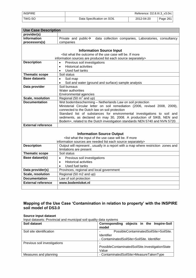
INSPIRE Reference: D2.8.III.3_v3.0rc
TWG-SO Data Specification on SOIL 2012-04-20 Page 261
Use Case Description provider(s)
Information processors(s)
Private and public data collection companies, Laboratories, consultancy companies
Information Source Input
<list what the outcome of the use case will be. If more information sources are produced list each source separately>
Description Previous soil investigations
Historical activities
Used fuel tanks
Thematic scope Soil status
Base datasets Soil map
Soil and water (ground and surface) sample analysis
Data provider Soil bureaus Water authorities Environmental agencies
Scale, resolution Regional (50 m2 and up)
Documentation Wet bodembescherming – Netherlands Law on soil protection Ministerial Circular letter on soil remediation (2006, revised 2008, 2009), connected to the Dutch law on soil protection Standard list of substances for environmental investigations to soil and sediments, as declared on may 30, 2008. A production of SIKB, NEN and Bodem+, related to the Dutch investigation standards NEN 5740 and NVN 5720.
External reference
Information Source Output
<list what the input of the use case will be. If more information sources are needed list each source separately>
Description Output will represent , usually in a report with a map where restriction zones and limitations are present
Thematic scope Soil status
Base dataset(s) Previous soil investigations
Historical activities
Used fuel tanks
Data provider(s) Provinces, regional and local government
Scale, resolution Regional (50 m2 and up)
Documentation Law of soil protection
External reference www.bodemloket.nl
Mapping of the Use Case ‘Contamination in relation to property’ with the INSPIRE soil model of DS3.0 Source input dataset Input datasets: Provincial and municipal soil quality data systems
Soil dataset Corresponding objects in the Inspire-Soil model
Soil site identification - PossibleContaminatedSoilSite>SoilSite. Identifier - ContaminatedSoilSite>SoilSite. Identifier
Previous soil investigations - PossibleContaminatedSoilSite.InvestigationState Value
Measures and planning - ContaminatedSoilSite>MeasureTakenType

INSPIRE Reference: D2.8.III.3_v3.0rc
TWG-SO Data Specification on SOIL 2012-04-20 Page 262
- ContaminatedSoilSite>measureTakenStageValue
Historical activities - PossibleContaminatedSoilSite.Contaminating ActivityType
Used fuel tanks - PossibleContaminatedSoilSite.Contaminating ActivityType =…
Soil map SoilSite>SoilPlot
Soil and water (groundwater and surface water) sample analysis –chemical parameters
- InvestigatedChemicalParameter - Procedures and values >”Observations and measure ments”
Applicable threshold values -LegislationCitation.LegislationLevelValue
Output dataset Bodemloket (Soil counter) /report to prospective property buyer Equal to input set

INSPIRE Reference: D2.8.III.3_v3.0rc
TWG-SO Data Specification on SOIL 2012-04-20 Page 263
B.15 State of soil in Europe Internationally and nationally focus is on the change of state of soils (e.g. EUR 25186 EN, 2012). This information is used in the debate around different environmental, agricultural and climate related themes. For the characterization of the soil state and the soil development there is a need for a systematic soil monitoring approach. Most of the member states practice a nationwide monitoring network: Austria, Belgium, Bulgaria, Czech Republic, Denmark, Estonia, Finland, France, Germany, Greece, Hungary, Ireland, Lithuania, Latvia, Malta, Northern Ireland, Netherlands, Poland, Portugal, Romania, Scotland, Slovenia, Slovakia, Spain, Sweden, UK (ENVASSO, 2008). Therefore the central aim of a monitoring network with fixed large or minor time steps is to give a documentation of the state and trend about soil related data and properties with the highest repetitious accuracy and standardization. In this sense monitoring data provide the opportunity to describe and asses the most important soil threats at a fixed time step for a nationwide purpose. Therefore the data should be suitable to advance the European Soil Strategy on the appropriate scale. The only European wide integrative monitoring network is the ICP forest soil monitoring. The other monitoring networks deal with minor different purposes and strategies. Often the purpose is to describe the soil quality with parameter groups of nutrients, heavy metals, organic pollutants (in general pollutants), soil contamination and rarely soil physical data, soil erosion or soil biodiversity. Sometimes the purpose is to describe the soil types and to derive soil variety. In many cases the most important thing of a monitoring, the sampling in fixed time steps is given and European wide exist several number of campaigns. In addition soil monitoring data allow an estimation of the success of environmental measures, the validation of modelling (climate change, nutrients, deposition e.g.), scientific research projects and also well know sites for several purposes (licensing proposes, threshold derivation). Due to the fact of an appropriate interpretation the results may contribute the development of methodologies to restrict degradation of landscape, apply standards of sustainable development in agriculture (e.g. nutrient balance) and European, national, regional or local strategies of soil (environmental) protection and prevention. The systematic monitoring approach provides the warranty to derive the state and development of soil organic carbon and related to this the national Kyoto reporting. In general, soil monitoring is the central element for environmental monitoring. Due to the complexity of deriving soil related data a lot of stakeholders with different requirements on different levels but in the end similar aims participates (e.g. EU, member states, federal states, interest groups, companies, consulting networks, universities, public). The different stakeholders deal and work with the soil related monitoring data in a different manner and a different degree of strength (e.g.: generator, owner, users).
Use Case Description Name Soil monitoring in Europe.
Priority High
Description Member States provide soil related monitoring data to characterize soil state, soil quality and soil development in order to describe the influence of anthropogenic activities on soils
Legal foundation(s) legislations of the member states and improve the legislation of the member states, improve the European soil strategy, environmental reporting of the member states (e.g. Kyoto reporting – soil carbon state) and environmental reporting of the European authorities (e.g. SOER)
Pre-condition field samples have to be taken in systematic time steps and with repetitious accuracy as well as in analytics

INSPIRE Reference: D2.8.III.3_v3.0rc
TWG-SO Data Specification on SOIL 2012-04-20 Page 264
Use Case Description
Flow of Events - Basic Path
Step 1 member states collect and store the harmonised raw data
Step 2 member states make further assessment with the raw data
Step 3 member states give a report on aggregated data, interpreted data and specific questions
Step 4 member states make the results available
Post-condition stakeholder and interest groups can use the results (not raw data) for further investigations, reporting and policy development
Actors
End-users - Member States - European institutions - Scientists - Citizens - Professionals (e.g. Agri-environmental business) - interest groups (consulting networks)
Information provider(s)
Member States
Information processors(s)/Brokers
Member States authorities responsible for providing nationwide aggregated and interpreted data
Information Source Output
Reports on the state and change of state of soils
Point Maps that provide the aggregated measurements an values from the monitoring sites
Maps on an appropriate national level or raster format that show the state and the development of soil related interpreted data.
Description
Thematic scope soil, climate, land cover/use
Base datasets characterization of the monitoring site (e.g. climate, land use)
characterization of the soil type and the associated soil properties
aggregated data of the soil monitoring parameters and measurements at different time steps
→ chemical parameters (active/ exchangeable soil reaction, available nutrients, microelements, sorption capacity, organic matter content, risk elements/ pollutants)
→ organic pollutants (PAH, PCB, DDx; HCH, Dioxin) → physical parameters (texture, density, water content) - biological parameters
interpreted data of soil state and the development of soil related data on a national level
→ e.g. organic matter content → e.g. risk elements content
Data provider Member States authorities
Scale, resolution from point locations up to national scale, depends on national focus und specific interpretation
Documentation - Member states manuals and reports - Member states legislation
External reference Member States authorities web sites

INSPIRE Reference: D2.8.III.3_v3.0rc
TWG-SO Data Specification on SOIL 2012-04-20 Page 265
Use Case Description
Information Source Input Member States monitoring raw data from different authorities at different time steps.
Description
Thematic scope soil, climate, land cover/use, climate
Base dataset(s) description of the monitoring site → climate data → landcover/ use data
description of the soil type and associated soil properties
description of the monitoring parameters and measurements with their replicates, their quality, analytical standards and sampling methods
→ chemical parameters (active/ exchangeable soil reaction, available nutrients, microelements, sorption capacity, organic matter content, risk elements/ pollutants)
→ organic pollutants (PAH, PCB, DDx; HCH, Dioxin) → physical parameters (texture, density, water content) - biological parameters
as point maps and/or databases
Data provider(s) Member states authorities on different levels and different responsibilities
Scale, resolution point locations
Documentation - Member states manuals and reports on different levels
External reference none
Mapping of the Use Case ‘State of soil in Europe’ with the INSPIRE soil model of DS3.0 Input dataset: Member States soil monitoring network or single inventories
Soil attributes Corresponding objects in the INSPIRE soil model
1) Soil site description SoilSite (feature type)
a) extend of the area, point location SoilSite: geometry
b) name of the location, internal ID SoilSite: SoilSiteParameter: SoilSiteParameterType linked to ObservableProperty, PhenomenonTypeValue and UnitOfMeasure which is part of OM_Observation (feature type)
c) investigation purpose SoilSite: soilInvestigationPurpose: SoilInvestigationPurpoeValue
d) establishment of the soil site SoilSite: validFrom
e) e.g. land use category SoilSite: SoilSiteParameter: SoilSiteParameterType: SoilParameterValueType linked to ObservableProperty, PhenomenonTypeValue and UnitOfMeasure which is part of OM_Observation (feature type)
f) e.g. vegetation category SoilSite: SoilSiteParameter: SoilSiteParameterType: SoilParameterValueType linked to ObservableProperty, PhenomenonTypeValue and UnitOfMeasure which is part of OM_Observation (feature type)
2) Soil plot (observation point) description SoilPlot (feature type)
a) name of the location, reference to coordinates SoilPlot: soilPlotLocation
b) kind of the observation SoilPlot: soilPlotType
3) Soil profile description ObservedSoilProfile/ SoilProfile (feature type)
a 1) characterization of the soil type SoilProfile: WRBSoilName: WRBSoilNameType; WRBQualifierGroup

INSPIRE Reference: D2.8.III.3_v3.0rc
TWG-SO Data Specification on SOIL 2012-04-20 Page 266
a 2) characterization of the soil type SoilProfile: otherSoilName: OtherSoilNameType
b) local or internal ID of the profile SoilProfile: localIdentifier
c) any property that is observed to characterize the soil profile (e.g. available water capacity or potential root depth)
SoilProfile: soilProfileParameter: SoilProfilParameterType: SoilParameterValueType linked to ObservableProperty, PhenomenonTypeValue and UnitOfMeasure which is part of OM_Observation (feature type)
4) Soil horizon/soil layer description ProfileElement (feature type)
a) characterization of the upper and lower depth of the observed profile element (horizon, layer)
ProfileElement: profileElementDepthRange: RangeType
b 1) characterization of the horizon SoilHorizon (feature type): FAOHorizonNotation: FAOHorizonNotationType
b 2) characterization of the horizon SoilHorizon (feature type): otherHorizonNotation: OtherHorizonNiotationType
c) characterization of a layer type (e.g. topsoil or a specific depth interval)
SoilLayer (feature type): layerType
d) characterization of the rock type SoilLayer: (feature type): layerRockType
e) characterization of the non-pedogenic processes
SoilLayer (feature type): layerGenesisProcess
f) characterization of the particle size ProfileElement (feature type): particleSizeFraction: ParticleSizeFractionType
g) any property that is observed to characterize the state of soil (e.g. soil organic carbon, content of lead or bulk density)
ProfileElement (feature type): profileElementParameter: ProfileElementParameterType: SoilParameterValueType linked to ObservableProperty, PhenomenonTypeValue and UnitOfMeasure which is part of OM_Observation (feature type)
Output dataset: in first instance the aggregated information of the soil monitoring network or single inventories (but not the raw data) in line with the above displayed mapping of the input dataset and in second instance evaluations based on the input data (e.g. soil typological units, soil properties evaluations e.g. soil texture of the topsoil)
Soil attributes Corresponding objects in the INSPIRE soil model
1) Soil typolocical Units SoilBody (feature type)
a) characterization of the soil profile, based on the observed profiles
DerivedSoilProfile
b) extend of the typological unit SoilBody: geometry
c) name of the typlogical unit SoilBody: soilBodyLabel
2) Soil properties evaluation SoilDerivedObject (feature type)
a) extent of soil related properties which can derived directly from the observed soils and properties
SoilDerivedObject: geometry
b) soil related properties which can derived directly from the observed soils and properties
SoilDerivedObject: soilDerivedObjectParameter: SoilDerivedObjectParameterType: SoilParameterValueType linked to ObservableProperty, PhenomenonTypeValue and UnitOfMeasure which is part of OM_Observation (feature type)
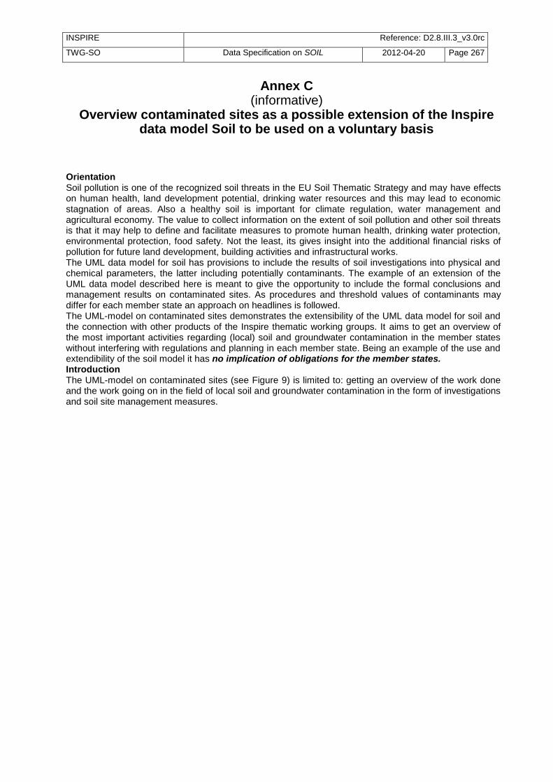
INSPIRE Reference: D2.8.III.3_v3.0rc
TWG-SO Data Specification on SOIL 2012-04-20 Page 267
Annex C (informative)
Overview contaminated sites as a possible extension of the Inspire data model Soil to be used on a voluntary basis
Orientation Soil pollution is one of the recognized soil threats in the EU Soil Thematic Strategy and may have effects on human health, land development potential, drinking water resources and this may lead to economic stagnation of areas. Also a healthy soil is important for climate regulation, water management and agricultural economy. The value to collect information on the extent of soil pollution and other soil threats is that it may help to define and facilitate measures to promote human health, drinking water protection, environmental protection, food safety. Not the least, its gives insight into the additional financial risks of pollution for future land development, building activities and infrastructural works. The UML data model for soil has provisions to include the results of soil investigations into physical and chemical parameters, the latter including potentially contaminants. The example of an extension of the UML data model described here is meant to give the opportunity to include the formal conclusions and management results on contaminated sites. As procedures and threshold values of contaminants may differ for each member state an approach on headlines is followed. The UML-model on contaminated sites demonstrates the extensibility of the UML data model for soil and the connection with other products of the Inspire thematic working groups. It aims to get an overview of the most important activities regarding (local) soil and groundwater contamination in the member states without interfering with regulations and planning in each member state. Being an example of the use and extendibility of the soil model it has no implication of obligations for the member states. Introduction The UML-model on contaminated sites (see Figure 9) is limited to: getting an overview of the work done and the work going on in the field of local soil and groundwater contamination in the form of investigations and soil site management measures.

INSPIRE Reference: D2.8.III.3_v3.0rc
TWG-SO Data Specification on SOIL 2012-04-20 Page 268
Figure 9: UML class diagram: Soil Contamination
For a description of all objects in this UML class diagram see Error! Reference source not found. at the end of this annex.

INSPIRE Reference: D2.8.III.3_v3.0rc
TWG-SO Data Specification on SOIL 2012-04-20 Page 269
Figure 10 gives an overview which items are in the data model and which items are purposely left out of the data model to make it fit for getting an overview on this important topic without interfering in the member states rights to protect the soil in the ways they consider fit for the specific local circumstances and regulations.
Figure 10: Overview of the items inside the data model and the items which are purposely left out of the data model.

INSPIRE Reference: D2.8.III.3_v3.0rc
TWG-SO Data Specification on SOIL 2012-04-20 Page 270
The model does not go into details of the investigations, only into the endpoints: the main decisions made on basis of the investigations and similarly for site management the model goes into main phases and main results of site management. The intention is to focus is on the data of contaminated sites (soil and/or groundwater) and not on possibly/potentially contaminated sites. A site is considered possibly/potentially contaminated here as long as the investigations and decisions of the appointed authorities have not led to a verdict ‘contaminated’ or otherwise (see Figure 10). Which sites are to be included in ‘possibly contaminated sites’ to start with the investigations depends of the level of suspicion of the site and the ambitions, rules etcetera of the appointed authorities. General considerations may be to include a site if experience has learned that the possible contaminating activity has usually a high follow up in necessary measures and also to include sites urging for investigation after confirmed civil complaints or resulting from known calamities. No obligating rule is implied and which sites to include here is up to the member states or it’s appointed local authorities. The information which sites are in investigation should give insight in the approach of a member state in an earlier stage than after completion of the often long trajectories of investigation and management procedures. Generalized site investigation and site management procedures Generally a site is considered contaminated if chemical parameters have values above threshold values in a sufficiently large area. The threshold values indicate that an exposure level can be expected that may lead to risks for humans or have adverse effects on ecosystem services or resources on and around the site. The level of these risks depends on land use, the presence of objects at risk, the probability of exposure and dispersion routes. The threshold values are based on a generalized (generic) exposure and dispersion modeling and effect estimations, but they may, in specific situations, be overruled by outcomes of further investigations. Some contaminants, e.g. metals may be present on a natural background level. Also diffuse manmade contamination in low levels may contribute to a background level. Generally the background level is not considered to give adverse effects or it is not feasible to take other actions on it than considering restrictions in land use planning. The investigations on a possibly contaminated site may involve the contaminant identification, levels and distribution in soil, groundwater, surface water, sediments, plants, animals, humans. Generally a tiered investigation procedure is followed, initially to confirm or deny a suspicion of serious contamination in soil and groundwater (the preliminary investigation). A resulting confirmation will justify a larger investigation effort (the main site investigation) to assess levels of contamination and the size of the contaminated area. A tiered investigation procedure is not essential for the data model, but still it will often be applied and it can be handled in headlines as shown in Figure 11. Details of investigations like exposure, dispersion, contamination of produce, ecological effects, physical and biological processes in the soil may play a role but are as such not a part of the data to be explicitly included in this model. For each step in the tiered procedure screening values specific for this step can be applicable. After assessment of the hazard (the presence of contamination, its level and the size of the area), the investigation is focused on the assessment of the risk, the dispersion and the effectiveness of possible measures. The remediation and site management may involve temporary protection and restriction measures, cleaning or partial cleaning (of the contamination sources or of kernels with high contamination levels) over longer or shorter periods, change of land use, or isolation or immobilization of the contaminants and may include aftercare. Aftercare may consist of maintenance of physical provisions and land use restrictions or monitoring of contamination levels and dispersion rates of the contaminants.

INSPIRE Reference: D2.8.III.3_v3.0rc
TWG-SO Data Specification on SOIL 2012-04-20 Page 271
Figure 11: Tiered approach on headlines of the investigation and management of sites with possibly contaminated soil and/or groundwater. Starting on the top and going down following procedures for investigations and management.
Figure 11 gives an overview of the generalized procedure. Each investigation may lead to the conclusion that the site is not contaminated and no further investigation is needed or to the conclusion that a further investigation is needed. Generally the decision that a site is contaminated falls after the final verdict on the contamination levels and the size of the contaminated area in the main site investigation. In a national set procedure an indicated investigation may involve several steps. The main dividing lines proposed here for investigation stages are (1) the historical investigation into knowledge from administration and archives (into types of activities and processes, periods, known calamities, spills, former complaints, type and volume of chemicals used), or for calamities an administrative investigation into the amounts of chemicals involved (2) the preliminary soil investigation to confirm that contamination is present in substantial levels and a more expensive main site investigation is advised or necessary and finally (3) the main site investigation. The characteristic of the main site investigation is that it gives the necessary information on the site contamination on which the appointed authority including other considerations can give the verdict that the site is contaminated or not, and consequently prioritize and plan site management. The type of measures to be taken are elaborated in (4) the ‘investigation into measures and planning’. Restrictions of the model The approach of the model is to include local contamination of soil and groundwater (excluding soils permanently under water); to concentrate mainly on local contamination and not diffuse contamination. Another restriction is to concentrate mainly on soil and groundwater pollution on a site and not on the complete soil water system in which parts of the site may consist of surface waters and underwater soil or may consist of controlled dump sites or other special areas (e.g. of archeological value). Border areas are indicated but not elaborated here. Regarding the complexity the envisioned organizational setup to facilitate the tackling of soil contamination here is (1) a national law defining investigation procedures and general threshold values, (2) regional additional rules in relation to planning and background values and (3) local implementation of risk and dispersion assessments in relation to land development and soil quality ambitions. The organization of responsibilities between national, local and regional authorities in a member state is not decisive for the use of the data model. Instead it can be adopted by the data model. Each site in Figure 11 may be considered ‘possibly contaminated’ (or ‘potentially contaminated’) as long as it is not concluded that the site is not contaminated and no further investigation is needed. It is finally considered ‘contaminated’ after confirmation in a main site investigation or after a verdict by the

INSPIRE Reference: D2.8.III.3_v3.0rc
TWG-SO Data Specification on SOIL 2012-04-20 Page 272
appointed local authority based on the results of the main site investigation. Figuratively speaking the ‘possibly contaminated sites’ lay directly behind the gate through which “sites to be investigated” enter. It is up to the regulations and planning of the member states which sites will enter. The ‘possibly contaminated sites’ may also contain the results of an inventory of possibly contaminating activities. The decision on the feasibility and depth of such an inventory is actually left to the member states or its local or regional authorities. It should be considered that it can be performed on various levels considering e.g. ambitions, economic situation and budget available, political pressure and the pressure of land development and building activities. An effort to make a complete inventory of possibly contaminating sites may give insight into the extent of the problem, but when done too thoroughly may also lead to the checking of large numbers of sites finally resulting in small percentages of sites considered to be seriously contaminated. Focusing first on known sites with soil pollution problems and sites with high suspicion may be more feasible and help to get the information on the site on the time when needed and not as possibly expired data. This means generally that a long term continuous effort will be needed, but beside the costs also this effort will yield benefits in terms of welfare and economic progress like a more healthy living environment, improved food and drinking water safety, useable groundwater to be extracted for industrial uses with the aim of human consumption, sustainable resources management and canceling out economic stagnation caused by land unfit for intended use because of soil pollution (especially in urban areas). It is proposed not to focus on ‘possibly contaminated sites’ but consider contaminated sites (after the main site investigation) as the main component of a data collection, including all sites in subsequent management phases including aftercare. It is advised to generally keep sites once found to be contaminated in the system, especially when the problem is partially solved, with consequences like aftercare and use restrictions. The preservation of information may also prevent repetition of investigations. Short description of the model The main entities in the model are a ‘possibly contaminated site’ and a ‘contaminated site’ (see Figure 12). A possibly contaminated site may have several reasons to be introduced among which are the confirmed presence of hazardous waste, former or existing activities on the site with an experienced high possibility of soil or groundwater contamination. In the case of ongoing activities prevention of further contamination is a first point of action, but here only covered as a border subject not facilitated fully in this data model. Code lists for possibly contaminating activities, waste types and chemical parameters are included but can be complemented and are not setting any obligations for investigation or site management from the side of the EU. They may facilitate in keeping the overview of causes and facilitate local planning of the efforts. In the cooperation between member states these data may help to analyze for which type of sites experience is built up in a member state or which types of sites are lacking. The stage of investigation gives insight in the level of conformation of assumptions in the tiered investigations. The site identification and geometry is a property inherited from the soil site in the ‘Soil’ model (in the main text) and from the Inspire ‘Geology’ data model for groundwater. A confirmed contaminated site is more legally embedded (than a ‘possibly contaminated site’). Its status is connected to the applicable law and appointed national, regional or local authority or authorities. The pollutant level and extent (affected surface size and depth) is set in the main site investigation and other parameters may be involved in further assessment. Several risk assessment stages are possible, involving risk types and possible risk receptors related to the land use. Land use is connected in this data model to the Inspire data model ‘Land use’. The current level of protection obtained on the site is recorded in ‘measures taken’ and ‘stage of measures’. The measures may involve land use restrictions as elaborated in the Inspire data model ‘Area management / restriction / regulation zones and reporting units’. The reasons to investigate and manage a site are the hazards and risks as specified within the member state, considering international rules and knowledge when applicable. The trigger to start investigations may follow procedures specified within the member state and does not follow directly from EU regulations (except for the control of major-accident hazards as defined in the Seveso II Directive and its extensions). In this example: the trigger to investigate the justification and application may be up to the member states. It may be informative for policy makers to know which triggers are dominant and as it is compliant to the rules of the member states generally there is no reason to keep it back. The information is included in the model as an option with a generalized and extendable code list.

INSPIRE Reference: D2.8.III.3_v3.0rc
TWG-SO Data Specification on SOIL 2012-04-20 Page 273
Figure 12: Quick reference view of the model
Recommendations: A further check of interoperability and flexibility of the proposed data model by mapping of the data systems of member states and of the EEA data collection system is recommended. The data may carry civil, criminal and financial liabilities. In agreeing with public availability of data in the Århus agreement the local authorities / member states should balance the protection of citizens to risk versus the liabilities in this subject. Both sides may have connected economic and political value. If public availability has valid juridical barriers it should be possible to keep data delivery back if not in conflict with the Århus agreement. In this conflict probably the juridical boundaries should be determined by jurisdiction in each member state. Some subjects are not included in the model and it is recommended that these should get attention in further developments, being: prevention of the continuation of polluting effects of activities; diffuse pollution in soil and groundwater; the assessment of ecological / biological quality of the soil (use of parameters from ENVASSO) and ecological services of the soil; integration in management of soil and water systems; area management and combined approach of sites. As soil pollution may have implications for a large field of economic activities the management of contaminated sites and brown fields may have wider implications in fields for which the TWG Soil has no expertise available. Figure 13 gives a wider overview of related management issues to consider several of these issues will be integrated in management related to other themes, making use of soil pollution data. It is recommended to make a further check of the connection of soil pollution with other INSPIRE themes. The current data model is restricted and mainly aiming to record the status of contaminated sites to foster public health and safe and sustainable land development.

INSPIRE Reference: D2.8.III.3_v3.0rc
TWG-SO Data Specification on SOIL 2012-04-20 Page 274
Figure 13: Possible tasks in management of soil pollution, with (in grey) the main management issues in which these tasks may be integrated. This is an illustration of the wider fields of risk management on soil pollution and not part of the proposed data model.
11.4 Feature catalogue Feature catalogue metadata
Feature catalogue name INSPIRE feature catalogue SoilContamination
Scope SoilContamination
Version number 2.9
Version date 2012-04-20
Definition source INSPIRE data specification SoilContamination
Types defined in the feature catalogue
Type Package Stereotypes Section
ContaminatedSoilSite SoilContamination «featureType» Annex C.1.1
ContaminatingActivitiesValue SoilContamination «union» Annex C.2.1
ContaminatingActivityPresenceValue SoilContamination «codeList» Annex C.3.1

INSPIRE Reference: D2.8.III.3_v3.0rc
TWG-SO Data Specification on SOIL 2012-04-20 Page 275
Type Package Stereotypes Section
ContaminatingActivityType SoilContamination «dataType» Annex C.2.2
GroundwaterProfile SoilContamination «featureType» Annex C.1.2
InvestigatedChemicalParameterType SoilContamination «dataType» Annex C.2.3
InvestigationStateValue SoilContamination «codeList» Annex C.3.2
InvestigationTriggerValue SoilContamination «codeList» Annex C.3.3
MeasureTakenStageValue SoilContamination «codeList» Annex C.3.4
MeasureTakenStatusValue SoilContamination «codeList» Annex C.3.5
MeasureTakenType SoilContamination «dataType» Annex C.2.4
MeasureTakenValue SoilContamination «codeList» Annex C.3.6
NaceIndustrialActivityValue SoilContamination «codeList» Annex C.3.7
OtherContaminatingActivityValue SoilContamination «codeList» Annex C.3.8
PossiblyContaminatedSoilSite SoilContamination «featureType» Annex C.1.3
RiskAssessmentStageValue SoilContamination «codeList» Annex C.3.9
RiskReceptorValue SoilContamination «codeList» Annex C.3.10
RiskTypeValue SoilContamination «codeList» Annex C.3.11
SoilContaminationSpecialisedZoneTypeCode SoilContamination «codeList» Annex C.3.12
WasteTypeValue SoilContamination «codeList» Annex C.3.13
11.4.1 Spatial object types
11.4.1.1. ContaminatedSoilSite
ContaminatedSoilSite
Name: contaminated soil site Subtype of: ManagementRestrictionOrRegulationZone, PossiblyContaminatedSoilSite Definition: Site on which manmade substances are present in levels and amounts considered
to be a hazard, in soil, groundwater and waste (on or below surface level). Description: Site where levels of contaminants in soil or groundwater are or were above
applicable threshold values, as concluded from a main site investigation and over a surface or in a volume not to be neglected (up to local regulations and authorities). Irrespective of the current status of management measures or temporary safety measures taken or to be taken after risk assessment.
Status: Proposed Stereotypes: «featureType» Identifier: null
Attribute: investigatedChemicalParameter
Name investigated chemical parameter Value type: InvestigatedChemicalParameterType Definition: Chemical parameter for which the exceeding of threshold values for a substantial
are is confirmed or rejected. Description: Multiplicity: 0..*
Attribute: riskAssessmentStage
Name risk assessment stage Value type: RiskAssessmentStageValue Definition: level of progress in assessment of risk and dispersion of the pollution. Description: The presence of hazardous material may pose a risk only when valued objects are
exposed on a level considered excessive. The latter level is generally established from toxicology studies. The exposure level depends on the local situation and the land use. The exposed objects may be for instance human, valued nature or drinking water wells.

INSPIRE Reference: D2.8.III.3_v3.0rc
TWG-SO Data Specification on SOIL 2012-04-20 Page 276
ContaminatedSoilSite
Multiplicity: 1..* Obligation: Technical Guidance (recommendation)
Attribute: measureStage
Name measure stage Value type: MeasureTakenStageValue Definition: level of progress in the measures taken in response of the hazard and risk
assessment. Description: Distinguishes between, intended measures, measures in progress and applied
measures. Multiplicity: 1 Obligation: Technical Guidance (recommendation)
Attribute: measureTaken
Name measure taken Value type: MeasureTakenType Definition: measures taken in response of the hazard and risk assessment. Description: Measures with respect to safety, cleaning the soil and groundwater, blocking
exposure and dispersion routes, stabilization, isolation, aftercare, generally in connection with redevelopment.
Multiplicity: 0..*
Attribute: riskType
Name risk type Value type: RiskTypeValue Definition: anticipated or experienced risk resulting from type of pollutant and exposure route. Description: Type of exposure routes which give adverse effects on the basis of land use and
level, extent and distribution of the pollutants, generally in line with applicable risk assessment models.
Multiplicity: 1..* Obligation: Technical Guidance (recommendation)
Attribute: riskReceptor
Name risk receptor Value type: RiskReceptorValue Definition: Entity exposed to the pollution. Description: Entity on which adverse effects are taking place, generally in connection with the
protection of human health, quality of the environment, natural values, agricultural produce, land and materials as resources.
Multiplicity: 1..* Obligation: Technical Guidance (recommendation)
Association role:
Value type: ExistingLandUseObject Multiplicity: 0..*
Association role:
Value type: ManagementRestrictionOrRegulationZone Multiplicity:
Association role:
Value type: ZoningElement Multiplicity: 0..*
Association role:

INSPIRE Reference: D2.8.III.3_v3.0rc
TWG-SO Data Specification on SOIL 2012-04-20 Page 277
ContaminatedSoilSite
Value type: ManagementRestrictionOrRegulationZone Multiplicity:
11.4.1.2. GroundwaterProfile
GroundwaterProfile
Name: groundwater profile Definition: body of groundwater with boundaries in 3 dimensions (surface and depth)
characterized by some property (the value of a certain parameter). Description: Used in connection to pollution: giving the extent of the groundwater body that is
polluted over a threshold value of concentration of a certain pollutant. Generally it is dynamic and dependent on flow rates of the groundwater, the presence of dense soil layers, solubility and adsorption/desorption behaviour of the pollutants.
Status: Proposed Stereotypes: «featureType» Identifier: null
Attribute: geometry
Name geometry Value type: GM_Point Definition: location of the ground water profile. Description: Multiplicity: 1
Attribute: groundwaterDepthRange
Name groundwater depth range Value type: RangeType Definition: depth of the groundwater. Description: Multiplicity: 1
Attribute: investigatedChemicalParameter
Name investigated chemical parameter Value type: InvestigatedChemicalParameterType Definition: Chemical parameter for which the exceeding of threshold values for a substantial
are is confirmed or rejected. Description: Multiplicity: 1..*
11.4.1.3. PossiblyContaminatedSoilSite
PossiblyContaminatedSoilSite
Name: possibly contaminated soil site Subtype of: SoilSite Definition: a site with a suspicion of pollution above threshold values which has not been
confirmed by a main site investigation with a verdict of the local authority. Description: It is always the candidate for further investigations, generally with a tiered approach
in which it will remain possibly polluted until after the main site investigation in which hazards may be confirmed or rejected.
Status: Proposed Stereotypes: «featureType» Identifier: null
Attribute: localName
Name local name Value type: CharacterString

INSPIRE Reference: D2.8.III.3_v3.0rc
TWG-SO Data Specification on SOIL 2012-04-20 Page 278
PossiblyContaminatedSoilSite
Definition: name given to the possible contaminated soil site. Multiplicity: 0..1 Stereotypes: «voidable»
Attribute: investigationTrigger
Name investigation trigger Value type: InvestigationTriggerValue Definition: the type of triggers for which the site is considered polluted and is a candidate for
further investigations. Description: A site may be entering the stage of possible polluted from soil investigations (.e.g.
for building activities), from an systematic inventory of possibly polluting activities, from epidemiology, confirmed civil complaints, recent accidents or known leaking and spills. The reason for starting an investigation into soil contamination may relate to its priority for investigation and measures.
Multiplicity: 1 Obligation: Technical Guidance (recommendation)
Attribute: investigationState
Name investigation state Value type: InvestigationStateValue Definition: status of knowledge about soil pollution presence and levels and risk and dispersion
levels. Description: Generally a tiered investigation approach may be followed. A possibly polluted site
may enter as a site to investigate and undergo preliminary and main site investigations before it sis decide on the verdict polluted or not polluted.
Multiplicity: 1 Obligation: Technical Guidance (recommendation)
Attribute: contaminatingActivity
Name contaminating activity Value type: ContaminatingActivityType Definition: historical or current activity on the site in which use, handling and storage of
significant amounts of relevant hazardous materials occurs or has occurred and may have lead to soil and/or groundwater pollution, including events (e.g. calamity) with effect on soil and/or groundwater contamination.
Description: List of industrial and trade activities and specified calamities (eg. according directive 96/82/EC 'Seveso').
Multiplicity: 1
Attribute: mainInvestigatedChemicalParameter
Name main investigated chemical parameter Value type: InvestigatedChemicalParameterType Definition: main chemical parameter that was observed on the possible contaminated soil site. Multiplicity: 1..*
Attribute: wasteType
Name waste type Value type: WasteTypeValue Definition: type of waste according to European Waste Catalogue. Description: reference to article 1 council directive 75/442/EEC on waste Multiplicity: 0..* Stereotypes: «voidable» Obligation: Technical Guidance (recommendation)
Association role: uses

INSPIRE Reference: D2.8.III.3_v3.0rc
TWG-SO Data Specification on SOIL 2012-04-20 Page 279
PossiblyContaminatedSoilSite
Value type: GroundwaterProfile Multiplicity: 0..*
Association role:
Value type: ObservedSoilProfile Multiplicity: 0..*
11.4.2 Data types
11.4.2.1. ContaminatingActivitiesValue
ContaminatingActivitiesValue
Name: contaminating activities value Definition: Historical or current activity on the site in which use, handling and storage of
significant amounts of relevant hazardous materials occurs or has occurred and may have lead to soil and/or groundwater pollution, including events (e.g. calamity) with effect on soil and/or groundwater contamination.
Description: Also including now obsolete (industrial and commercial) activities which left a mark on the soil (e.g. city gas works, gas light mantle production). ContaminatingActivitiesValue is a union class (choice) that shall support two possible codelists i.e. either NaceIndustrialActivityValue or OtherContaminatingActivityValue
Status: Proposed Stereotypes: «union» Identifier: null
Attribute: naceIndustrialActivity
Name nace industrial activity Value type: NaceIndustrialActivityValue Definition: Industrial activity according to NACE. Description: Multiplicity: 1 Obligation: Technical Guidance (recommendation)
Attribute: otherContaminatingAvtivity
Name other contaminating activity Value type: OtherContaminatingActivityValue Definition: contaminating activities apart from the Industrial activities according to NACE. Multiplicity: 1 Obligation: Technical Guidance (recommendation)
11.4.2.2. ContaminatingActivityType
ContaminatingActivityType
Name: contamination activity type Definition: classification of contaminating activities. Description: Generally the character of the contaminating activities is: emissions, leaking and
spills from industrial production, trade and storage, waste handling, defense, fire and transport calamities.
Status: Proposed Stereotypes: «dataType» Identifier: null
Attribute: contaminatingActivity
Name contaminating activity Value type: ContaminatingActivitiesValue

INSPIRE Reference: D2.8.III.3_v3.0rc
TWG-SO Data Specification on SOIL 2012-04-20 Page 280
ContaminatingActivityType
Definition: NACE + Soil directive (proposed) + additional Description: Multiplicity: 1..*
Attribute: contaminatingActivityPresence
Name contamination activity presence Value type: ContaminatingActivityPresenceValue Definition: indicates the time the contaminating activity was/is present on the site. Description: Multiplicity: 1 Obligation: Technical Guidance (recommendation)
Attribute: expectedPollutantName
Name expected pollutant name Value type: SoilSiteParameterNameValue Definition: Chemical parameter expected to be above threshold values. Description: The expectation may rise from the contaminating activity, visual observations or
smells on the site, the observed type of waste etc. Multiplicity: 1..* Obligation: Technical Guidance (recommendation)
11.4.2.3. InvestigatedChemicalParameterType
InvestigatedChemicalParameterType
Name: investigated chemical parameter type Definition: Chemical parameter for which the exceeding of threshold values for a substantial
are is confirmed or rejected. Description: In main site investigation. Status: Proposed Stereotypes: «dataType» Identifier: null
Attribute: soilSiteChemicalParameterDescription
Name soil site chemical parameter description Value type: ObservableProperty Definition: Identification of chemical parameter. Description: Identification of substances by name and wher possible by CAS number. The latter
not for mixtures (e.g. mineral oil) or sumparameters (e.g. PAHs, PCBs) or toxic equivalents (Teq for dioxins and furans, BAP for PAHs.)
Multiplicity: 1
Attribute: soilSiteChemicalParameterTreshhold
Name soil site chemical parameter treshhold Value type: SoilParameterValueType Definition: Value of the concentration of a chemical parameter in the soil or in groundwater for
which the presence is considered a hazard, generally based on mobility bioavailability and toxicity.
Description: The threshold value can differ for countries or regions because of different circumstances, priorities, risk assessment modeling.
Multiplicity: 1
Attribute: soilSiteChemicalParameterScreening
Name soil site chemical parameter screening Value type: SoilParameterValueType

INSPIRE Reference: D2.8.III.3_v3.0rc
TWG-SO Data Specification on SOIL 2012-04-20 Page 281
InvestigatedChemicalParameterType
Definition: Value of the concentration of a chemical parameter in the soil or in groundwater which is used in a tiered approach as a trigger to go into a next investigation step.
Description: Especially going from preliminary investigations to main ste investigations. The values can differ for countries or regions because of different circumstances, priorities, risk assessment modeling.
Multiplicity: 1
Attribute: soilSiteChemicalParameterBackground
Name soil site chemical parameter background Value type: SoilParameterValueType Definition: Value of the concentration of a chemical parameter in the soil or in groundwater
which is considered common as a natural value (e.g. metals) or from human activities as a background value considered as without consequences. Generally defines the unpolluted state.
Description: Regionally varying values because of variations in climate, soil type, etc. There may be custom made procedures to set the value valid for the site and its surroundings.
Multiplicity: 1
11.4.2.4. MeasureTakenType
MeasureTakenType
Name: measure taken type Definition: type of measures taken in response to the hazard and risk assessment. Description: Measures to take away the risk by blocking exposure and dispersion paths, by
cleaning, stabilizing or isolation, also temporay safety measures. Status: Proposed Stereotypes: «dataType» Identifier: null
Attribute: measureTaken
Name measure taken Value type: MeasureTakenValue Definition: Measures taken in response to the hazard and risk assessment. Description: Multiplicity: 1 Obligation: Technical Guidance (recommendation)
Attribute: measureTakenStatus
Name measure taken status Value type: MeasureTakenStatusValue Definition: status of measures. Description: to be taken, in progress, applied. Multiplicity: 1 Obligation: Technical Guidance (recommendation)
11.4.3 Code lists
11.4.3.1. ContaminatingActivityPresenceValue
ContaminatingActivityPresenceValue
Name: contaminating activity presence value Definition: status of contaminating actvity. Description: Historical, recent, ongoing, or not a regular actvity but a calamity. Status: Proposed Stereotypes: «codeList» Extensibility: any

INSPIRE Reference: D2.8.III.3_v3.0rc
TWG-SO Data Specification on SOIL 2012-04-20 Page 282
ContaminatingActivityPresenceValue
Identifier: http://inspire.ec.europa.eu/codeList/ContaminatingActivityPresenceValue
11.4.3.2. InvestigationStateValue
InvestigationStateValue
Name: investigation state value Definition: status of investigations. Description: Based on a tiered approach, starting with: not investigated yet, first step of the
investigation in progress, ending with: investigated and verdict on the state of pollution given (by local authority).
Status: Proposed Stereotypes: «codeList» Extensibility: any Identifier: http://inspire.ec.europa.eu/codeList/InvestigationStateValue
11.4.3.3. InvestigationTriggerValue
InvestigationTriggerValue
Name: investigation trigger value Definition: trigger to have a site investigated or to investigate it in the future. Description: On the basis of recognised problems (confirmed compliants, encountered high
concentrations of hazardous materials, etc.) or expected problems (inventory of potentially polluted sites).
Status: Proposed Stereotypes: «codeList» Extensibility: any Identifier: http://inspire.ec.europa.eu/codeList/InvestigationReasonValue
11.4.3.4. MeasureTakenStageValue
MeasureTakenStageValue
Name: measure taken status value Definition: stage in which measures are taken. Description: During investigation (safety measures), definitive measures, aftercare. Status: Proposed Stereotypes: «codeList» Extensibility: any Identifier: http://inspire.ec.europa.eu/codeList/MeasureTakenStageValue
11.4.3.5. MeasureTakenStatusValue
MeasureTakenStatusValue
Name: measure taken status value Definition: status of measures at the site. Description: proposed, in progress, executed Status: Proposed Stereotypes: «codeList» Extensibility: any Identifier: http://inspire.ec.europa.eu/codeList/MeasureTakenStatusValue
11.4.3.6. MeasureTakenValue
MeasureTakenValue
Name: measure taken value Definition: type of measure taken to manage pollution. Description: e.g. cleaning, isolation, change land use Status: Proposed Stereotypes: «codeList»

INSPIRE Reference: D2.8.III.3_v3.0rc
TWG-SO Data Specification on SOIL 2012-04-20 Page 283
MeasureTakenValue
Extensibility: any Identifier: http://inspire.ec.europa.eu/codeList/MeasureTakenValue
11.4.3.7. NaceIndustrialActivityValue
NaceIndustrialActivityValue
Name: NACE industrial activity value Definition: Industrial activity according to NACE. Description: Status: Proposed Stereotypes: «codeList» Extensibility: any Identifier: http://inspire.ec.europa.eu/codeList/NaceIndustrialActivityValue
11.4.3.8. OtherContaminatingActivityValue
OtherContaminatingActivityValue
Name: other contaminating activity value Definition: for polluted sites: activity which polluted the soil and groundwater on the site. For
inventories of potentially polluted sites: the activities present on the site which have a potential for polluting soil and groundwater, dependent on processes, size an management. This list is an extension of the NACE codelist of industrial activities and made to cover other types of possibly polluting activities.
Description: This value may help to focus investigations on the chemical parameters of importance (probability and amounts present).
Status: Proposed Stereotypes: «codeList» Extensibility: any Identifier: http://inspire.ec.europa.eu/codeList/OtherContaminatingActivityValue
11.4.3.9. RiskAssessmentStageValue
RiskAssessmentStageValue
Name: risk assessment stage value Definition: status risk assessment. Description: Recognition of risk receptors and exposure routes, up to full assessment of levels of
risk and dispersion. Status: Proposed Stereotypes: «codeList» Extensibility: any Identifier: http://inspire.ec.europa.eu/codeList/RiskAssessmentStageValue
11.4.3.10. RiskReceptorValue
RiskReceptorValue
Name: risk receptor value Definition: entities exposed to pollutants at the site. Description: e.g. inhabitants, groundwater well, nature reserve Status: Proposed Stereotypes: «codeList» Extensibility: any Identifier: http://inspire.ec.europa.eu/codeList/RiskReceptorValue
11.4.3.11. RiskTypeValue
RiskTypeValue
Name: risk type value Definition: type of exposure route for risk receptors.

INSPIRE Reference: D2.8.III.3_v3.0rc
TWG-SO Data Specification on SOIL 2012-04-20 Page 284
RiskTypeValue
Description: in relation to type of pollutants Status: Proposed Stereotypes: «codeList» Extensibility: any Identifier: http://inspire.ec.europa.eu/codeList/RiskTypeValue
11.4.3.12. SoilContaminationSpecialisedZoneTypeCode
SoilContaminationSpecialisedZoneTypeCode
Name: soil contamination specialised zone type code Subtype of: SpecialisedZoneTypeCode Definition: Indicates restrictions on the site as a consequence of the current situation. Description: Imposed restrictions in land use Status: Proposed Stereotypes: «codeList» Extensibility: any Identifier:
11.4.3.13. WasteTypeValue
WasteTypeValue
Name: waste type value Definition: Waste types encountered at the site. Description: non-exhaustive list of waste materials, to help to recognise the expected problems
at uncontrolled waste landfills and dumpsites. Status: Proposed Stereotypes: «codeList» Extensibility: any Identifier: http://inspire.ec.europa.eu/codeList/WasteTypeValue
11.4.4 Imported types (informative)
This section lists definitions for feature types, data types and enumerations and code lists that are defined in other application schemas. The section is purely informative and should help the reader understand the feature catalogue presented in the previous sections. For the normative documentation of these types, see the given references.
11.4.4.1. CharacterString
CharacterString
Package: INSPIRE Consolidated UML Model::Foundation Schemas::ISO TC211::ISO 19103:2005 Schema Language::Basic Types::Primitive::Text [Include reference to the document that includes the package, e.g. INSPIRE data specification, ISO standard or the GCM]
11.4.4.2. ExistingLandUseObject
ExistingLandUseObject
Package: INSPIRE Consolidated UML Model::Themes::Annex III::Land Use::Existing Land Use [Include reference to the document that includes the package, e.g. INSPIRE data specification, ISO standard or the GCM]
Definition: An existing land use object describes the land use of an area having an homogeneous combination of land use types.
11.4.4.3. GM_Point
GM_Point
Package: INSPIRE Consolidated UML Model::Foundation Schemas::ISO TC211::ISO 19107:2003 Spatial Schema:: Geometry::Geometric primitive [Include reference to the document that includes the package, e.g. INSPIRE data specification, ISO standard or the GCM]

INSPIRE Reference: D2.8.III.3_v3.0rc
TWG-SO Data Specification on SOIL 2012-04-20 Page 285
11.4.4.4. ManagementRestrictionOrRegulationZone
ManagementRestrictionOrRegulationZone
Package: INSPIRE Consolidated UML Model::Themes::Annex III::Area Management Restriction Regulation Zones and Reporting units::Area Management Restriction and Regulation Zones [Include reference to the document that includes the package, e.g. INSPIRE data specification, ISO standard or the GCM]
Definition: Area managed, regulated or used for reporting at international, European, national, regional and local levels.
Description: SOURCE [INSPIRE Directive]
11.4.4.5. ObservableProperty
ObservableProperty
Package: INSPIRE Consolidated UML Model::Generic Conceptual Model::Base Models::Observations::Observable Properties [Include reference to the document that includes the package, e.g. INSPIRE data specification, ISO standard or the GCM]
Definition: Represents a single observable property e.g. 'temperature'. Description: The Observable Property represents a single observable property e.g. 'temperature'.
It may have associations to additional constraints or measures that make it more complex e.g. 'daily mean temperature'.
11.4.4.6. ObservedSoilProfile
ObservedSoilProfile
Package: INSPIRE Consolidated UML Model::Themes::Annex III::Soil::Soil [Include reference to the document that includes the package, e.g. INSPIRE data specification, ISO standard or the GCM]
Definition: a representation of a soil profile found on a specific location which is described based on observations in a trial pit or with a borehole.
Description: The observed soil profile corresponds to a set of data taken directly from a georeferenced soil profile, described in the field, and often sampled and analyzed in the laboratory.
11.4.4.7. RangeType
RangeType
Package: INSPIRE Consolidated UML Model::Themes::Annex III::Soil::Soil [Include reference to the document that includes the package, e.g. INSPIRE data specification, ISO standard or the GCM]
Definition: a range value using upper and lower bounds.
11.4.4.8. SoilParameterValueType
SoilParameterValueType
Package: INSPIRE Consolidated UML Model::Themes::Annex III::Soil::Soil [Include reference to the document that includes the package, e.g. INSPIRE data specification, ISO standard or the GCM]
Definition: It is a construct to hold the resulting value of an soil observable property. Description: The choice is limited to one of the included possible types.
11.4.4.9. SoilSite
SoilSite
Package: INSPIRE Consolidated UML Model::Themes::Annex III::Soil::Soil [Include reference to the document that includes the package, e.g. INSPIRE data specification, ISO standard or the GCM]
Definition: area within a larger survey, study or monitored area, where a specific soil investigation is carried out.

INSPIRE Reference: D2.8.III.3_v3.0rc
TWG-SO Data Specification on SOIL 2012-04-20 Page 286
SoilSite
Description: Site provides the object to describe: a.) the surroundings of the plot and/or b.) the larger piece of land that is directly linked to and described by all soil investigations on its one or more spots (SoilPlots). It thus provides the object to which soil data of different kind (or the same kind, but at different points in time, e.g. in soil monitoring) obtained on different plots is related as if it would have been collected at the very same place. This allows for: 1. combination of data that cannot be obtained on the very same place EXAMPLE: a soil pit and investigations on earthworm abundance cannot be done in the same place, but possibly some metres apart from each other. Nonetheless shall the results of both investigations be combined to inform about the soil state. or 2. comparison of soil condition after some time has elapsed. EXAMPLE: Organic carbon stock has been investigated using data from two monitoring periods that had to be conducted on spatially slightly separated places because the sampling is destructive. Nonetheless are the results of both periods regarded as giving an idea how organic carbon stock has changed over the years at the same place. The site is also the object to state the date and time information on validity, etc. The soil site might have delineation, but can be located with a centre or reference point location only. Delineated soil sites - possibly in the form of cadastral parcels - are especially used in the inventory of contaminated areas. NOTE Any plot can be linked to one specific site only, but several plots to one site. SOURCE GS Soil, modified
11.4.4.10. SoilSiteParameterNameValue
SoilSiteParameterNameValue
Package: INSPIRE Consolidated UML Model::Themes::Annex III::Soil::Soil [Include reference to the document that includes the package, e.g. INSPIRE data specification, ISO standard or the GCM]
Definition: list of properties that can be observed to characterize the soil site. Description: Basically these parameters can be divided in several major groups like:
Chemical parameters
Physical parameters
Biological parameters
...
11.4.4.11. SpecialisedZoneTypeCode
SpecialisedZoneTypeCode (abstract)

INSPIRE Reference: D2.8.III.3_v3.0rc
TWG-SO Data Specification on SOIL 2012-04-20 Page 287
SpecialisedZoneTypeCode (abstract)
Package: INSPIRE Consolidated UML Model::Themes::Annex III::Area Management Restriction Regulation Zones and Reporting units::Area Management Restriction and Regulation Zones [Include reference to the document that includes the package, e.g. INSPIRE data specification, ISO standard or the GCM]
Definition: Additional classification value that defines the specialised type of zone. Description: For some ManagementRestrictionOrRegulationZones each zone may be further
specialised. This is used to indicate that additional controls (activities or measures)may be in force depending on its specialised type. Example 1: Air Quality Management Zones - can be specialised as either:
agglomerations
nonAgglomeration
Example 2: Animal Health Restriction Zones - can be specialised as either:
restrictionZone
protectionZone
controlZone
lowerRiskZone
surveillanceZone
11.4.4.12. ZoningElement
ZoningElement
Package: INSPIRE Consolidated UML Model::Themes::Annex III::Land Use::Planned Land Use [Include reference to the document that includes the package, e.g. INSPIRE data specification, ISO standard or the GCM]
Definition: a geographical feature which is homogeneous regarding the permitted uses of land based on zoning which separate one set of land uses from another.
Description: Zoning elements refer to the regulation of the kinds of activities which will be acceptable on particular lots (such as open space, residential, agricultural, commercial or industrial). The intensity of use at which those activities can be performed (from low-density housing such as single family homes to high-density such as high-rise apartment buildings), the height of buildings, the amount of space that structures may occupy, the proportions of the types of space on a lot, such as how much landscaped space, impervious surface, traffic lanes, and parking may be provided.
11.5 Codelists
11.5.1.1. Values of code list ContaminatingActivityPresenceValue

INSPIRE Reference: D2.8.III.3_v3.0rc
TWG-SO Data Specification on SOIL 2012-04-20 Page 288
Value Name Definition Description Parent value
historical historical contaminating activity ended before an agreed year or took mainly place before this year
agreed year, e.g. based on introduction of legislation on soil pollution in the considered region; mainly , i.e. for 80%; activity stopped or polluting potential diminish for instance by introduction of a cleaner process, emission reduction measures, controlled waste management
recent recent contaminating activity ended after an agreed year or took mainly place after this year
agreed year, e.g. based on introduction of legislation on soil pollution in the considered region; mainly , i.e. for 80%; activity stopped or polluting potential diminish for instance by introduction of a cleaner process, emission reduction measures, controlled waste management
ongoing ongoing contaminating activity continues up to the present date or the date of the start of site investigation or management
activity continues,e.g. with similar polluting potential
recentCalamity recent calamity
not historical not historical, with known date
11.5.1.2. Values of code list InvestigationTriggerValue
Value Name Definition Description Parent value
siteIntroducedAfterInventory Site Introduced AfterInventory
introduced in current data system, based on lists made up on basis of experience with resulting soil pollution
inventory: making a list of sites with one or more activities with high soil polluting potential, assessing experinces with processes, waste and emission control; probably

INSPIRE Reference: D2.8.III.3_v3.0rc
TWG-SO Data Specification on SOIL 2012-04-20 Page 289
introduced only after check on periods and volumes of chemicals used, but before soil site investigation
siteIntroducedAfterCivilComplaints Site Introduced After Confirmed Civil Complaints
introduced in current data system, based on civil complaints that are considered justified to take action
siteIntroducedAfterEpidemiology Site Introduced After Epidemiology
introduced in the current data system based on suspicion of health effects,
e.g. based on epidemiology of carcinogenic effects
siteIntroducedAfterSoilInvestigation Site Introduced After Soil Investigation
introduced in current data system on the basis of soil investigations
e.g. based on suspicions and/or experience before formal inventory of sites or based on investigations for some other reason (e.g. land development, civil works, building, archeology, agricultural fertility)
siteIntroducedAfterCalamity Site Introduced After Calamity
intrioduced in the current data sytem based on soil and groundwater polluting consequences of a calamity or resulting from actions taken or expected dispersion in the resulting situation
e.g. transport accidents, leaking, spills, fire
11.5.1.3. Values of code list InvestigationStateValue
Value Name Definition Description Parent value

INSPIRE Reference: D2.8.III.3_v3.0rc
TWG-SO Data Specification on SOIL 2012-04-20 Page 290
notSurveyed not surveyed site introduced in current data system but no soil investigation
underPreliminaryInvestigation under preliminary investigation
preliminary investigation started, no formal decision that a main site investigation is not necessary or a main site investigation has not yet started
a preliminary soil investigation ends with the decision to take up a main site investigation or not
underMainInvestigation under main investigation
main site investigation started but no formal decision was taken that the site is contaminated above threshold values
above threshold values hazard justifies risk and dispersion asessement and/or investigation into feasible measures
foundNotContaminated found not contaminated
decision based of main site investigation in agreement of applicable juridical standards and decisions of local authorities
below threshold values for all contaminants investigated, meaning that light contamination below threshold values may be present but is considered to pose no unacceptable risks
foundContaminated found contaminated
decision based of main site investigation in agreement of applicable juridical standards and decisions of local authorities
above threshold values for one or more contaminants investigated, meaning that risk and dispersion assessment is a next step and will be programmed and may lead to measures for site management
11.5.1.4. Values of code list MeasureTakenStageValue
Value Name Definition Description Parent value
investigation investigation stage of investigation into feasible (definitive) measures (after formal decision in main site investigation that the
measures for site management (cleaning, blocking of exposure and dispersion routes, isolation,

INSPIRE Reference: D2.8.III.3_v3.0rc
TWG-SO Data Specification on SOIL 2012-04-20 Page 291
site is contaminated); possibly temporary safety measures are already taken in this stage
stabilization, change of land use, land use restrictions, temporary safety measures)
execution execution execution of (definitive) measures
noAftercare no aftercare measures executed no aftercare needed
aftercare aftercare aftercare of physical provisions and monitoring as needed; land use and land use restrictions maintained as needed
needed activities of maintenance plan programmed, organised and financed
11.5.1.5. Values of code list MeasureTakenStatusValue
Value Name Definition Description Parent value
toBeTaken to be taken measures not yet started
inProgress in progress measures started but not yet finished
applied applied measures applied
11.5.1.6. Values of code list MeasureTakenValue
Value Name Definition Description Parent value
temporarySafetyMeasures
temporary safety measures
measures taken to defy risks when definitive measures are not completed
site access restrictions, drinking water distribution, no soil transport in area, no home gardening etc. as needed
blockingPathToRiskReceptors
blocking path to risk receptors
measures in which hazardous materials are and remain present but human contact and exposure is prevented
land cover, no consumption of crops from site, no digging, clean upper layer, no drinking water wells, etc.
blockingDispersion blocking dispersion
measures in which hazardous materials are and remain present but dispersion with groundwater, runoff water, storm water, sewers, surface water, wind, excavation and transport is prevented
in groundwater with a level regulating well system and/or screens, isolation and chemical stabilization

INSPIRE Reference: D2.8.III.3_v3.0rc
TWG-SO Data Specification on SOIL 2012-04-20 Page 292
cleaningOfMainPollutionSources
cleaning of main pollution sources
removing soil and waste bodies with high concentrations and mobility
excavation and treating elsewhere or controlled landfilling; in situ treatment (microbial, washing, chemical conversion)
siteCleaningUpToLevelFitForCurrentLandUse
site cleaning up to level fit for current land use
measures to relieve risks in the actual existing situation; the presence and volume of exposure routes are highly dependent on the land use (as well as on more situational parameters as soil types, climate, elevation, slopes, water management, land cover, number of inhabitants, etc.)
excavation and treating elsewhere or controlled landfilling; in situ treatment (microbial, washing, chemical conversion)
siteCleaningUpToLevelFitForPlannedLandUse
site cleaning up to level fit for planned land use
measures with to intention to make the land fit for a new planned land use (as part of land development); often stumilating soil pollution management
excavation and treating elsewhere or controlled landfilling; in situ treatment (microbial, washing, chemical conversion)
groundwaterCleaning
groundwater cleaning
pump and treat or in situ treatment e.g. by stimulation of microbial actions
in groundwater with a cleaning well system with or without flow back, generally also plumes outside the site, generally lowcost but over periods of several years or decades, because of time lag of transport of chemicals in soil with monitoring
surfaceWaterAndSedimentCleaning
surface water and sediment cleaning
cleaning of water area on the site, generally also polluted by run off water and polluted groundwater seepage into surface waters
prevention of disperion and cross contamination
aftercareMonitoringAndProcedureForActionsIfNeeded
aftercare monitoring and procedure for actions if needed
monitoring of dispersion by groundwater, of time lagged health effects, as check on unexpected mobility of stabilized and/or isolated remaining pollutants
monitoring alone is not sufficient, also a procedure should be developed to decide on and execute the necessaruy actions

INSPIRE Reference: D2.8.III.3_v3.0rc
TWG-SO Data Specification on SOIL 2012-04-20 Page 293
aftercareMaintenanceOfProvisions
aftercare maintenance of provisions
plan of action for control and maintenance
provisions like long a term groundwater level or cleaning well system, screens placed in the soil or covers soil screens, need control and maintanance
11.5.1.7. Values of code list OtherContaminatingActivityValue
Value Name Definition Description Parent value
SitesWithMajoraccidentHazardsInvolvingDangerousSubstancesAccordingSevesodirectives
Sites with major-accident hazards involving dangerous substances according to Seveso-directive
Sites with major-accident hazards involving dangerous substances as defined by directives 96/82/EC Seveso II and 2003/105/EC Seveso III amendment
This is a checklist for possible soil and groundwater pollution and indication of type of pollution activity for encountered pollution . It restricts the includes actoivities also by quantities of hazardous substances present
CityGasworks City gasworks
City gasworks Generally abondonned works, experience shows thatt often soil pollution remains
AreasForHandlingAndStorageOfHazardousMaterialsOnPortsAirportsMilitarySites
Areas for handling and storage of hazardous materials on ports, airports and military sites
Areas for handling and storage of significant amounts of hazardous materials on ports, airports and military sites
PetrolAndFillingStationsLargeOilTanks
Petrol and filling stations, large oils tank sites
Petrol and filling stations, large oils tank sites
Often soil pollution from leakage and spills, including abandoned sites and tanks
DryCleaners Dry cleaners
Dry cleaners Oftens spills of volatile chlorinated hydrocarbons , may follow sewer system of evoprate fom DNAPL layers in soil and penetrate in buildings with adverse effects to humans as well as odour nuissance
MiningInstallations Mining installations
Coal, ores, oil, gas including oil extraction and refineries
PesticideSites Pesticides factories, reformulation and storage sites
Pesticides factories, reformulation and storage sites
WasteLandfills Uncontrolled
Uncontrolled landfill or major dumpsite
e.g. uncontrolled industrial hazardous waste landfills and

INSPIRE Reference: D2.8.III.3_v3.0rc
TWG-SO Data Specification on SOIL 2012-04-20 Page 294
hazardous waste landfills
with suspicion or recorded hazardous substances in substantial amounts
municipal waste landfills mixed with industrial hazardous waste, illegal dumpsites
LandRaisingOrFillingInWaterways
Land raising or filling in waterways with hazardous waste materials
Land raising or filling in waterways with hazardous waste materials
e.g. slags , demolition materails
SiteOfPumpingStationsAndOrPipelines
Site of pumping stations and/or pipelines
Pipelines for transport of hazardous substances
e.g. location of known leakings sites, pumping statiosn, transfer points, joints
11.5.1.8. Values of code list RiskAssessmentStageValue
Value Name Definition Description Parent value
identificationPollutionPathsAndReceptors
identification pollution paths and receptors
First step of the risk and dispersion assessment of a polluted site
After the decision that a site is polluted (in the main site investigation) the risk and dispersion assessment starts with identification of exposure paths and receptors at risk.
riskLevelAssessment risk level assessment
Procedure to assess the risk of the pollutant found to be present, to support the decision te take measures on a polluted site
Calculation with risk assessment models and measurements of exposure levels and volumes followed by comparison with toxicologically based acute, chronic and carcinogenic effect levels.In parallel with dispersion asessment.
pollutionDispersionAssessment
pollution dispersion assessment
Procedure to assess thedispersion level of the pollutant found to be present, to support the decision te take measures on a polluted site
Calculation with dispersion assessment models and measurements of dispersion and resulting concentratiosn and affected volumes areas in the receiving media. Followed by comparison with quality measures in those media. In parallel with exposure asessment.
11.5.1.9. Values of code list RiskReceptorValue
Value Name Definition Description Parent value
humanConnectionWithTheSite
human connection with the site
Humans on the site that may be exposed on a level giving adverse effects
E.g. by working in a garden, eating vegetables grown on the site, drinking water from a private well on the site or from pipes in which pollutants permeate, etc.

INSPIRE Reference: D2.8.III.3_v3.0rc
TWG-SO Data Specification on SOIL 2012-04-20 Page 295
drinkingWaterWells drinking water wells
Drinking water wells on the site or affected by the pollution from the site (pollution plumes in groundwater). This also the case for industrial wells for human consumption (e.g. breweries). And for wells for irrgation in horticulture or agriculture.
This may have effect on users not on the site. Generally the drinking water authority will control the drinking water quality but closing of sites will give extra costs
areaWithValuedNatureOrAcheologyOrLandscape
area with valued nature or acheology or landscape
Pollutants may influence the atractivity of natural surroundings and landscape and the value of archeological evidence.
valuedWildlifeAndEcology
valued wildlife and ecology
Biodiversity and ecosystem services like decomposition and mineralization may be adversely effected by pollution of an area.
produceOfAgricultureOrAnimalHusbandryOrGardeningForUseOutsideSite
produce of agriculture or animal husbandry or gardening for use outside site
Produce form a polluted area may contain pollutants and be unhealthy or less valuable and have smaller yields
huntingGameOrFishForUseOutsideSite
hunting game or fish for use outside site
Consumption of hunting game or fish that visited a polluted area may effect the health.
11.5.1.10. Values of code list RiskTypeValue
Value Name Definition Description Parent value
hazardousVaporsEnteringBuildings
hazardous vapors entering buildings
hazardous vapors entering buildings
volatile pollutants
investigationOfPollutedSoil
investigation of polluted soil
ingestion of polluted soil
involuntary ingestion resulting from soil dust, soil on hands, between nails etc., may be especially relevant for children and gardeners
inhalationOfAsbestosFibres
inhalation of asbestos
inhalation of asbestos fibres
for soil levelled with asbestos containing materials e.g. from buidling materials

INSPIRE Reference: D2.8.III.3_v3.0rc
TWG-SO Data Specification on SOIL 2012-04-20 Page 296
fibres
odourNuissance odour nuissance
odour nuissance
consumptionOfCropsFromThePollutedSoil
consumption of crops from the polluted soil
consumption of crops from the polluted soil
risk depends on uptake in crops and consumed amounts of crops which may differ for each crop, an estimated consumer basket for the situation is advised
consumptionOfOtherProduceFromThePollutedSite
consumption of other produce from the polluted site
consumption of other produce from the polluted site
the use of an estimated consumer basket for the situation is advised
useOfDrinkingWaterFromAnAreaInfluencedByThePollutedSite
use of drinking water from an area influenced by the polluted site
use of drinking water from an area influenced by the polluted site
Generally the drinking water authority will control the drinking water quality but closing of sites will give extra costs
permeationIntoDrinkingWaterPipelines
permeation into drinking water pipelines
permeation into drinking water pipelines
when in doubt control of taps on the site may be advised
nuisanceFromSkinContact
nuisance from skin contact
nuisance from skin contact
other other if it is an extendable list this can be skipped
11.5.1.11. Values of code list SoilContaminationSpecialisedZoneTypeCode
Value Name Definition Description Parent value
restrictedHomeGardeningAndOrMonitoringOfProduce
restricted home gardening and or monitoring of produce
protection of local consumers living of crops grown non -commercially on the site
e.g. possble restrictions: no home gardening for consumption, limited consumption, only crops with little uptake, carefull washing of vegetables, adjusted fertiliser and calcium addition regime; monitoring:

INSPIRE Reference: D2.8.III.3_v3.0rc
TWG-SO Data Specification on SOIL 2012-04-20 Page 297
including declared limiting concentrtaions and set rules for action
restrictedAgricultureAndOrMonitoringOfProduce
restricted agriculture and/or monitoring of produce
general food protection rules; care for additional monitoring when land is possibly contaminated
agricultural produce is for use elsewhere and follows commercial rules; possible content of chemicals with adverse effects will generally be regulated and maintained by the producing member state and according trade rules
stormWaterAndSewerManagement
storm water and sewer management
structural works to minimise the dispersion or the effects of dispersion of contaminants, in sewers and dewatering regulation systems
storm water, run off to surface water and transport in sewer systems may be an additional route of dispersion and need care
managementAndMonitoringOfSurfaceWatersInConnectionWithTheSite
management and monitoring of surface waters in connection with the site
structural works to minimise the dispersion or the effects of dispersion of contaminants by management of surface wates in contact with the site
soil is part of a soil- water system with both media generally in cliose contact; dispersion with surface water in close contact to the site or inclusion in underwater soil /surface

INSPIRE Reference: D2.8.III.3_v3.0rc
TWG-SO Data Specification on SOIL 2012-04-20 Page 298
water sediment is common
restrictedOrLicensedUseOfGroundwaterWellsOnTheSite
restricted or licensed use of groundwater wells on the site
dependent of pollution level water from groundwater wells may have restricted use
e.g. not as untreated drinking water, not as irrigation water
restrictedOrLicensedExcavationOrDiggingOnly
restricted or licensed excavation or digging only
excavation /digging permits from local authority
to avoid contact with pollution, to avoid dispersion from stabilised bodies of polluted soil or enclosed voltile substances
restrictedOrLicensedTranportOfSoilAndOrWasteMaterialToAndFromSite
restricted or licensed tranport of soil and or waste material to and from site
permits for transport of soil and waste from local authority
to avoid dispersion of pollution with excavated soil to other areas
restrictionsOnBuilingActivities
restrictions on builing activities
according applicable rules for building permits
to avoid blocking cleaning possibilities and to avoid buildings with limited use or comercial values after finishing
restrictionsOnUseOfBuildingsAndFacilities
restrictions on use of buildings and facilities
according view of local health authorities
i.e. regarding indoor air quality
coverManagement cover management
if cover is applied to avoid contact with polluted soil this should be maneged
i.e.check on tears, punctures, deep rooting trees, taking up of water, escaping gasses
restrictedOrLicensedEntranceOnly
restricted or licensed entrance only
restricted or licensed entrance only
i.e. to avoid contact with pollution for innocent bypassers and playing children, to demand

INSPIRE Reference: D2.8.III.3_v3.0rc
TWG-SO Data Specification on SOIL 2012-04-20 Page 299
protection and safety measures for workers entering the area
11.5.1.12. Values of code list SoilSiteParameterNameValue
Value Name Definition Description Parent value
chemicalParameter chemical parameter
chemical parameters observed to characterize the soilsite
physicalParameter physical parameter
physical parameters observed to characterize the soilsite
biologicalParameter biological parameter
biological parameters observed to characterize the soilsite
metalAs Arsenic and compounds (as As)
as in E-PRTR, CAS-Nr.: 7440-38-2
legislation E-PRTR release on land and water
chemicalParameter
metalBa Barium and compounds (as Ba)
CAS-Nr.: 82870-81-3 Waste Directive 91/689/EEC excludes bariumsulfate; bariumsulfide describing soil state
chemicalParameter
metalCd Cadmium and compounds (as Cd)
as in E-PRTR, CAS-Nr.: 7440-43-9
legislation E-PRTR release on land and water, sewage sludge directive, priority substance EU water policy
chemicalParameter
metalCr Chromium and compounds (as Cr)
as in E-PRTR, CAS-Nr.: 7440-47-3
legislation E-PRTR release on land and water, sewage sludge directive
chemicalParameter
metalCo Cobalt and compounds (as Co)
CAS-Nr.: 7440-48-4 describing soil state
chemicalParameter
metalCu Copper and compounds (as Cu)
as in E-PRTR, CAS-Nr.: 7440-50-8
legislation E-PRTR release on land and water, sewage sludge directive
chemicalParameter
metalHg Mercury and compounds (as Hg)
as in E-PRTR, CAS-Nr.: 7439-97-6
legislation E-PRTR release on land and water, sewage sludge directive, priority substance EU
chemicalParameter

INSPIRE Reference: D2.8.III.3_v3.0rc
TWG-SO Data Specification on SOIL 2012-04-20 Page 300
water policy
metalNi Nickel and compounds (as Ni)
as in E-PRTR, CAS-Nr.: 7440-02-0
legislation E-PRTR release on land and water, sewage sludge directive, priority substance EU water policy
chemicalParameter
metalPb Lead and compounds (as Pb)
as in E-PRTR, CAS-Nr.: 7439-92-1
legislation E-PRTR release on land and water, sewage sludge directive, priority substance EU water policy
chemicalParameter
metalTl Thallium and compounds (as Tl)
CAS-Nr.: 82870-81-3 Waste Directive 91/689/EEC (steel slags)
chemicalParameter
metalZn Zinc and compounds (as Zn)
as in E-PRTR, CAS-Nr.: 7440-66-6
legislation E-PRTR release on land and water, sewage sludge directive
chemicalParameter
metalSb Antimony and compounds (as Sb)
CAS-Nr.: 7440-36-0 describing soil state
chemicalParameter
metalV Vanadium and compounds (as V)
CAS-Nr.: 7440-62-2 describing soil state
chemicalParameter
metalMo Molybdenum and compounds (as Mo)
CAS-Nr.: 7439-89-7 describing soil state
chemicalParameter
organometalSn Organotin compounds (as total Sn)
as in E-PRTR, CAS-Nr.: 7440-31-5
legislation E-PRTR release on land and water; sum parameter
chemicalParameter
organometalTributylSn Tributyltin and compounds (total mass)
as in E-PRTR legislation E-PRTR release on land and water, priority substance EU water policy
chemicalParameter
organometalTriphenylSn Triphenyltin and compounds (total mass)
as in E-PRTR legislation E-PRTR release on land and water, priority substance EU water policy
chemicalParameter
inorganicAsbestos Asbestos as in E-PRTR legislation E-PRTR release on land and water
chemicalParameter
inorganicCN Cyanides (as total CN)
as in E-PRTR legislation E-PRTR release on land and water
chemicalParameter
inorganicF Fluorides (as total F)
as in E-PRTR legislation E-PRTR release on land and water
chemicalParameter
aromaticBTEX BTEX as in E-PRTR, Sum of benzene, toluene. Ethylbenzene and Xylenes
Legislation E-PRTR release on land and water, sumparameter
chemicalParameter

INSPIRE Reference: D2.8.III.3_v3.0rc
TWG-SO Data Specification on SOIL 2012-04-20 Page 301
aromaticBenzene Benzene as in E-PRTR legislation E-PRTR release on land and water, priority substance in EU water policy, may be reported in sum parameter BTEX
chemicalParameter
aromaticToluene Toluene as in E-PRTR legislation E-PRTR release on land and water, preferably reported in sum parameter BTEX
chemicalParameter
aromaticEthylbenzene Ethylbenzene as in E-PRTR legislation E-PRTR release on land and water, preferably reported in sum parameter BTEX
chemicalParameter
aromaticXylene Xylene as in E-PRTR, sum of 3 isomers
legislation E-PRTR release on land and water, preferably reported in sum parameter BTEX
chemicalParameter
aromaticStyrene Styrene Styrene Potential, no EU legislation, common in national lists of soil screening values of EU member states
chemicalParameter
haloAromaticPCBs Polychlorinated biphenyls (PCBs)
as in E-PRTR legislation E-PRTR release on land and water, POP convention Stockholm, specification recommended
chemicalParameter
haloAromaticPCB28 Polychlorinated biphenyl 28
CAS-Nr.: 7012-37-5 legislation E-PRTR release on land and water, POP convention Stockholm, specification recommended
chemicalParameter
haloAromaticPCB52 Polychlorinated biphenyls 52
CAS-Nr.: 35693-99-3 legislation E-PRTR release on land and water, POP convention Stockholm, specification recommended
chemicalParameter
haloAromaticPCB101 Polychlorinated biphenyls 101
CAS-Nr.: 37680-73-2 legislation E-PRTR release on land and water, POP convention Stockholm, specification
chemicalParameter

INSPIRE Reference: D2.8.III.3_v3.0rc
TWG-SO Data Specification on SOIL 2012-04-20 Page 302
recommended
haloAromaticPCB138 Polychlorinated biphenyls 138
CAS-Nr.: 35065-28-2 legislation E-PRTR release on land and water, POP convention Stockholm, specification recommended
chemicalParameter
haloAromaticPCB153 Polychlorinated biphenyls 153
CAS-Nr.: 35065-27-1 legislation E-PRTR release on land and water, POP convention Stockholm, specification recommended
chemicalParameter
haloAromaticPCB180 Polychlorinated biphenyls 180
CAS-Nr.: 35065-29-3 legislation E-PRTR release on land and water, POP convention Stockholm, specification recommended
chemicalParameter
haloAromaticPCB77 Polychlorinated biphenyls 77
as in POP convention, CAS-Nr.: 1336-36-3
describing soil state
chemicalParameter
haloAromaticPCB81 Polychlorinated biphenyls 81
as in POP convention, CAS-Nr.: 70362-50-4
describing soil state
chemicalParameter
haloAromaticPCB126 Polychlorinated biphenyls 126
as in POP convention, CAS-Nr.: 57465-288
describing soil state
chemicalParameter
haloAromaticPCB169 Polychlorinated biphenyls 169
as in POP convention, CAS-Nr.: 32774-16-6
describing soil state
chemicalParameter
haloAromaticPCB105 Polychlorinated biphenyls 105
as in POP convention, CAS-Nr.: 32598-14-4
describing soil state
chemicalParameter
haloAromaticPCB114 Polychlorinated biphenyls 114
as in POP convention, CAS-Nr.: 74472-37-0
describing soil state
chemicalParameter
haloAromaticPCB118 Polychlorinated biphenyls 118
as in POP convention, CAS-Nr.: 31508-00-6
describing soil state
chemicalParameter
haloAromaticPCB123 Polychlorinated biphenyls 123
as in POP convention, CAS-Nr.: 65510-44-3
describing soil state
chemicalParameter
haloAromaticPCB156 Polychlorinated biphenyls 156
as in POP convention, CAS-Nr.: 38380-08-4
describing soil state
chemicalParameter
haloAromaticPCB157 Polychlorinated biphenyls 157
as in POP convention, CAS-Nr.: 69782-90-7
describing soil state
chemicalParameter
haloAromaticPCB167 Polychlorinated biphenyls 167
as in POP convention, CAS-Nr.: 52663-72-6
describing soil state
chemicalParameter
haloAromaticPCB189 Polychlorinated biphenyls 189
as in POP convention, CAS-Nr.: 39635-31-9
describing soil state
chemicalParameter

INSPIRE Reference: D2.8.III.3_v3.0rc
TWG-SO Data Specification on SOIL 2012-04-20 Page 303
haloAromaticHCB Hexachlorobenzene (HCB)
as in E-PRTR, CAS-Nr.: 118-74-1
legislation E-PRTR release on land and water, POP convention Stockholm, priority substance in EU water policy
chemicalParameter
haloAromaticPCDD-PCF PCDD+PCDF (dioxines and furans; as Teq)
as in E-PRTR legislation E-PRTR release on land and water, POP convention Stockholm
chemicalParameter
haloAromatic2,3,7,8-Tetra-CDD
2,3,7,8-Tetra-CDD (as concentration ng/kg)
as in E-PRTR legislation E-PRTR release on land and water, POP convention Stockholm
chemicalParameter
haloAromatic1,2,3,7,8-Penta-CDD
1,2,3,7,8-Penta-CDD (as concentration ng/kg)
as in E-PRTR legislation E-PRTR release on land and water, POP convention Stockholm
chemicalParameter
haloAromatic1,2,3,4,7,8-Hexa-CDD
1,2,3,4,7,8-Hexa-CDD (as concentration ng/kg)
as in E-PRTR legislation E-PRTR release on land and water, POP convention Stockholm
chemicalParameter
haloAromatic1,2,3,6,7,8-Hexa-CDD
1,2,3,6,7,8-Hexa-CDD (as concentration ng/kg)
as in E-PRTR legislation E-PRTR release on land and water, POP convention Stockholm
chemicalParameter
haloAromatic1,2,3,7,8,9-Hexa-CDD
1,2,3,7,8,9-Hexa-CDD (as concentration ng/kg)
as in E-PRTR legislation E-PRTR release on land and water, POP convention Stockholm
chemicalParameter
haloAromatic1,2,3,3,6,7,8-Hepta-CDD
1,2,3,3,6,7,8-Hepta-CDD (as concentration ng/kg)
as in E-PRTR legislation E-PRTR release on land and water, POP convention Stockholm
chemicalParameter
haloAromatic1,2,3,4,6,7,8,9-Octa-CDD
1,2,3,4,6,7,8,9-Octa-CDD (as concentration ng/kg)
as in E-PRTR legislation E-PRTR release on land and water, POP convention Stockholm
chemicalParameter
haloAromatic2,3,7,8-Tetra-CDF
2,3,7,8-Tetra-CDF (as concentration ng/kg)
as in E-PRTR legislation E-PRTR release on land and water, POP convention Stockholm
chemicalParameter
haloAromatic1,2,3,7,8-Penta-CDF
1,2,3,7,8-Penta-CDF (as concentration ng/kg)
as in E-PRTR legislation E-PRTR release on land and water, POP convention Stockholm
chemicalParameter
haloAromatic2,3,4,7,8-Penta-CDF
2,3,4,7,8-Penta-CDF (as concentration
as in E-PRTR legislation E-PRTR release on land and water,
chemicalParameter

INSPIRE Reference: D2.8.III.3_v3.0rc
TWG-SO Data Specification on SOIL 2012-04-20 Page 304
ng/kg) POP convention Stockholm
haloAromatic1,2,3,4,7,8-Hexa-CDF
1,2,3,4,7,8-Hexa-CDF (as concentration ng/kg)
as in E-PRTR legislation E-PRTR release on land and water, POP convention Stockholm
chemicalParameter
haloAromatic1,2,3,6,7,8-Hexa-CDF
1,2,3,6,7,8-Hexa-CDF (as concentration ng/kg)
as in E-PRTR legislation E-PRTR release on land and water, POP convention Stockholm
chemicalParameter
haloAromatic1,2,3,7,8,9-Hexa-CDF
1,2,3,7,8,9-Hexa-CDF (as concentration ng/kg)
as in E-PRTR legislation E-PRTR release on land and water, POP convention Stockholm
chemicalParameter
haloAromatic2,3,4,6,7,8-Hexa-CDF
2,3,4,6,7,8-Hexa-CDF (as concentration ng/kg)
as in E-PRTR legislation E-PRTR release on land and water, POP convention Stockholm
chemicalParameter
haloAromatic1,2,3,4,6,7,8-Hepta-CDF
1,2,3,4,6,7,8-Hepta-CDF (as concentration ng/kg)
as in E-PRTR legislation E-PRTR release on land and water, POP convention Stockholm
chemicalParameter
haloAromatic1,2,3,4,7,8,9-Hepta-CDF
1,2,3,4,7,8,9-Hepta-CDF (as concentration ng/kg)
as in E-PRTR legislation E-PRTR release on land and water, POP convention Stockholm
chemicalParameter
haloAromatic1,2,3,4,6,7,8,9-Octa-CDF
1,2,3,4,6,7,8,9-Octa-CDF (as concentration ng/kg)
as in E-PRTR legislation E-PRTR release on land and water, POP convention Stockholm
chemicalParameter
haloAromaticClbenzenes Chlorobenzenes (total)
as in E-PRTR potential, alternative sumparameter, no EU legislation, common in national lists of soil screening values of EU member states
chemicalParameter
haloAromaticTriClbenzenes
Trichlorobenzenes
Chlorobenzenes (total)
legislation priority substance in EU water policy
chemicalParameter
haloAromaticPentaClbenzene
Pentachlorobenzene
as in E-PRTR, CAS-Nr.: 608-93-5
legislation E-PRTR release on land and water, POP convention Stockholm (Paris amendment), priority substance in EU water policy
chemicalParameter
haloAromaticHCBD Hexachlorobutadiene (HCBD)
as in E-PRTR, CAS-Nr.: 87-68-3
legislation E-PRTR release on land and water,
chemicalParameter

INSPIRE Reference: D2.8.III.3_v3.0rc
TWG-SO Data Specification on SOIL 2012-04-20 Page 305
priority substance in EU water policy
haloAromaticHBB Hexabromobiphenyl (HBB)
as in E-PRTR, CAS-Nr.: 36355-1-8
legislation E-PRTR release on land and water, POP convention Stockholm (Paris amendment)
chemicalParameter
haloAromaticBDPE Brominated diphenylether (sum) / Pentabromodiphenylether
as in priority substances EU water policy, CAS-Nr.: ../32534-81-9
legislation priority substance in EU water policy, sum parameter
chemicalParameter
haloAromatic6-7BDPE Hexabromodiphenyl ether and heptabromodiphenyl ether
as in POP convention
legislation POP convention Stockholm (Paris amendment)
chemicalParameter
haloAromatic4-5BDPE Tetrabromodiphenyl ether and Pentabromodiphenyl ether
as in POP convention
legislation POP convention Stockholm (Paris amendment)
chemicalParameter
haloAliphaticAOX halogenated organic compounds (as AOX)
as in E-PRTR legislation E-PRTR release on land and water, alternative sum parameter
chemicalParameter
haloAliphaticC10-13 Chloro-alkanes C10-C13
as in priority substances EU water policy, CAS-Nr.: 85535-84-8
legislation priority substances in EU water policy, sum parameter
chemicalParameter
haloAliphaticTCE {Trichloroethylene}
as in E-PRTR,CAS-Nr.: 79-01-6
legislation E-PRTR release on water, priority substance in EU water policy
chemicalParameter
haloAliphaticPCE {Tetrachloroethylene (or Perchloroethylene)}
as in E-PRTR, CAS-Nr.: 127-18-4
legislation E-PRTR release on water, priority substance in EU water policy
chemicalParameter
haloAliphaticDCM Dichloromethane (DCM)
as in E-PRTR, CAS-Nr.: 75-09-2
legislation E-PRTR release on land and water, priority substance in EU water policy
chemicalParameter
haloAliphaticTriCM {Trichloromethane (chloroform)}
as in E-PRTR, CAS-Nr.: 67-66-3
legislation E-PRTR release on water, priority substance in EU water policy
chemicalParameter
haloAliphaticEDC 1,2-dichlorethane (EDC)
as in E-PRTR, CAS-Nr.: 107-06-2
legislation E-PRTR release on land and water, priority substance in EU water policy
chemicalParameter
haloAliphaticTCM {Tetrachloromethane (TCM)}
as in E-PRTR, CAS-Nr.: 56-23-5
legislation E-PRTR release on water, priority substance in EU water policy
chemicalParameter

INSPIRE Reference: D2.8.III.3_v3.0rc
TWG-SO Data Specification on SOIL 2012-04-20 Page 306
haloAliphaticVinylCl Vinylchloride as in E-PRTR, CAS-Nr.: 75-01-4
legislation E-PRTR release on land and water
chemicalParameter
haloAliphaticPFOS-A Perfluorooctane sulfonic (acid and salts) and Perfluorooctane sulfonyl fluoride
as in E-PRTR, legislation POP convention Stockholm (Paris amendment)
chemicalParameter
phenolsTotal Phenols (as total C of phenols)
as in E-PRTR, 108-95-2
legislation E-PRTR release on land and water, sumparameter
chemicalParameter
phenolsPCP Pentachlorophenol (PCP)
as in E-PRTR, 87-86-5
legislation E-PRTR release on land and water, priority substance in EU water policy
chemicalParameter
phenolsClPTotal Chlorophenols (total)
Chlorophenols (total) potential, alternative sumparameter, no EU legislation, common in national lists of soil screening values of EU member states
chemicalParameter
phenolsNonylP Nonylphenols / (4-nonylphenol)
as in priority substances EU water policy, CAS-Nr.: 25154-52-3/ (104-40-5)
legislation priority substance in EU water policy
chemicalParameter
phenolsOctylP {Octylphenols and octylphenolethoxylates}
as in E-PRTR, CAS-Nr.: 1806-26-4/ 140-66-9
legislation E-PRTR release on water, priority substance in EU water policy
chemicalParameter
PAHsum PAHs sum or report specific releases of
as in E-PRTR legislation E-PRTR release on land and water, sumparameter, report of specific releases of PAHs are prefered
chemicalParameter
PAH-BaP Benzo(a)pyrene as in E-PRTR, CAS-Nr.: 50-32-8
legislation E-PRTR release on land and water, priority substance in EU water policy
chemicalParameter
PAH-BbF Benzo(b)fluoranthene
as in E-PRTR, CAS-Nr.: 205-99-2
legislation E-PRTR release on land and water, priority substance in EU water policy
chemicalParameter
PAH-BkF Benzo(k)fluoranthene
as in E-PRTR, CAS-Nr.: 207-08-9
legislation E-PRTR release on land and water, priority substance in EU water policy
chemicalParameter
PAH-IcP Indeno(1,23-cd)pyrene
as in E-PRTR, CAS-Nr.: 193-39-5
legislation E-PRTR release on
chemicalParameter

INSPIRE Reference: D2.8.III.3_v3.0rc
TWG-SO Data Specification on SOIL 2012-04-20 Page 307
land and water, priority substance in EU water policy
PAH-BgP {Benzo(g,h,i)perylene}
as in E-PRTR, CAS-Nr.: 191-24-2
legislation E-PRTR release on water, priority substance in EU water policy
chemicalParameter
PAH-ANT Anthracene as in E-PRTR, CAS-Nr.: 120-12-7
legislation E-PRTR release on land and water, priority substance in EU water policy
chemicalParameter
PAH-NAP Naphtalene as in E-PRTR, CAS-Nr.: 91-20-3
legislation E-PRTR release on land and water, priority substance in EU water policy
chemicalParameter
PAH-ACY Acenaphthylene CAS-Nr.: 208-96-8 describing soil state
chemicalParameter
PAH-ACE Acenaphthene CAS-Nr.: 83-32-9 describing soil state
chemicalParameter
PAH-FLE Fluorene CAS-Nr.: 86-73-7 describing soil state
chemicalParameter
PAH-PHE Phenanthrene CAS-Nr.: 85-01-8 describing soil state
chemicalParameter
PAH-FLA Fluoranthene CAS-Nr.: 206-44-0 describing soil state
chemicalParameter
PAH-PYE Pyrene CAS-Nr.: 129-00-0 describing soil state
chemicalParameter
PAH-BaA Benzo(a)anthracene
CAS-Nr.: 56-55-3 describing soil state
chemicalParameter
PAH-CHE Chrysene CAS-Nr.: 218-01-9 describing soil state
chemicalParameter
PAH-DaA Dibenzo(a,h)anthracene
CAS-Nr.: 53-70-3 describing soil state
chemicalParameter
pesticideAldrin Aldrin as in E-PRTR, CAS-Nr.: 309-00-2
legislation E-PRTR release on land and water, POP convention Stockholm, priority substance in EU water policy
chemicalParameter
pesticideDieldrin Dieldrin as in E-PRTR, CAS-Nr.: 60-57-1
legislation E-PRTR release on land and water, POP convention Stockholm, priority substance in EU water policy
chemicalParameter
pesticideEndrin Endrin as in E-PRTR, CAS-Nr.: 72-20-8
legislation E-PRTR release on land and water, POP convention Stockholm, priority substance in EU water policy
chemicalParameter

INSPIRE Reference: D2.8.III.3_v3.0rc
TWG-SO Data Specification on SOIL 2012-04-20 Page 308
pesticideIsodrin {Isodrin} as in E-PRTR, 465-73-6
legislation E-PRTR release on water, priority substance in EU water policy
chemicalParameter
pesticideOpDDT op-DDT CAS-Nr.: 789-02-6 legislation E-PRTR release on land and water, POP convention Stockholm, priority substance in EU water policy
chemicalParameter
pesticidePpDDT pp-DDT CAS-Nr.: 50-29-3 legislation E-PRTR release on land and water, POP convention Stockholm, priority substance in EU water policy
chemicalParameter
pesticideAlHCH alpha-HCH CAS-Nr.: 319-84-6 legislation E-PRTR release on land and water, POP convention Stockholm (Paris amendment), priority substance in EU water policy
chemicalParameter
pesticideBeHCH beta-HCH CAS-Nr.: 319-85-7 legislation E-PRTR release on land and water, POP convention Stockholm (Paris amendment), priority substance in EU water policy
chemicalParameter
pesticideDeHCH delta-HCH CAS-Nr.: 319-86-8 legislation E-PRTR release on land and water, POP convention Stockholm (Paris amendment), priority substance in EU water policy
chemicalParameter
pesticideGaHCH gamma-HCH (Lindan)
as in E-PRTR, CAS-Nr.: 58-89-9
legislation E-PRTR release on land and water, POP convention Stockholm (Paris amendment), priority substance in EU water policy
chemicalParameter
pesticideAtrazin Atrazine as in E-PRTR, 1912-24-9
legislation E-PRTR release on land and water, priority substance in EU water policy
chemicalParameter
pesticideChlordane Chlordane as in E-PRTR, 57-74-9
legislation E-PRTR release on land and water, POP convention
chemicalParameter

INSPIRE Reference: D2.8.III.3_v3.0rc
TWG-SO Data Specification on SOIL 2012-04-20 Page 309
Stockholm
pesticideChlordecone Chlordecone as in E-PRTR, CAS-Nr.:143-50-0
legislation E-PRTR release on land and water, POP convention Stockholm (Paris amendment)
chemicalParameter
pesticideChlorfenvinphos Chlorfenvinphos as in E-PRTR, CAS-Nr.:470-90-6
legislation E-PRTR release on land and water, priority substance in EU water policy
chemicalParameter
pesticideChlorpyrifos Chlorpyrifos as in E-PRTR, CAS-Nr.:2921-88-2
legislation E-PRTR release on land and water, priority substance in EU water policy
chemicalParameter
pesticideDiuron Diuron as in E-PRTR, CAS-Nr.:330-54-1
legislation E-PRTR release on land and water, priority substance in EU water policy
chemicalParameter
pesticideEndosulphan Endosulphan as in E-PRTR, CAS-Nr.:115-29-7
legislation E-PRTR release on land and water, priority substance in EU water policy
chemicalParameter
pesticideHeptachlor Heptachlor as in E-PRTR, CAS-Nr.:76-44-8
legislation E-PRTR release on land and water, POP convention Stockholm
chemicalParameter
pesticideMirex Mirex as in E-PRTR, CAS-Nr.:2385-85-5
legislation E-PRTR release on land and water, POP convention Stockholm
chemicalParameter
pesticideSimazine Simazine as in E-PRTR, CAS-Nr.:122-34-9
legislation E-PRTR release on land and water, priority substance in EU water policy
chemicalParameter
pesticideToxaphene Toxaphene as in E-PRTR, CAS-Nr.:8001-35-2
legislation E-PRTR release on land and water, POP convention Stockholm
chemicalParameter
pesticideIsoproturon Isoproturon as in E-PRTR, CAS-Nr.:34123-59-6
legislation E-PRTR release on land and water, priority substance in EU water policy
chemicalParameter
pesticideDEHP Di-(2-ethyl hexyl) phtalate (DEHP)
as in priority substances EU water policy, CAS-Nr.:117-81-7
legislation priority substances in EU-water policy
chemicalParameter
pesticideTrifluralin Trifluralin as in E-PRTR, CAS-Nr.:1582-09-8
legislation E-PRTR release on land and water,
chemicalParameter

INSPIRE Reference: D2.8.III.3_v3.0rc
TWG-SO Data Specification on SOIL 2012-04-20 Page 310
priority substance in EU water policy
pesticideAlachlor Alachlor as in E-PRTR, CAS-Nr.:15972-60-8
legislation E-PRTR release on land and water, priority substance in EU water policy
chemicalParameter
pesticideCyclodiene Cyclodiene pesticides
as in priority substances EU water policy
legislation priority substances in EU-water policy
chemicalParameter
otherMTBE Methyl tertiary-butyl ether (MTBE)
CAS-Nr.:1634-04-4 potential, no EU legislation, common in national lists of soil screening values of EU member states
chemicalParameter
otherMineralOil Mineral oil Mineral oil potential, no EU legislation, common in national lists of soil screening values of EU member states, recommended: specifation by type or by fractions, recognized by EEA as second main soil pollutant
chemicalParameter
otherPhtalatesTotal Phtalates (total) Phtalates (total) potential, alternative sumparameter, no EU legislation, common in national lists of soil screening values of EU member states
chemicalParameter
11.5.1.13. Values of code list WasteTypeValue
Value Name Definition Description Parent value
wasteMineralExcavation Waste from mineral excavation
subgroup code: 10100 - Waste from mineral excavation
waste type based on the list of wastes pursuant to Article 1 (a) of Council Directive 75/442/EEC on Waste (EUROPEAN WASTE CATALOGUE)
wasteMineralDressing Waste from mineral dressing
subgroup code: 10200 - Waste from mineral dressing
waste type based on the list of wastes pursuant to Article 1 (a) of

INSPIRE Reference: D2.8.III.3_v3.0rc
TWG-SO Data Specification on SOIL 2012-04-20 Page 311
Council Directive 75/442/EEC on Waste (EUROPEAN WASTE CATALOGUE)
wastePhysicalChemicalProcessingMetalliferousMinerals
Waste from further physical and chemical processing of metalliferous minerals
subgroup code: 10300 - Waste from further physical and chemical processing of metalliferous minerals
waste type based on the list of wastes pursuant to Article 1 (a) of Council Directive 75/442/EEC on Waste (EUROPEAN WASTE CATALOGUE)
wastePhysicalChemicalProcessingMetalliferousMinerals
Waste from further physical and chemical processing of non metalliferous minerals
subgroup code: 10400 - Waste from further physical and chemical processing of non metalliferous minerals
waste type based on the list of wastes pursuant to Article 1 (a) of Council Directive 75/442/EEC on Waste (EUROPEAN WASTE CATALOGUE)
drillingMudsDrillingWastes
Drilling muds and other drilling wastes
subgroup code: 10500 - Drilling muds and other drilling wastes
waste type based on the list of wastes pursuant to Article 1 (a) of Council Directive 75/442/EEC on Waste (EUROPEAN WASTE CATALOGUE)
primaryProductionWaste Primary production waste
subgroup code: 20100 - Primary production waste
waste type based on the list of wastes pursuant to Article 1 (a) of Council Directive 75/442/EEC on Waste (EUROPEAN WASTE CATALOGUE)
wastesPreparationProcessingMeatFishFoodsAnimalOrigin
Wastes from the preparation and processing of meat, fish and other foods of animal origin
subgroup code: 20200 - Wastes from the preparation and processing of meat, fish and other foods of animal origin
waste type based on the list of wastes pursuant to Article 1 (a) of Council Directive 75/442/EEC on Waste (EUROPEAN WASTE CATALOGUE)
wastesFruitVegetablesCerealsEdibleOilsCocoaCoffeeTobaccoPreparation
Wastes from fruit, vegetables, cereals, edible oils, cocoa, coffee
subgroup code: 20300 - Wastes from fruit, vegetables, cereals, edible oils,
waste type based on the list of wastes pursuant to Article 1 (a) of

INSPIRE Reference: D2.8.III.3_v3.0rc
TWG-SO Data Specification on SOIL 2012-04-20 Page 312
and tobacco preparation, processing; conserve production; tobacco processing
cocoa, coffee and tobacco preparation, processing; conserve production; tobacco processing
Council Directive 75/442/EEC on Waste (EUROPEAN WASTE CATALOGUE)
wastesSugarProcessing Wastes from sugar processing
subgroup code: 20400 - Wastes from sugar processing
waste type based on the list of wastes pursuant to Article 1 (a) of Council Directive 75/442/EEC on Waste (EUROPEAN WASTE CATALOGUE)
wastesDairyProductsIndustry
Wastes from the dairy products industry
subgroup code: 20500 - Wastes from the dairy products industry
waste type based on the list of wastes pursuant to Article 1 (a) of Council Directive 75/442/EEC on Waste (EUROPEAN WASTE CATALOGUE)
wastesBakingConfectioneryÍndustry
Wastes from the baking and confectionery industry
subgroup code: 20600 - Wastes from the baking and confectionery industry
waste type based on the list of wastes pursuant to Article 1 (a) of Council Directive 75/442/EEC on Waste (EUROPEAN WASTE CATALOGUE)
wastesProductionAlcoholicNonAlcoholicBeverages
Wastes from the production of alcoholic and non-alcoholic beverages (excluding coffee, tea and co- coa)
subgroup code: 20700 - Wastes from the production of alcoholic and non-alcoholic beverages (excluding coffee, tea and co- coa)
waste type based on the list of wastes pursuant to Article 1 (a) of Council Directive 75/442/EEC on Waste (EUROPEAN WASTE CATALOGUE)
wastesWoodProcessingProductionPanelsFurniture
Wastes from wood processing and the production of panels and furniture
subgroup code: 30100 - Wastes from wood processing and the production of panels and furniture
waste type based on the list of wastes pursuant to Article 1 (a) of Council Directive 75/442/EEC on Waste (EUROPEAN WASTE CATALOGUE)
woodPreservationWaste Wood preservation waste
subgroup code: 30200 - Wood preservation waste
waste type based on the list of wastes pursuant
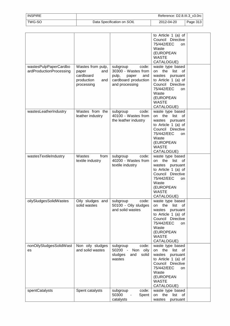
INSPIRE Reference: D2.8.III.3_v3.0rc
TWG-SO Data Specification on SOIL 2012-04-20 Page 313
to Article 1 (a) of Council Directive 75/442/EEC on Waste (EUROPEAN WASTE CATALOGUE)
wastesPulpPaperCardboardProductionProcessing
Wastes from pulp, paper and cardboard production and processing
subgroup code: 30300 - Wastes from pulp, paper and cardboard production and processing
waste type based on the list of wastes pursuant to Article 1 (a) of Council Directive 75/442/EEC on Waste (EUROPEAN WASTE CATALOGUE)
wastesLeatherIndustry Wastes from the leather industry
subgroup code: 40100 - Wastes from the leather industry
waste type based on the list of wastes pursuant to Article 1 (a) of Council Directive 75/442/EEC on Waste (EUROPEAN WASTE CATALOGUE)
wastesTextileIndustry Wastes from textile industry
subgroup code: 40200 - Wastes from textile industry
waste type based on the list of wastes pursuant to Article 1 (a) of Council Directive 75/442/EEC on Waste (EUROPEAN WASTE CATALOGUE)
oilySludgesSolidWastes Oily sludges and solid wastes
subgroup code: 50100 - Oily sludges and solid wastes
waste type based on the list of wastes pursuant to Article 1 (a) of Council Directive 75/442/EEC on Waste (EUROPEAN WASTE CATALOGUE)
nonOilySludgesSolidWastes
Non oily sludges and solid wastes
subgroup code: 50200 - Non oily sludges and solid wastes
waste type based on the list of wastes pursuant to Article 1 (a) of Council Directive 75/442/EEC on Waste (EUROPEAN WASTE CATALOGUE)
spentCatalysts Spent catalysts subgroup code: 50300 - Spent catalysts
waste type based on the list of wastes pursuant

INSPIRE Reference: D2.8.III.3_v3.0rc
TWG-SO Data Specification on SOIL 2012-04-20 Page 314
to Article 1 (a) of Council Directive 75/442/EEC on Waste (EUROPEAN WASTE CATALOGUE)
spentFilterClays Spent filter clays subgroup code: 50400 - Spent filter clays
waste type based on the list of wastes pursuant to Article 1 (a) of Council Directive 75/442/EEC on Waste (EUROPEAN WASTE CATALOGUE)
oilDesulphurisationWaste Oil desulphurisation waste
subgroup code: 50500 - Oil desulphurisation waste
waste type based on the list of wastes pursuant to Article 1 (a) of Council Directive 75/442/EEC on Waste (EUROPEAN WASTE CATALOGUE)
wastePyrolyticTreatmentCoal
Waste from the pyrolytic treatment of coal
subgroup code: 50600 - Waste from the pyrolytic treatment of coal
waste type based on the list of wastes pursuant to Article 1 (a) of Council Directive 75/442/EEC on Waste (EUROPEAN WASTE CATALOGUE)
wastesNaturalGasPurification
Wastes from natural gas purification
subgroup code: 50700 - Wastes from natural gas purification
waste type based on the list of wastes pursuant to Article 1 (a) of Council Directive 75/442/EEC on Waste (EUROPEAN WASTE CATALOGUE)
wastesOilRegeneration Wastes from oil regeneration
subgroup code: 50800 - Wastes from oil regeneration
waste type based on the list of wastes pursuant to Article 1 (a) of Council Directive 75/442/EEC on Waste (EUROPEAN WASTE CATALOGUE)
wasteAidicSolutions Waste acidic solutions
subgroup code: 60100 - Waste acidic solutions
waste type based on the list of wastes pursuant
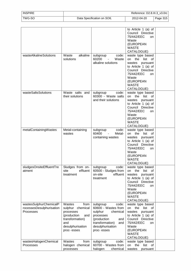
INSPIRE Reference: D2.8.III.3_v3.0rc
TWG-SO Data Specification on SOIL 2012-04-20 Page 315
to Article 1 (a) of Council Directive 75/442/EEC on Waste (EUROPEAN WASTE CATALOGUE)
wasteAlkalineSolutions Waste alkaline solutions
subgroup code: 60200 - Waste alkaline solutions
waste type based on the list of wastes pursuant to Article 1 (a) of Council Directive 75/442/EEC on Waste (EUROPEAN WASTE CATALOGUE)
wasteSaltsSolutions Waste salts and their solutions
subgroup code: 60300 - Waste salts and their solutions
waste type based on the list of wastes pursuant to Article 1 (a) of Council Directive 75/442/EEC on Waste (EUROPEAN WASTE CATALOGUE)
metalContainingWastes Metal-containing wastes
subgroup code: 60400 - Metal-containing wastes
waste type based on the list of wastes pursuant to Article 1 (a) of Council Directive 75/442/EEC on Waste (EUROPEAN WASTE CATALOGUE)
sludgesOnsiteEffluentTreatment
Sludges from on-site effluent treatment
subgroup code: 60500 - Sludges from on-site effluent treatment
waste type based on the list of wastes pursuant to Article 1 (a) of Council Directive 75/442/EEC on Waste (EUROPEAN WASTE CATALOGUE)
wastesSulphurChemicalProcessesDesulphurisationProcesses
Wastes from sulphur chemical processes (production and transformation) and desulphurisation proc- esses
subgroup code: 60600 - Wastes from sulphur chemical processes (production and transformation) and desulphurisation proc- esses
waste type based on the list of wastes pursuant to Article 1 (a) of Council Directive 75/442/EEC on Waste (EUROPEAN WASTE CATALOGUE)
wastesHalogenChemicalProcesses
Wastes from halogen chemical processes
subgroup code: 60700 - Wastes from halogen chemical
waste type based on the list of wastes pursuant
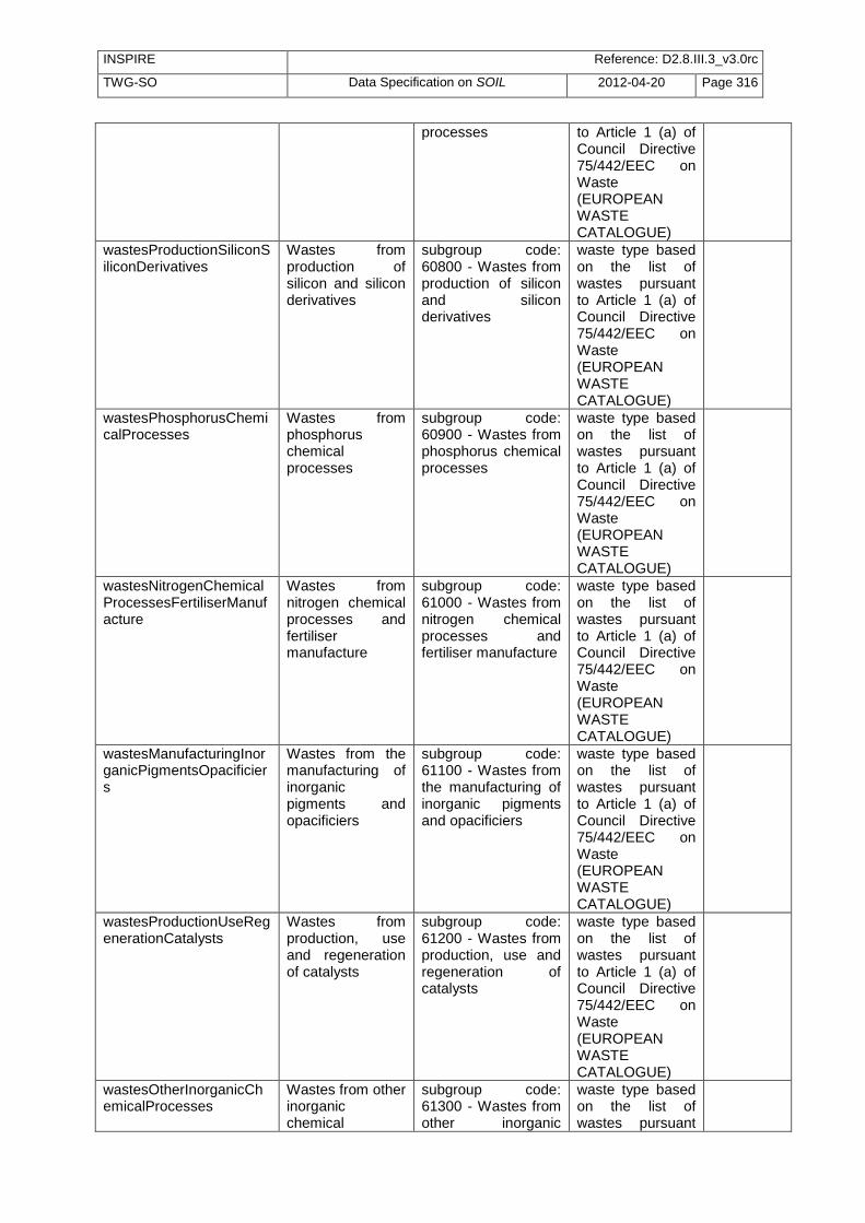
INSPIRE Reference: D2.8.III.3_v3.0rc
TWG-SO Data Specification on SOIL 2012-04-20 Page 316
processes to Article 1 (a) of Council Directive 75/442/EEC on Waste (EUROPEAN WASTE CATALOGUE)
wastesProductionSiliconSiliconDerivatives
Wastes from production of silicon and silicon derivatives
subgroup code: 60800 - Wastes from production of silicon and silicon derivatives
waste type based on the list of wastes pursuant to Article 1 (a) of Council Directive 75/442/EEC on Waste (EUROPEAN WASTE CATALOGUE)
wastesPhosphorusChemicalProcesses
Wastes from phosphorus chemical processes
subgroup code: 60900 - Wastes from phosphorus chemical processes
waste type based on the list of wastes pursuant to Article 1 (a) of Council Directive 75/442/EEC on Waste (EUROPEAN WASTE CATALOGUE)
wastesNitrogenChemicalProcessesFertiliserManufacture
Wastes from nitrogen chemical processes and fertiliser manufacture
subgroup code: 61000 - Wastes from nitrogen chemical processes and fertiliser manufacture
waste type based on the list of wastes pursuant to Article 1 (a) of Council Directive 75/442/EEC on Waste (EUROPEAN WASTE CATALOGUE)
wastesManufacturingInorganicPigmentsOpacificiers
Wastes from the manufacturing of inorganic pigments and opacificiers
subgroup code: 61100 - Wastes from the manufacturing of inorganic pigments and opacificiers
waste type based on the list of wastes pursuant to Article 1 (a) of Council Directive 75/442/EEC on Waste (EUROPEAN WASTE CATALOGUE)
wastesProductionUseRegenerationCatalysts
Wastes from production, use and regeneration of catalysts
subgroup code: 61200 - Wastes from production, use and regeneration of catalysts
waste type based on the list of wastes pursuant to Article 1 (a) of Council Directive 75/442/EEC on Waste (EUROPEAN WASTE CATALOGUE)
wastesOtherInorganicChemicalProcesses
Wastes from other inorganic chemical
subgroup code: 61300 - Wastes from other inorganic
waste type based on the list of wastes pursuant

INSPIRE Reference: D2.8.III.3_v3.0rc
TWG-SO Data Specification on SOIL 2012-04-20 Page 317
processes chemical processes to Article 1 (a) of Council Directive 75/442/EEC on Waste (EUROPEAN WASTE CATALOGUE)
wasteManufactureFormulationSupplyMFSUOrganicChemicals
Waste from the manufacture, formulation, supply and use (MFSU) of basic organic chemicals
subgroup code: 70100 - Waste from the manufacture, formulation, supply and use (MFSU) of basic organic chemicals
waste type based on the list of wastes pursuant to Article 1 (a) of Council Directive 75/442/EEC on Waste (EUROPEAN WASTE CATALOGUE)
wasteMFSUPlasticsSyntheticRubberManMadeFibres
Waste from the MFSU of plastics, synthetic rubber and man-made fibres
subgroup code: 70200 - Waste from the MFSU of plastics, synthetic rubber and man-made fibres
waste type based on the list of wastes pursuant to Article 1 (a) of Council Directive 75/442/EEC on Waste (EUROPEAN WASTE CATALOGUE)
wasteMFSUOrganicDyesPigments
Waste from the MFSU of organic dyes and pigments (excluding 06 11 00)
subgroup code: 70300 - Waste from the MFSU of organic dyes and pigments (excluding 06 11 00)
waste type based on the list of wastes pursuant to Article 1 (a) of Council Directive 75/442/EEC on Waste (EUROPEAN WASTE CATALOGUE)
wasteMFSUOrganicPesticides
Waste from the MFSU of organic pesticides (except 02 01 05)
subgroup code: 70400 - Waste from the MFSU of organic pesticides (except 02 01 05)
waste type based on the list of wastes pursuant to Article 1 (a) of Council Directive 75/442/EEC on Waste (EUROPEAN WASTE CATALOGUE)
wasteMFSUPharmaceuticals
Waste from the MFSU of pharmaceuticals
subgroup code: 70500 - Waste from the MFSU of pharmaceuticals
waste type based on the list of wastes pursuant to Article 1 (a) of Council Directive 75/442/EEC on Waste (EUROPEAN WASTE CATALOGUE)
wasteMFSUFatsGreaseSoapsDetergentsDisinfectantsCosmetics
Waste from the MFSU of fats, grease, soaps,
subgroup code: 70600 - Waste from the MFSU of fats,
waste type based on the list of wastes pursuant

INSPIRE Reference: D2.8.III.3_v3.0rc
TWG-SO Data Specification on SOIL 2012-04-20 Page 318
detergents disinfectants and cosmetics
grease, soaps, detergents disinfectants and cosmetics
to Article 1 (a) of Council Directive 75/442/EEC on Waste (EUROPEAN WASTE CATALOGUE)
wasteMFSUFineChemicalsChemicalProducts
Waste from the MFSU of fine chemicals and chemical products not otherwise specified
subgroup code: 70700 - Waste from the MFSU of fine chemicals and chemical products not otherwise specified
waste type based on the list of wastes pursuant to Article 1 (a) of Council Directive 75/442/EEC on Waste (EUROPEAN WASTE CATALOGUE)
wastesMFSUPaintVarnish
Wastes from MFSU of paint and varnish
subgroup code: 80100 - Wastes from MFSU of paint and varnish
waste type based on the list of wastes pursuant to Article 1 (a) of Council Directive 75/442/EEC on Waste (EUROPEAN WASTE CATALOGUE)
wastesMFSUCoating Wastes from MFSU of other coating (including ceramic materials)
subgroup code: 80200 - Wastes from MFSU of other coating (including ceramic materials)
waste type based on the list of wastes pursuant to Article 1 (a) of Council Directive 75/442/EEC on Waste (EUROPEAN WASTE CATALOGUE)
wastesMFSUPrintingInks Waste from MFSU of printing inks
subgroup code: 80300 - Waste from MFSU of printing inks
waste type based on the list of wastes pursuant to Article 1 (a) of Council Directive 75/442/EEC on Waste (EUROPEAN WASTE CATALOGUE)
wastesMFSUAdhesivesSealants
Wastes from MFSU of adhesives and sealants (including waterproofing products)
subgroup code: 80400 - Wastes from MFSU of adhesives and sealants (including waterproofing products)
waste type based on the list of wastes pursuant to Article 1 (a) of Council Directive 75/442/EEC on Waste (EUROPEAN WASTE CATALOGUE)
wastesPhotographicIndustry
Wastes from photographic industry
subgroup code: 90100 - Wastes from photographic industry
waste type based on the list of wastes pursuant

INSPIRE Reference: D2.8.III.3_v3.0rc
TWG-SO Data Specification on SOIL 2012-04-20 Page 319
to Article 1 (a) of Council Directive 75/442/EEC on Waste (EUROPEAN WASTE CATALOGUE)
wastesPowerStationCombustionPlants
Wastes from power station and other combustion plants (except 19 00 00)
subgroup code: 100100 - Wastes from power station and other combustion plants (except 19 00 00)
waste type based on the list of wastes pursuant to Article 1 (a) of Council Directive 75/442/EEC on Waste (EUROPEAN WASTE CATALOGUE)
wastesIronSteelIndustry Wastes from the iron and steel industry
subgroup code: 100200 - Wastes from the iron and steel industry
waste type based on the list of wastes pursuant to Article 1 (a) of Council Directive 75/442/EEC on Waste (EUROPEAN WASTE CATALOGUE)
wastesAluminiumThermalMetallurgy
Wastes from aluminium thermal metallurgy
subgroup code: 100300 - Wastes from aluminium thermal metallurgy
waste type based on the list of wastes pursuant to Article 1 (a) of Council Directive 75/442/EEC on Waste (EUROPEAN WASTE CATALOGUE)
wastesLeadThermalMetallurgy
Wastes from lead thermal metallurgy
subgroup code: 100400 - Wastes from lead thermal metallurgy
waste type based on the list of wastes pursuant to Article 1 (a) of Council Directive 75/442/EEC on Waste (EUROPEAN WASTE CATALOGUE)
wastesZincThermalMetallurgy
Wastes from zinc thermal metallurgy
subgroup code: 100500 - Wastes from zinc thermal metallurgy
waste type based on the list of wastes pursuant to Article 1 (a) of Council Directive 75/442/EEC on Waste (EUROPEAN WASTE CATALOGUE)
wastesCopperThermalMetallurgy
Wastes from copper thermal metallurgy
subgroup code: 100600 - Wastes from copper thermal
waste type based on the list of wastes pursuant

INSPIRE Reference: D2.8.III.3_v3.0rc
TWG-SO Data Specification on SOIL 2012-04-20 Page 320
metallurgy to Article 1 (a) of Council Directive 75/442/EEC on Waste (EUROPEAN WASTE CATALOGUE)
wastesSilverGoldPlatinumThermalMetallurgy
Wastes from silver, gold and platinum thermal metallurgy
subgroup code: 100700 - Wastes from silver, gold and platinum thermal metallurgy
waste type based on the list of wastes pursuant to Article 1 (a) of Council Directive 75/442/EEC on Waste (EUROPEAN WASTE CATALOGUE)
wastesOtherNonFerrousThermalMetallurgy
Wastes from other non-ferrous thermal metallurgy
subgroup code: 100800 - Wastes from other non-ferrous thermal metallurgy
waste type based on the list of wastes pursuant to Article 1 (a) of Council Directive 75/442/EEC on Waste (EUROPEAN WASTE CATALOGUE)
wastesCastingFerrousPieces
Wastes from casting of ferrous pieces
subgroup code: 100900 - Wastes from casting of ferrous pieces
waste type based on the list of wastes pursuant to Article 1 (a) of Council Directive 75/442/EEC on Waste (EUROPEAN WASTE CATALOGUE)
wastesCastingNonFerrousPieces
Wastes from casting of non-ferrous pieces
subgroup code: 101000 - Wastes from casting of non-ferrous pieces
waste type based on the list of wastes pursuant to Article 1 (a) of Council Directive 75/442/EEC on Waste (EUROPEAN WASTE CATALOGUE)
wastesManufactureGlassProducts
Wastes from manufacture of glass and glass products
subgroup code: 101100 - Wastes from manufacture of glass and glass products
waste type based on the list of wastes pursuant to Article 1 (a) of Council Directive 75/442/EEC on Waste (EUROPEAN WASTE CATALOGUE)
wastesManufactureCeramicGoodsBricksTilesConstructionsProducts
Wastes from manufacture of ceramic goods,
subgroup code: 101200 - Wastes from manufacture of
waste type based on the list of wastes pursuant

INSPIRE Reference: D2.8.III.3_v3.0rc
TWG-SO Data Specification on SOIL 2012-04-20 Page 321
bricks, tiles and constructions products
ceramic goods, bricks, tiles and constructions products
to Article 1 (a) of Council Directive 75/442/EEC on Waste (EUROPEAN WASTE CATALOGUE)
wastes from manufacture of cement, lime and plaster and articles and products made from them
Wastes from manufacture of cement, lime and plaster and articles and products made from them
subgroup code: 101300 - Wastes from manufacture of cement, lime and plaster and articles and products made from them
waste type based on the list of wastes pursuant to Article 1 (a) of Council Directive 75/442/EEC on Waste (EUROPEAN WASTE CATALOGUE)
liquidWastesSludgesMetalTreatmentCoatingMetals
Liquid wastes and sludges from metal treatment and coating of metals (e,g, galvanic processes, zinc coating processes, pickling processes, etching, phosphatising, alkaline degreasing)
subgroup code: 110100 - Liquid wastes and sludges from metal treatment and coating of metals (e,g, galvanic processes, zinc coating processes, pickling processes, etching, phosphatising, alkaline degreasing)
waste type based on the list of wastes pursuant to Article 1 (a) of Council Directive 75/442/EEC on Waste (EUROPEAN WASTE CATALOGUE)
wastesSludgesNonFerrousHydrometallurgicalProcesses
Wastes and sludges from non-ferrous hydrometallurgical processes
subgroup code: 110200 - Wastes and sludges from non-ferrous hydrometallurgical processes
waste type based on the list of wastes pursuant to Article 1 (a) of Council Directive 75/442/EEC on Waste (EUROPEAN WASTE CATALOGUE)
sludgesSolidsTemperingProcesses
Sludges and solids from tempering processes
subgroup code: 110300 - Sludges and solids from tempering processes
waste type based on the list of wastes pursuant to Article 1 (a) of Council Directive 75/442/EEC on Waste (EUROPEAN WASTE CATALOGUE)
otherInorganicWastesMetals
Other inorganic wastes with metals not otherwise specified
subgroup code: 110400 - Other inorganic wastes with metals not otherwise specified
waste type based on the list of wastes pursuant to Article 1 (a) of Council Directive 75/442/EEC on Waste (EUROPEAN

INSPIRE Reference: D2.8.III.3_v3.0rc
TWG-SO Data Specification on SOIL 2012-04-20 Page 322
WASTE CATALOGUE)
wastesShaping Wastes from shaping (including forging, welding, pressing, drawing, turning, cutting and filing)
subgroup code: 120100 - Wastes from shaping (including forging, welding, pressing, drawing, turning, cutting and filing)
waste type based on the list of wastes pursuant to Article 1 (a) of Council Directive 75/442/EEC on Waste (EUROPEAN WASTE CATALOGUE)
wastesMechanicalSurfaceTreatmentProcesses
Wastes from mechanical surface treatment processes (blasting, grinding, honing, lapping, polishing)
subgroup code: 120200 - Wastes from mechanical surface treatment processes (blasting, grinding, honing, lapping, polishing)
waste type based on the list of wastes pursuant to Article 1 (a) of Council Directive 75/442/EEC on Waste (EUROPEAN WASTE CATALOGUE)
wastesWaterSteamDegreasingProcesses
Wastes from water and steam degreasing processes (except 11 00 00)
subgroup code: 120300 - Wastes from water and steam degreasing processes (except 11 00 00)
waste type based on the list of wastes pursuant to Article 1 (a) of Council Directive 75/442/EEC on Waste (EUROPEAN WASTE CATALOGUE)
wasteHydraulicOilsBrakeFluids
Waste hydraulic oils and brake fluids
subgroup code: 130100 - Waste hydraulic oils and brake fluids
waste type based on the list of wastes pursuant to Article 1 (a) of Council Directive 75/442/EEC on Waste (EUROPEAN WASTE CATALOGUE)
wasteEngineGearLubricatingOils
Waste engine, gear & lubricating oils
subgroup code: 130200 - Waste engine, gear & lubricating oils
waste type based on the list of wastes pursuant to Article 1 (a) of Council Directive 75/442/EEC on Waste (EUROPEAN WASTE CATALOGUE)
wasteInsulatingHeatTransmissionOilsLiquids
Waste insulating and heat transmission oils and other liquids
subgroup code: 130300 - Waste insulating and heat transmission oils and other liquids
waste type based on the list of wastes pursuant to Article 1 (a) of Council Directive 75/442/EEC on Waste (EUROPEAN

INSPIRE Reference: D2.8.III.3_v3.0rc
TWG-SO Data Specification on SOIL 2012-04-20 Page 323
WASTE CATALOGUE)
bilgeOils Bilge oils subgroup code: 130400 - Bilge oils
waste type based on the list of wastes pursuant to Article 1 (a) of Council Directive 75/442/EEC on Waste (EUROPEAN WASTE CATALOGUE)
oilWaterSeparatorContents
Oil/water separator contents
subgroup code: 130500 - Oil/water separator contents
waste type based on the list of wastes pursuant to Article 1 (a) of Council Directive 75/442/EEC on Waste (EUROPEAN WASTE CATALOGUE)
oilWasteOtherwiseSpecified
Oil waste not otherwise specified
subgroup code: 130600 - Oil waste not otherwise specified
waste type based on the list of wastes pursuant to Article 1 (a) of Council Directive 75/442/EEC on Waste (EUROPEAN WASTE CATALOGUE)
wastesMetalDegreasingMachineryMaintenance
Wastes from metal degreasing and machinery maintenance
subgroup code: 140100 - Wastes from metal degreasing and machinery maintenance
waste type based on the list of wastes pursuant to Article 1 (a) of Council Directive 75/442/EEC on Waste (EUROPEAN WASTE CATALOGUE)
wastesTextileCleaningDegreasingNaturalProducts
Wastes from textile cleaning and degreasing of natural products
subgroup code: 140200 - Wastes from textile cleaning and degreasing of natural products
waste type based on the list of wastes pursuant to Article 1 (a) of Council Directive 75/442/EEC on Waste (EUROPEAN WASTE CATALOGUE)
wastesElectronicIndustry Wastes from the electronic industry
subgroup code: 140300 - Wastes from the electronic industry
waste type based on the list of wastes pursuant to Article 1 (a) of Council Directive 75/442/EEC on Waste (EUROPEAN

INSPIRE Reference: D2.8.III.3_v3.0rc
TWG-SO Data Specification on SOIL 2012-04-20 Page 324
WASTE CATALOGUE)
wastesCoolantsFoamAerosolPropellents
Wastes from coolants, foam/aerosol propellents
subgroup code: 140400 - Wastes from coolants, foam/aerosol propellents
waste type based on the list of wastes pursuant to Article 1 (a) of Council Directive 75/442/EEC on Waste (EUROPEAN WASTE CATALOGUE)
wastesSolventCoolantRecovery
Wastes from solvent and coolant recovery (still bottoms)
subgroup code: 140500 - Wastes from solvent and coolant recovery (still bottoms)
waste type based on the list of wastes pursuant to Article 1 (a) of Council Directive 75/442/EEC on Waste (EUROPEAN WASTE CATALOGUE)
packaging Packaging subgroup code: 150100 - Packaging
waste type based on the list of wastes pursuant to Article 1 (a) of Council Directive 75/442/EEC on Waste (EUROPEAN WASTE CATALOGUE)
absorbentsFilterMaterialsWipingClothsProtectiveClothing
Absorbents, filter materials, wiping cloths and protective clothing
subgroup code: 150200 - Absorbents, filter materials, wiping cloths and protective clothing
waste type based on the list of wastes pursuant to Article 1 (a) of Council Directive 75/442/EEC on Waste (EUROPEAN WASTE CATALOGUE)
soilDredgingSpoil Soil and dredging spoil
subgroup code: 150500 - Soil and dredging spoil
waste type based on the list of wastes pursuant to Article 1 (a) of Council Directive 75/442/EEC on Waste (EUROPEAN WASTE CATALOGUE)
endLifeVehicles End of life vehicles
subgroup code: 160100 - End of life vehicles
waste type based on the list of wastes pursuant to Article 1 (a) of Council Directive 75/442/EEC on Waste (EUROPEAN

INSPIRE Reference: D2.8.III.3_v3.0rc
TWG-SO Data Specification on SOIL 2012-04-20 Page 325
WASTE CATALOGUE)
discardedEquipmentShredderResidues
Discarded equipment and shredder residues
subgroup code: 160200 - Discarded equipment and shredder residues
waste type based on the list of wastes pursuant to Article 1 (a) of Council Directive 75/442/EEC on Waste (EUROPEAN WASTE CATALOGUE)
offSpecificationBatches Off-specification batches
subgroup code: 160300 - Off-specification batches
waste type based on the list of wastes pursuant to Article 1 (a) of Council Directive 75/442/EEC on Waste (EUROPEAN WASTE CATALOGUE)
wasteExplosives Waste explosives subgroup code: 160400 - Waste explosives
waste type based on the list of wastes pursuant to Article 1 (a) of Council Directive 75/442/EEC on Waste (EUROPEAN WASTE CATALOGUE)
chemicalsGasesContainers
Chemicals and gases in containers
subgroup code: 160500 - Chemicals and gases in containers
waste type based on the list of wastes pursuant to Article 1 (a) of Council Directive 75/442/EEC on Waste (EUROPEAN WASTE CATALOGUE)
batteriesAccumulators Batteries and accumulators
subgroup code: 160600 - Batteries and accumulators
waste type based on the list of wastes pursuant to Article 1 (a) of Council Directive 75/442/EEC on Waste (EUROPEAN WASTE CATALOGUE)
wasteTransportStorageTankCleaning
Waste from transport and storage tank cleaning (except 05 00 00 and 12 00 00)
subgroup code: 160700 - Waste from transport and storage tank cleaning (except 05 00 00 and 12 00 00)
waste type based on the list of wastes pursuant to Article 1 (a) of Council Directive 75/442/EEC on Waste (EUROPEAN

INSPIRE Reference: D2.8.III.3_v3.0rc
TWG-SO Data Specification on SOIL 2012-04-20 Page 326
WASTE CATALOGUE)
concreteBricksTilesCeramicsGypsumBasedMaterials
Concrete, bricks, tiles, ceramics, and gypsum based materials
subgroup code: 170100 - Concrete, bricks, tiles, ceramics, and gypsum based materials
waste type based on the list of wastes pursuant to Article 1 (a) of Council Directive 75/442/EEC on Waste (EUROPEAN WASTE CATALOGUE)
woodGlassPlastic Wood, glass and plastic
subgroup code: 170200 - Wood, glass and plastic
waste type based on the list of wastes pursuant to Article 1 (a) of Council Directive 75/442/EEC on Waste (EUROPEAN WASTE CATALOGUE)
asphaltTarTarredProducts
Asphalt, tar and tarred products
subgroup code: 170300 - Asphalt, tar and tarred products
waste type based on the list of wastes pursuant to Article 1 (a) of Council Directive 75/442/EEC on Waste (EUROPEAN WASTE CATALOGUE)
metalsAlloys Metals (including their alloys)
subgroup code: 170400 - Metals (including their alloys)
waste type based on the list of wastes pursuant to Article 1 (a) of Council Directive 75/442/EEC on Waste (EUROPEAN WASTE CATALOGUE)
insulationMaterials Insulation materials
subgroup code: 170600 - Insulation materials
waste type based on the list of wastes pursuant to Article 1 (a) of Council Directive 75/442/EEC on Waste (EUROPEAN WASTE CATALOGUE)
mixedConstructionDemolitionWaste
Mixed construction and demolition waste
subgroup code: 170700 - Mixed construction and demolition waste
waste type based on the list of wastes pursuant to Article 1 (a) of Council Directive 75/442/EEC on Waste (EUROPEAN

INSPIRE Reference: D2.8.III.3_v3.0rc
TWG-SO Data Specification on SOIL 2012-04-20 Page 327
WASTE CATALOGUE)
wasteNatalCareDiagnosisTreatmentPreventionDiseaseHumans
Waste from natal care, diagnosis, treatment or prevention of disease in humans
subgroup code: 180100 - Waste from natal care, diagnosis, treatment or prevention of disease in humans
waste type based on the list of wastes pursuant to Article 1 (a) of Council Directive 75/442/EEC on Waste (EUROPEAN WASTE CATALOGUE)
wasteResearchDiagnosisTreatmentPreventionDiseaseInvolvingAnimals
Waste from research, diagnosis, treatment or prevention of disease involving animals
subgroup code: 180200 - Waste from research, diagnosis, treatment or prevention of disease involving animals
waste type based on the list of wastes pursuant to Article 1 (a) of Council Directive 75/442/EEC on Waste (EUROPEAN WASTE CATALOGUE)
wastesIncinerationPyrolysisMunicipalSimilarCommercialIndustrialInstitutionalWastes
Wastes from incineration or pyrolysis of municipal and similar commercial, industrial and institutional wastes
subgroup code: 190100 - Wastes from incineration or pyrolysis of municipal and similar commercial, industrial and institutional wastes
waste type based on the list of wastes pursuant to Article 1 (a) of Council Directive 75/442/EEC on Waste (EUROPEAN WASTE CATALOGUE)
wastesSpecificPhysicoChemicalTreatmentsIndustrialWastes
Wastes from specific physico/chemical treatments of industrial wastes (e,g, dechromatation, decyani- dation, neutralisation)
subgroup code: 190200 - Wastes from specific physico/chemical treatments of industrial wastes (e,g, dechromatation, decyani- dation, neutralisation)
waste type based on the list of wastes pursuant to Article 1 (a) of Council Directive 75/442/EEC on Waste (EUROPEAN WASTE CATALOGUE)
stabilisedSolidifiedWastes
Stabilised/solidified wastes
subgroup code: 190300 - Stabilised/solidified wastes
waste type based on the list of wastes pursuant to Article 1 (a) of Council Directive 75/442/EEC on Waste (EUROPEAN WASTE CATALOGUE)
vitrifiedWastesVitrification Vitrified wastes and wastes from vitrification
subgroup code: 190400 - Vitrified wastes and wastes from vitrification
waste type based on the list of wastes pursuant to Article 1 (a) of Council Directive 75/442/EEC on Waste (EUROPEAN

INSPIRE Reference: D2.8.III.3_v3.0rc
TWG-SO Data Specification on SOIL 2012-04-20 Page 328
WASTE CATALOGUE)
wastesAerobicTreatmentSolidWastes
Wastes from aerobic treatment of solid wastes
subgroup code: 190500 - Wastes from aerobic treatment of solid wastes
waste type based on the list of wastes pursuant to Article 1 (a) of Council Directive 75/442/EEC on Waste (EUROPEAN WASTE CATALOGUE)
wastesAnaerobicTreatmentWastes
Wastes from anaerobic treatment of wastes
subgroup code: 190600 - Wastes from anaerobic treatment of wastes
waste type based on the list of wastes pursuant to Article 1 (a) of Council Directive 75/442/EEC on Waste (EUROPEAN WASTE CATALOGUE)
landfillLeachate Landfill leachate subgroup code: 190700 - Landfill leachate
waste type based on the list of wastes pursuant to Article 1 (a) of Council Directive 75/442/EEC on Waste (EUROPEAN WASTE CATALOGUE)
wastesWaterTreatmentPlants
Wastes from waste water treatment plants not otherwise specified
subgroup code: 190800 - Wastes from waste water treatment plants not otherwise specified
waste type based on the list of wastes pursuant to Article 1 (a) of Council Directive 75/442/EEC on Waste (EUROPEAN WASTE CATALOGUE)
wastesPreparationDrinkingWaterIndustrialUse
Wastes from the preparation of drinking water or water for industrial use
subgroup code: 190900 - Wastes from the preparation of drinking water or water for industrial use
waste type based on the list of wastes pursuant to Article 1 (a) of Council Directive 75/442/EEC on Waste (EUROPEAN WASTE CATALOGUE)
paperCardboard Paper and cardboard
code: 200101 - Paper and cardboard
waste type based on the list of wastes pursuant to Article 1 (a) of Council Directive 75/442/EEC on Waste (EUROPEAN

INSPIRE Reference: D2.8.III.3_v3.0rc
TWG-SO Data Specification on SOIL 2012-04-20 Page 329
WASTE CATALOGUE)
glass Glass code: 200102 - Glass waste type based on the list of wastes pursuant to Article 1 (a) of Council Directive 75/442/EEC on Waste (EUROPEAN WASTE CATALOGUE)
smallPlastics Small plastics code: 200103 - Small plastics
waste type based on the list of wastes pursuant to Article 1 (a) of Council Directive 75/442/EEC on Waste (EUROPEAN WASTE CATALOGUE)
otherPlastics Other plastics code: 200104 - Other plastics
waste type based on the list of wastes pursuant to Article 1 (a) of Council Directive 75/442/EEC on Waste (EUROPEAN WASTE CATALOGUE)
smallMetalsCans Small metals (cans etc,)
code: 200105 - Small metals (cans etc,)
waste type based on the list of wastes pursuant to Article 1 (a) of Council Directive 75/442/EEC on Waste (EUROPEAN WASTE CATALOGUE)
otherMetals Other metals code: 200106 - Other metals
waste type based on the list of wastes pursuant to Article 1 (a) of Council Directive 75/442/EEC on Waste (EUROPEAN WASTE CATALOGUE)
wood Wood code: 200107 - Wood waste type based on the list of wastes pursuant to Article 1 (a) of Council Directive 75/442/EEC on Waste (EUROPEAN

INSPIRE Reference: D2.8.III.3_v3.0rc
TWG-SO Data Specification on SOIL 2012-04-20 Page 330
WASTE CATALOGUE)
organicCompostableKitchenWaste
Organic compostable kitchen waste (including frying oil and kitchen waste from canteens and restau- rants)
code: 200108 - Organic compostable kitchen waste (including frying oil and kitchen waste from canteens and restau- rants)
waste type based on the list of wastes pursuant to Article 1 (a) of Council Directive 75/442/EEC on Waste (EUROPEAN WASTE CATALOGUE)
oilFat Oil and fat code: 200109 - Oil and fat
waste type based on the list of wastes pursuant to Article 1 (a) of Council Directive 75/442/EEC on Waste (EUROPEAN WASTE CATALOGUE)
clothes Clothes code: 200110 - Clothes
waste type based on the list of wastes pursuant to Article 1 (a) of Council Directive 75/442/EEC on Waste (EUROPEAN WASTE CATALOGUE)
textiles Textiles code: 200111 - Textiles
waste type based on the list of wastes pursuant to Article 1 (a) of Council Directive 75/442/EEC on Waste (EUROPEAN WASTE CATALOGUE)
paintInksAdhesivesResins
Paint, inks, adhesives and resins
code: 200112 - Paint, inks, adhesives and resins
waste type based on the list of wastes pursuant to Article 1 (a) of Council Directive 75/442/EEC on Waste (EUROPEAN WASTE CATALOGUE)
solvents Solvents code: 200113 - Solvents
waste type based on the list of wastes pursuant to Article 1 (a) of Council Directive 75/442/EEC on Waste (EUROPEAN

INSPIRE Reference: D2.8.III.3_v3.0rc
TWG-SO Data Specification on SOIL 2012-04-20 Page 331
WASTE CATALOGUE)
acids Acids code: 200114 - Acids waste type based on the list of wastes pursuant to Article 1 (a) of Council Directive 75/442/EEC on Waste (EUROPEAN WASTE CATALOGUE)
alkalines Alkalines code: 200115 - Alkalines
waste type based on the list of wastes pursuant to Article 1 (a) of Council Directive 75/442/EEC on Waste (EUROPEAN WASTE CATALOGUE)
detergents Detergents code: 200116 - Detergents
waste type based on the list of wastes pursuant to Article 1 (a) of Council Directive 75/442/EEC on Waste (EUROPEAN WASTE CATALOGUE)
photoChemicals Photo chemicals code: 200117 - Photo chemicals
waste type based on the list of wastes pursuant to Article 1 (a) of Council Directive 75/442/EEC on Waste (EUROPEAN WASTE CATALOGUE)
medicines Medicines code: 200118 - Medicines
waste type based on the list of wastes pursuant to Article 1 (a) of Council Directive 75/442/EEC on Waste (EUROPEAN WASTE CATALOGUE)
pesticides Pesticides code: 200119 - Pesticides
waste type based on the list of wastes pursuant to Article 1 (a) of Council Directive 75/442/EEC on Waste (EUROPEAN

INSPIRE Reference: D2.8.III.3_v3.0rc
TWG-SO Data Specification on SOIL 2012-04-20 Page 332
WASTE CATALOGUE)
batteries Batteries code: 200120 - Batteries
waste type based on the list of wastes pursuant to Article 1 (a) of Council Directive 75/442/EEC on Waste (EUROPEAN WASTE CATALOGUE)
fluorescentTubesOtherMercuryContainingWaste
Fluorescent tubes and other mercury containing waste
code: 200121 - Fluorescent tubes and other mercury containing waste
waste type based on the list of wastes pursuant to Article 1 (a) of Council Directive 75/442/EEC on Waste (EUROPEAN WASTE CATALOGUE)
aerosols Aerosols code: 200122 - Aerosols
waste type based on the list of wastes pursuant to Article 1 (a) of Council Directive 75/442/EEC on Waste (EUROPEAN WASTE CATALOGUE)
equipmentContainingChloroflurocarbons
Equipment containing chloroflurocarbons
code: 200123 - Equipment containing chloroflurocarbons
waste type based on the list of wastes pursuant to Article 1 (a) of Council Directive 75/442/EEC on Waste (EUROPEAN WASTE CATALOGUE)
electronicEquipment Electronic equipment (e,g, printed circuit boards)
code: 200124 - Electronic equipment (e,g, printed circuit boards)
waste type based on the list of wastes pursuant to Article 1 (a) of Council Directive 75/442/EEC on Waste (EUROPEAN WASTE CATALOGUE)
gardenParkWaste Garden and park waste (including cemetery waste)
subgroup code: 200200 - Garden and park waste (including cemetery waste)
waste type based on the list of wastes pursuant to Article 1 (a) of Council Directive 75/442/EEC on Waste (EUROPEAN

INSPIRE Reference: D2.8.III.3_v3.0rc
TWG-SO Data Specification on SOIL 2012-04-20 Page 333
WASTE CATALOGUE)
otherMunicipalWaste Other municipal waste
subgroup code: 200300 - Other municipal waste
waste type based on the list of wastes pursuant to Article 1 (a) of Council Directive 75/442/EEC on Waste (EUROPEAN WASTE CATALOGUE)
11.5.2 Externally governed code lists
Code list Governance Version Availability Formats Subset
NaceIndustrialActivityValue
Latest available version
INSPIRE Reference: D2.8.III.3_v3.0rc
TWG-SO Data Specification on SOIL 2012-04-20 Page 334
Annex D (informative)
Use case soil derived information
How to provide soil organic carbon content with the INSPIRE “Soil model”
INTRODUCTION
The INSPIRE Annex III theme ‘Soil’
INSPIRE makes models for data exchange for themes with importance for the EU economy, one
of those is the theme ‘Soil’. Main topics for ‘Soil’ are the soil characterisation and all related
themes within the scope of soil protection. Soil organic matter decline is one of the major
processes which need actual assessment, among others, for healthy foods and the occurrence and
impact of climate change. The use case described below shows how soil related data, and in
particular the map of topsoil organic carbon content, can be provided within the INSPIRE “soil
model”.
Relevance of soil organic carbon content and soil organic carbon stock with regard to
regulation and legislation
A. The Thematic Strategy for Soil Protection (Brussels, 22.9.2006, COM(2006)231)
individuates Soil Organic Matter Decline as one of the mayor risks of soil degradation.
B. The Proposal for a DIRECTIVE OF THE EUROPEAN PARLIAMENT AND OF THE
COUNCIL establishing a framework for the protection of soil and amending Directive
2004/35/EC (Brussels, 22.9.2006 COM(2006) 232 final, 2006/0086 (COD)) defines
many soils functions: biomass production, storing, filtering and transforming nutrients
and water, hosting the biodiversity pool, acting as a platform for most human activities,
providing raw materials, acting as a carbon pool and storing the geological and
archeological heritage. Soil organic carbon content (total and humus concentration) and
soil organic carbon stock are indicated as common elements for the identification of areas
at risk of soil organic matter decline.
C. In the REPORT FROM THE COMMISSION TO THE EUROPEAN PARLIAMENT,
the implementation of the Soil Thematic Strategy and ongoing activities are illustrated
(Brussels, 13.2.2012, COM(2012) 46 final). Different Community policies, in particular,
environmental (e.g. air and water) and agricultural (agri-environment and cross-
compliance) contribute to soil protection. Agriculture can have positive effects on the
state of soil. For instance, land management practices such as organic and integrated
farming or extensive agricultural practices in mountain areas can maintain and enhance
organic matter in the soil and prevent landslides.
A great focus on soil organic carbon is given by the Kyoto Protocol. The Kyoto Protocol
highlights that soil is a major carbon store which must be protected and increased where
possible, since carbon sequestration in agricultural soils by some land management
practices can contribute to mitigating climate change. The European Climate Change
Programme (ECCP) Working Group on Sinks Related to Agricultural Soils estimated this
potential at equivalent to 1.5 to 1.7% of the EU’s anthropogenic CO2 emissions during
the first commitment period (See:
http://ec.europa.eu/comm/environment/climat/pdf/finalreport_agricsoils.pdf.) under the

INSPIRE Reference: D2.8.III.3_v3.0rc
TWG-SO Data Specification on SOIL 2012-04-20 Page 335
Kyoto Protocol. Programmes can build on measures already implemented in national and
Community contexts, such as cross-compliance and rural development under the CAP,
codes of good agricultural practice and action programmes under the Nitrates Directive,
future measures under the river basin management plans for the Water Framework
Directive, flood risk management plans, national forest programmes and sustainable
forestry practices and forest fire prevention measures. Member States will be free to
combine approaches to combat concurrent threats. This will be particularly beneficial for
Member States addressing desertification under the UNCCD and will avoid duplication
of effort.
In summary, the soil organic carbon content is a parameter to be taken into account for
meeting the (i) Proposed Soil framework Directive, (ii) Council regulation (EC) No
1782/2003 (Common Agricultural Policy), (iii) Agri-environmental indicators that track
the integration of environmental concerns into CAP at EU, national and regional levels,
(iv) Directive 2009/28/EC of the European Parliament and of the Council (energy from
renewable resources) and (v) Less Favoured Areas (LFA) Intermediate areas (regulation
aimed at better targeting of natural handicap payments COM (2009) 161 (still under
discussion).
USE CASE DESCRIPTION
The following example describes a use case referring to a regional estimation of soil organic
carbon content (Fig.1).
Use case: soil organic carbon content estimation on a regional scale.
This use case makes reference to the real case of the Region Sicily and involves several objects
(feature types, their attributes and their connections).
The map of the regional soil organic carbon content is a SoilThemeCoverage rectified grid which
has the following attributes:
«feature type»
SoilThemeCoverage
+ soilThemeName: map of the soil organic carbon content in the topsoil of the region Sicily
+ domainExtent: EX_VerticalExtent 1
+ beginLifespanVersion: 2011
+ endLifespanVersion:
+ validTimeFrom: 1959
+ validTimeTo: 2009
Constraints
Values can range from 0 to 100 dag/kg
The SoilThemeCoverage is associated to a SoilDerivedObject, which is a collection of polygons
described as follows:
«feature type»
SoilDerivedObject
+ geometry: GM_Polygon (the coordinates of the polygon)
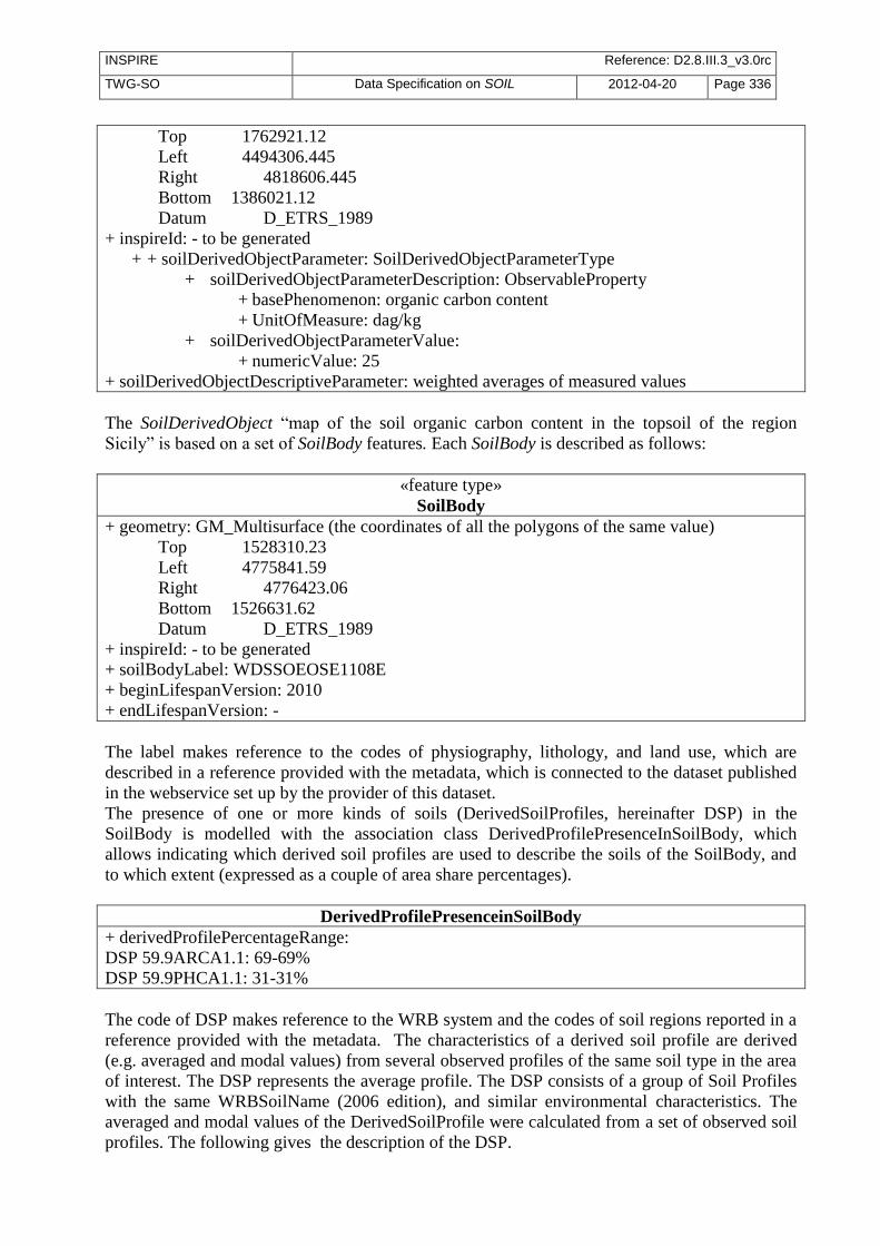
INSPIRE Reference: D2.8.III.3_v3.0rc
TWG-SO Data Specification on SOIL 2012-04-20 Page 336
Top 1762921.12
Left 4494306.445
Right 4818606.445
Bottom 1386021.12
Datum D_ETRS_1989
+ inspireId: - to be generated
+ + soilDerivedObjectParameter: SoilDerivedObjectParameterType
+ soilDerivedObjectParameterDescription: ObservableProperty
+ basePhenomenon: organic carbon content
+ UnitOfMeasure: dag/kg
+ soilDerivedObjectParameterValue:
+ numericValue: 25
+ soilDerivedObjectDescriptiveParameter: weighted averages of measured values
The SoilDerivedObject “map of the soil organic carbon content in the topsoil of the region
Sicily” is based on a set of SoilBody features. Each SoilBody is described as follows:
«feature type»
SoilBody
+ geometry: GM_Multisurface (the coordinates of all the polygons of the same value)
Top 1528310.23
Left 4775841.59
Right 4776423.06
Bottom 1526631.62
Datum D_ETRS_1989
+ inspireId: - to be generated
+ soilBodyLabel: WDSSOEOSE1108E
+ beginLifespanVersion: 2010
+ endLifespanVersion: -
The label makes reference to the codes of physiography, lithology, and land use, which are
described in a reference provided with the metadata, which is connected to the dataset published
in the webservice set up by the provider of this dataset.
The presence of one or more kinds of soils (DerivedSoilProfiles, hereinafter DSP) in the
SoilBody is modelled with the association class DerivedProfilePresenceInSoilBody, which
allows indicating which derived soil profiles are used to describe the soils of the SoilBody, and
to which extent (expressed as a couple of area share percentages).
DerivedProfilePresenceinSoilBody
+ derivedProfilePercentageRange:
DSP 59.9ARCA1.1: 69-69%
DSP 59.9PHCA1.1: 31-31%
The code of DSP makes reference to the WRB system and the codes of soil regions reported in a
reference provided with the metadata. The characteristics of a derived soil profile are derived
(e.g. averaged and modal values) from several observed profiles of the same soil type in the area
of interest. The DSP represents the average profile. The DSP consists of a group of Soil Profiles
with the same WRBSoilName (2006 edition), and similar environmental characteristics. The
averaged and modal values of the DerivedSoilProfile were calculated from a set of observed soil
profiles. The following gives the description of the DSP.

INSPIRE Reference: D2.8.III.3_v3.0rc
TWG-SO Data Specification on SOIL 2012-04-20 Page 337
«feature type»
SoilProfile
+ inspireId: (to be generated)
+ WRBSoilName:
+ WRBSoilNameType
+ WRBQualifierGroup : WRBQualifierGroupType
+ qualifierPlace: prefix
+ qualifierPosition: 1
+ WRBqualifier: Haplic
+ WRBspecifier: -
+ WRBQualifierGroup : WRBQualifierGroupType
+ qualifierPlace: suffix
+ qualifierPosition: 1
+ WRBqualifier: Calcaric
+ WRBspecifier: -
+ WRBReferenceSoilGroup: Arenosol
+ isOriginalClassification: true
+ otherSoilName:
+ soilName: Typic Xeropsamment
+ soilClassificationScheme: DocumentCitation
+ Name: Carta suoli Sicilia: convenzione con la Regione Sicilia per la
realizzazione della Carta dei Suoli a scala 1:250,000 nell'ambito del
programma interregionale "Agricoltura e Qualità".
+ shortName: Carta suoli Sicilia
+ date: 2011
+ link: http://www.sias.regione.sicilia.it/
+ isOriginalClassification: true
+ localidentifier: DSP 59.9ARCA1.1
+ soilProfileParameter: -
+ validFrom: 2008
+ validTo: 2009
+ beginLifespanVersion: 2010
+ endLifespanVersion: -
For DSP 59.9PHCA1.1 there will be a similar description
The ProfileElement considered in this use case is a SoilLayer.
«feature type»
ProfileElement
+ inspireId: (to be generated)
+ profileElementDepthRange:
+ upperValue: 0
+ lowerValue: 30
+ UnitOfMeasure: cm
+ + profileElementParameter:
+ ProfileElementParameterType
+ profileElementParameterDescription: ObservableProperty
+ basePhenomenon: organic carbon content
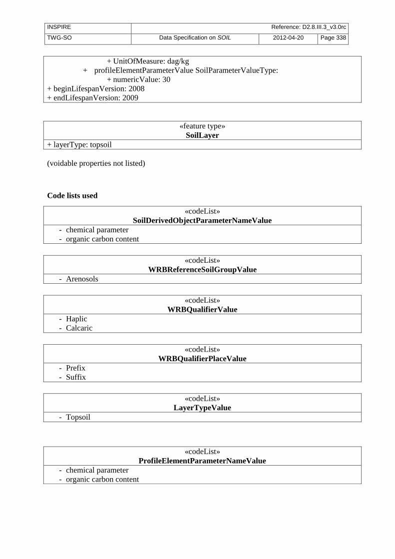
INSPIRE Reference: D2.8.III.3_v3.0rc
TWG-SO Data Specification on SOIL 2012-04-20 Page 338
+ UnitOfMeasure: dag/kg
+ profileElementParameterValue SoilParameterValueType:
+ numericValue: 30
+ beginLifespanVersion: 2008
+ endLifespanVersion: 2009
«feature type»
SoilLayer
+ layerType: topsoil
(voidable properties not listed)
Code lists used
«codeList»
WRBReferenceSoilGroupValue
- Arenosols
«codeList»
WRBQualifierValue
- Haplic
- Calcaric
«codeList»
WRBQualifierPlaceValue
- Prefix
- Suffix
«codeList»
LayerTypeValue
- Topsoil
«codeList»
SoilDerivedObjectParameterNameValue
- chemical parameter
- organic carbon content
«codeList»
ProfileElementParameterNameValue
- chemical parameter
- organic carbon content

INSPIRE Reference: D2.8.III.3_v3.0rc
TWG-SO Data Specification on SOIL 2012-04-20 Page 339
«feature type»
SoilThemeCoverage
+ soilThemeName: map of the soil organic carbon content in the topsoil of the region Sicily
+ domainExtent: EX_VerticalExtent 1
+ beginLifespanVersion: 2011
+ endLifespanVersion: not available
+ validTimeFrom: 1959
+ validTimeTo: 2009
Constraints
Values can range from 0 to 100 dag/kg
«feature type»
SoilDerivedObject
+ geometry: GM_Polygon
+ inspireId: 0
+ soilDerivedObjectParameter: not available
+ soilDerivedObjectDescriptiveParameter: validTimeFrom: 1959
«feature type»
SoilBody
+ geometry: GM_Multisurface
+ inspireId: 0
+ soilBodyLabel: WDSSOEOSE1108E
+ beginLifespanVersion: 2010
+ endLifespanVersion: not available
+isDescribedBy 1..*
DerivedProfilePresenceinSoilBody
+ derivedProfilePercentageRange:
DSP 59.9ARCA1.1: 69-69%
DSP 59.9PHCA1.1: 31-31%
«feature type»
SoilProfile
+ inspireId: 0
+ WRBSoilName: Haplic Arenosols (Calcaric)
+ otherSoilName: Typic Xeropsamment
+ localidentifier: DSP 59.9ARCA1.1
+ validFrom: 2008
+ validTo: 2009
+ beginLifespanVersion: 2010
+ endLifespanVersion: not available 1 isPartOf
+isDescribedBy 1..*
«feature type»
ProfileElement
+ inspireId: 0
+ profileElementDepthRange: 0-30 cm
+ profileElementParameter: organic carbon content
+ beginLifespanVersion: 2008
+ endLifespanVersion: 2009
«feature type»
SoilLayer
+ layerType: topsoil
Figure 1 – Implementation of INSPIRE. Objects involved in the use case: soil organic carbon content
estimation on a regional scale (note that some data types are represented in short).
DerivedSoilProfile

INSPIRE Reference: D2.8.III.3_v3.0rc
TWG-SO Data Specification on SOIL 2012-04-20 Page 340
Annex E (normative)
Encoding rules for TIFF and JPEG 2000 file formats
Open issue 11: This annex is still under discussion between the TWGs which intend to refer to TIFF and JPEG 2000 in their specifications.
E.1 Introduction This annex specifies how to use the TIFF or JPEG 2000 file formats for encoding the range set of grid coverages. Because pixel payload is not sufficient to construct a readable standalone image, additional descriptive information has to be packaged together in the same file, even if it is already provided somewhere else in GML. For this purpose, this part establishes schema conversion rules for all the coverage components of INSPIRE Application Schemas that have a corresponding element in the output TIFF or JPEG 2000 data structures. These conversion rules play an essential role in maintaining consistency between the different representations (i.e. GML, TIFF or JPEG 2000) of the same coverage information. On the other hand, TIFF specifications and JPEG 2000 Standard offer many options and let some variables open for encoding image data. If this flexibility allows covering most applications, it leads, in turn, to a situation where disparate implementation platforms exist while being potentially incompatible. As a result, interoperability is often unlikely. In order to fill in this gap and to enable a controlled exchange of data across Europe, this annex draws up an implementation profile of TIFF and JPEG 2000 to constraint their usage within the scope of INSPIRE. It amounts to impose external format-dependent restrictions to the applicable values of the properties described in the INSPIRE application schemas.
E.2 TIFF format
E.2.1 Format overview
The Tagged Image File Format (TIFF) is a binary file format for storing and interchanging raster images. Originally developed by the company Aldus (Adobe Systems), it is in the public domain since 1992, the year of the latest release of the specifications (revision 6.0 [TIFF]). TIFF has become a popular “de facto standard” for high color-depth digital images. It is widely used in image handling applications, covering various themes such as SOIL. TIFF specifications are divided into two parts. Part 1: Baseline TIFF defines all the features that every reader must support, while Part 2: TIFF Extensions provides additional format structures designed for specialized applications, that are not necessarily taken into account by all TIFF readers (e.g. JPEG or LZW compression, tiling, CMYK images). As highlighted in the format name, the TIFF data structure is based on the definition of tags for describing the characteristics of images. To be more precise, a TIFF file contains an image file header pointing to one or several image file directory (IFD). The image file header fixes the technical properties of the file, such as the byte order (e.g. little-endian or big-endian) or the offset of the first byte. An image file directory holds the complete description of an image by means of fields or entries. Each IFD entry consists of a tag identifying the field, the field type (e.g. byte, ASCII, short int), the number of values and the values themselves or an offset to the values. The location of the actual image data within the file is given by the combination of information elements expressed in some fields.
E.2.2 INSPIRE TIFF profile for grid coverage data
INSPIRE Reference: D2.8.III.3_v3.0rc
TWG-SO Data Specification on SOIL 2012-04-20 Page 341
This section lists the requirements and the constraints to be applied to the TIFF format when encoding INSPIRE SOIL data sets in this format. It should be read in conjunction with the table in section E.2.3 which provides more detailed information. Some of the rules presented here are directly inspired by the GeoTIFF Profile for Georeferenced Imagery [DGIWG-108] edited by DGIWG for the military community.
11.5.2.1. General rules
TG Requirement 5 Encoding of INSPIRE SOIL data sets by using TIFF format shall conform to Baseline TIFF extended to LZW Compression.
NOTE Baseline TIFF is described in the part 1 of the TIFF specification 6.0 [TIFF], while the TIFF extension on LZW Compression is addressed in part 2. TIFF files must be identified as such by network services by using a predefined Internet media type or MIME type.
TG Requirement 6 A file claiming to encode coverage elements in TIFF shall receive the image/tiff
MIME type registered in RFC 3302.
NOTE The absence of the optional application parameter here does not necessarily imply that the encoded TIFF image is Baseline TIFF.
11.5.2.2. Data structure Even though TIFF specifications allow describing multiple related images in a single file by using more than one Image File Directory (IFD), Baseline TIFF readers are not required to decode any IFD beyond the first one. In order to ensure alignment with Baseline TIFF, all indispensable information has to be included in the first IFD.
TG Requirement 7 The range set of the grid coverage shall be carried by only one Image File Directory (IFD), which is the first one in the TIFF file.
NOTE As a consequence, the different bands of a same image can not be split in separate IFDs.
TG Requirement 8 A TIFF file shall not contain more than two image file directories (IFD), the second being used to support a transparency mask.
The use of a second IFD is admitted for encoding an optional transparency mask, which is common for geographic raster data. This kind of ancillary information is useful at least for portrayal considerations. A transparency mask is a bi-level image matching pixel by pixel the image depicted in the first IFD. The pixel value 1 in the transparency mask means that the corresponding pixel in the image itself is significant. Conversely, the value 0 means that the corresponding pixel in the image holds a no data value (e.g. unknown, withheld). Typically, it must be made transparent when displaying the image. The image file directory assigned to a transparency mask must receive the following TIFF tag values:
- BitsPerSample = 1 - Colormap: not used - ImageDescription = ‘transparency mask’ - ImageLength = ImageLength of the first IFD - ImageWidth = ImageWidth of the first IFD - NewSubFileType: all bits equal 0, except bit 2 = 1 - PhotometricInterpretation = 4 - SamplesPerPixel = 1
11.5.2.3. Grid coordinate system

INSPIRE Reference: D2.8.III.3_v3.0rc
TWG-SO Data Specification on SOIL 2012-04-20 Page 342
Baseline TIFF supports only one type of orientation for grid coverages, that is, one type of grid coordinate system.
TG Requirement 9 The origin of the grid coordinate system shall be the upper left corner of the grid coverage. The axis ‘row’ and ‘column’ shall be oriented downward and to the right.
Figure 3. referenced grid as defined by Baseline TIFF
11.5.2.4. Range values The Baseline TIFF specifications cover four image types: bi-level, greyscale, palette-colour and full-colour images. Multi-band images are allowed but not fully addressed: baseline TIFF readers are intended to skip over the extra components gracefully, using the values of the SamplesPerPixel and BitsPerSample fields.
Recommendation 1 The image data of a TIFF file should contain either 1 (bi-level, greyscale and palette-colour) or 3 bands (RGB).
NOTE Encoding multispectral images in TIFF is running the risk of losing a part of the coverage range set, since many software applications are not able to support more than three colours.
Open issue 12: The lack of a part of the coverage range set is a well-identified problem for the orthoimage delivery in the frame of the Control with Remote Sensing (CwRS) program of the MARS Unit of JRC. When data is delivered in TIFF, we occasionally receive only 3 out of the initial 4 four channels of the VHR satellite data (usually the colour infrared is the missing one). The lack of this information might be crucial for certain applications. In that respect we might think (in case of availability of multispectral data) to encourage the data producers to provide more than one RGB files, holding different band combinations – natural; colour infrared; false colour composite. It is a common practice in the frame of the CwRS, although it required additional efforts. Same delivery approach can be valid for JPEG2000 as well.
For better performances, it is preferable to encode the range values as arrays of type SHORT, BYTE or LONG, depending on the type of data.
TG Requirement 10 For imagery, the range values shall be expressed as unsigned integers coded on 8 or 16 bits, except for bi-level images which are 1-bit data. For other gridded data (e.g. elevation data, measured data), they shall be stored as 8 or 16-bits integers, signed or unsigned, or as 32-bits floating points.
NOTE If the original data do not satisfy this requirement, they will be converted in a representation using the next higher power of 2.
(0,0)
Column
Row
(ImageLength,ImageWidth)

INSPIRE Reference: D2.8.III.3_v3.0rc
TWG-SO Data Specification on SOIL 2012-04-20 Page 343
TG Requirement 11 In the case of multi-band images, the number of bits per component shall be the same for all the bands.
TG Requirement 12 In the case of multi-band images, the planar configuration shall be Chunky format,
i.e. the bands are interleaved.
NOTE The range values of a same grid point in its different bands are stored contiguously. For instance, RGB data is stored as RGBRGBRGBRGB...
11.5.2.5. Compression Data compression can be used within this profile to reduce the size of a file, provided that it does not distort the original range values after an encoding-decoding cycle. This condition allows, for example, ensuring the preservation of nil values.
TG Requirement 13 The range value data shall be either uncompressed or lossless compressed with packbit or LZW compression schemes.
NOTE As a TIFF extension, LZW compression is not supported by Baseline TIFF. However, it is included in this profile since its use is widespread, essentially for both its simplicity and its efficiency.
11.5.2.6. Internal tiling The TIFF extension defined in section 15 of the specifications focuses on the way of laying out the image content into roughly square tiles. This method, as an alternative to the standard repartition of the range within separate strips, increases the access to data. However, it may cause some interoperability problems in the same time. It is therefore better not to use it and to restrict oneself to Baseline TIFF.
Open issue 13: Is there a strong requirement to allow internal tiling for TIFF files?
E.2.3 Mapping between TIFF and GML data structures
The following table indicates how to fill the content of TIFF tags for grid coverages in the context of INSPIRE. On the other hand, it gives the rules to be applied for ensuring the consistency of TIFF files with the SOIL GML Application(s) Schema(s). It does not address the encoding of the possible transparency mask. The columns Tag name, Code, Type, Card. and Description remind respectively the name, the code, the type, the maximum number of occurrences and the description of each Baseline TIFF tag within the meaning of the TIFF specification. The column Obligation informs if the tag is considered to be mandatory (M), conditional (C), optional (O) or inadequate (I). The column Restricted values specifies the values allowed for the tag in the context of INSPIRE. The column Mapping to GML elements establishes a correspondence between the tag values and the corresponding GML elements of the coverage whose type is one of those specified in the Generic Conceptual Model (e.g. RectifiedGridCoverage). N/A means not applicable.

INSPIRE Reference: D2.8.III.3_v3.0rc
TWG-SO Data Specification on SOIL 2012-04-20 Page 344
Table 4. Baseline TIFF implementation profile and Mapping between TIFF tags and the associated object elements from the SOIL GML Application Schema
Tag name Code Type Card. Description Obligation Restricted values Mapping to GML elements (including restrictions)
Artist 315 ASCII 1 Person who created the image
O - N/A
BitsPerSample 258 Short SamplesPerPixel Number of bits per component
M 1 for bi-level images
For imagery, constrained to 8 or 16 bits-per-pixel-per-band (e.g. 8 8 8 or 16 16 16 for RGB images).
For other gridded data, 8, 16 and 32 bits-per-pixel-per-band
For each band i, rangeType.field[i].constraint.interval = “0 2^BitsPerSample[i]-1”
CellLength 265 Short 1 The length of the dithering or halftoning matrix used to create a dithered or halftoned bilevel file.
I This field should be never used N/A
CellWidth 264 Short 1 The width of the dithering or halftoning matrix used to create a dithered or halftoned bilevel file.
I This field should be never used N/A
ColorMap 320 Short 3*(2**BitsPerSample) A colour map for palette colour images
C Only for palette color images N/A
Compression 259 Short 1 Compression scheme used on the image data
M 1 for uncompressed data
5 for LZW compression
32773 for PackBits compression of greyscale and palette-colour data
N/A
Copyright 33432 ASCII 1..* Copyright notice O - N/A
DateTime 306 ASCII 20 Date and time of image creation
O - N/A
NOTE the field DateTime should not be confused with the properties phenomenonTime and beginLifespanVersion that report other types of temporal information.
ExtraSample 338 Short 1..* Description of extra components
C Only when extra samples are present
N/A

INSPIRE Reference: D2.8.III.3_v3.0rc
TWG-SO Data Specification on SOIL 2012-04-20 Page 345
Tag name Code Type Card. Description Obligation Restricted values Mapping to GML elements (including restrictions)
FillOrder 266 Short 1 The logical order of bits within a byte.
O 1 (default) N/A
FreeByteCounts 289 Long 1 For each string of contiguous unused bytes in a TIFF file, the number of bytes in the string.
I This field should be never used N/A
FreeOffsets 288 Long 1 For each string of contiguous unused bytes in a TIFF file, the byte offset of the string.
I This field should be never used N/A
GrayResponseCurve 291 Short 2**BitsPerSample For greyscale data, the optical density of each possible pixel value.
I This field should be never used N/A
GrayResponseUnit 290 Short 1 The precision of the information contained in the GrayResponseCurve
I This field should be never used N/A
HostComputer 316 ASCII 1..* The computer and/or operating system in use at the time of image creation.
O - N/A
ImageDescription 270 ASCII 1..* Description of the image subject.
O - N/A
ImageLength 257 Short or Long
1 The number of rows in the image.
M - domainSet.extent.high.coordValues[0]-
domainSet.extent.low.coordValues[0]=ImageLength
ImageWidth 256 Short or Long
1 The number of columns in the image, i.e. the number of pixels per row.
M - domainSet.extent.high.coordValues[1]-
domainSet.extent.low.coordValues[1]=ImageWidth
Make 271 ASCII 1 The scanner manufacturer. O - N/A
MaxSampleValue 281 Short SamplesPerPixel The maximum component value used.
O This field should be used only for statistical purposes
N/A
MinSampleValue 280 Short SamplesPerPixel The minimum component value used.
O This field should be used only for statistical purposes
N/A
Model 272 ASCII 1 The scanner model name or number.
O - N/A
NewSubfileType 254 Long 1 A general indication of the kind of data contained in this subfile.
O 0 N/A
Orientation 274 Short 1 The orientation of the image with respect to the rows and columns.
M 1 (default) domainSet.extent.low.coordValues=”0 0”

INSPIRE Reference: D2.8.III.3_v3.0rc
TWG-SO Data Specification on SOIL 2012-04-20 Page 346
Tag name Code Type Card. Description Obligation Restricted values Mapping to GML elements (including restrictions)
PhotometricInterpretation 262 Short 1 Colour space of the image data.
M 1 for bi-level and greyscale images (0 is black)
2 for RGB images
3 for palette-colour images
N/A
PlanarConfiguration 284 Short 1 How the components of each pixel are stored.
M 1 which means, for RGB data, that the data is stored as RGBRGBRGB…
rangeSet.fileStructure=”Record Interleaved”
ResolutionUnit 296 Short 1 Unit of measurement for XResolution and YResolution.
M 2 which means dpi (dot per inch)
N/A
RowsPerStrip 278 Short or Long
1 Number of rows per strip. C
Not used if tiling
It is recommended to choose this value such that each strip is about 8K bytes.
N/A
SampleFormat 399 Short SamplesPerPixel This field specifies how to interpret each data sample in a pixel.
M 1 for imagery (unsigned integer data)
1 or 3 for gridded data
For imagery, for each band i, rangeType.field[i].constraint.interval[0] = “0”
SamplesPerPixel 277 Short 1 Number of components per pixel.
M 1 usually for bi-level, greyscale and palette-colour images
3 usually for RGB images
rangeType.field.size()=SamplesPerPixel
SmaxSampleValue 341 Field type that
best matches
the sample
data
SamplesPerPixel The maximum value for each sample. This tag is used in lieu of MaxSampleValue when the sample type is other than integer.
I This field should be never used N/A
SminSampleValue Field type that
best matches
the sample
data
SamplesPerPixel The minimum value for each sample. This tag is used in lieu of MaxSampleValue when the sample type is other than integer.
I This field should be never used N/A
Software 305 ASCII 1..* Name and version number of the software package(s) used to create the image.
O - N/A
StripByteCounts 279 Short or Long
StripPerImage For each strip, number of bytes in the strip after compression.
C
Not used if tiling
- N/A

INSPIRE Reference: D2.8.III.3_v3.0rc
TWG-SO Data Specification on SOIL 2012-04-20 Page 347
Tag name Code Type Card. Description Obligation Restricted values Mapping to GML elements (including restrictions)
StripOffsets 273 Long StripPerImage For each strip, the byte offset of that strip
C
Not used if tiling
- N/A
Thresholding 263 Short 1 For black and white TIFF files that represent shades of gray, the technique used to convert gray to black and white pixels.
I This field should be never used N/A
TileWidth 322 Short or Long
The tile width in pixels. This is the number of columns in each tile.
C
if tiling
- N/A
TileLength 323 Short or Long
The tile length (height) in pixels. This is the number of rows in each tile.
C
if tiling
- N/A
TileOffsets 324 Long For each tile, the byte offset of that tile, as compressed and stored on disk.
C
if tiling
- N/A
TileByteCount 325 Short or Long
For each tile, the number of (compressed) bytes in that tile.
C
if tiling
- N/A
Xresolution 282 Rational The number of pixels per ResolutionUnit in the ImageWidth direction.
M 254 N/A
Yresolution 283 Rational The number of pixels per ResolutionUnit in the ImageLength direction.
M 254 N/A
In addition, the description of the coverage grid function must reflect the baseline ordering used by TIFF format to store the range values within a file. The following mapping must be applied: coverageFunction.gridFunction.sequenceRule.type = “linear” AND coverageFunction.gridFunction.sequenceRule.scanDirection = “+2 +1”

INSPIRE Reference: D2.8.III.3_v3.0rc
TWG-SO Data Specification on SOIL 2012-04-20 Page 348
E.2.4 Theme-specific requirements and recommendations
Add further requirements or recommendations here if necessary. Otherwise, include the following sentence: No further requirements or recommendations are defined for this theme.
E.3 JPEG 2000 format
E.3.1 Format overview
JPEG 2000 is a wavelet compression for storing and interchanging raster. Other wavelet compressions exist like ECW or MrSid. JPEG 2000 was prepared by Joint Technical Committee ISO/IEC JTC 1,
Information technology, Subcommittee SC 29, Coding of audio, picture, multimedia and hypermedia information in collaboration with ITU-T. The identical text is published as ITU-T Rec. T.800. First version was was published in 2000. JPEG 2000 is known as a very efficient format to distribute and access large imagery data. JPEG 2000 Standard is defined by ISO 15444 serie (from 15444-1 to 15444-12). The two parts dealing with 2D still imagery and then interesting for INSPIRE are:
- ISO 15444-1: Core Coding System, defining how coders and decoders shall behave and how shall
be structured a JPEG 2000 codestream. This part also defines JP2 format, the simpler wrapper
for JPEG 2000 encoded data.
- ISO 15444-2: Extensions, defining extensions for JPEG 2000 codestream (new makers) and JPX
format. This part deals with extended capabilities which are not useful for INSPIRE themes.
That’s the reason why this part is not used within INSPIRE.
JPEG 2000 is complex - The JPEG 2000 codestream, which directly contains compressed data. This stream contains
markers and segment markers which allow decoding and accessing data. - The format which is the wrapper of the JPEG 2000 codestream. It is possible to only distribute the
codestream (extension file .j2c), but to have a more comprehensive file, it’s recommended to wrap this stream inside a format, whose the most common is JP2, described by Annex I of ISO 15444-1 (extension file .jp2) which adds some boxes describing encoded data.
The figure below shows the JP2 file structure :

INSPIRE Reference: D2.8.III.3_v3.0rc
TWG-SO Data Specification on SOIL 2012-04-20 Page 349
Figure 14 : JP2 file structure
E.3.2 JPEG 2000 profile for INSPIRE SOIL data
This section lists the requirements and the constraints to be applied to JPEG 2000 when encoding INSPIRE SOIL data sets in this format. It should be read in conjunction with the table in section E.2.3 which provides more detailed information.
11.5.2.1. General rules
TG Requirement 14 Encoding of INSPIRE SOIL data sets by using JPEG 2000 shall conform to profile 1 of ISO 15444-1, extended by the use of boxes “association” and “label” (defined by JPX format in ISO 15444-2) necessary for GMLJP2 encoding (see GMLJP2 standard for more details).
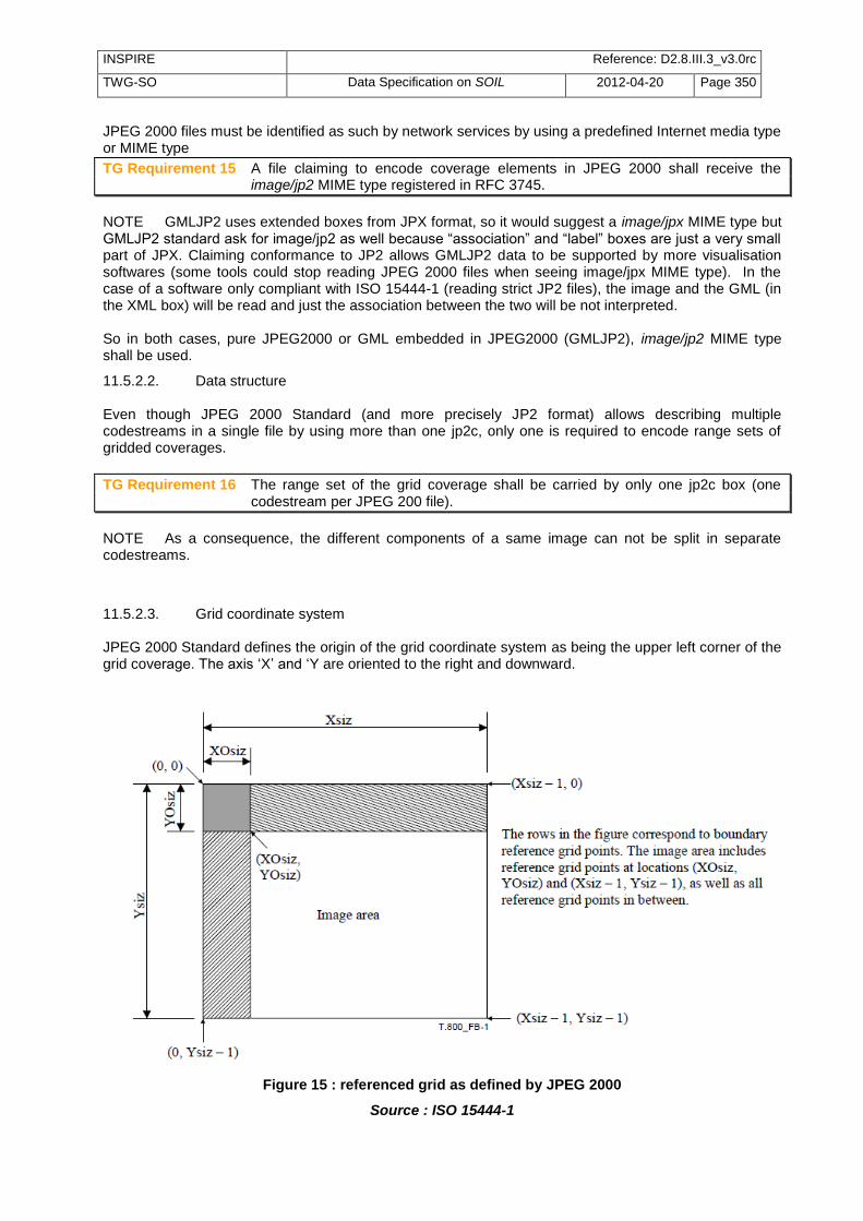
INSPIRE Reference: D2.8.III.3_v3.0rc
TWG-SO Data Specification on SOIL 2012-04-20 Page 350
JPEG 2000 files must be identified as such by network services by using a predefined Internet media type or MIME type
TG Requirement 15 A file claiming to encode coverage elements in JPEG 2000 shall receive the image/jp2 MIME type registered in RFC 3745.
NOTE GMLJP2 uses extended boxes from JPX format, so it would suggest a image/jpx MIME type but GMLJP2 standard ask for image/jp2 as well because “association” and “label” boxes are just a very small part of JPX. Claiming conformance to JP2 allows GMLJP2 data to be supported by more visualisation softwares (some tools could stop reading JPEG 2000 files when seeing image/jpx MIME type). In the case of a software only compliant with ISO 15444-1 (reading strict JP2 files), the image and the GML (in the XML box) will be read and just the association between the two will be not interpreted. So in both cases, pure JPEG2000 or GML embedded in JPEG2000 (GMLJP2), image/jp2 MIME type shall be used.
11.5.2.2. Data structure Even though JPEG 2000 Standard (and more precisely JP2 format) allows describing multiple codestreams in a single file by using more than one jp2c, only one is required to encode range sets of gridded coverages.
TG Requirement 16 The range set of the grid coverage shall be carried by only one jp2c box (one codestream per JPEG 200 file).
NOTE As a consequence, the different components of a same image can not be split in separate codestreams.
11.5.2.3. Grid coordinate system JPEG 2000 Standard defines the origin of the grid coordinate system as being the upper left corner of the grid coverage. The axis ‘X’ and ‘Y are oriented to the right and downward.
Figure 15 : referenced grid as defined by JPEG 2000
Source : ISO 15444-1

INSPIRE Reference: D2.8.III.3_v3.0rc
TWG-SO Data Specification on SOIL 2012-04-20 Page 351
11.5.2.4. Range values ISO 15444-1 allows a lot of image types with multiband composition. Within the scope of INSPIRE, following types are addressed: bilevel, grayscale, palette-color and full-color images (known as RGB images).
Recommendation 2 The image data of a JPEG 2000 file should contain either 1 (bilevel, greyscale and palette-colour) or 3 bands (RGB). An additional band for opacity could also be used.
The use of palette-colour in JPEG 2000 is restricted to a mapping to one component to RGB data.
Open issue 14: Is the use of palette-colour needed. It allows to compress RGB data on 1 band and provide a mapping table.
These components are described trough markers in the JPEG 2000 codestream (see Table 6) and boxes in the JP2 format (see Table 7).
TG Requirement 17 For imagery, the range values shall be expressed as unsigned integers coded on 8 or 16 bits, except for bi-level images which are 1-bit data. For other gridded data (e.g. elevation data, measured data), they shall be stored as 8 or 16-bits integers, signed or unsigned, or as 32-bits.
JPEG2000 (ISO 15444-1) does not allow to encode data as floats (only integers), but in general you can choose a Unit of measure for which your results are integers. For elevation, use centimeters (cm) instead of meters (m). NOTE If the original data do not satisfy this requirement, they will be converted in a representation using the next higher power of 2.
TG Requirement 18 In the case of multi-band images, the number of bits per component shall be the same for all the bands.
11.5.2.5. Opacity channel JP2 format allows to describe opacity channel (trough Channel Definition Box or CDEF) and then to display multiple files without overlapping issues. Opacity channel can be defined for RGB or greyscales images. The following table give example of an RGB image with alpha channel. CDF defines the 3 RGB components and then the alpha channel which applies to the all 3 RGB ones. Table 5. Definition of opacity channel with CDEF box
CDEF box
Hexadecimal Numeric conversion (2 bits) interprétation
00 04 00 00 00 00 00 01 | 00 01 00 00 00 02 00 02 | 00 00 00 03 00 03 00 01 | 00 00
4 4 components
0 0 1 component 0 is red R 1 0 2 component 1 is green G 2 0 3 component 2 is blue B 3 1 0 component 3 is an opacity
channel related to all other component
Component number
signification Color of the component

INSPIRE Reference: D2.8.III.3_v3.0rc
TWG-SO Data Specification on SOIL 2012-04-20 Page 352
NOTE In this case, bit depth shall be defined for each of the four components trough the bpcc boxes in the JP2 Header Box. JPEG 2000 allows defining opacity channel on more than 1 bit to have a scale of transparency. In pur case, we’re just interested in full transparency and full opacity. So, within the scope of INSPIRE, it is recommended to code it on only 1 bit (0= transparent , 1=opaque)
Recommendation 3 In the case of an opacity channel, the bit depth should be 1-bit.
11.5.2.6. Compression JPEG 2000 codestream allows both lossless and lossy compression. Lossless compression is important for some themes because you can’t allow any loss of information. For example in Land Cover, or Land Use, you encode a code which represents a class. For other themes, a lossy compression without visual effect can be also interesting. JPEG 2000 lossy compression is very powerful with which you can compress imagery data by 1:10 or more without visual effect.
Open issue 15: Some TWGs may use lossy compression. If there is a need for requirement/recommendation, you can add it in the theme specific section
11.5.2.7. Internal tiling JPEG 2000 allows internal tiling within the codestream. Profile 1 of ISO 15444-1 already requires no tiling (i.e. the image = 1 tile) or tiles size bigger than1024x1024 pixels. There is no further requirement.
Open issue 16: That means there is either 1 tile or more tiles bigger that 1024x1024? Maybe a clarification is needed.
11.5.2.8. Resolutions JPEG 2000 codestream encode the full resolution image but has mechanisms to directly access (without any computation) particular sub-resolutions. So the JPEG 2000 file contains a pyramid of resolution. The number of decomposition Nd defines the smallest image you can access whose size is reduced by 2
Nd
(compared to the full image). Profile 1 of ISO 15444-1 requires that the number of decomposition shall be such as: Height/2
Nd ≤128 pixels and Width/2
Nd ≤128 pixels (height and width of the full resolution image).
For example for a 2048x1024 image, the number of decomposition is 4, and the smallest thumbnail image is 128x64 pixels. There is no further requirement.
11.5.2.9. Region of interest When encoding in a lossy mode, JPEG 2000 allows to encode some image regions with better quality and then deteriorate the quality of other areas. This capability shall not be used.
TG Requirement 19 JPEG 2000 codestream shall not encode Region Of Interest (RGN marker segment).
11.5.2.10. Other options JPEG 2000 allows more options:
- Quality layers, i.e. the capability to different levels of compressions within the same JPEG 200 file. - Presence of markers, some allowing fast data access (TLM, PLT), other allowing error resiliency, .. - Presence of precints and their size.

INSPIRE Reference: D2.8.III.3_v3.0rc
TWG-SO Data Specification on SOIL 2012-04-20 Page 353
- Encoding order ; the codestream can be arranged in different ways depending the order you want the data to be decompressed.
- Color transformation, from RGB to three other decorrelated components (ICT or RCT transformations).
These choices depend on data size, data access (trough network services, via FTP, via USB stick, …) and then can’t be made here.
E.3.3 Mapping between JPEG 2000 and GML data structures
The following table indicates how to fill the content of TIFF tags for grid coverages in the context of INSPIRE. On the other hand, it gives the rules to be applied for ensuring the consistency of JPEG 2000 files with the SOIL GML Application(s) Schema(s). It does not address the encoding of the possible transparency mask. As described by the Format overview section, the JP2 format contains the JPEG 2000 codestream. Both have elements that need to be consistent with GML. The first table deals with mappings between the JPEG 2000 codestream and GML, whereas the second table deals with mappings between JP2 boxes and GML elements. The columns marker/box, description, Type, Card. and Conditions/Values remind respectively the marker code/box name, its description, its obligation/maximum number of occurrences allowed by JPEG 2000 standard (ISO 15444-1). The column values specifies the values allowed for the marker in the context of INSPIRE. The column Mapping to GML elements establishes a correspondence between these makers values and the corresponding GML elements of the coverage whose type is one of those specified in the Generic Conceptual Model (e.g. RectifiedGridCoverage). N/A means not applicable.

INSPIRE Reference: D2.8.III.3_v3.0rc
TWG-SO Data Specification on SOIL 2012-04-20 Page 354
Table 6. mapping between markers in JPEG 2000 codestream and GML elements
Marker Description Card. Values Mapping GML
SIZ Marker code (Image and tile size) 1 N/A
Lsiz Length of marker segment 1 N/A
Rsiz Denotes capabilities that a decoder needs to properly decode the codestream
1 0000 0000 0000 0010 Codestream restricted as described for Profile 0 from Table A.45
N/A
Xsiz Width of the reference grid 1 = domainSet.RectifiedGrid.limits.GridEnvelope.high[0]
Ysiz Height of the reference grid 1 = domainSet.RectifiedGrid.limits.GridEnvelope.high[1]
X0siz Horizontal offset from the origin of the reference grid to the left side of the image area
1 = domainSet.RectifiedGrid.limits.GridEnvelope.low[0]
YOsiz Vertical offset from the origin of the reference grid to the top side of the image area.
1 = domainSet.RectifiedGrid.limits.GridEnvelope.low[1]
XTsiz Width of one reference tile with respect to the reference grid.
1 N/A
YTsiz Height of one reference tile with respect to the reference grid
1 N/A
XTOsiz Horizontal offset from the origin of the reference grid to the left side of the first tile
1 N/A
YTOsiz Vertical offset from the origin of the reference grid to the top side of the first tile
1 N/A
Csiz Number of components in the image 1 1 for greyscale imagery 3 for RGB data …
rangeType.field.size()
Ssizi Precision (depth) in bits and sign of the
ith component samples 1/component x000 0000 to x010 101 Component sample bit
depth = value + 1. x=0 (unsigned values) x=1 (signed values)
For each band i, rangeType.field[i].constraint.interval = “0 2^[Ssiz
i+1]-1”
XRsizi Horizontal separation of a sample of ith
component with respect to the reference grid
1/component In most case XRsizi =1 for all components N/A
YRsizi Vertical separation of a sample of ith
component with respect to the 1/component In most case YRsiz
i =1 for all components N/A

INSPIRE Reference: D2.8.III.3_v3.0rc
TWG-SO Data Specification on SOIL 2012-04-20 Page 355
Marker Description Card. Values Mapping GML
reference grid
For each component i of the image, its size is defined by :
Widthi = (Xsiz – X0siz)/XRsiz
i
Heighti = (Ysiz – Y0siz)/YRsiz
i
Table 7. Mapping between boxes in JP2 format and GML elements
Box name Type Description Card. Conditions/Values Mapping GML
JPEG 2000 Signature box
'jP\040\040' The combination of the particular type and contents for this box enable an application to detect a common set of file transmission errors.
1 '<CR><LF><0x87><LF>' N/A
File Type box 'ftyp' 1 N/A
BR Brand. This field specifies the Recommendation | International Standard which completely defines this file.
'jp2\040' meaning is 15444-1, Annex
I
N/A
MinV Minor version. This parameter defines the minor version number of this JP2 specification for which the file complies.
1 N/A
CL Compatibility list. This field specifies a code representing this Recommendation | International Standard, another standard, or a profile of another standard, to which the file conforms.
1..* At least 'jp2\040' N/A
JP2 Header box 'jp2h' 1 N/A
ihdr 'ihdr' Image Header box 1 N/A
HEIGHT Image area height 1 Ysiz – Y0siz domainSet.RectifiedGrid.limits.GridEnvelope.high[1]- domainSet.RectifiedGrid.limits.GridEnvelope.low[1]
WIDTH Image area width 1 Xsiz – X0siz domainSet.RectifiedGrid.limits.GridEnvelope.high[0]- domainSet.RectifiedGrid.limits.GridEnvelope.low[0]

INSPIRE Reference: D2.8.III.3_v3.0rc
TWG-SO Data Specification on SOIL 2012-04-20 Page 356
NC Number of components 1 = Csiz = rangeType.field.size() if no use of palette-colour data. If use of a colour palette NC=1, rangeType.field.size()=3.
BPC Bits per component 1 If the bit depth of all components in the
codesteam is the same (sign an precision)
= Ssizi
For each band i, rangeType.field[i].constraint.interval = “0 2^[Ssiz
i+1]-1” if no use of palette-colour
data. If use of a palette colour, there is no relation.
C Compression type 7 (Other values are reserved for
ISO use)
N/A
UnkC Colourspace Unknown. 1 0 (colourspace of the image is known and correctly specified in the Colourspace Specification boxes within the file) 1 (if the colourspace of the image is not known)
N/A
IPR Intellectual Property 1 N/A
bpci 'bpcc' Bits per component Optional
Required if component
have different bit
depth
x000 0000 to x010 101 Component sample bit depth = value + 1. x=0 (unsigned values) x=1 (signed values)
For each band i, rangeType.field[i].constraint.interval = “0 2^[Ssiz
i+1]-1”
colri 'colr' Each Colour Specification box defines one
method by which an application can interpret the colourspace of the decompressed image data
1 N/A
METH Specification method 1 1 (Enumerated Colourspace) 2 (Restricted ICC profile) other values (Reserved for other ISO use)
N/A
PREC Precedence 1 0 (field reserved for ISO use)

INSPIRE Reference: D2.8.III.3_v3.0rc
TWG-SO Data Specification on SOIL 2012-04-20 Page 357
APPROX Colourspace approximation. 1 0 N/A
EnumCS Enumerated colourspace 1 16 (sRGB as defined by IEC 61966-2-1) 17 (greyscale) 18 (sYCC as defined by IEC 61966-2-1 Amd. 1) other values (Reserved for other ISO uses)
N/A
pclr 'pclr' Palette box. This box specifies a palette that can be used to create channels from components.
0..1 N/A
cmap 'cmap' Component Mapping box. The Component Mapping box defines how image channels are identified from the actual components decoded from the codestream.
0..1 N/A
cdef 'cdef' Channel Definition box Optional The description provided shall be consistent with the rangeType description
N Number of channel descriptions 1 = rangeType.field.size()
Cni Channel index 1/channel N/A
Typi Channel type 1/channel 0 This channel is the colour image data for the associated colour. 1 (Opacity) 2 (Premultiplied opacity)
N/A
Asoci Channel association 1/channel 0 (This channel is associated as the image as a whole) 1 to (216– 2) This channel is associated with a particular colour as indicated by this value) 216– 1 This channel is not associated with any particular colour.
N/A
res 'resd' Optional N/A
resc Capture Resolution box. Optional N/A
resd Default Display Resolution box. Optional N/A
Contiguou Codestream box
‘jp2c’ This box contains the codestream as defined by Annex A of ISO 15444-1.
1
Contains the encoded data in JPEG 2000.

INSPIRE Reference: D2.8.III.3_v3.0rc
TWG-SO Data Specification on SOIL 2012-04-20 Page 358
Intellectual property box ‘jp2i’ This box contains intellectual property information about the image.
Optional N/A
XML Box ‘xml\040’ Box for XML formatted information to a JP2 file.
Optional The place to provide GML within JPEG 2000 (see OGC standard for more details).
UUID box ‘uuid’ Box for additional information to a file without risking conflict with other vendors
Optional The place to provide GeoJP2 georeference. Shall be consistent with georeference given by : The origine of the grid : domainSet.RectifiedGrid.origin domainSet.RectifiedGrid.offsetVector
UUID info box ‘uinf' Box for providing access to additional information associated with a UUID.
Optional N/A
UUID list box ‘ulst’ This box specifies a list of UUIDs. Optional N/A
URL box ‘url\040’ This box specifies a URL. Optional N/A

INSPIRE Reference: D2.8.III.3_v3.0rc
TWG-SO Data Specification on SOIL 2012-04-20 Page 359
E.3.4 Theme-specific requirements and recommendations
Add further requirements or recommendations here if necessary. Otherwise, include the following sentence: No further requirements or recommendations are defined for this theme. Example for Land Cover data : For SOIL data, as range values represent classification codes, compression shall be lossless.
TG Requirement 20 JPEG 2000 codestream shall be compressed in a lossless mode.
For Land Cover, only a grid code is stored within the JPEG 2000 stream on one component.
TG Requirement 21 JPEG 2000 codestream shall contain only one component with a bit depth of 8-bits and a greyscale colour space.