Emigration Policies- Assessment of Human Resources Outflow: The case Of Senegal
Upload
independentCategory
view
0download
0
Infiltration of Martian outflow channel floodwatersinto lowland cavernous systems
J. Alexis P. Rodriguez,1 Mary Bourke,1,2 Kenneth L. Tanaka,3 Hideaki Miyamoto,4
Jeffrey Kargel,5 Victor Baker,5 Alberto G. Fairén,6 Richard J. Davies,7 Lynne Bridget,8
Rogelio Linares Santiago,9 Mario Zarroca Hernández,9 and Daniel C. Berman1
Received 24 July 2012; revised 9 October 2012; accepted 10 October 2012; published 30 November 2012.
[1] The hydrosphere of Mars has remained mostly con-cealed within the subsurface for the past�3.5 Gyr. Localizedrupturing of the permafrost-capped crust led to voluminousgroundwater discharges that carved some of the largestknown channels in the solar system. However, our knowl-edge of the nature of the flows and their ultimate fate remainsincomplete, partly because diagnostic landforms at outflowchannel termini have been largely destroyed or buried. TheHebrus Valles outflow channels were excavated by fluid dis-charges that emanated from two point sources, and theymostly terminate in systems of fractures and depressionswithin the northern plains. Our investigation indicates thatoutflow channel floodwaters were captured and reabsorbedinto the subsurface in zones where caverns developed withinthe northern plains. These findings imply that the studyregion comprises the only known location in the Martiannorthern lowlands where the fate of outflow channel dis-charges can be assessed with confidence. We propose thatevacuation of subsurface materials via mud volcanism wasan important process in cavern formation. Our conceptualmodel provides a hypothesis to account for the fate of sedi-ments and fluids from some of the Martian outflow channels.It also reveals a mechanism for lowland cavern formation andupper crustal volatile enrichment after the development of theMartian global cryosphere. Citation: Rodriguez, J. A. P., et al.(2012), Infiltration of Martian outflow channel floodwaters intolowland cavernous systems, Geophys. Res. Lett., 39, L22201,doi:10.1029/2012GL053225.
1. Introduction
[2] The Martian outflow channels were excavated by thelargest estimated flood volumes in our solar system [Carr,1979; Clifford and Parker, 2001; Tanaka et al., 2005]. Thesewaters were released from aquifers [Carr, 1979; Clifford andParker, 2001] and/or surface lakes [Irwin et al., 2004] andmay have resulted in the formation of transient oceans [Parkeret al., 1993; Fairén, 2003], lakes [Fairén, 2003], continental-scale ice sheets [Kargel et al., 1995], and regionally extensivedebris flow deposits [Tanaka et al., 2001]. The study region(Figure 1a and 1b), centered at 19�N., 125�E., includes theHebrus Valles (HV) and Hephaestus Fossae (HF). It occursalong the SE margin of the 2000-km diameter Utopia impactbasin on the lower flank of the Elysium volcanic rise, and it isalso positioned along the global topographic dichotomy sepa-rating ancient southern cratered highland terrains and theVastitas Borealis Formation (VBF), which consists of rela-tively younger sedimentary deposits forming the floors of thenorthern lowland basins [Tanaka et al., 2005].
2. Data Sources and Methods
[3] This geologic investigation has been performed usingEnvironmental Systems Research Institute’s (ESRI) ArcGISsoftware. Geologic feature mapping (Figure 1b and 1c) andcharacterization (Figure 2a–2h) were carried out using MarsReconnaissance Orbiter (MRO) Context Camera (CTX, 5.15 to5.91 m/pixel), and Mars Odyssey Thermal Emission ImagingSystem (THEMIS) visible wavelength multiband (VIS, 17 to40 m/pixel/day IR, 100 m/pixel) images. Topographic infor-mation and volumetric estimations have been derived utilizingMars Global Surveyor (MGS) Mars Orbiter Laser Altimeter(MOLA) digital elevation models (DEMs) at �460 m/pixelhorizontal and 1 m vertical resolutions.
3. Results
[4] Cone features interpreted to be mud volcanoes formextensive fields within the northern plains of Mars [Oehlerand Allen, 2010, 2012], which include the southern Utopiaboundary plains, where the study region is located [Skinnerand Tanaka, 2007] (auxiliary material, Text S1).1 At somelocations within the study region, features interpreted as mudvolcanoes cluster into linear ridges (black arrow inFigure 2f ). These ridge patterns align with networks ofindividual pits, pit chains and troughs, all of which showvariable degrees of integration (Figure 1c, white arrow in
1Planetary Science Institute, Tucson, Arizona, USA.2Department of Geography, Trinity College, Dublin, Ireland.3Astrogeology Science Center, U.S. Geological Survey, Flagstaff,
Arizona, USA.4University Museum, University of Tokyo, Japan.5Department of Hydrology and Water Resources, University of
Arizona, Tucson, Arizona, USA.6Space Science and Astrobiology Division, NASA Ames Research
Center, Moffett Field, California, USA.7Centre for Research into Earth Energy Systems, Department of Earth
Sciences, University of Durham, Durham, UK.8Institute of Earth Science and Engineering, University of Auckland,
Auckland, New Zealand.9Unitat de Geodinàmica Externa i d’Hidrogeologia, Departament de
Geologia, Universitat Autònoma de Barcelona, Barcelona, Spain.
Corresponding author: J. A. P. Rodriguez, Planetary Science Institute,1700 E. Fort Lowell Rd., Ste. 106, Tucson, AZ 85719-2395, USA.([email protected])
©2012. American Geophysical Union. All Rights Reserved.0094-8276/12/2012GL053225
1Auxiliary materials are available in the HTML. doi:10.1029/2012GL053225.
GEOPHYSICAL RESEARCH LETTERS, VOL. 39, L22201, doi:10.1029/2012GL053225, 2012
L22201 1 of 6
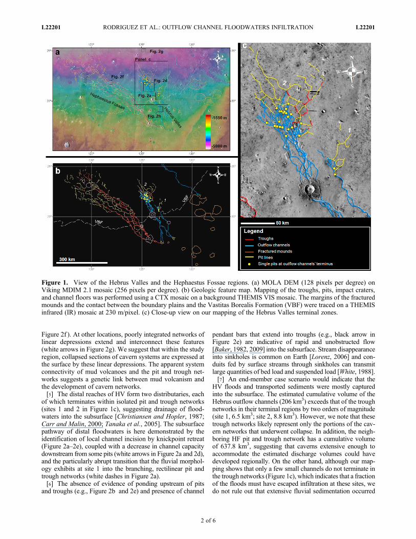
Figure 2f ). At other locations, poorly integrated networks oflinear depressions extend and interconnect these features(white arrows in Figure 2g). We suggest that within the studyregion, collapsed sections of cavern systems are expressed atthe surface by these linear depressions. The apparent systemconnectivity of mud volcanoes and the pit and trough net-works suggests a genetic link between mud volcanism andthe development of cavern networks.[5] The distal reaches of HV form two distributaries, each
of which terminates within isolated pit and trough networks(sites 1 and 2 in Figure 1c), suggesting drainage of flood-waters into the subsurface [Christiansen and Hopler, 1987;Carr and Malin, 2000; Tanaka et al., 2005]. The subsurfacepathway of distal floodwaters is here demonstrated by theidentification of local channel incision by knickpoint retreat(Figure 2a–2e), coupled with a decrease in channel capacitydownstream from some pits (white arrows in Figure 2a and 2d),and the particularly abrupt transition that the fluvial morphol-ogy exhibits at site 1 into the branching, rectilinear pit andtrough networks (white dashes in Figure 2a).[6] The absence of evidence of ponding upstream of pits
and troughs (e.g., Figure 2b and 2e) and presence of channel
pendant bars that extend into troughs (e.g., black arrow inFigure 2e) are indicative of rapid and unobstructed flow[Baker, 1982, 2009] into the subsurface. Stream disappearanceinto sinkholes is common on Earth [Lorenz, 2006] and con-duits fed by surface streams through sinkholes can transmitlarge quantities of bed load and suspended load [White, 1988].[7] An end-member case scenario would indicate that the
HV floods and transported sediments were mostly capturedinto the subsurface. The estimated cumulative volume of theHebrus outflow channels (206 km3) exceeds that of the troughnetworks in their terminal regions by two orders of magnitude(site 1, 6.5 km3; site 2, 8.8 km3). However, we note that thesetrough networks likely represent only the portions of the cav-ern networks that underwent collapse. In addition, the neigh-boring HF pit and trough network has a cumulative volumeof 637.8 km3, suggesting that caverns extensive enough toaccommodate the estimated discharge volumes could havedeveloped regionally. On the other hand, although our map-ping shows that only a few small channels do not terminate inthe trough networks (Figure 1c), which indicates that a fractionof the floods must have escaped infiltration at these sites, wedo not rule out that extensive fluvial sedimentation occurred
Figure 1. View of the Hebrus Valles and the Hephaestus Fossae regions. (a) MOLA DEM (128 pixels per degree) onViking MDIM 2.1 mosaic (256 pixels per degree). (b) Geologic feature map. Mapping of the troughs, pits, impact craters,and channel floors was performed using a CTX mosaic on a background THEMIS VIS mosaic. The margins of the fracturedmounds and the contact between the boundary plains and the Vastitas Borealis Formation (VBF) were traced on a THEMISinfrared (IR) mosaic at 230 m/pixel. (c) Close-up view on our mapping of the Hebrus Valles terminal zones.
RODRIGUEZ ET AL.: OUTFLOW CHANNEL FLOODWATERS INFILTRATION L22201L22201
2 of 6

but the deposits are no longer recognizable because they wereweathered and removed.
4. Discussion
4.1. Cavern Formation Associated With NorthernPlains Mud Volcanism
[8] Carr and Malin [2000] suggested that the HF systemmay indicate a subsurface karst landscape formed by thedissolution of buried carbonate deposits. However, the onlycarbonate deposits that have so far been identified within thenorthern plains were exhumed from depths of �6 km duringan impact crater forming event [e.g., Michalski and Niles,2010]. At site 1 a channel extends to the floor of a �300 mdeep trough from a zone of knickpoint retreat occurring atdepths of just 10s of meters of outflow channel dissection(respectively, elevation profiles A-A′ and B-B′ in Figure 2c).These observations are indicative of caverns having existed atshallow depths within the study region. In the absence of theidentification of shallowly buried carbonate deposits, weoffer an alternative mechanism for the formation of thepseudo-karst landscape. Our model invokes the role of mudvolcanism in the formation of subsurface caverns.[9] High hydraulic pressures are thought to have led to
mud volcanism along the SE margins of the Utopia basin[Tanaka et al., 2003; Skinner and Tanaka, 2007], as well aswithin other regions of the northern plains [Oehler and Allen,
2010, 2012]. The high occurrence of mud volcanoes alongboundary plains (Figure 3a) is consistent with the hydraulichead being driven by the relief aquifers extending across thehighland-lowland boundary [Rodríguez et al., 2010].[10] Possible sites of Late Hesperian/Early Amazonian
groundwater discharge, perhaps emanating from a groundwaterzone that extended into more elevated terrains in the southerncratered highlands [Clifford and Parker, 2001], have beenidentified on the flanks of the Elysium rise [Tanaka et al., 2005;Skinner and Tanaka, 2007]. These sites are located at eleva-tions ranging between approximately 3500 and 5000 m abovethe study region. Thus, provided that a regional groundwaterzone existed at the time (1 in Figure 3b), this relief may haveprovided a hydraulic head (h (relief in meters) x g (for Mars3.711 m/s2) � r (water density, �1 g/cm3)) between �13–18.5 MPa, values which are comparable to those postulatedto have produced superlithostatic pressures and driven large-scale hydrologic resurfacing in southern circum-Chryse[Andrews-Hanna and Phillips, 2007]. An alternative geo-logic scenario is that instead of a regional groundwater zoneleading to superlithostatic pressures, pressurized groundwa-ter systems resulted from intrusive magmatism into thecryosphere, including dikes (5 in Figure 3b), which duringEarly Amazonian Elysium volcanism [Tanaka et al., 2005]extended �350 km [Rice et al., 2002; Scott et al., 2002;Russell and Head, 2003] from the Elysium rise to thesoutheast. Craft and Lowell [2012] show that pressurized
Figure 2. Close-up views of study region; context and locations shown in Figure 1. All scale bars correspond to 5 km.(a) Site 1. THEMIS VIS images V11629004 and V12852005 centered at 126�47′ E., 20�35′ N. (b) Zone of knickpoint (blackarrow) retreat shown in panel a. CTX image P13_006196_1998 centered at 126�43′ E., 20�33′ N. (c) Elevation profileslocated in panel b. (d) Site 2. Composite of THEMIS VIS images V02617006, V12877003 and V01868003 centered at125 �36′ E., 21�34′ N. (e) Zone of knickpoint retreat (black arrow) shown in panel d. CTX image P17_007765_2015 cen-tered at 125�40′ E., 21�44′ N. (f ) Part of Hephaestus Fossae. CTX image B18_016560_2033 centered at 122�70′ E.,22�00′ N. (g) Zone north of site 2 where systems of linear depressions interconnect clusters of features interpreted asmud volcanoes. Part of CTX image B18_016705_2048 centered at 125�18′ E., 25�00′ N. (h) Zone where Hebrus Vallesdissects a plain modified by mud volcanism. Part of CTX image P02_001805_1996 centered at 126�47′E., 19�28′ N.
RODRIGUEZ ET AL.: OUTFLOW CHANNEL FLOODWATERS INFILTRATION L22201L22201
3 of 6

aquifers could have resulted from the melting and vaporiza-tion of regional permafrost deposits by intrusive dikes. Theypropose that these aquifers could have produced some cata-strophic outflow channel discharges.[11] Our model proposes that excess pressure within an
aquifer(s) produced hydrofractures that penetrate an overlyingcryosphere (1 in Figure 3c). Fluid circulation along the frac-tures led to the development of feeder conduits through whichfluid-sediment mixtures erupted to construct mud volcanoes.This mechanism is supported by observations on Earth [Brown,1990;Davies and Stewart, 2005; Stewart and Davies, 2006] (2in Figure 3c). In their models, subsurface flow through exten-sive and complex networks of feeder conduits convergingunderneath eruption sites [Morley, 2003; Davies and Stewart,
2005] may have resulted in thermo-karstic and pseudo-karstic(by suffusion) erosion along feeder conduits, which led tocavern development and enlargement [Deville et al., 2003;Davies et al., 2007; Davies, 2008] (3 in Figure 3c).[12] We note, however, that other than the mud volcanic
cones, no large volumes of surficial deposits have beenidentified, which could be indicative of the volume of evac-uated subsurface geologic materials significantly exceedingthe volumes of the overlying mud volcanoes, perhaps by asmuch as a few orders of magnitude [Valentine et al., 2010].For example, it is possible that the VBF consisted of pri-marily ice-rich permafrost, and thus relatively low volumesof lithics were ejected during mud volcanism [Mouginotet al., 2012]. Alternatively, a significant portion of the
Figure 3. (a) MOLA shaded-relief view of the northern plains of Mars showing the highland/lowland boundary margin(orange hachured line; dotted or queried where dissected or obscured). The Vastitas Borealis and Isidis Planitia units aregreen and the Utopia lahars are pink, based on geologic mapping of the northern plains [Tanaka et al., 2005]. Point symbolsdesignate the locations of landforms mainly identified in THEMIS VIS images and MOLA altimetry data that possiblyresulted from ground-volatile activity, in the following interpretive types: Mass flows (red circles), mud volcanoes (yellowtriangles), and various troughs and depressions formed by collapse and/or subsidence (white squares). Abbreviated geo-graphic names include Arcadia Planitia (Ar), Utopia Planitia (UP), Isidis Planitia (IP), Deuteronilus Mensae (DM), CydoniaMensae (CM), Acidalia Mensa (AcM), Acidalia Planitia (AcP), Chryse Planitia (CP), Tempe Terra (TT), Alba Mons (AM),Acheron Fossae (AF), Scandia region (Sc), and Planum Boreum (PB). (b) Schematic diagrams showing upper crustal cross-sectional views depicting the hydrogeologic conditions that led to the inferred history of resurfacing. Panels 1–4 and 5–8 show alternative regional geologic scenarios, respectively involving a three-zone (ice-rich cryosphere [Cr], hydrosphere[Hr] and basement [Bs]) and a two-zone (ice-rich cryosphere and basement) upper crustal structure. The cross-sectionsextend from Elysium rise to the floor of the Utopia basin. EC stands for Elysium Chasma, HV for Hebrus Valles, andVBF for Vastitas Borealis Formation. Surface topography slightly modified from MOLA for a better artistic reconstruction.1. Pressurization of a continuous groundwater zone produces fractures within the overlying cryosphere, which led to mudvolcanism along the southern margin of the Utopia basin. 2. The hydrosphere progressively drains (white dotted arrow)and the conduit feeder systems drain. 3. An igneous intrusion into the cryosphere produces large volumes of melt that arethen released at the surface to carve HV. 4. The floods are captured by the evacuated caverns. 5. Dikes intrude an ice-richcryosphere, which does not confine an underlying groundwater zone. The dikes produce hydrothermal systems, some ofwhich extend to the surface and expel fluids to produce mud volcanism. 6. As the hydrothermal systems cool and waterevaporates, the water table drops and evacuates the conduits. Groundwater within some isolated conduits that do not opento the surface freezes (white arrow). 7. A large intrusive magmatic body melts the cryosphere and produces catastrophicdischarges that carve HV. 8. The groundwater discharges infiltrate into the evacuated conduits. (c) Schematic diagramsshowing stages in proposed scenario for cavern development associated with Hebrus Valles and Hephaestus Fossae. 1.Hydrofractures within the regional cryosphere are produced by overpressure within an underlying hydrosphere. 2. Feederconduits form along fractures and converge at the eruption sites. 3. Caverns develop underneath the eruption sites andwhere feeder conduits form dense networks. 4. Fluid drains from the caverns.
RODRIGUEZ ET AL.: OUTFLOW CHANNEL FLOODWATERS INFILTRATION L22201L22201
4 of 6
deposits could have been subject to weathering and reworkingby small impact craters (Text S1), and aeolian mobilizationduring the 3.5 Gyr [Werner et al., 2011] since emplacement andare currently degraded beyond possible recognition in the useddatasets.[13] Fluid evacuation from the caverns could have resulted
from (1) lowering of the regional water table as aquifersdrained and/or hydrothermal systems cooled down (2 and 6 inFigure 3b), (2) eruptive phases of water expelling mud fol-lowed by evaporation, (3) eruptive phases of gases expellingmud, or (4) a combination of these processes. We note thatalternating eruptive phases of mud, water and gases separatedby periods of inactivity are known to occur in terrestrial mudvolcanism [Deville et al., 2010]. In addition, uneruptedwater-saturated sediment infilling portions of the feederconduits’ network would have eventually desiccated [e.g.,Grimm and Painter, 2009], thereby producing further sub-surface void space.
4.2. Geologic Conditions Promoting StructuralStability of Evacuated Caverns
[14] Mud volcanism originating from under-compactedmud-rich strata within terrestrial clastic basin settings is knownto lead to the formation of transient cavern systems, whichupon structural failure lead to zones of surface collapse andsubsidence [e.g., Brown, 1990; Davies and Stewart, 2005;Davies et al., 2007; Stewart and Davies, 2006; Roberts et al.,2011]. In contrast, the inferred magnitude of floodwaterinfiltration within the study region (4 and 8 in Figure 3b)points to the existence of structurally stable caverns that werelargely evacuated of fluids and sediments prior to HV outflowchannel activity (2, 3 and 6, 7 in Figure 3b; 4 in Figure 3c).[15] During the Early Amazonian, the Martian northern
plains are thought to have consisted of extensive permafrostdeposits [e.g., Clifford and Parker, 2001; Mouginot et al.,2012]. Mud volcanism occurring within permafrost is indi-cated by mud flows that extend from the eruptive cones intopolygonal fractures [Oehler and Allen, 2010]. At �60�C,a predicted typical mean annual surface temperature for theinvestigated latitudes [Mellon et al., 2004], permafrost couldhave had a mechanical strength close to that of limestone[Kuribayashi et al., 1985; Ladyani, 2003], which could haveallowed for the formation of structurally stable evacuatedcaverns. On Earth, caverns are known to occur in ice-weldedsediments such as in association with networks of ice wedgesin permafrost [Costard et al., 2012] and ice-welded morainedeposits [Moorman, 2005]. Some glacier caverns are knownto have remained stable over decades [Halliday, 2007].[16] The gravity of Mars is 0.38 times that of Earth, which
would have allowed for the development of 2.5 times deepercavern systems, particularly within theMartian northern plains,which appear to consist of low density (�1 g/cm3) deposits[Mouginot et al., 2012]. Conduit compartmentalization intonested systems of smaller pipes [Davies and Stewart, 2005]could have also promoted the caverns’ mechanical stability,particularly if these were chemically cemented (Text S2). Interms of cavern closure, terrestrial caverns occur to a maxi-mum depth of �2 km [Klimchouk et al., 2008], thus gravitydifferences alone could allow Martian caverns to resist clo-sure to �5 km depth, particularly if deep-seated carbonatesform extensive deposits within the northern lowland’s uppercrust [Michalski and Niles, 2010]. We note, however, thatlarge subglacial lakes existing at depths of �4 km under the
Antarctic Ice Sheet [Eyles, 2006], indicate that, on Earth,fluid-filled glacial caverns can exist at depths significantlygreater than 2 km. In addition, the maximum stable width ofa cavern increases with the inverse square root of gravita-tional acceleration [Haruyama, 2009]. Consequently, onMars caverns within geologic materials that have similarmechanical strength could have �60% wider roofs than onEarth. If maximum cavern dimensions all scale similarly,Martian caverns could be more voluminous than Earth’s,perhaps four times (1.63) greater.
4.3. Geologic Conditions Leading to Outflow ChannelDischarges Following the Cessation of Mud Volcanism
[17] The absence of mud volcanoes along the floor of HV(Figure 2h) indicates that regional mud volcanism ceased priorto outflow channel activity. Mud volcanism could have ceasedas aquifers depleted (2 in Figure 3b), and/or hydrothermalsystems cooled (6 in Figure 3b), which would have led to areduction of hydraulic pressure within the regional aquifer(s)and a lowering of the water table. The formation of HV duringthe Early Amazonian [Tanaka et al., 2005] is indicative of asecond stage of aquifer development and pressurization, whichcould have been produced by the localized subsurface meltingof an ice-rich cryosphere during intrusive magmatism [Riceet al., 2002] (3 and 7 in Figure 3b). The absence of evidenceindicative of a second stage of mud volcanism following out-flow channel formation suggests that aquifer development didnot result in regional groundwater dispersion, but instead theaquifers were drained during catastrophic discharge.
[18] Acknowledgments. The Editor thanks the two anonymousreviewers for their assistance in evaluating this paper.
ReferencesAndrews-Hanna, J. C., and R. J. Phillips (2007), Hydrological modeling of
outflow channels and chaos regions on Mars, J. Geophys. Res., 112,E08001, doi:10.1029/2006JE002881.
Baker, V. R. (1982), The Channels of Mars, 204 pp., Univ. of Texas atAustin, Austin.
Baker, V. R. (2009), Channeled Scabland Morphology, inMegaflooding onEarth and Mars, edited by D. M. Burr, P. A. Carling, and V. R. Baker,pp. 65–77, Cambridge Univ. Press, Cambridge, U. K., doi:10.1017/CBO9780511635632.005.
Brown, K. M. (1990), The nature and hydrogeologic significance of muddiapirs and diatremes for accretionary systems, J. Geophys. Res., 95,8969–8982, doi:10.1029/JB095iB06p08969.
Carr, M. H. (1979), Formation of Martian flood features by release of waterfrom confined aquifers, J. Geophys. Res., 84, 2995–3007, doi:10.1029/JB084iB06p02995.
Carr, M. H., and M. C. Malin (2000), Meter-scale characteristics of Martianchannels and valleys, Icarus, 146(2), 366–386, doi:10.1006/icar.2000.6428.
Christiansen, E. H., and J. A. Hopler (1987), Geomorphic evidence for sub-surface volatile reservoirs in the Elysium region of Mars, in MartianGeomorphology and Its Relation to Subsurface Volatiles, LPI Tech.Rep. 87-02, edited by S.M. Clifford, L. A. Rossbacher, and J. R. Zimbelman,p. 14, Lunar and Planet. Inst., Houston, Tex.
Clifford, S. M., and T. J. Parker (2001), The evolution of the Martian hydro-sphere: Implications for the fate of a primordial ocean and the currentstate of the northern plains, Icarus, 154(1), 40–79, doi:10.1006/icar.2001.6671.
Costard, F., and A. Séjourné, J. Kargel, and R. Soare (2012), Shallow melt-ing and underground drainage in Utopia Planitia, Mars, Proc. LunarPlanet. Sci. Conf., 43rd, Abstract 1822.
Craft, K. L., and R. P. Lowell (2012), Boundary layer models of hydrother-mal circulation on Mars and its relationship to geomorphic features,J. Geophys. Res., 117, E05006, doi:10.1029/2012JE004049.
Davies, R. J. (2008), The East Java mud volcano (2006 to present): Anearthquake or drilling trigger?, Earth Planet. Sci. Lett., 272, 627–638,doi:10.1016/j.epsl.2008.05.029.
RODRIGUEZ ET AL.: OUTFLOW CHANNEL FLOODWATERS INFILTRATION L22201L22201
5 of 6

Davies, R. J., and S. A. Stewart (2005), Emplacement of giant mud volca-noes in the South Caspian Basin: 3D seismic reflection imaging of theirroot zones, J. Geol. Soc., 162, 1–4, doi:10.1144/0016-764904-082.
Davies, R. J., et al. (2007), Birth of a mud volcano: East Java, 29 May 2006,GSA Today, 17, 4–9.
Deville, E., et al. (2003), The origin and processes of mud volcanism: Newinsights from Trinidad, Geol. Soc. Spec. Publ., 216, 475–490,doi:10.1144/GSL.SP.2003.216.01.31.
Deville, E., et al. (2010), Fluid dynamics and subsurface sediment mobiliza-tion processes: an overview from southeast Caribbean, Basin Res., 22,361–379, doi:10.1111/j.1365-2117.2010.00474.x.
Eyles, N. (2006), The role of meltwater in glacial processes, Sediment.Geol., 190(1–4), 257–268, doi:10.1016/j.sedgeo.2006.05.018.
Fairén, A. G. (2003), Episodic flood inundations of the northern plains ofMars, Icarus, 165, 53–67, doi:10.1016/S0019-1035(03)00144-1.
Grimm, R. E., and S. L. Painter (2009), On the secular evolution of groundwa-ter onMars,Geophys. Res. Lett., 36, L24803, doi:10.1029/2009GL041018.
Halliday, W. R. (2007), Pseudokarst in the 21st century, J. Cave KarstStud., 69(1), 103–113.
Haruyama, J. (2009), Possible lunar lava tube skylight observed bySELENE cameras, Geophys. Res. Lett., 36, L21206, doi:10.1029/2009GL040635.
Irwin, R. P., A. D. Howard, and T. A. Maxwell (2004), Geomorphology ofMa’adim Vallis, Mars, and associated paleolake basins, J. Geophys. Res.,109, E12009, doi:10.1029/2004JE002287.
Kargel, J. S., V. R. Baker, J. E. Begét, J. F. Lockwood, T. L. Péwé, J. S.Shaw, and R. G. Strom (1995), Evidence of continental glaciation inthe Martian northern plains, J. Geophys. Res., 100, 5351–5368,doi:10.1029/94JE02447.
Klimchouk, A. B., G. V. Samokhin, and Y. M. Kasjan (2008), The deepestcave in the world Krubera and its hydrogeological and paleogeographicsignificance, Speleol. Karstol., 1, 100–104.
Kuribayashi, E., M. Kawamura, and Y. Yui (1985), Stress-strain character-istics of an artificially frozen sand in uniaxial compressive tests, GroundFreezing: Proceedings of the 4th International Symposium on GroundFreezing, 2, pp. 177–182, Balkema, Rotterdam, Netherlands.
Ladyani, B. (2003), Rheology of ice/rock systems and interfaces, in Perma-frost, edited by M. Phillips, S. M. Springman, and L. U. Arenson,pp. 621–626, Swets and Zeitlinger, Lisse, Netherlands.
Lorenz, J. C. (2006), Assessment of the geological evidence for karst in theRustler formation at the Wipp site, in Caves and Karst of SoutheasternNew Mexico, pp. 243–252, N. M. Geol. Soc., Socorro.
Mellon, J. T., W. C. Feldman, and T. H. Prettyman (2004), The presenceand stability of ground ice in the southern hemisphere of Mars, Icarus,169, 324–340, doi:10.1016/j.icarus.2003.10.022.
Michalski, J. R., and P. B. Niles (2010), Deep crustal carbonate rocksexposed by meteor impact on Mars, Nat. Geosci., 3, 751–755,doi:10.1038/ngeo971.
Moorman, B. J. (2005), Glacier-permafrost hydrological interconnectivity:Stagnation Glacier, Bylot Island, Canada, in Cryospheric Systems: Gla-ciers and Permafrost, vol. 242, edited by C. Harris and J. B. Murton,pp. 63–74, Geol. Soc., London.
Morley, C. K. (2003), Outcrop examples of mudstone intrusions from theJerudong anticline, Brunei Darussalam and inferences for hydrocarbonreservoirs, Geol. Soc. Spec. Publ., 216, 381–394, doi:10.1144/GSL.SP.2003.216.01.25.
Mouginot, J., A. Pommerol, P. Beck, W. Kofman, and S. M. Clifford(2012), Dielectric map of the Martian northern hemisphere and the natureof plain filling materials, Geophys. Res. Lett., 39, L02202, doi:10.1029/2011GL050286.
Oehler, D. Z., and C. C. Allen (2010), Evidence for pervasive mudvolcanism in Acidalia Planitia, Mars, Icarus, 208, 636–657,doi:10.1016/j.icarus.2010.03.031.
Oehler, D. Z., and C. C. Allen (2012), Giant polygons and mounds in thelowlands of Mars: Signatures of an ancient ocean?, Astrobiology, 12(6),601–615, doi:10.1089/ast.2011.0803.
Parker, T. J., D. S. Gorsline, R. S. Saunders, D. C. Pieri, and D. M. Schnee-berger (1993), Coastal geomorphology of the Martian northern plains,J. Geophys. Res., 98, 11,061–11,078, doi:10.1029/93JE00618.
Rice, J. W., P. R. Christensen, M. C. Malin, and A. S. McEwen (2002),THEMIS observations of fluvial landforms on Mars, Eos Trans. AGU,83(47), Fall Meet. Suppl., Abstract P11B-08.
Roberts, K. S., S. Stewart, R. J. Davies, and R. J. Evans (2011), Sector col-lapse of mud volcanoes, Azerbaijan, J. Geol. Soc., 168, 49–60,doi:10.1144/0016-76492010-115.
Rodríguez, J. A. P., et al. (2010), Late Hesperian plains formation and deg-radation in a low sedimentation zone of the northern plains, Mars, Icarus,210(1), 116–134, doi:10.1016/j.icarus.2010.04.025.
Russell, P. S., and J. W. Head (2003), Elysium-Utopia flows as mega-lahars:A model of dike intrusion, cryosphere cracking, and water-sedimentrelease, J. Geophys. Res., 108(E6), 5064, doi:10.1029/2002JE001995.
Scott, E. D., L. Wilson, and J. W. Head (2002), Emplacement of giant radialdikes in the northern Tharsis region of Mars, J. Geophys. Res., 107(E4),5019, doi:10.1029/2000JE001431.
Skinner, J. A., and K. L. Tanaka (2007), Evidence for and implica-tions of sedimentary diapirism and mud volcanism in the southernUtopia highland-lowland boundary plain, Mars, Icarus, 186, 41–59,doi:10.1016/j.icarus.2006.08.013.
Stewart, S. A., and R. J. Davies (2006), Structure and emplacement of mudvolcano systems in the South Caspian Basin, AAPG Bull., 90, 771–786,doi:10.1306/11220505045.
Tanaka, K. L., W. B. Banerdt, J. S. Kargel, and N. Hoffman (2001), HugeCO2 charged debris flow deposit and tectonic sagging in the northernplains of Mars, Geology, 29, 427–430, doi:10.1130/0091-7613(2001)029<0427:HCCDFD>2.0.CO;2.
Tanaka, K. L., J. A. Skinner Jr., T. M. Hare, T. Joyal, and A. Wenker(2003), Resurfacing history of the northern plains of Mars based on geo-logic mapping of Mars Global Surveyor data, J. Geophys. Res., 108(E4),8043, doi:10.1029/2002JE001908.
Tanaka, K. L., et al. (2005), Geologic map of the northern plains of Mars,U.S. Geol. Surv. Sci. Invest. Map, 2888, 32 pp.
Valentine, D. L., et al. (2010), Asphalt volcanoes as a potential source ofmethane to late Pleistocene coastal waters, Nat. Geosci., 3, 345–348,doi:10.1038/ngeo848.
Werner, S. C., K. L. Tanaka, and J. A. Skinner Jr. (2011), Mars: The evo-lutionary history of the northern lowlands based on crater counting andgeologic mapping, Planet. Space Sci., 59, 1143–1165, doi:10.1016/j.pss.2011.03.022.
White, W. B. (1988), Geomorphology and Hydrology of Karst Terrains,464 pp., Oxford Univ. Press, New York.
RODRIGUEZ ET AL.: OUTFLOW CHANNEL FLOODWATERS INFILTRATION L22201L22201
6 of 6
Copyright © 2022 FDOKUMEN